relation of the ellensburg formation to … · relation of the ellensburg formation to extensions...
TRANSCRIPT


State of Oregon Department of Geology and Mineral Industries 1069 State Office Bldg. Portland Oregon 97201
The ORE BIN Volume 33, No.7 July 1971
RELATION OF THE ELLENSBURG FORMATION TO EXTENSIONS OF THE DALLES FORMATION IN THE AREA OF ARLINGTON
AND SHUTLER FLAT, NORTH CENTRAL OREGON
by R. C. Newcomb Consulting Geologist, Portland, Oregon
The Columbia Plateaus physiographic province in the area of this report is characteri zed by the general basi nal si tuation of the I arge east-west Dall esUmatilla syncline. Within this broad downwarp, the local plateaus of about 1,000 feet altitude are bounded by the 200- to 700-foot declivities of the Columbia River Gorge and the canyons of the rivers and creeks that drain north to the Columbia River (see Fig. 1).
The bedrock belongs to the Columbia River Group, a 3,000-foot thick aggregation of accordantly layered basaltic lava flows. Only the top 1 /100 feet or so of these I avas crop out in the study area. They have been designated as part of the Yakima Basal t. Interlayered below each of the upper two flows of the Yakima Basalt, and extending beyond the end of each, is a sedimentary member of the lower part of the Ellensburg Formation. Overlying both the basalt and the Ellensburg members are Pliocene gravels and tuffs, referred to as eastward extensions of the Dalles Formation (Newcomb, 1966). Pliocene and Quaternary loess, as well as Pleistocene and Holocene glaciofluvial deposits, colluvium, talus, and alluvium incompletely mantle the Tertiary rocks.
Except for some reconnaissance work, geologic studies have reached this area only from the north. Schmincke (1967) and Laval (1966) extended the members of the Yakima Basalt and the Ellensburg Formation to the north side of the Columbia River. As part of the investigations for the ChemNuclear Services, Inc., * at their disposal site ten miles southwest of
*Thanks are due the Chem-Nuclear Services, Inc., for their contribution of the information obtai ned duri ng the i nvesti gation of thei r si te.
133
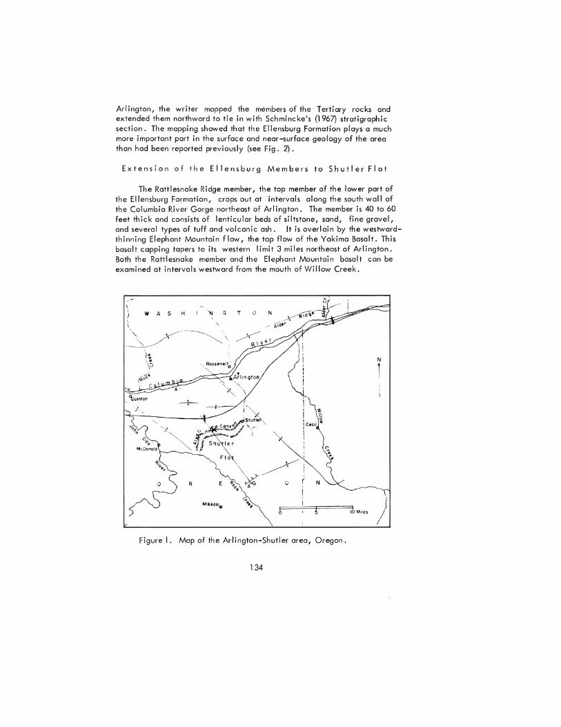
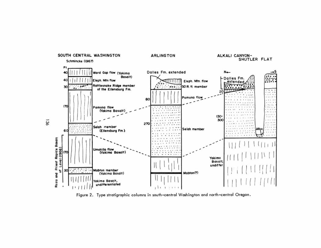
Arlington, the writer mapped the members of the Tertiary rocks and extended them northward to tie in with Schmincke's (1967) stratigraphic section. The mapping showed that the Ellensburg Formation plays a much more important part in the surface and near-surface geology of the area than had been reported previously (see Fig. 2).
Extension of the Ellensburg Members to Shutler Flat
The Rattlesnake Ridge member, the top member of the lower part of the Ellensburg Formation, crops out at intervals along the south wall of the Columbia River Gorge northeast of Arlington. The member is 40 to 60 feet thick and consists of lenticular beds of siltstone, sand, fine gravel, and several types of tuff and volcanic ash. It is overlain by the westwardthinning Elephant Mountain flow, the top flow of the Yakima Basalt. This basalt capping tapers to its western limit 3 miles northeast of Arlington. Both the Rattlesnake member and the Elephant Mountain basalt can be examined at intervals westward from the mouth of Willow Creek.
WAS H
){ ' .. \""
.,.'(,~ 1"'-0 , c
'buin,on '-.
'N G TON
N
1
o
OF I ======J!F====:llh Mile. )
Figure I. Map of the Arlington-Shutler area, Oregon.
134

Westward from the end of its basalt cap, the eroded remnants of the Rattlesnake Ridge member have few outcroppings and appear to be overlain, with erosional unconformity, by gravelly members of the Dalles Formation. In places, such as at the Gorge rim north of the Arlington Airport, the Rattlesnake Ridge member is entirely missing and Dalles conglomerate lies on the Pomona Basalt flow. It is believed that the Rattlesnake Ridge member occurs in places beneath the Dalles Formation southwest of Arlington. Its presence is indicated by the thickness of the Tertiary sedimentary section overlying the Pomona Basalt flow. This thickness exceeds the 70-foot maximum of the Dalles Formation observed elsewhere in the area.
In many places in south-central Washington, the Rattlesnake Ridge member contains much fluvial material, though at other places it is entirely fine-grained air-fall tuff. In the Yakima Valley it contains many, if not all, of the Columbia River-type of guartzitic gravels that occur in the Ellensburg Formation. No Columbia River-type gravels were seen within the member in this area. In general, the Rattlesnake Ridge member contains more fluvial materials than does the Selah member. This fluvial nature of the Rattlesnake Ridge member makes difficult its field distinction from the sedimentary facies of the Dalles Formation.
The Selah member of the Ellensburg Formation was traced by Schmincke (1967) from its type locality north of Yakima to its outcroppings in the Columbia River Gorge north of Arlington. Beneath the Pomona Basalt flow, the Selah member can be followed south from Arlington to Shutler where the Pomona flow tapers out along a general east-west line. South of the end of the Pomona flow, the slightly eroded top of the Selah member is overlain by the Dalles Formation in the few places where the Selah top can be observed (see Fig. 3).
Within this general north-south area through Arlington and Shutler Flat, the Selah member ranges from 130 to 300 feet in thickness, much greater than the 50 to 100-foot thickness common to other parts of its widespread occurrence in south central Washington. It is essentially all tuff composed of silt, clay- and sand-sized grains of volcanic glass, glass with crystall i tes, and crystall ine fragments. A variable component of the mass has been altered to clay minerals. Most of the member is massive and coarsely bedded, but finely-bedded strata near its base have been logged in wells at AI kal i Canyon. The tuff is compact but I acks cementation or welding of the grains. It has a high porosity, low permeability, and low spec i fic grav i ty .
Basalt Below the Selah Member
Basalt flows below the Selah rrember include only a few thin sedimentary separations. A one-foot thick clay bed, beneath the first flow below the Selah at Arlington, may be an eguivalent to the Mabton member of the
135
SOUTH CENTRAL WASHINGTON Sthmlncke (1961)
"""--:-1'7:":T1 00 /111 ( III II w". Gap'Iow (V,kim,
40 ! I! 11111 Eloph. MI"fI~ Baselt)
30 : .. ': : .. ,,~ .. RattlesMike Ridge member .. 4. ... of tlte Ellensburg Fm.
17<
1 I [I! P,m .. , fI,.
1'\:" .. "" . .,.. " .. -:/.,. . .,.1 ",I. _ (Y,"m, .",11),
..... . .. :.';:: Selah member 6 : .:: .. :'-~ :-.:,:,: ::':: (EllensburQ Fm .l --
I I Hrn • •
Umati lla flow (l'akima BaloGlt)
.~.J •• f=:-=-::-:-:-""; Q. ~ I v .. - - - Mabton memMr
o I ~ -. - •• (Yak ima Basalr)
~ 1I11I1 (II Y,klm, .'''''. :.. I { I I f II undifferentioted
ARLINGTON ALKALI CANYON-
Dalles Fm. extended
1><.."',,>, .<,:",,".1T, ;;, /" rm Eleph. Mtn. flaw
"';.~: .:." ::.~:~~;. .:.:: SOR .R. member t 2 0
Pomol"lCl flow ~ - - -,-· .. . ; ~ : ' ... '. :: · ..... " .' . . .. . ' ..
. . . . . . . .. ' . .. . . . ... ... · .... . . . ' ... . 270 : : ; .... : •... : ..... :
.- .': .' .~ •. ." : :.- : Selah member
· . . . . .. .. . · . . .. . . .' .. '
. -' ....... . - ......... . · .. . . . . . ". · . . . . . . .. . . ...
\ I 1\ I I \ I \ I \ I 1[1/ I \ r 1, I ." ,
Mabton!!)
-'30 300
-,
• Yakima
80solt undiUe ,.
SHUTLER FLAT
N_ _s ; ;; ;. ...
Dalles Fm~ · ..... extended .;/.1' ... • ..... .. . ... ..... :." .. ' ; .. .;~
· . · - . · -. · . .. · -. . .. .. .. .. .. · . .. · . · . . . ... . . ' ..
.' .. · . ...... . .. ' . .. . · . . '. · . .. · ... · . · . . . . . · .. . " .
.. . ... ... · . . . .. . .. ., ... · . .. · .. .. ' ... . .
. . . .. ....... . ... .. ~ ..... • ... . . .•.•.•. A ::: .. ...... ::::: ..... ::: :: ........... - ~ . ....
I I I I I I \ I / I I I I
I r I \ I I \ I I I \ I I
I I I I I •
I I 1 \ I I I i ,
• .
I I [ I I I 1 I I ( I I Figure 2. Type stratigraphic co lumns in south -central Washington and north-centrol Oregon.

Yakima Basah that Schmincke (1967) observed farther north. Th is one - foot clay bed is not present either in surface exposures or in the drilling records of wells south of Arlington.
The first flows below the Selah member in the eastern end of Alder Ridge, 14 miles northeast of Roosevelt, were called the Priest Rapids Basalt by l aval (1966) . A porph yriti c basalt li ke that of the Roza flow, which underl ies the Priest Rapids basalt of laval (1966), was observed in ra ilroad and highway cuts at 300 feet altitude 3! miles northeast of Roosevelt. Thus the exposed basa lt below the Selah member in the Arl ington area apparently includes equ ivalents of the Priest Rapids and Roza Flows.
Da l les Formation as Extended to This Area
In the foce of the JXlzzuolana quarry, in the north bluff of Alkali Canyon, the Dalles Format ion lies w ith erosional unconformity on the Sela, member of the Ellensburg Formation. From the bose upward the Dol fes For mation consists of: 1) 10 to 20 feet of v itric rhyodacitic tuff, a lenticu lar and local occurrence; 2) 20 to 50 fee t of pebble and cobble weakly-bonded cong lomerate of Blue Mounta ins rock types; and 3) 30 feet of tan - brown silty tuff (see Fig . 4) .
The local member of vitdc tuff, the pozzuo lano, lies between the Selah member and the conglomerate of the Dalles Formation; it is herein described with the Dalles Formation, though later work may prove that it belongs under another strat igraphic des ignation. A smal l out lying lens of the pozzuo lona occurs on top of the Pomona flow at the head of Jones Canyon l ! miles northwest of the quarry exposure.
The basal port of the conglomerate in the quarry contains 4 to 8 feet of buff, si lty, un bedded cloy that is apparently a former loessal soil ly ing atop the pozzuolana.
The top (tuff) un it of the Da ll es Formation has some indurated calcifi ed zones, but on the whole it is poorl y conso li dated and has been extensively eroded by the wind.
In the south bluff of Alkali Canyon the conglomerate urderlies the soils of Shutler Flat and lies upon the Se lah tuff wh ich cont inues downward 200 feet to the top of the basalt. Most of the soils of Shut ler F lo t are loessol ; they ore generall y 10 to 15 feet thick beneath the up land parts of the area . If any significant amount of the light - brown tuff unit of the Dalles Formation remains upon the conglomerate beneath Shut ler Flat, it has not been observed nor recorded in well logs.
In the sides of th e shall ow depressions of the plateau just north of the quarry the Da ll es Forma tion li es on the Se lah member, but half a mile north of the quarry the sou thern end of the 'Pomona flow separates the Seloh mem ber from the overl ying Dalles Formation; in those outcrops there is no evidence of the Ratt lesnake Ridge member. To the north of Alkali Canyon, the cong lomerate member of the Dalles Formation, port ly stripped of the
137
wind-vulnerable tan tuff member, underlies much of the upland surface that extends to the Columbia River Gorge.
The two principal units of the Dalles Formation in Alkali Canyon, the conglomerate and the overlying tan tuff, are lithologically and physiographically similar to units at the top of the Dalles Formation in Fifteen Mile Creek Valley 30 miles to the west. Likewise, they are similar to the sedimentary unit called Pliocene fanglomerate, 28 miles to the east, by Hogenson (1964).
To the east of Arlington the relationships of the Dalles Formation to the Rattlesnake Ridge member of the Ellensburg Formation and to the Elephant Mountain basalt flow are not yet known. The following two conditions observed by the writer suggest, however, that these units may have been contemporaneous depositions: 1) No Dalles Formation I ies upon that part of the Elephant Mountain basalt examined to date; and 2) t he origins and I ithologies (fluvial materials and air-fall tuff) of the Rattlesnake Ridge member and the "Dalles Formation extended" are, in general, similar.
The sedimentary units described above as belonging to the Ellensburg Formation and the Dalles Formation have been designated in reconnaissance work as Arlington Lake Beds (Hodge, 1932) and Shutler Formation (Hodge, 1942). These early designations included little specific petrologic or location data. Hodge correctly interpreted his Arlington Lake Beds as being older than the Columbia River Gorge (Hodge, 1932, p. 6).
Age of the Units
A collection of camel bones for which identification was secured by Foxworthy (1962, p. 19) determined the Selah member near its type locality to be probably early Pliocene. A small collection of vertebrate fossils from the sedimentary deposits (interpreted by the writer as Selah member) near the top of the Columbia River Gorge northeast of Roosevelt, was identified by the collecting group from California Institute of Technology as Barstovian (Arnold Shotwell, personal communication 1966). The radioisotope dates so far obtained for the Pomona flow place it in the range 12.3 to 13.3 million years, and an additional 68 per cent confidence interval expands the total range to 10.1 to 14.3 million years (Holmgren, 1969, p. 193). Thus the early Pliocene age of the Selah member as obtained by Foxworthy seems to be allowed by the subsequent determinations.
Discrepancies in the ages of sedimentary deposits assigned to the Dalles Forme .on were pointed out by Newcomb (1966). The early Pliocene age, generally accepted for paleobotanical and vertebrate fossi Is near the type area at The Dalles, was in conflict with a middle Pliocene (Hemphillian) age obtained on vertebrate fossils from what appear to be correlative deposits ("Dalles Formation extended") near Arlington and near McKay Reservoir 60 miles further east. Additional vertebrate specimens from the Dalles Formation near The Dalles reviewed since 1966, have been
138

interpreted as substantiating the early Pliocene age in the type area (Arnold Shotwell, personal communication 1967). Discrepancies still exist in the age (middle Pliocene) and in the stratigraphic assignment of the "Dalles Formation extended" in north central Oregon.
Conclusions
1. The top two flows of the Yakima Basalt taper out southward into the Ellensburg Formation near Arlington much as they do westward in the Yakima Valley.
2. The extension of the Selah member, and possibly of the Rattlesnake Ridge member, for many miles beyond the end of its capping basalt flows requires that large areas be mapped as Ellensburg Formation, a new experience for mappers in Oregon.
3. The relation of the lower part of the sedimentary facies of the "Dalles Formation extended" to the Rattlesnake Ridge member is not yet clear and the possibility that the two are in part contemporaneous has not been ruled out.
4. The Ellensburg Formation and the "Dalles Formation extended" comprise the materials that have been referred to in reconnaissance studies as "Arlington Lake Beds" and "Shutler Formation," terms that are no longer needed.
5. The discrepancies still exist between early Pliocene age in the type area of the Dalles Formation and middle Pliocene age for the supposed correlative strata {"Dalles Formation extended"} in the Arlington area.
References
Foxworthy, B, L., 1962, Geology and ground water resources of the Ahtanum Valley, Yakima County, Washington: U. S. Geological Survey Water Supply Paper 1598, 100 p., 11 illustrations.
Hodge, E. T., 1932, Geological map of north central Oregon: Univ. Oregon Publ., Suppl. to Geology Series v. I, no. 5, 7 p., scale 1 :250,000.
Hodge, E. T., 1942, Geology of north central Oregon: Oregon State College Mon., Studies in Geology, no. 3, 76 p.
Hogenson, G. M., 1964, Geology and ground water of the Umatilla River Basin, Oregon: U. S. Geological Survey Water-Supply Paper 1620, 102 p., 16 illustrations.
Holmgren, D. A., 1969, K/Ar dates and paleomagnetics of the type Yakima Basalt, Central Washington: Northwest Science Proceedings of the Second Columbia River Basalt Symposium, pp. 196-199.
Laval, W. N., 1966, Miocene-Pliocene formations of south-central Washington {Abs.}: Northwest Science., v. 40, pp. 38-39.
139

120
..
.! c:
·~800 -0
:f <t
400
~ 600'5. and 400'e. of A N 1/4 corner sec 32 I T 3 N. R 20 E
Tdru
'-.. ,. it: ~ I:' ~ <:>
"
0 NW
Tebu
20,000
ru
_ ./water level
xxx "Aquifer
I Che~ NueL.1 ~traet'
Tdru ' ~ I ~
40,000
------ --- ---- - -- -----------
Tebu
60,000 Vertical exaggeration 10 times
250 s. and 450e. of center NEV4sec.2"
T. I S., R.21 E. A'
80 0
400
Figure 3. Section from the Columbia River to the south end of Shutler Flat. (Qa, Quaternary alluvium. Tdru, Dalles Formation and Rattlesnake Ridge member of the Ellensburg Formation, undifferentiated. Tdeu, Dalles Formation and Rattlesnake Ridge and Selah members of the Ellensburg Formation, undifferentiated . Tcbp, Pomona flow of the Yakima Basalt of the Columbia River Group . Tes, Selah member of the Ellensburg Formation. Tcbu, basalt of the Columbia River Group, undifferentiated .)
Figure 4a. Quarry face exposing 40-foot section of the Dalles Formation above the Selah member of the Ellensburg Formation, the top of which forms the quarry floor.
Figure 4b. View east across the quarry and along the north bluff of Alkali Canyon. (Tes, Selah member of the Ellensburg Formation. Tdp, pozzuolana lens; Tdg, conglomerate member; and Tdt, tan tuff member of the Dalles Formation.)
140 141

Newcomb, R. C., 1966, Lithology and eastward extension of the Dalles Formation, Oregon and Washington: U. S. Geological Survey Prof. Paper 550-D pp. 59-63, illus.
Newcomb, R. C., 1969, Effect of tectonic structure on the occurrence of ground water in the basalt of the Columbia River Group of TheDalles area, Oregon and Washington: U. S. Geological Survey Prof. Paper 383-C, 33 p., 19 illustrations.
Schmincke, H. U., 1967, Stratigraphy and petrography of four upper Yakima Basalt flows in south-central Washington: Geological Society of America Bull. v. 78, pp. 1385-1422.
* * * * *
RALPH WORKS CHANEY
By Jane Gray
Paleoecology Laboratory Museum of Natural History
University of Oregon, Eugene, Oregon
On March 3, 1971, at the age of 80, famed paleobotanist, Ralph Works Chaney died in Berkeley, California where he had made his home since 1931. Dr. Chaney, until the late 1950's Professor of Paleontology at the University of California, enjoyed a long career yielding a rich harvest in the fields of education, paleontological research and conservation.
Chaney spent his first field season in Oregon in 1916, and received his doctorate in 1919 from the University of Chicago with a dissertation based on studies of the Middle Tertiary Eagle Creek flora of the Columbia River Gorge. Thus began a long, intense association with Tertiary floras of the Pacific Northwest in which he used the State of Oregon as his most valuable laboratory to develop and test many of the innovative, analytical techniques that have contributed to an understanding of Tertiary floras throughout the world. His work established Oregon as a classic area in Tertiary pal eobotany.
Among Chaney's significant contributions to the study of fossil floras are the following: the recognition that taxonomic considerations of a flora cannot be separated from its ecological considerations, thereby treating fossil plant assemblages as representatives of vegetation rather than as collections of isolated specimens; the handling of large numbers of specimens in the field to permit an accurate idea of morphological variations within fossil species that enabled detailed comparison with the leaf characters of designated living equivalent species; the use of leaf characters {such as
142
length, organization, nervation, margin, texture) and of morphological life form as an aid to determining the climatic conditions of a region or of a geological period; quantitative study of fossil floras in an attempt to arrive at some estimate of species dominance; the application, where appropriate, of corrective factors derived from studies of the comparative representation of plant remains in contemporary sediments, together with data on numerical representation of fossil species and the habitats of the equivalent living species to serve as guides in the reconstruction of the physical environment, including topography and climate, of fossil floras; the thesis that migrations of major vegetational units (termed geofloras) through Cenozoic time are the basis not only for the reconstruction of topographic and climatic changes, but since such migrations result from progressive physical changes, particularly in climate, which are a function of time, that the successive
geographic positions of geofloras may serve to determine the age of sedimentary rocks with occurrences of plant fossils.
Although much of Chaney's professional work was concerned with the paleobotany of the Pacific Northwest, his scientific efforts ranged far afield from that area. He carried out field work intermittently in Central and South America and widely for many years in Asia; as a young man he was a member of the Central Asiatic Expedition of the American Museum of Natural History under the leadership of Roy Chapman Andrews. One of Chaney's most significant publications dealt with a revision of fossil Sequoia and Taxodium which was completed after his visit in 1948 to the only natural occurrence of Metasequoia in central China. Through his efforts in obtaining seeds and cuttings of Metasequoia, this conifer again thrives in many parts of the world where it once lived naturally.
In addition to his scholarly activities, Dr. Chaney was active in conservation as a long-time member and past President of the Savethe-Redwoods-League, and as a member of the Advisory Board of the National Park Service. During World War II, he served in an administrative capacity as Assistant Director of the University of California's Lawrence Radiation Laboratory.
During his lifetime, Dr. Chaney received many honors and awards; he was a member of the National Academy of Sciences, the American Philosophical Society, a Fellow and past Vice President of the Geological Society of America and a past President of the Paleontological Society of America. In recent years, he was an Honorary Vice President of the XI International Botanical Congress, where he was honored with a Congress Medal, he received the U. S. Department of the I nterior Conservation Service Award and shortly before his death he was the recipient of the 5th Paleontological Society Medal, the first and only paleobotanist so honored.
* * * * *
143

METAL NEWS'
S i I v e r
The price of silver continues "sluggish" and is presently quoted a,t $1 .633 per ounce. A number of silver investors have brought suit against Engelhard Industries, the Silver Users Association and certain of their officials for remarks mode at the May 20 silver and gold forum sponsored by the American Metal Market. The suit was in response to comments mode ot the forum by Engelhard Industries president Richard C. Glogou, which discounted the importance of the deficit between silver production and consumption, and by Silver Users Association executive director Walter L. Frankland, who olso spoke bearishly ot the AMM forum. Although silver did go down on the day of the meeting and has performed sluggishly ever since, few traders are blaming Glogou or Frankland as silver has been sloppy of late anyway and the whole meeting was filled with depressing news.
Silver coin trading was started on the new West Coast Exchange on May 17, following the lead set by the New York Mercontile Exchange, which commenced coin futures on Aprill. The Los Angeles-based exchange offers "half-size" contracts, with a $5,000 face value, consisting of 5 bogs of dimes, quarters, or half dollars minted before 1965.
Mexico, which has blamed the slumping silver market on speculators who dominate the commodity exchanges, has invited representatives from Canada, Peru, Australia, the U.S., ond Indio to 0 meeting loter this month to examine prospects for setting up a world producer silver price. It has been reported that U.S. participotion will be limited to government observers. Mexico produces more than 40-million troy ounces of silver per year, most of which is as "prime" product. Canada is a larger producer, but there, as olmost everywhere else, production is mostly byproduct output from base metal mining. While the upcoming meeting is preliminary and no attempt to set up a producer price in the future is expected, the possibility of a producer price somewhere down the line has stirred considerable conversation.
Gold
On June 9, London gold prices fell below $40 a troy ounce for the first time since May II and gold is presently selling for $39.49. Although trading and investing in gold per se has been denied to U.S. citizens since the Gold Reserve Act of 1934, they are stepping up the pressure to seek ways to buy gold, which include proposed legislation to revitalize the U.S. gold industry and to legalize bullion investment, as well as plans being formulated by major commodity exchanges to offer gold trading. California Congressmen H. T. Johnson and Don H. Clausen maintain that U. S. output of gold falls far short of the
.. From News letter, Nevada Mining Association, June 15,1971.
144
nation's strategic needs, much less its normal industrial and consumer requirements. Domestic production totaled some 1 .6-million troy ounces in 1969while gold use hit about 7-million, of which nearly 40% or 2.7-mi II ion ounces went to space and defense. The U . S. Bureau of Mines estimated U.S. known reserves at about 400-million ounces, but startup costs for new mines can be prohibitive.
Earlier legislation to permit U.S. citizens to hold gold bullion was introduced by Illinois Representative Philipp M. Crane, who claims that interest among Americans has been substantial and that individuals should have the right to hold their wealth in tangible commodities as currency values continue to decline. Presently, Americans can hold gold only in the form of jewelry or coinage. The United Kingdom lifted restrictions on British citizens holding gold on April 1. Meanwhile, the West Coast Commodity Exchange is ready for any change in the federal rules as it has prepared complete contract specifications for trading in gold bullion as a futures contract if the current restrictions are lifted by Rep. Crane's legislation. Specifications of the contract, should it be permitted, call for trading units of 400 troy ounces in a bar of at least 99.95% pure gold. Delivery months would be in January, March, May, July, September, and December.
A strong demand for British gold sovereigns is reported by dealers. Frederick S. Bogart, manager of Republic National Bank's gold department, told a group at the recent American Metal Market silver and gold forum that these coins, which contain about! ounce of gold and are worth-l:1 ($2.40) face value, have risen sharply in price to about $13 a piece.
Copper
Simon D. Strauss, executive vice president of American Smelting and Refining Company, told the Financial Analysts Federation at Cleveland, "If the geographical concentration of copper production becomes more diverse, the price should be less volatile." He said it is the dependence of Western European copper consumers on the ClPEC (Congo, Chile, Peru and Zambia) countries for supplies that has "accentuated the volatile fluctuations in the price of copper" in recent years. The flow of copper from CIPEC countries to Free World consumers has been well maintained, Strauss noted, "But this fai Is to quiet the fears of uneasy consumers who do not know what to expect next." The Asarco executive sees this situation changing, however. Strauss said, "There is no shortage of known copper reserves, " but it is of "considerable significance that much of the new tonnage is being developed outside the CIPEC area. Capital is, in fact, showing considerable reluctance to invest in new CIPEC projects. Five or 10 years hence, the relative importance of the CIPEC countries seems likely to be less than it is today!' He noted that the U.S. and Canada will maintain their production rank in the world while production from "other countries" may show proportionately the
145

greatest increase. Substantial new production is expected from the South Pacific basin (Indonesia, the Philippines, and Bougainville) while Australia is increasing its production by at least 50% within the next 2 years.
During a recent meeting of CIPEC mining ministers, it has been reported, other copper-exporting countries in the world were invited to join the group. Also, ClPEC issued its usual call for "price stabilization." Meanwhile, increased outputs were announced - Congo by 5%; Zambia by 4.5%, and both Chile and Peru talked about 12% increases. Thiswould amount to 91,000 tons per year for Chile; 27,000 tons per year for Peru; and 36,000 tons per year for Zambia, and 18,000 tons per year for the Congo.
Mercury
Mercury is currently being quoted at $265-270 per 76-pound flask. The U.S. Bureau of Mines states, "Domestic mine production in the first quarter of 1971 wa~ 4480 flasks, down 20% from the preceding quarter. Eleven mines producing over 100 flasks each during the quarter accounted for 87% of the production. The three top producers were the New Idria and Mt. Jackson mines in California, and the Ruja mine in Nevada. Several mines became inactive, including the Buena Vista mine. Secondary mercury totaled 4058 flasks, which included 2700 flasks released from GSA, reducing their stock to about 10,800 flasks. GSA did not resume offerings for commercial sale during the quarter.
"Consumption was 12,720 flasks, about the same as the previous quarter, but down substantially from the 19,555 flasks recorded for the first quarter of 1970. Increases were noted in ag riculture, catalysts, electrical apparatus, general laboratory use, industrial and control instruments, and mildew proofing for paint. Use in electrolytic preparation of chlorine and caustic soda declined to under 3000 flasks. No mercury was consumed for amalgamation of pul p and paper.
"The March 31 issue of the Federal Register contained a list, published pursuant to the Clean Air Act of 1970, in which mercury was designated one of the hazardous air pollutants."
* * * * * BURTON W. SILCOCK APPOINTED BLM DIRECTOR
The appointment of Burton W. Silcock as Director of the Bureau of Land Management has been announced by Interior Secretary Rogers C. B. Morton. Mr. Silcock succeeds Boyd L. Rasmussen, who has been named an Assistant to the Secretary of the Interior. Silcock, a native of Burley, Idaho, and a graduate of Utah State University, joined the Bureau of Land Management in 1948 and has held successively responsible posts in public lands management in various areas of the West. Since 1965 he has been BLM Alaska Director.
* * * * * 146

GEOLOGY OF THE POWERS QUADRANGLE PUBLISHED
The Department has just issued, as the fifth in its Geological Map Series, "Geology of the Powers Quadrangle, Oregon," by Ewart M. Baldwin and Paul D. Hess, of the University of Oregon. The publication consists of a 21 by 26 inch sheet with a multicolored geologic map and cross sections on one side and text on the other. The map scale is 1 :62,500.
The Powers quadrangle is situated along the northern edge of the Klamath Mountains in Coos and Curry Counties in a region underlain by pre-Tertiary and Tertiary rocks. The older pre-Tertiary units have a complex tectonic history involving development of schists, serpentinite, and melange facies.
GMS 5 is for sale by the Department of Geology and Mineral Industries at its Portland, Baker, and Grants Pass offices. The price is $1 .50.
* * * * *
STATE MINERALS RESEARCH CENTERS NEEDED
Senate Bill S .635 to amend the Mining and Minerals Policy Act of 1970 proposes to establish a minerals research and training center in each state. With reference to S .635 Dr. Vernon E. Scheid, Dean of the Mackay School of Mines, University of Nevada, writes:
"A moment's reflection is sufficient to convince a person that there are but two basic and fundamental industries and that all other human economic activity depends upon the satisfactory operation of: 1) the industry involved with living resources, that is, agriculture (including forestry, fishing, etc.)i and 2) the industry involved with non-living resources, that is, the mineral industry. Without either of these industries, which compose the first level of human economic activity the world as we know it ceases to exist and man becomes a wandering animal. Thus it is folly to debate which is more important, agriculture or mineral industry. Other levels of human economic activity are important to the life of our nation but they cannot exist without the first level!
"Some hundred years ago, Congress recognized that a healthy agricultural industry was necessary to our nation's well-being and by means of the Morri II and other Acts created agricultural research and training institutes throughout America. The results are world famous. Regrettably, research and training institutes for the non-living (earth and mineral) resources were not established at that time. Thus, America, although wellsupplied by nature with mineral materials, has paid a heavy price through lack of research and training. The nation that does not consider the economic condition of each of its two basic industries may soon lose its right of free choice in guiding its own future in the world!
"The time has come for America to think about its earth and mineral
147
(non-I iving) resources. The education and research necessary for these resources to be properly extracted and used must be supported and encouraged. Then, and only then, will America know that both of its basic and fundamental industries will be healthy and will contribute to our Nation's safety and well-being.
"As Dean of one of America's few remaining mineral industry colleges and as Director of one of our most active state bureaus of mines, I sincerely urge you to support the passage of S.635 which calls for the establishment of mineral resources research and training institutes throughout America." (News Letter, Nevada Mining Association, June 15, 1971)
PRESIDENT DELIVERS ENERGY MESSAGE
In a special energy message to Congress, President Nixon outlined a program which included: (1) additional funding of a program to develop and demonstrate, in partnership with industry, the technology for removing sulfur from the stack gases of power plants and industrial plants burning coal and oil; (2) a commitment to complete the successful demonstration of the liquid metal, fast-breeder reactor by 1980; (3) an expanded cooperative pilot plant program aimed at making coal gasification a commercial reality; (4) funding of a broad range of other energy research and development such as coal mine health and safety, fusion power, magnetohydrodynamics and underground electric transmissions; (5) the increasing of oi I and gas lease offerings on the Outer Continental Shelf; (6) expediting development of an orderly oil shale leasing program with emphasis on environmental protection and recovery of a fair return to the government; and (7) expediting of the scheduling of a competitive geothermal lease program this fall under recently enacted legislation, provided environmental concerns can be satisfied.
* * * * *
NEW U. S. CHIEF GEOLOGIST NAMED
Dr. Vincent E. McKelvey has been appointed Chief Geologist to head the Geologic Division of the U. S. Geological Survey, Department of the Interior. Dr. McKelvey succeeds Dr. Harold L. James, who occupied the post since 1965, and who wi II return to his research on the geology and ore deposits of ancient rocks in the Northern Rocky Mountains.
Mc Kelvey, who joined the Geological Survey in 1941, is internationally recognized for his studies of phosphate deposits, for his investigations into problems related to long-range energy and mineral resource needs, and particularly, in recent years, for his analyses and assessments of seabed resources of the world.
* * * * *
148

