relation of slow-moving landslides to earth … · field observations ... 1 7 young pyroclastics...
TRANSCRIPT

U.S. DEPARTMENT OF THE INTERIOR
U. S. GEOLOGICAL SURVEY
Relation of slow-moving landslides to earth materials and other factors in valleys of the Honolulu District of Oahu, Hawaii
By
Stephen D. Ellen 1 , Lori S.M. Liu2, Robert W. Fleming3, Mark E. Reid 1 , and Mark J. Johnsson^
Open-File Report 95-218
Prepared in cooperation withthe City and County of Honolulu,
Department of Public Works
This report has not been reviewed for conformity with U.S. Geological Survey editorial standards or with the North American Stratigraphic Code. Any use of trade, product, or firm names is for descriptive purposes only and does not imply endorsement by the U.S. Government.
iMenlo Park, CA^Clayton Environmental Consultants, Inc., 1130 N. Nimitz Highway, Unit A-124,
Honolulu, HI 96817-4579 3Denver, CO Department of Geology, Bryn Mawr College, Bryn Mawr, PA 19010
1995

Contents Abstract.............................................................................................!Introduction......................................................................................... 2Slow-moving landslides in Honolulu .......................................................... .2
History..................................................................................... 2Characteristics............................................................................^
Factors associated with landslide distribution .................................................. 5Rainfall..................................................................................... 5Topographic setting.......................................................................lOEarth materials.............................................................................lO
Field observations...............................................................lOGeologic mapping ............................................................... 1 0Soils mapping............ ........................................................ 11Soil-clay reconnaissance ........................................................ 1 1Compiled subsurface data................................... .................... 12
Distribution and quality ................................................ 12Methods.. ................................................................ 12Results. .................................................................. 13Relation to landslides ................................................... 1 3
Summary of relations..................................................................... 16Origin of susceptible materials ................................................................... 16
Formation of Vertisols . . . . ............................................................... 17Vertisols in the subsurface ............................................................... 1 7Young pyroclastics of the Honolulu Volcanics.. ..................................... .20
Understanding landslide distribution.. .......................................................... 21Summary and conclusions ....................................................................... .22Acknowledgments and contributions ........................................................... .22References cited ................................................................................... .23Appendix A Compiled descriptions of subsurface materials in the valleys....... ...... ...26Appendix B-Schematic portrayals of compiled descriptions of subsurface materials..... 40
Plate
Plate 1: Relation of slow-moving landslides to earth materials and other factors in valleys of the Honolulu District of Oahu, Hawaii:
Map A. Topography, rainfall, shallow earth materials, and slow-movinglandslides
Map B. Subsurface earth materials and slow-moving landslides
Figures
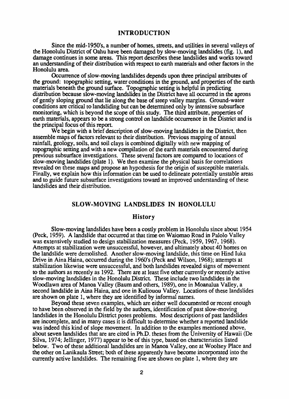
Figure 1: Index map of study area, showing landslides, annual precipitation, and names ofmajor valleys and communities
2: Map and cross section of the Alani-Paty landslide in Manoa Valley 3: Photographs of features typical of slow-moving landslides in study area4. Logs of borings from the Alani-Paty landslide in Manoa Valley5. Plasticity chart comparing materials from the valleys to materials at the Alani-
Paty landslide 6: Photograph showing layered valley-fill deposits near foot of hillslope in Palolo
Valley 7: Schematic cross sections showing burial of surface soils in accumulating valley-
margin deposit
11

ABSTRACT
Since the mid-1950's, a number of homes, streets, and utilities in several valleys of the Honolulu District of Oahu have been damaged by slow-moving landslides. To determine whether existing data might help in predicting areas of future landslide problems, this report assembles relevant information from climatic studies, topographic and slope maps, geologic and soils mapping, soil-clay reconnaissance, and subsurface investigations conducted during previous engineering site studies. Data from more than 1,000 logs of test pits and borings were compiled from original sources as part of this effort. The distributions of these several factors are then compared to the locations of slow-moving landslides.
Maps of rainfall show that slow-moving landslides have occurred only in parts of the District where annual rainfall is moderate, generally between 1 m (39 in.) and 2 m (79 in.). Topographic and slope maps show that these landslides have occurred consistently on gently sloping ground near the base of steep valley walls. Soils mapping shows that all of these landslides have occurred at or adjacent to places where a particular kind of soil, called "Vertisol," is mapped at the ground surface. Soil-clay reconnaissance establishes the distribution of smectite, a particularly weak clay mineral, in surficial soils, and the relation of this distribution to annual rainfall. Geologic mapping establishes that the landslides occur within valley-fill deposits but fails to provide useful subdivisions of the valley fill. The compiled subsurface data, as well as field observations, show that valley fill in most areas consists dominantly of bouldery layers of clay, silty clay, and clayey silt that are similar to materials involved in slow-moving landslides.
Association of Vertisols and smectite at the ground surface with sites of slow- moving landslides and subsurface clays complements field observations in leading to an hypothesis about the origin of the weak, highly plastic materials at depths of ten to several tens of feet within which sliding occurs. These materials appear to have originated largely as surficial Vertisols that were buried by subsequent deposits from steep valley walls. Distribution of buried Vertisols can be expected to follow the distribution of Vertisols at the ground surface, because present patterns of rainfall and other climatic conditions that affect soil formation appear to have prevailed during formation of these deposits.
The mapped factors delineate the general areas that are likely to be susceptible to slow-moving landslides, and they lead to a testable hypothesis for the origin of susceptible materials. The delineation of susceptible areas can be used to guide the need for subsurface investigations of site stability, and the hypothesis can guide the focus of such investigations toward an improved understanding of these landslides and their distribution.
INTRODUCTION
Since the mid-1950's, a number of homes, streets, and utilities in several valleys of the Honolulu District of Oahu have been damaged by slow-moving landslides (fig. 1), and damage continues in some areas. This report describes these landslides and works toward an understanding of their distribution with respect to earth materials and other factors in the Honolulu area.
Occurrence of slow-moving landslides depends upon three principal attributes of the ground: topographic setting, water conditions in the ground, and properties of the earth materials beneath the ground surface. Topographic setting is helpful in predicting distribution because slow-moving landslides in the District have all occurred in the aprons of gently sloping ground that lie along the base of steep valley margins. Ground-water conditions are critical to landsliding but can be determined only by intensive subsurface monitoring, which is beyond the scope of this study. The third attribute, properties of earth materials, appears to be a strong control on landslide occurrence in the District and is the principal focus of this report.
We begin with a brief description of slow-moving landslides in the District, then assemble maps of factors relevant to their distribution. Previous mapping of annual rainfall, geology, soils, and soil clays is combined digitally with new mapping of topographic setting and with a new compilation of the earth materials encountered during previous subsurface investigations. These several factors are compared to locations of slow-moving landslides (plate 1). We then examine the physical basis for correlations revealed on these maps and propose an hypothesis for the origin of susceptible materials. Finally, we explain how this information can be used to delineate potentially unstable areas and to guide future subsurface investigations toward an improved understanding of these landslides and their distribution.
SLOW-MOVING LANDSLIDES IN HONOLULU
History
Slow-moving landslides have been a costly problem in Honolulu since about 1954 (Peck, 1959). A landslide that occurred at that time on Waiomao Road in Palolo Valley was extensively studied to design stabilization measures (Peck, 1959,1967,1968). Attempts at stabilization were unsuccessful, however, and ultimately about 40 homes on the landslide were demolished. Another slow-moving landslide, this time on Hind luka Drive in Aina Haina, occurred during the 1960's (Peck and Wilson, 1968); attempts at stabilization likewise were unsuccessful, and both landslides revealed signs of movement to the authors as recently as 1992. There are at least five other currently or recently active slow-moving landslides in the Honolulu District. These include two landslides in the Woodlawn area of Manoa Valley (Baum and others, 1989), one in Moanalua Valley, a second landslide in Aina Haina, and one in Kuliouou Valley. Locations of these landslides are shown on plate 1, where they are identified by informal names.
Beyond these seven examples, which are either well documented or recent enough to have been observed in the field by the authors, identification of past slow-moving landslides in the Honolulu District poses problems. Most descriptions of past landslides are incomplete, and in many cases it is difficult to determine whether a reported landslide was indeed this kind of slope movement. In addition to the examples mentioned above, about seven landslides that are are cited in Ph.D. theses from the University of Hawaii (De Silva, 1974; Jellinger, 1977) appear to be of this type, based on characteristics listed below. Two of these additional landslides are in Manoa Valley, one at Woolsey Place and the other on Lanikaula Street; both of these apparently have become incorporated into the currently active landslides. The remaining five are shown on plate 1, where they are

LIM
IT O
F S
TU
DY
AR
EA
/':..-
. .!
/R
/' M
ff
w
^ nw
M r^i
,^ O
4/
n./.»
*
I
* U
,U V
i I
3 V
L,..,
>
iS
N
kiX
-'
Figu
re 1
: St
udy
area
, the
Hon
olul
u D
istr
ict o
f Oah
u, s
how
ing
slow
-mov
ing
land
slid
es (
dots
) an
d na
mes
of
maj
or v
alle
ys a
nd c
omm
uniti
es.
Topo
grap
hic
cont
our i
nter
val 4
00 ft
(122
m).
Bol
d da
shed
con
tour
s in
dica
te
mea
n an
nual
rain
fall
in m
illim
eter
s (G
iam
bellu
ca a
nd o
ther
s, 1
986)
.3

identified by letter. Because these landslides have been modified over time, we could not confirm the nature of movement, but they are included on the basis of the written descriptions. These five additional landslides bring the total to 12 recognized slow-moving landslides in the Honolulu District. Other landslides described in the theses by De Silva (1974) and Jellinger (1977), such as those in the upper part of Manoa Valley, do not appear to be of the slow-moving type.
From 1989 to 1992, the U.S. Geological Survey, in cooperation with the City and County of Honolulu, conducted an investigation of landslides and debris flows in the Honolulu District, and much of that study focused on slow-moving landslides. The present report is one product of that study. Other products include detailed maps of two slow-moving landslides in the Woodlawn area of Manoa Valley (Baum and others, 1989); detailed investigations of one of these landslides, the Alani-Paty landslide (Baum and others, 1990,1991; Baum and Reid, 1992); and an attempt at predicting landslides of this kind in Manoa Valley by mapping evidence of incipient movement (Fleming, 1995).
Characteristics
Slow-moving landslides in the Honolulu District are illustrated in figure 2. They are distinguished from other kinds of slope movement by the following characteristics. Few of these characteristics are unique to this kind of ground movement, but in aggregate they describe the kind of movement that we refer to as slow-moving landslides:
1) Movement rates are typically less than about 0.25 in./day (6 mm/day), but may be as great as about 1 in./day (25 mm/day) (Peck, 1959,1967; Peck and Wilson, 1968).
2) Movement occurs in episodes that can be correlated with large amounts of rainfall, particularly in the ten days or so preceding the episode (Peck, 1967, p. 414). Movement is not steady. As described by Peck (1959, p. 6), movement of the Waiomao Road landslide "has not increased at a constant rate but has progressed in rapid steps, separated by periods of somewhat slower motion." There may be long intervening periods of no movement (Baum and Reid, 1992).
3) Total downslope movement in a given episode is typically several feet or less, rather than tens of feet (Peck, 1959, p. 6; Baum and others, 1989, pi. 2).
4) Movement does not accelerate into rapid debris flow.5) Movement occurs in relatively gently sloping surficial deposits along valley
margins, near the base of steep valley walls (fig. 2B).6) The landslides contain distinct heads at their upslope ends (fig. 3A) and distinct toes
at their downslope ends (fig. 3B). Flanks may be obscure except where they offset fixed man-made features, such as curbs or walls (fig. 3C), but flanks may be marked by en echelon cracks, by scarps, or, especially in lawns, by en echelon folds (R.L. Baum, written commun., 1995).
7) The landslides generally are larger than single house lots. Although slow-moving landslides apparently form by progressive enlargement of small areas of instability, their geometry precludes formation in very small areas. Depth of sliding is typically in the range of 20-30 ft (6-9 m), but movement has been as shallow as 15 ft (5 m), at Hind luka Drive, or as deep as 60 ft (18 m), at Waiomao Road (Peck and Wilson, 1968). Landslides of this type are commonly at least twice as wide as they are deep and may be considerably wider (fig. 2).
8) The landslides apparently form slowly, over a period of years to decades.Disrupted utilities, cracked streets and walks, and other forms of structural damage are chronic (Peck, 1959; Peck and Wilson, 1968; Fleming, 1995).
9) Basal slip surfaces of the landslides generally form in highly plastic clay or silty clay, but they may pass through clayey silt. These materials generally are designated CH or MH according to the Unified Soil Classification system (D.R. Marcum, oral commun., 1994; Baum and Reid, 1995).
Slow-moving landslides are just one of several kinds of slope movement that have occurred in the Honolulu area. Others include 1) areas of creep deformation, 2) failures of fill or collapse of retaining walls (Fleming, 1995), 3) failures in saprolite (weathered bedrock) on very steep slopes (Peterson and others, 1993), and 4) shallow soil slips that mobilize into debris flows (Wentworth, 1943; Ellen and others, 1993; Peterson and others, 1993). Also present in the area is evidence for much larger prehistoric slope movements, such as debris avalanches (Peterson and others, 1993, p. 14) and enormous landslides that involved much of Oahu (Moore, 1989). The theses by De Silva (1974) and Jellinger (1977) documented some of these types of movement but grouped them all as landslides, rather than distinguishing the different physical processes involved. Understanding of specific causes and distributions can improve only when the different kinds of landslides are distinguished. Then, knowledge gained from the location and causes of one landslide can contribute to an understanding of others of the same type.
FACTORS ASSOCIATED WITH LANDSLIDE DISTRIBUTION
Plate 1 displays mapped factors that bear a likely relation to the distribution of slow- moving landslides, as combined digitally in a geographic information system (CIS). The plate consists of two maps. Map A shows locations of the landslides with respect to rainfall, topography, and shallow earth materials; map B, with respect to subsurface earth materials. Some factors are shown on both maps so mat the various relations are clearly displayed. The spatial relations revealed in plate 1 are described below, along with sources and other information about the mapping of each factor.
Rainfall
Mean, or average, annual rainfall is shown in both figure 1 and map A. Slow- moving landslides all have occurred in parts of the District where rainfall is moderate, and all but the two adjacent landslides in Kalihi Valley (sites A and B, pi. 1) have occurred where annual rainfall is between 1 m (39 in.) and 2 m (79 in.).
The rainfall contours (isohyets) on map A are enlarged about 10 times from a map of mean annual rainfall of Oahu (Giambelluca and others, 1986, fig. A. 105). The enlarged isohyets should be considered only an approximate representation of annual rainfall, for two principal reasons. First, the isohyets were derived from a sparse network of rain gauges (Giambelluca and others, 1984, fig. 5); some gauges are as close as about 0.3 mi (0.5 km), but most are separated by 0.6 mi (1 km) or more, and many parts of the area lack gauges over distances of 2 mi (3 km) or more. In addition, local topographic effects probably cause significant variations from the smooth, simple pattern that was appropriate at the small scale of the original map. As a consequence, locations of the isohyets should be considered uncertain by some substantial part of a mile or more, depending on the density of gauges.
Rainfall is important to slow-moving landslides in two ways. First, subsurface water pressure, which is an immediate cause of movement, is related directly to amount of rainfall (Baum and Reid, 1992). Rate of landslide movement at Waiomao Road in Palolo Valley, for example, has been correlated with rainfall in the preceding 10-day period (Peck, 1967). Second, and more important to this study, is the influence of rainfall as a climatic factor in the weathering of rock to form clay minerals. As discussed below in the section entitled "Soil-clay reconnaissance," we use the 2-m isohyet as a surrogate for this climatic effect, but we recognize that seasonal patterns and intensity of rainfall may be as important as rainfall amounts.

CONTOUR INTERVAL 2 FEET (0.6 METERS) DATUM IS MEAN SEA LEVEL
Figure 2: The Alani-Paty landslide in Manoa Valley, an example of slow-moving landslides in the Honolulu District (from Baum and Reid, 1995). A, Map of the landslide, showing boundaries, major internal features, and displacement vectors. Hachured lines are scarps; toothed lines are toes; single-barbed arrows indicate relative displacement along flanks; arrows tipped by full points or triangles indicate displacement between 1969 and 1989, measured photogrametrically (1 in.=20 ft; 1 cm=2.4 m); arrows beyond landslide boundaries illustrate accuracy of photogrammetric measurement of displacement. Base shows houses, streets, and elevation contours.
6

100CH
800-
400-
200-
200 400 600 600 1000 Feet
100 200 300 Meters
B
Figure 2 (continued): The Alani-Paty landslide in Manoa Valley, an example of slow- moving landslides in the Honolulu District (from Baum and Reid, 1995). B, Downslope cross section drawn through length of the landslide southwest of Kahaloa Drive, showing setting of landslide with respect to steep valley walls and valley fill.

B
Figure 3: Features typical of slow-moving landslides in study area. A, Head scarp area of the Ailuna-Leighton landslide in Aina Haina, showing extensional cracking accompanied by vertical offset in lawn. Material in foreground has moved toward observer with respect to material in background. Upper parts of slow-moving landslides typically exhibit stretching as material is pulled apart by slide movement. B, Tilted and displaced retaining walls exhibit typical compressional features at toe of the Alani-Paty landslide in Manoa Valley. Ground at left is being pushed over the relatively undeformed ground at sidewalk and street. Deformation along downslope ends of slow-moving landslides is typically compressional, evidenced by thrusting, buckling, or shortening of walks, streets, or walls; a common form of deformation in such areas is displacement of rigid structures, such as concrete driveways, out into the street, much as the small retaining walls shown here are pushed over the sidewalk.
8
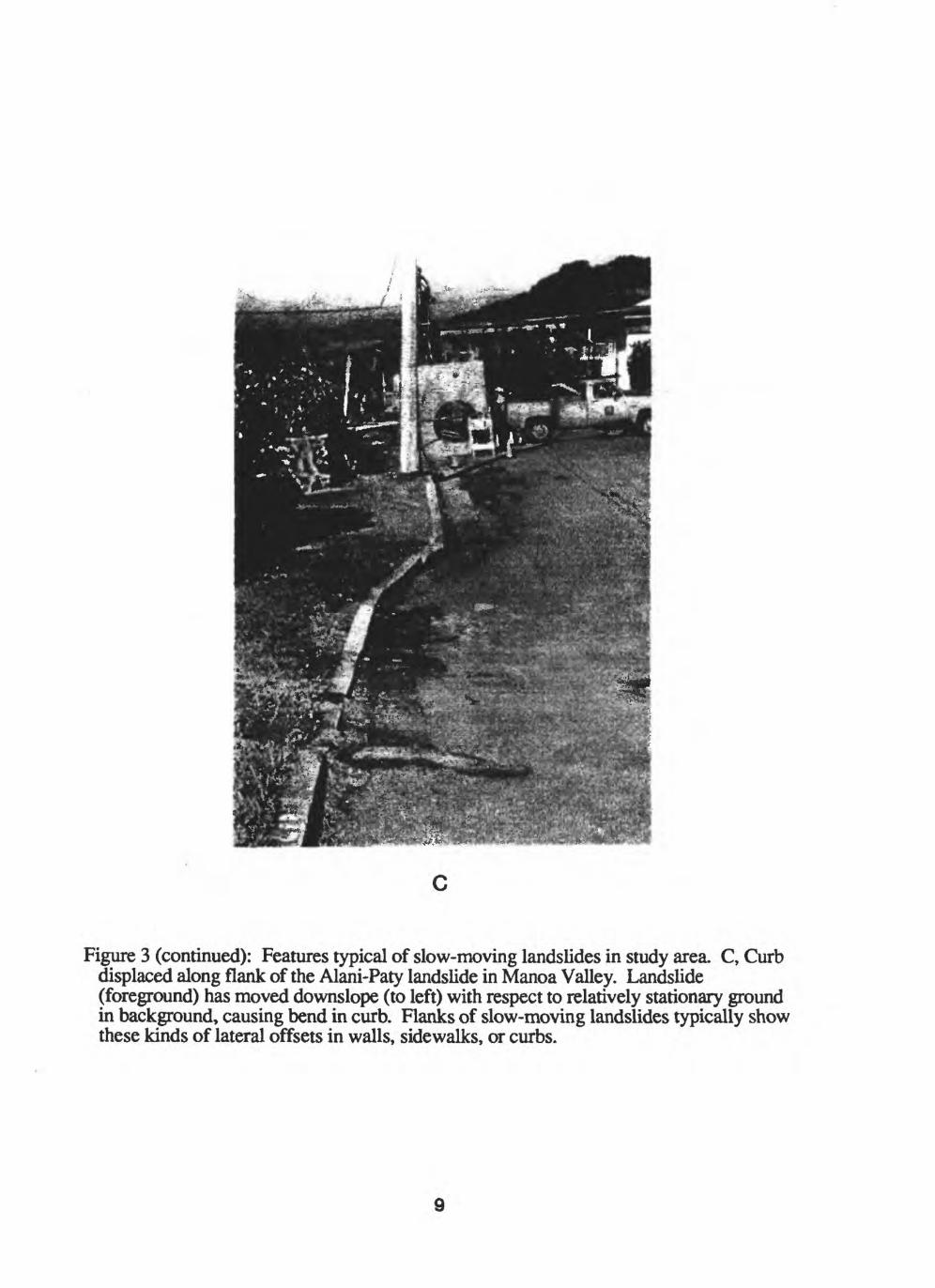
Figure 3 (continued): Features typical of slow-moving landslides in study area. C, Curb displaced along flank of the Alani-Paty landslide in Manoa Valley. Landslide (foreground) has moved downslope (to left) with respect to relatively stationary ground in background, causing bend in curb. Flanks of slow-moving landslides typically show these kinds of lateral offsets in walls, sidewalks, or curbs.
9

Topographic setting
Slow-moving landslides in the District consistently have occurred in areas of gently sloping ground that are common along the base of steep valley walls. In this report, we refer to these areas as topographic aprons. Map A uses a yellow color to delineate topographic aprons, which were drawn to include most areas that slope between 5 and 25 degrees near the base of steeper valley walls. This range in slope was selected because it is similar to that displayed at sites of slow-moving landslides. The aprons so delineated include most debris-apron and debris-fan deposits, in which slow-moving landslides appear to occur (Baum and Reid, 1992).
The topographic aprons were mapped as part of this study, using a slope map generated by ARC/INFO software (ESRI, 1993) from a 10-m-square elevation grid of the District. Toward valley mouths, the aprons are smooth surfaces that appear to consist of debris fans and debris aprons, and it is in these relatively smooth areas that most slow- moving landslides have occurred. Toward the upper ends of valleys, however, the topographic aprons shown on map A include dissected ground, as evidenced on the topographic source maps by an intricate pattern of elevation contours. The earth materials in these areas may consist of dissected debris-fan and debris-apron deposits, or they may consist of fundamentally different materials.
Topographic features similar to the mapped aprons occur also near young volcanic cones, such as Koko Head and Diamond Head, that lie beyond the valley mouths. Such features beyond the valleys were not investigated during this study, and are not shown on the maps or discussed further.
Earth materials
Distribution of slow-moving landslides is controlled in part by the kinds of earth materials that underlie the ground surface. Earth materials have been observed by the authors during this study and described to varying degrees during previous mapping of geology and soils, during previous subsurface investigations for engineering site studies, and during more recent reconnaissance studies of soil-clay minerals. Data from most of these sources are shown together on plate 1 and discussed below.
Field observationsOur observations of exposures in topographic aprons form the basis for much of
our confidence that slow-moving landslides are associated with particular earth materials, namely bouldery, dark-colored, plastic clays. We observed these materials at a number of exposures within valley-fill deposits near valley margins, including exposures in and near the Moanalua, Alani-Paty, Hulu-Woolsey, Hind luka, Ailuna-Leighton, and Kuliouou landslides and at the probable slow-moving landslide near Hao Street. At the Waiomao Road landslide, Peck (1959, p. 3) described what sounds like similar "clay with boulders." The common occurrence of these dark, bouldery clays at slow-moving landslides, in combination with the documented weakness of these materials at the Alani-Paty landslide (Baum and Reid, 1992, p. 22), suggests that they are a critical ingredient for landslides of this kind in the District.
Geologic mappingGeologic mapping by Stearns (1939) focused on the volcanic bedrock. Stearns
mapped two principal bedrock units in the Honolulu area, the Koolau Basalt (Wentworth and Winchell, 1947; Langenheim and Clague, 1987), into which the valleys of the District have been carved, and the more recent Honolulu Volcanics (Winchell, 1947; Langenheim and Clague, 1987) that erupted after erosion and valley filling had produced much of the current landscape. Stearns' mapping of these principal units and some of their subdivisions is shown on map B. In mapping the extent of bedrock units, Stearns drew
10

contacts between bedrock and the alluvial deposits that fill the valleys, thus defining approximate limits to the valley fill. In addition, he depicted two principal units within valley fill, one consisting chiefly of younger alluvium, the other chiefly of older alluvium.
This geologic mapping forms the basic materials context for slow-moving landslides. The landslides have all occurred in valley-fill deposits near bedrock that underlies the steep valley walls. Stearns1 mapping of this contact is flawed at least locally; the contact near Aina Haina is misplaced sufficiently to show bedrock at the Ailuna- Leighton landslide, which occurs in valley fill (William Cotton, oral cpmmun., 1991). Steams' mapping likewise shows bedrock at places where subsurface investigations have subsequently revealed significant thicknesses of valley fill (sites 14,46, and other more marginal examples on map B).
Steams' subdivision of valley fill into younger and older alluvium does not distinguish materials significant to landsliding. Slow-moving landslides have occurred in both units, and so for simplicity these units are combined on map B.
The geologic mapping on map B is enlarged from Stearns' (1939) mapping at 1:62,500 scale. Change in scale involved transfer of geologic features from the original base map to a newer, more detailed l:24,000-scale base map. Locations of geologic contacts on plate 1 are approximate because of both the reconnaissance nature of the original mapping and the transfer to a significantly different base.
Soils mappingSoils mapping describes materials at the ground surface and in the very shallow
subsurface, typically within about 5 ft (1.5 m) of the ground surface. This mapping consequently does not attempt to portray materials as deep as landslide slip surfaces, which typically lie at depths of 20 ft (6 m) or more.
Two generations of soils mapping have been conducted in the Honolulu area by the Soil Conservation Service (U.S. Department of Agriculture, 1955, 1972). Examination of the 1972 mapping reveals an association between sites of slow-moving landslides and the distribution of a particular kind of soil called "Vertisol," which is characterized by high plasticity, expansivity, and largely undifferentiated soil profile (U.S. Department of Agriculture, 1972). In valleys of the District, Vertisols have been mapped by the Soil Conservation Service as the Lualualei soil series and the Kaena soil series; beyond valley mouths, Vertisols have been mapped as the Honouliuli, Kokokahi, and Makalapa soil series (U.S. Department of Agriculture, 1972).
The spatial association between Vertisols and slow-moving landslides is shown in map A, where Vertisols are indicated by red stipple pattern. Vertisols occur at or immediately adjacent to all sites of slow-moving landslides. The causal relation between these surficial soils and the deeper-seated landslides is discussed below in the section entitled "Origin of susceptible materials."
Soils mapping shown on map A was transferred from uncorrected aerial photographs, which constitute the base for the 1972 soils map. Because of distortions inherent in uncorrected photography, locations of the soils units on map A are approximate.
Soil-clay reconnaissanceX-ray mineralogy by Johnsson and others (1993), conducted as part of this
cooperative U.S. Geological Survey study with the City and County of Honolulu, has delineated parts of the District where different clay minerals occur in surficial soils. Clay minerals of the Honolulu area are complex, consisting of intimate intergrowths of kaolinite, halloysite, and smectite. Most soil samples contain mixtures of two or more of these constituents, and compositions approaching the three end members are most common. Kaolinite is most abundant in areas of high precipitation, where weathering has thoroughly leached parent material. Halloysite is an intermediate phase that tends to be most common in areas of intermediate precipitation. Smectite is an incompletely leached phase that is most abundant in areas of low precipitation (Johnsson and others, 1993, fig. 8). We focus
1 1

on smectite because it is noted for its expansivity, high plasticity, low frictional strength (Borchardt, 1977; Selby, 1982, p. 77-80), and association with landslides (Borchardt, 1977).
The 2-m rainfall contour, which is highlighted on plate 1, forms an approximate boundary between parts of the District where surficial soils on hillslopes and in valleys generally contain smectite and parts where such soils generally lack smectite (Johnsson and others, 1993, p. 166). Smectite occurs south of the highlighted line, in the dryer areas. This boundary is only approximately located, as evidenced by the disparity between the 2- m isohyet and the line drawn by Johnsson and others (1993, fig. ISA). This uncertainty in location arises partly from the wide spacing of reconnaissance samples, shown in map A, and partly from the complex influence of the several factors that influence clay mineralogy.
Most slow-moving landslides in the study area have occurred south of the 2-m isohyet, where surficial soils generally contain smectite. Two landslides, however, at sites A and B on plate 1, have occurred in wetter areas north of this isohyet.
Compiled subsurface dataBecause landslide slip surfaces occur in valley-fill deposits that lie beneath surficial
soils, and because these valley-fill deposits have not been adequately described or mapped, we have compiled descriptions of subsurface earth materials encountered in test pits and borings during previous engineering studies. At the start of compilation, little was known of the abundance, quality, and availability of logs from previous holes, or how useful they might be in distinguishing landslide-prone earth materials. Compilation of previous information seemed an obvious first step toward understanding the distribution of landslides, especially in light of the considerable cost of new subsurface exploration and the proven usefulness of a similar compilation by Ferrall (1976) for different geotechnical problems in the vicinity of Waikiki and downtown Honolulu.
We consequently gathered and compiled all available logs of test pits and borings, along with associated laboratory test data, that had been obtained during previous engineering studies in the Honolulu District. Only data from valleys were collected; data from ridgecrests and from areas beyond valley mouths were excluded. Data from the valleys included logs of more than 1,000 test pits and borings, representing nearly 50 sites.
SourcesSources of data used for this study include Geolabs-Hawaii; State of Hawaii
Department of Land and Natural Resources, Division of Water and Land Development; State of Hawaii Department of Transportation, Highways Division, Materials Testing and Research Branch; City and County of Honolulu, Department of Public Works, Engineering Division; and U.S. Geological Survey, Water Resources Division, Hawaii District. Most of the data obtained from governmental entities had been prepared by geotechnical consulting and exploration firms.
Distribution and qualityDistribution of test pits and borings is not uniform over the valleys. The holes
occur in groups, shown by numbered sites on map B, in which locations were determined by the goals of the previous engineering studies. Depths ranged from 0.5 ft (15 cm) to 105 ft (32 m); most were in the range of 5-20 ft (1.5-6 m). The logs vary greatly in quality; in some, materials are described by a single word, whereas others use detailed descriptions that include results from laboratory tests.
MethodsBecause of the proprietary nature of the subsurface information, the actual logs and
their specific locations are not shown in this report. Rather, the locations and information contained in the logs have been generalized. To this end, the logs were first grouped by locality, as numbered on map B. Then the logs for each locality were compared and the
12

various component materials listed, as shown in appendix A. The components listed in appendix A were then portrayed symbolically in appendix B, and the presence of particularly significant materials, such as highly plastic clays, was indicated by symbol on plate 1.
The exercise of distinguishing and listing the component materials from a group of logs involved considerable judgment Some units that were thin and not generally present were omitted from the list. In cases where different logs in a group showed identical or nearly identical materials, the material generally was listed just once, but in some cases materials that differed only in color or other incidental properties were listed separately in order to retain clues that might be significant to landsliding.
The resulting composite descriptions show the materials encountered at each site and their ranges in thickness, and are to be interpreted as lists of components rather than composite logs. The number of materials in a given list may be greater than in an actual log because many of the components may have been exposed in adjacent test pits rather than in vertical sequence. Similarly, the sequence of materials may bear little resemblance to actual logs, except that surficial materials are shown at the top and basal materials at the bottom. In short, the compiled descriptions generally lack information on the sequence of materials, but they do reveal the kinds of valley-fill materials that are present at depths of as much as several tens of feet, depths similar to the slip surfaces of slow-moving landslides.
ResultsAs shown in the appendices, the materials described from previous test pits and
borings include much clayey silt; much clay and silty clay; much basalt, including soft weathered basalt (saprolite) and gravelly weathered basalt; some gravel; and lesser sand, silt, and coral. Many of these materials contain fragments of rock as large as boulders. Some of the localities contain distinctive materials that originate from young pyroclastic deposits of the Honolulu Volcanics; for example, sites 20,21,23, and 29 in Manoa Valley contain distinctive sand composed of cinders mat probably were produced by eruptive events at Round Top, Sugarloaf, or Tantalus. Dominant valley-fill materials in most localities, however, are clayey silt, clay, and silty clay, all of which commonly contain rock fragments as much as 5 ft (1.5 m) or more in diameter. These materials are so abundant that informal names have been used in many of the source logs; clayey silt has commonly been called "alluvium" and clay and silty clay have commonly been called "colluvium."
Relation to landslidesTo determine whether these compiled descriptions can be used to distinguish areas
susceptible to landsliding, we compared these descriptions to those of materials encountered in slow-moving landslides of the study area. Most of our information about materials in slow-moving landslides comes from drilling, sampling, and testing at the Alani-Paty landslide in the Woodlawn area of Manoa Valley. Extrapolation of the characteristics of materials from this landslide to other slow-moving landslides is based on visual inspection and on written and oral descriptions of materials at other sites.
Properties of materials in the Alani-Paty landslide have been reported by Baum and others (1990). Figure 4, modified from that report, shows logs typical of borings in the landslide. The landslide materials generally consist of as much as 50 percent pebble- to boulder-sized clasts of basalt in a matrix of fine-grained material. "The matrix is brown to gray, sandy to slightly sandy, highly plastic, clayey silt interlayered with dark brown to gray, highly plastic silty clay" (Baum and others, 1990, p. 1). Landslide slip surfaces generally are localized in silty clay, which constitutes the weaker, more plastic zones in the slope (Baum and Reid, 1992, p. 29). This material generally is classified as high-plasticity clay (CH) on the basis of Atterberg limits (D.R. Marcum, oral commun., 1994), but some samples of silty clay from the slip surface are classified as high-plasticity silts (MH), as shown in figure 5.
13

15 _
30-
40-
Bor
ing
12
-1)
Cla
yey
silt
(fill
)co
lor:
br
own
Uni
fied
Soi
l Cla
ssif
icat
ion
(use
): M
Hm
oist
ure
cont
ent
(me)
: -
"stif
fnes
s" (
s):
-m
inor
soi
l com
pone
nts
(msc
): co
bble
-siz
ed c
last
sun
it th
ickn
ess
(ut):
5 f
t
^ 2) S
andy
cla
yco
lon
gray
us
e: C
H
me:
m
oist
s:
stif
f
\
rnsc
: pe
bble
- to
bou
lder
-siz
ed c
last
s ut
: 7
ft3)
Cla
yey
silt
colo
r, br
own
use:
MH
me:
m
oist
s: st
iff
msc
: pe
bble
- to
bou
lder
-siz
ed c
last
sut
: 5
fti S
andy
cla
yco
lon
gray
cha
ngin
g to
bro
wn
usc:
CH
me:
m
oist
s: st
iff
msc
: pe
bble
- to
cob
ble-
size
d cl
asts
ut:
7ft
-5)
Cla
yey
silt
colo
n br
own
use:
MH
me:
dr
ys:
hard
msc
: pe
bble
- to
bou
lder
-siz
ed c
last
sut
: 17
ft m
inim
um
5_
25-
40-
Bor
ingl
S
1) C
oncr
ete
slab
ut
0.5f
t
-2)
Cla
yey
silt
(fill
)co
lon
brow
nus
e: M
H/G
Cm
e: -
s:
msc
: pe
bble
- to
cob
ble-
size
d cl
asts
ut:
6ft
-3)
Sand
y cl
ay colo
n br
own
to g
ray
use:
CH
/OH
me:
moi
sts:
stiff
to h
ard
msc
: pe
bble
- to
boul
der-
size
d cl
asts
ut:
17ft
othe
r, sl
icke
nsid
es d
ippi
ng 1
0-15
deg
rees
Cla
yey
silt
colo
r, br
own
use:
MH
me:
moi
sts:
hard
msc
: pe
bble
- to
bou
lder
-siz
ed c
last
sut
: 8ft
,5)
Sand
y cl
ay colo
n br
own-
gray
use:
CH
me:
moi
sts:
hard
msc
: pe
bble
-siz
ed c
last
sut
: 2f
tot
her:
fissu
red
clay
-6) C
laye
y si
lt an
d or
gani
c sil
ty c
lay
colo
n br
own
use:
MH
/OH
m
e: d
ry
s: ha
rdm
sc:
pebb
le-
to b
ould
er-s
ized
cla
sts
ut:
10 ft
min
imum
Figu
re 4
: Lo
gs o
f tw
o bo
rings
from
with
in th
e A
lani
-Pat
y la
ndsl
ide
in M
anoa
Val
ley
(mod
ified
from
Bau
m a
nd o
ther
s, 19
90).
Dep
th b
elow
gro
und
surf
ace
in fe
et D
escr
iptio
ns o
f mat
eria
ls u
se fo
rmat
of a
ppen
dix
A; s
chem
atic
por
traya
l of m
ater
ials
use
s co
mpo
sitio
nal p
atte
rns o
f app
endi
x B.
14

100
80XLLJ Q
^ 60 '
g03 40
20
20 40 60 80 100 120 140 LIQUID LIMIT
Figure 5: Plasticity chart comparing materials from valleys throughout study area (open symbols) to materials at the Alani-Paty landslide in Manoa Valley (solid symbols). Plot shows that materials similar to those at the Alani-Paty landslide are found in many parts of study area. Open circles, materials encountered in relatively dry areas south of 2-m isohyet; open squares, materials encountered in relatively wet areas north of 2-m isohyet. Solid diamonds, materials from slip surface of the Alani-Paty landslide; solid circles, materials from within the Alani-Paty landslide; solid triangles, materials from near the Alani-Paty landslide. Data for open symbols are from previous subsurface investigations, as compiled in appendices; data for solid symbols are from Baum and others (1990, table Bl; 1991, table Al) and Baum and Reid (1992, table 2).
15

As shown in plate 1 and the appendices, most localities in the valleys are underlain by bouldery deposits largely of clay, sDty clay, and clayey silt, materials that are at least outwardly similar to those in the Alani-Paty landslide. Likewise, zones of bouldery clay and silty clay, apparently similar to materials that form landslide slip surfaces, underlie large parts of most valleys; sites where clay or silty clay has been encountered in subsurface investigations are shown on plate 1, as are sites where these materials are classified as high-plasticity clay (CH). Figure 5 shows similar results in measured plasticity of materials; many subsurface materials in the valleys have Atterberg limits similar to those of materials in the Alani-Paty landslide. We conclude that materials similar to those involved in slow-moving landslides occur beneath large parts of most valleys in the District Within these areas, the subsurface data do not isolate any particular valley-fill materials that are uniquely associated with the landslides.
These results can be interpreted in two principal ways. One possibility is that the clayey valley-fill materials indeed lack significant differences critical to landsliding throughout large parts of the valleys. In this case, other conditions, such as ground-water levels or geometry of materials, must control specific occurrences of landsliding. The alternative interpretation is that the clayey valley fill does contain significant differences that were simply overlooked during the previous subsurface work, which focused on different or less specific engineering questions. Regardless of the interpretation, it is clear that specific areas of likely movement cannot be predicted from the compiled subsurface data. Delineation of such areas will require new investigations that look specifically for materials or conditions critical to landsliding.
Summary of relations
Of the various relations shown on plate 1, some are particularly clear. All slow- moving landslides occur in topographic aprons and at or adjacent to mapped surficial Vertisols (map A). Also, the landslides occur only in valley-fill deposits, though mapping of these deposits is flawed at least locally (map B).
Additional relations are intriguing though less conclusive, and offer clues that may lead to an improved understanding of the valley-fill materials in which landsliding has occurred. The 2-m isohyet of annual rainfall forms an approximate northern boundary to the occurrence of slow-moving landslides and also to surficial Vertisols, the mineral smectite in surficial soils, and subsurface clays, including those of high plasticity. These relations are imperfect some of the landslides, smectite, and highly plastic clays in the subsurface occur locally north of the 2-m isohyet, and Vertisols are mapped well north of the isohyet in Moanalua, Kalihi, and Nuuanu Valleys. Nevertheless, these relations appear to document a climatic influence on the distributions of Vertisols and smectite near the ground surface. The relations also suggest that properties of valley-fill materials at the depth of landslide slip surfaces are related to properties of materials at the ground surface.
ORIGIN OF SUSCEPTIBLE MATERIALS
To provide a physical explanation for the relation between surface conditions and sliding at depth, we propose the following hypothesis. Following Baum and Reid (1992, p. 14-21), we suggest that the plastic clays at landslide slip surfaces formed at the ground surface as Vertisols, then were buried by younger deposits originating from steep valley walls.
This hypothesis arose from field observations. During the course of our study, we examined a number of excavations into valley-fill materials in different parts of the District. The excavations showed alternating, irregular, slope-parallel layers of light-colored clayey silt and dark-colored silty clay (fig. 6), both of which contained variable amounts of rock fragments as large as boulders (Baum and Reid, 1992, fig. 7). Layers of clayey silt were
16

typically gray to brownish-gray; silty clays ranged from dark gray or dark brown to almost black in color. Locally there were also a few sandy, reddish-colored layers.
The dark layers of silty clay arc the focus of our attention because they include the weakest materials; in Woodlawn, they include most of the failure surface of the Alani-Paty landslide (Baum and Reid, 1992; D.R. Marcum, oral commun., 1994). These dark layers show several significant characteristics. They typically include numerous discontinuous shiny surfaces that resemble slickensides. Where well exposed, their upper contact with overlying light-colored materials is abrupt. The lower contact, in contrast, is gradational over an interval of a few inches, and there arc scattered traces of one or more light-colored minerals near the base of the dark layer. Thicknesses of exposed dark layers typically are less than about 6 ft (1.8 m). These characteristics suggest that the dark layers are pedologic soils that formed at the ground surface in light-colored debris-flow deposits, then were buried by subsequent debris-flow deposits, as sketched in figure 7. Their high plasticity and expansivity, very low permeability, and largely undifferentiated soil profile identify the dark layers as Vertisols (U.S. Department of Agriculture, 1972).
Formation of Vertisols
In the soil survey of Oahu, the Soil Conservation Service (U.S. Department of Agriculture, 1972, p. 207) described Vertisols and some of the conditions that lead to their formation: "Vertisols are usually black or dark gray in color. They are high in clay, have poor structure, and develop large cracks when dry. The shrinking, cracking, and shearing make these soils difficult to manage for farming and for engineering and other nonfarm uses....Vertisols contain a large amount of very fine clay, either the mineral montmorillonite [a form of smectite] or tabular halloysite. The clay shrinks and swells with changes in water con tent.... When the soil is dry, the cracks open up and the surface soil falls into them. When the soil is wet and swells, the cracks close and the subsoil material is pushed toward the surface. Thus, in the course of many years, the soil churns slowly over and over. Throughout the soil and particularly deep down where churning does not occur, there are aggregates and crystals of calcium carbonate, or calcite, and of calcium sulfate, or gypsum. These minerals are present because Vertisols occur in a dry or nearly dry climate and there is little leaching."
Vertisols form only under particular conditions that permit the development of expandable clays. Many soil types may form by weathering of the basaltic parent materials that underlie almost all sloping ground on Oahu, but Vertisols have specific climatic requirements. In particular, development of expandable clays requires low to moderate rainfall that occurs seasonally, that is, which permits alternate periods of wetting and drying (Soil Survey Staff, 1951; Buol and others, 1989). In the wetter parts of the valleys, rainfall occurs throughout the year in larger amounts, and the soils become leached and weathered to kaolinite. Such soils are termed Oxisols, to signify near-complete oxidation of the minerals, or Ultisols, to signify near-complete leaching of exchangeable cations in the minerals (Buol and others, 1989). Soils from both of these groups are typically stronger than Vertisols, have lower Atterberg limits, and are non-expansive (Buol and others, 1989). Landslides have occurred in areas underlain by Oxisols and Ultisols (De Silva, 1974; Jellinger, 1977), but, as described above, these landslides are different from the slow-moving landslides discussed in this report.
Vertisols in the subsurface
If buried Vertisols indeed constitute the slip surfaces of slow-moving landslides, then identifying areas susceptible to slow-moving landslides involves locating where Vertisols occur in the subsurface. Vertisols at the ground surface, identified by soil surveys, are shown by pattern on map A. The x-ray mineralogy by Johnsson and others (1993) provides an independent line of evidence that delineates areas where weak, highly
1 7

Figure 6: Slope-parallel layers of valley-fill deposits exposed in excavation along east side of Palolo Valley. Light-colored silty zones alternate with darker, more clay-rich zones. In similar exposures, darker clay-rich zones appear to have originated as Vertisols and are weaker, more plastic, and less permeable than the light-colored material. Cinder blocks in wall below exposure are 16 in. (0.4 m) long.
18

Steep valley wall
Gently sloping apron af " margin
*/ apron at valley
-V?^": Itt;/Valley
f < "':::>--,f:-:-:^ :--x ., iS-suf m. $ \ - ; *; ,.
A.
Soil forms in previous deposits
New deposit buries soil
B.
:-ii:S:wV ^ ::W:-^»» .-:-:-:-:-!>V '
- . , , <*iW---- ' ^ :>: **" " -'^- N.^t^yK.--^ ^sr-sg at;^**"
;'f j v Soil forms in new deposit
y.i^v>^8te^v^v-r^j^fei* r"~ ' :-**' > :<* ) » > . «. V\\\Wj_«: M ^.,, / \ fe-d ^ *;« ' lysjs^J s, -P^V
- ; *? V ' f * % %\ \ ',- V: "4jf I .' '
-;:-« \.^ ~ t _ ^j-^.v./; ;_ /->^ T * >, ^ v* R»". V ." .*: *> >
.. p ^^ bSequence of episodes
roduces stack of uried soils
-X *«: KJJ: SSi-.---
D.
Figure 7: Schematic cross sections showing burial of surface soils in accumulating valley- margin deposit. A, During period of little debris movement from steep valley walls, soil forms by weathering of previous valley-fill deposits. B, New deposit of debris from steep valley wall buries soil. C, During period of little debris movement, soil forms by weathering of new deposit. D, Over time, sequence of episodes produces stack of interlayered soils and deposits.
19

plastic, expandable clay minerals occur in surficial soils (pi. 1). Both of these sources of data thus provide indications of areas where recent climatic conditions have permitted the formation of expandable clays and resulting Vertisols at the ground surface.
Relevance of surficial soils to the deeper materials that directly influence slow- moving landslides is provided by information on Oahu's paleoclimate. Work by Rune (1964) and Jackson and others (1971, p. 521) suggests that, despite global climatic fluctuations during the Pliestocene (Ice Age), climatic patterns on Oahu have remained nearly constant for millions of years. This time span includes erosional development of the valleys, accumulation of the valley-fill deposits, and development of soils during accumulation of these deposits. Such information is important because, as discussed above, climate, including seasonality of rainfall, is a major control on the kind of soil that develops. If present-day climatic conditions did indeed prevail during formation of the valley-fill materials, then buried Vertisols, and hence potential slow-moving landslides, should coincide with the general areas where Vertisols and expandable clays are mapped at the ground surface.
A local test of this hypothesis was provided by Johnsson and others (1993, fig. 14), who determined the clay mineralogy of seven samples from the core of a boring through the Alani-Paty landslide (boring 14 of Baum and others, 1990). Clay mineralogy in this core remains nearly constant, dominated by smectite, from a depth of 6 ft (1.8 m) to a depth of 40 ft (12.2 m); the top 5.5 ft (1.7 m) of this boring consists of fill (Baum and others, 1990, fig. A14). The results at this site thus support the hypothesis that surficial soils reflect subsurface materials: clay mineralogy remains dominated by smectite from near the ground surface to depths comparable to those of landslide slip surfaces.
We would not expect this hypothesized spatial relation between buried and surficial soils to be perfect. The hypothesis ignores any changes in clay mineralogy that might result from altered conditions that follow burial. The hypothesis must also allow the distribution of buried Vertisols to depart somewhat from that of Vertisols at the ground surface, because, due to the District's extreme spatial variation in rainfall, even small climatic changes may have had significant spatial influence on soil-forming environments.
In summary, the relation between past and present climate helps explain the relation between surficial and buried soils, and hence the relation, shown on map A, between surficial Vertisols and slow-moving landslides. We hypothesize that failure surfaces of slow-moving landslides in the Honolulu District have formed largely in buried Vertisols, plastic clay soils that developed at the surface of valley-margin deposits and then were buried by subsequent debris flows and related movements from adjacent steep hillslopes (fig. 7). Vertisols in the subsurface provide slope-parallel horizons of weak, highly plastic, expansive clay in which low permeability creates a favorable surface for perching ground water. These characteristics of orientation, strength, and hydrologic properties combine to make buried Vertisols likely locations for development of landslide slip surfaces. This hypothesis of the nature and distribution of potential landslide slip surfaces can be tested using pedologic and mineralogic assessments of any future test pits and borings.
Young pyroclastics of the Honolulu Volcanics
An additional factor that may influence the distribution of weak, plastic clays is the widespread occurrence of explosive volcanism late in the history of erosional development of the valleys, during accumulation of valley fill. Volcanic ash and cinders from some of the numerous vents of the Honolulu Volcanics (Wentworth, 1926; Stearns and Vaksvik, 1935; Winchell, 1947) fell on, or were transported to, colluvial aprons that were accumulating near valley walls. Some of these pyroclastic deposits might provide slope- parallel horizons of fine-grained material that could be weathered to plastic clay before or after burial. Such slope-parallel horizons of buried plastic clay could, like buried Vertisols, provide slip surfaces for slow-moving landslides, and future investigators should remain
20

aware of this possibility. We have no evidence, however, that young pyroclastics have affected the formation of slow-moving landslides. Neither our observations, nor observations by others (D.R. Marcum, oral commun., 1994), nor publicly available reports have identified young pyroclastics at slip surfaces of slow-moving landslides in the Honolulu District.
Because of this possibility, we have shown known locations of young pyroclastics on plate 1. Map B shows by color the places where these materials have been mapped at the ground surface, and other occurrences undoubtedly remain unmapped. Where buried, even less is known. Pyroclastic deposits revealed in the compiled subsurface data are shown by special symbol in map B and appendix B. An additional deposit was detected in an excavation near the toe of the Hulu-Woolsey landslide in Manoa Valley during our field investigations. Because buried deposits of young pyroclastics have been detected only locally, it has not been possible to accurately map their distribution.
Presence of young pyroclastics might also help explain the occurrence of highly plastic clays in wet, headward parts of the valleys, north of the 2-m isohyet shown in plate 1. Work by a number of investigators (for example, Sherman, 1949, 1952; Johnsson and others, 1993, p. 165) suggests that expandable clays, because they require incomplete leaching, may be favored in places where soil parent material is young. The limited sampling by Johnsson and others (1993) did not detect smectite over young pyroclastics in wet areas. Plate 1, however, shows three localities (sites 5,18, and 32) where subsurface investigations have revealed highly plastic (CH) clays north of the 2-m isohyet. The three localities are all in areas where young pyroclastics might be expected; the occurrence in upper Manoa Valley is on mapped pyroclastics, and the occurrences in Nuuanu and Kalihi Valleys lie near scattered bodies of mapped pyroclastics. Thus, young pyroclastics offer a plausible explanation for the occurrence of plastic clays, and hence of potential slow- moving landslides, beyond the typical extent of climatically generated smectite in the District.
UNDERSTANDING LANDSLIDE DISTRIBUTION
The factors compiled in plate 1 constrain the likely areas of occurrence of slow- moving landslides, and in addition have led to an hypothesis that slip surfaces form in buried Vertisols that may explain the distribution of susceptible materials. These two elements provide the basic ingredients for developing an understanding of the distribution of slow-moving landslides in valleys of the Honolulu District.
As a first step, map A can be used directly to delineate the potentially susceptible areas in which subsurface investigations might be needed for detailed evaluation of landslide potential. Topographic aprons, shown in yellow on this map, provide the broadest delimiter of susceptibility; any future slow-moving landslides in the valleys almost certainly will occur within these areas. The parts of topographic aprons underlain by mapped Vertisols provide a more restricted delimiter, these areas, shown by the coincidence of yellow color and red stipple, are characterized by both of the mapped factors that are present at all currently recognized slow-moving landslides. Those parts of topographic aprons that are underlain by mapped Vertisols and, in addition, lie south of the 2-m isohyet provide an even more restricted delimiter of susceptible areas; on the basis of the information assembled in this report, these areas constitute the most likely sites for future slow-moving landslides, although some sites of previous slow-moving landslides lie beyond these areas. Choice of the appropriate delimiter thus involves trade-offs. Delimiters that restrict susceptibility to small areas are less certain to include all potential slow-moving landslides.
Once subsurface investigations of landslide potential are begun, the hypothesis for origin of susceptible materials can be tested and can serve to focus the investigations toward geologic, pedologic, and mineralogic clues about the origin, and hence potential
21

distribution, of susceptible materials. Over time, a series of careful and consistent investigations, focused in this manner, may lead progressively to an improved understanding of these landslides and their distribution.
SUMMARY AND CONCLUSIONS
Plate 1 compiles current knowledge about earth materials and other factors potentially related to the distribution of slow-moving landslides. The landslides have consistently developed in a distinctive topographic setting gently sloping ground near the base of steep valley walls and in places where Vertispls occur at the ground surface. The landslides generally have occurred in parts of the District where annual rainfall is less than 2 m (79 in.) per year. Geologic mapping has contributed to delineation of susceptible areas by distinguishing the valley fill in which such landslides have occurred. Information on valley-fill materials, as compiled in this report from previous subsurface investigations, shows that clayey materials similar to those involved in slow-moving landslides underlie broad areas of most valleys in the District.
The association of slow-moving landslides with surficial Vertisols, particular soil clays, a particular rainfall regime, and subsurface clays has complemented field observations in leading to an hypothesis about the origin of the slope-parallel layers of weak, highly plastic materials within which sliding occurs. These materials appear to have originated largely as Vertisols that were buried by subsequent deposits that originated on steep valley walls. The distribution of buried Vertisols, and hence of potential slow- moving landslides, is probably similar to that of Vertisols at the ground surface, because present patterns of rainfall and other climatic conditions appear to have prevailed during formation of these deposits.
The information assembled here can be used to develop an improved understanding of slow-moving landslides in the Honolulu area. As a first step, the topographic aprons and related factors on map A can be used to guide the need for subsurface investigations of landslide potential. Within areas that appear susceptible according to these factors, the hypothesis described above can be tested by these subsurface investigations, and can be used to guide the investigations toward clues relevant to the origin, and hence distribution, of these deposits. A series of such investigations over time may improve the understanding of these landslides and their distribution.
ACKNOWLEDGMENTS AND CONTRIBUTIONS
We appreciate the help of personnel at the Department of Public Works, City and County of Honolulu, and of the agencies and consultants that provided subsurface data. Haruyoshi Ikawa of the University of Hawaii alerted us to the variability and significance of clay minerals, and Richard M. Pollastro provided early analyses of subsurface clays. Ethel P. Lopez-Cavender assisted with illustrations in the text and appendices. Rex L. Baum, Mary Anne McKittrick, Steven R. Spengler, and Jill D. Torikai, as well as many personnel at the U.S. Geological Survey office in Honolulu, facilitated the study in various ways.
Plate 1 involved the efforts of several people. Sarah B. Christian created the maps digitally using digital coverages developed in part by Donna L. Knifong. Personnel of the U.S. Geological Survey in Honolulu digitized the rainfall contours. James Y. Nitta, also of the U.S. Geological Survey in Honolulu, diligently transferred Stearns' (1939) geologic mapping from the original l:62,500-scale base map to l:24,000-scale base maps, and Edwin T. Sakoda of the Hawaii Department of Land and Natural Resources kindly provided the stable-base copies of those maps used in digitizing.
22

The several authors contributed to different aspects of the study. Ellen coordinated the work and wrote most of the report, based on partial drafts by Liu and Fleming. Liu obtained and compiled the subsurface data presented in plate 1 and the appendices. Fleming supervised the compilation of subsurface data, recognized the significance of Vertisols to landsliding, and contributed an understanding of soils mapping that led to its inclusion on plate 1. Reid helped supervise the compilation of subsurface data and guided the direction of work throughout. Johnsson investigated the distribution of clay minerals, and thereby provided a basis for understanding the weathering processes responsible for landslide distribution.
REFERENCES CITED
Baum, R.L., Fleming, R.W., and Ellen, S.D., 1989, Maps showing landslide features and related ground deformation in the Woodlawn area of the Manoa Valley, City and County of Honolulu, Hawaii: U.S. Geological Survey Open-File Report 89-290, 16 p., 2 plates at 1:1,200 scale. --
Baum, R.L., Spengler, S.R., Torikai, J.D., and Liu, L.A., 1990, Summary ofgeotechnical and hydrologic data collected through April 30,1990, for the Alani- Paty landslide, Manoa Valley, Honolulu, Hawaii: U.S. Geological Survey Open- File Report 90-531, 67 p.
Baum, R.L., Reid, M.E., Wilburn, C.A., and Torikai, J.D., 1991, Summary ofgeotechnical and hydrologic data collected from May 1,1990 through April 30, 1991, for the Alani-Paty landslide, Manoa Valley, Honolulu, Hawaii: U.S. Geological Survey Open-File Report 91-598,102 p.
Baum, R.L., and Reid, M.E., 1992, Geology, hydrology and mechanics of the Alani-Paty landslide, Manoa Valley, Oahu, Hawaii: U.S. Geological Survey Open-File Report 92-501,87 p., 6 plates.
Baum, R.L., and Reid, M.E., 1995, Geology, hydrology, and mechanics of a slow- moving, clay-rich landslide, Honolulu, Hawaii, in Haneberg, W.C., and Anderspn, S.A., eds., Clay and shale slope instability: Boulder, Colorado, Geological Society of America Reviews in Engineering Geology, v. 10.
Borchardt, G.A., 1977, Clay mineralogy and slope stability: California Division of Mines and Geology Special Report 133,15 p.
Buol, S.W., Hole, F.D., and McCracken, R.J., 1989, Soil genesis and classification: Iowa State University Press, Ames, 3rd edition, 446 p.
De Silva, G.L.R., 1974, Slope stability problems induced by human modification of the soil covered hill slopes of Oahu, Hawaii: Honolulu, Hawaii, University of Hawaii, Ph.D. Dissertation, 451 p.
Ellen, S.D., Mark., R.K., Cannon, S.H., and Knifong, D.L., 1993, Map of debris-flow hazard in the Honolulu District of Oahu, Hawaii: U.S. Geological Survey Open- File Report 93-213, 25 p., 1 plate at 1:30,000 scale.
Environmental Systems Research Institute (ESRI), Inc., 1993, Understanding GIS, the ARC/INFO method: Redlands, Calif., ESRI, 480 p. (workstation version 6.0), and 525 p. (PC version).
Ferrall, C.C., Jr., 1976, Subsurface geology of Waikiki, Mioliili and Kakaako withengineering applications: University of Hawaii, M.S. Thesis, 168 p., 5 plates.
Fleming, R.W., 1995, Deformational features resulting from slope movement in the Manoa Valley, City and County of Honolulu, Hawaii: U.S. Geological Survey Open-File Report 95-8,12 p., 2 plates.
Giambelluca, T.W., Lau, L.S., Fok, Yu-Si, and Schroeder, T.A., 1984, Rainfall frequency study for Oahu: State of Hawaii, Department of Land and Natural Resources, Division of Water and Land Development, Report R73, 34 p.
23

Giambelluca, T.W., Nullet, M.A., and Schroeder, T.A., 1986, Rainfall atlas of Hawai'i:State of Hawaii, Department of Land and Natural Resources, Division of Water andLand Development, Report R76,267 p.
Jackson, M.L., Levelt, T.W.M., Syers, J.K., Rex, R.W., Clayton, R.N., Sherman,G.D., and Uehara, G., 1971, Geomorphological relationships of troposphericallyderived quartz in die soils of the Hawaiian Islands: Soil Science Society of AmericaProceedings, v. 35, no. 4, p. 515-525.
Jellinger, Moanikeala, 1977, Methods of detection and analysis of slope instability,southeast Oahu, Hawaii: Honolulu, Hawaii, University of Hawaii, Ph.D.Dissertation, 247 p.
Johnsson, M.J., Ellen, S.D., and McKittrick, M.A., 1993, Intensity and duration ofchemical weathering: an example from soil clays of the southeastern KoolauMountains, Oahu, Hawaii, in Johnsson, M.J., and Basu, Abhijit, eds., Processescontrolling the composition of clastic sediments: Geological Society of AmericaSpecial Paper 284, p. 147-170.
Langenheim, V.A.M., and Clague, D.A., 1987, The Hawaiian-Emperor volcanic chain;Part 2, Stratigraphic framework of volcanic rocks of the Hawaiian Islands, inDecker, R.W., Wright, T.L., and Stauffer, P.H., eds., Volcanism in Hawaii:U.S. Geological Survey Professional Paper 1350, v. 1, p. 55-84.
Moore, J.G., 1989, Prodigious submarine landslides on the Hawaiian Ridge: Journal ofGeophysical Research, v. 94, no. B12, p. 17,465-17,484.
Peck, R.B., 1959, Report on causes and remedial measures Waiomao slide, Honolulu:unpublished report to the City and County of Honolulu, 31 p.
Peck, R.B., 1967, Stability of natural slopes: Proceedings of the American Society ofCivil Engineers, Journal of the Soil Mechanics and Foundation Division, v. 93, no.SM4, p. 403-417.
Peck, R.B., 1968, Supplementary report on remedial measures Waiomao slide, Honolulu:unpublished report to the City and County of Honolulu, 35 p.
Peck, R.B., and Wilson, S.D., 1968, The Hind luka landslide and similar movements,Honolulu, Hawaii: unpublished report to the City and County of Honolulu, 21 p.
Peterson, D.M., Ellen, S.D., and Knifong, D.L., 1993, Distribution of past debris flowsand other rapid slope movements from natural hillslopes in the Honolulu District ofOahu, Hawaii: U.S. Geological Survey Open-File Report 93-514, 32 p., 2 platesat 1:24,000 scale.
Ruhe, R.V., 1964, An estimate of paleoclimate in Oahu, Hawaii: American Journal ofScience, v. 262, no. 9, p. 1098-1115.
Selby, M.J., 1982, Hillslope materials and processes: Oxford University Press, 264 p. Sherman, G.D., 1949, Factors influencing the development of lateritic and laterite soils in
the Hawaiian Islands: Pacific Science, v. 3, no. 4, p. 307-314. Sherman, G.D., 1952, The genesis and morphology of the alumina-rich laterite clays:
Problems of Clay and Laterite Genesis, Symposium at Annual Meeting of theAmerican Institute of Mining and Metallurgical Engineers, St. Louis, Missouri,Feb. 19-22, 1951, p. 154-161.
Soil Survey Staff, 1951, Soil survey manual: U.S. Department of Agriculture Handbookno. 18, 503 p.
Stearns, H.T., 1939, Geologic map and guide of the island of Oahu, Hawaii: Territory ofHawaii, Division of Hydrography, Bulletin 2, 75 p., map scale 1:62,500.
Stearns, H.T., and Vaksvik, K.N., 1935, Geology and ground-water resources of theisland of Oahu, Hawaii: Territory of Hawaii, Division of Hydrography, Bulletin 1,479 p.
U.S. Department of Agriculture, 1955, Soil Survey, Territory of Hawaii, Islands ofHawaii, Kauai, Lanai, Maui, Molokai, and Oahu: Soil Conservation Service, SoilSurvey Series 1939, no. 25, 644 p., 30 plates.
24

U.S. Department of Agriculture, 1972, Soil Survey of Kauai, Oahu, Maui, Molokai, andLanai, State of Hawaii: Soil Conservation Service, Soil Survey Series, 232 p., 130plates.
Wentworth, C.K., 1926, Pyroclastic geology of Oahu: Bernice P. Bishop MuseumBulletin 30,121 p., 22 plates.
Wentworth, C.K., 1943, Soil avalanches on Oahu, Hawaii: Geological Society ofAmerica Bulletin, v. 54, p. 53-64.
Wentworth, C.K., and Winchell, Horace, 1947, Koolau Basalt Series, Oahu, Hawaii:Geological Society of America Bulletin, v. 58, no. 1, p. 49-78.
Winchell, Horace, 1947, Honolulu Series, Oahu, Hawaii: Geological Society of AmericaBulletin, v. 58, no. 1, p. 1-48.
25

Appendix A--Compiled descriptions of subsurface materials in the valleys
This appendix contains descriptions of earth materials in valleys of the Honolulu District of Oahu, Hawaii, compiled from more than 1,000 logs of test pits and borings. Each description lists the materials encountered in a group of pits or borings. The generalized location of each group of pits or borings is shown by a numbered symbol on map B of plate 1.
Preparation of the descriptions is described in the section of text entitled "Methods." In brief, each description is a list of the materials encountered and their ranges in thickness. The number of materials in a given list may be greater than in an actual log because many of the components occur side by side rather than in vertical sequence. Similarly, the sequence of materials may bear little resemblance to actual logs, except that surficial materials are shown at the top and the deepest materials at the bottom.
Each different material encountered in a group of test pits and borings is shown as a separate unit Standardized information is provided for each material according to the following format:
material typecolorUnified Soil Classification system designation (use)moisture content (me)stiffness (s)minor soil constituents (msc)unit thickness in feet (ut)
The following additional properties are provided where available:Atterberg limits and related indices
liquid limit (11) plastic limit (pi) plasticity index (pi) liquidity index (U)
water content in percent by weight (we)cohesion in pounds per square foot (c)angle of internal friction in degrees (0
An asterisk (*) indicates that slickensides were noted in the material. Unit thickness indicates the range in thickness of the unit in the several holes used to make up the description. Designations of the Unified Soil Classification system are based on either laboratory or field tests; a query (?) indicates that the reported designation is inconsistent with the reported Atterberg limits, and is followed in parentheses by the designation indicated by the Atterberg limits. In cases where multiple sets of Atterberg limits, or other material properties, are available for a unit, the sets are reported in consistent order so that the values for each sample can be distinguished. Where information is not shown, or where double dashes (--) are entered, information was not available.
Information in the descriptions may be interpreted in the following manner, using the first description as an example. The site is labeled "1" on map B of plate 1 and is located in the Moanalua Valley. The description is a list of seven different units, ranging from silty clay at the ground surface to basalt at the bottom of the holes. For the silty clay, the unit thickness of 0-4 ft indicates that the unit was not present in all the test pits and borings but was as much as 4 ft thick where it did occur. This unit includes both MH-CH and MH materials of the Unified Soil Classification system, but only one set of Atterberg limits is reported.
26
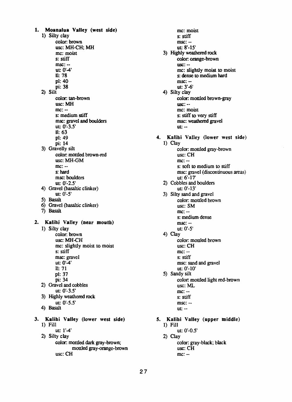
1. Moanalua Valley (west side)1) Siltyclay
colon brownuse: MH-CH; MHme: moists: stiffmsc: --ut: 0'-4'11:78pi: 40pi: 38
2) Siltcolor: tan-brownusc:MHme: --s: medium stiffmsc: gravel and bouldersut: 0'-3.5'11:63pi: 49pi: 14
3) Gravelly siltcolon mottled brown-reduse: MH-GMme: ~srhardmsc: bouldersut: 0'-2.5'
4) Gravel (basaltic clinker) ut: 0'-5'
5) Basalt6) Gravel (basaltic clinker)7) Basalt
2. Kalihi Valley (near mouth)1) Silty clay
color: brownuse: MH-CHme: slightly moist to moists: stiffmsc: gravelut: 0'-4'11:71pi: 37pi: 34
2) Gravel and cobbles ut: 0'-3.5'
3) Highly weathered rock ut: 0'-5.5'
4) Basalt
3. Kalihi Valley (lower west side)1) Fill
ut: l'-4'2) Siltyclay
color: mottled dark gray-brown;mottled gray-orange-brown
usc:CH
me: moist s: stiff msc: - ut: 8'-15'
3) Highly weathered rock colon orange-brown usc:~mc: slightly moist to moist s: dense to medium hard msc: - ut: 3'-6'
4) Siltyclaycolor: mottled brown-grayusc:--mc: moists: stiff to very stiffmsc: weathered graveluu-
4. Kalihi Valley (lower west side)1) Clay
color: mottled gray-brownusc:CHme: ~s: soft to medium to stiffmsc: gravel (discontinuous areas)ut: 6'-17
2) Cobbles and boulders ut: 0'-13'
3) Silty sand and gravel color: mottled brown use: SM me: -s: medium dense msc: - ut: 0'-5'
4) Claycolor: mottled brownusc:CHme: -s: stiffmsc: sand and gravelut: O'-IO 1
5) Sandy siltcolon mottled light red-brownuse: MLme: -s: stiffmsc: -ut: -
5. Kalihi Valley (upper middle)1) Fill
ut: 0'-0.5'2) Clay
color: gray-black; blackusc:CHme: ~
27

s: soft to medium to stiff msc: boulders ut: 1.5'-6'
3) Clayey siltcolor: mottled gray-redusc:MHme: -s: stiff to very stiffmsc: bouldersut: 0'-4.5'
6. Kalihi Valley (upper east side) 1) Clayey silt
colon dark brown;mottled red-tan-black
use: ML me: damp to moist to wet« __
msc: cobbles (discontinuous areas) ut: 1.5'-?
7. Nuuanu Valley (lower east side)1) Clayey silt (Fill)
color: brown usc:MH me: moist s: stiffmsc: sand and gravel (trace) ut: O'-l'
2) "Adobe" claycolon brown; mottled brown-grayuse: CHme: moists: stiff to very stiffmsc: gravelut: 1.5'-6'
3) Cobbles and boulders (with gray clay) ut: 0'-21'
4) Gravel and cobbles (with brown silty sand) ut: 0'-13'
5) Basalt
8. Nuuanu Valley (lower east side)1) Clayey silt
colon yellowish brownuse: --me: dry to moists: stiffmsc: ~ut: 0'-3.5'
2) Claycolon dark brownusc:--mc: dry to moists: stiffmsc: ~ut: 1.5'-3.5'
3) Basalt?
9. Nuuanu Valley (lower east side)1) Fill (clayey silt; silty clay)
colon brown use: MLme: slightly moist s: firm to medium stiff msc: gravel and cobbles ut 0'-6.5'
2) Silty claycolor: brownusc:MHme: moists: medium stiff to stiffmsc: gravel and cobblesut: 0'-7'
3) Clayey siltcolor: mottled orange-brownuse: MLme: moists: stiffmsc: gravel, cobbles, and boulders;
discontinuous areas with sand ut: 0'-23.5'
4) Basalt
10. Nuuanu Valley (lower east side)1) Clayey silt/silty sand and gravel (Fill)
color: brown; dark brown use: MH-ML; SM me: ~s: medium to stiff msc: -- ut: r-5.5 1 c:220 <|>: 26.5
2) Clayey siltcolor: reddish brownusc:MHme: ~s: stiff to very stiffmsc: -ut: 0'-7.5'
3) Clayey silt (highly decomposed basalt)color: mottled brown-grayusc:MHme: -s: very stiffmsc: gravelut: 7.5'-8.5c: 1025<|>: 16
4) Weathered basalt or boulders
11. Nuuanu Valley (lower east side)1) Sandy gravel (Fill)
color: dark gray usc:GW
28

me: dry s: loose msc: - ut: 0'-2'
2) Silly claycolon brown; red-brownuse: MH; MH-CHme: moists: stiff to very stiffmsc: trace of sandut: 5'-711: 60, 89, 75pi: 35, 41, 37pi: 25, 48, 38we: 47,45,46li: 0.48, 0.08, 0.24c:250<t>:30
3) Clayey siltcolor: brown usc:MH me: wet s: stiff msc:~ ut: 0'-4.5' 11:66 pi: 52 pi: 14 we: 45 li: -0.05
4) Siltysandcolor red-brownuse: SMme: wets: medium densemsc: clay and gravelut: 0'-8.5'
5) Cobbles and boulders ut: 0-4.5'
6) Basalt
12. Nuuanu Valley (lower east side)1) Fill (silty sand; clayey silt)
colon gray; mottled brown-reduse: SM; MHme: moists: loose to medium dense; medium stiffmsc: gravel; sand and gravelut: 0'-3.5'
2) Clay (slopewash) colon dark brown usc:CHme: moist to saturated s: soft to medium stiff msc: sand and gravel ut: 0'-1.5'
3) Silty claycolon gray-brown
usc:CH me: ~c*
msc: - ut: 0'-2'
4) Clayey siltcolor, brown; mottled brownusc:MHme: moists: stiff to very stiffmsc: sand and gravelut:711: 58pi: 33pi: 25
5) Basalt (slightly to moderately weathered)
13. Nuuanu Valley (middle)1) Fill/pavement (silty gravel)
color: brown; gray use: GM me: - s: ~ msc: - ut: O'-l'
2) Clayey siltcolor: mottled brown-red; brownusc:MHme: moists: hard; medium stiff to very stiffmsc: gravel and cobbles; trace of sandut: 4'-16.5'c: 1025<|>:23
3) Basalt
14. Nuuanu Valley (middle west side)1) Silty clay
color: brown; brown-grayusc:MHme: moistQ* ~~
msc: cobbles and boulders: ut 0'-3
2) "Adobe"clay*color: dark grayusc:CHme: moists: -msc: cobbles and bouldersut: 3'-24'
3) Silty claycolor: brown; brown-grayuse: MH; MH-CHme: moists: --msc: cobbles and bouldersut: O'-l 1.5'
29

4) Basalt?
15. Nuuanu Valley (middle east side)1) Clayey silt (Fill)
color: brown; reddish brown;dark brown
use: MH? (CH-MH) me: wet s: softmsc: sand and gravel ut: 2.5'-5' 11: 54 pi: 27 pi: 27 we: 49 li: 0.81 c:260 4>:28
2) Clayey siltcolor mottled brown-redusc:MHme: damp to moists: stiffmsc: sand and gravelut: 6'- 13'11: 94, 87pi: 47, 44pi: 47, 43we: 56li: 0.19c:650
16. Nuuanu Valley (upper east side)1) Clayey silt
color: brown; mottled orange, red,gray-black, yellow
usc:MH me: moists: medium stiff to stiff msc: decomposed rock ut: 9'- 13.5' 11: 82, 103, 76, 61 pi: 40; 49; 49; 42 pi: 42, 54, 27, 19 we: 47, 56, 57 li: 0.17, 0.26, 0.79 c: 550, 375, 260, 420 <(): 29, 33.5, 26, 29
2) Decomposed rock/weathered rock
17. Nuuanu Valley (upper)1) Clayey silt
color: brownuse: MHme: moists: stiffmsc: gravel and cobbles
(discontinuous areas)ut: 3'-15 11: 73 pi: 48 pi: 25 we: 55 li: 0.28
2) Bouldersut: 0'-2.5'
18. Nuuanu Valley (upper west side)1) Siltyclay
color gray-brownuse: CH-MHme: moists: soft to stiffmsc: gravel (discontinuous areas)ut: 2'-15.5'11: 92, 81pi: 39, 36pi: 53, 45we: 46, 52li: 0.13, 0.36c: 415,400<fr: 18.5, 30
2) Clayey siltcolor: mottled brown-grayusc:MHme: moists: stiffmsc: gravelut: 2.5'-13'11:73pi: 43pi: 30we: 61li: 0.60c:280<fr: 28.5
19. Manoa Valley (lower east side)1) Asphalt concrete and silty coral gravel
(base coarse) color: tan usc:GW me: -s: very dense msc: - ut: 0.5'-1.5'
2) Silty basalt gravel (Fill) color: brown usc:GM me: ~s: medium dense to very dense msc: boulders ut: 0.5'-7' 11: 31, 23 pi: 26, 18
30
pi: 5, 53) Volcanic clinker and vesicular basalt
(Sugarloaf basalt flow)
20. Manoa Valley (lower west side)1) Clayey silt (Fill)
color: brown usc:MH me: damp s: stiffrose: some sand ut: l'-6'
2) Black sand (cinder) color: tannish use: SP me: damp s: medium dense msc: silt ut: 3'-7.5'
3) Black sand (cinder) colon black use: SP me: damps: medium dense to loose ut: 3'-13'
21. Manoa Valley (lower east side)1) Asphalt concrete and base coarse
(sandy silty gravel) ut: O'-l 1
2) Sandy silt/clayey silt (Fill)color: brown; reddish brown;
dark brown-black use: MH; MH-ML? (CH-MH) me: --s: stiff to very stiff msc: gravelly with boulders ut: 0.5'-7' 11: 65, 64, 62 pi: 32, 29, 27 pi: 33, 35, 35 we: 31,--,28 li: -0.03, --, 0.03
3) Silty sand (weathered cinder)color: reddish brown; mottled brown-
gray; blackish-brown; light brown
use: SM; GM-SM; SP; GP-GM; SM-SP
me: -s> * msc: gravel and some bouldersut: 0'-9.5'
4) Silty gravel (weathered clinker)color: brown; light brown; reddish-
brown; yellow-brown use: GM; GM-SM; GM-MH me:
s: loose to medium dense msc: sandy ut: 0'-5'
5) Basalt
22. Manoa Valley (lower east side)1) Silty clay
color, brownuse: CHme: moists: medium stiffmsc: cobbles and boulders
(discontinuous areas) ut:--11:92,63, 100, 112 pi: 28, 29, 17, 35 pi: 64, 34, 83, 77
2) Sandy siltcolor: brown; light brown;
mottled orange-brown use: ML me: moist s: stiffmsc: boulders (discontinuous areas) ut:--
3) Conglomeratecolor: mottled orange-brownuse:--me: -s: medium hardmsc: --ut: O'-l'
4) Basaltut: 0'-14'
5) Basaltic clinker ut: 0'-4'
6) Basaltut: 2'-14'
23. Manoa Valley (middle west side)1) Clayey silt
color: brownusc:MHme: moists: stiffmsc: gravel (discontinuous areas)ut: 2.5'-15'
2) Cinderscolor: brownuse: SPme: moists: medium densemsc: silt (discontinuous areas)ut: l'-3'
3) Basalt
24. Manoa Valley (middle)1) "Adobe" clay (Fill)
31

color: dark gray-brownusc:CHme: moistC" «.
msc: roots ut: 0.5'-1.5'
2) Dead grass and rootsut 0'-0.3'
3) Fill (sandy silt; clay; coarse gravel)color reddish brown; grayuse: ML; CHme: moists: medium stiffmsc: coral, gravel, and cobblesut: 0'-1.3'
4) Siltcolor: brownuse: MLme: slightly moists: -msc: some rootsut: 0'-0.5'
5) Siltyclaycolor: brown; mottled brownusc:MHme: moists: very stiffmsc: some gravel and sandut-
6) Clayey siltcolor: brown; mottled brownusc:MHme: dry to moists: stiffmsc: some sand and gravelut: 0'-4.5'
25. Manoa Valley (middle east side)1) Siltyclay
color: brownuse: MH-CHme: dry to moist to wets: very stiffmsc: sand and gravelut: 1.5'-3'
2) Claycolon gray; brown; dark brownusc:CHme: wets: soft to stiffmsc: trace of gravel (grades to more
sand and gravel) ut: 2'-9' 11: 86 pi: 36 pi: 50 we: 51 li: 0.30
3) Clayey gravel/gravelly clay color brown use: GC-CH me: moist to wet s: dense to very dense msc: sand ut:3'
26. Manoa Valley (middle east side)1) Siltyclay
color: brown; dark brownuse: CHme: moists: stiffmsc: gravel (discontinuous areas)ut: 4'-12'
2) Siltyclaycolor: brown; yellow-brownusc:CHme: saturateds: very stiffmsc: gravelut: 11.5'-14'
27. Manoa Valley (upper east side)1) Fill (clayey silt and silty clay)
colon reddish brown; brown-black;brown-gray
usc:MH me: moist s: stiff msc:- ut: 0'-4.5'
2) Clayey siltcolor: reddish brown; brownuse: MHme: moist to wets: very stiff to softmsc: gravel (discontinuous areas)ut: 4'-21.5'
3) Decomposed rock (saprolite) colon gray-brown c:525 <(»: 31
28. Manoa Valley (upper east side) 1) Sandy silt
color: brownuse: MH-SMme: wets: medium stiffmsc: gravelut: 0'-1.5'11: 103pi: 45pi: 58we: 64li: 0.33
32
2) Clayey siltcolon brownusc:MHme: moist to wets: stiff to medium stiffmsc: gravel and sandut: 0'-4'11:87pi: 45pi: 42we: 76li: 0.74
3) Siltcolor: brown; mottled brownusc:MHme: moists: medium stiff to very stiffmsc: -ut: 0'-4.5'11: 97, 98pi: 48,45pi: 49, 53we: 55, 50li: 0.14, 0.09c:500<j):32
4) Sandy silt/silty sandcolon reddish brown, dark brownuse: MH-SM; SMme: moist to wets: very stiff to stiffmsc: --ut: 0'-1.5'
29. Manoa Valley (upper west side)1) Clayey silt
color: brown; brown-grayusc:MHme: moist to wets: stiff to softmsc: sand and gravelut: 7.5'-10'
2) Silty sand (cinders) color: brown use: SM me: moist s: stiff to loose msc: -- ut: 1.5'
3) Clayey siltcolor: mottled reddish brown;
tan-brown usc:MH me: moist s: medium stiff msc: some sand; gravel ut:8.5'-ll'
30. Manoa Valley (upper end)1) Silty clay
colon reddish brownusc:MHme: moist to wets: stiffmsc: ut: 0'-2'
2) Clayey siltcolon brown; mottled red-brownusc:MHme: moists: stiffmsc: -ut: 13'-15'11:78pi: 51pi: 27we: 47li: 0.15c:1200<t>: 26.5
31. Manoa Valley (upper end)1) Clayey and silty gravel
color: brown; dark brownuse: GC; GMme: moists: medium densemsc: silty gravel with sandut: 0'-1.5'
2) Clayey siltcolor, mottled brown-orange; brownusc:MHme: moist to very moists: stiffmsc: trace of gravelut: 10.5'-22'
32. Manoa Valley (upper end)1) Fill (coral sand, silty sand, sandy silt,
clayey silt)color: gray-tan; brown; gray use: SM; SM; ML; MH me: moist s: very stiff msc: gravel ut: 0'-4'
2) Clayey siltcolor: mottled brownusc:MHme: moists: stiff to hardmsc: cobbles and boulders;
may be sandy ut: -
3) Silty claycolor: dark brown; dark gray-brown
33
use: CH-OHme: moists: softmsc: gravel (discontinuous areas)ut: 0'-6'11: 90, 84pi: 42,42pi: 48, 42we: 66, 64li: 0.50, 0.52
4) Boulders ut: 0'-6'
5) Clayey siltcolon mottled brownusc:MHme: moists: stiffmsc: sand (discontinuous areas)ut: 0.5'-12'11: 86pi: 46pi: 40we: 72li: 0.65
33. Palolo Valley (middle west side)1) Siltyclay
color: dark brown; light brown;gray-brown
use: CH me: moist s: stiffmsc: boulders ut: 3'-5' 11:97 pi: 36 pi: 61 we: 29.8 li: -0.10
2) Clayey siltcolor: brown; mottled blue-grayuse: ML-MH? (MH)me: slightly moist to moists: firmmsc: some bouldersut: 7'-9'11:65pi: 41pi: 24we: 27.8li: -0.55
3) Basalt
34. Palolo Valley (upper west side)1) Slopewash (clayey silt, silly clay, clay)
color: brown; dark brown; dark grayto black
use: MH to CH
me: dry to moists: medium stiffmsc: trace of sand; gravelut: 2.5'-14'c:425<(>:29
2) Siltyclaycolor mottled brown-gray-yellowuse: MH; CH-MHme: moists: stiff to very stiffmsc: gravelut: 0'-4.5'-31.5'c:925<t>:23
3) Silty and gravelly sand (highly weathered rock)
color: dark brown; mottled brown- yellow
use: SP; GM; ML-SM; MHme: moists: dense to very stiffut: 0'-16'
4) Basalt5) Basaltic clinker6) Basalt7) Basaltic clinker
35. Palolo Valley (east side)1) Gravel (Fill)
color: brown; red; gray-brownuse: SPme: slightly moist to very moists: medium dense to softmsc: silt and clayut: 0'-6'
2) Siltyclaycolon dark brownusc:CLme: wets: softmsc: fine sandut: 0'-1.5'
3) Clayey silt*color: orange-brown; brown; blue-gray;
violet-red usc:MH me: moist s: medium stiff msc: fine sand ut: r-17.5 1 11:95 pi: 50 pi: 45 we: 55.3 li: 0.12
4) Highly weathered basalt (saprolite) ut: 3'-8'
34

11:45 pi: 32 pi: 13 we: 41.5 li: 0.73
5) Clayey silt/siltcolor: mottled gray-brown-redusc:MH;MLme: moists: stiffmsc: sand and gravel (discontinuous
areas) ut: 5'-21' 11:70 pi: 47 pi: 23 we: 57.4 li: 0.45
6) Highly weathered basalt (gravelly, silly)
36. Wailupe Valley (upper west side)1) "Adobe" clay (Fill?)
color: brown; gray-brownusc:CHme: dry to moists: medium to stiffmsc: gravel, cobbles, and bouldersut: 0'-14.5'11: 78, 52, 72, 77pi: 34, 28, 28, 29pi: 44, 24,44, 48we: 29.9, 22, 36.4, 29.5li: -0.09, -0.25, 0.19, 0.01
2) Siltyclaycolor: brown; light brownuse: MH-CH; MHme: slightly moist to moists: very stiffmsc: cobbles and bouldersut: 0'-15'11: 95, --, 63, 67pi: 42, -, 48, 50pi: 53, --, 15, 17we: 43.9, 35.4, --, 30.2li: 0.04, 0.07, --, -1.16
3) Gravel, cobbles, and boulders ut: O'-l 1
4) "Adobe" claycolor: brown; gray-brownuse: CHme: moists: very stiffmsc: cobbles and bouldersut: O'-ll'11: 72pi: 32pi: 40we: 33.1
li: 0.035) "Adobe" clay
colon gray usc:CH me: moist s: stiff msc: cobbles ut: O'-IO' 11:93 pi: 33 pi: 60
37. Wailupe Valley (lower east side) Note: carbonate seams through some soil layers
1) Silty clay; clay (Fill)colon red-brown; brownuse: MH; CHme: --; moists:-; stiffmsc: cobbles and bouldersut: O'-l 1 ; 0'-6'
2) "Adobe"clay*colon gray-brownusc:CHme: moists: stiffmsc: boulders (discontinuous areas)ut: 2'-7.5'
3) Silty clay (some blue staining) color: brown usc:MH me: dry s: stiffmsc: cobbles and boulders ut: 0'-12'
4) Clayey silt (tuffaceous) color: brown usc:MH me: dry s: stiffmsc: few boulders ut: O'-lp1
5) Basaltic clinker (also tan silty sand and cobbles)
38. Niu Valley (upper west side) 1) Siltyclay
color dark gray-brownuse: CHme: moists: highly plasticmsc: bouldersut: I 1-1.5'11: 76pi: 33pi: 43we: 42.9li: 0.23
35

2) Clayey siltcolon gray-brownusc:--mc:drys: -msc: bouldersut: 0'-2'
39. Niu Valley (middle)1) Clayey silt
colon molded brownuse: MHme: drys: hardmsc: sand and gravelut: 0'-1.5'
2) "Adobe" claycolor: brown; dark brown usc:CHme: slightly moist s: stiffmsc: trace of gravel; boulders
(minimum depth about 1.5'-3.5')
ut: 0'-9'3) Sandy silt
color: brownuse: ML; GP-GMme: drys: hardmsc: gravel, grades to bouldersut: 0'-7.5'
4) Siltyclaycolon mottled brown; dark gray; brownuse: CH-MHme: moists: very stiff; hardmsc: gravelut: 0'-3'
5) Silty claycolor: brown use: CL me: dry s: stiff msc: sand ut: 0'-3'
40. Kuliouou Valley (lower west side) 1) "Adobe" clay
colon brown-grayusc:CHme: dry to moists: stiffmsc: sand and gravelut: 2'-3.3'11: 90, 83pi: 26, 28pi: 64, 55
we: 31 li: 0.08
2) Siltyclaycolon gray-brownusc:CHme: moist to wets: softmsc: sand and gravelut: 0'-3.5'11: 70, 67pi: 29, 27pi: 41,40we: 47li: 0.44
3) Gravelly sandcolon tan; dark brown; grayuse: SP; GPme: -s: -msc: --ut: O'-l'
4) Silty sand color: tan use: SM me: - s: - msc: -- ut: 0'-4'
5) Siltyclaycolor: gray use: CH-MH me: - s: soft msc: - ut: O'-l'
41. Kuliouou Valley (lower middle west side)
1) Claycolor: black-brown; dark gray; brownusc:CHme: moists: softmsc: gravel and cobblesut: 0'-5'11:94pi: 26pi: 68we: 42.7li: 0.25c:580<t>:9
2) Claycolor: grayuse: CHme: moists: stiffmsc: gravel, boulders, and sand
36

ut: 0'-6.5' 11:93 pi: 28 pi: 65 we: 39.7 li: 0.18 c: 530, 1450 4>:31,28
3) Clayey siltcolor: brown usc:MH me: -o»
msc: cobbles ut:0'-11.5'
4) Silly claycolor: gray; brown; mottled
brown-orange use: CH me: moist s: soft to stiffmsc: gravel, cobbles, and boulders ut: 0'-31' 11:87 pi: 28 pi: 59 we: 37.1 li: 0.15
42. Kuliouou Valley (upper middle west side)
1) Silly claycolor: brownusc:CHme: slightly moisl lo moisls: firm lo stiffmsc: gravel and cobblesui: 2'-13'
2) Clayey sillcolor, molded gray-brown-orangeuse: MH-CHme: moisls: stiffmsc: gravel, cobbles, and bouldersui: 0'-17.5'
3) Basalt
43. Kuliouou Valley (upper end)1) River boulders
ui: 0'-3'2) Cobbles
ui: 0'-2'3) Clayey sand
color: gray-brown; brownuse: SCme: dry lo moisl lo weis: --msc: gravel and cobbles
ui: 0'-4'4) "Adobe" clay
color: dark grayusc:CHme: moisl lo wels: medium stiff lo softut 0'-2'
5) Silly claycolon brown-grayuse: MH-CHme: moisls: stiffmsc: gravel, cobbles, and bouldersuu O'-IO1
6) Clayey sillcolon gray; brownusc:MHme: moisls: stiffmsc: gravel, cobbles, and bouldersut: 0'-5'
44. Hahaione Valley (lower east side)1) Clayey sill (Fill)
color: dark brown-grayuse: MHme: --s: medium stiffmsc: gravel, cobbles, boulders,
and wood ut: 0'-6'
2) Clayey siltcolor dark brown; dark grayuse: MHme: --s: soft lo stiff to very stiffmsc: may have gravel, cobbles,
and boulders ut: 0'-13.5'
3) Sandy clayey silt color dark brown use: MH me: s:hard msc: -- ut: 0-1.5'
4) Sandy silt (weathered tuff)color: orange-brown; brownuse: SM; MLme: -s:hardmsc: --ui: 0'-8'
5) Coral sandcolor: tan; whiteuse: SP; SMme: --s: medium dense to dense
37
msc: ~ ut: 0'-8'
6) Algal coral reefcolor: tan; whiteuse: --me: -s: medium hardmsc: -ut: 0'-9.5
7) Clayey siltcolor: dark grayusc:MHme: ~s:hardmsc: gravel, cobbles, and bouldersut: 0'-35'
8) Sandy siltcolon dark brownuse: MH-SM; MLme: -s: medium stiffmsc: gravel and bouldersut: 0'-21'
9) Basalt
45. Hahaione Valley (upper west side)1) Clayey silt
color: dark gray-brownusc:MHme: drys:hardmsc: gravel and cobblesut: 0'-2.5'
2) Claycolon gray-brownusc:CHme: drys: hardmsc: gravel and cobblesut:0'-11.5'
3) Clayey siltcolor: red-brown; orange-brownusc:MHme: dry to moists: stiffmsc: gravelut: 0-6.5'
4) Siltyclaycolor: dark gray-brownusc:CHme: drysrhardmsc: gravelut: 0'-2'
5) Siltysandcolor: mottled brownusc:--mc: ~
s: medium dense msc: gravel and cobbles (highly
weathered conglomerate) ut: 0'-7'
46. Kamiloiki Valley1) Clay
color: dark grayusc:CHme: moists: stiffmsc: boulders, 10-25%ut: O'-IO'11:95pi: 27pi: 68we: 32.6li: 0.08
2) Clayey gravel and boulders ut: O'-IO1
11:62 pi: 32 pi: 30
3) Silty gravel and cobbles ut: 0'-7' 11:61 pi: 36 pi: 25 we: 38.4 li: 0.10
4) Siltyclaycolon gray-brownuse: MH-CHme: moist to wets: medium dense to densemsc: cobbles and bouldersut: 0'-21'11: 76, 78, 72pi: 29, 32, 32pi: 47, 46, 40we: 30, 32, 38li: 0.02, 0, 0.15
5) Clayey siltcolon gray-brown; mottled
brown-yellow usc:MH me: moist s: stiffmsc: sand, cobbles, and boulders ut: 0'-18' 11: 53, 62 pi: 41, 37 pi: 12, 25 we: 31 li: -0.83
6) Boulders7) Basalt
38
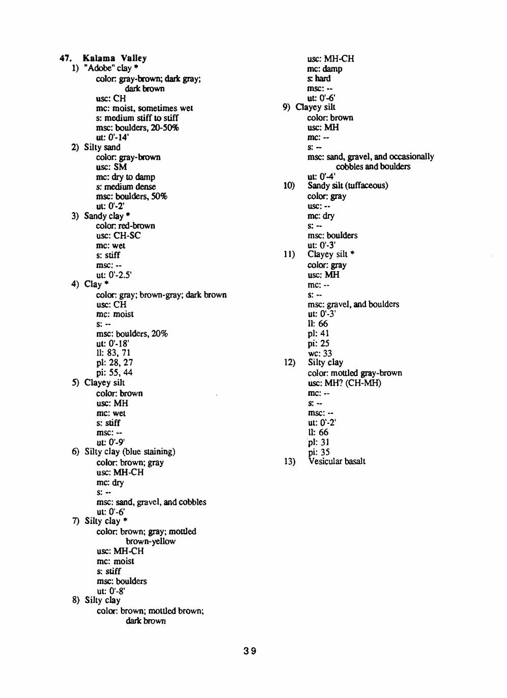
47. Kalama Valley1) "Adobe"clay*
colon gray-brown; dark gray;dark brown
use: CHme: moist, sometimes wet s: medium stiff to stiff msc: boulders, 20-50% ut: 0'-14'
2) Silly sandcolon gray-brown use: SM me: dry to damp s: medium dense msc: boulders, 50% ut: 0'-2'
3) Sandy clay*colon red-brown use: CH-SC me: wet s: stiff msc: - ut: 0'-2.5'
4) Clay*color: gray; brown-gray; dark brown use: CH me: moistS*
msc: boulders, 20% ut: 0'-18' 11: 83, 71 pi: 28, 27 pi: 55, 44
5) Clayey siltcolor: brown usc:MH me: wet s: stiff msc: - ut: 0'-9'
6) Silly clay (blue staining) color: brown; gray use: MH-CH me: dryC* «
msc: sand, gravel, and cobbles ut: 0'-6'
7) Silly clay*color: brown; gray; mottled
brown-yellow use: MH-CH me: moist s: stiffmsc: boulders ut: 0'-8'
8) Siltyclaycolor: brown; mottled brown;
dark brown
use: MH-CH me: damp shard msc: ~ uu 0'-6'
9) Clayey siltcolor: brown usc:MH me: -« _^
msc: sand, gravel, and occasionallycobbles and boulders
ut: 0'-4'10) Sandy silt (tuffaceous)
color: gray usc:-- mc:dry s: msc: boulders ut: 0'-3'
11) Clayey silt* color: gray use: MH me: -- s: --msc: gravel, and boulders ut: 0'-3' 11:66 pi: 41 pi: 25 we: 33
12) Silty claycolor: mottled gray-brown use: MH? (CH-MH) me: -
msc: - ut: 0'-2' 11: 66 pi: 31 pi: 35
13) Vesicular basalt
39
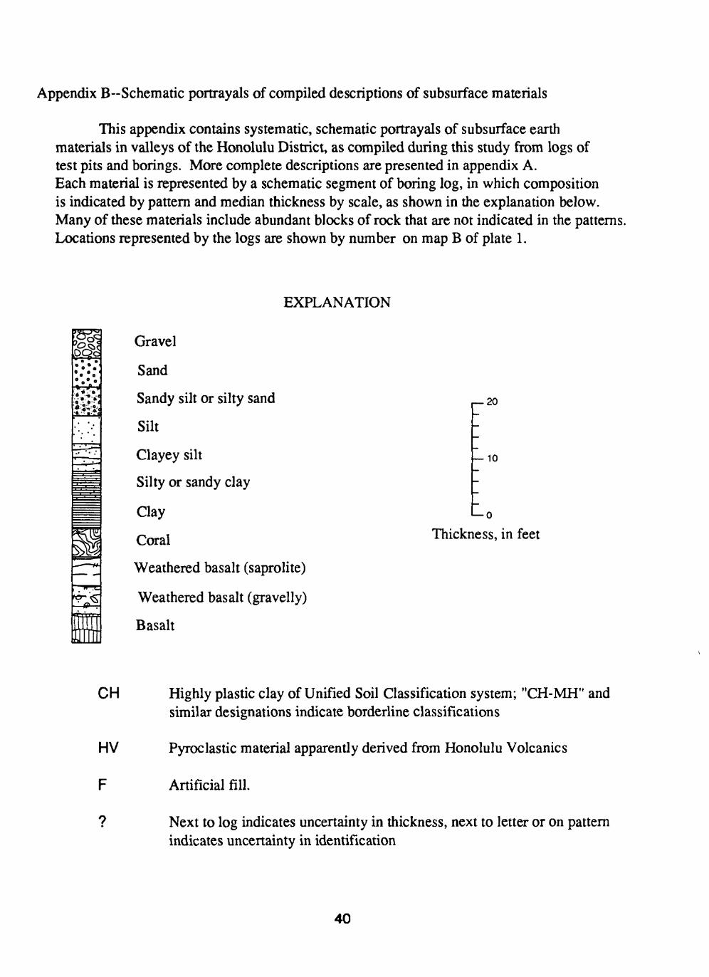
Appendix B~Schematic portrayals of compiled descriptions of subsurface materials
This appendix contains systematic, schematic portrayals of subsurface earth materials in valleys of the Honolulu District, as compiled during this study from logs of test pits and borings. More complete descriptions are presented in appendix A. Each material is represented by a schematic segment of boring log, in which composition is indicated by pattern and median thickness by scale, as shown in the explanation below. Many of these materials include abundant blocks of rock that are not indicated in the patterns. Locations represented by the logs are shown by number on map B of plate 1.
EXPLANATION
&! Gravel
Sand
Sandy silt or silty sand
Silt
Clayey silt
Silty or sandy clay
Clay
Coral
Weathered basalt (saprolite)
Weathered basalt (gravelly)
Basalt
r 20
10
> 0
Thickness, in feet
CH
HV
F
9
Highly plastic clay of Unified Soil Classification system; "CH-MH" and similar designations indicate borderline classifications
Pyroclastic material apparently derived from Honolulu Volcanic s
Artificial fill.
Next to log indicates uncertainty in thickness, next to letter or on pattern indicates uncertainty in identification
40

Site (plate 1B) Vallev Surficial material____Subsurface components Basal material
MoanaluaMH-CH
KalihiMH-CH
Kalihi
|CH =
Kalihi
iCHi
Kalihi
Kalihi
Nuuanu =CHi
8 Nuuanu
Nuuanu
10 Nuuanu.° c
11 Nuuanu
MH-CH
4pp.B-scfMmrtc.Jb0s41

Site (plate 1B) Valley Surficial material___Subsurface components Basal material
12 Nuuanu F l CH t==3 CH i
13 Nuuanu
14 Nuuanu
MH-CH iCHi
15 Nuuanu
CH-MH?
16 Nuuanu
17 Nuuanu
18 Nuuanu
CH-MH
19 Manoa
20 Manoa
HV
HV
42
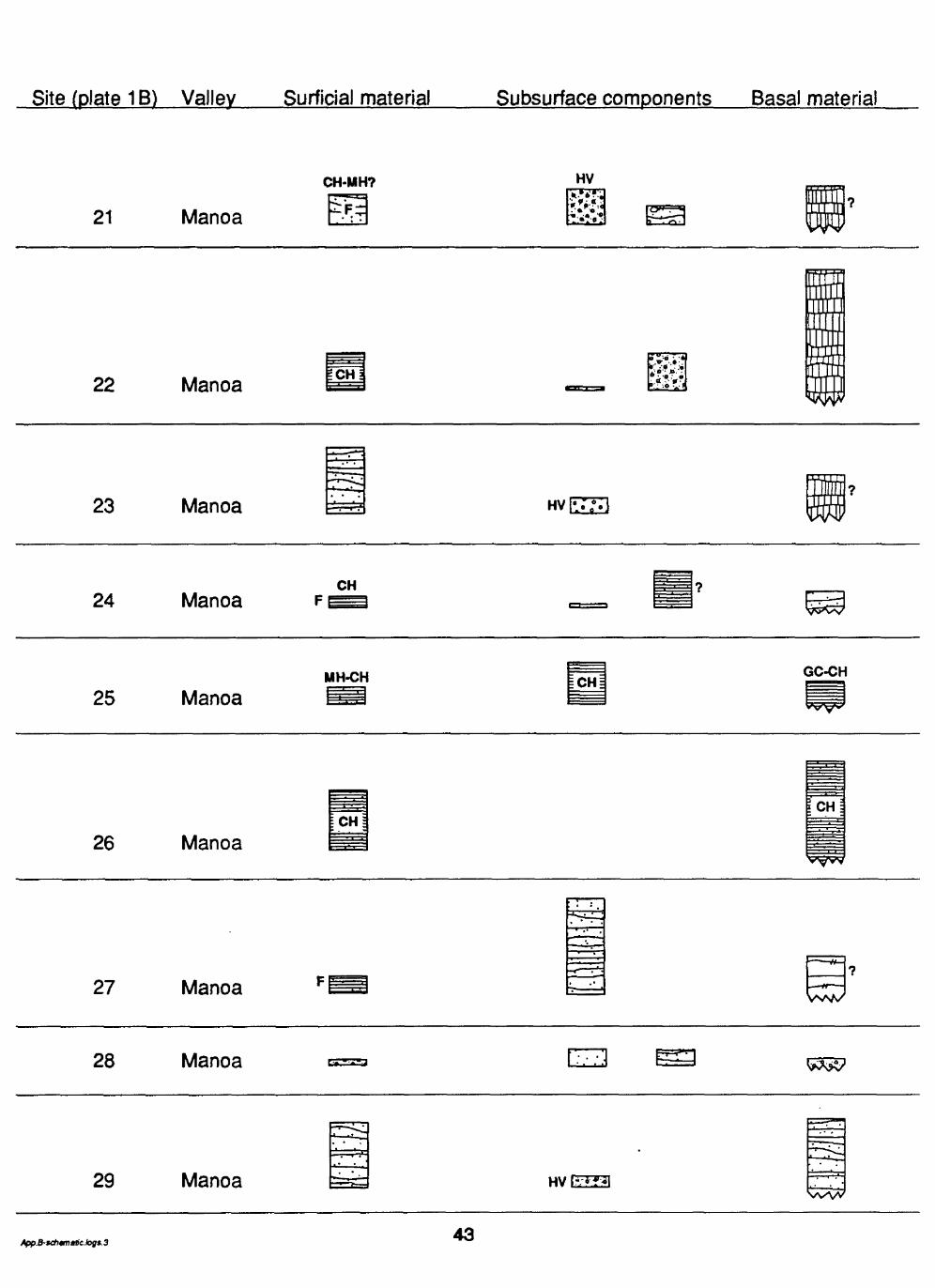
Site (plate 1B) Valley Surficial material___Subsurface components Basal material
21 Manoa
CH-MH? HV
22 Manoa ICHa
23 Manoa
24 ManoaCH
25 ManoaMH-CH GC-CH
26 ManoaCH
27 Manoa
28 Manoa
29 Manoa HVE23
43

Site (plate 1B) Valley Surficial material____Subsurface components Basal material
30 Manoa
31 Manoa
32 ManoaCH-OH
33 Palolo CH!
34 Palolo
MH to CH
CH-MH
35 Palolo
36 Wailupe
MH-CH
37 Wailupe F ECTH
App. B-schematic.logs. 4 44

Site (plate 1B) Vallev Surficial material____Subsurface components____Basal material
38 NiuCH
39 NiuCH-MH
40 KuliououCH CH-MH
41 Kuliouou
ICHl
42 Kuliouou
MH-CH
43 Kuliouou
MH-CH
CH
44 Hahaione
HV
45 HahaioneCH
46 Kamiloiki
MH-CH
.m
47 Kalama HVES3
CH-SC
CH-MH?MH-CH T^T? MH-CH Wffl
45