rehabilitation of former snowy scheme sites in kosciuszko ... · tion of seven power stations, 16...
TRANSCRIPT

Rehabilitation of former SnowyScheme sites in Kosciuszko NationalParkBy Elizabeth MacPhee and Gabriel Wilks
Ten years of restorationwork at 200 sites withinKosciuszko National Park– sites damaged during theconstruction of Australiasmost iconic hydroelectricscheme – is showingsubstantial progress and iscontributing to theprotection of the parksinternationally significantecosystems.
Key words: alpine ecosystem restoration,
conservation management, industrial site
remediation, soil stabilisation.
Elizabeth MacPhee is Rehabilitation Officer
with National Parks and Wildlife Service, Office
of Environment and Heritage NSW (PO Box 472,
Tumut, NSW 2720, Australia); Email: elizabeth.
[email protected]; Tel: +61 2
6947 7076). Gabriel Wilks is Environmental
Officer with National Parks and Wildlife Service,
Office of Environment and Heritage NSW (PO
Box 472, Tumut, NSW 2720, Australia); Email:
Introduction
Kosciuszko National Park (Fig. 1),
located in the south-eastern corner
of New South Wales (NSW), contains
alpine and subalpine flora and faunacommunities (Box 1), the continents’
highest mountains, unique glacial
landscapes, and rich indigenous and
historic cultural values. These features
have contributed to the park being
included on the Australian National
Heritage List and recognised as an
International Biosphere Reserve
(UNESCO 2010).
The Snowy Mountains Hydro-Elec-
tric Authority (SMHEA) Scheme, Aus-
tralia’s largest industrial project, was
carried out from 1949 to 1974 in the
area now gazetted as national park.This scheme is listed on Australia’s
Register of the National Estate for its
internationally recognised engineer-
ing achievements and its impact on
Figure 1. Summer view in Kosciuszko National Park looking from about 1750 m (subalpine
zone) to Geehi Dam (at 1100 m). The Snowy Mountains Hydro-Electric Scheme left high historic
value, but a legacy of environmental damage at about 400 sites in the park, of which about half
have been rehabilitated to date through this ambitious restoration project (The Alpine zone, includ-
ing Mt Kosciuszko is in the far distance.) (Photograph G. Little).
ª 2013 Ecological Society of Australia ECOLOGICAL MANAGEMENT & RESTORATION VOL 14 NO 3 SEPTEMBER 2013 159
doi: 10.1111/emr.12067 F E A T U R E
EcologicalSociety of Australia
Box 1. Kosciuszko National Park EcosystemsKosciuszko National Park is one of the largest conservation reserves in Australia, encompassing 673 542 ha of land. It
straddles the Great Dividing Range in south-east corner of the Australian mainland and contains the continent’s highest peak,
Mt Kosciuszko, at 2228 m. The park contains the headwaters of the Murrumbidgee, Snowy and Murray Rivers; however, 60%
of the stream flow in the Park is captured and diverted for the Snowy Scheme and irrigation purposes. Its valued features include
exceptional diversity of plant communities and endemic species in alpine vegetation, soils of outstanding scientific value and a
number of threatened fauna species.
VegetationThree zones, based on altitude, are recognised (Good 1992, McClucki 1927, Costin 1954, 1957): montane zone, subalpine
zone and alpine zone.
1 Montane zone consists of steeply sloping land extending from the valley floors and plains (at about 300 m) up to about1500 m in NSW. At this upper limit, the mean mid-winter temperature is about 0°C, and in mid-winter, snow continuouslylies for a month or more. Summers are hot to warm (the latter at higher elevations), and at the lower elevation average rainfallis about 650 mm, increasing to 2200 mm at the higher elevation. Typically in this zone, the summers are warm and thewinters are cold. In this zone, many species of eucalyptus and other trees can grow.
The zone supports eucalypts and other trees, with broad community types including
(i) Woodlands of peppermints, boxes and stringybarks (Eucalyptus spp.), on duplex soil with sharp increases in clay contentat about 30 cm in depth. This leads to a hardsetting surface, with subsoils of low soil porosity.
(ii) Open forests of peppermints and gums on soils with a gradual increase in clay content with progressively more friablesoil with more open structure and increasing acidity.
(iii) Tall open forests of Alpine Ash (Eucalyptus delegatensis) and Mountain Gum (Eucalyptus dalrympleana) on soils withuniform texture profiles on soils that are more friable and more acidic, as low as pH 5.0, becoming clay loams or loamsat about 1200 m.
The steep terrain of the ridges and long upper slopes result in shallow soils, from which material is being removed by natural
processes such as soil creep, and in deeper soils on the lower slopes sometimes on collegial gravels which have in filled deep
former gullies.
2 Subalpine zone is characteristically high plains or rolling plateaus and occurs between 1350 and 1750 m and is char-acterised by very low winter temperatures with snow lying on the ground. Cold, wet and often windy conditions canoccur at any time of the year, and summers can be warm and dry. The range of trees that can survive is restricted;however, more by the cold and wet low winter temperatures, Snow Gum (Eucalyptus pauciflora) is characteristic of thiszone.
There are two distinctive landscapes with characteristic soils:
(i) Snow Gums and heaths on shallow, stony, uniform soils. The understorey species include snow grasses (Poa spp.) andsparse heath plants. The upper slopes also have similar soils, with heath species of Prostanthera, Orites, Grevillea andPhebalium occurring.
(ii) Grasslands on deep uniform soils (alpine humus soils or organic loams on the lower slopes of the rolling plateaus. Theseslopes are characterised by the absence of trees due to cold air drainage patterns, but support open heaths and grass-lands.
3 Alpine zone occurs above the treeline where the mean summer temperature is approximately 10°C or less. In NSW, thealpine zone occurs at around 1800 m and supports a suite of significant vegetation communities, including heaths, herb-fields, bogs, fens, feldmark and sod tussock grasslands. These communities also have significant biological and hydrologicalconservation values and support many rare and endemic flora and fauna species. Alpine soils are typically organic humussoils prone to wind and water erosion when exposed. They are typically low in nutrients, but cycle nutrients rapidly resultingin thick vegetation cover where undisturbed. Rocky outcrops are common.
160 ECOLOGICAL MANAGEMENT & RESTORATION VOL 14 NO 3 SEPTEMBER 2013 ª 2013 Ecological Society of Australia
F E A T U R E

Australian society from the influx of
migrant workers and industrial work-
place developments. The Scheme,
which evolved into a hydroelectricityand irrigation complex, was a massive
engineering feat with the construc-
tion of seven power stations, 16
major water storages and 220 km of
tunnels and aqueducts.
In environmental terms, the con-
struction of the ‘Snowy Scheme’ had
significant negative impacts on thebiota and landscapes of the park as
well as on the catchments involved.
This included impacts from activities
such as water diversion from rivers
and streams; the cutting and clearing
of roads and construction sites
through sensitive areas such as sphag-
num bogs and steep unstable coun-try; and the use of introduced plants
to stabilise eroding soils (Costin
1958). One impact that has been per-
haps less well documented is the
dumping of large volumes of rock
following underground blasting of
tunnels and the cutting of benches
for aqueduct pipelines in a range oflocations across the park. This has
resulted in the filling of a number of
valleys with spoil rock (Fig. 2), some
of which has destabilised and washed
downstream in major flood event,
causing turbidity and sedimentationof water which has severely impacted
aquatic life below the site (Harris
et al. 2006). The erosion events have
also filled natural ponds, blocked or
diverted streams, and buried riparian
vegetation, creating moist areas open
to weed invasion such as willows (Sa-
lix spp.) and Scotch Broom (Cytisusscoparia). Further slips have the
potential to cause greater damage in
the future unless the sites are fully
stabilised.
Prior to corporatisation of the
SMHEA in 2002, relevant agencies
agreed that it was necessary to deter-
mine the extent of environmentalliabilities on sites within Kosciuszko
National Park that were no longer
required as part of management of
the Snowy Scheme. Between 1998
and 2000, approximately 400 former
Snowy Scheme sites within the park
(Fig. 3) were assessed by National
Parks and Wildlife Service (NPWS),other natural resources state agencies
(including the NSW Environmental
Protection Authority), NSW Treasury,
SMHEA and an independent consul-
tant (CH2M Hill 2000) to determine
the extent of risk of breaching NSWand Commonwealth environmental
legislation. The sites were split into
two categories: those with environ-
mental issues but unlikely to breach
legislation were classed as minor
and those with greater potential for
breaching legislation were classed as
major. Of the 35 sites listed as majorsites, 23 were spoil dumps with the
remainder including quarries, former
townships and landfill sites. Minor
sites were generally snow courses,
communications lines, storage
depots, temporary camps and town-
ships, power lines and stream gaug-
ing stations.CH2M Hill was then engaged to fur-
ther assess and develop a concept
plan for each major site. Each plan
identified the natural and cultural her-
itage values of the site and current
issues at each site including site stabil-
ity, flora and fauna, weed invasion,
hydrology and water quality, solidwaste, visual amenity, heritage values
and management logistic issues. The
FaunaThe park provides habitat for a diversity of mammals, birds, reptiles, frogs and invertebrate fauna. Among the mammals,
there is only one species, the Mountain Pygmy Possum (Burramys parvus), which is today confined to the mountains of
south-eastern Australia and only occurs above 1200 m. Another small mammal species, the Broad-toothed Rat
(Mastacomys fuscus) is presently found in two widely separated areas in NSW (the Barrington Tops region and Snowy
Mountains region).
Among the birds, there are no species confined to the mountains. However, of the 60 species recorded living above 500 m,
there are only 12 species that are year-round residents in the Snowy Mountains. These include owls, kingfishers, warblers and
wood swallows.
Terrestrial vertebrate wildlife is usually scarce in alpine regions. However, the wildlife of the Snowy Mountains and Victorian
Alps is comparatively rich with eight frogs, two snakes and 12 lizards, all but one of which are skinks. Endemic skink species
include the Alpine Water Skink (Eulamprus kosciuskoi), the Guthega Skink (Liopholus guthega) and the Alpine Oak Skink
(Cyclodomorphus praealtus). Three frog species, the Southern Corroboree Frog (Pseudophryne corroboree), Northern
Corroboree Frog (Pseudophryne pengilleyi) and the Baw Baw Frog (Philoria frosti) and two subspecies, the Alpine Tree Frog
(Litoria verreauxii alpina) and the Snowy Mountains Banjo Frog (Limnodynastes dumerili fryi), are found only in snow-country
areas.
The majority of endemic species occur in the invertebrate group: swift moths, stoneflies, cockroaches and particularly the
grasshoppers of the genus Kosciuscola are specific to the Australian Alps.
[Fauna information for this box was drawn from Green and Osborne (2012) and DEC (2006).]
Box 1. Continued
ª 2013 Ecological Society of Australia ECOLOGICAL MANAGEMENT & RESTORATION VOL 14 NO 3 SEPTEMBER 2013 161
F E A T U R E

plan also provided conceptual restora-
tion measures to treat the causes and
addresses these impacts, including
an estimate of cost. A total of $78 mil-
lion was estimated to implement the
agreed restoration objectives at these
major sites.
As a result of the assessment pro-
cess, in 2002, the newly corporatised
Snowy Hydro Limited (SHL) and
NSW NPWS signed a deed whereby
SHL agreed to contribute a total of
$25 M to fund the restoration, man-
aged by NPWS, of the major Former
Snowy Scheme Sites – and $7 M to
fund the minor former sites. The dif-
ference in funding was agreed to be
addressed by further risk assessment,and accepting sites would not be fully
restored to their pre-existing land-
forms, but stabilised with functional
locally native vegetation communities,
achieving restoration standards to the
highest standard feasible.
This article focuses on reporting
results of site reshaping and revege-tation works that have been con-
ducted on reshaped rock spoil and
dump sites within the last 10 years
– comprising a major part of the For-
mer Snowy Scheme Sites Restoration
Project. The objectives of the works
have been to address a range of
issues at the sites to achieve thetwofold aim of reducing environ-
mental risks (including further ero-
sion) and reinstating self-
perpetuating indigenous plant com-
munities on the sites.
Former Snowy SchemeSites Restoration Project
The ‘Restoration of Former SnowyScheme Sites Project’ (the Project)
commenced in 2003. One of the
major challenges facing the team at
the start of the project was the
absence of procedures and tech-
niques for ecological restoration
works on very steep, high-altitude
sites virtually devoid of soil andorganic matter – the conditions found
at spoil dumps (Box 2, Fig. 2).
Figure 2. Distribution of the Former Snowy Scheme Sites within Kosciuszko National Park as
surveyed by CH2M Hill. The survey informed the agreement between NPWS and SHL to fund and
implement the Former Snowy Scheme Rehabilitation programme (Map courtesy NPWS Tumut).
Box 2. Issues at Most of the Sites Requiring Major Works
� Unconsolidated rock dumped in steep valleys and hill slopes, with rock sitting at the material angle of repose (1–1.5) pre-senting instability factors (i.e. only marginally stable) (Sinclair Knight Merz 2013).
� Continual movement of outer slope faces due to steepness, lack of a soil cover and organic matter, and vegetation, to theextent that, over 50 years, little vegetation has been able to establish itself on these unstable surfaces.
� A requirement for the final landform to be safely traversable by personnel for revegetation work.
� Many of the sites, particularly the large spoil dumps, were located in steep valleys where creeks were either located adja-cent to the sites or ran through the sites. This posed a serious problem to the overall stability of the sites.
162 ECOLOGICAL MANAGEMENT & RESTORATION VOL 14 NO 3 SEPTEMBER 2013 ª 2013 Ecological Society of Australia
F E A T U R E

Previous efforts at soil stabilisation
and revegetation after the removal of
grazing and/or wildfire at high-alti-
tude sites in the park by the NSW Soil
Conservation Service involved sites
with considerable amounts of topsoil
and some natural vegetation present(Clothier & Condon 1968; Good
1976, 1992, 1999). In these areas,
cultivation, sowing with an exotic
stabilising ‘crop’, mulching and sub-
sequent oversowing or planting of
native species was the basic
approach. Much was learnt from this
extended programme, particularly interms of mulching rates, soil temper-
ature regimes, native seed germina-
tion and application rates, and the
restoration of peat swamp ecosys-
tems (Good 1999). Some erosion con-
trol works had also been undertaken
in similar high country in the Victo-
rian Alps after disturbances associ-ated with ski slopes, roads and the
hydroelectric scheme (McDougall
2001). Good natural recovery has
been noted in sites on relatively gen-
tle slopes, although this has beenslow (McDougall 2005).
The SMHEA soil conservation
branch also undertook some revegeta-
tion works on roadside batters and
some steep sites in the early years of
construction of the Snowy Scheme.
The techniques for these sites
included the installation of batterberms and planting with advanced
willows, poplars (Populus spp.) and
Scotch Broom that are now environ-
mental weeds within the park (Good
1999). Unfortunately, this work pro-
vided limited guidelines to the restora-
tion of the former Snowy Scheme
construction sites, although work byCarr et al. (1980), Johnson (1987)
and MacPhee (1998) recognised the
use of native shrub species in subal-
pine area restoration works.
At the commencement of the cur-
rent project, therefore, no successful
examples existed of revegetation of a
former Snowy site that was predomi-nantly rock spoil, devoid of topsoil
and bare for over 50 years. The resto-
ration team was faced with the chal-
lenge of developing new techniques
and procedures, drawing on some
specialist advice and a limited soil con-
servation and ecological restoration
literature for exposed sites (e.g.Houghton & Charman 1986; Allen
1988; Berger 1990; Tongway & Lud-
wig 1990.) The specific methods
developed were continually updated
and refined as more was learned about
the ecological requirements of local
ecosystems and specific sites, largely
through the monitoring of successand/or failure on each of the sites.
To achieve success, it was clear
that a multidisciplinary team was
needed that contained engineering,environmental assessment, high-
altitude plant establishment and
administrative expertise. A Rehabilita-
tion Officer, an Environmental Officer
and an Engineer formed the team –along with administrative support
and field staff with specialist skills in
remote area nursery and irrigationestablishment and site-specific com-
post production. Skilled contractors
are also engaged for geotechnical
design, earthworks, large-scale/steep
planting, fauna surveys, weed control
in difficult terrain and seed collection.Without pre-existing models, it
was necessary to develop ecologicalrestoration techniques by undertak-
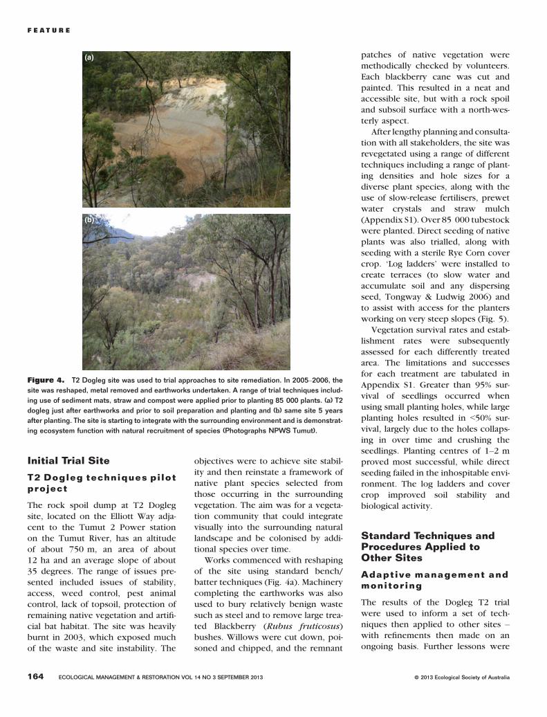
ing trials on the sites themselves. In
2005, earthworks and revegetation
trials were conducted at the T2 Dog-
leg site (Fig. 4), a former rock crush-
ing site used for concrete making for
the Tumut 2 Power Station Dam
wall. This site was selected as it pre-sented a number of stability, weed
and pest animal problems that were
common to many of the former
Snowy Scheme sites – with a view
to developing a suite of techniques
and protocols that could be applied
at other sites.
Figure 3. Happy Jacks Spoil Dump 1, in which over 970 000 m3 rock spoil was dumped both
sides of the Tumut River, is another of the 35 major sites that has now been subject to rehabili-
tation earthworks and planting. Its condition prior to treatment, pictured here, illustrates the envi-
ronmental risk associated with the filling of valleys with spoil rock, which can be further washed
down by streams or even block or divert the streams themselves (Photograph Regina Roach).
ª 2013 Ecological Society of Australia ECOLOGICAL MANAGEMENT & RESTORATION VOL 14 NO 3 SEPTEMBER 2013 163
F E A T U R E
Initial Trial Site
T2 Dogleg techniques pilotproject
The rock spoil dump at T2 Dogleg
site, located on the Elliott Way adja-
cent to the Tumut 2 Power station
on the Tumut River, has an altitudeof about 750 m, an area of about
12 ha and an average slope of about
35 degrees. The range of issues pre-
sented included issues of stability,
access, weed control, pest animal
control, lack of topsoil, protection of
remaining native vegetation and artifi-
cial bat habitat. The site was heavilyburnt in 2003, which exposed much
of the waste and site instability. The
objectives were to achieve site stabil-
ity and then reinstate a framework of
native plant species selected from
those occurring in the surrounding
vegetation. The aim was for a vegeta-
tion community that could integrate
visually into the surrounding natural
landscape and be colonised by addi-tional species over time.
Works commenced with reshaping
of the site using standard bench/
batter techniques (Fig. 4a). Machinery
completing the earthworks was also
used to bury relatively benign waste
such as steel and to remove large trea-
ted Blackberry (Rubus fruticosus)bushes. Willows were cut down, poi-
soned and chipped, and the remnant
patches of native vegetation were
methodically checked by volunteers.
Each blackberry cane was cut and
painted. This resulted in a neat andaccessible site, but with a rock spoil
and subsoil surface with a north-wes-
terly aspect.
After lengthy planning and consulta-
tion with all stakeholders, the site was
revegetated using a range of different
techniques including a range of plant-
ing densities and hole sizes for adiverse plant species, along with the
use of slow-release fertilisers, prewet
water crystals and straw mulch
(Appendix S1). Over 85 000 tubestock
were planted. Direct seeding of native
plants was also trialled, along with
seeding with a sterile Rye Corn cover
crop. ‘Log ladders’ were installed tocreate terraces (to slow water and
accumulate soil and any dispersing
seed, Tongway & Ludwig 2006) and
to assist with access for the planters
working on very steep slopes (Fig. 5).
Vegetation survival rates and estab-
lishment rates were subsequently
assessed for each differently treatedarea. The limitations and successes
for each treatment are tabulated in
Appendix S1. Greater than 95% sur-
vival of seedlings occurred when
using small planting holes, while large
planting holes resulted in <50% sur-
vival, largely due to the holes collaps-
ing in over time and crushing theseedlings. Planting centres of 1–2 m
proved most successful, while direct
seeding failed in the inhospitable envi-
ronment. The log ladders and cover
crop improved soil stability and
biological activity.
Standard Techniques andProcedures Applied toOther Sites
Adaptive management andmonitoring
The results of the Dogleg T2 trial
were used to inform a set of tech-
niques then applied to other sites –with refinements then made on an
ongoing basis. Further lessons were
(a)
(b)
Figure 4. T2 Dogleg site was used to trial approaches to site remediation. In 2005–2006, the
site was reshaped, metal removed and earthworks undertaken. A range of trial techniques includ-
ing use of sediment mats, straw and compost were applied prior to planting 85 000 plants. (a) T2
dogleg just after earthworks and prior to soil preparation and planting and (b) same site 5 years
after planting. The site is starting to integrate with the surrounding environment and is demonstrat-
ing ecosystem function with natural recruitment of species (Photographs NPWS Tumut).
164 ECOLOGICAL MANAGEMENT & RESTORATION VOL 14 NO 3 SEPTEMBER 2013 ª 2013 Ecological Society of Australia
F E A T U R E

to be derived from both informal and
formal monitoring including the fol-
lowing.
1 Informal photomonitoring and
inspection of each site by the resto-
ration team is carried out through-
out the year to monitor for
weeds, planting success and sitestability;
2 Formal monitoring is carried out by
personnel from Greening Australia
Capital Region at eight key plant-ing sites against a benchmark of
remnant vegetation at each site.
Site recordings were not under-
taken prior to works; however, site
photography attests to the fact that
all the sites were basically rubble
prior to treatment, with some natu-
ral regeneration and various levelsof weed infestation occurring on
the smaller sites.
The formal postrehabilitation mon-
itoring uses an adapted BioMetric(DECCW 2011) methodology,
recording data along permanent
50-m transects and in a
20 9 20 m quadrat at each site.
On small sites, shorter transects
are used. All plant species are
counted, regardless of height, to
ensure that recently planted tree
and shrub tubestock are included.
Woody debris are measured in
a smaller area within the
20 9 20 m quadrat, and the results
are extrapolated to the 20 9 20 mquadrat. At each site, a photograph
is taken along the transect from
each end (Greening Australia
2012).
Site assessment
At major sites, the concept plan pre-
pared by CH2M Hill provides a basis
for undertaking further assessment
and developing the rehabilitation
design. Prior to scheduling specific
works, the Environmental Officerundertakes a review of environmental
factors, drawing on specialist exper-
tise for fauna surveys. These surveys
are based on structured transect
observations, surveys using Elliot
traps and harp nets, playback, and
audio and camera recordings. Soil
and water samples are taken whererequired to identify whether any con-
tamination occurs on the site and to
assist with managing plant health at
planting time. If significant earth-
works are required, the Project Engi-
neer manages the surveying work
and development of geotechnical
design, detailing and catering for
anticipated water flows across site,
and installing run-off control struc-
tures if required. The Rehabilitation
Officer then undertakes detailedassessments of the weeds and natives
on site to develop planting lists and
substrate preparation specifications
to ensure the works are specifically
tailored to conditions at each site.
Erosion and sedimentcontrol
Where possible, sites are reshaped toachieve the standard of 2:1 (H:V)
slope ratios, with access benches
and log ladders constructed as
required. The three main erosion
and sediment control methods for sur-
face stabilisation are as follows: cover-
ing the site with organic matter (chip
mulch and straw), the construction ofcross drains and covering with jute
matting. Standard geotextile sediment
fencing is temporarily installed to
catch any soil, small rocks or soil fines
disturbed during earthworks and is
removed once seedlings are estab-
lished and the site is stable. Supported
by stakes, the base of the sedimentfencing is dug in and secured with
rocks, pins and straw bales. Cross
drains, manually constructed or by a
small excavator, act as small collec-
tion areas for water, soil, seed and
any other biota and promote the
movement of water through the rock
slope rather than over the top of it.Jute matting is used on larger areas
such as spoil dump slopes or sloping
batters to prevent erosion and soil
loss. However, rice straw is the most
commonly used material to prevent
erosion of the spoil and any remnant
soil where soil exists.
Selection of species forplanting
A formal flora survey of 25 selected
former Snowy Scheme sites listed
the most common indigenous colonis-
ers across the sites as candidates for
the revegetation works (Duncan &
Gillies 2000). These species includedBurgan (Kunzea ericoides), Small-
Figure 5. Planting into compost-filled holes at Bourkes Gorge #2 site. Site preparation involv-
ing surface shaping and creating permeable and fertile microniches is a key to successful plant
establishment. Engaging local contractors is also important. Over 200 000 work days for local
contractors has been generated by the project, which has created substantial benefits to local
communities (Photo NPWS Tumut).
ª 2013 Ecological Society of Australia ECOLOGICAL MANAGEMENT & RESTORATION VOL 14 NO 3 SEPTEMBER 2013 165
F E A T U R E

fruit Hakea (Hakea microcarpa), Sil-
ver Wattle (Acacia dealbata), Black-
wood (Acacia melanoxylon),
Common Cassinia (Cassinia longifoli-
a) and Native Raspberry (Rubus par-
vifolius). Standard procedure during
the planning phase for restoration
works at each site, however, includes
a site inspection and preparation list
of species only occurring at that par-
ticular site – from which a much
wider planting list is complied. Thisconsiders the need to include species
from each stratum; the dominant spe-
cies in the surrounding vegetation;
colonisers occurring locally; the feasi-
bility of commercial propagule collec-
tion and propagation; and tolerance
to exposure and relative vulnerability
to herbivory.The use of colonising shrubs is a
now standard approach in the revege-
tation of some alpine and subalpine
ecological communities (Johnson
1987; Carr et al. 1980; MacPhee
1998). Some commonly occurring col-
onising shrubs are readily propagated,
including Mountain Hovea (Hoveamontana), Common Shaggy Pea
(Oxylobium ellipticum) and Alpine
Shaggy Pea (Podolobium alpestre),
while Pimelea ligustrina is difficult
to propagate from seed or cuttings.
Other common colonising species
such as Leafy Bossiaea (Bossiaea foli-
osa) can be propagated, but often failto thrive in planted situations – most
likely due to specific microorganism
requirements that are not present in
a highly degraded environment.
Sourcing plant materialand planting
Most of the native grass seed used in
the project is produced at the Yarran-gobilly Native Seed and Straw Farm
(see www.emrprojectsummaries.org/
2013/08/17/). This production area
was specifically developed to provide
suitable high-altitude native grass seed
and straw for the revegetation work,
irrigated by grey water generated by
the nearby Yarrangobilly Caves waste-water treatment plant.
All plant propagules are collected
under a scientific collection licence,
and collection is consistent with the
Guidelines for the Translocation ofThreatened Plants in Australia (Austra-
lian Network for Plant Conservation
2006). Two years in advance of the
works, seed and cutting material are
collected (by the Restoration Team
and contractors) from the actual site
to be revegetated. The timing for seed
and cutting collection and pretreat-ments for seed of a range of shrubs
species follows MacPhee (1998).
Some species (such as Dianella
spp.) are also salvaged from the site
prior to earthworks and used as prop-
agation stock.
Plants are grown by local nurseries
under contract. Nursery stock isrequired to be in prime condition at
the time of planting, well hardened
off, weed and pathogen free, and
grown in an appropriate potting med-
ium to avoid excessive drying and
prolonged saturation. Most trees and
grasses to date have been grown in
forestry tubes. Many alpine shrub spe-cies, however, have strongly branch-
ing lateral roots and are better suited
to grow in 7.5-cm round pots. Smaller
pots are occasionally used, but larger
tubestock is desirable as seedlings
are more likely to cope with trans-
plant shock.
For alpine species, about 5% of the
volume of the growing medium is
made up of local soil to ensure rein-
troduction of soil microflora to thesite. Aged compost and wetted water
crystals are also incorporated into
the hole at the time of planting
(Fig. 5), with watering-in occurring
at that time with subsequent watering
applied as required.
Compost, mulch thatchand litter cover
Compost provides the planting med-
ium for tubestock planted into rock
spoil, to mitigate the lack of organic
material at most construction sites
and spoil dumps. This is produced
locally, using old decomposing saw-
dust stockpiled at regional sawmills
that once milled Alpine Ash (E. dele-gatensis). The compost is designed
to meet the requirements of montane
and subalpine native species, using
principles outlined in Handreck
(1996) (Fig. 6); that is, dolomite is
added to the highly acidic sawdust
to adjust it to pH 5.5–6, with some
woodchip added. Nitrogen is addedin the form of urea. As the compost
is low in phosphorus and potassium,
a slow-release fertiliser is used at
planting.
Native grass straw from the Yarran-
gobilly Native Seed and Straw Farm,
Figure 6. Compost used in the revegetation works is prepared for the project, based on aged
waste fortuitously remaining from decommissioned regional sawmills.
166 ECOLOGICAL MANAGEMENT & RESTORATION VOL 14 NO 3 SEPTEMBER 2013 ª 2013 Ecological Society of Australia
F E A T U R E

along with rice straw, has also proven
to be very effective in addressing the
lack of organic matter on sites, modi-
fying surface temperature for youngplant survival and reducing competi-
tion by weeds. As the straw is the
source from a very different environ-
ment, the weed risk in high-altitude
sites is considered to be negligible.
Small tree limbs and cut vegetation
(thatch) are also applied to create hab-
itat and microclimates, reducing windvelocity across bare rock surfaces and
holding straw and mulch in place.
The thatch used in the project is
sourced locally from vegetation con-
trol activities occurring along roads,
fire trails and power line easements
in the park.
Protection from herbivorebrowsing
Most plants need protection from
browsing until well established. The
main herbivores are wallabies (Macr-
opus spp.), Eastern Grey Kangaroo
(Macropus giganteus), Wombat
(Vombatus ursinus), European Rabbit
(Oryctolagus cuniculus) and BrownHare (Lepus capensis). Generally the
sites are fenced or plastic mesh tree
guards used around seedlings until
they are established. Browsing deter-
rents such as egg powder and iron fil-
ings, as well as ultrasonic sound
systems, have been trialled. After many
years of protecting seedlings from graz-ing in the park, however, a fence or
well-constructed tree guards have
been found to be the most effective
techniques in controlling browsing
and grazing.
Weed management
The vegetation survey conducted byDuncan and Gillies (2000) found that
weed at the sites ranged from minor
to high infestations. The report rec-
ommended that major consideration
be given to the reduction or elimina-
tion of all introduced species at the
sites due to the likelihood of the weed
invading neighbouring native vegeta-tion, spreading along waterways and
inhibiting native vegetation. The
earthwork stage is used to bury some
weedy substrates, and weed control
is also carried out at all sites accord-ing to the Noxious and Environmen-
tal Weed Control Handbook
(Department of Agriculture NSW
2005).
The main weeds of concern on the
sites include Browntop Bent Grass
(Agrostis capillaris), St Johns Wort
(Hypericum perforatum), black-berry (R. fruticosus), Viper’s Bugloss
(Echium vulgare) and Grey Sallow
Willow (Salix cinerea). In addition,
the project includes control of weeds
of concern in the vicinity of sites,
including weeds subject to park-wide
control programmes Scotch Broom
(Cytisus scoparius) and OrangeHawkweed (Hieracium aurantia-
cum).
Works at Other Sites andTheir Results to Date
Over the last 8 years, over 200 sites
in the park have had restoration
works applied to them, using thetechniques described above, with
over 100 sites still to have their envi-
ronmental liabilities addressed. Over
1 million native plants have been
established as part of the Former
Snowy Scheme Sites programme to
date (Table 1), at a total expenditure
of approximately $18 M.Plant establishment rate has
exceeded 90% across the 200 sites
in the first year, a result that has rein-
forced the value of the high level of
site preparation undertaken. Levels
of plant cover have increased over
time, with very satisfactory levels of
vegetation development by bothwoody and herbaceous native spe-
cies across the vast majority of sites.
As the initial application of mulch
decomposes, it is expected that it
will be replaced by litterfall from
the growing revegetation, and it is
hoped that this will occur prior to
the breakdown of the applied mulchand woody debris.
Table
1.
Summary
ofve
getationattributesforeachsite
%Cover
Site
Length
of
transect
(m)
Native
over-
sto
rey
Native
mid-
sto
rey
Native
gra
sses
Native
gro
und
shru
bs
Native
forb
sSum
of
native
gro
und
cover
Exotic
annual
gra
sses
Exotic
pere
nnial
gra
sses
Exotic
forb
sSum
of
nat+
exgd
cover
Litte
rBare
gro
und
Rock
Woody
Debris
Numberof
exoticsp
Numberof
nativesp
Woody
Ste
ms<10
cm
dbh
Coars
ewoody
debris(m
)
Control(N
ungar
Quarry)
50
25
22
56
58
50
164
62
6178
96
00
033
10
1120
17.5
Bourke’s
Gorge
40
01.3
7.5
20
7.5
35
00
035
75
032.5
519
21510
82.5
Jindabyn
eValve
House
50
00
218
222
00
022
80
10
10
215
7425
190
Nungar
50
00
02
20
22
88
16
22
148
74
42
025
14
248
14
Pipers
Creek
36
03
11
19
11
41
031
50
122
86
00
021
11
912
0SnowyAdit2008,
insideexclosure
50
07.5
220
830
00
030
52
252
811
3990
530
SueCity,
outside
exclosure
35
04.3
29
17
046
00
046
77
023
118
13
230
75
T2Dogleg
50
25
27.5
214
218
12
218
50
68
628
013
13
640
105
TumutPond
Hairpin
50
05
12
42
256
014
676
86
66
416
9875
109
ª 2013 Ecological Society of Australia ECOLOGICAL MANAGEMENT & RESTORATION VOL 14 NO 3 SEPTEMBER 2013 167
F E A T U R E

While vegetation establishment can-
not guarantee stability of steep slopes
alone, extremely low levels of rilling
and subsidence have occurred onreshaped batters to date, despite some
100-year rainfall events, attesting to the
appropriateness of the engineering
standards adopted. There is no doubt
that the revegetation has contributed
to surface stabilisation, and it can be
expected that the deeper root systems
of larger species such as Eucalyptus
can be expected to improve overall
site stability over time.
An initial indicator that the goal of
restoring self-perpetuating vegetation
communities is commencing is the
occurrence of natural colonisation in
the microsites created by the applica-
tion of thatch and log ladders at anumber of sites. These represent a
range of growth forms including trees
(particularly Ribbon Gum, Eucalyptus
viminalis), shrubs (Silver Wattle and
Leptospermum obovatum) and a
range of grasses and forbs. These
include some species that have been
sown as well as some unsown spe-cies. Many of the sites are now being
visited by fauna including Lyre Bird
(Menura novaehollandiae), Wom-
bat, Red-necked Wallaby (Macropus
rufogriseus), Swamp Wallaby (Walla-
bia bicolor), Eastern Brown Snake
(Pseudonaja textilis) and Tiger Snake
(Notechis scutatus).Major works at the following four
sites are briefly summarised as exam-
ples of the results currently being
achieved, with more data and photo-
graphs of two of these cases provided
at www.emrprojectsummaries.org.
1 Snowy Adit: This is a large rehabil-
itation site in the Snowy River val-
ley. A stockpile of millions of
tonnes of rock spoil from the
Island Bend-Geehi tunnel (measur-
ing 1000 m by 400 m) wasreshaped in 2008 and revegetation
works completed in 2011. The site
had relatively high cover levels of
weed prior to treatment, including
St Johns Wort, Vipers Bugloss and
Bokhara Clover (Melilotus albus).
Some 260 tonnes of waste steel
was salvaged from the site and
sold, netting $61 K that was rein-
vested in the project. The sitewas reshaped to create linked
dams, planted with 110 000 tube-
stock of 11 species in three stages
and mulched with straw. After high
initial browsing by wallabies, part
of the site was fenced, resulting
in almost 100% plant establishment
success. Monitoring found 30%native plant cover in the ground
stratum with 7.5% cover of Ribbon
Gum at mid-storey height and very
few exotic species.
2 Bourkes Gorge Spoil Dump # 2:
This spoil dump containing some
300 000 m3 of rock was reshaped
for stability, accessibility and safe
water movement across the site in
2009–2010. Slope angles were
reduced from around 38° to
between 26° and 30°. It wasplanted with 50 000 tubestock in
2010–2011 and had specific man-
agement practices applied to mini-
mise the impact on potentially
present threatened species. In the
3 years since the works, there have
been two major (>100-year inten-
sity rainfall) events in the region,but there has been no evidence of
erosion or slumping following
these events. Vegetation monitor-
ing since that time has proven out-
standing survival and growth rates
of over 19 site-native species, withan average of over 35% cover in
the monitored plots within 1 year
(See Fig. 7 and www.emrproject
summaries.org/2013/08/22/).
3 Jindabyne Valve House: This
required major earthworks, which
commenced in May 2010 and were
completed in July 2010. Some
35 000 tubestock were planted in
2010–2011. Observations 3 years
after treatment showed that about
80% of all seedlings survived. Dueto the steepness of the site, it was
impractical to fence it, and grazing
of seedlings by Eastern Grey Kanga-
roos and wallabies occurred,
which has restricted some plant
development. Overall the site is
well on the way to recovery and
will be mulched with woodchipsin November 2013 to increase the
litter levels on the site (See www.
emrprojectsummaries.org/2013/08/
20/).
4 Khancoban Tip: This former tip
and spoil dump contained tunnel
spoil from the Murray 1 and Murray
2 Power Station developments and
had also been subjected to
Figure 7. Rehabilitation Officer Liz McPhee is pictured at Bourke’s Spoil Dump #2, where
monitoring has shown outstanding survival and growth rates within 1 year, with 19 native species
establishing, all sourced from the surrounding vegetation. Other native species are now colonis-
ing (Photograph NPWS Tumut).
168 ECOLOGICAL MANAGEMENT & RESTORATION VOL 14 NO 3 SEPTEMBER 2013 ª 2013 Ecological Society of Australia
F E A T U R E

100 years of grazing. At a lower
elevation than many of the other
locations, the site had a well-estab-
lished weed population and popu-lations of feral animals. In 2010,
the sites were reshaped and the
tip capped with a clay liner. In
2011, the site was ripped and
planted with 30 000 tubestock
(confined to grasses at the tip site).
Observations 2 years after treat-
ment show that the seedlings haveestablished very well and growth
rates have exceeded expectations.
Observations from formalmonitoring (Data in thissection derived fromGreening Australia 2012)
Quadrat and transect data collected at
eight of the revegetated sites in April–May 2012 show that the results at that
date varied depending on the age of
the restoration work and various site-specific factors such as altitude, slope,
vegetation type and herbivore grazing
pressures (Table 2).
A range of 11–25 native plant spe-
cies had been established at the eight
sites. At most sites, the greater propor-
tion were shrub species; however, at
the two high-altitude sites, naturallyregenerating native forbs made up
the majority of species. The number
of woody stems (shrubs and tree sap-
lings) ranged from 230 to 1510 per
plot, with only one site (Bourke’s
Gorge #2, Fig. 7)with a higher number
of stems than the reference site (1120).
Native plant cover at the eight res-toration sites varied with stratum.
Between 18% and 56% cover was
achieved in the ground stratum (0–1 m height). Some native plants had
grown to mid-stratum height at six of
the sites, with the exceptions being
the two higher-altitude sites (Pipers
Creek and Nungar Quarry). At the old-est (7-year-old) T2 Dogleg site, per-
centage cover in both upper and
mid-stratum had developed to levels
similar to that of the reference site
(Fig. 4b). This site, however, had the
lowest native ground layer, perhaps
due to the rapid growth of a dense
mid-storey and overstorey.
Litter cover at the monitored sites
varied from 52% to 86%. The amountof coarse woody debris was within a
satisfactory level, with most sites hav-
ing levels well above that of the refer-
ence site (17.5 m).
Exotic species (grasses and forbs)
were generally a greater component
of the older sites than the younger
ones. It is not clear whether this is afunction of time since restoration or
whether it is due to cleaner, more
sterile substrates on the more recent
sites. The two high-altitude sites
located in Snow Gum (E. pauciflora)
woodland (Pipers Creek and Nungar
Quarry) are particularly high in exotic
species cover. Again, it was not evi-dent whether this is because of the
earlier restoration methods or the
presence and type of exotic species
in the area around these sites.
Other Outcomes
Twenty comprehensive fauna surveys
have been completed as part of the
project. Few sites had been surveyed,
and hence, little data were available
from any previous surveys. The 20 sur-
veys carried out have added over 1200
species locations to the Wildlife Atlas
database for Kosciuszko NationalPark, including 63 sites for threatened
species. Approximately 360 individual
threatened species records have been
added to the database. These figures
do not include the extensive annual
recording and radiotracking of Moun-
tain Pygmy Possum (B. parvus) at
Happy Jacks that has occurred sincethe initial discovery of two individuals
(Schultz et al. 2012). Three surveys
recorded multiple individuals of the
recently described Tan-backed Rock
Skink (Liophilis montana) for which
minimal data are available on its
occurrence, with only one previous
record existing for the park.The project is also playing a
key role in supporting the ongoing
park-wide programme to remove sig-
nificant weeds within the park, includ-Table
2.
Summary
ofve
getationattributesforeachsite
Site
%Cover
Length
of
transect
(m)
Native
over-
sto
rey
Native
mid-
sto
rey
Native
gra
sses
Native
gro
und
shru
bs
Native
forb
sSum
of
native
gro
und
cover
Exotic
annual
gra
sses
Exotic
pere
nnial
gra
sses
Exotic
forb
sSum
of
nat+
exgd
cover
Litte
rBare
gro
und
Rock
Woody
Debris
Numberof
nativesp
Numberof
exoticsp
Woody
Ste
ms
<10cm
dbh
Coars
ewoody
debris
(m)
Control(N
ungar
Quarry)
50
25
22
56
58
50
164
62
6178
96
00
033
10
1120
17.5
Bourke’s
Gorge
40
01.3
7.5
20
7.5
35
00
035
75
032.5
519
21510
82.5
Jindabyn
eValve
House
50
00
218
222
00
022
80
10
10
215
7425
190
Nungar
50
00
02
20
22
88
16
22
148
74
42
025
14
248
14
Pipers
Creek
36
03
11
19
11
41
031
50
122
86
00
021
11
912
0SnowyAdit2008,
insideexclosure
50
07.5
220
830
00
030
52
252
811
3990
530
SueCity,
outside
exclosure
35
04.3
29
17
046
00
046
77
023
118
13
230
75
T2Dogleg
50
25
27.5
214
218
12
218
50
68
628
013
13
640
105
TumutPond
Hairpin
50
05
12
42
256
014
676
86
66
416
9875
109
ª 2013 Ecological Society of Australia ECOLOGICAL MANAGEMENT & RESTORATION VOL 14 NO 3 SEPTEMBER 2013 169
F E A T U R E
ing Scotch Broom in the upper Snowy
River Catchment, exotic trees on
Guthega Road and willows (Salix
spp.) in the upper Murrumbidgeeand Tumut Rivers. It is also making a
significant contribution to the Orange
Hawkweed (Hieracium auranta-
cum) Program, an emerging weed of
significance that has destroyed many
native ecosystems in New Zealand.
A series of training and site inspec-
tions have also taken place to informand educate NPWS staff, SHL staff
and community volunteers on the res-
toration programme. Specifically this
has included conducting site tours
for Landcare Nursery volunteers,
NPWS staff and Utilities (SHL, Trans-
grid), as well as Site Restoration
Courses for NPWS staff.Standards have been developed in
this project covering erosion control,
tubestock management, species selec-
tion, contractor planting standards
and maintenance requirements and
are embedded in contract documents
and management plans.
In addition, a ‘Green Book’ fieldguide has been published, drawn
from the lessons learned throughout
the project (MacPhee 2013). This field
guide covers goals, restoration stan-
dards, planting lists, principles and
techniques that can be interpreted at
each site by skilled officers.
Looking Forward
The programme is scheduled to run for
another 9 years, drawing to a close in
2022. The Restoration of Former
Snowy Sites Project team still has many
new challenges ahead to address. The
following projects are already in the
initial stages of development.
1 Construction of critically endan-
gered frog breeding habitats within
restoration areas, providing poolsfor the reintroduction of these
frogs across the park that has com-
menced and will run for 5–10 years. If successful, the tech-
niques developed will have impli-
cations for survival of riverine
frog species both in the park and
further afield.
2 The standards and guidelines devel-
oped within this project are cur-
rently being revised for application
to all restoration and revegetation
work within National Parks in
NSW and other parks within theAustralian Alps. Our ambition is to
see the restoration standards devel-
oped within this project, applied
to all protected natural areas in the
parks estate so that native vegeta-
tion and restoration is incorporated
in every planning stage, and to opti-
mise potential for all developmentproposals to include budget alloca-
tion for restoration.
3 Development of a ‘green card’
Accreditation system ensures landmanagers and construction work-
ers are trained in protecting
environmental values when devel-
opments are occurring. In NSW,
all construction workers must have
a white card for safety and comply
with the ‘Blue Book’ for erosion
and water controls. A green cardwill ensure everyone from manag-
ers to site workers understand
and take responsibility for the
long-term impacts of disturbance
works and comply with set vegeta-
tion protection standards.
4 Restoration of large and high-risk
Former Snowy Scheme Sites in
the Happy Jacks and Tumut valley.
5 Design of Mountain Pygmy Possum
habitat including artificial boulder-
fields within restoration projects
(See Schultz et al. 2012).
6 Installation of interpretative panels
and ‘apps’ that convey the cultural
values and history of sites and the
restoration achievements.
Is the Work Making aDifference?
Over the 10 years since the projectcommenced, the restoration team
has undertaken landform stabilisa-
tion, stream channel stabilisation
and revegetation works at over 200
sites. It is clear that the sites, manywhich were unstable and located in
gullies affecting downstream water-
courses, now have limited potential
for sedimentation and contamination
discharge into waterways. The risk
of spoil collapsing into streams has
been greatly decreased, and previous
surface stream flow has been rein-stated through reshaping some creek
lines, with riparian vegetation
planted on the new banks. Over
900 000 plants have been success-
fully established on the sites, includ-
ing on 18 major sites previously
bare for 40 years.
Efforts have been made to matchplant species to the main species in
the local species pool, although differ-
ences are inevitable due to the chan-
ged nature of the landforms and
substrates. It is anticipated that func-
tional, locally native vegetation com-
munities will develop on the sites,
reducing the vulnerability of sur-rounding vegetation to weed inva-
sion. Already, recruitment and
colonisation of trees, shrubs and
ground covers is occurring on most
sites – an early indication that condi-
tions are likely to be suitable for
recruitment of other species over
time. Further study of the sites’ levelsof similarity or difference to locally
occurring communities over time will
help park managers continue to opti-
mise restoration outcomes. Such
study will also contribute to the body
of knowledge on the degree to which
restoration is possible or not on
highly modified sites.We believe that the work demon-
strates that, even in these extreme
conditions, long-term commitment,
secure funding and skilled staff can
combine to achieve a promising eco-
logical restoration result. These
results should encourage people
working in less extreme sites, to striveto solve problems with careful,
informed and determined effort.
170 ECOLOGICAL MANAGEMENT & RESTORATION VOL 14 NO 3 SEPTEMBER 2013 ª 2013 Ecological Society of Australia
F E A T U R E

Acknowledgements
Thanks are extended to the restora-
tion team at Kosciuszko National
Park, including the many contractorswho participated. We also thank
Nicki Taws and Angela Calliess
(Greening Australia Capital Region)
who undertook the formal vegeta-
tion monitoring and who have per-
mitted their data to be cited in this
article.
References
Allen E. B. (ed.) (1988) The Reconstruction of dis-turbed Arid Lands. An Ecological Approach.American Association for the Advancementof Sciences. Selected Symposium 109, West-view Press Inc, Boulder, CO.
Australian Network for Plant Conservation (2006)Guidelines for the Translocation of Threa-tened Plants in Australia. Australian Networkfor Plant Conservation, Canberra, ACT.
Berger J. J. (1990) Environmental Restoration:Science and Strategies for Restoring theEarth. Island Press, Washington DC.
Carr D. J., Carr S. G. M. and Papst W. R. (1980)Field studies of nitrogen fixation of Australianalpine plants and soils. Australian Journal ofEcology 5, 211–220.
CH2M Hill Australia Pty Ltd (2000) Former SitesCategory Recommendations. CH2M Hill Aus-tralia Pty Ltd, Chatswood, NSW.
Clothier D. P. and Condon R. W. (1968) Soil con-servation in alpine catchments. Journal of theSoil Conservation Service of New SouthWales 24, 96–113.
Costin A. B. (1954) Ecosystems of the MonaroRegion of New South Wales with SpecialReference to Soil Erosion. NSW GovernmentPrinter, Sydney, NSW.
Costin A. B. (1957) The high mountain vegetationof Australia. Australian Journal of Botany 5,173–189.
Costin A. B. (1958) Ecological hazards of theSnowy Mountains Scheme. Proceedings ofthe Ecological Society of Australia 5, 87–98.
DEC (2006) Kosciuszko National Park Plan ofManagement 2006. Department of Environ-ment and Conservation, Sydney, NSW.
DECCW (2011) Operational Manual for BioMet-ric 3.1. Department of Environment, ClimateChange and Water, Sydney, NSW.
Department of Agriculture (2005) Noxious andEnvironmental Weed Control Handbook.NSW Government, Sydney, NSW.
Duncan A. and Gillies C. (2000) Botanical surveyof former SMA sites: Survey and report.Reserve Conservation Unit, NPWS, Tumut,NSW.
Good R. B. (1976) Contrived regeneration ofalpine herbfields. Proceedings of the AN-ZAAS Congress. Hobart, Tas. 1–13.
Good R. B. (1992) Kosciusko Heritage. The Con-servation Significance of Kosciusko NationalPark. NPWS and Surrey Beatty and Sons,Chipping Norton.
Good R. B. (1999) Rehabilitation and revegetationof the Kosciuszko summit area following theremoval of grazing – An historic review. Pro-motion, Practice and Partnerships Proceed-ings 4th biannual Conference of theAustralian Network for Plant Conservation.(ed. J. Mill) pp. 21–25. ANPC Canberra,Albury, NSW.
Green K. and Osborne W. (2012) Field Guide toWildlife of the Australian Snow Country.Reed Hew Holland, Chatswood, NSW.
Greening Australia (2012) Vegetation MonitoringFormer Snowy-Hydro Sites KosciuszkoNational Park. Greening Australia CapitalRegion, Canberra, ACT.
Handreck K. A. (1996) Composting Soils Series:Making Soil Improver from Rubbish. CSIRODivision of Soils, Canberra, ACT.
Harris J., Bowling L., Keller R. et al. (2006) TheTooma River Project – Interdisciplinary probesinto ill-defined and unpredictable contamina-tion. Technical report. CRC for FreshwaterEcology, Canberra, ACT.
Houghton F. D. and Charman P. E. V. (1986) Glos-sary of Terms used in Soil Conservation. Soilconservation Service of N.S.W, Sydney, NSW.
Johnson L. A. (1987) Management of northerngravel sites for successful reclamation: areview. Arctic and Alpine Research 19,530–536.
MacPhee E. (1998) Studies of the germination ofseven Australian alpine and subalpine shrub
species (Masters Thesis). University of Mel-bourne, Melbourne, Vic.
MacPhee E. (2013) Rehabilitation Field Guide.Australian Alpine Liaison Committee, TumutNSW.
McClucki J. (1927) “The vegetation of KosciuskoPlateau, Part 1 The plant communities”. Pro-ceedings of the Linnean Society New SouthWales 52, 187–221.
McDougall K. L. (2001) Colonization by alpinenative plants of a stabilized road verge onthe Bogong High Plains, Victoria. EcologicalManagement & Restoration 2, 47–52.
McDougall K. L. (2005) Recovery of an erodingpeat surface on the Bogong High Plains, Vic-toria. Ecological Management & Restoration6, 217–219.
Schultz M., Wilks G. and Broome L. (2012) Occu-pancy of spoil dumps by the Mountain Pygmy-possum Burramys parvus in KosciuszkoNational Park. Ecological Management &Restoration 13, 290–296.
Tongway D. J. and Ludwig J. A. (1990) Vegetationand soil patterning in semi-arid mulga lands ofeastern Australia. Australian Journal of Ecol-ogy 15, 23–34.
Tongway D. J. and Ludwig J. A. (2006) Rehabilita-tion of semiarid landscapes in Australia. I.Restoring productive soil patches. Restora-tion Ecology 4, 388–397.
Sinclair Knight Merz (2013) Design of Rehabilita-tion Works for the Former Snowy Sites in theHappy Jacks precinct. Geotechnical Investi-gations and Assessment.
UNESCO (2010) World Network of BiosphereReserves Sept 2010. United Nations Educa-tional, Scientific and Cultural Organisation,Paris.
Supporting Information
Additional Supporting Information
may be found in the online version
of this article:
Appendix S1. Rehabilitation treat-
ments and results for the T2 Dogleg
site in KNP.
ª 2013 Ecological Society of Australia ECOLOGICAL MANAGEMENT & RESTORATION VOL 14 NO 3 SEPTEMBER 2013 171
F E A T U R E