regional transportation priority project report
TRANSCRIPT

Washington State
Transportation Commission
Regional Transportation
Priority Projects
January 2011
Prepared by the Washington State Transportation Commission
In Cooperation With:
Regional & Metropolitan Transportation Organizations


1
Washington State Transportation Commission Members
Philip Parker, Chairman
Richard Ford, Vice-Chairman
Dan O’Neal
Carol Moser
Latisha Hill
Reema Griffith, Executive Director
Acknowledgements We want to thank the MPOs and RTPOs throughout the state. Your collective assistance, cooperation, support and responsiveness resulted in a successful process which produced a valuable outcome for the State of Washington. We also want to thank the County Road Administration Board who provided engineering & technical analysis support to the Commission.


2
Table of Contents Introduction 3 Background 4 Findings & Recommendations 8 Regional Priority Project Lists 12 Appendix
A. PSRC & QuadCo Project Lists
B. Skagit/ Island RTPO Transit Project List
C. WSTC Instruction Memo and Templates


3
INTRODUCTION The enacted 2010 Supplemental Transportation Budget contained a proviso directing the Transportation Commission (WSTC) as follows (ESSB 6381, Sec. 205 (8)):
“As part of its development of the statewide transportation plan, the commission shall review prioritized projects, including preservation and maintenance projects, from regional transportation and metropolitan planning organizations to identify statewide transportation needs. The review should include a brief description and status of each project along with the funding required and associated timeline from start to completion. The commission shall submit the review, along with recommendations, to the house of representatives and senate transportation committees by January 2011.”
Based upon the budget directive, the Commission requested that Metropolitan Planning Organizations (MPOs) and Regional Transportation Planning Organizations (RTPOs) submit up to 20 priority projects for their region, along with an estimate of their 10-year road and bridge preservation need. Some caveats to consider:
• The information submitted by the regional organizations represents their priority projects but the lists are not prioritized nor do they reflect the complete need of each region.
• The lists submitted are selective in that they were not created based upon a prescribed selection process as defined by the WSTC.
• The preservation needs identified by each region vary based upon how they define “preservation”. There is not a consistent, agreed to definition of this term in use by all, nor is there a consistent approach from region to region as to what types of projects should be placed under this category.
The transportation needs across the state vary and there is no question that the need is well beyond available revenues, even perhaps in excess of what can realistically be accomplished in a single, future revenue package. Based upon the caveats and limitations discussed above, the total estimated priority project need as indicated by the regional project lists totals $22.6 billion over several biennia.* The estimated statewide preservation need for roads and bridges over the next 10 years totals $6.6 billion. (For more detail see page 9.) *This estimate reflects the regional project lists only and is therefore less than the total need identified in WTP 2030 which included the additional estimated needs for: WSDOT, cities, counties, and transit.
4
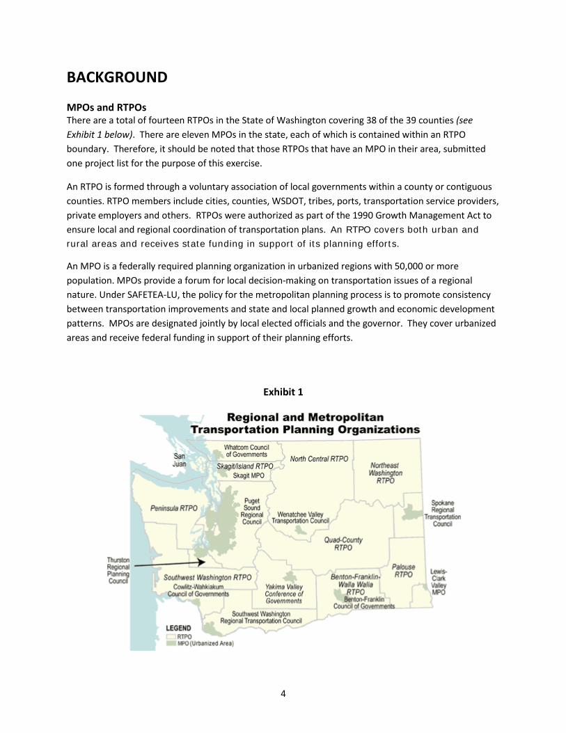
BACKGROUND MPOs and RTPOs There are a total of fourteen RTPOs in the State of Washington covering 38 of the 39 counties (see Exhibit 1 below). There are eleven MPOs in the state, each of which is contained within an RTPO boundary. Therefore, it should be noted that those RTPOs that have an MPO in their area, submitted one project list for the purpose of this exercise.
An RTPO is formed through a voluntary association of local governments within a county or contiguous counties. RTPO members include cities, counties, WSDOT, tribes, ports, transportation service providers, private employers and others. RTPOs were authorized as part of the 1990 Growth Management Act to ensure local and regional coordination of transportation plans. An RTPO covers both urban and
rural areas and receives state funding in support of its planning efforts.
An MPO is a federally required planning organization in urbanized regions with 50,000 or more population. MPOs provide a forum for local decision-making on transportation issues of a regional nature. Under SAFETEA-LU, the policy for the metropolitan planning process is to promote consistency between transportation improvements and state and local planned growth and economic development patterns. MPOs are designated jointly by local elected officials and the governor. They cover urbanized areas and receive federal funding in support of their planning efforts.
Exhibit 1

5
COUNTIES WITHIN RTPOs Following is a list of each RTPO and the counties within each of them. (NOTE: San Juan County does not belong to an RTPO.)
o Northeast Wash. RTPO: Ferry, Stevens, and Pend Oreille Counties o Spokane Regional Transportation Council: Spokane County o S.W. Wash. Regional Transportation Council: Clark, Klickitat, and Skamania
Counties o Yakima Valley Conference of Governments: Yakima County o S.W. Wash. RTPO: Cowlitz, Grays Harbor, Lewis, Pacific, and Wahkiakum
Counties o Thurston Regional Planning Council: Thurston County o Benton-Franklin-Walla Walla RTPO: Benton, Franklin, and Walla Walla Counties o Skagit/ Island RTPO: Island and Skagit Counties o Whatcom Council of Governments: Whatcom County o Palouse RTPO: Asotin, Columbia, Garfield, and Whitman Counties o Wenatchee Valley Transportation Council/ North Central RTPO: Chelan, Douglas,
and Okanogan Counties o Peninsula RTPO: Clallam, Jefferson, Kitsap, and Mason Counties o PSRC: King, Kitsap, Pierce, and Snohomish Counties o QuadCo: Adams, Grant, Kittitas, and Lincoln Counties
COLLECTION OF PROJECT LISTS This was the first time the state Legislature has directed the collection of regional project information directly from the Metropolitan Planning Organizations (MPOs) and Regional Transportation Planning Organizations (RTPOs). As such, this was a new endeavor for all involved requiring the establishment of a new process and way of thinking about regional transportation priorities. In May 2010 the WSTC met with the statewide MPO/RTPO coordinating committee to discuss the Legislative mandate and get input on how to collect the project information from the regional organizations. To ensure MPOs and RTPOs had direct involvement in this effort from start to finish, an advisory committee was established, made up of staff from four regional organizations:
• Puget Sound Regional Council
• Spokane Regional Transportation Council
• Whatcom Council of Governments
• Wenatchee Valley Transportation Council/ North Central RTPO

6
Based upon input and guidance from the advisory committee, the WSTC issued an instruction memo to all MPOs and RTPOs statewide on June 25, 2010. (See Appendix B) The memo outlined the mandate and the process to be followed, along with templates for the regional organizations to use for both ease and consistency of project reporting.
The instruction memo indicated the WSTC was requesting 20 priority projects (in no particular order) from each regional organization. Given the limited number of projects being requested, mega projects were excluded from the WSTC request because they have already been identified as high priority state projects. The “mega projects” were defined to include: SR 520 bridge replacement; Alaskan Way Viaduct replacement; I-405; Columbia River Crossing; Spokane North/South Freeway; Tacoma HOV; Snoqualmie Pass; and SR 167 extension to the Port of Tacoma. Funding for Washington State Ferries was also identified as a high priority for the state and thus was excluded from the WSTC request as well.
The WSTC left it open to the regional organizations to put any transportation project on their priority list. This meant road projects could include those located on city streets, county roads or state highways and could be any type of road project such as but not limited to preservation, maintenance, safety or improvement. Projects on the regional lists could also be multi-modal projects such as but not limited to transit, air, or intermodal freight. The deadline for submitting the priority project lists was October 29, 2010.
On July 30, 2010 the WSTC issued an addendum to their June 25th instruction memo, in response to concerns that were raised by various MPOs and RTPOs related to preservation projects and needs. It was brought to our attention that many of the regional organizations were struggling with the WSTC instructions because they allowed for the inclusion of preservation projects in the priority project list, but if included, required those projects be listed as discrete activities rather than as a programmatic total. This requirement placed preservation needs in competition with the other projects, and this was not the intent realizing there is a tremendous preservation backlog statewide that must be addressed as a top priority. It was determined that preservation needs required an alternative approach so that those needs did not compete for a spot on the regional priority project lists, given preservation investments are so far behind and yet are so critical in order to preserve existing investments. Based upon guidance from the advisory committee, the WSTC modified its original instructions and requested each region provide a 10-year (2011-2021) road and bridge preservation need (rather than discrete, individual preservation projects) along with a short narrative that would help give a sense of what their total preservation need is comprised of.

7
Some have asked why the WSTC limited the list to 20 projects. The budget proviso directed the WSTC to gather and review “…prioritized projects…” from the regional organizations. As discussions were held with RTPOs, it became clear that they did not have a general list of “prioritized projects.” Rather, they had several different lists that were tailored to respond to specific efforts such as various grant programs or state requirements. The exercise of project prioritization was and continues to be a very difficult exercise when done in a generalized manner. The result of this effort by the WSTC is the closest we have come to such a list, although it is made clear by each region that the list they submitted is not in “priority order.” In order to be responsive to the direction of the budget proviso, recognizing the significant time constraint we had to create a process, execute it, analyze the results and report findings, there was simply not enough time or the resources to develop a formalized project prioritization process or establish a structured project allocation process. It was therefore determined that the project lists should be constrained, if they cannot be prioritized, so that the lists at least reflect a limited number of priority projects. Along these lines, the majority of the Commission felt that absent the creation of a structured process that could allocate a varied number of projects by region based upon some pre-determined factors, the most straight forward and fairest way was to give every region the same number of projects across the board. Based upon this, the 20 project limitation was established. The result of this is that the WSTC received hundreds of projects statewide, creating a very ambitious program if funding were to become available in the near future.
8
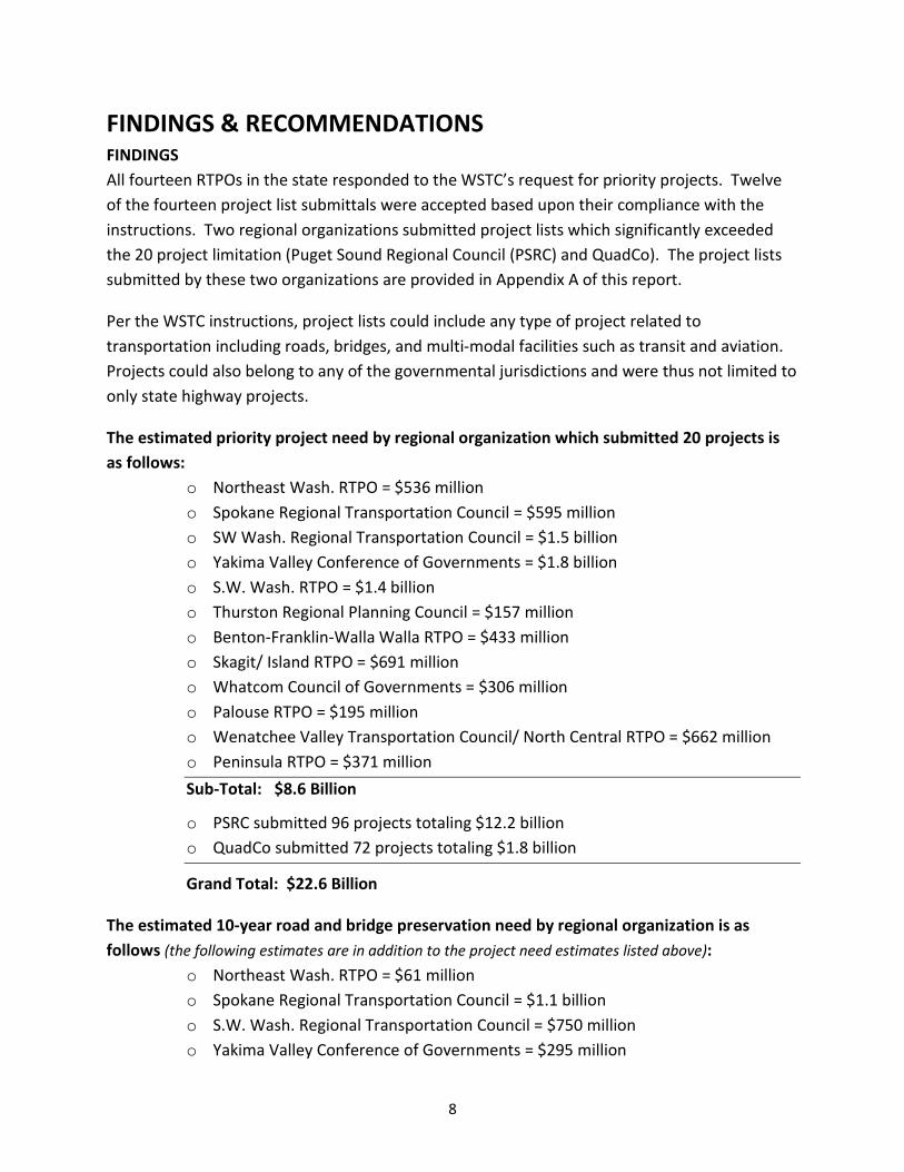
FINDINGS & RECOMMENDATIONS FINDINGS All fourteen RTPOs in the state responded to the WSTC’s request for priority projects. Twelve of the fourteen project list submittals were accepted based upon their compliance with the instructions. Two regional organizations submitted project lists which significantly exceeded the 20 project limitation (Puget Sound Regional Council (PSRC) and QuadCo). The project lists submitted by these two organizations are provided in Appendix A of this report.
Per the WSTC instructions, project lists could include any type of project related to transportation including roads, bridges, and multi-modal facilities such as transit and aviation. Projects could also belong to any of the governmental jurisdictions and were thus not limited to only state highway projects.
The estimated priority project need by regional organization which submitted 20 projects is as follows:
o Northeast Wash. RTPO = $536 million o Spokane Regional Transportation Council = $595 million o SW Wash. Regional Transportation Council = $1.5 billion o Yakima Valley Conference of Governments = $1.8 billion o S.W. Wash. RTPO = $1.4 billion o Thurston Regional Planning Council = $157 million o Benton-Franklin-Walla Walla RTPO = $433 million o Skagit/ Island RTPO = $691 million o Whatcom Council of Governments = $306 million o Palouse RTPO = $195 million o Wenatchee Valley Transportation Council/ North Central RTPO = $662 million o Peninsula RTPO = $371 million
Sub-Total: $8.6 Billion
o PSRC submitted 96 projects totaling $12.2 billion o QuadCo submitted 72 projects totaling $1.8 billion
Grand Total: $22.6 Billion
The estimated 10-year road and bridge preservation need by regional organization is as follows (the following estimates are in addition to the project need estimates listed above):
o Northeast Wash. RTPO = $61 million o Spokane Regional Transportation Council = $1.1 billion o S.W. Wash. Regional Transportation Council = $750 million o Yakima Valley Conference of Governments = $295 million

9
o S.W. Wash. RTPO = $500 million o Thurston Regional Planning Council = $46 million o Benton-Franklin-Walla Walla RTPO = $160 million o Skagit/ Island RTPO = $328 million o Whatcom Council of Governments = $351 million o Palouse RTPO = $193 million o Wenatchee Valley Transportation Council/ North Central RTPO = $94 million o Peninsula RTPO = $303 million o PSRC = $2.2 billion o QuadCo = $175 million
Grand Total: $6.6 Billion
In reviewing all the information submitted, there are a few statewide trends and observations that can be made:
• Overall priority needs statewide far exceed current revenues and will require significant future investments to address.
• Preservation needs are a growing, critical need for each and every region across the state – in fact for some their total preservation needs exceed their total project needs in terms of dollars.
• There are no consistent, agreed to definitions of major transportation project terms such as preservation, maintenance, re-construction, new construction, etc. The result is an inconsistent application which makes it very difficult to analyze the needs of each jurisdiction and arrive at accurate conclusions which are comparable between jurisdictions across the state.
• Regional organizations were asked to indicate which of the six statutory policy goals each of their projects addressed. The following indicates what was identified by policy goal area, and by east and west of the cascade mountains:
o Economic Vitality: 84 total projects – 10 on the west side, 74 on the east side o Preservation: 68 total projects – 7 on the west side, 61 on the east side o Safety: 94 total projects – 12 on the west side, 82 on the east side o Mobility: 269 total projects – 161 on the west side, 108 on the east side o Environmental: 43 total projects – 8 on the west side, 35 on the east side o Stewardship: 88 total projects – 18 on the west side, 70 on the east side
• Of all the lists submitted, only two regional organizations, PSRC and the Peninsula RTPO, had three projects that appeared on both of their lists:
o Gorst area interchange – SR 3/ SR 16/ SR 304 o SR 3 in the vicinity of Hood Canal Bridge Improvements o Widen SR 3 in the vicinity of the SR 3/ SR 304 interchange
10
RECOMMENDATIONS Based upon the information submitted and the findings previously discussed, the WSTC offers the following recommendations for the Legislature’s consideration.
• With the total 10-year road and bridge preservation need for the fourteen responding regional organizations totaling an estimated $6.6 billion, any new state funding to regional and/or local jurisdictions should be first and foremost dedicated to addressing their preservation needs.
o A dedicated state funding source and program should be established for regional/ local road and bridge preservation so the entire surface system is maintained before it moves into the “reconstruction” category.
o Preservation funding provided to regional organizations should be based upon scheduled/ planned preservation work for each biennium as identified by the regional organizations.
• All direct state appropriations to regional organizations/ locals should require some level of local match and should identify performance/ project delivery expectations. It should be further required that regional organizations submit annual status reports to the state on the work accomplished as compared to the plan they submitted for funding, along with performance data indicating the accomplishment of the identified performance expectations.
• Consideration should be given to clarifying common transportation project terminologies such as “preservation” and “maintenance” so that project reporting from jurisdictions is derived from the same basis. Doing so will result in comparable data across the board thus allowing for more accurate analysis and a clearer understanding of the overall need.
• The Legislature should consider establishing overarching policies aimed at guiding the project prioritization process to be used by regional organizations when seeking state revenues. In developing the prioritization guidance policies, the “policy goals” currently in statute (RCW 47.04.280) should be incorporated as appropriate. This standardization will help to ensure consistency in the formulation of priority transportation investment needs by region and thus benefit legislative investment decision making, among other things.
• As identified in the 2011 WTP, the WSTC supports the following local funding options and opportunities for local jurisdictions to generate revenue:
11
o Authorize cities to create street maintenance utilities. o Allow transportation benefit districts (TBDs) to impose license fees up to $100 by
councilmanic vote and provide flexibility in the use of the funds. o Amend authority for counties and cities to impose a fuel tax, allowing it to be set
at cents per gallon, and providing councilmanic authority to impose the tax. o Increase local authority for transit operations and capital, such as vehicle license
fees or sales tax increases. o Given the increased demand for safe bicycle paths and facilities, it may be
appropriate to implement a fee levied on bicycle users that is dedicated to bicycle facility improvements.
• If funding is not secured in the next year, this project information will need to be updated. Future project list information should be collected from the regional organizations in a more focused and refined manner so that separate, constrained projects lists are sought on the following:
o Road and bridge projects o Preservation projects for roads and bridges o Transit operating and capital projects (new and preservation separated out)


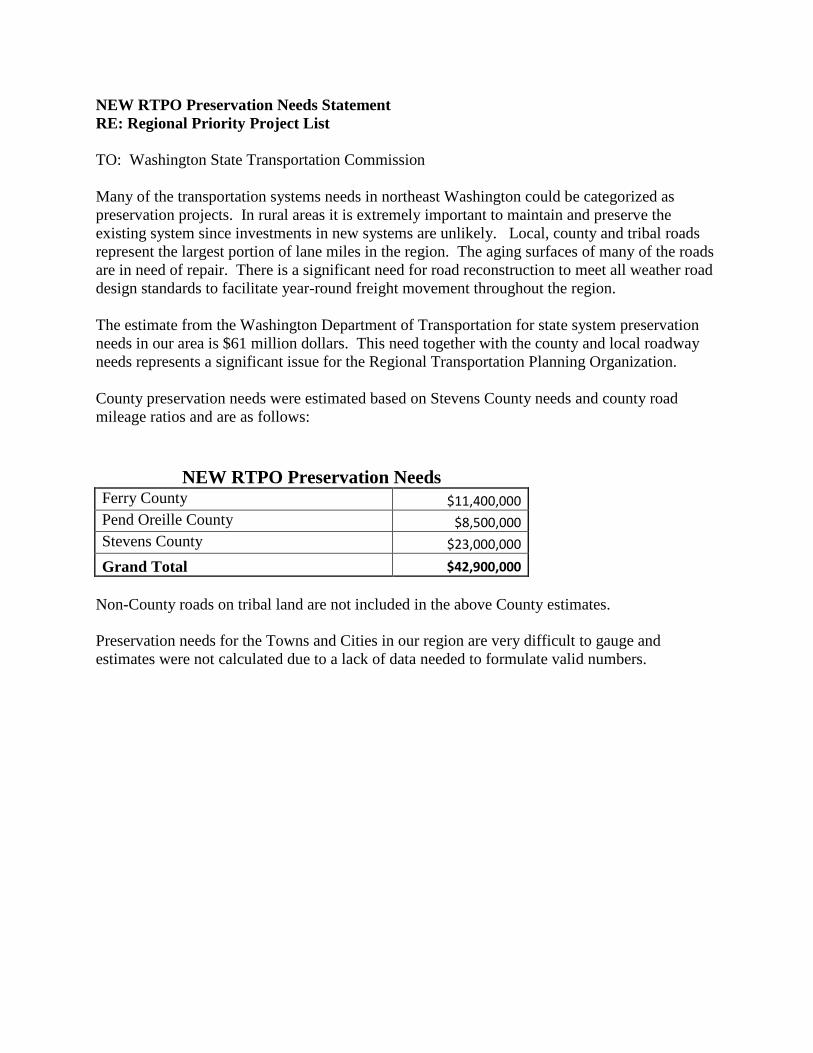
NEW RTPO Preservation Needs Statement RE: Regional Priority Project List TO: Washington State Transportation Commission Many of the transportation systems needs in northeast Washington could be categorized as preservation projects. In rural areas it is extremely important to maintain and preserve the existing system since investments in new systems are unlikely. Local, county and tribal roads represent the largest portion of lane miles in the region. The aging surfaces of many of the roads are in need of repair. There is a significant need for road reconstruction to meet all weather road design standards to facilitate year-round freight movement throughout the region. The estimate from the Washington Department of Transportation for state system preservation needs in our area is $61 million dollars. This need together with the county and local roadway needs represents a significant issue for the Regional Transportation Planning Organization. County preservation needs were estimated based on Stevens County needs and county road mileage ratios and are as follows:
NEW RTPO Preservation Needs Ferry County $11,400,000 Pend Oreille County $8,500,000 Stevens County $23,000,000
Grand Total $42,900,000 Non-County roads on tribal land are not included in the above County estimates. Preservation needs for the Towns and Cities in our region are very difficult to gauge and estimates were not calculated due to a lack of data needed to formulate valid numbers.


NEW RTPORegional Priority Project List
October, 2010
Project Name, Jurisdiction & Category (i.e.: road or multi-modal)
Project Type Total Project Cost
Project Cost Breakdown
By Biennia - YOE $ (09/11; 11/13; 13/15 etc.)
Is This
Project
Consistent
with an
Approved
RTP
Policy
Goals
1 Flowery Trail; All Weather Deficiencies:
a Pend Oreille County: Westside Calispel Rd MP 11.0 to MP 12.6 All Weather Reconstruction 9/11 -$0; 11/15-$18 Mil
b Pend Oreille County McKensie Rd MP 0.0 to MP 2.3 All Weather Reconstruction 9/11 -$1.5 Mil; 11/13-$16 Mil
c Pend Orielle County: Flowery Trail Rd MP 0.0 -MP 2.4 All Weather Reconstruction 1, 2 9/11 -$0; 11/13-$16 Mil
2 Chewelah: Flowery Trail, Segment B, Completion 1 ,2 $1 Million yes 1, 4, 6
State all Weather Deficiencies:
3 Pend Oreille County: SR 20 MP 412.00 - 421.07 All Weather Reconstruction 1 ,2 $17 Million Yes 1, 4, 6
4 Pend Oreille County: SR 211 MP 0.00 - 15.00 All Weather Reconstruction 1, 2 $28 Million yes 1, 4, 6
5 Stevens County: SR 231 MP 45.40 - 75.16 All Weather Reconstruction 1, 2 $56 Million yes 1, 4, 6
6 Ferry County: SR 21: Mp 104.57 - MP 116.78 All Weather Reconstruction 1 ,2 $23 Million Yes 1, 4, 6
County all Weather Deficiencies:
7 Stevens County: Williams Lake All Weather Reconstruction 1 ,2 $36 Million $12 Mil/$12 Mil/$12 Mil Yes 1, 4, 6
8 Stevens County: Garden Spot Road All Weather Reconstruction 1 ,2 $14 Million $5 Mil/$5 Mil/$4 Mil yes 1, 4, 6
9 Stevens County: Aladdin Road All Weather Reconstruction 1 ,2 $72 Million $25 Mil/$22 Mil/$25 Mil yes 1, 4, 6
10 Ferry County: Kettle River Road All Weather Reconstruction 1, 2 3,416,697.00 P.E. 09/11, $100,000.00 Yes 1, 4, 6
Const. 06/12, $3,316,697.00
11 Ferry County: Old Kettle Falls Road All Weather Reconstruction 1, 2 $1,855,927.00 P.E. 09/12, $100,000.00 yes 1, 4, 6
Const. 06/13, $1,755,927.00
12 Ferry/Lincoln County: SR 21 Keller Ferry Replacement 1, 3 ,4 $12.2 Million yes 1, 2 ,3 ,4 ,6
13 Pend Oreille County: Usk Bridge Replacement 1 ,2,4 $60 Million 21/23 $5 Mil, 25/27 $55 Mil yes 1 ,2 ,3 ,4 ,6
14 Stevens County: SR 25 Columbia River Bridge at Northport 1 ,2 ,6 $1.8 Million yes 1 ,2 ,3 ,4 ,6
15 Stevens County: US 395: Columbia River Bridge at Kettle Falls 1 ,2,6 $2.6 Million yes 1 ,2 ,3 ,4 ,6
16 Stevens County: US 395: Border Crossing Revisions 1 ,2 ,4 $62.9 Million yes 1 ,2 ,3, 4 ,6
NEW RTPORegional Priority Project List
October, 2010
Project Name, Jurisdiction & Category (i.e.: road or multi-modal)
Project Type Total Project Cost
Project Cost Breakdown
By Biennia - YOE $ (09/11; 11/13; 13/15 etc.)
Is This
Project
Consistent
with an
Approved
RTP
Policy
Goals
yes 1, 4, 6$51.5 Million
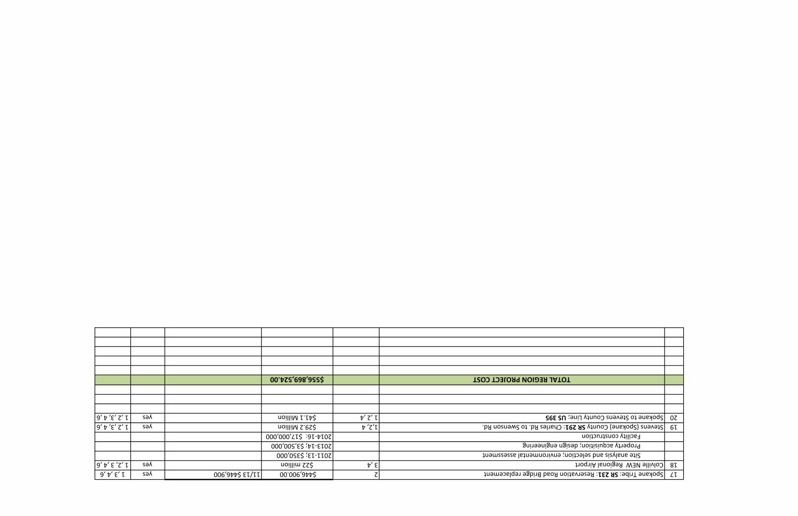
17Spokane Tribe: SR 231: Reservation Road Bridge replacement2$446,900.0011/13 $446,900yes1 ,3 ,4 ,6
18Colville NEW Regional Airport 3 ,4$22 million yes1 ,2, 3 ,4 ,6
Site analysis and selection; environmental assessment 2011-13; $350,000
Property acquisition; design engineering2013-14; $3,500,000
Facility construction2014-16: $17,000,000
19Stevens (Spokane) County SR 291: Charles Rd. to Swenson Rd. 1,2, 4 $29.2 Millionyes1 ,2 ,3, 4 ,6
20Spokane to Stevens County Line; US 3951 ,2 ,4$41.1 Million yes1 ,2 ,3, 4 ,6
TOTAL REGION PROJECT COST$556,869,524.00
NEW RTPO REGIONAL PRIORITY PROJECT LIST Submittal to Washington State Transportation Commission NARRATIVE PROJECT INFORMATION October 2010 Item 1: Flowery Trail Road Completion Pend Oreille County (All Weather Roadway) Project Description: This project will complete the Flowery Trail Road with an all-weather road connection between State Highway 395 in Chewelah to State Highway 20 in Usk. The project consists of four separate projects in total:
• Pend Oreille County: Flowery Trail Rd from Westside Calispel Rd to Danforth Rd (MP 0.0 to MP 2.4) This project is to rehabilitate and resurface the existing roadway strengthening pavement structure to match Flower Trail standards.
Project Status and Timeline: Preliminary engineering: 1/2012 ROW n/a Construction 1/2013
• Pend Oreille County: McKenzie Rd from State Highway 20 to Westside Calispel Rd. (MP 0.0 to MP 2.3). This project will reconstruct, widen, and major realignment of the existing roadway to match Flowery Trail standards.
Project Status and Timeline: Preliminary engineering: 1/2011 ROW: 1/2012 Construction 1/2013
• Pend Oreille County: Westside Calispel Rd from McKensie Rd to Flowery Trail Rd (MP 11.0 to MP 12.6). This project intends to reconstruct, widen, and minor realignment of the existing roadway to match Flowery Trail standards.

Project Status and Timeline: Preliminary engineering: 1/2013 ROW: 1/2014 Construction 1/2015
Item 2: Flowery Trail Road Completion Chewelah (All Weather Roadway)
• City of Chewelah: Flowery Trail Rd (Segment B): On the main avenue in Chewelah from 5th Street east to Ehorn Lane. This is a project that began with Segment A (Downtown Revitalization - 1999), then moved on to Segment C (East end of City Limits - 2007) and is now ready for completion with Segment B, a section of Flowery Trail that will connect the other two (completed) sections.
Main Avenue between 5th Avenue East and Ehorn Road is a rural roadway section that connects the Chewelah downtown business corridor to the more rural area east of town. Main Avenue also serves as a connection for Flowery Trail Road to U.S. 395. Flowery Trail Road connects Chewelah to the east and leads to 49˚ North Ski; and further to the town of Usk in Pend Oreille County. Because this segment is not currently all-weather, it is subject to frost and breakup damage. Therefore the city must impose load restrictions on this segment each spring. This creates an economic loss to those companies utilizing Flowery Trail as a route to transport goods. In addition, there is only a small portion of old, cracked sidewalk along Segment B. Most of the section is without sidewalks and because there is currently no pavement along the road, pedestrians and bicyclists are forced to use the roadway causing conflict with motorists. Completion of Segment B would create a safe route for pedestrians/bicyclists and allow for year round freight mobility.
Project Status and Timeline:
Planning has been completed. The project is ready for construction. The timeline for this project will require ROW acquisition from two land owners. Once that is accomplished, the project should take 3-4 months to complete.
Item 3: Pend Oreille County: SR 20 All Weather Reconstruction Project Description: SR 20 MP 412.00 – 421.07: this project is for all weather reconstruction and includes preliminary engineering, right of way acquisition, and construction costs to upgrade the existing state routes to provide for all-weather conditions. Project Status and Timeline: Only the preliminary scoping is complete

Item 4: Pend Oreille County: SR 211 All Weather Reconstruction Project Description: SR 211 MP 0.00 – 15.00: this project is for all weather reconstruction and includes preliminary engineering, right of way acquisition, and construction costs to upgrade the existing state routes to provide for all-weather conditions. Project Status and Timeline: Only the preliminary scoping is complete. Item 5: Stevens County: SR 231 All Weather Reconstruction Project Description: SR 231 MP 45.00 – 15.00: this project is for all weather reconstruction and includes preliminary engineering, right of way acquisition, and construction costs to upgrade the existing state routes to provide for all-weather conditions. Project Status and Timeline: Only the preliminary scoping is complete. Item 6: Ferry County: SR 21 All Weather Reconstruction Project Description: SR 211 MP 0.00 – 15.00: this project is for all weather reconstruction and includes preliminary engineering, right of way acquisition, and construction costs to upgrade the existing state routes to provide for all-weather conditions. Project Status and Timeline: Only the preliminary scoping is complete. Item 7: Stevens County: Williams Lake All Weather Reconstruction Project Description: This project is to reconstruct Williams Lake Road to an all weather standard. It is located in Stevens County north of Colville. The intended outcome is to allow all year, all weather use of high traffic, high volume freight and goods route. This project is a vital freight and goods route for Stevens County. Funding will assure continue movement of freight in a currently economically depressed region. Project Status and Timeline: This project is currently in a development/preliminary planning stage. Construction could occur shortly after funding. Preliminary engineering: 6/2011 Construction: 6/2012

Item 8: Stevens County: Garden Spot Road All Weather Reconstruction Project Description: This project is to reconstruct Garden Spot Road to an all weather standard. It is located in Stevens County north of Colville. The intended outcome is to allow all year, all weather use of high traffic, high volume freight and goods route. This project is a vital freight and goods route for Stevens County. Funding will assure continue movement of freight in a currently economically depressed region. Project Status and Timeline: This project is currently in a development/preliminary planning stage. Construction could occur shortly after funding. Preliminary engineering: 6/2011 Construction: 6/2012 Item 9: Stevens County: Aladdin Road All Weather Reconstruction Project Description: This project is to reconstruct Aladdin Road to an all weather standard. It is located in Stevens County north of Colville. The intended outcome is to allow all year, all weather use of high traffic, high volume freight and goods route. This project is a vital freight and goods route for Stevens County. Funding will assure continue movement of freight in a currently economically depressed region. Project Status and Timeline: This project is currently in a development/preliminary planning stage. Construction could occur shortly after funding. Preliminary engineering: 6/2011 Construction: 6/2012 Item 10: Ferry County: Kettle River Road All Weather Reconstruction Project Description: This project is to reconstruct the Kettle River Road to all weather standard. It is located in northern Ferry County. This project will take the existing road and allow it to be converted to an all weather road, removing the disruption in the hauling of freight and goods. Project Status and Timeline: Ferry County is currently seeking funding for preliminary engineering and construction. It is anticipated that the project will be complete within a year and a half after approval of funding. Additional Comments The Kettle River road is a thoroughfare from Canada; it’s also the haul route for the area’s largest private employer which is beneficial to Ferry County as well as Okanogan County. It serves a Forest Service Job Corps which is the second largest population group in Northern Ferry County. Additionally the road follows beside the Kettle River which is used for recreation and Tourism. The project will remove the need for road restrictions which cause disruption of freight movement. The project was anticipated to complete in three phases. The first was the

Toroda Creek Road which was funded and completed in 2007. The second phase is to be the Kettle River Road, and the third phase is the Old Kettle Falls Road Item 11: Ferry County: Old Kettle Falls Road All Weather Reconstruction Project Description: This project is to reconstruct the Old Kettle Falls Road to all weather standards located in the northern part of Ferry County. The existing roadway is 8.55 miles and 26 feet wide. The road will be overlaid with a 2.5 inch HMA; with any deficient roadway areas being repaired before the overlay. The project will convert the existing road to an all weather road, removing the disruption of the hauling of freight and goods.
Project Status and Timeline: Ferry County is currently seeking funding for the preliminary engineering and construction phases. No exact time is known. The project will take approximately one and a half years to complete after the approval of funding. Additional Comments The Old Kettle Falls Road is the access road to the mill site for processing ore. This road is the haul route for the area’s largest private employer which is beneficial to Ferry County. The project will remove the need for road restrictions which cause disruption of ore and freight movement. The Old Kettle Falls Road, is the third phase of a three phase project. The first phase being completed in 2007. Item 12: Ferry/Lincoln County: SR 21 Keller Ferry Replacement Project Description: This project will replace the current 63 year old Keller Ferry vessel that has safety and operational issues. Review and analysis of the issues has identified a preferred solution of a new ferry vessel. Project Status and Timeline: The planning and design phases have been completed; approximately $675,000 has been expended. Additional Information: Demand: The ferry makes an average of 30 to 35 round trips per day. Students living north of the river on the Colville Indian Reservation are bused to Wilbur for school, crossing on the ferry twice a day. The alternate route adds 60 miles one way to this trip. While records of traffic queuing and wait times are not routinely kept, the following observations by the crew provide insight into the travel demands placed on this crossing. At almost any time of the year, large RVs and motor homes traveling together have to cross in multiple trips as they are not able to all fit on the ferry together. Summer holiday and hunting season traffic demands routinely require travelers to wait for multiple crossings. Large semi-truck traffic causes delay for other travelers. Standard semi-trucks utilize the full size and weight capacities of the ferry requiring any other vehicles to wait for one or more trips. This situation occurs almost daily, and sometimes (e.g. during construction/project activity or active logging) it may occur multiple times in any one day. Double trailer combinations require

the truck to cross with one trailer at a time requiring down time to disconnect and reconnect trailers and two crossings. Emergency service’s reliance on this crossing was clearly evidenced in 2003, during the Keller area fires. Travelers experience delays at various times and for various reasons with the capacity of the existing vessel. It is evident from the crew observations that this ferry crossing is vital to commerce, the local and regional traveler and the area schools. Safety: A hull leak and resultant shut down order for safety by the United States Coast Guard in October of 2009 required an emergency dry dock of the Martha S for repair. Inspection revealed additional necessary repairs which were completed in July of 2010. While these repairs are anticipated to keep the vessel in operation for a few years it is important to note the construction of a replacement vessel is anticipated to take 14 to 27 months (depending on the alternative selected) after funding is secured. Due to her age, unanticipated problems could develop and take her out of service at any time. As a recent example, on June 10, 2010 the pilot was unable to engage the gears due to an electronics problem resulting in the vessel being adrift with passengers on board. Other safety issues include that the Martha S does not meet today’s two compartment damaged stability requirement and the low pilot house elevation results in the pilot’s view Item 13: Pend Oreille County: Usk Bridge Replacement Project Description: This project is to replace the USK Bridge. It is located in Pend Oreille County on Kings Lake Road MP 0.47 to 0.91. The intended outcome is to replace the structurally deficient and functionally obsolete bridge. Project Status and Timeline: The project is only proposed at this time. Type size and location study: 2021 Design and construction in 2025 Additional Comments The Usk Bridge has been identified as structurally deficient and functionally obsolete. A major maintenance project has been completed in 2010 with the intention of providing an additional 10-15 years of life of the current structure. The Usk Bridge is one of three structures crossing the Pend Oreille River in the State of Washington. The bridge connects the communities of Cusick/Usk with the Kalispel Indian Reservation. A detour of over 33 miles is required if the bridge is closed. Item 14: Stevens County: Columbia River Bridge at Northport Project Description: SR 25 Columbia River Bridge at Northport; to repair concrete deck and overlay. This repair will continue to provide mobility.
Project Status and Timeline: The project is in the planning phase at this time and it is unknown when the project timeline would begin and end. Item 15: Stevens County: US 395: Columbia River Bridge at Kettle Falls Project Description: SR 395 Columbia River Bridge at Kettle Falls; to repair concrete deck and overlay. This repair will continue to provide mobility. Project Status and Timeline: The project is in the planning phase at this time and it is unknown when the project timeline would begin and end. Item 16: Stevens County: US 395: Border Crossing Revisions Project Description: While NEW RTPO has six border crossings in its jurisdiction, one crossing at Waneta to Northport will be revised. This project will improved roadway and/or bridge from Waneta to Northport and the cost will vary depending on whether or not a bridge replacement will be included. Project Status and Timeline: This project has been scoped only. Item 17: Spokane Tribe: SR 231: Reservation Road Bridge Replacement Project Description: The Spokane Tribe requests that a replacement/new Reservation Road Bridge be added to the list State DOT list of 20 regionally significant projects. The project is located on the Spokane Indian Reservation; Reservation Road Bridge, crossing Chamokane Creek at Reservation Road, just west of State Highway 231. The intended outcome is a bridge that meets safety, mobility economic vitality and stewardship statutory policy goals of DOT by replacing the current bridge with a new one, given that a BIA written assessment said it needs to be replaced. The capacity is adequate for the use (the bridge needs the capacity to handle the frequent use by single and double load logging trucks, and cement trucks; additionally, the existing bridge has improperly installed rails and the bridge bolts are of insufficient in size.) Project Status and Timeline: The bridge was examined by the BIA, which determined it needed to be replaced; preliminary specifications/cost estimate for a replacement bride have been made. The current bridge in noted in the Tribe’s 2008 Long Range Transportation Plan (LRTP); the replacement bridge project must be added to the Tribal TIP and, when the LRTP is updated, this need will be added and/or the new bridge will be discussed in that plan.

The soonest timeline would be FY2012 to begin the project, which would involve design/engineering, bid process and construction phases. It is estimated that a project begun in the first or second fiscal year quarter could be completed by the fourth quarter of the project start-up year. Item 18: Colville Northeast Washington Regional Airport Project Description: The Colville Regional Airport project is designed to replace the current Colville Municipal Airport with a relocated airport having capacity and safety standards meeting FAA requirements for a ‘regional’ class airport. The new airport will serve the Northeastern Washington region air transportation and economic development needs that cannot be met with the existing and limited municipal airports currently within the region. There have been preliminary site analysis and feasibility studies but a specific site has not been selected at this time.
The new airport will be vastly superior to the current municipal Colville airport in terms of safety and capacity to serve as an economic and business development tool. It will also have the capacity to serve small jet type aircraft and cargo carriers that is not currently available in northeastern Washington. The new airport will primarily benefit air transportation in terms of increased safety and capacity, provide additional means in which local business and industries may expand service and products, promote and attract new businesses and industries, provide much improved service to regional agencies at the federal, local, and state levels of government, be much better suited for medical emergencies and accommodating jet air travel, including business jet aircraft. Project Status and Timeline: The project is currently in the financial feasibility and economic impact analysis stages including public involvement processes. The next step will include a site analysis and site selection process. 2011 – 2013: Completion of Economic Impact Study currently in progress followed by site analysis and selection, environmental assessments, and alternative site analysis. 2013-2014: Property acquisition. 2014-2015: Design engineering. 2015-2016: Facility construction. Item 19: Stevens (Spokane) County SR 291: Charles Rd. to Swenson Rd. Project Description:

From Charles Rd to Swenson Rd: improve safety and capacity – realign highway, provide a four lane undivided limited access highway. Project Status and Timeline: Only scoping is done at this time. Item 20: Spokane to Stevens County Line; US 395 Project Description: This project is from Spokane/Stevens County line to Kettle Falls along SR 395. The purpose of this project is to improve capacity-provide additional lanes and/or provide additional passing lanes. Project Status and Timeline: Only scoping is done at this time.


Transportation agencies within the Spokane Metropolitan Area have been collaborating with community leaders during the past couple of years trying to quantify and document the need for preservation as well as maintenance and operations of our regions roadway system. This effort took place as part of a larger discussion on the need to establish regionally based revenue sources in light of diminishing transportation funding at all levels of government (a regional transportation benefit district). In all, the need was estimated to be nearly $53 million annually for maintenance and operations, which puts the 10-year need at close to $530 million. The need for preservation was based on a recognition that all roads are not built to the same performance level, nor do they operate in a uniform fashion. As a result functionally classified arterials typically require higher activity levels (snow plowing, sweeping, crack sealing, seal coating) than local streets and many rural roads. In the table below, are the projected needs of local jurisdictions in Spokane County over the next 10 years. In order to arrive at that number, we looked at what each jurisdiction reported to the State for Road/Street Maintenance and Operations for the period of 1997 through 2006, the costs of over 30 preservation and reconstruction projects performed in the region, as well as work conducted by local jurisdictions on unmet maintenance and operations needs. This information was then extrapolated to the ten year timeframe using current dollars. Finally we reported them by category’s used within the Local Government Financial Reporting System (http://www.sao.wa.gov/applications/lgfrs/) Here are the resulting ten year needs by category: Road/Street-Preservation 1 $425,252,554 Road/Street-Maintenance & Operations (M&O) $536,140,410 Road/Street-M&O-General Admin/Eng/Facilities $81,563,000 Total $1,042,955,964
1 This assumes nearly 10% of roadways will be on a 7 year preservation cycle; 30% of roadways will be on a 15 year preservation cycle, and 60 percent of roadways will be on a 20 year preservation cycle (most long-term are local streets and rural county roads).


Spokane Regional Transportation Council
Regional Priority Project List
October, 2010
Project Name, Jurisdiction & Category
(i.e.: road or multi-modal)
Project Type -
Indicate
Applicable
Number(s)
(see
instruction
memo)
Total Project
Cost*
Project Cost Breakdown
By Biennia - YOE $**
(09/11; 11/13; 13/15 etc.)
Is This Project
Consistent with
an Approved
Regional
Transportation
Plan?
Policy Goals
Project Addresses -
Indicate Applicable
Numbers
(see instruction
memo)
Comments
Sullivan Road Corridor Project (Spokane Valley) 4,5,6,7 $51,750,000 11/13: $9M; remaing balance TBD yes 1,4
Bigelow Gulch/Forker Road Connector Project (Spokane County) 3,4,5,6 $22,841,419 11/13: $7.2M; 13/15: $10.6M; 15/17: $5M yes 3,4Barker Road/BNSF Grade Separation Project (Spokane Valley) 3,5 39,100,000 11/13: $3M; remaing balance TBD yes 3,4Sprague Avenue Resurfacing Project #2 (Spokane Valley) 1,7 $2,200,000 11/13: $2.2M yes 1,2I-90/Barker to Harvard Lane Additions (WSDOT) 3,5,6 $85,000,000 See timing in narative yes 4,3(WSDOT) 3,5,6 $52,500,000 See timing in narative yes 3,4Interchange (WSDOT) 3,5,6 $10,500,000 See timing in narative yes 3,4Fish Lake Trail Phase III (Spokane) 5,3 $2,400,000 11/13: $2.4M yes 5,3US 195 Meadowlane Interchange (WSDOT) 3,5,6 $8,500,000 See timing in narative yes 3,4SR 902 Interchange Improvements (WSDOT) 4,3 $7,500,000 See timing in narative yes 3,4
Central City Line Project (Spokane Transit) 5,6 $120,000,000 No request at this time yes 1,5,4Request is range from $25M to 120M
Millwood - Spokane Valley Trail (Spokane Valley) 5,3 $4,400,000 11/13: $4.4M yes 5,3South Valley Corridor High Performance Transit Project (Spokane Transit) 5,6 $150,000,000 No request at this time yes 5,4
Request is range from $100M to 150M
Improvement (Cheney) 5,6,3 $22,300,000 11/13: $5M; remaining balance TBD yes 3,5
STA Transit Plaza Improvements (Spokane Transit) 4,7 $5,000,000 No request at this time yes 2,5West Plains Transit Center (Spokane Transit) 5,7,6 $3,500,000 No request at this time yes 4,5,6
Smart Bus Implementation Project (Spokane Transit) 5,6 $6,000,000 11/13: $1M; remaining balance TBD yes 4,5,6Centennial Trail to Fish Lake Trail, Connecting Trail Study (Spokane) n/a $250,000 11/13: $250K yes 5,3Northwest Connector Study (Spokane Country) n/a $875,000 11/13: $875K yes 4,1 *Dollars in thousands**YOE = Year of Expenditure Dollars assuming a 3% inflation factor


SPOKANE REGIONAL TRANSPORTATION COUNCIL REGIONAL PRIORITY PROJECT LIST Submittal to Washington State Transportation Commission NARRATIVE PROJECT INFORMATION October 2010
#1 – Sullivan Road Corridor Project Project Description
• What is it? The Sullivan Road Corridor Project is a series of four projects that will improve this rapidly deteriorating and vital transportation corridor. Part 1 consists of the widening and lengthening of the bridges over SR 290 (Trent Avenue) and the BNSF Railroad mainline tracks. Part 2 reconstructs the existing failing asphalt roadway with concrete for long term durability. Part 3 replaces the two lane southbound Sullivan Road West Bridge over the Spokane River with a new four lane bridge. Part 4 resurfaces the two bridge decks over the Union Pacific Railroad.
• Where is it located? On Sullivan Road between Indiana Avenue (near I-90) to Wellesley Avenue.
• What is the intended outcome & benefit? To ensure this corridor continues to adequately serve the region as well as the adjacent industrial areas by accommodating existing traffic volumes as well as the increased volume and freight traffic that will come with the completion of the county’s Bigelow Gulch project. It will allow for future consolidation of two Class 1 railroads. It will eliminate the disruption of regional freight movement due to weight restrictions on the Sullivan Road West Bridge. It will improve the failing level of service at the Sullivan Road/Indiana Avenue Intersection.
Project Status & Timeline
• Where is the project at in development? Environmental clearances have been received and the 30% design phase has been completed for the SR 290 and BNSF overpasses. Funding in the amount of $2 million has been awarded by FMSIB for the Sullivan Road West Bridge Replacement Project. A federal bridge replacement grant application has been submitted to WSDOT for the replacement of the Sullivan Road West Bridge.
• What is the timeline for this project from start to completion? 2011-2013: Complete the design of SR 290 and BNSF overpasses (Part 1), the design of the concrete resurfacing of Sullivan Road (Part 2), and the design and construction of the UPRR bridge deck resurfacing (Part 4). Begin design and environmental work on the Sullivan Road West Bridge (Part 3).
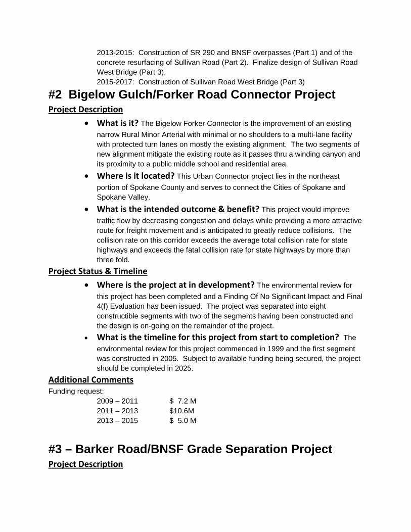
2013-2015: Construction of SR 290 and BNSF overpasses (Part 1) and of the concrete resurfacing of Sullivan Road (Part 2). Finalize design of Sullivan Road West Bridge (Part 3). 2015-2017: Construction of Sullivan Road West Bridge (Part 3)
#2 Bigelow Gulch/Forker Road Connector Project Project Description
• What is it? The Bigelow Forker Connector is the improvement of an existing narrow Rural Minor Arterial with minimal or no shoulders to a multi-lane facility with protected turn lanes on mostly the existing alignment. The two segments of new alignment mitigate the existing route as it passes thru a winding canyon and its proximity to a public middle school and residential area.
• Where is it located? This Urban Connector project lies in the northeast portion of Spokane County and serves to connect the Cities of Spokane and Spokane Valley.
• What is the intended outcome & benefit? This project would improve traffic flow by decreasing congestion and delays while providing a more attractive route for freight movement and is anticipated to greatly reduce collisions. The collision rate on this corridor exceeds the average total collision rate for state highways and exceeds the fatal collision rate for state highways by more than three fold.
Project Status & Timeline
• Where is the project at in development? The environmental review for this project has been completed and a Finding Of No Significant Impact and Final 4(f) Evaluation has been issued. The project was separated into eight constructible segments with two of the segments having been constructed and the design is on-going on the remainder of the project.
• What is the timeline for this project from start to completion? The environmental review for this project commenced in 1999 and the first segment was constructed in 2005. Subject to available funding being secured, the project should be completed in 2025.
Additional Comments Funding request:
2009 – 2011 $ 7.2 M 2011 – 2013 $10.6M 2013 – 2015 $ 5.0 M
#3 – Barker Road/BNSF Grade Separation Project Project Description
• What is it? Construction of an overpass providing grade separation for Barker Road to cross over the BNSF mainline and SR 290 (Trent Avenue).
• Where is it located? At the junction of SR 290 (Trent Avenue) and Barker Road.
• What is the intended outcome & benefit? The grade separation will improve the safety of both the railroad crossing and the intersection with SR 290. It will correct an existing transportation concurrency problem therefore allowing for future industrial development of the area. It will improve freight mobility within the industrial district in the northeast part of Spokane Valley. The grade separation of Barker Road will allow for the future closure of the nearby at-grade Flora Road crossing.
Project Status & Timeline • Where is the project at in development? Environmental clearances have
been received and the 30% design has been completed. Funding in the amount of $10 million has been awarded by FMSIB towards the completion of this project.
• What is the timeline for this project from start to completion? 2011-2013: finalize design, right-of-way acquisition 2013-2015: construction
#4 – Sprague Avenue Resurfacing Project Project Description
• What is it? A grind and asphalt inlay of Sprague Avenue. • Where is it located? Sprague Avenue from Evergreen Road to Sullivan Road.
• What is the intended outcome & benefit? To extend the useful life of this major principal arterial and prevent the need for a more costly full reconstruction, which would have a much greater impact on the business community, freight movement, transit, and commuters. The project will also include stormwater upgrades, ADA improvements, widening the curb lane to provide for safer non-motorized travel, and modifying intersection turn pockets to improve safety and congestion.
Project Status & Timeline
• Where is the project at in development? It is 95% designed.
• What is the timeline for this project from start to completion? 2009-2011: complete design, construction in summer 2011 if funds become available
#5 -- I-90/Barker to Harvard MP 293.61 to MP 296.64

Project Description
• What is it? This project adds capacity to Interstate 90 as well as address off and on connections at Harvard and Barker.
• Where is it located? I90 MP 293.61 to MP 296.64
• What is the intended outcome & benefit? This project addresses current congestion on Interstate 90 east of Spokane by adding a lane in each direction between Barker Rd and Harvard Rd. This will also improve the interchanges and access from Barker to Harvard Roads, this improvement is the next in line to continue the expansion of I-90 from four lanes to six lanes from Sprague Ave I/C to the Idaho border. The work began in 2003 with the passage of the nickel gas tax. This project also addresses possible changes to the interchange layouts sought by the City of Liberty Lake to better fit with their long range planning for the entrance to the City.
Project Status & Timeline
• Where is the project at in development? This project is part of the corridor environmental impact statement that was done from Four Lakes to the Idaho State Line in the late 80’s. We have conceptual designs that will be refined through value engineering during the development of the interchange justification report (IJR). We have some design funds, but need funds to complete the design as well as right of way & construction funds
• What is the timeline for this project from start to completion?
Estimate 24 months to get on Ad and another 24 months for construction.
#6 -- US 195 MP 91.17- Hatch Road Interchange and US 195 alignment shift
Project Description
• What is it? This project constructs a new Hatch Road Interchange and the necessary US 195 alignment shift to implement full access control at this location.
• Where is it located? US 195 MP 91.17
• What is the intended outcome & benefit? This project maintains the free flow characteristics of this high priority freight corridor by completing the Hatch Road interchange as well as some local streets and alignment changes on US195. This project will benefit safety and mobility on the corridor by removing conflicting at grade movements.
Project Status & Timeline

• Where is the project at in development? Corridor design concepts and right of way plans are complete. We are waiting for design and right of way funds to make shovel ready.
• What is the timeline for this project from start to completion? Estimate 24 months to get on Ad and another 24 months for construction.
#7 -- US 195 MP 93.83- Cheney-Spokane finish Diamond interchange. This project completes the remaining west half of the Diamond interchange funded from the Section164 grant which is currently shown as funded in the Department’s agency request budget to the Governor. Project Description
• What is it? This project completes the remaining west half of the Diamond interchange. The east half was funded from a Section164 grant.
• Where is it located? US 195 MP 93.83
• What is the intended outcome & benefit? This project completes the Diamond Interchange that was started with the Section 164 grant funds. Safety and mobility within the US 195 corridor will be enhanced with the completion of the removal of the at grade intersection.
Project Status & Timeline • Where is the project at in development? The project is substantially
designed as the East half is headed to construction. We need funding to complete the design and to purchase remaining right of way
• What is the timeline for this project from start to completion? Project will require completion of Right of way purchases and completion of set of contract plans before the Construction phase can begin, estimate 18 months.
Additional Comments This is a high priority corridor within the Spokane metropolitan area. Improvements are necessary to preserve the free flowing character of this freight facility.
#8 -- Fish Lake Trail Phase III Project Description
• What is it? This is a regional trail project, which will construct the final phase. The project includes two new grade separated crossings of BNSF’s main rain line. Constructing 2.5 miles of trail between Scribner Road and Fish Lake Trail will complete the 10.5 mile trail system between Spokane and Fish Lake.

• Where is it located? The final phase of the trail starts at Scribner Road and runs south to Fish Lake. Scribner Road is approximately 2.5 miles north of Fish Lake.
• What is the intended outcome & benefit? In 1991 the City of Spokane acquired approximately 10.5 linear miles of railroad corridor right-of-way from Government Way in west Spokane to Fish Lake, a Spokane County park south of Spokane. An initial phase (Phase I) of construction was completed in 1997 when the City paved approximately 3.5 miles of the trail from Scribner Road to the north. Phase II was completed in 2009 which constructed 4.4 miles between Government Way and the section completed in 1997. The intended outcome of this project is to complete the last remaining 2.5 miles of trail (including the two new pedestrian bridges). Completing the trail will create a continuous non-motorized trail system between Spokane and Cheney. Fish Lake Trail connects to the existing Columbia Plateau Trail at Fish Lake. The Plateau Trail provides connection to Cheney (Wa), Pasco (Wa) and crosses the John Wayne Trail, which is a cross-state trail connecting to the Puget Sound area.
Project Status & Timeline
• Where is the project at in development? The project has environmental approval and is funded for design. The funds being requested will help construct the project.
• What is the timeline for this project from start to completion? Design is 20% complete for phase III. While no right-of-way is needed, the City will need overhead easements and rights to enter during construction from BNSF to cross their right-of-way. The City has been working with BNSF to obtain their approval of the project and will be working on the needed easements in the coming months. Design is scheduled to be completed by June of 2011.
#9 -- US 195 - Meadowlane Interchange. This project constructs a new Meadowlane half Diamond Interchange Project Description
• What is it? This project constructs a new Meadowlane half Diamond Interchange.
• Where is it located? US 195 MP 92.28
• What is the intended outcome & benefit? This project completes a half diamond interchange at Meadowlane. This project will benefit safety and mobility on the corridor by removing conflicting at grade movements as developed in the US 195; Hatch road to I-90 corridor plan.
Project Status & Timeline

• Where is the project at in development? Design concept is complete and we are waiting for design and right of way funds to make the project shovel ready.
• What is the timeline for this project from start to completion? Estimate 18-24 months to get on Ad and another 18-24 months for construction.
#10 -- SR 902 - Interchange Improvements
Project Description
• What is it? Modify the interchange by eliminating the double intersection on the north side of the Interchange. This would be accomplished by introducing a loop ramp westbound off, moving White Road, and combining all of the interesection/ramp movements into one signalized intersection.
• Where is it located? I90 MP 272.81
• What is the intended outcome & benefit? This project eliminates truck turning conflicts created from recent development, this project may also allows for capacity needed to site a new jail and a possible STA facility, more study is needed to confirm this.
Project Status & Timeline
• Where is the project at in development? This project has a scope identified, and is waiting for design and right of way funds.
• What is the timeline for this project from start to completion? Estimate 18-24 months to get on Ad and another 18-24 months for construction.
Additional Comments This project benefits and is supported by Spokane County due to the siting of the new Jail, as well as STA due to the addition of planned transit facilities.
#11 -- Central City Line Project Project Description
• What is it? The purpose of the project is to design and construct a high performance transit service that serves local circulation within the central city of Spokane.
• Where is it located? Exact alignment under development but will serve central city districts such as Browne’s Addition, Central Business District, Medical District, Kendall Yards, North Bank and University District.
• What is the intended outcome & benefit? Increase transit ridership and convenience, stimulate new development; maximize regional resources and transit mobility; support local and regional land use goals, objectives and plans; is
environmentally sensitive; and garners broad public support within the greater central city area.
Project Status & Timeline • Where is the project at in development? Alternatives Analysis (planning)
• What is the timeline for this project from start to completion? “locally preferred alternative” decision is expected Q1 2011; Small Starts Application to FTA in Q3 2011; Environmental, Design and Engineering 2012-2014; Construction completed 2015
Additional Comments Project contingent upon increased capital and operating resources. No state funding request in 2011-13 biennium anticipated at this time.
#12 – Spokane Valley – Millwood Trail Project Project Description
• What is it? Construction of a 6.5-mile multi-use pathway on old railroad right-of-way.
• Where is it located? From Spokane Community College (City of Spokane) to the Spokane Valley Mall (City of Spokane Valley), and passing through the City of Millwood. Much of the route parallels the Union Pacific tracks. It will connect two elementary schools, a high school, several junior colleges, an STA park-n-ride, and several parks. The route also runs through several built-out residential neighborhoods, two industrial districts, and downtown Millwood.
• What is the intended outcome & benefit? To enhance non-motorized transportation in the north part of Spokane Valley and between some of the highest traffic generators. It is expected to be used primarily by commuters.
Project Status & Timeline • Where is the project at in development? The planning and design have
been funded. Planning work will begin in early 2011. • What is the timeline for this project from start to completion?
2009-2011: initiate planning and design 2011-2013: finalize design, right-of-way acquisition (if needed), begin construction
#13 -- Spokane South Valley Corridor High Performance Transit Project Project Description
• What is it? High performance transit investment that may include bus rapid transit utilizing advanced electric trolley bus infrastructure.
• Where is it located? Generally an east-west alignment between City of Spokane and Liberty Lake via City of Spokane Valley and generally following parallel Sprague and Appleway avenues.
• What is the intended outcome & benefit? Improved mobility, connectivity and increased service frequency and quality of service.
Project Status & Timeline
• Where is the project at in development? Planning concept. Previous studies indicated preference for diesel-powered light rail.
• What is the timeline for this project from start to completion? Timeline is yet to be determined.
Additional Comments No appropriation is requested at this time. The project is part of the proposed High Performance Transit network for the Spokane region.
#14 – SR 904 Cheney to Four Lakes Transportation Improvement Project Description
• What is it? o To accommodate existing and projected growth, enhance safety and
preserve capacity, the project provides a five lane undivided alignment ($22.3 million) the entire length of the corridor by: • Constructing two additional lanes for through traffic • Constructing one additional lane through the center for a two
way left turn lane • Implementing partial access control along segment
• Where is it located? o The Route Development Plan, completed in 2003, addresses a segment
of SR 904 located in Spokane County. The project begins at MP 12.56 (Betz Road vicinity) and extends just over four miles north of the City of Cheney to MP 16.81 (Four Lakes).
• What is the intended outcome & benefit? o The segment of SR 904 is a major commuter link between metropolitan
Spokane and the City of Cheney, providing access to residential development along the route. This portion of SR 904 also serves as the primary route between Spokane and Eastern Washington University. With hourly STA service to EWU for students, Cheney School District buses morning and afternoon and the personal car commuting of EWU students this route is one of the highest multi-passenger routes in the
State. Head-on collisions and rear-ender collisions due to turning have been decreased since the addition of centerline rumble strips but the highway continues to be a major hazzard. With the increased use by grain-hauling trucks to the flour mill in Cheney and the new industrial users in the Cheney Business Park the mix of auto, semi trucks and busses have seriously congested this highway. Present traffic count is at 19,000 ADTs.
Project Status & Timeline
• Where is the project at in development? o SR 904 from Cheney to Four Lakes was the subject of a WSDOT Route
Development Plan that was completed in 2003. No additional engineering design has been completed. Nearly all of the right-of-way is in place.
• What is the timeline for this project from start to completion? o Engineering can be completed in 6 months with construction taking 1
year. Additional Comments
Letters of support and advocacy is forthcoming from Eastern Washington University, Cheney School District, Allpak Container, LTD, Haakon Industries, ADM Milling and the Cheney City Council.
#15 -- STA Transit Plaza Improvements Project Project Description
• What is it? Spokane Transit is seeking to improve the efficiency of circulation in and around the Plaza facility and to convert Wall Street from a one-way street to two-way from Riverside Avenue to Third Avenue. In addition, the sidewalk along Sprague Avenue adjacent to the Peyton Building will be widened to reduce pedestrian traffic congestion along that stretch of the sidewalk. Converting Wall Street to two-way will require revision to the traffic signals at the affected intersections, re-striping Wall Street, and relocating parking meters on the west side of Wall Street.
• Where is it located? Downtown Spokane between Sprague and Riverside avenues, Wall and Post streets plus Wall Street from Riverside to 3rd Avenue.
• What is the intended outcome & benefit? The primary intent of the interior work is to relocate all of the direct transit activities to the main floor of the building, thus relieving customers/patrons from having to access the second floor for Customer Services. The exterior portion of the project will create bus zones allowing buses to operate more efficiently in general, and specifically along Wall Street, by allowing travel for both north and southbound buses. Reduction of pedestrian congestion is also anticipation.

Project Status & Timeline
• Where is the project at in development? Design of exterior improvements and coordination with City of Spokane.
• What is the timeline for this project from start to completion? Design of exterior improvements complete Spring 2011; exterior construction complete Fall 2011; interior improvements construction to be determined
Additional Comments No financial assistance is requested of Washington State at this time.
#16 -- West Plains Transit Center Project Project Description
• What is it? The purpose of the project is to design and construct a 200-300 car park facility located on the north side of I-90 at the West Plains Interchange (Exit 272 - see Attachment A). The project includes: up to four bus bays, driver restroom, lighting, shelters and bicycle parking. Construction of the park and ride will improve pedestrian access and safety, allow public transit to operate more effectively to Medical Lake, connect Cheney, Medical Lake, Airway Heights, and Spokane, provide public transportation options for regional high school students, provide coordination with the proposed regional jail, and tie into a proposed WSDOT project intending to make improvements at the interchange.
• Where is it located? Adjacent to I-90 Exit 272 west of City of Spokane
• What is the intended outcome & benefit? Improve service efficiency, improve regional connections to West Plains area of Spokane County, reduce vehicle miles traveled.
Project Status & Timeline
• Where is the project at in development? Planning.
• What is the timeline for this project from start to completion? Complete preliminary design 2011. Complete environmental review and 30% design Summer 2012. Submit Regional Mobility Grant Fall 2012. Construction completed 2015 contingent upon successful grant application(s).
#17 -- Smart Bus Implementation Project Project Description
• What is it? Spokane Transit is seeking $6 million to install and implement Smart Bus technology on 156 fixed-route buses and supervisor vehicles including the necessary infrastructure to support the project (see Attachment A for Service Area). Smart Bus
provides for an on-board electronics and data system that monitors and reports on the operational and maintenance status of the bus, including security and safety incidents, as well as its current location and schedule adherence. The project will provide improved customer service with access to real time information through the internet, telephones, personal digital assistants (PDA's), variable message signs and information kiosks to allow riders to make more dynamic travel decisions.
• Where is it located? ITS components will be installed on each fixed route bus in the Spokane Transit system and in STA facilities.
• What is the intended outcome & benefit? The Smart Bus project will increase ridership and safety which in turn will lead to numerous benefits to the region. Increased ridership assists the region with a reduction in carbon monoxide pollutants (improved air quality), increased access to potential employees, and reduced traffic congestion. Cameras and real-time information on the buses will improve safety by assisting drivers and dispatchers to quickly react to incidents occurring throughout the transportation system. It will also allow STA staff to better coordinate with police and fire departments.
Project Status & Timeline
• Where is the project at in development? Installation of onboard cameras will begin this fall (contract has been awarded).
• What is the timeline for this project from start to completion? Design of the architecture for automatic vehicle location and computer aided dispatch will begin in 2011. Vendor selection and negotiations in 2012. System engineering in 2012-2013. System procurement and installation in 2013-2014. System acceptance and testing 2015.
Additional Comments Up to $1 million will be requested in the 2011 Legislative Session in order to fund the stop annunciators for improved ADA accessibility.
#18 -- Centennial Trail to Fish Lake Trail, Connecting Trail Study Project Description
• What is it? This is a “study only” to analyze the potential of creating a trail connection between two regional trail systems; the Centennial and Fish Lake Trails.
• Where is it located? The missing link is located from the south end of the Sandifur Bridge to the Fish Lake Trail Head.
• What is the intended outcome & benefit? Two proposed trail alignments need more study to confirm if one or both are viable options to pursue. One alignment would follow existing State owned land towards Latah
Creek from the trail head at Government Way. The proposed alignment would then go under the Sunset Hwy Bridge and into High Bridge Park and utilize the Marne Bridge to access the Centennial Trail at the south end of the Sandifur Bridge. The other proposed trail alignment would follow existing roadways to the Marne Bridge and access the Centennial Trail at the south end of Sandifur Bridge. The future benefit will be to have a direct connection from one regional trail system to the other.
Project Status & Timeline • Where is the project at in development? We are at the very beginning of
this process in that a Study is needed to determine an appropriate connection that meets the needs from both the user and financial perspective.
• What is the timeline for this project from start to completion? This study would take 12 to 16 months to complete.
#19 Northwest Connector Study Project Description
• What is it? This project is a route development and feasibility study for a new connector route to provide an efficient transportation facility to connect the areas of north Spokane County, City of Spokane and southeast Stevens County to West Spokane, Spokane International Airport, Fairchild Air Force Base, Interstate 90 and US Route 2.
• Where is it located? This proposed facility lies northwest of the City of Spokane in Spokane County.
• What is the intended outcome & benefit? This project will provide an efficient transportation facility for the commuters of the region and alleviate the congestion that currently exists on the City of Spokane arterials and the segment of Interstate 90 traversing through the downtown core area.
Project Status & Timeline
• Where is the project at in development? This project is in the public information and review phase, the important first stage of development. It has been discussed as a desirable companion project with the US 2 Route Development Plan.
• What is the timeline for this project from start to completion? This project is in the planning stage and the schedule for completion will be subject to the outcome of the study and available finances.
Additional Comments
Funding Request: 2011 – 2013 $875K


1300 Franklin Street, Floor 4 P.O. Box 1366 Vancouver, WA 98666-1366
360-397-6067 360-397-6132 fax http://www.rtc.wa.gov
Member Jurisdictions Clark County
Skamania County
Klickitat County
City of Vancouver
City of Camas
City of Washougal
City of Battle Ground
City of Ridgefield
City of La Center
Town of Yacolt
City of Stevenson
City of North Bonneville
City of White Salmon
City of Bingen
City of Goldendale
C-TRAN
Washington DOT
Port of Vancouver
Port of Camas-Washougal
Port of Ridgefield
Port of Skamania County
Port of Klickitat
Metro
Oregon DOT
15th Legislative District
17th Legislative District
18th Legislative District
49th Legislative District
November 3, 2010 Reema Griffith, Executive Director Washington State Transportation Commission PO Box 47308 Olympia, Washington 98504-7308
Dear Ms. Griffith:
We are pleased to submit Southwest Washington Regional Transportation Council’s recommendation for the Washington State 2010 Supplemental Transportation Budget Proviso for Clark, Skamania, and Klickitat Counties. The proposed recommendation is a product of the regional transportation planning process. A copy of the RTC resolution approving the recommendation and project information, along with the spreadsheet of Top 20 Projects are attached.
The project list being recommend to the Washington State Transportation Commission along with the $75 million annual estimated need for preservation and maintenance provides a picture of the need to have a significant share of any new statewide transportation revenue package come to local governments. While the attached list of projects is focused on regional projects, there is considerable need beyond this list of projects for local scale capital projects on city and county arterial roadways. There is also a need to fund a statewide program for bike and trail projects, as well as an annual direct allocation to local governments for a preservation and maintenance program
The attached project priority recommendation is not intended to represent a final or complete list of transportation project priorities for our region. The proposed list of projects priorities should be viewed as a range of priority needs, given the budget proviso, that are of a high priority to our region.
If you need additional information, please call me at (360) 397-6067 x5208.
Sincerely, Dean Lookingbill Transportation Director Attachments


Southwest Washington Regional Transportation Council (RTC)
Washington State 2010 Supplemental Transportation Budget Proviso: Top 20 Priority Projects October 2010
Project
Number
Project Name, Jurisdiction & Category
(i.e.: road or multi-modal)
State
Route
Begin
MP
End
MP
Project Type - Indicate
Applicable Number(s)
Total Project Cost*
(Adjusted to Year of
Expenditure)
Is This Project
Consistent with
an Approved
RTP?
Policy Goals Project
Addresses
Level of
DevelopmentComments
11/13 : $150,000
13/15 : $150,000
15/17 : $150,000
11/13 : $4,000
13/15 : $9,000
15/17 : $21,000
11/13 : $2,600
13/15 : $3,800
15/17 : $12,600
11/13 : $3,000
13/15 : $3,500
15/17 : $15,500
11/13 : $5,000
13/15 : $10,000
15/17 : $20,000
11/13 : $10,000
13/15 : $22,000
15/17 : $50,750
11/13 : $3,000
13/15 : $34,000
15/17 : $56,000
11/13 : $40,000
13/15 : $34,000
15/17 : $66,000
11/13 : $12,000
13/15 : $10,000
15/17 : $20,000
11/13 : $4,000
13/15 : $10,000
15/17 : $23,000
14-6SR 14/I-205 to SE 164th Ave - Add Auxiliary Lanes,
WSDOT, 1 - Road Project14 6.45 8.00
This highway segment is identified bottleneck/chokepoint and is part of
the "Moving Washington" program.$37,000 Yes
1 - Economic Vitality
3 - Safety
4 - Mobility
6 - Stewardship
Planning
3 - Safety
5 - New Construction
6 - Adds Capacity
1 - Economic Vitality
3 - Safety
4 - Mobility
6 - Stewardship
20% DesignThis project is a continuation of the I-5/Columbia River
Crossing/Vancouver - EIS TPA Project.
5-7I-5/I-205 - NE 134th St Interchange, Stage II,
WSDOT, 1 - Road Project5 6.80 8.00
3 - Safety
4 - Reconstruction
5 - New Construction
6 - Adds Capacity
$140,000 Yes
$42,000 Yes
1 - Economic Vitality
3 - Safety
4 - Mobility
6 - Stewardship
5% DesignThe project will complete the second phase of the Salmon Creek
Interchange Project
1 - Economic Vitality
2 - Preservation
3 - Safety
6 - Stewardship
1 - Preservation
2 - Maintenance
Preservation and Maintenance
Yes
Project Cost
Breakdown
By Biennia - YOE
5-2I-5/SR 500 - Construct Direct Connections,
WSDOT, 1 - Road Project5 2.35 2.50
3 - Safety
5 - New Construction
6 - Adds Capacity
Annual Preservation and Maintenance Cost for
Clark, Skamania, and Klickitat Counties$75,000
State Facilities
Regional Arterials
M-6375West Vancouver Freight Access Project, Rail and
Grade Separation, Port of Vancouver, Multimodal
3 - Safety
4 - Reconstruction
5 - New Construction
6 - Adds Capacity
7-Multi-Modal Facility
$126,690 Yes
1 - Economic Vitality
3 - Safety
4 - Mobility
6 - Stewardship
10%-30% Design
Construction began in 2007. Outstanding elements of the project are
between 10-30 percent designed, with discrete elements nearing
construction. NEPA process is completed.
RA-135418th Street Corridor, Four Seasons to 162nd Av.-
Add lanes, City of Vancouver, Road Project
3 - Safety
4 - Reconstruction
5 - New Construction
6 - Adds Capacity
$34,000 Yes
1 - Economic Vitality
3 - Safety
4 - Mobility
6 - Stewardship
Environmental
Completed
Provide a direct link to future I-205 interchange. Interchange
construction to begin in 2014.
RA-1352137th/138th Avenue, 28th St. to Four Plain Blvd.-
Add Lanes, City of Vancouver, Road Project
3 - Safety
4 - Reconstruction
5 - New Construction
6 - Adds Capacity
$19,000 Yes
1 - Economic Vitality
3 - Safety
4 - Mobility
6 - Stewardship
Design beginning
2011
NE 28th St. to 49th St. is schedule for 2012 construction. NE 49th St. to
Fourth Plain design will begin in 2011.
RA-1315
Fruit Valley Road Corridor, NW 61st Av. to 78th
St.-Widen to Urban Standards, City of Vancouver,
Road Project
3 - Safety
4 - Reconstruction
5 - New Construction
6 - Adds Capacity
$22,000 Yes
1 - Economic Vitality
3 - Safety
4 - Mobility
6 - Stewardship
Planning Provides freight access between Port of Vancouver and I-5.
1 - Economic Vitality
3 - Safety
4 - Mobility
6 - Stewardship
10% DesignHighway 99 is a regional corridor that parallels I-5, providing an
alternate route.
Multimodal Projects
M-4BRT
Fourth Plain Bus Rapid Transit, Van Mall to
Downtown Vancouver-Transit, C-TRAN,
Multimodal
5 - New Construction
6 - Adds Capacity
7 - Adds Multi-Modal
Facility
$82,750 Yes
1 - Economic Vitality
3 - Safety
4 - Mobility
6 - Stewardship
Alternative
Analysis
Project includes the construction of a high quality high capacity transit
service along a 4.9 mile segment of Fourth Plain Boulevard corridor,
between Westfield Vancouver Mall an downtown Vancouver.
RA-0628
Highway 99, S. of RR Bridge to 129th St.,
Reconstruct Road and Replace RR Bridge, Clark
County, Road Project
3 - Safety
4 - Reconstruction
5 - New Construction
6 - Adds Capacity
$35,000 Yes

Project
Number
Project Name, Jurisdiction & Category
(i.e.: road or multi-modal)
State
Route
Begin
MP
End
MP
Project Type - Indicate
Applicable Number(s)
Total Project Cost*
(Adjusted to Year of
Expenditure)
Is This Project
Consistent with
an Approved
RTP?
Policy Goals Project
Addresses
Level of
DevelopmentComments
Preservation and Maintenance
Project Cost
Breakdown
By Biennia - YOE
11/13:$5,000
13/15:$8,000
15/17:$17,000
11/13:$40,000
13/15:$34,000
15/17:$66,000
11/13:$500
13/15:$9,000
15/17:$500
11/13:$25,000
13/15:$5,000
15/17:$196,000
11/13:$46,000
13/15:$40,000
15/17:$45,000
17/19:$34,000
11/13:$20,000
13/15:$17,000
15/17:$33,000
11/13:$33,000
13/15:$28,000
15/17:$55,000
11/13:$18,000
13/15:$16,000
15/17:$30,000
11/13:$17,000
13/15:$14,000
15/17:$28,000
11/13:$8,000
13/15:$10,000
15/17:$21,000
11/13:$3,000
13/15:$3,000
15/17:$5,000
*Dollars in thousands
**YOE = Year of Expenditure Dollars assuming a 3% inflation factor
503-1SR 503/Padden Parkway and SR 500 - Construct
Interchange, WSDOT, 1 - Road Project5030.771.00
3 - Safety
4 - Reconstruction
5 - New Construction
6 - Adds Capacity
$59,000Yes
This project is the result of combining two separate projects: SR 503/SR
502 - Construct Turn Lanes and SR 503/SR 502 to NE 244th Street - Add
Lanes.
$11,000Yes
1 - Economic Vitality
3 - Safety
4 - Mobility
6 - Stewardship
Planning
3 - Safety
5 - New Construction
6 - Adds Capacity
$39,000Yes
1 - Economic Vitality
3 - Safety
4 - Mobility
6 - Stewardship
PlanningThis intersection is an identified bottleneck/chokepoint.
503-8SR 503/SR 502 to NE 244th Street - Add Lanes and
Construct Turn Lanes, WSDOT, 1 - Road Project5038.119.35
500-2
SR 500/NE 42nd Ave and NE 54th Ave - Limit
Access and Construct Interchange, WSDOT, 1 -
Road Project
5001.802.38
The adjacent segments of SR 500, on each side of this location, function
as a limited access highway. By grade separating these two
intersections, this corridor will have improved continuity and meet
driver expectations. This project is part of the "Moving Washington"
program.
500-6
SR 500/SR 503 and NE Fourth Plain Blvd - SR 500
Fly-Over (Intersection Grade Separation), WSDOT,
1 - Road Project
5005.945.98
3 - Safety
4 - Reconstruction
5 - New Construction
6 - Adds Capacity
$64,000Yes
1 - Economic Vitality
3 - Safety
4 - Mobility
6 - Stewardship
Planning
3 - Safety
4 - Reconstruction
5 - New Construction
6 - Adds Capacity
1 - Economic Vitality
3 - Safety
4 - Mobility
6 - Stewardship
PlanningThis intersection is an identified bottleneck/chokepoint.
3 - Safety
4 - Reconstruction
5 - New Construction
6 - Adds Capacity
1 - Economic Vitality
3 - Safety
4 - Mobility
6 - Stewardship
This project is included in the "Moving Washington" program. It is also
a continuation of the I-205/Mill Plain Interchange to NE 18th St. TPA
project.
205-31I-205/SR 500 to Padden Parkway - Add Lanes,
WSDOT, 1 - Road Project20531.4933.00
3 - Safety
5 - New Construction
6 - Adds Capacity
$70,000Yes
$116,000Yes
1 - Economic Vitality
3 - Safety
4 - Mobility
6 - Stewardship
Planning
This project is part of the "Moving Washington" program. I-205 is a
major North-South Corridor that compliments I-5 in connecting
Washington and Oregon.
205-29I-205/NE 18th St to SR 500 - Construct Ramps and
Connector Roads, WSDOT, 1 - Road Project20529.3431.65
3 - Safety
5 - New Construction
6 - Adds Capacity
1 - Economic Vitality
3 - Safety
4 - Mobility
6 - Stewardship
5% Design
$140,000Yes
14-23
205-27
I-205/SR 14 to SE Mill Plain Rd - Rebuild
Interchange and Construct Braided Ramps,
WSDOT, 1 - Road Project
20526.8429.00
35-01
SR-35 Columbia River Crossing/White Salmon,
WA to Hood River, OR- Bridge Replacement,
WSDOT-ODOT, 1- Road Project
35
3 - Safety
4 - Reconstruction
7 - Adds Multi-Modal
Facility
$226,000Yes
1 - Economic Vitality
3 - Safety
4 - Mobility
6 - Stewardship
10%
This project is within an identified bottleneck location. It is also
included in the "Moving Washington" program.5% Design
14-15SR 14/SE 2nd St to 32nd St - Add Lanes and
Construct Interchanges, WSDOT, 1 - Road Project1414.9917.00
3 - Safety
4 - Reconstruction
5 - New Construction
6 - Adds Capacity
20-30% DesignThis project includes re-alignment of the "big ess" curve and the Belle
Center intersection, in Skamania County.
SR 14/Marble Road to Cape, Phase 2- Realign
Curves and Improve Intersection, WSDOT, 1-
Road Project
1422.7026.38
3 - Safety
4 - Reconstruction
7 - Adds Multi-Modal
Facility
$10,000
Planning
This project is a continuation of the SR 14/Camas Washougal - Add
Lanes and Build Interchange TPA project. That TPA project will widen SR
14 to a 4 lane facility just west of this project's limits.
This project would replace a bridge built in 1924. The existing structure
is 4,418 Feet long and has two 9.5-foot wide travel lanes with no
shoulder, pedestrian, or bicycle facilities. In Klickitat County.
Yes
1 - Economic Vitality
3 - Safety
4 - Mobility
6 - Stewardship
$165,000Yes
1 - Economic Vitality
3 - Safety
4 - Mobility
6 - Stewardship
14-13SR 14/West Camas Bridge - Rebuild Bridge,
WSDOT, 1 - Road Project1412.6212.82
3 - Safety
4 - Reconstruction
6 - Adds Capacity
1 - Economic Vitality
3 - Safety
4 - Mobility
6 - Stewardship
15% Design $30,000Yes


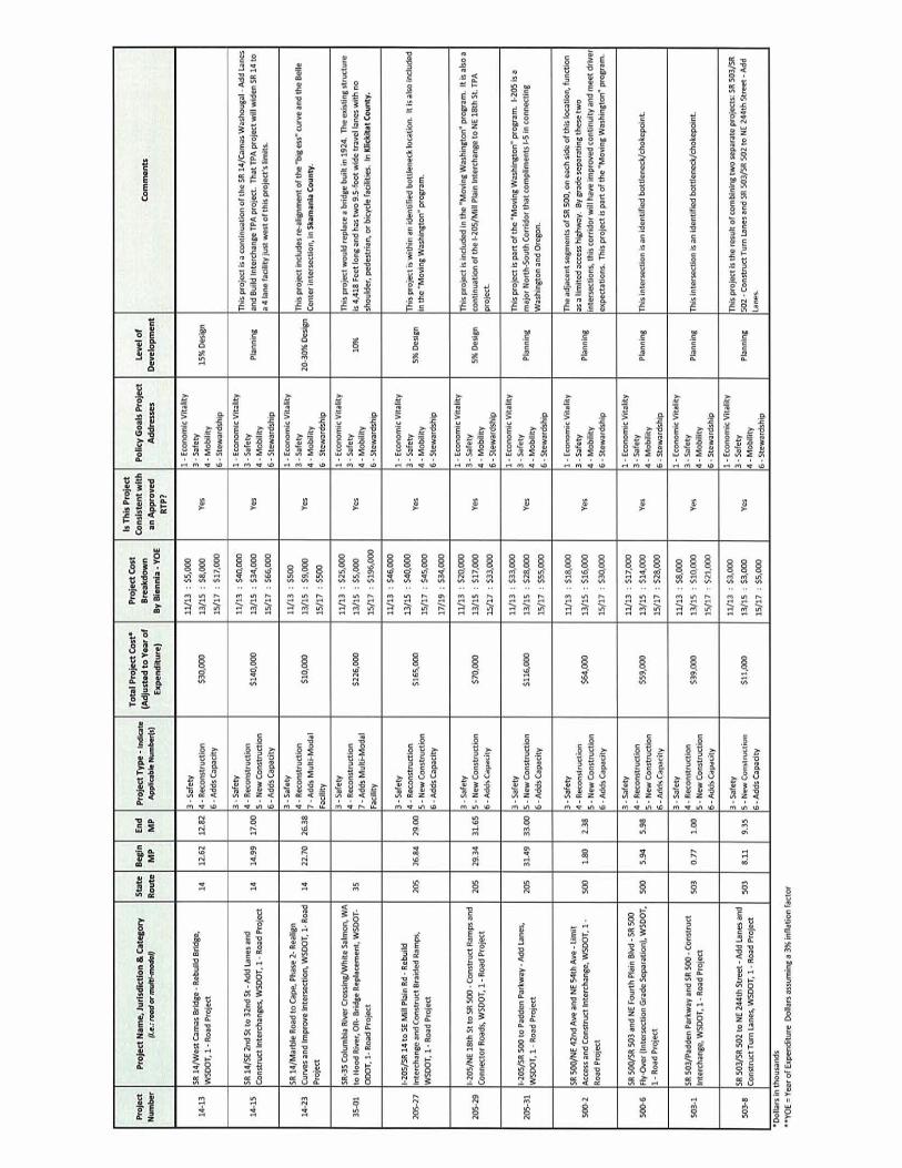


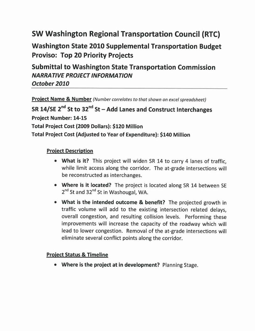


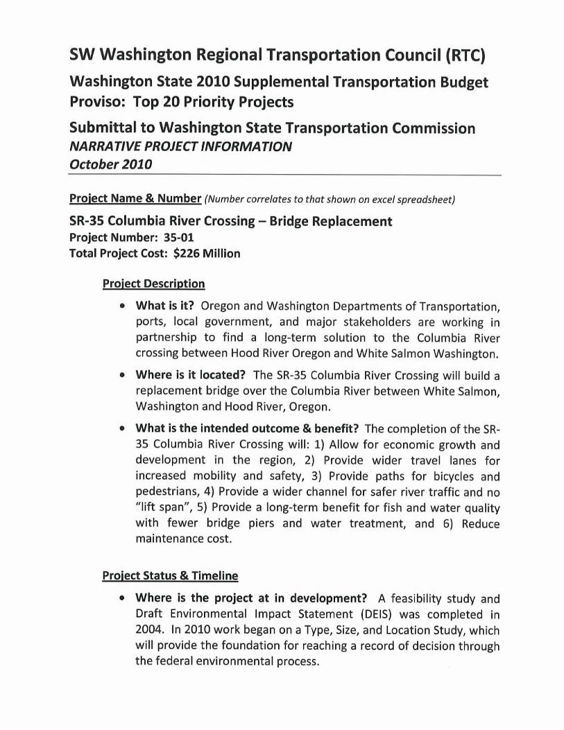


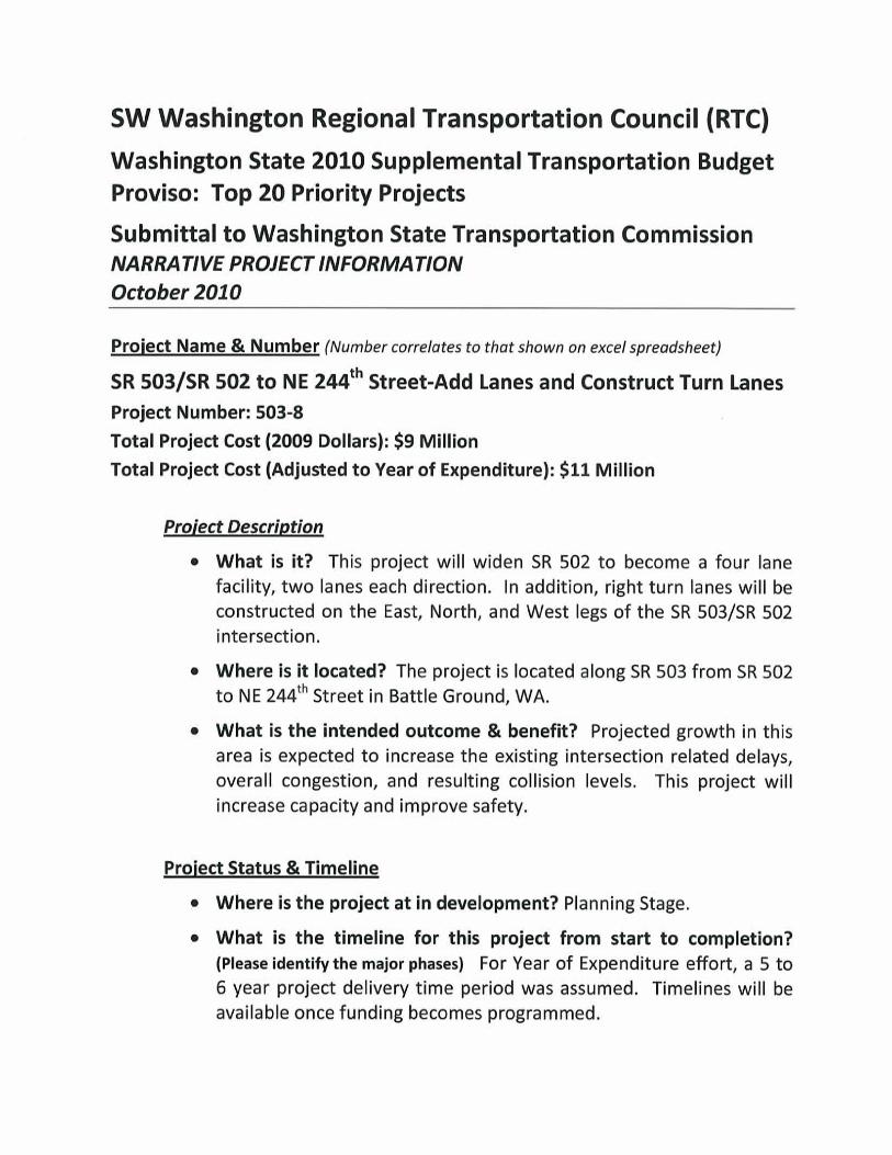


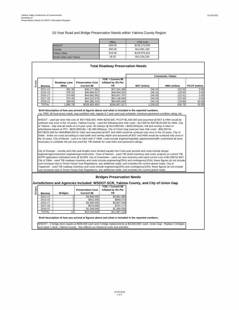
Yakima Valley Conference of GovernmentsSummary ofPreservations Needs for WSTC Information Request
10-29-2010
Miles YOE Cost626.00 $135,270,000600.00 $14,081,155619.46 $129,976,93128.32 $15,329,230
Roa
ds
BienniaRoadway Lane
MilesPreservation Cost
Current $$
YOE = Current $$ Inflated by 3% Per
YR BST (miles) HMA (miles) PCCP (miles)2011-13 381.36 $46,177,381 $47,261,269 246.20 132.50 0.002013-15 378.32 $45,686,917 $48,844,032 246.16 129.50 0.002015-17 370.68 $44,682,991 $50,607,767 245.50 122.51 0.002017-19 370.49 $44,522,976 $53,138,565 245.50 122.33 0.002019-21 389.93 $45,385,225 $94,805,683 245.16 119.86 20.00TOTAL 1,890.78 $226,455,491 $294,657,317 1,228.52 626.70 20.00
Brief description of how you arrived at figures above and what is included in the reported numbers.e.g. PMS, all local acess roads, avg cost/lane mile, regular 6-7 year seal-coat schedule, minimum pavement condition rating, etc.
Brid
ges
Biennia BridgesPreservation Cost
Current $$
YOE = Current $$ Inflated by 3% Per
YR2011-13 3 $3,846,000 $3,961,3802013-15 3 $815,000 $890,5732015-17 3 $3,940,000 $4,567,5402017-19 3 $575,000 $707,1772019-21 1 $1,058,000 $1,380,450TOTAL 13 $10,234,000 $11,507,120
Brief description of how you arrived at figures above and what is included in the reported numbers.
Bridges Preservation Needs
WSDOT - used per lane mile cost of: BST=$30,000, HMA=$200,000, PCCP=$1,500,000 and assumed all BST & HMA would be surfaced only once in the 10 years. Yakima County - used the following lane mile costs - $12,500 for BST/$120,000 for HMA. City of Yakima - chip seal all roads on a 9 year cycle; 45 miles/yr @ $14,000/mile = $630,000/year; mill and overlay 4 miles of arterial/year based on PCI - $620,000/mile = $2,480,000/year. City of Union Gap used per lane mile costs - $56,000 for BST/$220,000 for HMA/$584,000 for G&O and assumed all BST and HMA would be surfaced only once in the 10 years. City of Selah - broke out costs according to road width and overlay depth and assumed all BST and HMA would be surfaced only once in the 10 years. City of Moxee - cost is to G&O with 2" HMA, costs include engineering/utility adjustments/traffic control/and all work necessary to complete the job and used the TIB website for road miles and pavement ratings.
City of Granger - overlay and chip seal lengths were divided equally into 5 two-year periods and costs include design engineering/construction engineering/construction. Town of Naches - used TIB street inventory and costs; projects on current TIB SCPP application estimated costs @ $130/ft. City of Grandview - used our own inventory and used current cost of $0.43/lf for BST. City of Zillah - used TIB roadway inventory and costs include engineering(25%) and contingency(10%); these figures do not include cost increases due to Green House Gas Regulations, any additional roads, and excludes the current gravel roads. City of Toppenish - used TIB roadway inventory and costs include engineering(25%) and contingency(10%); these figures do not include cost increases due to Green House Gas Regulations, any additional roads, and excludes the current gravel roads.
WSDOT - 2 bridge deck repairs at $550,000 each and 2 bridge replacements at $3,000,000+ each. Union Gap - Replace 3 bridges and repair 1 deck. Yakima County - this reflects our historical costs and activities.
10-Year Road and Bridge Preservation Needs within Yakima County Region
Comments / Notes
Jurisdictions and Agencies Included: WSDOT-SCR, Yakima County, and City of Union Gap.
Total Roadway Preservation Needs
WSDOT CountyUrban CitiesSmall Cities and Towns
10-29-20101 of 1


Yakima Valley MPO/RTPOFINAL Regional Priority Project List
10-18-2010 MPO/RTPO Executive Committee Adoption
Project Reference for
Narrative Correlation
Project Name, Jurisdiction &
Category (i.e.: road or multi-modal)
Project Type Indicate
Applicable Number(s)
(see instruction memo)
Total Project Cost* (in thousands)
Is this project consistent
with an approved
Regional Transportation
Plan?
Policy Goals Project
Addresses - Indicate
Applicable Numbers (see
instruction memo)
Comments
Yakima County Duffield to Meiras: 09-11$100 - PE, R/W for Duffield/Meiras
section
> Reduces pedestrian-motor vehicle conflict during school
hours along East Valley School District campus(s).
$2,930 11-13 $2,800 - CN for Duffield/Mieras section > Creates 2nd N-S Arterial east of the Yakima River.
13-15 $250 - PE for Mieras/Roza section> Complements bike-pedestrian pathway network
continuity.
15-17 $750 - PE, R/W for Mieras/Roza section> Moxee section complete. County's Duffield to Meiras
section partially funded, remainder unfunded.
$7,400 17-19 $6,400 - CN for Meiras/Roza section
Naches Rail-Trail Section (Yakima
County Section): 09-11 $825 - CN for Naches to Low Rd. section
> Naches Trail System is a viable recreational destination
to most Yakima/Naches area residents.
$4,200 11-13$1,430 - CN for Low Rd to Old Naches
Hwy section> Listed in Yakima County's 2008 Trails System Plan
13-15$1,600 - CN for Old Naches Hwy to 40th
Ave section> Preserves rail corridors for future use
15-17$100 - Feasiblity study for Lower Valley
section
> Town of Naches to Locust Rd (funded), remainder
pending or unfunded
$10,000 17-19 $500 - PE, R/W for Lower Valley section
Project Cost Breakdown By Biennia - YOE $** (09/11; 11/13;
13/15 etc.)
1,2,3,4,5,6
Yakima County / Yakima Greenway
Trail System Expansion (multi-juris)1,2,3,5,7 Yes 1,2,3,4,5,6
YesA
B
East Valley Schools – Beaudry Road
Crossing & Pathway Project (County)3,5,6
Yakima County Beaudry/Bittner Rds
plus canal bridge crossing:
Lower Valley Section (Yakima County
Section): Gap to Sunnyside
Final Regional Priority Project List Page 1 of 7
10-29-2010

Yakima Valley MPO/RTPOFINAL Regional Priority Project List
10-18-2010 MPO/RTPO Executive Committee Adoption
Project Reference for
Narrative Correlation
Project Name, Jurisdiction &
Category (i.e.: road or multi-modal)
Project Type Indicate
Applicable Number(s)
(see instruction memo)
Total Project Cost* (in thousands)
Is this project consistent
with an approved
Regional Transportation
Plan?
Policy Goals Project
Addresses - Indicate
Applicable Numbers (see
instruction memo)
CommentsProject Cost Breakdown By Biennia - YOE $** (09/11; 11/13;
13/15 etc.)
County Wide: 09-11$17,592
Operational Needs11-13$18,120
13-15$18,652
15-17$19,200
17-19$19,764
County Wide: 09-11$2,882
Capital Needs11-13$2,969
13-15$3,056
15-17$27,866
17-19$4,268
Yes
(Yakima Transit) The route miles are calculated at a
coservative 3% increase annually. The Operations cost
reflects the 3% increase in mileage and is based on the
current year end estimates. (People for People) The
following services are included in the cost for People For
People to provide transportation service to Yakima County
residents: (1) to provide paratransit service to individuals
with special needs that live outside public transit; (2) to
provide fixed-route transportation for disadvantaged and
general public to access services along 48 miles of
Highway I-82 from Prosser to Yakima; (3) to provide
transportation services for WorkFirst and low-income
individuals to access employment and employment
related services. (U.G.)These are the actual amounts that
will be paid by the City of Union Gap per their contract
with T.C. Transportation Services. The Operations cost
reflects a 3% inflation (not compounded) and is based on
the current year end estimates.
1,2,3,4,5,6
(Yakima Transit) The route miles are calculated at a
conservative 3% increase annually. The Capital cost
reflects the 3% increase in mileage and is based on the
current year end estimates. The cost of a new transit
facility on the West side of Yakima is added to the 2015-
17 Biennia. The cost of the additional capital expenditure
has also been reflected in the above table from the 2017
Biennia forward. (People for People) People For People
reviewed our Asset Management Plan to identify our
vehicle replacement schedule to ensure safe, reliable, and
cost-efficient service continues to be provided to
residents of Yakima County. People For People would
replace four 14-passenger and one 30-passenger vehicle
with video and radio equipment each biennium. To
maintain technology for the dispatch and routing of
buses, People For People has included the cost for
computer, telephone, and software updates. To preserve
the current Mobility Manager for Greater Columbia 211,
People For People has included the biennial cost that
WSDOT has funded with capital (FTA 5310).
Countywide transit capital and
operating (multi-juris)
Yes1,2,3,4,5,6
1,2,3,7 C
$933,278
$41,041
Final Regional Priority Project List Page 2 of 7
10-29-2010

Yakima Valley MPO/RTPOFINAL Regional Priority Project List
10-18-2010 MPO/RTPO Executive Committee Adoption
Project Reference for
Narrative Correlation
Project Name, Jurisdiction &
Category (i.e.: road or multi-modal)
Project Type Indicate
Applicable Number(s)
(see instruction memo)
Total Project Cost* (in thousands)
Is this project consistent
with an approved
Regional Transportation
Plan?
Policy Goals Project
Addresses - Indicate
Applicable Numbers (see
instruction memo)
CommentsProject Cost Breakdown By Biennia - YOE $** (09/11; 11/13;
13/15 etc.)
09-11 $500
11-13 $775
13-15
15-17
17-19
09-11 $432> Improves Freight Mobility for Farm-to-Market traffic
between SR97 and I-82 via SR22.
11-13 > Brings Rural Arterial road to standards.
$432 13-15 > Toppenish section funded by STP-R in 2010.
Yakima County Section: 15-17 $100 - PE for County section > Yakima County section currently unfunded.
$3,300 17-19 $250 - PE, R/W for County section
WSDOT Section: (Completed in 2008) 09-11 $275 - PE, R/W for County section> Improves access to industry, ag-industry, emergency
services, social services, and WSDOT Maintance.
$600 11-13 $3,625 - CN for County section> Includes both urban and rural classified roadways built
to a 5-lane urban standard.
13-15 N/A > Complements YN/BIA (funded) Robbins Road project.
15-17 N/A
$3,900 17-19 N/A
Yakima County ("N" Section): 09-11 $9,900- CN of N. Meyers Bridges> Removes non-stopping freight traffic from sensitive
sites along SR 22 through Toppenish.
$11,900 11-13
$2,000 - CN of N. Meyers Rd. to
Toppenish (County); $165, 000 -
Toppenish contribution
> "North" section (County) - fully funded.
Toppenish Section: $695 13-15 $531 - Toppenish contribution > City of Toppenish section - unfunded.
Yakima County ("S" section): (Includes
RR separation)15-17 $100 - PE for N. Meyers Rd. "S" section > South section (County) - unfunded.
$5,500 17-19 $400 - R/W for N. Meyers Rd. "S" Section> Toppenish contribution - Assumes funding is secured
January 1, 2012 and construction begins May 2013.
Yes
Fort Road Reconstruction Project
(Phase II) (County, YN, WSDOT)3,5,6 Yes
Yakima County Section:
Assumes early-spring start of construction.
1,2,3,4,6
1,3,6
1,2,3,6
1,2,3,4,5,6
I-82 / SR-97 Freight Express Route
(County, Toppenish, WSDOT)3,5,6,7 Yes
City of Toppenish Section:
East McDonald Road Improvements
(Toppenish/County)3,4,6
Euclid Road Improvements
(Grandview)3,4,6,7 Yes
City of Grandview:
$1,275
D
E
F
G
Final Regional Priority Project List Page 3 of 7
10-29-2010

Yakima Valley MPO/RTPOFINAL Regional Priority Project List
10-18-2010 MPO/RTPO Executive Committee Adoption
Project Reference for
Narrative Correlation
Project Name, Jurisdiction &
Category (i.e.: road or multi-modal)
Project Type Indicate
Applicable Number(s)
(see instruction memo)
Total Project Cost* (in thousands)
Is this project consistent
with an approved
Regional Transportation
Plan?
Policy Goals Project
Addresses - Indicate
Applicable Numbers (see
instruction memo)
CommentsProject Cost Breakdown By Biennia - YOE $** (09/11; 11/13;
13/15 etc.)
09-11$1,750 - PE/Enviro. for County section> (*) 2016 Is earliest Yakima County can construct new
bridge over Yakima River - estimated cost $60 Million
11-13$2,000 - PE, R/W, CN for County section> $750,000 in PE funds secured by County, remainder
unfunded.
13-15$2,075 - PE, R/W, CN for County section
15-17$2,200 (*) - PE, R/W, CN for County
section
17-19$2,350 - PE, R/W, CN for County section
09-11$500 - PE/Envir.
11-13$2,000 - PE, Envir., R/W, CN
13-15$2,500 - PE, Envir., R/W, CN
15-17$3,000 - PE, Envir., R/W, CN
17-19$3,500 - PE, Envir., R/W, CN
09-11$140 - PE, R/W
11-13$1,160 - CN
13-15
15-17
17-19
09-11$700 - PE> SR-24 & Morrier Lane intersection study will be
complete in Spring 2011.
11-13$600 - R/W; $3,800 - CN
> Project will promote economic development within the
community by providing access to large undeveloped
industrial-zoned parcels.
13-15$3,800 - CN> Total cost is in 2010 $$.
15-17> Project will enhance roadway connectivity within the
existing roadway network.
17-19
$80,000
Morrier Lane/Duffield Road (Moxee)
City of Selah:
$1,266
$55,000
Gateway Corridor (Yakima, County,
WSDOT)
3,5,6,7Yes
City of Moxee:
$8,900
Project is in planning stage, no funding secured.
1,3,4,6
It is anticipated that this project will be constructed in
phases - from I-82 to 1st Street, and then from 1st Street
to Fruitvale Boulevard.
Goodlander Road to SR-283 (Selah)3,4,6,7
1,2,3,4,5,6,7
Yes
1,2,3,4,5,6
City of Yakima (West of I-82): (Includes
grade separation of railroad mainline at
'H' street)
1,3,6
Yakima County ("E" section): (Includes
Bridge over Yakima River)
Yes H
I
J
Final Regional Priority Project List Page 4 of 7
10-29-2010

Yakima Valley MPO/RTPOFINAL Regional Priority Project List
10-18-2010 MPO/RTPO Executive Committee Adoption
Project Reference for
Narrative Correlation
Project Name, Jurisdiction &
Category (i.e.: road or multi-modal)
Project Type Indicate
Applicable Number(s)
(see instruction memo)
Total Project Cost* (in thousands)
Is this project consistent
with an approved
Regional Transportation
Plan?
Policy Goals Project
Addresses - Indicate
Applicable Numbers (see
instruction memo)
CommentsProject Cost Breakdown By Biennia - YOE $** (09/11; 11/13;
13/15 etc.)
09-11 $750 - PE, R/W for entire project > Right-of-way complete by Winter of 2011.
11-13 $6,375 - CN for entire project (if funded)> Single-phase project requires full $6.125 Million funding
to construct project.
13-15 N/A
15-17 N/A
17-19 N/A
09-11 $1,100 - PE/Envir.
11-13 $14,300 - CN
13-15
15-17
17-19
09-11 $100 - PE for entire project> BIA-funded and phased project over 4+ yearly funding
cycles.
11-13$1,900 - R/W, CN for southern sections of
project area> Complements County's Fort Rd. project.
13-15$2,000 - CN for northern sections of
project
> Roadway to be transferred to Yakima County after
construction.
15-17
17-19
09-11
11-13
13-15
15-17 $10,000 - $20,000
17-19 $70,000 - $80,000
09-11 $750 - spent 09-11 on corridor study
11-13 $11,000 - PE/Enviro
13-15 $5,000 - R/W
15-17 $80,000 - CN
17-19 $189,000 - CN
1,2,3,4,5,6
N. 1st Street Revitalization (Yakima) 1,3,4,6,7
Naches-Tieton Road Improvements
(Naches, County)
Yes
Yes
Yakima County Section:(Funded
through BIA Roads Program Funds
through Yakama Nation)
$4,000
5,6
City of Yakima:
$15,400
Robbins Road Extension (County, YN) 2,3,4,6
Only have a range at this time. Can just split the
difference if needed.
Only have a range at this time. Can just split the
difference if needed.
3,4,6,7 Yes
Yakima County:
$7,125
WSDOT Section:
South Union Gap I-82 Interchange
(WSDOT, Union Gap)3,4,5 Yes
$80,000 - $100,000
Union Gap Section:
$80,000 - $269,000
1,3,4,6
1,2,3,4,6
K
L
M
N
Final Regional Priority Project List Page 5 of 7
10-29-2010

Yakima Valley MPO/RTPOFINAL Regional Priority Project List
10-18-2010 MPO/RTPO Executive Committee Adoption
Project Reference for
Narrative Correlation
Project Name, Jurisdiction &
Category (i.e.: road or multi-modal)
Project Type Indicate
Applicable Number(s)
(see instruction memo)
Total Project Cost* (in thousands)
Is this project consistent
with an approved
Regional Transportation
Plan?
Policy Goals Project
Addresses - Indicate
Applicable Numbers (see
instruction memo)
CommentsProject Cost Breakdown By Biennia - YOE $** (09/11; 11/13;
13/15 etc.)
09-11
11-13
13-15
15-17$19,252
17-19$24,239
09-11$1,000 - PE/Enviro
11-13$1,500 - PE, R/W
13-15$5,000 - R/W
15-17$4,000 - PE, R/W
17-19$25,000 - CN
09-11
11-13
13-15
15-17
17-19
09-11N/A
11-13$100 - for feasiblity study
13-15$200 - PE/Enviro for location & facility
design> All components of project currently unfunded.
15-17$700 - R/W, CN for site prep and access
17-19$5,000 - CN of facility
1,2,3,4,5,6
1,2,3,4,6
1,2,3,4,5,6
Yakima Valley Shortline Rail & Trans-
Load Facility Feasibility Study
(County)
3,5,7
> Feasiblity study to determine location candidates, road
and rail improvements, and regional impacts affecting
Ports of Seattle and Tacoma.
1,2,3,4,5,6
Total cost is 2010 dollars. Project construction is outside
of the 23-25 biennium so no YOE costs shown.
City of Yakima:
$32,900
SR-22 Bridges (WSDOT)1,3,4Yes
WSDOT Section:
$43,491
Yes
Suntides Interchange (WSDOT)3,5,7Yes
WSDOT Section:
$38,491
Yakima County:
$6,000
Assumes right-of-way acquired by June 2016. Project is
unfunded.
Construction is split, some in 15-17 and some in 17-19.
16th Ave Washington to SR-12
Improvements (Yakima)1,3,4,6,7Yes
O
P
Q
R
Final Regional Priority Project List Page 6 of 7
10-29-2010

Yakima Valley MPO/RTPOFINAL Regional Priority Project List
10-18-2010 MPO/RTPO Executive Committee Adoption
Project Reference for
Narrative Correlation
Project Name, Jurisdiction &
Category (i.e.: road or multi-modal)
Project Type Indicate
Applicable Number(s)
(see instruction memo)
Total Project Cost* (in thousands)
Is this project consistent
with an approved
Regional Transportation
Plan?
Policy Goals Project
Addresses - Indicate
Applicable Numbers (see
instruction memo)
CommentsProject Cost Breakdown By Biennia - YOE $** (09/11; 11/13;
13/15 etc.)
09-11
11-13
13-15 $300,000 - for feasibility study
15-17 $300,000 - for feasibility study
17-19 $1,000,000 - PE/Envir.
09-11 N/A > All Components of project currently unfunded
11-13 N/A
13-15 $270 - for feasiblity / alignment study
15-17$500 - PE/Enviro for County section of
project
$28,330 17-19 $500 - R/W for County section of project
09-11 $25 - spent 09-10 on corridor study
11-13 $100 - PE / Enviro
13-15 $375 - PE, R/W
15-17 $25,000 - CN
17-19
09-11 $800 - PE/Envir.
11-13 $1,300 - PE, R/W
13-15 $4,600 - R/W
15-17 $4,500 - PE, R/W
17-19 $23,000 - CN
**YOE = Year of Expenditure Dollars assuming a 3% inflation factor
Information needed from Project Sponsor(s)
1,2,3,4,5,6
City of Union Gap Section:
Assumes right-of-way acquired by June 2016. Project is
unfunded.
40th Avenue Corridor Widening
(Yakima)1,3,4,6,7 Yes 1,2,3,4,6
> Feasibility & Alignment Study will address alternatives
and partnership involvement needs of Yakima County and
cities of Yakima and Union Gap.
City of Yakima Section:
$1,600
(5-Lane Ahtanum Corridor - $19,000) &
( 3-Lane N/S Corridor - $9,330)
Westside Connector (Union Gap,
Yakima, County)3,5,6,7 Yes
Only have range at this time,construction is outside of 23-
25 bienneum. No YOE costs shown.
Yakima County Sections:
$500 -$25,500
City of Yakima:
$34,200
S
T
Final Regional Priority Project List Page 7 of 7
10-29-2010


WSTC Top 20 Regional Projects
Narrative - A
Yakima Valley MPO/RTPOREGIONAL PRIORITY PROJECT LISTSubmittal to Washington State Transportation CommissionNARRATIVE PROJECT INFORMATIONOctober 2010
Project Name & NumberEast Valley Schools – Beaudry Road Crossing & Pathway Project
(Phase II – Grade Separation) ‐ Project AProject Description
• What is it? Phase I of the project constructs a network of pathways connecting the East Valley Intermediate (K‐5) / Central “Middle School” (including District Office), and High School campuses with an ACE Hardware Co.sponsored Community Soccer Field and Pathway, and City of Moxee sidewalk system, located along Beaudry Road. Phase II will construct an ADA approved grade‐separated crossing in the northern (heavily accessed) half the project zone. Future phases will extend urban roadway improvements north to Roza Hill Drive via rural segments of Beaudry and Bittner/Wendt Roads.
• Where is it located? Beaudry Road – Moxee, WA City Limits to Mieras Road (County); approximately four miles east of Yakima, WA.
• What is the intended outcome & benefit? The East Valley School District view improvements to this roadway and construction of pathways and a grade separation as key for the safe navigation of their elementary, middle, and high school students between their respective campuses. ∙ Reduces pedestrian‐motor vehicle conflict during school hours.∙ Complements Bike‐Pedestrian pathway network continuity.∙ Complements Phase I (Pathway, education, & enforcement activities) and Beaudry Road
Reconstruction Efforts.
Project Status & Timeline• Where is the project at in development?
The City of Moxee completed urban reconstruction of their one mile section in 2009. Yakima County has begun preliminary engineering for the grade separation approaches. Yakima County seeks constructionfunds to complete Phase II. Construction would be completed with 18 months of following finalawarding of construction funds prior to beginning of new school year. The remaining two miles of the corridor are included on Yakima County Comprehensive Plan and the MPO/RTPO Regional Transportation Plan.
• What is the timeline for this project from start to completion? Construction would be completed with 18 months of following final awarding of construction funds prior to beginning of new school year. Improvements to the remaining two miles will begin after 2013, with a completed urbanized corridor around 2020.
Additional Comments
Narrative - A
WSTC Top 20 Regional Projects
Narrative - B
Yakima Valley MPO/RTPOREGIONAL PRIORITY PROJECT LISTSubmittal to Washington State Transportation CommissionNARRATIVE PROJECT INFORMATIONOctober 2010
Project Name & NumberYakima County / Yakima Greenway Trail System Expansion ‐ Project B
Project Description• What is it?
Continuing development of pathway systems within Yakima County extending the current 20‐mile Yakima
Greenway to the lower Yakima Valley (eventually connecting with the Sunnyside‐Grandview Trail) and
Northwest along the former Naches Branch Railroad Line to the Naches Trail presently under construction.
• Where is it located? The Yakima Greenway runs parallel to the Yakima River and I‐82 at Union Gap, WA north to the
confluence of the Yakima & Naches Rivers, then continues west parallel to the Naches River and SR‐12 to
its present terminus at 40th Avenue in Yakima. The Naches Trail segment begins in Naches, WA
(approximately 12 miles NNW of Yakima) and is expanding towards Yakima in Phases. The only existing
trail system in the lower Yakima County area runs parallel to the Gibbon‐Granger Short (RR) Line and
Yakima Valley Highway between the City’s of Sunnyside and Grandview. This trail extends beyond
Grandview’s city limits to the southeast and connects to the Prosser Trail in Benton County.
• What is the intended outcome & benefit? Yakima Valley region is experiencing increased demand for individual‐based recreation activities
(walking/biking), prompting the need for more trail systems.
∙ Access to Natural / Historical Sites
∙ Community Events
∙ Ag–Retail and Employment Centers
∙ Tourism Information & Guidance
∙ Recreational Destinations
∙ All‐Year (All‐Season) Use
The creation of a countywide trail system will create a viable, safe and eco‐friendly transportation
alternative that better connects the cities and communities within the county.
Project Status & Timeline• Where is the project at in development?
The current (20‐mile) Yakima Greenway trail extends for its Northwestern terminus at SR‐12 and 40th Ave
in Yakima, WA, continues along SR‐12 and the Naches River. At the confluence of the Naches & Yakima
Rivers and confluence of SR‐12 and I‐82 (in NE Yakima), the trail continues parallel to I‐82 and the
Yakima River to its Southeastern Terminus near Union Gap at “Century Landing”.
The Town of Naches completed Phase I of the new “Naches Trail”, a one mile pathway traveling through
town on the old Naches Branch Rail line. Yakima County and the Yakima Greenway Foundation have
partnered to continue Naches Trail south towards the 40th Avenue Terminus including the construction of
an approximately 3.5 mile section in 2011 and another 4.36 mile section in 2012‐13.
Trail extensions south of Union Gap are considering in Yakima County 2008 Trail Plan and by the
transportation action group “DRYVE” as an important transportation “identified need”.
• What is the timeline for this project from start to completion? Yakima County continues its plans to connect the City of Naches Trail with the Yakima Greenway by
constructing nearly nine (9) miles of trail over the next 2‐3 years. The final (2+ mile) section between
requires the crossing of the Naches River with design and funding issue still to be addressed. Completing
connections of the Greenway/Naches Trail is intended by 2015‐2017.
There are presently no funding/planning activities underway for extending the Greenway south of Union
Gap. Efforts will begin upon completion of the Greenway/Naches Trail connection.
Additional Comments
Narrative - B

WSTC Top 20 Regional Projects
Narrative - C
Yakima Valley MPO/RTPOREGIONAL PRIORITY PROJECT LISTSubmittal to Washington State Transportation CommissionNARRATIVE PROJECT INFORMATIONOctober 2010
Project Name & NumberCountywide Transit Capital and Operating ‐ Project C
Project Description• What is it?
This project would preserve public transit and special needs transportation for Yakima County. This includes the following transportation services: (1) Yakima Transit service to the cities of Yakima and Selah; (2) Union Gap Transit service to Union Gap; (3) People For People paratransit service to individuals with special needs that live outside public transit; (4) People For People fixed‐route transportation for special needs and general public to access services along 48 miles of Highway I‐82 from Prosser to Yakima; (5) People For People transportation service for WorkFirst and low‐income individuals to access employment and employment related services.
• Where is it located? Public transit is provided for the incorporated cities of Yakima, Selah, and Union Gap. People For People’s Fixed Route service connects Ben‐Franklin Transit with Yakima Transit by providing service along the I‐82 corridor from Prosser to Yakima with bus stops in Prosser, Grandview, Sunnyside, Granger, Zillah, Toppenish, Wapato, and Yakima. People For People’s paratransit services are provided for individuals thatlive throughout Yakima County and do not have access to transit service.
• What is the intended outcome & benefit? (1) Transportation options improve the quality of life for individuals to live independently by providingaccess to employment, education, health care, and other necessary services.(2) Promotes a healthy environment through conservation of energy resources(3) Increases connectivity across Yakima County for citizens to travel across service areas(4) Promotes economic development by providing business with transportation options for theiremployees.(5) Addresses public safety by providing less pedestrian and vehicle traffic on rural and urban roadways(6) Preserves the public transit and paratransit infrastructure for Yakima County
Project Status & Timeline• Where is the project at in development?
Yakima Transit and Union Gap Transit are funded through sales tax and grant funds. The funding that is
identified will preserve the existing level of service for transit service.
People For People’s projects are grant funded and those grants will terminate on June 30, 2011. To preserve the
existing transportation service for individuals with special needs in the non‐transit areas of Yakima County,
funding will need to be allocated to continue the service.
• What is the timeline for this project from start to completion? Continuous funding must be allocated to preserve existing transit operations and to replace obsolete
equipment.
Additional Comments
Narrative - C

WSTC Top 20 Regional Projects
Narrative - D
Yakima Valley MPO/RTPOREGIONAL PRIORITY PROJECT LISTSubmittal to Washington State Transportation CommissionNARRATIVE PROJECT INFORMATIONOctober 2010
Project Name & NumberEuclid Road Improvements ‐ Project D
Project Description• What is it?
Reconstruct Euclid Road from Groom Lane to south city limits. The project is approximately 2,400 feet
in length and will include water main improvements as well as a complete road reconstruction (install
curb/gutters, storm drainage, sidewalk, illumination, S.V.I.D. culvert extension and new asphalt).
• Where is it located? This section of roadway serves as the south gateway into the Grandview community as well as a farm
to market road; it is a highly traveled roadway into the City of Mabton and the Town of Bickleton.
• What is the intended outcome & benefit? Some of the benefits of this project include better drainage which will eliminate the roadway hazards
(flooding and erosion problems) during any rain storm; the sidewalks and illumination will improve the area
for pedestrian travel, motorists and property owners.
Project Status & Timeline• Where is the project at in development?
The design and construction start dates are all pending funding.
• What is the timeline for this project from start to completion? Design engineering would begin as soon as the funds are available with construction to follow. The project
would be completed within a 12‐month time frame.
Additional CommentsThe street improvements are estimated at $1, 273,500 with an additional $240,200 for water main upgrades.
Narrative - D

WSTC Top 20 Regional Projects
Narrative - E
Yakima Valley MPO/RTPOREGIONAL PRIORITY PROJECT LISTSubmittal to Washington State Transportation CommissionNARRATIVE PROJECT INFORMATIONOctober 2010
Project Name & NumberEast McDonald Road Improvements ‐ Project E
Project Description• What is it?
Reconstruct existing city and county‐owned roadway from existing narrow two‐lane configuration to
“Rural Arterial” Standard roadways (12‐ft. Lanes & 8‐ft. Shoulders).
• Where is it located? This corridor is located north to northwest of Toppenish, WA between SR‐22 and SR‐97.
• What is the intended outcome & benefit? Improves movement of school, agriculture (farm to market), industrial freight, and commuter traffic
between State Routes 97 and 22 around Northwest Toppenish.
Complements WSDOT’s SR‐22 Safety Improvement Project (currently funding and scheduled for
construction in 2010 and 2011.)
Addresses rural and urban transportation issues for a project within cities urban growth boundary. Classified as a “Pedestrian Emphasis Route”, widened shoulders will provide safer pedestrian mobility.
Project Status & Timeline• Where is the project at in development?
Conceptual – City of Toppenish’s section of project was awarded construction funds in 2010. Yakima
County has this project listed on regional planning documents.
• What is the timeline for this project from start to completion? City of Toppenish began preliminary engineering in 2010 with construction expected in 2012 or beyond.
This project is not presently on Yakima County’s Six Year Transportation Improvement Program (TIP).
Additional Comments
Narrative - E

WSTC Top 20 Regional Projects
Narrative - F
Yakima Valley MPO/RTPOREGIONAL PRIORITY PROJECT LISTSubmittal to Washington State Transportation CommissionNARRATIVE PROJECT INFORMATIONOctober 2010
Project Name & NumberFort Road Reconstruction Project (Phase II) ‐ Project F
Project Description• What is it?
Widen two‐lane urban/rural roadway to 5‐lane Urban Arterial (curb, gutter, sidewalk, signalizaton and illumination between SR‐97 and Robbins Road. Improves access to Yakama Nation governmental offices,AB Foods Processing Plant, Legends Casino complex, WSDOT maintenance facility and numerousresidential agricultural and commercial properties.
• Where is it located? This project is located on the old SR‐220 Highway immediately west of Toppenish, WA.
• What is the intended outcome & benefit? Complements over $60 Million in private investment to expand residential, industrial (AB Foods), entertainment (Legends Casino), & human and governmental (Yakama Nation) businesses and services along Fort Road.
Improves safety for pedestrians, bicyclists, & motorists travelling between Toppenish, adjacent Fort Road properties, and lands west.
Reduces Congestion at peak travel times at SR‐97 & Fort Road Intersection.
Improves freight mobility and access to AB Foods (Washington Beef), Legends Casino & Yakama Nation administrative complexes.
Complements BIA‐led Robbins Road extension to SR‐97 and WSDOT safety enhancement efforts along SR‐97.
Provides access improvement opportunities for federally funded transit services along Fort Road and Cityof Toppenish.
Project Status & Timeline• Where is the project at in development?
Preliminary Engineering is mostly complete and initial right of way acquisition is underway though a partnership between Yakima County and the Yakama Nation. Phase I (improvements to the Fort Road/SR‐97 Intersection was completed by WSDOT in 2008.
• What is the timeline for this project from start to completion? Preliminary Engineering began in 2008. Yakima County and the Yakama Nation initiated joint right of way acquisition and donation activities in 2010. Yakima County has secured approximately $2.3 Million of the
projected $3.5 million project. Project will be completed within 15months of securing project shortfall.
Additional Comments
Narrative - F

WSTC Top 20 Regional Projects
Narrative - G
Yakima Valley MPO/RTPOREGIONAL PRIORITY PROJECT LISTSubmittal to Washington State Transportation CommissionNARRATIVE PROJECT INFORMATIONOctober 2010
Project Name & NumberI‐82 / SR‐97 Freight Express Route ‐ Project G
Project Description• What is it?
Widen two‐lane rural roadway to a rural state highway quality 40 foot width (12’ lanes / 8’ shoulders) with alignment improvements and grade separation over the BNSF Mail Line Rail Corridor south east of Toppenish, WA.
• Where is it located? The corridor follows North Meyers Road, a three block section on Toppenish’s east side, and other county roads to the south and southeast of Toppenish, WA that provide an indirect connection between SR‐97(south of Toppenish) and I‐82 (northeast of Toppenish at Zillah, WA).
• What is the intended outcome & benefit? Reconstruction of the N. Meyer’s Road Bridges will reopen a freight corridor that has been weight restricted since 1996.
Yakima County will reconstruct North Meyers Road to a “Rural Highway” quality roadway (12‐ft. lanes, 8‐ft. shoulders), complementary to WSDOT’s SR‐22 Reconstruction Project slated for Spring 2010 through Fall 2011.
SR‐22 through central Toppenish experiences over 11,000 vehicles per day. Removing “pass through” traffic will increase multi‐modal safety near two public schools and a football stadium, fire station, public library, two city parks, a visitor’s center, and segments of the city’s “Mural Trail”.
Promises to create 100’s of construction jobs and re‐energize residential, commercial, and industrial development around south and eastern Toppenish.
N. Meyers Road Grade Separation of the BNSF Main Line would be the only such crossing between Union Gap and Prosser.
Project Status & Timeline• Where is the project at in development?
Yakima County has secured federal bridge funds to replace deficient bridges on the Yakima River.Construction of the bridges is planned for 2011. Funding has also been secured to reconstruct N. Meyers Road from the bridges to the Toppenish City Limits. This phase is presently in preliminary engineering. The “Toppenish” section and the southern leg of the corridor are in conceptual stage and unfunded.
• What is the timeline for this project from start to completion? See previous question.
Additional Comments
Narrative - G

WSTC Top 20 Regional Projects
Narrative - H
Yakima Valley MPO/RTPOREGIONAL PRIORITY PROJECT LISTSubmittal to Washington State Transportation CommissionNARRATIVE PROJECT INFORMATIONOctober 2010
Project Name & NumberGateway Corridor ‐ Project H
Project Description• What is it?
This project constructs a principal arterial that will extend from Fruitvale Boulevard, cross over (or under)
the BNSF Railroad mainline, run through the sawmill development site and connect to the future County
road from Terrace Heights. The roadway will be constructed to a 61‐foot width (14‐11‐11‐11‐14)
providing a two‐way left‐turn lane, and outside lanes that will be shared with bicycles. Continuous 7‐foot
wide sidewalks will be constructed on both sides of the road, along with traffic signals and street lighting.
• Where is it located? The new roadway connects Fruitvale Boulevard in the City of Yakima on the west of the the Yakima River
and I‐82, through the sawmill development site just west of I‐82, over the Yakima River and to Yakima
County's community of Terrace Heights.
• What is the intended outcome & benefit? This new roadway would provide access to the sawmill development site, and be a portion of a new route
from northeast Yakima to Terrace Heights.
Project Status & Timeline• Where is the project at in development?
In 2008, the City was successful in securing a Washington State LIFT grant for the sawmill site in the
amount of $25,000,000 ($1,000,000 per year for 25 years). Since then, the City has been working with the
developer on the design of the sawmill development site. Environmental documentation has been
started, as well as a traffic analysis.
• What is the timeline for this project from start to completion? Project Design and Development: 1/2011 – 12/2015
Acquire Right of Way: 4/2012 – 12/2020Construct: 5/2016 – 6/2022
Additional Comments
Narrative - H

WSTC Top 20 Regional Projects
Narrative - I
Yakima Valley MPO/RTPOREGIONAL PRIORITY PROJECT LISTSubmittal to Washington State Transportation CommissionNARRATIVE PROJECT INFORMATIONOctober 2010
Project Name & NumberGoodlander Road to SR‐283 ‐ Project I
Project Description• What is it?
Reconstruct East Goodlander Road; from North First Street to North Wenas Road (SR‐823): Widen existing
two lanes, new pavement section to be 40 feet wide with concrete curb & gutter, sidewalks both sides
and streets lights. The project segment is approximately 2000 feet long with weekday average daily
traffic counts of 3,735 and the weekend traffic counts are 2,663. Acquire additional right‐of‐way and
modify existing signalization. Provide storm drainage and extensions of water and sewer lines.
• Where is it located? The project portion of East Goodlander Road is between North First Street and North Wenas Road
(SR‐823) in Selah Washington.
• What is the intended outcome & benefit? Completion of this project will eliminate narrow rough lanes, improve turning radius onto SR‐823 and into
a sport complex and high school parking areas. East Goodlander Road serves as an important
farm‐to‐market route, carrying goods from the orchards to the fruit processors and warehouses in Selah’s
industrial area. City transit and school buses use East Goodlander Road as well. East Goodlander Road
serves as access for the parking lots for Selah High School and Carlon Park. Both of these facilities draw
large volumes of vehicle and foot traffic for football, softball, tennis and hardball (Pepsi Packs) games
and tournaments.
Project Status & Timeline• Where is the project at in development?
The project is in the planning stages. The design and construction schedule is subject to securing funding.
• What is the timeline for this project from start to completion? Project Design and Development: 1/2011 – 12/2013
Acquire Right of Way: 4/2013 – 12/2013
Advertise and Award: 1/2015 – 5/2015Construct: 5/2015 – 11/2015
Additional Comments
Narrative - I

WSTC Top 20 Regional Projects
Narrative - J
Yakima Valley MPO/RTPOREGIONAL PRIORITY PROJECT LISTSubmittal to Washington State Transportation CommissionNARRATIVE PROJECT INFORMATIONOctober 2010
Project Name & NumberMorrier Lane/Duffield Road ‐ Project J
Project Description• What is it?
In 2004, the Yakima County Development Association finalized the SR‐24 Industrial Sub‐Area Plan which
focused on industrial properties between the cities of Yakima and Moxee. Construction of Morrier Lane
was identified as a recommended transportation improvement to serve the Sub‐Area. This project would
provide access to large parcels of industrially‐zoned land north of SR‐24, from Birchfield Road to
Beaudry Road and large parcels of commercially‐zoned land south of SR‐24. Morrier Lane would extend
north from SR‐24 to Mieras Lane and south to Postma Road. Duffield Road would extend from
Beaudry Road to planned Morrier Lane.
• Where is it located? This project is located in the western portion of the City of Moxee. The planned Morrier Lane arterial
would intersect SR‐24 at approximate mile post 3.10.
• What is the intended outcome & benefit? The project would ultimately enhance roadway connectivity within the existing transportation network of
the City of Moxee in addition to promoting economic development. The project would improve
transportation system safety, including bicycle and pedestrian traffic. The project would provide an
additional north/south arterial spanning the limits of the City, decreasing the demand on the existing
facilities.
Project Status & Timeline• Where is the project at in development?
The project is currently in the planning stages. In 2009, the City of Moxee began the process of
developing a feasibility study to evaluate an intersection at SR‐24 and planned Morrier Lane. The
intersection study will be submitted to WSDOT as part of an access break request on SR‐24.
• What is the timeline for this project from start to completion? Preliminary Design and Development: 1/2011 – 12/2011
Right of Way Acquisition: 1/2012 – 12/2012
Final Design: 1/2012 – 7/2012Construct: 8/2012 – 5/2014
Additional Comments
Narrative - J
WSTC Top 20 Regional Projects
Narrative - K
Yakima Valley MPO/RTPOREGIONAL PRIORITY PROJECT LISTSubmittal to Washington State Transportation CommissionNARRATIVE PROJECT INFORMATIONOctober 2010
Project Name & NumberNaches‐Tieton Road Improvements ‐ Project K
Project Description• What is it?
Reconstruct 1.5 miles of rural major collector roadway to include two travel lanes with an additional hill climbing lane and eight‐foot shoulders. Improvements will be made on 600 feet of Naches Hghts Rd. and 700 feet of Rosenkranz Road to accommodate new alignments. Project continues Town of Naches / Yakima County improvements to S. Naches Road from SR‐12 to the Naches River in 2006 and Yakima County’s S. Naches Rd. Improvement project scheduled for 2011.
• Where is it located? Project is located 1.0 Mile west of Naches, WA. (between S. Naches Road and N. Cowiche Road).
• What is the intended outcome & benefit? Naches‐Tieton Rd. is the only route between the Cowiche‐Tieton Valley (on bluffs west of the Naches River), the Town of Naches, and SR‐12. A narrow two‐lane rural major collector with no shoulders, Naches‐Tieton Rd's substandard facilities fail to adequately service its classification as a Class 1 Bicycle Route, Class 4 (300K to 4 Million tons /year) Truck Route, Pedestrian Emphasis Route, and school bus route.
Navigating a 450 foot elevation change in less than 1.5 miles, the roadway’s steep ( >7%) grade causes unsafe traffic delays for loaded freight vehicle traveling up the bluffs and makes for dangerous navigation for all downhill traffic during inclement weather.
Over 2500 vehicles use this route daily. This is the 2nd to last segment (the planned, but un‐funded, N. Cowiche Road project being the final segment) that will create a “rural state highway”‐ standard corridor that will bisect the entire Cowiche‐Tieton Valley between western ‐Yakima and Naches, WA.
Project Status & Timeline• Where is the project at in development?
Yakima County has completed preliminary engineering and will have acquired all but one owner (property) block by December 2010. Acquisition of the final four (4) properties, by one owner, is expected by Spring 2011. Yakima County continues to seek construction funding to complete this project.
• What is the timeline for this project from start to completion? Yakima County expects that Right‐of‐Way will be secured in 2011 with construction contingent on securing approximately $6.0 million still needed for construction.
Additional Comments
Narrative - K
WSTC Top 20 Regional Projects
Narrative - L
Yakima Valley MPO/RTPOREGIONAL PRIORITY PROJECT LISTSubmittal to Washington State Transportation CommissionNARRATIVE PROJECT INFORMATIONOctober 2010
Project Name & NumberN. 1st Street Revitalization ‐ Project L
Project Description• What is it?
This project would improve North 1st Street by: widening the outside lanes to 14 feet to function as a
shared lane (vehicle & bicycle), removing on‐street parking, removing one railroad track crossing,
providing a new pavement surface by grinding and overlaying the remainder of the roadway, upgrading
the street lighting, installing pedestrian lighting, upgrading the streetscape with trees planters and
benches, replacing and relocating existing sidewalks.
• Where is it located? This project is located in the City of Yakima on 1st Street between ‘A’ Street and SR‐12.
• What is the intended outcome & benefit? This project would provide vehicular flow while improving bicycle and pedestrian safety, enticing
commercial development by using the Crime Prevention Through Environmental Design (CPTED) design
approach that provides well lit corridors that are currently dark and have deteriorated sidewalks. These
amenities create a more inviting environment to business and customers that drives out the criminal
element. The further creation of a clean and safe environment is essential to Yakima’s position in the
convention and tourism market.
Project Status & Timeline• Where is the project at in development?
The project is in the planning stages.
• What is the timeline for this project from start to completion? Project Design and Development: 1/2011 – 2/2012
Advertise and Award: 3/2012 – 4/2012
Construct: 5/2012 – 7/2013
Additional Comments
Narrative - L

WSTC Top 20 Regional Projects
Narrative - M
Yakima Valley MPO/RTPOREGIONAL PRIORITY PROJECT LISTSubmittal to Washington State Transportation CommissionNARRATIVE PROJECT INFORMATIONOctober 2010
Project Name & NumberRobbins Road Extension ‐ Project M
Project Description• What is it?
Construct a new four lane (boulevard) configuration arterial between SR‐97 and Fort Road including
signalization, extended frontage roads, and a raised center median. Project will complete an urban arterial loop
around the greater Yakama Nation Agency complex while opening up scores of acres for development.
Construction projected for 2013.
• Where is it located? Presently undeveloped, the project will be located on the western boundaries of the Yakama Nation
Headquarters complex (approximately ¾ of a mile west of Toppenish, WA).
• What is the intended outcome & benefit? Opens access to over 80 acres for tribal development adjacent to existing Yakama Nation governmental
offices, social and medical services, and tourism, and other business enterprises.
Completes an urban loop comprised of SR‐97, Fort Road and Robbins Road which improves safety for
pedestrians, bicyclists, & motorists travelling between Toppenish, adjacent Fort Road properties, and lands
west.
Reduces congestion and improves freight mobility and access to AB Foods (Washington Beef), Legends
Casino & Yakama Nation administrative complexes, in addition to agriculture west of Toppenish.
Eliminates existing “Buster Road Intersection and “S‐Curve” access road, a mobility constriction for freight,
recreational vehicle, and general motoring public traffic entering the Yakama Nation Cultural Center and
neighboring facilities.
Southern phase (south of Fort Road), improves access for staff and delivery traffic for the Legends Casino
complex and Yakama Nation Longhouse while reducing airborne dust during summer months.
Project Status & Timeline• Where is the project at in development?
Preliminary Engineering. Project is under administration of the Bureau of Indian Affairs. Initial right of way
activities are underway between YN/BIA and affected property.
• What is the timeline for this project from start to completion? Project is funded with BIA Road Funds. However, funding levels to the YN/BIA (Yakama Agency) limits
construction to a phased approach. Reconstruction of the existing Robbins Road section (south of Fort
Road) could begin as early as 2013. Three remaining phases (including new intersection at SR‐97) would occur
over next 3‐5 years.
Additional Comments
Narrative - M
WSTC Top 20 Regional Projects
Narrative - N
Yakima Valley MPO/RTPOREGIONAL PRIORITY PROJECT LISTSubmittal to Washington State Transportation CommissionNARRATIVE PROJECT INFORMATIONOctober 2010
Project Name & NumberSouth Union Gap I‐82 Interchange ‐ Project N
Project Description• What is it?
This project will complete the interchange by adding the final two ramps, improving access to Union Gap and to the existing and potential industrial and commercial property nearby via the City of Union Gap’s proposed Regional Beltway Connector that will connect to the improved interchange.
• Where is it located? This project is located at the City of Union Gap's southern city limits.
• What is the intended outcome & benefit? The existing I‐82/ South Union Gap Interchange is incomplete and does not provide full access to and from Union Gap to the interstate system, greatly impacting access and economic growth. This situation has negatively affected the Union Gap downtown business district since the original construction of I‐82 in 1964 and has increased traffic at the I‐82 / Valley Mall Boulevard interchange to the north.
Project Status & Timeline• Where is the project at in development?
Value Engineering Study (VE): Evaluated the current design concept based on the project objectives: providedirect access between South Union Gap and I‐82, improve access between I‐82 and US 97, and accommodate a future “Beltway” connection.Cost Risk Assessment (CRA) and update: Provided a probabilistic‐based evaluation of the project’s cost and schedule.Assumptions Document and Preliminary information for the Interchange Justification Report (IJR): Started process to gain approval from FHWA to break or revise the existing limited access required to improve the interchange.Preliminary design alternatives: Developed a draft set of design alternatives for further analysis.Preliminary environmental analysis: Determined sensitive areas needing further study.
Next: □ Further develop design concepts to reduce impacts to environmentally sensitive areas.□ Environmental Documentation: Continue preparing required reports ‐ Air Quality (Energy/Climate
Change), Wetland/Vegetation Inventory, Wildlife/Fish Inventory, Cultural/Historic Resources Inventory, Hazardous Material Inventory, Noise Analysis, Parks/Recreation Inventory, Social/Economic/Environmental Justice, Visual Analysis, Water Resources & Floodplains.
□ Complete Interchange Justification Report (IJR): Report required by the Federal Highway Administration for new access points on an interstate highway.
• What is the timeline for this project from start to completion? Design & Environmental Documentation 2007 ‐ 2014Right of Way Acquisition 2012 ‐ 2014Construction 2014 ‐ 2016
Additional CommentsWhat funding has been provided?$2,860,000 SAFETEA‐LU Appropriation (Part of $5.2 million appropriation for I‐82 Union Gap Interchanges)$170,000 Federal FFY04 Appropriation (Part of $500,000 appropriation for I‐82 Union Gap Interchanges)
Narrative - N
WSTC Top 20 Regional Projects
Narrative - O
Yakima Valley MPO/RTPOREGIONAL PRIORITY PROJECT LISTSubmittal to Washington State Transportation CommissionNARRATIVE PROJECT INFORMATIONOctober 2010
Project Name & NumberSR‐22 Bridges ‐ Project O
Project Description• What is it?
This project will consist of widening and/or lengthening two bridges on SR‐22, Bridge 22/006 and
Bridge 22/007.
• Where is it located? SR‐22, MP 1.1 to MP 1.4 just north of the City of Toppenish.
• What is the intended outcome & benefit? One bridge is currently structurally deficient and the other is functionally obsolete and both need to be
replaced. Wider/longer bridges will provide for more shoulder room to improve the safety for pedestrians
and motorists and improve the environmental impacts of the existing bridges by providing more flow
area/volume.
Project Status & Timeline• Where is the project at in development?
Some preliminary design has been completed.
• What is the timeline for this project from start to completion? This project has not been programmed and no dates have been set. Estimate approximately 5 years from
Design through Construction.
Additional Comments
Narrative - O

WSTC Top 20 Regional Projects
Narrative - P
Yakima Valley MPO/RTPOREGIONAL PRIORITY PROJECT LISTSubmittal to Washington State Transportation CommissionNARRATIVE PROJECT INFORMATIONOctober 2010
Project Name & Number16th Ave Washington to SR‐12 Improvements ‐ Project P
Project Description• What is it?
This project improves 16th Avenue by building it to the full principal arterial standards. The roadway
width will be widened to 61’ (14‐11‐11‐11‐14) providing a continuous two‐way left‐turn lane, and outside
lanes that will be shared with bicycles. Continuous 7‐wide sidewalks will be constructed on both sides of
the road. Traffic signals and street lighting will be updated. Roadway right of way will be expanded to
100 feet.
• Where is it located? This project is located in the City of Yakima on 16th Avenue between Washington Avenue and SR‐12.
• What is the intended outcome & benefit? This widening project will improve citywide mobility and safety, including bicycle and pedestrian traffic
along this 3+ mile corridor.
Project Status & Timeline• Where is the project at in development?
The project is in the planning stages.
• What is the timeline for this project from start to completion? Project Design and Development: 1/2011 – 12/2013
Acquire Right of Way: 4/2013 – 12/2016
Advertise and Award: 1/2017 – 3/2017
Construct: 5/2017 – 11/2018
Additional Comments
Narrative - P
WSTC Top 20 Regional Projects
Narrative - Q
Yakima Valley MPO/RTPOREGIONAL PRIORITY PROJECT LISTSubmittal to Washington State Transportation CommissionNARRATIVE PROJECT INFORMATIONOctober 2010
Project Name & NumberSuntides Interchange ‐ Project Q
Project Description• What is it?
This project will remove the existing traffic signal, eliminate unexpected traffic stoppage, and reduce
slowdowns by constructing a diamond interchange at the intersection of SR‐12 and Old Naches Highway.
SR‐12 will travel over Old Naches Highway, the at‐grade intersections at Mitchell and Ackley will be
closed, and frontage roads will be constructed to provide access to the new interchange.
• Where is it located? This project is located on SR‐12, MP 198.06, just west of the City of Yakima.
• What is the intended outcome & benefit? The new interchange will provide safer traffic flow and eliminate conflicts between high speed traffic on
SR‐12 and local cross traffic on Old Naches Highway. Rear end collisions and other related intersection
crashes are expected to be reduced as well as improving travel times and reducing emissions for all
vehicles.
Project Status & Timeline• Where is the project at in development?
Some preliminary design and environmental work has been completed.
• What is the timeline for this project from start to completion? Design: Jul 2027
R/W: Jan 2028
Construction: Apr 2029
Additional Comments
Narrative - Q

WSTC Top 20 Regional Projects
Narrative - R
Yakima Valley MPO/RTPOREGIONAL PRIORITY PROJECT LISTSubmittal to Washington State Transportation CommissionNARRATIVE PROJECT INFORMATIONOctober 2010
Project Name & NumberYakima Valley Shortline Rail & Trans‐Load Facility Feasibility Study ‐ Project R
Project Description• What is it?
Analyze potential [multi‐modal freight] trans‐load facilities along Yakima County’s Short Line Rail Systems
(White Swan Branch Line and Gibbon‐Granger Branch Line) relating to location, economic development
and environmental impacts to valley communities and road systems, recruitment of interstate and
international distribution facilities, and how such facilities can benefit and support the freight mobility
efficiencies for local agriculture and industry, the Ports of Seattle and Tacoma, and Washington State’s
Rail and Interstate Highway Systems.
• Where is it located? This study would consider locations within Yakima County with direct access to rail network.
• What is the intended outcome & benefit? Provide local jurisdictions a planning tool to address short (5 years) to long term (30 years) infrastructure
needs and impacts on Yakima County and its place in the nation’s freight import/export distribution routes.
Project Status & Timeline• Where is the project at in development?
Pre‐planning – Seeking funding for study.
• What is the timeline for this project from start to completion? Study would be completed within 18 months of securing of funds. Individual projects / enhancements
would be planned for, funded, and constructed through consultation with local jurisdictions, railroads,
Ports of Seattle & Tacoma, and WSDOT.
Additional Comments
Narrative - R
WSTC Top 20 Regional Projects
Narrative - S
Yakima Valley MPO/RTPOREGIONAL PRIORITY PROJECT LISTSubmittal to Washington State Transportation CommissionNARRATIVE PROJECT INFORMATIONOctober 2010
Project Name & NumberWestside Connector ‐ Project S
Project Description• What is it?
This project would construct a new facility to better connect the West Valley residents and businesses to
I‐82 and SR‐12. The project would consist of improving existing roads and constructing segments to
connect the roads into a large loop that would reach from I‐82 in Union Gap to SR‐12 in Naches.
• Where is it located? Although very early in the planning stages, it is anticipated that the Westside Connector would begin at
the future South Union Gap Interchange, proceed northwesterly along a new road to Ahtanum Road in the
vicinity of 3rd Avenue, continue westerly on Ahtanum Road to the vicinity of Wiley City, then turn north
along the Dazet Road/Hennessy Road corridor to Summitview Road, then follow Summitview Road
westerly to the vicinity of Wiekel Road and then follow existing roads to SR‐12 at Naches.
• What is the intended outcome & benefit? The intended benefit of the project is to improve traffic flow to the West Valley area, for freight trucks,
emergency vehicles and the general public.
Project Status & Timeline• Where is the project at in development?
In the early planning stages. Funds are currently being sought to conduct an alignment alternative study.
• What is the timeline for this project from start to completion? Perform alignment alternative study: 2011 – 2014.
Begin design and right of way acquisition: 2014 – 2019.
Additional Comments
Narrative - S
WSTC Top 20 Regional Projects
Narrative - T
Yakima Valley MPO/RTPOREGIONAL PRIORITY PROJECT LISTSubmittal to Washington State Transportation CommissionNARRATIVE PROJECT INFORMATIONOctober 2010
Project Name & Number40th Avenue Corridor Widening ‐ Project T
Project Description• What is it?
This project improves 40th Avenue by building it to the full principal arterial standards. The roadway
width will be widened to 61’ (14‐11‐11‐11‐14) providing a two‐way left‐turn lane, and outside lanes that
will be shared with bicycles. Continuous 7‐foot wide sidewalks will be constructed on both sides of the
road. Traffic signals and street lighting will be updated. Roadway right of way will be expanded to 100
feet.
• Where is it located? This project is located in the City of Yakima on 40th Avenue between the Yakima Air Terminal on
Washington Avenue and River Road (near SR‐12).
• What is the intended outcome & benefit? This widening project will improve citywide mobility and safety, including bicycle and pedestrian traffic
along this 3+ mile corridor. 40th Avenue is the westernmost arterial connection to the Interstate system
while traversing the full width of the City.
Project Status & Timeline• Where is the project at in development?
The project is in the planning stages.
• What is the timeline for this project from start to completion? Project Design and Development: 1/2011 – 12/2013
Acquire Right of Way: 4/2013 – 12/2016
Advertise and Award: 1/2017 – 3/2017
Construct: 5/2017 – 11/2018
Additional Comments
Narrative - T


Southwest Washington Regional Transportation Planning Organization Maintenance and Preservation Notes Systemically, City Streets and County Roads in the five-county SWRTPO area are in drastic need of repair. Several years of deferred maintenance have left the pavement rough with open pot holes and alligator cracking. Many of these roads are now past the maintenance stage and need full reconstruction due to base damage. This is particularly a problem in the small cities throughout the region. Due to the current economic environment our cities and county have endured deep budget cuts. For example, in Grays Harbor County, six of the nine cities in the county no longer have a maintenance/preservation program in their budget at all. The remaining three cities have drastically reduced their expenditures. For example, annual roadway maintenance costs for the City of Aberdeen are $484,880; with only $50,000 available in the budget. This is generally true throughout the entire five-county area. In discussions throughout the SWRTPO area, the current estimates for deferred maintenance are $80 to $100 million. The annual maintenance/preservation needs estimates are $30 to $40 million. Please note these figures include chip seals, patching and crack-sealing. They do not include curb, gutter, sidewalks, drainage, lighting, etc. We need a dedicated funding program to ensure that our local transportation system network maintenance needs are met before our entire surface system falls into the reconstruction category. The initial years of the program should be front loaded with additional dollars to assist our jurisdictions in “catching up” in their maintenance schedules. After that a flat allocation schedule, that has either a step or COLA-type increase, can be developed and maintained through a sustainable funding source. We would encourage that the Association of Washington Cities, the Washington Association of Counties, and the Washington Public Works Association be involved in the development of a sustainable funding program for streets and roads maintenance and preservation.


Longview/Kelso/Rainier MPO (CWCOG)/Southwest Washington Regional Transportation Planning Organization
Submittal to Washington State Transportation Commission Inflation Factors Corrected
Oct-10 10-Dec
Consistency withProject Name, Jurisdiction & Project Type Total Project Cost & Year Project Cost Breakdown Adopted Regional Policy Goals
Category (in thousands) Biennia/YOE Transportation Plan Project Addresses
1 SR 432/SR 433 3,5,6 175,000$ 2010 Biennial YOE yes
Single Point $100,000 SPUI 2016 126,532 1,2,4,6
Urban Interchange GradeSeparation &
Rail Enhancement $75,000 Rail 2014 87,739
Cowlitz County, Port of Longview, City of
Longview, WSDOT - SWR
2 SR 432/Talley Way/I-5 (Exit 36) 3,4,5,6 32,000$ 2010 yes
Interchange Modernization, Ph.2
I-5 Undercrossing Earthquake Retrofit 20,000$ 2014 23,397 1,2,3,4,6
I-5/Old 99 Intersection Improvements 2,000$ 2018 2,737
Talley Way/SR 432 Intersection & 10,000$ 2018 13,686
Bridge Replacement
City of Kelso, WSDOT - SWR
3 I-5 3,4,6 60,000$ 2010 yes
I-5/Scott Avenue Reconnection & 45,000$ 2018 61,586 1,3,4,6
At-Grade Separation 15,000 2018 20,529
Port of Woodland, City of Woodland,
WSDOT - SWR
4 West Main Realignment 3,4,6 8,000$ 2010 yes
Realign West Main & Intersection Improvements 2018 10,949 1,3,4,5,6,
City of Kelso
5 US 101 Truck Route Alternative: Aberdeen, Hoquiam 1,2,3,4,5,6 600,000$ 2010
Phase I: NEPA, EIS Update & re-evaluation 5,000$ 2014 5,849 yes 1,2,3,4,6,
Phase II: Environmental for full corridor 3,000$ 2019 4,270
Phase III: Construction (3 phases) 592,000$ 2022 947,811
Port of Grays Harbor, Cities of Aberdeen & Hoquiuam
6 Tri-Cities Operational Improvements 1,2,3, 13,000$ 2010 2014 15,208 yes 1,2,3,4,5,6,
Cities of Aberdeen, Hoquiam & Cosmopolis
7 Wishkah Mall Access Improvements 3,4,6, 5,400$ 2010 2016 6,833 yes 1,3,4,6,
City of Aberdeen
8 SR 12/Keys Rd Intersection Grade Separation 1,2,3,6 10,000$ 2010 2016 12,653 yes 1,2,3,6
Grays Harbor County, WSDOT Olympic Region
9 Simpson Avenue Bridge Replacement 1,2,3,5 20,000$ 2010 2014 23,397 yes 1,3,4,6
City of Hoquiam, WSDOT - Olympic Region
10 I-5 1,2,3,4,6, 400,000$ 2010 2019 569,325 yes 1,2,3,4,6,
Mellen to 13th: Centralia/Chehalis
Cities of Centralia, Chehalis & WSDOT - SWR
11 US 12 - Corridor Safety Improvements 1,2,3, 4,500$ 2010 2014 5,264 yes 1,3,4,6
I-5 to Yakima County Line
Lewis County, WSDOT - SWR
12 SR 6 Bridge Replacement 1,2,3,5 25,000$ 2010 2017 32,898 yes 1,2,3,4,6
Chehalis River Bridge #06-123
City of Chehalis & WSDOT - SWR
13 Harrison Avenue Corridor Improvements 1,2,3,4,6, 13,000$ 2010 2015 15,816 yes 1,2,3,4,6,
City of Centralia
14 SR 505 Corridor Improvements 1,2,3,4, 6,500$ 2010 2016 8,225 yes 1,2,3,4,6
Lewis County, WSDOT - SWR

15SR 6 Bridge Replacements1,2,3,5,30,000 $ 2010201841,057yes1,2,3,5,
Rock Creek & Pluvius (former RR bridges)
Lewis County, Pacific County, WSDOT - SWR
16Elizabeth/Howerton/US 101 Truck Route1,2,3,3,000 $ 201020163,796yes1,2,3,6
Port of Ilwaco, City of Ilwaco, WSDOT - SWR
17Wahkiakum Ferry Replacement5,65,000 $ 201020145,849yes1,3,4,5,6
New Vessel w/24 car capacity, ADA-compliant
Wahkiakum County
18Short-line Rail2,3,4,618,000 $ 2010201421,057yes1,2,3,4,5,6
Port of Grays Harbor, PSAP
19Aviation1,2,3,5,6NATBDTBDyes1,2,3,4,5,6,
20Transit3,6,7,10,000 $ 2010TBDTBDyes1,3,4,5,6,
926 WSTC Top 20 Project Submittal RS29-10
Revised with corrected inflation factors
Totals1,438,400 $ 2,066,464

2010 SWRTPO Priority Projects Washington State Transportation Commission Page No. 1
Cowlitz County_________________ 1. SR 432 Corridor Highway and Rail Modernization:
Cowlitz County/Port of Longview/City of Longview, Washington
Description/Location: This project modernizes the SR 432 Corridor by grade separating the SR 432/SR 433 Intersection and by extension of the Port of Longview’s Industrial Rail Corridor north of the intersection to accommodate future growth in unit train activity. There are three major components of this project:
• Expansion of the Port of Longview Industrial Rail Corridor on-site and north of SR 432
intersection to accommodate future unit train traffic from area marine terminals • Construction of 2nd Cowlitz River Rail Crossing. The current bridge is over 80 years old
and is limited by height and weight restrictions. The bridge is needed to accommodate the increased export of bulk cargo being transported via unit trains
• Construction of a single-point urban interchange at the intersection of SR 432/SR 433 to grade separate the truck, recreational and local traffic from the increased rail traffic.
Outcome/Benefit: This project safely separates the highway traffic and rail traffic using this
very busy industrial corridor. The project also reduces congestion and increases the region’s capacity for increased marine terminal, rail and highway transport of goods, expanding global trade opportunities for Cowlitz County. The goal is to have both sets of improvements built by 2017, in conjunction with the proposed Cowlitz county BNSF mainline improvements, scheduled to be completed by 2017. The January 2008 SR 432 Rail and Highway Realignment Feasibility Study, co-sponsored by WSDOT and CWCOG, projects an increase of 30–40 percent in both truck and rail traffic over the next 20 years. Activities to increase the transport of bulk cargo, grain and coal, are already underway. The rail projects will put the bulk commodity unit trains on an expanded Port of Longview rail, which is already grade-separated. The second rail bridge is needed to safely and efficiently move these trains onto the BNSF mainline railyard. The interchange provides the safe grade separation for surface and rail traffic at the SR 432/SR 433 intersection.
Project Status & Timeline: A standing committee for the SR 432 Highway and Rail
Corridor Safety has been developed. In conjunction with the standing committee, a Technical Advisory Committee has also been developed. The following is a timeline for the projects: • Phase I: Complete NEPA documentation (2011-2013)
Develop funding proposal, including development of local match mechanism, state and federal programs, etc.
• Phase II: Complete preliminary design, engineering, right of way and permitting for highway & rail projects (2013-2015) • Phase III: Complete construction of projects in conjunction with HSR project

2010 SWRTPO Priority Projects Washington State Transportation Commission Page No. 2
(2015-2017) 2. SR 432/Talley Way/I-5 (Exit 36) Interchange Modernization, Phase 2:
Kelso, Washington Description/Location: This project is the final phase of this project. The CWCOG
sponsored Modified Access Decision Report recommendations and ultimate design of the project included the following projects:
• Earthquake Retrofit and Expansion of I-5 Undercrossing • I-5/Old 99 Intersection Channelization & Signalization Improvements • Talley Way/SR 432 Intersection Improvements & Bridge Replacement
Outcome/Benefit: The complexity of the first phase of the interchange project resulted in a
lack of funding from the initial TPA program to complete the above-mentioned design elements of the project. Continued growth in the region and the development of the property at the interchange will result in additional safety and congestion concerns at the interchange.
Project Status & Timeline: The project elements have been, for the most part, initially
designed. Preliminary engineering results caused these improvements to be postponed during Phase 1. Final engineering and environmental work needs to be completed for the projects. It is expected that the City of Kelso and WSDOT will be partners in this project. With funding in place, the project should take up to three years to complete from environmental through construction.

2010 SWRTPO Priority Projects Washington State Transportation Commission Page No. 3
3. I-5/Scott Avenue Reconnection & Grade Separation: Woodland, WA Description/Location: This project relieves the congestion at Exits 21 and 22 by
reconnection of Scott Avenue as an east-west connection across I-5 in the City of Woodland. Extensive development at Exits 21 and 22 preclude interchange improvements. The Woodland Transportation Infrastructure Strategic Plan, approved by WSDOT, Cowlitz County, CWCOG, Port of Woodland and City of Woodland, developed a series of long-range projects to relieve congestion at the city’s interchanges. Analysis completed during the study indicated that 80–90 percent of the local traffic forced to use these interchanges were local residents of Woodland. Removing the ordinary, day-to-day need to cross the community without going through the two I-5 interchanges became the most efficient, safe and cost-effective method of traffic congestion relief. Reconnecting Scott Avenue, which was severed when the I-5 corridor was completed 50+ years ago, by raising I-5 over the street was determined to be the best solution to maintaining the integrity of the two interchanges and remove the local traffic from the I-5 interchanges. With the growth in recreational and industrial traffic using these two interchanges, the efficient and safe movement of all vehicles is paramount.
Outcome/Benefit: Removing local traffic away from the freeway interchanges keeps the
integrity of both safety and operational aspects of the interchanges at a high level. Reconnecting Scott Avenue provides the residents of Woodland an alternative to the two I-5 interchanges as the east-west route between the two segments of the community, which are physically separated by I-5. A reconnected Scott Avenue also includes continuing the street into the Port of Woodland by providing a grade-separated crossing of the BNSF mainline railroad. There are currently no grade separated railroad crossings in Woodland. Reconnecting Scott Avenue will remove the truck traffic accessing the Port from the city center and provide a more direct route to the port.
Project Status & Timeline: The Woodland Transportation Infrastructure Strategic Plan
short-term projects are under construction. Roundabouts at the ramps of Exit 22 are nearly completed. These roundabouts were part of mitigation for the construction of a new retail complex at the exit. In addition, the city will be an additional roundabout at the intersection of Dike and Schurman roads during the summer of 2011. Regional STP funds have been allocated to relieve some of the safety and access issues for left turns along SR 503, which serves Exit 21. The City is also undertaking, in partnership with the Port, the development of a Transportation Benefit District as a part of the eventual funding package for the projects. Finally, the Port of Woodland received an EDA grant for street improvements within the Port area. The next project will be completing the Scott Avenue Reconnection and Grade Separation. • Phase I: Completion of NEPA (2011-2013) • Phase II: Completion of final design, engineering, permitting, right of way and construction (2014 – 2016)

2010 SWRTPO Priority Projects Washington State Transportation Commission Page No. 4
4. West Main Realignment, Phase 2: Kelso, Washington Description/Location: The City of Kelso, supported by the MPO, is seeking funding to
realign West Main Street in Kelso. The realignment of the street provides a direct connection between Kelso and SR 4 in Longview. This realignment will allow for the business district to redevelop by removing the through traffic from West Main and improve the intersection of West Main/Catlin/ Cowlitz Way/Washington Way/ and SR 4 (Ocean Beach Highway). This key intersection, located at the edge of both Longview and Kelso will allow for less congestion for the Cowlitz Way and Allen Street bridge termini and will make West Main a more sustainable business corridor for the City of Kelso and the region.
Outcome/Benefit: This project improves circulation between the cities of Longview and
Kelso. The heavy volumes of through traffic along West Main have not resulted in a vibrant commercial district. In addition, the close-by low-income neighborhood has not benefitted by the high volume of through traffic. The realignment and associated traffic calming projects will allow West Kelso’s commercial and residential neighborhood to redevelop and become more sustainable.
Project Status & Timeline: The project, developed by the MPO, has received funding for
the analysis from the CWCOG STP-U funds, a high priority federal earmark, STP-U regional funds and a TIB grant (November 2010). These funds will cover the cost of completing the first phase of the project. The entire project’s NEPA has been completed. Phase 2 will complete the realignment from its transition from West Main to Catlin through to the intersection with SR 4. Phase 1 should be completed by Spring 2012. Phase 2 can be underway afterwards, for completion in 12 – 18 months.
2010 SWRTPO Priority Projects Washington State Transportation Commission Page No. 5
Grays Harbor County 5. US 101 Truck Route Alternative: Aberdeen, Hoquiam Description/Location: This project would provide an alternate truck route corridor from the
State Route (SR)109/SR 109 Spur intersection in Hoquiam to the US 101/Chehalis Street intersection in Aberdeen. Total project includes: A new four to five lane (two lanes in each direction and left turn lanes) limited access truck route paralleling US 101 through South Hoquiam, the Port of Grays Harbor, and Aberdeen, two new high-level, fixed span bridges over the Hoquiam River and Wishkah River, a new alignment from Wishkah Street to State Street and completing grade-separated ramps at the US 12/US 101 interchange.
Outcome/Benefit: This project will increase safety by reducing conflicts between freight
vehicles, local motorists and tourists unfamiliar with the area. The full truck route will provide an additional crossing over the Hoquiam River in order to provide access to emergency responders which cannot access the Mall area due to rail blockage. It will reduce vehicle traffic on the other two Hoquiam River bridges, will not open to vessel traffic, improve travel times and circulation patterns on US 12, US 101, and on State Route 109 by removing some truck and through traffic. Truck mobility and circulation into the Port of Grays Harbor will improve.
Project Status & Timeline: Phase I, 2014–2018. Phase II 2018-2020. Phase III, 2021+
This project has been identified in the US 101 Regional Circulation Project study, with preliminary costs associated, and has strong community support through public process. A NEPA EIS was completed 10 years ago and needs to be updated. A phasing analysis must be completed to identify specific route locations. • Phase I Funding Includes - Updating NEPA EIS (including phasing analysis) • Phase II Funding Includes – Environmental documentation & preliminary engineering
based on phasing analysis • Phase III Funding Includes – Construction

2010 SWRTPO Priority Projects Washington State Transportation Commission Page No. 6
6. Tri-Cities Operational Improvements: Aberdeen, Hoquiam & Cosmopolis Description/Location: The Tri-City Operational Improvements project provides 17 needed
and visible improvements that can be implemented in the short term. Most of these projects are small in nature; such as pedestrian access improvements and intersection and turning radius improvements, and are limited to a single intersection or a few city blocks.
Outcome/Benefit: The tri-city operation improvements will provide each city with several
small, but beneficial projects that will enhance the safety, effectiveness and overall quality of the regional transportation system. Each project in the tri-city operational improvements is relatively low cost, and would provide a quick and immediate benefit to the region. Intersection projects will create a larger and safer turning radius for freight vehicles and avoid current freight/passenger vehicle conflicts. Several projects, including constructing curb extensions, ADA compliant ramps, and sidewalks will provide non-motorized safety and accessibility improvements in the tri-city area.
Project Status & Timeline: 2014
This project has been identified in the US 101 Regional Circulation Project study, with preliminary costs associated, and has strong community support through public process. Timeline depends on the specific project. Many are ready to proceed to construction. This overall project has strong community support through public process. All project improve-ment locations have been identified. The majority of the environmental documentation has been completed in-house. Preliminary Engineering (P&E) has been completed on several of the projects. All projects contained in the Tri-Cities Operational Improvements can be competed in less than 18 months.

2010 SWRTPO Priority Projects Washington State Transportation Commission Page No. 7
7. Wishkah Mall Access Improvements – Aberdeen Description/Location: The Wishkah Mall (now Gateway Mall) is located on US Highway
12 just inside the Aberdeen City limits. US 12 is the main route into the Aberdeen core. The identified access improvements will provide channelization improvements and access revisions to the Wishkah Mall in two phases. The first phase will fund a new emergency vehicle access, turning movement and access revisions, signal coordination between the two signals located along US 12 and restriping of the internal Wal-Mart and Top Foods parking area. The second phase would include analysis and construction of an alternate access road, located on the north side of US 12, and removal of several driveways along the highway.
Outcome/Benefit: This project will reduce the bottleneck created as traffic enters the
Aberdeen core and improve access from US 12 to the Wishkah (Gateway) Mall area and surrounding businesses. It will also reduce vehicle vs. freight rail delays at several intersections in the vicinity, reduce vehicle delays at site access driveways, improve safety by changing access control at some mall driveways and provide a dedicated emergency vehicle access route that is not blocked by a train.
Project Status & Timeline: Phase I, 2016 – 2018. Phase II, 2019 - 2022
This project has been identified in the US 101 Regional Circulation Project study, with preliminary costs associated, and has strong community support through public process.
• Phase I of the project includes emergency vehicle access, turning movement and access
revisions, signal coordination and restriping of the internal Wal-Mart/Top Foods parking area.
• Phase II of the project includes analysis and construction of an alternate access road, located on the north side of US 12.
2010 SWRTPO Priority Projects Washington State Transportation Commission Page No. 8
8. US 12/Keys Rd Intersection Grade Separation –Grays Harbor County Description/Location: This project is located in Grays Harbor County, near the community
of Satsop, at the intersection of US 12 and Keys Road. The project will construct a grade separated diamond interchange replacing the existing intersection. Keys Road serves as a main access road to the Satsop Development Park which provides about 500 jobs for the region. Recent build-out at the Park has brought a heavy mix of freight, construction, and newly created employment traffic to the area. Coupled with steadily increasing traffic on SR 12, this intersection is plagued with high volume, cross traffic turning movements. During peak hours a cueing length of more than 30 vehicles waiting to enter US 12 via a left-hand (westbound turn) from Keys Road is common.
Outcome/Benefit: The project will improve safety and visibility. It will effectively remove
cross traffic turning movements and create dedicated acceleration and deceleration ramps for safe access to US 12. Freight trucks making a westbound left-hand turn currently drive approx 6 miles out of their way to the US 12/Third Street interchange at Elma to safely use the ramps. Once completed this project will save time and mileage for freight haulers.
Project Status & Timeline: 2016
WSDOT and Grays Harbor County secured hazard elimination funding to design and construct interim intersection improvements such as lengthening the westbound access lane and adding cueing space in the intersection. Funding is needed for preliminary engineering and construction.

2010 SWRTPO Priority Projects Washington State Transportation Commission Page No. 9
9. US 101/Simpson Avenue Bridge Replacement – Hoquiam Description/Location: Built in 1927, the US 101 Simpson Avenue Bridge is a 1,978-foot-
long bridge that spans the Hoquiam River and carries 15,000 vehicles a day. WSDOT closed the Simpson Avenue Bridge to motor-vehicle traffic on August 5, 2010 due to structural integrity concerns. The closure was necessary after commercial divers and bridge engineers discovered unusual movement on the bridge and later discovered severe erosion and degradation of the timber piles that support the bridge’s easterly concrete piers. The bridge is 83 years old and long past the state’s replacement schedule.
Outcome/Benefit: This project will allow for the replacement of the US 101/Simpson
Avenue Bridge over the Hoquiam River. It will end continuing bridge closures due to maintenance and repair of the 83 year old structure thereby limiting the impacts of closure on local businesses in the downtown core. It will also increase safety and capacity along US 101 as vehicles will no longer have to reduce speeds when crossing the narrow bridge. It will facilitate the movement of freight and tourism traffic though the region.
Project Status & Timeline: Phase I, 2014–2016. Phase II, 2016-2018. Phase III, 2018
Suggested phases include: Phase I – P&E; Phase II – design; Phase III – construction. Short-term, temporary repairs are being completed. They will help stabilize the bridge but will not provide enough support to open the bridge to vehicular traffic. This work involves tying the bridge back with steel cables to support the easterly pier. Though it will not provide enough support to allow vehicles on the bridge, it does provide the necessary stability to allow for future work.
Engineers have started designing more permanent repairs for the bridge which will allow it to reopen to vehicles. WSDOT originally estimated that the permanent repairs would be completed by November 2010. That date has been pushed back to January 2011 with additional ongoing work to occur over the next year to fully implement the repairs.
While WSDOT is taking great strides in the upkeep and maintenance of the US 101/Simpson Avenue Bridge, total bridge replacement is needed. The aging structure is unsafe and the cause of several long-term closures for ongoing repair. These closures severely impact the businesses in the downtown core.
2010 SWRTPO Priority Projects Washington State Transportation Commission Page No. 10
Lewis County 10. Project I-5/13th
Street to Mellen Street: Chehalis/Centralia, Washington
Description/Location: I-5/13th St to Mellen Street - Add Lanes and Rebuild Structures BMP1 76.15 EMP1 81.21; Total Project Length – 5.06 miles.
The current conditions of this section of I-5 between the cities of Chehalis and Centralia are at capacity with existing demand. This is the last segment of I-5 in the Chehalis/Centralia area slated for capacity and safety improvements.
Outcome/Benefit: Solution - widen to six general purpose lanes with an additional auxiliary
lane between interchanges and rebuild bridges and interchanges as necessary to accommodate increased traffic volume. This project will increase interstate capacity, improve safety and encourage regional economic development.
Project Status & Timeline: This project is the second stage of WSDOT Southwest region’s
I-5 north corridor (from Toutle Rest area to Mellen Street) capacity improvements. Upon the completion of the three stages, I-5 will have at least six general purpose lanes from Labree Road to Grand Mound for a total of 15 miles.

2010 SWRTPO Priority Projects Washington State Transportation Commission Page No. 11
11. Project US 12/I-5 to Yakima County Line – Corridor Safety Improvements:
Description/Location: Corridor Safety Improvements; BMP1 66.54 EMP1 151.15; Total
Project Length – 84.55 miles in Lewis County. Outcome/Benefit: Several locations along this corridor have been identified for potential
roadway improvements. Solution - potential solutions include truck climbing lanes, passing lanes and left turn pockets.
Project Status & Timeline: This project is in the planning stage and has been identified in
the White Pass Scenic Byway Corridor Management Plan.
2010 SWRTPO Priority Projects Washington State Transportation Commission Page No. 12
12. Project SR 6 Chehalis River Bridge Replacement: Chehalis/Lewis County, Washington
Description/Location: SR 6 Chehalis River Bridge Replacement; BMP 50.94 EMP 51.14; Outcome/Benefit: The existing bridge is functionally obsolete and unsafe for increase in
truck, recreational vehicle and area traffic. The solution is the replacement of the existing structure with a new bridge to safely move traffic.
Project Status & Timeline: This project is in planning stage.

2010 SWRTPO Priority Projects Washington State Transportation Commission Page No. 13
13. Harrison Avenue Corridor Improvements: Centralia, Washington Description/Location: Harrison Avenue Corridor Improvements; BMP 0.00 EMP 2.54; Outcome/Benefit: As growth occurs, primarily related to the Port of Centralia expansion,
corridor transportation improvements have been identified for the entire corridor. Potential solutions include additional capacity, a center turn lane, bicycle paths, sidewalks and various intersection improvements.
Project Status & Timeline: This project is in planning stage.

2010 SWRTPO Priority Projects Washington State Transportation Commission Page No. 14
14. Project SR 505 Corridor Improvements: Winlock/Lewis County, WA Description/Location: SR 505 Corridor Improvements; BMP 0.0 EMP 6.8; Outcome/Benefit: As growth occurs, corridor transportation improvements have been
identified at various locations along this corridor. Potential solutions include additional capacity, a truck climbing lane and various intersection improvements.
Project Status & Timeline: This project is in planning stage.
2010 SWRTPO Priority Projects Washington State Transportation Commission Page No. 15
Pacific County
15. SR 6 Bridge Replacements: Rock Creek and Pluvius Railroad Bridges, Lewis and Pacific Counties Description/Location: These two bridges, located in Lewis and Pacific counties, along SR 6
are functionally obsolete and an impediment to the safe movement of trucks, recreational vehicles and residents of the area. The bridges cross railroad tracks that have been abandoned and are now the alignment for the Washington State Parks’ Willapa Hills Trail. Their function as rail bridges are obsolete.
Outcome/Benefit: Bringing these bridges down to at-grade level and straightening out the
tight curves and narrow passage will allow for a safer route between the I-5 corridor and the northern Pacific County/southern Grays Harbor communities.
Project Status & Timeline: WSDOT Southwest region has developed preliminary
engineering estimate for replacing these bridges. Further discussion with the Washington State Parks Department will be necessary to accommodate pedestrians and bicyclists using the trail in the vicinity of the bridge.

2010 SWRTPO Priority Projects Washington State Transportation Commission Page No. 16
16. Elizabeth/Howerton/US 101 Truck Route: City and Port of Ilwaco, WA Description/Location: The development of this alternate truck route to access the Port of
Ilwaco will remove the unsafe turning movements of large trucks and recreational vehicles from the current intersection at US 101 (Spruce Street) and First Street in downtown Ilwaco.
Outcome/Benefit: The turning radius of this intersection is too tight for large trucks
servicing the Port of Ilwaco’s businesses, seafood processors, recreational camp ground and marina. This new route allows for a larger turning radius and more direct route for large vehicles that need to access the port.
Project Status & Timeline: This project is relatively simple to implement. A left turn
pocket on US 101, along with rebuilding Elizabeth Street to accommodate the increased weight are the two key elements of this project. Howerton Street has already been redeveloped and links directly to Elizabeth Street.

2010 SWRTPO Priority Projects Washington State Transportation Commission Page No. 17
Wahkiakum County
17. Wahkiakum Ferry Replacement: Wahkiakum County, WA Description/Location: Wahkiakum County operates the only vehicle and passenger ferry on
the Lower Columbia River. The ferry operates between Puget Island, Washington and Westport, Oregon. The current ferry has a 12-car limit, limited amenities and is not ADA-compliant. The ferry replacement is for a 24-car vehicle, fully ADA-compliant.
Outcome/Benefit: Wahkiakum County has made improvements to the ferry landing and
turning basin on the Washington side of the river and similar improvements are underway on the Oregon side. The ferry is heavily used in times of emergency, such as the massive landslides along US 30 during December 2007 and massive rockfalls on SR 4 during the winter months. The ferry is the only link across the river between Longview and Astoria, a distance of nearly 50 miles. The ferry provides access for workers between the two states and also serves as a key tourist attraction.
Project Status & Timeline: Wahkiakum County has selected a ferry design and has put
together the engineering cost estimates. The project can be quickly implemented with available funding.
2010 SWRTPO Priority Projects Washington State Transportation Commission Page No. 18
Short-Line Rail
18. Short-Line Rail – Port of Grays Harbor, PSAP
Description/Location: Project addresses long-term infrastructure needs by constructing 30,000 feet of new port rail, 16,000 feet of passing tracks and rehabilitating a rail bridge to expand 286,000-lb railcar capacity to accommodate increasing export shipments of automobiles, agricultural and liquid bulk cargo through the Port of Grays Harbor, in Aberdeen & Hoquiam; Washington State’s only deep-water port directly on the Pacific Ocean.
Increasing vessel calls, rail traffic and diverse cargo movements are putting a strain on the existing rail infrastructure serving the marine terminals. The marine terminals have additional cargo handling capacity that is limited only by the rail facilities serving the terminals.
Outcome/Benefit: The project provides multiple benefits to the region some of which
include: Increases U.S. export capacity on Washington’s Coast; encourages fuel efficient transportation modes - ship, barge and rail; removes more than 8.74 million car equivalents from highways by moving cargo via rail versus truck, resulting in reduced pavement, congestion and crash costs; reduces crossing delays resulting in improved public safety; reduces carbon dioxide emissions by more than 94,000 tons annually based on the shipment of bulk agricultural products moving by rail versus truck.
Project Status & Timeline – Project is shovel ready - total buildout estimated by May 2012. Design, engineering and permitting are underway. Project participants are completing the
final engineering of the improvements and local, state and federal permits are underway. Copies of the draft NEPA Categorical Exclusions for both the port rail improvements and railroad passing tracks are completed and will be filed with the appropriate agency upon notification of funding.
To address the immediate need of Grays Harbor’s exporters, the Port began construction of the PNW Coastal Export Corridor Rail Improvements, Phase 1 in September 2010. This $3.3 million project is constructing rail storage tracks in the marine terminal area for the immediate handling of automobile receiving and exports.

2010 SWRTPO Priority Projects Washington State Transportation Commission Page No. 19
19. Aviation
No specific projects have been identified for this portion of the SWRTPO priority projects. Implementation of the Washington LATS recommendations will stabilize the 13 airports that serve our five-county area. We are asking that the legislature keep these facilities on their radar and consider their future as a vital part of the state’s transportation network.
2010 SWRTPO Priority Projects Washington State Transportation Commission Page No. 20
20. Transit
Similar to aviation, public transit service, whether operated by transit agencies, tribes, or non-profits serve a function to connect our rural communities to jobs and the I-5 corridor. Our SWRTPO has nearly 30 consolidated transit grant proposals submitted every four years that, in their totality, connect the entire five-county region. A more stable funding base is needed to provide transit for our population, which is growing older in place, much of it in very sparse rural areas. 026 SWRTPO WSTC Project Narratives RS12-10


1
Thurston Regional Planning Council Regional Transportation Priorities (Not in priority order) Submittal to Washington State Transportation Commission October 2010
ID Project Name Jurisdiction Category
Project Type
Cost (YOE) Biennium $ 2011-2013
Consistent with RTP?
Policy Goals
Comments
1
Smart Corridors Implementation Lacey-Olympia-Tumwater-Thurston County-Intercity Transit-WSDOT Olympic Region ITS Category
1 $3,000,000 $3,000,000 Yes 1, 3, 4
Region intends to leverage its $3 million in CMAQ implementation funding to achieve minimum $6 million improvement as part of Phase 2 implementation (signal and controller updates, coordinated timing plans, transit signal priority). This project type also improves system efficiency. Identified as a planned project in 2011-2014 RTIP.
2 Carpenter Road Widening Lacey-Thurston County Multi-modal Road Category
2, 4, 5 $7,500,000 $7,500,000 Yes 1, 3, 4
This was region’s highest priority “Jobs for Main Street Act 2010” candidate project. PE, RW, Environmental are complete – project is construction ready. Construction is planned project in 2011-2014 RTIP.
3
West Olympia Access – US 101 Interchange Justification Report and Preliminary Engineering Olympia-WSDOT Olympic Region Urban Interchange Category
1, 2, 3, 4 $4,200,000 $4,200,000 Yes 1, 3, 4
Feasibility study complete. Completion of IJR is planned project in 2011-2014 RTIP. Funding is for completion of IJR and Preliminary Engineering of Phase 1. Anticipated cost of final approved project is approximately $100 million.
4
Marvin Road / I-5 Interchange Improvements – PE & RW Lacey-WSDOT Olympic Region Urban Interchange Category
1, 2, 3, 4 $10,000,000 $10,000,000 Yes 1, 3, 4
Feasibility study is complete. Completion of IJR is funding secured in 2011-2014 RTIP. Funding is for completion of Preliminary Engineering and Right-of-Way acquisition. Anticipated cost of the final approved project is approximately $70 million.
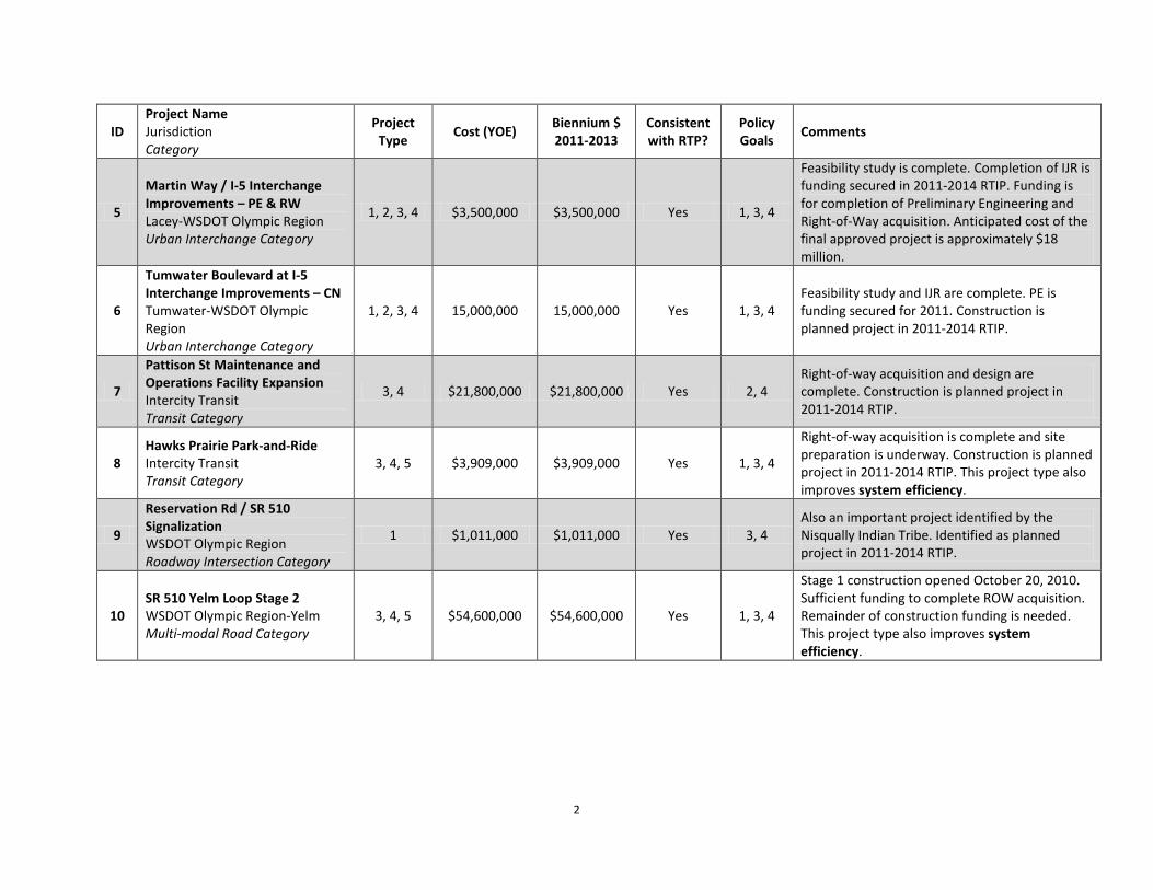
2
ID Project Name Jurisdiction Category
Project Type
Cost (YOE) Biennium $ 2011-2013
Consistent with RTP?
Policy Goals
Comments
5
Martin Way / I-5 Interchange Improvements – PE & RW Lacey-WSDOT Olympic Region Urban Interchange Category
1, 2, 3, 4 $3,500,000 $3,500,000 Yes 1, 3, 4
Feasibility study is complete. Completion of IJR is funding secured in 2011-2014 RTIP. Funding is for completion of Preliminary Engineering and Right-of-Way acquisition. Anticipated cost of the final approved project is approximately $18 million.
6
Tumwater Boulevard at I-5 Interchange Improvements – CN Tumwater-WSDOT Olympic Region Urban Interchange Category
1, 2, 3, 4 15,000,000 15,000,000 Yes 1, 3, 4 Feasibility study and IJR are complete. PE is funding secured for 2011. Construction is planned project in 2011-2014 RTIP.
7
Pattison St Maintenance and Operations Facility Expansion Intercity Transit Transit Category
3, 4 $21,800,000 $21,800,000 Yes 2, 4 Right-of-way acquisition and design are complete. Construction is planned project in 2011-2014 RTIP.
8 Hawks Prairie Park-and-Ride Intercity Transit Transit Category
3, 4, 5 $3,909,000 $3,909,000 Yes 1, 3, 4
Right-of-way acquisition is complete and site preparation is underway. Construction is planned project in 2011-2014 RTIP. This project type also improves system efficiency.
9
Reservation Rd / SR 510 Signalization WSDOT Olympic Region Roadway Intersection Category
1 $1,011,000 $1,011,000 Yes 3, 4 Also an important project identified by the Nisqually Indian Tribe. Identified as planned project in 2011-2014 RTIP.
10 SR 510 Yelm Loop Stage 2 WSDOT Olympic Region-Yelm Multi-modal Road Category
3, 4, 5 $54,600,000 $54,600,000 Yes 1, 3, 4
Stage 1 construction opened October 20, 2010. Sufficient funding to complete ROW acquisition. Remainder of construction funding is needed. This project type also improves system efficiency.
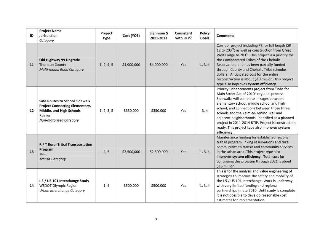
3
ID Project Name Jurisdiction Category
Project Type
Cost (YOE) Biennium $ 2011-2013
Consistent with RTP?
Policy Goals
Comments
11 Old Highway 99 Upgrade Thurston County Multi-modal Road Category
1, 2, 4, 5 $4,900,000 $4,900,000 Yes 1, 3, 4
Corridor project including PE for full length (SR 12 to 203rd) as well as construction from Great Wolf Lodge to 203rd. This project is a priority for the Confederated Tribes of the Chehalis Reservation, and has been partially funded through County and Chehalis Tribe stimulus dollars. Anticipated cost for the entire reconstruction is about $10 million. This project type also improves system efficiency.
12
Safe Routes to School Sidewalk Project Connecting Elementary, Middle, and High Schools Rainier Non-motorized Category
1, 2, 3, 5 $350,000 $350,000 Yes 3, 4
Priority Enhancements project from “Jobs for Main Street Act of 2010” regional process. Sidewalks will complete linkages between elementary school, middle school and high school, and connections between those three schools and the Yelm-to-Tenino Trail and adjacent neighborhoods. Identified as a planned project in 2011-2014 RTIP. Project is construction ready. This project type also improves system efficiency.
13
R / T Rural Tribal Transportation Program TRPC Transit Category
4, 5 $2,500,000 $2,500,000 Yes 1, 3, 4
Maintenance funding for established regional transit program linking reservations and rural communities to transit and community services in the urban area. This project type also improves system efficiency. Total cost for continuing this program through 2021 is about $15 million.
14 I-5 / US 101 Interchange Study WSDOT Olympic Region Urban Interchange Category
1, 4 $500,000 $500,000 Yes 1, 3, 4
This is for the analysis and value engineering of strategies to improve the safety and mobility of the I-5 / US 101 interchange. Work is underway with very limited funding and regional partnerships in late 2010. Until study is complete it is not possible to develop reasonable cost estimates for implementation.
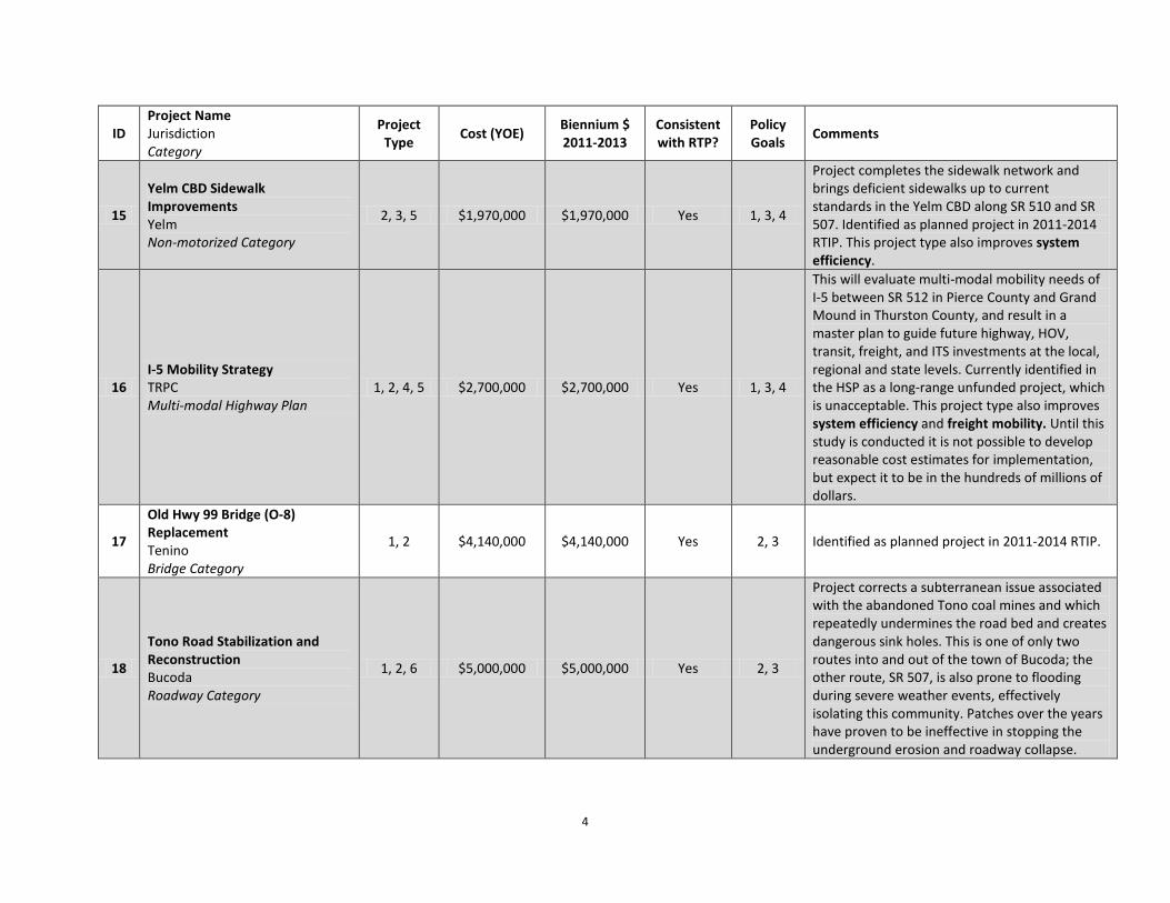
4
ID Project Name Jurisdiction Category
Project Type
Cost (YOE) Biennium $ 2011-2013
Consistent with RTP?
Policy Goals
Comments
15
Yelm CBD Sidewalk Improvements Yelm Non-motorized Category
2, 3, 5 $1,970,000 $1,970,000 Yes 1, 3, 4
Project completes the sidewalk network and brings deficient sidewalks up to current standards in the Yelm CBD along SR 510 and SR 507. Identified as planned project in 2011-2014 RTIP. This project type also improves system efficiency.
16 I-5 Mobility Strategy TRPC Multi-modal Highway Plan
1, 2, 4, 5 $2,700,000 $2,700,000 Yes 1, 3, 4
This will evaluate multi-modal mobility needs of I-5 between SR 512 in Pierce County and Grand Mound in Thurston County, and result in a master plan to guide future highway, HOV, transit, freight, and ITS investments at the local, regional and state levels. Currently identified in the HSP as a long-range unfunded project, which is unacceptable. This project type also improves system efficiency and freight mobility. Until this study is conducted it is not possible to develop reasonable cost estimates for implementation, but expect it to be in the hundreds of millions of dollars.
17
Old Hwy 99 Bridge (O-8) Replacement Tenino Bridge Category
1, 2 $4,140,000 $4,140,000 Yes 2, 3 Identified as planned project in 2011-2014 RTIP.
18
Tono Road Stabilization and Reconstruction Bucoda Roadway Category
1, 2, 6 $5,000,000 $5,000,000 Yes 2, 3
Project corrects a subterranean issue associated with the abandoned Tono coal mines and which repeatedly undermines the road bed and creates dangerous sink holes. This is one of only two routes into and out of the town of Bucoda; the other route, SR 507, is also prone to flooding during severe weather events, effectively isolating this community. Patches over the years have proven to be ineffective in stopping the underground erosion and roadway collapse.

5
ID Project Name Jurisdiction Category
Project Type
Cost (YOE) Biennium $ 2011-2013
Consistent with RTP?
Policy Goals
Comments
19
Boulevard Rd. Intersection and Multi-modal Improvements Olympia Multi-modal Road Category
1, 3, 4, 5 $10,939,000 $10,939,000 Yes 3, 4
Phase 1 of this project is complete. Phase 2 completes the retrofit of this regionally-significant corridor to better accommodate all modes of travel and to minimize impacts of the through-corridor on adjacent neighborhoods and schools. Identified as a planned project in 2011-2014 RTIP. This project type also improves system efficiency.
20
70th Avenue / Kirsop Road Improvements Tumwater Multi-modal Road Category
1, 3, 4, 5 $1,230,000 $1,230,000 Yes 3, 4
Project will retrofit an older rural road to better serve the multi-modal urban traffic it currently carries. Identified as a planned project in 2011-2014 RTIP. This project type also improves system efficiency.
Note: This list represents some of the region’s current project needs. If funding were available in the 2011-2013 biennium, any of these projects could and would proceed. Pavement Preservation Needs: Insufficient funds are available to support this region’s pavement preservation program. Based on current estimates, which likely understate the shortfall due to data lags, this region needs an additional $3.76 million per year to maintain the most basic preservation program. At this rate of deficit this would increase to $4.59 million per year by 2021, for a total deficit of $45.78 million. However the protracted and deepening recession is likely to take a further toll on available revenues, further increasing the funding shortfall for this essential roadway function. Bridge Repair and Replacement Needs: Insufficient funds are available to repair or replace all the bridges rated ‘poor’ or which present potential hazards due to their location. Based on estimates from six-year programming estimates and bridge reports, an additional $12.92 million is needed by 2020 to correct the existing deficiencies. This does not include replacement of the I-5 Nisqually River Bridge, which is also showing signs of structural deficiency and inadequate capacity. Fish Passage Barrier Removal Needs: Insufficient funds are available to retrofit existing fish passage culvert barriers. Where possible, culvert retrofit is included as a part of capital or preservation projects and many “easy” stand-alone culverts have also been addressed. But based on existing six-year funding plans and an inventory of barriers, an estimated $4.41 million is needed by 2020 to retrofit culverts on the most important salmon-bearing streams, several of which present complex environmental challenges.

6
Thurston Regional Planning Council Regional Transportation Priorities (Not in priority order) Submittal to Washington State Transportation Commission Narrative Project Information October 2010
1. Smart Corridors Implementation
Lacey, Olympia, Tumwater, Thurston County, Intercity Transit, WSDOT Olympic Region
Project Description • This is an ITS project implementing the signal technology, Transit System Priority, and regionally-
coordinated operations plans developed in Phase 1. • This pilot project includes all of Capitol Boulevard / Capitol Way from Tumwater Boulevard to State
Avenue, and the 4th Avenue / State Avenue / Martin Way corridor from Capitol Way to Marvin Road. Project partners include Lacey, Olympia, Tumwater, Thurston County, Intercity Transit, WSDOT Olympic Region, and Thurston Regional Planning Council (TRPC).
• The project will relieve congestion by improving operational efficiency and safety on these two critical transit corridors using low cost / high value technologies and coordination strategies.
Project Status and Timeline TRPC funded Phase 1, development of the regional concept of traffic operations, signals analysis, and systems engineering analysis and design work through an award of regional CMAQ funds. Phase 1 will conclude in early 2011. The balance of regional CMAQ funds - $3 million – is targeted towards implementation of this strategy and is anticipated to leverage at least another $3 million in revenues. Project partners will be ready for the implementation phase by late 2011.
2. Carpenter Road Widening
Lacey, Thurston County Project Description • This project will reconstruct Carpenter Road and add an additional travel lane in each direction, bike
lanes, planter strips, sidewalks, stormwater treatment, wetland mitigation and illumination. Project will correct several outstanding deficiencies including vertical and horizontal alignments and severe base failure and untreated stormwater flows into a Class I salmon bearing stream. Project is being coordinated with the LOTT Sewer and Reclaimed Water facility to include a reclaimed water line that provides regional mitigation for the water supplies for Lacey, Olympia, and the Nisqually Indian Tribe.
• Project is located between Martin Way and Pacific Avenue. Half of the roadway is in Thurston County’s unincorporated urban growth area and half is within the City of Lacey.
• This project will relieve congestion, improve multi-modal mobility and safety, and address outstanding environmental impacts on wetlands and salmon-bearing waters.
Project Status and Timeline Lacey and Thurston County have completed all engineering and design work, right-of-way acquisition, and environmental permitting. This is a construction ready project for which these two agencies are currently seeking funding. Additional Comments This was TRPC’s highest priority project for the “Jobs for Main Street Act of 2010” stimulus process.

7
3. West Olympia Access – US 101 Interchange Justification Report & Preliminary Engineering Olympia Project Description • This project will complete the Interchange Justification Report for the US 101 locally-preferred alternative
interchange improvement and conduct the preliminary engineering for Phase 1. The locally-preferred alternative includes modifications to the Evergreen Parkway interchange to include access to/from Kaiser Road and US 101 (Phase 1) and over the longer-term will add new off-bound access to an extension of Yauger Way.
• The project is located on Olympia’s westside at the interchange of US 101 and Evergreen Parkway, and in the vicinity of the Black Lake Boulevard interchange.
• The project will relieve congestion at the Black Lake Boulevard interchange and improve safety and mobility on Olympia’s west side.
Project Status and Timeline Olympia and the WSDOT Olympic Region completed the feasibility study in May 2010 to identify a locally-preferred alternative. The City is currently seeking funding to complete the IJR and to pursue preliminary engineering. This project can proceed as soon as funds are available.
4. Marvin Road / I-5 Interchange Improvements – PE & RW
Lacey
Project Description • Project will conduct the preliminary engineering and design for the Marvin Road (SR 510) / I-5 interchange
improvements, Phase 2. This includes conversion of the existing interchange into a Single-Point Urban Interchange (SPUI) as approved in the 1990s with a southbound I-5 slip-ramp to Hogum Bay Road and a southbound I-5 off-ramp to the Hawks Prairie Business District.
• Project is located at Marvin Road (SR 510) and Interstate 5. • The project will relieve congestion that currently backs up onto I-5, improve safety, and enhance access
and mobility into and out of the Hawks Prairie industrial area and Business district.
Project Status and Timeline Lacey has completed its feasibility study that identified the locally-preferred alternative and has secured the funding needed to complete the IJR (secured project in 2011-2014 RTIP). That work will be complete in 2012 at which point the City will be ready to proceed with preliminary engineering and right-of-way acquisition.
5. Martin Way / I-5 Interchange Improvements – PE & RW Lacey Project Description • Project will conduct the preliminary engineering and design for the Martin Way / I-5 interchange
improvements. This will include conversion of the existing interchange into either a partial cloverleaf or a Single Point Urban Interchange (SPUI), based on the outcome of the pending IJR.
• Project is located at Martin Way and Interstate 5. • The project will mitigate the delays caused by heavy left-turn volumes from Martin Way to the I-5 on-
ramps and better accommodate the heavy turning movements of the off-ramps onto Martin Way.
8
Project Status and Timeline Lacey has completed its feasibility study that identified the project need and has secured the funding to complete the IJR (secured project in 2011-2014 RTIP). That work will be complete in 2012 at which point the City will be ready to proceed with preliminary engineering and right-of-way acquisition. Recent WSDOT-Lacey partnership project relocated sidewalks behind the bridge pilings to mitigate left turn queues to the extent practicable until the interchange is reconfigured.
6. Tumwater Boulevard at I-5 Interchange Improvements – Construction Tumwater Project Description • This project will construct the locally-preferred interchange alternative established in the Tumwater
Boulevard IJR process. The project will replace the signalized intersections at the ramp terminals of the Tumwater Boulevard / I-5 interchange with roundabouts, and will add bike lanes and sidewalks to the existing bridge over I-5 as well as within the roundabouts. This design, vetted through FHWA and WSDOT processes, provides a cost-effective means of increasing system capacity by reducing operational friction and eliminates the need to do an expensive replacement of the overpass.
• Project is located at Tumwater Boulevard and I-5. • The project will improve operational efficiency and the current queuing of cars onto I-5 by eliminating the
friction caused by excessive left turn movements.
Project Status and Timeline Tumwater completed its IJR process and got FHWA / WSDOT approval on the design concept in 2009. The City has secured funding for the design phase and environmental permitting in 2011 (funding secured project in 2011-2014 RTIP) and will be ready to construct in the 2011-2013 biennium.
7. Pattison Street Maintenance and Operations Facility Expansion
Intercity Transit
Project Description • Project will result in a new and expanded maintenance and operations facility for Intercity Transit. This
will enable Intercity Transit to continue to grow its bus fleet as called for in adopted plans. • Project is located on Pattison Street at the intersection with Martin Way. • The project will improve system efficiency by providing IT with the capacity to maintain the larger bus
fleet required to meet growing demand for transit service. The current facility is not large enough to accommodate an expanded fleet of that size.
Project Status and Timeline Intercity Transit has completed the property purchase and facility design. The project is construction ready in the 2011-2013 timeframe.

9
8. Hawks Prairie Park-and-Ride Intercity Transit
Project Description
• Project will result in the construction of a new regional park-and-ride facility on land reclaimed from the old Thurston County landfill site.
• Project is located off of Hogum Bay Road, just north of the Marvin Road / I-5 interchange. • Project will provide 330 new park-and-ride stalls, replacing most of the stalls that were lost when DNR
sold the property where the old park-and-ride was located. This is an important location to capture northbound commuter trips with transit, carpool, and vanpool alternatives.
Project Status and Timeline Intercity Transit has completed negotiations with Thurston County regarding long-term lease of the property and is currently in the process of compacting the old landfill site to make it suitable for construction. This will be a construction ready project by mid-2011.
9. Reservation Road / SR 510 Signalization WSDOT Olympic Region Project Description • Project will signalize the “T” intersection of Reservation Road at SR 510, both of which are high speed,
high volume facilities. • Project is located at the intersection of Reservation Road and SR 510. • Project will provide for a safer intersection by providing protected turning and merging opportunities on
this facility.
Project Status and Timeline WSDOT has met with local and tribal representatives and has begun some preliminary design considerations. This project has met all warrants and will be a construction ready project in mid-late 2011. Additional Comments This is identified as a high priority safety need by the Nisqually Indian Tribe.
10. SR 510 Yelm Loop Stage 2 WSDOT Olympic Region, Yelm Project Description • Stage 2 construction will complete a new road that bypasses the heavily congested intersection of SR 510
/ SR 507 in downtown Yelm. It includes one lane in each direction, non-motorized facilities, roundabouts, illumination, stormwater treatment, and landscaping.
• Stage 2 extends from Cullen Road to the segment constructed by Wal-Mart. • Project will improve circulation and relieve through-traffic congestion at the constrained and severely
congested intersection of SR 510 / SR 507. This also increases safety within the central business district.
Project Status and Timeline City of Yelm initiated this project in the late 1980s and secured regional STP funding in the 1990s to demonstrate the value to the state highway system and conduct preliminary engineering and design. Yelm also construction of the southern segment paid for as part of the mitigation for a retail development. The

10
project was turned over to WSDOT in 2004. Stage 1, from Mud Run Road to Cullen Road, was completed and opened to the traveling public on October 20, 2010. Final right-of-way acquisition is underway. Project could proceed to construction in the 2011-2013 biennium.
11. Old Highway 99 Upgrade
Thurston County Project Description • Project will upgrade an important section of Old Highway 99 from a rural two-lane facility to a more urban
cross section better equipped to handle current and future traffic volumes. It includes bike lanes, sidewalks, illumination and traffic control. Project will also complete the preliminary engineering and design on the rest of the corridor.
• Project is located on Old Highway 99 between SR 12 and 203rd Avenue; the next phase of construction will occur between Great Wolf Lodge and 203rd Avenue.
• Project will relieve congestion and improve safety and mobility on Old Highway 99. The initial construction provides immediate relief to the Chehalis Indian Tribe’s Great Wolf Water Park and Hotel, and major economic development initiative in southwest Thurston County. This is a high priority project for the County and the Tribe.
Project Status and Timeline Segments of this corridor have been reconstructed with funding support from Thurston County and the Chehalis Indian Tribe through the American Recovery and Reinvestment Act funding program.
12. Safe Routes to School Sidewalk Project – Elementary, Middle, High Schools Connections
Rainier Project Description • Project will construct new sidewalks, eliminating the walking route gaps between SR 507 / Yelm-to-Tenino
Trail / adjacent neighborhoods and the city’s elementary, middle, and high schools. Project includes pervious concrete pavement to eliminate stormwater runoff, street trees, and curb and gutter. This completes the sidewalk package that was initiated with an American Recovery and Reinvestment Act grant to the city in 2009.
• Project is located on Second Street, Third Street, and Dakota Street. • Project will provide safe walking routes for students attending the elementary, middle, and high schools in
Rainier.
Project Status and Timeline Preliminary engineering and design is complete; no right-of-way is needed. Project is construction ready as soon as funds are available. Additional Comments This project was the region’s highest priority Enhancements project for the “Jobs for Main Street Act 2010” statewide competitive process.

11
13. R/T Rural Tribal Transportation Program
Thurston Regional Planning Council Project Description • This project provides pre-scheduled, on-demand services for the residents of Rochester, Tenino, Bucoda,
Rainier and Yelm. The program also serves the Nisqually Indian Tribe and the Confederated Tribes of the Chehalis Reservation. R/T transports passengers from centralized pickup points to centralized drop off points that allow for transfers to final destinations. TRPC contracts with Northwest Connections for this program, which is designed to connect with but not duplicate other transit services. Program is a priority identified in the Coordinated Human Services Transportation Plan developed by regional stakeholders and adopted by TRPC.
• Rural Thurston County and the region’s two Indian reservations. • Project improves mobility options for rural, disadvantaged residents.
Project Status and Timeline TRPC has managed this program for a number of years. Funding is currently secure through the end of 2011 at which time the program will have to be discontinued unless additional funds are secured. Grants are matched by a mix of local and tribal revenues.
14. I-5 / US 101 Interchange Study
WSDOT Olympic Region Project Description • This project will evaluate current and future needs, constraints, and opportunities associated with the
configuration of the I-5 / US 101 interchange to identify near- and long-term strategies for improving safety and mobility at this highly congested urban interchange.
• Project is located at the intersection of I-5 and US 101. • Project will ultimately improve mobility and safety, and support the economy by addressing
congestion at this critical I-5 interchange.
Project Status and Timeline Despite a lack of funding, WSDOT Olympic Region is organizing local and regional partners to begin scoping the study framework and meaningful interim steps that can be taken while funding is sought to complete the study analysis. Work can proceed right away.
15. Yelm CBD Sidewalk Improvements
City of Yelm Project Description • Project will complete the pedestrian sidewalk network through Yelm’s central business district,
including construction of new sidewalks and reconstruction of buckled or otherwise substandard sidewalks. Project includes upgrade of ADA ramps at intersecting streets.
• East Yelm Avenue (SR 507) and West Yelm Avenue (SR 510) and intersections at intersecting streets. • Project will improve safety and mobility for pedestrians in the Yelm central business district.
Project Status and Timeline Project is a planned project and is ready to proceed upon securing funding.

12
16. I-5 Mobility Strategy
Thurston Regional Planning Council Project Description • Project will conduct the first coordinated, multi-modal analysis of I-5 mobility needs between SR 512
and Grand Mound, and result in an approved strategy to guide future investments in highway capacity, HOV lanes, ITS, and freight improvements through this highly congested corridor. Project includes development of first corridor model for this study area, and extensive coordination with local, regional, state, and federal agencies. Project includes core data collection, including a household travel survey stratified on JBLM population characteristics.
• Study area is located on Interstate 5, between SR 512 in Pierce County and Grand Mound in Thurston County.
• Project will identify short-, medium-, and long-range funding needs to improve multi-modal safety and mobility on this essential highway facility.
Project Status and Timeline TRPC secured funding to complete I-5 analysis of external-external, external-internal, internal-external, and interchange-interchange flows; data collection was completed on October 27th. TRPC continues to solicit funding to complete the study in a coordinated fashion instead of a piecemeal approach.
17. Old Highway 99 Bridge (O-8) Replacement
Tenino Project Description • Project will replace the old BNSF mainline bridge overpass on Old Highway 99 at the western
entrance to the city, addressing existing structural safety concerns. A wider base will enable the street cross section to accommodate a wider shoulder for non-motorized safety.
• Project is located at the O-8 bridge on Old Highway 99. • Project will improve multi-modal safety and efficiency, and address existing bridge structural
concerns.
Project Status and Timeline Project can proceed within the 2011-2013 time period if funding is available.
18. Tono Road Stabilization and Reconstruction
Bucoda Project Description • Project will stabilize and reconstruct a section of Tono Road that regularly collapses due to
subterranean erosion, creating dangerous sinkholes and isolating this small rural community. • Project is located at Tono Road in vicinity of Ohop Road. • Project will improve safety and reduce on-going repair and maintenance costs.
Project Status and Timeline Geotechnical studies were completed in 2007. This project can proceed as soon as funding is available.

13
19. Boulevard Road Intersection and Multi-modal Improvements
Olympia Project Description • Project will complete the reconstruction of Boulevard Road, a major north-south connector between
suburban neighborhoods and rural areas to the south and the commercial and employment centers to the north. Originally built without bike lanes and sidewalks, and currently pushing capacity limits, the Boulevard Road Intersection and Multi-modal Improvements project is adding landscaped medians and roundabouts to better manage competing traffic movements, and is building bike lanes and sidewalks where none exist. Project also includes illumination, striping, and stormwater facilities.
• Project is located on Boulevard Road between Wheeler Avenue and Yelm Highway. Intersection roundabouts are located at 22nd Avenue, Morse-Merryman Road.
• Project will improve multi-modal safety and efficiency.
Project Status and Timeline Olympia issued a bond to construct Phase 1 improvements; the roundabout at Log Cabin Road was completed and opened to the public in spring 2010. City is seeking funding for Phase 2 work and is ready to proceed in the 2011-2013 biennium.
20. 70th Avenue / Kirsop Road Improvements
Tumwater Project Description • Project will retrofit an older rural road to accommodate the urban uses it now serves by adding bike
lanes, sidewalks, striping, illumination, and curb and gutters. • Project is located on 70th Avenue / Kirsop Road, between Littlerock Road and 66th Avenue • Project will improve multi-modal safety and efficiency
Project Status and Timeline City is seeking project funding. Project is ready to proceed in the 2011-2013 biennium.
Regional Pavement Preservation Needs Based on current revenue levels, this region faces an annual pavement preservation budget deficit of $3.76 million per year. Assuming a 2% annual inflation between now and 2021, that would grow to an annual deficit of $4.59 million, or a total of $45.78 million for the ten year period. This forecast is based on local agency pavement preservation plans and historical BARS data. If the current recession is protracted or increases in severity the assumptions behind this forecast will underestimate the total need as local resources currently relied on for augmenting direct gas tax distributions will be depleted. Revenues available through the direct gas tax distribution are insufficient to pay for more than a small share of annual pavement preservation needs. Bridge Repair and Replacement Needs Insufficient funds are available to repair or replace all the bridges rated ‘poor’ or which present potential hazards due to their location. Based on estimates from six-year programming estimates and bridge reports, an additional $12.92 million is needed by 2020 to correct the existing deficiencies. This does not include replacement of the I-5 Nisqually River Bridge, which is also showing signs of structural deficiency and inadequate capacity.

14
Fish Passage Barrier Removal Needs Insufficient funds are available to retrofit existing fish passage culvert barriers. Where possible, culvert retrofit is included as a part of capital or preservation projects and many “easy” stand-alone culverts have also been addressed. But based on existing six-year funding plans and an inventory of barriers, an estimated $4.41 million is needed by 2020 to retrofit culverts on the most important salmon-bearing streams, several of which present complex environmental challenges


With a population of 308,0001 and an area that covers more than 4,1002 square miles, the Benton-Franklin-Walla Walla (BFWW) RTPO has over 1,4043 miles of urban and 3,7054
In preparing cost estimates for preservation across the BFWW RTPO we spoke with eight jurisdictions; three counties, two urban cities and three small cities regarding their street/road budgets
miles of rural roadways.
5
and what dollar amount was dedicated to preservation functions. In determining other jurisdiction’s needs, with whom we did not speak, our assumptions were based on similar populations.
As one can imagine the term “preservation” can mean different things to different people so we did not assume that our brief discussions with the jurisdictions would produce an exact “apples to apples” understanding of the question put before them. It should be noted that almost all of the jurisdictions we spoke with indicated they had increased their preservation budgets and anticipated that it would continue to increase. Several mentioned an emerging trend to focus on the preservation of roadways rather than construction or complete reconstruction projects.
For rural county areas an annual preservation cost estimate $7.5 million. For urban area jurisdictions the annual preservation cost estimate was $8.0 million.
For small urban/rural cities the annual preservation cost estimate was $500,000.
Ten year projection for preservation cost estimate = $160 million.
1 Office of Financial Management – September 2010 2 BFCG Transportation Trends Report – 2010 3BFCG Transportation Trends Report – 2010 4 BFCG Transportation Trends Report – 2010 5 2009 or 2010 streets/roads budgets.

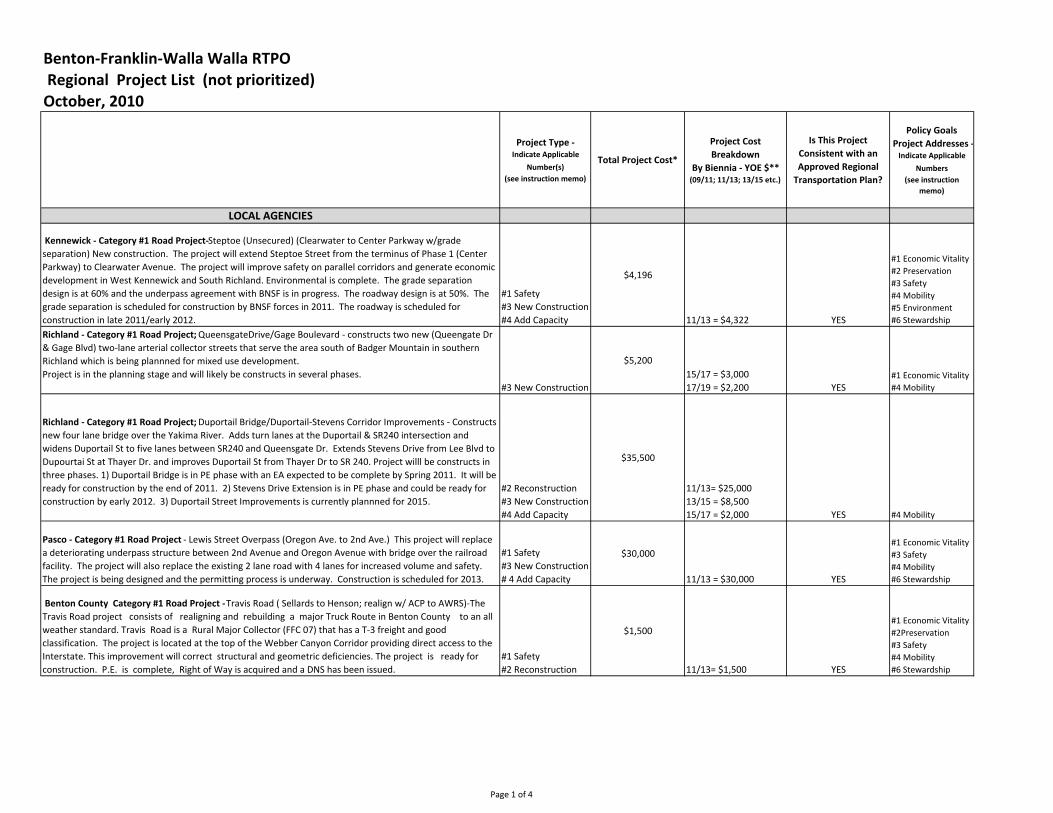
Benton-Franklin-Walla Walla RTPO
Regional Project List (not prioritized)
October, 2010
Project Type - Indicate Applicable
Number(s)
(see instruction memo)
Total Project Cost*
Project Cost
Breakdown
By Biennia - YOE $** (09/11; 11/13; 13/15 etc.)
Is This Project
Consistent with an
Approved Regional
Transportation Plan?
Policy Goals
Project Addresses - Indicate Applicable
Numbers
(see instruction
memo)
LOCAL AGENCIES
Kennewick - Category #1 Road Project-Steptoe (Unsecured) (Clearwater to Center Parkway w/grade
separation) New construction. The project will extend Steptoe Street from the terminus of Phase 1 (Center
Parkway) to Clearwater Avenue. The project will improve safety on parallel corridors and generate economic
development in West Kennewick and South Richland. Environmental is complete. The grade separation
design is at 60% and the underpass agreement with BNSF is in progress. The roadway design is at 50%. The
grade separation is scheduled for construction by BNSF forces in 2011. The roadway is scheduled for
construction in late 2011/early 2012.
#1 Safety
#3 New Construction
#4 Add Capacity
$4,196
11/13 = $4,322 YES
#1 Economic Vitality
#2 Preservation
#3 Safety
#4 Mobility
#5 Environment
#6 Stewardship
Richland - Category #1 Road Project; QueensgateDrive/Gage Boulevard - constructs two new (Queengate Dr
& Gage Blvd) two-lane arterial collector streets that serve the area south of Badger Mountain in southern
Richland which is being plannned for mixed use development.
Project is in the planning stage and will likely be constructs in several phases.
#3 New Construction
$5,200
15/17 = $3,000
17/19 = $2,200 YES
#1 Economic Vitality
#4 Mobility
Richland - Category #1 Road Project; Duportail Bridge/Duportail-Stevens Corridor Improvements - Constructs
new four lane bridge over the Yakima River. Adds turn lanes at the Duportail & SR240 intersection and
widens Duportail St to five lanes between SR240 and Queensgate Dr. Extends Stevens Drive from Lee Blvd to
Dupourtai St at Thayer Dr. and improves Duportail St from Thayer Dr to SR 240. Project willl be constructs in
three phases. 1) Duportail Bridge is in PE phase with an EA expected to be complete by Spring 2011. It will be
ready for construction by the end of 2011. 2) Stevens Drive Extension is in PE phase and could be ready for
construction by early 2012. 3) Duportail Street Improvements is currently plannned for 2015.
#2 Reconstruction
#3 New Construction
#4 Add Capacity
$35,500
11/13= $25,000
13/15 = $8,500
15/17 = $2,000 YES #4 Mobility
Pasco - Category #1 Road Project - Lewis Street Overpass (Oregon Ave. to 2nd Ave.) This project will replace
a deteriorating underpass structure between 2nd Avenue and Oregon Avenue with bridge over the railroad
facility. The project will also replace the existing 2 lane road with 4 lanes for increased volume and safety.
The project is being designed and the permitting process is underway. Construction is scheduled for 2013.
#1 Safety
#3 New Construction
# 4 Add Capacity
$30,000
11/13 = $30,000 YES
#1 Economic Vitality
#3 Safety
#4 Mobility
#6 Stewardship
Benton County Category #1 Road Project - Travis Road ( Sellards to Henson; realign w/ ACP to AWRS)-The
Travis Road project consists of realigning and rebuilding a major Truck Route in Benton County to an all
weather standard. Travis Road is a Rural Major Collector (FFC 07) that has a T-3 freight and good
classification. The project is located at the top of the Webber Canyon Corridor providing direct access to the
Interstate. This improvement will correct structural and geometric deficiencies. The project is ready for
construction. P.E. is complete, Right of Way is acquired and a DNS has been issued.
#1 Safety
#2 Reconstruction
$1,500
11/13= $1,500 YES
#1 Economic Vitality
#2Preservation
#3 Safety
#4 Mobility
#6 Stewardship
Page 1 of 4

Project Type - Indicate Applicable
Number(s)
(see instruction memo)
Total Project Cost*
Project Cost
Breakdown
By Biennia - YOE $** (09/11; 11/13; 13/15 etc.)
Is This Project
Consistent with an
Approved Regional
Transportation Plan?
Policy Goals
Project Addresses - Indicate Applicable
Numbers
(see instruction
memo)
Franklin County - Category #1 Road Project - East Foster Wells Road Unsecured Portion -The East Foster
Wells Road Extension Phase 2 will complete the development of a new east-west transportation corridor
located just northeast of the City of Pasco in southern Franklin County. When completed, this 8.5 mile
corridor will provide an all-weather 50 MPH transportation facility that will access public lands owned by the
United States Bureau of Reclamation in Smith Canyon and provide direct access from Pasco-Kahlotus Road to
processing facilities located along US 395 and the newly completed Commercial Avenue in the City of Pasco.
Project is ready to proceed once additional construction funding is acquired. Preliminary Engineering: Plans
Completed Right-of-Way: Complete Environmental: Complete
#3 New Construction
$1,010
11/13 = $1,010 YES
#1 Economic Vitality
#4 Mobility
#6 Stewardship
Benton, Franklin, Walla Walla Counties - Category #1 Road Project - All weather road program -
#2 Reconstruction
#6 Mainenenance
$1,500
11/13 = $750
13/15 = $750 YES
#1 Economic Vitality
#2 Preservation
#3 Safety
#4 Mobililty
#6 Stewardship
Preservation (Entire RTPO - does not include WSDOT)
#1 Safety
#6 Maintenance
$160,000
Ten Year Projection YES
#1 Economic Vitality
#2 Preservation
#3 Safety
#4 Mobility
#5 Environment
#6 Stewardship
Ben Franklin Transit and Valley Transit- Category #2 Multi-Modal - Public Transportation Bus Replacement
Project: This project is a series of bus replacements as contained in the six year term of our most current
Transportation Improvement Program (TIP) 2011 to 2016. These buses will replace old buses that have
exceeded their useful economic life and meet or surpass FTA guidelines for vehicle replacement. The
timeframe of this project to replace transit buses during the six year period of our most current
Transportation Improvement Program (2011-2016). Public transportation investments in vehicles do not
require engineering or right of way and are only subject to standard public agency purchasing requirements
such as Requests for Proposals. The Federal Transit Administration publishes standards for vehicle
replacement and our purchases will meet or exceed these standards.
Replacement buses
(hybrid)
$7,700
($6,500 $1,200)
$17,145
($13,500 - $3,645)
Prosser - Category #1 Road Project - Wine County Road Intersections (Merlot & Gap) The project consists of
the following elements: Elongated Roundabout - 2-lane entrance from north (I-82 ramp traffic), single lanes
elsewhere for traffic calming, dedicated westbound to northbound right turn lane (I-82 access), larger
diameter and wider lanes for truck traffic. Intended Benefits: increased traffic capacity, fewer traffic back-
ups, traffic calming, smoother flow of traffic. The project is proposed Priority #15 on the City of Prosser
adopted 2011-2016 STIP. Timeline from the 2011-2016 STIP: PE: 3/1/2014, Right Of Way: 6/1/2015,
Construction: 3/1/2016.
#1 Safety
#2 Reconstruction
#3 New Construction
# 4 Add Capacity
$2,373
13/15 = $205
15/17 = $16
15/17= $2,107 YES
#1 Economic Vitality
#3 Safety
#4 Mobility
#6 Stewardship
City of Walla Walla - Category #1 Road Project - 13th Avenue Improvements Phase 2 - (Abadie to Cherry)
This project will complete the 13th Avenue corridor running from Rose Street to the Washington State
Penitentiary near the north city limits and will be the last piece of an overall project involving six different
road and sidewalk projects, completing the gap section from Abadie Street to Cherry Street. Construction
would be anticipated to occur within approximately 90 working days +/-, beginning in summer 2011.
Environmental approval by January, 2001, R/W acquisition by March, 2011, Design complete by April, 2011
and construction complete by November 2011.
#2 Reconstruction
#5 Adds Multi-
Modal Facilty
$764
11/13 = $764 YES
#1 Economic Vitality
#2 Preservation
#4 Mobility
Page 2 of 4

Project Type - Indicate Applicable
Number(s)
(see instruction memo)
Total Project Cost*
Project Cost
Breakdown
By Biennia - YOE $** (09/11; 11/13; 13/15 etc.)
Is This Project
Consistent with an
Approved Regional
Transportation Plan?
Policy Goals
Project Addresses - Indicate Applicable
Numbers
(see instruction
memo)
Walla Walla County - Category #1 Road Project - Berney #2 Bridge/Berney Drive The extension of Berney
Drive has been identified on the Long Term Arterial Plan as a future principal arterial. The existing section of
Berney Drive is currently classified as an urban collector with a current ADT of 850. The 20 year ADT is
estimated at 1,570. The existing road is narrow with a bridge length less than 20 ft and a width of 19 ft. The
bridge is located on a curve. Due to the horizontal and vertical alignment of Berney Drive it is necessary to
reconstruct 0.64 miles of the road in order to meet current design standards. This road serves as a main route
along the east side of Walla Walla. The new road would be realigned, the small bridge replaced with a
bottomless box culvert and the road widened to 40 ft. with sidewalks and bicycle lanes. The design is partially
complete. Design will continue in 2011. Since the is no funding available at this time for right of way
acquisition or construction, this project will be shelved once design is complete. Construction could begin in
2013 if funding became available next year.
#1 Safety
#2 Reconstruction
#4 Add Capacity
#5 Adds Multi-
Modal Facility
$2,000
11/13= $2,000 YES
# 1 Economic Vitality
#3 Safety
#4 Mobility
#5 Environment
#6 Stewardship
Benton City - Category #1 Road Project Dale Avenue Improvements (Reconstruction SR 225 to 13th) New
arterial street construction of Dale Avenue from 13th to 9th (SR 225) with curb and gutter, sidewalks,
drainage, and paving. Provides suitable street for fire trucks from fire station to downtown and vehicles and
pedestrian traffic to and from post office, clinic, strip mall, senior citizen center, and Port of Benton light
industrial park. P.E. is authorized by City and approximately 60% completed, no new right-of-way is required,
environmental to be completed this year. If construction funds are approved from TIB or perhaps possible
stimulus grant this fall, 2010, bidding to take place first of 2011 with construction completed by May, 2011.
#1 Saftey
#2 Reconstruction
#4 Add Capacity
#5 Adds Multi-
Modal Facility
$539
11/13 = $539 YES
#1 Economic Vitality
#2 Preservation
#3 Safety
#4 Mobility
#6 Stewardship
College Place - Category #1 Road Project - Whitman Central Cooridor Project Phase 2 - (Birch to Bade
Ave.)Will reconstruct 1800 feet of collector/arterial, signalizes and improves the corridor with additional right
turn lanes at the intersection with College Ave. (principle arterial) and adds 1800 feet of pedestrian and
bicycle facilities (both sides) that run east and west through the center of the College Place adjacent to Walla
Walla University and associated properties. Utility relocation plan coordination is 90% complete. Project
engineering is 50% complete. ROW and easement acquisition as well as environmental permitting are to be
initiated and completed this year.
#1 Safety
#2 Reconstruction
#4 Add Capacity
#5 Adds Multi-
Modal Facility
$1,145
11/13 = $1,145 YES
#1 Economic Vitality
#2Preservation
#3 Safety
#4 Mobility
#5 Environment
Connell - Category #1 Road Project West Adams Street ( Columbia Ave. to 5th ) This project will reconstruct
W Adams Street from Columbia Avenue to Sixth Avenue. The existing pavement is in poor condition and most
of the structural section has failed causing extensive alligator cracking necessitating a complete
reconstruction. Existing sidewalks are intermittent, narrow, and in very poor condition, so ADA compliant
sidewalks will be constructed on both sides of the street. Currently, no storm drainage facilities exist, so
facilities to handle the 25-year design storm onsite will be constructed. Low energy street lights will be
installed to increase safety for pedestrians. A stacked block retaining wall will be installed at the back of the
sidewalk on the west side of the Esquatzel Coulee. Grass landscape strips with street trees will be installed
between the sidewalk and curb throughout the project where right-of-way allows. The project is currently in
the preliminary stage as funding is secured. An application has been submitted to the Washington State
Transportation Improvement Board for a potion of the funding. The following is the anticipated timeline. PE
and environmental: October 2011 to April 2012 R/W: No additional right of way is needed Construction: May
2012 to September 2012
#1 Safety
#2 Reconstruction
$995
11/13 = $995 YES
#2 Preservation
#3 Safety
#4 Mobility
#5 Environment
Page 3 of 4

Project Type - Indicate Applicable
Number(s)
(see instruction memo)
Total Project Cost*
Project Cost
Breakdown
By Biennia - YOE $** (09/11; 11/13; 13/15 etc.)
Is This Project
Consistent with an
Approved Regional
Transportation Plan?
Policy Goals
Project Addresses - Indicate Applicable
Numbers
(see instruction
memo)
Waitsburg - Category #1 Road Project - 7th Street Reconstruction (Main to Arnold Lane) The W. 7th Street
reconstruction rebuilding W. 7th Street from Main to Arnold lane; including a new road bed, dry wells and a
ADA compliant sidewalk on one side. Project located in the City of Waitsburg. Intended outcome is a new
wider, safer road that will improve vehicle and pedestrian transportation along this heavy traveled route. .
Project is currently in the design phase; completion of the design to occur prior to the end of the year. Project
has been submitted into funding agencies for construction dollars, pending the outcome of that, construction
will take place and be completed by the end of 2011.
#1 Safety
#2 Reconstruction
$775
11/13 = $700 YES
#1 Economic Vitality
#2 Preservation
#3 Safety
#4 Mobility
#5 Environment
#6 Stewardship
Kennewick & WSDOT- Category #1 Road Project - Ridgeline Drive - (US 395 I/S improvements) Intersection
improvements. The project will construct right turn only lanes, double left turn lanes, median barriers and a
traffic signal or roundabout at Ridgeline and US 395, and off-ramp improvements at Interstate 82 and US 395.
The project will provide intersection and corridor safety and generate economic development in Southridge
Area. Designs are at 30%. Scheduled for construction start in 2012.
#1 Safety
#2 Reconstruction
#4 Add Capacity
$4,500
11/13 = $4,635 YES
#1 Economic Vitality
#3 Safety
#4Mobility
#5 Environment
#6 Stewardship
Pasco - Category #1 Road Project - Road 68 Widening / Argent Road improvements ( I182- Argent) This
project will widen Road 68 between the I-182 Interchange to Court Street. The project will provide
uninterrupted traffic flow between the signalized intersections with additional lanes and center turn lanes.
Conceptual design has been done. The project is scheduled to be designed and constructed in 2012. #1 Safety
#2 Reconstruction
#4 Add Capacity
$830
11/13 = $830 YES
#1 Economic Vitality
#3 Safety
#4 Mobility
#6 Stewardship
WSDOT
WSDOT - Category #1 Road Project - US 12 Phase 7A and 7B - This project will realign US 12 and add an
additional lane to make a 4-lane highway. Located in Walla Walla county, the new alignment will bypass the
community of Touchet and connect into the US 12 Phase 6 project that is now complete. The Environmental
Assessment was completed in February 2010. Currently there is funding for some design of 7A. With
additional funding, design, R/W, and Construction could be completed in the 13-15 biennium.
#1 Safety
#2 Reconstruction
#3 Add Capacity $127,000
11/13 = $53,000
13/15 $ 74,000 YES
#1 Economic Vitality
#3 Safety
#4 Mobility
#6 Stewardship
WSDOT - Category #1 Road Project -SR 224 I/C at Benton City and Red Mountain Interchange - This project
will improve the SR 224/SR 225 intersection in Benton City by constructing a roundabout (Phase 1). It also
includes construction of a new interchange on I-82 to connect SR 224 to the interstate (Phase 2). An
intersection study was completed in 2008 that selected a roundabout as the preferred alternative for SR
224/SR 225. With funding, Phase 1 will begin design in 2011 construction in 2013. Phase 2 design will occur
in 2012 with construction in 2015.
#1 Safety
#2 Reconstruction
#3 New construction
#4 Add Capacity
$29,000
11 / 13 $ 2,900,000
13 /15 $ 3,900,000
15 /17 $22,200,000
YES
#1 Economic Vitality
# 3 Safety
#4 Mobility
Final November 2, 2010
Page 4 of 4


Skagit/Island RTPO Arterial System Preservation Needs Synopsis for the Washington State Transportation Commission
Entire system:
10-year total, in year-of-expenditure: $328 million Annual need: $33 million
Federally classified system only:
10-year total, in year-of-expenditure: $159 million Annual need: $16 million
Background Overlay costs for arterial roads/streets varies from $8,000 per lane mile for a rural arterial (chip seal),
to over $380,000 per lane mile (3” overlay plus grinding, ADA, design, federal inspection, traffic control) for major urban arterials.
County costs only take into account basic chip seal, overlay and shoulder patching.
Preservation needs for all jurisdictions have been underfunded for nearly a decade and without additional funding, this preservation deficit will continue to grow.
Jurisdictions are primarily focusing on maintenance and preservation, limiting the construction of new projects.
This list takes into account 100% of basic road preservation requirements in Island County.
This list does not take into account road replacement/reconstruction costs.


Entire System10-year need, 2010 dollars 278,000,000
Annual need, 2010 dollars 27,800,000
2011 2012 2013 2014 2015 2016 2017 2018 2019 202010-year need,
in YOE
27,800,000 28,634,000 29,493,020 30,377,811 31,289,145 32,227,819 33,194,654 34,190,493 35,216,208 36,272,695 37,360,875 328,256,720
Arterials and Highways
10-year need, 2010 dollars 135,000,000
Annual need, 2010 dollars 13,500,000
2011 2012 2013 2014 2015 2016 2017 2018 2019 202010-year need,
in YOE
13,500,000 13,905,000 14,322,150 14,751,815 15,194,369 15,650,200 16,119,706 16,603,297 17,101,396 17,614,438 18,142,871 159,405,242


PRESERVATION NEEDS ESTIMATE
Arterials and HighwaysArterial &
Highway
Lane Miles
Cost per
lane mileWeighted Cycle
10-Year
Need
Jurisdiction 34 380,000 17 7,600,000
Anacortes 21 360,000 17 4,447,059
Burlington 8 340,000 20 1,360,000
Concrete 4 11,000 19 23,158
Coupeville 160 8,000 15 853,333
Island County 6 360,000 20 1,080,000
La Conner 4 11,000 19 23,158
Langley 80 300,000 17 14,117,647
Mount Vernon 45 200,000 17 5,294,118
Oak Harbor 38 340,000 17 7,600,000
Sedro-Woolley 327 15,000 7 7,007,143
Skagit County - BST 81 200,000 10 16,200,000
Skagit County - Asphalt 20 340,000 20 3,400,000
Small Towns 16 350,000 20 2,800,000
Districts and Tribes 143 63,000,000
WSDOT* 134,805,616
135,000,000
Total need, arterials and highways
Entire SystemTotal System
Lane Miles
Cost per
lane mileWeighted Cycle
10-Year
Need
Jurisdiction 240 280,000 17 39,529,412
Anacortes 100 240,000 17 14,117,647
Burlington 12 340,000 20 2,040,000
Concrete 26 11,000 19 150,526
Coupeville 1,176 8,000 15 6,272,000
Island County 12 360,000 20 2,160,000
La Conner 22 11,000 19 127,368
Langley 180 150,000 25 10,800,000
Mount Vernon- non-fed routes 80 300,000 17 14,117,647
Mount Vernon - fed routes 136 160,000 17 12,800,000
Oak Harbor 240 260,000 17 36,705,882
Sedro-Woolley 1,300 15,000 7 27,857,143
Skagit County - BST 302 150,000 10 45,300,000
Skagit County - Asphalt 20 350,000 20 3,500,000
Districts and Tribes 143 63,000,000
WSDOT* 278,477,626
278,000,000
Total need, entire roadway system
*WSDOT 10-year need based on total cost of "due" and "past due" paving projects, 2011-2020. See attached sheet.
Concrete, La Conner and Sedro Woolley are estimates based on towns of similar size.


WSDOT - Skagit and Island Counties
Route Begin End Due Yr Project Title Lane Miles Estimated Cost Assumed Project Type
5 227.08 231.79 2011 I-5 SB/BN RR Bridge to Joe Leary Slough - Paving 4.71 2,800,000$ Overlay
5 231.79 243.34 2013 I-5 SB/Joe Leary Slough to Nulle Rd Vic. - Grinding 11.55 6,400,000$ PCCP Grinding project
11 2.18 9.15 2016 SR 11/Cook Road to Colony Creek - Paving 13.94 5,600,000$ Mill and Fill
20 47.89 50.86 2017 SR 20/Sharpes Corner to Swinomish Slough - Paving 3.94 1,300,000$ Overlay
20 60.27 64.21 2013 SR 20/ Avon Ave. to Rhodes Road - Paving 3.94 3,600,000$ Overlay
20 71.93 74.15 2013 SR 20/ Lyman Hamilton Road Vicinity to Baker River - Paving 2.22 1,400,000$ Thin Overlay
20 80.46 81.66 2015 SR 20/Pinelli Road Vic to 1 Mile East of Lusk Road - Paving 4.20 1,000,000$ Thin Overlay
20 114.42 120.88 2013 SR 20/ Damnation Creek to George Powerhouse Vicinity - BST 6.46 1,900,000$ Chip Seal project
530 59.12 60.67 2018 SR 530/2.6 Miles North of Suiattle River Road to White Creek - Paving 3.10 1,000,000$ Overlay
536 4.84 5.38 2015 SR 536/Skagit River Bridge to I-5 1.32 500,000$ Mill and Fill
20 Sp 47.89 51.92 2015 SR 20 Spur/Sharpes Corner to 12th Ave - Paving 13.84 5,500,000$ Mill and Fill
20 Sp 51.92 55.67 2013 SR 20 Spur/Commercial Ave. to Higgens Slough - Paving 3.75 3,200,000$ Cost estimate does not include ADA requirements
20 20.5 27.73 2010 SR 20/Jacobs Road Vicinity to Sidney St - Paving 7.23 5,100,000$ Overlay
20 33.19 41.42 2020 SR 20/Narrows Avenue to Deception Pass - Paving 16.80 5,400,000$ Overlay
20 41.42 47.89 2015 SR 20/Deception Pass to Sharpes Corner - Paving 12.82 4,100,000$ Overlay
525 9.06 19.13 2012 SR 525/Bob Galbreath Road to Honeymoon Bay Road Vic - Paving 10.07 7,100,000$ Overlay
525 17.91 30.52 2018 SR 525/Harbor Ave to SR 20 - Paving 22.76 7,400,000$ Overlay
Totals 142.65 63,300,000$
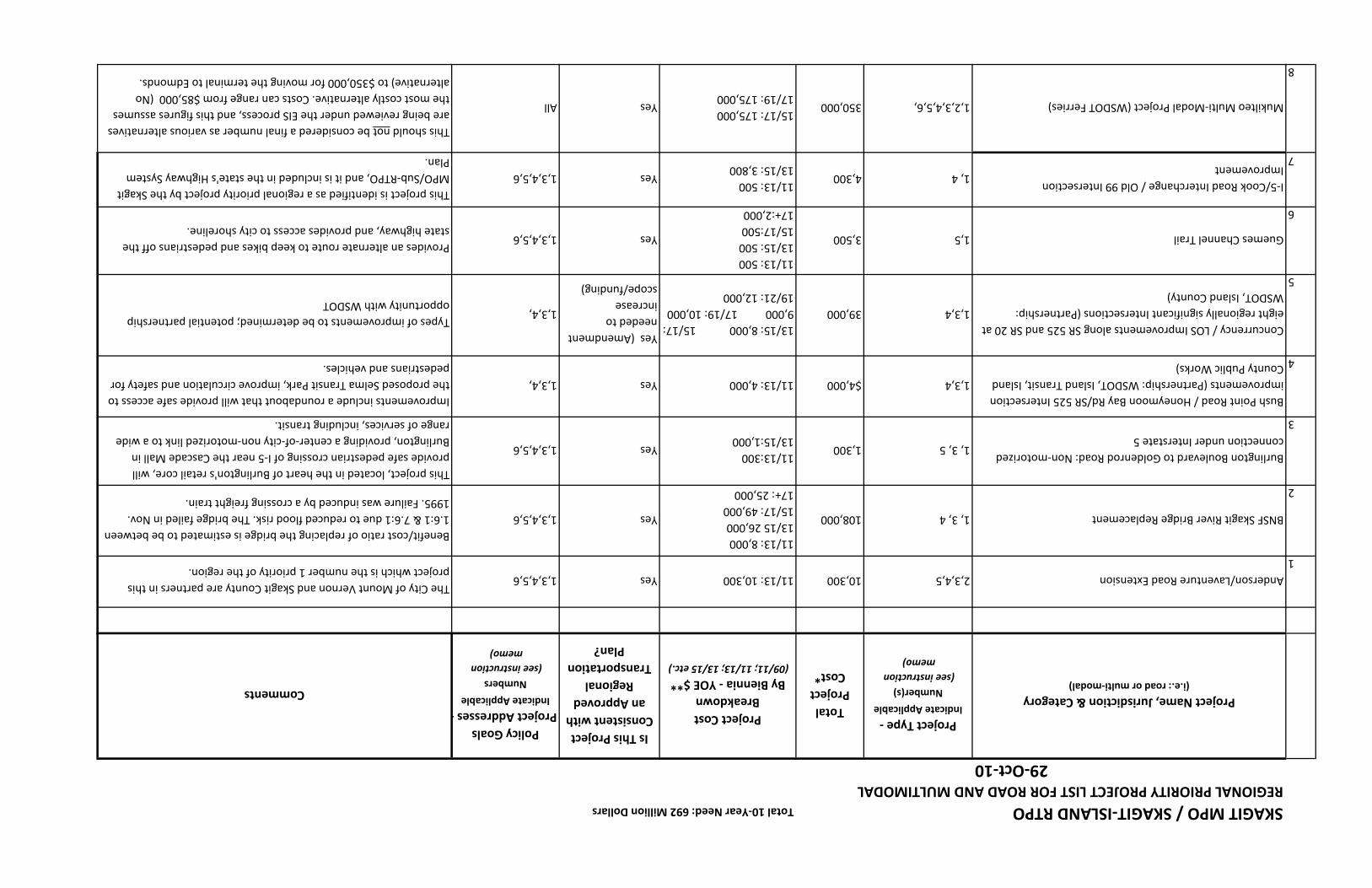
SKAGIT MPO / SKAGIT-ISLAND RTPOTotal 10-Year Need: 692 Million Dollars
REGIONAL PRIORITY PROJECT LIST FOR ROAD AND MULTIMODAL
29-Oct-10
Project Name, Jurisdiction & Category (i.e.: road or multi-modal)
Project Type - Indicate Applicable
Number(s)
(see instruction
memo)
Total
Project
Cost*
Project Cost
Breakdown
By Biennia - YOE $** (09/11; 11/13; 13/15 etc.)
Is This Project
Consistent with
an Approved
Regional
Transportation
Plan?
Policy Goals
Project Addresses - Indicate Applicable
Numbers
(see instruction
memo)
Comments
1
Anderson/Laventure Road Extension 2,3,4,510,30011/13: 10,300Yes1,3,4,5,6The City of Mount Vernon and Skagit County are partners in this
project which is the number 1 priority of the region.
2
BNSF Skagit River Bridge Replacement1, 3, 4108,000
11/13: 8,000
13/15 26,000
15/17: 49,000
17+: 25,000
Yes1,3,4,5,6
Benefit/cost ratio of replacing the bridge is estimated to be between
1.6:1 & 7.6:1 due to reduced flood risk. The bridge failed in Nov.
1995. Failure was induced by a crossing freight train.
3
Burlington Boulevard to Goldenrod Road: Non-motorized
connection under Interstate 51, 3, 51,300
11/13:300
13/15:1,000 Yes1,3,4,5,6
This project, located in the heart of Burlington's retail core, will
provide safe pedestrian crossing of I-5 near the Cascade Mall in
Burlington, providing a center-of-city non-motorized link to a wide
range of services, including transit.
4
Bush Point Road / Honeymoon Bay Rd/SR 525 Intersection
improvements (Partnership: WSDOT, Island Transit, Island
County Public Works)
1,3,4$4,000 11/13: 4,000Yes1,3,4,
Improvements include a roundabout that will provide safe access to
the proposed Selma Transit Park, improve circulation and safety for
pedestrians and vehicles.
5
Concurrency / LOS Improvements along SR 525 and SR 20 at
eight regionally significant Intersections (Partnership:
WSDOT, Island County)
1,3,439,000
13/15: 8,000 15/17:
9,000 17/19: 10,000
19/21: 12,000
Yes (Amendment
needed to
increase
scope/funding)
1,3,4,Types of improvements to be determined; potential partnership
opportunity with WSDOT
6
Guemes Channel Trail 1,53,500
11/13: 500
13/15: 500
15/17:500
17+:2,000
Yes1,3,4,5,6 Provides an alternate route to keep bikes and pedestrians off the
state highway, and provides access to city shoreline.
7
I-5/Cook Road Interchange / Old 99 Intersection
Improvement1, 44,300
11/13: 500
13/15: 3,800Yes1,3,4,5,6
This project is identified as a regional priority project by the Skagit
MPO/Sub-RTPO, and it is included in the state's Highway System
Plan.
8
Mukilteo Multi-Modal Project (WSDOT Ferries)1,2,3,4,5,6,350,00015/17: 175,000
17/19: 175,000YesAll
This should not be considered a final number as various alternatives
are being reviewed under the EIS process, and this figures assumes
the most costly alternative. Costs can range from $85,000 (No
alternative) to $350,000 for moving the terminal to Edmonds.
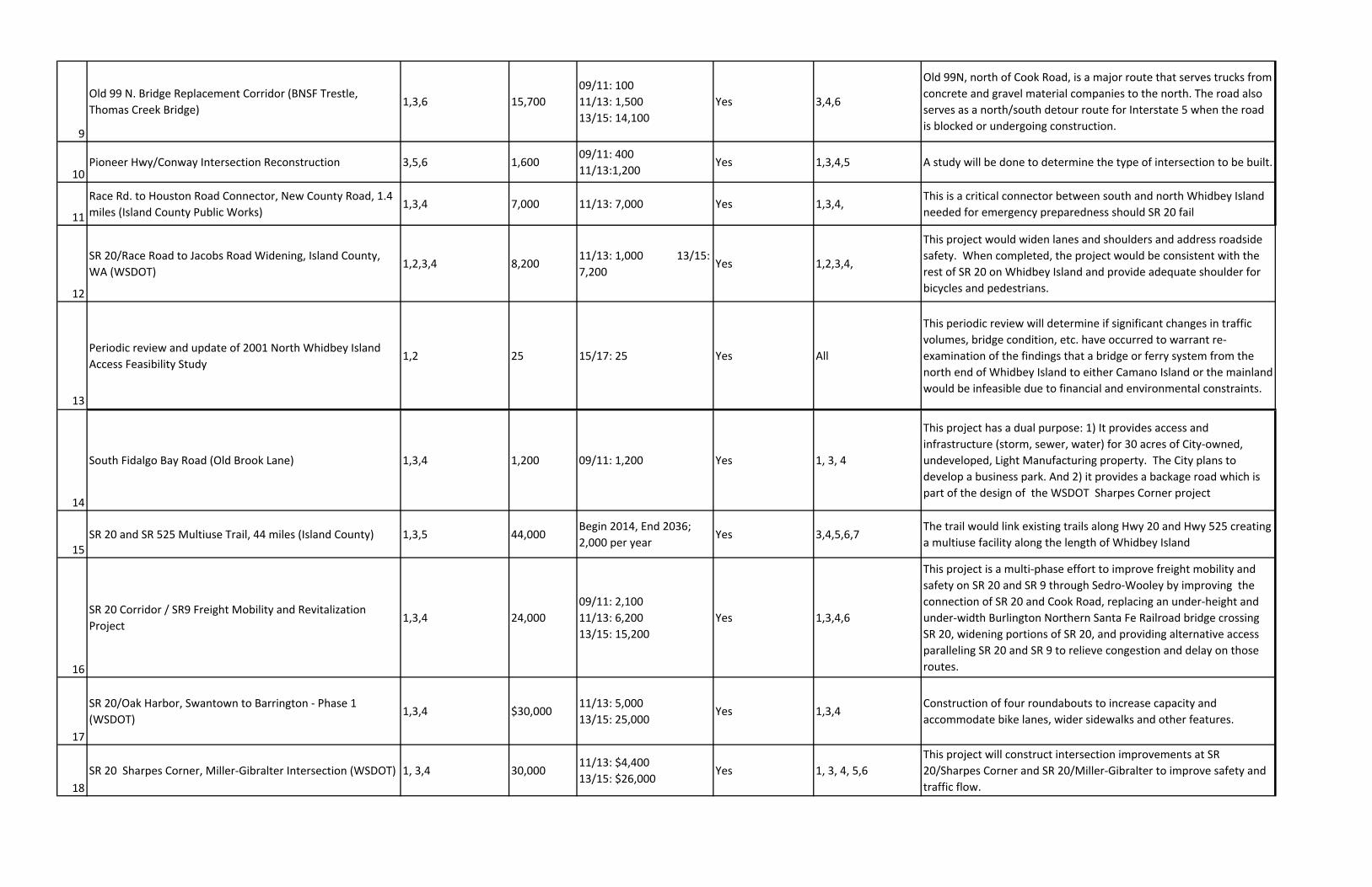
9
Old 99 N. Bridge Replacement Corridor (BNSF Trestle,
Thomas Creek Bridge)1,3,6 15,700
09/11: 100
11/13: 1,500
13/15: 14,100
Yes 3,4,6
Old 99N, north of Cook Road, is a major route that serves trucks from
concrete and gravel material companies to the north. The road also
serves as a north/south detour route for Interstate 5 when the road
is blocked or undergoing construction.
10Pioneer Hwy/Conway Intersection Reconstruction 3,5,6 1,600
09/11: 400
11/13:1,200Yes 1,3,4,5 A study will be done to determine the type of intersection to be built.
11
Race Rd. to Houston Road Connector, New County Road, 1.4
miles (Island County Public Works) 1,3,4 7,000 11/13: 7,000 Yes 1,3,4,
This is a critical connector between south and north Whidbey Island
needed for emergency preparedness should SR 20 fail
12
SR 20/Race Road to Jacobs Road Widening, Island County,
WA (WSDOT)1,2,3,4 8,200
11/13: 1,000 13/15:
7,200 Yes 1,2,3,4,
This project would widen lanes and shoulders and address roadside
safety. When completed, the project would be consistent with the
rest of SR 20 on Whidbey Island and provide adequate shoulder for
bicycles and pedestrians.
13
Periodic review and update of 2001 North Whidbey Island
Access Feasibility Study1,2 25 15/17: 25 Yes All
This periodic review will determine if significant changes in traffic
volumes, bridge condition, etc. have occurred to warrant re-
examination of the findings that a bridge or ferry system from the
north end of Whidbey Island to either Camano Island or the mainland
would be infeasible due to financial and environmental constraints.
14
South Fidalgo Bay Road (Old Brook Lane) 1,3,4 1,200 09/11: 1,200 Yes 1, 3, 4
This project has a dual purpose: 1) It provides access and
infrastructure (storm, sewer, water) for 30 acres of City-owned,
undeveloped, Light Manufacturing property. The City plans to
develop a business park. And 2) it provides a backage road which is
part of the design of the WSDOT Sharpes Corner project
15
SR 20 and SR 525 Multiuse Trail, 44 miles (Island County) 1,3,5 44,000Begin 2014, End 2036;
2,000 per yearYes 3,4,5,6,7
The trail would link existing trails along Hwy 20 and Hwy 525 creating
a multiuse facility along the length of Whidbey Island
16
SR 20 Corridor / SR9 Freight Mobility and Revitalization
Project1,3,4 24,000
09/11: 2,100
11/13: 6,200
13/15: 15,200
Yes 1,3,4,6
This project is a multi-phase effort to improve freight mobility and
safety on SR 20 and SR 9 through Sedro-Wooley by improving the
connection of SR 20 and Cook Road, replacing an under-height and
under-width Burlington Northern Santa Fe Railroad bridge crossing
SR 20, widening portions of SR 20, and providing alternative access
paralleling SR 20 and SR 9 to relieve congestion and delay on those
routes.
17
SR 20/Oak Harbor, Swantown to Barrington - Phase 1
(WSDOT)1,3,4 $30,000
11/13: 5,000
13/15: 25,000Yes 1,3,4
Construction of four roundabouts to increase capacity and
accommodate bike lanes, wider sidewalks and other features.
18
SR 20 Sharpes Corner, Miller-Gibralter Intersection (WSDOT) 1, 3,4 30,00011/13: $4,400
13/15: $26,000Yes 1, 3, 4, 5,6
This project will construct intersection improvements at SR
20/Sharpes Corner and SR 20/Miller-Gibralter to improve safety and
traffic flow.
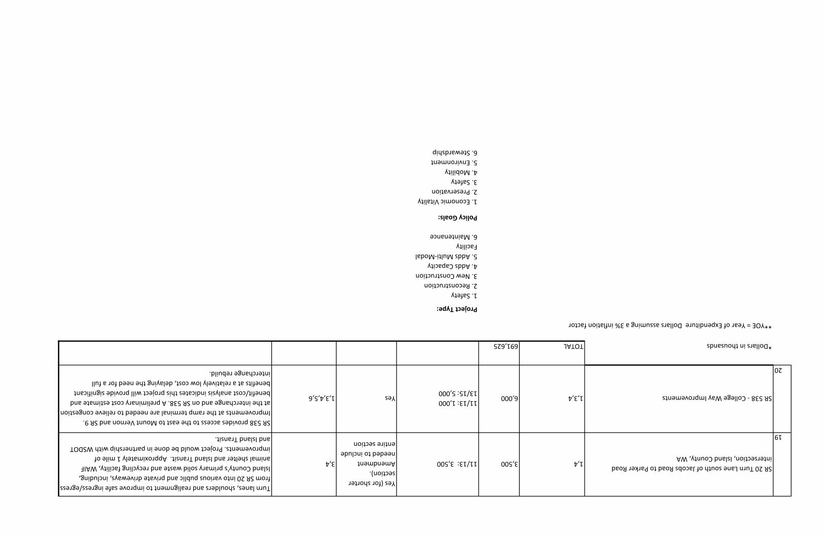
19
SR 20 Turn Lane south of Jacobs Road to Parker Road
intersection, Island County, WA 1,43,50011/13: 3,500
Yes (for shorter
section).
Amendment
needed to include
entire section
3,4
Turn lanes, shoulders and realignment to improve safe ingress/egress
from SR 20 into various public and private driveways, including,
Island County's primary solid waste and recycling facility, WAIF
animal shelter and Island Transit. Approximately 1 mile of
improvements. Project would be done in partnership with WSDOT
and Island Transit.
20
SR 538 - College Way Improvements1,3,46,00011/13: 1,000
13/15: 5,000Yes1,3,4,5,6
SR 538 provides access to the east to Mount Vernon and SR 9.
Improvements at the ramp terminal are needed to relieve congestion
at the interchange and on SR 538. A preliminary cost estimate and
benefit/cost analysis indicates this project will provide significant
benefits at a relatively low cost, delaying the need for a full
interchange rebuild.
*Dollars in thousandsTOTAL691,625
**YOE = Year of Expenditure Dollars assuming a 3% inflation factor
Project Type:
1. Safety
2. Reconstruction
3. New Construction
4. Adds Capacity
5. Adds Multi-Modal
Facility
6. Maintenance
Policy Goals:
1. Economic Vitality
2. Preservation
3. Safety
4. Mobility
5. Environment
6. Stewardship
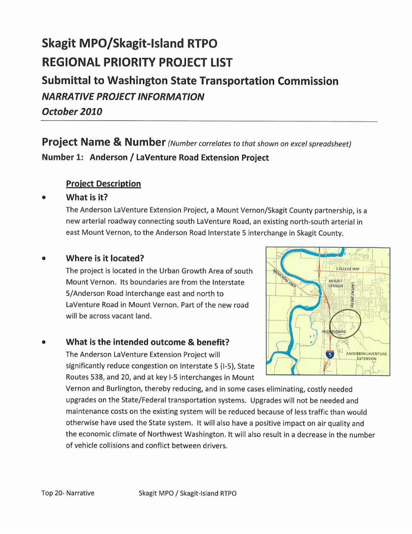


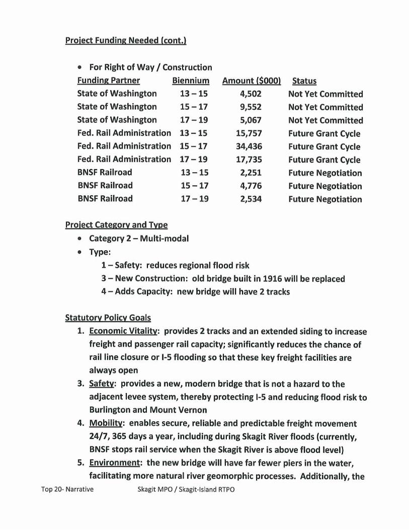

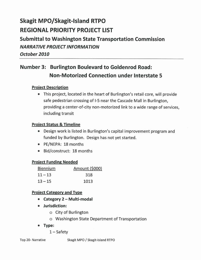
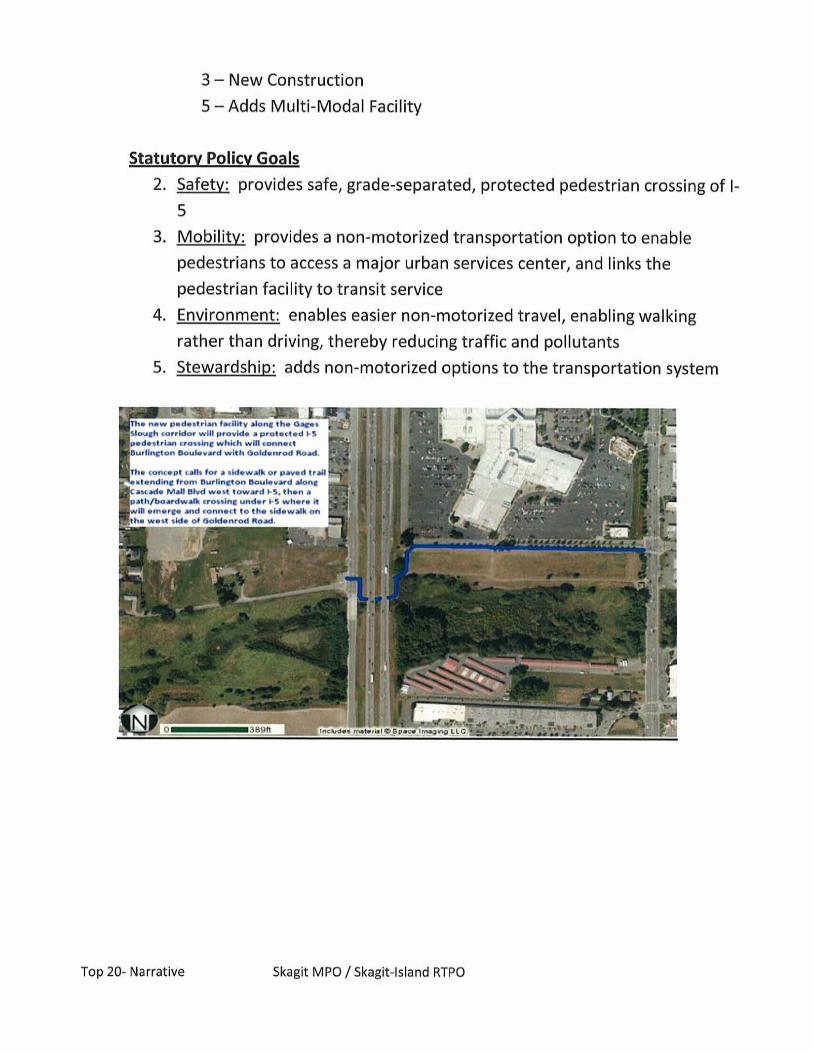


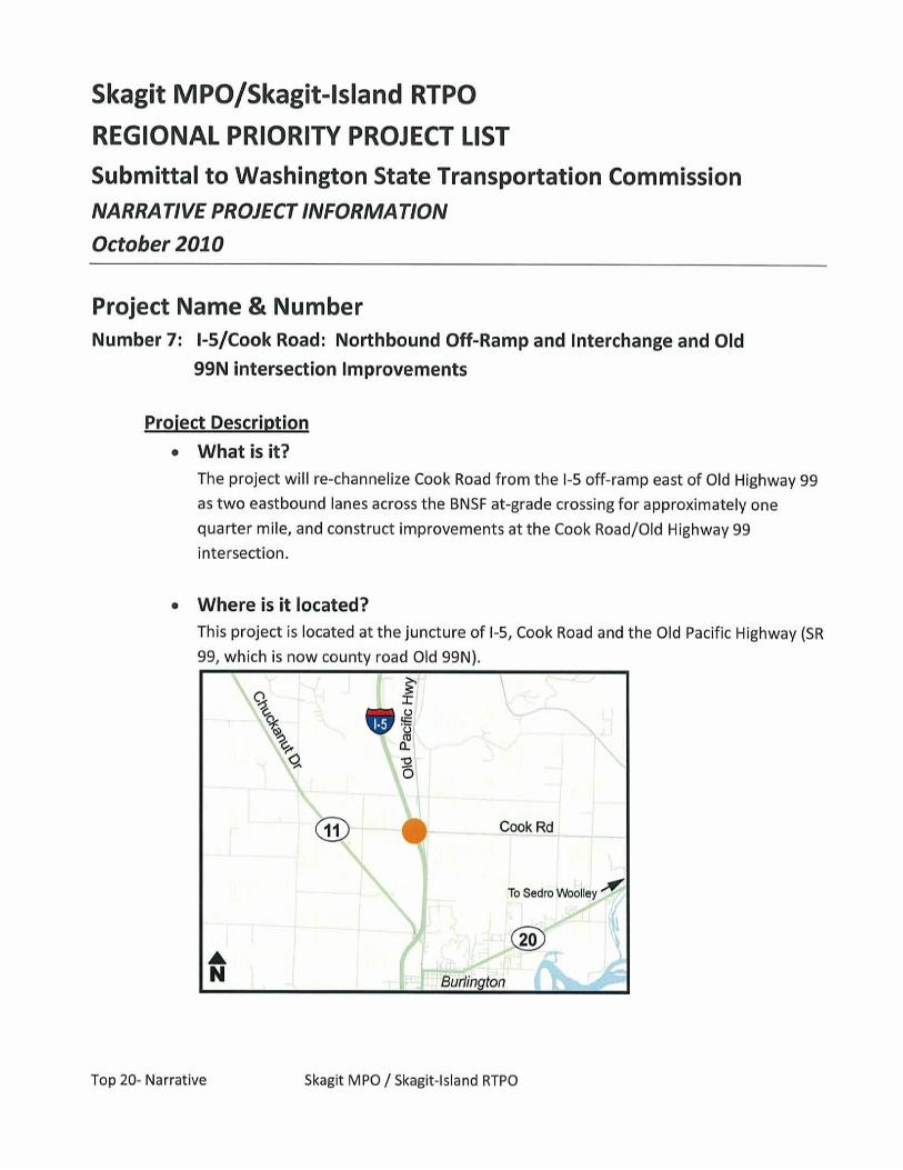
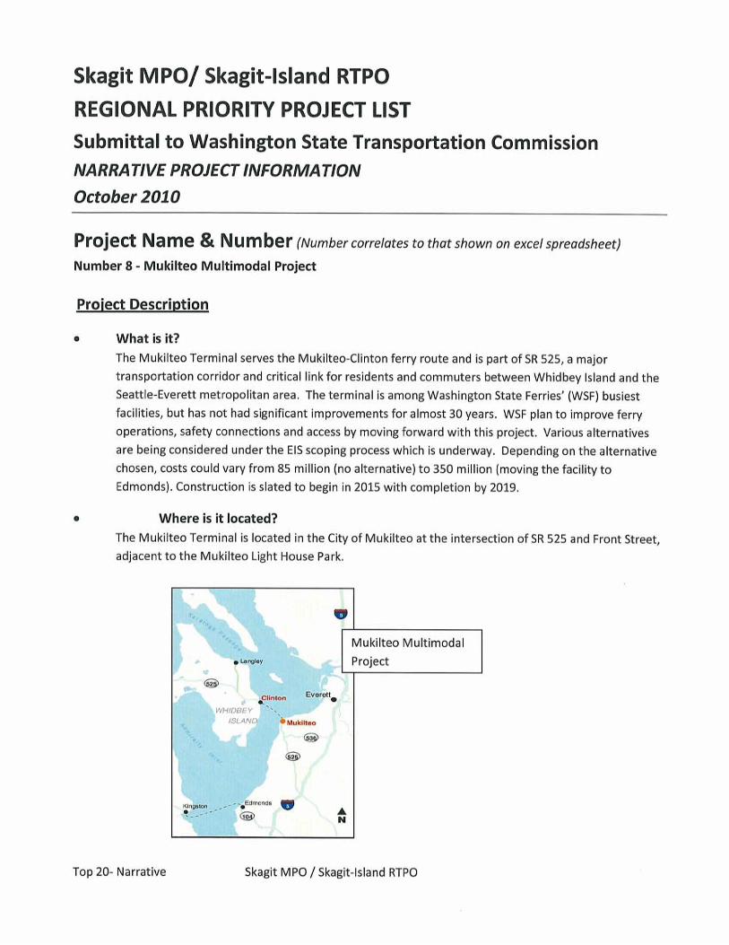


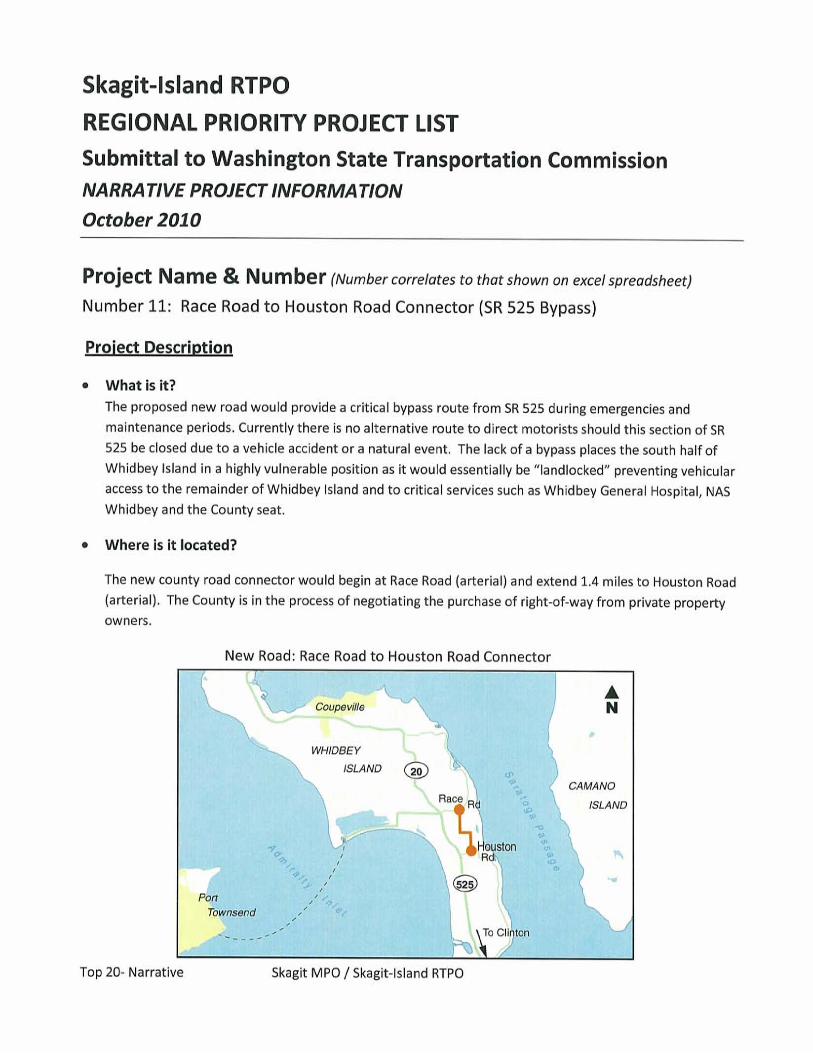


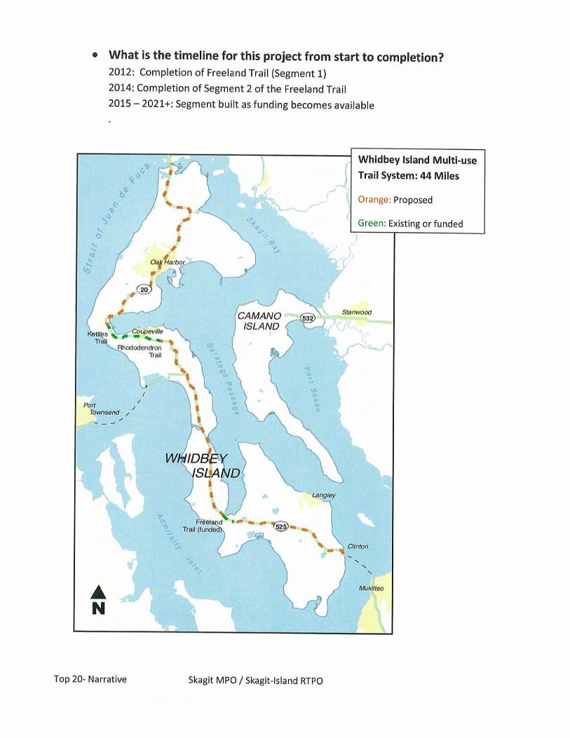


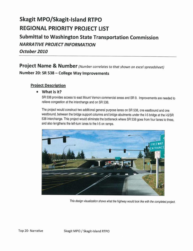


Whatcom preservation projects cover a wide range of types, all of which substantially extend the life of existing facilities. Individual jurisdictions have submitted these needs under the titles listed. Some included needs are comprised of larger projects that might not normally be considered preservation, but added traffic controls, drop lanes and roundabouts are seen as adding to the functionality and design life of many existing facilities without the expense of simply adding lane capacity or new road miles.
While some preservation projects may seem duplicative of TOP 20 projects, this is due to a somewhat gray area between distinct high-priority projects and other, larger –scale, projects that extend service life and add functionality.
Below is the preservation list.
WHATCOM PRESERVATION PROJECTS
Assumed Project Type Estimated Cost
PCCP Grinding project $6,400,000 Mill and Fill $48,000,000 Overlay $176,200,000 Chip Seal $49,600,000
Bridge Preservation $20,000,000
Multi-Modal Facility $1,900,000
Signals $5,000,000
Roundabouts $15,200,000
Turn Lanes $5,000,000
Street Lighting $5,000,000
Bike Ped Overpass $4,000,000
Culvert Replacement and Improvements $15,000,000
Grand Total $351,300,000


Whatcom Regional Priority Project List (October 2010) Policy Board Approved 10/13/2010
09/11 11/13 13/15 15/17 After 2017
1 Church Road, Main Street to Heather Drive, Ferndale, Road 1,2,4 $6,000 $6,000 Yes 1,2,3,4,5,6
2Main Street and Berthusen Rd: B,B. Lynden Rd to 1/2 mile east of Berthusen. City of Lynden, Category 1 (Road) 1,2,3,4,5 $7,500 $7,500 Yes 1,2,3,4,5,6
3 Birch Bay Lynden/ Blaine Rd Roundabout, Whatcom County, Road 1,3,4,5 $2,500 $500 $2,000 Yes 1,2,3,4,64 Slater Rd Bridge, Whatcom County, Road 1,3 $10,000 $10,000 Yes 1,2,3,45 Fixed Route Vehicle Replacement (5 buses), WTA, Multimodal 6 $2,250 $2,250 Yes 2,3,4,56 Heavy Haul Road Extention in Sumas, Road 3 $2,300 $2,300 Yes 1 #
7I-5/ Bakerview Low-Cost Interchange Improvements, WSDOT, Road 4 $3,575 $1,000 $0 $2,575 Yes 1, 2, 3, 4, 6 #
8I-5/ Birch Bay Lynden Ramp Terminal Improvements, WSDOT, Road 4 $5,150 $2,060 $3,090 Yes 1, 2, 3, 4, 6
9 Birch Bay Dr Ped Facility, Whatcom County, Multimodal 1,2,3,5 $7,100 $2,000 $5,100 Yes 1,2,3,4,5,6
10Haxton Way Kwina to Slater (includes roundabout), Whatcom County, Road 1,2,3,4 $9,000 $2,000 $7,000 Yes 1,2,3,4,5,6
Coordinate with Lummi Nation
11 Whatcom Smart Trips, WCOG, Multi-Modal 1,4 $3,000 $1,000 $1,000 $1,000 Yes 3, 4, 5 # 12 Bellingham Waterfront, Bellingham, Multimodal 1,2,3,4,5,6 $63,750 $11,000 $37,500 $7,500 $7,750 Yes 1,3,4,5,6 # 13 I-5/ Iowa Interchange and adjacent I-5 bridges, WSDOT, Road 4 $55,045 $2,000 $0 $7,725 $45,320 Yes 1, 2, 3, 4, 5, 6
14SR-539/ SR-546 (Badger Rd) to International Boundary, WSDOT, Road 4 $35,020 $0 $0 $7,210 $27,810 Yes 1, 2, 3, 4, 5, 6
15Urban Incorporated Bike and Ped Infrastructure, Urban Incorporated areas, Multimodal 1,2,3,4,5 $15,000 $5,000 $5,000 $5,000 Yes 1,3,4,5,6 Multi-jurisdiction
16 East Bakerview Road, Phases 1 & 2, Bellingham, Multimodal 1,2,4,5 $25,000 $0 $0 $0 $0 $25,000 Yes 1,3,4,5,617 James Street, Phases 2 & 3, Bellingham, Multimodal 1,2,4,5 $11,500 $500 $1,000 $5,000 $5,000 Yes 1,3,4,5,618 West Horton Road, Phases 1 & 2, Bellingham, Multimodal 1,3,4,5 $16,000 $1,000 $5,000 $5,000 $5,000 Yes 1,3,4,5,619 SR 543/Boblett signal, Blaine, Road 1 $800 $100 $700 Yes 1,2,3,4,6
20SR-539 Birch Bay Lynden Rd to SR-546 (Badger Rd), WSDOT, Road 4 $26,000 $700 $0 $1,545 $4,017 $14,420 Yes 1, 2, 3, 4, 5, 6
# It is anticipated that this project will be partially funded through private sector exactions or contributions, the amount of which cannot be determined at this time.**YOE = Year of Expenditure Dollars assuming a 3% inflation factor*Dollars in thousands
Is This Project
Consistent with an
Approved Regional
Transportation Plan?
Policy Goals Project
Addresses - Indicate
Applicable Numbers
(see instruction memo)
Comments
Project Cost Breakdown By Biennia - YOE $**
(09/11; 11/13; 13/15 etc.)Project
NumberProject Name, Jurisdiction & Category
(i.e.: road or multi-modal)
Project Type - Indicate
Applicable Number(s)
(see instruction
memo)
Total Project Cost*


Whatcom County Council of Governments REGIONAL PRIORITY PROJECT LIST Submittal to Washington State Transportation Commission NARRATIVE PROJECT INFORMATION October 2010
Project Name & Number (Number correlates to that shown on excel spreadsheet)
Project Name: Church Road, Main Street to Heather Drive, Ferndale Project Number: #1
Project Description
• What is it? Church Road was constructed more than 50 years ago as a rural country road. As the City of Ferndale has grown, Church Road has been annexed and has become a major north-south connector. Currently, Church Road is substandard in width with alligatored and deteriorating chip seal, no shoulders, sidewalks at few locations, and 1:1 roadside ditch slopes. Stormwater is not treated or detained. These conditions do not provide safe pedestrian, bicycle, or vehicle travel. The project improvements include reconstructing the roadway with 2-11 foot travel lanes and 2-5 bike lanes. Sidewalk, curb and gutter will be constructed throughout the project length. Stormwater runoff will be treated and detained in accordance with the most current standards.
• Where is it located? Church Road is a major north-south route located within the city limits of Ferndale, on the west side of the Nooksack River, and links Main Street to Thornton Road.

• What is the intended outcome & benefit? The City of Ferndale reconstructed and improved Main Street, from approximately 1-5 westerly to 3rd Street, in 2004 and reconstructed and signalized the Douglas/Main Street intersection in 2007. Currently, Ferndale is reconstructing Main Street from 3rd to Washington, and in 2012 will complete the remaining section from Douglas to Church. The Main Street improvements, coupled with the proposed Church Road improvements will greatly enhance corridor safety, traffic flow, and access to I-5, as well as enhance multimodal transportation.
Church Road is a major north-south traffic corridor that carries approximately 15,000 vehicles per day and provides access to downtown business, commercial, and industrial districts, as well as the refineries.
Project Status & Timeline
• Where is the project at in development? Currently, the design, permitting and right-of-way acquisition for this project is underway. After this work is completed, the project will be shelved until construction funding is secured.
• What is the timeline for this project from start to completion? (Please identify the major phases) The design, permitting and right-of-way acquisition for this project is scheduled to be completed in July 2011. Construction work will proceed after funding is secured.
Additional Comments This project will be shovel-ready in July 2011.

Whatcom Council of Government REGIONAL PRIORITY PROJECT LIST Submittal to Washington State Transportation Commission NARRATIVE PROJECT INFORMATION October 2010
Project Name & Number Main Street and Berthusen Road: Birch Bay-Lynden Road to ½ mile east of Berthusent Road. Project Number 2
Project Description
• What is it? Main Street provides access to the West Lynden industrial and commercial areas and also the future St. Joseph’s North County Campus from SR-539 (Guide Meridian). Berthusen Road provides similar access from Birch Bay-Lynden Road. The City has improved the first ½ mile of Main Street west of SR-539 but the remaining ½ mile needs to be reconstructed to City arterial standards. The proposed 1 mile stretch of Berthusen Road is currently rural county standard road of 20 feet in width. The north ¼ mile is improved to three-quarter street section with sidewalk on one side. The proposed project will complete improvements to 1.5 miles of road to City all-weather arterial standard 40 feet curb-to-curb, sidewalk, enclosed drainage and utility upgrades.
• Where is it located?
Lynden Washington.
• What is the intended outcome & benefit?
The project will provide 1.5 miles all-weather arterial access to Lynden’s West Lynden
commercial and industrial areas. Enhances access to the proposed North County St. Joseph’s
hospital site. 1.5 miles of sidewalk where none exist. 1.5 miles of striped bike route where none exist. The only safe and viable all-weather detour route around
Lynden when SR-539 is improved.
Project Status & Timeline
• Where is the project at in development?
The City has already addressed the drainage of West Main Street in a regional stormwater facility.
The City has developed plans for this ½ mile section of Main Street to 25%.
• What is the timeline for this project from start to completion? (Please identify the major phases)
o Preliminary Engineering will commence upon fund availability.
o Construction will commence approximately 1.5 years following PE starting.
Additional Comments

Whatcom County COG REGIONAL PRIORITY PROJECT LIST Submittal to Washington State Transportation Commission NARRATIVE PROJECT INFORMATION October 2010
Project Name & Number (Number correlates to that shown on excel spreadsheet)
Birch Bay Lynden/Blaine Rd Roundabout: #3 Project Description
• What is it? Construction of new roundabout
• Where is it located? Intersection of Birch Bay Lynden Road and Blaine Road (SR 548)
• What is the intended outcome & benefit? Currently intersection if 4-way stop controlled, is operating at LOS D-E and has a high accident rate. Construction of roundabout will improve traffic flow and increase safety.
Project Status & Timeline
• Where is the project at in development? Conceptual design and right-of –way plans complete
• What is the timeline for this project from start to completion? (Please identify the major phases)
o Preliminary Engineer 10/10-10/11. o Right-of-Way 10/11-5/12. o Construction 6/12-10/12
Additional Comments

Whatcom County COG REGIONAL PRIORITY PROJECT LIST Submittal to Washington State Transportation Commission NARRATIVE PROJECT INFORMATION October 2010
Project Name & Number (Number correlates to that shown on excel spreadsheet)
Slater Road Bridge: #4 Project Description
• What is it? Raising Slater Road 10-feet in elevation and construction of a new 375’ opening bridge over the Nooksack River floodway.
• Where is it located? Slater Road immediately east of Nooksack River main cahnnel bridge.
• What is the intended outcome & benefit? Currently Slater Road is closed to flooding on a frequent basis limiting access to Lummi Nation Indian Reservation, Conoco Philips Refinery and large residential areas. This project will raise Slater Road and construct a new bridge to let floodwater pass underneath. This will allow Slater Road to remain open during most flooding scenarios.
Project Status & Timeline
• Where is the project at in development? Project Design and Right-of-Way acquisition complete.
• What is the timeline for this project from start to completion? (Please identify the major phases)
o Environmental Permitting 10/10-1/12. o Construction 3/12-12/12
Additional Comments
Whatcom Council of Governments REGIONAL PRIORITY PROJECT LIST Submittal to Washington State Transportation Commission NARRATIVE PROJECT INFORMATION October 2010
Project Name & Number (Number correlates to that shown on excel spreadsheet)
Fixed Route Transit Vehicle Replacement, Whatcom Transportation Authority (WTA) – Project #5
Project Description
• What is it? Five bio-diesel compatible fixed route transit buses to replace five fully-depreciated buses
• Where is it located? Whatcom County • What is the intended outcome and benefit? WTA’s buses will be 16 to
17 years old, with mileage in excess of 570,000, by the time they can be replaced. Though they have been partially rebuilt to extend their useful life, they are degrading rapidly. If not replaced soon it will be extremely difficult for WTA to meet the demands of providing reliable, attractive transit service.
Project Status and Timeline
• Where is the project in development? In 2008, WTA completed a competitive bid process, selected a vendor, and entered into a contract for up to 33 buses. In the past three years WTA has received 25 replacement buses; it will soon take delivery of three more. Another five are needed to complete the fleet replacement project.
• What is the timeline for this project from start to completion? Once funding is secured, WTA would order buses in 2011 and take delivery in 2012.

Additional Comments
In 2008, the Federal Transit Administration recognized WTA as the small- to mid-sized agency with the highest ridership increase in the nation (26 percent). In 2009, ridership increased by an additional 13 percent. WTA carries approximately 20,000 riders per weekday, or 5.6 million per year. WTA provides urban, rural, tribal and inter-county bus services as well as service to Western Washington University, three colleges and nearly all major employment centers in Whatcom County. Recent survey data suggests that 37 percent of riders on WTA’s high frequency “GO Lines” (corridors along which a bus is coming every 15 minutes) would drive alone if they were not making their trip by transit. WTA’s ability to retain and attract riders depends on the reliability and attractiveness of its fleet. This fleet replacement project is part of WTA’s capital improvement plan and is identified in regional plans as critical to serving regional mobility needs.

Whatcom Council of Governments REGIONAL PRIORITY PROJECT LIST Submittal to Washington State Transportation Commission NARRATIVE PROJECT INFORMATION October 2010
Project Name & Number (Number correlates to that shown on excel spreadsheet)
Sumas Heavy Haul Road Extension – Project #6
Project Description
• What is it? The project includes construction of a new all-weather, heavy haul road to serve the Sumas Industrial District located adjacent to the international border crossing at Sumas.
• Where is it located? The new road will extend from Bob Mitchell Way (heavy haul road) west to Barbo Road and then south to Halverstick Road (previously State Route 9) to complete an all-weather, heavy haul loop through the Sumas Industrial District.
• What is the intended outcome & benefit? The new road will open up new properties within the Sumas Industrial District and allow them to be developed with new industrial businesses, thereby creating new industrial wage jobs that will allow those living in the local area to work closer to where they live and reduce their vehicle miles traveled as well their contribution to greenhouse gas emissions.
Project Status & Timeline
• Where is the project at in development? The project is in the planning stage, although the main property owner has previously

submitted a General Binding Site Plan to begin the development process.
• What is the timeline for this project from start to completion? (Please identify the major phases) Project planning and coordination related to the project will continue over the next two years. Depending on market conditions, roadway design work could get underway in 2013 and would require about six months to complete. No right-of-way acquisition is needed. Timing for project construction will be based on market conditions and demand for industrial property. Actual construction time should be approximately three to four months. It is anticipated that the project will be completed in the 2015 biennium.
Additional Comments The City of Sumas Industrial District is an area that has seen continued growth in the industrial sector even through the economic downturn. The proximity of this location to the international border allows U.S. and Canadian companies to expand their businesses to reach new markets. It is anticipated that continued strong growth in this and other similar areas will help fuel overall economic recovery in the region.
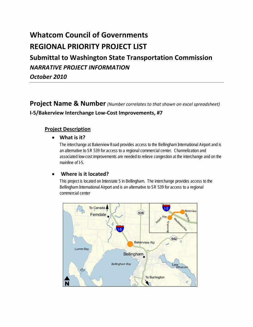
Whatcom Council of Governments REGIONAL PRIORITY PROJECT LIST Submittal to Washington State Transportation Commission NARRATIVE PROJECT INFORMATION October 2010
Project Name & Number (Number correlates to that shown on excel spreadsheet)
I‐5/Bakerview Interchange Low‐Cost Improvements, #7
Project Description
What is it? The interchange at Bakerview Road provides access to the Bellingham International Airport and is an alternative to SR 539 for access to a regional commercial center. Channelization and associated low-cost improvements are needed to relieve congestion at the interchange and on the mainline of I-5.
Where is it located? This project is located on Interstate 5 in Bellingham. The interchange provides access to the Bellingham International Airport and is an alternative to SR 539 for access to a regional commercial center

What is the intended outcome & benefit? This project will improve traffic flow on the ramps and intersections at this interchange.
Project Status & Timeline
Where is the project at in development? The need for improvements at this location was identified in the 2008 Interstate 5 Master Plan: Fairhaven to Slater. WSDOT, in partnership with City of Bellingham, Whatcom Council of Governments, Port of Bellingham and Whatcom County is working on a Value Planning Study for this location that will result in an improvement concept, footprint, risk analysis and cost estimate.
What is the timeline for this project from start to completion? (Please identify the major phases) Design: 12 months Construction: 12 months
Additional Comments

Whatcom Council of Governments REGIONAL PRIORITY PROJECT LIST Submittal to Washington State Transportation Commission NARRATIVE PROJECT INFORMATION October 2010
Project Name & Number (Number correlates to that shown on excel spreadsheet)
I‐5/Birch Bay Lynden Road Interchange Ramp Terminal Improvements, #8
Project Description
What is it? Construct a five-leg roundabout at the I-5 northbound ramp terminal intersection with Birch Bay Lynden Road and Valley View Road. The roundabout will combine the traffic movements at two closely spaced intersections into one safer and more efficient intersection.
Where is it located? The I-5 interchange at Birch Bay Lynden Road provides access to north Whatcom County including Birch Bay to the west and Lynden to the east. The northbound ramp terminal intersection is in close proximity to the intersection of Birch Bay Lynden Road and Valley View Road.
Valley View Rd

What is the intended outcome & benefit? This project will improve traffic flow at the I-5 northbound ramp terminal intersection, significantly reducing current and forecasted intersection delay and off ramp queues. This will reduce the risk of traffic backing onto the I-5 mainline.. As the area continues to develop there is an opportunity to leverage local and state funds with developer contributions in order to fund this project.
Project Status & Timeline
Where is the project at in development? A scoping analysis, including a conceptual roundabout design, has been completed. Developers have purchased property on Valley View Road. There are no firm development proposals at this time.
What is the timeline for this project from start to completion? (Please identify the major phases) Design: 12 months Right of Way: 12 months Construction: 12 months
Additional Comments

Whatcom County COG REGIONAL PRIORITY PROJECT LIST Submittal to Washington State Transportation Commission NARRATIVE PROJECT INFORMATION October 2010
Project Name & Number (Number correlates to that shown on excel spreadsheet)
Birch Bay Drive Pedestrian Facility: #9 Project Description
• What is it? Construction of separated pedestrian/bicycle trail.
• Where is it located? Birch Bay Drive north of Alderson Rd
• What is the intended outcome & benefit? Safety for pedestrians and bicyclist, flood prevention provided by raised berm and improved shore form,
Project Status & Timeline
• Where is the project at in development? Feasibility Study and cost estimates complete.
• What is the timeline for this project from start to completion? (Please identify the major phases)
o Preliminary Engineering 2010 - 2013 o Right-of-Way 2012-2014. o Construction 2014-2015
Additional Comments

Whatcom County COG REGIONAL PRIORITY PROJECT LIST Submittal to Washington State Transportation Commission NARRATIVE PROJECT INFORMATION October 2010
Project Name & Number (Number correlates to that shown on excel spreadsheet)
Haxton Way, Kwina Road to Slater Road: #10 Project Description
• What is it? This project includes the reconstruct Haxton Way to all-weather standard and paved shoulders. Construction of round-a-bout at Haxton Way and Slater Road intersection, construction of new bridge over Red River
• Where is it located? Haxton Way between Kwina and Slater Roads
• What is the intended outcome & benefit? Project will address safety and LOS deficiencies at intersection of Haxton and Slater Roads as well as complete all-weather road network to Lummi Island Ferry and Lummi Nation Indian .
Project Status & Timeline
• Where is the project at in development? Design Survey Complete.
• What is the timeline for this project from start to completion? (Please identify the major phases)
o Preliminary Engineering 10/11-12/12 o Right-of-Way 12/12-2/13. o Construction 3/13-10/13
Additional Comments

Whatcom Council of Governments REGIONAL PRIORITY PROJECT LIST Submittal to Washington State Transportation Commission NARRATIVE PROJECT INFORMATION October 2010
Project Name & Number (Number correlates to that shown on excel spreadsheet)
Whatcom Smart Trips, Project Number: 11
Project Description • What is it? Whatcom Smart Trips reduces congestion and VMT by shifting trips to
walking, bicycling, riding the bus or sharing rides. Whatcom Smart Trips will expand its multi-faceted trip-reduction education program, with emphasis on the Individualized Marketing element that has reduced VMT by 15% in the area targeted in 2008. The next phase funding will allow implementation of the Individualized Marketing to other areas of Whatcom County and remaining neighborhoods of Bellingham.
• Where is it located? Whatcom Smart Trips is carried out throughout Whatcom County
• What is the intended outcome & benefit? Whatcom Smart Trips will: Increase Capacity of roads and highways throughout Whatcom County by reducing drive-alone trips. Increase Safety: Reduced VMT will improve traffic safety by reducing congestion and crashes (National Highway Traffic Safety Administration reports that VMT reduction in
recent years corresponds with a 13% reduction in fatal crashes nationwide). Adds Multi-modal: Increases use of existing walk/bike/bus infrastructure; improved cost efficiency of existing transportation system. Preservation: Reduced VMT will reduce maintenance costs for local streets and roadways through reduced wear.
Project Status & Timeline • Where is the project at in development? Whatcom Smart Trips is already
underway and can begin expanded work immediately after funding is available.
What is the timeline for this project from start to completion? (Please identify the major phases)
o July 2013 through June 2017: Continue or expand existing Whatcom Smart Trips program elements including:

- Continue Whatcom Smart Trips on-line trip diary and rewards program; worksite promotions, community outreach, emergency ride home, etc.
- Contract with website developer and database manager to develop and design School Smart Trips trip diary program
- Bicycle education and outreach program - Develop walking transportation education program - Continue Senior education on bus riding and other smart trips
o The following timeline will repeat in each biennium (11-13, 13-15, 15-17) to target each of three geographic areas in Whatcom County:
- January – Contract with Social Data to to perform additional phase(s) of Individualized Marketing, Define target geographic area, develop marketing materials and incentives
- June - Begin in-depth survey (base line data, “before” project) - July – Implement Individualized Marketing for target area - September – Complete Individualized Marketing effort - October – Follow-up survey (results data, “after” project) - June – SocialData data analysis; publicize results
Additional Comments Whatcom Smart Trips originated in 2006 as a more cost-effective expansion of the worksite-based Commute Trip Reduction program (CTR). While Whatcom CTR worksites reduced drive-alone work trips from 78.08% to 73.52%, this success represents a small fraction of all trips: 80% of daily trips are not work trips. Whatcom Smart Trips addresses all types of trips (shopping, school, errands, leisure and work) and has reduced drive-alone trips to a much greater degree than the CTR program was designed to do. Whatcom Smart Trips Individualized Marketing education provides home-based education, resources, and incentives to encourage transportation behavior change customized to the individual participants’ needs. The 2004 Whatcom Smart Trips pilot program resulted in an overall reduction in drive-alone trips of 8%. Reduced VMT improves highway capacity for freight: 60% of I-5 traffic through Bellingham is local (<5 miles) and such short trips are most easily changed to biking or bus modes. Whatcom Smart Trips has precise data and evaluation measurements demonstrating success of previous Individualized Marketing. Whatcom Smart Trips partners and grants include: Bellingham, Whatcom Transportation Authority, Whatcom County, Whatcom Council of Governments (WCOG), FTA, FHWA, Northwest Clear Air Agency, private companies, and WSDOT. Program details are available at: https://www.whatcomsmarttrips.org/news/implement.aspx.

Whatcom Council of Governments REGIONAL PRIORITY PROJECT LIST Submittal to Washington State Transportation Commission NARRATIVE PROJECT INFORMATION October 2010
Bellingham Waterfront District Arterial Streets (12) $63,750,000 Project Description
• What is it? Several new multimodal arterial streets and bridges and significant reconstruction of existing arterial streets are required to support the redevelopment of 200-acres of former heavy industrial land on Bellingham Bay.
• Where is it located? Between Bellingham Bay and downtown Bellingham (See next page)
• What is the intended outcome & benefit? The 200-acres of former heavy industrial land on the Bellingham Bay waterfront will be redeveloped as a vibrant mixed-use urban neighborhood with up to 6 million square feet of residential, commercial, light industrial, institutional, and public parks and beaches. The benefits of the project include:
• 512 new short-term jobs, 13,188 new long-term jobs, preserve 10,510 existing jobs;
• Critical multimodal transportation links between the Waterfront and downtown;
• Increase BNSF mainline railroad track speed 5 mph, eliminate 3 at-grade crossings;
• Reduce annual vehicle miles traveled, gasoline use, CO2, and greenhouse gases; and
• Improve safety by reducing the number, rate, and severity of crashes and injuries.
Project Status & Timeline
• Where is the project at in development? Adopted in Bellingham 2011-2016 TIP, significant street and bridge design work completed, permits in process. Waterfront District Final Environmental Impact Statement and Master Plan completed, development regulations and planned action ordinance in process with completion expected in early 2011.
• What is the timeline for this project from start to completion? Multiple phases over approximately 50 years, as funding becomes available.

Bellingham Waterfront District Master Plan of Arterial Streets

Whatcom Council of Governments REGIONAL PRIORITY PROJECT LIST Submittal to Washington State Transportation Commission NARRATIVE PROJECT INFORMATION October 2010
Project Name & Number (Number correlates to that shown on excel spreadsheet)
I‐5/Iowa Interchange and Adjacent Bridges, #13
Project Description
What is it? This project would replace aging Interstate 5 bridges and an interchange in a quarter mile segment through Bellingham. The bridges and interchange are located at a key access point between Interstate 5 and Bellingham’s industrial areas. In all there are six bridges over 50 years old and all are functionally obsolete. The project would replace I-5 bridges crossing over Meador St, Whatcom Creek and Kentucky St, and replace the existing Iowa St interchange with a single point urban interchange (SPUI). This project is recommended in the Interstate 5, Fairhaven to Slater Master Plan.
Where is it located? This project is located on Interstate 5 in Bellingham.
What is the intended outcome & benefit? Congestion Relief: This project will reduce backups on I-5 by vehicles entering from and exiting

onto Iowa Street, improving traffic flow.
Freight mobility: This project will improve access between I-5 and the freight-dependent industrial area of Bellingham. An efficient SPUI interchange will improve merging on and off I-5, reduce mainline backups and improve the reliability of trip times for through movements.
Safety: A single-point urban interchange (SPUI) reduces the number of conflict points at the ramp terminal intersection and significantly increases the capacity to handle existing and forecasted volumes of traffic. Vehicles can merge on and off the I-5 mainline at safe speeds. Traffic queues at the off ramps will be reduced, decreasing the risk of high speed rear end collisions.
Project Status & Timeline
Where is the project at in development? This project was recommended in the 2008 Interstate 5 Master Plan: Fairhaven to Slater. The plan included traffic analysis, assessment of right-of-way needs and a planning level-cost estimate.
What is the timeline for this project from start to completion? (Please identify the major phases) Design: 24 months Right of way: 24 months Construction: 36 months
Additional Comments
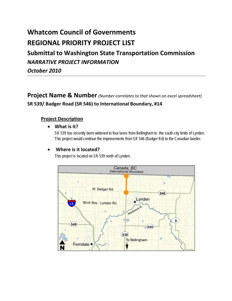
Whatcom Council of Governments REGIONAL PRIORITY PROJECT LIST Submittal to Washington State Transportation Commission NARRATIVE PROJECT INFORMATION October 2010
Project Name & Number (Number correlates to that shown on excel spreadsheet)
SR 539/ Badger Road (SR 546) to International Boundary, #14
Project Description
What is it? SR 539 has recently been widened to four lanes from Bellingham to the south city limits of Lynden. This project would continue the improvements from SR 546 (Badger Rd) to the Canadian border.
Where is it located? This project is located on SR 539 north of Lynden.
What is the intended outcome & benefit? SR 539 is a border crossing highway essential to freight movement and regional commerce. The existing two-lane section of SR 539 from SR 546 to the Canadian Border would be widened to four lanes to match the proposed four lane section through Lynden, and the existing four lane section south of Lynden. Completing four lanes from I-5 in Bellingham to the international border is a critical upgrade to the corridor.
Congestion Relief: The project will provide additional capacity for freight traffic traveling between the U.S. and Canada..
Safety: The project will change the Guide Meridian from a narrow two-lane roadway with minimal shoulders to a wider and safer four-lane highway.
Project Status & Timeline
Where is the project at in development? A scoping estimate has been completed.
What is the timeline for this project from start to completion? (Please identify the major phases) Design: 12 months Right of Way: 24 months Construction: 24 months
Additional Comments

Whatcom Council of Governments REGIONAL PRIORITY PROJECT LIST Submittal to Washington State Transportation Commission NARRATIVE PROJECT INFORMATION October 2010
Project Name & Number (Number correlates to that shown on excel spreadsheet)
Urban Incorporated Bike and Ped Infrastructure: #15
Project Description
• What is it? A program of projects intended to systematically and substantially increase access, safety and mobility for pedestrians and bicycle riders in Whatcom County
• Where is it located? In all urban incorporated areas of Whatcom County
• What is the intended outcome & benefit? Pedestrians and bicycle riders will have access to substantially improved facilities County wide. This project emphasizes dedicated bicycle and pedestrian infrastructure improvements; including separated routes, bicycle parking and storage facilities, an extensive bicycle lane marking program and widened shoulders and sidewalks where appropriate.
Project Status & Timeline
• Where is the project at in development? This project expands, enhances and accelerates multiple short- and long-range efforts in the planning stages.
• What is the timeline for this project from start to completion? The project would begin in calendar 2011 and continue over the following six years with planning and design continuing for the various identified projects over the first three years. Construction

would begin almost immediately with some projects that have been under previous consideration with some preliminary work completed
Additional Comments Added non-auto mobility will encourage and cause increasing levels of walking and bicycling by all ages, contributing significantly to lowering Whatcom’s transportation carbon footprint, increasing health among all age groups and reducing congestion.

Whatcom Council of Governments REGIONAL PRIORITY PROJECT LIST Submittal to Washington State Transportation Commission NARRATIVE PROJECT INFORMATION October 2010
East Bakerview Road, Phases 1 and 2 (16) $25,000,000 Project Description
• What is it? The East Bakerview Road principal arterial will be reconstructed and widened from a rural standard with two travel lanes to an urban standard with 4 travel lanes, a center two-way left turn lane, sidewalks, bicycle lanes, and bus pullouts.
• Where is it located? Phase 1 = Deemer Road to James Street Phase 2 = James Street to Hannegan Road.
• What is the intended outcome & benefit? Reconstruction and widening of this critical east-west principal arterial from a rural standard to an urban standard complete with multimodal facilities will provide increased safety between Bellingham’s largest industrial employment and manufacturing center and the largest commercial shopping and employment area with connections to both Interstate 5 and State Highway 542. Project Status & Timeline
• Where is the project at in development? Adopted in Bellingham Comprehensive Plan Transportation Element.
• What is the timeline for this project from start to completion? Phase 1 anticipated by 2020; Phase 2 anticipated by 2022, if funding is available.

Whatcom Council of Governments
REGIONAL PRIORITY PROJECT LIST Submittal to Washington State Transportation Commission NARRATIVE PROJECT INFORMATION October 2010
James Street, Phases 2 and 3 (17) $11,500,000 Project Description
• What is it? James Street will be reconstructed as a secondary urban arterial street with sidewalks, bicycle lanes, turn lanes, crosswalks, and signals at Orchard and Telegraph.
• Where is it located? Phase 2 = Woodstock Way to East Orchard Drive Phase 3 = From East Orchard Drive to Telegraph Road.
• What is the intended outcome & benefit? North-south multimodal connectivity and increased safety and transit efficiency between two major arterials to support annexation of 860 acres to the north, including approximately 1,600 residential units, Sunset Pond Regional Park, Sunset Square Regional Shopping Center, and Bay-to-Baker multiuse trail.
Project Status & Timeline
• Where is the project at in development? Adopted on Bellingham 2011-2016 TIP; Phase 2 design underway, mitigation strategy being developed, permits being sought.
• What is the timeline for this project from start to completion? Phase 2 programmed for construction in 2012; Phase 3 in 2016, if funding is available.

Whatcom Council of Governments
REGIONAL PRIORITY PROJECT LIST Submittal to Washington State Transportation Commission NARRATIVE PROJECT INFORMATION October 2010
West Horton Road, Phases 1 and 2 (18) $16,000,000 Project Description
• What is it? West Horton Road will be extended as a secondary urban arterial street with sidewalks, bicycle lanes, turn lanes, and signals at Aldrich and Northwest.
• Where is it located? Phase 1 = From current terminus to Aldrich Road and Phase 2 = From Aldrich Road to Northwest Road.
• What is the intended outcome & benefit? East-west multimodal connectivity between two major arterials to support annexation of 125 acres to the south, including 350 residential units, a new Cordata elementary school, and the 20-acre Cordata Neighborhood Park with vehicle access from Horton. Significant environmental constraints will require land acquisition, wetland mitigation, and perhaps alternative design for pin-pile sidewalks.
Project Status & Timeline
• Where is the project at in development? Adopted on Bellingham 2011-2016 TIP. Feasibility study underway with land acquisition strategy being developed.
• What is the timeline for this project from start to completion? Phase 1, current terminus to Aldrich Road in 2016; Phase 2, Aldrich Road to Northwest Road, 2017.

Whatcom Council of Governments REGIONAL PRIORITY PROJECT LIST Submittal to Washington State Transportation Commission NARRATIVE PROJECT INFORMATION October 2010
Project Name & Number: SR 543/ Boblett Signal Project #19
Project Description
• What is it? Permanent signalization and channelization of SR 543 (Truck Route Border Crossing) and Boblett Street
• Where is it located? SR 543 and Boblett Street – City of Blaine
• What is the intended outcome & benefit? Project will increase safety and freight mobility though a critical choke point which supports the freight international border crossing, access to I-5, and the primary industrial area in Blaine.
Project Status & Timeline
• Where is the project at in development? The project is in early stages of preliminary design.
• What is the timeline for this project from start to completion? PE: June 2011 ROW: Complete Construction: March 2013 - Complete September 2013
Additional Comments This is the first intersection serving the I-5 on/off ramps at Exit 275 and the international border crossing. Without a fully functioning and coordinated signal, this intersection constitutes a major choke point in this international freight corridor.

Whatcom Council of Governments REGIONAL PRIORITY PROJECT LIST Submittal to Washington State Transportation Commission NARRATIVE PROJECT INFORMATION October 2010
Project Name & Number (Number correlates to that shown on excel spreadsheet)
SR 539/Birch Bay Lynden Road to Badger Road (SR 546), #20
Project Description
What is it? SR 539 has recently been widened to four lanes from Bellingham to the south city limits of Lynden. This project would continue the improvements through the city of Lynden to SR 546 (Badger Rd).
Where is it located? This project is located on SR 539 within the city limits of Lynden.

What is the intended outcome & benefit? SR 539 is a border crossing highway essential to freight movement and regional commerce. The existing two-lane section through Lynden is a capacity bottleneck between the four-lane section of SR 539 to the south and border crossings to the north. Widening SR 539 to four lanes within Lynden will eliminate the bottleneck. Completing four lanes from I-5 in Bellingham to the international border is a critical upgrade to the corridor.
Congestion Relief: The project will eliminate a key bottleneck and provide additional capacity for freight traffic between the U.S. and Canada.
Safety: The project will change the Guide Meridian from a narrow two-lane roadway with minimal shoulders to a wider and safer four-lane highway.
Project Status & Timeline
Where is the project at in development? Some design and permitting has been completed, but more is needed.
What is the timeline for this project from start to completion? (Please identify the major phases) Design: 12 months Right of Way: 36 months Construction: 12 months
Additional Comments


1
Whitman County road system preservation requires a great deal of financial commitment, and covers a wide range of infrastructure types. Preservation activities primarily add or extend the useful life of existing infrastructure. Whitman County contains 17 different jurisdictions plus WSDOT. The needs generally fall into the categories indicated below.
WHITMAN COUNTY PRESERVATION NEED
Assumed Project Type Estimated Cost
Pavement grind and re-pave (incl. PCCP) $64,500,000 Asphalt Overlay $13,000,000 Chip Seal $24,000,000
Bridge Preservation $8,500,000
Turn Lanes $1,500,000
Street Lighting $250,000
Culvert Replacement and Improvements $2,200,000
Total Preservation Need $113,950,000
Asotin County estimates do not include the Cities of Asotin or Clarkston. Also, the bridge preservation is high due to the need on Southway Bridge. The following summary also includes a roundabout estimate for Fleshman Way, even though it is a capital project. The estimates for Asotin County do not include WSDOT preservation needs.
ASOTIN COUNTY PRESERVATION NEED
Assumed Project Type Estimated Cost
Pavement grind and re-pave $10,000,000 Asphalt Overlay $8,000,000 Chip Seal $7,000,000
Bridge Preservation $7,000,000
Turn Lanes $3,000,000
Street Lighting $800,000
Signals $700,000
Roundabouts $10,000,000
Bike Ped Underpass $1,500,000 Culvert Replacement and Improvements
$1,200,000
Total Preservation Need $49,200,000

2
Columbia County road system preservation estimates below do not include the Cities of Dayton and Starbuck, nor estimates for WSDOT.
COLUMBIA COUNTY PRESERVATION NEED
Assumed Project Type Estimated Cost
Asphalt Overlay $5,900,000 Chip Seal $7,300,000
Bridge Preservation $750,000
Culvert Replacement and Improvements $2,100,000
Total Preservation Need $16,050,000
Garfield County system preservation estimates below do include the City of Pomeroy.
GARFIELD COUNTY PRESERVATION NEED
Assumed Project Type Estimated Cost
Cement Stabilization/Bituminous Treatment $4,500,000 Chip Seal $6,000,000
Bridge Preservation $1,500,000 Culvert Replacement/small structure Improvements $1,400,000
Total Preservation Need $13,400,000

Palouse RTPO (Asotin, Columbia, Garfield, Whitman Couties)Regional Priority Project List
October, 2010
Project Name, Jurisdiction &
Category (i.e.: road or multi-modal)
Project Type - Indicate Applicable
Number(s)
(see instruction memo)
Total Project Cost*
Project Cost Breakdown
By Biennia - YOE $** (09/11; 11/13; 13/15 etc.)
Is This Project
Consistent with
an Approved
Regional
Transportation
Plan?
Policy Goals
Project Addresses - Indicate Applicable
Numbers
(see instruction
memo)
Comments
Fleshman Way/SR129 Interchange,
Asotin County (Road) 1, 2, 4 10,000
06/11 - R/W - $1,000, 06/12 -
C - $9,000 Yes 1, 2, 3, 4, 6
Incorporate innovative design to
address multiple modes and reduce
accidents.
Almota Road Reconstruction (Phase III),
Whitman County (Road) 1, 2 3,800
11/13 - PE - $100, 13/15 - CE -
$3700 Yes 1, 2, 3, 4, 5, 6
Construct to All-Weather Freight
capacity
Neace Bridge Replacement, Columbia
County (Road) 1, 2 1,500 Not yet funded Yes 1, 2, 3, 5
Kirby Mayview Road Reconstruction,
Garfield County (Road) 1, 2 2,700
12/13 - PE $270, 14/15 CE/CN
2430 Yes 1, 2, 3, 4, 5, 6
SR194 Reconstruction, WSDOT (Road) 1, 2 11,000 Not yet funded Yes 1, 2, 3, 4, 5, 6
Construct to All-Weather Freight
capacity
Snake River Road Corridor
Improvements, Asotin County (Road) 1, 2 8,000
04/12 - PE - $1,000, 04/14 -
R/W - $1,000, 04/15 - C -
$6,000 Yes 1, 2, 3, 4, 5, 6
Improves road that is regionally and
nationally significant to Hells
Canyon.
Pullman Airport Road Reconstruction,
Pullman & Whitman County (Road) 1, 2, 4, 5 33,000
13/15 - PE Phase I - $300,
15/17 - CE Phase I - $8000 Yes 1, 2, 3, 4, 5, 6
Construct to All-Weather Freight
capacity, include bike/ped facilities,
Re-align for future FAA airport
improvements
Rose Gulch Bridge Replacement,
Columbia County (Road) 1, 2 2,800 Not yet funded Yes 1, 2, 3, 4, 5, 6
Fairground Road Bridge Replacement,
Garfield (Road) 1, 2 1,000 Yes 1, 2, 3, 4, 6
Edmunson Bridge Replacement,
Whitman County (Road) 1, 2 1,200 Not yet funded Yes 1, 2, 3, 4, 6
Replace last narrow bridge (approx
100 year old) on regionally
significant route.
Southway Bridge Pavement
Rehabilitation, Asotin County (Road) 1, 2 6,000
04/12 - PE - $500, 04/13 - C -
$5,500 Yes 1, 2, 3, 4, 6
Replace deck pavement. Joint
project with Idaho agencies.
North Touche Road Reconstruction,
Columbia County (Road) 1, 2 9,000 Not yet funded Yes 1, 2, 3, 4, 5, 6
Columbia Street Reconstruction,
Pomeroy (Road) 1, 2 400
2012 - PE $40, 2013 CE/CN
$360 Yes 1, 2, 3, 4, 6

Hume Road Reconstruction, Whitman
County (Road)1, 215,000-20,000
13/15 - PE Phase I - $150,
15/17 - CE Phase I - $4000Yes1, 2, 3, 4, 5, 6
Construct to All-Weather Freight
capacity
Main StreetImprovements, Asotin,
Asotin County (Road)1, 21,500
04/11 - PE - $100, 05/11 - C -
$1,400Yes1, 2, 3, 4, 5, 6
Rehabilitate deteriorated concrete
pavement on Asotin Main Street
Eckler Mountain Road Improvements,
Columbia County (Road)1, 224,000Not yet fundedYes1, 2, 3, 4, 5, 6
Tekoa Farminton Road Reconstruction,
Whitman County (Road)1, 215,000Not yet fundedYes1, 2, 3, 4, 5, 6
Construct to All-Weather Freight
capacity
Regional Small Bridge Replacement
Program, Asotin, Columbia, Garfield,
Whitman Couties (Road)1, 2, 4, 5500 - 1,000 annuallyNot yet fundedYes1, 2, 3, 4, 6
Pullman South Bypass, City of Pullman,
Whitman County (Road)1, 3, 4, 523,000Not yet fundedYes1, 2, 3, 4, 5, 6
Construct to All-Weather Freight
capacity
Lower Deadman Road, MP 10.13 to 1,21,100
2015-PE $100, 2016-CE/CN
$1,000Yes1,2,3,4,5,6
Construct to All-Weather Freight
capacity and major safety
improvement.
11.91
**YOE = Year of Expenditure Dollars assuming a 3% inflation factor

Palouse RTPO REGIONAL PRIORITY PROJECT LIST Submittal to Washington State Transportation Commission NARRATIVE PROJECT INFORMATION October 2010
1. Fleshman Way/SR129 Interchange, Asotin County - $10,000 Thousand
Project Description
• What is it? The project is an intersection of Fleshman Way (a principal arterial) and SR129 that services over 35,000 vehicles per day of region-wide traffic. Substantial congestion and accidents are experienced at the interchange.
• Where is it located? Project is located just west of the Snake River in Asotin County urbanized area.
• What is the intended outcome & benefit? Completion of the project will incorporate roundabout technology to substantially improve mobility for multiple travel modes, reduce congestion, and reduce accidents.
Project Status & Timeline
• Where is the project at in development? Design is about 75% complete.
• What is the timeline for this project from start to completion? (Please identify the major phases) PE (design) – Complete 05/11 R/W – Start 06/11 Construction – Start 04/12 (pending funding)
Additional Comments

2. Almota Road Reconstruction- Phase III, Whitman County - $3,500 Thousand
Project Description
• What is it? Almota Road is a major trucking route for local agricultural producers to deliver their product to the Port facilities at Almota, on the Snake River. The road is currently not suitable for year round freight, and also has many safety and capacity concerns. The project would solve these issues. Total project cost is estimated at $3.5 Million.
• Where is it located? Connecting Colfax area with Port of Almota, Whitman County, WA
• What is the intended outcome & benefit? Safer, higher capacity road for freight, farm to market and other uses to the Snake River area in southern Whitman County.
Project Status & Timeline
• Where is the project at in development? Phase I & II are completed, Phase IV is in design right now. Phase III is the only portion without funding at this time.
• What is the timeline for this project from start to completion? Phase I complete with RATA funds in 2007, Phase II complete with RATA funds in 2010, Phase IV in design, anticipated for construction in 2013. Phase III will start the design phase as soon as funding is secured.
Additional Comments Almota Road is listed in our regional transportation plan as a high priority. It would be a major local accomplishment to complete the last phase of the project that is critical to movement of agricultural products to the Port at Almota.

3. Neace Bridge Replacement, Columbia County - $1,500 Thousand
Project Description
• What is it? Replace a structurally deficient bridge. The current sufficiency rating is 34.3.
• Where is it located? The project is located approximately 5 miles southwest of Dayton, WA at MP 0.75 on Whiskey Creek Road.
• What is the intended outcome & benefit? By replacing the structurally deficient bridge, the corridor will be fully restored for the hauling of grain and timber harvested in the area.
Project Status & Timeline
• Where is the project at in development? Preliminary survey data has been collected so that the County can begin to evaluate design options.
• What is the timeline for this project from start to completion? (Please identify the major phases) Design of the project is anticipated to take three years. Most of that time will be due to environmental permitting and right-of-way acquisition. Construction is expected to take six to eight months.
Additional Comments
4. Kirby Mayview Road Reconstruction, Garfield County - $2,700 Thousand
Project Description
• What is it? Reconstruction of Kirby Mayview Road from its intersection onto US 12 to Smith Gulch Road.
• Where is it located? <Insert text>

• What is the intended outcome & benefit? Significant Intersection Safety Improvements on US 12, Ledgerwood Rd and Smith Gulch Intersections. Also, reconstruction to all weather standards and other safety corridor improvements. This project is one of the primary access locations from US 12 to Lower Granite Dam.
Project Status & Timeline
• Where is the project at in development? The project has been in initial planning and scoping for several years, and is listed as a priority for the RTPO. It has not received any project specific funding to this date.
• What is the timeline for this project from start to completion? PE in 2012/2013 construction in 2014/2015 (Please identify the major phases) <insert text>
Additional Comments
5. SR194 Almota Grade Reconstruction, Whitman County -
$11,000 Thousand
Project Description
• What is it? SR194 is a WSDOT maintained 2-lane rural highway that supports movement of people, goods, and service in the region around Pullman. It is also the primary route for recreational access to the Snake River in the area. The grade portion of the highway is currently in very poor condition, with massive ruts, and pavement degradation. The road was never built to an “all-weather” standard. It sustains additional heavy damage every spring. The portion requiring full reconstruction is MP 0 to MP6.44.
• Where is it located? SR194 connects the City of Pullman to the port facilities at Almota on the Snake River transportation corridor, Whitman County. The Almota Grade is the portion of the highway

that connects the port facilities themselves, with the top of the hill, and ultimately Pullman.
• What is the intended outcome & benefit? The outcome is to reconstruct a severely deteriorating freight route to one of the region’s major seaports along the Snake River transportation corridor. Deterioration of the current road system is so sever, it threatens the continued movement of goods. Agriculture is a critical part of the local and regional economy, and must be supported for economic health of the region and state.
Project Status & Timeline
• Where is the project at in development? There is currently no funding for the project in the state budget. It is not currently scheduled for funding.
• What is the timeline for this project from start to completion? There is no anticipated timeline for the project.
Additional Comments
6. Snake River Road Corridor Improvements, Asotin County - $8,000 Thousand
Project Description
• What is it? Improve and/or reconstruct several sections of Snake River Road, a major transportation and recreational corridor of national significance. The corridor experiences significant accident history.
• Where is it located? Project is located along the Snake River in Asotin County.
• What is the intended outcome & benefit? The project will improve the travel corridor by widening and paving Snake River Road, and installing guardrail and other safety improvements.

Project Status & Timeline
• Where is the project at in development? Projects have been identified in transportation plan, but no funding is available yet to start.
• What is the timeline for this project from start to completion? (Please identify the major phases) PE – 04/12 R/W – 04/14 Construction – 04/15
Additional Comments
7. Pullman Airport Road Reconstruction, Pullman & Whitman County - $33,000 Thousand
Project Description
• What is it? Pullman Airport Road is a vital link between the WSU campus and the University of Idaho campus, somewhat referred to as the “Knowledge Corridor”. The Airport serving the two communities, and both universities, is served byu the road. It carries a great deal of freight, bicycle, and passenger traffic to the airport and the two communities. The road is too narrow, and cannot support the heavy loads in the winter and spring without significant damage. The project will help alleviate these issues, and promote economic health of the region.
• Where is it located? The road connects Pullman, Washington with Moscow Idaho, and serves the regional airport.
• What is the intended outcome & benefit? The outcome is to support heavy freight year round, the airport business (including Schweitzer Engineering), and the two universities with a business friendly corridor, and to accommodate the re-alignment of the Pullman-Moscow Airport by the FAA in the near future.

Project Status & Timeline
• Where is the project at in development? The project has been in initial planning and scoping for several years, and is listed as a priority for the RTPO. It has not received any project specific funding to this date. It is larger than the local funding sources can accommodate.
• What is the timeline for this project from start to completion? If funding is secured, the project planning and design/right of way acquisition can begin immediately. Construction of the first of two phases could be under construction as soon as the 2015/17 biennium.
Additional Comments
8. Rose Gulch Bridge Replacement, Columbia County - $2,800 Thousand
Project Description
• What is it? Replace a structurally deficient bridge. The current sufficiency rating is 41.3
• Where is it located? The project is located approximately 3 miles southwest of Dayton, WA at MP 0.3 on Rose Gulch Road.
• What is the intended outcome & benefit? This bridge leads to the only commercial rock source in the County. The new bridge will allow for improved access to this vital commercial resource. The project will also ensure access during times of high flow and improved river flow. This area historically experiences flooding and bridge damage during high river flow.
Project Status & Timeline

• Where is the project at in development? This project is only in the planning stage. No work on design has been initiated.
• What is the timeline for this project from start to completion? (Please identify the major phases) Design of the project is anticipated to take four years. Most of that time will be due to environmental permitting and right-of-way acquisition. Construction is expected to take one year.
Additional Comments
9. Fairground Road Bridge Replacement, Garfield County - $1,000 Thousand
Project Description
• What is it? Turn Lanes on US 12 and bridge replacement on very narrow Fair Grounds Road bridge abutting US 12.
• Where is it located? Two Miles East of City of Pomeroy.
• What is the intended outcome & benefit? Major Safety improvement for traffic turning off US 12 onto Fairgrounds Road which services many local residents, the Eastern Washington Agriculture Museum, Fair Grounds and Fair Grounds RV Park.
Project Status & Timeline
• Where is the project at in development? Funding not yet secured
• What is the timeline for this project from start to completion? Undetermined
Additional Comments

10. Edmunson Bridge Replacement, Whitman County - $1,200 Thousand
Project Description
• What is it? Edmunson Bridge is a nearly 100-year old bridge situated on the Sand Road, a major regional through route connecting areas south of Pullman to the Moscow, Idaho and Pullman Moscow Corridor. The Bridge is 19 feet wide on a road that supports two-lane traffic and speeds in excess of 50 mph. All the other bridges on the route are at least 28 feet wide.
• Where is it located? The bridge is situated about 5 miles southeast of Pullman on the Sand Road.
• What is the intended outcome & benefit? Replacement of the bridge will make the route far safer for the public. There are many “near-miss” incidents at the bridge approaches every year. It is only a matter of time before there is a more serious accident or head-on collision.
Project Status & Timeline
• Where is the project at in development? The project has been considered for funding for the last several years, but the shortage in federal bridge replacement money has excluded this bridge from making the funding line.
• What is the timeline for this project from start to completion? If funding were acquired today, the project could be designed, permitted, and constructed within three years.
Additional Comments
11. Southway Bridge Pavement Rehabilitation, Asotin County - $6,000 Thousand

Project Description
• What is it? Southway Bridge connects Asotin County across the Snake River with Nez Perce County, Idaho. The bridge was built in 1981 and serves 25,000 vehicles per day. The asphalt surface is degraded and is proposed to be replaced with concrete.
• Where is it located? Project is located across the Snake River between Clarkston and Asotin.
• What is the intended outcome & benefit? The outcome would be a long-wearing, lower maintenance concrete travel surface used by interstate travelers and commerce.
Project Status & Timeline
• Where is the project at in development? Only conceptual engineering has been performed.
• What is the timeline for this project from start to completion? (Please identify the major phases) PE – 04/12 Construction – 04/13
Additional Comments The project would be a joint effort between Asotin County, City of Clarkston, WA, City of Lewiston, ID and Nez Perce County, ID.
12. North Touche Road Reconstruction, Columbia County - $13,500 Thousand
Project Description
• What is it? This project will reconstruct approximately 6 miles of forest highway that is deficient for width and both horizontal and vertical alignment. Included will be the replacement of three bridges.

• Where is it located? The project begins approximately 9 miles southeast of Dayton,Wa and finishes at the boundary of the Umatilla National Forest.
• What is the intended outcome & benefit? This project will complete a corridor improvement of the County’s portion of the North Touchet Road. The road is a primary access to a large portion of the agricultural and recreational traffic of the County. The road provides for the hauling of fruit, grain, and timber to market. The road is also the primary access for the Umatilla National Forest in the County and a major ski resort (Bluewood).
Project Status & Timeline
• Where is the project at in development? The project is only in the planning phase. Aerial survey data has been collected that the County will use to explore various design options.
• What is the timeline for this project from start to completion? (Please identify the major phases) Design is anticipated to take approximately 5 years. Environmental permitting and right-of-way acquisition are expected to be to primary issues during design. Due to the climate of the area, construction is expected to take place over the course of two construction seasons.
Additional Comments
13. Columbia Street Reconstruction, Pomeroy, Garfield County - $400 Thousand
Project Description
• What is it? Final section of Columbia Street Corridor improvement project. Reconstruction of existing Columbia Street, including sidewalks.

• Where is it located? City of Pomeroy – Columbia Street between 5th and 6th Streets
• What is the intended outcome & benefit? This project will complete the Corridor improvements to Columbia Street. Columbia Street from 6th to 18th have been completed. This project is the primary access to downtown business, schools, parks and is used as a temporary bypass to US 12.
Project Status & Timeline
• Where is the project at in development? Funding not yet secured What is the timeline for this project from start to completion? PE 2012 Construction 2011.
Additional Comments
14. Hume Road Reconstruction, Whitman County - $15,000 to $20,000 Thousand
Project Description
• What is it? Hume Road is a major transportation route for local agricultural producers and commerce between Colfax and the communities of Oakesdale and Tekoa. The road is currently not suitable for freight traffic, and is restricted all 12 months of the year. The road has many safety and capacity concerns. The project would solve most of the heavy freight and transportation issues in this portion of the region. Total project cost is estimated at $15 Million.
• Where is it located? Connecting Colfax area with Oakesdale and Tekoa, WA

• What is the intended outcome & benefit? Safer, higher capacity road for freight, farm to market and other uses in northern Whitman County.
Project Status & Timeline
• Where is the project at in development? The road is segregated into 4 distinct phases, none of which are currently funded. The road is one of the highest maintenance cost/year roads in the region.
• What is the timeline for this project from start to completion? Phase I could be designed, permitted, and constructed within three to four years of receiving funding.
Additional Comments
15. Drain Street Improvements, Asotin, Asotin County - $1,500 Thousand
Project Description
• What is it? The project involves rehabilitating an old concrete Main Street in downtown Asotin, WA. The surface has been deteriorated such that drivability is compromised and other modes such as bicycles are hampered.
• Where is it located? Asotin, WA
• What is the intended outcome & benefit? The outcome will be an improved riding/driving surface with improved ADA access that services downtown Asotin as well as Asotin schools.
Project Status & Timeline
• Where is the project at in development? Design is about 80% complete.
• What is the timeline for this project from start to completion? (Please identify the major phases) PE – Complete 04/11

Construction – 05/11
Additional Comments
16. Eckler Mountain Road Improvements, Columbia County - $24,000 Thousand
Project Description
• What is it? This project will improve 16 miles of gravel road to a paved all-weather road.
• Where is it located? The project begins three miles east of Dayton, Wa and extends to the Eckler Mountain Snow Park.
• What is the intended outcome & benefit? The forest highway is thr primary access from Dayton Washington to the Eckler Mountain area. This area is seeing increased development, grain production, and timber harvesting. The area is currently served by a gravel road, a portion of which is closed in winter. The new road will provide year round access to the area.
Project Status & Timeline
• Where is the project at in development? The County has obtained aerial survey data to compare route alternatives. A final route for improvement is expected to be selected by the end of 2011.
• What is the timeline for this project from start to completion? (Please identify the major phases) Once design begins, it is expected to take approximately 4 years to complete. Right-of-way acquisition is expected to be the most time consuming portion of the design phase. Due to climatic conditions in the area (High elevation), the project is expected to take two construction seasons to complete.
Additional Comments

17. Tekoa Farmington Road Reconstruction, Whitman County - $15,000 to $18,000 Thousand
Project Description
• What is it? Tekoa Farmington Road is a major trucking route for local agricultural producers to deliver their products from along the eastern boundary of Whitman County to the grain facilities in Tekoa. There is also plans in the works for a grain train facility in the area, that would re3quire year round heavy freight routes for support. The road is currently not suitable for year round freight, and also has many safety and capacity concerns. The project would solve these issues. Total project cost is estimated at around $15 to $18 Million.
• Where is it located? Connecting Farmington, SR27, and Tekoa for the movement of freight and goods.
• What is the intended outcome & benefit? Safer, higher capacity road for freight, farm to market and other uses to the northeastern portions of Whitman County with the rest of the region.
Project Status & Timeline
• Where is the project at in development? Many locally funded improvements to the road have been made over the last few years, but no funding for major improvements have been secured.
• What is the timeline for this project from start to completion? No timeline currently exists for the project
Additional Comments
18. Regional programmatic Small Bridge Replacement Program, Asotin, Columbia, Garfield, and Whitman Counties - $500 to $1,000 Thousand Annually

Project Description
• What is it? The four county region, and the entire state, have need of a small bridge replacement program. Although the Federal funding helps local agencies replace larger bridges, there is no assistance for smaller one that may not even be situated on a federally classified route. Programmatic funding, without complicated documentation process, would provide for the most efficient way to update the small bridges in the region.
• Where is it located? Regionwide.
• What is the intended outcome & benefit? There are currently over 50 small bridges in the four county region that are deteriorating faster that the local agencies are able replace them. The funding to replace small spans merely dilutes local funds that would be better spent on region preservation needs. These small bridge replacement projects do not qualify for any other funding currently.
Project Status & Timeline
• Where is the project at in development? The project has not been developed yet as it has no funding at this time. It has been discussed for several years with the WSDOT bridge office, and is thought to be a great way to solve a statewide problem.
• What is the timeline for this project from start to completion? Not yet determined.
Additional Comments
19. Pullman South Bypass, City of Pullman, Whitman County - $23,000 Thousand
Project Description

• What is it? The Pullman South Bypass is a proposed route to relieve heavy truck pressure and congestion from downtown Pullman. It has been identified for a number of years as a more affordable option to the WSDOT proposed North Bypass. It takes advantage of currently undeveloped land in Whitman County.
• Where is it located? There was a feasibility study completed in 2005, that identifies three potential routes, all of which connect highway SR195 at the south end of Pullman, to SR270 in the Pullman-Moscow corridor.
• What is the intended outcome & benefit? Congestion and heavy truck traffic in downtown Pullman has been long considered a hindrance to economic vitality of the city and county. The outcome will be twofold, relieve congestion, and promote economic development outside the central corridor.
Project Status & Timeline
• Where is the project at in development? The project feasibility study has been completed, and we are currently seeking different funding sources to complete the design, right of way purchase, and construction.
• What is the timeline for this project from start to completion? A timeline has not been developed, as sufficient funding has not been secured. The window of opportunity will start to go away, and land in the vicinity of the proposed alignment starts to develop.
Additional Comments
20. Lower Deadman Road MP 10.13 to 11.91, Garfield County - $1,100 Thousand
Project Description

• What is it? Widening, reconstruction to all weather standards and major safety improvements.
• Where is it located? 12 miles north of City of Pomeroy on Lower Deadman Road.
• What is the intended outcome & benefit? This project is on one of Garfield County’s main freight corridors to the Snake River at Central Ferry. This section of road is very narrow, rough and has unprotected steep embankments and other roadside hazards.
Project Status & Timeline
• Where is the project at in development? Funding not yet secured
• What is the timeline for this project from start to completion? Undetermined (Please identify the major phases) <insert text>
Additional Comments

WVTC / NCRTPO Estimated Preservation Need October 29, 2010 In addition to the information contained in the project list, the total estimated 10-year unfunded preservation need totals $94,379,000.
This figure covers the three county NCRTPO region of Chelan, Douglas and Okanogan counties and all of the cities and towns contained within.
The range of preservation needs includes typical city street and county road surface preservation, as well as the more costly preservation strategies necessary to maintain heavier-duty “all weather roads” on many of the key agricultural freight routes, on bridges of all types including irrigation canal crossings, and for addressing unstable slopes.


WVTC / NCRTPORegional Priority Project List
October, 2010
Project Name, Jurisdiction & Category (i.e.: road or multi-modal)
Project Type - Indicate Applicable
Number(s)
(see instruction memo)
Total Project Cost*
Project Cost Breakdown
By Biennia - YOE $** (09/11; 11/13; 13/15 etc.)
Is This Project
Consistent with
an Approved
Regional
Transportation
Plan?
Policy Goals
Project Addresses - Indicate Applicable
Numbers
(see instruction
memo)
Comments
"SR 285 Corridor Improvements / Confluence Parkway" - City of Wenatchee, WSDOT & Link Transit -
Road & Multimodal1, 2, 3, 4, 5 236,000
09/11 = $6,000; 11/13 =
$63,654; 13/15 = $180,081;
15/17 = $11,941
Yes 1, 3, 4, 5, 6
Safety improvements to SR 285
from downtown Wenatchee to
junction of SR 285 / US2 / US 97A;
construct parallel "Confluence
Parkway" to provide mobility
improvement parallel to SR 285.
SR 28/Junction US2/97 to 9th Street: Remaining Stages of FEIS 1, 3, 4 211,000
09/11 = $1,000; 11/13 =
$31,827; 13/15 = $15,757;
15/17 = $45,374; 17/19 =
$111,476; 19/21 = $53,757
Yes 1, 3, 4
Construct interchange and widen
highway to 4 Lanes through East
Wenatchee.
"US 97 Passing Lanes: Blewett Pass to Canadian Border" - WSDOT - Road 1, 3, 4 55,000
11/13 = $4,242; 13/15 =
$15,757; 15/17 = $35,822;
17/19 = $8,867
Yes 1, 2, 3, 4, 6
Construct passing and truck
climbing lanes to improve safety
and mobility.
"Transit Fleet & Infrastructure to Electrify Entire Bus System" - Link Transit - Multimodal 5 39,00011/13 = $25,462; 13/15 =
$16,883Yes 1, 4, 5, 6
Link received federal ARRA funding
to pioneer all-electric urban trolley
buses; this project reflects Link's
intent to transition the entire urban
fleet to all-electric as the next cycle
of fleet replacement occurs.
"SR 155 Central Avenue Bridge Replacement" - WSDOT, City of Omak - Road 1, 3, 4, 5 26,00011/13 = $2,122; 13/15 =
$4,502; 15/17 = $23,881Yes 1, 3, 4, 6
Replace existing, functionally
obsolete bridge into City of Omak
central business district.
"US 2 Peshastin Business Park Bridge" - WSDOT, Port of Chelan County - Road 1, 3, 4 20,00011/13 = $2,122; 13/15 =
$4,502; 15/17 = $16,717Yes 1, 3, 4, 6
Construct new bridge into Peshastin
industrial/business park.
"US 97A Multimodal Corridor Improvements" - WSDOT, City of Entiat - Road & Multimodal 1, 2, 5 11,73711/13 = $2,045; 13/15 =
$10,347Yes 1, 3, 5, 6
A comprehensive, corridor approach
that will provide pedestrian/bicycle
facilities, improve transit
opportunities, calm traffic, and
create a sense of place.
"SR 28 Passing Lanes: East Wenatchee to Grant County Line" - WSDOT - Road 1, 3, 4 10,00011/13 = $1,591; 13/15 =
$9,567Yes 1, 2, 3, 4, 6
Construct passing lanes for safety
and improved mobility.
"10th Street Reconstruction" - City of East Wenatchee - Roadway 1, 2, 6 7,20011/13 = $3,183; 13/15 =
$4,727Yes 3, 4, 6
"SR 150 / NoSeeUm Road Intersection Safety Reconstruction" - WSDOT, City of Chelan - Roadway 1, 2 7,00009/11 = $200; 11/13 = $1,910;
13/15 = $5,628Yes 3, 6
Widen SR 150 for turn lane; improve
safety of intersection.
"Eastmont Avenue Reconstruction" - City of East Wenatchee - Road 1, 2, 4, 5 7,00011/13 = $3,183; 13/15 =
$4,502Yes 1, 3, 4, 5, 6 Reconstruction to urban standards.
"Grant Road Relocation (for Pangborn Airport runway extension)" - Douglas County - Road 3 10,287 11/13 = $10,913 Yes 1, 3, 4, 5, 6
Funding for the runway extension is
identified in FAA's program of
future expenditures, but not yet
committed.

"Chief Joseph Bridge Replacement" - Dougals County - Road24,32609/11 = 200; 11/13 = $4,377Yes1, 2, 3, 4, 5, 6
Replace an existing weight
restricted bridge on an "All
Weather" freight route.
"Knowles Road Reconstruction" - Chelan County - Road1, 2, 54,32211/13 = $2,225; 13/15 =
$2,291Yes3, 4, 5, 6Reconstruction to urban standards.
"US 2 Pedestrian Underpass" - WSDOT, City of Leavenworth - Multimodal1, 3, 53,50011/13 = $3,713Yes1, 3, 4, 5, 6
Construct pedestrian undercrossing
in downtown Leavenworth to
improve safety and reduce
congestion on US 2
"19th Street Reconstruction" - City of East Wenatchee - Road1, 2, 53,80011/13 = $4,031Yes3, 4, 6Reconstruction to urban standards.
"Transit Operations Facility & Equipment" - Okanogan County Senior Transportation - Multimodal52,57211/13 = $2,030; 13/15 = $796Yes1, 2, 4, 5, 6
OCTN is a non-profit rural transit
provider that depends on continued
state investment to continue it's
services.
"Coulee Meadows / Moses Coulee Road Reconstruction" - Douglas County - Road1, 21,97811/13 = $212; 13/15 = $2,001Yes1, 2, 3, 4, 6Structural, "All Weather"
Reconstruction
"Upper Bluff Street Improvements" - Town of Winthrop - Road290209/11 = $902Yes1, 3, 4, 5, 6
Roadway reconstruction to urban
standard; provides the only point of
access to Pearrygin Lake State Park
"SR 155 Central Avenue Sidewalks" - City of Omak - Multimodal1, 575011/13 = $796Yes1, 3, 4, 5, 6
The City has been seeking Safe
Routes to School funding for this
important pedestrian link. The
route is along SR 155 and will
provide a safe and ADA accesible
pedestrian route from East Omak
Elementary to the Omak
High/Middle School Campus. It will
also provide access between the
Colville Reservation and downtown
Omak.
*Dollars in thousands
**YOE = Year of Expenditure Dollars assuming a 3% inflation factor
WVTC / NCRTPO REGIONAL PRIORITY PROJECT LIST Submittal to Washington State Transportation Commission NARRATIVE PROJECT INFORMATION October 2010
“SR 285 Corridor Improvements / Confluence Parkway” (#1)
Project Description
• What is it? WVTC recently completed an in-depth corridor study and
alternatives analysis to address the mobility and safety challenges on SR 285 North Wenatchee Avenue. SR 285 carries approximately 45,000 vehicles per day and is one of only two points of physical roadway access to and from the City of Wenatchee, which is isolated on all sides by the Columbia River, Wenatchee River and steep mountains. This project is a comprehensive, long-range solution that improves the existing SR 285 route through the north end of Wenatchee, improves the safety and functionality of the SR 285 / US 2 interchange, and constructs a new, parallel bypass corridor from US 2 directly to the Wenatchee central business district, providing a third point of access to and from the city.
• Where is it located? This project is located within the north-end of the
Wenatchee metropolitan area. • What is the intended outcome & benefit? This project addresses critical
safety, mobility and economic development challenges and is designed to improve Wenatchee’s ability to accomplish the downtown, Waterfront district and other infill development objectives identified in the city’s GMA comprehensive plan objectives. Providing a new (and only a third) point of access to Wenatchee is highly important for purposes of public safety, including the possibility of an evacuation scenario related to breaching of a Columbia River Dam or other disaster, and on a daily basis for maintaining viable emergency access to Central Washington Hospital and the Wenatchee Valley Medical Center. When one of the two existing bridges into Wenatchee are blocked due to an accident, the travel time to the emergency room increases by at least 25 minutes. Many other benefits will accrue with completion of this project,
particularly with regard to improving the speed and reliability of Link Transit’s regional intercity commuter bus routes.
Project Status & Timeline
• Where is the project at in development? Awaiting funding for NEPA,
Design and Construction
• What is the timeline for this project from start to completion? NEPA is required for new construction elements of this project, and can be completed within a two year period. Design for the SR 285/ US 2 Interchange modifications can begin immediately. Construction phases could begin as early as the 11/13 biennium and would likely continue through the 13/15 biennium. Many of the smaller components of the project can be designed and constructed concurrently.
Additional Comments This project is the top regional investment priority for the Wenatchee Valley Transportation Council.
WVTC / NCRTPO REGIONAL PRIORITY PROJECT LIST Submittal to Washington State Transportation Commission NARRATIVE PROJECT INFORMATION October 2010
“SR 28/Junction US 2/97 to 9th Street: Remaining Stages” (#2)
Project Description
• What is it? These are the remaining improvement stages planned for the SR
28 corridor in the East Wenatchee area
• Where is it located? The project is located just east of the Odabashian Bridge
on US 2 in Douglas County. This project is within the metropolitan planning area managed by the Wenatchee Valley Transportation Council (WVTC).
• What is the intended outcome & benefit? This project will complete an
interchange and connecting roadways, remove an at-grade intersection, and construct two additional lanes, making a four lane roadway and a center median with intersection turn lanes and other intersection improvements. The benefits will be safety, mobility, and economic development.
Project Status & Timeline
• Where is the project at in development? WSDOT completed an EIS in 2006. Stage 1 is funded and will be constructed in several contracts between 2009 and 2012. Stage 2 had a Value Engineering Study completed in 2008. WSDOT has proceeded with some initial design and is at about 30% completion. An informational folio has been prepared.
• What is the timeline for this project from start to completion? Design and Right of Way: Three years from funding approval Construction: At least three full construction season
Additional Comments

WVTC / NCRTPO REGIONAL PRIORITY PROJECT LIST Submittal to Washington State Transportation Commission NARRATIVE PROJECT INFORMATION October 2010
“US 97 Passing Lanes – Blewett Pass to Canadian Border” (#3)
Project Description • What is it? This project consists of the construction of passing lanes at
selected locations on US 97.
• Where is it located? The project locations are located on US 97 in Chelan
County, Douglas County and Okanogan County.
• What is the intended outcome & benefit? The benefits will be safety,
mobility, and economic development.
Project Status & Timeline
• Where is the project at in development? Early planning state.
• What is the timeline for this project from start to completion?
(Please identify the major phases) Assuming each passing lane location as a separate contract, Design and Right of Way: Two years from funding approval for each location. Construction: One full construction season for each location.
Additional Comments

WVTC / NCRTPO REGIONAL PRIORITY PROJECT LIST Submittal to Washington State Transportation Commission NARRATIVE PROJECT INFORMATION October 2010
“Transit Fleet & Infrastructure to Electrify Bus System” (#4)
Project Description
• What is it? This project is a combination of capital facilities and bus fleet
replacement for a wholesale conversion of the urban transit system to all-electric vehicles. This requires not only the coaches with battery operated powertrains, but also specialized charging stations and the addition of additional bus transfer locations.
• Where is it located? Link Transit operates bus transit service within the
Wenatchee urbanized area, and provides regional intercity commuter bus services to most outlying small cities in Chelan and Douglas counties.
• What is the intended outcome & benefit? The intended outcome is a
fully electric urban bus service. The benefits include lower long-term life cycle costs, and dramatic reductions to greenhouse gas emissions in the urban area.
Project Status & Timeline
• Where is the project at in development? Preliminary planning is
completed for the location and design of additional bus transfer centers; the remaining project will be developed in partnership with the private companies that will manufacture the charging equipment and buses.
• What is the timeline for this project from start to completion? This
project will require at least one year for design and environmental review upon receipt of funding. Construction of additional transfer/charging locations will take two years, and fleet replacement can occur immediately thereafter.
Additional Comments
WVTC / NCRTPO REGIONAL PRIORITY PROJECT LIST Submittal to Washington State Transportation Commission NARRATIVE PROJECT INFORMATION October 2010
“SR 155 Central Avenue Bridge Replacement” (#5)
Project Description • What is it? Replacement of an old narrow bridge crossing the Okanogan River
within the City of Omak
• Where is it located? Within the City of Omak , in Okanogan County
• What is the intended outcome & benefit? Replacement of this massive
aged structure will remove a transportation bottleneck within the City of Omak. The existing structure only allows for 10 foot wide driving lanes and narrow sidewalks, making this an accident risk area for drivers and pedestrians.
Project Status & Timeline
• Where is the project at in development? This project is only at the early
planning phase. An initial analysis is needed to determine the size and location of a replacement bridge. With the planned growth in the east Omak area, a new bridge location should be considered.
• What is the timeline for this project from start to completion?
Initial design and environmental analysis; two years Final Design and Right of Way acquisition: two years Construction: one construction season
Additional Comments
This existing bridge is essential to the Omak community for transportation circulation. It is the principal city access across the Okanogan River for police, fire trucks, and other emergency vehicles. It is the main pedestrian route for school children to an elementary school. It is the connection from the Omak Stampede arena to the downtown Omak area.

WVTC / NCRTPO REGIONAL PRIORITY PROJECT LIST Submittal to Washington State Transportation Commission NARRATIVE PROJECT INFORMATION October 2010
“US 2/ Peshastin Business Park Bridge” (#6)
Project Description • What is it? This project will add another bridge crossing the Wenatchee River
to access the Peshastin area. An existing bridge is located 2 miles downstream of the new location, but it is very old, narrow, and has a high number of vehicle collisions at the intersection of US 2. The new bridge and approaches will open access to a large area, especially the proposed Port of Chelan development of 30 acres along the Wenatchee River
• Where is it located? This project is located in Chelan County, approximately
2 miles east of Leavenworth.
• What is the intended outcome & benefit? This project will provide safer
access to the Peshastin area. It will help alleviate the collision concern that WSDOT has at the existing access to the Peshastin area. This project will help economic growth and development for the Port of Chelan and other nearby properties.
Project Status & Timeline
• Where is the project at in development? Early planning stages. The Port
of Chelan has completed a site assessment study. This report was completed in 2005 by RH2 Engineering, Inc. and identified the second bridge over the Wenatchee River as the preferred solution for optimizing site access to the north end of Peshastin as well as providing the most overall long-term benefit to Peshastin. WSDOT has reviewed the high collision area at the existing Peshastin Bridge and believe that this new bridge would help alleviate the current collision patterns.
• What is the timeline for this project from start to completion?
Begin Design and Right of way, 11/13 biennium, est. $2M expended; Complete Design and Right of way, 13/15 biennium, est. $4M expended, Construction of bridge and approach roads, 15/17 biennium, est. $14 M expended
Additional Comments

WVTC / NCRTPO REGIONAL PRIORITY PROJECT LIST Submittal to Washington State Transportation Commission NARRATIVE PROJECT INFORMATION October 2010
“US 97A Multimodal Corridor Improvements” (#7)
Project Description
• What is it? This project is a full corridor multi-modal upgrade. The Entiat US 97A Corridor project will provide safety and mobility for pedestrians and bicyclists along and across US 97A. Project elements include bicycle lanes, transit/bicycle restroom and storage facilities, crosswalks, vegetated medians with left-turn pockets to minimize collision points and provide a refuge for pedestrians, gateway features to announce to motorists that they have entered a populated area, a mixed-use pathway connecting to other bike/ped trails, and a round-a-bout to provide continuous flow of traffic at the city core.
The project site is a heavily-traveled commuter and tourist corridor between the Wenatchee urban area and Lake Chelan, a popular tourist destination. US 97A runs through the center of the City of Entiat, separating much of the residential and business district from the waterfront and city park. The City of Entiat partnered with the local WSDOT planning office and the Regional Transportation Planning Organization in the development of the Entiat US 97A Corridor Plan. The study and planning was funded by Surface Transportation Program dollars. The planning included a highly participatory public process in which citizen turnout numbers were high and other attendees included local and state elected officials, the LINK Transit General Manager, the Chelan County Port District General Manager, and both the Superintendent and Transportation Manager from Entiat School District.
• Where is it located? The project is located along the US 97A Corridor in the City of Entiat between Wenatchee and Chelan.
• What is the intended outcome & benefit? This is a comprehensive, corridor approach that will provide pedestrian/bicycle facilities, improve transit opportunities, calm traffic, and create a sense of place.
Project Status & Timeline
• Where is the project at in development? Project is at conceptual design phase. Planning, preliminary environmental scan, and public involvement is completed.
• What is the timeline for this project from start to completion? Three months from award contract for contracting of design and
permitting consultant(s). Twelve months for final design and permitting. Six months for bid documents and contracting of construction contractor. Eight-month construction season (March through October)
Additional Comments This project can be broken into smaller elements and phased to be completed as funding is available. The round-a-bout portion of the project should be completed in conjunction with the development of the City waterfront project in order to provide smooth ingress and egress. Initial trail and restoration portion of waterfront project is expected to begin in the fall of 2012. Marina development is anticipated for 2013.

WVTC / NCRTPO REGIONAL PRIORITY PROJECT LIST Submittal to Washington State Transportation Commission NARRATIVE PROJECT INFORMATION October 2010
“SR 28/Passing Lanes – East Wenatchee to County Line” (#8)
Project Description • What is it? This project consists of the construction of passing lanes at
selected locations on SR 28.
• Where is it located? The selected project locations are located on SR 28 in
Douglas County from East Wenatchee to Douglas County Line.
• What is the intended outcome & benefit? The benefits will be safety,
mobility, and economic development.
Project Status & Timeline
• Where is the project at in development? Early planning state.
• What is the timeline for this project from start to completion?
(Please identify the major phases) Assuming each passing lane location as a separate contract, Design and Right of Way: Two years from funding approval for each location. Construction: One full construction season for each location.
Additional Comments

WVTC / NCRTPO REGIONAL PRIORITY PROJECT LIST Submittal to Washington State Transportation Commission NARRATIVE PROJECT INFORMATION October 2010
“10th Street Reconstruction” (#9)
Project Description
• What is it? Full reconstruction of roadway with widening, center turn lane,
curb, gutter, sidewalk, stormwater conveyance and water quality, illumination, signing and striping.
• Where is it located? 10th Street, Eastmont Avenue to Kentucky Avenue.
• What is the intended outcome & benefit? To provide full development of
this Principal Arterial to adopted standards and to increase capacity and safety.
Project Status & Timeline
• Where is the project at in development? A preliminary cost estimate has
been prepared.
• What is the timeline for this project from start to completion? Design – 2011 to 2012 ROW Acquisition – 2012 Construction - 2013
Additional Comments
WVTC / NCRTPO REGIONAL PRIORITY PROJECT LIST Submittal to Washington State Transportation Commission NARRATIVE PROJECT INFORMATION October 2010
“US 150/ No-See-Um Road Intersection Safety Reconstruction” (#10)
Project Description
• What is it? This project consists of improving the corridor along SR 150 in the
vicinity on No-See-Um road. Widening for two way left turn lane, turn lanes and possible a signal system at the existing No-See-Um intersection, and establishing locations of new city streets to access residential growth areas.
• Where is it located? The project location is located on SR 150 at the west
side of the City of Chelan, in Chelan County.
• What is the intended outcome & benefit? The benefits will be safety and
the orderly development of land use development.
Project Status & Timeline
• Where is the project at in development? Early design state.
• What is the timeline for this project from start to completion?
Design and Right of Way: Two years from funding approval. Construction: one construction season.
Additional Comments

WVTC / NCRTPO REGIONAL PRIORITY PROJECT LIST Submittal to Washington State Transportation Commission NARRATIVE PROJECT INFORMATION October 2010
“Eastmont Avenue Reconstruction” (#11)
Project Description
• What is it? Full reconstruction of roadway with widening, center turn lane,
curb, gutter, sidewalk, bicycle lanes, stormwater conveyance and water quality, illumination, signing and striping.
• Where is it located? Eastmont Avenue, Ninth Street to Grant Road. • What is the intended outcome & benefit? To provide full development of
this Principal Arterial to adopted standards; to extend previously funded sections of this roadway; and to increase capacity and safety.
Project Status & Timeline
• Where is the project at in development? A detailed scoping report and
cost estimate has been prepared.
• What is the timeline for this project from start to completion? Design – 2011 to 2012 ROW Acquisition – 2012 Construction - 2013
Additional Comments

WVTC / NCRTPO REGIONAL PRIORITY PROJECT LIST Submittal to Washington State Transportation Commission NARRATIVE PROJECT INFORMATION October 2010
“Grant Road Relocation (for Pangborn Airport runway extension)” (#12)
Project Description
• What is it? During the 2004 Airport Master Planning process, forecast air transportation growth indicated the need to extend the primary runway (12/30) at Pangborn Memorial Airport (PMA) to accommodate larger aircraft for both commercial air service and general aviation users. In 2006, it became apparent that the forecast for growth and the use of larger, more demanding aircraft was going to occur sooner than anticipated in the 2004 Plan. PMA subsequently embarked on the development of an Airfield Improvement Needs Assessment. This assessment, completed in October 2009, refined and analyzed various alternatives for extending the runway, resulting in a preferred alternative. The preferred alternative includes planning, engineering, land acquisition, and construction for the relocation of Grant Road and impacted adjacent streets (South Union Avenue, Airway Street SE, and Texas Avenue); utility relocations associated with the road relocations; and, finally, the extension of the runway, taxiway, and associated navigational aids.
• Where is it located? PMA is located in the East Wenatchee area of Douglas County, in Township 22 North, Range 21 East, WM, in Section 16. Grant Road and adjacent streets are also located in portions of Sections 8, 9 and 17. PMA is part of the North Central RTPO and is located within the Greater Wenatchee Urban Area MPO, which is governed by the Wenatchee Valley Transportation Council (WVTC).

• What is the intended outcome & benefit? PMA is not only an important regional and statewide transportation facility necessary to facilitate the movement of people and goods; it is also an important essential public facility with significant direct and indirect economic benefits for the entire Airport Service Area. Airports provide employment and business opportunities that are both directly related to the aviation industry and to other, various economic sectors and industries. PMA is the 6th largest airport providing passenger enplanements and 1 of 12 primary airports in the state of Washington. PMA provides direct, indirect, and induced impacts that contribute to over 630 jobs and $47 million to our economy. To remain a competitive transportation facility, and for the long-term viability of PMA and the surrounding region, it is essential that this project be implemented. This project ensures that both existing and forecasted airport operations are maximized, which in turn stimulates, supports and enhances the movement of people and goods that is indicative of a prosperous economy. A viable and competitive air transportation facility to serve the Greater Wenatchee Area is important for ensuring there is predictability for people and businesses that rely on air service to support their endeavors. Without this project, there will be future reductions in both general aviation as well as commercial air service, which jeopardize the investments that have already been made at the airport over the decades by both the community, the state of Washington and by the Federal Aviation Administration (FAA). Relocating Grant Road and other surrounding road corridors is required specifically to address the safety and security of transportation customers and the runway, as defined by FAA regulations. Overall, the outcome and benefit of this project is to continue to respond to and provide for the air transportation and economic development needs of the community and the state through an effective, efficient and high quality transportation facility.
Project Status & Timeline
• Where is the project at in development? The demonstrated need and preliminary selection of a preferred alternative for this project has been completed. Due to Federal Aviation Administration (FAA) funding and regulatory requirements, an Environmental Assessment (EA) and preliminary engineering is anticipated to begin in the next Federal Fiscal Year. Current efforts in preparation of the EA include preliminary technical analysis of

the airspace associated with the extended runway; preliminary engineering for the relocation of Grant Road, South Union Avenue, Airway Street SE, and Texas Avenue: and coordination with Douglas County and the City of East Wenatchee regarding compatible land use and potential urban growth areas.
• What is the timeline for this project from start to completion? (Please identify the major phases) With most of the groundwork for the EA completed or in progress, the EA itself is expected to take approximately six to twelve months. Following the completion of the EA and based on a positive final determination, the Airport’s next step will be to initiate land acquisition. Design and construction of the road relocations and infrastructure improvements could then follow. The Airport would extent the runway, parallel taxiway and relocate navigational aids after the road and non-aviation infrastructure was complete. It is anticipated that the full duration of this project, with full funding, could be as little as four years, but could take longer depending on the outcome of the EA and land acquisition efforts.
Additional Comments This project is critical to the economic development and growth of the Wenatchee Valley. Without the relocation of Grant Road, the runway will not control the area necessary to extend the runway and control the Runway Safety Area associated with the runway. While funding discussions are underway with the FAA, the high cost of this project makes it unlikely the FAA’s Airport Improvement Program will be able to generate the funds necessary to complete this project in a timely manner. For this reason, we believe it is necessary to pursue additional potential sources of revenue for this project.

WVTC / NCRTPO REGIONAL PRIORITY PROJECT LIST Submittal to Washington State Transportation Commission NARRATIVE PROJECT INFORMATION October 2010
“Chief Joseph Bridge Replacement” (#13)
Project Description
• What is it? Chief Joseph Bridge
• Where is it located? Pearl Hill Road crossing Foster Creek, also adjacent to
Chief Joseph Dam on the Columbia River. • What is the intended outcome & benefit? Construct a replacement
bridge 310’ in span for freight haul and overall access to agricultural markets and tourist transportation needs. The existing bridge is restricted to a single lane and to 20 tons maximum. Agricultural haulers have a 30 mile detour around this site. A new bridge would not have load restrictions and would accommodate two lanes of traffic.
Project Status & Timeline
• Where is the project at in development? Project requires design, survey
and construction phases including construction administration. • What is the timeline for this project from start to completion?
Major phase of work will begin with the design phase winter of 2011, right-of-way work 2012 and finally construction 2013. Environmental work and a detour route have already been started.
Additional Comments The existing historic bridge is showing signs of stress, is currently reduced to a single lane with load restrictions. Douglas County has easements to construct a temporary detour bridge and environmental permits for five years for the detour route.
WVTC / NCRTPO REGIONAL PRIORITY PROJECT LIST Submittal to Washington State Transportation Commission NARRATIVE PROJECT INFORMATION October 2010
“Knowles Road Reconstruction” (#14)
Project Description
• What is it? Knowles Road Improvement Project
• Where is it located? Knowles Road- Sunnyslope, Wenatchee, WA • What is the intended outcome? Knowles Road Improvement Project will
realign Knowles Road from School Street to American Fruit Road, widen the road width to 32 feet, improve vertical and horizontal alignment, construct concrete curb and gutter, sidewalks and storm and sewer drainage improvements. Within the County, Knowles Road Improvement Project is seen as a priority for safety concerns on the current, narrow roadway. This is due to factors such as continued development in the area; increasing ADT, pedestrian and school bus utilization. Knowles Road is an Urban Collector in this section.
Project Status & Timeline
• Project is in preliminary design and cannot move forward until funding is secured.
• Construction is scheduled for Summer 2014.
Additional Comments
• Total project costs including Preliminary Engineering, Environmental, Right-Of-Way and construction is $4,322,464.

WVTC / NCRTPO REGIONAL PRIORITY PROJECT LIST Submittal to Washington State Transportation Commission NARRATIVE PROJECT INFORMATION October 2010
“US 2 Pedestrian Underpass” (#15)
Project Description • What is it? This project consists of several improvements on US 2 within the
city limits of Leavenworth. The main improvements will be intersection improvements at Ski Hill Drive (probably a signal system), and a pedestrian undercrossing near the center of town.
• Where is it located? The project is located in Chelan County, within the City
limits of Leavenworth on US 2
• What is the intended outcome & benefit? Increased safety for the
travelling public. The intersection improvements at Ski Hill will reduce the vehicle collision severity. The pedestrian crossing will provide a way for the many pedestrians move around Leavenworth to cross US 2 in a safe manner.
Project Status & Timeline
• Where is the project at in development? Early planning state.
• What is the timeline for this project from start to completion?
Design and Right of Way: One year from funding approval Construction: One full construction season
Additional Comments

WVTC / NCRTPO REGIONAL PRIORITY PROJECT LIST Submittal to Washington State Transportation Commission NARRATIVE PROJECT INFORMATION October 2010
“19th Street Reconstruction” (#16)
Project Description
• What is it? Full reconstruction of roadway with widening, center turn lane,
curb, gutter, sidewalk, stormwater conveyance and water quality, illumination, signing and striping.
• Where is it located? 19th Street, Baker Avenue to Eastmont Avenue. • What is the intended outcome & benefit? To provide full development of
this Principal Arterial to adopted standards and to increase capacity and safety.
Project Status & Timeline
• Where is the project at in development? A preliminary cost estimate has
been prepared.
• What is the timeline for this project from start to completion? Design – 2011 to 2012 ROW Acquisition – 2012 Construction - 2013
Additional Comments

WVTC / NCRTPO REGIONAL PRIORITY PROJECT LIST Submittal to Washington State Transportation Commission NARRATIVE PROJECT INFORMATION October 2010
“Transit Operations Facility & Equipment” (#17)
Project Description
• What is it? Construction of Operating Facilities, including office building and bus barn with purchase of land and scheduled bus replacement of 2 buses every 2 years.
• Where is it located? Okanogan County
• What is the intended outcome & benefit? Intended outcome is to provide a building that will provide the space needed to adequately house staff, as well as provide space needed for storage of records and supplies, dispatch area, meeting room, parking, etc. The building of a bus barn would provide both safety from vandalism and eliminate extreme weather exposure thereby extending the useful life of our buses. The purchase of land for this facility is located with easy access to hwy 97 for our employment transportation services that go to the north end and south end of the county, reduces drive time through downtown, is located near medical facilities and low income housing as well as other social services. The purpose of the fleet replacement is to operate a safe, cost effective transportation system by replacing buses on a scheduled basis based on the WSDOT useful life of each bus. By maintaining a replacement schedule maintenance costs are reduce, breakdown time is reduced, new buses are more environmentally friendly and generally more energy efficient.

Project Status & Timeline
• Where is the project at in development? Currently unfunded but we have pre-design/programming phase of plans for capital facilities and bus barn. We have a commitment from the land owner to price of land along with his commitment to this project. We have a commitment from the City of Omak to assist with the required NEPA studies, etc. Two buses would be purchased every grant cycle over the next 10 years through the WSDOT procurement process.
• What is the timeline for this project from start to completion? Approximately 6-12 months from start to finish. Purchase of land, Required NEPA studies, Site work and construction with overview of project manager. Every two years buses are ordered and delivered within a 6-9 month time line.
Additional Comments Current office space has no room for office equipment or computer server equipment. It lacks a meeting room and has insufficient storage room for records, supplies and maintenance items. The parking available for buses is horribly inadequate requiring us to park buses behind one another in an open parking lot. No security is available and buses are exposed to snow, rain and sun while parked. We also have inadequate staff parking. The investment that FTA has made in our buses alone as well as the investment in funding operations over many years supports the need for the service that we provide. It is prudent and necessary that we preserve that investment as best we can. This project would allow us to provide the transportation service more efficiently, safely and more cost effectively and will allow us to move the people in our community in a way that will better meet their needs thereby contributing to healthy communities. In order to keep our fleet running efficiently, we need to keep to the “useful life” schedule of each bus as defined by WSDOT. Dependable, safe, transportation provides the mobility necessary to improve the quality of life for our residents and the efficiency of the transportation system.

WVTC / NCRTPO REGIONAL PRIORITY PROJECT LIST Submittal to Washington State Transportation Commission NARRATIVE PROJECT INFORMATION October 2010
“Coulee Meadows / Moses Coulee Road Reconstruction” (#18)
Project Description
• What is it? Coulee Meadows/Moses Coulee Rd • Where is it located? Between Olson Hills Road and Road 8 SE, a 3.8 mile
major collector.
• What is the intended outcome & benefit? Structural section
reconstruction, shoulder widening and guardrail installation for safety enhancement.
Project Status & Timeline
• Where is the project at in development? Project requires design, survey
and construction phases including construction administration. • What is the timeline for this project from start to completion?
Major phase of work will begin with the design phase winter of 2011, right-of-way work 2012 and finally construction 2013
Additional Comments This project completes improvements in a section of road to address sub-base problems with this 11 mile roadway system. During freeze thaw conditions water trapped in the sub-base of the roadway freezes causing road heave resulting in pavement failure. This is the last 3.8 miles, the gap for connecting previous reconstructed north and south sections. Work also includes installation of guardrail for safety and clear zone issues.

WVTC / NCRTPO REGIONAL PRIORITY PROJECT LIST Submittal to Washington State Transportation Commission NARRATIVE PROJECT INFORMATION October 2010
“Upper Bluff Street Improvements” (#19)
Project Description
• What is it? Redesign and reconstruction of the entire road section with
enhancements, to include , widening , curbing and pedestrian facilities
• Where is it located? On Bluff St. from the intersection of Bluff St and Bridge
St. to the North Town Limits. • What is the intended outcome & benefit? To increase the safety and
capacity of the primary Route to Pearrygin Lake State Park and recreational facilities provided by the National Forest and the Pasayten Wilderness.
Project Status & Timeline
• Where is the project at in development? Awaiting funding for design
and Construction
• What is the timeline for this project from start to completion? Design and construction in one year
Additional Comments

WVTC / NCRTPO REGIONAL PRIORITY PROJECT LIST Submittal to Washington State Transportation Commission NARRATIVE PROJECT INFORMATION October 2010
“SR 155 Central Avenue Sidewalks” (#20)
Project Description
• What is it? The project entails the design and construction of sidewalks and
ADA facilities along SR 155 from East Omak Elementary west to the intersection with SR 215, then west along Central Avenue to the Omak High/Middle School Campus.
• Where is it located? The project is located along the north side of SR 155
from Hanford Street west to the intersection with SR 215 in downtown Omak, then on westward along both sides of Central Avenue to Cedar Street.
• What is the intended outcome & benefit? The intended outcome is
provision of a safe and accessible walkway providing a link between schools, parks and commercial and residential areas.
Project Status & Timeline
• Where is the project at in development? Preliminary designs and cost
estimates have been developed as part of the application process for Safe Routes to School Funding. The project could be designed and constructed within 12 to 18 months of funding. WSDOT has included the project on the regional unfunded pedestrian projects list.
• What is the timeline for this project from start to completion? (Please identify the major phases) Design and permitting could be completed within 6 months of funding with bidding and construction to follow soon thereafter. The city’s desire is to secure the resources necessary to complete the project during the 2011/13 timeframe.
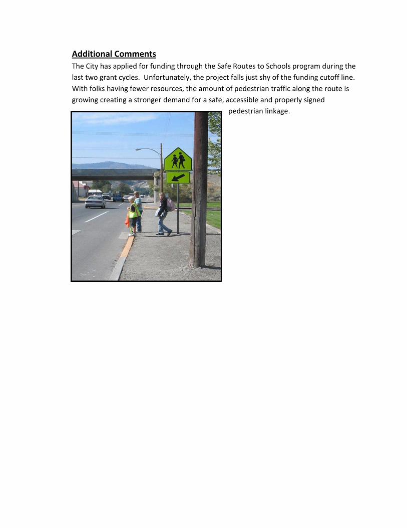
Additional Comments The City has applied for funding through the Safe Routes to Schools program during the last two grant cycles. Unfortunately, the project falls just shy of the funding cutoff line. With folks having fewer resources, the amount of pedestrian traffic along the route is growing creating a stronger demand for a safe, accessible and properly signed
pedestrian linkage.


Peninsula RTPO Four-County Region
Preservation Work: Ten Year Cost Estimates
The Peninsula RTPO Region has prioritized the preservation work of its four counties as an important way to preserve and extend the life of its regional roadway infrastructure. The major items of this preservation work are outlined below. This outline includes the following estimated costs for these preservation work types for the next ten years: Four-County Preservation Ten Year Work Type Areas Cost Estimates Chip seal and Overlay $120,678,500.00 Bridge Preservation Work $76,923,125.00 Culvert Replacement and Improvements $71,852,844.00 Signals & Roundabouts $17,460,656.00 Turn Lanes $16,137,328.00 ____________________________________________________ Total Preservation Costs Estimate $303,052,453.00

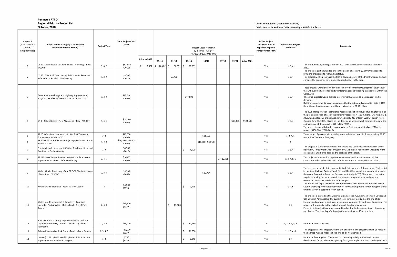
Peninsula RTPO
Regional Priority Project List *Dollars in thousands (Year of cost estimate)
October, 2010 **YOE = Year of Expenditure Dollars assuming a 3% inflation factor
Prior to 200909/11 11/13 13/15 15/17 17/19 19/21 After 2021
1US 101 - Shore Road to Kitchen Road (Widening) - Road -
WSDOT3, 4, 6
$82,886
(2010) $ 3,922 $ 20,482 $ 36,551 $ 21,931 Yes 1, 3, 4
This was funded by the Legislature in 2007 with construction scheduled to start in
2012.
2US 101 Deer Park Overcrossing & Northwest Peninsula
Safety Rest - Road - Clallam County1, 3, 4
$8,700
(2010) $8,700 Yes 1, 3, 4
The project is partially funded and in the design phase with $2,500,000 needed to
bring the project up to full funding status.
This project will help increase the traffic flow and safety of the Deer Park area and will
enhance the economic development opportunities in the area.
3Gorst Area Interchange and Highway Improvement
Program - SR 3/SR16/SR304 - State -Road - WSDOT1, 3, 4
$43,514
(2009)$47,508 Yes 1, 3, 4
These projects were identified in the Bremerton Economic Development Study (BEDS)
that will eventually reconstruct two interchanges and widening state routes within the
Gorst Area.
The initial projects would provide interim improvements to meet current traffic
demands.
If all the improvements were implemented by the estimated completion date (2040)
the estimated planning cost would approximately be $1.11 billion.
4 SR 3 - Belfair Bypass - New Alignment - Road - WSDOT 1, 4, 5 $78,000
(2009) $10,990 $103,599 Yes 1, 3, 4
The 2005 Transportation Partnership Account legislation included funding for work on
the pre-construction phase of the Belfair Bypass project ($15 million). Effective July 1,
2009, funding for this project was deferred until 2019 or later; WSDOT design work
stopped June 30, 2009. Based on the design engineering work conducted to date the
estimate cost of the project is $78 million (2009).
The project is currently funded to complete an Environmental Analysis (EA) of the
project ($750,000) (2010-2012).
5SR 20 Safety Improvements: SR 19 to Port Townsend
Entryway - Road - WSDOT3, 4
$10,000
(2009)$11,500 Yes 1, 3, 4, 6
These series of projects will provide greater safety and mobility for users along SR 20
to the Port Townsend Entryway.
6SR 3 Vicinity of Hood Canal Bridge Improvements - State -
Road - WSDOT1, 2, 4
$10,000 - $27,000
(2009)$10,900 - $30,588 Yes 4
7Construct Underpasses of US 101 at Sherburne Road and
Barr Road - Clallam County 1, 3
$4,500
(2010) $ 4,500 Yes 1, 3, 4
This project is currently unfunded. And would add County road underpasses of the
new WSDOT McDonald Creek Bridges on US 101 at Barr Road on the west side of the
creek and at Sherburne Road on the east side of the creek.
8SR 116: Ness' Corner Intersections & Complete Streets
Improvements - Road - Jefferson County3, 4, 7
$10000
(2009)12,700$ Yes 1, 3, 4, 5, 6
This project of intersection improvements would provide the residents of the
Chimacum and Irondale UGA with safer streets for both pedestrians and bikers.
9Widen SR 3 in the vicinity of the SR 3/SR 304 Interchange
- State -Road -WSDOT1, 3, 4
$9,588
(2009)$10,764 Yes 1, 3, 4
This area has been identified as a mobility deficiency and a Bottleneck and Chokepoint
in the State Highway System Plan (HSP) and identified as an improvement strategy in
the recent Bremerton Economic Development Study (BEDS). This project is an initial
step in improving this location with the eventual long-term solution being the
reconstruction of the SR3/SR 304 interchange.
10 Newkirk-Old Belfair-SR3 - Road - Mason County 4$6,500
(2010) $ 7,475 Yes 1, 4, 6
The project will begin to develop a comprehensive road network in northern Mason
County that will provide alternative routes for travelers potentially reducing the travel
time for travelers passing through Belfair.
11
Waterfront Development & Coho Ferry Terminal
Upgrade - Port Angeles - Multi-Modal - City of Port
Angeles
2, 5, 7$13,500
(2010) $ 13,500
Yes 1, 4
The project is located on the waterfront on Railroad Ave. between Lincoln Street and
Oak Street in Port Angeles. The current ferry terminal facility is at the end of its
lifespan, and requires a significant structural, environmental and security upgrade. The
project will also assist in the revitalization of the downtown area.
Presently this project has some secured funding for the beginning stages of planning
and design. The planning of this project is approximately 25% complete.
12
Port Townsend Gateway Improvements: SR 20 from
Logan Street to Ferry Terminal - Road - City of Port
Townsend
2, 5, 7 $15,000 $ 17,250 Yes 1, 2, 3, 4, 5, 6 Located in Port Townsend
13 Railroad-Shelton Matlock Brady - Road - Mason County 1, 3, 4, 5$19,000
(2010) $ 21,850 Yes 1, 2, 3, 4, 6
This project is a joint project with the city of Shelton. The project will turn 28 miles of
the Railroad Avenue-Matlock Road into an all weather road.
14Lincoln (US 101)/Lauridsen Blvd/Laurel St Intersection
Improvements - Road - Port Angeles1, 2
$700
(2010) $ 7,840 Yes 3, 4
Located in Port Angeles. The project is currently partially funded with private
development funds. The City is applying for a grant application with TIB this year 2010
Project #
(in no particular
order,
not prioritized)
Is This Project
Consistent with an
Approved Regional
Transportation Plan?
Policy Goals Project
Addresses Comments
Project Cost Breakdown
By Biennia - YOE $**
(09/11; 11/13; 13/15 etc.)
Project Name, Category & Jurisdiction
(i.e.: road or multi-modal)Project Type
Total Project Cost*
($ Year)
Page 1 of 2 2/4/2011

Peninsula RTPO
Regional Priority Project List *Dollars in thousands (Year of cost estimate)
October, 2010**YOE = Year of Expenditure Dollars assuming a 3% inflation factor
Prior to 200909/1111/1313/1515/1717/1919/21After 2021
Project #
(in no particular
order,
not prioritized)
Is This Project
Consistent with an
Approved Regional
Transportation Plan?
Policy Goals Project
Addresses Comments
Project Cost Breakdown
By Biennia - YOE $**
(09/11; 11/13; 13/15 etc.)
Project Name, Category & Jurisdiction
(i.e.: road or multi-modal)Project Type
Total Project Cost*
($ Year)
15Howard Street Extension & Discovery Road Improvement
- Road - Jefferson County1, 2, 4, 5$10,000 $ 11,500 Yes1, 2, 3, 4, 5, 6
This project would benefit both residents and tourists to Port Townsend by offering
them a second route into Port Townsend and by alleviating congestion on SR 20
16Cloquallum-Lake Blvd - Road - Mason County1, 2$5,000
(2010) $ 5,075 Yes 2, 3, 4, 6
This project is a joint project with the city of Shelton. The project will turn the Lake
Blvd-Cloquallum Road into an all weather road.
17Lauridsen Blvd Bridge Widening s - Road - Port Angeles2, 4$5,000
(2010) $ 5,000
Yes1, 4
This project is unfunded. Located in Port Angeles. Currently trucks must go through
the downtown to access the waterfront and industrial area and travel from east to
west ends of Port Angeles. Widening the bridge would provide another alternative for
trucks and buses
18Elwha Valley Road Project Phase 4 Lower Elwha Tribe/
Clallam County - Road 2
$1, 800
(2010) $ 1,800 Yes1, 3, 4
Located in Clallam County - Tribal led project and priority to be owned and operated
by Clallam County. Construction began in
2009 with Phase 1 and 2 which are now complete. Phase3 has secured $1.3 M in PLHD
funding for 2011 construction.
19US 101/Simdars Road Interchange - Road - WSDOT4, 6 $5,500
(2007) $ 1,995 $ 5,560 Yes1
This project would complete the existing half diamond interchange to provide a full
diamond interchange on the eastside of the City of Sequim
20
SR 19/ Rhody Drive Intersections & Complete Streets
Improvements; Safety Improvements from Four Corners
Road to SR 20 - road - Jefferson County
3,4,6,7 $15,000
(2009) $19,050yes 1,3,4,5,6
Intersection treatments: Chimacum Crossroads (Center & Chimacum Roads), Irondale
Road, Prospect Avenue. Sidewalks, separated paths, bike lanes, access management on
Rhody Drive. Channelization from Airport Road to SR 20.
Page 2 of 22/4/2011

Peninsula RTPO REGIONAL PRIORITY PROJECT LIST Submittal to Washington State Transportation Commission NARRATIVE PROJECT INFORMATION October 2010 Project Number (1.)
Project Name US 101 - Shore Rd. to Kitchen-Dick Rd. - Widening
Project Description • What is it?
This Rural Mobility project will widen US 101 from milepost (MP) 256.91 to MP 260.38 by constructing two new general purpose lanes separated by a 40 ft. median. The new lanes will be constructed to the south of the existing highway from west of Shore Road (MP 256.91) to east of the Dryke/Pierson intersection (MP 259.5). The new lanes then switch over to the north side of the highway all the way to the end of the project east of Kitchen-Dick Road (MP 260.38). The project also includes a new bridge over McDonald Creek that will be constructed upstream (south) of the existing bridge, and the existing bridge will be replaced with a longer and wider bridge. A shared-use path for pedestrians will be constructed underneath the two new bridges on the west side of McDonald Creek.
• Where is it located? The project is located in Clallam County between the cities of Port Angeles and Sequim along US 101 between Shore Road and Kitchen-Dick Road (MP 256.91 to MP 260.38)
• What is the intended outcome & benefit? The purpose of the proposed action is to increase traffic capacity; decrease the levels of congestion; improve the safety of this section of US 101 and meet the projected traffic demand. The end result is a continuous four-lane divided highway between Sequim and Port Angeles. The new four-lane roadway will have two lanes in each direction and a wide median. The benefits expected are:

o Congestion relief. Additional lanes reduce traffic congestion and move more vehicles.
o Increased safety. Wide median reduces the potential for head-on collisions. County road intersections improved to meet current highway safety standards. Left turns limited to county road intersections.
Project Status & Timeline • Where is the project at in development?
The project is currently funded and is early in the design/preliminary engineering phase. Construction is scheduled to start in summer 2012.
• What is the timeline for this project from start to completion? Preliminary engineering and right of way will be conducted in 2010-2012 with construction commencing in 2012 with completion in approximately 2014.
Additional Comments

Peninsula RTPO REGIONAL PRIORITY PROJECT LIST Submittal to Washington State Transportation Commission NARRATIVE PROJECT INFORMATION October 2010
Project Number (2.) Project Name US 101 and Deer Park Overcrossing and Northwest Peninsula Safety Rest Area:
Project Description
• What is it? This project would enhance access to the Deer Park Scenic Gateway Center and associated neighborhood highway access would be enhanced and made safer through the concurrent development of the Deer Park Overpass. The Deer Park Overpass will connect Deer Park Road with Buchanan Drive by means of new roadway and a US 101 underpass. This new facility will provide bi-directional access to the Gateway Center from US 101 and allow Deer Park Road and Buchanan Drive to become right in-right out intersections eliminating the dangerous left turn movements from these intersections. This traffic improvement will return these intersections to an acceptable level of service. A new acceleration lane will be constructed westbound from the Buchanan Drive-US 101 intersection to allow for the safe merging of westbound traffic from Buchanan Drive onto US 101. Pedestrian, bicyclist and transit rider safety will be greatly enhanced with a traffic separated pathway provided on the overpass. The existing Deer Park Scenic Gateway Center would be improved by providing 6 vault toilet stalls, car parking would be upgraded to 40 parking spaces, parking for large RVs/Trucks would be doubled to provide a total of 6 parking spaces, a drinking fountain would be provided, landscaping would be enhanced, and the existing interpretive panel display would be upgraded with new interpretive panels. These improvements would upgrade the site to full state Safety Rest Stop standards and would be the only safety rest area located on the North Olympic Peninsula.

• Where is it located? This project is located in Clallam County East of Port Angeles at Deer Park and US 101 (MP 253.10).
• What is the intended outcome & benefit? The Sherburne Road and Barr Road Underpasses project is intended to improve transportation system linkage and capacity to these county road intersections with US 101 and make safe bidirectional transit, traffic and non-motorized connections possible at these two intersections which serve large population bases north and south of US 101. The benefits expected are:
o Economic Vitality: The Deer Park Overcrossing and Northwest Peninsula Safety Rest Area Improvements would promote and develop a transportation system that stimulates, supports and enhances the movement of people and goods to ensure a prosperous economy on the most heavily trafficked state highway in Clallam County. Previous studies of the impact of this project on the commercial development of the commercial zones on each side of US 101 at Deer park show this project aiding in the creation of more than 100 new jobs at this key commercial development location in Clallam County.
o Preservation: The Deer Park Overcrossing and Northwest Peninsula Safety Rest Area Project maintains, preserves and extends the life and utility of prior investments in transportation systems and services spent to maintain mobility on US 101 and Deer Park Road, a County Rural Minor Collector with high traffic volumes.
o Safety: The Deer Park Overcrossing and Northwest Peninsula Safety Rest Area Project provides for and improves the safety and security of transportation customers and the transportation system by correcting all of the hazardous traffic problems experienced at this high accident location on US 101. Provides only Safety Rest Area located on the North Olympic Peninsula, which would provide the facilities necessary to reduce vehicle accidents resulting from driver fatigue.
o Mobility: The Deer Park Overcrossing and Northwest Peninsula Safety Rest Area Project improves the predictable movement of goods and people throughout Clallam County in Washington State. Notable improvement to Clallam County Transit in terms of bidirectional transit rider access and safety result from implementation of this project. The mobility of the Deer Park intersection which is projected to reach over 6,000 trips per day in 2030 will be maintained with minimal impact to mobility of the 30,000 trips per day experienced on US 101 in 2030 at this location with implementation of this project.

Project Status & Timeline
• Where is the project at in development? The project is partially funded and in the design phase; right of way plans and estimate along with the Plan for Approval has been submitted to WSDOT. The project is entering the right of way acquisition phase. Total project cost is $8,700,000 with $2,500,000 needed from the legislature to bring the project up to full funding status. Right of way and design is estimated at $2,200,000 Construction is estimated at $6,500,000
• What is the timeline for this project from start to completion? If the unfunded portion of this project ($2,500,000) were funded during the 2011-2013 biennium it is anticipated that the design and right of way phases could be completed in 2011 with construction commencing around 2011 with completion anticipated by 2013.
Additional Comments

Peninsula RTPO REGIONAL PRIORITY PROJECT LIST Submittal to Washington State Transportation Commission NARRATIVE PROJECT INFORMATION October 2010
Project Name & Number (3.) SR 3/SR 16 – Gorst Area Interchange and Highway Improvement Program
Project Description
• What is it? The Bremerton Economic Development Study (BEDS) recommended a series of strategies (projects) that would be phased over a period of time to improve the SR 3, SR16, and SR 304 corridors within the Gorst area. As a whole these strategies include interchange reconstruction of two interchanges (SR 3/SR 16 and SR 3/SR 304) and lane widening efforts along SR 3 and SR 16 between Gorst at the head of the Sinclair inlet to Bremerton and between Gorst to the Mason County line. These strategies would provide added capacity and improve mobility and safety along these corridors.
The Gorst area is the intersection of two major state routes in Kitsap County that connects Kitsap to Mason County (SR 3) and Pierce County (SR 16). The SR 3 and SR 304 corridors in this area provide access to a major military facility (Bremerton Naval Shipyard) in the area. The area experiences major congestion issues that impacts mobility and economic development within the area.
The first projects to be implemented would provide interim improvements to meet current traffic demands and would consist of:
o Intersection improvements and re-channelization at the SR 3/Sam Christopherson Road Intersection, add one through lane in each direction on SR 3 approaches, add new turn lanes ($27 million).
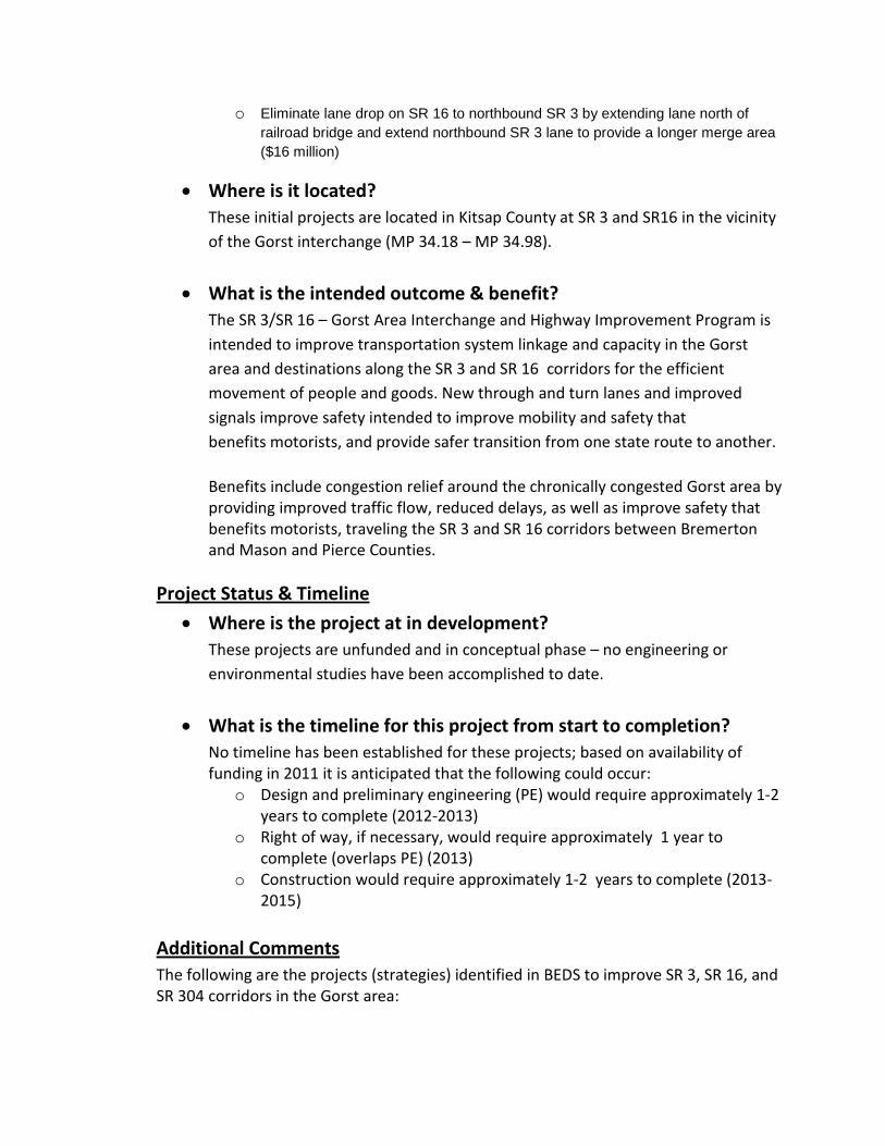
o Eliminate lane drop on SR 16 to northbound SR 3 by extending lane north of railroad bridge and extend northbound SR 3 lane to provide a longer merge area ($16 million)
• Where is it located? These initial projects are located in Kitsap County at SR 3 and SR16 in the vicinity of the Gorst interchange (MP 34.18 – MP 34.98).
• What is the intended outcome & benefit? The SR 3/SR 16 – Gorst Area Interchange and Highway Improvement Program is intended to improve transportation system linkage and capacity in the Gorst area and destinations along the SR 3 and SR 16 corridors for the efficient movement of people and goods. New through and turn lanes and improved signals improve safety intended to improve mobility and safety that benefits motorists, and provide safer transition from one state route to another.
Benefits include congestion relief around the chronically congested Gorst area by providing improved traffic flow, reduced delays, as well as improve safety that benefits motorists, traveling the SR 3 and SR 16 corridors between Bremerton and Mason and Pierce Counties.
Project Status & Timeline
• Where is the project at in development? These projects are unfunded and in conceptual phase – no engineering or environmental studies have been accomplished to date.
• What is the timeline for this project from start to completion? No timeline has been established for these projects; based on availability of funding in 2011 it is anticipated that the following could occur:
o Design and preliminary engineering (PE) would require approximately 1-2 years to complete (2012-2013)
o Right of way, if necessary, would require approximately 1 year to complete (overlaps PE) (2013)
o Construction would require approximately 1-2 years to complete (2013-2015)
Additional Comments The following are the projects (strategies) identified in BEDS to improve SR 3, SR 16, and SR 304 corridors in the Gorst area:

Solution Title/Description of Potential Improvement Option
2009 Planning Estimate Cost
(thousand dollars)
Estimated Completion
Date
Year of Expenditure
(thousand dollars) SR 3/Sam Christopherson Road Intersection - Intersection improvements and re-channelization: In additional, add one through lane in each direction on SR 3 approaches, add a double left turn and a separate right turn from SR 16 Spur to SR 3 (MP 34.26 - MP 34.26)
$26,551 2015 $28,988
SR 3 Widening – Eliminate lane drop on SR 16 to northbound SR 3 by extending lane north of railroad bridge and extend northbound SR 3 lane for longer merge area
$16,963 2015 $18,520
SR 3/SR 16 Interchange - Construct a new interchange to include grade separating the SR 3/Sam Christophrson Road intersection and widen SR 16 Spur (MP 34.26 – MP 34.67)
$194,486 2035 $272,436
SR 3/SR 304 Interchange - Reconstruct interchange (MP 36.59 – MP 36.60)
$48.479 2035 $67,909
SR 3 Widening – Between the SR 3/SR 16 interchange to the SR 3/SR 304 interchange; widen to six-lanes adding a HOV lane in each direction. (MP 34.26 - MP 36.59)
$242,943 2040 $362,836
SR 3 Widening - Widen to six-lane (creating one HOV lane in each direction) from vicinity SR 3/SR 304 interchange to Loxie Eagan Blvd; ITS improvements (MP 34.18-MP 37.86)
26,885 2040 $40,153
SR 3 Widening – Between SR 3 Kistap/Mason County Line to Imperial Way; widen to four-lanes (MP 28.23 – 30.51)
$133,000 2040 $198,636
SR 3 Widening – Between Imperial Way to SR 16 (Gorst); widen to four-lanes (MP 30.51 – MP 34.18)
$82,000 2040 $122,467
If all the improvements were implemented they would cost an estimated $1.11 billion. There continues to be interest in pursuing a Sinclair Inlet Bridge option in the Gorst Area that could supersede some of the longer term improvements in the Gorst area.
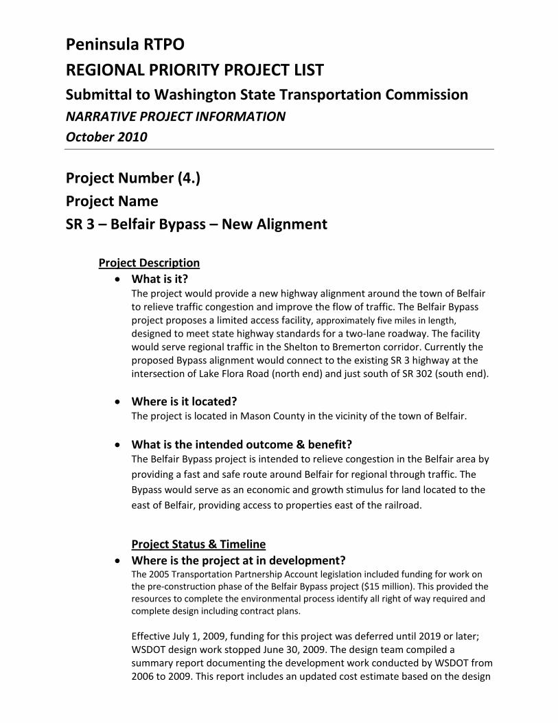
Peninsula RTPO REGIONAL PRIORITY PROJECT LIST Submittal to Washington State Transportation Commission NARRATIVE PROJECT INFORMATION October 2010
Project Number (4.) Project Name SR 3 – Belfair Bypass – New Alignment
Project Description • What is it?
The project would provide a new highway alignment around the town of Belfair to relieve traffic congestion and improve the flow of traffic. The Belfair Bypass project proposes a limited access facility, approximately five miles in length, designed to meet state highway standards for a two-lane roadway. The facility would serve regional traffic in the Shelton to Bremerton corridor. Currently the proposed Bypass alignment would connect to the existing SR 3 highway at the intersection of Lake Flora Road (north end) and just south of SR 302 (south end).
• Where is it located?
The project is located in Mason County in the vicinity of the town of Belfair.
• What is the intended outcome & benefit? The Belfair Bypass project is intended to relieve congestion in the Belfair area by providing a fast and safe route around Belfair for regional through traffic. The Bypass would serve as an economic and growth stimulus for land located to the east of Belfair, providing access to properties east of the railroad.
Project Status & Timeline
• Where is the project at in development? The 2005 Transportation Partnership Account legislation included funding for work on the pre-construction phase of the Belfair Bypass project ($15 million). This provided the resources to complete the environmental process identify all right of way required and complete design including contract plans. Effective July 1, 2009, funding for this project was deferred until 2019 or later; WSDOT design work stopped June 30, 2009. The design team compiled a summary report documenting the development work conducted by WSDOT from 2006 to 2009. This report includes an updated cost estimate based on the design
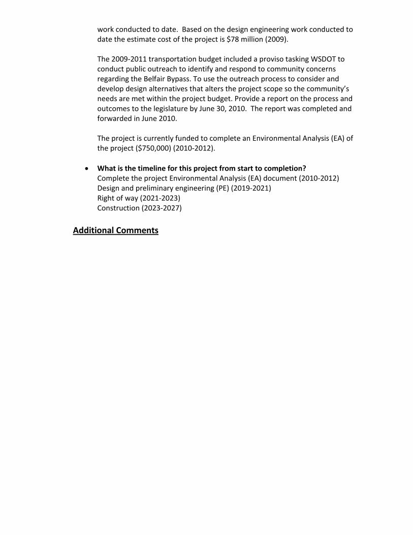
work conducted to date. Based on the design engineering work conducted to date the estimate cost of the project is $78 million (2009). The 2009-2011 transportation budget included a proviso tasking WSDOT to conduct public outreach to identify and respond to community concerns regarding the Belfair Bypass. To use the outreach process to consider and develop design alternatives that alters the project scope so the community’s needs are met within the project budget. Provide a report on the process and outcomes to the legislature by June 30, 2010. The report was completed and forwarded in June 2010. The project is currently funded to complete an Environmental Analysis (EA) of the project ($750,000) (2010-2012).
• What is the timeline for this project from start to completion? Complete the project Environmental Analysis (EA) document (2010-2012) Design and preliminary engineering (PE) (2019-2021) Right of way (2021-2023) Construction (2023-2027)
Additional Comments
Peninsula RTPO
REGIONAL PRIORITY PROJECT LIST Submittal to Washington State Transportation Commission NARRATIVE PROJECT INFORMATION October 2010
Project Number (5.) Project Name
SR 20 Safety Improvements: SR 19 to Port Townsend Entryway
Project Description
• What is it? This project involves intersection consolidation for the Port Townsend Entryway, as well as access management improvement for a two-mile stretch of highway, including intersection treatment for the main entrance to Glen Cove industrial park. The intersections of SR 20 with South Jacob Miller Road, Discovery Road, Mill Road and Seton Road at the edge of the city limits of the City of Port Townsend will be reconstructed and improved.
Mill Road is the turn-off to Port Townsend Paper Mill, where all of the trucks with chips and materials for the Mill turn. Discovery Road is the alternative road into Port Townsend; diverting more traffic to Discovery Road will reduce traffic volumes on SR 20 through Port Townsend. In addition, Discovery Road and South Jacob Miller Road are principal connections to unincorporated Jefferson County. The project involves reconfiguring how these roads intersect and constructing improvements that address traffic flow and safety. Finally, access to the Glen Cove industrial park on SR 20 near the city limits will be improved, resulting in overall safety benefits for the
stretch of SR 20 from the junction with SR 19 to the City of Port Townsend.
• Where is it located? This project is located at the entryway to the City of Port Townsend, stretching 2.02 miles along SR 20 from the junction with SR 19 at milepost 7.79 to the intersection with Discovery and Mill Roads at milepost 9.81. The WSDOT SR 19/SR 20 Corridor Plan identifies this segment to be among the most congested in the area.
• What is the intended outcome & benefit? The purpose of this project is to improve intersection operations and safety at these intersections. It has been identified as a priority in the WSDOT SR 19/SR 20 Corridor Plan. The intersections are heavily congested due to the traffic going to work in the downtown area and to various schools, leaving town after getting off the Coupeville Ferry, and accessing the Glen Cove light industrial park outside of the city. This project would relieve traffic congestion, provide safety improvement to these intersections, and reduce the frequency and severity of crashes. It is vital for economic development in the City of Port Townsend and surrounding industrial areas. The project addresses the following statutory policy goals of Washington State: economic vitality, safety, mobility, stewardship.
Project Status & Timeline
• Where is the project at in development? This project is unfunded. At this time, there have only been preliminary discussions on the project concepts, options and timeline. Design and construction should occur within the next five to ten years.
Peninsula RTPO REGIONAL PRIORITY PROJECT LIST Submittal to Washington State Transportation Commission NARRATIVE PROJECT INFORMATION October 2010
Project Number (6.) Project Name SR 3 Vicinity of Hood Canal Bridge Improvements
Project Description
• What is it? High traffic volumes and Hood Canal Bridge openings for marine traffic generate backups and congestion. Average opening time is just under 30 minutes, but initial backups can extend over one mile in length on SR 3. During bridge openings, the westbound traffic on SR 104 backs up on SR 3 blocking northbound traffic and homeowners along SR 3. This area has been identified as a mobility deficiency and a Bottleneck and Chokepoint in the state Highway System Plan (HSP). Currently two improvement strategies have been identified as potential solutions;
o Add a northbound (NB) truck/climbing lane/Hood Canal holding lane NB between Big Valley and the SR 3/SR 104 intersection.
o Construct flyover jug handle with holding area in the vicinity of the Hood Canal Bridge.
Though either improvement could avoid traffic backups and maintain traffic flow on SR 3, both projects have operational challenges that require resolving before either can proceed forward. An operational feasibility study is needed to mitigate the operational challenges and determine which solution is appropriate.
• Where is it located? These projects are located in Kitsap County on SR 3 between Big Valley Road and the SR 3/SR 104 intersection in the vicinity of the Hood Canal Bridge (MP 57.09 – MP 60.02).

• What is the intended outcome & benefit? This project will reduce the impacts to northbound traffic and homeowners along this section of SR 3 while enhancing motorist safety and improving traffic operation. Environmentally, air quality is expected to be enhanced since fewer vehicles wait in holding queues, northbound vehicles bound for Kingston Ferry terminal will not be impeded by bridge openings.
Project Status & Timeline
• Where is the project at in development? Both projects are unfunded and in the conceptual stage and have not been scoped – an operational feasibility study is needed to address operational issues associated with each improvement.
• What is the timeline for this project from start to completion? No timeline has been established for these projects; depending on the improvement implemented and based on availability of funding in 2011 it is anticipated that the following could occur:
o Operational feasibility study would require 12-18 months. (2011-2012) o Design and preliminary engineering (PE) would require approximately 1-2
years to complete (2012-2014) o Right of way, if necessary, would require approximately 1-2 years to
complete (overlaps PE) (2014) o Construction would require approximately 1-2 years to complete (2014-
2016)
Additional Comments

Peninsula RTPO REGIONAL PRIORITY PROJECT LIST Submittal to Washington State Transportation Commission NARRATIVE PROJECT INFORMATION October 2010
Project Number (7.) Project Name Sherburne Road and Barr Road Underpasses of US 101 at the New McDonald Creek Bridges:
Project Description
• What is it? This project would add County road underpasses of the new WSDOT McDonald Creek Bridges on US 101 at Barr Road on the west side of the creek and at Sherburne Road on the east side of the creek. County would construct County road underpasses of the new state bridges at McDonald Creek on US 101 to restore the full range of traffic movements (left turn and through traffic movements) that existed prior to implementation of WSDOT’s widening project to four lane on US 101 between Shore and Kitchen-Dick Road to these County road intersections. This project would restore left turn and through traffic movements at these county road intersections where these movements were allowed prior to WSDOT’s 2012 project to four lane US 101 between Shore and Kitchen-Dick Road. The project also would make safe bidirectional transit, traffic and non-motorized connections possible adding traffic and bicycle safe shoulders to the county roads.
• Where is it located?

This project is located in Clallam County at Barr Road and US 101 (MP 258.12) and at Sherburne Road at US 101 (MP 258.31).
• What is the intended outcome & benefit? The Sherburne Road and Barr Road Underpasses project is intended to improve transportation system linkage and capacity to these county road intersections with US 101 and make safe bidirectional transit, traffic and non-motorized connections possible at these two intersections which serve large population bases north and south of US 101. The benefits expected are:
o Economic Vitality: Restoration of traffic movements at these two County road intersections would promote and develop a transportation system that stimulates, supports, and enhances the movement of people and goods to ensure a prosperous economy on the most heavily trafficked road under County jurisdiction.
o Preservation: Restoration of traffic movements at these two County road intersections maintains, preserves and extends the life and utility of prior investments in transportation systems and services spent to maintain mobility on US 101 and Old Olympic Highway, a County Rural Minor Collector with high traffic volumes.
o Safety: Restoration of traffic movements at these two County road intersections provides for and improves the safety and security of transportation customers and the transportation system by adding traffic and bicycle safe shoulders to the County’s main Rural Minor Collector road.
o Mobility: Restoration of traffic movements at these two County road intersections improves the predictable movement of goods and people throughout Clallam County in Washington State.
Project Status & Timeline
• Where is the project at in development? The project is unfunded and in conceptual design phase. Total project cost is $4,500,000 with right of way and design done at a cost of $1,800,000, and construction estimated at $2,700,000.

• What is the timeline for this project from start to completion? If the were funded during the 2011-2013 biennium it is anticipated that the design-preliminary engineering and right of way phases could be conducted during 2011-2013 with construction commencing around 2013 with completion in concert with WSDOT’s widening project on US 101 between Shore and Kitchen-Dick Road
Additional Comments
Peninsula RTPO
REGIONAL PRIORITY PROJECT LIST Submittal to Washington State Transportation Commission NARRATIVE PROJECT INFORMATION October 2010
Project Name & Number (8.)
SR 116: Ness' Corner Intersections & Complete Streets Improvements
Project Description
• What is it? This project involves intersection treatments along SR 116 from the intersection with SR 19 to the Hadlock Crossroads, the intersection with Chimacum and Irondale Roads. The project involves intersection control, access management, safety treatments, and pedestrian and bicycle facilities for the identified 1.12-mile segment, which includes a primary school and the Jefferson County Library. This project is integrated with local land use planning in that it is an essential transportation component of the development vision for the Irondale & Port Hadlock Urban Growth Area (UGA).
• Where is it located? The project is located along SR 116, known locally as Ness’ Corner Road, from the intersection with SR 19 at milepost 0.00 to the Port Hadlock Crossroads at milepost 1.12, which is the four-way intersection with Chimacum and Irondale Roads in the heart of Port Hadlock. This segment of SR 116 is the main east-west transportation corridor of the Irondale & Port Hadlock UGA, and is the principal connection to the Indian Island Naval Magazine and Fort Flagler State Park on Marrowstone Island.

• What is the intended outcome & benefit? The project will meet UGA transportation, economic development and livability needs identified in local and State transportation studies and plans. The intersection of SR 116 with SR 19 has been identified as a top priority in the WSDOT SR 19/SR 20 Corridor Plan. The SR 116 corridor is a top priority in the local Quimper Peninsula Transportation Study. The intended outcome is an urban transportation corridor that meets the needs of all users, reduces traffic congestion, creates walkability, improves safety, and promotes economic development in Jefferson County’s lone unincorporated UGA. The project addresses the following statutory policy goals of Washington State: economic vitality, safety, mobility, environment, stewardship.
Project Status & Timeline
• Where is the project at in development? This project is unfunded. At this time, there have only been preliminary discussions on the project concepts, options and timeline. Design and construction should occur within the next five to ten years.

Peninsula RTPO REGIONAL PRIORITY PROJECT LIST Submittal to Washington State Transportation Commission NARRATIVE PROJECT INFORMATION October 2010
Project Number (9.)
Project Name Widen southbound SR 3 under SR 304 ramp overcrossing, and extend SR 304 on-ramp to southbound SR 3 (vicinity MP 36.34 to MP 36.72).
Project Description
• What is it? Widen southbound SR 3 undercrossing of the westbound SR 304 on-ramp; extend the SR 304 on-ramp to southbound SR 3 (vicinity MP 36.34 to MP 36.72) and ramp meter westbound SR 304 onto SR 3. The southbound lanes of SR 3 narrow from two to one lane under an undercrossing structure of the SR 304 interchange. This southbound lane reduction at the SR 3/SR 304 Interchange causes large backups. This area has been identified as a mobility deficiency and a Bottleneck and Chokepoint in the State Highway System Plan (HSP) and has been identified as an improvement strategy in the Bremerton Economic Development Study (BEDS). This project is an initial step in improving this location with the eventual long-term solution being the reconstruction of the SR3/SR 304 interchange.
• Where is it located? This project is located in Kitsap County on SR 3 in the vicinity of the SR 3/SR 304 (MP 36.35 – MP 36.72).

What is the intended outcome & benefit? The expected benefits from the addition of a southbound lane on SR 3 will be congestion relief on SR 3 while enhancing motorist safety and improving traffic operations and provides a safer transition from one state route to another.
Project Status & Timeline
• Where is the project at in development? This project is unfunded and is in the conceptual stage and has not been scoped.
• What is the timeline for this project from start to completion? • No timeline has been established for this project; it anticipated that based on availability
of funding in 2011 that the following could occur: o Design and preliminary engineering (PE) would require approximately 1-2
years to complete (2012-2014) o Right of way, if necessary, would require approximately 1 year to
complete (overlaps PE) (2014) o Construction would require approximately 1-2 years to complete (2014-
2016)
Additional Comments

Peninsula RTPO REGIONAL PRIORITY PROJECT LIST Submittal to Washington State Transportation Commission NARRATIVE PROJECT INFORMATION October 2010 Project Number (10.)
Project Name
Newkirk –Old Belfair –SR3 Connection
Project Description
• What is it?
The project will provide a vital link between SR3 and Old Belfair Highway. The project is within the Belfair UGA boundaries and as such will comply with UGA standards. The route utilizes Newkirk Road and the existing railroad crossing easement in Section 21, Township 23 North, Range 1 West, W.M., and then to SR 3. The connection will in part alleviate some of the Belfair traffic congestion by allowing traffic going to or coming from Old Belfair Highway to bypass the Belfair “downtown” corridor on their way to or from Kitsap County.
This project will require that Newkirk Road be widened to 2 – 12’ wide paved lanes with 2 – 8’ shoulders. Adequate drainage will be needed, and the needed right-of-way dedicated to the County. In addition, the connection would also use the current Railroad crossing at Katchemak Lane. Upgrading that crossing to meet WUTC standards would probably be less expensive than establishing a new crossing
• Where is it located? The project is within the Belfair UGA boundaries and as such will comply with UGA standards.
What is the intended benefit?
The project will begin to develop a comprehensive road network in northern Mason County that will provide alternative routes for the citizens of Mason and Kitsap County and potentially reduce the travel time for travelers passing through Belfair.
Project Status & Timeline
• Where is the project at in development?
Over the years, Mason County in concert with WSDOT has developed several scenarios regarding a Belfair bypass project to alleviate the Belfair traffic concerns. Although both the county and WSDOT have recognized the importance and value of such an endeavor, the critical issue has always been funding.
Funding this project now, is a step in the right direction that will address the Belfair traffic issue in a positive proactive manner that will benefit the Belfair UGA, Mason County, WSDOT and the travelling public.
• What is the timeline for this project from start to completion? Design: 2012
ROW Acquisition: 2013
Construction: 2013-2015
Additional Comments
Peninsula RTPO REGIONAL PRIORITY PROJECT LIST Submittal to Washington State Transportation Commission NARRATIVE PROJECT INFORMATION October 2010
Project Number (11.) Project Name Waterfront Development & Coho Ferry Terminal Upgrade – Port Angeles -
Project Description
• What is it? This project involves structural improvements and or replacements of the west pier and bulkhead, the east pier and the docking and vehicle loading structures. The project also involves enhancement to the terminal including a new terminal build and streetscape. Included in the project is pedestrian/bicycle facilities, lighting, landscaping and improved public access to the waterfront. Besides the COHO Ferry, the terminal supports a passenger only ferry to and from Victoria, B.C.
• Where is it located? The project is located in Port Angeles on the waterfront along Railroad Ave. between Lincoln Street and Oak Street.
• What is the intended outcome & benefit? The current ferry terminal facility is at the end of its lifespan, and requires a significant structural, environmental and security upgrade to ensure the continued safe and efficient transport of people and goods. The project will improve access to the waterfront and assist in the revitalization of the downtown area. The project would benefit travel between Port Angeles and Victoria, B.C. and better assist the Customs Personnel and Border Patrol.
Project Status & Timeline
• Where is the project at in development? Presently this project has some secured funding for the beginning stages of planning and design. The planning of this project is approximately 25% complete.

• What is the timeline for this project from start to completion? Planning 2010 – 2011 Design 2011 Construction 2011 - 2012

Peninsula RTPO
REGIONAL PRIORITY PROJECT LIST Submittal to Washington State Transportation Commission NARRATIVE PROJECT INFORMATION October 2010
Project Number (12.) Project Name
Port Townsend Gateway Improvements: SR 20 from Logan Street to Ferry Terminal
Project Description
• What is it Improvements have recently been completed on SR 20 along Upper Sims Way. This project involves extending improvements from where the last project ended at Logan Street to the SR 20 terminus at the Ferry Terminal downtown. This will add sidewalks, intersection improvements, and safety improvements along the entire corridor of the highway the leads to Port Townsend’s Historic District.
• Where is it located? This project is located inside the city limits of the City of Port Townsend, on SR 20 leading to the Ferry Terminal and the National Landmark Historic District
• What is the intended outcome & benefit? This project has been identified as a priority in the WSDOT SR 19/SR 20 Corridor Plan. Intersection modifications and upgrades will improve mobility and corridor capacity; new sidewalks will add missing non-motorized facilities. Overall, the project will improve the safety, flow of traffic, aesthetics and accessibility of the corridor. The project addresses the following statutory policy goals of Washington

State: economic vitality, preservation, safety, mobility, environment, stewardship.
Project Status & Timeline
• Where is the project at in development? This project is unfunded. At this time, there have only been preliminary discussions on the project concepts, options and timeline.

Peninsula RTPO
REGIONAL PRIORITY PROJECT LIST Submittal to Washington State Transportation Commission NARRATIVE PROJECT INFORMATION October 2010
Project Number (13.) Project Name
Railroad Ave-Shelton Matlock Road
Project Description
• What is it This project is a joint project with the city of Shelton. The anticipated road reconstruction will turn 28 miles of the Railroad Ave-Shelton Matlock Road into an all weather road. This road is a major arterial and freight route that connects Shelton with western Mason County and Grays Harbor County. Currently, winter weather conditions create a safety hazard, contribute to an excessive amount of road damage and prevent the unimpeded flow of freight traffic due to road restrictions resulting from freeze- thaw cycles.
• Where is it located? This road reconstruction project spans approximately 28 miles. The reconstruction will start with Railroad Ave in Shelton and continue along Shelton Matlock Road.
• What is the intended benefit? This project will be result in developing a dependable backbone of roads that will be useable by the public in all weather conditions and situations.

Project Status & Timeline
• Where is the project at in development? This project had been advocated before using ARRA funds unfortunately the project was not selected and funding was not made available. Both the county and the city feel that a joint project to address the Railroad Ave-Shelton Matlock Road reconstruction would actually result in cost savings over having two separate and independent projects. Preliminary discussions between Mason County and Shelton regarding project management and administration are underway.
Timelines
Design: 2012
ROW Acquisition: None
Construction: 2013-2015

Peninsula RTPO REGIONAL PRIORITY PROJECT LIST Submittal to Washington State Transportation Commission NARRATIVE PROJECT INFORMATION October 2010
Project Number (14.) Project Name Lincoln/Laurel Rechannelization/Signal/Roundabout
Project Description
• What is it? This project involves the reconstruction and improvement of the intersections of Laurel & US 101 (Lauridsen Blvd) and Lincoln Street & US 101 (Lauridsen Blvd). This project will entail evaluating the installation or removal of, a traffic signal and/or installing roundabouts. These intersections are approximately 500 feet apart. Between these two intersections is a major grocery store (Albertsons) that adds additional congestion. Immediately adjacent to the intersection of Lincoln and US 101 is and elementary school and approximately ¾ of a mile to the east is another elementary school. The regional library is located 3 blocks to the east of the intersection of Lincoln Street and US 101. To the south, approximately 7 blocks, is the Port Angeles High School and directly to the east, approximately 1 mile, is the Community College.
• Where is it located? This project is located within the city limits of Port Angeles at the intersections of Laurel Street and Lincoln Street (US 101) at Lauridsen Blvd.
• What is the intended outcome & benefit?

The purpose of this project is to improve intersection operations and safety at these intersections. These intersections are heavily congested due to the traffic going to work in the downtown area and to the various schools. This project would provide safety for both intersections, relieve the congestion and reduce the severity of accidents. There have been a number of accidents at the intersection of Laurel & US 101, and as the only major route to the west end of the City and the County, causes long backups.
Project Status & Timeline
• Where is the project at in development? The project is currently partially funded with private development money. The City will be applying for a grant application with Transportation Improvement Board (TIB) in the year 2011. At this time, due to the lack of funding, there has only been preliminary discussions on the project only.
• What is the timeline for this project from start to completion? Design 2011-2012 Construction 2013-2014
Additional Comments

Peninsula RTPO REGIONAL PRIORITY PROJECT LIST Submittal to Washington State Transportation Commission NARRATIVE PROJECT INFORMATION October 2010
Project Number (15.) Project Name
Howard Street Extension & Discovery Road Improvement
Project Description
• What is it? This project involves constructing a new road – Howard Street – connecting SR 20 (Sims Way) to Discovery Road, as well as upgrading and improving Discovery Road. Discovery Road is the alternative entrance into Port Townsend; diverting more traffic to Discovery Road will reduce traffic volumes on SR 20 through Port Townsend, thereby addressing future capacity problems on the State highway. The project will connect from the roundabout that was recently constructed on SR 20 to Discovery Road, and will make available for development land that is zoned mixed-use commercial.
• Where is it located? This project is located just inside the city limits of the City of Port Townsend, and connects to one leg of the roundabout on SR 20 that was recently constructed in anticipation of the Howard Street Extension project.
• What is the intended outcome & benefit? SR 20 is projected to see increased backups and delays and reach its level-of-service capacity in the next 10 to 20 years. This project has been identified as a priority in the WSDOT SR 19/SR 20 Corridor Plan.

The expected benefits include diverting some traffic off of SR 20 to extend its life and delay or eliminate the need for capacity improvements on the highway. The extension of Howard Street opens up the last remaining undeveloped mixed-use commercial land in the city. Widening Discovery Road to add bike lanes and sidewalks also improves the safety of the corridor and adds non-motorized facilities where they do not currently exist. The project addresses the following statutory policy goals of Washington State: economic vitality, preservation, safety, mobility, environment, stewardship.
Project Status & Timeline
• Where is the project at in development? This project is unfunded. At this time, there have only been preliminary discussions on the project concepts, options and timeline.

Peninsula RTPO REGIONAL PRIORITY PROJECT LIST Submittal to Washington State Transportation Commission NARRATIVE PROJECT INFORMATION October 2010
Project Number (16.) Project Name Cloquallum - Lake Blvd Road Reconstruction (Phase 1)
Project Description
• What is it? This project is a joint project with the city of Shelton. The anticipated road reconstruction or ACP Overlay will turn the Lake Blvd – Cloquallum Road into an all weather road. This road is a major arterial and freight route that connects Shelton with the southwest area of the county as well as Grays Harbor County. Currently, winter weather conditions create a safety hazard, contribute to an excessive amount of road damage and prevent the unimpeded flow of freight traffic due to road restrictions resulting from freeze- thaw cycles.
The project will provide an all weather upgrade to an arterial which is subject to heavy truck traffic to and from Shelton. Emphasis is on preserving a vital transportation link to Shelton that will support the safe movement of goods during inclement weather.
This project does not require the additional acquisition of ROW. However the project will be reviewed for adequate drainage.
• Where is it located?

This road reconstruction project spans approximately 9.56 miles. The reconstruction will start with Lake Blvd. near Pioneer Way and continue along Cloquallum Road.
• What is the intended benefit? This project will be result in developing a dependable backbone of roads that will be useable by the public in all weather conditions and situations
Project Status & Timeline
Although this project has been advocated before, independent funding by Mason County and Shelton has been unobtainable. Both the county and the city feel that a joint project to address the Cloquallum – Lake Blvd reconstruction would actually result in cost savings over having two separate and independent projects. Preliminary discussions between Mason County and Shelton regarding project management and administration are underway.
Project Timeline
Design: 2012
ROW Acquisition: None
Construction: 2013-2015

• What is the timeline for this project from start to completion? If the unfunded portion of this project ($2,500,000) were funded during the 2011-2013 biennium it is anticipated that the design and right of way phases could be completed in 2011 with construction commencing around 2011 with completion anticipated by 2013.
Additional Comments


Peninsula RTPO REGIONAL PRIORITY PROJECT LIST Submittal to Washington State Transportation Commission NARRATIVE PROJECT INFORMATION October 2010
Project Number (17.) Project Name Lauridsen Blvd Bridge Widening
Project Description
• What is it? This project involves replacement and widening of the current structurally deficient bridge to allow the use of the bridge by trucks and buses. Currently trucks must go through the downtown to access the waterfront, Nippon Paper Mill as well as other heavy industries and the Port of Port Angeles facilities traveling from east to west ends of Port Angeles. Widening the bridge would allow its use by trucks and buses. This would accommodate and alternate route to US 101 to access the waterfront, and provide a by-pass to help eliminate the trucks passing through the downtown area.
• Where is it located? Lauridsen Blvd at Race Street in Port Angeles
• What is the intended outcome & benefit? The purpose of this project is to replace and widen an existing two lane bridge that is structurally deficient. This project would provide a by-pass to eliminate the trucks passing through the downtown area, relieve the congestion and make the downtown area more pedestrian friendly. The project would also provide for a by-pass route for motorist passing through the City of Port Angeles.

Project Status & Timeline
• Where is the project at in development? Grant application has been submitted in spring 2010 and is waiting to hear from the funding agency. As of today there has been no secured funding therefore 10% planning is completed.
• What is the timeline for this project from start to completion? o If funded Preliminary Engineering would begin in February, 2011, as well
as permitting, and be completed in May, 2012. o The construction could start in July, 2012 and be completed the end of
2013.
Additional Comments
Peninsula RTPO
REGIONAL PRIORITY PROJECT LIST Submittal to Washington State Transportation Commission NARRATIVE PROJECT INFORMATION October 2010
Project Number (18.) Project Name Elwha Valley Road project Phase 4 – Lower Elwha Tribe/Clallam County Road
Project Description
• What is it? The project will complete the final phase of a 2.3 mile $9.3 million project connecting Elwha Valley to the adjacent uplands. Phase 4 will reconstruct portions of the Milwaukee Railroad right of way as a public road and help preserve current rural character and infrastructure of Lower Elwha by reducing traffic.
• Where is it located? The project will complete the final phase of a 2.3 mile $9.3 million project connecting Elwha Valley to the adjacent uplands.
• What is the intended benefit? This project will provide the tribe with an all-weather road that will permit access into the tribe and act as an emergency exit for the tribe to exit the area from natural disasters. The project will also reduce general emergency response time to and from the tribe.

The road project will be built to standards so it will last longer than the existing road has. The project will also have pedestrian and bikers access from valley to the Olympic Discovery Trail.
Project Status & Timeline
• Where is the project at in development? The road project is shovel ready. The NEPA paper work is complete and the right of ways issues resolved. The project requires some coordination with WSDOT on some paper work but is essentially ready for construction.
Project Timeline
Construction 2011

Peninsula RTPO REGIONAL PRIORITY PROJECT LIST Submittal to Washington State Transportation Commission NARRATIVE PROJECT INFORMATION October 2010
Project Number (19.) Project Name US 101/Simdars Road Interchange - Complete Diamond Interchange (MP 266.55 –MP 266.70)
Project Description • What is it?
The US 101 Simdars Road interchange project would add eastbound on-ramp and westbound off-ramp to complete the existing half diamond interchange to provide a full diamond interchange on the eastside of the City of Sequim.
• Where is it located?
The project is located in Clallam County in the City of Sequim (MP 266.55 – MP 266.70).
• What is the intended outcome & benefit? The US 101 Simdars Road interchange project is intended to improve mobility and enhance access to the City of Sequim by improving transportation system linkage with US 101. The project would provide added access to and from the eastside of the City of Sequim and serve as an economic and growth stimulus for land located on that end of the city. The Simdars Road interchange would promote and develop a transportation system that stimulates, supports and enhances the movement of people and goods to ensure a prosperous economy on the most heavily trafficked state highway in Clallam County. Project Status & Timeline
• Where is the project at in development? The project is unfunded and in the planning phase – no engineering, traffic, environmental or economic studies have been accomplished to date.
• What is the timeline for this project from start to completion? No timeline has been established for this project; it anticipated that based on availability of funding that

o Design and preliminary engineering (PE) would require approximately 2-4 years to complete (Right of way would require approximately 2 years to complete (overlaps PE)
o Construction would require approximately 2-4 years to complete Additional Comments The estimated project costs ($5,500,000) is a planning estimate only and should be viewed as a starting point when determining a final cost estimate for a proposed project. The estimated project costs are planning level and not based on engineering analysis. They do not account for potential environmental mitigation, rising material costs or other unforeseen expenditures that may occur during design or constructions.

Peninsula Regional Transportation Planning Organization
REGIONAL PRIORITY PROJECT LIST Submittal to Washington State Transportation Commission NARRATIVE PROJECT INFORMATION October 2010
Project Name & Number (20.)
SR 19: Rhody Drive Intersections & Complete Streets Improvements
Project Description
• What is it? This project involves intersection treatments and improved access management for commercial driveways for the 2.8-mile segment of SR 19 known as Rhody Drive through the Tri-Area of Jefferson County. Intersection control is targeted for three main intersections in this segment of SR 19: Chimacum and Center Roads, SR 116 and Irondale Road. Active transportation components such as crosswalks, sidewalks, separated paths, and bike lanes are also envisioned in this corridor, which includes the main Chimacum School campus, the Tri-Area Community Center, the Chimacum Post Office, the Chimacum Grange and the Washington State University Extension facility. This project is integrated with local land use planning in that it is an essential transportation component of the development vision for the Irondale & Port Hadlock Urban Growth Area (UGA).
• Where is it located? The Rhody Drive project involves the segment of SR 19 between the Chimacum Crossroads at milepost 9.09, which is the four-way intersection with Center and Chimacum Roads, and the intersection with Four Corners Road at milepost 11.89, just south of the Jefferson County International Airport. Rhody Drive is the main north-south

transportation corridor of the Irondale & Port Hadlock Urban Growth Area (UGA) and the primary connection from the Hood Canal Bridge to Port Townsend and the Coupeville Ferry.
• What is the intended outcome & benefit? The project will meet UGA transportation, economic development and livability needs identified in local and State transportation studies and plans. It has been identified as a priority in the WSDOT SR 19/SR 20 Corridor Plan and the local Quimper Peninsula Transportation Study. The intended outcome is an urban transportation corridor that meets the needs of all users, reduces traffic congestion, creates walkability, improves safety, and promotes economic development in Jefferson County’s lone unincorporated UGA. The project addresses the following statutory policy goals of Washington State: economic vitality, safety, mobility, environment, stewardship.
Project Status & Timeline
• Where is the project at in development? This project is unfunded. At this time, there have only been preliminary discussions on the project concepts, options and timeline. Design and construction should occur within the next five to ten years.


APPENDIX OVERVIEW
Appendix A
Contains the project lists submitted by the PSRC and QuadCo. Both submittals
exceeded the twenty project limitation as requested by the WSTC. Due to size
limitations, the narrative descriptions provided by PSRC are not included in this
appendix but can be provided upon request of the WSTC Office.
Appendix B
Contains a project list of transit-only related projects submitted by the Skagit/
Island RTPO.
Appendix C
Contains the memos sent from the WSTC to the regional organizations statewide,
including the June 25th
instruction memo, related templates, and the July 30th
addendum memo.


October 29, 2010
Reema Griffith
Washington State Transportation Commission
P.O. Box 47300
Olympia, WA 98504-7300
Re: Transportation Commission Review of Statewide Transportation Needs
Dear Ms. Griffith:
In response to your June 25, 2010, request to assist the Commission in its review of prioritized
projects to identify statewide transportation needs, the local jurisdictions within King, Kitsap,
Pierce and Snohomish counties and the staff at the Puget Sound Regional Council have completed
a significant amount of work in identifying transportation project needs important to local
jurisdictions. Enclosed is the current status of that work, which is very much a work in progress.
PSRC is submitting a draft narrative overview; a draft summary list of projects; and a draft
detailed project list which includes information for each project requested by the Commission.
Some of the information in our submittal might change as jurisdictions refine their list of priorities
in preparation for the upcoming legislative session; as better information on project costs becomes
available or year-of-expenditure estimates change; and as project scopes evolve as part of the
project development process. Again, we view this as a report on the current status of this work in
support of the Commission’s assignment.
As the Commission prepares its review and recommendations for submittal to the 2011 Legislature,
the Puget Sound Regional Council will continue to support the Commission in your work. We hope
that there will be an opportunity to help shape the recommendations requested by the Legislature as
a conclusion of the Commission’s review.
If you have any questions, or for further clarification on what we have submitted, please contact
Charlie Howard at 206-464-7122 or [email protected], or Kelly McGourty at 206-971-3601 or
Sincerely,
Charlie Howard
Transportation Planning Director
Enclosures


A Report to the Washington State Transportation Commission on
Transportation Priorities of Jurisdictions in the Central Puget Sound Region October 29, 2010
The 2010 Supplemental Transportation Budget (ESSB 6381 Sec. 205(8)) requested that
the Washington State Transportation Commission “review prioritized projects, including
preservation and maintenance projects, from regional transportation and metropolitan
planning organizations to identify statewide transportation needs.” In June 2010, the
Transportation Commission sought help in completing this work by soliciting input from
Regional Transportation and Metropolitan Planning Organizations from across the state.
This document is intended to communicate the current status of the identification of high
priority transportation projects and program needs for the jurisdictions in the central
Puget Sound region (King, Kitsap, Pierce and Snohomish counties) carried out to help the
Washington State Transportation Commission complete its review.
Setting the context: Transportation 2040, the region’s transportation plan
With the adoption of Transportation 2040 in May 2010, the region recognized that we are
in an era of economic and transportation funding uncertainty and need to be strategic
about our investments. With this in mind, the region established as its highest
transportation priority the preservation, maintenance and operation of the existing system.
At the same time, the region is continuing to grow at a rate (over 74,000 more people in
the last two years) that will add another 1.3 million more people to the region by 2040.
The plan identifies strategic investments needed over the next thirty years, along with a
10-year action strategy, to support the state and region’s economy and improve personal
and freight mobility. Project and program investment needs for the next thirty years can
be reviewed at http://www.psrc.org/assets/4523/Appendix_M_-
_MTS_Capacity_Investment_List_-_FINAL_-_August_2010.pdf psrc.org.
Overarching Transportation Investment Needs
In addition to individual projects, the Commission also requested information on
programmatic investment needs that could not be identified as individual projects but
were nonetheless important priorities for the region’s jurisdictions. The central Puget
Sound region has three programmatic priority investments important for the Commission
review:
Local Roadway Preservation – Cities and counties manage over 10,000 miles of
streets and roads in the four-county region. This local roadway system is aging
and conditions are deteriorating because of age, increased freight traffic, and
growing use. Recent statewide transportation revenue packages have not
provided enough investment in these local roadway systems to keep up with
needs, and local agencies have been forced to invest a growing amount of local
general revenues to maintain the structural condition of pavements and bridges
and meet state concurrency requirements. With recent economic conditions

reducing the amount of general revenues at local jurisdictions, the ability of cities
and counties to keep up with local roadway investment needs is in jeopardy. A
funding gap of as much as $220 million per year has been identified for county
roads and city streets within the central Puget Sound counties, based on needs
identified in Transportation 2040 and recognizing tightening local funding
abilities. Additional funding for local roadway preservation is a high priority for
jurisdictions of the Puget Sound region.
Local Transit Operations – The recession has significantly reduced sales tax
revenue which is critical to supporting local transit operations. The region’s
transit agencies have taken steps to implement efficiencies and reduce
expenditures, but service to the public has already been cut in most transit
agencies in the Puget Sound region, with deep and more significant cuts looming.
The region’s transit agencies need sources of revenue to stabilize their current
funding shortfall situation, and to provide for service needed to support long-term
growth envisioned in the region’s transportation plan Transportation 2040.
Completion of Sound Transit 2 Capital Investments – In 2008, voters in the
Sound Transit service area approved Sound Transit 2, a program of investments to
expand light rail service to Lynnwood, Federal Way, and Bellevue/Overlake;
expand regional express bus service and Sounder commuter rail service (four
additional round trips). Recent financial forecasts indicate that Sound Transit
revenues will fall almost $4 billion short of the amount needed to complete the
improvements in the Sound Transit 2 program by 2023. Completing this voter-
approved program is a high priority for the central Puget Sound region.
Priority Projects in the Central Puget Sound Region
The attached list represents the current status of work to identify priority projects within
the four counties of the central Puget Sound region. The list is not in any particular
priority order, but all of the projects were put forward by local jurisdictions within each
county as important local priorities. Each project is consistent with the region’s
transportation plan, Transportation 2040. However, this list is not a comprehensive list of
transportation needs within the region, but more illustrative of the types of projects local
jurisdictions would pursue and advocate for with additional revenue. The list includes
both local arterial improvements as well as long-standing identified needs on the region’s
state highways. The list also includes projects to support transit service and several
priority regional trail projects.
Support for our neighboring regions’ priority projects
The central Puget Sound region has connections that go beyond our four-county region
that are important to our region’s people and its economy. We have reviewed priority
project lists from our neighboring RTPOs and recognize that many of those projects are
important for our region as well. We appreciate Island/Skagit RTPO’s support for the
Mukilteo Multi-Modal Project as a benefit for both regions. Also, continued operations
of Skagit Transit service to Everett is important to support jobs and mobility in our
region. We support continued improvements to I-5 between Pierce County and Thurston
County as identified by the Thurston Regional Planning Council, which is particularly
important to support Joint Base Lewis-McChord in its growth. Finally, we recognize the
importance of I-90 ITS improvements supported by the Quad-Co RTPO to freight
movement and cross-state connections for our region.
Support for projects and programs that are inherent state priorities
The Commission also identified several state mega-projects and other inherent state
priorities as important and suggested that they did not need to be included on regional
lists. An example is ferry system funding. The central Puget Sound region also supports
finding a sustainable funding source for the Washington State Ferries to maintain current
operations and replace vessels and upgrade terminals according to the WSF long-range
plan. Also, the region’s list includes specific support for state mega-projects, including
extension of Highway 167 from Puyallup to the Port of Tacoma, major improvements in
the Interstate 405 corridor, and the SR 509 Extension, arterial freight mobility, and Sea-
Tac Airport South Access project.

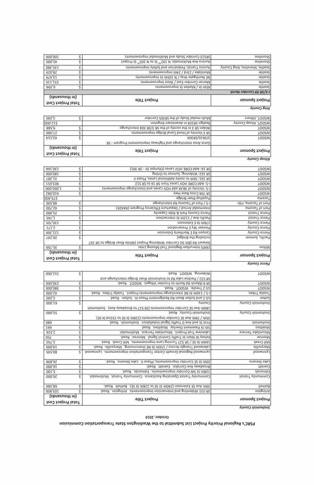
Snohomish County
Project SponsorProject TitleTotal Project Cost
(in thousands)
ArlingtonSR-531 Widenting and Intersection Improvements. Arlington. Road. $ 103,800
Bothell39th Ave SE Extension (240th St SE to 228th St SE). Bothell. Road. $ 68,584
Community TransitCommunity Transit Operating Assistance. Community Transit. Multimodal. $ 20,000
Edmonds228th St SW Corridor Improvements. Edmonds. Road. $ 5,100
EverettBroadway Ave Corridor. Everett. Road. $ 16,000
Lake Stevens20th St SE Corridor Improvements, Phase II. Lake Stevens. Road. $ 26,898
LynnwoodLynnwood Regional Growth Center Transportation Improvements. Lynnwood. $ 80,595
MarysvilleLakewood Triangle Access / 156th St NE Overcrossing. Marysville. Road. $ 14,000
Mill Creek164th St SE / SR 527 Turning Lane Improvements. Mill Creek. Road. $ 2,750
MonroeKelsey W Main St Traffic Control Signal. Monroe. Road. $ 750
Mountlake TerraceLakeview Trail Project. Mountlake Terrace. Multimodal. $ 2,526
Mukilteo5th St Pavement Overlay. Mukilteo. Road. $ 661
SnohomishFirst St and Ave D Traffic Signal Installation. Snohomish. Road. $ 680
Snohomish County
35th / 39th Ave SE Corridor Improvements (228th St SE to 152nd St SE).
Snohomish County. Road. $ 55,000
Snohomish County
180th Ave SE Corridor Improvements (SR 527 to Broadway Ave). Snohomish
County. $ 61,000
SultanUS 2 and Sultan Basin Rd Realignment Phase III. Sultan. Road. $ 3,200
Tulalip TribesI-5 / 116th St NE Interchange Improvements Project. Tulalip Tribes. Road. $ 42,000
WSDOTUS 2 Trestle. WSDOT. Road. $ 380,000
WSDOTSR 9 (Marsh Rd North to Frontier Village). WSDOT. Road. $ 230,000
WSDOT
SR 522 / Pardise Lake Rd to Snohomish River Bridge Interchange and
Widening. WSDOT. Road. $ 152,000
Pierce County
Project SponsorProject TitleTotal Project Cost
(in thousands)
MiltonEMPS Interurban Regional Trail Missing Links $ 35,709
Pacific, Sumner
Stewart Rd (8th St) Corridor Widening Project (White River Bridge to SR 167
including the Bridge) $ 29,297
Pierce CountyCanyon Rd E Northerly Extension $ 122,300
Pierce CountyPioneer Wy E Preservation $ 2,171
Pierce County176th St E Extension $ 130,705
Pierce TransitPacific Ave / 112th St Intersection $ 1,745
Pierce TransitPierce County Park & Ride Capacity $ 25,000
Port of TacomaIntermodal Arrival / Departure Efficiency Program (IMADE) $ 42,700
Port of Tacoma, FifeI-5 / Port of Tacoma Rd Interchange $ 48,500
TacomaPuyallup River Bridge$79,400
WSDOTSR 704 Cross Base Hwy $ 410,082
WSDOTI-5: Vicinity of JBLM add HOV Lanes and Interchange Improvements $ 1,060,000
WSDOTI-5: Add CORE HOV Lanes from SR 16 to SR 512 $ 903,651
WSDOTSR 161: 36th to Jovita Additional Lanes, Phase II $ 31,387
WSDOTSR 162: Widening, Sumner to Orting $ 180,000
WSDOTSR 16: Add CORE HOV Lanes (Olympic Dr - SR 301) $ 130,166
Kitsap County
Project SponsorProject TitleTotal Project Cost
(in thousands)
WSDOT
Gorst Area Interchange and Highway Improvement Program - SR
3/SR16/SR304 $ 43,514
WSDOTSR 3 Vicinity of Hood Canal Bridge Improvements $ 27,000
WSDOTWiden SR 3 in the vicnity of the SR 3/SR 304 Interchange $ 9,588
WSDOT, Kitsap CountyRealign SR104 in downtown Kingston$12,000
WSDOT, OthersMulti-modal Study of the SR305 Corridor $ 3,200
King County
Project SponsorProject TitleTotal Project Cost
(in thousands)
I-5/SR 99 Corridor North
Seattle45th St / Market St Improvements $ 6,394
SeattleMercer Corridor East / West Improvements $ 331,110
SeattleNE Northgate Way / N 105th St Improvements $ 13,479
SeattleMontlake / 23rd / 24th Improvements $ 28,029
Seattle, Shoreline, King CountyAurora Transit, Pedestrian and Safety Improvements $ 135,380
ShorelineAurora Ave Multimodal, N 192nd
St to N 205th
St Project $ 45,000
ShorelineSR523 Corridor Study and Multimodal Improvements $ 100,000
PSRC's Regional Priority Project List Submittal to the Washington State Transportation Commission
October, 2010
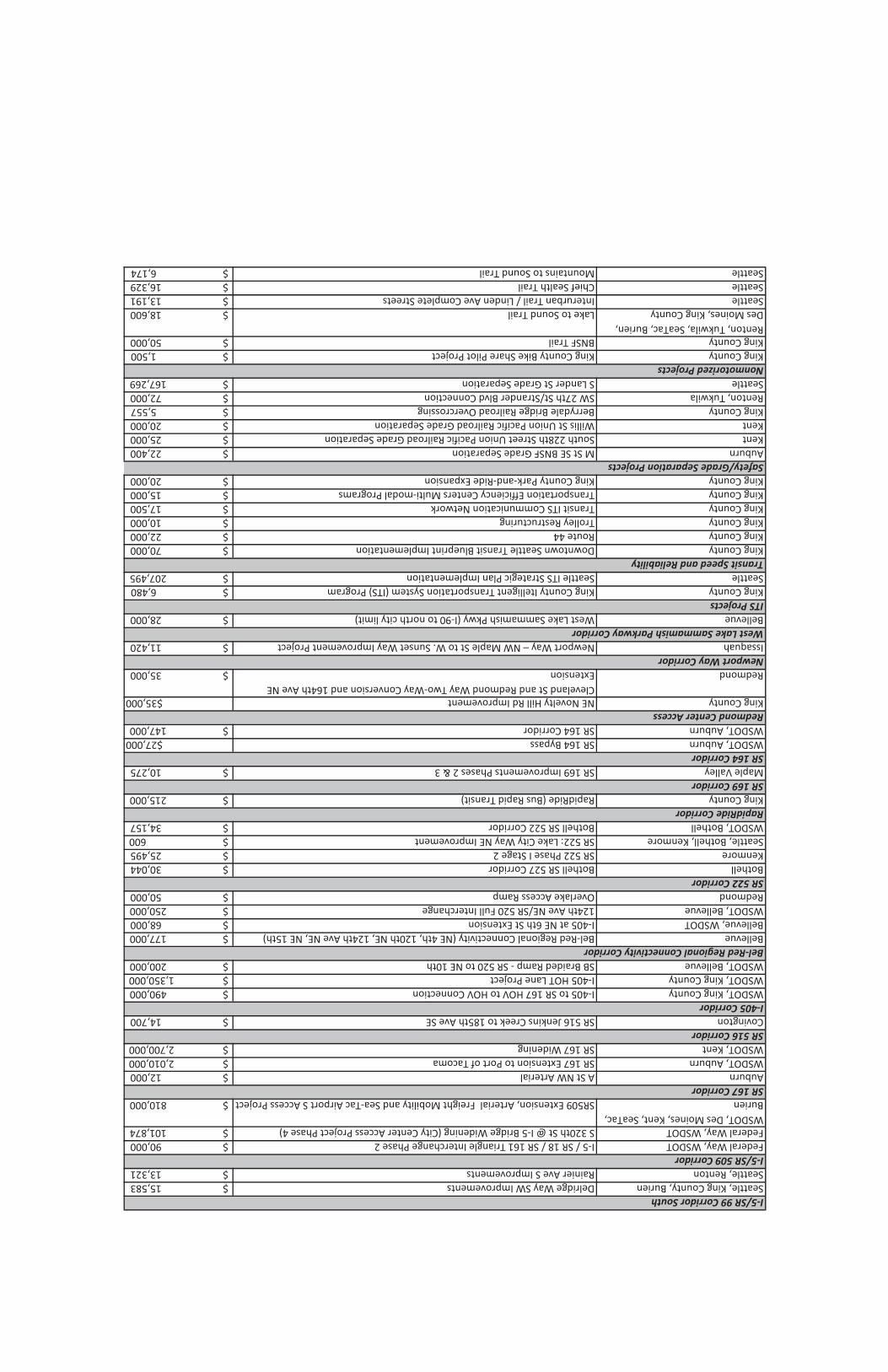
I-5/SR 99 Corridor South
Seattle, King County, BurienDelridge Way SW Improvements $ 15,583
Seattle, RentonRainier Ave S Improvements $ 13,321
I-5/SR 509 Corridor
Federal Way, WSDOTI-5 / SR 18 / SR 161 Triangle Interchange Phase 2 $ 90,000
Federal Way, WSDOTS 320th St @ I-5 Bridge Widening (City Center Access Project Phase 4) $ 101,874
WSDOT, Des Moines, Kent, SeaTac,
BurienSR509 Extension, Arterial Freight Mobility and Sea-Tac Airport S Access Project $ 810,000
SR 167 Corridor
AuburnA St NW Arterial $ 12,000
WSDOT, AuburnSR 167 Extension to Port of Tacoma $ 2,010,000
WSDOT, KentSR 167 Widening $ 2,700,000
SR 516 Corridor
CovingtonSR 516 Jenkins Creek to 185th Ave SE $ 14,700
I-405 Corridor
WSDOT, King CountyI-405 to SR 167 HOV to HOV Connection $ 490,000
WSDOT, King CountyI-405 HOT Lane Project $ 1,350,000
WSDOT, BellevueSB Braided Ramp - SR 520 to NE 10th $ 200,000
Bel-Red Regional Connectivity Corridor
BellevueBel-Red Regional Connectivity (NE 4th, 120th NE, 124th Ave NE, NE 15th) $ 177,000
Bellevue, WSDOTI-405 at NE 6th St Extension $ 68,000
WSDOT, Bellevue124th Ave NE/SR 520 Full Interchange $ 250,000
RedmondOverlake Access Ramp $ 50,000
SR 522 Corridor
BothellBothell SR 527 Corridor $ 30,044
KenmoreSR 522 Phase I Stage 2 $ 25,495
Seattle, Bothell, KenmoreSR 522: Lake City Way NE Improvement $ 600
WSDOT, BothellBothell SR 522 Corridor $ 34,157
RapidRide Corridor
King CountyRapidRide (Bus Rapid Transit) $ 215,000
SR 169 Corridor
Maple ValleySR 169 Improvements Phases 2 & 3 $ 10,275
SR 164 Corridor
WSDOT, AuburnSR 164 Bypass$27,000
WSDOT, AuburnSR 164 Corridor $ 147,000
Redmond Center Access
King CountyNE Novelty Hill Rd Improvement$35,000
Redmond
Cleveland St and Redmond Way Two-Way Conversion and 164th Ave NE
Extension $ 35,000
Newport Way Corridor
IssaquahNewport Way – NW Maple St to W. Sunset Way Improvement Project $ 11,420
West Lake Sammamish Parkway Corridor
BellevueWest Lake Sammamish Pkwy (I-90 to north city limit) $ 28,000
ITS Projects
King CountyKing County Itelligent Transportation System (ITS) Program $ 6,480
SeattleSeattle ITS Strategic Plan Implementation $ 207,495
Transit Speed and Reliability
King CountyDowntown Seattle Transit Blueprint Implementation $ 70,000
King CountyRoute 44 $ 22,000
King CountyTrolley Restructuring $ 10,000
King CountyTransit ITS Communication Network $ 17,500
King CountyTransportation Efficiency Centers Multi-modal Programs $ 15,000
King CountyKing County Park-and-Ride Expansion $ 20,000
Safety/Grade Separation Projects
AuburnM St SE BNSF Grade Separation $ 22,400
KentSouth 228th Street Union Pacific Railroad Grade Separation $ 25,000
KentWillis St Union Pacific Railroad Grade Separation $ 20,000
King CountyBerrydale Bridge Railroad Overcrossing $ 5,557
Renton, TukwilaSW 27th St/Strander Blvd Connection $ 72,000
SeattleS Lander St Grade Separation $ 167,269
Nonmotorized Projects
King CountyKing County Bike Share Pilot Project $ 1,500
King CountyBNSF Trail $ 50,000
Renton, Tukwila, SeaTac, Burien,
Des Moines, King CountyLake to Sound Trail $ 18,600
SeattleInterurban Trail / Linden Ave Complete Streets $ 13,191
SeattleChief Sealth Trail $ 16,329
SeattleMountains to Sound Trail $ 6,174

Puget Sound Regional Council
Regional Priority Project ListSubmittal to Washington State Transportation Commission
October, 2010
Project #(in no particular
order,
not prioritized)
Project Name, Jurisdiction &
Category
(i.e.: road or multi-modal)
Project Type -
Indicate Applicable
Number(s) (see instruction memo)
Total Project Cost*Project Cost Breakdown
By Biennia - YOE $** (09/11; 11/13; 13/15 etc.)
Is This Project
Consistent with
an Approved
Regional
Transportation
Plan?
Policy Goals
Project Addresses -
Indicate Applicable
Numbers(see instruction memo)
Comments
Snohomish
1
228th St SW Corridor Improvements.
Edmonds. Road. 3,5,6 $ 5,100
09-11: $150
11-13: $650
13-15: $4,300 Yes 1,3,4,5
30% design completed in May 2009. Project supported
by the City of Mountlake Terrace, Community Transit,
and Washington State Department of Transportation.
Early Phase reflects CN cost.
2
Kelsey W Main St Traffic Control Signal.
Monroe. Road. 3,5,6 $ 750
09-11: $250
11-13: $500 Yes 1,3,4,5
Design is complete and ready for construction. #1 City
Priority project.
3
39th Ave SE Extension (240th St SE to 228th St
SE). Bothell. Road. 3,5,6,7 $ 68,584
09-11: $3,245
11-13: $6,358
13-15: $33,240
15-17: $25,742 Yes 1,3,4,5,6
4
Lakeview Trail Project. Mountlake Terrace.
Multimodal. 5,7 $ 2,526
09-11: $626
11-13: $1,900 Yes 3,4,5
This project will construct bike lanes, sidewalks, and a
non-motorized trail.
5
20th St SE Corridor Improvements, Phase II.
Lake Stevens. Road. 3,4,5,6,7 $ 26,898
09-11: $7,365
11-13: $19,533 Yes 1,3,4,5,6
Design will be complete 1/11. Project will be ready for
ad 03/11.
6
SR-531 Widenting and Intersection
Improvements. Arlington. Road. 3,4,5,6,7 $ 103,800
09-11: $2,000
11-13: $3,500 Yes 1,3,4,5,6
Increases mobility & safety, supports economic growth,
supports emergency services. Project cost breakdown is
based on early phase project cost.
7 Broadway Ave Corridor. Everett. Road. 2,3,4,5,6,7 $ 16,000
11-13: $4,500
13-15: 11,500 Yes 1,3,4,5,6
8
I-5 / 116th St NE Interchange Improvements
Project. Tulalip Tribes. Road. 3,4,6 $ 42,000
11-13: $23,100
13-15: $18,900 Yes 1,3,4,5,6
The Tulalip Tribes, BIA, FHWA, WSDOT and Snohomish
County have previously funded ($19M) and completed
the environmental documentation, early design, and
construction of prior phases, final design of this final
piece of the project is underway and funded
9
Lynnwood Regional Growth Center
Transportation Improvements. Lynnwood. 3,4,5,6,7 $ 80,595
09-11: $2,000
11-13: $4,000
13-15: $4,000 Yes 1,3,4,5,6
Project will complete the key transportation
improvements needed to support Lynnwood's Regional
Growth Center. Early phase project cost
10
35th / 39th Ave SE Corridor Improvements
(228th St SE to 152nd St SE). Snohomish
County. Road. 3,4,5,6,7 $ 55,000
11-13: $4,000
13-15: $10,000
15-17: $12,000
17-19: $10,000
19-21: $10,000
21-23: $9,000 Yes 1,3,4,5,6
The County has already invested local funds to Improve
intersections and the northern portion of this corridor.

Project #(in no particular
order,
not prioritized)
Project Name, Jurisdiction &
Category
(i.e.: road or multi-modal)
Project Type -
Indicate Applicable
Number(s) (see instruction memo)
Total Project Cost*Project Cost Breakdown
By Biennia - YOE $** (09/11; 11/13; 13/15 etc.)
Is This Project
Consistent with
an Approved
Regional
Transportation
Plan?
Policy Goals
Project Addresses -
Indicate Applicable
Numbers(see instruction memo)
Comments
11
180th Ave SE Corridor Improvements (SR 527
to Broadway Ave). Snohomish County.3,4,5,6,7 $ 61,000
11-13: $7,000
13-15: $6,000
15-17: $10,000
17-19: $10,000
19-21: $10,000
21-23: $10,000
23-25: $8,000Yes1,3,4,5,6
The County has already invested local funds to Improve
intersections and begin design work on portions of the
corridor.
12
Lakewood Triangle Access / 156th St NE
Overcrossing. Marysville. Road.3,4,5,6,7 $ 14,000 09-11: $6,000Yes1,3,4,5,6
The City has invested 2M in Local funds for Design,
Environmental Review and ROW Acquisition and is
requesting $3M in grant funding.
13
US 2 and Sultan Basin Rd Realignment Phase
III. Sultan. Road.5,6 $ 3,200 11-13: $3,000Yes1,3,4,5,
Applied for TIGER II Rural Funds - Federal Grant. Design
is complete and acquisition for ROW is underway.
14
164th St SE / SR 527 Turning Lane
Improvements. Mill Creek. Road.3,5,6 $ 2,750
11-13: $2,230
13-15: $500Yes1,3,4,5,6
15
Community Transit Operating Assistance.
Community Transit. Multimodal.1,3 $ 20,000
09-11: $5,000
11-13: $15,000 Yes1,2,3,4,5,6Local Funding
16
First St and Ave D Traffic Signal Installation.
Snohomish. Road.3,5,6 $ 680 11-13: $680Yes1,3,4,5Design is complete. The project is ready for installation.
17US 2 Trestle. WSDOT. Road.3,5,6,7 $ 380,000
11-13: $20,000
13-15: $35,000
15-17: $75,000
17-19: $150,000
19-21: $80,000
21-23: $20,000Yes1,3,4,6
18
SR 9 (Marsh Rd North to Frontier Village).
WSDOT. Road.3,5,6 $ 230,000
09-11: $5,000
11-13: $20,000
13-15: $30,000
15-17: $110,000
17-19: 65,000Yes1,2,3,4,5,6
19
SR 522 / Pardise Lake Rd to Snohomish River
Bridge Interchange and Widening. WSDOT.
Road.3,5,6 $ 152,000
11-13: $22,000
13-15: $60,000
15-17: $62,000
17-19: $8Yes1,2,3,4,5,6
Since 1988, WSDOT has been widening SR 522 from
Woodinville to Monroe as funding became available.
This portion of SR 522 is the missing gap segment
remaining to be widened; Paradise Lake Road is the last
at-grade intersection on the freeway portion of the
highway.
205th St Pavement Overlay. Mukilteo. Road.2,3,4,6 $ 661 09-11: $661Yes1,2,3,4,6
Design is 90% complete. The project can be ready for
construction within approximately 45 days.
Pierce
21SR 704 Cross Base Hwy. WSDOT. Road.3,5,6 $ 410,082
11-13: $2,082
13-15: $16,000
15-17: $36,000
17-19: $110,000
19-21: $144,000
21-23: $102,000Yes1,3,4,5,6

Project #(in no particular
order,
not prioritized)
Project Name, Jurisdiction &
Category
(i.e.: road or multi-modal)
Project Type -
Indicate Applicable
Number(s) (see instruction memo)
Total Project Cost*Project Cost Breakdown
By Biennia - YOE $** (09/11; 11/13; 13/15 etc.)
Is This Project
Consistent with
an Approved
Regional
Transportation
Plan?
Policy Goals
Project Addresses -
Indicate Applicable
Numbers(see instruction memo)
Comments
22
I-5 / Port of Tacoma Rd Interchange. Port of
Tacoma, Fife. Road. 6 $ 48,500
09-11: $2,000
11-13: $10,200
13-15: $2,800
15-17: $33,500 Yes 1,3,4,6
Interchange Justification Report and NEPA
documentation nearing completion.
23
Canyon Rd E Northerly Extension. Pierce
County. Road. 1,3,5,6 $ 122,300
09-11: $3,686
11-13: $5,528
13-15: $23,885
15-17: $66,857
17-19: $22,286 Yes 1,3,4
24
EMPS Interurban Regional Trail Missing Links.
Milton. Multimodal. 5,7 $ 35,709
09-11: $6,421
11-13: $29,288 Yes 2,3,4,5,6 Need $4,782 for design/ROW.
25
I-5: Vicinity of JBLM add HOV Lanes and
Interchange Improvements. WSDOT.
Multimodal. 3,5,6 $ 1,060,000
11-13: $5,000
13-15: $15,000
15-17: $80,000
17-19: $100,000
19-21: $280,000
21-23: $320,000
23-25: $260,000 Yes 1,3,4,5,6
Improvement options were evaluated for the mainline
and for Exits 119, 120, 122 and 123. If all the
improvements were implemented they would cost
between $960 million and $1.06 billion. These cost
estimates are in 2010 dollars.
26
I-5: Add CORE HOV Lanes from SR 16 to SR
512. WSDOT. Road. 3,5,6 $ 1,076,000
11-13: $12,000
13-15: $21,000
15-17: $96,000
17-19: $146,000
19-21: $351,000
21-23: $240,000
23-25 $210,000 Yes 1,3,4,5,6
Part of the Tacoma / Pierce County HOV Program.
Project is a series of projects / phases that adds High
Occupancy Vehicle (HOV) Lanes; this project would
extend HOV lanes south from the vicinity of 48th St in
Tacoma to SR 512 Interchange in Lakewood and would
widen I-5 to accommodate HOV lanes. Includes
interchange improvements, frontage road, Intelligent
Transportation Systems.
27
Stewart Rd (8th St) Corridor Widening Project
(White River Bridge to SR 167 including the
Bridge), Pacific, Sumner. Road. 1 $ 29,297
11-13: $17,547
13-15: $10,750 Yes 1,3,4,5
28
Puyallup River Bridge, Tacoma (Bridge
Replacement with mulitmodal component) 3,4, 6,7 $79,400
09-11:$100
11-13: $5,300
13-15: $32,000 Yes 1,2,3,4,5,6
Total project cost in 2010 dollars is $70.1 million. Total
cost adjusted for 3% inflation in year of expenditure is
$79.4 million.
29
Pacific Ave / 112th St Intersection, Pierce
Transit 4 $ 1,745
09-11: $220
11-13 $1,525 Yes 1, 4, 5, 6
Intersection improvements to implement more frequent
public transportation services and begin to position
corridor for high capacity public transportation services.
30
SR 161: 36th to Jovita Additional Lanes, Phase
II. WSDOT. Road. 3,5,6 $ 31,387
13-15: $326
15-17: $12,400
17-19: $12,993
19-21: $5,667 Yes 1,3,4,5,6
SR 161 36th to Jovita widens SR 161 to five lanes and is
divided into two phases.. Phase 1 (24th St E to Jovita) is
programmed ($37,600) for construction to begin in late
2010 with Phase 2 (36th to 24th) being funded but on
hold till 2019-2021.
31
SR 162: Widening, Sumner to Orting. WSDOT.
Road. 3,5,6 $ 85,000
13-15: $20,000
15-17: $65,000
Not currently
included within
Vision 2040 projects. 1,3,4,5,6
Project adds one general purpose lane each direction to
SR 162 from SR 410 interchange in Sumner to
approximately 136th St in Orting including additional
capacity on SR 410 between SR 167 and SR 162.

Project #(in no particular
order,
not prioritized)
Project Name, Jurisdiction &
Category
(i.e.: road or multi-modal)
Project Type -
Indicate Applicable
Number(s) (see instruction memo)
Total Project Cost*Project Cost Breakdown
By Biennia - YOE $** (09/11; 11/13; 13/15 etc.)
Is This Project
Consistent with
an Approved
Regional
Transportation
Plan?
Policy Goals
Project Addresses -
Indicate Applicable
Numbers(see instruction memo)
Comments
32
Pioneer Wy E Preservation, Pierce County.
Road.1,3 $ 2,171 11-13: $2,171Yes1Rehabilitation of 14.29 lane miles of roadway.
33176th St E Extension. Pierce County. Road.1,5,6 $ 130,705
20-22: $44,976
22-24: $57,153
24-26: $28,576Yes1,4
This project is considered a lahar evacuation route for
the Orting Valley.
34
Intermodal Arrival / Departure Efficiency
Program (IMADE). Port of Tacoma.
Multimodal.1,3,4,7 $ 42,700
09-11: $3,000
11-13: $17,000
13-15: $22,700Yes1,2,3,4,5,6
35
SR 16: Add CORE HOV Lanes (Olympic Dr - SR
302). WSDOT. Road.3,5,6 $ 130,166
13-15: $1,166
15-17: $14,000
17-19: $70,000
19-21: $45,000Yes1,3,4,5,6
Part of the Tacoma / Pierce County HOV Program. Adds
High Occupancy Vehicle (HOV) Lanes; this project would
extend HOV lanes north from Olympic Dr Interchange in
Gig Harbor to vicinity of SR 302 and would widen SR 16
to accommodate HOV lanes. Includes interchange
improvements, frontage road, Intelligent Transportation
Systems.
36
Pierce County Park & Ride Capacity, Pierce
Transit6 $ 25,000
13/15: $12,500
15/17: $12,500Yes1, 4, 5, 6
Construct up to 3,000 additional stalls in Pierce County.
Site selection, PE/ED and Final Design would need to be
initiated for all potential facilities. Initiation phase with
PE/ED and site selection could commence as early as
2012 with funding, final design and right-of-way
acquisition in 2014 with construction in 2015 of specific
facilities.
Kitsap
37
Gorst Area Interchange and Highway
Improvement Program - SR 3/SR16/SR304 .
WSDOT. Road3,4,6 $ 43,514 15-17: $47,508Yes1,3,4
These projects were identified in the Bremerton
Economic Development Study (BEDS) that will
eventually reconstruct two interchanges and widening
state routes within the Gorst Area.
The initial projects would provide interim
improvements to meet current traffic demands.
If all the improvements were implemented by the
estimated completion date (2040) the estimated
planning cost would approximately be $1.11 billion.
38
SR 3 Vicinity of Hood Canal Bridge
Improvements. WSDOT. Road3,4,6 $ 27,000 15-17: $30,588Yes4
39
Widen SR 3 in the vicnity of the SR 3/SR 304
Interchange. WSDOT. Road3,4,6 $ 9,588 15-17: $10,764Yes1,3,4
This area has been identified as a mobility deficiency
and a Bottleneck and Chokepoint in the State Highway
System Plan (HSP) and identified as an improvement
strategy in the recent Bremerton Economic
Development Study (BEDS). This project is an initial step
in improving this location with the eventual long-term
solution being the reconstruction of the SR3/SR 304
interchange.
40
Realign SR104 in downtown Kingston. WSDOT,
Kitsap County. Road3,4$12,000
09-11: $80
11-13: $800
13-15: $6,000Yes1,3,4
This project is a citizen and stakeholder initiative based
on a partially completed SR104 corridor study by WSDOT
in the 1990s.

Project #(in no particular
order,
not prioritized)
Project Name, Jurisdiction &
Category
(i.e.: road or multi-modal)
Project Type -
Indicate Applicable
Number(s) (see instruction memo)
Total Project Cost*Project Cost Breakdown
By Biennia - YOE $** (09/11; 11/13; 13/15 etc.)
Is This Project
Consistent with
an Approved
Regional
Transportation
Plan?
Policy Goals
Project Addresses -
Indicate Applicable
Numbers(see instruction memo)
Comments
41
Multi-modal Study of the SR305 Corridor.
WSDOT, others. Multi-modal ("study, PE") $ 3,200
11-13: $1,000
13-15: $2,200 Yes 1,3,4,5
Since 1997, the corridor has been studied for person
throughput and low-impact alternatives to general
capacity lane expansion. A 2030 horizon plan will
forecast the multi-modal needs of the entire corridor
within the current SR305 alignment. A continuous non-
motorized facility may use the state ROW or be feasibile
with a new alignment.
King
42
Aurora Transit, Pedestrian and Safety
Improvements. Seattle, Shoreline, King County
Metro. Multimodal. 3,4,5,7 $ 135,380
09-11: $2,286
11-13: $12,952
13-15: $31,885
15-17: $44,619
17-19: $43,638 Yes 1,2,3,4,5,6
Incorporates TIP SEA-127 - with Shoreline and King
County Metro.
43
Aurora Ave Multimodal, N 192nd
St to N 205th
St Project. Shoreline. Road. 1,3,4,6,7 $ 45,000 11-13: $30,000 Yes 1,2,3,4,5,6
This funding would complete the overall Shoreline-
Aurora Project. The project cost breakdown by biennia
only includes the funds needed to complete the project.
$15 mil aldready secured.
44
45th St / Market St Improvements. Seattle.
Multimodal. 1,2,3,4,7 $ 6,394
09-11: $2,163
11-13: $3,684
13-15: $547 Yes 1,2,3,4,5,6
45
Mercer Corridor East / West Improvements.
Seattle. Multimodal. 3,4,7 $ 331,110
09-11: $37,600
11-13: $255,784
13-15: $37,716 Yes 1,2,3,4,5,6 Incorporates TIP SEA-90 and SEA-151.
46
NE Northgate Way / N 105th St Improvements.
Seattle. Multimodal. 1,2,3,4,7 $ 13,479
09-11: $1,190
11-13: $12,289 Yes 1,2,3,4,5,6 Incorporates TIP SEA-126.
47
Montlake / 23rd / 24th Improvements.
Seattle. Multimodal. 1,2,3,7 $ 28,029 15-17: $28,029 Yes 1,2,3,4,5,6
48
SR523 Corridor Study and Multimodal
Improvements. Shoreline. Road. 1,3,4,6,7 $ 100,000 11-13: $8,000
included in
"concepts" portion
of MTP 1,2,3,4,5,6
This funding will determine a corridor design concept
and complete preliminary engineering
49
Delridge Way SW Improvements. Seattle, King
County DOT, King County Metro, Burien.
Multimodal. 1,2,3,4,7 $ 15,583
13-15: $1,558
15-17: $14,025 Yes 1,2,3,4,5,6 Extends to White Center & Burien
50
Rainier Ave S Improvements. Seattle, Renton.
Multimodal. 1,2,3,4,7 $ 13,321 11-13: $13,321 Yes 1,2,3,4,5,6 Incorporates TIP SEA147 and SEA150 - with Renton
51
I-5 / SR 18 / SR 161 Triangle Interchange Phase
2. Federal Way, WSDOT. Road. 3,4,5,6 $ 90,000
11-13: $9,000
13-15: $81,000 Yes 1,3,4,5,6
If funding were available, final design and ROW could be
completed in 1 year and construction completed in 2
years
52
S 320th St @ I-5 Bridge Widening (City Center
Access Project Phase 4). Federal Way, WSDOT.
Road. 3,4,6,7 $ 101,874
11-13: $10,612
13-15: $46,692
15-17: $44,570 Yes 1,3,4,5,6
If funding were available, environmental and permitting
could be completed in 2 years, final design and ROW
could be completed in 1 year, and construction
completed in 2 years
I-5 / SR 509 Corridor
I-5 / SR 99 Corridor South
I-5 / SR 99 Corridor North

Project #(in no particular
order,
not prioritized)
Project Name, Jurisdiction &
Category
(i.e.: road or multi-modal)
Project Type -
Indicate Applicable
Number(s) (see instruction memo)
Total Project Cost*Project Cost Breakdown
By Biennia - YOE $** (09/11; 11/13; 13/15 etc.)
Is This Project
Consistent with
an Approved
Regional
Transportation
Plan?
Policy Goals
Project Addresses -
Indicate Applicable
Numbers(see instruction memo)
Comments
53
SR509 Extension Phase 1, I-5 Freight Mobility
and Sea-Tac Airport S Access Project. WSDOT,
Des Moines, Kent, SeaTac, Burien. Road and
Hot Lane Multimodal.5,6,7 $ 865,000
11-13: $60,000
13-15: $145,000
15-17: $220,000
17-19: $140,000
15-17: $110,000 Yes1,2,3,4,5,6
WSDOT costS ONLY. Assumes construction is completed
in 2016 with SR509 tolling option 3a including
conversion of I-5 HOV lanes to HOT lanes in the project
vicinity to finance 80% construction of freeway.
54A St NW Arterial. Auburn. Road.3,5,6,7 $ 12,000 09-11: $3,200 Yes1,3,4,6
This project will connect a major north-south corridor by
constructing a new 1.47 mile link that is part of the
overall 3.5 mile A Street NW Corridor, which begins at
the Auburn Regional Growth Center (Downtown) and
terminates at S. 277th Street on the northern city limits.
The project also connects trips with West Valley
Highway, Auburn Way North, SR-167 and SR-18. This
funding will complete the project.
55
SR 167 Extension to Port of Tacoma, Phase 1.
WSDOT, Auburn. Road. 3,5,6,7 $ 1,350,000
11-13: $100,000
13-15: $200,000
15-17: $450,000
17-19: $600,000 Yes1,3,4,6
SR (SR) 167 is an important 27-mile route that links
south King County and north Pierce County to Interstate
405 (I-405). In conjunction with I-405 and SR 512, SR 167
is one of two north-south routes in the region and
provides an alternative to I-5. SR 167 plays an important
role in the distribution and movement of freight since
one third of the region’s warehouses are located near
the SR 167 Corridor.
56
SR 167 Widening, HOV/HOT Lanes. WSDOT,
Kent. Road.5,6 $ 438,000
19-21: $4,000
21-23: $80,000
23-25: $174,000
25-27: $140,000Yes1,3,4,5,6
57
SR 516 Jenkins Creek to 185th Ave SE.
Covington. Road.6 $ 14,700
09-11: $1,000
11-13: $4,000
13-15: $9,700 Yes1,4
Completes a critical pinchpoint on the corridor by
widening across Jenkins Creek.
58
I-405 to SR 167 HOV to HOV Connection.
WSDOT, King County. Multimodal.3,4,6 $ 490,000
11-13: $11,000
13-15: $39,000
15-17: $240,000
17-19: $200,000Yes1,3,4,5,6
New direct connector ramps between SR 167 and I-405
allows the two toll lane systems to work together
effectively and efficiently. cost estimate from Eastside
Corridor Tolling Study, January, 2010.
59
SB Braided Ramp - SR 520 to NE 10th. WSDOT,
Bellevue. Road.3,5,6 $ 200,000
11-13: $15,000
13-15: $150,000
15-17: $50,000Yes1,2,4
Bellevue has grant funds to work with WSDOT on design
phase. The City of Bellevue endorses this WSDOT
project as a high priority for regional mobility.
60
I-405 HOT Lane Project. WSDOT, King County.
Multimodal.3,4,5,6 $ 1,350,000
11-13: $50,000
13-15: $100,000
15-17: $350,000
17-19: $850,000Yes1,4,5,6
The Eastside Corridor Tolling Study planning level cost
estimate to construct HOT lanes in each direction on I-
405 is $1.35 billion (cost includes dual HOT lanes in each
direction between SR 167 and SR 522, and a single HOT
lane in each direction between SR 522 and I-5 to the
north).
Bellevue, Bel-Red Regional Connectivity Corridor
I-405 Corridor
SR 516 Corridor
SR 167 Corridor
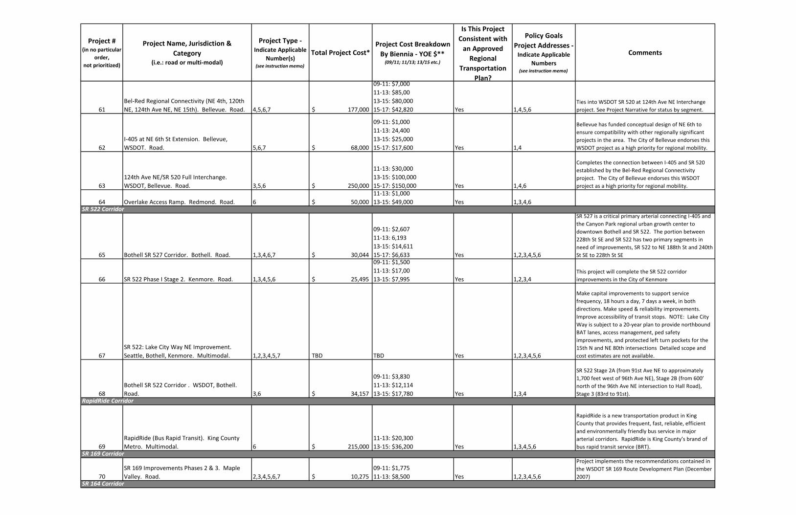
Project #(in no particular
order,
not prioritized)
Project Name, Jurisdiction &
Category
(i.e.: road or multi-modal)
Project Type -
Indicate Applicable
Number(s) (see instruction memo)
Total Project Cost*Project Cost Breakdown
By Biennia - YOE $** (09/11; 11/13; 13/15 etc.)
Is This Project
Consistent with
an Approved
Regional
Transportation
Plan?
Policy Goals
Project Addresses -
Indicate Applicable
Numbers(see instruction memo)
Comments
61
Bel-Red Regional Connectivity (NE 4th, 120th
NE, 124th Ave NE, NE 15th). Bellevue. Road. 4,5,6,7 $ 177,000
09-11: $7,000
11-13: $85,00
13-15: $80,000
15-17: $42,820 Yes 1,4,5,6
Ties into WSDOT SR 520 at 124th Ave NE Interchange
project. See Project Narrative for status by segment.
62
I-405 at NE 6th St Extension. Bellevue,
WSDOT. Road. 5,6,7 $ 68,000
09-11: $1,000
11-13: 24,400
13-15: $25,000
15-17: $17,600 Yes 1,4
Bellevue has funded conceptual design of NE 6th to
ensure compatibility with other regionally significant
projects in the area. The City of Bellevue endorses this
WSDOT project as a high priority for regional mobility.
63
124th Ave NE/SR 520 Full Interchange.
WSDOT, Bellevue. Road. 3,5,6 $ 250,000
11-13: $30,000
13-15: $100,000
15-17: $150,000 Yes 1,4,6
Completes the connection between I-405 and SR 520
established by the Bel-Red Regional Connectivity
project. The City of Bellevue endorses this WSDOT
project as a high priority for regional mobility.
64 Overlake Access Ramp. Redmond. Road. 6 $ 50,000
11-13: $1,000
13-15: $49,000 Yes 1,3,4,6
65 Bothell SR 527 Corridor. Bothell. Road. 1,3,4,6,7 $ 30,044
09-11: $2,607
11-13: 6,193
13-15: $14,611
15-17: $6,633 Yes 1,2,3,4,5,6
SR 527 is a critical primary arterial connecting I-405 and
the Canyon Park regional urban growth center to
downtown Bothell and SR 522. The portion between
228th St SE and SR 522 has two primary segments in
need of improvements, SR 522 to NE 188th St and 240th
St SE to 228th St SE
66 SR 522 Phase I Stage 2. Kenmore. Road. 1,3,4,5,6 $ 25,495
09-11: $1,500
11-13: $17,00
13-15: $7,995 Yes 1,2,3,4
This project will complete the SR 522 corridor
improvements in the City of Kenmore
67
SR 522: Lake City Way NE Improvement.
Seattle, Bothell, Kenmore. Multimodal. 1,2,3,4,5,7 TBD TBD Yes 1,2,3,4,5,6
Make capital improvements to support service
frequency, 18 hours a day, 7 days a week, in both
directions. Make speed & reliability improvements.
Improve accessibility of transit stops. NOTE: Lake City
Way is subject to a 20-year plan to provide northbound
BAT lanes, access management, ped safety
improvements, and protected left turn pockets for the
15th N and NE 80th intersections Detailed scope and
cost estimates are not available.
68
Bothell SR 522 Corridor . WSDOT, Bothell.
Road. 3,6 $ 34,157
09-11: $3,830
11-13: $12,114
13-15: $17,780 Yes 1,3,4
SR 522 Stage 2A (from 91st Ave NE to approximately
1,700 feet west of 96th Ave NE), Stage 2B (from 600’
north of the 96th Ave NE intersection to Hall Road),
Stage 3 (83rd to 91st).
69
RapidRide (Bus Rapid Transit). King County
Metro. Multimodal. 6 $ 215,000
11-13: $20,300
13-15: $36,200 Yes 1,3,4,5,6
RapidRide is a new transportation product in King
County that provides frequent, fast, reliable, efficient
and environmentally friendly bus service in major
arterial corridors. RapidRide is King County’s brand of
bus rapid transit service (BRT).
70
SR 169 Improvements Phases 2 & 3. Maple
Valley. Road. 2,3,4,5,6,7 $ 10,275
09-11: $1,775
11-13: $8,500 Yes 1,2,3,4,5,6
Project implements the recommendations contained in
the WSDOT SR 169 Route Development Plan (December
2007)
SR 164 Corridor
SR 169 Corridor
SR 522 Corridor
RapidRide Corridor

Project #(in no particular
order,
not prioritized)
Project Name, Jurisdiction &
Category
(i.e.: road or multi-modal)
Project Type -
Indicate Applicable
Number(s) (see instruction memo)
Total Project Cost*Project Cost Breakdown
By Biennia - YOE $** (09/11; 11/13; 13/15 etc.)
Is This Project
Consistent with
an Approved
Regional
Transportation
Plan?
Policy Goals
Project Addresses -
Indicate Applicable
Numbers(see instruction memo)
Comments
71SR 164 Corridor. WSDOT, Auburn. Road.3,5,6,7 $ 147,000
11-13: $5,000
13-15: $10,000
15-17: $70,000
17-19: $62,000Yes1,3,4,6
This project addresses identified existing and emerging
safety, mobility, and preservation needs on a fifteen-
mile stretch of SR 164 from Auburn to Enumclaw. This
corridor functions primarily as a commuter, recreational,
and freight corridor due to development in this area.
72SR 164 Bypass. WSDOT, Auburn. Road.3,5,6,7 TBD TBDYes1,3,4,5
This project is part of an ongoing feasibility study being
conducted by WSDOT, which is expected to be
completed Spring 2011.
73
NE Novelty Hill Rd Improvement. King County.
Road.3,4,5,6,7$35,000
09-11: $8,000
11-13: $25,000
13-15: $2,000Yes1,3,4,5,6
The project will improve and constructnew roadway and
connection on 196th Ave NE to Novelty Hill Road. The
road work includes expanding Union Hill Road from two
lanes to four lanes, construct two roundabouts at 196th
and Union Hill Road, and at 196th and NE Novelty Hill
Road. The project will replace a narrow bridge at Evans
Creek.
74
Cleveland St and Redmond Way Two-Way
Conversion and 164th Ave NE Extension.
Redmond. Road.4,5 $ 35,000
11-13: $14,000
13-15: $21,000 Yes1,3,4
Convert Redmond Way from 160th Ave NE to Avondale
Way to one through lane in each direction and center
turn lane with west end having two westbound starting
at 161st Ave NE and east end having two eastbound
lanes starting at 168th Ave NE. Convert Cleveland St to
one through lane in each direction.
75
Newport Way – NW Maple St to W. Sunset
Way Improvement Project. Issaquah. Road.1,3,4,5,6,7 $ 11,420
09-11: $410
11-13: $11,010Yes1,2,3,4,5,6
The project is a non-motorized and roadway
improvement project and will include a non-motorized
trail, and a sidewalk on the opposite side of the St, bike
lanes on each side, and landscaping. Project includes
roundabouts at the intersection with NW Juniper St and
possible two other locations, NW Holly St and NW
Dogwood St
76
West Lake Sammamish Pkwy (I-90 to north city
limit). Bellevue. Road.1,3,7 $ 28,000
09-11: $1,000
11-13: $6,000
13-15: $10,000
15-17: $18,663Yes2,3,5
Strongly supported by residential and bicycle
community; provides continuous non-motorized
connection from I-90 north to Redmond.
77
King County Itelligent Transportation System
(ITS) Program. King County. Road.1,3 $ 6,480
09-11: $400
11-13: $4,785
13-15: $1,300Yes1,2,3,4,5,6
Includes interconnecting signals with fiber optic cable
on two corridor routes and providing the following on all
six routes: CCTV cameras, travel time equipment, data
information stations, ice detection systems and/or Road
Weather Information Systems and Dynamic Message
Signs. The project is located on Woodinville Duvall Road,
Avondale Road, and spot locations on Issaquah Hobart,
Issaquah Fall City/Duthie Hill Road, Military Road S., and
Novelty Hill Road.
ITS Projects
West Lake Sammamish Parkway Corridor
Newport Way Corridor
Redmond Center Access
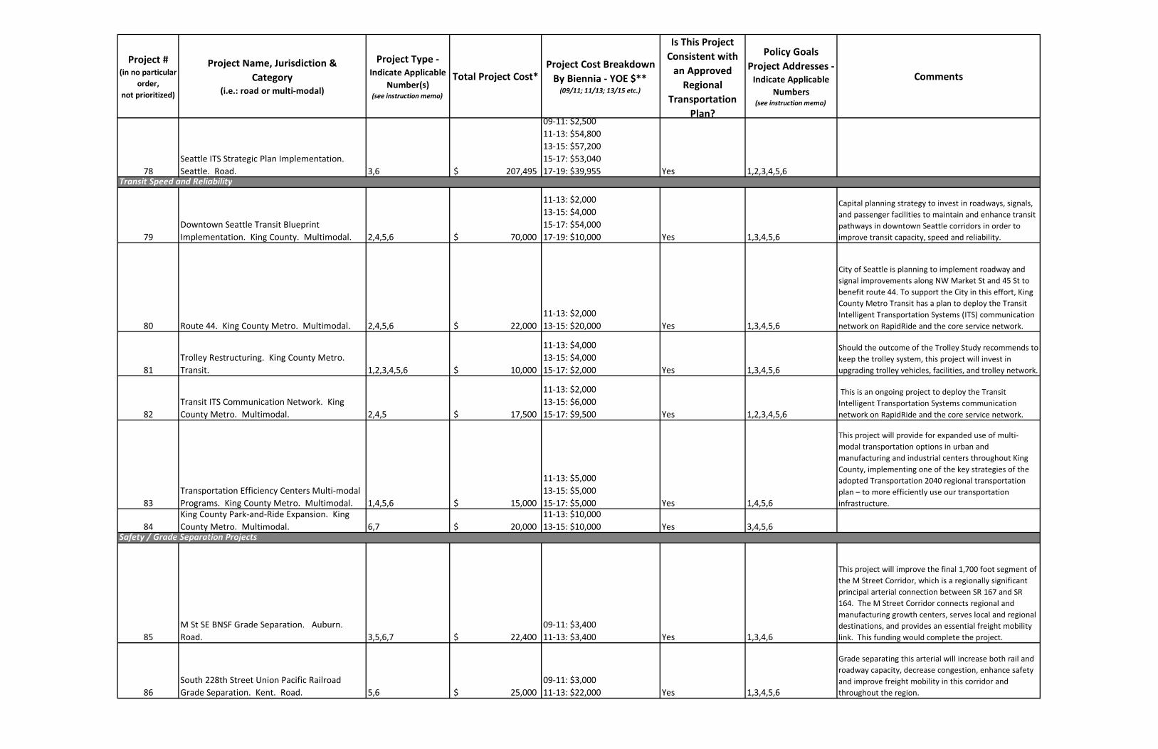
Project #(in no particular
order,
not prioritized)
Project Name, Jurisdiction &
Category
(i.e.: road or multi-modal)
Project Type -
Indicate Applicable
Number(s) (see instruction memo)
Total Project Cost*Project Cost Breakdown
By Biennia - YOE $** (09/11; 11/13; 13/15 etc.)
Is This Project
Consistent with
an Approved
Regional
Transportation
Plan?
Policy Goals
Project Addresses -
Indicate Applicable
Numbers(see instruction memo)
Comments
78
Seattle ITS Strategic Plan Implementation.
Seattle. Road. 3,6 $ 207,495
09-11: $2,500
11-13: $54,800
13-15: $57,200
15-17: $53,040
17-19: $39,955 Yes 1,2,3,4,5,6
79
Downtown Seattle Transit Blueprint
Implementation. King County. Multimodal. 2,4,5,6 $ 70,000
11-13: $2,000
13-15: $4,000
15-17: $54,000
17-19: $10,000 Yes 1,3,4,5,6
Capital planning strategy to invest in roadways, signals,
and passenger facilities to maintain and enhance transit
pathways in downtown Seattle corridors in order to
improve transit capacity, speed and reliability.
80 Route 44. King County Metro. Multimodal. 2,4,5,6 $ 22,000
11-13: $2,000
13-15: $20,000 Yes 1,3,4,5,6
City of Seattle is planning to implement roadway and
signal improvements along NW Market St and 45 St to
benefit route 44. To support the City in this effort, King
County Metro Transit has a plan to deploy the Transit
Intelligent Transportation Systems (ITS) communication
network on RapidRide and the core service network.
81
Trolley Restructuring. King County Metro.
Transit. 1,2,3,4,5,6 $ 10,000
11-13: $4,000
13-15: $4,000
15-17: $2,000 Yes 1,3,4,5,6
Should the outcome of the Trolley Study recommends to
keep the trolley system, this project will invest in
upgrading trolley vehicles, facilities, and trolley network.
82
Transit ITS Communication Network. King
County Metro. Multimodal. 2,4,5 $ 17,500
11-13: $2,000
13-15: $6,000
15-17: $9,500 Yes 1,2,3,4,5,6
This is an ongoing project to deploy the Transit
Intelligent Transportation Systems communication
network on RapidRide and the core service network.
83
Transportation Efficiency Centers Multi-modal
Programs. King County Metro. Multimodal. 1,4,5,6 $ 15,000
11-13: $5,000
13-15: $5,000
15-17: $5,000 Yes 1,4,5,6
This project will provide for expanded use of multi-
modal transportation options in urban and
manufacturing and industrial centers throughout King
County, implementing one of the key strategies of the
adopted Transportation 2040 regional transportation
plan – to more efficiently use our transportation
infrastructure.
84
King County Park-and-Ride Expansion. King
County Metro. Multimodal. 6,7 $ 20,000
11-13: $10,000
13-15: $10,000 Yes 3,4,5,6
85
M St SE BNSF Grade Separation. Auburn.
Road. 3,5,6,7 $ 22,400
09-11: $3,400
11-13: $3,400 Yes 1,3,4,6
This project will improve the final 1,700 foot segment of
the M Street Corridor, which is a regionally significant
principal arterial connection between SR 167 and SR
164. The M Street Corridor connects regional and
manufacturing growth centers, serves local and regional
destinations, and provides an essential freight mobility
link. This funding would complete the project.
86
South 228th Street Union Pacific Railroad
Grade Separation. Kent. Road. 5,6 $ 25,000
09-11: $3,000
11-13: $22,000 Yes 1,3,4,5,6
Grade separating this arterial will increase both rail and
roadway capacity, decrease congestion, enhance safety
and improve freight mobility in this corridor and
throughout the region.
Safety / Grade Separation Projects
Transit Speed and Reliability
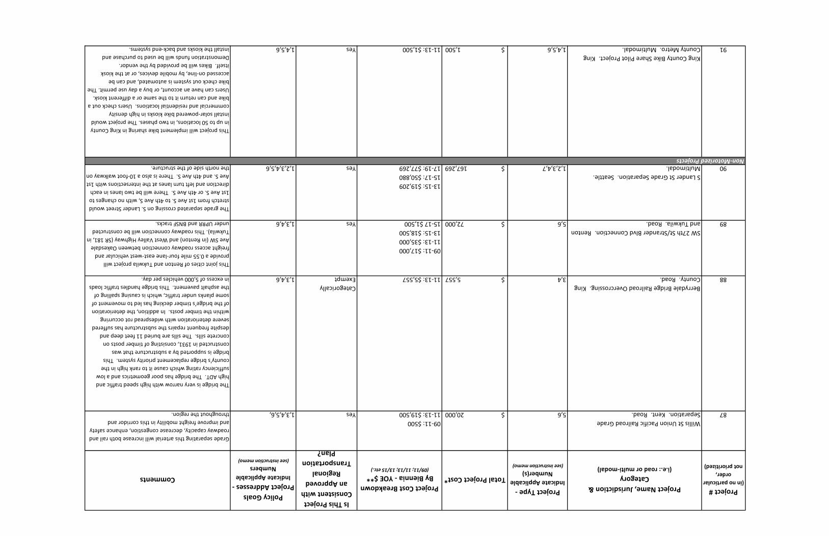
Project #(in no particular
order,
not prioritized)
Project Name, Jurisdiction &
Category
(i.e.: road or multi-modal)
Project Type -
Indicate Applicable
Number(s) (see instruction memo)
Total Project Cost*Project Cost Breakdown
By Biennia - YOE $** (09/11; 11/13; 13/15 etc.)
Is This Project
Consistent with
an Approved
Regional
Transportation
Plan?
Policy Goals
Project Addresses -
Indicate Applicable
Numbers(see instruction memo)
Comments
87
Willis St Union Pacific Railroad Grade
Separation. Kent. Road.5,6 $ 20,000
09-11: $500
11-13: $19,500 Yes1,3,4,5,6,
Grade separating this arterial will increase both rail and
roadway capacity, decrease congestion, enhance safety
and improve freight mobility in this corridor and
throughout the region.
88
Berrydale Bridge Railroad Overcrossing. King
County. Road.3,4 $ 5,557 11-13: $5,557
Categorically
Exempt1,3,4,6
The bridge is very narrow with high speed traffic and
high ADT. The bridge has poor geometrics and a low
sufficiency rating which cause it to rank high in the
county’s bridge replacement priority system. This
bridge is supported by a substructure that was
constructed in 1931, consisting of timber posts on
concrete sills. The sills are buried 11 feet deep and
despite frequent repairs the substructure has suffered
severe deterioration with widespread rot occurring
within the timber posts. In addition, the deterioration
of the bridge’s timber decking has led to movement of
some planks under traffic, which is causing spalling of
the asphalt pavement. This bridge handles traffic loads
in excess of 5,000 vehicles per day.
89
SW 27th St/Strander Blvd Connection. Renton
and Tukwila. Road.5,6 $ 72,000
09-11: $17,000
11-13: $35,000
13-15: $18,500
15-17 $1,500Yes1,3,4,6
This joint cities of Renton and Tukwila project will
provide a 0.55 mile four-lane east-west vehicular and
freight access roadway connection between Oakesdale
Ave SW (in Renton) and West Valley Highway (SR 181, in
Tukwila). This roadway connection will be constructed
under UPRR and BNSF tracks.
90
S Lander St Grade Separation. Seattle.
Multimodal.1,2,3,4,7 $ 167,269
13-15: $19,209
15-17: $50,880
17-19: $77,269Yes1,2,3,4,5,6
The grade separated crossing on S. Lander Street would
stretch from 1st Ave S. to 4th Ave S, with no changes to
1st Ave S. or 4th Ave S. There will be two lanes in each
direction and left turn lanes at the intersections with 1st
Ave S. and 4th Ave S. There is also a 10-foot walkway on
the north side of the structure.
91
King County Bike Share Pilot Project. King
County Metro. Multimodal.1,4,5,6 $ 1,500 11-13: $1,500 Yes1,4,5,6
This project will implement bike sharing in King County
in up to 50 locations, in two phases. The project would
install solar-powered bike kiosks in high density
commercial and residential locations. Users check out a
bike and can return it to the same or a different kiosk.
Users can have an account, or buy a day use permit. The
bike check out system is automated, and can be
accessed on-line, by mobile devices, or at the kiosk
itself. Bikes will be provided by the vendor.
Demonstration funds will be used to purchase and
install the kiosks and back-end systems.
Non-Motorized Projects

Project #(in no particular
order,
not prioritized)
Project Name, Jurisdiction &
Category
(i.e.: road or multi-modal)
Project Type -
Indicate Applicable
Number(s) (see instruction memo)
Total Project Cost*Project Cost Breakdown
By Biennia - YOE $** (09/11; 11/13; 13/15 etc.)
Is This Project
Consistent with
an Approved
Regional
Transportation
Plan?
Policy Goals
Project Addresses -
Indicate Applicable
Numbers(see instruction memo)
Comments
92 BNSF Trail. King County. Multimodal. 3,7 $ 50,000 09-11: $38,000 Yes 3,5,6
Planning level construction cost estimate for trial only,
between Renton and Woodinville - $50 million per BNSF
Corridor Preservation, Study Final Report, May 2007.
93
Lake to Sound Trail. Renton, Tukwila, SeaTac,
Burien, Des Moines, King County. Multimodal. 3,7 $ 10,300
11-13: $4,540
13-15: $3,860
15-17: $1,900 Yes 3,5,6
Build a regional trail connecting Lake Washington in
Renton and the Puget Sound in Des Moines. The trail
will also link to the cities of Tukwila and SeaTac. It will
be 17 miles long and connect to urban centers, transit
centers, schools, and community centers throughout
south King County.
94
Interurban Trail / Linden Ave Complete
Streets. Seattle. Multimodal. 5,7 $ 13,191
09-11: $6,833
11-13: $6,358 Yes 1,3,4,5,6 Shared use bike path
95 Chief Sealth Trail. Seattle. Multimodal. 5,7 $ 16,329
09-11: $5,989
11-13: $5,311
13-15: $5,029 Yes 1,3,4,5,6
Multiuse nonmotorized path. The project incorporates
MTP 3609 and 3611.
96
Mountains to Sound Trail. Seattle.
Multimodal. 5,7 $ 6,174
09-11: $3,424
11-13: $2,750 Yes 1,3,4,5,6 Shared use bike path
*Dollars in thousands
**YOE = Year of Expenditure Dollars assuming a 4% inflation factor

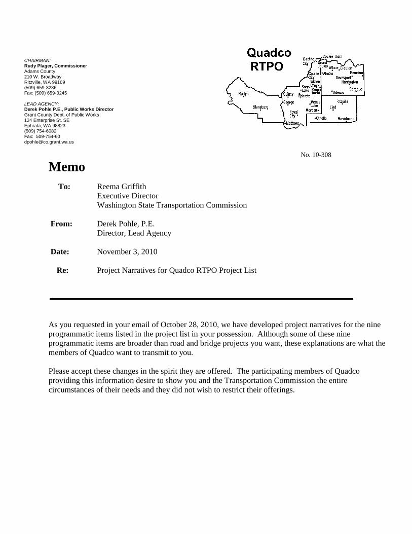
CHAIRMAN:Rudy Plager, CommissionerAdams County210 W. BroadwayRitzville, WA 99169(509) 659-3236Fax: (509) 659-3245
LEAD AGENCY:Derek Pohle P.E., Public Works DirectorGrant County Dept. of Public Works124 Enterprise St. SEEphrata, WA 98823(509) 754-6082Fax: [email protected]
No. 10-308
MemoTo: Reema Griffith
Executive DirectorWashington State Transportation Commission
From: Derek Pohle, P.E.Director, Lead Agency
Date: November 3, 2010
Re: Project Narratives for Quadco RTPO Project List
As you requested in your email of October 28, 2010, we have developed project narratives for the nine programmatic items listed in the project list in your possession. Although some of these nine programmatic items are broader than road and bridge projects you want, these explanations are what the members of Quadco want to transmit to you.
Please accept these changes in the spirit they are offered. The participating members of Quadco providing this information desire to show you and the Transportation Commission the entire circumstances of their needs and they did not wish to restrict their offerings.


QUADCO RTPO REGIONAL PRIORITY PROJECT LIST Submittal to Washington State Transportation Commission NARRATIVE PROJECT INFORMATION October 2010 Item 1: Public transportation
Project Description This programmatic review consists of transportation projects including Special Needs, Community Connections, Dial-A-ride and route deviated services, expansion of fixed route services, paratransit services, trip scheduling, ride reporting, planning services, public transportation infrastructure such as bus shelters, new buses, and maintenance garages. This program is specifying needs in Grant, Adams, Lincoln and Kittitas Counties. The completion of these programs will improve transportation services to those users that depend on public transportation and special transport services. Project Status & Timeline The coordination of these services has many participants and much of the program list specified below can be accomplished by 2021 or sooner. Typical program listing follows:

Project Name, Jurisdiction & Category
(i.e.: road or multi-modal)
Project Type - Indicate Applicable
Number(s) (see instruction memo)
Total Project Cost*Project Cost Breakdown
By Biennia - YOE $** (09/11; 11/13; 13/15 etc.)
Is This Project Consistent
with an Approved Regional
Transportation Plan?
Policy Goals Project
Addresses - Indicate Applicable
Numbers (see instruction
memo)
Comments
Special Needs Transportation (Dial-A-Ride & Route Deviated) for Grant, Adams, and Lincoln counties
Public Transportation-WSDOT
Ongoing funding to preserve special needs transportation resources = Total Costs =
$1,171 = 2011-13 $1,206 = 2013-15 $1,242 = 2015-17 $1,280 = 2017-19 $1,318 = 2019-21
Yes 1,2,3,4,5,6 People For People's Dial-A-Ride and Route Deviated Transportation will preserve critical existing service that covers over 7,000 square miles of communities for persons with special needs and the general public in Adams and Lincoln with limited services i
$6,217 Community Connector for Adams and Lincoln counties
Public Transportation-WSDOT
Ongoing funding to preserve special needs transportation resources = Total Costs =
$458 = 2011-13 $472 = 2013-15 $486 = 2015-17 $501 = 2017-19 $516 = 2019-21
Yes 1,2,3,4,5,6 People For People's Community Connector (Adams and Lincoln counties) preserves vital existing transportation services for special needs individuals and the general public to access service from Othello to Moses Lake and from Grand Coulee to Davenport with
$2,433 Expand Dial-A-Ride and Route Deviated Service for Adams and Lincoln counties
Public Transportation WSDOT
Funding to expand transportation service for individuals with special needs = Total Cost =
$265 = 2011-13 $272 = 2013-15 $281 = 2015-17 $289 = 2017-19 $298 = 2019-21
Yes 1,2,3,4,5,6 Expand Othello Connector to provide service to Ritzville in order for riders to connect with Special Mobility Services for access to Spokane.
$1,405
Columbia Basin Transport for Adams County
Public Transportation WSDOT
Funding to implement new service for Adams County special needs = Total Costs =
$227 = 2011-13 $234 = 2013-15 $241 = 2015-17 $248 = 2017-19 $255 = 2019-21
Yes 1,2,3,4,5,6 People For People would provide a new fixed route service for the impoverished communities of Desert Aire, Mattawa, Schwana, Royal City, and Othello.
$1,205 Vehicle Replacement - Capital Public
Transportation WSDOT
Replacement of 6 vehicles per biennium = Total Costs =
$474 = 2011-13 $488 = 2013-15 $502 = 2015-17 $517 = 2017-19 $533 = 2019-21
Yes 1,2,3,4,5,6 Vehicles will used to provide paratransit transportation services to the special needs populations in Grant, Adams and Lincoln counties.
$2,514 Computer Technology Upgrades - Capital
Public Transportation WSDOT
Computer hardware and software = Total Costs =
$50 = 2011-13 $4 = 2013-15 $6 = 2015-17 $4 = 2017-19 $6 = 2019-21
Yes 1,2,3,4,5,6 Computer software and hardware will be used to provide trip scheduling and data reporting in Grant, Adams and Lincoln Counties
$70 Vehicle Technology Upgrades - Capital
Public Transportation WSDOT
Vehicle cameras (14 vehicles) and GPS Systems for 16 vehicles = Total Costs =
$13 = 2011-13 Yes 1,2,3,4,5,6, Vehicles will used to provide paratransit transportation services to the special needs populations in Grant, Adams and Lincoln counties.
$13 Mobility Coordinator - Capital Public
Transportation WSDOT
$636 $120 = 2011-13 $123 = 2013-15 $127 = 2015-17 $131 = 2017-19 $135 = 2019-21
Yes 1,2,3,4,5,6 The Mobility Coordinator will provide transportation planning assistance to the residents of Grant, Adams and Lincoln counties.
1. Public Transportation 3 6 7 (non-profit) $2,100 11/13 $500|13/15 $1,748 Yes 1 3 4 5 6Public transit infrastructure - bus shelters, buses, and bus garage
$16,593

Item 2: Bridge Repair/Replacement >20 ft
Project Description • What is it? Replacement of County and City bridges that have a sufficiency rating
less that 50
• Where is it located? These bridges located in four counties and several cities. The Quadco RTPO has hundreds of timber bridges, dozens of substandard concrete and steel bridges that are or soon will fall below a minimum sufficiency rating of 50.
• What is the intended outcome & benefit? This project is intended to replace bridges to meet the current design standards. By reconstructing these bridges to the current standards would benefit the mobility and safety of the traveling public upon these roadways along with preserving the transportation system.
Project Status & Timeline
• Where is the project at in development? Many of these bridges are listed on local agency Six Year Transportation Improvement plans but due to lack of money they have not been rebuilt. The reduction in BRAC funding to the rural counties has affected each member county’s and city’s ability to complete the planned bridge replacement project needs.
• What is the timeline for this project from start to completion? (Please identify the major phases) If additional funding became available eligible bridge could continue to be replaced within the anticipated funding cycle. A typical program listing follows:
Project Name, Jurisdiction & Category
(i.e.: road or multi-modal)
Project Type - Indicate Applicable
Number(s) (see instruction memo)
Total Project Cost*Project Cost Breakdown
By Biennia - YOE $** (09/11; 11/13; 13/15 etc.)
Is This Project Consistent
with an Approved Regional
Transportation Plan?
Policy Goals Project
Addresses - Indicate Applicable
Numbers (see instruction
memo)
Comments
Bridge Replacement (Adams County) 1,3,6 $4,600 $4,600 (2013-15) Yes 1,3,4,63. Bridges over 20' (Ellensburg & Kittitas County) 1 2 3 4 5 6 7 $30,018
11/13 $6,000|13/15 $6,500|15/18 $34,000 Yes 1 2 3 4 5 6
New bridge over RR tracks & other large bridges
Miles Creston Bridge, Bridge No. B-76301 (Lincoln County) 1,2,3 $3,000
17/19 - $75019/21 - $1,25021/23 - $1,000 Yes 1,3,4,5,6
$37,618

Item 3: Drainage Structures <20 ft.
Project Description There are hundreds of structures under 20 foot long in the Quadco RTPO. Bridges under 20 feet long do not qualify for Federal Bridge Replacement Funding. Many of these bridges need to be replaced for various reasons relating to condition or obsolescence. Project Status & Timeline As there is no current funding mechanism for under 20 foot bridges, agencies within the Quadco RTPO have been funding these replacements with local funds when possible. With proper funding, these deficient structures could be replaced within a reasonable time period. Typical list of projects follows:
Item 4: Non-motorized Needs
Project Description This program constructs improvements for pedestrian access on existing facilities or connecting existing facilities with pedestrian paths. These improvements will improve safety and convenience for users of the pedestrian facilities. Project Status & Timeline All projects in this program area could be constructed within a relatively short time line if all rights-of way have been acquired and funding secured. Typical project list follows:
Project Name, Jurisdiction & Category
(i.e.: road or multi-modal)
Project Type - Indicate Applicable
Number(s) (see instruction memo)
Total Project Cost*Project Cost Breakdown
By Biennia - YOE $** (09/11; 11/13; 13/15 etc.)
Is This Project Consistent
with an Approved Regional
Transportation Plan?
Policy Goals Project
Addresses - Indicate Applicable
Numbers (see instruction
memo)
Comments
2. Bridges under 20' (Ellensburg & Kittitas County) 1 2 3 4 5 6 7 $13,838
09/11 $1045|11/13 $1109|13/15 $1177|15/17
$1248 Yes 1 2 3 4 5 6 annual needBridges Under 20' Replacement Project (Lincoln County) 1,3,6 $2,800 400 per biennia Yes 1,3,4,6Under 20 ft. Bridge Replacement Needs (Grant County) 1,2,3,4 $1,400 $700 per biennium Yes 1,2,3,4,6Drainage Structure Replacement Project (Adams County) 1,3,6 $5,500 550 / Biennia Yes / Section III 1,3,4,6
$23,538

Project Name, Jurisdiction & Category
(i.e.: road or multi-modal)
Project Type - Indicate Applicable
Number(s) (see instruction memo)
Total Project Cost*Project Cost Breakdown
By Biennia - YOE $** (09/11; 11/13; 13/15 etc.)
Is This Project Consistent
with an Approved Regional
Transportation Plan?
Policy Goals Project
Addresses - Indicate Applicable
Numbers (see instruction
memo)
Comments
4. Non motorized needs (Ellensburg & Kittitas County) 3 5 6 7 $6,500 11/13/$2,750|13/15 $3,250 Yes 1 3 4 5 6
Continue construction on missing links on John Wayne Trail & Yakima River Trail
SR 17/Stratford Road Bridge 017/216 MP 54.72 to 54.73 - Widening (WSDOT) 1,3 & 4 $10,000
09/11 $1500 K, 11/13 $7000 K, 13/15 $1500 K YES 1,3
Bridge Widening for mobility and wider pedestrian sidewalks
SR 262/Vicinity of Mar Don Resort - Highway shoulder improvements (Included in Region Pedestrian Improvements) (WSDOT) 1,2 & 4 $1,500 11/13 YES 1
Widen shoulders to provide safer pedestrian route adjacent to the Mar Don Resort and surrounding communities. This was partially accomplished under 05-07 risk funding.
$18,000
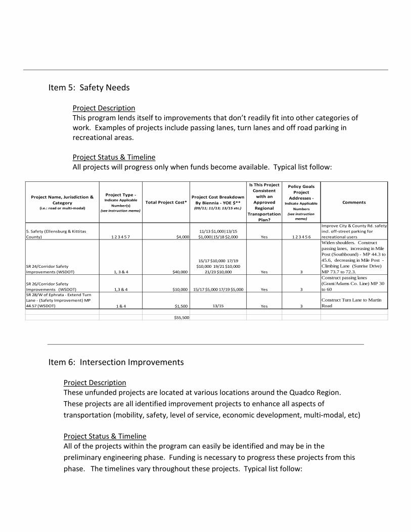
Item 5: Safety Needs
Project Description This program lends itself to improvements that don’t readily fit into other categories of work. Examples of projects include passing lanes, turn lanes and off road parking in recreational areas. Project Status & Timeline All projects will progress only when funds become available. Typical list follow:
Item 6: Intersection Improvements
Project Description These unfunded projects are located at various locations around the Quadco Region. These projects are all identified improvement projects to enhance all aspects of transportation (mobility, safety, level of service, economic development, multi-modal, etc)
Project Status & Timeline All of the projects within the program can easily be identified and may be in the preliminary engineering phase. Funding is necessary to progress these projects from this phase. The timelines vary throughout these projects. Typical list follow:
Project Name, Jurisdiction & Category
(i.e.: road or multi-modal)
Project Type - Indicate Applicable
Number(s) (see instruction memo)
Total Project Cost*Project Cost Breakdown
By Biennia - YOE $** (09/11; 11/13; 13/15 etc.)
Is This Project Consistent
with an Approved Regional
Transportation Plan?
Policy Goals Project
Addresses - Indicate Applicable
Numbers (see instruction
memo)
Comments
5. Safety (Ellensburg & Kittitas County) 1 2 3 4 5 7 $4,000
11/13 $1,000|13/15 $1,000|15/18 $2,000 Yes 1 2 3 4 5 6
Improve City & County Rd. safety incl. off-street parking for recreational users
SR 24/Corridor Safety Improvements (WSDOT) 1, 3 & 4 $40,000
15/17 $10,000 17/19 $10,000 19/21 $10,000
21/23 $10,000 Yes 3
Widen shoulders. Construct passing lanes, increasing in Mile Post (Southbound) - MP 44.3 to 45.6, decreasing in Mile Post - Climbing Lane (Sunrise Drive) MP 73.7 to 72.3.
SR 26/Corridor Safety Improvements (WSDOT) 1,3 & 4 $10,000 15/17 $5,000 17/19 $5,000 Yes 3
Construct passing lanes (Grant/Adams Co. Line) MP 30 to 60
SR 28/W of Ephrata - Extend Turn Lane - (Safety Improvement) MP 44.57 (WSDOT) 1 & 4 $1,500 13/15 Yes 3
Construct Turn Lane to Martin Road
$55,500
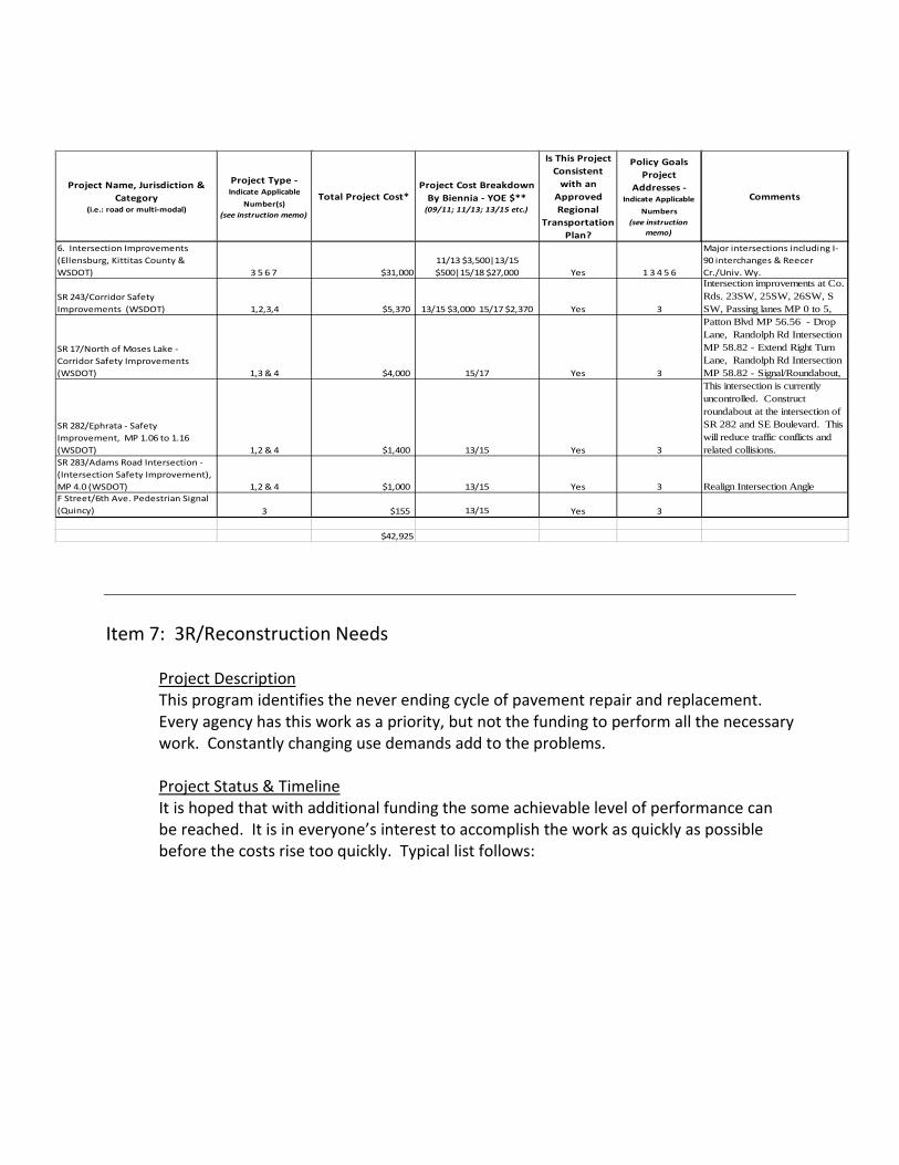
Item 7: 3R/Reconstruction Needs
Project Description This program identifies the never ending cycle of pavement repair and replacement. Every agency has this work as a priority, but not the funding to perform all the necessary work. Constantly changing use demands add to the problems. Project Status & Timeline It is hoped that with additional funding the some achievable level of performance can be reached. It is in everyone’s interest to accomplish the work as quickly as possible before the costs rise too quickly. Typical list follows:
Project Name, Jurisdiction & Category
(i.e.: road or multi-modal)
Project Type - Indicate Applicable
Number(s) (see instruction memo)
Total Project Cost*Project Cost Breakdown
By Biennia - YOE $** (09/11; 11/13; 13/15 etc.)
Is This Project Consistent
with an Approved Regional
Transportation Plan?
Policy Goals Project
Addresses - Indicate Applicable
Numbers (see instruction
memo)
Comments
6. Intersection Improvements (Ellensburg, Kittitas County & WSDOT) 3 5 6 7 $31,000
11/13 $3,500|13/15 $500|15/18 $27,000 Yes 1 3 4 5 6
Major intersections including I-90 interchanges & Reecer Cr./Univ. Wy.
SR 243/Corridor Safety Improvements (WSDOT) 1,2,3,4 $5,370 13/15 $3,000 15/17 $2,370 Yes 3
Intersection improvements at Co. Rds. 23SW, 25SW, 26SW, S SW, Passing lanes MP 0 to 5,
SR 17/North of Moses Lake - Corridor Safety Improvements (WSDOT) 1,3 & 4 $4,000 15/17 Yes 3
Patton Blvd MP 56.56 - Drop Lane, Randolph Rd Intersection MP 58.82 - Extend Right Turn Lane, Randolph Rd Intersection MP 58.82 - Signal/Roundabout,
SR 282/Ephrata - Safety Improvement, MP 1.06 to 1.16 (WSDOT) 1,2 & 4 $1,400 13/15 Yes 3
This intersection is currently uncontrolled. Construct roundabout at the intersection of SR 282 and SE Boulevard. This will reduce traffic conflicts and related collisions.
SR 283/Adams Road Intersection - (Intersection Safety Improvement), MP 4.0 (WSDOT) 1,2 & 4 $1,000 13/15 Yes 3 Realign Intersection AngleF Street/6th Ave. Pedestrian Signal (Quincy) 3 $155 13/15 Yes 3
$42,925

Item 8: Bypass Needs
Project Description This project will overlay a major truck route that provides a by-pass on the western edge of Ellensburg. Ellensburg has recently improved one leg of this by-pass at the Canyon Road/I-90 Interchange and Ellensburg has programmed improving the other leg at the US 97/I-90 Interchange. This project will provide the remaining needed improvements in this by-pass route. It is a key route for major exporters and industrial companies located in the Kittitas County region including Anderson Hay. The completion of this by-pass will decrease the volume of industrial traffic that passes though highly populated areas in Ellensburg and will promote economic development in Kittitas County. Project Status & Timeline
Project Name, Jurisdiction & Category
(i.e.: road or multi-modal)
Project Type - Indicate Applicable
Number(s) (see instruction memo)
Total Project Cost*Project Cost Breakdown
By Biennia - YOE $** (09/11; 11/13; 13/15 etc.)
Is This Project Consistent
with an Approved Regional
Transportation Plan?
Policy Goals Project
Addresses - Indicate Applicable
Numbers (see instruction
memo)
Comments
7. 3R/Reconstruction (Ellensburg & Kittitas County) 3 5 6 7 $87,500
11/13 $8,500|13/15 $9,000|15/18 $9,500 Yes 1 3 4 5 6
Annual preservation programs and 3R projects including No. 6 Rd.
Rocklyn Rd. No. 9255, M.P. 3.24 - 6.24 (Lincoln County) 1,2,3,6 $1,700
11/13 - $25013/15 - $1,450 Yes 1,2,3,4,5,6
Miles Creston Rd. No. 9510, M.P. 0.00 to 4.99 (Lincoln County) 1,2,3,6 $1,900
11/13 - $25013/15 - $1,650 Yes 1,2,3,4,5,6
Kiner Rd. No. 9115. M.P. 16.70 - 20.29 (Lincoln County) 1,2,3,6 $1,950
13/15 - $35015/17 - $1,600 Yes 1,2,3,4,5,6
Old Coulee Rd. No. 9433, M.P. 8.07 - 12.15 (Lincoln County) 1,2,3,6 $2,244
13/15 - $35015/17 - $1,894 Yes 1,2,3,4,5,6
Duck Lake Rd. No. 9231, M.P. 6.26 - 15.67 (Lincoln County) 1,2,3,6 $5,100
15/17 - $40017/19 - $4,700 Yes 1,2,3,4,5,6
Sprague Highway Rd. No. 9315, M.P. 9.64 - 14.82 (Lincoln County) 1,2,3,6 $2,500
15/17 - $40017/19 - $2,100 Yes 1,2,3,4,5,6
Hanson Harbor Rd. No. 4841, M.P. 2.01 - 12.02 (Lincoln County) 1,2,3,6 $6,005
17/19 - $1,00019/21 - $3,00021/23 - $2,005 Yes 1,2,3,4,5,6
SR 243 - Rebuild Roadway MP 0.0 to 28.26 (Economic Initiatives & Safety) WSDOT) 1,2 & 4 $32,000
15/17 $10,000 17/19 $12,000 19/21 $10,000 Yes 1,2,6
Improve roadway pavement structure to support legal traffic loads year around. Increase surfacing for Frost Heaves, Widen shoulders.
SR 283/Murphy's Corner to Naylor Jct. - Pavement Recycle and BST MP 0.0 to 14.86 (WSDOT) 1,2, 4 & 6 $8,000 13/15 Yes 2
Cold in place recycle with a BST. Average due year 2018 with cracking the major factor. Based on WSPMS 2010.
All Season Roads Reconstruction (Grant County) 3,4,6 $24,250 $4,850 per biennium Yes 1,3,4,6I-90 Frontage Rd Widening and Resurfacing (Grant County) 1,2,3,4,6 $11,475 $2,295 per biennium Yes 1,2,3,4,56th Avenue Widening, City of Quincy 3 $740 11/13 Yes 3Collector Roads Reconstruction Project (Adams County) 1,2,6 $45,900 $9,180/ Biennia Yes / Section III 1,3,4,6
$231,264

Kittitas County plans to design this project in 2011 with local funds. If additional funding is awarded, construction would take place in 2012.
Item 9: New Construction
Project Description This program reflects the needs of all growing communities - new routes serving growing areas with little or no money available to perform the work. The range of projects is large . . . new roads where none existed, additional capacity by adding lanes, intelligent traffic design, reactive work due to recent legislative changes. That work falls here. Project Status & Timeline Much of the work listed below will be constructed with funding and within a reasonable time line. The region has been seen the funding gap growing larger every year for far too many years. Typical list follows:
Project Name, Jurisdiction & Category
(i.e.: road or multi-modal)
Project Type - Indicate Applicable
Number(s) (see instruction memo)
Total Project Cost*Project Cost Breakdown
By Biennia - YOE $** (09/11; 11/13; 13/15 etc.)
Is This Project Consistent
with an Approved Regional
Transportation Plan?
Policy Goals Project
Addresses - Indicate Applicable
Numbers (see instruction
memo)
Comments
8. By-Pass - Umptanum/ Anderson/ Railroad truck by-pass (Kittitas County & Ellensburg) 3 5 6 7 $1,000 11/13 $1,093 Yes 1 3 4 5 6
Truck Route from interchange to interchange
$1,000
Project Name, Jurisdiction & Category
(i.e.: road or multi-modal)
Project Type - Indicate Applicable
Number(s) (see instruction memo)
Total Project Cost*Project Cost Breakdown
By Biennia - YOE $** (09/11; 11/13; 13/15 etc.)
Is This Project Consistent
with an Approved Regional
Transportation Plan?
Policy Goals Project
Addresses - Indicate Applicable
Numbers (see instruction
memo)
Comments
9. New Construction - Kittitas County - Bowers Road Ext. East (Ellensburg & Kittitas County) 3 5 6 7 $1,630 09/11 $134|11/13 $1,496 Yes 1 3 4 5 6
Completes NW Ellensburg by-pass
SR 17/Corridor Safety Improvements (WSDOT) 1,3 & 4 $11,100
09/11 $1500 K, 11/13 & $6000 K Yes 3
Construct passing lanes. (Paradise Rd.)SB MP 17.37 to 18.98, (Grant/Adams Co. Line)SB MP 35.6 to 34.27, (Lind Coulee)NB MP 42.9 to 44.5, (Old Neppel Rd.) MP 65.2 to 66.6. Construct left turn lanes; S of Othello (Bench Road) at Bench Road MP 27.36, S of Warden(10 SE Rd) MP 37.65,

Item 10: 15. Ellensburg/WSDOT - US 97/University Way/Dolarway Intersection
Project Description What is it? Intersection currently a multilane four way stop under WSDOT jurisdiction serving industrial areas as well as truck stop and future retail location. This project would construct necessary improvements (traffic signal or round-a-bout), bike lanes, sidewalks, etc at the intersection is necessary for growth to maintain intersection within adopted levels of service.
US 97/NB Blewett Pass - Truck Lane (Iron Creek) MP 158.30 to 178.0 (WSDOT) 1,3 & 4 $25,000
17/19 $8,000 19/21 $8,000 21/23 $9,000 Yes 1,3,4
Constructs new truck climbing lanes for northbound traffic south of Blewett Pass on SR 97. This will reduce traffic congestion, reduce accidents from slower moving and passing vehicles, and benefit freight movement.
SR 17/Othello To Moses Lake - Corridor Safety, Freight Improvement and Mobility Improvements (WSDOT) 1,3 & 4 $75,000
15/17 $15,000 17/19 $15,000 19/21 $15,000
21/23 $15,000 23/25 $15,000 YES 3,4 Safety and Freight Improvements
SR 17/SR 395 to Moses Lake - Multi-Lane Corridor (WSDOT) 1,3 & 4 $155,000
17/19 $30,000 19/21 $30,000 21/23 $30,000 23/25 $30,000
$25/27 $35,000 YES 4 Construct Additional 2 Lanes
SR 17/Moses Lake to Ephrata - Multi-Lane Corridor (WSDOT) 1,3 & 4 $80,000
17/19 $20,000 19/21 $20,000 21/23 $20,000 23/25 $20,000 Yes 4 Construct Additional 2 Lanes
SR 28/West Of Quincy - Additional Lanes (Corridor Mobility Improvement) STAGE 3 MP 22.94 to 32.0 (WSDOT) 1,3 & 4 $185,000
17/19 $30,000 19/21 $30,000 21/23 $30,000 23/25 $30,000 25/27
$30,000 27/29 $35,000 Yes 3
Constructs one additional lane in each direction from Crescent Bar to Quincy at the junction of SR 281 on SR 28. This is the third stage of a four stage project. There are currently 2 lanes. There will be four lanes when this project is complete.
I-90 / Basin Communications and Traveler Information (WSDOT) 1 $700 13/15 Yes 3,4
Intelligent Transportation System to provide added information to travelers resulting in better awarenes of driving conditions leading to a safer and more predictable roadway.
US 97, Swauk Creek Campground - Wildlife Connectivity (Environmental Retrofit Improv) MP 157.5 to 160.0 (WSDOT) 1 & 3 $3,500 13/15 Yes 3
This location has been identified as one of the top ten deer-vehicle collision sites in the state. The project includes the installation of approximately 5 miles of long-term deer-proof fence, gates, jump-out structures and one underpass structure.
SR 281/George To Quincy-Additional Lane Corridor project, MP 0.00 to MP 10.55 (Mobility Improvement) STAGE 4 (WSDOT) 1,3 & 4 $75,000
17/19 $20,000 19/21 $20,000 21/23 $20,000 23/25 $15,000 Yes 4
Constructs one additional lane in each direction from Quincy at the junction of I-90 on SR 281. This is the fourth stage of a four stage project. There are currently 2 lanes. There will be four lanes when this project is complete.
$611,930

Where is it located? The intersection is immediately adjacent to on/off-ramps to Interstate 90 and is the intersection of Sr97/Dolarway Road/University Way. What is the intended outcome & benefit? This project is identified in City’s Comprehensive Plan as a limiting factor to growth based on acceptable levels of service. Reconstruction/capacity and multimodal improvements are required. Project Status & Timeline Where is the project at in development? WSDOT has evaluated and determined that a round-a-bout is desired at this location. This project is still in preliminary engineer stage and has some right of way work completed. Funding is currently the limiting factor. What is the timeline for this project from start to completion? This project could likely take one or two years to complete once funding is secured.
Item 11: 16. Kittitas County - Fairview Road
Project Description This project will consolidate three substandard stream crossings into one crossing, reducing the environmental impacts and reconstructing the road to County standards. It is located northeast of Ellensburg. The completion of this project will improve fish passage in this vicinity and make it safer for the travelers. Project Status & Timeline The County has received verbal support from environmental agencies for this project. If funding is awarded, the design work can be completed in 2011 and construction would take place in 2012.
Item 12: 17. City of Kittitas - Industrial Park Access
Project Description This project will build a new access road to a proposed industrial and business park. It is located southeast of Kittitas near the I-90 interchange. The completion of this project will improve the economic vitality for the City of Kittitas and surrounding region. Project Status & Timeline This project will likely take one to two years to design/bid/construct once funding is secured.
Item 13: Lincoln County - Hawk Creek Rd. No. 5554 & 5786 M.P. 3.50 – 10.66 on Road No. 5554 & M.P. 10.23 – 11.41 on Road No. 5786
Project Description • What is it? This is a Category 1 safety and reconstruction project.
• Where is it located? This project is located in Lincoln County between the City of Davenport and the community of Seven Bays.
• What is the intended outcome & benefit? Hawk Creek Road is a Major Collector Route (FFC 07) connecting Davenport to Rural Development and Recreation along the Northern Lincoln County Border. This project will upgrade the road from gravel surface to paved surfacing. This project will improve safety and meet motorist’s expectations. The Project will improve the drivability and safety of the roadway and increase the economic viability of the region.
This project will: Benefit agriculture, business, tourism and development, Keep people employed and create new employment opportunities, Preserve the environment, Maintain and enhance the quality of life within the region, Provide timely and safe access for emergency services.
Project Status & Timeline
• Where is the project at in development? This corridor has been on the 6-year TIP for many years. About a third of this corridor has been upgraded in 2009 & 2010.
• What is the timeline for this project from start to completion? (Please identify the major phases)
o PE: 2011 – 2013 R/W: 2011 – 2013 Construction: 2013 - 2015
Additional Comments Lincoln County doesn’t have the luxury of having funds available for preliminary engineering, environmental and right of way work. We don’t have plans waiting on the shelf for construction.
Item 14: City of Moses Lake – Lakeshore Dr Reconstruction Project
Project Description

• What is it? This project consists of reconstructing a 3,300 foot section of Lakeshore Drive.
• Where is it located? In the Peninsula area south of Interstate 90 and extending to the newly constructed Sage Point Elementary.
• What is the intended outcome & benefit? To replace the existing BST roadway with a wider HMA surface and adding curb and gutter, a storm drain system, sidewalks, and an activity trail.
Project Status & Timeline
• Where is the project at in development? This project is on the City’s 6-year Transportation Improvement Program. Some preliminary design work has been completed to determine quantities and cost estimates.
• What is the timeline for this project from start to completion? Complete Design Fall/Winter 2011 ROW Acquisition Winter 2011 Construction Spring/Summer 2012
Additional Comments This work will be the fourth and final phase of a project that will complete a 3.3 mile, looped activity trail that will connect the entire Peninsula area with the Sage Point Elementary School and the City’s Lower Peninsula Park.
The timeline for this project is dependent upon funding.
Item 15: WSDOT - SR 243/Intersection RD 24 SW - (Intersection Safety Improvement) MP 13.94
Project Description Submitted for Intersection Safety. Realign Intersection/Round-a-bout/Interchange. Project Status & Timeline This project is in the early pre-design analysis to determine the most appropriate type of intersection improvement. A low cost grade separation is being reviewed and considered. Timeline would be two years for design and right of way, then one construction season for construction.

Item 16: WSDOT - SR 26/Othello - Intersection Revision (Safety Improvement), SR 26/Othello at First Street, Stage 2, Safety
Project Description Stage 2 will complete all of the intersection improvements that have been coordinated with WSDOT and the City of Othello. Improvements will help make the vehicle movements at this intersection safer. Project Status Stage 1 was completed in 2009. Design is mostly done for Stage 2, minimal right of way in needed. Construction can take place in one construction season.
Item 17: WSDOT – SR 21/Keller Ferry Replacement
Project Description This project will replace the current 63 year old Keller Ferry vessel that has safety and operational issues. Review and analysis of the issues has identified a preferred solution of a new ferry vessel. The Keller Ferry operates seven days per week, 365 days per year, 6:00 AM – Midnight providing service across Lake Roosevelt as a part of SR 21. The ferry makes an average of 30 to 35 round trips per day. The alternate route adds 60 miles one way to this trip. Project Status The Planning and Design phases have been completed; approx. $675,000 has been expended. Construction cost is estimated at $12.2 Million, and will take 14 to 17 months to complete.
Item 18: City of Quincy - F Street SW / 13th Avenue SW Traffic Signal QPI - 11 - 03
Project Description
• What is it? Construct traffic signal with eastbound and westbound protected signal phases, and northbound and southbound permitted phases. Enhance turn lanes on north and south legs.
• Where is it located? Located at the intersection of F Street SW (SR 28) and 13th Avenue SW.
• What is the intended outcome & benefit?

Construction of traffic signal will help improve level of service (LOS) and facilitate safe movements from F Street SW (SR28) onto 13th Avenue SW. As north 13th Avenue is expected to support heavy truck traffic, this signal will also provide the appropriate time frame in which trucks can safely enter and depart the highway.
Project Status & Timeline
• Where is the project at in development? The project is at the Preliminary Engineering Stage.
• What is the timeline for this project from start to completion? (Please identify the major phases)
Project Schedule Date Design 03/01/12 Permits 05/01/12 Construction 08/01/12 Project Closeout 12/01/12
Item 19: Grant County – R NE Rd Widening and Reconstruction, 27 NE to 36 NE
Project Description This nine mile long two-lane arterial project will complete the missing link serving as the only commodity haul route in northern Grant County. The roadway will be widened and reconstructed to accommodate current truck standards, improve safety and all-season reliability. With the loss of rail services our agribusinesses are completely dependent on local roads to serve their business needs.
Project Status and Timeline The project needs funding to complete the design and construction phases. It is listed on the Six Year Transportation Improvement Program. The project can be easily completed within two years of funding authorization. All necessary rights of way have been acquired.
Item 20: McManamon Bridge #400-3 Replacement Project
Project Description

• What is it? Replacement of McManamon Bridge #400-3 along with approach roadways.
• Where is it located? Located in the SW portion of the County in Section 27 & 28, Township 16N, Range 29E.
• What is the intended outcome & benefit? This project is intended to replace the existing structure as well as existing approach roadways to meet the current design standards. By reconstructing this bridge and roadways we will be completing a missing link connecting the SW portion of Adams County and the SE portion of Grant County to the City of Othello.
Project Status & Timeline
• Where is the project at in development? This bridge has been in the Adams County Six Year Transportation plan in the past but due to the reduction in BRAC funding has not been rebuilt.
• What is the timeline for this project from start to completion? (Please identify the major phases) If funding became available Adams County would begin preliminary engineering in fiscal year 2011/2012 and construction would be planned for the 2013/2015 biennium.
Additional Comments
• McManamon Road is a major arterial linking the City of Othello with portions of Adams and Grant Counties. The road is used to transport produce and other commodities to storage and processing facilities in the Othello area, provides access to recreational areas in and around the Columbia Wildlife Refuge, and is the primary route for a growing residential population to get to shops, work and school in the City of Othello.
• The McManamon Rd east of this project has been rebuilt (11.00 miles) which completes the roadway and bridge portion to the Grant County line. Grant County also completed their portion of the roadway extending west of the county line during the late 2000’s construction season. This portion represents the last unimproved section of road.
• Because of the physical location of this roadway this route is considered high importance because an alternate route (detour) is impractical due to length. If the bridge was closed or weight restricted the alternate routing of traffic would be in excess of an additional 20 miles.


Skagit MPO / Skagit-Island RTPO Regional Priority Project List - TRANSIT
##
Project Name, Jurisdiction & Category (i.e.: road or multi-modal)
Project Type - Indicate
Applicable
Number(s)
(see instruction
memo)
Total Project
Cost*
Project Cost
Breakdown
By Biennia - YOE
$** (09/11; 11/13; 13/15
etc.)
Is This Project
Consistent with
an Approved
Regional
Transportation
Plan?
Policy Goals Project
Addresses - Indicate
Applicable Numbers
(see instruction memo)
Comments
Island Transit Projects
1
New Main Operations, Administration, and Maintenance Base Facilities Project, including Parker Road Realignment / Smith Prairie Getaway / Bike Transit Park
1, 3, 4,5 23,86311/13: $23,863
Yes 3,4,5,6
With large, well-equipped facilities, appropriate office space, full integration of system-wide surveillance systems, real-time dispatching, MDT/AVL system, etc. this Project will bring our system to a state of good repair, and will also provide Island Transit with the resources, technologies, and tools needed to meet growing regional transportation demands for the next 30 years and beyond. The Parker Road project portion will allow Island Transit to construct a secondary access situated safely off of SR 20 for bus ingress/egress at their facilities. The planned improvements will greatly mitigate area congestion and increasing overall safety.
2 Regional Connector Services (Island) 4,5 $39,390
11/13: $6,975,102 13/15: $7,399,886 15/17: $7,850,539 17/19: $8,328,637 19/21: $8,835,851
Yes 4,5,6
Regional connector services continue to relieve congestion and improve mobility by providing commuter-based transit service. This effort will meet increasing demand for public transportation options between Island, Skagit and Whatcom Counties.
3Selma Farmer Transit Park, wetlands enhancement and mitigation
3, 4, 5 $5,000 11/13: $5,000,000
Yes 1,4,5,6
This project will provide a needed park and ride for 100 vehicles, develop intersection improvements to meet concurrency and increase safety, allow for express routes to the ferry and connect with a planned trail system to facilitate pedestrian access in the Freeland area.

4Vehicle Replacement / Expansion$28,091
11/13: $6,967,282 13/15: $4,705,645 15/17: $7,469,710 17/19: $4,962,467 19/21: $3,985,495
Yes
This project consists of purchasing replacement / expansion vehicles to be used for Specialized Paratransit, Route Deviation, and Fixed Route rural commuter services throughout Island County and for cross-county regional connector services. In addition, this project will allow Island Transit to expand service on Whidbey and Camano Island to include 30-minute service Monday through Friday until 8PM, and then hourly to midnight, more frequent service on Saturday and running to midnight, and limited Sunday service.
5Transit Station / Transit Park at SR 20 and Monroe Landing Road Vicinity
3,4, 5$4,000 11/13: $4,000,000Yes3,4,5This wil become the main transfer station for Whidbey Island Services.
6Race Road/Central Whidbey Transit Park3,4,5$1,000 13/15: $1,000,000 Yes3,4, 5This transit station will provide a critical link and service to transit riders. Currently there is no formal park and ride in the vicinity.
7Whidbey Solar Skyway Demonstration Project3$25,000 11/13: $6,000,000 13/15: $19,000,000
Yes1,3,4,5,6
This project could serve as a model for similar applications throughout the state and country. In essence, a solar skyway would operate above the existing highway. The roof of the skyway would be solar panel and a pod car would travel below.
8Transit Park Development Funds3,4,5$8,000 11/13: $4,000,000 13/15: $4,000,000
Yes1,2, 3,4,5,6
Identification and development of transit parks and facilities on Whidey and Camano Islands improve connectivity and mobility using transit. Includes the following Transit Parks: Selma Farmer; Elger Bay; N.Whidbey; Greenbank. Also Langley Funicular and Pocket Transit Parks.
9MDL-AVL / Dispatch Communications / Enhancements1,4$800 11/13: $800,000 Yes2,3,4The project is comprised of software to enhance the MDT-AVL's to improve vehicle and route efficiency and greater mobility options.
10Transit Security and Communications Systems in Partnership with law enforcement
1$500 11/13: $500,000 Yes4,6Monitoring systems greatly enhance safety.
Skagit Transit Projects
11Alger Park and Ride3,4,51,19011/13: 1,190Yes1,4,5,6This project will improve the performance, reduce maintenance costs and enhance the amenities at the Alger Park and Ride facility.
12Regional Connector Services (Skagit)1,3,4,53,40011/13: 3,400Yes4,5,6
Regional connector services continue to relieve congestion and improve mobility by providing commuter-based transit service. This effort will meet increasing demand for public transportation options between Island, Skagit and Whatcom Counties.

13Skagit Transit Maintenance, Operations and
Administration Building Feasibility Study1,6 100 11/13: 100 Yes 3,4
A cost/benefit feasibility study is needed to determine the most efficient approach for needed facility expansion.
14 Remodel of Skagit Station 1,2,4 650 11/13: 650 (estimate) Yes 1,3,4The existing lobby at the Skagit Station is insufficient in size to accommodate the number of passengers waiting for buses or trains.
*Dollars in thousands TOTAL 117,121
**YOE = Year of Expenditure Dollars assuming a 3% inflation factor
Project Type:
1. Safety2. Reconstruction3. New Construction4. Adds Capacity5. Adds Multi-Modal Facility6. Maintenance
Policy Goals:
1. Economic Vitality2. Preservation 3. Safety4. Mobility 5. Environment6. Stewardship


Regional Connector Services 4,5 39,390,015
11/13: $6,975,102
13/15: $7,399,886
15/17: $7,850,539
17/19: $8,328,637
19/21: $8,835,851
Parker Road Realignment / Smith Prairie
Getaway / Bike Transit Park1, 3, 4,5 1,460,000
11/13:
13/15
Selma Farmer Transit Park, wetlands
enhancement and mitigation3, 4, 5 5,500,000
11/13:5,500
Transit Station / Transit Park at SR 20 and
Monroe Landing Vicinity3,4, 5 4,000,000 11/13: $4 M
Race Road/Central Whidbey Transit Park 3,4,5 1,000,000 13/15: $1 M
Whidbey Solar Skyway Demonstration
Project3 $25,000,000
11/13: $ 13/15:
$ 15/17: $
Transit Park Development Funds 3,4,5 13,000,00011/13: $
13/15:
MDL-AVL / Dispatch Communications /
Enhancements1,4 800,000 11/13: $800,000
Transit Security and Communications
Systems in Partnership with law
enforcement
1 500,000 11/13: $500,000


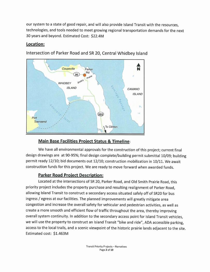


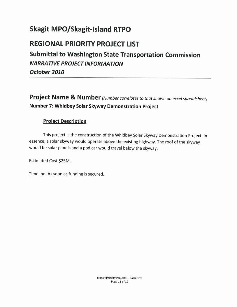

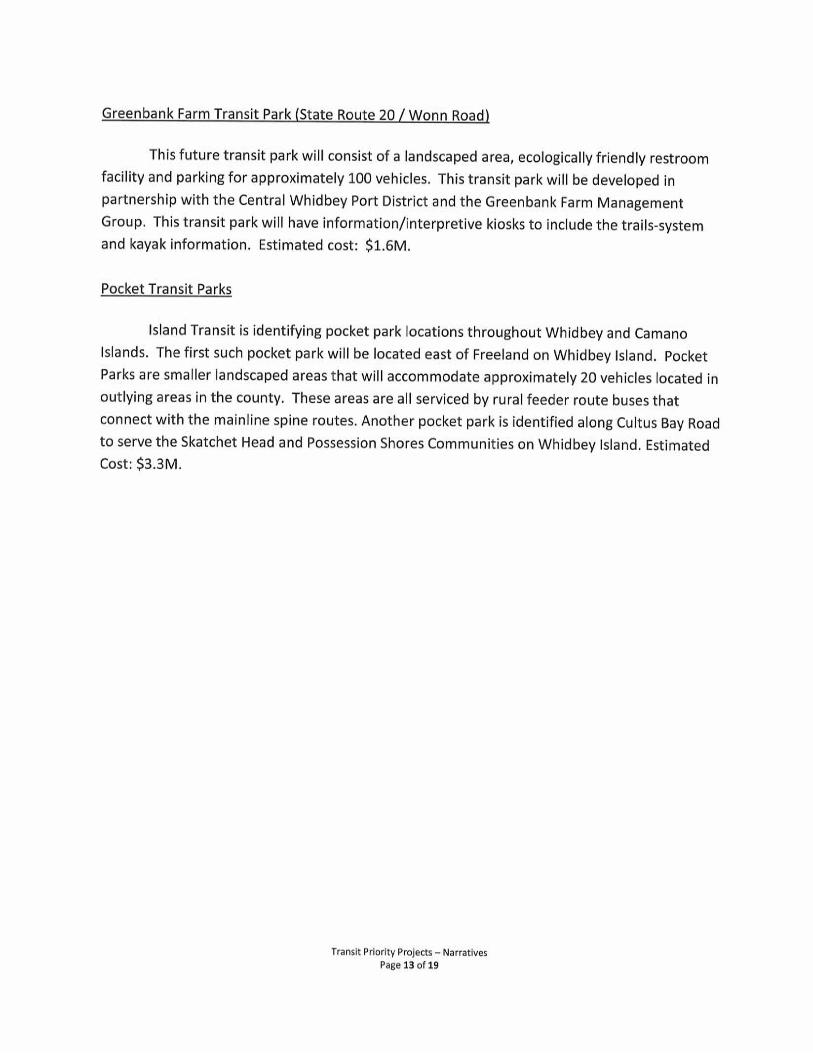
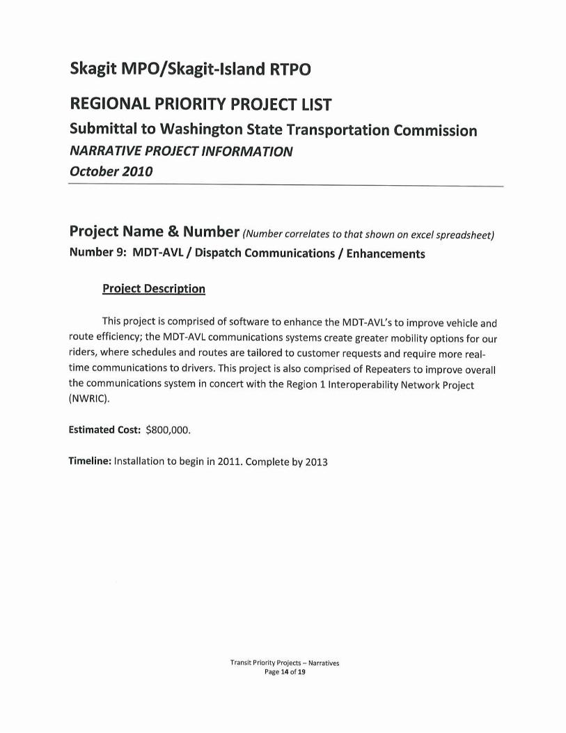


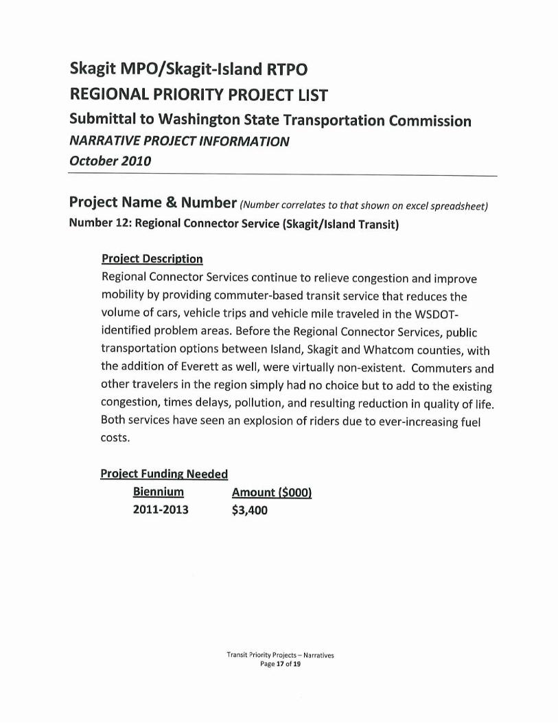


<Insert MPO/ RTPO Name> REGIONAL PRIORITY PROJECT LIST Submittal to Washington State Transportation Commission NARRATIVE PROJECT INFORMATION October 2010
Project Name & Number (Number correlates to that shown on excel spreadsheet)
<Insert text>
Project Description
• What is it? <Insert text>
• Where is it located? <Insert text>
• What is the intended outcome & benefit? <Insert text>
Project Status & Timeline
• Where is the project at in development? <Insert text>
• What is the timeline for this project from start to completion? (Please identify the major phases) <insert text>
Additional Comments
REPEAT THE ABOVE INFORMATION FOR EACH PROJECT


<Insert MPO/ RTPO Name>Regional Priority Project List
October, 2010
Project Name, Jurisdiction &
Category (i.e.: road or multi-modal)
Project Type - Indicate Applicable
Number(s)
(see instruction memo)
Total Project Cost*
Project Cost Breakdown
By Biennia - YOE $** (09/11; 11/13; 13/15 etc.)
Is This Project
Consistent with
an Approved
Regional
Transportation
Plan?
Policy Goals
Project Addresses
- Indicate Applicable
Numbers
(see instruction
memo)
Comments
*Dollars in thousands
**YOE = Year of Expenditure Dollars assuming a 3% inflation factor