regional policy plan chapter 2 - niagara region
TRANSCRIPT


Chapter 2 2 - 2
This page has been intentionally left blank.

Chapter 2 2 - 3
2. Growing the Economy In many ways, the Niagara Region is a community of communities and this is becoming increasingly so. It is made up of towns and cities, hamlets and rural areas, all linked together by social and economic ties. People live in one community and shop and work in another. They have ties of friendship and family relations to other communities and enjoy recreational and social activities around the Region. As a community, Niagara has special qualities, rooted in its rich cultural and historical heritage, its unique mix of natural resources, and in its diversity. It offers a mix of the urban and the rural, of small hamlets and bustling cities, of specialty farmlands and sensitive natural areas, of heavy industry and scenic tourist spots. It is seen as a special area known for Niagara Falls and the Welland Canal, for historic sites such as Niagara-on-the-Lake and historic Fort Erie, and for its orchards and vineyards. Both those who live here and those who visit as tourists value the special qualities that Niagara has to offer. The preservation and enhancement of the Region's special character will be important to the quality of life here in the future. At the same time, though, it is also important to provide for economic development and housing to meet the needs of those who live in Niagara. The challenge is to provide a balance between conservation and development. At the Regional scale, there is the opportunity to achieve such a balance, accommodating urban development while conserving resources and protecting the environment. Increasingly, economic development at the community level is influenced by quality of life issues such as environmental health and quality, housing mix and affordability, the quality of public services, and the range of educational and recreational facilities. There is the opportunity to establish a framework to guide change that will preserve and enhance what is special about Niagara while also accommodating growth and new development. To this end, seven strategic objectives have been identified along with underlying principles which assist in the attainment of the objectives. Strategic Objectives
2.1 To recognize the diversified opportunities and needs in Niagara by balancing both urban
development and the conservation of natural resources.
a) A choice of housing and employment locations. b) Development and efficient use of lands within the existing urban boundaries first. c) Conservation of natural resources (e.g., fishery habitat, Areas of Natural and Scientific Interest,
natural areas, wildlife habitat, waterways, Niagara Escarpment, wetlands, aggregate areas, and woodlots).
d) Minimization of conflicts between incompatible land uses.
2.2 To facilitate and maintain a pattern of distinctive and identifiable urban communities.
a) Separation between urban areas. b) Integrated urban communities. c) A variety of housing suited for each urban area. d) Recognition of historical features. e) Provision of opportunities for selective rural development in areas of poor agricultural land where
farming activities would not be adversely impacted.

Chapter 2 2 - 4
2.3 To encourage two discontinuous development corridors, one between Thorold and Port Colborne and the other between Niagara Falls and Fort Erie, through enabling public policies.
a) Preferred locations for additional residential and employment areas based on studies showing the
Regional need for additional land. b) Access to be improved by completion of Highway 406 and the mid-peninsula transportation
corridor. c) Corridors to recognize natural resources and protect environmental features. d) Orderly, staged development within the corridors.
2.4 To preserve and enhance the ecological processes and life-support systems essential for
sustaining human well-being and the health of the natural environment.
a) Importance of water quality (e.g., as a source of drinking water, and for fishery habitat). b) Public facilities to protect water quality. c) Air quality improvements by good urban design, reduced commuting, and linking residential and
employment areas. d) Contributions of natural areas (e.g., wetlands).
2.5 To improve regional self-reliance through long-range economic development planning and
economic diversification.
a) Attraction of more employment through existing or new firms. b) Creation of tourism development opportunities. c) Importance of affordable housing. d) Relating employment and residential areas to discourage commuting.
2.6 To provide for the conservation and wise use of Niagara's agricultural and other natural
resources, through environmentally sound resource use without compromising the needs of future generations.
a) Advocate and support government policies and programs which promote the agricultural
industry. b) Protection of farmers' right-to-farm by minimizing the introduction of incompatible land uses
within the agricultural areas. c) Preserve agricultural lands with highest priority being given to the protection of the unique
agricultural lands. d) Preference for urban development on lower quality agricultural land. e) Conservation of forest resources, fisheries, and significant landscape features. f) Wise use of mineral aggregate resources.
2.7 To undertake and support those activities which improve the quality of life for the Niagara
community.
a) Importance of quality of life in community development through housing, employment, services, agriculture, environmental quality, and natural features.

Chapter 2 2 - 5
Strategic Statement These seven objectives taken together provide the basis for a Regional Strategy to guide development and change in Niagara. This Strategy represents a balance among the various objectives, a balance between development and conservation. The combined objectives are to:
1. Provide a broad framework against which to assess major development proposals and planning
documents, Regional capital expenditures and servicing plans, and Provincial initiatives; and 2. Provide the basis for the objectives and detailed policies contained in the other chapters of this
Plan. The Regional Strategy for Development and Conservation Map illustrates the Strategy in a very schematic and approximate way. The Map provides guidance as to the broad direction for development and conservation in the Region. It does not indicate specific development areas or locations. The strategic objectives are made more specific in the policies and policy maps found elsewhere in this Plan.
The emphasis in the Strategy is on issues of Regional concern. The local municipalities have a significant contribution to make in developing more detailed policies within the overall framework provided by the Strategy as well as in developing other policies to address more local issues.

Chapter 2 2 - 6
2.A Tourism
Tourism plays a very important role in Niagara’s economy, providing employment and generating business for support service and supply industries. It is an industry with significant growth potential. The Region envisions a strong tourism economy that draws tourists with the promise of diverse opportunities and supports the development and integration of cultural tourism. The policies in this Plan are designed to support the continued growth and development of Niagara as a tourist destination while maintaining those special qualities that make the Region attractive both to tourists and to residents.
2.A.1 Tourism and Recreation
Policy 2.A.1.1 Tourism and recreation related development is recognized as one of the core components
of Niagara’s economy. Policy 2.A.1.2 The Region supports and encourages the continued expansion and development, within
Settlement Areas, of opportunities related to tourism and recreation.

Chapter 2 2 - 7
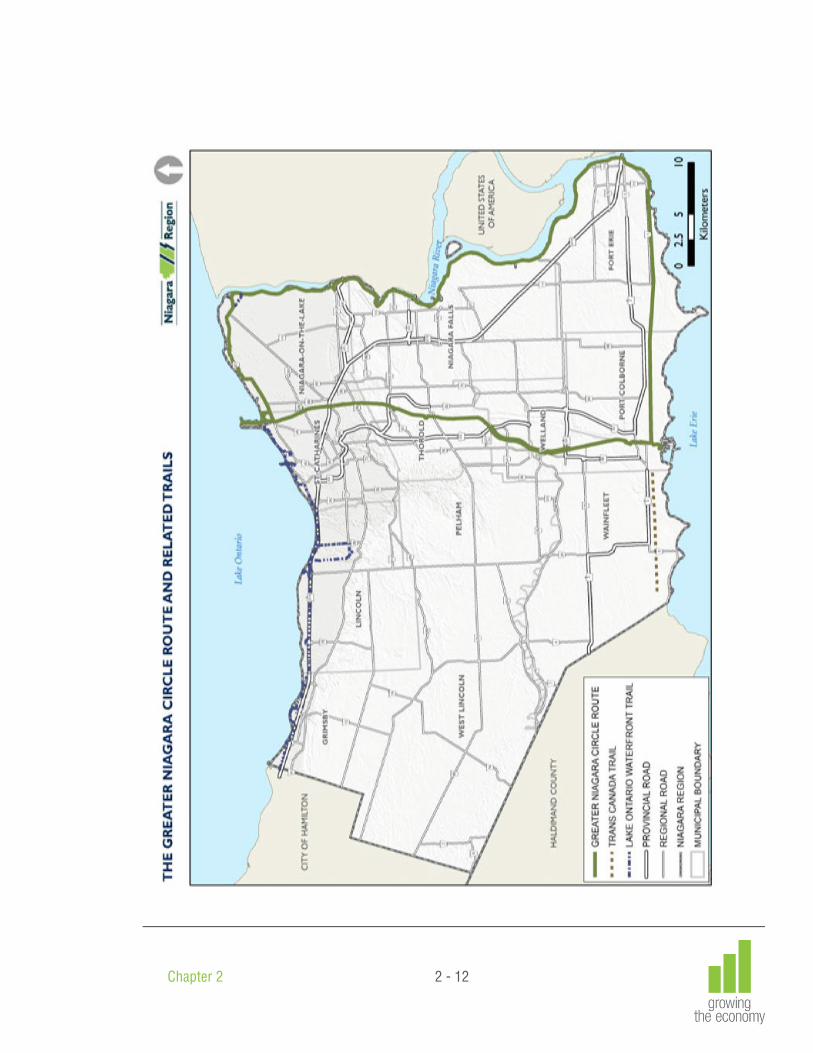
2.B Greater Niagara Circle Route and Trails
The Greater Niagara Circle Route as shown on the map entitled “The Greater Niagara Circle Route and Related Trails” would link the Niagara River with the Welland Canals. It would consist of:
a) A scenic drive that would provide visitors and residents alike with a scenic route linking various attractions within the Region;
b) A recreational trail providing an attractive setting for physically active users such as walkers, cyclists and rollerbladers. This will include the Welland Canals Trail, the Friendship Trail, the Niagara River Recreation Trail and the Lake Ontario Waterfront Trail between Niagara-on-the-Lake and Port Weller.
The Niagara River Parkway and the Niagara River Recreation Trail have a history of success in attracting tourists and residents alike and providing them with attractive and enjoyable recreational opportunities. The Parkway and Trail have played a significant role in making Niagara a major tourist destination and enhancing the quality of life for local residents. The Greater Niagara Circle Route would build on this success and on the potential offered by the Welland Canals Parkway and Trails. In linking the Niagara River Parkway with the Welland Canals corridor, the Greater Niagara Circle Route would play an important role in supporting the further development of Niagara as a tourist destination. It would draw visitors to attractions in other parts of the Region, in effect offering more to the tourist. At the same time it would benefit local residents by providing opportunities for healthy outdoor activities, promoting healthy lifestyles in Niagara and enhancing the quality of life in the Region. The Trans Canada Trail and the Lake Ontario Waterfront Trail would provide links connecting the Greater Niagara Circle Route to other trail systems outside Niagara. In so doing they would enhance the value and attraction of the Circle Route. The Welland Canals East Side Trail would provide opportunities for different types of users than would use the Greater Niagara Circle Route. Finally the promotion of two recreational driving routes is encouraged to support tourism. These are a Wine Route and a Lake Erie North Shore Route (Talbot Trail).
2.B.1 Objectives Objective 2.B.1.1 To promote and coordinate the development of a Greater Niagara Circle Route connecting
the Welland Canals and the Niagara River to form a coherent, continuous scenic drive and recreational trail system that will:
a) foster the growth of tourism in Niagara; b) increase the average length of stay of tourists visiting the Region; and c) provide recreational opportunities for local residents, and promote healthy
lifestyles. Objective 2.B.1.2 To protect corridors from Lake Ontario to Lake Erie along the east and west sides of the
Welland Canals, along which a Parkway would be established, with the remaining protected sections of the corridors being available for potential alternate and related uses, recognizing local municipal planning and Niagara Escarpment Commission objectives.
Objective 2.B.1.3 To assist in the development of the Welland Canals corridor as a linear corridor that
blends historic, recreational and tourist-related uses with natural settings, while providing opportunities for compatible and appropriate residential and commercial development at key nodes. The corridor would combine natural and landscaped areas.

Chapter 2 2 - 8
Objective 2.B.1.4 To support the development of the Trans Canada Trail and the Lake Ontario Waterfront Trail as links connecting the Greater Niagara Circle Route to trail systems outside Niagara.
Objective 2.B.1.5 To provide access to the cultural and natural features along the Greater Niagara Circle
Route, the Trans Canada Trail and the Lake Ontario Waterfront Trail. Objective 2.B.1.6 To ensure that, within Urban Areas, development along the Greater Niagara Circle
Route, the Trans Canada Trail and the Lake Ontario Waterfront Trail maintains or enhances the scenic qualities and character of these driving routes and trails and protects significant natural and cultural heritage resources.
Objective 2.B.1.7 To maintain or enhance the scenic, rural character of the landscape and significant
natural and cultural heritage resources along the Greater Niagara Circle Route, the Trans Canada Trail and the Lake Ontario Waterfront Trail outside Urban Areas.
Objective 2.B.1.8 To support and promote two tourism-related driving routes, namely a Wine Route and a
Lake Erie North Shore Route (Talbot Trail).

Chapter 2 2 - 9
2.B.2 Policies
Policy 2.B.2.1 The Region supports the development of the Greater Niagara Circle Route, the Lake Ontario Waterfront Trail, the Trans Canada Trail, and the Welland Canals East Side Trail as shown on the map entitled “The Greater Niagara Circle Route and Related Trails”.
Policy 2.B.2.2 The Greater Niagara Circle Route is intended to consist of:
a) A scenic drive; and b) A recreational trail for use by hikers, cyclists, rollerbladers and others but excluding
motorized vehicles except for motorized wheelchairs and other motorized invalid vehicles.
Policy 2.B.2.3 The Lake Ontario Waterfront Trail will be a recreational trail for pedestrians, non-
motorized vehicles, and motorized wheelchairs and other motorized invalid vehicles. Policy 2.B.2.4 The Trans Canada Trail will be a recreational trail for appropriate recreational uses as
determined by the local municipalities in keeping with the framework developed by the Trans Canada Trail organization. An equestrian trail may be permitted alongside the paved section of that Trail in the Town of Fort Erie, the City of Port Colborne, and the Township of Wainfleet subject to the agreement of those local municipalities.
Policy 2.B.2.5 The Region intends that a mixed use recreational trail known as the Welland Canals East
Side Trail will be developed along the east side of the Welland Canal and will provide for a variety of activities including horseback riding, snowmobiling and off-road trail bike riding.
Policy 2.B.2.6 Portions of the routes for the recreation trail component of the Greater Niagara Circle
Route and the Trans Canada Trail through the City of Port Colborne have yet to be finalized. The Region will cooperate with the City of Port Colborne in determining the routes to be followed. Adjustments to these trail routes may be made by the City without Amendment to this Plan provided that the intent and purpose of this Plan are maintained.
Policy 2.B.2.7 The Greater Niagara Circle Route, the Lake Ontario Waterfront Trail, the Trans Canada
Trail, and the Welland Canals East Side Trail will be developed in phases in the following order:
a) The first priority will be the completion of the recreational trail component of the
Greater Niagara Circle Route and the completion of the Welland Canals East Side Trail from Port Colborne to Thorold South;
b) The second priority will be the completion of those portions of the Lake Ontario Waterfront Trail and the Trans Canada Trail that are located outside the Greater Niagara Circle Route; and
c) The third priority will be the completion of the scenic drive component of the Greater Niagara Circle Route.
Policy 2.B.2.8 The Greater Niagara Circle Route, the Welland Canals East Side Trail, the Lake Ontario
Waterfront Trail and the Trans Canada Trail will be developed in cooperation with the local municipalities, other public and private agencies and private landowners.

Chapter 2 2 - 10
Policy 2.B.2.9 The Region will pursue the creation of the Welland Canals portion of the Greater Niagara Circle Route Scenic Drive as shown on the map entitled “The Greater Niagara Circle Route and Related Trails”. Until this Scenic Drive is completed, the existing interim Scenic Drive will be used for that purpose.
Policy 2.B.2.10 The route identified for the Lake Ontario Waterfront Trail is interim. The Region will seek
opportunities to realign sections of the Trail to bring it closer to Lake Ontario or to provide better views of the Lake and the shoreline. In doing so the Region will take into consideration:
a) The broad public interest in the development of a Trail that provides recreational
opportunities for local residents and supports tourism development; b) The rights of private property owners; and c) The protection and enhancement of sensitive natural heritage areas, of agricultural
areas and of local heritage character and features. Where development of lakefront land is proposed a strip of land along the shoreline above
the stable top-of-bank should be dedicated by the landowner to a suitable public agency to form part of the Lake Ontario Waterfront Trail.
Where Regional facilities exist or are to be developed in close proximity to the Lake
Ontario shoreline appropriate Waterfront Trail facilities shall be included wherever feasible.
Policy 2.B.2.11 The Region encourages the local municipalities to identify and protect the Greater Niagara
Circle Route, the Lake Ontario Waterfront Trail and the Trans Canada Trail and the uncompleted portions of the Welland Canals Parkway system, including the Welland Canals East Side Trail, in their Official Plans, Zoning By-Laws and planning decisions.
Policy 2.B.2.12 The Region will cooperate with the local municipalities and other relevant agencies in
planning for recreational, commercial and tourism related uses along the Greater Niagara Circle Route, the Lake Ontario Waterfront Trail and the Trans Canada Trail and in providing appropriate development opportunities at key nodes along them so that:
a) Development within the Urban Area Boundary maintains or enhances the visual
qualities and character of these scenic drives and trails and protects or enhances significant natural and cultural heritage resources; and
b) Development conforms to the planning objectives and policies of the Region, the local municipalities, the Provincial government and the Niagara Escarpment Commission.

Chapter 2 2 - 11
Policy 2.B.2.13 The Region and the local municipalities may support in their Official Plans the development of appropriate staging areas, scenic lookouts and other complementary uses outside the Urban Area Boundaries along trails shown in the map entitled “The Greater Niagara Circle Route and Related Trails”, provided that such uses:
a) Are small in scale; b) Are in keeping with the recreational character of the trails and are designed to
complement them; c) Have minimal impact on the surrounding land uses; d) Have no significant negative impacts on the natural environment or on cultural
heritage resources; and e) Will not require the extension of the municipal water supply or sanitary sewage
services. Policy 2.B.2.14 The Region shall seek to secure appropriate public access where land that is owned by a
public agency or a public utility is determined to be surplus to that agency’s or utility’s needs and has the potential to enhance the quality and attractiveness of the trails and scenic drives shown in the map entitled “The Greater Niagara Circle Route and Related Trails”.
Policy 2.B.2.15 The Region will encourage and support the development of other recreational trails that
are connected to and complement the Greater Niagara Circle Route, the Lake Ontario Waterfront Trails and the Trans Canada Trail. The Region will cooperate with the local municipalities and other appropriate public agencies in identifying and protecting the routes for such trails.
Policy 2.B.2.16 The Region will support and promote a Wine Route and a Lake Erie North Shore Route as
tourism-related recreational driving routes.
Chapter 2 2 - 12

Chapter 2 2 - 13
2.C Twenty Valley / Jordan Harbour Tourism Area
The Twenty Valley/Jordan Harbour Tourism Area is shown on Schedule F. It is expected that this Area will continue to evolve as a distinctive entity that many people will want to visit and enjoy for many purposes, in all seasons for many years to come. The Area is renowned for its combination of scenic lands and waters, world heritage natural environment, cultural heritage experiences and superb wine touring, all contained within a small and readily accessible geographic area. These features will be supported by a tourism infrastructure comprising a range of high quality food and accommodation outlets and top-notch information resources and welcoming facilities. These features will be linked by well-marked driving, cycling and walking routes. It is a goal of the Region to increase the economic benefit from tourism in the Twenty Valley/Jordan Harbour Tourism Area, while maintaining and enhancing its natural and cultural heritage resources. Further, the achievement of this goal must balance tourism interests with the existing agricultural, environmental, business and residential interests in the Area. The Twenty Valley/Jordan Harbour Tourism Area includes tourism assets in three key categories including attractions/places, linkages and open spaces and the working agricultural landscape. Attractions/Places provide the focus to the tourism strategy within the Area. They include shopping and eating areas, heritage sites and museums, waterfront attractions, market centres and wineries. These attractions/places provide the anchoring points of visitation for a network of trails and road routes that traverse the landscapes of the Area and the pastoral agricultural landscapes of the valley and lowlands. Key attractions/places within the Twenty Valley/Jordan Harbour Tourism Area include:
a) Vineland Central Business District; b) Jordan Village; c) Jordan Station; d) Prudhommes; e) Jordan Harbour; and f) the Ball’s Falls Heritage Conservation Area.
Linkages and Open Spaces are public access routes and areas that weave through the valley and agricultural landscapes providing a system of parks trails and nature-based attractions that acknowledge the wide variety of natural and cultural amenities. The routes include linkages for hiking, cycling, car touring and water-based routes for canoes and other non-motorized vessels. The Working Agricultural Landscape offers a scenic landscape exhibiting many orchards of tender fruit, vineyards and a range of farms and agri-tourism businesses that sell products and by-products to the public including an impressive array of wineries. Farming operations provide many opportunities for public education and cottage industries of public interest.

Chapter 2 2 - 14
2.C.1 Objectives
Objective 2.C.1.1 The objectives related to attractions/places are:
a) to support sensitive and compatible development within the various communities that comprise the Twenty Valley/Jordan Harbour Tourism Area;
b) to increase the opportunities for shopping, eating and accommodation and to provide an enhanced experience of the valley and its environs for visitors;
c) to build enhanced landscape amenities to support recreational and educational experiences; and
d) to increase the diversity of visitation experiences for a wide range of agri-tourism and natural and cultural heritage choices, for all interests and in all seasons.
Objective 2.C.1.2 The objectives related to linkages and open space are:
a) to protect, manage and enhance the natural ecosystem corridors of the Niagara
Escarpment, the Twenty Valley, Jordan Harbour, and the Lake Ontario waterfront and their immediate environs;
b) to provide and enhance public access to selected natural landscape attractions, for the purposes of heritage education and scenic enjoyment, and in a manner that is not harmful to the ecology of the Area; and
c) to promote the Area’s natural assets and linkages for recreation, resource management and stewardship initiatives in an effort to improve the ecosystem for future generations.
Objective 2.C.1.3 The objectives related to the working agricultural landscape are:
a) to educate the visitors about the diversity of agricultural activities within the Area; b) to provide agri-tourism opportunities for the farming communities that will
complement farming operations and the tourist appeal of the Area; c) to retain all Unique Agricultural Lands for specialty crops, field crops and
vineyards, minimizing buildings; and d) to increase the enjoyment of the scenic farming landscape, and its unique natural
setting.

Chapter 2 2 - 15
2.C.2 Policies
Policy 2.C.2.1 The Region will cooperate with the Town of Lincoln, the Niagara Peninsula Conservation Authority and other relevant agencies in planning for recreational, commercial and tourism related uses within the Twenty Valley/Jordan Harbour Tourism Area, and in providing appropriate development opportunities at key locations within it so that:
a) development within the areas identified as “Urban Areas” on Schedule F maintains
or enhances the visual qualities and character of the existing Villages, the connecting scenic drives and trails and protects or enhances significant natural and cultural heritage resources;
b) the areas identified as “Unique Agricultural Areas” on Schedule F are protected for their ongoing use for agriculture and that the views and vistas that enhance the enjoyment of the natural environment and the agri-tourism potential of the Area and also protected;
c) the area identified as “Jordan Harbour” on Schedule F is a sensitive environmental resource that shall be protected and enhanced;
d) the area identified as “Area under the jurisdiction of the Niagara Escarpment Commission” on Schedule F including the area identified as the “Ball’s Falls Heritage Conservation Area” shall be protected and enhanced; and
e) any new development shall conform to all the applicable planning objectives and policies of the Region, the Town of Lincoln, the Niagara Peninsula Conservation Authority, and the Niagara Escarpment Plan.
Policy 2.C.2.2 The Region will support and promote the marketing and the appropriate redevelopment of
the roadways and the lands adjacent to the Wine Route and the Victoria Avenue Market Greenway.
Policy 2.C.2.3 The Region will request that the Niagara Economic and Tourism Corporation include the
Twenty Valley/Jordan Harbour Tourism Area in its promotional materials and activities. Policy 2.C.2.4 The Region supports the development and/or enhancement of an integrated trail system
within the Twenty Valley/Jordan Harbour Tourism Area, which includes components of the Bruce Trail, the Waterfront Trail and the Twenty Valley Trail as identified conceptually on Schedule F.
Policy 2.C.2.5 The identified trail network will be developed in cooperation with the Town of Lincoln, the
Niagara Peninsula Conservation Authority, other public agencies and private landowners.

Chapter 2 2 - 16
Policy 2.C.2.6 The Region, the Town of Lincoln and the Niagara Peninsula Conservation Authority shall support the development of appropriate staging areas, scenic lookouts and other complementary uses outside the “Urban Areas” along the trails shown on the Schedule F, provided that such uses:
a) are small in scale; b) are in keeping with, and complementary to the passive recreational character of
the trails; c) have minimal impact on the surrounding public and/or private land uses; d) have no significant negative impacts on the natural environment or on cultural
heritage resources; and e) will not require the extension of the municipal water supply or sanitary sewage
services. Policy 2.C.2.7 The Region shall seek to secure appropriate public access where land that is owned by a
public agency or a public utility is determined to be surplus to their needs and has the potential to enhance the quality and attractiveness of the trail network.
Policy 2.C.2.8 The Region will encourage and support the development of other recreational trails that
are connected to, and complement the Waterfront Trail and the Twenty Valley Trail. The Region will assist with funding and will cooperate with the Town of Lincoln, the Niagara Peninsula Conservation Authority and other appropriate agencies in identifying and protecting the routes for such trails.
Policy 2.C.2.9 The Region requires the Town of Lincoln supported by the Niagara Peninsula Conservation
Authority to identify and protect the Waterfront Trail and the uncompleted portions of the Twenty Valley Trail in its Official Plan, Zoning By-law and in all its subsequent planning decisions.
Policy 2.C.2.10 The route identified for the Waterfront Trail has not been finalized and is shown
conceptually on the Schedule F. The Region will seek opportunities in cooperation with the Town of Lincoln and the Niagara Peninsula Conservation Authority to ensure that the Waterfront Trail, when implemented, maximizes public access to the Lake Ontario shoreline. In doing so, the Region, the Town and the Conservation Authority will take into consideration:
a) the broad public interest in the development of a trail that provides recreational
opportunities for local residents and supports tourism development; b) the rights of private property owners; c) the protection and enhancement of sensitive natural heritage areas, agricultural
areas and of local heritage resources; and d) shoreline protection measures may be included in area development plans for
maintaining long term stability along the Lake Ontario shoreline which will assist to facilitate “Smart Growth” initiatives in maximizing area land use and development opportunities.
Where new development is proposed on lakefront property, the Region shall support the
efforts of the Town of Lincoln and the Niagara Peninsula Conservation Authority to, where publicly appropriate, secure by public ownership or by easement a strip of land along the

Chapter 2 2 - 17
shoreline, from the water edge to a point above the stable top-of-bank, to form part of the continuous Waterfront Trail.
Policy 2.C.2.11 Portions of the route for the Twenty Valley Trail have yet to be finalized. The Region will
assist with funding and will cooperate with the Town of Lincoln, the Niagara Escarpment Commission and the Niagara Peninsula Conservation Authority in determining the final routing. Adjustments to this trail route may be made by the Town without amendment to this Plan provided that the intent and purpose of this Plan and the Niagara Escarpment Plan, where applicable, are maintained.
Policy 2.C.2.12 The intent of Schedule F is to identify the area where the policies of Chapters 2.C apply.
Further, the objectives and policies of Chapter 2.C apply to the entire Twenty Valley/Jordan Harbour Tourism Area and are in addition to all the other applicable objectives and policies of the Region, the Town of Lincoln, the Niagara Peninsula Conservation Authority and the Niagara Escarpment Commission.

Chapter 2 2 - 18
2.D Niagara Wine Country
In 2007, the Niagara Economic Development Corporation prepared a Study entitled: “Energizing Niagara’s Wine Country Communities”. The purpose of the Study was to develop a long term and coordinated strategy for enhancing Niagara’s communities and specifically for enhancing the “Wine Country” communities of the Town of Grimsby, the Town of Lincoln, the City of St. Catharines, and the Town of Niagara-on-the-Lake as wine and culinary tourism destinations. The Study identified tourism development opportunities in existing communities and proposed a number of community infrastructure improvements. The Policies in this Chapter reflect the recommendations and overall vision in the Study and collectively are intended to:
a) Conform with existing local municipal, Regional and Provincial Plans and policies including those of the Niagara Escarpment Commission,
b) Support the growth of the wine industry and grape growing sectors through expanded tourism development opportunities,
c) Support high quality community design which respects and is consistent with the character and building forms within existing communities,
d) Support the protection and enhancement of agricultural, natural heritage, as well as cultural and historic resources throughout Niagara and within Wine Country communities.
The vision, therefore, includes a thriving wine, culinary and hospitality industry, vibrant local businesses and shops, and attractive streets filled with people. The protection of cultural features, natural heritage and historic features and distinctive character of neighbourhoods and communities are not only part of the vision but central to the successful realization of the vision. “The Wine Route” Map shows linkages and connections through the Wine Country communities and wineries. The Wine Route map is for illustration purposes only. It is anticipated that the Wine Route will evolve and change over time as the wine industry changes and expands over time. Changes to the Wine Route map will not require an amendment to the Regional Official Plan. The primary responsibility for identifying the Wine Route rests with the Wine Council of Ontario. However, it is expected that the Wine Council of Ontario will work with local municipalities, the Niagara Escarpment Commission, the Niagara Parks Commission and the Region when considering changes to the Wine Route. The “Energizing Niagara’s Wine Country Communities” Study proposed a series of linked “Potential Signature Developments” which included the creation of a Natural Heritage Centre in Grimsby, a Marine Museum in Port Dalhousie, a Wine Country Embassy in Downtown St. Catharines, and a Wine Country Culinary Centre in Niagara-on-the-Lake. Also identified was a set of Community Development Nodes in the downtown Grimsby, Beamsville, Vineland, Jordan, downtown St. Catharines, Port Dalhousie, the Glendale Area, St. David’s, Queenston, Virgil and the Old Town of Niagara-on-the-Lake. The Study identified private investment opportunities in each community such as inns, restaurants, art galleries, wine outlets etc. Decisions with respect to specific types of land uses and their location and scale will be the responsibility of the local municipality through their Official Plans, Secondary Plans, and Community Improvement Plans. It is anticipated that the Region and local municipalities as well as other Provincial agencies such as the Niagara Escarpment Commission and the Niagara Parks Commission give consideration to the recommendations in the “Energizing Niagara’s Wine Country Communities” Study in its planning and economic development work.

Chapter 2 2 - 19
2.D.1 Objectives
Objective 2.D.1.1 To support high quality wine, culinary, and hospitality tourism related development within existing “Wine Country” Urban Areas that respects and is compatible with the character of existing communities and is consistent with local municipal, Regional and Provincial Plans and policies.
Objective 2.D.1.2 To encourage the growth of agri-tourism including wine and culinary tourism. Objective 2.D.1.3 To encourage and promote a strong grape growing agricultural sector. Objective 2.D.1.4 To promote and encourage a coordinated approach to educating informing and directing
visitors to the Region regarding the wine, culinary, cultural and agricultural features as well as the normal agricultural practices conducted in the area.
Objective 2.D.1.5 To encourage and support appropriate and improved access by automobile and by bicycle
to wineries, agri-tourism uses, cultural and historic amenities in the Region and in Wine Country. This should be based on a consultative process involving local municipalities, affected Provincial agencies and with affected local land owners. The impact on farming activities must be considered.

Chapter 2 2 - 20
2.D.2 Policies
Policy 2.D.2.1 The Region will encourage local municipalities through their Official Plans and Neighbourhood Plans to identify and provide for high quality tourism related development and redevelopment opportunities within existing urban areas that are compatible with and respects the distinctive character of the communities.
Policy 2.D.2.2 The Region will support a hierarchy of way finding measures including for example,
traditional methods such as signage, and information kiosks, as well as perhaps less traditional GPS and GIS systems to orient, inform and direct visitors to Wine Country. The measures used should be flexible, coordinated and comprehensively designed to accommodate visitor interest in a variety of winery, culinary, cultural and historic features and using various means of travel including automobiles, bicycles and walking where appropriate. Visitors should be informed of normal farm practices conducted in the area. Agricultural practices information brochures should be made available to the public at tourist booths and other tourist outlets including bicycle rental outlets.
Policy 2.D.2.3 The Region will cooperate with the Wine Council of Ontario and with local municipalities
and other Provincial agencies to coordinate clear and consistent signage and information centres along the Wine Route.
Policy 2.D.2.4 The Region will work with and support local municipal initiatives to enhance driving and
cycling opportunities along the Wine Route corridors where appropriate and in consultation with the cooperation of any affected property owners.
Policy 2.D.2.5 The Region, in cooperation with local municipalities and other Provincial agencies and
through the Regional Niagara Bicycling Committee and Greater Niagara Circle Route Committee will support and promote a Wine Route network and will support the provision of bicycle lanes in accordance with and as provided for on the Niagara Bicycling Network as approved in the Policy Plan. This provision is in no way intended to support the establishment of bike lanes on local and Regional roads that are not part of the approved Bicycling Network.
It is recognized that the Wine Route system can be revised in the future as the wine
industry changes and expands. It is expected that changes to the Wine Route by the Wine Council of Ontario would be carried out in consultation and cooperation with the Region, the local municipalities affected, and with the Niagara Escarpment Commission and the Niagara Parks Commission.
Policy 2.D.2.6 The Region will pursue ways of integrating and supporting other agri-tourism and
agricultural initiatives including the Region’s Culture Plan, the Regional Culinary Trail, and Agricultural Value Added Activities policies into Wine Country programs. The intent of this policy is to complement and support these other related Regional and local municipal initiatives. Likewise, the intent of the policies is to complement other tourism and economic development initiatives and policies including the Twenty Valley/Jordan Harbour Tourism Area policies in this Plan.

Chapter 2 2 - 21
Policy 2.D.2.7 The Region will support and encourage local municipalities through such mechanisms as: Secondary Plans, Community Improvement Plans, heritage conservation incentives, design guidelines, redevelopment incentives, streetscape guidelines and streetscape design plans to protect cultural and heritage features and resources.
Policy 2.D.2.8 The provisions contained in Policies 9.C.24 and 9.C.41 in the Transportation Chapter of
this Plan should be considered within the context of the Wine Country Objectives. Policy 2.D.2.9 The Region in consultation with local municipalities and other Provincial agencies will
provide the required infrastructure within urban areas along the Wine Route to accommodate new growth and/or redevelopment in keeping with overall infrastructure capital planning priorities, as established by Regional Council, over time.
Policy 2.D.2.10 The Region in consultation with local municipalities will support and encourage senior
levels of Government to provide funding for agricultural irrigation infrastructure in Agricultural Areas.
Policy 2.D.2.11 The Region will encourage and promote a strong grape growing agricultural sector by
recognizing the need to conduct normal farm practices and by encouraging changes to Provincial and Federal legislation that will help identify, promote and expand the sale of VQA wine.

Chapter 2 2 - 22

Chapter 2 2 - 23
2.E Commerce, Industry and Trade
2.E.1 Export Distribution Zone
Policy 2.E.1.1 It is the intent of the Region to investigate, in partnership with the Federal Government; opportunities to create an “Export Distribution District” within the Gateway Economic Zone and Centre through which commodities and intermediate inputs could enter the district from abroad duty free and value-added production for re-export could be undertaken within the zone.
2.E.2 Centres of Excellence
Policy 2.E.2.1 It is the policy of the Region to promote innovation and excellence by building on Niagara’s economic strengths and creating partnerships with institutes of higher education, the private sector and the investment community.