regional functional plan requirements
TRANSCRIPT

Effective 01/18/12 3.07 - 1 of 129
CHAPTER 3.07
URBAN GROWTH MANAGEMENT FUNCTIONAL PLAN SECTIONS TITLE 3.07.010 Purpose 3.07.020 Regional Policy Basis 3.07.030 Structure of Requirements
REGIONAL FUNCTIONAL PLAN REQUIREMENTS
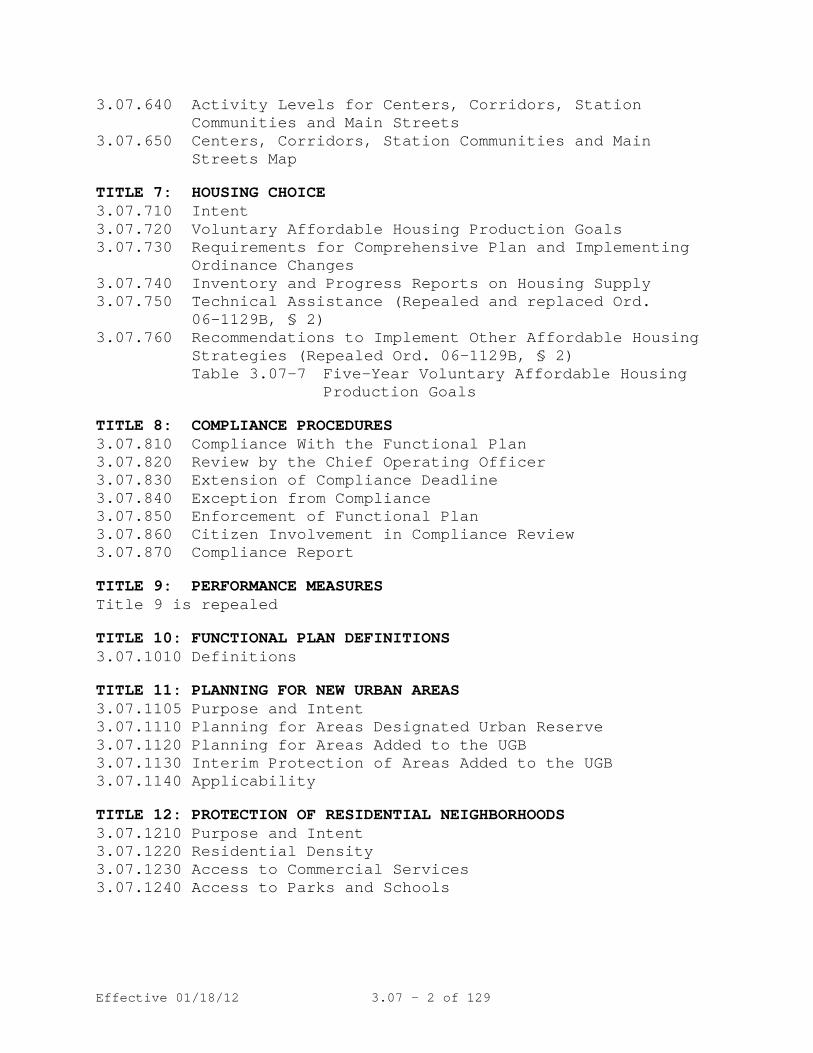
TITLE 1: HOUSING CAPACITY 3.07.110 Purpose and Intent 3.07.120 Housing Capacity
TITLE 2: REGIONAL PARKING POLICY (Repealed Ord. 10-1241B, § 6)
TITLE 3: WATER QUALITY and FLOOD MANAGEMENT 3.07.310 Intent 3.07.320 Applicability 3.07.330 Implementation Alternatives for Cities and Counties 3.07.340 Performance Standards 3.07.350 Fish and Wildlife Habitat Conservation Area (Repealed
Ord. 05-1077C, § 6) 3.07.360 Metro Model Ordinance Required 3.07.370 Variances (Repealed Ord. 05-1077C, § 6)
Table 3.07-3 - Protected Water Features
TITLE 4: INDUSTRIAL AND OTHER EMPLOYMENT AREAS 3.07.410 Purpose and Intent 3.07.420 Protection of Regionally Significant Industrial Areas 3.07.430 Protection of Industrial Areas 3.07.440 Protection of Employment Areas 3.07.450 Employment and Industrial Areas Map
Table 3.07-4
TITLE 5: NEIGHBOR CITIES AND RURAL RESERVES (Repealed, Ord. 10-1238A, § 4)
TITLE 6: CENTERS, CORRIDORS, STATION COMMUNITIES AND MAIN STREETS
3.07.610 Purpose 3.07.620 Actions and Investments in Centers, Corridors, Station
Communities and Main Streets 3.07.630 Eligibility Actions for Lower Mobility Standards and
Trip Generation Rates
Effective 01/18/12 3.07 - 2 of 129
3.07.640 Activity Levels for Centers, Corridors, Station Communities and Main Streets
3.07.650 Centers, Corridors, Station Communities and Main Streets Map
TITLE 7: HOUSING CHOICE 3.07.710 Intent 3.07.720 Voluntary Affordable Housing Production Goals 3.07.730 Requirements for Comprehensive Plan and Implementing
Ordinance Changes 3.07.740 Inventory and Progress Reports on Housing Supply 3.07.750 Technical Assistance (Repealed and replaced Ord.
06-1129B, § 2) 3.07.760 Recommendations to Implement Other Affordable Housing
Strategies (Repealed Ord. 06-1129B, § 2) Table 3.07-7 Five-Year Voluntary Affordable Housing
Production Goals
TITLE 8: COMPLIANCE PROCEDURES 3.07.810 Compliance With the Functional Plan 3.07.820 Review by the Chief Operating Officer 3.07.830 Extension of Compliance Deadline 3.07.840 Exception from Compliance 3.07.850 Enforcement of Functional Plan 3.07.860 Citizen Involvement in Compliance Review 3.07.870 Compliance Report
TITLE 9: PERFORMANCE MEASURES Title 9 is repealed
TITLE 10: FUNCTIONAL PLAN DEFINITIONS 3.07.1010 Definitions
TITLE 11: PLANNING FOR NEW URBAN AREAS 3.07.1105 Purpose and Intent 3.07.1110 Planning for Areas Designated Urban Reserve 3.07.1120 Planning for Areas Added to the UGB 3.07.1130 Interim Protection of Areas Added to the UGB 3.07.1140 Applicability
TITLE 12: PROTECTION OF RESIDENTIAL NEIGHBORHOODS 3.07.1210 Purpose and Intent 3.07.1220 Residential Density 3.07.1230 Access to Commercial Services 3.07.1240 Access to Parks and Schools

Effective 01/18/12 3.07 - 3 of 129
TITLE 13: NATURE IN NEIGHBORHOODS 3.07.1310 Intent 3.07.1320 Inventory and Habitat Conservation Areas 3.07.1330 Implementation Alternatives for Cities and Counties 3.07.1340 Performance Standards and Best Management Practices
for Habitat Conservation Areas 3.07.1350 Claims Pursuant to ORS 197.352 (Ballot Measure 37) 3.07.1360 Program Objectives, Monitoring and Reporting 3.07.1370 Future Metro Urban Growth Boundary Expansion Areas
Table 3.07-13a Method for Identifying Habitat Conservation Areas ("HCA")
Table 3.07-13b Method for Identifying Habitat Conservation Areas ("HCA") in Future Metro Urban Growth Boundary Expansion Areas
Table 3.07-13c Habitat-friendly Development Practices Table 3.07-13d Locating Boundaries of Class I and II
Riparian Areas Table 3.07-13e Performance and Implementation
Objectives and Indicators
TITLE 14: URBAN GROWTH BOUNDARY 3.07.1405 Purpose 3.07.1410 Urban Growth Boundary 3.07.1420 Legislative Amendment to the UGB - Procedures 3.07.1425 Legislative Amendment to the UGB - Criteria 3.07.1430 Major Amendments – Procedures 3.07.1435 Major Amendments – Expedited Procedures 3.07.1440 Major Amendments - Criteria 3.07.1445 Minor Adjustments – Procedures 3.07.1450 Minor Adjustments – Criteria 3.07.1455 Conditions of Approval 3.07.1460 Fees 3.07.1465 Notice Requirements NOTE
: The Urban Growth Management Functional Plan was adopted by the Metro Council by Ordinance No. 96-647C, and amended by Ordinance No. 97-691C, prior to being codified as Metro Code Chapter 3.07 by Ordinance No. 97-715B.

Effective 01/18/12 3.07 - 4 of 129
The regional policies which are adopted by this Urban Growth Management Functional Plan recommend and require changes to city and county comprehensive plans and implementing ordinances. The purpose of this functional plan is to implement regional goals and objectives adopted by the Metro Council as the Regional Urban Growth Goals and Objectives (RUGGO), including the Metro 2040 Growth Concept and the Regional Framework Plan. The comprehensive plan changes and related actions, including implementing regulations, required by this functional plan as a component of the Regional Framework Plan, shall be complied with by cities and counties as required by Section 5(e)(2) of the Metro Charter.
3.07.010 Purpose
Any city or county determination not to incorporate all required functional plan policies into comprehensive plans shall be subject to the conflict resolution and mediation processes included within the RUGGO, Goal I provisions, prior to the final adoption of inconsistent policies or actions.
(Ordinance No. 97-715B, Sec. 1.)
The regional policies adopted in this Urban Growth Management Functional Plan are formulated from, and are consistent with, the RUGGOs, including the Metro 2040 Growth Concept. The overall principles of the Greenspaces Master Plan are also incorporated within this functional plan. In addition, the Regional Transportation Functional Plan (RTFP), adopted on June 10, 2010, as Metro Code 3.08, serves as the primary transportation policy implementation of the 2040 Growth Concept.
3.07.020 Regional Policy Basis
(Ordinance No. 97-715B, Sec. 1. Amended by Ordinance No. 02-972A, Sec. 1.)
The Urban Growth Management Functional Plan is a regional functional plan which contains "requirements" that are binding on cities and counties of the region as well as recommendations that are not binding. Shall" or other directive words are used with requirements. The words "should" or "may" are used with recommendations. In general, the plan is structured so that local jurisdictions may choose either performance standard requirements or prescriptive requirements. The intent of the
3.07.030 Structure of Requirements

Effective 01/18/12 3.07 - 5 of 129
requirements is to assure that cities and counties have a significant amount of flexibility as to how they meet requirements. Performance standards are included in most titles. If local jurisdictions demonstrate to Metro that they meet the performance standard, they have met that requirement of the title. Standard methods of compliance are also included in the plan to establish one very specific way that jurisdictions may meet a title requirement, but these standard methods are not the only way a city or county may show compliance. In addition, certain mandatory requirements that apply to all cities and counties are established by this functional plan.
(Ordinance No. 97-715B, Sec. 1).
TITLE 1: HOUSING CAPACITY
REGIONAL FUNCTIONAL PLAN REQUIREMENTS
The Regional Framework Plan calls for a compact urban form and a “fair-share” approach to meeting regional housing needs. It is the purpose of Title 1 to accomplish these policies by requiring each city and county to maintain or increase its housing capacity except as provided in section 3.07.120.
3.07.110 Purpose and Intent
(Ordinance No. 97-715B, Sec. 1. Amended by Ordinance 02-969B, Sec. 1; and Ordinance No. 10-1244B, Sec. 2).
A. A city or county may reduce the minimum zoned capacity of the Central City or a Regional Center, Town Center, Corridor, Station Community or Main Street under subsection D or E. A city or county may reduce its minimum zoned capacity in other locations under subsections C, D or E.
3.07.120 Housing Capacity
B. Each city and county shall adopt a minimum dwelling unit density for each zone in which dwelling units are authorized except for zones that authorize mixed-use as defined in section 3.07.1010(hh). If a city or county has not adopted a minimum density for such a zone prior to March 16, 2011, the city or county shall adopt a minimum density that is at least 80 percent of the maximum density.
C. A city or county may reduce its minimum zoned capacity by one of the following actions if it increases minimum zoned capacity by an equal or greater amount in other places

Effective 01/18/12 3.07 - 6 of 129
where the increase is reasonably likely to be realized within the 20-year planning period of Metro’s last capacity analysis under ORS 197.299:
1. Reduce the minimum dwelling unit density, described in subsection B, for one or more zones;
2. Revise the development criteria or standards for one or more zones; or
3. Change its zoning map such that the city’s or county’s minimum zoned capacity would be reduced.
Action to reduce minimum zoned capacity may be taken any time within two years after action to increase capacity.
D. A city or county may reduce the minimum zoned capacity of a zone without increasing minimum zoned capacity in another zone for one or more of the following purposes:
1. To re-zone the area to allow industrial use under Title 4 of this chapter or an educational or medical facility similar in scale to those listed in section 3.07.1340D(5)(b)(i) of Title 13 of this chapter; or
2. To protect natural resources pursuant to Titles 3 or 13 of this chapter.
E. A city or county may reduce the minimum zoned capacity of a single lot or parcel so long as the reduction has a negligible effect on the city’s or county’s overall minimum zoned residential capacity.
F. A city or county may amend its comprehensive plan and land use regulations to transfer minimum zoned capacity to another city or county upon a demonstration that:
1. A transfer between designated Centers, Corridors or Station Communities does not result in a net reduction in the minimum zoned capacities of the Centers, Corridors or Station Communities involved in the transfer; and
2. The increase in minimum zoned capacity is reasonably likely to be realized within the 20-year planning period of Metro’s last capacity analysis under ORS 197.299
G. A city or county shall authorize the establishment of at least one accessory dwelling unit for each detached single-family dwelling unit in each zone that authorizes detached single-family dwellings. The authorization may be subject to reasonable regulation for siting and design purposes.
(Ordinance No. 97-715B, Sec. 1. Amended by Ordinance No. 02-972A, Sec. 1; Ordinance No. 02-969B, Sec. 1; Ordinance No. 07-1137A, Sec. 1; and Ordinance No. 10-1244B, Sec. 2).

Effective 01/18/12 3.07 - 7 of 129
(Title 2 Regional Parking Policy, Sections 3.07.210-3.07.220, Table 3.07-2 Regional Parking Ratios. Ordinance No. 97-715B, Sec. 1; and repealed Ordinance No. 10-1241B, § 6)
TITLE 3: WATER QUALITY AND FLOOD MANAGEMENT
To protect the beneficial water uses and functions and values of resources within the Water Quality and Flood Management Areas by limiting or mitigating the impact on these areas from development activities and protecting life and property from dangers associated with flooding.
3.07.310 Intent
(Ordinance No. 97-715B, Sec. 1. Replaced by Ordinance No. 98-730C, Sec. 1. Readopted by Ordinance No. 00-839, Sec. 1. Amended by Ordinance No. 05-1077C, Sec. 6.)
A. Title 3 applies to:
3.07.320 Applicability
1. Development in Water Quality Resource and Flood
Management Areas. 2. Development which may cause temporary or permanent
erosion on any property within the Metro Boundary. B. Title 3 does not apply to work necessary to protect,
repair, maintain, or replace existing structures, utility facilities, roadways, driveways, accessory uses and exterior improvements in response to emergencies provided that after the emergency has passed, adverse impacts are mitigated in accordance with the performance standards in Section 3.07.340.
(Ordinance No. 97-715B, Sec. 1. Replaced by Ordinance No. 98-730C, Sec. 1. Readopted by Ordinance No. 00-839, Sec. 1. Amended by Ordinance No. 02-972A, Sec. 1; and Ordinance No. 05-1077C, Sec. 6.)
3.07.330 Implementation Alternatives for Cities and Counties
A. Cities and counties shall comply with this title in one of the following ways:
1. Amend their comprehensive plans and implementing
ordinances to adopt all or part of the Title 3 Model Ordinance or code language that substantially complies with the performance standards in Section 3.07.340 and

Effective 01/18/12 3.07 - 8 of 129
the intent of this title, and adopt either the Metro Water Quality and Flood Management Area Map or a map which substantially complies with the Metro map. Cities and counties may choose one of the following options for applying this section:
a. Adopt code language implementing this title which
prevails over the map and uses the map as reference; or
b. Adopt a city or county field verified map of
Water Quality and Flood Management Areas based on the Metro Water Quality and Flood Management map, implementing this title which prevails over adopted code language.
Field verification is a process of identifying or delineating Protected Water Features, Water Quality Resource Areas and Flood Management Areas shown on the Metro Water Quality and Flood Management Areas map. This process includes examination of information such as site visit reports, wetlands inventory maps, aerial photographs, and public input and review. The field verification process shall result in a locally adopted Water Quality and Flood Management Areas map which:
i. Applies the Title 10 definitions of
Protected Water Feature, Water Quality Resource Areas and Flood Management Areas to all those protected areas on the Metro Water Quality and Flood Management Areas map to show the specific boundaries of those protected areas on the locally adopted Water Quality and Flood Management Areas map; and
ii. Is subject to amendment by applying adopted code language to add Protected Water Features, Water Quality Resource Areas and Flood Management Areas and to correct errors in the local Water Quality and Flood Management Areas map consistent with Section 3.07.330(D).
2. Demonstrate that existing city and county comprehensive plans and implementing ordinances
Effective 01/18/12 3.07 - 9 of 129
substantially comply with the performance standards in Section 3.07.340 and the intent of this title.
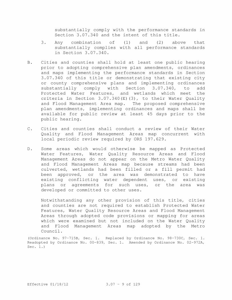
3. Any combination of (1) and (2) above that substantially complies with all performance standards in Section 3.07.340.
B. Cities and counties shall hold at least one public hearing prior to adopting comprehensive plan amendments, ordinances and maps implementing the performance standards in Section 3.07.340 of this title or demonstrating that existing city or county comprehensive plans and implementing ordinances substantially comply with Section 3.07.340, to add Protected Water Features, and wetlands which meet the criteria in Section 3.07.340(E)(3), to their Water Quality and Flood Management Area map. The proposed comprehensive plan amendments, implementing ordinances and maps shall be available for public review at least 45 days prior to the public hearing.
C. Cities and counties shall conduct a review of their Water Quality and Flood Management Areas map concurrent with local periodic review required by ORS 197.629.
D. Some areas which would otherwise be mapped as Protected Water Features, Water Quality Resource Areas and Flood Management Areas do not appear on the Metro Water Quality and Flood Management Areas map because streams had been culverted, wetlands had been filled or a fill permit had been approved, or the area was demonstrated to have existing conflicting water dependent uses, or existing plans or agreements for such uses, or the area was developed or committed to other uses.
Notwithstanding any other provision of this title, cities and counties are not required to establish Protected Water Features, Water Quality Resource Areas and Flood Management Areas through adopted code provisions or mapping for areas which were examined but not included on the Water Quality and Flood Management Areas map adopted by the Metro Council.
(Ordinance No. 97-715B, Sec. 1. Replaced by Ordinance No. 98-730C, Sec. 1. Readopted by Ordinance No. 00-839, Sec. 1. Amended by Ordinance No. 02-972A, Sec. l.)

Effective 01/18/12 3.07 - 10 of 129
A.
3.07.340 Performance Standards
Flood Management Performance Standards
.
1. The purpose of these standards is to reduce the risk of flooding, prevent or reduce risk to human life and property, and maintain functions and values of flood-plains such as allowing for the storage and conveyance of stream flows through existing and natural flood conveyance systems.
2. All development, excavation and fill in the Flood
Management Areas shall conform to the following performance standards:
a. Development, excavation and fill shall be
performed in a manner to maintain or increase flood storage and conveyance capacity and not increase design flood elevations.
b. All fill placed at or below the design flood
elevation in Flood Management Areas shall be balanced with at least an equal amount of soil material removal.
c. Excavation shall not be counted as compensating
for fill if such areas will be filled with water in non-storm winter conditions.
d. Minimum finished floor elevations for new
habitable structures in the Flood Management Areas shall be at least one foot above the design flood elevation.
e. Temporary fills permitted during construction
shall be removed. f. Uncontained areas of hazardous materials as
defined by DEQ in the Flood Management Area shall be prohibited.
3. The following uses and activities are not subject to
the requirements of subsection 2:
a. Excavation and fill necessary to plant new trees or vegetation.

Effective 01/18/12 3.07 - 11 of 129
b. Excavation and fill required for the construction of detention facilities or structures, and other facilities such as levees specifically designed to reduce or mitigate flood impacts. Levees shall not be used to create vacant buildable lands.
c. New culverts, stream crossings, and transportation
projects may be permitted if designed as balanced cut and fill projects or designed to not signifi-cantly raise the design flood elevation. Such projects shall be designed to minimize the area of fill in Flood Management Areas and to minimize erosive velocities. Stream crossing shall be as close to perpendicular to the stream as practicable. Bridges shall be used instead of culverts wherever practicable.
B. Water Quality Performance Standards
.
1. The purpose of these standards is to: (1) protect and improve water quality to support the designated beneficial water uses as defined in Title 10, and (2) protect the functions and values of the Water Quality Resource Area which include, but are not limited to:
a. Providing a vegetated corridor to separate
Protected Water Features from development; b. Maintaining or reducing stream temperatures; c. Maintaining natural stream corridors;
d. Minimizing erosion, nutrient and pollutant loading into water;
e. Filtering, infiltration and natural water purifi-
cation; and
f. Stabilizing slopes to prevent landslides contributing to sedimentation of water features.
2. Local codes shall require all development in Water
Quality Resource Areas to conform to the following performance standards:

Effective 01/18/12 3.07 - 12 of 129
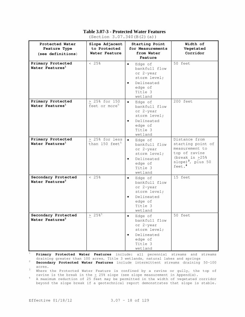
a. The Water Quality Resource Area is the vegetated corridor and the Protected Water Feature. The width of the vegetated corridor is specified in Table 3.07-3. At least three slope measurements along the water feature, at no more than 100-foot increments, shall be made for each property for which development is proposed. Depending on the width of the property, the width of the vegetated corridor will vary.
b. Water Quality Resource Areas shall be protected,
maintained, enhanced or restored as specified in Section 3.07.340(B)(2).
c. Prohibit development that will have a significant
negative impact on the functions and values of the Water Quality Resource Area, which cannot be mitigated in accordance with subsection 2(f).
d. Native vegetation shall be maintained, enhanced
or restored, if disturbed, in the Water Quality Resource Area. Invasive non-native or noxious vegetation may be removed from the Water Quality Resource Area. Use of native vegetation shall be encouraged to enhance or restore the Water Quality Resource Area. This shall not preclude construction of energy dissipaters at outfalls consistent with watershed enhancement, and as approved by local surface water management agencies.
e. Uncontained areas of hazardous materials as
defined by DEQ in the Water Quality Resource Area shall be prohibited.
f. Cities and counties may allow development in
Water Quality Resource Areas provided that the governing body, or its designate, implement procedures which:
i. Demonstrate that no practicable alternatives
to the requested development exist which will not disturb the Water Quality Resource Area; and
Effective 01/18/12 3.07 - 13 of 129
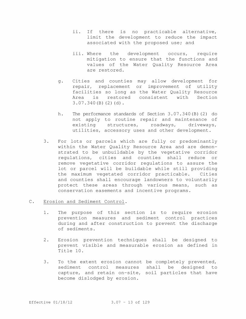
ii. If there is no practicable alternative, limit the development to reduce the impact associated with the proposed use; and
iii. Where the development occurs, require
mitigation to ensure that the functions and values of the Water Quality Resource Area are restored.
g. Cities and counties may allow development for
repair, replacement or improvement of utility facilities so long as the Water Quality Resource Area is restored consistent with Section 3.07.340(B)(2)(d).
h. The performance standards of Section 3.07.340(B)(2) do
not apply to routine repair and maintenance of existing structures, roadways, driveways, utilities, accessory uses and other development.
3. For lots or parcels which are fully or predominantly
within the Water Quality Resource Area and are demon-strated to be unbuildable by the vegetative corridor regulations, cities and counties shall reduce or remove vegetative corridor regulations to assure the lot or parcel will be buildable while still providing the maximum vegetated corridor practicable. Cities and counties shall encourage landowners to voluntarily protect these areas through various means, such as conservation easements and incentive programs.
C. Erosion and Sediment Control
.
1. The purpose of this section is to require erosion prevention measures and sediment control practices during and after construction to prevent the discharge of sediments.
2. Erosion prevention techniques shall be designed to
prevent visible and measurable erosion as defined in Title 10.
3. To the extent erosion cannot be completely prevented,
sediment control measures shall be designed to capture, and retain on-site, soil particles that have become dislodged by erosion.

Effective 01/18/12 3.07 - 14 of 129
D. Implementation Tools to Protect Water Quality and Flood Management Areas
.
1. Cities and counties shall either adopt land use regulations, which authorize transfer of permitted units and floor area to mitigate the effects of development restrictions in Water Quality and Flood Management Areas, or adopt other measures that mitigate the effects of development restrictions.
2. Metro encourages local governments to require that
approvals of applications for partitions, subdivisions and design review actions be conditioned upon one of the following:
a. Protection of Water Quality and Flood Management
Areas with a conservation easement; b. Platting Water Quality and Flood Management Areas
as common open space; or c. Offer of sale or donation of property to public
agencies or private non-profits for preservation where feasible.
3. Additions, alterations, rehabilitation or replacement
of existing structures, roadways, driveways, accessory uses and development in the Water Quality and Flood Management Area may be allowed provided that:
a. The addition, alteration, rehabilitation or
replacement is not inconsistent with applicable city and county regulations, and
b. The addition, alteration, rehabilitation or
replacement does not encroach closer to the Protected Water Feature than the existing structures, roadways, driveways or accessory uses and development, and
c. The addition, alteration, rehabilitation or
replacement satisfies Section 3.07.340(C) of this title.
d. In determining appropriate conditions of
approval, the affected city or county shall require the applicant to:

Effective 01/18/12 3.07 - 15 of 129
i. Demonstrate that no reasonably practicable
alternative design or method of development exists that would have a lesser impact on the Water Quality Resource Area than the one proposed; and
ii. If no such reasonably practicable
alternative design or method of development exists, the project should be conditioned to limit its disturbance and impact on the Water Quality Resource to the minimum extent necessary to achieve the proposed addition, alteration, restoration, replacement or rehabilitation; and
iii. Provide mitigation to ensure that impacts to
the functions and values of the Water Quality Resource Area will be mitigated or restored to the extent practicable.
4. Cities and counties may choose not to apply the Water
Quality and Flood Management Area performance standards of Section 3.07.340 to development necessary for the placement of structures when it does not require a grading or building permit.
5. Metro encourages cities and counties to provide for
restoration and enhancement of degraded Water Quality Resource Areas through conditions of approval when development is proposed, or through incentives or other means.
6. Cities and counties shall apply the performance
standards of this title to Title 3 Wetlands as shown on the Metro Water Quality and Flood Management Areas Map and locally adopted Water Quality and Flood Management Areas maps. Cities and counties may also apply the performance standards of this title to other wetlands.
E. Map Administration
.
Cities and counties shall amend their comprehensive plans and implementing ordinances to provide a process for each of the following:
Effective 01/18/12 3.07 - 16 of 129
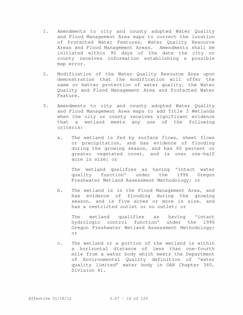
1. Amendments to city and county adopted Water Quality and Flood Management Area maps to correct the location of Protected Water Features, Water Quality Resource Areas and Flood Management Areas. Amendments shall be initiated within 90 days of the date the city or county receives information establishing a possible map error.
2. Modification of the Water Quality Resource Area upon demonstration that the modification will offer the same or better protection of water quality, the Water Quality and Flood Management Area and Protected Water Feature.
3. Amendments to city and county adopted Water Quality and Flood Management Area maps to add Title 3 Wetlands when the city or county receives significant evidence that a wetland meets any one of the following criteria:
a. The wetland is fed by surface flows, sheet flows or precipitation, and has evidence of flooding during the growing season, and has 60 percent or greater vegetated cover, and is over one-half acre in size; or
The wetland qualifies as having "intact water quality function" under the 1996 Oregon Freshwater Wetland Assessment Methodology; or
b. The wetland is in the Flood Management Area, and has evidence of flooding during the growing season, and is five acres or more in size, and has a restricted outlet or no outlet; or
The wetland qualifies as having "intact hydrologic control function" under the 1996 Oregon Freshwater Wetland Assessment Methodology; or
c. The wetland or a portion of the wetland is within a horizontal distance of less than one-fourth mile from a water body which meets the Department of Environmental Quality definition of "water quality limited” water body in OAR Chapter 340, Division 41.
Effective 01/18/12 3.07 - 17 of 129
Examples of significant evidence that a wetland exists that may meet the criteria above are a wetland assessment conducted using the 1996 Oregon Freshwater Wetland Assessment Methodology, or correspondence from the Division of State Lands that a wetland determination or delineation has been submitted or completed for property in the city or county.
4. Cities and counties are not required to apply the criteria in Section 3.07.340(E)(3) to water quality or stormwater detention facilities.
(Ordinance No. 97-715B, Sec. 1. Replaced by Ordinance No. 98-730C, Sec. 1. Readopted by Ordinance No. 00-839, Sec. 1. Amended by Ordinance No. 02-972A, Sec. 1; and Ordinance No. 05-1077C, Sec. 6.)
(3.07.350 Fish and Wildlife Habitat Conservation Area. Repealed Ord. 05-1077C §6)
Metro shall adopt a Water Quality and Flood Management Areas Model Ordinance and map. The Model Ordinance shall represent one method of complying with this title. The Model Ordinance shall be advisory, and cities and counties are not required to adopt the Model Ordinance, or any part thereof, to substantially comply with this title. However, cities and counties which adopt the Model Ordinance in its entirety and a Water Quality and Flood Management Areas Map shall be deemed to have substantially complied with the requirements of this title.
3.07.360 Metro Model Ordinance Required
(Ordinance No. 97-715B, Sec. 1. Amended by Ordinance No. 98-730C, Sec. 2. Readopted and amended by Ordinance No. 00-839, Sec. 1; and Ordinance No. 05-1077C, Sec. 6.)
(3.07.370 Variances. Repealed Ord. 05-1077C §6)
Effective 01/18/12 3.07 - 18 of 129
Table 3.07-3 - Protected Water Features (Section 3.07.340(B(2)(a))
Protected Water Feature Type
(see definitions)
Slope Adjacent to Protected Water Feature
Starting Point for Measurements
from Water Feature
Width of Vegetated Corridor
Primary Protected Water Features1
< 25% • Edge of bankfull flow or 2-year storm level;
• Delineated edge of Title 3 wetland
50 feet
Primary Protected Water Features1
> 25% for 150 feet or more5
• Edge of bankfull flow or 2-year storm level;
• Delineated edge of Title 3 wetland
200 feet
Primary Protected Water Features1
> 25% for less than 150 feet5
• Edge of bankfull flow or 2-year storm level;
• Delineated edge of Title 3 wetland
Distance from starting point of measurement to top of ravine (break in >25% slope)3, plus 50 feet.4
Secondary Protected Water Features2
< 25% • Edge of bankfull flow or 2-year storm level;
• Delineated edge of Title 3 wetland
15 feet
Secondary Protected Water Features2
> 25%5
• Edge of
bankfull flow or 2-year storm level;
• Delineated edge of Title 3 wetland
50 feet
1 Primary Protected Water Features include: all perennial streams and streams draining greater than 100 acres, Title 3 wetlands, natural lakes and springs
2 Secondary Protected Water Features include intermittent streams draining 50-100 acres.
3 Where the Protected Water Feature is confined by a ravine or gully, the top of ravine is the break in the > 25% slope (see slope measurement in Appendix).
4 A maximum reduction of 25 feet may be permitted in the width of vegetated corridor beyond the slope break if a geotechnical report demonstrates that slope is stable.

Effective 01/18/12 3.07 - 19 of 129
To establish the width of the vegetated corridor, slope should be measured in 25-foot increments away from the water feature until slope is less than 25% (top of ravine).
5 Vegetated corridors in excess of 50-feet for primary protected features, or in excess of 15-feet for secondary protected features, apply on steep slopes only in the uphill direction from the protected water feature.
(Ordinance No. 98-730C, Sec. 1.)

Effective 01/18/12 3.07 - 20 of 129
TITLE 4: INDUSTRIAL AND OTHER EMPLOYMENT AREAS
The Regional Framework Plan calls for a strong regional economy. To improve the economy, Title 4 seeks to provide and protect a supply of sites for employment by limiting the types and scale of non-industrial uses in Regionally Significant Industrial Areas (RSIAs), Industrial and Employment Areas. Title 4 also seeks to provide the benefits of "clustering" to those industries that operate more productively and efficiently in proximity to one another than in dispersed locations. Title 4 further seeks to protect the capacity and efficiency of the region’s transportation system for the movement of goods and services and to encourage the location of other types of employment in Centers, Corridors, Main Streets and Station Communities. The Metro Council will evaluate the effectiveness of Title 4 in achieving these purposes as part of its periodic analysis of the capacity of the urban growth boundary.
3.07.410 Purpose and Intent
(Ordinance No. 97-715B, Sec. 1. Amended by Ordinance 02-969B, Sec. 5; Ordinance No. 04-1040B, Sec. 2; and Ordinance No. 10-1244B, Sec. 3).
A. Regionally Significant Industrial Areas (RSIAs) are those areas near the region’s most significant transportation facilities for the movement of freight and other areas most suitable for movement and storage of goods. Each city and county with land use planning authority over RSIAs shown on the Employment and Industrial Areas Map shall derive specific plan designation and zoning district boundaries of RSIAs within its jurisdiction from the Map, taking into account the location of existing uses that would not conform to the limitations on non-industrial uses in this section and the need to achieve a mix of employment uses.
3.07.420 Protection of Regionally Significant Industrial Areas
B. Cities and counties shall review their land use regulations
and revise them, if necessary, to include measures to limit the size and location of new buildings for retail commercial uses - such as stores and restaurants - and retail and professional services that cater to daily customers – such as financial, insurance, real estate, legal, medical and dental offices - to ensure that they serve primarily the needs of workers in the area. One such measure shall be that new buildings for stores, branches, agencies or other outlets for these retail uses and services shall not occupy more than 3,000 square feet of

Effective 01/18/12 3.07 - 21 of 129
sales or service area in a single outlet, or multiple outlets that occupy more than 20,000 square feet of sales or service area in a single building or in multiple buildings that are part of the same development project, with the following exceptions:
1. Within the boundaries of a public use airport subject to a facilities master plan, customary airport uses, uses that are accessory to the travel-related and freight movement activities of airports, hospitality uses, and retail uses appropriate to serve the needs of the traveling public; and
2. Training facilities whose primary purpose is to provide training to meet industrial needs.
C. Cities and counties shall review their land use regulations
and revise them, if necessary, to include measures to limit the siting and location of new buildings for the uses described in subsection B and for non-industrial uses that do not cater to daily customers—such as banks or insurance processing centers—to ensure that such uses do not reduce off-peak performance on Main Roadway Routes and Roadway Connectors shown on the Regional Freight Network Map in the RTP or require added road capacity to prevent falling below the standards.
D. Cities and counties shall review their land use regulations
and revise them, if necessary, to prohibit the siting of schools, places of assembly larger than 20,000 square feet or parks intended to serve people other than those working or residing in the RSIA.
E. No city or county shall amend its land use regulations that
apply to lands shown as RSIA on the Employment and Industrial Areas Map to authorize uses described in subsection B that were not authorized prior to July 1, 2004.
F. Cities and counties may allow division of lots or parcels
into smaller lots or parcels as follows:
1. Lots or parcels smaller than 50 acres may be divided into any number of smaller lots or parcels.
2. Lots or parcels 50 acres or larger may be divided into smaller lots and parcels pursuant to a master plan approved by the city or county so long as the

Effective 01/18/12 3.07 - 22 of 129
resulting division yields at least one lot or parcel of at least 50 acres in size.
3. Lots or parcels 50 acres or larger, including those created pursuant to paragraph 2 of this subsection, may be divided into any number of smaller lots or parcels pursuant to a master plan approved by the city or county so long as at least 40 percent of the area of the lot or parcel has been developed with industrial uses or uses accessory to industrial use, and no portion has been developed, or is proposed to be developed, with uses described in subsection B of this section.
4. Notwithstanding paragraphs 2 and 3 of this subsection, any lot or parcel may be divided into smaller lots or parcels or made subject to rights-of-way for the following purposes:
a. To provide public facilities and services;
b. To separate a portion of a lot or parcel in order to protect a natural resource, to provide a public amenity, or to implement a remediation plan for a site identified by the Oregon Department of Environmental Quality pursuant to ORS 465.225;
c. To separate a portion of a lot or parcel containing a nonconforming use from the remainder of the lot or parcel in order to render the remainder more practical for a permitted use; or
d. To allow the creation of a lot solely for financing purposes when the created lot is part of a master planned development.
G. Notwithstanding subsection B of this section, a city or county may allow the lawful use of any building, structure or land at the time of enactment of an ordinance adopted pursuant to this section to continue and to expand to add up to 20 percent more floor area and 10 percent more land area. Notwithstanding subsection E of this section, a city or county may allow division of lots or parcels pursuant to a master plan approved by the city or county prior to July 1, 2004.
(Ordinance No. 97-715B, Sec. 1. Amended by Ordinance No. 02-969B, Sec. 5; Ordinance No. 04-1040B, Sec. 2; and Ordinance No. 10-1244B, Sec. 3).

Effective 01/18/12 3.07 - 23 of 129
A. Cities and counties shall review their land use regulations and revise them, if necessary, to include measures to limit new buildings for retail commercial uses—such as stores and restaurants—and retail and professional services that cater to daily customers—such as financial, insurance, real estate, legal, medical and dental offices—in order to ensure that they serve primarily the needs of workers in the area. One such measure shall be that new buildings for stores, branches, agencies or other outlets for these retail uses and services shall not occupy more than 5,000 square feet of sales or service area in a single outlet, or multiple outlets that occupy more than 20,000 square feet of sales or service area in a single building or in multiple buildings that are part of the same development project, with the following exceptions:
3.07.430 Protection of Industrial Areas
1. Within the boundaries of a public use airport subject
to a facilities master plan, customary airport uses, uses that are accessory to the travel-related and freight movement activities of airports, hospitality uses, and retail uses appropriate to serve the needs of the traveling public; and
2. Training facilities whose primary purpose is to
provide training to meet industrial needs. B. Cities and counties shall review their land use regulations
and revise them, if necessary, to include measures to limit new buildings for the uses described in subsection A to ensure that they do not interfere with the efficient movement of freight along Main Roadway Routes and Roadway Connectors shown on the Regional Freight Network Map in the RTP. Such measures may include, but are not limited to, restrictions on access to freight routes and connectors, siting limitations and traffic thresholds. This subsection does not require cities and counties to include such measures to limit new other buildings or uses.
C. No city or county shall amend its land use regulations that
apply to lands shown as Industrial Area on the Employment and Industrial Areas Map to authorize uses described in subsection A of this section that were not authorized prior to July 1, 2004.
Effective 01/18/12 3.07 - 24 of 129
D. Cities and counties may allow division of lots or parcels into smaller lots or parcels as follows:
1. Lots or parcels smaller than 50 acres may be divided
into any number of smaller lots or parcels. 2. Lots or parcels 50 acres or larger may be divided
into smaller lots and parcels pursuant to a master plan approved by the city or county so long as the resulting division yields at least one lot or parcel of at least 50 acres in size.
3. Lots or parcels 50 acres or larger, including those
created pursuant to paragraph (2) of this subsection, may be divided into any number of smaller lots or parcels pursuant to a master plan approved by the city or county so long as at least 40 percent of the area of the lot or parcel has been developed with industrial uses or uses accessory to industrial use, and no portion has been developed, or is proposed to be developed with uses described in subsection A of this section.
4. Notwithstanding paragraphs 2 and 3 of this subsection,
any lot or parcel may be divided into smaller lots or parcels or made subject to rights-of-way for the following purposes:
a. To provide public facilities and services; b. To separate a portion of a lot or parcel in order
to protect a natural resource, to provide a public amenity, or to implement a remediation plan for a site identified by the Oregon Department of Environmental Quality pursuant to ORS 465.225;
c. To separate a portion of a lot or parcel
containing a nonconforming use from the remainder of the lot or parcel in order to render the remainder more practical for a permitted use; or
d. To allow the creation of a lot solely for
financing purposes when the created lot is part of a master planned development.

Effective 01/18/12 3.07 - 25 of 129
E. Notwithstanding subsection B of this section, a city or county may allow the lawful use of any building, structure or land at the time of enactment of an ordinance adopted pursuant to this section to continue and to expand to add up to 20 percent more floorspace and 10 percent more land area.
(Ordinance No. 97-715B, Sec. 1. Amended by Ordinance No. 02-969B, Sec. 5; Ordinance No. 04-1040B, Sec. 2; and Ordinance No. 10-1244B, Sec. 3).
A. Except as provided in subsections C, D and E, in Employment Areas mapped pursuant to Metro Code section 3.07.450, cities and counties shall limit new and expanded commercial retail uses to those appropriate in type and size to serve the needs of businesses, employees and residents of the Employment Areas.
3.07.440 Protection of Employment Areas
B. Except as provided in subsections C, D and E, a city or
county shall not approve a commercial retail use in an Employment Area with more than 60,000 square feet of gross leasable area in a single building, or commercial retail uses with a total of more than 60,000 square feet of retail sales area on a single lot or parcel, or on contiguous lots or parcels, including those separated only by transportation right-of-way.
C. A city or county whose zoning ordinance applies to an
Employment Area and is listed on Table 3.07-4 may continue to authorize commercial retail uses with more than 60,000 square feet of gross leasable area in that zone if the ordinance authorized those uses on January 1, 2003.
D. A city or county whose zoning ordinance applies to an
Employment Area and is not listed on Table 3.07-4 may continue to authorize commercial retail uses with more than 60,000 square feet of gross leasable area in that zone if: 1. The ordinance authorized those uses on January 1,
2003;
2. Transportation facilities adequate to serve the commercial retail uses will be in place at the time the uses begin operation; and

Effective 01/18/12 3.07 - 26 of 129
3. The comprehensive plan provides for transportation facilities adequate to serve other uses planned for the Employment Area over the planning period.
E. A city or county may authorize new commercial retail uses
with more than 60,000 square feet of gross leasable area in Employment Areas if the uses:
1. Generate no more than a 25 percent increase in site-
generated vehicle trips above permitted non-industrial uses; and
2. Meet the Maximum Permitted Parking – Zone A
requirements set forth in Table 3.08-3 of Title 4 of the Regional Transportation Functional Plan.
(Ordinance No. 97-715B, Sec. 1. Amended by Ordinance No. 02-969B, Sec. 5; Ordinance No. 04-1040B, Sec. 2; and Ordinance No. 10-1244B, Sec. 3).
A. The Employment and Industrial Areas Map is the official depiction of the boundaries of Regionally Significant Industrial Areas, Industrial Areas and Employment Areas.
3.07.450 Employment and Industrial Areas Map
B. If the Metro Council adds territory to the UGB and
designates all or part of the territory Regionally Significant Industrial Area, Industrial Area or Employment Area, after completion of Title 11 planning by the responsible city or county, the Chief Operating Officer (COO) shall issue an order to conform the map to the boundaries established by the responsible city or county. The order shall also make necessary amendments to the Habitat Conservation Areas Map, described in section 3.07.1320 of Title 13 of this chapter, to ensure implementation of Title 13.
C. A city or county may amend its comprehensive plan or zoning
regulations to change its designation of land on the Employment and Industrial Areas Map in order to allow uses not allowed by this title upon a demonstration that:
1. The property is not surrounded by land designated on
the map as Industrial Area, Regionally Significant Industrial Area or a combination of the two;
2. The amendment will not reduce the employment capacity of the city or county;

Effective 01/18/12 3.07 - 27 of 129
3. If the map designates the property as Regionally Significant Industrial Area, the subject property does not have access to specialized services, such as redundant electrical power or industrial gases, and is not proximate to freight loading and unloading facilities, such as trans-shipment facilities;
4. The amendment would not allow uses that would reduce off-peak performance on Main Roadway Routes and Roadway Connectors shown on the Regional Freight Network Map in the RTP below volume-to-capacity standards in the plan, unless mitigating action is taken that will restore performance to RTP standards within two years after approval of uses;
5. The amendment would not diminish the intended function of the Central City or Regional or Town Centers as the principal locations of retail, cultural and civic services in their market areas; and
6. If the map designates the property as Regionally Significant Industrial Area, the property subject to the amendment is ten acres or less; if designated Industrial Area, the property subject to the amendment is 20 acres or less; if designated Employment Area, the property subject to the amendment is 40 acres or less.
D. A city or county may also amend its comprehensive plan or
zoning regulations to change its designation of land on the Employment and Industrial Areas Map in order to allow uses not allowed by this title upon a demonstration that:
1. The entire property is not buildable due to
environmental constraints; or
2. The property borders land that is not designated on the map as Industrial Area or Regionally Significant Industrial Area; and
3. The assessed value of a building or buildings on the property, built prior to March 5, 2004, and historically occupied by uses not allowed by this title, exceeds the assessed value of the land by a ratio of 1.5 to 1.
E. The COO shall revise the Employment and Industrial Areas Map by order to conform to an amendment made by a city or county pursuant to subsection C or D of this section within 30 days after notification by the city or county that no appeal of the amendment was filed pursuant to ORS 197.825

Effective 01/18/12 3.07 - 28 of 129
or, if an appeal was filed, that the amendment was upheld in the final appeal process.
F. After consultation with MPAC, the Council may issue an order suspending operation of subsection C in any calendar year in which the cumulative amount of land for which the Employment and Industrial Areas Map is changed during that year from Regionally Significant Industrial Area or Industrial Area to Employment Area or other 2040 Growth Concept design type designation exceeds the industrial land surplus. The industrial land surplus is the amount by which the current supply of vacant land designated Regionally Significant Industrial Area and Industrial Area exceeds the 20-year need for industrial land, as determined by the most recent "Urban Growth Report: An Employment Land Need Analysis", reduced by an equal annual increment for the number of years since the report.
G. The Metro Council may amend the Employment and Industrial Areas Map by ordinance at any time to make corrections in order to better achieve the policies of the Regional Framework Plan.
H. Upon request from a city or a county, the Metro Council may amend the Employment and Industrial Areas Map by ordinance to consider proposed amendments that exceed the size standards of paragraph 6 of subsection C of the section. To approve an amendment, the Council must conclude that the amendment:
1. Would not reduce the employment capacity of the city or county;
2. Would not allow uses that would reduce off-peak performance on Main Roadway Routes and Roadway Connectors shown on the Regional Freight Network Map in the RTP below volume-to-capacity standards in the plan, unless mitigating action is taken that will restore performance to RTP standards within two years after approval of uses;
3. Would not diminish the intended function of the Central City or Regional or Town Centers as the principal locations of retail, cultural and civic services in their market areas;
4. Would not reduce the integrity or viability of a traded sector cluster of industries;
5. Would not create or worsen a significant imbalance between jobs and housing in a regional market area; and

Effective 01/18/12 3.07 - 29 of 129
6. If the subject property is designated Regionally Significant Industrial Area, would not remove from that designation land that is especially suitable for industrial use due to the availability of specialized services, such as redundant electrical power or industrial gases, or due to proximity to freight transport facilities, such as trans-shipment facilities.
I. Amendments to the Employment and Industrial Areas Map made in compliance with the process and criteria in this section shall be deemed to comply with the Regional Framework Plan.
J. The Council may establish conditions upon approval of an amendment to the Employment and Industrial Areas Map under subsection F to ensure that the amendment complies with the Regional Framework Plan and state land use planning laws.
K. By January 31 of each year, the COO shall submit a written report to the Council and MPAC on the cumulative effects on employment land in the region of the amendments to the Employment and Industrial Areas Map made pursuant to this section during the preceding year. The report shall include any recommendations the COO deems appropriate on measures the Council might take to address the effects.
(Ordinance No. 07-1137A, Sec. 2. Amended by Ordinance No. 10-1244B, Sec. 3; and Ordinance No. 1264B, Sec. 1).

Effective 01/18/12 3.07 - 30 of 129
Title 4 Employment and Industrial Areas Map as of January 8, 2014 (Ordinance No. 13-1316)

UV10
UV99W
UV217
UV210UV217
UV10
UV8
UV8
£¤26
UV8
UV47
UV47
UV6
UV47
UV6
£¤30
£¤30
£¤30
£¤26
UV99E
UV99E
§̈¦5
§̈¦205
§̈¦205
§̈¦205
§̈¦205
§̈¦205
UV43
UV224
UV212
UV212
UV224
UV224
UV224
£¤26
£¤26
£¤26
UV212
£¤30§̈¦84
§̈¦84
UV213
UV213
UV213
UV213
UV99E
UV99E
UV99W
§̈¦405
§̈¦5
§̈¦5
§̈¦5
§̈¦5
§̈¦5
UV99E
UV219
UV219
UV219
UV99W
UV99W
UV47
UV233UV221
UV240
UV210
UV8
UV500UV14
UV14
UV500
UV500
Gresham
£¤26
UV210
UV219
Canby
§̈¦5
NorthPlains
Banks
Gaston
Newberg
Dundee
Portland MaywoodPark
WoodVillageFairview
Troutdale
Camas
Vancouver
Washougal
Damascus
Happy Valley
JohnsonCity
Milwaukie
LakeOswego
WestLinn
Gladstone
OregonCity
Rivergrove
Durham
Tualatin
Sherwood
Wilsonville
KingCity
Tigard
Beaverton
HillsboroCornelius
ForestGrove
Aurora
Barlow
Dayton Donald
Estacada
Lafayette
St. Paul
Washington Co.Multnomah Co.
Multnomah Co.Clackamas Co.
Clackamas Co.Marion Co.
Washington Co.
Clacka
mas C
o.Yam
hill Co
.
Washington Co.Yamhill Co.
Columbia River
Willamette R.
Tualatin
R.
Clackamas R.
Clark Co.Multnomah Co.
Sand
yR.
Proposed main roadway routesProposed road connectorsMainline freightBranch line freight
Urban growth boundariesCounty boundaries
Neighbor cities
Rail yardsEmployment areasIndustrial areasRegionally significantindustrial areas
Wash.Ore.
W illamette R.
Title 4, Industrial and Other Employment AreasJanuary 20140 2 41
miles Making a great placeThe information on this map was derived from digital databases on Metro's GIS. Care was taken in the creation of this map. Metro cannot accept anyresponsibility for errors, omissions, or positional accuracy. There are no warranties, expressed or implied, including the warranty of merchantability or fitness for aparticular purpose, accompanying this product. However, notif ication of any errors are appreciated.

Effective 01/18/12 3.07 - 31 of 129
Table 3.07-4 Clackamas County unincorporated Commercial Commercial Industrial Lake Oswego General Commercial Highway Commercial Troutdale General Commercial Hillsboro General Commercial Sherwood General Commercial Tigard General Commercial Commercial Professional Tualatin Commercial General Wilsonville Planned Development Commercial
(Ordinance No. 97-715B, Sec. 1. Amended by Ordinance No. 02-969B, Sec. 5; and Ordinance No. 10-1244B, Sec. 3).
TITLE 5: NEIGHBOR CITIES
Title 5 is repealed
(Ordinance No. 97-715B, Sec. 1. Repealed Ord. 10-1238A, Sec. 4.)
.
Effective 01/18/12 3.07 - 32 of 129
TITLE 6: CENTERS, CORRIDORS, STATION COMMUNITIES AND MAIN STREETS
The Regional Framework Plan identifies Centers, Corridors, Main Streets and Station Communities throughout the region and recognizes them as the principal centers of urban life in the region. Title 6 calls for actions and investments by cities and counties, complemented by regional investments, to enhance this role. A regional investment is an investment in a new high-capacity transit line or designated a regional investment in a grant or funding program administered by Metro or subject to Metro’s approval.
3.07.610 Purpose
(Ordinance No. 97-715B, Sec. 1. Amended by Ordinance No. 98-721A, Sec. 1; Ordinance No. 02-969B, Sec. 7; and Ordinance No. 10-1244B, Sec. 5).
A. In order to be eligible for a regional investment in a Center, Corridor, Station Community or Main Street, or a portion thereof, a city or county shall take the following actions:
3.07.620 Actions and Investments in Centers, Corridors, Station Communities and Main Streets
1. Establish a boundary for the Center, Corridor, Station Community or Main Street, or portion thereof, pursuant to subsection B;
2. Perform an assessment of the Center, Corridor, Station Community or Main Street, or portion thereof, pursuant to subsection C; and
3. Adopt a plan of actions and investments to enhance the Center, Corridor, Station Community or Main Street, or portion thereof, pursuant to subsection D.
B. The boundary of a Center, Corridor, Station Community or Main Street, or portion thereof, shall:
1. Be consistent with the general location shown in the RFP except, for a proposed new Station Community, be consistent with Metro’s land use final order for a light rail transit project;
2. For a Corridor with existing high-capacity transit service, include at least those segments of the Corridor that pass through a Regional Center or Town Center;
Effective 01/18/12 3.07 - 33 of 129
3. For a Corridor designated for future high-capacity transit in the RTP, include the area identified during the system expansion planning process in the RTP; and
4. Be adopted and may be revised by the city council or county board following notice of the proposed boundary action to the Oregon Department of Transportation and to Metro in the manner set forth in subsection A of section 3.07.820 of this chapter.
C. An assessment of a Center, Corridor, Station Community or Main Street, or portion thereof, shall analyze the following:
1. Physical and market conditions in the area;
2. Physical and regulatory barriers to mixed-use, pedestrian-friendly and transit-supportive development in the area;
3. The city or county development code that applies to the area to determine how the code might be revised to encourage mixed-use, pedestrian-friendly and transit-supportive development;
4. Existing and potential incentives to encourage mixed-use pedestrian-friendly and transit-supportive development in the area; and
5. For Corridors and Station Communities in areas shown as Industrial Area or Regionally Significant Industrial Area under Title 4 of this chapter, barriers to a mix and intensity of uses sufficient to support public transportation at the level prescribed in the RTP.
D. A plan of actions and investments to enhance the Center, Corridor, Station Community or Main Street shall consider the assessment completed under subsection C and include at least the following elements:
1. Actions to eliminate, overcome or reduce regulatory and other barriers to mixed-use, pedestrian-friendly and transit-supportive development;
2. Revisions to its comprehensive plan and land use regulations, if necessary, to allow:
a. In Regional Centers, Town Centers, Station Communities and Main Streets, the mix and intensity of uses specified in section 3.07.640; and

Effective 01/18/12 3.07 - 34 of 129
b. In Corridors and those Station Communities in areas shown as Industrial Area or Regionally Significant Industrial Area in Title 4 of this chapter, a mix and intensity of uses sufficient to support public transportation at the level prescribed in the RTP;
3. Public investments and incentives to support mixed-use pedestrian-friendly and transit-supportive development; and
4. A plan to achieve the non-SOV mode share targets, adopted by the city or county pursuant to subsections 3.08.230A and B of the RTFP, that includes:
a. The transportation system designs for streets, transit, bicycles and pedestrians consistent with Title 1 of the RTFP;
b. A transportation system or demand management plan consistent with section 3.08.160 of the RTFP; and
c. A parking management program for the Center, Corridor, Station Community or Main Street, or portion thereof, consistent with section 3.08.410 of the RTFP.
E. A city or county that has completed all or some of the requirements of subsections B, C and D may seek recognition of that compliance from Metro by written request to the COO.
F. Compliance with the requirements of this section is not a prerequisite to:
1. Investments in Centers, Corridors, Station Communities or Main Streets that are not regional investments; or
2. Investments in areas other than Centers, Corridors, Station Communities and Main Streets.
(Ordinance No. 97-715B, Sec. 1. Amended by Ordinance No. 98-721A, Sec. 1; Ordinance No. 02-969B, Sec. 7; and Ordinance No. 10-1244B, Sec. 5).
A. A city or county is eligible to use the higher volume-to-capacity standards in Table 7 of the 1999 Oregon Highway Plan when considering an amendment to its comprehensive plan or land use regulations in a Center, Corridor, Station Community or Main Street, or portion thereof, if it has taken the following actions:
3.07.630 Eligibility Actions for Lower Mobility Standards and Trip Generation Rates

Effective 01/18/12 3.07 - 35 of 129
1. Established a boundary pursuant to subsection B of section 3.07.620; and
2. Adopted land use regulations to allow the mix and intensity of uses specified in section 3.07.640.
B. A city or county is eligible for an automatic reduction of 30 percent below the vehicular trip generation rates reported by the Institute of Traffic Engineers when analyzing the traffic impacts, pursuant to OAR 660-012-0060, of a plan amendment in a Center, Corridor, Main Street or Station Community, or portion thereof, if it has taken the following actions:
1. Established a boundary pursuant to subsection B of section 3.07.620;
2. Revised its comprehensive plan and land use regulations, if necessary, to allow the mix and intensity of uses specified in section 3.07.640 and to prohibit new auto-dependent uses that rely principally on auto trips, such as gas stations, car washes and auto sales lots; and
3. Adopted a plan to achieve the non-SOV mode share targets adopted by the city or county pursuant to subsections 3.08.230A and B of the RTFP, that includes:
a. Transportation system designs for streets, transit, bicycles and pedestrians consistent with Title 1 of the RTFP;
b. A transportation system or demand management plan consistent with section 3.08.160 of the RTFP; and
c. A parking management program for the Center, Corridor, Station Community or Main Street, or portion thereof, consistent with section 3.08.410 of the RTFP.
(Ordinance No. 97-715B, Sec. 1. Amended by Ordinance No. 98-721A, Sec. 1; Ordinance No. 02-969B, Sec. 7; and Ordinance No. 10-1244B, Sec. 5).
A. A Centers, Corridors, Station Communities and Main Streets need a critical number of residents and workers to be vibrant and successful. The following average number of residents and workers per acre is recommended for each:
3.07.640 Activity Levels for Centers, Corridors, Station Communities and Main Streets
1. Central City - 250 persons

Effective 01/18/12 3.07 - 36 of 129
2. Regional Centers - 60 persons
3. Station Communities - 45 persons
4. Corridors - 45 persons
5. Town Centers - 40 persons
6. Main Streets - 39 persons
B. Centers, Corridors, Station Communities and Main Streets need a mix of uses to be vibrant and walkable. The following mix of uses is recommended for each:
1. The land uses listed in State of the Centers: Investing in Our Communities, January, 2009, such as grocery stores and restaurants;
2. Institutional uses, including schools, colleges, universities, hospitals, medical offices and facilities;
3. Civic uses, including government offices open to and serving the general public, libraries, city halls and public spaces.
C. Centers, Corridors, Station Communities and Main Streets need a mix of housings types to be vibrant and successful. The following mix of housing types is recommended for each:
1. The types of housing listed in the “needed housing” statute, ORS 197.303(1);
2. The types of housing identified in the city’s or county’s housing need analysis done pursuant to ORS 197.296 or statewide planning Goal 10 (Housing); and
3. Accessory dwellings pursuant to section 3.07.120 of this chapter.
(Ordinance No. 97-715B, Sec. 1. Amended by Ordinance No. 98-721A, Sec. 1; Ordinance No. 02-969B, Sec. 7; and Ordinance No. 10-1244B, Sec. 5).
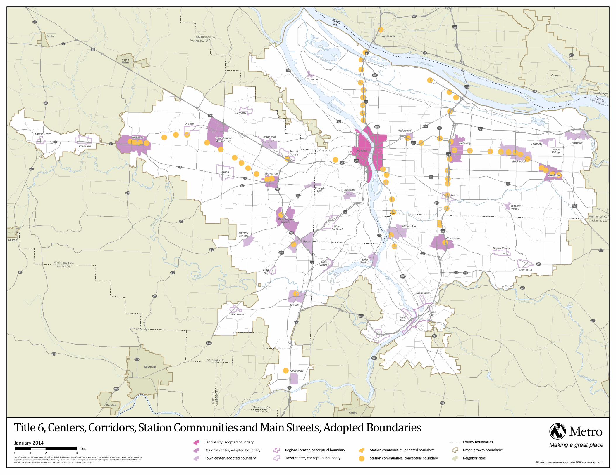
A. The Centers, Corridors, Station Communities and Main Streets Map is incorporated in this title and is Metro’s official depiction of their boundaries. The map shows the boundaries established pursuant to this title.
3.07.650 Centers, Corridors, Station Communities and Main Streets Map
B. A city or county may revise the boundary of a Center, Corridor, Station Community or Main Street so long as the boundary is consistent with the general location on the 2040 Growth Concept Map in the RFP. The city or county shall
Effective 01/18/12 3.07 - 37 of 129
provide notice of its proposed revision as prescribed in subsection B of section 3.07.620.
C. The COO shall revise the Centers, Corridors, Station Communities and Main Streets Map by order to conform the map to establishment or revision of a boundary under this title.
(Ordinance No. 02-969B, Sec. 7. Amended by Ordinance No. 10-1244B, Sec. 5; and Ordinance No. 11-1264B, Sec. 1.). Title 6 Centers, Corridors, Station Communities and Main Streets Map as of January 8, 2014 (Ordinance No. 13-1316)
UV10
UV99W
UV217
UV210UV217
UV10
UV8
UV8
£¤26
UV8
UV47
UV47
UV6
UV47
UV6
£¤30
£¤30
£¤30
£¤26
UV99E
UV99E
§̈¦5
§̈¦205
§̈¦205
§̈¦205
§̈¦205
§̈¦205Sherwood
UV43
UV224
UV212
UV212
UV224
UV224
UV224
£¤26
£¤26
£¤26
UV212
£¤30§̈¦84
§̈¦84
UV213
UV213
UV213
UV213
UV99E
UV99E
UV99W
§̈¦405
§̈¦5
§̈¦5
§̈¦5
§̈¦5
§̈¦5
UV99E
UV219
UV219
UV219
UV99W
UV99W
UV47
UV233UV221
UV240
UV210
UV8
UV500UV14
UV14
UV14
UV500
UV500
Wilsonville
Tualatin
KingCity
LakeGrove
WestLinn
OregonCity
Gladstone
LakeOswego
WestPortland
Tigard
WashingtonSquare
MurrayScholls
RaleighHills Hillsdale
Milwaukie
Clackamas
Lents
BeavertonAloha
Gateway
Hollywood
Portland
Rockwood
Gresham
WoodVillage
Fairview Troutdale
St. Johns
Bethany£¤26
Orenco
TanasbourneAmber GlenHillsboro Cedar Mill
SunsetTransit
Forest Grove
Cornelius
UV210
UV219
Canby
Happy Valley
Damascus
PleasantValley
§̈¦5
NorthPlains
Banks
Gaston
Newberg
Dundee
Vancouver
Camas
Washougal
Wash.Ore.
Willamette R.
Aurora
Barlow
Dayton Donald
Estacada
Lafayette
St. Paul
Washington Co.Multnomah Co.
Multnomah Co.Clackamas Co.
Clackamas Co.Marion Co.
Washington Co.
Clacka
mas C
o.Yam
hill Co
.
Washington Co.Yamhill Co.
Columbia River
Willamette R.
Tualatin
R.
Clackamas R.
Urban growth boundariesCounty boundaries
Neighbor cities
Clark Co.Multnomah Co.
Sand
yR.
Title 6, Centers, Corridors, Station Communities and Main Streets, Adopted BoundariesJanuary 20140 2 41
miles Making a great placeThe information on this map was derived from digital databases on Metro's GIS. Care was taken in the creation of this map. Metro cannot accept anyresponsibility for errors, omissions, or positional accuracy. There are no warranties, expressed or implied, including the warranty of merchantability or fitness for aparticular purpose, accompanying this product. However, notif ication of any errors are appreciated.
Station communities, adopted boundaryStation communities, conceptual boundary
Central city, adopted boundaryRegional center, adopted boundaryTown center, adopted boundary
Regional center, conceptual boundaryTown center, conceptual boundary
UGB and reserve boundaries pending LCDC acknowledgement
Effective 01/18/12 3.07 - 38 of 129
TITLE 7: HOUSING CHOICE
The Regional Framework Plan calls for establishment of voluntary affordable housing production goals to be adopted by local governments and assistance from local governments on reports on progress towards increasing the supply of affordable housing. It is the intent of Title 7 to implement these policies of the Regional Framework Plan.
3.07.710 Intent
(Ordinance No. 97-715B, Sec. 1. Amended by Ordinance No. 00-882C, Sec. 2; and Ordinance No. 06-1129B, Sec. 2.)
Each city and county within the Metro region should adopt the Affordable Housing Production Goal indicated in Table 3.07-7, as amended over time, as a guide to measure progress toward increasing housing choices and meeting the affordable housing needs of households with incomes between 0 percent and 50 percent of the regional median family income.
3.07.720 Voluntary Affordable Housing Production Goals
(Ordinance No. 97-715B, Sec. 1. Amended by Ordinance No. 00-882C, Sec. 2; Ordinance No. 03-1005A; and Ordinance No. 06-1129B, Sec. 2).
Cities and counties within the Metro region shall ensure that their comprehensive plans and implementing ordinances:
3.07.730 Requirements for Comprehensive Plan and Implementing Ordinance Changes
A. Include strategies to ensure a diverse range of housing types within their jurisdictional boundaries.
B. Include in their plans actions and implementation measures designed to maintain the existing supply of affordable housing as well as increase the opportunities for new dispersed affordable housing within their boundaries.
C. Include plan policies, actions, and implementation measures aimed at increasing opportunities for households of all income levels to live within their individual jurisdictions in affordable housing.
(Ordinance No. 97-715B, Sec. 1. Amended by Ordinance No. 00-882-, Sec. 2; Ordinance No. 03-1005A, Sec. 1; and Ordinance No. 06-1129B, Sec. 2.)

Effective 01/18/12 3.07 - 39 of 129
A. Local governments shall assist Metro in the preparation of a biennial affordable housing inventory by fulfilling the reporting requirements in subsection 3.07.120D of Title 1 (Requirements for Housing and Employment Accommodation) and subsection B of this section.
3.07.740 Inventory and Progress Reports on Housing Supply
B. Local governments shall report their progress on increasing the supply of affordable housing to Metro on a form provided by Metro, to be included as part of the biennial housing inventory described in subsection A. Local governments shall submit their first progress reports on July 31, 2007, and by April 15 every two years following that date. Local governments may report their progress as part of the capacity reports required by subsection 3.07.120D of Title 1 (Requirements for Housing and Employment Accommodation). Progress reports shall include, at least, the following information:
1. The number and types of units of affordable housing preserved and income groups served during the reporting period, as defined in Metro’s form;
2. The number and types of units of affordable housing built and income groups served during the reporting period;
3. Affordable housing built and preserved in Centers and Corridors; and
4. City or county resources committed to the development of affordable housing, such as fee waivers and property tax exemptions.
(Ordinance No. 00-882C, Sec. 2. Amended by Ordinance No. 03-005A, Sec. 1; and Ordinance No. 06-1129B, Sec. 2.)
Cities and counties are encouraged to take advantage of the programs of technical and financial assistance provided by Metro to help achieve the goal of increased production and preservation of housing choices and affordable housing and to help fulfill the monitoring and reporting requirements of this title.
3.07.750 Technical Assistance
(Ordinance No. 00-882C, Sec. 2. Amended by Ordinance No. 03-1005A, Sec. 1; repealed and replaced by Ordinance No. 06-1129B, Sec. 2.)
(3.07.760 Recommendations to Implement Other Affordable Housing Strategies. Repealed Ord. 06-1129B §2)
Effective 01/18/12 3.07 - 40 of 129
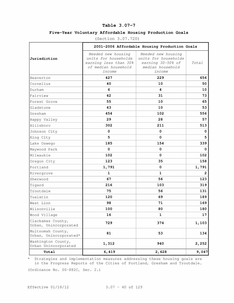
Table 3.07-7 Five-Year Voluntary Affordable Housing Production Goals
(Section 3.07.720)
Jurisdiction
2001-2006 Affordable Housing Production Goals
Needed new housing units for households earning less than 30% of median household
income
Needed new housing units for households earning 30-50% of median household
income
Total
Beaverton 427 229 656
Cornelius 40 10 50
Durham 6 4 10
Fairview 42 31 73
Forest Grove 55 10 65
Gladstone 43 10 53
Gresham 454 102 556
Happy Valley 29 28 57
Hillsboro 302 211 513
Johnson City 0 0 0
King City 5 0 5
Lake Oswego 185 154 339
Maywood Park 0 0 0
Milwaukie 102 0 102
Oregon City 123 35 158
Portland 1,791 0 1,791
Rivergrove 1 1 2
Sherwood 67 56 123
Tigard 216 103 319
Troutdale 75 56 131
Tualatin 120 69 189
West Linn 98 71 169
Wilsonville 100 80 180
Wood Village 16 1 17
Clackamas County, Urban, Unincorporated
729 374 1,103
Multnomah County, Urban, Unincorporated*
81 53 134
Washington County, Urban Unincorporated
1,312 940 2,252
Total 6,419 2,628 9,047
* Strategies and implementation measures addressing these housing goals are in the Progress Reports of the Cities of Portland, Gresham and Troutdale.
(Ordinance No. 00-882C, Sec. 2.)

Effective 01/18/12 3.07 - 41 of 129
TITLE 8: COMPLIANCE PROCEDURES
A. The purposes of this chapter are to establish a process for ensuring city or county compliance with requirements of the Urban Growth Management Functional Plan and for evaluating and informing the region about the effectiveness of those requirements. Where the terms "compliance" and "comply" appear in this title, the terms shall have the meaning given to "substantial compliance" in section 3.07.1010.
3.07.810 Compliance With the Functional Plan
B. Cities and counties shall amend their comprehensive plans
and land use regulations to comply with the functional plan, or an amendment to the functional plan, within two years after acknowledgement of the functional plan or amendment, or after any later date specified by the Metro Council in the ordinance adopting or amending the functional plan. The COO shall notify cities and counties of the acknowledgment date and compliance dates described in subsections C and D.
C. After one year following acknowledgment of a functional
plan requirement, cities and counties that amend their comprehensive plans and land use regulations shall make such amendments in compliance with the new functional plan requirement.
D. Cities and counties whose comprehensive plans and land use
regulations do not yet comply with the new functional plan requirement shall, after one year following acknowledgment of the requirement, make land use decisions consistent with the requirement. The COO shall notify cities and counties of the date upon which functional plan requirements become applicable to land use decisions at least 120 days before that date. For the purposes of this subsection, "land use decision" shall have the meaning of that term as defined in ORS 197.015(10).
E. An amendment to a city or county comprehensive plan or land
use regulation shall be deemed to comply with the functional plan upon the expiration of the appropriate appeal period specified in ORS 197.830 or 197.650 or, if an appeal is made, upon the final decision on appeal. Once the amendment is deemed to comply, the functional plan
Effective 01/18/12 3.07 - 42 of 129
requirement shall no longer apply to land use decisions made in conformance with the amendment.
F. An amendment to a city or county comprehensive plan or land
use regulation shall be deemed to comply with the functional plan as provided in subsection E only if the city or county provided notice to the COO as required by subsection A of section 3.07.820.
(Ordinance No. 97-715B, Sec. 1. Amended by Ordinance No. 98-730C, Sec. 4. Readopted and amended by Ordinance No. 00-839, Sec. 1. Amended by Ordinance No. 00-882C, Sec. 2; Ordinance No. 01-925E, Sec. 1; Ordinance No. 02-972A, Sec. l; Ordinance No. 05-1077C, Sec. 6; and Ordinance No. 10-1244B, Sec. 7).
A. A city or county proposing an amendment to a comprehensive plan or land use regulation shall submit the proposed amendment to the COO at least 45 days prior to the first evidentiary hearing on the amendment. The COO may request, and if so the city or county shall submit, an analysis of compliance of the amendment with the functional plan. If the COO submits comments on the proposed amendment to the city or county, the comment shall include analysis and conclusions on compliance and a recommendation with specific revisions to the proposed amendment, if any, that would bring it into compliance with the functional plan. The COO shall send a copy of comment to those persons who have requested a copy.
3.07.820 Review by the Chief Operating Officer
B. If the COO concludes that the proposed amendment does not
comply with the functional plan, the COO shall advise the city or county that it may:
1. Revise the proposed amendment as recommended in the
COO’s analysis;
2. Seek an extension of time, pursuant to section 3.07.830, to bring the proposed amendment into compliance with the functional plan; or
3. Seek an exception pursuant to section 3.07.840.
(Ordinance No. 97-715B, Sec. 1. Amended by Ordinance No. 98-730C, Secs. 5, 6, 7; Ordinance No. 98-727C, Sec. 1. Readopted by Ordinance No. 00-839, Sec. 1. Amended by Ordinance No. 00-882C, Sec. 2; Ordinance No. 01-925E, Sec. 1; Ordinance No. 02-972A, Sec. l; and Ordinance No. 10-1244B, Sec. 7).

Effective 01/18/12 3.07 - 43 of 129
A. A city or county may seek an extension of time for compliance with a functional plan requirement. The city or county shall file an application for an extension on a form provided by the COO. Upon receipt of an application, the COO shall notify the city or county and those persons who request notification of applications for extensions. Any person may file a written comment in support of or opposition to the extension.
3.07.830 Extension of Compliance Deadline
B. The COO may grant an extension if the city or county is
making progress toward compliance or there is good cause for failure to meet the deadline for compliance. Within 30 days after the filing of a complete application for an extension, the COO shall issue an order granting or denying the extension. The COO shall not grant more than two extensions of time. The COO shall send the order to the city or county and any person who filed a written comment.
C. The COO may establish terms and conditions for the
extension in order to ensure that compliance is achieved in a timely and orderly fashion and that land use decisions made by the city or county during the extension do not undermine the ability of the city or county to achieve the purposes of the functional plan requirement. A term or condition must relate to the requirement of the functional plan to which the COO has granted the extension.
D. The city or county applicant or any person who filed written comment on the extension may appeal the COO’s order to the Metro Council within 15 days after receipt of the order. If an appeal is filed, the Council shall hold a hearing to consider the appeal. After the hearing, the Council shall issue an order granting or denying the extension and shall send copies to the applicant and any person who participated in the hearing. The city or county or a person who participated in the proceeding may seek review of the Council’s order as a land use decision described in ORS 197.015(10)(a)(A).
(Ordinance No. 97-715B, Sec. 1. Amended by Ordinance No. 98-727C, Sec. 2; Ordinance No. 01-925E, Sec. 1; Ordinance No. 02-972A, Sec. l; and Ordinance No. 10-1244B, Sec. 7).

Effective 01/18/12 3.07 - 44 of 129
A. A city or county may seek an exception from compliance with a functional plan requirement by filing an application on a form provided by the COO. Upon receipt of an application, the COO shall notify the city or county and those persons who request notification of requests for exceptions. Any person may file a written comment in support of or opposition to the exception.
3.07.840 Exception from Compliance
B. Except as provided in subsection C, the COO may grant an
exception if:
1. It is not possible to achieve the requirement due to topographic or other physical constraints or an existing development pattern;
2. This exception and likely similar exceptions will not
render the objective of the requirement unachievable region-wide;
3. The exception will not reduce the ability of another
city or county to comply with the requirement; and 4. The city or county has adopted other measures more
appropriate for the city or county to achieve the intended result of the requirement.
C. The COO may grant an exception to the housing capacity
requirements in section 3.07.120 if:
1. The city or county has completed the analysis of capacity for dwelling units required by section 3.07.120;
2. It is not possible to comply with the requirements due
to topographic or other physical constraints, an existing development pattern, or protection of natural resources pursuant to Titles 3 or 13 of this chapter; and
3. This exception and other similar exceptions will not
render the targets unachievable region-wide. D. The COO may establish terms and conditions for the
exception in order to ensure that it does not undermine the ability of the region to achieve the purposes of the requirement. A term or condition must relate to the

Effective 01/18/12 3.07 - 45 of 129
requirement of the functional plan to which the COO grants the exception. The COO shall incorporate the terms and conditions into the order on the exception.
E. The city or county applicant or a person who filed a
written comment on the exception may appeal the COO’s order to the Metro Council within 15 days after receipt of the order. If an appeal is filed, the Council shall hold a hearing to consider the appeal. After the hearing, the Council shall issue an order granting or denying the exception and send copies to the applicant and any person who participated in the hearing. The city or county or a person who participated in the proceeding may seek review of the Council’s order as a land use decision described in ORS 197.015(10)(a)(A).
(Ordinance No. 97-715B, Sec. 1. Amended by Ordinance No. 01-925E, Sec. 1; Ordinance No. 02-972A, Sec. l; and Ordinance No. 10-1244B, Sec. 7).
A. The Metro Council may initiate enforcement if a city or county has failed to meet a deadline for compliance with a functional plan requirement or if the Council has good cause to believe that a city or county is engaged in a pattern or a practice of decision-making that is inconsistent with the functional plan, ordinances adopted by the city or county to implement the plan, or the terms or conditions in an extension or an exception granted pursuant to section 3.07.830 or 3.07.840, respectively. The Council may consider whether to initiate enforcement proceedings upon the request of the COO or a Councilor. The Council shall consult with the city or county before it determines there is good cause to proceed to a hearing under subsection B.
3.07.850 Enforcement of Functional Plan
B. If the Council decides there is good cause, the Council
President shall set the matter for a public hearing before the Council within 90 days of its decision. The COO shall publish notice of the hearing in a newspaper of general circulation in the city or county and send notice to the city or county, MPAC and any person who requests a copy of such notices.
C. The COO shall prepare a report and recommendation on the
pattern or practice, with a proposed order, for consideration by the Council. The COO shall publish the report at least 14 days prior to the public hearing and

Effective 01/18/12 3.07 - 46 of 129
send a copy to the city or county and any person who requests a copy.
D. At the conclusion of the hearing, the Council shall adopt
an order that dismisses the matter if it decides the city or county complies with the requirement. If the Council decides the city or county has failed to meet a deadline for compliance with a functional plan requirement or has engaged in a pattern or a practice of decision-making that is inconsistent with the functional plan, ordinances adopted by the city or county to implement the plan, or terms or conditions of an extension or an exception granted pursuant to section 3.07.830 or 3.07.840, respectively, the Council may adopt an order that:
1. Directs changes in the city or county ordinances
necessary to remedy the pattern or practice; or
2. Includes a remedy authorized in ORS 268.390(7). E. The Council shall issue its order not later than 30 days
following the hearing and send copies to the city or county, MPAC and any person who requests a copy.
(Ordinance No. 97-715B, Sec. 1. Amended by Ordinance No. 01-925E, Sec. 1; Ordinance No. 02-972A, Sec. l; and Ordinance No. 10-1244B, Sec. 7).
A. Any person may contact Metro staff or the COO or appear before the Metro Council to raise issues regarding local functional plan compliance, to request Metro participation in the local process, or to request the COO to appeal a local enactment for which notice is required pursuant to subsection A of section 3.07.820. Such contact may be oral or in writing and may be made at any time.
3.07.860 Citizen Involvement in Compliance Review
B. In addition to considering requests as described in A
above, the Council shall at every regularly scheduled meeting provide an opportunity for people to address the Council on any matter related to this functional plan. The COO shall maintain a list of persons who request notice in writing of COO reviews, reports and orders and proposed actions under this chapter and shall send requested documents as provided in this chapter.
C. Cities, counties and the Council shall comply with their
own adopted and acknowledged Citizen Involvement

Effective 01/18/12 3.07 - 47 of 129
Requirements (Citizen Involvement) in all decisions, determinations and actions taken to implement and comply with this functional plan. The COO shall publish a citizen involvement fact sheet, after consultation with the Metro Committee for Citizen Involvement, that describes opportunities for citizen involvement in Metro’s growth management procedures as well as the implementation and enforcement of this functional plan.
(Ordinance No. 97-715B, Sec. 1. Amended by Ordinance No. 01-925E, Sec. 1; Ordinance No. 02-972A, Sec. l; and Ordinance No. 10-1244B, Sec. 7).
A. The COO shall submit a report to the Metro Council by March 1 of each calendar year on the status of compliance by cities and counties with the requirements of the Urban Growth Management Function Plan. The COO shall send a copy of the report to MPAC, JPACT, MCCI and each city and county within Metro.
3.07.870 Compliance Report
B. A city, county or person who disagrees with a determination
in the compliance report may seek review of the determination by the Council by written request to the COO. The Council shall notify the requestor, all cities and counties, MPAC, JPACT, MCCI, the Department of Land Conservation and Development and any person who requests notification of the review. The notification shall state that the Council does not have jurisdiction to:
1. Determine whether previous amendments of comprehensive
plans or land use regulations made by a city or county comply with functional plan requirements if those amendments already comply pursuant to subsections E and F of section 3.07.810; or
2. Reconsider a determination in a prior order issued
under this section that a city or county complies with a requirement of the functional plan.
C. Following its review at a public hearing, the Council shall
adopt an order that determines whether the city or county complies with the functional plan requirement raised in the request. The order shall be based upon the COO’s report and testimony received at the public hearing. The COO shall send a copy of the order to cities and counties and any person who testifies, orally or in writing, at the public hearing.

Effective 01/18/12 3.07 - 48 of 129
D. A city or county or a person who participated, orally or in
writing, at the public hearing, may seek review of the Council’s order as a land use decision described in ORS 197.015(10)(a)(A).
(Ordinance No. 01-925E, Sec. 2. Amended by Ordinance No. 02-972A, Sec. l; and Ordinance No. 10-1244B, Sec. 7).
TITLE 9: PERFORMANCE MEASURES
(Ordinance No. 10-1244B, Sec. 8).
Title 9 is repealed.
TITLE 10: FUNCTIONAL PLAN DEFINITIONS
For the purpose of this functional plan, the following definitions shall apply:
3.07.1010 Definitions
(a) "Balanced cut and fill" means no net increase in fill within the floodplain.
(b) “COO” means Metro’s Chief Operating Officer.
(c) "Comprehensive plan" means the all inclusive, generalized, coordinated land use map and policy statement of cities and counties defined in ORS 197.015(5).
(d) "DBH" means the diameter of a tree measured at breast height.
(e) "Design flood elevation" means the elevation of the 100-year storm as defined in FEMA Flood Insurance Studies or, in areas without FEMA floodplains, the elevation of the 25-year storm, or the edge of mapped flood prone soils or similar methodologies.
(f) "Design type" means the conceptual areas described in the Metro 2040 Growth Concept text and map in Metro's regional goals and objectives, including central city, regional centers, town centers, station communities, corridors, main streets, inner and outer neighborhoods, industrial areas, and employment areas.
(g) "Designated beneficial water uses" means the same as the term as defined by the Oregon Department of Water Resources, which is: an instream public use of water for

Effective 01/18/12 3.07 - 49 of 129
the benefit of an appropriator for a purpose consistent with the laws and the economic and general welfare of the people of the state and includes, but is not limited to, domestic, fish life, industrial, irrigation, mining, municipal, pollution abatement, power development, recreation, stockwater and wildlife uses.
(h) "Development" means any man-made change defined as buildings or other structures, mining, dredging, paving, filling, or grading in amounts greater than ten (10) cubic yards on any lot or excavation. In addition, any other activity that results in the removal of more than 10 percent of the vegetation in the Water Quality Resource Area on the lot is defined as development, for the purpose of Title 3 except that less than 10 percent removal of vegetation on a lot must comply with section 3.07.340(C) - Erosion and Sediment Control. In addition, any other activity that results in the removal of more than either 10 percent or 20,000 square feet of the vegetation in the Habitat Conservation Areas on the lot is defined as development, for the purpose of Title 13. Development does not include the following: (1) Stream enhancement or restoration projects approved by cities and counties; (2) Farming practices as defined in ORS 30.930 and farm use as defined in ORS 215.203, except that buildings associated with farm practices and farm uses are subject to the requirements of Titles 3 and 13 of this functional plan; and (3) Construction on lots in subdivisions meeting the criteria of ORS 92.040(2).
(i) "Development application" means an application for a land use decision, limited land decision including expedited land divisions, but excluding partitions as defined in ORS 92.010(7) and ministerial decisions such as a building permit.
(j) “Division” means a partition or a subdivision as those terms are defined in ORS chapter 92.
(k) "Ecological functions" means the biological and hydrologic characteristics of healthy fish and wildlife habitat. Riparian ecological functions include microclimate and shade, streamflow moderation and water storage, bank stabilization and sediment/pollution control, sources of large woody debris and natural channel dynamics, and organic material sources. Upland wildlife ecological functions include size of habitat area, amount of habitat with interior conditions, connectivity of habitat to water

Effective 01/18/12 3.07 - 50 of 129
resources, connectivity to other habitat areas, and presence of unique habitat types.
(l) "Emergency" means any man-made or natural event or circum-stance causing or threatening loss of life, injury to person or property, and includes, but is not limited to, fire, explosion, flood, severe weather, drought earthquake, volcanic activity, spills or releases of oil or hazardous material, contamination, utility or transportation disruptions, and disease.
(m) "Enhancement" means the process of improving upon the natural functions and/or values of an area or feature which has been degraded by human activity. Enhancement activities may or may not return the site to a pre-disturbance condition, but create/recreate processes and features that occur naturally.
(n) "Fill" means any material such as, but not limited to, sand, gravel, soil, rock or gravel that is placed in a wetland or floodplain for the purposes of development or redevelopment.
(o) "Flood Areas" means those areas contained within the 100-year floodplain and floodway as shown on the Federal Emergency Management Agency Flood Insurance Maps and all lands that were inundated in the February 1996 flood.
(p) "Flood Management Areas" means all lands contained within the 100-year floodplain, flood area and floodway as shown on the Federal Emergency Management Agency Flood Insurance Maps and the area of inundation for the February 1996 flood. In addition, all lands which have documented evidence of flooding.
(q) "Floodplain" means land subject to periodic flooding, including the 100-year floodplain as mapped by FEMA Flood Insurance Studies or other substantial evidence of actual flood events.
(r) "Growth Concept Map" means the conceptual map demonstrating the 2040 Growth Concept design types attached to this plan1
(s) "Habitat Conservation Area" or "HCA" means an area identified on the Habitat Conservation Areas Map and subject to the performance standards and best management practices described in Metro Code section 3.07.1340.
.
(t) "Habitat-friendly development" means a method of developing property that has less detrimental impact on fish and
1 On file in the Metro Council office.

Effective 01/18/12 3.07 - 51 of 129
wildlife habitat than does traditional development methods. Examples include clustering development to avoid habitat, using alternative materials and designs such as pier, post, or piling foundations designed to minimize tree root disturbance, managing storm water on-site to help filter rainwater and recharge groundwater sources, collecting rooftop water in rain barrels for reuse in site landscaping and gardening, and reducing the amount of effective impervious surface created by development.
(u) "Habitats of Concern" means the following unique or unusually important wildlife habitat areas as identified based on cite specific information provided by local wildlife or habitat experts: Oregon white oak woodlands, bottomland hardwood forests, wetlands, native grasslands, riverine islands or deltas, and important wildlife migration corridors.
(v) "Hazardous materials" means materials described as hazardous by Oregon Department of Environmental Quality.
(w) "Implementing ordinances or regulations" means any city or county land use regulation as defined by ORS 197.015(11) which includes zoning, land division or other ordinances which establish standards for implementing a comprehensive plan.
(x) "Invasive non-native or noxious vegetation" means plants listed as nuisance plants or prohibited plants on the Metro Native Plant List as adopted by Metro Council resolution because they are plant species that have been introduced and, due to aggressive growth patterns and lack of natural enemies in the area where introduced, spread rapidly into native plant communities.
(y) "Land Conservation and Development Commission" or "LCDC" means the Oregon Land Conservation and Development Commission.
(z) "Land use regulation" means any local government zoning ordinance, land division ordinance adopted under ORS 92.044 or 92.046 or similar general ordinance establishing standards for implementing a comprehensive plan, as defined in ORS 197.015.
(aa) “Large-format retail commercial buildings” means a building intended for retail commercial use with more than 60,000 square feet of gross leasable area, or that amount or more of retail sales area on a single lot or parcel, or that amount or more on contiguous lots or parcels including lots or parcels separated only by a transportation right-of-way.

Effective 01/18/12 3.07 - 52 of 129
(bb) "Local program effective date" means the effective date of a city’s or county’s new or amended comprehensive plan and implementing ordinances adopted to comply with Title 13 of the Urban Growth Management Functional Plan, Metro Code sections 3.07.1310 to 3.07.1370. If a city or county is found to be in substantial compliance with Title 13 without making any amendments to its comprehensive plan or land use regulations, then the local program effective date shall be December 28, 2005. If a city or county amends its comprehensive plan or land use regulations to comply with Title 13, then the local program effective date shall be the effective date of the city’s or county’s amendments to its comprehensive plan or land use regulations, but in no event shall the local program effective date be later than two years after Title 13 is acknowledged by LCDC. For territory brought within the Metro UGB after December 28, 2005, the local program effective date shall be the effective date of the ordinance adopted by the Metro Council to bring such territory within the Metro UGB.
(cc) "Metro" means the regional government of the metropolitan area, the elected Metro Council as the policy setting body of the government.
(dd) "Metro boundary" means the jurisdictional boundary of Metro, the elected regional government of the metropolitan area.
(ee) “MCCI” means the Metro Committee for Citizen Involvement. (ff) “MPAC” means the Metropolitan Advisory Committee
established pursuant to Metro Charter, Chapter V, Section 27.
(gg) "Mitigation" means the reduction of adverse effects of a proposed project by considering, in the following order: (1) avoiding the impact altogether by not taking a certain action or parts of an action; (2) minimizing impacts by limiting the degree or magnitude of the action and its implementation; (3) rectifying the impact by repairing, rehabilitating or restoring the affected environment; (4) reducing or eliminating the impact over time by preser-vation and maintenance operations during the life of the action by monitoring and taking appropriate measures; and (5) compensating for the impact by replacing or providing comparable substitute water quality resource areas or habitat conservation areas.
(hh) "Mixed use" means comprehensive plan or implementing regulations that permit a mixture of commercial and residential development.

Effective 01/18/12 3.07 - 53 of 129
(ii) "Mixed-use development" includes areas of a mix of at least two of the following land uses and includes multiple tenants or ownerships: residential, retail and office. This definition excludes large, single-use land uses such as colleges, hospitals, and business campuses. Minor incidental land uses that are accessory to the primary land use should not result in a development being designated as "mixed-use development." The size and definition of minor incidental, accessory land uses allowed within large, single-use developments should be determined by cities and counties through their comprehensive plans and implementing ordinances.
(jj) "Native vegetation" or "native plant" means any vegetation listed as a native plant on the Metro Native Plant List as adopted by Metro Council resolution and any other vegetation native to the Portland metropolitan area provided that it is not listed as a nuisance plant or a prohibited plant on the Metro Native Plant List.
(kk) "Net acre" means an area measuring 43.560 square feet which excludes:
• Any developed road rights-of-way through or on the edge of the land; and
• Environmentally constrained areas, including any open water areas, floodplains, natural resource areas protected under statewide planning Goal 5 in the comprehensive plans of cities and counties in the region, slopes in excess of 25 percent and wetlands requiring a Federal fill and removal permit under Section 404 of the Clean Water Act. These excluded areas do not include lands for which the local zoning code provides a density bonus or other mechanism which allows the transfer of the allowable density or use to another area or to development elsewhere on the same site; and
• All publicly-owned land designated for park and open spaces uses.
(ll) "Net developed acre" consists of 43,560 square feet of land, after excluding present and future rights-of-way, school lands and other public uses.
(mm) "Net vacant buildable land" means all vacant land less all land that is: (1) within Water Quality Resource Areas; (2) within Habitat Conservation Areas; (3) publicly owned by a local, state or federal government; (4) burdened by major utility easements; and (5) necessary for the
Effective 01/18/12 3.07 - 54 of 129
provision of roads, schools, parks, churches, and other public facilities.
(nn) "Perennial streams" means all primary and secondary perennial waterways as mapped by the U.S. Geological Survey.
(oo) "Performance measure" means a measurement derived from technical analysis aimed at determining whether a planning policy is achieving the expected outcome or intent associated with the policy.
(pp) "Person-trips" means the total number of discrete trips by individuals using any mode of travel.
(qq) "Persons per acre" means the intensity of building development by combining residents per acre and employees per acre.
(rr) "Practicable" means available and capable of being done after taking into consideration cost, existing technology, and logistics in light of overall project purpose. As used in Title 13 of this functional plan, "practicable" means available and capable of being done after taking into consideration cost, existing technology, and logistics in light of overall project purpose and probable impact on ecological functions.
(ss) "Primarily developed" means areas where less than 10% of parcels are either vacant or underdeveloped.
(tt) “Property owner” means a person who owns the primary legal or equitable interest in the property.
(uu) "Protected Water Features" Primary Protected Water Features shall include:
• Title 3 wetlands; and
• Rivers, streams, and drainages downstream from the point at which 100 acres or more are drained to that water feature (regardless of whether it carries year-round flow); and
• Streams carrying year-round flow; and
• Springs which feed streams and wetlands and have year-round flow; and
• Natural lakes.
Secondary Protected Water Features shall include intermittent streams and seeps downstream of the point at

Effective 01/18/12 3.07 - 55 of 129
which 50 acres are drained and upstream of the point at which 100 acres are drained to that water feature.
(vv) "Public facilities and services" means sewers, water service, stormwater services and transportation.
(ww) "Redevelopable land" means land on which development has already occurred, which due to present or expected market forces, there exists the strong likelihood that existing development will be converted to more intensive uses during the planning period.
(xx) "Regionally significant fish and wildlife habitat" means those areas identified on the Regionally Significant Fish and Wildlife Habitat Inventory Map, adopted in Metro Code section 3.07.1320, as significant natural resource sites.
(yy) "Restoration" means the process of returning a disturbed or altered area or feature to a previously existing natural condition. Restoration activities reestablish the structure, function, and/or diversity to that which occurred prior to impacts caused by human activity.
(zz) "Retail" means activities which include the sale, lease or rent of new or used products to the general public or the provision of product repair or services for consumer and business goods.
(aaa)"Riparian area" means the water influenced area adjacent to a river, lake or stream consisting of the area of transition from a hydric ecosystem to a terrestrial ecosystem where the presence of water directly influences the soil-vegetation complex and the soil-vegetation complex directly influences the water body. It can be identified primarily by a combination of geomorphologic and ecologic characteristics.
(bbb)“Rural reserve” means an area designated rural reserve by Clackamas, Multnomah or Washington County pursuant to OAR 660 Division 27.
(ccc)"Significant negative impact" means an impact that affects the natural environment, considered individually or cumulatively with other impacts on the Water Quality Resource Area, to the point where existing water quality functions and values are degraded.
(ddd)"Straight-line distance" means the shortest distance measured between two points.
(eee)"Stream" means a body of running water moving over the earth’s surface in a channel or bed, such as a creek, rivulet or river. It flows at least part of the year,
Effective 01/18/12 3.07 - 56 of 129
including perennial and intermittent streams. Streams are dynamic in nature and their structure is maintained through build-up and loss of sediment.
(fff)"Substantial compliance" means city and county comprehensive plans and implementing ordinances, on the whole, conforms with the purposes of the performance standards in the functional plan and any failure to meet individual performance standard requirements is technical or minor in nature.
(ggg)"Title 3 Wetlands" means wetlands of metropolitan concern as shown on the Metro Water Quality and Flood Management Area Map and other wetlands added to city or county adopted Water Quality and Flood Management Area maps consistent with the criteria in Title 3, section 3.07.340(E)(3). Title 3 wetlands do not include artificially constructed and managed stormwater and water quality treatment facilities.
(hhh)"Top of bank" means the same as "bankfull stage" defined in OAR 141-085-0510(5).
(iii)"Urban development value" means the economic value of a property lot or parcel as determined by analyzing three separate variables: assessed land value, value as a property that could generate jobs ("employment value"), and the Metro 2040 design type designation of property. The urban development value of all properties containing regionally significant fish and wildlife habitat is depicted on the Metro Habitat Urban Development Value Map referenced in Metro Code section 3.07.1340(E).
(jjj)"UGB" means an urban growth boundary adopted pursuant to ORS chapter 197.
(kkk)"Underdeveloped parcels" means those parcels of land with less than 10 percent of the net acreage developed with permanent structures.
(lll)“Urban reserve” means an area designated urban reserve by the Metro Council pursuant to OAR 660 Division 27.
(mmm)"Utility facilities" means buildings, structures or any constructed portion of a system which provides for the production, transmission, conveyance, delivery or furnishing of services including, but not limited to, heat, light, water, power, natural gas, sanitary sewer, stormwater, telephone and cable television.
(nnn)"Vacant land" means land identified in the Metro or local government inventory as undeveloped land.
Effective 01/18/12 3.07 - 57 of 129
(ooo)"Variance" means a discretionary decision to permit modifi-cation of the terms of an implementing ordinance based on a demonstration of unusual hardship or exceptional circum-stance unique to a specific property.
(ppp)"Visible or measurable erosion" includes, but is not limited to:
• Deposits of mud, dirt sediment or similar material exceeding one-half cubic foot in volume on public or private streets, adjacent property, or onto the storm and surface water system, either by direct deposit, dropping discharge, or as a result of the action of erosion.
• Evidence of concentrated flows of water over bare soils; turbid or sediment laden flows; or evidence of on-site erosion such as rivulets on bare soil slopes, where the flow of water is not filtered or captured on the site.
• Earth slides, mudflows, earth sloughing, or other earth movement that leaves the property.
(qqq)"Water feature" means all rivers, streams (regardless of whether they carry year-round flow, i.e., including intermittent streams), springs which feed streams and wetlands and have year-round flow, Flood Management Areas, wetlands, and all other bodies of open water.
(rrr)"Water Quality and Flood Management Area" means an area defined on the Metro Water Quality and Flood Management Area Map, to be attached hereto2
(sss)"Water Quality Resource Areas" means vegetated corridors and the adjacent water feature as established in Title 3.
. These are areas that require regulation in order to mitigate flood hazards and to preserve and enhance water quality. This area has been mapped to generally include the following: stream or river channels, known and mapped wetlands, areas with flood-prone soils adjacent to the stream, floodplains, and sensitive water areas. The sensitive areas are generally defined as 50 feet from top of bank of streams for areas of less than 25 percent slope, and 200 feet from top of bank on either side of the stream for areas greater than 25 percent slope, and 50 feet from the edge of a mapped wetland.
(ttt)"Wetlands" mean those areas inundated or saturated by surface or ground water at a frequency and duration
2 On file in Metro Council office.

Effective 01/18/12 3.07 - 58 of 129
sufficient to support and under normal circumstances do support a prevalence of vegetation typically adapted for life in saturated soil conditions. Wetlands generally include swamps, marshes, bogs and similar areas. Wetlands are those areas identified and delineated by a qualified wetland specialist as set forth in the 1987 Corps of Engineers Wetland Delineation Manual.
(uuu)"Zoned capacity" means the highest number of dwelling units or jobs that are allowed to be contained in an area by zoning and other city or county jurisdiction regulations.
(Ordinance No. 97-715B, Sec. 1. Amended by Ordinance No. 98-721A, Sec. 1; Ordinance No. 98-730C, Sec. 10. Readopted by Ordinance No. 00-839, Sec. 1. Amended by Ordinance No. 00869A, Sec. 2; Ordinance No. 02-972A, Sec. l; Ordinance No. 05-1077C, Sec. 6; and Ordinance No. 10-1244B, Sec. 9).
TITLE 11: PLANNING FOR NEW URBAN AREAS
The Regional Framework Plan calls for long-range planning to ensure that areas brought into the UGB are urbanized efficiently and become or contribute to mixed-use, walkable, transit-friendly communities. It is the purpose of Title 11 to guide such long-range planning for urban reserves and areas added to the UGB. It is also the purpose of Title 11 to provide interim protection for areas added to the UGB until city or county amendments to land use regulations to allow urbanization become applicable to the areas.
3.07.1105 Purpose and Intent
(Ordinance No. 99-818A, Sec. 3. Amended by Ordinance No. 02-969B, Sec. ll; and Ordinance No. 10-1238A, Sec. 5; and Ordinance No. 11-1252A, Sec. 1).
A. The county responsible for land use planning for an urban reserve and any city likely to provide governance or an urban service for the area, shall, in conjunction with Metro and appropriate service districts, develop a concept plan for the urban reserve prior to its addition to the UGB pursuant to sections 3.07.1420, 3.07.1430 or 3.07.1435 of this chapter. The date for completion of a concept plan and the area of urban reserves to be planned will be jointly determined by Metro and the county and city or cities.
3.07.1110 Planning for Areas Designated Urban Reserve
B. A local government, in creating a concept plan to comply
with this section, shall consider actions necessary to achieve the following outcomes:

Effective 01/18/12 3.07 - 59 of 129
1. If the plan proposes a mix of residential and employment uses: a. A mix and intensity of uses that will make
efficient use of the public systems and facilities described in subsection C;
b. A development pattern that supports pedestrian
and bicycle travel to retail, professional and civic services;
c. A range of housing of different types, tenure and
prices addressing the housing needs in the prospective UGB expansion area in the context of the housing needs of the governing city, the county, and the region if data on regional housing needs are available, in order to help create economically and socially vital and complete neighborhoods and cities and avoiding the concentration of poverty and the isolation of families and people of modest means;
d. Sufficient employment opportunities to support a
healthy economy, including, for proposed employment areas, lands with characteristics, such as proximity to transportation facilities, needed by employers;
e. Well-connected systems of streets, bikeways,
parks, recreational trails and public transit that link to needed housing so as to reduce the combined cost of housing and transportation;
f. A well-connected system of parks, natural areas
and other public open spaces; g. Protection of natural ecological systems and
important natural landscape features; and h. Avoidance or minimization of adverse effects on
farm and forest practices and important natural landscape features on nearby rural lands.
2. If the plan involves fewer than 100 acres or proposes
to accommodate only residential or employment needs, depending on the need to be accommodated:

Effective 01/18/12 3.07 - 60 of 129
a. A range of housing of different types, tenure and prices addressing the housing needs in the prospective UGB expansion area in the context of the housing needs of the governing city, the county, and the region if data on regional housing needs are available, in order to help create economically and socially vital and complete neighborhoods and cities and avoiding the concentration of poverty and the isolation of families and people of modest means;
b. Sufficient employment opportunities to support a
healthy economy, including, for proposed employment areas, lands with characteristics, such as proximity to transportation facilities, needed by employers;
c. Well-connected systems of streets, bikeways,
pedestrian ways, parks, natural areas, recreation trails;
d. Protection of natural ecological systems and
important natural landscape features; and e. Avoidance or minimization of adverse effects on
farm and forest practices and important natural landscape features on nearby rural lands.
C. A concept plan shall:
1. Show the general locations of any residential, commercial, industrial, institutional and public uses proposed for the area with sufficient detail to allow estimates of the cost of the public systems and facilities described in paragraph 2;
2. For proposed sewer, park and trail, water and
stormwater systems and transportation facilities, provide the following:
a. The general locations of proposed sewer, park and
trail, water and stormwater systems;
b. The mode, function and general location of any proposed state transportation facilities, arterial facilities, regional transit and trail facilities and freight intermodal facilities;

Effective 01/18/12 3.07 - 61 of 129
c. The proposed connections of these systems and
facilities, if any, to existing systems;
d. Preliminary estimates of the costs of the systems and facilities in sufficient detail to determine feasibility and allow cost comparisons with other areas;
e. Proposed methods to finance the systems and
facilities; and
f. Consideration for protection of the capacity, function and safe operation of state highway interchanges, including existing and planned interchanges and planned improvements to interchanges.
3. If the area subject to the concept plan calls for
designation of land for industrial use, include an assessment of opportunities to create and protect parcels 50 acres or larger and to cluster uses that benefit from proximity to one another;
4. If the area subject to the concept plan calls for
designation of land for residential use, the concept plan will describe the goals for meeting the housing needs for the concept planning area in the context of the housing needs of the governing city, the county, and the region if data on regional housing needs are available. As part of this statement of objectives, the concept plan shall identify the general number, price and type of market and nonmarket-provided housing. The concept plan shall also identify preliminary strategies, including fee waivers, subsidies, zoning incentives and private and nonprofit partnerships, that will support the likelihood of achieving the outcomes described in subsection B of this section;
5. Show water quality resource areas, flood management
areas and habitat conservation areas that will be subject to performance standards under Titles 3 and 13 of this chapter;

Effective 01/18/12 3.07 - 62 of 129
6. Be coordinated with the comprehensive plans and land use regulations that apply to nearby lands already within the UGB;
7. Include an agreement between or among the county and
the city or cities and service districts that preliminarily identifies which city, cities or districts will likely be the providers of urban services, as defined at ORS 195.065(4), when the area is urbanized;
8. Include an agreement between or among the county and
the city or cities that preliminarily identifies the local government responsible for comprehensive planning of the area, and the city or cities that will have authority to annex the area, or portions of it, following addition to the UGB;
9. Provide that an area added to the UGB must be annexed
to a city prior to, or simultaneously with, application of city land use regulations to the area intended to comply with subsection C of section 3.07.1120; and
10. Be coordinated with schools districts, including
coordination of demographic assumptions. B. Concept plans shall guide, but not bind:
1. The designation of 2040 Growth Concept design types by the Metro Council;
2. Conditions in the Metro ordinance that adds the area
to the UGB; or 3. Amendments to city or county comprehensive plans or
land use regulations following addition of the area to the UGB.
C. If the local governments responsible for completion of a
concept plan under this section are unable to reach agreement on a concept plan by the date set under subsection A, then the Metro Council may nonetheless add the area to the UGB if necessary to fulfill its responsibility under ORS 197.299 to ensure the UGB has sufficient capacity to accommodate forecasted growth.

Effective 01/18/12 3.07 - 63 of 129
(Ordinance No. 98-772B, Sec. 2. Amended by Ordinance No. 99-818A, Sec. 3; Ordinance No. 02-969B, Sec. 11; Ordinance No. 06-1110A, Sec. 1; Ordinance No. 10-1238A, Sec. 5; and Ordinance No. 11-1252A, Sec. 1).
A. The county or city responsible for comprehensive planning of an area, as specified by the intergovernmental agreement adopted pursuant to section 3.07.1110C(7) or the ordinance that added the area to the UGB, shall adopt comprehensive plan provisions and land use regulations for the area to address the requirements of subsection C by the date specified by the ordinance or by section 3.07.1455B(4) of this chapter.
3.07.1120 Planning for Areas Added to the UGB
B. If the concept plan developed for the area pursuant to
section 3.07.1110 assigns planning responsibility to more than one city or county, the responsible local governments shall provide for concurrent consideration and adoption of proposed comprehensive plan provisions unless the ordinance adding the area to the UGB provides otherwise.
C. Comprehensive plan provisions for the area shall include:
1. Specific plan designation boundaries derived from and generally consistent with the boundaries of design type designations assigned by the Metro Council in the ordinance adding the area to the UGB;
2. Provision for annexation to a city and to any
necessary service districts prior to, or simultaneously with, application of city land use regulations intended to comply with this subsection;
3. Provisions that ensure zoned capacity for the number
and types of housing units, if any, specified by the Metro Council pursuant to section 3.07.1455B(2) of this chapter;
4. Provision for affordable housing consistent with Title
7 of this chapter if the comprehensive plan authorizes housing in any part of the area.
5. Provision for the amount of land and improvements
needed, if any, for public school facilities sufficient to serve the area added to the UGB in coordination with affected school districts. This

Effective 01/18/12 3.07 - 64 of 129
requirement includes consideration of any school facility plan prepared in accordance with ORS 195.110;
6. Provision for the amount of land and improvements
needed, if any, for public park facilities sufficient to serve the area added to the UGB in coordination with affected park providers.
7. A conceptual street plan that identifies internal
street connections and connections to adjacent urban areas to improve local access and improve the integrity of the regional street system. For areas that allow residential or mixed-use development, the plan shall meet the standards for street connections in the Regional Transportation Functional Plan;
8. Provision for the financing of local and state public
facilities and services; and 9. A strategy for protection of the capacity and function
of state highway interchanges, including existing and planned interchanges and planned improvements to interchanges.
D. The county or city responsible for comprehensive planning
of an area shall submit to Metro a determination of the residential capacity of any area zoned to allow dwelling units, using the method in section 3.07.120, within 30 days after adoption of new land use regulations for the area.
(Ordinance No. 98-772B, Sec. 2. Amended by Ordinance No. 99-818A, Sec. 3; Ordinance No. 01-929A, Sec. 8; Ordinance No. 02-964, Sec. 5; Ordinance No. 05-1077C, Sec. 6; Ordinance No. 05-1089A, Sec. 2; Ordinance No. 07-1137A, Sec. 3; Ordinance No. 10-1238A, Sec. 5; and Ordinance No. 11-1252A, Sec. 1).
Until land use regulations that comply with section 3.07.1120 become applicable to the area, the city or county responsible for planning the area added to the UGB shall not adopt or approve:
3.07.1130 Interim Protection of Areas Added to the UGB
A. A land use regulation or zoning map amendment that allows
higher residential density in the area than allowed by regulations in effect at the time of addition of the area to the UGB;

Effective 01/18/12 3.07 - 65 of 129
B. A land use regulation or zoning map amendment that allows commercial or industrial uses not allowed under regulations in effect at the time of addition of the area to the UGB;
C. A land division or partition that would result in creation
of a lot or parcel less than 20 acres in size, except for public facilities and services as defined in section 3.07.1010 of this chapter, or for a new public school;
D. In an area designated by the Metro Council in the ordinance
adding the area to the UGB as Regionally Significant Industrial Area:
1. A commercial use that is not accessory to industrial
uses in the area; and 2. A school, a church, a park or any other institutional
or community service use intended to serve people who do not work or reside in the area.
(Ordinance No. 98-772B, Sec. 2. Amended by Ordinance No. 99-818A, Sec. 3; Ordinance No. 10-1238A, Sec. 5; and Ordinance No. 11-1252A, Sec. 1).
Section 3.07.1110 becomes applicable on December 31, 2011.
3.07.1140 Applicability
(Ordinance No. 98-772B, Sec. 2. Amended by Ordinance No. 99-818A, Sec. 3; Ordinance No. 10-1238A, Sec. 5; and Ordinance No. 11-1252A, Sec. 1).
TITLE 12: PROTECTION OF RESIDENTIAL NEIGHBORHOODS
Existing neighborhoods are essential to the success of the 2040 Growth Concept. The intent of Title 12 of the Urban Growth Management Functional Plan is to protect the region’s residential neighborhoods. The purpose of Title 12 is to help implement the policy of the Regional Framework Plan to protect existing residential neighborhoods from air and water pollution, noise and crime and to provide adequate levels of public services.
3.07.1210 Purpose and Intent
(Ordinance No. 02-969B, Sec. 3.)
Effective 01/18/12 3.07 - 66 of 129
Metro shall not require any city or county to authorize an increase in the residential density of a single-family neighborhood in an area mapped solely as an Inner or Outer Neighborhood pursuant to Metro Code Section 3.07.130 prior to May 22, 2002.
3.07.1220 Residential Density
(Ordinance No. 02-969B, Sec. 3.)
A. In order to reduce air pollution and traffic congestion, and to make commercial retail services more accessible to residents of Inner and Outer Neighborhoods, a city or county may designate in its comprehensive plan and land use regulations one or more Neighborhood Centers within or in close proximity to Inner and Outer Neighborhoods to serve as a convenient location of commercial services.
3.07.1230 Access to Commercial Services
B. To ensure that commercial development serves the needs of
the residents of Inner and Outer Neighborhoods but does not generate excessive traffic, noise or air pollution, a city or county that designates a Neighborhood Center shall adopt limitations on the scale of commercial services in Neighborhood Centers. In a Neighborhood Center, a city or county shall not approve:
1. A commercial retail use with more than 20,000 square
feet of gross leasable area in a single building; or 2. Office commercial uses with more than 10,000 square
feet of gross leasable area in a single building or on a single lot or parcel.
(Ordinance No. 02-969B, Sec. 3.)
A. Each city and county shall, within two years following adoption by the Metro Council of a process and criteria for such standards, establish a level of service standard for parks and greenspaces that calls for a park facility within a specified distance of all residences.
3.07.1240 Access to Parks and Schools
B. To make parks and greenspaces more accessible to residents
of Inner and Outer Neighborhoods and all residents of the region, each city and county shall provide for access to

Effective 01/18/12 3.07 - 67 of 129
parks and greenspaces by walking, biking and transit, where transit is available or planned.
C. To make parks and schools more accessible to neighborhood
residents, to reduce traffic, and to use land more efficiently, cities, counties, park providers and school districts shall, where appropriate, provide for shared use of school facilities for park purposes and of park facilities for school purposes.
D. To make public schools more accessible to neighborhood
residents, cities, counties and school districts shall prioritize school sites that are near concentrations of population and are connected to those concentrations by safe and convenient walking, biking and, where transit is available or planned, transit facilities.
(Ordinance No. 02-969B, Sec. 3.)
TITLE 13: NATURE IN NEIGHBORHOODS
The purposes of this program are to (1) conserve, protect, and restore a continuous ecologically viable streamside corridor system, from the streams’ headwaters to their confluence with other streams and rivers, and with their floodplains in a manner that is integrated with upland wildlife habitat and with the surrounding urban landscape; and (2) to control and prevent water pollution for the protection of the public health and safety, and to maintain and improve water quality throughout the region. This program:
3.07.1310 Intent
A. Will achieve its purpose through conservation, protection,
and appropriate restoration of riparian and upland fish and wildlife habitat through time, using a comprehensive approach that includes voluntary, incentive-based, educational, and regulatory elements;
B. Balances and integrates goals of protecting and enhancing
fish and wildlife habitat, building livable Region 2040 communities, supporting a strong economy, controlling and preventing water pollution for the protection of the public health and safety, and complying with federal laws including the Clean Water Act and the Endangered Species Act;
Effective 01/18/12 3.07 - 68 of 129
C. Includes provisions to monitor and evaluate program performance over time to determine whether the program is achieving the program’s objectives and targets, to determine whether cities and counties are in substantial compliance with this title, and to provide sufficient information to determine whether to amend or adjust the program in the future; and
D. Establishes minimum requirements and is not intended to
repeal or replace existing requirements of city and county comprehensive plans and implementing ordinances to the extent those requirements already meet the minimum requirements of this title, nor is it intended to prohibit cities and counties from adopting and enforcing fish and wildlife habitat protection and restoration programs that exceed the requirements of this title.
(Ordinance No. 05-1077C, Sec. 5.)
The purpose of this section is to describe the geographic information system (GIS) data and maps that form the basis of Metro’s fish and wildlife habitat protection and restoration program. This data and maps are referenced in various ways in this title, but may or may not be relevant within a city or county depending upon which implementation alternative the city or county chooses pursuant to Metro Code Section 3.07.1330(B). The maps referred to in this title are representations of data contained within Metro’s GIS system, operated by the Metro Data Resource Center, and references to such maps shall be interpreted as references to the maps themselves and to the underlying GIS data that the maps represent.
3.07.1320 Inventory and Habitat Conservation Areas
A. The Regionally Significant Fish and Wildlife Habitat
Inventory Map (hereinafter the "Inventory Map"), attached hereto3
, identifies the areas that have been determined to contain regionally significant fish and wildlife habitat. The Inventory Map divides habitat into two general categories, riparian and upland wildlife, and further differentiates each habitat category into low, medium, and high value habitats.
3 On file in the Metro Council office and copies available from the Metro Data Resource Center.

Effective 01/18/12 3.07 - 69 of 129
B. The Habitat Conservation Areas Map, attached hereto4
, identifies the areas that are subject to the performance standards and best management practices described in Metro Code Section 3.07.1340, to the extent that a city or county chooses to comply with Metro Code Section 3.07.1330 by using the Habitat Conservation Areas map, or a map that substantially complies with the Habitat Conservation Areas map. For such cities and counties, the Habitat Conservation Areas Map further identifies, subject to the map verification process described in Metro Code Sections 3.07.1330(G) and 3.07.1340(D), which areas will be subject to high, moderate, and low levels of habitat conservation based on Metro Council’s consideration of the results of the economic, social, environmental, and energy (ESEE) consequences of protecting or not protecting the habitat, public input, and technical review, and the Metro Council’s subsequent decision to balance conflicting uses in habitat areas.
1. Table 3.07-13a describes how (1) Class I and II riparian habitat areas, and (2) Class A and B upland wildlife habitat areas within publicly-owned parks and open spaces, except for parks and open spaces where the acquiring agency clearly identified that it was acquiring the property to develop it for active recreational uses, located within the Metro boundary on December 28, 2005, were designated as high, moderate, and low Habitat Conservation Areas.
2. Table 3.07-13b describes how Class I and II riparian
habitat areas and Class A and B upland wildlife areas brought within the Metro UGB after December 28, 2005, will be designated as high, moderate, and low Habitat Conservation Areas. Metro Code Section 3.07.1360 describes the procedures for how Table 3.07-13b and Metro Code Section 3.07.1340 shall be applied in such areas.
C.
Exempt International Marine Terminals
1. Marine dependent properties which would otherwise have been mapped as Habitat Conservation Areas do not appear on the Habitat Conservation Areas Map because the Metro Council concluded, based on its analysis of
4 On file in the Metro Council office and copies available from the Metro Data Resource Center.
Effective 01/18/12 3.07 - 70 of 129
the economic, social, environmental, and energy implications of its decision, that the economic importance of such properties far outweighed the environmental importance of the properties as fish and wildlife habitat. The Metro Council applied the criteria described in subsection (C)(2) of this section to conclude that the following properties should not be considered Habitat Conservation Areas:
a. The International Terminal property, located at
12005 N. Burgard Way, Portland, Oregon, 97203;
b. Port of Portland Marine Terminal 4;
c. Port of Portland Marine Terminal 5; and d. Port of Portland Marine Terminal 6.
2. The Metro Council may, at its discretion, consider and adopt ordinances to exempt from the provisions of this title any additional properties along the Willamette and Columbia Rivers, or portions of such properties, where it can be demonstrated that:
a. The property is currently developed for use as an
international marine terminal capable of mooring ocean-going tankers or cargo ships; and
b. The property is substantially without vegetative
cover.
(Ordinance No. 05-1077C, Sec. 5.)
A. Under Oregon law, upon acknowledgment of this program by the Oregon Land Conservation and Development Commission (LCDC), cities and counties wholly or partly within the Metro boundary shall apply the requirements of this title with respect to areas identified as riparian habitat on the Inventory Map and areas identified as upland wildlife habitat on the Inventory Map, according to the compliance deadlines established in Metro Code Section 3.07.810, rather than applying the requirements of division 23 of chapter 660 of the Oregon Administrative Rules ("OAR"), promulgated by LCDC, except that:
3.07.1330 Implementation Alternatives for Cities and Counties
Effective 01/18/12 3.07 - 71 of 129
1. A city or county shall apply the requirements of division 23 of OAR chapter 660 in order to adopt comprehensive plan amendments or land use regulations that (i) would otherwise require compliance with division 23 of OAR chapter 660 but for the adoption of this title (i.e., amendments or regulations adopted to protect Goal 5 resources), and (ii) will limit development in areas not identified as riparian habitat on the Inventory Map, unless such provisions (a) are part of a program intended to comply with Metro Code Section 3.07.1330(B)(3) and apply only to areas identified as upland wildlife habitat on the Inventory Map (i.e., they do not apply to areas not identified as habitat); or (b) apply to areas identified as Class A or B upland wildlife habitat on the Inventory Map that are brought within the UGB after December 28, 2005. Such a city or county shall seek acknowledgement of such provisions from LCDC or treat such provisions as post-acknowledgement plan amendments under ORS chapter 197;
2. A city or county that, prior to December 28, 2005, adopted any comprehensive plan amendments or land use regulations that (a) apply to areas identified as upland wildlife habitat on the Inventory Map but not identified as riparian habitat on the Inventory Map, (b) limit development in order to protect fish or wildlife habitat, and (c) were adopted in compliance with division 23 of OAR chapter 660, shall not repeal such amendments or regulations, nor shall it amend such provisions in a manner that would allow any more than a de minimis increase in the amount of development that could occur in areas identified as upland wildlife habitat; and
3. After a city or county has demonstrated that it is in
substantial compliance with the requirements of this title, if the city or county wishes to adopt comprehensive plan amendments or land use regulations applicable to areas identified as riparian habitat on the Inventory Map that have the effect of imposing greater limits on development than those imposed by provisions that are in substantial compliance with the requirements of this title, such a city or county shall comply with the provisions of division 23 of OAR chapter 660, and shall seek acknowledgement of such provisions from LCDC or treat such provisions as

Effective 01/18/12 3.07 - 72 of 129
post-acknowledgement plan amendments under ORS chapter 197.
B. Each city and county in the region shall either:
1. Amend its comprehensive plan and implementing ordinances to adopt the Title 13 Model Ordinance and the Metro Habitat Conservation Areas Map, and demonstrate compliance with the provisions of (a) Metro Code Section 3.07.1340(A)(5), related to enhanced fish and wildlife protection and management of publicly-owned parks and open spaces that have been designated as natural areas and are not intended for future urban development, and (b) Metro Code Section 3.07.1340(A)(8), related to the restoration of Habitat Conservation Areas when developed property is undergoing significant redevelopment;
2. Demonstrate that its existing or amended comprehensive
plan and existing, amended, or new implementing ordinances substantially comply with the performance standards and best management practices described in Metro Code Section 3.07.1340, and that maps that it has adopted and uses substantially comply with the Metro Habitat Conservation Areas Map;
3. Demonstrate that it has implemented a program based on
alternative approaches that will achieve protection and enhancement of Class I and II riparian habitat areas, and of Class A and B upland wildlife habitat areas in territory added to the Metro UGB after December 28, 2005, substantially comparable with the protection and restoration that would result from the application of a program that complied with Metro Code Sections 3.07.1330(B)(1) or (B)(2). A city or county developing such a program:
a. Shall demonstrate that its alternative program
will provide a certainty of habitat protection and enhancement to achieve its intended results, such as by using proven programs and demonstrating stable and continuing funding sources sufficient to support elements of the program that require funding;
b. May assert substantial compliance with this
provision by relying on either or both the city’s
Effective 01/18/12 3.07 - 73 of 129
or county’s comprehensive plan and implementing ordinances and on the use of incentive based, voluntary, education, acquisition, and restoration programs, such as:
i. An existing tree protection ordinance;
ii. A voluntary program for tree protection,
tree replacement, and habitat restoration;
iii. Habitat preservation incentive programs, such as programs that provide reduced development or storm water management fees and property taxes in return for taking measures to protect and restore habitat (including, for example, the Wildlife Habitat Special Tax Assessment Program, ORS 308A.400 through 308A.430, and the Riparian Habitat Tax Exemption Program, ORS 308A.350 through 308A.383);
iv. Habitat-friendly development standards to
reduce the detrimental impact of storm water run-off on riparian habitat;
v. A local habitat acquisition program; and
vi. Maintaining and enhancing publicly-owned
habitat areas, such as by:
(A) Using habitat-friendly best management practices, such as integrated pest management programs, in all regionally significant habitat areas within publicly-owned parks and open spaces;
(B) Ensuring that publicly-owned parks and
open spaces that have been designated as natural areas and are not intended for future urban development are managed to maintain and enhance the quality of fish and wildlife habitat that they provide; and
(C) Pursuing funding to support local park,
open space, and habitat acquisition and restoration, such as with local bond
Effective 01/18/12 3.07 - 74 of 129
measures, System Development Charge (SDC) programs, Federal Emergency Management Act (FEMA) grants, or other funding mechanisms.
4. District Plans
a. Adopt one or more district plans that apply over portions of the city or county, and demonstrate that, for the remainder of its jurisdiction, the city or county has a program that complies with either Metro Code Section 3.07.1330(B)(1) or Metro Code Section 3.07.1330(B)(2). If a city or county adopts one or more district plans pursuant to this paragraph, it shall demonstrate that, within each district plan area, the district plan complies with Metro Code Section 3.07.1330(B)(3). District plans shall be permitted under this subsection only for areas within a common watershed, or which are within areas in adjoining watersheds that share an interrelated economic infrastructure and development pattern. Cities and counties that choose to develop district plans are encouraged to coordinate such district plans with other entities whose activities impact the same watershed to which the district plan applies, including other cities and counties, special districts, state and federal agencies, watershed councils, and other governmental and non-governmental agencies.
.
b. The City of Portland shall develop a District Plan that complies with Metro Code Section 3.07.1330(B)(4)(a), in cooperation with the Port of Portland, that applies to West Hayden Island; or
5. For a city or county that is a member of the Tualatin Basin Natural Resources Coordinating Committee (the "TBNRCC," which includes Washington County and the cities of Beaverton, Cornelius, Durham, Forest Grove, Hillsboro, King City, Sherwood, Tigard, and Tualatin), amend its comprehensive plan and implementing ordinances to comply with the maps and provisions of the TBNRCC Goal 5 Program, attached hereto5
5 On file in the Metro Council office and copies available from the Metro Planning Department.
and incorporated herein by reference, adopted by the

Effective 01/18/12 3.07 - 75 of 129
TBNRCC on April 4, 2005 (the "Tualatin Basin Program"), subject to the intergovernmental agreement entered into between Metro and the TBNRCC. All other provisions of this Metro Code Section 3.07.1330, as well as Metro Code Section 3.07.1360, shall still apply to each city and county that is a member of the TBNRCC. In addition, in order for a city or county that is a member of the TBNRCC to be in compliance with this functional plan, the following conditions must be satisfied:
a. Within the compliance timeline described in
Paragraph 6 of the Intergovernmental Agreement entered into between Metro and the TBNRCC, the TBNRCC and its members comply with the six (6) steps identified in section B of Chapter 7 of the Tualatin Basin Program;
b. Clean Water Services approves and begins
implementing its Healthy Streams Plan; c. The TBNRCC members agree to renew and extend
their partnership to implement the projects on the Healthy Streams Project List and target projects that protect and restore Class I and II Riparian Habitat, including habitat that extends beyond the Clean Water Services "vegetated corridors," and the TBNRCC shall continue to coordinate its activities with Metro and cooperate with Metro on the development of regional public information about the Nature in Neighborhoods Initiative;
d. The city or county has adopted provisions to
facilitate and encourage the use of habitat-friendly development practices, where technically feasible and appropriate, in all areas identified as Class I and II riparian habitat areas on the Metro Regionally Significant Fish and Wildlife Habitat Inventory Map. Table 3.07-13c provides examples of the types of habitat-friendly development practices that shall be encouraged and considered;
e. The city or county has adopted provisions to
allow for the reduction of the density and capacity requirements of Title 1 of the Urban

Effective 01/18/12 3.07 - 76 of 129
Growth Management Functional Plan, Metro Code Sections 3.07.110 to 170, consistent with Metro Code Section 3.07.1330(H). Particularly, the provisions shall (1) apply only to properties that were within the Metro urban growth boundary on January 1, 2002; (2) require the protection of regionally significant habitat on the property, such as via a public dedication or restrictive covenant; and (3) allow only for a reduction in the minimum number of units required to be built based on the amount of area protected as provided in part (2) of this paragraph. In addition, cities and counties will be required to report to Metro as provided in Metro Code Section 3.07.1330(H)(3);
f. The city or county complies with the provisions
of Metro Code Section 3.07.1330(B)(1) to (B)(3) as those provisions apply to upland wildlife habitat in territory added to the Metro urban growth boundary after December 28, 2005. For example, (1) each city and county shall either adopt and apply Metro’s Title 13 Model Ordinance to upland wildlife habitat in new urban areas, (2) substantially comply with the requirements of Metro Code Section 3.07.1340 as it applies to upland wildlife habitat in new urban areas, or (3) demonstrate that it has implemented an alternative program that will achieve protection and enhancement of upland wildlife habitat in new urban areas comparable with the protection and restoration that would result from one of the two previous approaches described in this sentence; and
g. The TBNRCC and the city or county complies with
the monitoring and reporting requirements of Metro Code Section 3.07.1360.
C. The comprehensive plan and implementing ordinances relied
upon by a city or county to comply with this title shall contain clear and objective standards. A standard shall be considered clear and objective if it meets any one of the following criteria:
1. It is a fixed numerical standard, such as fixed
distance (e.g. "50 feet") or land area (e.g. "1 acre");

Effective 01/18/12 3.07 - 77 of 129
2. It is a nondiscretionary requirement, such as a
requirement that grading not occur beneath the dripline of a protected tree; or
3. It is a performance standard that describes the
outcome to be achieved, specifies the objective criteria to be used in evaluating outcome or performance, and provides a process for application of the performance standard, such as a conditional use or design review process.
D. In addition to complying with subsection (C) of this
section, the comprehensive plan and implementing ordinances that a city or county relies upon to satisfy the requirements of this title may include an alternative, discretionary approval process that is not clear and objective provided that the comprehensive plan and implementing ordinance provisions of such a process:
1. Specify that property owners have the choice of
proceeding under either the clear and objective approval process, which each city or county must have pursuant to subsection (C) of this section, or under the alternative, discretionary approval process; and
2. Require a level of protection for, or enhancement of,
the fish and wildlife habitat that meets or exceeds the level of protection or enhancement that would be achieved by following the clear and objective standards described in subsection (C) of this section.
E. Use of Habitat-Friendly Development Practices In Regionally
Significant Fish And Wildlife Habitat.
1. Each city and county in the region shall:
a. Identify provisions in the city’s or county’s comprehensive plan and implementing ordinances that prohibit or limit the use of the habitat-friendly development practices such as those described in Table 3.07-13c; and
b. Adopt amendments to the city’s or county’s
comprehensive plan and implementing ordinances to remove the barriers identified pursuant to subsection (E)(1)(a)of this section, and shall

Effective 01/18/12 3.07 - 78 of 129
remove such barriers so that such practices may be used, where practicable, in all regionally significant fish and wildlife habitat; provided, however that such practices shall not be permitted if their use is prohibited by an applicable and required State or Federal permit issued to a unit of local government having jurisdiction in the area, such as a permit required under the Clean Water Act, 33 U.S.C. §§1251 et seq., or the Safe Drinking Water Act, 42 U.S.C. §§300f et seq., and including conditions or plans required by such permit.
2. Metro shall provide technical assistance to cities and
counties to comply with the provisions of this subsection E of this section.
F. Cities and counties shall hold at least one public hearing prior to adopting comprehensive plan amendments, implementing ordinances, and maps implementing this title or demonstrating that existing city or county comprehensive plans, implementing ordinances, and maps substantially comply with this title. The proposed comprehensive plan amendments, implementing ordinances, and maps shall be available for public review at least 45 days prior to the public hearing.
G. The comprehensive plan provisions and implementing ordinances that each city or county amends, adopts, or relies on to comply with this title shall provide property owners with a reasonable, timely, and equitable process to verify the specific location of habitat areas subject to the provisions of the city’s or county’s comprehensive plan and implementing ordinances. It is the intent of this requirement that, in the majority of cases, the process be as simple and straightforward as possible and not result in a change that would require an amendment to the city’s or county’s comprehensive plan. Such process shall:
1. Allow a property owner, or another person with the property owner’s consent, to confirm the location of habitat on a lot or parcel at any time, whether or not the property owner has submitted a specific request for a development permit, provided, however, that a city or county may impose a fee to cover the actual staff, equipment and other administrative costs of providing such a service;
Effective 01/18/12 3.07 - 79 of 129
2. As often as reasonably possible, provide a simple, default approach that allows a property owner to verify the location of habitat on a lot or parcel without having to hire an environmental consultant and without having to pay a significant processing or application fee;
3. Allow a property owner to present detailed
documentation to verify the location of habitat on a lot or parcel, such as information collected and analyzed by an environmental consultant; and
4. Ensure that the process provides adequate
opportunities for appeals and a fair and equitable dispute resolution process, consistent with state law.
H. Reducing Regional Density and Capacity Requirements to
Allow Habitat Protection.
1. Notwithstanding the provisions of Metro Code Section 3.07.140(A)(2), cities and counties may approve a subdivision or development application that will result in a density below the minimum density for the zoning district if:
a. The property lot or parcel was within the Metro
UGB on January 1, 2002;
b. An area of the property lot or parcel to be developed has been identified as regionally significant fish and wildlife habitat on the Metro Inventory Map or as a significant resource on a local Goal 5 riparian, wetlands, or wildlife resource inventory map that had been acknowledged by the LCDC prior to December 28, 2005; and
c. Such a decision will directly result in the
protection of the remaining undeveloped regionally significant fish and wildlife habitat or significant resource located on the property lot or parcel, such as via a public dedication or a restrictive covenant.
2. The amount of reduction in the minimum density
requirement that may be approved under this subsection (H) of this section shall be calculated by subtracting the number of square feet of regionally significant fish and wildlife habitat or significant resource that

Effective 01/18/12 3.07 - 80 of 129
is permanently protected under subsection (H)(1)(c) of this section from the total number of square feet that the city or county otherwise would use to calculate the minimum density requirement for the property.
3. If a city or county approves a subdivision or
development application that will result in a density below the minimum density for the zoning district pursuant to subsection (H)(1) of this section, then such city or county shall:
a. Be permitted an offset against the capacity
specified for that city or county in Table 3.07-1 of the Metro Code. The amount of such offset shall be calculated by subtracting the difference between the number of dwelling units that the city or county approved to be built pursuant to subsection (H)(1) of this section and the minimum number of dwelling units that would have otherwise been required to be built on the property pursuant to the applicable minimum density requirements for the zoning district where the property is located; and
b. Report to Metro by April 15 of every year the
number of approvals made pursuant to this subsection H of this section, including docu-mentation that the factors in subsection (H)(1) had been satisfied for each such approval, and the capacity offsets that the city or county shall be afforded as a result of such approvals.
(Ordinance No. 05-1077C, Sec. 5.)
The following performance standards and best management practices apply to all cities and counties that choose to adopt or rely upon their comprehensive plans and implementing ordinances to comply, in whole or in part, with Metro Code Section 3.07.1330(B)(2):
3.07.1340 Performance Standards and Best Management Practices for Habitat Conservation Areas
A. City and county comprehensive plans and implementing
ordinances shall conform to the following performance standards and best management practices:
Effective 01/18/12 3.07 - 81 of 129
1. Habitat Conservation Areas shall be protected, maintained, enhanced, and restored as specified in this Metro Code Section 3.07.1340, and city and county development codes shall include provisions for enforcement of these performance standards and best management practices.
2. In addition to requirements imposed by this title, the
requirements of Title 3 of the Urban Growth Management Functional Plan, Metro Code Sections 3.07.310 to 3.07.360 shall continue to apply.
3. The performance standards and best management
practices of this Metro Code Section 3.07.1340 shall not apply:
a. When the application of such standards and
practices would restrict or regulate farm structures or farming practices in violation of ORS 215.253 or ORS 561.191; or
b. In areas outside of the Metro UGB but within the
Metro boundary at the effective date of this title: i. When such standards and practices violate
ORS 527.722 by prohibiting, limiting, regulating, subjecting to approval, or in any other way affecting forest practices on forestlands located outside of an acknowledged urban growth boundary, except as provided in ORS 527.722(2), (3) and (4); or
ii. Pursuant to ORS 196.107, in areas within
Multnomah County and the Columbia River Gorge National Scenic Area, provided that Multnomah County has adopted and implements ordinances that are approved pursuant to sections 7(b) and 8(h) through 8(k) of the Columbia River Gorge National Scenic Area Act, 16 U.S.C. §§ 544e(b) and 544f(h) through 544f(k).
4. The performance standards and best management
practices of this Metro Code Section 3.07.1340 shall not apply to any use of residential properties if, as

Effective 01/18/12 3.07 - 82 of 129
of the local program effective date:
a. Construction of the residence was completed in compliance with all applicable local and state laws and rules for occupancy as a residence or the residence had been occupied as a residence for the preceding ten years; and
b. Such uses would not have required the property
owner to obtain a land use approval or a building, grading, or tree removal permit from their city or county.
5. Habitat Conservation Areas within publicly-owned parks
and open spaces that have been designated as natural areas and are not intended for future urban development shall be protected and managed so that the quality of fish and wildlife habitat that they provide is maintained and enhanced, and that habitat-friendly best management practices, such as integrated pest management programs, are used in such areas.
6. Invasive non-native or noxious vegetation shall not be
planted in any Habitat Conservation Area. The removal of invasive non-native or noxious vegetation from Habitat Conservation Areas shall be allowed. The planting of native vegetation shall be encouraged in Habitat Conservation Areas.
7. Except as provided in subsection (A)(8) of this
section, routine repair, maintenance, alteration, rehabilitation, or replacement of existing structures, roadways, driveways, utilities, accessory uses, or other development within Habitat Conservation Areas may be allowed provided that:
a. The project is consistent with all other
applicable local, state, and federal laws and regulations;
b. The project will not permanently or irreparably
result in more developed area within a Habitat Conservation Area than the area of the existing development; and
c. Native vegetation is maintained, enhanced and
restored, if disturbed; other vegetation is
Effective 01/18/12 3.07 - 83 of 129
replaced, if disturbed, with vegetation other than invasive non-native or noxious vegetation; and the planting of native vegetation and removal of invasive non-native or noxious vegetation is encouraged.
8. Notwithstanding subsection (A)(7) of this section,
when a city or county exercises its discretion to approve zoning changes to allow a developed property that contains a Habitat Conservation Area to (1) change from an industrial or heavy commercial zoning designation to a residential or mixed-use/residential designation, or (2) increase the type or density and intensity of development in any area, then the city or county shall apply the provisions of this Metro Code Section 3.07.1340, or provisions that will achieve substantially comparable habitat protection and restoration as do the provisions of this section. This provision will help to insure that, when developed areas are redeveloped in new ways to further local and regional urban and economic development goals, property owners should restore regionally significant fish and wildlife habitat as part of such redevelopment.
9. Any activity within Habitat Conservation Areas that is
required to implement a Federal Aviation Administration (FAA)-compliant Wildlife Hazard Management Plan (WHMP) on property owned by the Port of Portland within 10,000 feet of an Aircraft Operating Area, as defined by the FAA, shall be allowed provided that mitigation for any such projects is completed in compliance with mitigation requirements adopted pursuant to subsections (B)(1), (B)(2)(c), and (B)(3) of this section. In addition, habitat mitigation for any development within Habitat Conservation Areas on property owned by the Port of Portland within 10,000 feet of an Aircraft Operating Area, as defined by the FAA, shall be permitted at any property located within the same 6th Field Hydrologic Unit Code subwatershed as delineated by the Unites States Department of Agriculture’s Natural Resources Conservation Service (NRCS) without having to demonstrate that on-site mitigation is not practicable, feasible, or appropriate.
10. Within Habitat Conservation Areas located in Multnomah
County Drainage District No. 1, Peninsula Drainage

Effective 01/18/12 3.07 - 84 of 129
District No. 1, Peninsula Drainage District No. 2, and the area managed by the Sandy Drainage Improvement Company, routine operations, repair, maintenance, reconfiguration, rehabilitation, or replacement of existing drainage and flood control facilities, and existing related facilities, including any structures, pump stations, water control structures, culverts, irrigation systems, roadways, utilities, accessory uses (such as off-load facilities that facilitate water-based maintenance), erosion control projects, levees, soil and bank stabilization projects, dredging and ditch clearing within the hydraulic cross-section in existing storm water conveyance drainageways, or other water quality and flood storage projects applicable to existing facilities and required to be undertaken pursuant to ORS Chapters 547 or 554 or Titles 33 or 44 of the Code of Federal Regulations, shall be allowed provided that:
a. The project is consistent with all other
applicable local, state, and federal laws and regulations;
b. The project does not encroach closer to a surface
stream or river, wetland, or other body of open water than existing operations and development;
c. Disturbed areas are replanted with vegetation and
no bare soils remain after project completion; the planting of native vegetation and removal of invasive non- native or noxious vegetation is encouraged; and invasive non-native or noxious vegetation shall not be planted; and
d. Each district submits an annual report, to all
local permitting agencies in which the district operates, describing the projects the district completed in the previous year and how those projects complied with all applicable federal and state laws and requirements.
B. City and county comprehensive plans and implementing
ordinances shall contain review standards applicable to development in all Habitat Conservation Areas that include:
1. Clear and objective development approval standards
consistent with Metro Code Section 3.07.1330(C) that

Effective 01/18/12 3.07 - 85 of 129
protect Habitat Conservation Areas but which allow limited development within High Habitat Conservation Areas, slightly more development in Moderate Habitat Conservation Areas, and even more development in Low Habitat Conservation Areas. Such standards shall allow (a) property owners to consider reduced building footprints and the use of minimal excavation foundation systems (e.g., pier, post or piling foundation), and (b) the flexible application of local code requirements that may limit a property owner’s ability to avoid development in Habitat Conservation Areas, such as setback and landscaping requirements or limits on clustering and the transfer of development rights on-site. The habitat-friendly development practices described in Table 3.07-13c, which are intended to minimize the magnitude of the impact of development in Habitat Conservation Areas, shall be allowed, encouraged, or required to the extent that cities and counties can develop clear and objective standards for their use, unless their use is prohibited by an applicable and required State or Federal permit issued to a unit of local government having jurisdiction in the area, such as a permit required under the Clean Water Act, 33 U.S.C. §§1251 et seq., or the Safe Drinking Water Act, 42 U.S.C. §§300f et seq., and including conditions or plans required by such permit. The clear and objective development standards required by this paragraph also shall require that all development in Habitat Conservation Areas be mitigated to restore the ecological functions that are lost or damaged as a result of the development. Standards that meet the requirements of this subsection and Metro Code Section 3.07.1330(C) are provided in Section 7 of the Metro Title 13 Model Ordinance6
; and
2. Discretionary development approval standards consistent with Metro Code Section 3.07.1330(D) that comply with subsections (B)(2)(a), (B)(2)(b), and B(2)(c) of this section. Standards that meet the requirements of this subsection (B)(2) and Metro Code Section 3.07.1330(D) are provided in Section 8 of the Metro Title 13 Model Ordinance.
6 On file in the Metro Council office and copies available from the Metro Planning Department.

Effective 01/18/12 3.07 - 86 of 129
a. Avoid Habitat Conservation Areas.
i. Development may occur within a Habitat Conservation Area only if a property owner demonstrates that no practicable alternatives to the requested development exist which will not disturb the Habitat Conservation Area;
ii. When implementing this requirement to
determine whether a practicable alternative exists, cities and counties shall include consideration of the type of Habitat Conservation Area that will be affected by the proposed development. For example, High Habitat Conservation Areas have been so designated because they are areas that have been identified as having lower urban development value and higher-valued habitat, while Low Habitat Conservation Areas have been so designated because they are areas that have been identified as having higher urban development value and lower-valued habitat; and
iii. Cities and counties shall allow flexibility
in the application of local code requirements that may limit a property owner’s ability to avoid development in Habitat Conservation Areas, such as setback and landscaping requirements or limits on clustering and the transfer of development rights on-site. Property owners shall also consider reduced building footprints and use of minimal excavation foundation systems (e.g., pier, post or piling foundation). The use of the techniques described in this paragraph shall be part of the alternatives analysis to determine whether any alternative to development within the Habitat Conservation Area is practicable; and

Effective 01/18/12 3.07 - 87 of 129
b. Minimize Impacts on Habitat Conservation Areas and Water Quality. i. If there is no practicable alternative,
limit the development to minimize, to the extent practicable, the detrimental impacts on Habitat Conservation Areas associated with the proposed development;
ii. When implementing this requirement to
determine whether development has been minimized to the extent practicable, cities and counties shall include consideration of the type of Habitat Conservation Area that will be affected by the proposed development. For example, High Habitat Conservation Areas have been so designated because they are areas that have been identified as having lower urban development value and higher-valued habitat, while Low Habitat Conservation Areas have been so designated because they are areas that have been identified as having higher urban development value and lower-valued habitat; and
iii. The techniques described in subsection
(B)(2)(a)(iii) of this section shall be used to demonstrate that development within a Habitat Conservation Area has been minimized. In addition, the magnitude of the impact of development within Habitat Conservation Areas also shall be minimized, such as by use of the habitat-friendly development practices described in Table 3.07-13c, unless the use of such practices is prohibited by an applicable and required State or Federal permit issued to a unit of local government having jurisdiction in the area, such as a permit required under the Clean Water Act, 33 U.S.C. §§1251 et seq., or the Safe Drinking Water Act, 42 U.S.C. §§300f et seq., and including conditions or plans required by such permit; and
c. Mitigate Impacts on Habitat Conservation Areas
and Water Quality.

Effective 01/18/12 3.07 - 88 of 129
When development occurs, require mitigation to restore the ecological functions that were lost or damaged as a result of the development, after taking into consideration the property owner’s efforts to minimize the magnitude of the detrimental impacts through the use of the techniques described in Table 3.07-13c and through any additional or innovative techniques.
3. When development occurs within delineated wetlands,
then the mitigation required under subsections (B)(1) and (B)(2) of this title shall not require any additional mitigation than the mitigation required by state and federal law for the fill or removal of such wetlands.
C. City and county comprehensive plans and implementing
ordinances shall include procedures to consider claims of hardship and to grant hardship variances for any property demonstrated to be converted to an unbuildable lot by application of any provisions implemented to comply with the requirements of this title.
D. Administering the Habitat Conservation Areas Map and Site-
Level Verification of Habitat Location. 1. Each city and county shall be responsible for
administering the Habitat Conservation Areas Map, or the city’s or county’s map that has been deemed by Metro to be in substantial compliance with the Habitat Conservation Areas Map, within its jurisdiction, as provided in this subsection (D) of this section.
2. The comprehensive plan and implementing ordinances
amended, adopted or relied upon to comply with this subsection (D) of this section shall comply with Metro Code Section 3.07.1330(G).
3. Verification of the Location of Habitat Conservation
Areas. Each city and county shall establish a verification process consistent with subsections (D)(4) through (D)(6) of this section. The site-level verification of Habitat Conservation Areas is a three-step process. The first step is determining the boundaries of the habitat areas on the property, as provided in subsection (D)(4) of this section. The

Effective 01/18/12 3.07 - 89 of 129
second step is determining the urban development value of the property, as provided in subsection (D)(5) of this section. The third step is cross-referencing the habitat classes with the urban development value of the property to determine whether the property contains High, Moderate, or Low Habitat Conservation Areas, or none at all, as provided in subsection (D)(6) of this section.
4. Habitat Boundaries.
a. Locating riparian habitat and determining its
habitat class is a five-step process.
i. Step 1. Locate the water feature that is the basis for identifying riparian habitat:
(A) Locate the top of bank of all streams,
rivers, and open water within 200 feet of the property;
(B) Locate all flood areas within 100 feet
of the property (areas that were mapped as flood areas but were filled to a level above the base flood level prior to the local program effective date, consistent with all applicable local, state, and federal laws and regulations shall no longer be considered habitat based on their status as flood areas); and
(C) Locate all wetlands within 150 feet of
the property based on the Local Wetland Inventory map (if completed) and on the Metro 2004 Wetland Inventory Map (available from the Metro Data Resource Center, 600 N.E. Grand Ave., Portland, OR 97232; 503-797-1742). Identified wetlands shall be further delineated consistent with methods currently accepted by the Oregon Division of State Lands and the U.S. Army Corps of Engineers.
ii. Step 2. Identify the vegetative cover status
of all areas on the property that are within
Effective 01/18/12 3.07 - 90 of 129
200 feet of the top of bank of streams, rivers, and open water, are wetlands or are within 150 feet of wetlands, and are flood areas and within 100 feet of flood areas:
(A) Vegetative cover status shall be as
identified on the Metro Vegetative Cover Map, attached hereto7
and incorporated herein by reference. The vegetative cover type assigned to any particular area was based on two factors: the type of vegetation observed in aerial photographs and the size of the overall contiguous area of vegetative cover to which a particular piece of vegetation belonged. As an example of how the categories were assigned, in order to qualify as "forest canopy" the forested area had to be part of a larger patch of forest of at least one acre in size; and
(B) In terms of mapping the location of habitat, the only allowed corrections to the vegetative cover status of a property are those based on an area being developed prior to the local program effective date and those based on errors made at the time the vegetative cover status was determined based on analysis of the aerial photographs used to create the Metro Vegetative Cover Map (for the original map, the aerial photos used were Metro’s summer 2002 photos) and application of the vegetative cover definitions provided in the footnotes to Table 3.07-13d.
iii. Step 3. Determine whether the degree that
the land slopes upward from all streams, rivers, and open water within 200 feet of the property is greater than or less than 25% (using the methodology described in the
7 On file in the Metro Council office and copies available from the Metro Data Resource Center.

Effective 01/18/12 3.07 - 91 of 129
Appendix to Exhibit A to Ordinance No. 00-839 re-adopting Title 3 of the Urban Growth Management Functional Plan).
iv. Step 4. Identify the habitat class (Class I, Class II, or none) of the areas within up to 200 feet of the identified water feature, consistent with Table 3.07-13d. Note that areas that have been identified as habitats of concern, as depicted on the Metro Habitats of Concern Map, attached hereto8
and incorporated herein by reference, are all classified as Class I riparian habitat.
v. Step 5. Confirm that the development and vegetative cover status of areas within up to 200 feet of the identified water feature has not been altered without the required approval of the city or county since the local program effective date and, if it has, then verify the original habitat location using the best available evidence of its location on the local program effective date.
b. For territory brought within the Metro UGB after
December 28, 2005, the location of upland wildlife habitat and its habitat class shall be as identified in Metro’s habitat inventory of such territory performed pursuant to Metro Code Section 3.07.1370. The only factors that may be reviewed to verify the location of upland wildlife habitat shall be:
i. For territory that was within the Metro
boundary on December 28, 2005, whether regionally significant fish and wildlife habitat was removed, consistent with all other applicable local, state, and federal laws and regulations, prior to the date that the property was brought within the Metro UGB and, if so, then areas where habitat was removed shall not be identified as Habitat Conservation Areas;
8 On file in the Metro Council office and copies available from
the Metro Data Resource Center.

Effective 01/18/12 3.07 - 92 of 129
ii. Whether errors were made at the time the
vegetative cover status was determined based on (1) analysis of the aerial photographs used to determine the vegetative cover status, and (2) application of the vegetative cover definitions provided in the footnotes to Table 3.07-13d; and
iii. Whether there are discrepancies between the
locations of property lot lines and the location of Habitat Conservation Areas, as shown on the Habitat Conservation Areas Map.
5. Urban Development Value of the Property. The urban
development value of property designated as regionally significant habitat is depicted on the Metro Habitat Urban Development Value Map, attached hereto9
and incorporated herein by reference. The Metro Habitat Urban Development Value Map is based on an assessment of three variables, the land value of property, the employment value of property, and the Metro 2040 Design Type designation of property. Cities and counties shall make an upward adjustment of a property’s urban development value designation (i.e., from low to medium or high, or from medium to high) if:
a. The Metro 2040 Design Type designation has changed from a category designated as a lower urban development value category to one designated as a higher urban development value category. Properties in areas designated as the Central City, Regional Centers, Town Centers, and Regionally Significant Industrial Areas are considered to be of high urban development value; properties in areas designated as Main Streets, Station Communities, Other Industrial Areas, and Employment Centers are of medium urban development value; and properties in areas designated as Inner and Outer Neighborhoods and Corridors are of low urban development value; or
9 On file in the Metro Council office and copies available from
the Metro Data Resource Center.

Effective 01/18/12 3.07 - 93 of 129
b. The property, or adjacent lots or parcels, is owned by a regionally significant educational or medical facility and, for that reason, should be designated as of high urban development value because of the economic contributions the facility provides to the citizens of the region.
i. The following facilities are regionally
significant educational or medical facilities, as further identified on the Regionally Significant Educational or Medical Facilities Map, attached hereto10
:
(A) Clackamas Community College, 19600 S. Molalla Ave., Oregon City;
(B) Lewis & Clark College, 0615 S.W. Palatine
Hill Rd., Portland; (C) Marylhurst University, 17600 Hwy 43, in
Lake Oswego; (D) Mt. Hood Community College, 26000 S.E.
Stark St., Gresham; (E) Oregon Health Sciences University, 3181
SW Sam Jackson Park Rd., Portland;
(F) Oregon Health Sciences University, Portland South Waterfront, Portland;
(G) Oregon Health Sciences University/Oregon
Graduate Institute, 20000 N.W. Walker, Hillsboro;
(H) Pacific University, 2043 College Way,
Forest Grove;
(I) Portland Community College, Rock Creek Campus, 17865 N.W. Springdale Rd., Portland;
(J) Portland Community College, Sylvania
Campus, 12000 S.W. 49th Ave., Portland;
10 On file in the Metro Council office.

Effective 01/18/12 3.07 - 94 of 129
(K) Providence St. Vincent Medical Center, 9115 SW Barnes Rd., Portland;
(L) Reed College, 3203 S.E. Woodstock
Blvd., Portland; (M) University of Portland, 5000 N.
Willamette Blvd., Portland; and
(N) Veterans Hospital, 3710 SW U.S. Veterans Hospital Rd., Portland.
ii. The Metro Council may add a property to the
list of facilities identified in subsection (D)(5)(b)(i) of this section in the future by adopting an ordinance amending that section if the Council finds that the use of the property:
(A) Supports the 2040 Growth Concept by
providing a mixed-use environment that may include employment, housing, retail, cultural and recreational activities, and a mix of transportation options such as bus, bicycling, walking, and auto;
(B) Provides, as a primary objective, a
service that satisfies a public need rather than just the consumer economy (i.e., producing, distributing, selling or servicing goods);
(C) Draws service recipients (e.g.,
students, patients) from all reaches of the region and beyond;
(D) Relies on capital infrastructure that
is so large or specialized as to render its relocation infeasible; and
(E) Has a long-term campus master plan that
has been approved by the city or county in which it is located.
6. Cross-Referencing Habitat Class With Urban Development
Value. City and county verification of the locations

Effective 01/18/12 3.07 - 95 of 129
of High, Moderate, and Low Habitat Conservation Areas shall be consistent with Tables 3.07-13a and 3.07-13b.
(Ordinance No. 05-1077C, Section 5.)
A. The purpose of this section is to provide for Metro to accept potential liability for claims filed against cities and counties pursuant to ORS 197.352 (Ballot Measure 37) as a result of the cities' and counties' good faith implementation of Metro Code Sections 3.07.1310 through 3.07.1370. As a corollary of accepting financial and administrative responsibility for these claims, Metro seeks the authority and cooperation of cities and counties in the evaluation and settlement of claims.
3.07.1350 Claims Pursuant to ORS 197.352 (Ballot Measure 37)
B. Provided that cities and counties meet the requirements set
out below, Metro shall indemnify a city or county for any claim made against a city or county based on its implementation of the requirements of Metro Code Sections 3.07.1310 through 3.07.1370. In order to receive the benefits of this provision, a city or county must:
1. Upon receipt of a written demand for compensation
pursuant to ORS 197.352, from an owner of private real property located within its jurisdiction alleging that a comprehensive plan amendment or land use regulation adopted or relied upon to comply with the requirements of this title reduces the fair market value of the property, a city or county shall forward a copy of the demand to Metro no later than seven (7) days following receipt of the demand;
2. Reasonably cooperate with Metro throughout Metro’s
consideration and disposition of the claim, including promptly providing Metro with any information related to the property in question, to an assessment of its fair market value, or to the city’s or county’s adoption of the comprehensive plan amendment or land use regulation that is the basis of the demand made pursuant to ORS 197.352; and
3. Substantially concur with Metro’s recommendation
regarding disposition of the claim, which disposition may include, but not be limited to, a cash payment or other compensation, a decision to modify, remove, or not apply the regulation, dismissal of the claim, and

Effective 01/18/12 3.07 - 96 of 129
the imposition of appropriate conditions. Metro shall forward to the city or county Metro’s recommended disposition of the claim within 120 days of Metro’s receipt of notice of the claim from the city or county; provided, however, that if Metro does not provide such recommendation within the 120 day deadline then the city or county may dispose of the claim as it determines appropriate and Metro will neither indemnify the city or county for the claim nor use the city’s or county’s decision on the claim as a basis for finding that the city or county is not in compliance with this title. A city or county may also satisfy this requirement by entering into an intergovernmental agreement with Metro in order to grant Metro sufficient authority to implement, on the city or county’s behalf, Metro’s recommendation regarding the disposition of the claim.
(Ordinance No. 05-1077C, Section 5.)
This section describes the program performance objectives, the roles and responsibilities of Metro, cities, counties, and special districts in regional data coordination and inventory maintenance, monitoring and reporting, and program evaluation.
3.07.1360 Program Objectives, Monitoring and Reporting
A. The following program objectives are established:
1. Performance objectives:
a. Preserve and improve streamside, wetland, and floodplain habitat and connectivity;
b. Preserve large areas of contiguous habitat and
avoid habitat fragmentation; c. Preserve and improve connectivity for wildlife
between riparian corridors and upland wildlife habitat; and
d. Preserve and improve special habitats of concern
such as native oak habitats, native grasslands, wetlands, bottomland hardwood forests, and riverine islands.
2. Implementation objectives:

Effective 01/18/12 3.07 - 97 of 129
a. Increase the use of habitat-friendly development throughout the region; and
b. Increase restoration and mitigation actions to
compensate for adverse effects of new and existing development on ecological function.
B. Program Monitoring and Evaluation.
1. Metro will monitor the region’s progress toward
meeting the vision of conserving, protecting, and restoring the region’s fish and wildlife habitat and the intent of this title by:
a. Developing and monitoring regional indicators and
targets as set forth in Table 3.07-13e to evaluate progress in achieving the four performance objectives described in subsection (A)(1) of this section;
b. Developing and monitoring regional indicators as
set forth in Table 3.07-13e to evaluate progress in achieving the two implementation objectives described in subsection (A)(2) of this section;
c. Collaborating with local, state, and federal
agencies and non-governmental organizations in carrying out field studies and data sharing to increase understanding of the health of the region’s watersheds and to identify restoration opportunities and priorities; and
d. Preparing and presenting monitoring and program
evaluation reports to Metro Council no later than December 31, 2006, and by December 31 of each even-numbered year thereafter.
2. Metro will practice adaptive management by using the
results of monitoring studies and the availability of new information to assess whether the goals, objectives, and targets of this title are being achieved.
C. Reporting Requirements for Cities and Counties.
1. Cities and counties shall report to Metro no later than December 31, 2007, and by December 31 of each
Effective 01/18/12 3.07 - 98 of 129
odd-numbered year thereafter on their progress in using voluntary and incentive-based education, acquisition, and restoration habitat protection efforts; and
2. At least 45 days prior to a city’s or county’s final
public hearing on a proposed new or amended ordinance or regulation relating to protection of, or mitigation of damage to, habitat, trees or other vegetation, cities and counties shall mail written notice of the proposed ordinance or regulation to Metro. Cities and counties that require applications for land use approvals or building, grading, or tree removal permits to include documentation that the development meets habitat, tree, or vegetation protection and mitigation requirements adopted by a special district, including any county service district established pursuant to ORS chapter 451, shall mail written notice to Metro of any proposed new or amended ordinance or regulation relating to protection of, or mitigation of damage to, trees or other vegetation that is proposed by such a special district at least 45 days prior to the special district’s final public hearing on the proposed new or amended ordinance or regulation.
D. Regional data coordination and maintenance.
1. Metro will act as the regional coordinator for Geographic Information System (GIS) data used to create and maintain the Regionally Significant Fish and Wildlife Habitat Inventory Map and other data relevant to program implementation, monitoring, and evaluation. To carry out this role cities and counties shall provide Metro with local data in a timely fashion and in a form compatible with Metro’s GIS program. To the extent that such data is collected by county service districts established pursuant to ORS chapter 451, then the county in which the county service district operates shall comply with this section. Such data shall include:
a. Adopted and revised Local Wetland Inventories approved by the Division of State Lands and those determined to be locally significant under ORS 197.279(3)(b);
b. Wetland mitigation sites approved by the Division of State Lands or U.S. Army Corps of Engineers;

Effective 01/18/12 3.07 - 99 of 129
c. For cities and counties that have not carried out Local Wetland Inventories, wetland boundaries delineated using accepted protocols by Division of State Lands or U.S. Army Corps of Engineers;
d. Revised or updated local surface stream inventories;
e. Revised or updated 100-year Federal Emergency Management Act (FEMA) flood area maps or revisions to the 1996 area of inundation maps to incorporate FEMA-approved floodplain map revisions or floodplain fills approved by the U.S. Army Corps of Engineers;
f. Completed restoration and enhancement projects; and
g. Revised or updated Metro Habitats of Concern data layer.
2. Metro will periodically update its Regionally Significant Fish and Wildlife Habitat Inventory for use in program monitoring and evaluation. Metro will maintain a study area boundary one mile beyond the perimeter of the Metro boundary and Metro Urban Growth Boundary.
(Ordinance No. 05-1077C, Sec. 5.)
The Metro Inventory Map identifies regionally significant fish and wildlife habitat within the entire Metro boundary, including areas outside of the Metro UGB at the time this title was adopted. As described in Metro Code Section 3.07.1320, the Metro Council has designated as Habitat Conservation Areas the regionally significant fish and wildlife habitat that has been identified as riparian Class I and II habitat within the Metro boundary. In addition, the Metro Council has also determined that the regionally significant fish and wildlife habitat identified as upland wildlife Class A and B habitat that is currently outside of the Metro UGB shall be designated as Habitat Conservation Areas at such time that those areas are brought within the Metro UGB. Territory where the Metro UGB may expand includes both areas within the current Metro boundary and areas outside of the current Metro boundary.
3.07.1370 Future Metro Urban Growth Boundary Expansion Areas
A. New Urban Territory That Was Previously Within the Metro Boundary.
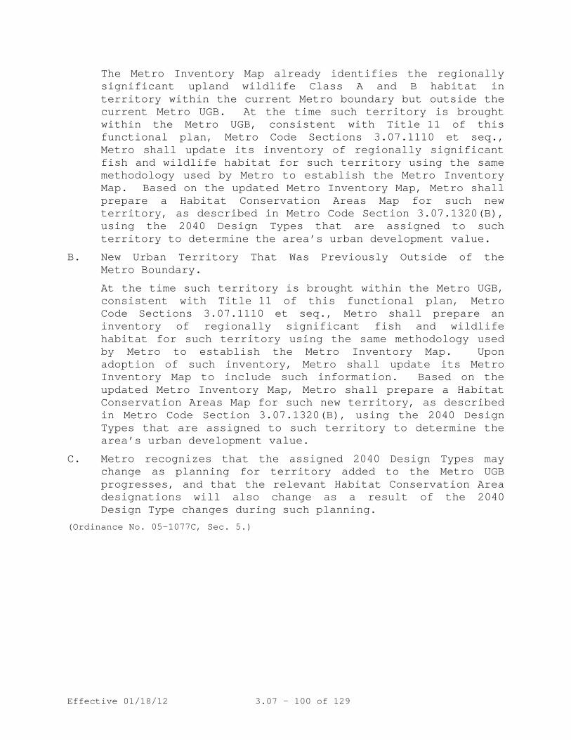
Effective 01/18/12 3.07 - 100 of 129
The Metro Inventory Map already identifies the regionally significant upland wildlife Class A and B habitat in territory within the current Metro boundary but outside the current Metro UGB. At the time such territory is brought within the Metro UGB, consistent with Title 11 of this functional plan, Metro Code Sections 3.07.1110 et seq., Metro shall update its inventory of regionally significant fish and wildlife habitat for such territory using the same methodology used by Metro to establish the Metro Inventory Map. Based on the updated Metro Inventory Map, Metro shall prepare a Habitat Conservation Areas Map for such new territory, as described in Metro Code Section 3.07.1320(B), using the 2040 Design Types that are assigned to such territory to determine the area’s urban development value.
B. New Urban Territory That Was Previously Outside of the Metro Boundary.
At the time such territory is brought within the Metro UGB, consistent with Title 11 of this functional plan, Metro Code Sections 3.07.1110 et seq., Metro shall prepare an inventory of regionally significant fish and wildlife habitat for such territory using the same methodology used by Metro to establish the Metro Inventory Map. Upon adoption of such inventory, Metro shall update its Metro Inventory Map to include such information. Based on the updated Metro Inventory Map, Metro shall prepare a Habitat Conservation Areas Map for such new territory, as described in Metro Code Section 3.07.1320(B), using the 2040 Design Types that are assigned to such territory to determine the area’s urban development value.
C. Metro recognizes that the assigned 2040 Design Types may change as planning for territory added to the Metro UGB progresses, and that the relevant Habitat Conservation Area designations will also change as a result of the 2040 Design Type changes during such planning.
(Ordinance No. 05-1077C, Sec. 5.)

Effective 01/18/12 3.07 - 101 of 129
Table 3.07-13a: Method for Identifying Habitat Conservation Areas ("HCA")
Fish & wildlife habitat
classification High Urban development
value1
Medium Urban development
value2
Low Urban development
value3
Other areas: Parks and Open Spaces, no design types outside UGB
Class I Riparian
Moderate HCA
High HCA High HCA High HCA / High HCA+4
Class II Riparian
Low HCA Low HCA Moderate HCA
Moderate HCA /
High HCA+4 Class A Upland Wildlife
No HCA No HCA No HCA No HCA / High HCA5 / High HCA+4
Class A Upland Wildlife
No HCA No HCA No HCA No HCA / High HCA5 / High HCA+4
NOTE: The default urban development value of property is as depicted on the
Metro Habitat Urban Development Value Map. The Metro 2040 Design Type designations provided in the following footnotes are only for use when a city or county is determining whether to make an adjustment pursuant to Metro Code Section 3.07.1340(E)(5).
1 Primary 2040 design types: Regional Centers, Central City, Town Centers, and Regionally Significant Industrial Areas
2 Secondary 2040 design types: Main Streets, Station Communities, Other Industrial Areas, and Employment Centers
3 Tertiary 2040 design types: Inner and Outer Neighborhoods, Corridors 4 Cities and counties shall give Class I and II riparian habitat and Class A and B upland wildlife habitat in parks designated as natural areas even greater protection than that afforded to High Habitat Conservation Areas, as provided in Metro Code Section 3.07.1340(A)(5).
5 All Class A and B upland wildlife habitat in publicly-owned parks and open spaces, except for parks and open spaces where the acquiring agency clearly identified that it was acquiring the property to develop it for active recreational uses, shall be considered High HCAs.

Effective 01/18/12 3.07 - 102 of 129
Table 3.07-13b: Method for Identifying Habitat Conservation Areas ("HCA") in Future Metro
Urban Growth Boundary Expansion Areas
Fish & wildlife habitat classification
High Urban development
value1
Medium Urban development
value2
Low Urban development
value3
Other areas: Parks and
Open Spaces, no design
types outside UGB
Class I Riparian
Moderate HCA
High HCA High HCA High HCA / High HCA+4
Class II Riparian
Low HCA Low HCA Moderate HCA
Moderate HCA /
High HCA+4 Class A Upland Wildlife
Low HCA Moderate HCA
Moderate HCA
High HCA / High HCA5 / High HCA+4
Class B Upland Wildlife
Low HCA Low HCA Moderate HCA
Moderate HCA /
High HCA5 / High HCA+4
NOTE: The default urban development value of property is as depicted on the
Metro Habitat Urban Development Value Map. The Metro 2040 Design Type designations provided in the following footnotes are only for use when a city or county is determining whether to make an adjustment pursuant to Metro Code Section 3.07.1340(E)(5).
1 Primary 2040 design types: Regional Centers, Central City, Town Centers, and Regionally Significant Industrial Areas
2 Secondary 2040 design types: Main Streets, Station Communities, Other Industrial Areas, and Employment Centers
3 Tertiary 2040 design types: Inner and Outer Neighborhoods, Corridors 4 Cities and counties shall give Class I and II riparian habitat and Class A and B upland wildlife habitat in parks designated as natural areas even greater protection than that afforded to High Habitat Conservation Areas, as provided in Metro Code Section 3.07.1340(A)(5).
5 All Class A and B upland wildlife habitat in publicly-owned parks and open spaces, except for parks and open spaces where the acquiring agency clearly identified that it was acquiring the property to develop it for active recreational uses, shall be considered High HCAs.

Effective 01/18/12 3.07 - 103 of 129
Table 3.07-13c. Habitat-friendly Development Practices
Part (a): Design and Construction Practices to Minimize Hydrologic Impacts
1. Amend disturbed soils to original or higher level of porosity to regain infiltration and stormwater storage capacity.
2. Use pervious paving materials for residential driveways, parking lots, walkways, and within centers of cul-de-sacs.
3. Incorporate stormwater management in road right-of-ways. 4. Landscape with rain gardens to provide on-lot detention, filtering of
rainwater, and groundwater recharge. 5. Use green roofs for runoff reduction, energy savings, improved air
quality, and enhanced aesthetics. 6. Disconnect downspouts from roofs and direct the flow to vegetated
infiltration/filtration areas such as rain gardens. 7. Retain rooftop runoff in a rain barrel for later on-lot use in lawn
and garden watering. 8. Use multi-functional open drainage systems in lieu of more
conventional curb-and-gutter systems. 9. Use bioretention cells as rain gardens in landscaped parking lot
islands to reduce runoff volume and filter pollutants. 10. Apply a treatment train approach to provide multiple opportunities for
storm water treatment and reduce the possibility of system failure. 11. Reduce sidewalk width and grade them such that they drain to the front
yard of a residential lot or retention area. 12. Reduce impervious impacts of residential driveways by narrowing widths
and moving access to the rear of the site. 13. Use shared driveways. 14. Reduce width of residential streets, depending on traffic and parking
needs. 15. Reduce street length, primarily in residential areas, by encouraging
clustering and using curvilinear designs. 16. Reduce cul-de-sac radii and use pervious vegetated islands in center
to minimize impervious effects, and allow them to be utilized for truck maneuvering/loading to reduce need for wide loading areas on site.
17. Eliminate redundant non-ADA sidewalks within a site (i.e., sidewalk to all entryways and/or to truck loading areas may be unnecessary for industrial developments).
18. Minimize car spaces and stall dimensions, reduce parking ratios, and use shared parking facilities and structured parking.
19. Minimize the number of stream crossings and place crossing perpendicular to stream channel if possible.
20. Allow narrow street right-of-ways through stream corridors whenever possible to reduce adverse impacts of transportation corridors.

Effective 01/18/12 3.07 - 104 of 129
Part (b): Design and Construction Practices to Minimize Impacts on Wildlife Corridors and Fish Passage
1. Carefully integrate fencing into the landscape to guide animals toward animal crossings under, over, or around transportation corridors.
2. Use bridge crossings rather than culverts wherever possible. 3. If culverts are utilized, install slab, arch or box type culverts,
preferably using bottomless designs that more closely mimic stream bottom habitat.
4. Design stream crossings for fish passage with shelves and other design features to facilitate terrestrial wildlife passage.
5. Extend vegetative cover through the wildlife crossing in the migratory route, along with sheltering areas.
Part (c): Miscellaneous Other Habitat-Friendly Design and Construction Practices
1. Use native plants throughout the development (not just in HCA). 2. Locate landscaping (required by other sections of the code) adjacent
to HCA. 3. Reduce light-spill off into HCAs from development. 4. Preserve and maintain existing trees and tree canopy coverage, and
plant trees, where appropriate, to maximize future tree canopy coverage.

Effective 01/18/12 3.07 - 105 of 129
Table 3.07-13d: Locating Boundaries of Class I and II Riparian Areas
Distance from Water Feature
Development/Vegetation Status¹ Developed areas not providing vegetative
cover2
Low structure vegetation or open soils3
Woody vegetation (shrub and scattered forest canopy)4
Forest Canopy (closed to open forest canopy)5
Surface Streams
0-50’ Class II 6 Class I 7 Class I Class I 50’-100’ Class II 6 Class I Class I 100’-150’ Class II if
slope>25% 6 Class II if slope>25% 6
Class II 6
150’-200’ Class II if slope>25% 6
Class II if slope>25% 6
Class II if slope>25% 6
Wetlands (Wetland feature itself is a Class I Riparian Area)
0-100’ Class II 6 Class I Class I 100’-150’ Class II 6
Flood Areas Within 300’ of river or surface stream
Class I Class I Class I
More than 300’ from river or surface stream
8 Class II 6 Class II 6 Class I
0-100’ from edge of flood area
Class II 6, 9 Class II 6
1 Development/vegetative cover status is identified on the Metro Vegetative Cover Map (on file in the Metro Council office). The vegetative cover type assigned to any particular area was based on two factors: the type of vegetation observed in aerial photographs and the size of the overall contiguous area of vegetative cover to which a particular piece of vegetation belonged.
2 "Developed areas not providing vegetative cover" are areas that lack sufficient vegetative cover to meet the one-acre minimum mapping unit for any type of vegetative cover.
3 "Low structure vegetation or open soils" means areas that are part of a contiguous area one acre or larger of grass, meadow, crop-lands, or areas of open soils located within 300 feet of a surface stream (low structure vegetation areas may include areas of shrub vegetation less than one acre in size if they are contiguous with areas of grass, meadow, crop-lands, orchards, Christmas tree farms, holly farms, or areas of open soils located within 300 feet of a surface stream and together form an area of one acre in size or larger).
4 "Woody vegetation" means areas that are part of a contiguous area one acre or larger of shrub or open or scattered forest canopy (less than 60% crown closure) located within 300 feet of a surface stream.
5 "Forest canopy" means areas that are part of a contiguous grove of trees of one acre or larger in area with approximately 60% or greater crown closure, irrespective of whether the entire grove is within 200 feet of the relevant water feature.
Effective 01/18/12 3.07 - 106 of 129
6 Areas that have been identified as habitats of concern, as designated on the Metro Habitats of Concern Map (on file in the Metro Council office and copies available from the Metro Data Resource Center), shall be treated as Class I riparian habitat areas in all cases, subject to the provision of additional information that establishes that they do not meet the criteria used to identify habitats of concern as described in Metro’s Technical Report for Fish and Wildlife. Examples of habitats of concern include: Oregon white oak woodlands, bottomland hardwood forests, wetlands, native grasslands, riverine islands or deltas, and important wildlife migration corridors.
7 Except that areas within 50 feet of surface streams shall be Class II riparian areas if their vegetation status is "Low structure vegetation or open soils," and if they are high gradient streams. High gradient streams are identified on the Metro Vegetative Cover Map. If a property owner believes the gradient of a stream was incorrectly identified, then the property owner may demonstrate the correct classification by identifying the channel type using the methodology described in the Oregon Watershed Assessment Manual, published by the Oregon Watershed Enhancement Board, and appended to the Metro’s Riparian Corridor and Wildlife Habitat Inventories Report, Attachment 1 to Exhibit F to this ordinance.
8 If development prior to the effective date of this title within a contiguous, undeveloped flood area (to include contiguous flood areas on adjacent properties) that was not mapped as having any vegetative cover has reduced the size of that contiguous flood area to less than one half of an acre in size, then the remaining flood area shall also be considered a developed flood area and shall not be identified as habitat.
9 Only if within 300 feet of a river or surface stream.
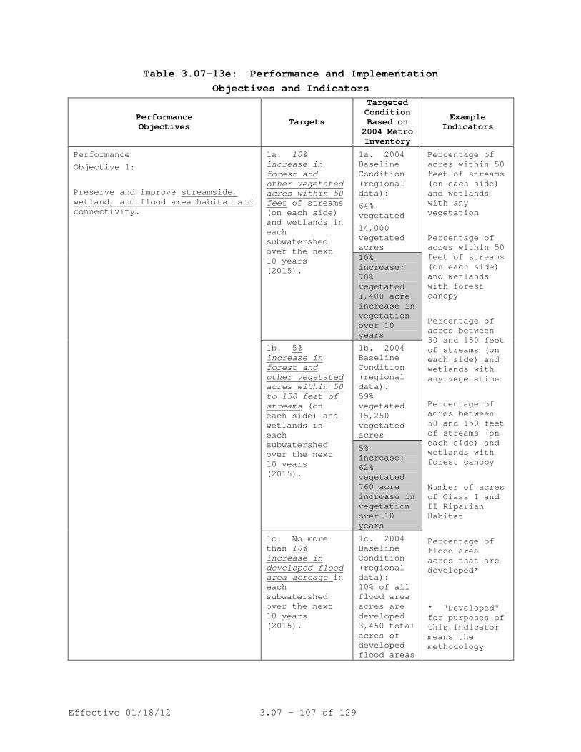
Effective 01/18/12 3.07 - 107 of 129
Table 3.07-13e: Performance and Implementation Objectives and Indicators
Performance Objectives Targets
Targeted Condition Based on 2004 Metro Inventory
Example Indicators
Performance
Objective 1:
Preserve and improve streamside, wetland, and flood area habitat and connectivity
1a.
.
10% increase in forest and other vegetated acres within 50 feet
of streams (on each side) and wetlands in each subwatershed over the next 10 years (2015).
1a. 2004 Baseline Condition (regional data):
64% vegetated
14,000 vegetated acres
Percentage of acres within 50 feet of streams (on each side) and wetlands with any vegetation
Percentage of acres within 50 feet of streams (on each side) and wetlands with forest canopy
Percentage of acres between 50 and 150 feet of streams (on each side) and wetlands with any vegetation
Percentage of acres between 50 and 150 feet of streams (on each side) and wetlands with forest canopy
Number of acres of Class I and II Riparian Habitat
Percentage of flood area acres that are developed*
* "Developed" for purposes of this indicator means the methodology
10% increase: 70% vegetated 1,400 acre increase in vegetation over 10 years
1b. 5% increase in forest and other vegetated acres within 50 to 150 feet of streams
1b. 2004 Baseline Condition (regional data):
(on each side) and wetlands in each subwatershed over the next 10 years (2015).
59% vegetated 15,250 vegetated acres
5% increase: 62% vegetated 760 acre increase in vegetation over 10 years
1c. No more than 10% increase in developed flood area acreage
1c. 2004 Baseline Condition (regional data): in
each subwatershed over the next 10 years (2015).
10% of all flood area acres are developed 3,450 total acres of developed flood areas

Effective 01/18/12 3.07 - 108 of 129
Performance Objectives Targets
Targeted Condition Based on 2004 Metro Inventory
Example Indicators
10% increase: 3,800 total acres of developed flood areas
used in Metro’s Fish and Wildlife Inventory to identify developed flood areas.
Performance Objective 2: Preserve large areas of contiguous habitat
2a.
and avoid fragmentation.
Preserve 75% of vacant Class A and B
2a. 2004 Baseline Condition:
upland wildlife habitat in each subwatershed over the next 10 years (2015).
15,500 acres of vacant Class A and B upland wildlife habitat
Number of acres of Class A habitat Number of acres of Class B habitat Number of wildlife habitat patches that contain 30 acres or more of upland wildlife habitat
5% retention: 11,600 acres of vacant Class A and B upland wildlife habitat remaining
2b. Of the upland habitat preserved, retain 80% of the number of patches 30 acres or larger
2b. 2004 Baseline Condition:
in each subwatershed over the next 10 years (2015).
23,400 acres of upland habitat in 133 patches that contain 30 acres or more of upland wildlife habitat
80% retention: 106 upland habitat patches that contain 30 acres or more of upland habitat

Effective 01/18/12 3.07 - 109 of 129
Performance Objectives Targets
Targeted Condition Based on 2004 Metro Inventory
Example Indicators
Performance Objective 3: Preserve and improve connectivity for wildlife
3a.
between riparian corridors and upland wildlife habitat.
Preserve 90% of forested wildlife habitat acres located within 300 feet of surface streams
in each subwatershed over the next 10 years (2015).
3a. 2004 Baseline Condition: 28,300 acres within 1,453 patches of forested wildlife habitat located within 300 feet of surface streams
Number and miles of all wildlife corridors Corridor quality: % of habitat acres within corridors with a vegetative width of 200 ft Acres of wildlife patches with a connectivity score of 3 or greater Acres and number of forested wildlife habitat patches (forest canopy or wetland with a total combined size greater than 2 acres) within 300 feet of surface streams compared to acres of the patches located outside of 300 feet of surface streams.
90% retention: 25,500 acres of forested wildlife habitat located within 300 feet of surface streams
Performance Objective 3 (continued):
3b. Preserve 80% of non-forested wildlife habitat acres located within 300 feet of surface streams
3b. 2004 Baseline Condition:
in each subwatershed over the next 10 years (2015).
14,400 acres within 1,633 patches of non-forested wildlife habitat located within 300 feet of surface streams
Acres and number of non-forested wildlife patches (shrub or low structure/open soils with a total combined size greater than 2 acres) located within 300 feet of a surface streams.

Effective 01/18/12 3.07 - 110 of 129
Performance Objectives Targets
Targeted Condition Based on 2004 Metro Inventory
Example Indicators
80% retention: 11,500 acres of non-forested wildlife habitat located within 300 feet of surface streams
Performance Objective 4: Preserve and improve special habitats of concern
4a.
.
Preserve 95% of habitats of concern acres
in each subwatershed over the next 10 years (2015).
4a. 2004 Baseline Condition: 33% of all habitat designated as HOCs 26,700 total acres of HOCs
Number of acres of wetland Number of acres of white oak woodland Number of acres of bottomland hardwood forest Number of acres of vegetated riverine islands Number of acres of key connector habitat (list out HOC connectors)
95% retention: 25,400 total acres of HOCs
Implementation Objectives Example Indicators
Implementation Objective A: Increase the use of habitat-friendly development
Number of jurisdictions that allow or require LID
throughout the region
Number of jurisdictions providing LID incentives Percentage of region in forest canopy Percentage of impervious area B-IBI (benthic index of biological integrity) scores
Implementation Objective B: Increase restoration and mitigation actions
to compensate of adverse effects of new and existing development on ecological function
Number of restoration projects in one year Number of mitigation projects in one year Acres and distribution by resource class of habitat inventory Number of culverts that need improvement Number of watersheds in region with adopted action plans
(Ordinance No. 05-1077C, Sec. 5.)

Effective 01/18/12 3.07 - 111 of 129
TITLE 14: URBAN GROWTH BOUNDARY
The Regional Framework Plan (RFP) calls for a clear transition from rural to urban development, an adequate supply of urban land to accommodate long-term population and employment, and a compact urban form. Title 14 prescribes criteria and procedures for amendments to the urban growth boundary (UGB) to achieve these objectives.
3.07.1405 Purpose
(Ordinance No. 10-1244B, Sec. 12).
A. The UGB for the metropolitan area is incorporated into this title and is depicted on the Urban Growth Boundary and Urban and Rural Reserves Map. Cities and counties within the Metro boundary shall depict the portion of the UGB, if any, that lies within their boundaries on their comprehensive plan maps. Within 21 days after an amendment to the UGB under this title, the COO shall submit the amended UGB to the city and county in which the amended UGB lies. The city and county shall amend their comprehensive plan maps to depict the amended UGB within one year following receipt of the amendment from the COO.
3.07.1410 Urban Growth Boundary
B. Urban and Rural Reserves are depicted on the Urban Growth
Boundary and Urban and Rural Reserves Map. Amendments to the UGB made pursuant to this title shall be based upon this map.
(Ordinance No. 10-1244B, Sec. 12. Amended by Ordinance No. 11-1264B, Sec. 3).
(Ordinance No. 13-1316)
Title 14 Urban Growth Boundary Map as of January 8, 2014

UV10
UV99W
UV217
UV210UV217UV10
UV8
UV8
£¤26
UV8
UV47
UV47
UV8
UV6
UV47
UV6
UV6
UV47
£¤26
£¤30
£¤30
£¤30
£¤26
UV99E
UV99E
§̈¦5
§̈¦5
§̈¦205
§̈¦205
§̈¦205
§̈¦205
§̈¦205
§̈¦205Sherwood
UV43
UV224
UV212UV212
UV224
UV224
UV224
UV211
£¤26£¤26
£¤26
UV212
£¤26
£¤26
£¤30§̈¦84
§̈¦84 §̈¦84
UV213
UV213
UV213
UV213
UV99E
UV99E
UV99W
§̈¦405
§̈¦5
§̈¦5
§̈¦5
§̈¦5
§̈¦5
UV99E
UV219
UV219
UV219
UV99W
UV99W
UV47
UV47
UV47
UV99W
UV233UV221
UV240
UV210
UV219
UV8
UV500UV14
UV14
UV14
UV500UV500
UV500
UV503
Wilsonville
Tualatin Rivergrove
DurhamKingCity
Tigard LakeOswego
WestLinn
OregonCity
Gladstone
JohnsonCity
MilwaukieHappyValley
Damascus
Gresham
FairviewWoodVillage Troutdale
MaywoodParkPortland
Vancouver
Camas
Washougal
Beaverton
HillsboroCornelius
ForestGrove
UV211
UV211
UV211
§̈¦5
UV170
£¤26
UV210
Aurora
Banks
Barlow
Canby
Carlton
Dayton Donald
Dundee
Estacada
Gaston
Hubbard
Lafayette
McMinnville
Molalla
Newberg
NorthPlains
Sandy
St. Paul
Woodburn
Yamhill
Washi
ngton
Co.
Multn
omah
Co.
Columbia Co.
Multnomah Co.Clark Co. Skamania Co.
Multnomah Co.Clackamas Co.
Clackamas Co.Marion Co.
Washington Co.
Clacka
mas C
o.Yam
hill Co
.Washington Co.
Yamhill Co.
Sandy R.
Columbia River
Willamette R.
Tuala tin
R.HaggLake
SturgeonLake
VancouverLake
Clackamas R.
Urban growth boundariesCounty boundaries
Neighbor cities0 2 41
milesThe information on this map was derived from digital databases on Metro's GIS. Care was taken in the creation of this map. Metro cannot accept anyresponsibility for errors, omissions, or positional accuracy. There are no warranties, expressed or implied, including the warranty of merchantability or fitness for aparticular purpose, accompanying this product. However, notif ication of any errors are appreciated.
Willamette R.
Wash.Ore.
Making a great placeRural reserveUrban reserve
Title 14, Urban Growth BoundaryJanuary 2014
Effective 01/18/12 3.07 - 112 of 129
A. Legislative amendments follow periodic analysis of the capacity of the UGB and the need to amend it to accommodate long-range growth in population and employment. The Metro Council shall initiate a legislative amendment to the UGB when required by state law and may initiate a legislative amendment when it determines there is a need to add land to the UGB.
3.07.1420 Legislative Amendment to UGB - Procedures
B. Except as otherwise provided in this title, the Council
shall make legislative amendments to the UGB by ordinance in the manner prescribed for ordinances in Chapter VII of the Metro Charter. For each legislative amendment, the Council shall establish a schedule of public hearings that allows for consideration of the proposed amendment by MPAC, other advisory committees and the general public.
C. Notice to the public of a proposed legislative amendment of
the UGB shall be provided as prescribed in section 3.07.1465.
D. Prior to the final hearing on a proposed legislative
amendment of the UGB in excess of 100 acres, the COO shall prepare a report on the effect of the proposed amendment on existing residential neighborhoods. The COO shall provide copies of the report to all households located within one mile of the proposed amendment area and to all cities and counties within the district at least 20 days prior to the hearing. The report shall address:
1. Traffic patterns and any resulting increase in traffic
congestion, commute times and air quality; 2. Whether parks and open space protection in the area to
be added will benefit existing residents of the district as well as future residents of the added territory; and
3. The cost impacts on existing residents of providing
needed public facilities and services, police and fire services, public schools, emergency services and parks and open spaces.
(Ordinance No. 10-1244B, Sec. 12).

Effective 01/18/12 3.07 - 113 of 129
A. This section sets forth the factors and criteria for amendment of the UGB from state law and the Regional Framework Plan. Compliance with this section shall constitute compliance with statewide planning Goal 14 (Urbanization) and the Regional Framework Plan.
3.07.1425 Legislative Amendment to the UGB - Criteria
B. The Council shall determine whether there is a need to
amend the UGB. In determining whether a need exists, the Council may specify characteristics, such as parcel size, topography or proximity, necessary for land to be suitable for an identified need. The Council’s determination shall be based upon:
1. Demonstrated need to accommodate future urban
population, consistent with a 20-year population range forecast coordinated with affected local governments; and
2. Demonstrated need for land suitable to accommodate
housing, employment opportunities, livability or uses such as public facilities and services, schools, parks, open space, or any combination of the foregoing in this paragraph; and
3. A demonstration that any need shown under paragraphs 1
and 2 of this subsection cannot reasonably be accommodated on land already inside the UGB.
C. If the Council determines there is a need to amend the UGB,
the Council shall evaluate areas designated urban reserve for possible addition to the UGB and shall determine which areas better meet the need considering the following factors:
1. Efficient accommodation of identified land needs; 2. Orderly and economic provision of public facilities
and services; 3. Comparative environmental, energy, economic and social
consequences; and 4. Compatibility of proposed urban uses with nearby
agricultural and forest activities occurring on land outside the UGB designated for agriculture or forestry pursuant to a statewide planning goal.
Effective 01/18/12 3.07 - 114 of 129
5. Equitable and efficient distribution of housing and employment opportunities throughout the region;
6. Contribution to the purposes of Centers and Corridors; 7. Protection of farmland that is most important for the
continuation of commercial agriculture in the region; 8. Avoidance of conflict with regionally significant fish
and wildlife habitat; and 9. Clear transition between urban and rural lands, using
natural and built features to mark the transition.
D. The Council may consider land not designated urban or rural reserve for possible addition to the UGB only if it determines that:
1. Land designated urban reserve cannot reasonably
accommodate the need established pursuant to subsection B of this section; or
2. The land is subject to a concept plan approved
pursuant to section 3.07.1110 of this chapter, involves no more than 50 acres not designated urban or rural reserve and will help the concept plan area urbanize more efficiently and effectively.
E. The Council may not add land designated rural reserve to
the UGB.
F. The Council may not amend the UGB in such a way that would create an island of urban land outside the UGB or an island of rural land inside the UGB.
(Ordinance No. 10-1244B, Sec. 12).
A. A city, a county, a special district or a property owner may initiate a major amendment to the UGB by filing an application on a form provided by Metro. The COO will accept applications for major amendments between February 1 and March 15 of each calendar year except that calendar year in which the Council is completing its analysis of buildable land supply under ORS 197.299. Upon a request by a Metro Councilor and a finding of good cause, the Metro Council may accept an application at other times by a vote of five members of the Council.
3.07.1430 Major Amendments - Procedures

Effective 01/18/12 3.07 - 115 of 129
B. Except for that calendar year in which the Council is
completing its analysis of buildable land supply, the COO shall give notice of the March 15 deadline for applications for major amendments not less than 120 days before the deadline and again 90 days before the deadline in a newspaper of general circulation in Metro and in writing to each city and county in Metro and anyone who has requested notification. The notice shall explain the consequences of failure to file before the deadline and shall specify the Metro representative from whom additional information may be obtained.
C. With the application, the applicant shall provide the names
and addresses of property owners for notification purposes, consistent with section 3.07.1465. The list shall be certified as true and accurate as of the specified date by a title company, a county assessor or designate of the assessor or the applicant.
D. The applicant shall provide a written statement from the
governing body of each city or county with land use jurisdiction over the area and any special district that has an agreement with that city or county to provide an urban service to the area that it recommends approval or denial of the application. The Council may waive this requirement if the city, county or special district has a policy not to comment on major amendments, or has not adopted a position within 120 days after the applicant’s request for the statement. The governing body of a local government may delegate the decision to its staff.
E. The COO will determine whether an application is complete
and will notify the applicant of the determination within seven working days after the filing of the application. The COO will dismiss an application and return application fees if a complete application is not received within the 14 days after the notice of incompleteness.
F. Within 14 days after receipt of a complete application, the
COO will:
1. Set the matter for a public hearing before a hearings officer for a date no later than 55 days following receipt of a complete application; and
2. Notify the public of the public hearing as prescribed
in section 3.07.1465 of this title.
Effective 01/18/12 3.07 - 116 of 129
G. The COO shall submit a report and recommendation on the application to the hearings officer not less than 15 days before the hearing and send copies to the applicant and others who have requested copies. Any subsequent report by the COO to be used at the hearing shall be available to the public at least seven days prior to the hearing.
H. If the proposed major amendment would add more than 100
acres to the UGB, the COO shall prepare a report on the effect of the proposed amendment on existing residential neighborhoods in the manner prescribed in subsection D of section 3.07.1420.
I. An applicant may request postponement of the hearing within
20 days after filing a complete application. The COO may postpone the hearing for no more than 60 days. If the applicant fails to request rescheduling within 90 days after the request for postponement, the application shall be considered withdrawn and the COO will return the unneeded portion of the fee deposit assessed pursuant to section 3.07.1460.
J. Participants at a hearing before a hearings officer need
not be represented by an attorney. If a person wishes to represent an organization orally or in writing, the person must show the date of the meeting at which the organization adopted the position presented and authorized the person to represent it.
K. Failure of the applicant to appear at the hearing shall be
grounds for dismissal of the application unless the applicant requests a continuance prior to the hearing. The applicant has the burden of demonstrating that the proposed amendment complies with the criteria.
L. The hearings officer shall provide the following
information to participants at the beginning of the hearing: 1. The criteria applicable to major amendments and the
procedures for the hearing; 2. A statement that testimony and evidence must be
directed toward the applicable criteria or other criteria the person believes apply to the proposal; and
3. A statement that failure to raise an issue in a manner
sufficient to afford the hearings officer and

Effective 01/18/12 3.07 - 117 of 129
participants an opportunity to respond to the issue precludes appeal of that issue.
M. The hearing shall be conducted in the following order:
1. Presentation of the report and recommendation of the COO;
2. Presentation of evidence and argument by the
applicant; 3. Presentation of evidence and argument in support of or
opposition to the application by other participants; and
4. Presentation of rebuttal evidence and argument by the
applicant. N. The hearings officer may grant a request to continue the
hearing or to leave the record open for presentation of additional evidence upon a demonstration that the evidence could not have been presented during the hearing. If the hearings officer grants a continuance, the hearing shall be continued to a date, time and place certain at least seven (7) days from the date of the initial evidentiary hearing. A reasonable opportunity shall be provided at the continued hearing for persons to present and rebut new evidence.
O. If new evidence is submitted at the continued hearing, the
hearings officer may grant a request, made prior to the conclusion of the continued hearing, to leave the record open to respond to the new evidence. If the hearings officer grants the request, the record shall be left open for at least seven (7) days. Any participant may respond to new evidence during the period the record is left open.
P. Cross-examination by parties shall be by submission of
written questions to the hearings officer, who shall give participants an opportunity to submit such questions prior to closing the hearing. The hearings officer may set reasonable time limits for oral testimony and may exclude or limit cumulative, repetitive, or immaterial testimony.
Q. A verbatim record shall be made of the hearing, but need
not be transcribed unless necessary for appeal. R. The hearings officer may consolidate applications for
hearing after consultation with Metro staff and applicants. If the applications are consolidated, the hearings officer
Effective 01/18/12 3.07 - 118 of 129
shall prescribe rules to avoid duplication or inconsistent findings, protect the rights of all participants, and allocate the charges on the basis of cost incurred by each applicant.
S. Within 15 days following the close of the record, the
hearings officer shall submit a proposed order, with findings of fact and conclusions of law and the record of the hearing, to the COO, who shall make it available for review by participants.
T. Within seven (7) days after receipt of the proposed order
from the hearings officer, the COO shall set the date and time for consideration of the proposed order by the Council, which date shall be no later than 40 days after receipt of the proposed order. The COO shall provide written notice of the Council meeting to the hearings officer and participants at the hearing before the hearings officer, and shall post notice of the hearing at Metro’s website, at least 10 days prior to the meeting.
U. The Council shall consider the hearings officer’s report
and recommendation at the meeting set by the COO. The Council will allow oral and written argument by those who participated in the hearing before the hearings officer. Argument must be based upon the record of those proceedings. Final Council action shall be as provided in section 2.05.045 of the Metro Code. The Council shall adopt the order, or ordinance if the Council decides to expand the UGB, within 15 days after the Council’s consideration of the hearings officer’s proposed order.
(Ordinance No. 10-1244B, Sec. 12).
A. The COO may file an application at any time to add land to the UGB for industrial use, pursuant to section 3.07.460, by major amendment following the expedited procedures in this section. The application under this section remains subject to subsections C, D, H, M and Q of section 3.07.1430.
3.07.1435 Major Amendments – Expedited Procedures
B. Within 10 days after receipt of a complete application, the
Council President will: 1. Set the matter for a public hearing before the Council
for a date no later than 55 days following receipt of a complete application; and
Effective 01/18/12 3.07 - 119 of 129
2. Notify the public of the public hearing as prescribed
in section 3.07.1465. C. The COO shall submit a report and recommendation on the
application to the Council not less than 15 days before the hearing and send copies to those who have requested copies. Any subsequent report by the COO to be used at the hearing shall be available to the public at least seven (7) days prior to the hearing.
D. Participants at the hearing need not be represented by an
attorney. If a person wishes to represent an organization orally or in writing, the person must show the date of the meeting at which the organization adopted the position presented and authorized the person to represent it.
E. The Council President shall provide the following
information to participants at the beginning of the hearing:
1. The criteria applicable to major amendments and the procedures for the hearing;
2. A statement that testimony and evidence must be
directed toward the applicable criteria or other criteria the person believes apply to the proposal.
F. The Council President may grant a request to continue the hearing or to leave the record open for presentation of additional evidence upon a demonstration that the evidence could not have been presented during the hearing. If the Council President grants a continuance, the hearing shall be continued to a date, time and place certain at least seven (7) days from the date of the initial evidentiary hearing. A reasonable opportunity shall be provided at the continued hearing for persons to present and rebut new evidence.
G. If new evidence is submitted at the continued hearing, the
Council President may grant a request, made prior to the conclusion of the continued hearing, to leave the record open to respond to the new evidence. If the Council President grants the request, the record shall be left open for at least seven (7) days. Any participant may respond to new evidence during the period the record is left open.
H. The Council President may set reasonable time limits for
oral testimony and may exclude or limit cumulative, repetitive, or immaterial testimony.
Effective 01/18/12 3.07 - 120 of 129
I. Within 15 days following the close of the record, the
Council shall adopt:
1. An ordinance, with findings of fact and conclusions of law, that amends the UGB to add all or a portion of the territory described in the application; or
2. A resolution adopting an order, with findings of fact
and conclusions of law, that denies the application.
(Ordinance No. 10-1244B, Sec. 12).
A. The purpose of the major amendment process is to provide a mechanism to address needs for land that cannot wait until the next analysis of buildable land supply under ORS 197.299. Land may be added to the UGB under sections 3.07.1430 and 3.07.1440 only for public facilities and services, public schools, natural areas and other non-housing needs and as part of a land trade under subsection D. An applicant under section 3.07.1430 must demonstrate compliance with this purpose and these limitations.
3.07.1440 Major Amendments - Criteria
B. The applicant shall demonstrate that the proposed amendment
to the UGB will provide for an orderly and efficient transition from rural to urban land use and complies with the criteria and factors in subsections B, C, D, E, F and G of section 3.07.1425. The applicant shall also demonstrate that:
1. The proposed uses of the subject land would be
compatible, or through measures can be made compatible, with uses of adjacent land;
2. If the amendment would add land for public school
facilities, the coordination required by subsection C(5) of section 3.07.1120 of this chapter has been completed; and
3. If the amendment would add land for industrial use
pursuant to section 3.07.1435, a large site or sites cannot reasonably be created by land assembly or reclamation of a brownfield site.
C. If the application was filed under section 3.07.1435, the
applicant shall demonstrate that the amendment is

Effective 01/18/12 3.07 - 121 of 129
consistent with any concept plan for the area developed pursuant to section 3.07.1110 of this chapter.
D. To facilitate implementation of the Metropolitan
Greenspaces Master Plan of 1992, the Council may add land to the UGB in a trade that removes a nearly equal amount of land from the UGB. If the Council designates the land to be added for housing, it shall designate an appropriate average density per net developable acre.
(Ordinance No. 10-1244B, Sec. 12).
A. Minor adjustments make small changes to the UGB so that land within the UGB functions more efficiently and effectively. A city, a county, a special district, Metro or a property owner may initiate a minor adjustment to the UGB by filing an application on a form provided by Metro. The application shall include a list of the names and addresses of owners of property within 100 feet of the land involved in the application. The application shall also include the positions on the application of appropriate local governments and special districts, in the manner required by subsection D of section 3.07.1430.
3.07.1445 Minor Adjustments - Procedures
B. The COO will determine whether an application is complete
and shall notify the applicant of the determination within ten working days after the filing of the application. If the application is not complete, the applicant shall complete it within 14 days of notice of incompleteness. The COO will dismiss an application and return application fees if a complete application is not received within 14 days of the notice of incompleteness.
C. Notice to the public of a proposed minor adjustment of the
UGB shall be provided as prescribed in section 3.07.1465. D. The COO shall review the application for compliance with
the criteria in section 3.07.1450 and shall issue an order with analysis and conclusions within 90 days of receipt of a complete application. The COO shall send a copy of the order to the applicant, the city or county with jurisdiction over the land that is the subject of the application, to each member of the Council and any person who requests a copy.
E. The applicant or any person who commented on the
application may appeal the COO’s order to the Council by

Effective 01/18/12 3.07 - 122 of 129
filing an appeal on a form provided by Metro within 14 days after receipt of the order. A member of the Council may request in writing within 14 days of receipt of the order that the decision be reviewed by the Council. The Council shall consider the appeal or Councilor referral at a public hearing held not more than 60 days following receipt of a timely appeal or referral.
F. Notice to the public of a Council hearing on a proposed
minor adjustment to the UGB shall be provided as prescribed in section 3.07.1465.
G. Following the hearing, the Council shall uphold, deny or
modify the COO’s order. The Council shall issue an order with its analysis and conclusions and send a copy to the appellant, the city or county with jurisdiction over the land that is the subject of the application and any person who requests a copy.
(Ordinance No. 10-1244B, Sec. 12).
A. The purpose of this section is to provide a mechanism to make small changes to the UGB in order to make land within it function more efficiently and effectively. It is not the purpose of this section to add land to the UGB to satisfy a need for housing or employment. This section establishes criteria that embody state law and Regional Framework Plan policies applicable to minor adjustments.
3.07.1450 Minor Adjustments - Criteria
B. Metro may adjust the UGB under this section only for the
following reasons: (1) to site roads and lines for public facilities and services; (2) to trade land outside the UGB for land inside the UGB; or (3) to make the UGB coterminous with nearby property lines or natural or built features.
C. To make a minor adjustment to site a public facility line
or road, or to facilitate a trade, Metro shall find that:
1. The adjustment will result in the addition to the UGB of no more than two net acres for a public facility line or road and no more than 20 net acres in a trade;
2. Adjustment of the UGB will make the provision of
public facilities and services easier or more efficient;
Effective 01/18/12 3.07 - 123 of 129
3. Urbanization of the land added by the adjustment would have no more adverse environmental, energy, economic or social consequences than urbanization of land within the existing UGB;
4. Urbanization of the land added by the adjustment would
have no more adverse effect upon agriculture or forestry than urbanization of land within the existing UGB;
5. The adjustment will help achieve the 2040 Growth
Concept; 6. The adjustment will not result in an island of urban
land outside the UGB or an island of rural land inside the UGB; and
7. If the adjustment is to facilitate a trade, the
adjustment would not add land to the UGB that is designated rural reserve or for agriculture or forestry pursuant to a statewide planning goal.
D. To approve a minor adjustment to make the UGB coterminous
with property lines, natural or built features, Metro shall find that:
1. The adjustment will result in the addition of no more
than two net acres to the UGB; 2. Urbanization of the land added by the adjustment would
have no more adverse environmental, energy, economic or social consequences than urbanization of land within the existing UGB;
3. Urbanization of the land added by the adjustment would
have no more adverse effect upon agriculture or forestry than urbanization of land within the existing UGB;
4. The adjustment will help achieve the 2040 Growth
Concept; and 5. The adjustment will not result in an island of urban
land outside the UGB or an island of rural land inside the UGB.
E. Where the UGB is intended to be coterminous with the 100-
year floodplain, as indicated on the map of the UGB maintained by Metro’s Data Resource Center, Metro may
Effective 01/18/12 3.07 - 124 of 129
adjust the UGB in order to conform it to a more recent delineation of the floodplain. To approve such an adjustment, Metro shall find that: 1. The delineation was done by a professional engineer
registered by the State of Oregon; 2. The adjustment will result in the addition of no more
than 20 net acres to the UGB; 3. The adjustment will help achieve the 2040 Growth
Concept; and 4. The adjustment will not result in an island of urban
land outside the UGB or an island of rural land inside the UGB.
F. If a minor adjustment adds more than two (2) acres of land
available for housing to the UGB, Metro shall designate an appropriate average density per net developable acre for the area.
G. The COO shall submit a report to the Council at the end of
each calendar year with an analysis of all minor adjustments made during the year. The report shall demonstrate how the adjustments, when considered cumulatively, are consistent with and help achieve the 2040 Growth Concept.
(Ordinance No. 10-1244B, Sec. 12).
A. Land added to the UGB pursuant to sections 3.07.1420, 3.07.1430 and 3.07.1435 shall be subject to the requirements of sections 3.07.1120 and 3.07.1130 of this chapter.
3.07.1455 Conditions of Approval
B. If the Council amends the UGB pursuant to sections
3.07.1420, 3.07.1430 or 3.07.1435, it shall:
1. In consultation with affected local governments, designate the city or county responsible for adoption of amendments to comprehensive plans and land use regulations to allow urbanization of each area added to the UGB, pursuant to Title 11 of this chapter. If local governments have an agreement in a concept plan developed pursuant to Title 11 that establishes responsibility for adoption of amendments to

Effective 01/18/12 3.07 - 125 of 129
comprehensive plans and land use regulations for the area, the Council shall assign responsibility according to the agreement.
2. Establish the 2040 Growth Concept design type
designations applicable to the land added to the UGB, including the specific land need, if any, that is the basis for the amendment. If the design type designation authorizes housing, the Council shall designate an appropriate average density per net developable acre consistent with the need for which the UGB is expanded.
3. Establish the boundaries of the area that shall be
included in the planning required by Title 11. A planning area boundary may include territory designated urban reserve, outside the UGB.
4. Establish the time period for city or county
compliance with the requirements of Title 11, which shall be two (2) years following the effective date of the ordinance adding the area to the UGB unless otherwise specified.
C. If the Council amends the UGB pursuant to sections
3.07.1420, 3.07.1430 or 3.07.1435, it may establish other conditions it deems necessary to ensure the addition of land complies with state planning laws and the Regional Framework Plan. If a city or county fails to satisfy a condition, the Council may enforce the condition after following the notice and hearing process set forth in section 3.07.850 of this chapter.
(Ordinance No. 10-1244B, Sec. 12).
A. Each application submitted by a property owner or group of property owners pursuant to this title shall be accompanied by a filing fee in an amount to be established by the Council. Such fee shall not exceed Metro’s actual cost to process an application. The fee may include administrative costs, the cost of a hearings officer and of public notice.
3.07.1460 Fees
B. The fee for costs shall be charged from the time an
application is filed through mailing of the notice of adoption or denial to the Department of Land Conservation and Development and other interested persons.
Effective 01/18/12 3.07 - 126 of 129
C. Before a hearing is scheduled, an applicant shall submit a fee deposit. In the case of an application for a minor adjustment pursuant to section 3.07.1445, the applicant shall submit the fee deposit with the application.
D. The unexpended portion of an applicant’s deposit, if any,
shall be returned to the applicant at the time of final disposition of the application. If hearings costs exceed the amount of the deposit, the applicant shall pay to Metro an amount equal to the costs in excess of the deposit prior to final action by the Council.
E. The Council may, by resolution, reduce, refund or waive the
fee, or portion thereof, if it finds that the fee would create an undue hardship for the applicant.
(Ordinance No. 10-1244B, Sec. 12).
A. For a proposed legislative amendment under section 3.07.1420, the COO shall provide notice of the public hearing in the following manner:
3.07.1465 Notice Requirements
1. In writing to the Department of Land Conservation and
Development and local governments of the Metro region at least 45 days before the first public hearing on the proposal; and
2. To the general public at least 45 days before the
first public hearing by an advertisement no smaller than 1/8-page in a newspaper of general circulation in the Metro area and by posting notice on the Metro website.
B. For a proposed major amendment under sections 3.07.1430 or
3.07.1435, the COO shall provide notice of the hearing in the following manner:
1. In writing at least 45 days before the first public
hearing on the proposal to:
a. The applicant; b. The director of the Department of Land
Conservation and Development; c. The owners of property that is being considered
for addition to the UGB; and

Effective 01/18/12 3.07 - 127 of 129
d. The owners of property within 250 feet of
property that is being considered for addition to the UGB, or within 500 feet of the property if it is designated for agriculture or forestry pursuant to a statewide planning goal;
2. In writing at least 30 days before the first public
hearing on the proposal to:
a. The local governments of the Metro area; b. A neighborhood association, community planning
organization, or other organization for citizen involvement whose geographic area of interest includes or is adjacent to the subject property and which is officially recognized as entitled to participate in land use decisions by the cities and counties whose jurisdictional boundaries include or are adjacent to the site, and to any other person who requests notice of amendments to the UGB; and
3. To the general public by posting notice on the Metro
website at least 30 days before the first public hearing on the proposal.
C. The notice required by subsections A and B of this section
shall include:
1. A map showing the location of the area subject to the proposed amendment;
2. The time, date and place of the hearing; 3. A description of the property reasonably calculated to
give notice as to its actual location, with street address or other easily understood geographical reference if available;
4. A statement that interested persons may testify and
submit written comments at the hearing; 5. The name of the Metro staff to contact and telephone
number for more information; 6. A statement that a copy of the written report and
recommendation of the COO on the proposed amendment

Effective 01/18/12 3.07 - 128 of 129
will be available at reasonable cost 20 days prior to the hearing; and
7. A general explanation of the criteria for the
amendment, the requirements for submission of testimony and the procedure for conduct of hearings;
8. For proposed major amendments only:
a. An explanation of the proposed boundary change; b. A list of the applicable criteria for the
proposal; and c. A statement that failure to raise an issue at the
hearing, orally or in writing, or failure to provide sufficient specificity to afford the decision maker an opportunity to respond to the issue precludes an appeal based on the issue.
9. For the owners of property described in subsection
B(1)(c) of this section, the information required by ORS 268.393(3).
D. For a proposed minor adjustment under section 3.07.1445,
the COO shall provide notice in the following manner:
1. In writing to the director of the Department of Land Conservation and Development at least 45 days before the issuance of an order on the proposal;
2. In writing at least 20 days before the issuance of an
order on the proposal to:
a. The applicant and the owners of property subject to the proposed adjustment;
b. The owners of property within 500 feet of the
property subject to the proposed adjustment; c. The local governments in whose planning
jurisdiction the subject property lies or whose planning jurisdiction lies adjacent to the subject property;
d. Any neighborhood association, community planning
organization, or other organization for citizen involvement whose geographic area of interest includes the area subject to the proposed

Effective 01/18/12 3.07 - 129 of 129
amendment and which is officially recognized as entitled to participate in land use decisions by the city or county whose jurisdictional boundary includes the subject property; and
e. Any other person requesting notification of UGB
changes. E. The notice required by subsection D of this section shall
include:
1. A map showing the location of the area subject to the proposed amendment;
2. A description of the property reasonably calculated to
give notice as to its actual location, with street address or other easily understood geographical reference if available;
3. A statement that interested persons may submit written
comments and the deadline for the comments; 4. The name of the Metro staff to contact and telephone
number for more information; and 5. A list of the applicable criteria for the proposal.
F. The COO shall notify each county and city in the district
of each amendment of the UGB.
(Ordinance No. 10-1244B, Sec. 12).
**********