regional development plan - southern region · mission and objectives of this regional development...
TRANSCRIPT

REGIONAL DEVELOPMENT PLAN - SOUTHERN REGION

Doc #: 298751-v1A Regional Community Development Plan 27/09/2007 2
SOUTHERN REGION
Regional Development Area

Doc #: 298751-v1A Regional Community Development Plan 27/09/2007 3
EXECUTIVE SUMMARY
Given the fact that the South Africa democratic government is understood to play a crucial development role in the pursuit of social and economic upliftment and the redress of historically distorted patterns of spatial and socio-economic development, it became pertinent for public and private sector institutions to develop a social responsibility strategy to attend to these desired redress issues. The provincial government together with local government, the business sector, labour and the NGO sector has developed a Provincial Growth and Development Strategy (PGDS) which sets quantified growth and poverty reduction targets. This is informed by four pillars of development strategy, namely:-
Increasing investment in provinces; Skills and capacity building; Broadening participation in the economy; Increasing competitiveness of the provinces.
As a result, processes and procedures have been put in place to harmonise and align National Spatial Development Perspective (NSDP), the Provincial Growth and Development Strategy (PGDS) and the municipal Integrated Development Plans (IDPs). SANRAL supports the view that economic development cannot be separated from the broader issues concerning the well-being of our young democracy. SANRAL further considers the provision of infrastructure as a primary tool to change the lives of people for the better, ‘creating wealth through infrastructure’, in the provision of roads, improved access, as well as providing job creation and other economic and training opportunities. In recognition of the importance of development, SANRAL has developed a Community Development philosophy and implementation model to support national initiatives. The SANRAL Southern Region has identified a development region and corridor/s within the framework of the Integrated Sustainable Rural Development Programme (ISRDP), referred to as Regional Development Plan. This Southern Region document outlines a strategy to engage the communities along the national roads corridors and selected region. It is achieved by looking into SANRAL’s Socio-Economical Development Policy that encapsulates vision, mission and objectives of this Regional Development Plan. The regional level planning follows by providing an informed Regional Growth and Development Strategies. These are informed by national, provincial and both District and Local Municipality levels official documents as indicated above. It is further narrowed to Regional Focus Areas which also look into which areas, zones, nodes, corridors the Southern Region development plan would be focussing on. Anticipated social and economical impact is also explored in the process of delving into the philosophies of ‘improving quality of life by providing basic services’ and promoting economic growth areas. Project level planning kicks in, in identifying project types, criteria of project selection, and prioritisation of projects. Implementation strategy that advises on empowerment impact assessment, and institutional arrangements, is examined. The empowerment impact assessment is done in a phased process. From the completed empowerment impact assessment, a project scope is finalised to determine the possible targets and impact for each project. Finally, monitoring strategies are explored as well as evaluation of projects in due process. This is to ensure that the target/s that have been set and informed the particular project selection are met.

Doc #: 298751-v1A Regional Community Development Plan 27/09/2007 4
TABLE OF CONTENTS EXECUTIVE SUMMARY……………………………………………….……………………… .3 1. BACKGROUND………………………………………………………….……………………… 5
1.1 SANRAL’s Socio Economical Development Policy………………………………… 5
2. OBJECTIVES OF SANRAL REGIONAL DEVELOPMENT PLANS………… 5 3. SOUTHERN REGION DEVELOPMENT PLAN…………………...………………… 5 3.1 Regional Growth and Development Strategies……………………………………… 5 3.2 Regional Focus Areas………………………………………………….………………… 6 3.2.1 Development are and corridor…………………………..………….………… 6 3.2.2 Location of the development area…………………...…………….………… 7 3.2.3 General demographic information……………………………...….………… 8 3.2.3.1 OR Tambo District Municipality population………………………. 9 3.2.3.2 OR Tambo District Municipality age distribution………………….9 3.2.3.3 OR Tambo District Municipality education status………………...9 3.2.3.4 OR Tambo District Municipality employment……………………...9 3.2.3.5 OR Tambo District Municipality transport modes………………...9 3.2.3.6 OR Tambo District Municipality disability status…………………10
3.3 Anticipated Social and Economical Impact……………………………….…………..10 4. PROJECT LEVEL PLANNING……………………………………………………………. 11 4.1 Project Types…………………………………………….……………………..…………..11 4.1.1 Specific regional projects…………………………………..……….………… 12 4.1.2 “Adhoc” corridor development projects………………………….………… 12 4.1.3 PMS/BMS/Road Safety projects……………………………….……………… 12 4.2 Selection of Projects………………………………………………..…………………… .12 4.2.1 Criteria…………………………………………………………………………….. 12 4.2.2 Prioritisation of Projects……………………………………………………….. 13 5. IMPLEMENTATION STRATEGY…………………………………………………….… ..16 5.1 Empowerment Impact Assessment……………………………………..…………… ..16 5.1.1 Background and purpose……………………………….………………………16 5.1.2 Nature and objectives……………………………………………………………16 5.1.3 Implementation process……………………………………………………… ..16 5.2 Institutional Arrangements………………………………………………………….……17 6. MONITORING AND EVALUATION………………………………….…………………...17 7. EXIT STRATEGY………………………………………………………………………………...17
7.1 Infrastructure………………………………………………………………………………...17 7.2 User……………………………………………………………………………………….…...17 7.3 Skills Transfer…………………………………………………………………..……………18
7.3.1 Municipality…………………………………………………………………………18 7.3.2 Workers……………………………………………………………..……………….18
6. APPENDICES……………………………………………………..………….…………………….19

Doc #: 298751-v1A Regional Community Development Plan 27/09/2007 5
1. BACKGROUND
The national imperative is to reduce and eliminate the economic divide between South Africa’s First and Second Economies. While the First Economy is modern, produces the bulk of South Africa’s wealth in addition to its integration within the global economy, the Second Economy manifests itself outside the core commercial corridors. It is largely rural in orientation and characterised by economic and geographical marginalisation.
For many rural SMME entrepreneurs, such as emerging farmers, freight logistics and related services are unreliable, ineffective and/or very expensive. This is unfortunately related to low production densities, poorly developed to non existent rural road networks, and uncoordinated supply chain volumes in rural areas. To increase the viability of rural transport development, there is a need for traffic infrastructure development, improvement and consolidation to increase access to markets and reduce transport costs. This would involve the development, improvement and use of available infrastructure in spatially integrated and effective ways.
This Regional Development Plan for the Southern Region provides an outline of a process containing project identification, project implementation strategies, monitoring and evaluation as well as exit strategies. The provision of effective and well managed infrastructure services promote economic growth, equity, sustainable development and job creation.
1.1 SANRAL’s Socio Economical Development Policy
The development and maintenance of the national road network is the core competency of SANRAL. The interrelated nature of this core business and its link with safety management and community development has pointed the agency to focus on these issues. The Regional Development Plans, as a result, address these non-core competencies characterized by the Vision and Mission:
Vision To embed the ethos of social and economic justice in the provision of a superior road network.
Mission The development of the socio-economical framework and implementation tools required to guide SANRAL’s activities in realizing its vision”
2. OBJECTIVES OF SANRAL REGIONAL DEVELOPMENT PLANS
The primary objective of the Regional Development Plan is to ensure that the Southern Region identifies, plans, programmes and implements Community Development Projects in a coordinated fashion that is aligned with and enhance National, Provincial and Regional Growth and Development Strategies. It further allows for the sustained regional development by providing increased opportunities during both the project implementation stage and the provision of transport infrastructure stage.
3. SOUTHERN REGION: REGIONAL DEVELOPMENT PLAN
3.1 Regional Growth and Development Strategies
Colonial and apartheid planning, in addition to social engineering, has deeply scarred some of the developing communities, especially in the rural areas, leaving enduring structural problems and under-development. In order to address the resultant poverty challenges, the provincial government together with local government, the business sector, labour and the NGO sector, has developed a Provincial Growth and Development Plan (PGDS). The PGDS sets quantified growth and poverty reduction targets.
Effective coordination, integration and alignment of government service provision activities across the three spheres of government have been one of the biggest challenges to date.

Doc #: 298751-v1A Regional Community Development Plan 27/09/2007 6
Processes and procedures have been put in place to harmonise and align the National Spatial Development Perspective (NSDP), the Provincial Growth and Development Strategies (PGDS) and the municipal Integrated Development Plans (IDPs).
Since SANRAL conducts its Community Development Programmes at the District and Local municipality level, the Southern Region Development Plan ensures that the proposed development is aligned to the provincial, district and local municipality current and future plans.
3.2 Regional Focus Areas 3.2.1 Development area and corridor
The Southern Region focuses on the OR Tambo District Municipality of the Eastern Cape as a development area as well as along the provincial national road corridor. This district municipality as reflected in Figure 1 falls in one of the rural nodes pronounced by government as representing the largest concentration of poverty in South Africa. The common features of these nodes are that they are areas of severe neglect where poverty is at its most endemic.
Figure 1 Rural nodes pronounced by government
More so, OR Tambo District Municipality has been chosen by the Department of Transport (DoT) to be an experimental area for an innovative intervention packaged as the Integrated Rural Mobility and Access (IRMA) project. It was seen as having a potential to effectively demonstrate a sufficient range of the integrated rural access interventions outlined in the Rural Transport Strategy. SANRAL therefore becomes a major player in the growth strategies of this District Municipality in the light of its expertise in road infrastructure and community development programme.
The corridor development along the Eastern Cape national roads is an additional consideration for the Southern Region and it goes through the rural and urban nodes as demonstrated in Figures 2a & 2b. This is focused on areas where there are SANRAL conventional projects like PMS/BMS/Road Safety. Wherever there are such ongoing projects, community development projects are also conducted in that specific project area. Emphasis in these is mainly on road safety improvement for the communities adjacent to the national road and road users. These also provide enabling strategies as there is job creation through labour based projects and skills development through capacity building and training in the SMME sector.

Doc #: 298751-v1A Regional Community Development Plan 27/09/2007 7
Figure 2a National road development corridors through rural and urban nodes
Figure 2b Specific national road development corridor projects from 2006-2012
3.2.2 Location of the development area
The currently three identified Local Municipalities within the OR Tambo District are Port St Johns, Qaukeni and Mbizana as demonstrated in Figure 3 that also reflects the economic potential.

Doc #: 298751-v1A Regional Community Development Plan 27/09/2007 8
Figure 3 Three OR Tambo District chosen municipalities and economic potential
The major towns for these municipalities are respectively Port St Johns, Lusikisiki for Qaukeni and Mbizana.
3.2.3 General Demographic Information
OR Tambo is the largest District Municipality in the Eastern Cape Province situated on its eastern side.
As demonstrated in Figures 1 and 2. It is regarded as one of the tourist attraction areas in South Africa. A reflection on the relevant growth and development strategy that could be adopted is demonstrated in the demographic information provided.
OR TAMBO DISTRICT
PORT ST. JOHNS LOCAL AUTHORITY PERCENTAGE OF DISTRICT POPULATION
King Sabata Dalindyebo25%
Qaukeni15%
Mbizana15%
Mhlontlo 12%
Ntabankulu7%
Nyandeni17%
Port St John's9%
Figure 4 OR Tambo District Municipality population per local municipality

Doc #: 298751-v1A Regional Community Development Plan 27/09/2007 9
3.2.3.1 OR Tambo District Municipality population
It is resident to more than 1.7 million people and exceeds in size and population the countries of Botswana, Lesotho and Swaziland. There is a higher preponderance of women (55%) compared to males (45%). Generally, there is:
93% of inhabitants live in rural conditions; 88% of the households live below minimum poverty level; 75% of the population do not have formal RDP standard water supply; 71% of the economically active population is unemployed; 47.5% of the population is under 15 years of age.
3.2.3.2 OR Tambo District Municipality age distribution
13% of the district municipality is in the pre-school phase and are between 0-4 years. This is followed by 31% of the population between the ages of 5-14 years (primary school). 49% falls within the economically active age groups of 15-64% years meanwhile, 6% is older than 64 years. OR Tambo DM is characterised by a youthful population.
Figure 5 OR Tambo District Municipality age groups
3.2.3.3 OR Tambo District Municipality education status
Of the age groups in the district that could attend educational institutions 24% attended none, 3% attend pre-school and 72% are going to school. The number of people in the district attending higher education institutions is estimated at 1%. There are approximately 1 847 pre-primary, primary and secondary schools in the district
3.2.3.4 OR Tambo District Municipality Employment
68% of the district population is not economically active (pre-school, elderly, disabled, not looking for work). 11% are employed and 21% are unemployed. Work status is not applicable to 94% of the district population. Of the 6% that do work only 9% are self-employed.
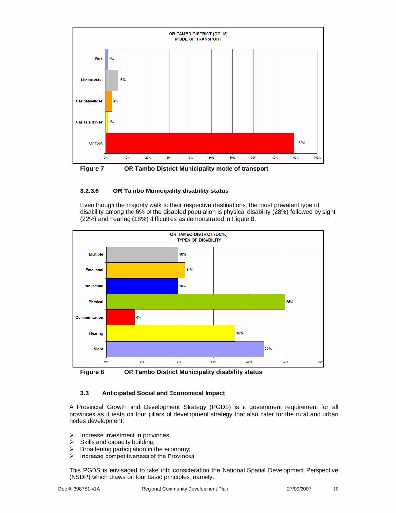
3.2.3.5 OR Tambo District Municipality transport modes
Walking is a major mode of transport since most (89%) of the people in the district walk to their respective destinations. 6% make use of a minibus taxi in order to travel while 1% uses the bus. 3% of the population travel in a vehicle and 1% drive their own vehicles as indicated in Figure 6.
Doc #: 298751-v1A Regional Community Development Plan 27/09/2007 10
Figure 7 OR Tambo District Municipality mode of transport
3.2.3.6 OR Tambo Municipality disability status
Even though the majority walk to their respective destinations, the most prevalent type of disability among the 6% of the disabled population is physical disability (28%) followed by sight (22%) and hearing (18%) difficulties as demonstrated in Figure 8.
Figure 8 OR Tambo District Municipality disability status
3.3 Anticipated Social and Economical Impact
A Provincial Growth and Development Strategy (PGDS) is a government requirement for all provinces as it rests on four pillars of development strategy that also cater for the rural and urban nodes development:
Increase investment in provinces; Skills and capacity building; Broadening participation in the economy; Increase competitiveness of the Provinces
This PGDS is envisaged to take into consideration the National Spatial Development Perspective (NSDP) which draws on four basic principles, namely:

Doc #: 298751-v1A Regional Community Development Plan 27/09/2007 11
i. Rapid economic growth that is sustained and inclusive as a prerequisite for the achievement of
poverty eradication; ii. Government spending on fixed investment should be focused on localities of economic growth
and /or economic potential in order to gear up private sector investment, stimulate sustainable economic activities and create long term employment opportunities;
iii. Where low economic potential exists, investment should be directed at projects and programmes to address poverty and the provision of basic services in order to address past and current social inequalities;
iv. In order to overcome the spatial distortions of apartheid, future settlement and economic development opportunities should be channeled into activity corridors and nodes that are adjacent to or link the main growth centres in order for them to become regional gateways to the global economy.
SANRAL in the Southern Region as a result intends to achieve a multiplicity of goals in its identified development areas and corridors which include:
• Providing basic transport infrastructure to improve the quality of life. This takes into
cognizance needs for extended public transport services or routes, especially in terms of social transport needs. Needs for improved paths, footbridges, low-level crossings and other types of river crossings. Particularly to improve pedestrian and non-motorised access to schools, clinics and other facilities;
• Contributing directly to the economic growth through providing efficient access and mobility for people and goods. Thus looking into the existence of underutilized economic potential, and evidence that this potential is being underutilized due to poor logistical connections and general accessibility to markets and services. Other social and economic impact expected is in harnessing the existence of a well functioning multi-purpose community centre (MPCC) and the potential of developing a hub-satellite network of MPCCs and allied logistics facilities and/or brokerage services;
• Creating an indirect positive impact on economic growth in the nature of road safety. This would partly be characterized by speed humps, rumble strips and proper signage.
4. PROJECT PLANNING
4.1 Project Types
Two major project types have been identified by SANRAL. The first one is derived from the SANRAL core business relating to specialized systems like the Pavement and Bridge Management System (A) where emphasis is to improve road safety along the national roads corridor. The second one relates to the Special Development Programme (B) which splits into ‘Adhoc” Community Development (B1) that is either initiated by special request or needs in addition to SANRAL interventions. While B2 refers to Regional Development Plans whose projects are chosen according to the approved framework. The Figure 19 diagram shows these different types of projects described above and further provides the stages at which the projects are identified in addition to the initial in house assessment done to determine the need and viability of identified projects in the Special Development Programme. Once prioritized and Empowerment Impact Assessment is done to evaluate all aspect within the community. From the completed empowerment impact assessment a projects scope is finalized to determine the possible targets and impact for each project which are monitored, reported and evaluated.

Doc #: 298751-v1A Regional Community Development Plan 27/09/2007 12
Figure 19 Comprehensive approaches to community development 4.1.1 Specific regional projects
The specific regional projects (see Appendix 1) relate to the Local Municipality Project like Mphophomeni in Port St Johns, Matheko River and Msikaba Access Road in Qaukeni and Mbhobheni in Mbizana. Facilities to be provided include:
Upgrading of access roads; Construction of low level bridges and culverts; Construction of pedestrian/bicycle paths; Drainage design to discharge surface water Earthworks and drainage improvements to entrances of schools.
4.1.2 “Adhoc” corridor development projects
These are identified through the Presidential Intervention Programme in recognition of National Heroes of the past as in the case of the current OR Tambo Ancestral Home and Garden of Remembrance Project as in Appendix 2.
4.1.3 PMS/BMS/Road safety projects
The PMS/BMS/Road Safety Projects are the ‘conventional’ ones which are SANRAL’s mandate is to develop and maintain the strategic national road network as reflected in Appendix 3. Figures 2a and 2b also demonstrate allocation of these projects along the national roads corridor.
4.2 Selection of Projects
4.2.1 Criteria The specific regional projects are selected in co-operation with the municipality and councilors who consider their IDPs for proposals. While the ’Adhoc’ projects are identified through Presidential Intervention Programme and the PMS/BMS/Road Safety for the benefit of road users’ safety and development of the national road corridor communities
PMS/BMS/Road Safety Projects “Conventional”
Identified Project [A] Special Development Programme
(2 types) [B]
Project Registration
CDP, CSE, CEO
PM / HO
PM, CDS, RM, CD
Type 1: “Adhoc” Community Development Projects:
Special Request Special Needs / SANRAL Interventions
[B1]
Type 2: Regional Development Plans: Corridor Development Zones
Linked / Proximity to Portion/s of National Network
Informed by: oIdentified Community Development Needs
oIDP, ITP, Rural Dev Nodes, etc oSANRAL objectives (toll proposals)
5 – 10 year Business Plans List of Projects, e.g.
o2006/2007….4 projects o2007/2008….3 projects oEtc
ADVANTAGES [B2]
Motivate and Submit Proposal to HO
Evaluation & approval
CDS / REGION

Doc #: 298751-v1A Regional Community Development Plan 27/09/2007 13
4.2.2 Prioritisation of projects
After a number of consultative processes with respective stakeholders, the SANRAL Evaluation Sheet is used in the prioritisation of projects which have proposed allocation points. These are done in consultation with the Local Municipalities. Current development projects have undergone that process as demonstrated in the table and map below:

Doc #: 298751-v1A Regional Community Development Plan 27/09/2007 14
Point Scored **
Location: District / Local
Municipality
Name of Town / Community
Key Indicators Population / # Household /
Unemployment
Proposed Scope of Works Length of road
Estimated Constr. Value
Estimated
Start of Constr.
Community Consultation
Process
1 245 OR Tambo See map Below
Port St. Johns/ Mphophomeni
Population : 9 267 Households: 1554 Unemployment: 13% & 83% not economically active Please refer to Pc Doc # 326011 for more detail
Access Road Upgrade and construction Low Level Bridge Crossings School earthworks & drainage improvements +-0.6km footpaths Please Refer to Pc Doc 298891 for more detail
10 km R21,2 million March 2008
Provincial, District / Local Municipality Consultations in process.
Initial Introductory Community Meeting Held July 2007.
2 250 OR Tambo
See map Below Qukeni/ Matheko-Msikaba
Population : 10 472 Households: 1991 Unemployment: 29% & 64% not economically active Please refer to Pc Doc #326013 for more detail
Access Road Upgrade and construct. Low Level Bridge Crossings Various culverts structures construct. School earthworks & drainage improvements +-0.6km footpaths
Please Refer to Pc Doc 298891 for more detail
11km R24.2 million March 2008
Provincial, District / Local Municipality Consultations in process.
Initial Introductory Community Meeting Held July 2007.
3 245 OR Tambo
See map Below Mbizana/ Mbhobheni
Population : 11 163 Households: 2160 Unemployment: 21% & 72% not economically active Please refer to Pc Doc # 326016 for more detail
Access Road Upgrade and construct. Low Level Culverts construction Various culverts structures construct. School earthworks & drainage improvements +-0.6km footpaths
Please Refer to Pc Doc 298891 for more detail
7km R11.3 million March 2008
Provincial, District / Local Municipality Consultations in process.
Initial Introductory Community Meeting Held July 2007.

Doc #: 298751-v1A Regional Community Development Plan 27/09/2007 15
Mbizana Mbizana
Lusikisiki
Port St. Johns

Doc #: 298751-v1A Regional Community Development Plan 27/09/2007 16
5. IMPLEMENTATION STRATEGY
5.1 Empowerment Impact Assessment (EmpIA) 5.1.1 Background and purpose
SANRAL has established its own EmpIA perspective that encapsulates its vision and mission in the process of fulfilling its core competency, business and its linkage with other issues like safety management and community development. The EmpIA’s approach is to measure both delivery of services and the impact of delivered services in the improvement of the quality of life of the specifically targeted communities.
5.1.2 Nature and objectives
This EmpIA is a participatory process which involves a number of different stakeholders depending on the type and nature of project that is to be implemented. The objectives of the process include:
Facilitation of upgrading of the local infrastructure; Identification of job creation opportunities and improve skills and employment levels in the
local area; Provision of opportunities to stimulate economic growth in the area and directly impact on
the poverty levels; Provision of the local people an opportunity to influence development in their local area; Allowing for growth in size and capacity of participating contractors and subcontractors,
especially those from previously disadvantaged background.
5.1.3 Implementation process
The SANRAL EmpIA implementation process has five identified process phases:
Empowerment information collection and collation:- gathering of information on beneficiary community including its infrastructure needs. This is characterized by socio-economic status and environment; Local resources; Economic opportunities potential; Community stakeholders for a and representative structures; Community demographics in addition to infrastructure requirements;
Empowerment impact analysis:- analysing the collected information to determine needs of the vulnerable groups, local labour, and labour enhancing implementation methods. This assists to Specify and prioritise education, skills, training to alleviate communities’ problems; List local resources available: labour, SMME’s, plant materials; Development of civil society fora; Specify designated categories of vulnerable persons and quantify needs and Determine labour enhanced task opportunities
Empowerment impact targets:- Looks into the target/s that have been set in the process of implementing the proposed project. This stage is informed by: Required skills training for ‘additional’ job opportunities; Post project competencies; Skills for continuity of opportunities; SMME’s opportunities in contract; Sub-contractors; Community participation strategy; Specific education relating to: Women contractors; Local government officials; NGO’s & CBO’s etc; Awareness programme focused on Broader community; Private and business sector etc; Additional job opportunities for designated groups.
Empowerment implementation strategy:- identification of the most suitable implementation methods including project planning, design, construction and skills development needs. This stage considers: Interventions to prepare Community Development Workers for participation; Link capacity building of project to potential economic opportunities; Project break break-outs and procurement strategy; Engagement of community representatives on project implementation for planning, design and construction phases; Time scheduled training programmes.
Empowerment evaluation framework:- entails evaluation of targets with the aim of establishing ways to measure the impact of the process. This is characterized by: Economic cost/benefit analysis; Capacity building; Stakeholder participation; Levels of accessibility to markets, schools, health facilities etc; Levels of mobility in use of public transport modes and facilities, use of no-motorised transport and its facilities etc; Changes in community awareness levels; Road safety levels; Changes in infrastructure provision.

Doc #: 298751-v1A Regional Community Development Plan 27/09/2007 17
5.2 Institutional Arrangements
SANRAL is the implementing agent where a partnership with a district and/or local municipality is encouraged as a way of showing commitment to the selected projects. SANRAL enters into a Memorandum of Agreement with District and/or Local Municipalities which details among other things:
Agreement of Projects and Scope of Works; Implementing Agent assignment of responsibilities Funding; Municipality Skills and Capacity Transfer Plan Maintenance agreements in addition to dedicated maintenance budgets
6. MONITORING AND EVALUATION
Monitoring and evaluation has a crucial role to play in the implementation of NRA Regional Development Plans. The monitoring and evaluation of the implemented programme/s will take place at the respective projects levels. The monitoring and evaluation of the programme will be done by NRA through its Project Manager and Community Development Specialist. It will be conducted during construction to ensure achievement of targets as well as during the post construction to measure effective use of infrastructure and services provided. After a 2 to 3 years circle is recommended to establish sustainability and spin-off/s of the project to the affected community.
Some issues for consideration to monitor and evaluate include:
The set empowerment targets; Set targets for skills development; Availability and use of local resources; Procurement processes; Level of job creation; Participation of stakeholders and their contribution in the programme; Participation of vulnerable groups including women and people with disabilities; Improvement of social environment, including issues such as mobility, safety, security, etc.
7. EXIT STRATEGY
Exit strategy is focused at the levels of infrastructure and the user.
7.1 Infrastructure
The relevant regional development area and corridor municipalities are being engaged to make available the skills audit information they have at their disposal. This is aimed at:
Training needs to improve the local labour skills; Identification of other local projects and programmes where the developed skill is to be
engaged; Identification of funding strategies for the roads investment maintenance programme to
benefit a sustainable growing economy in addition to improving and retaining capacity as well as skills available.
7.2 User
Users of the new infrastructure need to be sensitized and educated on its proper use and vigilance with regard to consistent maintenance. Road safety education is one other component seriously considered to save human lives in addition to humane use of the infrastructure investment. Improved road conditions attract more vehicular traffic which jeopardizes the safety of vulnerable road users including children and people with disabilities. Appropriate road safety measures need to be put in place. Where possible, available traffic related data is to be used for situational analysis, development and implementation of programmes and their monitoring

Doc #: 298751-v1A Regional Community Development Plan 27/09/2007 18
and evaluation. It is also at this stage the proposed phase 5 EmpIA stakeholder participation plays a crucial role in addition to the established civil society fora in phase 2. 7.3 Skills Transfer
Skills transfer focuses on capacity building and improvement of skills for the local labour in order to look after their infrastructure investment. This would be relatively cheap with local labour whilst at the same time developing the local economy thus making it more vibrant and sustainable.
7.3.1 Municipality level skills transfer
It is known that municipalities are stretched when it comes to both human and financial capacity in addition to technical skills. The regional development area and corridor programme also looks into these aspects to promote competent infrastructure maintenance by transferring relevant technical skills and capacity building.
7.3.2 Local labour skills transfer
The identified potential opportunity during the EmpIA characterized by local labour, SMME & BE engagement through local contractors and subcontractors is geared to transfer skills in the process of the actual implementation of the development projects.

Doc #: 298751-v1A Regional Community Development Plan 27/09/2007 19
APPENDIX 1
CONSTRUCTION AND UPGRADING OF MPHOPHOMENI ACCESS ROAD WARD 8
Project location This project is located on the central eastern side of Port St John’s Local Municipality. It is approximately 21km south west of Lusikisiki Town travelling along the R61. The facility can be accessed via the R61 near the village of Ntafufu on trunk road DR08159 for approximately 2,4km thereafter on Access road AC 60587 for approximately 700m. The proposed access road traverses in a north westerly direction and links Ntafufu village to Ngcenge and Qolombo villages including several settlements scattered along the route for approximately 4km and a further 5km of new road to the Bambisana Mission Hospital.
Some demographic and socioeconomic indicators Population according to age groups relevance to infrastructure improvement relates to:
• Road safety behaviour risk profiling; • Determine type of education, law enforcement programmes and media to ensure effective
and safe usage of infrastructure; • Population growth to monitor loss or gain of skills as well as skills that would be needed.
Appendix 1A Age groups in Port St. Johns ward 12
Education and literacy levels relevance to infrastructure improvement also relates to: • the type of labour and skills that would be available for labour enhanced construction; • Influencing road safety education programmes; • Lack of access to roads, transport result in special needs learners not being able to attend
school or other educational institutions.

Doc #: 298751-v1A Regional Community Development Plan 27/09/2007 20
Appendix 1B Education status of people older than 20 years (ward 12) during the 2001 census
Major employment sectors could be of relevance to infrastructure and engineering projects and add value as stakeholders and sponsors.
Appendix 1C Industries of employment-Ward 12
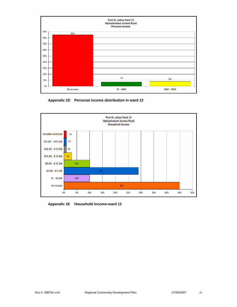
Household/personal income has influence to poverty alleviation, skills programmes and affects crime and social ratios and aspects
Doc #: 298751-v1A Regional Community Development Plan 27/09/2007 21
Appendix 1D Personal income distribution in ward 12
Appendix 1E Household Income-ward 12

Doc #: 298751-v1A Regional Community Development Plan 27/09/2007 22
CONSTRUCTION AND UPGRADE OF THE MATHEKO RIVER TO MSIKABA ACCESS ROAD WARD 23
Project location
The project is located on the south eastern side of Qaukeni Local Municipality. Travelling along Trunk Road T024 approximately 23km east of Lusikisiki Town. The facility can be accessed from Lusikisiki Town via the R61 for approximately 1,4km to Trunk Road DR08024 thereafter for approximately 7,2km to DR08141. Traverse on DR08141 for approximately 11km to Matheko village to join Access Road AC 284 to Msikaba AA Village for 3,7km to start of project.
Some demographic and socioeconomic indicators
Population according to age groups relevance to infrastructure improvement relates to: • Road safety behaviour risk profiling; • Determine type of education, law enforcement programmes and media to ensure effective
and safe usage of infrastructure; • Population growth to monitor loss or gain of skills as well as skills that would be needed.
Appendix 1F Age groups in Qaukeni-ward 23
Education and literacy levels relevance to infrastructure improvement also relates to: o The type of labour and skills that would be available for labour enhanced
construction; o Influencing road safety education programmes; o Lack of access to roads, transport result in special needs learners not being able to
attend school or other educational institutions.

Doc #: 298751-v1A Regional Community Development Plan 27/09/2007 23
Appendix 1G Education status in Qaukeni Ward 23
Personal/ Household income has influence to poverty alleviation, skills programmes and affects crime and social ratios and aspects.
Appendix 1H Personal income distribution in Qaukeni Ward 23

Doc #: 298751-v1A Regional Community Development Plan 27/09/2007 24
Appendix 1I Household income in Qaukeni Ward 23

Doc #: 298751-v1A Regional Community Development Plan 27/09/2007 25
CONSTRUCTION AND UPGRADE OF EMBHOBHENI ACCESS ROAD WARD 21
Project location
The project is located on the northern side of Mbizana Local Municipality, approximately 15km northwest of Mbizana Town. The facility can be accessed via the R61 from district road DR08020 near the village of Nompumalanga. The proposed access road is a main road which traverses in a westerly direction through the village of Embhobheni for approximately 7km.
Some demographic and socioeconomic indicators
Population according to age groups relevance to infrastructure improvement relates to: • Road safety behaviour risk profiling; • Determine type of education, law enforcement programmes and media to ensure effective
and safe usage of infrastructure; • Population growth to monitor loss or gain of skills as well as skills that would be needed.
Appendix J Age groups- Mbizana ward 5 Education and literacy levels relevance to infrastructure improvement also relates to:
• The type of labour and skills that would be available for labour enhanced construction; • Influencing road safety education programmes; • Lack of access to roads, transport result in special needs learners not being able to attend
school or other educational institutions.

Doc #: 298751-v1A Regional Community Development Plan 27/09/2007 26
Appendix 1K Education status of Mbizana, ward 5
Major employment sectors could be of relevance to infrastructure and engineering projects and add value as stakeholders and sponsors.
Appendix 1L Industries of employment
Household/ Personal income has influence to poverty alleviation, skills programmes and affects crime and social ratios and aspects

Doc #: 298751-v1A Regional Community Development Plan 27/09/2007 27
Appendix 1M Household income-Mbizana Ward 5
Mode of transport mostly used by commuters has relevance to infrastructure improvement since: • roads provide the following infrastructure-
Social needs e.g. visiting family and friends; Productive needs e.g. earning income to provide for their families; Reproductive needs e.g. fetching of firewood, water in order to make food etc; Access to medical facilities for women, children, the disabled and elderly;
• roads and infrastructure fulfil the following human needs- The development of the human capital where they access educational settings, health
centres etc.; Economic purposes such as travelling to or looking for work, taking farming produce,
crafts to markets etc. Social purpose such as attending church, going shopping or community meetings.
Appendix N Mode of Transport in Mbizana

Doc #: 298751-v1A Regional Community Development Plan 27/09/2007 28
APPENDIX 2
Design and Construction of Access Roads: O R TAMBO ANCESTRAL HOME AND THE GARDEN OF REMEMBRANCE
Location The project is located on the north western side of Mbizana Local Municipality in the O R Tambo District Municipality. It is approximately 32km northwest of Mbizana town travelling along the R61 towards Flagstaff. These facilities can be accessed via the R61 on Trunk Road T112 for approximately 13km, thereafter traversing north westwards on T112 for approximately 11km to T113. Background This Project was initiated through the O R Tambo District Council’s recommendation at the Memorial Lecture held on the 08th October 2005 at the Walter Sisulu University of Technology in Mthatha. In acknowledgement of the national heroes of the past, a proposal was made to link the birthplace of O R Tambo in Nkantolo Village in Mbizana Local Municipality to his Final Resting Place in Wattville, Benoni in the Ekurhuleni Metropolitan Municipality. In this regard a request was forwarded to the President’s Office, who approved the initiative. The need for the infrastructure upgrade was identified through the Mbizana Presidential Intervention Programme in recognition of the national heroes of the past. The Garden of Remembrance is to be developed as a cultural heritage site and identified as a tourist attraction for local and international visitors. The National Department of Transport was tasked to manage and implement the programme. All stakeholders were mobilised and SANRAL was tasked to improve the road infrastructure leading to the O R Tambo Ancestral Home and The Garden of Remembrance. Scope of works The project comprises both the design and construction of the upgrading of approximately 2.2 km gravel road to the O R Tambo Ancestral Home and roughly 0.5 km of gravel road to the Garden of Remembrance. The improvements of these roads include the following:
• Construction and upgrading of approximately 2.7km of gravel road to low seal standards;
• Improve the geometric alignment to reduce the steep inclines in several areas; • Improve drainage including cross drainage by labour intensive methods; • Importation of borrow material.
Outcomes The contract to the value of R 5, 03 million has been awarded to UWP/Ngobo Civils Joint Venture. This project is scheduled to be finished at the end of July 2007. When it is finished there will be improved road infrastructure for easy and unhindered access.
Doc #: 298751-v1A Regional Community Development Plan 27/09/2007 29
Impacts Numerous positive impacts on the community being served by this project are expected which include: Socio-economic development
Maximisation of labour use aimed at generating employment of local labour; Work opportunities for the local BEE’s in addition to upgraded training; Equipment of labourers and the community at large with new skills for future
participation in the country’s economy; All seasons navigable road infrastructure that would enhance opportunity for further
growth of social and economic activities; Extension of tourism benefits to the poor communities and promotion of indigenous
cultural lifestyle practices. Catering for integrated transport
Provision of infrastructure that caters for all modes of transport (motorised & non-motorised
Improve the use of public transport system due to encouraged operators. Road safety
Improved pedestrian safety; Envisaged appropriate use by road users since all would be catered for.

Doc #: 298751 Community Development Plan 27/09/2006
APPENDIX 3
2006-2010 CORRIDOR DEVELOPMENT PLAN PROJECTS (SR)
Project Manager
Project No.
Project Description
Nearest Town to Project
District
Municipalities
Municipality
Proposed Community Development Project
Type of Project
PLC
NEED
NRA
Route
Construction Date
3% Allocated
or Total Budget
2006/2007 Start
Finish
Renaldo Lorio
N.006-010-2005/1 Finished. Project was almost over for additional CD input
REHABILITATION N6 : SMILING VALLEY TO R63
East London
AMATHOLE
AMAHLATHI
Fencing + gates
A
N6
11.08.06
28.03.07 R647 520
FvA N.006-050-2004/1 In progress & PLC established PLO/CLO employed
REHABILITATION N6 : JAMESTOWN TO NEK
Jamestown
UKHAHLAM
BA
MALETSWAYI
Pedestrian/cyclists pathways Construct raised pedestrian crossing Construction of access Roads Play field leveling
A
Yes
N6
08-09-06
30.06.09
R3 000,000
Renaldo Lorio
N.002-100-2005/1
REHABILITATION N2 : GAMTOOS TO VAN STADENS
Humansdorp
CACADU
MAKANA
Fencing + Cattle gates Upgrading of sportsfield Pedestrian/Bicycle Pathways
A
N2
05.10.06
05.04.08
R2 250 000
Roland Thompson
N.002-090-2000/1 In progress & PLC established PLO/CLO employed
UPGRADING OF 14KM OF NATIONAL ROUTE 2 SECTION 9 TSITSIKAMMA TO WITELSBOS
Storms River
CACADU
KOU-KAMMA
Leveling 2 play fields Upgrade access roads Construction of one playfield (Thornham)
A
Yes
N2
01-11-06
31.10.09 R7 000,000
Tom Kelly N.010-030-2003/1 In progress. Pedestrian Forum in operation
UPGRADE N10 SECTION 3: TARKA BRIDGE TO CRADOCK
Cradock
CHRIS HANI
INXUBA YETHEMBA
Raised Pedestrian Crossings Street electricity lighting system
A
Yes
N10
17.02.06 17.09.07
R2 500 000
Clive Arries N.002-160-2007/1 Job finished Pedestrian walkway in progress
RESEAL N2 : WILSONIA (BERT KIPLING) TO N6
East London
AMATHOLE
BUFFALO CITY
Pedestrian/Cyclist pathways
A
No
N2
01-09-06
01.03.07
R66 0000
Mike Kaiser
R.061-060-2005/1 Short Contractor for CD input
RESEAL R61/5: TSOMO TO QHUMANCO RIVERS
Engcobo
CHRIS HANI
ENGCOBO
Off/loading bays
A
No
R61
01-09-06.
01.05.07
R360 000
Izak Botha N.009-050-2010/1
RESEAL N9/5 : ABERDEEN TO
Aberdeen
CACADU
CAMDEBOO
Pedestrian/cyclists pathways
A
N9
2006.09.
2007.03.31
R900 000

Doc #: 298751 Community Development Plan 27/09/2006
Job finished Sealing Pedestrian walkway
GRAAFF REINET 01
Iqbak Hoosen
P.002-060-2005/1 Job in progress
CONSTRUCT & UPGRADE ACCESS ROAD: OR TAMBO; GARDEN OF REMEMBRANCE & ANCESTRAL HOME
Mbizana
OR TAMBO
MBIZANA
Upgrade access roads
B1
Yes
30-09-06
31.10.07
R 5 428 000
2007/2008 Izak Botha
N.009-050-2010/1 Job finished Sealing Pedestrian walkway
RESEAL N9/5 : ABERDEEN TO GRAAFF REINET
Aberdeen
CACADU
CAMDEBOO
Pedestrian/cyclists pathways
A
N9
2006.09.
01
2007.03.31
R900 000
Iqbak Hoosen
P.002-060-2005/1 Job in progress
CONSTRUCT & UPGRADE ACCESS ROAD: OR TAMBO; GARDEN OF REMEMBRANCE & ANCESTRAL HOME
Mbizana
OR TAMBO
MBIZANA
Upgrade access roads
B1
Yes
30-09-06
31.10.07
R 5 428 000
Tom Kelly N.010-030-2003/1 In progress. Pedestrian Forum in operation
UPGRADE N10 SECTION 3: TARKA BRIDGE TO CRADOCK
Cradock
CHRIS HANI
INXUBA YETHEMBA
Raised Pedestrian Crossings Street electricity lighting system
A
Yes
N10
17.02.06 17.09.07
R2 500 000
Clive Arries N.002-160-2007/1 Job finished Pedestrian walkway in progress
RESEAL N2 : WILSONIA (BERT KIPLING) TO N6
East London
AMATHOLE
BUFFALO CITY
Pedestrian/Cyclist pathways
A
No
N2
01-09-06
01.03.07
R66 0000
FvA N.006-050-2004/1 In progress & PLC established PLO/CLO employed
REHABILITATION N6 : JAMESTOWN TO NEK
Jamestown
UKHAHLAM
BA
MALETSWAYI
Pedestrian/cyclists pathways Construct raised pedestrian crossing Narrow main street - parking/Median Construction of access Roads Playfield levelling
A
Yes
N6
08-09-06
30.06.09
R3 000,000
Roland Thompson
N.002-090-2000/1 In progress & PLC established PLO/CLO employed
UPGRADING OF 14KM OF NATIONAL ROUTE 2 SECTION 9 TSITSIKAMMA TO WITELSBOS
Storms River
CACADU
KOU-KAMMA
Leveling 2 play fields Upgrade access roads Construction of one playfield (Thornham)
A
Yes
N2
01-11-06
31.10.09 R7 000,000
Renaldo Lorio
N.006-010-2005/1 Finished. Project was almost over for additional CD input
REHABILITATION N6 : SMILING VALLEY TO R63
East London
AMATHOLE
AMAHLATHI
Fencing + gates
A
N6
11.08.06
28.03.07 R647 520
Mike Kaiser
N.002-178-2003/1
SPECIAL MAINTENANCE N2 : IBIKA TO THETYANA
Dutywa
AMATHOLE
MNQUMA/MBHASHE &
MBHASHE
Upgrade access road to clinic
A
No
N2
01.06.07
16.12.08
R1 140,000
Renaldo Lorio
N.002-100-2005/1
REHABILITATION N2 : GAMTOOS
Humansdorp
CACADU
MAKANA
Fencing + Cattle gates
A
N2
05.10.06
05.04.08
R2 250 000

Doc #: 298751 Community Development Plan 27/09/2006
TO VAN STADENS Upgrading of sportsfield Pedestrian/Bicycle Pathways
Iqbal Hoosen
P.002-039-2006/1 Waiting approval scopes of work
CONSTRUCT & UPGRADE ACCESS ROAD MPHOPHOMENI
Port St Johns
OR TAMBO
QAUKENI
Upgrade Access Roads Pedestrian/cycle pathways
B2
R 61
R 4 100 000
Iqbal Hoosen
P.002-040-2006/1 Waiting approval scopes of work
CONSTRUCT & UPGRADE ACCESS ROAD: MATHEKO & MSIKABA RIVERS
Lusikisiki
OR TAMBO
QAWUKENI
Construction of Access Roads: Matheko & Msikaba Rivers
B2
R 5 428 000
Iqbal Hoosen
P.002-037-2006/1 Waiting approval scopes of work
CONSTRUCT & UPGRADE ACCESS ROAD: EMBHOBHENI
Mbizana
OR TAMBO
MBIZANA
…..Embhobheni Access Road Pedestrian/cycle pathways
B2
R 5 120 000
Rob Damhuis
N006-034-2000/2 Possible budget delay
REHABILITATION N2: QUEENSTOWN - KM 34
Queenstown
CHRIS HANI
LUKHANJI
Pedestrian walkways
A
N6
R900 000
Fanie V. Aardt
N.002-123-2006/1 CD input expected
REHABILITATION N2: NANAGA TO KOMGHA RIVER
Nanaga/
Colchester
CACADU
SUNDAY’S RIVER
VALLEY
Future input
A
N2
R600 000
Clive Arries R.061-020-2007/1
SPECIAL R61/2: KM 26,8 - ELINUS
Cradock
CHRIS HANI
INXUBA YETHEMBA
Future input
A
R 61
R510 000
Renaldo Lorio
N.002-160-2003/9
REHABILITION N2: KOMGA TO MOOIPLAAS
Mooiplaas/
Cintsa
AMATOLE
GREAT KEI
Pedestrian /Bicycle Pathways Slip lanes Fencing + cattle gates Access Roads Bridge to link community Settlements School sportsfield leveling Cattle creep
A
N2
01.06.08
31.05.10
R3 33000
Renaldo Lorio
N002-170-2002/9
FENCING N2 FROM THOLENI TO IBIKA
Butterworth
AMATHOLE
MNQUMA
Upgrade 9 access roads Improve Drainage Fencing + Cattle gates
A
N2
01.04.07
01.10.07
Fanie v Aardt
N.002-140-2005/2
UPGRADE N2 SECTION 14: KEISKAMA TO GREEN RIVERS
Ngqushwa
AMATHOLE
NGQUSHWA
Pedestrian/Cyclist pathways Fencing + Cattle gates Access Roads
A
N2
R4 050 000
Roland Thompson
N.002-101-2008/1
SPECIAL N2: VAN STADENS - ST ALBANS
Humansdorp
CACADU
KOUGA
Future input
A
N2
R1 100 000
2008/2009 Renaldo Lorio
N.002-100-2005/1
REHABILITATION N2 : GAMTOOS TO VAN STADENS
Humansdorp
CACADU
MAKANA
Fencing + Cattle gates Upgrading of sportsfield Pedestrian/Bicycle Pathways
A
N2
05.10.06
05.04.08
R2 250 000
FvA N.006-050-2004/1 In progress & PLC established PLO/CLO
REHABILITATION N6 : JAMESTOWN TO NEK
Jamestown
UKHAHLAM
BA
MALETSWAYI
Pedestrian/cyclists pathways Construct raised pedestrian crossing Narrow main street - parking/Median
A
Yes
N6
08-09-06
30.06.09
R3 000,000

Doc #: 298751 Community Development Plan 27/09/2006
employed Construction of access Roads Playfield levelling
Renaldo Lorio
N.002-160-2003/9
REHABILITION N2: KOMGA TO MOOIPLAAS
Mooiplaas/
Cintsa
AMATOLE
GREAT KEI
Pedestrian /Bicycle Pathways Slip lanes Fencing + cattle gates Access Roads Bridge to link community Settlements School sportsfield leveling Cattle creep
A
N2
01.06.08
31.05.10
R3 33000
Roland Thompson
N.002-090-2000/1 In progress & PLC established PLO/CLO employed
UPGRADING OF 14KM OF NATIONAL ROUTE 2 SECTION 9 TSITSIKAMMA TO WITELSBOS
Storms River
CACADU
KOU-KAMMA
Leveling 2 play fields Upgrade access roads Construction of one playfield (Thornham)
A
Yes
N2
01-11-06
31.10.09 R7 000,000
Mike Kaiser
N.002-190-2004/1 To be delayed due to budget
MSPGS: MTHATHA-MHLAKULO (NQADU FOREST)
Mthatha
OR TAMBO
KSD
Pedestrian/Bicycle Pathways Fencing cattle gates Access Roads Rumble strips
A
N2
01.09.07
31.10.09
R2 40 000
Mike Kaiser
N.002-200-2006/1 To be delayed due to budget
REHABILITATION N2 : ENGCWELENI – BROOKSNEK
Mount Ayliff
ALFRED
NZO
UMZIMVUBU
Rumble strips Off /loading bays Slip lanes construction Construction of short access Roads Pedestrian walkways Fencing + Cattle gates
A
Yes
N2
R2 070 000
2009/2010 Fanie Van Aardt
N.002-150-2008/1
NEW BREIDBACH INTERCHANGE
KingWilliam's
Town
AMATHOLE
BUFFALO CITY
Pedestrian/Cyclist Pathways
A
N2
2009/04/
01
R180 000
Roland Thompson
N.002-090-2000/1 In progress & PLC established PLO/CLO employed
UPGRADING OF 14KM OF NATIONAL ROUTE 2 SECTION 9 TSITSIKAMMA TO WITELSBOS
Storms River
CACADU
KOU-KAMMA
Leveling 2 play fields Upgrade access roads Construction of one playfield (Thornham)
A
Yes
N2
01-11-06
31.10.09 R7 000,000
Renaldo Lorio
N.002-160-2003/9
REHABILITION N2: KOMGA TO MOOIPLAAS
Mooiplaas/
Cintsa
AMATOLE
GREAT KEI
Pedestrian /Bicycle Pathways Slip lanes Fencing + cattle gates Access Roads Bridge to link community Settlements School sportsfield leveling Cattle creep
A
N2
01.06.08
31.05.10
R3 33000
Mike Kaiser
N.002-190-2004/1 To be delayed due to budget
MSPGS: MTHATHA-MHLAKULO (NQADU FOREST)
Mthatha
OR TAMBO
KSD
Pedestrian/Bicycle Pathways Fencing cattle gates Access Roads Rumble strips
A
N2
01.09.07
31.10.09
R2 40 000
Tom Kelly N.010-040-2004/1
REHABILITATION N10: CRADOCK TO KM40
Cradock
CHRIS HANI
INXUBA YETHEMBA
Pedestrian/Bicycle Pathways Off/loading bays
A
N10
R 1 8 00 000

Doc #: 298751 Community Development Plan 27/09/2006
Access Roads 2010/2011
Roland Thompson
N.002-090-2000/1 In progress & PLC established PLO/CLO employed
UPGRADING OF 14KM OF NATIONAL ROUTE 2 SECTION 9 TSITSIKAMMA TO WITELSBOS
Storms River
CACADU
KOU-KAMMA
Leveling 2 play fields Upgrade access roads Construction of one playfield (Thornham)
A
Yes
N2
01-11-06
31.10.09 R7 000,000
Roland Thompson
N.002-110-2005/1
REHABILITATION N2: SUNDAY'S RIVER TO COLCHESTER
Port
Elizabeth
NELSON
MANDELA
NMMM
Pedestrain/Bicycle Pathways
A
N2
R3 10 000
2011/2012 Tom Kelly
N.010-040-2003/1
REHABILITATION N10: MIDDLEBURG TO KM40
Graaf Reinet
CHRIS HANI
INXUBA YETHEMBA
Access Roads Fencing+cattle gates Pedestrian/Bicycle Pathways Rehabilitation of monuments
A
N10
R3 000000
Renaldo Lorio
N.002-140-2005/1
REHABILITATION N2: FROM KM57 TO KEISKAMMA PASS
Ngqushwa
AMATOLE
NGQUSHWA
Fencing+cattle gates Pedestrian/Bicycle Pathways Off/loading bays Access roads
A
N2
01.04.10
01.04.12
R340 000
2012/2016 Ronaldo Thompson
N.002-089-2005/1
PERIODIC MAINTENANCE
Storms River
CACADU
KOU-KAMMA
Future input
A
N2
R150 000
Roland Thompson
N.002-110-2008/1
REHABILITATION N2: VAN STADENS BRIDGE TO ST ALBANS
Humansdorp
CACADU/NN
M
KOUGA
Pedestrian/Bicycle Pathways Off/loading bays
A
N2
2004.10.
18
2006.07.04
R 250 000
Sub Total Community Development Projects
Sub Total Route Projects
TOTAL