referral of regional spatial plans (rtrw) by analytical ... · pdf fileand the absence of...
TRANSCRIPT

Refferal of Regional Spatial Plans (RTRW) by Analytical Hierarchy Process (AHP) Method (Case study: East kalimantan Province), (7041) Udiana Wahyu Deviantari, Agung Budi Cahyano, Didik Wihardi and Yuliana Susilowati (Indonesia) FIG Congress 2014 Engaging the Challenges – Enhancing the Relevance Kuala Lumpur, Malaysia 16-21 June 2014
1/9
Referral of Regional Spatial Plans (RTRW)
by Analytical Hierarchy Process (AHP) Method (Case study: East Kalimantan Province)
Udiana Wahyu DEVIANTARI, Agung Budi CAHYONO, Didik WIHARDI and
Yuliana SUSILOWATI, Indonesia
Key words: Regional Spatial Plans, Alternativechoice, AHP
ABSTRACT
Province of East Kalimantan is the center of the activities of many parties, ranging from industrial sector, agriculture, forestry, mining, and also the center of economic activities of society. Spatial planning activities should be based on a land allotment notice constraints. In the spatial planning process required a study related to the ability/general land suitability and land suitability studies for a variety of special designation
The Regional Spatial Plans (RTRW) which is not in accordance with the suitability of land, will result in damage to the land. A direction for land use spatial planning using qualitative and quantitative methods for help existing problems. For data analysis using 2 methods, the first to determine the availability using Geographic Information System (GIS) and to determine the needs of land using AHP method (Analytical Hierarchy Process). The method of AHP are designed with 4 kinds of alternative: no. 1, the priority order of mining, Agriculture, Plantation, Forestry ; no. 2, the priority order of Agriculture, Plantation, Forestry, Mining; no. 3, the priority order of Plantation, Forestry, Mining, Agriculture; no. 4, the priority order of Forestry, Mining, Agriculture, Plantation. Alternative analysis enrollment of stakeholder preference of society, governments and investors. The criteria used include the social, economic, and environmental aspects.
Expected results of this study are as follows optimization of land use in t he province of East Kalimantan by existing land suitability and analysis of Regional Spatial Plans (RTRW) with AHP method.

Refferal of Regional Spatial Plans (RTRW) by Analytical Hierarchy Process (AHP) Method (Case study: East kalimantan Province), (7041) Udiana Wahyu Deviantari, Agung Budi Cahyano, Didik Wihardi and Yuliana Susilowati (Indonesia) FIG Congress 2014 Engaging the Challenges – Enhancing the Relevance Kuala Lumpur, Malaysia 16-21 June 2014
2/9
Referral of Regional Spatial Plans (RTRW) by Analytical Hierarchy Process (AHP) Method
(Case study: East Kalimantan Province)
Udiana Wahyu DEVIANTARI, Agung Budi CAHYONO, Didik WIHARDI and Yuliana SUSILOWATI, Indonesia
1. INTRODUCTION 1.1 Background Spatial planning is a system of spatial planning processes, space utilization and control of the utilization of space. Spatial planning is needed to overcome the competition and conflict between different utilization within a limited area. Spatial plans that do not comply with the suitability of land, will result in damage to the land. Environmental degradation and water quality in the Mahakam river basin region has not managed optimally due to use of land which can be viewed from upstream to downstream waters of the Mahakam river had the density of matter content (TDS and TSS) with higher TSS concentrations exceed the standard threshold of 50 mg / l (Susilowati 2010, Susilowati 2007, Susilowati 2006, Estiaty, 2006). Poor baseline data characteristic for planning and management of the Mahakam river basin and the absence of reference Detailed Spatial Plan (RDTR) arrangement resulted in unplanned land use and environmental damage (Harijono in Susilowati 2010). With such a complex problem, a method which looks at qualitative and quantitative aspects was needed. Method of Analytical Hierarchy Process (AHP) is helping to solve complex problems with the structuring of a hierarchy of criteria, interested parties, results and by attracting a variety of considerations in order to develop a weight or priority. 1.2 Problem Statement
- “How to apply the AHP (at what stages and what for) for spatial planning? “ - "What are the benefits of AHP for the spatial planning?"
1.3 Hypothesis AHP method can be applied in spatial planning to produce a better regional spatial planning.
- Generation of alternative (scenario analysis). - Accommodate the preferences of stakeholders. - To conduct the analysis withmore criteria’s.
1.4 Research Aim
This study aims at Referral of Regional Spatial Plans (RTRW) by Analytical Hierarchy Process (AHP) Method with case study East Kalimantan Province.

Refferal of Regional Spatial Plans (RTRW) by Analytical Hierarchy Process (AHP) Method (Case study: East kalimantan Province), (7041) Udiana Wahyu Deviantari, Agung Budi Cahyano, Didik Wihardi and Yuliana Susilowati (Indonesia) FIG Congress 2014 Engaging the Challenges – Enhancing the Relevance Kuala Lumpur, Malaysia 16-21 June 2014
3/9
Scenario II:
Agriculture
Scenario III:
Plantation
Scenario I:
Mining
Scenario IV:
Forestry
Social Environment Economic
Government
Optimal for Land Use
Investor Communities
2. RESEARCH EXECUTION 2.1 Description of Research Area
East Kalimantan province has an area of approximately 198.441 km2 of land and sea management area around 10.216.57 km2, which is divided into 10 counties and four cities. Province of East Kalimantan are generally composed of mountains and hills in most of its area (Propinsi Kalimantan Timur,2010). 2.2 Implementation In the hierarchy of optimal land use, there are several actors in decision-making for spatial planning in East Kalimantan province, namely: government, communities and investors. Then for an alternative choice in this research consists of several scenarios, which are the priority mining, agriculture priorities, priorities for plantation and forestry priorities. Criteria in this study consists of social, economic and environmental, which respectively - each criterion has a positive impact (+) and negative.
Fig 1. Optimization Hierarchy for Land Use
3. RESULT AND DISCUSSION 3.1 The Regional Spatial Plans Spatial planning in East Kalimantan Province Area only based land suitability and environmental capacity that results in East Kalimantan Spatial. Based on Regulation of the Minister of Forestry of the Republic of Indonesia No.P.50/Menhut-II/2009 adjustment process of forest functions and spatial called synchronization. Basically the changes made to get a more harmonious environment, sustainable and fair. East Kalimantan synchronization consists of two types:
- Based on the beginning of regional spatial plans - Based on the end of regional spatial plans

Refferal of Regional Spatial Plans (RTRW) by Analytical Hierarchy Process (AHP) Method (Case study: East kalimantan Province), (7041) Udiana Wahyu Deviantari, Agung Budi Cahyano, Didik Wihardi and Yuliana Susilowati (Indonesia) FIG Congress 2014 Engaging the Challenges – Enhancing the Relevance Kuala Lumpur, Malaysia 16-21 June 2014
4/9
Table 1. The Regional Spatial Plans
THE BEGINNING OF REGIONAL SPATIAL PLANS
THE END OF REGIONAL SPATIAL PLANS
Regional Spatial Plans (%) Regional Spatial Plans (%)
Non-Forestry Cultivation Area (KBNK) 26.29 Non-Forestry Cultivation Area
(KBNK) 39.63
Forestry Cultivation Area (KBK) 49.94 Forestry Cultivation Area (KBK) 32.66
Protected Area 23.46 Protected Area 27.25
Watersheds 0.41 Watersheds 0.41
Total 100 Total 100 In regional spatial plans an increasing number of KBNK is 13.34%. The beginning of regional spatial plans located in Kodya Tarakan, Kabupaten Kutai Barat, Kodya Samarinda and the end of regional spatial plans located in Kodya Tarakan, Kabupaten Kutai Barat, Kodya Samarinda, Kabupaten Penajam Paser Utara. 3.2 Spatial Planning of Environmental Carrying Capacity
Table 2. Critical Land
CRITICAL LEVEL AREA (Ha) %
Not Critical 2,553,753.66 13.14
Rather Critical 8,510,773.93 43.80
Potential Critical 7,367,163.60 37.91
Critical 994,586 5.12
Very Critical 5,352.45 0.03
Total 19,431,629.79 100.00 Critical land obtained from the slope, soil, Land cover, and precipitation. By knowing the value ofl and loss (erosion) with the Universal Soil Loss Equation (USLE) to predict the level of criticality land(Wijanarko, 2010). In the beginning of regional plans, critical land was dominated by the Non-Forestry Cultivation Area (KBK) and Forestry Cultivation Area (KBNK) with a rather critical area of KBK 26.92% and KBNK 9.02%. In the end of regional plans critical land dominated by the Non-Forestry Cultivation Area (KBNK) and Forestry Cultivation Area (KBK) with a rather critical area on KBK 20.8% and KBNK 13,34%. This

Refferal of Regional Spatial Plans (RTRW) by Analytical Hierarchy Process (AHP) Method (Case study: East kalimantan Province), (7041) Udiana Wahyu Deviantari, Agung Budi Cahyano, Didik Wihardi and Yuliana Susilowati (Indonesia) FIG Congress 2014 Engaging the Challenges – Enhancing the Relevance Kuala Lumpur, Malaysia 16-21 June 2014
5/9
needs to be closely controlled, because there are potentials of damage to the environment even if there is an increasing area of approximately 1, 80% of protected areas.
Table 3. Regional Spatial Plans of Critical Land (%) 3.3 Spatial Planning of Land Suitability
Table 4. Regional Spatial Plans of Land Suitability (Hektare)
In the beginning of regional plans, there is the potential suitability accordingly (Suitability) with an area of 1,548.579.98 ha for KNBK and 1,021,757.75 on KBK for agricultural commodities. Agricultural commodities have the potential suitability of land with an S area 3,018,921.25 haof KBNK and 3,640,922.40 ha of the KBK. Mining commodities have the potential suitability of land with an S area 2,334,533.79ha for KNK and 3,182,682.73 ha of KBK. Commodity forestry land suitability with an S area and 3,071,106.66 ha for KBNK and 2,902,474.78 ha of KBK. In the endof regional plans also have the potential suitability accordingly (Suitability), which increased the area of 1,869,347.88 ha in KNBK and decreased to 715,648.97 ha for agricultural commodities on KBK. For agricultural commodities have increased the potential for land suitability with an S area 3,917,694.42 ha in KBNK and decreased to 2,699,342.42 ha on KBK. And for mining commodities have the potential suitability of land with an S area and KBNK 2,940,213.13 ha and 2,447,880.17 ha on the KBK. Commodity forestry land

Refferal of Regional Spatial Plans (RTRW) by Analytical Hierarchy Process (AHP) Method (Case study: East kalimantan Province), (7041) Udiana Wahyu Deviantari, Agung Budi Cahyano, Didik Wihardi and Yuliana Susilowati (Indonesia) FIG Congress 2014 Engaging the Challenges – Enhancing the Relevance Kuala Lumpur, Malaysia 16-21 June 2014
6/9
suitability with an S area and KBNK 3,648,064.92 ha and 2,261,332.43 ha for KBK. Development of an area of cultivation was possible, driven by the suitability for a particular commodity but must still pay attention to carrying capacity of land. 3.4 AHP Method for Referral Spatial Planning
(a) (b)
(c) (d) Fig 2.(a) Scenario I (Mining Priority); (b) Scenario 2 (Agriculture Priority); (c) Scenario 3
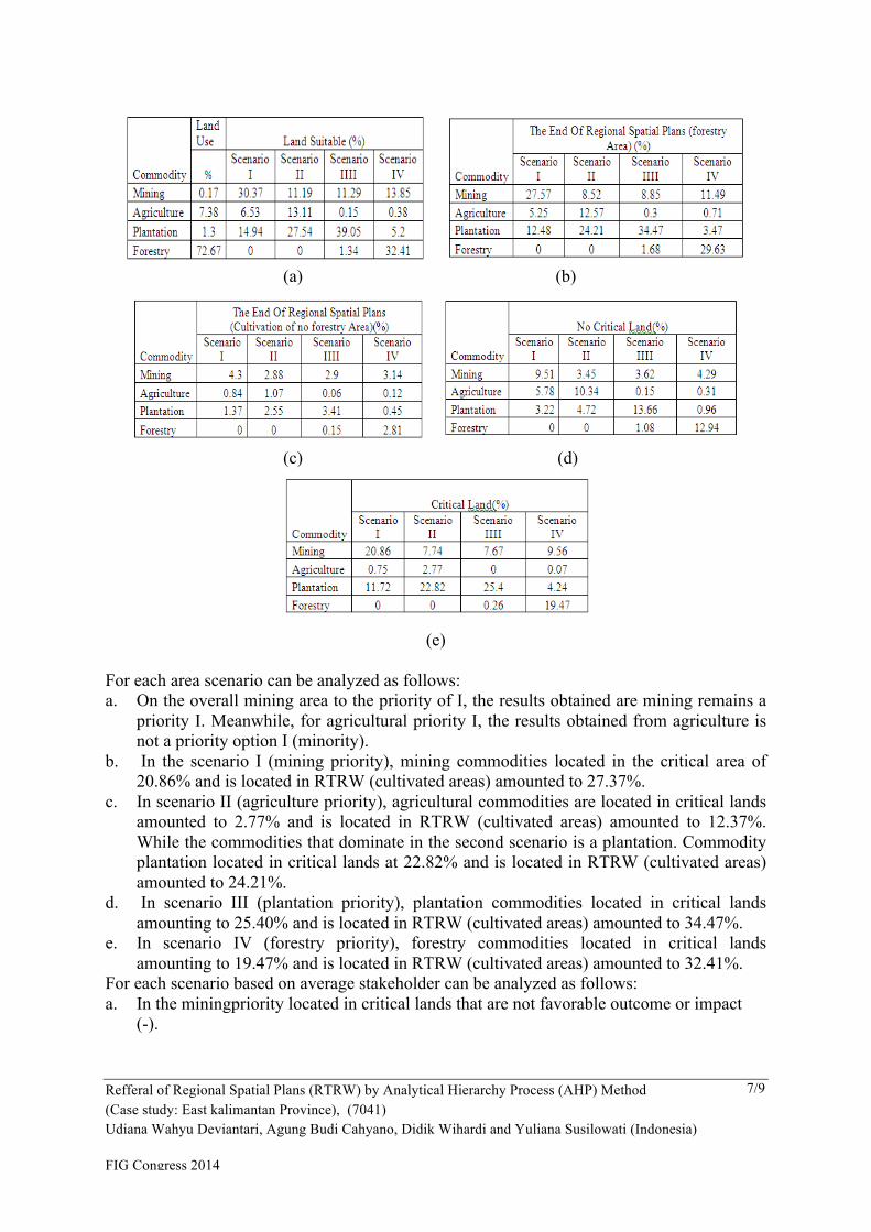
(Plantation Priority); (d) Scenario 4 (Forestry Priority) In the hierarchy of optimal land use, there are several actors in decision-making for spatial planning in East Kalimantan province, namely: government, communities and investors. Then for an alternative choice in this research consists of several scenarios, which are the priority mining, agriculture priorities, priorities for plantation and forestry priorities. Criteria in this study consists of social, economic and environmental, which respectively - each criterion has a positive impact (+) and negative (-). Table 5. (a).Commodity-Land Suitability; (b) Commodity-Forestry Area; (c)Commodity-Non forestry Cultivation Area; (d) Commodity – No Critical Land; (e) Commodity –Critical Land
Refferal of Regional Spatial Plans (RTRW) by Analytical Hierarchy Process (AHP) Method (Case study: East kalimantan Province), (7041) Udiana Wahyu Deviantari, Agung Budi Cahyano, Didik Wihardi and Yuliana Susilowati (Indonesia) FIG Congress 2014 Engaging the Challenges – Enhancing the Relevance Kuala Lumpur, Malaysia 16-21 June 2014
7/9
(a) (b)
(c) (d)
(e) For each area scenario can be analyzed as follows: a. On the overall mining area to the priority of I, the results obtained are mining remains a
priority I. Meanwhile, for agricultural priority I, the results obtained from agriculture is not a priority option I (minority).
b. In the scenario I (mining priority), mining commodities located in the critical area of 20.86% and is located in RTRW (cultivated areas) amounted to 27.37%.
c. In scenario II (agriculture priority), agricultural commodities are located in critical lands amounted to 2.77% and is located in RTRW (cultivated areas) amounted to 12.37%. While the commodities that dominate in the second scenario is a plantation. Commodity plantation located in critical lands at 22.82% and is located in RTRW (cultivated areas) amounted to 24.21%.
d. In scenario III (plantation priority), plantation commodities located in critical lands amounting to 25.40% and is located in RTRW (cultivated areas) amounted to 34.47%.
e. In scenario IV (forestry priority), forestry commodities located in critical lands amounting to 19.47% and is located in RTRW (cultivated areas) amounted to 32.41%.
For each scenario based on average stakeholder can be analyzed as follows: a. In the miningpriority located in critical lands that are not favorable outcome or impact
(-).
Refferal of Regional Spatial Plans (RTRW) by Analytical Hierarchy Process (AHP) Method (Case study: East kalimantan Province), (7041) Udiana Wahyu Deviantari, Agung Budi Cahyano, Didik Wihardi and Yuliana Susilowati (Indonesia) FIG Congress 2014 Engaging the Challenges – Enhancing the Relevance Kuala Lumpur, Malaysia 16-21 June 2014
8/9
b. In priority agricultural land located in the critical gain a favorable outcome or impact (+). And priority of which is located in agriculture RTRW obtain a favorable outcome or impact (+).
c. On priority estates located in critical lands, land suitability, and not critical RTRW unfavorable outcome or impact (-).
d. In forestry priorities, located in critical lands, land suitability, and not critical RTRW obtain a favorable outcome (+).
4. CONCLUSION
AHP method can be applied in spatial planning to produce a better spatial Plan do: - Presenting the results of calculations of several alternative scenarios based on social
criteria, and considering the economic and environmental preferences of all stake holders.
- Allows to generate RTRW by considering preferences of all stake holders and to optimize land use to be economically optimal, in the use of sustainable and socially equitable.
REFERENCES Menteri Kehutanan Republik IndonesiaNomor. (2009): Peraturan Menteri Kehutanan
Republik Indonesia No.P.50/Menhut-II/2009TentangPenegasan Status Dan Fungsi Kawasan Hutan, Jakarta
Provinsi Kalimantan Timur :www.bappenas.go.id/get-file-server/node/8853/, diakses pada tanggal 10 Februari 2014, pukul 14.00 WIB
Susilowati, Y. (2003): Pemodelan SPKSM Untuk Pengelolaan Wilayah Pesisir Terpadu, materi kuliah sistem pendukung keputusan
Susilowati, Y., and Estiaty, L.M., Harsono, Eko, Tjiptasmara. (2006): Pencemaran Organik Sistem Perairan Sungai Mahakam
Wijanarko, A.,B.(2010): Kajian Daerah Rawan Erosi DAS Kapuas Hulu Kalimantan Barat Dengan USLE dan SIG, www.bakosurtnalan.go.id/upl/Hulu%20Sungai%20kapuas.pdf, diakses tanggal 10 Februari 2014, pukul 14.00WIB
BIOGRAPHICAL NOTES Udiana Wahyu Deviantari, ST,MT, born in 1987, Graduated in 2008 as Enginner in Geomatics Engineering from Institut Teknologi Sepuluh Nopember (ITS-Indonesia), obtaining Master’s Program in Land Administration, Geodesy and Geomatics Engineering from Institut Teknologi Bandung (Indonesia). Since 2010 become lecturer and researcher of cadastre and land policy laboratoryin Geomatics Engineering atInstitut Teknologi Sepuluh Nopember (Indonesia). Agung Budi Cahyono, ST,MSc, DEA, born in 1969, Graduated in 1994 as Enginner in Geodetic Engineering from Gadjah Mada University (UGM-Indonesia), obtaining Master’s Program in Natural Resources from BogorAgricultural University (IPB-Indonesia), 2001 and Master Program in Environment and Landscape from La Rochelle University (French), 2004. Since 1999become lecturer and scientist. Head of cadastre and land policy laboratory in Geomatics Engineering at Institut Teknologi Sepuluh Nopember (Indonesia). Ir.Didik Wihardi,M.S, born in 1952, Graduated in 1979 as Engineer in Geodesy and Geomatics Engineering from Institut Teknologi Bandung (Indonesia), obtaining Master degree in

Refferal of Regional Spatial Plans (RTRW) by Analytical Hierarchy Process (AHP) Method (Case study: East kalimantan Province), (7041) Udiana Wahyu Deviantari, Agung Budi Cahyano, Didik Wihardi and Yuliana Susilowati (Indonesia) FIG Congress 2014 Engaging the Challenges – Enhancing the Relevance Kuala Lumpur, Malaysia 16-21 June 2014
9/9
Geodesy and Geomatics Engineering (1994). Since 1996 become lecturer and researcher in Geodesy and Geomatics Engineering at Institut Teknologi Bandung (ITB). Dr.Ir. Yuliana Susilowati,M.Si., born in 1968, Graduated in 1991 as Engineer inElectronic Engineering from Bandung Institute of Technology (Indonesia), obtainingMaster degree in Physical Science (1999) and Doctorate degree in Applied InformationSystem for Electronic Engineering (2005) from Bandung Institute of Technology(Indonesia). Since 2006 become the senior researcher at Geo-technology of IndonesianResearch Institute (LIPI). CONTACTS Udiana Wahyu Deviantari,ST,MT Researcher of Cadastre and Land Policy Laboratory Geomatics Engineering Institut Teknologi Sepuluh Nopember Kampus ITS,Sukolilo Surabaya 60111 Tel +6231.5929487 Email: [email protected] Agung Budi Cahyono, ST, M.Sc., DEA Headof Cadastre and Land Policy Laboratory Geomatics Engineering Institut Teknologi Sepuluh Nopember Kampus ITS,Sukolilo Surabaya 60111 Tel +6231.5929487 Email:[email protected] Ir.Didik Wihardi,MS Graduate Program for Geodetic and Geomatic Engineering Bandung Institute of Technology, Labtek IX-C 3rd floor, Jl Ganesha 10, Bandung- 40132, Indonesia Tel. +62.22.2530701 Fax. +62.22.2530702 Email: [email protected] Dr.Ir. Yuliana Susilowati, M.Si Research Centre for Geotechnology Indonesian Institute of Sciences (LIPI), 70 LIPI Bldg, Jl. Sangkuriang, Bandung-40135, Indonesia. Tel. +62.22.2503654 Fax. +62.22.2504593 Email: [email protected] [email protected]