redmond et al-1999-archeological papers of the american anthropological association
TRANSCRIPT

7/25/2019 Redmond Et Al-1999-Archeological Papers of the American Anthropological Association
http://slidepdf.com/reader/full/redmond-et-al-1999-archeological-papers-of-the-american-anthropological-association 1/21
Macroregional View of Cycling Chiefdoms
in the Western Venezuelan Llanos
Elsa M. Redmond
American Museum of Natural History
Rafael A. Gasson
Instituto Venezolano de Investigaciones Cientificas
Charles S. Spencer
American Museum of Natural History
ABSTRACT
Complex chiefdoms are subject to oscillating cycles of regional political centralization under the
domination of a paramount chief followed by political dissolution, and frequently, the rise of a rival
paramou nt chiefdom . A ma croregional scale of investigation offers the best opportunity to exam ine
the development of centralized, hierarchical leadership and the trajectories of such regional control
at successive param ount cen ters. We present the results of recent archaeological investigations in the
tropical savannas of western Venezuela, which document the development of the earliest complex
chiefdoms that em erged here around A.D . 500. Regional and comm unity-level investigations in
neighboring river valleys of Barina s, Venezuela enable us to examine the dev elopm ent of the regional
polities centered at £1 Gavan and El Cedral from a macroregional perspective, and tentatively to
propose that they w ere subject
t
the cycling pattern of growth and dissolution ch aracteristic of comp lex
aramount chiefdoms.
INTRODUCTION spurred, in part, by European contact. Indeed, some
of the most powerful paramou nt chiefs of the circum -
On Columb us's initial voyage to the Am ericas Caribbean area had already been subdued—and their
1492 the first so cie tie s he en co un te re d on populations were well on their way toward extinction
iola w ere the Taino chiefdom s, ru led by — by the time Lucas Vasqu ezdeA yllon's expedition
ary paramount chiefs. The native chiefdoms pen etrate d southe astern No rth Am erica in 1521
by Colum bus and his followers througho ut (Ande rson 1994a:56). The Mississippian societies
circum-Caribbean area were large and com plex of the Southeast that were contacted and described
consisting of district chiefs and village chiefs by mem bers of Vasquez de Ayllon 's expedition, and
the
centralized regional authority of paramount later by memb ers of Hernando de Soto's exp edition,
Their popu lations were often estimated in were comp lex param ount chiefdoms of similar size
f the thousands o f warriors that
the
param ount and migh t. Hereditary param ount chiefs ruled over
ould summo n at the blast of a conch-shell vast populations by means of regional adm inistrative
n indicator of the widespread hostilities hier arc hie s of distric t chiefs and village chiefs
109

7/25/2019 Redmond Et Al-1999-Archeological Papers of the American Anthropological Association
http://slidepdf.com/reader/full/redmond-et-al-1999-archeological-papers-of-the-american-anthropological-association 2/21
110
Elsa M . Redm ond, Rafael A. Gasson and C harles S. Spencer
(Hudson 1990:61). They too would succumb to the
colonial legacy wrought by foreign incursions and
eventually collapse.
These complex Mississippian and circum-
Caribbean societies can be recognized as chiefdoms
by the centralized and hereditary leadership wielded
by the paramount chief, with one or two levels of
administrative control above the many member
vi l lage s in thei r dom ain. Ac com pany ing the
central ized, h ierarchical , but nonbureaucrat ic
administration is institutionalized social ranking
dom inated by the chiefly hereditary elite. Overall
social and political control is vested in a hereditary
nobility that stands apart from the commoners, the
res t of the populat ion
1
(Wrigh t 1984 :42-43) .
Moreover , in tense compet i t ion ex i s t s among
members of the burgeoning chief ly el i te for
succession to a relatively small number of political
offices—and the privileged access to resources,
goods and foreign connections that those political
positions entail.
Seen in this light, complex chiefdoms are
inherently unstable and subject to oscillating cycles
of growth and dissolution:
the wise paramount will attempt to
reorganize production or to increase
his income by seizing productive
capacity from his neighbors; the
unwise param ount, especially one who
has been so foolish as to create more
than two levels of hierarchy, will face
assassination, fission, or rebellion led
by other nobles who bel ieve
themselves to have be tter claim to the
office of param ount. W hatever the
outcom e, nobility and comm oners will
be killed, political relations w ill break
down, and the building process will
start again [Wright 1984:50-51].
Complex chiefdoms can be characterized, then, as
societies with two or three levels of control hierarchy
[that] persisted for centuries, with intense competition
and much replacement of centers and no doubt of
paramounts , but wi th l i t t le or no increase in
sociopolitical com plexity (Wright 1986:357). The
cyclical pattern of regional political centralization
und er the rule of a para m oun t chief and his
descendants lasting a century or more, followed by
region-wide rebellion, destruction of the paramoun t
center, and the rise of a rival paramount chiefdom
should be detectable in the archaeological record of
prehistoric chiefdoms throughout the Americas.
Before we turn to the development of prehistoric
polities in the tropical lowlands of western Venezuela,
however, we need to consider the archaeological
research designs that should be implemented in order
to recognize and mon itor the sequential trajectories
of prehistoric chiefdoms.
A
MACROREGIONAL VIEW OF CYCLING
CHIEFDOMS
Since most com plex chiefdoms in the Americas
were snuffed out by the early 17th century, our
understand ing of these polities and their pre-Hispanic
forebears rests upon the archaeological record. In
order to investigate the development of centralized
regional leadership and the sequential trajectories of
such control by successive paramount centers,
comprehensive archaeological research designs
should follow a
macroregional
scale of investigation,
which entails the collection, observation and analysis
of diachronic data on the household, community,
regional, and interregional levels (Flannery 1976:5-
6).
Recognizing Complex Chiefdoms
Complex chiefdoms wil l be recognized
archaeologically on the regional level by a settlement
hierarchy of two or three levels based on settlement
size. The topm ost levels should exhibit evidence of
their position in the regional adm inistrative hierarchy
by having mo re public architecture than lower levels.
We would expect the paramount center to be the
largest in the region and to feature the most
impressive public architecture and monuments:
the center of each polity in a network
of interacting complex chiefdoms,
usually the seat of the paramount, w ill
become both larger than an,d
architecturally differentiated from
ordinary chief ly centers , both
phys ica l ly accommodat ing the
paramount's following and providing
7/25/2019 Redmond Et Al-1999-Archeological Papers of the American Anthropological Association
http://slidepdf.com/reader/full/redmond-et-al-1999-archeological-papers-of-the-american-anthropological-association 3/21
Cycling Chiefdoms in the Venezuelan L lanos
111
a focus for major social rituals [Wright
1984:43].
At individual communities or sites within a
region, there should be evidence of that com mu nity's
position in the regional administrative hierarchy, in
terms of its size, its public sector and mounded
architecture, as well as other measures such as its
degree of linkage to the region's network of roads
(Earle 1991:12-13). The smallest sites migh t lack
public sectors and visible mounded architecture
altogether. Differences in size and architectural
elaboration among households and their artifact
assemblages reflect their members' relative social
rank and wealth (Drennan 1991:268; Spencer
1982:79 -149). The ascrib ed social statuses of
individuals in complex chiefdoms are manifested
archaeologically as well , most notably in the
elaborate burial treatment accorded to members of
the nobility, whose bodies are often preserved in
sacred precincts. Differences in mortuary treatment,
nutrition, and health are associated with individuals
of chiefly, commoner, and retainer statuses (Briggs
1986;
Hatch and Geidel
1985;
Linares
1977;
Lothrop
1937; Peebles andK us 1977:438-440; Powell 1988,
1992; Wright 1984:44).
The archaeological examination of complex
chiefdom development on a macroregional scope
should monitor key environm ental, demographic and
economic va riables that relate to the developm ent of
a chief ly pol i t ical economy, which involves
stimulating and mobilizing the production of surplus
from local producers and controlling manpower
(Drennan 1985:3-11; Earle 1978, 1987; Marcus and
Flannery 1996:120; Robertshaw, th is volume;
Steponaitis 1981). Accordingly, we would expect to
find evidence of intensified agricultural or craft
production beyond local or household subsistence
needs, together with the building of storehouses,
roads, public works, and other facilities that serve
the chiefly political economy (Brumfiel and Earle
1987; Earle 1991,1997:75-87). Public constructions
and monuments are erected in part to legitimize the
paramount chief's leadership over all activities,
including ritual ones (Steponaitis 1991:198-200).
Am ong them are large-scale feasts that the paramount
chief hosts on a seasonal and sometimes more
frequent basis in order to display his wealth and
power and consolidate his alliances with villages
within his domain as well as with neighboring grou ps
beyond (Hayden 1996).
Complex chiefdoms often emerge in the
context of a network of polities that interact with one
another through ceremonialism, exchange, and
war fare. The ir pub l ic sectors wi l l feature
monum ental buildings of a ceremonial nature, where
evidence of feasts and other forms of cerem onialism
should be present (Anderson
1994a:
126-127,136-
137; Blitz 1993:84-97; Earle 1997:174-179 ). The
nature and intensity of their long-distance exchange
relationships can be detected archaeolog ically in the
distribution of prestige goods, often in high-status
contexts (Flannery and Marcus 1994:387-390; Helms
1979,1987; Spencer 1982:152-197). The waging of
allied raids against rival chiefly polities on the
macroregional scale results in empty buffer zones that
separate the terr i tor ies of host i le paramount
chiefdoms. Individual communities—and especially
paramount centers that are frequently the major
targets of military campaigns—might show signs of
settlemen t nucleation, fortification, and armam ent as
well as the conseq uences of large-scale attacks in the
form of burning, destruction, and slaughter (Marcus
and Flannery 1996:123-130; Redmond 1994:94-102).
Cycling Chiefdoms
We would expect the developm ental trajectory
of a complex chiefdom to span a period of several
cen tu r ies (A nderson 1994a: 145-150 ; Wrigh t
1984:50). The centralized, regional leadership of the
paramount chiefdom should feature a regional
administrative hierarchy of lower-order centers and
villages under the control of the paramount center.
The paramount center is l ikely to experience
population growth and major mound construction
together with the characteristic packing-in of nearby
centers and vi l lages in the region and other
manifestations of their political unification (Anderson
1994a:
147;
Mclntosh, this volum e; Peebles 1987:27;
Rust and Sharer 1988; Steponaitis 1978). Forms of
intensified agricultural production and specialized
craft production may develop to fuel the chiefly
political economy, and to provision the paramount
chief's storehouses. Some of the surplus produced
might be used for the purposes of ceremonial feasts
hosted by the chiefly elite (Dietler 1990, 1996;
Hayden
1996;
Roosevelt, this volum e). The far-flung

7/25/2019 Redmond Et Al-1999-Archeological Papers of the American Anthropological Association
http://slidepdf.com/reader/full/redmond-et-al-1999-archeological-papers-of-the-american-anthropological-association 4/21
112 Elsa M . Redm ond, Rafael A. Gasson and Charles S. Spencer
aspec ts of the chiefly political econ om y can be (And erson 199 4a:122, 125-126). Large buria l
revealed in the distribution of exotic prestige goods pop ulatio ns exist that hav e bee n the subject of
ex ch an g ed be tw ee n pa ra m ou nt ce nt er s in mortuary, dietary, and health analyses (Peebles and
neighb oring regions and awarded to lesser chiefs and Kus 19 77:438-440; Pow ell 1988, 1992).
allies (B acu s, this volum e; Pee bles 1987 :34-36; Mississippian researchers have documented
Spen cer 1982:160 -177; Welch 1991:176-190). the sequential cycling of three great Mississippian
In time, however, the paramount center might param ount chiefdom s centered at Cahokia (A.D.
be the targ et of m ilita ry att ac ks , w age d b y a 1000-1150) and Moundville (A.D. 1250-1500). The
disg run tled po pula ce or by am bitiou s cad ets in third one centered at Coosa was at its peak when De
alliance with rival paramo unts. Fortifications might Soto's expedition encountered it in
1540
and
is
known
be erected or strengthened and other measures taken largely from the Sp ania rds ' accounts (Anderson
by the regiona l leadership in the face of chronic 1994a:138-155, 1996:247-251; Hudson 1990). As
hostilities, but eventually the paramount center may to the factors that d eter m ined the em erge nce ,
be a tta ck ed for th e la st tim e, d es tro ye d, and expansion, and decline of these shifting paramount
abandoned. A region-wide population relocation ce nte rs, fac tion al co m pe tit ion am ong the
frequently accom panies the demise of a paramount M ississippian elites has been assigned a primary
center. Another paramoun t center elsewhere in the causal role (An derso n 1994 b:65-6 9, 199 6:236).
larger macroregion becomes a magnet of population C ha lle ng es to the re gio na l l ea de rsh ip at the
grow th and the center of the succeeding cycle of paramount center by subordinate elites took the form
regiona l chiefly develop me nt. Consequently, it is of refusals to render tribute or actual revolts, and rival
on the macro regiona l scale that we can best detect claims to chiefly offices. These episodes of factional
the developm ental trajectories of prehistoric complex competition pitted the elites of a single polity against
chiefdom s. one another, and often involved the chiefly elites of
The Mississippian chiefdoms that emerged in neighboring polities as well. Such pow er struggles
the So uth eas t betw een A .D . 900 -16 00 offer often disrupted the regiona l and interregional
unus ua l ly com preh ens ive e thnoh i s to r i c and p res t ige-good s exchange ne two rks be tween
archaeological data on the developmental trajectories param ount chiefs and the ir allies, and also led to
and sequential cycling of complex chiefdoms. For intensive warfare between rival factions and polities
our purp oses , these cycling chiefdoms can be used throughout the Mississippian period,
as a mo del for outlining the causes of sequential M ississippian archaeologists have been able
cycling and its effects on the macroreg ional sca le, to measure factional com petition and to mo nitor its
and can serve as a standard for how b est to mo nitor effects upon the macroregional landscape in a number
the behavior of cycling chiefdoms archaeologically. of way s. A change in the movem ent, volume, or
The Spanish accounts of the handful of param ount quality of prestige goods both within and between
chiefdom s that flourished here in the ea rly 16th polities is an indication of a paramount chiefdom's
cen tury are rich in detail about their reg iona l dom inance or dec line. So too are episodes of
adm inistrativ e and settlem ent hierarch ies, their population growth and major mound building at
poli t ical econom ies, their chiefly rivalries over chiefly c ente rs and the ceram ic eviden ce of
succession , and their interpolity warfare (Anderson intensified feasting therein. The devastating effects
1996:243-247). Moreover, the archaeological data of wa rfare are evid ent in the destru ction and
that have been recovered by archaeologists here since abandonm ent of param ount centers and dramatic
the turn of the century have yielded complete regional population relocations on the m acroregiona l scale
settlement pattern surveys and geographic catchment (Anderson 1994a: 132-13 6,1994 b:71-75,19 96:242-
analyses. Com munity-level investigations have been 248 ; Welch 1991:190-19 9). M oreover, factional
carried out at settlements representing all levels of co m pe titio n and its c on seq ue nc es ha ve bee n
their regional adm inistrative hierarchies, as well as monitored archaeologically and have been shown to
at spec ial-purpo se sites. Floral and faunal remains change during the M ississippian period. It seems
have revealed both local subsistence patterns and the that existing patterns of prestige-good s exchange and
flow of tribute in foodstuffs to the chiefly elite m ou nd bu ildi ng a nd ot he r form s of ch iefly

7/25/2019 Redmond Et Al-1999-Archeological Papers of the American Anthropological Association
http://slidepdf.com/reader/full/redmond-et-al-1999-archeological-papers-of-the-american-anthropological-association 5/21
Cycling Chiefdoms in the Venezuelan Llan os 113
cerem onialism and sanctified authority diminished agricultural land. Victorious raiding parties looted
in the Late Miss issippia n period. In the Late enemy villages and gardens and seized captives
M issis sipp ian per iod w arfare incr eas ed on a (Federman 1958:63-64, 67-68; Gumilla 1963:241-
m ac ro reg ion al scale an d region al par am ou nts 242; Morey 1975:277, 282; Rivero 1956:429-430).
resorted to the use of force and more secular forms Archaeologists have begun to recover data on
of authority. To And erson (199 4b:75 -76), these the pre-contact forebears of the Caquetio chiefdoms
changes in prestige-goods exchange, ceremo nialism, and their neighbors in the western Venezuelan llanos
and warfare docum ented in the long-term trajectories of the state of Barinas. Alberta Zuc chi's pion eering
of the Mississippian param ount chiefdoms represent excavations at the mound sites of La Betania and H ato
changing strategies by which paramount chiefly elites de La C alzada (Fig ure 7.1) esta blis hed the first
soug ht to m ain tain the ir regio na l, centr alize d chronological sequence, the Osoid series, for the
authority. western llanos, compo sed of two phas es: the Cano
del Oso phase (230 B.C.-A.D. 650) and the La
CYC LING CH IEFD OM S IN TH E WE STER N Betania phase
(A.D.
650-1200) (Zucchi 1967,1972a,
VENE ZUELA N LLAN OS 1972b, 1973). Zucch i ' s or ig inal mapping and
excavations at the mound site of La Betania rev ealed
The investigation of pre-Hispanic chiefdoms that the site extends over 15-20 hectares and features
in Venezuela is still in the incipient stage of data five earthen mounds flanking an open plaza som e
collection and analysis and cannot yet address some 200-250 meters in length; the tallest mo und situated
of the detailed questions raised by M ississippian at the plaza 's northern end is 3.6 me ters high (Zucch i
archaeologists in their discussions of the cycling 1967: Fig. 4). Zucchi recovered a sample of burials
dynamics of paramount chiefdoms in southeastern from her 11 test excavations in mound and n on-
North Am erica. Yet the ethnohistoric record for mound contexts at La Betania that produced some
western Venezuela
is
rich in detail about the complex evidence of ascribed status differentiation (Zucchi
Caquetio, Achag ua, and Otoma co chiefdoms that 1967:117-120; see also Spencer 1998).
coexisted on the llanos at the time of contact in the Zucchi's subsequent investigations at the larger
early 16th century (Federman 1958; Gum illa 19 63; mou nd site of Hato de La Calzada, along the bank s
Jahn 1927; M orey 197 5; Oliver 1988; Sp ence r of the Cano El Oso in the lower llanos (see Figure
1991:137-141; Sp encer and Redm ond 1992:136- 7.1) produced partial but tantalizing evidence of an
137). The Caquetio inhabited numerous river courses early cycle of comp lex chiefly deve lopm ent in the
across a large area of the llanos in large, fortified western llanos. The site is the largest in the region
villages that were politically controlled by paramoun t and lies at the end of an earthen causeway or calzada
chiefs, who were reporte d to have been able to after which it
is
named. In the absence of a complete
mo bilize fighting forces of up to 30,000 warrio rs site map, Zucchi and Garson's estimates of its size
(Federmann 1958:67,108-109). Their maize- and vary betwee n larger than 15 he cta res (Garso n
man ioc-farming popu lations are known to have 1980:105,294), which is probably an underestimate
practiced intensive agriculture , including forms of for this center whose surface remains are reported to
irrigation and drained-field agriculture. The Caquetio be eroding from the Cano El Oso banks for several
chiefdoms maintained long-dis tance exchange hun dred me ters in both di r ec t io ns (Ga rson
ne tw ork s w ith n eig hb or ing and dist ant gro up s 1980:105), and Zucchi's overestimate of 800 hectares
through which they obtained a variety of utilitarian (Zucchi 1973:185). The four-hectare a rea of the
and prestige goods. Exchange relationships w ere center that was mapped during Zuc chi's field season
ena cted b y mean s of pub lic fea sts an d ritua ls, features three large mou nds, the tallest one at the
inc lud ing ce rem on ial dis co ur ses w he rein an northern end of a plaza reaching a height of 12.9
en or m ou s am ou nt of es ote ric and po lit ic al meters (Zucchi 1972a:Fig. 3). Zucchi's trench across
information was exchanged. The Caquetio were also the talles t m ound expo sed this m ou nd 's entire
pursu ing intensive allied military campaigns against stratigraphic sequen ce, capped by hearths at its base
neighboring groups in the early 16th century, in part and to p. Ch arco al sa m ples from those hea rths
to expan d their territories and their access to prime produced radiocarbon dates of A.D . 550±60 and A.D.
7/25/2019 Redmond Et Al-1999-Archeological Papers of the American Anthropological Association
http://slidepdf.com/reader/full/redmond-et-al-1999-archeological-papers-of-the-american-anthropological-association 6/21
114
Elsa M. R edm ond, Rafael A. Gasson and Charles S. Spencer
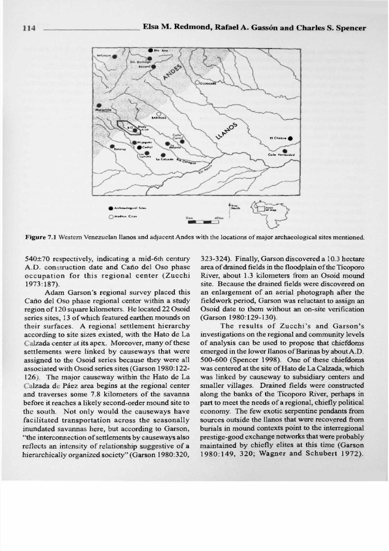
Figure 7.1 Western Venezuelan llanos and adjacent Andes with the locations of major archaeological sites mentioned.
540±70 respectively, indicating a mid-6th century
A.D. construction date and Cano del Oso phase
occupat ion for th is regional center (Zucchi
1973:187).
Adam Garson's regional survey placed this
Cano del Oso phase regional center within a study
region of 120 square kilometers. He located 22 Osoid
series sites, 13 of which featured earthen mounds on
their surfaces. A regional settlement hierarchy
according to site sizes existed, with the Hato de La
Calzada center t its apex. Mo reover, many of these
settlements were linked by causeways that were
assigned to the Osoid series because they were all
associated w ith Osoid series sites (Garson 1980:122-
126;.
The major causeway w ithin the Hato de La
Calzada de Paez area begins at the regional center
and traverses some 7.8 kilometers of the savanna
before it reaches a likely second-order m ound site to
the south. Not only would the causew ays have
facil i tated transportation across the seasonally
inundated savannas here, but according to Garson,
the interconnection of settlements by causeways also
reflects an intensity of relationship suggestive of a
hierarchically organized society (Garson 1980:320,
323-324). Finally, Garson discovered a 10.3 hectare
area of drained fields in the floodplain of the Ticoporo
River, about 1.3 kilometers from an Osoid mound
site. Becau se the drained fields w ere discovered on
an enlargement of an aerial photograph after the
fieldwork period, Garson was reluctant to assign an
Osoid date to them without an on-site verification
(Garson 1980:129-130).
The resul ts of Zucchi ' s and Garson 's
investigations on the regional and comm unity levels
of analysis can be used to propose that chiefdoms
emerged in the lower llanos of Ba rinas by about A.D.
500-60 0 (Spencer 1998). One of these chiefdoms
was centered at
the
site of Hato de La Calzada, which
was linked by causeway to subsidiary centers and
smaller villages. Draine d fields were constructed
along the banks of the Ticoporo River, perhaps in
part to me et the needs of a regional, chiefly political
economy . The few exotic serpentine pendants from
sources outside the llanos that were recovered from
burials in mound contexts point to the interregional
prestige-good exchange networks that were probably
maintained by chiefly elites at this time (Garson
1980:149 , 320; Wagner and Schubert 1972).

7/25/2019 Redmond Et Al-1999-Archeological Papers of the American Anthropological Association
http://slidepdf.com/reader/full/redmond-et-al-1999-archeological-papers-of-the-american-anthropological-association 7/21
Cycling Chiefdoms in the Venezuelan Llanos
115
Corroborating this Cano del Oso phase date for the
emergence of mound-building chiefdoms in the
western Venezuelan llanos are Jorge Armand's
limited excava tions at the small mound site of Batatuy
in the higher llanos (see Figure 7.1), where he
recovered two radiocarbon dates with midpoints of
A.D. 2201160 and A.D. 510+250 associated with
Osoid series ceramics from the site's two mounds
(Armand 1975:56-57, 74-75, 101-102, 115).
Recently, two archaeological projects have
been carried out in the higher llanos of Barinas w ith
the explicit goal of investigating the origins and
development of complex chiefly societies of the sort
that were reported in the area in the early 16th century.
Charles Spencer and Elsa Redmond carried out a pilot
survey of the high llanos in 1982 and chose to focus
their attention on the Canagua River, where the large
mound site of
El
Gavan is located (see Figure 7.1).
With the express intention of investigating this
impressive mounded settlement in its regional and
interregional context, in 1983 they began the first of
three seasons of systema tic regional survey of a 450
square kilometer study region that extended from the
high l lanos upstream to the adjacent Andean
piedmon t. A total of 103 archaeological sites were
located during this initial phase of research
(1983-
1985).
The second phase of fieldwo rk began in 1986
and consisted of test excavations at ten sites, seven
of them at mo und and no n-mound sites in the llanos.
In 1988 they began the third phase of horizontal
excavations at the mound site of El Gavan itself, the
region's primary center. The four-phase chronology
established for the high llanos begins around A.D.
300 and extends to the contact period (Spencer and
Redmond 1992:138-140).
During the 1984 survey season Spencer and
Redmond visited the large mound site of El Cedral
in the adjacent Acequia-Anaro River drainage and
returned to reconnoiter this major mound site with
Rafael Gasson in 1988 (see Figure 7.1). El Cedral
became the focus of Gasson's doctoral research,
which began in 1995 with a systematic regional
survey of the center's 60 square kilometer immediate
hinterland, as well as informant-based surveys of
other mound sites in the greater Acequia-Anaro
region (Gasson 1998:59-60). A total of 17 sites were
situated with a geographical positioning system and
located on
1:25,000
aerial photos and topographic
ma ps of the region. The second phase of Gasson's
investigations in 1996 involved m apping the primary
regional center of El Cedral and carrying out test
excavations there and at five other mound and non-
mound sites.
The resulting survey and excavation data from
these two regional centers and settlements in their
hinterlands allow us to consider the developmental
trajectories of two prehistoric polities that emerged
in adjacent r iver val leys from macroregional
perspective. This broade r macroregion, larger than
our combined study regions in portions of the
Canagua and Acequia-Anaro drainages, extends
across some 2,000 square kilometers of high llanos.
The El
Gavan
Polity
The site of El Gavan (B12) w as first occup ied
and littered with Cano del Oso style ceramics in the
Early Gavan phase (A.D. 300-550). A radiocarbon
date of
A.D.
455±80 from charcoal recovered in the
lowest level of Test 27 located west of the site's
center can be assigned to this founding period
(Spencer and Redmon d 1992:Table
2).
The available
survey and excava tion data for this earliest period of
occupation in the upper C anagua R iver valley do not
show evidence of a regional settlement hierarchy or
of mound construction. B12 was one of three Early
Gavan phase sites in the high llanos of the Canagua
River drainage (Figure 7.2). B12 extended over five
hectares, somewhat larger in size than the other two
Early Gavan sites B97 and B21, which were both
three hectares in size. No mounds can be dated to
the Early Gavan pha se.
By the Late Gavan phase (A.D. 550-1000), the
high llanos flanking the upper Canagua River
witnessed significant population growth and the
development of a complex regional organization. The
Late Gavan phase regional sett lement pattern
consisted of 32 settlements that varied according to
site area and am ount of mound construction, am ong
other features (Figure 7.3). Moreover, a clear regional
sett lement hierarchy of three levels could be
discerned on the basis of site size and mounded
architecture for the Late Gavan phase.
Occupying the top level of the regional
settlement hierarchy was the site of El G avan (B1 2),
which extended over 33 hectares and featured an
elongated open plaza lined by more than 130 mounds
and earthworks of varying sizes, most notably a 10-

7/25/2019 Redmond Et Al-1999-Archeological Papers of the American Anthropological Association
http://slidepdf.com/reader/full/redmond-et-al-1999-archeological-papers-of-the-american-anthropological-association 8/21
116
Elsa M. Red m ond, Rafael A. Gasson and C harles S. Spencer
Figure
7.2 Settlement pattern for the Early Gavan p hase (A.D. 300-550) on the llanos of the
upper Canagua River drainage.
0 km
Curboti ' Complex Sitei
O Pctroglyphi
iovdn CompUi S«ttl»m«nt Hierarchy
lst-Ord
Ctnte
k 2neK)rd*r Sitei D Drained f i«W
. - • ' C a l z a d a
5 km
Figure 7.3 S ettlement pattern for the Late Gavan phase
(A.D.
550-1000) on the llanos
of the uppe r Canagu& River draina ge.

7/25/2019 Redmond Et Al-1999-Archeological Papers of the American Anthropological Association
http://slidepdf.com/reader/full/redmond-et-al-1999-archeological-papers-of-the-american-anthropological-association 9/21
Cycling C hiefdoms in the Venezuelan L lanos
117
Figure
7.4
Topographic map of El Gavan (B12), showing the major mounds, calzadas and encircling earthwork, as
well as the housemounds, the numbered test excavations, and the three areas of horizontal excavation designated by
capital letters.
meter-tall mound at its northern end and a 12-meter-
tall mound at
its
southern end (Figure 7.4). The latter
mound or cerrito (small hill) had a maximum basal
diameter of 90 me ters and featured an 80-m eter-long
ramp that ascended from the plaza
floor
o its summit.
The B12 site was circumscribed by an enormous
oval-shaped earthwork that has been damaged by an
oxbow stream on its northwest side but that still
reaches one meter or more in height and varies
between six and eight me ters in width on its surface.
Three calzadas radiated out from this 950-meter-long
encircling earthwork to link the El Gavan center with
sites on lower levels of the regional settlement
hierarchy.
Below B12 in the regional settlement hierarchy
were five sites (B97, B21, B17,
B25,
and B30), which
ranged between 6-10 hectares in size and featured
two to four mound s reaching between 2-6 meters in
height. No t only did the elongated layout of their
mound ed architecture duplicate the community plan
at B12 on a sma ller scale, but also four—and possibly
all five—(i.e., 80-100 %) of these second-order sites
were l inked by
calzada
to the regional center
(Spencer and Redmond 1992:145, 1998:105).
The third level of the regional settlement
hierarchy consisted of 26 sites that varied between
0.5
to
4.4 hectares in size and lacked visible mo unded
architecture altogether. Nin e of these third-orde r
settlements (or 35%) were connected to the regional
calzada network.
El Gavan's (B12) regional prominence is
evident in its size, its 500-meter-long public sector
punctuated by m onumental mou nds, and its position
at the hub of the region's settlement hierarchy and
causeway network. We estimate that the El Gavan
polity thus defined extended over an area of
approximately 290 square kilometers.
Complementing this survey evidence of a
centralized, hierarchical regional polity in Late Gavan
t imes are excavated data from individual
comm unities that shed light on the developm ent and
organization of the El Gavan p olity and the nature of
its political economy. Am ong the 55 test excavations
2 m x 1 m) that were carried out at the regional center
itself was Test 183, which w as located at the w estern
base of the major mo und . In its lowest leve ls

7/25/2019 Redmond Et Al-1999-Archeological Papers of the American Anthropological Association
http://slidepdf.com/reader/full/redmond-et-al-1999-archeological-papers-of-the-american-anthropological-association 10/21
118 _
Elsa M. R edmon d, Rafael A. Gasson and Charles S. Spen cer
ovan Locality
•-Archaeological site
O-Vego alluvium
Fig ure 7.5 The Gavan locality, showing the regional center (B12), an adjacent second-order site (B97), four neighboring
third-order sites (B52, B98,
B96,
B26), the drained-field facility (B 27), and the interconnecting calzada system (indicated
by the dotted lines).
associated with the earliest construction of the
mound , Tes t 183 recovered rad iocarbon and
thermoluminescence dates that have midpoints of
A.D. 650±100 and A.D. 41O±9O respectively; these
dates indicate that the initial construction of this
mound occurred around A.D. 500-600 (Spencer and
Redmond 1992:144, Tables 2, 3). That the mound's
function was ceremonial rather than residential is
suggested by its conical shape and small summ it, and
by the paucity of domestic debris in the six test
excavations that were placed in and around it. By
contrast the 134 visible housemounds at the center
were associated with abundant domestic debris
(Spencer 1998; Spencer and Redmond 1998:104).
It is likely that the other conical mound built at the
northwestern end of the plaza was also ceremonial
in nature, making for one and probably two public
buildings that served the seat of regional political
authority at El Gavan in the Late Gavan phase.
Evid ence of social status differentiation comes
from the excavation of two housemounds at El
Gav an. The house floor exposed in Area D atop a
0.55-meter-tall housemound revealed a rectangular
roofed structure containing some 16.6 m
2
of hard-
packed earthen floor space with a doorway that faced
the plaza (s ee Figure 7.4) (see Spencer and Redmond
1992:Fig. 9). The Late Gavan house floor exposed
in Are a A atop the one-m eter-tall housem ound at the
pla za 's midpoint reve aled a rectangular roofed
structure some 27.9 m
2
in area with a hard-packed
earthen surface lined by postholes, a doorway on the
plaza side, and an interior hearth (see Figure 7.4) (see
Spencer and Redmo nd 1992:Fig. 8). Buried beneath
the house floor were two extended burials of adults,
at least one of which was interred with ceramic
offerings and a malachite bead whose source area
could have been as distant as the Andes of southern
Colombia or Ecuador (Spencer and Redmond
1992:154), By contrast
the
only other extended burial
at B12, which was recovered in the housemound
context of Test 27, lacked non-perishable funerary
accompaniments. The differences in location, height,
and size of the two exposed housemounds, as well
as the funerary— and exotic— accom panime nts
associated with certain m em bers of the Area A
household, signal the latter's higher social position
in El Gavan society and their participation in long-
distance prestige-good exchange. Moreover, the Area
A house was clearly burned at the t ime of
abandonm ent, a point that we w ill return to later.
The El Gavan polity was engaged in intensive
agricultural production in Late Gavan time s. One of
the three calzadas that radiated from B12 led to the
southeast, passing alongside the third-order village
sites of B96 and B 26, before bordering B 27 (Figure
7.5). B27 was a 35-hectare area of drained fields

7/25/2019 Redmond Et Al-1999-Archeological Papers of the American Anthropological Association
http://slidepdf.com/reader/full/redmond-et-al-1999-archeological-papers-of-the-american-anthropological-association 11/21
Cycling Chiefdoms in the Venezuelan Llanos 119
that were artificially c reated by digging
a
network of at B12 with distant paramo unt elites in the Andes at
canals between the Cano Colorado and two oxbow the same time that the flow of prestige goods from
lagoons on the floodplain of the Cana gua River. B12 to second-order centers like B21 reinforced the
Local farmers still recogn ized these drained fields alliances that existed betw een the regional and local
as an ancien t wa ter m ana gem ent facil i ty that eli tes.
promoted drainage during the rainy season as well In w art im e, the surp lus m ob ilize d from
as extended the effective growing season for maize sub ord inate villa ges like B 26 co uld ha ve bee n
cultivation by retaining water in dry periods at the stockpiled in order to feed the resident population
beginning and end of the rainy season. Two harvests during periods of chronic hostilities and sieges, and
of maize could be reaped here each year in contrast also to provision w ar parties of considerable size.
to the single harvests elsewhere on the floodplains. That warfare was a regular if not chronic occurrence
Consequently, annual maize yields reported by local dur ing the en tire L ate G ava n p ha se is evi den t
farmers at B27 were on the order of 3,600 kilogram s specifically at B12 in a num ber of way s. It appears
ofshelled maize per hectare (Spencer eta l. 1994:128- that the oval-shap ed earthw ork th at encirc les the
131). Tha t m aiz e wa s also the pri nc ipa l crop regional center was built at the beginning of the Late
cultivated on the drained fields in the Late Gavan Gavan phase. The Area B excavations atop and
phase was determ ined b y Milagro R inaldi's (n.d.) across the peripheral earthwo rk failed to recover any
palyno logical analysis of one of the soil samples ceramics and other artifactual remains in its earthen
excavated at B2 7, which revealed high frequencies fill, hence the earthw ork was probab ly built long
of Zea mays pollen. M oreover, Spencer, Redmond before B 12's growing pop ulation had begun to
and Rina ldi (1994:133-139) have determined that the expand within the encircled area and reside nearby.
drained fields at B27 were capable of producing a Furthermore, this oval-shaped earthwork seems to
considerable surplus, well beyo nd the subsistence have served as a defensive earthw ork on which a
needs of the nearby villagers at B26 w ho probably palisade of posts was erected, revealed in the Area B
farmed them. Both B27 and B26 were connected by trench b y the alignm ent of postm olds that w ere
calzada to the regiona l center at B1 2, allowing for exposed along its centerline (Spencer and Red mo nd
the expeditious mo vement of this agricultural surplus 1992:144, Fig. 5). Of the seven hum an skeletons
across the seasonally inundated savanna (Spencer and recovered at El Gavan , only three w ere articulated
Redmond 1998:101,105,109) and likely deposited in sk ele ton s laid to res t in ex te nd ed po siti on in
storage bins at the regional center. residential contexts. The rem ainde r were partial,
In times of peace the regional leadership at El disarticulated human skeletons that were reco vered
Gavan could have used the surplus mo bilized from in mou nd contexts: in the lowest construction level
B27— and probab ly from other such facilities in the of the major mound exposed in Test 183 (Burial 8),
region—to sustain its resident population as well as and from Test 17 (Burial 1) and Test 18 (Burials 2,
o reinforce alliances with the ma ny subordinate 3) in an elongated mound or earthwork construction
in its dom ain through periodic feasting. T he on the northwest side of the plaza. These pa rtial,
Gavan elite could also have used such agricultural disarticulated hum an skeletons devoid of funerary
us along with other lowland products for the accompaniments may well represent war captives
of exchange with groups in the Ande s. In who w ere sacrificed and deposited in m ounds or
we know that the El Gavan polity obtained earthworks at the regional center, a time -honored
jasp er from sources in the An des for making custom p racticed by victorious chiefly war p arties
thic tools. Polished stone ornaments made from throug hout northern South Ame rica (F ederm an
serpentinite, malachite, slate, amphybolite 1958:68; Morey 1975:349; Redm ond 1994:30-31,
phyllite have also been recovered in moun d and 37).
contexts both at the regional center B12 and N ot only did the re gio na l cen ter bu ild a
B21. S ketchy though the defensive fortification and practice hum an sacrifice
prestige-good exchange may be for the from the beginning of the Late Gavan phase, but it
Gavan polity, it supports a mo del of interregional also seems to have been a major target of hostilities,
exchange that linked the regional elite as revealed by the widespread evidence of burning

7/25/2019 Redmond Et Al-1999-Archeological Papers of the American Anthropological Association
http://slidepdf.com/reader/full/redmond-et-al-1999-archeological-papers-of-the-american-anthropological-association 12/21
120
Elsa M . Redm ond, Rafael A. Gasson and Charles S. Spencer
Rio Canagua
Archaeological Site
Modern Town
0 5 10 Km
tsmer ld
astranto
nvidia
Figure 7.6 The greater Cedral region, showing the location of the regional center of El Cedral, the 60 km
2
area of
intensive survey, and other mound and non-mound sites located and sampled in the region.
there . Significantly higher relative quantities of
burned daub—by a factor of four to six—were
recovered in the excavations at B12 than in th e
excavations at four other G avan-polity sites (B9 7,
B21, 26, B17), and especially from the very latest
l eve l of o ccu p a t i o n (Sp en ce r and R e d m o n d
1998:106). Indeed, the abandonment of the regional
center seems to have been precipitated by a violent
conflagration, when both the high-status residence
in Area
A
and the defensive palisade were destroyed
by fire, alon g with m ost of the other structures at the
site.
The two thermoluminescence dates associated
with the burned residence in Area
A
have m idpoints
of A.D. 760±120 and A.D. 900 ±120, and suggest
that the final attack and abandonment of El Gavan
occurred not long after A.D. 760-900. Accompanying
the destruction and abandonment of the regional
center was the widespread abandonment of all the
secondary centers and villages that made up the El
Gavan polity.
The El Cedral Polity
Some 40 kilometers to the southwest of the El
Gavan polity, another com plex polity em erged in the
F i g u r e i n El
Cedral's immediate hinterland, with the
neig hbo ring high llanos that extend between the location of the regional center (C l) and eight village sites
Tico poro , Acequia and Ana ro rivers (Gass6n 1998). recorded within the 60 km
2
area of intensive survey.

7/25/2019 Redmond Et Al-1999-Archeological Papers of the American Anthropological Association
http://slidepdf.com/reader/full/redmond-et-al-1999-archeological-papers-of-the-american-anthropological-association 13/21
Cycling C hiefdoms in the Venezuelan Llanos
121
I lOOOn
| C l EL CEDR AL
Figure 7.8 Topographic map of El Cedral (Cl), showing the locations of the major mounds, calzadas, housemounds,
and agricultural fields.
The 17 Osoid series sites within Gasson's study
region could be classified in a three-level regional
settlement hierarchy, according to their size, the
number and scale of mounded architecture, and their
linkage by means of
calzadas
(Figures 7.6,7.7) . The
first level of the regional settlement hierarchy was
occupied by the si te of El Cedral (Cl), which
encompassed an area of 135 hectares (Figure 7.8).
On its northern, western and southern sides the
settlement w as enclosed by a calzada some 1.80 to 2
meters in height; a stream borders its eastern side,
and may have served as a natural moat. Within the
enclosure 139 mounds were mapped, dominated by
a linear cluster of three conical mou nds. The principal
mound was m ore than 100 meters in diameter at its
base and measured 12 meters in height; directly to
the northwest stood two other conical mounds that
were nine meters tall. The site's many lower m ounds
of varying s izes are assumed to have been
housemounds, like those exposed in the horizontal
excavations at El Gav an. Population estima tes were
calculated for El Cedral on the basis of the number
of housemounds and hectares of occupation and
range d from a min imu m of 695 person s to a
maximum of 4090 persons (Gasson 1998 :74-75,7 8-
79). Finally, El Cedral seems to have been the hu b
for a number of causeways, which connected the
regional center to sites on lower levels of the regiona l
settlement hierarchy. The El Cedral polity, defined
by the regional settlement hierarchy and network of

7/25/2019 Redmond Et Al-1999-Archeological Papers of the American Anthropological Association
http://slidepdf.com/reader/full/redmond-et-al-1999-archeological-papers-of-the-american-anthropological-association 14/21
122
E l s a M
- Red mo nd, Rafael A. Gasson and Charles S. Spencer
causew ays, extended over a hinterland measuring a probably represented
the
dwellings of
a
small fraction
minim um of 448 square kilometers. of the farmers who cultivated the fields (Gasson
The second level of the regiona l settlemen t 1998:65).
hierarchy consisted of eight sites with site areas of Gasson (1998:77, 80) has demonstrated that
38 to 42 hecta res an d mou nde d arc hitec ture — the drained fields at El Cedral could have easily
typically with one mo und eight to nine me ters tall, supported the regional center's resident population
Th ey are the sites of C erro M ijagua s, Lo m itas as well as the inhabitants of the eight villages in its
Floridenas, Mi Destino, Maria Luisa, M atade Palma, im m edia te hin terla nd and still hav e prod uced
La Esmeralda, La Envidia, and El Mastranto in the sub stan tial sur plus es. The r egio nal ce nte r 's
gre ate r C edr al reg ion co m pris ing El C ed ra l's dependence upon the drained fields for its sustenance
hinterland (see Figure 7.6). Several of the calzadas as we ll as for the benefits that could be gained from
radiating from El Cedral lead to these second-order the potential surplus production is evident in several
cente rs. wa ys. First, the drained field facility is directly
The third level of the regional settlement con tiguou s to the regiona l center itself, which
hierarchy was occupied by nine sites that extended sugg ests that the region 's param oun t lead ership
between 0.5 and 1 hectare in area and that lacked controlled its production directly. Secondly, the
visible mounded architecture. These correspond to multiple calzadas that traversed and bounded the
the nine sites that we re located by means of intensive drained fields would have been useful for transporting
survey in the 60 km
2
area surrounding El Cedral (see laborers and mobilizing produce to the regiona l center
Figure 7.7). throughout the year, across seasonally inundated
D ire ctl y eas t a nd adjac ent to C l wa s an terrain. Finally, the height of the causeway spanning
eno rm ous exp anse of dra ined fields, bou nded by the facility would have allowed an unobstructed view
causeways and streams {canos) (see Figure 7.8). A of the fields, suggesting that the causeways might
minim al size estimate for these drained fields is 416 have been used for the surveillance and defense of
hectares within which a network of canals and ditches this prime agricultural zone (Gasson 1998.72).
supplied water from several canos to a patchw ork of W hat might the potential surpluses generated
rais ed fields of va ryi ng sha pes and size s. A by the drained fields have been used for by the El
m onu m enta l causew ay reaching eight m eters in Cedral leadership? Ceremonial feasting may have
height and three meters wide on top led directly from been one purpose, in view of the evidence of C l' s
the cen tral cere monia l p recin ct of El C edral and central role in feasting—specifically serving food and
spanned this facility; the calzada was interrupted at drink on a big scale—w ithin the El Cedral polity,
various points by cuts that allowed water to flow G as so n' s a na lys is of ves sel f orm s, sizes and
acr oss it. Lik e the drain ed field system (B27) decoration amo ng ceramic samples from sites on
asso ciated w ith the Gavan polity, the netw ork of different levels of El Ce dral's regional settlement
canals would have served to channel excess water hie rar ch y sho we d significa ntly grea ter relative
during the rainy season and to retain water in the dry frequen cies of small serving vessels at El Cedral than
seaso n, thereb y facilitating the produ ction o f two at lower-order settlemen ts. By contrast, cooking and
harvests each year (Gasson 1998:70). In addition, storag e vesse ls were larger and relatively more
another one of El Ce dral's causeways led directly to abu nda nt at lo we r-orde r settlem ents than at the
the fertile floo dplain of the Acequia River, located region al center, a finding that ma y have implications
about four kilometers west of the regional center. for unde rsta ndin g the nature of produ ction and
G as so n's surv ey team lo cated two sh erd consumption within the El Cedral polity (Gasson
scatters less than one hectare in size within the large 1998:117 , 120, 124). Feasting was an imp ortant
area of drained fields at El Cedral. The ceramics elem ent in the ceremo nial excha nges of many
recovered from these surface scatters were similar northw estern S outh Am erican societies, where it
to the plain ceramics characteristic of the nine third- included the consum ption of food and enormous
order vil lage si tes rather than to the carefully qua nti t ies of chicha or mazato (maize beer) ,
burnish ed pottery recov ered at the regional center ceremonial dances, songs, and recitations (Gilij 1965;
and othe r mou nde d ce nter s. Th e sherd scatters Morey 1975; Rivero 1956; Roosevelt, this volume).

7/25/2019 Redmond Et Al-1999-Archeological Papers of the American Anthropological Association
http://slidepdf.com/reader/full/redmond-et-al-1999-archeological-papers-of-the-american-anthropological-association 15/21
Cycling C hiefdoms in the Venezuelan L lanos
123
Q
1000
1100
1200
1300
1400
1500
1600
1700 -
CEDR L
G V N
BIS T.27
B 1 2 - 0 1 6 1
BETA-16646
B12 T.183
B 1 2 - 0 7 5 9
BETA-27258
Cl OP.2
60 -7 0 CM
BETA-117265
Cl 0P.2
80 -9 0 CM
BETA-117266
R a d i o c a r b o n S a m p l e s
Figure 7.9 Distribution of radiocarbon dates (expressed in radiocarbon years before present) associated with the El
Gavan and El Cedral regional centers.
Hosting feasts would have offered El Cedral's elite
the opportunity to display its wealth in food surplus
and reaffirm its poli t ical prominence, and to
consolidate al l iances with subordinate chiefs,
villagers, and allies. These social and ritual occasions
would have provided the context for exchange
relationships to be enacted and military alliances
established. At the same time , the exchanges and
alliances so created offered new opportunities for
social differentiation, and could have led to increased
competition, heightened feasting and/or warfare,
thereby placing addi t ional demands upon the
available surplus (Gasson 1998:163-164).
A l t h o u g h d o cu men t i n g E l Ced ra l ' s
ectory is amon g the goals o f future
Gasson recovered from one of
precinct.
Two of the samples from
Ana lytic Laboratory for radiocarbon
The resulting radiocarbon dates with
A.D. 680±50 and A.D. 690±50 can now
the regional center (Figure 7.9). These
dates are associated with deposits in the ceremonial
precinct, near the tallest conical mound, and their
stratigraphic position suggests that they can be
ass igned roughly midway during El Cedral ' s
occupation.
The Macroregional View
The results of these archaeological projects
carried out in neighboring regions of the western
Venezuelan l lanos enable us to make some
comparisons between the two regional hierarchical
polities centered at El Gavan and El Cedral, and to
consider their developmental trajectories on a
macroregional scale. At the presen t time, we can
compare their relative chronological time spans using
the handful of radiocarbon dates that we have from
the two regional centers (see Figure 7.9). W hile not
conclusive, the available dates suggest that the El
Gavan polity may have emerged some two centuries
or more before the El Cedral polity—or at least before
the major m ounds in El Ced ral's ceremonial precinct
were built. Following the procedu re outlined by
Thomas (1986:249-251), a two-tailed student's M est
compared
the
earliest radiocarbon date obtained from

7/25/2019 Redmond Et Al-1999-Archeological Papers of the American Anthropological Association
http://slidepdf.com/reader/full/redmond-et-al-1999-archeological-papers-of-the-american-anthropological-association 16/21
124 Elsa M . Red mo nd, Rafael A. Gasson and Charles S. Spence r
Test 27 at El Gavan (1495 ±80 years BP with kilome ter imm ediate hinterland of El Gav an's
mid point of A.D . 4 55) and the earliest date obtained regional center featured both second-order mo unded
from Operation 2 at El Cedral (1290+50 years BP centers such as B97 and
B25,
and third-order village
with m idpoint o f A.D. 660) and indicated
a
significant sites such as B52 , B9 8, B96, and B26, all of which
difference between them at less than the 0.05 level were conn ected by causew ays to El Gava n. El
(t - 2.17; d f>
120;
p= 0.033). Ce dral's 60 square kilometer imm ediate hinterland,
The sequence of dates in Figure 7.9 indicates by contrast, featured o nly third-order village sites,
con sider able chro nolo gical overlap m easu red in none of which was directly linked by calzada to the
rad ioca rbo n years betw een the Late Gava n date regional center. Instead, the causeways radiating
(130 0110 0 y ears BP with midpoint of A.D . 650) from El Cedral linked the regional center to secondary
obtained from Test 183 (Provenience B12-07 59) at centers with considerable mounded architecture of
the base of El Ga van 's major m ound, and the two their own, all situated at distances greater than 10
dates obtained directly southeast of El Cedral's major kilome ters from El Cedral (Gasson 1998:59-60).
mound in Operation 2 (1290150 years BP with W hile the pa ck ing -in of low er-o rder
mid point of A.D . 660, and 1260150 years BP with settlements in the vicinity of the regional center is a
midpoint of A.D. 690). The available radiocarbon comm on phenom enon of complex chiefdoms, the
dates for the two neighb oring polities allow us to differential distribution and linkage of village sites
suggest that: 1) El Gavan probably emerged as a and s ec on d- or de r ce nte rs w ithi n El C ed ra l's
regional center before El Cedral; and 2) the two hin ter lan d has im por tan t im plic atio ns for
polities were probably contem poraneou s for a time, understan ding the territorial extent and the relative
Fu ture inve stiga tions sho uld clarify w hethe r El dominance of this centralized chiefly polity on the
Cedral persisted as
a
regional center after El Gavan 's regional scale. M oreover, the subsidiary centers
collapse. linked by causeway to El Cedral were somewhat
There are some notable differences of size and larger in size than the regional center of the El Gavan
scale betw een the El Gavan and El Cedral polities, polity. We suspect that El Cedral was the regional
beg inning with the sizes of their regional centers. A t center of a paramount chiefdom that
was
considerably
135 hectare s, the regional center of El Cedral w as greater in scale and political migh t during its heyday
over four times the size of El Gavan and its estimated than El Gavan. The El Cedral polity may have been
popu lation was also a fourfold larger. Although the formed from a num ber of previou sly autonomous
two regional centers were similar in their linear chie fdom s in the cyc ling proc ess ou tlined by
configuration of mo unded architecture along the Anderson:
central ax is of their elliptical enclosures, the scale of
El Ce dral's public works was grander. The major Com plex chiefdoms, formed from a
conical mound at El Cedral was more than
10
meters number of simple chiefdoms, are thus
broader in diam eter than the largest mound at El made up of entities perfectly capable,
Gavan and its original height was probab ly greater if given the chance, of usurping the
than the 12 me ters reco rded in 1996 (Gasso n role of the para m oun t cente r or,
1998:63). Both regional centers were at the hub of alternatively, operating autonomously,
radiating causeways, yet the calzadas at El Cedral Ac cord ingly, com plex chiefdoms
we re taller, a fact that cannot be exp lained by existed only as long as their elites
differences in elevation and seasonal inundations of could ma intain political control over
the savanna landscape since both regional centers are similar yet subsidiary elites in other
situated in the high llanos (150-20 0 masl) on natural centers. Struggles for political control
rises (bancos) that are not subject to seasonal flooding in the se soc ietie s we re typ ica lly
(Redm ond and Spencer 1995; Spencer and Redm ond between paramount and lesser elites
1998). and their retinues and only rarely
The El Gavan and El Cedral poli ties also enc om pas sed entire po pula tion s,
exhibit differences in the geographical distribution Com moners appear to have had very
of their low er-ord er settlem ents. The 30 square little powe r or influence in shaping

7/25/2019 Redmond Et Al-1999-Archeological Papers of the American Anthropological Association
http://slidepdf.com/reader/full/redmond-et-al-1999-archeological-papers-of-the-american-anthropological-association 17/21
Cyc ling Chiefdo ms in the Venezuelan Llanos 125
chiefdom organizational structures, defending this prime agricultural zone from raiders
except through weight of num bers. (Gasson 1998:71-73). The construction of eight-
Maintaining the support of fellow and meter-tall causeways across the drained fields further
lesser elites was, therefore, crucial to reflects the interest shown by the inhabitants of El
the stability of a chiefdom [Anderson Ced ral in having imm ediate access to them. The
1994a:50-51].
fields' partially bounded perimeters also suggest that
A determination of the chronolog ical and functional warfare might have been endem ic at the time of their
relationships betw een the regional center of El Cedral construction and use.
and the large secondary centers within its domain
will enable us to monitor the development of the CONCLUSION
complex El Cedral polity as well as to assess the
operation of its political economy and the nature of Ou r ex am in ati on of the d ev el op m en ta l
its political control over its vast hinterland. trajectories of these neighbo ring polities of differing
At present, however, we can say that the scale size, scale and organization allows us to offer certain
of intensive agricultural pro ductio n w ithin the El conclusions about the nature of their relationship in
Cedral polity was certainly greater than that evident the macroregion. The fact that the El Gavan and El
within the El Gavan
polity.
The area of drained fields Cedral polities were at least partly contemporaneo us
associated with the regional center of El Cedral was raises the possibility that a compe titive dynamic ma y
significantly larger both in absolute area and relative have existed between their chiefly elites, perhaps not
to the regional center 's population than was the case so such much over land as over labor and access to
at El Gavan, which has implications not only for the exotic goods. Other sources of factional comp etition
organization and dep loyment of labor involved in and interpolity hostilities may also have been present,
their cultivation, but also for the mob ilization of the As it happens, there are some indications that warfare
considerable surpluses the drained fields could have was occurring on a mac roregional sca le. We have
produc ed. It is und oubted ly significant that the evidence that the regional center of El Gavan was
drained fields at El Cedral were just a stone's throw sacrificing hum ans; in view of the ethnohistorical
across a stream from the regional center, while the reports of the taking of captives in warfare to serve
drained fields associated with the El Gavan polity as laborers an d sacrif icial v ictim s (F ede rm ann
were loca ted two and a half kilometers from the 1958:62; Morey 1975:110, 277-282 ) it seems likely
regional center in the vicinity of a third-order village, that captives were seized in warfare for this purpose
This difference in the location of
the
drained fields in Late Gavan times. We also know that the regional
with respect to the paramo unt cen ter suggests that El center of El Gavan suffered a major attack and
Ce dral's chiefly elite was directly co ntrolling the conflagration at the time of its aband onm ent, which
production of the adjacent agricultural facility. The de str oy ed its de fen siv e pa lis ad e and ca us ed
proximity of the prime agricultural zone to the widesp read burn ing, including the high-statu s
regional center also suggests that El Cedra l's regional residence in the heart of the region al center. The
leadership may have been expen ding greater effort only dates we have for the abandon men t of El Gavan
overseeing agricultural production on the local level are the two aforem entioned therm olum inescen ce
rather than relying on the mobilization of surplus dates of A.D . 760+ 120 and A.D. 900±1 20 from
from subsidiary settlements (Gasson 1998:73). By ceramics recovered on top of the house floor of this
contrast, the regional chiefly elite centered at El burned-down elite residence (Spencer and Redm ond
Gavan seems to have pursued a political economic 1992:Table 3).
strategy that involved the mo bilization of foodstuffs It is possible that the El Cedral polity with its
from lower-orde r settlements to the regional center burgeoning population and greater territorial extent
(Spencer et al. 1994:137-139; Spencer and Redm ond may have persisted for some time after El Ga van 's
1998). collapse. If so, we wou ld hypothesize that the El
The pro xim ity of the drained fields to the Cedral polity was responsible for waging the final
regiona l center of El Cedral also raises the possibility attack that destroyed El Ga van 's regional center and
that there may have been a heightened concern for
7/25/2019 Redmond Et Al-1999-Archeological Papers of the American Anthropological Association
http://slidepdf.com/reader/full/redmond-et-al-1999-archeological-papers-of-the-american-anthropological-association 18/21
126 Elsa M . Redm ond, Rafael A. Gasson and Charles S. Spencer
that precipitated the abandonment of all its lower-
order centers and villages. This is one of the many
hypotheses to be explored in our future investigations
in the Venezuelan llanos.
ACKNOWLEDGMENTS
The radiocarbon samples from El Cedral were
submitted to Beta Analytic Laboratory thanks to
funding from the Department of Anthropology at the
American Museum of Natural History and the
Department of Anthropology at Columbia University.
The 1983-1988 Barinas Project received funding
from the National Science Foundation (BNS-85-
06192), the Connecticut Research Foundation (No.
00220-35-220), the Wenner-Gren Foundation for
Anthropological Research (No. 4798), and the
University of Connecticut Faculty Fellowship
Program. The 1995-1996 El Cedral Project received
funding from the Wenner-Gren Foundation for
Anthropological Research (No. 5781) and a Graduate
Student Field Research Grant from the Center for
Latin American Studies of the University of
Pittsburgh provided by the Tinker Foundation. We
wish to thank Maria Andueza, Lilliam Arvelo,
Francisco Javier Fernandez, Ines Frias, Damaris
Gasson, Ana Gomez, Pablo Novoa, Milagro Rinaldi,
Johan Rodriguez, Raiza Ron, Carlos Schubert,
Ramon Sifontes, Jesus Eduardo Vaz, Rona Villalba,
Erika Wagner and Alberta Zucchi for their assistance
and friendship. Tom Cuddy prepared Figure 7.9. We
also wish to thank the three anonymous reviewers
for their useful comments on the original manuscript.
NOTES
Commoners who made up the largest sector of Taino
society were the naborias, the rest of them (Redmond
and Spencer 1994:193).
REFERENCES CITED
Anderson, D. G.
1994a
The
Savannah R iver Chiefdoms: P olitical
Change
in the
Late Prehistoric
Southeast.
Tuscaloosa: The Un iversity of Alabama Press
1994b Fact ional comp eti tion and the poli t ical
evolution of Mississippian chiefdoms in the
southeastern United States. In Factional
Competition an d Political Development in t he
New World. E. M. Brumfiel and J. W. Fox,
eds. Pp. 61-76. Cambridge: Cambridge
University Press.
1996 Fluctuations between simple
and
complex
chiefdoms: cycling in the late prehistoric
Southeast. In Political
Structure and
Change
in the Prehistoric Southeastern U nited States.
J. F. Scarry, ed. Pp. 231-252. Gainesville:
University Press of Florida.
Armand, J.
1975 Batatuy. Ediciones del M useo Arqueologico,
No.
1. M erida: Universidad de los Andes
Blitz, J. H.
1993 Ancient Chiefdoms of the Tombigbee.
Tuscaloosa: The University of Alabama Press
Briggs, P. S.
1986 Pre-Conquest Mortuary Arts and Status in the
Central Region of Panam a. Ph.D. dissertation,
Department of Art and Art H istory, University
of New Mexico . Ann Arbor: Universi ty
Microfilms.
Brumfiel, E. M ., and T. Earle
1987 Specialization, exchange, and complex scieties:
an introduction. In Specialization, Exchange,
and Comp lex Societies. E. M. Brumfiel and
T.
E arle, eds.
Pp. 1-9.
Cambridge: Cambridge
University Press.
Dietler, M.
1990 Driven by drink: the role of drinking in the
political economy and the case of early Iron
Age France. Journal of Anthropological
Archaeology 9:352-406.
1996 Feasts and commensal politics in the po litical
economy: food, power, and status in prehistoric
Europe. In Food and the Status Quest: An
Interdisciplinary Perspective. P. W iessner and
W. Schiefenhovel ,
eds. Pp.
87-125 .
Providence: Berghan Books.
Drennan, R. D.
1985 Introduction. In Regional Archaeology in the
Valle
de la
Plata, Colombia:
A
P reliminary
Report on the 1984 Season of the Proyecto
Arqueologico Valle de la Plata. R.
D.
Drennan,
ed. Pp. 1-13. Technical Reports, No. 16. Ann
Arbor: University of Michigan Museum of
Anthropology.
1991 Pre-Hispanic chiefdom t ra jec tor ies in
Mesoamerica, Central America, and northern
South Amer ica . In Chiefdoms:
Power
Economy,
and Ideology.
T.
Earle, ed. Pp. 263 -
2 8 7 .
Schoo l of Am er i can Resea rch .
Cambridge: Cambridge University Press.

7/25/2019 Redmond Et Al-1999-Archeological Papers of the American Anthropological Association
http://slidepdf.com/reader/full/redmond-et-al-1999-archeological-papers-of-the-american-anthropological-association 19/21
Cycling Ch iefdoms in the Venezuelan L lanos
127
Earle, T.
1978 Econom ic an d Social Organization of a
Complex Chiefdom: The Halelea District
Kaua Hawaii.
Anthropological Papers, No.
63 .
Ann Arbor: Universi ty of Michigan
Museum of Anthropology.
1987 Specialization and the production of wealth:
Hawaiian chiefdoms and the Inka empire. In
Specialization, Exchange, and Complex
Societies.
E. M. Brumfiel and T. Earle, eds.
Pp.
64-75. Cambridge: Cambridge University
Press.
1991 Paths and roads in evolutionary perspective.
In Ancient Road Networks and Settlement
Hierarchies in the New World. C. D.
Trombold, ed . Pp. 10-16. Cambr idge:
Cambridge University Press
1997
How Chiefs Come to Power: The Political
Economy in Prehistory. Stanford: Stanford
University Press.
Federman, N.
1958 Historia Indiana. Academia Colombiana de
Historia. Madrid: ARO - Artes Graficas.
Flannery, K . V.
1976 Research strategy and Formative Mesoamerica.
In The Early Mesoamerican Village. K. V.
Flannery, ed. Pp. 1-11. New York: Academic
Press.
Flannery, K. V., and J. Marcus
1994 The Olm ec and the valley of Oa xaca : a
revision. In Early Formative Pottery of the
Valley of Oaxaca , Mexico. Memoirs, N o. 27.
Ann Arbor: University of Michigan M useum
of Anthropology.
Garson, A. G .
1980 Prehistory, Settlement and Food Production
in the Savanna Region of La Calzada de Paez,
Venezuela.
Ph.D. dissertation, Department of
Anthropology, Yale University. Ann Arbor:
University Microfilms.
Gasson, R. A.
1998 Prehispanic Intensive Agriculture, Settlement
Pattern and Po litical Economy in the Western
Venezuelan Llanos. Ph . D . d i s se r t a t ion ,
Department of Anthropology, University of
Pittsburgh
Gilij, F. S.
1965 Ensayo d e Historia Americana. V olumes I, II,
III.
Caracas: Academia Nacional de la Historia.
Gumilla, J.
1963 El Orinoco Ilustrado y Defendido (1745).
Biblioteca de la Academic Nacional de la
Historia, No . 68. Fuentes para la H istoria
Colonial de Venezuela. Caracas: Italgrafica,
C.A.
Hatch, J. W., and R. A. Geidel
1985 Status-specific dietary variation in two New
World cultures. Journal of Human Evolution
14:469-476.
Hayden, B
1996 Feasting in prehistoric and traditional societies.
In Food and the Status Quest: An
Interdisciplinary Perspective.
P.
W iessnerand
W. Schiefenho vel , eds . Pp. 127-14 7.
Providence: Berghan Books.
Helms, M . W.
1979 Ancient Panama: C hiefs in Search of Power.
Austin: University of Texas Press.
1987 Art styles and interaction spheres in Central
America and the Caribbean: polished black
wood in the Greater Antilles. In Chiefdoms in
the Americas. R. D. Drennan and C. A. Uribe,
eds. Pp. 67-84. Lanham,
M D:
University Press
of America.
Hudson, C M .
1990 The Juan Pardo Expeditions: Exploration of
the Carolinas and Tennessee, 1566-1568.
Washington, D.C.: Smithsonian Institution
Press.
Jahn, A.
1927
Los Aborigenes del Occidente de Venezuela.
Caracas: Litografia
y
Tipografia del Comercio.
Linares, O.
1977 Ecology and the Arts in Ancient Panama: On
the Development of Social Rank and
Symbolism in the C entral Provinces. Studies
in Pre-Columbian Art and Archaeology 17.
Washington, D.C.: Dumbarton Oaks.
Lothrop, S. K.
1937 Code: An Archaeological Study of Central
Panama, Part I. Mem oirs of the Peabody
Museum of Archaeology and Ethnology 7.
Cambr idge: Peabody Museum, Harvard
University.
M arcus, J., and K. V Flannery
1996 Zapotec Civilization: How Urban Society
Evolved in Mexico s Oaxaca Valley. London:
Thames and Hudson.
Morey, N. K.
1975 Ethnohistory of the Colombian and Venezuelan
Llanos.
Ph.D. dissertation, Department of
Anthropology, University of Utah, Provo. An n
Arbor: University Microfilms.
Oliver, J. R.
1988 The Archaeological, Linguistic, and
Ethnohistorical Evidence for the Expansion of
Arawakan into Northwestern Venezuela an d

7/25/2019 Redmond Et Al-1999-Archeological Papers of the American Anthropological Association
http://slidepdf.com/reader/full/redmond-et-al-1999-archeological-papers-of-the-american-anthropological-association 20/21
128
Elsa M. R edmond, Rafael A. Gasson and C harles S. Spencer
Department of Anthropology, University of
Illinois, Urbana-Champaign.
Peebles, C. S
1987 M oundv ille from 1000 to 1500 A.D . as seen
from 1840 to 1985 A.D. In
Chiefdoms in the
Americas.
R. D. Drennan and
C. A.
Uribe, eds.
Pp.
21-41.
Lanham, MD: University Press of
America.
Peebles, C. S., and S. M. Kus
1977 Some archaeological correlates of ranked
societies.
American Antiquity
42:421-448.
Powell, M. L.
1988
Status and Health in Prehistory: A Case Study
of the Mou ndville Chiefdom.
Washington,
D.C.: Smithsonian Institution Press.
1992 In
the
best of health? disease and trauma am ong
the Mississ ippian eli te . In
Lords of the
Southeast: Social Inequality and the Native
Elites of Southeastern North America.
A. W.
Barker and T. R. Pauketat, eds. Pp. 81-97.
Archeologica l Papers o f the Amer ican
An th r o p o lo g ic a l As s o c ia t io n , No . 3 .
Washington,
D.C.:
American Anthropological
Association.
Redmond, E. M.
1994
Tribal and Chiefly Warfare in South Ame rica
Memoirs, No. 28. Ann Arbor: University of
Michigan M useum of Anthropology.
Redmond, E. M., and C. S. Spencer
1994 The cacicazgo: an indigeno us design. In
Caciques and Their People: A Volume in Honor
of Ronald
Spores.
J. M arcus and J. F. Zeitlin,
eds. Pp. 189-225. Anthropological Papers, No .
89.
Ann Arbor: Univers ity of M ichigan
Museum of Anthropology.
1995 Las calzadas prehispanicas de Barinas en su
contexto regional.
Ada Cientifica Venezolana
46:253-262.
Rinaldi, M.
n.d. Informe de las M uestra s 54, 114, 44 2.
Laborator io de Paleoecologia , Centro de
Ecologia y Ciencias Ambientales, Instituto
Venezolano de Investigaciones Cientificas,
Caracas. Manuscript on file, Department of
Anthropology. New
York:
American Museum
of Natural History.
Rivero, J.
1956
Historia de las Misiones de los Llanos d e
Casanare y los Rio Orinoco y Meta.
Bogota:
Editorial Argra.
Rust, W . F., and R. J. Sharer
1988 Olmec settlement data from La Venta, Tabasco,
Mexico.
Science
242:102-104.
Spencer, C. S.
1982
The Cuicatlan Canada and Monte Albdn: A
Study of Primary State Form ation.
New York:
Academic Press.
1991 Coevolution and the development of Venezuelan
chiefdoms. In Profiles
in Cultural Evolution:
papers from a Conference in Honor ofElman
R.
Service.
A. T. Rambo and K . Gillogly, eds.
Pp. 137-165. Anthropological Papers, No. 85.
Ann Arbor: University of Michigan Museum
of Anthropology.
1998 Investigating the development of Venezuelan
chiefdoms. In
Chiefdoms and Chieftaincy in
the Americas.
E. M. Redmond, ed. Pp. 104-
137. Gainesville: University Press of F lorida.
Spencer, C. S., and E. M. Redmond
1992 Preh ispa nic chiefdom s of the western
Venezuelan llanos.
World Archaeology
42:134-
157.
1998 Prehispanic causeways and regional politics
in the llanos of Barinas, Venezuela.
Latin
American Antiquity
9:95-110.
Spencer, C. S., E. M. Redmond, and M. Rinaldi
1994 Drained fields at La Tigra, Venezuelan llanos:
a reg iona l pe r spec t ive .
Latin American
Antiquity
5.119-143.
Steponaitis, V P.
1978 Location theory and com plex chiefdoms: a
Mississ ippian example. In
Mississippian
Settlement Patterns.
B. D. Sm ith, ed.
Pp .
417-
453.
N ew York: Academic Press.
1981 Settlement hierarchies and political complexity
in nonmarket societies: the Formative period
in the Valley of Mexico.
American
Anthropologist
83:320-363.
1991 Contrasting patterns of Mississippian
development. In
Chiefdoms:
Power
Economy,
and Ideology.
T. Earle, ed. Pp . 193-228.
Cambridge: Cambridge University Press.
Thomas, D. H.
1986
Refiguring Anthropo logy: The First Principles
of Probability and Statistics.
Prospect Heights,
IL :
Waveland P ress.
Wagner, E., and C. Schubert
19 72 Pre-Hispanic workshop of serpentinite artifacts,
Venezuelan A ndes, and possible raw material
source.
Science
175:888-890.
Welch, P. D.
1991
Moundville s Economy.
Tuscaloosa: The
University of Alabama Press.
W right, H . T.
1984 Prestate political forma tions. In
On the
Evolution of
Complex
Societies: Essays in

7/25/2019 Redmond Et Al-1999-Archeological Papers of the American Anthropological Association
http://slidepdf.com/reader/full/redmond-et-al-1999-archeological-papers-of-the-american-anthropological-association 21/21
Cycling Chiefdoms
in
the Venezuelan Llano s 129
Honor of Harry
Hoijer
1982. T.Earle,ed. Pp.
41-77. Malibu, CA: Undena Publications.
1986 The evolution of civilizations. In American
Archaeology Past an d Future. D. J. Meltzer,
D.
D. Fow ler, and J. A.
Sabloff,
eds. Pp. 323-
365. Washington, D.C. : Smi thsonian
Institution P ress.
1967 La Betania: Un Yacimiento Arqueologico del
Occidente de Venezuela. 2 Volumes. Ph.D.
disser ta t ion, Univers idad Cent ra l de
Venezuela, Carac as.
1972a Aboriginal earth structures of the western
Venezuelan llanos. Caribbean Journal of
Science 12:95-106
1972b New data on the antiquity of polychrome
painting from Venezuela. Am erican Antiquity
37:439-446
1973 Prehistoric human occupations of the western
Venezuelan l l anos . American Antiquity
38:182-190.