red river builds gold portfolio at thalanga red river ... · 7/1/2020 · epm 27357, owned by...
TRANSCRIPT

ASX Release
1 July 2020
Address: Level 6, 350 Collins Street, Melbourne, VIC, 3000, Australia
T: +61 3 9017 5380 F: +61 3 9670 5942 E: [email protected]
www.redriverresources.com.au
Red River builds gold portfolio at Thalanga
Highlights:
• Red River granted the Toomba Project (EPM 27357) and awaiting grant for the Don Project (EPM 27520) near its Thalanga Operations in Northern Queensland
• Red River is targeting known gold mineralisation within trucking distance of Thalanga
• Both projects have historically produced gold – small-scale production from mesothermal vein systems hosting high-grade gold mineralisation
• Recent drilling (2008/2009) at Toomba intersected high-grade gold mineralisation (2m @ 26.5 g/t Au & 43 g/t Ag from 43m down-hole) – results yet to be followed up
• Red River has commenced exploration activities at Toomba (mapping, sampling) to define drill targets
Figure 1 Historical Workings at Toomba
Red River Managing Director Mel Palancian said: “In parallel with plans to restart gold production at our Hillgrove project in NSW this year, we are working to maximise our exposure to gold at Thalanga, where we can produce gold in addition to our ongoing base metals operations. As part of that strategy, we have targeted areas of known gold mineralisation in the Thalanga region, and both the Toomba and Don projects fit that criteria with historical gold production and exciting prospects for follow-up. Our exploration team has commenced exploration activities at Toomba and is now planning a work program for the remainder of CY2020.”
For
per
sona
l use
onl
y
Address: Level 6, 350 Collins Street, Melbourne, VIC, 3000, Australia
T: +61 3 9017 5380 F: +61 3 9670 5942 W: www.redriverresources.com.au
2
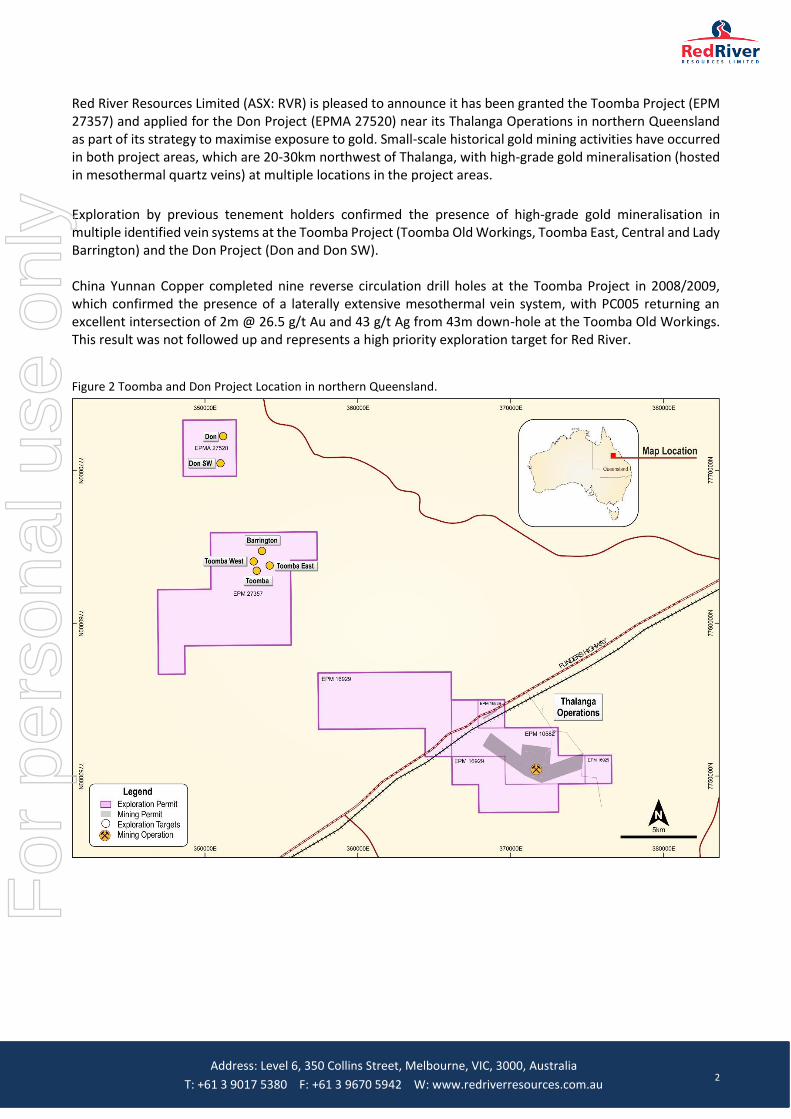
Red River Resources Limited (ASX: RVR) is pleased to announce it has been granted the Toomba Project (EPM 27357) and applied for the Don Project (EPMA 27520) near its Thalanga Operations in northern Queensland as part of its strategy to maximise exposure to gold. Small-scale historical gold mining activities have occurred in both project areas, which are 20-30km northwest of Thalanga, with high-grade gold mineralisation (hosted in mesothermal quartz veins) at multiple locations in the project areas.
Exploration by previous tenement holders confirmed the presence of high-grade gold mineralisation in multiple identified vein systems at the Toomba Project (Toomba Old Workings, Toomba East, Central and Lady Barrington) and the Don Project (Don and Don SW). China Yunnan Copper completed nine reverse circulation drill holes at the Toomba Project in 2008/2009, which confirmed the presence of a laterally extensive mesothermal vein system, with PC005 returning an excellent intersection of 2m @ 26.5 g/t Au and 43 g/t Ag from 43m down-hole at the Toomba Old Workings. This result was not followed up and represents a high priority exploration target for Red River.
Figure 2 Toomba and Don Project Location in northern Queensland.
For
per
sona
l use
onl
y

Address: Level 6, 350 Collins Street, Melbourne, VIC, 3000, Australia
T: +61 3 9017 5380 F: +61 3 9670 5942 W: www.redriverresources.com.au
3
Toomba Exploration and Mining History
Operations at the Toomba Mine (Toomba Old Workings) commenced in 1889, and several shafts were sunk, one to a depth of 130 feet. The workings were located on a fissure vein in granite, which was traced for about 450m on the surface. The fissure ranged from 30cm to 1.2 metres in thickness, consisting of quartz with pyrite, galena and sphalerite. Gold assays ranged from 15 dwt (pennyweights) to one ounce per ton. Total output is recorded as 335 ounces from the Toomba Mine (QLD Mines Dept 1936).
Figure 3 Toomba Geology Map (Identified Vein Systems)
Source: China Yunnan Copper Australia Limited (2009)
For
per
sona
l use
onl
y

Address: Level 6, 350 Collins Street, Melbourne, VIC, 3000, Australia
T: +61 3 9017 5380 F: +61 3 9670 5942 W: www.redriverresources.com.au
4
Toomba Project Area Geology and Mineralisation
Previous rock chip sampling by Mt Stewart Gold/China Yunan Copper between 2005 and 2010 produced high-grade gold (average gold value of 9 g/t Au) values with samples also returning results of up to 128 g/t Ag, 0.7% Cu, 3.4% Pb and 4.8% Zn.
The Central Vein is a zone of veining and veinlets seen in outcrop, float and historic exploration trenches for more than 400m with a further occurrence 800m to the north. Rock and chip sampling returned assay values of up to 9.65g/t Au.
The Toomba East Vein Zone strikes for more than 300m and has been mapped as a trend of small pits and exploration trenches with coincident area of sulphidic quartz veinlets as float on the surface. Samples returned maximum results of up to 6.25 g/t Au, 68 g/t Ag, 1.25% Pb and 0.15% Zn.
The Lady Barrington Vein has been exploited by a deep shaft and strikes for approximately 200m. Rock chip samples returned values to 8.81 g/t Au, 6 g/t Ag, 0.57% Pb and 0.18% Zn.
China Yunnan Copper (CYC) completed nine reverse circulation (RC) holes in 2008/2009 testing vein systems at the Toomba Project. Six RC holes (643m drilled) tested the Toomba Old Workings, two RC holes (215m drilled) tested the southern portion of the Central Vein structure and three RC holes (340m drilled) tested the Toomba East Vein.
Three RC holes (PC005, PC006 and PC007) tested the northern portion of the Toomba Old Workings. PC005 was designed to test the structure beneath the northern workings. PC005 intersected a quartz vein at 43 metres down hole, with a down hole width of approximately 1.3m. The intersection returned an excellent assay result of 2m @ 26.5 g/t Au, 43 g/t Ag, 0.4% Cu, 0.9% Pb and 1.8% Zn.
Table 1 Toomba Drill Hole PC005 Assays
Hole ID From To Down Hole Intersection
Au Ag Cu Pb Zn
(m) (m) (m) (g/t) (g/t) (%) (%) (%)
PC005 41.00 42.00 1.00 nd nd 0.0% 0.0% 0.0%
PC005 42.00 43.00 1.00 0.06 1 0.0% 0.0% 0.0%
PC005 43.00 44.00 1.00 48.97 62 0.6% 1.6% 3.3%
PC005 44.00 45.00 1.00 4.07 23 0.1% 0.2% 0.2%
PC005 45.00 46.00 1.00 0.34 2 0.0% 0.0% 0.0%
PC005 46.00 47.00 1.00 0.34 1 0.0% 0.0% 0.0%
PC005 47.00 48.00 1.00 0.04 nd 0.0% 0.0% 0.0%
PC005 48.00 49.00 1.00 0.04 nd 0.0% 0.0% 0.0%
PC005 49.00 50.00 1.00 0.32 1 0.0% 0.0% 0.0%
Source: CYC (2009)
PC0006 was drilled 50 metres to the south (from PC005) along strike and under more old workings and an outcropping zone of veinlets hosted in sericite altered granite. PC006 intersected a 5m wide zone of quartz veining from 47m to 52m downhole. The maximum gold assay was 1m @ 0.27 g/t Au and the main vein zone assay up to 0.19 g/t Au.
PC007 was drilled a further 116 metres south along strike under old workings. PC007 intersected a solid zone of vein quartz from 37m to 42m downhole. The main vein assayed to only 0.4 g/t Au and the best result came from the hanging wall veining (0.55 g/t Au).
The CYC drilling confirmed the presence of high-grade gold mineralisation at in the northern section of the Toomba Old Workings in a laterally extensive mesothermal vein system. This drilling has not been followed up and the intersection in PC005 is still open down dip and to the north.
For
per
sona
l use
onl
y

Address: Level 6, 350 Collins Street, Melbourne, VIC, 3000, Australia
T: +61 3 9017 5380 F: +61 3 9670 5942 W: www.redriverresources.com.au
5
Figure 4 Toomba Old Workings Drilling
Source: China Yunnan Copper Australia Limited (2009)
For
per
sona
l use
onl
y

Address: Level 6, 350 Collins Street, Melbourne, VIC, 3000, Australia
T: +61 3 9017 5380 F: +61 3 9670 5942 W: www.redriverresources.com.au
6
Figure 5 Historical Workings at Toomba
For
per
sona
l use
onl
y

Address: Level 6, 350 Collins Street, Melbourne, VIC, 3000, Australia
T: +61 3 9017 5380 F: +61 3 9670 5942 W: www.redriverresources.com.au
7
Don Project Exploration and Mining History
Historical mining activity in the Don Project area was limited to the Don and Don SW mines. At the former, historical records indicate a shaft was sunk on the Don reef to a depth of 53m and about 0.75m wide. Some stoping was undertaken at the 46m level and back to the 18m level. The ore crushed assayed about 1 oz Au. In 1935, ore from the surface was crushed and assayed at around 15 dwt (pennyweight, where 1 penny weight = 1.56 g/t) Au.
Don Project Area Geology and Mineralisation
Gold mineralisation at the Don deposit is hosted by a 0.4m to 2.0m thick quartz vein that extends over 250m, striking NNW with an average dip of 75° to the WSW. Several small pits expose an en échelon array of smaller quartz veins on the eastern side of the main vein, in an overall N-S zone. Historical samples of mineralised quartz vein material taken from mullock heaps contained between 1 to 3% galena-chalcopyrite-pyrite-bornite and returned assays up to 54.7 g/t Au.
The Don SW workings, about 600m SW of the Don Workings, extend over a N-S trend of approximately 400m. The main mineralised quartz vein observed at surface, extends over 270m, is 0.4-1.0m wide, strikes 345° and dips WSW at 70° to 80°. At the northern end of the reef, a set of shallow pits trace another quartz vein with a strike of 350° over a length of 180 metres. Historical sampling of mineralised quartz taken from mullock heaps contained 3-6% galena-chalcopyrite-pyrite-bornite, returning assays of up to 9.6 g/t Au.
At least five percussion holes were drilled by Rowe Drilling in 1992-3, from the west, but no company records of the drilling are available. It is understood that drilling was undertaken by prospectors on a speculative basis.
Next Steps
Red River has commenced exploration activities at Toomba (mapping, sampling) to be followed up by trenching to better define the extent of the vein systems prior to drilling. Upon grant of the Don tenement (expected shortly), Red River will commence similar activities.
On behalf of the Board,
Mel Palancian
Managing Director
Red River Resources Limited
For further information please visit Red River’s website or contact:
Mel Palancian Nathan Ryan
Managing Director NWR Communications
[email protected] [email protected]
D: +61 3 9017 5380 M: +61 420 582 887
For
per
sona
l use
onl
y

Address: Level 6, 350 Collins Street, Melbourne, VIC, 3000, Australia
T: +61 3 9017 5380 F: +61 3 9670 5942 W: www.redriverresources.com.au
8
Competent Persons Statement
Exploration Results
The information in this report that relates to Exploration Results is based on information compiled by Mr Steven Harper who is a member of The Australasian Institute of Mining and Metallurgy, and a full time employee of Red River Resources Ltd., and who has sufficient experience relevant to the style of mineralisation and type of deposit under consideration and to the activities being undertaken to qualify as a Competent Person as defined in the 2012 Edition of the ‘Australasian Code for Reporting Exploration Results, Mineral Resources and Ore Reserves’ (JORC Code).
Mr Harper consents to the inclusion in this report of the matters based on the information in the form and context in which it appears.
For
per
sona
l use
onl
y

Address: Level 6, 350 Collins Street, Melbourne, VIC, 3000, Australia
T: +61 3 9017 5380 F: +61 3 9670 5942 W: www.redriverresources.com.au
9
JORC Code, 2012 Edition – Table 1
Section 1 Sampling Techniques and Data
Criteria JORC Code explanation Commentary
Sampling techniques
• Nature and quality of sampling (eg cut channels, random chips, or specific specialised industry standard measurement tools appropriate to the minerals under investigation, such as down hole gamma sondes, or handheld XRF instruments, etc). These examples should not be taken as limiting the broad meaning of sampling.
• Include reference to measures taken to ensure sample representivity and the appropriate calibration of any measurement tools or systems used.
• Aspects of the determination of mineralisation that are Material to the Public Report.
• In cases where ‘industry standard’ work has been done this would be relatively simple (eg ‘reverse circulation drilling was used to obtain 1 m samples from which 3 kg was pulverised to produce a 30 g charge for fire assay’). In other cases more explanation may be required, such as where there is coarse gold that has inherent sampling problems. Unusual commodities or mineralisation types (eg submarine nodules) may warrant disclosure of detailed information.
• All information in this table is based on information in reports submitted to the Queensland Department of Natural Resources, Mines and Energy by China Yunnan Copper Australia Limited (CYC) for EPM 12900 in 2008, 2009 and 2010
• Reverse circulation drilling was used to obtain 1m samples from which a 1 to 2kg sample was spilt using a riffle splitter.
• The 1 to 2 kg sample was submitted to Genalysis in Townsville for gold assay by 50g Fire Assay and AAS determination. Copper, lead, zinc and silver were determined by multi acid extraction and AAS finish.
• CYC Soil sampling collected on 25 x 250m grid. The sample were sieved to -80# (175um) in the field and sent to ALS in Townsville for analysis. Au was analysed using a 25g sample with Aqua Regia leach and ICP-MS determination. A multi element suite was assayed by Aqua Regia with ICP-AES finish.
• Rock chip samples. Submitted to ALS in Townsville for analysis. Au by 30g fire assay and AAS determination and multi element suite by ICP-AES.
Drilling techniques
• Drill type (eg core, reverse circulation, open-hole hammer, rotary air blast, auger, Bangka, sonic, etc) and details (eg core diameter, triple or standard tube, depth of diamond tails, face-sampling bit or other type, whether core is oriented and if so, by what method, etc).
• The drilling by CYC on EPM 12900 was reverse circulation. The drilling contractor was L.A. Boyle using a Bilby drill rig. Hole diameter was 133mm. Bit details were not given.
Drill sample recovery
• Method of recording and assessing core and chip sample recoveries and results assessed.
• Measures taken to maximise sample recovery and ensure representative nature of the samples.
• Whether a relationship exists between sample recovery and grade and whether sample bias may have occurred due to preferential loss/gain of fine/coarse material.
Holes were sampled at 1m intervals over the full length of each hole. No information was reported by CYC in relation to sample recovery
Logging • Whether core and chip samples have been geologically and geotechnically logged to a level of detail to support appropriate Mineral Resource estimation,
Drill chip samples for the entire holes were geologically logged by the supervising geologist.
For
per
sona
l use
onl
y
Address: Level 6, 350 Collins Street, Melbourne, VIC, 3000, Australia
T: +61 3 9017 5380 F: +61 3 9670 5942 W: www.redriverresources.com.au
10
Criteria JORC Code explanation Commentary
mining studies and metallurgical studies.
• Whether logging is qualitative or quantitative in nature. Core (or costean, channel, etc) photography.
• The total length and percentage of the relevant intersections logged.
Sub-sampling techniques and sample preparation
• If core, whether cut or sawn and whether quarter, half or all core taken.
• If non-core, whether riffled, tube sampled, rotary split, etc and whether sampled wet or dry.
• For all sample types, the nature, quality and appropriateness of the sample preparation technique.
• Quality control procedures adopted for all sub-sampling stages to maximise representivity of samples.
• Measures taken to ensure that the sampling is representative of the in situ material collected, including for instance results for field duplicate/second-half sampling.
• Whether sample sizes are appropriate to the grain size of the material being sampled.
• The 1m drill samples were riffle split to produce a 1 to 2kg sample for analysis.
• There is no mention of whether the samples were wet or dry in the CYC reports.
• Riffle splitting the sample is an appropriate technique to maximise representivity of samples for analysis.
• There is no mention of field duplicate sampling in the CYC report of data files.
• There is no mention of quality control procedures in the CYC report.
• Sample size is considered appropriate to the grain size of the material being samples.
Quality of assay data and laboratory tests
• The nature, quality and appropriateness of the assaying and laboratory procedures used and whether the technique is considered partial or total.
• For geophysical tools, spectrometers, handheld XRF instruments, etc, the parameters used in determining the analysis including instrument make and model, reading times, calibrations factors applied and their derivation, etc.
• Nature of quality control procedures adopted (eg standards, blanks, duplicates, external laboratory checks) and whether acceptable levels of accuracy (ie lack of bias) and precision have been established.
• The assay methods employed are considered appropriate for near total digestion AAS.
• The CYC reports do not include any information on quality control procedures used.
Verification of sampling and assaying
• The verification of significant intersections by either independent or alternative company personnel.
• The use of twinned holes.
• Documentation of primary data, data entry procedures, data verification, data storage (physical and electronic) protocols.
• Discuss any adjustment to assay data.
• No verification of significant intersections was reported by CYC
Location of data points
• Accuracy and quality of surveys used to locate drill holes (collar and down-hole
• Location of drill holes are recorded in GDA 94 MGA Z55 UTM coordinates.
• There is no mention of the method used or
For
per
sona
l use
onl
y

Address: Level 6, 350 Collins Street, Melbourne, VIC, 3000, Australia
T: +61 3 9017 5380 F: +61 3 9670 5942 W: www.redriverresources.com.au
11
Criteria JORC Code explanation Commentary
surveys), trenches, mine workings and other locations used in Mineral Resource estimation.
• Specification of the grid system used.
• Quality and adequacy of topographic control.
accuracy limits to locate the drill holes in the CYC reports.
• Downhole surveys were taken on the drill holes at the rate of 1 per 40 to 50m. No mention of method used.
• There is no mention of the method used or accuracy of topographic control in the CYC reports.
Data spacing and distribution
• Data spacing for reporting of Exploration Results.
• Whether the data spacing and distribution is sufficient to establish the degree of geological and grade continuity appropriate for the Mineral Resource and Ore Reserve estimation procedure(s) and classifications applied.
• Whether sample compositing has been applied.
• The drilling was reconnaissance in nature with holes widely spaced to test specific targets outlined in the CYC report.
• No sample compositing was applied.
Orientation of data in relation to geological structure
• Whether the orientation of sampling achieves unbiased sampling of possible structures and the extent to which this is known, considering the deposit type.
• If the relationship between the drilling orientation and the orientation of key mineralised structures is considered to have introduced a sampling bias, this should be assessed and reported if material.
• The drilling was reconnaissance in nature. The drill holes testing the reef were oriented perpendicular to the reef to obtain a representative intersection and sample of the reef.
• Other holes were oriented to test the specific target.
Sample security
• The measures taken to ensure sample security.
• No mention in CYC reports
Audits or reviews
• The results of any audits or reviews of sampling techniques and data.
• No mention in CYC reports
For
per
sona
l use
onl
y

Address: Level 6, 350 Collins Street, Melbourne, VIC, 3000, Australia
T: +61 3 9017 5380 F: +61 3 9670 5942 W: www.redriverresources.com.au
12
Section 2 Reporting of Exploration Results
Criteria JORC Code explanation Commentary
Mineral tenement and land tenure status
• Type, reference name/number, location and ownership including agreements or material issues with third parties such as joint ventures, partnerships, overriding royalties, native title interests, historical sites, wilderness or national park and environmental settings.
• The security of the tenure held at the time of reporting along with any known impediments to obtaining a licence to operate in the area.
• EPM 27357, owned by Cromarty Resources Pty Ltd a wholly owned subsidiary of Red River Resources Limited.
• EPM 27357 is located approximately 70km SW of Charters Towers in a direct line and 85km by road. Access is via the Flinders Highway approximately 70km SW of Charters Towers then access via farm tracks through the Allendale station.
• Native Title does not exist over the tenement but is subject to NTPC’s
Exploration done by other parties
• Acknowledgment and appraisal of exploration by other parties.
• The historic Toomba workings have been explored by numerous exploration tenements since the 1970’s, however only 4 companies have reported work on Toomba.
• Ravenswood Resources Limited, AtoP 4764, 1987-1988. Completed air photo interpretation, rock chip samples, Bulk cyanide leach stream sediment sampling. o Rock chips of selected quartz vein mullock
returned Au results between 0.6 and 27g/t Au o 130 stream sediment samples analysed by
bulk cyanide leach method. Identified 8 anomalies
o Interpretation: Examination of the Toomba
workings indicate significant strike length,
with mineralised samples returning up to
27g/t Au from relatively narrow vein system.
Sampling of altered wall rocks returned Au
values up to 0.65g/t indicating potential for a
wider zone of gold mineralisation. The shear
zone hosting the mineralisation trends north
south.
• MPI Gold, EPM 9637, 1994. MPI Gold. 1994. Target
was breccia pipe hosted gold mineralisation similar
to that occurring in the Lolworth Goldfield to the
northwest or gold bearing quartz veins associated
with intrusive rocks. Completed a BLEG stream
sediment survey over selected parts of the EPM
and reconnaissance over known deposits.
o 153 stream samples analysed for gold by Bulk
Leach Extractable Gold (BLEG) method. 33
samples returned results greater than 1ppb,
most associated with minor known
mineralisation.
o 17 rock chip samples. Highest results up to
34g/t Au from selected dump material at
Toomba.
• QLD Gold Pty Ltd, EPM 10625, 1996-1998.
For
per
sona
l use
onl
y

Address: Level 6, 350 Collins Street, Melbourne, VIC, 3000, Australia
T: +61 3 9017 5380 F: +61 3 9670 5942 W: www.redriverresources.com.au
13
Criteria JORC Code explanation Commentary
Conducted review of previous exploration, helicopter reconnaissance, target selection. No field work was completed.
• China Yunnan Copper Australia Limited (CYC), EPM 12900, Aug 2007 – Aug 2010. During these years CYC completed reconnaissance mapping, rock chip sampling, soil sampling, 4 lines of dipole-dipole IP surveying, 15 reverse circulation drill holes, ground magnetic survey. o Reconnaissance mapping of historic workings
and mineralised structures.
o Soil sampling. Samples collected at 25m
intervals on 250 m spaced lines. 7 x 1.5km
long lines sampled. Identified several zones of
anomalous gold. Anomalous Au results
generally corresponded with known vein
structures. Maximum gold value was 567ppb
which is located to the southeast of the
Toomba East veins. Other anomalous zones
occur to the northwest and west of the known
reefs.
o Rock chip sampling. Selective sampling of
outcrop and mineralised waste piles around
old workings and vein outcrops. 65 samples
collected. Results up to 9g/t Au, 128 g/t Ag,
6570ppm Cu, 3.41% Pb and 4.8% Zn from
Toomba workings. Other veins returned gold
values up to 9.65g/t.
o IP survey. Four lines of IP were surveyed
across Toomba. Lines were 250m apart with
100m spaced dipoles. The interpretation of
the IP sections identified 4 IP anomaly trends.
o Reverse Circulation (RC) drilling. 15 holes for
1784m with holes ranging in depth from 91 to
247m. six holes targeted the Toomba
workings, 2 tested the southern portion of the
central vein, 3 tested the Toomba East
structure and 1 tested the area of sub-
cropping veinlets and stockwork with
coincident IP and soil anomaly at Toomba
East. Two holes were drilled as pre-collars for
diamond tails but these failed to reach
planned depth due to drilling issues and
diamond drilling to test the deep IP anomalies
was not completed. The best assay results
were in hole PC005 with 2m @ 2m @ 27.5g/t
Au, 42.5 ppm Ag, 0.3% Cu, 0.9% Pb and 1.7%
Zn in a quartz vein array. Hole PC005 was
targeting the structure beneath the northern
For
per
sona
l use
onl
y

Address: Level 6, 350 Collins Street, Melbourne, VIC, 3000, Australia
T: +61 3 9017 5380 F: +61 3 9670 5942 W: www.redriverresources.com.au
14
Criteria JORC Code explanation Commentary
Toomba workings. The other hole to return
an intersection greater than 1g/t Au was
PC014 which contained 1m @ 1.64g/t Au with
anomalous base metals from 82m down hole.
The hole was drilled beneath small pit on the
Toomba East vein. The other holes testing
beneath the old workings and veins did not
return any significant Au values. The drill
holes testing the IP targets did not return any
significant Au results.
o Ground magnetic survey. Conducted by Terra
Search Pty Ltd for CYC. Survey consisted of
50m spaced lines with lengths of 2.5km for
120 line km of surveying. Line guidance was
provided by the inbuilt GPS.
CYC relinquished the EPM in 2010.
Geology • Deposit type, geological setting and style of mineralisation.
• The deposit type is quartz vein hosted gold of Charters Towers style hosted within the granite of the Lolworth batholith which is part of the Lolworth--Ravenswood Province.
Drill hole Information
• A summary of all information material to the understanding of the exploration results including a tabulation of the following information for all Material drill holes, including, easting and northing, elevation or RL, dip and azimuth, down hole length, interception depth and hole length.
• If the exclusion of this information is justified the Competent Person should clearly explain why this is the case.
• Refer table below for drill hole collar details and significant intercepts.
• The holes are reconnaissance in nature testing particular targets, features along the reefs, structures and geophysical anomalies at Toomba.
• From the reporting by CYC the holes appear to have successfully intersected the target zone except for holes PC009 and PC011 which were drilled as pre-collars for deeper diamond drilling. Hole PC009 and PC011 failed to reach planned depth and the diamond drilling was not conducted. Drill hole PC008 failed in the collar and was re-drilled as PC009.
• The holes were assayed at 1m intervals for the entire hole.
Data aggregation methods
• In reporting Exploration Results, weighting averaging techniques, maximum and/or minimum grade truncations (eg cutting of high grades) and cut-off grades are usually Material and should be stated.
• Where aggregate intercepts incorporate short lengths of high grade results and longer lengths of low grade results, the procedure used for such aggregation should be stated and some typical examples of such aggregations should be shown in detail.
• No data aggregation methods were used in the reporting of the CYC drill results.
For
per
sona
l use
onl
y

Address: Level 6, 350 Collins Street, Melbourne, VIC, 3000, Australia
T: +61 3 9017 5380 F: +61 3 9670 5942 W: www.redriverresources.com.au
15
Criteria JORC Code explanation Commentary
• The assumptions used for any reporting of metal equivalent values should be clearly stated.
Relationship between mineralisation widths and intercept lengths
• These relationships are particularly important in the reporting of Exploration Results.
• If the geometry of the mineralisation with respect to the drill hole angle is known, its nature should be reported.
• If it is not known and only the down hole lengths are reported, there should be a clear statement to this effect (eg ‘down hole length, true width not known’).
• From the plans available in the CYC annual reports the drill holes testing the workings and veins were oriented perpendicular to the surface trend of the veins and workings.
• The down hole lengths have been reported.
Diagrams • Appropriate maps and sections (with scales) and tabulations of intercepts should be included for any significant discovery being reported. These should include, but not be limited to a plans and sections.
• Refer to plan in report
Balanced reporting
• Where comprehensive reporting of all Exploration Results is not practicable, representative reporting of both low and high grades and/or widths should be practiced to avoid misleading reporting of Exploration Results.
• Refer to ”Exploration done by other parties” section
Other substantive exploration data
• Other exploration data, if meaningful and material, should be reported.
• Refer to ”Exploration done by other parties” section
Further work • The nature and scale of planned further work (eg tests for lateral extensions or depth extensions or large-scale step-out drilling).
• Rock chip and infill soil sampling, trenching, drilling
For
per
sona
l use
onl
y