records of wells, drillers' logs, water-level measurements ... · post office box 130b7...
TRANSCRIPT

TEXAS WATER DEVELOPMENT BOARD
REPORT 202
RECORDS OF WELLS, DRILLERS' LOGS, WATER-LEVEL
MEASUREMENTS, AND CHEMICAL ANALYSES OF
GROUND WATER IN CHAMBERS, LIBERTY, AND
MONTGOMERY COUNTIES, TEXAS, 1966-74
By
W. L. Naftel, Bobbie Fleming, and Kenneth VaughtUnited States Geological Survey
This report was prepared by the U.S. Geological Surveyunder cooperative agreement with the
Texas Water Development Board
March 1976

,.
TEXAS WATER DEVELOPMENT BOARD
A. L. Black, ChairmanMilton PotuJohn H. Garrett
Robert B. Gilmore, Vice ChairmenGaorge W. McCleskeyGlan E. Roney
Jlmes M. Rose, Executive Director
Authorization for use or reproduction of any original material contained inthis publication, i.e., not obtained from other sources, is freely granted. The Boardwould appreciate acknowledgement.
Published and distributedby the
Texas Water Development BoardPost Office Box 130B7Austin, Texas 78711
ii

TABLE OF CONTENTS
INTRODUCTION
WELL-NUMBERING SYSTEM
REFERENCES CITED
TABLES
1. Records of Wells in Chambers County .
2. Drillers' Logs of Wells in Chambers County
3. Water Levels in Wells in Chambers County
4. Chemical Analyses of Water From Wells in Chambers County
5. Records of Wells in Liberty County
6. Drillers' Logs of Wells in Liberty County
7. Water Levels in Wells in Liberty County
8. Chemical Analyses of Water From Wells in Liberty County
9. Records of Wells in Montgomery County .
10. Drillers' Logs of Wells in Montgomery County
11. Water Levels in Wells in Montgomery County
12. Chemical Analyses of Water From Wells in Montgomery County
FIGURES
Page
2
3
5
9
12
15
17
24
28
31
37
60
62
1.
2.
3.
Map Showing Locations of Wells in Chambers County
Map Showing Locations of Wells in Liberty County
Map Showing Locations of Wells in Montgomery County
iii
13
29
63

(

RECORDS OF WELLS, DRILLERS' LOGS, WATER-LEVEL
MEASUREMENTS, AND CHEMICAL ANALYSES OF
GROUND WATER IN CHAMBERS, LIBERTY, AND
MONTGOMERY COUNTIES, TEXAS, 1966-74
INTRODUCTION
Reports describing the ground-water resources ofChambers, Liberty, and Montgomery Counties wereprepared and published in 1971, 196B, and 1971,respectively. Wesselman and Aronow (1971), indescribing the resources of Chambers County, tabulatedrecords of wells, drillers' logs, water-level measurements,and chemical analyses gathered during the course oftheir study.
Th is report presents data collected since theinvestigation by Wesselman and Aronow (1971) andupdates records tabulated by Anders and others (196B)in Liberty County, and by Popkin (1971) inMontgomery County. These records are being collectedin cooperation with the Texas Water Development Boardto evaluate the ground-water resources of the greaterHouston-Galveston region.
Most of the chemical analyses presented in thisreport were determined in the laboratories of the U.S.Geological Survey, but some data were obtained fromcommercial analyses. Dissolved nitrite plus nitrate (N),dissolved orthophosphorous (P), dissolved solids (sum ofconstitutents), hardness (Ca, Mg), percent sodium,residual sodium carbonate (RSC), and sodiumadsorption ratio (SAR) were recalculated fromcommercial analyses to correspond to the U.S.Geological Survey reporting methods.
The English units used in this report may beconverted to metric units by the following conversionfactors:
FROM MULTIPLY BY TO OBTAIN
feet 0.304B meters
gallons per liters perminute .06309 second
inches 2.54 centimeters
WELL-NUMBERING SYSTEM
The well-numbering system used in this report wasdevised by the Texas Water Development Board for usethroughout the State. Under this system, each l-degreequadrangle is given a number consisting of two digits.These are the first two digits in the well number. Eachl·degree quadrangle is divided into 71k-minutequadrangles which are given two-digit numbers from 01to 64. These are the third and fourth digits of the wellnumber. Each 7Vi-minute quadrangle is divided into21k-minute quadrangles which are given a single-digitnumber from 1 to 9. This is the fifth digit of the wellnumber. Finally, each well within a 2Vi-minutequadrangle is given a two-digit number in the order inwhich it was inventoried, starting with 01. These are thelast two digits of the well number.
On the well-location maps (Figures 1-3), only thelast three digits of the well number are shown at eachwell location; the second two digits are shown in thenorthwest corner of each 7Vi-minute quadrangle; and thefirst two digits are shown by the large block numerals60, 61, 64, and 65.
In addition to the seven-digit well number, atwo·letter prefix is used to identify the county. Theprefix for Chambers County is DH; for Liberty County,S8; and for Montgomery County, TS.

REFERENCES CITED
Anders, R. B., McAdoo, G. D., and Alexander, W. H.,Jr., 1968, Ground-water resources of Liberty County,Texas: Texas Water Devel. Board Rept.72, 154 p.,20 figs.
Wesselman, J. B.; and Aronow, Saul, 1971,Ground-water resources of Chambers and JeffersonCounties, Texas: Texas Water Deve!. BoardRept. 133, 138 p., 28 figs.
Popkin, B. P., 1971, Ground-waterMontgomery County, Texas: TexasBoard Rept. 136, 149 p., 29 figs.
resources ofWater Devel.
- 2-

WaCflr levOllaMethod of lHL and type of powerUle of watorWllter-bearing unlte
Table I.--Recordl of Welle In Chambera County
Ileporud water levell given in feet; ....alured water levels given in feet and tenths.~, alactril;: l Sub, eubmeu ib Ie; T, turbine; W, ... Ind; H, none. Nutllber lnd iCltes hOU<lIl<JWer.0, dome.tie; lnd, indu.crial; P, publil;: supply; S, liveaeol;:k; N, none.C, Chicot /lquifer; CU, upp<lr unit of Chieot nquUer; CL, lower unit Or Chicot aquifer; E, Evangol1ne aquHer,
w
Caain Wilter levelDato Depth Dlam- Dtlpth Water- Altitudu IAbove (+) or Da til of HcthOc """". Owner Driller com- o, eter (ft. ) bUllring of land bl!luw hnl! ITICllourument or or RCfl\Ul'ka
pie ted well (In. ) unit surface KurfaCII IUt water(ft. ) (ft. ) dlltum
(ft. ,
011-64-02-805 Dodson A6L Pump lind Willi 1972 32S 4 294 CL 25 60 Hay 2, 1972 Sub,!'.: D ScrClln from 315 to 325 fflet ..!!Serv1cG 2 1/2 32S I
'DO B. Pace '0. 1972 '" 4 294 CL 25 60 Hay l, 1972 Sub,l': I) Screen from 305 to 315 fect.Jj2 1/2 '" I
• 09-207 Werren Porroleu.. COrp., Layne-Toxu CO. 1967 1,497 10 l,06Z ," i6D Dec. S, 1967 T,' lod 151 filet of acretln between 1,075 and
Well Z 10 1,497 1,1.80 feet, Reporud y1eld 1,018 gnl/lIlln... ith 128 feet cra...down when drilled •.!!
• '" Watren Potroleum Corp., do. 1970 96D 16 '15 , 29 '69 Aug. 17, 1970 T,E 10' 120 feot of lIcreen bet....en 685 and 948Woll 3 10 96D t.56,8 Oct, 11, 1972 150 h.t, Reported yield 709 gal/.ln with
93 reot dr....down ...hen drilled,.!!
• "6 City of Hont Belvieu, do. 1971 4" 6 400 CL 40 112 Nov. 11, 1971 Sub,E , Screen fro- 406 to 1,47 feet. ReportedCherry Point Ranchette. 4 4" , yielc 610 gal/..in ...ith 79 [Cllt dr.wown
when drillod ..!l611 BUI Wallaee A6L PUI'lP and We tI 1969 J5l 4 '" C " 140 Jan, 15, 1969 Sub,l:: , Sl;:rllen frOlll 331 to 35l £eet.l!
Sllrvlca Z I/Z 351 ,618 Contlnenclll Oil Co. Lowry Water WellR 1968 138 4 -- C 30 36 Filb. I, 1968 Sub,!': ,"d Screen from 123 to l33 teet. SuppUell
Z l/Z 138 1 sel'v1ce /Jtatlon.
• 811 1I11u_ton I.1ghtlng (. Layne-1'lIxall Co. 1967 "2 24 " CL 10 120 Oct. 10, 1967 T,I~ Iod 70 fool of /Jeraen bot"'cetl 324 Ilnd 39(1PO'oIer, Cedar Illlyou 18 315 1(.7.7 HIlr. Z6, 1971 125 feet. Reportud yield 1,000 8ill/mln withPlant, Willi I 12 402 55 feet druwltown ... lIan drllled.lI
• 812 llou8ton LlRhting (. '0, 1967 409 24 24 <1 11 120 Nov. III, 1967 Sub,.; Iod 411 faet of Acraen between 352 llnd (100Power, cedar BIlYou 18 342 15 het. Reported yll1ld 650 gal/lIlin withPlont, Well 2 12 409 43 hOlt drllwdown ...hen drUled.y
• 921 Houston Ughtill8 & do. 1967 1.03 24 " CL 24 119 Dec. ZO, 1967 Sub,E Iod }6 follL of IIcrllun between 335 llnd 391Power, Cedar Iloyou 18 '" 135.3 HIIr. 26, 1971 15 feet. Reported ylOlld 650 8iJ!lIlin with 41Plant, Well 3 12 4" feet drawdown "'hen dr11led.2
922 Clyda Kally MI. ru..p and Well 1969 340 4 '" CL II 126 Sept, 3, 1969 Sub,! D Scr..n from 300 to 315 feet.l/Sarvic. 2 l/Z 34D
m AnahUllc TO\Iinij & Shell Frenk II n we II Service 1973 144 4 144 '" 24 10 Aug. 20, 1973 Sub,! lod Screen frOlll 13(, to;> 144 feet.yCo. I 1/2
10"'111 Theo Wilborn do. 1972. 320 4 '" C 42 " Feb. 23, 1972. Sub,E D Screen frOlll 310 to 320 feet.})Z 1/2 320
• 112 u.arber'e 11l1i School Layne-Taxal Co. 1967 '" 8 430 " 34 206 Har. 30, 1967 T,E I' Screen from 439 to 480 feet. Reported,'" yield 112 gal/llIi" ... ith 6 feet drawdown ..!!
412 P. R. Herrington O'l)lIy Drll11ng Co. 1969 '10 4 '" CL " 86 Mar. 14, 1969 Sub,r. P Seroll" from 490 to 510 feet, ReportedZ 1/2 "0 , yiald IZO gal/min. Suppllea mobile hOllll!
pllrk,..!1
f Sell tllbla 4 for ehemlcnl analysll8 ef ...ater frolll ...ell ••.!! See Cllblo Z for drllhn' log_ of ...111111.y See table 3 for ...ater Ievula in wella.

...
Table l.--Recordl of Wdll In Chamberl County--ContLnued
GaBin \IlIter l~ve1
Datil llepth Dlam- Dopth Wilter- Altitude bovo (+) Dr Dace of MBtllOd U..'0. Owner Dr iller <~ or eter (ft, ) bearing of lind below land 1Dl!1lSurement of of RelMrk"pleted Willi (in. ) unit lurfllce aurface Lift water
(ft, ) (ft, )~~~~~
DH-64-10-413 Lonnie Plehor NOolIck Drilling CD. 1966 'SO , 680 CL " 90 Apr. 28. 1966 Sub.E 0 Screen frOlll 480 to 500 feet.l!3 '00 lll, 5 Oct. 12, 1972 ,
712 General Telephone LOIfry Water Wells 1971 '68 4 U. CU 36 38 July 13, 1971 Sub,E 0 Screen from 159 to 164 (eoLj)2 1/2 '"
11-208 Hr. 81ssa Franklin Well Servicil 1972 '" 4 ,,, CU 20 12 Oct. 6, 1972 Sub,E 0 Screen from 142 to lS2 feoe.J)Co. ,
308 White Memorh L Park do. 1968 142 4 142 ru 22 20 H,,,. 8, 1968 Sub,E P Screen [rOlll 132 to 142 feet, Supplieu24.1 Oct. ll, 1972 1 1/2 county park ..!!
'09 Tllxaco, Inc. Il&L Water VeU Service 1969 14' 4 141 CU 26 20 Aug. 1969 Sub,E 10d ScreeD fro.- 130 to 141 feet. Supplies22.5 Oct. 11, 1972 1 1/2 lIerv1.cll IItatlon.lI
310 do. do. 1969 331 4 331 CU 27 31 Au8· 1969 Sub,E Iud Screen frOlll 320 to )31 feet. suppaes24.5 Oct. 11, 1972 1 1/2 .ervice stetioo.j}
403 Corp. of F.ugineera J>nnklln Well Service 1972 34' 4 42 CL 4 36 Peb. 29, 1972 -- U Screen (rOlll 336 to 346 feet.j}Co. 2 34' 29.0 Oct. 11, 1972
1)·)06 Trinity Bay Conllerva- LaY"e-TexaB Co. 1974 '" " -- CU 27 " Ho<. 1974 -- , 50 feet of screen between 130 aDd 199tion District. Well 3 10 240 feet. Reported yLllld 25ll 8111/mln with 30
filet drawd-., whon drilled .
307 Harry Chua Franklin W,,11 Sllrv!c:. 1974 170 4 170 C 30 " Jun. 9, 1974 Sub,E 0 Scree" from 160 to 170 feet..!!Co.
401 O. C. Oevl111or, Jr. do. 1972 170 4 l70 CU 24 18 Hoy I, 1972 Sub,E S Screen from 160 to 170 fut.l!1/2
'" E. J. Duger do. 1972 160 4 160 CU 28 38 July I, L972 Sub.E 0 Screen fro. ISO to 160 [eot.1/2
18-605 Exxon Co. Exxon Co. -- -- , -- CL7 0 51.0 Aug. 2, 1971, , , LOC4ted In ClIlVOIcon Bay.y90' do. do. -- -- , -- CLY 0 38.7 Hoy 23, 1969 , , Located In GlIlveston 88Y.y
46.7 Aug. 2, 1971,
21-205 Sun Oil Co. Sun 011 Co. -- '50 4 '50 C " 20.0 Kar. 15, 1967 , , Supply well for oLl teBt.y23.2 HIlr. 27, 1974
26-808 Exxon Co. Exxon Co. -- -- , -- CLI 0 56.5 Hoy 23, 1969 , , LOCllted In Glllvuton llay.y5B.I Hoy 15, 1973
28-304 AnahullC WLldlLfo r/l.nkl1" Well Sllrvlce 1974 342 ,. '" CL , 12 July 19, 1974 Sub,E P Screen from 332 to 342 feet,Refugll Co. ,
60' do. do. 1972 242 ,'" C ] 12 June 19, 1974 w S Screen frOGl 232 to 242 (eet.l!
2 1/2 '"I See table
JJ. See tableIi 5118 ulble
for chomical anlllYBlll of water from WOUI.for drillerl' 10g8 of wella.for waur levelB Ln weill.

Table 2.--Drillers· Logs of Wells in C~~bers County
THICKNESS(FEET )
Well DH-64-02-805Owner: Dodson
Driller: A&L Pump and Well Service
DEPTH(FEET)
THICKNESS(FEET)
It.Te11 DH-64- 09- 207- - Continued
Shale, s~~dy and shale
DEPTH(FEET)
1,012
Surface
Clay, yelle....
Clay, blue
Sand
Clay, blue
Sand
5
LO
50
35
5
95
130
280
325
Sand
Shale, sandy
Sand, fLrle
Shale, sancy
Sand (broken)
Shale, sandy and sand
L8
6
37
41
6
30
1,060
1,066
1,103
1,144
1,150
1,180
Well DH-64-02-806Owner: B. Pace
Dri:ler: A&L ~p ~~d Well Service
Shale
Sand (broken)
20
40
1,200
1,240
Surface
Clay, ye now
Clay, blue
Sand
Clay, blue
Sand
WellOw-ner: Warren
Driller:
DH-64- 05l- 207Fetroleum Corp.,
Layne- Texa s Co.
5
40
50
30
155
35
r...·ell 2
5
45
95
125
280
315
Shale
Sand
Shale
Sand
Shale
Shale, sand~,.
Sand
Shale
30
10
24
16
25
30
112
5
1,270
1,280
1,304
1,320
1,375
1,487
1,492
Topsoil
Clay
Sand
ShaJ. e
Sand
Shale
Sand
Shale, sandy
Sand
Shale, blue
Sha Ie, sandy
5
100
60
23
25
27
29
60
53
59
10
5
105
165
188
213
240
269
329
382
441
451
rtiell DH-6!.-09-335Owner: Warren Petroleum Corp., Well 3
Driller: La~-r..e-Texas Co.
Topsoil 21. 24
Clay 49 73
Shale 40 113
Sand 52 165
Shale 43 208
Sand 13 221
Shale 20 241
Sand 11 252
Shale 19 271
Sand
Shale, sandy
Sand
Shale, sandy
Sand
Shale
Shale, sandy
112
182
95
11
19
8
30
563
851
870
878
·5·
sand and sandy shale
Shale
Sand
Shale
Sand
Sand and rock layers
Sand
16
28
47
69
99
18
15
287
315
362
431
530
548
563
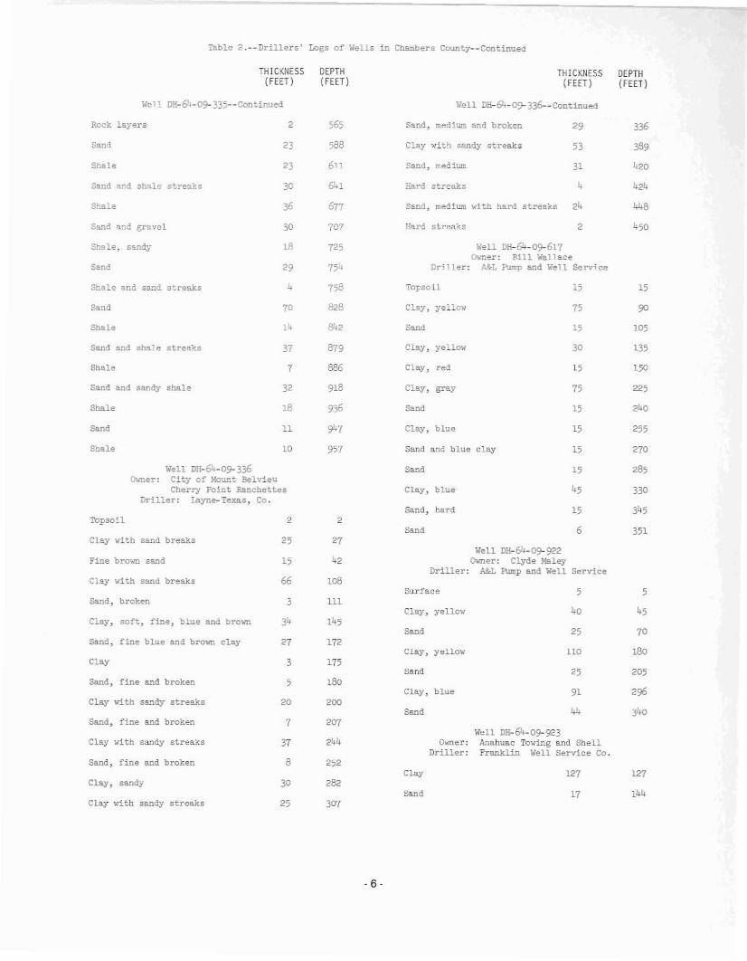
Table 2.--Drillers' Logs of Wells in Ch~bers County--Continued
THICKNESS(FEET)
DEPTH{FEET}
THICKNESS(FEET)
DEPTH{FEET}
,,"'ell DH-6L-Q9- 335--Contir.ued ~'ell DH-611-09- 336--Continued
Rock layers
Sand
Shale
2
23
23
565
588
6n
Sand, medium and broken 29
Clay ..dth sandy streaks 53
Sand, .t:1ed ium 31
336
389
420
Hard streaks 2
?ard streaks 4
Sand, medium with hard streaks 24
Well DH-64-09-617~ner: Bill Wallace
Driller: A&L Pump and Well Service
105
424
448
150
15
135
255
225
240
15
15
15
75
15
30
75
15
Sand
Clay, yellow
Topsoil
Clay, red
Clay, yeHow
Clay, gray
Clay. blue
Sand
75'*
707
725
641
677
758
828
842
879
886
918
936
947
30
36
30
18
14
11
70
37
7
32
29
4
18
Sand 8:ld gravel
Shale
Shale, sandy
Shale and sand s~reaks
Sand
Sand a~d shale stre~ks
Sand
Shale
Sand and shale streaks
Sand and sandy shale
Shale
Shale
Sand
Shale 10 957 Sand and blue clay 15 270
Well DH-64-0!'-336D••ner: City of Mount Belvieu
Cherry Point PBnchettesDriller: Layne-Texas, Co.
Well DH-64-09-922Oomer: Clyde Paley
Driller: A&L Pump and Well Service
Well DH-64-0!'-923~~er: Anahuac Towing and Shell
Driller: Franklin Well Service Co.
Topsoil
Clay with sand breaks
Fine brown sand
Clay ~ith sand breaks
Sand, broken
Clay, soft, fine, blue and brown
Sand, fine blue and brown clay
Clay
Sand, fine and broken
Clay with sandy streaks
Sand, fine and broken
Clay with sandy streaks
Sand, fine and broken
Clay, sandy
Clay with sandy streaks
2
25
15
66
3
34
27
3
5
20
7
37
8
30
25
2
27
2
loB
111
172
175
180
200
207
244
252
282
307
Sand
Clay, blue
sand, hard
Sand
Surface
Clay, yellow
Sand
Clay, yellow
Sand
Clay, blue
Sand
Clay
Sand
15
15
6
5
40
25
110
25
91
44
127
17
285
330
345
351
5
45
70
180
205
296
340
127
144
- 6-
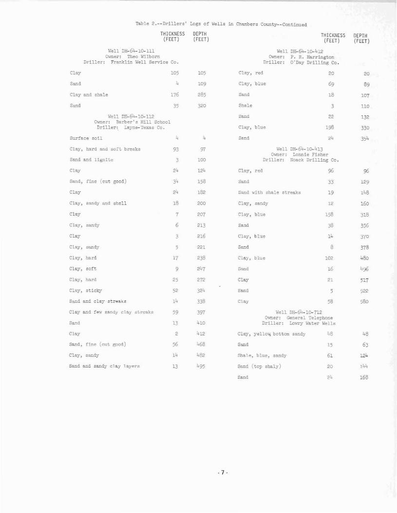
Table 2.--Drillers' Logs of Wells in Chambers County--Continued
THICKNESS(FEET)
DEPTH(FEET)
THICKNESS(FEET)
DEPTH(FEET)
\-"£011 JH-64-l 111Owner: Theo Wilborn
Driller: Fr~~lin Well Service
Clay
Sand
Clay end shale
Sand
Co.
10;
4
176
35
105
109
285
320
WellCw-ner:
Driller:
Clay, red
Clay: blue
Sand
Shale
DH-64-1o-412P. R. HarringtonO'Day Drilling Co.
20
69
18
3
20
89
107
HO
Well DE-64-1Q-l12Owne:l'": Barber's Hill SchoolDriller: Layne-Texas Co.
Sur='ace so il 4 4
Sand
Clay, blue
Sand
22
198
132
330
354
Clay, hard and soft breaks
Sand and lignite
C1""
93
3
24
97
100
124
WellO\.ner:
Jriller:
Clay, red
D:l:-64-1G-413Lonnie Fisher
r;oack Drilling Co.
96
Well DH-64-1 712~ner: General Telephone
Driller: ~~ry Water Wells
Sand, fine (cut good)
Clay
Clay, sandy and shell
Clay
Clay, sandy
Clay
Clay, sandy
Clay, hard
Clay, so:~t
Clay. hard
Clay, sticky
Sand and clay stre~~s
Clay and ~e~ sandy clay streaks
Sand
Clay
Sand, fine (cut good)
Clay, sandy
S~~d and sandy clay layers
24
18
7
6
3
5
17
9
25
52
14
59
13
2
14
13
158
182
200
207
213
216
221
238
272
324
338
397
410
412
68
482
·7·
Sand
S~~d ~ith shale streaks
Clay: sandy
Clay, blue
Sand
Clay, blue
Sand
Clay, blue
Sand
Clay
S:illd
Clay
Clay, yello: bottom sandy
S::;.nd
Shale, blue, sandy
Sand (top shaly)
Sand
33
19
12
158
14
8
102
16
21
5
58
L8
15
61
20
129
148
160
318
356
370
378
480
496
517
522
580
48
63
144
168

Table 2.--Drillers· Logs of wells in Ch~bers County--Continued
Surface clay 109 109
Sand (would not produce) 15 124
Clay 15 139
Sand (..,ou Id not produce) 16 155
Clay and shale 142 2'71
Sand 34 331
Clay 14
Sand 25
Clay 9
Sand 36
Clay 15
Sand 25
Clay 10
Surface clay
THICKNESS DEPTH(FEET ) (FEET)
Well DH-64-11-403Owner: Corps of Engineers
Driller: Franklin Well Service Co.
Sa."\d, silt filled 15 15
Clay, light gray 42 57
Sand 9 66
Clay, light yellow 64 130
Clay, blue and shale 185 315
Sand 35 350
Well DH-64-13-307Owner: Harry Chase
Driller: Franklin Well Service Co
Sand, sur:'ace 3 3
Clay 20 23
Sand 22 45
Clay 104 149
Sand 21 170
Well DH-64-13-4010'.mer: O. C. Devillier, Jr.
Driller: Frar.L~lin Well Service Co.
Clay 15 15
Sand 6 21
Clay 111 132
Sand and g!"avel 38 170
Well DH-64-13-619Owner: E. J. DJ.gat
Driller: Franklin Well Service Co.
Clay 20 20
Sand 15 35
Clay 108 143
Sand 17 160
Well DH-64-28-603Owner: Anahuac Wildlife Refuge
Driller: Franklin Well Service Co.
Surface 2 2
Clay 16 18
Sand, fine and shell 6 24
Clay 86 110
Sand 7 117
Clay and shale 99 216
Sand 26 242
90
6
20
55
84
1;;2
105
130
140
130
142
126
DEPTH(FEET)
90
40
12
15
55
29
42
Well DE-64-11- 310O;.ner: Texaco, Inc.
Driller: B&L Water Well Service
Well DH-64-11- 309Owner: Texaco, Inc.
Driller: B&L Water Well Service
THICKNESS(FEET)
12
Well DH-64-11-308Owner: White Memorial Park
Driller: Franklin Well Service Co.
6
Well DH-64-11-208Owner: Mr. Biggs
Driller: Franklin Well Se!"vice Co.
Sand
Shale
Clay, yello..,
Sand
Sand
Clay and shale
Sand
·8·

Table 3.--vrat,er Levels in Wells in Cha~bers COU!lty(feet, below land surface)
il'ell DF.-EL-09- 301
DATEDATE WATERLEVEL
DATE WATERLEVEL
WATERLEVEL
Well !lH-64-~921
C"..ner: ;,'C&ID fOo. 1, "·e;"l 5t>iont Eelv~u
Elevllticn: 1.}
Nar. 17. 1970
c'C:.. 29
19.59
2O.1l
~~er: Houston Lighting & Power Co.Cedar Ba,)'ou Plant .....ell 3
Elevation: 23
Oct. 26, 1956
lI.ar. 9, 1972
101. ;2
117.7
134.78
>:ar. 9, 1972
Oct. 10
19.31
19·15
19·17
I·tar. 26. 1971
Feb. 15, 1972
Sept. 7
135.28
136.2
137
·....ell DH-64-09- 302
Oct. 10
Mar. 15, 1973 138.27
~'lar. 1;, 1973
Cct. 2
20.44
19.07
18.87
Jan. 19. 1973
Sept. 13
135.9
142.9
135.5
C...ner: 'IiC&I~ 110. 1, w'e11 4!<ont BelvieuEle'mticn: <.3
Dec. 26, 1957 103
Well DH-61-Q9-811
O"..'!ler: HO;.lstor. L1;:i;hting & Fo..er Co.Cedar Eayou Plant, 'hell 1
:::levation: 13
Apr. 25
July 3
Sept. 18
137 ·3
142.9
143.8
Oct. 27, 1956 115.2 ~.:ar. 26, 1971 137.7'- ....ell Di-i-64-1~"01
Well ~i-i-9--09-30B
liell D:1-64-09- 307
Owner: Dianond AlkaliElevation: 27
110·97
loB.87
116.9'-
110.20
105.54
112.69
102.9'2
97.81
99.88
106.98
111.54
112.90
112 .87
113.17
110.25
107 .37
110.25
110.98
110.5
101.75
10;·55
103.5
Oct. 17
Oct. 15
Mar. 17, 1910
Apr. I, 1959
Oct. 29
t-:ar. 26, 1971
~!er. 9, 1972
Oct.. 11
lo'.ar. 14, 1973
Cct. 15
(r~er: Finger Furniture Co.Eleva.tion: 37
Oct. 9. 1957
!).ar. 28, 1968
~lar. 19, 1973
Well DH-64-1Q..703
Owner: :~as Oil and Gas Co.Elevation: 31
Oct. 9. 1967
Mar. 28. 1968
Oct. 17
Apr. I, 1969
Mar. 28, 19j1..
Har. 9, 1972
OCt. 2
II.ar. 17, 1970
"'oar. 26, 1971
Oct. 11
134.9
135
140.1
136.9
138.6
137
1}4 ·5
149
146
13'-.2
109.8
Tr.9
85.7
138.9
148.4
146.59
Well DE-64-09-901
Feo. 15. 1972
?e:-. I;. 1972
AFr. 2;
':an. 19. 1973
Sept. 13
~:ar. lL, 197"
Sept;. 7
July 25
Se:;:t. 13
July 24
Owner: S. R. WilliamsElevation: 15
':a.n. 19. 1973
\o,'ell DE-64-o9-812
Sept. 5
Apr. 26
Sept. 7
~lar. 28, 1968
Apr. 1. 1969
I·far. 17, 1970
C"..':ler: Ho-.:ston Light1:l11 & ?c...'er Co.Cedar Bayou :nant, Well 2
Elevat.~on: 17
19.62
20.03
19.}!l.
20.27
19·29
21.07
177 .1;
102
138.11
137.92
103.03
129.47
135.47
137.23
138.26
131.52
1'-3.1.3
158.39
139·72
153.79
166.37
~ar. 16, 1967
Oct. 9
Bar. 28. 1968
Oct. 15
Oct. 10. 1972
Oct. 13. 1953
I·lay 21, 1956
Ap'. 1, 1969
O~ner: Dianond Alkali, Well 3Elevation: 27
l'I.ar. 15, 1973
Iola.r. 16, 1967
!olBr. 9, 1972
Oct. 10
Oct. 2. 1973
Oce. 17
Oct. 12
:!-oar. 17, 1970
V,n. 26. 1971
OCt. 9
V..ar. 28, 1966
Oct. 17
.~pr. 1. 1969
Oct. 15
·9·

Table 3.--IO.Jter Levels in Wells in Chal:bers County--Continued
""ell DH-64-1O-703--Cont!nued
DATE DATEDATE WATERLEVEL
WATERLEVEL
""ell DH-Gh-1l-901
WATERLEVEL
Well 00-64-13-701
;,'ell D8-64-11-801
Well DH-64-ll-40l
Owner: City of .:\nahuac, Well 2E1e"''ation: 22
21.6
19·2
19.08
20.34
20.46
20.94
20.57
20.62
20.77
22.25
20.01
23·7
20.62
159·13
151.34
155.61
158
150.83
163.99
,'''
171.7
176
171.38
170.61
Owner: E!.rvey HaynesEle\'at1on: 23
28, 1974
Oct. 11
Nov. 2, 1959
July 12, 1966
II",r. 15, 1967
~!lr. 3, 1972
Dec. 10. 1965
Mar. 27. 1974
Mar. 15, 1973
Jet. 2
14.ar. 16, 1973
OCt. 3
Mar.
Well DE-64-18-601
O\.ner: Exxon Co., C-12Elevation: Sea Level
Mar. 17, 1970
Oct. 17
Oct. 15
Well DH-64-17- 311
Oct. 9, 1967
Mar. 28, 1968
_ell DH-64-17-901
~~er: Seacrest FBrkEleva tion: 25
Owner: Wilburn Bros.Elevation: 23
Apr. 1, 1969
"'.aT. 9, 1972
Oct. 2. 1973
Mar. 28, 1974
Oct.. 29
Iolar. 26, 19'71
"'.ar. 9, 1972
May 23, 1969
June 11, 1971
28.05
26.44
28.14
31·m
30.82
30.4 1
28.93
29·17
29·27
29.67
30.01
30.62
71
72
70
72
72
80
35
48
60
62
68
66
70
72
707272
60
68
Ovner: BarringerElevation: 22
1953
1959
1953
1967
1970
1971
/oiar. 19, 1970
Oct. 28
Oct. 3
Nov.
Oct. 10, 1967
Mar. 29, 1968
Oct. 18
Apr. 2, 1969
Oct. 14
'''ell DH-64-13-601
Mar. 27, 1974
Oct. 11
Mar. 3. 1912
Mar. 27, 1974
Feb.
Mar. 3, 1972
Owner: Trinity Bay ConservationDistrict, Winnie, Well 2
Elevation: 26
Feb. 23, 1973
II..ar. 16
Well DH-64--13-602
Owner: Trinity Bay Conserv'BtionDistrict, Winnie, Well 1
Elevation; 26
Oct. 3
July 31
Sept.
}olar. 16. 1973
Oct. 11
Sept.
Oct. 11Feb. 23, 1973Mar. 16
July 31, 1972
May
Feb. 1967
May 1970
May 1971
May
"'.aT. 25. 1971
16.81
11.61
16.03
18.27
16.8"
18.77
17.20
17.93
21.40
18.07
17.60
17.36
18.21
17.80
20.92
19.38
26.07
25.24
26.97
20.55
21.50
20.51
20.94
23.96
109·97
113.15
Mar. 29, 1968
Oct.. 18
Apr. 2, 1969
Oct. II,
Oct. 2, 1973
Mar. 28, 1974
Oct. 28
!/;ar. 25, 19'71
Mar. 16, 19'73
Well DH-64-u-802
Oct. 11
Mar. 3. 1972
Mar. 3, 1972
Oct. 25, 1955
Jan. 17, 1966
o.ner: E. E. AbsnierElevtlt.ion: 5
~~r. 19, 1970
Oct. 11
Ovner: City of Anahuac, Well 1Elevation: 22
!Jar. 16, 1973
Oct. 3
Mar. 19, 1970
"'..ar. 25, 1971
OCt. 3
Apr. 2, 1969
"'..ar. 19, 19'70
Oct. 11, 1972
M.!r. 16, 1973
"'.ar. 27, 1974
. 10-

~ble 3.--ii!l:'er Le·."els in wells 1.'1 Che.l':t'bers Co.:.nty--Continued
DATE WATER DATE WATERLEVEL LEVEl
Well DE-6l-18-602 •...ell :)~-64-26-701
Q>,,-r.er: Exxen Co., C-30 c-..ner: Exxon Co., ,~-l
Elevation: Se!l. Level 31eVBtion: Sea Level
".ay 23, 1969 io2.80 Nov. 29, 1966 85.72
Ju..Tle 11, 1971 45. 45 Hov. 30 88.75
!.!ay 23, 1972 49.89 ~Aj' 13, 1967 55.05
Aug. 2, 197" -;.70 J.!ay 23, 1509 92·55
"'-ell :m-6'l-18-603 !olay -, 1970 95.25
cr","er: :::XXen Co., c-1..6 JU:"J.e 11, 1971 99.0631evation: ~ea Level
ItAy 23, 1972 100.95Hll.y 23, 1969 41.35
1·:Ay 15, 1973 103.04June 11, 1971 50·53
to'ell DH-64-26-808May 23, 1972 43.10
Q;.mer: Exxon Co., A-168'....ell D:;:-64-18-605 Elevation: Sea Level
O"A'Iler: Exxon Co., C-54 '>.y 23, 1969 56.50Elevation: Sea Le','el
May " 1970 55.30Au!!;. 2, 1974 51
Jun. 11, 1971 55.36liell J*-64-18-903
_.ay 23, 1972 57.19Owner: 3Jaron Co., <-50
Elevation: Sea Level --'Y 15, 1973 58.14
"'.1!.y 23, 1969 40.68
June 11, 1971 42.85
~ay 23, 1972 56.21
I·!eo:' 15, 1973 1.6.20
Aug. 2, 1974 46.74
Well DH-&-21-205
~~'Tler: SUn Cil Co.Elevation: 16
I-'..ar. 15, 1967 19.96
OCt;. 10 20.76
!.!ar. 29, 1968 20.64
Apr, 2, 1969 20.92
""t. 14 21.52
!".aT. '9, 1970 20.87
Oct. 28 21.30
-=. 25, 1971 21.48
P.ar. 3, 1972 21.27
""t. 11 22.96
~laT . 16, 1973 22.79
Cct. 3 23.36
Mar. 27, 1974 23.17
. 11 .

e•
••
:_.~~R~R•
, d
~ ;.'"
,dd
•,
;•
;•
,.'h~
. 12·

Water levelMethod of 11 fc and type ol [lOWerUse of waLurWlIler-bea, lng unit.
Tahle 5.--Rc"ords of We1l9 tn Llberty County
Rllportlld "ntelf lcvlil~ given In (eet; ..cuj;ut"ed water levels 1:1vcn 1n fect lind tcrlllla.K, III.eerie; C, 8"MoHnll, nU, h"rllne, or dbs.. ! engine; Ng, natural gall; Sub, a"bm(!rslbl<l; T, [urhlno. Numb",r lndl".... c81 hOt'sepowcr.Il, do",... tlc; Ind, lnduttrtul; Irr, lrrls,ulon; r. public slIp(>I)'.C. ChlcOL IIl\uHIlt"; Po, I':vang(!l tno aqulfcr.
'"
Cn61n' Wurnr l\'vl'l!llltc llepeh D10",- Depth \;'Ilter- Altitude Above (+) or Oo1Ce or Mulhnll \111"". (Nollr Dr1l111r COI'\- of etc!' (fl.) beadn;; of Inn,l bela,", Lnn<l nw<l9tl"<o"'cnt of " Itcmu"K/I
rioted ""cll (tn. ) unit >IurfltCll sU"(nee lift wotCI"(flo ) {ft. ) dlleum
(t't,)
5B-60-56-101 II. J. Kouchcr E, F. lloNtHUH~ Wnter 1.964 J25 " J25 E 110 " ..., 1966 Sub,1":"
Serc!!n from 31:l to 3Z5 feet.Well Service I 1/2
61>-303 Stolliller rll"lllll, Inc" Luyne-TlllCnl Co. 1967 "0 " "0 E " as ..... 7 J 1967 T ,Nil ,,, 16~ f(lllt or .Iotted cnNlng between 20)Well 6 112.2 Kar. 16, 1970 11",1 570 feet. Reported yluld 1.084
gnl/lllin with 41 feet drllwdown whendrlllud.l!l!
910 Arco Oil & Ca. TtilCal Water Wella, Inc. 1967 400 -- 305 e " -- -- T,' Iud Cndng lIlotted [rom )07 to )47 heLl!4 '.00 "
'" W. S. Ilolton 116.L W,d I SOlrvlce 197) 370 4 360 C 70 120 July 3, 1?73 Sub,!": 0 ScrOlen frnao 360 to 370 [(lut •.!!2 170
61·34·109 flone Shoe L.kll Club O'Day Drlll1nll Cn. 1970 '" 6 442 , 67 .'1 OIlIng -- Sub ,f. ,,, :11 feet ot screen between 4:i9 nnd :i:i24 '" fe_to Reported yIeld 200 8111/lIIln wIth
1,2 fuet drawd""'01 when drtlled. Suppl tealake ..!!
110 Frank Duke. SllC 1.lIkel Ml1lor'. Wllter Well 1973 138 4 '" C " 30 Junu 21, 1973 Sub,l-: , Seruun from US to D8 fceLl!Dri1llnll 2 <3, 3
41~ IOI, O. M. Scott 6 Sana U, J. Swfnellllrt Co. 1973 331 8 '" E 150 61 Aug. 9, 1973 T,' 1" Serllcn from 28:i to 325 feet..!!6 331 30
'.O? Tnrkington Indllpundtmt Keena Orlilln8 Co, 1<)69 469 4 367 e 131 -- -- Sub.1:: , Scroun from 447 to 467 fuot ..!!School IHatrlct 2 1/2 I,b?
1.9-601 Ilowonl Croft Chnpmllll Water Wall 1974 <40 " 1/,0 , 100 32 Apr. 15, 1971, Sub,V. n ScroCll ftom 130 to 11,0 fe.et.l/Stlrvlce
807 T. Wliburn Knty Orllllnll, Inc, 1967 396 24 -- '.C 97 77 Jan. 17, 1967 T,e 1" 331 fOllt of alntted cllling between b51'. 396 (lnd 396 fUllt. Reported yIeld 1,:i39
llol/lIIlo1 with 162 feat drpwown whendrilled·..!IlI
808 Bol linge r ISrol. Leonard W, Mickll110n 1970 728 16 368 , 97 112.6 "'" 5, 1972 T,e 1" 356 fellt of 1I10tted caatns between 25012 728 lind 728 feeL.!!
903 J. II. Roau Chtll"*lln W..ter W_lI 1973 327 4 307 ," 92 0." . I, 1973 Sub,F. 0 Serecll frOlll 307 to 327 fcet.y
Service 2 327
• :i1-1I1 Ilordln WUltlr SUllply Layno-Tellal Co. 1969 812 8 700 , 90 " Jan. 23, 1969 Sub.!!: P 50 feet of Icreen between 710 lind 800Corp. , 812 feet. Repo ... ted yIeld 1:i0 Sl1/mhl with
lt~ feet dmwdown when drilled.
604 B111 YllrbrOt'lIh KIlty Drilling, Inc. 1973 686 20 360 , 70 " Fet.. 1973 T,r. 1" 499 feat of .Iotted c"~ln8 botwcen 18712 686 686 foet. Reported yteld 3,088 Gal/min
with 127 feat drllwdown whe" drllled.l!
807 A. E. McGl.'lty L"yna-'l'ulCPll Co. 1968 770 20 296 E 70 61 ",,,. 5, 1968 T ,E ," 370 ftlllt of 'lotted ca81nil bOlween 18012 770 lind 7:i6 feut. Reported yield 2,941 Sill/
min with li2 het drowdown whun drilled.
See footnotes ot end of ttl.bla.

~
m
Table 5.--Record. of Well. in Ll~rty C<>uncy--Contlnued
Cui" Watel' lllyel0". Depth D(lllll- Depth Wotel"- Altitudo hove (+) or Date of Hcthod U"
No. """" DrUler ,- of fleer (ft, ) beating uf lllnd below I.IId _aBurement of of Relllll rk.platad well (1n. ) unlt .urfllce aurface 11 fl water
(~t. ) (ft, )~~~~'~
Sfl-61-~7-108 ROy Seaberg Lllytul-Texa" Co. 1910 B32 20 407 , 84 "4 Hat. 26, 1970 T,Ng ,,, 295 hec of ,Iotttld c.,1ng between 30212 B32 125.5 Oct. 5, 1972 and 8\7 feet. Reported ylald 3,024 gal/
1ll1" wlth 90 feet drawdown whIm dell led ..!!209 Pelton 80111n,,n Chapm4n Watar Well 1913 175 4 155 C '0 54 Aug. 17. 1973 Sub,E 0 Screen (COllI 155 to 115 feet •.!!
Service. 2 '75
702 J. H. Fron, Jr. -- -- '00 " 700 -- 67 lit" .5 "',. J, 1972 T.C t" Y'OJ Cecil Hobdy J. W. Grll8k W.ter Well 1971 J~~ 4 328 C " 125 Oct. 27, 1971 Sub,! 0 Screen fro. )19 to 329 fClet •.!/
Servicil
58-303 PdCl! Oantol, Jr. do. 1971 247 4 231 C ',0 70 July 1971 Sub,l:: 0 Screon frolll 236 to 247 (vet.Y2 1/2 247
59-510 Roywood Watur Supply Katy Ortillnll, Inc. 1970 '01 , 716 E " '1 Hor. 1970 Sub,!! , Screen ftQlll 728 to 801 filet. ReportedCorp. 4 '01 yield 2lS gll.1/mtn when drilled ..!!
64·01·108 Hilton Chllchere ChaJllll'ln Wllter Well 1972 '0 4 '0 C 67 16 SlIpt. 8. 1972 Sub,!! 0 Screen frOal 80 to 90 het ,J!Service
'01 Trtnity Waur Telta. Water Wells, Inc. 1970 581 -- -- , ',6 176 Dec. 1970 T.P. t.d Seteen ftom 530 to 576 feet. ReportedConveyance Syllto.. , 4 58' 7 1/2 yield 50 gal/mi.n with 41 feet drawownWell 2 wlull1 drill ed. IUgh tron content teponed.)1
02-102 5. W. Fran.en AM. P\.IllIP lind Well 1972 240 4 210 C " '0 Jun. 10, 1972 Sub ,I:: Il SCrtl1l1l (rom 230 ro 240 fellt •.!!Scrvic~ 2 240 1
20' Trinity Water Texu W"tct Welle, llll:. 1970 f,49 -- -- , 27 " June 1970 T , tnd,O Screen from 384 to 1,44 feet. ReportcdConveytlnc/! Syetllm, 4 1,49 7' 1/2 yield 85 gol/min with 10 teet drlllOdolOnWull 1 whon drll led ..1/
60' Hou Bluff Fire Dept. Finklea 1I11tllr l.Iell 1969 159 4 1" C l' 20 Dec. 1969 Sub,! , Screen frlJnl 148 to 159 feet. ReportedDrilling Co. 1 yield 75 gal/rain. Supplllll pumper for
fI rll dCportment..!I
'01 l.arry D. Fruge AM. Pump end l.Iell 1971 '98 4 182 C J7 40 Har. 31, 1971 Sub,1!: 0 Scteen (rora 188 to 198 feot.jJServtce 2 198 1/2
Ql.-709 Culf Oil Corp. George Bellllnllllr Water 1971 160 6 120 C " 12 OCt. 10, 1972 Sub, E lnd Scruen from DO to 160 hilt. ReportedlIell ServlclI " 160 , yil!id 100 gal/min when drilled. Supplin
otor'8' uuk to c<><>1 coraprellllor ..!!710 d,. do. 1971 160 6 130 C " 12 Oct. 1911 Sub,l> Iud SCrl!ll1l frOll\ 130 to 160 feet.
4 160 ,, See)1 SeeJJ See
tllb III 8tllble 6t.ble 7
for chemlclII nnolyau of wnterfor drillers' 10'11 of we11l1.for wllter levele In welle.
from welle.

Table 6a--Drillers' Logs of Wells in Liberty County
THICKNESS(FEET)
DEPTH(FEET)
THICKNESS(FEET)
DEPTH(FEET)
Well SB-60-64-910--ContinuedIllell 5"8-60-64- 303Owner: Stoesser Farms, Inc., Well 6
Driller: Layne-Texas Co. Sbale, gray 23 400
Surface soil
Sand
Clay and sand s\;!"eaks
5
30
35
5
35
70 SUrface
Well 58-60-64-911Q-wner: W. $. Dalton
Driller: ~~ Well Service
5 5
Sand
Clay
Sand
25
33
15
95
128
143
Clay, ..nite
Clay, red
Clay, blue
15
70
20
90
235
Clay 48 191 Sand 135 370
Shale 30
""ell 85-60-64-910(h,':ler: Area 011 and Gas
Driller: Texas Water Wells, Inc. Cley 25
Hell 58-61-31.-110Owner: Frank Duke, Six Lakes
Dril~er: Miller's Water Well Drilling
25
40
70
92
95
18
120
506
557558
88
104
3
50
70
16
16
30
15
23
20
511
22
3
290
r..,'ell 58-61- 34-109~ner: Eorsesboe Lake ClubDriller: O'Day Drilling Co.
18
Rock
Sa.'1d
Clay
Sand, fine to coarse
Clay
Clay
Band
Clay with rock streaks
Sand
Sand and gravel
Rock
Clay
Sand, streaky
Sand
CIa;)'
311
3
530
570
600
95
220
351
3
445
454
483
230
288
18
25
294
9
58
6
10
29
17
40
13
81
3
15
7
29
47
40
70
Sand and c lay breaks
Sand and sandy clay
Clay
Sand
Clay
Sand
Clay, sandy
Clay
Clay and sandy clay
Clay
Sand
Sand, gravel and shale streaks
Topsoil
Sand, gray and debris
Clay. yello.... and gray
Clay, yellow
Clay, gray
Sa."1d, fine gray
35
14
130
144
Clay
Sand
24 119
157
Clay, yello.... and graJr
Sand, broken and shale
46
35
190
225
Sand, broker- and shale 23 248
Sand, gray
Shale, gray
Sand, gray
99
15
15
347
362
377
·17-

Table 6.--Drillers' Logs of Wells in :iberty County--Continued
THICKNESS DEPTH THICKNESS DEPTH(FEET) (FEET) (FEET) (FEET)
Well S:8-6l~4l-l04 Well 3:8-61-49-601cr..ner: o. M. Scott and Sons Owner: Howard Croft
Driller: B. J. Swine!'>.art Co. Driller: Chapman Water Well Service
Clay 18 18 Clay 22 22
Sand 24 42 Sand, fine 8 30
Clay 18 60 Clay 48 78
Sand 9 69 Sand 14 92
Clay 17 86 Clay 30 122
Sand and gravel 31, 120 Sand 18 140
Clay 34 154 lien SB-61-49-807Owner: T. Wilburn
Sand and gravel 16 170 Driller: Katy Drilling, Inc.
Clay, sand streaks 96 266 Clay 65 65
Sand, fine 19 285 Sand 29 94
Sand, coarse 42 327 Shale 91 185
Sand, fine 9 336 sand 17 202
Clay 1 337 Shale 14 216
Well SB-61-41-409 Strips of sand and shale 31 27D-..mer: Tarkington Independent Scbool District
Driller: Keene Drilling Co. Shale 123 370
Sand 5 5 Sa.'1d 26 396
Clay 40 45 Shale 5 401
Sand 35 Be Well SB-6l-49-808Owner: Bollinger Bros.
Clay, blue 25 105 Driller: Leonard W. Mickelson
Sand 30 135 Soil and clay 24 24
Clay 15 150 Sand 31 55
Sand 20 170 Clay 36 91
Clay 15 185 Sand 13 104
Salld 30 215 Clay 35 139
Clay 15 230 Wood sbavings, rocky sand 77 216
Sand 15 245 Clay 33 29
Clay 10 255 Sand, rocky 33 282
Sand 35 290 Clay 13 295
Clay 55 345 Sand, rocky 47 342
Sand, rock 15 360 Clay n 353
Clay 57 417 Sand 10 363
Rock, hard 25 442 Clay 6 369
Sand 27 469 Sand 5 374
Clay 6 475 Clay n 385
- 18·

Table 6 .--Drillers-' Logs of Wells in Liberty CountY--Continued
THICKNESS DEPTH THICKNESS DEPTH(FEET) (FEET) (FEET) (FEET)
Well SE- 61-49-808- - Continued Well SE-61- 51-ll1--Continued
Sand 6 391 Sa.-'1d with streaks of shale 48 337
Clay 25 416 Shale, sandy 18 355
Sand 10 426 Shale, sandy with sand streaks 33 388
Clay 5 431 Sand 43 431
Wood shavings 58 489 Sand T.... ith sandy shale 32 463
Sand 26 515 Shale, sandy 6 469
Sand, rocky 49 564 Sand, broken 20 489
Clay 13 577 Sand, shale with streaks 45 534
Sand 5 582 Sand, broken 33 567
Clay 11 593 San.d, shale with strea.\tsof sand 14 581
Sand 132 725Sand, broken 18 599
Well 8&-61-49-903Owner: J. H. Rose Shale, san.d.y 4 603
Driller: Chapman Water Well ServiceSand, broken 11 614
Clay 19 19Clay, sandy 4 618
Clay, sandy 9 28Sa.'1d, broken 18 636
Clay 83 111Clay with strea.\ts of sand 15 651
Sand 5 116Sand, broken 23 674
Clay 4 120Clay ,...ith streaks of sand 8 682
Sand 14 134Sand with small layers of
Clay 120 254 shale 56 738
Sand 10 264 Shale, sandy with sandstreaJI:s 36 774
Clay 21 285Sand with hard streaks 41 815
Sand 42 327Shale, sandy 19 834
Well S&-61-51-111Owner: Hardin Water Supply Corp. Well S8-61-51-604
Driller: layne-Texas Company O"''l1er: Bill YarbroughDriller: Katy Drilling, Inc.
Clay with streaks of sandyclay 51 51 Surface, clay 56 56
Sand, broken 72 123 Sand 68 124
Sand, streaks of gravel 20 143 Clay 63 187
Clay, sandy, streaks of sand 8 151 Sand 74 261
Sand and gravel 19 170 Clay 74 335
Sand and streaks of clay 14 184 Sand 19 354
Rock, sand 2 186 Clay 37 391
Clay and streaks of sand 30 216 Sand 26 417
Shale and sandy shale 73 289 Clay 6 423
- 19-

Table 6.--Drillers' Logs of Wells in Liberty County--Continued
THICKNESS DEPTH THICKNESS DEPTH(FEET) (FEET) (FEET) (FEET)
Well S8-6l-5l-604--Continued Well S8-61- 5l-807--Continued
Sand 18 441 Sand, bard shale and sandyshale 30 632
Clay 22 463Sand and sandy shale 18 650
Sand 90 553Shale, sandy 9 659
Clay 3 556Sand 21 680
Sand 130 686Shale and sandy streaks 14 694
Clay 3 689San.d and sandy shale streaks 60 754
Well S&61-51-807Owner: n. E. McGinty Shale, sandy 18 772
Driller: layne-Texas Co.Sand and shale brea\s 23 795
Topsoil 4 4Shale, sandy 9 804
Clay and sand streaks 2'1 31Well ~6l-57-108
Sand 19 50 Owner: Roy SeabergDriller: Layne- Texas Co.
Clay and sand 20 70Clay 70 70
Sand 14 84Sand 8 78
Clay Md sandy clay 8 92Clay 26 104
Clay 33 125Sand 18 122
Sand and few clay streaks 27 152Shale, green 50 172
Clay, sandy clay and layers ofsand 30 182 Sand, good 48 220
Sand and clay streaks 14 196 Shale 8 228
Clay and sand streaks 27 223 Sand 58 286
Sand and clay streaks 19 242 Shale 3 289
Sand (some fine sand) 29 271 Sand 67 356
Sand and few clay streaks 22 293 Sand layers and shale 33 389
Clay and salld streaks 8 301 Shale 4 393
Shale, hard sandy 25 326 Sand 8 401
Sand and sandy shale 46 372 Shale 6 407
Clay, gravel and sandy clay 62 434 &.'ld and shale 20 42'1
Sand and sandy clay 18 452 Shale, hard 7 434
Sand and layers of clay 30 482 Sand 23 457
Clay and streaks of sand 18 500 Shale 9 466
Sand and sandy clay streaks 31 531 Sand 12 478
Clay, sticky and sand clay 33 564 Shale 4 482
Sand 13 577 Sand 8 ~90
Clay 8 585 Shale 6 496
Sand and sandy clay 17 602 Sand 12 508
·20·

Table 6.--Drillers' Logs o~ ~ells in Liberty County--Continued
THICKNESS(FEET)
DEPTH(FEET)
THICKNESS(FEET)
DEPTH(FEET)
Hell SB-61- 57-108--Continued
Shale and sandy shale
Sand, hard and sLale
Shale, hard
Sand
70
17
1
12
578
595
596
608
',.,TellOwner:
Driller: J. W.
Clay
Sand
Clay
S&-61-58-303Price Daniel, Jr.Greak Water Well Service
19
31
113
19
50
163
Well SB-61-59-510o-.m.er: ::\e.ywood Water Supply Corp.
Driller: ~ty Drilling, Inc.
Shale
Sand
Shale
Sand and sandy shale
Shale
9
7
17
76
5
617
624
641
717
722
Sand, fine
Clay
Sand
8
60
16
171
231
Sand, fine
Clay, sandy
Sand and hard streaks
Sand with hard streaks 50
725
75
290
350
415
435
535
550
583
622
655
680
690
70010
10
15
25
33
39
33
25
20
100
50
25
215
60
65
Shale
Sand
Sand
Shale
Shale
Sand streaks, clay
Sand streaks, clay
Shale
Sand and clay streaks
Sand
Shale
Shale
sand s~reaks, clay
Clay
Sand
n8
35
39
16
18
128
147
175
775
784
837
812
821
2
10
17
4
53
9
16
79
19
28
9
28
Well S8-61-57-209Owner: Felton Bollinger
Driller: Chapman Water Well Service
16
Clay
Clay
Sand
Shale
Clay
Shale, sandy and hard streaks
Sand
Clay
Shale
'","ell 88-61-57-803O"..":1er: Cecil Hobdy
Driller: J. W. Greak Water Well Service
Clay 90 90
Sand 71
Well S8-64-01-lo8Owner: Milton Chachere
Driller: Chapman Water Well Service
796
Sand, yellow 20 110 Clay 21 21
Clay
Sand, ",,"bite
Clay
Sand
100
20
60
40
210
230
290
330
Sand, fine
Clay
Clay
2
35
4
9
23
58
62
71
Sand 19 90
- 21 -

Table 6.--Drill~rs' Logs of Wells in Liberty County--Continued
THICKllESS(FEET)
DEPTH(FEET)
THICKNESS(FEET)
DEPTH(FEET)
Well S~6f-Ol-901
Owner: Trinity Water Conveyance $yst~
Well 2Driller: Texas Water Wells, Inc.
Well S~64-02-205
Owner: TTinity Water Conveyance SystemWell 1
Driller: Texas Water Wells, Inc.
Well S~64-02-102
Owner: S. W. FransenDriller: .~L Pump and Well Service
Well S~64-02-90lOwner: Larry D. Fruge
Driller: A&L Pump and Well Service
12
5
4
55
29
56
217
174
101
70
120
113
147
159
175
198
502
528
556
586
590
129
160
230
244
296
441
76
492
496
30
4
8
12
6
26
28
56
57
34
5
50
15
50
55
23
17
72
28
31
15
43
13
14
52
145
35
16
4
sand
sand
Well s~64-02-605Owner: Moss Bluff Fire Department
Driller: Finklea Water Well Drilling Co.
Shale
Clay, bro'Wtl
Clay
Shale, bro-..n
Sand, coarse
Surface
Sand
Clay. gray
Shale, hard
Shale
Clay, red
Shale
SUrface
Sand, fine ~nite
Shale, hard blue
Sand and shale streaks
Shale
Shale
Clay, yellow
Clay
Shale
Sand, shell and shale streaks
Clay, blue
Sand
Sand
Sand
Sand
Sand
5
30
62
487
105
180
527
537
547
207
240
557
567
573
579
464
482
452
507
517
310
343
27
251
6
6
2
5
27
10
10
10
10
10
18
12
33
10
10
18
50
13
5
25
32
43
75
10
59
33
26
27
224
Clay, yellow and red
Shale, sandy
Sand and shaIe
Shale, sandy
Sand
SUrface
Shale
Clay. blue
Clay. blue
Shale
Shale
Sand
Sand and shale streaks
Shale
Sand and shale
Sand
sand, fine and gravel,shale streaks
Shale
Shale and sand
Sa.'1d and shale
Sand
Sand and shale
Clay
Shale
Sand
Stale
Sand and shale stre~\s
Sand
- 22-

Table 6.--Drillers' Logs of Wells in Liberty County--Continued
THICKNESS(FEET)
Well SB-64-04-709Chvner: Gulf Oil Corp.
Driller: George Bellenger Water Well Service
DEPTH(FEET)
Surface
SaPld
Shale
Sand
33
4
90
35
33
37
127
162
·23·

Table 7.--Water Levels in Wells in Liberty County(feet belo~ land surface)
DATE WATERLEVEL
DATE WATERlEVEL
DATE WATERLEVEL
;,'ell 5B-- 4~903 Well Sa-60-~901--Continued i"ell 5B-60-64-302--Contimled
rlell S~6Q-~102
Well s~6c-48-302
Well S~6c-~901
73·70
92·10
82.21
86.27
84.19
82.09
84.06
85.93
78.20
103.86
n.72
96.73
120.23
120.08
rj;. .15
99·99
126.1£
106.86
124 .97
112.01
102.52
123.67
115·32
79.60
101.40
89.7
91.96
103·27
108
3, 1974
l·lar. 23, 1971
Feb. 28, 1972
Mar. 21, 1973
f..pr. 3. 1974
fo'.ar. 13, 1967
Oct. 5
Jolar. 26, 1968
Oc:;.. 15
r,~ar. 27. 1969
Mar. 13, 1$167
Oct. 11
Oct. 21, 1965
lI.ar. 1, 1966
Oct. 17
Join. 16, 1970
Oct. 30
Cct. 5
Apr.
Owner: stoesser Fan::s, !nc., Well 6Ele\"tltlo:!: 85
Feb. 29. 1972
l-tar. 16, 1970
Well SB-6Q-611-901
Well sa-60-64- 303
O1mer: M. F. zaleskyElevation: 70
~ner: E. J. Stoesser, Well 4Elevation: 83
)lar. 26, 1968
Oct. 15
Mar. 27, 1969
Oct. 17
Well 55- 64-602
Mar. 1. 1966
!'.ar. 23. 15771
Jan. 27, 1960
Mar. 23, 1965
lI.ar. 2, 1972
!/.ar. 14, 1973
Apr. 3. 1974
79.60
77.62
B1.96
78.37
92.16
77.67
97.~
83.26
82.1)
92.18
99·30
80.59
94·27
77."7
97.f!7
91.35
106.1.6
105.02
102.25
113.86
86.50
95. 48
80.26
96.25
82.72
107.27
92·11
77.30
100.28
87.02
;;ell 5:&-60-56-902
Har. 16. 19'70
O"wner: ::. J. Stoesser, i\'ell 5Elevation: 85
Mu. 13, 1967
l'.ar. 16, 1910
OCt. 30
Oct. 11, 1966
Oct. 5
Apr. 3, 197~
Feb. 28, 1972
Mar. 27, 1959
OCt. 17
Mar. 26. 1$168
Oct. 15
O"~ner: E. J. Stoesser, well 2Elevation: 82
Well sa-6C-64- 301
~Tler: Roy SeaburgElevation: 82
...·ell 5~60-64-302
Mar. 23, 1971
"'ar. 16, 1970
Oct. 5
Mar. 26, 1968
"'.ar. 21, 1973
Apr. 3, 1974
Oct. 11
Oct. 21, 1965
Oct.. 11. 1956
Oct. 5. 1967
!-'.ar. 26, 1968
Oct. 15
~~r. 13, 1967
Oct. 15
!".ar. 27, 1969
Oct. 17
Mar. I, 1966
Mar. 27, 1969
Oct. 30, 1970
Flows
39·50
39.34
33.50
46.07
14.70
48.65
47.61
41.20
42.01
40.32
33.50
Lj.73
42.1.7
44.27
43.11
...!L79
41.25
48.97
45.09
~.27
47.37
87.76
91.56
84.B3
100.61
74.65
78·09
66.31
90.44
O"ll'ler: Roy HortOl'\ & Sons£levation: 159
O<::t. 10
Feb. 29, 1972
Oct;. 6
Mar. 27, 1968
Oct. 16, 1969
Cc:~. 20, 1965
Mar. 3, 1966
Owner: E. J. Stoesser, Ke11 3E1e",ration: 86
Jan. 4, 1960
Mar. 20. 1955
~ner: Ci"ty of C1evehnd, ....ell 1Elevation: 157
~:ar. 18, 1970
Oct. 27
Olmer; Vernon Elledge, 'liell 2Elevation: 153
Apr. 28, 1938
Jan. 26, 1945
Oct. 21, 1965
oct. 11, 1966
Oct. 5
Mar. 26, 1968
Oct. 15
"".Ill'. 2, 1972
!-lar. 21, 1973
Oct. to
Feb. 29, 1972
Mar. 14, 1973
Oct. 4
!".sr. 29. 1974
MI!.r. 27, 1969
Oct. 17
"'.ar. 13, 1967
·24·

Table 7.--Water Levels in Wells in Liberty COU..'lty--Continued
"ell 85-61-33-601
DATE
'....ell 53-61-41-10l--Continued
DATE WATERLEVEL
WATERLEVEl
....ell 55-61-33-706
DATE WATERLEVEL
57.26
63.27
59.46
58.36
56.02
67.69
51.83
63.89
56.61
75.17
80.5
82.4
79·5
65.09
64.35
68.88
64.79
65.02
56·99
65.74
65.77
66.97
7, 1960
23, 1965
Mar. 29, 1974
Oct. 14, 1956
Oct. 6, 1967
Well 58-61-41-701
~ner: M. A. ScottElevation: 128
"'-ell 55-61-43-801
fI.ar. I, 1966
Mar. 14, 1973
Oct. 4
jo,'ell 5&-61-49-802
I<'.ar. 27, 1968
OI.ner: W. A. ConnersElevation: 97
Feb. 29, 1972
Well sa-61-49-803
Ql.ne1": A. L. EricksonEle".ration: 93
July 23, 1965
()-;m~r: w. A. ConnersElevation: 97
Oct. 11. 1966 83.1~4
Mar. 13, 1967 67.46
Mar. 13, 1973
Oct. 5
Apr. 3, 1974
Feo. 19, 1972
!".ar. 14, 1973
Oct. 4
Mar. 26, 1968
Mar. 27, 1969
Oct. 17
OCt. 30
f.!Br. 16, 1970
Mar. 23, 1971
....ar. 2, 1972
Mar. 13, 1973
Jan.
Feb. 28, 1972
!J.ar.
33.13
31.53
34.03
33.25
32·30
31.36
37.77
32.44
33.39
32.56
34 .23
32.88
33.'6
45.55
40.66
40.57
46.78
39.87
50.26
41.96
43.16
39.18
38.61
38.12
39.47
36.50
la, 1966
Well 5&-61-33-708
Oct. 10
OCt.
Mar. 14, 1967
Oct. 6
Mar. 27, 1968
Oct. 16
V.al'. 28, 1969
Oct. 16
Oc~. 27
Oct. 20, 1955
l!ar. 3, 1956
Mar. 29, 197!1.
~ner: Roy A. Morton & So~s
Elevation: 161
Oct. 16
Mar. 20, 19'71
Feo. 29, 1972
Danel': Vernon ElledgeE1e'ratioo: 153
Jan. 4, 1960
Mar. 26, 1965
1I.ar. 3, 1966
J.la:t'. 28, 1969
Oct. 16
Feb. 29, 1972
¥.ar. 21, 1973
Oct. 4
Mar. 18, 1970
¥..ar. 2, 1972
!>'At'. 20, 1971
Well 5&-61-41-101
Oct. 4
Mar. 29, 1974
Ov:::lel': 30y A. Morton &. SonsElevation: 161
",".ar. 18, 1970
Oct. 27
!J,ar. 14, 1967
Mar. 27, 1968
!".ar. 21, 1973
40.61
41.02
;0·92
41.32
45.43
39.65
48.31
!l.0.45
44.28
66.80
56.80
42.74
41.19
46.98
!l.0.28
57.32
60.20
6/1.61
57.67
56.30
60.27
56.85
60.'"
58.40
57.61
56.44
56.05
"'.97
20, 1965
3, 1966
Owner: Roy ElledgeElevation: 157
Oct. 20, 1965
Mar. 3, 1966
OI.ner: C. Die!levation: 126
Oct. 10
,,:ar. 14, 1967
Oct. 6
~ar.
Oct. 27
Oct.
Hal'. 27, 1968
loW'. 28, 1969
"'..e:r. 16
Mar. 18, 1970
Mar. 20, 1971
Feb. 29, 1972
Hal'. 21, 1973
Oct. 4
l'.ar. 28, 1969
Oct. 16
Jo'.ar. 18, 1970
Oct. 27
Well 5&-61-33-701
Mar. 20, 1971
Feb. 29, 1972
"'..e:r. 21, 1973
OCt. 4
Oct. 10
"'.sr. 14, 1967
OCt. 6
Mar. 27. 1968
Oct. 16
IJar. 29, 1974
·25 -

Table 7.--wat.er Levels in Wells in Liberty County--Continued
ii'ell SB-61-49-803--Continued
DATEDATE WATERLEVEL
DATE WATERLEVEL
WATERLEVEL
Well 58-61-57-506
Well 53-61-57-202
Ol.ner: D. A. ReidlandElevation: 93
o...ner: W. M. MoreauBlevation: 78
Oct. 5, 1973
AJll". 3, 1974
'liell 58-61-49-805
o-..ner: "'. A. Cor>.DersElevat.io:'l: 97
Mar. 1, 1972
fo~ar. 22, 1973
48.68
56.88Mar. 22, 1965
Mar. 1, 1966
J.~r. 14, 1967
104.97
104.9'
110.48
Well 58-61-51-806
k'ell 58-61-49-807
OI.-ner: A. L. 3ricksonBlevation: 86
Ower: "'.organ TippettE1e...-ation: 68
56.65
69.82
57.67
49.92
73. 47
46.38
53· 71
72.98
75.47
66.11
113.94
126.21
11L..G4
113.21
114.12
93·2
107 .43
106.69
111.43
114.54
n4.'r7
115·10
101.2
118.12
117.27
128.87
118.07
Feb. 28, 1972
Io'.ar. 13, 1973
Oct. 5
Apr. 3, 1974
Y.ar. 26, 1968
"'.ar. 27, 1969
Mar. 16, 1970
Mar. 23. 1971
Mar. 2, 1972
J·lar. 21, 1973
Oct. 5
Apr. 3, 197U
Owner: J. M. Frost, Jr., ~e11
Elevation: 67
'Iiell 55-61-57-703
Well 53-61-57-702
....ell 8&-61-58-504
Owner: J. M. Frost, Jr., Well 2Elevation: 67
J.'.ar. 2, 1972
Owner: City of Liberty, Well 3Elevation: 32
Mar. 16, 1970
Oct. 30
Mar. 26. 1968
Ma.r. 28, 1969
Oct. 5
V.ar. 21. 1973
Apr. 3, 1974
Oct. 21, 1965
Mar. 3, 1966
Oct. 11
J>l.ar. 13, 1967
Jan. 18, 1960
!".ar. 1, 1966
V.ar. 23, 1971
87.47
62.54
63.60
62.14
61.76
83.2
101.6
90.4
80.35
102 .16
114.1
112.42
109·9
109·39
113·50
115.55
116.35
116.39
129·07
116.63
Feb. 28, 1972
Oct. 15
Jan. 18, 1960
lI.ar. 23, 1965
Owner: Leo MoreauElevation: 78
Oct. 11, 1966
l~ar. 13, 1967
Oct. 6
Mar. 26, 1968
Well 58-61-57-405
O'.ro.er: D. A. ReidlandBlevation: ~
Owner: Russ Mitchell, '.-ell 4Elevation: 83
Well 58-61-57-301
Oct. 5, 1973 83.75
Apr. 3, 1974 75.50
..'ell 53-61-57-204
Jan. 18, 1960
?eb. 28, 1972
!%pr. 3, 1974
Apr. 3. 1974
Oct. 5
!".ar. 1, 1956
Mar. 2, 1966
,,:ar. 14, 1967
Mar. 26, 1968
¥Ar. 27, 1969
liar. 16. 1970
Mar. 23, 1971
Feb. 28, 1972
1I.ar. 13. 1973
63.98
85
52.6
39.81
38.15
44.57
'6.'}2
46.4
48.52
81
44.44
48.14
45.91
49.57
87.43
'}2·93
84.36
91.34
92.24
89.82
SiI.41
90.45
8, 1960
IJ..ar. 23, 1971
t-:ar. 26, 1965
Mar. 1, 1966
Feb. 29, 1972
"'ell 53-61-51-102
O1oner: T. WilburnElevation: ';7
O1oner: Frank DukeEle...-ation: 87
Oct. 11, 1966
1I.ar. 13, 1967
Oct. 5
Feb. 29, 1972
Mar. 22, 1973
Mar. 14., 1967
II.ar. 27, 1968
Mar. 28, 1969
Mar. 18, 1970
Mar. 13, 1967
Oct. 5, 1$168
l".ar. 27, 1969
Mar. 16, 1';70
Feb. 28, 1';72
II~. 13, 1';73
Oct. 5
Apr. 3, 1974
Jon.
Mar. 22, 1973 46.68
"'.ar. 29, 1';74 45.91
Well 58-61-51-202
·26·
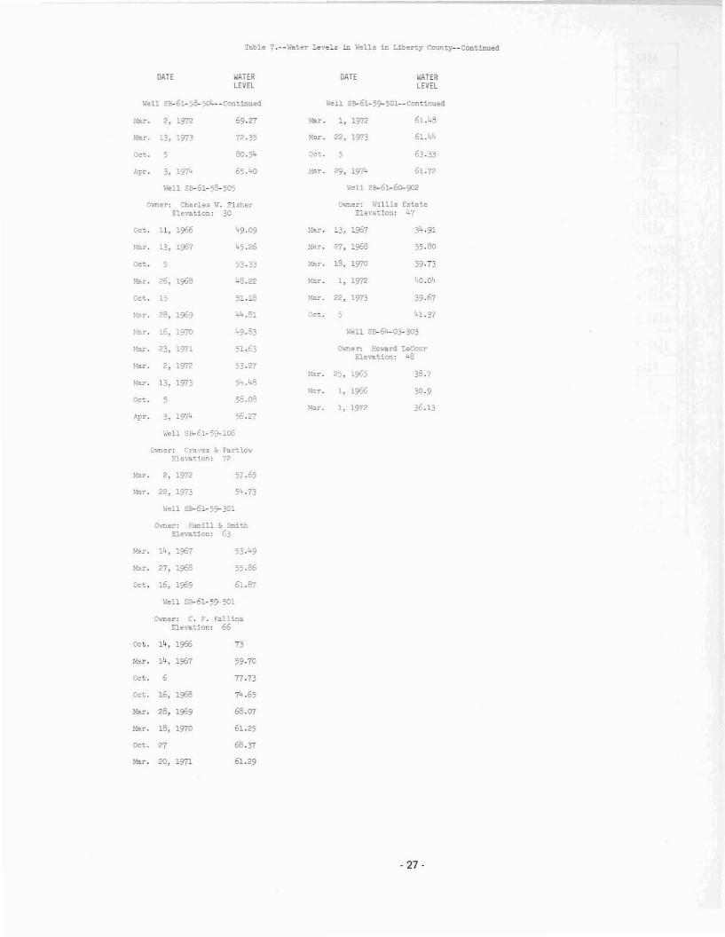
Table 7.--'''a';.er .:.evels in y,'ells in Liberty County--Continuecl
DATE WATERLEVEL
,",'ell s~61-5l>-5O'----Cont1nued
!-r. 2. 1972 69.27
I·~r. 13. 1973 72·35
Oc~. 5 80.:;4
Apr, 3. 197:- 65. 100
Well Sa-61-58-505
O'\<mer: Charles W. ?isherElevation: 30
Oct. 11. 1966 49.09
J·!ar. 13. 1967 4.5.26
Oct. 5 53.33
!-lar. 26, 1968 48.22
Oct. " 5:.18
fo'.ar. 2F, 1969 i..4..!!1
Kar. .6. 1970 49.33
Mar. 23. 1971 51.63
!-'.a.r • 2. 1972 53.27
~Iar. 13, 1973 5'- .48
Oct. , 58.08
Apr. 3, 1974 56.27
~!ell S~El-59-106
GloTler: Graves '}- Fa.r~lo",·
Ele'.-ation: 72
~~r. 2, 1972 57.65
Mar. 22, 1973 51..73
....ell Sa-61-59-3C1
O1oner: Earr.ill 3: ~i·~.."lElevation: 63
lo'.!lr. 14, 1967 53·-9
Mar. 27, 1968 55.86
Oct. 16, 1909 61.87
Well S~61-5~501
Owner: C. F. KallinaElevation; 66
Oct. 14. 1966 73
Ner. 14, 1967 59·70
Oct. 6 77.73
Oct. 16, 1968 74.65
"=. 28, 1969 68.07
M". 18. 1970 61.25
Oct. 27 68.37
Mor. 20, 1971 61.29
DATE WATERLEVEL
Well SB-61-59-501--ContL~ued
,,.,.. 1, 1972 61.1,.8
~~~. 22, 1913 6:.""
:)ct.. 5 6}.33
"'.ar. 29, 197i. 61. 72
Well SB-61-~902
O1o-ner: Willis EstateE:"evation: 47
!~a.r. 13, 1967 34.91
~·!ar. 27, 1968 35.80
~:ar. 15. 1970 39·73
z.:ar. 1. 1972 40.04
l-!ar. 22. 1973 39.67
nc~. 5 41.37
Well 58-64-03- 303
(hmer; iievan! LeCourElevation: 48
!.~r. 25, 1965 38.7
M!l.r. 1, 1966 30·9
Mer. " 1972 36.13
- 27-

;; .f~ .;
- 28-

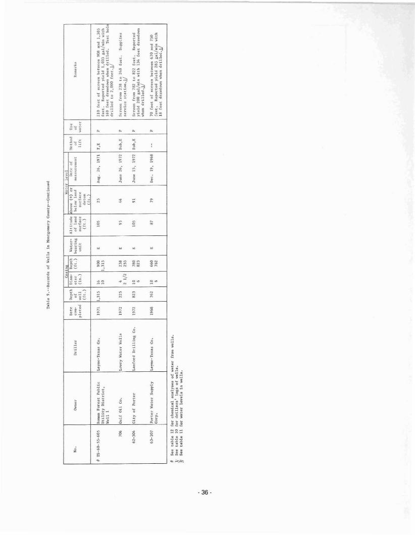
Water levelMethod of III t .... <1 type of JI'OWllfUsc of waterWatcr-hearll1S unil.
Table 9.··Records of Wells in Iiontgomoty County
Reponed water level. givel! In feel; rneaaurctl waler leych given tn (('ot 1l11<1 tenth.EletLI'lc; G, ~ll'Qltntl, oU, bUlnnll, Or dlllsaJ enginc; Sub, sub".Hslb!ei T, (urbt"". Number lndieoeea hOrl0powl:r.D, domeatlC; lnd, industrial; 1ft, lrriilatlon; N, nono; p. puhllc Ilupply.C, Chleet U<]ulfclr; E, Evans_line /I'lulfl,"f; J, JlIsper aquifer; JU, "P!X'f unit of Jupor nqul(ilr.
w~
Cllaln W,'lt>f Il'Vl'1011 til IJepeh Dium- [Jepth Wllter- Altitude bove (+) or U;Hu of M'Hhud Coo
M. Owner lIrU ler Cll'n· or Clef (ft. ) bearing of lund billow Lnlld nI\!(I&ur"munt or " l(l:lnnrk.p1"(lId well (In. ) Imt t Burface .u,"fllce I J ft loin t('r
(fto ) eft. )~~~~'~
Ts-60-35-904 Cape Conrail Suhdivi,ion Keene DriHing Co. 1972 '" , 178 C '" " Nov. 14. 1972 Sub,E P Scrolln f{om 163 to t97 fOflLl!32.2 Junll IS, 1974
36-205 Corinthion Polnt, lotd. Tex., W(\ter WlIll~, Inc:. 1972 530 » >- J ". 51 SepL 1972 T,E P 95 [eOL or u:reen between 380 lind 520l2 530 1.9.2 July 16, 1911. 75 feet. Reported yiold 601. 8nl/lIIl1> w1th
111 f,et drnwdown when drlll,d. Teathalo urllled to 1,263 feet.l!, 50' Point Aquert", l..yne·Tex.u Co. 1912 640 " 440 J 190 40.5 "" 22. 1912 T,' P 140 feet of ,crllen blew'en 450 111\(1 610
Hunldpal Utliity 10 640 flet. Reported yield 780 gol/.ln with 91Dhtrtct fect drllwdown wben drU led. Test hole
drU I,d to 1,009 feet.l!
'0' S"n Jlclnto Gi{1 SCOutl l.owry Il"tlr Welle 1967 '" 4 '52 , no u, June IS, 1961 Sub.e P 32 feet of screen between 652 lInd 6882 1/2 '" 5 feet .!!
'0) Charllll H. Boyd COn·TllX Wuer Well Co, 1911 )00 4 '" c 275 134 Apr. 1, 1911 Sub,E 0 Streen from 290 to 300 fCHlt.2 1/2 )00, "", Gllit Stllte, Utilitllll, Layne-TllxlII Co. 1969 7B2 14 560 JO '" 74 Oc:t. I, 1969 Sub,E lnd 102 feet of 'CrtllOll between 571 lind 771
WaH 2 , 7B2 75 (eeL. Ruporc:od ylold 650 Bul/min wtth74 feol dT/lwuown when drilled ..!!,
'" Gulf Stoto' Utll1tllll, do. 1968 '" " 460 JO '" 70 June 10, 1966 Sub,l~ tnd 155 fCOl of ec:rllon between 468 and 772Well 1 14 787 75 h,t. Repotteld yiold 1,1.01 Bill/min with
77 foet drllwdown wh(m dtillCll1. 'feet holedr1l1el1 to 1,150 fellt ..!!,.. Art MUlet Con-Tn WAter Well Co, 1!)71 '" 4 215 C 170 " Feb. Z2, 1911 Sub,r. " Screen ftom 222 to 232 feet ..!!
2 1/2 '",'09 HontllOlllOry COUllty loaync-Tcllu Co. 1912 740 16 440 J '" 37 Jun_ 22, 1912 T,' P 160 feet ot "'creen botwecn 450-125 feet.
UtUlty Dl,tt'ler No, 2. 10 740 34.1 July 16, 197/, 125 koported yield 754 gftl/mln with 56 feetSeven Covee dnlwdown whlln drill_d. Teat hole drt lled
lO 1,250 het ..!!90' C. P. Grayulll Con-To)!: Weter Well Co. 1970 347 4 )26 C 320 141 June 4, 1970 Sub,1! 0 Screen frc. 337 lO 347 feet.!!
2 1/2 347
31-106 Lllk. Lout.e do. 1910 340 ,'" C )00 " Nov. 19, 1970 -- 0 Screen fr_ JlS to 335 feet.!!
4 340
107 Jl. OUver do. 1971 '" 4 24' C )00 107 AUJI;. 2, 1971 -- D Screen frOOl 250 1'1'1 260 feet.!!2 1/2 '"
410 Kenneth R~c:h do. 1912 409 4 )64 C 370 16' Apr. ,. 1912 Sub,l! 0 Scr,.n fr"'" 399 to 409 hct.!!2 1/2 409
'06 lllirty OxeprlnjJ Pattetlon Water Well 1970 '" 4 )15 C )00 '26 Jan. 1970 Sub,E 0 Bcr,.,n from 328 to 338 Cen.l!Service 2 1/2 '"
70' Phillip Yonk Con-tcx Wllter WillI Co. 1911 )09 4 '" C 320 146 Apr. 8, 1911 -- 0 Screen ftom 299 to 309 feet ..!!2 1/2 320
See (ootnotllll at end of table,

w'"
Table 9.··Recorda of Wells in I1onlgOlllOry County--Continued
CII"ln Water ICII<'l
""" Depth Dbm- Depth Water- Altitude bove (+) or Oatil nl MlILhulJ U.."0. Owner Dr lIler ,- of (lter (ft. ) bearing of land billow laud lIleaBurem"nL or of R",..a rks
pie ted well (In. ) unit Burr.cll .urf8ce II rt water(rt. ) (ft. )
~~~~~TS-60-37-710 E. 11. Drhcnll Con-Tex Waul' Wl.Ill Co. 1967 3/,6 4 '" C 320 141 Aug. 7, 1967 Sub,E D Scrcel1 (roln 336 to 346 feet.JJ
2 lIz '" 1
907 Royal FOrllu UtUity B. J. S.. illohart Co. 1970 '08 6 "1 E 290 " Dec. 1971 Sub,1!: P Screen from 462 to 507 (eet.l!Co. 4 '08
38- 703 Horri" Crllllgton Con-Tex W"ur Wall Co. 1970 192 4 '" c 233'"
Sept. 9, 1!)70 .. 0 Scrllen from 182 tn 192 f""t.JJ2 1/2 192
43-103 Le.. t. A. Richard. do. 1968 222 4 '09 C 250 " Feb. 6, 1968 Sub,! U Screen from H2 to 222 feet.J.J2 1/2 222 1
'04 John Martin do. 1967 m 4 322 E 2SO 52 July 20, Ub7 Sub ,r. u Screen hom 322 Lo 332 [eet.J)2 1/2 3J2 2
'0' Cecil Boulevare do. 1971 29' " 276 C '00 121 ""y 31, 1971 Sub,!:!: U Screen from 279 to 289 feet..!!2 1/2 '"
'0' Johnnie LllfHllIlh I'atunon Waler Well 1972 '" 4 225 E 220 y, Feb. 17, 1972 .. 0 11Sl!rllll;:e 2 1/2 '"
'0' Roman IIU1. SublJlllhion Katy Drt1llng, Inc. 1.973 '00 12 SOD , 250 81 July 3, 1!)73 'r ,G 0, In 190 feUl of dotted pipe b"tween 310 and500 feet. Reported yhld 243 gal/minwith 160 feot drl".down when drilled.Test holo drllieu to 700 teet.y
'0' II. K. ThOlnplon Falkenhury DrlUina Co. 1971 55 4 55 , '" .. .. Sub,! D SCrelln from 45 to 55 fl!"t.lI
'06 lIarold L. COlllll Dietl!. Pump 6 W"l1 1972 4ll " 40' , 315 197 ,,"y 3, 19n Sub.1!: D Screen from 1,03 to 41\ feet ..i/Service 2. 1/2 411
S07 R. O. Knott Con-Tex Wllter Wall Cn. 1971 '" ,. '" E no I)' "".. 4, 1971 SlIb,V. ° Screen frDIII 330 to 340 fcet.y2. 1/2 '"
'0' Ray [,ulJl1ck Turhlnll Pump Silrllice 1971 "0 4 ", , l65 '" Apr. 197t .- D Screcil from 338 tn 3M! fceLJJ2 1/2 350
'09 C. B. Ruahl Con-TIlX Water Well Co. 1971 '" " '" E '" III "",. I, 197L E U Screen frOlll 3.52 to 362 feet •.!!2 I/Z 36'
SID Loke 177, O. A. Gerlnff do. 1968 '",
"0 E "" 154 July 19&8 Sub,!': P Screen frnm 1,31 to 446 feet. Suppll.nM4 4/,6 7 1/2 aubdllllsinn.y
44-106 Lake Conroe Forest Katy Dr1111n3, Inc. 1971 'OS ,'" E l2.5 55 Oct. 12, 1972 'r ,I!: P Screen from 800 to 995 [eet. RepOrted
Subd1vilion 4 1/2 99' '0 yield 259 gal/..ln with 105 feet drnwdololnwhen drllllld.y
107 Webb Helder COli-Tell. Wliter Well Co. 1972 ". 4 '" E 220 " Jan. 19, 1971 .- " Scroell from 380 La 390 feec.y2 1/2 39O
108 Dab HeCalhuah do. 1971 "6 4 37/, E 2H 66 June 24, 1971 Sub,E D Screen fcOlll 366 to 396 [eet.y2 1/2 '"
Sao £ootnotea at end of table.

"io
w~
oo
::,..
o
::,..
w~
oo
o
"~
o.-,;
~~
fr.t:.5"' .....a e .. ";~::.5Q.~
o"
o"
··>·>
o
"Q
- 33-

":1oo
~~o
- 34-

wU1
Tllble 9.--Recordll of Wells in Montgomery Couuty--{;t1ntinued
Cast" Water levelJ)at~ lJ"pth Diam· Depth Wnttr- Altlt"d" bove (+) or D<llC of Method U""0. Owne,' Driller co'n- 0' eter (ft. ) hearing of land be I 0'" l.and measurement of of Rtmarks
pLeted "'t'Ll (In. ) \mit surfacc surface 11ft ",attr(ft. ) (ft. ) dlllum
flo
TS~60·S3·207 Rivtrbrook Suhdivisioo Con~Te)l Water WeU Co. 1968 170 6 '" , 125 J Mop 9, 1968 Sub,E In Screen ftom 155 tu 170 f ...et. Supplies'. l10 lake •.!J
312 Richard P. Stade Ie, Nclson Wat~r Wc.ll" 1968 l26 , l26 E 110 -- -- J,': 0 Screen frow 121 to 126 feet.Ha;;nolia Bend 1Subdivision
5ll Shenandoah V<tlley Knty Drilllng, Inc. 1972 708 10 426 E 145 92 Apr. 1972 1',1; P 265 feet of scrten between 433 and 698HunidplII Utility 6 708 3D feet. Reported yicld 1,1.0 gal!min withDistrict 200 feet drllwdow" whcu dril1ed.J.)
512 Allhford Fore5t Lowry Water Wella 1968 695 4 669 l 145 7J Od. 11, 1968 S"b,E , 25 feo::t of IIcre!!n between 667 and &92Subdividon 2 1/2 695 5 feeLJ.!
708 Montgomery County WC&ID Texas Wuter W"lls, [nco 1968 i,180 -- -- , lJ5 71 "",. 1968 T.', 166 feet of <lcr""n b... tween 794 nnd 1,170
No.1, Timber Lake 10 1,180 LOO feet. Reported yield 1,000 gal!min withRatilte" 165 feet drawdown when drilled. Teat
holc drilled to 1,410 fcet.l!
8ll Lak" Chutenu Wooda Lowry Wat"r We1111 L967 38J 4 J45 ,"7 50 Jan. 5, 1967 Sub,~;
, Screen CrOll! 353 to 383 feet.2 1!2 38J 5
812 Oak Ridge North E. L. lIode Dr1l1l.'\8 Co. 1968 244 '. 212 , l26 57 June 7, 1968 Sub,E r Screen fr ...... 224 to 244 feet.JJSubdivision 2 l/2 244 5
8" Montgomery County FWSD Katy Or1111.n8, Inc. 1970 '" 16 510 , 117 OJ Oct. 1970 'r ,E r Reported yiei<l 1,200 8al/mln with 210No. 2 LO 996 feet drawdown when drllled.JJ
814 Oak Ridge North Texas Water Wells, ILle. 1969 1,0lO -- -- , 129 73 "'" 2, 1969 or ,E P 160 feet of licreen betwccll 730 lind 1,000Subdivillion lO 1,010 125 feet. Reported yield 1,001 gal!min with
109 feet druwdown when drilled.l!
815 Juek Joneli Con-1'C'ex Water Wcll Co. 1969 238 , 238 , [20 4J Feb. 28, 1969 J .' " Screen from 2]3 to 23B feet.JJJ/4
816 Lake Ch<ltellu WOO<:lIl Lowry Water Wella 1971 380 6 J57 , lJ7 67 Oct. 11, 1971 Sub,E r Sere!!n from 349 to 369 feet.1/4 380
55-309 Texaco, [nco do. 1972 284 4 261, , llO 2l June 2, 1972 Sub, I; 10d Screen from 260 to 275 feet. Suppliell2 1/2 284 aervlce atation.l!
310 T. !". Howland Schoppa Wuter Well 1971 340 '. J25 , l2l 42 Jan. 21, 1971 SUb,I:: 0 Screell from 330 to 31,0 feet ..!!Service 2 1/2 340 l
Jll George 8ullock Con-Tcx Water Well CO. 1971 422 '. 405 , ll8 51 Sept. 2, 1971 Sub,E 0 Serec." from 412 to 422 feet.J.!2 1/2 t,22
508 Southwestern Dllll Lowry "'ater Wella 1970 388 4 J72 E llO " '· ...b. 2, 1970 Sub,E Ind Sere-en from 368 to 383 feet •.!!1'elephonc 2 1/2 J88 I 1/2
604 Ol1!litl Foreat Kilty Drilling, Inc. 1973 683 12 68J , lOS 74 lIug. 1973 T,E In Cueing Qlotted from 287 to 683 feet.S"b<livlllion 20 Reported yield 1,15!! gal/min witb 116
~~n ~~~~g~\,/...hell ddllcd. lrrlgute~
Sec foou,otc-fi lit e"d of ~sble.
~~~ ," 0
i!~~-;~.c 00=;~~ON","000_ •
..0 .. .=
;~~.0':;Z.g·" ,o •· ~"000•o •o ••... .......
o~~~
"o •.-, 0 •, • •
"., ." '"• 0 •00_
~
t:...0_
.:I-----+-~---------___l;.,5"C0._
i•j~
··3..··ef~·:;;~
~=::::
~~~
~~~"""
,
··~··3"~ E-O 0'0
"."2oEo
,o
o
"."o
.o
~~~
L LC~=-- _J ~ """"
·36·
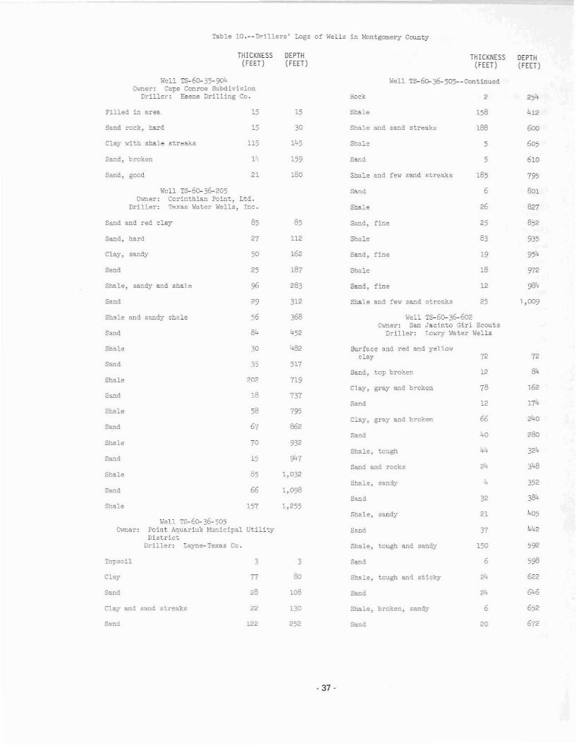
Table lO.--Drillers' Logs of Wells in Montgomery County
THICKNESS(FEET)
DEPTH(FEET)
THICKNESS(FEET)
DEPTH(FEET)
Well TS-- 35-9Qlo-ner: Cape Conroe Subdivision
Driller: Keene Drilling Co.
Well Is-6o-36-205~ner: Corinthian Point, Ltd.
Driller: Texas Water Wells, Inc.
Sand, fine
Sand, fine
795
801
827
852
935
954
972
984
600
605
610
254
412
2
12
26
83
19
18
25
5
5
185
6
158
188
Well TS-~36-505--Continued
Shale
Shale
Sand
Shale
Sand
3.ock
Shale and few sand streaks
Shale
Shale and sand streaks
Shale
Sand, :'ine
85
159
180
112
162
30
15
187
283
15
14
21
27
50
85
25
115
Pilled in area
Sand, good
Clay with shale s~reaks
Sana, broken
Sand :-ock, hard
Sand
Clay, sandy
Sa.l'1d, hard
Send and red clay
Shale, sandy a~d shale
sand 29 312 Shale and :'ew sand streaks 25 1,009
Well Ts-6O-36-505Owner: Point Aquarius ~~nicipal Utility
DistrictDriller: Layne-Texas Co.
T&-60- 36-602Jacin~o Girl ScoutsLc~~' Water Wells
Shale and sandy shale
Sand
Shale
Sand
Shale
Sand
Shale
sand
Shale
Shale
Sand
Shale
'Topsoil
Clay
Sand
56
30
35
202
18
58
67
70
15
85
66
157
3
77
28
368
452
482
517
719
737
795
862
932
,M
1,032
1,098
1,255
3
80
loB
'''ell()T"ner: San
Driller:
Surface and red and yellowclay
Sand, top broken
Clay. gray and broken
Sand
Clay, gray and broken
Sand
Shale, tcugh
Sane and rocks
Shale, sandy
Sand
Shale, sandy
Sand
Shale, tough and sandy
Sand
Shale, tough and sticky
sand
72
12
78
12
66
40
44
24
32
21
37
150
6
24
24
72
162
174
240
280
324
348
352
405
442
592
598
622
646
Clay and sand streaks
sand
22
222
130
252
Shale, broken, sandy
Sand
6
20
652
672
- 37-

Table IO.--Drillers' Logs of Wells in Montgomery County--Continued
THICKNESS(FEET)
DEPTH(FEET)
THICKNESS(FEET )
DEPTH(FEET)
Well ~60-36-602--Continued
Shale, sand, broken 4
Well Ts-60-36-604Owner: Gulf States Utilities, Well 2
Driller: Layne-Texas Co.
Well TS-6o-36-605Owner: Gulf States Utilities, Well 1
Driller: Layne-Texas Co.
530
542
543
32
62
611
118
128
163
181
216
231
252
266
296
305
315
325
332
367
378
391
399
416
L83
460
461
482
499
620
632
641
1
1
7
35
9
9
9
13
8
15
10
32
30
56
35
14
30
11
10
37
7
17
10
17
12
21
35
18
12
31
L8
20
21
Sand
Shale with small layers ofrock
Clay and sand streaks
Clay, sandy clay, hardstreaks
Clay, hard sandy streaks
Clay
Shale
Sand
Shale
sand with few shale breaks
Sand
Shale with few sand streaks
Sand
Shale
Clay with sand streaks
Sand
Shale and sandy shale
sand and clay streaks
Shale and clay
Sand
Shale and sandy shale
Shale, sandy
Clay
Sand and shale breaks
sand with few shale breaks
Shale with few sand breaks
Shale with few s~~d breaks
Clay
Sand with shale breaks
Sand, broken
Shale, sandy
Sand
Sand with clay streaks
75
115
136
172
52
307
329
360
275
277
312
215
245
260
676
688
689
6<)4
712
648
684
392
464
485
497
546
576
600
605
620
737
769
800
5
1
12
5
12
52
36
43
30
15
15
2
17
31
32
72
23
40
30
21
49
30
24
21
5
15
28
36
28
25
32
31
Clay and hard streaks
Shale, sandy and shale breaks
Shale, sandy and sand
sand and sandy streaks
Shale, sandy and sand
Sand and shale breaks
Shale, hard
Sand, gray
Shale
Shale, sandy and sand
Clay and sticky clay
Clay and gravel and rocklayers
Clay, hard
Shale, very sandy, broken
Shale, hard
Shale, sticky
Sa~d
Sand
Shale, sandy and sand
Shale a~d ~~d streaks
Shale
Sand an.d shale breaks
Sand and shale streaks
Shale, sandy
Shale, sticlty
Clay, sandy and sand
Sand, fine
Sand and shale streaks
Shale
Shale, hard
Sand
Shale
·38·

':'able :O.--:Jrillers' Logs of Wells in Mon~gome~y COQ~ty--Continued
THICKNESS DEPTH THICKNESS DEPTH(FEET) (FEET) (FEET) (FEET)
Hell T5-60- 36-605--Cont:.nued Hell TS-60- 36- 808- - Continued
Shale, send,:;, 19 660 Clay with hard strea..'lts 97 183
Stale 10 670 Sand 13 196
Shale 7 677 Shale 11 207
Shale, sandy and sand breaks 43 720 Sand 25 232
ShSE 19 739 Well TS-60- 36-809o-,,~er: Mcntgomerj County
Sand 30 769 ~tilitj· District Xo. 2, Seven CovesDriller: Layne- Texas Co.
Shale 11 780Topsoil 2 2
Shale 6 786Clay and few sand streaks 78 80
Shale 4 790Sand and c:'ay 30 110
Shale, sandy with sand breaks 20 810
C:'aj' 10 120Shale, sandy shale a~d breaks
of sand 61 871 Sand 80 200
Shale 7 878 Sand and shale streaks 20 220
Sand 2 880 Shale and sand streaks 20 240
Shale with sand streaks 5 885 Sand 52 292
Shale, sandy 2'/ 912 Shale 88 380
Shale with sand streaks 80 992 Shale and sand streaks 40 420
Shale with sand streaks 90 1,082 Shale 30 450
Shale 30 1,112 sandy, shale 150 600
Shale 11 1,123 Shale and sand streaks 18 618
Shale and sandy shale 27 1,150 Sand and few shale streaks 52 670
Well ,:,s-60-36-603 Shale 10 680Owner: Charles n. Boyd
Driller: Con-Tex Water WeI:' Co. sand 18 696
Clay 124 124 Shale and sand streaks 11 709
Sand, t.ard 12 136 Sand 10 719
Shale "'ith hard streaks 120 256 Shale and lice 46 765
Sand, brown 14 2'/0 Sand 6 771
Shale 7 2'/7 Shale and lice 29 800
Sa:1d 23 300 Shale and Ike 77 877
Well Ts-6o- 36-808 Shale 15 892Owner: Art Miller
Driller: Con-Tex Water Well Co. Shale and sand streaks 73 965
Clay with lice streaks 43 L3 Shale 45 1,010
Sand 3 ,6 Shale and sand streaks 68 1,078
Clay 39 85 Shale and few sa~d streaks 172 1,250
Rock 1 86
- 39-
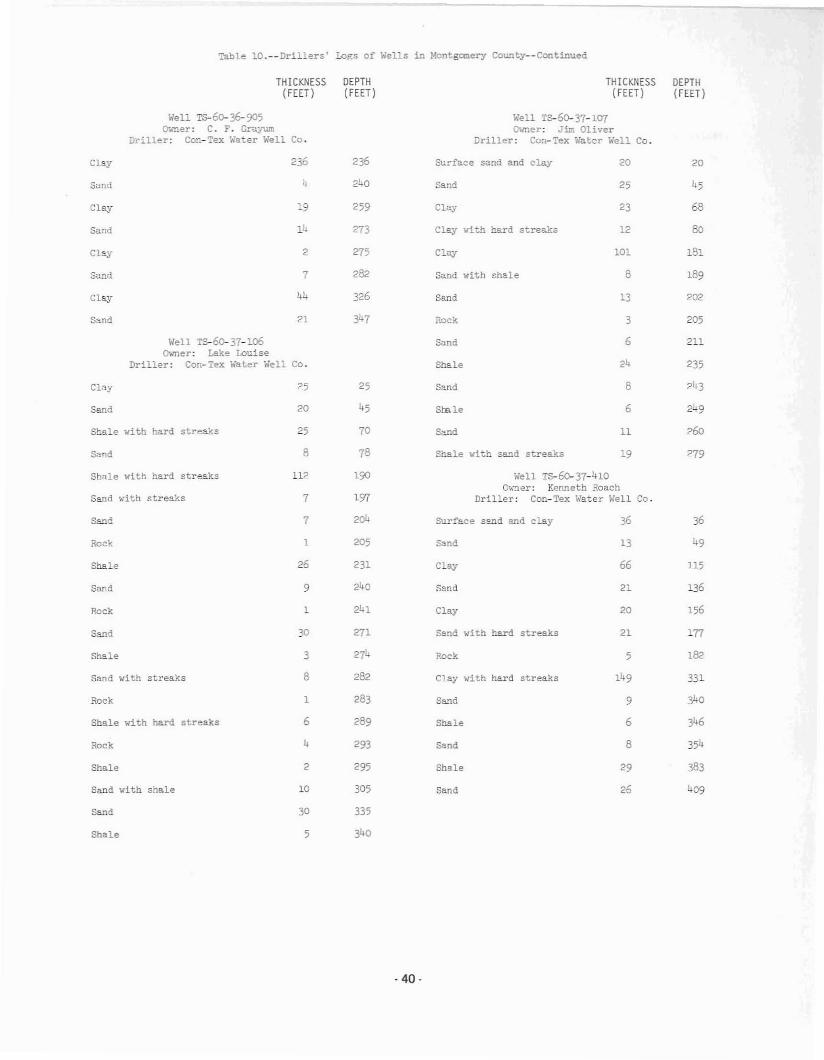
~ble IO.--Drillers' Logs of Wells in Montgomery Cou.~ty--Cont1nued
THICKNESS(FEET)
Well rs-60- 36-905O;.ner: C. F. Grayum
Driller: Con-~ex Water Well Co.
DEPTH(FEET)
THICKNESS(FEET)
Well T&-6o- 37-1Cfl~ner: Jim Oliver
Driller: Con-Tex Water Well Co.
DEPTH(FEET)
Clay 236 Surface sand and clay 20 20
Sand
Clay
Sand
Clay
Sand
Clay
Sand
Clay
Sand
19
14
2
7
44
2l
Well T5- 37-106Owner: Lake Louise
Driller: Con-Tex Water Well Co.
25
20
259
273
275
Sand
Clay
Clay with hard streaks
Clay
Sand with shale
Sand
Rock
Sand
Shale
Sand
Smle
25
23
12
101
8
13
3
6
8
6
181
202
205
211
235
243
Well rs-60- 37-410Own~r: Kenneth Roach
Driller: Con-Tex Water Well Co.
Shale with ~~d strea-~s
Sand
Shale with hard streaks
Sand with streaks
Sand
Rock
Shale
Sand
Rock
Sand
Sp..a.le
Sand with streaks
Rock
Shale with hard streaks
Rock
Shale
Sand with shale
Sand
Sbale
25
8
112
7
7
1
26
9
1
30
3
8
1
6
4
2
10
30
5
70
78
190
197
204
205
231
240
241
271
274
282
283
289
293
295
305
335
340
- 40-
Sand
Shale with s~~d streaks
Sur:"ace sand and clay
Sand
Clay
Sand
Clay
Sand with hard streaks
Rock
Clay with hard streaks
Sand
Shale
Sand
Shale
Sand
11
19
36
13
66
21
20
21
5
149
9
6
8
29
26
260
279
36
115
136
156
177
182
331
346
354
383
409

Table lO.--D~ill~rs' Logs o~ Wells L~ Montgome~y County--Continued
THICKNESS DEPTH THICKNESS DEPTH(FEET) (FEET) (FEET) (FEET!
Well TS-60-37- 506 v;ell TS-6o- 37-710Oi.ne:!": Harry Oxs-pring Owner: E. ~. Driscoll
Driller: Pat;terson y:ater Well Service Driller: Con-~ex Wate~ Well Co.
Clay 12 12 Clay 110 110
Sand 10 22 Clay with ha~d streaks 10 120
Clay 32 .' S6.r::d ....ien ha!'d streaks ::"4 134,-Rock 2 56 Rock 1 135
Cley 59 :15 &:.nd 15 150
Sand 4; 160 :lock 2 152
Reck 5 165 C~ay ...."i;;h sand 6 158
Clay 40 205 CIa:,' 96 2jL
3.ock 5 210 Rock 3 257
Clay 50 260 Clay 2 259
Rock 2 262 Sa..'1d 1* 273
Clay 18 280 Clay 2 275
Rock 2 282 Sand 5 280
Clay 35 317 Clay 41 321
Sand 21 338 Sand 5 326
';.,Tell Ts-6o-37-709 Clay 3 329Owner: Phillip Yorek
Driller: Con-Tex Water In'ell Co. Sand 17 346
Clay ',dth sand strea.1.ts 40 40 Well Ts-6o- 37-907o-"ner: Royal Forest Utility Co.
Clay 95 135 Driller: B. J. Swinehart Co.
Shale with hard streaks 16 151 St:rface sand 7 7
Sar.d 16 167 Clay 18 25
Shale 45 212 Clay .nd sand 9 34
Rock 3 215 Clay 36 70
Shale 55 270 Sa~d 10 80
Sand, bro-..m 10 280 Clay 42 122
Shale 11 291 CIa;)', sand a.'1d rock 72 194
Sand 18 309 Rock, sand 13 207
Sa..'ld, fine 32 239
Clay 117 356
Sand. fine 13 369
Clay 9 378
Sand 17 395
Clay 16 411
Sand 18 429
·41 -

Table lO.--Drillers I Logs of Wells in Montgomerj CotUlty--Continued
Clay
Sand
Clay
THICKNESS(FEET)
Well Ts-6Q-37-907--Continued
30
48
1
DEPTH( FEET)
507
508
Sand
Clay
THICKNESS(FEET)
Well Ts-6o-43-204Owner: John Martin
Driller: Con-Tex Water Well Co.
22
29
DEPTH(FEET)
22
51
Well Ts-60-38-703Owner: Mor~is Creigton
Driller: Con-Tex Water Well Co.
We 11 'I-&- 60- 43- 205Owner: Cecil Boulevare
Driller: Con-Tex 'rlater Well Co.
Surface sand
Clay
Sand
Clay
Sand
Clay
Sand
Clay
Rock
Clay
Clay with herd streaks
Sand
Clay
12
20
18
5
3
8
29
37
3
37
4
16
3
12
50
55
58
66
95
132
135
172
176
192
195
Rock
Clay with hard streaks
Clay, sandy and rock
Rock
sand
Clay
Sand with hard streaks
Clay
Sand with hard streaks
Clay
Sand
Shale with hard streaks
Sand
1
135
125
1
19
32
13
55
18
56
12
4
6
52
187
312
313
332
32
45
100
118
174
186
190
196
Sand, hard streaks
Clay
Rock
Well TS-60- L3-l03o.ner: Lewis A. Richards
Driller: Cor:-Tex 'I'later Well Co.
40
12
1
40
52
53
Shale
Sand, shale ~~d hard streaks
Shale
Sand
Shale
23
8
42
21
5
219
227
269
290
295
Clay
Sand, hard streaks
55
28
108 Well TS-60-43-305Owner: Johnnie Lapaglia
Driller: Patterson Water Well Service
Sand with clay s~reaks
Sand
Sand with clay streaks
Clay
Sand
9
6
7
52
12
151
158
210
222
·42·
Clay, hard red and rock
Clay
Clay and rock
Sand and rock
Clay
Sand, water bearing
85
20
10
15
70
38
85
105
115
130
200
238

Table lO.--Drillers' Logs of Wells in MOntgooery County--Continued
THICKNESS(FEET)
Well Ts-~43-306
~~~er: Roman Hills SubdivisionDriller: Katy Drilling, Inc.
DEPTH(FEET)
THICKNESS(FEET)
Well TS-60-43-505Owner: W. K. TbClllpson
Driller: Falkenbu..."Y Drilling Co.
DEPTH(FEET)
Well T5-60-43-506O'~er: Harold L. Cones
Driller: Dietz Rk~p and Well Service
Well Ts-6o..43- 507O~~er: R. D. Knott
Driller: Con-Tex Water Well Co.
Clay, surface
Clay, brown
Clay, blue
Clay
Sand
Clay
Shale
Clay, sa~d streaks
sand, clay streaks
Sand
Sand
Shale
Sand
Clay
Sand
CIa;)'
Sand
Clay
Clay
Sand
Sand with clay strea.1{s
sand, stene
Sand
Sand
38
16
10
5
32
31
31
31
15
1
69
20
12
18
17
28
24
15
10
10
11
16
9
38
69
85
95
100
132
163
19'-
225
310
.330
360
377
405
429
444
454
46'+
1.75
491
500
sand
Rock
Clay
Sand
Clay, red
Clay, wni~e
Shale, hard
Sand
Shale, hard, .~ite
Shale, sa11dy
Sat'ld
Shale, se.ndy
Sand
Clay
Sand with clay
Clay
Sand
ClaJI'
Sand
Lime with shale
18
4
13
20
67
36
51
8
n6
10
53
7
10
25
226
19
3
18
22
35
55
67
103
162
206
322
327
401
411
53
60
70
95
321
340
Clay
Sand
7
3
507
510
Well TS-~43-508
(r.mer: Ray LudlickDriller; Turbine ~~p Service
Clay
Clay, sand streaks
Sand
Clay
27
32
126
5
537
569
695
700
·43·
Clay
Sand, fine
Clay
Clay, sandy
Sand
20
138
52
50
90
110
21.8
300
350

Table lO.--Drillers' Logs of Wells in Montgomery County--Continued
Kell TS- 44-106--Continued
Sand, rock 41
Clay
Sand
Clay
Sand
Shale
THICKNESS(FEET)
Well TS-60-L3-509Owner: C. R. Buahl
Driller: Con-Tex Water ~'ell Co_
20
10
255
12
14
DEPTH(FEET)
20
30
285
311
Clay
sand, rock
Clay
Sand, shale
Clay
THICKNESS(FEET)
28
17
116
20
117
DEPTH(FEET)
419
447
464
580
600
717
j,,'ell TS-6O-":3- 510Owner: O. A. Gerlo~:, Lake 30. 111Driller: Con-Tex Water Well Co.
'IIell Ts-6o-44-l01Owner: Webb Helder
Driller: Con-Tex Water Well Co.
Well rs-6o-4L_I06o.~er: Lake Conroe Forest SUbdivision
Driller: Katy Drilling. Inc.
Sa.'1d, brown
Shale
Sand
Sand, surface
Clay
Sand, gravel
Clay
Sand, fine
Clay with lime streaks
Sand
Clay
Sand
Clay
Sand
Clay
Sand. gravel
Clay
Rock, sand
Clay
Sand. rock
Clay
Sand, rock
Clay
Sand, rock
Clay
11
6
20
11
22
22
227
23
1
14
32
29
19
26
35
14
106
11
59
18
15
21
48
322
328
362
20
31
53
75
120
347
370
371
446
19
45
80
200
211
270
288
303
324
372
·44·
Sand
Clay
Sand, shale
Shale
Sand, rock
Sand, shale
sand, rock
Sand
Sand
Shale
Bottom
Clay, surface
Sand
Shale
Sand
Rock with sand streaks
Shale
Sand
Shale
Shale, sandy
Sand
Shale, sandy
Sand
Shale
Rock
Shale
sand
28
10
18
31
25
17
87
6
43
9
8
16
24
190
13
12
3
15
47
12
13
L6
7
5
1
4
12
745
755
773
804
829
846
933
939
982
991
999
230
243
255
258
273
320
332
345
361
373
374
378
390

?able IO.--Drillers' Logs of Wells in ~ontgomery County--Continued
THICKNESS DEPTH THICKNESS DEPTH(FEET) ( FEET) (FEET) (FEET)
\l.'ell Ts-60-4L 107--Cont:inued Well TS-~44-109--Continued
Shale 202 592 Eard streaks 8 370
~ell Ts-6o-L.4-loB Rock 1 371Oloner: 30b McCallaugh
Driller: Con- rex Water Well Co. Hard streaks 7 378
Clay 20 20 Rock 2 380
Sand 35 55 Shale and hard streaks 250 630
Rock 5 60 Rock 2 632
Clay ,...ith sand streaks 10 70 Sand 62 694
Clay \<lith herd strea.."'::s 30 100 Well ~6Q-l4-110
O".mer: April Sound SubdivisionHard streaks with shale 15 115 Driller: Con-Tex Water Well Co.
Snale with hard streaks 55 170 Clay 15 15
Eard streaks with.sand 7 177 Sand 20 35
Saod 9 186 Clay, hard streaks 208 243
Shale 63 249 Shale, sandy 9 252
Sand with hard streaks and shale 11 260 Sand 5 257
Shale 19 279 Rock 1 258
Sand 12 291 Shale 4 262
Shale, sand~c 9 300 Sand 16 278
Shale with hard streaks 41 341 Shale, sandy 2 280
Sand 6 347 Shale 44 324
Rock 4 351 Shale, sandy 7 331
Sand 3 354 Sand, fine 6 337
Shale 8 362 Shale 15 352
Sand 3" 396 Sand 7 359
Ke:l rs-6o-44-109 Shale 271 630Owner: April Sound SubdivisionDriller: Con-Tex Water Well Co. Reck 1 631
Surface sand and clay 22 22 Shale 2 633
Sand 20 42 Rock 1 634
Clay 106 148 Shale, sandy 8 642
Sand 27 175 Sand 29 671
Clay 65 240 Sand, good 26 697
Sand 25 265
Rock 3 268
Sand C2 280
Shale 50 330
Sand 32 362
·45·

Table lO.--Dr111ers' Logs of Wells in Montgomery County--Continued
THICKNESS(FEET)
Well TS-6o-44-207(ft,ner: Remus Fuitz
Driller: Patterson Water Well Service
DEPTH(FEET)
Sand
THICKNESS(FEET)
Well TS-6o-44- 308--Continued
33
DEPTH(FEET)
Clay
Sand
25
3
25
28
Well 1'&-60-44-309Owner: Jack Moore
Driller: Con-Tex Water Well Co.
Well TS-60-44- 307Owner: William Hill
Driller: Con-Tex Water Well Co.
Clay
Rock
Sand and rock
Clay
Clay and rock
Clay
Clay and rock
Clay
Sand, -.."titer
Surface sand snd clay
Sand and gravel
Clay
Sand
Clay
Sand
Shale
Rock with shale
Shale snd few hard streaks
Sand
12
2
38
25
40
30
10
71
20
14
38
62
12
30
9
15
173
40
40
42
80
105
145
175
185
256
276
14
52
114
126
156
165
205
220
393
433
Surface sand and clay
Sand and gravel
Clay
Sand
Clay
Sand
Clay
Rock
Clay
Rock .... ith sand
Sand
Shale
Rock ....ith shale
Shale
Sand
Shale
Rock
Sand
Shale
sand .... ith shale
Sand
32
16
17
5
14
8
61
1
32
12
36
4
72
13
5
2
5
30
16
40
32
48
65
70
84
92
153
154
186
198
212
248
252
324
337
342
34
349
379
395
435
Well T8-60-44-3a8Owner: Walt Blanchard
Driller: Con-Tex ~ater Well Co.
Well TS-6Q-!J4-310Owner: Walton Plant Farm
Driller: Patterson Water Well Service
Surface sand and clay
Sand and gravel
Shale
Sand
Shale
Sand wi'th hard streaks
Shale with hard streaks
Sand
Shale
20
80
18
12
20
10
234
15
15
20
100
118
130
150
160
394
409
424
·46·
Sand, red
Clay
Rock
Clay
Rock
Clay
Rock
Clay
Shale
44
60
2
69
2
63
5
60
40
104
106
175
177
240
245
305
345

Table IO.--Drillers' Logs o~ Wells in ~ontgomery County--Continued
THICK/lESS(FEET)
DEPTH(FEET)
THICKNESS(FEET)
DEPTH(FEET)
Clay
~ell rs-6o-L~-3Io--Co~tinued
59
Well TS-6o-44-407Owner: Benny Eldred
Driller: Con-Tex ~ater Well Co.
Rock 1 405 Clay 20 20
Well ~s-60-44-405
Owner: Lake Forest LodgeDriller: Ra~terson Water Well Service
Clay
Water sand
Clay
Saltd
Clay
Sand
Clay
Rock
15
18
20
10
50
40
35
5
20
30
80
120
155
160
Sand and gravel
Clay
Sand
Clay
Sand
Clay with herd stre~ks
Sand
Clay, sar-dy
Sand
C:ay
30
80
14
2l
24
185
10
2
23
3
50
130
144
165
189
374
384
386
409
Clay
Rock and clay
60
85
220
305
Well TS-~45-109
(h,,'Tler: Classic SchoolDriller: Con-::'ex Wa~er Well Co.
Clay 350 Surface sand 20 20
Roc k and clay
Clay
Hs't;er, sand
40
36
390
426
440
Sand ~ith clay
Clay ~ith hard streaks
Shale with hard streaks
50
120
160
70
190
350
We 11 TS- 60- 44- 406Owner: Lake Bonanza Associat~on
Driller: Fat~erson Water Well Service
Shale ~itb sand streaks
nard streaks with clay
Shale, sandy with hardstreaks
164
150
375
378
417
426
449
482
35
70
108
25
42
14
35
35
38
3
39
9
23
33
Well rs-6o-45-110Owner: Dillinger
Driller: Con-Tex Water Well Co.
Sand
Clay
Sand
St>...ele
SEnd
Sand
Sand
Clay
63
10
22
100
155
244
300
105
125
385
406
41
12
10
20
30
37
5
89
56
85
21
Clay and sand streaks
Clay
Clay ~ith rock breaks
Clay
Sand
Cley
Clay ~ith rock breaks
Clay
Sand
Sand
Water, sand
Shale with herd streaks
Sand
S:mle
68
2
232
234
324
·47·

Table IO.--Drillers' Logs of 'Hells in ~~ntga=ery Count,y--Continued
THICKNESS DEPTH THICKNESS DEPTH(FEET) (FEET) (FEET) (FEET)
'","ell TS- 60-45-110- - Continued Well TS-6O-45-512Owner: Pat's Feed Store
Sh~le, sandy 12 336 Driller: J&J Water Well
Shale 35 371 Clay, red, iron ore 19 19
Sand 26 397 Clay, blue 29 48
Shale, sandy 3 400 Sand 8 56
Well TS-60-45-205 Clay, blue-yellow 74 130fr..ner: Roe ¥.c:ianey
Driller: Con-Tex Water Well Co. Rock 2 132
Clay 20 20 Clay and rock 38 170
Sand and gravel 50 70 Clay, blue 100 270
Clay 15 85 Sand 5 275
Sand and gravel 25 110 Shale, blue 6J, 339
Clay 72 182 sand 60 399
Rock 4 186 Well TS-6o-45-7llO\.ner: San Jacinto Girl Scouts
Sand 15 201 Driller: Lowry Water Wells
Shale 58 259 Clay, bard, gray 10 10
Sand 11 270 Sand 31 41
Shale 54 324 Shale, corn meal, sandy 55 96
Hard streaks 8 332 Sand, light and broken 75 171
Shale 158 490 Shale, ....hite 21 192
Sand with streaks 10 500 Shale, red, sand breaks 72 264
sand 8 508 Shale, tough 232 496
Shale '",ith streaks 52 560 sand 17 513
Sand 20 580 Shale, sandy tough 39 552
Well rs-60-45- 10 sand 23 575Owner: McFarlane
Driller: Con-Tex Water Well Co. Shale, sandy 7 582
Clay 63 63 Sand 11 593
Sand and gravel 56 119 Shale, sandy 13 606
Clay 57 176 Sand 17 623
Sand 38 214 Well TS-6o-46-205O".mer: Wolfe Nursery
Clay 258 472 Driller: Patterson Water Well Service
Shale, sandy 9 481 Clay 15 15
Sand 5 486 Sand 158 173
Rock 1 487
Shale, sandy 11 498
Sand, good 27 525
Shale, sandy 8 533
- 48-

Table IO.--Drillers' Logs of Kells in ~~ntgocery County--Continued
THICKNESS(FEET)
Well TS-6o-46-806o-ner: ~nite oak Valley Subdivision
Driller: Walker Well Service
DEPTH(FEET)
THICKNESS(FEET)
'liell TS-60-51-404~~~er: Cripple Creek ~ortb
Driller: 5. J. Swinehart Co.
DEPTH(FEET)
Topsoil and sand 21 21 Clay 22 22
Well 'IS-60- 50- 303o....l'ler: ':'oby Smith, Water & Lurtber Co,
Driller: Hildebrandt Service
Well TS-~51-405
fr~ner: Hazy F.ollo~ SubdivisionWell 6
Driller: Schoppa Water Well Service
Sand with clay balls
Clay, broiolTl
Sand
Clay, '~'hite
Sand and gravel
Clay, blue
Sand and sh~le ~ix
Clay, blue
Sand and shale mLx
Cay, blue
Sand
Clay
Sand
Clay
Sand
Clay
Sand
Rock, clay and sand particles
Sa.."1d
Clay
Rock
Clay, blue
Sa'1d, hard
Sand, coarse
21
33
114
21
50
265
21
-2
21
25
60
40
20
30
5
12
53
<a
30
20
205
12
43
42
75
189
210
260
525
588
609
665
690
60
100
120
150
155
167
220
260
290
310
515
527
570
- 49-
Sand, clay streaks
Sand, fine
Clay
S9.nd, coarse
Clay
Sand
Clay
Send, coarse
CIa:;
Sand
Clay
Sand
Clay, hard, rock streaks
Sand, fine
Rock
Sand, fine
Clay
Sand
Clay, hard, rock streaks
Sand, good
Topsoil
Clay
Sand
Clay
Sand
Clay
Rock
Clay
Sand
sand and clay mixed
21
31
25
4
9
23
34
4
10
II
7
121
9
6
4
8
9
211
23
5
13
9
16
5
15
1
42
30
65
86
117
142
146
155
178
212
216
226
237
244
365
374
380
384
392
01
612
635
5
18
27
63
64
88
130
160

Table lO.--Dr1l1ers' Logs of Wells in YLlntgar:ery COU!1'ty--Continued
Rock and sand mixed
Clay. hard and iron ore
Sand
Clay
:l.ock
Rock
THICKNESS(FEET)
Well TS-6Q-51-405--Continued
47
128
9
21
18
DEPTH(FEET)
207
335
3UL
365
383
WellOwner:
Driller:
Clay, red
Clay, yellow
THICKNESS(FEET)
T8-60-51-508Lester Goodson
Lowry Water Wells
24
27
31
14
OEPTH(FEET)
24
51
82
Well Ts-6o-51-406Owner: Hazy Hollow Subdivision
'l'iell 7Driller: Schoppa Water Well Service
Well T8-60-51-509~ner: Hazy Hollow SubdivisionDriller: Walker Well Service
Well Ts-6o-51- 07Owner: Hazy Hollow SUbdivision
Well 3Driller: Walker Well service
Topsoil
Clay
Sand
Clay
Sand
Clay
Sand
Clay
Sand
sand and clay mixed
Clay
Rock
Clay
Sand and rock mixed
Sand
Topsoil and clay, red
Clay. mixed color with sand
Sand and grave1
Clay, soft, blue, white
Sand, white with gravel
Clay, blue
sand, wbite
Clay, brown, shale and rock
Sand, fine
4
37
7
52
31
9
17
5
40
15
38
81
15
30
60
25
35
23
87
55
6
99
40
41
48
100
131
140
157
162
202
217
255
259
340
355
385
60
85
120
230
285
291
390
430
- 50-
Clay, white
Sand
Sand, broken and shaly
Rock
Clay, red
Sand
Shale
Sand
Clay, '.mite, tough
Sand and sand rock
Clay, white, tough
Clay, ~hite, tough androck sand
Topsoil, clay ~~d iron are
Sa..'1.d, pink and clay mixed
Clay, brown
Clay, mixed color balls
Sand, coarse and gravel
Clay, blue
Sand with gravel
Clay, mixed color
Clay, brown
Rock
Sand
24
27
26
1
18
19
7
8
86
4
68
48
20
30
27
33
58
21
36
67
106
1
31
120
173
174
192
211
218
226
312
316
432
20
50
77
no
168
189
225
292
398
399
430

Table lO.--Drillers' Logs of Wells L~ Montgomery Co~~ty--Continued
THICKNESS(FEET)
Well r8-60-51- 510~~ner: &Y~thwestern Bell Telephone Co.
Driller: Lo",-ry Water ",'el:'s
DEPTH(FEET )
THICKNESS(FEET)
ioiell _ 60- 51-806Owner: Mid South Corp.
Driller: Walker Well Service
DEPTH(FEET)
Surface sand and clay 34 34
Clay 48 82
Sand 28 no
Broken 13 123
Sand 15 138
Clay 7 145
Sand 9 154
Clay 13 167
Sa'1d 23 190
Clay 6 196
Broken 16 212
Sand 10 222
i-.'ell Ts-6o-52-404Owner: Mi.tchell & Mitchell
Drille!": Falkenburg Drilli.ng, Co.
Clay, ~9.rd and iro:l ore 2L 2L
S:"ale, broken 24 L8
Sand, shale. broken 24 72
Clay, yellow 37 109
Clay, sandy 35 144
Sand 37 181
Shale, break 2 183
Sand, light. breaks 33 216
sane. 12 228
Shale 24 252
Sand 12 264
Shale 10 274
sand 32 306
Shale, tough and sane. streaks 215 521
Shale 27 548
Sand 4 552
Sand n 563
Shale, very sandy 27 590
Sand 22 612
Well TS-~5l-a05
Owner: Johnr.:'e ClepperDrille!": Schoypa Water Well Service
'Ibpsoil 10 10
Clay 6 16
Sand 6 22
Clay 23 45
Sand n 56
Clay 2 58
Sand 30 88
Clay 44 132
Sand 58 190
Clay 1 191
Sand 19 210
·51 .
Iron are, gravel. clay
Clay, red
Clay, brm.n
Clay l mixed
Sand, white and ~ixed clay
Sand l h'hite
Clay, blue and white
Clay, blue and clay balls
Clay. blue and ft~i~e
Sand, _hite, coarse
Clay and rock ~ith littleor no sand
21
24
18
22
20
15
20
80
20
30
10
140
21
45
63
85
105
120
140
220
270
280
420

Table 10.--Drillers' logs of Wells in Montgcx:lery County--Continued
THICKNESS(FEET)
DEPTH(FEET)
THICKNESS(FEET)
DEPTH(FEET)
Well TS-60-52-707Owner: Billy Medearis, Jr.
Driller: Hildebrant Services
Well Ts-60-52-405Owner: ~litcbell & Mitcbell
Driller: Falkenbury Drilling Co.
Well TS- 53-205Owner: Lazy River Improve~ent District
Riverbrook AdditionDriller: Layne-Texas Co.
Surface soil clay and sand
Clay with s~~d streaks
Clay
Clay with rock and sand stre~~s
Clay
Sand with clay s~reaks
Sand
Clay
Sand
Sand
Clay
Sand
33
22
23
22
22
23
5
10
30
7
7
16
33
55
78
100
122
145
150
160
190
197
204
220
Clay
Sand and streaks of gravel
Clay
8a.'ld and gravel
Clay
Sand and gravel
Sand, gravel and claystrea,ks
Sand and fine gravel
Clay
Gravel, sand and claystrea.~s
Clay
Sand, gravel B...'1d sandy claystrea.~s
12
12
40
16
35
5
7
28
20
24
9
12
12
24
64
SO
115
120
127
155
175
199
208
220
Well rs-60-53-107~ner: Exxon Co.
Driller: ~q Water Well )rilling
Sand
Sand
Clay and rock
279
289
226
318
323
353
402
485
253
265
274
5
27
10
9
6
12
29
5
30
49
83
Sand, gravel and claybreaks
Shale
Clay and sandy clay
Shale, sandy and sand
Clay and gravel streaks
Clay, sandy clay and gravelstreaks
Sand, poor
Sand, gravel and claystreaks
Clay
Clay
Clay and gravel streaks
90
93
217
17
19
140
148
lSO
127
37
8
32
17
2
3
47
43
121Sand and gravel
Sand and gravel
Sand, coarse
Sand
Clay
Clay
Clay
Sand, shale and streaks ofsand
Sand, broken
Clay, sandy
Sand
Shale
28
5
16
7
549
577
582
598
605
Shale, sandy and streaks ofsand 15 620
·52·

Table lO.--Drillers I Logs of Wells L'! tF.ontgOlI!ery County--Continued
THICKNESS DEPTH THICKNESS DEPTH(FEET) (FEET) (FEET) (FEET)
Well Ts-6o- 53- 205-- Continued Hell TS- 60- 53- 206-- Cantinued
Send, broken 42 662 Shale 8 700
Shsle 14 676 Sand 30 730
Sand, broken 51 727 Shale 66 7~
Shale 21 748 Sand 55 851
Well TS-6o-53-206 Shale 30 881Owner: River Plantation Municipal Utility District
Hell 2 Shale, sandy 31 912Driller: Layne-Texas Co.
Shale 30 942Topsoil 3 3
Shale, sandy 28 970Clay 7 10
Sand 20 990Sand 11 21
Shale 71 1,061Clay 32 53
Sand 79 1,140Sand 11 64
Shale, sandy 34 1,174Clay 33 97
sand 82 1,256sand, coarse 21 118
Rock 2 1,258sand, coarse and gravel 26 144
Shale 8 1,266Clay 17 161
Sand and shale streaks 66 1,332Sand 15 176
Sh.lle, sandy and sand 24 1,356Clay and sand streaks 21 197
Shale and few sand streaks 17 1,373Clay 36 233
''''ell T&-60-53-207Sand 25 258 O"'!"!er: Riverbrook Subdivision
Driller: Con-Tex Water ,,'ell Co.Clay 37 295
Clay 15 15Sand 8 303
Sand 42 57Clay 23 326
Clay 18 75Sand 20 346
Sand 37 112Clay 21 367
Clay 22 134Clay, sandy 44 411
Sand and hard streaks 6 140Shale 43 4)4
Sand, good 30 170Shale, hard tough 61 515
Shale, ,andy 41 556
Sand 15 571
Shale 30 601
Sand 14 615
Shale 17 632
Sa!ld 16 648
Shale 19 667
Sand 25 692
·53 -

Table lO.--Drillers' Logs of Wells in ~bntg~ery County--Continued
THICKNESS DEPTH THICKNESS DEPTH(FEET) (FEET) (FEET) (FEET)
Well T3-6 53- 511 Well Ts-6o- 53- 5l2--ContinuedOw-ner: Shenandoah Valley Municipal
Utility District Sand 12 441Driller: Katy Drilling, Inc.
Shale, sticky 4 445Clay 47 47
sand 14 459sand and gravel 71 118
Shale, to-clgh 9 468Clay fA 182
Sand 9 477Sand 43 225
(Incomplete log)Clay 31 256
Well T3-60- 53-708Sand 20 276 o...ller: ~bntgomery County WC&ID No. 1
~ber Lake EstatesClay 20 296 Driller: Texas Water ioI+ells, Inc.
Sand 14 310 SUrface 9 9
Clay 12 322 Clay 29 38
Sand and rock 36 358 Shale 32 70
Clay 74 432 Shale, sandy 10 80
sand and rock 22 454 Shale 40 120
Clay 9 k63 Shale, gravel 13 133
Sand 25 488 Sand 36 169
Clay 68 556 Shale, sandy 71 240
Sand and rock 7 563 sand 20 260
Clay 26 589 Shale, sandy 30 290
Sand and !'ock 9 598 Sand 30 320
Clay 20 618 Shale, sandy 35 355
Sand and rock 79 697 Sand 15 370
Clay 6 703 Shale, sandy 47 417
Well TS-60-53-512 Shale 18 435O'WTler: Ashford Forest Subdivision
Driller: Lowry water Wells sand 68 503
Surface and clay....ilite 31 31 Shale 37 540
sand 41 72 Shale, sandy 30 570
Gravel, bottom broke 27 99 Sand and shale streaks 55 625
Clay, tough 76 175 Shale, sandy 5 630
sand 23 198 Shale, hard and sandy 80 710
Clay. toust\ gumbo 28 226 Sand, broken and shale 239 949
sand 44 270 Shale 15 964
Gumbo, tough 152 422 sand 11 975
Sand, rock 3 425 Shale. sandy 25 1,000
Gumbo, tough 4 429 Sand 30 1,030
·54·

Table 10.--Drillers' Logs of Wells in Montgomery County--Con~inued
THICKNESS DEPTH THICKNESS DEPTH(FEET) (FEET) (FEET) (FEET)
'Nell Ts-60-53-708--Continued Well TS- 60- 53- 813- - Continued
Shale, "ndy 10 1,040 Shale, hard 134 ')41
Sand 15 1,055 Sand, rock 31 'TI2
Shale, sa.ndy 95 1,150 Shele 35 1,0<:17
5a."d 20 1,170 sarod, rock 56 1,063
Shale, sandy 110 1,280 Clay 38 1,101
Sand 30 1,310 Sand, clay 19 1,120
Shale 20 1,330 Clay 70 1,190
Sand 20 1,350 ":ell T8-60-53-814O",.ner: Oa.:';' Ridge :;ortb
Shale, sandy 60 1,410 Driller: TeY.8.s io;a.;;er 'I\'ells, Inc.
'r:el1 1'8-60-53-812 Surface 3 3Q;,'l'Ier: Oak Ridge North
Driller: E. L. Bode Drilling Co. Clay, red 10 13
Clay 28 28 Sand and gravel 39 52
Sand and gra'Ie 1 32 60 Shale 129 181
Clay 9 69 Sand "7 228
Send 30 99 Shale, sandy 15 243
Clay 15 114 Sand 55 298
Sand 9 123 Shale 145 443
Clay 93 216 Sand 75 518
Sand 28 244 sand, shale 70 588
Well TS-60-53-8l3 Sand 16 604Q<,.ner: r....ontgomery County TwSD r;o. 2
Driller: Katy Drilling, LTJ.c. Shale 84 688
Sand, rock 12 12 Sand 12 700
Gravel, sand 90 102 Shele 22 722
Sand, rock. 33 135 Sand 99 821
Clay 16 151 Shale 14 835
Sand, rock 14 165 Sand 48 883
Clay 8 173 Shale 6 889
Sand, rock 4 177 Sand 9 898
Clay 378 555 Shale 29 927
Sand 70 625 Sand 6 933
Clay 25 650 Rock 1 934
Rock 53 703 Sand 28 962
Sand, rock 32 735 Shale 15 977
Clay, rock 57 792 Sand 17 994
Sand, rock 15 807 Shale 58 1,052
·55·

Table lO.--Drillers' Logs of Wells in ~ontgo~ery County--Continued
THICKNESS(FEET)
DEPTH(FEET)
THICKNESS(FEET)
DEPTH(FEET)
Well
Shale, sandy
53-814--Continued
26 1,078
Well TS-6o-55-309~~er: Texaco, Inc.
Driller: Lowry ~fater Wells
Wen TS-6C-53-815Owner: Jack Jones
Driller: Con-Tex Water Well Co.
Well Ts-6G-55-3l0o-ner: T. P. Howland
Driller: Schopps Water Well Service
Shale
Shale, sandy
Shale
Shale, sandy
Surface sand and clay
Sa."ld "'lith clay
Clay with sand streaks
Clay
Sand
Clay
Sand
Sand, hard and clay
Clay
Sand
Sand, hard and clay
Sand
Wen ':'5-60-53-816~lner: Lake Chateau Woods
Driller: Lowry Water Wells
Surface a."1d white clay
Sand a.'1d gravel
Shale, white and sand
Clay, red
Sand, clay
Sand, broken, shaly
Sand, ha.!"d, light broken
Shale, sand:,t.:
Sand, light rock
Shale, tough
Sand
2l
26
40
25
15
50
20
10
32
10
4
30
4
10
24
48
72
36
12
48
48
10
14
21
1,099
1,125
1,165
1,190
15
65
85
95
127
176
186
190
220
224
228
24
72
144
180
192
240
288
298
312
333
380
- 56-
Surface and bro...n clay
Sand, broken, loose
Sand
Shale, ·...hite
Sand, broken
Clay
Sand, gravel
Clay, tough
Sand, broken and sand rock
Clay, hard
Sand
Topsoil
Clay
Sand
Clay
sand
Sand and c lay mixed
Sand
Clay
Sand
Clay
Sand
Clay
Rock
Rock and sand mixed
sand
Sand and rock mixed
Clay
Rock and clay mixed
Sand
Rock
Claysand
8
16
24
18
33
5
40
46
27
27
3
12
7
28
19
21
13
7
19
49
36
21
2
18
8
17
20
15
5
2
513
8
24
48
66
99
104
144
190
217
257
284
3
15
22
50
69
90
103
no
129
178
214
235
237
255
263
280
300
315
320
322
327340

Table lO.--Drillers' Logs of Hells in 1.lontgomery County--Continued
THICKNESS DEPTH THICKNESS DEPTH(FEET) (FEET) (FEET) (FEET)
Well T5-6D-S5-3ll Well TS-6Q-55-604--CcntinuedOwner: George Bullock
Dr:'ller: Con-Tex Water ~ell Co. Sand, rock 29 278
Sur~ace sand and clay 20 20 Clay 9 287
Sarod and gravel 15 35 Sand, rock 35 322
Clay 25 60 Clay 93 415
Sand and gravel 50 nO Sand, roc}: 120 535
Clay 25 135 Clay 32 567
Sa.'1.Q 11 146 S9.m:, rc~k 3" 601
Clay L 150 Clay 8 609
Sa.'1.d 37 187 Sand, rock 74 683
Shale 51 238 Clay and sand breaks 12 695
sand 14 252 Clay 7 702
Shale 9 261 Well TS-6Q-55-605fr.mer: Roman Forest Public Utility
Sand 29 290 District, ''''ell 1Driller: Layne-':'exas Co.
Shale 31 321Surface 4 4
Sand 20 341Clay 2l 25
Rock '...ith soo>e streaks 9 350Sand, coarse 60 85
Shale 40 390Sand, coarse, gravel and
Sand (hard bottom) 32 422 clay streaks 51 136
Well Ts-60-55-508 Clay 22 158Owner: Southwestern Bell Telephone Co.
Driller: Lo"'Ty 'dater Wells Clay. sandy 7 165
Surface and red and white clay 48 48 Gravel and coarse sa.'1.d 17 182
Sand, loose 75 123 Clay 12 194
Shale, sandy 9 132 Sand 10 204
SarlO. and gravel 84 216 Sand streaks and claj' 109 313
Sand and gravel 33 21,.9 Clay 9~ 404
Shale, sand breaks 113 362 Sand 32 436
Sand, few sand rocks 26 388 3.oc.\;: a.'ld shale 10 446
h'ell T&-6Q-55-604 Sond and streaks of clay 5 451OImer: Roman Forest Subdivision
Driller: Katy Drilling, Inc. Sond 12 463
Surface e.'1.Q clay 37 37 Sand, lime and clay streaks 71 53U
Clay 24 61 Clay 16 580
Sand 77 138 Sand 23 603
Clay 43 181 Clay 8 611
Sand, rock 30 211 Sand 21 632
Clay 38 249 Clay 88 720
- 57-
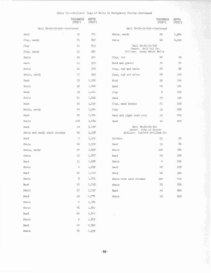
Table lO.--Drillers' Logs of Wells in Montgomery County--Continued
THICKNESS DEPTH THICKNESS DEPTH(FEET) (FEET) (FEET) (FEET)
Well TS-~55-605--Contlnued Well TS- 60- 55-605- - Continued
Sand 31 751 Shale, sa.r:tdy 22 1,960
Clay, sandy 11 822 Shale 40 2,000
Clay 31 853 Well TS-60-55-706O\.ner: Gulf Oil Co.
Clay, sandy 31 as:. Driller: Low~ Water Wells
Shale 30 914 Clay, red 22 22
Sand 41 955 Sand and gravel 52 74
Shale 21 976 Clay, red a..'1d white 22 96
Shale, sandy 17 993 Clay, red and ...llite 26 122
Sand 33 1,026 Sand 22 144
Shale 36 1,062 Sand 20 ,64
Sand 79 l,l!"l Clay 6 170
Shale 61 1,202 Sand 25 '95
Sand 35 1,237 Clay, sand breaks 21 216
Shale, sandy 47 1,284 Clay 12 228
Sand 20 1,304 Sand and light sand rock 12 240
Shale 178 1,482 Sand 15 255
Sand 10 1,492 Wen T5-60-62- 304Owner: City of Porter
Shale and sandy shale strea..~s 46 1,538 Driller: Lanford Drilling Co.
Sand 7 1,545 Surface 25 25
Shale 40 1,585 Sand 55 SO
Shale, sandy n 1,662 Shale 100 lSO
Shale 15 1,677 Sand 48 228
Sand 11 1,688 Shale L 232
Shale 4 1,692 Sand 46 278
Sand 21 1,713 Sand 42 320
Shale 8 1,721 Shale ~ith sand streaks 390 110
Sand 17 1,738 Shale 70 780
Shale 17 1,755 Sand 40 820
Sand 19 1,774 Shale 10 830
Shale 7 1,781
Shale 46 1,827
Sand 20 1,847
Shale 5 1,852
Sand 10 1,862
Shale 76 1,938
·58·

Table lO.--Drillers' Logs of Wells in Montgomery County--Cont1nued
THICKNESS(FEET )
i-jell Ts-6o-63-l07(hmer: Porter Water Supply Corporation
Driller: Layne- Texas Co.
DEPTH(FEET)
Sand
THICKNESS(FEET)
""ell Ts-60-63-107--Continued
85
OEPTH(FEET)
783
'Topsoil
Clay with sand streaks
Sand, broken
Clay
Sand
Clay, gurrcy
Sand, clay streaks and sandylime rock
Clay, g'JnlIY
Sand
Clay
Sand
Clay and sandy clay
Sand with clay streaks
Sand and sandy clay
Sand with streaks of shale
Clay
Sand with streaks of shale
Clay, sandy
Sand with streaks of sandy clay
Clay a~d sandy shale
Clay, sandy .... ith streaks ofsand
Sand and sandy clay
Clay, sticky
Sand
Clay
Sand
Clay, hard
Sand
Clay, bard
Sand
Clay
Sand
Clay
5
48
8
13
13
36
30
48
36
32
16
15
20
8
'.24
6
20
25
8
10
69
6
4
4
39
31
7
18
10
5
53
61
87
123
153
187
235
271
303
319
334
354
362
366
390
396
416
441
528
534
538
581
585
632
663
670
688
698
- 59-

Table l1.--'liater Levels in Wells in Montga:lery County(feet below land surface)
Well TS-60-"'S- 501
DATE WATERLEVEL
Well ~ 60- 35-202
DATE WATERLEVEL
DATE WATERLEVEL
Well TS-60-45-507
Ch.ner; Miss Flo",(er FollettE1eVlltion; 321
Cl\mer; Cit:r of Co~roe, Well 5Elevatioo: 215
Owner; City of Cau-ce, Well 3Elevation; 205
Well TS-6o-37-401
'liell TS-60- 38-801
61.22
17·50
19_94
21.27
21.74
23.21
17.~2
17.54
19.94
21.42
22.32
dry
24.29
23·52
23·30
23.03
20.24
20.25
21.51
22.73
22.28
21.56
21.05
19.94
20
22.17
20·95
62.82
22.79
23.38
1967
13, 1974
Fe":). 26, 1913
Feo.
Dec.
Mar. 29
Dec. 9
Dec. 19
Jan. 22, 1969
Feb. 28
June 28
Aug. 1
Nov. 7
Well rs-60-45-803
July
Oct. 1
;;'eo. 10
May 26
Aug.
Jan. 18, 1968
Sept. 3
~lov. 26
July 1
Mar. 30
Apr. 26
Sept.
June 2
Oct.
~l'l.er; Brown EstateElevation; 178
J.~y 31
Aug.
Apr. 19
May 27
July 1
Jan. 18, 1970
Feb. 24
!(.ar. 1
June 11
52.39
7;.08
25.2
25
30·9
75.04
10.36
79.28
76.02
75.13
72.36
78.28
75.81
75.64
68.18
75.19
78.69
30.07
33.68
18.78
21.43
22.86
25.37
46.16
31·52
35.68
59·12
70.38
67.31
68.01
City of Conroe, .ell 2Slevation; 211<
'.iell 'i"s-60-45-504
O".mer;
Jan. 13, 1957
Feb. 26, 1973
Feb. 13, 1974
Apr. 20, 1954
Ja."l. 13, 1967
Feb. 26, 1973
Feb. 13, 1914
June 12
Feb. 26, 1910
Feb. 28, 1969
Sept. 11
June 17
Feb. 5, 1968
Dec. 11
Apr. 20, 1971
O'~eT: City of Conroe, ....·ell 4Elevation; 212
Oct. 2
Feb. 26, 1913
Jun.
Dec. 11
Dec. 8
June 7, 1967
Sept. 26
Sept. 22
Feb. 1.6, 1972
June 18
Jan. 31, 1914
Sept. 13
June 11
Dec. 6
Sept. 18
52.W!
52.07
52.49
51.61
51.44
51.33
51.36
51.17
51.27
51.48
52.13
52.64
52.86
53.76
53
52.27
21.68
22.68
23.22
23·07
22·99
22.83
22.68
22.54
188.96
188.05
188.51
190.41
190·29
190.61
Feb. 3, 1911
Feb. 16, 1972
June 6
Dec. 8
Feb. 26, 1973
June 7, 1967
Dec. 18, 1968
Feb. 28, 1969
Feb. 26, 1970
Sept. 11
Dec. 11
June 11
~~er; Ci~y of WillisElevation: 380
Sept. 18
Jan. 31, 1914
June 18
Feb. 5, 1968
Feb. 28, 1969
Feb. 26, 1970
Feb. 16, 1972
Feb. 26, 1913
Nov. 7
6
O.mer: O. S. ReavesElevation: 224
Feb. 3, 1911
Sept. 13
Dec. 6
Jan. 16. 1968
Sept. 26
June 12
June 1, 1967
Aug. 8
!>'.ar. 14
Sept. 2 23.06
·60 -

DATE
Table ll.--\o,'ater Levels in Wells 1n ¥.ontgomery County--Continu~
WATERLEVEL
Well TS-60-45-8<l3--Cc!'!tinued
Oct. 2, 1970 23.46
lioy. 8 23.67
Dec. 1 23.98
Jan. I, 1971 d..."
Hay 15, 1m 22.8
June 10 23.1
:>e,. 18 23·9
Ja::l. 15, 1973 23.48
Feb. 28 21.36
liar. 30 19·75
Apr. 28 18.71
}!a.y 26 18.1;
June 27 18.07
JUl;( 1 18.23
Aug. 15 19·02
Sept. 30 17·;1
Oct. 31 16.23
Nov. 27 15.06
Dec. 20 14.97
Jan. 18, 1974 14.10
Feb. 13 13·15
Mar. 13 14.74
Apr. 3 14.81
Moy 3 16.32
J=. 18 17.37
Se:;:.t. 18 19.48
Doc. 4 16.25
·61 .

••
. ,
~ ~ §~ ~ ~ E ~ ~
•
- 62-