reassessment of potentially dangerous glacial lakes in bhutan
TRANSCRIPT

Reassessment of Potentially Dangerous Glacial Lakes in Bhutan
“The costs of natural disasters can set back a community or nation by decades – not to speak of the lasting emotional damage inflicted on the people affected.”
His Majesty Jigme Khesar Namgyel Wangchuck, King of Bhutan,Convocations address to the students of Calcutta University, 5th October 2010
NATIONAL CENTER FOR HYDROLOGY AND METEOROLOGYROYAL GOVERNMENT OF BHUTAN
www.nchm.gov.bt
ISBN: 978-99980-862-1-0
NATIONAL CENTER FOR HYDROLOGY AND METEOROLOGYROYAL GOVERNMENT OF BHUTAN
2019

REASSESSMENT OF POTENTIALLY DANGEROUS
GLACIAL LAKES IN BHUTAN
NATIONAL CENTER FOR HYDROLOGY AND METEOROLOGY
ROYAL GOVERNMENT OF BHUTAN
2019

Prepared by:
Cryosphere Services Division, NCHM
Published by:
National Center for Hydrology and Meteorology
Royal Government of Bhutan
PO Box: 2017
Thimphu, Bhutan
ISBN#:978-99980-862-1-0
© National Center for Hydrology and Meteorology
Printed @ United Printing Press, Thimphu

i
Foreword
Bhutan is highly vulnerable to the impacts of climate change. Bhutan is already facing the
impacts of climate change such as extreme weather and changing rainfall patterns. The Royal
Government of Bhutan (RGoB) recognizes the devastating impacts climate change can cause to
the country’s natural resources, livelihood of the people and the economy. Bhutan is committed
to addressing these challenges in the 12th Five Year Plan (2018-2023) through various
commitments, mitigation and adaption plans and actions on climate change at the international,
national, regional levels. Bhutan has also pledged to stay permanently carbon neutral at the
Conference of Parties (COP) Summit on climate change in Copenhagen.
Accurate, reliable and timely hydro-meteorological information underpins the understanding of
weather and climate change. The National Center for Hydrology and Meteorology (NCHM) is
the national focal agency responsible for studying, understanding and generating information and
providing services on weather, climate, water, water resources and the cryosphere. The service
provision of early warning information is one of the core mandates of NCHM that helps the
nation to protect lives and properties from the impacts of climate change.
The Strategic Program for Climate Resilience (SPCR) which is being implemented by Gross
National Happiness Commission (GNHC) focuses on four main pillars. The pillars are:
Enhancing information base for hydro-met services and climate resilience
Preparedness, food and water security
Sustainable growth and resilient infrastructure
Strengthening governance, institutional coordination and human resource capacity
NCHM is one of the four technical agencies under the SPCR and it is responsible for undertaking
a technical study under the Pillar I- Enhancing Information Base Hydro-met Services and
Climate Resilience. The fundamental objective of the study is to improve hydro-met base
information and identify future investment plans. The list of studies carried out under the Pillar I
of SPCR are as follows:
Analysis of historical climate and climate change projection for Bhutan.
Re-assessment of potentially dangerous lakes of Bhutan
Bhutan glacier inventory 2018
Reassessing of the previous list of 25 potentially dangerous glacial lakes are discussed in this
report. It has almost been two decades (2001) since the potentially dangerous glacial lakes were
identified and some of the lakes listed as PDGL’s have burst out. Therefore, this study reassessed
the previous list of PDGL’s taking into account field reports, physical verification and recent
satellite imageries. The current list of PDGL’s were updated based on the previous existing list
and all glacial lakes were not taken into consideration. It is therefore recommended to compile an
inventory of glacial lakes of Bhutan to have a better understanding of the impacts of recent
global climate change, melting glaciers which leads to formation of new glacial lakes as well as
expansion of existing glacial lakes.

ii
This report is submitted by NCHM to GNHC and the World Bank under the SPCR Project. The
findings from this study provide initial assessment of possible future changes of climate over
Bhutan. The report is an outcome of Pillar I of the SPCR Project implemented by NCHM. In this
regard, I would like to thank all the Divisions, the SPCR Management of NCHM who have
worked hard to bring out this report.
(Karma Dupchu)
Director

iii
Acknowledgement
We express our sincere thanks to Dr. Jiro Komori and his team of DGM-JICA/JST GLOF project
for providing us with the processed bathymetry data of the PGDL’s. We are grateful to Karma,
Chief of the Division of CSD, NCHM for his initiative and guidance to come up with updated
PGDL of Bhutan and for his valuable comments and suggestions on the draft reports. Our sincere
thanks also goes to all the past team members of various projects whose literature were of great
reference during the compilation of the report. We would also like to express our thanks to SPCR
(Strategic Programme for Climate Resilience) Project for providing support in capacity building
of the glacial lake mapping. Thanks to ESA (European Space Agency) for making Sentinel-2
imagery freely available on their webpage. Lastly thanks to CSD colleagues for the help
rendered to complete this report

iv
Executive summary
Increase in global temperature have resulted in rapid melting of glaciers globally. Glacial Lake
Outburst Flood (GLOF) commonly known as silent/mountain tsunamis are one of the major
catastrophes resulting from excessive melting of glaciers. Himalayan countries are mainly
affected by global warming, where it has been found that the glaciers are receding at an
accelerated rate in the recent decades causing GLOF(s) downstream. Bhutan experienced a
massive GLOF in 1994 causing chaos downstream taking life of 20 people and damaging
millions worth of infrastructures and properties. After the country’s major GLOF event in 1994,
the Royal Government of Bhutan undertook various measures to monitor, mitigate and create
awareness on risks associated with GLOF hazard leading to identification of potentially
dangerous glacial lakes (PDGL).
The first ever inventory on glaciers, glacial lakes and potentially dangerous glacial lakes was
published by Department of Geology and Mines (DGM) under the then Ministry of Trade and
Industry in collaboration with International Center for Integrated Mountain Development
(ICIMOD) ((Mool et al., 2001)) with an objective to identify and segregate potentially dangerous
glacial lakes of Bhutan. In the process, the study had identified 24 glacial lakes as potentially
dangerous glacial lakes, 5 in Mo Chhu sub basin, 8 in Pho Chhu sub basin, 7 in Mangde Chhu-
basin, 3 in Chamkhar Chhu sub basin and 1 in Kuri Chhu sub basin. Later during the Austrian-
Bhutan joint project (1999-2002) a new lake (Thorthormi lake) was identified and updated in the
list of PGDLs to a total of 25 potentially dangerous glacial lakes in Bhutan. However, the
inventory was prepared purely based on remote sensing materials and techniques with no actual
field based data and information. Hence this current study was carried out with the objective to
verify and update the previous list of PDGL inventory using field verified data sets and latest
Sentinel 2 high resolution satellite imageries of 2016.
Under this study bathymetry data compiled by various field works in the past were collected and
processed into Bathymetry maps. The data acquired from the maps were collected and compared
with the previous inventory and then potentially dangerous lakes were identified using the set of
criteria’s which was previously defined by Mool et al inventory of 2001. From this current study
it was found that out of 25 dangerous glacial lakes, 8 were deemed safe based on lake
morphology, it’s surrounding features, bathymetry condition and associated feeding glacier, 5
lakes are still not ground verified and 12 were identified as potentially dangerous. The status for
those PGDLs which could not be verified on the ground remain unchanged and recommended
for ground based verification in the future. From the total of 8 lakes which were deemed safe for
GLOF, 3 lakes were from Mo chhu basin, 4 from Mangde chhu basin and one from Chamkhar
chhu basin. The remaining 17 lakes are still listed as potentially dangerous and needs constant
monitoring because the lakes morphology and its feeding glaciers are changing constantly.

v
CONTENTS
Foreword ......................................................................................................................................... i
Acknowledgement ........................................................................................................................ iii
Executive summary ...................................................................................................................... iv
List of Figures: ............................................................................................................................ vii
Abbreviation and Acronyms ........................................................................................................ x
1. INTRODUCTION ................................................................................................................. 1
2. DATA AND METHODOLOGY .......................................................................................... 4
3 FINDINGS AND DISCUSSION........................................................................................... 5
3.1 Mo Chu sub-basin ............................................................................................................ 5
3.1.1 Mo_gl 200 (Kab Tsho/Lemthang Tsho) ................................................................... 5
3.1.2 Mo_gl 201 ................................................................................................................. 7
3.1.3 Mo_gl 202 (Latshokarp) ........................................................................................... 8
3.1.4 Mo_gl 234 (Sintaphu tsho) ....................................................................................... 9
3.1.5 Mo_gl 235 ............................................................................................................... 10
3.2 Pho Chhu sub-basin ........................................................................................................ 10
3.2.1 Pho_gl 84 ................................................................................................................ 10
3.2.2 Pho_gl 148 .............................................................................................................. 11
3.2.3 Pho_gl 163 (Tarina I) .............................................................................................. 12
3.2.4 Pho_gl 164 (Tarina II / Mozum Tsho) .................................................................... 13
3.2.5 Pho_gl 209 (Raphstreng) ........................................................................................ 15
3.2.6 Pho_gl xx (Thorthomi) ........................................................................................... 17
3.2.7 Pho_gl 210 (Lugge Tsho) ....................................................................................... 18
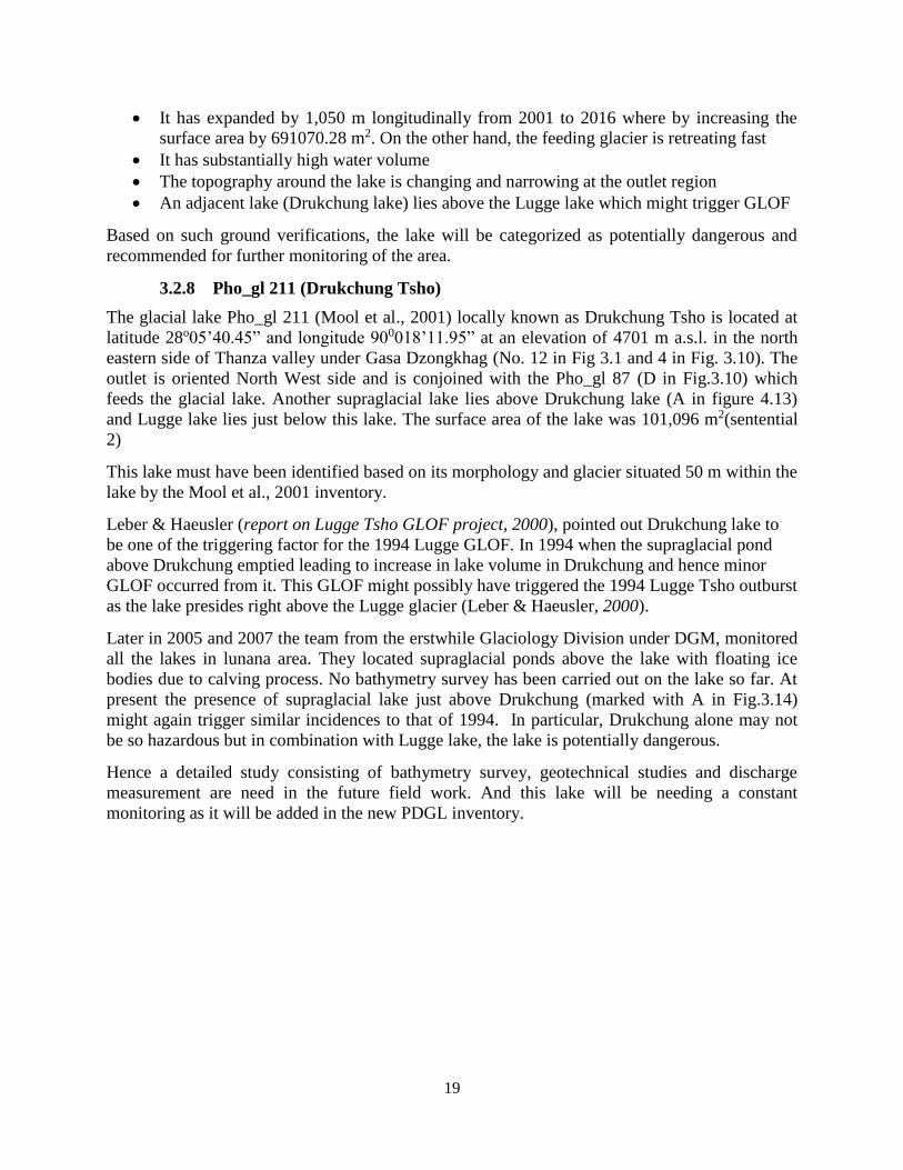
3.2.8 Pho_gl 211 (Drukchung Tsho)................................................................................ 19
3.2.9 Pho_gl 313 .............................................................................................................. 20
3.3 Mangde Chhu sub-basin ................................................................................................. 21
3.3.1 Mang_gl 99 (GLT 9) ............................................................................................... 21
3.3.2 Mang_gl 106 (Metatshota) ...................................................................................... 22
3.3.3 Mang_gl 270 (Zanam F) ......................................................................................... 23
3.3.4 Mang_gl 285 (Zanam E) ......................................................................................... 24
3.3.5 Mang_gl 307 (Zanam B) ......................................................................................... 25
3.3.6 Mang_gl 310 (Zanam G) ........................................................................................ 26

vi
3.3.7 Mang_gl 385 ........................................................................................................... 27
3.4 Chamkhar Chu Sub-basin............................................................................................... 28
3.4.1 Cham_gl 198 (Phudung lake) ................................................................................. 28
3.4.2 Cham_gl 232 ........................................................................................................... 29
3.4.3 Cham_gl 383 (Chubda Tsho) .................................................................................. 30
3.5 Kuri Chu Sub-basin ........................................................................................................ 31
3.5.1 Kuri_gl 172 (Terjatse Tsho) .................................................................................... 31
CONCLUSION ........................................................................................................................... 36
Recommendation......................................................................................................................... 37
References .................................................................................................................................... 38

vii
List of Figures:
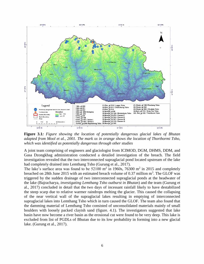
Figure 3.1: Figure showing the location of potentially dangerous glacial lakes of Bhutan adapted
from Mool et al., 2001. The mark xx in orange shows the location of Thorthormi Tsho, which
was identified as potentially dangerous through other studies ....................................................... 6
Figure 3.2: Remnants of Lemthang Lake after the GLOF. Blue line shows the original Lake
level and the dotted red line shows the original moraine dam height near the outlet. .................... 7
Figure 3.3: Left: Photo of Mo_gl 201 showing wide open outlet with stable surrounding
conditions; Right: Mo_gl 202 on google earth pro (image date: 17-10-2009) .............................. 8
Figure 3.4: Left: Photo of Latshokarp show the location of Mo_gr 51. The lake has a wide open
outlet which is shown in pink rectangular box. Yellow dotted box shows the extreme end
moraine. Left: Bathymetry map of the lake with the depth profiles A-A’. .................................... 9
Figure 3.5: Left: Sintaphu glacial lake and the supraglacial lake on google earth pro image
(imagery date: 1-4-2014). The lake boundaries are from the Sentinel 2 image (2016). Right:
Bathymetry map of the main lake with depth profile from outlet towards upper reach (A’-A) ... 10
Figure 3.6 :Left: Pho_gl 84 on Sentinel 2 (2016) with other adjacent lakes and feeding glacier
Pho_gr 8. Green and red polygons are the lake outline from Sentinel 2 and by Mool et al., 2001.
Number 1 and 2 are the new lakes formed. Right: Bathymetry map of the lake with the depth
profile A-A’ .................................................................................................................................. 11
Figure 3.7: Left: Pho_gl 148 with adjacent lakes lying at higher elevation (1&2) and the feeding
glacier Pho_gr 21 which wastes part of it in the form of icefall into the lake. Green and the red
polygon shows the lake outline of 2016 (Sentinel 2) and Mool et al., 2001 respectively.
Background image is Sentinel 2 (2016). Right: Bathymetry map of the lake with depth profile
(A-A’). Lake has shallow depth at the outlet part and deeper towards the upper reach. .............. 12
Figure 3.8: Left: Photo showing Tarina I, Tarina II, Pho_gr 41, Pho_gr 44 and the Cliff along
which the Pho_gr 41 feeds Tarina I in the form of ice fall. Right: Bathymetry map of Tarina I
along with the depth profile from the outlet towards upper reach of the lake (A-A’) .................. 13
Figure 3.9: Left: Google image of Pho_gl 164 (Tarina lake II) and Pho_gl 165 (Tarina lake III)
along with the feeding glaciers Pho_gr 44 and Pho_gr 67 respectively. Right: Bathymetry map
of Tarina lake II along with the depth profile from outlet to the upper reach (A-A’) .................. 14
Figure 3.10: Glacier and glacial lakes in the Lunana region. Circled numbers 1 - 4 are Pho_gl
209 (Raphstreng), Pho_gl xx (Thorthormi), Pho_gl 210 (Lugge) and Pho_gl 2011 (Drukchung)
respectively. Letters A – D in the box are the glaciers feeding the main lakes (Pho_gr 83, Pho_gr
84, Pho_gr 86 and Pho_gr 87 respectively). ................................................................................. 15
Figure 3.11: Raphstreng and Thorthormi lakes showing the location of thin and active moraine
barrier ............................................................................................................................................ 16
Figure 3.12: Bathymetry map of Raphstreng lake along with the depth profile (A-A') .............. 17

viii
Figure 3.13: Left: Mo_gl 210 (Lugge Tsho) on Sentinel 2 image. Green and red polygon are the
Lake Outline from Sentinel 2 (2016) and Mool et al., 2001. Pho_gl 211 is Drukchung lake.
Right: Bathymetry map of Lugge lake (data from 2011). Due to lack of data coverage towards
the upper reach, the depth interpolated is lesser. .......................................................................... 18
Figure 3.14: Pho_gl 211 (Drukchung lake). Green and red polygons are lake outline from
Sentinel 2 (2016) and Mool et al., 2001. Letter A is the suptraglacial lake above Drukchung lake
....................................................................................................................................................... 20
Figure 3.15: Pho_gl 313 on google earth pro image (2002) along with series of lakes
downstream (A, B) and other adjacent lakes lying above the lake level (1, 2, 3) ........................ 21
Figure 3.16: Left: Mang_gl 99 with feeding glacier Mang_gr 7. Green and red polygons are the
lake outline from Sentinel 2 (2016) and Mool et al., 2001. Right: Lake bathymetry map of
Mang_gl 99 along with the lake depth profile from outlet to upper reach (A-A’) ....................... 22
Figure 3.17: Left: Mang_gl 106 (Metatshota) delineated using Sentinel 2 of 2016 (Green) IRS
1D of 1999 (Mool et al., 2001). Right: Lake bathymetry map prepared using the data set of 2009
(DGM-JICA/JST GLOF Project) along with depth profile A-A’ ................................................. 23
Figure 3.18: Metatshota lake with hanging glacier above (Mo_gr 5) ......................................... 23
Figure 3.19: Left: Mang_gl 207 (lake Zanam F) on Sentinel 2 (2016) image with lake polygons
of Mool et al., 2016 (red) and Sentinel 2 (2016). Right: Lake bathymetry map with depth profile
(A-A’). .......................................................................................................................................... 24
Figure 3.20: Mang_gl 285 (Zanam E) with feeding glacier Mang_gr 57. The red and green
polygons are the lake outline by Mool et al., 2001 and delineated from Sentinel 2 (2016)
respectively. .................................................................................................................................. 25
Figure 3.21: Left: Mang_gl 307 (Zanam B) and Mang_gl 303 (Zanam A) on Sentinel 2 (2016)
imagery. The red polygon is the lake outlines by Mool et al., 2001 and green is from Sentinel 2
(2016). Right: Bathymetry map of Mang_gl 307 along with depth profile from outlet to upper
reach (A-A’). ................................................................................................................................. 26
Figure 3.22: Left: Mang_gl 310 (Zanam G) on Sentinel 2 (2016) imagery. The red polygon is
the lake outline by Mool et al., 2001 and green is from Sentinel 2 (2016). Right: Bathymetry
map of Mang_gl 310 along with depth profile from outlet to upper reach (A-A’). ..................... 27
Figure 3.23: Mang_gl 385 with damming glacier (Mang_gr 117) on Sentinel 2 (2016) imagery.
The red polygon is the lake outline by Mool et al., 2001 and green is from Sentinel 2 (2016) ... 28
Figure 3.24: Left: Cham_gl 198 (Phudung Tsho) on Sentinel 2 (2016) imagery. The red polygon
is the lake outline by Mool et al., 2001 and green is from Sentinel 2 (2016). Right: Bathymetry
map of Cham_gl 198 along with depth profile from outlet to upper reach (A-A’) ...................... 29
Figure 3.25: Panoramic view of Cham_gl 198 (Phudung Tsho) lying completely in a bedrock
topography. Dotted red box show the location of the lake outlet ................................................. 29

ix
Figure 3.26: Cham_gl 232 on Sentinel 2 (2016) imagery. The red polygon is the lake outline by
Mool et al., 2001 and green is from Sentinel 2 (2016). No. 1 marked in pink shows the presence
of a lake which was not mapped in earlier inventory by Mool et al., 2001 .................................. 30
Figure 3.27: Left: Cham_gl 383 (Chubda Tsho) on Sentinel 2 (2016) imagery. The red polygon
is the lake outline by Mool et al., 2001 and green is from Sentinel 2 (2016). Right: Bathymetry
map of Cham_gl 383 along with depth profile from outlet to upper reach (A-A’) ...................... 31
Figure 3.28: Kuri_gl 172 on Sentinel 2 (2016) image. The red polygon is the lake outline by
Mool et al., 2001 and green is from Sentinel 2 (2016) ................................................................. 32
Figure 3.29 Locations of updated list of PDGLs ......................................................................... 33

x
Abbreviation and Acronyms
CSD Cryosphere Services Division
DDM Department of Disaster Management
DGM Department of Geology and Mines
DHMS Department of Hydro-Met Services
ESA European Space Agency
GEF Global Environment Facility
GIS Geographical Information System
Gl Glacial lake
GLOF Glacial Lake Outburst Flood
GoA Government of Austria
GOI Government of India
Gr Glacier
GSB Geological Survey of Bhutan
GSI Geological Survey of India
IRS Indian Remote Sensing
JICA Japan International Cooperation Agency
LANDSAT Land Observation Satellite
LDCF Least Development Countries Fund
LIS Linear Self Scanning
NCHM National Center of Hydrology and Meteorology
PDGL Potentially Dangerous Glacier Lake
RGoB Royal Government of Bhutan
RS Remote Sensing
SPCR Strategic Programme for Climate Resilience
SPOT Satellite Pour I'Observation de la Terre
TM Thematic Mapper
WAPCOS Water and Power Consultancy Services (India) Limited
WWF World Wide Fund

1
1. INTRODUCTION
With recent global climate change, glaciers worldwide are retreating resulting in formation of
many supra- and pro-glacial lakes. When such smaller glacial lakes start to grow bigger in area,
they join to form bigger lakes. In many cases, such glacial lakes are dammed with moraine dams
consisting of boulders and ice masses. When the damming part of the lake fails due to
hydrostatic pressure from the lake, seismic activities and surge waves created by various mass
movements from lateral moraines including avalanches from the accumulation area, large
amount of water released causing catastrophic flood in the downstream known as Glacial Lake
Outburst Flood (GLOF).
Such phenomenon of both formation of glacial lakes in Bhutan started as early as 1940s (Leber,
D. et al, 2003) and several GLOF incidents took place in Bhutan (Komori, J. et al, 2012). Among
such incidences in the last few decades, one of the most devastating was from one of the glacial
lakes in the Lunana region (Lugge Lake) on October 7, 1994. During that event, the partial
outburst released around 18 million cubic meter of water causing severe damages downstream. It
washed away pasture lands, agricultural lands, claimed 20 lives and caused partial damage to one
of the oldest fortress of the country, the Punakha Dzong (Singh, 2009)
After the 1994 event, the Royal government of Bhutan felt the need to study the lakes in the
northern frontiers of the country. Line agencies in collaboration with other national and
international agencies, universities and institutes led several expeditions to the glaciated northern
frontiers to assess the potential risks and hazards posed by glacial lakes. In 2001, Department of
Geology and Mines (DGM) under the then Ministry of Trade and Industry in collaboration with
International Center for Integrated Mountain Development (ICIMOD) produced the first ever
inventory on glacier, glacial lakes and glacial lake outburst floods of Bhutan categorizing 24
number of glacial lakes as potentially dangerous Glacial Lakes (PGDL). Later, another lake was
identified as potentially dangerous increasing the number to 25. (Hausler, H et al, 2002).
The 2001 inventory was prepared using aerial photographs, Landsat Thematic Mapper(TM)
(1993-1999) Indian Remote Sensing (IRS), ID Linear Self scanning (LIS) S3 (1999) and SPOT
(1994) satellite images and topographic maps (1: 50,000) of 1960s and 1950s made by Survey of
India (1960). Though the information on potentially dangerous glacial lake (PDGL) was readily
available, no updates were made by conducting field verifications. Of recent, many changes have
taken place not only at the source but also downstream along the rivers due to modern
developmental activities. It is timely that the inventory on potentially dangerous glacial lakes be
updated using latest high resolution imageries and field verification. The then Glaciology
Division under DGM has started the program of verifying the potentially dangerous glacial lakes
by visiting those accessible glacial lakes. Today, about half the number of PDGLs are field
verified.
Making use of available data and reports on such glacial lakes, the number of PDGLs are
updated with the main aims to provide reliable and realistic figures to public and decision
makers.
The following are the main objectives of the present task:
To update the previous list of PDGLs with the latest available data and information.

2
To understand and spread awareness of GLOF phenomenon to public domains and
disseminate the results and information to related stakeholders and organizations.
Studies on glaciers and glacial lakes in Bhutan were not carried out until 1960 when Augusto
Gansser, a Swiss geologist while doing survey to compile data on the Geology of Bhutan
Himalaya took an expedition in Lunana area. He briefly studied the glaciers (1960s to 1970s) and
identified numerous dangerous lakes that could cause massive flood in the lower valleys in
future. Specifically he mentioned Tarina lake I as the source of flood that destroyed parts of
Punakha Dzong (Gansser, 1983). He recommended the Bhutanese officials to come up with
identification of valleys which might be affected by future catastrophic floods (Gansser, 1983).
Hence following the recommendations, a preliminary aerial reconnaissance surveys were carried
out in Lunana area (Raphstreng Tsho) in September 1974 and August 1981 by an expert team
from GSI and the then GSB. A detailed ground survey of Raphstreng Tsho was recommended by
the team. Following the earlier recommendations, a joint expedition of GSB and GSI again
carried out the study of Raphstreng lake (mentioned as Lunana Tsho in the report) in 1984.The
team had further recommended constant monitoring of the lake every two years .Further in 1986
the joint expedition of GSB and GSI carried out a detailed study of the Raphstreng lake taking in
detailed bathymetry survey of the lake along with ice flow studies, sediment transport studies,
geomorphology of the Thanza valley. With their findings they came to a conclusion that there
was no possible danger of a lake outburst in the near future but recommended periodic
monitoring every two to three years due to presence of ice cores in the lateral moraine dams of
Raphstreng-Thorthomi Tsho (Sharma, A.R. Ghosh, D.K. Norbu, 1986)
1994 was the worst year in the history of Bhutan with the outburst of Lugge lake on 7th October
causing massive chaos to the communities downstream. The first Bhutanese expedition in 1994
(Multidisciplinary team) did a preliminary study to identify various lakes that might cause flood.
In 1995, a Joint team of GSI and RGoB carried out preliminary studies to identify the source of
the flash flood in the headwater of Pho Chhu river. The team consisted of Glaciologist,
engineering geologist and surveyors from GOI and Other officials from RGoB. After the study
they recommended various short term mitigation and Long term mitigations (GSI and GSB,
Environmental Hazard and Remedial Measurements in lunana (1995), (Mool et al., 2001))
The Mitigation Project of the Raphstreng lake undertook in 1996 with the funding from Minister
of External Affairs, GOI. The WAPCOS was appointed as a consultant for the preparation of
designs, estimates and report compilation of the Lunana Project. By the end of the project in
1998, water level in the main lake of Rapstreng tsho was lowered by 4 m thereby achieving the
overall target of the project. (Lunana Project,1998). The investigations on Lunana lakes was
continued by the Austro-Bhutanese joint team from 1999 to 2002 (Hausler.H et al,2000) and
based on their findings (Hausler.H et al, 2002) they introduced a new PDGL (Thorthormi lake)
into the earlier list of 24 PDGLs (Pradeep K. Mool et al., 2001) as it was found to bear high risk
due to presence of dead ice on its lateral moraine which separates it from Raphstreng lake. Hence
they recommended a future mitigation of Thorthormi lake if the subsidiary lakes join together to
form a bigger lake.
In 1998 the Japan-Bhutan joint research initiated by Nagoya University, Tokyo Metropolitan
University partnered with the then GSB undertook a major research program. The objective of

3
the project was to prepare and update inventory of major glacier lakes located at the head water
of major river systems in Bhutan and produce a GLOF risk assessment (Ageta and Iwata 1999).
In this research project a total of 18 glacial lakes named by the DGM and 12 other glacier lakes
were observed and studied. Using all this data and observations an updated glacial lake inventory
and risk assessment of the moraine dam failure of the glacial lakes in Bhutan were presented in
the report (Ageta and Iwata 1999).
In the same year the officials of engineering geology and glaciological section, GSB undertook a
preliminary study to identify some of the potentially dangerous lakes at the head water of
Chamkhar Chhu and found that Chubda Tsho contained dead ice underneath the moraine, active
slides and fresh ice cliffs within and around the moraine. So they strongly recommended to
constantly monitor the lake and also proposed a detailed technical study of the lake in the future
(Karma et al, 1999 (unpublished)).
Another study on the Tsokar Tsho in the head water of Chamkhar Chhu, Bumthang was taken by
GSB in April 1999 (Karma et al, 1999 (unpublished)). Out of several lakes in the source of
Gomthang chhu, 9 lakes were studied by the team. It was found that Tshokar Tsho was the main
lake where all the eight small lakes flow. The team found that Tshokar Tsho flood in 1998 was
triggered by the heavy monsoon and excessive discharge from the upper lakes. With steep
gradient and active monsoon this outlet area was found to be prone to active sliding. (Karma et
al., 1999, GSB (unpublished))
In 2001, DGM in collaboration with International Center for Integrated Mountain Development
(ICIMOD) published the inventory of the glacier and glacial lakes of Bhutan (Pradeep K. Mool
et al., 2001) mentioning the numbers of potentially dangerous glacial lakes. However, those
studies were done completely based on satellite images and topographic maps prepared in the
late 1950s and early 1960s. Therefore, it was crucial to validate the severity of the GLOF threats
from those glacial lakes through ground verification. In line with these/such objectives, the
Glaciology Division under the then DGM has initiated an annual activity called “Time Series
Monitoring of Glaciers and Glacial lakes” to ground check the lakes which are categorized as
potentially dangerous lakes. This activity is one of the main task of the CSD, NCHM which was
formed by merging of the Department of Glaciology Division of DGM with Snow and Glacier
division of the then Department of Hydro Met Services following the organizational
development exercise carried out by Royal Civil Service Comission. Under this activity many of
the potentially dangerous glacial lakes were field verified and monitored.
In 2008 the Thorthomi mitigation project was undertaken by RGOB in partner with UNDP under
the GEF project funded by LDCF and co-financed by GoA, WWF Bhutan and RGoB. The target
of the project was to reduce the water level of the Thorthomi lake by 5 meter within 3 years with
four working seasons per year. (Thorthomi Tsho Mitigation Project). The four-year project could
not meet the target of reducing the level by 5m hence the team recommended an extension for
this project to meet the goals to lower the water level by 5 m.
With this five-year project coming to an end mitigation of Thorthomi by lowering of water level
by 5 m was achieved in main lake as recommended by the Austrian experts. (Project reports on
Artificial Lowering of Thorthormi Lake).

4
2. DATA AND METHODOLOGY
In the previous inventory of Glaciers and glacial lakes of Bhutan (Mool et al., 2001), the
materials used for the study were the topographic maps which were prepared using aerial photos
of 1960s by Survey of India (1960), and Landsat Thematic Mapper(TM) (1993-1999) Indian
Remote Sensing (IRS), ID Linear Self scanning (LIS) S3 (1999) and SPOT (1994) satellite
images. In particular, following criteria were used for identifying the PDGLs of Bhutan:
Rise in lake water level
Activity of supraglacial lakes
Position of lakes
Dam conditions
Condition of associated mother glacier
Physical conditions of the surroundings
The study was purely based on remote sensing analysis and no field based data were
incorporated. With such criteria, 24 glacial lakes were pointed out to be potentially dangerous.
On the other hand, no detailed explanation on how the criteria are applied on the individual lakes
were mentioned. For instance, some of the PDGLs in the headwater of Mo Chhu (Mo_gl 200,
Mo_gl 201 and Mo_gl 202) do not qualify to be dangerous in terms of lake surface area but have
qualified on the basis of morphology and position of the lake with respect to the associated
glaciers. However, a detailed explanation on WHY and HOW the morphology and position of
the lake contributed to categorizing these lakes as PGDL is not clear.
Hence, under the current activity all the potentially dangerous glacial lakes will be individually
updated based on Mool et al., 2001’s criteria backed up with data sets from field work. For few
PDGLs, the field data were not available due to various reasons and therefore their status remain
unchanged till a detail field verification can be carried out. The depth of the PGDL were
measured through Bathymetry survey using echo sounding devices such as Sonar FishElite
500cc. Most of the lakes were surveyed through DGM-JICA/JST GLOFs project (2009-2012)
and additional surveys were later carried out through the Time Series Monitoring Program. The
data on Lake Bathymetry from DGM-JICA/JST project were in excel format containing latitude,
longitude and the depth data. For generating the 3D dimensional map of the lake basin and to
extract the lake water volume, the data was imported in ArcGIS and interpolated using the
Inverse distance weighted (IDW) tools under 3D analyst limiting to the lake polygon. Hence the
new raster file with lake profile is generated and from this the volume of lake is also calculated
in million cubic meter. The Bathymetry maps produced were then used to extract lake water
volume and surface area. After having listed out information on water volume, the lakes were
then updated with the latest information and reviewed upon to determine whether they are
dangerous or not with the same criteria by Mool et al., 2001 on lake volume. Except for
Lemthang Tsho (Mo_gl 200) all the lake surface area data were extracted by manually digitizing
the lakes using Sentinel 2 imagery of 2016. The lake surface area of Lemthang Tsho was
collected from the literature review because the lake breached in 2015 and no lake imagery was
found in the sentinel 2 imagery of 2016.

5
In the process of reviewing, all 25 PDGLs were examined individually based on the earlier
criteria set by Mool et al., 2001 and complemented with field based data sets and
recommendations mentioned in earlier technical reports. Out of 25, only few are not field
verified due to various reasons mostly associated with accessibility to the site. For such unvisited
glacial lakes, the reviewing criteria and the status of the lake remains same to that of Mool et al.,
2001 till further ground based verification could be carried out.
The following criteria were used as basis to reassess and update the list of potentially dangerous
glacial lakes:
1. Minimum volume of 10 million m3
2. Minimum surface area of 100,000 m2
3. Feeding glacier within a reach of 50 m
4. Relatively high depth near the outlet area
5. Active supra glacial activity on the glacier surface (feeding glacier)
6. Condition of the damming materials
7. Presence of Ice core in the moraine wall.
8. Morphological conditions (mass movement from the lateral moraine and steep rock walls
in the accumulation area
3 FINDINGS AND DISCUSSION
3.1 Mo Chu sub-basin
3.1.1 Mo_gl 200 (Kab Tsho/Lemthang Tsho)
The glacial lake Mo_gl 200 (Mool et al., 2001) locally known as Lemthang Tsho (Tsho = Lake)
is located at latitude 28o04’05.17” and longitude 89o34’53.42” at 4280 m a.s.l. in the north
western part of Gasa Dzongkhag, in the headwaters of Mo Chhu (No 1. in figure 3.1). The lake
outlet is oriented southeast direction. The lake is conjoined with the glacier Mo_gr 47 (Debris
covered) having an area of 4. 591km2.The lake was regarded as a fast growing lake until June
2015 when the lake finally breached due to moraine failure (Gurung et al., 2017). The lake was
identified as potentially dangerous on the basis of morphology and position of the lake with
respect to the associated glacier by Mool et al., 2001.
6
Figure 3.1: Figure showing the location of potentially dangerous glacial lakes of Bhutan
adapted from Mool et al., 2001. The mark xx in orange shows the location of Thorthormi Tsho,
which was identified as potentially dangerous through other studies
A joint team comprising of engineers and glaciologist from ICIMOD, DGM, DHMS, DDM, and
Gasa Dzongkhag administration conducted a detailed investigation of the breach. The field
investigation revealed that the two interconnected supraglacial pond located upstream of the lake
had completely drained into Lemthang Tsho (Gurung et al., 2017).
The lake’s surface area was found to be 52100 m2 in 1960s, 76300 m2 in 2015 and completely
breached on 28th June 2015 with an estimated breach volume of 0.37 million m3. The GLOF was
triggered by the sudden drainage of two interconnected supraglacial ponds at the headwater of
the lake (Bajracharya, investigating Lemthang Tsho outburst in Bhutan) and the team (Gurung et
al., 2017) concluded in detail that the two days of incessant rainfall likely to have destabilized
the steep scarp due to relative warmer raindrops melting the glacier. This caused the collapsing
of the near vertical wall of the supraglacial lakes resulting in emptying of interconnected
supraglacial lakes into Lemthang Tsho which in turn caused the GLOF. The team also found that
the damming material of Lemthang Tsho consisted of unconsolidated materials mainly of small
boulders with loosely packed clayish sand (figure. 4.1). The investigators suggested that lake
basin have now become a river basin as the erosional cut were found to be very deep. This lake is
excluded from list of PGDLs of Bhutan due to its low probability in forming into a new glacial
lake. (Gurung et al., 2017).

7
Figure 3.2: Remnants of Lemthang Lake after the GLOF. Blue line shows the original Lake level
and the dotted red line shows the original moraine dam height near the outlet.
3.1.2 Mo_gl 201
The glacial lake Mo_gl 202 (Mool et al., 2001) is located at latitude 28o07’44.40” and longitude
89o036’31.60” at an altitude of 4380 m a.s.l. in the north western part of Gasa Dzongkhag (No. 2
in Fig.3.1). The cirque glacial lake has ansurface area of 68,138 m2. The outlet is oriented near
East – West and does not have any feeding glaciers. The surrounding topography is steep as
revealed from the satellite imageries and this could have been the reason why it was categorized
as potentially dangerous lake in the earlier inventory.
The Lemthang lake assessment team also visited this particular lake and scanned the area. On
field verification, the lake was found to be stable with all the surroundings vegetated (Fig 3.2)
and no sign of any active slides. Though the team did not carry out bathymetry survey, the lake
was assumed to be quite shallow especially towards the outlet since the lake bottom was visible.
The lake also has a wide and well defined outlet. Later Gurung et al., 2017 suggested that the
lake does not pose any immediate threat considering its size, moraine stability, conditions of
feeding mother glacier and its surrounding geomorphology. Hence the lake will be removed from
the PDGL list.

8
Figure 3.3: Left: Photo of Mo_gl 201 showing wide open outlet with stable surrounding
conditions; Right: Mo_gl 202 on google earth pro (image date: 17-10-2009)
3.1.3 Mo_gl 202 (Latshokarp)
The glacial lake Mo_gl 201 (Mool et al., 2001) locally known as Latshokarp is located at latitude
28o06’15.06” and longitude 89o36’55.60” at an altitude of 4434 m a.s.l. in the northwestern side
of Gasa Dzongkhag in the headwater of Mo chhu (No. 3 in Fig 3.1). The lake is oriented towards
south and is conjoined with the glacier Mo_gr 51 (3.18 km2). The lake has a surface area of
62,801 m2. Although this lake did not have sufficient surface area to be deemed potentially
dangerous, the presence of feeding glacier within the distance of 50 m upstream and surrounding
morphology (from the satellite imageries), the lake was identified as potentially dangerous. In
2015, the technical team who visited Lemthang Tsho also assessed Latshokarp and carried out
bathymetry survey along with assessment of surrounding geomorphological settings. Following
were the findings by the team:
The lake water volume was 0.1 million m3 with surface area of 68,476.5 m2, maximum
depth of 10 m towards the upper reach
The lake is quite shallow compared to other glacial lakes with relatively flat and wide
open outlet (pink rectangular box in Fig.3.4 left).
The surrounding morphology is fully vegetated and no major changes observed.
The mother glacier (Mo_gr 51) has rather steep surface and no chances of forming
supraglacial ponds.
Extreme end moraine consists of large boulders with gentle outward sloping.
Considering such conditions, later Gurung et al., 2017 suggested that the lake does not
pose any immediate threat. Hence this lake is also excluded from the PDGL list.

9
Figure 3.4: Left: Photo of Latshokarp show the location of Mo_gr 51. The lake has a wide open
outlet which is shown in pink rectangular box. Yellow dotted box shows the extreme end
moraine. Left: Bathymetry map of the lake with the depth profiles A-A’.
3.1.4 Mo_gl 234 (Sintaphu tsho)
The glacial lake Mo_gl 234 (Mool et al., 2001) locally known as Sintaphu tsho (named Setang
Burgi Tsho by Mool et al, 2001) is located at latitude 28o010’6.0” and longitude 89o051’21.1” at
an elevation of 4480 m a.s.l. in the north eastern side of Gasa Dzongkhag in the head water of
Mo Chhu (No. 4 in Fig. 3.1). It has an average surface area of 238,314 m2. The Lake outlet is
oriented south. This lake was identified based on the criteria of morphology and position of the
glacier with respect to the glacial lake. The glacier was found within a distance of 50 m. No
subsidiary lake was found during the time of assessing the glacier and glacier lakes of Bhutan in
early 2000s. Later in 2011 from the google earth imagery the Supraglacial Lake was observed
above the main lake. The Mo_gr 82 glacier having an area of 9.866 km2 feeds the Supraglacial
Lake and the main lakes downstream. In 2016, the lake was assessed in detail under the Time
Series Monitoring program for ground verification. The assessment consisted of bathymetry
survey, moraine stability study, discharge measurement at the outlet, moraine dam thickness
measurement and condition of the dam of subsidiary lake, and checking the conditions on
surrounding morphologies. The team (T. Phuntsho and P. Tshering 2016) came out with the
following findings
The total water reserve of the main lake was about 6.2 million m3, with an average depth
of 54 m.
The supraglacial lake is in the growing stage and attached with the main glacier and feeds
the main lake
The subsidiary lake was found to be 340 m long and 200m wide during the time of
carrying out the survey
The thickness of the moraine which separates the two lakes is 15 m
No active slides were observed on the lateral moraines/side walls
Regular monitoring required as rapid growing subsidiary lake may trigger GLOF
Based on the findings and recommendations of the assessment team, the lake will be included in the new
list of PDGL.

10
Figure 3.5: Left: Sintaphu glacial lake and the supraglacial lake on google earth pro image
(imagery date: 1-4-2014). The lake boundaries are from the Sentinel 2 image (2016). Right:
Bathymetry map of the main lake with depth profile from outlet towards upper reach (A’-A)
3.1.5 Mo_gl 235
The glacial lake Mo_gl 235 (Mool et al., 1984) is located at latitude 28o08’35.4” and longitude
890051’21.1” in the north eastern side of Gasa Dzongkhag at the head water of Mo chhu. The
lake is situated 4960 m a.s.l. (No. 5 in Fig 3.1), oriented Southwest side and is conjoined with the
Mo_gr 84 which feeds the glacial lake. The lake was identified based on the criteria on
morphology and condition of the mother glacier. The presence of huge hanging glacier near the
glacial lake premises could have been the possible reason for identifying it as potentially
dangerous. The surface area of the lake was found to be 128,803 m2.
On May 2016 the team consisting of two officials (T. Phuntsho and P. Tshering) from glaciology
division under the DGM’s Time Series Monitoring Activity attempted to visit the lake site but
due to the remoteness of the location and the rugged terrain on the way, harsh climatic conditions
and time constraints, the team could not reach the glacial lake site during the planned trip. Hence
no ground assessment has been carried out till date. However, the team recommended to carry
out a detailed field investigation in near future keeping in mind about the rugged terrain and
incompatible weather conditions.
As per the latest lake surface area extracted using high resolution Sentinel 2 image, the lake has
the surface area exceeding the Mool et al 2001’s threshold area. The glacier is still attached to
the lake and hanging glaciers around the lake. Unless, the glacial lake is ground verified, it will
be considered to be potentially dangerous based on above criteria.
3.2 Pho Chhu sub-basin
3.2.1 Pho_gl 84
The glacial lake Pho_gl 84 (Mool et al., 2001) is located at latitude 27o56’25.44” and longitude
89055’48.16” at an elevation of 4997 m a.s.l. in the eastern side of Gasa Dzongkhag, in the head
water of Pho Chhu. The outlet of the lake is oriented southwest side and is conjoined with the
Pho_gr 8 glacier (0.798 km2) feeding the glacial lake. This lake was identified on the basis of its
surface area, presence of hanging glacier above the lake and presence of other lakes in the
vicinity (Fig. 3.6, marked with numbers 1-6). The lake had a surface area of 214,078.18 m2 in the
Mool et al 2001 inventory which used the 1999 IRS 1D imagery. The present sentinel 2 imagery
of 2016 reveals the surface area of 742,329 m2. Comparing the surface area obtained using
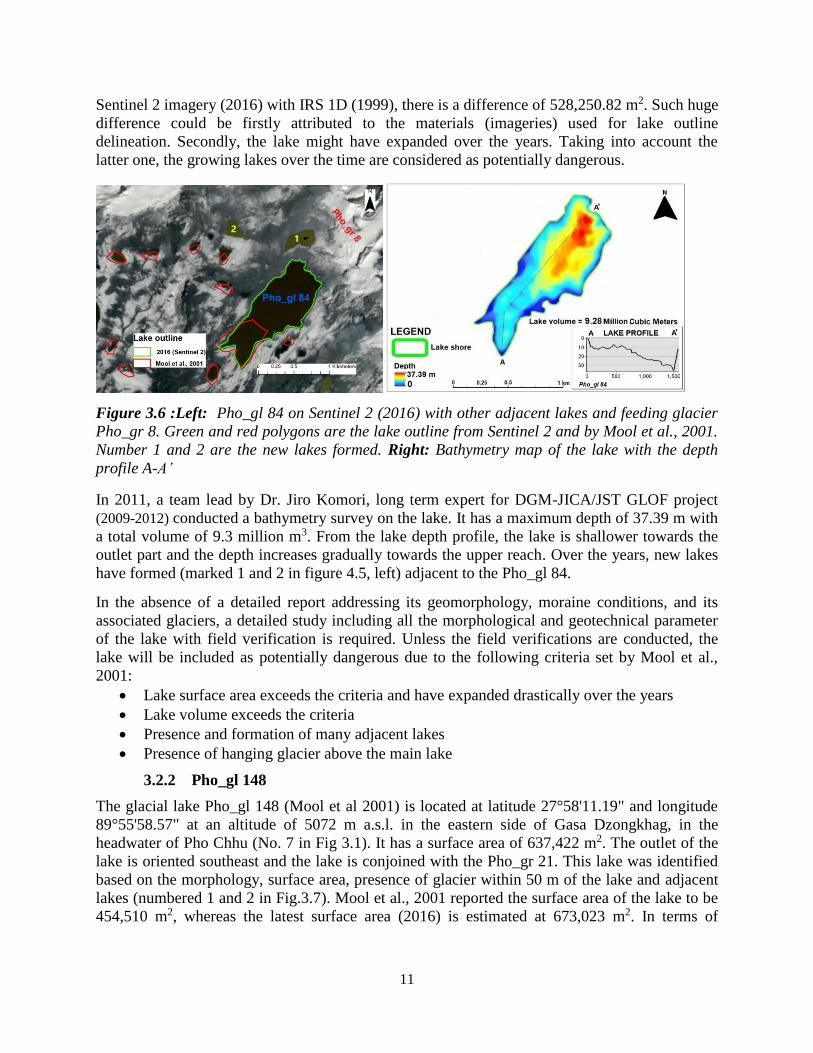
11
Sentinel 2 imagery (2016) with IRS 1D (1999), there is a difference of 528,250.82 m2. Such huge
difference could be firstly attributed to the materials (imageries) used for lake outline
delineation. Secondly, the lake might have expanded over the years. Taking into account the
latter one, the growing lakes over the time are considered as potentially dangerous.
Figure 3.6 :Left: Pho_gl 84 on Sentinel 2 (2016) with other adjacent lakes and feeding glacier
Pho_gr 8. Green and red polygons are the lake outline from Sentinel 2 and by Mool et al., 2001.
Number 1 and 2 are the new lakes formed. Right: Bathymetry map of the lake with the depth
profile A-A’
In 2011, a team lead by Dr. Jiro Komori, long term expert for DGM-JICA/JST GLOF project
(2009-2012) conducted a bathymetry survey on the lake. It has a maximum depth of 37.39 m with
a total volume of 9.3 million m3. From the lake depth profile, the lake is shallower towards the
outlet part and the depth increases gradually towards the upper reach. Over the years, new lakes
have formed (marked 1 and 2 in figure 4.5, left) adjacent to the Pho_gl 84.
In the absence of a detailed report addressing its geomorphology, moraine conditions, and its
associated glaciers, a detailed study including all the morphological and geotechnical parameter
of the lake with field verification is required. Unless the field verifications are conducted, the
lake will be included as potentially dangerous due to the following criteria set by Mool et al.,
2001:
Lake surface area exceeds the criteria and have expanded drastically over the years
Lake volume exceeds the criteria
Presence and formation of many adjacent lakes
Presence of hanging glacier above the main lake
3.2.2 Pho_gl 148
The glacial lake Pho_gl 148 (Mool et al 2001) is located at latitude 27°58'11.19" and longitude
89°55'58.57" at an altitude of 5072 m a.s.l. in the eastern side of Gasa Dzongkhag, in the
headwater of Pho Chhu (No. 7 in Fig 3.1). It has a surface area of 637,422 m2. The outlet of the
lake is oriented southeast and the lake is conjoined with the Pho_gr 21. This lake was identified
based on the morphology, surface area, presence of glacier within 50 m of the lake and adjacent
lakes (numbered 1 and 2 in Fig.3.7). Mool et al., 2001 reported the surface area of the lake to be
454,510 m2, whereas the latest surface area (2016) is estimated at 673,023 m2. In terms of

12
surface area, there is an increase of 218,513 m2. As per the criteria by Mool et al., 2001, increase
in lake area pose risk. In terms of length, the lake has expanded by 506 m upward.
Figure 3.7: Left: Pho_gl 148 with adjacent lakes lying at higher elevation (1&2) and the feeding
glacier Pho_gr 21 which wastes part of it in the form of icefall into the lake. Green and the red
polygon shows the lake outline of 2016 (Sentinel 2) and Mool et al., 2001 respectively.
Background image is Sentinel 2 (2016). Right: Bathymetry map of the lake with depth profile (A-
A’). Lake has shallow depth at the outlet part and deeper towards the upper reach.
Although no field reports were found, the bathymetry map created from data compiled by
Komori and his teams under the DGM-JICA/JST GLOFs project (2009-2012) give us a profile of
a lake with a maximum depth of 101 m and a volume of 25.3 million m3. The lake profile
reveals that the lake is shallow towards the outlet. The surrounding morphology consists of high
hanging glaciers, and possible active slides.
Since no detailed field study was documented at the site, a detailed study with detail
geomorphological parameter of the damming materials is required as the ice calving, avalanche
or active slide and outburst of higher lying lakes could possibly be the triggering factor of the
GLOF. Until further ground verifications are carried out, the lake will be listed as potentially
dangerous.
3.2.3 Pho_gl 163 (Tarina I)
The glacial lake Pho_gl 163 (Mool et al 2001) is located at latitude 28o06’06.43” and longitude
89054’11.83” at an elevation of 4266 m a.s.l. in the north eastern side of Gasa Dzongkhag in the
headwater of Pho Chhu (No. 8 in Fig. 3.1). It has a surface area of 250,813 m2 (Sentinel 2). The
outlet of the lake is oriented south and the lake is in conjoined to Pho_gr 41 (Hanging glacier).
Though the lake had a history of breach in 1957 causing GLOF downstream, the lake still has a
large surface area and the hanging glacier just above the lake. Such conditions must have let to
identification of the lake to be potentially dangerous.

13
Figure 3.8: Left: Photo showing Tarina I, Tarina II, Pho_gr 41, Pho_gr 44 and the Cliff along
which the Pho_gr 41 feeds Tarina I in the form of ice fall. Right: Bathymetry map of Tarina I
along with the depth profile from the outlet towards upper reach of the lake (A-A’)
Tarina Valley lakes were first mentioned by Augusto Gansser in his small assessment reporting
the glacier variation and GLOF risk from the lake but no detail studies were done until 1998
when the first reconnaissance survey under the Bhutan-Japan collaboration project took place at
Tarina valley. Similarly, during the last phase (Phase IV) of the joint Austria-Bhutan
collaborative project undertook a detail study of the lake.
Later, under the Activity of Annual Time Series Monitoring of Glacial lakes, the lake was
monitored in 2003 and 2016. The 2016 monitoring team carried out field surveys including
bathymetry survey, detailed topographic survey of the moraine dams, geotechnical studies of the
damming materials and other geomorphological studies. Through their studies, the team found
that:
The lake has the surface area of 248,200 m2
It has a maximum depth of 43 m
The lake water volume is 5.4 million m3
Terminus of the glacier (Pho_gr 41) wastes ice through ice fall to the lake (hanging
glacier)
The end moraine materials are gravelly sandy type with very little or no cohesive strength
Based on above ground verifications such as the lake surface area, lake volume, existence of
hanging glaciers and the geotechnical parameters of the end moraines, the glacial lake will be
categorized as potentially dangerous.
3.2.4 Pho_gl 164 (Tarina II / Mozum Tsho)
The crescent shaped glacial lake Pho_gl 164 (Mool et al., 2001) locally known as Mozum Tsho
(Tarina lake II) is located at latitude 28o06’37.81” and longitude 89005’37.81” at an elevation of
4338 m a.s.l. in the north eastern side of Gasa Dzongkhag, headwater of Pho Chhu (No. 9 in Fig.
3.1). It has a surface area of 446,325 m2 (Sentinel 2). The lake outlet is oriented Southwestern
side and is conjoined with the Pho_gl 44/67 which feeds the glacial lake. A small subsidiary
lake, Pho_gl 165 (Tarina lake III) right above the left lateral moraine also feed the glacier in the
form of seepage. This lake seems to have been identified due to its large surface area, presence
of adjacent glacial lake (Tarina III) located just above the left lateral moraine and the steep
lateral moraines.

14
Tarina Valley lakes was first mentioned by Augusto Gansser where he had written small
assessment reporting the glacier variation and GLOF risk from the lake but no detail studies were
done until 1998 when the first reconnaissance survey under the Bhutan-Japan collaboration
project took place at Tarina valley. Similarly, during the last phase (Phase IV) of the joint
Austria-Bhutan collaborative project undertook a detail study of the lake.
Figure 3.9: Left: Google image of Pho_gl 164 (Tarina lake II) and Pho_gl 165 (Tarina lake III)
along with the feeding glaciers Pho_gr 44 and Pho_gr 67 respectively. Right: Bathymetry map
of Tarina lake II along with the depth profile from outlet to the upper reach (A-A’)
Later, under the Activity of Annual Time Series Monitoring of Glacial lakes, the lake was
monitored in 2003 and 2016. The 2016 monitoring team carried out field surveys including
bathymetry survey, detailed topographic survey of the moraine dams, geotechnical studies of the
damming materials and other geomorphological studies.
Through their studies, the team found that:
The lake has the surface area of 476,300 m2 but the lake volume has not changed much
since 2002
It has a maximum depth of 67.5 m
The lake water volume is 13.0 million m3
The Pho_gr 67 and Pho_gr 44 has retreated way upstream and doesn’t pose direct impact
The end moraine materials are gravelly sandy type with very little or no cohesive strength
Tarina lake III have a weak moraine with lots of seepage points and has high possibility
of destabilizing the moraine dams which contains unconsolidated materials
Tarina lake III was found to have sessional change of the shorelines due to difference in
inflow and outflow of the lake indicating a piping between the main lake and Tarina lake
III
Possibility of dam failure of Tarina III might trigger GLOF of the main lake
Based on the above field findings, Mo_gl 164 (Tarina lake III) will be categorized as potentially
dangerous.

15
Figure 3.10: Glacier and glacial lakes in the Lunana region. Circled numbers 1 - 4 are Pho_gl
209 (Raphstreng), Pho_gl xx (Thorthormi), Pho_gl 210 (Lugge) and Pho_gl 2011 (Drukchung)
respectively. Letters A – D in the box are the glaciers feeding the main lakes (Pho_gr 83, Pho_gr
84, Pho_gr 86 and Pho_gr 87 respectively).
3.2.5 Pho_gl 209 (Raphstreng)
The glacial lake Pho_gl 209 (Mool et al., 2001) locally known as Raphstreng Tsho is located at
latitude 28o06’43.56” and longitude 900014’3.65” at an elevation of 4368 m a.s.l. in the north
eastern side of Thanza village under Gasa Dzongkhag (No. 10 in Fig. 3.1and circled no. 1 in
Fig.3.10). It is oriented Southwest side and is conjoined with the Pho_gl 83 ( letter A in Fig.
3.10) which feeds the glacial lake. This lake is one of the largest lake in the Lunana area
measuring a surface area of 1,241,970 m2 (Sentinel 2). This glacial lake could have been
identified due to its surface area, feeding glacier and the surrounding morphology.
Numerous field studies were taken up on glacier and glacial lakes of Lunana region by different
joint collaboration teams. Under the WAPCOS consultant funded by GOI and RGoB in
collaboration with DGM undertook a mitigation project (1995-1998) where the subsidiary lakes
below the lake were drained out and the lake level was lowered by 4 m. Later this project was
continued by the Austrian - Bhutan joint team where many detailed study of the lake was done
by experts. After that several monitoring have already taken place and this lake is constantly
monitored by erstwhile Glaciology Division under DGM.

16
Figure 3.11: Raphstreng and Thorthormi lakes showing the location of thin and active moraine
barrier
From the latest literature although the glacier feeding the lake have retreated and hit the bed
rock, the Raphstreng- Thorthomi moraine which is thinning due to active sliding pose risk. In
2008, the Thorthormi lake mitigation team conducted detailed survey in the vicinity. An
electrical resistivity survey to investigate ice core was conducted along the moraine ridge
separating Raphstreng and Thorthormi. The result revealed that the moraines were not
continuously underlined by dead ice however the presence of ice lenses or highly unconsolidated
boulders pose risk. Moreover, the zone of active slides was observed on the Thorthormi side
indicating unstable moraine. Under such scenarios, researchers have suggested that the fast
developing Thorthormi lake in future might collapse into Raphstreng lake causing huge outburst.
If it happens, the worst case estimated flood volume was 53 million m3 of water. Under the
DGM-JICA/JST GLOF project, bathymetry survey was conducted on Raphstreng lake (Fig.
4.11) and the result is presented here with the lake water volume extracted using the same data
set. Raphstreng lake has an estimated water volume of 55 million m3. It has a relatively deep part
at the outlet area and deeper towards the upper reach. According to the latest literatures and
based on the lake surface area, lake volume and the surrounding morphological characteristics,
Raphstreng lake will be categorized as potentially dangerous.

17
Figure 3.12: Bathymetry map of Raphstreng lake along with the depth profile (A-A')
3.2.6 Pho_gl xx (Thorthomi)
The unassigned glacial lake name in the inventory by Mool et al., 2001, locally known as
Thorthormi lake is located at latitude 28o06’19.90” and longitude 90015’48.46” at an elevation of
4446 m a.s.l. in the north eastern side of Lunana under Gasa Dzongkhag (No. xx in Fig. 3.1 and
2 in Fig.3.10). The lake is in the process of developing into a full moraine dammed glacial lake
and has no definite surface area due to major and moving ice bodies. Roughly (polygon 2 in Fig.
3.10), the surface area is approximately 2,908,490 m2. The outlet is oriented South side and is
conjoined with the Pho_gl 83 which feeds the glacial lake ( Letter B in Fig 3.10). Thorthormi
glacial lake is one of the fastest growing lakes in the recent times.
During the Austro-Bhutanese joint project from 1999 to 2002 (Hausler.H et al, 2000), a detailed
investigation was carried on the retreating Thorthomi Glacier, and found that the glacier was
retreating at accelerating pace hence they proposed a detailed study of the proglacial lake. Hence
this lake was then added in the PDGL list.
Later in 2005-2007 the detail study of the lake was undertaken under the Time series Monitoring
by the erstwhile Glaciology Division, DGM. During the 2005 expedition, the team found that the
three proglacial lake were expanding at an accelerated rate and the thinning of the Raphstreng-
Thorthormi moraine was noticed. The assessments in the area concluded that the fully developed
Thorthormi lake might overtop into Raphstreng causing huge GLOF. So in 2008 the Thorthomi
mitigation project was undertaken by RGOB in partner with UNDP under the GEF project
funded by LDCF and co-financed by GoA, WWF Bhutan and RGoB. The main objective of the
project was to lower the lake level so that the hydrostatic pressure towards the Thorthormi-
Raphstreng moraine would be minimized. Through the 5-year long project the lake water level
was lowered by 5 m as recommended by the Austrian -Bhutan joint team in 2003.
This lake has now expanded rapidly in the recent decade and is one of the critical lake that might
outburst in near future. This lake is currently being monitored under the Time series Monitoring
Activity of CSD division under NCHM. As per the recent available literatures on Thorthormi

18
lake and the criteria by Mool et al., 2001 on fast growing lakes, Thorthormi lake will be included
in the updated potentially dangerous lakes.
3.2.7 Pho_gl 210 (Lugge Tsho)
The glacial lake Pho_gl 210 (Mool et al 2001) locally known as Lugge Tsho is located at latitude
28o05’00.34” and longitude 900018’28.58” at an elevation of 4507 m a.s.l. in the north eastern
side of Lunana village under Gasa Dzongkhag (No. 11 in fig. 3.1 and 3 in Fig.3.10). It is oriented
North West side and is conjoined with the Pho_gl 86 (letter C in Fig.3.10) which feeds the
glacial lake. The lake had the surface area of 769,799.72 m2 in 2001 whereas the current surface
area is 1,460,870 m2.
The lake is one of the largest lake in the Lunana complex and have already breached on 7th
October 1994 killing 20 people and damaging million worth of infrastructure downstream
(WWF). There are many theories on why the lake breached. The rapid drainage from Drukchung
Tsho (No. 4 in Fig.3.10) has probably caused the sudden rise in Lugge Tsho causing the failure
of the left lateral moraine (Leber & Haussler, Report on Lugge Tsho GLOF project, 2000). The
collapse of the right bank of the moraine into the lake (ice avalanche or landslide) could have
possibly triggered the 1994 Lugge GLOF (Fujita et. al,2008).
Figure 3.13: Left: Mo_gl 210 (Lugge Tsho) on Sentinel 2 image. Green and red polygon are the
Lake Outline from Sentinel 2 (2016) and Mool et al., 2001. Pho_gl 211 is Drukchung lake.
Right: Bathymetry map of Lugge lake (data from 2011). Due to lack of data coverage towards
the upper reach, the depth interpolated is lesser.
Later in 2005 and 2007 the team under the Time series monitoring activity under took a study of
the lake. They found that the lake had a narrow outlet having a width of 5 m and active sliding
from the left lateral moraine. Hence there is a chance of blockage in the future with changing
condition. The glacier, Pho_gr 86 (marked C in Fig.3.10) was also found to be retreating at
abnormal rate due to water seeping into the Lugge left glacier causing rapid ablation. The PDGL
Pho_gl 211 (Drukchunhg tsho) exists just above the Lugge lake. The bathymetry map was
generated from the bathymetry survey data (2011) obtained from DGM-JICA/JST GLOF project
and has the water volume of about 65.19 million m3.
The current scenario of Lugge lake is that:
It still has relatively deep bottom topography towards the outlet
19
It has expanded by 1,050 m longitudinally from 2001 to 2016 where by increasing the
surface area by 691070.28 m2. On the other hand, the feeding glacier is retreating fast
It has substantially high water volume
The topography around the lake is changing and narrowing at the outlet region
An adjacent lake (Drukchung lake) lies above the Lugge lake which might trigger GLOF
Based on such ground verifications, the lake will be categorized as potentially dangerous and
recommended for further monitoring of the area.
3.2.8 Pho_gl 211 (Drukchung Tsho)
The glacial lake Pho_gl 211 (Mool et al., 2001) locally known as Drukchung Tsho is located at
latitude 28o05’40.45” and longitude 900018’11.95” at an elevation of 4701 m a.s.l. in the north
eastern side of Thanza valley under Gasa Dzongkhag (No. 12 in Fig 3.1 and 4 in Fig. 3.10). The
outlet is oriented North West side and is conjoined with the Pho_gl 87 (D in Fig.3.10) which
feeds the glacial lake. Another supraglacial lake lies above Drukchung lake (A in figure 4.13)
and Lugge lake lies just below this lake. The surface area of the lake was 101,096 m2(sentential
2)
This lake must have been identified based on its morphology and glacier situated 50 m within the
lake by the Mool et al., 2001 inventory.
Leber & Haeusler (report on Lugge Tsho GLOF project, 2000), pointed out Drukchung lake to
be one of the triggering factor for the 1994 Lugge GLOF. In 1994 when the supraglacial pond
above Drukchung emptied leading to increase in lake volume in Drukchung and hence minor
GLOF occurred from it. This GLOF might possibly have triggered the 1994 Lugge Tsho outburst
as the lake presides right above the Lugge glacier (Leber & Haeusler, 2000).
Later in 2005 and 2007 the team from the erstwhile Glaciology Division under DGM, monitored
all the lakes in lunana area. They located supraglacial ponds above the lake with floating ice
bodies due to calving process. No bathymetry survey has been carried out on the lake so far. At
present the presence of supraglacial lake just above Drukchung (marked with A in Fig.3.14)
might again trigger similar incidences to that of 1994. In particular, Drukchung alone may not
be so hazardous but in combination with Lugge lake, the lake is potentially dangerous.
Hence a detailed study consisting of bathymetry survey, geotechnical studies and discharge
measurement are need in the future field work. And this lake will be needing a constant
monitoring as it will be added in the new PDGL inventory.

20
Figure 3.14: Pho_gl 211 (Drukchung lake). Green and the red polygons are the lake outline
from Sentinel 2 (2016) and Mool et al., 2001. Letter A is the suptraglacial lake above Drukchung
lake
3.2.9 Pho_gl 313
The glacial lake Pho_gl 313 (Mool et al., 2001) is located at latitude 27o59’19.03” and longitude
90007’50.91” at an elevation of 5049 m a.s.l. in the north eastern side of Gasa Dzongkhag (No.
13 in Fig. 3.1). It is oriented South East side. In the inventory, the lake has a surface area of
222,134.80 m2 and 211,705 m2 by Sentinel 2 (2016) imagery. This lake might have been
identified based on presence of hanging ice just above the lake and the presence of other adjacent
lakes lying above the main lake level (marked 1 – 3 in Fig.3.15) and also series of bigger lakes
downstream (marked A, B in Fig. 3.15) by Mool et al., 2001.
Due to lack of access to the site, no field study has been carried out so far. However, by
comparing the surface area by Mool et al., 2001 and the surface area delineated from Sentinel 2
(2016) imagery, there is not much of changes (2001 – 2016). The present scenario of the lake is:
It has the surface area exceeding more than 100,000 m2
There are many adjacent lakes including series of other lakes downstream
Big glacier mass lying above the glacial lake
Based on such findings, the lake will be included in the updated potentially dangerous glacial
lakes.

21
Figure 3.15: Pho_gl 313 on google earth pro image (2002) along with series of lakes
downstream (A, B) and other adjacent lakes lying above the lake level (1, 2, 3)
3.3 Mangde Chhu sub-basin
3.3.1 Mang_gl 99 (GLT 9)
The glacial lake Mang_gl 99 (Mool et al 2001) coded as GLT 9 (Ageta, Y. and Iwata, S., 1999) is
located at latitude 28o06’43.56” and longitude 900014’3.65” at an elevation of 5155 m a.s.l. in
the north western side of Trongsa Dzongkhag on Gangrinchezoe plateau (No. 14 in Fig. 3.1). It is
oriented Southwest side and is conjoined with the Mang_gr 7 which feeds the glacial lake. Mool
et al., 2001 reported the surface area of 192,607.3 m2 and the recent Sentinel 2 (2016) image
reveals the surface area of 228,905 m2.The Japan-Bhutan joint research team (Ageta, Y. and
Iwata, S., 1999) did a detailed study on the glacial lakes on the Gangrinchenzoe plateau. The
Mang_gl 99 (GLT 9), like many other lakes in the Gangrinchenzoe plateau were found to have:
Relatively little water volume in shallow lake basin
The glaciers feeding the lake was found to have no risk for avalanche or rock fall because
of gentle glacier basin,
The relative height between the lake levels and the local basin levels were small
Wide and flat valley bottoms, extending downstream the lake serves as retention basins
Hence with all the above findings they concluded that the lake does not pose any risk of outburst
flood in future.
Later under the DGM-JICA/JST GLOF project (2009 – 2012), lake bathymetry survey was
conducted on Mang_gl 99 and showed a maximum depth of 51.72 m with a total volume of 4.70
million m3 (Fig.3.16 right). The present scenarios is that:
The lake did not change its surface area much (36,297.4 m2) (refer Fig.3.16 left)
The feeding glacier (Mang_gr 7) has retreated further upward and has a gentle glacier
morphology
The surrounding morphology is rather flat and no possibility of sliding

22
Based on the findings by Ageta, Y. and Iwata, S., 1999 and from the current analysis, the
Mang_gl 99 will be deemed safe and removed from the list of potentially dangerous glacial
lakes.
Figure 3.16: Left: Mang_gl 99 with feeding glacier Mang_gr 7. Green and red polygons are the
lake outline from Sentinel 2 (2016) and Mool et al., 2001. Right: Lake bathymetry map of
Mang_gl 99 along with the lake depth profile from outlet to upper reach (A-A’)
3.3.2 Mang_gl 106 (Metatshota)
The glacial lake Mangd_gl 106 (Mool et al., 2001) locally known as Metatshota is located at
latitude 28o053’06.43” and longitude 900 017’33.94” at an elevation of 5065 m a.s.l. in the north
western side of Trongsa Dzongkhag in the headwater of Mangde Chhu (No. 15 in Fig. 3.1). Its
outlet oriented southwest and is conjoined with the Mang_gr 5 which feeds the glacial lake. The
Mang_gl 5 has numerous ice cliffs which wastes its mass in the form of ice fall into the lake.
Due to the presence of such hanging glaciers, surface area and surrounding steep morphology
might have attributed for the identification of the lake as potentially dangerous in the inventory
by Mool et al., 2001. The inventory reported the surface area of 868,294 m2 whereas the Sentinel
2 (2016) imagery reveals the surface area of 1,203,880 m2 showing the difference of about
335,586 m2. The material used by Mool et al., 2001 was IRS 1D of 1999.
Under the DGM-JICA/JST GLOF project (2009 – 2012), lake bathymetry was conducted in
2009. Later, within the same project, the lake was covered for the risk assessment of GLOF on
the Mangde Chhu river basin. They concluded that:
The total water volume to be 41 million m3 with maximum depth of 120 m
The frontal basin near the outlet is less than 40 m deep
The moraine dam near the outlet has been deeply eroded so the actual height of the dam
crest from the frontal plain is only 25 m
Downstream slope of the moraine dam is gentle with crest width of 110 m
No dam breach event could be generated for any amount of inflow up to 5,000 m3/sec
The breach potential of Mang_gl 106 (Metatshota) lake is definitely low at the moment
but considering the large amount of water stored in the lake basin, and the changes that
might take place on the outlet moraine dams, probable large scale scenario of a GLOF in
the Mangde Chhu river basin.

23
Figure 3.17: Left: Mang_gl 106 (Metatshota) delineated using Sentinel 2 of 2016 (Green) IRS
1D of 1999 (Mool et al., 2001). Right: Lake bathymetry map prepared using the data set of 2009
(DGM-JICA/JST GLOF Project) along with depth profile A-A’
At present, the scenario in and around Metatshota Lake is that:
It has the large surface area
It has large amount of water stored
Large area of hanging glacier which wastes the mass in the form of ice fall into the lake
(Fig.3.18)
Figure 3.18: Metatshota lake with hanging glacier above (Mo_gr 5)
Taking into consideration the large amount of water stored and surrounding morphology (hanging
glacier), the glacial lake will be included in the list of potentially dangerous glacial lakes.
3.3.3 Mang_gl 270 (Zanam F)
The glacial lake Mang_gl 270 (Mool et al., 2001) coded as Zanam F by DGM-JICA/JST GLOF
project team (2009 – 2012) is located at latitude 27o 58’9.32” and longitude 90020’6.89” at an
altitude of 5311 m a.s.l. in the north eastern side of Trongsa Dzongkhag, headwater of Mangde
Chhu (No. 16 in Fig. 3.1). It is oriented east-west and is conjoined with the Mang_gr 51 which
feeds the glacial lake. Its surface area reported by Mool et al., 2001 is 239,778.31 m2. The lake
could have been identified as potentially dangerous based on its surface area, existence of glacier
within the distance of 50 m and the outlet moraine features.

24
Figure 3.19: Left: Mang_gl 207 (lake Zanam F) on Sentinel 2 (2016) image with lake polygons
of Mool et al., 2016 (red) and Sentinel 2 (2016). Right: Lake bathymetry map with depth profile
(A-A’).
First ever field survey of the lake was conducted in 2009 by DGM-JICA/JST GLOFs project.
Lake bathymetry was carried out and the lake water was calculated to be 4.7 million m3 with a
maximum depth of 60.4 m. No detailed report was documented. Current scenario of the lake is
that:
The surface area is 223,163 m2 and no surface area difference observed from 2001 to
2016 (Fig.3.19, left)
The feeding glacier (Mang_gr 51) has retreated further upstream and has a gentle glacier
morphology
Wide and gentle surrounding topography with no active slides
Shallow depth towards outlet (Fig.3.19, right)
Moraine dam conditions are firm and no changes observed
Though the surface area exceeds 100,000 m2, based on other surrounding conditions the lake will
be deemed safe and will be removed from the list of potentially dangerous glacial lakes.
3.3.4 Mang_gl 285 (Zanam E)
The glacial lake Mang_gl 285 (Mool et al., 2001) coded as Zanam E by DGM-JICA/JST GLOF
project team (2009 – 2012) is located at latitude 28o0’20.90” and longitude 90019’50.77” at an
elevation of 5370 m a.s.l. in the northern east of Trongsa Dzongkhag, in the headwater of
Mangde Chhu (No. 17 in fig. 3.1). It is oriented South and is fed by Mang_gr 57 glacier having a
surface area of 1.579 km2. Mool et al., 2001 reported the lake surface area of 341,412 m2
whereas lake surface area delineated from Sentinel 2 (2016) reveals 342,874 m2. The lake must
have been identified as potentially dangerous on the basis of hanging glacier (Mang_gr 57 in
Fig.3.20) found within 50 m upstream and the lake surface area (341,412 m2).

25
Figure 3.20: Mang_gl 285 (Zanam E) with feeding glacier Mang_gr 57. The red and green
polygons are the lake outline by Mool et al., 2001 and delineated from Sentinel 2 (2016)
respectively.
No field studies have been done so far at this site by any officials. But as per the desktop studies
it was found that the lake has:
Large feeding glacier area with gentle glacier morphology
The surface area of 342,874 m2
Surface area has not changed from 2001 to 2016 which indicates the lake is stable
Flat and wide surrounding topography with no triggering factors such as active sliding
Based on such conditions, the lake will be deemed safe and will be removed from the list of
potentially dangerous glacial lakes.
3.3.5 Mang_gl 307 (Zanam B)
The glacial lake Mang_gl 307 (Mool et al., 2001) coded as Zanam B by DGM-JICA/JST GLOF
project team (2009 – 2012) is located at latitude 28o1’40.51” and longitude 90021’58.87” at an
elevation of 5208 m a.s.l., in the north eastern side of Trongsa Dzongkhag in the headwater of
Mangde Chhu (No. 18 in Fig.3.1). It is oriented Southwest side and is conjoined with the
Mang_gr 65 which feeds the glacial lake. The surface area of the lake was reported to be
767,429.09 m2 (Mool et al., 2001). Another glacial lake (Mang_gl 303, coded as Zanam A)
having the surface area of 477,649 m2 lies just above the lake at the crest width of 20 m and at
the vertical height difference of 55 – 60 m (google earth pro). From the Sentinel 2 (2016)
imagery, the lake surface area is about 862,181 m2. The lake might have been included in the
inventory (Mool et al., 2001) on the basis of feeding glacier partly attached to the lake and party
feeds in the form of icefall, presence of glacial lake (Zanam A) just above the main lake which is
also fed by another glacier within the vicinity of 50 m.

26
Figure 3.21: Left: Mang_gl 307 (Zanam B) and Mang_gl 303 (Zanam A) on Sentinel 2 (2016)
imagery. The red polygon is the lake outlines by Mool et al., 2001 and green is from Sentinel 2
(2016). Right: Bathymetry map of Mang_gl 307 along with depth profile from outlet to upper
reach (A-A’).
The first field work was carried out by the DGM-JICA/JST GLOF project in 2010 during which
the lake bathymetry was conducted. The deepest part of the lake was around 103 m with shallow
depth towards the outlet of 15 – 20 m. From the bathymetry survey, the volume of the lake was
calculated to be 37 million m3. Lake bathymetry was also conducted on Zanam A and found the
water volume of approximately 7 million m3 with maximum depth of 46.8 m. The project
covered the lake for risk assessment in terms of GLOF in the Mangde Chhu river basin. T. koike
and S.Takenaka, 2012 concluded that:
The upslope and downslope of the lake moraine has low slope angle
The constant discharge of more than 5.0 m3/s or temporal discharge of 40 m3/s could
have a GLOF scenario of the lake but may not have much affect downstream
The triggering factor could be ice avalanche or mass slope failure
Constant monitoring required to check whether the volume of the lake is increasing
Based on the findings and recommendations by T. koike and S. Takenaka, 2012, the lake will be
included in the list of potentially dangerous glacial lakes.
3.3.6 Mang_gl 310 (Zanam G)
The glacial lake Mang_gl 307 (Mool et al., 2001) coded as Zanam G by DGM-JICA/JST GLOF
project team (2009 – 2012) is located at latitude 27o58’51.47” N and longitude 90022’53.97” E at
an elevation of 5224 m a.s.l. in the north western side of Trongsa Dzongkhag in the headwater of
Mangde Chhu (No. 19 in Fig.3.1). It is oriented Southwest and is conjoined with the Mang_gr 65
which feeds the glacial lake. As per the record by the earlier inventory (Mool et al., 2001) the
lake has the surface area of 200,746.34 m2 whereas the newly mapped surface area using
Sentinel 2 (2016) is 206,234 m2. The lake could have been identified as potentially dangerous
based on its surface area, presence of adjacent glacial lake and the mother glacier found within
the distance of 50 m (Fig. 3.22, left).

27
Figure 3.22: Left: Mang_gl 310 (Zanam G) on Sentinel 2 (2016) imagery. The red polygon is
the lake outline by Mool et al., 2001 and green is from Sentinel 2 (2016). Right: Bathymetry map
of Mang_gl 310 along with depth profile from outlet to upper reach (A-A’).
The field work on the site was first carried out by the DGM-JICA/JST GLOF project (2009 –
2012). The project team has conducted the lake bathymetry survey (Fig. 3.22, right) but no
detailed report is documented. From their survey, the lake volume was mapped to be 1.84 million
m3 with the maximum depth of 21 m which lies towards the upper reach. The current scenario of
the lake is that:
The lake surface area did not change much from 2001 to 2016
The feeding glacier (Mang_gr 76 in Fig.3.22, left) has a gentle topography and may not
trigger GLOF
The lake has shallower depth towards the outlet exhibiting safe condition
It has a wide and flat surrounding topography and does not pose any danger from active
sliding
Based on the above conditions, the lake will be deemed safe and will be removed from the list of
potentially dangerous glacial lakes.
3.3.7 Mang_gl 385
The glacial lake Mang_gl 385 (Mool et al., 2001) is located at latitude 27o58’58.53” and
longitude 90026’21.90” at an elevation of 5089 m a.s.l., in the north eastern side of Trongsa
Dzongkhag and in the headwater of Mange Chhu (No. 20 in Fig.3.1). The ice dammed lake is
oriented north conjoined with glacier Mang_gr 44. Mool et al., 2001 reported the surface of the
lake to be 466,125.34 m2 but the recent Sentinel 2 (2016) image reveals the surface area of
248,574 m2. The lake is dammed by ice (Mang_gr 177). The major difference observed is that
the lake polygon by Mool et al., 2001 has included the upstream that feeds the lake (Fig.3.23)
whereas in Sentinel 2 (2016) imagery it is omitted. This has led to the surface area change of (-)
217,551.36 m2 from 2001 to 2016. Since the lake is dammed by ice, it could have been the
reason for identifying it as potentially dangerous.

28
Figure 3.23: Mang_gl 385 with damming glacier (Mang_gr 117) on Sentinel 2 (2016) imagery.
The red polygon is the lake outline by Mool et al., 2001 and green is from Sentinel 2 (2016)
So far, no field survey has been conducted on the glacial lake as it is located at a very remote
area and it is inaccessible. However, from the desktop studies, still the lake is dammed by glacier
ice (Mang_gr 177) and is intact. Ice dams are subtle to change (Huggel et al 2002) and a detailed
field observation is recommended. Hence, the lake will be considered potentially dangerous as
no detailed field records are available.
3.4 Chamkhar Chu Sub-basin
3.4.1 Cham_gl 198 (Phudung lake)
The glacial lake Cham_gl 198 (Mool et al., 2001) locally known as Phudung Tsho is located at
latitude 27o58’58.53” and longitude 90026’21.90” at an elevation of 5062 m a.s.l. in the northern
side of Bumthang Dzongkhag in the headwater of Chamkhar Chhu (No. 21 in Fig.3.1). The
outlet is oriented north east. The surface area was reported to be 624,669.81 m2 by Mool et al.,
2001. Using the Sentinel 2 (2016) imagery the lake outline was delineated and reveals the
surface area of 582,729 m2. The surface area difference is negligible which can be attributed to
type of imagery used for delineation and methodology (red and green polygons in Fig.3.24, left).
It is a fully developed lake.
This lake could have been identified based on the surface area, steep outlet morphology and the
steep glacier feeding the lake as observed from the Remote Sensing data. From the google earth
and other remote sensing data, steep morphology can be observed.

29
Figure 3.24: Left: Cham_gl 198 (Phudung Tsho) on Sentinel 2 (2016) imagery. The red polygon
is the lake outline by Mool et al., 2001 and green is from Sentinel 2 (2016). Right: Bathymetry
map of Cham_gl 198 along with depth profile from outlet to upper reach (A-A’)
Figure 3.25: Panoramic view of Cham_gl 198 (Phudung Tsho) lying completely in a bedrock
topography. Dotted red box show the location of the lake outlet
The first field work was conducted under the DGM-JICA/JST GLOF project (2009-2012) and
initiated the lake bathymetry survey. From their survey, the lake volume was extracted to be 10.7
million m3 with the maximum depth of 63 m. The team found that the feeding glacier has
retreated further upstream posing no threat of ice avalanche. The damming material of the lake
consists of bed rock and in the events of overtopping of lake water, no erosion of damming
material could occur. Ultimately, no GLOF scenario can happen downstream. Based on the
above observations and findings, the lake is considered as safe.
3.4.2 Cham_gl 232
The glacial lake Cham_gl 232 (Mool et al., 2001) is located at latitude 27o59’11.33” and
longitude 90030’31.42” at an elevation of 5205 m a.s.l., in the northern side of Bumthang
Dzongkhag and in the headwater of Chamkhar Chhu (No. 22 in Fig.3.1). It is oriented south and
conjoined with glacier chamkr_gr 15 which feeds the glacial lake. Mool et al., 2001 reported the
lake surface area of 205,146.23 m2 whereas the latest satellite imagery (Sentinel 2) of 2016
reveals the lake surface area to be 188,550 m2. The lake could have been identified to be
dangerous based on its surface area exceeding 100,000 m2, presence of few adjacent lakes and
the presence of feeding glacier in the vicinity. An interesting feature observed at present is the
development of another lake just above the Cham_gl 232 (marked no. 1 in Fig.3.26) which was
not mapped in earlier inventory by Mool et al., 2001.

30
Figure 3.26: Cham_gl 232 on Sentinel 2 (2016) imagery. The red polygon is the lake outline by
Mool et al., 2001 and green is from Sentinel 2 (2016). No. 1 marked in pink shows the presence
of a lake which was not mapped in earlier inventory by Mool et al., 2001
No field work was done on the side at the moment but from the desktop studies (satellite
imageries and google earth pro) it was found that:
The surface area has not increased from 2001 to 2016
The feeding glacier (Cham_gr 15) has retreated further upstream and has a gentle glacier
morphology indicating no direct thread
A new lake is visible using latest satellite imageries (Sentinel 2)
It has a wide and gentle topography indicating no threads from active slidings
Based on above points the lake seems safe from GLOF. However, a new lake is observed using
latest satellite imageries, which is missing in the inventory by Mool et al., 2001. In this regard,
until further field verifications are made, the lake will be included in the list of potentially
dangerous glacial lakes.
3.4.3 Cham_gl 383 (Chubda Tsho)
The Glacial Lake Cham_gl 383 (Mool et al, 2001) locally known as Chubda Tsho is located at
latitude 28o01’25.91” and longitude 900041’31.77” at an elevation of 4868 m a.s.l. in the
northern part of Bumthang Dzongkhag in the headwater of Chamkhar Chhu( No. 23 in Fig.3.1).
The lake measuring the surface area of 1,388,320 m2 (Sentinel 2) is one of the biggest lake in the
Chamkhar Chhu headwater. The lake outlet is oriented southwest and is directly fed by Cham_gr
71. The lake is one of the biggest lake in the headwater of Chamkhar Chhu. The surface area

31
reported by Mool et al., 2001 is 1,035,131.51 m2 and is expanding at a rate of 0.027 km2 per year
i.e. an increase of about three fold in the last 3 decades. (Komori, J. et al., 2004)
Figure 3.27: Left: Cham_gl 383 (Chubda Tsho) on Sentinel 2 (2016) imagery. The red polygon
is the lake outline by Mool et al., 2001 and green is from Sentinel 2 (2016). Right: Bathymetry
map of Cham_gl 383 along with depth profile from outlet to upper reach (A-A’)
Numerous studies have been carried out in the headwater of Bumthang (karma et al., 1999;
Karma et al., 2000; Iwata et al., 2003; Komori et al., 2004). They found that the lake has an ice
cored moraine dam. Besides, it was also noticed that the expansion rate of the lake and rate of
glacier retreat was taking placing at an accelerated rate. This lake is not a moraine dammed but a
supraglacial lake with flat threshold existing at the end moraine (Karma et al.,1999). Komori et
al., 2003 concluded that the position of the terminus of Chubda Tsho has not changed but the
existence of the threshold might possess a greater risk in near future.
The lake bathymetry survey was carried out in 2010 by the DGM-JICA/JST GLOF project
(2009-2012) and the lake water volume was extracted to be 21.7 million m3 approximately with
maximum depth of 56 m towards the upper reach. Most of the earlier studies recommended for a
detailed studies especially the damming part. Comparing the lake polygons by Mool et al., 2001
and the from the Sentinel 2 (2016) imagery (Fig.3.27, left), the lake has expanded upward by
approximately 564 m in 17 years accounting to 33 m per year. This rate of glacier retreat (debris
cover glaciers) still falls well within the estimated rate by the earlier researchers in Lunana
region where the rate of glacier retreat was mentioned as 30 to 35 m per year.
Based on recommendations from earlier studies and current situation, the lake Cham_gl 383
(Chubda Tsho) will be included in the list of potentially dangerous glacial lakes.
3.5 Kuri Chu Sub-basin
3.5.1 Kuri_gl 172 (Terjatse Tsho)
The glacial lake Kuri_gl 172 (Mool et al., 2001) locally known as Terjatse Tsho is located at
latitude 27o55’49.76” and longitude 910 17’59.53” at an elevation of 4373 m a.s.l., in the north
eastern side of Lhuntse Dzongkhag in the headwater of Kuri Chhu (No. 24 in Fig.3.1). The lake
is oriented north east and is conjoined with the Kuri_gr 10 which feeds the glacial lake. In the
earlier inventory by Mool et al., 2001, the lake’s surface area was reported to be 161,706.43 m2
whereas the latest imageries reveal the surface area to be 167,540 m2. There is another lake
above the kuri_gl 172 which would be a potential triggering factor for a GLOF case and could be
the reason why the lake was categorized to be potentially dangerous in the 2001 inventory.

32
Another factor could be due to its steep morphology at the outlet of the lake. The lake feeds the
Khoma chhu and finally flows into Kuri Chhu downstream.
Figure 3.28: Kuri_gl 172 on Sentinel 2 (2016) image. The red polygon is the lake outline by
Mool et al., 2001 and green is from Sentinel 2 (2016)
Komori et al (2013) mentioned that the lake is not a glacial lake as the glacier associated with it
has retreated way above. In April 2018 a group of officials consisting of Geologists and
Engineers went for a detail study of the lake. Due to excessive avalanche from the route site, and
steep hill from the other alternating route the study could not be carried out. From the recent
satellite imageries (Sentinel 2 (2016)), the lake surface area has not changed.
However, since no ground verifications are made the lake will be included in the list of
potentially dangerous glacial lakes until further detailed field studies are conducted.

33
Figure 3.29 Locations of updated list of PDGLs

Table
1:
New
sta
tus
of
Pote
nti
all
y D
an
ger
ous
Gla
cial
Lake
s of
Bhuta
n
SN
o.
Lak
e
Nu
mb
er
Lo
cal
Nam
e L
ati
tud
e L
on
git
ud
e A
ltit
ud
e A
rea (
m2)
Vo
lum
e (m
3)
Rem
ark
s
Mo C
hu
Su
b-b
asi
n
1
Mo_gl
200
Lem
than
g
28
° 0
4' 0
0.0
0
89°
35' 0
5.5
0
4280
0
0
Saf
e
2
Mo_gl
201
2
8°
06 1
5.6
0
89°
36' 5
5.6
0
4380
68,1
38
NA
S
afe
3
Mo_gl
202
Lat
sho
kar
p
28
° 0
7' 4
4.4
0
89°
36' 3
1.6
0
4434
62,8
01
NA
S
afe
4
Mo_gl
234
Sin
tap
hu
28
° 1
0' 0
6.0
0
89°
51' 2
1.1
0
4480
238,3
14
6,4
10
,00
0
PD
l M
o_gl
235
2
8°
08' 3
5.4
0
89°
51' 2
1.1
0
4960
128,8
03
NA
P
D
Ph
o C
hh
u S
ub
-basi
n
6
Pho_gl
84
2
7°
56' 4
8.5
3
89°
55' 1
4.0
3
4997
742,3
29
9,2
80
,00
0
PD
7
Pho_gl
148
2
7°
58' 0
9.4
2
89°
56' 1
6.6
9
5072
637,4
22
26
,31
0,0
00
PD
8
Pho_gl
163
Tar
ina
I 2
8°
06' 0
6.4
3
89°
54' 1
1.8
3
4266
250,8
13
5,4
00
,00
0
PD
9
Pho_gl
164
Tar
ina
II
28
° 0
6' 3
7.2
2
89°
54' 3
7.8
1
4338
446,3
25
13
,00
0,0
00
PD
10
P
ho_gl
209
Rap
hst
ren
g
28
° 0
6' 4
3.5
6
90°
14' 0
3.6
5
4368
1,2
41,9
70
54
,65
0,0
00
PD
11
P
ho_gl
210
Lu
gge
28
° 0
5' 0
0.3
4
90°
18' 2
8.5
8
4570
1,4
60,8
70
65
,19
0,0
00
PD
12
P
ho_gl
211
Dru
kch
un
g
28
° 0
5' 4
0.4
5
90°
19' 1
1.9
5
4701
101,0
96
NA
P
D
13
P
ho_gl
313
2
7°
59' 5
8.7
2
90°
07' 1
8.8
6
5049
211,7
05
NA
P
D
14
P
ho_gl
xx
Th
ort
ho
rmi
28
° 0
6' 1
9.9
0
90°
15' 4
8.4
6
4446
2,9
08,4
90
NA
P
D
Man
gd
ech
hu
Su
b-b
asi
n
15
M
ang_
gl
99
GL
T 9
2
7°
54' 2
2.1
3
90°
16' 4
5.8
8
5155
228,9
05
4,7
40
,00
0
Saf
e
16
M
ang_
gl
106
Met
atsh
ota
2
7°
53' 1
9.4
5
90°
17' 3
3.9
4
5065
1,2
03,8
80
41
,74
0,0
00
PD
17
M
ang_
gl
270
Zan
am
F
27
° 5
8' 0
9.3
2
90°
20' 0
6.9
8
5311
233,1
63
4,7
10
,00
0
Saf
e
18
M
ang_
gl
285
Zan
am
E
28
° 0
0' 2
0.9
0
90°
19' 5
0.7
7
5370
341,4
12
NA
S
afe
19
M
ang_
gl
307
Zan
am
B
28
° 0
2' 2
1.0
1
90°
21' 5
8.8
7
5208
862,1
81
37
,03
0,0
00
PD
20
M
ang_
gl
310
Zan
am
G
27
° 58' 4
9.8
7
90°
23' 0
5.5
3
5224
206,2
34
1,8
70
,00
0
Saf
e
21
M
ang_
gl
385
2
7°
58' 5
8.5
3
90°
26' 2
1.9
0
5089
248,5
74
NA
P
D

Ch
am
kh
ar
Ch
hu
Su
b-b
asi
n
22
Cham
_gl
19
8
Ph
ud
un
g
27
° 56' 2
2.2
7
90°
32' 1
5.9
1
5062
58
2,7
29
10
,76
0,0
00 S
afe
23
Cham
_gl
23
2
27
° 59' 1
1.3
3
90°
30' 3
1.4
2
5205
18
8,5
50
NA
PD
24
Cham
_gl
38
3
Ch
ub
da
Tsh
o
28
° 01' 2
5.9
1
90°
42' 3
1.7
7
4868
1,3
88
,32
0
21
,69
0,0
00 P
D
Ku
rich
hu
Su
b-b
asi
n
25
Kuri
_gl
17
2
Ter
ja t
se T
sho
27
° 55' 4
7.5
6
91°
18' 0
8.7
7
4373
16
7,5
40
NA
PD
Note
: P
D -
Po
ten
tiall
y D
ang
ero
us
NA
- N
ot
Ava
ilab
le

36
CONCLUSION
In this current work, the list of potentially dangerous glacial lakes of the Bhutan Himalayas
(Mool et al., 2001) are updated by carefully reviewing the previously identified 25 PGDL’s. The
work is executed based on recommendations from earlier literature including technical reports,
field reports, scientific reports and findings from recent satellite imageries (Sentinel 2 (2016))
and google earth pro. Of the 25 potentially dangerous glacial lakes, so far 19 had been field
verified. Of the 19 field verified potentially dangerous glacial lakes, data from previous studies
have concluded that 7 are safe. Of the 6 lakes which were not field verified 5 are still considered
to be potentially dangerous glacial lakes until further ground verifications are conducted and one
in the headwater of Mangde Chhu (Mang_gl 285/Zanam E) was deemed safe as it lies on a
gentle and flat topography with no possible triggering factors. For the lakes which were not field
verified surface area change from 2001(Mool et al., 2001) to 2016(Sentinel 2) were observed and
compared using satellite imageries. With the removal of 8 lakes from the previous list of PDGLs,
the new updated list of PGDL’s consist of 17 Potentially dangerous glacial lakes, with a major of
9 lakes in the Pho Chhu sub basin ,3 in Mangde Chhu sub basin, 2 in Mo Chhu sub basin, 2 in
Chamkhar Chhu sub basin and one in Kuri Chhu sub basin(Fig.3.29 and Table 1).The updated
inventory on PDGL aims to provide more accurate information and awareness of GLOF
phenomenon to public domains so that concerned agencies can act accordingly for prevention
and mitigation.

37
Recommendation
The current work on assessing and updating of potentially dangerous glacial lakes were based on
existing 25 potentially dangerous glacial lakes of Bhutan Himalayas and did not take into
account other glacial lakes. Due to recent global climate change, melting glaciers lead to
formation of new glacial lakes as well as expansion of existing glacial lakes. In this line, the
center would like to recommend the following:
Conduct field assessment on those glacial lakes listed as potentially dangerous glacial
lakes which are not yet field verified.
Update the inventory of glacial lakes covering northern frontiers of Bhutan
Develop an appropriate list of criteria’s for assessing and categorizing potentially
dangerous glacial lakes
All other glacial lakes must be assessed so as to come up with a comprehensive inventory
of glacial lakes and identify them in terms of the safety from GLOF.

38
References
Dorji. Y., (?????) Glaciers and Glacial Lakes Feeding Pho Chhu and The Risk Associated with
these Lakes. GSB(unpublished).
Gansser, A. (1983). Geology of the Bhutan Himalaya. Birkhaüser Verlag (Vol. 8).
https://doi.org/10.1016/0160-9327(84)90075-9
Iwata.S.,Gurung.D.R and Komori.J.(2002) Preliminary Report on Chubda Tsho in the
Headwater of Chamkhar Chhu,Bumthang.DGM(unpublished)
Iwata, S., Ageta, Y., Naito,N., Sakai,A., Narma,C and Karma.(2002)Glacial Lakes and their
Outburst Flood Assessment in the Bhutan Himalaya.
Karma. and Tamang.K.B (1999) Preliminary Report on TsokarTsho in the Headwater of
Chamkhar Chhu,Bumthang. Engineering Geology and Glaciology Wing GSB(Unpublished)
Karma.,Thapa.T. and Ghalley.K.S.,(1999) Preliminary Report on Chubda Tsho in the Headwater
of Chamkhar Chhu,Bumthang.Engineering Geology and Glaciology Wing GSB(Unpublished)
Karma., Tshering,P and Penjor,T.,(2016) Time Series Monitoring of Glacier and Glacial Lakes
of Tarina Glacier and Glacial Lakes (Pho Chhu Western Branch) under Gasa Dzongkhag.
DGM(unpublished)
Komori, J., T. Koije, T. Yamanokuchi and P. Tshering (2012) Glacial Lake Outburst events in
the Bhutan Himalayas. Global Environmental Research, 16:59-70.
Koike,T and Takenaka,S.(2012) Scenario Analysis on Risk of Glacial Lake Outburst Floods on
the Mangde Chhu River,Bhutan.Global Environment Research,16/41-49.
Komori.J., Iwata.S.,Gurung.D.R and Yabuki.H.(2003) Variation and Lake Expansion of Chubda
Glacier,Bhutan Himalayas, during the last 35 years.
Leber,D., Haeusler, H., Brauner,M. & Skuk, S.(2000) Lugge Tsho outburst Flood Mitigation
Project , Lunana, Bhutan.Institute of Geology University of Vienna.
Mool, P. K., Wangda, D., Bajracharya, S. R., Kunzang, K., Gurung, D. R., & Joshi, S. P. (2001).
Inventory of Glacier, Glacial Lakes and Glacial Lake Outburst Floods: Monitoring and Early
Warniing Systems in the Hindu Kush-Himalayan Region, Bhutan. Quality.
https://doi.org/10.1017/CBO9781107415324.004
Penjor.T., Galley.S. And Gyeltshen.J.(2012) Time Series Monitoring of Glacier and Glacial
Lakes of Mo-Chu Basin under Gasa Dzongkhag. DGM (unpublished).
Singh, S. M. (2009). The Cost of Climate Change: The Story of Thorthormi Glacial Lake in
Bhutan.
Tshering,P, and Penjor,T.(2016) Time Series Monitoring of Glacier and Glacial Lakes of Mo-

39
Chu Basin (Singtaphu and Rodophu Area) under Gasa Dzongkhag. DGM (unpublished)
Tshering, T., Gyenden, L., Ghalley, K.S.Chettri, L.K., Dorji,P. and Tamang,T.(2007) Report on
annual Monitoring of Glaciers and Glacial Lakes in Lunana. DGM. (unpublished)

Reassessment of Potentially Dangerous Glacial Lakes in Bhutan
“The costs of natural disasters can set back a community or nation by decades – not to speak of the lasting emotional damage inflicted on the people affected.”
His Majesty Jigme Khesar Namgyel Wangchuck, King of Bhutan,Convocations address to the students of Calcutta University, 5th October 2010
NATIONAL CENTER FOR HYDROLOGY AND METEOROLOGYROYAL GOVERNMENT OF BHUTAN
www.nchm.gov.bt
ISBN: 978-99980-862-1-0
NATIONAL CENTER FOR HYDROLOGY AND METEOROLOGYROYAL GOVERNMENT OF BHUTAN
2019