reading the landscape'' : reflections on a sacred site in south
TRANSCRIPT

!57
''Reading the Landscape'' : Reflections on a Sacred Site in
South Thailand Lorraine Gesick **
In the course of several articles on the early art of peninsular Thailand, Professor Stanley O'Connor, applying insights derived from semiotics and phenomenology, has developed the theme that inhabitants of a landscape "read" it, seeing in that landscape's natural features signs that carry meaning. 1 In turn, according to the meaning they have discerned in those natural signs, they may add signs of their own to the landscape, by, for example, erecting temples and lingas, or by depositing votive tablets or images at "powerful" sites, such as hills or caves, thereby enlarging the significance of the natural terrain. The landscape with its man-made modifications thus becomes a "text" capable of being read not only by the inhabitants who, so to speak, created the text, but by anyone who takes the trouble--though this should not be underestimated-- to learn the idiom in which the text is expressed. Such a reading, of course, can never be complete, since some signs may disappear or their meaning become obscure, the reading being, rather, a translation of a text that is never fixed.
As an illustration of what I believe Professor O'Connor is suggesting, I should like to describe in these few pages a striking example of a "text" of the sort he postulates. This "text" is a stretch of terrain near Ban Chumphon, Amphoe Sathing Phra, Songkhla Province, comprising four hills, on one of which is a Buddhist temple, on another, a Shaivite /inga-cave-pond complex, and, hidden •at the base of a third, a grotto housing an animal spirit. The whole site fits roughly into one square kilometer. The hills themselves are relatively small, but, rising dramatically out of the flat Sathing Phra peninsula as they do, they do-
** Elmira College, Elmira, New York 14901.
* I wish to express my gratitude to Phra Achan Khiaw Pminaphalo (Yi7:::en'\l17~b1irn \It]}~~ 1t:~) of Wat Phra Kho for his kindness in showing me around the site when I visited it in 1974 and again in 1977 and for telling me something of Wat Phra Kho's history. Mr. Jaroon Kanchanaphen
('\'If,~ 111~'\l'\.UV\~) took the photographs. Thanks are also due to th.e National Library and its staff in the Manuscript Division, who photocopied the map MS for me.
1. See especially, Stanley J. O'Connor, "Buddhist Votive Tablets and Caves in Peninsular Thailand," in Art and Archaeology in Thailand. published by the Fine Arts Department in Commemoration of the IOOth Anniversary ·Of the National Museum, Bangkok, 1974, pp. 71, 82-84.

158
Lorraine Gesick
minate the surrounding landscape.
The first site in this overall terrain that I should like to describe is located at the more northerly of the two central hills. This hill, the second-highest of the four, is crowned on the east side with a giant, rounded stone knob, quite clearly apprehended by inhabitants of the land-scape in antiquity as a natural manifestation of Shiva's liliga, or phallic emblem (Skt. Svayan:zbhuvalinga). This stone knob, once it had been so apprehended, may or may not have been modified by human agency to make it look more realistic (Plates 1 and 2), but this initial
apprehension of a manifestation of the divine in a natural feature of the landscape must have been what gave rise to the elaboration of the rest of the complex.
In the lower face of the hill facing east, directly below the natural linga,
are twin single-chamber caves, whether natural or man!.made I cannot ;ay, though their entrances certainly have been modified by humans (Plates 3,4, and 5. Notice the carved notches for lintels and threshold blocks.) At the inner end of each cave the rock has been shaped into a rough alter. In front of the caves is a level terracelike space, again, perhaps, levelled by humans; on the east edge of this terrace is a large, square stone base that appears to have held a man-made monumental lingo
(Plate 6). Below the terrace is a long north-south depression that Dr. Janice Stargardt identifies as the remnant of a major ancient canal. 2 Lying due east of the canal and the hill are the remains of a large, square ancient tank. This tank, known as Phang Phra (~\1~1::),"Sacred Pond," was the largest in the Sathing Phra region, a fact that
· suggests its importance. 3 (S. Thai phang = traphang, the typical square or rectangular man-made archaic tank.) In the middle of Phang Phra is a square island, known locally as khok Phang Phra (khOk = tumulus; in local parlance, khok also carries the connotation of being haunted). Except for a bit of standing water right around the island, Phang Phra has been turned into a ricefield, and the island now contains only a wooden pavilion and spirit house, but, in a late-seventeenth or early eighteenth-century "map" of the Sathing Phra peninsula (drawn almost certainly by a local person) Phang Phra is depicted as still filled with water and
2. Janice Stargardt, Satingpra I: The Environmental and Economic Archaeology of South Thailand,.
BAR International Series# 158, Oxford, 1983, pp. 169-170, and fig. 16.
3. Ibid., pp. 169-170.

159
"Reading the Landscape"
the island as containing a pavilion housing a Buddha image (Plate 7). 4 Stewart Wavell, who visited the site in 1962, says that, according to the then abbot of Wat Phra Kho, a large number of bricks and the liriga belonging to the base on the terrace were uncovered on the island when the Japanese military, stationed in Songkhla during World War II; forced local villagers (for undisclosed reasons) to dig there.5 Wavell also was told that the villagers, until forced to visit the island by the Japanese, had been afraid to go there for fear of the powerful spirit (s) resident there. Finally, Phang Phra has yielded up a small ninth or tenth-century bronze image of Agastya, the "sage-incarnation" of Shiva, who, in this form, was worshipped in close association with the cult of the liriga in South India and Java around the tenth century.6
Atop the highest hill, directly south of Khao Khiiha (Cave Hill)--the Shaivite site just described--is the Buddhist temple, Wat Phra Kho, one of the two major temples of the Sathing Phra peninsula. Among the structures of interest at this site are two is tupas, the larger of which crowns the high-point of the hill (Plate 8). It has a square, triple-stepped, elephant-surrounded base (the latter feature reminiscent of Wat Chang Lorn, Sisatchanalai) topped with a slender, unusual-shaped stupa and finial. According to two separate local texts written in the late seventeenth or early eighteenth century, Wat Phra Kho enjoyed the patronage of Ayudhyan kings, after it had been brought to their attention by legendary figures important in local history. 7 During this period the stupa was restored at least once, and one wonders whether it might not cover or incorporate a much older structure. There is also a ruined hall in which, in Ayudhyan times, local officials gathered to drink the Water of Allegiance. Not least in importance,
4. Bangkok, Thailand National Library Manuscript, "phaenthi muang nakhon sithammarat" (LLIII'U.~ Lij(HI'U.fnfl71f7'HJ'l'1'll).
5. Stewart Wavell, The Naga King's Daughter (London: George Allen & Unwin Ltd., 1964), pp. 204-207.
6. Piriya Krairiksh, Art in Peninsular Thailand Prior to the Fourteenth Century A .D. (Bangkok : Fine Arts Department, 1980), p. 166, Plate 44, and M.C. Subhadradis Diskul, · ed., The Art of Srivijaya (Oxford University Press for UNESCO, 1980) p. 35 and Plate 38. On the importance of the 1cult of the linga in ancient South Thailand, see Stanley O'Connor's recent article, "Some Early Siva Lingas in Nakhon Si Thammarat, Peninsular Thailand," JSS 71 : 1,2 (Jan., July, 1983), pp. 1-5.
7. Prachum phratamra boromarachuthit phii'a kanlapana samai ayuthaya (Bangkok : Committee for the Publishing of Historical, Literary, and Archaeological Sources, Office of the Prime Minister, 2510 1967), pp. 63-84 passim.

160
Lorraine Gesick
there is at Wat Phra Kho a footprint of the Buddha impressed in the natural rock of the hill. According to one of the texts just mentioned, the footprint was found by a legendary abbot of Wat Phra Kho, who is known locally today as Luang Pho Thuat, "Great Ancestor Spirit. " 8 According to current local tradition, the footprint is actually that of Luang Pho Thuat, who will come again as Maitreya, the future Buddha.9 (Loc81 inhabitants also "read" Luang Pho Thuat's "biography" in the landscape. thus : "Here is the tree under which his umbilical cord was buried, there is the field where the cobra gave him the crystal ball, here is the tree which grew from his staff, there is the sea where he .urned salt water to fresh, hear .is the hill where he found (or left) the Buddha's
. footprint.")
Although only the two central hills have formal religious "patterning" on them, I include all four hills as part of the "text" because locally they seem to be "read" as a unit. The old map (s~ Plate 7 again) clearly portrays and names all four hills, while a written text attached to the map manuscript has this to say:
At the site of that royal temple (i.e.Wat Pha Kho) there are four mountains. The mountain of the royal temple is named Phiphatsing. The hill named Phanang Tukae is to the south, the hill named Khao Khiiha is to the north, and the hill named Khao Phi' is to the north-west of Phiphatsing Hill. All these hills are at the site of the royal temple. 10
To sum up, from very early times the inhabitants of this locale seem to have apprehended this complex of hills as a node or nodes where supernatural power manifested itself. The animist-Brahmanist-Buddhist complex, mapped onto the terrain, may be deliberate or may be fortuitous, but it would also seem to be of considerable antiquity. Over time, the specific content of the inhabitants' understanding of this landscape's meaning has, no doubt, changed and shifted emphasis, with the Buddhist element at present clearly taking precedence (the peak of this trend may have been in the seventeenth century, when the old map depicts even Phang Phra, the Shaivite site, given over to Buddhism) , but the
8. Ibid., p. 81.
9. Prawat Wat Pha Kho: Prawat Somdet Chao Pha Kho (th::~~i!V'l:: lfl::; '1.h::~W!JL~~L~1V'l:: lfl::) (Songkhla: pamphlet issued for a temple festival at Wat Phra Kho, 2520 1977), p. 19.
10. Prachum phratamra . . . , p. 66.

Plates
Plate 1
Plate 2

Plate 3
Plate 4

Plate 5
Plate 6


\ \ \ ... ~·\
\ 6s.\ \ <=:>" . \
-~-- -. -------·-·---·- -·-----·--- --·-
Plate 7
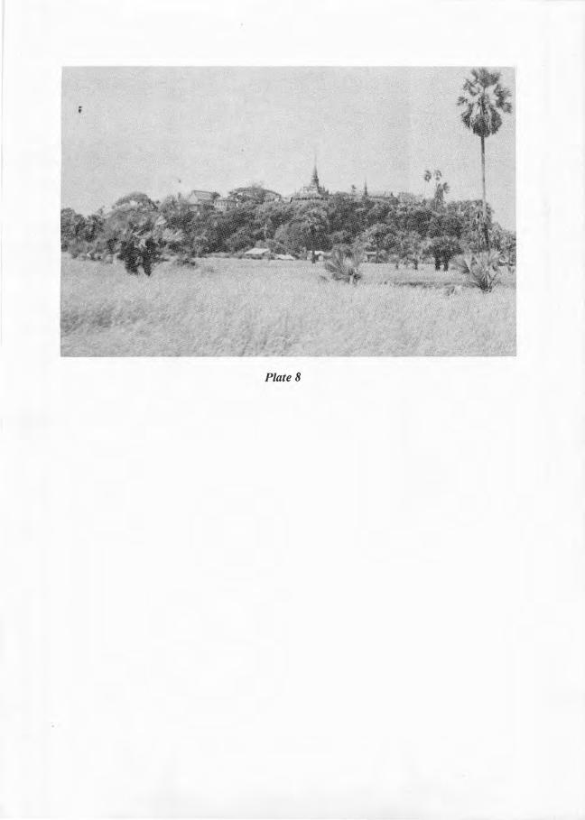
Plate 8

161
"Reading the Landscape"
underlying perception of the whole terrain as possessed of "power" still retains its force. The spirit grotto in Khao Phi (Spirit/Ghost Hill) is still regularly, though furtively, visited by local villagers to make vows to, or strike bargains with, the spirit there. Though the Shaivite site appears to be abandoned now, it is kept from becoming too overgrown, and• altttough Phang Phra is a ricefield, the island and the caves are still saksit ( flfl.,ft'Yli Skt. sakdi-siddhi, in Thai connotation, "possessed of supernatural power").
In this brief account I have described a tract of a specific landscape and some of the signs that have at one or another time been seen in it or patterned onto it, making it into a "text," and have buttressed my own "reading" with pieces of local texts about this particular landscape. My purpose has not been to force a particular interpretation onto this landscape but merely to describe it and to suggest that it is readable. The wider implication is, of course, that other landscapes wherein humans have left signs marking the meaning they have perceived in this or that feature of the landscape are also readable.