rates of vertical displacement at … technical report nos/ngs 50 rates of vertical displacement at...
TRANSCRIPT
NOAA TECHNICAL REPORT NOS/NGS 50 RATES OF VERTICAL DISPLACEMENT AT BENCHMARKS IN THE LOWER MISSISSIPPI VALLEY AND THE NORTHERN GULF COAST Kurt D. Shinkle National Geodetic Survey Dr. Roy K. Dokka Louisiana State University July, 2004 U.S. DEPARTMENT OF COMMERCE National Oceanic and Atmospheric Administration National Ocean Service

1
Abstract This report describes the methods and results of our research into the recent rates and spatial distribution of subsidence on benchmarks in the lower Mississippi Valley and northern Gulf Coast region. The analysis was accomplished using first-order leveling data and GPS observations from the National Geodetic Survey (NGS) and water level (tide gauge) data from the National Ocean Service. This study computed vertical velocities for over 2700 NGS benchmarks based on leveling data collected between 1920 and 1995. Subsidence affects coastal areas of Louisiana, Mississippi, Texas, and Alabama. The highest rates, over 25 mm per year, occur in the Mississippi river delta region and chenier plain of southwest Louisiana. Subsidence gradually slows toward the east, ending in western Florida. Subsidence continues toward the west along the Texas coast beyond the study area. These rates are substantially higher than rates reported in previous studies based on analysis of leveling or on geological investigations. Our analysis of the leveling data also indicates that subsidence rates increased in many areas during the later half of the 20th century. Another region of subsidence is centered on the Mississippi alluvial valley, extending northward from the coast to near Memphis, Tennessee. This subsiding region is flanked by regions of stability or uplift in northwest Louisiana and northeastern Mississippi. Our evaluation of independent subsidence measures validates the primary results. Displacement rates derived from the leveling network agree, on average, to within 1.5 mm/yr with rates derived from a number of coastal tide gauge stations. We also computed vertical displacement over six or seven years at three Continuously Operating Reference Station (CORS) sites. These values agreed to within about 2 mm/yr with the rates derived from the leveling data for nearby benchmarks. The CORS analysis also shows that subsidence is continuing today at comparable rates. We draw two primary conclusions from this study. First, subsidence is occurring at substantially higher rates than previously reported. These new rates provide insights into the causes of subsidence and should be integrated into plans to mitigate the effects of subsidence and the resultant inundation of coastal lands. Second, the results of this study prove the need for a Height Modernization program to provide the updated and sustainable elevation reference system that is essential to any efforts to mitigate the impending slow disaster threatened by subsidence.
2
Contents Introduction I. Problem II. Data A. Tide Records B. Leveling Observations C. Continuously Operating Reference Stations III. Methods A. Initial Condition
B. Rate Computations C. Joins D. Network IV. Results A. Description B. Spatial Distribution C. Temporal Distribution 1. Grand Isle to Raceland 2. New Orleans to New Iberia 3. Kenner to Jackson 4. New Orleans to Biloxi D. Monument Stability Type V. Validation A. Tide Records B. CORS Sites C. Closures VI. Discussion A. Causes of Subsidence B. Future Subsidence VII. Conclusions and Recommendations Appendices 1. Regression plots for additional tide stations 2. Leveling lines and connections 3. Table of benchmarks, with positions and subsidence rates 4. Individual network segment plots 5. Individual point regression plots from multiple rates
3
Introduction Subsidence, i.e., the downward displacement of the Earth’s surface relative to a fixed datum, is the inexorable “slow disaster” that will gradually change the shape and character of the lower Mississippi Valley and northern Gulf coast. Subsidence threatens critical habitats, large and small cities, farms, and economic infrastructure in several states with eventual inundation by the Gulf of Mexico. The effects of this disaster will be felt by the entire country as inundation gradually destroys America’s largest coastal wetland and ravages its energy production heartland. This document addresses the problem of defining accurate subsidence rates on benchmarks, the fundamental height reference points, in this region. We describe the methods used in this study, the sources and quality of the data, the geographic extent, and magnitude of subsidence. This report documents the results of the first comprehensive study of historical subsidence rates relative to a common vertical datum in the lower Mississippi Valley and northern Gulf Coast. This study area includes Louisiana and Mississippi, and parts of Alabama, Florida, Texas, and Tennessee. To compute accurate rates of subsidence throughout this region, we used data from the authoritative sources of primary vertical control: the National Ocean Service (NOS) and the National Geodetic Survey (NGS). The data we used spans much of the last century and is the basis for the official national systems of vertical reference for terrestrial and maritime application. We obtained and used “reduced” data from both agencies, meaning that the original raw leveling observations had already been through the computational processes used to obtain elevation differences from redundant field observations. For geodetic leveling data, we used field elevations with systematic corrections applied. In the case of the water level observations, we used the monthly mean values. All of the subsequent computation, assembly, and interpretation were original work done specifically for this study. Thus, the subsidence rates and conclusions presented here are completely independent of any of the previous, smaller studies published elsewhere. The first section of this document outlines the rationale and approach we used to determine subsidence rates. The second section describes the data. A subsequent methods section details our method for computing and assembling this data into a subsidence rates network. We describe in detail the process used in the first leg of the network, the segment from Grand Isle to Raceland. The same process applies to the entire network. Next, we describe our results in detail, including discussions on temporal variation in rates and on benchmark monument type in relation to subsidence rate. In a separate section, we discuss three tests we used to check the validity of our computed rates. The key to the validity of our rates computations is that the entire system is tied to a single, recognized datum, the North American Vertical Datum of 1988. We do not rely on arbitrary local datums and implied connections between disparate data sources of varying quality and scale. In the final section, we address in general terms the possible causes of the spatial and temporal patterns of subsidence implied by the results. More detailed discussions on subsidence will be available elsewhere. Finally, we address the question of what these rates might tell us about future subsidence.

4
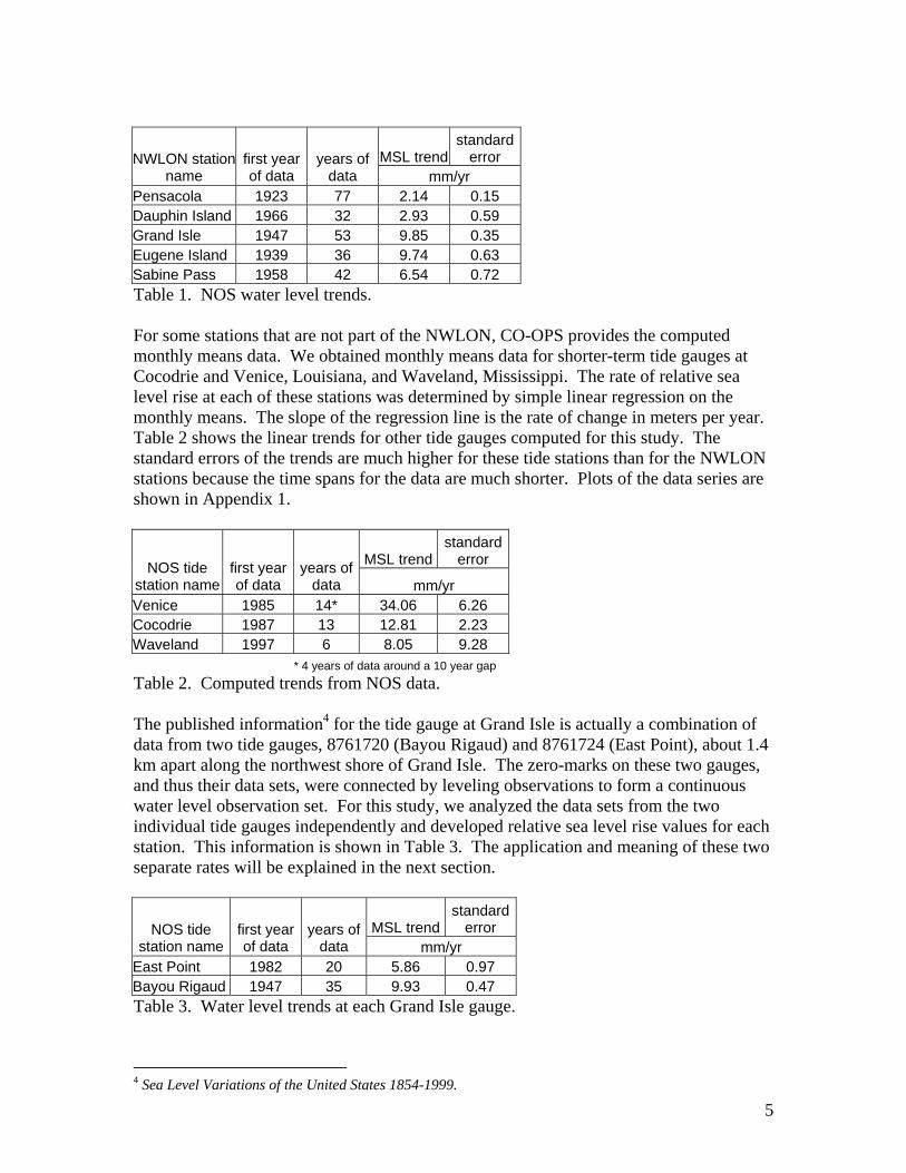
Several people contributed to this study. Jordan Heltz provided many hours of diligent research assistance and data processing. Clifford Mugnier, Kathy Koepsell, Dr. Chris Pearson, Gilbert Mitchell, David Zilkoski, Dr. Irv Mendelssohn, and Dr. Richard Snay contributed advice at various stages of the project. Myra L. Shinkle provided invaluable editorial assistance. I. Problem In a 2001 report to Congress, NGS concluded that the vertical control portion of the National Spatial Reference System (NSRS) in Louisiana was “inaccurate and obsolete.” The research described in this report was conducted by NGS and the Louisiana Spatial Reference Center (LSRC)1 to support the Vertical Time Dependent Positioning (VTDP) project by determining the recent rates of vertical displacement of benchmarks relative to the North American Vertical Datum of 1988 (NAVD 88). Displacement rates derived in this study are the most accurate and precise description available of the vertical motions that affect this region. These rates can be used to extrapolate current elevations for moving benchmarks. When properly validated by new observations, these elevations can be used to update the NSRS. Our initial investigation focused on coastal Louisiana. As our research progressed, we realized that a wider regional examination was necessary to locate the bounds of the subsiding area. II. Data The data used in this analysis consists of water level records from the National Ocean Service (NOS) and first-order leveling data from the National Geodetic Survey (NGS). Global Positioning System (GPS) data from Continuously Operating Reference Stations (CORS) were also obtained from NGS. A. Tide Records We obtained tide record data from the NOS Center for Operational Oceanographic Products and Services (CO-OPS). Most of the information was available from the CO-OPS Web site at www.co-ops.nos.noaa.gov. For information not available from the Web site, we contacted the staff at CO-OPS. The tidal data is the monthly means of water level readings at NOS tide gauges. In this study, we used the monthly mean sea level (MSL) values. The monthly means are an average of hourly water level heights for a complete month of data.2 For some long-term tide gauges that are part of the National Water Level Observation Network (NWLON), CO-OPS publishes linear MSL trends derived from monthly data. For example, Table 1 shows the NOS published trends for NWLON stations in the study area, along with the first year in which data was recorded and the length of the series. 3
1 A partnership with the Center for Geoinformatics at Louisiana State University. 2 Sea Level Variations of the United States 1854-1999, pg. 1 3 Sea Level Variations of the United States 1854-1999, pg. 19
5
MSL trendstandard
error NWLON station name
first year of data
years of data mm/yr
Pensacola 1923 77 2.14 0.15 Dauphin Island 1966 32 2.93 0.59 Grand Isle 1947 53 9.85 0.35 Eugene Island 1939 36 9.74 0.63 Sabine Pass 1958 42 6.54 0.72 Table 1. NOS water level trends. For some stations that are not part of the NWLON, CO-OPS provides the computed monthly means data. We obtained monthly means data for shorter-term tide gauges at Cocodrie and Venice, Louisiana, and Waveland, Mississippi. The rate of relative sea level rise at each of these stations was determined by simple linear regression on the monthly means. The slope of the regression line is the rate of change in meters per year. Table 2 shows the linear trends for other tide gauges computed for this study. The standard errors of the trends are much higher for these tide stations than for the NWLON stations because the time spans for the data are much shorter. Plots of the data series are shown in Appendix 1.
MSL trendstandard
error NOS tide station name
first year of data
years of data mm/yr
Venice 1985 14* 34.06 6.26 Cocodrie 1987 13 12.81 2.23 Waveland 1997 6 8.05 9.28 * 4 years of data around a 10 year gap Table 2. Computed trends from NOS data. The published information4 for the tide gauge at Grand Isle is actually a combination of data from two tide gauges, 8761720 (Bayou Rigaud) and 8761724 (East Point), about 1.4 km apart along the northwest shore of Grand Isle. The zero-marks on these two gauges, and thus their data sets, were connected by leveling observations to form a continuous water level observation set. For this study, we analyzed the data sets from the two individual tide gauges independently and developed relative sea level rise values for each station. This information is shown in Table 3. The application and meaning of these two separate rates will be explained in the next section.
MSL trendstandard
error NOS tide station name
first year of data
years of data mm/yr
East Point 1982 20 5.86 0.97 Bayou Rigaud 1947 35 9.93 0.47 Table 3. Water level trends at each Grand Isle gauge.
4 Sea Level Variations of the United States 1854-1999.
6
B. Leveling Observations Leveling observation data was acquired from the National Geodetic Survey (NGS). All elevation data used in this study was drawn only from first-order5,6 leveling projects. The data was acquired in the form of “phase 1” files (p-files). For each leveling line, the p-file contains general information about the leveling run and data about each benchmark. The benchmark information is an ordered list of stations (both PID and designation), stability rating, spur level, distance along the level line, unadjusted height (elevation), number of runs, and an approximate position. It is essential to note that the “unadjusted heights” are exactly that: unofficial, essentially arbitrary elevations relative only to the starting point of that particular leveling line. These values are derived from the very precise elevation differences observed in the leveling survey process. Corrections for known systematic errors7 (i.e., orthometric, rod, level, temperature, astronomic, refraction, magnetic) were applied automatically to the observations when the p-file was generated. C. CORS Data We obtained Global Positioning System (GPS) observation data collected at Continuously Operating Reference Station (CORS) sites directly from the NGS Web site (www.ngs.noaa.gov). The CORS sites employed for this analysis are located near New Orleans, Louisiana, Vicksburg, Mississippi, and Memphis, Tennessee. III. Method We computed vertical displacement velocities of benchmarks over intervals of time bounded by the available leveling data. Velocities that are negative indicate subsidence, i.e., the downward motion of the Earth’s surface relative to the NAVD 88 datum. Positive velocities indicate upward motion relative to NAVD 88. We will explain in detail the process we used to compute subsidence rates along the highway corridor from Grand Isle to Raceland, Louisiana, as an example of the method used throughout this study. A. Initial Condition This analysis started with the data for the currently operating NOS tide gauge at Grand Isle, East Point (8761724) to estimate the total land subsidence rate at that location. In one sense, the tide gauge measures relative sea level rise at a specific location. In the opposite sense, the tide gauge data can be seen as recording the relative subsidence of the land in comparison to a fixed water level datum. If sea level is constant, then the change in tide gauge readings over time record subsidence. If the sea level is actually determined to be rising globally (e.g. eustatic rise), then the difference between the eustatic rise and the displacement recorded in the water level data is the subsidence of the land, and the tide gauge, at that location.
5 Schomaker, M.C. and R.M. Berry, Geodetic Leveling. 6 Federal Geodetic Control Committee, Standards and Specifications for Geodetic Control Networks. 7 Balazs, E., and G. Young, Corrections Applied by the National Geodetic Survey to Precise Leveling Observations.

7
B. Rate Computations The net subsidence rate from the tide gauge was applied to the published elevation of a benchmark near to the tide gauge to compute the likely elevation of that benchmark for the specific year in which differential level connections were made to the benchmark. Holding this computed elevation, we used the observed elevation differences between benchmarks to compute the corrected field elevation at each benchmark along the line for the year in which the observations were made. The difference in elevation at each benchmark common to each of two different leveling observation epochs thus defined the rate at which the monument moved over the time between the two leveling measurements. This is a summary of the process we used to process the leveling data: 1. Obtain “field” elevations, with systematic corrections applied, for all benchmarks in
lines running through a single route; 2. Cull the list of benchmarks to those that are common to at least two leveling lines; 3. Compute “observed” elevation differences between adjacent points within this set of
“common” benchmarks; 4. Determine and set a starting elevation for one epoch, and a vertical displacement rate,
for an initial point (e.g., from a tide gauge); 5. Compute new elevations for all benchmarks, using the observed elevation differences,
based on the starting condition. Differential leveling observation data was taken from the “phase 1” files extracted from the National Geodetic Survey’s Integrated Data Base for three level runs. The three leveling lines used in this segment are L25414 (1993), L24680/11 (1982), and L20370 (1965). These are all “first-order” leveling lines, meaning that they are the best differential elevation observations available. Two earlier leveling lines from the 1950s also run through parts of this corridor and may have been used in other analyses. Since these older lines are of lower order, we chose not to degrade the quality of this analysis with data of lesser precision. The leveling data extraction program computed and applied all available systematic corrections to the observations. In theory, this leaves only small random errors in the height difference observations. A list of all benchmarks common to any pair of lines was compiled. These common points ran along the route LA 1 corridor from benchmark 876 1724 TIDAL 13 at Grand Isle to A 220 near Raceland, Louisiana. Line L20370 (1965) started at point 876 1720 TIDAL 6, at the site of the older tide gauge (8761720). These “common” benchmarks then become the data set used in further analysis. Next, we computed point-to-point elevation differences between each pair of adjacent benchmarks for each of the three runs. We did this simply by subtracting the corrected field elevation (obtained by the extraction program) for point 2 from the elevation for point 1, and so forth down the line. These are the elevation changes measured from one point to the next at the time the level run was observed. The result of this process was a list of elevation differences, between adjacent benchmarks, for each leveling line. Note that at no point in the process do we use the “adjusted” or published elevation values for the benchmarks. These adjusted elevation values contain the unwanted effects of distribution of the random errors from the network adjustment computation.
8
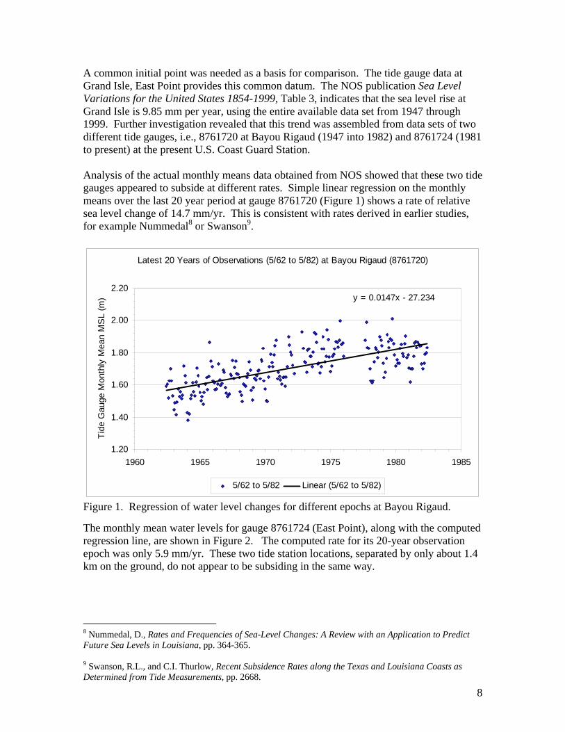
A common initial point was needed as a basis for comparison. The tide gauge data at Grand Isle, East Point provides this common datum. The NOS publication Sea Level Variations for the United States 1854-1999, Table 3, indicates that the sea level rise at Grand Isle is 9.85 mm per year, using the entire available data set from 1947 through 1999. Further investigation revealed that this trend was assembled from data sets of two different tide gauges, i.e., 8761720 at Bayou Rigaud (1947 into 1982) and 8761724 (1981 to present) at the present U.S. Coast Guard Station. Analysis of the actual monthly means data obtained from NOS showed that these two tide gauges appeared to subside at different rates. Simple linear regression on the monthly means over the last 20 year period at gauge 8761720 (Figure 1) shows a rate of relative sea level change of 14.7 mm/yr. This is consistent with rates derived in earlier studies, for example Nummedal8 or Swanson9.
Latest 20 Years of Observations (5/62 to 5/82) at Bayou Rigaud (8761720)
y = 0.0147x - 27.234
1.20
1.40
1.60
1.80
2.00
2.20
1960 1965 1970 1975 1980 1985
Tide
Gau
ge M
onth
ly M
ean
MS
L (m
)
5/62 to 5/82 Linear (5/62 to 5/82)
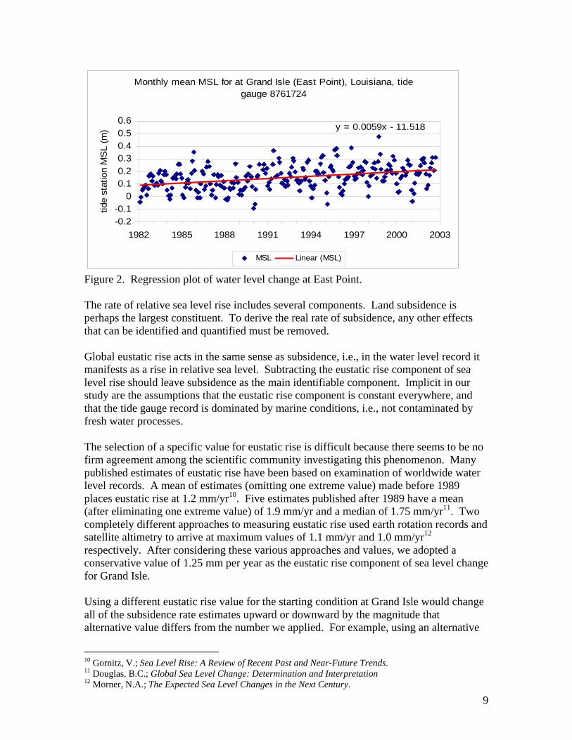
Figure 1. Regression of water level changes for different epochs at Bayou Rigaud. The monthly mean water levels for gauge 8761724 (East Point), along with the computed regression line, are shown in Figure 2. The computed rate for its 20-year observation epoch was only 5.9 mm/yr. These two tide station locations, separated by only about 1.4 km on the ground, do not appear to be subsiding in the same way.
8 Nummedal, D., Rates and Frequencies of Sea-Level Changes: A Review with an Application to Predict Future Sea Levels in Louisiana, pp. 364-365. 9 Swanson, R.L., and C.I. Thurlow, Recent Subsidence Rates along the Texas and Louisiana Coasts as Determined from Tide Measurements, pp. 2668.
9
Monthly mean MSL for at Grand Isle (East Point), Louisiana, tide gauge 8761724
y = 0.0059x - 11.518
-0.2-0.1
00.10.20.30.40.50.6
1982 1985 1988 1991 1994 1997 2000 2003
tide
stat
ion
MS
L (m
)
MSL Linear (MSL)
Figure 2. Regression plot of water level change at East Point. The rate of relative sea level rise includes several components. Land subsidence is perhaps the largest constituent. To derive the real rate of subsidence, any other effects that can be identified and quantified must be removed. Global eustatic rise acts in the same sense as subsidence, i.e., in the water level record it manifests as a rise in relative sea level. Subtracting the eustatic rise component of sea level rise should leave subsidence as the main identifiable component. Implicit in our study are the assumptions that the eustatic rise component is constant everywhere, and that the tide gauge record is dominated by marine conditions, i.e., not contaminated by fresh water processes. The selection of a specific value for eustatic rise is difficult because there seems to be no firm agreement among the scientific community investigating this phenomenon. Many published estimates of eustatic rise have been based on examination of worldwide water level records. A mean of estimates (omitting one extreme value) made before 1989 places eustatic rise at 1.2 mm/yr10. Five estimates published after 1989 have a mean (after eliminating one extreme value) of 1.9 mm/yr and a median of 1.75 mm/yr11. Two completely different approaches to measuring eustatic rise used earth rotation records and satellite altimetry to arrive at maximum values of 1.1 mm/yr and 1.0 mm/yr12 respectively. After considering these various approaches and values, we adopted a conservative value of 1.25 mm per year as the eustatic rise component of sea level change for Grand Isle. Using a different eustatic rise value for the starting condition at Grand Isle would change all of the subsidence rate estimates upward or downward by the magnitude that alternative value differs from the number we applied. For example, using an alternative
10 Gornitz, V.; Sea Level Rise: A Review of Recent Past and Near-Future Trends. 11 Douglas, B.C.; Global Sea Level Change: Determination and Interpretation 12 Morner, N.A.; The Expected Sea Level Changes in the Next Century.

10
value for eustatic rise of 1.75 mm/yr will lower all the subsidence rate estimates developed in this study by 0.50 mm/yr. In some parts of the subsidence network, this represents a relatively insignificant change of 5 or 10 percent in the rate estimate. In peripheral areas, it shifts the interpretation from subsidence to stability or even uplift. Remember, however, that in the coastal areas both subsidence and eustatic rise are acting simultaneously to inundate the land surface. It is the sum of the two rates that predicts how soon any particular location on the Louisiana or Mississippi coast will be at, or below, sea level. Adopting a higher eustatic rate and, thus, “shifting” some velocity from the subsidence rate is essentially irrelevant in the coastal margins because the net result does not change the projected time until potential inundation (i.e., zero elevation). Applying the value of 1.25 mm/yr to the sea level rise rate measured by tide gauge 8761724, East Point, yields an estimated rate of subsidence for that location on Grand Isle, i.e., -5.90 mm/yr – 1.25 mm/yr (eustatic rise) = -4.65 mm/yr. Similarly, the subsidence rate for the older tide gauge, 876 1720 at Bayou Rigaud, can be computed as –14.7 mm/yr – 1.25 mm/yr = -13.45 mm/yr. Note how these values differ from the NOS published trend of -9.85 mm/ year. This NOS trend value is a combination of data from the two gauges and it still contains the eustatic rise signal. The adjusted elevation for the last point on the level line, 876 1724 TIDAL 13, was selected as the starting point for this analysis. (TIDAL 13 is not far from the tide gauge (45 m) and subsequent analysis showed its rate of movement was not significantly different from two other benchmarks closer to the gauge site itself.) This published elevation value, 1.210 meters, was assigned as the 1993 value since it was originally determined using the 1993 leveling data. Note that 1.210 m is almost certainly not the correct present elevation of this benchmark, but this is not a problem. The goal is to determine the relative vertical displacements of benchmarks over time. Any reasonable value would suffice at this point in the analysis. Starting with a value of 1.210 meters, we computed new “field” elevations for the other common points in the line using the original 1993 (L25414) observed elevation differences. The subsidence rate of –4.65 mm/yr was applied to the 1993 elevation (1.210 m) at 876 1724 TIDAL 13 to compute a likely elevation for that point in 1982: 1.306 meters. This value was then used as the starting point to compute new 1982 “field” elevations for each common point in the line, based on the elevation differences from the 1982 level run (L24680/11). Finally, we used the difference in the computed elevations between the 1982 and 1993 runs at each point to compute an annual vertical displacement rate at each benchmark common to the two leveling lines. Note that the subsidence rate computed at benchmark 876 1720 TIDAL 9 (-11.73 mm/yr) is close to the subsidence trend computed for the latest 20-year cycle at the adjacent tide gauge (8761720), i.e., -13.45 mm/yr. In effect, the leveling data predicts the rate observed at this tide gauge to better than 2 mm/yr when the rate from the first gauge is used as the initial condition. It has been suggested that two locations only 1.4 km apart could not have been subsiding at such different rates, i.e., -4.65 mm/yr at East Point and –13.45 mm/yr at Bayou Rigaud, at essentially the same time. A 20-year period is
11
considered long enough to establish a tidal datum at a given location13, so the rates derived from these monthly means data should not be unduly influenced by short-term effects. The notable difference in movement between the two sites is likely the result of motion along the Leeville fault, as mapped by Hickey and Sabate (1972)14. As noted above, a third level run from 1965, L20370, previously followed the same route and included many of the benchmarks used in the later two surveys. L20370 did not, however, include TIDAL 13, but stopped about 1.4 km short at TIDAL 6. TIDAL 6 was associated with the earlier tide gauge 876 1720 at Bayou Rigaud and is also common to leveling runs L25414 and L24680/11. The new computed field elevations for 1993.333 and 1982.167 at TIDAL 6, referenced to TIDAL 13 and the tide gauge, were used to compute a rate of displacement at TIDAL 6. This rate was then applied to the 1982.167 field elevation to compute the likely elevation of TIDAL 6 in 1965.417. From this starting point, the 1965 elevation differences between adjacent points were used to compute new 1965 field elevations for each point in common with the 1982 run. Another set of subsidence rates were then computed for the time span from 1965 to 1982. C. Joins Leveling lines are of finite length, and leveling lines from different years do not generally start and end at the same places. The problem in assembling a network of different leveling lines observed at disparate epochs is how to join the lines through time at the nodes. We made these temporal joins by making a linear interpolation or extrapolation through time at each leveling line connection throughout the process of assembling the subsidence network. Linear interpolation or extrapolation implies that the rate of vertical motion is essentially constant over a given time period. This is a plausible model for large-scale geologic movement over short time spans in the absence of specific and detailed evidence of other events or influences. At Raceland, we first confronted the problem of making a connection where one level line ends and another begins. Where connected leveling lines were observed at essentially the same time, as in the case of L24680/11 and L24680/10, the solution is a simple matter of assigning the computed elevation from one line to a common point on the connecting line and continuing on with computing elevation differences along that line, and rates between lines, as described above. For example, where lines L25414 and L25406/2 met at benchmark U 221, we simply assigned the elevation computed at that point for L25414 as the starting elevation at U 221 to continue computing elevations for that epoch along L25406/2. This kind of connection without an accompanying temporal shift was the exception, however. In most cases, connecting to a different leveling line also meant changing the temporal epoch of the leveling data. For example, at point U 221 line L24680/10 (from 1982) took a different direction and we needed to develop a connection to line L20376 toward Cocodrie. L20376 was observed at a mean epoch of 1965.42. With a computed subsidence rate at U 221 of almost 2 cm per year between 1982 and 1993, it seemed likely that the elevation of U 221 in 1965 was not the same as it was 17 years later in
13 Gill, S.K., and J.R. Schultz, Tidal Datums and Their Applications, pp.14. 14 Hickey, H., and R. Sabate, eds. Tectonic map of Gulf coast region, USA.
12
1982. But we lacked any reliable measurement information that might define how the elevation of point U 221 might have changed over that time. The solution we adopted was to use a simple linear extrapolation through time, using the computed rate between 1982 and 1993 and the elevation of U 221 at epoch 1982.167 to compute the likely elevation for that benchmark in 1965.42. In other cases, the epoch of a connecting line fell within the span of the preceding two leveling lines. An example of this case occurred at point T 190 (AU0356). We first computed rates along a pair of leveling lines running from Raceland toward New Orleans that were observed in 1977 (L24133/18) and 1995 (L25517/2). At benchmark T 190, we lost L24133/18 but connected to L24966/2, observed in 1986. Here, we interpolated the likely elevation of point T 190 in 1986 based on the rate already computed between 1977 and 1995, and using the computed 1995 elevation for that point. Although the actual rate of vertical displacement may not have been constant over the 18 year period between the available leveling epochs, there is no evidence that it was not. Therefore, linear interpolation is again a plausible approach to the problem of connecting pairs of leveling lines from different epochs. D. Network Starting at Grand Isle, Louisiana, and following the approach detailed above, we assembled a network of benchmarks with computed subsidence rates that extends about 650 kilometers northward to Memphis, Tennessee, and roughly 650 km east to west between Pensacola, Florida, and Beaumont, Texas. Figure 3 shows the spatial distribution of the benchmarks that comprise our subsidence network. This network includes approximately 2700 benchmarks drawn from 96 different first-order level lines. Figure 4, on the following page, shows the geographical context for this network.

13
LSRC/NGS Subsidence Measurement Network
Baldw in
Venice
Baton Rouge
Shreveport
New Orleans
Mobile
MeridianJackson
Memphis
Grand Isle 29.00
30.00
31.00
32.00
33.00
34.00
35.00
36.00
86.0087.0088.0089.0090.0091.0092.0093.0094.00longitude
latit
ude
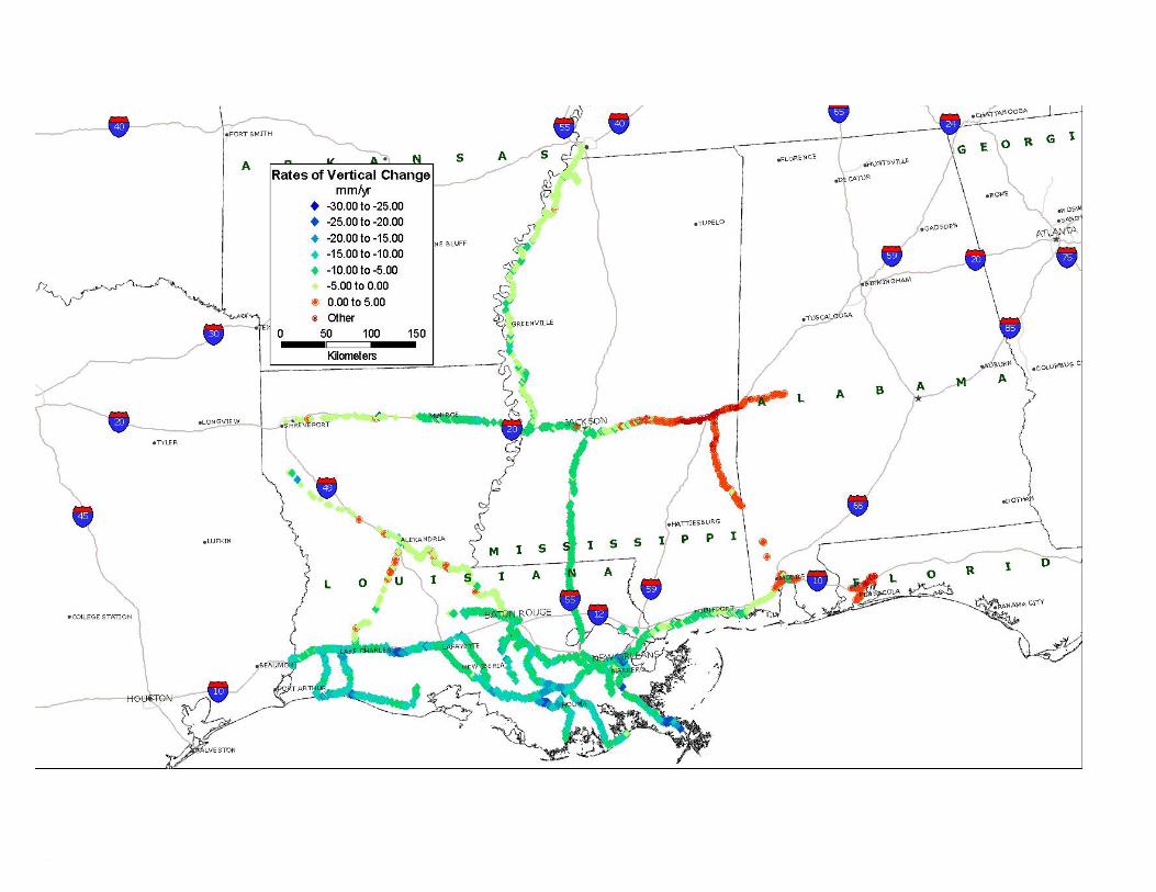
Figure 3. Plot of first-order benchmarks included in the subsidence measurement network. Charts in Appendix 2 show the individual leveling lines included, their common end points, and how we assembled them into our network. This network was assembled from observational data, with all of the misclosures remaining. We have made no attempt here to form a single homogeneous network through a network adjustment computation, as was done by Holdahl15, for example. A straightforward vertical network adjustment would incorrectly ignore the temporal incongruities within the data set, e.g., any given point is not expected to have a single elevation value through various epochs, nor a single rate from one epoch to the next. A complete list of all of the benchmarks included in this subsidence network is included in Appendix 3. IV. Results A. Description The compiled network indicates that subsidence has occurred during the past century, and is probably still happening, throughout the lower Mississippi Valley and adjoining coastal plane. Figure 5 is a map of subsidence in this region derived from the latest rates computed for the benchmarks in this study. The general pattern of the distribution shows
15 Holdahl, S.R., and N.L. Morrison, Regional Investigations of Vertical Crustal Movements in the U.S., Using Precise Relevelings and Mareograph Data, pp. 373-390.

14
that subsidence rates are greatest in the coastal areas of southeastern Louisiana. Significant rates also appear throughout most of southern Louisiana. Subsidence was also computed along the northern Gulf Coast through Mississippi and about as far east as Mobile, Alabama. Subsidence occurs northward along the Mississippi alluvial valley at least as far as Memphis. Subsidence rates appear to diminish to near stability toward northwestern Louisiana and eastward toward Meridian, Mississippi. Our analysis appears to indicate that there may actually have been some uplift in the region of Meridian. Note that subsidence rates were computed at benchmarks that had been included in two or more geodetic leveling projects. Leveling lines in this region tend to follow transportation corridors -- highways and railroads. Benchmarks are not located in the engineered roadbeds themselves, but in adjacent right-of-way areas or nearby structures, large and small. As such, they do not represent a unique physical condition applicable only to heavy transportation structures. Rather, they represent a wide sample of the conditions appropriate to their particular environment. For example, in southeast Louisiana the transportation corridors tend to follow the natural levees. The benchmark lines have not sampled the potentially less consolidated alluvial deposits and wetland areas in between. Appendix 3 gives a computed subsidence rate for each benchmark, along with an approximate date of the end of the epoch (“base year” in table) from which that rate was derived. For many points, there was only one interval of time over which a rate could be computed using first-order leveling data. Those are the benchmarks that were included just twice through the years in first-order leveling projects. Many other lines of benchmarks were visited by three, four, or even five 1st order leveling projects over the years. In these cases, it was possible to develop displacement rates for a number of time epochs. These rates were rarely constant through time. (Refer to a detailed analysis of temporal distribution of rates in the Results section.) This list shows, in most cases, the latest rate computed for a given point, i.e., the rate of vertical movement computed from the two most recent leveling lines to include that point. The most recent rate at each point is the most likely value to describe the current movement of that point in the absence of any other reliable quantitative information about specific locations. A computed elevation is shown for each benchmark in Appendix 3. These elevations were computed from the measured height differences between adjacent benchmarks. At each connecting point in the network, an extrapolation or interpolation through time was made based on the computed rate and elevation at that point. The result was a new computed elevation for that connecting point for a different date in time. For example, if the computed elevation for connecting benchmark A 100 at approximate date 1975.25 was 1.000 meters and the subsidence rate at the point was computed as -12.00 mm/yr, then the new computed elevation at date 1986.75 is 0.862 meters for benchmark A 100. These computed elevations are estimates of the elevation of each particular benchmark at the date shown as the “end of epoch.” All of the computed elevations in the subsidence network are based on the starting condition for benchmark 8761724 TIDAL 13 at Grand Isle, Louisiana. Initially, we used the published elevation for TIDAL 13 of 1.210 meters as the starting value for the network. When we connected the network to the tide gauge at Pensacola, Florida, we
15
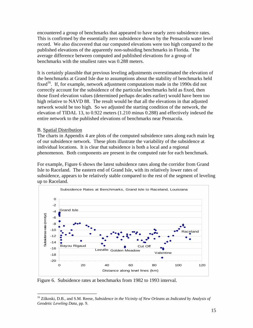
encountered a group of benchmarks that appeared to have nearly zero subsidence rates. This is confirmed by the essentially zero subsidence shown by the Pensacola water level record. We also discovered that our computed elevations were too high compared to the published elevations of the apparently non-subsiding benchmarks in Florida. The average difference between computed and published elevations for a group of benchmarks with the smallest rates was 0.288 meters. It is certainly plausible that previous leveling adjustments overestimated the elevation of the benchmarks at Grand Isle due to assumptions about the stability of benchmarks held fixed16. If, for example, network adjustment computations made in the 1990s did not correctly account for the subsidence of the particular benchmarks held as fixed, then those fixed elevation values (determined perhaps decades earlier) would have been too high relative to NAVD 88. The result would be that all the elevations in that adjusted network would be too high. So we adjusted the starting condition of the network, the elevation of TIDAL 13, to 0.922 meters (1.210 minus 0.288) and effectively indexed the entire network to the published elevations of benchmarks near Pensacola. B. Spatial Distribution The charts in Appendix 4 are plots of the computed subsidence rates along each main leg of our subsidence network. These plots illustrate the variability of the subsidence at individual locations. It is clear that subsidence is both a local and a regional phenomenon. Both components are present in the computed rate for each benchmark. For example, Figure 6 shows the latest subsidence rates along the corridor from Grand Isle to Raceland. The eastern end of Grand Isle, with its relatively lower rates of subsidence, appears to be relatively stable compared to the rest of the segment of leveling up to Raceland.
Subsidence Rates at Benchmarks, Grand Isle to Raceland, Louisiana
Grand Isle
Bayou RigaudLeeville Golden Meadow
Cut Off
Valentine
Raceland
-20
-18
-16
-14
-12
-10
-8
-6
-4
-2
0
0 20 40 60 80 100 120
Distance along level lines (km)
Sub
side
nce
rate
(mm
/yr)
Figure 6. Subsidence rates at benchmarks from 1982 to 1993 interval. 16 Zilkoski, D.B., and S.M. Reese, Subsidence in the Vicinity of New Orleans as Indicated by Analysis of Geodetic Leveling Data, pp. 9.
16
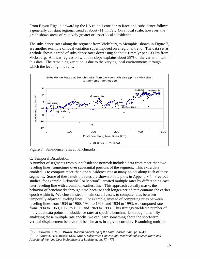
From Bayou Rigaud onward up the LA route 1 corridor to Raceland, subsidence follows a generally constant regional trend at about -11 mm/yr. On a local scale, however, the graph shows areas of relatively greater or lesser local subsidence. The subsidence rates along the segment from Vicksburg to Memphis, shown in Figure 7, are another example of local variation superimposed on a regional trend. The data set as a whole shows a trend of subsidence rates decreasing at about 1 mm/yr per 100 km from Vicksburg. A linear regression with this slope explains about 58% of the variation within this data. The remaining variation is due to the varying local environments through which the leveling line runs.
Subsidence Rates at Benchmarks from Jackson, Mississippi, via Vicksburg to Memphis, Tennessee
Jackson
Vicksburg
Greenville
Friars Point
Tunica Memphis
-12
-10
-8
-6
-4
-2
0
0 100 200 300 400 500
Distance along level lines (km)
Sub
side
nce
rate
(mm
/yr)
68 to 93 74 to 93
Figure 7. Subsidence rates at benchmarks. C. Temporal Distribution A number of segments from our subsidence network included data from more than two leveling lines, sometimes over substantial portions of the segment. This extra data enabled us to compute more than one subsidence rate at many points along each of these segments. Some of these multiple rates are shown on the plots in Appendix 4. Previous studies, for example Jurkowski17 or Morton18, created multiple rates by differencing each later leveling line with a common earliest line. This approach actually masks the behavior of benchmarks through time because each longer-period rate contains the earlier epoch within it. We chose instead, in almost all cases, to compute rates between temporally adjacent leveling lines. For example, instead of computing rates between leveling lines from 1934 to 1960, 1934 to 1969, and 1934 to 1993, we computed rates from 1934 to 1960, 1960 to 1969, and 1969 to 1993. This strategy yielded a number of individual data points of subsidence rates at specific benchmarks through time. By analyzing these multiple rate epochs, we can learn something about the short-term vertical displacement behavior of benchmarks in a given corridor. Examining multiple 17 G. Jurkowski, J. Ni, L. Brown, Modern Uparching of the Gulf Coastal Plain, pp. 6249. 18 R. A. Morton, N.A. Buster, M.D. Krohn, Subsurface Controls on Historical Subsidence Rates and Associated Wetland Loss in Southcentral Louisiana, pp. 774-775.

17
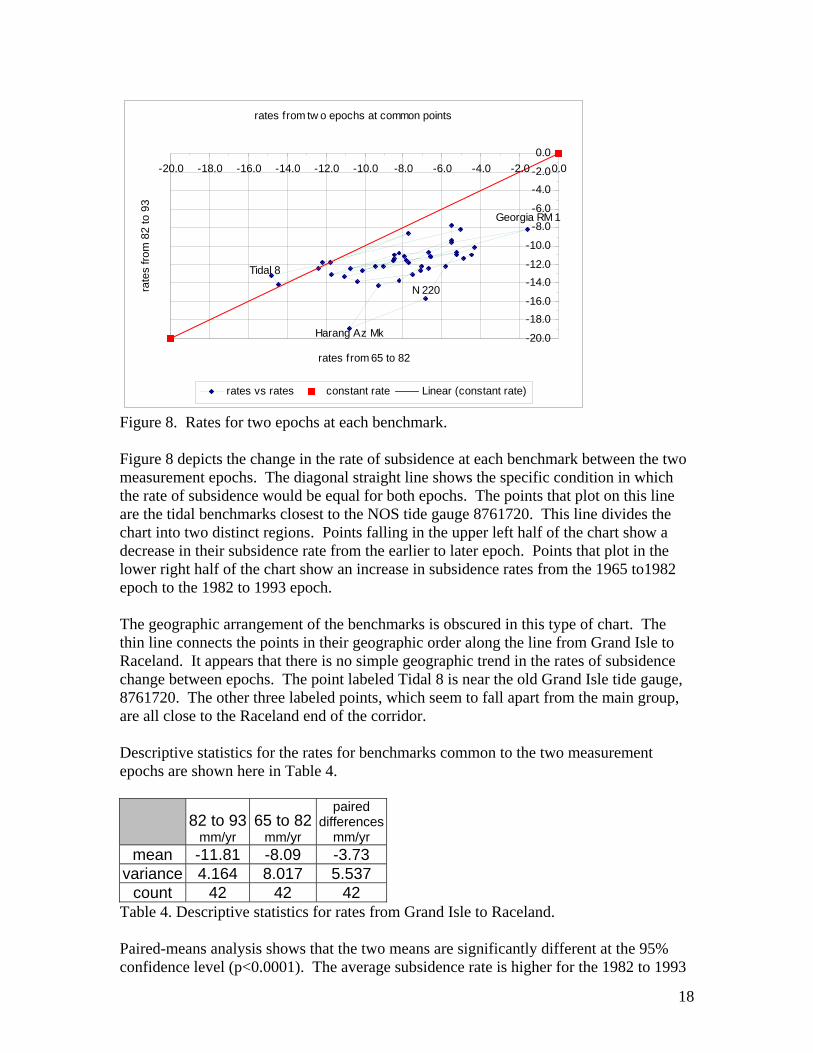
rates can also enable us to make some better inferences about the future movement of these points. Below, we will analyze in detail the multiple rates computed for benchmarks along several lines: Grand Isle to Raceland, LA; New Orleans to New Iberia, LA; Kenner, LA, to Jackson, MS; and New Orleans, LA, to Biloxi, MS. 1. Grand Isle to Raceland Along the corridor from Grand Isle to Raceland, we analyzed first-order leveling lines from 1965, 1982, and 1993. The 1965 to 1982 subsidence rates show a marked divergence from the 1982 to 1993 rates, even though they were set to an equal value at the common initial point, TIDAL 6. This divergence could represent an unmodeled, uncorrected systematic error in the first-order geodetic leveling data. This would call into question the error models used for geodetic leveling and, ultimately, the veracity of elevations nationwide. Or this divergence could represent an error in the initial condition, i.e., the rate used to extrapolate backwards in time from the 1982 elevation to a 1965 elevation for TIDAL 6. However, the tidal record for 8761720 shows a fairly consistent vertical displacement trend, at about this level, over this entire time span. The other, and most likely, possibility is that this represents a real change in the rate of subsidence within this corridor over time. Of the 110 benchmarks examined within the corridor from Grand Isle to Raceland, 94 of these were common to the 1982 and 1993 level lines, and were thus used to compute rates for that epoch. A total of 58 benchmarks were common to the 1965 and 1982 level lines, and so were used to compute rates for that earlier epoch. The mean rates for these two epochs (-7.67 mm/yr for 1965 to 1982, -11.09 mm/yr for 1982 to 1993) are statistically different at the 95% confidence level, while the variances are equal at that level. Only 42 benchmarks were common to all three leveling runs, however. These 42 benchmarks have two rates computed for each of them, i.e., one rate for 1965 to 1982, and another for 1982 to 1993. Figure 8 shows the two rates for each these 42 benchmarks plotted opposite each other. For each benchmark, the earlier epoch rate is plotted along the horizontal axis against that same mark’s later epoch rate along the vertical axis.
18
Figure 8. Rates for two epochs at each benchmark. Figure 8 depicts the change in the rate of subsidence at each benchmark between the two measurement epochs. The diagonal straight line shows the specific condition in which the rate of subsidence would be equal for both epochs. The points that plot on this line are the tidal benchmarks closest to the NOS tide gauge 8761720. This line divides the chart into two distinct regions. Points falling in the upper left half of the chart show a decrease in their subsidence rate from the earlier to later epoch. Points that plot in the lower right half of the chart show an increase in subsidence rates from the 1965 to1982 epoch to the 1982 to 1993 epoch. The geographic arrangement of the benchmarks is obscured in this type of chart. The thin line connects the points in their geographic order along the line from Grand Isle to Raceland. It appears that there is no simple geographic trend in the rates of subsidence change between epochs. The point labeled Tidal 8 is near the old Grand Isle tide gauge, 8761720. The other three labeled points, which seem to fall apart from the main group, are all close to the Raceland end of the corridor. Descriptive statistics for the rates for benchmarks common to the two measurement epochs are shown here in Table 4.
82 to 93
mm/yr 65 to 82
mm/yr
paired differences
mm/yr mean -11.81 -8.09 -3.73
variance 4.164 8.017 5.537 count 42 42 42
Table 4. Descriptive statistics for rates from Grand Isle to Raceland. Paired-means analysis shows that the two means are significantly different at the 95% confidence level (p<0.0001). The average subsidence rate is higher for the 1982 to 1993
rates from tw o epochs at common points
Tidal 8
Georgia RM 1
Harang Az Mk
N 220
-20.0
-18.0-16.0
-14.0-12.0
-10.0
-8.0-6.0
-4.0-2.0
0.0-20.0 -18.0 -16.0 -14.0 -12.0 -10.0 -8.0 -6.0 -4.0 -2.0 0.0
rates from 65 to 82
rate
s fro
m 8
2 to
93
rates vs rates constant rate Linear (constant rate)

19
epoch than for the 1965 to 1982 period. The higher mean rate for the later epoch implies an overall faster rate of subsidence along the corridor. There is also less variability among the rates in the later epoch compared to the earlier interval. The change in rates is not consistent or predictable along the corridor. A linear regression model using the earlier rates as the dependent variable and the later rates as the independent variable shows only a weak correlation. It should not be assumed that subsidence rates generally and suddenly accelerated in 1982. This is merely an artifact of the timing of leveling runs. Rather, these two epochs could be interpreted as chords to a curve that describes a gradual acceleration of subsidence over time. In the case of benchmark N 220, the two rates described by the three data points (elevations determined from leveling runs), Figure 9, are –6.84 and –15.73 mm/yr. A second-order polynomial curve fit to the three data points shows one possible function to describe the actual progress of subsidence rate change over time at N 220.
Elevations Computed at N 220
y = -0.0003x2 + 1.2938x - 12681.6
1.7
1.8
1.9
2.0
2.1
1960 1970 1980 1990 2000
Ele
vatio
n (m
)
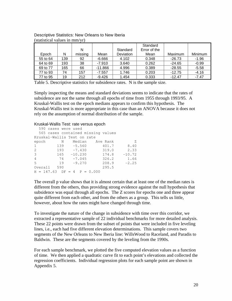
Figure 9. Changes in elevation over time at N 220. 2. New Orleans to New Iberia For the corridor from just south of New Orleans to New Iberia, Louisiana, we were able to analyze first-order leveling lines observed in 1955, 1964, 1969, 1977, and 1993 or 1995 (on two different parts of the line). The total line length is about 207 kilometers and includes 231 benchmarks. Not all benchmarks are included in all lines or rate epochs. Thus, we computed subsidence rates at benchmarks for temporally adjacent epochs as: 1955 to 1964, 1964 to 1969, 1969 to 1977, 1977 to 1993 (the 1993 and 1995 lines do not spatially overlap), 1977 to 1995. Table 5 shows descriptive statistics for the computed subsidence rates along this line, by epoch.
20
Descriptive Statistics: New Orleans to New Iberia (statistical values in mm/yr)
Epoch N N
missing Mean Standard Deviation
Standard Error of the
Mean Maximum Minimum 55 to 64 139 92 -6.666 4.102 0.348 -26.73 -1.96 64 to 69 193 38 -7.910 3.640 0.262 -24.65 -0.99 69 to 77 165 66 -11.866 4.996 0.389 -28.55 -5.58 77 to 93 74 157 -7.557 1.746 0.203 -12.75 -4.16 77 to 95 19 212 -9.426 1.454 0.333 -12.47 -7.47
Table 5. Descriptive statistics for subsidence rates. N is the sample size. Simply inspecting the means and standard deviations seems to indicate that the rates of subsidence are not the same through all epochs of time from 1955 through 1993/95. A Kruskal-Wallis test on the epoch medians appears to confirm this hypothesis. The Kruskal-Wallis test is more appropriate in this case than an ANOVA because it does not rely on the assumption of normal distribution of the sample. Kruskal-Wallis Test: rate versus epoch 590 cases were used 565 cases contained missing values Kruskal-Wallis Test on rate epoch N Median Ave Rank Z 1 139 -5.560 401.7 8.40 2 193 -7.430 319.0 2.33 3 165 -10.230 174.8 -10.72 4 74 -7.045 326.2 1.66 5 19 -9.270 208.9 -2.25 Overall 590 295.5 H = 147.63 DF = 4 P = 0.000 The overall p value shows that it is almost certain that at least one of the median rates is different from the others, thus providing strong evidence against the null hypothesis that subsidence was equal through all epochs. The Z scores for epochs one and three appear quite different from each other, and from the others as a group. This tells us little, however, about how the rates might have changed through time. To investigate the nature of the change in subsidence with time over this corridor, we extracted a representative sample of 22 individual benchmarks for more detailed analysis. These 22 points were drawn from the subset of points that were included in five leveling lines, i.e., each had five different elevation determinations. This sample covers two segments of the New Orleans to New Iberia line: WillsWood to Raceland, and Paradis to Baldwin. These are the segments covered by the leveling from the 1990s. For each sample benchmark, we plotted the five computed elevation values as a function of time. We then applied a quadratic curve fit to each point’s elevations and collected the regression coefficients. Individual regression plots for each sample point are shown in Appendix 5.

21
Descriptive statistics for regression coefficients: row 1 = intercept row 2 = linear term coefficient, in mm/yr row 3 = quadratic coefficient, i.e., change in rate, in mm/yr/yr Row ave coef stdev median max min range 1 2.64564 1.23696 2.86924 4.84208 0.696829 4.14525 2 -0.00748 0.00431 -0.00691 -0.00207 -0.023852 0.02178 3 -0.00003 0.00008 -0.00002 0.00028 -0.000125 0.00040 The sample is 22 points along the line from New Orleans to New Iberia. Negative value in row 2 indicates downward tilt, i.e., subsidence. Negative value in row 3 indicates downward "bend" in fitted curve, i.e., subsidence increasing with time. Rate is increasing at coefficient amount in mm/yr/yr. On average, for this line, subsidence rates are increasing by 0.03 mm per year for each year, from a base rate of 7.5 mm/yr. The maximum acceleration in this sample is 0.000125 mm/yr/yr. This implies that the subsidence rate at that benchmark increases by 1.25 mm/yr over a ten-year period. Figure 10 shows the spatial distribution of the sample points with their quadratic coefficients. It appears that subsidence is increasing at a higher rate for the points in the eastern portion of the line (WillsWood to Raceland), whereas the rate of increase is smaller for the western portion (Paradis to Baldwin). The notable anomaly appears to be point L 167 (AU0232), about 5 miles east of Morgan City. The regression plot for L 167 appears to show that the rate of subsidence is actually decreasing through time at this point.
0 50 100 150
-0.0001
0.0000
0.0001
0.0002
0.0003
Distance (km)
coef
ficie
nt v
alue
mm
/yr/y
r
Willswood RM
Y 165
V 165B 165D 165
Q 8
J 165
C 167H 167
L 167
P 167Q 167W 7 ResetY 167C 168E 168G 168
L 168
N 168
X 4Y 4B 169
Squared term coefficients of sample points on linefrom New Orleans to New Iberia
Figure 10. Distribution of accelerations within the sample.
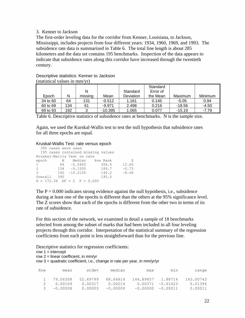
22
3. Kenner to Jackson The first-order leveling data for the corridor from Kenner, Louisiana, to Jackson, Mississippi, includes projects from four different years: 1934, 1960, 1969, and 1993. The subsidence rate data is summarized in Table 6. The total line length is about 285 kilometers and the data set contains 195 benchmarks. Inspection of the data appears to indicate that subsidence rates along this corridor have increased through the twentieth century. Descriptive statistics: Kenner to Jackson (statistical values in mm/yr)
Epoch N N
missing Mean Standard Deviation
Standard Error of
the Mean Maximum Minimum 34 to 60 64 131 -0.512 1.161 0.145 -5.05 0.94 60 to 69 134 61 -9.971 2.498 0.216 -18.56 -4.50 69 to 93 192 3 -10.395 1.065 0.077 -15.19 -7.79
Table 6. Descriptive statistics of subsidence rates at benchmarks. N is the sample size. Again, we used the Kurskal-Wallis test to test the null hypothesis that subsidence rates for all three epochs are equal. Kruskal-Wallis Test: rate versus epoch 390 cases were used 195 cases contained missing values Kruskal-Wallis Test on rate epoch N Median Ave Rank Z 1 64 -0.5400 358.5 12.65 2 134 -9.1500 189.7 -0.73 3 192 -10.2150 145.2 -8.68 Overall 390 195.5 H = 172.36 DF = 2 P = 0.000
The P = 0.000 indicates strong evidence against the null hypothesis, i.e., subsidence during at least one of the epochs is different than the others at the 95% significance level. The Z scores show that each of the epochs is different from the other two in terms of its rate of subsidence. For this section of the network, we examined in detail a sample of 18 benchmarks selected from among the subset of marks that had been included in all four leveling projects through this corridor. Interpretation of the statistical summary of the regression coefficients from each point is less straightforward than for the previous line. Descriptive statistics for regression coefficients: row 1 = intercept row 2 = linear coefficient, in mm/yr row 3 = quadratic coefficient, i.e., change in rate per year, in mm/yr/yr Row mean stdev median max min range 1 79.06308 52.69799 88.66814 144.89457 1.88714 143.00743 2 0.00109 0.00317 0.00214 0.00371 -0.01023 0.01394 3 -0.00008 0.00003 -0.00009 -0.00000 -0.00011 0.00011

23
Inspection of the individual plots in Appendix 5 reveals that many of the quadratic fits have a humped shape. This explains the positive values for the linear coefficients, but also suggests that these results cannot be readily interpreted in terms of slope, and thus subsidence rate. The shapes of the plotted curves imply that positive displacement may have occurred over a portion of this corridor during the 1940s and 1950s. The more likely interpretation is that these values hint at the level of measurement error, not yet formally quantified, inherent within this analysis. For these 18 sample points, the regression plots seem to show an increase in the rate of subsidence over at least the last 30 years of the observation period. In this case, the plot of all the rates computed for all the benchmarks within this corridor, shown in Figure 11, appears to show a general increase in subsidence rates with the passage of time.
1 2 3
0 100 200 300
-10
-5
0
Distance along line (km)
Sub
side
nce
rate
(mm
/yr)
Subsidence rates for three epochs at benchmarksfrom Kenner, LA, to Jackson, MS.
epoch 1 = 1934 to 1960epoch 2 = 1960 to 1969
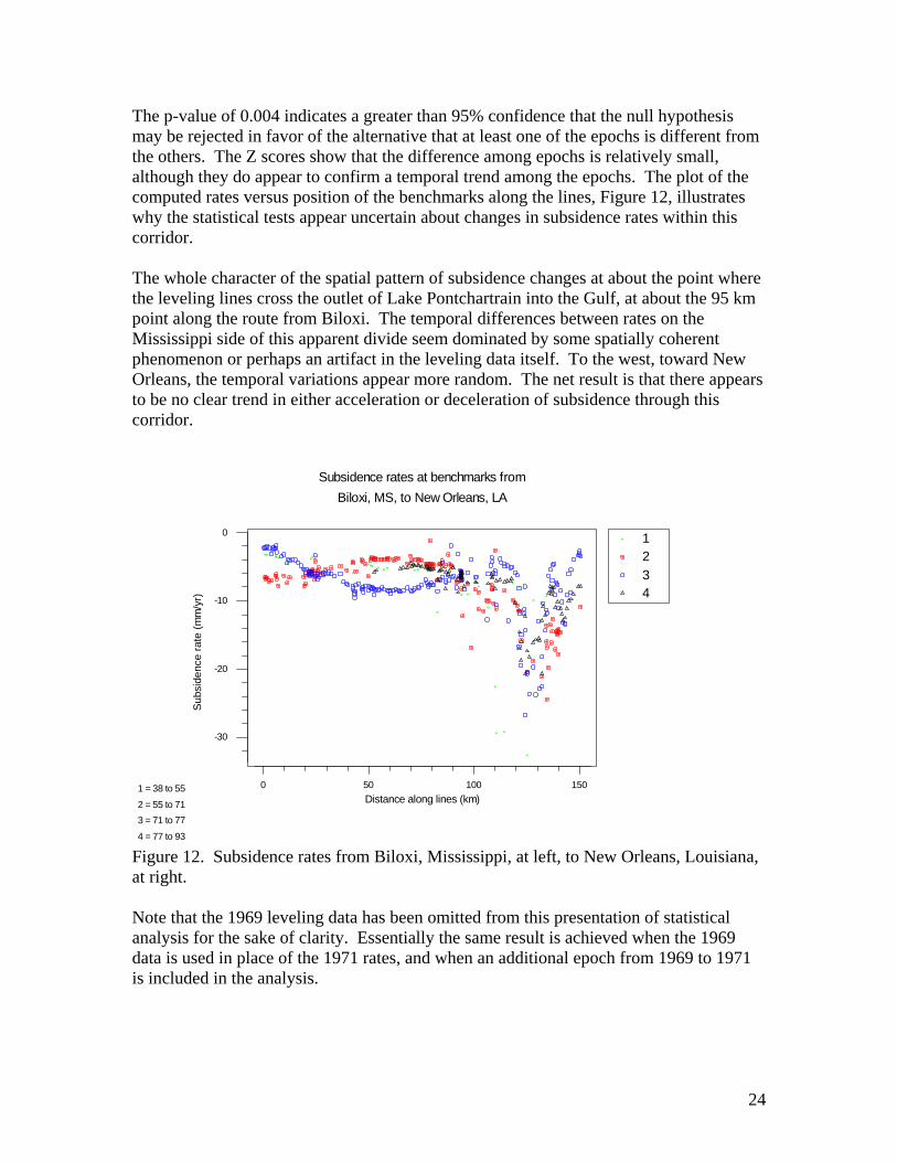
epoch 3 = 1969 to 1993 Figure 11. Subsidence rates from Kenner, Louisiana, at left to Jackson, Mississippi, at right. 4. New Orleans to Biloxi In contrast to the corridors discussed above, the multiple leveling lines between Biloxi and New Orleans show only weak evidence of an increase in the rates of subsidence at benchmarks over time. The Kruskal-Wallis test shows that the median rate of subsidence appears to be increasing slightly over time. Kruskal-Wallis Test: rate versus epoch Epoch 1 = 38 to 55, 2 = 55 to 71, 3 = 71 to 77, 4 = 77 to 93. Kruskal-Wallis Test on rate2 epoch N Median Ave Rank Z 1 53 -5.180 301.3 2.55 2 133 -6.080 269.0 1.47 3 225 -6.870 247.2 -0.80 4 94 -6.995 217.2 -2.64 Overall 505 253.0 H = 13.42 DF = 3 P = 0.004
24
The p-value of 0.004 indicates a greater than 95% confidence that the null hypothesis may be rejected in favor of the alternative that at least one of the epochs is different from the others. The Z scores show that the difference among epochs is relatively small, although they do appear to confirm a temporal trend among the epochs. The plot of the computed rates versus position of the benchmarks along the lines, Figure 12, illustrates why the statistical tests appear uncertain about changes in subsidence rates within this corridor. The whole character of the spatial pattern of subsidence changes at about the point where the leveling lines cross the outlet of Lake Pontchartrain into the Gulf, at about the 95 km point along the route from Biloxi. The temporal differences between rates on the Mississippi side of this apparent divide seem dominated by some spatially coherent phenomenon or perhaps an artifact in the leveling data itself. To the west, toward New Orleans, the temporal variations appear more random. The net result is that there appears to be no clear trend in either acceleration or deceleration of subsidence through this corridor.
1 2 3 4
0 50 100 150
-30
-20
-10
0
Distance along lines (km)
Sub
side
nce
rate
(mm
/yr)
Subsidence rates at benchmarks fromBiloxi, MS, to New Orleans, LA
1 = 38 to 55
2 = 55 to 713 = 71 to 77
4 = 77 to 93 Figure 12. Subsidence rates from Biloxi, Mississippi, at left, to New Orleans, Louisiana, at right. Note that the 1969 leveling data has been omitted from this presentation of statistical analysis for the sake of clarity. Essentially the same result is achieved when the 1969 data is used in place of the 1971 rates, and when an additional epoch from 1969 to 1971 is included in the analysis.
25
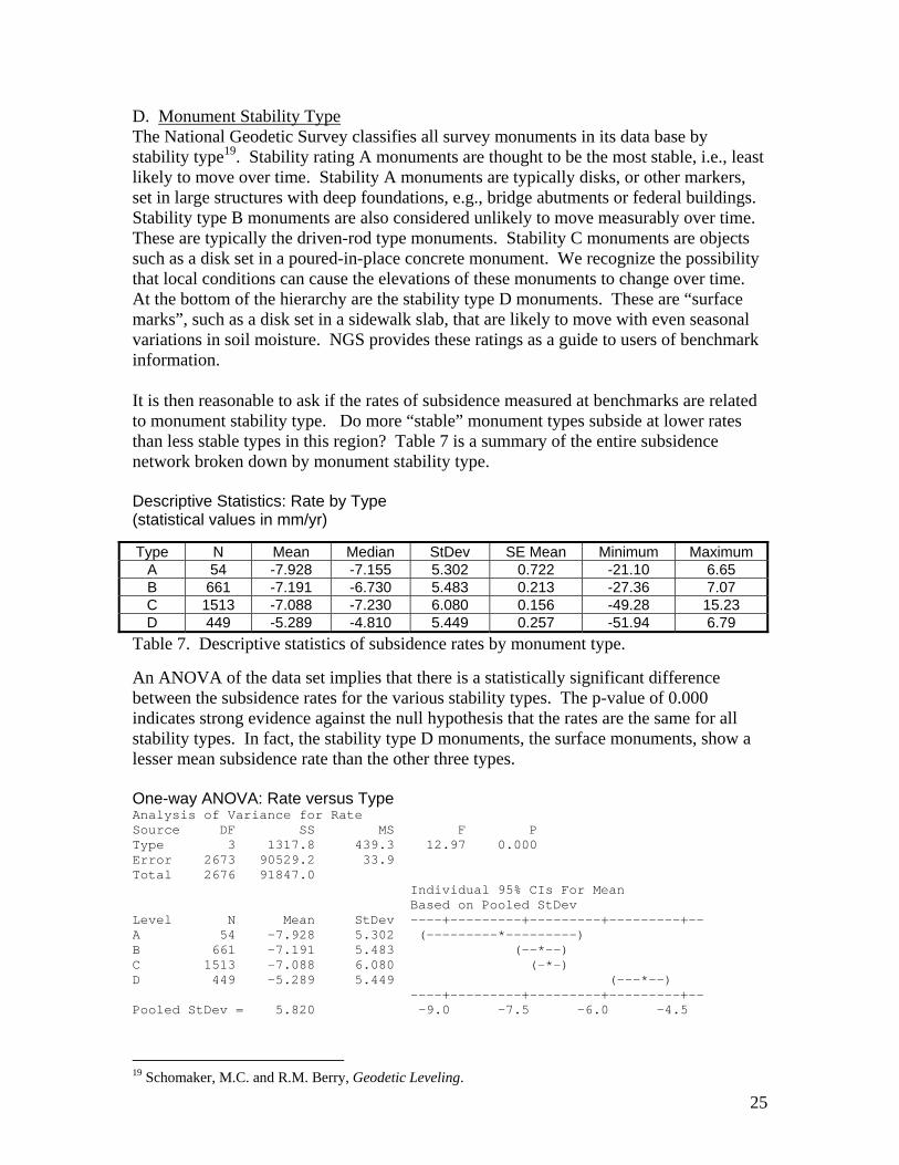
D. Monument Stability Type The National Geodetic Survey classifies all survey monuments in its data base by stability type19. Stability rating A monuments are thought to be the most stable, i.e., least likely to move over time. Stability A monuments are typically disks, or other markers, set in large structures with deep foundations, e.g., bridge abutments or federal buildings. Stability type B monuments are also considered unlikely to move measurably over time. These are typically the driven-rod type monuments. Stability C monuments are objects such as a disk set in a poured-in-place concrete monument. We recognize the possibility that local conditions can cause the elevations of these monuments to change over time. At the bottom of the hierarchy are the stability type D monuments. These are “surface marks”, such as a disk set in a sidewalk slab, that are likely to move with even seasonal variations in soil moisture. NGS provides these ratings as a guide to users of benchmark information. It is then reasonable to ask if the rates of subsidence measured at benchmarks are related to monument stability type. Do more “stable” monument types subside at lower rates than less stable types in this region? Table 7 is a summary of the entire subsidence network broken down by monument stability type. Descriptive Statistics: Rate by Type (statistical values in mm/yr)
Table 7. Descriptive statistics of subsidence rates by monument type. An ANOVA of the data set implies that there is a statistically significant difference between the subsidence rates for the various stability types. The p-value of 0.000 indicates strong evidence against the null hypothesis that the rates are the same for all stability types. In fact, the stability type D monuments, the surface monuments, show a lesser mean subsidence rate than the other three types. One-way ANOVA: Rate versus Type Analysis of Variance for Rate Source DF SS MS F P Type 3 1317.8 439.3 12.97 0.000 Error 2673 90529.2 33.9 Total 2676 91847.0 Individual 95% CIs For Mean Based on Pooled StDev Level N Mean StDev ----+---------+---------+---------+-- A 54 -7.928 5.302 (---------*---------) B 661 -7.191 5.483 (--*--) C 1513 -7.088 6.080 (-*-) D 449 -5.289 5.449 (---*--) ----+---------+---------+---------+-- Pooled StDev = 5.820 -9.0 -7.5 -6.0 -4.5
19 Schomaker, M.C. and R.M. Berry, Geodetic Leveling.
Type N Mean Median StDev SE Mean Minimum Maximum A 54 -7.928 -7.155 5.302 0.722 -21.10 6.65 B 661 -7.191 -6.730 5.483 0.213 -27.36 7.07 C 1513 -7.088 -7.230 6.080 0.156 -49.28 15.23 D 449 -5.289 -4.810 5.449 0.257 -51.94 6.79
26
Both Tukey’s and Fisher’s pairwise comparison tests agree that the mean subsidence rate for stability type D is different from each of the others, while the rates for types A, B, and C are all statistically the same. To check for the possibility of variation in behavior of monument types within different corridors, we extracted data for each of three main branches of the subsidence network and performed separate analyses. For the leveling lines along the corridor from New Orleans to New Iberia, Louisiana, there were no stability type A monuments in the data set. The p-value of 0.184 implies no evidence against the null hypothesis that the mean rate of subsidence is the same for all three stability types. One-way ANOVA: rate versus stability Analysis of Variance for rate Source DF SS MS F P stabilit 2 67.0 33.5 1.70 0.184 Error 587 11608.7 19.8 Total 589 11675.7 Individual 95% CIs For Mean Based on Pooled StDev Level N Mean StDev -------+---------+---------+--------- B 111 -8.473 4.237 (-------*--------) C 405 -8.638 4.258 (----*---) D 74 -9.602 5.622 (---------*---------) -------+---------+---------+--------- Pooled StDev = 4.447 -10.0 -9.0 -8.0
Our analysis of the leveling lines connecting Kenner, Louisiana, with Jackson, Mississippi, shows a similar result. The p-value of 0.493 indicates no evidence against the null hypothesis that the mean rate of subsidence is the same for all four stability types. One-way ANOVA: rate versus type Analysis of Variance for rate Source DF SS MS F P type 3 38.3 12.8 0.80 0.493 Error 386 6149.9 15.9 Total 389 6188.2 Individual 95% CIs For Mean Based on Pooled StDev Level N Mean StDev -------+---------+---------+--------- A 9 -7.553 4.276 (------------*------------) B 129 -8.406 3.930 (--*--) C 231 -8.703 4.149 (-*--) D 21 -9.611 1.853 (--------*--------) -------+---------+---------+--------- Pooled StDev = 3.992 -10.0 -8.0 -6.0
The leveling data in the corridor from New Orleans to Biloxi, Mississippi, yields subsidence rates that reveal similar behavior regarding monument stability type. The p-value of 0.142 in the ANOVA table below implies no evidence against the null hypothesis that the mean rate of subsidence is the same for all four stability types.

27
One-way ANOVA: rate versus type Analysis of Variance for rate Source DF SS MS F P type 3 287.8 95.9 1.82 0.142 Error 709 37328.7 52.6 Total 712 37616.4 Individual 95% CIs For Mean Based on Pooled StDev Level N Mean StDev ---+---------+---------+---------+--- A 20 -12.349 6.867 (------------*-----------) B 182 -8.425 7.217 (---*----) C 394 -8.576 7.270 (--*--) D 117 -8.486 7.332 (----*----) ---+---------+---------+---------+--- Pooled StDev = 7.256 -15.0 -12.5 -10.0 -7.5
The relatively miniscule size of the sum of squares due to stability type compared to the SS for error in both cases indicates that the majority of the variation in subsidence rates is attributable to chance rather than to monument configuration. V. Validation The subsidence rate network was assembled and computed using one kind of data, first-order leveling, and one starting condition, i.e., the tidal record at Grand Isle East Point. A great many assumptions, judgments, and choices went into assembling the network and computing the vertical displacement rates for each benchmark. What confidence do we have that the rates are valid? A. Tide Records One possible measure of the validity of our constructed subsidence network is to examine how the rates computed through the leveling network match the rates predicted at tide gauges other than the starting point at Grand Isle, East Point. The subsidence rates for all benchmarks in the network were computed only from leveling observations, all based on the starting condition set by the East Point tide gauge. Thus, the subsidence values at benchmarks near other tide gauges are independent of the values determined from the tidal records. Table 8 shows the effective subsidence rates for other tide gauges and proximate benchmarks. At each tide station, the total relative sea level rise, as recorded by the water level record, was reduced by the same –1.25 mm/yr eustatic rise value.
tide gauge location
gauge observed rate
(mm/yr)
leveling data prediction (mm/yr)
difference in rates (mm/yr)
Grand Isle (Bayou Rigaud) -13.45 -11.73 1.72
Cocodrie, LA -11.95 -8.68 3.27 Venice, LA -32.85 -24.52 8.33
Waveland, MS -6.75 -4.62 2.13 Pensacola, FL -0.89 4.33 5.22
Dauphin Island, AL -1.68 -0.04 1.64 Eugene Island, LA -8.49 -12.02 -3.53
Table 8. Comparison of tidal rates with leveling rates.

28
In general, the leveling network predicts the tidal records very well. The largest difference is at Venice, Louisiana. In this case, the tidal record is probably not an especially accurate measure of actual surface subsidence. The location of the gauge itself, within a distributary channel of the river, raises the possibility of an effect from changes in river flow volume in the data. The tidal record at this location consists of fourteen months of observations, a ten-year gap, and another 21 months of observations. The subsidence rate derived from the leveling network is probably the more accurate measure of vertical displacement at this location. B. CORS Sites Another independent check on the validity of the subsidence rates computed from the leveling network computations can be derived from computed vertical displacement rates for CORS sites within the network area. Using a processing approach suggested by Dr. Mark Schenewerk, we used NGS’ PAGES software to process vector solutions and determine ellipsoid heights at CORS sites in New Orleans (ENG1), Vicksburg (VIC1), and Memphis (MEM2). We determined the heights within a reference frame defined for each processing session by three IGS sites: CRO1 (St. Croix, U.S. Virgin Islands), NLIB (North Liberty, Iowa), and MDO1 (McDonald Observatory, Texas). In each processing session, we held all of the IGS sites fixed, i.e., constrained the individual sites to their a priori values by assigning each of them the PAGES default weight of 100. This forced PAGES to put all of the “error” into the one free site, the local CORS site, and thus determine its height relative to the fixed reference frame defined by the others. For each day used, we processed a single session of vectors from one “local” CORS site to each of the IGS sites. In the language of PAGES, we used the CORS as the “hub site”. Where a full data set was available, we processed a 23 hour and 45 minute session for each day. A few days were shorter due to lack of data, but none was shorter by more than a few hours. In a few cases where data was missing, we processed vectors to only two out of three of the IGS sites. Ellipsoid heights from these days generally fit well with heights from days using all sites, so we included those in the data set for analysis. For each local CORS site, we determined ellipsoid heights for a selection of days at each “end” of a six or seven year time period. All the days fell within the last 65 days of their respective year, thus eliminating seasonal effects as far as possible. The final number of days processed and included in the analysis depended on how many samples were needed to bring the expected error of the mean within a limit of 5 mm. A spreadsheet computed, and recomputed, the relevant statistics and sample size needed as each result was added. Each mean ellipsoid height for each site includes heights processed independently by two different operators. We did this to detect any possible bias in the processing result; no bias or difference between the two operators was evident. Each person worked on each session solution individually to achieve the best possible result in terms of lowest RMS and lowest number of un-fixed integers in each session. We did not, however, break individual vectors out of a session for special processing attention.
29
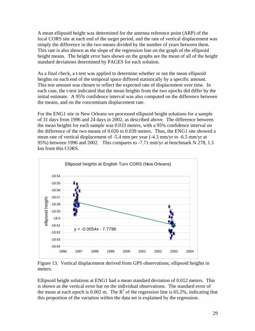
A mean ellipsoid height was determined for the antenna reference point (ARP) of the local CORS site at each end of the target period, and the rate of vertical displacement was simply the difference in the two means divided by the number of years between them. This rate is also shown as the slope of the regression line on the graph of the ellipsoid height means. The height error bars shown on the graphs are the mean of all of the height standard deviations determined by PAGES for each solution. As a final check, a t-test was applied to determine whether or not the mean ellipsoid heights on each end of the temporal space differed statistically by a specific amount. This test amount was chosen to reflect the expected rate of displacement over time. In each case, the t-test indicated that the mean heights from the two epochs did differ by the initial estimate. A 95% confidence interval was also computed on the difference between the means, and on the concomitant displacement rate. For the ENG1 site in New Orleans we processed ellipsoid height solutions for a sample of 31 days from 1996 and 24 days in 2002, as described above. The difference between the mean heights for each sample was 0.033 meters, with a 95% confidence interval on the difference of the two means of 0.026 to 0.039 meters. Thus, the ENG1 site showed a mean rate of vertical displacement of -5.4 mm per year (-4.3 mm/yr to -6.5 mm/yr at 95%) between 1996 and 2002. This compares to -7.71 mm/yr at benchmark N 278, 1.5 km from this CORS.
Ellipsoid heights at English Turn CORS (New Orleans)
y = -0.0054x - 7.7796
-18.64
-18.63
-18.62
-18.61
-18.6
-18.59
-18.58
-18.57
-18.56
-18.55
-18.54
1996 1997 1998 1999 2000 2001 2002 2003 2004
ellip
soid
hei
ght
Figure 13. Vertical displacement derived from GPS observations; ellipsoid heights in meters. Ellipsoid height solutions at ENG1 had a mean standard deviation of 0.012 meters. This is shown as the vertical error bar on the individual observations. The standard error of the mean at each epoch is 0.002 m. The R2 of the regression line is 65.2%, indicating that this proportion of the variation within the data set is explained by the regression.
30
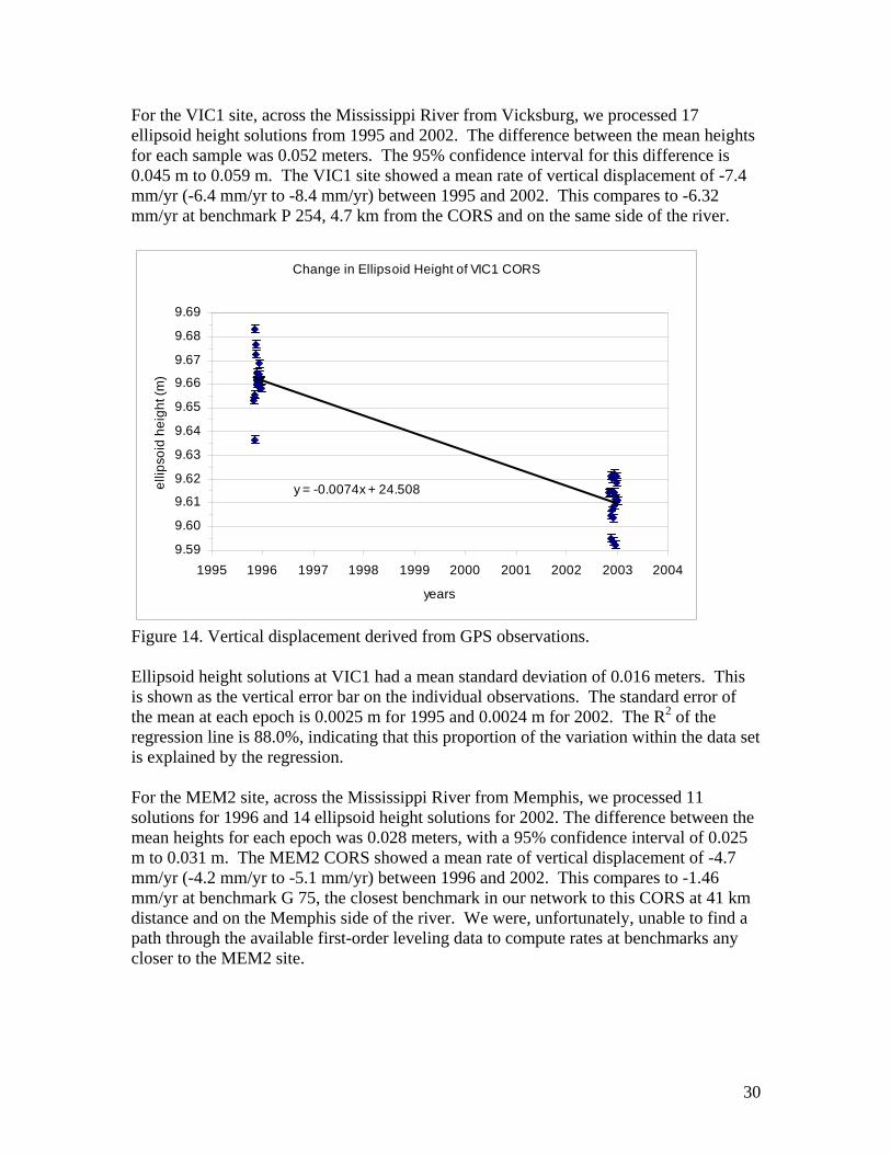
For the VIC1 site, across the Mississippi River from Vicksburg, we processed 17 ellipsoid height solutions from 1995 and 2002. The difference between the mean heights for each sample was 0.052 meters. The 95% confidence interval for this difference is 0.045 m to 0.059 m. The VIC1 site showed a mean rate of vertical displacement of -7.4 mm/yr (-6.4 mm/yr to -8.4 mm/yr) between 1995 and 2002. This compares to -6.32 mm/yr at benchmark P 254, 4.7 km from the CORS and on the same side of the river.
Change in Ellipsoid Height of VIC1 CORS
y = -0.0074x + 24.508
9.59
9.60
9.61
9.62
9.63
9.64
9.65
9.66
9.67
9.68
9.69
1995 1996 1997 1998 1999 2000 2001 2002 2003 2004
years
ellip
soid
hei
ght (
m)
Figure 14. Vertical displacement derived from GPS observations. Ellipsoid height solutions at VIC1 had a mean standard deviation of 0.016 meters. This is shown as the vertical error bar on the individual observations. The standard error of the mean at each epoch is 0.0025 m for 1995 and 0.0024 m for 2002. The R2 of the regression line is 88.0%, indicating that this proportion of the variation within the data set is explained by the regression. For the MEM2 site, across the Mississippi River from Memphis, we processed 11 solutions for 1996 and 14 ellipsoid height solutions for 2002. The difference between the mean heights for each epoch was 0.028 meters, with a 95% confidence interval of 0.025 m to 0.031 m. The MEM2 CORS showed a mean rate of vertical displacement of -4.7 mm/yr (-4.2 mm/yr to -5.1 mm/yr) between 1996 and 2002. This compares to -1.46 mm/yr at benchmark G 75, the closest benchmark in our network to this CORS at 41 km distance and on the Memphis side of the river. We were, unfortunately, unable to find a path through the available first-order leveling data to compute rates at benchmarks any closer to the MEM2 site.

31
Ellipsoid heights at MEM2 CORS, and rate of change over time
y = -0.0047x + 55.873
46.53
46.54
46.55
46.56
46.57
46.58
46.59
46.60
1996 1997 1998 1999 2000 2001 2002 2003 2004
ellip
soid
hei
ght (
m)
Figure 15. Vertical displacement derived from GPS observations. Ellipsoid height solutions at MEM2 had a mean standard deviation of 0.017 meters. The standard error of the mean at each epoch is 0.002 m. The R2 of the regression line is 74.6%, indicating that this proportion of the variation within the data set is explained by the regression. C. Closures In a very few locations, we were able to close loops within our subsidence rates network, i.e., compute rates at individual benchmarks from two different directions using different sets of leveling lines. These are not completely independent checks on the vertical displacement rates computed at given marks, however. The two different routes along which rates were computed to a common point necessarily share a common starting condition somewhere. Examining loop closures does give us some feel for the validity of the process and magnitude of possible errors, particularly in regard to interpolation or extrapolation at joins. Four examples will suffice to show the range of rate closures we found in the subsidence network. At Gibson, Louisiana, we computed two rates by different routes at point N 198 (AU0256). A rate of -10.37 mm/yr was computed between lines from 1982 and 1993, which ran along the U.S. 90 highway corridor between Houma and Gibson. A rate of -12.29 mm/yr was computed between leveling lines from 1969 and 1977 which followed the railroad corridor from the New Orleans area, through Raceland and Lafourche, to Gibson and beyond. We were also able to make a loop closure between Baldwin and Lafayette, Louisiana. The subsidence rate computed for point P 3 (BK0239) was -8.16 mm/yr as part of the set of leveling lines running from New Orleans to New Iberia, and then from New Iberia to Iowa. This rate was computed for the epoch between 1970 and 1986. A different set of leveling lines, from 1955 and 1965, took the scenic route from Baldwin to Lafayette via Butte La Rose and Breaux Bridge to connect back to the “main” line at P 3. From this data, we computed a rate of -10.22 mm/yr at P 3.
32
On the Louisiana side of the Mississippi River across from Vicksburg, Mississippi, we connected a huge loop with vertices including New Orleans, Baton Rouge, and Shreveport in Louisiana, and Jackson and Vicksburg in Mississippi. Computing west from Jackson using epochs from 1968 to 1974 and from 1968 to 1996, we derived a displacement rate at point P 254 (CP2351) of -6.23 mm/yr. Coming from the direction of Shreveport and using epochs from 1938 to 1969 and from 1966 to 1969, we computed the rate for P 254 at -2.37 mm/yr. Where lines converged near the town of Iowa, in western Louisiana, we computed rates at nearby benchmarks using lines taking different routes. Unfortunately, these sets of pairs of lines did not include any common marks. From a series of lines following the U.S. 90 corridor westward from Lafayette, we computed rates at two points: F 267 (BK0607) as -10.85 mm/yr, and E 267 (BK1439) as -11.30 mm/yr. These two rates were computed for the epoch from 1970 to 1986. Another set of level lines followed the U.S. 165 highway and rail corridor from Alexandria to Iowa. Using this data, we computed vertical displacement rates for another point within about one kilometer of the points cited above: A 4145 (BK0608) as -6.70 mm/yr. This rate was computed for the epoch between 1969 and 1986. This was another large loop; its vertices included Alexandria, Baton Rouge, Thibodaux, Lafayette, and Iowa Junction. These closures are imprecise; rates computed from different directions don’t match exactly. Part of the imprecision comes from the fact that the rates are calculated over different time epochs and intervals. Displacement rates at individual marks probably do vary over time depending on a number of local conditions. These variable conditions may be different over different routes. Rates computed through different sets of lines contain different numbers of “joins” at different locations. This means that the assumption of linear extrapolation or interpolation of rates to compute new starting elevations at common points affects each route differently. Leveling data collected in different decades may have been observed with different equipment and procedures, and under different ambient conditions. While all met the then current first-order standard, some variation due to these sources could have been introduced into the data. The subsidence rates and computed elevations listed in the appendix could be used to compute estimates of the current, or future, elevations of any of the benchmarks in the network. Any such computed elevation values are only estimates, however. Publication of updated elevation values for a subset of these benchmarks must await the conclusion of ongoing height modernization projects and additional analysis. VI. Discussion At this point, we hesitate to define a simple model for future subsidence within this study region based on simple linear extrapolation of computed rates into the future. As we have seen, subsidence rates in any given epoch vary across the region with both broad and local conditions. Rates at most individual benchmarks appear to vary through time also, usually in a non-linear manner. Extrapolation models, whether simple or complex, could provide useful information over a large area to a level of accuracy that may be suitable for long-term, large scale planning. However, determination of future elevations
33
at specific locations to a level of accuracy consistent with the requirements of geodetic control will apparently require more, and more current, data. VII. Conclusions and Recommendations Thorough consideration and analysis of all of this information has led us to a number of conclusions.
1. There are no valid NAVD 88 elevation reference points in a large portion of the lower Mississippi Valley today. On the other hand, we may also have identified some areas on the periphery of this study region where vertical displacement rates are small enough to be essentially zero.
2. The old leveling data is useless for determining current elevations. The historical
data, even that of only ten years ago, describes a topography and spatial relationship between benchmarks that no longer exists. Since benchmarks, even spatially adjacent benchmarks, move at different rates, their relative elevation differences have changed over time. A readjustment of old leveling data seems pointless.
3. We know now that elevations on benchmarks in this region cannot be assumed to
be static through time. We suggest this implies that ongoing vertical displacement must be monitored at a few fundamental locations and propagated through a base network using periodic reobservations.
4. Subsidence rates at individual points are not constant through time nor over
significant spatial extents. Vertical displacement rates may not even vary according to a linear function. Attempts to make predictive models must account for spatial and temporal variation of rates.
5. Because the elevations used were obsolete, the conversion surface used to
transform the G99SSS geoid model into the Geoid 99 model20 is also inaccurate in this region. One implication of this is that ellipsoid height differences measured from new GPS observations are probably more accurate measures of the true spatial relationship between points than are the differences in orthometric heights estimated from those observations using the current Geoid 99 model. A new geoid model must account for the temporal movement of benchmarks used to create the conversion surface.
6. Expensive benchmark installations are pointless in this environment. Our
analysis shows, for example, that sectional rod monuments driven to refusal subside just as fast as concrete benchmarks. Fast, easy, and cheap monuments perform just as well, or poorly, as anything else for elevation reference points in this milieu.
20 Smith, D.A, and D.R. Roman, Documentation for the GPS Benchmark Data Set of August 27, 1999, pp. 1-11.
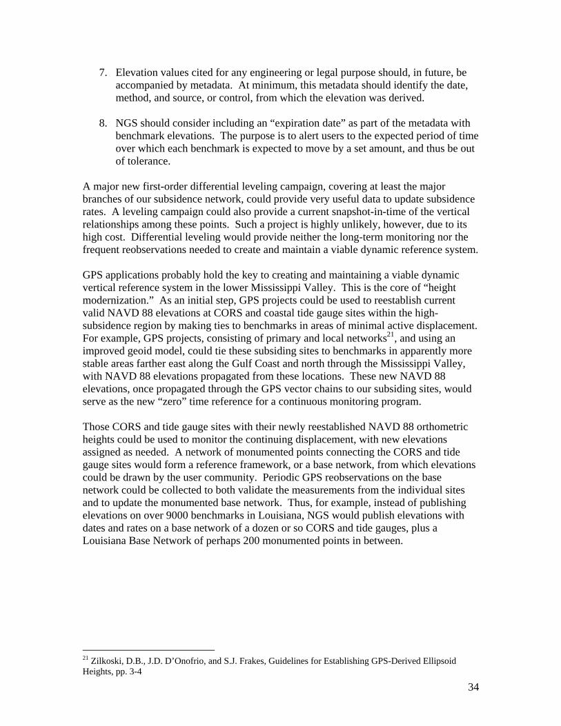
34
7. Elevation values cited for any engineering or legal purpose should, in future, be accompanied by metadata. At minimum, this metadata should identify the date, method, and source, or control, from which the elevation was derived.
8. NGS should consider including an “expiration date” as part of the metadata with
benchmark elevations. The purpose is to alert users to the expected period of time over which each benchmark is expected to move by a set amount, and thus be out of tolerance.
A major new first-order differential leveling campaign, covering at least the major branches of our subsidence network, could provide very useful data to update subsidence rates. A leveling campaign could also provide a current snapshot-in-time of the vertical relationships among these points. Such a project is highly unlikely, however, due to its high cost. Differential leveling would provide neither the long-term monitoring nor the frequent reobservations needed to create and maintain a viable dynamic reference system. GPS applications probably hold the key to creating and maintaining a viable dynamic vertical reference system in the lower Mississippi Valley. This is the core of “height modernization.” As an initial step, GPS projects could be used to reestablish current valid NAVD 88 elevations at CORS and coastal tide gauge sites within the high-subsidence region by making ties to benchmarks in areas of minimal active displacement. For example, GPS projects, consisting of primary and local networks21, and using an improved geoid model, could tie these subsiding sites to benchmarks in apparently more stable areas farther east along the Gulf Coast and north through the Mississippi Valley, with NAVD 88 elevations propagated from these locations. These new NAVD 88 elevations, once propagated through the GPS vector chains to our subsiding sites, would serve as the new “zero” time reference for a continuous monitoring program. Those CORS and tide gauge sites with their newly reestablished NAVD 88 orthometric heights could be used to monitor the continuing displacement, with new elevations assigned as needed. A network of monumented points connecting the CORS and tide gauge sites would form a reference framework, or a base network, from which elevations could be drawn by the user community. Periodic GPS reobservations on the base network could be collected to both validate the measurements from the individual sites and to update the monumented base network. Thus, for example, instead of publishing elevations on over 9000 benchmarks in Louisiana, NGS would publish elevations with dates and rates on a base network of a dozen or so CORS and tide gauges, plus a Louisiana Base Network of perhaps 200 monumented points in between.
21 Zilkoski, D.B., J.D. D’Onofrio, and S.J. Frakes, Guidelines for Establishing GPS-Derived Ellipsoid Heights, pp. 3-4

References Balazs, E., and G. Young; Corrections Applied by the National Geodetic Survey to Precise Leveling Observations; NOAA Technical Memorandum NOS NGS 34; NOAA; Silver Spring, MD; 1982. Coleman, J.M., H.H. Roberts, and G.W. Stone; Mississippi River Delta, An Overview; Journal of Coastal Research; vol. 14, no. 3, 1998; pp.698-716. Douglas, B.C.; Global Sea Level Change: Determination and Interpretation; U.S. National Report to IUGG, 1991-1994; Washington, D.C. Federal Geodetic Control Committee; Standards and Specifications for Geodetic Control Networks; Federal Geodetic Control Committee, Rockville, MD; 1984. Gill, S.K. and J.R. Schultz, eds.; Tidal Datums and Their Applications; NOAA Special Publication NOS CO-OPS 1; NOAA; Silver Spring, MD; 2001. Gornitz, V.; Sea-Level Rise: A Review Of Recent Past And Near-Future Trends; Earth surface Processes and Landforms; vol. 20, 1995; pp. 7-20. Hickey, H. and R. Sabate, eds.; Tectonic map of Gulf coast region, USA; Gulf Coast Assoc. Geol. Soc. and Am. Assoc. Petroleum; Tulsa, OK; 1972. Holdahl, S.R. and N.L. Morrison; Regional Investigations of Vertical Crustal Movements in the U.S., Using Precise Relevelings and Mareograph Data; Tectonophysics; vol. 23, no. 4; 1974; pp. 373-390. Jurkowski, G., J. Ni, and L. Brown; Modern Uparching of the Gulf Coastal Plain; Journal of Geophysical Research; vol. 89, no. B7, 1984; pp. 6247-6255. Louisiana Coastal Wetlands Conservation and Restoration Task Force; Coast 2050: Toward a Sustainable Coastal Louisiana; Louisiana Department of Natural Resources; 1999. Marmer, H.A.; Tidal Datum Planes; U.S. Coast and Geodetic Survey Special Publication 135; U.S. Department of Commerce, Washington, D.C.; 1951. Morner, N.A.; The Expected Sea Level Changes in the Next Century; internet publication of the International Association of Quaternary Research; 2000. Morton, R.A., N.A. Buster, M.D. Krohn; Subsurface Controls on Historical Subsidence Rates and Associated Wetland Loss in Southcentral Louisiana; Transactions - Gulf Coast Association of Geological Societies; vol. 52; 2002; pp.767-778.

Nummedal, D.; Rates and Frequencies of Sea-Level Changes; A Review With an Application to Predict Future Sea Levels in Louisiana; Transactions - Gulf Coast Association of Geological Societies; vol. 33; 1983; pp. 361-366. Penland, S., et al; Geological Framework, Processes, and Rates of Subsidence in the Mississippi River Delta Plain; AAPG Bulletin; vol. 79, no. 10; 1995; pp. 1565-1566. Penland, S., J.R. Suter, and R.A. McBride; Delta Plain Development and Sea Level History in the Terrebonne coastal Region, Louisiana; Coastal Sediments ’87; vol. 2, 1987; pp. 1689-1706. Ramsey, K.E., and T.F. Moslow; A Numerical Analysis of Subsidence and Sea Level Rise in Louisiana; Coastal Sediments ’87; pp. 1673-1688. Sella, G., R.K. Dokka, and T. Dixon; Constraints on Extension and Subsidence Rates Along the Northern Gulf of Mexico from High-Precision GPS; Annual Meeting Expanded Abstracts - American Association of Petroleum Geologists; vol. 2000; 2000; pp. 134-135. Schenewerk, M.S.; private communication; Give’em An Inch; 2003. Schomaker, M.C., and R.M. Berry; Geodetic Leveling; NOAA Manual NOS NGS 3, NOAA, Rockville, MD; 1981. Smith, D.A., and D.R. Roman; Documentation for the GPS Benchmark Data Set of August 27, 1999; NOAA, Silver Spring, MD; 2000. Swanson, R.L., and C.I. Thurlow; Recent Subsidence Rates along the Texas and Louisiana Coasts as Determined from Tide Measurements; Journal of Geophysical Research; vol. 78, no. 15; 1973; pp. 2665-2671. Swanson, R.L.; Variability of Tidal Datums and Accuracy in Determining Datums from Short Series of Observations; NOAA Technical Report NOS 64, NOAA, Rockville, MD; 1974. Vertical Network Branch; NAVD 88 Readjustment of Vertical Control Network in Southern Louisiana; National Geodetic Survey, Silver Spring, Maryland; 1994. Zervas, C.; Sea Level Variations of the United States 1854-1999; NOAA Technical Report NOS CO-OPS 36, NOAA, Silver Spring, Maryland; 2001. Zilkoski, D.B., J.D. D’Onofrio, and S.J. Frakes; Guidelines for Establishing GPS-Derived Ellipsoid Heights, version 4.3; NOAA Technical Memorandum NOS NGS-58; NOAA, Silver Spring, Maryland; 1997.

Zilkoski, D.B. and S.M. Reese,; Subsidence in the Vicinity of New Orleans as Indicated by Analysis of Geodetic Leveling Data; NOAA Technical Report NOS 120 NGS 38; NOAA, Rockville, Maryland; 1986.

APPENDIX 1 REGRESSION PLOTS FOR ADDITIONAL TIDE STATIONS Regression plots for monthly mean water levels at coastal tide stations operated by the National Ocean Service, but which are not included among the stations discussed in Sea Level Variations of the United States 1854-1999. The data for these plots came directly from NOS.
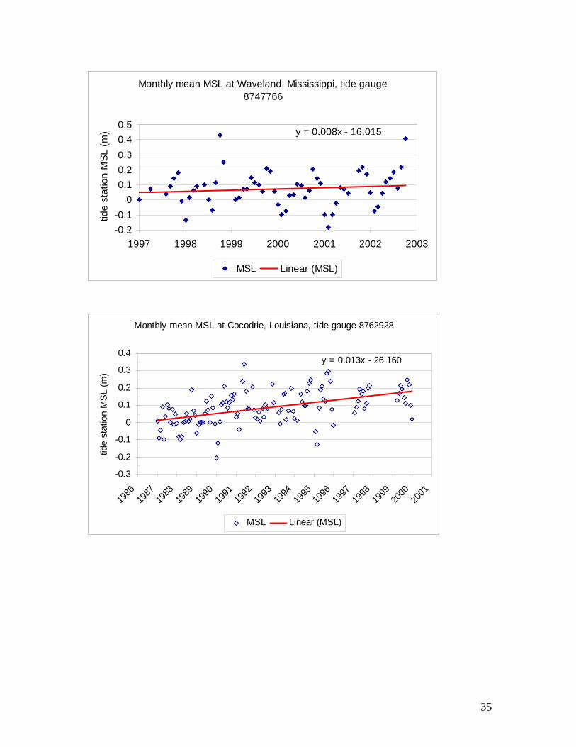
35
Monthly mean MSL at Waveland, Mississippi, tide gauge 8747766
y = 0.008x - 16.015
-0.2-0.1
00.10.20.30.40.5
1997 1998 1999 2000 2001 2002 2003
tide
stat
ion
MSL
(m)
MSL Linear (MSL)
Monthly mean MSL at Cocodrie, Louisiana, tide gauge 8762928
y = 0.013x - 26.160
-0.3
-0.2
-0.1
0
0.1
0.2
0.3
0.4
1986
1987
1988
1989
1990
1991
1992
1993
1994
1995
1996
1997
1998
1999
2000
2001
tide
stat
ion
MSL
(m)
MSL Linear (MSL)
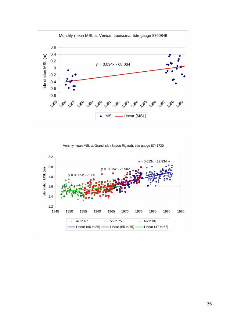
36
Monthly mean MSL at Venice, Louisiana, tide gauge 8760849
y = 0.034x - 68.034
-0.8
-0.6
-0.4
-0.2
0
0.2
0.4
0.6
1985
1986
1987
1988
1989
1990
1991
1992
1993
1994
1995
1996
1997
1998
1999
tide
stat
ion
MS
L (m
)
MSL Linear (MSL)
Monthly mean MSL at Grand Isle (Bayou Rigaud), tide gauge 8741720
y = 0.013x - 23.934
y = 0.015x - 26.982
y = 0.005x - 7.860
1.2
1.4
1.6
1.8
2.0
2.2
1945 1950 1955 1960 1965 1970 1975 1980 1985 1990
tide
stat
ion
MSL
(m)
47 to 67 55 to 75 66 to 86
Linear (66 to 86) Linear (55 to 75) Linear (47 to 67)

37
Monthly mean MSL at Grand Isle (East Point), Louisiana, tide gauge 8741724
y = 0.006x - 11.566-0.2
-0.1
0
0.1
0.2
0.3
0.4
1982 1983 1984 1985 1986 1987 1988 1989 1990 1991 1992 1993 1994
tide
stat
ion
MS
L (m
)
MSL Linear (MSL)

APPENDIX 2 LEVELING LINES AND CONNECTIONS Leveling lines included in the subsidence network. Lines shown in the schematic diagram as above or below each other generally followed the same route and included common benchmarks. Leveling data from lines that included common benchmarks were available for analysis and computation of subsidence rates.

38
Diagram of Leveling Lines and Connections in the LSRC Subsidence Network Year of Observations Grand Isle to Cocodrie via Houma Houma to Gibson along US 90
1934 1934 1935 1935 1955 1955
1960 1960 1963 1963 1964 1964 1965 L20370 L20376 1965 L20376 > > > > > 1966 L20583 1966 1968 1968 1969 1969 1970 1970 1971 1971 1972 1972 1974 1974 1977 1977
1980 1980 1981 1981 1982 L24680/11 > > > > > L24680/10 > > > > > 1982 L24680/10 1984 1984 1986 1986
1991 1991 1993 L25414 > > > > > > > > > > L25406/2 > > > > > 1993 L25414 > > > > > 1994 1994 1995 1995
Lines in bold type were used to compute rates shown in table in appendix 2. Tie < start TIDAL 6 U 221 Littler RM1 U 221 B 167 Benchmarks: TIDAL 13 A 220 D 222 N 198 < stop Location: Grand Isle Raceland Houma Cocodrie Houma Gibson
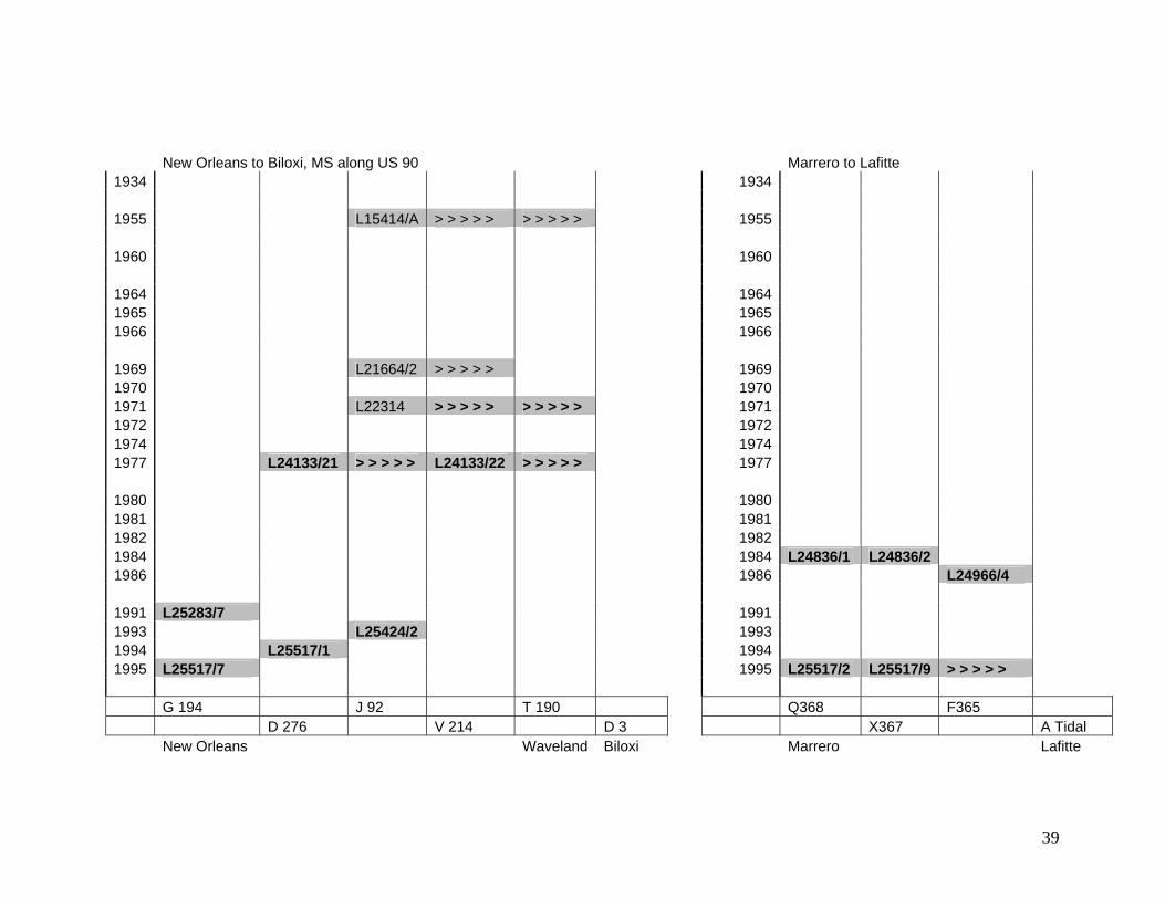
39
New Orleans to Biloxi, MS along US 90 Marrero to Lafitte 1934 1934 1955 L15414/A > > > > > > > > > > 1955 1960 1960 1964 1964 1965 1965 1966 1966 1969 L21664/2 > > > > > 1969 1970 1970 1971 L22314 > > > > > > > > > > 1971 1972 1972 1974 1974 1977 L24133/21 > > > > > L24133/22 > > > > > 1977 1980 1980 1981 1981 1982 1982 1984 1984 L24836/1 L24836/2 1986 1986 L24966/4 1991 L25283/7 1991 1993 L25424/2 1993 1994 L25517/1 1994 1995 L25517/7 1995 L25517/2 L25517/9 > > > > > G 194 J 92 T 190 Q368 F365 D 276 V 214 D 3 X367 A Tidal New Orleans Waveland Biloxi Marrero Lafitte
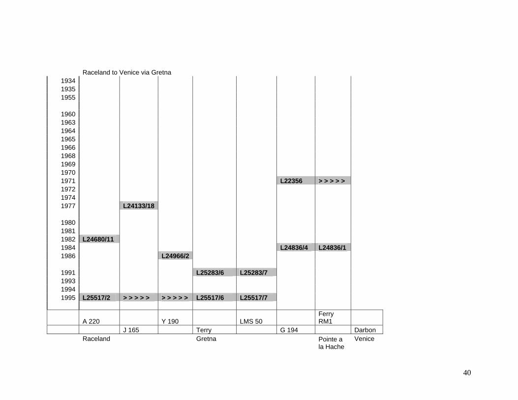
40
Raceland to Venice via Gretna 1934 1935 1955
1960 1963 1964 1965 1966 1968 1969 1970 1971 L22356 > > > > > 1972 1974 1977 L24133/18
1980 1981 1982 L24680/11 1984 L24836/4 L24836/1 1986 L24966/2
1991 L25283/6 L25283/7 1993 1994 1995 L25517/2 > > > > > > > > > > L25517/6 L25517/7
A 220 Y 190 LMS 50 Ferry RM1
J 165 Terry G 194 Darbon Raceland Gretna Venice
Pointe a la Hache

41
New Orleans to New Iberia 1934
1955 < < < < < < < < < < L15631 > > > > > > > > > > > > > > >
1960
1964 < < < < < < < < < < L19637 > > > > > L20199 > > > > > > > > > > 1965 1966
1969 L21785 > > > > > > > > > > > > > > > > > > > > > > > > > > > > > > > > > > > 1970 1971 1972 1974 1977 L24133/18 > > > > > > > > > > > > > > > > > > > > > > > > >
1980 1981 1982 1984 1986
1991 1993 L25414 > > > > > 1994 1995 L25517/2 > > > > >
Y 190 C 192 N 198 B 169 L 201 A 10 W 165 Q 167 H 4 Waggaman Raceland Jct. Gibson New Iberia

42
New Iberia to Iowa, LA Iowa, LA, to Beaumont, TX 1934 1934
1955 L15631 > > > > > > > > > > > > > > > 1955 L15631 > > > > >
1960 1960
1964 1964 1965 1965 1966 1966
1969 1969 1970 L22027 > > > > > > > > > > > > > > > 1970 1971 1971 1972 L22921 1972 L22921 > > > > > > > > > > > > > > > 1974 1974 1977 1977
1980 1980 1981 L24680/1 > > > > > 1981 L24680/1 > > > > > > > > > > 1982 L24680/12 > > > > > 1982 1984 1984 1986 L24962/2 > > > > > > > > > > 1986 L24968 > > > > > > > > > >
1991 1991 1993 1993 1994 1994 1995 1995
H 4 TT 17 B A 4142X A 4142 X N 58 W 1016
28 A 017 O1 Reset R 210 T 1199
New Iberia Iowa Iowa Beaumont
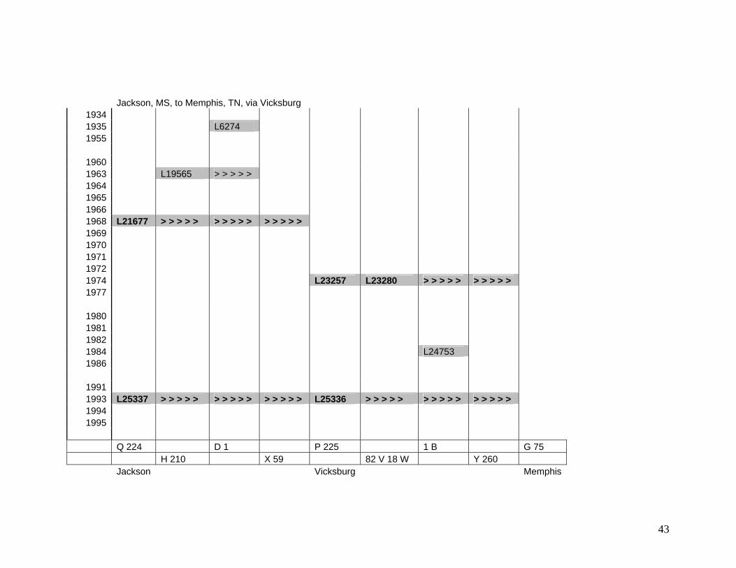
43
Jackson, MS, to Memphis, TN, via Vicksburg 1934 1935 L6274 1955
1960 1963 L19565 > > > > > 1964 1965 1966 1968 L21677 > > > > > > > > > > > > > > > 1969 1970 1971 1972 1974 L23257 L23280 > > > > > > > > > > 1977
1980 1981 1982 1984 L24753 1986
1991 1993 L25337 > > > > > > > > > > > > > > > L25336 > > > > > > > > > > > > > > > 1994 1995
Q 224 D 1 P 225 1 B G 75 H 210 X 59 82 V 18 W Y 260 Jackson Vicksburg Memphis
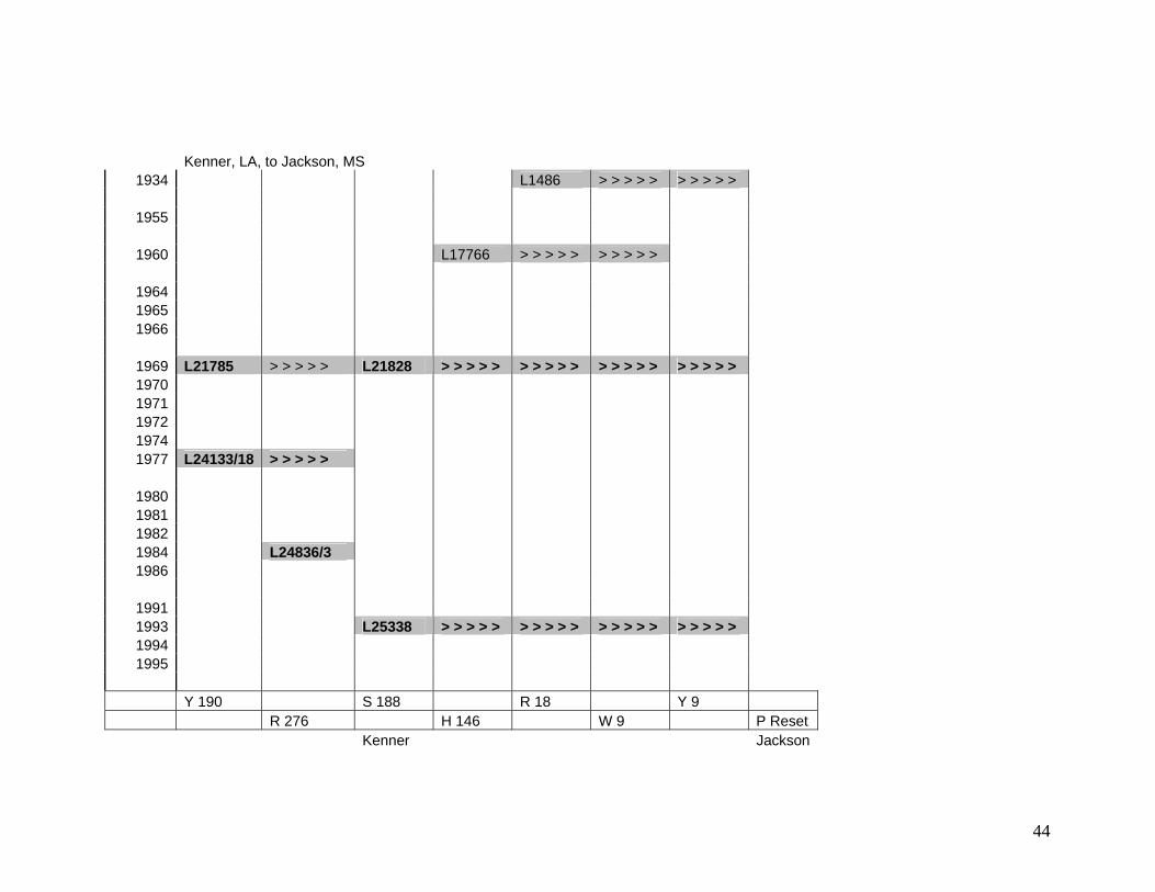
44
Kenner, LA, to Jackson, MS 1934 L1486 > > > > > > > > > >
1955
1960 L17766 > > > > > > > > > >
1964 1965 1966
1969 L21785 > > > > > L21828 > > > > > > > > > > > > > > > > > > > > 1970 1971 1972 1974 1977 L24133/18 > > > > >
1980 1981 1982 1984 L24836/3 1986
1991 1993 L25338 > > > > > > > > > > > > > > > > > > > > 1994 1995
Y 190 S 188 R 18 Y 9 R 276 H 146 W 9 P Reset Kenner Jackson
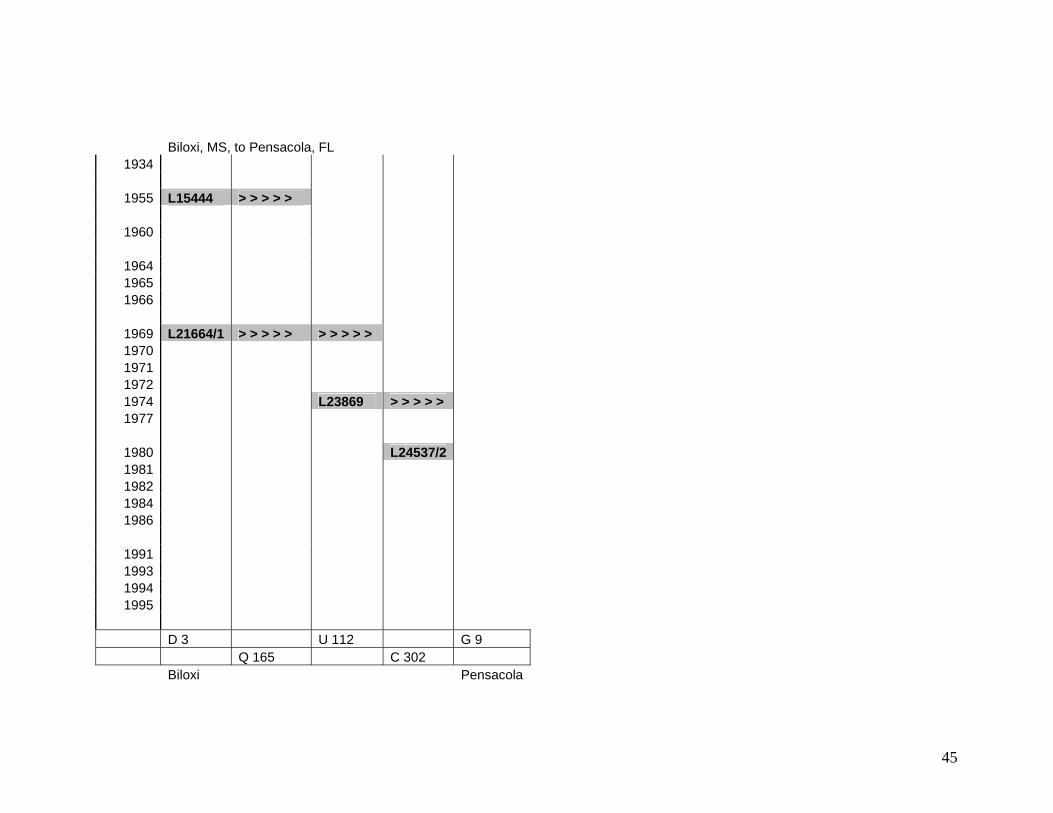
45
Biloxi, MS, to Pensacola, FL 1934
1955 L15444 > > > > >
1960
1964 1965 1966
1969 L21664/1 > > > > > > > > > > 1970 1971 1972 1974 L23869 > > > > > 1977
1980 L24537/2 1981 1982 1984 1986
1991 1993 1994 1995
D 3 U 112 G 9 Q 165 C 302 Biloxi Pensacola

46
Year of Observations Kenner to Baton Rouge, via Donaldsonville and Plaquemine Donaldsonville to Thibodaux
1920 1920 1934 1934 1935 1935 1937 1937 1938 1938 1939 1939 1940 1940 1944 1944 1950 1950 1955 1955 1961 1961 1963 1963 1964 L19622/1 L19631 >>>>>>>> >>>>>>>> >>>>>>>> 1964 1965 1965 L20373 >>>>>>>> 1966 1966 1968 1968 1969 1969 1970 1970 1976 1976 1977 L24133/17 >>>>>>>> >>>>>>>>> 1977 1982 1982 L24680/9 >>>>>>>> 1986 L24970 >>>>>>>> >>>>>>> >>>>>>> >>>>>>>> 1986 1993 1993 1996 1996
Tie D 147 X 290 V 197 G192
Benchmarks: J 146 RESET H 192 D 197 H192
Norco Plaquemine Baton Rouge Thibodaux
47
Plaquemine to Morgan City Baton Rouge to Port Barre 1920 1920 1934 1934 1935 1935 1937 1937 1938 1938 1939 1939 1940 1940 1944 1944 1950 1950 1955 1955 1961 1961 1963 1963 1964 1964 1965 L20202 L20211 >>>>>>> 1965 1966 1966 1968 1968 1969 1969 1970 1970 1976 L24133/15 >>>>>>> 1976 L24133/13 L24133/5 1977 1977 L24133/17 L24133/10 1982 1982 1986 1986 L24962/1 >>>>>>>> >>>>>>>> 1993 L25414 1993 1996 1996
X 290 S 200 P 287 B 206
PM 51 USE C204 Q 291
Crescent Port Allen Port Barre
48
Baton Rouge to Alexandria to Iowa Junction 1920 1934 L1149 1935 1937 1938 1939 1940 1944 1950 1955 1961 1963 1964 L20196 L20205 >>>>>>>> 1965 1966 L20711 L20719 1968 1969 L21850 1970 L22017 >>>>>>>> 1976 L24133/1 L24133/2 1977 L24160 1982 1986 L24962/1 L24967/1 1993 1996
D 206 Gabriel Cap F15 O 1 Reset
C 204 B 208 P 13 W 16
Baton Rouge Simmesport Alexandria Kinder

49
Alexandria to Shreveport to Vicksburg, MS 1920 74220 >>>>>>>> 1934 1935 1937 L10394 1938 L8354 L8455 >>>>>>>> 1939 1940 1944 1950 L13495/27 1955 1961 1963 1964 1965 1966 L20693 1968 1969 L21824 >>>>>>>> >>>>>>>> >>>>>>>> >>>>>>>> L21677 >>>>>>>> 1970 1976 1977 L24160 >>>>>>>> L23257 1982 L24711 1986 1993 1996 L25615/1 L25615/2
P 13 M 12 T 1 U254 H225 South S-10 B118 S 245 A1811 Z 59 Alexandria Shreveport Monroe Tallulah Delta

50
Lafayette to Baldwin, via Butte La Rose 1920 1934 1935 1937 1938 1939 1940 1944 1950 1955 L15631 L15631 1961 1963 1964 1965 L20343 >>>>>>>>> >>>>>>>>>> 1966 L20589 >>>>>>>>>>>>> 1968 1969 1970 1976 L24133/7 >>>>>>>>> >>>>>>>>>>>>> 1977 1982 L24680/7 >>>>>>>>>> 1986 1993 1996
P 3 Lenora Cap Charenton RM4 M 17 C 219 B 169
Breaux Bridge Butte La Rose Baldwin
51
Jackson, MS, to Meridian, MS, to Demopolis, AL Meridian, MS, to Mobile, AL 1920 1920 1934 1934 1935 1935 1937 1937 1938 1938 1939 1939 1940 1940 L8967 1944 L11057 1944 1950 1950 1955 1955 1961 L18304 >>>>>>>> >>>>>>>> 1961 L19601 1963 1963 1964 1964 1965 1965 1966 1966 1968 L21677 L21418 >>>>>>>> >>>>>>>> 1968 1969 1969 1970 1970 1976 1976 1977 1977 1982 1982 L24537/1 >>>>>>>> >>>>>>>> 1986 1986 1993 1993 1996 1996
P Reset B 73 PBM 5 B 73 448 ALGS Y 213 U 156 45 V A Y 120 Jackson Meridian Demopolis Meridian Vinegar Bend

APPENDIX 3 TABLE OF RATES, ELEVATIONS, AND POSITIONS Final data for the points in the subsidence network. The “End of epoch” value for each point is the date for the computed elevation shown. It is usually the latest date for which first-order leveling data was available at that point. Use this date, along with the computed elevation and rate, to extrapolate elevations into the future.

52
base year
PID Designation computed elevation
(m)
latitude longitude rate (mm/yr)
1984.50 AT0005 R 195 -0.706 292020 892956 -24.08 1984.50 AT0006 Z 91 -0.529 292020 892932 -21.57 1984.50 AT0007 S 195 -0.777 292018 892838 -21.67 1984.50 AT0016 V 195 RESET 1970 0.377 292108 892724 -20.26 1984.50 AT0025 W 195 0.015 292109 892624 -21.12 1984.50 AT0032 X 195 RESET 1967 -1.974 292040 892530 -18.61 1984.50 AT0033 C 196 -1.543 292040 892524 -17.23 1984.50 AT0034 E 279 0.114 292032 892450 -14.79 1984.50 AT0037 Z 195 0.172 292008 892422 -15.50 1984.50 AT0043 A 196 RESET 1967 -0.686 291928 892346 -15.43 1984.50 AT0046 G 279 -0.811 291824 892246 -15.52 1984.50 AT0060 H 279 -1.209 291650 892136 -15.49 1984.50 AT0076 DARBON 1.256 291556 892110 -24.52 1984.50 AT0195 W 194 0.524 292846 894140 -11.56 1984.50 AT0196 F 195 1.909 292836 894130 -14.73 1984.50 AT0200 MILAN 2 -0.138 292805 894053 -13.66 1984.50 AT0205 G 195 1.394 292750 894040 -14.83 1984.50 AT0208 A 279 -0.220 292718 893900 -12.74 1984.50 AT0209 B 26 USE 0.611 292709 893800 -8.52 1984.50 AT0213 X 194 1.039 292702 893714 -8.60 1984.50 AT0214 T 91 0.812 292640 893658 -10.10 1984.50 AT0223 J 195 -0.518 292438 893641 -12.32 1984.50 AT0231 EMPIRE AZ MK 2 1934 1966 -0.013 292326 893606 -12.70 1984.50 AT0234 K 195 1.934 292314 893550 -13.25 1984.50 AT0235 L 195 0.558 292308 893540 -11.32 1984.50 AT0245 M 195 0.424 292202 893406 -14.55 1984.50 AT0247 C 279 -0.242 292150 893324 -14.17 1984.50 AT0248 N 195 -0.813 292146 893324 -24.55 1984.50 AT0252 MASTAGE AZ MK RESET 1955 -0.429 292138 893236 -23.47 1984.50 AT0254 MASTAGE RESET -0.377 292138 893222 -20.24 1984.50 AT0258 Q 195 -0.252 292119 893157 -15.37 1984.50 AT0259 P 195 -0.185 292116 893138 -16.02 1984.50 AT0262 B 196 -0.779 292034 893052 -27.36 1993.33 AT0266 Z 222 1.766 291430 895844 -8.65 1993.33 AT0275 876 1720 TIDAL 7 1.295 291515 895759 -14.17 1993.33 AT0276 876 1720 TIDAL 8 1.359 291515 895759 -13.22 1993.33 AT0277 876 1720 TIDAL 9 0.908 291515 895759 -11.73 1993.33 AT0278 876 1720 TIDAL 6 0.775 291520 895801 -12.40 1995.17 AT0289 CHALMETTE ECC RM 1 2.858 295632 895939 -8.85 1995.17 AT0294 F 152 1.900 295625 895826 -11.96 1995.17 AT0297 A 151 2.645 295610 895752 -12.63 1995.17 AT0302 A 194 2.737 295555 895726 -11.53 1995.17 AT0304 H 194 2.333 295550 895633 -12.67 1995.17 AT0306 J 194 2.293 295547 895600 -13.22 1995.17 AT0309 G 194 1.434 295528 895521 -11.45 1984.58 AT0311 B 194 0.926 295458 895443 -9.46

53
1984.58 AT0314 K 194 2.032 295407 895407 -9.04 1984.58 AT0322 VIOLET 2 RM 3 2.683 295355 895406 -10.61 1984.58 AT0328 D 151 1.083 295320 895349 -9.92 1984.58 AT0332 L 278 2.123 295233 895345 -8.09 1984.58 AT0333 F 194 2.016 295216 895340 -8.48 1984.58 AT0336 M 278 1.351 295152 895404 -8.34 1984.58 AT0339 F 3138 RESET 0.427 295136 895446 -6.93 1984.58 AT0340 C 194 0.693 295132 895457 -7.00 1984.58 AT0342 F 3340 RESET 0.053 295131 895511 -14.06 1984.58 AT0344 H 151 RESET 1964 0.868 295139 895542 -8.61 1984.58 AT0349 E 151 1.511 295152 895637 -15.73 1984.58 AT0351 N 278 1.481 295230 895724 -7.71 1984.58 AT0357 D 194 1.696 295136 895818 -7.78 1984.58 AT0359 Q 278 1.450 295057 895828 -7.63 1984.58 AT0364 S 278 2.336 294916 895947 -7.76 1984.58 AT0370 T 278 2.223 294817 895959 -15.01 1984.58 AT0374 S 151 USE 4.356 294413 895940 -7.74 1984.58 AT0376 R 194 1.414 294345 895917 -5.58 1984.58 AT0383 U 151 USE 3.389 294310 895856 -20.54 1984.58 AT0398 D 281 1.138 293853 895649 -8.56 1984.58 AT0401 P 194 1.358 293833 895547 -8.45 1984.58 AT0407 A 152 0.729 293727 895410 -6.91 1984.58 AT0412 E 281 0.755 293637 895157 -9.05 1984.58 AT0419 Q 194 1.954 293630 895107 -7.81 1984.58 AT0424 B 91 RESET 1966 0.748 293556 894939 -8.46 1984.58 AT0428 E 152 2.347 293508 894821 -9.54 1984.58 AT0429 E 91 2.619 293440 894745 -10.50 1984.58 AT0438 FERRY RM 1 1.389 293406 894750 -10.78 1984.50 AT0448 B 195 1.661 293242 894626 -13.08 1984.50 AT0458 C 195 0.562 293210 894548 -13.90 1984.50 AT0466 E 195 0.790 293050 894348 -9.74 1995.17 AT0468 J 278 1.373 295946 895622 -18.77 1995.17 AT0471 239 RESET 1.323 295856 895644 -21.24 1995.17 AT0474 H 278 0.311 295740 895722 -13.66 1995.17 AT0478 K 152 RESET -0.010 295716 895726 -13.77 1995.08 AT0482 P 196 0.733 295546 895952 -2.73 1995.08 AT0483 Q 196 1.814 295530 895906 -4.53 1995.08 AT0485 S 196 0.316 295515 895841 -3.19 1995.08 AT0498 5 -0.323 295438 895954 -8.01 1984.50 AT0674 B 279 0.931 292507 893647 -12.12 1993.33 AT0675 X 358 1.112 291400 895935 -11.53 1993.33 AT0676 W 358 0.777 291444 895817 -10.91 1993.33 AT0679 V 358 0.623 291511 895738 -10.30 1993.33 AT0680 T 358 0.688 291551 895718 -7.04 1993.33 AT0681 876 1724 C TIDAL 0.737 291551 895719 -5.45 1993.33 AT0682 876 1724 B TIDAL 0.709 291552 895727 -4.22 1993.33 AT0683 876 1724 A TIDAL 0.770 291553 895728 -4.36 1993.33 AT0684 12 0.953 291553 895728 -4.96 1993.33 AT0685 11 0.926 291553 895728 -4.64
54
1993.33 AT0686 876 1724 TIDAL 14 1.052 291553 895728 -8.90 1993.33 AT0687 10 0.902 291553 895728 -5.04 1993.33 AT0688 876 1724 TIDAL 13 0.922 291553 895728 -4.65 1993.33 AT0689 876 1724 D TIDAL 0.647 291552 895725 -7.23 1995.17 AT0759 G 189 RESET 1.256 295628 895750 -12.06 1995.08 AT0760 V 375 0.642 295501 895818 -3.43 1995.08 AT0761 X 375 1.268 295420 895910 -1.09 1995.17 AT0763 SB 002 B -0.682 295734 895941 -7.44 1995.17 AT0764 SB 003 C -0.552 295729 895924 -9.12 1995.17 AT0765 SB 004 B -0.895 295717 895854 -8.24 1995.17 AT0766 SB 005 C -0.658 295659 895821 -9.78 1995.17 AT0767 SB 006 B 0.005 295644 895818 -9.95 1995.17 AT0768 SB 007 C 0.909 295626 895728 -11.05 1995.17 AT0769 SB 008 B 0.935 295618 895713 -10.21 1995.17 AT0770 SB 009 C 1.128 295609 895647 -11.16 1995.17 AT0771 SB 010 B 0.665 295609 895636 -9.77 1995.17 AT0773 SB 012 B -0.040 295609 895524 -9.87 1995.17 AT0774 SB 013 C -0.213 295553 895501 -13.99 1995.17 AT0775 SB 014 B 0.038 295527 895430 -9.76 1995.17 AT0776 SB 015 C 0.491 295513 895414 -12.49 1995.17 AT1382 STREAK 0.056 295818 895643 -20.62 1995.17 AT1395 LOWE 1 0.443 295818 895640 -20.85 1995.17 AT1404 CHALMETTE 3 RM 3 1.610 295630 895938 -9.00 1995.17 AT1405 CHALMETTE 3 AZ MK 0.601 295649 895928 -8.38 1995.17 AT1406 CHALMETTE 4 1.987 295631 895939 -8.91 1995.17 AT1407 T 387 0.184 295652 895736 -12.11 1995.08 AT1408 LMS 50 5.765 295557 895953 -4.85 1976.88 AU0004 M 240 1.351 295812 913238 -7.40 1976.88 AU0005 MILE 89.4 USE 2.075 295722 913250 -9.68 1976.88 AU0007 MILE 90 USE 1.647 295653 913304 -11.24 1976.88 AU0009 L 240 2.013 295512 913236 -19.63 1976.88 AU0010 K 240 2.161 295427 913211 -9.57 1976.88 AU0013 LOCK 1 USE 5.794 295407 913110 -9.91 1976.88 AU0015 J 240 0.905 295359 913049 -9.12 1976.88 AU0018 CHARENTON RM 4 4.072 295314 913118 -11.08 1976.88 AU0020 A 4081 LAGS 3.930 295255 913131 -11.74 1976.88 AU0022 A 4082 LAGS 4.687 295229 913129 -12.48 1976.88 AU0023 A 4084 LAGS 4.489 295200 913137 -12.72 1976.88 AU0024 H 240 4.672 295105 913209 -13.81 1976.88 AU0025 BALDWIN SE BASE 4.139 295020 913243 -9.52 1986.50 AU0053 A 146 4.339 295948 902444 -7.70 1976.88 AU0069 E 210 2.068 295839 911548 -11.51 1976.88 AU0074 A 210 1.319 295548 911446 -10.82 1976.88 AU0076 K 209 0.889 295450 911343 -9.66 1976.88 AU0078 79 1.344 295423 911251 -9.83 1976.88 AU0084 X 219 0.822 295048 911119 -13.99 1976.88 AU0105 TERREBONNE 2.140 294209 911249 -11.68 1986.50 AU0132 XIII 7.375 295934 904914 -12.19 1993.42 AU0136 B 169 3.624 295003 913305 -9.31
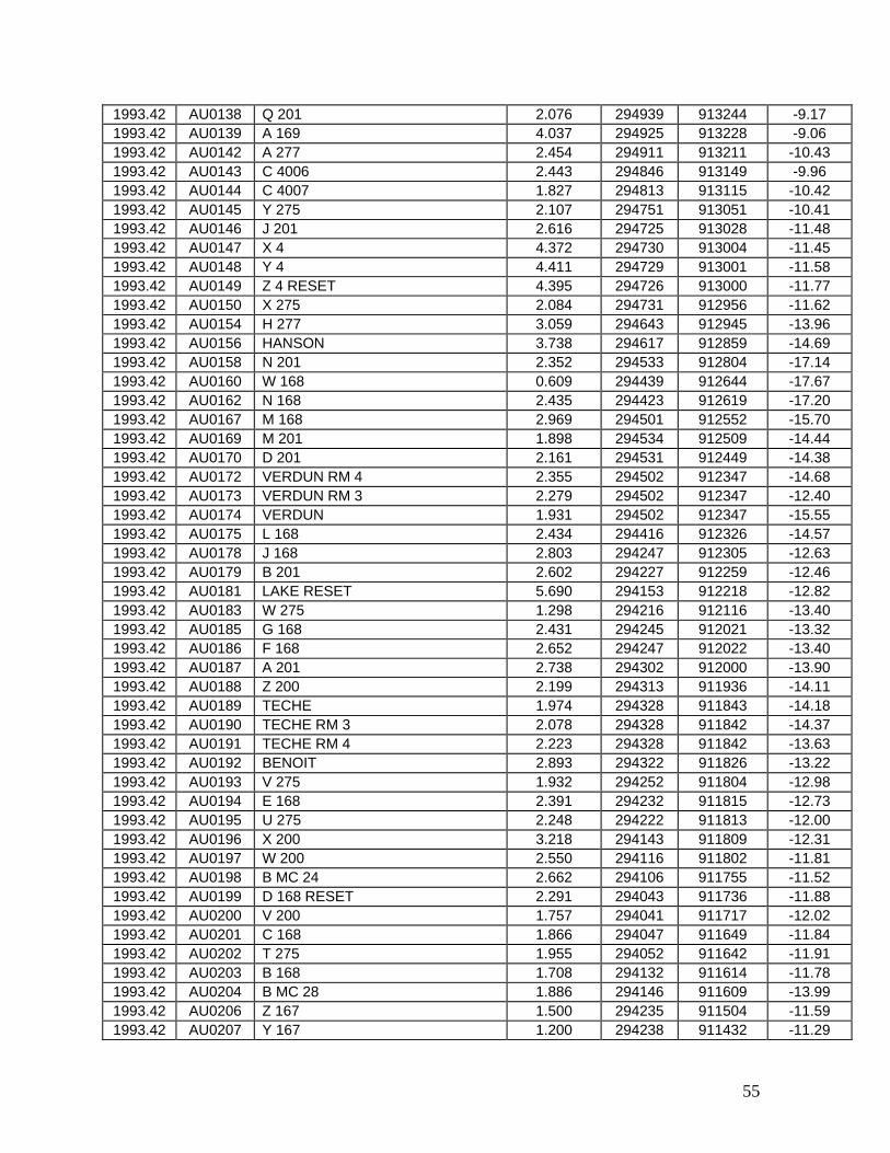
55
1993.42 AU0138 Q 201 2.076 294939 913244 -9.17 1993.42 AU0139 A 169 4.037 294925 913228 -9.06 1993.42 AU0142 A 277 2.454 294911 913211 -10.43 1993.42 AU0143 C 4006 2.443 294846 913149 -9.96 1993.42 AU0144 C 4007 1.827 294813 913115 -10.42 1993.42 AU0145 Y 275 2.107 294751 913051 -10.41 1993.42 AU0146 J 201 2.616 294725 913028 -11.48 1993.42 AU0147 X 4 4.372 294730 913004 -11.45 1993.42 AU0148 Y 4 4.411 294729 913001 -11.58 1993.42 AU0149 Z 4 RESET 4.395 294726 913000 -11.77 1993.42 AU0150 X 275 2.084 294731 912956 -11.62 1993.42 AU0154 H 277 3.059 294643 912945 -13.96 1993.42 AU0156 HANSON 3.738 294617 912859 -14.69 1993.42 AU0158 N 201 2.352 294533 912804 -17.14 1993.42 AU0160 W 168 0.609 294439 912644 -17.67 1993.42 AU0162 N 168 2.435 294423 912619 -17.20 1993.42 AU0167 M 168 2.969 294501 912552 -15.70 1993.42 AU0169 M 201 1.898 294534 912509 -14.44 1993.42 AU0170 D 201 2.161 294531 912449 -14.38 1993.42 AU0172 VERDUN RM 4 2.355 294502 912347 -14.68 1993.42 AU0173 VERDUN RM 3 2.279 294502 912347 -12.40 1993.42 AU0174 VERDUN 1.931 294502 912347 -15.55 1993.42 AU0175 L 168 2.434 294416 912326 -14.57 1993.42 AU0178 J 168 2.803 294247 912305 -12.63 1993.42 AU0179 B 201 2.602 294227 912259 -12.46 1993.42 AU0181 LAKE RESET 5.690 294153 912218 -12.82 1993.42 AU0183 W 275 1.298 294216 912116 -13.40 1993.42 AU0185 G 168 2.431 294245 912021 -13.32 1993.42 AU0186 F 168 2.652 294247 912022 -13.40 1993.42 AU0187 A 201 2.738 294302 912000 -13.90 1993.42 AU0188 Z 200 2.199 294313 911936 -14.11 1993.42 AU0189 TECHE 1.974 294328 911843 -14.18 1993.42 AU0190 TECHE RM 3 2.078 294328 911842 -14.37 1993.42 AU0191 TECHE RM 4 2.223 294328 911842 -13.63 1993.42 AU0192 BENOIT 2.893 294322 911826 -13.22 1993.42 AU0193 V 275 1.932 294252 911804 -12.98 1993.42 AU0194 E 168 2.391 294232 911815 -12.73 1993.42 AU0195 U 275 2.248 294222 911813 -12.00 1993.42 AU0196 X 200 3.218 294143 911809 -12.31 1993.42 AU0197 W 200 2.550 294116 911802 -11.81 1993.42 AU0198 B MC 24 2.662 294106 911755 -11.52 1993.42 AU0199 D 168 RESET 2.291 294043 911736 -11.88 1993.42 AU0200 V 200 1.757 294041 911717 -12.02 1993.42 AU0201 C 168 1.866 294047 911649 -11.84 1993.42 AU0202 T 275 1.955 294052 911642 -11.91 1993.42 AU0203 B 168 1.708 294132 911614 -11.78 1993.42 AU0204 B MC 28 1.886 294146 911609 -13.99 1993.42 AU0206 Z 167 1.500 294235 911504 -11.59 1993.42 AU0207 Y 167 1.200 294238 911432 -11.29

56
1993.42 AU0208 U 200 0.459 294239 911431 -11.17 1993.42 AU0209 V 167 0.817 294200 911346 -11.41 1993.42 AU0211 CORBIN 1.515 294151 911311 -11.00 1993.42 AU0212 T 200 2.099 294142 911305 -11.12 1993.42 AU0213 K 7 RESET 2.423 294131 911254 -11.62 1993.42 AU0214 S 200 4.775 294136 911234 -12.67 1993.42 AU0215 W 7 RESET 4.055 294137 911230 -11.34 1993.42 AU0216 MAX 2.055 294140 911221 -11.04 1993.42 AU0217 PTS 23 1.745 294139 911221 -10.73 1993.42 AU0218 F 198 2.292 294139 911216 -10.96 1993.42 AU0219 Q 167 2.907 294138 911157 -11.03 1993.42 AU0220 P 167 3.313 294131 911115 -11.65 1993.42 AU0223 G 198 1.355 294131 911115 -11.16 1993.42 AU0225 E 198 3.745 294116 910937 -11.61 1993.42 AU0232 L 167 2.502 294014 910732 -13.76 1993.42 AU0234 U 276 3.462 294007 910600 -12.26 1993.42 AU0237 T 276 0.369 294007 910534 -12.28 1993.42 AU0239 H 167 1.953 294003 910333 -13.43 1993.42 AU0241 V 276 0.836 293954 910222 -11.88 1993.42 AU0242 A 167 0.609 294006 910134 -11.32 1993.42 AU0243 W 276 1.459 294021 910059 -11.60 1993.42 AU0244 B 167 1.135 294033 910044 -11.44 1993.33 AU0245 T 298 1.255 294051 910025 -9.72 1993.42 AU0246 C 167 2.127 294110 910004 -13.61 1993.33 AU0247 Q 298 2.911 294105 905954 -11.17 1993.33 AU0248 C 227 0.605 294103 905934 -9.98 1993.33 AU0249 D 227 1.789 294103 905905 -9.88 1993.33 AU0251 U 298 0.236 294120 905952 -9.99 1993.33 AU0256 N 198 2.317 294121 905929 -10.37 1977.17 AU0257 D 167 1.605 294125 905907 -14.80 1977.17 AU0258 E 167 2.011 294136 905800 -14.82 1977.17 AU0259 WELL 6 0.537 294133 905757 -12.54 1977.17 AU0260 F 167 2.663 294146 905710 -12.43 1977.17 AU0261 G 167 2.372 294156 905609 -14.55 1977.17 AU0262 X 166 1.409 294212 905515 -11.61 1977.17 AU0263 CHACAHOULA RM 2 1.407 294223 905435 -11.92 1977.17 AU0264 CHACAHOULA RM 1 1.514 294223 905435 -12.13 1977.17 AU0265 D 8 2.158 294223 905441 -12.53 1977.17 AU0266 P 198 2.970 294224 905440 -12.49 1977.17 AU0267 Y 166 1.451 294230 905421 -13.53 1977.17 AU0268 W 166 2.399 294253 905324 -17.81 1977.17 AU0269 V 166 2.345 294316 905231 -19.19 1977.17 AU0270 U 166 2.116 294340 905137 -17.50 1977.17 AU0271 T 166 2.373 294402 905043 -16.15 1977.17 AU0272 X 276 1.771 294413 905015 -15.25 1977.17 AU0273 S 166 2.239 294426 904947 -15.06 1977.17 AU0274 L 198 3.384 294441 904910 -15.12 1977.17 AU0275 SCHRIEVER NB RM 3 3.514 294445 904901 -15.33 1977.17 AU0276 Y 276 5.224 294453 904847 -15.92
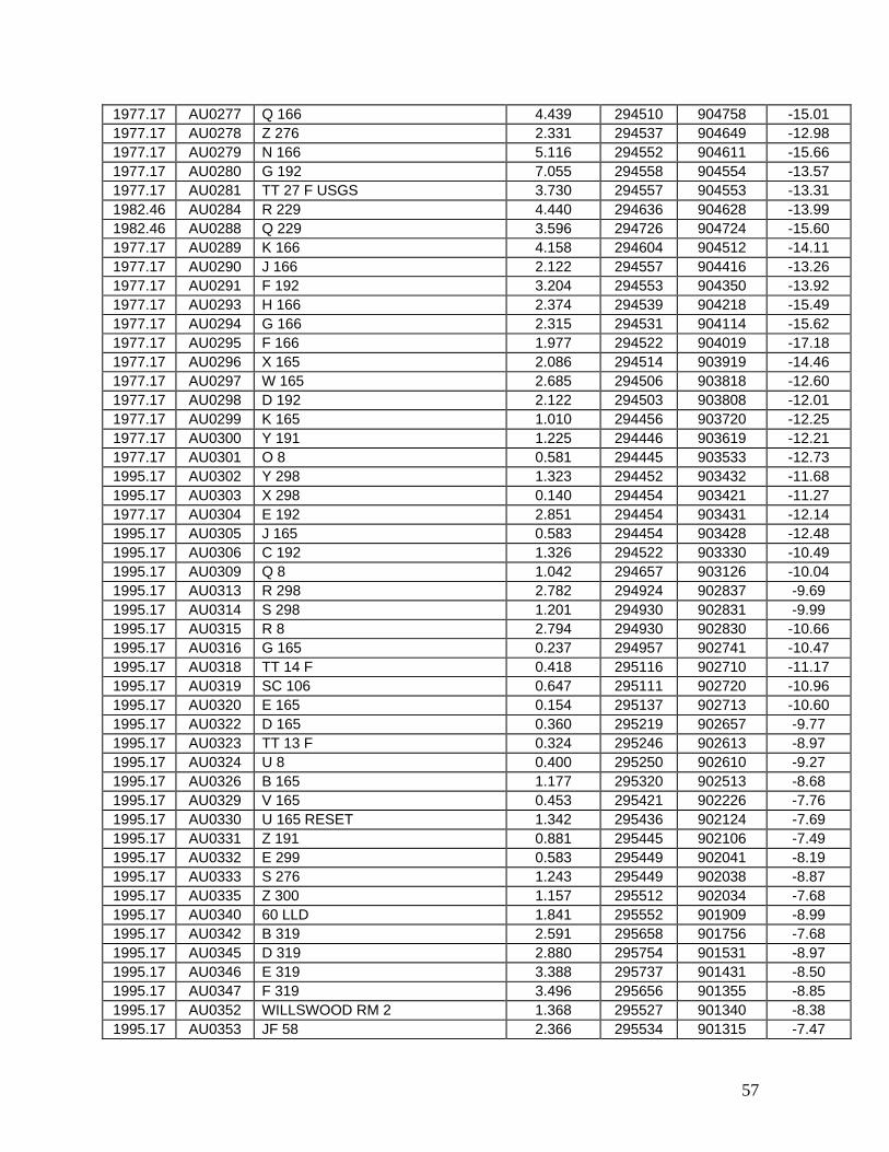
57
1977.17 AU0277 Q 166 4.439 294510 904758 -15.01 1977.17 AU0278 Z 276 2.331 294537 904649 -12.98 1977.17 AU0279 N 166 5.116 294552 904611 -15.66 1977.17 AU0280 G 192 7.055 294558 904554 -13.57 1977.17 AU0281 TT 27 F USGS 3.730 294557 904553 -13.31 1982.46 AU0284 R 229 4.440 294636 904628 -13.99 1982.46 AU0288 Q 229 3.596 294726 904724 -15.60 1977.17 AU0289 K 166 4.158 294604 904512 -14.11 1977.17 AU0290 J 166 2.122 294557 904416 -13.26 1977.17 AU0291 F 192 3.204 294553 904350 -13.92 1977.17 AU0293 H 166 2.374 294539 904218 -15.49 1977.17 AU0294 G 166 2.315 294531 904114 -15.62 1977.17 AU0295 F 166 1.977 294522 904019 -17.18 1977.17 AU0296 X 165 2.086 294514 903919 -14.46 1977.17 AU0297 W 165 2.685 294506 903818 -12.60 1977.17 AU0298 D 192 2.122 294503 903808 -12.01 1977.17 AU0299 K 165 1.010 294456 903720 -12.25 1977.17 AU0300 Y 191 1.225 294446 903619 -12.21 1977.17 AU0301 O 8 0.581 294445 903533 -12.73 1995.17 AU0302 Y 298 1.323 294452 903432 -11.68 1995.17 AU0303 X 298 0.140 294454 903421 -11.27 1977.17 AU0304 E 192 2.851 294454 903431 -12.14 1995.17 AU0305 J 165 0.583 294454 903428 -12.48 1995.17 AU0306 C 192 1.326 294522 903330 -10.49 1995.17 AU0309 Q 8 1.042 294657 903126 -10.04 1995.17 AU0313 R 298 2.782 294924 902837 -9.69 1995.17 AU0314 S 298 1.201 294930 902831 -9.99 1995.17 AU0315 R 8 2.794 294930 902830 -10.66 1995.17 AU0316 G 165 0.237 294957 902741 -10.47 1995.17 AU0318 TT 14 F 0.418 295116 902710 -11.17 1995.17 AU0319 SC 106 0.647 295111 902720 -10.96 1995.17 AU0320 E 165 0.154 295137 902713 -10.60 1995.17 AU0322 D 165 0.360 295219 902657 -9.77 1995.17 AU0323 TT 13 F 0.324 295246 902613 -8.97 1995.17 AU0324 U 8 0.400 295250 902610 -9.27 1995.17 AU0326 B 165 1.177 295320 902513 -8.68 1995.17 AU0329 V 165 0.453 295421 902226 -7.76 1995.17 AU0330 U 165 RESET 1.342 295436 902124 -7.69 1995.17 AU0331 Z 191 0.881 295445 902106 -7.49 1995.17 AU0332 E 299 0.583 295449 902041 -8.19 1995.17 AU0333 S 276 1.243 295449 902038 -8.87 1995.17 AU0335 Z 300 1.157 295512 902034 -7.68 1995.17 AU0340 60 LLD 1.841 295552 901909 -8.99 1995.17 AU0342 B 319 2.591 295658 901756 -7.68 1995.17 AU0345 D 319 2.880 295754 901531 -8.97 1995.17 AU0346 E 319 3.388 295737 901431 -8.50 1995.17 AU0347 F 319 3.496 295656 901355 -8.85 1995.17 AU0352 WILLSWOOD RM 2 1.368 295527 901340 -8.38 1995.17 AU0353 JF 58 2.366 295534 901315 -7.47

58
1995.17 AU0356 Y 190 2.164 295509 901227 -7.92 1995.17 AU0356 Y 190 2.164 295509 901227 -7.92 1993.33 AU0385 Q 154 RESET 0.272 291348 901244 -14.38 1984.58 AU0402 R 276 3.719 295536 901224 -9.03 1994.92 AU0413 Q 147 0.747 295811 900938 -7.86 1994.92 AU0417 M 188 1.017 295829 900917 -7.90 1994.92 AU0419 A 276 1.775 295914 900820 -8.91 1994.92 AU0420 U 147 0.806 295914 900743 -9.75 1994.92 AU0422 L 188 2.341 295919 900700 -9.94 1994.92 AU0423 P 188 1.359 295927 900635 -11.07 1994.92 AU0425 45 B -0.002 295940 900604 -12.45 1994.92 AU0427 W 147 -0.437 295935 900533 -12.80 1994.92 AU0428 Y 147 0.408 295935 900513 -11.96 1994.92 AU0429 A 148 1.661 295921 900513 -11.01 1994.92 AU0431 F 156 -1.210 295925 900415 -10.11 1994.92 AU0434 D 3120 0.161 295944 900345 -10.93 1994.92 AU0435 P 193 0.365 300000 900332 -8.02 1993.33 AU0451 BOWIE 2 0.285 294220 903720 -9.34 1986.50 AU0463 SHELL 20 4.125 295948 902438 -7.29 1986.50 AU0466 B 146 4.281 295931 902414 -9.88 1986.50 AU0471 C 188 2.636 295920 902353 -10.30 1986.50 AU0472 P 93 1.755 295837 902325 -9.27 1986.50 AU0481 B 188 4.053 295629 902121 -9.65 1986.50 AU0489 V 188 3.167 295616 902018 -9.17 1986.50 AU0493 E 146 4.029 295631 901922 -10.42 1986.50 AU0494 K 93 3.868 295701 901846 -9.33 1986.50 AU0504 A 188 1.818 295813 901722 -11.35 1986.50 AU0508 G 146 2.681 295832 901543 -11.46 1993.25 AU0512 H 146 2.357 295829 901508 -7.92 1986.50 AU0512 H 146 2.387 295829 901508 -9.96 1993.25 AU0518 J 146 RESET 2.127 295821 901438 -7.96 1986.50 AU0518 J 146 RESET 2.158 295821 901438 -10.06 1993.25 AU0520 S 188 2.237 295801 901345 -7.34 1984.58 AU0526 Q 276 1.588 295708 901251 -7.97 1984.58 AU0530 Q 188 1.959 295627 901247 -9.73 1984.58 AU0531 46 2.551 295610 901235 -10.37 1995.17 AU0676 Q 189 -0.040 295733 900034 -7.23 1995.17 AU0682 U 157 1.480 295410 900602 -8.71 1995.17 AU0686 J 190 RESET 0.691 295337 900603 -8.79 1995.17 AU0689 P 190 1.455 295142 900554 -6.50 1995.17 AU0691 S 190 RESET 0.633 295111 900631 -6.14 1995.17 AU0692 T 190 0.482 295136 900636 -6.13 1995.17 AU0693 U 190 0.899 295239 900650 -5.79 1995.17 AU0697 V 157 1.900 295353 900613 -9.00 1995.17 AU0729 W 190 1.420 295452 901029 -8.85 1993.25 AU0766 NEW ORLEANS W BASE 2 0.545 295845 901422 -8.26 1993.25 AU0775 HANSEN 0.903 295858 901440 -7.23 1995.17 AU0934 GRETNA 2 0.431 295516 900305 -8.76 1995.17 AU0935 GRETNA 1.042 295504 900329 -9.43

59
1995.17 AU0941 T 157 1.772 295454 900351 -9.41 1995.17 AU0944 WTPS RESET -0.337 295450 900248 -7.44 1995.08 AU0948 F 190 -0.345 295528 900202 -0.85 1995.17 AU0952 SHEAR 0.875 295430 900423 -9.20 1995.17 AU0963 HARVEY RM 2 2.012 295431 900502 -9.61 1995.17 AU0964 HARVEY RM 3 3.168 295428 900502 -9.27 1995.17 AU0965 1601 6.417 295434 900503 -9.29 1993.25 AU1085 P 276 -0.643 295915 901625 -8.34 1993.25 AU1086 R 18 1.278 295944 901708 -10.38 1993.33 AU1091 F 220 1.603 293620 902923 -12.13 1993.33 AU1094 G 220 1.642 293550 902904 -13.79 1993.33 AU1097 H 220 1.472 293537 902801 -14.29 1993.33 AU1100 HARANG RESET 2.175 293527 902706 -16.32 1993.33 AU1101 HARANG RM 3 1.470 293527 902707 -15.91 1993.33 AU1104 HARANG AZ MK 3.154 293520 902637 -18.92 1993.33 AU1105 N 220 1.410 293512 902614 -15.73 1993.33 AU1107 P 220 1.549 293503 902519 -12.12 1993.33 AU1109 Q 220 1.090 293439 902417 -11.01 1993.33 AU1112 S 220 1.802 293432 902337 -10.10 1993.33 AU1115 LAROSE AZ MK RESET 2.289 293427 902318 -10.84 1993.33 AU1117 LAROSE 1.908 293419 902259 -11.01 1993.33 AU1118 LAROSE RM 3 2.035 293419 902259 -12.80 1993.33 AU1123 R 220 0.972 293319 902103 -11.25 1993.33 AU1125 TT 36 L 0.994 293245 902021 -12.42 1993.33 AU1126 R 155 1.176 293245 902021 -12.71 1993.33 AU1127 K 220 1.521 293205 902008 -13.13 1993.33 AU1130 G 221 1.198 293055 901958 -13.90 1993.33 AU1131 L 220 1.460 292956 901943 -13.35 1984.58 AU1143 G 281 1.093 294747 900017 -8.25 1984.58 AU1146 222/2 CAP 1.455 294732 900020 -8.23 1984.58 AU1152 U 278 0.757 294648 900050 -6.02 1984.58 AU1153 Q 151 2.643 294550 900102 -7.13 1995.08 AU1163 T 196 -1.247 295547 900155 -0.89 1995.08 AU1169 V 196 RESET -1.500 295425 900105 -51.94 1995.08 AU1170 A 200 -1.268 295446 900104 -5.55 1995.08 AU1175 Z 196 -1.262 295437 900024 -4.33 1995.08 AU1176 U 196 -0.434 295516 900052 -0.90 1995.08 AU1178 W 196 RESET -1.211 295527 900112 -3.21 1993.33 AU1207 M 220 0.536 292603 901750 -10.62 1993.33 AU1209 U 220 0.373 292516 901717 -11.53 1993.33 AU1212 V 220 0.512 292437 901630 -12.47 1993.33 AU1213 X 220 0.245 292405 901620 -11.35 1993.33 AU1216 C 154 RESET -0.051 292320 901553 -15.59 1993.33 AU1225 W 220 RESET 0.000 292319 901552 -15.32 1993.33 AU1226 Y 220 0.157 292232 901534 -12.13 1993.33 AU1228 E 154 -0.061 292146 901518 -13.11 1993.33 AU1229 Z 220 -0.025 292142 901515 -10.79 1993.33 AU1231 POLE 0.591 292023 901445 -11.12 1993.33 AU1236 ICE -0.056 291918 901421 -10.99

60
1993.33 AU1238 LEE 0.492 291822 901406 -10.67 1993.33 AU1242 C 221 0.290 291725 901353 -11.22 1993.33 AU1245 E 221 0.693 291549 901304 -12.10 1993.33 AU1255 JESSE 0.284 291406 901235 -12.68 1993.33 AU1257 J 221 0.063 291305 901303 -11.60 1993.33 AU1265 MARSH 0.271 290934 901051 -9.41 1993.33 AU1277 B 155 RESET 0.556 291053 900605 -13.48 1993.33 AU1285 Y 222 0.380 291217 900331 -7.77 1993.33 AU1289 P 221 0.943 291238 900258 -8.18 1993.33 AU1291 N 221 1.593 291216 900224 -11.69 1993.50 AU1298 F 233 1.442 293035 903515 -10.45 1993.50 AU1299 G 233 1.214 292957 903437 -10.25 1993.50 AU1300 H 233 0.647 292927 903424 -11.32 1993.50 AU1301 J 233 2.521 292855 903446 -12.73 1993.50 AU1302 K 233 2.040 292807 903525 -13.66 1993.50 AU1303 L 233 1.777 292741 903520 -13.71 1993.50 AU1304 M 233 1.667 292700 903535 -14.03 1993.50 AU1305 N 233 0.831 292603 903546 -14.89 1993.50 AU1306 P 233 0.901 292519 903609 -12.44 1993.50 AU1307 Q 233 0.770 292428 903628 -10.76 1993.50 AU1308 R 233 1.426 292340 903646 -9.55 1993.50 AU1309 S 233 3.217 292308 903712 -14.94 1993.50 AU1312 V 233 1.546 292057 903740 -11.60 1993.50 AU1313 W 233 0.670 292016 903816 -9.46 1993.50 AU1314 X 233 3.460 291956 903834 -11.68 1993.50 AU1317 Y 233 0.449 291909 903844 -7.97 1993.50 AU1319 Z 233 0.692 291750 903856 -7.11 1993.50 AU1320 R 231 1.071 291654 903840 -7.57 1993.50 AU1321 P 232 0.255 291633 903847 -7.21 1993.50 AU1323 LITTLER RM 4 0.503 291444 903942 -8.05 1993.50 AU1325 LITTLER RM 1 0.382 291444 903942 -8.68 1993.33 AU1344 A 220 3.539 294345 903556 -11.18 1993.33 AU1353 GEORGIA RM 1 3.107 294140 903305 -8.18 1993.33 AU1358 Z 219 2.795 293956 903213 -9.59 1993.33 AU1366 E 4606 1.977 293803 903032 -11.79 1982.46 AU1369 S 228 5.018 295512 905916 -9.31 1982.46 AU1370 U 228 4.802 295439 905913 -9.95 1982.46 AU1371 A 229 4.810 295354 905914 -12.20 1982.46 AU1372 TT STA 53 USGS 4.702 295331 905920 -10.89 1982.46 AU1373 B 229 4.663 295249 905921 -10.51 1982.46 AU1374 V 228 4.754 295216 905913 -10.29 1982.46 AU1376 X 228 4.549 295111 905811 -9.39 1982.46 AU1377 Y 228 3.906 295042 905735 -9.54 1982.46 AU1378 Z 228 5.226 295024 905716 -9.89 1982.46 AU1379 C 229 4.339 294951 905616 -8.95 1982.46 AU1380 D 229 1.853 294945 905523 -9.01 1982.46 AU1381 E 229 4.290 294932 905449 -9.88 1982.46 AU1382 F 229 4.315 294909 905343 -10.72 1982.46 AU1383 G 229 3.964 294856 905251 -12.03

61
1982.46 AU1384 1336+40 USE 5.464 294843 905210 -12.96 1982.46 AU1385 TT 29 F USGS 4.168 294843 905210 -13.12 1982.46 AU1386 H 229 2.322 294825 905133 -13.17 1982.46 AU1387 J 229 4.279 294802 905035 -13.41 1982.46 AU1388 K 229 4.001 294755 905019 -14.37 1982.46 AU1389 Y 229 3.825 294745 904938 -17.32 1982.46 AU1390 M 229 5.348 294751 904920 -15.46 1982.46 AU1391 TT 28 F USGS 4.251 294752 904840 -16.15 1982.46 AU1392 N 229 3.529 294743 904805 -18.70 1993.33 AU1396 F 227 1.281 293855 905808 -10.91 1993.33 AU1398 G 227 1.171 293834 905740 -12.54 1993.33 AU1399 ARSENAUX 1.131 293817 905714 -14.20 1993.33 AU1401 ARSENAUX RM 2 1.119 293810 905659 -14.74 1993.33 AU1402 B 4649 1.166 293753 905607 -16.58 1993.33 AU1403 H 227 0.836 293752 905552 -17.00 1993.33 AU1404 K 227 1.526 293743 905502 -18.58 1993.33 AU1405 J 227 2.245 293741 905503 -18.75 1993.33 AU1406 L 227 1.077 293710 905411 -20.94 1993.33 AU1407 M 227 1.345 293630 905320 -23.48 1993.33 AU1409 N 227 1.350 293622 905219 -22.65 1993.33 AU1411 P 227 2.080 293628 905138 -21.51 1993.33 AU1412 Q 227 2.213 293624 905137 -21.50 1993.33 AU1413 TT 37 F 1.554 293630 905117 -21.15 1993.33 AU1415 R 227 1.455 293620 905019 -22.27 1993.33 AU1418 S 227 1.412 293540 904937 -20.09 1993.33 AU1420 B 4668 2.293 293509 904912 -19.77 1993.33 AU1424 T 227 2.975 293340 904734 -15.37 1993.33 AU1425 U 227 2.373 293339 904735 -15.06 1993.33 AU1426 W 227 1.861 293332 904712 -14.77 1993.33 AU1428 X 227 2.517 293356 904614 -14.43 1993.33 AU1433 Y 227 2.241 293430 904437 -14.64 1993.33 AU1434 ABLE AZ MK 3.842 293431 904347 -14.28 1993.33 AU1435 Y 221 2.296 293441 904318 -14.05 1993.33 AU1436 Z 221 1.364 293520 904313 -16.60 1993.50 AU1437 U 221 2.122 293554 904308 -18.21 1993.50 AU1439 S 221 2.229 293552 904213 -18.22 1993.50 AU1440 T 221 1.215 293550 904143 -16.78 1993.50 AU1441 A 222 1.141 293528 904044 -15.36 1993.50 AU1444 D 222 2.569 293347 903852 -7.29 1993.33 AU1464 J 109 0.696 294302 903654 -10.38 1993.50 AU1489 C 4612 3.751 293553 904237 -16.87 1993.50 AU1499 CB 1.629 293456 904026 -11.62 1993.50 AU1500 DB 1.641 293448 904014 -10.59 1993.50 AU1501 EB 1.647 293447 904013 -10.28 1993.50 AU1504 A 233 2.146 293312 903819 -7.22 1993.50 AU1505 B 233 2.887 293231 903740 -5.62 1993.50 AU1506 C 233 2.294 293209 903709 -5.61 1993.50 AU1507 D 233 2.336 293155 903620 -6.29 1993.50 AU1508 E 233 1.956 293117 903556 -10.04
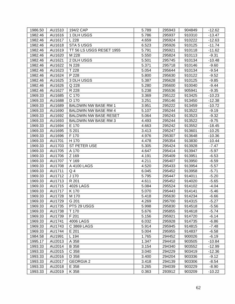
62
1986.50 AU1510 194/2 CAP 5.789 295943 904849 -12.62 1982.46 AU1616 1 DLH USGS 5.786 295937 910310 -13.47 1982.46 AU1617 L 228 4.659 295924 910222 -12.63 1982.46 AU1618 STA 5 USGS 6.523 295926 910125 -11.74 1982.46 AU1619 TT 56 LS USGS RESET 1955 5.791 295921 910118 -11.62 1982.46 AU1620 M 228 5.550 295824 910113 -9.31 1982.46 AU1621 2 DLH USGS 5.501 295745 910134 -10.48 1982.46 AU1622 N 228 5.371 295718 910146 -9.60 1982.46 AU1623 T 228 5.054 295644 910134 -9.54 1982.46 AU1624 P 228 5.800 295630 910122 -9.52 1982.46 AU1625 3 DLH USGS 5.387 295628 910125 -9.85 1982.46 AU1626 Q 228 5.280 295600 910040 -9.44 1982.46 AU1627 R 228 5.238 295536 905941 -9.35 1969.33 AU1685 C 170 3.369 295122 913425 -10.23 1969.33 AU1688 D 170 3.251 295146 913450 -12.38 1969.33 AU1689 BALDWIN NW BASE RM 1 3.951 295222 913459 -10.72 1969.33 AU1690 BALDWIN NW BASE RM 4 5.107 295244 913522 -9.19 1969.33 AU1692 BALDWIN NW BASE RESET 5.064 295243 913523 -9.32 1969.33 AU1693 BALDWIN NW BASE RM 3 4.493 295244 913522 -9.75 1969.33 AU1694 E 170 4.663 295242 913552 -18.45 1969.33 AU1695 S 201 3.413 295247 913601 -10.25 1969.33 AU1696 F 170 4.976 295307 913648 -10.36 1969.33 AU1701 H 170 4.478 295354 913830 -10.44 1969.33 AU1703 ST PETER USE 5.305 295424 913928 -7.47 1969.33 AU1705 A 170 4.647 295414 913947 -5.97 1969.33 AU1706 Z 169 4.191 295409 913951 -6.53 1969.33 AU1707 Y 169 4.211 295407 913950 -6.59 1969.33 AU1708 A 4100 LAGS 4.520 295433 913954 -5.57 1969.33 AU1711 Q 4 6.045 295452 913958 -5.71 1969.33 AU1712 J 170 5.795 295447 914011 -5.20 1969.33 AU1713 R 201 4.611 295452 914020 -5.65 1969.33 AU1715 4026 LAGS 5.084 295524 914102 -4.04 1969.33 AU1717 K 170 5.070 295443 914141 -5.46 1969.33 AU1728 M 170 5.418 295630 914234 -6.66 1969.33 AU1729 G 201 4.269 295700 914315 -5.27 1969.33 AU1735 PTS 29 USGS 5.998 295830 914518 -5.56 1969.33 AU1738 T 170 5.676 295855 914618 -5.74 1969.33 AU1739 F 201 5.156 295921 914720 -6.14 1969.33 AU1741 4006 LAGS 6.032 295928 914735 -6.86 1969.33 AU1743 C 3869 LAGS 5.914 295945 914815 -7.48 1969.33 AU1744 E 201 5.004 295955 914837 -6.58 1984.58 AU1991 L 194 1.765 294452 900026 -6.19 1995.17 AU2013 A 358 1.347 294418 903505 -10.84 1993.33 AU2014 B 358 3.154 294340 903552 -12.99 1993.33 AU2015 C 358 3.040 294229 903419 -12.36 1993.33 AU2016 D 358 3.400 294204 903336 -9.12 1993.33 AU2017 GEORGIA 2 3.418 294139 903306 -8.54 1993.33 AU2018 E 358 3.265 294039 903229 -8.90 1993.33 AU2019 K 358 0.363 293912 903209 -10.22
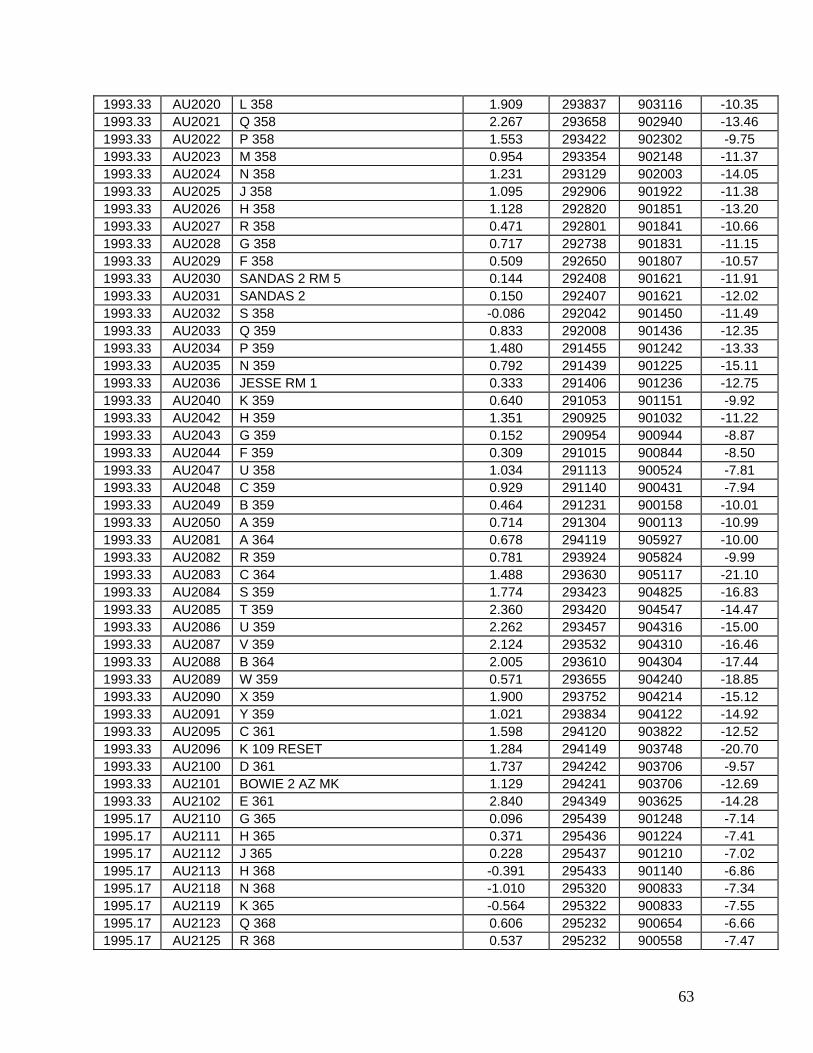
63
1993.33 AU2020 L 358 1.909 293837 903116 -10.35 1993.33 AU2021 Q 358 2.267 293658 902940 -13.46 1993.33 AU2022 P 358 1.553 293422 902302 -9.75 1993.33 AU2023 M 358 0.954 293354 902148 -11.37 1993.33 AU2024 N 358 1.231 293129 902003 -14.05 1993.33 AU2025 J 358 1.095 292906 901922 -11.38 1993.33 AU2026 H 358 1.128 292820 901851 -13.20 1993.33 AU2027 R 358 0.471 292801 901841 -10.66 1993.33 AU2028 G 358 0.717 292738 901831 -11.15 1993.33 AU2029 F 358 0.509 292650 901807 -10.57 1993.33 AU2030 SANDAS 2 RM 5 0.144 292408 901621 -11.91 1993.33 AU2031 SANDAS 2 0.150 292407 901621 -12.02 1993.33 AU2032 S 358 -0.086 292042 901450 -11.49 1993.33 AU2033 Q 359 0.833 292008 901436 -12.35 1993.33 AU2034 P 359 1.480 291455 901242 -13.33 1993.33 AU2035 N 359 0.792 291439 901225 -15.11 1993.33 AU2036 JESSE RM 1 0.333 291406 901236 -12.75 1993.33 AU2040 K 359 0.640 291053 901151 -9.92 1993.33 AU2042 H 359 1.351 290925 901032 -11.22 1993.33 AU2043 G 359 0.152 290954 900944 -8.87 1993.33 AU2044 F 359 0.309 291015 900844 -8.50 1993.33 AU2047 U 358 1.034 291113 900524 -7.81 1993.33 AU2048 C 359 0.929 291140 900431 -7.94 1993.33 AU2049 B 359 0.464 291231 900158 -10.01 1993.33 AU2050 A 359 0.714 291304 900113 -10.99 1993.33 AU2081 A 364 0.678 294119 905927 -10.00 1993.33 AU2082 R 359 0.781 293924 905824 -9.99 1993.33 AU2083 C 364 1.488 293630 905117 -21.10 1993.33 AU2084 S 359 1.774 293423 904825 -16.83 1993.33 AU2085 T 359 2.360 293420 904547 -14.47 1993.33 AU2086 U 359 2.262 293457 904316 -15.00 1993.33 AU2087 V 359 2.124 293532 904310 -16.46 1993.33 AU2088 B 364 2.005 293610 904304 -17.44 1993.33 AU2089 W 359 0.571 293655 904240 -18.85 1993.33 AU2090 X 359 1.900 293752 904214 -15.12 1993.33 AU2091 Y 359 1.021 293834 904122 -14.92 1993.33 AU2095 C 361 1.598 294120 903822 -12.52 1993.33 AU2096 K 109 RESET 1.284 294149 903748 -20.70 1993.33 AU2100 D 361 1.737 294242 903706 -9.57 1993.33 AU2101 BOWIE 2 AZ MK 1.129 294241 903706 -12.69 1993.33 AU2102 E 361 2.840 294349 903625 -14.28 1995.17 AU2110 G 365 0.096 295439 901248 -7.14 1995.17 AU2111 H 365 0.371 295436 901224 -7.41 1995.17 AU2112 J 365 0.228 295437 901210 -7.02 1995.17 AU2113 H 368 -0.391 295433 901140 -6.86 1995.17 AU2118 N 368 -1.010 295320 900833 -7.34 1995.17 AU2119 K 365 -0.564 295322 900833 -7.55 1995.17 AU2123 Q 368 0.606 295232 900654 -6.66 1995.17 AU2125 R 368 0.537 295232 900558 -7.47
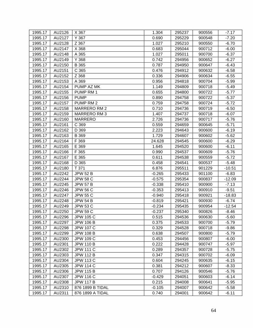
64
1995.17 AU2126 X 367 1.304 295237 900556 -7.17 1995.17 AU2127 Y 367 0.690 295229 900548 -7.20 1995.17 AU2128 Z 367 1.027 295210 900550 -6.70 1995.17 AU2147 X 368 0.683 295044 900712 -6.00 1995.17 AU2148 A 365 1.027 295011 900700 -6.37 1995.17 AU2149 Y 368 0.742 294956 900652 -6.27 1995.17 AU2150 B 365 0.787 294950 900647 -6.43 1995.17 AU2151 C 365 0.476 294912 900632 -6.58 1995.17 AU2152 Z 368 0.336 294906 900634 -6.55 1995.17 AU2153 A 369 0.956 294818 900704 -5.99 1995.17 AU2154 PUMP AZ MK 1.149 294809 900718 -5.49 1995.17 AU2155 PUMP RM 1 0.655 294800 900722 -5.77 1995.17 AU2156 PUMP 0.890 294758 900722 -5.37 1995.17 AU2157 PUMP RM 2 0.759 294758 900724 -5.72 1995.17 AU2158 MARRERO RM 2 0.710 294736 900719 -6.50 1995.17 AU2159 MARRERO RM 3 1.407 294737 900718 -6.07 1995.17 AU2160 MARRERO 2.726 294736 900717 -5.76 1995.17 AU2161 C 369 0.559 294659 900645 -5.71 1995.17 AU2162 D 369 2.223 294643 900600 -6.19 1995.17 AU2163 B 369 1.729 294607 900602 -5.62 1995.17 AU2164 F 369 24.628 294545 900600 -6.29 1995.17 AU2165 E 369 1.645 294520 900600 -6.11 1995.17 AU2166 F 365 0.990 294537 900609 -5.76 1995.17 AU2167 E 365 0.611 294538 900559 -5.72 1995.17 AU2168 D 365 0.458 294541 900537 -5.48 1995.17 AU2180 T 371 6.876 295511 901229 -10.51 1995.17 AU2242 JPW 52 B -0.265 295433 901100 -6.83 1995.17 AU2244 JPW 58 C -0.575 295354 900837 -12.09 1995.17 AU2245 JPW 57 B -0.338 295410 900900 -7.13 1995.17 AU2246 JPW 56 C -0.353 295413 900910 -9.51 1995.17 AU2247 JPW 55 C -0.940 295418 900921 -18.83 1995.17 AU2248 JPW 54 B -0.819 295421 900930 -6.74 1995.17 AU2249 JPW 53 C -0.234 295435 900954 -12.54 1995.17 AU2250 JPW 59 C -0.237 295340 900826 -8.46 1995.17 AU2296 JPW 105 C 0.515 294536 900630 -5.60 1995.17 AU2297 JPW 106 B 0.375 294533 900700 -5.79 1995.17 AU2298 JPW 107 C 0.329 294528 900718 -9.86 1995.17 AU2299 JPW 108 B 0.638 294507 900800 -5.79 1995.17 AU2300 JPW 109 C 0.453 294456 900807 -6.00 1995.17 AU2301 JPW 110 B 0.222 294428 900747 -5.97 1995.17 AU2302 JPW 111 C 0.289 294357 900728 -5.75 1995.17 AU2303 JPW 112 B 0.347 294315 900702 -6.09 1995.17 AU2304 JPW 113 C 0.604 294245 900635 -6.15 1995.17 AU2305 JPW 114 C 0.381 294212 900607 -8.33 1995.17 AU2306 JPW 115 B 0.707 294126 900546 -5.76 1995.17 AU2307 JPW 116 C -0.429 294051 900603 -6.14 1995.17 AU2308 JPW 117 B 0.215 294008 900641 -5.95 1995.17 AU2310 876 1899 B TIDAL -0.105 294007 900642 -5.58 1995.17 AU2311 876 1899 A TIDAL 0.740 294001 900642 -6.11
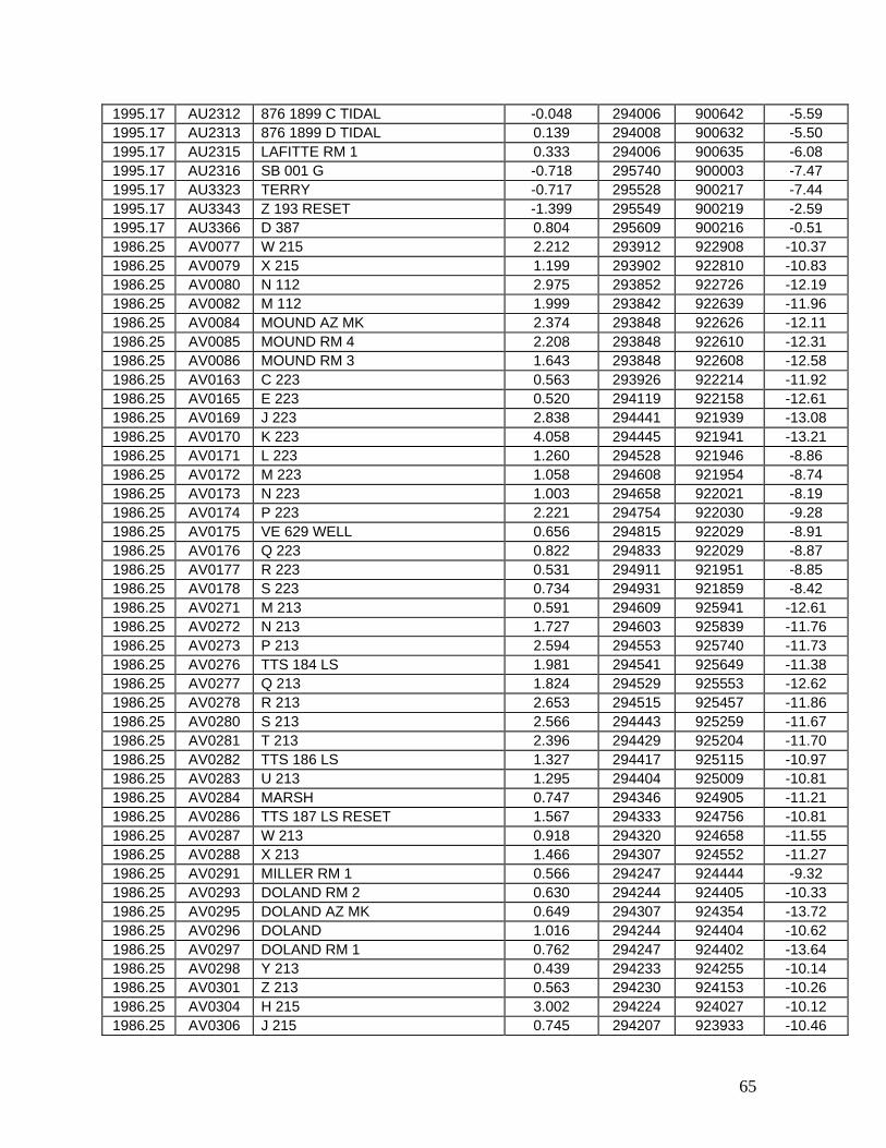
65
1995.17 AU2312 876 1899 C TIDAL -0.048 294006 900642 -5.59 1995.17 AU2313 876 1899 D TIDAL 0.139 294008 900632 -5.50 1995.17 AU2315 LAFITTE RM 1 0.333 294006 900635 -6.08 1995.17 AU2316 SB 001 G -0.718 295740 900003 -7.47 1995.17 AU3323 TERRY -0.717 295528 900217 -7.44 1995.17 AU3343 Z 193 RESET -1.399 295549 900219 -2.59 1995.17 AU3366 D 387 0.804 295609 900216 -0.51 1986.25 AV0077 W 215 2.212 293912 922908 -10.37 1986.25 AV0079 X 215 1.199 293902 922810 -10.83 1986.25 AV0080 N 112 2.975 293852 922726 -12.19 1986.25 AV0082 M 112 1.999 293842 922639 -11.96 1986.25 AV0084 MOUND AZ MK 2.374 293848 922626 -12.11 1986.25 AV0085 MOUND RM 4 2.208 293848 922610 -12.31 1986.25 AV0086 MOUND RM 3 1.643 293848 922608 -12.58 1986.25 AV0163 C 223 0.563 293926 922214 -11.92 1986.25 AV0165 E 223 0.520 294119 922158 -12.61 1986.25 AV0169 J 223 2.838 294441 921939 -13.08 1986.25 AV0170 K 223 4.058 294445 921941 -13.21 1986.25 AV0171 L 223 1.260 294528 921946 -8.86 1986.25 AV0172 M 223 1.058 294608 921954 -8.74 1986.25 AV0173 N 223 1.003 294658 922021 -8.19 1986.25 AV0174 P 223 2.221 294754 922030 -9.28 1986.25 AV0175 VE 629 WELL 0.656 294815 922029 -8.91 1986.25 AV0176 Q 223 0.822 294833 922029 -8.87 1986.25 AV0177 R 223 0.531 294911 921951 -8.85 1986.25 AV0178 S 223 0.734 294931 921859 -8.42 1986.25 AV0271 M 213 0.591 294609 925941 -12.61 1986.25 AV0272 N 213 1.727 294603 925839 -11.76 1986.25 AV0273 P 213 2.594 294553 925740 -11.73 1986.25 AV0276 TTS 184 LS 1.981 294541 925649 -11.38 1986.25 AV0277 Q 213 1.824 294529 925553 -12.62 1986.25 AV0278 R 213 2.653 294515 925457 -11.86 1986.25 AV0280 S 213 2.566 294443 925259 -11.67 1986.25 AV0281 T 213 2.396 294429 925204 -11.70 1986.25 AV0282 TTS 186 LS 1.327 294417 925115 -10.97 1986.25 AV0283 U 213 1.295 294404 925009 -10.81 1986.25 AV0284 MARSH 0.747 294346 924905 -11.21 1986.25 AV0286 TTS 187 LS RESET 1.567 294333 924756 -10.81 1986.25 AV0287 W 213 0.918 294320 924658 -11.55 1986.25 AV0288 X 213 1.466 294307 924552 -11.27 1986.25 AV0291 MILLER RM 1 0.566 294247 924444 -9.32 1986.25 AV0293 DOLAND RM 2 0.630 294244 924405 -10.33 1986.25 AV0295 DOLAND AZ MK 0.649 294307 924354 -13.72 1986.25 AV0296 DOLAND 1.016 294244 924404 -10.62 1986.25 AV0297 DOLAND RM 1 0.762 294247 924402 -13.64 1986.25 AV0298 Y 213 0.439 294233 924255 -10.14 1986.25 AV0301 Z 213 0.563 294230 924153 -10.26 1986.25 AV0304 H 215 3.002 294224 924027 -10.12 1986.25 AV0306 J 215 0.745 294207 923933 -10.46

66
1986.25 AV0311 L 215 0.500 294135 923726 -9.12 1986.25 AV0314 M 215 1.851 294106 923624 -9.08 1986.25 AV0317 P 215 1.869 294012 923421 -8.96 1986.25 AV0318 Q 215 1.862 294014 923408 -9.39 1986.25 AV0320 R 215 1.879 294005 923328 -9.03 1986.25 AV0321 S 215 1.877 294002 923313 -9.08 1986.25 AV0325 U 215 1.892 293934 923119 -9.54 1986.25 AV0331 R 112 RESET 1.396 293918 923009 -9.43 1982.17 AV0332 H 211 2.199 295947 932107 -12.05 1982.17 AV0333 J 211 1.217 295934 932203 -10.38 1982.17 AV0334 K 211 1.107 295843 932159 -10.11 1982.17 AV0336 L 211 0.486 295750 932204 -9.69 1982.17 AV0337 M 211 0.375 295653 932210 -9.40 1982.17 AV0338 TT 147 USGS 2.027 295613 932232 -9.70 1982.17 AV0340 P 211 2.496 295548 932238 -9.23 1982.17 AV0341 Q 211 0.520 295516 932249 -10.05 1982.17 AV0343 S 211 0.265 295343 932317 -12.38 1982.17 AV0344 T 211 2.662 295325 932408 -9.31 1982.17 AV0345 U 211 2.357 295301 932459 -14.02 1982.17 AV0346 V 211 1.077 295246 932533 -12.69 1982.17 AV0347 W 211 0.543 295222 932628 -12.90 1982.17 AV0352 X 211 0.551 295102 932758 -12.32 1982.17 AV0355 A 212 2.387 294907 932812 -12.56 1982.17 AV0356 B 212 0.473 294843 932831 -12.65 1982.17 AV0357 C 212 2.375 294802 932830 -12.73 1982.17 AV0358 D 212 1.155 294717 932804 -12.21 1982.17 AV0359 E 212 0.404 294631 932748 -12.88 1982.17 AV0360 F 212 1.013 294619 932705 -12.35 1982.17 AV0361 HENRY AZ MK 1.275 294618 932616 -13.72 1982.17 AV0363 HOLLYND RM 4 1.483 294605 932441 -15.73 1982.17 AV0364 HOLLYND 1.295 294604 932440 -16.77 1982.17 AV0366 H 212 0.616 294559 932247 -15.29 1982.17 AV0367 J 212 0.807 294601 932202 -12.51 1982.17 AV0368 K 212 0.760 294628 932104 -12.76 1982.17 AV0373 60+00 USE 1.547 294654 932048 -17.12 1982.17 AV0374 L 212 1.569 294744 932058 -17.20 1982.17 AV0375 M 212 1.060 294809 932054 -14.95 1982.17 AV0376 N 212 2.320 294809 932043 -4.68 1982.17 AV0377 TT 154 LS USGS 0.945 294754 931941 -16.38 1982.17 AV0381 Q 212 1.395 294741 931843 -14.58 1982.17 AV0382 R 212 1.433 294715 931807 -14.27 1982.17 AV0388 T 212 1.321 294709 931714 -15.19 1982.17 AV0389 U 212 0.861 294712 931605 -12.42 1982.17 AV0390 V 212 1.185 294717 931506 -12.67 1982.17 AV0391 W 212 1.505 294723 931355 -12.42 1982.17 AV0392 X 212 0.679 294751 931331 -12.08 1982.17 AV0393 Y 212 0.823 294807 931241 -13.08 1982.17 AV0394 TT 179 LS USGS 0.906 294815 931155 -14.48 1982.17 AV0395 Z 212 0.821 294817 931101 -13.30
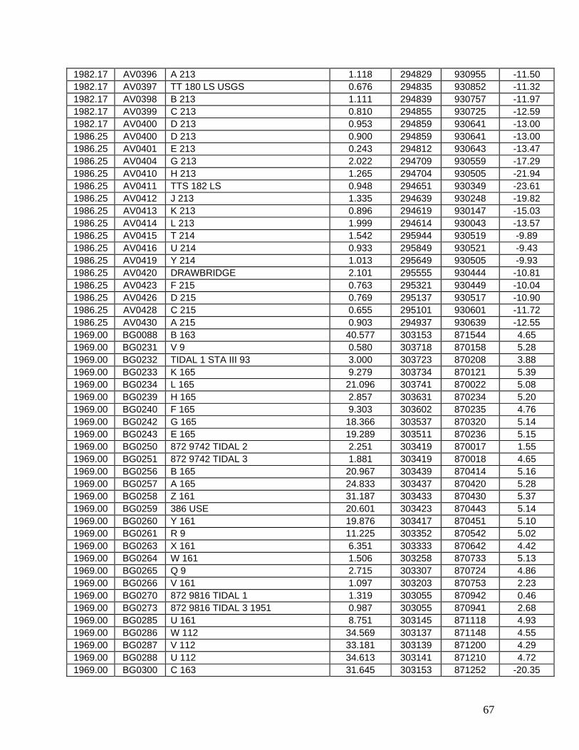
67
1982.17 AV0396 A 213 1.118 294829 930955 -11.50 1982.17 AV0397 TT 180 LS USGS 0.676 294835 930852 -11.32 1982.17 AV0398 B 213 1.111 294839 930757 -11.97 1982.17 AV0399 C 213 0.810 294855 930725 -12.59 1982.17 AV0400 D 213 0.953 294859 930641 -13.00 1986.25 AV0400 D 213 0.900 294859 930641 -13.00 1986.25 AV0401 E 213 0.243 294812 930643 -13.47 1986.25 AV0404 G 213 2.022 294709 930559 -17.29 1986.25 AV0410 H 213 1.265 294704 930505 -21.94 1986.25 AV0411 TTS 182 LS 0.948 294651 930349 -23.61 1986.25 AV0412 J 213 1.335 294639 930248 -19.82 1986.25 AV0413 K 213 0.896 294619 930147 -15.03 1986.25 AV0414 L 213 1.999 294614 930043 -13.57 1986.25 AV0415 T 214 1.542 295944 930519 -9.89 1986.25 AV0416 U 214 0.933 295849 930521 -9.43 1986.25 AV0419 Y 214 1.013 295649 930505 -9.93 1986.25 AV0420 DRAWBRIDGE 2.101 295555 930444 -10.81 1986.25 AV0423 F 215 0.763 295321 930449 -10.04 1986.25 AV0426 D 215 0.769 295137 930517 -10.90 1986.25 AV0428 C 215 0.655 295101 930601 -11.72 1986.25 AV0430 A 215 0.903 294937 930639 -12.55 1969.00 BG0088 B 163 40.577 303153 871544 4.65 1969.00 BG0231 V 9 0.580 303718 870158 5.28 1969.00 BG0232 TIDAL 1 STA III 93 3.000 303723 870208 3.88 1969.00 BG0233 K 165 9.279 303734 870121 5.39 1969.00 BG0234 L 165 21.096 303741 870022 5.08 1969.00 BG0239 H 165 2.857 303631 870234 5.20 1969.00 BG0240 F 165 9.303 303602 870235 4.76 1969.00 BG0242 G 165 18.366 303537 870320 5.14 1969.00 BG0243 E 165 19.289 303511 870236 5.15 1969.00 BG0250 872 9742 TIDAL 2 2.251 303419 870017 1.55 1969.00 BG0251 872 9742 TIDAL 3 1.881 303419 870018 4.65 1969.00 BG0256 B 165 20.967 303439 870414 5.16 1969.00 BG0257 A 165 24.833 303437 870420 5.28 1969.00 BG0258 Z 161 31.187 303433 870430 5.37 1969.00 BG0259 386 USE 20.601 303423 870443 5.14 1969.00 BG0260 Y 161 19.876 303417 870451 5.10 1969.00 BG0261 R 9 11.225 303352 870542 5.02 1969.00 BG0263 X 161 6.351 303333 870642 4.42 1969.00 BG0264 W 161 1.506 303258 870733 5.13 1969.00 BG0265 Q 9 2.715 303307 870724 4.86 1969.00 BG0266 V 161 1.097 303203 870753 2.23 1969.00 BG0270 872 9816 TIDAL 1 1.319 303055 870942 0.46 1969.00 BG0273 872 9816 TIDAL 3 1951 0.987 303055 870941 2.68 1969.00 BG0285 U 161 8.751 303145 871118 4.93 1969.00 BG0286 W 112 34.569 303137 871148 4.55 1969.00 BG0287 V 112 33.181 303139 871200 4.29 1969.00 BG0288 U 112 34.613 303141 871210 4.72 1969.00 BG0300 C 163 31.645 303153 871252 -20.35

68
1969.00 BG0302 T 112 22.459 303153 871308 4.84 1969.00 BG0305 Z 111 16.511 303155 871402 4.69 1969.00 BG0307 Y 111 26.075 303155 871448 5.23 1969.00 BG0446 M 165 22.897 303747 865943 5.07 1969.00 BG0447 P 165 22.936 303750 865938 4.60 1969.00 BG0449 Q 165 34.361 303802 865851 5.54 1980.33 BG1724 872 9840 TIDAL 12 4.699 302453 871256 4.44 1980.33 BG1730 872 9840 TIDAL BASIC 3.751 302431 871252 4.58 1980.33 BG1731 G 9 3.983 302434 871254 4.33 1980.33 BG1732 872 9840 TIDAL 8 3.831 302430 871248 4.32 1980.33 BG1739 G 163 7.871 302502 871238 4.25 1980.33 BG1740 M 25 14.787 302516 871207 4.00 1980.33 BG1754 Q 163 19.156 302527 871142 4.15 1980.33 BG1757 T 163 10.385 302550 871033 3.94 1980.33 BG1758 M 161 19.069 302639 871025 3.76 1980.33 BG1760 N 161 17.842 302731 871000 4.28 1980.33 BG1763 O 11 3.448 302901 870939 3.99 1980.33 BG1768 R 161 3.079 302957 870937 4.27 1969.00 BG2542 K 407 52.942 304036 875201 2.86 1969.00 BG2546 H 407 52.992 304015 875352 2.59 1969.00 BG2549 T 406 39.323 304000 875441 2.75 1969.00 BG2551 U 406 5.632 304006 875538 2.35 1969.00 BG2552 V 406 0.500 304012 875619 -13.87 1969.00 BG2554 W 406 5.082 304022 875716 1.93 1969.00 BG2555 X 406 0.371 304029 875802 -12.56 1969.00 BG2557 Y 406 0.673 304045 875937 -8.40 1980.33 BH0009 198 ALGS 33.016 305507 881154 1.88 1969.00 BH0033 Y 120 0.705 304225 880300 2.18 1969.00 BH0051 MERIDIAN STONE USGS 3.608 304136 880230 2.33 1969.00 BH0056 Y 9 RESET 1946 3.464 304201 880244 2.34 1969.00 BH0060 S 367 2.848 304239 880304 2.32 1969.00 BH0061 T 367 3.249 304231 880301 2.17 1969.00 BH0063 R 367 3.085 304329 880332 2.54 1969.00 BH0105 Q 367 8.573 304354 880343 2.45 1969.00 BH0107 R 404 41.186 303008 881514 -0.88 1969.00 BH0108 S 404 39.690 303023 881426 -0.75 1969.00 BH0110 325 1 ALGS 40.656 303027 881403 -0.81 1969.00 BH0115 T 404 30.704 303057 881314 -0.97 1969.00 BH0116 G 405 26.903 303124 881224 -0.56 1969.00 BH0118 H 10 22.122 303131 881202 -1.52 1969.00 BH0119 H 405 19.171 303159 881102 -0.52 1969.00 BH0120 J 405 17.719 303247 881027 -0.21 1969.00 BH0122 K 405 17.823 303318 881003 -0.04 1969.00 BH0123 J 10 10.926 303407 880932 -0.07 1969.00 BH0124 L 405 3.419 303535 880836 -0.36 1969.00 BH0125 M 405 4.620 303612 880814 0.18 1969.00 BH0126 K 10 5.166 303636 880758 0.36 1969.00 BH0129 S 405 6.958 303743 880642 0.62 1969.00 BH0130 L 10 6.972 303750 880626 0.56
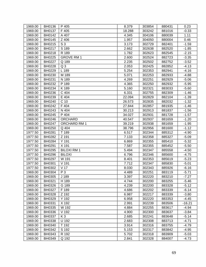
69
1969.00 BH0136 P 405 8.379 303854 880431 0.23 1969.00 BH0137 F 405 18.288 303242 881016 -0.33 1969.00 BH0142 A 407 4.345 304106 880039 1.11 1969.00 BH0145 Z 406 1.957 304050 880004 0.46 1969.00 BH0215 S 3 3.173 302729 882401 -1.59 1969.00 BH0217 S 189 2.662 302638 882520 -1.85 1969.00 BH0218 R 189 1.782 302623 882545 -2.15 1969.00 BH0225 GROVE RM 1 2.600 302524 882723 -3.35 1969.00 BH0227 Q 189 2.235 302502 882752 -3.52 1969.00 BH0228 Q 3 2.053 302425 882852 -4.13 1969.00 BH0229 L 189 5.254 302353 882941 -4.16 1969.00 BH0230 M 189 5.071 302253 882933 -4.88 1969.00 BH0231 N 189 4.269 302251 882929 -5.06 1969.00 BH0232 P 189 4.365 302250 882932 -5.95 1969.00 BH0234 K 189 5.160 302321 883033 -5.60 1969.00 BH0236 C 404 6.331 302755 882309 -1.46 1969.00 BH0239 E 404 22.094 302829 882104 -1.39 1969.00 BH0240 C 10 26.573 302835 882032 -1.32 1969.00 BH0242 F 404 27.844 302857 881935 -1.46 1969.00 BH0243 N 404 30.213 302913 881837 -1.56 1969.00 BH0245 P 404 34.027 302931 881728 -1.57 1969.00 BH0246 ORCHARD 40.547 302937 881659 -1.20 1969.00 BH0247 ORCHARD RM 1 39.219 302938 881659 -1.95 1969.00 BH0250 Q 404 38.796 302956 881600 -1.12 1977.50 BH0281 T 189 6.517 302344 885312 -4.90 1977.50 BH0282 Z 191 7.133 302358 885327 -5.09 1977.50 BH0284 Y 191 6.869 302355 885410 -5.32 1977.50 BH0291 X 191 7.587 302355 885452 -5.50 1977.50 BH0295 BILOXI RM 1 5.494 302347 885558 -4.50 1977.50 BH0296 BILOXI 6.796 302346 885600 -4.75 1977.50 BH0297 W 191 8.401 302353 885619 -5.23 1977.50 BH0301 V 191 7.712 302347 885830 -5.01 1977.50 BH0302 V 17 8.030 302343 885926 -6.16 1969.00 BH0304 P 3 4.489 302251 883119 -5.71 1969.00 BH0305 J 189 3.397 302220 883210 -7.27 1969.00 BH0321 H 189 4.744 302200 883255 -5.46 1969.00 BH0326 G 189 4.239 302200 883328 -5.12 1969.00 BH0327 F 189 4.686 302202 883339 -6.14 1969.00 BH0328 Z 192 6.987 302217 883339 -3.80 1969.00 BH0329 Y 192 6.958 302220 883353 -4.45 1969.00 BH0331 X 192 2.991 302239 883506 -16.21 1969.00 BH0335 W 192 4.884 302255 883617 -4.94 1969.00 BH0336 V 192 4.900 302300 883637 -3.84 1969.00 BH0337 K 3 2.685 302241 883648 -5.14 1969.00 BH0338 U 192 2.683 302308 883713 -4.71 1969.00 BH0340 T 192 3.914 302316 883755 -4.79 1969.00 BH0342 S 192 5.153 302317 883842 -4.95 1969.00 BH0343 R 192 5.702 302318 883909 -5.03 1969.00 BH0349 Q 192 2.841 302328 884007 -4.73

70
1969.00 BH0350 J 3 6.156 302331 884052 -6.20 1969.00 BH0351 P 192 5.267 302332 884125 -4.41 1969.00 BH0352 N 192 3.353 302344 884230 -4.67 1969.00 BH0353 M 192 7.166 302345 884317 -4.59 1969.00 BH0358 D 192 5.505 302410 884412 -4.36 1969.00 BH0359 C 192 6.191 302420 884516 -4.67 1969.00 BH0365 B 192 6.279 302428 884558 -4.51 1969.00 BH0367 A 192 6.872 302435 884644 -4.75 1969.00 BH0368 Z 189 6.692 302444 884743 -4.69 1969.00 BH0369 Y 189 6.935 302454 884843 -4.74 1969.00 BH0371 G 3 7.295 302456 884940 -4.44 1969.00 BH0379 X 189 5.837 302449 885018 -4.41 1969.00 BH0382 BRIDGE RM 1 3.580 302438 885030 -4.93 1969.00 BH0383 BRIDGE 3.560 302438 885029 -5.07 1969.00 BH0384 BRIDGE RM 2 3.500 302438 885030 -5.21 1969.00 BH0393 MORROW 3.422 302347 885133 -4.73 1969.00 BH0394 W 189 3.811 302345 885150 -4.70 1969.00 BH0395 V 189 4.881 302344 885226 -5.07 1969.00 BH0396 DUKATE 3.600 302345 885226 -4.96 1969.00 BH0397 U 189 5.931 302347 885249 -5.09 1977.50 BH0398 D 3 7.338 302346 885313 -4.95 1977.50 BH0399 PBM BILOXI MRC 7.351 302354 885329 -4.96 1977.50 BH0847 U 191 7.814 302337 890004 -5.50 1977.50 BH0857 W 168 10.021 302320 890340 -6.72 1977.50 BH0858 S 191 2.348 302342 890328 -5.48 1977.50 BH0862 R 191 7.020 302233 890414 -5.76 1977.50 BH0863 Q 191 6.119 302223 890440 -6.70 1977.50 BH0869 P 191 7.673 302212 890523 -5.67 1977.50 BH0870 N 191 7.560 302210 890528 -5.31 1977.50 BH0874 L 191 7.445 302216 890544 -5.49 1977.50 BH0875 R 17 9.215 302230 890543 -5.33 1977.50 BH0876 K 191 6.562 302302 890545 -5.73 1977.50 BH0877 F 191 8.738 302254 890630 -5.94 1977.50 BH0878 CBC 32.97 USNCB 9.673 302256 890646 -5.20 1977.50 BH0881 S 17 8.623 302208 890541 -5.38 1977.50 BH0882 G 191 6.981 302201 890607 -5.26 1977.50 BH0884 GULFPORT RM 2 4.566 302140 890634 -5.53 1977.50 BH0886 GULFPORT RESET 4.733 302140 890634 -3.58 1977.50 BH0889 E 191 6.625 302148 890645 -6.26 1977.50 BH0891 D 191 7.517 302134 890727 -5.38 1977.50 BH0894 C 191 7.471 302112 890833 -5.59 1977.50 BH0898 A 191 7.966 302049 890943 -5.16 1977.50 BH0903 Y 190 9.026 302018 891120 -5.07 1977.50 BH0914 W 190 3.981 301931 891344 -4.87 1977.50 BH0917 V 190 4.072 301855 891526 -5.71 1977.50 BH0925 U 190 2.973 301833 891712 -5.06 1977.50 BH0926 T 121 1.564 301833 891714 -5.04 1977.50 BH0932 EAST 5.176 301900 891741 -5.89 1977.50 BH0934 WEST 4.590 301909 891916 -4.91
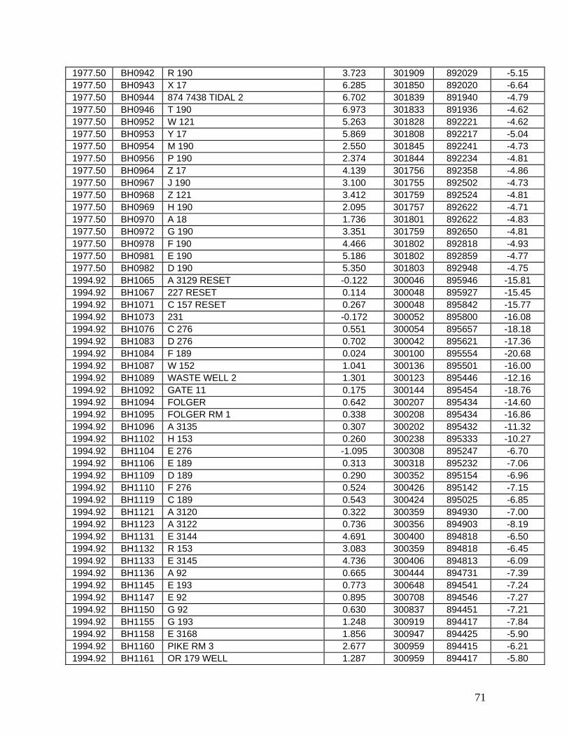
71
1977.50 BH0942 R 190 3.723 301909 892029 -5.15 1977.50 BH0943 X 17 6.285 301850 892020 -6.64 1977.50 BH0944 874 7438 TIDAL 2 6.702 301839 891940 -4.79 1977.50 BH0946 T 190 6.973 301833 891936 -4.62 1977.50 BH0952 W 121 5.263 301828 892221 -4.62 1977.50 BH0953 Y 17 5.869 301808 892217 -5.04 1977.50 BH0954 M 190 2.550 301845 892241 -4.73 1977.50 BH0956 P 190 2.374 301844 892234 -4.81 1977.50 BH0964 Z 17 4.139 301756 892358 -4.86 1977.50 BH0967 J 190 3.100 301755 892502 -4.73 1977.50 BH0968 Z 121 3.412 301759 892524 -4.81 1977.50 BH0969 H 190 2.095 301757 892622 -4.71 1977.50 BH0970 A 18 1.736 301801 892622 -4.83 1977.50 BH0972 G 190 3.351 301759 892650 -4.81 1977.50 BH0978 F 190 4.466 301802 892818 -4.93 1977.50 BH0981 E 190 5.186 301802 892859 -4.77 1977.50 BH0982 D 190 5.350 301803 892948 -4.75 1994.92 BH1065 A 3129 RESET -0.122 300046 895946 -15.81 1994.92 BH1067 227 RESET 0.114 300048 895927 -15.45 1994.92 BH1071 C 157 RESET 0.267 300048 895842 -15.77 1994.92 BH1073 231 -0.172 300052 895800 -16.08 1994.92 BH1076 C 276 0.551 300054 895657 -18.18 1994.92 BH1083 D 276 0.702 300042 895621 -17.36 1994.92 BH1084 F 189 0.024 300100 895554 -20.68 1994.92 BH1087 W 152 1.041 300136 895501 -16.00 1994.92 BH1089 WASTE WELL 2 1.301 300123 895446 -12.16 1994.92 BH1092 GATE 11 0.175 300144 895454 -18.76 1994.92 BH1094 FOLGER 0.642 300207 895434 -14.60 1994.92 BH1095 FOLGER RM 1 0.338 300208 895434 -16.86 1994.92 BH1096 A 3135 0.307 300202 895432 -11.32 1994.92 BH1102 H 153 0.260 300238 895333 -10.27 1994.92 BH1104 E 276 -1.095 300308 895247 -6.70 1994.92 BH1106 E 189 0.313 300318 895232 -7.06 1994.92 BH1109 D 189 0.290 300352 895154 -6.96 1994.92 BH1110 F 276 0.524 300426 895142 -7.15 1994.92 BH1119 C 189 0.543 300424 895025 -6.85 1994.92 BH1121 A 3120 0.322 300359 894930 -7.00 1994.92 BH1123 A 3122 0.736 300356 894903 -8.19 1994.92 BH1131 E 3144 4.691 300400 894818 -6.50 1994.92 BH1132 R 153 3.083 300359 894818 -6.45 1994.92 BH1133 E 3145 4.736 300406 894813 -6.09 1994.92 BH1136 A 92 0.665 300444 894731 -7.39 1994.92 BH1145 E 193 0.773 300648 894541 -7.24 1994.92 BH1147 E 92 0.895 300708 894546 -7.27 1994.92 BH1150 G 92 0.630 300837 894451 -7.21 1994.92 BH1155 G 193 1.248 300919 894417 -7.84 1994.92 BH1158 E 3168 1.856 300947 894425 -5.90 1994.92 BH1160 PIKE RM 3 2.677 300959 894415 -6.21 1994.92 BH1161 OR 179 WELL 1.287 300959 894417 -5.80

72
1994.92 BH1162 PIKE RM 2 2.362 300959 894414 -6.60 1994.92 BH1163 C 193 2.462 301000 894415 -5.82 1994.92 BH1164 PIKE RESET 2.379 300959 894414 -6.99 1994.92 BH1165 PIKE RM 4 2.558 300958 894414 -6.36 1994.92 BH1167 J 92 2.359 301004 894412 -5.66 1986.42 BH1168 E 3170 5.521 301007 894408 -6.55 1993.25 BH1170 S 156 1.722 301031 894344 -8.75 1993.25 BH1171 T 156 1.762 301050 894314 -6.77 1995.17 BH1191 236 0.431 300030 895622 -17.44 1993.25 BH1193 F 236 5.856 301805 893012 -5.21 1993.25 BH1194 V 214 4.637 301742 893050 -5.02 1993.25 BH1195 C 122 4.784 301710 893147 -5.02 1993.25 BH1196 D 122 5.289 301639 893240 -4.45 1993.25 BH1197 C 190 5.102 301631 893253 -4.94 1993.25 BH1198 C 215 5.214 301612 893321 -4.68 1993.25 BH1199 B 235 4.753 301603 893336 -4.74 1993.25 BH1201 F 122 3.192 301537 893423 -4.76 1993.25 BH1202 B 190 1.345 301528 893438 -4.79 1993.25 BH1203 G 122 2.243 301505 893519 -4.95 1993.25 BH1204 H 122 1.941 301436 893615 -5.13 1993.25 BH1205 A 190 1.531 301424 893636 -4.93 1993.25 BH1210 143 STAUNTON C 3.712 301420 893656 -5.33 1993.25 BH1211 EAST PEARL RIVER 2.850 301420 893656 -5.14 1993.25 BH1212 A 193 0.642 301418 893711 -5.37 1993.25 BH1213 E 3186 4.282 301413 893743 -5.20 1993.25 BH1214 EAST MIDDLE BOLT 2.745 301412 893745 -5.35 1993.25 BH1215 E 3185 4.268 301408 893817 -5.23 1993.25 BH1216 142 4.299 301404 893843 -5.31 1993.25 BH1217 R 92 1.261 301355 893941 -6.84 1993.25 BH1218 WEST PEARL BRIDGE 2.599 301352 894007 -5.61 1993.25 BH1219 141 4.164 301352 894008 -5.48 1993.25 BH1220 Q 92 2.415 301352 894038 -4.84 1993.25 BH1222 P 92 0.925 301257 894120 -8.24 1993.25 BH1223 B 193 1.952 301254 894125 -5.73 1993.25 BH1224 N 92 1.923 301227 894149 -6.00 1993.25 BH1225 U 156 1.263 301215 894201 -5.56 1986.42 BH1252 U 20 4.083 301640 894658 -8.82 1986.42 BH1261 A 21 3.636 301812 895510 -8.51 1986.42 BH1263 TT 70 L RESET 4.006 301835 895612 -12.12 1995.17 BH1442 Z 297 0.044 300032 895620 -16.95 1995.17 BH1443 236 AZ MK 0.698 300042 895621 -17.48 1994.92 BH1444 WYNOT RM 4 2.433 300435 895122 -9.31 1994.92 BH1445 J 319 2.037 300522 894642 -8.33 1994.92 BH1446 K 319 0.210 300551 894556 -7.10 1969.00 BH1459 PBM KEENER BOLT USE 5.300 302450 885030 -4.28 1969.00 BH1460 PBM KEENER CAP USE 6.535 302450 885030 -4.65 1969.00 BH1463 N 405 8.371 303919 880354 0.68 1969.00 BH1464 N 10 5.363 303933 880327 1.61 1969.00 BH1465 H 406 2.300 303958 880259 1.12

73
1969.00 BH1466 J 406 4.194 304011 880240 1.33 1969.00 BH1467 K 406 3.992 304029 880236 1.10 1969.00 BH1468 L 406 3.043 304056 880228 1.75 1969.00 BH1469 M 406 3.424 304125 880228 1.47 1969.00 BH1470 N 406 3.204 304140 880235 2.20 1969.00 BH1471 R 406 4.407 304401 880225 2.39 1969.00 BH1472 S 406 2.552 304326 880213 1.29 1969.00 BH1473 210 ALGS 0.840 304255 880202 -0.48 1969.00 BH1474 B 407 2.422 304216 880158 0.97 1969.00 BH1475 C 407 ALHD 1.257 304136 880148 0.82 1969.00 BH1476 D 407 ALHD 2.478 304135 880151 0.55 1969.00 BH1477 E 407 ALHD 2.157 304134 880152 1.81 1986.42 BH1537 WES 16 3.257 301000 894413 -6.20 1986.42 BH1538 WES 15 1.140 301001 894416 -6.09 1986.42 BH1539 WES 14 1.616 300954 894418 -6.24 1995.17 BH1769 V 371 0.286 300013 895619 -18.10 1995.17 BH1802 D 374 0.104 300028 895621 -17.61 1995.17 BH1806 U 375 1.033 300004 895628 -21.70 1995.17 BH1806 U 375 1.033 300004 895628 -21.70 1995.17 BH3007 WES 19 -0.151 300025 895619 -18.41 1995.17 BH3096 B 387 1.242 300023 895620 -18.50 1964.92 BJ0002 B 208 15.224 305922 914046 -2.57 1964.92 BJ0003 TORRAS BOLT 13.680 305921 914051 -1.82 1964.92 BJ0005 A 208 13.123 305835 914030 -3.63 1964.92 BJ0006 C 208 14.342 305741 914016 -3.32 1964.92 BJ0007 N 208 14.334 305719 914010 -3.85 1964.92 BJ0009 RED RIVER RM 2 12.687 305728 913954 -0.89 1964.92 BJ0012 Q 108 12.636 305633 913942 -3.47 1964.92 BJ0015 L 208 14.386 305557 913945 -3.99 1964.92 BJ0016 R 108 13.057 305603 913934 -2.06 1964.92 BJ0018 E 207 14.864 305458 913939 -4.12 1964.92 BJ0019 3 A BOLT 13.796 305434 913955 -2.97 1964.92 BJ0020 19 BOLT 12.823 305340 914004 -3.95 1964.92 BJ0021 F 207 14.260 305307 914013 -4.44 1964.92 BJ0022 4 A BOLT 13.491 305234 914024 -4.44 1964.92 BJ0024 G 207 13.368 305149 914016 -4.54 1964.92 BJ0025 XLIV 13.526 305137 914014 -4.52 1964.92 BJ0026 H 207 13.380 305104 913947 -4.61 1964.92 BJ0031 20 BOLT 12.972 304940 913633 -3.45 1964.92 BJ0033 M 207 12.481 304846 913444 -7.20 1964.92 BJ0038 P 207 11.192 304544 913616 0.42 1964.92 BJ0039 Q 207 16.130 304454 913601 -6.52 1964.92 BJ0042 PLAUCHE CAP 11.393 304418 913538 -2.87 1964.92 BJ0043 PLAUCHE BOLT 10.157 304418 913538 -2.79 1964.92 BJ0045 R 207 10.358 304334 913508 -2.65 1964.92 BJ0046 S 207 10.307 304305 913412 -2.57 1964.92 BJ0049 NEW ROADS WEST BASE RM 3 9.788 304256 913311 -3.70 1964.92 BJ0050 NEW ROADS WEST BASE RM 4 9.853 304256 913309 -2.91 1964.92 BJ0051 T 207 9.297 304253 913222 -2.00

74
1964.92 BJ0055 V 207 11.534 304351 913001 -3.77 1964.92 BJ0057 W 207 12.076 304347 912900 -2.81 1964.92 BJ0060 Z 207 9.856 304405 912555 -3.16 1964.92 BJ0062 SHAMROCK BOLT 9.276 304408 912522 -1.78 1964.92 BJ0063 D 207 10.565 304431 912440 -2.61 1964.92 BJ0065 C 207 13.278 304501 912355 -4.04 1964.92 BJ0067 B 207 12.451 304455 912304 -4.44 1964.92 BJ0068 161 C BOLT 10.534 304436 912234 -3.71 1964.92 BJ0069 23 BOLT 10.635 304421 912215 -4.08 1964.92 BJ0070 A 207 10.860 304334 912144 -4.51 1964.92 BJ0072 WALKER BOLT 9.065 304314 912141 -3.35 1964.92 BJ0073 GAGE 41 BOLT 10.215 304244 912126 -4.45 1964.92 BJ0074 Z 206 12.827 304149 912119 -4.95 1964.92 BJ0075 162 D CAP 11.271 304105 912122 -4.16 1964.92 BJ0076 Y 206 10.122 304028 912108 -4.32 1964.92 BJ0078 X 206 10.781 303937 912051 -4.83 1964.92 BJ0079 24 BOLT 9.825 303901 912008 -4.69 1964.92 BJ0081 W 206 9.863 303836 911922 -4.98 1964.92 BJ0082 DEFERN BOLT 9.572 303751 911844 -4.27 1964.92 BJ0083 V 206 10.027 303713 911854 -4.10 1964.92 BJ0084 U 206 9.361 303631 911906 -4.41 1964.92 BJ0085 T 206 10.306 303544 911919 -4.79 1964.92 BJ0087 S 206 8.763 303455 911926 -3.69 1964.92 BJ0088 R 206 9.201 303410 911900 -3.83 1964.92 BJ0092 25 BOLT 8.527 303352 911708 -3.26 1964.92 BJ0093 MCMURDO BOLT 9.293 303258 911726 -3.70 1964.92 BJ0094 SMITHFIELD BOLT 8.212 303244 911739 -4.09 1964.92 BJ0096 N 206 11.240 303207 911733 -4.54 1964.92 BJ0097 ORANGE GROVE BOLT 7.840 303136 911742 -3.79 1964.92 BJ0098 PAYNES BOLT 7.676 303114 911753 -2.94 1964.92 BJ0099 M 206 8.467 303108 911751 -3.47 1964.92 BJ0100 FOREST BOLT 7.217 303050 911748 -2.59 1964.92 BJ0104 J 206 8.041 302950 911540 -4.32 1964.92 BJ0107 G 206 8.775 303035 911345 -5.56 1964.92 BJ0108 F 206 8.395 303051 911253 -6.64 1964.92 BJ0109 E 206 9.396 303023 911214 -8.28 1964.92 BJ0110 POPLAR GROVE BOLT 8.125 302936 911209 -6.14 1964.92 BJ0111 D 206 8.601 302905 911209 -6.11 1986.40 BJ0112 P 287 8.157 302825 911206 -3.69 1976.50 BJ0154 J 208 13.503 305858 914646 -2.98 1976.50 BJ0155 K 208 14.081 305846 914741 -1.72 1977.33 BJ0163 L 250 14.406 305924 914856 -1.66 1977.33 BJ0164 M 250 14.229 305934 914918 -1.23 1977.33 BJ0165 N 250 13.688 305919 914943 -0.95 1977.33 BJ0166 P 250 11.750 305928 915028 -4.64 1977.33 BJ0171 GABRIEL CAP 14.220 305905 914821 -1.72 1986.40 BJ0259 Q 291 6.812 303326 913928 -9.32 1986.40 BJ0314 S 291 6.805 303327 913950 -8.45 1986.40 BJ0315 3680 6.929 303328 914030 -7.17
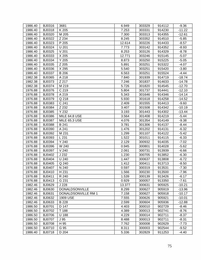
75
1986.40 BJ0316 3681 6.949 303329 914112 -9.36 1986.40 BJ0318 K 205 7.253 303331 914230 -11.22 1986.40 BJ0320 M 205 7.300 303313 914355 -12.61 1986.40 BJ0322 Z 234 8.245 303352 914510 -5.85 1986.40 BJ0323 P 205 12.614 303226 914433 -8.57 1986.40 BJ0324 U 201 7.773 303142 914352 -8.93 1986.40 BJ0325 V 201 8.253 303126 914329 -8.78 1986.40 BJ0333 X 205 12.771 303246 915145 -5.07 1986.40 BJ0334 Y 205 8.873 303250 915225 -5.05 1986.40 BJ0335 Z 205 5.891 303251 915322 -4.07 1986.40 BJ0336 X 295 5.540 303251 915420 -3.80 1986.40 BJ0337 B 206 6.563 303251 915524 -4.44 1982.38 BJ0365 A 218 7.840 301939 914719 -18.74 1982.38 BJ0373 Z 217 7.246 301837 914633 -14.78 1982.38 BJ0374 M 219 5.726 301820 914545 -12.70 1976.88 BJ0376 C 219 5.804 301737 914441 -12.10 1976.88 BJ0378 A 219 5.343 301646 914346 -14.14 1976.88 BJ0379 Q 218 5.930 301618 914258 -14.52 1976.88 BJ0383 C 241 2.409 301555 914413 -9.60 1976.88 BJ0384 Z 232 3.407 301508 914342 -10.19 1976.88 BJ0385 Y 232 3.193 301443 914302 -13.44 1976.88 BJ0386 MILE 64.8 USE 3.564 301408 914219 -5.44 1976.88 BJ0387 MILE 65.3 USE 4.076 301354 914149 -9.38 1976.88 BJ0388 B 241 3.781 301306 914137 -8.44 1976.88 BJ0390 A 241 1.476 301202 914131 -6.32 1976.88 BJ0392 M 231 1.299 301107 914122 -5.42 1976.88 BJ0393 L 231 1.522 301011 914115 -6.33 1976.88 BJ0394 Y 240 2.129 300932 914035 -7.02 1976.88 BJ0396 W 240 0.945 300801 914028 -5.62 1976.88 BJ0397 V 240 2.061 300731 913939 -6.66 1976.88 BJ0402 J 232 1.230 300705 913852 -6.30 1976.88 BJ0404 U 240 1.447 300637 913808 -6.72 1976.88 BJ0405 Q 240 1.412 300411 913713 -8.50 1976.88 BJ0407 N 240 0.597 300319 913531 -7.30 1976.88 BJ0410 H 231 1.566 300230 913500 -7.96 1976.88 BJ0411 R 240 1.539 300139 913426 -6.17 1976.88 BJ0413 G 231 0.929 300057 913350 -7.61 1982.46 BJ0629 J 228 13.377 300631 905925 -10.21 1982.46 BJ0630 DONALDSONVILLE 8.299 300627 905919 -13.96 1982.46 BJ0631 DONALDSONVILLE RM 1 7.158 300627 905918 -10.17 1982.46 BJ0632 1909 USE 7.555 300626 905921 -10.01 1982.46 BJ0633 B 228 2.599 300604 905936 -12.88 1986.50 BJ0701 D 147 4.403 300010 902729 -8.46 1986.50 BJ0702 T 188 4.389 300013 902741 -8.76 1986.50 BJ0706 U 188 4.229 300014 902711 -8.37 1986.50 BJ0707 J 95 8.488 300013 902711 -8.31 1986.50 BJ0708 H 95 7.762 300008 902629 -7.73 1986.50 BJ0710 G 95 8.311 300003 902544 -9.52 1986.40 BJ0718 D 204 5.336 302829 911253 -4.40
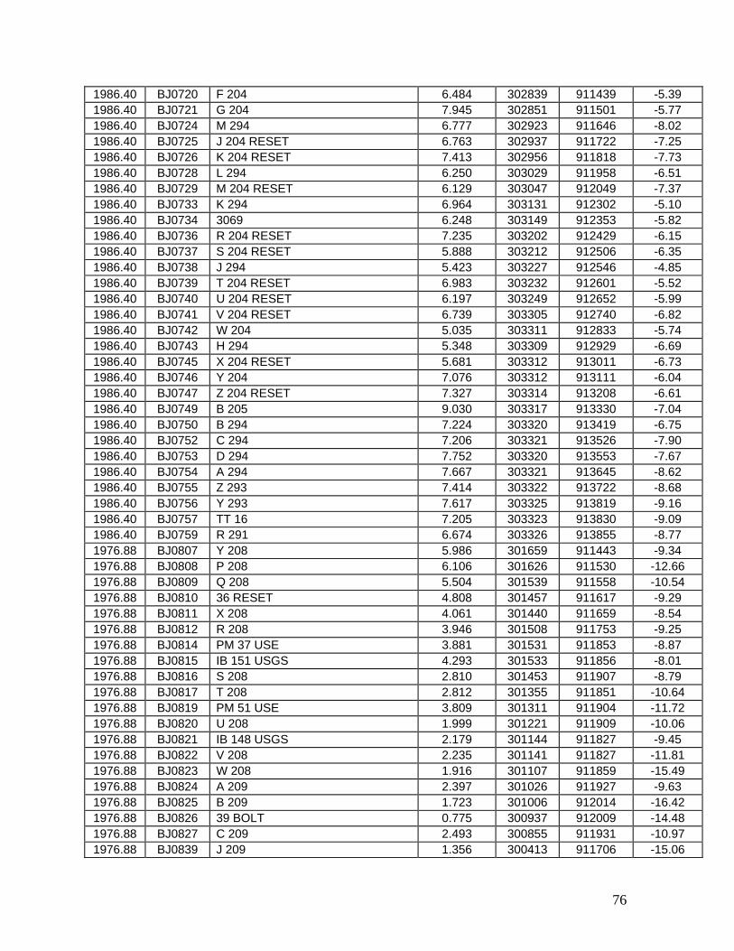
76
1986.40 BJ0720 F 204 6.484 302839 911439 -5.39 1986.40 BJ0721 G 204 7.945 302851 911501 -5.77 1986.40 BJ0724 M 294 6.777 302923 911646 -8.02 1986.40 BJ0725 J 204 RESET 6.763 302937 911722 -7.25 1986.40 BJ0726 K 204 RESET 7.413 302956 911818 -7.73 1986.40 BJ0728 L 294 6.250 303029 911958 -6.51 1986.40 BJ0729 M 204 RESET 6.129 303047 912049 -7.37 1986.40 BJ0733 K 294 6.964 303131 912302 -5.10 1986.40 BJ0734 3069 6.248 303149 912353 -5.82 1986.40 BJ0736 R 204 RESET 7.235 303202 912429 -6.15 1986.40 BJ0737 S 204 RESET 5.888 303212 912506 -6.35 1986.40 BJ0738 J 294 5.423 303227 912546 -4.85 1986.40 BJ0739 T 204 RESET 6.983 303232 912601 -5.52 1986.40 BJ0740 U 204 RESET 6.197 303249 912652 -5.99 1986.40 BJ0741 V 204 RESET 6.739 303305 912740 -6.82 1986.40 BJ0742 W 204 5.035 303311 912833 -5.74 1986.40 BJ0743 H 294 5.348 303309 912929 -6.69 1986.40 BJ0745 X 204 RESET 5.681 303312 913011 -6.73 1986.40 BJ0746 Y 204 7.076 303312 913111 -6.04 1986.40 BJ0747 Z 204 RESET 7.327 303314 913208 -6.61 1986.40 BJ0749 B 205 9.030 303317 913330 -7.04 1986.40 BJ0750 B 294 7.224 303320 913419 -6.75 1986.40 BJ0752 C 294 7.206 303321 913526 -7.90 1986.40 BJ0753 D 294 7.752 303320 913553 -7.67 1986.40 BJ0754 A 294 7.667 303321 913645 -8.62 1986.40 BJ0755 Z 293 7.414 303322 913722 -8.68 1986.40 BJ0756 Y 293 7.617 303325 913819 -9.16 1986.40 BJ0757 TT 16 7.205 303323 913830 -9.09 1986.40 BJ0759 R 291 6.674 303326 913855 -8.77 1976.88 BJ0807 Y 208 5.986 301659 911443 -9.34 1976.88 BJ0808 P 208 6.106 301626 911530 -12.66 1976.88 BJ0809 Q 208 5.504 301539 911558 -10.54 1976.88 BJ0810 36 RESET 4.808 301457 911617 -9.29 1976.88 BJ0811 X 208 4.061 301440 911659 -8.54 1976.88 BJ0812 R 208 3.946 301508 911753 -9.25 1976.88 BJ0814 PM 37 USE 3.881 301531 911853 -8.87 1976.88 BJ0815 IB 151 USGS 4.293 301533 911856 -8.01 1976.88 BJ0816 S 208 2.810 301453 911907 -8.79 1976.88 BJ0817 T 208 2.812 301355 911851 -10.64 1976.88 BJ0819 PM 51 USE 3.809 301311 911904 -11.72 1976.88 BJ0820 U 208 1.999 301221 911909 -10.06 1976.88 BJ0821 IB 148 USGS 2.179 301144 911827 -9.45 1976.88 BJ0822 V 208 2.235 301141 911827 -11.81 1976.88 BJ0823 W 208 1.916 301107 911859 -15.49 1976.88 BJ0824 A 209 2.397 301026 911927 -9.63 1976.88 BJ0825 B 209 1.723 301006 912014 -16.42 1976.88 BJ0826 39 BOLT 0.775 300937 912009 -14.48 1976.88 BJ0827 C 209 2.493 300855 911931 -10.97 1976.88 BJ0839 J 209 1.356 300413 911706 -15.06
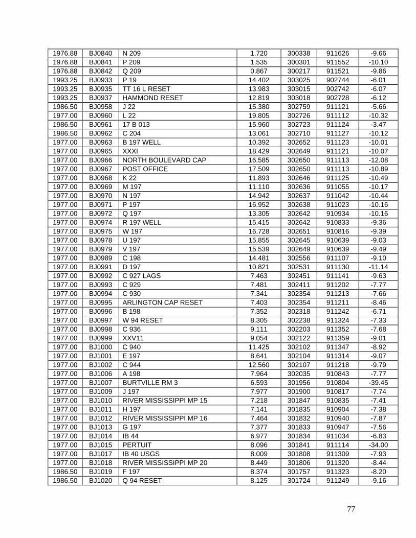
77
1976.88 BJ0840 N 209 1.720 300338 911626 -9.66 1976.88 BJ0841 P 209 1.535 300301 911552 -10.10 1976.88 BJ0842 Q 209 0.867 300217 911521 -9.86 1993.25 BJ0933 P 19 14.402 303025 902744 -6.01 1993.25 BJ0935 TT 16 L RESET 13.983 303015 902742 -6.07 1993.25 BJ0937 HAMMOND RESET 12.819 303018 902728 -6.12 1986.50 BJ0958 J 22 15.380 302759 911121 -5.66 1977.00 BJ0960 L 22 19.805 302726 911112 -10.32 1986.50 BJ0961 17 B 013 15.960 302723 911124 -3.47 1986.50 BJ0962 C 204 13.061 302710 911127 -10.12 1977.00 BJ0963 B 197 WELL 10.392 302652 911123 -10.01 1977.00 BJ0965 XXXI 18.429 302649 911121 -10.07 1977.00 BJ0966 NORTH BOULEVARD CAP 16.585 302650 911113 -12.08 1977.00 BJ0967 POST OFFICE 17.509 302650 911113 -10.89 1977.00 BJ0968 K 22 11.893 302646 911125 -10.49 1977.00 BJ0969 M 197 11.110 302636 911055 -10.17 1977.00 BJ0970 N 197 14.942 302637 911042 -10.44 1977.00 BJ0971 P 197 16.952 302638 911023 -10.16 1977.00 BJ0972 Q 197 13.305 302642 910934 -10.16 1977.00 BJ0974 R 197 WELL 15.415 302642 910833 -9.36 1977.00 BJ0975 W 197 16.728 302651 910816 -9.39 1977.00 BJ0978 U 197 15.855 302645 910639 -9.03 1977.00 BJ0979 V 197 15.539 302649 910639 -9.49 1977.00 BJ0989 C 198 14.481 302556 911107 -9.10 1977.00 BJ0991 D 197 10.821 302531 911130 -11.14 1977.00 BJ0992 C 927 LAGS 7.463 302451 911141 -9.63 1977.00 BJ0993 C 929 7.481 302411 911202 -7.77 1977.00 BJ0994 C 930 7.341 302354 911213 -7.66 1977.00 BJ0995 ARLINGTON CAP RESET 7.403 302354 911211 -8.46 1977.00 BJ0996 B 198 7.352 302318 911242 -6.71 1977.00 BJ0997 W 94 RESET 8.305 302238 911324 -7.33 1977.00 BJ0998 C 936 9.111 302203 911352 -7.68 1977.00 BJ0999 XXV11 9.054 302122 911359 -9.01 1977.00 BJ1000 C 940 11.425 302102 911347 -8.92 1977.00 BJ1001 E 197 8.641 302104 911314 -9.07 1977.00 BJ1002 C 944 12.560 302107 911218 -9.79 1977.00 BJ1006 A 198 7.964 302035 910843 -7.77 1977.00 BJ1007 BURTVILLE RM 3 6.593 301956 910804 -39.45 1977.00 BJ1009 J 197 7.977 301900 910817 -7.74 1977.00 BJ1010 RIVER MISSISSIPPI MP 15 7.218 301847 910835 -7.41 1977.00 BJ1011 H 197 7.141 301835 910904 -7.38 1977.00 BJ1012 RIVER MISSISSIPPI MP 16 7.464 301832 910940 -7.87 1977.00 BJ1013 G 197 7.377 301833 910947 -7.56 1977.00 BJ1014 IB 44 6.977 301834 911034 -6.83 1977.00 BJ1015 PERTUIT 8.096 301841 911114 -34.00 1977.00 BJ1017 IB 40 USGS 8.009 301808 911309 -7.93 1977.00 BJ1018 RIVER MISSISSIPPI MP 20 8.449 301806 911320 -8.44 1986.50 BJ1019 F 197 8.374 301757 911323 -8.20 1986.50 BJ1020 Q 94 RESET 8.125 301724 911249 -9.16
78
1986.50 BJ1021 178 2 RESET 8.114 301708 911201 -8.44 1986.50 BJ1022 P 94 RESET 8.361 301717 911133 -8.33 1986.50 BJ1024 N 94 RESET 7.521 301723 911027 -8.19 1986.50 BJ1025 ANGER RESET 7.528 301724 911004 -8.98 1986.50 BJ1029 L 94 6.748 301617 910657 -11.26 1986.50 BJ1030 K 94 6.498 301534 910614 -10.28 1986.50 BJ1033 RIVER MISSISSIPPI MP 30 5.468 301451 910613 -7.94 1986.50 BJ1034 3004 6.004 301420 910641 -7.45 1986.50 BJ1038 X 192 6.826 301329 910758 -7.97 1986.50 BJ1039 RIVER MISSISSIPPI MP 33 7.207 301309 910819 -7.83 1986.50 BJ1041 RIVER MISSISSIPPI MP 34 6.952 301227 910851 -7.90 1986.50 BJ1042 W 192 7.185 301224 910852 -7.85 1986.50 BJ1043 RIVER MISSISSIPPI MP 35 7.347 301146 910910 -9.12 1986.50 BJ1045 V 192 7.446 301141 910911 -8.20 1986.50 BJ1046 RIVER MISSISSIPPI MP 36 7.519 301105 910852 -7.14 1986.50 BJ1048 F 94 7.249 301127 910800 -8.27 1986.50 BJ1050 RIVER MISSISSIPPI MP 38 7.347 301151 910724 -7.80 1986.50 BJ1051 U 192 7.224 301158 910714 -7.66 1986.50 BJ1052 E 94 6.704 301223 910637 -7.82 1986.50 BJ1053 RIVER MISSISSIPPI MP 40 6.406 301249 910550 -9.48 1986.50 BJ1055 CARVILLE CAP 6.090 301303 910548 -7.09 1986.50 BJ1056 3009 5.545 301307 910449 -7.58 1986.50 BJ1058 RIVER MISSISSIPPI MP 42 5.435 301309 910358 -8.59 1986.50 BJ1059 3011 5.361 301307 910349 -7.78 1986.50 BJ1060 RUSSELL CAP 6.060 301301 910300 -7.87 1986.50 BJ1066 NEW RIVER CAP 7.141 301214 910122 -7.95 1986.50 BJ1069 C 94 RESET 6.986 301040 910012 -10.17 1986.50 BJ1071 P 192 7.631 300959 905945 -11.43 1986.50 BJ1072 A 94 RESET 5.560 300914 905934 -14.52 1986.50 BJ1075 Z 197 5.977 300711 905954 -9.72 1986.50 BJ1076 TT 3 P RESET 5.896 300710 905924 -10.63 1986.50 BJ1082 N 192 4.692 300843 905619 -7.46 1986.50 BJ1084 M 192 4.995 300856 905555 -7.59 1986.50 BJ1085 L 192 5.780 300857 905520 -7.73 1986.50 BJ1092 H 192 6.704 300556 905426 -8.18 1986.50 BJ1109 X 197 6.382 300524 905422 -7.66 1986.50 BJ1112 RIVER MISSISSIPPI MP 65 6.181 300455 905410 -9.17 1986.50 BJ1114 V 191 6.090 300414 905327 -9.15 1986.50 BJ1115 RIVER MISSISSIPPI MP 67 5.998 300404 905253 -13.04 1986.50 BJ1117 R 191 5.440 300016 904936 -9.73 1986.50 BJ1119 RIVER MISSISSIPPI MP 73 5.149 300052 904941 -10.40 1986.50 BJ1122 S 191 5.928 300210 904956 -8.02 1986.50 BJ1124 HYMEL RM 4 5.755 300408 905147 -7.91 1994.92 BJ1184 D 3123 -0.195 300008 900322 -8.01 1994.92 BJ1185 D 3124 -0.116 300010 900312 -8.52 1994.92 BJ1186 B 3105 -0.235 300012 900301 -8.89 1994.92 BJ1187 S 152 -1.030 300009 900242 -7.88 1994.92 BJ1188 G 278 0.878 300021 900212 -8.82 1994.92 BJ1191 225 RESET -0.013 300038 900112 -12.01
79
1994.92 BJ1192 B 276 1.153 300039 900046 -10.77 1994.92 BJ1193 LAFON -0.805 300042 900019 -12.93 1994.92 BJ1194 A 3128 RESET -0.402 300042 900021 -20.71 1977.33 BJ1199 H 250 13.568 305937 915138 -0.73 1977.33 BJ1200 K 250 14.100 305940 915210 -0.58 1977.33 BJ1201 J 250 15.154 305943 915314 -0.35 1977.33 BJ1202 F 250 14.770 305943 915314 -0.48 1977.33 BJ1203 G 250 15.732 305949 915324 -1.15 1993.25 BJ1216 HAMMOND RM 1 12.841 303039 902759 -5.41 1993.25 BJ1217 HAMMOND 12.992 303038 902800 -6.07 1993.25 BJ1218 HAMMOND RM 3 13.200 303039 902800 -6.03 1993.25 BJ1223 F 179 15.934 303258 902829 -6.18 1993.25 BJ1224 G 179 16.998 303347 902844 -5.81 1993.25 BJ1225 S 19 19.164 303438 902859 -6.53 1993.25 BJ1226 TA 265 18.779 303439 902904 -6.01 1993.25 BJ1227 H 179 19.582 303524 902912 -4.32 1993.25 BJ1228 T 19 20.366 303556 902923 -7.10 1993.25 BJ1229 53 DO 13 21.831 303624 902931 -6.25 1993.25 BJ1231 U 19 22.028 303638 902936 -5.78 1993.25 BJ1232 J 179 23.687 303716 902946 -7.34 1993.25 BJ1234 A 180 65.206 305747 902933 -5.42 1993.25 BJ1236 B 180 73.568 305857 902853 -5.35 1993.25 BJ1237 P 20 75.739 305937 902832 -5.36 1986.50 BJ1459 C 95 2.898 300137 902803 -9.50 1986.50 BJ1462 F 95 3.622 300349 902903 -9.02 1993.25 BJ1465 K 276 0.572 300003 901737 -9.02 1993.25 BJ1467 L 276 1.191 300107 901909 -9.47 1993.25 BJ1468 D 178 1.289 300145 902005 -11.22 1993.25 BJ1469 M 276 0.305 300214 902051 -8.13 1993.25 BJ1474 G 178 0.635 300308 902210 -10.27 1993.25 BJ1478 Z 274 2.033 300313 902220 -7.45 1993.25 BJ1480 H 178 5.369 300350 902312 -6.92 1993.25 BJ1481 J 178 5.215 300423 902401 -7.09 1993.25 BJ1484 A 275 3.231 300435 902414 -7.44 1993.25 BJ1507 R 178 0.712 301305 902451 -7.18 1993.25 BJ1522 GALVA 2 1.381 301646 902358 -10.78 1993.25 BJ1523 GALVA 2 RM 3 1.419 301647 902358 -8.89 1993.25 BJ1524 C 275 1.578 301700 902358 -6.91 1993.25 BJ1527 G 275 1.476 301721 902406 -6.76 1993.25 BJ1531 E 19 1.633 301827 902416 -7.36 1993.25 BJ1532 H 275 1.450 301832 902418 -7.08 1993.25 BJ1533 J 275 1.437 301847 902419 -6.91 1993.25 BJ1535 F 19 2.122 301935 902430 -6.76 1993.25 BJ1537 K 275 1.354 302028 902443 -6.73 1993.25 BJ1538 G 19 1.978 302055 902449 -6.75 1993.25 BJ1540 1038 1.087 302204 902510 -7.88 1993.25 BJ1541 H 19 1.946 302212 902513 -6.73 1993.25 BJ1542 1039 0.978 302252 902526 -8.71 1993.25 BJ1549 J 19 2.000 302329 902538 -7.58
80
1993.25 BJ1552 K 19 2.010 302446 902600 -7.23 1993.25 BJ1553 L 275 3.911 302453 902603 -7.40 1993.25 BJ1555 M 275 3.306 302533 902614 -5.68 1993.25 BJ1556 PONCHATOULA AZ MK 4.386 302552 902626 -5.24 1993.25 BJ1557 PONCHATOULA RM 1 6.325 302608 902631 -5.84 1993.25 BJ1560 PONCHATOULA 6.824 302608 902632 -5.84 1993.25 BJ1561 PONCHATOULA RM 2 6.879 302608 902631 -5.36 1993.25 BJ1567 765 9.084 302816 902726 -6.02 1993.25 BJ1568 V 178 9.591 302816 902723 -5.51 1986.50 BJ1607 Z 190 4.533 300333 903034 -8.49 1986.50 BJ1613 P 95 4.234 300316 903317 -8.29 1986.50 BJ1618 Q 95 4.684 300322 903401 -8.00 1986.50 BJ1627 MILE 90 4.605 300216 903718 -5.97 1986.50 BJ1628 A 191 3.693 300227 903729 -7.80 1986.50 BJ1632 H 191 2.546 300255 903804 -9.75 1986.50 BJ1639 RIVER MISSISSIPPI MP 86 4.290 300258 904035 -6.91 1986.50 BJ1647 J 191 4.744 300222 904132 -7.98 1986.50 BJ1655 E 191 4.450 300102 904348 -10.52 1986.50 BJ1656 RIVER MISSISSIPPI MP 81 3.940 300113 904421 -11.90 1986.50 BJ1659 L 191 3.535 300115 904443 -11.61 1986.50 BJ1669 N 191 5.391 300050 904716 -9.54 1986.50 BJ1671 P 191 5.922 300023 904751 -14.20 1993.25 BJ1740 W 19 27.995 303804 903001 -5.79 1993.25 BJ1743 TA 271 26.622 303806 902959 -5.90 1993.25 BJ1744 K 179 27.017 303850 903015 -5.80 1993.25 BJ1746 L 179 28.219 303946 903027 -6.01 1993.25 BJ1748 U 179 28.682 304028 903030 -6.22 1993.25 BJ1749 M 179 28.589 304106 903028 -6.30 1993.25 BJ1750 Z 19 32.071 304152 903029 -6.42 1993.25 BJ1751 A 197 33.337 304241 903030 -7.01 1993.25 BJ1752 AMITE AZ MK 32.922 304316 903010 -6.08 1993.25 BJ1756 AMITE RESET 34.224 304341 903013 -6.78 1993.25 BJ1757 AMITE RM 3 33.833 304337 903013 -6.60 1993.25 BJ1758 AMITE 33.528 304336 903014 -6.69 1993.25 BJ1759 AMITE RM 2 33.622 304337 903013 -6.62 1993.25 BJ1760 B 711 35.455 304346 903031 -6.69 1993.25 BJ1761 P 179 34.687 304406 903030 -6.71 1993.25 BJ1763 Q 275 37.492 304512 903028 -6.62 1993.25 BJ1765 Q 179 39.554 304545 903033 -7.14 1993.25 BJ1767 TA 260 40.349 304552 903041 -6.82 1993.25 BJ1768 R 179 40.327 304652 903034 -6.67 1993.25 BJ1769 E 20 41.896 304759 903036 -6.74 1993.25 BJ1771 S 179 44.942 304841 903037 -6.27 1993.25 BJ1772 F 20 45.853 304916 903037 -6.44 1993.25 BJ1774 G 20 50.510 305101 903039 -6.32 1993.25 BJ1775 V 179 52.304 305153 903040 -6.93 1993.25 BJ1776 H 20 54.143 305230 903040 -6.18 1993.25 BJ1777 W 179 54.921 305257 903041 -6.13 1993.25 BJ1778 X 179 54.681 305338 903042 -5.91
81
1993.25 BJ1781 Y 179 60.730 305519 903043 -6.23 1993.25 BJ1782 S 275 60.475 305552 903036 -6.63 1982.46 BJ2046 E 228 6.859 300447 910135 -9.23 1982.46 BJ2047 F 228 6.438 300349 910138 -9.77 1982.46 BJ2048 G 228 6.949 300259 910224 -8.84 1982.46 BJ2049 ES 17 USGS RESET 1961 6.089 300259 910225 -9.67 1982.46 BJ2050 H 228 5.786 300215 910259 -9.66 1982.46 BJ2051 ES 19 USGS 5.918 300124 910251 -10.51 1982.46 BJ2052 K 228 5.510 300026 910242 -11.06 1982.25 BJ2124 28 A 013 11.561 301146 915951 -8.40 1982.25 BJ2126 A 268 10.944 301131 915939 -7.63 1982.25 BJ2128 J 171 10.316 301049 915918 -7.56 1982.25 BJ2129 OVERLAP USE 9.522 301037 915908 -7.51 1982.25 BJ2130 28 A 011 LADH 9.921 301032 915904 -7.94 1982.25 BJ2131 B 4076 LAGS 9.826 301021 915852 -7.36 1982.25 BJ2132 28 A 010 LADH 10.183 301004 915836 -7.55 1982.25 BJ2133 B 4075 LAGS 10.574 300955 915834 -7.55 1982.25 BJ2134 B 4074 LAGS 10.079 300936 915816 -7.51 1982.25 BJ2135 28 A 009 LADH 10.247 300924 915805 -8.80 1982.25 BJ2139 V 3 RESET 1947 10.070 300857 915745 -7.44 1982.25 BJ2142 B 4072 LAGS 10.679 300841 915724 -7.54 1982.25 BJ2146 G 171 9.012 300751 915642 -9.42 1982.25 BJ2147 D 171 10.304 300713 915605 -15.71 1982.25 BJ2148 C 171 10.794 300625 915522 -7.82 1982.25 BJ2150 G 268 9.256 300547 915452 -6.50 1982.25 BJ2152 A 4 9.259 300503 915407 -6.30 1982.25 BJ2153 A 171 7.368 300421 915334 -8.12 1982.25 BJ2155 BURKE AZ MK 9.315 300316 915233 -6.98 1982.25 BJ2157 X 170 7.659 300307 915246 -6.30 1982.25 BJ2158 BURKE RM 2 7.755 300308 915241 -6.44 1982.25 BJ2159 BURKE 7.749 300308 915241 -6.72 1982.25 BJ2160 BURKE RM 1 7.768 300309 915242 -6.22 1982.25 BJ2161 Y 170 7.898 300303 915244 -6.11 1982.25 BJ2162 Z 266 8.509 300243 915157 -6.14 1982.25 BJ2167 Y 266 8.319 300214 915121 -6.06 1982.25 BJ2168 C 3879 LAGS 6.491 300148 915054 -8.85 1982.25 BJ2169 S 277 5.895 300111 915008 -7.50 1982.25 BJ2171 L 201 6.019 300100 914958 -6.87 1982.25 BJ2178 H 4 7.353 300031 914928 -8.04 1969.33 BJ2182 J4=23.520 USGS 6.985 300013 914859 -7.92 1969.33 BJ2183 P 170 5.935 300006 914904 -7.51 1982.38 BJ2223 D 203 9.046 301639 915425 -12.67 1965.21 BJ2248 P 164 13.150 301441 915933 -10.12 1965.21 BJ2251 R 164 5.825 301517 915805 -13.89 1965.21 BJ2252 L 17 6.204 301545 915649 -10.94 1965.21 BJ2253 S 164 5.371 301607 915553 -11.15 1982.38 BJ2254 M 17 5.544 301619 915525 -14.19 1982.38 BJ2263 S 17 5.858 301818 915026 -11.48 1964.92 BJ2630 11 A CAP 12.415 304758 913419 -2.55
82
1986.40 BJ3232 3678 7.356 303326 913921 -8.83 1993.25 BJ3867 IC 2 CAP RESET 1.503 300313 902216 -10.06 1986.17 BK0154 N 267 5.431 301049 923000 -20.91 1986.17 BK0158 455 3.906 301049 922914 -17.72 1986.17 BK0159 X 267 4.384 301049 922836 -17.31 1986.17 BK0160 453 5.227 301049 922800 -16.21 1986.17 BK0161 B 2250 6.007 301043 922750 -15.98 1986.17 BK0163 B 2239 4.033 301049 922630 -14.52 1986.17 BK0164 Y 267 4.176 301103 922554 -14.62 1986.17 BK0166 B 2242 4.457 301109 922534 -15.85 1986.17 BK0167 E 163 4.467 301123 922502 -15.84 1986.17 BK0168 P 267 2.783 301131 922452 -15.48 1986.17 BK0169 D 163 5.259 301147 922408 -14.01 1986.17 BK0170 Z 267 5.591 301209 922316 -13.22 1986.17 BK0173 S 266 6.225 301223 922228 -12.95 1986.17 BK0175 X 2 7.022 301245 922222 -13.87 1986.17 BK0176 Z 2 6.805 301247 922218 -12.65 1986.17 BK0178 G 163 6.130 301249 922044 -13.43 1986.17 BK0179 418 6.344 301249 922000 -10.14 1986.17 BK0180 V 267 5.977 301249 921944 -12.36 1986.17 BK0182 416 6.186 301249 921850 -10.65 1986.17 BK0183 415 7.079 301249 921830 -8.76 1986.17 BK0184 414 7.752 301249 921740 -9.35 1986.17 BK0185 K 163 8.050 301249 921712 -10.47 1986.17 BK0186 J 163 9.092 301248 921606 -10.49 1986.17 BK0187 A 410 8.827 301315 921608 -10.49 1986.17 BK0188 B 3 10.434 301407 921608 -10.95 1986.17 BK0189 S 267 9.540 301409 921609 -10.73 1986.17 BK0196 N 163 9.701 301407 921524 -10.50 1986.17 BK0197 F 3 9.992 301407 921454 -12.19 1986.17 BK0198 T 266 9.013 301406 921448 -11.29 1986.17 BK0200 B 3827 8.861 301407 921404 -11.20 1986.17 BK0201 B 3826 8.751 301405 921318 -10.42 1986.17 BK0204 Q 163 9.025 301405 921210 -12.52 1986.17 BK0205 Z 163 9.767 301405 921110 -21.64 1986.17 BK0206 T 267 10.677 301407 921054 -12.66 1986.17 BK0207 A 164 9.814 301405 921046 -12.45 1986.17 BK0208 Q 164 10.452 301405 920940 -12.83 1986.17 BK0211 J 3 RESET 10.583 301405 920814 -13.22 1986.17 BK0212 A 3863 9.336 301406 920726 -13.02 1986.17 BK0213 N 164 9.904 301406 920657 -12.34 1986.17 BK0214 A 3864 9.702 301406 920635 -11.75 1986.17 BK0217 A 3865 9.366 301401 920559 -10.91 1986.17 BK0218 U 267 10.302 301404 920540 -10.22 1986.17 BK0221 V 266 10.334 301405 920450 -9.06 1986.17 BK0222 X 163 10.833 301405 920400 -9.66 1986.17 BK0223 U 266 11.336 301406 920321 -8.32 1986.17 BK0224 U 164 10.876 301335 920303 -8.04 1986.17 BK0226 X 266 11.965 301406 920221 -8.30

83
1986.17 BK0227 S 163 12.733 301405 920205 -8.30 1965.21 BK0227 S 163 13.015 301405 920205 -10.25 1965.21 BK0232 R 163 11.886 301401 920103 -15.67 1986.17 BK0233 28 A 019 11.829 301351 920058 -8.46 1986.17 BK0234 E 268 11.690 301340 920052 -8.13 1986.17 BK0239 P 3 13.034 301338 920053 -8.16 1982.25 BK0241 28 A 015 10.790 301245 920023 -8.14 1982.25 BK0242 E 3815 A LAGS 8.991 301224 920012 -9.23 1965.21 BK0308 J 17 13.054 301420 920025 -6.65 1986.17 BK0354 1 V 10 6.167 301244 922145 -13.10 1986.17 BK0398 28 A 017 11.773 301329 920047 -8.49 1986.17 BK0607 F 267 6.856 301354 925955 -10.85 1986.17 BK0610 H 162 9.174 301351 925859 -10.30 1986.17 BK0612 A 4178 7.335 301353 925749 -10.46 1986.17 BK0614 A 267 6.899 301353 925727 -9.61 1986.17 BK0619 H 267 5.843 301353 925523 -9.27 1986.17 BK0629 LACAS AZ MK 6.042 301353 925500 -8.75 1986.17 BK0630 2124 5.468 301353 925407 -12.02 1986.17 BK0631 G 162 5.354 301353 925329 -11.43 1986.17 BK0632 TT 3 B 5.902 301354 925242 -30.34 1986.17 BK0636 2121 6.869 301353 925131 -8.53 1986.17 BK0637 2120 5.127 301353 925049 -8.09 1986.17 BK0638 27 V 156 5.103 301353 925027 -9.01 1986.17 BK0639 2119 6.408 301354 925009 -13.98 1986.17 BK0640 2118 5.146 301353 924953 -0.94 1986.17 BK0641 C 267 4.109 301353 924941 -8.89 1986.17 BK0643 V 1 7.319 301412 924918 -9.11 1986.17 BK0645 T 1 7.384 301419 924923 -9.29 1986.17 BK0646 J 267 6.511 301426 924919 -9.01 1986.17 BK0647 J 162 5.504 301428 924934 -10.40 1986.17 BK0649 M 162 5.926 301355 924833 -9.88 1986.17 BK0652 WELSH RM 1 5.726 301355 924744 -7.96 1986.17 BK0654 2113 6.760 301355 924701 -7.89 1986.17 BK0657 2112 6.903 301357 924603 -8.80 1986.17 BK0658 2111 6.175 301355 924529 -8.57 1986.17 BK0662 K 267 5.568 301353 924329 -9.38 1986.17 BK0663 Y 1 6.185 301414 924327 -9.51 1986.17 BK0664 TT 9 B 5.709 301353 924327 -7.50 1986.17 BK0668 Q 267 4.356 301353 924127 -12.33 1986.17 BK0670 2105 3.734 301353 924103 -13.24 1986.17 BK0671 Y 162 8.140 301355 924023 -13.41 1986.17 BK0683 B 2 9.567 301323 923932 -11.75 1986.17 BK0686 S 162 RESET 8.436 301434 923951 -11.98 1986.17 BK0687 T 162 7.400 301446 923950 -11.67 1986.17 BK0689 L 267 7.338 301313 923919 -14.44 1986.17 BK0690 A 406 6.850 301255 923905 -15.93 1986.17 BK0692 V 162 3.891 301225 923825 -15.73 1986.17 BK0694 W 162 4.417 301149 923735 -14.77 1986.17 BK0695 B 2208 4.457 301135 923711 -17.43

84
1986.17 BK0696 P 163 3.602 301135 923638 -14.93 1986.17 BK0697 M 267 4.685 301132 923600 -15.48 1986.17 BK0698 B 2224 4.596 301129 923550 -14.98 1986.17 BK0699 G 2 4.315 301121 923524 -15.83 1986.17 BK0700 B 2226 4.534 301119 923518 -16.21 1986.17 BK0704 B 2230 2.961 301101 923420 -18.49 1986.17 BK0707 W 266 4.149 301049 923336 -18.97 1986.17 BK0710 462 3.203 301047 923230 -22.54 1986.17 BK0711 TT 17 B 3.177 301047 923234 -23.48 1986.17 BK0713 W 267 3.779 301045 923120 -24.06 1986.17 BK0716 X 162 4.782 301047 923054 -24.87 1970.00 BK0718 W 16 14.578 302922 925049 -1.36 1986.33 BK0718 W 16 14.551 302922 925049 -1.65 1970.00 BK0719 X 16 15.629 302915 925055 -1.58 1986.33 BK0802 2 V 12 13.787 302932 925159 -3.19 1986.33 BK0803 E 3950 14.439 302930 925150 -3.04 1986.33 BK0804 E 3951 13.794 302928 925132 -4.06 1986.17 BK0838 27 V 37 6.976 301417 924917 -9.68 1986.17 BK0839 27 V 36 5.531 301351 924902 -8.85 1986.33 BK0860 INDIAN 10.892 302610 925958 -0.18 1986.33 BK0862 2 V 1 9.098 302641 925910 0.60 1986.33 BK0863 2 V 2 10.248 302649 925814 -0.36 1986.33 BK0864 2 V 3 9.201 302732 925742 -1.19 1986.33 BK0865 2 V 4 13.523 302805 925647 -1.18 1986.33 BK0867 2 V 5 11.676 302840 925545 -0.97 1986.33 BK0868 2 V 6 14.003 302858 925445 -1.16 1986.33 BK0869 2 V 7 12.407 302943 925419 -1.68 1986.33 BK0870 2 V 8 12.438 302954 925359 -1.67 1986.17 BK0951 27 V 115 8.295 301357 923935 -10.48 1970.00 BK1035 S 15 36.487 305906 923440 0.27 1970.00 BK1037 T 15 41.133 305833 923504 0.19 1970.00 BK1041 4 MPRR 45.828 305737 923533 -0.51 1970.00 BK1043 U 15 45.693 305642 923601 -0.03 1970.00 BK1045 V 15 46.522 305512 923645 0.11 1970.00 BK1047 W 15 39.891 305408 923717 -0.31 1970.00 BK1048 5 MPRR 41.164 305337 923731 -0.29 1970.00 BK1060 A 16 35.520 304858 923946 -0.64 1970.00 BK1061 B 16 36.892 304857 923926 -0.40 1970.00 BK1063 C 16 32.498 304751 924021 -1.18 1970.00 BK1074 F 16 28.803 304406 924217 -0.28 1970.00 BK1076 G 16 27.567 304307 924248 -0.16 1970.00 BK1082 H 16 29.042 304200 924323 -0.02 1970.00 BK1090 L 16 26.524 303948 924427 -0.02 1970.00 BK1097 N 16 21.447 303713 924546 -5.14 1970.00 BK1099 P 16 22.717 303714 924607 -1.45 1986.25 BK1360 A 4130 4.733 301340 932949 -9.98 1981.92 BK1360 A 4130 4.776 301340 932949 -9.99 1986.25 BK1361 A 4131 5.355 301339 932851 -9.62 1981.92 BK1361 A 4131 5.397 301339 932851 -9.62
85
1986.25 BK1362 A 4132 5.601 301339 932752 -4.57 1981.92 BK1362 A 4132 5.621 301339 932752 -4.57 1986.25 BK1363 A 4133 5.075 301338 932709 -5.52 1981.92 BK1363 A 4133 5.099 301338 932709 -5.52 1986.25 BK1364 M 161 5.204 301338 932622 -11.99 1981.92 BK1364 M 161 5.256 301338 932622 -11.99 1986.25 BK1366 N 161 RESET 4.412 301338 932538 -12.12 1981.92 BK1366 N 161 RESET 4.465 301338 932538 -12.12 1986.25 BK1369 A 4135 5.269 301348 932454 -11.62 1981.92 BK1369 A 4135 5.319 301348 932454 -11.62 1986.25 BK1374 C 269 3.228 301407 932337 -11.37 1981.92 BK1374 C 269 3.278 301407 932337 -11.37 1981.92 BK1375 X 5.935 301416 932239 -11.37 1986.25 BK1379 P 161 5.080 301415 932151 -10.68 1986.25 BK1380 L 210 3.270 301416 932100 -11.29 1986.25 BK1382 B 269 4.601 301415 932003 -9.25 1986.25 BK1383 U 161 4.139 301415 931904 -9.59 1986.25 BK1386 R 161 4.053 301416 931759 -9.66 1986.25 BK1389 N 210 5.197 301414 931701 -11.42 1986.25 BK1396 D 1 2.758 301417 931453 -11.73 1986.25 BK1398 P 210 1.477 301417 931352 -12.78 1986.25 BK1400 G 1 5.474 301345 931251 -12.06 1981.92 BK1405 Q 210 3.970 301339 931151 -11.79 1981.92 BK1406 R 210 3.853 301339 931113 -13.27 1981.92 BK1407 X 108 2.244 301339 931024 -14.87 1986.25 BK1407 X 108 2.208 301339 931024 -10.14 1981.92 BK1408 Y 108 2.798 301327 930949 -13.86 1986.25 BK1408 Y 108 2.734 301327 930949 -12.26 1981.92 BK1417 X 161 3.336 301339 930919 -13.11 1981.92 BK1421 Y 161 4.377 301357 930733 -11.95 1986.17 BK1422 A 4142 X 4.399 301357 930636 -12.45 1986.17 BK1423 Z 161 4.146 301357 930538 -11.22 1981.92 BK1423 Z 161 4.194 301357 930538 -11.22 1986.17 BK1425 D 267 5.176 301357 930451 -11.48 1986.17 BK1430 A 4140 5.321 301358 930410 -14.68 1986.17 BK1432 B 162 5.384 301358 930343 -12.30 1986.17 BK1434 A 4171 5.702 301359 930155 -10.64 1986.17 BK1435 A 4172 5.872 301353 930115 -10.95 1986.33 BK1438 O 1 RESET 7.417 301407 930042 -7.00 1986.17 BK1439 E 267 7.004 301353 930031 -11.30 1982.17 BK1467 S 210 3.246 301332 932236 -14.78 1982.17 BK1468 4164 LAGS RESET 1959 3.397 301303 932234 -14.46 1982.17 BK1469 T 210 3.780 301211 932235 -15.14 1982.17 BK1471 TT 171 LS USGS 3.179 301100 932235 -13.94 1982.17 BK1473 W 210 3.306 300935 932227 -12.60 1982.17 BK1474 X 210 2.424 300851 932205 -10.98 1982.17 BK1475 WRIGHT RM 1 3.343 300823 932152 -15.57 1982.17 BK1477 WRIGHT 3.465 300816 932201 -14.39 1982.17 BK1479 Z 210 1.287 300639 932133 -14.31

86
1982.17 BK1481 B 211 1.247 300447 932134 -12.78 1982.17 BK1484 D 211 1.244 300301 932029 -11.18 1982.17 BK1485 E 211 1.268 300205 932021 -11.81 1982.17 BK1486 F 211 0.442 300108 932020 -12.36 1982.17 BK1487 G 211 1.758 300015 932031 -10.47 1986.25 BK1552 TT 159 LS RESET 2.288 300035 930517 -10.29 1986.25 BK1601 12 V 19 1.906 300152 930742 -11.89 1986.25 BK1602 10 V 18 1.572 300244 930742 -10.21 1986.25 BK1603 10 V 19 2.430 300336 930744 -10.89 1986.25 BK1605 10 V 21 1.760 300548 930845 -12.46 1986.25 BK1606 10 V 22 2.852 300639 930845 -13.42 1986.25 BK1607 10 V 23 2.639 300732 930846 -12.09 1986.25 BK1608 10 V 24 3.443 300824 930843 -14.86 1986.25 BK1609 10 V 25 5.550 300929 930844 -18.49 1986.25 BK1610 10 V 26 5.432 300928 930950 -17.24 1986.25 BK1611 10 V 27 5.026 300930 931047 -15.28 1986.25 BK1612 10 V 28 4.861 301021 931046 -17.29 1986.25 BK1613 10 V 115 6.277 301116 931047 -19.48 1986.25 BK1614 10 V 116 3.483 301201 931047 -17.59 1986.25 BK1615 10 V 117 3.217 301250 931049 -12.90 1986.25 BK1616 10 V 118 2.974 301336 931048 -11.30 1986.25 BK1618 12 V 4 1.890 300032 930649 -10.40 1986.25 BK1619 12 V 5 2.640 300033 930732 -10.56 1986.25 BK1620 12 V 6 2.423 300059 930750 -10.94 1986.25 BK1655 10 V 14 1.852 300448 930845 -11.09 1986.33 BK1679 10 A 006 14.069 301456 930049 -5.15 1986.33 BK1680 C 4125 6.897 301538 930051 -6.31 1986.33 BK1682 C 4142 6.996 301614 930051 -7.65 1986.33 BK1683 C 4126 7.107 301629 930051 -7.35 1986.33 BK1684 27 V 83 6.805 301638 930049 -7.81 1986.33 BK1685 27 V 84 6.978 301723 930050 -6.74 1986.33 BK1686 27 V 85 7.028 301823 930050 -6.06 1986.33 BK1687 27 V 86 5.925 301911 930050 -4.57 1986.33 BK1688 27 V 87 6.600 302009 930050 -2.98 1986.33 BK1689 TT 105 RESET 6.292 302009 930051 -5.50 1986.33 BK1690 27 V 88 6.092 302102 930052 -3.66 1986.33 BK1691 27 V 89 6.912 302154 930101 -2.19 1986.33 BK1692 27 V 90 7.609 302245 930106 -1.59 1986.33 BK1693 27 V 91 7.946 302329 930048 -2.37 1986.33 BK1694 27 V 92 8.393 302415 930022 -1.33 1986.33 BK1695 27 V 93 7.845 302522 925959 -3.76 1986.25 BK1696 E 269 6.592 301358 933023 -9.33 1986.25 BK1702 T 5.635 301353 933031 -9.09 1986.25 BK1703 A 4127 4.578 301339 933055 -9.00 1986.25 BK1705 K 161 5.119 301326 933120 -9.49 1986.25 BK1707 A 4125 5.686 301254 933217 -3.65 1986.25 BK1709 J 161 5.659 301237 933249 -9.18 1986.25 BK1711 A 4123 3.700 301205 933343 -6.73 1986.25 BK1712 C 161 5.153 301144 933424 -9.71
87
1986.25 BK1713 F 269 4.754 301128 933450 -9.14 1986.25 BK1720 D 161 4.414 301111 933521 -9.33 1986.25 BK1722 G 269 4.741 301042 933614 -8.03 1986.25 BK1723 TTS 37 B 3.777 301008 933715 -6.36 1986.25 BK1724 E 161 3.623 301002 933730 -9.69 1986.25 BK1725 H 269 4.133 300932 933820 -4.82 1986.25 BK1727 J 269 4.771 300906 933913 -10.40 1986.25 BK1729 L 161 3.113 300854 934006 -10.98 1986.25 BK1731 K 269 2.878 300907 934103 -10.56 1986.25 BK1732 B 161 3.041 300910 934122 -11.72 1986.25 BK1733 U 58 4.027 300910 934226 -11.78 1986.25 BK1736 7 JLP 5.003 300912 934342 -12.63 1986.25 BK1737 N 1199 3.769 300911 934416 -12.65 1986.25 BK1739 P 1199 4.265 300905 934503 -10.09 1986.25 BK1742 S 1199 4.064 300801 934458 -10.60 1986.25 BK1743 Q 1199 2.953 300704 934444 -9.83 1986.25 BK1746 R 1199 2.557 300625 934437 -10.68 1986.25 BK1748 N 58 4.031 300536 934430 -11.07 1986.25 BK1750 P 58 3.338 300536 934417 -10.84 1986.25 BK1753 T 1199 1.855 300532 934456 -11.39 1986.25 BK2249 E 356 3.763 301414 931600 -11.01 1986.25 BK2251 H 356 5.095 301351 933017 -9.62 1981.92 BK2251 H 356 5.137 301351 933017 -9.62 1986.25 BK2260 D 1413 2.084 300639 934434 -11.38 1986.25 BK2261 C 1413 2.043 300558 934420 -11.10 1986.25 BK2262 B 1413 2.167 300539 934422 -11.11 1986.25 BK2263 A 1413 2.105 300536 934434 -11.21 1986.17 BK2337 Q 3 RESET 11.636 301329 920107 -49.28 1980.33 BV0141 M 119 94.757 310331 881354 2.04 1980.33 BV0142 448 ALGS 97.539 310417 881412 2.01 1980.33 BV0202 45 V A 79.816 312610 882704 2.22 1980.33 BV0203 45 V B 92.691 312702 882742 2.09 1980.33 BV0209 45 V C 73.813 312743 882815 2.01 1980.33 BV0211 45 V E 58.511 312902 882911 3.77 1980.33 BV0339 X 82 45.122 313219 883142 2.76 1980.33 BV0353 H 36 60.070 315145 884139 3.61 1980.33 BV0371 V 14 57.764 314038 883852 1.85 1980.33 BV0372 W 14 59.291 314029 883843 1.55 1980.33 BV0385 45 V 1 53.916 313046 883021 2.05 1980.33 BV0387 45 V 2 42.427 313131 883100 0.27 1980.33 BV0388 45 V 3 45.763 313308 883154 1.89 1980.33 BV0389 45 V 4 47.318 313359 883211 1.54 1980.33 BV0395 45 V 6 52.087 313537 883306 -0.32 1980.33 BV0396 45 V 7 53.382 313625 883352 2.20 1980.33 BV0399 SHAW RM 1 64.573 313739 883523 2.15 1980.33 BV0401 SHAW AZ MK 60.548 313757 883542 2.06 1980.33 BV0402 45 V 9 59.380 313837 883628 1.66 1980.33 BV0403 45 V 10 54.330 313912 883706 1.68 1980.33 BV0404 45 V 11 60.692 313958 883751 1.50
88
1980.33 BV0410 45 V 12 77.969 314210 883838 2.02 1980.33 BV0411 45 V 13 79.929 314258 883841 2.16 1980.33 BV0412 45 V 14 68.704 314356 883855 3.19 1980.33 BV0413 45 V 15 60.829 314452 883921 2.34 1980.33 BV0418 45 V 16 55.970 314523 884009 2.08 1980.33 BV0419 45 V 17 78.902 314620 884028 2.44 1980.33 BV0421 45 V 19 64.563 314905 884128 3.41 1980.33 BV0426 45 V 20 69.152 314958 884122 3.74 1980.33 BV0427 45 V 21 60.888 315054 884122 3.23 1980.33 BV0432 45 V 22 60.729 315242 884242 3.76 1980.33 BV0433 45 V 23 61.153 315337 884242 3.18 1980.33 BV0434 45 V 24 61.212 315425 884242 4.31 1980.33 BV0435 45 V 25 63.783 315607 884258 4.45 1980.33 BV0436 45 V 26 74.259 315701 884325 4.35 1980.33 BV0441 45 V 27 66.795 315749 884317 4.77 1980.33 BV1133 45 8 AZ MK 53.833 313024 883005 1.88 1976.50 BW0049 CHAPEL BOLT 13.956 310012 914144 -1.79 1976.50 BW0051 E 208 14.707 310013 914259 -3.24 1976.50 BW0052 F 208 15.051 310032 914350 -3.19 1976.50 BW0053 1945 14.390 310037 914421 -2.94 1977.33 BW0058 E 250 14.914 310008 915402 0.21 1977.33 BW0059 C 250 14.711 310047 915457 0.14 1977.33 BW0060 D 250 14.827 310132 915552 0.35 1977.33 BW0061 B 250 13.790 310153 915632 -0.08 1977.33 BW0062 Z 239 14.456 310205 915704 -0.53 1977.33 BW0063 Y 239 15.571 310237 915752 -0.58 1977.33 BW0064 CHAUSON RM 3 16.142 310235 915756 -0.39 1977.33 BW0065 CHAUSON RESET 15.509 310238 915753 -0.53 1977.33 BW0066 X 239 16.688 310246 915846 -1.41 1977.33 BW0067 RECTORY USE 17.203 310217 915838 -1.32 1977.33 BW0068 A 250 16.827 310204 915840 -1.34 1977.33 BW0069 Q 250 16.438 310155 915834 -1.81 1977.33 BW0070 W 239 16.809 310251 915914 -1.63 1977.33 BW0071 K 14 18.551 310253 915912 -1.31 1977.33 BW0072 RUE RM 1 15.701 310251 915922 -1.44 1993.25 BW0086 BROOK RESET 139.628 313256 902724 -5.94 1993.25 BW0087 BROOK RM 3 139.731 313257 902723 -5.87 1993.25 BW0088 BROOK RM 4 139.993 313257 902723 -5.08 1993.25 BW0090 E 8 137.057 313345 902656 -6.24 1993.25 BW0092 BROOKHAVEN 148.078 313439 902639 -6.00 1993.25 BW0093 F 8 149.228 313445 902635 -6.01 1993.25 BW0117 BROOKHAVEN N BASE RM 2 146.218 314133 902402 -5.66 1993.25 BW0118 BROOKHAVEN N BASE 147.250 314133 902402 -5.54 1993.25 BW0119 BROOKHAVEN N BASE RM 1 147.421 314133 902402 -5.58 1993.25 BW0121 N 8 138.899 314213 902321 -5.20 1993.25 BW0123 P 8 144.738 314316 902308 -5.18 1993.25 BW0124 H 209 141.815 314346 902329 -5.24 1993.25 BW0133 J 209 135.712 314657 902414 -5.41 1993.25 BW0134 T 8 132.608 314727 902426 -5.33

89
1993.25 BW0135 S 235 133.802 314736 902430 -5.23 1993.25 BW0140 G 209 125.719 314913 902355 -5.39 1993.25 BW0141 V 8 130.196 314959 902349 -5.15 1993.25 BW0142 K 209 132.346 315030 902347 -4.82 1993.25 BW0149 Z 8 RESET 139.612 315133 902331 -5.13 1993.25 BW0150 HAZELHURST 145.896 315136 902347 -4.81 1993.25 BW0151 HAZELHURST AZ MK 146.093 315138 902347 -4.85 1993.25 BW0152 HAZELHURST RM 3 146.994 315137 902351 -4.81 1993.25 BW0159 A 9 136.452 315259 902343 -5.15 1993.25 BW0160 Z 235 133.033 315335 902354 -5.59 1993.25 BW0166 B 9 127.516 315413 902356 -5.46 1993.25 BW0167 L 209 130.153 315446 902346 -5.65 1993.25 BW0168 C 9 135.878 315529 902332 -5.65 1993.25 BW0170 E 9 148.092 315640 902254 -5.91 1993.25 BW0177 R 209 142.408 315718 902235 -6.20 1993.25 BW0178 F 9 139.088 315810 902205 -6.22 1993.25 BW0179 T 235 140.458 315837 902151 -6.43 1993.25 BW0180 G 9 141.027 315911 902132 -6.74 1993.25 BW0181 H 9 143.696 315902 902108 -6.71 1993.25 BW0205 A 7 75.734 310006 902818 -5.26 1993.25 BW0207 A 208 72.766 310058 902757 -6.83 1993.25 BW0208 C 7 73.981 310148 902808 -5.41 1993.25 BW0209 B 208 76.125 310238 902818 -6.13 1993.25 BW0210 D 7 78.853 310334 902818 -5.29 1993.25 BW0211 M 235 78.971 310339 902818 -5.38 1993.25 BW0213 D 208 80.268 310447 902819 -6.09 1993.25 BW0214 E 7 81.652 310535 902819 -5.54 1993.25 BW0215 F 7 87.368 310707 902813 -5.90 1993.25 BW0217 MAGNOLIA 97.199 310837 902735 -5.92 1993.25 BW0218 C 235 97.683 310838 902734 -5.97 1993.25 BW0220 MAGNOLIA RM 2 98.574 310837 902735 -6.06 1993.25 BW0222 H 7 92.885 310841 902728 -6.01 1993.25 BW0225 D 235 103.870 311048 902642 -6.30 1993.25 BW0229 E 235 110.078 311215 902652 -6.47 1993.25 BW0230 J 208 111.827 311255 902656 -6.78 1993.25 BW0231 K 208 114.843 311352 902658 -7.34 1993.25 BW0232 MCCOMB AZ MK 126.278 311352 902658 -7.28 1993.25 BW0234 MCCOMB 127.163 311345 902712 -7.60 1993.25 BW0239 N 7 122.140 311437 902703 -7.00 1993.25 BW0240 P 7 126.927 311443 902707 -6.83 1993.25 BW0241 F 235 119.300 311446 902700 -6.91 1993.25 BW0252 G 235 128.566 311558 902747 -6.66 1993.25 BW0254 H 235 131.219 311656 902800 -6.95 1993.25 BW0255 R 7 131.132 311701 902800 -6.63 1993.25 BW0256 SUMMIT 139.592 311716 902804 -6.55 1993.25 BW0257 SUMMIT RM 1 139.399 311716 902804 -6.16 1993.25 BW0259 SUMMIT RM 3 140.115 311716 902804 -6.54 1993.25 BW0262 Q 208 124.461 311757 902741 -6.42 1993.25 BW0263 S 7 115.692 311841 902721 -6.66

90
1993.25 BW0264 R 208 112.367 311931 902701 -6.40 1993.25 BW0265 T 7 110.139 312014 902703 -6.57 1993.25 BW0266 N 235 110.004 312026 902707 -6.33 1993.25 BW0267 U 7 106.768 312042 902711 -6.52 1993.25 BW0268 V 7 105.267 312134 902727 -7.11 1993.25 BW0269 S 208 106.902 312217 902739 -6.70 1993.25 BW0270 W 7 108.978 312318 902744 -6.50 1993.25 BW0271 J 235 109.090 312348 902736 -6.56 1993.25 BW0273 T 208 110.597 312433 902725 -6.19 1993.25 BW0274 K 235 110.235 312503 902716 -6.30 1993.25 BW0282 Z 7 114.875 312630 902652 -6.29 1993.25 BW0283 V 208 115.488 312729 902637 -6.24 1993.25 BW0284 A 8 116.680 312806 902633 -5.96 1993.25 BW0285 P 235 116.850 312826 902637 -5.89 1993.25 BW0286 W 208 116.849 312831 902638 -6.13 1993.25 BW0287 B 8 118.838 312927 902654 -5.93 1993.25 BW1307 F 208 88.337 310725 902806 -5.80 1993.25 BW1795 E 208 83.382 310607 902819 -6.26 1993.25 BW1796 G 208 90.322 310819 902739 -6.44 1970.00 BX0622 E 237 23.937 311842 922637 -0.83 1977.33 BX0622 E 237 23.927 311842 922637 -1.14 1977.33 BX0722 Q 14 23.343 310321 920254 2.43 1977.33 BX0739 F 98 18.861 310749 921554 -2.05 1977.33 BX0743 L 99 RESET 1959 20.256 311108 921841 -1.47 1977.33 BX0745 K 99 RESET 1959 20.824 311133 921931 -1.37 1977.33 BX0748 WILSON RM 1 21.597 311246 922204 -2.11 1977.33 BX0751 J 98 21.348 311311 922215 -2.09 1970.00 BX0757 P 13 24.731 311843 922639 -1.49 1977.33 BX0757 P 13 24.720 311843 922639 -1.49 1920.50 BX0758 O 13 25.625 311843 922640 -0.92 1938.67 BX0764 HH 96 25.472 311919 922758 -1.88 1920.50 BX0765 VARGES RESET 25.331 311918 922757 -12.59 1977.33 BX0778 P 239 25.060 310307 920129 -1.32 1977.33 BX0779 B 239 24.157 310252 920224 -1.47 1977.33 BX0780 C 239 24.521 310322 920242 -1.38 1977.33 BX0782 BANK 22.644 310321 920254 1.04 1977.33 BX0785 N 239 21.886 310403 920306 -1.15 1977.33 BX0786 VICTOR AZ MK 22.636 310459 920248 -1.42 1977.33 BX0790 VICTOR RM 1 23.751 310543 920324 -2.63 1977.33 BX0795 ROSIE CAP 22.620 310546 920336 -2.15 1977.33 BX0797 L 239 24.179 310554 920351 -1.97 1977.33 BX0798 M 239 23.636 310553 920354 -2.04 1977.33 BX0799 806 LAGS 22.694 310647 920354 -2.24 1977.33 BX0800 J 239 21.301 310649 920355 -2.27 1977.33 BX0804 Q 238 24.850 310739 920354 1.92 1977.33 BX0806 R 238 20.670 310811 920344 -1.68 1977.33 BX0809 LOUETTA CAP 25.223 310829 920348 -0.17 1977.33 BX0810 Z 238 24.307 310927 920401 -1.96 1977.33 BX0819 S 238 23.924 310905 920425 -1.87
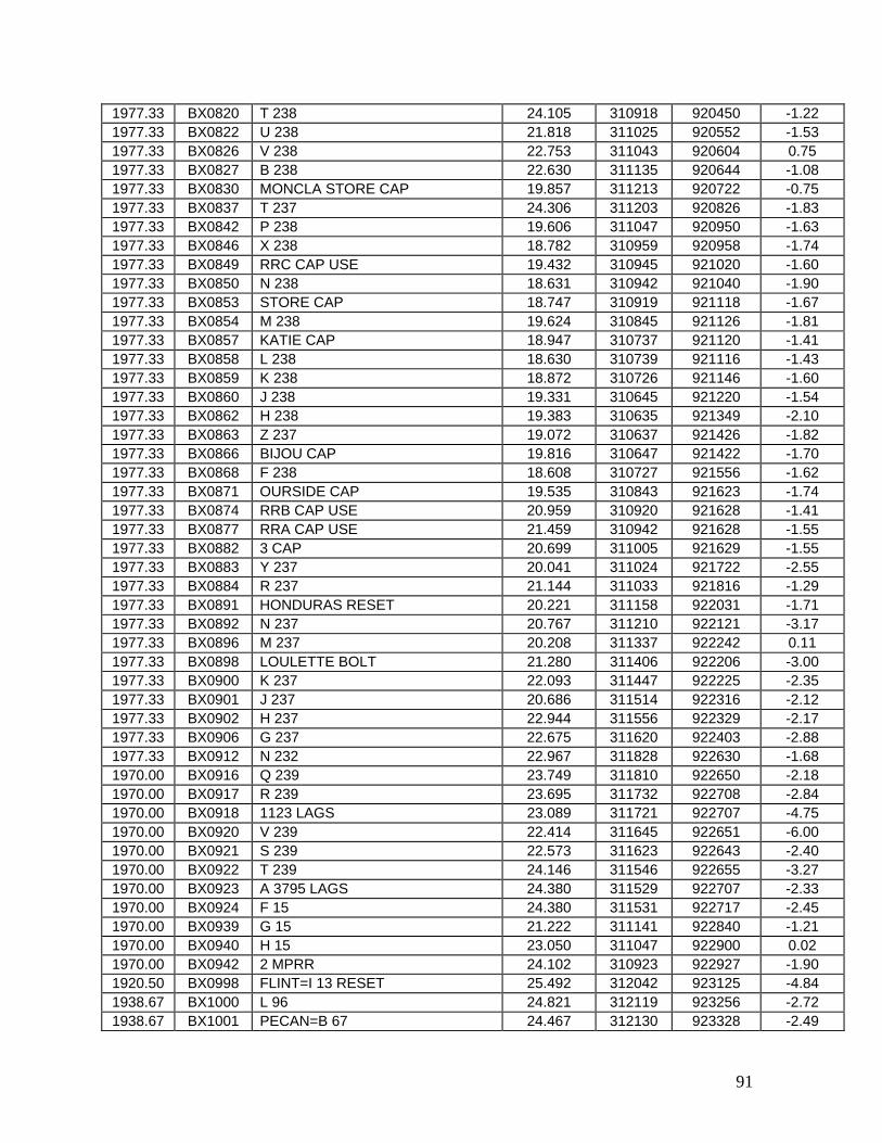
91
1977.33 BX0820 T 238 24.105 310918 920450 -1.22 1977.33 BX0822 U 238 21.818 311025 920552 -1.53 1977.33 BX0826 V 238 22.753 311043 920604 0.75 1977.33 BX0827 B 238 22.630 311135 920644 -1.08 1977.33 BX0830 MONCLA STORE CAP 19.857 311213 920722 -0.75 1977.33 BX0837 T 237 24.306 311203 920826 -1.83 1977.33 BX0842 P 238 19.606 311047 920950 -1.63 1977.33 BX0846 X 238 18.782 310959 920958 -1.74 1977.33 BX0849 RRC CAP USE 19.432 310945 921020 -1.60 1977.33 BX0850 N 238 18.631 310942 921040 -1.90 1977.33 BX0853 STORE CAP 18.747 310919 921118 -1.67 1977.33 BX0854 M 238 19.624 310845 921126 -1.81 1977.33 BX0857 KATIE CAP 18.947 310737 921120 -1.41 1977.33 BX0858 L 238 18.630 310739 921116 -1.43 1977.33 BX0859 K 238 18.872 310726 921146 -1.60 1977.33 BX0860 J 238 19.331 310645 921220 -1.54 1977.33 BX0862 H 238 19.383 310635 921349 -2.10 1977.33 BX0863 Z 237 19.072 310637 921426 -1.82 1977.33 BX0866 BIJOU CAP 19.816 310647 921422 -1.70 1977.33 BX0868 F 238 18.608 310727 921556 -1.62 1977.33 BX0871 OURSIDE CAP 19.535 310843 921623 -1.74 1977.33 BX0874 RRB CAP USE 20.959 310920 921628 -1.41 1977.33 BX0877 RRA CAP USE 21.459 310942 921628 -1.55 1977.33 BX0882 3 CAP 20.699 311005 921629 -1.55 1977.33 BX0883 Y 237 20.041 311024 921722 -2.55 1977.33 BX0884 R 237 21.144 311033 921816 -1.29 1977.33 BX0891 HONDURAS RESET 20.221 311158 922031 -1.71 1977.33 BX0892 N 237 20.767 311210 922121 -3.17 1977.33 BX0896 M 237 20.208 311337 922242 0.11 1977.33 BX0898 LOULETTE BOLT 21.280 311406 922206 -3.00 1977.33 BX0900 K 237 22.093 311447 922225 -2.35 1977.33 BX0901 J 237 20.686 311514 922316 -2.12 1977.33 BX0902 H 237 22.944 311556 922329 -2.17 1977.33 BX0906 G 237 22.675 311620 922403 -2.88 1977.33 BX0912 N 232 22.967 311828 922630 -1.68 1970.00 BX0916 Q 239 23.749 311810 922650 -2.18 1970.00 BX0917 R 239 23.695 311732 922708 -2.84 1970.00 BX0918 1123 LAGS 23.089 311721 922707 -4.75 1970.00 BX0920 V 239 22.414 311645 922651 -6.00 1970.00 BX0921 S 239 22.573 311623 922643 -2.40 1970.00 BX0922 T 239 24.146 311546 922655 -3.27 1970.00 BX0923 A 3795 LAGS 24.380 311529 922707 -2.33 1970.00 BX0924 F 15 24.380 311531 922717 -2.45 1970.00 BX0939 G 15 21.222 311141 922840 -1.21 1970.00 BX0940 H 15 23.050 311047 922900 0.02 1970.00 BX0942 2 MPRR 24.102 310923 922927 -1.90 1920.50 BX0998 FLINT=I 13 RESET 25.492 312042 923125 -4.84 1938.67 BX1000 L 96 24.821 312119 923256 -2.72 1938.67 BX1001 PECAN=B 67 24.467 312130 923328 -2.49

92
1938.67 BX1002 PECAN RM 2 24.502 312131 923328 -1.86 1938.67 BX1003 M 96 24.969 312144 923441 -0.82 1920.50 BX1004 RAPIDES=H 13 26.956 312151 923513 -10.60 1938.67 BX1005 HAWTHORN 25.672 312151 923514 -0.66 1920.50 BX1008 JOYNER=G 13 25.489 312221 923744 0.51 1938.67 BX1009 JOYNER RM 1 25.185 312223 923755 0.05 1938.67 BX1010 JOYNER RM 2 25.567 312225 923754 -0.03 1920.50 BX1011 BOYCE=F 13 26.665 312253 923910 -2.05 1920.50 BX1022 ZIMMERMAN=D 13 27.932 312456 924208 -0.77 1970.00 BX1121 L 15 41.623 310643 923024 0.37 1970.00 BX1124 M 15 54.442 310449 923106 0.51 1970.00 BX1132 Q 15 44.491 310153 923210 -0.05 1970.00 BX1134 3 MPRR 38.286 310109 923254 0.28 1920.50 BX1275 HALES=Z 12 30.296 313119 925518 0.33 1920.50 BX1282 MONTROSE=V 12 30.880 313416 925939 -4.72 1920.50 BX1683 CYPRESS=S 12 RESET 30.590 313628 930239 -2.23 1920.50 BX1689 FLORA=Q 12 32.147 313700 930708 -1.57 1920.50 BX1692 RUM=P 12 RESET 39.142 313742 930947 -1.55 1920.50 BX1700 SIGN 71.344 314016 931516 -3.91 1920.50 BX1703 WHITE=M 12 72.156 314043 931617 -2.63 1920.50 BX1705 ROBELINE=L 12 59.704 314106 931728 -4.80 1920.50 BX1713 CABIN=J 12 64.274 314359 932218 -1.47 1920.50 BX1721 BOLYNE=H 12 101.575 314500 932624 -1.31 1920.50 BX1724 PALM=G 12 96.615 314538 932729 -2.00 1920.50 BX1728 MILES=D 12 110.284 314737 932935 -0.56 1920.50 BX2171 PELICAN=Z 10 96.387 315256 933510 -2.72 1920.50 BX2174 OXFORD=Y 10 77.875 315533 933747 -17.43 1977.33 BX2225 R 250 14.027 310259 920020 -1.35 1977.33 BX2226 D 239 14.032 310305 920054 -1.29 1938.67 BX2273 HAWTHORN RM 1 25.683 312154 923514 -1.47 1968.25 CN2592 PBM 5 38.311 323103 875012 3.84 1968.25 CN2593 BOLT 4 38.830 323103 875012 3.83 1968.25 CN2594 Z 112 37.766 323102 875015 3.93 1968.25 CN2599 W 158 29.664 323042 875123 3.85 1968.25 CN2604 U 158 24.413 323050 875309 3.72 1968.25 CN2608 S 158 29.422 323115 875444 3.99 1968.25 CN2609 P B M 2 28.962 323123 875522 3.98 1968.25 CN2612 Q 158 26.548 323106 875626 3.80 1968.25 CN2614 P 158 24.637 323056 875711 4.15 1968.25 CN2615 N 158 25.380 323040 875822 4.15 1968.25 CN2616 TTS 63 T 26.818 323030 875907 3.77 1968.25 CO0285 D 158 49.685 322906 880305 4.36 1968.25 CO0288 H 158 38.741 322903 880409 4.49 1968.25 CO0289 TTS 61 T USGS 37.022 322906 880424 4.25 1968.25 CO0292 J 158 43.832 322913 880511 5.96 1968.25 CO0296 LT 3 108 USE 39.425 322903 880706 4.00 1968.25 CO0299 L 158 29.813 322859 880840 4.88 1968.25 CO0300 M 158 30.555 322909 880945 4.64 1968.25 CO0307 A 158 49.183 322923 881310 3.72

93
1968.25 CO0308 Z 156 52.811 322917 881413 5.80 1968.25 CO0309 Y 156 42.142 322914 881516 5.16 1968.25 CO0316 TTS 54 T USGS 50.828 322906 881751 4.68 1968.25 CO0320 W 156 49.193 322811 881926 4.32 1968.25 CO0321 V 156 52.062 322727 881951 4.60 1968.25 CO0322 U 156 52.914 322643 882030 4.46 1968.25 CO0323 T 156 60.271 322624 882110 4.67 1968.25 CO0324 S 156 63.768 322558 882204 5.06 1968.25 CO0326 K 103 65.310 322540 882242 5.42 1968.25 CO0327 M 318 71.105 322545 882300 5.51 1968.25 CO0328 L 318 71.359 322539 882329 5.65 1968.25 CO0329 KEWANEE RM 1 94.874 322529 882442 5.97 1968.25 CO0330 KEWANEE 95.290 322528 882442 6.08 1968.25 CO0331 KEWANEE RM 2 94.396 322529 882442 5.98 1968.25 CO0332 M 73 81.817 322459 882437 5.84 1968.25 CO0333 A 211 93.822 322527 882446 5.89 1968.25 CO0334 KEWANEE AZ MK 90.401 322527 882501 6.00 1968.25 CO0335 B 211 83.304 322526 882547 6.18 1968.25 CO0336 L 73 84.995 322526 882618 4.99 1968.25 CO0337 C 211 74.486 322536 882732 5.62 1968.25 CO0339 TOOMSUBA RM 2 89.280 322527 882829 5.46 1968.25 CO0340 TOOMSUBA RM 1 90.140 322527 882829 5.48 1968.25 CO0341 TOOMSUBA 89.359 322527 882829 5.47 1968.25 CO0342 TOOMSUBA AZ MK 89.435 322520 882853 5.35 1968.25 CO0343 Z 185 87.951 322501 882943 5.47 1968.25 CO0344 D 211 82.930 322509 882940 4.96 1980.33 CO0428 Q 36 71.131 320225 884338 5.06 1980.33 CO0431 S 35 68.796 320243 884348 4.73 1980.33 CO0443 C 73 101.439 322139 884206 5.50 1968.25 CO0449 PBM NEW POST OFFICE USE 104.953 322159 884200 5.76 1968.25 CO0452 B 73 101.167 322152 884145 5.29 1968.25 CO0460 H 11642 89.719 322503 883023 4.37 1968.25 CO0462 G 211 95.871 322507 883015 5.18 1968.25 CO0463 H 211 89.760 322511 883125 5.16 1968.25 CO0464 J 211 106.640 322503 883219 4.90 1968.25 CO0465 H 73 113.703 322448 883305 5.11 1968.25 CO0466 RUSSELL RM 2 172.590 322435 883408 4.91 1968.25 CO0467 RUSSELL 174.739 322435 883408 4.91 1968.25 CO0468 RUSSELL RM 1 173.645 322435 883408 5.05 1968.25 CO0469 RUSSELL AZ MK 146.223 322440 883403 5.01 1968.25 CO0470 F 211 137.539 322432 883447 5.97 1968.25 CO0472 E 211 127.873 322412 883541 5.28 1968.25 CO0473 N 211 115.366 322353 883629 5.19 1968.25 CO0475 G 73 109.184 322340 883815 5.95 1968.25 CO0476 W 211 104.043 322330 883923 5.91 1968.25 CO0477 BONITA RM 1 129.710 322256 883929 7.44 1968.25 CO0478 BONITA 130.453 322255 883929 6.21 1968.25 CO0479 BONITA RM 2 129.417 322256 883929 5.81 1968.25 CO0480 U 211 100.830 322214 884022 5.81
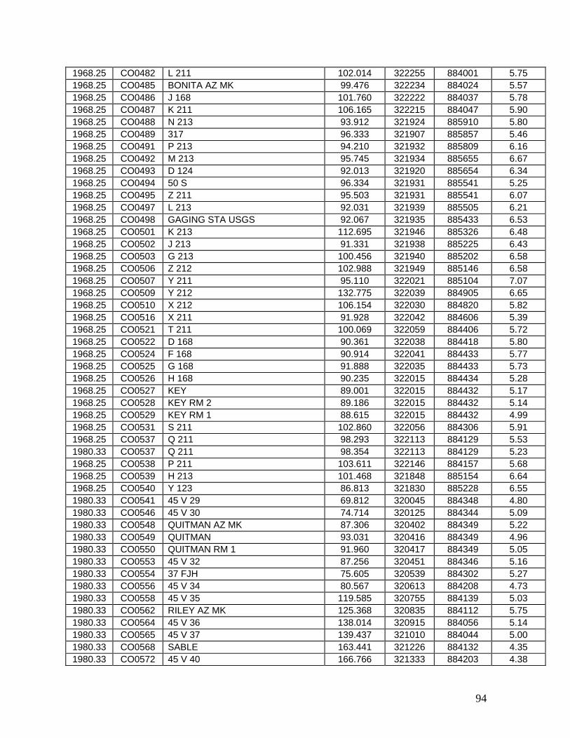
94
1968.25 CO0482 L 211 102.014 322255 884001 5.75 1968.25 CO0485 BONITA AZ MK 99.476 322234 884024 5.57 1968.25 CO0486 J 168 101.760 322222 884037 5.78 1968.25 CO0487 K 211 106.165 322215 884047 5.90 1968.25 CO0488 N 213 93.912 321924 885910 5.80 1968.25 CO0489 317 96.333 321907 885857 5.46 1968.25 CO0491 P 213 94.210 321932 885809 6.16 1968.25 CO0492 M 213 95.745 321934 885655 6.67 1968.25 CO0493 D 124 92.013 321920 885654 6.34 1968.25 CO0494 50 S 96.334 321931 885541 5.25 1968.25 CO0495 Z 211 95.503 321931 885541 6.07 1968.25 CO0497 L 213 92.031 321939 885505 6.21 1968.25 CO0498 GAGING STA USGS 92.067 321935 885433 6.53 1968.25 CO0501 K 213 112.695 321946 885326 6.48 1968.25 CO0502 J 213 91.331 321938 885225 6.43 1968.25 CO0503 G 213 100.456 321940 885202 6.58 1968.25 CO0506 Z 212 102.988 321949 885146 6.58 1968.25 CO0507 Y 211 95.110 322021 885104 7.07 1968.25 CO0509 Y 212 132.775 322039 884905 6.65 1968.25 CO0510 X 212 106.154 322030 884820 5.82 1968.25 CO0516 X 211 91.928 322042 884606 5.39 1968.25 CO0521 T 211 100.069 322059 884406 5.72 1968.25 CO0522 D 168 90.361 322038 884418 5.80 1968.25 CO0524 F 168 90.914 322041 884433 5.77 1968.25 CO0525 G 168 91.888 322035 884433 5.73 1968.25 CO0526 H 168 90.235 322015 884434 5.28 1968.25 CO0527 KEY 89.001 322015 884432 5.17 1968.25 CO0528 KEY RM 2 89.186 322015 884432 5.14 1968.25 CO0529 KEY RM 1 88.615 322015 884432 4.99 1968.25 CO0531 S 211 102.860 322056 884306 5.91 1968.25 CO0537 Q 211 98.293 322113 884129 5.53 1980.33 CO0537 Q 211 98.354 322113 884129 5.23 1968.25 CO0538 P 211 103.611 322146 884157 5.68 1968.25 CO0539 H 213 101.468 321848 885154 6.64 1968.25 CO0540 Y 123 86.813 321830 885228 6.55 1980.33 CO0541 45 V 29 69.812 320045 884348 4.80 1980.33 CO0546 45 V 30 74.714 320125 884344 5.09 1980.33 CO0548 QUITMAN AZ MK 87.306 320402 884349 5.22 1980.33 CO0549 QUITMAN 93.031 320416 884349 4.96 1980.33 CO0550 QUITMAN RM 1 91.960 320417 884349 5.05 1980.33 CO0553 45 V 32 87.256 320451 884346 5.16 1980.33 CO0554 37 FJH 75.605 320539 884302 5.27 1980.33 CO0556 45 V 34 80.567 320613 884208 4.73 1980.33 CO0558 45 V 35 119.585 320755 884139 5.03 1980.33 CO0562 RILEY AZ MK 125.368 320835 884112 5.75 1980.33 CO0564 45 V 36 138.014 320915 884056 5.14 1980.33 CO0565 45 V 37 139.437 321010 884044 5.00 1980.33 CO0568 SABLE 163.441 321226 884132 4.35 1980.33 CO0572 45 V 40 166.766 321333 884203 4.38

95
1980.33 CO0573 45 V 41 173.813 321429 884148 4.41 1980.33 CO0580 45 V 44 185.097 321645 884152 4.21 1980.33 CO0582 WOLF RESET 196.023 321720 884128 6.11 1980.33 CO0587 ZERO 203.420 321939 884129 4.85 1968.83 CO0740 C 25 152.447 322147 892928 3.00 1968.83 CO0741 FOREST W BASE RM 2 155.307 322147 892929 -21.54 1968.83 CO0742 FOREST W BASE RM 1 155.760 322147 892929 -2.67 1968.83 CO0743 FOREST WEST BASE 155.547 322146 892928 -0.29 1968.83 CO0744 PTS 25 S USGS 147.684 322146 892828 6.79 1968.83 CO0745 D 25 145.433 322137 892826 3.90 1968.83 CO0746 V 107 139.861 322137 892750 1.83 1968.83 CO0751 F 213 143.588 322145 892726 2.82 1968.83 CO0752 MUSKEGON AZ MK 134.245 322145 892644 2.91 1968.83 CO0753 MUSKEGON RM 3 140.522 322141 892619 4.30 1968.83 CO0754 MUSKEGON 140.459 322141 892620 3.30 1968.83 CO0755 MUSKEGON RM 1 140.241 322141 892619 -2.58 1968.83 CO0756 N 214 134.719 322137 892540 -1.27 1968.83 CO0757 U 107 137.377 322125 892538 2.97 1968.83 CO0758 L 214 135.995 322129 892444 -0.22 1968.83 CO0759 K 214 129.463 322125 892332 2.93 1968.83 CO0760 J 214 138.747 322117 892224 3.06 1968.83 CO0762 G 214 128.846 322109 892112 -4.79 1968.83 CO0763 FOREST E BASE RM 1 135.550 322053 892036 0.14 1968.83 CO0764 FOREST E BASE RM 3 136.406 322053 892036 1.14 1968.83 CO0765 FOREST EAST BASE 136.354 322052 892036 -0.10 1968.83 CO0766 PTS 23 S USGS 134.068 322035 891940 1.91 1968.83 CO0767 H 214 143.353 322043 891932 2.19 1968.83 CO0768 C 214 141.550 322023 891827 2.29 1968.83 CO0769 S 107 143.642 322009 891850 3.49 1968.83 CO0770 D 214 139.653 322015 891736 4.49 1968.83 CO0771 E 214 135.856 321952 891618 3.49 1968.83 CO0772 R 107 139.979 321939 891640 3.81 1968.83 CO0773 F 214 133.425 321951 891543 4.60 1968.83 CO0775 B 214 140.826 321940 891504 1.92 1968.83 CO0776 24 S 139.276 321930 891403 -0.48 1968.83 CO0777 Q 107 138.642 321931 891356 4.33 1968.83 CO0778 A 214 130.094 321926 891249 4.48 1968.83 CO0779 Z 213 124.756 321931 891147 3.98 1968.83 CO0780 P 107 122.580 321922 891148 4.15 1968.83 CO0781 P 212 116.998 321932 891108 4.23 1968.25 CO0782 Y 213 119.406 321930 891035 3.65 1968.25 CO0783 W 102 126.905 321917 890957 3.56 1968.25 CO0784 PTS 47S 126.503 321914 890947 3.48 1968.25 CO0786 V 102 133.259 321953 890937 3.08 1968.25 CO0788 W 213 142.006 321953 890932 4.37 1968.25 CO0789 NEWTON RM 2 146.374 321956 890921 4.33 1968.25 CO0790 NEWTON 147.192 321955 890921 4.32 1968.25 CO0791 NEWTON RM 1 147.343 321956 890921 4.36 1968.25 CO0792 NEWTON AZ MK 134.565 321959 890851 4.27

96
1968.25 CO0793 T 213 114.588 321957 890803 4.99 1968.25 CO0799 U 213 112.293 321958 890737 5.04 1968.25 CO0800 Q 212 104.460 322011 890644 4.74 1968.25 CO0801 V 213 106.417 322024 890600 5.19 1968.25 CO0802 X 213 109.821 322017 890452 4.18 1968.25 CO0803 TREES AZ MK 113.418 322004 890411 5.89 1968.25 CO0804 TREES RM 2 119.546 322000 890403 5.60 1968.25 CO0805 TREES 120.416 322000 890403 5.62 1968.25 CO0806 TREES RM 1 120.421 322000 890403 5.44 1968.25 CO0807 S 213 108.727 321952 890321 5.77 1968.25 CO0808 R 213 113.694 321929 890220 6.14 1968.25 CO0809 R 212 99.298 321905 890129 6.01 1968.25 CO0810 Q 213 99.250 321914 890014 5.55 1968.83 CO0830 P 214 140.417 322217 892838 3.70 1968.83 CO0837 W 107 144.153 322139 892828 2.58 1968.83 CO0860 BRANDON RESET 158.627 321635 895926 -2.44 1968.83 CO0861 BRANDON RM 1 156.655 321635 895926 -2.45 1968.83 CO0862 BRANDON RM 2 156.339 321635 895926 -2.66 1968.83 CO0865 Q 24 121.438 321717 895936 -3.42 1968.83 CO0866 W 210 152.836 321625 895924 -2.31 1968.83 CO0867 X 210 124.040 321621 895832 -4.37 1968.83 CO0868 Y 210 122.161 321629 895722 -3.95 1968.83 CO0869 B 212 121.693 321641 895627 -2.90 1968.83 CO0870 C 212 130.575 321655 895526 -3.80 1968.83 CO0871 COX AZ MK 133.719 321707 895446 -3.49 1968.83 CO0872 S 24 129.283 321717 895444 -1.79 1968.83 CO0873 J 212 121.074 321723 895338 -1.82 1968.83 CO0874 D 212 119.867 321739 895256 -2.64 1968.83 CO0875 T 24 119.290 321741 895236 -2.78 1968.83 CO0876 GULDE AZ MK 115.791 321807 895203 -9.56 1968.83 CO0877 GULDE RM 2 121.157 321818 895141 -4.40 1968.83 CO0878 GULDE 121.875 321817 895142 -6.49 1968.83 CO0881 GULDE RM 1 121.128 321818 895141 -1.94 1968.83 CO0883 F 212 118.725 321829 894942 -3.62 1968.83 CO0887 V 24 106.239 321837 894858 -2.12 1968.83 CO0888 L 212 104.798 321843 894832 -1.99 1968.83 CO0889 W 24 106.633 321841 894828 -2.34 1968.83 CO0890 W 109.403 321847 894758 -1.71 1968.83 CO0891 A 212 108.507 321845 894752 -2.78 1968.83 CO0892 HATCH AZ MK 112.200 321851 894734 -11.79 1968.83 CO0893 HATCH RM 3 118.568 321858 894719 3.99 1968.83 CO0896 G 212 118.520 321905 894644 0.20 1968.83 CO0897 S 212 131.905 321919 894536 -3.07 1968.83 CO0898 RANSCO AZ MK 112.868 321915 894445 -3.30 1968.83 CO0899 RANSCO RM 2 116.185 321933 894351 -0.86 1968.83 CO0900 RANSCO 116.234 321932 894351 -1.32 1968.83 CO0901 RANSCO RM 1 116.437 321933 894351 -1.51 1968.83 CO0902 T 212 125.131 321952 894240 -11.20 1968.83 CO0904 W 212 120.433 322001 894214 -2.77

97
1968.83 CO0905 V 212 138.396 322027 894115 -3.50 1968.83 CO0906 U 212 127.411 322051 894024 -3.52 1968.83 CO0910 X 24 144.981 322113 893910 3.10 1968.83 CO0911 Y 24 141.401 322114 893830 1.02 1968.83 CO0912 A 213 135.403 322117 893719 13.56 1968.83 CO0913 M 212 133.606 322115 893700 1.01 1968.83 CO0914 JOHNS 141.488 322117 893636 -2.86 1968.83 CO0915 JOHNS RM 1 141.315 322118 893635 -4.52 1968.83 CO0916 JOHNS RM 2 140.987 322118 893635 -0.87 1968.83 CO0918 B 213 138.108 322119 893536 2.39 1968.83 CO0919 A 25 144.146 322143 893424 3.60 1968.83 CO0920 CURVE AZ MK 145.403 322145 893412 -12.78 1968.83 CO0921 CURVE RM 1 154.672 322144 893352 -3.16 1968.83 CO0922 CURVE 155.348 322144 893352 -14.24 1968.83 CO0923 CURVE RM 2 155.512 322144 893352 -5.62 1968.83 CO0925 D 213 158.751 322127 893250 5.29 1968.83 CO0926 C 213 161.661 322125 893156 0.69 1968.83 CO0927 N 212 142.957 322145 893105 2.88 1968.83 CO0928 E 213 150.405 322143 893000 15.23 1968.25 CO0997 KEY AZ MK 90.185 322035 884420 5.09 1993.08 CP0001 61 V 130 30.067 324222 905605 -4.85 1993.08 CP0003 61 V 131 29.354 324306 905625 -6.14 1993.25 CP0205 A 236 132.777 320029 902050 -6.05 1993.25 CP0206 J 9 127.951 320051 902036 -5.76 1993.25 CP0209 U 209 114.619 320245 902007 -6.68 1993.25 CP0210 L 9 110.047 320323 901945 -6.32 1993.25 CP0215 V 209 102.745 320406 901906 -6.25 1993.25 CP0216 M 9 96.832 320444 901826 -6.24 1993.25 CP0218 BM 88.601 320543 901734 -6.58 1993.25 CP0219 N 9 89.618 320551 901744 -6.48 1993.25 CP0222 TERRY RM 1 97.030 320601 901800 -5.96 1993.25 CP0225 C 236 85.430 320641 901640 -6.63 1993.25 CP0226 Y 209 91.786 320718 901614 -5.94 1993.25 CP0227 G 210 84.578 320751 901602 -6.99 1993.25 CP0228 270 82.217 320837 901546 -6.30 1993.25 CP0229 Q 9 79.986 320919 901528 -6.90 1993.25 CP0232 R 9 80.564 321039 901442 -6.20 1993.25 CP0233 S 9 80.215 321056 901432 -5.66 1993.25 CP0241 W 9 89.558 321618 901225 -6.09 1993.25 CP0242 B 210 89.991 321645 901205 -5.94 1993.25 CP0243 B 236 90.023 321703 901145 -5.70 1993.25 CP0264 X 224 94.100 321812 901055 -3.82 1968.83 CP0269 CITY HALL 88.969 321751 901056 -5.61 1993.25 CP0283 CLINTON RM 4 116.411 322012 901912 -5.48 1993.25 CP0284 CLINTON RESET 115.786 322012 901912 -13.11 1993.25 CP0285 CLINTON RM 3 115.603 322012 901912 1.76 1993.25 CP0286 D 1 107.262 322015 901948 -6.47 1993.25 CP0287 Y 224 93.553 322000 901957 -6.88 1993.25 CP0298 Z 224 96.214 322025 902050 -5.03

98
1993.25 CP0309 P RESET 89.227 321749 901058 -5.73 1968.83 CP0310 CITY RM 1 88.748 321750 901059 -6.67 1993.25 CP0311 CITY AZ MK 88.844 321802 901058 -5.58 1968.83 CP0311 CITY AZ MK 88.981 321802 901058 -5.66 1968.83 CP0312 G 24 84.428 321715 901048 -6.29 1993.25 CP0313 Q 224 85.419 321732 901055 -5.70 1993.25 CP0314 H 210 82.769 321704 901100 -5.99 1968.83 CP0314 H 210 82.916 321704 901100 -6.22 1993.25 CP0315 P 224 84.334 321658 901103 -6.91 1968.83 CP0316 E 5 83.958 321657 901104 -8.27 1993.25 CP0317 J 210 92.139 321646 900959 -6.66 1968.83 CP0317 J 210 92.302 321646 900959 -6.17 1968.83 CP0326 K 210 82.806 321631 900812 -5.24 1968.83 CP0328 M 210 90.472 321457 900752 -6.67 1968.83 CP0329 J 24 83.749 321515 900836 -4.88 1968.83 CP0333 N 210 91.469 321445 900701 -6.05 1968.83 CP0334 P 210 88.588 321425 900556 -3.69 1968.83 CP0335 Q 210 93.248 321411 900505 -2.84 1968.83 CP0336 L 24 92.379 321406 900442 -3.55 1968.83 CP0337 R 210 93.469 321413 900422 -3.06 1968.83 CP0339 ST FARM 100.289 321417 900414 -4.73 1968.83 CP0342 S 210 93.360 321437 900334 -2.97 1968.83 CP0343 M 24 95.236 321455 900311 -2.73 1968.83 CP0345 N 24 98.146 321547 900237 -2.73 1968.83 CP0346 T 210 105.894 321624 900210 -2.64 1968.83 CP0347 V 210 110.777 321701 900209 -6.06 1968.83 CP0354 K 212 105.896 321703 900123 -2.52 1968.83 CP0355 U 210 124.068 321652 900014 -6.13 1993.25 CP0391 20 V 49 90.799 322035 902138 -6.59 1993.25 CP0393 TOM RM 1 108.802 322046 902220 -6.48 1993.25 CP0394 TOM RM 2 110.402 322046 902220 -6.02 1993.25 CP0398 20 V 46 81.928 322120 902435 -8.23 1993.25 CP0401 BOLTON AZ MK 83.982 322123 902604 -6.47 1993.25 CP0402 BOLTON 2 82.309 322122 902632 -6.11 1993.25 CP0403 BOLTON 2 RM 3 81.342 322123 902632 -5.86 1993.25 CP0404 BOLTON 2 RM 4 82.369 322122 902631 -5.23 1993.25 CP0409 REVIS 2 63.681 322140 902942 -5.85 1993.25 CP0410 REVIS 2 RM 3 63.177 322140 902941 -6.11 1993.25 CP0511 55 V 1 83.642 321650 901021 -6.73 1993.25 CP0546 X 59 79.474 322027 905052 -5.94 1993.08 CP0551 N 225 67.570 322035 905248 -5.71 1993.08 CP0552 P 225 70.475 322056 905250 -5.43 1993.08 CP0553 Z 59 58.646 322040 905302 -5.42 1993.08 CP0554 M 225 54.387 322046 905303 -5.45 1974.00 CP0558 J 225 44.018 321903 905337 -5.94 1974.00 CP0559 H225 49.252 321847 905405 -5.77 1993.08 CP0563 K 236 31.454 322123 905249 -5.40 1993.08 CP0564 J 236 33.871 322149 905234 -5.30 1993.08 CP0567 H 236 31.332 322220 905218 -5.30
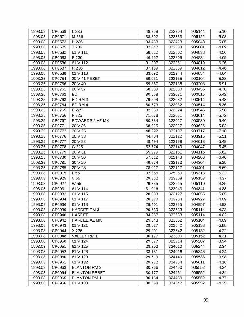
99
1993.08 CP0569 L 236 48.358 322304 905144 -5.10 1993.08 CP0571 M 236 38.802 322333 905122 -5.08 1993.08 CP0572 N 236 33.433 322423 905048 -5.05 1993.08 CP0575 T 236 32.047 322503 905001 -4.89 1993.08 CP0582 61 V 111 58.612 322802 904838 -4.56 1993.08 CP0583 P 236 46.952 322809 904834 -4.69 1993.08 CP0586 61 V 112 31.807 322851 904819 -6.26 1993.08 CP0587 R 236 37.139 322859 904812 -4.46 1993.08 CP0588 61 V 113 33.092 322944 904834 -4.64 1993.25 CP0754 20 V 41 RESET 59.031 322135 903104 -5.88 1993.25 CP0756 20 V 40 59.867 322138 903208 -5.91 1993.25 CP0761 20 V 37 68.239 322038 903455 -4.70 1993.25 CP0762 ED 80.568 322031 903515 -5.42 1993.25 CP0763 ED RM 3 79.594 322032 903514 -5.43 1993.25 CP0764 ED RM 4 80.773 322032 903514 -5.36 1993.25 CP0765 E 225 82.230 322024 903546 -5.58 1993.25 CP0766 F 225 71.078 322031 903614 -5.72 1993.25 CP0767 EDWARDS 2 AZ MK 80.384 322027 903530 -5.46 1993.25 CP0771 20 V 36 68.925 322037 903626 -5.82 1993.25 CP0772 20 V 35 48.292 322107 903717 -7.18 1993.25 CP0776 20 V 33 44.404 322122 903916 -5.51 1993.25 CP0777 20 V 32 49.494 322139 904013 -5.49 1993.25 CP0778 G 225 52.774 322149 904047 -5.45 1993.25 CP0779 20 V 31 55.979 322151 904116 -5.62 1993.25 CP0780 20 V 30 57.012 322143 904208 -6.40 1993.25 CP0781 20 V 29 49.674 322133 904304 -5.29 1993.25 CP0785 20 V 28 78.017 322117 904401 -5.69 1993.08 CP0915 L 55 32.355 325250 905318 -5.22 1993.08 CP0925 V 55 29.862 323808 905153 -4.37 1993.08 CP0927 W 55 29.335 323515 905110 -4.25 1993.08 CP0931 61 V 114 31.016 323043 904841 -4.88 1993.08 CP0932 61 V 115 28.033 323127 904855 -5.05 1993.08 CP0934 61 V 117 28.320 323254 904927 -4.09 1993.08 CP0936 61 V 118 29.401 323335 904957 -4.92 1993.08 CP0939 HARDEE RM 3 29.639 323533 905114 -4.23 1993.08 CP0940 HARDEE 34.267 323533 905114 -4.02 1993.08 CP0942 HARDEE AZ MK 29.343 323552 905104 -4.09 1993.08 CP0943 61 V 121 29.527 323642 905133 -5.88 1993.08 CP0944 X 236 29.201 323642 905132 -4.22 1993.08 CP0948 VALLEY RM 1 30.177 323800 905152 -4.31 1993.08 CP0950 61 V 124 29.677 323914 905207 -3.94 1993.08 CP0951 61 V 125 28.802 324010 905244 -3.34 1993.08 CP0952 61 V 126 38.151 324016 905346 -4.24 1993.08 CP0960 61 V 129 29.519 324140 905538 -3.98 1993.08 CP0961 61 V 132 29.972 324354 905611 -4.16 1993.08 CP0963 BLANTON RM 2 30.266 324450 905552 -4.24 1993.08 CP0964 BLANTON RESET 30.177 324451 905552 -4.34 1993.08 CP0965 BLANTON RM 1 30.164 324450 905552 -4.77 1993.08 CP0966 61 V 133 30.568 324542 905552 -4.25

100
1993.08 CP0967 61 V 134 30.510 324642 905603 -4.22 1993.08 CP0969 61 V 136 31.369 324824 905541 -5.32 1993.08 CP0970 G 237 31.711 324831 905528 -4.46 1993.08 CP0971 CARY AZ MK 31.523 324902 905516 -4.96 1993.08 CP0972 CARY RM 2 30.350 324912 905507 -5.39 1993.08 CP0974 CARY 31.379 324913 905507 -10.33 1993.08 CP0975 61 V 137 32.442 325007 905447 -5.36 1993.08 CP0977 B 237 31.542 325135 905412 -4.73 1993.08 CP0982 FORK RESET 33.113 325346 905240 -5.23 1993.08 CP0998 Y 236 31.164 325419 905344 -5.17 1993.08 CP0999 Z 236 32.581 325422 905417 -4.83 1993.08 CP1000 J 237 32.562 325427 905540 -4.84 1993.08 CP1002 H 237 30.774 325438 905716 -4.58 1993.08 CP1004 M 237 31.200 325542 905759 -4.59 1993.08 CP1005 N 237 30.841 325639 905757 -4.94 1993.08 CP1006 P 237 31.231 325727 905757 -5.31 1993.08 CP1011 F 237 33.003 325932 905752 -4.91 1969.08 CP1336 U 254 25.613 322223 910638 -8.73 1982.75 CP1338 BARNES 25.297 322245 910725 -8.92 1982.75 CP1339 BARNES RM 2 25.700 322245 910725 -8.97 1982.75 CP1345 W 254 26.632 322334 910920 -9.03 1982.75 CP1348 TALLULAH 2 AZ MK 25.111 322441 910849 -10.14 1982.75 CP1352 L 255 25.510 322445 910900 -9.58 1982.75 CP1353 M 255 25.251 322446 910859 -9.64 1982.75 CP1361 Z 254 24.183 322503 911224 -8.24 1982.75 CP1372 E 255 23.919 322535 911811 -8.75 1982.75 CP1387 G 255 24.476 322553 912200 -8.12 1982.75 CP1393 WAVERLY RM 3 24.245 322646 912442 -8.66 1982.75 CP1394 WAVERLY 24.943 322647 912444 -8.78 1982.75 CP1395 WAVERLY RM 4 24.279 322646 912446 -8.34 1969.08 CP1399 S 245 23.091 322714 912725 -12.85 1969.08 CP1400 R 245 27.385 322719 912832 -10.96 1969.08 CP1401 Y 244 28.911 322715 912937 -10.13 1969.08 CP1410 Z 244 29.656 322727 912956 -9.71 1969.08 CP1722 Q 245 29.137 322729 913024 -10.31 1969.08 CP1723 P 245 26.733 322734 913125 -10.14 1969.08 CP1725 N 245 27.478 322737 913210 -9.94 1969.08 CP1726 M 245 27.147 322743 913314 -7.97 1969.08 CP1730 L 245 26.331 322747 913418 -9.06 1969.08 CP1733 K 245 24.700 322751 913517 -8.92 1969.08 CP1734 J 245 24.803 322757 913618 -8.49 1969.08 CP1735 J 23 4 CAP 26.866 322805 913725 -6.29 1969.08 CP1736 HOLLY RM 3 26.770 322807 913724 -6.88 1969.08 CP1737 HOLLY RM 4 26.767 322807 913724 -7.05 1969.08 CP1738 HOLLY 26.792 322807 913724 -7.04 1969.08 CP1743 H 245 24.600 322809 913828 -6.41 1969.08 CP1744 G 245 24.419 322811 913933 -5.99 1969.08 CP1745 F 245 24.892 322816 914038 -6.52 1969.08 CP1746 J 23 1 CAP 25.595 322820 914146 -7.03
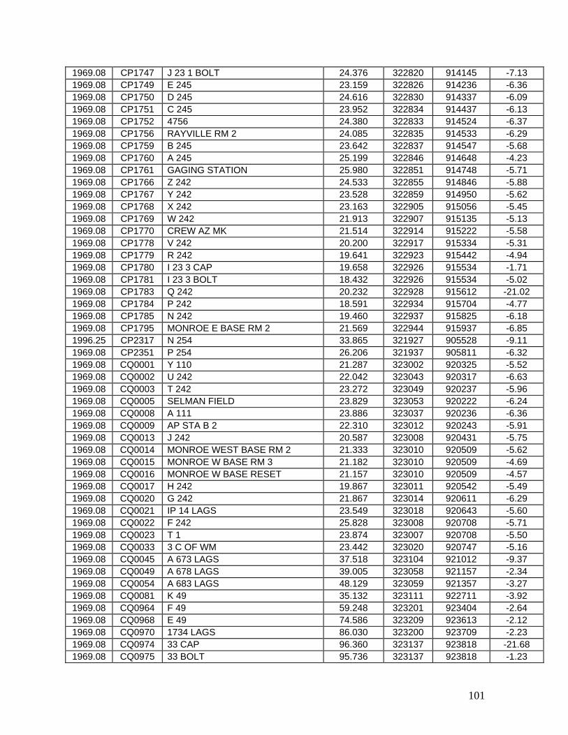
101
1969.08 CP1747 J 23 1 BOLT 24.376 322820 914145 -7.13 1969.08 CP1749 E 245 23.159 322826 914236 -6.36 1969.08 CP1750 D 245 24.616 322830 914337 -6.09 1969.08 CP1751 C 245 23.952 322834 914437 -6.13 1969.08 CP1752 4756 24.380 322833 914524 -6.37 1969.08 CP1756 RAYVILLE RM 2 24.085 322835 914533 -6.29 1969.08 CP1759 B 245 23.642 322837 914547 -5.68 1969.08 CP1760 A 245 25.199 322846 914648 -4.23 1969.08 CP1761 GAGING STATION 25.980 322851 914748 -5.71 1969.08 CP1766 Z 242 24.533 322855 914846 -5.88 1969.08 CP1767 Y 242 23.528 322859 914950 -5.62 1969.08 CP1768 X 242 23.163 322905 915056 -5.45 1969.08 CP1769 W 242 21.913 322907 915135 -5.13 1969.08 CP1770 CREW AZ MK 21.514 322914 915222 -5.58 1969.08 CP1778 V 242 20.200 322917 915334 -5.31 1969.08 CP1779 R 242 19.641 322923 915442 -4.94 1969.08 CP1780 I 23 3 CAP 19.658 322926 915534 -1.71 1969.08 CP1781 I 23 3 BOLT 18.432 322926 915534 -5.02 1969.08 CP1783 Q 242 20.232 322928 915612 -21.02 1969.08 CP1784 P 242 18.591 322934 915704 -4.77 1969.08 CP1785 N 242 19.460 322937 915825 -6.18 1969.08 CP1795 MONROE E BASE RM 2 21.569 322944 915937 -6.85 1996.25 CP2317 N 254 33.865 321927 905528 -9.11 1969.08 CP2351 P 254 26.206 321937 905811 -6.32 1969.08 CQ0001 Y 110 21.287 323002 920325 -5.52 1969.08 CQ0002 U 242 22.042 323043 920317 -6.63 1969.08 CQ0003 T 242 23.272 323049 920237 -5.96 1969.08 CQ0005 SELMAN FIELD 23.829 323053 920222 -6.24 1969.08 CQ0008 A 111 23.886 323037 920236 -6.36 1969.08 CQ0009 AP STA B 2 22.310 323012 920243 -5.91 1969.08 CQ0013 J 242 20.587 323008 920431 -5.75 1969.08 CQ0014 MONROE WEST BASE RM 2 21.333 323010 920509 -5.62 1969.08 CQ0015 MONROE W BASE RM 3 21.182 323010 920509 -4.69 1969.08 CQ0016 MONROE W BASE RESET 21.157 323010 920509 -4.57 1969.08 CQ0017 H 242 19.867 323011 920542 -5.49 1969.08 CQ0020 G 242 21.867 323014 920611 -6.29 1969.08 CQ0021 IP 14 LAGS 23.549 323018 920643 -5.60 1969.08 CQ0022 F 242 25.828 323008 920708 -5.71 1969.08 CQ0023 T 1 23.874 323007 920708 -5.50 1969.08 CQ0033 3 C OF WM 23.442 323020 920747 -5.16 1969.08 CQ0045 A 673 LAGS 37.518 323104 921012 -9.37 1969.08 CQ0049 A 678 LAGS 39.005 323058 921157 -2.34 1969.08 CQ0054 A 683 LAGS 48.129 323059 921357 -3.27 1969.08 CQ0081 K 49 35.132 323111 922711 -3.92 1969.08 CQ0964 F 49 59.248 323201 923404 -2.64 1969.08 CQ0968 E 49 74.586 323209 923613 -2.12 1969.08 CQ0970 1734 LAGS 86.030 323200 923709 -2.23 1969.08 CQ0974 33 CAP 96.360 323137 923818 -21.68 1969.08 CQ0975 33 BOLT 95.736 323137 923818 -1.23

102
1969.08 CQ0979 X 57 68.193 323143 924032 -2.09 1969.08 CQ0980 H 104 99.004 323111 924045 0.84 1969.08 CQ0991 A 1324 LAGS 101.340 323047 924348 -1.49 1969.08 CQ1001 1748 LAGS 105.311 323155 924646 -1.30 1969.08 CQ1002 35 CAP 98.769 323159 924706 -1.02 1969.08 CQ1003 35 BOLT 97.527 323159 924706 -1.08 1969.08 CQ1008 1751 LAGS 101.789 323204 924839 -1.21 1969.08 CQ1011 1753 LAGS 101.007 323225 924940 -1.18 1969.08 CQ1012 K 104 105.773 323227 925014 -2.00 1969.08 CQ1013 Q 47 100.878 323232 925120 -1.07 1969.08 CQ1018 P 47 95.800 323237 925343 -1.00 1969.08 CQ1022 N 47 109.679 323256 925529 -0.36 1969.08 CQ1026 F 104 114.181 323319 925607 -0.87 1969.08 CQ1233 F 103 69.571 323200 932931 3.45 1969.08 CQ1237 H 103 59.239 323203 932711 -0.17 1969.08 CQ1254 Q 103 44.427 323213 931915 -0.59 1969.08 CQ1261 49 A 57.457 323220 931726 -0.21 1969.08 CQ1263 M 98 58.996 323220 931619 -0.08 1969.08 CQ1267 39 BOLT 77.939 323217 931434 -0.07 1969.08 CQ1273 T 103 67.835 323239 931206 -0.23 1969.08 CQ1278 V 103 64.572 323244 930923 -0.31 1969.08 CQ1280 W 103 72.877 323246 930816 -0.48 1969.08 CQ1290 PTS 63 Y 75.040 323249 930305 -0.26 1969.08 CQ1291 K 47 89.293 323235 930316 -0.29 1969.08 CQ1295 L 47 77.726 323246 930056 -0.43 1969.08 CQ1296 DD 104 82.311 323246 930041 -0.52 1920.50 CQ1652 SOUTH=S 10 104.452 320051 934327 -1.28 1920.50 CQ1657 OIL=R 10 110.455 320017 934341 -1.41 1969.08 CQ2012 43 CAP 73.319 323201 933017 -0.35 1969.08 CQ2013 43 BOLT 72.086 323201 933017 -0.14 1969.08 CQ2015 E 103 71.908 323158 933033 -0.51 1969.08 CQ2021 B 103 68.541 323203 933330 -1.66 1969.08 CQ2030 Y 101 53.615 323153 933634 -1.32 1969.08 CQ2031 X 101 50.069 323148 933742 -1.48 1920.50 CQ2101 M 12 61.903 323031 934456 -0.66 1969.08 CQ2402 M 242 20.036 322948 920029 -4.36 1969.08 CQ2403 L 242 21.953 322953 920130 -7.07 1969.08 CQ2404 K 242 22.068 322957 920225 -6.69 1920.50 CQ2510 ABO=U 10 94.361 320033 934229 -2.97 1920.50 CQ2514 GORDON=V 10 91.541 320008 934114 -7.10 1993.08 DK0434 R 237 33.086 330045 905834 -4.95 1993.08 DK0435 S 237 33.941 330122 905924 -4.73 1993.08 DK0532 3 DWB 41.995 334027 905904 -4.57 1993.08 DK0533 Z 240 41.991 334134 905859 -5.00 1993.08 DK0534 L 240 42.362 334211 905852 -4.26 1993.08 DK0536 Y 240 42.589 334355 905855 -4.78 1993.08 DK0537 X 240 42.087 334450 905853 -4.97 1993.08 DK0538 W 240 42.850 334537 905850 -4.21 1993.08 DK0539 V 240 43.924 334638 905847 -4.26
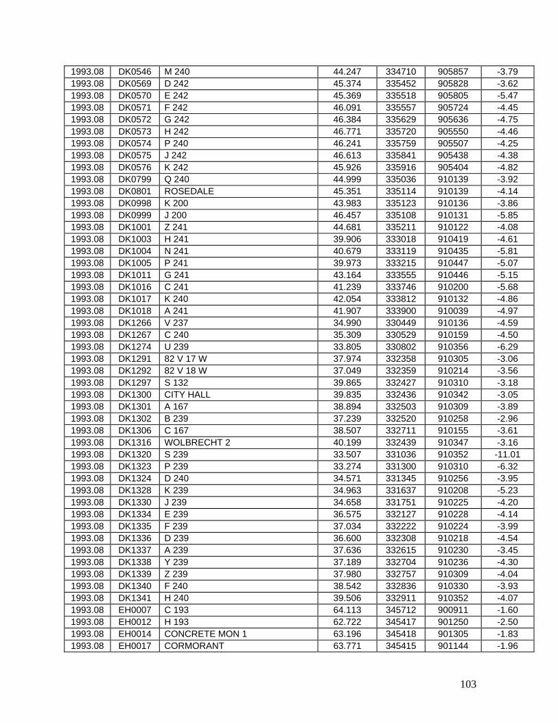
103
1993.08 DK0546 M 240 44.247 334710 905857 -3.79 1993.08 DK0569 D 242 45.374 335452 905828 -3.62 1993.08 DK0570 E 242 45.369 335518 905805 -5.47 1993.08 DK0571 F 242 46.091 335557 905724 -4.45 1993.08 DK0572 G 242 46.384 335629 905636 -4.75 1993.08 DK0573 H 242 46.771 335720 905550 -4.46 1993.08 DK0574 P 240 46.241 335759 905507 -4.25 1993.08 DK0575 J 242 46.613 335841 905438 -4.38 1993.08 DK0576 K 242 45.926 335916 905404 -4.82 1993.08 DK0799 Q 240 44.999 335036 910139 -3.92 1993.08 DK0801 ROSEDALE 45.351 335114 910139 -4.14 1993.08 DK0998 K 200 43.983 335123 910136 -3.86 1993.08 DK0999 J 200 46.457 335108 910131 -5.85 1993.08 DK1001 Z 241 44.681 335211 910122 -4.08 1993.08 DK1003 H 241 39.906 333018 910419 -4.61 1993.08 DK1004 N 241 40.679 333119 910435 -5.81 1993.08 DK1005 P 241 39.973 333215 910447 -5.07 1993.08 DK1011 G 241 43.164 333555 910446 -5.15 1993.08 DK1016 C 241 41.239 333746 910200 -5.68 1993.08 DK1017 K 240 42.054 333812 910132 -4.86 1993.08 DK1018 A 241 41.907 333900 910039 -4.97 1993.08 DK1266 V 237 34.990 330449 910136 -4.59 1993.08 DK1267 C 240 35.309 330529 910159 -4.50 1993.08 DK1274 U 239 33.805 330802 910356 -6.29 1993.08 DK1291 82 V 17 W 37.974 332358 910305 -3.06 1993.08 DK1292 82 V 18 W 37.049 332359 910214 -3.56 1993.08 DK1297 S 132 39.865 332427 910310 -3.18 1993.08 DK1300 CITY HALL 39.835 332436 910342 -3.05 1993.08 DK1301 A 167 38.894 332503 910309 -3.89 1993.08 DK1302 B 239 37.239 332520 910258 -2.96 1993.08 DK1306 C 167 38.507 332711 910155 -3.61 1993.08 DK1316 WOLBRECHT 2 40.199 332439 910347 -3.16 1993.08 DK1320 S 239 33.507 331036 910352 -11.01 1993.08 DK1323 P 239 33.274 331300 910310 -6.32 1993.08 DK1324 D 240 34.571 331345 910256 -3.95 1993.08 DK1328 K 239 34.963 331637 910208 -5.23 1993.08 DK1330 J 239 34.658 331751 910225 -4.20 1993.08 DK1334 E 239 36.575 332127 910228 -4.14 1993.08 DK1335 F 239 37.034 332222 910224 -3.99 1993.08 DK1336 D 239 36.600 332308 910218 -4.54 1993.08 DK1337 A 239 37.636 332615 910230 -3.45 1993.08 DK1338 Y 239 37.189 332704 910236 -4.30 1993.08 DK1339 Z 239 37.980 332757 910309 -4.04 1993.08 DK1340 F 240 38.542 332836 910330 -3.93 1993.08 DK1341 H 240 39.506 332911 910352 -4.07 1993.08 EH0007 C 193 64.113 345712 900911 -1.60 1993.08 EH0012 H 193 62.722 345417 901250 -2.50 1993.08 EH0014 CONCRETE MON 1 63.196 345418 901305 -1.83 1993.08 EH0017 CORMORANT 63.771 345415 901144 -1.96
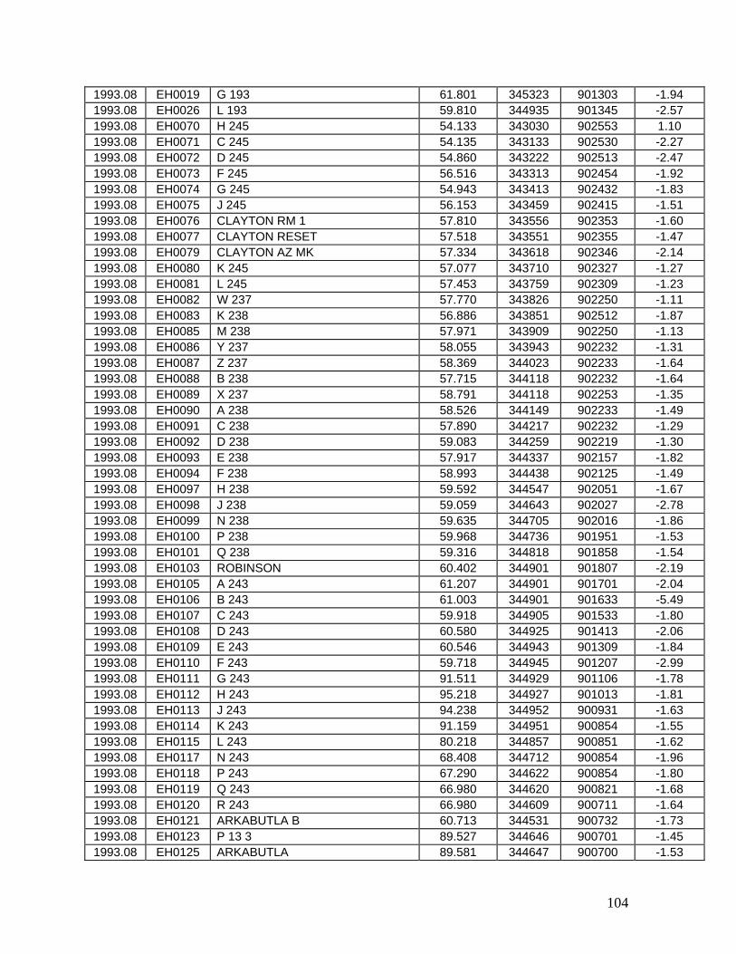
104
1993.08 EH0019 G 193 61.801 345323 901303 -1.94 1993.08 EH0026 L 193 59.810 344935 901345 -2.57 1993.08 EH0070 H 245 54.133 343030 902553 1.10 1993.08 EH0071 C 245 54.135 343133 902530 -2.27 1993.08 EH0072 D 245 54.860 343222 902513 -2.47 1993.08 EH0073 F 245 56.516 343313 902454 -1.92 1993.08 EH0074 G 245 54.943 343413 902432 -1.83 1993.08 EH0075 J 245 56.153 343459 902415 -1.51 1993.08 EH0076 CLAYTON RM 1 57.810 343556 902353 -1.60 1993.08 EH0077 CLAYTON RESET 57.518 343551 902355 -1.47 1993.08 EH0079 CLAYTON AZ MK 57.334 343618 902346 -2.14 1993.08 EH0080 K 245 57.077 343710 902327 -1.27 1993.08 EH0081 L 245 57.453 343759 902309 -1.23 1993.08 EH0082 W 237 57.770 343826 902250 -1.11 1993.08 EH0083 K 238 56.886 343851 902512 -1.87 1993.08 EH0085 M 238 57.971 343909 902250 -1.13 1993.08 EH0086 Y 237 58.055 343943 902232 -1.31 1993.08 EH0087 Z 237 58.369 344023 902233 -1.64 1993.08 EH0088 B 238 57.715 344118 902232 -1.64 1993.08 EH0089 X 237 58.791 344118 902253 -1.35 1993.08 EH0090 A 238 58.526 344149 902233 -1.49 1993.08 EH0091 C 238 57.890 344217 902232 -1.29 1993.08 EH0092 D 238 59.083 344259 902219 -1.30 1993.08 EH0093 E 238 57.917 344337 902157 -1.82 1993.08 EH0094 F 238 58.993 344438 902125 -1.49 1993.08 EH0097 H 238 59.592 344547 902051 -1.67 1993.08 EH0098 J 238 59.059 344643 902027 -2.78 1993.08 EH0099 N 238 59.635 344705 902016 -1.86 1993.08 EH0100 P 238 59.968 344736 901951 -1.53 1993.08 EH0101 Q 238 59.316 344818 901858 -1.54 1993.08 EH0103 ROBINSON 60.402 344901 901807 -2.19 1993.08 EH0105 A 243 61.207 344901 901701 -2.04 1993.08 EH0106 B 243 61.003 344901 901633 -5.49 1993.08 EH0107 C 243 59.918 344905 901533 -1.80 1993.08 EH0108 D 243 60.580 344925 901413 -2.06 1993.08 EH0109 E 243 60.546 344943 901309 -1.84 1993.08 EH0110 F 243 59.718 344945 901207 -2.99 1993.08 EH0111 G 243 91.511 344929 901106 -1.78 1993.08 EH0112 H 243 95.218 344927 901013 -1.81 1993.08 EH0113 J 243 94.238 344952 900931 -1.63 1993.08 EH0114 K 243 91.159 344951 900854 -1.55 1993.08 EH0115 L 243 80.218 344857 900851 -1.62 1993.08 EH0117 N 243 68.408 344712 900854 -1.96 1993.08 EH0118 P 243 67.290 344622 900854 -1.80 1993.08 EH0119 Q 243 66.980 344620 900821 -1.68 1993.08 EH0120 R 243 66.980 344609 900711 -1.64 1993.08 EH0121 ARKABUTLA B 60.713 344531 900732 -1.73 1993.08 EH0123 P 13 3 89.527 344646 900701 -1.45 1993.08 EH0125 ARKABUTLA 89.581 344647 900700 -1.53
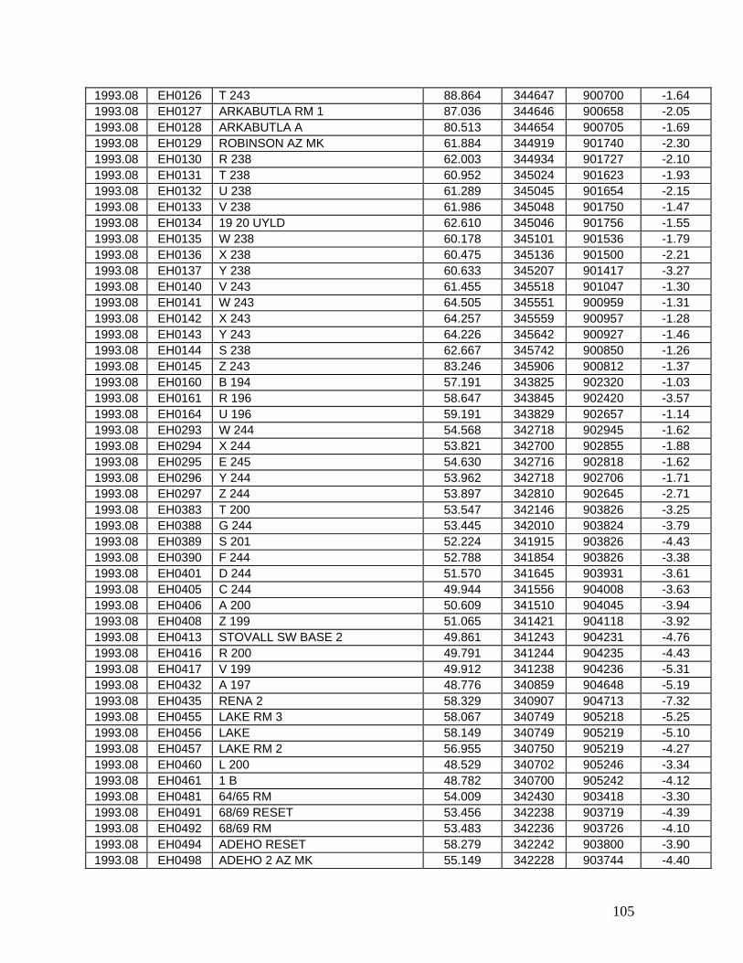
105
1993.08 EH0126 T 243 88.864 344647 900700 -1.64 1993.08 EH0127 ARKABUTLA RM 1 87.036 344646 900658 -2.05 1993.08 EH0128 ARKABUTLA A 80.513 344654 900705 -1.69 1993.08 EH0129 ROBINSON AZ MK 61.884 344919 901740 -2.30 1993.08 EH0130 R 238 62.003 344934 901727 -2.10 1993.08 EH0131 T 238 60.952 345024 901623 -1.93 1993.08 EH0132 U 238 61.289 345045 901654 -2.15 1993.08 EH0133 V 238 61.986 345048 901750 -1.47 1993.08 EH0134 19 20 UYLD 62.610 345046 901756 -1.55 1993.08 EH0135 W 238 60.178 345101 901536 -1.79 1993.08 EH0136 X 238 60.475 345136 901500 -2.21 1993.08 EH0137 Y 238 60.633 345207 901417 -3.27 1993.08 EH0140 V 243 61.455 345518 901047 -1.30 1993.08 EH0141 W 243 64.505 345551 900959 -1.31 1993.08 EH0142 X 243 64.257 345559 900957 -1.28 1993.08 EH0143 Y 243 64.226 345642 900927 -1.46 1993.08 EH0144 S 238 62.667 345742 900850 -1.26 1993.08 EH0145 Z 243 83.246 345906 900812 -1.37 1993.08 EH0160 B 194 57.191 343825 902320 -1.03 1993.08 EH0161 R 196 58.647 343845 902420 -3.57 1993.08 EH0164 U 196 59.191 343829 902657 -1.14 1993.08 EH0293 W 244 54.568 342718 902945 -1.62 1993.08 EH0294 X 244 53.821 342700 902855 -1.88 1993.08 EH0295 E 245 54.630 342716 902818 -1.62 1993.08 EH0296 Y 244 53.962 342718 902706 -1.71 1993.08 EH0297 Z 244 53.897 342810 902645 -2.71 1993.08 EH0383 T 200 53.547 342146 903826 -3.25 1993.08 EH0388 G 244 53.445 342010 903824 -3.79 1993.08 EH0389 S 201 52.224 341915 903826 -4.43 1993.08 EH0390 F 244 52.788 341854 903826 -3.38 1993.08 EH0401 D 244 51.570 341645 903931 -3.61 1993.08 EH0405 C 244 49.944 341556 904008 -3.63 1993.08 EH0406 A 200 50.609 341510 904045 -3.94 1993.08 EH0408 Z 199 51.065 341421 904118 -3.92 1993.08 EH0413 STOVALL SW BASE 2 49.861 341243 904231 -4.76 1993.08 EH0416 R 200 49.791 341244 904235 -4.43 1993.08 EH0417 V 199 49.912 341238 904236 -5.31 1993.08 EH0432 A 197 48.776 340859 904648 -5.19 1993.08 EH0435 RENA 2 58.329 340907 904713 -7.32 1993.08 EH0455 LAKE RM 3 58.067 340749 905218 -5.25 1993.08 EH0456 LAKE 58.149 340749 905219 -5.10 1993.08 EH0457 LAKE RM 2 56.955 340750 905219 -4.27 1993.08 EH0460 L 200 48.529 340702 905246 -3.34 1993.08 EH0461 1 B 48.782 340700 905242 -4.12 1993.08 EH0481 64/65 RM 54.009 342430 903418 -3.30 1993.08 EH0491 68/69 RESET 53.456 342238 903719 -4.39 1993.08 EH0492 68/69 RM 53.483 342236 903726 -4.10 1993.08 EH0494 ADEHO RESET 58.279 342242 903800 -3.90 1993.08 EH0498 ADEHO 2 AZ MK 55.149 342228 903744 -4.40
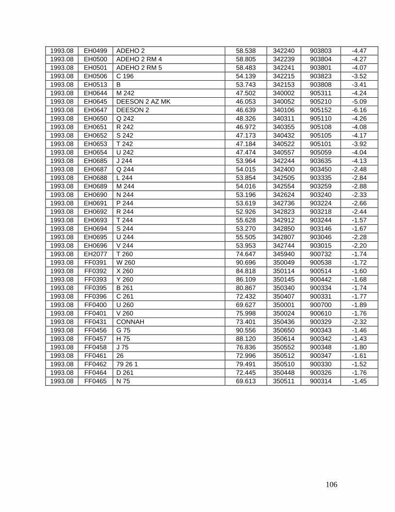
106
1993.08 EH0499 ADEHO 2 58.538 342240 903803 -4.47 1993.08 EH0500 ADEHO 2 RM 4 58.805 342239 903804 -4.27 1993.08 EH0501 ADEHO 2 RM 5 58.483 342241 903801 -4.07 1993.08 EH0506 C 196 54.139 342215 903823 -3.52 1993.08 EH0513 B 53.743 342153 903808 -3.41 1993.08 EH0644 M 242 47.502 340002 905311 -4.24 1993.08 EH0645 DEESON 2 AZ MK 46.053 340052 905210 -5.09 1993.08 EH0647 DEESON 2 46.639 340106 905152 -6.16 1993.08 EH0650 Q 242 48.326 340311 905110 -4.26 1993.08 EH0651 R 242 46.972 340355 905108 -4.08 1993.08 EH0652 S 242 47.173 340432 905105 -4.17 1993.08 EH0653 T 242 47.184 340522 905101 -3.92 1993.08 EH0654 U 242 47.474 340557 905059 -4.04 1993.08 EH0685 J 244 53.964 342244 903635 -4.13 1993.08 EH0687 Q 244 54.015 342400 903450 -2.48 1993.08 EH0688 L 244 53.854 342505 903335 -2.84 1993.08 EH0689 M 244 54.016 342554 903259 -2.88 1993.08 EH0690 N 244 53.196 342624 903240 -2.33 1993.08 EH0691 P 244 53.619 342736 903224 -2.66 1993.08 EH0692 R 244 52.926 342823 903218 -2.44 1993.08 EH0693 T 244 55.628 342912 903244 -1.57 1993.08 EH0694 S 244 53.270 342850 903146 -1.67 1993.08 EH0695 U 244 55.505 342807 903046 -2.28 1993.08 EH0696 V 244 53.953 342744 903015 -2.20 1993.08 EH2077 T 260 74.647 345940 900732 -1.74 1993.08 FF0391 W 260 90.696 350049 900538 -1.72 1993.08 FF0392 X 260 84.818 350114 900514 -1.60 1993.08 FF0393 Y 260 86.109 350145 900442 -1.68 1993.08 FF0395 B 261 80.867 350340 900334 -1.74 1993.08 FF0396 C 261 72.432 350407 900331 -1.77 1993.08 FF0400 U 260 69.627 350001 900700 -1.89 1993.08 FF0401 V 260 75.998 350024 900610 -1.76 1993.08 FF0431 CONNAH 73.401 350436 900329 -2.32 1993.08 FF0456 G 75 90.556 350650 900343 -1.46 1993.08 FF0457 H 75 88.120 350614 900342 -1.43 1993.08 FF0458 J 75 76.836 350552 900348 -1.80 1993.08 FF0461 26 72.996 350512 900347 -1.61 1993.08 FF0462 79 26 1 79.491 350510 900330 -1.52 1993.08 FF0464 D 261 72.445 350448 900326 -1.76 1993.08 FF0465 N 75 69.613 350511 900314 -1.45
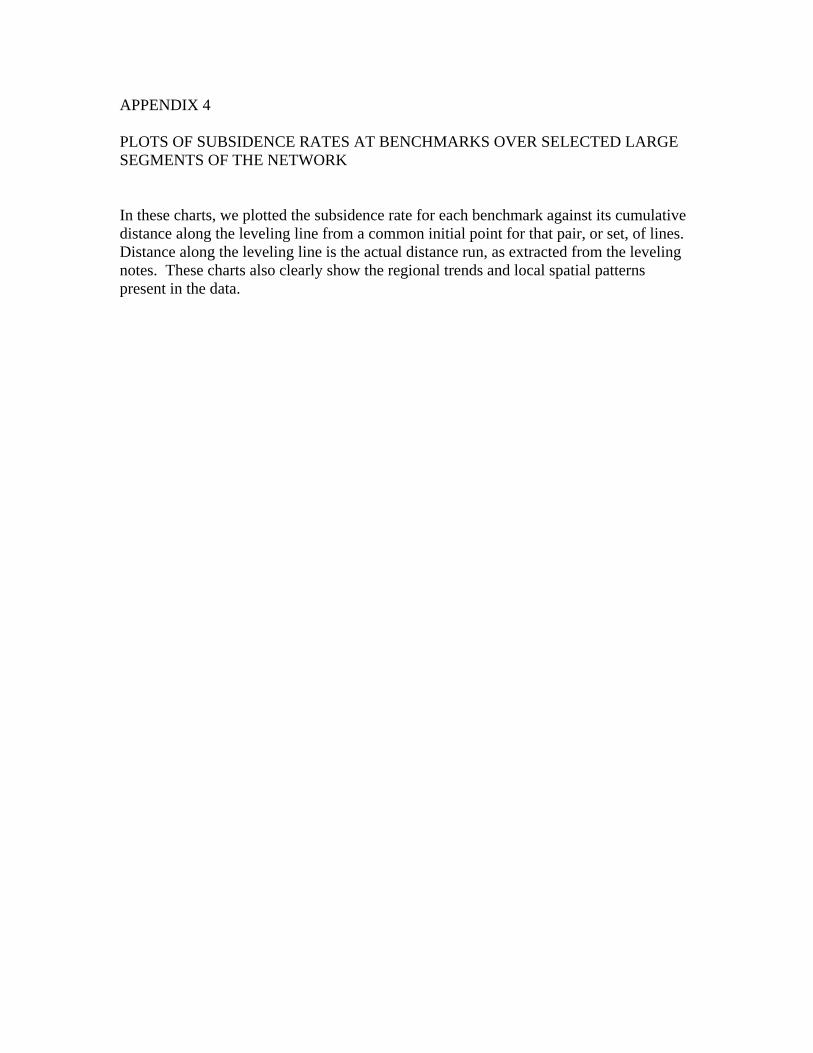
APPENDIX 4 PLOTS OF SUBSIDENCE RATES AT BENCHMARKS OVER SELECTED LARGE SEGMENTS OF THE NETWORK In these charts, we plotted the subsidence rate for each benchmark against its cumulative distance along the leveling line from a common initial point for that pair, or set, of lines. Distance along the leveling line is the actual distance run, as extracted from the leveling notes. These charts also clearly show the regional trends and local spatial patterns present in the data.
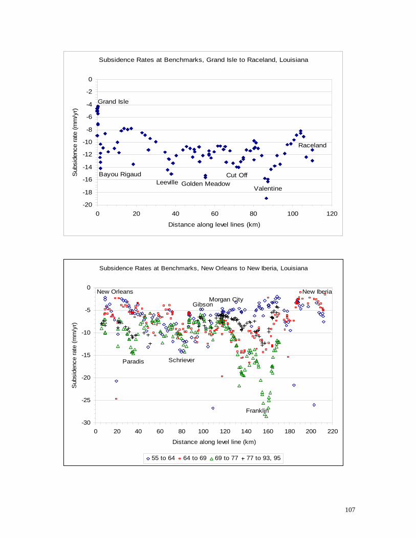
107
Subsidence Rates at Benchmarks, Grand Isle to Raceland, Louisiana
Grand Isle
Bayou RigaudLeeville Golden Meadow
Cut Off
Valentine
Raceland
-20
-18
-16
-14
-12
-10
-8
-6
-4
-2
0
0 20 40 60 80 100 120
Distance along level lines (km)
Sub
side
nce
rate
(mm
/yr)
Subsidence Rates at Benchmarks, New Orleans to New Iberia, Louisiana
Morgan CityGibson
Schriever
New Orleans New Iberia
Paradis
Franklin
-30
-25
-20
-15
-10
-5
0
0 20 40 60 80 100 120 140 160 180 200 220
Distance along level line (km)
Sub
side
nce
rate
(mm
/yr)
55 to 64 64 to 69 69 to 77 77 to 93, 95

108
Subsidence Rates at Benchmarks, from Raceland through Houma to Cocodrie, Louisiana
Cocodrie
Chauvin
Presquille
Houma
Raceland
-25
-20
-15
-10
-5
0
0 20 40 60 80
Distance along level lines (km)
Sub
side
nce
rate
(mm
/yr)
66 to 93
Subsidence at Benchmarks, Waggaman to Gretna, Louisiana
Waggaman Gretna
-20-18-16-14-12-10-8-6-4-20
0 5 10 15 20 25 30
Distance along level line (km)
Sub
side
nce
rate
(mm
/yr)
86 to 95
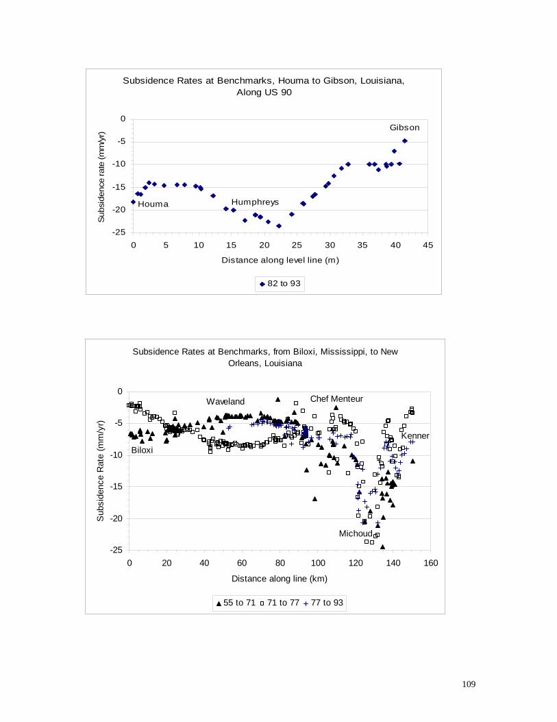
109
Subsidence Rates at Benchmarks, Houma to Gibson, Louisiana, Along US 90
HumphreysHouma
Gibson
-25
-20
-15
-10
-5
0
0 5 10 15 20 25 30 35 40 45
Distance along level line (m)
Sub
side
nce
rate
(mm
/yr)
82 to 93
Subsidence Rates at Benchmarks, from Biloxi, Mississippi, to New Orleans, Louisiana
Kenner
Michoud
Chef MenteurWaveland
Biloxi
-25
-20
-15
-10
-5
0
0 20 40 60 80 100 120 140 160
Distance along line (km)
Sub
side
nce
Rat
e (m
m/y
r)
55 to 71 71 to 77 77 to 93
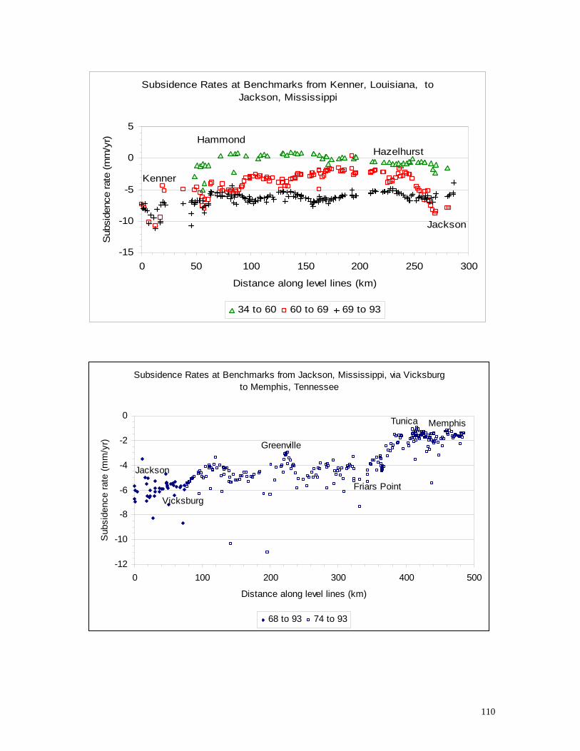
110
Subsidence Rates at Benchmarks from Kenner, Louisiana, to Jackson, Mississippi
Jackson
HazelhurstHammond
Kenner
-15
-10
-5
0
5
0 50 100 150 200 250 300
Distance along level lines (km)
Sub
side
nce
rate
(mm
/yr)
34 to 60 60 to 69 69 to 93
Subsidence Rates at Benchmarks from Jackson, Mississippi, via Vicksburg to Memphis, Tennessee
Jackson
Vicksburg
Greenville
Friars Point
Tunica Memphis
-12
-10
-8
-6
-4
-2
0
0 100 200 300 400 500
Distance along level lines (km)
Sub
side
nce
rate
(mm
/yr)
68 to 93 74 to 93

111
New Iberia to Iowa, LA, computed from New Iberia
IowaLafayette
New Iberia
Welsh
Scott
Midland-35
-30
-25
-20
-15
-10
-5
0
5
10
0 50 100 150
distance along line (km)
verti
cal d
ispl
acem
ent r
ate
(mm
/yr)
55 to 70 70 to 81 70 to 82 70 to 86
Subsidence Rates at Benchmarks, Lake Charles through Creole and Abbeville to Lafayette; Sulphur to Creole
Lafayette
Erath
Abbeville
Pecan Island
Oak Grove
Lake Charles
Creole
Sulphur
-25
-20
-15
-10
-5
0
0 50 100 150 200 250 300
Distance along leveling lines (km)
Sub
side
nce
rate
(mm
/yr)
Lake Charles to Lafayette Sulphur to Creole
Lines beginning in Sulphur and in Lake Charles follow different routes to common point D 213 at Creole, and continue on as one segment.

112
Subsidence Rates at Benchmarks, Alexandria, Louisiana, to Shreveport and on to Vicksburg, Mississippi
Delta
Delhi
ArcadiaBossier CityAlexandria
-20
-15
-10
-5
0
5
0 100 200 300 400 500
Distance along leveling lines (km)
Sub
side
nce
rate
(mm
/yr)
Subsidence Rates at Benchmarks, Jackson, Mississippi, through Meridian to Demopolis, Alabama
Demopolis
Cuba
Meridian
Lake
Forest
Jackson-10-8-6-4-202468
10
0 50 100 150 200 250
Distance along leveling lines (km)
Sub
side
nce
rate
(mm
/yr)
61 to 68
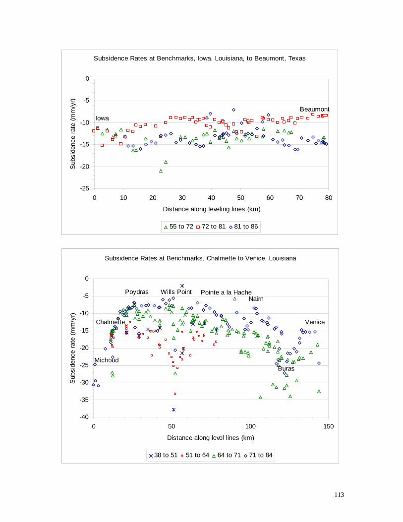
113
Subsidence Rates at Benchmarks, Iowa, Louisiana, to Beaumont, Texas
IowaBeaumont
-25
-20
-15
-10
-5
0
0 10 20 30 40 50 60 70 80
Distance along leveling lines (km)
Sub
side
nce
rate
(mm
/yr)
55 to 72 72 to 81 81 to 86
Subsidence Rates at Benchmarks, Chalmette to Venice, Louisiana
Chalmette
Pointe a la Hache
Venice
Buras
NairnWills PointPoydras
Michoud
-40
-35
-30
-25
-20
-15
-10
-5
0
0 50 100 150
Distance along level lines (km)
Sub
side
nce
rate
(mm
/yr)
38 to 51 51 to 64 64 to 71 71 to 84

APPENDIX 5 STATISTICS AND INDIVIDUAL POINT PLOTS SHOWING TEMPORAL VARIATIONS Each individual point plot shows the network computed elevation, in meters, as the ordinate and its temporal distance from the first available epoch as the abscissa. We used Minitab version 13 to compute the quadratic regression curve and the 95% confidence intervals.
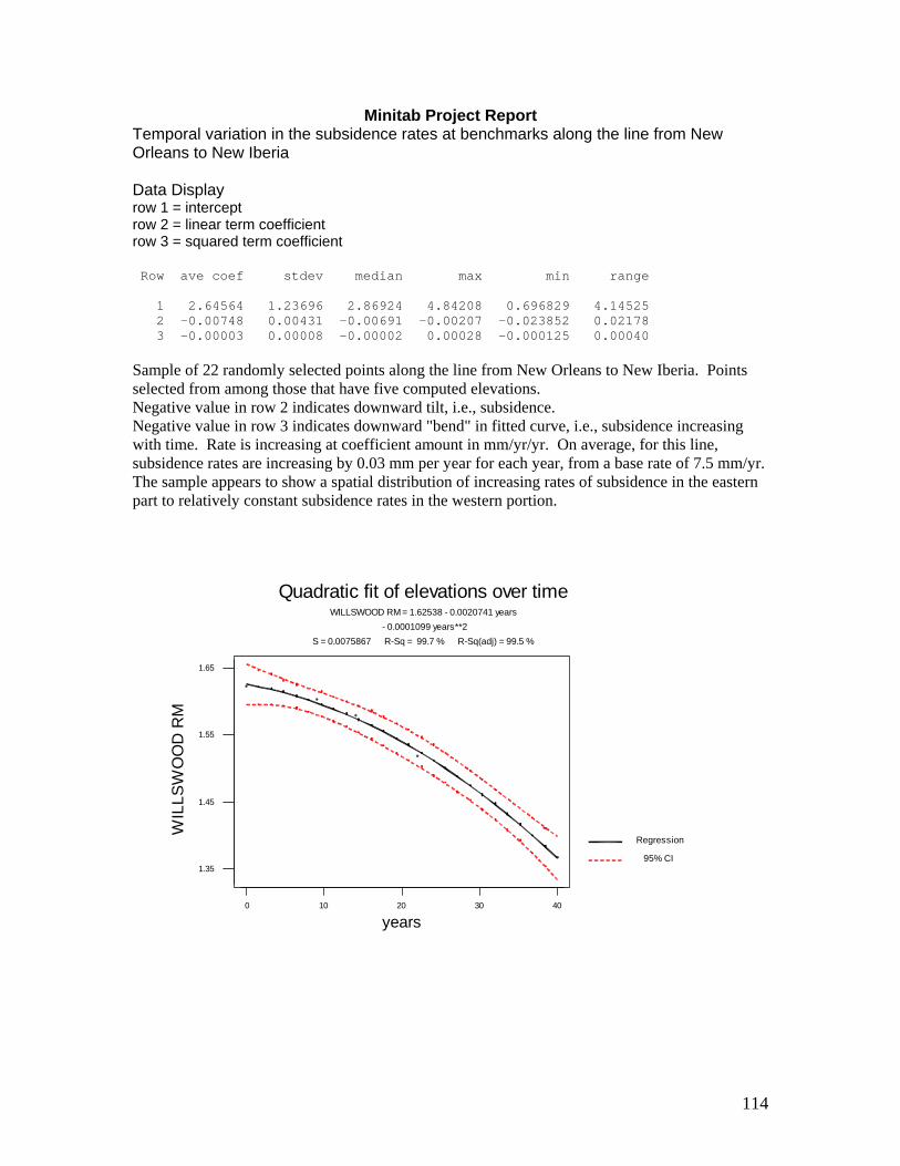
114
Minitab Project Report Temporal variation in the subsidence rates at benchmarks along the line from New Orleans to New Iberia Data Display row 1 = intercept row 2 = linear term coefficient row 3 = squared term coefficient Row ave coef stdev median max min range 1 2.64564 1.23696 2.86924 4.84208 0.696829 4.14525 2 -0.00748 0.00431 -0.00691 -0.00207 -0.023852 0.02178 3 -0.00003 0.00008 -0.00002 0.00028 -0.000125 0.00040 Sample of 22 randomly selected points along the line from New Orleans to New Iberia. Points selected from among those that have five computed elevations. Negative value in row 2 indicates downward tilt, i.e., subsidence. Negative value in row 3 indicates downward "bend" in fitted curve, i.e., subsidence increasing with time. Rate is increasing at coefficient amount in mm/yr/yr. On average, for this line, subsidence rates are increasing by 0.03 mm per year for each year, from a base rate of 7.5 mm/yr. The sample appears to show a spatial distribution of increasing rates of subsidence in the eastern part to relatively constant subsidence rates in the western portion.
0 10 20 30 40
1.35
1.45
1.55
1.65
years
WIL
LSW
OO
D R
M
WILLSWOOD RM = 1.62538 - 0.0020741 years - 0.0001099 years**2
S = 0.0075867 R-Sq = 99.7 % R-Sq(adj) = 99.5 %
Regression
95% CI
Quadratic fit of elevations over time
115
0 10 20 30 40
2.6
2.7
2.8
2.9
3.0
3.1
years
Y 1
65
Y 165 = 3.08584 - 0.0088567 years - 0.0000692 years**2
S = 0.0074073 R-Sq = 99.9 % R-Sq(adj) = 99.8 %
Regression
95% CI
Quadratic fit of elevations over time
0 10 20 30 40
0.4
0.5
0.6
0.7
years
V 16
5
V 165 = 0.696829 - 0.0022022 years - 0.0000982 years**2
S = 0.0077225 R-Sq = 99.7 % R-Sq(adj) = 99.4 %
Regression
95% CI
Quadratic fit of elevations over time

116
0 10 20 30 40
1.1
1.2
1.3
1.4
1.5
years
B 1
65
B 165 = 1.46672 - 0.0032112 years - 0.0001023 years**2
S = 0.0134037 R-Sq = 99.3 % R-Sq(adj) = 98.6 %
Regression
95% CI
Quadratic fit of elevations over time
0 10 20 30 40
0.3
0.4
0.5
0.6
0.7
0.8
years
D 1
65
D 165 = 0.718203 - 0.0055682 years - 0.0000867 years**2
S = 0.0175546 R-Sq = 99.2 % R-Sq(adj) = 98.4 %
Regression
95% CI
Quadratic fit of elevations over time

117
0 10 20 30 40
1.0
1.1
1.2
1.3
1.4
years
Q 8
Q 8 = 1.36136 - 0.0049955 years - 0.0000738 years**2
S = 0.0076841 R-Sq = 99.8 % R-Sq(adj) = 99.6 %
Regression
95% CI
Quadratic fit of elevations over time
0 10 20 30 40
0.5
0.6
0.7
0.8
0.9
1.0
years
J 16
5
J 165 = 0.958769 - 0.0047046 years - 0.0001169 years**2
S = 0.0081697 R-Sq = 99.8 % R-Sq(adj) = 99.7 %
Regression
95% CI
Quadratic fit of elevations over time

118
0 10 20 30 40
2.2
2.3
2.4
2.5
years
C 1
67
C 167 = 2.53214 - 0.0082043 years - 0.0000099 years**2
S = 0.0021284 R-Sq = 100.0 % R-Sq(adj) = 100.0 %
Regression
95% CI
Quadratic fit of elevations over time
0 10 20 30 40
2.0
2.1
2.2
2.3
2.4
years
H 1
67
H 167 = 2.37364 - 0.0094010 years + 0.0000114 years**2
S = 0.0017766 R-Sq = 100.0 % R-Sq(adj) = 100.0 %
Regression
95% CI
Quadratic fit of elevations over time

119
0 10 20 30 40
2.4
2.5
2.6
2.7
2.8
2.9
3.0
3.1
3.2
years
L 16
7
L 167 = 3.09318 - 0.0238524 years + 0.0002779 years**2
S = 0.0312347 R-Sq = 98.7 % R-Sq(adj) = 97.4 %
Regression
95% CI
Quadratic fit of elevations over time
0 10 20 30 40
3.35
3.45
3.55
3.65
years
P 1
67
P 167 = 3.65786 - 0.0068522 years - 0.0000043 years**2
S = 0.0039035 R-Sq = 99.9 % R-Sq(adj) = 99.9 %
Regression
95% CI
Quadratic fit of elevations over time
120
0 10 20 30 40
2.95
3.05
3.15
3.25
years
Q 1
67
Q 167 = 3.22874 - 0.0060725 years - 0.0000085 years**2
S = 0.0057765 R-Sq = 99.8 % R-Sq(adj) = 99.6 %
Regression
95% CI
Quadratic fit of elevations over time
0 10 20 30 40
4.1
4.2
4.3
4.4
years
W 7
RES
ET
W 7 RESET = 4.38845 - 0.0064702 years - 0.0000060 years**2
S = 0.0051318 R-Sq = 99.9 % R-Sq(adj) = 99.7 %
Regression
95% CI
Quadratic fit of elevations over time

121
0 10 20 30 40
1.2
1.3
1.4
1.5
1.6
years
Y 1
67
Y 167 = 1.54111 - 0.0067170 years - 0.0000059 years**2
S = 0.0073584 R-Sq = 99.7 % R-Sq(adj) = 99.5 %
Regression
95% CI
Quadratic fit of elevations over time
0 10 20 30 40
1.8
1.9
2.0
2.1
2.2
2.3
years
C 1
68
C 168 = 2.23708 - 0.0069640 years - 0.0000215 years**2
S = 0.0157867 R-Sq = 99.0 % R-Sq(adj) = 98.0 %
Regression
95% CI
Quadratic fit of elevations over time

122
0 10 20 30 40
2.2
2.3
2.4
2.5
2.6
2.7
2.8
2.9
3.0
years
E 1
68
E 168 = 2.84626 - 0.0089369 years - 0.0000311 years**2
S = 0.0360524 R-Sq = 97.0 % R-Sq(adj) = 94.1 %
Regression
95% CI
Quadratic fit of elevations over time
0 10 20 30 40
2.3
2.4
2.5
2.6
2.7
2.8
2.9
3.0
3.1
years
G 1
68
G 168 = 2.91438 - 0.0098486 years - 0.0000261 years**2
S = 0.0372547 R-Sq = 97.2 % R-Sq(adj) = 94.5 %
Regression
95% CI
Quadratic fit of elevations over time
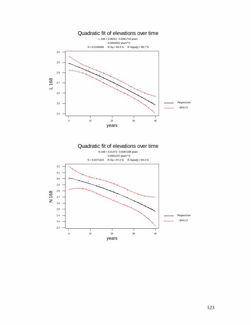
123
0 10 20 30 40
2.4
2.5
2.6
2.7
2.8
2.9
3.0
years
L 16
8
L 168 = 2.89222 - 0.0081743 years - 0.0000502 years**2
S = 0.0169066 R-Sq = 99.3 % R-Sq(adj) = 98.7 %
Regression
95% CI
Quadratic fit of elevations over time
0 10 20 30 40
2.2
2.3
2.4
2.5
2.6
2.7
2.8
2.9
3.0
3.1
3.2
years
N 1
68
N 168 = 3.01473 - 0.0087198 years - 0.0001247 years**2
S = 0.0471023 R-Sq = 97.2 % R-Sq(adj) = 94.4 %
Regression
95% CI
Quadratic fit of elevations over time
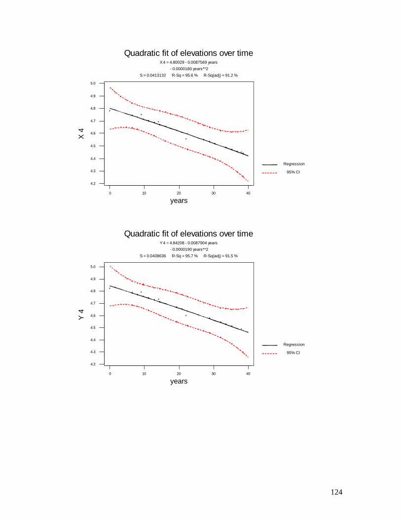
124
0 10 20 30 40
4.2
4.3
4.4
4.5
4.6
4.7
4.8
4.9
5.0
years
X 4
X 4 = 4.80029 - 0.0087569 years - 0.0000180 years**2
S = 0.0413132 R-Sq = 95.6 % R-Sq(adj) = 91.2 %
Regression
95% CI
Quadratic fit of elevations over time
0 10 20 30 40
4.2
4.3
4.4
4.5
4.6
4.7
4.8
4.9
5.0
years
Y 4
Y 4 = 4.84208 - 0.0087904 years - 0.0000190 years**2
S = 0.0408636 R-Sq = 95.7 % R-Sq(adj) = 91.5 %
Regression
95% CI
Quadratic fit of elevations over time
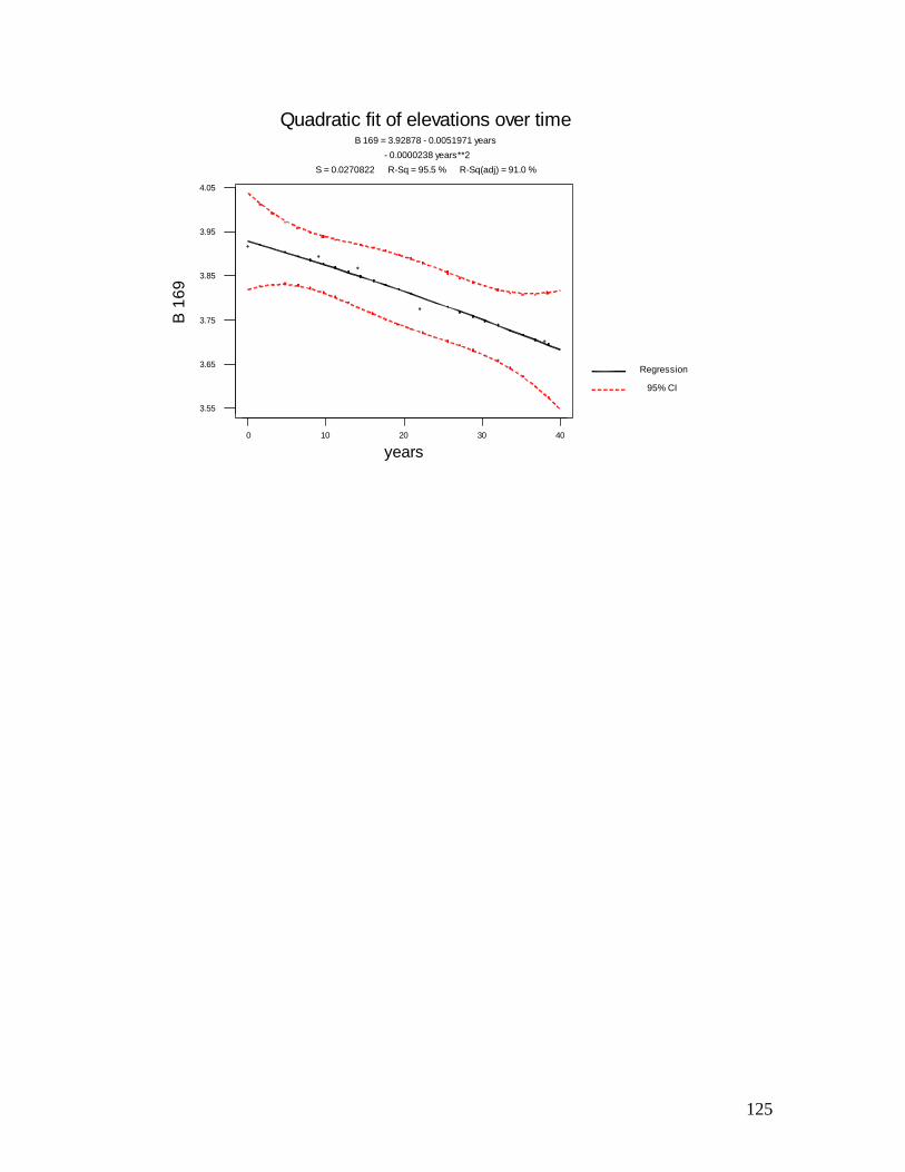
125
0 10 20 30 40
3.55
3.65
3.75
3.85
3.95
4.05
years
B 1
69
B 169 = 3.92878 - 0.0051971 years - 0.0000238 years**2
S = 0.0270822 R-Sq = 95.5 % R-Sq(adj) = 91.0 %
Regression
95% CI
Quadratic fit of elevations over time
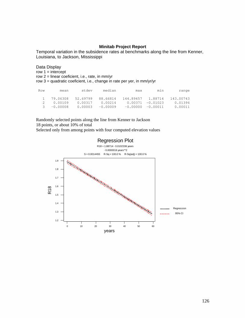
126
Minitab Project Report Temporal variation in the subsidence rates at benchmarks along the line from Kenner, Louisiana, to Jackson, Mississippi Data Display row 1 = intercept row 2 = linear coeficient, i.e., rate, in mm/yr row 3 = quadratic coeficient, i.e., change in rate per yer, in mm/yr/yr Row mean stdev median max min range 1 79.06308 52.69799 88.66814 144.89457 1.88714 143.00743 2 0.00109 0.00317 0.00214 0.00371 -0.01023 0.01394 3 -0.00008 0.00003 -0.00009 -0.00000 -0.00011 0.00011 Randomly selected points along the line from Kenner to Jackson 18 points, or about 10% of total Selected only from among points with four computed elevation values
0 10 20 30 40 50 60
1.2
1.3
1.4
1.5
1.6
1.7
1.8
1.9
years
R18
R18 = 1.88714 - 0.0102336 years - 0.0000016 years**2
S = 0.0014493 R-Sq = 100.0 % R-Sq(adj) = 100.0 %
Regression
95% CI
Regression Plot
127
0 10 20 30 40 50 60
1.65
1.75
1.85
1.95
years
E19
E19 = 1.93301 - 0.0012916 years - 0.0000643 years**2
S = 0.0000559 R-Sq = 100.0 % R-Sq(adj) = 100.0 %
Regression
95% CI
Regression Plot
0 10 20 30 40 50 60
1.85
1.95
2.05
2.15
2.25
2.35
2.45
years
K19
K19 = 2.27532 + 0.0007931 years - 0.0000904 years**2
S = 0.0132475 R-Sq = 99.6 % R-Sq(adj) = 98.8 %
Regression
95% CI
Regression Plot

128
0 10 20 30 40 50 60
19.0
19.1
19.2
19.3
19.4
19.5
years
S19
S19 = 19.3533 + 0.0030856 years - 0.0001071 years**2
S = 0.0128594 R-Sq = 99.4 % R-Sq(adj) = 98.1 %
Regression
95% CI
Regression Plot
0 10 20 30 40 50 60
27.8
27.9
28.0
28.1
28.2
28.3
28.4
years
W19
W19 = 28.1667 + 0.0028386 years - 0.0000980 years**2
S = 0.0169908 R-Sq = 98.7 % R-Sq(adj) = 96.1 %
Regression
95% CI
Regression Plot
129
0 10 20 30 40 50 60
32.05
32.15
32.25
years
Z19
Z19 = 32.2450 + 0.0029184 years - 0.0000995 years**2
S = 0.0004663 R-Sq = 100.0 % R-Sq(adj) = 100.0 %
Regression
95% CI
Regression Plot
0 10 20 30 40 50 60
54.15
54.25
54.35
years
H20
H20 = 54.3081 + 0.0029399 years - 0.0000976 years**2
S = 0.0006445 R-Sq = 100.0 % R-Sq(adj) = 100.0 %
Regression
95% CI
Regression Plot

130
0 10 20 30 40 50 60
87.35
87.45
87.55
years
F7
F7 = 87.5170 + 0.0032087 years - 0.0000972 years**2
S = 0.0003645 R-Sq = 100.0 % R-Sq(adj) = 100.0 %
Regression
95% CI
Regression Plot
0 10 20 30 40 50 60
122.1
122.2
122.3
122.4
years
N7
N7 = 122.315 + 0.0037090 years - 0.0001130 years**2
S = 0.0026066 R-Sq = 100.0 % R-Sq(adj) = 99.9 %
Regression
95% CI
Regression Plot
131
0 10 20 30 40 50 60
115.7
115.8
115.9
years
S7
S7 = 115.882 + 0.0024807 years - 0.0000968 years**2
S = 0.0013133 R-Sq = 100.0 % R-Sq(adj) = 100.0 %
Regression
95% CI
Regression Plot
0 10 20 30 40 50 60
114.75
114.85
114.95
115.05
115.15
years
Z7
Z7 = 115.041 + 0.0025980 years - 0.0000915 years**2
S = 0.0084740 R-Sq = 99.6 % R-Sq(adj) = 98.9 %
Regression
95% CI
Regression Plot
132
0 10 20 30 40 50 60
118.8
118.9
119.0
119.1
years
B8
B8 = 118.998 + 0.0023734 years - 0.0000861 years**2
S = 0.0056694 R-Sq = 99.8 % R-Sq(adj) = 99.5 %
Regression
95% CI
Regression Plot
0 10 20 30 40 50 60
144.7
144.8
144.9
years
P8
P8 = 144.895 + 0.0013561 years - 0.0000678 years**2
S = 0.0043134 R-Sq = 99.9 % R-Sq(adj) = 99.6 %
Regression
95% CI
Regression Plot

133
0 10 20 30 40 50 60
130.2
130.3
130.4
years
V8
V8 = 130.368 + 0.0009663 years - 0.0000659 years**2
S = 0.0018012 R-Sq = 100.0 % R-Sq(adj) = 99.9 %
Regression
95% CI
Regression Plot
0 10 20 30 40 50 60
136.45
136.55
136.65
years
A9
A9 = 136.627 + 0.0007823 years - 0.0000636 years**2
S = 0.0008114 R-Sq = 100.0 % R-Sq(adj) = 100.0 %
Regression
95% CI
Regression Plot
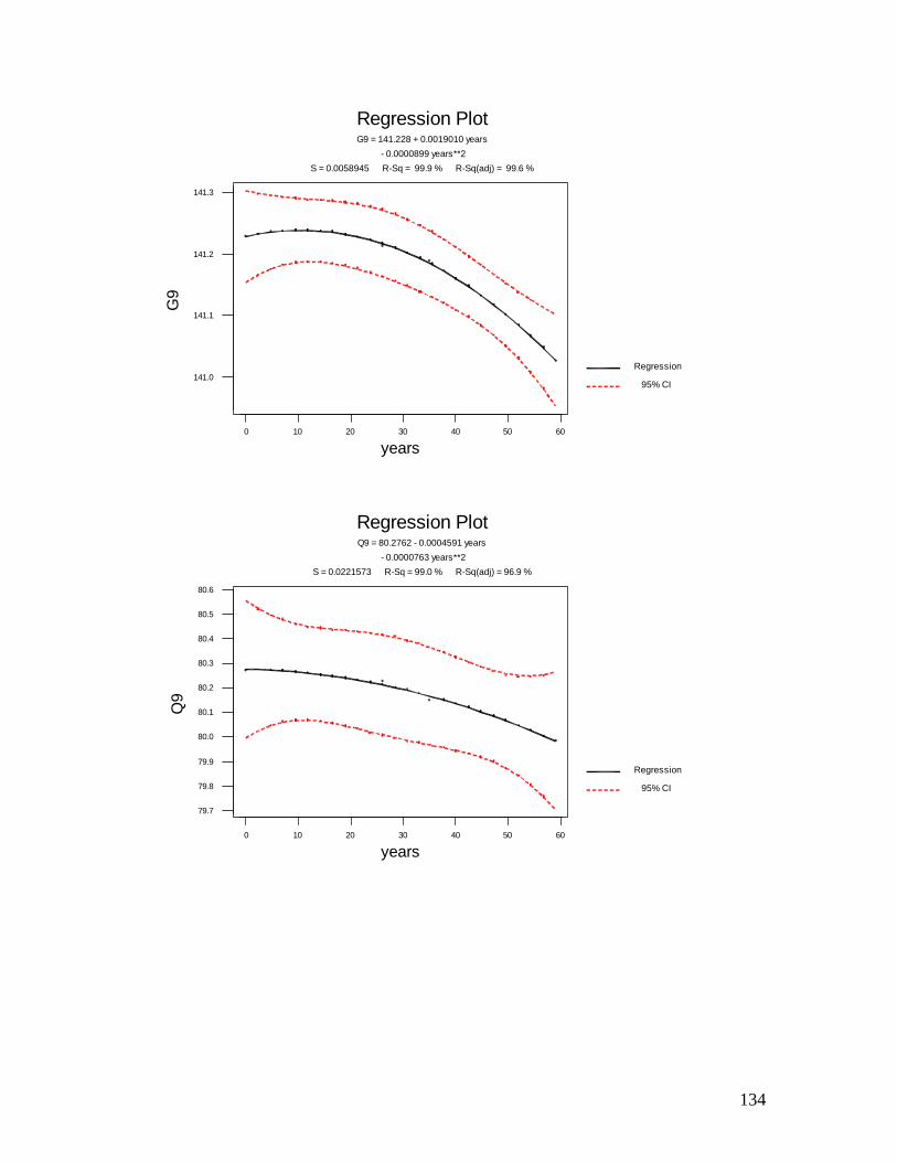
134
0 10 20 30 40 50 60
141.0
141.1
141.2
141.3
years
G9
G9 = 141.228 + 0.0019010 years - 0.0000899 years**2
S = 0.0058945 R-Sq = 99.9 % R-Sq(adj) = 99.6 %
Regression
95% CI
Regression Plot
0 10 20 30 40 50 60
79.7
79.8
79.9
80.0
80.1
80.2
80.3
80.4
80.5
80.6
years
Q9
Q9 = 80.2762 - 0.0004591 years - 0.0000763 years**2
S = 0.0221573 R-Sq = 99.0 % R-Sq(adj) = 96.9 %
Regression
95% CI
Regression Plot
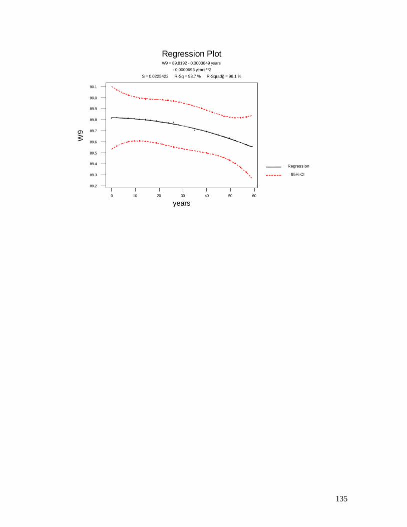
135
0 10 20 30 40 50 60
89.2
89.3
89.4
89.5
89.6
89.7
89.8
89.9
90.0
90.1
years
W9
W9 = 89.8192 - 0.0003849 years - 0.0000693 years**2
S = 0.0225422 R-Sq = 98.7 % R-Sq(adj) = 96.1 %
Regression
95% CI
Regression Plot