rapid risk asse ssment repor t 2019
TRANSCRIPT

RAPID RISK ASSESSMENTOF THE LOKICHAR – LAMUCRUDE OIL PIPELINE
2019
Rapid Risk Assessment
Report

Rapid Risk Assessment of the Lokichar – Lamu Crude Oil Pipeline
This report was written by:
Jackson Kiplagat - Regional Sustainable Investments Manager, WWF-Kenya
John Kuloba - Managing consultant, Earthcare Services Ltd.
Paolo Tibaldesch - Senior Advisor, WWF-Norway
Siro Abdallah - GIS & Modelling Expert, WWF-Kenya
Sumaya Mohamed - Project Officer, Oil for Development, WWF-Kenya
Teddy Muturi - Network Coordinator, Kenya Oil and Gas Working Group
Editors: David Patterson - Spatial intelligence lead, WWF-UK, Judy Kosgei Ekwam - Communications Coordinator - Content Development, WWF-Kenya
Graphic Design: Anthony Dianga - Digital Marketing and Design, WWF-Kenya
Front-page photo: © Global Warming Images / WWF
This report was supported by the Norwegian Agency for Development Cooperation – (Norad). However, the views and opinions expressed in this report do not forcedly represent the ones of Norad.
World Wide Fund for Nature (WWF), is one of the world s largest independent environmental organisations with more than 5 million supporters, as many as 25 million followers in social media, offices in more than 100 countries, over 6,000 employees and more than 1.000 active conservation projects. WWF’s mission is to stop the degradation of the planet’s natural environment and to build a future in which humans live in harmony with nature, by conserving the world’s biological diversity, ensuring that the use of renewable natural resources is sustainable, promoting the reduction of pollution and wasteful consumption.
A WWF-Kenya Production
Published in July 2019 by World Wide Fund for Nature - Kenya (WWF-Kenya). Reproduction of this report, partially or in whole, must refer to the report s title and to WWF-Kenya. This work was carried out in cooperation with local communities, local organisations and governments. Any potential errors and/or deficiencies in the report are the authors own responsibility.
© 2019 WWF-Kenya
All rights reserved
2
Rapid Risk Assessment of the Lokichar – Lamu Crude Oil Pipeline
CONTENTS
ACKNOWLEDGMENTS 3EXECUTIVE SUMMARY 6INTRODUCTION 10 THE LOKICHAR LAMU CRUDE OIL PIPELINE 11LEGAL FRAMEWORK FOR OIL AND GAS SECTOR IN KENYA 12DEVELOPMENT STAGES OF THE LLCOP 13METHODOLOGY 14RESULTS 16DISCUSSION 29FOCUS GROUP DISCUSSIONS 34CONCLUSIONS AND RECOMMENDATIONS 36REFERENCES 42

3
Rapid Risk Assessment of the Lokichar – Lamu Crude Oil Pipeline
ACKNOWLEDGMENTSWe would like to thank all those who have contributed to this Rapid Risk Assessment of the Lokichar Lamu Crude Oil Pipeline (LLCOP).
In particular, we acknowledge all those who have actively participated in the focus group discussions and provided information on the implications of the LLCOP and their recommendations for mitigation measures. We would like to acknowledge the following groups and organisations: Lokichar Action Network Live to Change Organisation, Turkana Empowerment Advocacy Group (TEA-G), Isiolo Centre for Community Change, Turkana Provincial administration, Isiolo Right Watch, Isiolo Business Community, Kenya Oil and Gas Working Group, Isiolo Local Urban Forum, Isiolo Centre for Community Change and other stakeholders, Nakulalas Economic Development Organization (NEDO), KIKOZI group, Lokichar Residents, Kenya’s Water Resource User Associations (WRUA), Shella Beach Management Unit (BMU), Kenya Wildlife Service (KWS) and Kenya Red Cross Society (KRCS). We hope this document reflects your views.
We would also like to thank Margaret Kinnaird- WWF Global Wildlife Practice Leader, Richard Nash - WWF Technical Lead Governance and David Patterson- WWF-UK Spatial Intelligence lead for their review and input.
4
Rapid Risk Assessment of the Lokichar – Lamu Crude Oil Pipeline
ACRONYMSAGIs: Above Ground Infrastructure
BMU: Beach Management Unit
CBD: Convention on Biodiversity
CEDAW: Convention for the Elimination of all forms of Discrimination Against Women
EBSAS: Ecologically Biologically Significant Marine Areas
EEZ: Exclusive Economic Zone
ESIA: Environmental and Social Impact Assessment
FGDs: Focus Group Discussions
FEED: Front End Engineering Design
GIS: Geographic Information System
IFC: International Finance Corporation
ITTO: International Tropical Timber Organization
IUCN: International Union for Conservation of Nature
JDA: Joint Development Study Agreement
KBA: Key Biodiversiy Areas
KMFRI: Kenya Marine and Fisheries Research Institute
KRCS: Kenya Red Cross Society
KWS: Kenya Wildlife Service
LAPPSET: Lamu Port-South Sudan-Ethiopia-Transport
LLCOP: Lokichar Lamu Crude Oil Pipeline
LOF: Load-Out Facility
NEDO: Nakulalas Economic Development Organization
NEMA: National Environment Management Authority
PPMT: Pipeline Project Management Team
ROW: Right of Way
RRA: Rapid Risk Assessment
RTUs: Remote Terminal Units
TEA-G: Turkana Empowerment Advocacy Group
TNC: The Nature Conservancy
UN WPP: United Nations World Population Prospects
UNEP-WCMC: United Nations Environment Programme - Wood Conservation Monitering Centre
VGGT: Voluntary Guidelines on the Responsible Governance of Tenure
WRA: Water Resources Authority
WRI: World Resources Institute
WRUA: Water Resource User Association

5
Rapid Risk Assessment of the Lokichar – Lamu Crude Oil Pipeline
List of Figures, Tables and Case StudiesTable 1: Delineations used to scale threat of the issues identified within the GIS assessment.
Table 2: Results of the LLCOP overlap with Important Biodiversity and Natural Habitats.
Table 3: A table defining the LLCOP overlap with Last of the Wild dataset.
Table 4: A table defining the LLCOP overlap with key rivers.
Table 5: A table defining the LLCOP overlap with wetlands.
Table 6: Types of land cover the LLCOP intersects.
Table 7: Proposed threat severity scoring for the three development phases of the LLCOP against the various key environmental and social-economic reviewed within the GIS assessment.
Figure 1: LLCOP Right of Way (RoW) within the LAPPSET corridor
Figure 2: LLCOP overlap with Important Biodiversity and Natural Habitats.
Figure 3: LLCOP overlap with Wildlife Habitats and Corridors and animals tracking data.
Figure 4: LLCOP overlap with Last of the Wild dataset.
Figure 5: LLCOP overlap with water resources.
Figure 6: LLCOP overlap and proximity to coastal and marine ecosystems.
Figure 7: LLCOP overlap on cropland and human population density.
Figure 8: LLCOP and land cover, showing types of regions the pipeline intersects.
Case study 1: Kalama community wildlife conservancy
Case study 2: Ewaso Ng’iro North Basin
Case study 3: The Tana River Delta
Case study 4: The impacts of a large-scale oil spill in the South Western Indian Ocean (SWIO): the case of the Katina P

6
Rapid Risk Assessment of the Lokichar – Lamu Crude Oil Pipeline
The proposed Lokichar Lamu Crude Oil Pipeline (LLCOP) stretches some 892 Km connecting the Lokichar oil fields in northern Kenya to Lamu seaport in the south. Developed as a joint partnership between the Kenya Government and the oil companies’ consortium of Tullow Oil Kenya B.V, Africa Oil Turkana Ltd and Total Oil (formally Maersk Oil), construction is expected to begin in 2019, and completed in 2022.
To better understand the wider implications of the LLCOP prior to the Environment and Social Impact Assessment (ESIA), WWF in partnership with other Civil Society Organizations (CSOs) active within the six counties in which the proposed pipeline is planned for construction, conducted a “Rapid Risk Assessment (RRA)” of the LLCOP project to define the “high level” environmental and socio-economic implications of the pipeline. The study was based on a Geographic Information System (GIS) analysis and Focused Group Discussions (FGDs) with communities living near the proposed pipeline Right of Way (RoW). This assessment notably identified the following:
Environmental Implications
• The pipeline is set to cross two protected areas, Rahole (IUCN Category VI) and Nyambene (IUCN Category ‘Not reported’) in Garissa and Meru Counties respectively over a total length of 30.87 km (3.5 % of the pipeline length) (Figure 2 and table 2).
• The pipeline is also set to cross six conservancies (i.e. Community Nature Reserves) in the Lamu, Isiolo and Samburu Counties for 118.37 km (13.3 % of the pipeline length). The largest section of this overlap is in the Kalama Community Nature Reserve intersecting by 36.87 km.
• The pipeline is also set to cross two Key Biodiversity Areas (KBAs), Lunghi and Matthews Range in the Lamu and Samburu counties respectively, crossing a total length of 24.52 km (2.75 % of the pipeline length).
• The pipeline crosses several important areas for wildlife, notably African lions (Panthera leo) (intersecting 193.62 km of their range, 21,7 % of the pipeline length), significantly crossing habitat for Grevy zebra (Equus grevyi), Hirola (Beatragus hunter) , Gerenuk (Litocranius walleri) and many others.
• Three major rivers will be intersected, namely Kalabata and Endo rivers in Turkana County (near Lokichar) and the Ewaso Ngiro which separates the Samburu and Isiolo region and is a permanent tributary to the Jubba River.
• Marine and coastal ecosystem will mostly likely be impacted. The pipeline will terminate at the Lamu Marine Terminal, the port requires significant construction works and also poses a long-term oil spill risk in an area rich in sensitive marine habitats such as mangroves, coral reefs and seagrass.
Socio-economic Implications;
• Local Communities have high expectations of employment from the LLPOC, however the study revealed that employment is unlikely to meaningfully benefit local communities without targeted efforts. Low education levels and skills reduce their capacity to compete with the rest of the country for jobs, due to long term marginalisation.
• Local tourism and fisheries in Samburu and Lamu counties respectively are likely to be impacted by the construction and operation of the pipeline. In Lamu the Lamu Marine Terminal channel dredging and construction is likely to damage key fishery nursery sites such coral reefs, mangroves and sea grass habitats.
• Compensation is an issue of great concern within local communities and is expected to be a significant and persistent issue. The majority of LLCOP passes through communal lands which have no title deeds. Under Kenyan law a valid deed is required to qualify for compensation as such communities are at risk of missing out on compensation. In addition, the project passes through contentious land boundaries which may catalyse past conflicts. These are serious issues which if not handled with care are likely to escalate to poverty, social – economic disfranchisement, displacements and apathy amongst the people.
EXECUTIVE SUMMARY
1 Turkana, Samburu, Isiolo, Meru, Garissa and Lamu

7
Rapid Risk Assessment of the Lokichar – Lamu Crude Oil Pipeline
The study concludes by noting that although the LLCOP may bring about important economic gains for the country, it also comes with significant environmental and socio-economic risks. While the potential direct impacts of the LLCOP might be moderate, it is the indirect impacts of the pipeline and its associated infrastructure that may pose the most significant threats to these ecosystems. In Samburu County for example, where the pipeline crosses conservancies, this could lead to new settlements, habitat fragmentation, increase in poaching and negative impacts on local tourism. In Lamu, where the pipeline has its marine terminal, the risks emanating from shipping activities including oil spills, pose a significant threat to local fisheries and tourism.
While most of the people consulted are in support of the implementation of the project as a safer way of transporting oil, measures should be designed and adopted to avoid, reduce, mitigate and offset all negative effects of the project and enhance all positive impacts. These measures should be carefully studied, discussed with local communities, government agencies and must not come at the cost of safeguarding nature and people.
WWF and civil society partners have elaborated recommendations below to help guide the LLCOP process in an attempt to ensure that potential direct and indirect impacts of the LLCOP on people and nature are addressed.
1. Ensure that the Environmental and Social Impact Assessment (ESIA) follows a transparent and inclusive process, based on International Best Practices: although the ESIA exercise is currently taking place, WWF and CSO partners would like to put the emphasis on ensuring that this process is transparent and inclusive taking in considerations from the public in order to make this an accepted, fair and durable project. For example, AGIs should be strategically located (away from tourist areas) based on consultations with local communities.
2. Ensure implementation of the Environmental & Social Management Plan to address impacts from the LLCOP: As seen in this assessment, there are a number of potential impacts on wildlife habitats, coastal ecosystems and possibly on the local economy which needs to be addressed. As such, the ESIA should elaborate a robust management plan and the LLCOP project team needs to ensure its implementation to avoid, reduce, mitigate or offset the direct and indirect impacts of the pipeline.
3. Follow existing Strategic Environmental Assessments (SEA) and development plans for the LAPPSET corridor: As seen in this assessment, the most significant impacts from the LLCOP are likely to be indirect and within the LAPPSET Corridor i.e. new settlements, overexploitation, poaching, shifting agriculture, mangrove and coral reef degradation, etc. It is therefore crucial to follow existing plans (or update / create new ones) that guide the sustainable development of the LAPPSET corridor, making sure indirect impacts are addressed.
4. Community safety and health should be prioritised: construction and operation of the pipeline could have serious implications for local communities. There is need for a comprehensive hazard and risk assessment and plan which guides construction and operation activities of all contractors along the route. LLCOP safety and management should include: systematic and structured approach of managing health safety; training of staff and equipment’s and technology used meet international standards.
5. Respect Land tenure and human rights at all times: Land tenure is central to the millions of people in rural communities who depend upon natural resources for their livelihoods. In Kenya, most rural residents are smallholders cultivating cereal crops on rain fed land and raising livestock. Kenya government and companies in charge of the LLCOP should adopt the Voluntary Guidelines on the Responsible Governance of Tenure (VGGT), where business have a responsibility to respect human rights and legitimate tenure rights.
6. Managing community’s expectations and develop local content and capacity: As seen in the FDGs, expectations by local communities for the LLCOP are high. Government should be transparent about opportunities and priorities developing local skills, ensure technology transfer, and use of local manpower and local manufacturing. Employment concerns by locals can only be solved through a comprehensive local content and the ministry of petroleum and mining needs to Fast Track development of local content.
7. Develop a complaint and grievance mechanism and create a conflict management unit: the LLCOP project team needs to put in place a transparent complaint mechanism for people to raise concerns. In addition, the grievance mechanisms should be structured in a way that members of the affected communities play an active role in conflict resolution. This could help avoid conflicts down the line.

8
Rapid Risk Assessment of the Lokichar – Lamu Crude Oil Pipeline
8. Consider relocation of AGIs: As seen in this assessment, some AGIs are proposed in or close to conservancies, protected areas, wildlife corridors or permanent rivers. Following, the ESIA some AGIs might need to be relocated away from these areas to avoid their cumulative impacts.
9. Establish and strictly enforce an Oil spill contingency mechanism: A seen in this assessment, one of the most significant threat is linked to oil spill in the Lamu Delta or along the pipeline. A complete oil spill contingency plan should be developed for the LLCOP and beyond including onshore and offshore operations.
10. Compile baseline data and create a monitoring programme along the LLCOP and LAPPSET corridor: there is a need to undertake a full data monitoring programme along the RoW of the LLCOP as well as the LAPPSET corridor. As shown by this study, there is a lack of up to date and granular data on people and environment to create a baseline on the current situation, and monitor changes in order to take the necessary actions.
11. In relation to ratified international conventions, Article 2 (5) of the Constitution of Kenya 2010 provides that any treaty or convention ratified by Kenya shall form part of the law of Kenya. In regard to this;
• The Government, private sector and financial institutions should apply the recommendations of the IUCN World Conservation Congress 2016 which adopted a motion (Motion 048) that “encourages states, the private sector and international financial institutions to:
a) Avoid loss and degradation of primary forests, including intact forest landscapes;
b) Promote conservation of primary forests, including intact forest landscapes.
• The government, private sector and the financial institutions should put in place Climate reduction emission measures that are in line with the United Nations Convention on Biodiversity (CBD) and the United Nations Framework for Convention on Climate Change (UNFCCC).
• Companies and financial institutions should adopt and implement best practices and commit to NO net loss of biodiversity and implementation of the mitigation hierarchy. New environmental safeguards requirements should be included as part of loan agreements to recognize the value of nature: these can be based on International Finance Corporation (IFC) Performance Standard, World Bank Environmental and Social Safeguards, standards of regional development banks (Africa Development Bank, Asian Development Bank, Inter-American Development Banks) and the Equator Principles for avoiding impacts and mitigating losses.
• The proponents should adhere to national and international laws in water abstraction and discharge in ensuring no harm to flora, fauna and the people.
WWF and CSO partners call on NEMA and government agencies to uphold the aspirations of the constitution of Kenya 2010, Environmental Management and Coordination Act,1999, the petroleum Act,2019 and relevant laws to safeguard biodiversity and sustain socioeconomic activities of people along the pipeline route.


10
Rapid Risk Assessment of the Lokichar – Lamu Crude Oil Pipeline
Oil and gas exploration in Kenya began in the 1950s within the Lamu Basin . However, it wasn’t until 2012 that commercially viable quantities of oil were discovered in Turkana. Since then the oil and gas sector in Kenya has transitioned towards production. A major potential development in Kenya’s oil and gas sector is the proposed Lokichar Lamu Crude Oil Pipeline, a 892-Km crude oil pipeline across the heart of Kenya.
In October 2017, the Government of Kenya, Tullow Oil, Africa Oil and Maersk Oil, signed a Joint Development Study Agreement (JDA) to carry out a study for the proposed pipeline opening the way for important feasibility studies to commence such as Front End Engineering Design (FEED), Environmental and Social Impact Assessments (ESIA), as well as studies on pipeline financing and ownership.
An ESIA scoping report (leading to full ESIA process) on the proposed Lokichar Lamu Oil pipeline was conducted by Golder Associates / ESF consultants and completed in August 2018. Golder Associates/ ESF consultants are to submit draft ESIA to Kenya’s National Environment Management Authority (NEMA) in August, 2019 and the ESIA is subject to public consultation as provided in law.
In order to identify and raise any potential environmental and social red flags, WWF and partner Civil Society Organisations (CSOs) in Kenya carried out an independent Rapid Risk Assessment (RRA) which comprises a GIS analysis as well as Focused Group Discussions (FGDs) with the relevant communities to discuss and identify the environmental and socio-economic implications of the LLCOP.
The results of the study reported in this document are presented with the aim of advising and guiding the Lamu Port-South Sudan-Ethiopia-Transport (LAPSSET) Corridor Development Authority, NEMA, Kenya’s Ministry of Petroleum and Mining, the Kenyan public, Civil Society Organisations, donors, and investors and companies including Africa Oil Limited, Total oil, Tullow Oil Kenya to minimise eventual impacts of the LLCOP on people and the environment.
INTRODUCTION
2 National Oil Corporation-Oil and Gas Exploration History in Kenya- https://www.nationaloil.co.ke/site/3.php?id=1

11
Rapid Risk Assessment of the Lokichar – Lamu Crude Oil Pipeline
The Lokichar Lamu Crude Oil Pipeline (LLCOP) will entail the construction of 892 Km of pipeline crossing six counties (Turkana, Samburu, Isiolo, Meru, Garissa and Lamu) to move oil from Lokichar oil fields in Turkana County in the north to the coast in the south, terminating at the port of Lamu (currently under construction) for export. According to initial designs, this will require the
excavation of two-meter-deep trenches along the proposed route, for laying down the underground pipe which could range between 40 to 50 centimetres in diameter.
There will be a total of 16 Above Ground Installations (AGIs) which will include pumping stations, pressure reductions points and generators. The waxy and heavy nature of the oil will require trace heating which will be done through a long line trace system. The port of Lamu will be significantly improved with specialized onshore and offshore facilities. It is expected to be equipped with a storage facility (1.5 million barrels capacity) and Load-Out Facility (LOF), loading line, a marine platform with a breasting and mooring structure. The completion of Front-End Engineering Design (FEED) planned for June 2019 will provide greater detail, outlining cost / benefit comparison of various options as well as choosing from the two options tabled for the port of Lamu, either an onshore facility comprising of storage tanks or an offshore facility with a floating storage.
The government of Kenya seeks a 20 percent shareholding in the company that will own this pipeline through the Kenya Pipeline Company at an estimated cost of KSh22.6 billion (US$226 million). The most recent construction cost of the pipeline has been estimated at US$1.1 billion (KSh113 billion). Besides the pipeline, other related infrastructure including access roads are estimated at US$1.9 billion (KSh194 billion). A final investment decision on the pipeline plans is expected in late 2019. The LLCOP is aligned to the Lamu Port South Sudan Ethiopia Transport (LAPSSET) corridor, a flagship development programme under the Kenya Government’s ‘Vision 2030’.
THE LOKICHAR LAMU CRUDE OIL PIPELINE
Coordinate System: WGS 1984 Web Mercator Auxiliary SphereProjection: Mercator Auxiliary SphereDatum: WGS 1984
0 100 20050 mi
0 180 36090 km
±Date: 7/2/2019 10:43:20 PM
LLCOP Right OF Way (RoW) & LAPPSET Corridor
Data source: Sources: Esri, HERE, DeLorme, increment P Corp., NPS,NRCan, Ordnance Survey, © OpenStreetMap contributors, USGS, NGA,NASA, CGIAR, N Robinson, NCEAS, NLS, OS, NMA, Geodatastyrelsen,Rijkswaterstaat, GSA, Geoland, FEMA, Intermap and the GIS usercommunityWWF-Kenya, 2019
© WWF, 2019. Map produced with WWF-SIGHT.org
Lamu Load out facility
Lokichar ExportFacilityAbove GroundInstallations (AGIs)Lokichar Lamu CrudeOil Pipeline (LLCOP)Mask
LAPPSET corridor
Figure 1: Right of Way (RoW) within the LAPPSET corridor

12
Rapid Risk Assessment of the Lokichar – Lamu Crude Oil Pipeline
LEGAL FRAMEWORK FOR OIL AND GAS SECTOR IN KENYA
The main legislations regulating petroleum exploration in Kenya are:
• The Constitution of Kenya 2010 which provides for various national values and principles of governance including equitable sharing of resources and the Petroleum Exploration, Development and Production Act, 2019.
• The Environmental Management and Coordination Act, Cap 387 and related regulations also require the petroleum activities in the country to comply with environmental safeguards during exploration and production stages.
• The subsidiary Regulations sets out specific requirements and procedures for conducting Environmental Impact Assessment (EIA), Environmental Audit (EA) and environmental monitoring in Kenya.
Since the inception of petroleum exploration activities in Kenya, investors have been reluctant to commit into contracts with local stakeholders due to insufficient legal assurances of continued project sustainability. This is set to change with the newly enacted Petroleum Act, 2019, which provides a framework for contracting, exploring and producing petroleum in Kenya. The Act establishes the Petroleum Regulatory Authority and will guide future policies on petroleum. It has also expanded investor options by eliminating the pre-existing regulatory hurdles. It also directs the sharing of profits between the national, county governments, local communities, assures indigenous local community and public participation, as well as social and environmental safeguards.
The Petroleum Act’s efficacy is yet to be appreciated since enactment. Players in the petroleum exploration and production sector remain hopeful of its long-term feasibility. The profit sharing structure provided for in the Act is just one of the much-awaited plugs in the pre-existing gaps. Local communities now have a legal backing on benefit sharing from petroleum resources. The Act further encourages transparency and accountability, proper revenue management, improved institutional framework and better bargains between the government and foreign capital investors.
International Standards
The 2012 IFC Performance Standards sets out a framework for managing and improving project performance from planning and assessment through the construction and operations to closure and the after care in this case decommissioning of the LLCOP. The IFC Performance Standards provide a basis for good practice and is the technical cornerstone for the Equator Principles which are adopted by world’s leading financial institutions when it comes to defining basic environmental and social standards that must be met in transactions.
The IFC Performance Standards stress that public consultation should be started early in the project development and that engagement with interested parties should be free (free from intimidation or coercion), prior (timely disclosure of information) and informed (information provided must be understandable and accessible).

13
Rapid Risk Assessment of the Lokichar – Lamu Crude Oil Pipeline
DEVELOPMENT STAGES OF THE LLCOP
Stage 1 - Feasibility and Design (Current Phase)
In 2016 the government of Kenya opened a tender for consultants to undertake a Front-End Engineering Design (FEED) for LLCOP. Eight firms were shortlisted, and Wood Group based in Aberdeen, Scotland was selected. Wood Group is currently undertaking the FEED,
entailing feasibility studies and an initial design due in June 2019. The results of the work are expected to shape the specifications options of the pipeline and provide detail costings. For the LLCOP ESIA, the Pipeline Project Management Team (PPMT) contracted an international consultancy firm (Golder Associates (UK) Ltd) and Kenyan consultancy firm (ESF Consultants) to undertake the ESIA which is currently ongoing and will be provided to NEMA in August 2019 for a one-month period of public review.
Stage 2 - Construction
Under the Joint Development Agreement (JDA) the Kenyan government, Tullow Oil, Africa Oil and Total Companies are expected to begin construction in late 2019, completing in 2022. The pipeline is likely, based on standard construction, to be buried two metres below ground with a trenching site spanning over 40 metres in width. Traditionally construction of an oil pipeline involves the following:
1. Route design and approval.
2. Surveying and staking the construction right-of-way.
3. Clearing the ground.
4. Grading the area.
5. Trenching.
6. Stringing the pipeline.
7. Bending pipes to fit ground contours.
8. Welding the pipeline segments together.
9. Coating the joints.
10. Lowering the pipeline into place.
11. Installing valves.
12. Backfilling the trench.
13. Hydrostatic testing to ensure the pipeline can handle pressure.
Stage 3 - Operation and Maintenance
The proposed crude oil pipeline will be controlled remotely where the main control room collects and receives data from Remote Terminal Units (RTUs) which are then consolidated in a central database. The RTUs are installed at specific points along the pipeline. Integrity of the pipeline is expected to be met through regular checks to ensure there is no erosion or faults. Most pipeline systems are designed to require minimal operational and maintenance interventions. However, to ensure safety and environmental protection, there should be a system of regular inspection and maintenance developed and implemented for the pipeline and associated facilities.
Stage 4 - Decommissioning
Eventually all pipelines are decommissioned, lines are taken out of service permanently for safety or replaced with newer lines. In many cases pipelines are left in place while other existing or new pipelines in the same right-of-way to continue to provide service to end users. The pipeline is wiped and cleaned inside and disconnected from the system and segmented where necessary. This approach ensures minimal effect on communities and the environment and soil stability.

14
Rapid Risk Assessment of the Lokichar – Lamu Crude Oil Pipeline
METHODOLOGY To better understand the environmental and socio-economic implications of the LLCOP, WWF and civil society partners undertook a desktop GIS analysis overlapping
the pipeline Right of Way (RoW) and associated infrastructures with key environmental and social layers, and in parallel, conducted Focus Group Discussions (FDGs) in communities leaving near the pipeline Right of Way (RoW).
The GIS analysis was conducted using WWF-SIGHT (a GIS platform developed by WWF). The delineation of the LLCOP (as described below) was compared against the environmental and socio-economic data layers listed below. Datasets were selected based on relevance and availability.
Lokichar Lamu Crude Oil Pipeline (LLCOP): The Right of Way route of the pipeline was obtained in PDF vector format from LAPSSET Corridor Development Authority in February 2019. This route is yet to be gazetted by the government of Kenya. The proposed route design is also subject to alterations from the FEED team.
Important Biodiversity and Natural Habitats:
• Protected areas and conservancies in Kenya: Kenya Wildlife Service (KWS), 2018
• IUCN red listed species within protected areas: WWF, 2018
• Key Biodiversity Areas (KBAs): BirdLife International, 2018
• UNESCO World Heritage Sites of natural importance: IUCN and The UN Environment World Conservation Monitoring Centre, 2019
• Forest blocks in Kenya: NEMA, 2017
Wildlife Habitats and Corridors:
• WWF Priority Species Landscapes: WWF and IUCN, 2017
• Wildlife Census data: KWS, 2019
• Wildlife corridors: KWS, 2017
• The Last of the Wild Dataset of the Last of the Wild: WCS, 2005.
Water Resources:
• Major rivers: NEMA, 2014
• Lakes and Reservoirs: HydroSHEDS, 2018
• Basins: HydroSHEDS 2018
• Wetlands: Kenya Water Resources Authority (WRA), 2018
Marine coastal ecosystem:
• Ecologically or Biologically Significant Marine Areas (EBSAs): CBD, 2018
• Mangroves: International Tropical Timber Organization (ITTO) et al. 2010
• Coral reef: UNEP-WCMC, WorldFish Centre, WRI, TNC, 2010
Local Socio economy:
• Hotel and lodges: WRI, 2010
• Crop-lands: Open Database License, 2015
• Population density: UN World Population Prospect (WPP), 2015
• Land cover: ESA Climate Change Initiative, Land Cover project 2017
Determining the environmental risk
For this study, each development stage of the LLCOP was qualitatively assessed for actual or potential threat against the environmental assets in the GIS analysis. For ecosystems and ecological communities, the level of threat severity

15
Rapid Risk Assessment of the Lokichar – Lamu Crude Oil Pipeline
was measured as the degree of destruction or degradation of the target within the scope of the LLCOP project. For IUCN red list species, this was measured as the degree of reduction of the target population within the scope of the LLCOP project (WWF, 2007).
Table 1: Delineations used to scale threat of the issues identified within the GIS assessment.Threat level Description
Severe or very high threat
Within the LLCOP project scope, the threat is likely to destroy or eliminate the target, or reduce its population by 71-100% within ten years or three generations.
Significant or high threat
Within the LLCOP project scope, the threat is likely to seriously degrade/re-duce the target or reduce its population by 31-70% within ten years or three generations.
Moderate or medium threatWithin the LLCOP project scope, the threat is likely to moderately degrade/reduce the target or reduce its population by 11-30% within ten years or three generations.
Marginal or low threat
Within the LLCOP project scope, the threat is likely to only slightly degrade/reduce the target or reduce its population by 1-10% within ten years or three generations.
Negligible threatWithin the LLCOP project scope, the threat is likely to be negligible slightly degrade/reduce the target or reduce its population less than 1% within ten years or three generations.
Focus Group Discussions (FGDs)
The study team conducted Focus Group Discussions (FGDs) with key stakeholders to create an understanding of the issues and implications perceived by the affected communities, and compile their recommendations for mitigation measures. Three FGDs were conducted in three counties, Turkana, Isiolo/ Meru and Lamu. A total of 78 participants from 22 different institutions ranging from local communities, to NGOs (e.g. Isiolo Right Watch), tourism operators to government administration attended the stakeholder consultations.
Limitations of this assessment
It is important to acknowledge that the GIS analysis and derived risk assessment are based on an overlap analysis that is indicative of a potential threat of adverse effect and does not certify actual impact. As such, the results of this study need to be taken as a high-level overview, useful in illustrating the risks and implications that the proposed pipeline may have.
It is also important to note that several datasets have limitations based on their methods of collection and date of creation. For example, the pipeline route was obtained in PDF format by the LAPSSET development Authority and has not yet been gazetted, meaning that the current position of the pipeline in the GIS analysis might not be fully accurate and that the pipeline RoW might simply change. Another example is the data provided by KWS on wildlife census which is from 2011-2015, only includes a few species and cover selected regions (not the full length of the pipeline). Also note that ground proofing was not undertaken.
Unfortunately, there was not enough data available on revenue generated from domestic and international tourism within the potentially impacted conservancies and as such we were unable to carry out a cost benefit analysis.

16
Rapid Risk Assessment of the Lokichar – Lamu Crude Oil Pipeline
RESULTS Important Biodiversity and Natural Habitats
Coordinate System: WGS 1984 Web Mercator Auxiliary SphereProjection: Mercator Auxiliary SphereDatum: WGS 1984
0 100 20050 mi
0 180 36090 km
±Date: 7/2/2019 10:53:50 PM
LLCOP & Important Biodiversity and Natural Habitats
Data source: Sources: Esri, HERE, DeLorme, increment P Corp., NPS,NRCan, Ordnance Survey, © OpenStreetMap contributors, USGS, NGA,NASA, CGIAR, N Robinson, NCEAS, NLS, OS, NMA, Geodatastyrelsen,Rijkswaterstaat, GSA, Geoland, FEMA, Intermap and the GIS usercommunityIUCN and UNEP-WCMC [06/2019]BirdLife International (Mar 2019)WWF-Kenya, 2019UNESCO World Heritage Centre 2019
© WWF, 2019. Map produced with WWF-SIGHT.org
Forest blocks
Lamu Load out facility
Lokichar ExportFacilityAbove GroundInstallations (AGIs)Lokichar Lamu CrudeOil Pipeline (LLCOP)
MaskUNESCO Natural andMixed World HeritageSites
World Database onProtected Areas
Terrestrial ProtectedAreasCoastal ProtectedAreas
Marine ProtectedAreas
Key Biodiversity Area(KBA) sites
Key Biodiversity Area(KBA) sites
Key Biodiversity Area(KBA) areas
Key Biodiversity Area(KBA) areas
Figure 2: LLCOP overlap with Important Biodiversity and Natural Habitats.
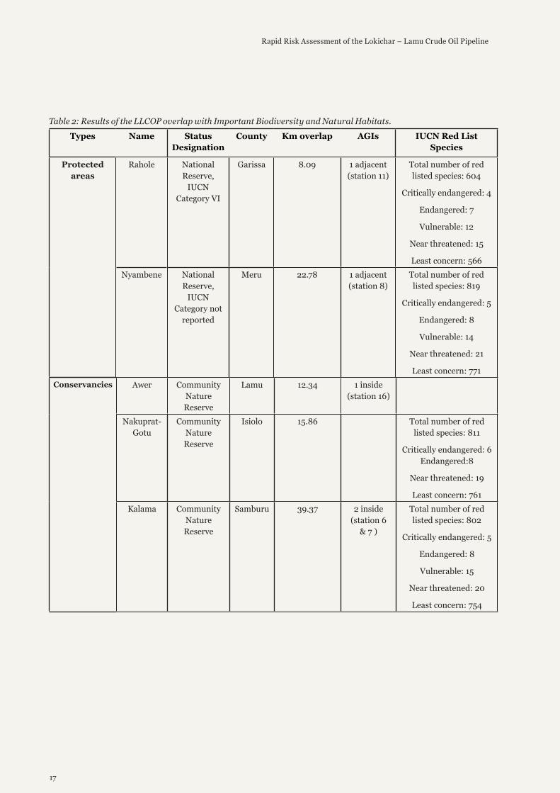
The pipeline is set to cross two protected areas Rahole (IUCN Category VI) and Nyambene (IUCN Category ‘Not reported’) in Garissa and Meru Counties respectively over a total length of 30.87 km (3.5 % of the pipeline length) (Figure 2 and table 2). Protected areas are sites as IUCN notes, recognized and managed “to achieve the long-term conservation of nature with associated ecosystem services and cultural values”.
The pipeline is also set to cross six conservancies (i.e. Community Nature Reserves) in the Lamu, Isiolo and Samburu Counties for 118.37 km (13.3 % of the pipeline length). The largest section of this overlap is in the Kalama Community Nature Reserve intersecting by 36.87 km. In addition, There are plans to build two above-ground installations (AGIs)in Kalama conservancy, a site managed by local communities containing over eight hundred IUCN Red Listed species, 6 of which are critically endangered, 8 endangered and 16 vulnerable (Figure 2 and table 2).
The pipeline is also set to cross two Key Biodiversity Areas, Lunghi and Matthews Range in the Lamu and Samburu counties respectively, crossing a total length of 24.52 km (2.75 % of the pipeline length). KBAs are “sites that contribute to the global persistence of biodiversity”, including vital habitats for impacted plant and animal species in terrestrial, freshwater and marine ecosystems (Figure 2).
Finally, the pipeline is set to cross two forest blocks in the Lamu County, these forests are mangrove forests over a minor distance of 1.9 km (0.2 % of the pipeline length). The proposed pipeline route does not intersect any UNESCO World Heritage Site.
17
Rapid Risk Assessment of the Lokichar – Lamu Crude Oil Pipeline
Types Name Status Designation
County Km overlap AGIs IUCN Red List Species
Protected areas
Rahole National Reserve,
IUCN Category VI
Garissa 8.09 1 adjacent (station 11)
Total number of red listed species: 604
Critically endangered: 4
Endangered: 7
Vulnerable: 12
Near threatened: 15
Least concern: 566Nyambene National
Reserve, IUCN
Category not reported
Meru 22.78 1 adjacent (station 8)
Total number of red listed species: 819
Critically endangered: 5
Endangered: 8
Vulnerable: 14
Near threatened: 21
Least concern: 771Conservancies Awer Community
Nature Reserve
Lamu 12.34 1 inside (station 16)
Nakuprat-Gotu
Community Nature Reserve
Isiolo 15.86 Total number of red listed species: 811
Critically endangered: 6 Endangered:8
Near threatened: 19
Least concern: 761Kalama Community
Nature Reserve
Samburu 39.37 2 inside (station 6
& 7 )
Total number of red listed species: 802
Critically endangered: 5
Endangered: 8
Vulnerable: 15
Near threatened: 20
Least concern: 754
Table 2: Results of the LLCOP overlap with Important Biodiversity and Natural Habitats.

18
Rapid Risk Assessment of the Lokichar – Lamu Crude Oil Pipeline
Conservancies Namunyak Community Nature Reserve
Samburu 4.95 Total number of red listed
species 823
Critically endangered 6
Endangered 8
Vulnerable 16
Near threatened 22
Least concern 771West Gate Community
Nature Reserve
Samburu 8.98 Total number of red listed
species 802
Critically endangered 5 Endangered 8
Vulnerable 15
Near threatened 20
Least concern754Meibae Community
Nature Reserve
Samburu 36.87 Total number of red listed
species 828
Critically endangered 5
Endangered 9
Vulnerable 14
Near threatened 22
Least concern 778Key
Biodiversiy Areas
Lunghi Lamu 5.83 Not identified Matthews
RangeSamburu 18.69
(overlapping Kalamana and
Namunyak conservancies)
Not identified
Forest block Lamu 1.2 Not identifiedLamu 0.7 Not identified
Types Name Status Designation
County Km overlap AGIs IUCN Red List Species
Overall the pipeline will cross a total of 175.66 Kms of Important Biodiversity and Natural Habitats including IUCN protected areas, Conservancies, KBAs and forest blocks. However, because the Matthew Range KBA overlaps with the Kalama and Namunyak conservancies, the true total is 156.97 Km equivalent to 17.6% of the entire pipeline route. These conservancies are key habitats for Elephants, Grevy Zebra and Lions among many other species. Data provided by KWS (2011 2014, 2015 wildlife census data) shows concentration of endangered Gerenuk and Hirola antelopes in Lamu and Garissa counties.

19
Rapid Risk Assessment of the Lokichar – Lamu Crude Oil Pipeline
Eight kilometres north of Archer’s Post and abutting the northern boundary of Samburu National Reserve, is this 384 Km2 wildlife conservancy, which opened in 2004. The conservancy is home to Grevy’s zebras, elephants and reticulated giraffes, among others, and acts as a vital wildlife corridor for animals migrating between the Samburu and Marsabit areas.
There is a high density of leopard and striped hyena, a large population of the endangered Grevy zebra, and all the Northern species (reticulated giraffe, greater and lesser kudu, gerenuk, oryx, etc.) are abundant.
Kalama Community Wildlife Conservancy is an initiative of Girgir group ranch which was established to create an alternative source of income in addition to livestock keeping. The conservancy started in 2001 with 16,000 hectares set aside for conservation, of which 6,000 hectares was designated as a core conservation area. Grazing of livestock is permitted in the buffer zone grazing during the dry season but it is not allowed in the core conservation area. The conservancy is managed by an elected management board which draws its membership from different parts of the group ranch, and which is responsible for the day to day running of the conservancy.
Most community members earn income through sales of livestock (56%) or livestock products (15%) Small Business: 36% of households earn income from small businesses including small shops and beadwork sales. Firewood: 5% of people earn income from collection and sale of firewood and charcoal. Employment: Permanent and casual employment through the Conservancy, Tourist hotels, NGOs and the British Army camps accounts for income for 20% (salary) and 47% (casual labour) of households
Kalama has recently established a small eco-lodge in collaboration with a private investor. The development of a conservancy has increased employment in Girgir and has increased the diversity of livelihoods. Land ownership has been strengthened and grazing management has improved. Individuals also benefit from the payment of dividends from the conservancy. Money raised from the conservancy has been ploughed back for community development activities and direct support is also given to community members during their time of need (e.g. bereavement or serious illness). The conservancy has also helped to establish a good rapport with neighbouring communities and has reduced insecurity. The conservancy vehicle doubles as an ambulance which enables people to get to hospital.
Source: Lonely Planet. Kalama Community Wildlife Conservancy
CASE STUDY 1: KALAMA COMMUNITY WILDLIFE CONSERVANCY

20
Rapid Risk Assessment of the Lokichar – Lamu Crude Oil Pipeline
Wildlife Habitats and Corridors
Coordinate System: WGS 1984 Web Mercator Auxiliary SphereProjection: Mercator Auxiliary SphereDatum: WGS 1984
0 100 20050 mi
0 180 36090 km
±Date: 7/2/2019 11:29:28 PM
LLCOP & Wildlife Habitats and Corridors
Data source: Sources: Esri, HERE, DeLorme, increment P Corp., NPS,NRCan, Ordnance Survey, © OpenStreetMap contributors, USGS, NGA,NASA, CGIAR, N Robinson, NCEAS, NLS, OS, NMA, Geodatastyrelsen,Rijkswaterstaat, GSA, Geoland, FEMA, Intermap and the GIS usercommunityIUCN
© WWF, 2019. Map produced with WWF-SIGHT.org
Lamu Load out facility
Lokichar ExportFacilityAbove GroundInstallations (AGIs)Lokichar Lamu CrudeOil Pipeline (LLCOP)Wildlife corridors KWS2017
Hirola GerenukElephant Lion KWSCensus 2015 LamuGravy Zebra ElephantLion KWS Census2014 MeruGravy ZebraElephants LionsCensus 2012
Hirola Elephants LionCensus 2011Mask
African Elephant
Extant (resident)
Lion
Extant (resident)
Possibly Extinct
Figure 3: LLCOP overlap with Wildlife Habitats and Corridors and animals tracking data.
Coordinate System: WGS 1984 Web Mercator Auxiliary SphereProjection: Mercator Auxiliary SphereDatum: WGS 1984
0 100 20050 mi
0 180 36090 km
±Date: 7/2/2019 11:31:22 PM
LLCOP & last of the wild
Data source: Sources: Esri, HERE, DeLorme, increment P Corp., NPS,NRCan, Ordnance Survey, © OpenStreetMap contributors, USGS, NGA,NASA, CGIAR, N Robinson, NCEAS, NLS, OS, NMA, Geodatastyrelsen,Rijkswaterstaat, GSA, Geoland, FEMA, Intermap and the GIS usercommunityWildlife Conservation Society - WCS, and Center for International EarthScience Information Network - CIESIN - Columbia University
© WWF, 2019. Map produced with WWF-SIGHT.org
Lamu Load out facility
Lokichar ExportFacilityAbove GroundInstallations (AGIs)Lokichar Lamu CrudeOil Pipeline (LLCOP)Mask
Last of the Wild v2Tropical andSubtropical MoistBroadleaf Forests
Tropical andSubtropical DryBroadleaf ForestsTropical andSubtropical ConiferousForestsTemperate Broadleafand Mixed ForestsTemperate ConiferousForests
Boreal Forests/Taiga
Tropical andsubtropicalgrasslands, savannas,and shrublands
TemperateGrasslands,Savannas, andShrublandsFlooded Grasslandsand SavannasMontane Grasslandsand Shrublands
Tundra
MediterraneanForests, Woodlands,and ScrubDeserts and XericShrublands
Mangroves
Lakes
Rock and Ice
Figure 4: LLCOP overlap with Last of the Wild dataset.

21
Rapid Risk Assessment of the Lokichar – Lamu Crude Oil Pipeline
The pipeline crosses several African elephant (Loxodonta Africana) dispersal areas in the Samburu, Meru and Isiolo counties where the species is resident according to the IUCN Red List of Threatened Species 2017, and the elephant census done by Kenya Wildlife Service (KWS). In fact, the pipeline crosses 271.79 km of IUCN African Elephant habitat (30.47 % of the pipeline length), with the largest overlap of this area in the Samburu county. The pipeline also crosses several areas where Lion (Panthera leo) is resident according to the Lion census done by KWS. The pipeline crosses 193.62 km of lion habitat (21.7 % of the pipeline length). In addition, the pipeline crosses several clusters of Grevy Zebra, Hirola and Gerenuk according to censuses done by KWS, mainly in the Samburu and Lamu counties, as well as wildlife corridors as identified by the Wildlife Migratory Corridors and Dispersal Areas report done by KWS in 2017 (Figure 3).
In terms of the Last of the Wild dataset, areas where Human Footprint Index values less than or equal to 10, the pipeline overlaps several of them, in particular the Somali Acacia-Commiphora bushlands and thickets in the Garissa county, and Northern Acacia-Commiphora bushlands and thickets in the Samburu region (Figure 4).
Table 3: LLCOP overlap with last of the wild dataset.
Type of biome Overlap (Km)
%
Somali Acacia - Commiphora bushlands and thickets 73.59 8.25Masai xeric grasslands and shrublands 28.36 3.17
East African montane forests 20.69 2.32Northern Acacia - Commiphora bushlands and thickets 76.56 8.5
Northern Zanzibar-Inhambane coastal forest mosaic 0.94 0.10Total 200.17 22.44
Coordinate System: WGS 1984 Web Mercator Auxiliary SphereProjection: Mercator Auxiliary SphereDatum: WGS 1984
0 100 20050 mi
0 180 36090 km
±Date: 7/3/2019 11:23:27 AM
LLCOP & Water Resources
Data source: Sources: Esri, HERE, DeLorme, increment P Corp., NPS,NRCan, Ordnance Survey, © OpenStreetMap contributors, USGS, NGA,NASA, CGIAR, N Robinson, NCEAS, NLS, OS, NMA, Geodatastyrelsen,Rijkswaterstaat, GSA, Geoland, FEMA, Intermap and the GIS usercommunityWorld Wildlife Fund US | HydroSHEDS | Natural EarthWWF-Kenya, 2019
© WWF, 2019. Map produced with WWF-SIGHT.org
Major riversLamu Load outfacilitiesLokichar ExportFacilityAbove GroundInstallations (AGIs)Lokichar Lamu CrudeOil Pipeline (LLCOP)
Mask
Wetlands WRI
Lakes and Reservoir
Lake
Lake with regulationstructure
Reservoir
Figure 5: LLCOP overlap with water resources.

22
Rapid Risk Assessment of the Lokichar – Lamu Crude Oil Pipeline
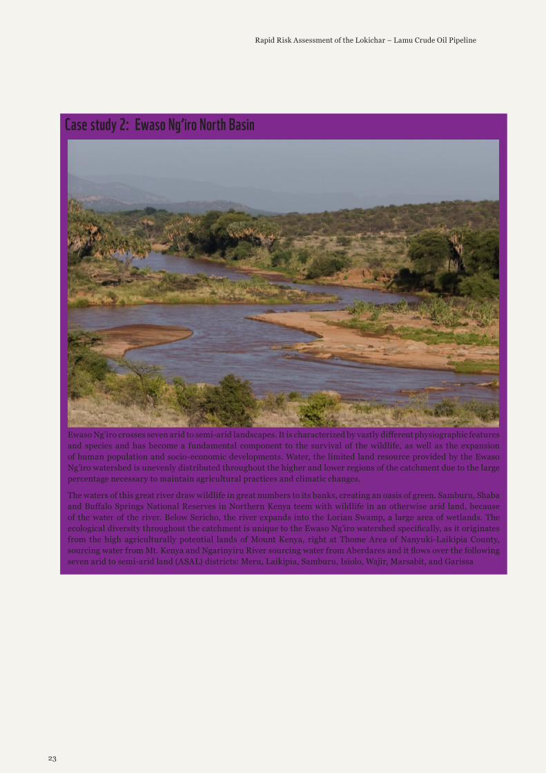
According to data from the NEMA, the pipeline is set to cross three major rivers in Kenya (Figure 5). Specifically the Kalabata and Endo rivers in Turkana county (near Lokichar) which are both seasonal and tributaries to the Lake Turkana, and Ewaso Ngiro which separates Samburu and Isiolo - a permanent and tributary to the Jubba River. The Ewaso Ng’iro watershed stretches over a diverse variety of ecosystems from the high regions of Mount Kenya to the lower arid to semi-arid regions. Each ecosystem delivers a unique contribution to the land and people of Kenya as they interact with one another to achieve a sustainable equilibrium. The wetland ecosystems, which are located in the higher regions of Mount Kenya, provide a natural water filtration system, a variety of plant and animal species, and nutrients for all other species and ecosystems.
River’s name Type County Tributary toKalabata Seasonal Turkana Lake Turkana
Endo Seasonal Turkana Lake TurkanaEwaso Ngiro Permanent Samburu / Isiolo Juba River / Indian Ocean
Table 4: A table defining the LLCOP overlap with key rivers.
According to Water Resources Authority data on wetlands, the LLCOP is set to cross 10 of the 1226 identified wetlands in Kenya, crossing 15.53 Km. Most of these overlaps are found in the Garissa County.
In terms of Lakes and Reservoirs, the LLCOP will not cross any according to data from HydroSHEDS. In terms of river Basins, the pipeline will traverse five basins (HydroSHEDS level 4) including the basins of the major rivers reported.
23
Rapid Risk Assessment of the Lokichar – Lamu Crude Oil Pipeline
Ewaso Ng’iro crosses seven arid to semi-arid landscapes. It is characterized by vastly different physiographic features and species and has become a fundamental component to the survival of the wildlife, as well as the expansion of human population and socio-economic developments. Water, the limited land resource provided by the Ewaso Ng’iro watershed is unevenly distributed throughout the higher and lower regions of the catchment due to the large percentage necessary to maintain agricultural practices and climatic changes.
The waters of this great river draw wildlife in great numbers to its banks, creating an oasis of green. Samburu, Shaba and Buffalo Springs National Reserves in Northern Kenya teem with wildlife in an otherwise arid land, because of the water of the river. Below Sericho, the river expands into the Lorian Swamp, a large area of wetlands. The ecological diversity throughout the catchment is unique to the Ewaso Ng’iro watershed specifically, as it originates from the high agriculturally potential lands of Mount Kenya, right at Thome Area of Nanyuki-Laikipia County, sourcing water from Mt. Kenya and Ngarinyiru River sourcing water from Aberdares and it flows over the following seven arid to semi-arid land (ASAL) districts: Meru, Laikipia, Samburu, Isiolo, Wajir, Marsabit, and Garissa
Case study 2: Ewaso Ng’iro North Basin

24
Rapid Risk Assessment of the Lokichar – Lamu Crude Oil Pipeline
Number Area in Km2 Overlapped Length in Km1 11.75 1.132 7.13 0.483 12.45 1.144 180.81 4.455 6.77 0.596 20.76 0.237 5.58 0.818 7.19 3.029 41.65 3.0910 29.15 0.58
Total 15.53
Table 5: A table defining the LLCOP overlap with wetlands.
According to the AGI overlap, Station 7 is close to Ewaso Ngiro River at Archer’s post. Ewaso Ng’iro is the second largest river in Kenya and stretches for approximately 700 Km and a major source of water for Mount Kenya region. The banks of the river support a broad range of wildlife including the elephant, buffalo, rhinos, cheetahs, leopards and Zebras. The river has been affected by degradation of its catchment areas. Pollution or spillage could further damage the river ecosystem. Recent drought periods have taken their toll on river’s water volume. The river has also taken centre stage in tribal disputes, especially among communities which inhabit the regions of Samburu and Isiolo.
Coordinate System: WGS 1984 Web Mercator Auxiliary SphereProjection: Mercator Auxiliary SphereDatum: WGS 1984
0 30 6015 mi
0 50 10025 km
±Date: 7/3/2019 11:56:09 AM
LLCOP & Coastal and Marine ecosystem
Data source: CBDSources: Esri, HERE, DeLorme, increment P Corp., NPS, NRCan, OrdnanceSurvey, © OpenStreetMap contributors, USGS, NGA, NASA, CGIAR, NRobinson, NCEAS, NLS, OS, NMA, Geodatastyrelsen, Rijkswaterstaat, GSA,Geoland, FEMA, Intermap and the GIS user communityWWF-Kenya, 2019
© WWF, 2019. Map produced with WWF-SIGHT.org
Lamu Load outfacilitiesAbove GroundInstallations (AGIs)Lokichar Lamu CrudeOil Pipeline (LLCOP)Mask
WCMC011_AtlasM...
WCMC008_CoralR...
WCMC008_CoralR...
Seagrass RCMRD2015
Ecologically orBiologically SignificantMarine Areas (EBSAs)
Ecologically orBiologically SignificantMarine Areas(EBSAs)
Coastal and Marine ecosystem
Figure 6: LLCOP overlap and proximity to coastal and marine ecosystems.

25
Rapid Risk Assessment of the Lokichar – Lamu Crude Oil Pipeline
For coastal and marine area, the area of focus is the Lamu Marine Terminal from where the crude oil will be shipped out (Figure 6). The Lamu Marine terminal is to stand in an area rich in mangroves, coral reefs and seagrass, as well as near the conservancy of Pate. In addition, Lamu is located within an the Lamu-Kiunga Ecologically or Biologically Significant Areas (EBSAS) which is considered part of six priority landscapes implementing climate change adaptation by the World Wide Fund for Nature (WWF). The mangrove and tidal flat habitats in the area of Lamu on the Indian Ocean coast of north-eastern Kenya, close to the Somali border, are known as some of the most extensive and species-rich along the entire coast of East Africa. They provide very important value in terms of biodiversity, climate protection (blue carbon), fishery, nature-based tourism and coastal protection.
Coral reef ecosystem supports both the artisanal and commercial fisheries and form the backbone of the coastal communities’ economies. However, they also support the tourism industry, which subsequently engages other stakeholders such as boat operators, tour companies, tour guides and hoteliers in the hospitality sector. Lamu residents depend on mangroves for construction materials, firewood, medicines, tannin, fibers and dyes, food, and charcoal.

26
Rapid Risk Assessment of the Lokichar – Lamu Crude Oil Pipeline
Case study 3: The Tana River Delta
The Tana River Delta (1,300 Km2) is one of the most important wetlands in Africa. It lies on the Kenya coast between Malindi and Lamu. The delta is the second most important estuarine and deltaic ecosystem in Eastern Africa and a Key Biodiversity Area. Recognition of the delta as an Important Bird and Biodiversity Area (IBA) and a designated Ramsar site further underscores the ecological importance of this ecosystem. (A Ramsar Site is a wetland site of international importance under the Ramsar Convention.).
The Tana River Delta in Kenya, which includes part of Lamu County, has been officially designated as a Wetland of International Importance by the Kenyan government. According to the Secretariat of the Ramsar Convention on wetlands, the Delta covers 1,636 Km2, is an Important Bird Area in Coast Province The delta comprises a variety of freshwater, floodplain, estuarine and coastal habitats with extensive and diverse mangrove systems, marine brackish and freshwater intertidal areas, pristine beaches and shallow marine areas, forming productive and functionally interconnected ecosystems. Kenya presently has six Ramsar Sites, covering an area of 2,654.49 Km2.
The delta supports a number of endangered primates, marine turtles and plant species as well as rare fish, amphibians and reptiles. A vast number of migratory and resident waterbirds are dependent on seasonally flooded grasslands and Borassus palm savannah that covers some 7,00 Km2 in the heart of the Tana Delta. The delta’s mangrove forests provide important spawning grounds and nurseries for fish and shellfish.
The delta is also a source of livelihood for communities, providing dry season grazing areas, fertile farmlands and rich fishing grounds. Despite its immense importance, the delta is threatened by resource use conflict between pastoralism, farming and conservation
© Jonathan Caramanus / Green Renaissance / WWF-UK

27
Rapid Risk Assessment of the Lokichar – Lamu Crude Oil Pipeline
Coordinate System: WGS 1984 Web Mercator Auxiliary SphereProjection: Mercator Auxiliary SphereDatum: WGS 1984
0 100 20050 mi
0 180 36090 km
±Date: 7/3/2019 11:38:49 AM
LLCOP & Local Socio economy
Data source: Sources: Esri, HERE, DeLorme, increment P Corp., NPS,NRCan, Ordnance Survey, © OpenStreetMap contributors, USGS, NGA,NASA, CGIAR, N Robinson, NCEAS, NLS, OS, NMA, Geodatastyrelsen,Rijkswaterstaat, GSA, Geoland, FEMA, Intermap and the GIS usercommunityWWF-Kenya, 2019
© WWF, 2019. Map produced with WWF-SIGHT.org
Hotels, lodges andcampsitesCroplandLamu Load outfacilitiesLokichar ExportFacilityAbove GroundInstallations (AGIs)
Lokichar Lamu CrudeOil Pipeline (LLCOP)MaskGPWv4: UN-AdjustedPopulation Count -2015
Local Socio-economic
Figure 7: LLCOP overlap on cropland and human population density.
Coordinate System: WGS 1984 Web Mercator Auxiliary SphereProjection: Mercator Auxiliary SphereDatum: WGS 1984
0 100 20050 mi
0 180 36090 km
±Date: 7/3/2019 11:39:58 AM
LLCOP & land cover
Data source: Sources: Esri, HERE, DeLorme, increment P Corp., NPS,NRCan, Ordnance Survey, © OpenStreetMap contributors, USGS, NGA,NASA, CGIAR, N Robinson, NCEAS, NLS, OS, NMA, Geodatastyrelsen,Rijkswaterstaat, GSA, Geoland, FEMA, Intermap and the GIS usercommunityWWF-Kenya, 2019ESA CCI Land Cover Project 2016
© WWF, 2019. Map produced with WWF-SIGHT.org
Lamu Load outfacilitiesLokichar ExportFacilityAbove GroundInstallations (AGIs)Lokichar Lamu CrudeOil Pipeline (LLCOP)Mask
Figure 8: Shows Land use and land cover along the pipeline

28
Rapid Risk Assessment of the Lokichar – Lamu Crude Oil Pipeline
The pipeline is set to cross approximately 20 km of cropland as mapped by the Regional Centre For Mapping Resource For Development (Figure 7). These crops are rain fed and range from Maize, cow peas, green grams, cassava, vegetables, cashew nuts and mangoes in the Lamu, Meru, Isiolo counties. The pipeline does not cross hotels, lodges and camping sites, however passes near (closest 9 km) to several lodges located in and near Shaba and Buffalo springs protected areas, in the Samburu and Isiolo counties.
According to the Gridded Population of the World, Version 4, the pipeline crosses fairly population sparse areas with a population density ranging from 1 to 799 people per Km2, with a weighted average of 18 people per Km2 (Figure 7).
In terms of land cover, 60% of the pipeline traverses ‘shrub savannah’, followed by ‘Open to closed herbaceous vegetation’ (Figure 8).
Land cover type Overlapped Length in KmOpen to closed herbaceous vegetation 86.79
Open to closed herbaceous vegetation on temporarily flooded 7.96Shrub savannah 319.19
Sparse shrubs 61.47Trees and shrubs savannah 51.50
Total 526.94
Table 6: types of land cover the LLCOP intersects.

29
Rapid Risk Assessment of the Lokichar – Lamu Crude Oil Pipeline
DISCUSSION As mentioned in the methodology, determining the environmental risk in this study is based on a qualitative assessment of the actual or potential threats emerging from the development stages
of the LLCOP on selected environmental assets including Important Biodiversity and Natural Habitats, Wildlife habitats and corridors, Water Resources and Coastal and Marine ecosystems. It is also important to remember the limitations of this methodology and that the aim is to provide high level implications and raised potential red flags. The following section discusses the actual or potential threats at each stage of the LLCOP and associated developments on the four environmental clusters. Note that stage 1 - Feasibility and Design is not discussed here given it is not considered as a threat.
The construction stage of the LLCOP is foreseen as the main direct threat to Important Biodiversity and Natural Habitats, Wildlife habitats and corridors, and Water Resources in the areas where the pipeline will be constructed. Excavation, movement of sediments, creation of a side road, transportation of material, associated noise and other activities during this stage, which will occur over a distance of 892 km to install the pipeline, may disrupt the physical structure of habitats3 and their use by faunal species4 especially in the two IUCN categorised protected areas, six conservancies and two KBAs. Nevertheless, because the construction stage is limited in time and that the pipeline will be buried underground, once installed the LLCOP is unlikely to generate long term impacts especially if re-vegetation occurs over the construction site. In terms of water resources, because of the safety measures of crude oil pipelines today, the probability of an oil spill is fairly low and due to the viscosity of the oil when not heated. However, the construction of a crude oil pipeline could disturb river beds of important rivers such as the Ewaso Ngiro River which the pipeline crosses. In addition, the construction of the pipeline may require water extraction for concrete mixing and hydrostatic testing. There is a possibility of a water conflict with local communities especially along Isiolo where there is concentrated human settlement along the route. As such the construction stage of the pipeline can be categorised as “Moderate or Medium threat ” to Important Biodiversity and Natural Habitats, Wildlife habitats and corridors and Water Resources.
The most significant potential threat to Important Biodiversity and Natural Habitats, Wildlife habitats and corridors is indirect and is likely to occur during the LLCOP operation phase. While the risks of an oil spill are marginal due to the safety standards of modern day pipelines, infrastructures such as AGIs and service roads often facilitate further development which might pose a greater threat to wildlife and important natural habitats than the actual pipeline. Planned AGIs and service roads will be required for continuous use and generate traffic which increase wildlife roadkill especially in protected areas and conservancies. In addition, new or expansion of roads may lead to unintended consequences including new settlements and exploitation, potentially leading to overexploitation of resources, increase in poaching, shifting agriculture and charcoal production, habitat fragmentation, land speculation, human wildlife conflicts, communicable diseases, loss of culture, local knowledge and livelihood of indigenous groups5. These impacts are usually more severe and affect a wider area than the direct infrastructure impacts. As such, although the direct impacts of the operation stage might be seen as marginal, the indirect or unintended consequences of the pipeline might pose a significant risk. As a result, the operation stage is classified as “Significant or high threat ” to Important Biodiversity and Natural Habitats, and Wildlife habitats and corridors.
In terms of marine and coastal ecosystem, the pipeline does not cross these features per se. However, the construction and operation of the LLCOP and associated infrastructure including storage facility (1.5 million barrels capacity), Load-Out Facility (LOF), loading line, a marine platform, as well as boat traffic and the actual transport of oil, are likely to pose serious threats to the marine and coastal ecosystem. The area in Lamu where the LLCOP is set to end is surrounded by abundant mangroves. Any construction activity will likely entail clearing mangrove areas. In addition, the construction of the load-out-Facility (LOF) associated to the port will entail dredging the area which will cause sedimentation and damage to the surrounding coral reef and mangrove habitats that represent important biodiversity areas as well as provide breeding and feeding grounds for fish. Sedimentation might be accentuated by ship traffic which also may lead to the introduction of alien species from the ships’ ballast waters which carry marine organisms that have invasive potential6.
During the operation of the pipeline, the actual shipping of oil is a high risk activity which can potentially have long term consequences to coastal and marine ecosystems. As seen in the case of the tanker Katina P which in 1992 sank 3Curatolo JA, Murphy SM. The effects of pipelines, roads, and traffic on the movements of Caribou, Rangifer tarandus. Can. Field-Nat. 1986;100:218–224.4Rabanal LI, Kuehl S, Mundry R, Robbins MM, Boesch C. Oil prospecting and its impact on large rainforest mammals in Loango National Park, Gabon. Biol. Conserv. 2010;143:1017–1024.5Netherlands Commission for Environmental Assessment, 2017, SEA and ESIA for Economic Corridors and Infrastructure Development, available at https://www.cbd.int/mainstreaming/doc/seas-infrastructure-en.pdf6 Frank Stuer-Lauridsen, Guillaume Drillet, Flemming Thorbjørn Hansen, Justine Saunders. (2018) Same Risk Area: An area-based approach for the management of bio-invasion risks from ships’ ballast water. Marine Policy 97, pages 147-155.

30
Rapid Risk Assessment of the Lokichar – Lamu Crude Oil Pipeline
with 66,700 tonnes of heavy fuel oil 85 nautical miles from the coastal of Mozambique, had oil slicks threaten the shores of Maputo Bay, which were being heavily exploited by local populations for food and trade. That year, the Ministry of Health and Secretary of State for Fisheries announced a fishing ban in Maputo Bay, as well as a ban on bathing and other beach activities, due to risks for human health (see case study 4). As such, although the LLCOP itself might not have severe direct impacts, the construction and operation of associated developments and activities including oil shipping, may pose “Servere or very high threat” to coastal ecosystem and the fishing industry within the region 7.
7 Lamu consists of several islands with numerous fishing villages and hubs, all which specialize in specific areas of the industry, with Kizingitini and Kiunga the major fish landing zones. Other than the mainland areas, Mokowe, Mkunumbi, Witu, Barigoni, Mpeketoni, Kiongoni and Hindi. To the far north, the islands of Kiungamwini, Siyu, Faza, Mtangwanda, Bori, Shanga, Chundwa, Mbwajumwali, Iyabogi, Kizingitini, Mkokoni, Simambaya and Kiwayuu lie, while to the south, Ndau, Pate, Manda and Lamu Islands lie.

31
Rapid Risk Assessment of the Lokichar – Lamu Crude Oil Pipeline
On 17th April 1992, the tanker Katina P was hit by a freak wave while transiting the Mozambique Channel. It was carrying 66,700 tonnes of heavy fuel oil en route from Venezuela to the United Arab Emirates. The vessel lost hull plating amidships resulting in a release of approximately 3,000 tonnes of cargo. The Katina P was intentionally grounded on a sandbar six miles offshore of Maputo Bay to prevent sinking. In an attempt to avoid further coastal pollution, the vessel was towed out to sea for lightering to another tanker. However, while under tow, the vessel broke in two and sank on 26th April, approximately 85 nautical miles off Mozambique, with a further release of oil. Part of the oil released initially stranded on various beaches in and outside Maputo Bay. Oil that spilled when the vessel sank travelled south on the agulhas current, with limited amounts of weathered oil stranding on the South African coastline. Shoreline clean-up was organised by the Ministry of Public Works with local municipalities using local labour, assisted by excavators, trucks etc. However, work was hampered by limited resources and civil war. The spill had major socio-economic and environmental consequences for Mozambique. The polluted environment was extremely sensitive (bays, mangroves, estuaries, islands and beaches) and home to a major shrimp population and other seafood resources. During the first few weeks following the spill, oil slicks threatened the shores of Maputo Bay, which were being heavily exploited by local populations for food and trade. On 22 April 1992, the Ministry of Health and Secretary of State for Fisheries announced a fishing ban in Maputo Bay, as well as a ban on bathing and other beach activities, due to risks. On 27 April, in the areas unaffected by the pollution (centre and south of the bay), the fishing ban was lifted. Shellfish in areas affected by the pollution still showed high contamination levels, meaning that they were unfit for human consumption. Salt pans along the Matola River were closed extraction for some weeks.
Oil escaping from the wrecked Braer tanker on the 10 January 1993. Shetland Islands, UK. © WWF / Dominique Halleux
Case study 4: The impacts of a large-scale oil spill in the South Western Indian Ocean (SWIO): the case of the Katina P

32
Rapid Risk Assessment of the Lokichar – Lamu Crude Oil Pipeline
The table below outlines our proposed threat severity of three of the development phases of the LLCOP for the various key environmental and social-economic reviewed within the GIS assessment.
Table 7: proposed threat severity scoring for the three development phases of the LLCOP against the various key environmental and social-economic reviewed within the GIS assessment.
Environmental assets
Stage 2: Construction phase
Stage 3: Operation phase Stage 4: Decommissioning phase
Important Biodiversity and Natural Habitats
Moderate or medium threat: excavation and
movement of sediment for installing the pipeline could
lead to disturbance over 175,66 Km of Important Biodiversity and Natural
Habitats include .
Significant or high threat: a) unregulated developments of associated infrastructure (roads, markets, etc.) within conservancies and protected could lead to lasting changes
to these areas,
b) increase in shifting agriculture, charcoal
production and poaching
Marginal or low threat: considering the pipeline is left in place, cleaned inside and disconnected from the
system and segmented where necessary.
Wildlife corridor and habitats
Moderate or medium threat: excavation of
sediments and noise could lead to disturbance over
hundreds of km of wildlife habitats as well as
corridors.
Significant or high threat: a) unregulated developments of associated infrastructure (roads, markets, etc.) within conservancies and protected could lead to lasting changes
to these areas,
b) increase in shifting agriculture, charcoal
production and poaching
Marginal or low threat: considering the pipeline is left in place, cleaned inside and disconnected from the
system and segmented where necessary.
Water resources Moderate or medium threat: a) excavation of sediments could lead to river bed disturbance;
b) water extraction for concrete mixing and
hydrostatic testing could lead to water conflict with
local communities
Moderate or medium threat: water extraction by new settlements as well as for the pipeline operation
could lead to water conflict with local communities
Marginal or low threat: considering the pipeline is left in place, cleaned inside and disconnected from the
system and segmented where necessary.
Coastal and Marine ecosystem
Severe or very high threat: dredging may cause sedimentation and
irreversible damage to mangroves and coral reefs.
Severe or very high threat: shipping oil from Lamu
marine terminal could lead to oil and chemical spills
within the Lamu Delta and could be catastrophic for this
region. In addition, ballast water from ships could introduce alien invasive
species.
Marginal or low threat: considering the pipeline is left in place, cleaned inside and disconnected from the
system and segmented where necessary.

33
Rapid Risk Assessment of the Lokichar – Lamu Crude Oil Pipeline
In terms of economic risks, the two main economic sectors with the most risk from the pipeline are the tourism and fisheries sectors. As discussed above, the pipeline is expected to pose a “Significant or high threat” to Important Biodiversity and Natural Habitats, and Wildlife habitats and corridors on which the local tourism industry depends on. Construction activities as well as LLCOP operation which may lead to increased traffic, settlements and human activities in general may disrupt the presence of wildlife, especially in the two IUCN categorised protected areas and the six conservancies.
It is important to remember that conservancies like Kalama (conservancy which will be crossed by the LLCOP) are heavily reliant on wildlife tourism which generates local employment, increases diversity of livelihoods, strengthen land ownership and improves grazing management. Local communities also benefit from the payment of dividends from the conservancy. As such, the construction and operation of the LLCOP over its 892 km which may disrupt wildlife numbers and movement has the potential to negatively impact on local tourism income on the long run.
A similar scenario could occur in Lamu where the pipeline and associated infrastructure will be built and operated. The construction and operation of the Load-Out Facility (Facility) and port may impact the reef, mangroves and overall scenery of Lamu, and therefore its tourism which the local economy is heavily dependent on. It is important to remember that Kenya’s main economic pillar is services (47.5%) followed by agriculture (34.5%) and industry (17.8%)8. Kenya’s services sector is dominated by tourism and most tourists are attracted to the coastal beaches and game reserves. As such, the construction and operation of the LLCOP and associated infrastructure over its 892 km, and especially the overlaps with protected areas and conservancies, but also in Lamu may very well impact negatively Kenya’s tourism sector and its beneficiaries.
In regards to the fisheries sector, according to Kenya Marine and Fisheries Research Institute the coastline supports the livelihoods of thousands of coastal communities. The annual marine fish production is estimated to be about 9,000 metric tonnes, equivalent to 7% of the national fish production from capture fisheries. It’s considered likely that the proposed LLCOP and associated infrastructure may have a significant impact on the fishing industry within the region9. The construction and operationalization of the Lamu Marine terminal a 32 berth port may impact the livelihoods of the fishers working in the highly productive fishing areas of Kizingitini and Faza by restricting access to fishing grounds, increase the risks of injury and death for lobster divers as well as increase boat traffic which is likely to increase accidents at sea. The Kenya Marine Fisheris Research Institute points out that local subsistence fishermen within Lamu depend on fish for food and their livelihood, any impacts on coral reef and sea grass which are vital fisheries breeding grounds will affect fish population translating into loss of incomes and livelihoods. The Lamu County fisheries department estimates that fishing and fisheries related activities accounts for over 70% of household incomes in Lamu East, Lamu Island and the adjacent fishing villages inhabiting the shorelines in Lamu west Sub County. The annual fish production for the county is estimated as 2500MT valued at Kes. 180 million. The estimated potential of the fish industry is 30,000 Metric Tonnes valued at Kes. 6 billion within a coastline of 144km and 200 nautical miles Exclusive Economic Zone (EEZ). The fish industry in the region is estimated to employ over 10,000 people directly or indirectly.
8Kenya Economy 2019, CIA world factbook and other sources, available at https://theodora.com/wfbcurrent/kenya/kenya_economy.html9Lamu consists of several islands with numerous fishing villages and hubs, all which specialize in specific areas of the industry, with Kizingitini and Kiunga the major fish landing zones. Other than the mainland areas, Mokowe, Mkunumbi, Witu, Barigoni, Mpeketoni, Kiongoni and Hindi. To the far north, the islands of Kiungamwini, Siyu, Faza, Mtangwanda, Bori, Shanga, Chundwa, Mbwajumwali, Iyabogi, Kizingitini, Mkokoni, Simambaya and Kiwayuu lie, while to the south, Ndau, Pate, Manda and Lamu Islands lie.

34
Rapid Risk Assessment of the Lokichar – Lamu Crude Oil Pipeline
FOCUS GROUP DISCUSSIONS
The Focus Group Discussions (FGDs) were conducted with the intention of gathering the concerns and recommendations that the local communities had regarding the construction and operation of the LLCOP. Four distinct areas were explored in discussion.
Employment: The FGDs showed that locals expect jobs and business opportunities from the LLCOP but fear an influx of outsiders.The Focus Group Discussions (FGDs) were conducted with the intention of gathering the concerns and recommendations that the local communities had regarding the construction and operation of the LLCOP. Here four distinct areas were explored in discussion.
The potentially impacted communities with exception of Meru have been marginalized since independence and this project gives hope to locals. However, the chances offered to locals may be limited because of low education levels and skills reducing their capacity to compete for jobs. Application of transparent and legal policies and procedures that encourage and promote competitiveness at national and county levels need to be implemented to mitigate this problem.
The expected number of local people to benefit from the proposed project is not known due to a lack of data. However, the contractor is expected to train locals, with expectation that the majority of manual labourers will be locals. Stakeholders engaged indicated that locals are available for temporary work. Opportunities along the proposed pipeline project are expected to attract large numbers and this demonstrates the large numbers of working-age people actively searching for work within and outside these counties. Communities close to potential construction camps reported the availability of workers skilled in catering, laundry, cleaning, food production, etc.
The Kenyan government needs to fast-track the development of a local content strategy especially local content under a devolved government system. Workforce and supplier capacity development, regulatory requirements, business drivers of the sector, and management of stakeholder expectations should all inform development of this strategy.
Land and Compensation: The FGDs highlighted wide concerns over land issues, that they may not be able to receive money in cases where land is communally owned, and that compensation may take years.Previous examples of land acquisition related to oil activities within Kenya, have historically been characterized by disputes and confusion arising due to land ownerships and illegal transfers observed when land has been identified and earmarked for project development. In the past many local communities have felt displaced from their traditional lands of heritage without Free Prior and Informed consultation and through unscrupulous means that often include denial to full access to information on the land acquisition process.
35
Rapid Risk Assessment of the Lokichar – Lamu Crude Oil Pipeline
The pipeline route in Isiolo, Turkana, Meru, Turkana and Lamu passes through contentious boundaries and lands and this normally translate to land disputes and civil conflicts. If unchecked, the conflicts are likely to lead to widespread escalation of poverty, social – economic disfranchisement, displacements and apathy amongst the people.
The two widely applied modes of land compensation in Kenya are “land for land” and “cash for land”. Despite their general acceptability, sustainability concerns continue to arise especially among the directly affected communities. The locals, in this case the land losers are expected to receive cash instead of alternative land and the money is used to buy viable land elsewhere. Some of the landowners, by the time they receive compensation they have relocated hence tracking them is problematic. Some locals prefer to choose viable land elsewhere and select locations of their preference. Others prefer cash compensation which could provide opportunities for opening family businesses. However, cash compensation is least helpful particularly for rural and other marginal populations because rural economies are in large part non-monetized, based on reciprocal exchange of goods and services; therefore, people are not well accustomed to managing cash. Some rural people have very little transaction experience with the outside world; finding relocation land is increasingly difficult. In addition, the costs for relocating, transporting, salvaging building materials, and so on can put financial strain on the displaced persons if not well accounted for in the cash compensation package. Furthermore, compensation for land acquisition should not be limited to monetary payments for individuals; there should be appropriate compensation to the community for people to re-establish their new communities. Since unemployment is rife in these six counties those at greater risk of displacement are landless labourers.
These five counties are patriarchal in nature, meaning compensation monies will likely go to men, often leading to mistrust and division in the family. Kenya is a signatory to various international and regional protocols such as the Convention for the Elimination of Discrimination Against Women (CEDAW) and the Africa Protocol on Women’s Rights. As a result of the discovery of oil and gas in Kenya, several legal and institutional frameworks have been developed for the exploration, production and management of the industry, but there is no clear demonstration or commitment to gender responsiveness in these legal and institutional considerations. Women pointed out that, men often have better access to benefits via employment and supplies, while the costs such as family/social disruption fall most heavily on women. Strong citizens’ participation will contribute to better management of the industry and ensure livelihood diversification and sustainability. Access to jobs and opportunities should be enhanced for all gender groups, people living with disabilities, marginalized, and minority communities. The Kenyan constitution provides fundamental policy guidelines to protect male and female citizens from gender imbalance. Gender imbalance experienced elsewhere on the African continent has exacerbated inequality. It has resulted in costly social conflicts and entrenchment of poverty in oil producing areas and widened gaps between the rich and the poor, (the poor being mostly women, children and the youth).
Livestock Grazing Zones: The FGDs highlighted concerns over water access and interruption of livestock movement.Communities in most of these regions practice pastoralism. While there are common migratory routes, new routes are also established each year. These are tracked along rivers, access roads, etc, as necessary to reach preferred grazing areas. The pipeline route frequently crosses potential herders’ grazing areas hence it will affect livestock grazing blocks that fall along the route. During construction, open trenches along livestock grazing corridors will be a physical constraint to livestock movement and in some cases, degradation of grazing pastures. In some areas the pipeline crosses rivers and other wetland ecosystems which are critical watering points for both livestock and wild animals, potentially a significant issue during dry season.
Social Infrastructure/Amenities: The FGDs highlighted hopes that the LLCOP will improve, local roads and the electricity and water supply. The proposed LLCOP is aligned in such a way that most social amenities will not be affected. Schools, health centres are far away from the proposed crude oil pipeline. These amenities are expected to benefit through improved road network, electricity supply, improved security and water supply.
The proposed LLCOP is expected to have both positive and negative impacts on settlements along the proposed route. The most significant impact is electricity and road upgrade in some of the remote areas because AGI’s, pumping stations and pressure reduction stations are expected to require electricity.

36
Rapid Risk Assessment of the Lokichar – Lamu Crude Oil Pipeline
CONCLUSIONS AND RECOMMENDATIONS
The LLCOP may generate national economic gains but will come with significant environmental and socio-economic risks. As outlined in the results and discussion, the LLCOP will pass through a range of diverse ecosystems, and although its direct impacts might be moderate, it is the indirect impacts of the pipeline and
associated developments that may pose the most significant threats to these ecosystems and associated economy. Such ecosystems provide a number of services including freshwater, timber, wildlife for tourism, fodder, fuelwood, pharmaceutical products and more. Indeed, ecosystems perform fundamental life-support services for communities, but also for Kenya as a nation. Considering their value there is need to identify and monitor these services and incorporate their value into decision-making processes for the LLCOP.
Conservancies in particular have emerged as important tools in managing Kenya’s key ecosystems. According to a 2014 task force on wildlife security, private and community conservancies are important providing the best and, probably, only viable option for ensuring that Kenya maintains its wildlife resource and turns around the decline in numbers and habitats. These sites bring with them a wide range of ecosystem services.
According to Ecology society of America the human economy depends upon the services performed for free by ecosystems. The ecosystem services supplied annually are worth trillions of dollars. Economic development that destroys habitats and impairs services should not only look at short term gains but long-term effects especially after decommissioning of the project. Ecosystem costs benefits are generally hidden from traditional economic accounting but are nonetheless real and are usually borne by society at large. Short-term focus in land-use decisions often sets in motion potentially great costs to be borne by future generations. This suggests a need for policies that achieve a balance between sustaining ecosystem services and pursuing the worthy short-term goals of economic development
Although this assessment has important limitations in its methodology, it is likely that the LLCOP project will impact on people and the environment in various ways, particularly in Samburu County where the pipeline is crossing important conservancies, and in Lamu where the pipeline has its Marine terminal. While most of the people consulted are in support of the implementation of the project as a safer way of transporting oil, efforts should be made to avoid, reduce, mitigate and off set all negative effects of the project and enhance all positive impacts. WWF and civil society partners have elaborated recommendations below to help guide the LLCOP process in an attempt to ensure that potential direct and indirect impacts on people and nature are addressed:
1. Ensure that the Environmental and Social Impact Assessment (ESIA) follows a transparent and inclusive process, based on International Best Practices: although the ESIA exercise is currently taking place, WWF and CSO partners would like to put the emphasis on ensuring that this process is transparent and inclusive taking in considerations from the public in order to make this an accepted, fair and durable project. For example, AGIs should be strategically located (away from tourist areas) based on consultations with local communities.
2. Ensure implementation of the Environmental & Social Management Plan to address impacts from the LLCOP: As seen in this assessment, there are a number of potential impacts on wildlife habitats, coastal ecosystems and possibly on the local economy which needs to be addressed. As such, the ESIA should elaborate a robust management plan and the LLCOP project team needs to ensure its implementation to avoid, reduce, mitigate or offset the direct and indirect impacts of the pipeline.
3. Follow existing Strategic Environmental Assessments (SEA) and development plans for the LAPPSET corridor: As seen in this assessment, the most significant impacts from the LLCOP are likely to be indirect and within the LAPPSET Corridor i.e. new settlements, overexploitation, poaching, shifting agriculture, mangrove and coral reef degradation, etc. it is therefore crucial to follow existing plans (or update / create new ones) that guide the sustainable development of the LAPPSET corridor, making sure indirect impacts are addressed.
4. Community safety and health should be prioritised: construction and operation of the pipeline could have serious implications for local communities. There is need for a comprehensive hazard and risk assessment and plan which guides construction and operation activities of all contractors along the route. LLCOP safety and management should include: systematic and structured approach of managing health safety; training of staff and equipment’s and technology used meet international standards.

37
Rapid Risk Assessment of the Lokichar – Lamu Crude Oil Pipeline
5. Respect Land tenure and human rights at all times: Land tenure is central to the millions of people in rural communities who depend upon natural resources for their livelihoods. In Kenya, most rural residents are smallholders cultivating cereal crops on rain fed land and raising livestock. Kenya government and companies in charge of the LLCOP should adopt the Voluntary Guidelines on the Responsible Governance of Tenure (VGGT), where business have a responsibility to respect human rights and legitimate tenure rights.
6. Managing community’s expectations and develop local content and capacity: As seen in the FDGs, expectations by local communities for the LLCOP are high. Government should be transparent about opportunities and prioritise developing local skills, ensure technology transfer, and use of local manpower and local manufacturing. Employment concerns by locals can only be solved through a comprehensive local content and the ministry of petroleum and mining needs to FastTrack development of local content.
7. Develop a complaint and grievance mechanism and create a conflict management unit: the LLCOP project team needs to put in place a transparent complaint mechanism for people to raise concerns. In addition, the grievance mechanisms should be structured in a way that members of the affected communities play an active role in conflict resolution. This could help avoid conflicts down the line.
8. Consider relocation of AGIs: As seen in this assessment, some AGIs are proposed in or close to conservancies, protected areas, wildlife corridors or permanent rivers. Following, the ESIA some AGIs might need to be relocated away from these areas to avoid their cumulative impacts.
9. Establish and strictly enforce an Oil spill contingency mechanism: A seen in this assessment, one of the most significant threat is linked to oil spill in the Lamu Delta or along the pipeline. A complete oil spill contingency plan should be developed for the LLCOP and beyond including onshore and offshore operations.
10. Compile baseline data and create monitoring programme along the LLCOP and LAPPSET corridor: there is a need to undertake a full data monitoring programme along the RoW of the LLCOP as well as the LAPPSET corridor. As shown by this study, there is a lack of up to date and granular data on people and environment in order to create a baseline on the current situation, and monitor changes in order to take the necessary actions.
11. In relation to ratified international conventions, Article 2 (5) of the Constitution of Kenya 2010 provides that any treaty or convention ratified by Kenya shall form part of the law of Kenya. In regard to this;
• The Government, private sector and financial institutions should apply the recommendations of the IUCN World Conservation Congress 2016 which adopted a motion (Motion 048) that “encourages states, the private sector and international financial institutions to:
a) Avoid loss and degradation of primary forests, including intact forest landscapes;
b) Promote conservation of primary forests, including intact forest landscapes.
• The government, private sector and the financial institutions should put in place Climate reduction emission measures that are in line with the United Nations Convention on Biodiversity (CBD) and the United Nations Framework for Convention on Climate Change (UNFCCC).
• Companies and financial institutions should adopt and implement best practices and commit to NO net loss of biodiversity and implementation of the mitigation hierarchy. New environmental safeguards requirements should be included as part of loan agreements to recognize the value of nature: these can be based on International Finance Corporation (IFC) Performance Standard, World Bank Environmental and Social Safeguards, standards of regional development banks (Africa Development Bank, Asian Development Bank, Inter-American Development Banks) and the Equator Principles for avoiding impacts and mitigating losses.
• The propoments should adhere to national and international laws in water abstraction and discharge in ensuring no harm to flora, fauna and the people.
WWF and CSO partners’ call on NEMA, government agencys to uphold the aspirations of the consttution of kenya 2010, Environmental Management and Coordination Act,1999, the petroleum Act,2019 and relevant laws to safeguard biodiversity and sustain socioeconomic activities of people along the pipeline route.

Rapid Risk Assessment (RRA) of the Lokichar – Lamu Crude Oil Pipeline (LLCOP)
REFERENCESCuratolo JA, Murphy SM. The effects of pipelines, roads, and traffic on the movements of Caribou, Rangifer tarandus. Can. Field-Nat. 1986;100:218–224.
Dyer SJ, O’Neill JP, Wasel SM, Boutin S. Quantifying barrier effects of roads and seismic lines on movements of female woodland caribou in northeastern Alberta. Can. J. Zool. 2002;80:839–845.
Ecology Society of America, 2010. Ecosystem Services: Benefits Supplied to Human Societies by Natural Ecosystems. Massachusetts Avenue, NW, Suite 400, Washington, DC, 20036. ISSN 1092-8987
Fisheries department issues outboard engines, 2018. Retrieved from: http://lamu.go.ke/fisheries-department-issues-outboard-engines/
Frank Stuer-Lauridsen, Guillaume Drillet, Flemming Thorbjørn Hansen, Justine Saunders. (2018) Same Risk Area: An area-based approach for the management of bio-invasion risks from ships’ ballast water. Marine Policy 97, pages 147-155.
Kalama community conservancy, 2017. Conservancy Management and community development plan (2017 - 2021) Northern Rangeland Trust
Kenya Economy 2019, CIA world factbook and other sources, available at https://theodora.com/wfbcurrent/kenya/kenya_economy.html
Kenya Marine and Fisheries Research Institute, 2017. Fisheries Catch Assessment Surveys (CAS) in Coastal Kenya. Retrieved from https://www.kmfri.co.ke/images/pdf/Policy_brief_CAS.pdf
Netherlands Commission for Environmental Assessment, 2017, SEA and ESIA for Economic Corridors and Infrastructure Development, available at https://www.cbd.int/mainstreaming/doc/seas-infrastructure-en.pdf
Osuka K, Melita Samoilys M, Mbugua J, de Leeuw J, Obura D., 2016. Marine habitats of the Lamu-Kiunga coast: an assessment of biodiversity value, threats and opportunities. ICRAF Working paper number no. 248 World Agroforestry Centre. DOI: http://dx.doi.org/10.5716/WP16167.PDF
Rabanal LI, Kuehl S, Mundry R, Robbins MM, Boesch C. Oil prospecting and its impact on large rainforest mammals in Loango National Park, Gabon. Biol. Conserv. 2010;143:1017–1024.
Sarah Heddon, 2006. The Constraints of the Artisanal Fishing Industry in Lamu District. School of International Training and Tawasal Institute Academic Director: Athman Lali Spring
38page

39page
Rapid Risk Assessment (RRA) of the Lokichar – Lamu Crude Oil Pipeline (LLCOP)
© N
AS
A
RAPID RISK ASSESSMENT (RRA) OF THE LOKICHAR – LAMU CRUDE OIL PIPELINE (LLCOP)100%
RECYCLED
WWF Kenya .:|:. The Mvuli, Mvuli Road off Wayaki Way Nairobi, Kenya .P.O. Box 62440 - 00200, Tel +254 20 387 7355 .:|:. [email protected] .:|:. wwfkenya.org/
Why we are here.
www.panda.org/cea
To stop the degradation of the planet’s natural environment andto build a future in which humans live in harmony with nature.
WWW.WWFKENYA.ORG