range report - fs.fed.us · 1 range report introduction livestock grazing within the monument...
TRANSCRIPT

1
Range Report
Introduction Livestock grazing within the Monument covers approximately 218,000 acres of grassland, chaparral, open forest, and riparian meadows. There are 22 grazing allotments wholly or partially within the Monument, located in two counties. Approximately 15,757 head months (HMs) of livestock grazing are permitted within the Monument.
The majority of the allotments and forage are based on annual grasses in the foothills below and/or well removed from the sequoia groves. Six montane allotments overlap with the sequoia groves. The majority of grazing within the allotments, overlapping sequoia groves, receives low to moderate use of the intermixed meadow and riparian areas.
The proclamation (Clinton 2000) states, “Laws, regulations, and policies pertaining to administration by the Department of Agriculture of grazing permits … shall continue to apply …” Grazing within the Monument is currently administered under the guidelines identified in the 1988 Sequoia National Forest Land and Resource Plan and the 2001 Sierra Nevada Forest Plan Amendment, and the general discussions on the effects of grazing addressed in these documents apply. Site-specific environmental analysis and documentation will be prepared for each allotment within the Monument under the direction in the Rescission Act of 1995 (P.L.104-19) and its amendments.
Current Management Direction
Current management direction for the Giant Sequoia National Monument range program comes from several sources, which include, the 1988 Forest Plan, MSA, 2001 Sierra Nevada Forest Plan Amendment and the proclamation (Clinton 2000). This direction is reflected in the terms and conditions (part 1, 2, and 3) of each term grazing permit within the Monument. Legislative authorities for administration of the National Forest System range program are shown in FSM 2201. Secretary of Agriculture Regulations related to grazing and livestock on the National Forest System are in 36 CFR 222. Objectives, policies, and responsibilities for the range management program are in the Forest Service Manual (FSM) 2202 through 2204 and FSM 2230.01 through 2230.06. National direction and guidance for grazing permit administration is contained in FSM 2230 through FSM 2238.
Affected Environment In 1905, Congress established the national forests and grasslands for the multiple use of resources such as range, timber, minerals, water, recreation and wildlife. The mission of the Forest Service is "To sustain the health, diversity, and productivity of the Nation’s forests and grasslands to meet the needs of present and future generations." The Forest Service supports livestock grazing on National Forest System lands (national forests and grasslands). Livestock grazing on these lands, if responsibly done, provides a valuable resource to permittees as well as the American people.
Livestock use has occurred on public lands since the late 1800s and is one of a variety of appropriate multiple uses of National Forest System lands. Grazing on national forests contributes to the social and economic well-being of rural communities as well as sustainable local food production. Many rural

2
communities continue to be dependent upon ranching for their economic livelihood, and most of these ranches rely on federal land grazing, either on Bureau of Land Management lands or in national forests, for at least a portion of their grazing. They are located in some of California’s fastest-growing communities and are at risk of conversion to development. These ranches provide open space and other ecosystem benefits, including habitat for many plants, fish, and wildlife species.
Current management direction for the Monument range program comes from several sources, which include the Forest Plan, the MSA, the 2001 SNFPA, and the Clinton proclamation. This direction is reflected in the terms and conditions (Parts 1, 2, and 3) of each term grazing permit within the Monument.
There are 22 grazing allotments wholly or partially within the Monument (see the following table and maps). Approximately 15,757 head months (HMs) of livestock grazing are permitted within the Monument boundary.

3
Table 1 Grazing Allotments in the Monument Allotment All. # Stock # Stock
Type Season of Use
HM
Total Allotm e n t
Acre s
NFS (Allo t. ) Acres withi n Monu m e n t
Min. Elev. Max. Elev. Est. Ripar i a n
acres withi n Monument
Hume Lake Ranger District
(RD)
809 4,104 93,127 79,557 2,655
Buck Rock 1 190 C 5/01-9/20 894 44,973 42,875 5,000 8,000 1,490
50 C 6/16-9/15 203 70 C 5/01-10/31 424
Hoist/ 2 100 C 5/01-9/15 454 18,958 18,957 3,500 7,000 640 Converse 125 C 6/01-9/15 316
25 C 6/01-9/15 88
Horse Corral 4 57 C 7/01-9/30 173 11,903 5,913 4,000 10,000 150 17 C 7/01-9/30 52
Sampson 5 200 C 2/01-9/15 1,500 17,293 11,812 1,000 6,000 375
Western Divide RD
2,716 11,616 208,466 139,280 3,310
Black Mountain 19 17 C 10/01-9/30 204 8 8,435 8,396 1,500 7,000 235
8 Y 10/01-9/30 96
Cow Mountain 15 100 C 5/01-8/31 602 7,499 7,240 2,500 7,000 115
East Bear Creek 14 30 C 3/16-8/31 94 4,642 3,747 3,000 6,000 80

4
Allotment All. # Stock # Stock
Season of Use HM
Total
NFS (Allot.)
Min. Elev. Max. Elev. Est. Riparian
Grouse Creek 64 12 C 4/16-9/15 61 1,175 868 3,500 6,000 25
Little Kern 21 225 C 7/15-8/15 237 66,380 21,359 5,000 9,000 625
(225) C 8/15-9/15 237
Middle Tule 18 15 Y 2/15-6/15 60 3,185 3,185 2,000 5,500 80
16 C 3/01-7/31 81
North Grouse 13 35 C 5/01-8/15 124 978 978 4,000 6,000 10
Rancheria 12 100 C 4/01-8/31 504 7,940 6,118 3,000 9,000 100
50 C 5/01-8/31 203
South Grouse 16 100 C 3/16-5/31 254 5,157 4,968 3,500 6,400 95
West Bear Creek 20 125 C 3/16-7/31 568 2,187 2,081 2,000 4,500 75
Capinero 23 214 C 4/16-8/31 971 6,812 6,133 3,500 7,400 100
Dry Meadow 25 260 C 5/16-8/15 787 14,704 13,920 3,400 7,000 345
Dunlap 24 220 C 5/01-6/30 442 25,772 7,570 5,400 8,500 115
(220) C 7/01-9/15 557
5 C 5/01-8/31 20
Powder
28 40 C 2/01-10/31 360 264 264 3,000 3,400 0
Rube 27 379 C 5/01-8/15 1,334 7,850 7,791 3,400 8,400 100
Summit 26 615 C 5/01-6/30 1,234 41,524 40,700 3,500 9,000 1,050
(465) C 7/01-9/15 1,178

5
Map 1 Range Allotments for the Northern Portion of the Monument
6
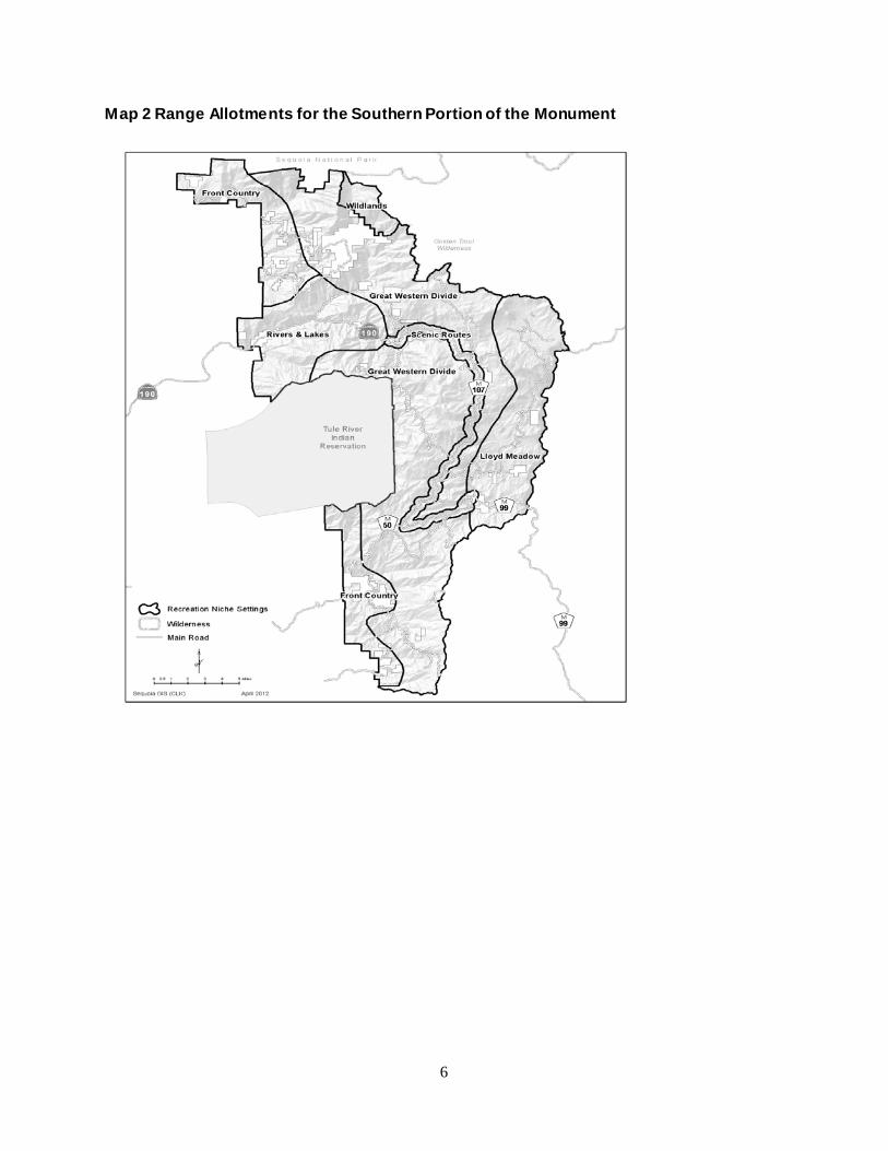
Map 2 Range Allotments for the Southern Portion of the Monument

7
The majority of the allotments in the Monument are located within annual grass range in the foothills below and removed from the giant sequoia groves. Six montane allotments overlap with the sequoia groves. Most allotments that overlap the groves receive low to moderate use of the intermixed meadows and riparian areas. There are several types of structural range improvements associated with the allotments, including spring-fed water troughs, fences, stock trails, drives, and corrals. Each range improvement is designed to improve livestock distribution throughout the allotments or provide some type of protection to a particular resource. Maintenance of these existing improvements would continue during each grazing season throughout the Monument.
Desired Conditions Livestock grazing opportunities are maintained and managed for sustainable, healthy rangelands that contribute to local economies and improve watershed conditions. Meadows are hydrologically functional and stable, with 80-90% vegetative cover, root masses stabilizing stream banks, and any sites of accelerated erosion stabilized or recovering. The ecological status of meadow vegetation is late seral, with a diversity of age classes of hardwood shrubs, and regeneration is occurring. Streams in meadows, lower elevation grasslands, and hardwood ecosystems have vegetation and channel bank conditions that meet proper functioning condition. Special aquatic habitats such as springs, seeps, vernal pools, fens, bogs, and marshes are healthy and diverse.
8
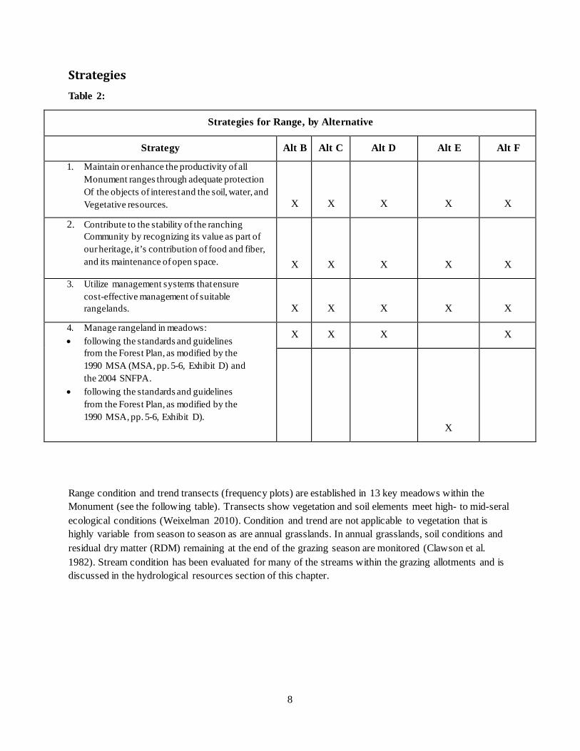
Strategies Table 2:
Strategies for Range, by Alternative
Strategy Alt B Alt C Alt D Alt E Alt F
1. Maintain or enhance the productivity of all Monument ranges through adequate protection Of the objects of interest and the soil, water, and Vegetative resources. X X X X X
2. Contribute to the stability of the ranching Community by recognizing its value as part of our heritage, it’s contribution of food and fiber, and its maintenance of open space. X X X X X
3. Utilize management systems that ensure cost-effective management of suitable rangelands. X X X X X
4. Manage rangeland in meadows: • following the standards and guidelines
from the Forest Plan, as modified by the 1990 MSA (MSA, pp. 5-6, Exhibit D) and the 2004 SNFPA.
• following the standards and guidelines from the Forest Plan, as modified by the 1990 MSA, pp. 5-6, Exhibit D).
X X X X
X
Range condition and trend transects (frequency plots) are established in 13 key meadows within the Monument (see the following table). Transects show vegetation and soil elements meet high- to mid-seral ecological conditions (Weixelman 2010). Condition and trend are not applicable to vegetation that is highly variable from season to season as are annual grasslands. In annual grasslands, soil conditions and residual dry matter (RDM) remaining at the end of the grazing season are monitored (Clawson et al. 1982). Stream condition has been evaluated for many of the streams within the grazing allotments and is discussed in the hydrological resources section of this chapter.

9
Table 3: Key Area Meadows and Frequency Plot Scores within the Monument
MEADOW NAME Successional Score Satisfactory ?
Lower Loggy TR001 mid seral Yes
Lower Clicks TR002 lower mid seral no
Deep TR003 mid seral yes
Last Chance TR004 late seral yes
Double Bunk TR005 upper mid seral yes
Parker TR006 upper mid seral yes
Horse TR007 late seral yes
Dry TR008 late mid seral yes
Mule TR009 upper mid seral yes
Big Meadows 0801 late seral yes
Horseshoe 9901 mid seral yes
Converse 9902 upper mid seral yes
Eshom 9903
(Meadow Flat)
low seral no
Indian Basin 9904 low seral no
*Dry Meadow is not in the Monument, but is within a mile of the east boundary. It is displayed as an example of a grazed meadow outside the Monument.

10
Environmental Effects
The proclamation (Clinton 2000) states, “Laws, regulations, and policies pertaining to administration by the Department of Agriculture of grazing permits … shall continue to apply …” Grazing within the Monument is currently administered under the guidelines identified in the 1988 Sequoia National Forest Land and Resource Plan and the 2001 Sierra Nevada Forest Plan Amendment, and the general discussions on the effects of grazing addressed in these documents apply. Site-specific environmental analysis and documentation will be prepared for each allotment within the Monument under the direction in the Rescission Act of 1995 (P.L.104-19) and its amendments.
Legal and Regulatory Compliance
Current management direction for the Giant Sequoia National Monument range program comes from several sources, which include the 1988 Forest Plan, MSA, 2001 Sierra Nevada Forest Plan Amendment, and the proclamation (Clinton 2000). This direction is currently reflected in the terms and conditions (part 1, 2, and 3) of each term grazing permit within the Monument. Under Alternatives B, C, D, and F, the 2004 SNFPA will replace the 2001 SNFPA.
Applicable laws, regulations, and policy include: (moved from line above)
• Secretary of Agriculture regulations relating to grazing and livestock on the National Forest System are in 36 CFR 222.
• Legislative authorities for administration of the National Forest System range program are described in the Forest Service Manual (FSM) 2201.
• Objectives, policies, and responsibilities for the range management program are in FSM 2202 through 2204, and FSM 2230.01 through 2230.06. National direction and guidance for grazing permit administration is contained in FSM 2230 through FSM 2238.
• 1997 Rangeland Analysis and Planning Guide.
A number of changes to forest plan standards and guidelines are proposed for the action alternatives (B, C, D, F). Range management policy has changed since both the Forest Plan and MSA were written. In addition, most of the changes proposed for the action alternatives (B, C, D, F) are from the 2001 SNFPA to the 2004 SNFPA.
A number of standards and guidelines are proposed to be deleted; some of them are not needed, because they are a matter of law, regulation, or policy, and some of them conflict with current national policy.
A few of the changes proposed for the action alternatives (B, C, D, F) are because the information included as standards and guidelines in the forest plan would be more appropriate as strategies to guide future actions, rather than as requirements that must be complied with.
In a few cases, where the MSA proposed wording changes for particular standards and guidelines in particular management emphasis areas, those standards and guidelines would apply to those management emphasis areas in Alternative E, as specified in the MSA.
Table 4 Revised Standards and Guidelines for Range

11
Forest Plan Category
Forest Plan Standard Guidelines Proposal/Rationale
Oak Management
range
Oak Management replaced by Hardwood and Grazing Management in 2001 SNFPA:
No Specific direction is provided in the Forest Plan (LRMP p.4-30) for utilization of oak by livestock. Only addresses management of oak relating to fuels and timber related projects.
The Forest Plan states to apply the standards and guidelines (S&Gs) set forth in the most current version of the Range Environmental Analysis Handbook (R-5 FSH2209.21).
The 1997 Rangeland Analysis and Planning Guide replaced the R-5 FSH2209.21, as it is obsolete. Alternative B,C,D,F: utilize S&Gs in 2004 SNFPA p.53 #19, 25; p. 55 #50. These S&Gs provide the most current direction for proper utilization of oak vegetation by livestock (see lists of Range Standards and Guides by alternative later in this appendix).
Alternative E: utilize S&Gs for oak management in the 1988 Forest Plan (p.4-30), including land allocations and emphasis areas, and the MSA recommendations (MSA pp. 28-34).
Riparian areas (including meadows)
• Meadows will be grazed to allowable use standards, as determined by the height/weight or grazed plot method.
• Within riparian areas, protect streamcourses and adjacent vegetation to maintain or improve overall wildlife and fish habitat, water quality, and recreational opportunities.
• Give preferential consideration to riparian area dependent resources over other non-dependent resources in case of unresolved conflicts.
Alternatives B,C,D,F: utilize the Riparian Conservation Area S&Gs in the 2004 SNFPA ROD p.56, #51,52; p.58 #57,58,59,60,63; p. 62 #92,93,94; p.63 #102, 103; p. 64 #105; p.65 #117,118,119,120; p.66 #121,122. These S&Gs provide a more comprehensive set of protection measures to ensure protection of riparian areas and their associated riparian dependent species (see Appendix A-Range Standards and Guides).
Alternative E only; Utilize agreements within the MSA, including Exhibit D- Riparian and Wetlands Standards and Guidelines and the 1988 Forest Plan.
12
Forest Plan Category
Forest Plan Standard Guidelines Proposal/Rationale
• Delineate and evaluate riparian areas prior to implementing any project activity.
• Monitor the effectiveness of the Sequoia National Forest’s Riparian Standards and Guidelines.
LRMP p. 4-30 (replaced by 2001 SNFPA)
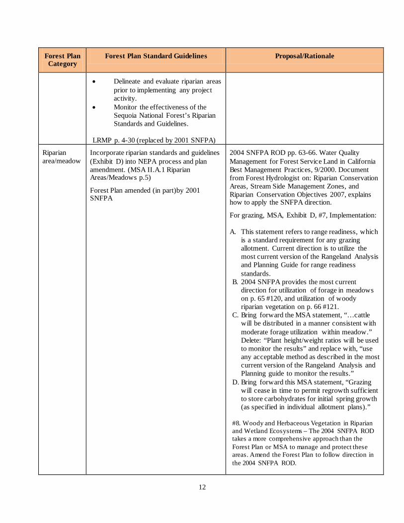
Riparian area/meadow
Incorporate riparian standards and guidelines (Exhibit D) into NEPA process and plan amendment. (MSA II.A.1 Riparian Areas/Meadows p.5)
Forest Plan amended (in part)by 2001 SNFPA
2004 SNFPA ROD pp. 63-66. Water Quality Management for Forest Service Land in California Best Management Practices, 9/2000. Document from Forest Hydrologist on: Riparian Conservation Areas, Stream Side Management Zones, and Riparian Conservation Objectives 2007, explains how to apply the SNFPA direction.
For grazing, MSA, Exhibit D, #7, Implementation:
A. This statement refers to range readiness, which is a standard requirement for any grazing allotment. Current direction is to utilize the most current version of the Rangeland Analysis and Planning Guide for range readiness standards.
B. 2004 SNFPA provides the most current direction for utilization of forage in meadows on p. 65 #120, and utilization of woody riparian vegetation on p. 66 #121.
C. Bring forward the MSA statement, “…cattle will be distributed in a manner consistent with moderate forage utilization within meadow.” Delete: “Plant height/weight ratios will be used to monitor the results” and replace with, “use any acceptable method as described in the most current version of the Rangeland Analysis and Planning guide to monitor the results.”
D. Bring forward this MSA statement, “Grazing will cease in time to permit regrowth sufficient to store carbohydrates for initial spring growth (as specified in individual allotment plans).”
#8. Woody and Herbaceous Vegetation in Riparian and Wetland Ecosystems – The 2004 SNFPA ROD takes a more comprehensive approach than the Forest Plan or MSA to manage and protect these areas. Amend the Forest Plan to follow direction in the 2004 SNFPA ROD.

13
Forest Plan Category
Forest Plan Standard Guidelines Proposal/Rationale
Grazing and oak management
Amend plan to clarify AUMs allotted will not be increased over 68,000. (MSA)
Propose changing to “…not to exceed historical levels.” This means to not exceed 68,000 AUMs for the forest. This MSA agreement relates to the entire forest, of which the Monument is only a portion. Monument specific – AUM’s will not exceed current levels.
Grazing and oak management
Allotment management plans will emphasize wildlife use of mast crops. (MSA) (Forest Plan amended (in part) by 2001 SNFPA)
2004 SNFPA ROD addresses this on p.53 #20. Includes protection of mast-producing species.
Grazing and oak management
Frost, McDougald study as a threshold for oak recruitment. Adopt allotment-specific thresholds for oak recruitment. (MSA) (Forest Plan Amended (in part) by 2001 SNFPA)
Recruitment of oaks and oak management is addressed in the 2004 SNFPA ROD p. 50#19,21,25. The Frost McDougald study is currently used and should carry forward for oak management within the Monument.
Grazing and oak management
Frost, McDougald study as a threshold for oak recruitment. Develop long-term strategies for oak recruitment where allotments below are threshold. (MSA) (Forest Plan amended (in part) by 2001 SNFPA)
Recruitment of oaks and oak management is addressed in the 2004 SNFPA ROD p. 50#19,21,25. The Frost McDougald study is currently used and should carry forward for oak management within the Monument.
Allotment plans and effectiveness
Monitor effectiveness of Riparian S&Gs: The item states that forest wide standards and guidelines on p.4-30, of the plan …shall be amended to change the sentence to read, “Monitor the effectiveness of the SQF’s riparian and wetland S&G.” (MSA) (forest Plan amended (in part) by 2001 SNFPA)
Replace current management with 2004 SNFPA aquatic management strategy.
14
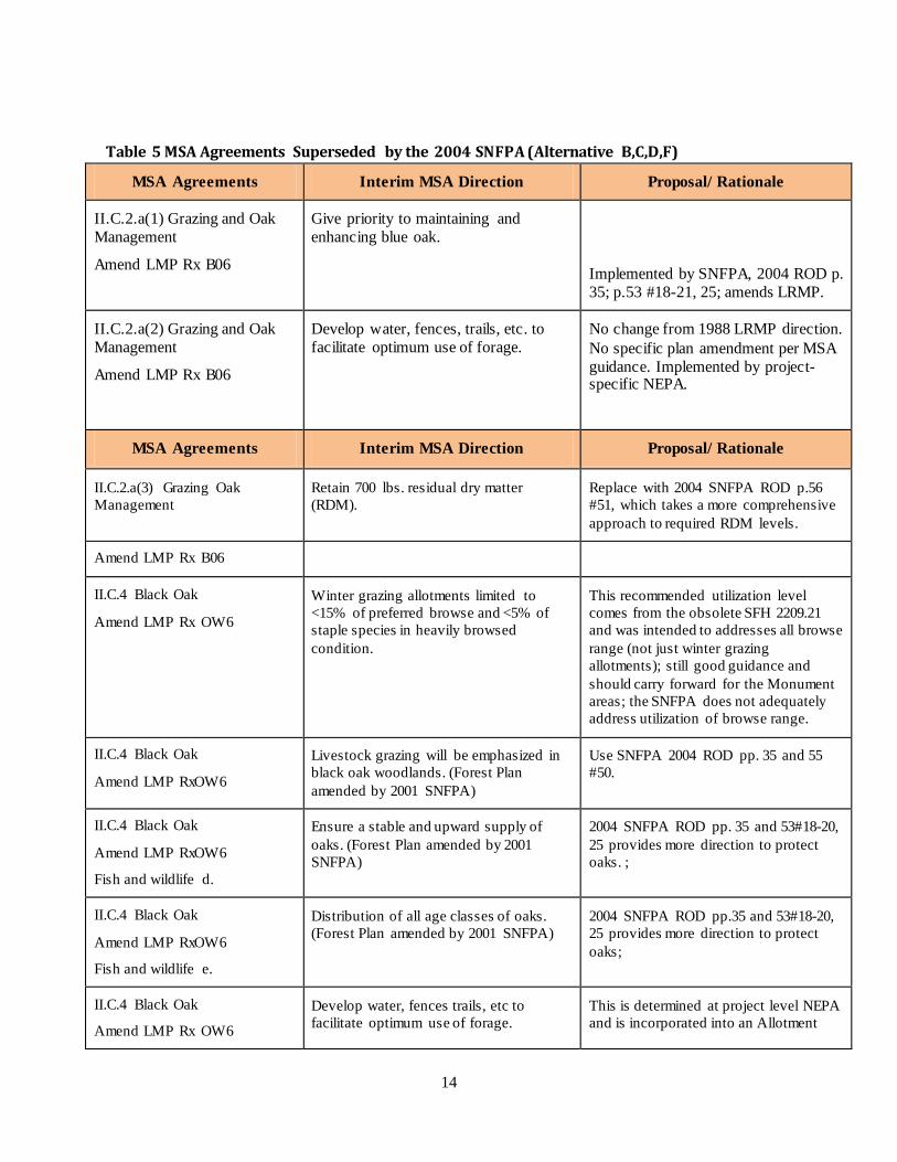
Table 5 MSA Agreements Superseded by the 2004 SNFPA (Alternative B,C,D,F)
MSA Agreements Interim MSA Direction Proposal/ Rationale
II.C.2.a(1) Grazing and Oak Management
Amend LMP Rx B06
Give priority to maintaining and enhancing blue oak.
Implemented by SNFPA, 2004 ROD p. 35; p.53 #18-21, 25; amends LRMP.
II.C.2.a(2) Grazing and Oak Management
Amend LMP Rx B06
Develop water, fences, trails, etc. to facilitate optimum use of forage.
No change from 1988 LRMP direction. No specific plan amendment per MSA guidance. Implemented by project-specific NEPA.
MSA Agreements Interim MSA Direction Proposal/ Rationale
II.C.2.a(3) Grazing Oak Management
Retain 700 lbs. residual dry matter (RDM).
Replace with 2004 SNFPA ROD p.56 #51, which takes a more comprehensive approach to required RDM levels.
Amend LMP Rx B06
II.C.4 Black Oak
Amend LMP Rx OW6
Winter grazing allotments limited to <15% of preferred browse and <5% of staple species in heavily browsed condition.
This recommended utilization level comes from the obsolete SFH 2209.21 and was intended to addresses all browse range (not just winter grazing allotments); still good guidance and should carry forward for the Monument areas; the SNFPA does not adequately address utilization of browse range.
II.C.4 Black Oak
Amend LMP RxOW6
Livestock grazing will be emphasized in black oak woodlands. (Forest Plan amended by 2001 SNFPA)
Use SNFPA 2004 ROD pp. 35 and 55 #50.
II.C.4 Black Oak
Amend LMP RxOW6
Fish and wildlife d.
Ensure a stable and upward supply of oaks. (Forest Plan amended by 2001 SNFPA)
2004 SNFPA ROD pp. 35 and 53#18-20, 25 provides more direction to protect oaks. ;
II.C.4 Black Oak
Amend LMP RxOW6
Fish and wildlife e.
Distribution of all age classes of oaks. (Forest Plan amended by 2001 SNFPA)
2004 SNFPA ROD pp.35 and 53#18-20, 25 provides more direction to protect oaks;
II.C.4 Black Oak
Amend LMP Rx OW6
Develop water, fences trails, etc to facilitate optimum use of forage.
This is determined at project level NEPA and is incorporated into an Allotment

15
Range a. Management Plan.
II.C.4. Black Oak
Amend LMP Rx OW6
Range b.
Retain 700 lbs residual dry matter (RDM). (Forest Plan amended by 2001 SNFPA)
Replace with 2004 SNFPA p.56 #51, which takes a more comprehensive approach to required RDM levels.
II.C.4 Black Oak
Amend LMP Rx OW6
Range c.
Winter grazing allotments will limit browse utilization to a change of no more than 15 percent of preferred browse or 5 percent of staple species in heavily browsed conditions.
This recommended utilization level comes from the obsolete FSH 2209.21 and was intended to addresses all browse range (not just winter grazing allotments); still good guidance and should carry forward for the Monument areas; the SNFPA does not adequately address utilization of browse range.
Assumptions and Methodology
Ecological Restoration
What constitutes a "degraded, damaged, and/or destroyed" ecosystem?
Meadows that show a declining trend in plant ecological status may require restoration (depending on the cause of the decline).
Assumptions for All Alternatives
• Livestock grazing in the Monument will continue.
• The 2004 SSNFPA, ROD. (p. 15), does not change the capable, available and suitable (CAS) lands determinations made in the Forest Plan (except for timber management in the Monument). Therefore, capability and suitability determinations from the 1988 Forest Plan, for range, will carry forward in management of the Monument. The 2001 Sierra Nevada Forest Plan Amendment (2001 SNFPA), Appendix K, requires the verification of rangeland suitability and capability at the time of project-specific environmental analysis. In other words, when allotment-specific environmental analysis is being done, the Forest Service would verify that suitability from the Forest Plan is still applicable to the lands within the allotment area. The method described in Appendix K of the 2001 SNFPA to verify range capability and suitability would be utilized for project-level environmental analysis regardless of the alternative selected.
• Management Emphasis in LRMP Management Area Prescriptions (for livestock grazing in BO6, OW6, MC6, PS6, and CF6)) from the 1988 Forest Plan cross-correlates with the Land Allocations in the 2004 Sierra Nevada Forest Plan Amendment. Areas BO6, OW6, MC6 fit in the Lower Westside Hardwood Land Allocation and PS6 and CF6, fit into the General Forest Land Allocation.

16
• The 1988 Forest Plan provides direction to utilize the most current version of the Range Analysis Handbook, FSH 2209.21. That handbook is now obsolete and is replaced with the 1997 Rangeland Analysis and Planning Guide. Use of the new planning guide would be applicable to all of the alternatives.
• Livestock grazing utilization is managed at the moderate use level and takes into account the habitat and forage needs of wildlife.
• If recommendations are made to close areas to livestock grazing, a subsequent site-specific environmental analysis would be necessary before actually closing any area.
• Livestock grazing areas may have localized concentration impacts in areas such as bedding areas, trails, water troughs, riparian and wet areas, from hoof action, soil compaction, and removal, and trampling of vegetation.
• The FEIS does not propose any specific actions to re-establish perennial grasslands where annual grasslands now dominate the area.
Assumptions for Alternative B, C, D, and F
• By following the Aquatic Management Strategy, desired conditions, and S&G's for range management, as prescribed in the 2004 SSNFPA, objects of interest, ie. Meadows, riparian areas, annual grasslands, and hardwood forests, would be adequately protected and meet the intent of the proclamation.
Assumptions for Alternative E
• There are no specific grazing S&G's for Willow Flycatcher or Great Grey Owls in the Forest Plan or MSA that limit grazing.
• The Riparian Standards and Guidelines in Appendix D of the MSA would be used for Riparian Area Management.
• Management Emphasis Areas ( for livestock grazing ) from the Forest Plan will carry forward in management of the Monument.
Indirect Effects Livestock grazing has occurred in the Sequoia National Forest, including lands within the Monument boundary, since the late 1800s, and is ongoing today. None of the alternatives propose to remove livestock from the Monument. The proclamation states, “Laws, regulations, and policies pertaining to administration by the Department of Agriculture of grazing permits … shall continue to apply …” Current grazing management within the Monument is administered under the guidelines identified in the Forest Plan, as amended by the 2001

17
SNFPA, and the MSA, and the, and the effects from grazing addressed in those documents apply in the Monument. Site-specific environmental analysis and documentation will be conducted for each allotment consistent with all applicable laws, regulations, and policy. Livestock grazing will continue to be authorized within the Monument as per the Rescission Act of 1995 (P.L.104-19) and subsequent appropriations act (the 2004 Interior Appropriations Act [P.L. 108-108], Section 325). Environmental documentation will be completed for grazing allotments according to the Sequoia National Forest Rangeland NEPA Strategy. The effects of implementing any of the alternatives, including the no action alternative, would be minimal on the range program. Term grazing permits for allotments within the Monument were modified to incorporate the standards and guidelines in the 2001 SNFPA and have followed that direction since about 2002. Grazing permittees have had adequate time to adjust their livestock operations to those requirements, especially concerning riparian area management. As stated above, the FEIS does not propose any changes to grazing management in the Monument. Alternatives B, C, D, and F would carry forward the capability and suitability determinations for range from the 1988 Forest Plan. The 2004 SNFPA standards and guidelines for livestock grazing and the direction contained within that document would replace the 2001 SNFPA direction (see Appendix A for complete lists of the standards and guidelines by alternative). Generally, the 2004 SNFPA carried forward the same requirements for grazing as the 2001 SNFPA, with two primary changes: how grazing would be regulated in willow flycatcher habitat and great gray owl protected activity centers (PACs) (2004 SNFPA ROD, Appendix A, pp. 56-58 [willow flycatcher], and p. 61 [great gray owl PACs]). In general, the standards and guidelines in the 2004 SNFPA for the willow flycatcher and great gray owl PACs provide more flexibility and less restrictive grazing practices, while still protecting the habitats for these species. Alternative A would continue current livestock management practices by utilizing direction from the 1988 Forest Plan, as amended by the 2001 SNFPA, and portions of the MSA. The direction from the 2001 SNFPA would continue to reduce grazing opportunities within areas occupied by willow flycatchers and great gray owls. In Alternative E, grazing management would be directed by implementation of the 1988 Forest Plan and the MSA. Standards and guidelines from these documents do not require specific guidelines for grazing within occupied willow flycatcher or great gray owl habitat. Alternatives B and F propose the Tribal Fuels Emphasis Treatment Area (TFETA) along the boundary between the Tule River Indian Reservation and the Sequoia National Forest. Treatments in this area could result in the need to construct drift fences in areas that currently have natural barriers, primarily dense brush fields, to livestock movement. This could result in increased operating costs for the affected permittees and the Forest Service.
Cumulative Effects In order to understand the contribution of past actions to the effects of the proposed action and alternatives, this analysis relies on current environmental conditions that are a result, in part, of past actions. Existing conditions reflect the combined impact of all prior human actions and natural events that have affected the environment and might contribute to cumulative effects. The cumulative effects analyses in this chapter do not attempt to quantify the effects of past human actions by adding up all prior actions on an action-by-action basis. Several reasons exist for not taking this approach. First, a catalog and analysis of all past actions would be impractical to compile and unduly

18
costly to obtain. Current conditions have been impacted by innumerable actions over the last century (and beyond), and trying to isolate the individual actions that continue to have residual impacts would be nearly impossible. Second, providing the details of past actions on an individual basis would not be useful to predict the cumulative effects of the proposed action or alternatives. In fact, focusing on individual actions would be less accurate than looking at existing conditions, because information is limited on the environmental impacts of individual past actions, and one cannot reasonably identify each and every action over the last century that has contributed to current conditions. Also, focusing on the impacts of past human actions risks ignoring the important residual effects of past natural events, which may contribute to cumulative effects just as much as human actions. By looking at current conditions, the residual effects of past human actions and natural events, regardless of which particular action or event contributed to those effects, are captured. Finally, the Council on Environmental Quality issued an interpretive memorandum on June 24, 2005 regarding analysis of past actions, which states, "agencies can conduct an adequate cumulative effects analysis by focusing on the current aggregate effects of past actions without delving into the historical details of individual past actions." The cumulative effects analysis in this EIS is consistent with the National Environmental Policy Act (NEPA) Regulations (36 CFR 220.4 (f)) (July 24, 2008), which state, in part:
CEQ regulations do not require the consideration of the individual effects of all past actions to determine the present effects of past actions. Once the agency has identified those present effects of past actions that warrant consideration, the agency assesses the extent that the effects of the proposal for agency action or its alternatives will add to, modify, or mitigate those effects. The final analysis documents an agency assessment of the cumulative effects of the actions considered (including past, present, and reasonable foreseeable future actions) on the affected environment. With respect to past actions, during the scoping process and subsequent preparation of the analysis, the agency must determine what information regarding past actions is useful and relevant to the required analysis of cumulative effects. Cataloging past actions and specific information about the direct and indirect effects of their design and implementation could in some contexts be useful to predict the cumulative effects of the proposal. The CEQ regulations, however, do not require agencies to catalogue or exhaustively list and analyze all individual past actions. Simply because information about past actions may be available or obtained with reasonable effort does not mean that it is relevant and necessary to inform decision making (40 CFR 1508.7).
For these reasons, the analysis of past actions in this Final EIS is based on current environmental conditions. As stated previously, Alternatives B and F might require additional fencing to control livestock drift as a result of the proposed TFETA. Cumulatively, none of the proposed alternatives would have negative effects on the range program within the Monument.
Standards and Guidelines and Monitoring
Effects on range resources could affect aquatic, meadow, and riparian ecosystems, and the species that depend on them for habitat, which are included in the following objects of interest for the Monument:
• The ecosystems and outstanding landscapes that surround the giant sequoia groves.
• The diverse array of rare animal species, including the Pacific fisher, the great gray owl, the
American marten, the northern goshawk, the peregrine falcon, the California spotted owl, the

19
California condor, several rare amphibians, the western pond turtle, and other species listed as threatened or endangered by the ESA, or sensitive by the Forest Service.
The standards and guidelines for range, listed by alternative in Appendix A, are designed to protect those objects of interest associated with aquatic ecosystems both inside and outside of groves. These standards and guidelines follow the Aquatic Management Strategy (AMS) developed in the 2001 and 2004 SNFPA. The AMS was developed to retain, restore, and protect processes and landforms that provide habitat for aquatic and riparian-dependent species. The Riparian Conservation Objectives (RCOs) provide standards and guidelines to meet hydrologic resource objectives described for each alternative.
The monitoring plan developed for the Monument, as described in Part 3, Design Criteria, of the Monument Plan, contains implementation, effectiveness, validation, and status and trend monitoring for range. Plan monitoring is conducted to evaluate plan implementation and its effectiveness in meeting management strategies and objectives, in particular protecting the objects of interest and restoring ecosystems. Data collected and analyzed inform specialists and managers of any additional effects from management activities and the need for changes in management. For example, at the end of the grazing season every year, allowable use monitoring is conducted to assure proper forage use standards were met. Every 5 years, the ecological status of meadows is monitored to help determine long-term effects to meadow vegetation (status and trend monitoring).

20
Literature Cited and References
USDA Forest Service, Pacific Southwest Region, 2001. Sierra Nevada Forest Plan Amendment
USDA Forest Service, Pacific Southwest Region, 2004. Sierra Nevada Forest Plan Amendment, Final Supplemental Environmental Impact Statement
USDA Forest Service, Pacific Southwest Region, 1988 Sequoia National Forest Land and Resource Management Plan
Sequoia National Forest, Land Management Plan 1990 Settlement Agreement (Mediated Settlement Agreement - MSA) Weixelman, Dave A, Cooper David J. 2009. Assessing Proper Functioning Condition for Fen Areas in the Sierra Nevada and Southern Cascade Ranges in California, A User Guide. Gen. Tech. Rep. R5-TP-028. Vallejo, CA. U.S. Department of Agriculture, Forest Service, Pacific Southwest Region, 42 p. Rangeland Analysis and Planning Guide, Pacific Southwest Region, U.S.D.A. Forest Service, March 1997; Interagency Technical Reference. 1996. Sampling Vegetation Attributes. Bureau of Land Management Publication BLM/RS/ST-96/002+1730. 163 p.; Interagancy Technical Reference. 1996. Utilization Studies and Residual Measurements. 1996. Bureau of Land Management Publication BLM/RS/ST-96/004+1730. 165 p.; University of California Cooperative Extension Service. 1982. Guidelines for Residual Management on Annual Range, Leaflet 21327. 4 p. Moyle, P.B., 2007, Sierra Meadows: Historical Impact, Current Status and Trends, and Data Gaps, Final Report, 82 p. Bartolome, J.W.,Stroud,M.C., Heady, H.F., 1978 Influence of Natural mulch on Forage Production on Differing California Annual Range Sites, 5 p. Bartolome, J.W., 1987, California Annual Grassland and Oak Savannah, 3 p. Belsky, Blumenthal, D.M., Effects of Livestock Grazing on Stand Dynamics and Soils in Upland Forests of the Interior West, Conservation Biology, Volume 11, No 2, April 1997, 13 pp. Parsons and Stohlgren, 1989, Effects of varying Fire Regimes on Annual Grasslands in the Southern Sierra Nevada of California, Madrono 36:154-168, 10 pp. McCreary, D.D., Tecklin, J., Restoring Native California Oaks on Grazed Rangeland, USDA Forest Service Proceedings RMRS-P-35. 2005, George, M., Bartolome, J., McDougald, N., Connor, M., Vaughn, C., Markegard, G., Annual Range Forage Production, University of California, Davis, Rangeland Management Series, Publication 8018, 9 p. USDI, IM 2009-215, Planning for Special Designations within the National System of Public Lands, 2009, 2 p.

21
Bartolome, J.W., Frost, W.E., McDougald, N.K., Connor, M., California Guidelines for Residual Dry Matter (RDM) Management on Coastal and Foothill Annual Rangelands, Rangeland Monitoring Series, Publication 8092, 8 p. 840 F. 2d 714 - Save the Yaak Committee v. Jr Block R1, United States Court of Appeals, 12 pp.

22
Appendix A-Range Standards and Guidelines
Standards and Guidelines from the 2004 SNFPA ROD - Range Program within the Monument
Apply to Alternatives B, C, D, and F
Hardwood Management P. 53 #19: Manage hardwood ecosystems for a diversity of hardwood tree size classes within a stand such that seedlings, saplings, and pole-sized trees are sufficiently abundant to replace large trees that die. P. 53 #25: During or prior to landscape analysis, spatially determine distributions of existing and potential natural hardwood ecosystems (Forest Service Handbook [FSH] 2090.11). Assume pre-1850 disturbance levels for potential natural community distribution. Work with province ecologists or other qualified personnel to map and/or model hardwood ecosystems at a landscape scale (approximately 30,000 to 50,000 acres). Include the following steps in the analysis: (1) compare distributions of potential natural hardwood ecosystems with existing hardwood ecosystems; (2) identify locations where existing hardwood ecosystems are outside the natural range of variability for potential natural hardwood ecosystem distribution; and (3) identify hardwood restoration and enhancement projects.
Grazing P. 55 #50: To protect hardwood regeneration in grazing allotments, allow livestock browse on no more than 20 percent of annual growth of hardwood seedlings and advanced regeneration. Modify grazing plans if hardwood regeneration and recruitment needs are not being met. P. 56 #51: Grazing utilization in annual grasslands will maintain a minimum of 60 percent cover. Where grasslands are in satisfactory condition and annual precipitation is greater than 10 inches, manage for 700 pounds of residual dry matter (RDM) per acre. Where grasslands are in satisfactory condition and annual precipitation is less than 10 inches, manage for 400 pounds RDM per acre. Where grasslands are in unsatisfactory condition and annual precipitation is greater than 10 inches, manage for 1,000 pounds RDM per acre; manage for 700 pounds RDM per acre where grasslands are in unsatisfactory condition and precipitation is less than 10 inches. Adjust these standards, as needed, based on grassland condition. This standard and guideline only applies to grazing utilization. P. 56 #52: Where professional judgment and quantifiable measurements find that current practices are maintaining range in good to excellent condition, the grazing utilization standards above may be modified to allow for the Forest Service, in partnership with individual permittees, to rigorously test and evaluate alternative standards. P. 58 #57: In meadows with occupied willow flycatcher sites, allow only late-season grazing (after August 15) in the entire meadow. P. 58 #58: Standard and guideline #57 above may be waived if an interdisciplinary team has developed a site-specific meadow management strategy. This strategy is to be developed and implemented in partnership with the affected grazing permittee. The strategy objectives must focus on protecting the nest site and associated habitat during the breeding season and the long-term sustainability of suitable habitat at breeding sites. It may use a mix of management tools, including grazing systems, structural improvements, and other exclusion by management techniques to protect willow flycatcher habitat.

23
P. 58 #59: In willow flycatcher sites receiving late season grazing, monitor utilization annually using regional range analysis and planning guide. Monitor willow flycatcher habitat every 3 years using the following criteria: rooting depth cores for meadow condition, point intercepts for shrub foliar density, and strip transects for shrub recruitment and cover. Meadow condition assessments will be included in a GIS meadow coverage. If habitat conditions are not supporting the willow flycatcher or trend downward, modify or suspend grazing. P. 58 #60: For historically occupied willow flycatcher sites, assess willow flycatcher habitat suitability within the meadow. If habitat is degraded, develop restoration objectives and take appropriate actions (such as physical restoration of hydrological components, limiting or re-directing grazing activity and so forth) to move the meadow toward desired conditions. P. 58 #63: Evaluate proposals for new concentrated stock areas (for example, livestock handling and management facilities, pack stations, equestrian stations, and corrals) located within 5 miles of occupied willow flycatcher sites. P. 62 #92: Evaluate new proposed management activities within CARs and RCAs during environmental analysis to determine consistency with the riparian conservation objectives at the project level and the AMS goals for the landscape. Ensure that appropriate mitigation measures are enacted to: (1) minimize the risk of activity-related sediment entering aquatic systems and (2) minimize impacts to habitat for aquatic- or riparian-dependent plant and animal species. P. 62 #93: Identify existing uses and activities in CARs and RCAs during landscape analysis. At the time of permit reissuance, evaluate and consider actions needed for consistency with RCOs. P. 62 #94: As part of project-level analysis, conduct peer reviews for projects that propose ground-disturbing activities in more than 25 percent of the RCA or more than 15 percent of a CAR. P. 63 #102: Prior to activities that could adversely affect streams, determine if relevant stream characteristics are within the range of natural variability. If characteristics are outside the range of natural variability, implement mitigation measures and short-term restoration actions needed to prevent further declines or cause an upward trend in conditions. Evaluate required long-term restoration actions and implement them according to their status among other restoration needs. P. 63 #103: Prevent disturbance to streambanks and natural lake and pond shorelines caused by resource activities (for example, livestock, off-highway vehicles, and dispersed recreation) from exceeding 20 percent of stream reach or 20 percent of natural lake and pond shorelines. Disturbance includes bank sloughing, chiseling, trampling, and other means of exposing bare soil or cutting plant roots. This standard does not apply to developed recreation sites, sites authorized under Special Use Permits and designated off-highway vehicle routes. P. 64 #105: At either the landscape or project-scale, determine if the age class, structural diversity, composition, and cover of riparian vegetation are within the range of natural variability for the vegetative community. If conditions are outside the range of natural variability, consider implementing mitigation and/or restoration actions that will result in an upward trend. Actions could include restoration of aspen or other riparian vegetation where conifer encroachment is identified as a problem.

24
P. 65 #117: Assess the hydrologic function of meadow habitats and other special aquatic features during range management analysis. Ensure that characteristics of special features are, at a minimum, at Proper Functioning Condition, as defined in the appropriate Technical Reports (or their successor publications); (1) “Process for Assessing PFC” TR 1737-9 (1993), “PFC for Lotic Areas” USDI TR 1737-15 (1998) or (2) “PFC for Lentic Riparian-Wetland Areas” USDI TR 1737-11 (1994). P. 65 #118: Prohibit or mitigate ground-disturbing activities that adversely affect hydrologic processes that maintain water flow, water quality, or water temperature critical to sustaining bog and fen ecosystems and plant species that depend on these ecosystems. During project analysis, survey, map and develop measures to protect bogs and fens from such activities as trampling by livestock, pack stock, humans, and wheeled vehicles. Criteria for defining bogs and fens include, but are not limited to, presence of: (1) sphagnum moss (Spagnum spp.); (2) mosses belonging to the genus Meessia; and (3) sundew (Drosera spp.). Complete initial plant inventories of bogs and fens within active grazing allotments prior to re-issuing permits. P. 65 #119: Locate new facilities for gathering livestock and pack stock outside of meadows and riparian conservation areas. During project-level planning, evaluate and consider relocating existing livestock facilities outside of meadow and riparian areas. Prior to re-issuing grazing permits, assess the compatibility of livestock management facilities located in riparian conservation areas with riparian conservation objectives. P. 65 #120: Under season-long grazing:
• For meadows in early seral status: limit livestock utilization of grass and grass-like plants to 30 percent (or minimum 6-inch stubble height)
• For meadows in late seral status: limit livestock utilization of grass and grass-like plants to a maximum of 40 percent (or minimum 4-inch stubble height)
Determine ecological status on all key areas monitored for grazing utilization prior to establishing utilization levels. Use Regional ecological scorecards and range plant list in regional range handbooks to determine ecological status. Analyze meadow ecological status every 3 to 5 years. If meadow ecological status is determined to be moving in a downward trend, modify or suspend grazing. Include ecological status data in a spatially explicit Geographical Information System database.
Under intensive grazing systems (such as rest-rotation and deferred rotation) where meadows are receiving a period of rest, utilization levels can be higher than the levels described above if the meadow is maintained in late seral status and meadow-associated species are not being impacted. Degraded meadows (such as those in early seral status with greater than 10 percent of the meadow area in bare soil and active erosion) require total rest from grazing until they have recovered and have moved to mid- or late seral status.
P. 66 #121: Limit browsing to no more than 20 percent of the annual leader growth of mature riparian shrubs and no more than 20 percent of individual seedlings. Remove livestock from any area of an allotment when browsing indicates a change in livestock preference from grazing herbaceous vegetation to browsing woody riparian vegetation. P. 66 #122: Recommend restoration practices in: (1) areas with compaction in excess of soil quality standards, (2) areas with lowered water tables, or (3) areas that are either actively down cutting or that

25
have historic gullies. Identify other management practices, for example, road building, recreational use, grazing, and timber harvests that may be contributing to the observed degradation.