rand, mcnally & co.'s business atlas map of new mexico....
TRANSCRIPT

Rand, McNally & Co.'s business atlas map of NewMexico.1897
1: American Homesteaders
1862
American homesteaders did not flood into New Mexico as they did to Oregon and California, in part becausemost of the best land had been claimed centuries before, and in part because the areas outside of the old"Pueblo province" were not safe for settlers.
The U.S. Army paved the way, with forts from which they launched relentless campaigns against the Navajo,Comanche, and Apache.
Images:
111
1013
912
57 8
64
14
15
3
2
Image No: 3565144 Rumsey Collection - Terms of Use

Jim Norris and wife, homesteaders, Pie Town: Russell Lee 1944
2: La Joya: Unconfirmed Land Grant
1893
The GAO lists the Sevilleta grant as being a community land grant, including the town of La Joya, includedunder the terms of the Treaty of Guadalupe Hidalgo, and confirmed in 1893, although patents were not issueduntil 1915, which may account for this area being listed as an unconfirmed grant, although boosters wereclearly pushing for fast settlement of this area.
Quote: (1883) VALENCIA COUNTY
By Gilbert Scudder, Secretary of the Bureau of Immigration.
At the present time but little is known outside the Territory of the resources and advantages of this, one of theoldest and largest counties of New Mexico. Situated nearly in the center of the Territory, and having theadvantage of two trunk railways recently constructed and traversing the county at right angles, it possessesunusual attractions for the farmer, stock raiser and miner. Its mineral resources have as yet received but littleattention, but as soon as the prospector and capitalist shall commence their operations in earnest, its future asa mineral and stock raising district will be established. Some mineral claims have been located but nodevelopment of any consequence has been done. In the Manzano range there are some prospect holes, mostlydug by the natives, which show undoubted evidence of containing gold, silver, copper and lead, and in payingquantities. The one thing needed being capital to develop it. Only three districts have been prospected to anyextent to-wit: The "Ladrones," "Spiegelberg Springs" and "La Joya."
The Ladrones mountains is undoubtedly one of the largest deposits of low grade ore ever discovered in theTerritory, and to be worked profitably it must be on a large scale which requires capital. For a steady andreliable profit this camp is well worthy the attention of capitalists. The ores are principally galena, carryingconsiderable lead and some copper.
Spiegelberg Springs is a young camp, but gives promise, with development, of being one of the best copperproducing districts in the Territory.
The La Joya mining district, east of and near the Rio Grande, is situated in the southern part of the county.The ores are principally galena carrying large deposits of silver and gold which can be easily milled, and thework already done on the leads proves its presence in large and paying quantities.
The Atlantic and Pacific railroad, or thirty-fifth parallel road, runs nearly two hundred miles in a westerlydirection and centrally through the county, and connects the Santa Fe railway system in the valley of the RioGrande with Arizona Territory; thus bringing within easy reach its immense coal fields, pastoral ranges andagricultural valleys. These coal fields are already being worked in places with most satisfactory results, andnow that the Indian question has been virtually set at rest, considerable herds of cattle and flocks of sheep arebeing driven upon the public domain, although out little of the latter has been entered at the land office. Thiscounty it will be understood also possesses the advantage of having the entire western half free from landgrants, and, as it covers an area of over 9000 square miles, there are very large tracts of government land stillopen to entry and well adapted to stock raising and homesteads, and upon which coal and mineral prospectingmay be engaged with profit. [Ritch, William Gillet ]
Overview: La Joya de Sevilleta
The modern town of La Joya was founded as a frontier outpost for protection of the Camino Real adjacent tothe site of a seventeenth- century Piro pueblo, named Nueva Sevilla by Oñate, perhaps because of itsresemblance to the Spanish city of Seville. Later Fray Benavides refers to the pueblo, which by 1634 had aconvent, as Seelocú, possibly the Piro name for it. The pueblo was deserted in 1680, as the Piro went south toEl Paso with the Spanish.

The village of La Joya de Sevilleta marks the lower end of Rio Abajo. For a time it was where caravans wouldgather and await the rest of the caravan and/or presidial troops who would escort them down the trail. Thechurch and possibly the plaza, along with some ruins of structures, remain of this once-importantvillage. [Long Distance Trails Group--Santa Fe, National Park Service, New Mexico State Office, Bureau of LandManagement]
3: Belen: Confirmed Land Grant
1858
The Belen grant, totalling nearly 200,000 acres, was confirmed in 1858 and patents were issued to the heirs in1871.
Quote: (1767) GRANTEES Of The BELEN Tract vs. Sale Of Land By PEDRO ITURRIETA to Fernando Chaves.1767.
Before Don Pedro Fermin de Mendinueta, Governor.
Francisco Trebol Navarro; Manuel Garvisu; Manuel Zanez; Manuel Garvisu Zanez.
The petition for the Belen Grant asked for a tract of land which in 1740 was uncultivated and unappropriated.It is described and "bounded on the east by the Sandia Mountains; on the west by the Rio Puerco; on the northon both sides of the river the boundary is the land of Nicolas de Chaves and those of the adjoining settlers ofOur Lady of the Concepcion tract of Tome, and on the south the place called Felipe Romero, in a direct lineuntil it intersects the boundary above mentioned, from the east to the west."
The first settlers were: Diego Torres de Salazar; Pedro Bigil; Miguel Salazar; Juana Teresa Romero; LugardaRomero; Juan Antonio Salazar; Miguel Salazar; Pablo Salazar; Nicolas Salazar; Manuel Antonio Trugillo; MariaTorres; Salvador Torres; Jose Antonio Torres; Ladeo Torres; Cayetano Cristobal Torres; Diego Torres; BarbaraRomero; Gabriel Romero; Maria Vigil; Jose Trujillo; Francisco Martin; Nicolas Martiniano; Ygnacio Barrera; JuanDomingo Torres; Jose Romero; Jose Tenorio; Juan Jose de Sandoval; Francisco Trujillo; Francisco Hiron;Cristoval Naranjo; Jose Antonio Naranjo; Bartholome Torres; Pedro Romero.
The grant was made by Don Gaspar Domingo Mendoza, and possession was given by Don Nicolas de Chaves,alcalde mayor of Alburquerque.
The house of Felipe Romero was a ruin, this hacienda having been destroyed in the revolution of1680. [Twitchell, Ralph Emerson]
Overview: Belén
Belén was constructed on the west bank of the Río Grande. Colonial travelers saw it from their camps acrossthe river while later users of the west bank road stopped within the town.
Given that most colonial traffic passed along the east bank of the Río Grande, the most used caravan parajewould have been opposite the town of Belén. [Long Distance Trails Group--Santa Fe, National Park Service,New Mexico State Office, Bureau of Land Management]
4: Bell Ranch (Pablo Montoya Grant)
1824-1947
Title to the Pedro Montoya grant was cleared by a canny lawyer, who then sold it in 1870 to a Canadiannamed Wilson Waddingham, who named it the Bell Ranch in 1889. He lost it a few years later, to the RedRiver Valley Company, which controlled it until 1947, when the ranch was broken up and sold.
The portion remaining of the Bell Ranch is now operated as a dude ranch.
Quote: I, Don Pablo Montoya, most humbly present myself before your Excellency, and state tha, being theowner of certain amount of stock such as cattle, sheep and horses, and requiring pastures and capacity for itsincrease, having registered a piece of land without any individual owner, or belonging to any community, withnecessary supply of water, pastures, and timber, removed from any settlement which could in any manner beinjured; the location of which is on Red River, from the Rincon de la Cinta to the Trinchera, within which limitsno individual of the territory pastures and stock, not reaching that far on account of its distance; its entireextent in the other two directions being form the Arroyo de Cuervo to the Mule Spring; and Your Excellencypossessing all authority to make grants according to the wants of the people, and which result to the benefitof the territory and to every citizen, and in consideration of the superior intelligence of Your Excellency, whichwill perceive the benefits which will result to me, as well as by this means the immense tracts of land in whichour territory abounds will be occupied, and the savages will be made to know the strength of this powerful

nation. In view of such just and rational motives, I pray Your Excellency to condescend to accede to mypetition by doing which I will benefited and receive grace, swearing, in due form, that I do not act in malice.--Don Pedro Montoya, successfully petitioning the newly-independent nation of Mexico for a 655,468-acregrant.
Links: The Bell Ranch -- http://www.thebellranch.com/
5: Ojo Caliente: Confirmed Land Grant
The 2244-acre Ojo Caliente grant, issued in 1793, was confirmed in 1894, and patents issued the same year.
The 1793 grant, formally giving title to the 53 families who lived at Ojo Caliente, did not specify boundaries.Land speculator Antonio Joseph bought the deeds from the heirs of all 53 families, and applied for the entireOjo Caliente grant. But the judge who cleared the title reduced the 44,000 acres applied for, by denying title tothe common lands specified in the grant.
This grant is the current site of the Ojo Caliente spa and hotel.
Quote: Re-settlement. 1768-1769. Manuel Garcia Pareja, Alcalde. Tomas Velez Cachupin, Governor.
The names of many settlers are given in this item.
The site of the ancient pueblos near the Ojo Caliente was re-settled during the rule of Governor Tomas VelezCachupin. There were fifty-three families and the boundaries of the tract as granted were "from the Canada deLos Cumanches to the tower (Torreori) of Jose Baca, deceased, with a small difference just below, itsboundaries being on the north the Canada de Los Comanches; on the south a landmark which I ordered to beconstructed of stone and mortar with a holy cross of cedar placed in the center, just below the said tower ofJose Baca; on the east the foot of the hill; and on the west the foot of the other hills on the opposite side ofthe river. The leaders of this settlement were the sergeant Luis Duran and the district lieutenant, GregorioMartin.
A torreon (tower) was a sort of fortification used for purposes of defense and look-out against the hostileIndians.--Grant given for the first attempt to resettle Ojo Caliente. The original settlers would eventually depopulatethe area, and after more attempts to resettle, the 1793 grant was given to the descendants of the genizarofamilies who stayed in the area. [Twitchell, Ralph Emerson]
Overview: Ojo Caliente
The healing waters of Ojo Caliente have long been known, but its precarious position on New Mexico's northernfrontier prevented Ojo Caliente from achieving a stable population all throughout the 18th century. The areawas resettled in 1769, then within a decade, governors were looking to repopulate it, even threatening formerresidents with fines and jail unless they returned, which most refused to do.
A merchant named Antonio Joseph bought the deeds from the heirs of the 1793 grant and got the grantconfirmed and patented in 1894.
Today the site of the Ojo Caliente land grant offers visitors pools and spa facilities built around the hot springs,a hotel, and restaurant.
Links: Office of the State Historian: Ojo Caliente Land Grant --http://www.newmexicohistory.org/filedetails.php?fileID=4767Visitor Information for Ojo Caliente -- http://ojocalientesprings.com/
6: Fort Wingate Reservation
1897
1897
That exclusive jurisdiction is hereby ceded to the United States over all the territory set apart from the publicdomain and comprised within the limits of the Fort Wingate military reservation, in McKinley county, and FortBliss target range, in Dona Ana county, and over such land as may hereafter be reserved from the publicdomain for the enlargement of said reservations
...and provided further, that the jurisdiction herein ceded shall continue no longer than the United States shall

own and hold said reservations for military purposes.[bimsplit]New Mexico Code, Chapter 19, Article 2, Section19-2-8.
Overview: Fort Wingate
Fort Wingate was established in 1862, in an attempt to control the large Navajo tribe to the north. FortWingate served as a staging point for the roundup of Navajos and their forced march to Bosque Redondo, alsoknown as the Navajo's Long Walk.
From 1870 onward the military focused was concerned with controlling Apaches to the south. Over the nexttwo decades, the U.S. Army recruited hundreds of Navajo scouts to help contain the Apache.
In the early 20th century, Fort Wingate ceased its operations against Native Americans, and turned towardsassisting in overseas operations. Today Fort Wingate serves as a munitions storage depot.
Quote: [My grandfather] told that the Navajos used to raid other tribes, such as the Nóó'da'í (Utes), Kiis'áanii(Pueblo tribes), and the Naakaii (Mexicans). The Navajos would kill all the owners of the livestock and herd theanimals back to their homeland. Not all the Navajos were involved in raiding other tribes. The trouble beganwhen a group of Navajos killed the sons of Ma' iideeshgizhnii (a Jemez chief) to steal livestock. The JemezChief became furious and declared that all the Navajos should be killed. The Jemez Chief and other membersof his tribe travelled to Yootó (Santa Fe) to report what had happened to his only two sons. The Jemez chiefsaid, "The Navajos have been raiding and killing my people including my sons." He requested a warpathagainst the Navajos. Wááshindoon (the Governor) acknowledged his complaints and the warpath request wasgranted.
After the Jemez Chief and his tribe returned from Santa Fe, he sent messages to other tribes such as theNóoda'í, and the Naakaii. These tribes and the Mexicans became the ana'í (enemies) when they started thewarpath against the Navajos. Hastiin Biyaal (my grandfather) told these stories of long ago.
Hastiin Biyaal was among the Diné who journeyed to Hwéeldi (Bosque Redondo). They were held captive forapproximately five years. The people suffered from hunger, sickness, and cold weather because wood, food,and other necessities were scarce.
After five years at Hwéeldi, Hastiin Ch'il Haajiní (Manuelito) and other top officials traveled to Wááshindoon(Washington, D.C.) to negotiate with Washindoon (the president) on a peace treaty. Hastiin Ch'il Haajiní toldWashindoon that the women and the elders had wept for their homeland and wanted to return. After thepeace treaty was negotiated, the Diné were released. the first stop on the way back to their homeland was atShash Bitooh (Fort Wingate) where they stayed for several days. Then they were transported toTséghadoodzaní (Window Rock) where some necessities, such as food, tools, axes and shovels were distributedamong the Diné. They were to take and use these articles on their homeland.
Many of the Navajos did not make the journey to Hwéeldi. They stayed in the area and hid in the mountains,canyons, and mesas. A man named Hadéézdíín hid on top of Tséyíigai (Chaco Canyon mesa). He became wildand stayed on Tséyíigai.--Jim Beyale, an 86-year old medicine man from the Chaco area, tells stories his grandfather told him aboutHwéeldi, or Bosque Redondo. Beyale is of the People From Off Her Back Clan. His paternal clan is the RedStreak People. His maternal grandfather belongs to the Sleeping Rock People, and his paternal grandfatherbelongs to the Salt People clan. [Dine of Eastern Region]
7: Navajo Reservation
1868
The United States agrees that the following district of country, to wit: bounded on the north by the 37thdegree of north latitude, south by an east and west line passing through the site of old Fort Defiance, in CanonBonito, east by the parallel of longitude which, if prolonged south, would pass through old Fort Lyon, or theOjo-de-oso, Bear Spring, and west by a parallel of longitude about 109' 30' west of Greenwicb, provided itembraces the outlet of the Canon-de-Chilly, which canon is to be all included in this reservation, shall be, andthe same is hereby, set apart for the use and occupation of the Navajo tribe of Indians, and for such otherfriendly tribes or individual Indians as from time to time they may be willing, with the consent of the UnitedStates, to admit among them; and the United States agrees that no persons except those herein so authorizedto do, and except such officers, soldiers, agents, and employes of the government, or of the Indians, as maybe authorized to enter upon Indian reservations in discharge of duties imposed by law, or the orders of thePresident, shall ever be permitted to pass over, settle upon, or reside in, the territory described in thisarticle.[bimsplit]The Treaty of June 1, 1868 noted here defined the boundaries of the reservation, in exchangefor peaceful terms with the Americans, but the U.S. reserved the right to develop transit routes andgovernment and military installations within the reservation area.
Overview: Navajos
The earliest arrival of the Navajo into the Four Corners region may have been around the year 1000. Overtime, the Navajo and their Puebloan neighbors developed a symbiotic relationship: The Navajo traded goodsresulting from their hunting and gathering economy for agricultural goods from the more sedentary Puebloanpeoples. This symbiotic relationship resulted in the sharing of cultural traits.
The Navajo today reside on a 16-million-acre reservation-- the largest Indian reservation in the United States.The reservation surrounds the present Hopi Indian Reservation. A tribal President and a tribal council governthe Navajo Reservation. The reservation is broken up into administrative districts called chapters. [LongDistance Trails Group--Santa Fe, National Park Service, New Mexico State Office, Bureau of Land Management]
1976:
Quote: We hear about the sacred mountain-- the San Francisco Peaks (Dook' o' oosthliíd) -- being disruptedby the white people for some housing and developments. We, as Navajos, love our sacred mountains-- BlancaPeak (Sis Naajiní) is in the east, Mount Taylor (Tsoodzilth) is in the south, the San Francisco Peaks (Dook' o'oosthliid) are in the west and the La Plata Range (Dibé' Nitsaa) stands in the north. Then, we have HuerfanoMountain (Dzilth Na' odilthii) and the Gobernado Knob (Ch'óol'í'í); and we dwell within the big area bounded bythose mountains. We do not want them harmed or destroyed. To us the mountains are sacred, and there areholy beings living in them. That is why we do not want them harmed. To become a part of these sacredmountains we have sacred mountain soil charms in our posesion, which we cherish. They are our guidance andour protection. All we ask is that the white people leave our sacred mountains alone. [Johnson, Broderick, ,Editor]
1976:
Quote: My name is Ch'ahadiniini' Binali, I am 94 years old. The clan of my father was the Meadow People(Halstooí). He was Hopi; they just wandered into our tribe.
My grandfather on my mother's side, whose name was Mr. White, and a brother of his named Mr. Blind, alongwith their maternal granddaughter, came into our tribe. Not long after, other grandchildren were born. One ofthem was Mr. Slim, another was Little Yellowman. The youngest, who was my father, was born for theMeadow People clan; so I was born for it also. he was married into the Near the Water clan (To' ahani), andfrom that came the slim relationship of all relatives of the Hopi tribe who became Navajos. I have manyrelatives on my father's side at Fluted Rock. Anyhow, my real clan is the Towering House People (Kinyaa'áanii), on my mother's side.
This clan came originally from White Shell (Changing) Woman. It was at the base of San Francisco Peaks thatit came into being. Under that peak is where Changing Woman arrived from Gobernador Knob, a place whichis in New Mexico. Before she came she had twin boys whom she brought along. She took them near SanFrancisco Peaks to some traditional hogans at that place. There they learned the Blessing Way chant.
Changing Woman then left toward the West where she was supposed to live with the Sun on an island in themiddle of the ocean. When she arrived at San Francisco Peaks she had said to the twins, "My journey is cometo an end, and I am going back to where I belong. My children, you have learned all of the Blessing Way chantfrom me." The two winds would be the air for the twins to help them go to her later. The process would meanthe creation of their souls, and then they would become beings. [Johnson, Broderick, , Editor]
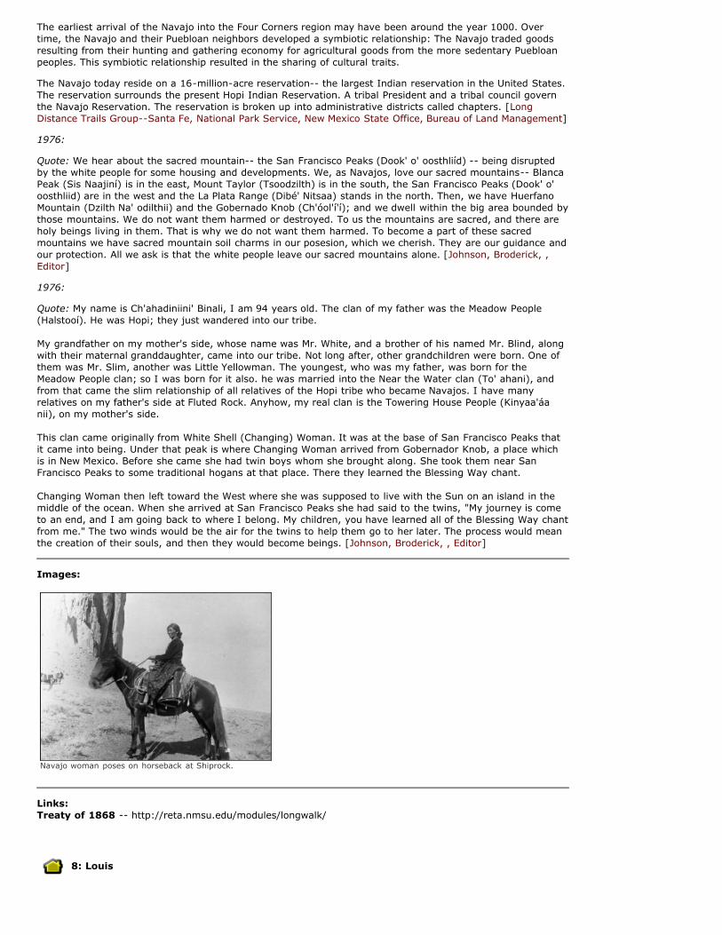
Images:
Navajo woman poses on horseback at Shiprock.
Links: Treaty of 1868 -- http://reta.nmsu.edu/modules/longwalk/
8: Louis

1879-1896
The Miera family were the first to establish a ranch in this country, and Luis Garcia followed them in 1874,establishing a little store, around which grew a community known as Garcia's Plaza or Tramperos Plaza, for thenearby creek. In 1892, the Post Office changed the name to Louis, an Anglicization of the founder's name. Thesettlement was abandoned after the collapse of the ranching industry. [Julyan, Robert]
Quote: In 1885, Tramperos Plaza was the theatre of social activity and the center of local commercialism. AtTramperos Plaza, Luis F. Garcia kept a stock of general merchandise which included whiskey and beer. WIthinthe one-story adobe building, with dirt roof and dirt floors, Garcia's store harbored Tramperos' post office towhich mail from Springer, 85 miles distant, arrived about nine o'clock each Tuesday and Friday morning--weather and the capacity of one small pony which drew the buckboard bearing the mail pouch permitting. Thenearest post office to Tramperos was Tequesquite, now Albert, some 40 miles southwest, of which A.B. Knellwas the postmaster.
In the Tramperos country, and upon the stream of that name, a dozen or more native-born ranchmen hadsettled about 1878, namely, Garcia Brothers, Jose Manuel, Luis F., Maximo, Francisco, Jose de la Luz, andAbelino. They were owners of sheep and cattle. Francisco Miera, the Lobatos, C.J.H. Bushnell, James McDonaldand James Carter resided 10 miles or so west of the Plaza. Candido Garcia and Thomas O. Boggs were ownersof sheep and had ranches on the Pinavetitios, five miles or so above the Beatty ranch. Boggs, frontiersmanand scout of the 1840's, once made his headquarters at Bent's Fort on the Arkansas. His wife was a niece ofMrs. Kit Carson. Carson's youngest child, Josefita, was living with Boggs and his wife in 1886. His son, Charlie,was shot and killed at their ranch in the summer of 1887. Though suspicion pointed to his wife as the slayer ofher husband, nothing came of the charge.
In 1884, and for several years thereafter, a telephone line connected the Beatty ranch on Pinavetitos Creek 10miles north of Tramperos Plaza, then belonging to the Prairie Cattle Company, with Trinidad, Colorado, by wayof the company's headquarters ranch on the Cimarron, the former Hall Bros.' property. The length of thisprivately owned telephone line was 125 miles. [Thompson, Albert W.]
9: Clayton
1886
Quote: (1886) No habitation existed in 1886 between the present post office of Clapham, where residedPostmaster James H. Davis, a native of Vermont, 4 miles down stream from whom lived James Taylor-- andthe 101 Ranch on the Cimarron River 5 miles east of the present Kenton, Okla., except the sub-ranch of Dr.T.E. Owen on the Perico known as the Pitchfork Ranch-- a distance of 75 miles. Homer E. Byler was care-takera tthe Perico property for Dr. Owen whose home ranch was ten miles west of the later-founded town ofFolsom. About 1883, Dr. Owen had bought several preemption claims of 160 acres each on the Perico, on oneof which he built a three-room adobe house. Lumber, shingles, flooring, and doors for this house werefreighted from Trinidad, a distance of 125 miles. It stood near the site of the Clayton waterworks of today.One room, that closest to the stream, was used as a kitchen, the middle room as sleeping quarters, and thenorth room for a store. The north room sheltered the first post office created in the Clayton District. It wasestablished November 9, 1886, under the name of Perico with Homer E. Byler as Postmaster (Records in thePost Office Department in Washington.)
Until the completion of the Denver and Ft. Worth railroad, the Perico Post Office was supplied from Tramperos,40 miles distant, on a weekly schedule. A few letters and newspapers, addressed to Byler and EdwardSprague-- the latter living at the present Otto Ranch 5 miles up the Perico from Byler's store-- usuallyconstituted the mail addressed to that office. They were the only settlers then living in this great area.
For a year after the creation of the Perico Post Office, Byler sent a man on horseback to Tramperos Plaza 40miles west once each week for mail, who remained overnight at Garcia's store, returning to the Perico thefollowing day. Jim Harvey, in summer a chuck-wagon cook, was the primal mail carrier on this route duringthe winter of 1886-1887. [Thompson, Albert W.]
Overview: Clayton
Modern Clayton is the county seat of Union County. It was founded in 1887 by former Arkansas SenatorStephen Dorsey, who established it as a shipping point for his cattle and cattle from the Panhandle and thePecos Valley regions.
Clayton's claim to Wild West fame was the hanging of Black Jack Ketchum, a notorious train robber andalleged murderer. The execution, the only one in Union County history, was botched, and Ketchum wasdecapitated. Pictures from the hanging were made into popular postcards.
A popular attraction near Clayton is Clayton Lake State Park.
Images:
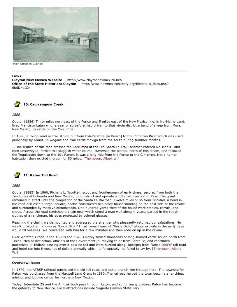
Main Street in Clayton
Links: Clayton New Mexico Website -- http://www.claytonnewmexico.net/Office of the State Historian: Clayton -- http://www.newmexicohistory.org/filedetails_docs.php?fileID=1324
10: Caurrampow Creek
1885
Quote: (1886) Thirty miles northeast of the Perico and 5 miles east of the New Mexico line, in No-Man's-Land,lived Francisco Lujan who, a year or so before, had driven to that virgin district a band of sheep from Mora,New Mexico, to settle on the Corrumpa.
In 1886, a rough road or trail strung out from Byler's store [in Perico] to the Cimarron River which was usedprincipally by round-up wagons and trail herds movign from the south during summer months.
...One branch of this road crossed the Corrumpa at the Old Santa Fe Trail; another entered No-Man's-Landthen unsurveyed, forded this sluggish water course, traversed the plateau north of this steam, and followedthe Tequisquite down to the 101 Ranch. It was a long ride from the Perico to the Cimarron. Not a humanhabitation then existed thereon for 50 miles. [Thompson, Albert W.]
11: Raton Toll Road
1885
Quote: (1885) In 1866, Richens L. Wootten, scout and frontiersman of early times, secured from both theTerritories of Colorado and New Mexico, to construct and operate a toll road over Raton Pass. The grantremained in effect until the completion of the Santa Fe Railroad. Twelve miles or so from Trinidad, a bend inthe road disclosed a large, square, adobe-constructed two-story house standing on the east side of the ravineand surrounded by massive cottonwoods. One hundred yards west of the house were stables, corrals, andsheds. Across the road stretched a chain near which stood a man well along in years, garbed in the roughclothes of a ranchman, his eyes protected by colored glasses.
Reaching the chain, we dismounted and addressed the stranger who pleasantly returned our salutations. Hewas R.L. Wootten, known as "Uncle Dick." I had never heard of "Uncle Dick," whose exploits in the early dayswould fill volumes. We conversed with him for a few minutes and then rode on up in the ravine.
Over Wootten's road in the 1860's and 1870's slowly trailed thousands of long-horned cattle bound north fromTexas. Men of distinction, officials of the Government journeying to or from Santa Fe, and ranchmenpatronized it. Indians passing over it paid no toll and were hurried along. Receipts from "Uncle Dick's" toll roadand hotel ran into thousands of dollars annually which, unfortunately, he failed to lay by. [Thompson, AlbertW.]
Overview: Raton
In 1879, the AT&SF railroad purchased the old toll road, and put a branch line through here. The townsite forRaton was purchased from the Maxwell Land Grant in 1880. The railroad helped the town become a ranching,mining, and logging center for northern New Mexico.
Today, Interstate 25 and the Amtrak both pass through Raton, and so for many visitors, Raton has becomethe gateway to New Mexico. Local attractions include Sugarite Canyon State Park.

Images:
Raton photographer RL Campbell captured this portrait of area ranchers and coal miners in 1880
Links: City of Raton -- http://www.cityofraton.com/
12: Chico Springs
1886
Quote: (1886) Among those who, in 1886, owned far-stretched land interests in northeastern New Mexico wasStephen W. Dorsey. Mr. Dorsey was United States Senator from Arkansas from 1873 to 1879. His home ranchwas located at Chico Springs, 25 miles east of Springer. Coming to New Mexico in 1877, the ex-Senator andhis company engaged in stock raising on a grand scale. His cattle, of a superior quality and grade, in the '80'swere scattered over all northeastern New Mexico. Dorsey had acquired thousands of acres of watered landsalong the Palo Blanco, Ute Creek, Corrumpa, Rafael, Seneca and other streams, some of which were 75 milesfrom his home ranch. I imagine the "Triangle Dot" cattle, Dorsey's brand, numbered in 1883-85, 50,000 head.
Lavish in its hospitality, Dorsey's ranch was the scene of many regal functions and festive gatherings. Here,men of National and Territorial prominence gathered. For Col. Robert G. Ingersoll, who had once successfullydefended him in a law suit in Washington, D.C., Dorsey constructed an ornate log house a half mile from hishome ranch at Chico Springs, where the noted attorney and orator spent part of one summer. Dorsey's largeand commodious house, built of cut stone and surrounded in summer by lawns and gardens, shrubbery andflowers, was the show spot of northeastern New Mexico. [Thompson, Albert W.]
Images:
Stephen Dorsey
Links: The Historic Dorsey Mansion -- http://dorseymansion.com
13: Farmington

1882
Quote: (1882) Not a shingle in the town. Well it was just as well and in some instances, better; For instance,frequently, there would be a group of cow-boys sitting in a saloon, and just for amusement, they would shootthrough the roof with their sixshooters, which would have made a regular seive of a shingled roof, but with adirt roof it did but little harm, for the bullet could be seen to raise a little streak of dirt a few inches in the air,then the dirt in the roof would just settle back and the hole closed up.
Some of the old buildings are still in pretty good shape, especially the old Markley Building, where I waslocated when I first went to Farmington. The two old school houses were both adobe, but are now bothencased in a sheathing of lumber. The second school-house was really a church which was dedicated onChristmas day in 1883. The building was used for all kinds of meetings-- except dances-- it was never used fordances. ...
The first fruit crop was harvested in 1883, but there was not more than a bushel or two of it all told. But thefruit crop was soon greatly increased, and before many years the fruit from The San Juan Valley was shippedby the train load across land and sea, and this fruit has made for its self a wide reputation for good fruit withfine flavor. At this early day Farmington had no trees. But to-day the town can boast of many beauties andadds much to the attractiveness of the homes there.
"Frank Allens Grand Hotel" was just a three rooms and west and north of Allens place Schuyler Smith had afarm (later bought by Blake) which was broad and flat and un-fenced and often on Sundays, when the cow-coys of the town were out for a bit of fun, they raced thrie ponies across this flat and on through the town,shooting their guns into the air with a whoop stirring up both dust and noise.
Occasionally Indians indulged in the same pastime, till one day in the winter on '84 - '5, it had been fenced inby "'Dobe Jack" who lived on the place. The fence, which they did not see in time to stop, was hit full forceand all piled up in a heap, both horses and Indians, and that was the last of the Indians racing through thetown.
The Navajo frequently brought in a wild turkey or a saddle of vanison, which they gladly sold for fifty cents.
In front of the present "Avery Hotel" to the south and west of it, was (and is) an acre or so of good flatground-which had been sowed to winter wheat. In the spring it was fresh and green looking and a goodfeeding ground for wild geese which frequently furnished the inhabitants with a very palatable dinner of roastwild-goose.
Making the trip to Durango at that time was quite an undertaking. The Animas River was crossed nine times,and there being only one bridge, it had to be forded just eight times. There was no road, 'twas but a trailwhere some one else had driven, avoiding as best he could the roughest places, and winding around trees andbig boulders, and you had to keep a-going to make it in two days. If it was muddy it took three or four days,and you couldn't make it at all if the snow was deep, while we make it in about an hour in any kind ofweather.
Well, they had regular stopping places on the road where we could get meals, but the best place of all was atthe home of Mrs. Kountz, who served such good meals, that we made every effort to get there at meal time.The memory of them is still very vivid. She lived in that adobe house in Aztec still standing, but showing theage of its years, just between the bridge and a large garage as you enter the town going north.--Mr. Joe Prewitt, transcript of personal interview, describing his move to Farmington in 1882. [WPA FederalWriters' Project Collection.]
Overview: Farmington
This area of New Mexico was historically part of the the Navajo, Ute, and Jicarilla Apache homelands. TheNavajo name is Totah, meaning three rivers, a reference to the confluence of the San Juan, the Animas, andthe La Plata Rivers. After the indigenous inhabitants had been removed to reservations by 1868, settlers fromColorado began to move to the area. A group of four men staked out homesites on the high ground above therivers, forming the first permanent settlement in 1879. Farmington was incorporated in 1901.
The town remained isolated until the coming of the Denver and Rio Grande railroad in 1905.
Although the original agricultural base is still important, oil and gas production has been the primary economicdriver since the early 20th century.
Images:

Farmington; view from Orchard Ave down Main St. ca 1906
Links: City of Farmington, NM -- http://fmtn.orgOffice of the State Historian: Farmington -- http://newmexicohistory.org/filedetails.php?fileID=1317
14: Town of Cubero Land Grant
1853
The Town of Cubero Land Grant was petitioned by Juan Chavez and others in 1833. Located in ValenciaCounty, the original grant was 47,743 acres. Following proceedings at the office of the Surveyor General andthe Court of Private Land Claims the grant was approved by the U.S. government in 1892 for 16,490 acres,and the patent issued in 1900.
Overview: Cubero
Quote: Governor Pedro Rodríguez Cubero, who came after Don Diego de Vargas, traveled this way in 1697,and it's possible the name of the community comes from this era. Bernardo Miera y Pacheco includes it on his1776 map of the Dominguez-Escalante expedition, as Cubera. Other maps variously have it as Covero,Cabero, and Cuvero.
Links: Office of the State Historian: New Mexico Land Grants --http://www.newmexicohistory.org/filedetails_docs.php?fileID=22288
15: Santa Rosa
Quote: (26 August 1936) Jose Garcia y Trujillo doesn't believe that Billy The Kid was ever shot. He feels surehe got away to South America. He wouldn't be surprised if he is alive somewhere today, an old man withmany memories and a quick mind, like himself....
In broken English, mixed with Spanish phrases, Mr. Garcia told me how he went in a posse of thirty-five ormore men to capture Billy The Kid. He didn't know the Sheriff's name, but the description sounded like PatGarrett himself. "Muy, muy alto" - very, very tall, and Pat Garrett was six feet, four and a half. Jose Garciawas working at the time as sheepherder on the ranch of Jacobo Yrissari, about ninety miles southeast ofAlbuquerque. The tall sheriff came by one day with a band of men, and offered him five dollars a day and foodfor himself and his horse to join the posse in search of Billy The Kid. He said he didn't think there was anydanger of their getting Billy, and five dollars was a lot of money. The plan was to surround the Maxwell Ranchon the Pecos River, where Billy the Kid was known to spend much time.
This ranch belonged to Lucien Maxwell. "Un hombre muy grande, un millionairio", said Jose Garcia. LucienMaxwell was indeed one of the most striking figures of the early mountain frontier. Every trader and plainsmanin the Rocky Mountain Region knew him. He came to New Mexico from Illinois when the country was still apart of Old Mexico. There he married Luz Beaubien, daughter of a French Canadian, Charles Hipolyte Trotier,Sieur de Beaubien, and a Spanish woman. With Guadalupe Miranda, Beaubien had received from the MexicanGovernment during the Administration of Governor Manuel Armijo a huge grant of land as a reward for pioneerservices. Beaubien bought Miranda's share, and at Beaubien's death, Lucien Maxwell, his son-in-law,purchased all the land from the heirs and became sole owner of more than a million acres. He made hugesums of money selling sheep, cattle and grain to the Government, and built a great house at Cimarron. Therehe lived in as much magnificence as the times and the country could afford. His guests included cattle kings,

Governors, Army Officers, and later when he moved to the ranch near Fort Sumner, Billy The Kid. Nearlyevery day his table was set for more than two dozen, and it is reputed that they ate on plates of silver anddrank from goblets of gold.
Jose Garcia said he didn't know anything about that for he had never been inside of the house, but he thoughtit quite likely. He had been by the place at Cimarron several times when he was working for some people bythe name of Martinez who had a ranch north of Las Vegas. The Maxwell house was "una grande mancion." Butit was to the Maxwell House on the Pecos near Fort Sumner that he went in search of Billy The Kid. Maxwellretired to his place at Fort Sumner after losing much of his wealth. His son Pete later became the richestsheep man in that part of the country.
It was Pete who was a friend of Billy The Kid. Jose Garcia said he and the other men surrounded the house fortwo weeks but they never got so much as a glimpse of Billy The Kid.
Mr. Garcia said he knew a good friend of Billy The Kid, Jose Chavez y Chavez. When he was herding sheep onthe Yrissari Ranch, which was not far from Santa Rosa on the Pecos River, Jose Chavez y Chavez was sheepherder on a nearby ranch. One day the two of them were sitting under a tree smoking when a pack train onthe way to Arizona came along on the other side of the Pecos. Just opposite the tree where the twosheepherders were sitting they tried to ford the stream. But the water was swift and the horses floundered.Jose Garcia and Jose Chavez pulled off their clothes, jumped in and guided the horses to the bank. After thepack train went on, Jose Chavez showed Mr. Garcia the twenty-one bullet scars on his body. "He had aninnocent face - didn't look as though he could break a dish, but he was bad with a gun. Que hombre!
"Did they try to get Jose Chavez to go with the posse after Billy?" I asked.
"Jose Chavez y Chavez", he corrected me. "No, senora, he had left the country at that time."
According to Walter Noble Burns it was this Jose Chavez y Chavez who was responsible for the friendshipbetween Billy The Kid and the wealthy Maxwells. Billy The Kid had ridden over to Fort Sumner from Lincolnwith several of his men, among whom was Jose Chavez y Chavez. The fiance of one of the Maxwell girls wasdrunk and met Jose Chavez y Chavez on the street back of the Maxwell House. The two men quarreled andJose Chavez pulled his gun. Mrs. Maxwell ran out of the house and tried to pull her future son-in-law away,begging Chavez not to shoot him as he was drunk and didn't know what he was doing. Chavez replied thatdrunk or sober he was going to kill him, and he was going to do it immediately. Just then a young manwalked rapidly across the road, touched his sombrero to Mrs. Maxwell, said something in Spanish to Chavezand led him away. It was the Kid. From that time until his death, he made Fort Sumner his headquarters, andwas a frequent visitor at the Maxwell home. It was in Pete Maxwell's room that Pat Garrett shot him.
Mr. Garcia asked me if there were any books in Spanish about Billy The Kid. "My wife," he said, "she taughtme to read. I didn't know the letters when I married her. She didn't know the words but she knew the lettersand she taught me. I taught myself how the words went, but I never could teach her to read, ni con carinoesni alebanzes - neither by coaxing nor praising - she never could learn anything more than the letters."
Mrs. Garcia shook her head. "Nunca, nunca, nunca," she said. Never had she been able to learn more than theletters.--Jose Garcia y Trujillo, resident of the Santa Rosa area in the 1880s. Interviewed by Janet Smith. [WPAFederal Writers' Project Collection.]
Overview: Santa Rosa
Founded as a rancho at the confluence of the Rio Agua Negra and the Rio Pecos, it gained its name around1890, after a chapel built by the landowner to honor Santa Rosa de Lima, the first saint of the New World.
In 1901, the Chicago, Rock Island, and Pacific Railroad acquired the route of the Eddy brothers' El Paso andNortheastern Railroad, and the Golden State Train began steaming through Santa Rosa daily. The MidlandHotel, a Fred Harvey Company enterprise, was among the first of scores of businesses in Santa Rosa cateringto the weary and ravenous traveler.
Route 66, now a National Byway, continued to route transcontinental traffic through Santa Rosa. Today,tourists flock to the both the "Bottomless Lakes" and to the reservoir at the center of Santa Rosa Lake StatePark.
Images:

Spanish American Sheep Herder with his flock Santa Rosa courthouse, built in 1909
Midland Hotel, Santa Rosa. Courtesy Cara Romero,dreammehomenewmexico.blogspot.com
Links: Santa Rosa Visitors Guide -- http://www.santarosanm.org/
About this Map
Rand, McNally & Co.'s business atlas map of New Mexico. : 1897
The Homestead Act, passed by Abraham Lincoln (see below) opened up the possibility of free, or nearly freeland to the teeming masses coming over from Europe. The American military had subdued the nativeresidents, both Hispanic and indigenous, and the railroads had connected remote New Mexico to the rest ofthe nation.
The final piece of the puzzle to draw American homesteaders to New Mexico was an assessment of what land,after millennia of occupation, and centuries of colonization, was still open for homesteaders.
George Montague Wheeler led an ambitious project to survey New Mexico at a scale of 1:8, and to establish ameridian (a north-south line) and baselines (east-west lines) in order to plat the state into sections (onesquare mile, or 640 acres) and townships (36 sections). Homesteaders willing to settle in the arid west couldclaim an entire section under the Desert Lands Act of 1877. Anyone who could prove that the land wasirrigated within three years of filing paid the government $1.25 per acre.
The dividing of the lands that went so easily in other states was more complicated in New Mexico. The Treatyof Guadalupe Hidalgo promised to honor the grants given under Spanish or Mexican law, but finding theboundaries of those grants was another problem entirely. The boundary descriptions were based on currentownership (Don Luis' corrals) and familiar landmarks (where the cattle come to the river to drink). Even whenmeasurements were specified, they were in variably-determined Spanish leagues, not easily convertible tomiles.
Many land grants had no more documentation than the testimony of the occupants, and most includedcommon lands for grazing, timber, and water access, which were mostly discounted as part of the title, andthe ownership claimed by the U.S. government.
This map rather paints a rather more optimistic picture of available lands and mineral resources in New Mexicothan was the case, even in 1888, when this map was actually created.
Many of the "undecided" land grant cases on this map had actually been confirmed by the time of publication,and it does not include any of the Pueblo grants, which had all been confirmed by that time.
This map appeared in an indexed atlas of the world, compiled with historical, descriptive, and statisticalmaterials for each country and civil division.
Atlas Citation: [Eidenbach, Peter]
Map Credits: Image No: 3565144 Rumsey Collection
TIMELINE: AGE OF TECHNOLOGY
1846
President Polk declares war with Mexico; US forces led by General Stephen Kearny seize New Mexico, which

surrenders without a shot being fired. Colonel Doniphan writes code for governing the Territory of New Mexico.New Mexico designated Ninth Military Department.
1847
Philip St. George Cooke blazed the first wagon road from New Mexico to the West Coast.
New Mexico formally annexed; slavery issues had prevented formal annexation until this point.
1848
Mexico signs the Treaty of Guadalupe Hidalgo, which cedes lands in California, Nevada, Utah, Colorado,Arizona, and New Mexico to the United States (Statute 922 App I). The international boundary designated asthe intersection of 32º N and the Rio Grande to intersection of Choctaw Creek with Red River.
1849
Simpson made a map previously shows town of Rito- Rito is a ruin by the time Whipple arrives because theupstream people took all the water. He traveled through Albuquerque to Pueblo de la Laguna and passedCovero (Cubero), Mount Taylor (named by Simpson in 1849 for Zachary Taylor), and Agua Fria, the last springbefore the Continental Divide. Whipple used Sitgreaves' 1851 map as a reference also Walker's 1851 map.
1850
New territories admitted, including New Mexico (including modern Arizona), purchase of additional lands fromTexas, boundaries adjusted. El Paso becomes part of Texas.
1851
Sitgreaves' official report, Report of an Expedition Down the Zuni and Colorado Rivers in 1851, was publishedin 1853. The report explored possibility of using this route for military transport.
1852 Survey
1st international boundary commission established in accordance with the Treaty of Guadalupe Hidalgo. Emoryis the designated astronomer. The survey run into difficulties, which are resolved with the purchase of moreland from Mexico.
Initial point on the Rio Grande (determined by Commissioners Condé and Bartlett according to the Treaty ofGuadalupe-Hidalgo) proves to be in the wrong place. Surveyor AB Gray says 32º 22' is wrong, 31º 52' is right.Commissioners Emory and Salazar (astronomers from the first Boundary Commission) later determine thestarting point of the line at 32º47'.
1852
New Mexico legislature passed a single act creating two new counties, redefining five of the original counties toextend across the limits of the territory, and eliminating all non-county area.
1853
Gadsden Purchase from Mexico resolves boundary issues, and give the U.S. the land necessary to build asouthern transcontinental railroad. (GP Statute 1031 App II).
1855 Survey
US Commissioner: William H. Emory
Mexican Commissioner: José Salazar y Larregui
Emory and Salazar survey the entire Mexican-American border, including the new area included by theGadsden Purchase.
The Americans made nearly a dozen monuments along the border to mark the sites, but many were destroyedby surrounding tribes, so the Mexicans rebuilt many and added some. Later surveys added over two hundredmore, and rebuilt them as more permanent monuments.
1855 railroad surveys
The U.S. Government commissioned a number of surveys, spaced along parallels, to determine the best routefor a transcontinental railroad.
Emory & Parke: 32nd parallel
Whipple & Ives: 35th parallel
Beckwith & Gunnison: 38th-39 parallel
1857 and 1858

Ives' Report upon the Colorado River of the West
1859
Marcy publishes The Prairie Traveler
1861
Colorado territory established; New Mexico's northern boundary reduced.
Residents of the Mesilla Valley declared their allegiance with the Confederacy and separated from the Union.They hoped the Confederacy would recognize them as the state of Arizona, which they imagined would reachto the Colorado River.
Civil War starts. Confederate troops gather at Fort Bliss and take Fort Fillmore. The plan is to seize NewMexico, and then march on to take the gold fields of Colorado or California. Indian raids on settlements stepup as U.S. Army soldiers turn their attention to other matters.
I
1862
Homestead Act: free 160 acres offered after 5 years cultivation. Later modified to offer 320 acres, and theDesert Lands Act offered 640 acres.
Henry H. Sibley, commander of a brigade of mounted regiments from Texas, marched from Fort Bliss near ElPaso up the Rio Grande: taking Fort Fillmore, defeating Union troops at Fort Craig, taking Albuquerque andSanta Fe, and finally defeating the Union troops at Glorieta Pass, near Pecos. By this time, the Confederatetroops were starving and without clothes or ammunition, so they retreated back to Fort Bliss.
1862-1871
Railroad Land grants: the Federal government gives away 128 million acres of land to the railroad companies,as an incentive to build railway lines all over the country. The railroad companies sold many of these parcelsto homesteaders.
1863
Arizona Territory created by the United States from the western portion of New Mexico Territory and a part ofpresent Nevada. Present New Mexico-Arizona boundary established.
1864-1866
"Long Walk"- Navajo and Mescalero Apache forcibly relocated to Bosque Redondo reservation; The Apacheescaped, and the Navajo signed a treaty of nonagression and returned to their homeland in 1868.
1864-1890
Indian Wars throughout the West. Destruction of the bison herds.
1867
Hayden, King, Wheeler, Powell Surveys map the west comprehensively, while cataloguing flora, fauna, andgeology.
1868
Navajo chief Barboncito, along with numerous other leaders, sign a treaty with General William T. Sherman,agreeing to peace with the Americans in exchange for rights to return from Bosque Redondo to their newreservation: a small area within their traditional homeland.
1869
Fort Bliss renamed Fort Bliss.
Cochise and Apache guerrillas active 1871- 1879.
The war to save the buffalo 1874-1880.
1878-1879
Fort Bliss permanently established in current location.
1878
The Atchison, Topeka and Santa Fe (AT&SF) railroad crosses the Raton Pass into New Mexico, reaching LasVegas, its first destination in New Mexico, in 1879.
1879

USGS established.
1880
The Southern transcontinental railroad traversed the region.
Geronimo & Chiricahua Apaches active in southern New Mexico and northern Mexico, 1880-1886.
1884
New boundary treaty: the boundary, where marked by the Rio Grande, adheres to the center of originalchannel as surveyed in 1852 even if the course of the river changes. Boundaries on international bridges atcenter point.
1886
Geronimo surrenders to General Crook in southern New Mexico. The remaining members of the Chiricahua andMimbres bands are removed first to Florida, and finally to Fort Sill, Oklahoma.
1889
US/Texas/ New Mexico/Mexico border resurveyed; discovered bancos or alluvial deposits changing land masson either side of the border.
1891
Forest Reserve Law, designating forest preserves; forerunner of current National Forests.
1905
National Forest service created.
1906
Antiquities Act. Allows a president to protect areas of public land by executive order.
New treaty with Mexico on water rights for irrigation
1912
New Mexico becomes the forty-seventh state of the Union.
1916
National Park Service created.
1924
Gila Wilderness established.
1925
U.S. Supreme Court decision in New Mexico v. Colorado dismisses New Mexico's claims and establishes currentboundaries between the states.
Visit Atlas of Historic NM Maps online at atlas.nmhum.org.
Website and Contents Copyright ©2008 - 2009 New Mexico Humanities Council. All rights reserved.