ramparts and walls: building techniques of kites in the ... nadel et al-kites 13.pdf · ramparts...
TRANSCRIPT

at SciVerse ScienceDirect
Quaternary International 297 (2013) 147e154
Contents lists available
Quaternary International
journal homepage: www.elsevier .com/locate/quaint
Ramparts and walls: Building techniques of kites in the Negev Highland
Dani Nadel a,*, Guy Bar-Oz a, Uzi Avner b, Dan Malkinson c, Elisabetta Boaretto d
a Zinman Institute of Archaeology, University of Haifa, Mount Carmel, Haifa 31905, Israelb The Arava Institute and the Dead Sea-Arava Research Centre, Eilat 88133, IsraelcDepartment of Geography and Environmental Studies, University of Haifa, Mount Carmel, Haifa 31905, IsraeldRadiocarbon Dating and Cosmogenic Isotopes Laboratory, Weizmann Institute of Science, Israel
a r t i c l e i n f o
Article history:Available online 5 December 2012
* Corresponding author.E-mail addresses: [email protected]
research.haifa.ac.il (G. Bar-Oz), [email protected] (U. A(D. Malkinson), [email protected] (E
1040-6182/$ e see front matter � 2012 Elsevier Ltd ahttp://dx.doi.org/10.1016/j.quaint.2012.11.037
a b s t r a c t
Remarkably, the largest archaeological game traps ever recorded in the Near East are found in aridlandscapes, both on plains and in hilly terrains. This paper describes the construction methods used onsteep slopes in the Negev Highland. Apparently, in some cases a massive rampart (rather than a free-standing wall) was built around the trap’s head. The details reflect careful planning and heavy-dutywork, including leveling and then using more than 100 t of stone for the rampart construction. New14C data date the Sayarim site to the Early Bronze Age (minimum age), and the Pitam site to pre-LateBronze Age.
� 2012 Elsevier Ltd and INQUA. All rights reserved.
1. Introduction
Remarkably, the largest archaeological game traps ever recor-ded in the Near East are found in arid landscapes. They were firsttermed ‘Desert Kites’ by pilots almost 100 years ago (Maitland,1927; Rees, 1929), though the term has nothing to do with theirpast function (for research history see Holzer et al., 2010; referencestherein; Bar-Oz and Nadel, 2013).
The large game traps (henceforth kites) discussed here aregenerally triangular structures (V-shaped), each built of two longconverging stone walls (arms) with a small round structure (head)at the apex. The heads vary in shape and their diameter can rangefrom a few m to over 200 m. The walls extend for tens of m andmore commonly for hundreds of m; they were constructed of localstones and vary in width and height. These extensive stone struc-tures are common in many desert environments in the Middle East,either as isolated phenomena or as sets of long chains (Betts, 1982).
The Negev and Sinai kites are usually isolated constructions,with no chains (Kobusiewicz, 1999; Meshel, 2000; Holzer et al.,2010). In addition, they are usually much smaller than thosefound in the deserts of East Jordan and Syria (Maitland, 1927; Rees,1929, p. 398; Helms and Betts, 1987; Betts, 1998; Van Berg et al.,2004; Kennedy and Bewley, 2009; Kempe and Al-Malabeh, 2010;Kennedy, 2011, 2012). In all areas, kites were constructed of locally
(D. Nadel), guybar@vner), [email protected]. Boaretto).
nd INQUA. All rights reserved.
available stones; in the Negev Highland kites discussed here,limestone was the only rock used.
To date, very few of the Negev and Sinai kites (and their asso-ciated features) were thoroughly excavated or studied, andfunction-specific finds such as animal bones are extremely rare(Avner, 1972; Meshel, 1974, 2000; Kobusiewicz, 1999; Holzer et al.,2010; Nadel et al., 2010; Bar-Oz et al., 2011a). The same is also truefor the large east Jordanian and Syrian chain kites (Helms and Betts,1987; Echallier and Braemer, 1995; Betts, 1998; Betts and Yagodin,2000; Van Berg et al., 2004). The differences in types, topographyand distribution patterns suggest that the kites were used invarious ways. Thus, a variety of functional reconstructions weresuggested, not always separating the utilization of the large chainsfrom those of the smaller isolated features (see Holzer et al., 2010;Bar-Oz and Nadel, 2013; Nachmias et al., in press).
While it is argued that the chain kites were used to trap the largemigratory herds of Persian (goitered) gazelle (Gazella subgutturosa)(e.g. Legge and Rowley-Conwy 1987; Kempe and Al-Malabeh, 2010;Bar-Oz et al., 2011b), the Negev and Sinai kites were probably builtto trap small numbers of non-migratory ungulate prey i.e., gazelle(Dorcas gazelle, Gazella dorcas or mountain gazelle, Gazella gazella),onager (Equus hemionus) and probably Arabian oryx (Oryx leu-coryx), which locally grazed in small herds year round (c.f. Holzeret al., 2010; Nadel et al., 2010). It appears that species behavioralecology, herd size, and body-size of the target game were amongthe factors that determined the characteristics of each kite (c.f.Perevolotsky and Baharav, 1991; Rosen and Perevolotsky, 1998).
Currently, 12 kites are known in the Negev; five in flat settingsand seven on hilly terrain (Fig.1). All were thoroughly surveyed andmapped by the authors, including the use of aerial photos and
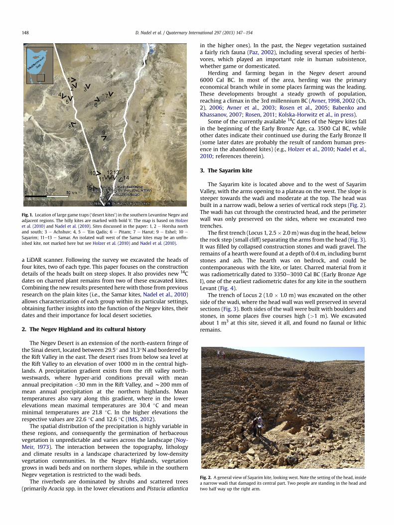
Fig. 1. Location of large game traps (‘desert kites’) in the southern Levantine Negev andadjacent regions. The hilly kites are marked with bold V. The map is based on Holzeret al. (2010) and Nadel et al. (2010). Sites discussed in the paper: 1, 2 e Horsha northand south; 3 e Achshuv; 4, 5 e ’Ein Qadis; 6 e Pitam; 7 e Harut; 9 e Eshel; 10 e
Sayarim; 11e13 e Samar. An isolated wall west of the Samar kites may be an unfin-ished kite, not marked here but see Holzer et al. (2010) and Nadel et al. (2010).
Fig. 2. A general view of Sayarim kite, looking west. Note the setting of the head, insidea narrow wadi that damaged its central part. Two people are standing in the head andtwo half way up the right arm.
D. Nadel et al. / Quaternary International 297 (2013) 147e154148
a LiDAR scanner. Following the survey we excavated the heads offour kites, two of each type. This paper focuses on the constructiondetails of the heads built on steep slopes. It also provides new 14Cdates on charred plant remains from two of these excavated kites.Combining the new results presented herewith those from previousresearch on the plain kites (i.e., the Samar kites, Nadel et al., 2010)allows characterization of each group within its particular settings,obtaining further insights into the function of the Negev kites, theirdates and their importance for local desert societies.
2. The Negev Highland and its cultural history
The Negev Desert is an extension of the north-eastern fringe ofthe Sinai desert, located between 29.5� and 31.3�N and bordered bythe Rift Valley in the east. The desert rises from below sea level atthe Rift Valley to an elevation of over 1000 m in the central high-lands. A precipitation gradient exists from the rift valley north-westwards, where hyper-arid conditions prevail with meanannual precipitation <30 mm in the Rift Valley, and w200 mm ofmean annual precipitation at the northern highlands. Meantemperatures also vary along this gradient, where in the lowerelevations mean maximal temperatures are 30.4 �C and meanminimal temperatures are 21.8 �C. In the higher elevations therespective values are 22.6 �C and 12.6 �C (IMS, 2012).
The spatial distribution of the precipitation is highly variable inthese regions, and consequently the germination of herbaceousvegetation is unpredictable and varies across the landscape (Noy-Meir, 1973). The interaction between the topography, lithologyand climate results in a landscape characterized by low-densityvegetation communities. In the Negev Highlands, vegetationgrows in wadi beds and on northern slopes, while in the southernNegev vegetation is restricted to the wadi beds.
The riverbeds are dominated by shrubs and scattered trees(primarily Acacia spp. in the lower elevations and Pistacia atlantica
in the higher ones). In the past, the Negev vegetation sustaineda fairly rich fauna (Paz, 2002), including several species of herbi-vores, which played an important role in human subsistence,whether game or domesticated.
Herding and farming began in the Negev desert around6000 Cal BC. In most of the area, herding was the primaryeconomical branch while in some places farming was the leading.These developments brought a steady growth of population,reaching a climax in the 3rd millennium BC (Avner, 1998, 2002 (Ch.2), 2006; Avner et al., 2003; Rosen et al., 2005; Babenko andKhassanov, 2007; Rosen, 2011; Kolska-Horwitz et al., in press).
Some of the currently available 14C dates of the Negev kites fallin the beginning of the Early Bronze Age, ca. 3500 Cal BC, whileother dates indicate their continued use during the Early Bronze II(some later dates are probably the result of random human pres-ence in the abandoned kites) (e.g., Holzer et al., 2010; Nadel et al.,2010; references therein).
3. The Sayarim kite
The Sayarim kite is located above and to the west of SayarimValley, with the arms opening to a plateau on the west. The slope issteeper towards the wadi and moderate at the top. The head wasbuilt in a narrow wadi, below a series of vertical rock steps (Fig. 2).The wadi has cut through the constructed head, and the perimeterwall was only preserved on the sides, where we excavated twotrenches.
The first trench (Locus 1, 2.5� 2.0m)was dug in the head, belowthe rock step (small cliff) separating the arms from the head (Fig. 3).It was filled by collapsed construction stones and wadi gravel. Theremains of a hearth were found at a depth of 0.4 m, including burntstones and ash. The hearth was on bedrock, and could becontemporaneous with the kite, or later. Charred material from itwas radiometrically dated to 3350e3010 Cal BC (Early Bronze AgeI), one of the earliest radiometric dates for any kite in the southernLevant (Fig. 4).
The trench of Locus 2 (1.0 � 1.0 m) was excavated on the otherside of the wadi, where the head wall was well preserved in severalsections (Fig. 3). Both sides of the wall were built with boulders andstones, in some places five courses high (>1 m). We excavatedabout 1 m3 at this site, sieved it all, and found no faunal or lithicremains.
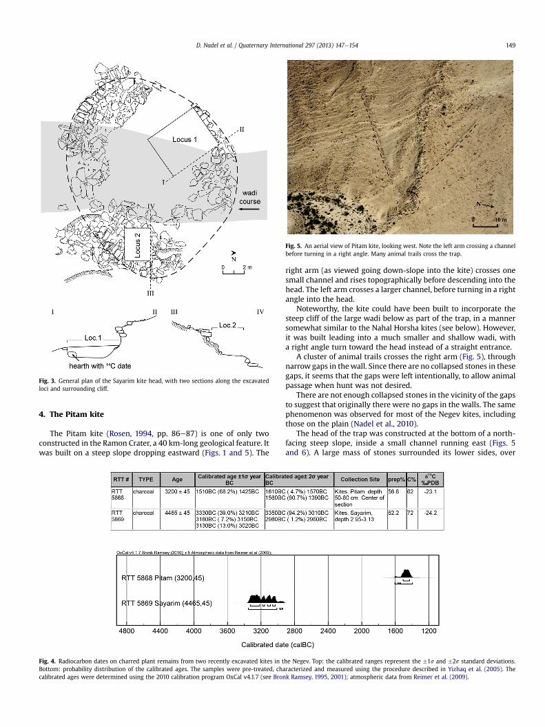
Fig. 3. General plan of the Sayarim kite head, with two sections along the excavatedloci and surrounding cliff.
Fig. 5. An aerial view of Pitam kite, looking west. Note the left arm crossing a channelbefore turning in a right angle. Many animal trails cross the trap.
D. Nadel et al. / Quaternary International 297 (2013) 147e154 149
4. The Pitam kite
The Pitam kite (Rosen, 1994, pp. 86e87) is one of only twoconstructed in the Ramon Crater, a 40 km-long geological feature. Itwas built on a steep slope dropping eastward (Figs. 1 and 5). The
Fig. 4. Radiocarbon dates on charred plant remains from two recently excavated kites in tBottom: probability distribution of the calibrated ages. The samples were pre-treated, chacalibrated ages were determined using the 2010 calibration program OxCal v4.1.7 (see Bron
right arm (as viewed going down-slope into the kite) crosses onesmall channel and rises topographically before descending into thehead. The left arm crosses a larger channel, before turning in a rightangle into the head.
Noteworthy, the kite could have been built to incorporate thesteep cliff of the large wadi below as part of the trap, in a mannersomewhat similar to the Nahal Horsha kites (see below). However,it was built leading into a much smaller and shallow wadi, witha right angle turn toward the head instead of a straight entrance.
A cluster of animal trails crosses the right arm (Fig. 5), throughnarrow gaps in thewall. Since there are no collapsed stones in thesegaps, it seems that the gaps were left intentionally, to allow animalpassage when hunt was not desired.
There are not enough collapsed stones in the vicinity of the gapsto suggest that originally there were no gaps in the walls. The samephenomenon was observed for most of the Negev kites, includingthose on the plain (Nadel et al., 2010).
The head of the trap was constructed at the bottom of a north-facing steep slope, inside a small channel running east (Figs. 5and 6). A large mass of stones surrounded its lower sides, over
he Negev. Top: the calibrated ranges represent the �1s and �2s standard deviations.racterized and measured using the procedure described in Yizhaq et al. (2005). Thek Ramsey, 1995, 2001); atmospheric data from Reimer et al. (2009).

Fig. 6. General view of the Pitam head, looking southeast. Four people are in themiddle of the head, and the remains of the rampart are visible below them.
Fig. 8. Close-up view of the retaining wall during excavation (Pitam head, lookingsouth).
D. Nadel et al. / Quaternary International 297 (2013) 147e154150
3 m wide at the bottom and up to ca. 1.2 m high. The head is ovalin shape, 5.5 � 6.0 m, and a thick deposit of fine material (mostlyaeolian) accumulated inside.
We excavated a 1.5 mwide trench across it (Fig. 7). On the innersteep side of the head (south), below the in-coming arms, we foundthe remains of a vertical wall (Fig. 8). It was built of undressed slabs,
Fig. 7. Plan and section of the head, Pitam kite.
the two lowest stones more than 0.5 m long. These remains indi-cate that the first stage of head construction was to cut verticallyinto the slope and create a human-made wide step, and thena retaining wall was built against the slope. Towards the lower side(north), no vertical wall was encountered in the trench. Rather,a wide semi-circular rampart was built in the channel bed, toprotect the head from flash floods. Massive boulders were used forconstruction, some more than 1 m long.
To the best of our knowledge, this is the first excavation inwhichsuch a buildingmethod of the head is revealed. It was also observedin the Nahal Horsha kites (see below and Fig. 14c). The channelcourse was diverted northwards by 3.0e5.0 m.
We excavated about 3 m3, sieved it all, and found no faunal orlithic remains. We did find, near the bottom of the trench (butabove bedrock), several charred fragments. The only dated samplewas retrieved from a depth of 0.5e0.8m (in the head’s center), withan age of 1510e1425 Cal BC (Fig. 4). This Late Bronze Age readingpost-dates the construction event, as the charred material was notfound in situ.
5. The Nahal Horsha kites
The two Nahal Horsha kites (Haiman, 1986, pp. 24, 137) werebuilt ca. 800m apart (Fig. 1). In most cases the Negev and Sinai kitesare several tens of kilometers apart. The Nahal Horsha setting withtwo relatively close kites is less common. Another pair was docu-mented near the ’Ein Qadis spring (Fig. 1; Haiman, 1986, pp. 223e224, 2007, pp. 346).
The two studied Nahal Horsha kites have their arms open to theplateau, converging in the same general direction, using a south orsouth-east facing vertical cliff (Fig. 9). Both are located above and tothe west of the large Nahal Horshawadi course. Neither of the kiteswas excavated, though a meticulous survey and documentationwas accomplished.
6. The Nahal Horsha south kite
The kite has two distinct components, the arms on the plateauand the head below a vertical cliff, ca. 2.5 m high (Figs. 9 and 10).The arms run almost horizontally on the plateau, the right muchshorter than the left. Only towards the head do they descend,before converging on the cliff where they create a narrow ‘bottleneck’. The arms were constructed of local field stone, up to threecourses high and 2e4 stones wide; only a few were found fallen.Thus, originally the arms were only 0.5e0.8 m high.

Fig. 11. Nahal Horsha south kite: plan and section of the head and cliff above it.
Fig. 9. An aerial view of the Nahal Horsha south kite, looking north. Note theconverging arms to a south facing cliff, with the left arm much longer. The wide NahalHorsha is at the top right, and a tributary at the bottom.
D. Nadel et al. / Quaternary International 297 (2013) 147e154 151
The head below the cliff has two components, a massive semi-circular structure and a small stone alignment within it. As thelatter appears to be a surface feature built after the head was in-filled by post-depositional processes, it post-dates the kite and isnot dealt with here. The inner diameter is ca. 5.0 m, while thewidthof the ring of collapsed stones ranges between 3.0 and 5.0 m(Fig. 11). Many more stones are scattered on the slope below thestructure.
It appears that the builders first created a wide flat space (ora shallow depression) on the slope, before construction (Fig. 14a).The massive structure appears to be a rampart, built to function ona steep slope. It was constructed of boulders and stones, with novisible pattern. The area of the rampart is ca. 70 m2, and accordingto surface observations the average thickness is at least 0.5 m,suggesting that the volume of stone used for construction was atleast 35 m3 or 100 t. This represents a formidable effort for theconstruction of a 5.0 m wide (inner diameter) trap head.
7. The Nahal Horsha north kite
This kite has longer arms than the previous, though the settingis similar (Fig. 12). Here, the right arm is much longer than the left.
Fig. 10. Nahal Horsha south: A side view of the vertical cliff and the rampart remainson the slope (right). The trapped animals were driven from the left to the natural cliff(person standing on edge). Remains of the collapsed head in center.
It crosses a channel andmakes an almost right turn still far from thehead. The cliff edge above the head is not visible from the far endsof both arms.
The head, 3.0 m below the cliff edge, is semi-circular withan inner diameter of ca. 5.0 m, surrounded by a massive rampart,2.0e5.0 m wide and many more stones are scattered below it(Figs. 12 and 13). A small stone feature built within the head post-dates the kite and will not be dealt here.
The area of the rampart is ca. 50 m2 and it is at least 0.5 m thick,suggesting that the volume of stone used for construction was noless than 25m3 (70 t). This demonstrates the efforts required for theconstruction of a 5.0 m wide (inner diameter) kite head. It appearsthat the constructors of both kites first leveled a wide area on theslope before building the surrounding rampart (Fig. 14b).
8. Discussion
The Bronze Age inhabitants of the Negev and Sinai constructedgame traps in a variety of topographic and ecological niches. Thethree Samar kites compose the largest concentration, located ona flat terrain in the Southern ’Araba Valley (Nadel et al., 2010). In theNegev Highlands, kites were built on steep slopes (e.g., the Pitam,Sayarim, Eshel and Achshuv kites), or on plateaus, incorporatingcliffs at their edges (e.g. the Harut and both Nahal Horsha kites).
Kites in the hilly terrain comprise two types of heads at theirapex. One is surrounded by a vertical wall, as was documented by

Fig. 12. A general view of the Nahal Horsha north head, with the arms convergingtowards the cliff. Note the large collapsed head on the slope.
D. Nadel et al. / Quaternary International 297 (2013) 147e154152
excavation at the Sayarim kite and by a survey at the Eshel kite.In the other type the head is surrounded by a massive rampart,3.0e5.0 m wide and probably originally 1.0e2.0 m high, as wasdocumented by excavations at the Pitam kite and surveys atthe Nahal Horsha kites. The Achshuv case is yet to be clearlyestablished.
Evidently, the construction of the head was not limited toa surrounding wall/rampart. Both on the plain and up in the hills,
Fig. 13. Nahal Horsha north kite: plan and section of the head and cliff above it.
Fig. 14. Schematic sections of the heads of three studied hilly kites, presenting theleveling and construction phases. The kites’ arms are not shown here. Top: the NahalHorsha south kite. Middle: the Nahal Horsha north kite. Bottom: the Pitam kite: thedigging of a wide pit; the construction of the retaining wall on the steep side; theconstruction of the rampart around the lower side. Note the change in wadi bedlocation after construction.
digging or leveling preceded the stone construction. Accommo-dating for specific topographic conditions, the courses of the armswere carefully chosen, sometimes crossing natural channels inorder to follow the general planned direction. This direction mayhave been chosen following parameters such as wind direction(preventing the animals from smelling the hunters) or sun direc-tion (sun in the eyes of the target herd). Furthermore, the specifichead location was likely selected to maximize the available topo-graphic opportunities.
On the plains, small channels were used for head location, and ifthe vertical difference between the plain and the bottom of thehead was insufficient, it was enhanced by digging in the channeland by building a ramp on the plain’s edge (Nadel et al., 2010). Inthe hilly terrain, the head was set either in a channel (e.g., Pitam,Sayarim) or directly below a vertical cliff (e.g., Nahal Horsha southand north, Harut). Construction included the use of available largeboulders and stones. On steep slopes it was usually a rampart, whilein channels it was either a wall or a rampart.
The head construction effort in some of the hilly kites was ofa magnitude not documented during the studied Samar kites. The

D. Nadel et al. / Quaternary International 297 (2013) 147e154 153
construction of one kite included leveling the slope and moving ca.100 t of rocks for building the head and construction of the arms; itwas indeed a remarkable effort (see also Kempe and Al-Malabeh,2010 for kites in Jordan; and Hockett et al., 2013, for experi-mental results and ensuing calculations).
This is especially outstanding when compared to localcontemporaneous dwelling structures, which were small andsimple in terms of stone use. In other words, the investment in kiteconstruction reflects their importance on the one hand, and thecommunal effort on the other (probably many tens of constructionman/days per kite). Accordingly, the kites may have also hada special and even symbolic/ritual meaning for local communities,even if originally planned only as large-scale hunting devices.
Whatever the construction method, the long arms and the headhad a direct impact on the environment e though only on a limitedlocal scale (Nadel et al., 2010; Bar-Oz et al., 2011a). The landscapewas now built with massive stone structures enduring theelements for thousands of years. In all cases the constructedfeatures remain on the landscape, either complete, almostcomplete, or as piles of collapsed stones. These changed waterregimes on the slopes and diverted runoff water, though only in theimmediate vicinity of the walls. Soil characteristics and vegetationgrowth at these locales also changed, with the construction stonesthemselves inhibiting the germination of almost all species. In thecase of the Pitam kite, the channel course itself was diverted by3.0e5.0 m. All head structures became sediment traps, infilling bynatural processes and creating a micro-niche with preferredconditions for plant growth (more soil and humidity).
The only other kind of massive building on the landscapeincorporated graves (such as tumuli and Nawamis), but usually notmundane features or dwelling structures. This correlation of kitesand burial structures is also known in other parts of southwest Asia,and should be further explored. On another level, numerouscontemporaneous dwelling sites also had direct impact on theenvironment. These, most probably, had profound and differenteffects on their immediate landscape (using construction materialssuch as stone andwood, using the already scarce vegetation for fueland herd fodder, accumulating refuse dumps, etc.).
In terms of targeted game, our results are limited. It is clear thatthe kites were set either near grazing locales, or on commonly usedroutes (Fig. 5). The dimensions of the kites reveal that the size ofherds was limited to a few herbivores, with no place to capturehundreds or even tens at a time (though see a different scale inother chapters in this volume). We suggest that the plain kites weremostly used for gazelle capture, while the hilly ones were aimed atcapturing the larger and heavier species, most probably focusing onthe onager (E. hemionus) (see also Holzer et al., 2010; Nadel et al.,2010; Bar-Oz et al., 2011a). The massive ramparts may beexplained not only in terms of durability on steep slopes, but also inpreventing onagers from escaping the trap.
We found that the strategy of “leaving the trails open”between hunting episodes was practiced at all the 12 Negev and’Araba game traps we studied (regardless of topographic settingor head construction method). In each, animal trails cross thearms of kites at points where narrow gaps were left within thewalls (in a width of a trail, ca. 0.5e0.7 m). During communalhunts these passages were probably temporarily manned byhunters or blocked by dry bushes, rocks, etc. This kind ofevidence, as well as all the above-described details, reflectsprofound knowledge of the physical environment and thebehavior of the indigenous species roaming through it. Only bysetting the kites at the right point (‘bottle neck’ or topographicallyadvantageous location) and using them at the appropriate time(when the target herd was passing), could the ancient hunterssucceed in their communal endeavor.
Despite previously published 14C and OSL dates (Holzer et al.,2010; Nadel et al., 2010), the issue of absolute and precise datingof all desert kites is yet to be addressed. Even in excavated cases,cultural-specific finds (e.g. arrow heads, pottery sherds, etc.) arerare at best, and datable organic remains are also very scarce.Though several plain kites were radiometrically dated (seesummaries in Holzer et al., 2010; Nadel et al., 2010), the followingdates are the first for hilly kites in this region of the Near East. Wehave one 14C date on charred remains from Pitam (1560e1390 Cal BC), and another 14C date on charred remains fromSayarim (3350e3010 Cal BC). In both cases the dates appear to belater than the kites themselves, and though the two dates are ca.1500 years different, the traps may be contemporaneous.Whateverthe case, such dates were also obtained (by both 14C and OSL)for other kites in the Negev and Sinai (see discussion in Holzer et al.,2010).
At this stage we have no evidence to support a model ofa chronological trajectory between the plain and hilly structures,and in both ecological niches kites were used at least from thebeginning of the Early Bronze Age, perhaps around 3500 Cal BC. Insome cases they may have been used for many generations andeven millennia. In others e like the three dated Samar kites e theywent out of use already during the Early Bronze Age, as is evidentby construction of a habitation camp or a tumulus on top of thekite’s head, both radiometrically dated (Holzer et al., 2010; Nadelet al., 2010).
Acknowledgments
Excavations were carried out on behalf of the Zinman Instituteof Archaeology, University of Haifa (license no. S-5/2008, IsraelAntiquities Authority, and a permit of the Israel Nature and ParksAuthority). The project was generously supported by the NationalGeographic Society (grant No. 8325-07). Our thanks are also due toTamar Orr-Gat, Reuven Yeshurun, Kyryll Kezwik, Anna Avshalomov,Amnon Nachmias, David Hadash and other students for theirassistance in fieldwork. Anat Regev-Gisis prepared the digitalfigures.
References
Avner, U., Anderson, P., Mai, B.T., Chabot, J., Cummings, L., 2003. Ancient threshingfloors, threshing tools and plant remains in ’Uvda Valley, Southern NegevDesert, Israel, a preliminary report. In: Anderson, P., Cummings, L., Schippers, T.,Simonel, B. (Eds.), Le traitment des récoltes: un regard sur la diversité duNeolithique de au présent. XXIII reconteres internationales d’archéologie etd’historie d’Antibes, Antibes, pp. 455e475.
Avner, U., 1972. Desert kites. Sal’it 5, 217e222 (Hebrew).Avner, U., 1998. Settlement, agriculture and paleoclimate in ’Uvda Valley,
Southern Negev Desert, 6the3rd millennia B.C. In: Issar, A., Brown, N. (Eds.),Water, Environment and Society in Times of Climate Change, Dordrecht,pp. 147e202.
Avner, U., 2002. Studies in the Material and Spiritual Culture of the Negev and SinaiPopulations, During the 6the3rd millennia BC. Ph.D. dissertation, HebrewUniversity, Jerusalem.
Avner, U., 2006. Settlement pattern in the ’Araba Valley and the adjacent desertareas, a view from the Eilat region. In: Bienkowski, P., Galor, K. (Eds.), Crossingthe Rift. Oxbow Books, Oxford, pp. 51e74.
Babenko, A., Khassanov, B., 2007. The absolute chronology of the zoogenic depositsfrom the Negev Desert (Israel). Geochronometria 28, 47e53.
Bar-Oz, G., Nadel, D., 2013. Worldwide Large-scale Trapping and Hunting ofUngulates in Past Societies. Quaternary International 297, 1e7.
Bar-Oz, G., Nadel, D., Avner, U., Malkinson, D., 2011a. Mass hunting game traps inthe Southern Levant: the Negev and Arava desert kites. Near Eastern Archae-ology 74, 208e215.
Bar-Oz, G., Zeder, M., Hole, F., 2011b. Role of mass-kill hunting strategies in theextirpation of Persian gazelle (Gazella subgutturosa) in the northern Levant.Proceedings of the National Academy of Sciences 108, 7345e7350.
Betts, A.V.G., Yagodin, V.N., 2000. A new look at desert kites. In: Stager, L.E.,Greene, J.A., Cogan, M.D. (Eds.), The Archaeology of Jordan and Beyond: Essaysin Honor of James A. Sauer. Eisenbrauns, Winona Lake, pp. 31e43.
Betts, A.V.G., 1982. Prehistoric sites at Qa’a Mejalla, eastern Jordan. Levant 14, 1e34.

D. Nadel et al. / Quaternary International 297 (2013) 147e154154
Betts, A.V.G., 1998. Dhuweilla: area survey. In: Betts, A.V.G. (Ed.), The Harra and theHammad: Excavations and Surveys in Eastern Jordan. Continuum InternationalPublishing Group, Sheffield, pp. 191e205.
Bronk Ramsey, C., 1995. Radiocarbon calibration and analysis of stratigraphy: theOxCal Program. Radiocarbon 37, 425e430.
Bronk Ramsey, C., 2001. Development of the radiocarbon program OxCal. Radio-carbon 43, 355e363.
Echallier, J.C., Braemer, F., 1995. Nature et functions des ‘desert kites’, donées ethypothèses. Paléorient 21, 35e63.
Haiman, M., 1986. Map of Har Hamran-Southwest (198). In: Archaeological Surveyof Israel. Israel Antiquities Authority, Jerusalem.
Haiman,M., 2007. Archaeological survey of theKadeshBarneavicinity: ’Ein el Qudeiratand ’Ein Qadis. In: Cohen, R., Bernick-Greenberg, H. (Eds.), Excavation at KadeshBarnea (Tell el-Qudeirat) 1976e1982. IAA Reports 34, Jerusalem, pp. 307e361.
Helms, S., Betts, A.V.G., 1987. The desert “kites” of the Badiyat Esh-Sham and NorthArabia. Paléorient 13, 41e67.
Hockett, B., Creger, C., Smith, B., Young, C., Carter, J., Dillingham, E., Crews, R., 2013.Large-scale Trapping Features from the Great Basin, USA: the Significance ofLeadership and Communal Gatherings in Ancient Foraging Societies. Quater-nary International 297, 64e78.
Holzer, A., Avner, U., Porat, N., Kolska-Horwitz, L., 2010. Desert kites in the Negevand northeast Sinai: their function, chronology and ecology. Journal of AridEnvironments 74, 806e817.
IMS, 2012. Israeli Meteorological Services: Online Atlas. http://www.ims.gov.il/IMS/CLIMATE/ClimaticAtlas/.
Kempe, S., Al-Malabeh, A., 2010. Hunting kites (‘desert kites’) and associatedstructures along the eastern rim of the Jordanian Harrat: a geo-archaeologicalGoogle Earth images survey. Zeitschrift für Orient-Archäologie 10 (3), 46e86.
Kennedy, D., Bewley, R., 2009. Aerial archaeology in Jordan. Antiquity 83, 69e81.Kennedy, D., 2011. The “Works of the Old Men” in Arabia: remote sensing in interior
Arabia. Journal of Archaeological Science 38, 3185e3203.Kennedy, D., 2012. Kites e new discoveries and a new type. Arabian Archaeology
and Epigraphy 23, 145e155.Kobusiewicz, M., 1999. Excavations at Sinai-10: the kite site, Romythi locality. In:
Eddy, F.W., Wendorf, F. (Eds.), An Archaeological Investigation of the CentralSinai, Egypt. University of Colorado Press, Boulder, pp. 173e180.
Kolska-Horwitz, L., Avner, U., Feig, N., Mienis, H.K. Faunal and malacologicalexploitation during the 6the3rd millennia B.C. in Uvda Valley, Southern Negev.Bulletin of the American Society for Oriental Research, in press.
Legge, A.J., Rowley-Conwy, P.A., 1987. Gazelle killing in Stone Age Syria. ScientificAmerican 257, 76e83.
Maitland, F., Lt., 1927. The “works of the old men” in Arabia. Antiquity 1, 197e203.Meshel, Z., 1974. New data about the ‘desert kites’. Tel-Aviv 1, 129e143.Meshel, Z., 2000. Desert kites in Sinai and southern Negev. In: Meshel, Z. (Ed.),
Sinai: Excavations and Studies. British Archaeological Research InternationalSeries, Oxford, pp. 121e142.
Nachmias, A., Nadel, D., Malkinson, D., Bar-Oz, G. Trapping and Training Onagers inthe Arid Steppe of East Jordan: a New Look at the “Desert Kites”. QuaternaryInternational, in press.
Nadel, D., Bar-Oz, G., Avner, U., Boaretto, E., Malkinson, D., 2010. Walls, ramps andpits: the construction and landscape modification of the Samar desert kites,Southern Negev, Israel. Antiquity 84 (326), 976e992.
Noy-Meir, I., 1973. Desert ecosystems: environment and producers. Annual Reviewof Ecology and Systematics 4, 23e51.
Paz, U., 2002. The Negev fauna in the past and present. In: Schiller, E. (Ed.),With a Face towards the Negev, vol. I. Keter, Jerusalem, pp. 71e86 (inHebrew).
Perevolotsky, A., Baharav, D., 1991. The distribution of “desert kites” in easternSinai and sub-regional carrying capacity. Journal of Arid Environments 20,239e249.
Rees, L.W.B., 1929. The Transjordan desert. Antiquity 3, 389e407.Reimer, P.J., Baillie, M.G.L., Bard, E., Bayliss, A., Beck, J.W., Blackwell, P.G., Bronk
Ramsey, C., Buck, C.E., Burr, G., Edwards, R.L., Friedrich, M., Guilderson, T.P.,Hajdas, I., Heaton, T.J., Hogg, A.G., Hughen, K.A., Kaiser, K.F., Kromer, B.,McCormac, F.G., Manning, S., Reimer, R.W., Richards, D.A., Southon, J.R.,Talamo, S., Turney, C.S.M., van der Plicht, J., Weyhenmeyer, C.E., 2009. IntCal09and Marine09 radiocarbon age calibration curves, 0e50,000 years cal BP.Radiocarbon 51, 1111e1150.
Rosen, B., Perevolotsky, A., 1998. The function of “desert kites” e hunting or live-stock husbandry? Paléorient 24, 107e111.
Rosen, S.A., Savinetsky, A.B., Plakht, Y., Kissleva, N.K., Khassanov, B.F.,Pereladov, A.M., Haiman, M., 2005. Dung in the desert: preliminary results ofthe Negev Holocene Ecology Project. Current Anthropology 46, 317e327.
Rosen, S., 1994. Archaeological Survey of Israel: Map of Makhtesh Ramon (204).Israel Antiquities Authority, Jerusalem.
Rosen, S., 2011. An Investigation into Early Desert Pastoralism: Excavations at theCamel Site, Negev. University of California Press, Los-Angeles.
Van Berg, P.-L., Vander Linden, M., Lemaitre, S., Cauwe, N., Picalause, V., 2004.Desert-kites of the Hemma Plateau (Hassake, Syria). Paléorient 30, 89e99.
Yizhaq, M., Mintz, G., Khalally, H., Weiner, S., Boaretto, E., 2005. Quality controlledradiocarbon dating of bones and charcoal from the early Pre-Pottery Neolithic B(PPNB) of Motza (Israel). Radiocarbon 47, 193e206.