race road project newsletter - 2015-06-10 · 2 existing conditions race road is a 2.7-mile-long...
TRANSCRIPT

1
Race Road/Jessup Village Planning Study (H550601)
Project Newsletter – Spring 2015 Project Description
The Study Team, consisting of staff from Anne Arundel County (Department of Public Works and
Department of Planning and Zoning) and the Maryland State Highway Administration (SHA) (Regional
and Intermodal Planning Division and District 5), has completed the Race Road/Jessup Village Planning
Study to investigate the recommendation of the 2004 Jessup/Maryland City Small Area Plan to utilize
the grid of platted “paper roads” within the Jessup Village to reduce turning movements along Jessup
Road (MD 175), as well as the proposed realignment of Race Road to the west in order to reduce the
current congestion and crash potential. The study area is shown in the figure below:
Study Area
Purpose and Need
Current traffic operations, the number and spacing of mainline MD 175 access points, and future travel
demand are factors that have led to the need for improvements to this roadway. In addition, the short
distance between the Race Road/Sellner Road/MD 175 intersection and the MD 175/MD 295
interchange creates unsafe and congested operating conditions. Based on the MD 175 Environmental
Assessment (EA)/Finding of No Significant Impact (FONSI) completed by SHA and signed in 2012, there is
concern that even with the SHA proposed improvements, safety and operations at this location may still
be impacted by the proximity of Race Road to the MD 295 ramps.
Therefore, the purpose of this project is to improve safety for all travelers (including pedestrians and
bicyclists) in the study area, implement elements of the Jessup Village Concept along MD 175 envisioned
and recommended in the Jessup/Maryland City Small Area Plan, and accommodate future (2035) traffic
volumes that are projected to result from planned development and employment growth in the Jessup
area.

2
Existing Conditions
Race Road is a 2.7-mile-long parallel north-south roadway west of MD 295 that terminates in the south
at MD 175 and in the north at Dorsey Road, just south of MD 100. Race Road is the only continuous
County arterial west of MD 295 and serves mainly local traffic, while MD 175 is a major east-west
corridor serving the Fort George G. Meade (FGGM) Military Reservation, Jessup, Odenton, and other
commercial and residential traffic.
The study area investigated in this planning study includes Race Road from north of Orchard Avenue to
just south of MD 175 and a portion of MD 175 from Wigley Avenue to MD 295. The section of Race Road
in the study area is approximately 0.5 miles long with a posted speed limit of 35 mph and is functionally
classified as a Minor Arterial under the Anne Arundel County Functional Classification System (2009).
The section of MD 175 in the study area is approximately one mile long with a posted speed limit of 35
mph and is functionally classified as a Principal Arterial under the County Functional Classification
System. Race Road and MD 175 are both open roadway sections without curb and gutter, and are lined
with light/utility poles.
Two signalized intersections are found on MD 175 within the study area, at Wigley Avenue and National
Business Parkway. A cloverleaf interchange with MD 295/Baltimore-Washington Parkway is located on
the east side of the study area. The other intersections within the study area on MD 175 are stop-
controlled, as is the intersection of Race Road/Orchard Avenue. A total of 32 unsignalized access points
(commercial entrances, residential driveways, and side streets) exist along MD 175 within the study
area, and although pedestrians and bicyclists share the corridor with vehicular traffic, formal sidewalks
and bike paths are not present.
3
Alternatives Development
Three conceptual alternatives were developed for the Race Road/Jessup Village Planning Study and are
described below:
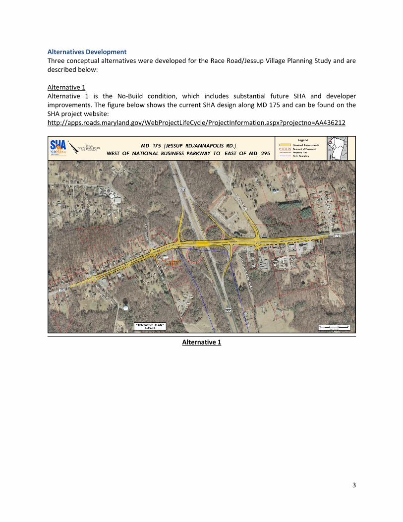
Alternative 1
Alternative 1 is the No-Build condition, which includes substantial future SHA and developer
improvements. The figure below shows the current SHA design along MD 175 and can be found on the
SHA project website:
http://apps.roads.maryland.gov/WebProjectLifeCycle/ProjectInformation.aspx?projectno=AA436212
Alternative 1

4
Alternative 2
Alternative 2, shown below, includes the relocation of Race Road and implementation of Jessup Village
paper roads. Alternative 2 also includes a dedicated access road to Jessup Elementary School, in addition
to elements of the Jessup Village Concept which relocate Race Road to the Chestnut Avenue intersection
with MD 175 and utilizes the paper roads/grid system depicted by the existing property lines.
Alternative 2

5
Alternative 3
Alternative 3, shown below, includes the relocation of Race Road only, as well as elements of the Jessup
Village Concept which relocate Race Road to the Chestnut Avenue intersection with MD 175.
Alternative 3
6
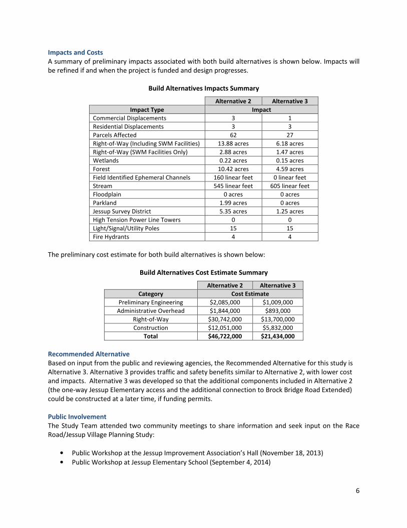
Impacts and Costs
A summary of preliminary impacts associated with both build alternatives is shown below. Impacts will
be refined if and when the project is funded and design progresses.
Build Alternatives Impacts Summary
Alternative 2 Alternative 3
Impact Type Impact
Commercial Displacements 3 1
Residential Displacements 3 3
Parcels Affected 62 27
Right-of-Way (Including SWM Facilities) 13.88 acres 6.18 acres
Right-of-Way (SWM Facilities Only) 2.88 acres 1.47 acres
Wetlands 0.22 acres 0.15 acres
Forest 10.42 acres 4.59 acres
Field Identified Ephemeral Channels 160 linear feet 0 linear feet
Stream 545 linear feet 605 linear feet
Floodplain 0 acres 0 acres
Parkland 1.99 acres 0 acres
Jessup Survey District 5.35 acres 1.25 acres
High Tension Power Line Towers 0 0
Light/Signal/Utility Poles 15 15
Fire Hydrants 4 4
The preliminary cost estimate for both build alternatives is shown below:
Build Alternatives Cost Estimate Summary
Alternative 2 Alternative 3
Category Cost Estimate
Preliminary Engineering $2,085,000 $1,009,000
Administrative Overhead $1,844,000 $893,000
Right-of-Way $30,742,000 $13,700,000
Construction $12,051,000 $5,832,000
Total $46,722,000 $21,434,000
Recommended Alternative
Based on input from the public and reviewing agencies, the Recommended Alternative for this study is
Alternative 3. Alternative 3 provides traffic and safety benefits similar to Alternative 2, with lower cost
and impacts. Alternative 3 was developed so that the additional components included in Alternative 2
(the one-way Jessup Elementary access and the additional connection to Brock Bridge Road Extended)
could be constructed at a later time, if funding permits.
Public Involvement
The Study Team attended two community meetings to share information and seek input on the Race
Road/Jessup Village Planning Study:
• Public Workshop at the Jessup Improvement Association’s Hall (November 18, 2013)
• Public Workshop at Jessup Elementary School (September 4, 2014)

7
At each of these community meetings, the project background was presented, along with the purpose,
scope, and schedule. The conceptual alternatives were shown and feedback on the alternatives was
received from those in attendance. The public comments received, along with Study Team responses,
are included in the project Summary Report which will be posted on the Anne Arundel County Office of
Planning and Zoning website (http://www.aacounty.org/PlanZone).
Public comment is important and still welcome. If or when the project moves forward into a subsequent
phase of design, public comments appropriate to the project will be considered.
Next Steps
Upon completion of this study, Anne Arundel County will decide whether to pursue the reconstruction,
realignment, and relocation of Race Road from north of Orchard Avenue to the new intersection with
Jessup Road (MD 175) west of the current intersection and the parallel section with MD 175 east of
Jessup Elementary School as one or multiple projects. Funding of this project, even with the merits
demonstrated in the Study, will involve identifying funding from several public (and likely private)
sources and phasing. The cost alone makes this project very likely to be constructed in phases based on
funding availability and opportunities. If this proposal is to advance into subsequent phases of project
development (design, right-of-way, construction), it will require a partnership among the County, the
community, and SHA.
When the proposed project is funded for construction, it may require the acquisition of additional right-
of-way. Residential and commercial relocations may also be required. For information regarding right-
of-way and relocation assistance, please see the attached Anne Arundel County Department of Public
Works document at the end of this flyer.
Questions / Contact Information
For additional information on this project, please contact:
Mrs. Martha Arzu-McIntosh, Project Manager
Anne Arundel County Office of Planning and Zoning, Transportation Division
2664 Riva Road, MS-6402
Annapolis, MD 21401
Phone: 410-222-7440
Email: [email protected]