r-lll-potash it-imocdimage.emnrd.state.nm.us/imaging/filestore/hobbs/wf/301525/...r-lll-potash it-im...
TRANSCRIPT

It-IMR-lll-POTASH
OCD Hobbs
Form 3160-3
(March 2012) ftffUNITED STATES ' /
DEPARTMENT OF THE INTERIOR / jAu. ^
BUREAU OF LAND MANAGEMENT 7 2 g p~
APPLICATION FOR PERMIT TO DRILL OR REE-N^gR*^ °
FORM APPROVED0MB No. 1004-0137
Expires October 31,2014
1f*5/ Lease Serial No.
NjvlNM108977 SL NMNM128367 BHL
f —
la. Type of work: [7] DRILL □REENTER
lb. Type of Well: [7] Oil Well | | Gas Well J |Other Single Zone | | Multiple Zone
1 1 If Unit or CA Agreement, Name and No.
/8. Lease Name and Well No. f
Della 29 Fed Com 602H \
1 Name of Operator eqG Resources, Inc ^77\ 9. API Well No.
30-025- ^
3a. Address P 0. Box 2267 Midland, TX 79702 3b. Phone No. (include area code)
432-686-3689
10. Field and Pool, or Exploratory (
Bone Spring
4. Location of Well (Report location clearly and in accordance with any State requirements.*)
At surface 250' FSL & 1300' FEL, SESE (P), Sec 29, 20S, 34E
At proposed prod, zone 230' FNL & 1210' FEL, NENE (A), Sec 29 ^ rynnrrVTVfW
11. Sec., T. R. M. or Blk.and Survey or Area
Section 29, T20S, R34E
14. Distance in miles and direction from nearest town or post office* PlUIVl W'-’'
Approximately +/- 27 miles Northwest from Eunice, New Mexico T ATlON
12. County or Parish 13. State
Lea NM
15. Distance from proposed* 9-n, 99n, pp
location to nearest
property or lease line, ft.
(Also to nearest drig. unit line, if any)
16. No. of aJres'VTlease
600
17. Spacing Unit dedicated to this well
160 ac.
18. Distance from proposed location*
to nearest well, drilling, completed, OD„, fr____' ■ applied for, on this lease, ft. 880 from 601H
19. Proposed Depth
16024' MD, 11260' TVD
20. BLM/BIA Bond No. on file
NM 2308
21. Elevations (Show whether DF, KDB, RT, GL, etc.)
3714' GL
22 Approximate date work will stall*
04/01/2016
23. Estimated duration
25 days
24. Attachments
The following, completed in accordance with the requirements of Onshore Oil and Gas Order No. 1, must be attached to this form:
1. Well plat certified by a registered surveyor.
2. A Drilling Plan.
3. A Surface Use Plan (if the location is on National Forest System Lands
SUPO must be filed with the appropriate Forest Seivice Office).
the
4. Bond to cover the operations unless covered by an existing bond on file (see
Item 20 above).
5. Operator certification
6. Such other site specific information and/or plans as may be required by the
BLM.
25. Signature / / A /Name (Printed/Typed)
Stan Wagner
Date
////7 //S'Title
Regulatory Specialist
Approved by (Signature) /s/George ^acDone!! Name (Printed/Typed) Date. .
■ fJAN 2 2 201ftT,tie PlilD manAMr' °fflCe CARLSBAD FIELD OFFICE
Application approval does not warrant or certify that the applicant holds legal or equitable title to those rights in the subject lease which would entitle the applicant to
Conditions of approval, if any, are attached. APPROVAL FOR TWO YEARS
Title 18 U.S.C. Section 1001 and Title 43 U.S.C. Section 1212, make it a crime for any person knowingly and willfully to make to any department or agency of the United
States any false, fictitious or fraudulent statements or representations as to any matter.within its jurisdiction.
(Continued on page 2)
Capitan Controlled Water BasinWitness Surface & intermediate Casing
*(Instructions on page 2)
Approval Subject to General Requirements
& Special Stipulations Attached
SEE ATTACHED FOR
CONDITIONS OF APPROVAL
.. FEB 0 2 2016
EOG RESOURCES, INC.DELLA 29 FED COM NO. 602H
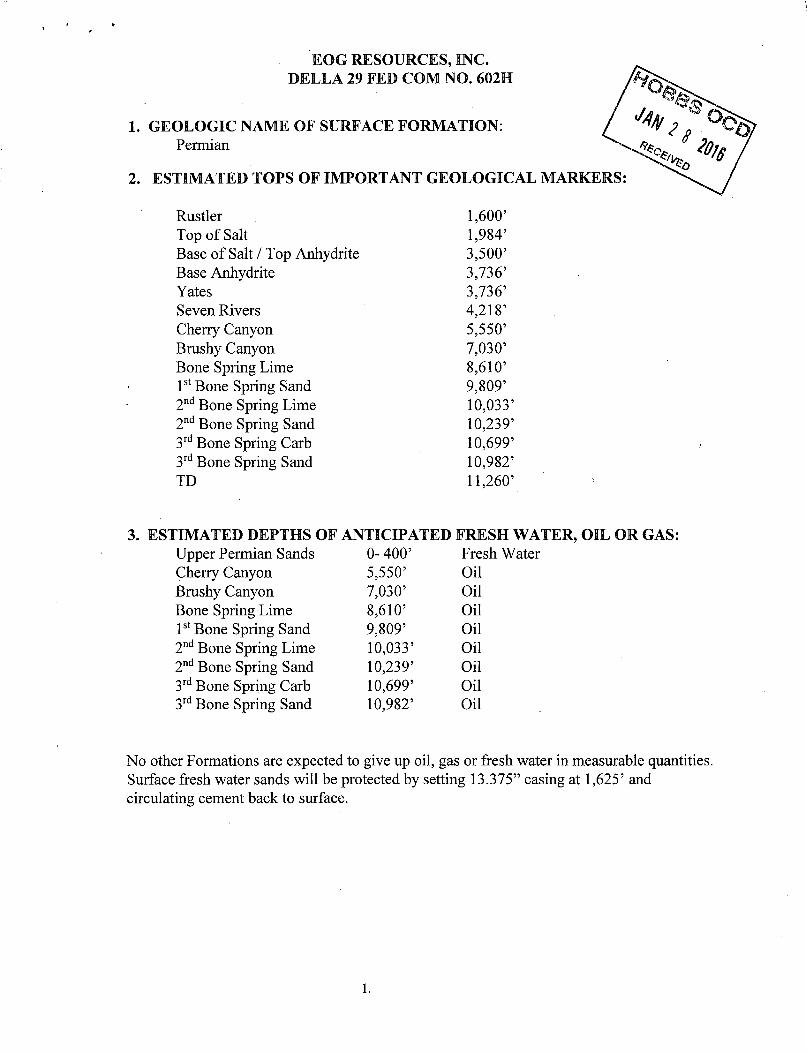
1. GEOLOGIC NAME OF SURFACE FORMATION: Permian
2. ESTIMATED TOPS OF IMPORTANT GEOLOGICAL MARKERS
Rustler 1,600’Top of Salt 1,984’Base of Salt / Top Anhydrite 3,500’Base Anhydrite 3,736’Yates 3,736’Seven Rivers 4,218’Cherry Canyon 5,550’Brushy Canyon 7,030’Bone Spring Lime 8,610’1st Bone Spring Sand 9,809’2nd Bone Spring Time 10,033’2nd Bone Spring Sand 10,239’3rd Bone Spring Carb 10,699’3rd Bone Spring Sand 10,982’TD 11,260’
flMATED DEPTHS OF ANTICIPATED FRESH WArUpper Permian Sands 0- 400’ Fresh WaterCherry Canyon 5,550’ OilBrushy Canyon 7,030’ OilBone Spring Lime 8,610’ Oil1st Bone Spring Sand 9,809’ Oil2nd Bone Spring Lime 10,033’ Oil2nd Bone Spring Sand 10,239’ Oil3 rd Bone Spring Carb 10,699’ Oil3rd Bone Spring Sand 10,982’ Oil
No other Formations are expected to give up oil, gas or fresh water in measurable quantities. Surface fresh water sands will be protected by setting 13.375” casing at 1,625’ and circulating cement back to surface.
1.

EOG RESOURCES, INC.DELLA 29 FED COM NO. 602H
4. CASING PROGRAM - NEW^ ■ ■■ ■ ■
HoleSize Interval
CsgOD Weight Grade Conn
DFminCollapse
DFminBurst
DFminTension
17.5” 0- 1,625’ 13.375” 54.5# J55 STC 1.125 1.25 1.6012.25” 0-4,000’ 9.625” 40# J55 LTC 1.125 1.25 1.6012.25” 4,000’ ->000] 9.625” 40# HCK55 LTC 1.125 1.25 1.608.75” 0’-16,024’ 1 5.5” 17# HCP-110 BTC 1.125 1.25 1.60
Cementing Program:
DepthNo.
SacksWt.
PPg
YldFt3/ft
MixWaterGal/sk
Slurry Description
13-3/8”1,625
700 13.5 1.73 9.13 Class C + 4.0% Bentonite + 0.6% CD-32 + 0.5% CaCl2 + 0.25 lb/sk Cello-Flake (TOC @ Surface)
300 14.8 1.34 6.34 Class C + 0.6% FL-62 + 0.25 lb/sk Cello-Flake + 0.2% Sodium Metasilicate
9-5/8”
$4(TD
1000 12.7 2.22 12.38 Lead: Class 'C + 1.50% R-3 + 0.25 lb/sk Cello-Flake + 2.0% Sodium Metasilicate + 10% Salt + 0.005 lb/sk Static Free (TOC @ surface)
200 14.8 1.32 6.33 Tail: Class 'C' + 0.25 lb/sk Cello Flake + 0.005 lb/sk Static Free5-1/2”16,024’
775 9.0 2.79 10.12 Lead: LiteCRETE + 0.10% D-065 + 0.20% D-046 + 0.40% D- 167 + 0.20% D-198 + 0.04% D-208 + 2.0% D-174 (TOC @ 4,500’)
2100 14.4 1.28 5.69 Tail: Class FI + 47.01 pps D-909 + 37.01 pps + 5.0% D-020 + 0.30% D-013 + 0.20% D-046 + 0.10% D-065 + 0.50% D-167 + 2.0% D-174
Note: Cement volumes based on bit size plus at least 25% excess in the open hole plus 10% excess in the cased-hole overlap section.
MINIMUM SPECIFICATIONS FOR PRESSURE CONTROL:
Variance is requested to use a co-flex line between the BOP and choke manifold (instead of using a 4” Of) steel line).
The minimum blowout preventer equipment (BOPE) shown in Exhibit #1 will consist of a single ram, mud cross and double ram-type (10,000 psi WP) preventer and an annular preventer (5000-psi WP). Both units will be hydraulically operated and the ram-type will be equipped with blind rams on bottom and drill pipe rams on top. All BOPE will be tested in accordance with Onshore Oil & Gas order No. 2.
2.
EOG RESOURCES, INC.DELLA 29 FED COM NO. 602H
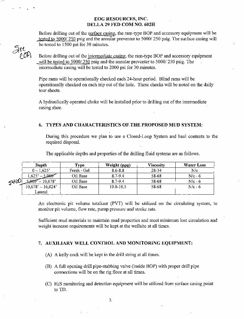
Before drilling out of the surface casing, the ram-type BOP and accessory equipment will be tested to 5000/ 250 psig and the annular preventer to 5000/ 250 psig. The surface casing will be tested to 1500 psi for 30 minutes.
Before drilling out of the intermediate casing, the ram-type BOP and accessory equipment will be tested to 5000/ 250 psig and the annular preventer to 5000/ 250 psig. The intermediate casing will be tested to 2000 psi for 30 minutes.
Pipe rams will be operationally checked each 24-hour period. Blind rams will be operationally checked on each trip out of the hole. These checks will be noted on the daily tour sheets.
A hydraulically operated choke will be installed prior to drilling out of the intermediate
casing shoe.
6. TYPES AND CHARACTERISTICS OF THE PROPOSED MUD SYSTEM:
During this procedure we plan to use a Closed-Loop System and haul contents to the required disposal.
The applicable depths and properties of the drilling fluid systems are as follows.
Depth Type Weight (ppg) Viscosity Water Loss0- 1,625’ Fresh - Gel 8.6-8.8 28-34 N/c
i,625’ Oil Base 8.7-9.4 58-68 N/c-6^0htr^K),678’ Oil Base 8.7-9.4 58-68 N/c-610,678’-16,024’
LateralOil Base 10.0-10.5 58-68 N/c-6
An electronic pit volume totalizer (PVT) will be utilized on the circulating system, to
monitor pit volume, flow rate, pump pressure and stroke rate.
Sufficient mud materials to maintain mud properties and meet minimum lost circulation and weight increase requirements will be kept at the wellsite at all times.
7. AUXILIARY WELL CONTROL AND MONITORING EQUIPMENT:
(A) A kelly cock will be kept in the drill string at all times.
(B) A full opening drill pipe-stabbing valve (inside BOP) with proper drill pipe connections will be on the rig floor at all times.
(C) H2S monitoring and detection equipment will be utilized from surface casing point
to TD.
3.

EOG RESOURCES, INC.DELLA 29 FED COM NO. 602H
8. LOGGING. TESTING AND CORING PROGRAM:
Open-hole logs are not planned for this well.
GR-CCL Will be run in cased hole during completions phase of operations.u>
9. ABNORMAL CONDITIONS. PRESSURES. TEMPERATURES AND POTENTIAL HAZARDS:
The estimated bottom-hole temperature (BHT) at TD is 170 degrees F with an estimated maximum bottom-hole pressure (BHP) at TD of 4875 psig. ^6 hydrogen sulfide or other hazardous gases or fluids have been encountered, repdrtld or are known to exist at
this depth in this area. No major loss circulation zones have been reported in offsetting wells.
10. ANTICIPATED STARTING DATE AND DURATION OF OPERATIONS:
The drilling operation should be finished in approximately one month. If the well is productive, an additional 60-90 days will be required for completion and testing before a decision is made to install permanent facilities.
(A) EOG Resources requests the option to contract a Surface Rig to drill, set surface casing, and cement on the subject well. If the timing between rigs is such that EOG Resources would not be able to preset the surface, the Primary Rig will MIRU and drill the well in its entirety per the APD.
4.
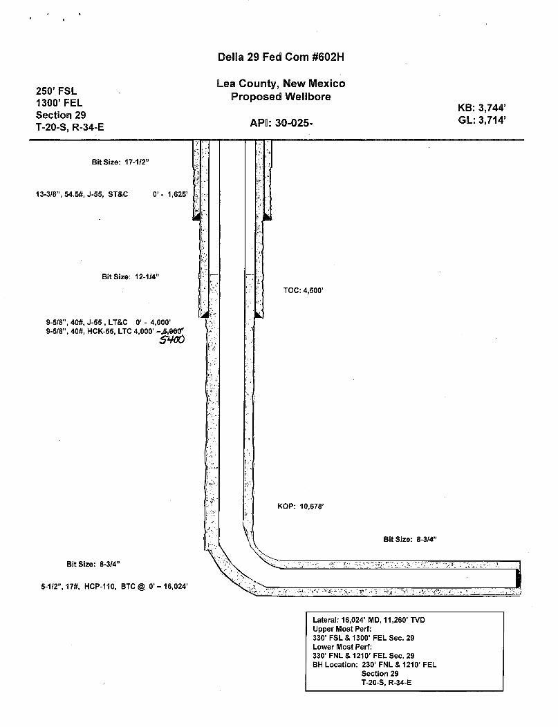
Della 29 Fed Com #602H
250’ FSL 1300’ FEL Section 29 T-20-S, R-34-E
Lea County, New Mexico Proposed Wellbore
API: 30-025-
KB: 3,744 GL: 3,714
Lateral: 16,024’ MD, 11,260’ TVD Upper Most Perf:330’ FSL & 1300’ FEL Sec. 29 Lower Most Perf:330’ FNL & 1210’ FEL Sec. 29 BH Location: 230’ FNL & 1210’ FEL
Section 29 T-20-S, R-34-E

/
A
eog resources
Lea County, NM (NAD 27 NME)
Della 29 Fed #602H
Plan #0.3
iiiliiii! I
iiaili!liifi:
St iiiiiiii! ii
i!!!=nN
aiunnSli
Azimuths to Grid North True North: -0.41*
Magnetic North: 6.67*
Magnetic Field Strength: 48214.7snT
Dip Angle: 60.36* Date: 7/23(2016
Model: IGRF2015
PROJECT DETAILS: Lea County, NM (NAD 27 NME)
Geodetic System: US State Plane 1927 (Exact solution) Datum: NAD 1927 (NADCON CONUS)
Ellipsoid: Clarke 1866Zone: New Mexico East 3001
System Datum: Mean Sea Level
To convert a Magnetic Direction to a Grid Direction. Add 6.67'To convert a Magnetic Direction to a Tme Direction. Add 7.09* East
To convert a True Direction to a Grid Direction. Subtract 0.41*
WELL DETAILS: 06O2H
Northing
Ground Level: 3714.0KB s 25 Q 3739.0usft
Easting Latittude Longitude732913.00 32* 32' 14.723 N 103* 34'39.202 W560053.00
SECTION DETAILS
MD Inc Azi TVD +N/-S +E/-W Dleg TFace0.0 0.00 0.00 0.0 0.0 0.0 0.00 0.002.0 0.00 0.00 2.0 0.0 0.0 0.00 0.00
119.6 1.18 156.S7 119.6 -1.1 0.6 1.00 156.5710679.6 1.18 156.57 10676.2 -200.0 86.7 0.00 0.0011589.3 90.00 359.52 11260.0 372.9 96.5 10.00 -157.0516024.6 90.00 359.52 11260.0 4908.0 49.0 0.00 0.00
-199.1373.7
4908.2 PBHL(Delia 29 Fed #702H)
WELLBORE TARGET DETAILS (MAP CO-ORDINATES)
PBHL( Della 29 Fed #702H) FTPfDeila 29 Fed HT702H)
TVD +N/-S +Ef-W11260.0 4803.0 49.011260.0 80.0 69.0
Northing664961.00660133.00
Easting732962.00733002.00
ithiliti li[|iji-liirillH-[mi;itiilmilHill:SiiiSllliiilir!jii;
1200 1400 1600Wertf-yEast)*) (200 utlVln)
turtn riiirsj: til :i'irtiim mrnm
CU&r29-ntf«7B2K1l;TH!
ifliiT
!/TiL
ilifir
tJilTi
iiiiiiii
iliiiii.
'■'Tin
i!!fl!iPC
1I tiTrtui
■••'.lii'sii&rt
liiiiiiii
ease LineS mu
;i-‘T
ir;:
pIt f!:: "m
?.y4i!:l!* ilRIiii
16924.6llii-tii
iiiiiii
ill'liil!TT
Hi!!:!
'iit:Hiii.
fijijj: [iii!
i;;;|
h; !;M ‘Ifiii.H tf?!: 1 Ii!-;!!!
; i'jrii'l]
TiiiiFiHiiiii Hi33 )' Ha rdfin S'
Iii!:!
\m
imi
j:j!|h
illi
Illi
mul-tTl!
rliiilii
iliiiii!
[•ill
iiiii
iiiliiiii
1 Ifij::j;Tlilr!
iffllin Ti:
Iiiii:
liilli iiiii1 IIR
iii;
liiiiii!
Iiiiilil
ijiljiTj
ITiili
)3,iiP r iiliif'l
M. liiiiii-
ifriilH
TIT
[ill
Ha;:[!{:[
ij[fffl Tin
mm iiSiiii
iiiiiiii
'.‘‘■j, iiiiil
UtiitT| ! ’ 11
iiliil
iIts [f Tiff
iliiliil
IIP:•'iiifV!
IliilT!
Iiiii;
Pit •i1!:T : iiittii!
:iii
1:11 iiiiiiliT
Iiii;
rjrrfri;i[[
!;ii!
;T iTili!
UTil!
jiiiijti
ifiiilit
iiiiil ) HJ1;!;’; nii
i, 1! i 1:::i!ii
iiiii!
iiii;? fj!:!•! 1 ill?
• |r. iliiiii! 'liiiiii
(iiiTi •j
li •IT
liiiiii
'iliii^.
li!,;
!!!!;!m '}j
Iiiii jfeiiiiiiii'
illilljii
&Iiiii:
'Iiiii llIili
fllljjff
mHT
H!::[[ill?
si 1 llliiiii!!'Huiill iiiiilil
Hi u\»•;' Hi
lei
iii[ iiiiiiiili
If li ■jf;j
;[[[[ (|f[ ill&-
. llTTfiiiiiiii
IT
lit! iiiiiiii'iiii;
mjiji:!
Hiili:I iilr
liiiiiiii
i <ili.iili
•li illi Hill lllii
ill:!!;ijp
| il|i| IV- Ml!jt;
jlliiiii!
» Ki:(C
Hi
til'll
iiiiiiii
ilijififtjji iiiiil
life.[p!|
IMCIfe'jt
j! Tliii
it. <4i ii:ii!i[i
Iliiliil!
jiiii! S ff'jijOG
•iiiii
,
:ilS
;r
iiii
■|;
Pjl
11 IEk.
Biliiiii!!
iHiilBiliSHiiiiiii
---li;ill!:!
latfi
1° ,IlIlP
11T
pliL®.
ii :■ £ ]{Z
mill!
liiiiiiii
[h:||;|!iiiiiiii!
iiiliiiiiIHiiiiiili
11ii:
•a\n ■
rllTlHi
TlliTillil!‘ii:
Pi!fiiilfi
iriii
in!! 1
iliiiii! :lil!!!HiSHIilT]
1:!! liiiiii'. urn
Sillill
flii ii'1IHiiiiiii
!f(|iiiii!!,i
liiiiiiiiilpiiil!■iiiiiiii
" FlLT'l:!lipii
iii : iiteiliiiii
' it
iiiii
Iiiii[!l{
iiHjiilt liiiiiiiimi iiiliiiii
Bliiilill
'Ir-iililtilllPl
li.T
liiiiii
ml Iiiii;:[j?fi
Iili
iii’ iil-iiii'
Iiiiiiii;
liiiiii\m\liTilii!
!‘i itiliM
iliiiii iili:
liiiiiiifflill
iiiii | 1iii: sea
■lilillll
eiibaVi »
liiiiiiii
iiHilii:
iiliill
urni*;ip iili:
Pii
Iiiiil!
[ii
ill
ihii
III i|
Ii.iIili
iliiiii;
TTiji
Iliiiii! !!iilill
-
1
liiiiiiii(ii 'll TiiiiH
iiii;
iliiiii
liiiiii1 Pi
iiiii
Hi
iii
iii:
r;1T:'ju
rtaisjt
iiiiiiii
Sdidt
It
jj«»iliiiii
i;Hi: .lii'lii
Iiiii
ml!il
ill
iiiiiTfi
liil
Br '■J ll 29 Fei
iiiiinailTi'im
ilfiilill
Iflljill"; iili
in!•ij:
niiilr
liiiiii:i*i
$ MiT; 30' \ ard!(nan ilTlii
MM i(liiii l/ilti:
EM'!;l!
li’liit’ iiiii:!; liliui'i
pill
iiiiilil I iiiii till: lilifliiiiiiiiiiiliiiii iii
iili
Tf tilH ill:
r) ) ! 1
ifiliiT
illi•M iiitiii' ps sejt till li-liii; iii iiii
liiiiiiii
iliiiii!''
liiiiiiii
iiiiiiiiiMMiiiivi:
iiiiil!!:S6HT
i-TililSU^haE
liiiiii-tTfrsi
ii-iilili Iiiiiiii iiiiil:"iiP
Iili
Iiiiiiii!v.v.'.usi!!!t!ifi
-Hiiv-'ltIXS-10
iiiii!iiBTTO-t!!;i!i!l
iiiiii'lLOStr.r’.ilrifTTr
*ilil!ll
ME.iiliTi
Tjiiiilinin'fliil: I'T
iiiii!!!, 'Iii:!!!! iiiiiiii iiiiiiii IHiiTii iiiiiiii Iiiiiiii!. *
Tti::!J ini
-7# 4B 4W 4 9 -M -W»«t|to •
4tEas0
"t*l »u«W1n)• >0 0 0 0 4
_ ..1 4s™
"f 1ffiin Vi
% s
s
S **•
e -a4 . 0 • >Wst( *(•)
0 I29 uc
0 6 » 70
1000.....1000..... 200#..... 2200.....2400......2604......2800 ' 3000"'"i!to4T,,"flo4'‘" So’6'" 3*#Jr '4000..... 4200"Vertical Section et 0.58* (200 usftttn)
eog resources
EOG Resources - Midland| Lea County, NM (NAD 27 NME)
\ Delia 29 Fed
\ #602H
(. OH
| Plan: Plan #0.3
Standard Planning Report03 November, 2015
I

EOG Resources, Inc,Planning Report
4
eog resources
Database: fEDM 5000.1 Single User Db j Local Co-ordinate Reference: ! Well #602H \\
Company: j EOG Resources - Midland j TVD Reference: i KB = 25 @ 3739.0usft \\
Project: j Lea County, NM (NAD 27 NME) j MD Reference: ! KB = 25 @ 3739.0usft
Site: | Della 29 Fed | North Reference: | Grid
Well:|#602H j Survey Calculation Method: j Minimum Curvature
Wellbore: jOH I
Design:j Plan #0.3 I
■■
Project I Lea County, NM (NAD 27 NME)
Map System: US State Plane 1927 (Exact solution) System Datum: Mean Sea Level
Geo Datum: NAD 1927 (NADCON CONUS)
Map Zone: New Mexico East 3001
Site ' Della 29 Fed _ ,
_______ , ____ ..._ ___ -............................. ............... --- •____ .... _
Site Position: Northing: 560,053.00 usft Latitude: 32° 32' 14.721 N
From: Map Easting: 732,943.00 usft Longitude: 103° 34' 38.852 W
Position Uncertainty 0.0 usft Slot Radius: 13-3/16" Grid Convergence: 0.41 0
Well #602H__________ __________
________ .______jWeil Position +N/-S 0.0 usft Northing: 560,053.00 usft Latitude: 32° 32' 14.723 N
+E/-W -30.0 usft Easting: 732,913.00 usft Longitude: 103° 34' 39.202 W
Position Uncertainty 0.0 usft Wellhead Elevation: 0.0 usft Ground Level: 3,714.0 usft
Wellbore ! OH
Magnetics Model Name Sample Date Declination
oDip Angle
. nField Strength
(nT)
IGRF2015 7/23/2016 7.08 60.36 48,215
Design JflSlJft?______ ____ 3_________________________ - -_________________________ ___
Audit Notes:
Version: Phase: PLAN Tie On Depth: 0.0
Vertical Section: Depth From (TVD) +N/-S +E/-W Direction
(usft) (usft) (usft) (°)
............... OO 0.0 0.0~ 0.58
Plan Sections ■ r_._; ' .. . _
_______ ______ _ . . . .__ .... __ _ ______ ___ ____ _ ___,___ ___________________ _ ...
Measured Vertical Dogleg Build Turn
Depth Inclination Azimuth Depth +N/-S +E/-W Rate Rate Rate TFO(usft) n n (usft) (usft) (usft) (7100usft) (°/100usft) (7100usft) O Target
0.0 0.00 0.00 0.0 0.0 0.0 0.00 0.00 0.00 0.00
2.0 0.00 0.00 2.0 0.0 0.0 0.00 0.00 0.00 0.00
119.6 1.18 156.57 119.6 -1.1 0.5 1.00 1.00 0.00 156.57
10,678.5 1.18 156.57 10,676.2 -200.0 86.7 0.00 0.00 0.00 0.00
11,589.3 90.00 359.52 11,260.0 372.9 86.5 10.00 9.75 -17.24 -157.05
16,024.6 90.00 359.52 11,260.0 4,808.0 49.0 0.00 0.00 0.00 0.00 PBHL(Della 29 Fed #'.
I
11/3/2015 1:42:02PM Page 2 COMPASS 5000.1 Build 72
A
eog resources
EOG Resources, Inc.Planning Report
IiDatabase: i EDM 5000.1 Single User Db — Local Co-ordinate Reference: j Well #602H — — ------ —
Company: < EOG Resources - Midland I TVD Reference: j KB = 25 @ 3739.0usft j!
'Project: j Lea County, NM (NAD 27 NME] j MD Reference: j KB = 25 @ 3739.0usftj
.Site: ! Della 29 Fed | North Reference: Grid ijWell: i#602H ; Survey Calculation Method: | Minimum Curvature i.
{Wellbore: ! OH I' '
Design: ', Plan #0.3 I |
Planned Survey.................. -------- - — - —~_------....... ——;-------—------------ -- ----------------------------- —.......... - ---
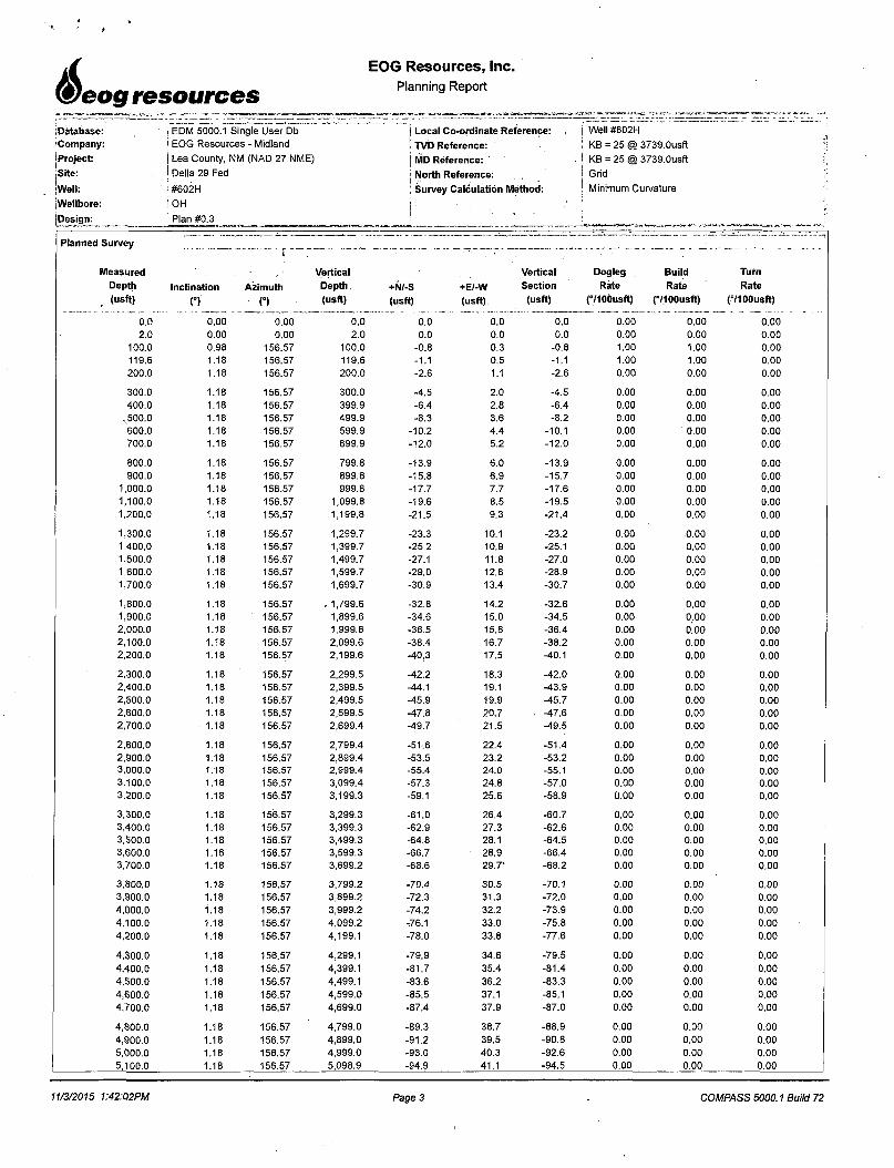
Measured Vertical Vertical Dogleg Build Turn
Depth Inclination Azimuth Depth +N/-S +E/-W Section Rate Rate Rate
(usft) n n (usft) (usft) (usft) (usft) (°/100usft) (°/100usft) (8/1 OOusft)
0.0 0.00 0.00 0.0 0.0 0.0 0.0 0.00 0.00 0.002.0 0.00 0.00 2.0 0.0 0.0 0.0 0.00 0.00 0.00
100.0 0.98 156.57 100.0 -0.8 0.3 -0.8 1.00 1.00 0.00119.6 1.18 156.57 119.6 -1.1 0.5 -1.1 1.00 1.00 0.00200.0 1.18 156.57 200.0 -2.6 1.1 -2.6 0.00 0.00 0.00
300.0 1.18 156.57 300.0 -4.5 2.0 -4.5 0.00 0.00 0.00400.0 1.18 156.57 399.9 -6.4 2.8 -6.4 0.00 0.00 0.00
x500.0 1.18 156.57 499.9 -8.3 3.6 -8.2 0.00 0.00 0.00600.0 1.18 156.57 599.9 -10.2 4.4 -10.1 0.00 0.00 0.00700.0 1.18 156.57 699.9 -12.0 5.2 -12.0 0.00 0.00 0.00
800.0 1.18 156.57 799.8 -13.9 6.0 -13.9 0.00 0.00 0.00900.0 1.18 156.57 899.8 -15.8 6.9 -15.7 0.00 0.00 0.00
1,000.0 1.18 156.57 999.8 -17.7 7.7 -17.6 0.00 0.00 0.001,100.0 1.18 156.57 1,099.8 -19.6 8.5 -19.5 0.00 0.00 0.001,200.0 1.18 156.57 1,199.8 -21.5 9.3 -21.4 0.00 0.00 0.00
1,300.0 1.18 156.57 1,299.7 -23.3 10.1 -23.2 0.00 .0.00 0.001,400.0 1.18 156.57 1,399.7 -25.2 10.9 -25.1 0.00 0.00 0.001,500.0 1.18 156.57 1,499.7 -27.1 11.8 -27.0 0.00 0.00 0.001,600.0 1.18 156.57 1,599.7 -29.0 12.6 -28.9 0.00 0.00 0.001,700.0 1.18 156.57 1,699.7 -30.9 13.4 -30.7 0.00 0.00 0.00
1,800.0 1.18 156.57 . 1,799.6 -32.8 14.2 -32.6 0.00 0.00 0.001,900.0 1.18 156.57 1,899.6 -34.6 15.0 -34.5 0.00 0.00 0.002,000.0 1.18 156.57 1,999.6 -36.5 15.8 -36.4 0.00 0.00 0.002,100.0 1.18 156.57 2,099.6 -38.4 16.7 -38.2 0.00 0.00 0.002,200.0 1.18 156.57 2,199.6 -40.3 17.5 -40.1 0.00 0.00 0.00
2,300.0 1.18 156.57 2,299.5 -42.2 18.3 -42.0 0.00 0.00 0.002,400.0 1.18 156.57 2,399.5 -44.1 19.1 -43.9 0.00 0.00 0.002,500.0 1.18 156.57 2,499.5 -45.9 19.9 -45.7 0.00 0.00 0.002,600.0 1.18 156.57 2,599.5 -47.8 20.7 ■ -47.6 0.00 0.00 0.002,700.0 1.18 156.57 2,699.4 -49.7 21.5 -49.5 0.00 0.00 0.00
2,800.0 1.18 156.57 2,799.4 -51.6 22.4 -51.4 0.00 0.00 0.002,900.0 1.18 156.57 2,899.4 -53.5 23.2 -53.2 0.00 0.00 0.003,000.0 1.18 156.57 2,999.4 -55.4 24.0 -55.1 0.00 0.00 0.003,100.0 1.18 156.57 3,099.4 -57.3 24.8 -57:0 0.00 0.00 0.003,200.0 1.18 156.57 3,199.3 -59.1 25.6 -58.9 0.00 0.00 0.00
3,300.0 1.18 156.57 3,299.3 -61.0 26.4 -60.7 0.00 0.00 0.003,400.0 1.18 156.57 3,399.3 -62.9 27.3 -62.6 0.00 0.00 0.003,500.0 1.18 156.57 3,499.3 -64.8 28.1 -64.5 0.00 0.00 0.003,600.0 1.18 156.57 3,599.3 -66.7 28.9 -66.4 0.00 0.00 0.003,700.0 1.18 156.57 3,699.2 -68.6 29.7‘ -68.2 0.00 0.00 0.00
3,800.0 1.18 156.57 3,799.2 -70.4 30.5 -70.1 0.00 0.00 0.003,900.0 1.18 156.57 3,899.2 -72.3 31.3 -72.0 0.00 0.00 0.004,000.0 1.18 156.57 3,999.2 -74.2 32.2 -73.9 0.00 0.00 0.004,100.0 1.18 156.57 4,099.2 -.76.1 33.0 -75.8 0.00 0.00 0.004,200.0 1.18 156.57 4,199.1 -78.0 33.8 -77.6 0.00 0.00 0.00
4,300.0 1.18 156.57 4,299.1 -79.9 34.6 -79.5 0.00 0.00 0.00
4,400.0 1.18 156.57 4,399.1 -81.7 35.4 -81.4 0.00 0.00 0.00
4,500.0 1.18 156.57 4,499.1 -83.6 36.2 -83.3 0.00 0.00 0.00
4,600.0 1.18 156.57 4,599.0 -85.5 37.1 -85.1 0.00 0.00 0.004,700.0 1.18 156.57 4,699.0 -87.4 37.9 -87.0 0.00 0.00 0.00
4,800.0 1.18 156.57 4,799.0 -89.3 38.7 -88.9 0.00 0.00 0.00
4,900.0 1.18 156.57 4,899.0 -91.2 39.5 -90.8 0.00 0.00 0.00
5,000.0 1.18 156.57 4,999.0 -93.0 40.3 -92.6 0.00 0.00 0.005,100.0 1.18 156.57 5,098.9 -94.9 41.1 -94.5 0.00 0.00 0.00
11/3/2015 1:42:02PM Page 3 COMPASS 5000.1 Build 72
4
6
eog resources
EOG Resources, Inc.Planning Report
iDatabase: EDM 5000.1 Single User Db Local Co-ordinate Reference: - . : Well #602H
Company: EOG Resources - Midland TVD Reference: . KB = 25 @ 3739.0usft^Project: Lea County, NM (NAD 27 NME) MD Reference:
I KB = 25 @ 3739.0usft
.Site: Della 29 Fed North Reference: - j Grid
'Well: #602H Survey Calculation Method: | Minimum Curvature
jWellbore: OH J ' j{Design: Plan #0.3 ■;,L....-.......
Planned Survey
Measured Vertical Vertical. Dogleg Build Turn
Depth Inclination Azimuth Depth +N/-S +E/-W Section Rate Rate Rate
(usft) (°> O ;■ (usft) (usft) (usft) (usft) (°/100usft) (TlOOusft) (°/100usft)
5,200.0 1.18 156.57 5,198.9 -96.8 42.0 -96.4 0.00 0.00 0.00
5,300.0 1.18 156.57 5,298.9 -98.7 42.8 -98.3 0.00 0.00 0.00
5,400.0 1.18 156.57 5,398.9 -100.6 43.6 -100.1 0.00 0.00 0.005,500.0 1.18 156.57 5,498.9 -102.5 44.4 -102.0 0.00 0.00 0.005,600.0 1.18 156.57 5,598.8 -104.3 45.2 -103.9 0.00 0.00 0.005,700.0 1.18 156.57 5,698.8 -106.2 46.0 -105.8 0.00 0.00 0.00
5,800.0 1.18 156.57 5,798.8 -108.1 46.9 -107.6 0.00 0.00 0.005,900.0 . '' 1.18 156.57 5,898.8 -110.0 47.7 -109.5 0.00 0.00 0.006,000.0 1.18 156.57 5,998.8 -111.9 48.5 -111.4 0.00 0.00 0.006,100.0 1.18 156.57 6,098.7 -113.8 49.3 -113.3 0.00 0.00 0.006,200.0 1.18 156.57 6,198.7 -115.7 50.1 -115.1 0.00 0.00 0.00
6,300.0 1.18 156.57 6,298.7 -117.5 50.9 -117.0 0.00 0.00 0.006,400.0 1.18 156.57 6,398.7 -119.4 51.8 -118.9 0.00 0.00 0.006,500.0 1.18 156.57 6,498.6 -121.3 52.6 -120.8 0.00 0.00 0.006,600.0 1.18 156.57 6,598.6 -123.2 53.4 -122.6 0.00 0.00 0.006,700.0 1.18 156.57 6,698.6 -125.1 54.2 -124.5 0.00 0.00 0.00
6,800.0 1.18 156.57 6,798.6 -127.0 55.0 -126.4 0.00 0.00 0.006,900.0 1.18 156.57 6,898.6 -128.8 55.8 -128.3 0.00 0.00 0.007,000.0 1.18 156.57 6,998.5 -130.7 56.7 -130.1 0.00 0.00 0.007,100.0 1.18 156.57 7,098.5 -132.6 57.5 -132.0 0.00 0.00 0.007,200.0 1.18 156.57 7,198.5 -134.5 58.3 -133.9 , 0.00 0.00 0.00
7,300.0 1.18 156.57 7,298.5 -136.4 59.1 -135.8 0.00 0.00 0.007,400.0 1.18 156.57 7,398.5 -138.3 59.9 -137.6 0.00 b.oo 0.007,500.0 1.18 156.57 7,498.4 -140.1 60.7 -139.5 0.00 0.00 0.007,600.0 1.18 156.57 7,598.4 -142.0 61.6 -141.4 0.00 0.00 0.007,700.0 1.18 156.57 7,698.4 -143.9 62.4 -143.3 0.00 0.00 0.00
7,800.0 1.18 156.57 7,798.4 -145.8 63.2 -145.1 0.00 0.00 0.007,900.0 1.18 156.57 7,898.4 -147.7 64.0 -147.0 0.00 0.00 0.00
8,000.0 1.18 156.57 7,998.3 -149.6 64.8 -148.9 0.00 0.00 0.00
8,100.0 1.18 156.57 8,098.3 -151.4 65.6 -150.8 0.00 0.00 0.00
8,200.0 1.18 156.57 8,198.3 -153.3 66.5 -152.6 0.00 0.00 0.00
8,300.0 1.18 156.57 8,298.3 -155.2 67.3 -154.5 0.00 0.00 0.008,400.0 1.18 156.57 8,398.2 -157.1 68.1 -156.4 0.00 0.00 0.008,500.0 1.18 156.57 8,498.2 -159.0 68.9 -158.3 0.00 0.00 0.008,600.0 1.18 156.57 8,598.2 -160.9 69.7 -160.1 0.00 0.00 0.008,700.0 ’ 1.18 156.57 8,698.2 -162.7 70.5 -162.0 0.00 0.00 0.00
8,800.0 1.18 156.57 8,798.2 -164.6 71.4 -163.9 0.00 0.00 0.00
8,900.0 1.18 156.57 8,898.1 -166.5 72.2 -165.8 0.00 0.00 0.00
9,000.0 1.18 156.57 8,998.1 -168.4 73.0 -167.6 0.00 0.00 0.00
9,100.0 1.18 156.57 9,098.1 -170.3 73.8 -169.5 0.00 0.00 0.00
9,200.0 1.18 156.57 9,198.1. -172.2 74.6 -171.4 0.00 0.00 0.00
9,300.0 1.18 156.57 9,298.1 -174.0 75.4 . -173.3 0.00 0.00 0.00
9,400.0 1.18 156.57 9,398.0 ‘ -175.9 76.3 -175.1 0.00 0.00 0.00
9,500.0 1.18 156.57 9,498.0 -177.8 77.1 -177.0 0.00 0.00 0.00
9,600.0 1.18 156.57 9,598.0 -179.7 77.9 -178.9 0.00 0.00 0.00
9,700.0 1.18 156.57 9,698.0 -181.6 78.7 -180.8 0.00 0.00 0.00
9,800.0 1.18 156.57 9,798.0 -183.5 79.5 -182.6 0.00 0.00 0.00
9,900.0 1.18 156.57 9,897.9 -185.4 80.3 -184.5 0.00 0.00 0.00
10,000.0 1.18 156.57 9,997.9 -187.2 81.2 -186.4 0.00 0.00 0.00
10,100.0 1.18 156.57 10,097.9 -189.1 82.0 -188.3 0.00 0.00 0.00
10,200.0 1.18 156.57 10,197.9 -191.0 82.8 -190.1 0.00 0.00 0.00
10,300.0 1.18 156.57 10,297.8 -192.9 83.6 -192.0 0.00 0.00 0.00
10,400.0 1.18 156.57 10,397.8 -194.8 84.4 -193.9 0.00 0.00 0.00
10,500.0 1.18 156.57 10,497.8 -196.7 85.2 -195.8 0.00 0.00 0.00
11/3/2015 1:42:02PM Page 4 COMPASS 5000.1 Build 72
6.eog resources
EOG Resources, Inc.Planning Report
Database: | EDM 5000.1 Single User Dbj Local Co-ordinate Reference: Well #602H
—
f;Company: j EOG Resources - Midland i'TVD Reference: KB = 25 @ 3739.0usft ?i|Project: I Lea County, NM (NAD 27 NME) j MD Reference: KB = 25 @ 3739.0usftSite: ! Della 29 Fed J North Reference:
Grid MWell:
! #602H I Survey Calculation Method: Minimum Curvature i-Wellbore: , i OH l '
}Design: i Plan #0.3 .}•'■■ ■
________!■
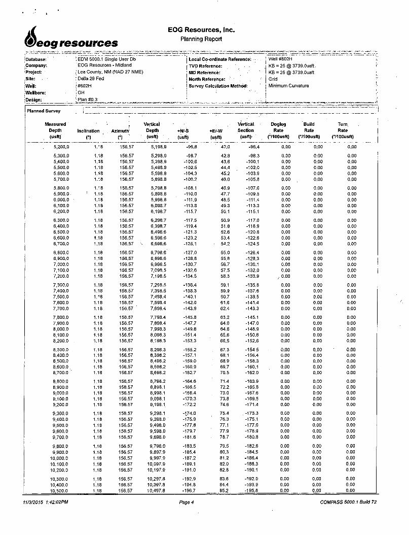
Planned Survey I
Measured Vertical Vertical Dogleg Build Turn
Depth Inclination Azimuth Depth -+N/-S +E/-W Section Rate Rate Rate
(usft) n n ; (usft) (usft) (usft) (usft) (YlOOusft) (°/100usft). (°/100usft)
10,600.0 1.18 156.57 10,597.8 -198.5 86.1 -197.7 0.00 0.00 0.00
10,678.5 1.18 156.57 10,676.2 -200.0 86.7 -199.1 0.00 0.00 0.00
10,700.0 1.16 22.71 10,697.8 -200.0 86.9 -199.1 10.00 -0.06 -621.49
10,750.0 6.09 3.82 10,747.6 -196.9 87.2 -196.0 10.00 9.85 -37.78
10,800.0 11.08 1.86 10,797.1 -189.4 87.6 -188.5 10.00 9.98 -3.92
10,850.0 16.08 1.11 10,845.7 -177.7 87.9 -176.8 10.00 9.99 -1.50
10,900.0 21.08 0.71 10,893.0 -161.8 88.1 -160.9 10.00 10.00 -0.80
10,950.0 26.07 0.45 10,938.9 -141.8 88.3 -140.9 10.00 10.00 -0.51
11,000.0 31.07 0.28 10,982.7 -117.9 88.5 -117.0 10.00 10.00 -0.35
11,050.0 36.07 0.15 11,024.4 -90.3 88.6 -89.4 10.00 10.00 -0.26
11,100.0 41.07 0.04 11,063.5 -59.1 88.6 -58.2 10.00 10.00 -0.21
11,150.0 46.07 359.96 11,099.7 -24.6 88.6 -23.7 10.00 10.00 -0.17
11,200.0 51.07 359.89 11,132.8 12.8 88.5 13.7 10.00 10.00 -0.14
11,250.0 56.07 359.82 11,162.4 53.1 88.4 54.0 10.00 10.00 -0.12
11,300.0 61.07 359.77 11,188.5 95.7 88.3 96.6 10.00 10.00 -0.11
11,317.8 62.85 359.75 11,196.9 111.4 88.2 112.3 10.00 10.00 -0.10
FTP(Della 29 Fed #702H)
11,350.0 66.07 359.72 11,210.8 140.5 88.1 141.4 10.00 10.00 -0.10
11,400.0 71.07 359.67 11,229.0 187.0 87.8 187.9 10.00 10.00 -0.09
11,450.0 76.07 359.63 11,243.2 234.9 87.6 235.8 10.00 10.00 -0.09
11,500.0 81.07 359.59 11,253.1 283.9 87.2 284.8 10.00 10.00 -0.08
11,550.0 86.07 359.55 11,258.7 333.6 86.8 334.5 10.00 10.00 -0.08
11,589.3 90.00 359.52 11,260.0 372.9 86.5 373.7 10.00 10.00 -0.08
11,600.0 90.00 359.52 11,260.0 383.6 86.4 384.4 0.00 0.00 0.00
11,700.0 90.00 359.52 11,260.0 483.6 85.6 484.4 0.00 0.00 0.00
11,800.0 90.00 359.52 11,260.0 583.6 84.7 584.4 0.00 0.00 0.00
11,900.0 90.00 359.52 11,260.0 683.6 83.9 684.4 0.00 0.00 0.00
12,000.0 90.00 359.52 11,260.0 783.5 83.0 784.4 0.00 0.00 0.00
12,100.0 90.00 359.52 11,260.0 883.5 82.2 884.3 0.00 0.00 0.00
12,200.0 90.00 359.52 11,260.0 983.5 81.4 984.3 0.00 0.00 0.00
12,300.0 90.00 359.52 11,260.0 1,083.5 80.5 1,084.3 0.00 0.00 0.00
12,400.0 90.00 359.52 11,260.0 1,183.5 79.7 1,184.3 0.00 0.00 0.00
12,500.0 90.00 359.52 11,260.0 1,283.5 78.8 1,284.3 0.00 0.00 0.00
12,600.0 90.00 359.52 11,260.0 1,383.5 78.0 1,384.2 0.00 0.00 0.00
12,700.0 90.00 359.52 11,260.0 1,483.5 77.1 1,484.2 0.00 0.00 0.00
12,800.0 90.00 359.52 11,260.0 1,583.5 76.3 1,584.2 0.00 0.00 0.00
12,900.0 90.00 359.52 11,260.0 1,683.5 75.4 1,684.2 0.00 0.00 0.00
13,000.0 90.00 359.52 11,260.0 1,783.5 74.6 1,784.2 0.00 0.00 0.00
13,100.0 90.00 359.52 11,260.0 ■ 1,883.5 73.7 1,884.2 0.00 0.00 0.00
13,200.0 90.00 359.52 11,260.0 1,983.5 72.9 1,984.1 0.00 0.00 0.00
13,300.0 90.00 359.52 11,260.0 2,083.5 72.0 2,084.1 0.00 0.00 0.00
13,400.0 90.00 359.52 11,260.0 2,183.5 71.2 2,184.1 0.00 0.00 0.00
13,500.0 90.00 359.52 11,260.0 2,283.5 70.4 2,284.1 0.00 0.00 0.00
13,600.0 90.00 359.52 11,260.0 2,383.5 69.5 2,384.1 0.00 0.00 0.00
13,700.0 90.00 359.52 11,260.0 2,483.5 68.7 2,484.1 0.00 0.00 0.00
13,800.0 90.00 359.52 11,260.0 2,583.5 67.8 2,584.0 0.00 0.00 0.00
13,900.0 90.00 359.52 11,260.0 2,683.5 67.0 2,684.0 0.00 0.00 0.00
14,000.0 90.00 359.52 11,260.0 2,783.5 66.1 2,784.0 0.00 0.00 0.00
14,100.0 90.00 359.52 11,260.0 2,883.5 65.3 2,884.0 0.00 0.00 0.00
14,200.0 90.00 359.52 11,260.0 2,983.5 64.4 2,984.0 0.00 0.00 0.00
14,300.0 90.00 359.52 11,260.0 3,083.5 63.6 3,084.0 0.00 0.00 0.00
14,400.0 90.00 359.52 11,260.0 3,183.5 62.7 3,183.9 0.00 0.00 0.00
14,500.0 90.00 359.52 11,260.0 3,283.5 61.9 3,283.9 0.00 0.00 0.00
11/3/2015 1:42:02PM Page 5 COMPASS 5000.1 Build 72
EOG Resources, Inc,Planning Reporti
eog resources
Database:|Company:
(Project:
Site:
[Well: j Wellbore:
'Design:
EDM 5000.1 Single User Db
EOG Resources - Midland J Lea County, NM (NAD 27 NME)
i Della 29 Fed ! #602H
| OH
! Plan #0.3
j Local Co-ordinate Reference:
j TVD Reference: j MD Reference: ’
North Reference:Survey Calculation Method:
; Well #602H
KB = 25 @ 3739.0usft
KB = 25 @ 3739.0usft
Grid
Minimum CurvatureI
!|
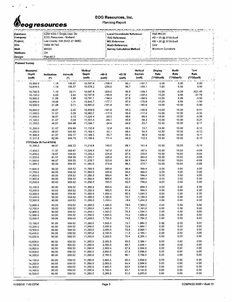
Planned Survey . •: j
Measuredf
Vertical - Vertical Dogleg Build Turn
Depth Inclination Azimuth Depth +N/-S +E/-W Section Rate Rate Rate
(usft) O n v- (usft) (usft) (usft) (usft) (°/100usft) (°/100usft) (°/100usft)
14,600.0 90.00 359.52 11,260.0 3,383.5 61.1 3,383.9 0.00 0.00 0.00
14,700.0 90.00 359.52 11,260.0 3,483.5 60.2 3,483.9 0.00 0.00 0.00
14,800.0 90.00 359.52 11,260.0 3,583.4 59.4 3,583.9 0.00 0.00 0.00
14,900.0 90.00 359.52 11,260.0 3,683.4 58.5 3,683.8 0.00 0.00 0.00
15,000.0 90.00 359.52 11,260.0 3,783.4 57.7 3,783.8 0.00 0.00 0.00
15,100.0 90.00 359.52 11,260.0 3,883.4 56.8 3,883.8 0.00 0.00 0.00
15,200.0 90.00 359.52 11,260.0 3,983.4 56.0 3,983.8 0.00 0.00 0.00
15,300.0 90.00 359.52 11,260.0 4[083.4 55.1 4,083.8 0.00 0.00 0.00
15,400.0 90.00 359.52 11,260.0 4,183.4 54.3 4,183.8 0.00 0.00 0.00
15,500.0 90.00 359.52 11,260.0 4,283.4 53.4 4,283.7 0.00 0.00 0.00
15,600.0 90.00 359.52 11,260.0 4,383.4 52.6 4,383.7 0.00 0.00 0.00
15,700.0 90.00 359.52 11,260.0 4,483.4 51.7 4,483.7 0.00 0.00 0.00
15,800.0 90.00 359.52 11,260.0 4,583.4 50.9 4,583.7 0.00 0.00 0.00
15,900.0 90.00 359.52 11,260.0 4,683.4 50.1 4,683.7 0.00 0.00 0.00
16,000.0 90.00 359.52 11,260.0 4,783.4 49.2 ' 4,783.7 0.00 0.00 0.00
16,024.6. 90.00 359.52 11,260.0 4,808.0 49.0 4,808.2 0.00 0.00 0.00
PBHL(Della 29 Fed #702H)
Design Targets ______ __----- --------- -- —- - ------------- — -— -- — . . --------------------- -------- ----- .... -....... ... .... -
Target Name
- hit/miss target Dip Angle
- Shape (°)Dip Dir. i.
o
TVD
(usft)
+N/-S
(usft)
+E/-W
(Usft)
Northing
(usft)
Easting
(usft) Latitude Longitude
PBHL(Della 29 Fed #70: 0.00- plan hits target center- Point
0.01 11,260.0 4,808.0 49.0 564,861.00 732,962.00 32° 33' 2.295 N 103° 34' 38.231 W
FTP(Della 29 Fed #7021- 0.00 0.01 11,260.0 80.0 89.0- plan misses target center by 70.5usft at 11317.8usft MD (11196.9 TVD, 111.4 N, 88.2 E)
- Point
560,133.00 733,002.00 32° 32' 15.508 N 103° 34' 38.156 W
11/3/2015 1:42:02PM Page 6 COMPASS 5000.1 Build 72

Exhibit 1
EOG Resources10M BORE Rig Floor
1.13 5/8" Rotating Head
2. NOV 13 5/8" 5,000 PSI WP GK Annular Preventor
3. 13 5/8" Cameron Type "U" 10,000 PSI WP Ram Preventors
4. 2 1/16" -10,000 PSI WP Check Valve
5. 10,000 PSI WP - 1502 Union to kill line
6. 2 1/16" - 10,000 PSI WP Manual Valves
7.13 5/8" 3,000 PSI WP x 13 5/8" 5,000 PSI WP Spacer Spool
8. 4 1/16" 10,000 PSI WP HCR Valve
9. 4 1/16" 10,000 PSI WP Manual Valve
10. 6" OD x 3" ID 10,000 PSI WP Steel Armoured Flex Choke Line
11. DSA -13 5/8" 10,000 PSI WP X 13 5/8" 5,000 PSI WP
12. Mud Cross -13 5/8" 10,000 PSI WP
13. Blind Rams
14. Pipe Rams
15.13 5/8" Cameron Type "U" 10,000 PSI WP Pipe Rams
16. Flow Line
17. 2" Fill Line
©
©.
© ©
©fluAirfh ffh tfh rfh
(16)
jflJrfn tFh n“n rftlrfti
ipjp lyj iyi Tgpr
tRilfn ifli rfti rftirfh
©
(14)
tyjiyi lyjiyj tyjiyi
(12,
(QTjgi u^J igjigr
ri=hlH=h rfHjfhlffr
©rfl[
©LyJ Lyj LyJ
rfh rFh rfV) ffh
l
EOG 5M BOPE Diagram (6/10/14)

Exhibit la
EOG Resources
10M BOPE
1. Cameron 2 1/16" 10,000 PSI WP Gate Valve
2. 4 1/16" 10,000 PSI WP Manual Choke
3. Cameron 4 1/16" 10,000 PSI WP Manual Valve
4. 8" OD x 4" ID 10,000 PSI WP Flex Choke Line
5. Cameron 4 1/16" 10,000 PSI WP Manual Valve
& Pressure Gauge on Pressure Block
6.10,000 PSI WP Hyrdaulic Choke Valve
7. 8" Expansion Chamber
8. LP Butterfly Valve
9. LP Valve
10.4" Panic Line
11. 6" Butterfly Valve
12.10-3/4" Butterfly Valve
13.6" Butterfly Valve
©
r-Cr
©
'lyjiyi iyj lyi tyjiyi’
0
EOG 5M Choke Manifold Diagram (rev. 3/21/14)

V
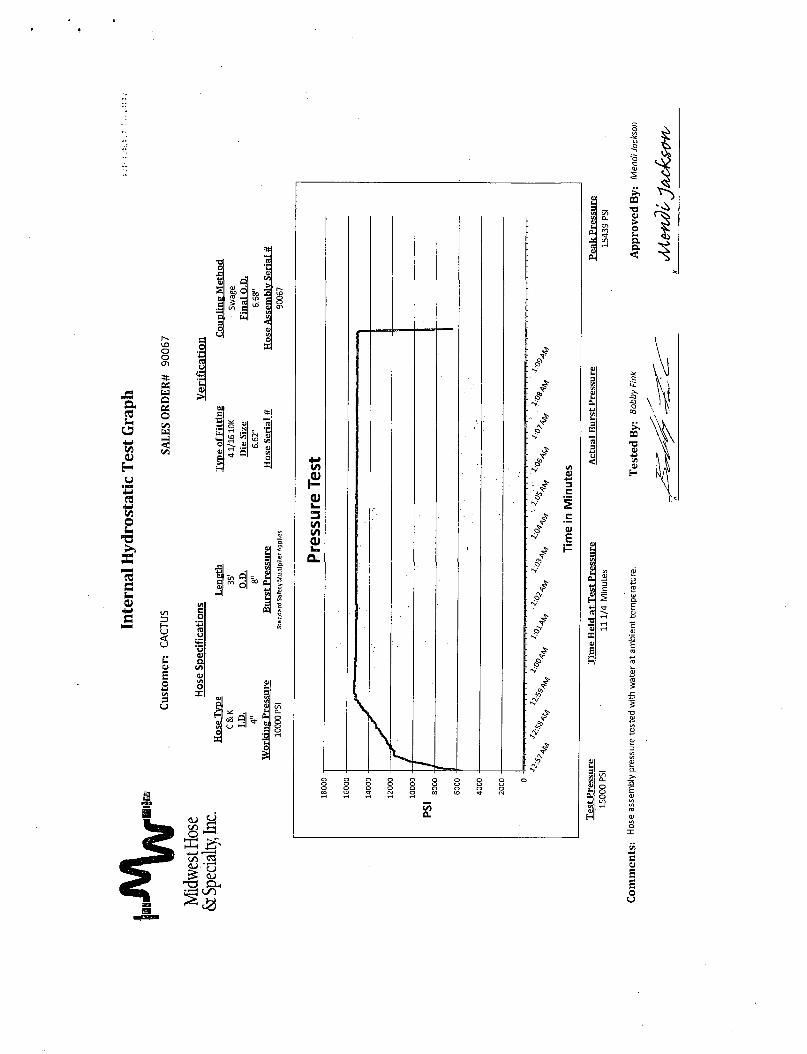
Manufacturer: Midwest Hose & Specialty
Serial Number: SN#90067
Length: 35'
Size: 00 = 8” ID = 4*
Ends: Flanges Size: 4-1/16"
WP Rating: 10,000 psi Anchors required by manfacturen No

MIDWEST
HOSE AND SPECIALTY INC.
INTERNAL HYDROSTATIC TEST REPORT
Customer:CACTUS
P.O. Number:RIG #123
HOSE SPECIFICATIONSAsset# M10761
Type: CHOKE LINE Length: 35'
I.D. 4” INCHES O.D. 8” INCHESWORKING PRE8SURE TEST PRESSURE BURST PRESSURE
10.000 PSI 15.000 PSI PS
COUPLINGSType of End Fitting
41/1610K FLANGE
type of Coupling:SWEDGED
MANUFACTURED BYMIDWEST HOSE & SPECIALTY
PROCEDURE
Hoseaaaemtrivormauntesteawi water at ambient trnnoeretun.TIME HELD ATTEST PRESSURE ACTUAL BURST PRESSURE:
1 mm 0 PSICOMMENTS:
SNS900S7 Ml0761Hose is covered with stainless steel armour cover and wraped with fire resistant vermicuiRe coated fiberglass insulation rated for 1500 degrees complete with lifting eyes
Data:6/612011
Tested By:BOBBY FINK
Approved:
MENDI JACKSON

◄------------------------- —--------------------------------------------------------------------------------------------------------------------------------------------------------------------------------------------------------------------------------------------------------------------------------------------------------------------------------------------—►
o•'tf"CO
Ro
ad