quickguidefortemsdiscovery3.03
TRANSCRIPT

FathanFathanMubinaMubina SuryamanSuryaman ((ImanIman))DigiDigi ZteZte [email protected]@gmail.com
ZTE Corporation

First Screen after clicking on TEM Discovery Icon
ZTE Corporation

Creating a Project
ZTE Corporation
Creating a Project

Creating Project from Project Explorer Window
ZTE Corporation

New Project creation
ZTE Corporation

Opening a Project
ZTE Corporation

Three main components of Project Dataset, Cells & GISCoverage Maps
ZTE Corporation

Create Cell file- save as text
ZTE Corporation
TEMS Discovery requires an input tab delimited text file with the following fields as a minimum – cell ID, site name, PCI,long, lat, azimuth. The above example has some fields which are not mandatory such as the HBW (Horizontal BeamWidth) which you can use in when showing the sites in the map. The column names and order is does not need to be aspecific way since you link specific fields to each column. This is shown in the next slides. Or directly from cell file isOke

Import Network configuration or TEMS Discovery Cell file
ZTE Corporation

Import Network configuration
ZTE Corporation

Assign source fields -site
ZTE Corporation
TEMS Discovery requires linking some mandatory fields into your createdproject. Simply drag and drop from your source fields

Assign source fields -sector
ZTE Corporation

Assign source fields -carrier
ZTE Corporation

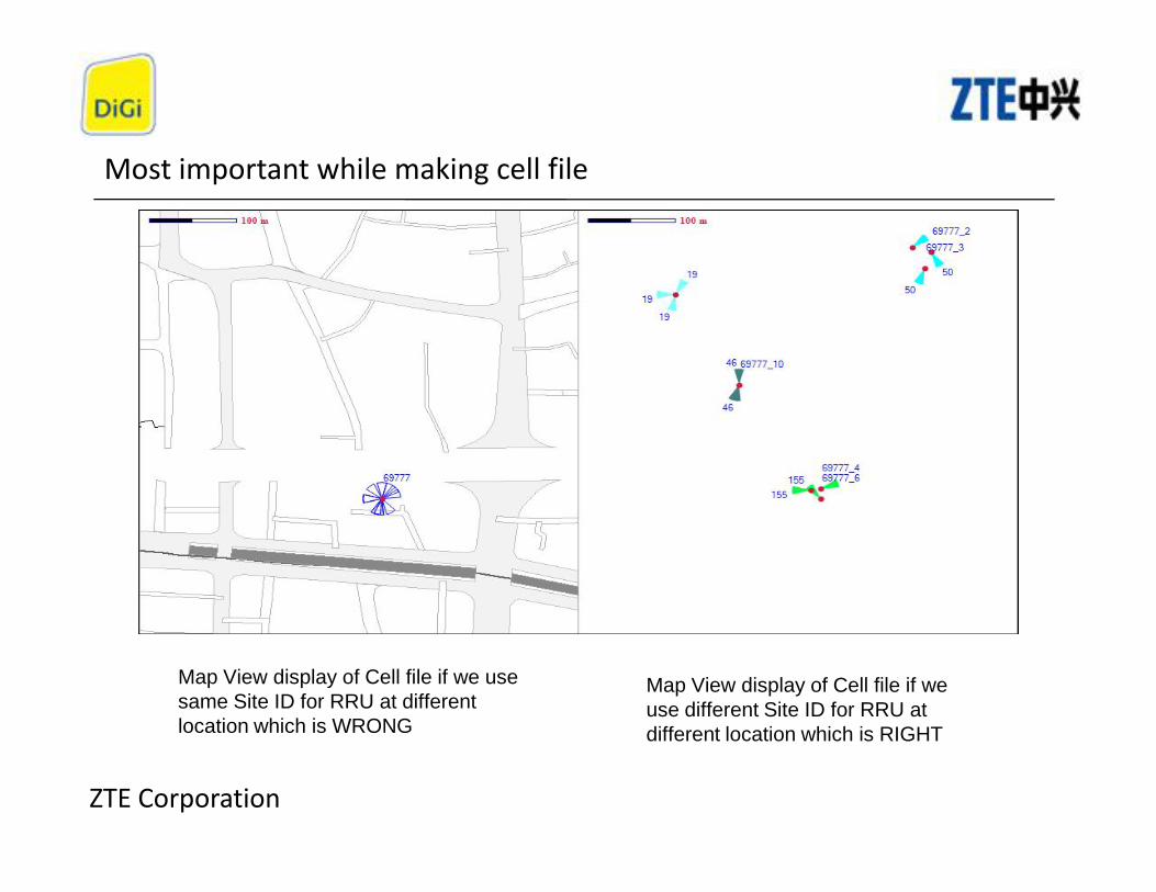
Most important while making cell file
ZTE Corporation
TEMS Discovery cell file requires that one DUL having RRU placed at differentlocation (lat/long) should have different site name so we have put additionalcolumn in cell file and named it as SiteName_new and mapped this with site ID.
Most important while making cell file
ZTE Corporation
Map View display of Cell file if we usesame Site ID for RRU at differentlocation which is WRONG
Map View display of Cell file if weuse different Site ID for RRU atdifferent location which is RIGHT

Import drive test data
ZTE Corporation

Task window – for checking import status
ZTE Corporation
Importing UE data take time so keep patience

Open Project (right Click Project)
ZTE Corporation

Dataset tab
ZTE Corporation
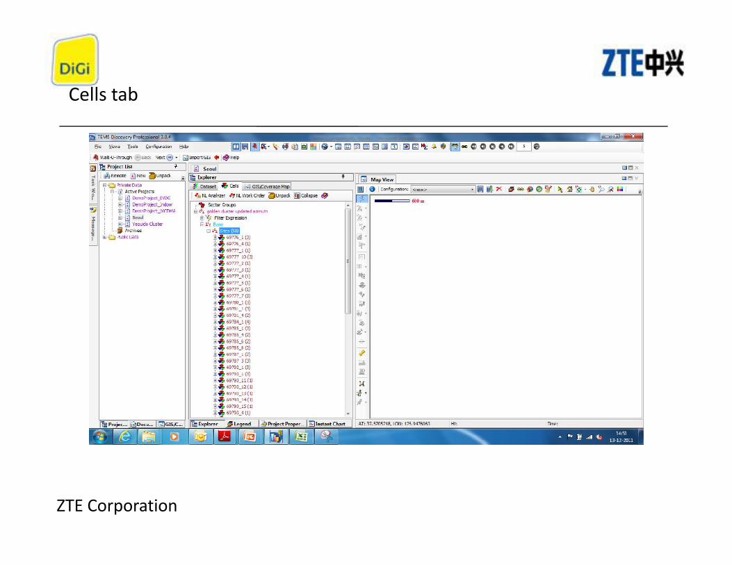
Cells tab
ZTE Corporation

Create composite dataset
ZTE Corporation
A static composite data set combines logfiles so that they can be displayed as1 drive in the map

Composite for MS1
ZTE Corporation
Create a new composite then Click and drag the MS you want for each logfile to combine to thecomposite data set

VERIFY COMPOSITE
ZTE Corporation

MAP VIEW OPTIONS
ZTE Corporation
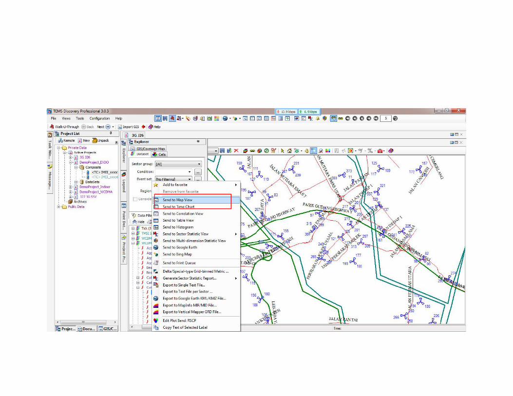
Right Click on Sites and select send to Map View
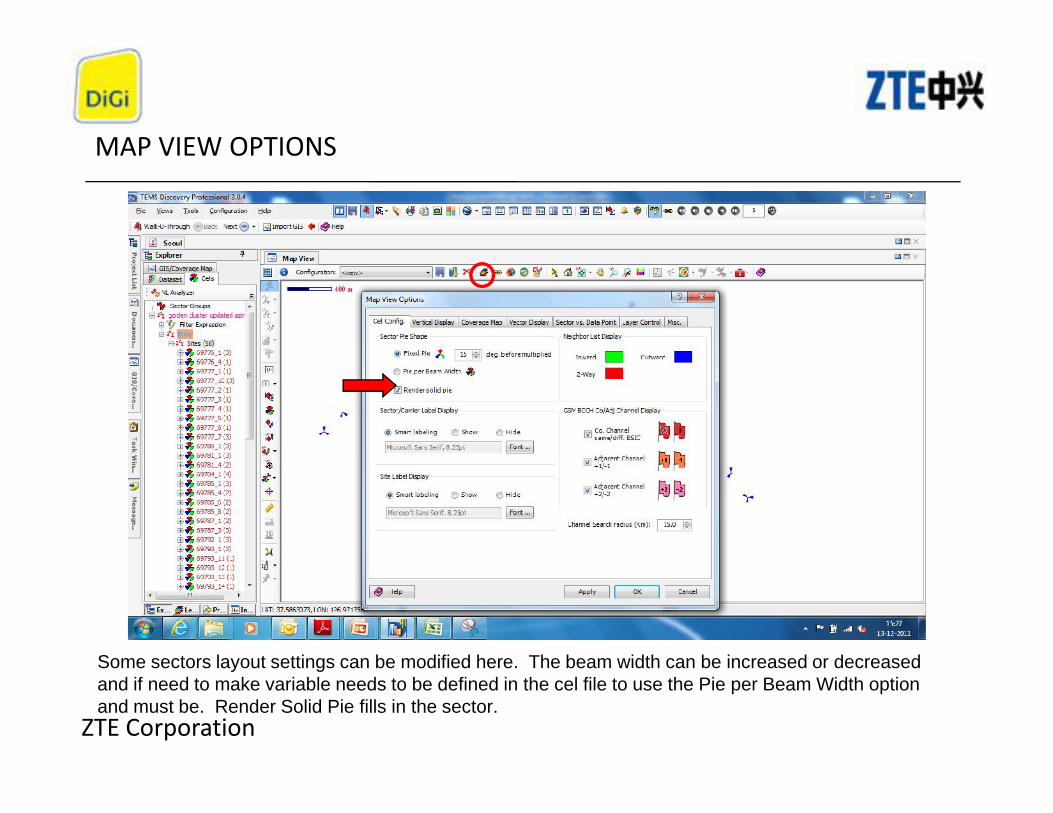
MAP VIEW OPTIONS
ZTE Corporation
Some sectors layout settings can be modified here. The beam width can be increased or decreasedand if need to make variable needs to be defined in the cel file to use the Pie per Beam Width optionand must be. Render Solid Pie fills in the sector.

EDIT CELL FILE
ZTE Corporation
Other sector layout settings can be modified here such as sector coloring and site/PCI labeling.
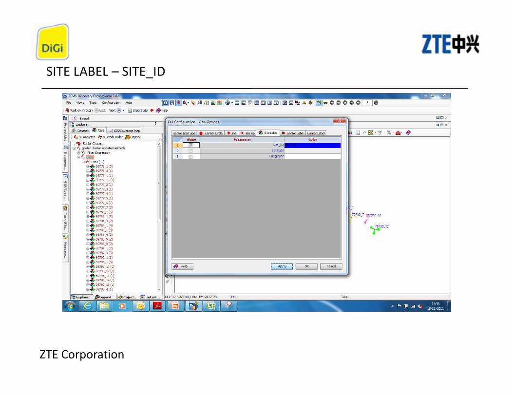
SITE LABEL – SITE_ID
ZTE Corporation

Importing a Mapinfo tab file
1
2
ZTE Corporation
External files (ie Mapinfotab file Roads, clusterboundaries) must beimported via the GIS butremember select onlytab files.
3
4

Importing a Mapinfo tab file
1 2 3
ZTE Corporation
GISsuccessfullyimported

Importing a Mapinfo tab file
ZTE Corporation
When this is complete just drag and drop to the map in the GIS/Coverage Map tab

TEMS Discovery Report (Edit Plot band)
ZTE Corporation
From the previous slide you can also edit the legend by right clicking on the metric being plotted andselecting “edit plot band”. These can be saved for future use.
If you cannot see these legends do not worry in coming slides I will tell how to import legends in discovery

Events Example – Table View
Exportto excelifrequired
ZTE Corporation
You can use the table view (circled) to drag and drop the events into a spreadsheet. This can beexported to Excel if required (also circled). You can also right-click on the events and select open intable view for any event in TEMS Discovery.

Events Example – Time chart View
ZTE Corporation
You can use the Time series view (circled) to drag and drop the events and RF Condition into this view.You can also right-click on the events and select open in time chart view for any event in TEMSDiscovery. This is handy way to analyze Drops, HO Fail and other events.

Events Example – Message View
ZTE Corporation
Messages in TEMS data collection can be displayed using the messages window. Drag RRCsignaling/ NAS signaling or any other event to display the information collected by TEMS.

Events Example – Histogram View
ZTE Corporation
Graphical analysis of RF condition can be done quickly with help of Histogram View. This is moreuseful when comparing Pre and Post tuning results but point to note is both Pre and Post Drive shouldhave identical Drive Test Route.

POINT TO POINT TERRAIN PROFILE
Click on download
ZTE Corporation
Lot of free online terrain profile map is available for terrain profile and we can download them usingTEMS Discovery using this process.

Terrain Map Veiw
ZTE Corporation

Point to Point Terrain Profile
ZTE Corporation
After download of terrain Map elevation profile check option will get activated in Discovery by which we cannow analyze point to point or LOS between two specific points. Can also change path start and path endheight from LOS tab

MAP VIEW

Creat Compossite Data


• DIGI ZTE Malaysia• Tems Discovery 3.02• Tems Investigation 13.02
@2012 /Iman
• DIGI ZTE Malaysia• Tems Discovery 3.02• Tems Investigation 13.02
@2012 /Iman