queen annes county - maryland state...
TRANSCRIPT

QUEEN ANNE’S COUNTY AGWAY, INC. (3) This commercial feed complex at 106 Banjo Lane, Centreville, 2 blocks south of the courthouse, was acquired in 1967 from Julia T. Burleigh, daughter of the previous owner, Christopher Thomas. The plant in 1953 was under lease to Eastern States Farmers Exchange, Inc. These frame structures are on the south side of the street on the former milk plant property [1976]. ANDREWS MILL (1 or 2) The 1850 census of manufactures listed William Andrews with $500 capital investment in a water mill with 2 employees, and annual output of $525 in flour and meal. BARCUS MILL (2) For three mills owned by Barcus, see Seth Mill in Election District 2, Church Hill Mill, and Crouse Mill. BARCUS WINDMILL ( ) Joseph Barcus had a windmill on Corners Neck in the 1798 tax list of Walsey, Upper and Lower Hundreds. BAXTER MILL (4) Richard Baxter was listed as miller on Kent Island in the 1880 State business directory. BENTON WINDMILL ( ) Mark Benton had one windmill and bolting house on Bentons Pleasant Discovery, in the 1797 tax list of Walsey, Upper and Lower Hundreds. BISCOE MILL (7) See Forge Mill. BISHOP MILL (8) Same as Chester Mill. BISHOP TANYARD ( )
1

“One small tanhouse, yard, and vats” was listed on the Bishop property (Queen Anne Guardian Bonds and Valuations, 1782), quoted in Carl R. Loundsbury, An Illustrated Glossary of Early Southern Architecture & Landscape (New York, 1995), p. 367. BLANK CANNING FACTORY (2) The 1877 county atlas showed this cannery at Round Top. BORDLEYS WINDMILL (5) About 1770, Judge John Beale Bordley inherited half of Lloyd’s Insula, or Wye Island in the Wye River and turned it into a model farm. The island was then 5.75 miles long by 1.5 miles wide. Bordley raised Palma Christi and extracted the oil. He also raised madder, hops, and large fields of wheat, having been one of the pioneers in giving up tobacco culture for grain. In his book on crop rotation and other topics, Essays & Notes on Husbandry and Rural Affairs (1803), he remarked that as tobacco was replaced county by county with wheat, moving from north to south, “the people became more happy, and independent of the British store keepers who had kept them in debt and dependent,” p. 245. As described in QACM, p. 515, the “substantial stone tower, similar to the one at Newport, Rhode Island, on the brow of the hill “excites curiosity about pre-Columbian settlement in Wye Island.” However, Eliza Bordley Gibson in Biographical Sketches of the Bordley Family of Maryland (1865), p. 98, declared that the windmill was built in 1773-74, “of uncommonly large dimensions and excellent proportions, substantially raised on a stone foundation, surrounded by an octagonal basement on eight brick columns, with an octagon superstructure of the best timber, tapering toward its lofty summit, and there furnished by a suitable cupola or head, from one side of which four gigantic arms spread themselves, revolving to catch the winds. This windmill was a fine object from the mouth of the river, and appears so in a view of the Island . . . by Mathias Bordley, Esq. in 1781.” Mrs. Gibson had in her possession John B. Bordley’s mill-book journal with columns of remarks and hints about mathematical computations. Bordley noted an unusually long calm in 1775 which “kept work waiting” and he praised the steady behavior of the mill in its running-in period. The estate was a self-sufficient industrial village and included ropewalks, salt evaporators, a brewery, cooper shop, brick yard and kiln. Bordley mentioned an “air furnace,” where during the Revolution, a brick maker named Cook made experimental batches of glazed earthenware and stoneware, Essays, p. 457. Bordley warned his readers of lead-glazed drinking vessels and the danger of breathing lead particles. His efforts to filter salt water through sand proved unsuccessful, p. 262. His Sketches in Rotation of Crops, Talbotton, 1792, was the pioneer work on the subject.
2

Matthias Bordley recommended to Edward Lloyd V his miller, Daniel Thomas; Bordley wished to save money by having only unmarried millers. “The mere act of grinding, is a simple affair: & demanding no more than a constant attention.” Bordley added that Thomas went shooting but, “There are frequent intervals afforded by the want of wind, for these things being without the person’s subjecting himself to blame for neglecting his duty” (MHS Special Collections, Lloyd Papers, Ms. 2002, June 16, 1798). The larger part of the island was owned in 1976 by William A. Hardy and was the scene of highly mechanized modern farming. See also, HTC, p. 542ff. Also, MHM, 24:299. Also, HM, 2:90f. Also, Pillars of Md., p. 402ff. Location of Fort Kent was at grid 29-C-13 in the ADC Street Atlas, the present Cove Creek Club, a golf course. Location of the pre-1637 windmill at the head of Tanners Creek west of Tanners Point Road was 29-F-8 in the same ADC atlas. Both locations were indicated on a map made in 1937 by H. S. Berkley, filed in MHS Library. [Note: There is no credibility in the pre-Columbian origin of the windmill tower at Newport Rhode Island, either, which is thoroughly documented as a windmill similar to types used in Great Britain.] BOYER CIDER MILL ( ) James Boyer sold a cider mill (the portable sort) to Thomas Roberts, Henry Price, etc., June 1799 (Queen Anne deeds, SWT 5:97). BRIERLY MILL ROAD (1) This road runs east, and then south, from Crane Swamp Road, SW of Barclay on the 1967/1968 General Highway Map. No clues in atlas. BROWNE WINDMILL ( ) Aquilla Browne had a windmill on Woodyard Thicket and Lillian Tracts, 1798 tax list of Walsey, Upper, and Lower Hundreds. BURCHARD SAWMILL ROAD (7) Richard Sewell Road runs from Md. 544 to the I.B.-Pondtown Road. CARTER WINDMILL ( ) Thomas Carter had one windmill on the tract Gobetween, in the 1798 tax list of Walsey, Upper and Lower Hundreds. CECIL FARM MILL ROAD ( )
3

Cecil Farm Mill Road runs SW from Md. 305 to Ruthsburg-Buldentown Road as current maps. CENTREVILLE FEED COMPANY (3) This company, later called Carter and Yates Milling Company, operated a grain elevator in Centreville and was acquired by Robert N. Mance in 1945 (ASG JR. 11:175) and passed to Willis and Cecil Company in 1945, a firm, composed of J. McKenny Willis, Jr., and Charles W. Cecil. It became the Wilson Grain Company in 1950 and passed to Queen Anne Co-op in 1966. The buildings on the east side of US 213 (Commerce Street) are opposite the Chester Mill and adjoin the “Mill Flats” tract on the north and the Centreville Ice Company plant on the south. This relatively modern works was closed in 1972 but still carried the sign “Farm Bureau.” No structures appeared here in the 1877 county atlas. CENTREVILLE MARYLAND SILK COMPANY (3) One of the many silk mills of the 19th century was the Centreville Maryland Silk Company, incorporated under Laws of Md., Acts of 1838, Chapter 31. The following year, the company purchased from James W. Harris a property on Corsica Creek formerly held by the trustees of the poor . . . on which the Poor House lately stood, 100 acres, plus woodland on the creek (Queen Anne County deeds, JT 2:507). CENTREVILLE MILL (3) Same as Chester Mill, CENTREVILLE WOOLEN MILL (3) An attempt was made in 1849 to establish a woolen mill but the enterprise failed despite a capital of $30,000, ESMV, p. 1067. CHESAPEAKE MILLS (4) Chesapeake Mills, owned by Day and Miles or C. S. Day and Co., producers of hominy and grist, were at Stevensville, Kent Island, per the 1887 State business directory. CHESTER MILL (3) CHESTER MILL BRANCH Chesterfield, a 900-acre tract, was patented by William Hemsley in 1672 and in 1679, Hemsley leased to William Bishop the “land whereon the said William Bishop hath lately erected a water mill . . . on a branch of the Creeke Called Courseca
4

Creek . . . on a tract of Land of Nyne hundred acres . . . now in the occupation of John Tillotson.” For the privilege of using ten acres, Bishop was to pay 500 pounds of tobacco, plus an “Eare of Indian Corne” annually. The agreement was to become void if Bishop let the mill fall down, be out of repair, or fail to rebuild it (Talbot County deeds, 3:333, MSA). In 1680, Bishop patented an adjoining tract called Mill Range,” 163 acres on the west side of the southern branch of Coursica Creek near the head of Muddy Branch (Patents, Liber 21:343, MSA). An 1805 deed placed the tract Mill Range on the Centreville-Easton Road near the “old water mark of Chester Mill pond” (Queen Anne County deeds, STW 8:4). In 1685, Hemsley sold Chesterfield to Richard Sweatnam, who was to receive the rents of the water mill erected by William Bishop, “also deceased” (Talbot County deeds, KK No. 5:61, MSA). The building in 1719 was referred to as “a water mill called Chester Mill” and belonged to the heirs of William Sweatnam, and was rented to Solomon Clayton, who was required to pay 8000 pounds of tobacco yearly “an keep ye sd Mill in Repare out of ye sd Tobo with all other charges that shall accrue so long as he shall keep the sd Mill Running with the Charges that the sd Clayton shall be out on sd mill shall be taken out of the Eight Thousand pounds of Tobo that she is Valley to per annum” (Deeds JK No. A:257, MSA). Sweatnam had bequeathed Chesterfield to any child yet unborn (MCW 5:18). [Note the somewhat nautical use of the word “she” to describe a mill as far back as 1719.] The road from Chester Mill to Wye Mill was in the 1730 list of county roads, Pat Melville, “Roads in Queen Anne’s County, 1709-1765,” The Archivists’ Bulldog, March 11, 2002. The mill became William Hooper’s through his marriage to Ester Banbury, sole daughter and heir of William Sweatnam. In 1748, Hopper leased Chester Mill with its ten acres to Matthew Dockery, along with liberty of cutting “timber and wood for firing on Chesterfield for the use of said Mill.” Rent was set at £ 80 per year (Queen Anne County deeds, RT No. C:319, MSA). Colonel Hopper was sued by Richard Tilghman Earle in 1752 over a dispute concerning the millrace; the court held that the land had been taken up under a writ of condemnation, Bordleys of the Eastern Shore of Md., p. 64, and Land Commissions, RT No. P, 1723-1756, folio 369. “Dockwrays” was in 1715 the name of the village that expanded to become Chester Mill or Centreville (QACM, p. 413). There was a mention of Dockery’s Mill in Queen Anne County in the Md. Gazette, August 4, 1757 followed by a mention of Matthew Dockery at Chester Mill in the same county, Md. Gazette, April 13, 1858. According to the Md. Gazette, July 24, 1766, both mill and dam washed away in the rains and the millstones were swept 50 yards from the site, with Colonel Hopper sustaining £ 1200 loss.
5

In 1763, William Hopper had married Dockery’s widow, Sarah, and bought the Dockery property called Fishingham. “Hoppers Mill, formerly Dockerys” was mentioned as on the road from Beaver dam Causeway [now Ingleside] in 1773 (QACM, p. 42). The mill was back in possession of the Sweatnam heirs in 1779 when Joseph Nicholson, Senior and Junior, and William Charles Neil partitioned the larger property and signed an agreement to repair and rebuild the Chester Mill and operate it in common (Queen Anne County deeds, RT 12:340, MSA). The mill was missing from the 1794-1795 Dennis Griffith map. In 1789 the village had been renamed Centreville and a planned courthouse and market town was laid out on property obtained from the Nicholsons. The 1798 tax list showed a mill on one of the tracts of Joshua Kennard, which included the tracts Wards Gift, Providence, and Chesterfield; assessed value was $1325. In September 1804, Joshua Kennard bought one third of the mill from Joseph Hopper Nicholson the elder and acquired other properties including parts of Ninevese, Mill Range, and Fishingham (Queen Anne deeds, STW 7:145). Kennard, a partner in the Wye Mill, left all his real estate to son-in-law John T. Miers in 1822 (Queen County Wills, TCE 1:209). Miers died, as did his son Stephen, as did the heirs of Stephen, causing the mill to descend in 1837 to Mary Tschudy (later Owings) (JT 2:239). Mary Tschudy sold the Kennard Mill property, then in possession of Henry Harrison, to Philemon B. Hopper and William Harper in 1839 (Queen Anne deeds, JT 2:596), and within the month, Hopper sold out to Harper (folio 61) in a deed that mentioned the “foot of the hill on which the mill garden is now placed” and the “branch running through the lands of Dr. Robert Goldsborough and Richard B. Carmicael.” In 1848, Harper and wife, Indiana, sold to Thomas DeC. Ruth for $5800. The 1850 census of manufactures listed T. D. C. Ruth with two mills capitalized at $2500 and $2200, with a combined output of $2009 in tolls based on grinding 19,893 bu of corn and wheat. Both mills were water powered with 1 employee each; the second was presumably Taylors Mill. Ruth was sued by the Kent National Bank and the mill was conveyed by the Sheriff under an execution to John H. Usilton in 1881 (Queen Anne County deeds (SCD 3:513). Usilton had already been in possession of the mill, which appeared as an L-shaped structure in the 1877 county atlas, SW of Centreville, on the north side of the present US 213, west bank, with the pond on the south side of the road. It had been called “Erdman’s Mill at Centreville” in April 1861 when used as a marshalling point for Company K (QACM p. 495).
6

Usilton was sued by Everett M. Eveleth of Philadelphia, holder of his mortgage, and the mill was advertised in the Centreville Observer, September 28, 1885, as “one of the most, if not the most desirable mill in this County,” the mill at that time “occupied by Thomas Roe as tenant.” The Manufacturers Record, November 14, 1885): 433, reported, “E. M. Eveleth, Centreville, Md., has sold his mill to J. H. Hall and W. L. Lowe.” The Manufacturers Record, 12 (September 10, 1887) reported, “Centreville . . . effort to rebuild flour mill of J. Hersey Hall.” The buyers, John Hersey Hall and Wrightson L. Lowe, did not get a deed until 1889 (Queen Anne County deeds, WD 2:510). Long sold out to Hall, and Hall and wife conveyed title of Centreville Mill Property and the “Mill Flats” to Centreville Manufacturing Company for $18,000 in May 1889 (Queen Anne County deeds, WD 3:166). The Halls were apparently builders of the frame mill that survived to the present; it was stated in 1887 (QACM, p. 572) that J. Hersey Hall’s large flour mill was established “on the historic site of Old Chester Mill.” The American Miller, 28 (January 1900): 76, reported, “The large flour mill of the Centreville Manufacturing Co. of Centreville, Md., was purchased December 20 by Charles E. Tucker for $6,600.” The next issue of that journal, February 1, 1900, (28:161) reported that Tucker failed to pay for the flouring mill at Centreville and it was turned over to the mortgagees, P. T. Forman and F. A. Emory by P. B. Hopper, Trustee. A deed was executed to Francis A. Emory and Pere T. Forman (Queen Anne County deeds, JEG 1:525). The new owners immediately sold (folio 538) to a prominent county miller, William C. Palmatory. “The Centreville Mill Property” had been advertised in the Centreville Record, November w5, 1899, as a wheat and corn mill, 40 x 50 ft, and 4-1/2 stories high with a 55 hp steam engine and boiler in excellent condition and nearly new, located in a Brick House beside the Mill Building. There was daily access to Baltimore by steam and sail boats and railroads. The roster of equipment included George T. Smith machinery, full centrifugal system consisting of the following: Flour 5 double stand Dawson Rolls, 6 x 18 in. 9 G. T. Smith Centrifugal Reels 1 Wolf Flour Dresser 2 No. 2 G. T. Smith Purifiers 4 Reel Scalpers 1 Richmond Bran Duster 1 Silver Creek flour packer 1 Large pair of grain scales 3 pair of small scales 1 Richmond Receiving Separator, 300 bu/hr 1 Brush machine 1 Polisher, 30-40 bu/hr Corn 1 Harrison Mill 2 Stands Dawson Corn Mills
7

7 Reels The mill’s capacity was 75-80 bbl/diem of flour and 20-40 bu/hr of corn meal or 40-50 bu/hr of feed. In 1905, Palmatory sold off a “tract formerly covered with water” (Queen Anne County deeds, JEG 8:304) and in 1907 he sold Centreville Mill Property and Centreville Mill in 1981 by Orlando Rideout V. “Lands covered by water” to R. H. Linwood Carter and E. Stephen Valliant, who operated as Carter and Co. and in 1919 sold to Christopher S. Thomas and wife. Mr. and Mrs. Thomas in 1923 incorporated as Centreville Milling Co. and conveyed title to the new entity. Christopher S. Thomas was president and William H. Carter, secretary. The corporation deeded “Chesterfield Mill Property” on the “Mill Stream” back to Thomas Carter in 1925, and in 1946, Thomas and wife conveyed it to John L. Strickland of Baltimore County the dwelling and “building formerly used as a flour mill.” The next year the mill passed to Violet Norris Renshaw and the mill was used by Renshaw and Emory Equipment Company tractor dealers. The frame mill dating from 1890 was partially covered with metal sheathing [1976]. The address of the building is 2647 Centreville Road, Tax Map 301, Parcel P1054. In 1997, the property was conveyed by Thomas Warfield Emory to Charles E. Geshwelm. The mill still existed in the 2006 State assessment records, its deed number SM 577:403, same owner as in 1997. This resource bears MHT Site No. QA 347. Orlando Rideout V prepared an MHT Inventory form in 1981. The mill was still standing in November 2006. Location is 19-E-3 in the ADC Street Atlas, next to Mill Stream Park. CHESTERFIELD MILL (3) Same as Chester Mill.
8

CHURCH HILL MILL (2) Orlando Rideout V discovered that the earliest mention of this mill appeared in 1698 when Thomas Collins of Kent County bequeathed a plantation and mill to his son John Collings [sic](Kent County Wills #202). The elder Collings had migrated from England in 1664 and acquired considerable land around Chester River, including the tract “Collins His Own” in 1695. Collins Mill was along a road authorized in 1710 that ran from the mill over the head of Double Creek Marsh. John Collins, planter, already had a mill in 1720 when he reserved “John Collins Mill dam, mill and wood for the millers family” from a deed of part of the tract Spread Eagle sold to Rachel Meloyd (Queen Anne’s County deeds, IK No. B:47). The mill was on the SE branch of Chester River (QACM, p. 27); the creek was called “head of Chester Branch” in 1829, Ibid., p. 209. In the 1730 list of roads, Collins Mill was mentioned twice, on the road to White Marsh Branch, also on a road to the Chester Ferry. See, Pat Melville, “Roads in Queen Anne’s County, 1709-1765,” The Archivists’ Bulldog, March 11, 2002. The mill was also mentioned in an act to build a warehouse near Church Landing in 1748 (Arch. Md., 46:159). Collins’ son, John Offley Collins, sold part of Spread Eagle, “commonly called Collins’s Mill” and all that mill, mill house, and five acres previously excepted, to John Smythe, chirurgeon and apothecary, in 1751 (Queen Anne’s County deeds, RT No. C:531). Spread Eagle was described as former property of Charles Hynson when sold by Daniel Smith to John and William Ruth in 1765 (Queen Anne’s County deeds, RT No. G:220, MSA). That year, William Ruth had his portion of Spread Eagle resurveyed into “Ruth’s Purchase” (Patented Certificate No. 894, MSA). William Ruth was a miller, and in 1772, to settle a debt with Abel Jones and Henry Drinker, Philadelphia merchants, he sold them 490 barrels, 50 bread barrels, 6000 barrel staves and heading, an 8-day clock, and other effects including a new wagon and riding chair (Queen Anne deeds, RT No. I:442). The Church Hill Mill was advertised in the Md. Gazette, November 26, 1772, but in May 1773, Ruth deeded the Spread Eagle property “on Collins Mill Branch” to the Philadelphians, who held a judgment against him and against his guarantor, John Ruth, Yeoman (Queen Anne’s County deeds, RT No. K:180, MSA). John Ruth had already signed over a tract called “Clouds Adventure” toward the debt of £ 2877 (Folio 70). In 1783, Abel James and Henry Drinker sold the gristmill to Thomas May, Ironmaster of Wilmington, Delaware. May appeared on the 1783 tax list and in 1788 sold to Benjamin Richardson for £ 3630 (Queen Anne’s County deeds, STW 1:67). The late property of Benjamin Richardson, 50 acres and a gristmill was
9
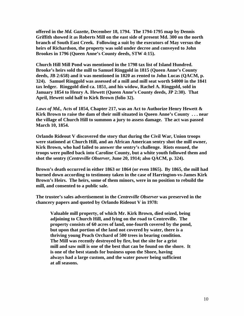
offered in the Md. Gazette, December 18, 1794. The 1794-1795 map by Dennis Griffith showed it as Roberts Mill on the east side of present Md. 300 on the north branch of South East Creek. Following a suit by the executors of May versus the heirs of Richardson, the property was sold under decree and conveyed to John Brookes in 1796 (Queen Anne’s County deeds, STW 4:15). Church Hill Mill Pond was mentioned in the 1798 tax list of Island Hundred. Brooke’s heirs sold the mill to Samuel Ringgold in 1815 (Queen Anne’s County deeds, JB 2:658) and it was mentioned in 1820 as rented to John Lucas (QACM, p. 324). Samuel Ringgold was assessed of a mill and mill seat worth $4000 in the 1841 tax ledger. Ringgold died ca. 1851, and his widow, Rachel A. Ringgold, sold in January 1854 to Henry A. Hewett (Queen Anne’s County deeds, JP 2:30). That April, Hewett sold half to Kirk Brown (folio 32). Laws of Md., Acts of 1854, Chapter 217, was an Act to Authorize Henry Hewett & Kirk Brown to raise the dam of their mill situated in Queen Anne’s County . . . near the village of Church Hill to summon a jury to assess damage. The act was passed March 10, 1854. Orlando Rideout V discovered the story that during the Civil War, Union troops were stationed at Church Hill, and an African American sentry shot the mill owner, Kirk Brown, who had failed to answer the sentry’s challenge. Riots ensued, the troops were pulled back into Caroline County, but a white youth followed them and shot the sentry (Centreville Observer, June 20, 1914; also QACM, p. 324). Brown’s death occurred in either 1863 or 1864 (or even 1865). By 1865, the mill had burned down according to testimony taken in the case of Harrington-vs-James Kirk Brown’s Heirs. The heirs, some of them minors, were in no position to rebuild the mill, and consented to a public sale. The trustee’s sales advertisement in the Centreville Observer was preserved in the chancery papers and quoted by Orlando Rideout V in 1978: Valuable mill property, of which Mr. Kirk Brown, died seized, being adjoining to Church Hill, and lying on the road to Centreville. The property consists of 60 acres of land, one-fourth covered by the pond, but upon that portion of the land not covered by water, there is a thriving young Peach Orchard of 500 trees in bearing condition. The Mill was recently destroyed by fire, but the site for a grist mill and saw mill is one of the best that can be found on the shore. It is one of the best stands for business upon the Shore, having always had a large custom, and the water power being sufficient at all seasons.
10
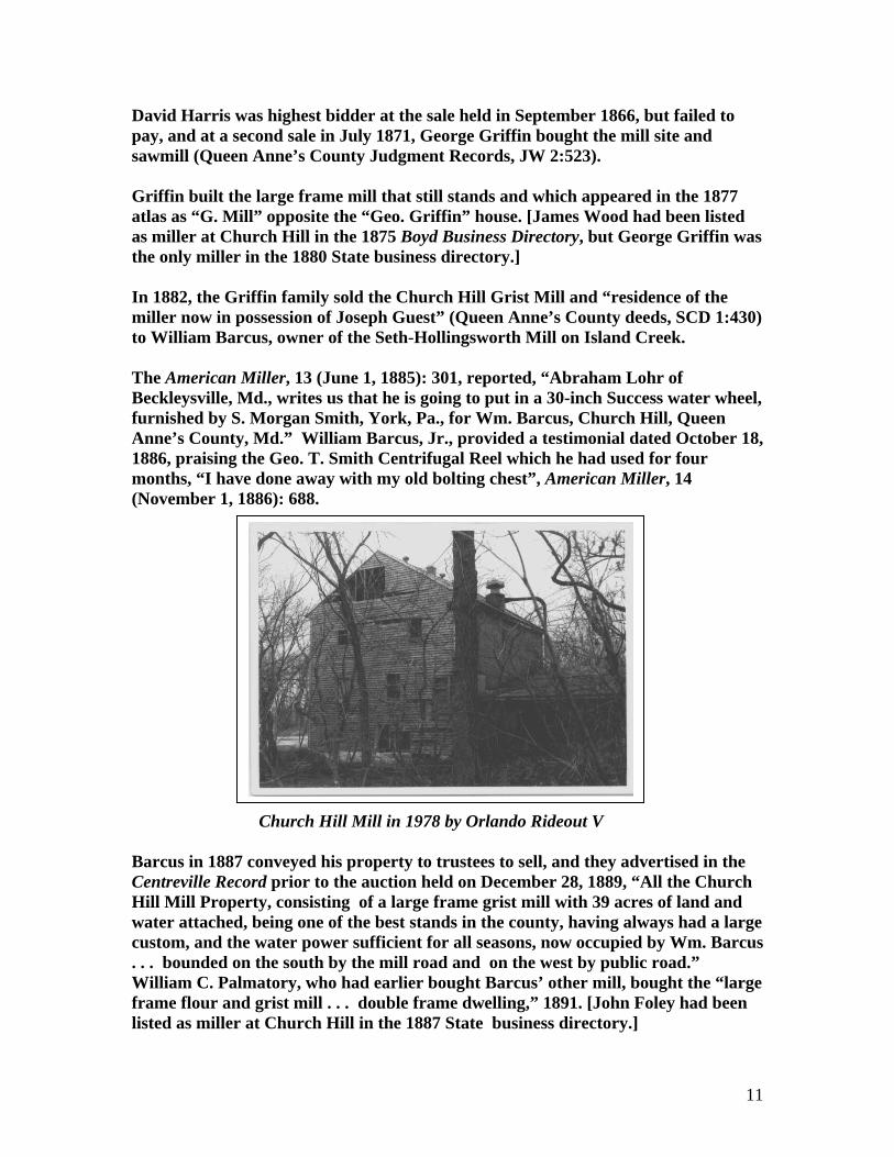
David Harris was highest bidder at the sale held in September 1866, but failed to pay, and at a second sale in July 1871, George Griffin bought the mill site and sawmill (Queen Anne’s County Judgment Records, JW 2:523). Griffin built the large frame mill that still stands and which appeared in the 1877 atlas as “G. Mill” opposite the “Geo. Griffin” house. [James Wood had been listed as miller at Church Hill in the 1875 Boyd Business Directory, but George Griffin was the only miller in the 1880 State business directory.] In 1882, the Griffin family sold the Church Hill Grist Mill and “residence of the miller now in possession of Joseph Guest” (Queen Anne’s County deeds, SCD 1:430) to William Barcus, owner of the Seth-Hollingsworth Mill on Island Creek. The American Miller, 13 (June 1, 1885): 301, reported, “Abraham Lohr of Beckleysville, Md., writes us that he is going to put in a 30-inch Success water wheel, furnished by S. Morgan Smith, York, Pa., for Wm. Barcus, Church Hill, Queen Anne’s County, Md.” William Barcus, Jr., provided a testimonial dated October 18, 1886, praising the Geo. T. Smith Centrifugal Reel which he had used for four months, “I have done away with my old bolting chest”, American Miller, 14 (November 1, 1886): 688. Church Hill Mill in 1978 by Orlando Rideout V Barcus in 1887 conveyed his property to trustees to sell, and they advertised in the Centreville Record prior to the auction held on December 28, 1889, “All the Church Hill Mill Property, consisting of a large frame grist mill with 39 acres of land and water attached, being one of the best stands in the county, having always had a large custom, and the water power sufficient for all seasons, now occupied by Wm. Barcus . . . bounded on the south by the mill road and on the west by public road.” William C. Palmatory, who had earlier bought Barcus’ other mill, bought the “large frame flour and grist mill . . . double frame dwelling,” 1891. [John Foley had been listed as miller at Church Hill in the 1887 State business directory.]
11
“W. C. Palmitory, Church Hill, Md., recently started a 21-inch Success Water Wheel furnished by S. Morgan Smith, York, Pa.,” American Miller, 19 (October 1 1891): 704. Orlando Rideout V credited Palmatory with installing the sifting machinery that remained on the upper floor at the time of his report in 1978. Palmitory sold out in 1905 to R. H. Linwood Carter and Company (Queen Anne County deeds, JEG 8:259) in a deeded that mentioned “mill pond, machinery, boilers . . . double dwelling opposite the Mill House . . . new frame dwelling.” Carter went into partnership with E. Stevens Valliant as Carter and Co., and the firm conveyed the mill property in 1912 to Nelson J. Brown, who deeded it immediately to Valliant. The mill was operated by Carter and Yates Milling Company, which also owned Centreville Feed and Grain Company. Carter and Yates in 1944 sold out to Robert N. Mance in a deed mentioning a grain elevator at Church Hill. In 1945, Mance sold both Centreville plant and The Church Hill Feed and Grain Company to C. Merrick Wilson. Wilson changed the corporate name to Wilson Grain Company and in 1966 sold to Queen Anne’s Cooperative which held the works 6 months and sold to Ambulitter Company and Michael Kevyuk (Queen Anne County deeds, CWC 24:258) who held land on both sides of the road called US 213 until the town was by-passed. In 1970, the private owners sold the mill to the County Commissioners (Queen Anne’s County deeds, CWC 40:602). In 1976, the mill was still standing but closed, located on Md. 300, SW of town; a gray clapboard building with rambling wings on the south, or east, side of the highway. A smaller, metal-sheathed mill structure was on the opposite side of the road. In 1978, Orlando Rideout V prepared an inventory form for the MHT. Inside the mill Rideout found a “Plansifter” manufactured by Barnard and Leas Mfg. Company of Moline, Illinois, bearing a patent date of 1890’s. Another sifting device had the nameplate of B. F. Starr, a well known Baltimore mill supply company. By the time of that inventory, the mill and grounds belonged to the Maryland Department of Natural Resources. John F. Wilson of the DNR informed us on November 15, 2006, that his agency had acquired the mill via the old Fish and Wildlife Commission in 1972 from the County Commissioners (Queen Anne’s County deeds, CWC 68:773). Then the reorganized DNR made a quit claim deed to the town of Church Hill in 1989, with various restrictions. This resource was assigned MHT Site No. QA-181. Local citizen Pat Harvey informed the author in 2007 that the mill had been demolished in the mid-1990s. Location was 7-H-11 in the ADC Street Atlas. Church Hill Mill was also mentioned in ESMV, p. 1065. CLAYBORNE WINDMILS (4) When William Clayborne of Virginia settled on Kent Island in 1629, about 5 years before the arrival of the first Maryland settlers, the outpost included a fort and two windmills. The millstones arrived by the ship Defense on February 20, 1632. Scharf
12

deduced that at least one windmill was built, relying on records that mentioned the “vane” as well as from the fact that there was no water fall on the island. Scharf quoted Plantaganet’s account of New Albion of 1648 where there was a mention of a mill and fort on Kent Island, “lately pulled down, on account of war with the Indians near it, not worth the keeping.” Clayborne’s report made in 1634 noted that he had had imported Anthony Lynney, an English millwright, MHM, 52:108. He also reported, “This year . . . Our principal employments for our men were in making 2 windmills,” MHM, 52:109. A Clayborne note made in 1636 listed two millers, William Westley, miller, and Francis Brookes, miller. “This years our works were as other years in trading and planting but especially wee were imployed in perfecting the mills. Wee framed 2 other mils perfectly so far as we could ready to set up . . . .” (MHM 52:110). That second windmill was on a tract that was awarded to Governor Leonard Calvert by the Lord Proprietor as Kent Fort Manor, HM, 1:137. Governor Calvert issued a decree dispossessing Clayborne in 1635. A mill was sold by Leonard Calvert to Giles Brent for the “yearly rent of 2 barrels of corne at Kent Mill.” When Clayborne’s people rebelled against the Lord Proprietor in 1644, the mill was stripped of its iron work by Peter Knight and ruined, Captains and Mariners of Early Maryland, p. 309f. Robert Turtle had been the miller. Also, Arch. Md., 4:417, 436. Margaret Brent’s complaint about “fyring” the mill—that is, setting it on fire. Two windmills were distinguished in MHM, 52:103, quoting Arch. Md., 5:184. In 1965, one was at Crayford Plantation and the other at Kent Fort. The mill at Crayford of Crafford Manoro was on a farm 0.75 mile south of Craney Creek; a windmill was operating on the same site in 1877 and a millstone was excavated on Elbert Nostrand Carvel’s farm. The millstones were in the possession of the ex-Governor Carvel of Delaware, Kent Island, p. 5. A century before, the Maryland Historical Society had acquired a piece of millstone from the site of the first settlement on Kent Island, Republican & Argus, January 24, 1853. One of the windmills may have survived or was replaced. An advertisement for a windmill builder appeared in Md. Gazette, November 1, 1774, quoted in QACM, p. 27 and 314. COLE AND BROTHER MILL (2) The 1880 census of manufactures listed Cole and Brother with $600 capital investment in a mill with 2 employees; a 12-foot fall on Island Creek drove an 8 hp undershot wheel 8 ft broad at 14 rpm; annual output was 100 bbl flour and 20 tons of meal ($1853). Barcus Mill was the only known works on Island Creek; Cole were conceivably the tenant operator of Church Hill Mill, although the partnership was not in the 1880 & Brother State business directory.
13

COLLINS MILL (2) See Church Hill Mill. COOPER SAWMILL (1 or 2) The 1860 census of manufactures listed Thomas H. Cooper with $2000 capital investment in a 16 hp steam sawmill; 1 employee; annual output was $2000 in lumber and timber. COPPAGE SAWMILL (2) Coppage’s steam sawmill was shown in the 1877 atlas on the north side of present Md. 302, west of Crane Swamp Road. COURSEY WINDMILL ( ) Henry Coursey owned a windmill on the tract Plain Dealing in the 1798 tax list of Walsey, Upper, and Lower Hundreds. CORSICA FARM SAWMILL ( ) An old steam sawmill was advertised along with Corsica Farm on Chester River, following the case of Michael Taylor-vs-Michael Newbold, Baltimore American, March 24, 1849. COXES SAWMILL (6) COX SAWMILL ROAD Coxes Sawmill was between Sudlersville and Centreville in a road survey of 1867, Kent Shoreman, May 1971, p. 53. Cox Sawmill Road appeared on the 1968 topographic map running SE from Md. 405 to Bridgetown-Ingleside Road. CROUSE MILL (6) CROUSE MILL ROAD Lydia and Jams Fisher in 1756 leased to William Dockery property “on French Womans Branch . . . a small Mill with Ten Aces of Land next Adjoining on the south side of said branch being part of . . . Suffolke with sufficient timber . . . to repair . . .” The lease was to run 11 years at a rate of 75 bu of Indian Corn and 10 bu of wheat. Dockery was “to allow her grain to being Hopper free during the said term” (Queen Anne’s County deeds, RT No. E:44, MSA). In 1778, William Fisher sold part of Suffolk to Caleb Ricketts and Robert Walters (or Watters) who bought an adjoining tract from Andrew Foster Leaverton in
14

December 1778 in a deed that mentioned “the old Mill Pond” (Queen Anne’s County deeds, RT No. L:137, MSA). In June 1778, the partners had bought from Thomas Reed all that pat of New Nottingham “that shall be covered and drowned by the Water of the Pond of the Mill of the said Caleb and Robert now erecting and building on said creek.” Part of Suffolk was listed in the 1783 tax list in Caleb Rickett’s name; he died in 1785, and in 1795, his heirs sold the grist, flour, and saw mill to an adjoining land owner, William Elliott Griffith (Queen Anne County deeds, STW 3:278). Griffith appeared on the 1798 tax list with John Ringgold as tenant; one frame grist-mill of 63 x 24 ft, one framed shed over the water wheels, 34 x 20 ft, and one shed over a sawmill, 28 x 12 ft. Crouse Mill about 1909 from collection of Mrs. Clifford G. Crouse On Griffith’s death, his daughter sued for a partition of the estate, and the mill seat was awarded to the widow in 1811. A plat made by the commissioners showed the mill to have been on the tract purchased from William Fisher close to the Beginning of Suffolk. The adjoining tract Hog Hole was on French Woman’s Branch, presumably the present Blockston Branch (Walter K. and Sarah White, Anne E. Boon, Charles E Griffith-vs-William E. Griffith’s Estate (Queen Anne Chancery Papers No. 5856, MSA). However, in HCLN, pp. 106 and 309, it was stated that this mill NW of Jumptown, Fuhrman’s Grove, or Bradleysburg in Caroline County was once held by the Bradley family. In 1839, Samuel and Catharine D. White sold the mill and mill seat formerly called Wallis Mill to Charles Adams and William Turner; the land overlapped both counties (Queen Anne’s County deeds, TM 3:46). In 1844, a share of the real estate
15
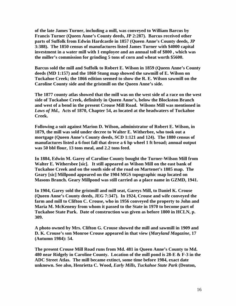
of the late James Turner, including a mill, was conveyed to William Barcus by Francis Turner (Queen Anne’s County deeds, JP 2:287). Barcus received other parts of Suffolk from Edwin Hardcastle in 1857 (Queen Anne’s County deeds, JP 3:388). The 1850 census of manufactures listed James Turner with $4000 capital investment in a water mill with 1 employee and an annual toll of $800 , which was the miller’s commission for grinding 5 tons of corn and wheat worth $5600. Barcus sold the mill and Suffolk to Robert E. Wilson in 1859 (Queen Anne’s County deeds (MD 1:157) and the 1860 Stung map showed the sawmill of E. Wilson on Tuckahoe Creek; the 1866 edition seemed to show the R. E. Wilson sawmill on the Caroline County side and the gristmill on the Queen Anne’s side. The 1877 county atlas showed that the mill was on the west side of a race on the west side of Tuckahoe Creek, definitely in Queen Anne’s, below the Blockston Branch and west of a bend in the present Crouse Mill Road. Wilsons Mill was mentioned in Laws of Md., Acts of 1870, Chapter 54, as located at the headwaters of Tuckahoe Creek. Following a suit against Marion D. Wilson, administrator of Robert E. Wilson, in 1879, the mill was sold under decree to Walter E. Witherbee, who took out a mortgage (Queen Anne’s County deeds, SCD 1:121 and 124). The 1880 census of manufactures listed a 6-foot fall that drove a 6 hp wheel 1 ft broad; annual output was 50 bbl flour, 13 tons meal, and 2.2 tons feed. In 1884, Edwin M. Garey of Caroline County bought the Turner-Wilson Mill from Walter E. Withersbee [sic]. It still appeared as Wilson Mill on the east bank of Tuckahoe Creek and on the south side of the road on Martenet’s 1885 map. The Geary [sic] Millpond appeared on the 1904 MGS topographic map located on Masons Branch. Geary Millpond was still carried as a place name in GZMD, 1941. In 1904, Garey sold the gristmill and mill seat, Gareys Mill, to Daniel K. Crouse (Queen Anne’s County deeds, JEG 7:347). In 1924, Crouse and wife conveyed the farm and mill to Clifton C. Crouse, who in 1956 conveyed the property to John and Maria M. McKeneny from whom it passed to the State in 1970 to become part of Tuckahoe State Park. Date of construction was given as before 1800 in HCLN, p. 309. A photo owned by Mrs. Clifton G. Crouse showed the mill and sawmill in 1909 and D. K. Crouse’s son Monroe Crouse appeared in that view (Maryland Magazine, 17 (Autumn 1984): 54. The present Crouse Mill Road runs from Md. 481 in Queen Anne’s County to Md. 480 near Ridgely in Caroline County. Location of the mill pond is 28-E & F-3 in the ADC Street Atlas. The mill became extinct, some time before 1984, exact date unknown. See also, Henrietta C. Wood, Early Mills, Tuckahoe State Park (Denton,
16

1988). For instructions on hiking in the Tuckahoe Valley, see Jay Abercrombie, Weekend Walks on the Delmarva Peninsula (2006), pp. 120-127. CURLETT MILL (1) James Curlett was listed as miller at Sudlersville in the 1887 State business directory. See also Curlott. CURLOTT SAWMILL (1) James Curlott’s steam sawmill was listed in the 1877 atlas patron list, and the postal address was given as Templeville. The 1880 census of manufactures listed a 30 hp steam engine and an annual output of 150,000 ft ($1800); there were 5 employees and $1000 capital investment. The name was spelled Curlett in the 1887 State business directory. The two mills were on the west side of the present Templeville-Peters Corners Road, 0.3 mile north of Busicks Church Road. Location was 10-J-7 in the ADC Street Atlas. DAILY TANYARD (1) James Dailey had a tanyard at Sudlers Cross Roads in 1820, QACM, p. 393. DARDEN MILL (3) See Taylors Mill. DARMON AND THOMPSON SAWMILL (7) Darmon and Thompson were partners in a steam sawmill at the SE corner of Front and Market Streets in Crumpton; they were in the lumber business and had a large timber lot NE of town. Plat filed in the case of Darmon-vs-Thompson, 1865, (Queen Anne’s County Judgment Records , SED 2:216f). The sawmill site is occupied by a Victorian House (1972 note). Location w as 2-G-6 in the ADC Street Atlas. DAY AND MILES MILL (4) See Chesapeake Mills. DEAN MILL (6) C, H. Dean was listed as a farmer and miller in the 1877 county atlas with a Hillsborough postal address. That atlas showed Dean’s house west of Horse Shoe Road and south of Crouse Mill Road. DIEHL SAWMILL (5)
17

The 1880 census of manufactures listed H. H. Diehl with $3100 capital investment in a sawmill with 6 employees, 2 boilers, two 22 hp engines, and annual output of 550,000 ft ($6800). DOCKETYS MILL (3, 6) See both Chester Mill and Crouse Mill. EAGLE SAWMILL (3) W. H. Eagle and Company was listed at Centreville in the 1867 Hawes Business Directory, p. 534. EARECKSON MILL (4) The 1880 State business directory listed Robert Eareckson as miller at Kent Island. EARLE MILL ( ) In 1730, James Earle petitioned the court to relocate a passage over Elliots Branch where he was building a mill that would flood the existing bridge. The court ordered a change in the road from White Marsh Branch to Collins Mill (Pat Melville, “Roads in Queen Anne’s County, 1709-1765,” The Archivists Bulldog, March 11, 2002). ELBIN MILL (7) Same as Forge Mill. ELLICOTT COTTON MILL (2) This works was founded at Church Hill in the early 19th century to use locally grown cotton, Kent Shoreman, May 1971, p. 53. ERDMANS MILL (3) See Chester Mill. FAITHFUL SAWMILL ( ) G. T. Faithful was listed as sawmiller at Hayden in the 1887 State business directory. FARM BUREAU CO-OP (3)
18

This complex of 20th century wooden feed mill buildings was standing but closed on the south side of US 213 at the apex of Liberty and Commerce Streets, Centreville, east side of Mill Branch (of Corsica Creek), this property of John N. Emory. Prior to that, it had been the Centreville Ice Company property, and the 1877 county atlas had shown it as the vacant land of G. W. Taylor [1976]. Location was 19-F-3 in the ADC Street Atlas. THE FARMERS SILK CO. ( ) The Farmers Silk Co. of Queen Anne was chartered under Laws of Md., Acts of 1838, Chapter 335. Incorporators were Arthur E. Sudler, Edward Coppage, and 34 others. Capitalization was not to exceed $5000. FISHER MILL (6) See Crouse Mill. FLOWERS MILL ROAD (6) This road is shown running parallel to Md. 404 in the village of Queen Anne on current SRC maps although it forms the county line per the MGS topographical map. FOLEY MILL (2) John Foley was listed as miller at Church Hill in the 1887 State directory. FORGE MILL (7) Spences [sic] Mill on Unicorn Branch near the head of Chester River was mentioned in the Md. Gazette, October 20, 1765. Although this mill was not shown on Dennis Griffith’s 1794-1795 map, some sources gave its date of construction as 1776, for example, Douglas Adams in “Only One Still Grinds of Six Which Stood 100 Years Ago,” Baltimore Sun, July 7, 1935. The mill stood on part of the 100 aces condemned by Benjamin Jacobs for building a forge mill in 1762. Isaac Spencer bought 75 acres of the forge property from Jonathan Morris, Chyurgeon of Chester County, Pa., in 1771 in a deed that only mentioned “houses and outhouses” (Queen Anne’s County deeds, RT No. I:207, MSA). Isaac Spencer owned a mill, miller’s house, and fulling mill occupied by Samuel Watt on the 1798 tax list of Chester Hundred. He also owned Hills Mill downstream on Unicorn Branch; his tracts were acquired between 1771 and 1782, and his son Isaac Spencer of Kent County sold Forge Mills and parts of Kilmanns Plains, Masseys Addition, Friendship, and the Jacobs condemnation property to John Turner in 1831 (Queen
19

Anne’s County deeds, TM 6:86). The mill was long known as Turners Mills and was described as “above Sandtown” (QACM, p. 534). The fulling business was carried on here by Langdon and Hodges in 1819, and before that by Abner Wilson and John Earle, ESMV, p. 1065. The Chestertown Transcript of November 23, 1935, gave the partners of 1808 as Emanuel Jenkins, “Hatter,” John Earle; and Ebner [sic] Wilson. Edward J. Turner, son of John Turner of Kent County, was awarded the mill by Decree of Chancery in 1839 and received title in 1844 to 149-1/2 acres, part of the Condemnation, Friendship Addition, Masseys Addition, and “that part taken off from Robothams Park”—Lot No. 2. In 1887, E. J. Turner sold the Forge Mill to John Elborn [Elbin] for$3500. G. Strong’s 1866 county map showed the J. E. Elben gristmill on Unicorn Branch. Court records showed that on Elbin’s death in 1873, his daughter Mary Biscoe sued for a division of the estate (James E. and Mary E. Biscoe-vs-Widow and Heirs of John Elbin, Queen Anne’s County Judgments, JWS 5:173). At the public sale, Mary Biscoe and Bevina Cacy bought the mill for $6000. The 1877 atlas showed J. E. Biscoe’s gristmill on a race off the east bank of Unicorn Branch on the west side of the present Unicorn Branch Road north of the Election District No. 7 boundary line, which runs along the road from Hacketts Corners to Millington. Downstream was Unicorn Woolen Mills, the Mallalieu plant. Biscoe advertised “Unicorn Family” and “Extra Family” brands of flour. The 1880 census of manufactures listed a 13-foot fall and 2.5-foot turbine that ran at 150 rpm to develop 40 hp. Annual output was 67 tons of meal worth $2100. In 1893, Biscoe sold out to Mr. Higman who operated until purchasing the Higman-Millington Mill in Kent County 11 years later. The 1880 State business directory listed Edward Briscoe [sic] as miller at Sudlersville. The mill closed in 1908. Current deeds [1976] cite the Higman Mill Road. The mill was called the Old Forge Mill in 1882, and the name was even corrupted to Fords Mill in local deeds. The statement that Biscoe was the first to use it for grain is clearly wrong. Location was 3-H-7 in the ADC Street Atlas. FORMAN MILL (2) See Seths Mill in Election District 2. GADD AND SUDLER CANNING FACTORY (1) This works was shown in the 1877 county atlas in Sudlersville on the Queen Anne and Kent Railroad. Location was 9-H-2 in the ADC Street Atlas. GILPIN TANYARD (7)
20

Joshua and Thomas Gilpin advertised a tanyard, bark mill, currying shop, 20 vats, and tanner’s house at Head of Chester in 1812, QACM, pp. 328, 393. GODWIN/GOODWIN MILL (7) See Red Lion Mill. GODWIN IRON FOUNDRY ( ) William T. Godwin, a miller of Kent County, owned peach orchards and an iron foundry, (See, Mrs. George P. Martin,[of Earlville] “Early History of Crumpton,” The Kent Shoreman, June 1969, p. 577. GOLT MILL (5) The American Miller, 27 (March 1, 1899): 240, carried a letter from a mill owner, stating, that “JOS. R. GOLT, Wye Mills, Md., . . . opened wholesale exchange house for feed . . . in connection with our mill in Queenstown, Md., . . . .” [the former Hammond Mill ?] GRANARY (3) A 0.5-acre lot on Corsica Creek improved by a 2-story frame granary of 5000 bu capacity, 0.5 mile from Centreville, was advertised by R. H. Moale, trustee, Baltimore American, August 10, 1814. Probably same as Captain McCabe’s shown in the 1877 county atlas NW of town. GRIFFITH MILL (6) See Crouse Mill. HACKETT MILL (2) Hackett Mill was at Church Hill in 1815 when Henry W. Hackett and Co. carried on cotton manufacturing, QACM, p. 393. They had four of Walter James’ patent domestic and factory looms. HACKETT TANNERY (3) James Hackett had a tannery, 2.5 miles from Centreville in 1814, QACM, p. 393. HALL MILL (3) See Chester Mill.
21
HAMMOND MILL (5) John R. Hammond was listed in the 1877 county atlas as a miller and grain dealer at Queenstown. The 1880 census of manufactures valued the mill at $3000; 20 hp steam engine, 1 employee, and annual output of 400 bbl flour and the 189 tons meal ($6845). HANNAH SALTWORKS ( ) The Council of Safety on June 14, 1776, voted £ 250 to William Hannah to build a salt works, QACM, p. 282. Cf. Kent Island Salt Works. Salt House Cove appears NE of Queenstown, Election District 5, on the modern topographic map. HARRIS MILL (5) Same as Seths Mill in Election District No. 5. HARRIS SAWMILL (1 or 2) The 1860 census of manufactures listed David Harris with $2000 capital investment in a 15 hp steam sawmill with 2 employees and annual output of $2000. HARRIS SAWMILL (1 or 2) The 1860 census of manufactures listed John Harris with $3000 capital investment in a 1 hp steam sawmill with a $4000 annual output. HAYDEN SAWMILLS (1) Two separate mills in Queen Anne’s and Kent Railroad were shown in the 1877 atlas, one a sawmill, the other powered by steam; they were east of the railroad on the south side of present Hayden-Clarks Corners Road. The 1880 census of manufactures showed J. Hayden with $2000 capital investment in a 12 hp steam sawmill; 6 employees; annual output was 60,000 ft ($900). Labor cost was $120/annum. Location was 13-K-9 in the ADC Street Atlas. HEMSLEYS MILL (3) See Wye Mill in Talbot County and also Chester Mill in Queen Anne’s. HEWETT & BROWN MILL (2) See Church Hill Mill. HILLS MILL (7)
22

Hills Mill was shown on the 1795 Dennis Griffith map on the south side of Unicorn Branch, 1.5 mile from Chester River, on the present Md. 313 at the site of the Unicorn Fishing Lake. The 1798 tax list of Chester Hundred showed Thomas Mill as occupant of a mill owned by Isaac Spencer. This site was later used by Unicorn Woolen Mill. Location was 3-G-4 in the ADC Street Atlas. HILLYARD SAWMILL ( ) W. H. Hilyard was listed as sawmiller at Queenstown in the 1887 State business directory. HOLLINGSWORTHS MILL (2) Same as Seths Mill in Election District No. 2. HOPPERS MILL (3) Same as Chester Mill. HORTON MILL ( ) W. J. Horton’s horse-powered mill advertised the grinding of wheat and corn in August 1816. Its pair of burr stones made “as good flour as any mill in the State and a bolting cloth of superior quality.” It had an output of 40 bu/diem, QACM, p. 393. HUTCHINGS WINDMILL ( ) James Hutchings, Jr., advertised in the Md. Gazette, November 1, 1774, that he wanted “an excellent mill-wright who will undertake next spring, to build a windmill and that will contract to find every material; to such a person, a handsome price will be given.” HUTCHINSON MILL (2) The Hutchinson Mill on the 1866 Strong map was the same as Seths Mill in Election District No. 2. JACKSONS FORGE (7) Benjamin Jackson, Gentleman, took a writ of ad quod damnum, on 100 acres on Unicorn Creek for a forge mill, March 5, 1761. The survey found 1.5 acres of Kilmanum Plains in possession of Gibbs’ Negroes, valued at 10 Shillings per acre; 23 acres of Masseys Addition, 10 Shillings per acre; 25 acres of Friendships Addition belonging to Robert Evans, and 64 acres of Roebotthome Park belonging
23
to the heirs of George Roebotthoms valued at 16 Shillings per acre (Chancery Records, Liber 9:115, MSA). In 1763, Robert Evans, Jonathan Morris, and Jacobs built the forge at Nasby (or Maysbury), the pig iron castings which served as the raw material were made at the Bush River Furnace in present Harford County. The forge did not last long, per Dr. Joseph T. Singewald in RIOM, p. 176. It was not listed in John Alexander’s 1840 report on iron works. KENNARDS MILL (-) See Wye Mill in Talbot County list. Joshua Kennard was also owner of Kennards Mill Lot in Tuckahoe District on the Queen Anne’s County 1783 tax list (p. 34) and later acquired the Chester Mill at Centreville. KENT ISLAND MILL (4) Same as Kent Mill. See Claiborne Windmills. KENT ISLAND SALT WORKS (4) The Kent Island Salt Works, a war-born industry, was mentioned in Md. Gazette, November 13, 1777, in an advertisement for iron salt pans. LOWER UNICORN MILL (7) Same as Unicorn Mill (the later woolen works). LUMBER MILLS (-) A national survey made in 1931, Nonutilized Wood (GPO, Washington, D. C.) listed the following wood consuming plants in Centreville: Wm. C. Dockens, A. W. Dukes, Carl Morris, Hayes and Morphy, and Ernest Rothwell. McFADDENS MILL (7) See Roberts Mill (near Dudley Corners). McLOONEY NILL ( ) John McLooney owned a framed mill house, 12 x 12 ft, on Lloyd’s Kindness tract per the 1798 tax list of Tuckahoe Hundred. MALLALIEU MILL (1) See Unicorn Mills.
24

MASSEY AND FAULKNER TANNERY (1) Abraham Falkner and Joseph Massey owned a tan house, 30 x 67 ft, and another, 60 x 21 ft, occupied by Richard Simmonds, 1798 tax list of Chester Hundred. MASSEY MILL (7) Samuel Massey took out a writ of ad quod damnum on that Branch of water which runs through a tract of land called Royston on Chester River called Foremans Creek, October 4, 1754. Damages of 4 Shillings were awarded to both Sweatnam Byrn and Francis Foreman (Chancery Records, Liber I. R. No. 5:76, MSA). MILBOURN BARK MILL (3 or 5) The 1860 census of manufactures listed Edward C. Milborn with $5000 capital investment in a bark mill with 5 employees and annual output of 150 tons of dressed bark produced by both water and hand power. MILL BRANCH (3) Mill Branch was mentioned as a tributary of Corsica Creek (Queen Anne’s County deeds, ET 1:154), QACM, p. 42. See both Williams and Chester Mills. MILLFORD/ MILLFORD ADDITION (3) See Williams Mill. MILL RANGE (3) Mill range was a tract near Chester Mill, q. v. MILLSTONE LANDING (3) Centreville Landing was once known as Millstone Landing because William Sweatnam had unloaded his grinding stones there, Bordleys of the Eastern Shore, p. 63. MILLAND (2) Robert Smith patented Milland, 60 acres, in 1664 (Patents, Liber 22:308, MSA). The tract was on the upper site of South East Branch of Chester River adjoining the land of Daniel Jenifer. Possibly a predecessor of Collins or Church Hill Mill. MOUNT MILL (2)
25
A second tract called Mount Mill was patented on Island Creek in 1796. See Seths Mill in Election District 2. MOUNT MILL (5) See Seths Mill in Election District 5 for the first tract to bear this name, originally owned by Robert Morris. NICHOLS LOOM HOUSE ( ) Henry Nicholas had a framed loom house, 14 x 10 ft, occupied by John Lucas on the tract Partnership in the 1798 tax list of Tuckahoe Hundred. OLD FORGE MILL (7) See Forge Mill. OREM MILL (7) See Red Lion Mills. PEARCE SAWMILL (7) Pearce sawmill was operating in 1970 on Md. 313 at Unicorn; it was outfitted with a railroad siding and equipment. PHILLIPS MILL ( ) The American Miller, 10 (September 1, 1882): 411, reported, “A new mill is being built on Kent Island off the coast of Maryland, for John Phillips. The contract for machinery has been placed with Nordyke & Marmon Co. of Indianapolis, Ind.” PORTER MILL (4) John Porter was listed as a miler at Kent Island in the 1880 State business directory. POTTS SAWMILL ( ) Daniel Potts was listed in the 1880 census of manufacturing with $900 capital investment in a sawmill; annual output was 400,000 ft ($5000). Potts did half the logging himself. PRICE WINDMILL (4)
26

Alfred Price’s windmill was shown in the 1877 county atlas on Kent Island near Shipping Creek below the present Kentmoor. Location was 22-C-13 in the ADC Street Atlas. QUEEN ANNE’S COUNTY SILK CO. (3) This community was chartered under Laws of Md., Acts of 1835, Chapter 13, one of many silk companies started in this period. The Centreville Maryland Silk Company was chartered in 1838, Laws of Md., Acts of 838, Chapter 351. The incorporators in 1835 were Thomas W. Harper, Sr.; William Harper, John Perry, James W. Harris, William J. Emory, Daniel C. H. Emory, Mary Emory, Arthur Emory, Edward H. Leaverton, Henry Lowe, Thomas C. Brown, Dr. James Bordley, Mary Elizabeth Hopper, Philemon B. Hopper, Richard Thomas, John F. McFeeley. The corporators purchased a farm on the east side of Corsica Creek, perhaps the Larimore farm, which was called the silk farm. (Observer Monthly Magazine, May 1, 1930, “Looking Back Through the Shadowy Corridors of 250 Years of Queen Anne’s County History.”) The Centreville Times, (quoted in the Somerset Herald of December 4, 1839, stated, “Silk Companies are springing up about us rapidly. A new one has just been formed in Kent County, a new one in Queen Ann’s [sic] County, and another one in Caroline County. The three counties now have eight silk associations.” The same paper, same issue, also stated, “”It is computed that Queen Ann’s County raised the present year, $40,000 worth of mulberry trees—more than were raised within the limits of the county than in all the State besides.” QUEEN ANNE’S COTTON CO. (7) See Unicorn Woolen Mill. RED GRAINARY (2) About 1825, the The Red Granary of Church Hill was in the rear of the corner store occupied by Levi Sparks and served as a depot for grain en route to Baltimore. The grain was hauled three miles to South East Creek for a cent or a cent-and-a-half per bushel, QACM, p. 325. RED LION MILL (1) This mill was believed to date from 1735, but Michael Bourne who prepared a paper for the local historical Society in 1975 was only able to trace it back to the 1760s. Ms. Kim Scheck provided Mr. Bourne with other notes from the Callster Papers. In a letter to George Garnett, Henry Callister on March 10, 1762, mentioned “the Mill of Red Lyon” in connection with a land ownership dispute. By January 3, 1764,
27

Callister was describing the mill as extinct, “There is no mill,” but there were references to a millhouse, in this case apparently meaning a dwelling, occupied in Callister’s opinion by a “nest of beggars,” or tenants planted by his neighbor Hughes who did not recognize him as landlord. Callister owned the 1238-acre tract Crumpton. His hired miller had been Nathaniel Miles. The earliest mention of a new or replacement mill found by Michael Bourne was a deed in 1764 from William Comegys to Asell Cosden for a farm on the south side of the mill road, now called Md. Route 544. The 1798 tax list failed to show a mill in Cosden family hands. In 1819, Winbert Tschudy purchased properties from the Cosdens and also from William Spencer. Wimbert [sic] Tschudy was authorized to raise his mill dam by three feet under Laws of Md., Acts of 1816, Chapter 180. The Orphans Court was to appoint commissioners to estimate the sums to be paid to the neighbors affected by the rising water. Tschudy’s “valuable grist and merchant mill” was on the Red Lyon Branch in the upper part of the county. The 30-foot race was to pass through the lands of the heirs of James Cosden, of John George, of Nathan Peacock, of John Rochester, and of Benjamin Robert. Also, Md. Water Law, Paul M. Galbreath, p. 8. In 1826, Lemuel Roberts deeded to Tschudy part of Courseys Choice on the “north side of Winbert Tschudy’s new mill race” (Queen Anne’s County deeds, TM 4:208). In 1825, Tschudy had purchased the farm of the late James Cosden on the west side of Red Lyon Branch, property Cosden had bought from John and William Comegys in 1763 and 1767. An advertisement in the Chestertown Telegraph, May 26, 1826, offered “Wool Carding at Red Lion Mills” and assured readers that “Customers will be set across the river at McCallsiters Ferry free of charge.” Winbert Tschudy died about 1833 or 1834. In 1844, Barbara Tschudy deeded to Martin Tschudy, son of Winbert, her dower interest in Red Lion Mills, sold to Ezekiel F. Chambers of Kent County (Queen Anne’s County deeds, TM 4:326). Chambers sold the grist and saw mill to William L. Godwin in 1860; that year, the census of manufactures listed Godwin with $5500 capital investment in a water-powered gristmill with 1 employee and annual output of 12,000 bu meal ($12,000). The 1877 county atlas showed Wlliam L. Goodwin [sic] with a gristmill on a long mill race from a pond far to the south. The mill was on the south or west bank of the stream, north side of present Millington Road, SE of Crumpton. Mrs. George P. Martin, (“Early History of Crumpton,” Kent Shoreman, June 1969, p. 57) wrote, “. . . near the mouth of the stream that starts at Dudley’s Corners) as it enters Chester River, the Red Lion Mills [were] owned by William L. Goodwin. Huge wheel . . . also included a saw or lumber mill.” Godwin also had an iron
28

foundry, presumably the unidentified one shown on the river at Crumpton on Strong’s 1860 county map. The 1880 census of manufactures showed $4000 capital investment in the mill. A 24-foot overshot wheel 6 ft broad ran at 5 rpm to develop 30 hp; annual output was 54 tons of meal and custom work ($1680). William L. Godwin’s mill pond was a landmark cited in Laws of Md., Acts of 1882, Chapter 244. The 1887 State business directory listed James Orem as miller at Crumpton; Orem had acquired a house on the adjoining property in 1871 but never had title to the mill. In fact, he was Mrs. Godwin’s brother and was either hired miller or tenant operator. Godwin sold the mill in 1886 to Albert Chandler, who in 1892 conveyed to Nellie Loller. When Daniel and Nellie Loller defaulted on their mortgage, the Red Lion or Godwin Mill was advertised in the Centreville Record, before the public sale held on July 25, 1899. The property was advertised as a “large frame process roller grist mill, stone foundation and turbine wheel, an excellent business stand.” The turbine had probably been added by Godwin. Charles M. Lloyd bought the mill and in 1903 sold to William Harrington. John N. Faulkner bought it in 1909 and leased the mill to Samuel W. Granbery of New York Red Lion Mill in 1978 by Orlando Rideout V in 1912 and later sold the property to Vernon L. Higgins. A gasoline engine was installed in 1912 per Michael Bourne’s lecture. Higgins in turn sold to Granbery in 1915. Granbery sold a triangular mill lot of 1.04 acres and the mill to the partnership of Gilbert Brown and Harry W. Spry in 1922 (Queen Anne’s County deeds, JFR 9:72). Spry sold in 1934 to Thomas Bourne, already owner of the large adjoining farm (since 1926). In that deed, the mill race, an unusually long one extending well beyond the main farm, was described as 667.14 perches (10,674.2 feet). Thomas Bourne had six sons, and on January 25, 1975, Michael Bourne presented his paper entitled “A Brief History of Red Lion Mill” to the Queen Anne’s County
29

Historical Society. Mr. Bourne, a noted architectural historian, reported that his father was the assistant director of the Civil Aeronautic Association (later designated the FAA). The hired millers in the Bourne period were Cooper Jewell and Leslie Nickerson. Tom Bourne, Jr., and brother Peter also ran the mill at times and unsuccessfully tried to collect its back debts. The elder Bourne installed a feed mixer to prepare food for chickens for their own farm and for the public. The mill was described as standing but closed by the Baltimore Sun, July 7. 1935. The pond was still shown on the 1954 topographic map just north of Colman Road in the path of the proposed US 301. John McGrain found the mill standing in 1972 on the north side of Md. 544, down a slope from the road, posted with a Farm Bureau trespass notice. The mill was also standing in 1978 when Orlando Rideout V prepared a MHT Inventory form. The MHT Site No. assigned was QA-29. The Rideout report gave the measurement of the mill as 33 x 41 feet at the foundation. The stone foundation is a full story high, set into the stream bank. The building was 3 bays by 2, the upper stories of frame. The turbine was located in the cellar or cog pit along with heavy iron gearing to transmit the turbine power to the bottom of the millstones. By 1978, the millstones had crashed through the first story flooring into the cellar. A lean-to shelter was the location of gasoline or diesel engine, by then removed. The millstone crane was still intact of the first story, standing by the hole caused by the crashed mill stones. There was still a steel hopper with the name plate reading, “The Haines Mixer Size No. 1, Serial No. 962. Fairfield Engineering Co., Marion, Ohio.” On the upper floor there was a sifting apparatus, lacking manufacturer’s labels, but there was the name of “Barnard and Leas, Moline, Illinois,” on a section of belting casing. Roof framing was similar to the Church Hill Mill but much heavier. All of the heavy timbers were products of mechanized sawmills. Posts and girts were skillfully mortised and pinned with pegs or treenails. The Centreville Record Observer, July 20, 1985, reported, “Historic Godwin Mill Burns. Arson Suspected After Three Alarms.” Location of the pond on the 1941 topographic map was 3-C-12 in the ADC Street Atlas. The mill itself was located at 3-A-7 in the same atlas. [Red Lion Tavern was at 3-J-5.] REEDS TANYARD ( ) Reeds Tanyard, a place name on the Centreville-Queenstown Road in 1887, had been the site of a works run by W. Reed and A. Lowe in 1822, QACM, p. 393. Tanyard Branch, which forms the Election District 3-5 boundary, crosses Md. 18. REGISTER TANYARD (2) Wilson Register’s tanyard was in the upper part of Church Hill, ca. 1820, but only a willow tree marked the spot when described in Centreville Observer, March 20, 1880.
30
RICHARDSONS MILL (2) See Church Hill Mill. RICHARDSON SAWMILL (3) A sawmill was shown in the 1877 county atlas NW of Clannahan’s Shop on the south side of present Coon Box Road and NE of Burrisville near the D. Richardson and Harding houses. Location was 12-G-6 in the ADC Street Atlas. RIDGEWAY STEAM SAWMILL (3 or 5) The 1850 census of manufactures listed Samuel Ridgeway with $4000 capital investment in a steam sawmill with 10 employees and annual output of 600,000 ft plank ($7300). RINGGOLD MIL (2) See Church Hill Mill. ROBERTS MILL (2) See Church Hill Mill. ROBERTS MILL (7) John Woolaston of Queen Anne petitioned the General Assembly to confirm his title to a mill that had been built by James Robass, on Red Lion Branch, November 18, 1757, (Arch. Md., 55:169). [James Robass also had a mill on Dog Branch or Old Mill Branch in Kent, 1738.] Benjamin Roberts bequeathed a mill on the tract Saylors Range to sons Benjamin and Hugh Roberts, and in May 1792, Benjamin Ellicott deeded the mill to Zacheus Roberts (Queen Anne’s County deeds, STH 2:271). In November 1792, a deed mentioned that the mill on Red Lyon Branch was in possession of Benjamin Roberts and the representatives of William Gooding (folio 326). Later, the sons of James Roberts, Thomas and Zechariahs Roberts, divided Saylors Range and Scotts Outrange, and the “messauges and tenements” fell to Thomas Roberts (Queen Anne’s County deeds, STW 3:504). [“Messauges” was an old legal term for houses.] The 1850 census of manufactures listened J. Roberts with $2500 capital investment in a water mill with 1 employee and annual production of $850 in flour and meal; the total is presumably in the form of toll, because the raw material was listed in 6 tons of corn and wheat ($6800).
31

John McFadden’s gristmill on the road from Crumpton to Dudley’s Corner was mentioned as a landmark of 1882 in QACM, p. 543. The 877 county atlas showed that McFadden was a native of Philadelphia. “On the outskirts [of Crumpton] two mill sites existed . . . McFadden’s Grain Mill, near the source of the stream which starts about at Dudley’s Corners and upstream of Red Lion Mills,” was mentioned in “Early History of Crumpton,” Kent Shoreman, July 1969, p. 57. The atlas showed the pond (now vanished) and the mill on the west side of present Md. 290, the Dudley Corners Road. The 1880 census of manufactures showed McFadden with $10,000 capital investment in a mill with 1 employee; all the trade was custom. There was a fall of 13 feet driving one 3-foot Leffel wheel that ran at 120 rpm to develop 24 hp. Annual output was 1000 bbl flour ($8562). John McFadden was listed as a miller at both Crumpton and Sudlersville in the 1880 State business directory. The American Miller, 19 (December 1, 1891): 849, reported that the Case Mfg. Company had received an order from L. R. McFadden of Sudlersville for rolls and a purifier. The Denton Journal, December 5, 1896, reported, “Mr. John W. Clark of Tuckahoe Neck, a few days ago, bought the McFadden Mill property about two miles from Sudlersville, Queen Anne’s County, paying $3,000 therefor. Mr. Lemuel Clough, a son-in-law of Mr. Clark, will occupy the place and conduct the mill.” Bill head of 1894 from Roberts-McFadden Mill. The mill was still standing but had has closed about 1900 per Baltimore Sun, July 7, 1935. The site was recorded as “Roberts Mill Property or McFaddon [sic] Mill Property” in Queen Anne’s County deeds, CWC 51:438. The mill was not to be found in the early 1970s. Location was 9-B-1 in the ADC Street Atlas. ROE MILL (1) W. D. Roe and Sons mill was a 20th century mill at Sudlersville on Md. 213, a supplier of Red Rose feed. An advertisement of 1930 claimed it was “The largest handlers of cash grain east of the Allegany Mountains.” ROKES MILL ( )
32

The will of Thomas Wadkins, October 19, 1776, left to “Charles Haker, all my part of corn and buckwheat I have made at the Widow Roke and residue of estate,” (Wills 41:372, MSA). RUTHSBURG FOUNDRY (6) Carriage equipment, threshers, plows and castings were made at Ruthsburg in 1843 by David Klinefelter, ESMV, p. 1067. It was called Queen Anne’s County Foundry in QACM, p. 393. SARTAIN WEAVING WORKS (5) William Sartain advertised in October 1808 that he had begun weaving coverlids at Bryantown, Head of Wye, QACM, p. 392. SATIFIELD AND MOORE SAWMIL (3) Steam sawmill east of Clannahan’s Shop shown in the 1877 county atlas. It was on the west side of Granny Branch Road north of Hayden. Location was grid 13-K-9 in the ADC Street Atlas. SAWMILL ROAD (1) Sawmill Road runs from Duhamel Corner Road to Peters Corner but was not shown in the 1877 county atlas. SETHS MILL (1 or 2) Charles Seth’s gristmill was listed in the 1850 census of manufactures as worth $600. Water powered, it had 4 employees and annually ground 8000 bu corn to produce $2000 worth of meal. Distinct from the other Seth Mill, at that time in the hands of Hughley and Harris families. SETHS MILL (2) Charles Seth had some former properties of Joseph Forman resurveyed into a tract called Mount Mill, the second patent of that name in the same county, 1796. The original tracts were Heathworth, Burrough Bridge, Freshford, and Rawlins Chance. Heathworth had been laid out for James Heath in 1700, and in 1796 it bounded on a mill pond, which appeared in Patented Certificate No. 288 (MSA). This Mount Mill was on the south side of the South East Branch of Island Creek. Charles Seth contracted to buy the mill and all land north of the pond in 1787 and received release of mortgage from Joseph Forman in 1797 (Queen Anne County deeds, STW 4:284, MSA). The 1798 tax list of Island Hundred showed Charles Seth
33

as owner of a mill house, 32 x 42 ft, on the tract Mount Mill [in this context, “mill house” seems to mean the mill itself]. The mill was on the north side of the present Sparks Mill Road, east bank of the South East Branch of Island Creek, with the sawmill on the south side of the road. About 1825, Jacob Seth agreed to sell the mill to Seth Clements, and Clements agreed to sell to Samuel Smith, but both Seth and Clements died before executing a deed for the mill and the tracts Mount Mill, Upper Heathworth, and Tolson’s Hardship (Queen Anne’s County deeds, TM 6:421). Smith and wife mortgaged the mill, and the property passed to Peregrine Wilmer at two different Sheriff’s sales. Wilmer sold the mill back to Mary E. Smith (1840), who with her husband Samuel Smith, mortgaged it (1841) to Nathaniel Wiley. Wiley sold to Clinton Cook (1850). The same year, Cook sold to Thomas Hughley. Still within 1850, Hughley sold to William Emory, Elizabeth Emory, Ellen Holt, Charles W. Holt, and Elizabeth Vansant. The next owner was John H. Hollingsworth, who deeded the mill to James H. Hutchinson in March 1866 and bought it back the same September. It was Hutchinson who appeared as owner on Strong’s county map published that year. Hollingsworth in 1875 sold to Frederick Lewis and Edward J. McMullan of Baltimore, trading as Lewis and McMullan. By October 1875, McMullan was sole owner and in November 1876 sold to William Barcus, who appeared as owner of the grist and saw mill in the 1877 county atlas. The 1880 census of manufactures showed the mill with $10,000 capital investment, 1 employee, and a 15-foot fall of water that drove one overshot wheel 11 ft broad at 15 rpm to develop 35 hp. Annual output was 900 bbl flour and 148 tons meal ($7756). Barcus also appeared as miller in the 1887 State business directory. William Barcus and wife Miriam in 1885 conveyed the mill to their daughter-in-law Mary Elizabeth, who had married John C. Barcus (Queen Anne’s County deeds, SCD 7:107). In 1888, the younger Barcus family sold Mount Mill to William Palmatory, the later owner of both Church Hill Mill and Chester Mills. Palmatory in 1892 conveyed “Seth’s Mill,” “Smith’s Mill,” or “Hollingsworth Mill” to Samuel N. Smith, who like most previous owners, took out a mortgage. In February 1904, the mill passed from Olin Bryan to Edwin Warfield and George C. Hilt, Executors of Calvin Shriver; the next year, following a decree, the gristmill passed to J. H. C. Legg, who sold to James T. Bright, Lemuel Roberts, B. Hackett Turner, and William T. Roe (1905); Roe became principal owner on the same day (Queen Anne’s County deeds, JEG 7:458). However, in 1908, in one of several mortgages (SS 5:295), there was the mention of “Mill Pond and Mill Race used by this property when used as the mill and known as Hollingsworth, Sparks, or Seths Mill,” suggesting the disappearance of the mill.
34
Sparks never had title to the mill, and was apparently tenant operator. A deed made in 1946 (Queen Anne County deeds, JR 12:531) described “Sparks Mill property . . . that part which contained the mill building no longer existing.” The site can still be discerned on what is called Granny Finley Branch at the present Sparks Mill Road [1972]. The Rev. Edward Carley of Centreville reported visiting the pond and former mill site in 1972. This site was assigned MHT Site No. QA 441 on what the MHT called Friels Farm Road. Location was 12-K-3 in the ADC Street Atlas. SETHS MILL (5) The 400-acre tract Mount mill was surveyed for Captain Robert Morris in 1665 at the head of North East Branch of Back Wye River (Patents, Liber 8:482, MSA). Jacob Seth, planter, bought the tract from Peter Seyer in 1685 (Talbot County deeds, KK:5:12, MSA) and Mount Mill was Jacob Seth’s in 1697 when he bequeathed it to his son John to pass on John’s death to Charles (Talbot County Wills, 6:124, MSA). In August 1717, Charles Seth and Norton Knatchbull entered a ten year agreement whereby Knatchbull was to have a half interest in “Seth’s Mill situate . . . on a branch of Wye River Queen Anne’s County aforesaid, now in possession of Owen Sullevane. Knatchbull was to provide “with all convenient speed . . . one pair of Cullin Water Mill Stones and also find and provide for the said Mill all manner of Iron Work brasses Nailes and Millstones . . . and will pay unto the said Said Charles Seth . . . 1500 pounds of Tobacco when required towards the building and erecting one Mill House for the said Mill and five hundred foot of pine [?] planks toward the erecting and building the Said Mill House. Seth . . . promises to . . . keep up or otherwise Secure the flood Gates as also the Dam and if the Dam should break downe, then with all convenient Speed to Stopp the Said Damm again that the said Mill may not stand still for want of water and to help the said Millstones from the Landing . . . and provide for the use of the said Mill one good breeding Sow,” (Queen Anne’s County deeds, JK No. A:164, MSA). Charles Seth, planter, (son of Jacobus) died in 1737 and left his real estate to sons, John, James, Charles, and Jacob (MCW, 7:213). James Seth advertised in the Md. Gazette, August 16, 1759, at Seths Mill, 2 miles from Queens Town, “which is very convenient to Chester River or Y River . . . any quantity of the best Flour, at the most reasonable Price, as the Mill does no other work. James Seth./ N. B. He has also good middlings.” The 1783 tax list of Corsica Hundred showed James Seth owner of part of Mount Mill. The 1794-1795 Dennis Griffith map showed Seths Mill on the north side of the road to Easton, about 3 miles SE of Queenstown on the west side of the main branch at the head of Wye River, a branch called Thomas Branch on early deeds and called Madam Alices Branch on mid-20th century topographic maps.
35

A deed of 1797 from William Hemsley to Thomas I. [Johnings] Set mentioned “the main road leading from the said Thomas I. Seth’s Mill to Wye Mill,” (MHS Special Collections, Ms. 1131). By 1835, the mill was that of Edward Harris, when he bequeathed it to his daughters Mary and Sallie Harris (Queen Anne County wills, TCE 2:72). The 1850 census of manufactures listed S. and M. Harris water mill worth $2500 with 1 employee grinding $5500 worth of corn and wheat (9500 bu) resulting in a miller’s toll or commission of $690. Mount Mill estate came to be called Bloomingdale, and the 1877 county atlas showed the mill property of Miss S. Harris on the road from Wye Mills to Queenstown. The road was shown making a dog-leg to the north of the mill. Miss Sally Harris was a famous Baltimore belle, who was noted for her wit and vivacity but still died a spinster as noted in Hulbert Footner’s Rivers of the Eastern Shore, p. 308. When the Misses Harris died ca. 1880, they each left half the mill to their friend Severn Teackle Wallis (Queen Anne County Wills, LD No. 1:250). Wallis sold the mill to John F. T. Brown in 1894 (Queen Anne County deeds, LD 2:557), and it passed to Hiram S. Dudley in 1898. The American Miller, 27 (October 1, 1899): 797, carried a letter from James J. Golt of Wye Mills, “Editor. American Miller:--Jos. Callahan has purchased the Sally Harris Mill. His dam was washed out September 18, which makes two since he bought it. He lives at Wye Mills and rents the property to M. O. Brown. . . . Business is good with us, but wheat is of poor quality. The bran is thick, the grain garlicky, and does not mill well; it makes so much blue flour.” A State historical roadside marker identifies Bloomingdale on US 50 well north of Easton, east side of the road. The miller’s house is dated at 1698. The mill is extinct. The present US 50 has obliterated the old road and the north side of the dual highway is marked as the end of tidal waters. The MHT has assigned the mill location site No. QA 440, giving the address as Arrington Road. The mill site was in fact 0.13 mile west of the intersection of Arrington Road and US 50. Location was grid 25-K-4 in the ADC Street Atlas. See also, Sara Seth Clark and Raymond B. Clark, Jr., “Bloomingdale, or Mount Mill, Queen Anne’s County,” MHM, 50:203ff. See also, WPA Guide, p. 418. Also, QACM, pp. 27, 197. SHERWOOD FEEDS (6) Sherwood Feeds was a chow dealer near Md. 303 and Md. 4004 just inside the county line [1976]. SILK COMPANIES (-)
36

See Queen Anne’s County Silk Company. See also Union Silk Company. SIMMONDS MILL (3) The 1880 census of manufactures listed J. M. Simmonds with $5000 capital investment with 3 employees; 3 wheels, 2 of them turbines; 18-foot fall; the wheel was 6 ft broad; the turbines were rated at 2000 rpm, developing a total of 50 hp. Annual output was 800 bbl flour, 216 tons meal, and 37 tons feed worth $11,232. SMITHS MILL (2) See Seths Mill in Election District 2. SMITH STEAM SAWMILL (3 or 5) The 1850 census of manufactures listed Thomas Smith with $1500 capital investment in a steam sawmill with 10 employees that annually produced 400,000 ft of plank worth $4000. SPARKS MILL ROAD (2/3) Sparks Mil Road runs west from US 213 north of Starkey Corner and led to Seths Mill in Election District 2. The western terminus of the road is at 12-F-2 in the ADC Street Atlas. SPENCER MILL (7) See Forge Mill. STARKEY BROTHERS AND HAYES SAWMILL (1) Same as Steyer Sawmill. STYER SAWMILL (1) D. H. Steyer steam sawmill was shown near Peters Corner on G. Strong’s 1866 map of the county. It was Starkey Brothers Steam Sawmill in the 1877 county atlas, which showed it 0.4 mile west of Peters Corners, north side of present Md. 300. Location was 10-J-1 in the ADC Street Atlas. SUDLERSVILLE SUPPLY CO. (1) A large feed mill north of Roe’s mill at Sudlersville, providing seed and grain cleaning [1976]. SULLEVANE MILL (5)
37

Same as Seths Mill in Election District No. 5. TALLEYS MILL (6) Talleys Mill was a place name on the railroad between Carville and Tilghman’s in the 1877 county atlas. Same as Ashland Station, where there were three sawmills in 1877. TANYARD BRANCH (3/5) See Reeds Tanyard. TANYARD ROAD (3/6) Tanyard Road runs from Md. 305 west of Carville, north to White Marsh Road, forming the election district boundaries. TANYARD FARM ( ) Willis Tull, genealogist, informed the author of Tanyard Farm near Centreville in 1975. Michael O. Bourne reported on a Tanyard Farm house for the MHT in 1983. The house was a telescope frame dwelling on high ground overlooking Tanyard Creek, on Md. 18, some 2.8 miles north of Queens Town. The MHT report made no mention of an actual tanyard site. The dwelling bears MHT Site No. QA-460. Location of the mill was 18-G-7 in the ADC Street Atlas. TAYLOR MILL (3) TAYLOR MILL ROAD Taylor Mill ruin in Spring, 1978, by Orland Rideout V.
38
Taylor Mill Road still runs from US 213 east to Md. 304 or Rolling Bridge Road, south of Centreville. This mill was Henry Dardin’s, and the 1798 tax list of Wye Hundred showed him with a “mill in pretty good repair,” 16 x 16 ft, on Fishingham, also one miller’s house, 16 x 16 ft. The mill was apparently fairly new, Darden having purchased a moiety [a half part] of Fishingham tract from Joseph Haslet in 1790 (Queen Anne’s County deeds, STW 2:247); the tract was on the east side of Corsica Creek. In 1803, Dardin bought part of Haphazard Addition tract (“south side of Henry Dradin’s Mill Pond”) from Thomas Emory, and the same year, Charles Frazier sold him “land covered by water of the said Henry Dardin’s Mill Pond,” (Queen Anne’s County deeds, STW 6:272, 399). Henry Dardin, Gentleman, in 1811, sold to William Taylor, Gentleman, the Mill, mill seat, and pond, now described as “Providence.” Taylor mortgaged the place to Dardin, who transferred the debt to Edward Lloyd, who in 1819 dispossessed Taylor and sold to Thomas B. Cook (Queen Anne’s County deeds, TM 2:127). The 1880 census of manufactures listed T. D. C. Ruth with two water mills, one of which was this mill, the other Chester Mill. Strong’s 1860 map showed T. D. C. Ruth’s mill. In 1870, Thomas DeC. Ruth of Kent County sold to George Taylor parts of Providence, Emorys Branch, and Haphazard, “which several tracts or parts of tracts . . . constitute the Mill Seat, Mill and Farm . . . known as the Upper Mill near Centreville” (Queen Anne’s County deeds, JW 2:80). The 1877 atlas showed a pond on the south side of the present Taylor Mill Road with a gristmill on the east side of both stream and mill race; the sawmill was slightly downstream (to the north), all the estate of G. W. Taylor. The mansion was south of the road, east of the pond. None of those structures survived in 1976. In 1908, the Upper Mill Farm was surveyed for David D. Taylor, and the plat appeared in Queen Anne’s County Plat Book NWB 8:369; the certificate described it as “originally the Centreville Mill Property.” The stream is now shown on topographic maps as Old Mill Stream Branch. The mill is possibly an upstream successor of the early Williams Mill. In the spring of 1978, Orlando Rideout V photographed a brick foundation of the mill reaching 6 ft above ground. The mill foundation was 42 x 32 ft, and there was also a depression that had been a wheel pit. The east gable end had been built into the stream bank. The dam had been 10 to 12 ft high but was by then breached in the center with the former pond growing up into a forest. This resource bears MHT Site No. QA-246. Location was 19-G-6 on Taylor’s Mill Road in the ADC Street Atlas. TILGHMAN SAWMILL (5)
39

John L. Tilghman advertised lumber at his sawmill in Piney Neck, signing his address as Benentts Point, Easton Gazette, April 26, 1819. TILLGHMAN STEAM SAWMILL (3 or 5) R. C. Tilghman was shown in the 1850 census of manufactures with $4000 capital investment in a steam saw mill with 10 employees; annual output was 400,000 ft plank worth $4000. TSCHUDY MILL (7) See Red Lion Mills. TUNIS MILL (4) John B. Tunis moved from St. Michaels and started a steam mill on Kent Island at the head of Cox Creek, per R. D. Lambdin’s list of Talbot County steam mills. TURNERS MILL (6) Same as Crouse Mill. TURNER MILL (7) Same as Forge Mill. UNICORN FORGE (7) See Jacobs Forge. UNICORN GRIST MILL (7) See Forge Mill. UNICORN WOOLEN MILLS (7) Christopher Williams took out a writ of ad quod damnum on Unicorn Branch of Chester River, June 4, 1734. James Cassy, owner of the land, part of “Connaway,” was awarded £ 5-10 plus an annual rent of 13 pence (Chancery Records, Liber 5:615, MSA). The grant was confirmed to Williams’ widow, Esther, on August 31, 1742, with damages reduced to £ 4-10 and yearly rent of 13-1/2 pence (Chancery Records, Liber I. R. No. 4:687). The 1794-1795 Dennis Griffith map showed Mills Mill at this site, and the 1798 tax list gave Thomas Hill as occupant and Isaac Spencer was owner of a mill of unspecified dimensions. Spencer also owned Forge Mill upstream.
40
In 1802, Jervis Spencer sold to John Campbell, Merchant of Kent County, “all of Conaway with a mill . . . called the Unicorn Mill.” That deed also implied that the mill was called “Lower Unicorn Mill,”(Queen Anne’s County deeds, STW 6:196, MSA). In 1806, following a suit by James Massey against John Campbell, Sheriff Solomon Scott sold the mill house to Benjamin Comegys for £ 600, and the next year, Comegys sold the property and mill to William Gilbert along with parts of the tracts Roebothoms Park, Johns Forests, Emorys Chance, and Woolostons Discovery (Queen Anne’s County deeds, SWT 8:116; 9:70). Gilbert also acquired part of Conaway in 1818 and, having been surety for John Campbell, he was sued by Benjamin Chew of Philadelphia and the mill was seized by the Sheriff and sold to Chew in 1822; the site was described as the south side of the road from Sudler’s Cross Roads to the Head of Chester (Queen Anne’s County deeds, TM 3:21l). Wool carding was said to have begun here under Richard Gibbs in 1810, QACM, pp. 328, 329. The Unicorn Mill became property of Samuel C. Walters and then passed to Thomas Walker, who in 1852 rented it and three dwellings for 10 years to John and Thomas Mallalieu of Smyrna, Delaware (Queen Anne’s County deeds, JP 2:301). Before the lease expired, the Mallalieu’s were able to buy the mill from Walker’s heirs for $5060 and they later acquired other properties adjoining the mill pond. Thomas Mallalieu was a master weaver from England who first settled in Elkton. The brothers produced kersey wool and shipped the product from Jones Landing, three miles away. John Mallalieu died, and his executor conveyed “The Woolen Factory,” dwellings, outbuildings, 208 acres, plus a lot in Millington to Thomas Mallalieu in 1870. The 1860 census of manufactures had listed 12 employees, $15,000 capital investment, and annual output of 44.177 yd of kersey ($30,680), plus blankets, flannel, and stocking yarn worth $3115. The 1877 county atlas presented a drawing of the mill and showed the Unicorn Woolen Mills on Unicorn Branch downstream of the Biscoe (Forge) gristmill. The Manufacturers Record, 18 (November 8, 1890): 41, reported, “W. H. Houpt, of Smyrna, Del., has purchased, it is reported, the Mallalieu’s Mills, near Millington.” The American Miller of December 1, 1890, reported the same thing. The mill passed out of the Mallalieu family and in 1909 was owned by George W. Todd and Queen Anne’s Cotton Company, who mortgaged the works to Bertha L. Jenkins and husband (Queen Anne’s County deeds, SS 6:310). Following default of mortgage, the mill was advertised for sale and was purchased by Mrs. Bertha Lee Miller in 1917.
41
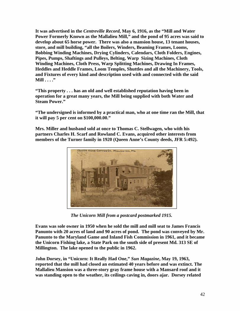
It was advertised in the Centreville Record, May 6, 1916, as the “Mill and Water Power Formerly Known as the Mallalieu Mill,” and the pond of 95 acres was said to develop about 65 horse power. There was also a mansion house, 13 tenant houses, store, and mill building, “all the Boilers, Winders, Beaming Frames, Looms, Bobbing Winding Machines, Drying Cylinders, Calendars, Cloth Folders, Engines, Pipes, Pumps, Shaftings and Pulleys, Belting, Warp Sizing Machines, Cloth Winding Machines, Cloth Press, Warp Splitting Machines, Drawing In Frames, Heddles and Heddle Frames, Loom Temples, Shuttles and all the Machinery, Tools, and Fixtures of every kind and description used with and connected with the said Mill . . . .” “This property . . . has an old and well established reputation having been in operation for a great many years, the Mill being supplied with both Water and Steam Power.” “The undersigned is informed by a practical man, who at one time ran the Mill, that it will pay 5 per cent on $100,000.00.” Mrs. Miller and husband sold at once to Thomas C. Stellwagen, who with his partners Charles H. Scarf and Rowland C. Evans, acquired other interests from members of the Turner family in 1920 (Queen Anne’s County deeds, JFR 5:492).
The Unicorn Mill from a postcard postmarked 1915. Evans was sole owner in 1950 when he sold the mill and mill seat to James Francis Panunto with 20 acres of land and 90 acres of pond. The pond was conveyed by Mr. Panunto to the Maryland Game and Inland Fish Commission in 1961, and it became the Unicorn Fishing lake, a State Park on the south side of present Md. 313 SE of Millington. The lake opened to the public in 1962. John Dorsey, in “Unicorn: It Really Had One,” Sun Magazine, May 19, 1963, reported that the mill had closed an estimated 40 years before and was extinct. The Mallalieu Mansion was a three-story gray frame house with a Mansard roof and it was standing open to the weather, its ceilings caving in, doors ajar. Dorsey related
42

that Unicorn village had once boasted a unicorn, but it was a live goat that had lost one of its horns in some battle with other animals; the 20th century unicorn had died about 1951. Both mansion and mill, had vanished before the 1970s explorations of the author of the Molinography. The works had been on the south side of the present Millington Road (Md. 313), west bank of the stream. Before the coming of the Mallalieu family, the mill had been used for grain milling and grinding of white oak bark for tanning, No textile mill had been listed for the county in the 1850 census of manufacturing. The village was once a prosperous spot and had boasted a company-sponsored brass band. Location of the factory was 3-G-4 in the ADC Street Atlas. UNION SILK CO. ( ) The Union Silk Company of Queen Anne’s County was chartered under Laws of Md., Acts of 1838, Chapter 343. Incorporators wee Doct. W. Finley, Andrew Johnson, V. P. Devorix, Doct. J. F. Boon, James M. Lucas, and Leonard Dunbracco. Capitalization was to be not less than $3000. UPPER MILL (3) See Taylors Mill. USILTONS GRISTMILL (3) Same as Chester Mill. VINSANTS MILL ( ) There was a reference to Joshua Vinsant’s Mill in Queen Anne’s County, Md. Gazette, July 20, 1758. WALLIS MILL (6) Same as Crouse Mill. WEDGE MILL ( ) Wedge Mill on Wedge River was mentioned in the Will of William Turlo in 1719; MCW, 4:197. WILKINSON TANNERY (3) Joseph Wilkinson’s heirs had a currying shop, 22 x 16 ft, all brick, and a tan house in Chester Hundred in the 1798 tax list.
43
WILLIAMS MILL (1) See Unicorn Woolen Mills. WILLIAMS MILL (3) In 1720, Edward Wright had a survey made for 123 acres called Mill-Ford on Chester Mill Branch near the dwelling plantation of Henry Williams (Patented Certificate No. 673, MSA). Wright assigned the certificate to Isaac and Abraham Williams. In 1724, Williams Mill Pond on Chester Mill Branch was mentioned as near the tract, “Smiths Neglect,” (LIBER IK No. B:266, MSA). Then in 1726, Edward Wright patented Milford Addition, “a little below Williams Mill Pond” (Patented Certificate No. 674 MSA). Abraham Williams took out a writ of ad quod damnum on a Branch called the Main Branch of Corsica Creek, May 19, 1749. The inquisition taken on June 6, 1749, awarded damages of 40 Shillings for 11-15/16 acres to William Allaband and 5 Shillings to John Ruth for a half acre, and a penny to the Lord Proprietor for 5/8th acre, all yearly rates. The tracts bordered on the tract Milford Addition. The grant was issued 8 years later, November 19, 1757 (Chancery Records, Liber 9:6, MSA). Abraham Williams assigned the writ to Henry Williams, and Henry Williams assigned to George Williams, who in 1759 leased the tract to William Dockery for £ 33-3/0 annually to be paid in good merchantable wheat. Williams agreed to build a mill and mill house 28 x 20 ft, 2 stories, fit it for a merchant mill, and he agreed to deliver up two pair of millstones. The tract began “on the east side of the pond where the bridge across the pear head” stood and adjoined Millford. The new mill was to be ready by December 21, 1760 (Queen Anne’s County deeds, RT No. F:1, MSA). The mill was upstream of Chester mill, possibly the predecessor of Judge Dardin’s mill that became Taylors. WILLIAMS SAWMILL (1) The 1877 county atlas showed the steam sawmill of J. L. Williams SW of Merrickton Post Office (now Barclay) on the south side of present Md. 303 just east of Barclay. Location was 9-F-10 in the ADC Street Atlas. WILLIAMS STEAM SAWMILL (1) The 1880 census of manufactures listed William Williams with $1800 capital investment in a sawmill with 3 employees, 30 hp steam engine, and annual output of 80,000 ft lumber ($1200).
44
WILSONS MILL (6) See Crouse Mill. WILLOUGHBY MILL (3) A blind advertisement was placed in the American Miller, 28 (November 1, 1900): 1890, by “Miller” from Box 201, Willoughby, Md., who wished to sell a 135 bbl roller mill run by water power “in the garden spot of Maryland.” The 1894-2895 Polk directory located Willoughby as 4 miles from Hillsborough, 6 miles from Centreville. Willoughby was barely inside Queen Anne’s County, so the disguised mill could also have been in Talbot County. WINCHESTER MILL ( ) Jacob Winchester had one windmill on a tract called Isaacs Addition Corrected per the 1798 tax list of Walsey, Upper, and Lower Hundreds. WINCHESTER SAWMILLS (5) Winchester in Piney Neck in the SW part of the county had three sawmills about 1887 per QACM, p. 563. See also, Tilghmans. WIND MILL ( ) Wind Mill, a 50-acre tract, was patented in 1758 by Richard Tilghman Earle (Patents, Liber BC & GS 13:195, MSA). In his will made in 1788, Earle left the land to his grandson, Henry Hindman. The tract adjoined Toms Fancy, a tract on Tullys Creek. The land was sold under special Act of Assembly, December 1790, to William Naylor (Chancery Records, B134:631, 642, MSA). WOOD MILL (2) James Wood was listed as miller at Church Hill in Boyd’s Business Directory, 1875. WRIGHTSON MILL (5) The William D. Wrightson steam saw and grist mill was listed at Queenstown in the 1887 State business directory. The 1877 county atlas showed the mill on an inlet of Big Wye River, south of Bryantown and east of Bennett Point road. The 1880 census of manufactures listed two 40 hp engines with two (or three) boilers, and annual output of 13,000 ft lumber ($2200) and 240 bbl flour and 81 tons of meal ($4000). There were 6 employees, and $1000capital investment in the sawmill and $2000 in the flour mill. Location was near present Bryantown Landing, grid 25-A-9 in the ADC Street Atlas.
45

WYE MILLS (-) The famous Wye Mill is listed under Talbot County; the county line runs through the mill. WOODALL SAWMILL (7) The D. R. Woodall Steam Sawmill was shown in the 1877 county atlas at the NE corner of present Md. 544 and Double Creek Road. Location was 1-K-11 in the ADC Street Atlas.
46

47

48