quaternary geology of the duck hawk bluffs, southwest banks island, arctic canada: a...
TRANSCRIPT
lable at ScienceDirect
Quaternary Science Reviews xxx (2014) 1e42
Contents lists avai
Quaternary Science Reviews
journal homepage wwwelsevier comlocatequascirev
Quaternary geology of the Duck Hawk Bluffs southwest Banks IslandArctic Canada a re-investigation of a critical terrestrial type localityfor glacial and interglacial events bordering the Arctic Ocean
David JA Evans a John H England b Catherine La Farge c Roy D Coulthard bThomas R Lakeman d Jessica M Vaughan b
aDepartment of Geography Durham University South Road Durham DH1 3LE UKb Earth and Atmospheric Sciences University of Alberta Edmonton Alberta T6G 2E3 CanadacDepartment of Biological Sciences University of Alberta Edmonton Alberta T6G 2E9 CanadadDepartment of Earth Sciences Dalhousie University Halifax Nova Scotia B3H 4R2 Canada
a r t i c l e i n f o
Article historyReceived 24 October 2013Received in revised form26 February 2014Accepted 7 March 2014Available online xxx
KeywordsDuck Hawk BluffsBanks IslandGlacitectonicsQuaternary stratigraphyCanadian Arctic glaciations and interglacialsPalaeoenvironments
Corresponding author Tel thorn44 0191 334 1886E-mail address djaevansdurhamacuk (DJA E
httpdxdoiorg101016jquascirev2014030110277-3791 2014 Elsevier Ltd All rights reserved
Please cite this article in press as Evans DJinvestigation of a critical terrestrial type lo(2014) httpdxdoiorg101016jquascirev
a b s t r a c t
Duck Hawk Bluffs southwest Banks Island is a primary section (8 km long and 60 m high) in the westernCanadian Arctic Archipelago exposing a long record of Quaternary sedimentation adjacent to the ArcticOcean A reinvestigation of Duck Hawk Bluffs demonstrates that it is a previously unrecognized thrust-block moraine emplaced from the northeast by Laurentide ice Previous stratigraphic models of DuckHawk Bluffs reported a basal unit of preglacial fluvial sand and gravel (Beaufort Fm forested Arctic)overlain by a succession of three glaciations and at least two interglacials Our observations dismiss theoccurrence of preglacial sediments and amalgamate the entire record into three glacial intervals and oneprominent interglacial The first glacigenic sedimentation is recorded by an ice-contact sandur con-taining redeposited allochthonous organics previously assigned to the Beaufort Fm This is overlain byfine-grained sediments with ice wedge pseudomorphs and well-preserved bryophyte assemblagescorresponding to an interglacial environment similar to modern The second glacial interval is recordedby ice-proximal mass flows and marine rhythmites that were glacitectonized when Laurentide iceoverrode the site from Amundsen Gulf to the south Sediments of this interval have been reported to bemagnetically reversed (gt780 ka) The third interval of glacigenic sedimentation includes glacifluvial sandand gravel recording the arrival of Laurentide ice that overrode the site from the northeast (islandinterior) depositing a glacitectonite and constructing the thrust block moraine that comprises DuckHawk Bluffs Sediments of this interval have been reported to be magnetically normal (lt780 ka) Theglacitectonite contains a highly deformed melange of pre-existing sediments that were previouslyassigned to several formally named marine and interglacial deposits resting in an undeformed sequenceIn contrast the tectonism associated with the thrust block moraine imparted pervasive deformationthroughout all underlying units highlighted by a previously unrecognized raft of Cretaceous bedrockDuring this advance Laurentide ice from the interior of Banks Island coalesced with an ice stream inAmundsen Gulf depositing the interlobate Sachs Moraine that contains shells as young as w24 cal ka BP(Late Wisconsinan) During deglaciation meltwater emanating from these separating ice lobes depositedoutwash that extended to deglacial marine limit (11 m asl) along the west coast of Banks Island Our newstratigraphic synthesis fundamentally revises and simplifies the record of past Quaternary environmentspreserved on southwest Banks Island which serves as a key terrestrial archive for palaeoenvironmentalchange
2014 Elsevier Ltd All rights reserved
vans)
A et al Quaternary geologycality for glacial and intergla201403011
1 Introduction
Previous reconstructions of the Neogene and Quaternary historyof Banks Island NT have featured a complex and apparentlycontinuous multiple glaciation record notably from Duck Hawk
of the Duck Hawk Bluffs southwest Banks Island Arctic Canada a re-cial events bordering the Arctic Ocean Quaternary Science Reviews
DJA Evans et al Quaternary Science Reviews xxx (2014) 1e422
Bluffs (DHB Fig 1a b) The Banks Island stratigraphy purportedlyincludes late Neogene fluvial sand and gravel (assigned to theBeaufort Fm) overlain by the preglacial Worth Point Fm and thenthe deposits of at least three glacial and interglacial intervals(Vincent 1982 1983 1984 1990 Vincent et al 1983 1984Barendregt and Vincent 1990 Barendregt et al 1998) Thismodel was initially proposed for the surficial record of the entireisland (70000 km2) where multiple till sheets and moraine sys-tems glacioisostatically controlled raised marine deposits andexpansive proglacial lake sediments were assigned to three discreteglaciations spanning at least the last 780 ka (Fig 1b c) Subse-quently expansive coastal sections were proposed to replicate thesame stratigraphic record of the multiple glacial and interglacial
Fig 1 Banks Island and the traditional Quaternary stratigraphy a) location map of Banks Islaglaciations based on surficial geology and Quaternary stratigraphy (from Vincent 1983) WPShelf moraine location MB frac14Morgan Bluffs NRB frac14 Nelson River bluff c) summary of traditibased on the Duck Hawk Bluffs Formation from SW Banks Island (after Barendregt and Vincein the ldquowestrdquo and ldquocentralrdquo cliffs and that the upper details labelled ldquoBluffs E Mary Sachs C
Please cite this article in press as Evans DJA et al Quaternary geologyinvestigation of a critical terrestrial type locality for glacial and intergla(2014) httpdxdoiorg101016jquascirev201403011
sequences in the surficial geology (Vincent 1982 1983) Fieldworkconducted during the past decade has proposed fundamental re-visions of the surficial geology throughout Banks Island (Englandet al 2009 Lakeman and England 2012 2013 in press Vaughanet al 2014) In contrast to previously proposed models (Vincent1982 1983 1984 1990 Vincent et al 1983 1984 Barendregt andVincent 1990 Barendregt et al 1998) the revised surficial recordof glacial and marine landforms were assigned to the Late Wis-consinan This has raised significant questions about thecomplexity and timescale of the previously reported stratigraphicrecord given that Banks Island has been widely regarded as acritical type locality for glacial and interglacial events in thecircumpolar Arctic (cf Vincent et al 1983 1984 Clark et al 1984
nd in the western Canadian Arctic b) map of the traditional proposals for the extent ofB frac14 Worth Point bluff DHB frac14 Duck Hawk Bluffs VMSIS frac14 Viscount Melville Sound Iceonal stratigraphy magnetostratigraphy and reconstructed glacial and interglacial eventsnt 1990) Note that this is a composite section based upon Vincent et al (1983) logs AeIkrdquo are from their log J in the ldquoMary Sachs Creek Cliffrdquo (see Figs 3 and 4)
of the Duck Hawk Bluffs southwest Banks Island Arctic Canada a re-cial events bordering the Arctic Ocean Quaternary Science Reviews
Fig 1 (continued)
DJA Evans et al Quaternary Science Reviews xxx (2014) 1e42 3
Matthews et al 1986 Matthews and Ovenden 1990 Vincent1990 Harrison et al 1999 Barendregt and Duk-Rodkin 2011Duk-Rodkin and Barendregt 2011 Li et al 2011 OrsquoRegan et al2011 Batchelor et al 2012 2013) Therefore it is timely that thestratigraphic record of Banks Island is reinvestigated especially theprimary sections at DHB and nearby Worth Point (Vaughan et al2014) Another revision of a prominent section at Morgan Bluffssoutheast Bank Island is provided by Lakeman and England (inpress)
2 Study area and previous research
DHB is a continuous coastal cliff 8 km long and up to 60 m highextending westward fromMary Sachs Creek to the southwest tip ofBanks Island (Fig 2) The bluffs compose an area of high land
Please cite this article in press as Evans DJA et al Quaternary geologyinvestigation of a critical terrestrial type locality for glacial and intergla(2014) httpdxdoiorg101016jquascirev201403011
separating Amundsen Gulf to the south from Kellett River to thenorth Small north-south orientated valleys dissect DHB dividing itinto five sectors designated ldquowesternmostrdquo ldquowestrdquo ldquocentralrdquoldquoeastrdquo and ldquoeasternmostrdquo cliffs (Fig 3) Cliff exposures to the east ofMary Sachs Creek were also investigated as they mark the westernend of a moraine and till sheet (Sachs Till) deposited by the Lau-rentide Ice Sheet occupying Amundsen Gulf (Figs 2 3) Previousresearch assigned the moraine to the Early Wisconsinan whereaslandforms and sediments west of Mary Sachs Creek were assignedto the Bernard Till of the Banks Glaciation (gt780 ka BP) overlain bya sequence of undeformed marine and interglacial sediments(Vincent 1982 1983 Vincent et al 1983 1984)
The first lithostratigraphy presented for DHB was compiled byVincent et al (1983 Fig 4) Their logs (AeI) correspond to ourldquowesternrdquo and ldquocentralrdquo cliffs whereas east of DHB their log J
of the Duck Hawk Bluffs southwest Banks Island Arctic Canada a re-cial events bordering the Arctic Ocean Quaternary Science Reviews
Fig 2 Aerial views of the Duck Hawk Bluffs a) oblique aerial photograph of the bluffs viewed from the east b) vertical aerial photograph extract of the local terrain of thesouthwest coast of Banks Island (photograph A17381-41 National Air Photograph Library Ottawa) Black broken line arrows are relict meltwater channels Areas outlined by reddotted lines are likely glacitectonic thrust masses based on interpretations of the sedimentology and stratigraphy reported in this paper The ldquoSachs Tillrdquo moraine of Vincent (1983)is outlined by white dotted line (For interpretation of the references to colour in this figure legend the reader is referred to the web version of this article)
DJA Evans et al Quaternary Science Reviews xxx (2014) 1e424
corresponds to our ldquoMary Sachs Creek cliffrdquo (Fig 3) This modelrecognized seven major stratigraphic units within logs AeI whichwere assigned formation status (Vincent et al 1983) A prominentbasal sand and gravel unit was originally assigned to the NeogeneBeaufort Fm (Tb) based on its associated macroflora (Hills et al1974 Vincent et al 1983) However macrofloral differences be-tween the Beaufort Fm type locality on Prince Patrick Island and thebasal gravel at DHB (which appeared ldquomore alteredrdquo) promptedFyles (1990 p 400) to designate the basal gravel at DHB as theldquoMary Sachs gravelrdquo Overlying this gravel Vincent et al (1983)recognized the Worth Point Fm e a non-glacial pre-Quaternaryaeolian fluvial and lacustrine sand (unit 1 Fig 4) This assumed acorrelationwith the type locality of theWorth Point Fmw30 km tothe north that broadly occupied a similar stratigraphic setting (cfVincent 1982 1983 Barendregt et al 1998) Vincent further
Please cite this article in press as Evans DJA et al Quaternary geologyinvestigation of a critical terrestrial type locality for glacial and intergla(2014) httpdxdoiorg101016jquascirev201403011
proposed that theWorth Point Fm at DHBwas overlain by the DuckHawk Bluffs Fmmarking the onset of glaciation and comprising theBernard Till (Banks Glaciation) sandwiched between glacimarinesediments of the ldquoPre-Banksrdquo and ldquoPost Banksrdquo seas (units 2a b cFig 4) The Duck Hawk Bluffs Fmwas reported to be capped by theMorgan Bluffs Fm (interglacial unit 3) Nelson River Fm (full glaciallsquoBig Searsquo unit 4) and Cape Collinson Fm (Sangamonian Interglacialunit 5 Fig 4) Despite the fact that these formations at DHB arethinly bedded and discontinuous with localized pockets of or-ganics they are nonetheless correlated with inferred interglacialand glacial deposits at Nelson River and Morgan Bluffs gt140 km tothe east (cf Vincent 1982 1983 Barendregt et al 1998) Accordingto this model (Vincent et al 1983) themost recent deposits (unit 6)are composed of the ldquoPre-Amundsen Seardquo glacimarine sedimentsand the ldquoSachs Tillrdquo which are assigned to the Early Wisconsinan
of the Duck Hawk Bluffs southwest Banks Island Arctic Canada a re-cial events bordering the Arctic Ocean Quaternary Science Reviews
Fig
3To
pograp
hicmap
oftheSW
coastof
Bank
sIsland
show
ingthelocation
sof
thecliff
expo
suresex
amined
during
thisstud
yEa
chcliff
contains
oneor
moreve
rtical
profi
leloglocation
swhich
arede
sign
ated
byletters(see
Fig
7)
DJA Evans et al Quaternary Science Reviews xxx (2014) 1e42 5
Please cite this article in press as Evans DJA et al Quaternary geologyinvestigation of a critical terrestrial type locality for glacial and intergla(2014) httpdxdoiorg101016jquascirev201403011
Prince of Wales Fm These deposits however only appear in Log Joverlying the Nelson River and Cape Collinson Fms (Fig 4)
Compilations of organic samples and sediments used fordating and palaeoecological reconstructions in the originalmodel for DHB can be found in Vincent et al (1983 1984)Matthews et al (1986) Vincent (1990) Barendregt and Vincent(1990) and Barendregt et al (1998 Fig 4) The stratigraphiclogs and palaeomagnetic measurements were compiled in acomposite lithostratigraphy (Barendregt and Vincent 1990Fig 1c) Palaeomagnetic measurements indicate that sedimentsin the Worth Point Fm Duck Hawk Bluffs Fm and lower MorganBluffs Fm are magnetically reversed (gt780 ka Matuyama Chron)whereas all sediments from the upper Morgan Bluffs Fm to thesurface are magnetically normal (lt780 ka Bruhnes ChronVincent et al 1984 Barendregt and Vincent 1990)
3 Methods
Stratigraphic exposures at DHB were documented using an-notated photomosaics and vertical profile logs which includedprimary sedimentary structures bed contacts sediment bodygeometry sorting texture and organic macrofossils These datawere then employed in the characterization of individual lith-ofacies classified according to the facies codes proposed byEyles et al (1983) and Evans and Benn (2004) Where relevantsecondary sedimentary structures including faults folds icewedge pseudomorphs and cross-cutting intrusions or clasticdykes were also entered onto stratigraphic logs and photomo-saics The orientations of the dipping surfaces of thrust faultplanes were also measured and entered onto vertical profile logsas individual data points or as great circles on lower hemi-spheric stereoplots wherever numerous measurements werepossible
Former debris transport pathways were evaluated through clastform analyses on predominantly sandstone quartize and chert li-thologies which included Powers roundness (VA frac14 very angularA frac14 angular SA frac14 sub-angular SR frac14 sub-rounded R frac14 roundedWR frac14 well rounded) and clast shape (see Benn 2004) Roundnesswas assessed visually using histogram plots and statistically bycalculating an RAvalue (relative angularityfrac14 percentage of clasts inthe VA and A categories) an RWR value (percentage of clasts in theR and WR categories Benn et al 2004 Lukas et al 2013) and anaverage roundness value wherein VA frac14 0 A frac14 1 SA frac14 2 SR frac14 3Rfrac14 4 andWRfrac14 5 (cf Spedding and Evans 2002 Evans 2010) Clastshape was analysed statistically by using clast shape triangles(Benn 2004) fromwhich C40 indices (percentage of clasts with CAaxial ratios 04) were derived and compared to RA RWR andaverage roundness values in co-variance plots following proceduresoutlined in Benn and Ballantyne (1994) The RWR index isemployed here because previous studies have reported that glaci-fluvial reworking of clast forms results in the failure of the RA-indexto discriminate between different transport pathways (Benn et al2004 Evans et al 2010 Lukas et al 2013 in press)
Control samples for clast form assessment are normallycollected frommaterial derived from known processes operating inthe vicinity and using similar lithologies to those sampled instratigraphic section However DHB lacks a glacierized catchment(glacifluvial subglacial and slope processes) requiring that controlsamples for clast form analysis be taken from existing databasesusing lithologies similar to those sampled locally We employ theldquoType 2rdquo co-variance plot of Lukas et al (2013) which representsmostly highly anisotropic lithologies (Fig 5)
Clast macro-fabrics were measured on diamictons using pre-dominantly the AB planes and in some cases also the A-axes ofclasts (n frac14 50 or 30) which are thought to rotate towards
of the Duck Hawk Bluffs southwest Banks Island Arctic Canada a re-cial events bordering the Arctic Ocean Quaternary Science Reviews
Fig 4 Vincent et al (1983) lithostratigraphy for the Duck Hawk Bluffs (logs AeI) and Mary Sachs Creek cliff (log J) Logs AeG are in our West cliff and logs H and I are in our Centralcliff
DJA Evans et al Quaternary Science Reviews xxx (2014) 1e426
parallelism with the principal axis of extensional strain in adeforming medium or with the plane of slip during brittle defor-mation (Benn and Evans 1996) The data were processed in Rock-works stereonet software and depicted using Schmidt equal-arealower hemisphere projections based of spherical Gaussian distri-butions The macrofabrics were then analysed for strength mo-dality and isotropy following procedures outlined by Benn (19942004) thereby facilitating an assessment not only of the directionof applied stress but also the genesis of the deposit The latter wasdetermined through comparisons with the clast macrofabrics ofsubglacial tills sampled at modern glacier margins subaqueousglacigenic diamictons and glacitectonites utilizing the data pre-sented by Benn (1994 1995) Evans and Hiemstra (2005) and Evanset al (2007) and employing specifically the modalityisotropy plotof Evans et al (2007 Fig 6)
Please cite this article in press as Evans DJA et al Quaternary geologyinvestigation of a critical terrestrial type locality for glacial and intergla(2014) httpdxdoiorg101016jquascirev201403011
4 Organics
Twelve organic samples were collected and analysed from theDBH sections Bulk organics were subsampled then submerged inwater rinsed and screened through two sieves (710 mm and450 mm) for macrofossils From the retained residue preservedsubfossils were examined with dissecting (Wild M5A) and com-pound (Leitz Laborlux S)microscopes Bryophyteswere determinedusing Nyholm (1956e1965) and Lawton (1971) with nomenclaturaladjustments using Crosby et al (1999) Species determinations ofthe Calliergonaceae and Amblystegiaceae used the revised in-terpretations by Hedenaumls (1993 2006) Palaeoecological recon-struction utilizes Kuc and Hills (1971) Kuc (1974) Steere (1978)Steere and Scotter (1979) and Janssens (1983) Macrofossilvouchers were mounted on permanent slides and deposited in the
of the Duck Hawk Bluffs southwest Banks Island Arctic Canada a re-cial events bordering the Arctic Ocean Quaternary Science Reviews
Fig 5 Clast form co-variance plots of data from this study a) Type 2 clast form co-variance plot from Lukas et al (2013) used in this study as control sample data for theinterpretation of clast wear patterns and former transport histories b) C40RA and C40RWR co-variance plots for data collected in this study
DJA Evans et al Quaternary Science Reviews xxx (2014) 1e42 7
Cryptogamic Herbarium (ALTA) Biological Sciences University ofAlberta
5 Results
51 Sedimentology and stratigraphy (Duck Hawk Bluffs)
The sedimentological and stratigraphic data for DHB arecompiled in vertical profile logs and annotated photographs (Fig 7)The descriptions and interpretations of the lithofacies associations(LFA) recognized throughout the bluffs are then presentedemploying details illustrated in Fig 7 and referring to the clast formand macrofabric data analysis (Figs 5 6)
511 DescriptionLFA 1 comprises up to 38 m of predominantly well-sorted
cross-stratified sand and gravel arranged in stacked sequences ofhorizontal and planar bedding structures The most common lith-ofacies are planar and trough cross-bedded sand often withgranule lags and horizontal to planar or trough cross-beddedgravel (Fig 8) Also common especially towards the base of theexposures is matrix-supported gravel with boulders Macrofossilscommonly comprising crudely bedded organic detritus also
Please cite this article in press as Evans DJA et al Quaternary geologyinvestigation of a critical terrestrial type locality for glacial and intergla(2014) httpdxdoiorg101016jquascirev201403011
include large tree debris (ie logs or stumps with degraded rootballs) and compressed mats of small woody fragments occurthroughout the sequence (Fig 8a) The largest concentrations oftree fragments and stumps occur in coarser grained gravelly bedsparticularly in matrix-supported gravel with sand silt and clayintraclasts The floral and faunal assemblages within LFA 1 arediverse as illustrated by lists reported in Roy and Hills (1972) Hillset al (1974) Hills (1975) Matthews et al (1986) and Matthews(1987)
Sandier lithofacies occur towards the top of LFA 1 where theyrecord a fining upward sequence In the central cliffs andWest Log Dthese upper beds contain rhythmically bedded (varve-like) silt andclay with lonestones interbedded with matrix-supported gravellyscour fills containing a distinct horizon of logs and woody detritusAt Central Log A the underlying LFA 1 gravel is arranged in promi-nent clinoforms or foreset beds dipping at 20 towards the south-west (Fig 8c) Well-developed ice wedge pseudomorphs up to 5 mdeep also occur towards the top of LFA 1 in some sections (Fig 7aiii) Clastic dykes or fissure fills are also common characterized bycrudely sub-vertically bedded and poorly sorted sand and gravelthat in some cases is clearly rooted in underlying strata Some clasticdykes are also characterized by branching and upward extendinglimbs or tentacles that wedge out in the host materials
of the Duck Hawk Bluffs southwest Banks Island Arctic Canada a re-cial events bordering the Arctic Ocean Quaternary Science Reviews
Fig 6 Quantitative plots of clast fabric strength a) clast fabric shape ternary plot(Benn 1994) containing AB plane (blue) and A axis (red) data used in this paper andcontrol sample data (AB planes) for glacitectonite (Evans et al 1998 Hiemstra et al2007) subglacial till (Evans and Hiemstra 2005) and lodged clasts (Evans andHiemstra 2005) b) modalityeisotropy plot (Hicock et al 1996 Evans et al 2007)of the clast AB plane (blue) and A axis (red) macrofabric data used in this paperEnvelopes contain data from deposits of known origin and shaded area represents thatpart of the graph in which stronger modality and isotropy in subglacial traction tills orglacitectonites reflects an increasing lodgement component (based on Evans andHiemstra 2005 Evans et al 2007) This graph is thereby used to interpret trends incumulative strain signature in the glacitectonite-subglacial traction till continuum(sensu Evans et al 2006) (un unimodal su spread unimodal bi bi-modal sb spreadbi-modal mm multi-modal) See Fig 7 for sample locations (For interpretation of thereferences to colour in this figure legend the reader is referred to the web version ofthis article)
DJA Evans et al Quaternary Science Reviews xxx (2014) 1e428
Please cite this article in press as Evans DJA et al Quaternary geologyinvestigation of a critical terrestrial type locality for glacial and intergla(2014) httpdxdoiorg101016jquascirev201403011
Palaeocurrents measured on sand and gravel bedformsthroughout LFA 1 indicate progradation predominantly towards thewest with themost common flowdirections towards theWSWandWNW Clast lithologies are dominated by chert quartzite andsandstone with minor amounts of shale towards the top of LFA 1quartzite dominates the counts in the middle of LFA 1 Striae arevisible on a small number of clasts ranging from 16 at the base to6 in the middle and upper lithofacies Clast form data from LFA 1reveal a vertical increase in rounding (228e312) and RWR values(2e28) reasonably consistent C40 values throughout (26e50)and a vertical reduction in but generally low RA values (10-0)Exposures through LFA 1 in the eastern cliffs reveal large scalereverse (thrust) faults that displace underlying Kanguk Fm andoverlying LFA 1 beds towards the southwest (Fig 7d iveviii)
LFA 2 is only locally preserved and often heavily deformed bysimple shear structures (eg Fig 7c iii inset photos 5e9 amp Fig 7d iiiinset photos aek) It comprises 11 m but generally less than 8 m ofrhythmic planar to horizontally bedded sand with thin anddiscontinuous beds of massive granule gravel or lags and laminatedfine sand silt and clay arranged in stacked units and interbedsOutsized clasts or lonestones occur in many finer grained units Atthe base of LFA 2 (west cliffs) a laterally extensive surface (w100 mwide) composed of locally disharmonically folded laminae alsocontains prominent ice wedges and thick peat composed of in situbryophyte assemblages characterized by excellent preservation(Fig 9) Nine bryophtye dominated samples were collected five ofthem spanning a single 15 m section of interbedded organics withfine sands generally accordant with the ice wedge surface
Secondary structures include clastic dykes intruded upwardsfrom underlying LFA 1 gravel sand wedge pseudomorphs (Fig 9)intraformational burst-out clastic dykes and zones of overfolded orcrumpled bedding and thrust faults associated with boudinage orhigh fissilitypseudo-lamination (Fig 10) Deformation and intensemodification andor erosion are locally the most prominent sedi-mentary signatures for example at the junction of LFA 1 and LFA 3near west Log D where LFA 2 has been pinched out from an initialthickness of approximately 6 m (Fig 11) At this location LFA 2displays a 1e2 m thick basal zone comprising highly attenuatedinter-digitated beds of gravelly to clay-rich diamictons and sandsiltclay rhythmites This passes upwards into rhythmites contain-ing diamictic intraclasts with sharp and angular boundariessignificantly the rhythmite bedding drapes the intraclasts and inplaces is deformed beneath them The sense of shearing in thedeformation structures (Fig 7c iii 10) is predominantly towards thesouthwest although some structures indicate shearing towards thenorth specifically ranging from between NNW and NNE Thesouthwesterly shearing direction is recorded in thrust faults thatcontinue into or are developed within underlying LFA 1 andoverlying LFA 3
LFA 3 varies in thickness from 6 to 14 m and is separated fromunderlying LFA 2 by a heavily deformed zone characterized byintensely folded thrust faulted andor highly fissile sand silt claylaminae or an erosional contact associated with attenuated rafts(intrabeds) of LFA 2 sediments (eg Fig 7c iii inset photo 5 7b ivinset photo 2) It comprises a massive to pseudo-laminated matrix-supported diamicton (Fig 7d i inset photo 1) with localized zonesof discontinuous stratified sand andor gravel lenses up to 1 mthick (Fig 7c iii inset photo 4) Areas of more densely spacedstratified lenses constitute an interbedded relationship with thediamicton Zones of attenuated andor overfolded lenses indicatepost-depositional deformation of the diamicton and tend to beconcentrated at the top (Fig 7b iv inset photo 3) or base of LFA 3(Fig 7d i inset photo 2) The sense of shearing in the lower part ofLFA 3 is variable but predominantly towards the southwest withsubsidiary thrusts towards the north (between NNW and NNE) In
of the Duck Hawk Bluffs southwest Banks Island Arctic Canada a re-cial events bordering the Arctic Ocean Quaternary Science Reviews
Fig 7 a Stratigraphic logs and sedimentological details of westernmost cliff i) Log A ii) Log B iii) photomosaic of lower Log B iv) photomosaic of upper log B v) Log C vi) Log D Inall logs the single barbed arrows with compass orientations indicate sense of shearing based on thrust planes and the solid arrows with compass orientations indicate palaeocurrentdirections b Stratigraphic logs and sedimentological details of west cliff i) Log A1 ii) Log A iii) Log B iv) Log C v) Log D c Stratigraphic logs and sedimentological details ofcentral cliff i) Log A ii) details of deformation structures in LFA 6 at top of Log A iii) supplementary details of upper part of sequence located immediately east of Log A dStratigraphic logs and sedimentological details of east cliff i) Log A ii) photomosaic of lower Log A showing lower LFA 1 details iii) photomosaic of middle Log A showing upper LFA1 details (inset photos l amp m) and LFA 2 details (inset photos aek) iv) overview of the eastern half of east cliff showing locations of logs A and B a photolog of the capping gravellyglacitectonite carapace major faults and the LFA 1Kanguk Formation contact The anomalous dips of the LFA 1 bedding associated with the major faults are represented by the 3-Dplane symbol v) overview of the deformation structures in the eastern part of the east cliff showing prominent distorted bedding major thrusts and 3-D representations ofanomalous dips in LFA 1 bedding The approximate boundary between the Kanguk Formation bedrock and LFA 1 provides an outline of a prominent thrust block that has beendisplaced along a major fault descending below beach level at the far right of the image vi) details of the major fault structures and chevron folding developed in the thrust block ofKanguk Formation with the shearing direction represented by the thrust plane dip orientations in a lower hemisphere stereoplot vii) Log B compiled as a photomosaic ofdeformation structures developed within sandsilt interbeds in the LFA 1 strata that overlie the Kanguk Formation thrust block viii) details of deformation structures identified inthe Kanguk Formation thrust block e Stratigraphic logs and sedimentological details of easternmost cliff i) photomosaic of the easternmost cliffs showing locations of the threevertical logs ii) Log A iii) Log B iv) Log C showing details of cobble clast lag at contact of LFAs 1 and 5 in inset ldquocrdquo and a vertical branching clastic dyke in LFA 1 in inset ldquodrdquo
DJA Evans et al Quaternary Science Reviews xxx (2014) 1e42 9
the upper part of LFA 3 the sense of shearing is towards WSW orwest although there is also some evidence of a northerly sheardirection Clast macrofabrics are moderately to well clustered(S1 frac14 0451e0773) and display a range of orientations the mostprominent stress being towards the southwest but also includingNeS alignments Unusually steep AB plane dips occur in therecumbent folds of lower LFA 3 in west cliff Log D (WCD F1)
Please cite this article in press as Evans DJA et al Quaternary geologyinvestigation of a critical terrestrial type locality for glacial and intergla(2014) httpdxdoiorg101016jquascirev201403011
although this sample is aligned NWeSE Clast macrofabricstrengths as quantified by the fabric shape ternary plot (Fig 6a)and the modalityisotropy plot (Fig 6b) are variable with thestrongest clusters being represented by the A axis and AB planedata from the upper part of LFA 3 (WCD F3) In the ternary graphthe macrofabric shapes plot across the spectrums of the glaci-tectonite and subglacial traction till envelopes (Evans et al 2006
of the Duck Hawk Bluffs southwest Banks Island Arctic Canada a re-cial events bordering the Arctic Ocean Quaternary Science Reviews
Fig 7 (continued)
DJA Evans et al Quaternary Science Reviews xxx (2014) 1e4210
Please cite this article in press as Evans DJA et al Quaternary geology of the Duck Hawk Bluffs southwest Banks Island Arctic Canada a re-investigation of a critical terrestrial type locality for glacial and interglacial events bordering the Arctic Ocean Quaternary Science Reviews(2014) httpdxdoiorg101016jquascirev201403011
Fig 7 (continued)
DJA Evans et al Quaternary Science Reviews xxx (2014) 1e42 11
Please cite this article in press as Evans DJA et al Quaternary geology of the Duck Hawk Bluffs southwest Banks Island Arctic Canada a re-investigation of a critical terrestrial type locality for glacial and interglacial events bordering the Arctic Ocean Quaternary Science Reviews(2014) httpdxdoiorg101016jquascirev201403011
Fig 7 (continued)
DJA Evans et al Quaternary Science Reviews xxx (2014) 1e4212
Please cite this article in press as Evans DJA et al Quaternary geology of the Duck Hawk Bluffs southwest Banks Island Arctic Canada a re-investigation of a critical terrestrial type locality for glacial and interglacial events bordering the Arctic Ocean Quaternary Science Reviews(2014) httpdxdoiorg101016jquascirev201403011
Fig 7 (continued)
DJA Evans et al Quaternary Science Reviews xxx (2014) 1e42 13
Please cite this article in press as Evans DJA et al Quaternary geology of the Duck Hawk Bluffs southwest Banks Island Arctic Canada a re-investigation of a critical terrestrial type locality for glacial and interglacial events bordering the Arctic Ocean Quaternary Science Reviews(2014) httpdxdoiorg101016jquascirev201403011
Fig 7 (continued)
DJA Evans et al Quaternary Science Reviews xxx (2014) 1e4214
Please cite this article in press as Evans DJA et al Quaternary geology of the Duck Hawk Bluffs southwest Banks Island Arctic Canada a re-investigation of a critical terrestrial type locality for glacial and interglacial events bordering the Arctic Ocean Quaternary Science Reviews(2014) httpdxdoiorg101016jquascirev201403011
Fig 7 (continued)
DJA Evans et al Quaternary Science Reviews xxx (2014) 1e42 15
Please cite this article in press as Evans DJA et al Quaternary geology of the Duck Hawk Bluffs southwest Banks Island Arctic Canada a re-investigation of a critical terrestrial type locality for glacial and interglacial events bordering the Arctic Ocean Quaternary Science Reviews(2014) httpdxdoiorg101016jquascirev201403011
Fig 7 (continued)
DJA Evans et al Quaternary Science Reviews xxx (2014) 1e4216
Please cite this article in press as Evans DJA et al Quaternary geology of the Duck Hawk Bluffs southwest Banks Island Arctic Canada a re-investigation of a critical terrestrial type locality for glacial and interglacial events bordering the Arctic Ocean Quaternary Science Reviews(2014) httpdxdoiorg101016jquascirev201403011
Fig 7 (continued)
DJA Evans et al Quaternary Science Reviews xxx (2014) 1e42 17
Please cite this article in press as Evans DJA et al Quaternary geology of the Duck Hawk Bluffs southwest Banks Island Arctic Canada a re-investigation of a critical terrestrial type locality for glacial and interglacial events bordering the Arctic Ocean Quaternary Science Reviews(2014) httpdxdoiorg101016jquascirev201403011
Fig 7 (continued)
DJA Evans et al Quaternary Science Reviews xxx (2014) 1e4218
Fig 6a) Clast lithologies vary depending on sample location Amore restricted lithological component (chert quartzite andsandstone) occurs in the deformed contact zone with underlyingLFA 1 and in areas characterized by attenuated gravel lenses Amore varied clast lithology comprising chert and quartz with mi-nor components of sandstone shale granite gabbro and limestoneoccurs towards the middle and in the more diamictic zones (LFA 3)
LFA 4 comprises less than 5 m of sand silt and clay arranged inhorizontal cross-laminae rhythmites climbing ripples or drapedlaminae that locally contain organic detritus The upper and lowercontacts of LFA 4 are commonly characterized by heavily brecciatedclay or contain boudinage and thrust faulted laminae (Fig 12panels a amp c) Some outcrops of LFA 4 also display widespreaddeformation in the form of overfolded bedding and thrust faultsalthough normal faulting and open folding or convolute beddingstructures are also evident (Fig 7c iii inset photo 3) In some sec-tions LFA 4 comprises only a thin (lt2 m thick) bed of brecciatedclay (Fig 7b iv inset photo 4) or laminated sand displaying over-folds and sheath folds The sense of shearing as recorded by thrustfaults is generally towards the SSW but southerly and southwest-erly orientations are also evident Numerous examples of narrowanabranched clastic dykes rise sub-vertically through the thickestoutcrop of the sandy climbing ripple lithofacies (LFA 4 West Log A)and have created offset beds between the blocks within the hostmaterial (Fig 12 panel b) The contact of LFA 4 with LFA 3 (west cliffLog A) is marked by a clast lag Although the association is pre-dominantly heavily deformed the most unaltered and thickest
Please cite this article in press as Evans DJA et al Quaternary geologyinvestigation of a critical terrestrial type locality for glacial and intergla(2014) httpdxdoiorg101016jquascirev201403011
outcrop in West Log A displays climbing ripple drift indicative of apalaeocurrent from the south or southwest (Fig 7b ii)
LFA 5 comprises 5e10 m of tabular sets of horizontally beddedto massive gravel interbedded with horizontally bedded or cross-laminated sand and occasional units of matrix-supported gravel(Fig 13a b) The thickest outcrop displays a general coarsening-upward sequence from well-sorted horizontally bedded granulegravel and sand to matrix-supported and less well sorted hori-zontally bedded cobble to boulder gravel Clast lithologies aredominated by quartzite but contain subsidiary amounts of chertand sandstone with minor limestone LFA 5 differs from LFA 1based on its general coarsening-upward characteristics coarsergrain size and the presence of limestone clasts Clast form datafrom LFA 5 indicate a sub-rounded sample (averageroundness frac14 222 amp 246 RA frac14 8 amp 24 RWR frac14 2 amp 6) withpredominantly blocky shapes (C40 frac14 30 amp 42) and striae visible(lt14 of clasts) Upper and lower contacts are sharp but are locallyinterdigitated or amalgamated with LFA 6 (Fig 7b iv inset photo 5)and LFA 4 (Fig 13d) respectively A heavily deformed discontin-uous bed of siltclay rhythmites occurs between LFA 5 and LFA 6 inWest Log D the base of which has been amalgamated with thegravel at the top of LFA 5 (Fig 13c) Gravel in Easternmost Cliff hasan unclear relationship to the primary sections at DHB to the westThis gravel designated LFA 5a rests uncomformably on LFA 1 andis not capped by LFA 6 as elsewhere (Fig 7e) Furthermore there isno evidence of deformation and palaeocurrents are orientatedtowards the NW
of the Duck Hawk Bluffs southwest Banks Island Arctic Canada a re-cial events bordering the Arctic Ocean Quaternary Science Reviews
Fig 7 (continued)
DJA Evans et al Quaternary Science Reviews xxx (2014) 1e42 19
Please cite this article in press as Evans DJA et al Quaternary geology of the Duck Hawk Bluffs southwest Banks Island Arctic Canada a re-investigation of a critical terrestrial type locality for glacial and interglacial events bordering the Arctic Ocean Quaternary Science Reviews(2014) httpdxdoiorg101016jquascirev201403011
Fig 7 (continued)
DJA Evans et al Quaternary Science Reviews xxx (2014) 1e4220
Please cite this article in press as Evans DJA et al Quaternary geology of the Duck Hawk Bluffs southwest Banks Island Arctic Canada a re-investigation of a critical terrestrial type locality for glacial and interglacial events bordering the Arctic Ocean Quaternary Science Reviews(2014) httpdxdoiorg101016jquascirev201403011
Fig 7 (continued)
DJA Evans et al Quaternary Science Reviews xxx (2014) 1e42 21
Please cite this article in press as Evans DJA et al Quaternary geology of the Duck Hawk Bluffs southwest Banks Island Arctic Canada a re-investigation of a critical terrestrial type locality for glacial and interglacial events bordering the Arctic Ocean Quaternary Science Reviews(2014) httpdxdoiorg101016jquascirev201403011
Fig 7 (continued)
DJA Evans et al Quaternary Science Reviews xxx (2014) 1e4222
Please cite this article in press as Evans DJA et al Quaternary geology of the Duck Hawk Bluffs southwest Banks Island Arctic Canada a re-investigation of a critical terrestrial type locality for glacial and interglacial events bordering the Arctic Ocean Quaternary Science Reviews(2014) httpdxdoiorg101016jquascirev201403011
Fig 7 (continued)
DJA Evans et al Quaternary Science Reviews xxx (2014) 1e42 23
Please cite this article in press as Evans DJA et al Quaternary geology of the Duck Hawk Bluffs southwest Banks Island Arctic Canada a re-investigation of a critical terrestrial type locality for glacial and interglacial events bordering the Arctic Ocean Quaternary Science Reviews(2014) httpdxdoiorg101016jquascirev201403011
Fig 7 (continued)
DJA Evans et al Quaternary Science Reviews xxx (2014) 1e4224
LFA 6 crops out along the length of DHB and varies widely inthickness (1e11 m) displaying the most complex deformationstructures of any of the sediment bodies at DHB It comprises apredominantly heterogeneous diamicton or a meacutelange of discon-tinuous interbeds of massive matrix-supported diamicton matrix-supported gravel and laminated sand silt and clay with localizedattenuated lenses of degraded organics (Fig 7a ivevi 7b i iv 7c iiiii) Three samples of highly compressed and fragmented detritalmaterial displaying poor preservation were collected for identifi-cation Collectively LFA 6 has the appearance of a stratified dia-micton but locally it displays a more massive to pseudo-laminatedcharacter where sand silt and gravel lenses and occasional gravellags occur as thin beds stringers or wisps Some laminated sand siltand clay bodies appear to be rafts within the diamicton (intraclasts)due to their heavily deformed internal bedding and deformedcontacts or attenuated appearance Basal contacts with other lith-ofacies associations are typically erosional or deformed and asso-ciated with fissility boudinage and pseudo-lamination insediments on either side of the contact Basal diamictons can alsodisplay a higher concentration of gravel clasts that locally result in aclast-supported character or even a several metre-thick highlycontorted meacutelange of diamicton and stratified sediment bodies Insome sections the whole of LFA 6 has been complexly deformed toproduce stacked overfolds and thrust faults indicative of shearingtowards the southwest or WSW Clast macrofabrics are onlymoderately clustered (S1 frac14 0456e0637) but indicate stressdirected predominantly towards the SW Clast macrofabricstrengths as quantified by the fabric shape ternary plot (Fig 6a)and themodalityisotropy plot (Fig 6b) are variable and range frombi-modal to multi-modal Overall the macrofabric shapes in theternary graph plot across the spectrums of the glacitectonite andsubglacial traction till envelopes but there is a trend of changing
Please cite this article in press as Evans DJA et al Quaternary geologyinvestigation of a critical terrestrial type locality for glacial and intergla(2014) httpdxdoiorg101016jquascirev201403011
fabric strength vertically through LFA 6 The strongest clusters arefrom the basal diamictic zones (eg CCA F1 amp F3 AB plane data)whereas the weakest are from the top of the association (eg WCAF3 A-axes amp CCA F2 AB planes) where relatively low strain defor-mation indicators (open and recumbent folds) are ubiquitous
Clast lithologies in LFA 6 are dominated by quartz chert andsandstone although one diamict reveals a concentration of sand-stone lithologies at the expense of chert Clast forms similarlyreflect the nature of the sampled materials whereby the gravellysample (CCA 2) was characterized by relatively low C40 (38) andRA (12) values and a high average roundness (256) compared tothe same values for the diamictons of LFA 6 (C40 frac14 50e74RA frac14 38e52 average roundness frac14 174e204) A small number ofclasts (lt10) in LFA 6 were striated
512 Interpretation5121 LFA 1 The thick tabular sequence of well sorted cross-stratified sand and gravel records deposition by a former glaci-fluvial braided river typified by fluctuating discharge (eg Church1972 Boothroyd and Ashley 1975 Miall 1978 1985 1992Marren 2005) The highest discharge is recorded by matrix-supported gravel with boulders indicative of hyperconcentratedflows or a traction carpet (Maizels 1989ab Siegenthaler andHuggenberger 1993 Mulder and Alexander 2001) These areseparated by and vertically give way to lower discharges recordedby planar or trough cross-bedded sand and horizontal to planar ortrough cross-bedded gravel These deposits record aggradation andmigration of gravel bars and sheets and downstream accretionarymacroforms with relatively tightly constrained palaeocurrent in-dicators (Miall 1977 1985 Collinson 1996) The general lack ofscour fills and an overall fining-upward is indicative of an aggradingsystem initially characterized by high magnitudehigh frequency
of the Duck Hawk Bluffs southwest Banks Island Arctic Canada a re-cial events bordering the Arctic Ocean Quaternary Science Reviews
Fig 7 (continued)
DJA Evans et al Quaternary Science Reviews xxx (2014) 1e42 25
Please cite this article in press as Evans DJA et al Quaternary geology of the Duck Hawk Bluffs southwest Banks Island Arctic Canada a re-investigation of a critical terrestrial type locality for glacial and interglacial events bordering the Arctic Ocean Quaternary Science Reviews(2014) httpdxdoiorg101016jquascirev201403011
Fig 7 (continued)
DJA Evans et al Quaternary Science Reviews xxx (2014) 1e4226
Please cite this article in press as Evans DJA et al Quaternary geology of the Duck Hawk Bluffs southwest Banks Island Arctic Canada a re-investigation of a critical terrestrial type locality for glacial and interglacial events bordering the Arctic Ocean Quaternary Science Reviews(2014) httpdxdoiorg101016jquascirev201403011
DJA Evans et al Quaternary Science Reviews xxx (2014) 1e42 27
events that were gradually replaced by low magnitudehigh fre-quency events (Marren 2005) Partially to heavily-scoured rem-nants of laminated and massive fines represent deposition duringlow flow conditions in abandoned shallow channels The palae-ocurrent data from LFA 1 indicate that the outwash streams wereflowing westerly away from a glacier source located in AmundsenGulf This glacier likely eroded the abundant LFA 1 lithologies(chert quartzite and sandstone) from Mesoproterozoic and Neo-proterozoic bedrock widely distributed to the east and south(western Victoria Island Amundsen Gulf and the adjacent main-land Harrison et al 2013) These lithologies are consistent with theadvance of the NW Laurentide Ice Sheet through Amundsen Gulf(cf Dyke et al 2002 Batchelor et al 2012 MacLean et al 2013)
The crudely bedded organic detritus and degraded tree frag-ments (stumps) in LFA 1 are clearly reworked (cf Matthews et al1986 Fyles 1990 Vincent 1990) The finer grained detritus wasdeposited in concentrated pockets during waning flow stageswhereas horizons of logs and larger tree fragments were emplacedwith the coarser grained and poorly sorted sediments associatedwith hyperconcentrated flows or traction carpets during highdischarge These reworked organics also differ significantly fromthe type location of the Beaufort Fm a characteristic that promptedFyles (1990) to distinguish them as lsquotheMary Sachs Gravelrsquo Notablythe enclosing gravel and sand of LFA 1 is much coarser and exhibitsan entirely different fluvial architecture than the sandier BeaufortFm The composition and degraded nature of the LFA 1 organicssuggests that they were eroded by glaciers or their meltwater fromNeogene andor Paleogene sediments presumably to the southeastof Banks Island (eg Fyles 1990 Fyles et al 1994) The proximity ofa glacier is highlighted by the preservation of striae on individualclasts especially in the very coarse lower gravel The verticaldecrease in striae preservation and angularity (RA) and concomi-tant increase in roundness and upward-fining in LFA 1 is indicativeof an increasingly distal ice margin The co-variance plots (Fig 5)indicate a strong fluvial signature especially in the C40RA data butsubglacial characteristics are also evident particularly in the C40RWR data for the coarser grained and more matrix-supportedgravel as would be expected in ice-proximal settings
It is important to note that the widespread thrusting of LFA 1and underlying Kanguk Formation towards the southwest occurredpost-depositionally This glacitectonic thrusting was produced byLaurentide ice that advanced from the Kellett River valley (interiorBanks Island) during the emplacement of LFA 6 (see below) Theinjection of clastic dykes and fissure fills during this glacitectonicdisturbance was due to the overpressurizing of groundwater ingravel aquifers likely in taliks The branching limbs of many of thedykes are indicative of burst-out structures diagnostic of hydro-fracturing by vertically escaping groundwater pressurized byglacier overriding (cf Rijsdijk et al 1999 Le Heron and Etienne2005)
5122 LFA 2 At the top of LFA 1 rhythmites with lonestonesoverlie prominent clinoforms or foreset beds recording a changefrom subaerial glacifluvial to subaqueous deposition This wasinitially on a shallow delta front prograding foreset beds in asouthwesterly direction followed by suspension sedimentationwith dropstones presumably from floating ice in a marine orlacustrine basin The occurrence of matrix-supported gravelly scourfills with logs and woody detritus suggests pulses of cohesionlesssediment gravity flows into the basin Overlying the rhythmically-bedded sand prominent ice wedge pseudomorphs (up to 4 mdeep Fig 9aec cf Mackay and Burn 2002) are interspersed withthick (gt1m) sections of compressed in situ bryophytes (Figs 9d 7e)indicating the establishment of a tundra surface Four bryophytefamilies and 10 distinct species have been determined from LFA2
Please cite this article in press as Evans DJA et al Quaternary geologyinvestigation of a critical terrestrial type locality for glacial and intergla(2014) httpdxdoiorg101016jquascirev201403011
with the most abundant material from the Calliergonaceae andCampyliaceae (Table 1) These macrofossils are exceptionally wellpreserved including material with intact fragile alar cells typical ofthese two families (Fig 14cef) The data from these autochthonousdeposits indicate a wetland environment characterized as a richfen This ecosystem and habitats therein are consistent with speciesfound in the extant flora of Banks Island (Fig 14b) The autecologyfrom this range of species suggest hydric to mesic habitatsincluding standing pools wet meadows and microhabitats createdby ice wedges Despite the predominance of bryophytes in LFA 2these macrofossils had not been previously documented at DHB Incontrast a minimal proportion of the samples (lt5) consisted ofvascular plant material (including Cyperaceae seeds gramminoidleaves and woody twig fragments) Collectively the ice wedgepseudomorphs and vegetation within LFA 2 represent an isochro-nous terrestrial surface of interglacial rank
Following the formation of ice wedges the injection of intra-formational clastic dykes and fissure fills in LFA 2 relates to theoverpressurizing of groundwater in gravel aquifers or taliks due toglacier overriding The branching dyke limbs that emanate fromunderlying LFA 1 gravels and sands are indicative of the burst-outstructures that develop during hydrofracturing (cf Rijsdijk et al1999 Le Heron and Etienne 2005) A variant of the gravel andsand filled clastic dykes occurs within the sequence of glaci-tectonite and rhythmites near west Log D (Fig 11) Here thevertically-widening fracture is characterized by a mosaic ofpartially disaggregated blocks of the host materials in its widestzone where it contains gravels injected from underlying LFA 1Because these gravels only occur in the basal narrow neck theypresumably record the rapid reduction in flow competence duringhydrofracture filling
Deformation structures including overfolded or crumpledbedding and thrust faults associated with boudinage or highfissilitypseudo-lamination are representative of simple shear andwere also induced by glacitectonic disturbance (cf van derWateren 1995 McCarroll and Rijsdijk 2003) This predominantlyrecords a glacier advance from the northeast Subsidiary shear in-dicators record deformation from the south or southeast but theseoccur only at the top of LFA 2 and the base of LFA 3 suggestingearlier emplacement (see below) The development of zones ofboudinage shallow thrust faults overfolding or bed crumpling atdifferent levels within LFA 2 e especially at the contact separatingsediments of different grain size e represents deformation parti-tioning due to contrasting rheological properties Blind thrustswere also initiated in underlying LFA 1 increasingly towards thecentral and eastern cliffs where large-scale deformation is moreprevalent (Fig 7c d) A zone of intense deformation is recorded by alens of LFA 3 diamicton in fault contact with LFA 2 (east cliff Log AFig 7d i) This constitutes a type B glacitectonite (non-penetrativelydeformed pre-existing sediments sensu Benn and Evans 1996Evans et al 2006) developed during the emplacement of LFA 3(see below) A similar glacitectonite occurs at the junction of LFA 1and LFA 3 near west Log D (Fig 11) Bed attenuation by deformationis best developed in lower LFA 2 where the greater differences insediment grain size and hence rheology exist
5123 LFA 3 Within LFA 3 locally abundant stratified lensesindicate subaqueous deposition These stratified sediments weresubsequently thrust faulted folded and attenuated - most evidentin the upper and lower zones of LFA 3 This deformation was likelyresponsible for the intraclast boudinage and pseudo-lamination inthe surrounding diamicton (eg Hart and Roberts 1994 Robertsand Hart 2005 Oacute Cofaigh et al 2011) This process was alsoassociatedwith the attenuation of LFA 1 and 2 sediments within theheavily deformed base of LFA 3 some of which may have been
of the Duck Hawk Bluffs southwest Banks Island Arctic Canada a re-cial events bordering the Arctic Ocean Quaternary Science Reviews
Fig 8 Details of LFA 1 a) example of a concentration of logs with degraded rootballs in the stacked tabular units of cross-bedded sands and gravels and crudely stratified matrix-supported cobble to boulder gravels in the west cliff b) poorly-sorted and crudely horizontally bedded cobble to boulder gravel containing laminated clay intraclast (immediatelyabove compass) c) shallow locally graded foreset beds composed of openwork to sandy matrix-supported cobble to granule gravels in central cliff Log A d) planar bedded sandy
DJA Evans et al Quaternary Science Reviews xxx (2014) 1e4228
Please cite this article in press as Evans DJA et al Quaternary geology of the Duck Hawk Bluffs southwest Banks Island Arctic Canada a re-investigation of a critical terrestrial type locality for glacial and interglacial events bordering the Arctic Ocean Quaternary Science Reviews(2014) httpdxdoiorg101016jquascirev201403011
DJA Evans et al Quaternary Science Reviews xxx (2014) 1e42 29
cannibalized and rafted by the deformation process within a shearzone at the contact of LFA 3 with older sediments The shearingdirection from the south and southeast recorded in lower LFA 3also impacted upper LFA 2 whereas the more prominent shearingdirection throughout LFA 3 is from the northeast (also recorded inLFA 4) The local development of a heavily deformed zone at the topof LFA 3 was likely imparted during the shearing of overlying LFA 4sediments Although clast macrofabric strengths from the LFA 3diamicton are variable they possess shapes that compare withglacitectonites and subglacial traction tills and in some cases amodalityisotropy signature that reflects high lodgementcomponents
The similar orientation of the macrofabrics and shear indicatorsare considered diagnostic of a glacitectonite derived from stratifiedsediments (eg interbedded mass flow diamictons gravelly massflows and localized traction current sands and suspension de-posits) This evidence indicates that LFA 3 like all the other LFAsand the underlying Kanguk Fm bedrock has been displaced by aglacier advancing from the NNE or NE (ie Laurentide ice crossingthe interior of Banks Island) Minor south to north shearing in-dicates that LFA 3 and upper LFA 2were also disturbed by glacier iceflowing northwards (ie Laurentide ice advancing throughAmundsen Gulf) The appearance of granite and gabbro clastswithin the LFA 3 diamict records the arrival of far-travelled Lau-rentide ice from mainland Canada Clast form co-variance stronglyindicates a subglacial (abraded) source for LFA 3 with a minorfluvial component (Fig 5) including glacifluvial clasts locallycannibalized from LFA 1 by overriding ice
5124 LFA 4 LFA 4 has restricted outcrops is heavily deformedand contains organic detritus that is clearly allochthonous andhighly degraded Nonetheless a variety of indicators (fine-grainedhorizontally bedded cross-laminae rhythmites climbing ripplesand draped laminae) demonstrate that LFA 4 was deposited in asubaqueous environment with palaeocurrents from the south orsouthwest Traction currents were likely responsible for thedevelopment of the clast lag at the contact between lower LFA 4and underlying LFA 3 (west cliff Log A Fig 7b ii) LFA 4 coarsensupwards indicative of basin infilling andor an approaching sedi-ment source The narrow anabranched clastic dykes in the sandyclimbing ripples (LFA 4 west cliff Log A) record hydrofracturing bythe upward injection of overpressurized groundwater duringshearing The branching limbs of the dykes are similar to the burst-out structures reported by Rijsdijk et al (1999) but differ becausethey are composed solely of sand derived from the walls of the hostsediment rather than from an underlying gravel aquifer (cf LeHeron and Etienne 2005) Hence the pressurized water wasgenerated at the contact between the sand and underlying imper-meable brecciated clays The development of thin zones of brecci-ation boudinage sheath folding or thrust faulting at the upper andlower contacts of LFA 4 relates to the localized partitioning ofdeformation controlled by the location of claysilt beds Thejuxtaposition of this style of deformation with the larger scaleoverfolds and thrust faults developed in the extensive bodies ofsandy lithofacies is indicative of a Type B glacitectonite (sensu Bennand Evans 1996) This was constructed by the overriding of glacierice advancing from the north or northeast These shear directionsare compatible with those developed in the underlying LFAs
granule gravels with gravel lags (top and bottom of image) interrupted by an intervening unbedded granule to pebble gravel and massive cobble to pebble gravel A cluster of small treesequence of stacked tabular units of predominantly horizontally bedded sands and gravels ingravels containing clusters of wood detritus in the coarser gravel beds (central cliff Log A)wood fragments (central cliff Log A)
Please cite this article in press as Evans DJA et al Quaternary geologyinvestigation of a critical terrestrial type locality for glacial and intergla(2014) httpdxdoiorg101016jquascirev201403011
5125 LFA 5 The primary characteristics of LFA 5 are typical ofgravel sheet and occasional traction-carpet sedimentation in anice-proximal sandur (eg Boothroyd and Ashley 1975 Miall 19781985 1992 Maizels 1989ab Siegenthaler and Huggenberger1993 Mulder and Alexander 2001 Marren 2005) Glacier prox-imity is supported by the subglacial to fluvial signature of the clastforms (Fig 5) The coarsening-upward sequence including striatedclasts culminates in the arrival of a glacier that overrode the sitedepositing LFA 6 Post-depositional shearing within underlying LFA4 is recorded by attenuation and interdigitation at the contact withLFA 5 imparted during deposition of LFA 6 The contact betweenLFA 5 and 6 reflects the development of a shear zone where upperLFA 5 sediments have been cannibalized producing a meacutelange ofcrudely stratified diamictons with discontinuous interbeds ofmatrix-supported gravel laminated sand silt and clay (LFA 6 seebelow)
5126 LFA5a At Easternmost Cliff glacifluvial gravel (LFA 5a)unconformably overlies LFA 1 (Fig 7e) rendering uncertain itsrelationshipwith respect to LFA 5 in themain sections of DHB to thewest The fact that LFA 5a extends to the modern surface appearsundeformed and has palaeocurrents orientated to the NW requiresthat it is younger than LFA 5 Indeed we interpret LFA 5a asdeglacial outwash deposited from retreating Laurentide ice in theKellett River valley and Amundsen Gulf at the end of the lastglaciation (see Discussion)
5127 LFA 6 Based on its heterogeneity strongly orientated clastmacrofabrics and macroscale deformation structures LFA 6 con-stitutes a Type B glacitectonite (sensu Benn and Evans 1996)However zones of more highly strained Type A glacitectonite(sensu Benn and Evans 1996) at the basal contact with older LFAsare recorded by intraclastinterbed attenuation (pseudo-lamina-tion) strong boudinage or fissility and strengthened clast macro-fabrics The production of this meacutelange is attributed to two separateprocesses 1) primary sedimentation as interbedded and interdig-itated mass flow debris fluvial gravel and sand and subaqueoussuspension sediments and 2) cannibalization of underlying strat-ified sediments (LFAs 4 and 5) This produced a continuum of formsranging from low strain fold structures to attenuated rafts to tec-tonic lamination (eg Fig 7) The discontinuous lenses of degradedorganics (black stems and woody twigs gramminoid leaveswhitened rootlets) within LFA 6 are rafts and include seven speciesof bryophytes (Table 1) The material was highly compressed anddifficult to separate into distinct taxa Indeed one of the threesamples analysed was too degraded to recover any taxa Much ofthe material consisted of only fragmented leaves and only theminute taxa had stems with intact leaves The bryophytes thatcharacterize the LFA 6 samples represent hydric (Calliergon sppTomenthypnum nitens) to mesic (Ditrichum flexicaule Dicranum sp)habitats Three species collected from LFA 6 were also present inLFA 2 whereas four others were not found in LFA 2 but are com-mon in the modern flora The poor preservation quality suggeststhat the material has been redeposited from unknown sources andis clearly allochthonous
The predominant shearing direction within LFA 6 records an iceadvance from the interior of Banks Island (NE) This has resulted incomplex folding and thrusting and localized thickening of LFA 6
it of cross-bedded poorly-sorted to openwork cobble to boulder gravel crudely planar-fragments occur at the base of the cobble to boulder gravels at image centre e) middleDHB west cliff Log D f) sequence of fining-upward planar-bedded cobble to sandy fineg) planar cross-bedded sandy granule to pebble gravels with pebble to cobble lags and
of the Duck Hawk Bluffs southwest Banks Island Arctic Canada a re-cial events bordering the Arctic Ocean Quaternary Science Reviews
Fig 9 Details of LFA 2 from the west cliff a) narrow necked ice wedge pseudomorph with upturned marginal bedding in sand silt and clay rhythmites b) wide necked ice wedgepseudomorph c) ice wedge pseudomorph with overturned silt sand and clay rhythmites developed at the top of LFA 2 and sealed by overlying LFA 3 laminated diamicton d)horizontally bedded sand and silt containing well preserved moss macrofossils e) zone of disharmonically folded sandsilt laminae with well preserved moss peat located at thebase of LFA 2
DJA Evans et al Quaternary Science Reviews xxx (2014) 1e4230
Please cite this article in press as Evans DJA et al Quaternary geology of the Duck Hawk Bluffs southwest Banks Island Arctic Canada a re-investigation of a critical terrestrial type locality for glacial and interglacial events bordering the Arctic Ocean Quaternary Science Reviews(2014) httpdxdoiorg101016jquascirev201403011
Fig 10 Details of simple shear structures developed in fine sand and silt laminae at the centre of the thickest outcrop of LFA 2 in west cliff Log B a) overview of large scaleanastomosing shear faults with zones of smaller scale densely spaced anastomosing shears towards the base of the photograph b) details of large scale shear faults separatingzones of variably but predominantly densely spaced shears c) close details of shear zone comprising densely spaced anastomosing fractures d) details of ascending kink zonecross-cutting large scale anastomising shear faults Shearing direction is coming out of the cliff and towards the left in each image
DJA Evans et al Quaternary Science Reviews xxx (2014) 1e42 31
This shearing direction is recorded throughout underlying LFAs 1e4as well as the Kanguk Formation demonstrating deep-seated butpartitioned glacitectonic disturbance imparted during theemplacement of LFA 6 This strain signature was therefore over-printed on the northerlynortheasterly aligned shearing directionrecorded in LFA 3 and upper LFA 2 by the earlier northerly flowingice that deposited LFA 3 One anomalous clast macrofabric(northerly CCA F1) occurs in the basal meacutelange of LFA 6 Howeverthis sample is from an isolated outcrop (Fig 7c i) rendering itsapparent shearing direction equivocal
Please cite this article in press as Evans DJA et al Quaternary geologyinvestigation of a critical terrestrial type locality for glacial and intergla(2014) httpdxdoiorg101016jquascirev201403011
52 Sedimentology and stratigraphy (Mary Sachs Creek cliff)
The cliffs east of Mary Sachs Creek (Figs 2b 3) provides a cross-section through the seaward margin of the coast-parallel SachsMoraine (ldquosection Jrdquo Vincent et al 1983 Vaughan 2014) Weprovide a summary of two logs based on a reconnaissance survey ofthese sediments Log A is closest toMary Sachs Creekwhereas Log Boccursw1 km farther east (Figs 3 15a amp b) The sediments exposedin Log A appear to descend eastward and disappear below themodern beach and therefore are assumed to stratigraphically
of the Duck Hawk Bluffs southwest Banks Island Arctic Canada a re-cial events bordering the Arctic Ocean Quaternary Science Reviews
Fig 11 Details of LFA 2 near west Log D Lower box shows a 1e2 m thick basal zone comprising highly attenuated inter-digitated beds of gravelly to clay-rich diamictons and sandsiltclay rhythmites Upper box shows rhythmites containing diamictic intraclasts with sharp and angular boundaries also visible is the draping and deforming of the rhythmitebedding over and under the intraclasts respectively ldquoTailsrdquo extending from the diamictic intraclasts and thin but discontinuous diamictic beds are also visible in the upper box
DJA Evans et al Quaternary Science Reviews xxx (2014) 1e4232
underlie the sediments of Log B A sand and gravel- bench caps bothlogs at w15 m asl incised into the seaward margin of the SachsMoraine
521 DescriptionLog A contains a sequence of upward-fining highly contorted
cross-stratified sand and fine gravel to rhythmically bedded sandsilt clay with minor pebble gravel and sporadic clots of gravellydiamicton (Fig 15a) An ice wedge was initially developed in thelower cross-stratified sand and fine gravel before they were foldedand thrust faulted The deformed ice wedge pseudomorph is un-conformably overlain by a relatively undisturbed lens of laminatedsilty clay with dropstones interbedded with gravelly diamictonthat contains a bed (10 cm) of sandy black organics containingwood fragments (Fig 15a) This organic material occurs repeatedlyup-section as discontinuous stringers Log A is capped by 1e2 m ofpoorly exposed and heavily cryoturbated gravelly diamicton Thegeneral sense of displacement on shallow reverse faults over-turned bedding and boudinage structures is from the southeast
Log B (12 m) displays a coarsening-upward sequence of hori-zontally bedded sandy granule gravel with occasional silty sandlaminae (Fig 15b iii) that grades to poorly-sorted cobble to bouldergravel and bouldery matrix-supported gravel (Fig 15b ii) This iscapped by laminated to crudely stratified cobbly diamicton that issilt and clay-rich abruptly and conformably overlain by
Please cite this article in press as Evans DJA et al Quaternary geologyinvestigation of a critical terrestrial type locality for glacial and intergla(2014) httpdxdoiorg101016jquascirev201403011
interlaminated silt clay and pebbly silty sand (Fig 15b i) Althoughthe bedding on these units dips towards the NW individuallaminae do not thicken in that direction indicating post-depositional tilting The uppermost part of the log (underlyingthe 15 m bench) contains 2 m of clay-rich massive diamictoninterfingered with the underlying laminated sediments and cobblydiamicton
522 Interpretation
5221 Log A Broadly the sedimentology of log A including thedeformed ice wedge pseudomorph is similar to LFA 2 in DHB (egcentral cliff Log A Fig 7c iii) Prior to glacitectonic disturbance theoverlying organic bed (Fig 15a) was redeposited into a sequence ofsubaqueous siltclay rhythmites containing dropstones and gravellymass flows The highly attenuated shear margins bracketing theorganic bed in Log A demonstrate that it has been displaced as atectonic raft Previous research proposed that the organic beds e
similar to those described in Log A e be assigned to the LastInterglacial (locally called the Cape Collinson Vincent 1982 1983)Because these organic beds are clearly a raft they cannot constitutean iscochronous surface precluding chronostratigraphic signifi-cance (see Discussion) Shearing of the Log A sediments from thesoutheast documents an ice advance from Amundsen Gulf corre-sponding to the earliest of two primary shearing directions recor-ded at DHB (imparted during the emplacement of LFA 3) Therefore
of the Duck Hawk Bluffs southwest Banks Island Arctic Canada a re-cial events bordering the Arctic Ocean Quaternary Science Reviews
Fig 12 Details of LFA 4 in West Log A a) heavily deformed upper contact of LFA 4 comprising sandsiltclay rhythmites displaying well developed boudinage sheath folds andimmature tectonic laminae and an interdigitatedsheared boundary with underlying climbing ripple sands The contact with overlying LFA 6 is marked by an interdigitated zonecontaining rooted and de-rooted folds or rhythmite rafts in a sand gravel and diamicton meacutelange b) narrow anabranched clastic dykes ascending sub-vertically through climbingripple drift and resulting in offset bedding between blocks of host material c) abrupt contact between sheared sands and rhythmites of LFA 4 and overlying sand gravel anddiamicton meacutelange
Fig 13 Details of LFA 5 a) poorly sorted and matrix-supported pebble to cobble gravel b) tabular sequence of horizontally bedded to massive gravel and matrix-supported gravelcontaining a horizon of striated cobbles and boulders c) heavily deformed discontinuous bed of siltclay rhythmites between LFA 5 and LFA 6 in West Log D showing theamalgamation zone with the LFA 5 gravels immediately above the compass d) interdigitateddeformed contact between LFA 5 granule to pebble gravels and underlying LFA 4laminated silts and clays with organic detritus in West Log B
DJA Evans et al Quaternary Science Reviews xxx (2014) 1e42 33
Please cite this article in press as Evans DJA et al Quaternary geology of the Duck Hawk Bluffs southwest Banks Island Arctic Canada a re-investigation of a critical terrestrial type locality for glacial and interglacial events bordering the Arctic Ocean Quaternary Science Reviews(2014) httpdxdoiorg101016jquascirev201403011
Table 1List of bryophytes and vascular plants from LFAs 2 and 6
LFA2 WestCliff Log B
LFA6 CentralCliff Log A
Elevation (m) 185 m asl w45 m aslSample 4e12 1e3 taxa 10 7
Bryophyta (mosses)AmblystegiaceaeAmblystegium serpens (Hedw) Schimp x
CamyliaceaeCampylium polygamum (Schimp) CEO Jensen xCampylium stellatum (Hedw) CEO Jensen x xDrepanocladus aduncus (Hedw) Warnst xDrepanocladus sp xTomentypnum nitens (Hedw) Loeske x
CalliergonaceaeCalliergon giganteum (Schimp) Kindb xCalliergon richardsonii (Mitt) Kindb xthornthornthornthorn xCalliergon sp xWarnstorfia exannulatus (Schimp) Loeske xthornthornthornthorn x
BrachytheciaceaeBrachythecium turgidum (Hartm) Kindb x
MniaceaeCyrtomnium cf hymenophylloides(Hbener) TJ Kop
x
DicranaceaeDicranum sp x
DitrichaceaeDitrichum flexicaule (Schwaumlgr) Hampe x
Tracheophyta (vascular plants)CyperaceaeSeeds (triangular amp flattened) x x
Gramminoid leaf material x xWoody twig fragments x xRootlets x
Fig 14 The moss peat and associated microfossils of LFA 2 a) exposure through lower LFAsouthern Banks Island analogue of a rich tundra fen environment for the bryophyte assemblfrom LFA 2 showing the exceptional preservation of Calliergonaceae and Campyliaceae ma
DJA Evans et al Quaternary Science Reviews xxx (2014) 1e4234
Please cite this article in press as Evans DJA et al Quaternary geologyinvestigation of a critical terrestrial type locality for glacial and intergla(2014) httpdxdoiorg101016jquascirev201403011
these deformed deposits are interpreted as a Type B glacitectonite(sensu Benn and Evans 1996) possibly derived from LFA 2
5222 Log B The coarsening upward gravel in Log B recordshighly turbid to hyperconcentrated discharge in non-channelizedsheets This is interpreted as aggrading glacifluvial outwash froman approaching ice margin The capping sequence of crudelystratified diamicton and laminated sediments records a changefrom glacifluvial to subaqueous sedimentation prior to overridingby a glacier of unknown age that tilted the upper beds Thecoarsening-upward sequence apparent tectonism and cappingdiamict at Log B clearly distinguishes these deposits from those ofLFA 5a (west of Mary Sachs Creek easternmost cliff Fig 3)Furthermore although there is lithological similarity between LogB and LFA 5 throughout DHB the sense of shearing is dissimilar (LFA5 from the NE and Log B from the SE) The simplest explanation forthis difference in shear direction is that LFA 5 (DHB) was displacedby interior ice advancing down the Kellett River whereas Log B wasdisplaced by ice advancing along Amundsen Gulf (Fig 2b)
6 Discussion
61 Large scale glacitectonic structures and stratigraphicarchitecture
The glacitectonic structures identified within the lithofaciesassociations at DHB record two phases of deformation (early NeSand later NEeSW) This deformation together with the DHBstratigraphic architecture (Fig 16) helps to explain both thekinetostratigraphy (sensu Berthelsen1978) and the evolution of thelocal glacial geomorphology The large scale glacitectonic defor-mation is most clearly manifest in the thrust faulting and conjugate
2 at DHB west log B showing the sampling locations for in situ moss peat b) a modernages of LFA 2 c)ef) details of the typical moss peat and associated microfossil materialscrofossils including material with intact fragile alar cells
of the Duck Hawk Bluffs southwest Banks Island Arctic Canada a re-cial events bordering the Arctic Ocean Quaternary Science Reviews
Fig 15 The stratigraphy of Mary Sachs Creek cliff a) photographic compilation log A showing upward-fining highly contorted (i) cross-stratified sands and fine gravels torhythmically bedded sands silts clays and minor pebble gravels Also visible in (ii) is a lens of interbedded laminated silty clays with dropstones and gravelly diamictons containingsandy black coloured organic material with wood fragments An ice wedge pseudomorph is visible (iii) to the right of the exposure b) photographic compilation log B showing i)laminated to crudely stratified cobbly but siltclay-rich diamicton grading into interlaminated silts clays and pebbly silty sands ii) poorly-sorted cobble to boulder gravel andbouldery matrix-supported gravel iii) coarsening-upward sequence of horizontally bedded sandy granule gravels with occasional silty sand laminae iv amp v) pebble to cobble graveland matrix-supported gravel
DJA Evans et al Quaternary Science Reviews xxx (2014) 1e42 35
shear development in the Kanguk Fm bedrock and overlying LFA 1(east cliff Fig 7d ivevi) Here predominantly northeasterly dippingthrust slices have been stacked truncated and overlain by LFA 6during the second and strongest (NEeSW) deformation phase(Fig 16 note bedrock slice within the imbricated stacked sequenceof LFA 1) These structures demonstrate significant compressionand thickening of the stratigraphic sequence including w40 m ofvertical offset within the Kanguk Formation acrossw3 km (Fig 16)Prominent hydrofracture fills in LFAs 1 and 2 record elevatedporewater pressure during this thrusting Smaller scale shear zoneshave also developed in the finer grained interbeds within thrustslabs (Fig 7d vii) indicative of deformation partitioning by strataprone to ductile failure This zone of greatest displacement alsocoincides with the highest topography (Fig 16) Lower angle thrustfaults propagate in a southwesterly direction predominantlythrough LFA 1 but are also developed through LFA 2 in the footwallblock (east cliff Fig 16)
The thrust stacking of bedrock and LFAs 1e5 in east cliff (obliqueto Fig 16) represents the ice-proximal zone of a thrust-blockmorainecomposite ridge constructed by a glacier advancing fromthe northeast (ie the interior of Banks Island) This glacitectonicdeformation propagated southwestward to distal parts of theproglacial stress field as recorded bywell-developed shear zones inthe finer grained sediments of LFAs 2e5 In the more distal westcliff open folds (LFA 2 Fig 16) appear to be the product of a blindthrust within underlying LFA 1 This style of tectonism is typical oflsquopiggyback-style thrustingrsquo wherein steeply inclined thrust blocksat the advancing ice margin propagate new thrusts in the footwall(Fig 16 Park 1983 Mulugeta and Koyi 1987) The angle of thesefootwall thrusts becomes progressively shallower southwestward
Please cite this article in press as Evans DJA et al Quaternary geologyinvestigation of a critical terrestrial type locality for glacial and intergla(2014) httpdxdoiorg101016jquascirev201403011
(ice-distal) in LFA 1e5 where deformation partitioning developedin finer grained lithofacies (Fig 16)
The densely spaced ponds and depressions immediately to thenortheast of DHB (Figs 2b 3) constitute the depression fromwhich the thrust mass was excavated (eg Aber et al 1989Evans and England 1991 van der Wateren 1995) This inter-pretation is consistent with the strong northeast to southwestshear direction in the second phase glacitectonic structures andin LFA 6 clast macrofabrics This indicates that construction ofDHB occurred at the margin of a glacier advancing from thenortheast (ie from Kellett River valley) overtopping DHB anddepositing the LFA 6 glacitectonite The continued advance ofKellett ice coalesced with a glacier in Amundsen Gulf marked bythe interlobate Sachs Moraine containing ice-transported shellsas young as 24 cal ka BP (21020 70 yrs BP UCIAMS-89674)assigning this glaciation to the Late Wisconsin (Vaughan 2014)East of Mary Sachs Creek the deformation of Log B outwash(from the southeast Figs 15 16) likely records overriding by thesame Amundsen Gulf glacier (coeval with LFA 6 Late Wiscon-sinan) During ice retreat when Kellett River and Amundsen Gulfice decoupled DHB was exposed allowing the northwesterly-flowing proglacial outwash (LFA 5a) west of Mary Sachs Creekto extend to the shoreline marking postglacial marine limit atKellett Point (11 m asl Vaughan 2014 Fig 3) Collectively thisreconstruction supports a Late Wisconsinan age for the con-struction of DHB thrust block moraine although its stratigraphyincludes a range of ages A palaeogeographic reconstruction ofevents based upon our interpretation of the sedimentologystratigraphic architecture tectonism and geomorphology is pre-sented in Fig 17
of the Duck Hawk Bluffs southwest Banks Island Arctic Canada a re-cial events bordering the Arctic Ocean Quaternary Science Reviews
Fig 15 (continued)
DJA Evans et al Quaternary Science Reviews xxx (2014) 1e4236
62 Comparison and revision of previous DHB model
DHB was previously interpreted to record horizontally beddedNeogene to Quaternary sediments assigned to preglacial fluvialand multiple glacial and interglacial episodes (Vincent 1982 19831990 Vincent et al 1983 1984 Barendregt et al 1998) A com-posite palaeomagnetic record was also presented for this proposedstratigraphy placing most of this deposition before the BrunhesMatuyama boundary (Fig 1c) However prior to our work detailedstudies had not been undertaken on the sedimentology structuralgeology or stratigraphic architecture of DHB Rather the originalstratigraphy was restricted to a series of composite logs (our Fig 4reproduced from Vincent et al 1983) that notably omitted thepervasive deformation structures including the thrust bedrock ineast cliff (Fig 16)
Please cite this article in press as Evans DJA et al Quaternary geologyinvestigation of a critical terrestrial type locality for glacial and intergla(2014) httpdxdoiorg101016jquascirev201403011
Our reinterpretation dismisses several key elements of theoriginal DHB model outlined below (oldest to youngest) We havedetermined that the lowermost unit (LFA 1) is not preglacial (Fyles1990) but rather is composed of glacial outwash providing theearliest terrestrial evidence for glaciation in the area and containingallochthonous organics (including tree stumps) of unknown prov-enance Because LFA 1 is a glacifluvial braidplain (Fig 17a) it is notpart of the Beaufort Fm (Fyles 1990) even though it containsreworked macrofossils presumably derived from it (eg Craig andFyles 1960 Hills et al 1974 Vincent et al 1983)
Our analysis of LFA 2 indicates that it is also not preglacial norcan it be the Worth Point Fm as previously proposed (cf Vincent1982 1983 1990 Vincent et al 1983 Matthews et al 1986)Indeed the type locality of the Worth Point Fm has been invali-dated because it is now recognized to be an ice-transported and
of the Duck Hawk Bluffs southwest Banks Island Arctic Canada a re-cial events bordering the Arctic Ocean Quaternary Science Reviews
LFA4
Fig16
Stratigrap
hiccross-profi
lerun
ning
westto
easto
fDuc
kHaw
kBluffs
basedup
oninterpolations
betw
eenthemainsectionlogs
andsh
owingthesixLFAstheKan
gukFo
rmationbe
droc
kex
posu
resmajor
structural
features
and
thepo
sition
sof
icewed
geps
eudo
morph
san
dsign
ificant
clasticdy
kesAtthe
easternen
dof
thecross-profi
lethe
sedimen
tsat
theco
reof
MarySa
chsCree
kcliff
logAaretentativelyclassified
asLFA2
althou
ghthesematerialsarelik
ely
notin
situN
otethat
thecross-profi
ledo
esno
tex
tend
asfarea
stas
MarySa
chsCree
kcliff
logB
DJA Evans et al Quaternary Science Reviews xxx (2014) 1e42 37
Please cite this article in press as Evans DJA et al Quaternary geologyinvestigation of a critical terrestrial type locality for glacial and intergla(2014) httpdxdoiorg101016jquascirev201403011
glacitectonized raft (Vaughan et al 2014) In contrast our LFA 2 ischaracterized by an isochronous tundra surface with ice wedgesand intervening shallow ponds andwetmeadows The peat at LFA 2is dominated by bryophytes (gt95 by volume) and yet none ofthese macrofossils had been previously documented The diversein situ bryophyte species record a flora similar to that on BanksIsland today suggesting that LFA 2 warrants an interglacial rankThis conclusion is supported by the limited vascular plant record(five taxa no species indicated Vincent 1990) that also suggest awet meadow environment The absolute age of LFA 2 remains un-known but is apparently older than the BrunhesMatayamaboundary (gt780 ka Fig 18 cf Vincent et al 1984 Barendregt andVincent 1990 Barendregt et al 1998 see below)
LFA 3 in both our model and that of Vincent et al (1983) pro-vides the first direct evidence of ice reaching DHB In the previousmodel this was interpreted as Bernard Till (Banks Glaciation) thatwas bracketed by glacioisostatically induced marine transgressions(pre- and post-Banks seas Vincent 1982 1983) Within basal LFA 3we recognized highly deformed stratified sediment that wasdeposited in a subaqueous environment (deep water Fig 17c) priorto the arrival of overriding ice from the south (recorded by graniteand gabbro erratics Figs 17c 18) We regard LFA 3 to be equivalentto the Banks Glaciation (Vincent 1982 1983 Vincent et al 1983)including its pre- and post-Banks seas represented by the stratifiedsediments that bracket the central diamicton The LFA 3 sedimentsare also reported to be magnetically reversed thereby predatingthe BrunheseMatayama boundary (gt780 ka Fig 18 Vincent et al1984 Barendregt and Vincent 1990 Barendregt et al 1998)
Following the Banks Glaciation (our LFA 3 at DHB) Vincent(1982 1983) and Vincent et al (1983) recognized two in-terglacials (Morgan Bluffs and Cape Collinson) separated by anintervening marine episode This marine episode correspondedwith the glacioisostatic loading of a Laurentide ice margin confinedto the eastern half of Banks Island (Thomsen Glaciation) HoweverLFA 4 contains coarsening-upward subaqueous sedimentation fromthe south or southwest reflecting continued marine regressionfollowing LFA 3 (Fig 17c d) The coarsening-upward sequence ofLFA 4 is supplanted by coarse gravel outwash (LFA 5) supplied by aglacier readvancing from the northeast (Kellett River valley iceFig 17e) Glacier overriding is recorded by LFA 6 glacitectonite thatcaps the DHB thrust-block moraine composed of the entireassemblage of underlying LFAs (Fig 16)
Notably we have not observed any sediments characteristic oftwo interglacial deposits above LFA 3 hence dismiss the presence ofthe Morgan Bluffs and Cape Collinson interglacials at DHB Causseand Vincent (1989) report a U-series date of gt200 ka (UQT-229)from above our LFA 3 but this is almost certainly reworked andlacks chronostratigraphic significance Nor have we observedintervening marine sediments attributable to the Thomsen Glaci-ation (eg lsquoBig Searsquo Vincent 1982 1983 Vincent et al 1983)Rather following the deposition of the subaqueous sediments ofupper LFAs 3 and 4 (post-Banks Glaciation) LFAs 5 and 6 record asingle ice advance reaching DHB from the Kellett River valley(Banks Island interior) that was not reported by Vincent et al(1983) It was instead assumed that after the Banks GlaciationDHB lay distal to any later ice advances The nearest subsequentLaurentide margin to DHB recognized by Vincent et al (1983) wasassigned to the Sachs Moraine (immediately east of DHB) that waspresumed to be of EarlyWisconsin age (Fig 2b) However the SachsMoraine is nowdated to24 cal ka BP (LateWisconsinan Vaughan2014) andwas formed by the coalescence of Amundsen Gulf ice andthe Kellett River ice that deformed DHB (Fig 17) On the east side ofMary Sachs Creek the deposition of the Sachs Moraine coincideswith the deformation (from the southeast) of the underlying Log Boutwash gravel (Figs 3 15b)
of the Duck Hawk Bluffs southwest Banks Island Arctic Canada a re-cial events bordering the Arctic Ocean Quaternary Science Reviews
Fig 17 The palaeogeography of southwest Banks Island based upon interpretations of the principal lithofacies associations and structural architecture recognized at Duck HawkBluffs and the geomorphology of the surrounding terrain See text for detailed explanations
DJA Evans et al Quaternary Science Reviews xxx (2014) 1e4238
Although interglacial deposits were previously reported fromthe cliffs east of Mary Sachs Creek (ie Cape Collinson InterglacialVincent et al 1983) we found no similar evidence Rather the onlydeposit that we observed that may have been construed as inter-glacial sediments occurs in our Log A (Figs 3 15a) Here a darkdiscontinuous band of allochthonous organics (Fig15a) sits severedwithin a heavily tectonized melange (type B glacitectonite) and istherefore clearly a raft Although the absolute ages of the deformedunits east of Mary Sachs Creek (Logs A amp B) remain uncertain theyare apparently normally magnetized (Vincent et al 1984Barendregt and Vincent 1990) Blake (1987) also reports non-finite radiocarbon dates (gt36000 amp 49000 BP GSC-3560 amp 3560-2) obtained on ldquocompressed and deformed black woody peatrdquopurportedly from Cape Collinson beds (Vincent et al 1983 p 1708)Additionally Causse and Vincent (1989) report a U-series date onshells of 924 ka (UQT-143) from beds similar to the Log B gravelAgain all of these dated units have been displaced from unknownlocations limiting their utility for palaeoenvironmental recon-struction The last glacially influenced sedimentation at DHB isrecorded by northwesterly directed outwash (easternmost cliff LFA5a Figs 3 16 17g) We infer that this outwash fed the gravel beachmarking marine limit (11 m asl) in the lower Kellett River duringLate Wisconsinan retreat from the Sachs Moraine
63 Regional context
The stratigraphy at Duck Hawk Bluffs records three glacialevents The earliest of these is recorded by the aggradation of a
Please cite this article in press as Evans DJA et al Quaternary geologyinvestigation of a critical terrestrial type locality for glacial and intergla(2014) httpdxdoiorg101016jquascirev201403011
glacifluvial braidplain (LFA 1) that contains allochthonous pre-glacial material of diverse age However within LFA 1 there is noevidence that the ice reached DHB although it must have beennearby (southeast in Amundsen Gulf) The age of this glaciationremains unknown but the palaeomagnetic polarity of LFA 1 in-dicates that it is gt780 ka BP (Barendregt and Vincent 1990)Although Barendregt et al (1998) assigned part of the Worth PointFm to the normally polarized Olduvai sub-zone (MIS 64e74) itshould be noted that the Worth Point section is located 30 kmnorthwest of DHB There a stratigraphic revision has demonstratedthat this ldquotype sectionrdquo of the Worth Point Fm is in fact a glaci-tectonized raft (Vaughan et al 2014) This observation invalidatesthe previous correlation from Worth Point to purportedly coevalbeds at DHB (our LFA 2) Furthermore the diverse plant assem-blages in the Worth Point raft include preglacial tree stumps andSphagnum spp that do not occur on Banks Island today and are notfound in the wet meadow assemblages (rich fen) of LFA 2 that weinterpret to be of interglacial rank Therefore the sediments at DHB(LFAs 1 amp 2) do not support an age assignment of MIS 64e74(Olduvai subzone) proposed by Barendregt et al (1998) Currentlythe available palaeomagnetic record at DHB simply separates theentire section into a lower lsquoreversedrsquo unit and an upper lsquonormalrsquoone We place this boundary within our LFA 4 (Fig 18)
The overriding of DHB by glaciers is recorded in LFAs 3 amp 6These two glacial deposits may correspond to parts of the record ofstacked till sheets reported from the offshore seismic stratigraphy(Batchelor et al 2012) LFA 3 glaciationmay have contributed to theonset of mid-Pleistocene ice-rafted debris (IRD Ca-rich) attributed
of the Duck Hawk Bluffs southwest Banks Island Arctic Canada a re-cial events bordering the Arctic Ocean Quaternary Science Reviews
B-M
B-M
gt19
Fig
18A
revisedlitho
stratigrap
hyforDuc
kHaw
kBluffsPrev
ious
lyrepo
rted
ageco
nstraintsarealso
depicted
toge
ther
withatentativeallocation
ofMIS
stag
es(positione
dalon
gsideEa
stCliff
LogA
forclarity)
basedup
onthe
palaeo
mag
neticreco
rd
DJA Evans et al Quaternary Science Reviews xxx (2014) 1e42 39
Please cite this article in press as Evans DJA et al Quaternary geology of the Duck Hawk Bluffs southwest Banks Island Arctic Canada a re-investigation of a critical terrestrial type locality for glacial and interglacial events bordering the Arctic Ocean Quaternary Science Reviews(2014) httpdxdoiorg101016jquascirev201403011
DJA Evans et al Quaternary Science Reviews xxx (2014) 1e4240
to the Canadian Arctic Archipelago (CAA) and recorded in sedimentcores from the Arctic Ocean basin (Polyak et al 2009 2013OrsquoRegan et al 2010 Stein et al 2010) However Stein et al(2010) place the onset of Ca-rich ice-rafted debris within MIS 16(w659 ka BP Lisiecki and Raymo 2005) with subsequent peaks atMIS 12 10 and 8 all of which postdate the gt780 ka BP palae-omagnetic age proposed for LFA 3 (above) Polyak et al (2013) placethe onset of Ca-rich ice-rafted debris in the central Arctic Oceancloser to MIS 19 (790 ka BP) which is broadly compatible with theDHB palaeomagnetic record LFA 6 records the last glaciation ofDHB and we assign this to the Late Wisconsinan when Banks Is-land ice (Kellett River) coalesced with the Amundsen Gulf IceStream (Stokes et al 2006 MacLean et al 2013) During this in-terval the northwest Laurentide Ice Sheet likely reached the edgeof the polar continental shelf (Stokes et al 2005 2006 Englandet al 2009 Batchelor et al 2012 Lakeman and England 2013MacLean et al 2013)
7 Conclusions
New sedimentological and stratigraphic analyses of DHB funda-mentally revise the previous reconstruction of the Neogene andQuaternary history of Banks Island DHB and two other widely citedsections on Banks Island have been reported as important unde-formed terrestrial archives of glacial and interglacial sedimentationat the northwest limit of the Laurentide Ice Sheet that all have beenrecently revised (Vaughan et al 2014 Lakeman and England inpress) The recognition of pervasive large-scale deformation ofDHB necessitates a fundamental re-assessment of its previouslydescribed layer-cake stratigraphy We document that the oldestsediments (LFA 1) at DHB are not preglacial fluvial deposits (Beau-fort Fm) but rather record proglacial outwash from ice in AmundsenGulf that did not reach the site This was followed by the estab-lishment of an isochronous tundra surface of interglacial rank (LFA2) characterized by ice wedge polygons within a wet meadow thatsupported a bryophyte community similar to modern Subse-quently glacial sedimentation resumed initially in an ice-proximalsubaqueous environment followed by ice arrival and glacitectonicdeformation (LFA 3) The overlying deposits at DHB indicate post-glacial marine sedimentation (LFA 4) followed by the aggradationof glacifluvial sand and gravel (LFA 5) from an advancing ice marginthat culminated with the emplacement of a glacitectonite (LFA 6)during the Late Wisconsin This ice advance constructed a previ-ously undescribed thrust-block moraine (60 m high 8 km long) thatexhibits pervasive deformation and includes a substantial raft ofCretaceous Kanguk Fm bedrock (Fig 16) Furthermore the produc-tion of the glacitectonite (LFA 6) cannibalized LFAs 1e5 which atsome sites were previously thought to be in situ interglacial de-posits Finally outwash (LFA 5a) incised the DHB thrust block duringdeglaciation of the site when ice in the Kellett River and AmundsenGulf separated and proglacial meltwater drained northwestward tomarine limit (11 m asl) Refinements to the evolution and chronol-ogy of DHB and other sections around Banks Island will furthercontribute to the understanding of high latitude environmentalchange especially the complementary marine archives of theadjacent polar continental shelf and Arctic Ocean
Acknowledgements
Funding for this research was provided by the Natural Sciencesand Engineering Research Council of Canada (NSERC) NorthernResearch Chair Program and a complementary NSERC DiscoveryGrant (A6680) (both to JH England) Coulthard Lakeman andVaughan were supported by CBAR grants Canadian CircumpolarInstitute University of Alberta Coulthard and Lakeman were also
Please cite this article in press as Evans DJA et al Quaternary geologyinvestigation of a critical terrestrial type locality for glacial and intergla(2014) httpdxdoiorg101016jquascirev201403011
supported by Northern Scientific Training Program grantsAboriginal Affairs and Northern Development Canada The PolarContinental Shelf Program Natural Resources Canada(_501100000159) supplied additional funding and aircraft supportField and logistical assistance from Issac Elanik Vernon AmosTrevor Lucas and Roger Kuptana of Sachs Harbour is gratefullyacknowledged
References
Aber JS Croot DG Fenton MM 1989 Glaciotectonic Landforms and StructuresKluwer Dordrecht
Barendregt RW Vincent J-S 1990 Late Cenozoic paleomagnetic record of DuckHawk Bluffs Banks Island Canadian Arctic Archipelago Can J Earth Sci 27124e130
Barendregt RW Duk-Rodkin A 2011 Chronology and extent of Late Cenozoic icesheets in North America a magnetostratigraphical assessment In Ehlers JGibbard PL Hughes PD (Eds) Quaternary Glaciations e Extent and Chro-nolgy a Closer Look Elsevier Amsterdam pp 419e426
Barendregt RW Vincent J-S Irving E Baker J 1998 Magnetostratigraphy ofQuaternary and late Tertiary sediments on Banks Island Canadian Arctic Ar-chipelago Can J Earth Sci 35 147e161
Batchelor CL Dowdeswell JA Pietras JT 2012 Variable history of Quaternaryice-sheet advance across the Beaufort Sea margin Arctic Ocean Geology httpdxdoiorg101130G336691
Batchelor CL Dowdeswell JA Pietras JT 2013 Seismic stratigraphy sedimen-tary architecture and palaeo-glaciology of the Mackenzie Trough evidence fortwo Quaternary ice advances and limited fan development on the westernCanadian Beaufort Sea margin Quat Sci Rev 65 73e87
Benn DI 1994 Fabric shape and the interpretation of sedimentary fabric dataJ Sediment Res 64 910e915
Benn DI 1995 Fabric signature of till deformation Breiethamerkurjoumlkull IcelandSedimentology 42 735e747
Benn DI 2004 Clast morphology In Evans DJA Benn DI (Eds) A PracticalGuide to the Study of Glacial Sediments Arnold London pp 77e92
Benn DI Ballantyne CK 1994 Reconstructing the transport history of glaciogenicsediments a new approach based on the co-variance of clast form indicesSediment Geol 91 215e227
Benn DI Evans DJA 1996 The interpretation and classification of subglaciallydeformed materials Quat Sci Rev 15 23e52
Benn DI Evans DJA Phillips ER Hiemstra JF Walden J Hoey TB 2004 Theresearch project d a case study of Quaternary glacial sediments InEvans DJA Benn DI (Eds) A Practical Guide to the Study of Glacial Sedi-ments Arnold London pp 209e234
Berthelsen A 1978 The methodology of kineto-stratigraphy as applied to glacialgeology Bull Geol Soc Den 27 25e38
Blake Jr W 1987 Geological Survey of Canada Radiocarbon Dates XXVI InGeological Survey of Canada Paper 86-7 60 pp
Boothroyd JC Ashley GM 1975 Processes bar morphology and sedimentarystructures on braided outwash fans northeastern Gulf of Alaska InJopling AV McDonald BC (Eds) Glaciofluvial and Glaciolacustrine Sedi-mentation Society of Economic Paleontologists and Mineralogists SpecialPublication No 23
Causse C Vincent J-S 1989 TheU disequilibrium dating of Middle and LatePleistocene wood and shells from Banks and Victoria islands Arctic CanadaCan J Earth Sci 26 2718e2723
Church MA 1972 Baffin Island sandurs a study of Arctic fluvial processes GeolSurv Can Bull 216 208
Clark DL Vincent J-S Jones GA Morris WA 1984 Corrrelation of marine andcontinental glacial and interglacial events Arctic Ocean and Banks Island Na-ture 311 147e149
Collinson JD 1996 Alluvial sediments In Reading HG (Ed) Sedimentary Envi-ronments and Facies third ed Blackwell Oxford pp 37e82
Craig BG Fyles JG 1960 Pleistocene Geology of Arctic Canada In GeologicalSurvey of Canada Paper 60-10 21 pp
Crosby MR Magill RE Allen B He S 1999 A Checklist of the Mosses MissouriBotanical Garden St Louis 320 pp
Duk-Rodkin A Barendregt RW 2011 Stratigraphical records of glacialsin-terglacials in northwest Canada In Ehlers J Gibbard PL Hughes PD (Eds)Quaternary Glaciations e Extent and Chronology a Closer Look ElsevierAmsterdam pp 661e698
Dyke AS Andrews JT Clark PU England JH Miller GH Shaw J Veillette JJ2002 The Laurentide and Innuitian ice sheets during the Last Glacial MaximumQuat Sci Rev 21 9e31
England JH Furze MFA Doupeacute JP 2009 Revision of the NW Laurentide IceSheet implications for the paleoclimate the northeast extremity of Beringiaand Arctic Ocean sedimentation Quat Sci Rev 28 1573e1596
Evans DJA 2010 Controlled moraine development and debris transport pathwaysin polythermal plateau icefields examples from Tungnafellsjoumlkull IcelandEarth Surf Process Landf 35 1430e1444
of the Duck Hawk Bluffs southwest Banks Island Arctic Canada a re-cial events bordering the Arctic Ocean Quaternary Science Reviews
DJA Evans et al Quaternary Science Reviews xxx (2014) 1e42 41
Evans DJA Benn DI 2004 Facies description and the logging of sedimentaryexposures In Evans DJA Benn DI (Eds) A Practical Guide to the Study ofGlacial Sediments Arnold London pp 11e51
Evans DJA England J 1991 Canadian landform examples 19 high arctic thrustblock moraines Can Geogr 35 93e97
Evans DJA Rea BR Benn DI 1998 Subglacial deformation and bedrockplucking in areas of hard bedrock Glacial Geology and Geomorphology rp041998 httpgggqubacukgggpapersfull1998rp041998rp04html
Evans DJA Hiemstra JF 2005 Till deposition by glacier submarginal incre-mental thickening Earth Surf Process Landf 30 1633e1662
Evans DJA Hiemstra JF Oacute Cofaigh C 2007 An assessment of clast macrofabricsin glaciogenic sediments based on AB plane data Geogr Ann A89 103e120
Evans DJA Phillips ER Hiemstra JF Auton CA 2006 Subglacial till formationsedimentary characteristics and classification Earth Sci Rev 78 115e176
Evans DJA Shulmeister J Hyatt OM 2010 Sedimentology of latero-frontalmoraines and fans on the west coast of South Island New Zealand Quat SciRev 29 3790e3811
Eyles N Eyles CH Miall AD 1983 Lithofacies types and vertical profile modelsan alternative approach to the description and environmental interpretation ofglacial diamicts and diamictite sequences Sedimentology 30 393e410
Fyles JG 1990 Beaufort Formation (late Tertiary) as seen from Prince Patrick Is-land Arctic Canada Arctic 43 393e403
Fyles JG Hills LV Matthews Jr JV Barendregt R Baker J Irving E Jette H1994 Ballast Brook and Beaufort Formations (Late Tertiary) on northern BanksIsland Arctic Canada Quat Int 2223 141e171
Harrison JC Mayr U McNeil DH Sweet AR McIntyre DJ Eberle JJHarington CR Chalmers JA Dam G Nohr-Hansen H 1999 Correlation ofCenozoic sequences of the Canadian Arctic region and Greenland implicationsfor the tectonic history of northern North America Bull Can Pet Geol 47 223e254
Harrison JC Ford A Miall AD Rainbird RH Hulbert LJ Chritie RLCampbell FHA 2013 Geology Tectonic Assemblage Map of Aulavik BanksIsland and Northwestern Victoria Island Northwest Territories GeologicalSurvey of Canada Canadian Geoscience Map 35 (preliminary) scale 1500 000httpdxdoiorg104095292833
Hart JK Roberts DH 1994 Criteria to distinguish between subglacial glaciotec-tonic and glaciomarine sedimentation I Deformation styles and sedimen-tology Sediment Geol 91 191e213
Hedenaumls L 1993 A generic revision of the Warnstorfia Calliergon group J Bryol 17447e479
Hedenaumls L 2006 Additional insights into the phylogeny of Calliergon LoeskypnumStraminergon and Warnstorfia (Bryophyta Calliergonaceae) J Hattori Bot Lab100 125e134
Hicock SR Goff JR Lian OB Little EC 1996 On the interpretation of subglacialtill fabric J Sediment Res 66 928e934
Hiemstra JF Evans DJA Oacute Cofaigh C 2007 The role of glaciotectonic rafting andcommunition in the production of subglacial tills examples from SW Irelandand Antarctica Boreas 36 386e399
Hills LV 1975 Late Tertiary floras Arctic Canada an interpretation In Proceedingsof Circumpolar Conference on Northern Ecology National Research Council ofCanada pp I(65)eI(71)
Hills LV Klovan JE Sweet AR 1974 Juglans eocineria n Beaufort Formation(Tertiary) southwestern Banks Island Arctic Canada Can J Bot 52 65e90
Janssens JAP 1983 Quaternary fossil bryophytes in North America new recordsLindbergia 9 137e151
Kuc M 1974 Calliergon aftonianum Steere in Late Tertiary and Pleistocene Depositsof Canada In Geological Survey of Canada Paper 74e24
Kuc M Hills LV 1971 Fossil mosses Beaufort Formation (Tertiary) NorthwesternBanks Island Western Canada Arctic Can J Bot 49 1089e1094
Lakeman TR England JH 2012 Paleoglaciological insights from the age andmorphology of the Jesse moraine belt western Canadian Arctic Quat Sci Rev47 82e100
Lakeman TR England JH 2013 Late Wisconsinan glaciation and postglacialrelative sea-level change on western Banks Island Canadian Arctic ArchipelagoQuat Res 80 99e112
Lakeman TR England JH 2014 Facies and stratigraphic analyses of glacial andinterglacial sediments at Morgan Bluffs Banks Island Canadian Arctic Archi-pelago Boreas httpdxdoiorg101111bor12069 (in press)
Lawton E 1971 Moss Flora of the Pacific Northwest The Hattori Botanical Labo-ratory Ninchen Miyazaki Japan
Le Heron DP Etienne JL 2005 A complex subglacial clastic dyke swarm Sol-heimajoumlkull southern Iceland Sediment Geol 181 25e37
Li G Piper DJW Campbell DC 2011 The Quaternary Lancaster Sound trough-mouth fan NW Baffin Bay J Quat Sci 26 511e522
Lisiecki LE Raymo ME 2005 A Pliocene-Pleistocene stack of 57 globallydistributed benthic d18O records Paleoceanography 20 PA1003 httpdxdoiorg1010292004PA001071
Lukas S Benn DI Boston CM Brook M Coray S Evans DJA Graf A Kellerer-Pirklbauer A Kirkbride MP Krabbendam M Lovell H Machiedo MMills SC Nye K Reinardy BTI Ross FH Signer M 2013 Clast shapeanalysis and clast transport paths in glacial environments a critical review ofmethods and the role of lithology Earth-Sci Rev 121 96e116
Lukas S Coray S Graf A Schluumlchter C 2014 The influence of clast lithology andfluvial reworking on the reliability of clast shape measurements in glacial en-vironments e a case study from a temperate Alpine glacier In Bridgland DR
Please cite this article in press as Evans DJA et al Quaternary geologyinvestigation of a critical terrestrial type locality for glacial and intergla(2014) httpdxdoiorg101016jquascirev201403011
(Ed) Clast Lithological Analysis Technical Guide Quaternary Research Asso-ciation London (in press)
Mackay JR Burn CR 2002 The first 20 years (1978e1979 to 1998e1999) of icewedge growth at the Illisarvik experimental drained lake site western Arcticcoast Canada Can J Earth Sci 39 95e111
MacLean B Blasco S Bennett R Lakeman T Hughes-Clarke J Kuus PPatton E 2013 Marine evidence for a Glacial ice stream in Amundsen GulfCanadian Arctic Archipelago In Canadian Quaternary Association (CANQUA)Meeting August 18e22 2013 Edmonton AB Canada
Maizels JK 1989a Sedimentology palaeoflow dynamics and flood history ofjokulhlaup deposits palaeohydrology of Holocene sediment sequences insouthern Iceland sandur deposits J Sediment Petrol 59 204e223
Maizels JK 1989b Sedimentology and palaeohydrology of Holocene flood depositsin front of a jokulhlaup glacier south Iceland In Bevan K Carling PJ (Eds)Floods the Geomorphological Hydrological and Sedimentological Conse-quences Wiley New York pp 239e251
Marren PM 2005 Magnitude and frequency in proglacial rivers a geomorpho-logical and sedimentological perspective Earth-Sci Rev 70 203e251
Matthews JV 1987 Plant macrofossils from the Neogene Beaufort Formation onBanks and Meighen islands District of Franklin In Current Research Part AGeological Survey of Canada Paper 87-1A pp 73e87
Matthews Jr JV Ovenden LE 1990 Late Tertiary plant macrofossils from local-ities in ArcticSubarctic North America a review of the data Arctic 43 364e392
Matthews JV Mott RJ Vincent J-S 1986 Preglacial and interglacial environ-ments of Banks Island pollen and macrofossils from Duck Hawk Bluffs andrelated sites Geogr Phys Quat XL 279e298
McCarroll D Rijsdijk KF 2003 Deformation styles as a key for interpreting glacialdepositional environments J Quat Sci 18 473e489
Miall AD 1977 A review of the braided river depositional environment Earth-SciRev 13 1e62
Miall AD 1978 Lithofacies types and vertical profile models in braided river de-posits a summary In Miall AD (Ed) Fluvial Sedimentology Canadian Societyof Petroleum Geologists Memoir 5 pp 597e604
Miall AD 1985 Architectural-element analysis a new method of facies analysisapplied to fluvial deposits Earth Sci Rev 22 261e308
Miall AD 1992 Alluvial deposits In Walker RG James NP (Eds) Facies ModelsResponse to Sea-level Change Geological Association of Canada Torontopp 119e142
Mulder T Alexander J 2001 The physical character of subaqueous sedimentarydensity flows and their deposits Sedimentology 48 269e299
Mulugeta G Koyi H 1987 Three-dimensional geometry and kinematics ofexperimental piggyback thrusting Geology 15 1052e1056
Nyholm E 1956e1965 Illustrated Moss Flora of Fennoscandia II Musci Fasc 1-6Lund pp 1e788
Oacute Cofaigh C Evans DJA Hiemstra JF 2011 Formation of a stratified subglacial lsquotillrsquoassemblage by ice-marginal thrusting and glacier overriding Boreas 40 1e14
OrsquoRegan M St John K Moran K Backman J King J Haley BA Jakobsson MFrank M Roumlhl U 2010 Plio-Pleistocene trends in ice rafted debris on theLomonosov Ridge Quat Int 219 168e176
OrsquoRegan M Williams CJ Frey KE Jakobsson M 2011 A synthesis of the long-term paleoclimatic evolution of the Arctic Oceanography 24 66e80
Park RG 1983 Foundations of Structural Geology Blackie LondonPolyak L Bischof J Ortiz JD Darby DA Channell JET Xuan C Kaufman DS
Loslashvlie R Schneider DA Eberl DD Adler RE Council EA 2009 LateQuaternary stratigraphy and sedimentation patterns in the western ArcticOcean Glob Planet Change 68 5e17
Polyak L Best KM Crawford KA Council EA St-Onge G 2013 Quaternaryhistory of sea ice in the western Arctic Ocean based on foraminifera Quat SciRev 79 145e156
Rijsdijk KF Owen G Warren WP 1999 Clastic dykes in overconsolidated tillsevidence for subglacial hydrofracturing at Killiney Bay eastern Ireland Sedi-ment Geol 129 111e126
Roberts DH Hart JK 2005 The deforming bed characteristics of a stratified tillassemblage in north east Anglia UK investigating controls on sedimentrheology and strain signatures Quat Sci Rev 24 123e140
Roy SK Hills LV 1972 Fossil woods from the Beaufort Formation (Tertiary)northwestern Banks Island Canada Can J Bot 50 2637e2648
Siegenthaler C Huggenberger P 1993 Pleistocene Rhine gravel deposits of abraided river systemwith dominant pool preservation In Best JL Bristow CS(Eds) Braided Rivers Geological Society London Special Publication 75pp 147e162
Spedding N Evans DJA 2002 Sediments and landforms at Kviacuteaacuterjoumlkull southeastIceland a reappraisal of the glaciated valley landsystem Sediment Geol 14921e42
Steere WC 1978 The Mosses of Arctic Alaska In Bryophytorum Bibliotheca vol14 J Cramer Lehre Germany 507 pp
Steere WC Scotter GW 1979 Bryophytes of Banks Island Northwest TerritoriesCanada Can J Bot 57 1136e1149
Stein R Matthiessen J Niessen F Krylov R Nam S Bazhenova E 2010 Towardsa better (litho-) stratigraphy and reconstruction of Quaternary palaeoenviron-ment in the Amerasian Basin (Arctic Ocean) Polarforschung 79 97e121
Stokes CR Clark CD Darby DA Hodgson DA 2005 Late Pleistocene ice exportevents into the Arctic Ocean from the MrsquoClure Strait Ice Stream Canadian ArcticArchipelago Glob Planet Change 49 139e162
of the Duck Hawk Bluffs southwest Banks Island Arctic Canada a re-cial events bordering the Arctic Ocean Quaternary Science Reviews
DJA Evans et al Quaternary Science Reviews xxx (2014) 1e4242
Stokes CR Clark C Winsborrow M 2006 Subglacial bedform evidence for amajor palaeo-ice stream in Amundsen Gulf and its retreat phases CanadianArctic Archipelago J Quat Sci 21 300e412
van der Wateren DFM 1995 Processes of glaciotectonism In Menzies J (Ed)Glacial Environments Modern Glacial Environments Processes Dynamics andSediments vol 1 Butterworth-Heinemann Oxford pp 309e335
Vaughan J 2014 The Glacial and Sea Level History of South Banks Island NT(Unpublished PhD thesis) University of Alberta Edmonton
Vaughan J England J Evans DJA 2014 Glaciotectonic deformation and rein-terpretation of the Worth Point stratigraphic sequence Banks Island NT Can-ada Quat Sci Rev httpdxdoiorg101016jquascirev201311005
Vincent J-S 1982 The Quaternary history of Banks Island Northwest TerritoriesCanada Geogr Phys Quat 36 209e232
Please cite this article in press as Evans DJA et al Quaternary geologyinvestigation of a critical terrestrial type locality for glacial and intergla(2014) httpdxdoiorg101016jquascirev201403011
Vincent J-S 1983 La geologie du quaternaire et la geomorpholie de Lrsquoile Banksarctique Canadien Geological Survey of Canada Memoir 405
Vincent J-S 1984 Quaternary stratigraphy of the western Canadian Arctic Archi-pelago In Fulton RJ (Ed) Quaternary Stratigraphy of Canada e a CanadianContribution to IGCP Project 24 Geological Survey of Canada Paper 84-10pp 87e100
Vincent J-S 1990 Late Tertiary and Early Pleistocene deposits and history of BanksIsland southwestern Canadian Arctic Archipelago Arctic 43 339e363
Vincent J-S Occhietti S Rutter N Lortie G Guilbault J-P De Boutray B 1983The Late TertiaryeQuaternary record of the Duck Hawk Bluffs Banks IslandCanadian Arctic Archipelago Can J Earth Sci 20 1694e1712
Vincent J-S Morris WA Occhietti S 1984 Glacial and non-glacial sediments ofMatuyama paleomagnetic age on Banks Island Canadian Arctic ArchipelagoGeology 12 139e142
of the Duck Hawk Bluffs southwest Banks Island Arctic Canada a re-cial events bordering the Arctic Ocean Quaternary Science Reviews
- Quaternary geology of the Duck Hawk Bluffs southwest Banks Island Arctic Canada a re-investigation of a critical terrest
-
- 1 Introduction
- 2 Study area and previous research
- 3 Methods
- 4 Organics
- 5 Results
-
- 51 Sedimentology and stratigraphy (Duck Hawk Bluffs)
-
- 511 Description
- 512 Interpretation
-
- 5121 LFA 1
- 5122 LFA 2
- 5123 LFA 3
- 5124 LFA 4
- 5125 LFA 5
- 5126 LFA5a
- 5127 LFA 6
-
- 52 Sedimentology and stratigraphy (Mary Sachs Creek cliff)
-
- 521 Description
- 522 Interpretation
-
- 5221 Log A
- 5222 Log B
-
- 6 Discussion
-
- 61 Large scale glacitectonic structures and stratigraphic architecture
- 62 Comparison and revision of previous DHB model
- 63 Regional context
-
- 7 Conclusions
- Acknowledgements
- References
-
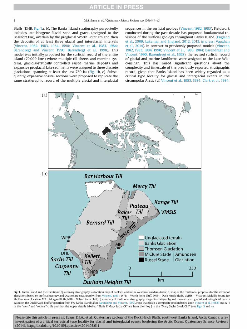
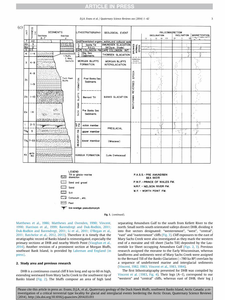
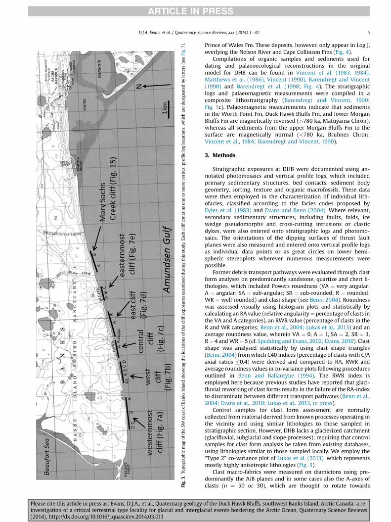
Fig
3To
pograp
hicmap
oftheSW
coastof
Bank
sIsland
show
ingthelocation
sof
thecliff
expo
suresex
amined
during
thisstud
yEa
chcliff
contains
oneor
moreve
rtical
profi
leloglocation
swhich
arede
sign
ated
byletters(see
Fig
7)
DJA Evans et al Quaternary Science Reviews xxx (2014) 1e42 5
Please cite this article in press as Evans DJA et al Quaternary geologyinvestigation of a critical terrestrial type locality for glacial and intergla(2014) httpdxdoiorg101016jquascirev201403011
Prince of Wales Fm These deposits however only appear in Log Joverlying the Nelson River and Cape Collinson Fms (Fig 4)
Compilations of organic samples and sediments used fordating and palaeoecological reconstructions in the originalmodel for DHB can be found in Vincent et al (1983 1984)Matthews et al (1986) Vincent (1990) Barendregt and Vincent(1990) and Barendregt et al (1998 Fig 4) The stratigraphiclogs and palaeomagnetic measurements were compiled in acomposite lithostratigraphy (Barendregt and Vincent 1990Fig 1c) Palaeomagnetic measurements indicate that sedimentsin the Worth Point Fm Duck Hawk Bluffs Fm and lower MorganBluffs Fm are magnetically reversed (gt780 ka Matuyama Chron)whereas all sediments from the upper Morgan Bluffs Fm to thesurface are magnetically normal (lt780 ka Bruhnes ChronVincent et al 1984 Barendregt and Vincent 1990)
3 Methods
Stratigraphic exposures at DHB were documented using an-notated photomosaics and vertical profile logs which includedprimary sedimentary structures bed contacts sediment bodygeometry sorting texture and organic macrofossils These datawere then employed in the characterization of individual lith-ofacies classified according to the facies codes proposed byEyles et al (1983) and Evans and Benn (2004) Where relevantsecondary sedimentary structures including faults folds icewedge pseudomorphs and cross-cutting intrusions or clasticdykes were also entered onto stratigraphic logs and photomo-saics The orientations of the dipping surfaces of thrust faultplanes were also measured and entered onto vertical profile logsas individual data points or as great circles on lower hemi-spheric stereoplots wherever numerous measurements werepossible
Former debris transport pathways were evaluated through clastform analyses on predominantly sandstone quartize and chert li-thologies which included Powers roundness (VA frac14 very angularA frac14 angular SA frac14 sub-angular SR frac14 sub-rounded R frac14 roundedWR frac14 well rounded) and clast shape (see Benn 2004) Roundnesswas assessed visually using histogram plots and statistically bycalculating an RAvalue (relative angularityfrac14 percentage of clasts inthe VA and A categories) an RWR value (percentage of clasts in theR and WR categories Benn et al 2004 Lukas et al 2013) and anaverage roundness value wherein VA frac14 0 A frac14 1 SA frac14 2 SR frac14 3Rfrac14 4 andWRfrac14 5 (cf Spedding and Evans 2002 Evans 2010) Clastshape was analysed statistically by using clast shape triangles(Benn 2004) fromwhich C40 indices (percentage of clasts with CAaxial ratios 04) were derived and compared to RA RWR andaverage roundness values in co-variance plots following proceduresoutlined in Benn and Ballantyne (1994) The RWR index isemployed here because previous studies have reported that glaci-fluvial reworking of clast forms results in the failure of the RA-indexto discriminate between different transport pathways (Benn et al2004 Evans et al 2010 Lukas et al 2013 in press)
Control samples for clast form assessment are normallycollected frommaterial derived from known processes operating inthe vicinity and using similar lithologies to those sampled instratigraphic section However DHB lacks a glacierized catchment(glacifluvial subglacial and slope processes) requiring that controlsamples for clast form analysis be taken from existing databasesusing lithologies similar to those sampled locally We employ theldquoType 2rdquo co-variance plot of Lukas et al (2013) which representsmostly highly anisotropic lithologies (Fig 5)
Clast macro-fabrics were measured on diamictons using pre-dominantly the AB planes and in some cases also the A-axes ofclasts (n frac14 50 or 30) which are thought to rotate towards
of the Duck Hawk Bluffs southwest Banks Island Arctic Canada a re-cial events bordering the Arctic Ocean Quaternary Science Reviews
Fig 4 Vincent et al (1983) lithostratigraphy for the Duck Hawk Bluffs (logs AeI) and Mary Sachs Creek cliff (log J) Logs AeG are in our West cliff and logs H and I are in our Centralcliff
DJA Evans et al Quaternary Science Reviews xxx (2014) 1e426
parallelism with the principal axis of extensional strain in adeforming medium or with the plane of slip during brittle defor-mation (Benn and Evans 1996) The data were processed in Rock-works stereonet software and depicted using Schmidt equal-arealower hemisphere projections based of spherical Gaussian distri-butions The macrofabrics were then analysed for strength mo-dality and isotropy following procedures outlined by Benn (19942004) thereby facilitating an assessment not only of the directionof applied stress but also the genesis of the deposit The latter wasdetermined through comparisons with the clast macrofabrics ofsubglacial tills sampled at modern glacier margins subaqueousglacigenic diamictons and glacitectonites utilizing the data pre-sented by Benn (1994 1995) Evans and Hiemstra (2005) and Evanset al (2007) and employing specifically the modalityisotropy plotof Evans et al (2007 Fig 6)
Please cite this article in press as Evans DJA et al Quaternary geologyinvestigation of a critical terrestrial type locality for glacial and intergla(2014) httpdxdoiorg101016jquascirev201403011
4 Organics
Twelve organic samples were collected and analysed from theDBH sections Bulk organics were subsampled then submerged inwater rinsed and screened through two sieves (710 mm and450 mm) for macrofossils From the retained residue preservedsubfossils were examined with dissecting (Wild M5A) and com-pound (Leitz Laborlux S)microscopes Bryophyteswere determinedusing Nyholm (1956e1965) and Lawton (1971) with nomenclaturaladjustments using Crosby et al (1999) Species determinations ofthe Calliergonaceae and Amblystegiaceae used the revised in-terpretations by Hedenaumls (1993 2006) Palaeoecological recon-struction utilizes Kuc and Hills (1971) Kuc (1974) Steere (1978)Steere and Scotter (1979) and Janssens (1983) Macrofossilvouchers were mounted on permanent slides and deposited in the
of the Duck Hawk Bluffs southwest Banks Island Arctic Canada a re-cial events bordering the Arctic Ocean Quaternary Science Reviews
Fig 5 Clast form co-variance plots of data from this study a) Type 2 clast form co-variance plot from Lukas et al (2013) used in this study as control sample data for theinterpretation of clast wear patterns and former transport histories b) C40RA and C40RWR co-variance plots for data collected in this study
DJA Evans et al Quaternary Science Reviews xxx (2014) 1e42 7
Cryptogamic Herbarium (ALTA) Biological Sciences University ofAlberta
5 Results
51 Sedimentology and stratigraphy (Duck Hawk Bluffs)
The sedimentological and stratigraphic data for DHB arecompiled in vertical profile logs and annotated photographs (Fig 7)The descriptions and interpretations of the lithofacies associations(LFA) recognized throughout the bluffs are then presentedemploying details illustrated in Fig 7 and referring to the clast formand macrofabric data analysis (Figs 5 6)
511 DescriptionLFA 1 comprises up to 38 m of predominantly well-sorted
cross-stratified sand and gravel arranged in stacked sequences ofhorizontal and planar bedding structures The most common lith-ofacies are planar and trough cross-bedded sand often withgranule lags and horizontal to planar or trough cross-beddedgravel (Fig 8) Also common especially towards the base of theexposures is matrix-supported gravel with boulders Macrofossilscommonly comprising crudely bedded organic detritus also
Please cite this article in press as Evans DJA et al Quaternary geologyinvestigation of a critical terrestrial type locality for glacial and intergla(2014) httpdxdoiorg101016jquascirev201403011
include large tree debris (ie logs or stumps with degraded rootballs) and compressed mats of small woody fragments occurthroughout the sequence (Fig 8a) The largest concentrations oftree fragments and stumps occur in coarser grained gravelly bedsparticularly in matrix-supported gravel with sand silt and clayintraclasts The floral and faunal assemblages within LFA 1 arediverse as illustrated by lists reported in Roy and Hills (1972) Hillset al (1974) Hills (1975) Matthews et al (1986) and Matthews(1987)
Sandier lithofacies occur towards the top of LFA 1 where theyrecord a fining upward sequence In the central cliffs andWest Log Dthese upper beds contain rhythmically bedded (varve-like) silt andclay with lonestones interbedded with matrix-supported gravellyscour fills containing a distinct horizon of logs and woody detritusAt Central Log A the underlying LFA 1 gravel is arranged in promi-nent clinoforms or foreset beds dipping at 20 towards the south-west (Fig 8c) Well-developed ice wedge pseudomorphs up to 5 mdeep also occur towards the top of LFA 1 in some sections (Fig 7aiii) Clastic dykes or fissure fills are also common characterized bycrudely sub-vertically bedded and poorly sorted sand and gravelthat in some cases is clearly rooted in underlying strata Some clasticdykes are also characterized by branching and upward extendinglimbs or tentacles that wedge out in the host materials
of the Duck Hawk Bluffs southwest Banks Island Arctic Canada a re-cial events bordering the Arctic Ocean Quaternary Science Reviews
Fig 6 Quantitative plots of clast fabric strength a) clast fabric shape ternary plot(Benn 1994) containing AB plane (blue) and A axis (red) data used in this paper andcontrol sample data (AB planes) for glacitectonite (Evans et al 1998 Hiemstra et al2007) subglacial till (Evans and Hiemstra 2005) and lodged clasts (Evans andHiemstra 2005) b) modalityeisotropy plot (Hicock et al 1996 Evans et al 2007)of the clast AB plane (blue) and A axis (red) macrofabric data used in this paperEnvelopes contain data from deposits of known origin and shaded area represents thatpart of the graph in which stronger modality and isotropy in subglacial traction tills orglacitectonites reflects an increasing lodgement component (based on Evans andHiemstra 2005 Evans et al 2007) This graph is thereby used to interpret trends incumulative strain signature in the glacitectonite-subglacial traction till continuum(sensu Evans et al 2006) (un unimodal su spread unimodal bi bi-modal sb spreadbi-modal mm multi-modal) See Fig 7 for sample locations (For interpretation of thereferences to colour in this figure legend the reader is referred to the web version ofthis article)
DJA Evans et al Quaternary Science Reviews xxx (2014) 1e428
Please cite this article in press as Evans DJA et al Quaternary geologyinvestigation of a critical terrestrial type locality for glacial and intergla(2014) httpdxdoiorg101016jquascirev201403011
Palaeocurrents measured on sand and gravel bedformsthroughout LFA 1 indicate progradation predominantly towards thewest with themost common flowdirections towards theWSWandWNW Clast lithologies are dominated by chert quartzite andsandstone with minor amounts of shale towards the top of LFA 1quartzite dominates the counts in the middle of LFA 1 Striae arevisible on a small number of clasts ranging from 16 at the base to6 in the middle and upper lithofacies Clast form data from LFA 1reveal a vertical increase in rounding (228e312) and RWR values(2e28) reasonably consistent C40 values throughout (26e50)and a vertical reduction in but generally low RA values (10-0)Exposures through LFA 1 in the eastern cliffs reveal large scalereverse (thrust) faults that displace underlying Kanguk Fm andoverlying LFA 1 beds towards the southwest (Fig 7d iveviii)
LFA 2 is only locally preserved and often heavily deformed bysimple shear structures (eg Fig 7c iii inset photos 5e9 amp Fig 7d iiiinset photos aek) It comprises 11 m but generally less than 8 m ofrhythmic planar to horizontally bedded sand with thin anddiscontinuous beds of massive granule gravel or lags and laminatedfine sand silt and clay arranged in stacked units and interbedsOutsized clasts or lonestones occur in many finer grained units Atthe base of LFA 2 (west cliffs) a laterally extensive surface (w100 mwide) composed of locally disharmonically folded laminae alsocontains prominent ice wedges and thick peat composed of in situbryophyte assemblages characterized by excellent preservation(Fig 9) Nine bryophtye dominated samples were collected five ofthem spanning a single 15 m section of interbedded organics withfine sands generally accordant with the ice wedge surface
Secondary structures include clastic dykes intruded upwardsfrom underlying LFA 1 gravel sand wedge pseudomorphs (Fig 9)intraformational burst-out clastic dykes and zones of overfolded orcrumpled bedding and thrust faults associated with boudinage orhigh fissilitypseudo-lamination (Fig 10) Deformation and intensemodification andor erosion are locally the most prominent sedi-mentary signatures for example at the junction of LFA 1 and LFA 3near west Log D where LFA 2 has been pinched out from an initialthickness of approximately 6 m (Fig 11) At this location LFA 2displays a 1e2 m thick basal zone comprising highly attenuatedinter-digitated beds of gravelly to clay-rich diamictons and sandsiltclay rhythmites This passes upwards into rhythmites contain-ing diamictic intraclasts with sharp and angular boundariessignificantly the rhythmite bedding drapes the intraclasts and inplaces is deformed beneath them The sense of shearing in thedeformation structures (Fig 7c iii 10) is predominantly towards thesouthwest although some structures indicate shearing towards thenorth specifically ranging from between NNW and NNE Thesouthwesterly shearing direction is recorded in thrust faults thatcontinue into or are developed within underlying LFA 1 andoverlying LFA 3
LFA 3 varies in thickness from 6 to 14 m and is separated fromunderlying LFA 2 by a heavily deformed zone characterized byintensely folded thrust faulted andor highly fissile sand silt claylaminae or an erosional contact associated with attenuated rafts(intrabeds) of LFA 2 sediments (eg Fig 7c iii inset photo 5 7b ivinset photo 2) It comprises a massive to pseudo-laminated matrix-supported diamicton (Fig 7d i inset photo 1) with localized zonesof discontinuous stratified sand andor gravel lenses up to 1 mthick (Fig 7c iii inset photo 4) Areas of more densely spacedstratified lenses constitute an interbedded relationship with thediamicton Zones of attenuated andor overfolded lenses indicatepost-depositional deformation of the diamicton and tend to beconcentrated at the top (Fig 7b iv inset photo 3) or base of LFA 3(Fig 7d i inset photo 2) The sense of shearing in the lower part ofLFA 3 is variable but predominantly towards the southwest withsubsidiary thrusts towards the north (between NNW and NNE) In
of the Duck Hawk Bluffs southwest Banks Island Arctic Canada a re-cial events bordering the Arctic Ocean Quaternary Science Reviews
Fig 7 a Stratigraphic logs and sedimentological details of westernmost cliff i) Log A ii) Log B iii) photomosaic of lower Log B iv) photomosaic of upper log B v) Log C vi) Log D Inall logs the single barbed arrows with compass orientations indicate sense of shearing based on thrust planes and the solid arrows with compass orientations indicate palaeocurrentdirections b Stratigraphic logs and sedimentological details of west cliff i) Log A1 ii) Log A iii) Log B iv) Log C v) Log D c Stratigraphic logs and sedimentological details ofcentral cliff i) Log A ii) details of deformation structures in LFA 6 at top of Log A iii) supplementary details of upper part of sequence located immediately east of Log A dStratigraphic logs and sedimentological details of east cliff i) Log A ii) photomosaic of lower Log A showing lower LFA 1 details iii) photomosaic of middle Log A showing upper LFA1 details (inset photos l amp m) and LFA 2 details (inset photos aek) iv) overview of the eastern half of east cliff showing locations of logs A and B a photolog of the capping gravellyglacitectonite carapace major faults and the LFA 1Kanguk Formation contact The anomalous dips of the LFA 1 bedding associated with the major faults are represented by the 3-Dplane symbol v) overview of the deformation structures in the eastern part of the east cliff showing prominent distorted bedding major thrusts and 3-D representations ofanomalous dips in LFA 1 bedding The approximate boundary between the Kanguk Formation bedrock and LFA 1 provides an outline of a prominent thrust block that has beendisplaced along a major fault descending below beach level at the far right of the image vi) details of the major fault structures and chevron folding developed in the thrust block ofKanguk Formation with the shearing direction represented by the thrust plane dip orientations in a lower hemisphere stereoplot vii) Log B compiled as a photomosaic ofdeformation structures developed within sandsilt interbeds in the LFA 1 strata that overlie the Kanguk Formation thrust block viii) details of deformation structures identified inthe Kanguk Formation thrust block e Stratigraphic logs and sedimentological details of easternmost cliff i) photomosaic of the easternmost cliffs showing locations of the threevertical logs ii) Log A iii) Log B iv) Log C showing details of cobble clast lag at contact of LFAs 1 and 5 in inset ldquocrdquo and a vertical branching clastic dyke in LFA 1 in inset ldquodrdquo
DJA Evans et al Quaternary Science Reviews xxx (2014) 1e42 9
the upper part of LFA 3 the sense of shearing is towards WSW orwest although there is also some evidence of a northerly sheardirection Clast macrofabrics are moderately to well clustered(S1 frac14 0451e0773) and display a range of orientations the mostprominent stress being towards the southwest but also includingNeS alignments Unusually steep AB plane dips occur in therecumbent folds of lower LFA 3 in west cliff Log D (WCD F1)
Please cite this article in press as Evans DJA et al Quaternary geologyinvestigation of a critical terrestrial type locality for glacial and intergla(2014) httpdxdoiorg101016jquascirev201403011
although this sample is aligned NWeSE Clast macrofabricstrengths as quantified by the fabric shape ternary plot (Fig 6a)and the modalityisotropy plot (Fig 6b) are variable with thestrongest clusters being represented by the A axis and AB planedata from the upper part of LFA 3 (WCD F3) In the ternary graphthe macrofabric shapes plot across the spectrums of the glaci-tectonite and subglacial traction till envelopes (Evans et al 2006
of the Duck Hawk Bluffs southwest Banks Island Arctic Canada a re-cial events bordering the Arctic Ocean Quaternary Science Reviews
Fig 7 (continued)
DJA Evans et al Quaternary Science Reviews xxx (2014) 1e4210
Please cite this article in press as Evans DJA et al Quaternary geology of the Duck Hawk Bluffs southwest Banks Island Arctic Canada a re-investigation of a critical terrestrial type locality for glacial and interglacial events bordering the Arctic Ocean Quaternary Science Reviews(2014) httpdxdoiorg101016jquascirev201403011
Fig 7 (continued)
DJA Evans et al Quaternary Science Reviews xxx (2014) 1e42 11
Please cite this article in press as Evans DJA et al Quaternary geology of the Duck Hawk Bluffs southwest Banks Island Arctic Canada a re-investigation of a critical terrestrial type locality for glacial and interglacial events bordering the Arctic Ocean Quaternary Science Reviews(2014) httpdxdoiorg101016jquascirev201403011
Fig 7 (continued)
DJA Evans et al Quaternary Science Reviews xxx (2014) 1e4212
Please cite this article in press as Evans DJA et al Quaternary geology of the Duck Hawk Bluffs southwest Banks Island Arctic Canada a re-investigation of a critical terrestrial type locality for glacial and interglacial events bordering the Arctic Ocean Quaternary Science Reviews(2014) httpdxdoiorg101016jquascirev201403011
Fig 7 (continued)
DJA Evans et al Quaternary Science Reviews xxx (2014) 1e42 13
Please cite this article in press as Evans DJA et al Quaternary geology of the Duck Hawk Bluffs southwest Banks Island Arctic Canada a re-investigation of a critical terrestrial type locality for glacial and interglacial events bordering the Arctic Ocean Quaternary Science Reviews(2014) httpdxdoiorg101016jquascirev201403011
Fig 7 (continued)
DJA Evans et al Quaternary Science Reviews xxx (2014) 1e4214
Please cite this article in press as Evans DJA et al Quaternary geology of the Duck Hawk Bluffs southwest Banks Island Arctic Canada a re-investigation of a critical terrestrial type locality for glacial and interglacial events bordering the Arctic Ocean Quaternary Science Reviews(2014) httpdxdoiorg101016jquascirev201403011
Fig 7 (continued)
DJA Evans et al Quaternary Science Reviews xxx (2014) 1e42 15
Please cite this article in press as Evans DJA et al Quaternary geology of the Duck Hawk Bluffs southwest Banks Island Arctic Canada a re-investigation of a critical terrestrial type locality for glacial and interglacial events bordering the Arctic Ocean Quaternary Science Reviews(2014) httpdxdoiorg101016jquascirev201403011
Fig 7 (continued)
DJA Evans et al Quaternary Science Reviews xxx (2014) 1e4216
Please cite this article in press as Evans DJA et al Quaternary geology of the Duck Hawk Bluffs southwest Banks Island Arctic Canada a re-investigation of a critical terrestrial type locality for glacial and interglacial events bordering the Arctic Ocean Quaternary Science Reviews(2014) httpdxdoiorg101016jquascirev201403011
Fig 7 (continued)
DJA Evans et al Quaternary Science Reviews xxx (2014) 1e42 17
Please cite this article in press as Evans DJA et al Quaternary geology of the Duck Hawk Bluffs southwest Banks Island Arctic Canada a re-investigation of a critical terrestrial type locality for glacial and interglacial events bordering the Arctic Ocean Quaternary Science Reviews(2014) httpdxdoiorg101016jquascirev201403011
Fig 7 (continued)
DJA Evans et al Quaternary Science Reviews xxx (2014) 1e4218
Fig 6a) Clast lithologies vary depending on sample location Amore restricted lithological component (chert quartzite andsandstone) occurs in the deformed contact zone with underlyingLFA 1 and in areas characterized by attenuated gravel lenses Amore varied clast lithology comprising chert and quartz with mi-nor components of sandstone shale granite gabbro and limestoneoccurs towards the middle and in the more diamictic zones (LFA 3)
LFA 4 comprises less than 5 m of sand silt and clay arranged inhorizontal cross-laminae rhythmites climbing ripples or drapedlaminae that locally contain organic detritus The upper and lowercontacts of LFA 4 are commonly characterized by heavily brecciatedclay or contain boudinage and thrust faulted laminae (Fig 12panels a amp c) Some outcrops of LFA 4 also display widespreaddeformation in the form of overfolded bedding and thrust faultsalthough normal faulting and open folding or convolute beddingstructures are also evident (Fig 7c iii inset photo 3) In some sec-tions LFA 4 comprises only a thin (lt2 m thick) bed of brecciatedclay (Fig 7b iv inset photo 4) or laminated sand displaying over-folds and sheath folds The sense of shearing as recorded by thrustfaults is generally towards the SSW but southerly and southwest-erly orientations are also evident Numerous examples of narrowanabranched clastic dykes rise sub-vertically through the thickestoutcrop of the sandy climbing ripple lithofacies (LFA 4 West Log A)and have created offset beds between the blocks within the hostmaterial (Fig 12 panel b) The contact of LFA 4 with LFA 3 (west cliffLog A) is marked by a clast lag Although the association is pre-dominantly heavily deformed the most unaltered and thickest
Please cite this article in press as Evans DJA et al Quaternary geologyinvestigation of a critical terrestrial type locality for glacial and intergla(2014) httpdxdoiorg101016jquascirev201403011
outcrop in West Log A displays climbing ripple drift indicative of apalaeocurrent from the south or southwest (Fig 7b ii)
LFA 5 comprises 5e10 m of tabular sets of horizontally beddedto massive gravel interbedded with horizontally bedded or cross-laminated sand and occasional units of matrix-supported gravel(Fig 13a b) The thickest outcrop displays a general coarsening-upward sequence from well-sorted horizontally bedded granulegravel and sand to matrix-supported and less well sorted hori-zontally bedded cobble to boulder gravel Clast lithologies aredominated by quartzite but contain subsidiary amounts of chertand sandstone with minor limestone LFA 5 differs from LFA 1based on its general coarsening-upward characteristics coarsergrain size and the presence of limestone clasts Clast form datafrom LFA 5 indicate a sub-rounded sample (averageroundness frac14 222 amp 246 RA frac14 8 amp 24 RWR frac14 2 amp 6) withpredominantly blocky shapes (C40 frac14 30 amp 42) and striae visible(lt14 of clasts) Upper and lower contacts are sharp but are locallyinterdigitated or amalgamated with LFA 6 (Fig 7b iv inset photo 5)and LFA 4 (Fig 13d) respectively A heavily deformed discontin-uous bed of siltclay rhythmites occurs between LFA 5 and LFA 6 inWest Log D the base of which has been amalgamated with thegravel at the top of LFA 5 (Fig 13c) Gravel in Easternmost Cliff hasan unclear relationship to the primary sections at DHB to the westThis gravel designated LFA 5a rests uncomformably on LFA 1 andis not capped by LFA 6 as elsewhere (Fig 7e) Furthermore there isno evidence of deformation and palaeocurrents are orientatedtowards the NW
of the Duck Hawk Bluffs southwest Banks Island Arctic Canada a re-cial events bordering the Arctic Ocean Quaternary Science Reviews
Fig 7 (continued)
DJA Evans et al Quaternary Science Reviews xxx (2014) 1e42 19
Please cite this article in press as Evans DJA et al Quaternary geology of the Duck Hawk Bluffs southwest Banks Island Arctic Canada a re-investigation of a critical terrestrial type locality for glacial and interglacial events bordering the Arctic Ocean Quaternary Science Reviews(2014) httpdxdoiorg101016jquascirev201403011
Fig 7 (continued)
DJA Evans et al Quaternary Science Reviews xxx (2014) 1e4220
Please cite this article in press as Evans DJA et al Quaternary geology of the Duck Hawk Bluffs southwest Banks Island Arctic Canada a re-investigation of a critical terrestrial type locality for glacial and interglacial events bordering the Arctic Ocean Quaternary Science Reviews(2014) httpdxdoiorg101016jquascirev201403011
Fig 7 (continued)
DJA Evans et al Quaternary Science Reviews xxx (2014) 1e42 21
Please cite this article in press as Evans DJA et al Quaternary geology of the Duck Hawk Bluffs southwest Banks Island Arctic Canada a re-investigation of a critical terrestrial type locality for glacial and interglacial events bordering the Arctic Ocean Quaternary Science Reviews(2014) httpdxdoiorg101016jquascirev201403011
Fig 7 (continued)
DJA Evans et al Quaternary Science Reviews xxx (2014) 1e4222
Please cite this article in press as Evans DJA et al Quaternary geology of the Duck Hawk Bluffs southwest Banks Island Arctic Canada a re-investigation of a critical terrestrial type locality for glacial and interglacial events bordering the Arctic Ocean Quaternary Science Reviews(2014) httpdxdoiorg101016jquascirev201403011
Fig 7 (continued)
DJA Evans et al Quaternary Science Reviews xxx (2014) 1e42 23
Please cite this article in press as Evans DJA et al Quaternary geology of the Duck Hawk Bluffs southwest Banks Island Arctic Canada a re-investigation of a critical terrestrial type locality for glacial and interglacial events bordering the Arctic Ocean Quaternary Science Reviews(2014) httpdxdoiorg101016jquascirev201403011
Fig 7 (continued)
DJA Evans et al Quaternary Science Reviews xxx (2014) 1e4224
LFA 6 crops out along the length of DHB and varies widely inthickness (1e11 m) displaying the most complex deformationstructures of any of the sediment bodies at DHB It comprises apredominantly heterogeneous diamicton or a meacutelange of discon-tinuous interbeds of massive matrix-supported diamicton matrix-supported gravel and laminated sand silt and clay with localizedattenuated lenses of degraded organics (Fig 7a ivevi 7b i iv 7c iiiii) Three samples of highly compressed and fragmented detritalmaterial displaying poor preservation were collected for identifi-cation Collectively LFA 6 has the appearance of a stratified dia-micton but locally it displays a more massive to pseudo-laminatedcharacter where sand silt and gravel lenses and occasional gravellags occur as thin beds stringers or wisps Some laminated sand siltand clay bodies appear to be rafts within the diamicton (intraclasts)due to their heavily deformed internal bedding and deformedcontacts or attenuated appearance Basal contacts with other lith-ofacies associations are typically erosional or deformed and asso-ciated with fissility boudinage and pseudo-lamination insediments on either side of the contact Basal diamictons can alsodisplay a higher concentration of gravel clasts that locally result in aclast-supported character or even a several metre-thick highlycontorted meacutelange of diamicton and stratified sediment bodies Insome sections the whole of LFA 6 has been complexly deformed toproduce stacked overfolds and thrust faults indicative of shearingtowards the southwest or WSW Clast macrofabrics are onlymoderately clustered (S1 frac14 0456e0637) but indicate stressdirected predominantly towards the SW Clast macrofabricstrengths as quantified by the fabric shape ternary plot (Fig 6a)and themodalityisotropy plot (Fig 6b) are variable and range frombi-modal to multi-modal Overall the macrofabric shapes in theternary graph plot across the spectrums of the glacitectonite andsubglacial traction till envelopes but there is a trend of changing
Please cite this article in press as Evans DJA et al Quaternary geologyinvestigation of a critical terrestrial type locality for glacial and intergla(2014) httpdxdoiorg101016jquascirev201403011
fabric strength vertically through LFA 6 The strongest clusters arefrom the basal diamictic zones (eg CCA F1 amp F3 AB plane data)whereas the weakest are from the top of the association (eg WCAF3 A-axes amp CCA F2 AB planes) where relatively low strain defor-mation indicators (open and recumbent folds) are ubiquitous
Clast lithologies in LFA 6 are dominated by quartz chert andsandstone although one diamict reveals a concentration of sand-stone lithologies at the expense of chert Clast forms similarlyreflect the nature of the sampled materials whereby the gravellysample (CCA 2) was characterized by relatively low C40 (38) andRA (12) values and a high average roundness (256) compared tothe same values for the diamictons of LFA 6 (C40 frac14 50e74RA frac14 38e52 average roundness frac14 174e204) A small number ofclasts (lt10) in LFA 6 were striated
512 Interpretation5121 LFA 1 The thick tabular sequence of well sorted cross-stratified sand and gravel records deposition by a former glaci-fluvial braided river typified by fluctuating discharge (eg Church1972 Boothroyd and Ashley 1975 Miall 1978 1985 1992Marren 2005) The highest discharge is recorded by matrix-supported gravel with boulders indicative of hyperconcentratedflows or a traction carpet (Maizels 1989ab Siegenthaler andHuggenberger 1993 Mulder and Alexander 2001) These areseparated by and vertically give way to lower discharges recordedby planar or trough cross-bedded sand and horizontal to planar ortrough cross-bedded gravel These deposits record aggradation andmigration of gravel bars and sheets and downstream accretionarymacroforms with relatively tightly constrained palaeocurrent in-dicators (Miall 1977 1985 Collinson 1996) The general lack ofscour fills and an overall fining-upward is indicative of an aggradingsystem initially characterized by high magnitudehigh frequency
of the Duck Hawk Bluffs southwest Banks Island Arctic Canada a re-cial events bordering the Arctic Ocean Quaternary Science Reviews
Fig 7 (continued)
DJA Evans et al Quaternary Science Reviews xxx (2014) 1e42 25
Please cite this article in press as Evans DJA et al Quaternary geology of the Duck Hawk Bluffs southwest Banks Island Arctic Canada a re-investigation of a critical terrestrial type locality for glacial and interglacial events bordering the Arctic Ocean Quaternary Science Reviews(2014) httpdxdoiorg101016jquascirev201403011
Fig 7 (continued)
DJA Evans et al Quaternary Science Reviews xxx (2014) 1e4226
Please cite this article in press as Evans DJA et al Quaternary geology of the Duck Hawk Bluffs southwest Banks Island Arctic Canada a re-investigation of a critical terrestrial type locality for glacial and interglacial events bordering the Arctic Ocean Quaternary Science Reviews(2014) httpdxdoiorg101016jquascirev201403011
DJA Evans et al Quaternary Science Reviews xxx (2014) 1e42 27
events that were gradually replaced by low magnitudehigh fre-quency events (Marren 2005) Partially to heavily-scoured rem-nants of laminated and massive fines represent deposition duringlow flow conditions in abandoned shallow channels The palae-ocurrent data from LFA 1 indicate that the outwash streams wereflowing westerly away from a glacier source located in AmundsenGulf This glacier likely eroded the abundant LFA 1 lithologies(chert quartzite and sandstone) from Mesoproterozoic and Neo-proterozoic bedrock widely distributed to the east and south(western Victoria Island Amundsen Gulf and the adjacent main-land Harrison et al 2013) These lithologies are consistent with theadvance of the NW Laurentide Ice Sheet through Amundsen Gulf(cf Dyke et al 2002 Batchelor et al 2012 MacLean et al 2013)
The crudely bedded organic detritus and degraded tree frag-ments (stumps) in LFA 1 are clearly reworked (cf Matthews et al1986 Fyles 1990 Vincent 1990) The finer grained detritus wasdeposited in concentrated pockets during waning flow stageswhereas horizons of logs and larger tree fragments were emplacedwith the coarser grained and poorly sorted sediments associatedwith hyperconcentrated flows or traction carpets during highdischarge These reworked organics also differ significantly fromthe type location of the Beaufort Fm a characteristic that promptedFyles (1990) to distinguish them as lsquotheMary Sachs Gravelrsquo Notablythe enclosing gravel and sand of LFA 1 is much coarser and exhibitsan entirely different fluvial architecture than the sandier BeaufortFm The composition and degraded nature of the LFA 1 organicssuggests that they were eroded by glaciers or their meltwater fromNeogene andor Paleogene sediments presumably to the southeastof Banks Island (eg Fyles 1990 Fyles et al 1994) The proximity ofa glacier is highlighted by the preservation of striae on individualclasts especially in the very coarse lower gravel The verticaldecrease in striae preservation and angularity (RA) and concomi-tant increase in roundness and upward-fining in LFA 1 is indicativeof an increasingly distal ice margin The co-variance plots (Fig 5)indicate a strong fluvial signature especially in the C40RA data butsubglacial characteristics are also evident particularly in the C40RWR data for the coarser grained and more matrix-supportedgravel as would be expected in ice-proximal settings
It is important to note that the widespread thrusting of LFA 1and underlying Kanguk Formation towards the southwest occurredpost-depositionally This glacitectonic thrusting was produced byLaurentide ice that advanced from the Kellett River valley (interiorBanks Island) during the emplacement of LFA 6 (see below) Theinjection of clastic dykes and fissure fills during this glacitectonicdisturbance was due to the overpressurizing of groundwater ingravel aquifers likely in taliks The branching limbs of many of thedykes are indicative of burst-out structures diagnostic of hydro-fracturing by vertically escaping groundwater pressurized byglacier overriding (cf Rijsdijk et al 1999 Le Heron and Etienne2005)
5122 LFA 2 At the top of LFA 1 rhythmites with lonestonesoverlie prominent clinoforms or foreset beds recording a changefrom subaerial glacifluvial to subaqueous deposition This wasinitially on a shallow delta front prograding foreset beds in asouthwesterly direction followed by suspension sedimentationwith dropstones presumably from floating ice in a marine orlacustrine basin The occurrence of matrix-supported gravelly scourfills with logs and woody detritus suggests pulses of cohesionlesssediment gravity flows into the basin Overlying the rhythmically-bedded sand prominent ice wedge pseudomorphs (up to 4 mdeep Fig 9aec cf Mackay and Burn 2002) are interspersed withthick (gt1m) sections of compressed in situ bryophytes (Figs 9d 7e)indicating the establishment of a tundra surface Four bryophytefamilies and 10 distinct species have been determined from LFA2
Please cite this article in press as Evans DJA et al Quaternary geologyinvestigation of a critical terrestrial type locality for glacial and intergla(2014) httpdxdoiorg101016jquascirev201403011
with the most abundant material from the Calliergonaceae andCampyliaceae (Table 1) These macrofossils are exceptionally wellpreserved including material with intact fragile alar cells typical ofthese two families (Fig 14cef) The data from these autochthonousdeposits indicate a wetland environment characterized as a richfen This ecosystem and habitats therein are consistent with speciesfound in the extant flora of Banks Island (Fig 14b) The autecologyfrom this range of species suggest hydric to mesic habitatsincluding standing pools wet meadows and microhabitats createdby ice wedges Despite the predominance of bryophytes in LFA 2these macrofossils had not been previously documented at DHB Incontrast a minimal proportion of the samples (lt5) consisted ofvascular plant material (including Cyperaceae seeds gramminoidleaves and woody twig fragments) Collectively the ice wedgepseudomorphs and vegetation within LFA 2 represent an isochro-nous terrestrial surface of interglacial rank
Following the formation of ice wedges the injection of intra-formational clastic dykes and fissure fills in LFA 2 relates to theoverpressurizing of groundwater in gravel aquifers or taliks due toglacier overriding The branching dyke limbs that emanate fromunderlying LFA 1 gravels and sands are indicative of the burst-outstructures that develop during hydrofracturing (cf Rijsdijk et al1999 Le Heron and Etienne 2005) A variant of the gravel andsand filled clastic dykes occurs within the sequence of glaci-tectonite and rhythmites near west Log D (Fig 11) Here thevertically-widening fracture is characterized by a mosaic ofpartially disaggregated blocks of the host materials in its widestzone where it contains gravels injected from underlying LFA 1Because these gravels only occur in the basal narrow neck theypresumably record the rapid reduction in flow competence duringhydrofracture filling
Deformation structures including overfolded or crumpledbedding and thrust faults associated with boudinage or highfissilitypseudo-lamination are representative of simple shear andwere also induced by glacitectonic disturbance (cf van derWateren 1995 McCarroll and Rijsdijk 2003) This predominantlyrecords a glacier advance from the northeast Subsidiary shear in-dicators record deformation from the south or southeast but theseoccur only at the top of LFA 2 and the base of LFA 3 suggestingearlier emplacement (see below) The development of zones ofboudinage shallow thrust faults overfolding or bed crumpling atdifferent levels within LFA 2 e especially at the contact separatingsediments of different grain size e represents deformation parti-tioning due to contrasting rheological properties Blind thrustswere also initiated in underlying LFA 1 increasingly towards thecentral and eastern cliffs where large-scale deformation is moreprevalent (Fig 7c d) A zone of intense deformation is recorded by alens of LFA 3 diamicton in fault contact with LFA 2 (east cliff Log AFig 7d i) This constitutes a type B glacitectonite (non-penetrativelydeformed pre-existing sediments sensu Benn and Evans 1996Evans et al 2006) developed during the emplacement of LFA 3(see below) A similar glacitectonite occurs at the junction of LFA 1and LFA 3 near west Log D (Fig 11) Bed attenuation by deformationis best developed in lower LFA 2 where the greater differences insediment grain size and hence rheology exist
5123 LFA 3 Within LFA 3 locally abundant stratified lensesindicate subaqueous deposition These stratified sediments weresubsequently thrust faulted folded and attenuated - most evidentin the upper and lower zones of LFA 3 This deformation was likelyresponsible for the intraclast boudinage and pseudo-lamination inthe surrounding diamicton (eg Hart and Roberts 1994 Robertsand Hart 2005 Oacute Cofaigh et al 2011) This process was alsoassociatedwith the attenuation of LFA 1 and 2 sediments within theheavily deformed base of LFA 3 some of which may have been
of the Duck Hawk Bluffs southwest Banks Island Arctic Canada a re-cial events bordering the Arctic Ocean Quaternary Science Reviews
Fig 8 Details of LFA 1 a) example of a concentration of logs with degraded rootballs in the stacked tabular units of cross-bedded sands and gravels and crudely stratified matrix-supported cobble to boulder gravels in the west cliff b) poorly-sorted and crudely horizontally bedded cobble to boulder gravel containing laminated clay intraclast (immediatelyabove compass) c) shallow locally graded foreset beds composed of openwork to sandy matrix-supported cobble to granule gravels in central cliff Log A d) planar bedded sandy
DJA Evans et al Quaternary Science Reviews xxx (2014) 1e4228
Please cite this article in press as Evans DJA et al Quaternary geology of the Duck Hawk Bluffs southwest Banks Island Arctic Canada a re-investigation of a critical terrestrial type locality for glacial and interglacial events bordering the Arctic Ocean Quaternary Science Reviews(2014) httpdxdoiorg101016jquascirev201403011
DJA Evans et al Quaternary Science Reviews xxx (2014) 1e42 29
cannibalized and rafted by the deformation process within a shearzone at the contact of LFA 3 with older sediments The shearingdirection from the south and southeast recorded in lower LFA 3also impacted upper LFA 2 whereas the more prominent shearingdirection throughout LFA 3 is from the northeast (also recorded inLFA 4) The local development of a heavily deformed zone at the topof LFA 3 was likely imparted during the shearing of overlying LFA 4sediments Although clast macrofabric strengths from the LFA 3diamicton are variable they possess shapes that compare withglacitectonites and subglacial traction tills and in some cases amodalityisotropy signature that reflects high lodgementcomponents
The similar orientation of the macrofabrics and shear indicatorsare considered diagnostic of a glacitectonite derived from stratifiedsediments (eg interbedded mass flow diamictons gravelly massflows and localized traction current sands and suspension de-posits) This evidence indicates that LFA 3 like all the other LFAsand the underlying Kanguk Fm bedrock has been displaced by aglacier advancing from the NNE or NE (ie Laurentide ice crossingthe interior of Banks Island) Minor south to north shearing in-dicates that LFA 3 and upper LFA 2were also disturbed by glacier iceflowing northwards (ie Laurentide ice advancing throughAmundsen Gulf) The appearance of granite and gabbro clastswithin the LFA 3 diamict records the arrival of far-travelled Lau-rentide ice from mainland Canada Clast form co-variance stronglyindicates a subglacial (abraded) source for LFA 3 with a minorfluvial component (Fig 5) including glacifluvial clasts locallycannibalized from LFA 1 by overriding ice
5124 LFA 4 LFA 4 has restricted outcrops is heavily deformedand contains organic detritus that is clearly allochthonous andhighly degraded Nonetheless a variety of indicators (fine-grainedhorizontally bedded cross-laminae rhythmites climbing ripplesand draped laminae) demonstrate that LFA 4 was deposited in asubaqueous environment with palaeocurrents from the south orsouthwest Traction currents were likely responsible for thedevelopment of the clast lag at the contact between lower LFA 4and underlying LFA 3 (west cliff Log A Fig 7b ii) LFA 4 coarsensupwards indicative of basin infilling andor an approaching sedi-ment source The narrow anabranched clastic dykes in the sandyclimbing ripples (LFA 4 west cliff Log A) record hydrofracturing bythe upward injection of overpressurized groundwater duringshearing The branching limbs of the dykes are similar to the burst-out structures reported by Rijsdijk et al (1999) but differ becausethey are composed solely of sand derived from the walls of the hostsediment rather than from an underlying gravel aquifer (cf LeHeron and Etienne 2005) Hence the pressurized water wasgenerated at the contact between the sand and underlying imper-meable brecciated clays The development of thin zones of brecci-ation boudinage sheath folding or thrust faulting at the upper andlower contacts of LFA 4 relates to the localized partitioning ofdeformation controlled by the location of claysilt beds Thejuxtaposition of this style of deformation with the larger scaleoverfolds and thrust faults developed in the extensive bodies ofsandy lithofacies is indicative of a Type B glacitectonite (sensu Bennand Evans 1996) This was constructed by the overriding of glacierice advancing from the north or northeast These shear directionsare compatible with those developed in the underlying LFAs
granule gravels with gravel lags (top and bottom of image) interrupted by an intervening unbedded granule to pebble gravel and massive cobble to pebble gravel A cluster of small treesequence of stacked tabular units of predominantly horizontally bedded sands and gravels ingravels containing clusters of wood detritus in the coarser gravel beds (central cliff Log A)wood fragments (central cliff Log A)
Please cite this article in press as Evans DJA et al Quaternary geologyinvestigation of a critical terrestrial type locality for glacial and intergla(2014) httpdxdoiorg101016jquascirev201403011
5125 LFA 5 The primary characteristics of LFA 5 are typical ofgravel sheet and occasional traction-carpet sedimentation in anice-proximal sandur (eg Boothroyd and Ashley 1975 Miall 19781985 1992 Maizels 1989ab Siegenthaler and Huggenberger1993 Mulder and Alexander 2001 Marren 2005) Glacier prox-imity is supported by the subglacial to fluvial signature of the clastforms (Fig 5) The coarsening-upward sequence including striatedclasts culminates in the arrival of a glacier that overrode the sitedepositing LFA 6 Post-depositional shearing within underlying LFA4 is recorded by attenuation and interdigitation at the contact withLFA 5 imparted during deposition of LFA 6 The contact betweenLFA 5 and 6 reflects the development of a shear zone where upperLFA 5 sediments have been cannibalized producing a meacutelange ofcrudely stratified diamictons with discontinuous interbeds ofmatrix-supported gravel laminated sand silt and clay (LFA 6 seebelow)
5126 LFA5a At Easternmost Cliff glacifluvial gravel (LFA 5a)unconformably overlies LFA 1 (Fig 7e) rendering uncertain itsrelationshipwith respect to LFA 5 in themain sections of DHB to thewest The fact that LFA 5a extends to the modern surface appearsundeformed and has palaeocurrents orientated to the NW requiresthat it is younger than LFA 5 Indeed we interpret LFA 5a asdeglacial outwash deposited from retreating Laurentide ice in theKellett River valley and Amundsen Gulf at the end of the lastglaciation (see Discussion)
5127 LFA 6 Based on its heterogeneity strongly orientated clastmacrofabrics and macroscale deformation structures LFA 6 con-stitutes a Type B glacitectonite (sensu Benn and Evans 1996)However zones of more highly strained Type A glacitectonite(sensu Benn and Evans 1996) at the basal contact with older LFAsare recorded by intraclastinterbed attenuation (pseudo-lamina-tion) strong boudinage or fissility and strengthened clast macro-fabrics The production of this meacutelange is attributed to two separateprocesses 1) primary sedimentation as interbedded and interdig-itated mass flow debris fluvial gravel and sand and subaqueoussuspension sediments and 2) cannibalization of underlying strat-ified sediments (LFAs 4 and 5) This produced a continuum of formsranging from low strain fold structures to attenuated rafts to tec-tonic lamination (eg Fig 7) The discontinuous lenses of degradedorganics (black stems and woody twigs gramminoid leaveswhitened rootlets) within LFA 6 are rafts and include seven speciesof bryophytes (Table 1) The material was highly compressed anddifficult to separate into distinct taxa Indeed one of the threesamples analysed was too degraded to recover any taxa Much ofthe material consisted of only fragmented leaves and only theminute taxa had stems with intact leaves The bryophytes thatcharacterize the LFA 6 samples represent hydric (Calliergon sppTomenthypnum nitens) to mesic (Ditrichum flexicaule Dicranum sp)habitats Three species collected from LFA 6 were also present inLFA 2 whereas four others were not found in LFA 2 but are com-mon in the modern flora The poor preservation quality suggeststhat the material has been redeposited from unknown sources andis clearly allochthonous
The predominant shearing direction within LFA 6 records an iceadvance from the interior of Banks Island (NE) This has resulted incomplex folding and thrusting and localized thickening of LFA 6
it of cross-bedded poorly-sorted to openwork cobble to boulder gravel crudely planar-fragments occur at the base of the cobble to boulder gravels at image centre e) middleDHB west cliff Log D f) sequence of fining-upward planar-bedded cobble to sandy fineg) planar cross-bedded sandy granule to pebble gravels with pebble to cobble lags and
of the Duck Hawk Bluffs southwest Banks Island Arctic Canada a re-cial events bordering the Arctic Ocean Quaternary Science Reviews
Fig 9 Details of LFA 2 from the west cliff a) narrow necked ice wedge pseudomorph with upturned marginal bedding in sand silt and clay rhythmites b) wide necked ice wedgepseudomorph c) ice wedge pseudomorph with overturned silt sand and clay rhythmites developed at the top of LFA 2 and sealed by overlying LFA 3 laminated diamicton d)horizontally bedded sand and silt containing well preserved moss macrofossils e) zone of disharmonically folded sandsilt laminae with well preserved moss peat located at thebase of LFA 2
DJA Evans et al Quaternary Science Reviews xxx (2014) 1e4230
Please cite this article in press as Evans DJA et al Quaternary geology of the Duck Hawk Bluffs southwest Banks Island Arctic Canada a re-investigation of a critical terrestrial type locality for glacial and interglacial events bordering the Arctic Ocean Quaternary Science Reviews(2014) httpdxdoiorg101016jquascirev201403011
Fig 10 Details of simple shear structures developed in fine sand and silt laminae at the centre of the thickest outcrop of LFA 2 in west cliff Log B a) overview of large scaleanastomosing shear faults with zones of smaller scale densely spaced anastomosing shears towards the base of the photograph b) details of large scale shear faults separatingzones of variably but predominantly densely spaced shears c) close details of shear zone comprising densely spaced anastomosing fractures d) details of ascending kink zonecross-cutting large scale anastomising shear faults Shearing direction is coming out of the cliff and towards the left in each image
DJA Evans et al Quaternary Science Reviews xxx (2014) 1e42 31
This shearing direction is recorded throughout underlying LFAs 1e4as well as the Kanguk Formation demonstrating deep-seated butpartitioned glacitectonic disturbance imparted during theemplacement of LFA 6 This strain signature was therefore over-printed on the northerlynortheasterly aligned shearing directionrecorded in LFA 3 and upper LFA 2 by the earlier northerly flowingice that deposited LFA 3 One anomalous clast macrofabric(northerly CCA F1) occurs in the basal meacutelange of LFA 6 Howeverthis sample is from an isolated outcrop (Fig 7c i) rendering itsapparent shearing direction equivocal
Please cite this article in press as Evans DJA et al Quaternary geologyinvestigation of a critical terrestrial type locality for glacial and intergla(2014) httpdxdoiorg101016jquascirev201403011
52 Sedimentology and stratigraphy (Mary Sachs Creek cliff)
The cliffs east of Mary Sachs Creek (Figs 2b 3) provides a cross-section through the seaward margin of the coast-parallel SachsMoraine (ldquosection Jrdquo Vincent et al 1983 Vaughan 2014) Weprovide a summary of two logs based on a reconnaissance survey ofthese sediments Log A is closest toMary Sachs Creekwhereas Log Boccursw1 km farther east (Figs 3 15a amp b) The sediments exposedin Log A appear to descend eastward and disappear below themodern beach and therefore are assumed to stratigraphically
of the Duck Hawk Bluffs southwest Banks Island Arctic Canada a re-cial events bordering the Arctic Ocean Quaternary Science Reviews
Fig 11 Details of LFA 2 near west Log D Lower box shows a 1e2 m thick basal zone comprising highly attenuated inter-digitated beds of gravelly to clay-rich diamictons and sandsiltclay rhythmites Upper box shows rhythmites containing diamictic intraclasts with sharp and angular boundaries also visible is the draping and deforming of the rhythmitebedding over and under the intraclasts respectively ldquoTailsrdquo extending from the diamictic intraclasts and thin but discontinuous diamictic beds are also visible in the upper box
DJA Evans et al Quaternary Science Reviews xxx (2014) 1e4232
underlie the sediments of Log B A sand and gravel- bench caps bothlogs at w15 m asl incised into the seaward margin of the SachsMoraine
521 DescriptionLog A contains a sequence of upward-fining highly contorted
cross-stratified sand and fine gravel to rhythmically bedded sandsilt clay with minor pebble gravel and sporadic clots of gravellydiamicton (Fig 15a) An ice wedge was initially developed in thelower cross-stratified sand and fine gravel before they were foldedand thrust faulted The deformed ice wedge pseudomorph is un-conformably overlain by a relatively undisturbed lens of laminatedsilty clay with dropstones interbedded with gravelly diamictonthat contains a bed (10 cm) of sandy black organics containingwood fragments (Fig 15a) This organic material occurs repeatedlyup-section as discontinuous stringers Log A is capped by 1e2 m ofpoorly exposed and heavily cryoturbated gravelly diamicton Thegeneral sense of displacement on shallow reverse faults over-turned bedding and boudinage structures is from the southeast
Log B (12 m) displays a coarsening-upward sequence of hori-zontally bedded sandy granule gravel with occasional silty sandlaminae (Fig 15b iii) that grades to poorly-sorted cobble to bouldergravel and bouldery matrix-supported gravel (Fig 15b ii) This iscapped by laminated to crudely stratified cobbly diamicton that issilt and clay-rich abruptly and conformably overlain by
Please cite this article in press as Evans DJA et al Quaternary geologyinvestigation of a critical terrestrial type locality for glacial and intergla(2014) httpdxdoiorg101016jquascirev201403011
interlaminated silt clay and pebbly silty sand (Fig 15b i) Althoughthe bedding on these units dips towards the NW individuallaminae do not thicken in that direction indicating post-depositional tilting The uppermost part of the log (underlyingthe 15 m bench) contains 2 m of clay-rich massive diamictoninterfingered with the underlying laminated sediments and cobblydiamicton
522 Interpretation
5221 Log A Broadly the sedimentology of log A including thedeformed ice wedge pseudomorph is similar to LFA 2 in DHB (egcentral cliff Log A Fig 7c iii) Prior to glacitectonic disturbance theoverlying organic bed (Fig 15a) was redeposited into a sequence ofsubaqueous siltclay rhythmites containing dropstones and gravellymass flows The highly attenuated shear margins bracketing theorganic bed in Log A demonstrate that it has been displaced as atectonic raft Previous research proposed that the organic beds e
similar to those described in Log A e be assigned to the LastInterglacial (locally called the Cape Collinson Vincent 1982 1983)Because these organic beds are clearly a raft they cannot constitutean iscochronous surface precluding chronostratigraphic signifi-cance (see Discussion) Shearing of the Log A sediments from thesoutheast documents an ice advance from Amundsen Gulf corre-sponding to the earliest of two primary shearing directions recor-ded at DHB (imparted during the emplacement of LFA 3) Therefore
of the Duck Hawk Bluffs southwest Banks Island Arctic Canada a re-cial events bordering the Arctic Ocean Quaternary Science Reviews
Fig 12 Details of LFA 4 in West Log A a) heavily deformed upper contact of LFA 4 comprising sandsiltclay rhythmites displaying well developed boudinage sheath folds andimmature tectonic laminae and an interdigitatedsheared boundary with underlying climbing ripple sands The contact with overlying LFA 6 is marked by an interdigitated zonecontaining rooted and de-rooted folds or rhythmite rafts in a sand gravel and diamicton meacutelange b) narrow anabranched clastic dykes ascending sub-vertically through climbingripple drift and resulting in offset bedding between blocks of host material c) abrupt contact between sheared sands and rhythmites of LFA 4 and overlying sand gravel anddiamicton meacutelange
Fig 13 Details of LFA 5 a) poorly sorted and matrix-supported pebble to cobble gravel b) tabular sequence of horizontally bedded to massive gravel and matrix-supported gravelcontaining a horizon of striated cobbles and boulders c) heavily deformed discontinuous bed of siltclay rhythmites between LFA 5 and LFA 6 in West Log D showing theamalgamation zone with the LFA 5 gravels immediately above the compass d) interdigitateddeformed contact between LFA 5 granule to pebble gravels and underlying LFA 4laminated silts and clays with organic detritus in West Log B
DJA Evans et al Quaternary Science Reviews xxx (2014) 1e42 33
Please cite this article in press as Evans DJA et al Quaternary geology of the Duck Hawk Bluffs southwest Banks Island Arctic Canada a re-investigation of a critical terrestrial type locality for glacial and interglacial events bordering the Arctic Ocean Quaternary Science Reviews(2014) httpdxdoiorg101016jquascirev201403011
Table 1List of bryophytes and vascular plants from LFAs 2 and 6
LFA2 WestCliff Log B
LFA6 CentralCliff Log A
Elevation (m) 185 m asl w45 m aslSample 4e12 1e3 taxa 10 7
Bryophyta (mosses)AmblystegiaceaeAmblystegium serpens (Hedw) Schimp x
CamyliaceaeCampylium polygamum (Schimp) CEO Jensen xCampylium stellatum (Hedw) CEO Jensen x xDrepanocladus aduncus (Hedw) Warnst xDrepanocladus sp xTomentypnum nitens (Hedw) Loeske x
CalliergonaceaeCalliergon giganteum (Schimp) Kindb xCalliergon richardsonii (Mitt) Kindb xthornthornthornthorn xCalliergon sp xWarnstorfia exannulatus (Schimp) Loeske xthornthornthornthorn x
BrachytheciaceaeBrachythecium turgidum (Hartm) Kindb x
MniaceaeCyrtomnium cf hymenophylloides(Hbener) TJ Kop
x
DicranaceaeDicranum sp x
DitrichaceaeDitrichum flexicaule (Schwaumlgr) Hampe x
Tracheophyta (vascular plants)CyperaceaeSeeds (triangular amp flattened) x x
Gramminoid leaf material x xWoody twig fragments x xRootlets x
Fig 14 The moss peat and associated microfossils of LFA 2 a) exposure through lower LFAsouthern Banks Island analogue of a rich tundra fen environment for the bryophyte assemblfrom LFA 2 showing the exceptional preservation of Calliergonaceae and Campyliaceae ma
DJA Evans et al Quaternary Science Reviews xxx (2014) 1e4234
Please cite this article in press as Evans DJA et al Quaternary geologyinvestigation of a critical terrestrial type locality for glacial and intergla(2014) httpdxdoiorg101016jquascirev201403011
these deformed deposits are interpreted as a Type B glacitectonite(sensu Benn and Evans 1996) possibly derived from LFA 2
5222 Log B The coarsening upward gravel in Log B recordshighly turbid to hyperconcentrated discharge in non-channelizedsheets This is interpreted as aggrading glacifluvial outwash froman approaching ice margin The capping sequence of crudelystratified diamicton and laminated sediments records a changefrom glacifluvial to subaqueous sedimentation prior to overridingby a glacier of unknown age that tilted the upper beds Thecoarsening-upward sequence apparent tectonism and cappingdiamict at Log B clearly distinguishes these deposits from those ofLFA 5a (west of Mary Sachs Creek easternmost cliff Fig 3)Furthermore although there is lithological similarity between LogB and LFA 5 throughout DHB the sense of shearing is dissimilar (LFA5 from the NE and Log B from the SE) The simplest explanation forthis difference in shear direction is that LFA 5 (DHB) was displacedby interior ice advancing down the Kellett River whereas Log B wasdisplaced by ice advancing along Amundsen Gulf (Fig 2b)
6 Discussion
61 Large scale glacitectonic structures and stratigraphicarchitecture
The glacitectonic structures identified within the lithofaciesassociations at DHB record two phases of deformation (early NeSand later NEeSW) This deformation together with the DHBstratigraphic architecture (Fig 16) helps to explain both thekinetostratigraphy (sensu Berthelsen1978) and the evolution of thelocal glacial geomorphology The large scale glacitectonic defor-mation is most clearly manifest in the thrust faulting and conjugate
2 at DHB west log B showing the sampling locations for in situ moss peat b) a modernages of LFA 2 c)ef) details of the typical moss peat and associated microfossil materialscrofossils including material with intact fragile alar cells
of the Duck Hawk Bluffs southwest Banks Island Arctic Canada a re-cial events bordering the Arctic Ocean Quaternary Science Reviews
Fig 15 The stratigraphy of Mary Sachs Creek cliff a) photographic compilation log A showing upward-fining highly contorted (i) cross-stratified sands and fine gravels torhythmically bedded sands silts clays and minor pebble gravels Also visible in (ii) is a lens of interbedded laminated silty clays with dropstones and gravelly diamictons containingsandy black coloured organic material with wood fragments An ice wedge pseudomorph is visible (iii) to the right of the exposure b) photographic compilation log B showing i)laminated to crudely stratified cobbly but siltclay-rich diamicton grading into interlaminated silts clays and pebbly silty sands ii) poorly-sorted cobble to boulder gravel andbouldery matrix-supported gravel iii) coarsening-upward sequence of horizontally bedded sandy granule gravels with occasional silty sand laminae iv amp v) pebble to cobble graveland matrix-supported gravel
DJA Evans et al Quaternary Science Reviews xxx (2014) 1e42 35
shear development in the Kanguk Fm bedrock and overlying LFA 1(east cliff Fig 7d ivevi) Here predominantly northeasterly dippingthrust slices have been stacked truncated and overlain by LFA 6during the second and strongest (NEeSW) deformation phase(Fig 16 note bedrock slice within the imbricated stacked sequenceof LFA 1) These structures demonstrate significant compressionand thickening of the stratigraphic sequence including w40 m ofvertical offset within the Kanguk Formation acrossw3 km (Fig 16)Prominent hydrofracture fills in LFAs 1 and 2 record elevatedporewater pressure during this thrusting Smaller scale shear zoneshave also developed in the finer grained interbeds within thrustslabs (Fig 7d vii) indicative of deformation partitioning by strataprone to ductile failure This zone of greatest displacement alsocoincides with the highest topography (Fig 16) Lower angle thrustfaults propagate in a southwesterly direction predominantlythrough LFA 1 but are also developed through LFA 2 in the footwallblock (east cliff Fig 16)
The thrust stacking of bedrock and LFAs 1e5 in east cliff (obliqueto Fig 16) represents the ice-proximal zone of a thrust-blockmorainecomposite ridge constructed by a glacier advancing fromthe northeast (ie the interior of Banks Island) This glacitectonicdeformation propagated southwestward to distal parts of theproglacial stress field as recorded bywell-developed shear zones inthe finer grained sediments of LFAs 2e5 In the more distal westcliff open folds (LFA 2 Fig 16) appear to be the product of a blindthrust within underlying LFA 1 This style of tectonism is typical oflsquopiggyback-style thrustingrsquo wherein steeply inclined thrust blocksat the advancing ice margin propagate new thrusts in the footwall(Fig 16 Park 1983 Mulugeta and Koyi 1987) The angle of thesefootwall thrusts becomes progressively shallower southwestward
Please cite this article in press as Evans DJA et al Quaternary geologyinvestigation of a critical terrestrial type locality for glacial and intergla(2014) httpdxdoiorg101016jquascirev201403011
(ice-distal) in LFA 1e5 where deformation partitioning developedin finer grained lithofacies (Fig 16)
The densely spaced ponds and depressions immediately to thenortheast of DHB (Figs 2b 3) constitute the depression fromwhich the thrust mass was excavated (eg Aber et al 1989Evans and England 1991 van der Wateren 1995) This inter-pretation is consistent with the strong northeast to southwestshear direction in the second phase glacitectonic structures andin LFA 6 clast macrofabrics This indicates that construction ofDHB occurred at the margin of a glacier advancing from thenortheast (ie from Kellett River valley) overtopping DHB anddepositing the LFA 6 glacitectonite The continued advance ofKellett ice coalesced with a glacier in Amundsen Gulf marked bythe interlobate Sachs Moraine containing ice-transported shellsas young as 24 cal ka BP (21020 70 yrs BP UCIAMS-89674)assigning this glaciation to the Late Wisconsin (Vaughan 2014)East of Mary Sachs Creek the deformation of Log B outwash(from the southeast Figs 15 16) likely records overriding by thesame Amundsen Gulf glacier (coeval with LFA 6 Late Wiscon-sinan) During ice retreat when Kellett River and Amundsen Gulfice decoupled DHB was exposed allowing the northwesterly-flowing proglacial outwash (LFA 5a) west of Mary Sachs Creekto extend to the shoreline marking postglacial marine limit atKellett Point (11 m asl Vaughan 2014 Fig 3) Collectively thisreconstruction supports a Late Wisconsinan age for the con-struction of DHB thrust block moraine although its stratigraphyincludes a range of ages A palaeogeographic reconstruction ofevents based upon our interpretation of the sedimentologystratigraphic architecture tectonism and geomorphology is pre-sented in Fig 17
of the Duck Hawk Bluffs southwest Banks Island Arctic Canada a re-cial events bordering the Arctic Ocean Quaternary Science Reviews
Fig 15 (continued)
DJA Evans et al Quaternary Science Reviews xxx (2014) 1e4236
62 Comparison and revision of previous DHB model
DHB was previously interpreted to record horizontally beddedNeogene to Quaternary sediments assigned to preglacial fluvialand multiple glacial and interglacial episodes (Vincent 1982 19831990 Vincent et al 1983 1984 Barendregt et al 1998) A com-posite palaeomagnetic record was also presented for this proposedstratigraphy placing most of this deposition before the BrunhesMatuyama boundary (Fig 1c) However prior to our work detailedstudies had not been undertaken on the sedimentology structuralgeology or stratigraphic architecture of DHB Rather the originalstratigraphy was restricted to a series of composite logs (our Fig 4reproduced from Vincent et al 1983) that notably omitted thepervasive deformation structures including the thrust bedrock ineast cliff (Fig 16)
Please cite this article in press as Evans DJA et al Quaternary geologyinvestigation of a critical terrestrial type locality for glacial and intergla(2014) httpdxdoiorg101016jquascirev201403011
Our reinterpretation dismisses several key elements of theoriginal DHB model outlined below (oldest to youngest) We havedetermined that the lowermost unit (LFA 1) is not preglacial (Fyles1990) but rather is composed of glacial outwash providing theearliest terrestrial evidence for glaciation in the area and containingallochthonous organics (including tree stumps) of unknown prov-enance Because LFA 1 is a glacifluvial braidplain (Fig 17a) it is notpart of the Beaufort Fm (Fyles 1990) even though it containsreworked macrofossils presumably derived from it (eg Craig andFyles 1960 Hills et al 1974 Vincent et al 1983)
Our analysis of LFA 2 indicates that it is also not preglacial norcan it be the Worth Point Fm as previously proposed (cf Vincent1982 1983 1990 Vincent et al 1983 Matthews et al 1986)Indeed the type locality of the Worth Point Fm has been invali-dated because it is now recognized to be an ice-transported and
of the Duck Hawk Bluffs southwest Banks Island Arctic Canada a re-cial events bordering the Arctic Ocean Quaternary Science Reviews
LFA4
Fig16
Stratigrap
hiccross-profi
lerun
ning
westto
easto
fDuc
kHaw
kBluffs
basedup
oninterpolations
betw
eenthemainsectionlogs
andsh
owingthesixLFAstheKan
gukFo
rmationbe
droc
kex
posu
resmajor
structural
features
and
thepo
sition
sof
icewed
geps
eudo
morph
san
dsign
ificant
clasticdy
kesAtthe
easternen
dof
thecross-profi
lethe
sedimen
tsat
theco
reof
MarySa
chsCree
kcliff
logAaretentativelyclassified
asLFA2
althou
ghthesematerialsarelik
ely
notin
situN
otethat
thecross-profi
ledo
esno
tex
tend
asfarea
stas
MarySa
chsCree
kcliff
logB
DJA Evans et al Quaternary Science Reviews xxx (2014) 1e42 37
Please cite this article in press as Evans DJA et al Quaternary geologyinvestigation of a critical terrestrial type locality for glacial and intergla(2014) httpdxdoiorg101016jquascirev201403011
glacitectonized raft (Vaughan et al 2014) In contrast our LFA 2 ischaracterized by an isochronous tundra surface with ice wedgesand intervening shallow ponds andwetmeadows The peat at LFA 2is dominated by bryophytes (gt95 by volume) and yet none ofthese macrofossils had been previously documented The diversein situ bryophyte species record a flora similar to that on BanksIsland today suggesting that LFA 2 warrants an interglacial rankThis conclusion is supported by the limited vascular plant record(five taxa no species indicated Vincent 1990) that also suggest awet meadow environment The absolute age of LFA 2 remains un-known but is apparently older than the BrunhesMatayamaboundary (gt780 ka Fig 18 cf Vincent et al 1984 Barendregt andVincent 1990 Barendregt et al 1998 see below)
LFA 3 in both our model and that of Vincent et al (1983) pro-vides the first direct evidence of ice reaching DHB In the previousmodel this was interpreted as Bernard Till (Banks Glaciation) thatwas bracketed by glacioisostatically induced marine transgressions(pre- and post-Banks seas Vincent 1982 1983) Within basal LFA 3we recognized highly deformed stratified sediment that wasdeposited in a subaqueous environment (deep water Fig 17c) priorto the arrival of overriding ice from the south (recorded by graniteand gabbro erratics Figs 17c 18) We regard LFA 3 to be equivalentto the Banks Glaciation (Vincent 1982 1983 Vincent et al 1983)including its pre- and post-Banks seas represented by the stratifiedsediments that bracket the central diamicton The LFA 3 sedimentsare also reported to be magnetically reversed thereby predatingthe BrunheseMatayama boundary (gt780 ka Fig 18 Vincent et al1984 Barendregt and Vincent 1990 Barendregt et al 1998)
Following the Banks Glaciation (our LFA 3 at DHB) Vincent(1982 1983) and Vincent et al (1983) recognized two in-terglacials (Morgan Bluffs and Cape Collinson) separated by anintervening marine episode This marine episode correspondedwith the glacioisostatic loading of a Laurentide ice margin confinedto the eastern half of Banks Island (Thomsen Glaciation) HoweverLFA 4 contains coarsening-upward subaqueous sedimentation fromthe south or southwest reflecting continued marine regressionfollowing LFA 3 (Fig 17c d) The coarsening-upward sequence ofLFA 4 is supplanted by coarse gravel outwash (LFA 5) supplied by aglacier readvancing from the northeast (Kellett River valley iceFig 17e) Glacier overriding is recorded by LFA 6 glacitectonite thatcaps the DHB thrust-block moraine composed of the entireassemblage of underlying LFAs (Fig 16)
Notably we have not observed any sediments characteristic oftwo interglacial deposits above LFA 3 hence dismiss the presence ofthe Morgan Bluffs and Cape Collinson interglacials at DHB Causseand Vincent (1989) report a U-series date of gt200 ka (UQT-229)from above our LFA 3 but this is almost certainly reworked andlacks chronostratigraphic significance Nor have we observedintervening marine sediments attributable to the Thomsen Glaci-ation (eg lsquoBig Searsquo Vincent 1982 1983 Vincent et al 1983)Rather following the deposition of the subaqueous sediments ofupper LFAs 3 and 4 (post-Banks Glaciation) LFAs 5 and 6 record asingle ice advance reaching DHB from the Kellett River valley(Banks Island interior) that was not reported by Vincent et al(1983) It was instead assumed that after the Banks GlaciationDHB lay distal to any later ice advances The nearest subsequentLaurentide margin to DHB recognized by Vincent et al (1983) wasassigned to the Sachs Moraine (immediately east of DHB) that waspresumed to be of EarlyWisconsin age (Fig 2b) However the SachsMoraine is nowdated to24 cal ka BP (LateWisconsinan Vaughan2014) andwas formed by the coalescence of Amundsen Gulf ice andthe Kellett River ice that deformed DHB (Fig 17) On the east side ofMary Sachs Creek the deposition of the Sachs Moraine coincideswith the deformation (from the southeast) of the underlying Log Boutwash gravel (Figs 3 15b)
of the Duck Hawk Bluffs southwest Banks Island Arctic Canada a re-cial events bordering the Arctic Ocean Quaternary Science Reviews
Fig 17 The palaeogeography of southwest Banks Island based upon interpretations of the principal lithofacies associations and structural architecture recognized at Duck HawkBluffs and the geomorphology of the surrounding terrain See text for detailed explanations
DJA Evans et al Quaternary Science Reviews xxx (2014) 1e4238
Although interglacial deposits were previously reported fromthe cliffs east of Mary Sachs Creek (ie Cape Collinson InterglacialVincent et al 1983) we found no similar evidence Rather the onlydeposit that we observed that may have been construed as inter-glacial sediments occurs in our Log A (Figs 3 15a) Here a darkdiscontinuous band of allochthonous organics (Fig15a) sits severedwithin a heavily tectonized melange (type B glacitectonite) and istherefore clearly a raft Although the absolute ages of the deformedunits east of Mary Sachs Creek (Logs A amp B) remain uncertain theyare apparently normally magnetized (Vincent et al 1984Barendregt and Vincent 1990) Blake (1987) also reports non-finite radiocarbon dates (gt36000 amp 49000 BP GSC-3560 amp 3560-2) obtained on ldquocompressed and deformed black woody peatrdquopurportedly from Cape Collinson beds (Vincent et al 1983 p 1708)Additionally Causse and Vincent (1989) report a U-series date onshells of 924 ka (UQT-143) from beds similar to the Log B gravelAgain all of these dated units have been displaced from unknownlocations limiting their utility for palaeoenvironmental recon-struction The last glacially influenced sedimentation at DHB isrecorded by northwesterly directed outwash (easternmost cliff LFA5a Figs 3 16 17g) We infer that this outwash fed the gravel beachmarking marine limit (11 m asl) in the lower Kellett River duringLate Wisconsinan retreat from the Sachs Moraine
63 Regional context
The stratigraphy at Duck Hawk Bluffs records three glacialevents The earliest of these is recorded by the aggradation of a
Please cite this article in press as Evans DJA et al Quaternary geologyinvestigation of a critical terrestrial type locality for glacial and intergla(2014) httpdxdoiorg101016jquascirev201403011
glacifluvial braidplain (LFA 1) that contains allochthonous pre-glacial material of diverse age However within LFA 1 there is noevidence that the ice reached DHB although it must have beennearby (southeast in Amundsen Gulf) The age of this glaciationremains unknown but the palaeomagnetic polarity of LFA 1 in-dicates that it is gt780 ka BP (Barendregt and Vincent 1990)Although Barendregt et al (1998) assigned part of the Worth PointFm to the normally polarized Olduvai sub-zone (MIS 64e74) itshould be noted that the Worth Point section is located 30 kmnorthwest of DHB There a stratigraphic revision has demonstratedthat this ldquotype sectionrdquo of the Worth Point Fm is in fact a glaci-tectonized raft (Vaughan et al 2014) This observation invalidatesthe previous correlation from Worth Point to purportedly coevalbeds at DHB (our LFA 2) Furthermore the diverse plant assem-blages in the Worth Point raft include preglacial tree stumps andSphagnum spp that do not occur on Banks Island today and are notfound in the wet meadow assemblages (rich fen) of LFA 2 that weinterpret to be of interglacial rank Therefore the sediments at DHB(LFAs 1 amp 2) do not support an age assignment of MIS 64e74(Olduvai subzone) proposed by Barendregt et al (1998) Currentlythe available palaeomagnetic record at DHB simply separates theentire section into a lower lsquoreversedrsquo unit and an upper lsquonormalrsquoone We place this boundary within our LFA 4 (Fig 18)
The overriding of DHB by glaciers is recorded in LFAs 3 amp 6These two glacial deposits may correspond to parts of the record ofstacked till sheets reported from the offshore seismic stratigraphy(Batchelor et al 2012) LFA 3 glaciationmay have contributed to theonset of mid-Pleistocene ice-rafted debris (IRD Ca-rich) attributed
of the Duck Hawk Bluffs southwest Banks Island Arctic Canada a re-cial events bordering the Arctic Ocean Quaternary Science Reviews
B-M
B-M
gt19
Fig
18A
revisedlitho
stratigrap
hyforDuc
kHaw
kBluffsPrev
ious
lyrepo
rted
ageco
nstraintsarealso
depicted
toge
ther
withatentativeallocation
ofMIS
stag
es(positione
dalon
gsideEa
stCliff
LogA
forclarity)
basedup
onthe
palaeo
mag
neticreco
rd
DJA Evans et al Quaternary Science Reviews xxx (2014) 1e42 39
Please cite this article in press as Evans DJA et al Quaternary geology of the Duck Hawk Bluffs southwest Banks Island Arctic Canada a re-investigation of a critical terrestrial type locality for glacial and interglacial events bordering the Arctic Ocean Quaternary Science Reviews(2014) httpdxdoiorg101016jquascirev201403011
DJA Evans et al Quaternary Science Reviews xxx (2014) 1e4240
to the Canadian Arctic Archipelago (CAA) and recorded in sedimentcores from the Arctic Ocean basin (Polyak et al 2009 2013OrsquoRegan et al 2010 Stein et al 2010) However Stein et al(2010) place the onset of Ca-rich ice-rafted debris within MIS 16(w659 ka BP Lisiecki and Raymo 2005) with subsequent peaks atMIS 12 10 and 8 all of which postdate the gt780 ka BP palae-omagnetic age proposed for LFA 3 (above) Polyak et al (2013) placethe onset of Ca-rich ice-rafted debris in the central Arctic Oceancloser to MIS 19 (790 ka BP) which is broadly compatible with theDHB palaeomagnetic record LFA 6 records the last glaciation ofDHB and we assign this to the Late Wisconsinan when Banks Is-land ice (Kellett River) coalesced with the Amundsen Gulf IceStream (Stokes et al 2006 MacLean et al 2013) During this in-terval the northwest Laurentide Ice Sheet likely reached the edgeof the polar continental shelf (Stokes et al 2005 2006 Englandet al 2009 Batchelor et al 2012 Lakeman and England 2013MacLean et al 2013)
7 Conclusions
New sedimentological and stratigraphic analyses of DHB funda-mentally revise the previous reconstruction of the Neogene andQuaternary history of Banks Island DHB and two other widely citedsections on Banks Island have been reported as important unde-formed terrestrial archives of glacial and interglacial sedimentationat the northwest limit of the Laurentide Ice Sheet that all have beenrecently revised (Vaughan et al 2014 Lakeman and England inpress) The recognition of pervasive large-scale deformation ofDHB necessitates a fundamental re-assessment of its previouslydescribed layer-cake stratigraphy We document that the oldestsediments (LFA 1) at DHB are not preglacial fluvial deposits (Beau-fort Fm) but rather record proglacial outwash from ice in AmundsenGulf that did not reach the site This was followed by the estab-lishment of an isochronous tundra surface of interglacial rank (LFA2) characterized by ice wedge polygons within a wet meadow thatsupported a bryophyte community similar to modern Subse-quently glacial sedimentation resumed initially in an ice-proximalsubaqueous environment followed by ice arrival and glacitectonicdeformation (LFA 3) The overlying deposits at DHB indicate post-glacial marine sedimentation (LFA 4) followed by the aggradationof glacifluvial sand and gravel (LFA 5) from an advancing ice marginthat culminated with the emplacement of a glacitectonite (LFA 6)during the Late Wisconsin This ice advance constructed a previ-ously undescribed thrust-block moraine (60 m high 8 km long) thatexhibits pervasive deformation and includes a substantial raft ofCretaceous Kanguk Fm bedrock (Fig 16) Furthermore the produc-tion of the glacitectonite (LFA 6) cannibalized LFAs 1e5 which atsome sites were previously thought to be in situ interglacial de-posits Finally outwash (LFA 5a) incised the DHB thrust block duringdeglaciation of the site when ice in the Kellett River and AmundsenGulf separated and proglacial meltwater drained northwestward tomarine limit (11 m asl) Refinements to the evolution and chronol-ogy of DHB and other sections around Banks Island will furthercontribute to the understanding of high latitude environmentalchange especially the complementary marine archives of theadjacent polar continental shelf and Arctic Ocean
Acknowledgements
Funding for this research was provided by the Natural Sciencesand Engineering Research Council of Canada (NSERC) NorthernResearch Chair Program and a complementary NSERC DiscoveryGrant (A6680) (both to JH England) Coulthard Lakeman andVaughan were supported by CBAR grants Canadian CircumpolarInstitute University of Alberta Coulthard and Lakeman were also
Please cite this article in press as Evans DJA et al Quaternary geologyinvestigation of a critical terrestrial type locality for glacial and intergla(2014) httpdxdoiorg101016jquascirev201403011
supported by Northern Scientific Training Program grantsAboriginal Affairs and Northern Development Canada The PolarContinental Shelf Program Natural Resources Canada(_501100000159) supplied additional funding and aircraft supportField and logistical assistance from Issac Elanik Vernon AmosTrevor Lucas and Roger Kuptana of Sachs Harbour is gratefullyacknowledged
References
Aber JS Croot DG Fenton MM 1989 Glaciotectonic Landforms and StructuresKluwer Dordrecht
Barendregt RW Vincent J-S 1990 Late Cenozoic paleomagnetic record of DuckHawk Bluffs Banks Island Canadian Arctic Archipelago Can J Earth Sci 27124e130
Barendregt RW Duk-Rodkin A 2011 Chronology and extent of Late Cenozoic icesheets in North America a magnetostratigraphical assessment In Ehlers JGibbard PL Hughes PD (Eds) Quaternary Glaciations e Extent and Chro-nolgy a Closer Look Elsevier Amsterdam pp 419e426
Barendregt RW Vincent J-S Irving E Baker J 1998 Magnetostratigraphy ofQuaternary and late Tertiary sediments on Banks Island Canadian Arctic Ar-chipelago Can J Earth Sci 35 147e161
Batchelor CL Dowdeswell JA Pietras JT 2012 Variable history of Quaternaryice-sheet advance across the Beaufort Sea margin Arctic Ocean Geology httpdxdoiorg101130G336691
Batchelor CL Dowdeswell JA Pietras JT 2013 Seismic stratigraphy sedimen-tary architecture and palaeo-glaciology of the Mackenzie Trough evidence fortwo Quaternary ice advances and limited fan development on the westernCanadian Beaufort Sea margin Quat Sci Rev 65 73e87
Benn DI 1994 Fabric shape and the interpretation of sedimentary fabric dataJ Sediment Res 64 910e915
Benn DI 1995 Fabric signature of till deformation Breiethamerkurjoumlkull IcelandSedimentology 42 735e747
Benn DI 2004 Clast morphology In Evans DJA Benn DI (Eds) A PracticalGuide to the Study of Glacial Sediments Arnold London pp 77e92
Benn DI Ballantyne CK 1994 Reconstructing the transport history of glaciogenicsediments a new approach based on the co-variance of clast form indicesSediment Geol 91 215e227
Benn DI Evans DJA 1996 The interpretation and classification of subglaciallydeformed materials Quat Sci Rev 15 23e52
Benn DI Evans DJA Phillips ER Hiemstra JF Walden J Hoey TB 2004 Theresearch project d a case study of Quaternary glacial sediments InEvans DJA Benn DI (Eds) A Practical Guide to the Study of Glacial Sedi-ments Arnold London pp 209e234
Berthelsen A 1978 The methodology of kineto-stratigraphy as applied to glacialgeology Bull Geol Soc Den 27 25e38
Blake Jr W 1987 Geological Survey of Canada Radiocarbon Dates XXVI InGeological Survey of Canada Paper 86-7 60 pp
Boothroyd JC Ashley GM 1975 Processes bar morphology and sedimentarystructures on braided outwash fans northeastern Gulf of Alaska InJopling AV McDonald BC (Eds) Glaciofluvial and Glaciolacustrine Sedi-mentation Society of Economic Paleontologists and Mineralogists SpecialPublication No 23
Causse C Vincent J-S 1989 TheU disequilibrium dating of Middle and LatePleistocene wood and shells from Banks and Victoria islands Arctic CanadaCan J Earth Sci 26 2718e2723
Church MA 1972 Baffin Island sandurs a study of Arctic fluvial processes GeolSurv Can Bull 216 208
Clark DL Vincent J-S Jones GA Morris WA 1984 Corrrelation of marine andcontinental glacial and interglacial events Arctic Ocean and Banks Island Na-ture 311 147e149
Collinson JD 1996 Alluvial sediments In Reading HG (Ed) Sedimentary Envi-ronments and Facies third ed Blackwell Oxford pp 37e82
Craig BG Fyles JG 1960 Pleistocene Geology of Arctic Canada In GeologicalSurvey of Canada Paper 60-10 21 pp
Crosby MR Magill RE Allen B He S 1999 A Checklist of the Mosses MissouriBotanical Garden St Louis 320 pp
Duk-Rodkin A Barendregt RW 2011 Stratigraphical records of glacialsin-terglacials in northwest Canada In Ehlers J Gibbard PL Hughes PD (Eds)Quaternary Glaciations e Extent and Chronology a Closer Look ElsevierAmsterdam pp 661e698
Dyke AS Andrews JT Clark PU England JH Miller GH Shaw J Veillette JJ2002 The Laurentide and Innuitian ice sheets during the Last Glacial MaximumQuat Sci Rev 21 9e31
England JH Furze MFA Doupeacute JP 2009 Revision of the NW Laurentide IceSheet implications for the paleoclimate the northeast extremity of Beringiaand Arctic Ocean sedimentation Quat Sci Rev 28 1573e1596
Evans DJA 2010 Controlled moraine development and debris transport pathwaysin polythermal plateau icefields examples from Tungnafellsjoumlkull IcelandEarth Surf Process Landf 35 1430e1444
of the Duck Hawk Bluffs southwest Banks Island Arctic Canada a re-cial events bordering the Arctic Ocean Quaternary Science Reviews
DJA Evans et al Quaternary Science Reviews xxx (2014) 1e42 41
Evans DJA Benn DI 2004 Facies description and the logging of sedimentaryexposures In Evans DJA Benn DI (Eds) A Practical Guide to the Study ofGlacial Sediments Arnold London pp 11e51
Evans DJA England J 1991 Canadian landform examples 19 high arctic thrustblock moraines Can Geogr 35 93e97
Evans DJA Rea BR Benn DI 1998 Subglacial deformation and bedrockplucking in areas of hard bedrock Glacial Geology and Geomorphology rp041998 httpgggqubacukgggpapersfull1998rp041998rp04html
Evans DJA Hiemstra JF 2005 Till deposition by glacier submarginal incre-mental thickening Earth Surf Process Landf 30 1633e1662
Evans DJA Hiemstra JF Oacute Cofaigh C 2007 An assessment of clast macrofabricsin glaciogenic sediments based on AB plane data Geogr Ann A89 103e120
Evans DJA Phillips ER Hiemstra JF Auton CA 2006 Subglacial till formationsedimentary characteristics and classification Earth Sci Rev 78 115e176
Evans DJA Shulmeister J Hyatt OM 2010 Sedimentology of latero-frontalmoraines and fans on the west coast of South Island New Zealand Quat SciRev 29 3790e3811
Eyles N Eyles CH Miall AD 1983 Lithofacies types and vertical profile modelsan alternative approach to the description and environmental interpretation ofglacial diamicts and diamictite sequences Sedimentology 30 393e410
Fyles JG 1990 Beaufort Formation (late Tertiary) as seen from Prince Patrick Is-land Arctic Canada Arctic 43 393e403
Fyles JG Hills LV Matthews Jr JV Barendregt R Baker J Irving E Jette H1994 Ballast Brook and Beaufort Formations (Late Tertiary) on northern BanksIsland Arctic Canada Quat Int 2223 141e171
Harrison JC Mayr U McNeil DH Sweet AR McIntyre DJ Eberle JJHarington CR Chalmers JA Dam G Nohr-Hansen H 1999 Correlation ofCenozoic sequences of the Canadian Arctic region and Greenland implicationsfor the tectonic history of northern North America Bull Can Pet Geol 47 223e254
Harrison JC Ford A Miall AD Rainbird RH Hulbert LJ Chritie RLCampbell FHA 2013 Geology Tectonic Assemblage Map of Aulavik BanksIsland and Northwestern Victoria Island Northwest Territories GeologicalSurvey of Canada Canadian Geoscience Map 35 (preliminary) scale 1500 000httpdxdoiorg104095292833
Hart JK Roberts DH 1994 Criteria to distinguish between subglacial glaciotec-tonic and glaciomarine sedimentation I Deformation styles and sedimen-tology Sediment Geol 91 191e213
Hedenaumls L 1993 A generic revision of the Warnstorfia Calliergon group J Bryol 17447e479
Hedenaumls L 2006 Additional insights into the phylogeny of Calliergon LoeskypnumStraminergon and Warnstorfia (Bryophyta Calliergonaceae) J Hattori Bot Lab100 125e134
Hicock SR Goff JR Lian OB Little EC 1996 On the interpretation of subglacialtill fabric J Sediment Res 66 928e934
Hiemstra JF Evans DJA Oacute Cofaigh C 2007 The role of glaciotectonic rafting andcommunition in the production of subglacial tills examples from SW Irelandand Antarctica Boreas 36 386e399
Hills LV 1975 Late Tertiary floras Arctic Canada an interpretation In Proceedingsof Circumpolar Conference on Northern Ecology National Research Council ofCanada pp I(65)eI(71)
Hills LV Klovan JE Sweet AR 1974 Juglans eocineria n Beaufort Formation(Tertiary) southwestern Banks Island Arctic Canada Can J Bot 52 65e90
Janssens JAP 1983 Quaternary fossil bryophytes in North America new recordsLindbergia 9 137e151
Kuc M 1974 Calliergon aftonianum Steere in Late Tertiary and Pleistocene Depositsof Canada In Geological Survey of Canada Paper 74e24
Kuc M Hills LV 1971 Fossil mosses Beaufort Formation (Tertiary) NorthwesternBanks Island Western Canada Arctic Can J Bot 49 1089e1094
Lakeman TR England JH 2012 Paleoglaciological insights from the age andmorphology of the Jesse moraine belt western Canadian Arctic Quat Sci Rev47 82e100
Lakeman TR England JH 2013 Late Wisconsinan glaciation and postglacialrelative sea-level change on western Banks Island Canadian Arctic ArchipelagoQuat Res 80 99e112
Lakeman TR England JH 2014 Facies and stratigraphic analyses of glacial andinterglacial sediments at Morgan Bluffs Banks Island Canadian Arctic Archi-pelago Boreas httpdxdoiorg101111bor12069 (in press)
Lawton E 1971 Moss Flora of the Pacific Northwest The Hattori Botanical Labo-ratory Ninchen Miyazaki Japan
Le Heron DP Etienne JL 2005 A complex subglacial clastic dyke swarm Sol-heimajoumlkull southern Iceland Sediment Geol 181 25e37
Li G Piper DJW Campbell DC 2011 The Quaternary Lancaster Sound trough-mouth fan NW Baffin Bay J Quat Sci 26 511e522
Lisiecki LE Raymo ME 2005 A Pliocene-Pleistocene stack of 57 globallydistributed benthic d18O records Paleoceanography 20 PA1003 httpdxdoiorg1010292004PA001071
Lukas S Benn DI Boston CM Brook M Coray S Evans DJA Graf A Kellerer-Pirklbauer A Kirkbride MP Krabbendam M Lovell H Machiedo MMills SC Nye K Reinardy BTI Ross FH Signer M 2013 Clast shapeanalysis and clast transport paths in glacial environments a critical review ofmethods and the role of lithology Earth-Sci Rev 121 96e116
Lukas S Coray S Graf A Schluumlchter C 2014 The influence of clast lithology andfluvial reworking on the reliability of clast shape measurements in glacial en-vironments e a case study from a temperate Alpine glacier In Bridgland DR
Please cite this article in press as Evans DJA et al Quaternary geologyinvestigation of a critical terrestrial type locality for glacial and intergla(2014) httpdxdoiorg101016jquascirev201403011
(Ed) Clast Lithological Analysis Technical Guide Quaternary Research Asso-ciation London (in press)
Mackay JR Burn CR 2002 The first 20 years (1978e1979 to 1998e1999) of icewedge growth at the Illisarvik experimental drained lake site western Arcticcoast Canada Can J Earth Sci 39 95e111
MacLean B Blasco S Bennett R Lakeman T Hughes-Clarke J Kuus PPatton E 2013 Marine evidence for a Glacial ice stream in Amundsen GulfCanadian Arctic Archipelago In Canadian Quaternary Association (CANQUA)Meeting August 18e22 2013 Edmonton AB Canada
Maizels JK 1989a Sedimentology palaeoflow dynamics and flood history ofjokulhlaup deposits palaeohydrology of Holocene sediment sequences insouthern Iceland sandur deposits J Sediment Petrol 59 204e223
Maizels JK 1989b Sedimentology and palaeohydrology of Holocene flood depositsin front of a jokulhlaup glacier south Iceland In Bevan K Carling PJ (Eds)Floods the Geomorphological Hydrological and Sedimentological Conse-quences Wiley New York pp 239e251
Marren PM 2005 Magnitude and frequency in proglacial rivers a geomorpho-logical and sedimentological perspective Earth-Sci Rev 70 203e251
Matthews JV 1987 Plant macrofossils from the Neogene Beaufort Formation onBanks and Meighen islands District of Franklin In Current Research Part AGeological Survey of Canada Paper 87-1A pp 73e87
Matthews Jr JV Ovenden LE 1990 Late Tertiary plant macrofossils from local-ities in ArcticSubarctic North America a review of the data Arctic 43 364e392
Matthews JV Mott RJ Vincent J-S 1986 Preglacial and interglacial environ-ments of Banks Island pollen and macrofossils from Duck Hawk Bluffs andrelated sites Geogr Phys Quat XL 279e298
McCarroll D Rijsdijk KF 2003 Deformation styles as a key for interpreting glacialdepositional environments J Quat Sci 18 473e489
Miall AD 1977 A review of the braided river depositional environment Earth-SciRev 13 1e62
Miall AD 1978 Lithofacies types and vertical profile models in braided river de-posits a summary In Miall AD (Ed) Fluvial Sedimentology Canadian Societyof Petroleum Geologists Memoir 5 pp 597e604
Miall AD 1985 Architectural-element analysis a new method of facies analysisapplied to fluvial deposits Earth Sci Rev 22 261e308
Miall AD 1992 Alluvial deposits In Walker RG James NP (Eds) Facies ModelsResponse to Sea-level Change Geological Association of Canada Torontopp 119e142
Mulder T Alexander J 2001 The physical character of subaqueous sedimentarydensity flows and their deposits Sedimentology 48 269e299
Mulugeta G Koyi H 1987 Three-dimensional geometry and kinematics ofexperimental piggyback thrusting Geology 15 1052e1056
Nyholm E 1956e1965 Illustrated Moss Flora of Fennoscandia II Musci Fasc 1-6Lund pp 1e788
Oacute Cofaigh C Evans DJA Hiemstra JF 2011 Formation of a stratified subglacial lsquotillrsquoassemblage by ice-marginal thrusting and glacier overriding Boreas 40 1e14
OrsquoRegan M St John K Moran K Backman J King J Haley BA Jakobsson MFrank M Roumlhl U 2010 Plio-Pleistocene trends in ice rafted debris on theLomonosov Ridge Quat Int 219 168e176
OrsquoRegan M Williams CJ Frey KE Jakobsson M 2011 A synthesis of the long-term paleoclimatic evolution of the Arctic Oceanography 24 66e80
Park RG 1983 Foundations of Structural Geology Blackie LondonPolyak L Bischof J Ortiz JD Darby DA Channell JET Xuan C Kaufman DS
Loslashvlie R Schneider DA Eberl DD Adler RE Council EA 2009 LateQuaternary stratigraphy and sedimentation patterns in the western ArcticOcean Glob Planet Change 68 5e17
Polyak L Best KM Crawford KA Council EA St-Onge G 2013 Quaternaryhistory of sea ice in the western Arctic Ocean based on foraminifera Quat SciRev 79 145e156
Rijsdijk KF Owen G Warren WP 1999 Clastic dykes in overconsolidated tillsevidence for subglacial hydrofracturing at Killiney Bay eastern Ireland Sedi-ment Geol 129 111e126
Roberts DH Hart JK 2005 The deforming bed characteristics of a stratified tillassemblage in north east Anglia UK investigating controls on sedimentrheology and strain signatures Quat Sci Rev 24 123e140
Roy SK Hills LV 1972 Fossil woods from the Beaufort Formation (Tertiary)northwestern Banks Island Canada Can J Bot 50 2637e2648
Siegenthaler C Huggenberger P 1993 Pleistocene Rhine gravel deposits of abraided river systemwith dominant pool preservation In Best JL Bristow CS(Eds) Braided Rivers Geological Society London Special Publication 75pp 147e162
Spedding N Evans DJA 2002 Sediments and landforms at Kviacuteaacuterjoumlkull southeastIceland a reappraisal of the glaciated valley landsystem Sediment Geol 14921e42
Steere WC 1978 The Mosses of Arctic Alaska In Bryophytorum Bibliotheca vol14 J Cramer Lehre Germany 507 pp
Steere WC Scotter GW 1979 Bryophytes of Banks Island Northwest TerritoriesCanada Can J Bot 57 1136e1149
Stein R Matthiessen J Niessen F Krylov R Nam S Bazhenova E 2010 Towardsa better (litho-) stratigraphy and reconstruction of Quaternary palaeoenviron-ment in the Amerasian Basin (Arctic Ocean) Polarforschung 79 97e121
Stokes CR Clark CD Darby DA Hodgson DA 2005 Late Pleistocene ice exportevents into the Arctic Ocean from the MrsquoClure Strait Ice Stream Canadian ArcticArchipelago Glob Planet Change 49 139e162
of the Duck Hawk Bluffs southwest Banks Island Arctic Canada a re-cial events bordering the Arctic Ocean Quaternary Science Reviews
DJA Evans et al Quaternary Science Reviews xxx (2014) 1e4242
Stokes CR Clark C Winsborrow M 2006 Subglacial bedform evidence for amajor palaeo-ice stream in Amundsen Gulf and its retreat phases CanadianArctic Archipelago J Quat Sci 21 300e412
van der Wateren DFM 1995 Processes of glaciotectonism In Menzies J (Ed)Glacial Environments Modern Glacial Environments Processes Dynamics andSediments vol 1 Butterworth-Heinemann Oxford pp 309e335
Vaughan J 2014 The Glacial and Sea Level History of South Banks Island NT(Unpublished PhD thesis) University of Alberta Edmonton
Vaughan J England J Evans DJA 2014 Glaciotectonic deformation and rein-terpretation of the Worth Point stratigraphic sequence Banks Island NT Can-ada Quat Sci Rev httpdxdoiorg101016jquascirev201311005
Vincent J-S 1982 The Quaternary history of Banks Island Northwest TerritoriesCanada Geogr Phys Quat 36 209e232
Please cite this article in press as Evans DJA et al Quaternary geologyinvestigation of a critical terrestrial type locality for glacial and intergla(2014) httpdxdoiorg101016jquascirev201403011
Vincent J-S 1983 La geologie du quaternaire et la geomorpholie de Lrsquoile Banksarctique Canadien Geological Survey of Canada Memoir 405
Vincent J-S 1984 Quaternary stratigraphy of the western Canadian Arctic Archi-pelago In Fulton RJ (Ed) Quaternary Stratigraphy of Canada e a CanadianContribution to IGCP Project 24 Geological Survey of Canada Paper 84-10pp 87e100
Vincent J-S 1990 Late Tertiary and Early Pleistocene deposits and history of BanksIsland southwestern Canadian Arctic Archipelago Arctic 43 339e363
Vincent J-S Occhietti S Rutter N Lortie G Guilbault J-P De Boutray B 1983The Late TertiaryeQuaternary record of the Duck Hawk Bluffs Banks IslandCanadian Arctic Archipelago Can J Earth Sci 20 1694e1712
Vincent J-S Morris WA Occhietti S 1984 Glacial and non-glacial sediments ofMatuyama paleomagnetic age on Banks Island Canadian Arctic ArchipelagoGeology 12 139e142
of the Duck Hawk Bluffs southwest Banks Island Arctic Canada a re-cial events bordering the Arctic Ocean Quaternary Science Reviews
- Quaternary geology of the Duck Hawk Bluffs southwest Banks Island Arctic Canada a re-investigation of a critical terrest
-
- 1 Introduction
- 2 Study area and previous research
- 3 Methods
- 4 Organics
- 5 Results
-
- 51 Sedimentology and stratigraphy (Duck Hawk Bluffs)
-
- 511 Description
- 512 Interpretation
-
- 5121 LFA 1
- 5122 LFA 2
- 5123 LFA 3
- 5124 LFA 4
- 5125 LFA 5
- 5126 LFA5a
- 5127 LFA 6
-
- 52 Sedimentology and stratigraphy (Mary Sachs Creek cliff)
-
- 521 Description
- 522 Interpretation
-
- 5221 Log A
- 5222 Log B
-
- 6 Discussion
-
- 61 Large scale glacitectonic structures and stratigraphic architecture
- 62 Comparison and revision of previous DHB model
- 63 Regional context
-
- 7 Conclusions
- Acknowledgements
- References
-
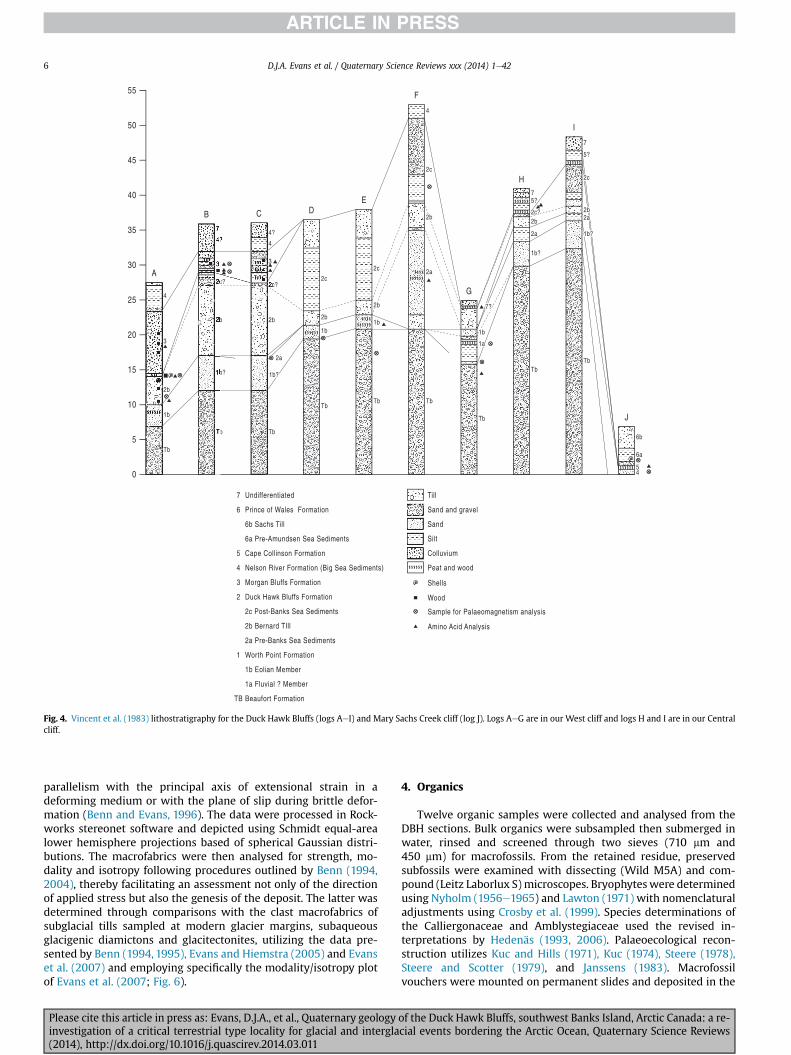
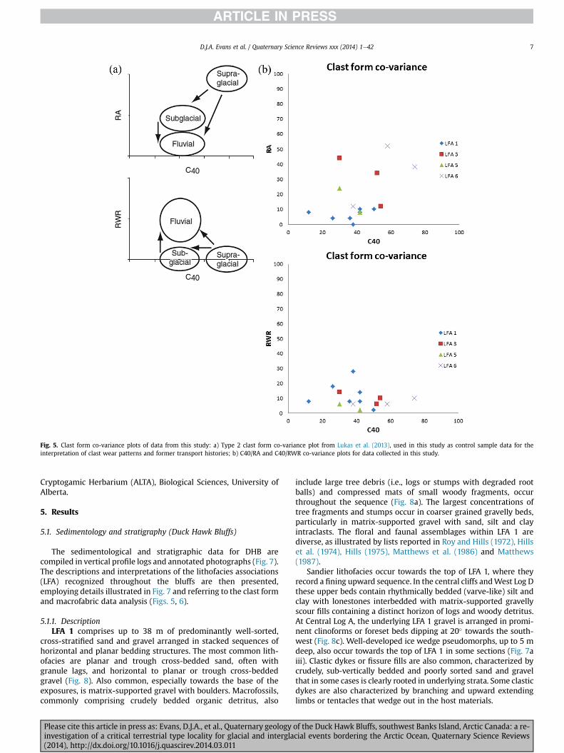
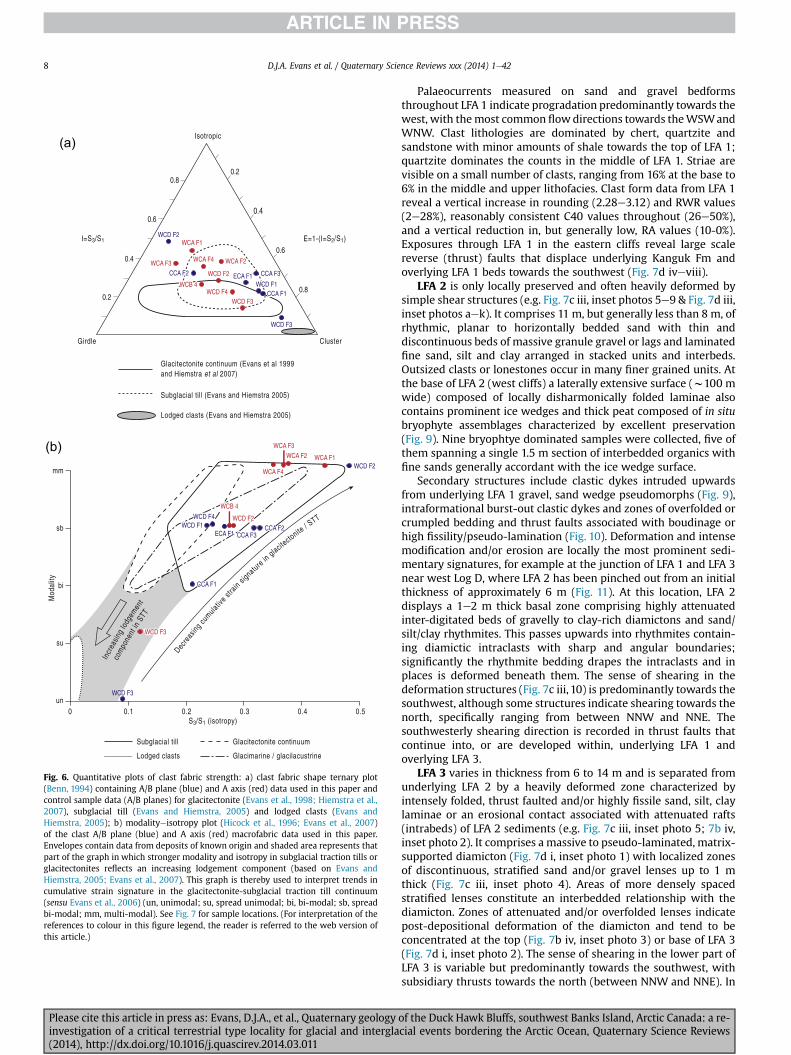
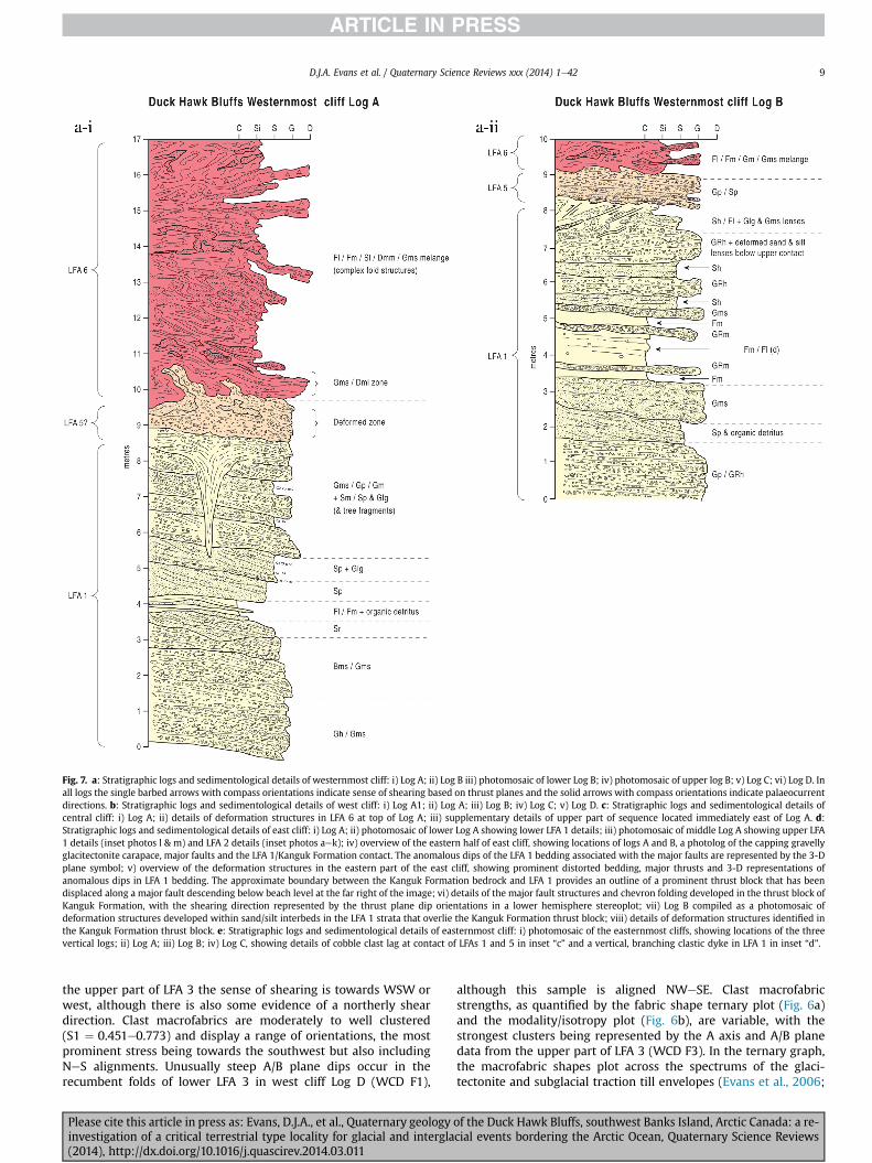
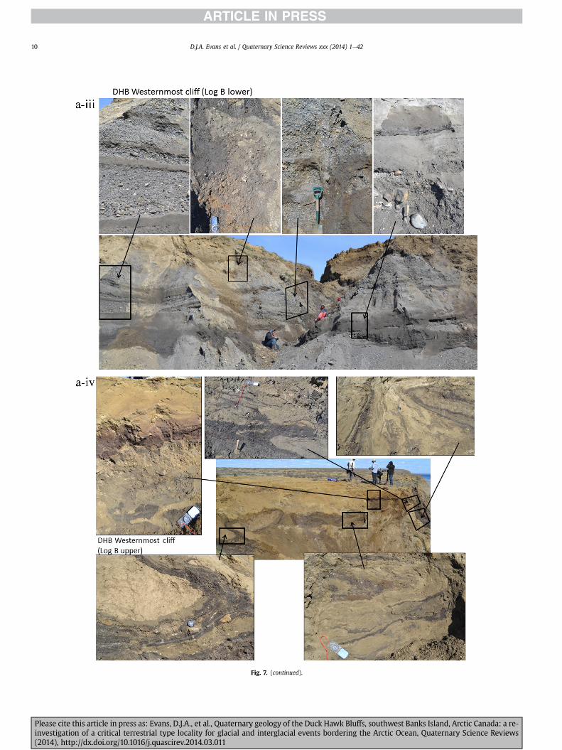
Fig 7 (continued)
DJA Evans et al Quaternary Science Reviews xxx (2014) 1e4210
Please cite this article in press as Evans DJA et al Quaternary geology of the Duck Hawk Bluffs southwest Banks Island Arctic Canada a re-investigation of a critical terrestrial type locality for glacial and interglacial events bordering the Arctic Ocean Quaternary Science Reviews(2014) httpdxdoiorg101016jquascirev201403011
Fig 7 (continued)
DJA Evans et al Quaternary Science Reviews xxx (2014) 1e42 11
Please cite this article in press as Evans DJA et al Quaternary geology of the Duck Hawk Bluffs southwest Banks Island Arctic Canada a re-investigation of a critical terrestrial type locality for glacial and interglacial events bordering the Arctic Ocean Quaternary Science Reviews(2014) httpdxdoiorg101016jquascirev201403011
Fig 7 (continued)
DJA Evans et al Quaternary Science Reviews xxx (2014) 1e4212
Please cite this article in press as Evans DJA et al Quaternary geology of the Duck Hawk Bluffs southwest Banks Island Arctic Canada a re-investigation of a critical terrestrial type locality for glacial and interglacial events bordering the Arctic Ocean Quaternary Science Reviews(2014) httpdxdoiorg101016jquascirev201403011
Fig 7 (continued)
DJA Evans et al Quaternary Science Reviews xxx (2014) 1e42 13
Please cite this article in press as Evans DJA et al Quaternary geology of the Duck Hawk Bluffs southwest Banks Island Arctic Canada a re-investigation of a critical terrestrial type locality for glacial and interglacial events bordering the Arctic Ocean Quaternary Science Reviews(2014) httpdxdoiorg101016jquascirev201403011
Fig 7 (continued)
DJA Evans et al Quaternary Science Reviews xxx (2014) 1e4214
Please cite this article in press as Evans DJA et al Quaternary geology of the Duck Hawk Bluffs southwest Banks Island Arctic Canada a re-investigation of a critical terrestrial type locality for glacial and interglacial events bordering the Arctic Ocean Quaternary Science Reviews(2014) httpdxdoiorg101016jquascirev201403011
Fig 7 (continued)
DJA Evans et al Quaternary Science Reviews xxx (2014) 1e42 15
Please cite this article in press as Evans DJA et al Quaternary geology of the Duck Hawk Bluffs southwest Banks Island Arctic Canada a re-investigation of a critical terrestrial type locality for glacial and interglacial events bordering the Arctic Ocean Quaternary Science Reviews(2014) httpdxdoiorg101016jquascirev201403011
Fig 7 (continued)
DJA Evans et al Quaternary Science Reviews xxx (2014) 1e4216
Please cite this article in press as Evans DJA et al Quaternary geology of the Duck Hawk Bluffs southwest Banks Island Arctic Canada a re-investigation of a critical terrestrial type locality for glacial and interglacial events bordering the Arctic Ocean Quaternary Science Reviews(2014) httpdxdoiorg101016jquascirev201403011
Fig 7 (continued)
DJA Evans et al Quaternary Science Reviews xxx (2014) 1e42 17
Please cite this article in press as Evans DJA et al Quaternary geology of the Duck Hawk Bluffs southwest Banks Island Arctic Canada a re-investigation of a critical terrestrial type locality for glacial and interglacial events bordering the Arctic Ocean Quaternary Science Reviews(2014) httpdxdoiorg101016jquascirev201403011
Fig 7 (continued)
DJA Evans et al Quaternary Science Reviews xxx (2014) 1e4218
Fig 6a) Clast lithologies vary depending on sample location Amore restricted lithological component (chert quartzite andsandstone) occurs in the deformed contact zone with underlyingLFA 1 and in areas characterized by attenuated gravel lenses Amore varied clast lithology comprising chert and quartz with mi-nor components of sandstone shale granite gabbro and limestoneoccurs towards the middle and in the more diamictic zones (LFA 3)
LFA 4 comprises less than 5 m of sand silt and clay arranged inhorizontal cross-laminae rhythmites climbing ripples or drapedlaminae that locally contain organic detritus The upper and lowercontacts of LFA 4 are commonly characterized by heavily brecciatedclay or contain boudinage and thrust faulted laminae (Fig 12panels a amp c) Some outcrops of LFA 4 also display widespreaddeformation in the form of overfolded bedding and thrust faultsalthough normal faulting and open folding or convolute beddingstructures are also evident (Fig 7c iii inset photo 3) In some sec-tions LFA 4 comprises only a thin (lt2 m thick) bed of brecciatedclay (Fig 7b iv inset photo 4) or laminated sand displaying over-folds and sheath folds The sense of shearing as recorded by thrustfaults is generally towards the SSW but southerly and southwest-erly orientations are also evident Numerous examples of narrowanabranched clastic dykes rise sub-vertically through the thickestoutcrop of the sandy climbing ripple lithofacies (LFA 4 West Log A)and have created offset beds between the blocks within the hostmaterial (Fig 12 panel b) The contact of LFA 4 with LFA 3 (west cliffLog A) is marked by a clast lag Although the association is pre-dominantly heavily deformed the most unaltered and thickest
Please cite this article in press as Evans DJA et al Quaternary geologyinvestigation of a critical terrestrial type locality for glacial and intergla(2014) httpdxdoiorg101016jquascirev201403011
outcrop in West Log A displays climbing ripple drift indicative of apalaeocurrent from the south or southwest (Fig 7b ii)
LFA 5 comprises 5e10 m of tabular sets of horizontally beddedto massive gravel interbedded with horizontally bedded or cross-laminated sand and occasional units of matrix-supported gravel(Fig 13a b) The thickest outcrop displays a general coarsening-upward sequence from well-sorted horizontally bedded granulegravel and sand to matrix-supported and less well sorted hori-zontally bedded cobble to boulder gravel Clast lithologies aredominated by quartzite but contain subsidiary amounts of chertand sandstone with minor limestone LFA 5 differs from LFA 1based on its general coarsening-upward characteristics coarsergrain size and the presence of limestone clasts Clast form datafrom LFA 5 indicate a sub-rounded sample (averageroundness frac14 222 amp 246 RA frac14 8 amp 24 RWR frac14 2 amp 6) withpredominantly blocky shapes (C40 frac14 30 amp 42) and striae visible(lt14 of clasts) Upper and lower contacts are sharp but are locallyinterdigitated or amalgamated with LFA 6 (Fig 7b iv inset photo 5)and LFA 4 (Fig 13d) respectively A heavily deformed discontin-uous bed of siltclay rhythmites occurs between LFA 5 and LFA 6 inWest Log D the base of which has been amalgamated with thegravel at the top of LFA 5 (Fig 13c) Gravel in Easternmost Cliff hasan unclear relationship to the primary sections at DHB to the westThis gravel designated LFA 5a rests uncomformably on LFA 1 andis not capped by LFA 6 as elsewhere (Fig 7e) Furthermore there isno evidence of deformation and palaeocurrents are orientatedtowards the NW
of the Duck Hawk Bluffs southwest Banks Island Arctic Canada a re-cial events bordering the Arctic Ocean Quaternary Science Reviews
Fig 7 (continued)
DJA Evans et al Quaternary Science Reviews xxx (2014) 1e42 19
Please cite this article in press as Evans DJA et al Quaternary geology of the Duck Hawk Bluffs southwest Banks Island Arctic Canada a re-investigation of a critical terrestrial type locality for glacial and interglacial events bordering the Arctic Ocean Quaternary Science Reviews(2014) httpdxdoiorg101016jquascirev201403011
Fig 7 (continued)
DJA Evans et al Quaternary Science Reviews xxx (2014) 1e4220
Please cite this article in press as Evans DJA et al Quaternary geology of the Duck Hawk Bluffs southwest Banks Island Arctic Canada a re-investigation of a critical terrestrial type locality for glacial and interglacial events bordering the Arctic Ocean Quaternary Science Reviews(2014) httpdxdoiorg101016jquascirev201403011
Fig 7 (continued)
DJA Evans et al Quaternary Science Reviews xxx (2014) 1e42 21
Please cite this article in press as Evans DJA et al Quaternary geology of the Duck Hawk Bluffs southwest Banks Island Arctic Canada a re-investigation of a critical terrestrial type locality for glacial and interglacial events bordering the Arctic Ocean Quaternary Science Reviews(2014) httpdxdoiorg101016jquascirev201403011
Fig 7 (continued)
DJA Evans et al Quaternary Science Reviews xxx (2014) 1e4222
Please cite this article in press as Evans DJA et al Quaternary geology of the Duck Hawk Bluffs southwest Banks Island Arctic Canada a re-investigation of a critical terrestrial type locality for glacial and interglacial events bordering the Arctic Ocean Quaternary Science Reviews(2014) httpdxdoiorg101016jquascirev201403011
Fig 7 (continued)
DJA Evans et al Quaternary Science Reviews xxx (2014) 1e42 23
Please cite this article in press as Evans DJA et al Quaternary geology of the Duck Hawk Bluffs southwest Banks Island Arctic Canada a re-investigation of a critical terrestrial type locality for glacial and interglacial events bordering the Arctic Ocean Quaternary Science Reviews(2014) httpdxdoiorg101016jquascirev201403011
Fig 7 (continued)
DJA Evans et al Quaternary Science Reviews xxx (2014) 1e4224
LFA 6 crops out along the length of DHB and varies widely inthickness (1e11 m) displaying the most complex deformationstructures of any of the sediment bodies at DHB It comprises apredominantly heterogeneous diamicton or a meacutelange of discon-tinuous interbeds of massive matrix-supported diamicton matrix-supported gravel and laminated sand silt and clay with localizedattenuated lenses of degraded organics (Fig 7a ivevi 7b i iv 7c iiiii) Three samples of highly compressed and fragmented detritalmaterial displaying poor preservation were collected for identifi-cation Collectively LFA 6 has the appearance of a stratified dia-micton but locally it displays a more massive to pseudo-laminatedcharacter where sand silt and gravel lenses and occasional gravellags occur as thin beds stringers or wisps Some laminated sand siltand clay bodies appear to be rafts within the diamicton (intraclasts)due to their heavily deformed internal bedding and deformedcontacts or attenuated appearance Basal contacts with other lith-ofacies associations are typically erosional or deformed and asso-ciated with fissility boudinage and pseudo-lamination insediments on either side of the contact Basal diamictons can alsodisplay a higher concentration of gravel clasts that locally result in aclast-supported character or even a several metre-thick highlycontorted meacutelange of diamicton and stratified sediment bodies Insome sections the whole of LFA 6 has been complexly deformed toproduce stacked overfolds and thrust faults indicative of shearingtowards the southwest or WSW Clast macrofabrics are onlymoderately clustered (S1 frac14 0456e0637) but indicate stressdirected predominantly towards the SW Clast macrofabricstrengths as quantified by the fabric shape ternary plot (Fig 6a)and themodalityisotropy plot (Fig 6b) are variable and range frombi-modal to multi-modal Overall the macrofabric shapes in theternary graph plot across the spectrums of the glacitectonite andsubglacial traction till envelopes but there is a trend of changing
Please cite this article in press as Evans DJA et al Quaternary geologyinvestigation of a critical terrestrial type locality for glacial and intergla(2014) httpdxdoiorg101016jquascirev201403011
fabric strength vertically through LFA 6 The strongest clusters arefrom the basal diamictic zones (eg CCA F1 amp F3 AB plane data)whereas the weakest are from the top of the association (eg WCAF3 A-axes amp CCA F2 AB planes) where relatively low strain defor-mation indicators (open and recumbent folds) are ubiquitous
Clast lithologies in LFA 6 are dominated by quartz chert andsandstone although one diamict reveals a concentration of sand-stone lithologies at the expense of chert Clast forms similarlyreflect the nature of the sampled materials whereby the gravellysample (CCA 2) was characterized by relatively low C40 (38) andRA (12) values and a high average roundness (256) compared tothe same values for the diamictons of LFA 6 (C40 frac14 50e74RA frac14 38e52 average roundness frac14 174e204) A small number ofclasts (lt10) in LFA 6 were striated
512 Interpretation5121 LFA 1 The thick tabular sequence of well sorted cross-stratified sand and gravel records deposition by a former glaci-fluvial braided river typified by fluctuating discharge (eg Church1972 Boothroyd and Ashley 1975 Miall 1978 1985 1992Marren 2005) The highest discharge is recorded by matrix-supported gravel with boulders indicative of hyperconcentratedflows or a traction carpet (Maizels 1989ab Siegenthaler andHuggenberger 1993 Mulder and Alexander 2001) These areseparated by and vertically give way to lower discharges recordedby planar or trough cross-bedded sand and horizontal to planar ortrough cross-bedded gravel These deposits record aggradation andmigration of gravel bars and sheets and downstream accretionarymacroforms with relatively tightly constrained palaeocurrent in-dicators (Miall 1977 1985 Collinson 1996) The general lack ofscour fills and an overall fining-upward is indicative of an aggradingsystem initially characterized by high magnitudehigh frequency
of the Duck Hawk Bluffs southwest Banks Island Arctic Canada a re-cial events bordering the Arctic Ocean Quaternary Science Reviews
Fig 7 (continued)
DJA Evans et al Quaternary Science Reviews xxx (2014) 1e42 25
Please cite this article in press as Evans DJA et al Quaternary geology of the Duck Hawk Bluffs southwest Banks Island Arctic Canada a re-investigation of a critical terrestrial type locality for glacial and interglacial events bordering the Arctic Ocean Quaternary Science Reviews(2014) httpdxdoiorg101016jquascirev201403011
Fig 7 (continued)
DJA Evans et al Quaternary Science Reviews xxx (2014) 1e4226
Please cite this article in press as Evans DJA et al Quaternary geology of the Duck Hawk Bluffs southwest Banks Island Arctic Canada a re-investigation of a critical terrestrial type locality for glacial and interglacial events bordering the Arctic Ocean Quaternary Science Reviews(2014) httpdxdoiorg101016jquascirev201403011
DJA Evans et al Quaternary Science Reviews xxx (2014) 1e42 27
events that were gradually replaced by low magnitudehigh fre-quency events (Marren 2005) Partially to heavily-scoured rem-nants of laminated and massive fines represent deposition duringlow flow conditions in abandoned shallow channels The palae-ocurrent data from LFA 1 indicate that the outwash streams wereflowing westerly away from a glacier source located in AmundsenGulf This glacier likely eroded the abundant LFA 1 lithologies(chert quartzite and sandstone) from Mesoproterozoic and Neo-proterozoic bedrock widely distributed to the east and south(western Victoria Island Amundsen Gulf and the adjacent main-land Harrison et al 2013) These lithologies are consistent with theadvance of the NW Laurentide Ice Sheet through Amundsen Gulf(cf Dyke et al 2002 Batchelor et al 2012 MacLean et al 2013)
The crudely bedded organic detritus and degraded tree frag-ments (stumps) in LFA 1 are clearly reworked (cf Matthews et al1986 Fyles 1990 Vincent 1990) The finer grained detritus wasdeposited in concentrated pockets during waning flow stageswhereas horizons of logs and larger tree fragments were emplacedwith the coarser grained and poorly sorted sediments associatedwith hyperconcentrated flows or traction carpets during highdischarge These reworked organics also differ significantly fromthe type location of the Beaufort Fm a characteristic that promptedFyles (1990) to distinguish them as lsquotheMary Sachs Gravelrsquo Notablythe enclosing gravel and sand of LFA 1 is much coarser and exhibitsan entirely different fluvial architecture than the sandier BeaufortFm The composition and degraded nature of the LFA 1 organicssuggests that they were eroded by glaciers or their meltwater fromNeogene andor Paleogene sediments presumably to the southeastof Banks Island (eg Fyles 1990 Fyles et al 1994) The proximity ofa glacier is highlighted by the preservation of striae on individualclasts especially in the very coarse lower gravel The verticaldecrease in striae preservation and angularity (RA) and concomi-tant increase in roundness and upward-fining in LFA 1 is indicativeof an increasingly distal ice margin The co-variance plots (Fig 5)indicate a strong fluvial signature especially in the C40RA data butsubglacial characteristics are also evident particularly in the C40RWR data for the coarser grained and more matrix-supportedgravel as would be expected in ice-proximal settings
It is important to note that the widespread thrusting of LFA 1and underlying Kanguk Formation towards the southwest occurredpost-depositionally This glacitectonic thrusting was produced byLaurentide ice that advanced from the Kellett River valley (interiorBanks Island) during the emplacement of LFA 6 (see below) Theinjection of clastic dykes and fissure fills during this glacitectonicdisturbance was due to the overpressurizing of groundwater ingravel aquifers likely in taliks The branching limbs of many of thedykes are indicative of burst-out structures diagnostic of hydro-fracturing by vertically escaping groundwater pressurized byglacier overriding (cf Rijsdijk et al 1999 Le Heron and Etienne2005)
5122 LFA 2 At the top of LFA 1 rhythmites with lonestonesoverlie prominent clinoforms or foreset beds recording a changefrom subaerial glacifluvial to subaqueous deposition This wasinitially on a shallow delta front prograding foreset beds in asouthwesterly direction followed by suspension sedimentationwith dropstones presumably from floating ice in a marine orlacustrine basin The occurrence of matrix-supported gravelly scourfills with logs and woody detritus suggests pulses of cohesionlesssediment gravity flows into the basin Overlying the rhythmically-bedded sand prominent ice wedge pseudomorphs (up to 4 mdeep Fig 9aec cf Mackay and Burn 2002) are interspersed withthick (gt1m) sections of compressed in situ bryophytes (Figs 9d 7e)indicating the establishment of a tundra surface Four bryophytefamilies and 10 distinct species have been determined from LFA2
Please cite this article in press as Evans DJA et al Quaternary geologyinvestigation of a critical terrestrial type locality for glacial and intergla(2014) httpdxdoiorg101016jquascirev201403011
with the most abundant material from the Calliergonaceae andCampyliaceae (Table 1) These macrofossils are exceptionally wellpreserved including material with intact fragile alar cells typical ofthese two families (Fig 14cef) The data from these autochthonousdeposits indicate a wetland environment characterized as a richfen This ecosystem and habitats therein are consistent with speciesfound in the extant flora of Banks Island (Fig 14b) The autecologyfrom this range of species suggest hydric to mesic habitatsincluding standing pools wet meadows and microhabitats createdby ice wedges Despite the predominance of bryophytes in LFA 2these macrofossils had not been previously documented at DHB Incontrast a minimal proportion of the samples (lt5) consisted ofvascular plant material (including Cyperaceae seeds gramminoidleaves and woody twig fragments) Collectively the ice wedgepseudomorphs and vegetation within LFA 2 represent an isochro-nous terrestrial surface of interglacial rank
Following the formation of ice wedges the injection of intra-formational clastic dykes and fissure fills in LFA 2 relates to theoverpressurizing of groundwater in gravel aquifers or taliks due toglacier overriding The branching dyke limbs that emanate fromunderlying LFA 1 gravels and sands are indicative of the burst-outstructures that develop during hydrofracturing (cf Rijsdijk et al1999 Le Heron and Etienne 2005) A variant of the gravel andsand filled clastic dykes occurs within the sequence of glaci-tectonite and rhythmites near west Log D (Fig 11) Here thevertically-widening fracture is characterized by a mosaic ofpartially disaggregated blocks of the host materials in its widestzone where it contains gravels injected from underlying LFA 1Because these gravels only occur in the basal narrow neck theypresumably record the rapid reduction in flow competence duringhydrofracture filling
Deformation structures including overfolded or crumpledbedding and thrust faults associated with boudinage or highfissilitypseudo-lamination are representative of simple shear andwere also induced by glacitectonic disturbance (cf van derWateren 1995 McCarroll and Rijsdijk 2003) This predominantlyrecords a glacier advance from the northeast Subsidiary shear in-dicators record deformation from the south or southeast but theseoccur only at the top of LFA 2 and the base of LFA 3 suggestingearlier emplacement (see below) The development of zones ofboudinage shallow thrust faults overfolding or bed crumpling atdifferent levels within LFA 2 e especially at the contact separatingsediments of different grain size e represents deformation parti-tioning due to contrasting rheological properties Blind thrustswere also initiated in underlying LFA 1 increasingly towards thecentral and eastern cliffs where large-scale deformation is moreprevalent (Fig 7c d) A zone of intense deformation is recorded by alens of LFA 3 diamicton in fault contact with LFA 2 (east cliff Log AFig 7d i) This constitutes a type B glacitectonite (non-penetrativelydeformed pre-existing sediments sensu Benn and Evans 1996Evans et al 2006) developed during the emplacement of LFA 3(see below) A similar glacitectonite occurs at the junction of LFA 1and LFA 3 near west Log D (Fig 11) Bed attenuation by deformationis best developed in lower LFA 2 where the greater differences insediment grain size and hence rheology exist
5123 LFA 3 Within LFA 3 locally abundant stratified lensesindicate subaqueous deposition These stratified sediments weresubsequently thrust faulted folded and attenuated - most evidentin the upper and lower zones of LFA 3 This deformation was likelyresponsible for the intraclast boudinage and pseudo-lamination inthe surrounding diamicton (eg Hart and Roberts 1994 Robertsand Hart 2005 Oacute Cofaigh et al 2011) This process was alsoassociatedwith the attenuation of LFA 1 and 2 sediments within theheavily deformed base of LFA 3 some of which may have been
of the Duck Hawk Bluffs southwest Banks Island Arctic Canada a re-cial events bordering the Arctic Ocean Quaternary Science Reviews
Fig 8 Details of LFA 1 a) example of a concentration of logs with degraded rootballs in the stacked tabular units of cross-bedded sands and gravels and crudely stratified matrix-supported cobble to boulder gravels in the west cliff b) poorly-sorted and crudely horizontally bedded cobble to boulder gravel containing laminated clay intraclast (immediatelyabove compass) c) shallow locally graded foreset beds composed of openwork to sandy matrix-supported cobble to granule gravels in central cliff Log A d) planar bedded sandy
DJA Evans et al Quaternary Science Reviews xxx (2014) 1e4228
Please cite this article in press as Evans DJA et al Quaternary geology of the Duck Hawk Bluffs southwest Banks Island Arctic Canada a re-investigation of a critical terrestrial type locality for glacial and interglacial events bordering the Arctic Ocean Quaternary Science Reviews(2014) httpdxdoiorg101016jquascirev201403011
DJA Evans et al Quaternary Science Reviews xxx (2014) 1e42 29
cannibalized and rafted by the deformation process within a shearzone at the contact of LFA 3 with older sediments The shearingdirection from the south and southeast recorded in lower LFA 3also impacted upper LFA 2 whereas the more prominent shearingdirection throughout LFA 3 is from the northeast (also recorded inLFA 4) The local development of a heavily deformed zone at the topof LFA 3 was likely imparted during the shearing of overlying LFA 4sediments Although clast macrofabric strengths from the LFA 3diamicton are variable they possess shapes that compare withglacitectonites and subglacial traction tills and in some cases amodalityisotropy signature that reflects high lodgementcomponents
The similar orientation of the macrofabrics and shear indicatorsare considered diagnostic of a glacitectonite derived from stratifiedsediments (eg interbedded mass flow diamictons gravelly massflows and localized traction current sands and suspension de-posits) This evidence indicates that LFA 3 like all the other LFAsand the underlying Kanguk Fm bedrock has been displaced by aglacier advancing from the NNE or NE (ie Laurentide ice crossingthe interior of Banks Island) Minor south to north shearing in-dicates that LFA 3 and upper LFA 2were also disturbed by glacier iceflowing northwards (ie Laurentide ice advancing throughAmundsen Gulf) The appearance of granite and gabbro clastswithin the LFA 3 diamict records the arrival of far-travelled Lau-rentide ice from mainland Canada Clast form co-variance stronglyindicates a subglacial (abraded) source for LFA 3 with a minorfluvial component (Fig 5) including glacifluvial clasts locallycannibalized from LFA 1 by overriding ice
5124 LFA 4 LFA 4 has restricted outcrops is heavily deformedand contains organic detritus that is clearly allochthonous andhighly degraded Nonetheless a variety of indicators (fine-grainedhorizontally bedded cross-laminae rhythmites climbing ripplesand draped laminae) demonstrate that LFA 4 was deposited in asubaqueous environment with palaeocurrents from the south orsouthwest Traction currents were likely responsible for thedevelopment of the clast lag at the contact between lower LFA 4and underlying LFA 3 (west cliff Log A Fig 7b ii) LFA 4 coarsensupwards indicative of basin infilling andor an approaching sedi-ment source The narrow anabranched clastic dykes in the sandyclimbing ripples (LFA 4 west cliff Log A) record hydrofracturing bythe upward injection of overpressurized groundwater duringshearing The branching limbs of the dykes are similar to the burst-out structures reported by Rijsdijk et al (1999) but differ becausethey are composed solely of sand derived from the walls of the hostsediment rather than from an underlying gravel aquifer (cf LeHeron and Etienne 2005) Hence the pressurized water wasgenerated at the contact between the sand and underlying imper-meable brecciated clays The development of thin zones of brecci-ation boudinage sheath folding or thrust faulting at the upper andlower contacts of LFA 4 relates to the localized partitioning ofdeformation controlled by the location of claysilt beds Thejuxtaposition of this style of deformation with the larger scaleoverfolds and thrust faults developed in the extensive bodies ofsandy lithofacies is indicative of a Type B glacitectonite (sensu Bennand Evans 1996) This was constructed by the overriding of glacierice advancing from the north or northeast These shear directionsare compatible with those developed in the underlying LFAs
granule gravels with gravel lags (top and bottom of image) interrupted by an intervening unbedded granule to pebble gravel and massive cobble to pebble gravel A cluster of small treesequence of stacked tabular units of predominantly horizontally bedded sands and gravels ingravels containing clusters of wood detritus in the coarser gravel beds (central cliff Log A)wood fragments (central cliff Log A)
Please cite this article in press as Evans DJA et al Quaternary geologyinvestigation of a critical terrestrial type locality for glacial and intergla(2014) httpdxdoiorg101016jquascirev201403011
5125 LFA 5 The primary characteristics of LFA 5 are typical ofgravel sheet and occasional traction-carpet sedimentation in anice-proximal sandur (eg Boothroyd and Ashley 1975 Miall 19781985 1992 Maizels 1989ab Siegenthaler and Huggenberger1993 Mulder and Alexander 2001 Marren 2005) Glacier prox-imity is supported by the subglacial to fluvial signature of the clastforms (Fig 5) The coarsening-upward sequence including striatedclasts culminates in the arrival of a glacier that overrode the sitedepositing LFA 6 Post-depositional shearing within underlying LFA4 is recorded by attenuation and interdigitation at the contact withLFA 5 imparted during deposition of LFA 6 The contact betweenLFA 5 and 6 reflects the development of a shear zone where upperLFA 5 sediments have been cannibalized producing a meacutelange ofcrudely stratified diamictons with discontinuous interbeds ofmatrix-supported gravel laminated sand silt and clay (LFA 6 seebelow)
5126 LFA5a At Easternmost Cliff glacifluvial gravel (LFA 5a)unconformably overlies LFA 1 (Fig 7e) rendering uncertain itsrelationshipwith respect to LFA 5 in themain sections of DHB to thewest The fact that LFA 5a extends to the modern surface appearsundeformed and has palaeocurrents orientated to the NW requiresthat it is younger than LFA 5 Indeed we interpret LFA 5a asdeglacial outwash deposited from retreating Laurentide ice in theKellett River valley and Amundsen Gulf at the end of the lastglaciation (see Discussion)
5127 LFA 6 Based on its heterogeneity strongly orientated clastmacrofabrics and macroscale deformation structures LFA 6 con-stitutes a Type B glacitectonite (sensu Benn and Evans 1996)However zones of more highly strained Type A glacitectonite(sensu Benn and Evans 1996) at the basal contact with older LFAsare recorded by intraclastinterbed attenuation (pseudo-lamina-tion) strong boudinage or fissility and strengthened clast macro-fabrics The production of this meacutelange is attributed to two separateprocesses 1) primary sedimentation as interbedded and interdig-itated mass flow debris fluvial gravel and sand and subaqueoussuspension sediments and 2) cannibalization of underlying strat-ified sediments (LFAs 4 and 5) This produced a continuum of formsranging from low strain fold structures to attenuated rafts to tec-tonic lamination (eg Fig 7) The discontinuous lenses of degradedorganics (black stems and woody twigs gramminoid leaveswhitened rootlets) within LFA 6 are rafts and include seven speciesof bryophytes (Table 1) The material was highly compressed anddifficult to separate into distinct taxa Indeed one of the threesamples analysed was too degraded to recover any taxa Much ofthe material consisted of only fragmented leaves and only theminute taxa had stems with intact leaves The bryophytes thatcharacterize the LFA 6 samples represent hydric (Calliergon sppTomenthypnum nitens) to mesic (Ditrichum flexicaule Dicranum sp)habitats Three species collected from LFA 6 were also present inLFA 2 whereas four others were not found in LFA 2 but are com-mon in the modern flora The poor preservation quality suggeststhat the material has been redeposited from unknown sources andis clearly allochthonous
The predominant shearing direction within LFA 6 records an iceadvance from the interior of Banks Island (NE) This has resulted incomplex folding and thrusting and localized thickening of LFA 6
it of cross-bedded poorly-sorted to openwork cobble to boulder gravel crudely planar-fragments occur at the base of the cobble to boulder gravels at image centre e) middleDHB west cliff Log D f) sequence of fining-upward planar-bedded cobble to sandy fineg) planar cross-bedded sandy granule to pebble gravels with pebble to cobble lags and
of the Duck Hawk Bluffs southwest Banks Island Arctic Canada a re-cial events bordering the Arctic Ocean Quaternary Science Reviews
Fig 9 Details of LFA 2 from the west cliff a) narrow necked ice wedge pseudomorph with upturned marginal bedding in sand silt and clay rhythmites b) wide necked ice wedgepseudomorph c) ice wedge pseudomorph with overturned silt sand and clay rhythmites developed at the top of LFA 2 and sealed by overlying LFA 3 laminated diamicton d)horizontally bedded sand and silt containing well preserved moss macrofossils e) zone of disharmonically folded sandsilt laminae with well preserved moss peat located at thebase of LFA 2
DJA Evans et al Quaternary Science Reviews xxx (2014) 1e4230
Please cite this article in press as Evans DJA et al Quaternary geology of the Duck Hawk Bluffs southwest Banks Island Arctic Canada a re-investigation of a critical terrestrial type locality for glacial and interglacial events bordering the Arctic Ocean Quaternary Science Reviews(2014) httpdxdoiorg101016jquascirev201403011
Fig 10 Details of simple shear structures developed in fine sand and silt laminae at the centre of the thickest outcrop of LFA 2 in west cliff Log B a) overview of large scaleanastomosing shear faults with zones of smaller scale densely spaced anastomosing shears towards the base of the photograph b) details of large scale shear faults separatingzones of variably but predominantly densely spaced shears c) close details of shear zone comprising densely spaced anastomosing fractures d) details of ascending kink zonecross-cutting large scale anastomising shear faults Shearing direction is coming out of the cliff and towards the left in each image
DJA Evans et al Quaternary Science Reviews xxx (2014) 1e42 31
This shearing direction is recorded throughout underlying LFAs 1e4as well as the Kanguk Formation demonstrating deep-seated butpartitioned glacitectonic disturbance imparted during theemplacement of LFA 6 This strain signature was therefore over-printed on the northerlynortheasterly aligned shearing directionrecorded in LFA 3 and upper LFA 2 by the earlier northerly flowingice that deposited LFA 3 One anomalous clast macrofabric(northerly CCA F1) occurs in the basal meacutelange of LFA 6 Howeverthis sample is from an isolated outcrop (Fig 7c i) rendering itsapparent shearing direction equivocal
Please cite this article in press as Evans DJA et al Quaternary geologyinvestigation of a critical terrestrial type locality for glacial and intergla(2014) httpdxdoiorg101016jquascirev201403011
52 Sedimentology and stratigraphy (Mary Sachs Creek cliff)
The cliffs east of Mary Sachs Creek (Figs 2b 3) provides a cross-section through the seaward margin of the coast-parallel SachsMoraine (ldquosection Jrdquo Vincent et al 1983 Vaughan 2014) Weprovide a summary of two logs based on a reconnaissance survey ofthese sediments Log A is closest toMary Sachs Creekwhereas Log Boccursw1 km farther east (Figs 3 15a amp b) The sediments exposedin Log A appear to descend eastward and disappear below themodern beach and therefore are assumed to stratigraphically
of the Duck Hawk Bluffs southwest Banks Island Arctic Canada a re-cial events bordering the Arctic Ocean Quaternary Science Reviews
Fig 11 Details of LFA 2 near west Log D Lower box shows a 1e2 m thick basal zone comprising highly attenuated inter-digitated beds of gravelly to clay-rich diamictons and sandsiltclay rhythmites Upper box shows rhythmites containing diamictic intraclasts with sharp and angular boundaries also visible is the draping and deforming of the rhythmitebedding over and under the intraclasts respectively ldquoTailsrdquo extending from the diamictic intraclasts and thin but discontinuous diamictic beds are also visible in the upper box
DJA Evans et al Quaternary Science Reviews xxx (2014) 1e4232
underlie the sediments of Log B A sand and gravel- bench caps bothlogs at w15 m asl incised into the seaward margin of the SachsMoraine
521 DescriptionLog A contains a sequence of upward-fining highly contorted
cross-stratified sand and fine gravel to rhythmically bedded sandsilt clay with minor pebble gravel and sporadic clots of gravellydiamicton (Fig 15a) An ice wedge was initially developed in thelower cross-stratified sand and fine gravel before they were foldedand thrust faulted The deformed ice wedge pseudomorph is un-conformably overlain by a relatively undisturbed lens of laminatedsilty clay with dropstones interbedded with gravelly diamictonthat contains a bed (10 cm) of sandy black organics containingwood fragments (Fig 15a) This organic material occurs repeatedlyup-section as discontinuous stringers Log A is capped by 1e2 m ofpoorly exposed and heavily cryoturbated gravelly diamicton Thegeneral sense of displacement on shallow reverse faults over-turned bedding and boudinage structures is from the southeast
Log B (12 m) displays a coarsening-upward sequence of hori-zontally bedded sandy granule gravel with occasional silty sandlaminae (Fig 15b iii) that grades to poorly-sorted cobble to bouldergravel and bouldery matrix-supported gravel (Fig 15b ii) This iscapped by laminated to crudely stratified cobbly diamicton that issilt and clay-rich abruptly and conformably overlain by
Please cite this article in press as Evans DJA et al Quaternary geologyinvestigation of a critical terrestrial type locality for glacial and intergla(2014) httpdxdoiorg101016jquascirev201403011
interlaminated silt clay and pebbly silty sand (Fig 15b i) Althoughthe bedding on these units dips towards the NW individuallaminae do not thicken in that direction indicating post-depositional tilting The uppermost part of the log (underlyingthe 15 m bench) contains 2 m of clay-rich massive diamictoninterfingered with the underlying laminated sediments and cobblydiamicton
522 Interpretation
5221 Log A Broadly the sedimentology of log A including thedeformed ice wedge pseudomorph is similar to LFA 2 in DHB (egcentral cliff Log A Fig 7c iii) Prior to glacitectonic disturbance theoverlying organic bed (Fig 15a) was redeposited into a sequence ofsubaqueous siltclay rhythmites containing dropstones and gravellymass flows The highly attenuated shear margins bracketing theorganic bed in Log A demonstrate that it has been displaced as atectonic raft Previous research proposed that the organic beds e
similar to those described in Log A e be assigned to the LastInterglacial (locally called the Cape Collinson Vincent 1982 1983)Because these organic beds are clearly a raft they cannot constitutean iscochronous surface precluding chronostratigraphic signifi-cance (see Discussion) Shearing of the Log A sediments from thesoutheast documents an ice advance from Amundsen Gulf corre-sponding to the earliest of two primary shearing directions recor-ded at DHB (imparted during the emplacement of LFA 3) Therefore
of the Duck Hawk Bluffs southwest Banks Island Arctic Canada a re-cial events bordering the Arctic Ocean Quaternary Science Reviews
Fig 12 Details of LFA 4 in West Log A a) heavily deformed upper contact of LFA 4 comprising sandsiltclay rhythmites displaying well developed boudinage sheath folds andimmature tectonic laminae and an interdigitatedsheared boundary with underlying climbing ripple sands The contact with overlying LFA 6 is marked by an interdigitated zonecontaining rooted and de-rooted folds or rhythmite rafts in a sand gravel and diamicton meacutelange b) narrow anabranched clastic dykes ascending sub-vertically through climbingripple drift and resulting in offset bedding between blocks of host material c) abrupt contact between sheared sands and rhythmites of LFA 4 and overlying sand gravel anddiamicton meacutelange
Fig 13 Details of LFA 5 a) poorly sorted and matrix-supported pebble to cobble gravel b) tabular sequence of horizontally bedded to massive gravel and matrix-supported gravelcontaining a horizon of striated cobbles and boulders c) heavily deformed discontinuous bed of siltclay rhythmites between LFA 5 and LFA 6 in West Log D showing theamalgamation zone with the LFA 5 gravels immediately above the compass d) interdigitateddeformed contact between LFA 5 granule to pebble gravels and underlying LFA 4laminated silts and clays with organic detritus in West Log B
DJA Evans et al Quaternary Science Reviews xxx (2014) 1e42 33
Please cite this article in press as Evans DJA et al Quaternary geology of the Duck Hawk Bluffs southwest Banks Island Arctic Canada a re-investigation of a critical terrestrial type locality for glacial and interglacial events bordering the Arctic Ocean Quaternary Science Reviews(2014) httpdxdoiorg101016jquascirev201403011
Table 1List of bryophytes and vascular plants from LFAs 2 and 6
LFA2 WestCliff Log B
LFA6 CentralCliff Log A
Elevation (m) 185 m asl w45 m aslSample 4e12 1e3 taxa 10 7
Bryophyta (mosses)AmblystegiaceaeAmblystegium serpens (Hedw) Schimp x
CamyliaceaeCampylium polygamum (Schimp) CEO Jensen xCampylium stellatum (Hedw) CEO Jensen x xDrepanocladus aduncus (Hedw) Warnst xDrepanocladus sp xTomentypnum nitens (Hedw) Loeske x
CalliergonaceaeCalliergon giganteum (Schimp) Kindb xCalliergon richardsonii (Mitt) Kindb xthornthornthornthorn xCalliergon sp xWarnstorfia exannulatus (Schimp) Loeske xthornthornthornthorn x
BrachytheciaceaeBrachythecium turgidum (Hartm) Kindb x
MniaceaeCyrtomnium cf hymenophylloides(Hbener) TJ Kop
x
DicranaceaeDicranum sp x
DitrichaceaeDitrichum flexicaule (Schwaumlgr) Hampe x
Tracheophyta (vascular plants)CyperaceaeSeeds (triangular amp flattened) x x
Gramminoid leaf material x xWoody twig fragments x xRootlets x
Fig 14 The moss peat and associated microfossils of LFA 2 a) exposure through lower LFAsouthern Banks Island analogue of a rich tundra fen environment for the bryophyte assemblfrom LFA 2 showing the exceptional preservation of Calliergonaceae and Campyliaceae ma
DJA Evans et al Quaternary Science Reviews xxx (2014) 1e4234
Please cite this article in press as Evans DJA et al Quaternary geologyinvestigation of a critical terrestrial type locality for glacial and intergla(2014) httpdxdoiorg101016jquascirev201403011
these deformed deposits are interpreted as a Type B glacitectonite(sensu Benn and Evans 1996) possibly derived from LFA 2
5222 Log B The coarsening upward gravel in Log B recordshighly turbid to hyperconcentrated discharge in non-channelizedsheets This is interpreted as aggrading glacifluvial outwash froman approaching ice margin The capping sequence of crudelystratified diamicton and laminated sediments records a changefrom glacifluvial to subaqueous sedimentation prior to overridingby a glacier of unknown age that tilted the upper beds Thecoarsening-upward sequence apparent tectonism and cappingdiamict at Log B clearly distinguishes these deposits from those ofLFA 5a (west of Mary Sachs Creek easternmost cliff Fig 3)Furthermore although there is lithological similarity between LogB and LFA 5 throughout DHB the sense of shearing is dissimilar (LFA5 from the NE and Log B from the SE) The simplest explanation forthis difference in shear direction is that LFA 5 (DHB) was displacedby interior ice advancing down the Kellett River whereas Log B wasdisplaced by ice advancing along Amundsen Gulf (Fig 2b)
6 Discussion
61 Large scale glacitectonic structures and stratigraphicarchitecture
The glacitectonic structures identified within the lithofaciesassociations at DHB record two phases of deformation (early NeSand later NEeSW) This deformation together with the DHBstratigraphic architecture (Fig 16) helps to explain both thekinetostratigraphy (sensu Berthelsen1978) and the evolution of thelocal glacial geomorphology The large scale glacitectonic defor-mation is most clearly manifest in the thrust faulting and conjugate
2 at DHB west log B showing the sampling locations for in situ moss peat b) a modernages of LFA 2 c)ef) details of the typical moss peat and associated microfossil materialscrofossils including material with intact fragile alar cells
of the Duck Hawk Bluffs southwest Banks Island Arctic Canada a re-cial events bordering the Arctic Ocean Quaternary Science Reviews
Fig 15 The stratigraphy of Mary Sachs Creek cliff a) photographic compilation log A showing upward-fining highly contorted (i) cross-stratified sands and fine gravels torhythmically bedded sands silts clays and minor pebble gravels Also visible in (ii) is a lens of interbedded laminated silty clays with dropstones and gravelly diamictons containingsandy black coloured organic material with wood fragments An ice wedge pseudomorph is visible (iii) to the right of the exposure b) photographic compilation log B showing i)laminated to crudely stratified cobbly but siltclay-rich diamicton grading into interlaminated silts clays and pebbly silty sands ii) poorly-sorted cobble to boulder gravel andbouldery matrix-supported gravel iii) coarsening-upward sequence of horizontally bedded sandy granule gravels with occasional silty sand laminae iv amp v) pebble to cobble graveland matrix-supported gravel
DJA Evans et al Quaternary Science Reviews xxx (2014) 1e42 35
shear development in the Kanguk Fm bedrock and overlying LFA 1(east cliff Fig 7d ivevi) Here predominantly northeasterly dippingthrust slices have been stacked truncated and overlain by LFA 6during the second and strongest (NEeSW) deformation phase(Fig 16 note bedrock slice within the imbricated stacked sequenceof LFA 1) These structures demonstrate significant compressionand thickening of the stratigraphic sequence including w40 m ofvertical offset within the Kanguk Formation acrossw3 km (Fig 16)Prominent hydrofracture fills in LFAs 1 and 2 record elevatedporewater pressure during this thrusting Smaller scale shear zoneshave also developed in the finer grained interbeds within thrustslabs (Fig 7d vii) indicative of deformation partitioning by strataprone to ductile failure This zone of greatest displacement alsocoincides with the highest topography (Fig 16) Lower angle thrustfaults propagate in a southwesterly direction predominantlythrough LFA 1 but are also developed through LFA 2 in the footwallblock (east cliff Fig 16)
The thrust stacking of bedrock and LFAs 1e5 in east cliff (obliqueto Fig 16) represents the ice-proximal zone of a thrust-blockmorainecomposite ridge constructed by a glacier advancing fromthe northeast (ie the interior of Banks Island) This glacitectonicdeformation propagated southwestward to distal parts of theproglacial stress field as recorded bywell-developed shear zones inthe finer grained sediments of LFAs 2e5 In the more distal westcliff open folds (LFA 2 Fig 16) appear to be the product of a blindthrust within underlying LFA 1 This style of tectonism is typical oflsquopiggyback-style thrustingrsquo wherein steeply inclined thrust blocksat the advancing ice margin propagate new thrusts in the footwall(Fig 16 Park 1983 Mulugeta and Koyi 1987) The angle of thesefootwall thrusts becomes progressively shallower southwestward
Please cite this article in press as Evans DJA et al Quaternary geologyinvestigation of a critical terrestrial type locality for glacial and intergla(2014) httpdxdoiorg101016jquascirev201403011
(ice-distal) in LFA 1e5 where deformation partitioning developedin finer grained lithofacies (Fig 16)
The densely spaced ponds and depressions immediately to thenortheast of DHB (Figs 2b 3) constitute the depression fromwhich the thrust mass was excavated (eg Aber et al 1989Evans and England 1991 van der Wateren 1995) This inter-pretation is consistent with the strong northeast to southwestshear direction in the second phase glacitectonic structures andin LFA 6 clast macrofabrics This indicates that construction ofDHB occurred at the margin of a glacier advancing from thenortheast (ie from Kellett River valley) overtopping DHB anddepositing the LFA 6 glacitectonite The continued advance ofKellett ice coalesced with a glacier in Amundsen Gulf marked bythe interlobate Sachs Moraine containing ice-transported shellsas young as 24 cal ka BP (21020 70 yrs BP UCIAMS-89674)assigning this glaciation to the Late Wisconsin (Vaughan 2014)East of Mary Sachs Creek the deformation of Log B outwash(from the southeast Figs 15 16) likely records overriding by thesame Amundsen Gulf glacier (coeval with LFA 6 Late Wiscon-sinan) During ice retreat when Kellett River and Amundsen Gulfice decoupled DHB was exposed allowing the northwesterly-flowing proglacial outwash (LFA 5a) west of Mary Sachs Creekto extend to the shoreline marking postglacial marine limit atKellett Point (11 m asl Vaughan 2014 Fig 3) Collectively thisreconstruction supports a Late Wisconsinan age for the con-struction of DHB thrust block moraine although its stratigraphyincludes a range of ages A palaeogeographic reconstruction ofevents based upon our interpretation of the sedimentologystratigraphic architecture tectonism and geomorphology is pre-sented in Fig 17
of the Duck Hawk Bluffs southwest Banks Island Arctic Canada a re-cial events bordering the Arctic Ocean Quaternary Science Reviews
Fig 15 (continued)
DJA Evans et al Quaternary Science Reviews xxx (2014) 1e4236
62 Comparison and revision of previous DHB model
DHB was previously interpreted to record horizontally beddedNeogene to Quaternary sediments assigned to preglacial fluvialand multiple glacial and interglacial episodes (Vincent 1982 19831990 Vincent et al 1983 1984 Barendregt et al 1998) A com-posite palaeomagnetic record was also presented for this proposedstratigraphy placing most of this deposition before the BrunhesMatuyama boundary (Fig 1c) However prior to our work detailedstudies had not been undertaken on the sedimentology structuralgeology or stratigraphic architecture of DHB Rather the originalstratigraphy was restricted to a series of composite logs (our Fig 4reproduced from Vincent et al 1983) that notably omitted thepervasive deformation structures including the thrust bedrock ineast cliff (Fig 16)
Please cite this article in press as Evans DJA et al Quaternary geologyinvestigation of a critical terrestrial type locality for glacial and intergla(2014) httpdxdoiorg101016jquascirev201403011
Our reinterpretation dismisses several key elements of theoriginal DHB model outlined below (oldest to youngest) We havedetermined that the lowermost unit (LFA 1) is not preglacial (Fyles1990) but rather is composed of glacial outwash providing theearliest terrestrial evidence for glaciation in the area and containingallochthonous organics (including tree stumps) of unknown prov-enance Because LFA 1 is a glacifluvial braidplain (Fig 17a) it is notpart of the Beaufort Fm (Fyles 1990) even though it containsreworked macrofossils presumably derived from it (eg Craig andFyles 1960 Hills et al 1974 Vincent et al 1983)
Our analysis of LFA 2 indicates that it is also not preglacial norcan it be the Worth Point Fm as previously proposed (cf Vincent1982 1983 1990 Vincent et al 1983 Matthews et al 1986)Indeed the type locality of the Worth Point Fm has been invali-dated because it is now recognized to be an ice-transported and
of the Duck Hawk Bluffs southwest Banks Island Arctic Canada a re-cial events bordering the Arctic Ocean Quaternary Science Reviews
LFA4
Fig16
Stratigrap
hiccross-profi
lerun
ning
westto
easto
fDuc
kHaw
kBluffs
basedup
oninterpolations
betw
eenthemainsectionlogs
andsh
owingthesixLFAstheKan
gukFo
rmationbe
droc
kex
posu
resmajor
structural
features
and
thepo
sition
sof
icewed
geps
eudo
morph
san
dsign
ificant
clasticdy
kesAtthe
easternen
dof
thecross-profi
lethe
sedimen
tsat
theco
reof
MarySa
chsCree
kcliff
logAaretentativelyclassified
asLFA2
althou
ghthesematerialsarelik
ely
notin
situN
otethat
thecross-profi
ledo
esno
tex
tend
asfarea
stas
MarySa
chsCree
kcliff
logB
DJA Evans et al Quaternary Science Reviews xxx (2014) 1e42 37
Please cite this article in press as Evans DJA et al Quaternary geologyinvestigation of a critical terrestrial type locality for glacial and intergla(2014) httpdxdoiorg101016jquascirev201403011
glacitectonized raft (Vaughan et al 2014) In contrast our LFA 2 ischaracterized by an isochronous tundra surface with ice wedgesand intervening shallow ponds andwetmeadows The peat at LFA 2is dominated by bryophytes (gt95 by volume) and yet none ofthese macrofossils had been previously documented The diversein situ bryophyte species record a flora similar to that on BanksIsland today suggesting that LFA 2 warrants an interglacial rankThis conclusion is supported by the limited vascular plant record(five taxa no species indicated Vincent 1990) that also suggest awet meadow environment The absolute age of LFA 2 remains un-known but is apparently older than the BrunhesMatayamaboundary (gt780 ka Fig 18 cf Vincent et al 1984 Barendregt andVincent 1990 Barendregt et al 1998 see below)
LFA 3 in both our model and that of Vincent et al (1983) pro-vides the first direct evidence of ice reaching DHB In the previousmodel this was interpreted as Bernard Till (Banks Glaciation) thatwas bracketed by glacioisostatically induced marine transgressions(pre- and post-Banks seas Vincent 1982 1983) Within basal LFA 3we recognized highly deformed stratified sediment that wasdeposited in a subaqueous environment (deep water Fig 17c) priorto the arrival of overriding ice from the south (recorded by graniteand gabbro erratics Figs 17c 18) We regard LFA 3 to be equivalentto the Banks Glaciation (Vincent 1982 1983 Vincent et al 1983)including its pre- and post-Banks seas represented by the stratifiedsediments that bracket the central diamicton The LFA 3 sedimentsare also reported to be magnetically reversed thereby predatingthe BrunheseMatayama boundary (gt780 ka Fig 18 Vincent et al1984 Barendregt and Vincent 1990 Barendregt et al 1998)
Following the Banks Glaciation (our LFA 3 at DHB) Vincent(1982 1983) and Vincent et al (1983) recognized two in-terglacials (Morgan Bluffs and Cape Collinson) separated by anintervening marine episode This marine episode correspondedwith the glacioisostatic loading of a Laurentide ice margin confinedto the eastern half of Banks Island (Thomsen Glaciation) HoweverLFA 4 contains coarsening-upward subaqueous sedimentation fromthe south or southwest reflecting continued marine regressionfollowing LFA 3 (Fig 17c d) The coarsening-upward sequence ofLFA 4 is supplanted by coarse gravel outwash (LFA 5) supplied by aglacier readvancing from the northeast (Kellett River valley iceFig 17e) Glacier overriding is recorded by LFA 6 glacitectonite thatcaps the DHB thrust-block moraine composed of the entireassemblage of underlying LFAs (Fig 16)
Notably we have not observed any sediments characteristic oftwo interglacial deposits above LFA 3 hence dismiss the presence ofthe Morgan Bluffs and Cape Collinson interglacials at DHB Causseand Vincent (1989) report a U-series date of gt200 ka (UQT-229)from above our LFA 3 but this is almost certainly reworked andlacks chronostratigraphic significance Nor have we observedintervening marine sediments attributable to the Thomsen Glaci-ation (eg lsquoBig Searsquo Vincent 1982 1983 Vincent et al 1983)Rather following the deposition of the subaqueous sediments ofupper LFAs 3 and 4 (post-Banks Glaciation) LFAs 5 and 6 record asingle ice advance reaching DHB from the Kellett River valley(Banks Island interior) that was not reported by Vincent et al(1983) It was instead assumed that after the Banks GlaciationDHB lay distal to any later ice advances The nearest subsequentLaurentide margin to DHB recognized by Vincent et al (1983) wasassigned to the Sachs Moraine (immediately east of DHB) that waspresumed to be of EarlyWisconsin age (Fig 2b) However the SachsMoraine is nowdated to24 cal ka BP (LateWisconsinan Vaughan2014) andwas formed by the coalescence of Amundsen Gulf ice andthe Kellett River ice that deformed DHB (Fig 17) On the east side ofMary Sachs Creek the deposition of the Sachs Moraine coincideswith the deformation (from the southeast) of the underlying Log Boutwash gravel (Figs 3 15b)
of the Duck Hawk Bluffs southwest Banks Island Arctic Canada a re-cial events bordering the Arctic Ocean Quaternary Science Reviews
Fig 17 The palaeogeography of southwest Banks Island based upon interpretations of the principal lithofacies associations and structural architecture recognized at Duck HawkBluffs and the geomorphology of the surrounding terrain See text for detailed explanations
DJA Evans et al Quaternary Science Reviews xxx (2014) 1e4238
Although interglacial deposits were previously reported fromthe cliffs east of Mary Sachs Creek (ie Cape Collinson InterglacialVincent et al 1983) we found no similar evidence Rather the onlydeposit that we observed that may have been construed as inter-glacial sediments occurs in our Log A (Figs 3 15a) Here a darkdiscontinuous band of allochthonous organics (Fig15a) sits severedwithin a heavily tectonized melange (type B glacitectonite) and istherefore clearly a raft Although the absolute ages of the deformedunits east of Mary Sachs Creek (Logs A amp B) remain uncertain theyare apparently normally magnetized (Vincent et al 1984Barendregt and Vincent 1990) Blake (1987) also reports non-finite radiocarbon dates (gt36000 amp 49000 BP GSC-3560 amp 3560-2) obtained on ldquocompressed and deformed black woody peatrdquopurportedly from Cape Collinson beds (Vincent et al 1983 p 1708)Additionally Causse and Vincent (1989) report a U-series date onshells of 924 ka (UQT-143) from beds similar to the Log B gravelAgain all of these dated units have been displaced from unknownlocations limiting their utility for palaeoenvironmental recon-struction The last glacially influenced sedimentation at DHB isrecorded by northwesterly directed outwash (easternmost cliff LFA5a Figs 3 16 17g) We infer that this outwash fed the gravel beachmarking marine limit (11 m asl) in the lower Kellett River duringLate Wisconsinan retreat from the Sachs Moraine
63 Regional context
The stratigraphy at Duck Hawk Bluffs records three glacialevents The earliest of these is recorded by the aggradation of a
Please cite this article in press as Evans DJA et al Quaternary geologyinvestigation of a critical terrestrial type locality for glacial and intergla(2014) httpdxdoiorg101016jquascirev201403011
glacifluvial braidplain (LFA 1) that contains allochthonous pre-glacial material of diverse age However within LFA 1 there is noevidence that the ice reached DHB although it must have beennearby (southeast in Amundsen Gulf) The age of this glaciationremains unknown but the palaeomagnetic polarity of LFA 1 in-dicates that it is gt780 ka BP (Barendregt and Vincent 1990)Although Barendregt et al (1998) assigned part of the Worth PointFm to the normally polarized Olduvai sub-zone (MIS 64e74) itshould be noted that the Worth Point section is located 30 kmnorthwest of DHB There a stratigraphic revision has demonstratedthat this ldquotype sectionrdquo of the Worth Point Fm is in fact a glaci-tectonized raft (Vaughan et al 2014) This observation invalidatesthe previous correlation from Worth Point to purportedly coevalbeds at DHB (our LFA 2) Furthermore the diverse plant assem-blages in the Worth Point raft include preglacial tree stumps andSphagnum spp that do not occur on Banks Island today and are notfound in the wet meadow assemblages (rich fen) of LFA 2 that weinterpret to be of interglacial rank Therefore the sediments at DHB(LFAs 1 amp 2) do not support an age assignment of MIS 64e74(Olduvai subzone) proposed by Barendregt et al (1998) Currentlythe available palaeomagnetic record at DHB simply separates theentire section into a lower lsquoreversedrsquo unit and an upper lsquonormalrsquoone We place this boundary within our LFA 4 (Fig 18)
The overriding of DHB by glaciers is recorded in LFAs 3 amp 6These two glacial deposits may correspond to parts of the record ofstacked till sheets reported from the offshore seismic stratigraphy(Batchelor et al 2012) LFA 3 glaciationmay have contributed to theonset of mid-Pleistocene ice-rafted debris (IRD Ca-rich) attributed
of the Duck Hawk Bluffs southwest Banks Island Arctic Canada a re-cial events bordering the Arctic Ocean Quaternary Science Reviews
B-M
B-M
gt19
Fig
18A
revisedlitho
stratigrap
hyforDuc
kHaw
kBluffsPrev
ious
lyrepo
rted
ageco
nstraintsarealso
depicted
toge
ther
withatentativeallocation
ofMIS
stag
es(positione
dalon
gsideEa
stCliff
LogA
forclarity)
basedup
onthe
palaeo
mag
neticreco
rd
DJA Evans et al Quaternary Science Reviews xxx (2014) 1e42 39
Please cite this article in press as Evans DJA et al Quaternary geology of the Duck Hawk Bluffs southwest Banks Island Arctic Canada a re-investigation of a critical terrestrial type locality for glacial and interglacial events bordering the Arctic Ocean Quaternary Science Reviews(2014) httpdxdoiorg101016jquascirev201403011
DJA Evans et al Quaternary Science Reviews xxx (2014) 1e4240
to the Canadian Arctic Archipelago (CAA) and recorded in sedimentcores from the Arctic Ocean basin (Polyak et al 2009 2013OrsquoRegan et al 2010 Stein et al 2010) However Stein et al(2010) place the onset of Ca-rich ice-rafted debris within MIS 16(w659 ka BP Lisiecki and Raymo 2005) with subsequent peaks atMIS 12 10 and 8 all of which postdate the gt780 ka BP palae-omagnetic age proposed for LFA 3 (above) Polyak et al (2013) placethe onset of Ca-rich ice-rafted debris in the central Arctic Oceancloser to MIS 19 (790 ka BP) which is broadly compatible with theDHB palaeomagnetic record LFA 6 records the last glaciation ofDHB and we assign this to the Late Wisconsinan when Banks Is-land ice (Kellett River) coalesced with the Amundsen Gulf IceStream (Stokes et al 2006 MacLean et al 2013) During this in-terval the northwest Laurentide Ice Sheet likely reached the edgeof the polar continental shelf (Stokes et al 2005 2006 Englandet al 2009 Batchelor et al 2012 Lakeman and England 2013MacLean et al 2013)
7 Conclusions
New sedimentological and stratigraphic analyses of DHB funda-mentally revise the previous reconstruction of the Neogene andQuaternary history of Banks Island DHB and two other widely citedsections on Banks Island have been reported as important unde-formed terrestrial archives of glacial and interglacial sedimentationat the northwest limit of the Laurentide Ice Sheet that all have beenrecently revised (Vaughan et al 2014 Lakeman and England inpress) The recognition of pervasive large-scale deformation ofDHB necessitates a fundamental re-assessment of its previouslydescribed layer-cake stratigraphy We document that the oldestsediments (LFA 1) at DHB are not preglacial fluvial deposits (Beau-fort Fm) but rather record proglacial outwash from ice in AmundsenGulf that did not reach the site This was followed by the estab-lishment of an isochronous tundra surface of interglacial rank (LFA2) characterized by ice wedge polygons within a wet meadow thatsupported a bryophyte community similar to modern Subse-quently glacial sedimentation resumed initially in an ice-proximalsubaqueous environment followed by ice arrival and glacitectonicdeformation (LFA 3) The overlying deposits at DHB indicate post-glacial marine sedimentation (LFA 4) followed by the aggradationof glacifluvial sand and gravel (LFA 5) from an advancing ice marginthat culminated with the emplacement of a glacitectonite (LFA 6)during the Late Wisconsin This ice advance constructed a previ-ously undescribed thrust-block moraine (60 m high 8 km long) thatexhibits pervasive deformation and includes a substantial raft ofCretaceous Kanguk Fm bedrock (Fig 16) Furthermore the produc-tion of the glacitectonite (LFA 6) cannibalized LFAs 1e5 which atsome sites were previously thought to be in situ interglacial de-posits Finally outwash (LFA 5a) incised the DHB thrust block duringdeglaciation of the site when ice in the Kellett River and AmundsenGulf separated and proglacial meltwater drained northwestward tomarine limit (11 m asl) Refinements to the evolution and chronol-ogy of DHB and other sections around Banks Island will furthercontribute to the understanding of high latitude environmentalchange especially the complementary marine archives of theadjacent polar continental shelf and Arctic Ocean
Acknowledgements
Funding for this research was provided by the Natural Sciencesand Engineering Research Council of Canada (NSERC) NorthernResearch Chair Program and a complementary NSERC DiscoveryGrant (A6680) (both to JH England) Coulthard Lakeman andVaughan were supported by CBAR grants Canadian CircumpolarInstitute University of Alberta Coulthard and Lakeman were also
Please cite this article in press as Evans DJA et al Quaternary geologyinvestigation of a critical terrestrial type locality for glacial and intergla(2014) httpdxdoiorg101016jquascirev201403011
supported by Northern Scientific Training Program grantsAboriginal Affairs and Northern Development Canada The PolarContinental Shelf Program Natural Resources Canada(_501100000159) supplied additional funding and aircraft supportField and logistical assistance from Issac Elanik Vernon AmosTrevor Lucas and Roger Kuptana of Sachs Harbour is gratefullyacknowledged
References
Aber JS Croot DG Fenton MM 1989 Glaciotectonic Landforms and StructuresKluwer Dordrecht
Barendregt RW Vincent J-S 1990 Late Cenozoic paleomagnetic record of DuckHawk Bluffs Banks Island Canadian Arctic Archipelago Can J Earth Sci 27124e130
Barendregt RW Duk-Rodkin A 2011 Chronology and extent of Late Cenozoic icesheets in North America a magnetostratigraphical assessment In Ehlers JGibbard PL Hughes PD (Eds) Quaternary Glaciations e Extent and Chro-nolgy a Closer Look Elsevier Amsterdam pp 419e426
Barendregt RW Vincent J-S Irving E Baker J 1998 Magnetostratigraphy ofQuaternary and late Tertiary sediments on Banks Island Canadian Arctic Ar-chipelago Can J Earth Sci 35 147e161
Batchelor CL Dowdeswell JA Pietras JT 2012 Variable history of Quaternaryice-sheet advance across the Beaufort Sea margin Arctic Ocean Geology httpdxdoiorg101130G336691
Batchelor CL Dowdeswell JA Pietras JT 2013 Seismic stratigraphy sedimen-tary architecture and palaeo-glaciology of the Mackenzie Trough evidence fortwo Quaternary ice advances and limited fan development on the westernCanadian Beaufort Sea margin Quat Sci Rev 65 73e87
Benn DI 1994 Fabric shape and the interpretation of sedimentary fabric dataJ Sediment Res 64 910e915
Benn DI 1995 Fabric signature of till deformation Breiethamerkurjoumlkull IcelandSedimentology 42 735e747
Benn DI 2004 Clast morphology In Evans DJA Benn DI (Eds) A PracticalGuide to the Study of Glacial Sediments Arnold London pp 77e92
Benn DI Ballantyne CK 1994 Reconstructing the transport history of glaciogenicsediments a new approach based on the co-variance of clast form indicesSediment Geol 91 215e227
Benn DI Evans DJA 1996 The interpretation and classification of subglaciallydeformed materials Quat Sci Rev 15 23e52
Benn DI Evans DJA Phillips ER Hiemstra JF Walden J Hoey TB 2004 Theresearch project d a case study of Quaternary glacial sediments InEvans DJA Benn DI (Eds) A Practical Guide to the Study of Glacial Sedi-ments Arnold London pp 209e234
Berthelsen A 1978 The methodology of kineto-stratigraphy as applied to glacialgeology Bull Geol Soc Den 27 25e38
Blake Jr W 1987 Geological Survey of Canada Radiocarbon Dates XXVI InGeological Survey of Canada Paper 86-7 60 pp
Boothroyd JC Ashley GM 1975 Processes bar morphology and sedimentarystructures on braided outwash fans northeastern Gulf of Alaska InJopling AV McDonald BC (Eds) Glaciofluvial and Glaciolacustrine Sedi-mentation Society of Economic Paleontologists and Mineralogists SpecialPublication No 23
Causse C Vincent J-S 1989 TheU disequilibrium dating of Middle and LatePleistocene wood and shells from Banks and Victoria islands Arctic CanadaCan J Earth Sci 26 2718e2723
Church MA 1972 Baffin Island sandurs a study of Arctic fluvial processes GeolSurv Can Bull 216 208
Clark DL Vincent J-S Jones GA Morris WA 1984 Corrrelation of marine andcontinental glacial and interglacial events Arctic Ocean and Banks Island Na-ture 311 147e149
Collinson JD 1996 Alluvial sediments In Reading HG (Ed) Sedimentary Envi-ronments and Facies third ed Blackwell Oxford pp 37e82
Craig BG Fyles JG 1960 Pleistocene Geology of Arctic Canada In GeologicalSurvey of Canada Paper 60-10 21 pp
Crosby MR Magill RE Allen B He S 1999 A Checklist of the Mosses MissouriBotanical Garden St Louis 320 pp
Duk-Rodkin A Barendregt RW 2011 Stratigraphical records of glacialsin-terglacials in northwest Canada In Ehlers J Gibbard PL Hughes PD (Eds)Quaternary Glaciations e Extent and Chronology a Closer Look ElsevierAmsterdam pp 661e698
Dyke AS Andrews JT Clark PU England JH Miller GH Shaw J Veillette JJ2002 The Laurentide and Innuitian ice sheets during the Last Glacial MaximumQuat Sci Rev 21 9e31
England JH Furze MFA Doupeacute JP 2009 Revision of the NW Laurentide IceSheet implications for the paleoclimate the northeast extremity of Beringiaand Arctic Ocean sedimentation Quat Sci Rev 28 1573e1596
Evans DJA 2010 Controlled moraine development and debris transport pathwaysin polythermal plateau icefields examples from Tungnafellsjoumlkull IcelandEarth Surf Process Landf 35 1430e1444
of the Duck Hawk Bluffs southwest Banks Island Arctic Canada a re-cial events bordering the Arctic Ocean Quaternary Science Reviews
DJA Evans et al Quaternary Science Reviews xxx (2014) 1e42 41
Evans DJA Benn DI 2004 Facies description and the logging of sedimentaryexposures In Evans DJA Benn DI (Eds) A Practical Guide to the Study ofGlacial Sediments Arnold London pp 11e51
Evans DJA England J 1991 Canadian landform examples 19 high arctic thrustblock moraines Can Geogr 35 93e97
Evans DJA Rea BR Benn DI 1998 Subglacial deformation and bedrockplucking in areas of hard bedrock Glacial Geology and Geomorphology rp041998 httpgggqubacukgggpapersfull1998rp041998rp04html
Evans DJA Hiemstra JF 2005 Till deposition by glacier submarginal incre-mental thickening Earth Surf Process Landf 30 1633e1662
Evans DJA Hiemstra JF Oacute Cofaigh C 2007 An assessment of clast macrofabricsin glaciogenic sediments based on AB plane data Geogr Ann A89 103e120
Evans DJA Phillips ER Hiemstra JF Auton CA 2006 Subglacial till formationsedimentary characteristics and classification Earth Sci Rev 78 115e176
Evans DJA Shulmeister J Hyatt OM 2010 Sedimentology of latero-frontalmoraines and fans on the west coast of South Island New Zealand Quat SciRev 29 3790e3811
Eyles N Eyles CH Miall AD 1983 Lithofacies types and vertical profile modelsan alternative approach to the description and environmental interpretation ofglacial diamicts and diamictite sequences Sedimentology 30 393e410
Fyles JG 1990 Beaufort Formation (late Tertiary) as seen from Prince Patrick Is-land Arctic Canada Arctic 43 393e403
Fyles JG Hills LV Matthews Jr JV Barendregt R Baker J Irving E Jette H1994 Ballast Brook and Beaufort Formations (Late Tertiary) on northern BanksIsland Arctic Canada Quat Int 2223 141e171
Harrison JC Mayr U McNeil DH Sweet AR McIntyre DJ Eberle JJHarington CR Chalmers JA Dam G Nohr-Hansen H 1999 Correlation ofCenozoic sequences of the Canadian Arctic region and Greenland implicationsfor the tectonic history of northern North America Bull Can Pet Geol 47 223e254
Harrison JC Ford A Miall AD Rainbird RH Hulbert LJ Chritie RLCampbell FHA 2013 Geology Tectonic Assemblage Map of Aulavik BanksIsland and Northwestern Victoria Island Northwest Territories GeologicalSurvey of Canada Canadian Geoscience Map 35 (preliminary) scale 1500 000httpdxdoiorg104095292833
Hart JK Roberts DH 1994 Criteria to distinguish between subglacial glaciotec-tonic and glaciomarine sedimentation I Deformation styles and sedimen-tology Sediment Geol 91 191e213
Hedenaumls L 1993 A generic revision of the Warnstorfia Calliergon group J Bryol 17447e479
Hedenaumls L 2006 Additional insights into the phylogeny of Calliergon LoeskypnumStraminergon and Warnstorfia (Bryophyta Calliergonaceae) J Hattori Bot Lab100 125e134
Hicock SR Goff JR Lian OB Little EC 1996 On the interpretation of subglacialtill fabric J Sediment Res 66 928e934
Hiemstra JF Evans DJA Oacute Cofaigh C 2007 The role of glaciotectonic rafting andcommunition in the production of subglacial tills examples from SW Irelandand Antarctica Boreas 36 386e399
Hills LV 1975 Late Tertiary floras Arctic Canada an interpretation In Proceedingsof Circumpolar Conference on Northern Ecology National Research Council ofCanada pp I(65)eI(71)
Hills LV Klovan JE Sweet AR 1974 Juglans eocineria n Beaufort Formation(Tertiary) southwestern Banks Island Arctic Canada Can J Bot 52 65e90
Janssens JAP 1983 Quaternary fossil bryophytes in North America new recordsLindbergia 9 137e151
Kuc M 1974 Calliergon aftonianum Steere in Late Tertiary and Pleistocene Depositsof Canada In Geological Survey of Canada Paper 74e24
Kuc M Hills LV 1971 Fossil mosses Beaufort Formation (Tertiary) NorthwesternBanks Island Western Canada Arctic Can J Bot 49 1089e1094
Lakeman TR England JH 2012 Paleoglaciological insights from the age andmorphology of the Jesse moraine belt western Canadian Arctic Quat Sci Rev47 82e100
Lakeman TR England JH 2013 Late Wisconsinan glaciation and postglacialrelative sea-level change on western Banks Island Canadian Arctic ArchipelagoQuat Res 80 99e112
Lakeman TR England JH 2014 Facies and stratigraphic analyses of glacial andinterglacial sediments at Morgan Bluffs Banks Island Canadian Arctic Archi-pelago Boreas httpdxdoiorg101111bor12069 (in press)
Lawton E 1971 Moss Flora of the Pacific Northwest The Hattori Botanical Labo-ratory Ninchen Miyazaki Japan
Le Heron DP Etienne JL 2005 A complex subglacial clastic dyke swarm Sol-heimajoumlkull southern Iceland Sediment Geol 181 25e37
Li G Piper DJW Campbell DC 2011 The Quaternary Lancaster Sound trough-mouth fan NW Baffin Bay J Quat Sci 26 511e522
Lisiecki LE Raymo ME 2005 A Pliocene-Pleistocene stack of 57 globallydistributed benthic d18O records Paleoceanography 20 PA1003 httpdxdoiorg1010292004PA001071
Lukas S Benn DI Boston CM Brook M Coray S Evans DJA Graf A Kellerer-Pirklbauer A Kirkbride MP Krabbendam M Lovell H Machiedo MMills SC Nye K Reinardy BTI Ross FH Signer M 2013 Clast shapeanalysis and clast transport paths in glacial environments a critical review ofmethods and the role of lithology Earth-Sci Rev 121 96e116
Lukas S Coray S Graf A Schluumlchter C 2014 The influence of clast lithology andfluvial reworking on the reliability of clast shape measurements in glacial en-vironments e a case study from a temperate Alpine glacier In Bridgland DR
Please cite this article in press as Evans DJA et al Quaternary geologyinvestigation of a critical terrestrial type locality for glacial and intergla(2014) httpdxdoiorg101016jquascirev201403011
(Ed) Clast Lithological Analysis Technical Guide Quaternary Research Asso-ciation London (in press)
Mackay JR Burn CR 2002 The first 20 years (1978e1979 to 1998e1999) of icewedge growth at the Illisarvik experimental drained lake site western Arcticcoast Canada Can J Earth Sci 39 95e111
MacLean B Blasco S Bennett R Lakeman T Hughes-Clarke J Kuus PPatton E 2013 Marine evidence for a Glacial ice stream in Amundsen GulfCanadian Arctic Archipelago In Canadian Quaternary Association (CANQUA)Meeting August 18e22 2013 Edmonton AB Canada
Maizels JK 1989a Sedimentology palaeoflow dynamics and flood history ofjokulhlaup deposits palaeohydrology of Holocene sediment sequences insouthern Iceland sandur deposits J Sediment Petrol 59 204e223
Maizels JK 1989b Sedimentology and palaeohydrology of Holocene flood depositsin front of a jokulhlaup glacier south Iceland In Bevan K Carling PJ (Eds)Floods the Geomorphological Hydrological and Sedimentological Conse-quences Wiley New York pp 239e251
Marren PM 2005 Magnitude and frequency in proglacial rivers a geomorpho-logical and sedimentological perspective Earth-Sci Rev 70 203e251
Matthews JV 1987 Plant macrofossils from the Neogene Beaufort Formation onBanks and Meighen islands District of Franklin In Current Research Part AGeological Survey of Canada Paper 87-1A pp 73e87
Matthews Jr JV Ovenden LE 1990 Late Tertiary plant macrofossils from local-ities in ArcticSubarctic North America a review of the data Arctic 43 364e392
Matthews JV Mott RJ Vincent J-S 1986 Preglacial and interglacial environ-ments of Banks Island pollen and macrofossils from Duck Hawk Bluffs andrelated sites Geogr Phys Quat XL 279e298
McCarroll D Rijsdijk KF 2003 Deformation styles as a key for interpreting glacialdepositional environments J Quat Sci 18 473e489
Miall AD 1977 A review of the braided river depositional environment Earth-SciRev 13 1e62
Miall AD 1978 Lithofacies types and vertical profile models in braided river de-posits a summary In Miall AD (Ed) Fluvial Sedimentology Canadian Societyof Petroleum Geologists Memoir 5 pp 597e604
Miall AD 1985 Architectural-element analysis a new method of facies analysisapplied to fluvial deposits Earth Sci Rev 22 261e308
Miall AD 1992 Alluvial deposits In Walker RG James NP (Eds) Facies ModelsResponse to Sea-level Change Geological Association of Canada Torontopp 119e142
Mulder T Alexander J 2001 The physical character of subaqueous sedimentarydensity flows and their deposits Sedimentology 48 269e299
Mulugeta G Koyi H 1987 Three-dimensional geometry and kinematics ofexperimental piggyback thrusting Geology 15 1052e1056
Nyholm E 1956e1965 Illustrated Moss Flora of Fennoscandia II Musci Fasc 1-6Lund pp 1e788
Oacute Cofaigh C Evans DJA Hiemstra JF 2011 Formation of a stratified subglacial lsquotillrsquoassemblage by ice-marginal thrusting and glacier overriding Boreas 40 1e14
OrsquoRegan M St John K Moran K Backman J King J Haley BA Jakobsson MFrank M Roumlhl U 2010 Plio-Pleistocene trends in ice rafted debris on theLomonosov Ridge Quat Int 219 168e176
OrsquoRegan M Williams CJ Frey KE Jakobsson M 2011 A synthesis of the long-term paleoclimatic evolution of the Arctic Oceanography 24 66e80
Park RG 1983 Foundations of Structural Geology Blackie LondonPolyak L Bischof J Ortiz JD Darby DA Channell JET Xuan C Kaufman DS
Loslashvlie R Schneider DA Eberl DD Adler RE Council EA 2009 LateQuaternary stratigraphy and sedimentation patterns in the western ArcticOcean Glob Planet Change 68 5e17
Polyak L Best KM Crawford KA Council EA St-Onge G 2013 Quaternaryhistory of sea ice in the western Arctic Ocean based on foraminifera Quat SciRev 79 145e156
Rijsdijk KF Owen G Warren WP 1999 Clastic dykes in overconsolidated tillsevidence for subglacial hydrofracturing at Killiney Bay eastern Ireland Sedi-ment Geol 129 111e126
Roberts DH Hart JK 2005 The deforming bed characteristics of a stratified tillassemblage in north east Anglia UK investigating controls on sedimentrheology and strain signatures Quat Sci Rev 24 123e140
Roy SK Hills LV 1972 Fossil woods from the Beaufort Formation (Tertiary)northwestern Banks Island Canada Can J Bot 50 2637e2648
Siegenthaler C Huggenberger P 1993 Pleistocene Rhine gravel deposits of abraided river systemwith dominant pool preservation In Best JL Bristow CS(Eds) Braided Rivers Geological Society London Special Publication 75pp 147e162
Spedding N Evans DJA 2002 Sediments and landforms at Kviacuteaacuterjoumlkull southeastIceland a reappraisal of the glaciated valley landsystem Sediment Geol 14921e42
Steere WC 1978 The Mosses of Arctic Alaska In Bryophytorum Bibliotheca vol14 J Cramer Lehre Germany 507 pp
Steere WC Scotter GW 1979 Bryophytes of Banks Island Northwest TerritoriesCanada Can J Bot 57 1136e1149
Stein R Matthiessen J Niessen F Krylov R Nam S Bazhenova E 2010 Towardsa better (litho-) stratigraphy and reconstruction of Quaternary palaeoenviron-ment in the Amerasian Basin (Arctic Ocean) Polarforschung 79 97e121
Stokes CR Clark CD Darby DA Hodgson DA 2005 Late Pleistocene ice exportevents into the Arctic Ocean from the MrsquoClure Strait Ice Stream Canadian ArcticArchipelago Glob Planet Change 49 139e162
of the Duck Hawk Bluffs southwest Banks Island Arctic Canada a re-cial events bordering the Arctic Ocean Quaternary Science Reviews
DJA Evans et al Quaternary Science Reviews xxx (2014) 1e4242
Stokes CR Clark C Winsborrow M 2006 Subglacial bedform evidence for amajor palaeo-ice stream in Amundsen Gulf and its retreat phases CanadianArctic Archipelago J Quat Sci 21 300e412
van der Wateren DFM 1995 Processes of glaciotectonism In Menzies J (Ed)Glacial Environments Modern Glacial Environments Processes Dynamics andSediments vol 1 Butterworth-Heinemann Oxford pp 309e335
Vaughan J 2014 The Glacial and Sea Level History of South Banks Island NT(Unpublished PhD thesis) University of Alberta Edmonton
Vaughan J England J Evans DJA 2014 Glaciotectonic deformation and rein-terpretation of the Worth Point stratigraphic sequence Banks Island NT Can-ada Quat Sci Rev httpdxdoiorg101016jquascirev201311005
Vincent J-S 1982 The Quaternary history of Banks Island Northwest TerritoriesCanada Geogr Phys Quat 36 209e232
Please cite this article in press as Evans DJA et al Quaternary geologyinvestigation of a critical terrestrial type locality for glacial and intergla(2014) httpdxdoiorg101016jquascirev201403011
Vincent J-S 1983 La geologie du quaternaire et la geomorpholie de Lrsquoile Banksarctique Canadien Geological Survey of Canada Memoir 405
Vincent J-S 1984 Quaternary stratigraphy of the western Canadian Arctic Archi-pelago In Fulton RJ (Ed) Quaternary Stratigraphy of Canada e a CanadianContribution to IGCP Project 24 Geological Survey of Canada Paper 84-10pp 87e100
Vincent J-S 1990 Late Tertiary and Early Pleistocene deposits and history of BanksIsland southwestern Canadian Arctic Archipelago Arctic 43 339e363
Vincent J-S Occhietti S Rutter N Lortie G Guilbault J-P De Boutray B 1983The Late TertiaryeQuaternary record of the Duck Hawk Bluffs Banks IslandCanadian Arctic Archipelago Can J Earth Sci 20 1694e1712
Vincent J-S Morris WA Occhietti S 1984 Glacial and non-glacial sediments ofMatuyama paleomagnetic age on Banks Island Canadian Arctic ArchipelagoGeology 12 139e142
of the Duck Hawk Bluffs southwest Banks Island Arctic Canada a re-cial events bordering the Arctic Ocean Quaternary Science Reviews
- Quaternary geology of the Duck Hawk Bluffs southwest Banks Island Arctic Canada a re-investigation of a critical terrest
-
- 1 Introduction
- 2 Study area and previous research
- 3 Methods
- 4 Organics
- 5 Results
-
- 51 Sedimentology and stratigraphy (Duck Hawk Bluffs)
-
- 511 Description
- 512 Interpretation
-
- 5121 LFA 1
- 5122 LFA 2
- 5123 LFA 3
- 5124 LFA 4
- 5125 LFA 5
- 5126 LFA5a
- 5127 LFA 6
-
- 52 Sedimentology and stratigraphy (Mary Sachs Creek cliff)
-
- 521 Description
- 522 Interpretation
-
- 5221 Log A
- 5222 Log B
-
- 6 Discussion
-
- 61 Large scale glacitectonic structures and stratigraphic architecture
- 62 Comparison and revision of previous DHB model
- 63 Regional context
-
- 7 Conclusions
- Acknowledgements
- References
-
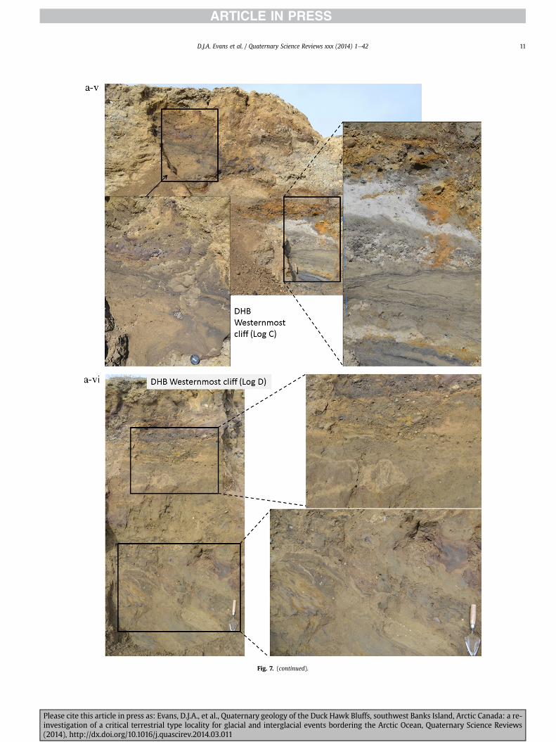
Fig 7 (continued)
DJA Evans et al Quaternary Science Reviews xxx (2014) 1e42 11
Please cite this article in press as Evans DJA et al Quaternary geology of the Duck Hawk Bluffs southwest Banks Island Arctic Canada a re-investigation of a critical terrestrial type locality for glacial and interglacial events bordering the Arctic Ocean Quaternary Science Reviews(2014) httpdxdoiorg101016jquascirev201403011
Fig 7 (continued)
DJA Evans et al Quaternary Science Reviews xxx (2014) 1e4212
Please cite this article in press as Evans DJA et al Quaternary geology of the Duck Hawk Bluffs southwest Banks Island Arctic Canada a re-investigation of a critical terrestrial type locality for glacial and interglacial events bordering the Arctic Ocean Quaternary Science Reviews(2014) httpdxdoiorg101016jquascirev201403011
Fig 7 (continued)
DJA Evans et al Quaternary Science Reviews xxx (2014) 1e42 13
Please cite this article in press as Evans DJA et al Quaternary geology of the Duck Hawk Bluffs southwest Banks Island Arctic Canada a re-investigation of a critical terrestrial type locality for glacial and interglacial events bordering the Arctic Ocean Quaternary Science Reviews(2014) httpdxdoiorg101016jquascirev201403011
Fig 7 (continued)
DJA Evans et al Quaternary Science Reviews xxx (2014) 1e4214
Please cite this article in press as Evans DJA et al Quaternary geology of the Duck Hawk Bluffs southwest Banks Island Arctic Canada a re-investigation of a critical terrestrial type locality for glacial and interglacial events bordering the Arctic Ocean Quaternary Science Reviews(2014) httpdxdoiorg101016jquascirev201403011
Fig 7 (continued)
DJA Evans et al Quaternary Science Reviews xxx (2014) 1e42 15
Please cite this article in press as Evans DJA et al Quaternary geology of the Duck Hawk Bluffs southwest Banks Island Arctic Canada a re-investigation of a critical terrestrial type locality for glacial and interglacial events bordering the Arctic Ocean Quaternary Science Reviews(2014) httpdxdoiorg101016jquascirev201403011
Fig 7 (continued)
DJA Evans et al Quaternary Science Reviews xxx (2014) 1e4216
Please cite this article in press as Evans DJA et al Quaternary geology of the Duck Hawk Bluffs southwest Banks Island Arctic Canada a re-investigation of a critical terrestrial type locality for glacial and interglacial events bordering the Arctic Ocean Quaternary Science Reviews(2014) httpdxdoiorg101016jquascirev201403011
Fig 7 (continued)
DJA Evans et al Quaternary Science Reviews xxx (2014) 1e42 17
Please cite this article in press as Evans DJA et al Quaternary geology of the Duck Hawk Bluffs southwest Banks Island Arctic Canada a re-investigation of a critical terrestrial type locality for glacial and interglacial events bordering the Arctic Ocean Quaternary Science Reviews(2014) httpdxdoiorg101016jquascirev201403011
Fig 7 (continued)
DJA Evans et al Quaternary Science Reviews xxx (2014) 1e4218
Fig 6a) Clast lithologies vary depending on sample location Amore restricted lithological component (chert quartzite andsandstone) occurs in the deformed contact zone with underlyingLFA 1 and in areas characterized by attenuated gravel lenses Amore varied clast lithology comprising chert and quartz with mi-nor components of sandstone shale granite gabbro and limestoneoccurs towards the middle and in the more diamictic zones (LFA 3)
LFA 4 comprises less than 5 m of sand silt and clay arranged inhorizontal cross-laminae rhythmites climbing ripples or drapedlaminae that locally contain organic detritus The upper and lowercontacts of LFA 4 are commonly characterized by heavily brecciatedclay or contain boudinage and thrust faulted laminae (Fig 12panels a amp c) Some outcrops of LFA 4 also display widespreaddeformation in the form of overfolded bedding and thrust faultsalthough normal faulting and open folding or convolute beddingstructures are also evident (Fig 7c iii inset photo 3) In some sec-tions LFA 4 comprises only a thin (lt2 m thick) bed of brecciatedclay (Fig 7b iv inset photo 4) or laminated sand displaying over-folds and sheath folds The sense of shearing as recorded by thrustfaults is generally towards the SSW but southerly and southwest-erly orientations are also evident Numerous examples of narrowanabranched clastic dykes rise sub-vertically through the thickestoutcrop of the sandy climbing ripple lithofacies (LFA 4 West Log A)and have created offset beds between the blocks within the hostmaterial (Fig 12 panel b) The contact of LFA 4 with LFA 3 (west cliffLog A) is marked by a clast lag Although the association is pre-dominantly heavily deformed the most unaltered and thickest
Please cite this article in press as Evans DJA et al Quaternary geologyinvestigation of a critical terrestrial type locality for glacial and intergla(2014) httpdxdoiorg101016jquascirev201403011
outcrop in West Log A displays climbing ripple drift indicative of apalaeocurrent from the south or southwest (Fig 7b ii)
LFA 5 comprises 5e10 m of tabular sets of horizontally beddedto massive gravel interbedded with horizontally bedded or cross-laminated sand and occasional units of matrix-supported gravel(Fig 13a b) The thickest outcrop displays a general coarsening-upward sequence from well-sorted horizontally bedded granulegravel and sand to matrix-supported and less well sorted hori-zontally bedded cobble to boulder gravel Clast lithologies aredominated by quartzite but contain subsidiary amounts of chertand sandstone with minor limestone LFA 5 differs from LFA 1based on its general coarsening-upward characteristics coarsergrain size and the presence of limestone clasts Clast form datafrom LFA 5 indicate a sub-rounded sample (averageroundness frac14 222 amp 246 RA frac14 8 amp 24 RWR frac14 2 amp 6) withpredominantly blocky shapes (C40 frac14 30 amp 42) and striae visible(lt14 of clasts) Upper and lower contacts are sharp but are locallyinterdigitated or amalgamated with LFA 6 (Fig 7b iv inset photo 5)and LFA 4 (Fig 13d) respectively A heavily deformed discontin-uous bed of siltclay rhythmites occurs between LFA 5 and LFA 6 inWest Log D the base of which has been amalgamated with thegravel at the top of LFA 5 (Fig 13c) Gravel in Easternmost Cliff hasan unclear relationship to the primary sections at DHB to the westThis gravel designated LFA 5a rests uncomformably on LFA 1 andis not capped by LFA 6 as elsewhere (Fig 7e) Furthermore there isno evidence of deformation and palaeocurrents are orientatedtowards the NW
of the Duck Hawk Bluffs southwest Banks Island Arctic Canada a re-cial events bordering the Arctic Ocean Quaternary Science Reviews
Fig 7 (continued)
DJA Evans et al Quaternary Science Reviews xxx (2014) 1e42 19
Please cite this article in press as Evans DJA et al Quaternary geology of the Duck Hawk Bluffs southwest Banks Island Arctic Canada a re-investigation of a critical terrestrial type locality for glacial and interglacial events bordering the Arctic Ocean Quaternary Science Reviews(2014) httpdxdoiorg101016jquascirev201403011
Fig 7 (continued)
DJA Evans et al Quaternary Science Reviews xxx (2014) 1e4220
Please cite this article in press as Evans DJA et al Quaternary geology of the Duck Hawk Bluffs southwest Banks Island Arctic Canada a re-investigation of a critical terrestrial type locality for glacial and interglacial events bordering the Arctic Ocean Quaternary Science Reviews(2014) httpdxdoiorg101016jquascirev201403011
Fig 7 (continued)
DJA Evans et al Quaternary Science Reviews xxx (2014) 1e42 21
Please cite this article in press as Evans DJA et al Quaternary geology of the Duck Hawk Bluffs southwest Banks Island Arctic Canada a re-investigation of a critical terrestrial type locality for glacial and interglacial events bordering the Arctic Ocean Quaternary Science Reviews(2014) httpdxdoiorg101016jquascirev201403011
Fig 7 (continued)
DJA Evans et al Quaternary Science Reviews xxx (2014) 1e4222
Please cite this article in press as Evans DJA et al Quaternary geology of the Duck Hawk Bluffs southwest Banks Island Arctic Canada a re-investigation of a critical terrestrial type locality for glacial and interglacial events bordering the Arctic Ocean Quaternary Science Reviews(2014) httpdxdoiorg101016jquascirev201403011
Fig 7 (continued)
DJA Evans et al Quaternary Science Reviews xxx (2014) 1e42 23
Please cite this article in press as Evans DJA et al Quaternary geology of the Duck Hawk Bluffs southwest Banks Island Arctic Canada a re-investigation of a critical terrestrial type locality for glacial and interglacial events bordering the Arctic Ocean Quaternary Science Reviews(2014) httpdxdoiorg101016jquascirev201403011
Fig 7 (continued)
DJA Evans et al Quaternary Science Reviews xxx (2014) 1e4224
LFA 6 crops out along the length of DHB and varies widely inthickness (1e11 m) displaying the most complex deformationstructures of any of the sediment bodies at DHB It comprises apredominantly heterogeneous diamicton or a meacutelange of discon-tinuous interbeds of massive matrix-supported diamicton matrix-supported gravel and laminated sand silt and clay with localizedattenuated lenses of degraded organics (Fig 7a ivevi 7b i iv 7c iiiii) Three samples of highly compressed and fragmented detritalmaterial displaying poor preservation were collected for identifi-cation Collectively LFA 6 has the appearance of a stratified dia-micton but locally it displays a more massive to pseudo-laminatedcharacter where sand silt and gravel lenses and occasional gravellags occur as thin beds stringers or wisps Some laminated sand siltand clay bodies appear to be rafts within the diamicton (intraclasts)due to their heavily deformed internal bedding and deformedcontacts or attenuated appearance Basal contacts with other lith-ofacies associations are typically erosional or deformed and asso-ciated with fissility boudinage and pseudo-lamination insediments on either side of the contact Basal diamictons can alsodisplay a higher concentration of gravel clasts that locally result in aclast-supported character or even a several metre-thick highlycontorted meacutelange of diamicton and stratified sediment bodies Insome sections the whole of LFA 6 has been complexly deformed toproduce stacked overfolds and thrust faults indicative of shearingtowards the southwest or WSW Clast macrofabrics are onlymoderately clustered (S1 frac14 0456e0637) but indicate stressdirected predominantly towards the SW Clast macrofabricstrengths as quantified by the fabric shape ternary plot (Fig 6a)and themodalityisotropy plot (Fig 6b) are variable and range frombi-modal to multi-modal Overall the macrofabric shapes in theternary graph plot across the spectrums of the glacitectonite andsubglacial traction till envelopes but there is a trend of changing
Please cite this article in press as Evans DJA et al Quaternary geologyinvestigation of a critical terrestrial type locality for glacial and intergla(2014) httpdxdoiorg101016jquascirev201403011
fabric strength vertically through LFA 6 The strongest clusters arefrom the basal diamictic zones (eg CCA F1 amp F3 AB plane data)whereas the weakest are from the top of the association (eg WCAF3 A-axes amp CCA F2 AB planes) where relatively low strain defor-mation indicators (open and recumbent folds) are ubiquitous
Clast lithologies in LFA 6 are dominated by quartz chert andsandstone although one diamict reveals a concentration of sand-stone lithologies at the expense of chert Clast forms similarlyreflect the nature of the sampled materials whereby the gravellysample (CCA 2) was characterized by relatively low C40 (38) andRA (12) values and a high average roundness (256) compared tothe same values for the diamictons of LFA 6 (C40 frac14 50e74RA frac14 38e52 average roundness frac14 174e204) A small number ofclasts (lt10) in LFA 6 were striated
512 Interpretation5121 LFA 1 The thick tabular sequence of well sorted cross-stratified sand and gravel records deposition by a former glaci-fluvial braided river typified by fluctuating discharge (eg Church1972 Boothroyd and Ashley 1975 Miall 1978 1985 1992Marren 2005) The highest discharge is recorded by matrix-supported gravel with boulders indicative of hyperconcentratedflows or a traction carpet (Maizels 1989ab Siegenthaler andHuggenberger 1993 Mulder and Alexander 2001) These areseparated by and vertically give way to lower discharges recordedby planar or trough cross-bedded sand and horizontal to planar ortrough cross-bedded gravel These deposits record aggradation andmigration of gravel bars and sheets and downstream accretionarymacroforms with relatively tightly constrained palaeocurrent in-dicators (Miall 1977 1985 Collinson 1996) The general lack ofscour fills and an overall fining-upward is indicative of an aggradingsystem initially characterized by high magnitudehigh frequency
of the Duck Hawk Bluffs southwest Banks Island Arctic Canada a re-cial events bordering the Arctic Ocean Quaternary Science Reviews
Fig 7 (continued)
DJA Evans et al Quaternary Science Reviews xxx (2014) 1e42 25
Please cite this article in press as Evans DJA et al Quaternary geology of the Duck Hawk Bluffs southwest Banks Island Arctic Canada a re-investigation of a critical terrestrial type locality for glacial and interglacial events bordering the Arctic Ocean Quaternary Science Reviews(2014) httpdxdoiorg101016jquascirev201403011
Fig 7 (continued)
DJA Evans et al Quaternary Science Reviews xxx (2014) 1e4226
Please cite this article in press as Evans DJA et al Quaternary geology of the Duck Hawk Bluffs southwest Banks Island Arctic Canada a re-investigation of a critical terrestrial type locality for glacial and interglacial events bordering the Arctic Ocean Quaternary Science Reviews(2014) httpdxdoiorg101016jquascirev201403011
DJA Evans et al Quaternary Science Reviews xxx (2014) 1e42 27
events that were gradually replaced by low magnitudehigh fre-quency events (Marren 2005) Partially to heavily-scoured rem-nants of laminated and massive fines represent deposition duringlow flow conditions in abandoned shallow channels The palae-ocurrent data from LFA 1 indicate that the outwash streams wereflowing westerly away from a glacier source located in AmundsenGulf This glacier likely eroded the abundant LFA 1 lithologies(chert quartzite and sandstone) from Mesoproterozoic and Neo-proterozoic bedrock widely distributed to the east and south(western Victoria Island Amundsen Gulf and the adjacent main-land Harrison et al 2013) These lithologies are consistent with theadvance of the NW Laurentide Ice Sheet through Amundsen Gulf(cf Dyke et al 2002 Batchelor et al 2012 MacLean et al 2013)
The crudely bedded organic detritus and degraded tree frag-ments (stumps) in LFA 1 are clearly reworked (cf Matthews et al1986 Fyles 1990 Vincent 1990) The finer grained detritus wasdeposited in concentrated pockets during waning flow stageswhereas horizons of logs and larger tree fragments were emplacedwith the coarser grained and poorly sorted sediments associatedwith hyperconcentrated flows or traction carpets during highdischarge These reworked organics also differ significantly fromthe type location of the Beaufort Fm a characteristic that promptedFyles (1990) to distinguish them as lsquotheMary Sachs Gravelrsquo Notablythe enclosing gravel and sand of LFA 1 is much coarser and exhibitsan entirely different fluvial architecture than the sandier BeaufortFm The composition and degraded nature of the LFA 1 organicssuggests that they were eroded by glaciers or their meltwater fromNeogene andor Paleogene sediments presumably to the southeastof Banks Island (eg Fyles 1990 Fyles et al 1994) The proximity ofa glacier is highlighted by the preservation of striae on individualclasts especially in the very coarse lower gravel The verticaldecrease in striae preservation and angularity (RA) and concomi-tant increase in roundness and upward-fining in LFA 1 is indicativeof an increasingly distal ice margin The co-variance plots (Fig 5)indicate a strong fluvial signature especially in the C40RA data butsubglacial characteristics are also evident particularly in the C40RWR data for the coarser grained and more matrix-supportedgravel as would be expected in ice-proximal settings
It is important to note that the widespread thrusting of LFA 1and underlying Kanguk Formation towards the southwest occurredpost-depositionally This glacitectonic thrusting was produced byLaurentide ice that advanced from the Kellett River valley (interiorBanks Island) during the emplacement of LFA 6 (see below) Theinjection of clastic dykes and fissure fills during this glacitectonicdisturbance was due to the overpressurizing of groundwater ingravel aquifers likely in taliks The branching limbs of many of thedykes are indicative of burst-out structures diagnostic of hydro-fracturing by vertically escaping groundwater pressurized byglacier overriding (cf Rijsdijk et al 1999 Le Heron and Etienne2005)
5122 LFA 2 At the top of LFA 1 rhythmites with lonestonesoverlie prominent clinoforms or foreset beds recording a changefrom subaerial glacifluvial to subaqueous deposition This wasinitially on a shallow delta front prograding foreset beds in asouthwesterly direction followed by suspension sedimentationwith dropstones presumably from floating ice in a marine orlacustrine basin The occurrence of matrix-supported gravelly scourfills with logs and woody detritus suggests pulses of cohesionlesssediment gravity flows into the basin Overlying the rhythmically-bedded sand prominent ice wedge pseudomorphs (up to 4 mdeep Fig 9aec cf Mackay and Burn 2002) are interspersed withthick (gt1m) sections of compressed in situ bryophytes (Figs 9d 7e)indicating the establishment of a tundra surface Four bryophytefamilies and 10 distinct species have been determined from LFA2
Please cite this article in press as Evans DJA et al Quaternary geologyinvestigation of a critical terrestrial type locality for glacial and intergla(2014) httpdxdoiorg101016jquascirev201403011
with the most abundant material from the Calliergonaceae andCampyliaceae (Table 1) These macrofossils are exceptionally wellpreserved including material with intact fragile alar cells typical ofthese two families (Fig 14cef) The data from these autochthonousdeposits indicate a wetland environment characterized as a richfen This ecosystem and habitats therein are consistent with speciesfound in the extant flora of Banks Island (Fig 14b) The autecologyfrom this range of species suggest hydric to mesic habitatsincluding standing pools wet meadows and microhabitats createdby ice wedges Despite the predominance of bryophytes in LFA 2these macrofossils had not been previously documented at DHB Incontrast a minimal proportion of the samples (lt5) consisted ofvascular plant material (including Cyperaceae seeds gramminoidleaves and woody twig fragments) Collectively the ice wedgepseudomorphs and vegetation within LFA 2 represent an isochro-nous terrestrial surface of interglacial rank
Following the formation of ice wedges the injection of intra-formational clastic dykes and fissure fills in LFA 2 relates to theoverpressurizing of groundwater in gravel aquifers or taliks due toglacier overriding The branching dyke limbs that emanate fromunderlying LFA 1 gravels and sands are indicative of the burst-outstructures that develop during hydrofracturing (cf Rijsdijk et al1999 Le Heron and Etienne 2005) A variant of the gravel andsand filled clastic dykes occurs within the sequence of glaci-tectonite and rhythmites near west Log D (Fig 11) Here thevertically-widening fracture is characterized by a mosaic ofpartially disaggregated blocks of the host materials in its widestzone where it contains gravels injected from underlying LFA 1Because these gravels only occur in the basal narrow neck theypresumably record the rapid reduction in flow competence duringhydrofracture filling
Deformation structures including overfolded or crumpledbedding and thrust faults associated with boudinage or highfissilitypseudo-lamination are representative of simple shear andwere also induced by glacitectonic disturbance (cf van derWateren 1995 McCarroll and Rijsdijk 2003) This predominantlyrecords a glacier advance from the northeast Subsidiary shear in-dicators record deformation from the south or southeast but theseoccur only at the top of LFA 2 and the base of LFA 3 suggestingearlier emplacement (see below) The development of zones ofboudinage shallow thrust faults overfolding or bed crumpling atdifferent levels within LFA 2 e especially at the contact separatingsediments of different grain size e represents deformation parti-tioning due to contrasting rheological properties Blind thrustswere also initiated in underlying LFA 1 increasingly towards thecentral and eastern cliffs where large-scale deformation is moreprevalent (Fig 7c d) A zone of intense deformation is recorded by alens of LFA 3 diamicton in fault contact with LFA 2 (east cliff Log AFig 7d i) This constitutes a type B glacitectonite (non-penetrativelydeformed pre-existing sediments sensu Benn and Evans 1996Evans et al 2006) developed during the emplacement of LFA 3(see below) A similar glacitectonite occurs at the junction of LFA 1and LFA 3 near west Log D (Fig 11) Bed attenuation by deformationis best developed in lower LFA 2 where the greater differences insediment grain size and hence rheology exist
5123 LFA 3 Within LFA 3 locally abundant stratified lensesindicate subaqueous deposition These stratified sediments weresubsequently thrust faulted folded and attenuated - most evidentin the upper and lower zones of LFA 3 This deformation was likelyresponsible for the intraclast boudinage and pseudo-lamination inthe surrounding diamicton (eg Hart and Roberts 1994 Robertsand Hart 2005 Oacute Cofaigh et al 2011) This process was alsoassociatedwith the attenuation of LFA 1 and 2 sediments within theheavily deformed base of LFA 3 some of which may have been
of the Duck Hawk Bluffs southwest Banks Island Arctic Canada a re-cial events bordering the Arctic Ocean Quaternary Science Reviews
Fig 8 Details of LFA 1 a) example of a concentration of logs with degraded rootballs in the stacked tabular units of cross-bedded sands and gravels and crudely stratified matrix-supported cobble to boulder gravels in the west cliff b) poorly-sorted and crudely horizontally bedded cobble to boulder gravel containing laminated clay intraclast (immediatelyabove compass) c) shallow locally graded foreset beds composed of openwork to sandy matrix-supported cobble to granule gravels in central cliff Log A d) planar bedded sandy
DJA Evans et al Quaternary Science Reviews xxx (2014) 1e4228
Please cite this article in press as Evans DJA et al Quaternary geology of the Duck Hawk Bluffs southwest Banks Island Arctic Canada a re-investigation of a critical terrestrial type locality for glacial and interglacial events bordering the Arctic Ocean Quaternary Science Reviews(2014) httpdxdoiorg101016jquascirev201403011
DJA Evans et al Quaternary Science Reviews xxx (2014) 1e42 29
cannibalized and rafted by the deformation process within a shearzone at the contact of LFA 3 with older sediments The shearingdirection from the south and southeast recorded in lower LFA 3also impacted upper LFA 2 whereas the more prominent shearingdirection throughout LFA 3 is from the northeast (also recorded inLFA 4) The local development of a heavily deformed zone at the topof LFA 3 was likely imparted during the shearing of overlying LFA 4sediments Although clast macrofabric strengths from the LFA 3diamicton are variable they possess shapes that compare withglacitectonites and subglacial traction tills and in some cases amodalityisotropy signature that reflects high lodgementcomponents
The similar orientation of the macrofabrics and shear indicatorsare considered diagnostic of a glacitectonite derived from stratifiedsediments (eg interbedded mass flow diamictons gravelly massflows and localized traction current sands and suspension de-posits) This evidence indicates that LFA 3 like all the other LFAsand the underlying Kanguk Fm bedrock has been displaced by aglacier advancing from the NNE or NE (ie Laurentide ice crossingthe interior of Banks Island) Minor south to north shearing in-dicates that LFA 3 and upper LFA 2were also disturbed by glacier iceflowing northwards (ie Laurentide ice advancing throughAmundsen Gulf) The appearance of granite and gabbro clastswithin the LFA 3 diamict records the arrival of far-travelled Lau-rentide ice from mainland Canada Clast form co-variance stronglyindicates a subglacial (abraded) source for LFA 3 with a minorfluvial component (Fig 5) including glacifluvial clasts locallycannibalized from LFA 1 by overriding ice
5124 LFA 4 LFA 4 has restricted outcrops is heavily deformedand contains organic detritus that is clearly allochthonous andhighly degraded Nonetheless a variety of indicators (fine-grainedhorizontally bedded cross-laminae rhythmites climbing ripplesand draped laminae) demonstrate that LFA 4 was deposited in asubaqueous environment with palaeocurrents from the south orsouthwest Traction currents were likely responsible for thedevelopment of the clast lag at the contact between lower LFA 4and underlying LFA 3 (west cliff Log A Fig 7b ii) LFA 4 coarsensupwards indicative of basin infilling andor an approaching sedi-ment source The narrow anabranched clastic dykes in the sandyclimbing ripples (LFA 4 west cliff Log A) record hydrofracturing bythe upward injection of overpressurized groundwater duringshearing The branching limbs of the dykes are similar to the burst-out structures reported by Rijsdijk et al (1999) but differ becausethey are composed solely of sand derived from the walls of the hostsediment rather than from an underlying gravel aquifer (cf LeHeron and Etienne 2005) Hence the pressurized water wasgenerated at the contact between the sand and underlying imper-meable brecciated clays The development of thin zones of brecci-ation boudinage sheath folding or thrust faulting at the upper andlower contacts of LFA 4 relates to the localized partitioning ofdeformation controlled by the location of claysilt beds Thejuxtaposition of this style of deformation with the larger scaleoverfolds and thrust faults developed in the extensive bodies ofsandy lithofacies is indicative of a Type B glacitectonite (sensu Bennand Evans 1996) This was constructed by the overriding of glacierice advancing from the north or northeast These shear directionsare compatible with those developed in the underlying LFAs
granule gravels with gravel lags (top and bottom of image) interrupted by an intervening unbedded granule to pebble gravel and massive cobble to pebble gravel A cluster of small treesequence of stacked tabular units of predominantly horizontally bedded sands and gravels ingravels containing clusters of wood detritus in the coarser gravel beds (central cliff Log A)wood fragments (central cliff Log A)
Please cite this article in press as Evans DJA et al Quaternary geologyinvestigation of a critical terrestrial type locality for glacial and intergla(2014) httpdxdoiorg101016jquascirev201403011
5125 LFA 5 The primary characteristics of LFA 5 are typical ofgravel sheet and occasional traction-carpet sedimentation in anice-proximal sandur (eg Boothroyd and Ashley 1975 Miall 19781985 1992 Maizels 1989ab Siegenthaler and Huggenberger1993 Mulder and Alexander 2001 Marren 2005) Glacier prox-imity is supported by the subglacial to fluvial signature of the clastforms (Fig 5) The coarsening-upward sequence including striatedclasts culminates in the arrival of a glacier that overrode the sitedepositing LFA 6 Post-depositional shearing within underlying LFA4 is recorded by attenuation and interdigitation at the contact withLFA 5 imparted during deposition of LFA 6 The contact betweenLFA 5 and 6 reflects the development of a shear zone where upperLFA 5 sediments have been cannibalized producing a meacutelange ofcrudely stratified diamictons with discontinuous interbeds ofmatrix-supported gravel laminated sand silt and clay (LFA 6 seebelow)
5126 LFA5a At Easternmost Cliff glacifluvial gravel (LFA 5a)unconformably overlies LFA 1 (Fig 7e) rendering uncertain itsrelationshipwith respect to LFA 5 in themain sections of DHB to thewest The fact that LFA 5a extends to the modern surface appearsundeformed and has palaeocurrents orientated to the NW requiresthat it is younger than LFA 5 Indeed we interpret LFA 5a asdeglacial outwash deposited from retreating Laurentide ice in theKellett River valley and Amundsen Gulf at the end of the lastglaciation (see Discussion)
5127 LFA 6 Based on its heterogeneity strongly orientated clastmacrofabrics and macroscale deformation structures LFA 6 con-stitutes a Type B glacitectonite (sensu Benn and Evans 1996)However zones of more highly strained Type A glacitectonite(sensu Benn and Evans 1996) at the basal contact with older LFAsare recorded by intraclastinterbed attenuation (pseudo-lamina-tion) strong boudinage or fissility and strengthened clast macro-fabrics The production of this meacutelange is attributed to two separateprocesses 1) primary sedimentation as interbedded and interdig-itated mass flow debris fluvial gravel and sand and subaqueoussuspension sediments and 2) cannibalization of underlying strat-ified sediments (LFAs 4 and 5) This produced a continuum of formsranging from low strain fold structures to attenuated rafts to tec-tonic lamination (eg Fig 7) The discontinuous lenses of degradedorganics (black stems and woody twigs gramminoid leaveswhitened rootlets) within LFA 6 are rafts and include seven speciesof bryophytes (Table 1) The material was highly compressed anddifficult to separate into distinct taxa Indeed one of the threesamples analysed was too degraded to recover any taxa Much ofthe material consisted of only fragmented leaves and only theminute taxa had stems with intact leaves The bryophytes thatcharacterize the LFA 6 samples represent hydric (Calliergon sppTomenthypnum nitens) to mesic (Ditrichum flexicaule Dicranum sp)habitats Three species collected from LFA 6 were also present inLFA 2 whereas four others were not found in LFA 2 but are com-mon in the modern flora The poor preservation quality suggeststhat the material has been redeposited from unknown sources andis clearly allochthonous
The predominant shearing direction within LFA 6 records an iceadvance from the interior of Banks Island (NE) This has resulted incomplex folding and thrusting and localized thickening of LFA 6
it of cross-bedded poorly-sorted to openwork cobble to boulder gravel crudely planar-fragments occur at the base of the cobble to boulder gravels at image centre e) middleDHB west cliff Log D f) sequence of fining-upward planar-bedded cobble to sandy fineg) planar cross-bedded sandy granule to pebble gravels with pebble to cobble lags and
of the Duck Hawk Bluffs southwest Banks Island Arctic Canada a re-cial events bordering the Arctic Ocean Quaternary Science Reviews
Fig 9 Details of LFA 2 from the west cliff a) narrow necked ice wedge pseudomorph with upturned marginal bedding in sand silt and clay rhythmites b) wide necked ice wedgepseudomorph c) ice wedge pseudomorph with overturned silt sand and clay rhythmites developed at the top of LFA 2 and sealed by overlying LFA 3 laminated diamicton d)horizontally bedded sand and silt containing well preserved moss macrofossils e) zone of disharmonically folded sandsilt laminae with well preserved moss peat located at thebase of LFA 2
DJA Evans et al Quaternary Science Reviews xxx (2014) 1e4230
Please cite this article in press as Evans DJA et al Quaternary geology of the Duck Hawk Bluffs southwest Banks Island Arctic Canada a re-investigation of a critical terrestrial type locality for glacial and interglacial events bordering the Arctic Ocean Quaternary Science Reviews(2014) httpdxdoiorg101016jquascirev201403011
Fig 10 Details of simple shear structures developed in fine sand and silt laminae at the centre of the thickest outcrop of LFA 2 in west cliff Log B a) overview of large scaleanastomosing shear faults with zones of smaller scale densely spaced anastomosing shears towards the base of the photograph b) details of large scale shear faults separatingzones of variably but predominantly densely spaced shears c) close details of shear zone comprising densely spaced anastomosing fractures d) details of ascending kink zonecross-cutting large scale anastomising shear faults Shearing direction is coming out of the cliff and towards the left in each image
DJA Evans et al Quaternary Science Reviews xxx (2014) 1e42 31
This shearing direction is recorded throughout underlying LFAs 1e4as well as the Kanguk Formation demonstrating deep-seated butpartitioned glacitectonic disturbance imparted during theemplacement of LFA 6 This strain signature was therefore over-printed on the northerlynortheasterly aligned shearing directionrecorded in LFA 3 and upper LFA 2 by the earlier northerly flowingice that deposited LFA 3 One anomalous clast macrofabric(northerly CCA F1) occurs in the basal meacutelange of LFA 6 Howeverthis sample is from an isolated outcrop (Fig 7c i) rendering itsapparent shearing direction equivocal
Please cite this article in press as Evans DJA et al Quaternary geologyinvestigation of a critical terrestrial type locality for glacial and intergla(2014) httpdxdoiorg101016jquascirev201403011
52 Sedimentology and stratigraphy (Mary Sachs Creek cliff)
The cliffs east of Mary Sachs Creek (Figs 2b 3) provides a cross-section through the seaward margin of the coast-parallel SachsMoraine (ldquosection Jrdquo Vincent et al 1983 Vaughan 2014) Weprovide a summary of two logs based on a reconnaissance survey ofthese sediments Log A is closest toMary Sachs Creekwhereas Log Boccursw1 km farther east (Figs 3 15a amp b) The sediments exposedin Log A appear to descend eastward and disappear below themodern beach and therefore are assumed to stratigraphically
of the Duck Hawk Bluffs southwest Banks Island Arctic Canada a re-cial events bordering the Arctic Ocean Quaternary Science Reviews
Fig 11 Details of LFA 2 near west Log D Lower box shows a 1e2 m thick basal zone comprising highly attenuated inter-digitated beds of gravelly to clay-rich diamictons and sandsiltclay rhythmites Upper box shows rhythmites containing diamictic intraclasts with sharp and angular boundaries also visible is the draping and deforming of the rhythmitebedding over and under the intraclasts respectively ldquoTailsrdquo extending from the diamictic intraclasts and thin but discontinuous diamictic beds are also visible in the upper box
DJA Evans et al Quaternary Science Reviews xxx (2014) 1e4232
underlie the sediments of Log B A sand and gravel- bench caps bothlogs at w15 m asl incised into the seaward margin of the SachsMoraine
521 DescriptionLog A contains a sequence of upward-fining highly contorted
cross-stratified sand and fine gravel to rhythmically bedded sandsilt clay with minor pebble gravel and sporadic clots of gravellydiamicton (Fig 15a) An ice wedge was initially developed in thelower cross-stratified sand and fine gravel before they were foldedand thrust faulted The deformed ice wedge pseudomorph is un-conformably overlain by a relatively undisturbed lens of laminatedsilty clay with dropstones interbedded with gravelly diamictonthat contains a bed (10 cm) of sandy black organics containingwood fragments (Fig 15a) This organic material occurs repeatedlyup-section as discontinuous stringers Log A is capped by 1e2 m ofpoorly exposed and heavily cryoturbated gravelly diamicton Thegeneral sense of displacement on shallow reverse faults over-turned bedding and boudinage structures is from the southeast
Log B (12 m) displays a coarsening-upward sequence of hori-zontally bedded sandy granule gravel with occasional silty sandlaminae (Fig 15b iii) that grades to poorly-sorted cobble to bouldergravel and bouldery matrix-supported gravel (Fig 15b ii) This iscapped by laminated to crudely stratified cobbly diamicton that issilt and clay-rich abruptly and conformably overlain by
Please cite this article in press as Evans DJA et al Quaternary geologyinvestigation of a critical terrestrial type locality for glacial and intergla(2014) httpdxdoiorg101016jquascirev201403011
interlaminated silt clay and pebbly silty sand (Fig 15b i) Althoughthe bedding on these units dips towards the NW individuallaminae do not thicken in that direction indicating post-depositional tilting The uppermost part of the log (underlyingthe 15 m bench) contains 2 m of clay-rich massive diamictoninterfingered with the underlying laminated sediments and cobblydiamicton
522 Interpretation
5221 Log A Broadly the sedimentology of log A including thedeformed ice wedge pseudomorph is similar to LFA 2 in DHB (egcentral cliff Log A Fig 7c iii) Prior to glacitectonic disturbance theoverlying organic bed (Fig 15a) was redeposited into a sequence ofsubaqueous siltclay rhythmites containing dropstones and gravellymass flows The highly attenuated shear margins bracketing theorganic bed in Log A demonstrate that it has been displaced as atectonic raft Previous research proposed that the organic beds e
similar to those described in Log A e be assigned to the LastInterglacial (locally called the Cape Collinson Vincent 1982 1983)Because these organic beds are clearly a raft they cannot constitutean iscochronous surface precluding chronostratigraphic signifi-cance (see Discussion) Shearing of the Log A sediments from thesoutheast documents an ice advance from Amundsen Gulf corre-sponding to the earliest of two primary shearing directions recor-ded at DHB (imparted during the emplacement of LFA 3) Therefore
of the Duck Hawk Bluffs southwest Banks Island Arctic Canada a re-cial events bordering the Arctic Ocean Quaternary Science Reviews
Fig 12 Details of LFA 4 in West Log A a) heavily deformed upper contact of LFA 4 comprising sandsiltclay rhythmites displaying well developed boudinage sheath folds andimmature tectonic laminae and an interdigitatedsheared boundary with underlying climbing ripple sands The contact with overlying LFA 6 is marked by an interdigitated zonecontaining rooted and de-rooted folds or rhythmite rafts in a sand gravel and diamicton meacutelange b) narrow anabranched clastic dykes ascending sub-vertically through climbingripple drift and resulting in offset bedding between blocks of host material c) abrupt contact between sheared sands and rhythmites of LFA 4 and overlying sand gravel anddiamicton meacutelange
Fig 13 Details of LFA 5 a) poorly sorted and matrix-supported pebble to cobble gravel b) tabular sequence of horizontally bedded to massive gravel and matrix-supported gravelcontaining a horizon of striated cobbles and boulders c) heavily deformed discontinuous bed of siltclay rhythmites between LFA 5 and LFA 6 in West Log D showing theamalgamation zone with the LFA 5 gravels immediately above the compass d) interdigitateddeformed contact between LFA 5 granule to pebble gravels and underlying LFA 4laminated silts and clays with organic detritus in West Log B
DJA Evans et al Quaternary Science Reviews xxx (2014) 1e42 33
Please cite this article in press as Evans DJA et al Quaternary geology of the Duck Hawk Bluffs southwest Banks Island Arctic Canada a re-investigation of a critical terrestrial type locality for glacial and interglacial events bordering the Arctic Ocean Quaternary Science Reviews(2014) httpdxdoiorg101016jquascirev201403011
Table 1List of bryophytes and vascular plants from LFAs 2 and 6
LFA2 WestCliff Log B
LFA6 CentralCliff Log A
Elevation (m) 185 m asl w45 m aslSample 4e12 1e3 taxa 10 7
Bryophyta (mosses)AmblystegiaceaeAmblystegium serpens (Hedw) Schimp x
CamyliaceaeCampylium polygamum (Schimp) CEO Jensen xCampylium stellatum (Hedw) CEO Jensen x xDrepanocladus aduncus (Hedw) Warnst xDrepanocladus sp xTomentypnum nitens (Hedw) Loeske x
CalliergonaceaeCalliergon giganteum (Schimp) Kindb xCalliergon richardsonii (Mitt) Kindb xthornthornthornthorn xCalliergon sp xWarnstorfia exannulatus (Schimp) Loeske xthornthornthornthorn x
BrachytheciaceaeBrachythecium turgidum (Hartm) Kindb x
MniaceaeCyrtomnium cf hymenophylloides(Hbener) TJ Kop
x
DicranaceaeDicranum sp x
DitrichaceaeDitrichum flexicaule (Schwaumlgr) Hampe x
Tracheophyta (vascular plants)CyperaceaeSeeds (triangular amp flattened) x x
Gramminoid leaf material x xWoody twig fragments x xRootlets x
Fig 14 The moss peat and associated microfossils of LFA 2 a) exposure through lower LFAsouthern Banks Island analogue of a rich tundra fen environment for the bryophyte assemblfrom LFA 2 showing the exceptional preservation of Calliergonaceae and Campyliaceae ma
DJA Evans et al Quaternary Science Reviews xxx (2014) 1e4234
Please cite this article in press as Evans DJA et al Quaternary geologyinvestigation of a critical terrestrial type locality for glacial and intergla(2014) httpdxdoiorg101016jquascirev201403011
these deformed deposits are interpreted as a Type B glacitectonite(sensu Benn and Evans 1996) possibly derived from LFA 2
5222 Log B The coarsening upward gravel in Log B recordshighly turbid to hyperconcentrated discharge in non-channelizedsheets This is interpreted as aggrading glacifluvial outwash froman approaching ice margin The capping sequence of crudelystratified diamicton and laminated sediments records a changefrom glacifluvial to subaqueous sedimentation prior to overridingby a glacier of unknown age that tilted the upper beds Thecoarsening-upward sequence apparent tectonism and cappingdiamict at Log B clearly distinguishes these deposits from those ofLFA 5a (west of Mary Sachs Creek easternmost cliff Fig 3)Furthermore although there is lithological similarity between LogB and LFA 5 throughout DHB the sense of shearing is dissimilar (LFA5 from the NE and Log B from the SE) The simplest explanation forthis difference in shear direction is that LFA 5 (DHB) was displacedby interior ice advancing down the Kellett River whereas Log B wasdisplaced by ice advancing along Amundsen Gulf (Fig 2b)
6 Discussion
61 Large scale glacitectonic structures and stratigraphicarchitecture
The glacitectonic structures identified within the lithofaciesassociations at DHB record two phases of deformation (early NeSand later NEeSW) This deformation together with the DHBstratigraphic architecture (Fig 16) helps to explain both thekinetostratigraphy (sensu Berthelsen1978) and the evolution of thelocal glacial geomorphology The large scale glacitectonic defor-mation is most clearly manifest in the thrust faulting and conjugate
2 at DHB west log B showing the sampling locations for in situ moss peat b) a modernages of LFA 2 c)ef) details of the typical moss peat and associated microfossil materialscrofossils including material with intact fragile alar cells
of the Duck Hawk Bluffs southwest Banks Island Arctic Canada a re-cial events bordering the Arctic Ocean Quaternary Science Reviews
Fig 15 The stratigraphy of Mary Sachs Creek cliff a) photographic compilation log A showing upward-fining highly contorted (i) cross-stratified sands and fine gravels torhythmically bedded sands silts clays and minor pebble gravels Also visible in (ii) is a lens of interbedded laminated silty clays with dropstones and gravelly diamictons containingsandy black coloured organic material with wood fragments An ice wedge pseudomorph is visible (iii) to the right of the exposure b) photographic compilation log B showing i)laminated to crudely stratified cobbly but siltclay-rich diamicton grading into interlaminated silts clays and pebbly silty sands ii) poorly-sorted cobble to boulder gravel andbouldery matrix-supported gravel iii) coarsening-upward sequence of horizontally bedded sandy granule gravels with occasional silty sand laminae iv amp v) pebble to cobble graveland matrix-supported gravel
DJA Evans et al Quaternary Science Reviews xxx (2014) 1e42 35
shear development in the Kanguk Fm bedrock and overlying LFA 1(east cliff Fig 7d ivevi) Here predominantly northeasterly dippingthrust slices have been stacked truncated and overlain by LFA 6during the second and strongest (NEeSW) deformation phase(Fig 16 note bedrock slice within the imbricated stacked sequenceof LFA 1) These structures demonstrate significant compressionand thickening of the stratigraphic sequence including w40 m ofvertical offset within the Kanguk Formation acrossw3 km (Fig 16)Prominent hydrofracture fills in LFAs 1 and 2 record elevatedporewater pressure during this thrusting Smaller scale shear zoneshave also developed in the finer grained interbeds within thrustslabs (Fig 7d vii) indicative of deformation partitioning by strataprone to ductile failure This zone of greatest displacement alsocoincides with the highest topography (Fig 16) Lower angle thrustfaults propagate in a southwesterly direction predominantlythrough LFA 1 but are also developed through LFA 2 in the footwallblock (east cliff Fig 16)
The thrust stacking of bedrock and LFAs 1e5 in east cliff (obliqueto Fig 16) represents the ice-proximal zone of a thrust-blockmorainecomposite ridge constructed by a glacier advancing fromthe northeast (ie the interior of Banks Island) This glacitectonicdeformation propagated southwestward to distal parts of theproglacial stress field as recorded bywell-developed shear zones inthe finer grained sediments of LFAs 2e5 In the more distal westcliff open folds (LFA 2 Fig 16) appear to be the product of a blindthrust within underlying LFA 1 This style of tectonism is typical oflsquopiggyback-style thrustingrsquo wherein steeply inclined thrust blocksat the advancing ice margin propagate new thrusts in the footwall(Fig 16 Park 1983 Mulugeta and Koyi 1987) The angle of thesefootwall thrusts becomes progressively shallower southwestward
Please cite this article in press as Evans DJA et al Quaternary geologyinvestigation of a critical terrestrial type locality for glacial and intergla(2014) httpdxdoiorg101016jquascirev201403011
(ice-distal) in LFA 1e5 where deformation partitioning developedin finer grained lithofacies (Fig 16)
The densely spaced ponds and depressions immediately to thenortheast of DHB (Figs 2b 3) constitute the depression fromwhich the thrust mass was excavated (eg Aber et al 1989Evans and England 1991 van der Wateren 1995) This inter-pretation is consistent with the strong northeast to southwestshear direction in the second phase glacitectonic structures andin LFA 6 clast macrofabrics This indicates that construction ofDHB occurred at the margin of a glacier advancing from thenortheast (ie from Kellett River valley) overtopping DHB anddepositing the LFA 6 glacitectonite The continued advance ofKellett ice coalesced with a glacier in Amundsen Gulf marked bythe interlobate Sachs Moraine containing ice-transported shellsas young as 24 cal ka BP (21020 70 yrs BP UCIAMS-89674)assigning this glaciation to the Late Wisconsin (Vaughan 2014)East of Mary Sachs Creek the deformation of Log B outwash(from the southeast Figs 15 16) likely records overriding by thesame Amundsen Gulf glacier (coeval with LFA 6 Late Wiscon-sinan) During ice retreat when Kellett River and Amundsen Gulfice decoupled DHB was exposed allowing the northwesterly-flowing proglacial outwash (LFA 5a) west of Mary Sachs Creekto extend to the shoreline marking postglacial marine limit atKellett Point (11 m asl Vaughan 2014 Fig 3) Collectively thisreconstruction supports a Late Wisconsinan age for the con-struction of DHB thrust block moraine although its stratigraphyincludes a range of ages A palaeogeographic reconstruction ofevents based upon our interpretation of the sedimentologystratigraphic architecture tectonism and geomorphology is pre-sented in Fig 17
of the Duck Hawk Bluffs southwest Banks Island Arctic Canada a re-cial events bordering the Arctic Ocean Quaternary Science Reviews
Fig 15 (continued)
DJA Evans et al Quaternary Science Reviews xxx (2014) 1e4236
62 Comparison and revision of previous DHB model
DHB was previously interpreted to record horizontally beddedNeogene to Quaternary sediments assigned to preglacial fluvialand multiple glacial and interglacial episodes (Vincent 1982 19831990 Vincent et al 1983 1984 Barendregt et al 1998) A com-posite palaeomagnetic record was also presented for this proposedstratigraphy placing most of this deposition before the BrunhesMatuyama boundary (Fig 1c) However prior to our work detailedstudies had not been undertaken on the sedimentology structuralgeology or stratigraphic architecture of DHB Rather the originalstratigraphy was restricted to a series of composite logs (our Fig 4reproduced from Vincent et al 1983) that notably omitted thepervasive deformation structures including the thrust bedrock ineast cliff (Fig 16)
Please cite this article in press as Evans DJA et al Quaternary geologyinvestigation of a critical terrestrial type locality for glacial and intergla(2014) httpdxdoiorg101016jquascirev201403011
Our reinterpretation dismisses several key elements of theoriginal DHB model outlined below (oldest to youngest) We havedetermined that the lowermost unit (LFA 1) is not preglacial (Fyles1990) but rather is composed of glacial outwash providing theearliest terrestrial evidence for glaciation in the area and containingallochthonous organics (including tree stumps) of unknown prov-enance Because LFA 1 is a glacifluvial braidplain (Fig 17a) it is notpart of the Beaufort Fm (Fyles 1990) even though it containsreworked macrofossils presumably derived from it (eg Craig andFyles 1960 Hills et al 1974 Vincent et al 1983)
Our analysis of LFA 2 indicates that it is also not preglacial norcan it be the Worth Point Fm as previously proposed (cf Vincent1982 1983 1990 Vincent et al 1983 Matthews et al 1986)Indeed the type locality of the Worth Point Fm has been invali-dated because it is now recognized to be an ice-transported and
of the Duck Hawk Bluffs southwest Banks Island Arctic Canada a re-cial events bordering the Arctic Ocean Quaternary Science Reviews
LFA4
Fig16
Stratigrap
hiccross-profi
lerun
ning
westto
easto
fDuc
kHaw
kBluffs
basedup
oninterpolations
betw
eenthemainsectionlogs
andsh
owingthesixLFAstheKan
gukFo
rmationbe
droc
kex
posu
resmajor
structural
features
and
thepo
sition
sof
icewed
geps
eudo
morph
san
dsign
ificant
clasticdy
kesAtthe
easternen
dof
thecross-profi
lethe
sedimen
tsat
theco
reof
MarySa
chsCree
kcliff
logAaretentativelyclassified
asLFA2
althou
ghthesematerialsarelik
ely
notin
situN
otethat
thecross-profi
ledo
esno
tex
tend
asfarea
stas
MarySa
chsCree
kcliff
logB
DJA Evans et al Quaternary Science Reviews xxx (2014) 1e42 37
Please cite this article in press as Evans DJA et al Quaternary geologyinvestigation of a critical terrestrial type locality for glacial and intergla(2014) httpdxdoiorg101016jquascirev201403011
glacitectonized raft (Vaughan et al 2014) In contrast our LFA 2 ischaracterized by an isochronous tundra surface with ice wedgesand intervening shallow ponds andwetmeadows The peat at LFA 2is dominated by bryophytes (gt95 by volume) and yet none ofthese macrofossils had been previously documented The diversein situ bryophyte species record a flora similar to that on BanksIsland today suggesting that LFA 2 warrants an interglacial rankThis conclusion is supported by the limited vascular plant record(five taxa no species indicated Vincent 1990) that also suggest awet meadow environment The absolute age of LFA 2 remains un-known but is apparently older than the BrunhesMatayamaboundary (gt780 ka Fig 18 cf Vincent et al 1984 Barendregt andVincent 1990 Barendregt et al 1998 see below)
LFA 3 in both our model and that of Vincent et al (1983) pro-vides the first direct evidence of ice reaching DHB In the previousmodel this was interpreted as Bernard Till (Banks Glaciation) thatwas bracketed by glacioisostatically induced marine transgressions(pre- and post-Banks seas Vincent 1982 1983) Within basal LFA 3we recognized highly deformed stratified sediment that wasdeposited in a subaqueous environment (deep water Fig 17c) priorto the arrival of overriding ice from the south (recorded by graniteand gabbro erratics Figs 17c 18) We regard LFA 3 to be equivalentto the Banks Glaciation (Vincent 1982 1983 Vincent et al 1983)including its pre- and post-Banks seas represented by the stratifiedsediments that bracket the central diamicton The LFA 3 sedimentsare also reported to be magnetically reversed thereby predatingthe BrunheseMatayama boundary (gt780 ka Fig 18 Vincent et al1984 Barendregt and Vincent 1990 Barendregt et al 1998)
Following the Banks Glaciation (our LFA 3 at DHB) Vincent(1982 1983) and Vincent et al (1983) recognized two in-terglacials (Morgan Bluffs and Cape Collinson) separated by anintervening marine episode This marine episode correspondedwith the glacioisostatic loading of a Laurentide ice margin confinedto the eastern half of Banks Island (Thomsen Glaciation) HoweverLFA 4 contains coarsening-upward subaqueous sedimentation fromthe south or southwest reflecting continued marine regressionfollowing LFA 3 (Fig 17c d) The coarsening-upward sequence ofLFA 4 is supplanted by coarse gravel outwash (LFA 5) supplied by aglacier readvancing from the northeast (Kellett River valley iceFig 17e) Glacier overriding is recorded by LFA 6 glacitectonite thatcaps the DHB thrust-block moraine composed of the entireassemblage of underlying LFAs (Fig 16)
Notably we have not observed any sediments characteristic oftwo interglacial deposits above LFA 3 hence dismiss the presence ofthe Morgan Bluffs and Cape Collinson interglacials at DHB Causseand Vincent (1989) report a U-series date of gt200 ka (UQT-229)from above our LFA 3 but this is almost certainly reworked andlacks chronostratigraphic significance Nor have we observedintervening marine sediments attributable to the Thomsen Glaci-ation (eg lsquoBig Searsquo Vincent 1982 1983 Vincent et al 1983)Rather following the deposition of the subaqueous sediments ofupper LFAs 3 and 4 (post-Banks Glaciation) LFAs 5 and 6 record asingle ice advance reaching DHB from the Kellett River valley(Banks Island interior) that was not reported by Vincent et al(1983) It was instead assumed that after the Banks GlaciationDHB lay distal to any later ice advances The nearest subsequentLaurentide margin to DHB recognized by Vincent et al (1983) wasassigned to the Sachs Moraine (immediately east of DHB) that waspresumed to be of EarlyWisconsin age (Fig 2b) However the SachsMoraine is nowdated to24 cal ka BP (LateWisconsinan Vaughan2014) andwas formed by the coalescence of Amundsen Gulf ice andthe Kellett River ice that deformed DHB (Fig 17) On the east side ofMary Sachs Creek the deposition of the Sachs Moraine coincideswith the deformation (from the southeast) of the underlying Log Boutwash gravel (Figs 3 15b)
of the Duck Hawk Bluffs southwest Banks Island Arctic Canada a re-cial events bordering the Arctic Ocean Quaternary Science Reviews
Fig 17 The palaeogeography of southwest Banks Island based upon interpretations of the principal lithofacies associations and structural architecture recognized at Duck HawkBluffs and the geomorphology of the surrounding terrain See text for detailed explanations
DJA Evans et al Quaternary Science Reviews xxx (2014) 1e4238
Although interglacial deposits were previously reported fromthe cliffs east of Mary Sachs Creek (ie Cape Collinson InterglacialVincent et al 1983) we found no similar evidence Rather the onlydeposit that we observed that may have been construed as inter-glacial sediments occurs in our Log A (Figs 3 15a) Here a darkdiscontinuous band of allochthonous organics (Fig15a) sits severedwithin a heavily tectonized melange (type B glacitectonite) and istherefore clearly a raft Although the absolute ages of the deformedunits east of Mary Sachs Creek (Logs A amp B) remain uncertain theyare apparently normally magnetized (Vincent et al 1984Barendregt and Vincent 1990) Blake (1987) also reports non-finite radiocarbon dates (gt36000 amp 49000 BP GSC-3560 amp 3560-2) obtained on ldquocompressed and deformed black woody peatrdquopurportedly from Cape Collinson beds (Vincent et al 1983 p 1708)Additionally Causse and Vincent (1989) report a U-series date onshells of 924 ka (UQT-143) from beds similar to the Log B gravelAgain all of these dated units have been displaced from unknownlocations limiting their utility for palaeoenvironmental recon-struction The last glacially influenced sedimentation at DHB isrecorded by northwesterly directed outwash (easternmost cliff LFA5a Figs 3 16 17g) We infer that this outwash fed the gravel beachmarking marine limit (11 m asl) in the lower Kellett River duringLate Wisconsinan retreat from the Sachs Moraine
63 Regional context
The stratigraphy at Duck Hawk Bluffs records three glacialevents The earliest of these is recorded by the aggradation of a
Please cite this article in press as Evans DJA et al Quaternary geologyinvestigation of a critical terrestrial type locality for glacial and intergla(2014) httpdxdoiorg101016jquascirev201403011
glacifluvial braidplain (LFA 1) that contains allochthonous pre-glacial material of diverse age However within LFA 1 there is noevidence that the ice reached DHB although it must have beennearby (southeast in Amundsen Gulf) The age of this glaciationremains unknown but the palaeomagnetic polarity of LFA 1 in-dicates that it is gt780 ka BP (Barendregt and Vincent 1990)Although Barendregt et al (1998) assigned part of the Worth PointFm to the normally polarized Olduvai sub-zone (MIS 64e74) itshould be noted that the Worth Point section is located 30 kmnorthwest of DHB There a stratigraphic revision has demonstratedthat this ldquotype sectionrdquo of the Worth Point Fm is in fact a glaci-tectonized raft (Vaughan et al 2014) This observation invalidatesthe previous correlation from Worth Point to purportedly coevalbeds at DHB (our LFA 2) Furthermore the diverse plant assem-blages in the Worth Point raft include preglacial tree stumps andSphagnum spp that do not occur on Banks Island today and are notfound in the wet meadow assemblages (rich fen) of LFA 2 that weinterpret to be of interglacial rank Therefore the sediments at DHB(LFAs 1 amp 2) do not support an age assignment of MIS 64e74(Olduvai subzone) proposed by Barendregt et al (1998) Currentlythe available palaeomagnetic record at DHB simply separates theentire section into a lower lsquoreversedrsquo unit and an upper lsquonormalrsquoone We place this boundary within our LFA 4 (Fig 18)
The overriding of DHB by glaciers is recorded in LFAs 3 amp 6These two glacial deposits may correspond to parts of the record ofstacked till sheets reported from the offshore seismic stratigraphy(Batchelor et al 2012) LFA 3 glaciationmay have contributed to theonset of mid-Pleistocene ice-rafted debris (IRD Ca-rich) attributed
of the Duck Hawk Bluffs southwest Banks Island Arctic Canada a re-cial events bordering the Arctic Ocean Quaternary Science Reviews
B-M
B-M
gt19
Fig
18A
revisedlitho
stratigrap
hyforDuc
kHaw
kBluffsPrev
ious
lyrepo
rted
ageco
nstraintsarealso
depicted
toge
ther
withatentativeallocation
ofMIS
stag
es(positione
dalon
gsideEa
stCliff
LogA
forclarity)
basedup
onthe
palaeo
mag
neticreco
rd
DJA Evans et al Quaternary Science Reviews xxx (2014) 1e42 39
Please cite this article in press as Evans DJA et al Quaternary geology of the Duck Hawk Bluffs southwest Banks Island Arctic Canada a re-investigation of a critical terrestrial type locality for glacial and interglacial events bordering the Arctic Ocean Quaternary Science Reviews(2014) httpdxdoiorg101016jquascirev201403011
DJA Evans et al Quaternary Science Reviews xxx (2014) 1e4240
to the Canadian Arctic Archipelago (CAA) and recorded in sedimentcores from the Arctic Ocean basin (Polyak et al 2009 2013OrsquoRegan et al 2010 Stein et al 2010) However Stein et al(2010) place the onset of Ca-rich ice-rafted debris within MIS 16(w659 ka BP Lisiecki and Raymo 2005) with subsequent peaks atMIS 12 10 and 8 all of which postdate the gt780 ka BP palae-omagnetic age proposed for LFA 3 (above) Polyak et al (2013) placethe onset of Ca-rich ice-rafted debris in the central Arctic Oceancloser to MIS 19 (790 ka BP) which is broadly compatible with theDHB palaeomagnetic record LFA 6 records the last glaciation ofDHB and we assign this to the Late Wisconsinan when Banks Is-land ice (Kellett River) coalesced with the Amundsen Gulf IceStream (Stokes et al 2006 MacLean et al 2013) During this in-terval the northwest Laurentide Ice Sheet likely reached the edgeof the polar continental shelf (Stokes et al 2005 2006 Englandet al 2009 Batchelor et al 2012 Lakeman and England 2013MacLean et al 2013)
7 Conclusions
New sedimentological and stratigraphic analyses of DHB funda-mentally revise the previous reconstruction of the Neogene andQuaternary history of Banks Island DHB and two other widely citedsections on Banks Island have been reported as important unde-formed terrestrial archives of glacial and interglacial sedimentationat the northwest limit of the Laurentide Ice Sheet that all have beenrecently revised (Vaughan et al 2014 Lakeman and England inpress) The recognition of pervasive large-scale deformation ofDHB necessitates a fundamental re-assessment of its previouslydescribed layer-cake stratigraphy We document that the oldestsediments (LFA 1) at DHB are not preglacial fluvial deposits (Beau-fort Fm) but rather record proglacial outwash from ice in AmundsenGulf that did not reach the site This was followed by the estab-lishment of an isochronous tundra surface of interglacial rank (LFA2) characterized by ice wedge polygons within a wet meadow thatsupported a bryophyte community similar to modern Subse-quently glacial sedimentation resumed initially in an ice-proximalsubaqueous environment followed by ice arrival and glacitectonicdeformation (LFA 3) The overlying deposits at DHB indicate post-glacial marine sedimentation (LFA 4) followed by the aggradationof glacifluvial sand and gravel (LFA 5) from an advancing ice marginthat culminated with the emplacement of a glacitectonite (LFA 6)during the Late Wisconsin This ice advance constructed a previ-ously undescribed thrust-block moraine (60 m high 8 km long) thatexhibits pervasive deformation and includes a substantial raft ofCretaceous Kanguk Fm bedrock (Fig 16) Furthermore the produc-tion of the glacitectonite (LFA 6) cannibalized LFAs 1e5 which atsome sites were previously thought to be in situ interglacial de-posits Finally outwash (LFA 5a) incised the DHB thrust block duringdeglaciation of the site when ice in the Kellett River and AmundsenGulf separated and proglacial meltwater drained northwestward tomarine limit (11 m asl) Refinements to the evolution and chronol-ogy of DHB and other sections around Banks Island will furthercontribute to the understanding of high latitude environmentalchange especially the complementary marine archives of theadjacent polar continental shelf and Arctic Ocean
Acknowledgements
Funding for this research was provided by the Natural Sciencesand Engineering Research Council of Canada (NSERC) NorthernResearch Chair Program and a complementary NSERC DiscoveryGrant (A6680) (both to JH England) Coulthard Lakeman andVaughan were supported by CBAR grants Canadian CircumpolarInstitute University of Alberta Coulthard and Lakeman were also
Please cite this article in press as Evans DJA et al Quaternary geologyinvestigation of a critical terrestrial type locality for glacial and intergla(2014) httpdxdoiorg101016jquascirev201403011
supported by Northern Scientific Training Program grantsAboriginal Affairs and Northern Development Canada The PolarContinental Shelf Program Natural Resources Canada(_501100000159) supplied additional funding and aircraft supportField and logistical assistance from Issac Elanik Vernon AmosTrevor Lucas and Roger Kuptana of Sachs Harbour is gratefullyacknowledged
References
Aber JS Croot DG Fenton MM 1989 Glaciotectonic Landforms and StructuresKluwer Dordrecht
Barendregt RW Vincent J-S 1990 Late Cenozoic paleomagnetic record of DuckHawk Bluffs Banks Island Canadian Arctic Archipelago Can J Earth Sci 27124e130
Barendregt RW Duk-Rodkin A 2011 Chronology and extent of Late Cenozoic icesheets in North America a magnetostratigraphical assessment In Ehlers JGibbard PL Hughes PD (Eds) Quaternary Glaciations e Extent and Chro-nolgy a Closer Look Elsevier Amsterdam pp 419e426
Barendregt RW Vincent J-S Irving E Baker J 1998 Magnetostratigraphy ofQuaternary and late Tertiary sediments on Banks Island Canadian Arctic Ar-chipelago Can J Earth Sci 35 147e161
Batchelor CL Dowdeswell JA Pietras JT 2012 Variable history of Quaternaryice-sheet advance across the Beaufort Sea margin Arctic Ocean Geology httpdxdoiorg101130G336691
Batchelor CL Dowdeswell JA Pietras JT 2013 Seismic stratigraphy sedimen-tary architecture and palaeo-glaciology of the Mackenzie Trough evidence fortwo Quaternary ice advances and limited fan development on the westernCanadian Beaufort Sea margin Quat Sci Rev 65 73e87
Benn DI 1994 Fabric shape and the interpretation of sedimentary fabric dataJ Sediment Res 64 910e915
Benn DI 1995 Fabric signature of till deformation Breiethamerkurjoumlkull IcelandSedimentology 42 735e747
Benn DI 2004 Clast morphology In Evans DJA Benn DI (Eds) A PracticalGuide to the Study of Glacial Sediments Arnold London pp 77e92
Benn DI Ballantyne CK 1994 Reconstructing the transport history of glaciogenicsediments a new approach based on the co-variance of clast form indicesSediment Geol 91 215e227
Benn DI Evans DJA 1996 The interpretation and classification of subglaciallydeformed materials Quat Sci Rev 15 23e52
Benn DI Evans DJA Phillips ER Hiemstra JF Walden J Hoey TB 2004 Theresearch project d a case study of Quaternary glacial sediments InEvans DJA Benn DI (Eds) A Practical Guide to the Study of Glacial Sedi-ments Arnold London pp 209e234
Berthelsen A 1978 The methodology of kineto-stratigraphy as applied to glacialgeology Bull Geol Soc Den 27 25e38
Blake Jr W 1987 Geological Survey of Canada Radiocarbon Dates XXVI InGeological Survey of Canada Paper 86-7 60 pp
Boothroyd JC Ashley GM 1975 Processes bar morphology and sedimentarystructures on braided outwash fans northeastern Gulf of Alaska InJopling AV McDonald BC (Eds) Glaciofluvial and Glaciolacustrine Sedi-mentation Society of Economic Paleontologists and Mineralogists SpecialPublication No 23
Causse C Vincent J-S 1989 TheU disequilibrium dating of Middle and LatePleistocene wood and shells from Banks and Victoria islands Arctic CanadaCan J Earth Sci 26 2718e2723
Church MA 1972 Baffin Island sandurs a study of Arctic fluvial processes GeolSurv Can Bull 216 208
Clark DL Vincent J-S Jones GA Morris WA 1984 Corrrelation of marine andcontinental glacial and interglacial events Arctic Ocean and Banks Island Na-ture 311 147e149
Collinson JD 1996 Alluvial sediments In Reading HG (Ed) Sedimentary Envi-ronments and Facies third ed Blackwell Oxford pp 37e82
Craig BG Fyles JG 1960 Pleistocene Geology of Arctic Canada In GeologicalSurvey of Canada Paper 60-10 21 pp
Crosby MR Magill RE Allen B He S 1999 A Checklist of the Mosses MissouriBotanical Garden St Louis 320 pp
Duk-Rodkin A Barendregt RW 2011 Stratigraphical records of glacialsin-terglacials in northwest Canada In Ehlers J Gibbard PL Hughes PD (Eds)Quaternary Glaciations e Extent and Chronology a Closer Look ElsevierAmsterdam pp 661e698
Dyke AS Andrews JT Clark PU England JH Miller GH Shaw J Veillette JJ2002 The Laurentide and Innuitian ice sheets during the Last Glacial MaximumQuat Sci Rev 21 9e31
England JH Furze MFA Doupeacute JP 2009 Revision of the NW Laurentide IceSheet implications for the paleoclimate the northeast extremity of Beringiaand Arctic Ocean sedimentation Quat Sci Rev 28 1573e1596
Evans DJA 2010 Controlled moraine development and debris transport pathwaysin polythermal plateau icefields examples from Tungnafellsjoumlkull IcelandEarth Surf Process Landf 35 1430e1444
of the Duck Hawk Bluffs southwest Banks Island Arctic Canada a re-cial events bordering the Arctic Ocean Quaternary Science Reviews
DJA Evans et al Quaternary Science Reviews xxx (2014) 1e42 41
Evans DJA Benn DI 2004 Facies description and the logging of sedimentaryexposures In Evans DJA Benn DI (Eds) A Practical Guide to the Study ofGlacial Sediments Arnold London pp 11e51
Evans DJA England J 1991 Canadian landform examples 19 high arctic thrustblock moraines Can Geogr 35 93e97
Evans DJA Rea BR Benn DI 1998 Subglacial deformation and bedrockplucking in areas of hard bedrock Glacial Geology and Geomorphology rp041998 httpgggqubacukgggpapersfull1998rp041998rp04html
Evans DJA Hiemstra JF 2005 Till deposition by glacier submarginal incre-mental thickening Earth Surf Process Landf 30 1633e1662
Evans DJA Hiemstra JF Oacute Cofaigh C 2007 An assessment of clast macrofabricsin glaciogenic sediments based on AB plane data Geogr Ann A89 103e120
Evans DJA Phillips ER Hiemstra JF Auton CA 2006 Subglacial till formationsedimentary characteristics and classification Earth Sci Rev 78 115e176
Evans DJA Shulmeister J Hyatt OM 2010 Sedimentology of latero-frontalmoraines and fans on the west coast of South Island New Zealand Quat SciRev 29 3790e3811
Eyles N Eyles CH Miall AD 1983 Lithofacies types and vertical profile modelsan alternative approach to the description and environmental interpretation ofglacial diamicts and diamictite sequences Sedimentology 30 393e410
Fyles JG 1990 Beaufort Formation (late Tertiary) as seen from Prince Patrick Is-land Arctic Canada Arctic 43 393e403
Fyles JG Hills LV Matthews Jr JV Barendregt R Baker J Irving E Jette H1994 Ballast Brook and Beaufort Formations (Late Tertiary) on northern BanksIsland Arctic Canada Quat Int 2223 141e171
Harrison JC Mayr U McNeil DH Sweet AR McIntyre DJ Eberle JJHarington CR Chalmers JA Dam G Nohr-Hansen H 1999 Correlation ofCenozoic sequences of the Canadian Arctic region and Greenland implicationsfor the tectonic history of northern North America Bull Can Pet Geol 47 223e254
Harrison JC Ford A Miall AD Rainbird RH Hulbert LJ Chritie RLCampbell FHA 2013 Geology Tectonic Assemblage Map of Aulavik BanksIsland and Northwestern Victoria Island Northwest Territories GeologicalSurvey of Canada Canadian Geoscience Map 35 (preliminary) scale 1500 000httpdxdoiorg104095292833
Hart JK Roberts DH 1994 Criteria to distinguish between subglacial glaciotec-tonic and glaciomarine sedimentation I Deformation styles and sedimen-tology Sediment Geol 91 191e213
Hedenaumls L 1993 A generic revision of the Warnstorfia Calliergon group J Bryol 17447e479
Hedenaumls L 2006 Additional insights into the phylogeny of Calliergon LoeskypnumStraminergon and Warnstorfia (Bryophyta Calliergonaceae) J Hattori Bot Lab100 125e134
Hicock SR Goff JR Lian OB Little EC 1996 On the interpretation of subglacialtill fabric J Sediment Res 66 928e934
Hiemstra JF Evans DJA Oacute Cofaigh C 2007 The role of glaciotectonic rafting andcommunition in the production of subglacial tills examples from SW Irelandand Antarctica Boreas 36 386e399
Hills LV 1975 Late Tertiary floras Arctic Canada an interpretation In Proceedingsof Circumpolar Conference on Northern Ecology National Research Council ofCanada pp I(65)eI(71)
Hills LV Klovan JE Sweet AR 1974 Juglans eocineria n Beaufort Formation(Tertiary) southwestern Banks Island Arctic Canada Can J Bot 52 65e90
Janssens JAP 1983 Quaternary fossil bryophytes in North America new recordsLindbergia 9 137e151
Kuc M 1974 Calliergon aftonianum Steere in Late Tertiary and Pleistocene Depositsof Canada In Geological Survey of Canada Paper 74e24
Kuc M Hills LV 1971 Fossil mosses Beaufort Formation (Tertiary) NorthwesternBanks Island Western Canada Arctic Can J Bot 49 1089e1094
Lakeman TR England JH 2012 Paleoglaciological insights from the age andmorphology of the Jesse moraine belt western Canadian Arctic Quat Sci Rev47 82e100
Lakeman TR England JH 2013 Late Wisconsinan glaciation and postglacialrelative sea-level change on western Banks Island Canadian Arctic ArchipelagoQuat Res 80 99e112
Lakeman TR England JH 2014 Facies and stratigraphic analyses of glacial andinterglacial sediments at Morgan Bluffs Banks Island Canadian Arctic Archi-pelago Boreas httpdxdoiorg101111bor12069 (in press)
Lawton E 1971 Moss Flora of the Pacific Northwest The Hattori Botanical Labo-ratory Ninchen Miyazaki Japan
Le Heron DP Etienne JL 2005 A complex subglacial clastic dyke swarm Sol-heimajoumlkull southern Iceland Sediment Geol 181 25e37
Li G Piper DJW Campbell DC 2011 The Quaternary Lancaster Sound trough-mouth fan NW Baffin Bay J Quat Sci 26 511e522
Lisiecki LE Raymo ME 2005 A Pliocene-Pleistocene stack of 57 globallydistributed benthic d18O records Paleoceanography 20 PA1003 httpdxdoiorg1010292004PA001071
Lukas S Benn DI Boston CM Brook M Coray S Evans DJA Graf A Kellerer-Pirklbauer A Kirkbride MP Krabbendam M Lovell H Machiedo MMills SC Nye K Reinardy BTI Ross FH Signer M 2013 Clast shapeanalysis and clast transport paths in glacial environments a critical review ofmethods and the role of lithology Earth-Sci Rev 121 96e116
Lukas S Coray S Graf A Schluumlchter C 2014 The influence of clast lithology andfluvial reworking on the reliability of clast shape measurements in glacial en-vironments e a case study from a temperate Alpine glacier In Bridgland DR
Please cite this article in press as Evans DJA et al Quaternary geologyinvestigation of a critical terrestrial type locality for glacial and intergla(2014) httpdxdoiorg101016jquascirev201403011
(Ed) Clast Lithological Analysis Technical Guide Quaternary Research Asso-ciation London (in press)
Mackay JR Burn CR 2002 The first 20 years (1978e1979 to 1998e1999) of icewedge growth at the Illisarvik experimental drained lake site western Arcticcoast Canada Can J Earth Sci 39 95e111
MacLean B Blasco S Bennett R Lakeman T Hughes-Clarke J Kuus PPatton E 2013 Marine evidence for a Glacial ice stream in Amundsen GulfCanadian Arctic Archipelago In Canadian Quaternary Association (CANQUA)Meeting August 18e22 2013 Edmonton AB Canada
Maizels JK 1989a Sedimentology palaeoflow dynamics and flood history ofjokulhlaup deposits palaeohydrology of Holocene sediment sequences insouthern Iceland sandur deposits J Sediment Petrol 59 204e223
Maizels JK 1989b Sedimentology and palaeohydrology of Holocene flood depositsin front of a jokulhlaup glacier south Iceland In Bevan K Carling PJ (Eds)Floods the Geomorphological Hydrological and Sedimentological Conse-quences Wiley New York pp 239e251
Marren PM 2005 Magnitude and frequency in proglacial rivers a geomorpho-logical and sedimentological perspective Earth-Sci Rev 70 203e251
Matthews JV 1987 Plant macrofossils from the Neogene Beaufort Formation onBanks and Meighen islands District of Franklin In Current Research Part AGeological Survey of Canada Paper 87-1A pp 73e87
Matthews Jr JV Ovenden LE 1990 Late Tertiary plant macrofossils from local-ities in ArcticSubarctic North America a review of the data Arctic 43 364e392
Matthews JV Mott RJ Vincent J-S 1986 Preglacial and interglacial environ-ments of Banks Island pollen and macrofossils from Duck Hawk Bluffs andrelated sites Geogr Phys Quat XL 279e298
McCarroll D Rijsdijk KF 2003 Deformation styles as a key for interpreting glacialdepositional environments J Quat Sci 18 473e489
Miall AD 1977 A review of the braided river depositional environment Earth-SciRev 13 1e62
Miall AD 1978 Lithofacies types and vertical profile models in braided river de-posits a summary In Miall AD (Ed) Fluvial Sedimentology Canadian Societyof Petroleum Geologists Memoir 5 pp 597e604
Miall AD 1985 Architectural-element analysis a new method of facies analysisapplied to fluvial deposits Earth Sci Rev 22 261e308
Miall AD 1992 Alluvial deposits In Walker RG James NP (Eds) Facies ModelsResponse to Sea-level Change Geological Association of Canada Torontopp 119e142
Mulder T Alexander J 2001 The physical character of subaqueous sedimentarydensity flows and their deposits Sedimentology 48 269e299
Mulugeta G Koyi H 1987 Three-dimensional geometry and kinematics ofexperimental piggyback thrusting Geology 15 1052e1056
Nyholm E 1956e1965 Illustrated Moss Flora of Fennoscandia II Musci Fasc 1-6Lund pp 1e788
Oacute Cofaigh C Evans DJA Hiemstra JF 2011 Formation of a stratified subglacial lsquotillrsquoassemblage by ice-marginal thrusting and glacier overriding Boreas 40 1e14
OrsquoRegan M St John K Moran K Backman J King J Haley BA Jakobsson MFrank M Roumlhl U 2010 Plio-Pleistocene trends in ice rafted debris on theLomonosov Ridge Quat Int 219 168e176
OrsquoRegan M Williams CJ Frey KE Jakobsson M 2011 A synthesis of the long-term paleoclimatic evolution of the Arctic Oceanography 24 66e80
Park RG 1983 Foundations of Structural Geology Blackie LondonPolyak L Bischof J Ortiz JD Darby DA Channell JET Xuan C Kaufman DS
Loslashvlie R Schneider DA Eberl DD Adler RE Council EA 2009 LateQuaternary stratigraphy and sedimentation patterns in the western ArcticOcean Glob Planet Change 68 5e17
Polyak L Best KM Crawford KA Council EA St-Onge G 2013 Quaternaryhistory of sea ice in the western Arctic Ocean based on foraminifera Quat SciRev 79 145e156
Rijsdijk KF Owen G Warren WP 1999 Clastic dykes in overconsolidated tillsevidence for subglacial hydrofracturing at Killiney Bay eastern Ireland Sedi-ment Geol 129 111e126
Roberts DH Hart JK 2005 The deforming bed characteristics of a stratified tillassemblage in north east Anglia UK investigating controls on sedimentrheology and strain signatures Quat Sci Rev 24 123e140
Roy SK Hills LV 1972 Fossil woods from the Beaufort Formation (Tertiary)northwestern Banks Island Canada Can J Bot 50 2637e2648
Siegenthaler C Huggenberger P 1993 Pleistocene Rhine gravel deposits of abraided river systemwith dominant pool preservation In Best JL Bristow CS(Eds) Braided Rivers Geological Society London Special Publication 75pp 147e162
Spedding N Evans DJA 2002 Sediments and landforms at Kviacuteaacuterjoumlkull southeastIceland a reappraisal of the glaciated valley landsystem Sediment Geol 14921e42
Steere WC 1978 The Mosses of Arctic Alaska In Bryophytorum Bibliotheca vol14 J Cramer Lehre Germany 507 pp
Steere WC Scotter GW 1979 Bryophytes of Banks Island Northwest TerritoriesCanada Can J Bot 57 1136e1149
Stein R Matthiessen J Niessen F Krylov R Nam S Bazhenova E 2010 Towardsa better (litho-) stratigraphy and reconstruction of Quaternary palaeoenviron-ment in the Amerasian Basin (Arctic Ocean) Polarforschung 79 97e121
Stokes CR Clark CD Darby DA Hodgson DA 2005 Late Pleistocene ice exportevents into the Arctic Ocean from the MrsquoClure Strait Ice Stream Canadian ArcticArchipelago Glob Planet Change 49 139e162
of the Duck Hawk Bluffs southwest Banks Island Arctic Canada a re-cial events bordering the Arctic Ocean Quaternary Science Reviews
DJA Evans et al Quaternary Science Reviews xxx (2014) 1e4242
Stokes CR Clark C Winsborrow M 2006 Subglacial bedform evidence for amajor palaeo-ice stream in Amundsen Gulf and its retreat phases CanadianArctic Archipelago J Quat Sci 21 300e412
van der Wateren DFM 1995 Processes of glaciotectonism In Menzies J (Ed)Glacial Environments Modern Glacial Environments Processes Dynamics andSediments vol 1 Butterworth-Heinemann Oxford pp 309e335
Vaughan J 2014 The Glacial and Sea Level History of South Banks Island NT(Unpublished PhD thesis) University of Alberta Edmonton
Vaughan J England J Evans DJA 2014 Glaciotectonic deformation and rein-terpretation of the Worth Point stratigraphic sequence Banks Island NT Can-ada Quat Sci Rev httpdxdoiorg101016jquascirev201311005
Vincent J-S 1982 The Quaternary history of Banks Island Northwest TerritoriesCanada Geogr Phys Quat 36 209e232
Please cite this article in press as Evans DJA et al Quaternary geologyinvestigation of a critical terrestrial type locality for glacial and intergla(2014) httpdxdoiorg101016jquascirev201403011
Vincent J-S 1983 La geologie du quaternaire et la geomorpholie de Lrsquoile Banksarctique Canadien Geological Survey of Canada Memoir 405
Vincent J-S 1984 Quaternary stratigraphy of the western Canadian Arctic Archi-pelago In Fulton RJ (Ed) Quaternary Stratigraphy of Canada e a CanadianContribution to IGCP Project 24 Geological Survey of Canada Paper 84-10pp 87e100
Vincent J-S 1990 Late Tertiary and Early Pleistocene deposits and history of BanksIsland southwestern Canadian Arctic Archipelago Arctic 43 339e363
Vincent J-S Occhietti S Rutter N Lortie G Guilbault J-P De Boutray B 1983The Late TertiaryeQuaternary record of the Duck Hawk Bluffs Banks IslandCanadian Arctic Archipelago Can J Earth Sci 20 1694e1712
Vincent J-S Morris WA Occhietti S 1984 Glacial and non-glacial sediments ofMatuyama paleomagnetic age on Banks Island Canadian Arctic ArchipelagoGeology 12 139e142
of the Duck Hawk Bluffs southwest Banks Island Arctic Canada a re-cial events bordering the Arctic Ocean Quaternary Science Reviews
- Quaternary geology of the Duck Hawk Bluffs southwest Banks Island Arctic Canada a re-investigation of a critical terrest
-
- 1 Introduction
- 2 Study area and previous research
- 3 Methods
- 4 Organics
- 5 Results
-
- 51 Sedimentology and stratigraphy (Duck Hawk Bluffs)
-
- 511 Description
- 512 Interpretation
-
- 5121 LFA 1
- 5122 LFA 2
- 5123 LFA 3
- 5124 LFA 4
- 5125 LFA 5
- 5126 LFA5a
- 5127 LFA 6
-
- 52 Sedimentology and stratigraphy (Mary Sachs Creek cliff)
-
- 521 Description
- 522 Interpretation
-
- 5221 Log A
- 5222 Log B
-
- 6 Discussion
-
- 61 Large scale glacitectonic structures and stratigraphic architecture
- 62 Comparison and revision of previous DHB model
- 63 Regional context
-
- 7 Conclusions
- Acknowledgements
- References
-
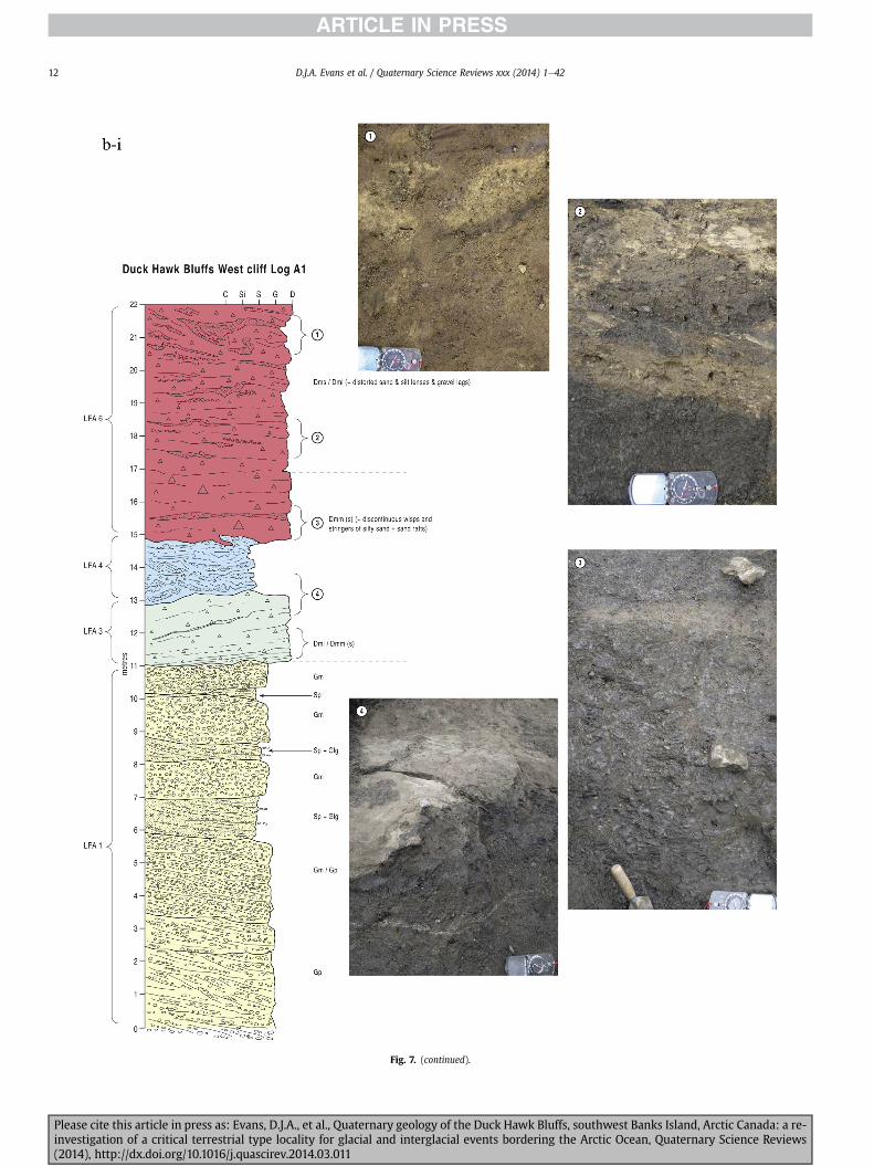
Fig 7 (continued)
DJA Evans et al Quaternary Science Reviews xxx (2014) 1e4212
Please cite this article in press as Evans DJA et al Quaternary geology of the Duck Hawk Bluffs southwest Banks Island Arctic Canada a re-investigation of a critical terrestrial type locality for glacial and interglacial events bordering the Arctic Ocean Quaternary Science Reviews(2014) httpdxdoiorg101016jquascirev201403011
Fig 7 (continued)
DJA Evans et al Quaternary Science Reviews xxx (2014) 1e42 13
Please cite this article in press as Evans DJA et al Quaternary geology of the Duck Hawk Bluffs southwest Banks Island Arctic Canada a re-investigation of a critical terrestrial type locality for glacial and interglacial events bordering the Arctic Ocean Quaternary Science Reviews(2014) httpdxdoiorg101016jquascirev201403011
Fig 7 (continued)
DJA Evans et al Quaternary Science Reviews xxx (2014) 1e4214
Please cite this article in press as Evans DJA et al Quaternary geology of the Duck Hawk Bluffs southwest Banks Island Arctic Canada a re-investigation of a critical terrestrial type locality for glacial and interglacial events bordering the Arctic Ocean Quaternary Science Reviews(2014) httpdxdoiorg101016jquascirev201403011
Fig 7 (continued)
DJA Evans et al Quaternary Science Reviews xxx (2014) 1e42 15
Please cite this article in press as Evans DJA et al Quaternary geology of the Duck Hawk Bluffs southwest Banks Island Arctic Canada a re-investigation of a critical terrestrial type locality for glacial and interglacial events bordering the Arctic Ocean Quaternary Science Reviews(2014) httpdxdoiorg101016jquascirev201403011
Fig 7 (continued)
DJA Evans et al Quaternary Science Reviews xxx (2014) 1e4216
Please cite this article in press as Evans DJA et al Quaternary geology of the Duck Hawk Bluffs southwest Banks Island Arctic Canada a re-investigation of a critical terrestrial type locality for glacial and interglacial events bordering the Arctic Ocean Quaternary Science Reviews(2014) httpdxdoiorg101016jquascirev201403011
Fig 7 (continued)
DJA Evans et al Quaternary Science Reviews xxx (2014) 1e42 17
Please cite this article in press as Evans DJA et al Quaternary geology of the Duck Hawk Bluffs southwest Banks Island Arctic Canada a re-investigation of a critical terrestrial type locality for glacial and interglacial events bordering the Arctic Ocean Quaternary Science Reviews(2014) httpdxdoiorg101016jquascirev201403011
Fig 7 (continued)
DJA Evans et al Quaternary Science Reviews xxx (2014) 1e4218
Fig 6a) Clast lithologies vary depending on sample location Amore restricted lithological component (chert quartzite andsandstone) occurs in the deformed contact zone with underlyingLFA 1 and in areas characterized by attenuated gravel lenses Amore varied clast lithology comprising chert and quartz with mi-nor components of sandstone shale granite gabbro and limestoneoccurs towards the middle and in the more diamictic zones (LFA 3)
LFA 4 comprises less than 5 m of sand silt and clay arranged inhorizontal cross-laminae rhythmites climbing ripples or drapedlaminae that locally contain organic detritus The upper and lowercontacts of LFA 4 are commonly characterized by heavily brecciatedclay or contain boudinage and thrust faulted laminae (Fig 12panels a amp c) Some outcrops of LFA 4 also display widespreaddeformation in the form of overfolded bedding and thrust faultsalthough normal faulting and open folding or convolute beddingstructures are also evident (Fig 7c iii inset photo 3) In some sec-tions LFA 4 comprises only a thin (lt2 m thick) bed of brecciatedclay (Fig 7b iv inset photo 4) or laminated sand displaying over-folds and sheath folds The sense of shearing as recorded by thrustfaults is generally towards the SSW but southerly and southwest-erly orientations are also evident Numerous examples of narrowanabranched clastic dykes rise sub-vertically through the thickestoutcrop of the sandy climbing ripple lithofacies (LFA 4 West Log A)and have created offset beds between the blocks within the hostmaterial (Fig 12 panel b) The contact of LFA 4 with LFA 3 (west cliffLog A) is marked by a clast lag Although the association is pre-dominantly heavily deformed the most unaltered and thickest
Please cite this article in press as Evans DJA et al Quaternary geologyinvestigation of a critical terrestrial type locality for glacial and intergla(2014) httpdxdoiorg101016jquascirev201403011
outcrop in West Log A displays climbing ripple drift indicative of apalaeocurrent from the south or southwest (Fig 7b ii)
LFA 5 comprises 5e10 m of tabular sets of horizontally beddedto massive gravel interbedded with horizontally bedded or cross-laminated sand and occasional units of matrix-supported gravel(Fig 13a b) The thickest outcrop displays a general coarsening-upward sequence from well-sorted horizontally bedded granulegravel and sand to matrix-supported and less well sorted hori-zontally bedded cobble to boulder gravel Clast lithologies aredominated by quartzite but contain subsidiary amounts of chertand sandstone with minor limestone LFA 5 differs from LFA 1based on its general coarsening-upward characteristics coarsergrain size and the presence of limestone clasts Clast form datafrom LFA 5 indicate a sub-rounded sample (averageroundness frac14 222 amp 246 RA frac14 8 amp 24 RWR frac14 2 amp 6) withpredominantly blocky shapes (C40 frac14 30 amp 42) and striae visible(lt14 of clasts) Upper and lower contacts are sharp but are locallyinterdigitated or amalgamated with LFA 6 (Fig 7b iv inset photo 5)and LFA 4 (Fig 13d) respectively A heavily deformed discontin-uous bed of siltclay rhythmites occurs between LFA 5 and LFA 6 inWest Log D the base of which has been amalgamated with thegravel at the top of LFA 5 (Fig 13c) Gravel in Easternmost Cliff hasan unclear relationship to the primary sections at DHB to the westThis gravel designated LFA 5a rests uncomformably on LFA 1 andis not capped by LFA 6 as elsewhere (Fig 7e) Furthermore there isno evidence of deformation and palaeocurrents are orientatedtowards the NW
of the Duck Hawk Bluffs southwest Banks Island Arctic Canada a re-cial events bordering the Arctic Ocean Quaternary Science Reviews
Fig 7 (continued)
DJA Evans et al Quaternary Science Reviews xxx (2014) 1e42 19
Please cite this article in press as Evans DJA et al Quaternary geology of the Duck Hawk Bluffs southwest Banks Island Arctic Canada a re-investigation of a critical terrestrial type locality for glacial and interglacial events bordering the Arctic Ocean Quaternary Science Reviews(2014) httpdxdoiorg101016jquascirev201403011
Fig 7 (continued)
DJA Evans et al Quaternary Science Reviews xxx (2014) 1e4220
Please cite this article in press as Evans DJA et al Quaternary geology of the Duck Hawk Bluffs southwest Banks Island Arctic Canada a re-investigation of a critical terrestrial type locality for glacial and interglacial events bordering the Arctic Ocean Quaternary Science Reviews(2014) httpdxdoiorg101016jquascirev201403011
Fig 7 (continued)
DJA Evans et al Quaternary Science Reviews xxx (2014) 1e42 21
Please cite this article in press as Evans DJA et al Quaternary geology of the Duck Hawk Bluffs southwest Banks Island Arctic Canada a re-investigation of a critical terrestrial type locality for glacial and interglacial events bordering the Arctic Ocean Quaternary Science Reviews(2014) httpdxdoiorg101016jquascirev201403011
Fig 7 (continued)
DJA Evans et al Quaternary Science Reviews xxx (2014) 1e4222
Please cite this article in press as Evans DJA et al Quaternary geology of the Duck Hawk Bluffs southwest Banks Island Arctic Canada a re-investigation of a critical terrestrial type locality for glacial and interglacial events bordering the Arctic Ocean Quaternary Science Reviews(2014) httpdxdoiorg101016jquascirev201403011
Fig 7 (continued)
DJA Evans et al Quaternary Science Reviews xxx (2014) 1e42 23
Please cite this article in press as Evans DJA et al Quaternary geology of the Duck Hawk Bluffs southwest Banks Island Arctic Canada a re-investigation of a critical terrestrial type locality for glacial and interglacial events bordering the Arctic Ocean Quaternary Science Reviews(2014) httpdxdoiorg101016jquascirev201403011
Fig 7 (continued)
DJA Evans et al Quaternary Science Reviews xxx (2014) 1e4224
LFA 6 crops out along the length of DHB and varies widely inthickness (1e11 m) displaying the most complex deformationstructures of any of the sediment bodies at DHB It comprises apredominantly heterogeneous diamicton or a meacutelange of discon-tinuous interbeds of massive matrix-supported diamicton matrix-supported gravel and laminated sand silt and clay with localizedattenuated lenses of degraded organics (Fig 7a ivevi 7b i iv 7c iiiii) Three samples of highly compressed and fragmented detritalmaterial displaying poor preservation were collected for identifi-cation Collectively LFA 6 has the appearance of a stratified dia-micton but locally it displays a more massive to pseudo-laminatedcharacter where sand silt and gravel lenses and occasional gravellags occur as thin beds stringers or wisps Some laminated sand siltand clay bodies appear to be rafts within the diamicton (intraclasts)due to their heavily deformed internal bedding and deformedcontacts or attenuated appearance Basal contacts with other lith-ofacies associations are typically erosional or deformed and asso-ciated with fissility boudinage and pseudo-lamination insediments on either side of the contact Basal diamictons can alsodisplay a higher concentration of gravel clasts that locally result in aclast-supported character or even a several metre-thick highlycontorted meacutelange of diamicton and stratified sediment bodies Insome sections the whole of LFA 6 has been complexly deformed toproduce stacked overfolds and thrust faults indicative of shearingtowards the southwest or WSW Clast macrofabrics are onlymoderately clustered (S1 frac14 0456e0637) but indicate stressdirected predominantly towards the SW Clast macrofabricstrengths as quantified by the fabric shape ternary plot (Fig 6a)and themodalityisotropy plot (Fig 6b) are variable and range frombi-modal to multi-modal Overall the macrofabric shapes in theternary graph plot across the spectrums of the glacitectonite andsubglacial traction till envelopes but there is a trend of changing
Please cite this article in press as Evans DJA et al Quaternary geologyinvestigation of a critical terrestrial type locality for glacial and intergla(2014) httpdxdoiorg101016jquascirev201403011
fabric strength vertically through LFA 6 The strongest clusters arefrom the basal diamictic zones (eg CCA F1 amp F3 AB plane data)whereas the weakest are from the top of the association (eg WCAF3 A-axes amp CCA F2 AB planes) where relatively low strain defor-mation indicators (open and recumbent folds) are ubiquitous
Clast lithologies in LFA 6 are dominated by quartz chert andsandstone although one diamict reveals a concentration of sand-stone lithologies at the expense of chert Clast forms similarlyreflect the nature of the sampled materials whereby the gravellysample (CCA 2) was characterized by relatively low C40 (38) andRA (12) values and a high average roundness (256) compared tothe same values for the diamictons of LFA 6 (C40 frac14 50e74RA frac14 38e52 average roundness frac14 174e204) A small number ofclasts (lt10) in LFA 6 were striated
512 Interpretation5121 LFA 1 The thick tabular sequence of well sorted cross-stratified sand and gravel records deposition by a former glaci-fluvial braided river typified by fluctuating discharge (eg Church1972 Boothroyd and Ashley 1975 Miall 1978 1985 1992Marren 2005) The highest discharge is recorded by matrix-supported gravel with boulders indicative of hyperconcentratedflows or a traction carpet (Maizels 1989ab Siegenthaler andHuggenberger 1993 Mulder and Alexander 2001) These areseparated by and vertically give way to lower discharges recordedby planar or trough cross-bedded sand and horizontal to planar ortrough cross-bedded gravel These deposits record aggradation andmigration of gravel bars and sheets and downstream accretionarymacroforms with relatively tightly constrained palaeocurrent in-dicators (Miall 1977 1985 Collinson 1996) The general lack ofscour fills and an overall fining-upward is indicative of an aggradingsystem initially characterized by high magnitudehigh frequency
of the Duck Hawk Bluffs southwest Banks Island Arctic Canada a re-cial events bordering the Arctic Ocean Quaternary Science Reviews
Fig 7 (continued)
DJA Evans et al Quaternary Science Reviews xxx (2014) 1e42 25
Please cite this article in press as Evans DJA et al Quaternary geology of the Duck Hawk Bluffs southwest Banks Island Arctic Canada a re-investigation of a critical terrestrial type locality for glacial and interglacial events bordering the Arctic Ocean Quaternary Science Reviews(2014) httpdxdoiorg101016jquascirev201403011
Fig 7 (continued)
DJA Evans et al Quaternary Science Reviews xxx (2014) 1e4226
Please cite this article in press as Evans DJA et al Quaternary geology of the Duck Hawk Bluffs southwest Banks Island Arctic Canada a re-investigation of a critical terrestrial type locality for glacial and interglacial events bordering the Arctic Ocean Quaternary Science Reviews(2014) httpdxdoiorg101016jquascirev201403011
DJA Evans et al Quaternary Science Reviews xxx (2014) 1e42 27
events that were gradually replaced by low magnitudehigh fre-quency events (Marren 2005) Partially to heavily-scoured rem-nants of laminated and massive fines represent deposition duringlow flow conditions in abandoned shallow channels The palae-ocurrent data from LFA 1 indicate that the outwash streams wereflowing westerly away from a glacier source located in AmundsenGulf This glacier likely eroded the abundant LFA 1 lithologies(chert quartzite and sandstone) from Mesoproterozoic and Neo-proterozoic bedrock widely distributed to the east and south(western Victoria Island Amundsen Gulf and the adjacent main-land Harrison et al 2013) These lithologies are consistent with theadvance of the NW Laurentide Ice Sheet through Amundsen Gulf(cf Dyke et al 2002 Batchelor et al 2012 MacLean et al 2013)
The crudely bedded organic detritus and degraded tree frag-ments (stumps) in LFA 1 are clearly reworked (cf Matthews et al1986 Fyles 1990 Vincent 1990) The finer grained detritus wasdeposited in concentrated pockets during waning flow stageswhereas horizons of logs and larger tree fragments were emplacedwith the coarser grained and poorly sorted sediments associatedwith hyperconcentrated flows or traction carpets during highdischarge These reworked organics also differ significantly fromthe type location of the Beaufort Fm a characteristic that promptedFyles (1990) to distinguish them as lsquotheMary Sachs Gravelrsquo Notablythe enclosing gravel and sand of LFA 1 is much coarser and exhibitsan entirely different fluvial architecture than the sandier BeaufortFm The composition and degraded nature of the LFA 1 organicssuggests that they were eroded by glaciers or their meltwater fromNeogene andor Paleogene sediments presumably to the southeastof Banks Island (eg Fyles 1990 Fyles et al 1994) The proximity ofa glacier is highlighted by the preservation of striae on individualclasts especially in the very coarse lower gravel The verticaldecrease in striae preservation and angularity (RA) and concomi-tant increase in roundness and upward-fining in LFA 1 is indicativeof an increasingly distal ice margin The co-variance plots (Fig 5)indicate a strong fluvial signature especially in the C40RA data butsubglacial characteristics are also evident particularly in the C40RWR data for the coarser grained and more matrix-supportedgravel as would be expected in ice-proximal settings
It is important to note that the widespread thrusting of LFA 1and underlying Kanguk Formation towards the southwest occurredpost-depositionally This glacitectonic thrusting was produced byLaurentide ice that advanced from the Kellett River valley (interiorBanks Island) during the emplacement of LFA 6 (see below) Theinjection of clastic dykes and fissure fills during this glacitectonicdisturbance was due to the overpressurizing of groundwater ingravel aquifers likely in taliks The branching limbs of many of thedykes are indicative of burst-out structures diagnostic of hydro-fracturing by vertically escaping groundwater pressurized byglacier overriding (cf Rijsdijk et al 1999 Le Heron and Etienne2005)
5122 LFA 2 At the top of LFA 1 rhythmites with lonestonesoverlie prominent clinoforms or foreset beds recording a changefrom subaerial glacifluvial to subaqueous deposition This wasinitially on a shallow delta front prograding foreset beds in asouthwesterly direction followed by suspension sedimentationwith dropstones presumably from floating ice in a marine orlacustrine basin The occurrence of matrix-supported gravelly scourfills with logs and woody detritus suggests pulses of cohesionlesssediment gravity flows into the basin Overlying the rhythmically-bedded sand prominent ice wedge pseudomorphs (up to 4 mdeep Fig 9aec cf Mackay and Burn 2002) are interspersed withthick (gt1m) sections of compressed in situ bryophytes (Figs 9d 7e)indicating the establishment of a tundra surface Four bryophytefamilies and 10 distinct species have been determined from LFA2
Please cite this article in press as Evans DJA et al Quaternary geologyinvestigation of a critical terrestrial type locality for glacial and intergla(2014) httpdxdoiorg101016jquascirev201403011
with the most abundant material from the Calliergonaceae andCampyliaceae (Table 1) These macrofossils are exceptionally wellpreserved including material with intact fragile alar cells typical ofthese two families (Fig 14cef) The data from these autochthonousdeposits indicate a wetland environment characterized as a richfen This ecosystem and habitats therein are consistent with speciesfound in the extant flora of Banks Island (Fig 14b) The autecologyfrom this range of species suggest hydric to mesic habitatsincluding standing pools wet meadows and microhabitats createdby ice wedges Despite the predominance of bryophytes in LFA 2these macrofossils had not been previously documented at DHB Incontrast a minimal proportion of the samples (lt5) consisted ofvascular plant material (including Cyperaceae seeds gramminoidleaves and woody twig fragments) Collectively the ice wedgepseudomorphs and vegetation within LFA 2 represent an isochro-nous terrestrial surface of interglacial rank
Following the formation of ice wedges the injection of intra-formational clastic dykes and fissure fills in LFA 2 relates to theoverpressurizing of groundwater in gravel aquifers or taliks due toglacier overriding The branching dyke limbs that emanate fromunderlying LFA 1 gravels and sands are indicative of the burst-outstructures that develop during hydrofracturing (cf Rijsdijk et al1999 Le Heron and Etienne 2005) A variant of the gravel andsand filled clastic dykes occurs within the sequence of glaci-tectonite and rhythmites near west Log D (Fig 11) Here thevertically-widening fracture is characterized by a mosaic ofpartially disaggregated blocks of the host materials in its widestzone where it contains gravels injected from underlying LFA 1Because these gravels only occur in the basal narrow neck theypresumably record the rapid reduction in flow competence duringhydrofracture filling
Deformation structures including overfolded or crumpledbedding and thrust faults associated with boudinage or highfissilitypseudo-lamination are representative of simple shear andwere also induced by glacitectonic disturbance (cf van derWateren 1995 McCarroll and Rijsdijk 2003) This predominantlyrecords a glacier advance from the northeast Subsidiary shear in-dicators record deformation from the south or southeast but theseoccur only at the top of LFA 2 and the base of LFA 3 suggestingearlier emplacement (see below) The development of zones ofboudinage shallow thrust faults overfolding or bed crumpling atdifferent levels within LFA 2 e especially at the contact separatingsediments of different grain size e represents deformation parti-tioning due to contrasting rheological properties Blind thrustswere also initiated in underlying LFA 1 increasingly towards thecentral and eastern cliffs where large-scale deformation is moreprevalent (Fig 7c d) A zone of intense deformation is recorded by alens of LFA 3 diamicton in fault contact with LFA 2 (east cliff Log AFig 7d i) This constitutes a type B glacitectonite (non-penetrativelydeformed pre-existing sediments sensu Benn and Evans 1996Evans et al 2006) developed during the emplacement of LFA 3(see below) A similar glacitectonite occurs at the junction of LFA 1and LFA 3 near west Log D (Fig 11) Bed attenuation by deformationis best developed in lower LFA 2 where the greater differences insediment grain size and hence rheology exist
5123 LFA 3 Within LFA 3 locally abundant stratified lensesindicate subaqueous deposition These stratified sediments weresubsequently thrust faulted folded and attenuated - most evidentin the upper and lower zones of LFA 3 This deformation was likelyresponsible for the intraclast boudinage and pseudo-lamination inthe surrounding diamicton (eg Hart and Roberts 1994 Robertsand Hart 2005 Oacute Cofaigh et al 2011) This process was alsoassociatedwith the attenuation of LFA 1 and 2 sediments within theheavily deformed base of LFA 3 some of which may have been
of the Duck Hawk Bluffs southwest Banks Island Arctic Canada a re-cial events bordering the Arctic Ocean Quaternary Science Reviews
Fig 8 Details of LFA 1 a) example of a concentration of logs with degraded rootballs in the stacked tabular units of cross-bedded sands and gravels and crudely stratified matrix-supported cobble to boulder gravels in the west cliff b) poorly-sorted and crudely horizontally bedded cobble to boulder gravel containing laminated clay intraclast (immediatelyabove compass) c) shallow locally graded foreset beds composed of openwork to sandy matrix-supported cobble to granule gravels in central cliff Log A d) planar bedded sandy
DJA Evans et al Quaternary Science Reviews xxx (2014) 1e4228
Please cite this article in press as Evans DJA et al Quaternary geology of the Duck Hawk Bluffs southwest Banks Island Arctic Canada a re-investigation of a critical terrestrial type locality for glacial and interglacial events bordering the Arctic Ocean Quaternary Science Reviews(2014) httpdxdoiorg101016jquascirev201403011
DJA Evans et al Quaternary Science Reviews xxx (2014) 1e42 29
cannibalized and rafted by the deformation process within a shearzone at the contact of LFA 3 with older sediments The shearingdirection from the south and southeast recorded in lower LFA 3also impacted upper LFA 2 whereas the more prominent shearingdirection throughout LFA 3 is from the northeast (also recorded inLFA 4) The local development of a heavily deformed zone at the topof LFA 3 was likely imparted during the shearing of overlying LFA 4sediments Although clast macrofabric strengths from the LFA 3diamicton are variable they possess shapes that compare withglacitectonites and subglacial traction tills and in some cases amodalityisotropy signature that reflects high lodgementcomponents
The similar orientation of the macrofabrics and shear indicatorsare considered diagnostic of a glacitectonite derived from stratifiedsediments (eg interbedded mass flow diamictons gravelly massflows and localized traction current sands and suspension de-posits) This evidence indicates that LFA 3 like all the other LFAsand the underlying Kanguk Fm bedrock has been displaced by aglacier advancing from the NNE or NE (ie Laurentide ice crossingthe interior of Banks Island) Minor south to north shearing in-dicates that LFA 3 and upper LFA 2were also disturbed by glacier iceflowing northwards (ie Laurentide ice advancing throughAmundsen Gulf) The appearance of granite and gabbro clastswithin the LFA 3 diamict records the arrival of far-travelled Lau-rentide ice from mainland Canada Clast form co-variance stronglyindicates a subglacial (abraded) source for LFA 3 with a minorfluvial component (Fig 5) including glacifluvial clasts locallycannibalized from LFA 1 by overriding ice
5124 LFA 4 LFA 4 has restricted outcrops is heavily deformedand contains organic detritus that is clearly allochthonous andhighly degraded Nonetheless a variety of indicators (fine-grainedhorizontally bedded cross-laminae rhythmites climbing ripplesand draped laminae) demonstrate that LFA 4 was deposited in asubaqueous environment with palaeocurrents from the south orsouthwest Traction currents were likely responsible for thedevelopment of the clast lag at the contact between lower LFA 4and underlying LFA 3 (west cliff Log A Fig 7b ii) LFA 4 coarsensupwards indicative of basin infilling andor an approaching sedi-ment source The narrow anabranched clastic dykes in the sandyclimbing ripples (LFA 4 west cliff Log A) record hydrofracturing bythe upward injection of overpressurized groundwater duringshearing The branching limbs of the dykes are similar to the burst-out structures reported by Rijsdijk et al (1999) but differ becausethey are composed solely of sand derived from the walls of the hostsediment rather than from an underlying gravel aquifer (cf LeHeron and Etienne 2005) Hence the pressurized water wasgenerated at the contact between the sand and underlying imper-meable brecciated clays The development of thin zones of brecci-ation boudinage sheath folding or thrust faulting at the upper andlower contacts of LFA 4 relates to the localized partitioning ofdeformation controlled by the location of claysilt beds Thejuxtaposition of this style of deformation with the larger scaleoverfolds and thrust faults developed in the extensive bodies ofsandy lithofacies is indicative of a Type B glacitectonite (sensu Bennand Evans 1996) This was constructed by the overriding of glacierice advancing from the north or northeast These shear directionsare compatible with those developed in the underlying LFAs
granule gravels with gravel lags (top and bottom of image) interrupted by an intervening unbedded granule to pebble gravel and massive cobble to pebble gravel A cluster of small treesequence of stacked tabular units of predominantly horizontally bedded sands and gravels ingravels containing clusters of wood detritus in the coarser gravel beds (central cliff Log A)wood fragments (central cliff Log A)
Please cite this article in press as Evans DJA et al Quaternary geologyinvestigation of a critical terrestrial type locality for glacial and intergla(2014) httpdxdoiorg101016jquascirev201403011
5125 LFA 5 The primary characteristics of LFA 5 are typical ofgravel sheet and occasional traction-carpet sedimentation in anice-proximal sandur (eg Boothroyd and Ashley 1975 Miall 19781985 1992 Maizels 1989ab Siegenthaler and Huggenberger1993 Mulder and Alexander 2001 Marren 2005) Glacier prox-imity is supported by the subglacial to fluvial signature of the clastforms (Fig 5) The coarsening-upward sequence including striatedclasts culminates in the arrival of a glacier that overrode the sitedepositing LFA 6 Post-depositional shearing within underlying LFA4 is recorded by attenuation and interdigitation at the contact withLFA 5 imparted during deposition of LFA 6 The contact betweenLFA 5 and 6 reflects the development of a shear zone where upperLFA 5 sediments have been cannibalized producing a meacutelange ofcrudely stratified diamictons with discontinuous interbeds ofmatrix-supported gravel laminated sand silt and clay (LFA 6 seebelow)
5126 LFA5a At Easternmost Cliff glacifluvial gravel (LFA 5a)unconformably overlies LFA 1 (Fig 7e) rendering uncertain itsrelationshipwith respect to LFA 5 in themain sections of DHB to thewest The fact that LFA 5a extends to the modern surface appearsundeformed and has palaeocurrents orientated to the NW requiresthat it is younger than LFA 5 Indeed we interpret LFA 5a asdeglacial outwash deposited from retreating Laurentide ice in theKellett River valley and Amundsen Gulf at the end of the lastglaciation (see Discussion)
5127 LFA 6 Based on its heterogeneity strongly orientated clastmacrofabrics and macroscale deformation structures LFA 6 con-stitutes a Type B glacitectonite (sensu Benn and Evans 1996)However zones of more highly strained Type A glacitectonite(sensu Benn and Evans 1996) at the basal contact with older LFAsare recorded by intraclastinterbed attenuation (pseudo-lamina-tion) strong boudinage or fissility and strengthened clast macro-fabrics The production of this meacutelange is attributed to two separateprocesses 1) primary sedimentation as interbedded and interdig-itated mass flow debris fluvial gravel and sand and subaqueoussuspension sediments and 2) cannibalization of underlying strat-ified sediments (LFAs 4 and 5) This produced a continuum of formsranging from low strain fold structures to attenuated rafts to tec-tonic lamination (eg Fig 7) The discontinuous lenses of degradedorganics (black stems and woody twigs gramminoid leaveswhitened rootlets) within LFA 6 are rafts and include seven speciesof bryophytes (Table 1) The material was highly compressed anddifficult to separate into distinct taxa Indeed one of the threesamples analysed was too degraded to recover any taxa Much ofthe material consisted of only fragmented leaves and only theminute taxa had stems with intact leaves The bryophytes thatcharacterize the LFA 6 samples represent hydric (Calliergon sppTomenthypnum nitens) to mesic (Ditrichum flexicaule Dicranum sp)habitats Three species collected from LFA 6 were also present inLFA 2 whereas four others were not found in LFA 2 but are com-mon in the modern flora The poor preservation quality suggeststhat the material has been redeposited from unknown sources andis clearly allochthonous
The predominant shearing direction within LFA 6 records an iceadvance from the interior of Banks Island (NE) This has resulted incomplex folding and thrusting and localized thickening of LFA 6
it of cross-bedded poorly-sorted to openwork cobble to boulder gravel crudely planar-fragments occur at the base of the cobble to boulder gravels at image centre e) middleDHB west cliff Log D f) sequence of fining-upward planar-bedded cobble to sandy fineg) planar cross-bedded sandy granule to pebble gravels with pebble to cobble lags and
of the Duck Hawk Bluffs southwest Banks Island Arctic Canada a re-cial events bordering the Arctic Ocean Quaternary Science Reviews
Fig 9 Details of LFA 2 from the west cliff a) narrow necked ice wedge pseudomorph with upturned marginal bedding in sand silt and clay rhythmites b) wide necked ice wedgepseudomorph c) ice wedge pseudomorph with overturned silt sand and clay rhythmites developed at the top of LFA 2 and sealed by overlying LFA 3 laminated diamicton d)horizontally bedded sand and silt containing well preserved moss macrofossils e) zone of disharmonically folded sandsilt laminae with well preserved moss peat located at thebase of LFA 2
DJA Evans et al Quaternary Science Reviews xxx (2014) 1e4230
Please cite this article in press as Evans DJA et al Quaternary geology of the Duck Hawk Bluffs southwest Banks Island Arctic Canada a re-investigation of a critical terrestrial type locality for glacial and interglacial events bordering the Arctic Ocean Quaternary Science Reviews(2014) httpdxdoiorg101016jquascirev201403011
Fig 10 Details of simple shear structures developed in fine sand and silt laminae at the centre of the thickest outcrop of LFA 2 in west cliff Log B a) overview of large scaleanastomosing shear faults with zones of smaller scale densely spaced anastomosing shears towards the base of the photograph b) details of large scale shear faults separatingzones of variably but predominantly densely spaced shears c) close details of shear zone comprising densely spaced anastomosing fractures d) details of ascending kink zonecross-cutting large scale anastomising shear faults Shearing direction is coming out of the cliff and towards the left in each image
DJA Evans et al Quaternary Science Reviews xxx (2014) 1e42 31
This shearing direction is recorded throughout underlying LFAs 1e4as well as the Kanguk Formation demonstrating deep-seated butpartitioned glacitectonic disturbance imparted during theemplacement of LFA 6 This strain signature was therefore over-printed on the northerlynortheasterly aligned shearing directionrecorded in LFA 3 and upper LFA 2 by the earlier northerly flowingice that deposited LFA 3 One anomalous clast macrofabric(northerly CCA F1) occurs in the basal meacutelange of LFA 6 Howeverthis sample is from an isolated outcrop (Fig 7c i) rendering itsapparent shearing direction equivocal
Please cite this article in press as Evans DJA et al Quaternary geologyinvestigation of a critical terrestrial type locality for glacial and intergla(2014) httpdxdoiorg101016jquascirev201403011
52 Sedimentology and stratigraphy (Mary Sachs Creek cliff)
The cliffs east of Mary Sachs Creek (Figs 2b 3) provides a cross-section through the seaward margin of the coast-parallel SachsMoraine (ldquosection Jrdquo Vincent et al 1983 Vaughan 2014) Weprovide a summary of two logs based on a reconnaissance survey ofthese sediments Log A is closest toMary Sachs Creekwhereas Log Boccursw1 km farther east (Figs 3 15a amp b) The sediments exposedin Log A appear to descend eastward and disappear below themodern beach and therefore are assumed to stratigraphically
of the Duck Hawk Bluffs southwest Banks Island Arctic Canada a re-cial events bordering the Arctic Ocean Quaternary Science Reviews
Fig 11 Details of LFA 2 near west Log D Lower box shows a 1e2 m thick basal zone comprising highly attenuated inter-digitated beds of gravelly to clay-rich diamictons and sandsiltclay rhythmites Upper box shows rhythmites containing diamictic intraclasts with sharp and angular boundaries also visible is the draping and deforming of the rhythmitebedding over and under the intraclasts respectively ldquoTailsrdquo extending from the diamictic intraclasts and thin but discontinuous diamictic beds are also visible in the upper box
DJA Evans et al Quaternary Science Reviews xxx (2014) 1e4232
underlie the sediments of Log B A sand and gravel- bench caps bothlogs at w15 m asl incised into the seaward margin of the SachsMoraine
521 DescriptionLog A contains a sequence of upward-fining highly contorted
cross-stratified sand and fine gravel to rhythmically bedded sandsilt clay with minor pebble gravel and sporadic clots of gravellydiamicton (Fig 15a) An ice wedge was initially developed in thelower cross-stratified sand and fine gravel before they were foldedand thrust faulted The deformed ice wedge pseudomorph is un-conformably overlain by a relatively undisturbed lens of laminatedsilty clay with dropstones interbedded with gravelly diamictonthat contains a bed (10 cm) of sandy black organics containingwood fragments (Fig 15a) This organic material occurs repeatedlyup-section as discontinuous stringers Log A is capped by 1e2 m ofpoorly exposed and heavily cryoturbated gravelly diamicton Thegeneral sense of displacement on shallow reverse faults over-turned bedding and boudinage structures is from the southeast
Log B (12 m) displays a coarsening-upward sequence of hori-zontally bedded sandy granule gravel with occasional silty sandlaminae (Fig 15b iii) that grades to poorly-sorted cobble to bouldergravel and bouldery matrix-supported gravel (Fig 15b ii) This iscapped by laminated to crudely stratified cobbly diamicton that issilt and clay-rich abruptly and conformably overlain by
Please cite this article in press as Evans DJA et al Quaternary geologyinvestigation of a critical terrestrial type locality for glacial and intergla(2014) httpdxdoiorg101016jquascirev201403011
interlaminated silt clay and pebbly silty sand (Fig 15b i) Althoughthe bedding on these units dips towards the NW individuallaminae do not thicken in that direction indicating post-depositional tilting The uppermost part of the log (underlyingthe 15 m bench) contains 2 m of clay-rich massive diamictoninterfingered with the underlying laminated sediments and cobblydiamicton
522 Interpretation
5221 Log A Broadly the sedimentology of log A including thedeformed ice wedge pseudomorph is similar to LFA 2 in DHB (egcentral cliff Log A Fig 7c iii) Prior to glacitectonic disturbance theoverlying organic bed (Fig 15a) was redeposited into a sequence ofsubaqueous siltclay rhythmites containing dropstones and gravellymass flows The highly attenuated shear margins bracketing theorganic bed in Log A demonstrate that it has been displaced as atectonic raft Previous research proposed that the organic beds e
similar to those described in Log A e be assigned to the LastInterglacial (locally called the Cape Collinson Vincent 1982 1983)Because these organic beds are clearly a raft they cannot constitutean iscochronous surface precluding chronostratigraphic signifi-cance (see Discussion) Shearing of the Log A sediments from thesoutheast documents an ice advance from Amundsen Gulf corre-sponding to the earliest of two primary shearing directions recor-ded at DHB (imparted during the emplacement of LFA 3) Therefore
of the Duck Hawk Bluffs southwest Banks Island Arctic Canada a re-cial events bordering the Arctic Ocean Quaternary Science Reviews
Fig 12 Details of LFA 4 in West Log A a) heavily deformed upper contact of LFA 4 comprising sandsiltclay rhythmites displaying well developed boudinage sheath folds andimmature tectonic laminae and an interdigitatedsheared boundary with underlying climbing ripple sands The contact with overlying LFA 6 is marked by an interdigitated zonecontaining rooted and de-rooted folds or rhythmite rafts in a sand gravel and diamicton meacutelange b) narrow anabranched clastic dykes ascending sub-vertically through climbingripple drift and resulting in offset bedding between blocks of host material c) abrupt contact between sheared sands and rhythmites of LFA 4 and overlying sand gravel anddiamicton meacutelange
Fig 13 Details of LFA 5 a) poorly sorted and matrix-supported pebble to cobble gravel b) tabular sequence of horizontally bedded to massive gravel and matrix-supported gravelcontaining a horizon of striated cobbles and boulders c) heavily deformed discontinuous bed of siltclay rhythmites between LFA 5 and LFA 6 in West Log D showing theamalgamation zone with the LFA 5 gravels immediately above the compass d) interdigitateddeformed contact between LFA 5 granule to pebble gravels and underlying LFA 4laminated silts and clays with organic detritus in West Log B
DJA Evans et al Quaternary Science Reviews xxx (2014) 1e42 33
Please cite this article in press as Evans DJA et al Quaternary geology of the Duck Hawk Bluffs southwest Banks Island Arctic Canada a re-investigation of a critical terrestrial type locality for glacial and interglacial events bordering the Arctic Ocean Quaternary Science Reviews(2014) httpdxdoiorg101016jquascirev201403011
Table 1List of bryophytes and vascular plants from LFAs 2 and 6
LFA2 WestCliff Log B
LFA6 CentralCliff Log A
Elevation (m) 185 m asl w45 m aslSample 4e12 1e3 taxa 10 7
Bryophyta (mosses)AmblystegiaceaeAmblystegium serpens (Hedw) Schimp x
CamyliaceaeCampylium polygamum (Schimp) CEO Jensen xCampylium stellatum (Hedw) CEO Jensen x xDrepanocladus aduncus (Hedw) Warnst xDrepanocladus sp xTomentypnum nitens (Hedw) Loeske x
CalliergonaceaeCalliergon giganteum (Schimp) Kindb xCalliergon richardsonii (Mitt) Kindb xthornthornthornthorn xCalliergon sp xWarnstorfia exannulatus (Schimp) Loeske xthornthornthornthorn x
BrachytheciaceaeBrachythecium turgidum (Hartm) Kindb x
MniaceaeCyrtomnium cf hymenophylloides(Hbener) TJ Kop
x
DicranaceaeDicranum sp x
DitrichaceaeDitrichum flexicaule (Schwaumlgr) Hampe x
Tracheophyta (vascular plants)CyperaceaeSeeds (triangular amp flattened) x x
Gramminoid leaf material x xWoody twig fragments x xRootlets x
Fig 14 The moss peat and associated microfossils of LFA 2 a) exposure through lower LFAsouthern Banks Island analogue of a rich tundra fen environment for the bryophyte assemblfrom LFA 2 showing the exceptional preservation of Calliergonaceae and Campyliaceae ma
DJA Evans et al Quaternary Science Reviews xxx (2014) 1e4234
Please cite this article in press as Evans DJA et al Quaternary geologyinvestigation of a critical terrestrial type locality for glacial and intergla(2014) httpdxdoiorg101016jquascirev201403011
these deformed deposits are interpreted as a Type B glacitectonite(sensu Benn and Evans 1996) possibly derived from LFA 2
5222 Log B The coarsening upward gravel in Log B recordshighly turbid to hyperconcentrated discharge in non-channelizedsheets This is interpreted as aggrading glacifluvial outwash froman approaching ice margin The capping sequence of crudelystratified diamicton and laminated sediments records a changefrom glacifluvial to subaqueous sedimentation prior to overridingby a glacier of unknown age that tilted the upper beds Thecoarsening-upward sequence apparent tectonism and cappingdiamict at Log B clearly distinguishes these deposits from those ofLFA 5a (west of Mary Sachs Creek easternmost cliff Fig 3)Furthermore although there is lithological similarity between LogB and LFA 5 throughout DHB the sense of shearing is dissimilar (LFA5 from the NE and Log B from the SE) The simplest explanation forthis difference in shear direction is that LFA 5 (DHB) was displacedby interior ice advancing down the Kellett River whereas Log B wasdisplaced by ice advancing along Amundsen Gulf (Fig 2b)
6 Discussion
61 Large scale glacitectonic structures and stratigraphicarchitecture
The glacitectonic structures identified within the lithofaciesassociations at DHB record two phases of deformation (early NeSand later NEeSW) This deformation together with the DHBstratigraphic architecture (Fig 16) helps to explain both thekinetostratigraphy (sensu Berthelsen1978) and the evolution of thelocal glacial geomorphology The large scale glacitectonic defor-mation is most clearly manifest in the thrust faulting and conjugate
2 at DHB west log B showing the sampling locations for in situ moss peat b) a modernages of LFA 2 c)ef) details of the typical moss peat and associated microfossil materialscrofossils including material with intact fragile alar cells
of the Duck Hawk Bluffs southwest Banks Island Arctic Canada a re-cial events bordering the Arctic Ocean Quaternary Science Reviews
Fig 15 The stratigraphy of Mary Sachs Creek cliff a) photographic compilation log A showing upward-fining highly contorted (i) cross-stratified sands and fine gravels torhythmically bedded sands silts clays and minor pebble gravels Also visible in (ii) is a lens of interbedded laminated silty clays with dropstones and gravelly diamictons containingsandy black coloured organic material with wood fragments An ice wedge pseudomorph is visible (iii) to the right of the exposure b) photographic compilation log B showing i)laminated to crudely stratified cobbly but siltclay-rich diamicton grading into interlaminated silts clays and pebbly silty sands ii) poorly-sorted cobble to boulder gravel andbouldery matrix-supported gravel iii) coarsening-upward sequence of horizontally bedded sandy granule gravels with occasional silty sand laminae iv amp v) pebble to cobble graveland matrix-supported gravel
DJA Evans et al Quaternary Science Reviews xxx (2014) 1e42 35
shear development in the Kanguk Fm bedrock and overlying LFA 1(east cliff Fig 7d ivevi) Here predominantly northeasterly dippingthrust slices have been stacked truncated and overlain by LFA 6during the second and strongest (NEeSW) deformation phase(Fig 16 note bedrock slice within the imbricated stacked sequenceof LFA 1) These structures demonstrate significant compressionand thickening of the stratigraphic sequence including w40 m ofvertical offset within the Kanguk Formation acrossw3 km (Fig 16)Prominent hydrofracture fills in LFAs 1 and 2 record elevatedporewater pressure during this thrusting Smaller scale shear zoneshave also developed in the finer grained interbeds within thrustslabs (Fig 7d vii) indicative of deformation partitioning by strataprone to ductile failure This zone of greatest displacement alsocoincides with the highest topography (Fig 16) Lower angle thrustfaults propagate in a southwesterly direction predominantlythrough LFA 1 but are also developed through LFA 2 in the footwallblock (east cliff Fig 16)
The thrust stacking of bedrock and LFAs 1e5 in east cliff (obliqueto Fig 16) represents the ice-proximal zone of a thrust-blockmorainecomposite ridge constructed by a glacier advancing fromthe northeast (ie the interior of Banks Island) This glacitectonicdeformation propagated southwestward to distal parts of theproglacial stress field as recorded bywell-developed shear zones inthe finer grained sediments of LFAs 2e5 In the more distal westcliff open folds (LFA 2 Fig 16) appear to be the product of a blindthrust within underlying LFA 1 This style of tectonism is typical oflsquopiggyback-style thrustingrsquo wherein steeply inclined thrust blocksat the advancing ice margin propagate new thrusts in the footwall(Fig 16 Park 1983 Mulugeta and Koyi 1987) The angle of thesefootwall thrusts becomes progressively shallower southwestward
Please cite this article in press as Evans DJA et al Quaternary geologyinvestigation of a critical terrestrial type locality for glacial and intergla(2014) httpdxdoiorg101016jquascirev201403011
(ice-distal) in LFA 1e5 where deformation partitioning developedin finer grained lithofacies (Fig 16)
The densely spaced ponds and depressions immediately to thenortheast of DHB (Figs 2b 3) constitute the depression fromwhich the thrust mass was excavated (eg Aber et al 1989Evans and England 1991 van der Wateren 1995) This inter-pretation is consistent with the strong northeast to southwestshear direction in the second phase glacitectonic structures andin LFA 6 clast macrofabrics This indicates that construction ofDHB occurred at the margin of a glacier advancing from thenortheast (ie from Kellett River valley) overtopping DHB anddepositing the LFA 6 glacitectonite The continued advance ofKellett ice coalesced with a glacier in Amundsen Gulf marked bythe interlobate Sachs Moraine containing ice-transported shellsas young as 24 cal ka BP (21020 70 yrs BP UCIAMS-89674)assigning this glaciation to the Late Wisconsin (Vaughan 2014)East of Mary Sachs Creek the deformation of Log B outwash(from the southeast Figs 15 16) likely records overriding by thesame Amundsen Gulf glacier (coeval with LFA 6 Late Wiscon-sinan) During ice retreat when Kellett River and Amundsen Gulfice decoupled DHB was exposed allowing the northwesterly-flowing proglacial outwash (LFA 5a) west of Mary Sachs Creekto extend to the shoreline marking postglacial marine limit atKellett Point (11 m asl Vaughan 2014 Fig 3) Collectively thisreconstruction supports a Late Wisconsinan age for the con-struction of DHB thrust block moraine although its stratigraphyincludes a range of ages A palaeogeographic reconstruction ofevents based upon our interpretation of the sedimentologystratigraphic architecture tectonism and geomorphology is pre-sented in Fig 17
of the Duck Hawk Bluffs southwest Banks Island Arctic Canada a re-cial events bordering the Arctic Ocean Quaternary Science Reviews
Fig 15 (continued)
DJA Evans et al Quaternary Science Reviews xxx (2014) 1e4236
62 Comparison and revision of previous DHB model
DHB was previously interpreted to record horizontally beddedNeogene to Quaternary sediments assigned to preglacial fluvialand multiple glacial and interglacial episodes (Vincent 1982 19831990 Vincent et al 1983 1984 Barendregt et al 1998) A com-posite palaeomagnetic record was also presented for this proposedstratigraphy placing most of this deposition before the BrunhesMatuyama boundary (Fig 1c) However prior to our work detailedstudies had not been undertaken on the sedimentology structuralgeology or stratigraphic architecture of DHB Rather the originalstratigraphy was restricted to a series of composite logs (our Fig 4reproduced from Vincent et al 1983) that notably omitted thepervasive deformation structures including the thrust bedrock ineast cliff (Fig 16)
Please cite this article in press as Evans DJA et al Quaternary geologyinvestigation of a critical terrestrial type locality for glacial and intergla(2014) httpdxdoiorg101016jquascirev201403011
Our reinterpretation dismisses several key elements of theoriginal DHB model outlined below (oldest to youngest) We havedetermined that the lowermost unit (LFA 1) is not preglacial (Fyles1990) but rather is composed of glacial outwash providing theearliest terrestrial evidence for glaciation in the area and containingallochthonous organics (including tree stumps) of unknown prov-enance Because LFA 1 is a glacifluvial braidplain (Fig 17a) it is notpart of the Beaufort Fm (Fyles 1990) even though it containsreworked macrofossils presumably derived from it (eg Craig andFyles 1960 Hills et al 1974 Vincent et al 1983)
Our analysis of LFA 2 indicates that it is also not preglacial norcan it be the Worth Point Fm as previously proposed (cf Vincent1982 1983 1990 Vincent et al 1983 Matthews et al 1986)Indeed the type locality of the Worth Point Fm has been invali-dated because it is now recognized to be an ice-transported and
of the Duck Hawk Bluffs southwest Banks Island Arctic Canada a re-cial events bordering the Arctic Ocean Quaternary Science Reviews
LFA4
Fig16
Stratigrap
hiccross-profi
lerun
ning
westto
easto
fDuc
kHaw
kBluffs
basedup
oninterpolations
betw
eenthemainsectionlogs
andsh
owingthesixLFAstheKan
gukFo
rmationbe
droc
kex
posu
resmajor
structural
features
and
thepo
sition
sof
icewed
geps
eudo
morph
san
dsign
ificant
clasticdy
kesAtthe
easternen
dof
thecross-profi
lethe
sedimen
tsat
theco
reof
MarySa
chsCree
kcliff
logAaretentativelyclassified
asLFA2
althou
ghthesematerialsarelik
ely
notin
situN
otethat
thecross-profi
ledo
esno
tex
tend
asfarea
stas
MarySa
chsCree
kcliff
logB
DJA Evans et al Quaternary Science Reviews xxx (2014) 1e42 37
Please cite this article in press as Evans DJA et al Quaternary geologyinvestigation of a critical terrestrial type locality for glacial and intergla(2014) httpdxdoiorg101016jquascirev201403011
glacitectonized raft (Vaughan et al 2014) In contrast our LFA 2 ischaracterized by an isochronous tundra surface with ice wedgesand intervening shallow ponds andwetmeadows The peat at LFA 2is dominated by bryophytes (gt95 by volume) and yet none ofthese macrofossils had been previously documented The diversein situ bryophyte species record a flora similar to that on BanksIsland today suggesting that LFA 2 warrants an interglacial rankThis conclusion is supported by the limited vascular plant record(five taxa no species indicated Vincent 1990) that also suggest awet meadow environment The absolute age of LFA 2 remains un-known but is apparently older than the BrunhesMatayamaboundary (gt780 ka Fig 18 cf Vincent et al 1984 Barendregt andVincent 1990 Barendregt et al 1998 see below)
LFA 3 in both our model and that of Vincent et al (1983) pro-vides the first direct evidence of ice reaching DHB In the previousmodel this was interpreted as Bernard Till (Banks Glaciation) thatwas bracketed by glacioisostatically induced marine transgressions(pre- and post-Banks seas Vincent 1982 1983) Within basal LFA 3we recognized highly deformed stratified sediment that wasdeposited in a subaqueous environment (deep water Fig 17c) priorto the arrival of overriding ice from the south (recorded by graniteand gabbro erratics Figs 17c 18) We regard LFA 3 to be equivalentto the Banks Glaciation (Vincent 1982 1983 Vincent et al 1983)including its pre- and post-Banks seas represented by the stratifiedsediments that bracket the central diamicton The LFA 3 sedimentsare also reported to be magnetically reversed thereby predatingthe BrunheseMatayama boundary (gt780 ka Fig 18 Vincent et al1984 Barendregt and Vincent 1990 Barendregt et al 1998)
Following the Banks Glaciation (our LFA 3 at DHB) Vincent(1982 1983) and Vincent et al (1983) recognized two in-terglacials (Morgan Bluffs and Cape Collinson) separated by anintervening marine episode This marine episode correspondedwith the glacioisostatic loading of a Laurentide ice margin confinedto the eastern half of Banks Island (Thomsen Glaciation) HoweverLFA 4 contains coarsening-upward subaqueous sedimentation fromthe south or southwest reflecting continued marine regressionfollowing LFA 3 (Fig 17c d) The coarsening-upward sequence ofLFA 4 is supplanted by coarse gravel outwash (LFA 5) supplied by aglacier readvancing from the northeast (Kellett River valley iceFig 17e) Glacier overriding is recorded by LFA 6 glacitectonite thatcaps the DHB thrust-block moraine composed of the entireassemblage of underlying LFAs (Fig 16)
Notably we have not observed any sediments characteristic oftwo interglacial deposits above LFA 3 hence dismiss the presence ofthe Morgan Bluffs and Cape Collinson interglacials at DHB Causseand Vincent (1989) report a U-series date of gt200 ka (UQT-229)from above our LFA 3 but this is almost certainly reworked andlacks chronostratigraphic significance Nor have we observedintervening marine sediments attributable to the Thomsen Glaci-ation (eg lsquoBig Searsquo Vincent 1982 1983 Vincent et al 1983)Rather following the deposition of the subaqueous sediments ofupper LFAs 3 and 4 (post-Banks Glaciation) LFAs 5 and 6 record asingle ice advance reaching DHB from the Kellett River valley(Banks Island interior) that was not reported by Vincent et al(1983) It was instead assumed that after the Banks GlaciationDHB lay distal to any later ice advances The nearest subsequentLaurentide margin to DHB recognized by Vincent et al (1983) wasassigned to the Sachs Moraine (immediately east of DHB) that waspresumed to be of EarlyWisconsin age (Fig 2b) However the SachsMoraine is nowdated to24 cal ka BP (LateWisconsinan Vaughan2014) andwas formed by the coalescence of Amundsen Gulf ice andthe Kellett River ice that deformed DHB (Fig 17) On the east side ofMary Sachs Creek the deposition of the Sachs Moraine coincideswith the deformation (from the southeast) of the underlying Log Boutwash gravel (Figs 3 15b)
of the Duck Hawk Bluffs southwest Banks Island Arctic Canada a re-cial events bordering the Arctic Ocean Quaternary Science Reviews
Fig 17 The palaeogeography of southwest Banks Island based upon interpretations of the principal lithofacies associations and structural architecture recognized at Duck HawkBluffs and the geomorphology of the surrounding terrain See text for detailed explanations
DJA Evans et al Quaternary Science Reviews xxx (2014) 1e4238
Although interglacial deposits were previously reported fromthe cliffs east of Mary Sachs Creek (ie Cape Collinson InterglacialVincent et al 1983) we found no similar evidence Rather the onlydeposit that we observed that may have been construed as inter-glacial sediments occurs in our Log A (Figs 3 15a) Here a darkdiscontinuous band of allochthonous organics (Fig15a) sits severedwithin a heavily tectonized melange (type B glacitectonite) and istherefore clearly a raft Although the absolute ages of the deformedunits east of Mary Sachs Creek (Logs A amp B) remain uncertain theyare apparently normally magnetized (Vincent et al 1984Barendregt and Vincent 1990) Blake (1987) also reports non-finite radiocarbon dates (gt36000 amp 49000 BP GSC-3560 amp 3560-2) obtained on ldquocompressed and deformed black woody peatrdquopurportedly from Cape Collinson beds (Vincent et al 1983 p 1708)Additionally Causse and Vincent (1989) report a U-series date onshells of 924 ka (UQT-143) from beds similar to the Log B gravelAgain all of these dated units have been displaced from unknownlocations limiting their utility for palaeoenvironmental recon-struction The last glacially influenced sedimentation at DHB isrecorded by northwesterly directed outwash (easternmost cliff LFA5a Figs 3 16 17g) We infer that this outwash fed the gravel beachmarking marine limit (11 m asl) in the lower Kellett River duringLate Wisconsinan retreat from the Sachs Moraine
63 Regional context
The stratigraphy at Duck Hawk Bluffs records three glacialevents The earliest of these is recorded by the aggradation of a
Please cite this article in press as Evans DJA et al Quaternary geologyinvestigation of a critical terrestrial type locality for glacial and intergla(2014) httpdxdoiorg101016jquascirev201403011
glacifluvial braidplain (LFA 1) that contains allochthonous pre-glacial material of diverse age However within LFA 1 there is noevidence that the ice reached DHB although it must have beennearby (southeast in Amundsen Gulf) The age of this glaciationremains unknown but the palaeomagnetic polarity of LFA 1 in-dicates that it is gt780 ka BP (Barendregt and Vincent 1990)Although Barendregt et al (1998) assigned part of the Worth PointFm to the normally polarized Olduvai sub-zone (MIS 64e74) itshould be noted that the Worth Point section is located 30 kmnorthwest of DHB There a stratigraphic revision has demonstratedthat this ldquotype sectionrdquo of the Worth Point Fm is in fact a glaci-tectonized raft (Vaughan et al 2014) This observation invalidatesthe previous correlation from Worth Point to purportedly coevalbeds at DHB (our LFA 2) Furthermore the diverse plant assem-blages in the Worth Point raft include preglacial tree stumps andSphagnum spp that do not occur on Banks Island today and are notfound in the wet meadow assemblages (rich fen) of LFA 2 that weinterpret to be of interglacial rank Therefore the sediments at DHB(LFAs 1 amp 2) do not support an age assignment of MIS 64e74(Olduvai subzone) proposed by Barendregt et al (1998) Currentlythe available palaeomagnetic record at DHB simply separates theentire section into a lower lsquoreversedrsquo unit and an upper lsquonormalrsquoone We place this boundary within our LFA 4 (Fig 18)
The overriding of DHB by glaciers is recorded in LFAs 3 amp 6These two glacial deposits may correspond to parts of the record ofstacked till sheets reported from the offshore seismic stratigraphy(Batchelor et al 2012) LFA 3 glaciationmay have contributed to theonset of mid-Pleistocene ice-rafted debris (IRD Ca-rich) attributed
of the Duck Hawk Bluffs southwest Banks Island Arctic Canada a re-cial events bordering the Arctic Ocean Quaternary Science Reviews
B-M
B-M
gt19
Fig
18A
revisedlitho
stratigrap
hyforDuc
kHaw
kBluffsPrev
ious
lyrepo
rted
ageco
nstraintsarealso
depicted
toge
ther
withatentativeallocation
ofMIS
stag
es(positione
dalon
gsideEa
stCliff
LogA
forclarity)
basedup
onthe
palaeo
mag
neticreco
rd
DJA Evans et al Quaternary Science Reviews xxx (2014) 1e42 39
Please cite this article in press as Evans DJA et al Quaternary geology of the Duck Hawk Bluffs southwest Banks Island Arctic Canada a re-investigation of a critical terrestrial type locality for glacial and interglacial events bordering the Arctic Ocean Quaternary Science Reviews(2014) httpdxdoiorg101016jquascirev201403011
DJA Evans et al Quaternary Science Reviews xxx (2014) 1e4240
to the Canadian Arctic Archipelago (CAA) and recorded in sedimentcores from the Arctic Ocean basin (Polyak et al 2009 2013OrsquoRegan et al 2010 Stein et al 2010) However Stein et al(2010) place the onset of Ca-rich ice-rafted debris within MIS 16(w659 ka BP Lisiecki and Raymo 2005) with subsequent peaks atMIS 12 10 and 8 all of which postdate the gt780 ka BP palae-omagnetic age proposed for LFA 3 (above) Polyak et al (2013) placethe onset of Ca-rich ice-rafted debris in the central Arctic Oceancloser to MIS 19 (790 ka BP) which is broadly compatible with theDHB palaeomagnetic record LFA 6 records the last glaciation ofDHB and we assign this to the Late Wisconsinan when Banks Is-land ice (Kellett River) coalesced with the Amundsen Gulf IceStream (Stokes et al 2006 MacLean et al 2013) During this in-terval the northwest Laurentide Ice Sheet likely reached the edgeof the polar continental shelf (Stokes et al 2005 2006 Englandet al 2009 Batchelor et al 2012 Lakeman and England 2013MacLean et al 2013)
7 Conclusions
New sedimentological and stratigraphic analyses of DHB funda-mentally revise the previous reconstruction of the Neogene andQuaternary history of Banks Island DHB and two other widely citedsections on Banks Island have been reported as important unde-formed terrestrial archives of glacial and interglacial sedimentationat the northwest limit of the Laurentide Ice Sheet that all have beenrecently revised (Vaughan et al 2014 Lakeman and England inpress) The recognition of pervasive large-scale deformation ofDHB necessitates a fundamental re-assessment of its previouslydescribed layer-cake stratigraphy We document that the oldestsediments (LFA 1) at DHB are not preglacial fluvial deposits (Beau-fort Fm) but rather record proglacial outwash from ice in AmundsenGulf that did not reach the site This was followed by the estab-lishment of an isochronous tundra surface of interglacial rank (LFA2) characterized by ice wedge polygons within a wet meadow thatsupported a bryophyte community similar to modern Subse-quently glacial sedimentation resumed initially in an ice-proximalsubaqueous environment followed by ice arrival and glacitectonicdeformation (LFA 3) The overlying deposits at DHB indicate post-glacial marine sedimentation (LFA 4) followed by the aggradationof glacifluvial sand and gravel (LFA 5) from an advancing ice marginthat culminated with the emplacement of a glacitectonite (LFA 6)during the Late Wisconsin This ice advance constructed a previ-ously undescribed thrust-block moraine (60 m high 8 km long) thatexhibits pervasive deformation and includes a substantial raft ofCretaceous Kanguk Fm bedrock (Fig 16) Furthermore the produc-tion of the glacitectonite (LFA 6) cannibalized LFAs 1e5 which atsome sites were previously thought to be in situ interglacial de-posits Finally outwash (LFA 5a) incised the DHB thrust block duringdeglaciation of the site when ice in the Kellett River and AmundsenGulf separated and proglacial meltwater drained northwestward tomarine limit (11 m asl) Refinements to the evolution and chronol-ogy of DHB and other sections around Banks Island will furthercontribute to the understanding of high latitude environmentalchange especially the complementary marine archives of theadjacent polar continental shelf and Arctic Ocean
Acknowledgements
Funding for this research was provided by the Natural Sciencesand Engineering Research Council of Canada (NSERC) NorthernResearch Chair Program and a complementary NSERC DiscoveryGrant (A6680) (both to JH England) Coulthard Lakeman andVaughan were supported by CBAR grants Canadian CircumpolarInstitute University of Alberta Coulthard and Lakeman were also
Please cite this article in press as Evans DJA et al Quaternary geologyinvestigation of a critical terrestrial type locality for glacial and intergla(2014) httpdxdoiorg101016jquascirev201403011
supported by Northern Scientific Training Program grantsAboriginal Affairs and Northern Development Canada The PolarContinental Shelf Program Natural Resources Canada(_501100000159) supplied additional funding and aircraft supportField and logistical assistance from Issac Elanik Vernon AmosTrevor Lucas and Roger Kuptana of Sachs Harbour is gratefullyacknowledged
References
Aber JS Croot DG Fenton MM 1989 Glaciotectonic Landforms and StructuresKluwer Dordrecht
Barendregt RW Vincent J-S 1990 Late Cenozoic paleomagnetic record of DuckHawk Bluffs Banks Island Canadian Arctic Archipelago Can J Earth Sci 27124e130
Barendregt RW Duk-Rodkin A 2011 Chronology and extent of Late Cenozoic icesheets in North America a magnetostratigraphical assessment In Ehlers JGibbard PL Hughes PD (Eds) Quaternary Glaciations e Extent and Chro-nolgy a Closer Look Elsevier Amsterdam pp 419e426
Barendregt RW Vincent J-S Irving E Baker J 1998 Magnetostratigraphy ofQuaternary and late Tertiary sediments on Banks Island Canadian Arctic Ar-chipelago Can J Earth Sci 35 147e161
Batchelor CL Dowdeswell JA Pietras JT 2012 Variable history of Quaternaryice-sheet advance across the Beaufort Sea margin Arctic Ocean Geology httpdxdoiorg101130G336691
Batchelor CL Dowdeswell JA Pietras JT 2013 Seismic stratigraphy sedimen-tary architecture and palaeo-glaciology of the Mackenzie Trough evidence fortwo Quaternary ice advances and limited fan development on the westernCanadian Beaufort Sea margin Quat Sci Rev 65 73e87
Benn DI 1994 Fabric shape and the interpretation of sedimentary fabric dataJ Sediment Res 64 910e915
Benn DI 1995 Fabric signature of till deformation Breiethamerkurjoumlkull IcelandSedimentology 42 735e747
Benn DI 2004 Clast morphology In Evans DJA Benn DI (Eds) A PracticalGuide to the Study of Glacial Sediments Arnold London pp 77e92
Benn DI Ballantyne CK 1994 Reconstructing the transport history of glaciogenicsediments a new approach based on the co-variance of clast form indicesSediment Geol 91 215e227
Benn DI Evans DJA 1996 The interpretation and classification of subglaciallydeformed materials Quat Sci Rev 15 23e52
Benn DI Evans DJA Phillips ER Hiemstra JF Walden J Hoey TB 2004 Theresearch project d a case study of Quaternary glacial sediments InEvans DJA Benn DI (Eds) A Practical Guide to the Study of Glacial Sedi-ments Arnold London pp 209e234
Berthelsen A 1978 The methodology of kineto-stratigraphy as applied to glacialgeology Bull Geol Soc Den 27 25e38
Blake Jr W 1987 Geological Survey of Canada Radiocarbon Dates XXVI InGeological Survey of Canada Paper 86-7 60 pp
Boothroyd JC Ashley GM 1975 Processes bar morphology and sedimentarystructures on braided outwash fans northeastern Gulf of Alaska InJopling AV McDonald BC (Eds) Glaciofluvial and Glaciolacustrine Sedi-mentation Society of Economic Paleontologists and Mineralogists SpecialPublication No 23
Causse C Vincent J-S 1989 TheU disequilibrium dating of Middle and LatePleistocene wood and shells from Banks and Victoria islands Arctic CanadaCan J Earth Sci 26 2718e2723
Church MA 1972 Baffin Island sandurs a study of Arctic fluvial processes GeolSurv Can Bull 216 208
Clark DL Vincent J-S Jones GA Morris WA 1984 Corrrelation of marine andcontinental glacial and interglacial events Arctic Ocean and Banks Island Na-ture 311 147e149
Collinson JD 1996 Alluvial sediments In Reading HG (Ed) Sedimentary Envi-ronments and Facies third ed Blackwell Oxford pp 37e82
Craig BG Fyles JG 1960 Pleistocene Geology of Arctic Canada In GeologicalSurvey of Canada Paper 60-10 21 pp
Crosby MR Magill RE Allen B He S 1999 A Checklist of the Mosses MissouriBotanical Garden St Louis 320 pp
Duk-Rodkin A Barendregt RW 2011 Stratigraphical records of glacialsin-terglacials in northwest Canada In Ehlers J Gibbard PL Hughes PD (Eds)Quaternary Glaciations e Extent and Chronology a Closer Look ElsevierAmsterdam pp 661e698
Dyke AS Andrews JT Clark PU England JH Miller GH Shaw J Veillette JJ2002 The Laurentide and Innuitian ice sheets during the Last Glacial MaximumQuat Sci Rev 21 9e31
England JH Furze MFA Doupeacute JP 2009 Revision of the NW Laurentide IceSheet implications for the paleoclimate the northeast extremity of Beringiaand Arctic Ocean sedimentation Quat Sci Rev 28 1573e1596
Evans DJA 2010 Controlled moraine development and debris transport pathwaysin polythermal plateau icefields examples from Tungnafellsjoumlkull IcelandEarth Surf Process Landf 35 1430e1444
of the Duck Hawk Bluffs southwest Banks Island Arctic Canada a re-cial events bordering the Arctic Ocean Quaternary Science Reviews
DJA Evans et al Quaternary Science Reviews xxx (2014) 1e42 41
Evans DJA Benn DI 2004 Facies description and the logging of sedimentaryexposures In Evans DJA Benn DI (Eds) A Practical Guide to the Study ofGlacial Sediments Arnold London pp 11e51
Evans DJA England J 1991 Canadian landform examples 19 high arctic thrustblock moraines Can Geogr 35 93e97
Evans DJA Rea BR Benn DI 1998 Subglacial deformation and bedrockplucking in areas of hard bedrock Glacial Geology and Geomorphology rp041998 httpgggqubacukgggpapersfull1998rp041998rp04html
Evans DJA Hiemstra JF 2005 Till deposition by glacier submarginal incre-mental thickening Earth Surf Process Landf 30 1633e1662
Evans DJA Hiemstra JF Oacute Cofaigh C 2007 An assessment of clast macrofabricsin glaciogenic sediments based on AB plane data Geogr Ann A89 103e120
Evans DJA Phillips ER Hiemstra JF Auton CA 2006 Subglacial till formationsedimentary characteristics and classification Earth Sci Rev 78 115e176
Evans DJA Shulmeister J Hyatt OM 2010 Sedimentology of latero-frontalmoraines and fans on the west coast of South Island New Zealand Quat SciRev 29 3790e3811
Eyles N Eyles CH Miall AD 1983 Lithofacies types and vertical profile modelsan alternative approach to the description and environmental interpretation ofglacial diamicts and diamictite sequences Sedimentology 30 393e410
Fyles JG 1990 Beaufort Formation (late Tertiary) as seen from Prince Patrick Is-land Arctic Canada Arctic 43 393e403
Fyles JG Hills LV Matthews Jr JV Barendregt R Baker J Irving E Jette H1994 Ballast Brook and Beaufort Formations (Late Tertiary) on northern BanksIsland Arctic Canada Quat Int 2223 141e171
Harrison JC Mayr U McNeil DH Sweet AR McIntyre DJ Eberle JJHarington CR Chalmers JA Dam G Nohr-Hansen H 1999 Correlation ofCenozoic sequences of the Canadian Arctic region and Greenland implicationsfor the tectonic history of northern North America Bull Can Pet Geol 47 223e254
Harrison JC Ford A Miall AD Rainbird RH Hulbert LJ Chritie RLCampbell FHA 2013 Geology Tectonic Assemblage Map of Aulavik BanksIsland and Northwestern Victoria Island Northwest Territories GeologicalSurvey of Canada Canadian Geoscience Map 35 (preliminary) scale 1500 000httpdxdoiorg104095292833
Hart JK Roberts DH 1994 Criteria to distinguish between subglacial glaciotec-tonic and glaciomarine sedimentation I Deformation styles and sedimen-tology Sediment Geol 91 191e213
Hedenaumls L 1993 A generic revision of the Warnstorfia Calliergon group J Bryol 17447e479
Hedenaumls L 2006 Additional insights into the phylogeny of Calliergon LoeskypnumStraminergon and Warnstorfia (Bryophyta Calliergonaceae) J Hattori Bot Lab100 125e134
Hicock SR Goff JR Lian OB Little EC 1996 On the interpretation of subglacialtill fabric J Sediment Res 66 928e934
Hiemstra JF Evans DJA Oacute Cofaigh C 2007 The role of glaciotectonic rafting andcommunition in the production of subglacial tills examples from SW Irelandand Antarctica Boreas 36 386e399
Hills LV 1975 Late Tertiary floras Arctic Canada an interpretation In Proceedingsof Circumpolar Conference on Northern Ecology National Research Council ofCanada pp I(65)eI(71)
Hills LV Klovan JE Sweet AR 1974 Juglans eocineria n Beaufort Formation(Tertiary) southwestern Banks Island Arctic Canada Can J Bot 52 65e90
Janssens JAP 1983 Quaternary fossil bryophytes in North America new recordsLindbergia 9 137e151
Kuc M 1974 Calliergon aftonianum Steere in Late Tertiary and Pleistocene Depositsof Canada In Geological Survey of Canada Paper 74e24
Kuc M Hills LV 1971 Fossil mosses Beaufort Formation (Tertiary) NorthwesternBanks Island Western Canada Arctic Can J Bot 49 1089e1094
Lakeman TR England JH 2012 Paleoglaciological insights from the age andmorphology of the Jesse moraine belt western Canadian Arctic Quat Sci Rev47 82e100
Lakeman TR England JH 2013 Late Wisconsinan glaciation and postglacialrelative sea-level change on western Banks Island Canadian Arctic ArchipelagoQuat Res 80 99e112
Lakeman TR England JH 2014 Facies and stratigraphic analyses of glacial andinterglacial sediments at Morgan Bluffs Banks Island Canadian Arctic Archi-pelago Boreas httpdxdoiorg101111bor12069 (in press)
Lawton E 1971 Moss Flora of the Pacific Northwest The Hattori Botanical Labo-ratory Ninchen Miyazaki Japan
Le Heron DP Etienne JL 2005 A complex subglacial clastic dyke swarm Sol-heimajoumlkull southern Iceland Sediment Geol 181 25e37
Li G Piper DJW Campbell DC 2011 The Quaternary Lancaster Sound trough-mouth fan NW Baffin Bay J Quat Sci 26 511e522
Lisiecki LE Raymo ME 2005 A Pliocene-Pleistocene stack of 57 globallydistributed benthic d18O records Paleoceanography 20 PA1003 httpdxdoiorg1010292004PA001071
Lukas S Benn DI Boston CM Brook M Coray S Evans DJA Graf A Kellerer-Pirklbauer A Kirkbride MP Krabbendam M Lovell H Machiedo MMills SC Nye K Reinardy BTI Ross FH Signer M 2013 Clast shapeanalysis and clast transport paths in glacial environments a critical review ofmethods and the role of lithology Earth-Sci Rev 121 96e116
Lukas S Coray S Graf A Schluumlchter C 2014 The influence of clast lithology andfluvial reworking on the reliability of clast shape measurements in glacial en-vironments e a case study from a temperate Alpine glacier In Bridgland DR
Please cite this article in press as Evans DJA et al Quaternary geologyinvestigation of a critical terrestrial type locality for glacial and intergla(2014) httpdxdoiorg101016jquascirev201403011
(Ed) Clast Lithological Analysis Technical Guide Quaternary Research Asso-ciation London (in press)
Mackay JR Burn CR 2002 The first 20 years (1978e1979 to 1998e1999) of icewedge growth at the Illisarvik experimental drained lake site western Arcticcoast Canada Can J Earth Sci 39 95e111
MacLean B Blasco S Bennett R Lakeman T Hughes-Clarke J Kuus PPatton E 2013 Marine evidence for a Glacial ice stream in Amundsen GulfCanadian Arctic Archipelago In Canadian Quaternary Association (CANQUA)Meeting August 18e22 2013 Edmonton AB Canada
Maizels JK 1989a Sedimentology palaeoflow dynamics and flood history ofjokulhlaup deposits palaeohydrology of Holocene sediment sequences insouthern Iceland sandur deposits J Sediment Petrol 59 204e223
Maizels JK 1989b Sedimentology and palaeohydrology of Holocene flood depositsin front of a jokulhlaup glacier south Iceland In Bevan K Carling PJ (Eds)Floods the Geomorphological Hydrological and Sedimentological Conse-quences Wiley New York pp 239e251
Marren PM 2005 Magnitude and frequency in proglacial rivers a geomorpho-logical and sedimentological perspective Earth-Sci Rev 70 203e251
Matthews JV 1987 Plant macrofossils from the Neogene Beaufort Formation onBanks and Meighen islands District of Franklin In Current Research Part AGeological Survey of Canada Paper 87-1A pp 73e87
Matthews Jr JV Ovenden LE 1990 Late Tertiary plant macrofossils from local-ities in ArcticSubarctic North America a review of the data Arctic 43 364e392
Matthews JV Mott RJ Vincent J-S 1986 Preglacial and interglacial environ-ments of Banks Island pollen and macrofossils from Duck Hawk Bluffs andrelated sites Geogr Phys Quat XL 279e298
McCarroll D Rijsdijk KF 2003 Deformation styles as a key for interpreting glacialdepositional environments J Quat Sci 18 473e489
Miall AD 1977 A review of the braided river depositional environment Earth-SciRev 13 1e62
Miall AD 1978 Lithofacies types and vertical profile models in braided river de-posits a summary In Miall AD (Ed) Fluvial Sedimentology Canadian Societyof Petroleum Geologists Memoir 5 pp 597e604
Miall AD 1985 Architectural-element analysis a new method of facies analysisapplied to fluvial deposits Earth Sci Rev 22 261e308
Miall AD 1992 Alluvial deposits In Walker RG James NP (Eds) Facies ModelsResponse to Sea-level Change Geological Association of Canada Torontopp 119e142
Mulder T Alexander J 2001 The physical character of subaqueous sedimentarydensity flows and their deposits Sedimentology 48 269e299
Mulugeta G Koyi H 1987 Three-dimensional geometry and kinematics ofexperimental piggyback thrusting Geology 15 1052e1056
Nyholm E 1956e1965 Illustrated Moss Flora of Fennoscandia II Musci Fasc 1-6Lund pp 1e788
Oacute Cofaigh C Evans DJA Hiemstra JF 2011 Formation of a stratified subglacial lsquotillrsquoassemblage by ice-marginal thrusting and glacier overriding Boreas 40 1e14
OrsquoRegan M St John K Moran K Backman J King J Haley BA Jakobsson MFrank M Roumlhl U 2010 Plio-Pleistocene trends in ice rafted debris on theLomonosov Ridge Quat Int 219 168e176
OrsquoRegan M Williams CJ Frey KE Jakobsson M 2011 A synthesis of the long-term paleoclimatic evolution of the Arctic Oceanography 24 66e80
Park RG 1983 Foundations of Structural Geology Blackie LondonPolyak L Bischof J Ortiz JD Darby DA Channell JET Xuan C Kaufman DS
Loslashvlie R Schneider DA Eberl DD Adler RE Council EA 2009 LateQuaternary stratigraphy and sedimentation patterns in the western ArcticOcean Glob Planet Change 68 5e17
Polyak L Best KM Crawford KA Council EA St-Onge G 2013 Quaternaryhistory of sea ice in the western Arctic Ocean based on foraminifera Quat SciRev 79 145e156
Rijsdijk KF Owen G Warren WP 1999 Clastic dykes in overconsolidated tillsevidence for subglacial hydrofracturing at Killiney Bay eastern Ireland Sedi-ment Geol 129 111e126
Roberts DH Hart JK 2005 The deforming bed characteristics of a stratified tillassemblage in north east Anglia UK investigating controls on sedimentrheology and strain signatures Quat Sci Rev 24 123e140
Roy SK Hills LV 1972 Fossil woods from the Beaufort Formation (Tertiary)northwestern Banks Island Canada Can J Bot 50 2637e2648
Siegenthaler C Huggenberger P 1993 Pleistocene Rhine gravel deposits of abraided river systemwith dominant pool preservation In Best JL Bristow CS(Eds) Braided Rivers Geological Society London Special Publication 75pp 147e162
Spedding N Evans DJA 2002 Sediments and landforms at Kviacuteaacuterjoumlkull southeastIceland a reappraisal of the glaciated valley landsystem Sediment Geol 14921e42
Steere WC 1978 The Mosses of Arctic Alaska In Bryophytorum Bibliotheca vol14 J Cramer Lehre Germany 507 pp
Steere WC Scotter GW 1979 Bryophytes of Banks Island Northwest TerritoriesCanada Can J Bot 57 1136e1149
Stein R Matthiessen J Niessen F Krylov R Nam S Bazhenova E 2010 Towardsa better (litho-) stratigraphy and reconstruction of Quaternary palaeoenviron-ment in the Amerasian Basin (Arctic Ocean) Polarforschung 79 97e121
Stokes CR Clark CD Darby DA Hodgson DA 2005 Late Pleistocene ice exportevents into the Arctic Ocean from the MrsquoClure Strait Ice Stream Canadian ArcticArchipelago Glob Planet Change 49 139e162
of the Duck Hawk Bluffs southwest Banks Island Arctic Canada a re-cial events bordering the Arctic Ocean Quaternary Science Reviews
DJA Evans et al Quaternary Science Reviews xxx (2014) 1e4242
Stokes CR Clark C Winsborrow M 2006 Subglacial bedform evidence for amajor palaeo-ice stream in Amundsen Gulf and its retreat phases CanadianArctic Archipelago J Quat Sci 21 300e412
van der Wateren DFM 1995 Processes of glaciotectonism In Menzies J (Ed)Glacial Environments Modern Glacial Environments Processes Dynamics andSediments vol 1 Butterworth-Heinemann Oxford pp 309e335
Vaughan J 2014 The Glacial and Sea Level History of South Banks Island NT(Unpublished PhD thesis) University of Alberta Edmonton
Vaughan J England J Evans DJA 2014 Glaciotectonic deformation and rein-terpretation of the Worth Point stratigraphic sequence Banks Island NT Can-ada Quat Sci Rev httpdxdoiorg101016jquascirev201311005
Vincent J-S 1982 The Quaternary history of Banks Island Northwest TerritoriesCanada Geogr Phys Quat 36 209e232
Please cite this article in press as Evans DJA et al Quaternary geologyinvestigation of a critical terrestrial type locality for glacial and intergla(2014) httpdxdoiorg101016jquascirev201403011
Vincent J-S 1983 La geologie du quaternaire et la geomorpholie de Lrsquoile Banksarctique Canadien Geological Survey of Canada Memoir 405
Vincent J-S 1984 Quaternary stratigraphy of the western Canadian Arctic Archi-pelago In Fulton RJ (Ed) Quaternary Stratigraphy of Canada e a CanadianContribution to IGCP Project 24 Geological Survey of Canada Paper 84-10pp 87e100
Vincent J-S 1990 Late Tertiary and Early Pleistocene deposits and history of BanksIsland southwestern Canadian Arctic Archipelago Arctic 43 339e363
Vincent J-S Occhietti S Rutter N Lortie G Guilbault J-P De Boutray B 1983The Late TertiaryeQuaternary record of the Duck Hawk Bluffs Banks IslandCanadian Arctic Archipelago Can J Earth Sci 20 1694e1712
Vincent J-S Morris WA Occhietti S 1984 Glacial and non-glacial sediments ofMatuyama paleomagnetic age on Banks Island Canadian Arctic ArchipelagoGeology 12 139e142
of the Duck Hawk Bluffs southwest Banks Island Arctic Canada a re-cial events bordering the Arctic Ocean Quaternary Science Reviews
- Quaternary geology of the Duck Hawk Bluffs southwest Banks Island Arctic Canada a re-investigation of a critical terrest
-
- 1 Introduction
- 2 Study area and previous research
- 3 Methods
- 4 Organics
- 5 Results
-
- 51 Sedimentology and stratigraphy (Duck Hawk Bluffs)
-
- 511 Description
- 512 Interpretation
-
- 5121 LFA 1
- 5122 LFA 2
- 5123 LFA 3
- 5124 LFA 4
- 5125 LFA 5
- 5126 LFA5a
- 5127 LFA 6
-
- 52 Sedimentology and stratigraphy (Mary Sachs Creek cliff)
-
- 521 Description
- 522 Interpretation
-
- 5221 Log A
- 5222 Log B
-
- 6 Discussion
-
- 61 Large scale glacitectonic structures and stratigraphic architecture
- 62 Comparison and revision of previous DHB model
- 63 Regional context
-
- 7 Conclusions
- Acknowledgements
- References
-
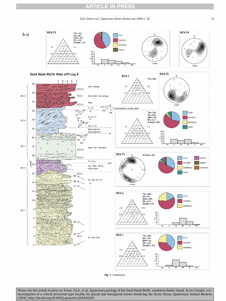
Fig 7 (continued)
DJA Evans et al Quaternary Science Reviews xxx (2014) 1e4214
Please cite this article in press as Evans DJA et al Quaternary geology of the Duck Hawk Bluffs southwest Banks Island Arctic Canada a re-investigation of a critical terrestrial type locality for glacial and interglacial events bordering the Arctic Ocean Quaternary Science Reviews(2014) httpdxdoiorg101016jquascirev201403011
Fig 7 (continued)
DJA Evans et al Quaternary Science Reviews xxx (2014) 1e42 15
Please cite this article in press as Evans DJA et al Quaternary geology of the Duck Hawk Bluffs southwest Banks Island Arctic Canada a re-investigation of a critical terrestrial type locality for glacial and interglacial events bordering the Arctic Ocean Quaternary Science Reviews(2014) httpdxdoiorg101016jquascirev201403011
Fig 7 (continued)
DJA Evans et al Quaternary Science Reviews xxx (2014) 1e4216
Please cite this article in press as Evans DJA et al Quaternary geology of the Duck Hawk Bluffs southwest Banks Island Arctic Canada a re-investigation of a critical terrestrial type locality for glacial and interglacial events bordering the Arctic Ocean Quaternary Science Reviews(2014) httpdxdoiorg101016jquascirev201403011
Fig 7 (continued)
DJA Evans et al Quaternary Science Reviews xxx (2014) 1e42 17
Please cite this article in press as Evans DJA et al Quaternary geology of the Duck Hawk Bluffs southwest Banks Island Arctic Canada a re-investigation of a critical terrestrial type locality for glacial and interglacial events bordering the Arctic Ocean Quaternary Science Reviews(2014) httpdxdoiorg101016jquascirev201403011
Fig 7 (continued)
DJA Evans et al Quaternary Science Reviews xxx (2014) 1e4218
Fig 6a) Clast lithologies vary depending on sample location Amore restricted lithological component (chert quartzite andsandstone) occurs in the deformed contact zone with underlyingLFA 1 and in areas characterized by attenuated gravel lenses Amore varied clast lithology comprising chert and quartz with mi-nor components of sandstone shale granite gabbro and limestoneoccurs towards the middle and in the more diamictic zones (LFA 3)
LFA 4 comprises less than 5 m of sand silt and clay arranged inhorizontal cross-laminae rhythmites climbing ripples or drapedlaminae that locally contain organic detritus The upper and lowercontacts of LFA 4 are commonly characterized by heavily brecciatedclay or contain boudinage and thrust faulted laminae (Fig 12panels a amp c) Some outcrops of LFA 4 also display widespreaddeformation in the form of overfolded bedding and thrust faultsalthough normal faulting and open folding or convolute beddingstructures are also evident (Fig 7c iii inset photo 3) In some sec-tions LFA 4 comprises only a thin (lt2 m thick) bed of brecciatedclay (Fig 7b iv inset photo 4) or laminated sand displaying over-folds and sheath folds The sense of shearing as recorded by thrustfaults is generally towards the SSW but southerly and southwest-erly orientations are also evident Numerous examples of narrowanabranched clastic dykes rise sub-vertically through the thickestoutcrop of the sandy climbing ripple lithofacies (LFA 4 West Log A)and have created offset beds between the blocks within the hostmaterial (Fig 12 panel b) The contact of LFA 4 with LFA 3 (west cliffLog A) is marked by a clast lag Although the association is pre-dominantly heavily deformed the most unaltered and thickest
Please cite this article in press as Evans DJA et al Quaternary geologyinvestigation of a critical terrestrial type locality for glacial and intergla(2014) httpdxdoiorg101016jquascirev201403011
outcrop in West Log A displays climbing ripple drift indicative of apalaeocurrent from the south or southwest (Fig 7b ii)
LFA 5 comprises 5e10 m of tabular sets of horizontally beddedto massive gravel interbedded with horizontally bedded or cross-laminated sand and occasional units of matrix-supported gravel(Fig 13a b) The thickest outcrop displays a general coarsening-upward sequence from well-sorted horizontally bedded granulegravel and sand to matrix-supported and less well sorted hori-zontally bedded cobble to boulder gravel Clast lithologies aredominated by quartzite but contain subsidiary amounts of chertand sandstone with minor limestone LFA 5 differs from LFA 1based on its general coarsening-upward characteristics coarsergrain size and the presence of limestone clasts Clast form datafrom LFA 5 indicate a sub-rounded sample (averageroundness frac14 222 amp 246 RA frac14 8 amp 24 RWR frac14 2 amp 6) withpredominantly blocky shapes (C40 frac14 30 amp 42) and striae visible(lt14 of clasts) Upper and lower contacts are sharp but are locallyinterdigitated or amalgamated with LFA 6 (Fig 7b iv inset photo 5)and LFA 4 (Fig 13d) respectively A heavily deformed discontin-uous bed of siltclay rhythmites occurs between LFA 5 and LFA 6 inWest Log D the base of which has been amalgamated with thegravel at the top of LFA 5 (Fig 13c) Gravel in Easternmost Cliff hasan unclear relationship to the primary sections at DHB to the westThis gravel designated LFA 5a rests uncomformably on LFA 1 andis not capped by LFA 6 as elsewhere (Fig 7e) Furthermore there isno evidence of deformation and palaeocurrents are orientatedtowards the NW
of the Duck Hawk Bluffs southwest Banks Island Arctic Canada a re-cial events bordering the Arctic Ocean Quaternary Science Reviews
Fig 7 (continued)
DJA Evans et al Quaternary Science Reviews xxx (2014) 1e42 19
Please cite this article in press as Evans DJA et al Quaternary geology of the Duck Hawk Bluffs southwest Banks Island Arctic Canada a re-investigation of a critical terrestrial type locality for glacial and interglacial events bordering the Arctic Ocean Quaternary Science Reviews(2014) httpdxdoiorg101016jquascirev201403011
Fig 7 (continued)
DJA Evans et al Quaternary Science Reviews xxx (2014) 1e4220
Please cite this article in press as Evans DJA et al Quaternary geology of the Duck Hawk Bluffs southwest Banks Island Arctic Canada a re-investigation of a critical terrestrial type locality for glacial and interglacial events bordering the Arctic Ocean Quaternary Science Reviews(2014) httpdxdoiorg101016jquascirev201403011
Fig 7 (continued)
DJA Evans et al Quaternary Science Reviews xxx (2014) 1e42 21
Please cite this article in press as Evans DJA et al Quaternary geology of the Duck Hawk Bluffs southwest Banks Island Arctic Canada a re-investigation of a critical terrestrial type locality for glacial and interglacial events bordering the Arctic Ocean Quaternary Science Reviews(2014) httpdxdoiorg101016jquascirev201403011
Fig 7 (continued)
DJA Evans et al Quaternary Science Reviews xxx (2014) 1e4222
Please cite this article in press as Evans DJA et al Quaternary geology of the Duck Hawk Bluffs southwest Banks Island Arctic Canada a re-investigation of a critical terrestrial type locality for glacial and interglacial events bordering the Arctic Ocean Quaternary Science Reviews(2014) httpdxdoiorg101016jquascirev201403011
Fig 7 (continued)
DJA Evans et al Quaternary Science Reviews xxx (2014) 1e42 23
Please cite this article in press as Evans DJA et al Quaternary geology of the Duck Hawk Bluffs southwest Banks Island Arctic Canada a re-investigation of a critical terrestrial type locality for glacial and interglacial events bordering the Arctic Ocean Quaternary Science Reviews(2014) httpdxdoiorg101016jquascirev201403011
Fig 7 (continued)
DJA Evans et al Quaternary Science Reviews xxx (2014) 1e4224
LFA 6 crops out along the length of DHB and varies widely inthickness (1e11 m) displaying the most complex deformationstructures of any of the sediment bodies at DHB It comprises apredominantly heterogeneous diamicton or a meacutelange of discon-tinuous interbeds of massive matrix-supported diamicton matrix-supported gravel and laminated sand silt and clay with localizedattenuated lenses of degraded organics (Fig 7a ivevi 7b i iv 7c iiiii) Three samples of highly compressed and fragmented detritalmaterial displaying poor preservation were collected for identifi-cation Collectively LFA 6 has the appearance of a stratified dia-micton but locally it displays a more massive to pseudo-laminatedcharacter where sand silt and gravel lenses and occasional gravellags occur as thin beds stringers or wisps Some laminated sand siltand clay bodies appear to be rafts within the diamicton (intraclasts)due to their heavily deformed internal bedding and deformedcontacts or attenuated appearance Basal contacts with other lith-ofacies associations are typically erosional or deformed and asso-ciated with fissility boudinage and pseudo-lamination insediments on either side of the contact Basal diamictons can alsodisplay a higher concentration of gravel clasts that locally result in aclast-supported character or even a several metre-thick highlycontorted meacutelange of diamicton and stratified sediment bodies Insome sections the whole of LFA 6 has been complexly deformed toproduce stacked overfolds and thrust faults indicative of shearingtowards the southwest or WSW Clast macrofabrics are onlymoderately clustered (S1 frac14 0456e0637) but indicate stressdirected predominantly towards the SW Clast macrofabricstrengths as quantified by the fabric shape ternary plot (Fig 6a)and themodalityisotropy plot (Fig 6b) are variable and range frombi-modal to multi-modal Overall the macrofabric shapes in theternary graph plot across the spectrums of the glacitectonite andsubglacial traction till envelopes but there is a trend of changing
Please cite this article in press as Evans DJA et al Quaternary geologyinvestigation of a critical terrestrial type locality for glacial and intergla(2014) httpdxdoiorg101016jquascirev201403011
fabric strength vertically through LFA 6 The strongest clusters arefrom the basal diamictic zones (eg CCA F1 amp F3 AB plane data)whereas the weakest are from the top of the association (eg WCAF3 A-axes amp CCA F2 AB planes) where relatively low strain defor-mation indicators (open and recumbent folds) are ubiquitous
Clast lithologies in LFA 6 are dominated by quartz chert andsandstone although one diamict reveals a concentration of sand-stone lithologies at the expense of chert Clast forms similarlyreflect the nature of the sampled materials whereby the gravellysample (CCA 2) was characterized by relatively low C40 (38) andRA (12) values and a high average roundness (256) compared tothe same values for the diamictons of LFA 6 (C40 frac14 50e74RA frac14 38e52 average roundness frac14 174e204) A small number ofclasts (lt10) in LFA 6 were striated
512 Interpretation5121 LFA 1 The thick tabular sequence of well sorted cross-stratified sand and gravel records deposition by a former glaci-fluvial braided river typified by fluctuating discharge (eg Church1972 Boothroyd and Ashley 1975 Miall 1978 1985 1992Marren 2005) The highest discharge is recorded by matrix-supported gravel with boulders indicative of hyperconcentratedflows or a traction carpet (Maizels 1989ab Siegenthaler andHuggenberger 1993 Mulder and Alexander 2001) These areseparated by and vertically give way to lower discharges recordedby planar or trough cross-bedded sand and horizontal to planar ortrough cross-bedded gravel These deposits record aggradation andmigration of gravel bars and sheets and downstream accretionarymacroforms with relatively tightly constrained palaeocurrent in-dicators (Miall 1977 1985 Collinson 1996) The general lack ofscour fills and an overall fining-upward is indicative of an aggradingsystem initially characterized by high magnitudehigh frequency
of the Duck Hawk Bluffs southwest Banks Island Arctic Canada a re-cial events bordering the Arctic Ocean Quaternary Science Reviews
Fig 7 (continued)
DJA Evans et al Quaternary Science Reviews xxx (2014) 1e42 25
Please cite this article in press as Evans DJA et al Quaternary geology of the Duck Hawk Bluffs southwest Banks Island Arctic Canada a re-investigation of a critical terrestrial type locality for glacial and interglacial events bordering the Arctic Ocean Quaternary Science Reviews(2014) httpdxdoiorg101016jquascirev201403011
Fig 7 (continued)
DJA Evans et al Quaternary Science Reviews xxx (2014) 1e4226
Please cite this article in press as Evans DJA et al Quaternary geology of the Duck Hawk Bluffs southwest Banks Island Arctic Canada a re-investigation of a critical terrestrial type locality for glacial and interglacial events bordering the Arctic Ocean Quaternary Science Reviews(2014) httpdxdoiorg101016jquascirev201403011
DJA Evans et al Quaternary Science Reviews xxx (2014) 1e42 27
events that were gradually replaced by low magnitudehigh fre-quency events (Marren 2005) Partially to heavily-scoured rem-nants of laminated and massive fines represent deposition duringlow flow conditions in abandoned shallow channels The palae-ocurrent data from LFA 1 indicate that the outwash streams wereflowing westerly away from a glacier source located in AmundsenGulf This glacier likely eroded the abundant LFA 1 lithologies(chert quartzite and sandstone) from Mesoproterozoic and Neo-proterozoic bedrock widely distributed to the east and south(western Victoria Island Amundsen Gulf and the adjacent main-land Harrison et al 2013) These lithologies are consistent with theadvance of the NW Laurentide Ice Sheet through Amundsen Gulf(cf Dyke et al 2002 Batchelor et al 2012 MacLean et al 2013)
The crudely bedded organic detritus and degraded tree frag-ments (stumps) in LFA 1 are clearly reworked (cf Matthews et al1986 Fyles 1990 Vincent 1990) The finer grained detritus wasdeposited in concentrated pockets during waning flow stageswhereas horizons of logs and larger tree fragments were emplacedwith the coarser grained and poorly sorted sediments associatedwith hyperconcentrated flows or traction carpets during highdischarge These reworked organics also differ significantly fromthe type location of the Beaufort Fm a characteristic that promptedFyles (1990) to distinguish them as lsquotheMary Sachs Gravelrsquo Notablythe enclosing gravel and sand of LFA 1 is much coarser and exhibitsan entirely different fluvial architecture than the sandier BeaufortFm The composition and degraded nature of the LFA 1 organicssuggests that they were eroded by glaciers or their meltwater fromNeogene andor Paleogene sediments presumably to the southeastof Banks Island (eg Fyles 1990 Fyles et al 1994) The proximity ofa glacier is highlighted by the preservation of striae on individualclasts especially in the very coarse lower gravel The verticaldecrease in striae preservation and angularity (RA) and concomi-tant increase in roundness and upward-fining in LFA 1 is indicativeof an increasingly distal ice margin The co-variance plots (Fig 5)indicate a strong fluvial signature especially in the C40RA data butsubglacial characteristics are also evident particularly in the C40RWR data for the coarser grained and more matrix-supportedgravel as would be expected in ice-proximal settings
It is important to note that the widespread thrusting of LFA 1and underlying Kanguk Formation towards the southwest occurredpost-depositionally This glacitectonic thrusting was produced byLaurentide ice that advanced from the Kellett River valley (interiorBanks Island) during the emplacement of LFA 6 (see below) Theinjection of clastic dykes and fissure fills during this glacitectonicdisturbance was due to the overpressurizing of groundwater ingravel aquifers likely in taliks The branching limbs of many of thedykes are indicative of burst-out structures diagnostic of hydro-fracturing by vertically escaping groundwater pressurized byglacier overriding (cf Rijsdijk et al 1999 Le Heron and Etienne2005)
5122 LFA 2 At the top of LFA 1 rhythmites with lonestonesoverlie prominent clinoforms or foreset beds recording a changefrom subaerial glacifluvial to subaqueous deposition This wasinitially on a shallow delta front prograding foreset beds in asouthwesterly direction followed by suspension sedimentationwith dropstones presumably from floating ice in a marine orlacustrine basin The occurrence of matrix-supported gravelly scourfills with logs and woody detritus suggests pulses of cohesionlesssediment gravity flows into the basin Overlying the rhythmically-bedded sand prominent ice wedge pseudomorphs (up to 4 mdeep Fig 9aec cf Mackay and Burn 2002) are interspersed withthick (gt1m) sections of compressed in situ bryophytes (Figs 9d 7e)indicating the establishment of a tundra surface Four bryophytefamilies and 10 distinct species have been determined from LFA2
Please cite this article in press as Evans DJA et al Quaternary geologyinvestigation of a critical terrestrial type locality for glacial and intergla(2014) httpdxdoiorg101016jquascirev201403011
with the most abundant material from the Calliergonaceae andCampyliaceae (Table 1) These macrofossils are exceptionally wellpreserved including material with intact fragile alar cells typical ofthese two families (Fig 14cef) The data from these autochthonousdeposits indicate a wetland environment characterized as a richfen This ecosystem and habitats therein are consistent with speciesfound in the extant flora of Banks Island (Fig 14b) The autecologyfrom this range of species suggest hydric to mesic habitatsincluding standing pools wet meadows and microhabitats createdby ice wedges Despite the predominance of bryophytes in LFA 2these macrofossils had not been previously documented at DHB Incontrast a minimal proportion of the samples (lt5) consisted ofvascular plant material (including Cyperaceae seeds gramminoidleaves and woody twig fragments) Collectively the ice wedgepseudomorphs and vegetation within LFA 2 represent an isochro-nous terrestrial surface of interglacial rank
Following the formation of ice wedges the injection of intra-formational clastic dykes and fissure fills in LFA 2 relates to theoverpressurizing of groundwater in gravel aquifers or taliks due toglacier overriding The branching dyke limbs that emanate fromunderlying LFA 1 gravels and sands are indicative of the burst-outstructures that develop during hydrofracturing (cf Rijsdijk et al1999 Le Heron and Etienne 2005) A variant of the gravel andsand filled clastic dykes occurs within the sequence of glaci-tectonite and rhythmites near west Log D (Fig 11) Here thevertically-widening fracture is characterized by a mosaic ofpartially disaggregated blocks of the host materials in its widestzone where it contains gravels injected from underlying LFA 1Because these gravels only occur in the basal narrow neck theypresumably record the rapid reduction in flow competence duringhydrofracture filling
Deformation structures including overfolded or crumpledbedding and thrust faults associated with boudinage or highfissilitypseudo-lamination are representative of simple shear andwere also induced by glacitectonic disturbance (cf van derWateren 1995 McCarroll and Rijsdijk 2003) This predominantlyrecords a glacier advance from the northeast Subsidiary shear in-dicators record deformation from the south or southeast but theseoccur only at the top of LFA 2 and the base of LFA 3 suggestingearlier emplacement (see below) The development of zones ofboudinage shallow thrust faults overfolding or bed crumpling atdifferent levels within LFA 2 e especially at the contact separatingsediments of different grain size e represents deformation parti-tioning due to contrasting rheological properties Blind thrustswere also initiated in underlying LFA 1 increasingly towards thecentral and eastern cliffs where large-scale deformation is moreprevalent (Fig 7c d) A zone of intense deformation is recorded by alens of LFA 3 diamicton in fault contact with LFA 2 (east cliff Log AFig 7d i) This constitutes a type B glacitectonite (non-penetrativelydeformed pre-existing sediments sensu Benn and Evans 1996Evans et al 2006) developed during the emplacement of LFA 3(see below) A similar glacitectonite occurs at the junction of LFA 1and LFA 3 near west Log D (Fig 11) Bed attenuation by deformationis best developed in lower LFA 2 where the greater differences insediment grain size and hence rheology exist
5123 LFA 3 Within LFA 3 locally abundant stratified lensesindicate subaqueous deposition These stratified sediments weresubsequently thrust faulted folded and attenuated - most evidentin the upper and lower zones of LFA 3 This deformation was likelyresponsible for the intraclast boudinage and pseudo-lamination inthe surrounding diamicton (eg Hart and Roberts 1994 Robertsand Hart 2005 Oacute Cofaigh et al 2011) This process was alsoassociatedwith the attenuation of LFA 1 and 2 sediments within theheavily deformed base of LFA 3 some of which may have been
of the Duck Hawk Bluffs southwest Banks Island Arctic Canada a re-cial events bordering the Arctic Ocean Quaternary Science Reviews
Fig 8 Details of LFA 1 a) example of a concentration of logs with degraded rootballs in the stacked tabular units of cross-bedded sands and gravels and crudely stratified matrix-supported cobble to boulder gravels in the west cliff b) poorly-sorted and crudely horizontally bedded cobble to boulder gravel containing laminated clay intraclast (immediatelyabove compass) c) shallow locally graded foreset beds composed of openwork to sandy matrix-supported cobble to granule gravels in central cliff Log A d) planar bedded sandy
DJA Evans et al Quaternary Science Reviews xxx (2014) 1e4228
Please cite this article in press as Evans DJA et al Quaternary geology of the Duck Hawk Bluffs southwest Banks Island Arctic Canada a re-investigation of a critical terrestrial type locality for glacial and interglacial events bordering the Arctic Ocean Quaternary Science Reviews(2014) httpdxdoiorg101016jquascirev201403011
DJA Evans et al Quaternary Science Reviews xxx (2014) 1e42 29
cannibalized and rafted by the deformation process within a shearzone at the contact of LFA 3 with older sediments The shearingdirection from the south and southeast recorded in lower LFA 3also impacted upper LFA 2 whereas the more prominent shearingdirection throughout LFA 3 is from the northeast (also recorded inLFA 4) The local development of a heavily deformed zone at the topof LFA 3 was likely imparted during the shearing of overlying LFA 4sediments Although clast macrofabric strengths from the LFA 3diamicton are variable they possess shapes that compare withglacitectonites and subglacial traction tills and in some cases amodalityisotropy signature that reflects high lodgementcomponents
The similar orientation of the macrofabrics and shear indicatorsare considered diagnostic of a glacitectonite derived from stratifiedsediments (eg interbedded mass flow diamictons gravelly massflows and localized traction current sands and suspension de-posits) This evidence indicates that LFA 3 like all the other LFAsand the underlying Kanguk Fm bedrock has been displaced by aglacier advancing from the NNE or NE (ie Laurentide ice crossingthe interior of Banks Island) Minor south to north shearing in-dicates that LFA 3 and upper LFA 2were also disturbed by glacier iceflowing northwards (ie Laurentide ice advancing throughAmundsen Gulf) The appearance of granite and gabbro clastswithin the LFA 3 diamict records the arrival of far-travelled Lau-rentide ice from mainland Canada Clast form co-variance stronglyindicates a subglacial (abraded) source for LFA 3 with a minorfluvial component (Fig 5) including glacifluvial clasts locallycannibalized from LFA 1 by overriding ice
5124 LFA 4 LFA 4 has restricted outcrops is heavily deformedand contains organic detritus that is clearly allochthonous andhighly degraded Nonetheless a variety of indicators (fine-grainedhorizontally bedded cross-laminae rhythmites climbing ripplesand draped laminae) demonstrate that LFA 4 was deposited in asubaqueous environment with palaeocurrents from the south orsouthwest Traction currents were likely responsible for thedevelopment of the clast lag at the contact between lower LFA 4and underlying LFA 3 (west cliff Log A Fig 7b ii) LFA 4 coarsensupwards indicative of basin infilling andor an approaching sedi-ment source The narrow anabranched clastic dykes in the sandyclimbing ripples (LFA 4 west cliff Log A) record hydrofracturing bythe upward injection of overpressurized groundwater duringshearing The branching limbs of the dykes are similar to the burst-out structures reported by Rijsdijk et al (1999) but differ becausethey are composed solely of sand derived from the walls of the hostsediment rather than from an underlying gravel aquifer (cf LeHeron and Etienne 2005) Hence the pressurized water wasgenerated at the contact between the sand and underlying imper-meable brecciated clays The development of thin zones of brecci-ation boudinage sheath folding or thrust faulting at the upper andlower contacts of LFA 4 relates to the localized partitioning ofdeformation controlled by the location of claysilt beds Thejuxtaposition of this style of deformation with the larger scaleoverfolds and thrust faults developed in the extensive bodies ofsandy lithofacies is indicative of a Type B glacitectonite (sensu Bennand Evans 1996) This was constructed by the overriding of glacierice advancing from the north or northeast These shear directionsare compatible with those developed in the underlying LFAs
granule gravels with gravel lags (top and bottom of image) interrupted by an intervening unbedded granule to pebble gravel and massive cobble to pebble gravel A cluster of small treesequence of stacked tabular units of predominantly horizontally bedded sands and gravels ingravels containing clusters of wood detritus in the coarser gravel beds (central cliff Log A)wood fragments (central cliff Log A)
Please cite this article in press as Evans DJA et al Quaternary geologyinvestigation of a critical terrestrial type locality for glacial and intergla(2014) httpdxdoiorg101016jquascirev201403011
5125 LFA 5 The primary characteristics of LFA 5 are typical ofgravel sheet and occasional traction-carpet sedimentation in anice-proximal sandur (eg Boothroyd and Ashley 1975 Miall 19781985 1992 Maizels 1989ab Siegenthaler and Huggenberger1993 Mulder and Alexander 2001 Marren 2005) Glacier prox-imity is supported by the subglacial to fluvial signature of the clastforms (Fig 5) The coarsening-upward sequence including striatedclasts culminates in the arrival of a glacier that overrode the sitedepositing LFA 6 Post-depositional shearing within underlying LFA4 is recorded by attenuation and interdigitation at the contact withLFA 5 imparted during deposition of LFA 6 The contact betweenLFA 5 and 6 reflects the development of a shear zone where upperLFA 5 sediments have been cannibalized producing a meacutelange ofcrudely stratified diamictons with discontinuous interbeds ofmatrix-supported gravel laminated sand silt and clay (LFA 6 seebelow)
5126 LFA5a At Easternmost Cliff glacifluvial gravel (LFA 5a)unconformably overlies LFA 1 (Fig 7e) rendering uncertain itsrelationshipwith respect to LFA 5 in themain sections of DHB to thewest The fact that LFA 5a extends to the modern surface appearsundeformed and has palaeocurrents orientated to the NW requiresthat it is younger than LFA 5 Indeed we interpret LFA 5a asdeglacial outwash deposited from retreating Laurentide ice in theKellett River valley and Amundsen Gulf at the end of the lastglaciation (see Discussion)
5127 LFA 6 Based on its heterogeneity strongly orientated clastmacrofabrics and macroscale deformation structures LFA 6 con-stitutes a Type B glacitectonite (sensu Benn and Evans 1996)However zones of more highly strained Type A glacitectonite(sensu Benn and Evans 1996) at the basal contact with older LFAsare recorded by intraclastinterbed attenuation (pseudo-lamina-tion) strong boudinage or fissility and strengthened clast macro-fabrics The production of this meacutelange is attributed to two separateprocesses 1) primary sedimentation as interbedded and interdig-itated mass flow debris fluvial gravel and sand and subaqueoussuspension sediments and 2) cannibalization of underlying strat-ified sediments (LFAs 4 and 5) This produced a continuum of formsranging from low strain fold structures to attenuated rafts to tec-tonic lamination (eg Fig 7) The discontinuous lenses of degradedorganics (black stems and woody twigs gramminoid leaveswhitened rootlets) within LFA 6 are rafts and include seven speciesof bryophytes (Table 1) The material was highly compressed anddifficult to separate into distinct taxa Indeed one of the threesamples analysed was too degraded to recover any taxa Much ofthe material consisted of only fragmented leaves and only theminute taxa had stems with intact leaves The bryophytes thatcharacterize the LFA 6 samples represent hydric (Calliergon sppTomenthypnum nitens) to mesic (Ditrichum flexicaule Dicranum sp)habitats Three species collected from LFA 6 were also present inLFA 2 whereas four others were not found in LFA 2 but are com-mon in the modern flora The poor preservation quality suggeststhat the material has been redeposited from unknown sources andis clearly allochthonous
The predominant shearing direction within LFA 6 records an iceadvance from the interior of Banks Island (NE) This has resulted incomplex folding and thrusting and localized thickening of LFA 6
it of cross-bedded poorly-sorted to openwork cobble to boulder gravel crudely planar-fragments occur at the base of the cobble to boulder gravels at image centre e) middleDHB west cliff Log D f) sequence of fining-upward planar-bedded cobble to sandy fineg) planar cross-bedded sandy granule to pebble gravels with pebble to cobble lags and
of the Duck Hawk Bluffs southwest Banks Island Arctic Canada a re-cial events bordering the Arctic Ocean Quaternary Science Reviews
Fig 9 Details of LFA 2 from the west cliff a) narrow necked ice wedge pseudomorph with upturned marginal bedding in sand silt and clay rhythmites b) wide necked ice wedgepseudomorph c) ice wedge pseudomorph with overturned silt sand and clay rhythmites developed at the top of LFA 2 and sealed by overlying LFA 3 laminated diamicton d)horizontally bedded sand and silt containing well preserved moss macrofossils e) zone of disharmonically folded sandsilt laminae with well preserved moss peat located at thebase of LFA 2
DJA Evans et al Quaternary Science Reviews xxx (2014) 1e4230
Please cite this article in press as Evans DJA et al Quaternary geology of the Duck Hawk Bluffs southwest Banks Island Arctic Canada a re-investigation of a critical terrestrial type locality for glacial and interglacial events bordering the Arctic Ocean Quaternary Science Reviews(2014) httpdxdoiorg101016jquascirev201403011
Fig 10 Details of simple shear structures developed in fine sand and silt laminae at the centre of the thickest outcrop of LFA 2 in west cliff Log B a) overview of large scaleanastomosing shear faults with zones of smaller scale densely spaced anastomosing shears towards the base of the photograph b) details of large scale shear faults separatingzones of variably but predominantly densely spaced shears c) close details of shear zone comprising densely spaced anastomosing fractures d) details of ascending kink zonecross-cutting large scale anastomising shear faults Shearing direction is coming out of the cliff and towards the left in each image
DJA Evans et al Quaternary Science Reviews xxx (2014) 1e42 31
This shearing direction is recorded throughout underlying LFAs 1e4as well as the Kanguk Formation demonstrating deep-seated butpartitioned glacitectonic disturbance imparted during theemplacement of LFA 6 This strain signature was therefore over-printed on the northerlynortheasterly aligned shearing directionrecorded in LFA 3 and upper LFA 2 by the earlier northerly flowingice that deposited LFA 3 One anomalous clast macrofabric(northerly CCA F1) occurs in the basal meacutelange of LFA 6 Howeverthis sample is from an isolated outcrop (Fig 7c i) rendering itsapparent shearing direction equivocal
Please cite this article in press as Evans DJA et al Quaternary geologyinvestigation of a critical terrestrial type locality for glacial and intergla(2014) httpdxdoiorg101016jquascirev201403011
52 Sedimentology and stratigraphy (Mary Sachs Creek cliff)
The cliffs east of Mary Sachs Creek (Figs 2b 3) provides a cross-section through the seaward margin of the coast-parallel SachsMoraine (ldquosection Jrdquo Vincent et al 1983 Vaughan 2014) Weprovide a summary of two logs based on a reconnaissance survey ofthese sediments Log A is closest toMary Sachs Creekwhereas Log Boccursw1 km farther east (Figs 3 15a amp b) The sediments exposedin Log A appear to descend eastward and disappear below themodern beach and therefore are assumed to stratigraphically
of the Duck Hawk Bluffs southwest Banks Island Arctic Canada a re-cial events bordering the Arctic Ocean Quaternary Science Reviews
Fig 11 Details of LFA 2 near west Log D Lower box shows a 1e2 m thick basal zone comprising highly attenuated inter-digitated beds of gravelly to clay-rich diamictons and sandsiltclay rhythmites Upper box shows rhythmites containing diamictic intraclasts with sharp and angular boundaries also visible is the draping and deforming of the rhythmitebedding over and under the intraclasts respectively ldquoTailsrdquo extending from the diamictic intraclasts and thin but discontinuous diamictic beds are also visible in the upper box
DJA Evans et al Quaternary Science Reviews xxx (2014) 1e4232
underlie the sediments of Log B A sand and gravel- bench caps bothlogs at w15 m asl incised into the seaward margin of the SachsMoraine
521 DescriptionLog A contains a sequence of upward-fining highly contorted
cross-stratified sand and fine gravel to rhythmically bedded sandsilt clay with minor pebble gravel and sporadic clots of gravellydiamicton (Fig 15a) An ice wedge was initially developed in thelower cross-stratified sand and fine gravel before they were foldedand thrust faulted The deformed ice wedge pseudomorph is un-conformably overlain by a relatively undisturbed lens of laminatedsilty clay with dropstones interbedded with gravelly diamictonthat contains a bed (10 cm) of sandy black organics containingwood fragments (Fig 15a) This organic material occurs repeatedlyup-section as discontinuous stringers Log A is capped by 1e2 m ofpoorly exposed and heavily cryoturbated gravelly diamicton Thegeneral sense of displacement on shallow reverse faults over-turned bedding and boudinage structures is from the southeast
Log B (12 m) displays a coarsening-upward sequence of hori-zontally bedded sandy granule gravel with occasional silty sandlaminae (Fig 15b iii) that grades to poorly-sorted cobble to bouldergravel and bouldery matrix-supported gravel (Fig 15b ii) This iscapped by laminated to crudely stratified cobbly diamicton that issilt and clay-rich abruptly and conformably overlain by
Please cite this article in press as Evans DJA et al Quaternary geologyinvestigation of a critical terrestrial type locality for glacial and intergla(2014) httpdxdoiorg101016jquascirev201403011
interlaminated silt clay and pebbly silty sand (Fig 15b i) Althoughthe bedding on these units dips towards the NW individuallaminae do not thicken in that direction indicating post-depositional tilting The uppermost part of the log (underlyingthe 15 m bench) contains 2 m of clay-rich massive diamictoninterfingered with the underlying laminated sediments and cobblydiamicton
522 Interpretation
5221 Log A Broadly the sedimentology of log A including thedeformed ice wedge pseudomorph is similar to LFA 2 in DHB (egcentral cliff Log A Fig 7c iii) Prior to glacitectonic disturbance theoverlying organic bed (Fig 15a) was redeposited into a sequence ofsubaqueous siltclay rhythmites containing dropstones and gravellymass flows The highly attenuated shear margins bracketing theorganic bed in Log A demonstrate that it has been displaced as atectonic raft Previous research proposed that the organic beds e
similar to those described in Log A e be assigned to the LastInterglacial (locally called the Cape Collinson Vincent 1982 1983)Because these organic beds are clearly a raft they cannot constitutean iscochronous surface precluding chronostratigraphic signifi-cance (see Discussion) Shearing of the Log A sediments from thesoutheast documents an ice advance from Amundsen Gulf corre-sponding to the earliest of two primary shearing directions recor-ded at DHB (imparted during the emplacement of LFA 3) Therefore
of the Duck Hawk Bluffs southwest Banks Island Arctic Canada a re-cial events bordering the Arctic Ocean Quaternary Science Reviews
Fig 12 Details of LFA 4 in West Log A a) heavily deformed upper contact of LFA 4 comprising sandsiltclay rhythmites displaying well developed boudinage sheath folds andimmature tectonic laminae and an interdigitatedsheared boundary with underlying climbing ripple sands The contact with overlying LFA 6 is marked by an interdigitated zonecontaining rooted and de-rooted folds or rhythmite rafts in a sand gravel and diamicton meacutelange b) narrow anabranched clastic dykes ascending sub-vertically through climbingripple drift and resulting in offset bedding between blocks of host material c) abrupt contact between sheared sands and rhythmites of LFA 4 and overlying sand gravel anddiamicton meacutelange
Fig 13 Details of LFA 5 a) poorly sorted and matrix-supported pebble to cobble gravel b) tabular sequence of horizontally bedded to massive gravel and matrix-supported gravelcontaining a horizon of striated cobbles and boulders c) heavily deformed discontinuous bed of siltclay rhythmites between LFA 5 and LFA 6 in West Log D showing theamalgamation zone with the LFA 5 gravels immediately above the compass d) interdigitateddeformed contact between LFA 5 granule to pebble gravels and underlying LFA 4laminated silts and clays with organic detritus in West Log B
DJA Evans et al Quaternary Science Reviews xxx (2014) 1e42 33
Please cite this article in press as Evans DJA et al Quaternary geology of the Duck Hawk Bluffs southwest Banks Island Arctic Canada a re-investigation of a critical terrestrial type locality for glacial and interglacial events bordering the Arctic Ocean Quaternary Science Reviews(2014) httpdxdoiorg101016jquascirev201403011
Table 1List of bryophytes and vascular plants from LFAs 2 and 6
LFA2 WestCliff Log B
LFA6 CentralCliff Log A
Elevation (m) 185 m asl w45 m aslSample 4e12 1e3 taxa 10 7
Bryophyta (mosses)AmblystegiaceaeAmblystegium serpens (Hedw) Schimp x
CamyliaceaeCampylium polygamum (Schimp) CEO Jensen xCampylium stellatum (Hedw) CEO Jensen x xDrepanocladus aduncus (Hedw) Warnst xDrepanocladus sp xTomentypnum nitens (Hedw) Loeske x
CalliergonaceaeCalliergon giganteum (Schimp) Kindb xCalliergon richardsonii (Mitt) Kindb xthornthornthornthorn xCalliergon sp xWarnstorfia exannulatus (Schimp) Loeske xthornthornthornthorn x
BrachytheciaceaeBrachythecium turgidum (Hartm) Kindb x
MniaceaeCyrtomnium cf hymenophylloides(Hbener) TJ Kop
x
DicranaceaeDicranum sp x
DitrichaceaeDitrichum flexicaule (Schwaumlgr) Hampe x
Tracheophyta (vascular plants)CyperaceaeSeeds (triangular amp flattened) x x
Gramminoid leaf material x xWoody twig fragments x xRootlets x
Fig 14 The moss peat and associated microfossils of LFA 2 a) exposure through lower LFAsouthern Banks Island analogue of a rich tundra fen environment for the bryophyte assemblfrom LFA 2 showing the exceptional preservation of Calliergonaceae and Campyliaceae ma
DJA Evans et al Quaternary Science Reviews xxx (2014) 1e4234
Please cite this article in press as Evans DJA et al Quaternary geologyinvestigation of a critical terrestrial type locality for glacial and intergla(2014) httpdxdoiorg101016jquascirev201403011
these deformed deposits are interpreted as a Type B glacitectonite(sensu Benn and Evans 1996) possibly derived from LFA 2
5222 Log B The coarsening upward gravel in Log B recordshighly turbid to hyperconcentrated discharge in non-channelizedsheets This is interpreted as aggrading glacifluvial outwash froman approaching ice margin The capping sequence of crudelystratified diamicton and laminated sediments records a changefrom glacifluvial to subaqueous sedimentation prior to overridingby a glacier of unknown age that tilted the upper beds Thecoarsening-upward sequence apparent tectonism and cappingdiamict at Log B clearly distinguishes these deposits from those ofLFA 5a (west of Mary Sachs Creek easternmost cliff Fig 3)Furthermore although there is lithological similarity between LogB and LFA 5 throughout DHB the sense of shearing is dissimilar (LFA5 from the NE and Log B from the SE) The simplest explanation forthis difference in shear direction is that LFA 5 (DHB) was displacedby interior ice advancing down the Kellett River whereas Log B wasdisplaced by ice advancing along Amundsen Gulf (Fig 2b)
6 Discussion
61 Large scale glacitectonic structures and stratigraphicarchitecture
The glacitectonic structures identified within the lithofaciesassociations at DHB record two phases of deformation (early NeSand later NEeSW) This deformation together with the DHBstratigraphic architecture (Fig 16) helps to explain both thekinetostratigraphy (sensu Berthelsen1978) and the evolution of thelocal glacial geomorphology The large scale glacitectonic defor-mation is most clearly manifest in the thrust faulting and conjugate
2 at DHB west log B showing the sampling locations for in situ moss peat b) a modernages of LFA 2 c)ef) details of the typical moss peat and associated microfossil materialscrofossils including material with intact fragile alar cells
of the Duck Hawk Bluffs southwest Banks Island Arctic Canada a re-cial events bordering the Arctic Ocean Quaternary Science Reviews
Fig 15 The stratigraphy of Mary Sachs Creek cliff a) photographic compilation log A showing upward-fining highly contorted (i) cross-stratified sands and fine gravels torhythmically bedded sands silts clays and minor pebble gravels Also visible in (ii) is a lens of interbedded laminated silty clays with dropstones and gravelly diamictons containingsandy black coloured organic material with wood fragments An ice wedge pseudomorph is visible (iii) to the right of the exposure b) photographic compilation log B showing i)laminated to crudely stratified cobbly but siltclay-rich diamicton grading into interlaminated silts clays and pebbly silty sands ii) poorly-sorted cobble to boulder gravel andbouldery matrix-supported gravel iii) coarsening-upward sequence of horizontally bedded sandy granule gravels with occasional silty sand laminae iv amp v) pebble to cobble graveland matrix-supported gravel
DJA Evans et al Quaternary Science Reviews xxx (2014) 1e42 35
shear development in the Kanguk Fm bedrock and overlying LFA 1(east cliff Fig 7d ivevi) Here predominantly northeasterly dippingthrust slices have been stacked truncated and overlain by LFA 6during the second and strongest (NEeSW) deformation phase(Fig 16 note bedrock slice within the imbricated stacked sequenceof LFA 1) These structures demonstrate significant compressionand thickening of the stratigraphic sequence including w40 m ofvertical offset within the Kanguk Formation acrossw3 km (Fig 16)Prominent hydrofracture fills in LFAs 1 and 2 record elevatedporewater pressure during this thrusting Smaller scale shear zoneshave also developed in the finer grained interbeds within thrustslabs (Fig 7d vii) indicative of deformation partitioning by strataprone to ductile failure This zone of greatest displacement alsocoincides with the highest topography (Fig 16) Lower angle thrustfaults propagate in a southwesterly direction predominantlythrough LFA 1 but are also developed through LFA 2 in the footwallblock (east cliff Fig 16)
The thrust stacking of bedrock and LFAs 1e5 in east cliff (obliqueto Fig 16) represents the ice-proximal zone of a thrust-blockmorainecomposite ridge constructed by a glacier advancing fromthe northeast (ie the interior of Banks Island) This glacitectonicdeformation propagated southwestward to distal parts of theproglacial stress field as recorded bywell-developed shear zones inthe finer grained sediments of LFAs 2e5 In the more distal westcliff open folds (LFA 2 Fig 16) appear to be the product of a blindthrust within underlying LFA 1 This style of tectonism is typical oflsquopiggyback-style thrustingrsquo wherein steeply inclined thrust blocksat the advancing ice margin propagate new thrusts in the footwall(Fig 16 Park 1983 Mulugeta and Koyi 1987) The angle of thesefootwall thrusts becomes progressively shallower southwestward
Please cite this article in press as Evans DJA et al Quaternary geologyinvestigation of a critical terrestrial type locality for glacial and intergla(2014) httpdxdoiorg101016jquascirev201403011
(ice-distal) in LFA 1e5 where deformation partitioning developedin finer grained lithofacies (Fig 16)
The densely spaced ponds and depressions immediately to thenortheast of DHB (Figs 2b 3) constitute the depression fromwhich the thrust mass was excavated (eg Aber et al 1989Evans and England 1991 van der Wateren 1995) This inter-pretation is consistent with the strong northeast to southwestshear direction in the second phase glacitectonic structures andin LFA 6 clast macrofabrics This indicates that construction ofDHB occurred at the margin of a glacier advancing from thenortheast (ie from Kellett River valley) overtopping DHB anddepositing the LFA 6 glacitectonite The continued advance ofKellett ice coalesced with a glacier in Amundsen Gulf marked bythe interlobate Sachs Moraine containing ice-transported shellsas young as 24 cal ka BP (21020 70 yrs BP UCIAMS-89674)assigning this glaciation to the Late Wisconsin (Vaughan 2014)East of Mary Sachs Creek the deformation of Log B outwash(from the southeast Figs 15 16) likely records overriding by thesame Amundsen Gulf glacier (coeval with LFA 6 Late Wiscon-sinan) During ice retreat when Kellett River and Amundsen Gulfice decoupled DHB was exposed allowing the northwesterly-flowing proglacial outwash (LFA 5a) west of Mary Sachs Creekto extend to the shoreline marking postglacial marine limit atKellett Point (11 m asl Vaughan 2014 Fig 3) Collectively thisreconstruction supports a Late Wisconsinan age for the con-struction of DHB thrust block moraine although its stratigraphyincludes a range of ages A palaeogeographic reconstruction ofevents based upon our interpretation of the sedimentologystratigraphic architecture tectonism and geomorphology is pre-sented in Fig 17
of the Duck Hawk Bluffs southwest Banks Island Arctic Canada a re-cial events bordering the Arctic Ocean Quaternary Science Reviews
Fig 15 (continued)
DJA Evans et al Quaternary Science Reviews xxx (2014) 1e4236
62 Comparison and revision of previous DHB model
DHB was previously interpreted to record horizontally beddedNeogene to Quaternary sediments assigned to preglacial fluvialand multiple glacial and interglacial episodes (Vincent 1982 19831990 Vincent et al 1983 1984 Barendregt et al 1998) A com-posite palaeomagnetic record was also presented for this proposedstratigraphy placing most of this deposition before the BrunhesMatuyama boundary (Fig 1c) However prior to our work detailedstudies had not been undertaken on the sedimentology structuralgeology or stratigraphic architecture of DHB Rather the originalstratigraphy was restricted to a series of composite logs (our Fig 4reproduced from Vincent et al 1983) that notably omitted thepervasive deformation structures including the thrust bedrock ineast cliff (Fig 16)
Please cite this article in press as Evans DJA et al Quaternary geologyinvestigation of a critical terrestrial type locality for glacial and intergla(2014) httpdxdoiorg101016jquascirev201403011
Our reinterpretation dismisses several key elements of theoriginal DHB model outlined below (oldest to youngest) We havedetermined that the lowermost unit (LFA 1) is not preglacial (Fyles1990) but rather is composed of glacial outwash providing theearliest terrestrial evidence for glaciation in the area and containingallochthonous organics (including tree stumps) of unknown prov-enance Because LFA 1 is a glacifluvial braidplain (Fig 17a) it is notpart of the Beaufort Fm (Fyles 1990) even though it containsreworked macrofossils presumably derived from it (eg Craig andFyles 1960 Hills et al 1974 Vincent et al 1983)
Our analysis of LFA 2 indicates that it is also not preglacial norcan it be the Worth Point Fm as previously proposed (cf Vincent1982 1983 1990 Vincent et al 1983 Matthews et al 1986)Indeed the type locality of the Worth Point Fm has been invali-dated because it is now recognized to be an ice-transported and
of the Duck Hawk Bluffs southwest Banks Island Arctic Canada a re-cial events bordering the Arctic Ocean Quaternary Science Reviews
LFA4
Fig16
Stratigrap
hiccross-profi
lerun
ning
westto
easto
fDuc
kHaw
kBluffs
basedup
oninterpolations
betw
eenthemainsectionlogs
andsh
owingthesixLFAstheKan
gukFo
rmationbe
droc
kex
posu
resmajor
structural
features
and
thepo
sition
sof
icewed
geps
eudo
morph
san
dsign
ificant
clasticdy
kesAtthe
easternen
dof
thecross-profi
lethe
sedimen
tsat
theco
reof
MarySa
chsCree
kcliff
logAaretentativelyclassified
asLFA2
althou
ghthesematerialsarelik
ely
notin
situN
otethat
thecross-profi
ledo
esno
tex
tend
asfarea
stas
MarySa
chsCree
kcliff
logB
DJA Evans et al Quaternary Science Reviews xxx (2014) 1e42 37
Please cite this article in press as Evans DJA et al Quaternary geologyinvestigation of a critical terrestrial type locality for glacial and intergla(2014) httpdxdoiorg101016jquascirev201403011
glacitectonized raft (Vaughan et al 2014) In contrast our LFA 2 ischaracterized by an isochronous tundra surface with ice wedgesand intervening shallow ponds andwetmeadows The peat at LFA 2is dominated by bryophytes (gt95 by volume) and yet none ofthese macrofossils had been previously documented The diversein situ bryophyte species record a flora similar to that on BanksIsland today suggesting that LFA 2 warrants an interglacial rankThis conclusion is supported by the limited vascular plant record(five taxa no species indicated Vincent 1990) that also suggest awet meadow environment The absolute age of LFA 2 remains un-known but is apparently older than the BrunhesMatayamaboundary (gt780 ka Fig 18 cf Vincent et al 1984 Barendregt andVincent 1990 Barendregt et al 1998 see below)
LFA 3 in both our model and that of Vincent et al (1983) pro-vides the first direct evidence of ice reaching DHB In the previousmodel this was interpreted as Bernard Till (Banks Glaciation) thatwas bracketed by glacioisostatically induced marine transgressions(pre- and post-Banks seas Vincent 1982 1983) Within basal LFA 3we recognized highly deformed stratified sediment that wasdeposited in a subaqueous environment (deep water Fig 17c) priorto the arrival of overriding ice from the south (recorded by graniteand gabbro erratics Figs 17c 18) We regard LFA 3 to be equivalentto the Banks Glaciation (Vincent 1982 1983 Vincent et al 1983)including its pre- and post-Banks seas represented by the stratifiedsediments that bracket the central diamicton The LFA 3 sedimentsare also reported to be magnetically reversed thereby predatingthe BrunheseMatayama boundary (gt780 ka Fig 18 Vincent et al1984 Barendregt and Vincent 1990 Barendregt et al 1998)
Following the Banks Glaciation (our LFA 3 at DHB) Vincent(1982 1983) and Vincent et al (1983) recognized two in-terglacials (Morgan Bluffs and Cape Collinson) separated by anintervening marine episode This marine episode correspondedwith the glacioisostatic loading of a Laurentide ice margin confinedto the eastern half of Banks Island (Thomsen Glaciation) HoweverLFA 4 contains coarsening-upward subaqueous sedimentation fromthe south or southwest reflecting continued marine regressionfollowing LFA 3 (Fig 17c d) The coarsening-upward sequence ofLFA 4 is supplanted by coarse gravel outwash (LFA 5) supplied by aglacier readvancing from the northeast (Kellett River valley iceFig 17e) Glacier overriding is recorded by LFA 6 glacitectonite thatcaps the DHB thrust-block moraine composed of the entireassemblage of underlying LFAs (Fig 16)
Notably we have not observed any sediments characteristic oftwo interglacial deposits above LFA 3 hence dismiss the presence ofthe Morgan Bluffs and Cape Collinson interglacials at DHB Causseand Vincent (1989) report a U-series date of gt200 ka (UQT-229)from above our LFA 3 but this is almost certainly reworked andlacks chronostratigraphic significance Nor have we observedintervening marine sediments attributable to the Thomsen Glaci-ation (eg lsquoBig Searsquo Vincent 1982 1983 Vincent et al 1983)Rather following the deposition of the subaqueous sediments ofupper LFAs 3 and 4 (post-Banks Glaciation) LFAs 5 and 6 record asingle ice advance reaching DHB from the Kellett River valley(Banks Island interior) that was not reported by Vincent et al(1983) It was instead assumed that after the Banks GlaciationDHB lay distal to any later ice advances The nearest subsequentLaurentide margin to DHB recognized by Vincent et al (1983) wasassigned to the Sachs Moraine (immediately east of DHB) that waspresumed to be of EarlyWisconsin age (Fig 2b) However the SachsMoraine is nowdated to24 cal ka BP (LateWisconsinan Vaughan2014) andwas formed by the coalescence of Amundsen Gulf ice andthe Kellett River ice that deformed DHB (Fig 17) On the east side ofMary Sachs Creek the deposition of the Sachs Moraine coincideswith the deformation (from the southeast) of the underlying Log Boutwash gravel (Figs 3 15b)
of the Duck Hawk Bluffs southwest Banks Island Arctic Canada a re-cial events bordering the Arctic Ocean Quaternary Science Reviews
Fig 17 The palaeogeography of southwest Banks Island based upon interpretations of the principal lithofacies associations and structural architecture recognized at Duck HawkBluffs and the geomorphology of the surrounding terrain See text for detailed explanations
DJA Evans et al Quaternary Science Reviews xxx (2014) 1e4238
Although interglacial deposits were previously reported fromthe cliffs east of Mary Sachs Creek (ie Cape Collinson InterglacialVincent et al 1983) we found no similar evidence Rather the onlydeposit that we observed that may have been construed as inter-glacial sediments occurs in our Log A (Figs 3 15a) Here a darkdiscontinuous band of allochthonous organics (Fig15a) sits severedwithin a heavily tectonized melange (type B glacitectonite) and istherefore clearly a raft Although the absolute ages of the deformedunits east of Mary Sachs Creek (Logs A amp B) remain uncertain theyare apparently normally magnetized (Vincent et al 1984Barendregt and Vincent 1990) Blake (1987) also reports non-finite radiocarbon dates (gt36000 amp 49000 BP GSC-3560 amp 3560-2) obtained on ldquocompressed and deformed black woody peatrdquopurportedly from Cape Collinson beds (Vincent et al 1983 p 1708)Additionally Causse and Vincent (1989) report a U-series date onshells of 924 ka (UQT-143) from beds similar to the Log B gravelAgain all of these dated units have been displaced from unknownlocations limiting their utility for palaeoenvironmental recon-struction The last glacially influenced sedimentation at DHB isrecorded by northwesterly directed outwash (easternmost cliff LFA5a Figs 3 16 17g) We infer that this outwash fed the gravel beachmarking marine limit (11 m asl) in the lower Kellett River duringLate Wisconsinan retreat from the Sachs Moraine
63 Regional context
The stratigraphy at Duck Hawk Bluffs records three glacialevents The earliest of these is recorded by the aggradation of a
Please cite this article in press as Evans DJA et al Quaternary geologyinvestigation of a critical terrestrial type locality for glacial and intergla(2014) httpdxdoiorg101016jquascirev201403011
glacifluvial braidplain (LFA 1) that contains allochthonous pre-glacial material of diverse age However within LFA 1 there is noevidence that the ice reached DHB although it must have beennearby (southeast in Amundsen Gulf) The age of this glaciationremains unknown but the palaeomagnetic polarity of LFA 1 in-dicates that it is gt780 ka BP (Barendregt and Vincent 1990)Although Barendregt et al (1998) assigned part of the Worth PointFm to the normally polarized Olduvai sub-zone (MIS 64e74) itshould be noted that the Worth Point section is located 30 kmnorthwest of DHB There a stratigraphic revision has demonstratedthat this ldquotype sectionrdquo of the Worth Point Fm is in fact a glaci-tectonized raft (Vaughan et al 2014) This observation invalidatesthe previous correlation from Worth Point to purportedly coevalbeds at DHB (our LFA 2) Furthermore the diverse plant assem-blages in the Worth Point raft include preglacial tree stumps andSphagnum spp that do not occur on Banks Island today and are notfound in the wet meadow assemblages (rich fen) of LFA 2 that weinterpret to be of interglacial rank Therefore the sediments at DHB(LFAs 1 amp 2) do not support an age assignment of MIS 64e74(Olduvai subzone) proposed by Barendregt et al (1998) Currentlythe available palaeomagnetic record at DHB simply separates theentire section into a lower lsquoreversedrsquo unit and an upper lsquonormalrsquoone We place this boundary within our LFA 4 (Fig 18)
The overriding of DHB by glaciers is recorded in LFAs 3 amp 6These two glacial deposits may correspond to parts of the record ofstacked till sheets reported from the offshore seismic stratigraphy(Batchelor et al 2012) LFA 3 glaciationmay have contributed to theonset of mid-Pleistocene ice-rafted debris (IRD Ca-rich) attributed
of the Duck Hawk Bluffs southwest Banks Island Arctic Canada a re-cial events bordering the Arctic Ocean Quaternary Science Reviews
B-M
B-M
gt19
Fig
18A
revisedlitho
stratigrap
hyforDuc
kHaw
kBluffsPrev
ious
lyrepo
rted
ageco
nstraintsarealso
depicted
toge
ther
withatentativeallocation
ofMIS
stag
es(positione
dalon
gsideEa
stCliff
LogA
forclarity)
basedup
onthe
palaeo
mag
neticreco
rd
DJA Evans et al Quaternary Science Reviews xxx (2014) 1e42 39
Please cite this article in press as Evans DJA et al Quaternary geology of the Duck Hawk Bluffs southwest Banks Island Arctic Canada a re-investigation of a critical terrestrial type locality for glacial and interglacial events bordering the Arctic Ocean Quaternary Science Reviews(2014) httpdxdoiorg101016jquascirev201403011
DJA Evans et al Quaternary Science Reviews xxx (2014) 1e4240
to the Canadian Arctic Archipelago (CAA) and recorded in sedimentcores from the Arctic Ocean basin (Polyak et al 2009 2013OrsquoRegan et al 2010 Stein et al 2010) However Stein et al(2010) place the onset of Ca-rich ice-rafted debris within MIS 16(w659 ka BP Lisiecki and Raymo 2005) with subsequent peaks atMIS 12 10 and 8 all of which postdate the gt780 ka BP palae-omagnetic age proposed for LFA 3 (above) Polyak et al (2013) placethe onset of Ca-rich ice-rafted debris in the central Arctic Oceancloser to MIS 19 (790 ka BP) which is broadly compatible with theDHB palaeomagnetic record LFA 6 records the last glaciation ofDHB and we assign this to the Late Wisconsinan when Banks Is-land ice (Kellett River) coalesced with the Amundsen Gulf IceStream (Stokes et al 2006 MacLean et al 2013) During this in-terval the northwest Laurentide Ice Sheet likely reached the edgeof the polar continental shelf (Stokes et al 2005 2006 Englandet al 2009 Batchelor et al 2012 Lakeman and England 2013MacLean et al 2013)
7 Conclusions
New sedimentological and stratigraphic analyses of DHB funda-mentally revise the previous reconstruction of the Neogene andQuaternary history of Banks Island DHB and two other widely citedsections on Banks Island have been reported as important unde-formed terrestrial archives of glacial and interglacial sedimentationat the northwest limit of the Laurentide Ice Sheet that all have beenrecently revised (Vaughan et al 2014 Lakeman and England inpress) The recognition of pervasive large-scale deformation ofDHB necessitates a fundamental re-assessment of its previouslydescribed layer-cake stratigraphy We document that the oldestsediments (LFA 1) at DHB are not preglacial fluvial deposits (Beau-fort Fm) but rather record proglacial outwash from ice in AmundsenGulf that did not reach the site This was followed by the estab-lishment of an isochronous tundra surface of interglacial rank (LFA2) characterized by ice wedge polygons within a wet meadow thatsupported a bryophyte community similar to modern Subse-quently glacial sedimentation resumed initially in an ice-proximalsubaqueous environment followed by ice arrival and glacitectonicdeformation (LFA 3) The overlying deposits at DHB indicate post-glacial marine sedimentation (LFA 4) followed by the aggradationof glacifluvial sand and gravel (LFA 5) from an advancing ice marginthat culminated with the emplacement of a glacitectonite (LFA 6)during the Late Wisconsin This ice advance constructed a previ-ously undescribed thrust-block moraine (60 m high 8 km long) thatexhibits pervasive deformation and includes a substantial raft ofCretaceous Kanguk Fm bedrock (Fig 16) Furthermore the produc-tion of the glacitectonite (LFA 6) cannibalized LFAs 1e5 which atsome sites were previously thought to be in situ interglacial de-posits Finally outwash (LFA 5a) incised the DHB thrust block duringdeglaciation of the site when ice in the Kellett River and AmundsenGulf separated and proglacial meltwater drained northwestward tomarine limit (11 m asl) Refinements to the evolution and chronol-ogy of DHB and other sections around Banks Island will furthercontribute to the understanding of high latitude environmentalchange especially the complementary marine archives of theadjacent polar continental shelf and Arctic Ocean
Acknowledgements
Funding for this research was provided by the Natural Sciencesand Engineering Research Council of Canada (NSERC) NorthernResearch Chair Program and a complementary NSERC DiscoveryGrant (A6680) (both to JH England) Coulthard Lakeman andVaughan were supported by CBAR grants Canadian CircumpolarInstitute University of Alberta Coulthard and Lakeman were also
Please cite this article in press as Evans DJA et al Quaternary geologyinvestigation of a critical terrestrial type locality for glacial and intergla(2014) httpdxdoiorg101016jquascirev201403011
supported by Northern Scientific Training Program grantsAboriginal Affairs and Northern Development Canada The PolarContinental Shelf Program Natural Resources Canada(_501100000159) supplied additional funding and aircraft supportField and logistical assistance from Issac Elanik Vernon AmosTrevor Lucas and Roger Kuptana of Sachs Harbour is gratefullyacknowledged
References
Aber JS Croot DG Fenton MM 1989 Glaciotectonic Landforms and StructuresKluwer Dordrecht
Barendregt RW Vincent J-S 1990 Late Cenozoic paleomagnetic record of DuckHawk Bluffs Banks Island Canadian Arctic Archipelago Can J Earth Sci 27124e130
Barendregt RW Duk-Rodkin A 2011 Chronology and extent of Late Cenozoic icesheets in North America a magnetostratigraphical assessment In Ehlers JGibbard PL Hughes PD (Eds) Quaternary Glaciations e Extent and Chro-nolgy a Closer Look Elsevier Amsterdam pp 419e426
Barendregt RW Vincent J-S Irving E Baker J 1998 Magnetostratigraphy ofQuaternary and late Tertiary sediments on Banks Island Canadian Arctic Ar-chipelago Can J Earth Sci 35 147e161
Batchelor CL Dowdeswell JA Pietras JT 2012 Variable history of Quaternaryice-sheet advance across the Beaufort Sea margin Arctic Ocean Geology httpdxdoiorg101130G336691
Batchelor CL Dowdeswell JA Pietras JT 2013 Seismic stratigraphy sedimen-tary architecture and palaeo-glaciology of the Mackenzie Trough evidence fortwo Quaternary ice advances and limited fan development on the westernCanadian Beaufort Sea margin Quat Sci Rev 65 73e87
Benn DI 1994 Fabric shape and the interpretation of sedimentary fabric dataJ Sediment Res 64 910e915
Benn DI 1995 Fabric signature of till deformation Breiethamerkurjoumlkull IcelandSedimentology 42 735e747
Benn DI 2004 Clast morphology In Evans DJA Benn DI (Eds) A PracticalGuide to the Study of Glacial Sediments Arnold London pp 77e92
Benn DI Ballantyne CK 1994 Reconstructing the transport history of glaciogenicsediments a new approach based on the co-variance of clast form indicesSediment Geol 91 215e227
Benn DI Evans DJA 1996 The interpretation and classification of subglaciallydeformed materials Quat Sci Rev 15 23e52
Benn DI Evans DJA Phillips ER Hiemstra JF Walden J Hoey TB 2004 Theresearch project d a case study of Quaternary glacial sediments InEvans DJA Benn DI (Eds) A Practical Guide to the Study of Glacial Sedi-ments Arnold London pp 209e234
Berthelsen A 1978 The methodology of kineto-stratigraphy as applied to glacialgeology Bull Geol Soc Den 27 25e38
Blake Jr W 1987 Geological Survey of Canada Radiocarbon Dates XXVI InGeological Survey of Canada Paper 86-7 60 pp
Boothroyd JC Ashley GM 1975 Processes bar morphology and sedimentarystructures on braided outwash fans northeastern Gulf of Alaska InJopling AV McDonald BC (Eds) Glaciofluvial and Glaciolacustrine Sedi-mentation Society of Economic Paleontologists and Mineralogists SpecialPublication No 23
Causse C Vincent J-S 1989 TheU disequilibrium dating of Middle and LatePleistocene wood and shells from Banks and Victoria islands Arctic CanadaCan J Earth Sci 26 2718e2723
Church MA 1972 Baffin Island sandurs a study of Arctic fluvial processes GeolSurv Can Bull 216 208
Clark DL Vincent J-S Jones GA Morris WA 1984 Corrrelation of marine andcontinental glacial and interglacial events Arctic Ocean and Banks Island Na-ture 311 147e149
Collinson JD 1996 Alluvial sediments In Reading HG (Ed) Sedimentary Envi-ronments and Facies third ed Blackwell Oxford pp 37e82
Craig BG Fyles JG 1960 Pleistocene Geology of Arctic Canada In GeologicalSurvey of Canada Paper 60-10 21 pp
Crosby MR Magill RE Allen B He S 1999 A Checklist of the Mosses MissouriBotanical Garden St Louis 320 pp
Duk-Rodkin A Barendregt RW 2011 Stratigraphical records of glacialsin-terglacials in northwest Canada In Ehlers J Gibbard PL Hughes PD (Eds)Quaternary Glaciations e Extent and Chronology a Closer Look ElsevierAmsterdam pp 661e698
Dyke AS Andrews JT Clark PU England JH Miller GH Shaw J Veillette JJ2002 The Laurentide and Innuitian ice sheets during the Last Glacial MaximumQuat Sci Rev 21 9e31
England JH Furze MFA Doupeacute JP 2009 Revision of the NW Laurentide IceSheet implications for the paleoclimate the northeast extremity of Beringiaand Arctic Ocean sedimentation Quat Sci Rev 28 1573e1596
Evans DJA 2010 Controlled moraine development and debris transport pathwaysin polythermal plateau icefields examples from Tungnafellsjoumlkull IcelandEarth Surf Process Landf 35 1430e1444
of the Duck Hawk Bluffs southwest Banks Island Arctic Canada a re-cial events bordering the Arctic Ocean Quaternary Science Reviews
DJA Evans et al Quaternary Science Reviews xxx (2014) 1e42 41
Evans DJA Benn DI 2004 Facies description and the logging of sedimentaryexposures In Evans DJA Benn DI (Eds) A Practical Guide to the Study ofGlacial Sediments Arnold London pp 11e51
Evans DJA England J 1991 Canadian landform examples 19 high arctic thrustblock moraines Can Geogr 35 93e97
Evans DJA Rea BR Benn DI 1998 Subglacial deformation and bedrockplucking in areas of hard bedrock Glacial Geology and Geomorphology rp041998 httpgggqubacukgggpapersfull1998rp041998rp04html
Evans DJA Hiemstra JF 2005 Till deposition by glacier submarginal incre-mental thickening Earth Surf Process Landf 30 1633e1662
Evans DJA Hiemstra JF Oacute Cofaigh C 2007 An assessment of clast macrofabricsin glaciogenic sediments based on AB plane data Geogr Ann A89 103e120
Evans DJA Phillips ER Hiemstra JF Auton CA 2006 Subglacial till formationsedimentary characteristics and classification Earth Sci Rev 78 115e176
Evans DJA Shulmeister J Hyatt OM 2010 Sedimentology of latero-frontalmoraines and fans on the west coast of South Island New Zealand Quat SciRev 29 3790e3811
Eyles N Eyles CH Miall AD 1983 Lithofacies types and vertical profile modelsan alternative approach to the description and environmental interpretation ofglacial diamicts and diamictite sequences Sedimentology 30 393e410
Fyles JG 1990 Beaufort Formation (late Tertiary) as seen from Prince Patrick Is-land Arctic Canada Arctic 43 393e403
Fyles JG Hills LV Matthews Jr JV Barendregt R Baker J Irving E Jette H1994 Ballast Brook and Beaufort Formations (Late Tertiary) on northern BanksIsland Arctic Canada Quat Int 2223 141e171
Harrison JC Mayr U McNeil DH Sweet AR McIntyre DJ Eberle JJHarington CR Chalmers JA Dam G Nohr-Hansen H 1999 Correlation ofCenozoic sequences of the Canadian Arctic region and Greenland implicationsfor the tectonic history of northern North America Bull Can Pet Geol 47 223e254
Harrison JC Ford A Miall AD Rainbird RH Hulbert LJ Chritie RLCampbell FHA 2013 Geology Tectonic Assemblage Map of Aulavik BanksIsland and Northwestern Victoria Island Northwest Territories GeologicalSurvey of Canada Canadian Geoscience Map 35 (preliminary) scale 1500 000httpdxdoiorg104095292833
Hart JK Roberts DH 1994 Criteria to distinguish between subglacial glaciotec-tonic and glaciomarine sedimentation I Deformation styles and sedimen-tology Sediment Geol 91 191e213
Hedenaumls L 1993 A generic revision of the Warnstorfia Calliergon group J Bryol 17447e479
Hedenaumls L 2006 Additional insights into the phylogeny of Calliergon LoeskypnumStraminergon and Warnstorfia (Bryophyta Calliergonaceae) J Hattori Bot Lab100 125e134
Hicock SR Goff JR Lian OB Little EC 1996 On the interpretation of subglacialtill fabric J Sediment Res 66 928e934
Hiemstra JF Evans DJA Oacute Cofaigh C 2007 The role of glaciotectonic rafting andcommunition in the production of subglacial tills examples from SW Irelandand Antarctica Boreas 36 386e399
Hills LV 1975 Late Tertiary floras Arctic Canada an interpretation In Proceedingsof Circumpolar Conference on Northern Ecology National Research Council ofCanada pp I(65)eI(71)
Hills LV Klovan JE Sweet AR 1974 Juglans eocineria n Beaufort Formation(Tertiary) southwestern Banks Island Arctic Canada Can J Bot 52 65e90
Janssens JAP 1983 Quaternary fossil bryophytes in North America new recordsLindbergia 9 137e151
Kuc M 1974 Calliergon aftonianum Steere in Late Tertiary and Pleistocene Depositsof Canada In Geological Survey of Canada Paper 74e24
Kuc M Hills LV 1971 Fossil mosses Beaufort Formation (Tertiary) NorthwesternBanks Island Western Canada Arctic Can J Bot 49 1089e1094
Lakeman TR England JH 2012 Paleoglaciological insights from the age andmorphology of the Jesse moraine belt western Canadian Arctic Quat Sci Rev47 82e100
Lakeman TR England JH 2013 Late Wisconsinan glaciation and postglacialrelative sea-level change on western Banks Island Canadian Arctic ArchipelagoQuat Res 80 99e112
Lakeman TR England JH 2014 Facies and stratigraphic analyses of glacial andinterglacial sediments at Morgan Bluffs Banks Island Canadian Arctic Archi-pelago Boreas httpdxdoiorg101111bor12069 (in press)
Lawton E 1971 Moss Flora of the Pacific Northwest The Hattori Botanical Labo-ratory Ninchen Miyazaki Japan
Le Heron DP Etienne JL 2005 A complex subglacial clastic dyke swarm Sol-heimajoumlkull southern Iceland Sediment Geol 181 25e37
Li G Piper DJW Campbell DC 2011 The Quaternary Lancaster Sound trough-mouth fan NW Baffin Bay J Quat Sci 26 511e522
Lisiecki LE Raymo ME 2005 A Pliocene-Pleistocene stack of 57 globallydistributed benthic d18O records Paleoceanography 20 PA1003 httpdxdoiorg1010292004PA001071
Lukas S Benn DI Boston CM Brook M Coray S Evans DJA Graf A Kellerer-Pirklbauer A Kirkbride MP Krabbendam M Lovell H Machiedo MMills SC Nye K Reinardy BTI Ross FH Signer M 2013 Clast shapeanalysis and clast transport paths in glacial environments a critical review ofmethods and the role of lithology Earth-Sci Rev 121 96e116
Lukas S Coray S Graf A Schluumlchter C 2014 The influence of clast lithology andfluvial reworking on the reliability of clast shape measurements in glacial en-vironments e a case study from a temperate Alpine glacier In Bridgland DR
Please cite this article in press as Evans DJA et al Quaternary geologyinvestigation of a critical terrestrial type locality for glacial and intergla(2014) httpdxdoiorg101016jquascirev201403011
(Ed) Clast Lithological Analysis Technical Guide Quaternary Research Asso-ciation London (in press)
Mackay JR Burn CR 2002 The first 20 years (1978e1979 to 1998e1999) of icewedge growth at the Illisarvik experimental drained lake site western Arcticcoast Canada Can J Earth Sci 39 95e111
MacLean B Blasco S Bennett R Lakeman T Hughes-Clarke J Kuus PPatton E 2013 Marine evidence for a Glacial ice stream in Amundsen GulfCanadian Arctic Archipelago In Canadian Quaternary Association (CANQUA)Meeting August 18e22 2013 Edmonton AB Canada
Maizels JK 1989a Sedimentology palaeoflow dynamics and flood history ofjokulhlaup deposits palaeohydrology of Holocene sediment sequences insouthern Iceland sandur deposits J Sediment Petrol 59 204e223
Maizels JK 1989b Sedimentology and palaeohydrology of Holocene flood depositsin front of a jokulhlaup glacier south Iceland In Bevan K Carling PJ (Eds)Floods the Geomorphological Hydrological and Sedimentological Conse-quences Wiley New York pp 239e251
Marren PM 2005 Magnitude and frequency in proglacial rivers a geomorpho-logical and sedimentological perspective Earth-Sci Rev 70 203e251
Matthews JV 1987 Plant macrofossils from the Neogene Beaufort Formation onBanks and Meighen islands District of Franklin In Current Research Part AGeological Survey of Canada Paper 87-1A pp 73e87
Matthews Jr JV Ovenden LE 1990 Late Tertiary plant macrofossils from local-ities in ArcticSubarctic North America a review of the data Arctic 43 364e392
Matthews JV Mott RJ Vincent J-S 1986 Preglacial and interglacial environ-ments of Banks Island pollen and macrofossils from Duck Hawk Bluffs andrelated sites Geogr Phys Quat XL 279e298
McCarroll D Rijsdijk KF 2003 Deformation styles as a key for interpreting glacialdepositional environments J Quat Sci 18 473e489
Miall AD 1977 A review of the braided river depositional environment Earth-SciRev 13 1e62
Miall AD 1978 Lithofacies types and vertical profile models in braided river de-posits a summary In Miall AD (Ed) Fluvial Sedimentology Canadian Societyof Petroleum Geologists Memoir 5 pp 597e604
Miall AD 1985 Architectural-element analysis a new method of facies analysisapplied to fluvial deposits Earth Sci Rev 22 261e308
Miall AD 1992 Alluvial deposits In Walker RG James NP (Eds) Facies ModelsResponse to Sea-level Change Geological Association of Canada Torontopp 119e142
Mulder T Alexander J 2001 The physical character of subaqueous sedimentarydensity flows and their deposits Sedimentology 48 269e299
Mulugeta G Koyi H 1987 Three-dimensional geometry and kinematics ofexperimental piggyback thrusting Geology 15 1052e1056
Nyholm E 1956e1965 Illustrated Moss Flora of Fennoscandia II Musci Fasc 1-6Lund pp 1e788
Oacute Cofaigh C Evans DJA Hiemstra JF 2011 Formation of a stratified subglacial lsquotillrsquoassemblage by ice-marginal thrusting and glacier overriding Boreas 40 1e14
OrsquoRegan M St John K Moran K Backman J King J Haley BA Jakobsson MFrank M Roumlhl U 2010 Plio-Pleistocene trends in ice rafted debris on theLomonosov Ridge Quat Int 219 168e176
OrsquoRegan M Williams CJ Frey KE Jakobsson M 2011 A synthesis of the long-term paleoclimatic evolution of the Arctic Oceanography 24 66e80
Park RG 1983 Foundations of Structural Geology Blackie LondonPolyak L Bischof J Ortiz JD Darby DA Channell JET Xuan C Kaufman DS
Loslashvlie R Schneider DA Eberl DD Adler RE Council EA 2009 LateQuaternary stratigraphy and sedimentation patterns in the western ArcticOcean Glob Planet Change 68 5e17
Polyak L Best KM Crawford KA Council EA St-Onge G 2013 Quaternaryhistory of sea ice in the western Arctic Ocean based on foraminifera Quat SciRev 79 145e156
Rijsdijk KF Owen G Warren WP 1999 Clastic dykes in overconsolidated tillsevidence for subglacial hydrofracturing at Killiney Bay eastern Ireland Sedi-ment Geol 129 111e126
Roberts DH Hart JK 2005 The deforming bed characteristics of a stratified tillassemblage in north east Anglia UK investigating controls on sedimentrheology and strain signatures Quat Sci Rev 24 123e140
Roy SK Hills LV 1972 Fossil woods from the Beaufort Formation (Tertiary)northwestern Banks Island Canada Can J Bot 50 2637e2648
Siegenthaler C Huggenberger P 1993 Pleistocene Rhine gravel deposits of abraided river systemwith dominant pool preservation In Best JL Bristow CS(Eds) Braided Rivers Geological Society London Special Publication 75pp 147e162
Spedding N Evans DJA 2002 Sediments and landforms at Kviacuteaacuterjoumlkull southeastIceland a reappraisal of the glaciated valley landsystem Sediment Geol 14921e42
Steere WC 1978 The Mosses of Arctic Alaska In Bryophytorum Bibliotheca vol14 J Cramer Lehre Germany 507 pp
Steere WC Scotter GW 1979 Bryophytes of Banks Island Northwest TerritoriesCanada Can J Bot 57 1136e1149
Stein R Matthiessen J Niessen F Krylov R Nam S Bazhenova E 2010 Towardsa better (litho-) stratigraphy and reconstruction of Quaternary palaeoenviron-ment in the Amerasian Basin (Arctic Ocean) Polarforschung 79 97e121
Stokes CR Clark CD Darby DA Hodgson DA 2005 Late Pleistocene ice exportevents into the Arctic Ocean from the MrsquoClure Strait Ice Stream Canadian ArcticArchipelago Glob Planet Change 49 139e162
of the Duck Hawk Bluffs southwest Banks Island Arctic Canada a re-cial events bordering the Arctic Ocean Quaternary Science Reviews
DJA Evans et al Quaternary Science Reviews xxx (2014) 1e4242
Stokes CR Clark C Winsborrow M 2006 Subglacial bedform evidence for amajor palaeo-ice stream in Amundsen Gulf and its retreat phases CanadianArctic Archipelago J Quat Sci 21 300e412
van der Wateren DFM 1995 Processes of glaciotectonism In Menzies J (Ed)Glacial Environments Modern Glacial Environments Processes Dynamics andSediments vol 1 Butterworth-Heinemann Oxford pp 309e335
Vaughan J 2014 The Glacial and Sea Level History of South Banks Island NT(Unpublished PhD thesis) University of Alberta Edmonton
Vaughan J England J Evans DJA 2014 Glaciotectonic deformation and rein-terpretation of the Worth Point stratigraphic sequence Banks Island NT Can-ada Quat Sci Rev httpdxdoiorg101016jquascirev201311005
Vincent J-S 1982 The Quaternary history of Banks Island Northwest TerritoriesCanada Geogr Phys Quat 36 209e232
Please cite this article in press as Evans DJA et al Quaternary geologyinvestigation of a critical terrestrial type locality for glacial and intergla(2014) httpdxdoiorg101016jquascirev201403011
Vincent J-S 1983 La geologie du quaternaire et la geomorpholie de Lrsquoile Banksarctique Canadien Geological Survey of Canada Memoir 405
Vincent J-S 1984 Quaternary stratigraphy of the western Canadian Arctic Archi-pelago In Fulton RJ (Ed) Quaternary Stratigraphy of Canada e a CanadianContribution to IGCP Project 24 Geological Survey of Canada Paper 84-10pp 87e100
Vincent J-S 1990 Late Tertiary and Early Pleistocene deposits and history of BanksIsland southwestern Canadian Arctic Archipelago Arctic 43 339e363
Vincent J-S Occhietti S Rutter N Lortie G Guilbault J-P De Boutray B 1983The Late TertiaryeQuaternary record of the Duck Hawk Bluffs Banks IslandCanadian Arctic Archipelago Can J Earth Sci 20 1694e1712
Vincent J-S Morris WA Occhietti S 1984 Glacial and non-glacial sediments ofMatuyama paleomagnetic age on Banks Island Canadian Arctic ArchipelagoGeology 12 139e142
of the Duck Hawk Bluffs southwest Banks Island Arctic Canada a re-cial events bordering the Arctic Ocean Quaternary Science Reviews
- Quaternary geology of the Duck Hawk Bluffs southwest Banks Island Arctic Canada a re-investigation of a critical terrest
-
- 1 Introduction
- 2 Study area and previous research
- 3 Methods
- 4 Organics
- 5 Results
-
- 51 Sedimentology and stratigraphy (Duck Hawk Bluffs)
-
- 511 Description
- 512 Interpretation
-
- 5121 LFA 1
- 5122 LFA 2
- 5123 LFA 3
- 5124 LFA 4
- 5125 LFA 5
- 5126 LFA5a
- 5127 LFA 6
-
- 52 Sedimentology and stratigraphy (Mary Sachs Creek cliff)
-
- 521 Description
- 522 Interpretation
-
- 5221 Log A
- 5222 Log B
-
- 6 Discussion
-
- 61 Large scale glacitectonic structures and stratigraphic architecture
- 62 Comparison and revision of previous DHB model
- 63 Regional context
-
- 7 Conclusions
- Acknowledgements
- References
-
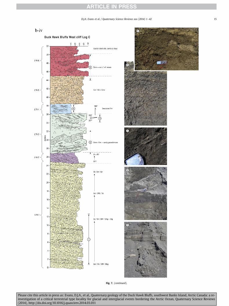
Fig 7 (continued)
DJA Evans et al Quaternary Science Reviews xxx (2014) 1e42 15
Please cite this article in press as Evans DJA et al Quaternary geology of the Duck Hawk Bluffs southwest Banks Island Arctic Canada a re-investigation of a critical terrestrial type locality for glacial and interglacial events bordering the Arctic Ocean Quaternary Science Reviews(2014) httpdxdoiorg101016jquascirev201403011
Fig 7 (continued)
DJA Evans et al Quaternary Science Reviews xxx (2014) 1e4216
Please cite this article in press as Evans DJA et al Quaternary geology of the Duck Hawk Bluffs southwest Banks Island Arctic Canada a re-investigation of a critical terrestrial type locality for glacial and interglacial events bordering the Arctic Ocean Quaternary Science Reviews(2014) httpdxdoiorg101016jquascirev201403011
Fig 7 (continued)
DJA Evans et al Quaternary Science Reviews xxx (2014) 1e42 17
Please cite this article in press as Evans DJA et al Quaternary geology of the Duck Hawk Bluffs southwest Banks Island Arctic Canada a re-investigation of a critical terrestrial type locality for glacial and interglacial events bordering the Arctic Ocean Quaternary Science Reviews(2014) httpdxdoiorg101016jquascirev201403011
Fig 7 (continued)
DJA Evans et al Quaternary Science Reviews xxx (2014) 1e4218
Fig 6a) Clast lithologies vary depending on sample location Amore restricted lithological component (chert quartzite andsandstone) occurs in the deformed contact zone with underlyingLFA 1 and in areas characterized by attenuated gravel lenses Amore varied clast lithology comprising chert and quartz with mi-nor components of sandstone shale granite gabbro and limestoneoccurs towards the middle and in the more diamictic zones (LFA 3)
LFA 4 comprises less than 5 m of sand silt and clay arranged inhorizontal cross-laminae rhythmites climbing ripples or drapedlaminae that locally contain organic detritus The upper and lowercontacts of LFA 4 are commonly characterized by heavily brecciatedclay or contain boudinage and thrust faulted laminae (Fig 12panels a amp c) Some outcrops of LFA 4 also display widespreaddeformation in the form of overfolded bedding and thrust faultsalthough normal faulting and open folding or convolute beddingstructures are also evident (Fig 7c iii inset photo 3) In some sec-tions LFA 4 comprises only a thin (lt2 m thick) bed of brecciatedclay (Fig 7b iv inset photo 4) or laminated sand displaying over-folds and sheath folds The sense of shearing as recorded by thrustfaults is generally towards the SSW but southerly and southwest-erly orientations are also evident Numerous examples of narrowanabranched clastic dykes rise sub-vertically through the thickestoutcrop of the sandy climbing ripple lithofacies (LFA 4 West Log A)and have created offset beds between the blocks within the hostmaterial (Fig 12 panel b) The contact of LFA 4 with LFA 3 (west cliffLog A) is marked by a clast lag Although the association is pre-dominantly heavily deformed the most unaltered and thickest
Please cite this article in press as Evans DJA et al Quaternary geologyinvestigation of a critical terrestrial type locality for glacial and intergla(2014) httpdxdoiorg101016jquascirev201403011
outcrop in West Log A displays climbing ripple drift indicative of apalaeocurrent from the south or southwest (Fig 7b ii)
LFA 5 comprises 5e10 m of tabular sets of horizontally beddedto massive gravel interbedded with horizontally bedded or cross-laminated sand and occasional units of matrix-supported gravel(Fig 13a b) The thickest outcrop displays a general coarsening-upward sequence from well-sorted horizontally bedded granulegravel and sand to matrix-supported and less well sorted hori-zontally bedded cobble to boulder gravel Clast lithologies aredominated by quartzite but contain subsidiary amounts of chertand sandstone with minor limestone LFA 5 differs from LFA 1based on its general coarsening-upward characteristics coarsergrain size and the presence of limestone clasts Clast form datafrom LFA 5 indicate a sub-rounded sample (averageroundness frac14 222 amp 246 RA frac14 8 amp 24 RWR frac14 2 amp 6) withpredominantly blocky shapes (C40 frac14 30 amp 42) and striae visible(lt14 of clasts) Upper and lower contacts are sharp but are locallyinterdigitated or amalgamated with LFA 6 (Fig 7b iv inset photo 5)and LFA 4 (Fig 13d) respectively A heavily deformed discontin-uous bed of siltclay rhythmites occurs between LFA 5 and LFA 6 inWest Log D the base of which has been amalgamated with thegravel at the top of LFA 5 (Fig 13c) Gravel in Easternmost Cliff hasan unclear relationship to the primary sections at DHB to the westThis gravel designated LFA 5a rests uncomformably on LFA 1 andis not capped by LFA 6 as elsewhere (Fig 7e) Furthermore there isno evidence of deformation and palaeocurrents are orientatedtowards the NW
of the Duck Hawk Bluffs southwest Banks Island Arctic Canada a re-cial events bordering the Arctic Ocean Quaternary Science Reviews
Fig 7 (continued)
DJA Evans et al Quaternary Science Reviews xxx (2014) 1e42 19
Please cite this article in press as Evans DJA et al Quaternary geology of the Duck Hawk Bluffs southwest Banks Island Arctic Canada a re-investigation of a critical terrestrial type locality for glacial and interglacial events bordering the Arctic Ocean Quaternary Science Reviews(2014) httpdxdoiorg101016jquascirev201403011
Fig 7 (continued)
DJA Evans et al Quaternary Science Reviews xxx (2014) 1e4220
Please cite this article in press as Evans DJA et al Quaternary geology of the Duck Hawk Bluffs southwest Banks Island Arctic Canada a re-investigation of a critical terrestrial type locality for glacial and interglacial events bordering the Arctic Ocean Quaternary Science Reviews(2014) httpdxdoiorg101016jquascirev201403011
Fig 7 (continued)
DJA Evans et al Quaternary Science Reviews xxx (2014) 1e42 21
Please cite this article in press as Evans DJA et al Quaternary geology of the Duck Hawk Bluffs southwest Banks Island Arctic Canada a re-investigation of a critical terrestrial type locality for glacial and interglacial events bordering the Arctic Ocean Quaternary Science Reviews(2014) httpdxdoiorg101016jquascirev201403011
Fig 7 (continued)
DJA Evans et al Quaternary Science Reviews xxx (2014) 1e4222
Please cite this article in press as Evans DJA et al Quaternary geology of the Duck Hawk Bluffs southwest Banks Island Arctic Canada a re-investigation of a critical terrestrial type locality for glacial and interglacial events bordering the Arctic Ocean Quaternary Science Reviews(2014) httpdxdoiorg101016jquascirev201403011
Fig 7 (continued)
DJA Evans et al Quaternary Science Reviews xxx (2014) 1e42 23
Please cite this article in press as Evans DJA et al Quaternary geology of the Duck Hawk Bluffs southwest Banks Island Arctic Canada a re-investigation of a critical terrestrial type locality for glacial and interglacial events bordering the Arctic Ocean Quaternary Science Reviews(2014) httpdxdoiorg101016jquascirev201403011
Fig 7 (continued)
DJA Evans et al Quaternary Science Reviews xxx (2014) 1e4224
LFA 6 crops out along the length of DHB and varies widely inthickness (1e11 m) displaying the most complex deformationstructures of any of the sediment bodies at DHB It comprises apredominantly heterogeneous diamicton or a meacutelange of discon-tinuous interbeds of massive matrix-supported diamicton matrix-supported gravel and laminated sand silt and clay with localizedattenuated lenses of degraded organics (Fig 7a ivevi 7b i iv 7c iiiii) Three samples of highly compressed and fragmented detritalmaterial displaying poor preservation were collected for identifi-cation Collectively LFA 6 has the appearance of a stratified dia-micton but locally it displays a more massive to pseudo-laminatedcharacter where sand silt and gravel lenses and occasional gravellags occur as thin beds stringers or wisps Some laminated sand siltand clay bodies appear to be rafts within the diamicton (intraclasts)due to their heavily deformed internal bedding and deformedcontacts or attenuated appearance Basal contacts with other lith-ofacies associations are typically erosional or deformed and asso-ciated with fissility boudinage and pseudo-lamination insediments on either side of the contact Basal diamictons can alsodisplay a higher concentration of gravel clasts that locally result in aclast-supported character or even a several metre-thick highlycontorted meacutelange of diamicton and stratified sediment bodies Insome sections the whole of LFA 6 has been complexly deformed toproduce stacked overfolds and thrust faults indicative of shearingtowards the southwest or WSW Clast macrofabrics are onlymoderately clustered (S1 frac14 0456e0637) but indicate stressdirected predominantly towards the SW Clast macrofabricstrengths as quantified by the fabric shape ternary plot (Fig 6a)and themodalityisotropy plot (Fig 6b) are variable and range frombi-modal to multi-modal Overall the macrofabric shapes in theternary graph plot across the spectrums of the glacitectonite andsubglacial traction till envelopes but there is a trend of changing
Please cite this article in press as Evans DJA et al Quaternary geologyinvestigation of a critical terrestrial type locality for glacial and intergla(2014) httpdxdoiorg101016jquascirev201403011
fabric strength vertically through LFA 6 The strongest clusters arefrom the basal diamictic zones (eg CCA F1 amp F3 AB plane data)whereas the weakest are from the top of the association (eg WCAF3 A-axes amp CCA F2 AB planes) where relatively low strain defor-mation indicators (open and recumbent folds) are ubiquitous
Clast lithologies in LFA 6 are dominated by quartz chert andsandstone although one diamict reveals a concentration of sand-stone lithologies at the expense of chert Clast forms similarlyreflect the nature of the sampled materials whereby the gravellysample (CCA 2) was characterized by relatively low C40 (38) andRA (12) values and a high average roundness (256) compared tothe same values for the diamictons of LFA 6 (C40 frac14 50e74RA frac14 38e52 average roundness frac14 174e204) A small number ofclasts (lt10) in LFA 6 were striated
512 Interpretation5121 LFA 1 The thick tabular sequence of well sorted cross-stratified sand and gravel records deposition by a former glaci-fluvial braided river typified by fluctuating discharge (eg Church1972 Boothroyd and Ashley 1975 Miall 1978 1985 1992Marren 2005) The highest discharge is recorded by matrix-supported gravel with boulders indicative of hyperconcentratedflows or a traction carpet (Maizels 1989ab Siegenthaler andHuggenberger 1993 Mulder and Alexander 2001) These areseparated by and vertically give way to lower discharges recordedby planar or trough cross-bedded sand and horizontal to planar ortrough cross-bedded gravel These deposits record aggradation andmigration of gravel bars and sheets and downstream accretionarymacroforms with relatively tightly constrained palaeocurrent in-dicators (Miall 1977 1985 Collinson 1996) The general lack ofscour fills and an overall fining-upward is indicative of an aggradingsystem initially characterized by high magnitudehigh frequency
of the Duck Hawk Bluffs southwest Banks Island Arctic Canada a re-cial events bordering the Arctic Ocean Quaternary Science Reviews
Fig 7 (continued)
DJA Evans et al Quaternary Science Reviews xxx (2014) 1e42 25
Please cite this article in press as Evans DJA et al Quaternary geology of the Duck Hawk Bluffs southwest Banks Island Arctic Canada a re-investigation of a critical terrestrial type locality for glacial and interglacial events bordering the Arctic Ocean Quaternary Science Reviews(2014) httpdxdoiorg101016jquascirev201403011
Fig 7 (continued)
DJA Evans et al Quaternary Science Reviews xxx (2014) 1e4226
Please cite this article in press as Evans DJA et al Quaternary geology of the Duck Hawk Bluffs southwest Banks Island Arctic Canada a re-investigation of a critical terrestrial type locality for glacial and interglacial events bordering the Arctic Ocean Quaternary Science Reviews(2014) httpdxdoiorg101016jquascirev201403011
DJA Evans et al Quaternary Science Reviews xxx (2014) 1e42 27
events that were gradually replaced by low magnitudehigh fre-quency events (Marren 2005) Partially to heavily-scoured rem-nants of laminated and massive fines represent deposition duringlow flow conditions in abandoned shallow channels The palae-ocurrent data from LFA 1 indicate that the outwash streams wereflowing westerly away from a glacier source located in AmundsenGulf This glacier likely eroded the abundant LFA 1 lithologies(chert quartzite and sandstone) from Mesoproterozoic and Neo-proterozoic bedrock widely distributed to the east and south(western Victoria Island Amundsen Gulf and the adjacent main-land Harrison et al 2013) These lithologies are consistent with theadvance of the NW Laurentide Ice Sheet through Amundsen Gulf(cf Dyke et al 2002 Batchelor et al 2012 MacLean et al 2013)
The crudely bedded organic detritus and degraded tree frag-ments (stumps) in LFA 1 are clearly reworked (cf Matthews et al1986 Fyles 1990 Vincent 1990) The finer grained detritus wasdeposited in concentrated pockets during waning flow stageswhereas horizons of logs and larger tree fragments were emplacedwith the coarser grained and poorly sorted sediments associatedwith hyperconcentrated flows or traction carpets during highdischarge These reworked organics also differ significantly fromthe type location of the Beaufort Fm a characteristic that promptedFyles (1990) to distinguish them as lsquotheMary Sachs Gravelrsquo Notablythe enclosing gravel and sand of LFA 1 is much coarser and exhibitsan entirely different fluvial architecture than the sandier BeaufortFm The composition and degraded nature of the LFA 1 organicssuggests that they were eroded by glaciers or their meltwater fromNeogene andor Paleogene sediments presumably to the southeastof Banks Island (eg Fyles 1990 Fyles et al 1994) The proximity ofa glacier is highlighted by the preservation of striae on individualclasts especially in the very coarse lower gravel The verticaldecrease in striae preservation and angularity (RA) and concomi-tant increase in roundness and upward-fining in LFA 1 is indicativeof an increasingly distal ice margin The co-variance plots (Fig 5)indicate a strong fluvial signature especially in the C40RA data butsubglacial characteristics are also evident particularly in the C40RWR data for the coarser grained and more matrix-supportedgravel as would be expected in ice-proximal settings
It is important to note that the widespread thrusting of LFA 1and underlying Kanguk Formation towards the southwest occurredpost-depositionally This glacitectonic thrusting was produced byLaurentide ice that advanced from the Kellett River valley (interiorBanks Island) during the emplacement of LFA 6 (see below) Theinjection of clastic dykes and fissure fills during this glacitectonicdisturbance was due to the overpressurizing of groundwater ingravel aquifers likely in taliks The branching limbs of many of thedykes are indicative of burst-out structures diagnostic of hydro-fracturing by vertically escaping groundwater pressurized byglacier overriding (cf Rijsdijk et al 1999 Le Heron and Etienne2005)
5122 LFA 2 At the top of LFA 1 rhythmites with lonestonesoverlie prominent clinoforms or foreset beds recording a changefrom subaerial glacifluvial to subaqueous deposition This wasinitially on a shallow delta front prograding foreset beds in asouthwesterly direction followed by suspension sedimentationwith dropstones presumably from floating ice in a marine orlacustrine basin The occurrence of matrix-supported gravelly scourfills with logs and woody detritus suggests pulses of cohesionlesssediment gravity flows into the basin Overlying the rhythmically-bedded sand prominent ice wedge pseudomorphs (up to 4 mdeep Fig 9aec cf Mackay and Burn 2002) are interspersed withthick (gt1m) sections of compressed in situ bryophytes (Figs 9d 7e)indicating the establishment of a tundra surface Four bryophytefamilies and 10 distinct species have been determined from LFA2
Please cite this article in press as Evans DJA et al Quaternary geologyinvestigation of a critical terrestrial type locality for glacial and intergla(2014) httpdxdoiorg101016jquascirev201403011
with the most abundant material from the Calliergonaceae andCampyliaceae (Table 1) These macrofossils are exceptionally wellpreserved including material with intact fragile alar cells typical ofthese two families (Fig 14cef) The data from these autochthonousdeposits indicate a wetland environment characterized as a richfen This ecosystem and habitats therein are consistent with speciesfound in the extant flora of Banks Island (Fig 14b) The autecologyfrom this range of species suggest hydric to mesic habitatsincluding standing pools wet meadows and microhabitats createdby ice wedges Despite the predominance of bryophytes in LFA 2these macrofossils had not been previously documented at DHB Incontrast a minimal proportion of the samples (lt5) consisted ofvascular plant material (including Cyperaceae seeds gramminoidleaves and woody twig fragments) Collectively the ice wedgepseudomorphs and vegetation within LFA 2 represent an isochro-nous terrestrial surface of interglacial rank
Following the formation of ice wedges the injection of intra-formational clastic dykes and fissure fills in LFA 2 relates to theoverpressurizing of groundwater in gravel aquifers or taliks due toglacier overriding The branching dyke limbs that emanate fromunderlying LFA 1 gravels and sands are indicative of the burst-outstructures that develop during hydrofracturing (cf Rijsdijk et al1999 Le Heron and Etienne 2005) A variant of the gravel andsand filled clastic dykes occurs within the sequence of glaci-tectonite and rhythmites near west Log D (Fig 11) Here thevertically-widening fracture is characterized by a mosaic ofpartially disaggregated blocks of the host materials in its widestzone where it contains gravels injected from underlying LFA 1Because these gravels only occur in the basal narrow neck theypresumably record the rapid reduction in flow competence duringhydrofracture filling
Deformation structures including overfolded or crumpledbedding and thrust faults associated with boudinage or highfissilitypseudo-lamination are representative of simple shear andwere also induced by glacitectonic disturbance (cf van derWateren 1995 McCarroll and Rijsdijk 2003) This predominantlyrecords a glacier advance from the northeast Subsidiary shear in-dicators record deformation from the south or southeast but theseoccur only at the top of LFA 2 and the base of LFA 3 suggestingearlier emplacement (see below) The development of zones ofboudinage shallow thrust faults overfolding or bed crumpling atdifferent levels within LFA 2 e especially at the contact separatingsediments of different grain size e represents deformation parti-tioning due to contrasting rheological properties Blind thrustswere also initiated in underlying LFA 1 increasingly towards thecentral and eastern cliffs where large-scale deformation is moreprevalent (Fig 7c d) A zone of intense deformation is recorded by alens of LFA 3 diamicton in fault contact with LFA 2 (east cliff Log AFig 7d i) This constitutes a type B glacitectonite (non-penetrativelydeformed pre-existing sediments sensu Benn and Evans 1996Evans et al 2006) developed during the emplacement of LFA 3(see below) A similar glacitectonite occurs at the junction of LFA 1and LFA 3 near west Log D (Fig 11) Bed attenuation by deformationis best developed in lower LFA 2 where the greater differences insediment grain size and hence rheology exist
5123 LFA 3 Within LFA 3 locally abundant stratified lensesindicate subaqueous deposition These stratified sediments weresubsequently thrust faulted folded and attenuated - most evidentin the upper and lower zones of LFA 3 This deformation was likelyresponsible for the intraclast boudinage and pseudo-lamination inthe surrounding diamicton (eg Hart and Roberts 1994 Robertsand Hart 2005 Oacute Cofaigh et al 2011) This process was alsoassociatedwith the attenuation of LFA 1 and 2 sediments within theheavily deformed base of LFA 3 some of which may have been
of the Duck Hawk Bluffs southwest Banks Island Arctic Canada a re-cial events bordering the Arctic Ocean Quaternary Science Reviews
Fig 8 Details of LFA 1 a) example of a concentration of logs with degraded rootballs in the stacked tabular units of cross-bedded sands and gravels and crudely stratified matrix-supported cobble to boulder gravels in the west cliff b) poorly-sorted and crudely horizontally bedded cobble to boulder gravel containing laminated clay intraclast (immediatelyabove compass) c) shallow locally graded foreset beds composed of openwork to sandy matrix-supported cobble to granule gravels in central cliff Log A d) planar bedded sandy
DJA Evans et al Quaternary Science Reviews xxx (2014) 1e4228
Please cite this article in press as Evans DJA et al Quaternary geology of the Duck Hawk Bluffs southwest Banks Island Arctic Canada a re-investigation of a critical terrestrial type locality for glacial and interglacial events bordering the Arctic Ocean Quaternary Science Reviews(2014) httpdxdoiorg101016jquascirev201403011
DJA Evans et al Quaternary Science Reviews xxx (2014) 1e42 29
cannibalized and rafted by the deformation process within a shearzone at the contact of LFA 3 with older sediments The shearingdirection from the south and southeast recorded in lower LFA 3also impacted upper LFA 2 whereas the more prominent shearingdirection throughout LFA 3 is from the northeast (also recorded inLFA 4) The local development of a heavily deformed zone at the topof LFA 3 was likely imparted during the shearing of overlying LFA 4sediments Although clast macrofabric strengths from the LFA 3diamicton are variable they possess shapes that compare withglacitectonites and subglacial traction tills and in some cases amodalityisotropy signature that reflects high lodgementcomponents
The similar orientation of the macrofabrics and shear indicatorsare considered diagnostic of a glacitectonite derived from stratifiedsediments (eg interbedded mass flow diamictons gravelly massflows and localized traction current sands and suspension de-posits) This evidence indicates that LFA 3 like all the other LFAsand the underlying Kanguk Fm bedrock has been displaced by aglacier advancing from the NNE or NE (ie Laurentide ice crossingthe interior of Banks Island) Minor south to north shearing in-dicates that LFA 3 and upper LFA 2were also disturbed by glacier iceflowing northwards (ie Laurentide ice advancing throughAmundsen Gulf) The appearance of granite and gabbro clastswithin the LFA 3 diamict records the arrival of far-travelled Lau-rentide ice from mainland Canada Clast form co-variance stronglyindicates a subglacial (abraded) source for LFA 3 with a minorfluvial component (Fig 5) including glacifluvial clasts locallycannibalized from LFA 1 by overriding ice
5124 LFA 4 LFA 4 has restricted outcrops is heavily deformedand contains organic detritus that is clearly allochthonous andhighly degraded Nonetheless a variety of indicators (fine-grainedhorizontally bedded cross-laminae rhythmites climbing ripplesand draped laminae) demonstrate that LFA 4 was deposited in asubaqueous environment with palaeocurrents from the south orsouthwest Traction currents were likely responsible for thedevelopment of the clast lag at the contact between lower LFA 4and underlying LFA 3 (west cliff Log A Fig 7b ii) LFA 4 coarsensupwards indicative of basin infilling andor an approaching sedi-ment source The narrow anabranched clastic dykes in the sandyclimbing ripples (LFA 4 west cliff Log A) record hydrofracturing bythe upward injection of overpressurized groundwater duringshearing The branching limbs of the dykes are similar to the burst-out structures reported by Rijsdijk et al (1999) but differ becausethey are composed solely of sand derived from the walls of the hostsediment rather than from an underlying gravel aquifer (cf LeHeron and Etienne 2005) Hence the pressurized water wasgenerated at the contact between the sand and underlying imper-meable brecciated clays The development of thin zones of brecci-ation boudinage sheath folding or thrust faulting at the upper andlower contacts of LFA 4 relates to the localized partitioning ofdeformation controlled by the location of claysilt beds Thejuxtaposition of this style of deformation with the larger scaleoverfolds and thrust faults developed in the extensive bodies ofsandy lithofacies is indicative of a Type B glacitectonite (sensu Bennand Evans 1996) This was constructed by the overriding of glacierice advancing from the north or northeast These shear directionsare compatible with those developed in the underlying LFAs
granule gravels with gravel lags (top and bottom of image) interrupted by an intervening unbedded granule to pebble gravel and massive cobble to pebble gravel A cluster of small treesequence of stacked tabular units of predominantly horizontally bedded sands and gravels ingravels containing clusters of wood detritus in the coarser gravel beds (central cliff Log A)wood fragments (central cliff Log A)
Please cite this article in press as Evans DJA et al Quaternary geologyinvestigation of a critical terrestrial type locality for glacial and intergla(2014) httpdxdoiorg101016jquascirev201403011
5125 LFA 5 The primary characteristics of LFA 5 are typical ofgravel sheet and occasional traction-carpet sedimentation in anice-proximal sandur (eg Boothroyd and Ashley 1975 Miall 19781985 1992 Maizels 1989ab Siegenthaler and Huggenberger1993 Mulder and Alexander 2001 Marren 2005) Glacier prox-imity is supported by the subglacial to fluvial signature of the clastforms (Fig 5) The coarsening-upward sequence including striatedclasts culminates in the arrival of a glacier that overrode the sitedepositing LFA 6 Post-depositional shearing within underlying LFA4 is recorded by attenuation and interdigitation at the contact withLFA 5 imparted during deposition of LFA 6 The contact betweenLFA 5 and 6 reflects the development of a shear zone where upperLFA 5 sediments have been cannibalized producing a meacutelange ofcrudely stratified diamictons with discontinuous interbeds ofmatrix-supported gravel laminated sand silt and clay (LFA 6 seebelow)
5126 LFA5a At Easternmost Cliff glacifluvial gravel (LFA 5a)unconformably overlies LFA 1 (Fig 7e) rendering uncertain itsrelationshipwith respect to LFA 5 in themain sections of DHB to thewest The fact that LFA 5a extends to the modern surface appearsundeformed and has palaeocurrents orientated to the NW requiresthat it is younger than LFA 5 Indeed we interpret LFA 5a asdeglacial outwash deposited from retreating Laurentide ice in theKellett River valley and Amundsen Gulf at the end of the lastglaciation (see Discussion)
5127 LFA 6 Based on its heterogeneity strongly orientated clastmacrofabrics and macroscale deformation structures LFA 6 con-stitutes a Type B glacitectonite (sensu Benn and Evans 1996)However zones of more highly strained Type A glacitectonite(sensu Benn and Evans 1996) at the basal contact with older LFAsare recorded by intraclastinterbed attenuation (pseudo-lamina-tion) strong boudinage or fissility and strengthened clast macro-fabrics The production of this meacutelange is attributed to two separateprocesses 1) primary sedimentation as interbedded and interdig-itated mass flow debris fluvial gravel and sand and subaqueoussuspension sediments and 2) cannibalization of underlying strat-ified sediments (LFAs 4 and 5) This produced a continuum of formsranging from low strain fold structures to attenuated rafts to tec-tonic lamination (eg Fig 7) The discontinuous lenses of degradedorganics (black stems and woody twigs gramminoid leaveswhitened rootlets) within LFA 6 are rafts and include seven speciesof bryophytes (Table 1) The material was highly compressed anddifficult to separate into distinct taxa Indeed one of the threesamples analysed was too degraded to recover any taxa Much ofthe material consisted of only fragmented leaves and only theminute taxa had stems with intact leaves The bryophytes thatcharacterize the LFA 6 samples represent hydric (Calliergon sppTomenthypnum nitens) to mesic (Ditrichum flexicaule Dicranum sp)habitats Three species collected from LFA 6 were also present inLFA 2 whereas four others were not found in LFA 2 but are com-mon in the modern flora The poor preservation quality suggeststhat the material has been redeposited from unknown sources andis clearly allochthonous
The predominant shearing direction within LFA 6 records an iceadvance from the interior of Banks Island (NE) This has resulted incomplex folding and thrusting and localized thickening of LFA 6
it of cross-bedded poorly-sorted to openwork cobble to boulder gravel crudely planar-fragments occur at the base of the cobble to boulder gravels at image centre e) middleDHB west cliff Log D f) sequence of fining-upward planar-bedded cobble to sandy fineg) planar cross-bedded sandy granule to pebble gravels with pebble to cobble lags and
of the Duck Hawk Bluffs southwest Banks Island Arctic Canada a re-cial events bordering the Arctic Ocean Quaternary Science Reviews
Fig 9 Details of LFA 2 from the west cliff a) narrow necked ice wedge pseudomorph with upturned marginal bedding in sand silt and clay rhythmites b) wide necked ice wedgepseudomorph c) ice wedge pseudomorph with overturned silt sand and clay rhythmites developed at the top of LFA 2 and sealed by overlying LFA 3 laminated diamicton d)horizontally bedded sand and silt containing well preserved moss macrofossils e) zone of disharmonically folded sandsilt laminae with well preserved moss peat located at thebase of LFA 2
DJA Evans et al Quaternary Science Reviews xxx (2014) 1e4230
Please cite this article in press as Evans DJA et al Quaternary geology of the Duck Hawk Bluffs southwest Banks Island Arctic Canada a re-investigation of a critical terrestrial type locality for glacial and interglacial events bordering the Arctic Ocean Quaternary Science Reviews(2014) httpdxdoiorg101016jquascirev201403011
Fig 10 Details of simple shear structures developed in fine sand and silt laminae at the centre of the thickest outcrop of LFA 2 in west cliff Log B a) overview of large scaleanastomosing shear faults with zones of smaller scale densely spaced anastomosing shears towards the base of the photograph b) details of large scale shear faults separatingzones of variably but predominantly densely spaced shears c) close details of shear zone comprising densely spaced anastomosing fractures d) details of ascending kink zonecross-cutting large scale anastomising shear faults Shearing direction is coming out of the cliff and towards the left in each image
DJA Evans et al Quaternary Science Reviews xxx (2014) 1e42 31
This shearing direction is recorded throughout underlying LFAs 1e4as well as the Kanguk Formation demonstrating deep-seated butpartitioned glacitectonic disturbance imparted during theemplacement of LFA 6 This strain signature was therefore over-printed on the northerlynortheasterly aligned shearing directionrecorded in LFA 3 and upper LFA 2 by the earlier northerly flowingice that deposited LFA 3 One anomalous clast macrofabric(northerly CCA F1) occurs in the basal meacutelange of LFA 6 Howeverthis sample is from an isolated outcrop (Fig 7c i) rendering itsapparent shearing direction equivocal
Please cite this article in press as Evans DJA et al Quaternary geologyinvestigation of a critical terrestrial type locality for glacial and intergla(2014) httpdxdoiorg101016jquascirev201403011
52 Sedimentology and stratigraphy (Mary Sachs Creek cliff)
The cliffs east of Mary Sachs Creek (Figs 2b 3) provides a cross-section through the seaward margin of the coast-parallel SachsMoraine (ldquosection Jrdquo Vincent et al 1983 Vaughan 2014) Weprovide a summary of two logs based on a reconnaissance survey ofthese sediments Log A is closest toMary Sachs Creekwhereas Log Boccursw1 km farther east (Figs 3 15a amp b) The sediments exposedin Log A appear to descend eastward and disappear below themodern beach and therefore are assumed to stratigraphically
of the Duck Hawk Bluffs southwest Banks Island Arctic Canada a re-cial events bordering the Arctic Ocean Quaternary Science Reviews
Fig 11 Details of LFA 2 near west Log D Lower box shows a 1e2 m thick basal zone comprising highly attenuated inter-digitated beds of gravelly to clay-rich diamictons and sandsiltclay rhythmites Upper box shows rhythmites containing diamictic intraclasts with sharp and angular boundaries also visible is the draping and deforming of the rhythmitebedding over and under the intraclasts respectively ldquoTailsrdquo extending from the diamictic intraclasts and thin but discontinuous diamictic beds are also visible in the upper box
DJA Evans et al Quaternary Science Reviews xxx (2014) 1e4232
underlie the sediments of Log B A sand and gravel- bench caps bothlogs at w15 m asl incised into the seaward margin of the SachsMoraine
521 DescriptionLog A contains a sequence of upward-fining highly contorted
cross-stratified sand and fine gravel to rhythmically bedded sandsilt clay with minor pebble gravel and sporadic clots of gravellydiamicton (Fig 15a) An ice wedge was initially developed in thelower cross-stratified sand and fine gravel before they were foldedand thrust faulted The deformed ice wedge pseudomorph is un-conformably overlain by a relatively undisturbed lens of laminatedsilty clay with dropstones interbedded with gravelly diamictonthat contains a bed (10 cm) of sandy black organics containingwood fragments (Fig 15a) This organic material occurs repeatedlyup-section as discontinuous stringers Log A is capped by 1e2 m ofpoorly exposed and heavily cryoturbated gravelly diamicton Thegeneral sense of displacement on shallow reverse faults over-turned bedding and boudinage structures is from the southeast
Log B (12 m) displays a coarsening-upward sequence of hori-zontally bedded sandy granule gravel with occasional silty sandlaminae (Fig 15b iii) that grades to poorly-sorted cobble to bouldergravel and bouldery matrix-supported gravel (Fig 15b ii) This iscapped by laminated to crudely stratified cobbly diamicton that issilt and clay-rich abruptly and conformably overlain by
Please cite this article in press as Evans DJA et al Quaternary geologyinvestigation of a critical terrestrial type locality for glacial and intergla(2014) httpdxdoiorg101016jquascirev201403011
interlaminated silt clay and pebbly silty sand (Fig 15b i) Althoughthe bedding on these units dips towards the NW individuallaminae do not thicken in that direction indicating post-depositional tilting The uppermost part of the log (underlyingthe 15 m bench) contains 2 m of clay-rich massive diamictoninterfingered with the underlying laminated sediments and cobblydiamicton
522 Interpretation
5221 Log A Broadly the sedimentology of log A including thedeformed ice wedge pseudomorph is similar to LFA 2 in DHB (egcentral cliff Log A Fig 7c iii) Prior to glacitectonic disturbance theoverlying organic bed (Fig 15a) was redeposited into a sequence ofsubaqueous siltclay rhythmites containing dropstones and gravellymass flows The highly attenuated shear margins bracketing theorganic bed in Log A demonstrate that it has been displaced as atectonic raft Previous research proposed that the organic beds e
similar to those described in Log A e be assigned to the LastInterglacial (locally called the Cape Collinson Vincent 1982 1983)Because these organic beds are clearly a raft they cannot constitutean iscochronous surface precluding chronostratigraphic signifi-cance (see Discussion) Shearing of the Log A sediments from thesoutheast documents an ice advance from Amundsen Gulf corre-sponding to the earliest of two primary shearing directions recor-ded at DHB (imparted during the emplacement of LFA 3) Therefore
of the Duck Hawk Bluffs southwest Banks Island Arctic Canada a re-cial events bordering the Arctic Ocean Quaternary Science Reviews
Fig 12 Details of LFA 4 in West Log A a) heavily deformed upper contact of LFA 4 comprising sandsiltclay rhythmites displaying well developed boudinage sheath folds andimmature tectonic laminae and an interdigitatedsheared boundary with underlying climbing ripple sands The contact with overlying LFA 6 is marked by an interdigitated zonecontaining rooted and de-rooted folds or rhythmite rafts in a sand gravel and diamicton meacutelange b) narrow anabranched clastic dykes ascending sub-vertically through climbingripple drift and resulting in offset bedding between blocks of host material c) abrupt contact between sheared sands and rhythmites of LFA 4 and overlying sand gravel anddiamicton meacutelange
Fig 13 Details of LFA 5 a) poorly sorted and matrix-supported pebble to cobble gravel b) tabular sequence of horizontally bedded to massive gravel and matrix-supported gravelcontaining a horizon of striated cobbles and boulders c) heavily deformed discontinuous bed of siltclay rhythmites between LFA 5 and LFA 6 in West Log D showing theamalgamation zone with the LFA 5 gravels immediately above the compass d) interdigitateddeformed contact between LFA 5 granule to pebble gravels and underlying LFA 4laminated silts and clays with organic detritus in West Log B
DJA Evans et al Quaternary Science Reviews xxx (2014) 1e42 33
Please cite this article in press as Evans DJA et al Quaternary geology of the Duck Hawk Bluffs southwest Banks Island Arctic Canada a re-investigation of a critical terrestrial type locality for glacial and interglacial events bordering the Arctic Ocean Quaternary Science Reviews(2014) httpdxdoiorg101016jquascirev201403011
Table 1List of bryophytes and vascular plants from LFAs 2 and 6
LFA2 WestCliff Log B
LFA6 CentralCliff Log A
Elevation (m) 185 m asl w45 m aslSample 4e12 1e3 taxa 10 7
Bryophyta (mosses)AmblystegiaceaeAmblystegium serpens (Hedw) Schimp x
CamyliaceaeCampylium polygamum (Schimp) CEO Jensen xCampylium stellatum (Hedw) CEO Jensen x xDrepanocladus aduncus (Hedw) Warnst xDrepanocladus sp xTomentypnum nitens (Hedw) Loeske x
CalliergonaceaeCalliergon giganteum (Schimp) Kindb xCalliergon richardsonii (Mitt) Kindb xthornthornthornthorn xCalliergon sp xWarnstorfia exannulatus (Schimp) Loeske xthornthornthornthorn x
BrachytheciaceaeBrachythecium turgidum (Hartm) Kindb x
MniaceaeCyrtomnium cf hymenophylloides(Hbener) TJ Kop
x
DicranaceaeDicranum sp x
DitrichaceaeDitrichum flexicaule (Schwaumlgr) Hampe x
Tracheophyta (vascular plants)CyperaceaeSeeds (triangular amp flattened) x x
Gramminoid leaf material x xWoody twig fragments x xRootlets x
Fig 14 The moss peat and associated microfossils of LFA 2 a) exposure through lower LFAsouthern Banks Island analogue of a rich tundra fen environment for the bryophyte assemblfrom LFA 2 showing the exceptional preservation of Calliergonaceae and Campyliaceae ma
DJA Evans et al Quaternary Science Reviews xxx (2014) 1e4234
Please cite this article in press as Evans DJA et al Quaternary geologyinvestigation of a critical terrestrial type locality for glacial and intergla(2014) httpdxdoiorg101016jquascirev201403011
these deformed deposits are interpreted as a Type B glacitectonite(sensu Benn and Evans 1996) possibly derived from LFA 2
5222 Log B The coarsening upward gravel in Log B recordshighly turbid to hyperconcentrated discharge in non-channelizedsheets This is interpreted as aggrading glacifluvial outwash froman approaching ice margin The capping sequence of crudelystratified diamicton and laminated sediments records a changefrom glacifluvial to subaqueous sedimentation prior to overridingby a glacier of unknown age that tilted the upper beds Thecoarsening-upward sequence apparent tectonism and cappingdiamict at Log B clearly distinguishes these deposits from those ofLFA 5a (west of Mary Sachs Creek easternmost cliff Fig 3)Furthermore although there is lithological similarity between LogB and LFA 5 throughout DHB the sense of shearing is dissimilar (LFA5 from the NE and Log B from the SE) The simplest explanation forthis difference in shear direction is that LFA 5 (DHB) was displacedby interior ice advancing down the Kellett River whereas Log B wasdisplaced by ice advancing along Amundsen Gulf (Fig 2b)
6 Discussion
61 Large scale glacitectonic structures and stratigraphicarchitecture
The glacitectonic structures identified within the lithofaciesassociations at DHB record two phases of deformation (early NeSand later NEeSW) This deformation together with the DHBstratigraphic architecture (Fig 16) helps to explain both thekinetostratigraphy (sensu Berthelsen1978) and the evolution of thelocal glacial geomorphology The large scale glacitectonic defor-mation is most clearly manifest in the thrust faulting and conjugate
2 at DHB west log B showing the sampling locations for in situ moss peat b) a modernages of LFA 2 c)ef) details of the typical moss peat and associated microfossil materialscrofossils including material with intact fragile alar cells
of the Duck Hawk Bluffs southwest Banks Island Arctic Canada a re-cial events bordering the Arctic Ocean Quaternary Science Reviews
Fig 15 The stratigraphy of Mary Sachs Creek cliff a) photographic compilation log A showing upward-fining highly contorted (i) cross-stratified sands and fine gravels torhythmically bedded sands silts clays and minor pebble gravels Also visible in (ii) is a lens of interbedded laminated silty clays with dropstones and gravelly diamictons containingsandy black coloured organic material with wood fragments An ice wedge pseudomorph is visible (iii) to the right of the exposure b) photographic compilation log B showing i)laminated to crudely stratified cobbly but siltclay-rich diamicton grading into interlaminated silts clays and pebbly silty sands ii) poorly-sorted cobble to boulder gravel andbouldery matrix-supported gravel iii) coarsening-upward sequence of horizontally bedded sandy granule gravels with occasional silty sand laminae iv amp v) pebble to cobble graveland matrix-supported gravel
DJA Evans et al Quaternary Science Reviews xxx (2014) 1e42 35
shear development in the Kanguk Fm bedrock and overlying LFA 1(east cliff Fig 7d ivevi) Here predominantly northeasterly dippingthrust slices have been stacked truncated and overlain by LFA 6during the second and strongest (NEeSW) deformation phase(Fig 16 note bedrock slice within the imbricated stacked sequenceof LFA 1) These structures demonstrate significant compressionand thickening of the stratigraphic sequence including w40 m ofvertical offset within the Kanguk Formation acrossw3 km (Fig 16)Prominent hydrofracture fills in LFAs 1 and 2 record elevatedporewater pressure during this thrusting Smaller scale shear zoneshave also developed in the finer grained interbeds within thrustslabs (Fig 7d vii) indicative of deformation partitioning by strataprone to ductile failure This zone of greatest displacement alsocoincides with the highest topography (Fig 16) Lower angle thrustfaults propagate in a southwesterly direction predominantlythrough LFA 1 but are also developed through LFA 2 in the footwallblock (east cliff Fig 16)
The thrust stacking of bedrock and LFAs 1e5 in east cliff (obliqueto Fig 16) represents the ice-proximal zone of a thrust-blockmorainecomposite ridge constructed by a glacier advancing fromthe northeast (ie the interior of Banks Island) This glacitectonicdeformation propagated southwestward to distal parts of theproglacial stress field as recorded bywell-developed shear zones inthe finer grained sediments of LFAs 2e5 In the more distal westcliff open folds (LFA 2 Fig 16) appear to be the product of a blindthrust within underlying LFA 1 This style of tectonism is typical oflsquopiggyback-style thrustingrsquo wherein steeply inclined thrust blocksat the advancing ice margin propagate new thrusts in the footwall(Fig 16 Park 1983 Mulugeta and Koyi 1987) The angle of thesefootwall thrusts becomes progressively shallower southwestward
Please cite this article in press as Evans DJA et al Quaternary geologyinvestigation of a critical terrestrial type locality for glacial and intergla(2014) httpdxdoiorg101016jquascirev201403011
(ice-distal) in LFA 1e5 where deformation partitioning developedin finer grained lithofacies (Fig 16)
The densely spaced ponds and depressions immediately to thenortheast of DHB (Figs 2b 3) constitute the depression fromwhich the thrust mass was excavated (eg Aber et al 1989Evans and England 1991 van der Wateren 1995) This inter-pretation is consistent with the strong northeast to southwestshear direction in the second phase glacitectonic structures andin LFA 6 clast macrofabrics This indicates that construction ofDHB occurred at the margin of a glacier advancing from thenortheast (ie from Kellett River valley) overtopping DHB anddepositing the LFA 6 glacitectonite The continued advance ofKellett ice coalesced with a glacier in Amundsen Gulf marked bythe interlobate Sachs Moraine containing ice-transported shellsas young as 24 cal ka BP (21020 70 yrs BP UCIAMS-89674)assigning this glaciation to the Late Wisconsin (Vaughan 2014)East of Mary Sachs Creek the deformation of Log B outwash(from the southeast Figs 15 16) likely records overriding by thesame Amundsen Gulf glacier (coeval with LFA 6 Late Wiscon-sinan) During ice retreat when Kellett River and Amundsen Gulfice decoupled DHB was exposed allowing the northwesterly-flowing proglacial outwash (LFA 5a) west of Mary Sachs Creekto extend to the shoreline marking postglacial marine limit atKellett Point (11 m asl Vaughan 2014 Fig 3) Collectively thisreconstruction supports a Late Wisconsinan age for the con-struction of DHB thrust block moraine although its stratigraphyincludes a range of ages A palaeogeographic reconstruction ofevents based upon our interpretation of the sedimentologystratigraphic architecture tectonism and geomorphology is pre-sented in Fig 17
of the Duck Hawk Bluffs southwest Banks Island Arctic Canada a re-cial events bordering the Arctic Ocean Quaternary Science Reviews
Fig 15 (continued)
DJA Evans et al Quaternary Science Reviews xxx (2014) 1e4236
62 Comparison and revision of previous DHB model
DHB was previously interpreted to record horizontally beddedNeogene to Quaternary sediments assigned to preglacial fluvialand multiple glacial and interglacial episodes (Vincent 1982 19831990 Vincent et al 1983 1984 Barendregt et al 1998) A com-posite palaeomagnetic record was also presented for this proposedstratigraphy placing most of this deposition before the BrunhesMatuyama boundary (Fig 1c) However prior to our work detailedstudies had not been undertaken on the sedimentology structuralgeology or stratigraphic architecture of DHB Rather the originalstratigraphy was restricted to a series of composite logs (our Fig 4reproduced from Vincent et al 1983) that notably omitted thepervasive deformation structures including the thrust bedrock ineast cliff (Fig 16)
Please cite this article in press as Evans DJA et al Quaternary geologyinvestigation of a critical terrestrial type locality for glacial and intergla(2014) httpdxdoiorg101016jquascirev201403011
Our reinterpretation dismisses several key elements of theoriginal DHB model outlined below (oldest to youngest) We havedetermined that the lowermost unit (LFA 1) is not preglacial (Fyles1990) but rather is composed of glacial outwash providing theearliest terrestrial evidence for glaciation in the area and containingallochthonous organics (including tree stumps) of unknown prov-enance Because LFA 1 is a glacifluvial braidplain (Fig 17a) it is notpart of the Beaufort Fm (Fyles 1990) even though it containsreworked macrofossils presumably derived from it (eg Craig andFyles 1960 Hills et al 1974 Vincent et al 1983)
Our analysis of LFA 2 indicates that it is also not preglacial norcan it be the Worth Point Fm as previously proposed (cf Vincent1982 1983 1990 Vincent et al 1983 Matthews et al 1986)Indeed the type locality of the Worth Point Fm has been invali-dated because it is now recognized to be an ice-transported and
of the Duck Hawk Bluffs southwest Banks Island Arctic Canada a re-cial events bordering the Arctic Ocean Quaternary Science Reviews
LFA4
Fig16
Stratigrap
hiccross-profi
lerun
ning
westto
easto
fDuc
kHaw
kBluffs
basedup
oninterpolations
betw
eenthemainsectionlogs
andsh
owingthesixLFAstheKan
gukFo
rmationbe
droc
kex
posu
resmajor
structural
features
and
thepo
sition
sof
icewed
geps
eudo
morph
san
dsign
ificant
clasticdy
kesAtthe
easternen
dof
thecross-profi
lethe
sedimen
tsat
theco
reof
MarySa
chsCree
kcliff
logAaretentativelyclassified
asLFA2
althou
ghthesematerialsarelik
ely
notin
situN
otethat
thecross-profi
ledo
esno
tex
tend
asfarea
stas
MarySa
chsCree
kcliff
logB
DJA Evans et al Quaternary Science Reviews xxx (2014) 1e42 37
Please cite this article in press as Evans DJA et al Quaternary geologyinvestigation of a critical terrestrial type locality for glacial and intergla(2014) httpdxdoiorg101016jquascirev201403011
glacitectonized raft (Vaughan et al 2014) In contrast our LFA 2 ischaracterized by an isochronous tundra surface with ice wedgesand intervening shallow ponds andwetmeadows The peat at LFA 2is dominated by bryophytes (gt95 by volume) and yet none ofthese macrofossils had been previously documented The diversein situ bryophyte species record a flora similar to that on BanksIsland today suggesting that LFA 2 warrants an interglacial rankThis conclusion is supported by the limited vascular plant record(five taxa no species indicated Vincent 1990) that also suggest awet meadow environment The absolute age of LFA 2 remains un-known but is apparently older than the BrunhesMatayamaboundary (gt780 ka Fig 18 cf Vincent et al 1984 Barendregt andVincent 1990 Barendregt et al 1998 see below)
LFA 3 in both our model and that of Vincent et al (1983) pro-vides the first direct evidence of ice reaching DHB In the previousmodel this was interpreted as Bernard Till (Banks Glaciation) thatwas bracketed by glacioisostatically induced marine transgressions(pre- and post-Banks seas Vincent 1982 1983) Within basal LFA 3we recognized highly deformed stratified sediment that wasdeposited in a subaqueous environment (deep water Fig 17c) priorto the arrival of overriding ice from the south (recorded by graniteand gabbro erratics Figs 17c 18) We regard LFA 3 to be equivalentto the Banks Glaciation (Vincent 1982 1983 Vincent et al 1983)including its pre- and post-Banks seas represented by the stratifiedsediments that bracket the central diamicton The LFA 3 sedimentsare also reported to be magnetically reversed thereby predatingthe BrunheseMatayama boundary (gt780 ka Fig 18 Vincent et al1984 Barendregt and Vincent 1990 Barendregt et al 1998)
Following the Banks Glaciation (our LFA 3 at DHB) Vincent(1982 1983) and Vincent et al (1983) recognized two in-terglacials (Morgan Bluffs and Cape Collinson) separated by anintervening marine episode This marine episode correspondedwith the glacioisostatic loading of a Laurentide ice margin confinedto the eastern half of Banks Island (Thomsen Glaciation) HoweverLFA 4 contains coarsening-upward subaqueous sedimentation fromthe south or southwest reflecting continued marine regressionfollowing LFA 3 (Fig 17c d) The coarsening-upward sequence ofLFA 4 is supplanted by coarse gravel outwash (LFA 5) supplied by aglacier readvancing from the northeast (Kellett River valley iceFig 17e) Glacier overriding is recorded by LFA 6 glacitectonite thatcaps the DHB thrust-block moraine composed of the entireassemblage of underlying LFAs (Fig 16)
Notably we have not observed any sediments characteristic oftwo interglacial deposits above LFA 3 hence dismiss the presence ofthe Morgan Bluffs and Cape Collinson interglacials at DHB Causseand Vincent (1989) report a U-series date of gt200 ka (UQT-229)from above our LFA 3 but this is almost certainly reworked andlacks chronostratigraphic significance Nor have we observedintervening marine sediments attributable to the Thomsen Glaci-ation (eg lsquoBig Searsquo Vincent 1982 1983 Vincent et al 1983)Rather following the deposition of the subaqueous sediments ofupper LFAs 3 and 4 (post-Banks Glaciation) LFAs 5 and 6 record asingle ice advance reaching DHB from the Kellett River valley(Banks Island interior) that was not reported by Vincent et al(1983) It was instead assumed that after the Banks GlaciationDHB lay distal to any later ice advances The nearest subsequentLaurentide margin to DHB recognized by Vincent et al (1983) wasassigned to the Sachs Moraine (immediately east of DHB) that waspresumed to be of EarlyWisconsin age (Fig 2b) However the SachsMoraine is nowdated to24 cal ka BP (LateWisconsinan Vaughan2014) andwas formed by the coalescence of Amundsen Gulf ice andthe Kellett River ice that deformed DHB (Fig 17) On the east side ofMary Sachs Creek the deposition of the Sachs Moraine coincideswith the deformation (from the southeast) of the underlying Log Boutwash gravel (Figs 3 15b)
of the Duck Hawk Bluffs southwest Banks Island Arctic Canada a re-cial events bordering the Arctic Ocean Quaternary Science Reviews
Fig 17 The palaeogeography of southwest Banks Island based upon interpretations of the principal lithofacies associations and structural architecture recognized at Duck HawkBluffs and the geomorphology of the surrounding terrain See text for detailed explanations
DJA Evans et al Quaternary Science Reviews xxx (2014) 1e4238
Although interglacial deposits were previously reported fromthe cliffs east of Mary Sachs Creek (ie Cape Collinson InterglacialVincent et al 1983) we found no similar evidence Rather the onlydeposit that we observed that may have been construed as inter-glacial sediments occurs in our Log A (Figs 3 15a) Here a darkdiscontinuous band of allochthonous organics (Fig15a) sits severedwithin a heavily tectonized melange (type B glacitectonite) and istherefore clearly a raft Although the absolute ages of the deformedunits east of Mary Sachs Creek (Logs A amp B) remain uncertain theyare apparently normally magnetized (Vincent et al 1984Barendregt and Vincent 1990) Blake (1987) also reports non-finite radiocarbon dates (gt36000 amp 49000 BP GSC-3560 amp 3560-2) obtained on ldquocompressed and deformed black woody peatrdquopurportedly from Cape Collinson beds (Vincent et al 1983 p 1708)Additionally Causse and Vincent (1989) report a U-series date onshells of 924 ka (UQT-143) from beds similar to the Log B gravelAgain all of these dated units have been displaced from unknownlocations limiting their utility for palaeoenvironmental recon-struction The last glacially influenced sedimentation at DHB isrecorded by northwesterly directed outwash (easternmost cliff LFA5a Figs 3 16 17g) We infer that this outwash fed the gravel beachmarking marine limit (11 m asl) in the lower Kellett River duringLate Wisconsinan retreat from the Sachs Moraine
63 Regional context
The stratigraphy at Duck Hawk Bluffs records three glacialevents The earliest of these is recorded by the aggradation of a
Please cite this article in press as Evans DJA et al Quaternary geologyinvestigation of a critical terrestrial type locality for glacial and intergla(2014) httpdxdoiorg101016jquascirev201403011
glacifluvial braidplain (LFA 1) that contains allochthonous pre-glacial material of diverse age However within LFA 1 there is noevidence that the ice reached DHB although it must have beennearby (southeast in Amundsen Gulf) The age of this glaciationremains unknown but the palaeomagnetic polarity of LFA 1 in-dicates that it is gt780 ka BP (Barendregt and Vincent 1990)Although Barendregt et al (1998) assigned part of the Worth PointFm to the normally polarized Olduvai sub-zone (MIS 64e74) itshould be noted that the Worth Point section is located 30 kmnorthwest of DHB There a stratigraphic revision has demonstratedthat this ldquotype sectionrdquo of the Worth Point Fm is in fact a glaci-tectonized raft (Vaughan et al 2014) This observation invalidatesthe previous correlation from Worth Point to purportedly coevalbeds at DHB (our LFA 2) Furthermore the diverse plant assem-blages in the Worth Point raft include preglacial tree stumps andSphagnum spp that do not occur on Banks Island today and are notfound in the wet meadow assemblages (rich fen) of LFA 2 that weinterpret to be of interglacial rank Therefore the sediments at DHB(LFAs 1 amp 2) do not support an age assignment of MIS 64e74(Olduvai subzone) proposed by Barendregt et al (1998) Currentlythe available palaeomagnetic record at DHB simply separates theentire section into a lower lsquoreversedrsquo unit and an upper lsquonormalrsquoone We place this boundary within our LFA 4 (Fig 18)
The overriding of DHB by glaciers is recorded in LFAs 3 amp 6These two glacial deposits may correspond to parts of the record ofstacked till sheets reported from the offshore seismic stratigraphy(Batchelor et al 2012) LFA 3 glaciationmay have contributed to theonset of mid-Pleistocene ice-rafted debris (IRD Ca-rich) attributed
of the Duck Hawk Bluffs southwest Banks Island Arctic Canada a re-cial events bordering the Arctic Ocean Quaternary Science Reviews
B-M
B-M
gt19
Fig
18A
revisedlitho
stratigrap
hyforDuc
kHaw
kBluffsPrev
ious
lyrepo
rted
ageco
nstraintsarealso
depicted
toge
ther
withatentativeallocation
ofMIS
stag
es(positione
dalon
gsideEa
stCliff
LogA
forclarity)
basedup
onthe
palaeo
mag
neticreco
rd
DJA Evans et al Quaternary Science Reviews xxx (2014) 1e42 39
Please cite this article in press as Evans DJA et al Quaternary geology of the Duck Hawk Bluffs southwest Banks Island Arctic Canada a re-investigation of a critical terrestrial type locality for glacial and interglacial events bordering the Arctic Ocean Quaternary Science Reviews(2014) httpdxdoiorg101016jquascirev201403011
DJA Evans et al Quaternary Science Reviews xxx (2014) 1e4240
to the Canadian Arctic Archipelago (CAA) and recorded in sedimentcores from the Arctic Ocean basin (Polyak et al 2009 2013OrsquoRegan et al 2010 Stein et al 2010) However Stein et al(2010) place the onset of Ca-rich ice-rafted debris within MIS 16(w659 ka BP Lisiecki and Raymo 2005) with subsequent peaks atMIS 12 10 and 8 all of which postdate the gt780 ka BP palae-omagnetic age proposed for LFA 3 (above) Polyak et al (2013) placethe onset of Ca-rich ice-rafted debris in the central Arctic Oceancloser to MIS 19 (790 ka BP) which is broadly compatible with theDHB palaeomagnetic record LFA 6 records the last glaciation ofDHB and we assign this to the Late Wisconsinan when Banks Is-land ice (Kellett River) coalesced with the Amundsen Gulf IceStream (Stokes et al 2006 MacLean et al 2013) During this in-terval the northwest Laurentide Ice Sheet likely reached the edgeof the polar continental shelf (Stokes et al 2005 2006 Englandet al 2009 Batchelor et al 2012 Lakeman and England 2013MacLean et al 2013)
7 Conclusions
New sedimentological and stratigraphic analyses of DHB funda-mentally revise the previous reconstruction of the Neogene andQuaternary history of Banks Island DHB and two other widely citedsections on Banks Island have been reported as important unde-formed terrestrial archives of glacial and interglacial sedimentationat the northwest limit of the Laurentide Ice Sheet that all have beenrecently revised (Vaughan et al 2014 Lakeman and England inpress) The recognition of pervasive large-scale deformation ofDHB necessitates a fundamental re-assessment of its previouslydescribed layer-cake stratigraphy We document that the oldestsediments (LFA 1) at DHB are not preglacial fluvial deposits (Beau-fort Fm) but rather record proglacial outwash from ice in AmundsenGulf that did not reach the site This was followed by the estab-lishment of an isochronous tundra surface of interglacial rank (LFA2) characterized by ice wedge polygons within a wet meadow thatsupported a bryophyte community similar to modern Subse-quently glacial sedimentation resumed initially in an ice-proximalsubaqueous environment followed by ice arrival and glacitectonicdeformation (LFA 3) The overlying deposits at DHB indicate post-glacial marine sedimentation (LFA 4) followed by the aggradationof glacifluvial sand and gravel (LFA 5) from an advancing ice marginthat culminated with the emplacement of a glacitectonite (LFA 6)during the Late Wisconsin This ice advance constructed a previ-ously undescribed thrust-block moraine (60 m high 8 km long) thatexhibits pervasive deformation and includes a substantial raft ofCretaceous Kanguk Fm bedrock (Fig 16) Furthermore the produc-tion of the glacitectonite (LFA 6) cannibalized LFAs 1e5 which atsome sites were previously thought to be in situ interglacial de-posits Finally outwash (LFA 5a) incised the DHB thrust block duringdeglaciation of the site when ice in the Kellett River and AmundsenGulf separated and proglacial meltwater drained northwestward tomarine limit (11 m asl) Refinements to the evolution and chronol-ogy of DHB and other sections around Banks Island will furthercontribute to the understanding of high latitude environmentalchange especially the complementary marine archives of theadjacent polar continental shelf and Arctic Ocean
Acknowledgements
Funding for this research was provided by the Natural Sciencesand Engineering Research Council of Canada (NSERC) NorthernResearch Chair Program and a complementary NSERC DiscoveryGrant (A6680) (both to JH England) Coulthard Lakeman andVaughan were supported by CBAR grants Canadian CircumpolarInstitute University of Alberta Coulthard and Lakeman were also
Please cite this article in press as Evans DJA et al Quaternary geologyinvestigation of a critical terrestrial type locality for glacial and intergla(2014) httpdxdoiorg101016jquascirev201403011
supported by Northern Scientific Training Program grantsAboriginal Affairs and Northern Development Canada The PolarContinental Shelf Program Natural Resources Canada(_501100000159) supplied additional funding and aircraft supportField and logistical assistance from Issac Elanik Vernon AmosTrevor Lucas and Roger Kuptana of Sachs Harbour is gratefullyacknowledged
References
Aber JS Croot DG Fenton MM 1989 Glaciotectonic Landforms and StructuresKluwer Dordrecht
Barendregt RW Vincent J-S 1990 Late Cenozoic paleomagnetic record of DuckHawk Bluffs Banks Island Canadian Arctic Archipelago Can J Earth Sci 27124e130
Barendregt RW Duk-Rodkin A 2011 Chronology and extent of Late Cenozoic icesheets in North America a magnetostratigraphical assessment In Ehlers JGibbard PL Hughes PD (Eds) Quaternary Glaciations e Extent and Chro-nolgy a Closer Look Elsevier Amsterdam pp 419e426
Barendregt RW Vincent J-S Irving E Baker J 1998 Magnetostratigraphy ofQuaternary and late Tertiary sediments on Banks Island Canadian Arctic Ar-chipelago Can J Earth Sci 35 147e161
Batchelor CL Dowdeswell JA Pietras JT 2012 Variable history of Quaternaryice-sheet advance across the Beaufort Sea margin Arctic Ocean Geology httpdxdoiorg101130G336691
Batchelor CL Dowdeswell JA Pietras JT 2013 Seismic stratigraphy sedimen-tary architecture and palaeo-glaciology of the Mackenzie Trough evidence fortwo Quaternary ice advances and limited fan development on the westernCanadian Beaufort Sea margin Quat Sci Rev 65 73e87
Benn DI 1994 Fabric shape and the interpretation of sedimentary fabric dataJ Sediment Res 64 910e915
Benn DI 1995 Fabric signature of till deformation Breiethamerkurjoumlkull IcelandSedimentology 42 735e747
Benn DI 2004 Clast morphology In Evans DJA Benn DI (Eds) A PracticalGuide to the Study of Glacial Sediments Arnold London pp 77e92
Benn DI Ballantyne CK 1994 Reconstructing the transport history of glaciogenicsediments a new approach based on the co-variance of clast form indicesSediment Geol 91 215e227
Benn DI Evans DJA 1996 The interpretation and classification of subglaciallydeformed materials Quat Sci Rev 15 23e52
Benn DI Evans DJA Phillips ER Hiemstra JF Walden J Hoey TB 2004 Theresearch project d a case study of Quaternary glacial sediments InEvans DJA Benn DI (Eds) A Practical Guide to the Study of Glacial Sedi-ments Arnold London pp 209e234
Berthelsen A 1978 The methodology of kineto-stratigraphy as applied to glacialgeology Bull Geol Soc Den 27 25e38
Blake Jr W 1987 Geological Survey of Canada Radiocarbon Dates XXVI InGeological Survey of Canada Paper 86-7 60 pp
Boothroyd JC Ashley GM 1975 Processes bar morphology and sedimentarystructures on braided outwash fans northeastern Gulf of Alaska InJopling AV McDonald BC (Eds) Glaciofluvial and Glaciolacustrine Sedi-mentation Society of Economic Paleontologists and Mineralogists SpecialPublication No 23
Causse C Vincent J-S 1989 TheU disequilibrium dating of Middle and LatePleistocene wood and shells from Banks and Victoria islands Arctic CanadaCan J Earth Sci 26 2718e2723
Church MA 1972 Baffin Island sandurs a study of Arctic fluvial processes GeolSurv Can Bull 216 208
Clark DL Vincent J-S Jones GA Morris WA 1984 Corrrelation of marine andcontinental glacial and interglacial events Arctic Ocean and Banks Island Na-ture 311 147e149
Collinson JD 1996 Alluvial sediments In Reading HG (Ed) Sedimentary Envi-ronments and Facies third ed Blackwell Oxford pp 37e82
Craig BG Fyles JG 1960 Pleistocene Geology of Arctic Canada In GeologicalSurvey of Canada Paper 60-10 21 pp
Crosby MR Magill RE Allen B He S 1999 A Checklist of the Mosses MissouriBotanical Garden St Louis 320 pp
Duk-Rodkin A Barendregt RW 2011 Stratigraphical records of glacialsin-terglacials in northwest Canada In Ehlers J Gibbard PL Hughes PD (Eds)Quaternary Glaciations e Extent and Chronology a Closer Look ElsevierAmsterdam pp 661e698
Dyke AS Andrews JT Clark PU England JH Miller GH Shaw J Veillette JJ2002 The Laurentide and Innuitian ice sheets during the Last Glacial MaximumQuat Sci Rev 21 9e31
England JH Furze MFA Doupeacute JP 2009 Revision of the NW Laurentide IceSheet implications for the paleoclimate the northeast extremity of Beringiaand Arctic Ocean sedimentation Quat Sci Rev 28 1573e1596
Evans DJA 2010 Controlled moraine development and debris transport pathwaysin polythermal plateau icefields examples from Tungnafellsjoumlkull IcelandEarth Surf Process Landf 35 1430e1444
of the Duck Hawk Bluffs southwest Banks Island Arctic Canada a re-cial events bordering the Arctic Ocean Quaternary Science Reviews
DJA Evans et al Quaternary Science Reviews xxx (2014) 1e42 41
Evans DJA Benn DI 2004 Facies description and the logging of sedimentaryexposures In Evans DJA Benn DI (Eds) A Practical Guide to the Study ofGlacial Sediments Arnold London pp 11e51
Evans DJA England J 1991 Canadian landform examples 19 high arctic thrustblock moraines Can Geogr 35 93e97
Evans DJA Rea BR Benn DI 1998 Subglacial deformation and bedrockplucking in areas of hard bedrock Glacial Geology and Geomorphology rp041998 httpgggqubacukgggpapersfull1998rp041998rp04html
Evans DJA Hiemstra JF 2005 Till deposition by glacier submarginal incre-mental thickening Earth Surf Process Landf 30 1633e1662
Evans DJA Hiemstra JF Oacute Cofaigh C 2007 An assessment of clast macrofabricsin glaciogenic sediments based on AB plane data Geogr Ann A89 103e120
Evans DJA Phillips ER Hiemstra JF Auton CA 2006 Subglacial till formationsedimentary characteristics and classification Earth Sci Rev 78 115e176
Evans DJA Shulmeister J Hyatt OM 2010 Sedimentology of latero-frontalmoraines and fans on the west coast of South Island New Zealand Quat SciRev 29 3790e3811
Eyles N Eyles CH Miall AD 1983 Lithofacies types and vertical profile modelsan alternative approach to the description and environmental interpretation ofglacial diamicts and diamictite sequences Sedimentology 30 393e410
Fyles JG 1990 Beaufort Formation (late Tertiary) as seen from Prince Patrick Is-land Arctic Canada Arctic 43 393e403
Fyles JG Hills LV Matthews Jr JV Barendregt R Baker J Irving E Jette H1994 Ballast Brook and Beaufort Formations (Late Tertiary) on northern BanksIsland Arctic Canada Quat Int 2223 141e171
Harrison JC Mayr U McNeil DH Sweet AR McIntyre DJ Eberle JJHarington CR Chalmers JA Dam G Nohr-Hansen H 1999 Correlation ofCenozoic sequences of the Canadian Arctic region and Greenland implicationsfor the tectonic history of northern North America Bull Can Pet Geol 47 223e254
Harrison JC Ford A Miall AD Rainbird RH Hulbert LJ Chritie RLCampbell FHA 2013 Geology Tectonic Assemblage Map of Aulavik BanksIsland and Northwestern Victoria Island Northwest Territories GeologicalSurvey of Canada Canadian Geoscience Map 35 (preliminary) scale 1500 000httpdxdoiorg104095292833
Hart JK Roberts DH 1994 Criteria to distinguish between subglacial glaciotec-tonic and glaciomarine sedimentation I Deformation styles and sedimen-tology Sediment Geol 91 191e213
Hedenaumls L 1993 A generic revision of the Warnstorfia Calliergon group J Bryol 17447e479
Hedenaumls L 2006 Additional insights into the phylogeny of Calliergon LoeskypnumStraminergon and Warnstorfia (Bryophyta Calliergonaceae) J Hattori Bot Lab100 125e134
Hicock SR Goff JR Lian OB Little EC 1996 On the interpretation of subglacialtill fabric J Sediment Res 66 928e934
Hiemstra JF Evans DJA Oacute Cofaigh C 2007 The role of glaciotectonic rafting andcommunition in the production of subglacial tills examples from SW Irelandand Antarctica Boreas 36 386e399
Hills LV 1975 Late Tertiary floras Arctic Canada an interpretation In Proceedingsof Circumpolar Conference on Northern Ecology National Research Council ofCanada pp I(65)eI(71)
Hills LV Klovan JE Sweet AR 1974 Juglans eocineria n Beaufort Formation(Tertiary) southwestern Banks Island Arctic Canada Can J Bot 52 65e90
Janssens JAP 1983 Quaternary fossil bryophytes in North America new recordsLindbergia 9 137e151
Kuc M 1974 Calliergon aftonianum Steere in Late Tertiary and Pleistocene Depositsof Canada In Geological Survey of Canada Paper 74e24
Kuc M Hills LV 1971 Fossil mosses Beaufort Formation (Tertiary) NorthwesternBanks Island Western Canada Arctic Can J Bot 49 1089e1094
Lakeman TR England JH 2012 Paleoglaciological insights from the age andmorphology of the Jesse moraine belt western Canadian Arctic Quat Sci Rev47 82e100
Lakeman TR England JH 2013 Late Wisconsinan glaciation and postglacialrelative sea-level change on western Banks Island Canadian Arctic ArchipelagoQuat Res 80 99e112
Lakeman TR England JH 2014 Facies and stratigraphic analyses of glacial andinterglacial sediments at Morgan Bluffs Banks Island Canadian Arctic Archi-pelago Boreas httpdxdoiorg101111bor12069 (in press)
Lawton E 1971 Moss Flora of the Pacific Northwest The Hattori Botanical Labo-ratory Ninchen Miyazaki Japan
Le Heron DP Etienne JL 2005 A complex subglacial clastic dyke swarm Sol-heimajoumlkull southern Iceland Sediment Geol 181 25e37
Li G Piper DJW Campbell DC 2011 The Quaternary Lancaster Sound trough-mouth fan NW Baffin Bay J Quat Sci 26 511e522
Lisiecki LE Raymo ME 2005 A Pliocene-Pleistocene stack of 57 globallydistributed benthic d18O records Paleoceanography 20 PA1003 httpdxdoiorg1010292004PA001071
Lukas S Benn DI Boston CM Brook M Coray S Evans DJA Graf A Kellerer-Pirklbauer A Kirkbride MP Krabbendam M Lovell H Machiedo MMills SC Nye K Reinardy BTI Ross FH Signer M 2013 Clast shapeanalysis and clast transport paths in glacial environments a critical review ofmethods and the role of lithology Earth-Sci Rev 121 96e116
Lukas S Coray S Graf A Schluumlchter C 2014 The influence of clast lithology andfluvial reworking on the reliability of clast shape measurements in glacial en-vironments e a case study from a temperate Alpine glacier In Bridgland DR
Please cite this article in press as Evans DJA et al Quaternary geologyinvestigation of a critical terrestrial type locality for glacial and intergla(2014) httpdxdoiorg101016jquascirev201403011
(Ed) Clast Lithological Analysis Technical Guide Quaternary Research Asso-ciation London (in press)
Mackay JR Burn CR 2002 The first 20 years (1978e1979 to 1998e1999) of icewedge growth at the Illisarvik experimental drained lake site western Arcticcoast Canada Can J Earth Sci 39 95e111
MacLean B Blasco S Bennett R Lakeman T Hughes-Clarke J Kuus PPatton E 2013 Marine evidence for a Glacial ice stream in Amundsen GulfCanadian Arctic Archipelago In Canadian Quaternary Association (CANQUA)Meeting August 18e22 2013 Edmonton AB Canada
Maizels JK 1989a Sedimentology palaeoflow dynamics and flood history ofjokulhlaup deposits palaeohydrology of Holocene sediment sequences insouthern Iceland sandur deposits J Sediment Petrol 59 204e223
Maizels JK 1989b Sedimentology and palaeohydrology of Holocene flood depositsin front of a jokulhlaup glacier south Iceland In Bevan K Carling PJ (Eds)Floods the Geomorphological Hydrological and Sedimentological Conse-quences Wiley New York pp 239e251
Marren PM 2005 Magnitude and frequency in proglacial rivers a geomorpho-logical and sedimentological perspective Earth-Sci Rev 70 203e251
Matthews JV 1987 Plant macrofossils from the Neogene Beaufort Formation onBanks and Meighen islands District of Franklin In Current Research Part AGeological Survey of Canada Paper 87-1A pp 73e87
Matthews Jr JV Ovenden LE 1990 Late Tertiary plant macrofossils from local-ities in ArcticSubarctic North America a review of the data Arctic 43 364e392
Matthews JV Mott RJ Vincent J-S 1986 Preglacial and interglacial environ-ments of Banks Island pollen and macrofossils from Duck Hawk Bluffs andrelated sites Geogr Phys Quat XL 279e298
McCarroll D Rijsdijk KF 2003 Deformation styles as a key for interpreting glacialdepositional environments J Quat Sci 18 473e489
Miall AD 1977 A review of the braided river depositional environment Earth-SciRev 13 1e62
Miall AD 1978 Lithofacies types and vertical profile models in braided river de-posits a summary In Miall AD (Ed) Fluvial Sedimentology Canadian Societyof Petroleum Geologists Memoir 5 pp 597e604
Miall AD 1985 Architectural-element analysis a new method of facies analysisapplied to fluvial deposits Earth Sci Rev 22 261e308
Miall AD 1992 Alluvial deposits In Walker RG James NP (Eds) Facies ModelsResponse to Sea-level Change Geological Association of Canada Torontopp 119e142
Mulder T Alexander J 2001 The physical character of subaqueous sedimentarydensity flows and their deposits Sedimentology 48 269e299
Mulugeta G Koyi H 1987 Three-dimensional geometry and kinematics ofexperimental piggyback thrusting Geology 15 1052e1056
Nyholm E 1956e1965 Illustrated Moss Flora of Fennoscandia II Musci Fasc 1-6Lund pp 1e788
Oacute Cofaigh C Evans DJA Hiemstra JF 2011 Formation of a stratified subglacial lsquotillrsquoassemblage by ice-marginal thrusting and glacier overriding Boreas 40 1e14
OrsquoRegan M St John K Moran K Backman J King J Haley BA Jakobsson MFrank M Roumlhl U 2010 Plio-Pleistocene trends in ice rafted debris on theLomonosov Ridge Quat Int 219 168e176
OrsquoRegan M Williams CJ Frey KE Jakobsson M 2011 A synthesis of the long-term paleoclimatic evolution of the Arctic Oceanography 24 66e80
Park RG 1983 Foundations of Structural Geology Blackie LondonPolyak L Bischof J Ortiz JD Darby DA Channell JET Xuan C Kaufman DS
Loslashvlie R Schneider DA Eberl DD Adler RE Council EA 2009 LateQuaternary stratigraphy and sedimentation patterns in the western ArcticOcean Glob Planet Change 68 5e17
Polyak L Best KM Crawford KA Council EA St-Onge G 2013 Quaternaryhistory of sea ice in the western Arctic Ocean based on foraminifera Quat SciRev 79 145e156
Rijsdijk KF Owen G Warren WP 1999 Clastic dykes in overconsolidated tillsevidence for subglacial hydrofracturing at Killiney Bay eastern Ireland Sedi-ment Geol 129 111e126
Roberts DH Hart JK 2005 The deforming bed characteristics of a stratified tillassemblage in north east Anglia UK investigating controls on sedimentrheology and strain signatures Quat Sci Rev 24 123e140
Roy SK Hills LV 1972 Fossil woods from the Beaufort Formation (Tertiary)northwestern Banks Island Canada Can J Bot 50 2637e2648
Siegenthaler C Huggenberger P 1993 Pleistocene Rhine gravel deposits of abraided river systemwith dominant pool preservation In Best JL Bristow CS(Eds) Braided Rivers Geological Society London Special Publication 75pp 147e162
Spedding N Evans DJA 2002 Sediments and landforms at Kviacuteaacuterjoumlkull southeastIceland a reappraisal of the glaciated valley landsystem Sediment Geol 14921e42
Steere WC 1978 The Mosses of Arctic Alaska In Bryophytorum Bibliotheca vol14 J Cramer Lehre Germany 507 pp
Steere WC Scotter GW 1979 Bryophytes of Banks Island Northwest TerritoriesCanada Can J Bot 57 1136e1149
Stein R Matthiessen J Niessen F Krylov R Nam S Bazhenova E 2010 Towardsa better (litho-) stratigraphy and reconstruction of Quaternary palaeoenviron-ment in the Amerasian Basin (Arctic Ocean) Polarforschung 79 97e121
Stokes CR Clark CD Darby DA Hodgson DA 2005 Late Pleistocene ice exportevents into the Arctic Ocean from the MrsquoClure Strait Ice Stream Canadian ArcticArchipelago Glob Planet Change 49 139e162
of the Duck Hawk Bluffs southwest Banks Island Arctic Canada a re-cial events bordering the Arctic Ocean Quaternary Science Reviews
DJA Evans et al Quaternary Science Reviews xxx (2014) 1e4242
Stokes CR Clark C Winsborrow M 2006 Subglacial bedform evidence for amajor palaeo-ice stream in Amundsen Gulf and its retreat phases CanadianArctic Archipelago J Quat Sci 21 300e412
van der Wateren DFM 1995 Processes of glaciotectonism In Menzies J (Ed)Glacial Environments Modern Glacial Environments Processes Dynamics andSediments vol 1 Butterworth-Heinemann Oxford pp 309e335
Vaughan J 2014 The Glacial and Sea Level History of South Banks Island NT(Unpublished PhD thesis) University of Alberta Edmonton
Vaughan J England J Evans DJA 2014 Glaciotectonic deformation and rein-terpretation of the Worth Point stratigraphic sequence Banks Island NT Can-ada Quat Sci Rev httpdxdoiorg101016jquascirev201311005
Vincent J-S 1982 The Quaternary history of Banks Island Northwest TerritoriesCanada Geogr Phys Quat 36 209e232
Please cite this article in press as Evans DJA et al Quaternary geologyinvestigation of a critical terrestrial type locality for glacial and intergla(2014) httpdxdoiorg101016jquascirev201403011
Vincent J-S 1983 La geologie du quaternaire et la geomorpholie de Lrsquoile Banksarctique Canadien Geological Survey of Canada Memoir 405
Vincent J-S 1984 Quaternary stratigraphy of the western Canadian Arctic Archi-pelago In Fulton RJ (Ed) Quaternary Stratigraphy of Canada e a CanadianContribution to IGCP Project 24 Geological Survey of Canada Paper 84-10pp 87e100
Vincent J-S 1990 Late Tertiary and Early Pleistocene deposits and history of BanksIsland southwestern Canadian Arctic Archipelago Arctic 43 339e363
Vincent J-S Occhietti S Rutter N Lortie G Guilbault J-P De Boutray B 1983The Late TertiaryeQuaternary record of the Duck Hawk Bluffs Banks IslandCanadian Arctic Archipelago Can J Earth Sci 20 1694e1712
Vincent J-S Morris WA Occhietti S 1984 Glacial and non-glacial sediments ofMatuyama paleomagnetic age on Banks Island Canadian Arctic ArchipelagoGeology 12 139e142
of the Duck Hawk Bluffs southwest Banks Island Arctic Canada a re-cial events bordering the Arctic Ocean Quaternary Science Reviews
- Quaternary geology of the Duck Hawk Bluffs southwest Banks Island Arctic Canada a re-investigation of a critical terrest
-
- 1 Introduction
- 2 Study area and previous research
- 3 Methods
- 4 Organics
- 5 Results
-
- 51 Sedimentology and stratigraphy (Duck Hawk Bluffs)
-
- 511 Description
- 512 Interpretation
-
- 5121 LFA 1
- 5122 LFA 2
- 5123 LFA 3
- 5124 LFA 4
- 5125 LFA 5
- 5126 LFA5a
- 5127 LFA 6
-
- 52 Sedimentology and stratigraphy (Mary Sachs Creek cliff)
-
- 521 Description
- 522 Interpretation
-
- 5221 Log A
- 5222 Log B
-
- 6 Discussion
-
- 61 Large scale glacitectonic structures and stratigraphic architecture
- 62 Comparison and revision of previous DHB model
- 63 Regional context
-
- 7 Conclusions
- Acknowledgements
- References
-
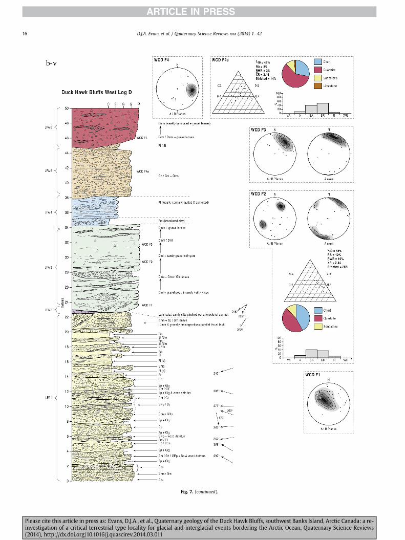
Fig 7 (continued)
DJA Evans et al Quaternary Science Reviews xxx (2014) 1e4216
Please cite this article in press as Evans DJA et al Quaternary geology of the Duck Hawk Bluffs southwest Banks Island Arctic Canada a re-investigation of a critical terrestrial type locality for glacial and interglacial events bordering the Arctic Ocean Quaternary Science Reviews(2014) httpdxdoiorg101016jquascirev201403011
Fig 7 (continued)
DJA Evans et al Quaternary Science Reviews xxx (2014) 1e42 17
Please cite this article in press as Evans DJA et al Quaternary geology of the Duck Hawk Bluffs southwest Banks Island Arctic Canada a re-investigation of a critical terrestrial type locality for glacial and interglacial events bordering the Arctic Ocean Quaternary Science Reviews(2014) httpdxdoiorg101016jquascirev201403011
Fig 7 (continued)
DJA Evans et al Quaternary Science Reviews xxx (2014) 1e4218
Fig 6a) Clast lithologies vary depending on sample location Amore restricted lithological component (chert quartzite andsandstone) occurs in the deformed contact zone with underlyingLFA 1 and in areas characterized by attenuated gravel lenses Amore varied clast lithology comprising chert and quartz with mi-nor components of sandstone shale granite gabbro and limestoneoccurs towards the middle and in the more diamictic zones (LFA 3)
LFA 4 comprises less than 5 m of sand silt and clay arranged inhorizontal cross-laminae rhythmites climbing ripples or drapedlaminae that locally contain organic detritus The upper and lowercontacts of LFA 4 are commonly characterized by heavily brecciatedclay or contain boudinage and thrust faulted laminae (Fig 12panels a amp c) Some outcrops of LFA 4 also display widespreaddeformation in the form of overfolded bedding and thrust faultsalthough normal faulting and open folding or convolute beddingstructures are also evident (Fig 7c iii inset photo 3) In some sec-tions LFA 4 comprises only a thin (lt2 m thick) bed of brecciatedclay (Fig 7b iv inset photo 4) or laminated sand displaying over-folds and sheath folds The sense of shearing as recorded by thrustfaults is generally towards the SSW but southerly and southwest-erly orientations are also evident Numerous examples of narrowanabranched clastic dykes rise sub-vertically through the thickestoutcrop of the sandy climbing ripple lithofacies (LFA 4 West Log A)and have created offset beds between the blocks within the hostmaterial (Fig 12 panel b) The contact of LFA 4 with LFA 3 (west cliffLog A) is marked by a clast lag Although the association is pre-dominantly heavily deformed the most unaltered and thickest
Please cite this article in press as Evans DJA et al Quaternary geologyinvestigation of a critical terrestrial type locality for glacial and intergla(2014) httpdxdoiorg101016jquascirev201403011
outcrop in West Log A displays climbing ripple drift indicative of apalaeocurrent from the south or southwest (Fig 7b ii)
LFA 5 comprises 5e10 m of tabular sets of horizontally beddedto massive gravel interbedded with horizontally bedded or cross-laminated sand and occasional units of matrix-supported gravel(Fig 13a b) The thickest outcrop displays a general coarsening-upward sequence from well-sorted horizontally bedded granulegravel and sand to matrix-supported and less well sorted hori-zontally bedded cobble to boulder gravel Clast lithologies aredominated by quartzite but contain subsidiary amounts of chertand sandstone with minor limestone LFA 5 differs from LFA 1based on its general coarsening-upward characteristics coarsergrain size and the presence of limestone clasts Clast form datafrom LFA 5 indicate a sub-rounded sample (averageroundness frac14 222 amp 246 RA frac14 8 amp 24 RWR frac14 2 amp 6) withpredominantly blocky shapes (C40 frac14 30 amp 42) and striae visible(lt14 of clasts) Upper and lower contacts are sharp but are locallyinterdigitated or amalgamated with LFA 6 (Fig 7b iv inset photo 5)and LFA 4 (Fig 13d) respectively A heavily deformed discontin-uous bed of siltclay rhythmites occurs between LFA 5 and LFA 6 inWest Log D the base of which has been amalgamated with thegravel at the top of LFA 5 (Fig 13c) Gravel in Easternmost Cliff hasan unclear relationship to the primary sections at DHB to the westThis gravel designated LFA 5a rests uncomformably on LFA 1 andis not capped by LFA 6 as elsewhere (Fig 7e) Furthermore there isno evidence of deformation and palaeocurrents are orientatedtowards the NW
of the Duck Hawk Bluffs southwest Banks Island Arctic Canada a re-cial events bordering the Arctic Ocean Quaternary Science Reviews
Fig 7 (continued)
DJA Evans et al Quaternary Science Reviews xxx (2014) 1e42 19
Please cite this article in press as Evans DJA et al Quaternary geology of the Duck Hawk Bluffs southwest Banks Island Arctic Canada a re-investigation of a critical terrestrial type locality for glacial and interglacial events bordering the Arctic Ocean Quaternary Science Reviews(2014) httpdxdoiorg101016jquascirev201403011
Fig 7 (continued)
DJA Evans et al Quaternary Science Reviews xxx (2014) 1e4220
Please cite this article in press as Evans DJA et al Quaternary geology of the Duck Hawk Bluffs southwest Banks Island Arctic Canada a re-investigation of a critical terrestrial type locality for glacial and interglacial events bordering the Arctic Ocean Quaternary Science Reviews(2014) httpdxdoiorg101016jquascirev201403011
Fig 7 (continued)
DJA Evans et al Quaternary Science Reviews xxx (2014) 1e42 21
Please cite this article in press as Evans DJA et al Quaternary geology of the Duck Hawk Bluffs southwest Banks Island Arctic Canada a re-investigation of a critical terrestrial type locality for glacial and interglacial events bordering the Arctic Ocean Quaternary Science Reviews(2014) httpdxdoiorg101016jquascirev201403011
Fig 7 (continued)
DJA Evans et al Quaternary Science Reviews xxx (2014) 1e4222
Please cite this article in press as Evans DJA et al Quaternary geology of the Duck Hawk Bluffs southwest Banks Island Arctic Canada a re-investigation of a critical terrestrial type locality for glacial and interglacial events bordering the Arctic Ocean Quaternary Science Reviews(2014) httpdxdoiorg101016jquascirev201403011
Fig 7 (continued)
DJA Evans et al Quaternary Science Reviews xxx (2014) 1e42 23
Please cite this article in press as Evans DJA et al Quaternary geology of the Duck Hawk Bluffs southwest Banks Island Arctic Canada a re-investigation of a critical terrestrial type locality for glacial and interglacial events bordering the Arctic Ocean Quaternary Science Reviews(2014) httpdxdoiorg101016jquascirev201403011
Fig 7 (continued)
DJA Evans et al Quaternary Science Reviews xxx (2014) 1e4224
LFA 6 crops out along the length of DHB and varies widely inthickness (1e11 m) displaying the most complex deformationstructures of any of the sediment bodies at DHB It comprises apredominantly heterogeneous diamicton or a meacutelange of discon-tinuous interbeds of massive matrix-supported diamicton matrix-supported gravel and laminated sand silt and clay with localizedattenuated lenses of degraded organics (Fig 7a ivevi 7b i iv 7c iiiii) Three samples of highly compressed and fragmented detritalmaterial displaying poor preservation were collected for identifi-cation Collectively LFA 6 has the appearance of a stratified dia-micton but locally it displays a more massive to pseudo-laminatedcharacter where sand silt and gravel lenses and occasional gravellags occur as thin beds stringers or wisps Some laminated sand siltand clay bodies appear to be rafts within the diamicton (intraclasts)due to their heavily deformed internal bedding and deformedcontacts or attenuated appearance Basal contacts with other lith-ofacies associations are typically erosional or deformed and asso-ciated with fissility boudinage and pseudo-lamination insediments on either side of the contact Basal diamictons can alsodisplay a higher concentration of gravel clasts that locally result in aclast-supported character or even a several metre-thick highlycontorted meacutelange of diamicton and stratified sediment bodies Insome sections the whole of LFA 6 has been complexly deformed toproduce stacked overfolds and thrust faults indicative of shearingtowards the southwest or WSW Clast macrofabrics are onlymoderately clustered (S1 frac14 0456e0637) but indicate stressdirected predominantly towards the SW Clast macrofabricstrengths as quantified by the fabric shape ternary plot (Fig 6a)and themodalityisotropy plot (Fig 6b) are variable and range frombi-modal to multi-modal Overall the macrofabric shapes in theternary graph plot across the spectrums of the glacitectonite andsubglacial traction till envelopes but there is a trend of changing
Please cite this article in press as Evans DJA et al Quaternary geologyinvestigation of a critical terrestrial type locality for glacial and intergla(2014) httpdxdoiorg101016jquascirev201403011
fabric strength vertically through LFA 6 The strongest clusters arefrom the basal diamictic zones (eg CCA F1 amp F3 AB plane data)whereas the weakest are from the top of the association (eg WCAF3 A-axes amp CCA F2 AB planes) where relatively low strain defor-mation indicators (open and recumbent folds) are ubiquitous
Clast lithologies in LFA 6 are dominated by quartz chert andsandstone although one diamict reveals a concentration of sand-stone lithologies at the expense of chert Clast forms similarlyreflect the nature of the sampled materials whereby the gravellysample (CCA 2) was characterized by relatively low C40 (38) andRA (12) values and a high average roundness (256) compared tothe same values for the diamictons of LFA 6 (C40 frac14 50e74RA frac14 38e52 average roundness frac14 174e204) A small number ofclasts (lt10) in LFA 6 were striated
512 Interpretation5121 LFA 1 The thick tabular sequence of well sorted cross-stratified sand and gravel records deposition by a former glaci-fluvial braided river typified by fluctuating discharge (eg Church1972 Boothroyd and Ashley 1975 Miall 1978 1985 1992Marren 2005) The highest discharge is recorded by matrix-supported gravel with boulders indicative of hyperconcentratedflows or a traction carpet (Maizels 1989ab Siegenthaler andHuggenberger 1993 Mulder and Alexander 2001) These areseparated by and vertically give way to lower discharges recordedby planar or trough cross-bedded sand and horizontal to planar ortrough cross-bedded gravel These deposits record aggradation andmigration of gravel bars and sheets and downstream accretionarymacroforms with relatively tightly constrained palaeocurrent in-dicators (Miall 1977 1985 Collinson 1996) The general lack ofscour fills and an overall fining-upward is indicative of an aggradingsystem initially characterized by high magnitudehigh frequency
of the Duck Hawk Bluffs southwest Banks Island Arctic Canada a re-cial events bordering the Arctic Ocean Quaternary Science Reviews
Fig 7 (continued)
DJA Evans et al Quaternary Science Reviews xxx (2014) 1e42 25
Please cite this article in press as Evans DJA et al Quaternary geology of the Duck Hawk Bluffs southwest Banks Island Arctic Canada a re-investigation of a critical terrestrial type locality for glacial and interglacial events bordering the Arctic Ocean Quaternary Science Reviews(2014) httpdxdoiorg101016jquascirev201403011
Fig 7 (continued)
DJA Evans et al Quaternary Science Reviews xxx (2014) 1e4226
Please cite this article in press as Evans DJA et al Quaternary geology of the Duck Hawk Bluffs southwest Banks Island Arctic Canada a re-investigation of a critical terrestrial type locality for glacial and interglacial events bordering the Arctic Ocean Quaternary Science Reviews(2014) httpdxdoiorg101016jquascirev201403011
DJA Evans et al Quaternary Science Reviews xxx (2014) 1e42 27
events that were gradually replaced by low magnitudehigh fre-quency events (Marren 2005) Partially to heavily-scoured rem-nants of laminated and massive fines represent deposition duringlow flow conditions in abandoned shallow channels The palae-ocurrent data from LFA 1 indicate that the outwash streams wereflowing westerly away from a glacier source located in AmundsenGulf This glacier likely eroded the abundant LFA 1 lithologies(chert quartzite and sandstone) from Mesoproterozoic and Neo-proterozoic bedrock widely distributed to the east and south(western Victoria Island Amundsen Gulf and the adjacent main-land Harrison et al 2013) These lithologies are consistent with theadvance of the NW Laurentide Ice Sheet through Amundsen Gulf(cf Dyke et al 2002 Batchelor et al 2012 MacLean et al 2013)
The crudely bedded organic detritus and degraded tree frag-ments (stumps) in LFA 1 are clearly reworked (cf Matthews et al1986 Fyles 1990 Vincent 1990) The finer grained detritus wasdeposited in concentrated pockets during waning flow stageswhereas horizons of logs and larger tree fragments were emplacedwith the coarser grained and poorly sorted sediments associatedwith hyperconcentrated flows or traction carpets during highdischarge These reworked organics also differ significantly fromthe type location of the Beaufort Fm a characteristic that promptedFyles (1990) to distinguish them as lsquotheMary Sachs Gravelrsquo Notablythe enclosing gravel and sand of LFA 1 is much coarser and exhibitsan entirely different fluvial architecture than the sandier BeaufortFm The composition and degraded nature of the LFA 1 organicssuggests that they were eroded by glaciers or their meltwater fromNeogene andor Paleogene sediments presumably to the southeastof Banks Island (eg Fyles 1990 Fyles et al 1994) The proximity ofa glacier is highlighted by the preservation of striae on individualclasts especially in the very coarse lower gravel The verticaldecrease in striae preservation and angularity (RA) and concomi-tant increase in roundness and upward-fining in LFA 1 is indicativeof an increasingly distal ice margin The co-variance plots (Fig 5)indicate a strong fluvial signature especially in the C40RA data butsubglacial characteristics are also evident particularly in the C40RWR data for the coarser grained and more matrix-supportedgravel as would be expected in ice-proximal settings
It is important to note that the widespread thrusting of LFA 1and underlying Kanguk Formation towards the southwest occurredpost-depositionally This glacitectonic thrusting was produced byLaurentide ice that advanced from the Kellett River valley (interiorBanks Island) during the emplacement of LFA 6 (see below) Theinjection of clastic dykes and fissure fills during this glacitectonicdisturbance was due to the overpressurizing of groundwater ingravel aquifers likely in taliks The branching limbs of many of thedykes are indicative of burst-out structures diagnostic of hydro-fracturing by vertically escaping groundwater pressurized byglacier overriding (cf Rijsdijk et al 1999 Le Heron and Etienne2005)
5122 LFA 2 At the top of LFA 1 rhythmites with lonestonesoverlie prominent clinoforms or foreset beds recording a changefrom subaerial glacifluvial to subaqueous deposition This wasinitially on a shallow delta front prograding foreset beds in asouthwesterly direction followed by suspension sedimentationwith dropstones presumably from floating ice in a marine orlacustrine basin The occurrence of matrix-supported gravelly scourfills with logs and woody detritus suggests pulses of cohesionlesssediment gravity flows into the basin Overlying the rhythmically-bedded sand prominent ice wedge pseudomorphs (up to 4 mdeep Fig 9aec cf Mackay and Burn 2002) are interspersed withthick (gt1m) sections of compressed in situ bryophytes (Figs 9d 7e)indicating the establishment of a tundra surface Four bryophytefamilies and 10 distinct species have been determined from LFA2
Please cite this article in press as Evans DJA et al Quaternary geologyinvestigation of a critical terrestrial type locality for glacial and intergla(2014) httpdxdoiorg101016jquascirev201403011
with the most abundant material from the Calliergonaceae andCampyliaceae (Table 1) These macrofossils are exceptionally wellpreserved including material with intact fragile alar cells typical ofthese two families (Fig 14cef) The data from these autochthonousdeposits indicate a wetland environment characterized as a richfen This ecosystem and habitats therein are consistent with speciesfound in the extant flora of Banks Island (Fig 14b) The autecologyfrom this range of species suggest hydric to mesic habitatsincluding standing pools wet meadows and microhabitats createdby ice wedges Despite the predominance of bryophytes in LFA 2these macrofossils had not been previously documented at DHB Incontrast a minimal proportion of the samples (lt5) consisted ofvascular plant material (including Cyperaceae seeds gramminoidleaves and woody twig fragments) Collectively the ice wedgepseudomorphs and vegetation within LFA 2 represent an isochro-nous terrestrial surface of interglacial rank
Following the formation of ice wedges the injection of intra-formational clastic dykes and fissure fills in LFA 2 relates to theoverpressurizing of groundwater in gravel aquifers or taliks due toglacier overriding The branching dyke limbs that emanate fromunderlying LFA 1 gravels and sands are indicative of the burst-outstructures that develop during hydrofracturing (cf Rijsdijk et al1999 Le Heron and Etienne 2005) A variant of the gravel andsand filled clastic dykes occurs within the sequence of glaci-tectonite and rhythmites near west Log D (Fig 11) Here thevertically-widening fracture is characterized by a mosaic ofpartially disaggregated blocks of the host materials in its widestzone where it contains gravels injected from underlying LFA 1Because these gravels only occur in the basal narrow neck theypresumably record the rapid reduction in flow competence duringhydrofracture filling
Deformation structures including overfolded or crumpledbedding and thrust faults associated with boudinage or highfissilitypseudo-lamination are representative of simple shear andwere also induced by glacitectonic disturbance (cf van derWateren 1995 McCarroll and Rijsdijk 2003) This predominantlyrecords a glacier advance from the northeast Subsidiary shear in-dicators record deformation from the south or southeast but theseoccur only at the top of LFA 2 and the base of LFA 3 suggestingearlier emplacement (see below) The development of zones ofboudinage shallow thrust faults overfolding or bed crumpling atdifferent levels within LFA 2 e especially at the contact separatingsediments of different grain size e represents deformation parti-tioning due to contrasting rheological properties Blind thrustswere also initiated in underlying LFA 1 increasingly towards thecentral and eastern cliffs where large-scale deformation is moreprevalent (Fig 7c d) A zone of intense deformation is recorded by alens of LFA 3 diamicton in fault contact with LFA 2 (east cliff Log AFig 7d i) This constitutes a type B glacitectonite (non-penetrativelydeformed pre-existing sediments sensu Benn and Evans 1996Evans et al 2006) developed during the emplacement of LFA 3(see below) A similar glacitectonite occurs at the junction of LFA 1and LFA 3 near west Log D (Fig 11) Bed attenuation by deformationis best developed in lower LFA 2 where the greater differences insediment grain size and hence rheology exist
5123 LFA 3 Within LFA 3 locally abundant stratified lensesindicate subaqueous deposition These stratified sediments weresubsequently thrust faulted folded and attenuated - most evidentin the upper and lower zones of LFA 3 This deformation was likelyresponsible for the intraclast boudinage and pseudo-lamination inthe surrounding diamicton (eg Hart and Roberts 1994 Robertsand Hart 2005 Oacute Cofaigh et al 2011) This process was alsoassociatedwith the attenuation of LFA 1 and 2 sediments within theheavily deformed base of LFA 3 some of which may have been
of the Duck Hawk Bluffs southwest Banks Island Arctic Canada a re-cial events bordering the Arctic Ocean Quaternary Science Reviews
Fig 8 Details of LFA 1 a) example of a concentration of logs with degraded rootballs in the stacked tabular units of cross-bedded sands and gravels and crudely stratified matrix-supported cobble to boulder gravels in the west cliff b) poorly-sorted and crudely horizontally bedded cobble to boulder gravel containing laminated clay intraclast (immediatelyabove compass) c) shallow locally graded foreset beds composed of openwork to sandy matrix-supported cobble to granule gravels in central cliff Log A d) planar bedded sandy
DJA Evans et al Quaternary Science Reviews xxx (2014) 1e4228
Please cite this article in press as Evans DJA et al Quaternary geology of the Duck Hawk Bluffs southwest Banks Island Arctic Canada a re-investigation of a critical terrestrial type locality for glacial and interglacial events bordering the Arctic Ocean Quaternary Science Reviews(2014) httpdxdoiorg101016jquascirev201403011
DJA Evans et al Quaternary Science Reviews xxx (2014) 1e42 29
cannibalized and rafted by the deformation process within a shearzone at the contact of LFA 3 with older sediments The shearingdirection from the south and southeast recorded in lower LFA 3also impacted upper LFA 2 whereas the more prominent shearingdirection throughout LFA 3 is from the northeast (also recorded inLFA 4) The local development of a heavily deformed zone at the topof LFA 3 was likely imparted during the shearing of overlying LFA 4sediments Although clast macrofabric strengths from the LFA 3diamicton are variable they possess shapes that compare withglacitectonites and subglacial traction tills and in some cases amodalityisotropy signature that reflects high lodgementcomponents
The similar orientation of the macrofabrics and shear indicatorsare considered diagnostic of a glacitectonite derived from stratifiedsediments (eg interbedded mass flow diamictons gravelly massflows and localized traction current sands and suspension de-posits) This evidence indicates that LFA 3 like all the other LFAsand the underlying Kanguk Fm bedrock has been displaced by aglacier advancing from the NNE or NE (ie Laurentide ice crossingthe interior of Banks Island) Minor south to north shearing in-dicates that LFA 3 and upper LFA 2were also disturbed by glacier iceflowing northwards (ie Laurentide ice advancing throughAmundsen Gulf) The appearance of granite and gabbro clastswithin the LFA 3 diamict records the arrival of far-travelled Lau-rentide ice from mainland Canada Clast form co-variance stronglyindicates a subglacial (abraded) source for LFA 3 with a minorfluvial component (Fig 5) including glacifluvial clasts locallycannibalized from LFA 1 by overriding ice
5124 LFA 4 LFA 4 has restricted outcrops is heavily deformedand contains organic detritus that is clearly allochthonous andhighly degraded Nonetheless a variety of indicators (fine-grainedhorizontally bedded cross-laminae rhythmites climbing ripplesand draped laminae) demonstrate that LFA 4 was deposited in asubaqueous environment with palaeocurrents from the south orsouthwest Traction currents were likely responsible for thedevelopment of the clast lag at the contact between lower LFA 4and underlying LFA 3 (west cliff Log A Fig 7b ii) LFA 4 coarsensupwards indicative of basin infilling andor an approaching sedi-ment source The narrow anabranched clastic dykes in the sandyclimbing ripples (LFA 4 west cliff Log A) record hydrofracturing bythe upward injection of overpressurized groundwater duringshearing The branching limbs of the dykes are similar to the burst-out structures reported by Rijsdijk et al (1999) but differ becausethey are composed solely of sand derived from the walls of the hostsediment rather than from an underlying gravel aquifer (cf LeHeron and Etienne 2005) Hence the pressurized water wasgenerated at the contact between the sand and underlying imper-meable brecciated clays The development of thin zones of brecci-ation boudinage sheath folding or thrust faulting at the upper andlower contacts of LFA 4 relates to the localized partitioning ofdeformation controlled by the location of claysilt beds Thejuxtaposition of this style of deformation with the larger scaleoverfolds and thrust faults developed in the extensive bodies ofsandy lithofacies is indicative of a Type B glacitectonite (sensu Bennand Evans 1996) This was constructed by the overriding of glacierice advancing from the north or northeast These shear directionsare compatible with those developed in the underlying LFAs
granule gravels with gravel lags (top and bottom of image) interrupted by an intervening unbedded granule to pebble gravel and massive cobble to pebble gravel A cluster of small treesequence of stacked tabular units of predominantly horizontally bedded sands and gravels ingravels containing clusters of wood detritus in the coarser gravel beds (central cliff Log A)wood fragments (central cliff Log A)
Please cite this article in press as Evans DJA et al Quaternary geologyinvestigation of a critical terrestrial type locality for glacial and intergla(2014) httpdxdoiorg101016jquascirev201403011
5125 LFA 5 The primary characteristics of LFA 5 are typical ofgravel sheet and occasional traction-carpet sedimentation in anice-proximal sandur (eg Boothroyd and Ashley 1975 Miall 19781985 1992 Maizels 1989ab Siegenthaler and Huggenberger1993 Mulder and Alexander 2001 Marren 2005) Glacier prox-imity is supported by the subglacial to fluvial signature of the clastforms (Fig 5) The coarsening-upward sequence including striatedclasts culminates in the arrival of a glacier that overrode the sitedepositing LFA 6 Post-depositional shearing within underlying LFA4 is recorded by attenuation and interdigitation at the contact withLFA 5 imparted during deposition of LFA 6 The contact betweenLFA 5 and 6 reflects the development of a shear zone where upperLFA 5 sediments have been cannibalized producing a meacutelange ofcrudely stratified diamictons with discontinuous interbeds ofmatrix-supported gravel laminated sand silt and clay (LFA 6 seebelow)
5126 LFA5a At Easternmost Cliff glacifluvial gravel (LFA 5a)unconformably overlies LFA 1 (Fig 7e) rendering uncertain itsrelationshipwith respect to LFA 5 in themain sections of DHB to thewest The fact that LFA 5a extends to the modern surface appearsundeformed and has palaeocurrents orientated to the NW requiresthat it is younger than LFA 5 Indeed we interpret LFA 5a asdeglacial outwash deposited from retreating Laurentide ice in theKellett River valley and Amundsen Gulf at the end of the lastglaciation (see Discussion)
5127 LFA 6 Based on its heterogeneity strongly orientated clastmacrofabrics and macroscale deformation structures LFA 6 con-stitutes a Type B glacitectonite (sensu Benn and Evans 1996)However zones of more highly strained Type A glacitectonite(sensu Benn and Evans 1996) at the basal contact with older LFAsare recorded by intraclastinterbed attenuation (pseudo-lamina-tion) strong boudinage or fissility and strengthened clast macro-fabrics The production of this meacutelange is attributed to two separateprocesses 1) primary sedimentation as interbedded and interdig-itated mass flow debris fluvial gravel and sand and subaqueoussuspension sediments and 2) cannibalization of underlying strat-ified sediments (LFAs 4 and 5) This produced a continuum of formsranging from low strain fold structures to attenuated rafts to tec-tonic lamination (eg Fig 7) The discontinuous lenses of degradedorganics (black stems and woody twigs gramminoid leaveswhitened rootlets) within LFA 6 are rafts and include seven speciesof bryophytes (Table 1) The material was highly compressed anddifficult to separate into distinct taxa Indeed one of the threesamples analysed was too degraded to recover any taxa Much ofthe material consisted of only fragmented leaves and only theminute taxa had stems with intact leaves The bryophytes thatcharacterize the LFA 6 samples represent hydric (Calliergon sppTomenthypnum nitens) to mesic (Ditrichum flexicaule Dicranum sp)habitats Three species collected from LFA 6 were also present inLFA 2 whereas four others were not found in LFA 2 but are com-mon in the modern flora The poor preservation quality suggeststhat the material has been redeposited from unknown sources andis clearly allochthonous
The predominant shearing direction within LFA 6 records an iceadvance from the interior of Banks Island (NE) This has resulted incomplex folding and thrusting and localized thickening of LFA 6
it of cross-bedded poorly-sorted to openwork cobble to boulder gravel crudely planar-fragments occur at the base of the cobble to boulder gravels at image centre e) middleDHB west cliff Log D f) sequence of fining-upward planar-bedded cobble to sandy fineg) planar cross-bedded sandy granule to pebble gravels with pebble to cobble lags and
of the Duck Hawk Bluffs southwest Banks Island Arctic Canada a re-cial events bordering the Arctic Ocean Quaternary Science Reviews
Fig 9 Details of LFA 2 from the west cliff a) narrow necked ice wedge pseudomorph with upturned marginal bedding in sand silt and clay rhythmites b) wide necked ice wedgepseudomorph c) ice wedge pseudomorph with overturned silt sand and clay rhythmites developed at the top of LFA 2 and sealed by overlying LFA 3 laminated diamicton d)horizontally bedded sand and silt containing well preserved moss macrofossils e) zone of disharmonically folded sandsilt laminae with well preserved moss peat located at thebase of LFA 2
DJA Evans et al Quaternary Science Reviews xxx (2014) 1e4230
Please cite this article in press as Evans DJA et al Quaternary geology of the Duck Hawk Bluffs southwest Banks Island Arctic Canada a re-investigation of a critical terrestrial type locality for glacial and interglacial events bordering the Arctic Ocean Quaternary Science Reviews(2014) httpdxdoiorg101016jquascirev201403011
Fig 10 Details of simple shear structures developed in fine sand and silt laminae at the centre of the thickest outcrop of LFA 2 in west cliff Log B a) overview of large scaleanastomosing shear faults with zones of smaller scale densely spaced anastomosing shears towards the base of the photograph b) details of large scale shear faults separatingzones of variably but predominantly densely spaced shears c) close details of shear zone comprising densely spaced anastomosing fractures d) details of ascending kink zonecross-cutting large scale anastomising shear faults Shearing direction is coming out of the cliff and towards the left in each image
DJA Evans et al Quaternary Science Reviews xxx (2014) 1e42 31
This shearing direction is recorded throughout underlying LFAs 1e4as well as the Kanguk Formation demonstrating deep-seated butpartitioned glacitectonic disturbance imparted during theemplacement of LFA 6 This strain signature was therefore over-printed on the northerlynortheasterly aligned shearing directionrecorded in LFA 3 and upper LFA 2 by the earlier northerly flowingice that deposited LFA 3 One anomalous clast macrofabric(northerly CCA F1) occurs in the basal meacutelange of LFA 6 Howeverthis sample is from an isolated outcrop (Fig 7c i) rendering itsapparent shearing direction equivocal
Please cite this article in press as Evans DJA et al Quaternary geologyinvestigation of a critical terrestrial type locality for glacial and intergla(2014) httpdxdoiorg101016jquascirev201403011
52 Sedimentology and stratigraphy (Mary Sachs Creek cliff)
The cliffs east of Mary Sachs Creek (Figs 2b 3) provides a cross-section through the seaward margin of the coast-parallel SachsMoraine (ldquosection Jrdquo Vincent et al 1983 Vaughan 2014) Weprovide a summary of two logs based on a reconnaissance survey ofthese sediments Log A is closest toMary Sachs Creekwhereas Log Boccursw1 km farther east (Figs 3 15a amp b) The sediments exposedin Log A appear to descend eastward and disappear below themodern beach and therefore are assumed to stratigraphically
of the Duck Hawk Bluffs southwest Banks Island Arctic Canada a re-cial events bordering the Arctic Ocean Quaternary Science Reviews
Fig 11 Details of LFA 2 near west Log D Lower box shows a 1e2 m thick basal zone comprising highly attenuated inter-digitated beds of gravelly to clay-rich diamictons and sandsiltclay rhythmites Upper box shows rhythmites containing diamictic intraclasts with sharp and angular boundaries also visible is the draping and deforming of the rhythmitebedding over and under the intraclasts respectively ldquoTailsrdquo extending from the diamictic intraclasts and thin but discontinuous diamictic beds are also visible in the upper box
DJA Evans et al Quaternary Science Reviews xxx (2014) 1e4232
underlie the sediments of Log B A sand and gravel- bench caps bothlogs at w15 m asl incised into the seaward margin of the SachsMoraine
521 DescriptionLog A contains a sequence of upward-fining highly contorted
cross-stratified sand and fine gravel to rhythmically bedded sandsilt clay with minor pebble gravel and sporadic clots of gravellydiamicton (Fig 15a) An ice wedge was initially developed in thelower cross-stratified sand and fine gravel before they were foldedand thrust faulted The deformed ice wedge pseudomorph is un-conformably overlain by a relatively undisturbed lens of laminatedsilty clay with dropstones interbedded with gravelly diamictonthat contains a bed (10 cm) of sandy black organics containingwood fragments (Fig 15a) This organic material occurs repeatedlyup-section as discontinuous stringers Log A is capped by 1e2 m ofpoorly exposed and heavily cryoturbated gravelly diamicton Thegeneral sense of displacement on shallow reverse faults over-turned bedding and boudinage structures is from the southeast
Log B (12 m) displays a coarsening-upward sequence of hori-zontally bedded sandy granule gravel with occasional silty sandlaminae (Fig 15b iii) that grades to poorly-sorted cobble to bouldergravel and bouldery matrix-supported gravel (Fig 15b ii) This iscapped by laminated to crudely stratified cobbly diamicton that issilt and clay-rich abruptly and conformably overlain by
Please cite this article in press as Evans DJA et al Quaternary geologyinvestigation of a critical terrestrial type locality for glacial and intergla(2014) httpdxdoiorg101016jquascirev201403011
interlaminated silt clay and pebbly silty sand (Fig 15b i) Althoughthe bedding on these units dips towards the NW individuallaminae do not thicken in that direction indicating post-depositional tilting The uppermost part of the log (underlyingthe 15 m bench) contains 2 m of clay-rich massive diamictoninterfingered with the underlying laminated sediments and cobblydiamicton
522 Interpretation
5221 Log A Broadly the sedimentology of log A including thedeformed ice wedge pseudomorph is similar to LFA 2 in DHB (egcentral cliff Log A Fig 7c iii) Prior to glacitectonic disturbance theoverlying organic bed (Fig 15a) was redeposited into a sequence ofsubaqueous siltclay rhythmites containing dropstones and gravellymass flows The highly attenuated shear margins bracketing theorganic bed in Log A demonstrate that it has been displaced as atectonic raft Previous research proposed that the organic beds e
similar to those described in Log A e be assigned to the LastInterglacial (locally called the Cape Collinson Vincent 1982 1983)Because these organic beds are clearly a raft they cannot constitutean iscochronous surface precluding chronostratigraphic signifi-cance (see Discussion) Shearing of the Log A sediments from thesoutheast documents an ice advance from Amundsen Gulf corre-sponding to the earliest of two primary shearing directions recor-ded at DHB (imparted during the emplacement of LFA 3) Therefore
of the Duck Hawk Bluffs southwest Banks Island Arctic Canada a re-cial events bordering the Arctic Ocean Quaternary Science Reviews
Fig 12 Details of LFA 4 in West Log A a) heavily deformed upper contact of LFA 4 comprising sandsiltclay rhythmites displaying well developed boudinage sheath folds andimmature tectonic laminae and an interdigitatedsheared boundary with underlying climbing ripple sands The contact with overlying LFA 6 is marked by an interdigitated zonecontaining rooted and de-rooted folds or rhythmite rafts in a sand gravel and diamicton meacutelange b) narrow anabranched clastic dykes ascending sub-vertically through climbingripple drift and resulting in offset bedding between blocks of host material c) abrupt contact between sheared sands and rhythmites of LFA 4 and overlying sand gravel anddiamicton meacutelange
Fig 13 Details of LFA 5 a) poorly sorted and matrix-supported pebble to cobble gravel b) tabular sequence of horizontally bedded to massive gravel and matrix-supported gravelcontaining a horizon of striated cobbles and boulders c) heavily deformed discontinuous bed of siltclay rhythmites between LFA 5 and LFA 6 in West Log D showing theamalgamation zone with the LFA 5 gravels immediately above the compass d) interdigitateddeformed contact between LFA 5 granule to pebble gravels and underlying LFA 4laminated silts and clays with organic detritus in West Log B
DJA Evans et al Quaternary Science Reviews xxx (2014) 1e42 33
Please cite this article in press as Evans DJA et al Quaternary geology of the Duck Hawk Bluffs southwest Banks Island Arctic Canada a re-investigation of a critical terrestrial type locality for glacial and interglacial events bordering the Arctic Ocean Quaternary Science Reviews(2014) httpdxdoiorg101016jquascirev201403011
Table 1List of bryophytes and vascular plants from LFAs 2 and 6
LFA2 WestCliff Log B
LFA6 CentralCliff Log A
Elevation (m) 185 m asl w45 m aslSample 4e12 1e3 taxa 10 7
Bryophyta (mosses)AmblystegiaceaeAmblystegium serpens (Hedw) Schimp x
CamyliaceaeCampylium polygamum (Schimp) CEO Jensen xCampylium stellatum (Hedw) CEO Jensen x xDrepanocladus aduncus (Hedw) Warnst xDrepanocladus sp xTomentypnum nitens (Hedw) Loeske x
CalliergonaceaeCalliergon giganteum (Schimp) Kindb xCalliergon richardsonii (Mitt) Kindb xthornthornthornthorn xCalliergon sp xWarnstorfia exannulatus (Schimp) Loeske xthornthornthornthorn x
BrachytheciaceaeBrachythecium turgidum (Hartm) Kindb x
MniaceaeCyrtomnium cf hymenophylloides(Hbener) TJ Kop
x
DicranaceaeDicranum sp x
DitrichaceaeDitrichum flexicaule (Schwaumlgr) Hampe x
Tracheophyta (vascular plants)CyperaceaeSeeds (triangular amp flattened) x x
Gramminoid leaf material x xWoody twig fragments x xRootlets x
Fig 14 The moss peat and associated microfossils of LFA 2 a) exposure through lower LFAsouthern Banks Island analogue of a rich tundra fen environment for the bryophyte assemblfrom LFA 2 showing the exceptional preservation of Calliergonaceae and Campyliaceae ma
DJA Evans et al Quaternary Science Reviews xxx (2014) 1e4234
Please cite this article in press as Evans DJA et al Quaternary geologyinvestigation of a critical terrestrial type locality for glacial and intergla(2014) httpdxdoiorg101016jquascirev201403011
these deformed deposits are interpreted as a Type B glacitectonite(sensu Benn and Evans 1996) possibly derived from LFA 2
5222 Log B The coarsening upward gravel in Log B recordshighly turbid to hyperconcentrated discharge in non-channelizedsheets This is interpreted as aggrading glacifluvial outwash froman approaching ice margin The capping sequence of crudelystratified diamicton and laminated sediments records a changefrom glacifluvial to subaqueous sedimentation prior to overridingby a glacier of unknown age that tilted the upper beds Thecoarsening-upward sequence apparent tectonism and cappingdiamict at Log B clearly distinguishes these deposits from those ofLFA 5a (west of Mary Sachs Creek easternmost cliff Fig 3)Furthermore although there is lithological similarity between LogB and LFA 5 throughout DHB the sense of shearing is dissimilar (LFA5 from the NE and Log B from the SE) The simplest explanation forthis difference in shear direction is that LFA 5 (DHB) was displacedby interior ice advancing down the Kellett River whereas Log B wasdisplaced by ice advancing along Amundsen Gulf (Fig 2b)
6 Discussion
61 Large scale glacitectonic structures and stratigraphicarchitecture
The glacitectonic structures identified within the lithofaciesassociations at DHB record two phases of deformation (early NeSand later NEeSW) This deformation together with the DHBstratigraphic architecture (Fig 16) helps to explain both thekinetostratigraphy (sensu Berthelsen1978) and the evolution of thelocal glacial geomorphology The large scale glacitectonic defor-mation is most clearly manifest in the thrust faulting and conjugate
2 at DHB west log B showing the sampling locations for in situ moss peat b) a modernages of LFA 2 c)ef) details of the typical moss peat and associated microfossil materialscrofossils including material with intact fragile alar cells
of the Duck Hawk Bluffs southwest Banks Island Arctic Canada a re-cial events bordering the Arctic Ocean Quaternary Science Reviews
Fig 15 The stratigraphy of Mary Sachs Creek cliff a) photographic compilation log A showing upward-fining highly contorted (i) cross-stratified sands and fine gravels torhythmically bedded sands silts clays and minor pebble gravels Also visible in (ii) is a lens of interbedded laminated silty clays with dropstones and gravelly diamictons containingsandy black coloured organic material with wood fragments An ice wedge pseudomorph is visible (iii) to the right of the exposure b) photographic compilation log B showing i)laminated to crudely stratified cobbly but siltclay-rich diamicton grading into interlaminated silts clays and pebbly silty sands ii) poorly-sorted cobble to boulder gravel andbouldery matrix-supported gravel iii) coarsening-upward sequence of horizontally bedded sandy granule gravels with occasional silty sand laminae iv amp v) pebble to cobble graveland matrix-supported gravel
DJA Evans et al Quaternary Science Reviews xxx (2014) 1e42 35
shear development in the Kanguk Fm bedrock and overlying LFA 1(east cliff Fig 7d ivevi) Here predominantly northeasterly dippingthrust slices have been stacked truncated and overlain by LFA 6during the second and strongest (NEeSW) deformation phase(Fig 16 note bedrock slice within the imbricated stacked sequenceof LFA 1) These structures demonstrate significant compressionand thickening of the stratigraphic sequence including w40 m ofvertical offset within the Kanguk Formation acrossw3 km (Fig 16)Prominent hydrofracture fills in LFAs 1 and 2 record elevatedporewater pressure during this thrusting Smaller scale shear zoneshave also developed in the finer grained interbeds within thrustslabs (Fig 7d vii) indicative of deformation partitioning by strataprone to ductile failure This zone of greatest displacement alsocoincides with the highest topography (Fig 16) Lower angle thrustfaults propagate in a southwesterly direction predominantlythrough LFA 1 but are also developed through LFA 2 in the footwallblock (east cliff Fig 16)
The thrust stacking of bedrock and LFAs 1e5 in east cliff (obliqueto Fig 16) represents the ice-proximal zone of a thrust-blockmorainecomposite ridge constructed by a glacier advancing fromthe northeast (ie the interior of Banks Island) This glacitectonicdeformation propagated southwestward to distal parts of theproglacial stress field as recorded bywell-developed shear zones inthe finer grained sediments of LFAs 2e5 In the more distal westcliff open folds (LFA 2 Fig 16) appear to be the product of a blindthrust within underlying LFA 1 This style of tectonism is typical oflsquopiggyback-style thrustingrsquo wherein steeply inclined thrust blocksat the advancing ice margin propagate new thrusts in the footwall(Fig 16 Park 1983 Mulugeta and Koyi 1987) The angle of thesefootwall thrusts becomes progressively shallower southwestward
Please cite this article in press as Evans DJA et al Quaternary geologyinvestigation of a critical terrestrial type locality for glacial and intergla(2014) httpdxdoiorg101016jquascirev201403011
(ice-distal) in LFA 1e5 where deformation partitioning developedin finer grained lithofacies (Fig 16)
The densely spaced ponds and depressions immediately to thenortheast of DHB (Figs 2b 3) constitute the depression fromwhich the thrust mass was excavated (eg Aber et al 1989Evans and England 1991 van der Wateren 1995) This inter-pretation is consistent with the strong northeast to southwestshear direction in the second phase glacitectonic structures andin LFA 6 clast macrofabrics This indicates that construction ofDHB occurred at the margin of a glacier advancing from thenortheast (ie from Kellett River valley) overtopping DHB anddepositing the LFA 6 glacitectonite The continued advance ofKellett ice coalesced with a glacier in Amundsen Gulf marked bythe interlobate Sachs Moraine containing ice-transported shellsas young as 24 cal ka BP (21020 70 yrs BP UCIAMS-89674)assigning this glaciation to the Late Wisconsin (Vaughan 2014)East of Mary Sachs Creek the deformation of Log B outwash(from the southeast Figs 15 16) likely records overriding by thesame Amundsen Gulf glacier (coeval with LFA 6 Late Wiscon-sinan) During ice retreat when Kellett River and Amundsen Gulfice decoupled DHB was exposed allowing the northwesterly-flowing proglacial outwash (LFA 5a) west of Mary Sachs Creekto extend to the shoreline marking postglacial marine limit atKellett Point (11 m asl Vaughan 2014 Fig 3) Collectively thisreconstruction supports a Late Wisconsinan age for the con-struction of DHB thrust block moraine although its stratigraphyincludes a range of ages A palaeogeographic reconstruction ofevents based upon our interpretation of the sedimentologystratigraphic architecture tectonism and geomorphology is pre-sented in Fig 17
of the Duck Hawk Bluffs southwest Banks Island Arctic Canada a re-cial events bordering the Arctic Ocean Quaternary Science Reviews
Fig 15 (continued)
DJA Evans et al Quaternary Science Reviews xxx (2014) 1e4236
62 Comparison and revision of previous DHB model
DHB was previously interpreted to record horizontally beddedNeogene to Quaternary sediments assigned to preglacial fluvialand multiple glacial and interglacial episodes (Vincent 1982 19831990 Vincent et al 1983 1984 Barendregt et al 1998) A com-posite palaeomagnetic record was also presented for this proposedstratigraphy placing most of this deposition before the BrunhesMatuyama boundary (Fig 1c) However prior to our work detailedstudies had not been undertaken on the sedimentology structuralgeology or stratigraphic architecture of DHB Rather the originalstratigraphy was restricted to a series of composite logs (our Fig 4reproduced from Vincent et al 1983) that notably omitted thepervasive deformation structures including the thrust bedrock ineast cliff (Fig 16)
Please cite this article in press as Evans DJA et al Quaternary geologyinvestigation of a critical terrestrial type locality for glacial and intergla(2014) httpdxdoiorg101016jquascirev201403011
Our reinterpretation dismisses several key elements of theoriginal DHB model outlined below (oldest to youngest) We havedetermined that the lowermost unit (LFA 1) is not preglacial (Fyles1990) but rather is composed of glacial outwash providing theearliest terrestrial evidence for glaciation in the area and containingallochthonous organics (including tree stumps) of unknown prov-enance Because LFA 1 is a glacifluvial braidplain (Fig 17a) it is notpart of the Beaufort Fm (Fyles 1990) even though it containsreworked macrofossils presumably derived from it (eg Craig andFyles 1960 Hills et al 1974 Vincent et al 1983)
Our analysis of LFA 2 indicates that it is also not preglacial norcan it be the Worth Point Fm as previously proposed (cf Vincent1982 1983 1990 Vincent et al 1983 Matthews et al 1986)Indeed the type locality of the Worth Point Fm has been invali-dated because it is now recognized to be an ice-transported and
of the Duck Hawk Bluffs southwest Banks Island Arctic Canada a re-cial events bordering the Arctic Ocean Quaternary Science Reviews
LFA4
Fig16
Stratigrap
hiccross-profi
lerun
ning
westto
easto
fDuc
kHaw
kBluffs
basedup
oninterpolations
betw
eenthemainsectionlogs
andsh
owingthesixLFAstheKan
gukFo
rmationbe
droc
kex
posu
resmajor
structural
features
and
thepo
sition
sof
icewed
geps
eudo
morph
san
dsign
ificant
clasticdy
kesAtthe
easternen
dof
thecross-profi
lethe
sedimen
tsat
theco
reof
MarySa
chsCree
kcliff
logAaretentativelyclassified
asLFA2
althou
ghthesematerialsarelik
ely
notin
situN
otethat
thecross-profi
ledo
esno
tex
tend
asfarea
stas
MarySa
chsCree
kcliff
logB
DJA Evans et al Quaternary Science Reviews xxx (2014) 1e42 37
Please cite this article in press as Evans DJA et al Quaternary geologyinvestigation of a critical terrestrial type locality for glacial and intergla(2014) httpdxdoiorg101016jquascirev201403011
glacitectonized raft (Vaughan et al 2014) In contrast our LFA 2 ischaracterized by an isochronous tundra surface with ice wedgesand intervening shallow ponds andwetmeadows The peat at LFA 2is dominated by bryophytes (gt95 by volume) and yet none ofthese macrofossils had been previously documented The diversein situ bryophyte species record a flora similar to that on BanksIsland today suggesting that LFA 2 warrants an interglacial rankThis conclusion is supported by the limited vascular plant record(five taxa no species indicated Vincent 1990) that also suggest awet meadow environment The absolute age of LFA 2 remains un-known but is apparently older than the BrunhesMatayamaboundary (gt780 ka Fig 18 cf Vincent et al 1984 Barendregt andVincent 1990 Barendregt et al 1998 see below)
LFA 3 in both our model and that of Vincent et al (1983) pro-vides the first direct evidence of ice reaching DHB In the previousmodel this was interpreted as Bernard Till (Banks Glaciation) thatwas bracketed by glacioisostatically induced marine transgressions(pre- and post-Banks seas Vincent 1982 1983) Within basal LFA 3we recognized highly deformed stratified sediment that wasdeposited in a subaqueous environment (deep water Fig 17c) priorto the arrival of overriding ice from the south (recorded by graniteand gabbro erratics Figs 17c 18) We regard LFA 3 to be equivalentto the Banks Glaciation (Vincent 1982 1983 Vincent et al 1983)including its pre- and post-Banks seas represented by the stratifiedsediments that bracket the central diamicton The LFA 3 sedimentsare also reported to be magnetically reversed thereby predatingthe BrunheseMatayama boundary (gt780 ka Fig 18 Vincent et al1984 Barendregt and Vincent 1990 Barendregt et al 1998)
Following the Banks Glaciation (our LFA 3 at DHB) Vincent(1982 1983) and Vincent et al (1983) recognized two in-terglacials (Morgan Bluffs and Cape Collinson) separated by anintervening marine episode This marine episode correspondedwith the glacioisostatic loading of a Laurentide ice margin confinedto the eastern half of Banks Island (Thomsen Glaciation) HoweverLFA 4 contains coarsening-upward subaqueous sedimentation fromthe south or southwest reflecting continued marine regressionfollowing LFA 3 (Fig 17c d) The coarsening-upward sequence ofLFA 4 is supplanted by coarse gravel outwash (LFA 5) supplied by aglacier readvancing from the northeast (Kellett River valley iceFig 17e) Glacier overriding is recorded by LFA 6 glacitectonite thatcaps the DHB thrust-block moraine composed of the entireassemblage of underlying LFAs (Fig 16)
Notably we have not observed any sediments characteristic oftwo interglacial deposits above LFA 3 hence dismiss the presence ofthe Morgan Bluffs and Cape Collinson interglacials at DHB Causseand Vincent (1989) report a U-series date of gt200 ka (UQT-229)from above our LFA 3 but this is almost certainly reworked andlacks chronostratigraphic significance Nor have we observedintervening marine sediments attributable to the Thomsen Glaci-ation (eg lsquoBig Searsquo Vincent 1982 1983 Vincent et al 1983)Rather following the deposition of the subaqueous sediments ofupper LFAs 3 and 4 (post-Banks Glaciation) LFAs 5 and 6 record asingle ice advance reaching DHB from the Kellett River valley(Banks Island interior) that was not reported by Vincent et al(1983) It was instead assumed that after the Banks GlaciationDHB lay distal to any later ice advances The nearest subsequentLaurentide margin to DHB recognized by Vincent et al (1983) wasassigned to the Sachs Moraine (immediately east of DHB) that waspresumed to be of EarlyWisconsin age (Fig 2b) However the SachsMoraine is nowdated to24 cal ka BP (LateWisconsinan Vaughan2014) andwas formed by the coalescence of Amundsen Gulf ice andthe Kellett River ice that deformed DHB (Fig 17) On the east side ofMary Sachs Creek the deposition of the Sachs Moraine coincideswith the deformation (from the southeast) of the underlying Log Boutwash gravel (Figs 3 15b)
of the Duck Hawk Bluffs southwest Banks Island Arctic Canada a re-cial events bordering the Arctic Ocean Quaternary Science Reviews
Fig 17 The palaeogeography of southwest Banks Island based upon interpretations of the principal lithofacies associations and structural architecture recognized at Duck HawkBluffs and the geomorphology of the surrounding terrain See text for detailed explanations
DJA Evans et al Quaternary Science Reviews xxx (2014) 1e4238
Although interglacial deposits were previously reported fromthe cliffs east of Mary Sachs Creek (ie Cape Collinson InterglacialVincent et al 1983) we found no similar evidence Rather the onlydeposit that we observed that may have been construed as inter-glacial sediments occurs in our Log A (Figs 3 15a) Here a darkdiscontinuous band of allochthonous organics (Fig15a) sits severedwithin a heavily tectonized melange (type B glacitectonite) and istherefore clearly a raft Although the absolute ages of the deformedunits east of Mary Sachs Creek (Logs A amp B) remain uncertain theyare apparently normally magnetized (Vincent et al 1984Barendregt and Vincent 1990) Blake (1987) also reports non-finite radiocarbon dates (gt36000 amp 49000 BP GSC-3560 amp 3560-2) obtained on ldquocompressed and deformed black woody peatrdquopurportedly from Cape Collinson beds (Vincent et al 1983 p 1708)Additionally Causse and Vincent (1989) report a U-series date onshells of 924 ka (UQT-143) from beds similar to the Log B gravelAgain all of these dated units have been displaced from unknownlocations limiting their utility for palaeoenvironmental recon-struction The last glacially influenced sedimentation at DHB isrecorded by northwesterly directed outwash (easternmost cliff LFA5a Figs 3 16 17g) We infer that this outwash fed the gravel beachmarking marine limit (11 m asl) in the lower Kellett River duringLate Wisconsinan retreat from the Sachs Moraine
63 Regional context
The stratigraphy at Duck Hawk Bluffs records three glacialevents The earliest of these is recorded by the aggradation of a
Please cite this article in press as Evans DJA et al Quaternary geologyinvestigation of a critical terrestrial type locality for glacial and intergla(2014) httpdxdoiorg101016jquascirev201403011
glacifluvial braidplain (LFA 1) that contains allochthonous pre-glacial material of diverse age However within LFA 1 there is noevidence that the ice reached DHB although it must have beennearby (southeast in Amundsen Gulf) The age of this glaciationremains unknown but the palaeomagnetic polarity of LFA 1 in-dicates that it is gt780 ka BP (Barendregt and Vincent 1990)Although Barendregt et al (1998) assigned part of the Worth PointFm to the normally polarized Olduvai sub-zone (MIS 64e74) itshould be noted that the Worth Point section is located 30 kmnorthwest of DHB There a stratigraphic revision has demonstratedthat this ldquotype sectionrdquo of the Worth Point Fm is in fact a glaci-tectonized raft (Vaughan et al 2014) This observation invalidatesthe previous correlation from Worth Point to purportedly coevalbeds at DHB (our LFA 2) Furthermore the diverse plant assem-blages in the Worth Point raft include preglacial tree stumps andSphagnum spp that do not occur on Banks Island today and are notfound in the wet meadow assemblages (rich fen) of LFA 2 that weinterpret to be of interglacial rank Therefore the sediments at DHB(LFAs 1 amp 2) do not support an age assignment of MIS 64e74(Olduvai subzone) proposed by Barendregt et al (1998) Currentlythe available palaeomagnetic record at DHB simply separates theentire section into a lower lsquoreversedrsquo unit and an upper lsquonormalrsquoone We place this boundary within our LFA 4 (Fig 18)
The overriding of DHB by glaciers is recorded in LFAs 3 amp 6These two glacial deposits may correspond to parts of the record ofstacked till sheets reported from the offshore seismic stratigraphy(Batchelor et al 2012) LFA 3 glaciationmay have contributed to theonset of mid-Pleistocene ice-rafted debris (IRD Ca-rich) attributed
of the Duck Hawk Bluffs southwest Banks Island Arctic Canada a re-cial events bordering the Arctic Ocean Quaternary Science Reviews
B-M
B-M
gt19
Fig
18A
revisedlitho
stratigrap
hyforDuc
kHaw
kBluffsPrev
ious
lyrepo
rted
ageco
nstraintsarealso
depicted
toge
ther
withatentativeallocation
ofMIS
stag
es(positione
dalon
gsideEa
stCliff
LogA
forclarity)
basedup
onthe
palaeo
mag
neticreco
rd
DJA Evans et al Quaternary Science Reviews xxx (2014) 1e42 39
Please cite this article in press as Evans DJA et al Quaternary geology of the Duck Hawk Bluffs southwest Banks Island Arctic Canada a re-investigation of a critical terrestrial type locality for glacial and interglacial events bordering the Arctic Ocean Quaternary Science Reviews(2014) httpdxdoiorg101016jquascirev201403011
DJA Evans et al Quaternary Science Reviews xxx (2014) 1e4240
to the Canadian Arctic Archipelago (CAA) and recorded in sedimentcores from the Arctic Ocean basin (Polyak et al 2009 2013OrsquoRegan et al 2010 Stein et al 2010) However Stein et al(2010) place the onset of Ca-rich ice-rafted debris within MIS 16(w659 ka BP Lisiecki and Raymo 2005) with subsequent peaks atMIS 12 10 and 8 all of which postdate the gt780 ka BP palae-omagnetic age proposed for LFA 3 (above) Polyak et al (2013) placethe onset of Ca-rich ice-rafted debris in the central Arctic Oceancloser to MIS 19 (790 ka BP) which is broadly compatible with theDHB palaeomagnetic record LFA 6 records the last glaciation ofDHB and we assign this to the Late Wisconsinan when Banks Is-land ice (Kellett River) coalesced with the Amundsen Gulf IceStream (Stokes et al 2006 MacLean et al 2013) During this in-terval the northwest Laurentide Ice Sheet likely reached the edgeof the polar continental shelf (Stokes et al 2005 2006 Englandet al 2009 Batchelor et al 2012 Lakeman and England 2013MacLean et al 2013)
7 Conclusions
New sedimentological and stratigraphic analyses of DHB funda-mentally revise the previous reconstruction of the Neogene andQuaternary history of Banks Island DHB and two other widely citedsections on Banks Island have been reported as important unde-formed terrestrial archives of glacial and interglacial sedimentationat the northwest limit of the Laurentide Ice Sheet that all have beenrecently revised (Vaughan et al 2014 Lakeman and England inpress) The recognition of pervasive large-scale deformation ofDHB necessitates a fundamental re-assessment of its previouslydescribed layer-cake stratigraphy We document that the oldestsediments (LFA 1) at DHB are not preglacial fluvial deposits (Beau-fort Fm) but rather record proglacial outwash from ice in AmundsenGulf that did not reach the site This was followed by the estab-lishment of an isochronous tundra surface of interglacial rank (LFA2) characterized by ice wedge polygons within a wet meadow thatsupported a bryophyte community similar to modern Subse-quently glacial sedimentation resumed initially in an ice-proximalsubaqueous environment followed by ice arrival and glacitectonicdeformation (LFA 3) The overlying deposits at DHB indicate post-glacial marine sedimentation (LFA 4) followed by the aggradationof glacifluvial sand and gravel (LFA 5) from an advancing ice marginthat culminated with the emplacement of a glacitectonite (LFA 6)during the Late Wisconsin This ice advance constructed a previ-ously undescribed thrust-block moraine (60 m high 8 km long) thatexhibits pervasive deformation and includes a substantial raft ofCretaceous Kanguk Fm bedrock (Fig 16) Furthermore the produc-tion of the glacitectonite (LFA 6) cannibalized LFAs 1e5 which atsome sites were previously thought to be in situ interglacial de-posits Finally outwash (LFA 5a) incised the DHB thrust block duringdeglaciation of the site when ice in the Kellett River and AmundsenGulf separated and proglacial meltwater drained northwestward tomarine limit (11 m asl) Refinements to the evolution and chronol-ogy of DHB and other sections around Banks Island will furthercontribute to the understanding of high latitude environmentalchange especially the complementary marine archives of theadjacent polar continental shelf and Arctic Ocean
Acknowledgements
Funding for this research was provided by the Natural Sciencesand Engineering Research Council of Canada (NSERC) NorthernResearch Chair Program and a complementary NSERC DiscoveryGrant (A6680) (both to JH England) Coulthard Lakeman andVaughan were supported by CBAR grants Canadian CircumpolarInstitute University of Alberta Coulthard and Lakeman were also
Please cite this article in press as Evans DJA et al Quaternary geologyinvestigation of a critical terrestrial type locality for glacial and intergla(2014) httpdxdoiorg101016jquascirev201403011
supported by Northern Scientific Training Program grantsAboriginal Affairs and Northern Development Canada The PolarContinental Shelf Program Natural Resources Canada(_501100000159) supplied additional funding and aircraft supportField and logistical assistance from Issac Elanik Vernon AmosTrevor Lucas and Roger Kuptana of Sachs Harbour is gratefullyacknowledged
References
Aber JS Croot DG Fenton MM 1989 Glaciotectonic Landforms and StructuresKluwer Dordrecht
Barendregt RW Vincent J-S 1990 Late Cenozoic paleomagnetic record of DuckHawk Bluffs Banks Island Canadian Arctic Archipelago Can J Earth Sci 27124e130
Barendregt RW Duk-Rodkin A 2011 Chronology and extent of Late Cenozoic icesheets in North America a magnetostratigraphical assessment In Ehlers JGibbard PL Hughes PD (Eds) Quaternary Glaciations e Extent and Chro-nolgy a Closer Look Elsevier Amsterdam pp 419e426
Barendregt RW Vincent J-S Irving E Baker J 1998 Magnetostratigraphy ofQuaternary and late Tertiary sediments on Banks Island Canadian Arctic Ar-chipelago Can J Earth Sci 35 147e161
Batchelor CL Dowdeswell JA Pietras JT 2012 Variable history of Quaternaryice-sheet advance across the Beaufort Sea margin Arctic Ocean Geology httpdxdoiorg101130G336691
Batchelor CL Dowdeswell JA Pietras JT 2013 Seismic stratigraphy sedimen-tary architecture and palaeo-glaciology of the Mackenzie Trough evidence fortwo Quaternary ice advances and limited fan development on the westernCanadian Beaufort Sea margin Quat Sci Rev 65 73e87
Benn DI 1994 Fabric shape and the interpretation of sedimentary fabric dataJ Sediment Res 64 910e915
Benn DI 1995 Fabric signature of till deformation Breiethamerkurjoumlkull IcelandSedimentology 42 735e747
Benn DI 2004 Clast morphology In Evans DJA Benn DI (Eds) A PracticalGuide to the Study of Glacial Sediments Arnold London pp 77e92
Benn DI Ballantyne CK 1994 Reconstructing the transport history of glaciogenicsediments a new approach based on the co-variance of clast form indicesSediment Geol 91 215e227
Benn DI Evans DJA 1996 The interpretation and classification of subglaciallydeformed materials Quat Sci Rev 15 23e52
Benn DI Evans DJA Phillips ER Hiemstra JF Walden J Hoey TB 2004 Theresearch project d a case study of Quaternary glacial sediments InEvans DJA Benn DI (Eds) A Practical Guide to the Study of Glacial Sedi-ments Arnold London pp 209e234
Berthelsen A 1978 The methodology of kineto-stratigraphy as applied to glacialgeology Bull Geol Soc Den 27 25e38
Blake Jr W 1987 Geological Survey of Canada Radiocarbon Dates XXVI InGeological Survey of Canada Paper 86-7 60 pp
Boothroyd JC Ashley GM 1975 Processes bar morphology and sedimentarystructures on braided outwash fans northeastern Gulf of Alaska InJopling AV McDonald BC (Eds) Glaciofluvial and Glaciolacustrine Sedi-mentation Society of Economic Paleontologists and Mineralogists SpecialPublication No 23
Causse C Vincent J-S 1989 TheU disequilibrium dating of Middle and LatePleistocene wood and shells from Banks and Victoria islands Arctic CanadaCan J Earth Sci 26 2718e2723
Church MA 1972 Baffin Island sandurs a study of Arctic fluvial processes GeolSurv Can Bull 216 208
Clark DL Vincent J-S Jones GA Morris WA 1984 Corrrelation of marine andcontinental glacial and interglacial events Arctic Ocean and Banks Island Na-ture 311 147e149
Collinson JD 1996 Alluvial sediments In Reading HG (Ed) Sedimentary Envi-ronments and Facies third ed Blackwell Oxford pp 37e82
Craig BG Fyles JG 1960 Pleistocene Geology of Arctic Canada In GeologicalSurvey of Canada Paper 60-10 21 pp
Crosby MR Magill RE Allen B He S 1999 A Checklist of the Mosses MissouriBotanical Garden St Louis 320 pp
Duk-Rodkin A Barendregt RW 2011 Stratigraphical records of glacialsin-terglacials in northwest Canada In Ehlers J Gibbard PL Hughes PD (Eds)Quaternary Glaciations e Extent and Chronology a Closer Look ElsevierAmsterdam pp 661e698
Dyke AS Andrews JT Clark PU England JH Miller GH Shaw J Veillette JJ2002 The Laurentide and Innuitian ice sheets during the Last Glacial MaximumQuat Sci Rev 21 9e31
England JH Furze MFA Doupeacute JP 2009 Revision of the NW Laurentide IceSheet implications for the paleoclimate the northeast extremity of Beringiaand Arctic Ocean sedimentation Quat Sci Rev 28 1573e1596
Evans DJA 2010 Controlled moraine development and debris transport pathwaysin polythermal plateau icefields examples from Tungnafellsjoumlkull IcelandEarth Surf Process Landf 35 1430e1444
of the Duck Hawk Bluffs southwest Banks Island Arctic Canada a re-cial events bordering the Arctic Ocean Quaternary Science Reviews
DJA Evans et al Quaternary Science Reviews xxx (2014) 1e42 41
Evans DJA Benn DI 2004 Facies description and the logging of sedimentaryexposures In Evans DJA Benn DI (Eds) A Practical Guide to the Study ofGlacial Sediments Arnold London pp 11e51
Evans DJA England J 1991 Canadian landform examples 19 high arctic thrustblock moraines Can Geogr 35 93e97
Evans DJA Rea BR Benn DI 1998 Subglacial deformation and bedrockplucking in areas of hard bedrock Glacial Geology and Geomorphology rp041998 httpgggqubacukgggpapersfull1998rp041998rp04html
Evans DJA Hiemstra JF 2005 Till deposition by glacier submarginal incre-mental thickening Earth Surf Process Landf 30 1633e1662
Evans DJA Hiemstra JF Oacute Cofaigh C 2007 An assessment of clast macrofabricsin glaciogenic sediments based on AB plane data Geogr Ann A89 103e120
Evans DJA Phillips ER Hiemstra JF Auton CA 2006 Subglacial till formationsedimentary characteristics and classification Earth Sci Rev 78 115e176
Evans DJA Shulmeister J Hyatt OM 2010 Sedimentology of latero-frontalmoraines and fans on the west coast of South Island New Zealand Quat SciRev 29 3790e3811
Eyles N Eyles CH Miall AD 1983 Lithofacies types and vertical profile modelsan alternative approach to the description and environmental interpretation ofglacial diamicts and diamictite sequences Sedimentology 30 393e410
Fyles JG 1990 Beaufort Formation (late Tertiary) as seen from Prince Patrick Is-land Arctic Canada Arctic 43 393e403
Fyles JG Hills LV Matthews Jr JV Barendregt R Baker J Irving E Jette H1994 Ballast Brook and Beaufort Formations (Late Tertiary) on northern BanksIsland Arctic Canada Quat Int 2223 141e171
Harrison JC Mayr U McNeil DH Sweet AR McIntyre DJ Eberle JJHarington CR Chalmers JA Dam G Nohr-Hansen H 1999 Correlation ofCenozoic sequences of the Canadian Arctic region and Greenland implicationsfor the tectonic history of northern North America Bull Can Pet Geol 47 223e254
Harrison JC Ford A Miall AD Rainbird RH Hulbert LJ Chritie RLCampbell FHA 2013 Geology Tectonic Assemblage Map of Aulavik BanksIsland and Northwestern Victoria Island Northwest Territories GeologicalSurvey of Canada Canadian Geoscience Map 35 (preliminary) scale 1500 000httpdxdoiorg104095292833
Hart JK Roberts DH 1994 Criteria to distinguish between subglacial glaciotec-tonic and glaciomarine sedimentation I Deformation styles and sedimen-tology Sediment Geol 91 191e213
Hedenaumls L 1993 A generic revision of the Warnstorfia Calliergon group J Bryol 17447e479
Hedenaumls L 2006 Additional insights into the phylogeny of Calliergon LoeskypnumStraminergon and Warnstorfia (Bryophyta Calliergonaceae) J Hattori Bot Lab100 125e134
Hicock SR Goff JR Lian OB Little EC 1996 On the interpretation of subglacialtill fabric J Sediment Res 66 928e934
Hiemstra JF Evans DJA Oacute Cofaigh C 2007 The role of glaciotectonic rafting andcommunition in the production of subglacial tills examples from SW Irelandand Antarctica Boreas 36 386e399
Hills LV 1975 Late Tertiary floras Arctic Canada an interpretation In Proceedingsof Circumpolar Conference on Northern Ecology National Research Council ofCanada pp I(65)eI(71)
Hills LV Klovan JE Sweet AR 1974 Juglans eocineria n Beaufort Formation(Tertiary) southwestern Banks Island Arctic Canada Can J Bot 52 65e90
Janssens JAP 1983 Quaternary fossil bryophytes in North America new recordsLindbergia 9 137e151
Kuc M 1974 Calliergon aftonianum Steere in Late Tertiary and Pleistocene Depositsof Canada In Geological Survey of Canada Paper 74e24
Kuc M Hills LV 1971 Fossil mosses Beaufort Formation (Tertiary) NorthwesternBanks Island Western Canada Arctic Can J Bot 49 1089e1094
Lakeman TR England JH 2012 Paleoglaciological insights from the age andmorphology of the Jesse moraine belt western Canadian Arctic Quat Sci Rev47 82e100
Lakeman TR England JH 2013 Late Wisconsinan glaciation and postglacialrelative sea-level change on western Banks Island Canadian Arctic ArchipelagoQuat Res 80 99e112
Lakeman TR England JH 2014 Facies and stratigraphic analyses of glacial andinterglacial sediments at Morgan Bluffs Banks Island Canadian Arctic Archi-pelago Boreas httpdxdoiorg101111bor12069 (in press)
Lawton E 1971 Moss Flora of the Pacific Northwest The Hattori Botanical Labo-ratory Ninchen Miyazaki Japan
Le Heron DP Etienne JL 2005 A complex subglacial clastic dyke swarm Sol-heimajoumlkull southern Iceland Sediment Geol 181 25e37
Li G Piper DJW Campbell DC 2011 The Quaternary Lancaster Sound trough-mouth fan NW Baffin Bay J Quat Sci 26 511e522
Lisiecki LE Raymo ME 2005 A Pliocene-Pleistocene stack of 57 globallydistributed benthic d18O records Paleoceanography 20 PA1003 httpdxdoiorg1010292004PA001071
Lukas S Benn DI Boston CM Brook M Coray S Evans DJA Graf A Kellerer-Pirklbauer A Kirkbride MP Krabbendam M Lovell H Machiedo MMills SC Nye K Reinardy BTI Ross FH Signer M 2013 Clast shapeanalysis and clast transport paths in glacial environments a critical review ofmethods and the role of lithology Earth-Sci Rev 121 96e116
Lukas S Coray S Graf A Schluumlchter C 2014 The influence of clast lithology andfluvial reworking on the reliability of clast shape measurements in glacial en-vironments e a case study from a temperate Alpine glacier In Bridgland DR
Please cite this article in press as Evans DJA et al Quaternary geologyinvestigation of a critical terrestrial type locality for glacial and intergla(2014) httpdxdoiorg101016jquascirev201403011
(Ed) Clast Lithological Analysis Technical Guide Quaternary Research Asso-ciation London (in press)
Mackay JR Burn CR 2002 The first 20 years (1978e1979 to 1998e1999) of icewedge growth at the Illisarvik experimental drained lake site western Arcticcoast Canada Can J Earth Sci 39 95e111
MacLean B Blasco S Bennett R Lakeman T Hughes-Clarke J Kuus PPatton E 2013 Marine evidence for a Glacial ice stream in Amundsen GulfCanadian Arctic Archipelago In Canadian Quaternary Association (CANQUA)Meeting August 18e22 2013 Edmonton AB Canada
Maizels JK 1989a Sedimentology palaeoflow dynamics and flood history ofjokulhlaup deposits palaeohydrology of Holocene sediment sequences insouthern Iceland sandur deposits J Sediment Petrol 59 204e223
Maizels JK 1989b Sedimentology and palaeohydrology of Holocene flood depositsin front of a jokulhlaup glacier south Iceland In Bevan K Carling PJ (Eds)Floods the Geomorphological Hydrological and Sedimentological Conse-quences Wiley New York pp 239e251
Marren PM 2005 Magnitude and frequency in proglacial rivers a geomorpho-logical and sedimentological perspective Earth-Sci Rev 70 203e251
Matthews JV 1987 Plant macrofossils from the Neogene Beaufort Formation onBanks and Meighen islands District of Franklin In Current Research Part AGeological Survey of Canada Paper 87-1A pp 73e87
Matthews Jr JV Ovenden LE 1990 Late Tertiary plant macrofossils from local-ities in ArcticSubarctic North America a review of the data Arctic 43 364e392
Matthews JV Mott RJ Vincent J-S 1986 Preglacial and interglacial environ-ments of Banks Island pollen and macrofossils from Duck Hawk Bluffs andrelated sites Geogr Phys Quat XL 279e298
McCarroll D Rijsdijk KF 2003 Deformation styles as a key for interpreting glacialdepositional environments J Quat Sci 18 473e489
Miall AD 1977 A review of the braided river depositional environment Earth-SciRev 13 1e62
Miall AD 1978 Lithofacies types and vertical profile models in braided river de-posits a summary In Miall AD (Ed) Fluvial Sedimentology Canadian Societyof Petroleum Geologists Memoir 5 pp 597e604
Miall AD 1985 Architectural-element analysis a new method of facies analysisapplied to fluvial deposits Earth Sci Rev 22 261e308
Miall AD 1992 Alluvial deposits In Walker RG James NP (Eds) Facies ModelsResponse to Sea-level Change Geological Association of Canada Torontopp 119e142
Mulder T Alexander J 2001 The physical character of subaqueous sedimentarydensity flows and their deposits Sedimentology 48 269e299
Mulugeta G Koyi H 1987 Three-dimensional geometry and kinematics ofexperimental piggyback thrusting Geology 15 1052e1056
Nyholm E 1956e1965 Illustrated Moss Flora of Fennoscandia II Musci Fasc 1-6Lund pp 1e788
Oacute Cofaigh C Evans DJA Hiemstra JF 2011 Formation of a stratified subglacial lsquotillrsquoassemblage by ice-marginal thrusting and glacier overriding Boreas 40 1e14
OrsquoRegan M St John K Moran K Backman J King J Haley BA Jakobsson MFrank M Roumlhl U 2010 Plio-Pleistocene trends in ice rafted debris on theLomonosov Ridge Quat Int 219 168e176
OrsquoRegan M Williams CJ Frey KE Jakobsson M 2011 A synthesis of the long-term paleoclimatic evolution of the Arctic Oceanography 24 66e80
Park RG 1983 Foundations of Structural Geology Blackie LondonPolyak L Bischof J Ortiz JD Darby DA Channell JET Xuan C Kaufman DS
Loslashvlie R Schneider DA Eberl DD Adler RE Council EA 2009 LateQuaternary stratigraphy and sedimentation patterns in the western ArcticOcean Glob Planet Change 68 5e17
Polyak L Best KM Crawford KA Council EA St-Onge G 2013 Quaternaryhistory of sea ice in the western Arctic Ocean based on foraminifera Quat SciRev 79 145e156
Rijsdijk KF Owen G Warren WP 1999 Clastic dykes in overconsolidated tillsevidence for subglacial hydrofracturing at Killiney Bay eastern Ireland Sedi-ment Geol 129 111e126
Roberts DH Hart JK 2005 The deforming bed characteristics of a stratified tillassemblage in north east Anglia UK investigating controls on sedimentrheology and strain signatures Quat Sci Rev 24 123e140
Roy SK Hills LV 1972 Fossil woods from the Beaufort Formation (Tertiary)northwestern Banks Island Canada Can J Bot 50 2637e2648
Siegenthaler C Huggenberger P 1993 Pleistocene Rhine gravel deposits of abraided river systemwith dominant pool preservation In Best JL Bristow CS(Eds) Braided Rivers Geological Society London Special Publication 75pp 147e162
Spedding N Evans DJA 2002 Sediments and landforms at Kviacuteaacuterjoumlkull southeastIceland a reappraisal of the glaciated valley landsystem Sediment Geol 14921e42
Steere WC 1978 The Mosses of Arctic Alaska In Bryophytorum Bibliotheca vol14 J Cramer Lehre Germany 507 pp
Steere WC Scotter GW 1979 Bryophytes of Banks Island Northwest TerritoriesCanada Can J Bot 57 1136e1149
Stein R Matthiessen J Niessen F Krylov R Nam S Bazhenova E 2010 Towardsa better (litho-) stratigraphy and reconstruction of Quaternary palaeoenviron-ment in the Amerasian Basin (Arctic Ocean) Polarforschung 79 97e121
Stokes CR Clark CD Darby DA Hodgson DA 2005 Late Pleistocene ice exportevents into the Arctic Ocean from the MrsquoClure Strait Ice Stream Canadian ArcticArchipelago Glob Planet Change 49 139e162
of the Duck Hawk Bluffs southwest Banks Island Arctic Canada a re-cial events bordering the Arctic Ocean Quaternary Science Reviews
DJA Evans et al Quaternary Science Reviews xxx (2014) 1e4242
Stokes CR Clark C Winsborrow M 2006 Subglacial bedform evidence for amajor palaeo-ice stream in Amundsen Gulf and its retreat phases CanadianArctic Archipelago J Quat Sci 21 300e412
van der Wateren DFM 1995 Processes of glaciotectonism In Menzies J (Ed)Glacial Environments Modern Glacial Environments Processes Dynamics andSediments vol 1 Butterworth-Heinemann Oxford pp 309e335
Vaughan J 2014 The Glacial and Sea Level History of South Banks Island NT(Unpublished PhD thesis) University of Alberta Edmonton
Vaughan J England J Evans DJA 2014 Glaciotectonic deformation and rein-terpretation of the Worth Point stratigraphic sequence Banks Island NT Can-ada Quat Sci Rev httpdxdoiorg101016jquascirev201311005
Vincent J-S 1982 The Quaternary history of Banks Island Northwest TerritoriesCanada Geogr Phys Quat 36 209e232
Please cite this article in press as Evans DJA et al Quaternary geologyinvestigation of a critical terrestrial type locality for glacial and intergla(2014) httpdxdoiorg101016jquascirev201403011
Vincent J-S 1983 La geologie du quaternaire et la geomorpholie de Lrsquoile Banksarctique Canadien Geological Survey of Canada Memoir 405
Vincent J-S 1984 Quaternary stratigraphy of the western Canadian Arctic Archi-pelago In Fulton RJ (Ed) Quaternary Stratigraphy of Canada e a CanadianContribution to IGCP Project 24 Geological Survey of Canada Paper 84-10pp 87e100
Vincent J-S 1990 Late Tertiary and Early Pleistocene deposits and history of BanksIsland southwestern Canadian Arctic Archipelago Arctic 43 339e363
Vincent J-S Occhietti S Rutter N Lortie G Guilbault J-P De Boutray B 1983The Late TertiaryeQuaternary record of the Duck Hawk Bluffs Banks IslandCanadian Arctic Archipelago Can J Earth Sci 20 1694e1712
Vincent J-S Morris WA Occhietti S 1984 Glacial and non-glacial sediments ofMatuyama paleomagnetic age on Banks Island Canadian Arctic ArchipelagoGeology 12 139e142
of the Duck Hawk Bluffs southwest Banks Island Arctic Canada a re-cial events bordering the Arctic Ocean Quaternary Science Reviews
- Quaternary geology of the Duck Hawk Bluffs southwest Banks Island Arctic Canada a re-investigation of a critical terrest
-
- 1 Introduction
- 2 Study area and previous research
- 3 Methods
- 4 Organics
- 5 Results
-
- 51 Sedimentology and stratigraphy (Duck Hawk Bluffs)
-
- 511 Description
- 512 Interpretation
-
- 5121 LFA 1
- 5122 LFA 2
- 5123 LFA 3
- 5124 LFA 4
- 5125 LFA 5
- 5126 LFA5a
- 5127 LFA 6
-
- 52 Sedimentology and stratigraphy (Mary Sachs Creek cliff)
-
- 521 Description
- 522 Interpretation
-
- 5221 Log A
- 5222 Log B
-
- 6 Discussion
-
- 61 Large scale glacitectonic structures and stratigraphic architecture
- 62 Comparison and revision of previous DHB model
- 63 Regional context
-
- 7 Conclusions
- Acknowledgements
- References
-
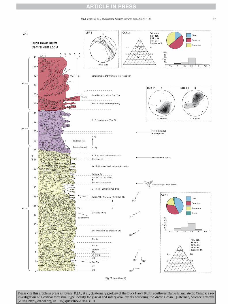
Fig 7 (continued)
DJA Evans et al Quaternary Science Reviews xxx (2014) 1e42 17
Please cite this article in press as Evans DJA et al Quaternary geology of the Duck Hawk Bluffs southwest Banks Island Arctic Canada a re-investigation of a critical terrestrial type locality for glacial and interglacial events bordering the Arctic Ocean Quaternary Science Reviews(2014) httpdxdoiorg101016jquascirev201403011
Fig 7 (continued)
DJA Evans et al Quaternary Science Reviews xxx (2014) 1e4218
Fig 6a) Clast lithologies vary depending on sample location Amore restricted lithological component (chert quartzite andsandstone) occurs in the deformed contact zone with underlyingLFA 1 and in areas characterized by attenuated gravel lenses Amore varied clast lithology comprising chert and quartz with mi-nor components of sandstone shale granite gabbro and limestoneoccurs towards the middle and in the more diamictic zones (LFA 3)
LFA 4 comprises less than 5 m of sand silt and clay arranged inhorizontal cross-laminae rhythmites climbing ripples or drapedlaminae that locally contain organic detritus The upper and lowercontacts of LFA 4 are commonly characterized by heavily brecciatedclay or contain boudinage and thrust faulted laminae (Fig 12panels a amp c) Some outcrops of LFA 4 also display widespreaddeformation in the form of overfolded bedding and thrust faultsalthough normal faulting and open folding or convolute beddingstructures are also evident (Fig 7c iii inset photo 3) In some sec-tions LFA 4 comprises only a thin (lt2 m thick) bed of brecciatedclay (Fig 7b iv inset photo 4) or laminated sand displaying over-folds and sheath folds The sense of shearing as recorded by thrustfaults is generally towards the SSW but southerly and southwest-erly orientations are also evident Numerous examples of narrowanabranched clastic dykes rise sub-vertically through the thickestoutcrop of the sandy climbing ripple lithofacies (LFA 4 West Log A)and have created offset beds between the blocks within the hostmaterial (Fig 12 panel b) The contact of LFA 4 with LFA 3 (west cliffLog A) is marked by a clast lag Although the association is pre-dominantly heavily deformed the most unaltered and thickest
Please cite this article in press as Evans DJA et al Quaternary geologyinvestigation of a critical terrestrial type locality for glacial and intergla(2014) httpdxdoiorg101016jquascirev201403011
outcrop in West Log A displays climbing ripple drift indicative of apalaeocurrent from the south or southwest (Fig 7b ii)
LFA 5 comprises 5e10 m of tabular sets of horizontally beddedto massive gravel interbedded with horizontally bedded or cross-laminated sand and occasional units of matrix-supported gravel(Fig 13a b) The thickest outcrop displays a general coarsening-upward sequence from well-sorted horizontally bedded granulegravel and sand to matrix-supported and less well sorted hori-zontally bedded cobble to boulder gravel Clast lithologies aredominated by quartzite but contain subsidiary amounts of chertand sandstone with minor limestone LFA 5 differs from LFA 1based on its general coarsening-upward characteristics coarsergrain size and the presence of limestone clasts Clast form datafrom LFA 5 indicate a sub-rounded sample (averageroundness frac14 222 amp 246 RA frac14 8 amp 24 RWR frac14 2 amp 6) withpredominantly blocky shapes (C40 frac14 30 amp 42) and striae visible(lt14 of clasts) Upper and lower contacts are sharp but are locallyinterdigitated or amalgamated with LFA 6 (Fig 7b iv inset photo 5)and LFA 4 (Fig 13d) respectively A heavily deformed discontin-uous bed of siltclay rhythmites occurs between LFA 5 and LFA 6 inWest Log D the base of which has been amalgamated with thegravel at the top of LFA 5 (Fig 13c) Gravel in Easternmost Cliff hasan unclear relationship to the primary sections at DHB to the westThis gravel designated LFA 5a rests uncomformably on LFA 1 andis not capped by LFA 6 as elsewhere (Fig 7e) Furthermore there isno evidence of deformation and palaeocurrents are orientatedtowards the NW
of the Duck Hawk Bluffs southwest Banks Island Arctic Canada a re-cial events bordering the Arctic Ocean Quaternary Science Reviews
Fig 7 (continued)
DJA Evans et al Quaternary Science Reviews xxx (2014) 1e42 19
Please cite this article in press as Evans DJA et al Quaternary geology of the Duck Hawk Bluffs southwest Banks Island Arctic Canada a re-investigation of a critical terrestrial type locality for glacial and interglacial events bordering the Arctic Ocean Quaternary Science Reviews(2014) httpdxdoiorg101016jquascirev201403011
Fig 7 (continued)
DJA Evans et al Quaternary Science Reviews xxx (2014) 1e4220
Please cite this article in press as Evans DJA et al Quaternary geology of the Duck Hawk Bluffs southwest Banks Island Arctic Canada a re-investigation of a critical terrestrial type locality for glacial and interglacial events bordering the Arctic Ocean Quaternary Science Reviews(2014) httpdxdoiorg101016jquascirev201403011
Fig 7 (continued)
DJA Evans et al Quaternary Science Reviews xxx (2014) 1e42 21
Please cite this article in press as Evans DJA et al Quaternary geology of the Duck Hawk Bluffs southwest Banks Island Arctic Canada a re-investigation of a critical terrestrial type locality for glacial and interglacial events bordering the Arctic Ocean Quaternary Science Reviews(2014) httpdxdoiorg101016jquascirev201403011
Fig 7 (continued)
DJA Evans et al Quaternary Science Reviews xxx (2014) 1e4222
Please cite this article in press as Evans DJA et al Quaternary geology of the Duck Hawk Bluffs southwest Banks Island Arctic Canada a re-investigation of a critical terrestrial type locality for glacial and interglacial events bordering the Arctic Ocean Quaternary Science Reviews(2014) httpdxdoiorg101016jquascirev201403011
Fig 7 (continued)
DJA Evans et al Quaternary Science Reviews xxx (2014) 1e42 23
Please cite this article in press as Evans DJA et al Quaternary geology of the Duck Hawk Bluffs southwest Banks Island Arctic Canada a re-investigation of a critical terrestrial type locality for glacial and interglacial events bordering the Arctic Ocean Quaternary Science Reviews(2014) httpdxdoiorg101016jquascirev201403011
Fig 7 (continued)
DJA Evans et al Quaternary Science Reviews xxx (2014) 1e4224
LFA 6 crops out along the length of DHB and varies widely inthickness (1e11 m) displaying the most complex deformationstructures of any of the sediment bodies at DHB It comprises apredominantly heterogeneous diamicton or a meacutelange of discon-tinuous interbeds of massive matrix-supported diamicton matrix-supported gravel and laminated sand silt and clay with localizedattenuated lenses of degraded organics (Fig 7a ivevi 7b i iv 7c iiiii) Three samples of highly compressed and fragmented detritalmaterial displaying poor preservation were collected for identifi-cation Collectively LFA 6 has the appearance of a stratified dia-micton but locally it displays a more massive to pseudo-laminatedcharacter where sand silt and gravel lenses and occasional gravellags occur as thin beds stringers or wisps Some laminated sand siltand clay bodies appear to be rafts within the diamicton (intraclasts)due to their heavily deformed internal bedding and deformedcontacts or attenuated appearance Basal contacts with other lith-ofacies associations are typically erosional or deformed and asso-ciated with fissility boudinage and pseudo-lamination insediments on either side of the contact Basal diamictons can alsodisplay a higher concentration of gravel clasts that locally result in aclast-supported character or even a several metre-thick highlycontorted meacutelange of diamicton and stratified sediment bodies Insome sections the whole of LFA 6 has been complexly deformed toproduce stacked overfolds and thrust faults indicative of shearingtowards the southwest or WSW Clast macrofabrics are onlymoderately clustered (S1 frac14 0456e0637) but indicate stressdirected predominantly towards the SW Clast macrofabricstrengths as quantified by the fabric shape ternary plot (Fig 6a)and themodalityisotropy plot (Fig 6b) are variable and range frombi-modal to multi-modal Overall the macrofabric shapes in theternary graph plot across the spectrums of the glacitectonite andsubglacial traction till envelopes but there is a trend of changing
Please cite this article in press as Evans DJA et al Quaternary geologyinvestigation of a critical terrestrial type locality for glacial and intergla(2014) httpdxdoiorg101016jquascirev201403011
fabric strength vertically through LFA 6 The strongest clusters arefrom the basal diamictic zones (eg CCA F1 amp F3 AB plane data)whereas the weakest are from the top of the association (eg WCAF3 A-axes amp CCA F2 AB planes) where relatively low strain defor-mation indicators (open and recumbent folds) are ubiquitous
Clast lithologies in LFA 6 are dominated by quartz chert andsandstone although one diamict reveals a concentration of sand-stone lithologies at the expense of chert Clast forms similarlyreflect the nature of the sampled materials whereby the gravellysample (CCA 2) was characterized by relatively low C40 (38) andRA (12) values and a high average roundness (256) compared tothe same values for the diamictons of LFA 6 (C40 frac14 50e74RA frac14 38e52 average roundness frac14 174e204) A small number ofclasts (lt10) in LFA 6 were striated
512 Interpretation5121 LFA 1 The thick tabular sequence of well sorted cross-stratified sand and gravel records deposition by a former glaci-fluvial braided river typified by fluctuating discharge (eg Church1972 Boothroyd and Ashley 1975 Miall 1978 1985 1992Marren 2005) The highest discharge is recorded by matrix-supported gravel with boulders indicative of hyperconcentratedflows or a traction carpet (Maizels 1989ab Siegenthaler andHuggenberger 1993 Mulder and Alexander 2001) These areseparated by and vertically give way to lower discharges recordedby planar or trough cross-bedded sand and horizontal to planar ortrough cross-bedded gravel These deposits record aggradation andmigration of gravel bars and sheets and downstream accretionarymacroforms with relatively tightly constrained palaeocurrent in-dicators (Miall 1977 1985 Collinson 1996) The general lack ofscour fills and an overall fining-upward is indicative of an aggradingsystem initially characterized by high magnitudehigh frequency
of the Duck Hawk Bluffs southwest Banks Island Arctic Canada a re-cial events bordering the Arctic Ocean Quaternary Science Reviews
Fig 7 (continued)
DJA Evans et al Quaternary Science Reviews xxx (2014) 1e42 25
Please cite this article in press as Evans DJA et al Quaternary geology of the Duck Hawk Bluffs southwest Banks Island Arctic Canada a re-investigation of a critical terrestrial type locality for glacial and interglacial events bordering the Arctic Ocean Quaternary Science Reviews(2014) httpdxdoiorg101016jquascirev201403011
Fig 7 (continued)
DJA Evans et al Quaternary Science Reviews xxx (2014) 1e4226
Please cite this article in press as Evans DJA et al Quaternary geology of the Duck Hawk Bluffs southwest Banks Island Arctic Canada a re-investigation of a critical terrestrial type locality for glacial and interglacial events bordering the Arctic Ocean Quaternary Science Reviews(2014) httpdxdoiorg101016jquascirev201403011
DJA Evans et al Quaternary Science Reviews xxx (2014) 1e42 27
events that were gradually replaced by low magnitudehigh fre-quency events (Marren 2005) Partially to heavily-scoured rem-nants of laminated and massive fines represent deposition duringlow flow conditions in abandoned shallow channels The palae-ocurrent data from LFA 1 indicate that the outwash streams wereflowing westerly away from a glacier source located in AmundsenGulf This glacier likely eroded the abundant LFA 1 lithologies(chert quartzite and sandstone) from Mesoproterozoic and Neo-proterozoic bedrock widely distributed to the east and south(western Victoria Island Amundsen Gulf and the adjacent main-land Harrison et al 2013) These lithologies are consistent with theadvance of the NW Laurentide Ice Sheet through Amundsen Gulf(cf Dyke et al 2002 Batchelor et al 2012 MacLean et al 2013)
The crudely bedded organic detritus and degraded tree frag-ments (stumps) in LFA 1 are clearly reworked (cf Matthews et al1986 Fyles 1990 Vincent 1990) The finer grained detritus wasdeposited in concentrated pockets during waning flow stageswhereas horizons of logs and larger tree fragments were emplacedwith the coarser grained and poorly sorted sediments associatedwith hyperconcentrated flows or traction carpets during highdischarge These reworked organics also differ significantly fromthe type location of the Beaufort Fm a characteristic that promptedFyles (1990) to distinguish them as lsquotheMary Sachs Gravelrsquo Notablythe enclosing gravel and sand of LFA 1 is much coarser and exhibitsan entirely different fluvial architecture than the sandier BeaufortFm The composition and degraded nature of the LFA 1 organicssuggests that they were eroded by glaciers or their meltwater fromNeogene andor Paleogene sediments presumably to the southeastof Banks Island (eg Fyles 1990 Fyles et al 1994) The proximity ofa glacier is highlighted by the preservation of striae on individualclasts especially in the very coarse lower gravel The verticaldecrease in striae preservation and angularity (RA) and concomi-tant increase in roundness and upward-fining in LFA 1 is indicativeof an increasingly distal ice margin The co-variance plots (Fig 5)indicate a strong fluvial signature especially in the C40RA data butsubglacial characteristics are also evident particularly in the C40RWR data for the coarser grained and more matrix-supportedgravel as would be expected in ice-proximal settings
It is important to note that the widespread thrusting of LFA 1and underlying Kanguk Formation towards the southwest occurredpost-depositionally This glacitectonic thrusting was produced byLaurentide ice that advanced from the Kellett River valley (interiorBanks Island) during the emplacement of LFA 6 (see below) Theinjection of clastic dykes and fissure fills during this glacitectonicdisturbance was due to the overpressurizing of groundwater ingravel aquifers likely in taliks The branching limbs of many of thedykes are indicative of burst-out structures diagnostic of hydro-fracturing by vertically escaping groundwater pressurized byglacier overriding (cf Rijsdijk et al 1999 Le Heron and Etienne2005)
5122 LFA 2 At the top of LFA 1 rhythmites with lonestonesoverlie prominent clinoforms or foreset beds recording a changefrom subaerial glacifluvial to subaqueous deposition This wasinitially on a shallow delta front prograding foreset beds in asouthwesterly direction followed by suspension sedimentationwith dropstones presumably from floating ice in a marine orlacustrine basin The occurrence of matrix-supported gravelly scourfills with logs and woody detritus suggests pulses of cohesionlesssediment gravity flows into the basin Overlying the rhythmically-bedded sand prominent ice wedge pseudomorphs (up to 4 mdeep Fig 9aec cf Mackay and Burn 2002) are interspersed withthick (gt1m) sections of compressed in situ bryophytes (Figs 9d 7e)indicating the establishment of a tundra surface Four bryophytefamilies and 10 distinct species have been determined from LFA2
Please cite this article in press as Evans DJA et al Quaternary geologyinvestigation of a critical terrestrial type locality for glacial and intergla(2014) httpdxdoiorg101016jquascirev201403011
with the most abundant material from the Calliergonaceae andCampyliaceae (Table 1) These macrofossils are exceptionally wellpreserved including material with intact fragile alar cells typical ofthese two families (Fig 14cef) The data from these autochthonousdeposits indicate a wetland environment characterized as a richfen This ecosystem and habitats therein are consistent with speciesfound in the extant flora of Banks Island (Fig 14b) The autecologyfrom this range of species suggest hydric to mesic habitatsincluding standing pools wet meadows and microhabitats createdby ice wedges Despite the predominance of bryophytes in LFA 2these macrofossils had not been previously documented at DHB Incontrast a minimal proportion of the samples (lt5) consisted ofvascular plant material (including Cyperaceae seeds gramminoidleaves and woody twig fragments) Collectively the ice wedgepseudomorphs and vegetation within LFA 2 represent an isochro-nous terrestrial surface of interglacial rank
Following the formation of ice wedges the injection of intra-formational clastic dykes and fissure fills in LFA 2 relates to theoverpressurizing of groundwater in gravel aquifers or taliks due toglacier overriding The branching dyke limbs that emanate fromunderlying LFA 1 gravels and sands are indicative of the burst-outstructures that develop during hydrofracturing (cf Rijsdijk et al1999 Le Heron and Etienne 2005) A variant of the gravel andsand filled clastic dykes occurs within the sequence of glaci-tectonite and rhythmites near west Log D (Fig 11) Here thevertically-widening fracture is characterized by a mosaic ofpartially disaggregated blocks of the host materials in its widestzone where it contains gravels injected from underlying LFA 1Because these gravels only occur in the basal narrow neck theypresumably record the rapid reduction in flow competence duringhydrofracture filling
Deformation structures including overfolded or crumpledbedding and thrust faults associated with boudinage or highfissilitypseudo-lamination are representative of simple shear andwere also induced by glacitectonic disturbance (cf van derWateren 1995 McCarroll and Rijsdijk 2003) This predominantlyrecords a glacier advance from the northeast Subsidiary shear in-dicators record deformation from the south or southeast but theseoccur only at the top of LFA 2 and the base of LFA 3 suggestingearlier emplacement (see below) The development of zones ofboudinage shallow thrust faults overfolding or bed crumpling atdifferent levels within LFA 2 e especially at the contact separatingsediments of different grain size e represents deformation parti-tioning due to contrasting rheological properties Blind thrustswere also initiated in underlying LFA 1 increasingly towards thecentral and eastern cliffs where large-scale deformation is moreprevalent (Fig 7c d) A zone of intense deformation is recorded by alens of LFA 3 diamicton in fault contact with LFA 2 (east cliff Log AFig 7d i) This constitutes a type B glacitectonite (non-penetrativelydeformed pre-existing sediments sensu Benn and Evans 1996Evans et al 2006) developed during the emplacement of LFA 3(see below) A similar glacitectonite occurs at the junction of LFA 1and LFA 3 near west Log D (Fig 11) Bed attenuation by deformationis best developed in lower LFA 2 where the greater differences insediment grain size and hence rheology exist
5123 LFA 3 Within LFA 3 locally abundant stratified lensesindicate subaqueous deposition These stratified sediments weresubsequently thrust faulted folded and attenuated - most evidentin the upper and lower zones of LFA 3 This deformation was likelyresponsible for the intraclast boudinage and pseudo-lamination inthe surrounding diamicton (eg Hart and Roberts 1994 Robertsand Hart 2005 Oacute Cofaigh et al 2011) This process was alsoassociatedwith the attenuation of LFA 1 and 2 sediments within theheavily deformed base of LFA 3 some of which may have been
of the Duck Hawk Bluffs southwest Banks Island Arctic Canada a re-cial events bordering the Arctic Ocean Quaternary Science Reviews
Fig 8 Details of LFA 1 a) example of a concentration of logs with degraded rootballs in the stacked tabular units of cross-bedded sands and gravels and crudely stratified matrix-supported cobble to boulder gravels in the west cliff b) poorly-sorted and crudely horizontally bedded cobble to boulder gravel containing laminated clay intraclast (immediatelyabove compass) c) shallow locally graded foreset beds composed of openwork to sandy matrix-supported cobble to granule gravels in central cliff Log A d) planar bedded sandy
DJA Evans et al Quaternary Science Reviews xxx (2014) 1e4228
Please cite this article in press as Evans DJA et al Quaternary geology of the Duck Hawk Bluffs southwest Banks Island Arctic Canada a re-investigation of a critical terrestrial type locality for glacial and interglacial events bordering the Arctic Ocean Quaternary Science Reviews(2014) httpdxdoiorg101016jquascirev201403011
DJA Evans et al Quaternary Science Reviews xxx (2014) 1e42 29
cannibalized and rafted by the deformation process within a shearzone at the contact of LFA 3 with older sediments The shearingdirection from the south and southeast recorded in lower LFA 3also impacted upper LFA 2 whereas the more prominent shearingdirection throughout LFA 3 is from the northeast (also recorded inLFA 4) The local development of a heavily deformed zone at the topof LFA 3 was likely imparted during the shearing of overlying LFA 4sediments Although clast macrofabric strengths from the LFA 3diamicton are variable they possess shapes that compare withglacitectonites and subglacial traction tills and in some cases amodalityisotropy signature that reflects high lodgementcomponents
The similar orientation of the macrofabrics and shear indicatorsare considered diagnostic of a glacitectonite derived from stratifiedsediments (eg interbedded mass flow diamictons gravelly massflows and localized traction current sands and suspension de-posits) This evidence indicates that LFA 3 like all the other LFAsand the underlying Kanguk Fm bedrock has been displaced by aglacier advancing from the NNE or NE (ie Laurentide ice crossingthe interior of Banks Island) Minor south to north shearing in-dicates that LFA 3 and upper LFA 2were also disturbed by glacier iceflowing northwards (ie Laurentide ice advancing throughAmundsen Gulf) The appearance of granite and gabbro clastswithin the LFA 3 diamict records the arrival of far-travelled Lau-rentide ice from mainland Canada Clast form co-variance stronglyindicates a subglacial (abraded) source for LFA 3 with a minorfluvial component (Fig 5) including glacifluvial clasts locallycannibalized from LFA 1 by overriding ice
5124 LFA 4 LFA 4 has restricted outcrops is heavily deformedand contains organic detritus that is clearly allochthonous andhighly degraded Nonetheless a variety of indicators (fine-grainedhorizontally bedded cross-laminae rhythmites climbing ripplesand draped laminae) demonstrate that LFA 4 was deposited in asubaqueous environment with palaeocurrents from the south orsouthwest Traction currents were likely responsible for thedevelopment of the clast lag at the contact between lower LFA 4and underlying LFA 3 (west cliff Log A Fig 7b ii) LFA 4 coarsensupwards indicative of basin infilling andor an approaching sedi-ment source The narrow anabranched clastic dykes in the sandyclimbing ripples (LFA 4 west cliff Log A) record hydrofracturing bythe upward injection of overpressurized groundwater duringshearing The branching limbs of the dykes are similar to the burst-out structures reported by Rijsdijk et al (1999) but differ becausethey are composed solely of sand derived from the walls of the hostsediment rather than from an underlying gravel aquifer (cf LeHeron and Etienne 2005) Hence the pressurized water wasgenerated at the contact between the sand and underlying imper-meable brecciated clays The development of thin zones of brecci-ation boudinage sheath folding or thrust faulting at the upper andlower contacts of LFA 4 relates to the localized partitioning ofdeformation controlled by the location of claysilt beds Thejuxtaposition of this style of deformation with the larger scaleoverfolds and thrust faults developed in the extensive bodies ofsandy lithofacies is indicative of a Type B glacitectonite (sensu Bennand Evans 1996) This was constructed by the overriding of glacierice advancing from the north or northeast These shear directionsare compatible with those developed in the underlying LFAs
granule gravels with gravel lags (top and bottom of image) interrupted by an intervening unbedded granule to pebble gravel and massive cobble to pebble gravel A cluster of small treesequence of stacked tabular units of predominantly horizontally bedded sands and gravels ingravels containing clusters of wood detritus in the coarser gravel beds (central cliff Log A)wood fragments (central cliff Log A)
Please cite this article in press as Evans DJA et al Quaternary geologyinvestigation of a critical terrestrial type locality for glacial and intergla(2014) httpdxdoiorg101016jquascirev201403011
5125 LFA 5 The primary characteristics of LFA 5 are typical ofgravel sheet and occasional traction-carpet sedimentation in anice-proximal sandur (eg Boothroyd and Ashley 1975 Miall 19781985 1992 Maizels 1989ab Siegenthaler and Huggenberger1993 Mulder and Alexander 2001 Marren 2005) Glacier prox-imity is supported by the subglacial to fluvial signature of the clastforms (Fig 5) The coarsening-upward sequence including striatedclasts culminates in the arrival of a glacier that overrode the sitedepositing LFA 6 Post-depositional shearing within underlying LFA4 is recorded by attenuation and interdigitation at the contact withLFA 5 imparted during deposition of LFA 6 The contact betweenLFA 5 and 6 reflects the development of a shear zone where upperLFA 5 sediments have been cannibalized producing a meacutelange ofcrudely stratified diamictons with discontinuous interbeds ofmatrix-supported gravel laminated sand silt and clay (LFA 6 seebelow)
5126 LFA5a At Easternmost Cliff glacifluvial gravel (LFA 5a)unconformably overlies LFA 1 (Fig 7e) rendering uncertain itsrelationshipwith respect to LFA 5 in themain sections of DHB to thewest The fact that LFA 5a extends to the modern surface appearsundeformed and has palaeocurrents orientated to the NW requiresthat it is younger than LFA 5 Indeed we interpret LFA 5a asdeglacial outwash deposited from retreating Laurentide ice in theKellett River valley and Amundsen Gulf at the end of the lastglaciation (see Discussion)
5127 LFA 6 Based on its heterogeneity strongly orientated clastmacrofabrics and macroscale deformation structures LFA 6 con-stitutes a Type B glacitectonite (sensu Benn and Evans 1996)However zones of more highly strained Type A glacitectonite(sensu Benn and Evans 1996) at the basal contact with older LFAsare recorded by intraclastinterbed attenuation (pseudo-lamina-tion) strong boudinage or fissility and strengthened clast macro-fabrics The production of this meacutelange is attributed to two separateprocesses 1) primary sedimentation as interbedded and interdig-itated mass flow debris fluvial gravel and sand and subaqueoussuspension sediments and 2) cannibalization of underlying strat-ified sediments (LFAs 4 and 5) This produced a continuum of formsranging from low strain fold structures to attenuated rafts to tec-tonic lamination (eg Fig 7) The discontinuous lenses of degradedorganics (black stems and woody twigs gramminoid leaveswhitened rootlets) within LFA 6 are rafts and include seven speciesof bryophytes (Table 1) The material was highly compressed anddifficult to separate into distinct taxa Indeed one of the threesamples analysed was too degraded to recover any taxa Much ofthe material consisted of only fragmented leaves and only theminute taxa had stems with intact leaves The bryophytes thatcharacterize the LFA 6 samples represent hydric (Calliergon sppTomenthypnum nitens) to mesic (Ditrichum flexicaule Dicranum sp)habitats Three species collected from LFA 6 were also present inLFA 2 whereas four others were not found in LFA 2 but are com-mon in the modern flora The poor preservation quality suggeststhat the material has been redeposited from unknown sources andis clearly allochthonous
The predominant shearing direction within LFA 6 records an iceadvance from the interior of Banks Island (NE) This has resulted incomplex folding and thrusting and localized thickening of LFA 6
it of cross-bedded poorly-sorted to openwork cobble to boulder gravel crudely planar-fragments occur at the base of the cobble to boulder gravels at image centre e) middleDHB west cliff Log D f) sequence of fining-upward planar-bedded cobble to sandy fineg) planar cross-bedded sandy granule to pebble gravels with pebble to cobble lags and
of the Duck Hawk Bluffs southwest Banks Island Arctic Canada a re-cial events bordering the Arctic Ocean Quaternary Science Reviews
Fig 9 Details of LFA 2 from the west cliff a) narrow necked ice wedge pseudomorph with upturned marginal bedding in sand silt and clay rhythmites b) wide necked ice wedgepseudomorph c) ice wedge pseudomorph with overturned silt sand and clay rhythmites developed at the top of LFA 2 and sealed by overlying LFA 3 laminated diamicton d)horizontally bedded sand and silt containing well preserved moss macrofossils e) zone of disharmonically folded sandsilt laminae with well preserved moss peat located at thebase of LFA 2
DJA Evans et al Quaternary Science Reviews xxx (2014) 1e4230
Please cite this article in press as Evans DJA et al Quaternary geology of the Duck Hawk Bluffs southwest Banks Island Arctic Canada a re-investigation of a critical terrestrial type locality for glacial and interglacial events bordering the Arctic Ocean Quaternary Science Reviews(2014) httpdxdoiorg101016jquascirev201403011
Fig 10 Details of simple shear structures developed in fine sand and silt laminae at the centre of the thickest outcrop of LFA 2 in west cliff Log B a) overview of large scaleanastomosing shear faults with zones of smaller scale densely spaced anastomosing shears towards the base of the photograph b) details of large scale shear faults separatingzones of variably but predominantly densely spaced shears c) close details of shear zone comprising densely spaced anastomosing fractures d) details of ascending kink zonecross-cutting large scale anastomising shear faults Shearing direction is coming out of the cliff and towards the left in each image
DJA Evans et al Quaternary Science Reviews xxx (2014) 1e42 31
This shearing direction is recorded throughout underlying LFAs 1e4as well as the Kanguk Formation demonstrating deep-seated butpartitioned glacitectonic disturbance imparted during theemplacement of LFA 6 This strain signature was therefore over-printed on the northerlynortheasterly aligned shearing directionrecorded in LFA 3 and upper LFA 2 by the earlier northerly flowingice that deposited LFA 3 One anomalous clast macrofabric(northerly CCA F1) occurs in the basal meacutelange of LFA 6 Howeverthis sample is from an isolated outcrop (Fig 7c i) rendering itsapparent shearing direction equivocal
Please cite this article in press as Evans DJA et al Quaternary geologyinvestigation of a critical terrestrial type locality for glacial and intergla(2014) httpdxdoiorg101016jquascirev201403011
52 Sedimentology and stratigraphy (Mary Sachs Creek cliff)
The cliffs east of Mary Sachs Creek (Figs 2b 3) provides a cross-section through the seaward margin of the coast-parallel SachsMoraine (ldquosection Jrdquo Vincent et al 1983 Vaughan 2014) Weprovide a summary of two logs based on a reconnaissance survey ofthese sediments Log A is closest toMary Sachs Creekwhereas Log Boccursw1 km farther east (Figs 3 15a amp b) The sediments exposedin Log A appear to descend eastward and disappear below themodern beach and therefore are assumed to stratigraphically
of the Duck Hawk Bluffs southwest Banks Island Arctic Canada a re-cial events bordering the Arctic Ocean Quaternary Science Reviews
Fig 11 Details of LFA 2 near west Log D Lower box shows a 1e2 m thick basal zone comprising highly attenuated inter-digitated beds of gravelly to clay-rich diamictons and sandsiltclay rhythmites Upper box shows rhythmites containing diamictic intraclasts with sharp and angular boundaries also visible is the draping and deforming of the rhythmitebedding over and under the intraclasts respectively ldquoTailsrdquo extending from the diamictic intraclasts and thin but discontinuous diamictic beds are also visible in the upper box
DJA Evans et al Quaternary Science Reviews xxx (2014) 1e4232
underlie the sediments of Log B A sand and gravel- bench caps bothlogs at w15 m asl incised into the seaward margin of the SachsMoraine
521 DescriptionLog A contains a sequence of upward-fining highly contorted
cross-stratified sand and fine gravel to rhythmically bedded sandsilt clay with minor pebble gravel and sporadic clots of gravellydiamicton (Fig 15a) An ice wedge was initially developed in thelower cross-stratified sand and fine gravel before they were foldedand thrust faulted The deformed ice wedge pseudomorph is un-conformably overlain by a relatively undisturbed lens of laminatedsilty clay with dropstones interbedded with gravelly diamictonthat contains a bed (10 cm) of sandy black organics containingwood fragments (Fig 15a) This organic material occurs repeatedlyup-section as discontinuous stringers Log A is capped by 1e2 m ofpoorly exposed and heavily cryoturbated gravelly diamicton Thegeneral sense of displacement on shallow reverse faults over-turned bedding and boudinage structures is from the southeast
Log B (12 m) displays a coarsening-upward sequence of hori-zontally bedded sandy granule gravel with occasional silty sandlaminae (Fig 15b iii) that grades to poorly-sorted cobble to bouldergravel and bouldery matrix-supported gravel (Fig 15b ii) This iscapped by laminated to crudely stratified cobbly diamicton that issilt and clay-rich abruptly and conformably overlain by
Please cite this article in press as Evans DJA et al Quaternary geologyinvestigation of a critical terrestrial type locality for glacial and intergla(2014) httpdxdoiorg101016jquascirev201403011
interlaminated silt clay and pebbly silty sand (Fig 15b i) Althoughthe bedding on these units dips towards the NW individuallaminae do not thicken in that direction indicating post-depositional tilting The uppermost part of the log (underlyingthe 15 m bench) contains 2 m of clay-rich massive diamictoninterfingered with the underlying laminated sediments and cobblydiamicton
522 Interpretation
5221 Log A Broadly the sedimentology of log A including thedeformed ice wedge pseudomorph is similar to LFA 2 in DHB (egcentral cliff Log A Fig 7c iii) Prior to glacitectonic disturbance theoverlying organic bed (Fig 15a) was redeposited into a sequence ofsubaqueous siltclay rhythmites containing dropstones and gravellymass flows The highly attenuated shear margins bracketing theorganic bed in Log A demonstrate that it has been displaced as atectonic raft Previous research proposed that the organic beds e
similar to those described in Log A e be assigned to the LastInterglacial (locally called the Cape Collinson Vincent 1982 1983)Because these organic beds are clearly a raft they cannot constitutean iscochronous surface precluding chronostratigraphic signifi-cance (see Discussion) Shearing of the Log A sediments from thesoutheast documents an ice advance from Amundsen Gulf corre-sponding to the earliest of two primary shearing directions recor-ded at DHB (imparted during the emplacement of LFA 3) Therefore
of the Duck Hawk Bluffs southwest Banks Island Arctic Canada a re-cial events bordering the Arctic Ocean Quaternary Science Reviews
Fig 12 Details of LFA 4 in West Log A a) heavily deformed upper contact of LFA 4 comprising sandsiltclay rhythmites displaying well developed boudinage sheath folds andimmature tectonic laminae and an interdigitatedsheared boundary with underlying climbing ripple sands The contact with overlying LFA 6 is marked by an interdigitated zonecontaining rooted and de-rooted folds or rhythmite rafts in a sand gravel and diamicton meacutelange b) narrow anabranched clastic dykes ascending sub-vertically through climbingripple drift and resulting in offset bedding between blocks of host material c) abrupt contact between sheared sands and rhythmites of LFA 4 and overlying sand gravel anddiamicton meacutelange
Fig 13 Details of LFA 5 a) poorly sorted and matrix-supported pebble to cobble gravel b) tabular sequence of horizontally bedded to massive gravel and matrix-supported gravelcontaining a horizon of striated cobbles and boulders c) heavily deformed discontinuous bed of siltclay rhythmites between LFA 5 and LFA 6 in West Log D showing theamalgamation zone with the LFA 5 gravels immediately above the compass d) interdigitateddeformed contact between LFA 5 granule to pebble gravels and underlying LFA 4laminated silts and clays with organic detritus in West Log B
DJA Evans et al Quaternary Science Reviews xxx (2014) 1e42 33
Please cite this article in press as Evans DJA et al Quaternary geology of the Duck Hawk Bluffs southwest Banks Island Arctic Canada a re-investigation of a critical terrestrial type locality for glacial and interglacial events bordering the Arctic Ocean Quaternary Science Reviews(2014) httpdxdoiorg101016jquascirev201403011
Table 1List of bryophytes and vascular plants from LFAs 2 and 6
LFA2 WestCliff Log B
LFA6 CentralCliff Log A
Elevation (m) 185 m asl w45 m aslSample 4e12 1e3 taxa 10 7
Bryophyta (mosses)AmblystegiaceaeAmblystegium serpens (Hedw) Schimp x
CamyliaceaeCampylium polygamum (Schimp) CEO Jensen xCampylium stellatum (Hedw) CEO Jensen x xDrepanocladus aduncus (Hedw) Warnst xDrepanocladus sp xTomentypnum nitens (Hedw) Loeske x
CalliergonaceaeCalliergon giganteum (Schimp) Kindb xCalliergon richardsonii (Mitt) Kindb xthornthornthornthorn xCalliergon sp xWarnstorfia exannulatus (Schimp) Loeske xthornthornthornthorn x
BrachytheciaceaeBrachythecium turgidum (Hartm) Kindb x
MniaceaeCyrtomnium cf hymenophylloides(Hbener) TJ Kop
x
DicranaceaeDicranum sp x
DitrichaceaeDitrichum flexicaule (Schwaumlgr) Hampe x
Tracheophyta (vascular plants)CyperaceaeSeeds (triangular amp flattened) x x
Gramminoid leaf material x xWoody twig fragments x xRootlets x
Fig 14 The moss peat and associated microfossils of LFA 2 a) exposure through lower LFAsouthern Banks Island analogue of a rich tundra fen environment for the bryophyte assemblfrom LFA 2 showing the exceptional preservation of Calliergonaceae and Campyliaceae ma
DJA Evans et al Quaternary Science Reviews xxx (2014) 1e4234
Please cite this article in press as Evans DJA et al Quaternary geologyinvestigation of a critical terrestrial type locality for glacial and intergla(2014) httpdxdoiorg101016jquascirev201403011
these deformed deposits are interpreted as a Type B glacitectonite(sensu Benn and Evans 1996) possibly derived from LFA 2
5222 Log B The coarsening upward gravel in Log B recordshighly turbid to hyperconcentrated discharge in non-channelizedsheets This is interpreted as aggrading glacifluvial outwash froman approaching ice margin The capping sequence of crudelystratified diamicton and laminated sediments records a changefrom glacifluvial to subaqueous sedimentation prior to overridingby a glacier of unknown age that tilted the upper beds Thecoarsening-upward sequence apparent tectonism and cappingdiamict at Log B clearly distinguishes these deposits from those ofLFA 5a (west of Mary Sachs Creek easternmost cliff Fig 3)Furthermore although there is lithological similarity between LogB and LFA 5 throughout DHB the sense of shearing is dissimilar (LFA5 from the NE and Log B from the SE) The simplest explanation forthis difference in shear direction is that LFA 5 (DHB) was displacedby interior ice advancing down the Kellett River whereas Log B wasdisplaced by ice advancing along Amundsen Gulf (Fig 2b)
6 Discussion
61 Large scale glacitectonic structures and stratigraphicarchitecture
The glacitectonic structures identified within the lithofaciesassociations at DHB record two phases of deformation (early NeSand later NEeSW) This deformation together with the DHBstratigraphic architecture (Fig 16) helps to explain both thekinetostratigraphy (sensu Berthelsen1978) and the evolution of thelocal glacial geomorphology The large scale glacitectonic defor-mation is most clearly manifest in the thrust faulting and conjugate
2 at DHB west log B showing the sampling locations for in situ moss peat b) a modernages of LFA 2 c)ef) details of the typical moss peat and associated microfossil materialscrofossils including material with intact fragile alar cells
of the Duck Hawk Bluffs southwest Banks Island Arctic Canada a re-cial events bordering the Arctic Ocean Quaternary Science Reviews
Fig 15 The stratigraphy of Mary Sachs Creek cliff a) photographic compilation log A showing upward-fining highly contorted (i) cross-stratified sands and fine gravels torhythmically bedded sands silts clays and minor pebble gravels Also visible in (ii) is a lens of interbedded laminated silty clays with dropstones and gravelly diamictons containingsandy black coloured organic material with wood fragments An ice wedge pseudomorph is visible (iii) to the right of the exposure b) photographic compilation log B showing i)laminated to crudely stratified cobbly but siltclay-rich diamicton grading into interlaminated silts clays and pebbly silty sands ii) poorly-sorted cobble to boulder gravel andbouldery matrix-supported gravel iii) coarsening-upward sequence of horizontally bedded sandy granule gravels with occasional silty sand laminae iv amp v) pebble to cobble graveland matrix-supported gravel
DJA Evans et al Quaternary Science Reviews xxx (2014) 1e42 35
shear development in the Kanguk Fm bedrock and overlying LFA 1(east cliff Fig 7d ivevi) Here predominantly northeasterly dippingthrust slices have been stacked truncated and overlain by LFA 6during the second and strongest (NEeSW) deformation phase(Fig 16 note bedrock slice within the imbricated stacked sequenceof LFA 1) These structures demonstrate significant compressionand thickening of the stratigraphic sequence including w40 m ofvertical offset within the Kanguk Formation acrossw3 km (Fig 16)Prominent hydrofracture fills in LFAs 1 and 2 record elevatedporewater pressure during this thrusting Smaller scale shear zoneshave also developed in the finer grained interbeds within thrustslabs (Fig 7d vii) indicative of deformation partitioning by strataprone to ductile failure This zone of greatest displacement alsocoincides with the highest topography (Fig 16) Lower angle thrustfaults propagate in a southwesterly direction predominantlythrough LFA 1 but are also developed through LFA 2 in the footwallblock (east cliff Fig 16)
The thrust stacking of bedrock and LFAs 1e5 in east cliff (obliqueto Fig 16) represents the ice-proximal zone of a thrust-blockmorainecomposite ridge constructed by a glacier advancing fromthe northeast (ie the interior of Banks Island) This glacitectonicdeformation propagated southwestward to distal parts of theproglacial stress field as recorded bywell-developed shear zones inthe finer grained sediments of LFAs 2e5 In the more distal westcliff open folds (LFA 2 Fig 16) appear to be the product of a blindthrust within underlying LFA 1 This style of tectonism is typical oflsquopiggyback-style thrustingrsquo wherein steeply inclined thrust blocksat the advancing ice margin propagate new thrusts in the footwall(Fig 16 Park 1983 Mulugeta and Koyi 1987) The angle of thesefootwall thrusts becomes progressively shallower southwestward
Please cite this article in press as Evans DJA et al Quaternary geologyinvestigation of a critical terrestrial type locality for glacial and intergla(2014) httpdxdoiorg101016jquascirev201403011
(ice-distal) in LFA 1e5 where deformation partitioning developedin finer grained lithofacies (Fig 16)
The densely spaced ponds and depressions immediately to thenortheast of DHB (Figs 2b 3) constitute the depression fromwhich the thrust mass was excavated (eg Aber et al 1989Evans and England 1991 van der Wateren 1995) This inter-pretation is consistent with the strong northeast to southwestshear direction in the second phase glacitectonic structures andin LFA 6 clast macrofabrics This indicates that construction ofDHB occurred at the margin of a glacier advancing from thenortheast (ie from Kellett River valley) overtopping DHB anddepositing the LFA 6 glacitectonite The continued advance ofKellett ice coalesced with a glacier in Amundsen Gulf marked bythe interlobate Sachs Moraine containing ice-transported shellsas young as 24 cal ka BP (21020 70 yrs BP UCIAMS-89674)assigning this glaciation to the Late Wisconsin (Vaughan 2014)East of Mary Sachs Creek the deformation of Log B outwash(from the southeast Figs 15 16) likely records overriding by thesame Amundsen Gulf glacier (coeval with LFA 6 Late Wiscon-sinan) During ice retreat when Kellett River and Amundsen Gulfice decoupled DHB was exposed allowing the northwesterly-flowing proglacial outwash (LFA 5a) west of Mary Sachs Creekto extend to the shoreline marking postglacial marine limit atKellett Point (11 m asl Vaughan 2014 Fig 3) Collectively thisreconstruction supports a Late Wisconsinan age for the con-struction of DHB thrust block moraine although its stratigraphyincludes a range of ages A palaeogeographic reconstruction ofevents based upon our interpretation of the sedimentologystratigraphic architecture tectonism and geomorphology is pre-sented in Fig 17
of the Duck Hawk Bluffs southwest Banks Island Arctic Canada a re-cial events bordering the Arctic Ocean Quaternary Science Reviews
Fig 15 (continued)
DJA Evans et al Quaternary Science Reviews xxx (2014) 1e4236
62 Comparison and revision of previous DHB model
DHB was previously interpreted to record horizontally beddedNeogene to Quaternary sediments assigned to preglacial fluvialand multiple glacial and interglacial episodes (Vincent 1982 19831990 Vincent et al 1983 1984 Barendregt et al 1998) A com-posite palaeomagnetic record was also presented for this proposedstratigraphy placing most of this deposition before the BrunhesMatuyama boundary (Fig 1c) However prior to our work detailedstudies had not been undertaken on the sedimentology structuralgeology or stratigraphic architecture of DHB Rather the originalstratigraphy was restricted to a series of composite logs (our Fig 4reproduced from Vincent et al 1983) that notably omitted thepervasive deformation structures including the thrust bedrock ineast cliff (Fig 16)
Please cite this article in press as Evans DJA et al Quaternary geologyinvestigation of a critical terrestrial type locality for glacial and intergla(2014) httpdxdoiorg101016jquascirev201403011
Our reinterpretation dismisses several key elements of theoriginal DHB model outlined below (oldest to youngest) We havedetermined that the lowermost unit (LFA 1) is not preglacial (Fyles1990) but rather is composed of glacial outwash providing theearliest terrestrial evidence for glaciation in the area and containingallochthonous organics (including tree stumps) of unknown prov-enance Because LFA 1 is a glacifluvial braidplain (Fig 17a) it is notpart of the Beaufort Fm (Fyles 1990) even though it containsreworked macrofossils presumably derived from it (eg Craig andFyles 1960 Hills et al 1974 Vincent et al 1983)
Our analysis of LFA 2 indicates that it is also not preglacial norcan it be the Worth Point Fm as previously proposed (cf Vincent1982 1983 1990 Vincent et al 1983 Matthews et al 1986)Indeed the type locality of the Worth Point Fm has been invali-dated because it is now recognized to be an ice-transported and
of the Duck Hawk Bluffs southwest Banks Island Arctic Canada a re-cial events bordering the Arctic Ocean Quaternary Science Reviews
LFA4
Fig16
Stratigrap
hiccross-profi
lerun
ning
westto
easto
fDuc
kHaw
kBluffs
basedup
oninterpolations
betw
eenthemainsectionlogs
andsh
owingthesixLFAstheKan
gukFo
rmationbe
droc
kex
posu
resmajor
structural
features
and
thepo
sition
sof
icewed
geps
eudo
morph
san
dsign
ificant
clasticdy
kesAtthe
easternen
dof
thecross-profi
lethe
sedimen
tsat
theco
reof
MarySa
chsCree
kcliff
logAaretentativelyclassified
asLFA2
althou
ghthesematerialsarelik
ely
notin
situN
otethat
thecross-profi
ledo
esno
tex
tend
asfarea
stas
MarySa
chsCree
kcliff
logB
DJA Evans et al Quaternary Science Reviews xxx (2014) 1e42 37
Please cite this article in press as Evans DJA et al Quaternary geologyinvestigation of a critical terrestrial type locality for glacial and intergla(2014) httpdxdoiorg101016jquascirev201403011
glacitectonized raft (Vaughan et al 2014) In contrast our LFA 2 ischaracterized by an isochronous tundra surface with ice wedgesand intervening shallow ponds andwetmeadows The peat at LFA 2is dominated by bryophytes (gt95 by volume) and yet none ofthese macrofossils had been previously documented The diversein situ bryophyte species record a flora similar to that on BanksIsland today suggesting that LFA 2 warrants an interglacial rankThis conclusion is supported by the limited vascular plant record(five taxa no species indicated Vincent 1990) that also suggest awet meadow environment The absolute age of LFA 2 remains un-known but is apparently older than the BrunhesMatayamaboundary (gt780 ka Fig 18 cf Vincent et al 1984 Barendregt andVincent 1990 Barendregt et al 1998 see below)
LFA 3 in both our model and that of Vincent et al (1983) pro-vides the first direct evidence of ice reaching DHB In the previousmodel this was interpreted as Bernard Till (Banks Glaciation) thatwas bracketed by glacioisostatically induced marine transgressions(pre- and post-Banks seas Vincent 1982 1983) Within basal LFA 3we recognized highly deformed stratified sediment that wasdeposited in a subaqueous environment (deep water Fig 17c) priorto the arrival of overriding ice from the south (recorded by graniteand gabbro erratics Figs 17c 18) We regard LFA 3 to be equivalentto the Banks Glaciation (Vincent 1982 1983 Vincent et al 1983)including its pre- and post-Banks seas represented by the stratifiedsediments that bracket the central diamicton The LFA 3 sedimentsare also reported to be magnetically reversed thereby predatingthe BrunheseMatayama boundary (gt780 ka Fig 18 Vincent et al1984 Barendregt and Vincent 1990 Barendregt et al 1998)
Following the Banks Glaciation (our LFA 3 at DHB) Vincent(1982 1983) and Vincent et al (1983) recognized two in-terglacials (Morgan Bluffs and Cape Collinson) separated by anintervening marine episode This marine episode correspondedwith the glacioisostatic loading of a Laurentide ice margin confinedto the eastern half of Banks Island (Thomsen Glaciation) HoweverLFA 4 contains coarsening-upward subaqueous sedimentation fromthe south or southwest reflecting continued marine regressionfollowing LFA 3 (Fig 17c d) The coarsening-upward sequence ofLFA 4 is supplanted by coarse gravel outwash (LFA 5) supplied by aglacier readvancing from the northeast (Kellett River valley iceFig 17e) Glacier overriding is recorded by LFA 6 glacitectonite thatcaps the DHB thrust-block moraine composed of the entireassemblage of underlying LFAs (Fig 16)
Notably we have not observed any sediments characteristic oftwo interglacial deposits above LFA 3 hence dismiss the presence ofthe Morgan Bluffs and Cape Collinson interglacials at DHB Causseand Vincent (1989) report a U-series date of gt200 ka (UQT-229)from above our LFA 3 but this is almost certainly reworked andlacks chronostratigraphic significance Nor have we observedintervening marine sediments attributable to the Thomsen Glaci-ation (eg lsquoBig Searsquo Vincent 1982 1983 Vincent et al 1983)Rather following the deposition of the subaqueous sediments ofupper LFAs 3 and 4 (post-Banks Glaciation) LFAs 5 and 6 record asingle ice advance reaching DHB from the Kellett River valley(Banks Island interior) that was not reported by Vincent et al(1983) It was instead assumed that after the Banks GlaciationDHB lay distal to any later ice advances The nearest subsequentLaurentide margin to DHB recognized by Vincent et al (1983) wasassigned to the Sachs Moraine (immediately east of DHB) that waspresumed to be of EarlyWisconsin age (Fig 2b) However the SachsMoraine is nowdated to24 cal ka BP (LateWisconsinan Vaughan2014) andwas formed by the coalescence of Amundsen Gulf ice andthe Kellett River ice that deformed DHB (Fig 17) On the east side ofMary Sachs Creek the deposition of the Sachs Moraine coincideswith the deformation (from the southeast) of the underlying Log Boutwash gravel (Figs 3 15b)
of the Duck Hawk Bluffs southwest Banks Island Arctic Canada a re-cial events bordering the Arctic Ocean Quaternary Science Reviews
Fig 17 The palaeogeography of southwest Banks Island based upon interpretations of the principal lithofacies associations and structural architecture recognized at Duck HawkBluffs and the geomorphology of the surrounding terrain See text for detailed explanations
DJA Evans et al Quaternary Science Reviews xxx (2014) 1e4238
Although interglacial deposits were previously reported fromthe cliffs east of Mary Sachs Creek (ie Cape Collinson InterglacialVincent et al 1983) we found no similar evidence Rather the onlydeposit that we observed that may have been construed as inter-glacial sediments occurs in our Log A (Figs 3 15a) Here a darkdiscontinuous band of allochthonous organics (Fig15a) sits severedwithin a heavily tectonized melange (type B glacitectonite) and istherefore clearly a raft Although the absolute ages of the deformedunits east of Mary Sachs Creek (Logs A amp B) remain uncertain theyare apparently normally magnetized (Vincent et al 1984Barendregt and Vincent 1990) Blake (1987) also reports non-finite radiocarbon dates (gt36000 amp 49000 BP GSC-3560 amp 3560-2) obtained on ldquocompressed and deformed black woody peatrdquopurportedly from Cape Collinson beds (Vincent et al 1983 p 1708)Additionally Causse and Vincent (1989) report a U-series date onshells of 924 ka (UQT-143) from beds similar to the Log B gravelAgain all of these dated units have been displaced from unknownlocations limiting their utility for palaeoenvironmental recon-struction The last glacially influenced sedimentation at DHB isrecorded by northwesterly directed outwash (easternmost cliff LFA5a Figs 3 16 17g) We infer that this outwash fed the gravel beachmarking marine limit (11 m asl) in the lower Kellett River duringLate Wisconsinan retreat from the Sachs Moraine
63 Regional context
The stratigraphy at Duck Hawk Bluffs records three glacialevents The earliest of these is recorded by the aggradation of a
Please cite this article in press as Evans DJA et al Quaternary geologyinvestigation of a critical terrestrial type locality for glacial and intergla(2014) httpdxdoiorg101016jquascirev201403011
glacifluvial braidplain (LFA 1) that contains allochthonous pre-glacial material of diverse age However within LFA 1 there is noevidence that the ice reached DHB although it must have beennearby (southeast in Amundsen Gulf) The age of this glaciationremains unknown but the palaeomagnetic polarity of LFA 1 in-dicates that it is gt780 ka BP (Barendregt and Vincent 1990)Although Barendregt et al (1998) assigned part of the Worth PointFm to the normally polarized Olduvai sub-zone (MIS 64e74) itshould be noted that the Worth Point section is located 30 kmnorthwest of DHB There a stratigraphic revision has demonstratedthat this ldquotype sectionrdquo of the Worth Point Fm is in fact a glaci-tectonized raft (Vaughan et al 2014) This observation invalidatesthe previous correlation from Worth Point to purportedly coevalbeds at DHB (our LFA 2) Furthermore the diverse plant assem-blages in the Worth Point raft include preglacial tree stumps andSphagnum spp that do not occur on Banks Island today and are notfound in the wet meadow assemblages (rich fen) of LFA 2 that weinterpret to be of interglacial rank Therefore the sediments at DHB(LFAs 1 amp 2) do not support an age assignment of MIS 64e74(Olduvai subzone) proposed by Barendregt et al (1998) Currentlythe available palaeomagnetic record at DHB simply separates theentire section into a lower lsquoreversedrsquo unit and an upper lsquonormalrsquoone We place this boundary within our LFA 4 (Fig 18)
The overriding of DHB by glaciers is recorded in LFAs 3 amp 6These two glacial deposits may correspond to parts of the record ofstacked till sheets reported from the offshore seismic stratigraphy(Batchelor et al 2012) LFA 3 glaciationmay have contributed to theonset of mid-Pleistocene ice-rafted debris (IRD Ca-rich) attributed
of the Duck Hawk Bluffs southwest Banks Island Arctic Canada a re-cial events bordering the Arctic Ocean Quaternary Science Reviews
B-M
B-M
gt19
Fig
18A
revisedlitho
stratigrap
hyforDuc
kHaw
kBluffsPrev
ious
lyrepo
rted
ageco
nstraintsarealso
depicted
toge
ther
withatentativeallocation
ofMIS
stag
es(positione
dalon
gsideEa
stCliff
LogA
forclarity)
basedup
onthe
palaeo
mag
neticreco
rd
DJA Evans et al Quaternary Science Reviews xxx (2014) 1e42 39
Please cite this article in press as Evans DJA et al Quaternary geology of the Duck Hawk Bluffs southwest Banks Island Arctic Canada a re-investigation of a critical terrestrial type locality for glacial and interglacial events bordering the Arctic Ocean Quaternary Science Reviews(2014) httpdxdoiorg101016jquascirev201403011
DJA Evans et al Quaternary Science Reviews xxx (2014) 1e4240
to the Canadian Arctic Archipelago (CAA) and recorded in sedimentcores from the Arctic Ocean basin (Polyak et al 2009 2013OrsquoRegan et al 2010 Stein et al 2010) However Stein et al(2010) place the onset of Ca-rich ice-rafted debris within MIS 16(w659 ka BP Lisiecki and Raymo 2005) with subsequent peaks atMIS 12 10 and 8 all of which postdate the gt780 ka BP palae-omagnetic age proposed for LFA 3 (above) Polyak et al (2013) placethe onset of Ca-rich ice-rafted debris in the central Arctic Oceancloser to MIS 19 (790 ka BP) which is broadly compatible with theDHB palaeomagnetic record LFA 6 records the last glaciation ofDHB and we assign this to the Late Wisconsinan when Banks Is-land ice (Kellett River) coalesced with the Amundsen Gulf IceStream (Stokes et al 2006 MacLean et al 2013) During this in-terval the northwest Laurentide Ice Sheet likely reached the edgeof the polar continental shelf (Stokes et al 2005 2006 Englandet al 2009 Batchelor et al 2012 Lakeman and England 2013MacLean et al 2013)
7 Conclusions
New sedimentological and stratigraphic analyses of DHB funda-mentally revise the previous reconstruction of the Neogene andQuaternary history of Banks Island DHB and two other widely citedsections on Banks Island have been reported as important unde-formed terrestrial archives of glacial and interglacial sedimentationat the northwest limit of the Laurentide Ice Sheet that all have beenrecently revised (Vaughan et al 2014 Lakeman and England inpress) The recognition of pervasive large-scale deformation ofDHB necessitates a fundamental re-assessment of its previouslydescribed layer-cake stratigraphy We document that the oldestsediments (LFA 1) at DHB are not preglacial fluvial deposits (Beau-fort Fm) but rather record proglacial outwash from ice in AmundsenGulf that did not reach the site This was followed by the estab-lishment of an isochronous tundra surface of interglacial rank (LFA2) characterized by ice wedge polygons within a wet meadow thatsupported a bryophyte community similar to modern Subse-quently glacial sedimentation resumed initially in an ice-proximalsubaqueous environment followed by ice arrival and glacitectonicdeformation (LFA 3) The overlying deposits at DHB indicate post-glacial marine sedimentation (LFA 4) followed by the aggradationof glacifluvial sand and gravel (LFA 5) from an advancing ice marginthat culminated with the emplacement of a glacitectonite (LFA 6)during the Late Wisconsin This ice advance constructed a previ-ously undescribed thrust-block moraine (60 m high 8 km long) thatexhibits pervasive deformation and includes a substantial raft ofCretaceous Kanguk Fm bedrock (Fig 16) Furthermore the produc-tion of the glacitectonite (LFA 6) cannibalized LFAs 1e5 which atsome sites were previously thought to be in situ interglacial de-posits Finally outwash (LFA 5a) incised the DHB thrust block duringdeglaciation of the site when ice in the Kellett River and AmundsenGulf separated and proglacial meltwater drained northwestward tomarine limit (11 m asl) Refinements to the evolution and chronol-ogy of DHB and other sections around Banks Island will furthercontribute to the understanding of high latitude environmentalchange especially the complementary marine archives of theadjacent polar continental shelf and Arctic Ocean
Acknowledgements
Funding for this research was provided by the Natural Sciencesand Engineering Research Council of Canada (NSERC) NorthernResearch Chair Program and a complementary NSERC DiscoveryGrant (A6680) (both to JH England) Coulthard Lakeman andVaughan were supported by CBAR grants Canadian CircumpolarInstitute University of Alberta Coulthard and Lakeman were also
Please cite this article in press as Evans DJA et al Quaternary geologyinvestigation of a critical terrestrial type locality for glacial and intergla(2014) httpdxdoiorg101016jquascirev201403011
supported by Northern Scientific Training Program grantsAboriginal Affairs and Northern Development Canada The PolarContinental Shelf Program Natural Resources Canada(_501100000159) supplied additional funding and aircraft supportField and logistical assistance from Issac Elanik Vernon AmosTrevor Lucas and Roger Kuptana of Sachs Harbour is gratefullyacknowledged
References
Aber JS Croot DG Fenton MM 1989 Glaciotectonic Landforms and StructuresKluwer Dordrecht
Barendregt RW Vincent J-S 1990 Late Cenozoic paleomagnetic record of DuckHawk Bluffs Banks Island Canadian Arctic Archipelago Can J Earth Sci 27124e130
Barendregt RW Duk-Rodkin A 2011 Chronology and extent of Late Cenozoic icesheets in North America a magnetostratigraphical assessment In Ehlers JGibbard PL Hughes PD (Eds) Quaternary Glaciations e Extent and Chro-nolgy a Closer Look Elsevier Amsterdam pp 419e426
Barendregt RW Vincent J-S Irving E Baker J 1998 Magnetostratigraphy ofQuaternary and late Tertiary sediments on Banks Island Canadian Arctic Ar-chipelago Can J Earth Sci 35 147e161
Batchelor CL Dowdeswell JA Pietras JT 2012 Variable history of Quaternaryice-sheet advance across the Beaufort Sea margin Arctic Ocean Geology httpdxdoiorg101130G336691
Batchelor CL Dowdeswell JA Pietras JT 2013 Seismic stratigraphy sedimen-tary architecture and palaeo-glaciology of the Mackenzie Trough evidence fortwo Quaternary ice advances and limited fan development on the westernCanadian Beaufort Sea margin Quat Sci Rev 65 73e87
Benn DI 1994 Fabric shape and the interpretation of sedimentary fabric dataJ Sediment Res 64 910e915
Benn DI 1995 Fabric signature of till deformation Breiethamerkurjoumlkull IcelandSedimentology 42 735e747
Benn DI 2004 Clast morphology In Evans DJA Benn DI (Eds) A PracticalGuide to the Study of Glacial Sediments Arnold London pp 77e92
Benn DI Ballantyne CK 1994 Reconstructing the transport history of glaciogenicsediments a new approach based on the co-variance of clast form indicesSediment Geol 91 215e227
Benn DI Evans DJA 1996 The interpretation and classification of subglaciallydeformed materials Quat Sci Rev 15 23e52
Benn DI Evans DJA Phillips ER Hiemstra JF Walden J Hoey TB 2004 Theresearch project d a case study of Quaternary glacial sediments InEvans DJA Benn DI (Eds) A Practical Guide to the Study of Glacial Sedi-ments Arnold London pp 209e234
Berthelsen A 1978 The methodology of kineto-stratigraphy as applied to glacialgeology Bull Geol Soc Den 27 25e38
Blake Jr W 1987 Geological Survey of Canada Radiocarbon Dates XXVI InGeological Survey of Canada Paper 86-7 60 pp
Boothroyd JC Ashley GM 1975 Processes bar morphology and sedimentarystructures on braided outwash fans northeastern Gulf of Alaska InJopling AV McDonald BC (Eds) Glaciofluvial and Glaciolacustrine Sedi-mentation Society of Economic Paleontologists and Mineralogists SpecialPublication No 23
Causse C Vincent J-S 1989 TheU disequilibrium dating of Middle and LatePleistocene wood and shells from Banks and Victoria islands Arctic CanadaCan J Earth Sci 26 2718e2723
Church MA 1972 Baffin Island sandurs a study of Arctic fluvial processes GeolSurv Can Bull 216 208
Clark DL Vincent J-S Jones GA Morris WA 1984 Corrrelation of marine andcontinental glacial and interglacial events Arctic Ocean and Banks Island Na-ture 311 147e149
Collinson JD 1996 Alluvial sediments In Reading HG (Ed) Sedimentary Envi-ronments and Facies third ed Blackwell Oxford pp 37e82
Craig BG Fyles JG 1960 Pleistocene Geology of Arctic Canada In GeologicalSurvey of Canada Paper 60-10 21 pp
Crosby MR Magill RE Allen B He S 1999 A Checklist of the Mosses MissouriBotanical Garden St Louis 320 pp
Duk-Rodkin A Barendregt RW 2011 Stratigraphical records of glacialsin-terglacials in northwest Canada In Ehlers J Gibbard PL Hughes PD (Eds)Quaternary Glaciations e Extent and Chronology a Closer Look ElsevierAmsterdam pp 661e698
Dyke AS Andrews JT Clark PU England JH Miller GH Shaw J Veillette JJ2002 The Laurentide and Innuitian ice sheets during the Last Glacial MaximumQuat Sci Rev 21 9e31
England JH Furze MFA Doupeacute JP 2009 Revision of the NW Laurentide IceSheet implications for the paleoclimate the northeast extremity of Beringiaand Arctic Ocean sedimentation Quat Sci Rev 28 1573e1596
Evans DJA 2010 Controlled moraine development and debris transport pathwaysin polythermal plateau icefields examples from Tungnafellsjoumlkull IcelandEarth Surf Process Landf 35 1430e1444
of the Duck Hawk Bluffs southwest Banks Island Arctic Canada a re-cial events bordering the Arctic Ocean Quaternary Science Reviews
DJA Evans et al Quaternary Science Reviews xxx (2014) 1e42 41
Evans DJA Benn DI 2004 Facies description and the logging of sedimentaryexposures In Evans DJA Benn DI (Eds) A Practical Guide to the Study ofGlacial Sediments Arnold London pp 11e51
Evans DJA England J 1991 Canadian landform examples 19 high arctic thrustblock moraines Can Geogr 35 93e97
Evans DJA Rea BR Benn DI 1998 Subglacial deformation and bedrockplucking in areas of hard bedrock Glacial Geology and Geomorphology rp041998 httpgggqubacukgggpapersfull1998rp041998rp04html
Evans DJA Hiemstra JF 2005 Till deposition by glacier submarginal incre-mental thickening Earth Surf Process Landf 30 1633e1662
Evans DJA Hiemstra JF Oacute Cofaigh C 2007 An assessment of clast macrofabricsin glaciogenic sediments based on AB plane data Geogr Ann A89 103e120
Evans DJA Phillips ER Hiemstra JF Auton CA 2006 Subglacial till formationsedimentary characteristics and classification Earth Sci Rev 78 115e176
Evans DJA Shulmeister J Hyatt OM 2010 Sedimentology of latero-frontalmoraines and fans on the west coast of South Island New Zealand Quat SciRev 29 3790e3811
Eyles N Eyles CH Miall AD 1983 Lithofacies types and vertical profile modelsan alternative approach to the description and environmental interpretation ofglacial diamicts and diamictite sequences Sedimentology 30 393e410
Fyles JG 1990 Beaufort Formation (late Tertiary) as seen from Prince Patrick Is-land Arctic Canada Arctic 43 393e403
Fyles JG Hills LV Matthews Jr JV Barendregt R Baker J Irving E Jette H1994 Ballast Brook and Beaufort Formations (Late Tertiary) on northern BanksIsland Arctic Canada Quat Int 2223 141e171
Harrison JC Mayr U McNeil DH Sweet AR McIntyre DJ Eberle JJHarington CR Chalmers JA Dam G Nohr-Hansen H 1999 Correlation ofCenozoic sequences of the Canadian Arctic region and Greenland implicationsfor the tectonic history of northern North America Bull Can Pet Geol 47 223e254
Harrison JC Ford A Miall AD Rainbird RH Hulbert LJ Chritie RLCampbell FHA 2013 Geology Tectonic Assemblage Map of Aulavik BanksIsland and Northwestern Victoria Island Northwest Territories GeologicalSurvey of Canada Canadian Geoscience Map 35 (preliminary) scale 1500 000httpdxdoiorg104095292833
Hart JK Roberts DH 1994 Criteria to distinguish between subglacial glaciotec-tonic and glaciomarine sedimentation I Deformation styles and sedimen-tology Sediment Geol 91 191e213
Hedenaumls L 1993 A generic revision of the Warnstorfia Calliergon group J Bryol 17447e479
Hedenaumls L 2006 Additional insights into the phylogeny of Calliergon LoeskypnumStraminergon and Warnstorfia (Bryophyta Calliergonaceae) J Hattori Bot Lab100 125e134
Hicock SR Goff JR Lian OB Little EC 1996 On the interpretation of subglacialtill fabric J Sediment Res 66 928e934
Hiemstra JF Evans DJA Oacute Cofaigh C 2007 The role of glaciotectonic rafting andcommunition in the production of subglacial tills examples from SW Irelandand Antarctica Boreas 36 386e399
Hills LV 1975 Late Tertiary floras Arctic Canada an interpretation In Proceedingsof Circumpolar Conference on Northern Ecology National Research Council ofCanada pp I(65)eI(71)
Hills LV Klovan JE Sweet AR 1974 Juglans eocineria n Beaufort Formation(Tertiary) southwestern Banks Island Arctic Canada Can J Bot 52 65e90
Janssens JAP 1983 Quaternary fossil bryophytes in North America new recordsLindbergia 9 137e151
Kuc M 1974 Calliergon aftonianum Steere in Late Tertiary and Pleistocene Depositsof Canada In Geological Survey of Canada Paper 74e24
Kuc M Hills LV 1971 Fossil mosses Beaufort Formation (Tertiary) NorthwesternBanks Island Western Canada Arctic Can J Bot 49 1089e1094
Lakeman TR England JH 2012 Paleoglaciological insights from the age andmorphology of the Jesse moraine belt western Canadian Arctic Quat Sci Rev47 82e100
Lakeman TR England JH 2013 Late Wisconsinan glaciation and postglacialrelative sea-level change on western Banks Island Canadian Arctic ArchipelagoQuat Res 80 99e112
Lakeman TR England JH 2014 Facies and stratigraphic analyses of glacial andinterglacial sediments at Morgan Bluffs Banks Island Canadian Arctic Archi-pelago Boreas httpdxdoiorg101111bor12069 (in press)
Lawton E 1971 Moss Flora of the Pacific Northwest The Hattori Botanical Labo-ratory Ninchen Miyazaki Japan
Le Heron DP Etienne JL 2005 A complex subglacial clastic dyke swarm Sol-heimajoumlkull southern Iceland Sediment Geol 181 25e37
Li G Piper DJW Campbell DC 2011 The Quaternary Lancaster Sound trough-mouth fan NW Baffin Bay J Quat Sci 26 511e522
Lisiecki LE Raymo ME 2005 A Pliocene-Pleistocene stack of 57 globallydistributed benthic d18O records Paleoceanography 20 PA1003 httpdxdoiorg1010292004PA001071
Lukas S Benn DI Boston CM Brook M Coray S Evans DJA Graf A Kellerer-Pirklbauer A Kirkbride MP Krabbendam M Lovell H Machiedo MMills SC Nye K Reinardy BTI Ross FH Signer M 2013 Clast shapeanalysis and clast transport paths in glacial environments a critical review ofmethods and the role of lithology Earth-Sci Rev 121 96e116
Lukas S Coray S Graf A Schluumlchter C 2014 The influence of clast lithology andfluvial reworking on the reliability of clast shape measurements in glacial en-vironments e a case study from a temperate Alpine glacier In Bridgland DR
Please cite this article in press as Evans DJA et al Quaternary geologyinvestigation of a critical terrestrial type locality for glacial and intergla(2014) httpdxdoiorg101016jquascirev201403011
(Ed) Clast Lithological Analysis Technical Guide Quaternary Research Asso-ciation London (in press)
Mackay JR Burn CR 2002 The first 20 years (1978e1979 to 1998e1999) of icewedge growth at the Illisarvik experimental drained lake site western Arcticcoast Canada Can J Earth Sci 39 95e111
MacLean B Blasco S Bennett R Lakeman T Hughes-Clarke J Kuus PPatton E 2013 Marine evidence for a Glacial ice stream in Amundsen GulfCanadian Arctic Archipelago In Canadian Quaternary Association (CANQUA)Meeting August 18e22 2013 Edmonton AB Canada
Maizels JK 1989a Sedimentology palaeoflow dynamics and flood history ofjokulhlaup deposits palaeohydrology of Holocene sediment sequences insouthern Iceland sandur deposits J Sediment Petrol 59 204e223
Maizels JK 1989b Sedimentology and palaeohydrology of Holocene flood depositsin front of a jokulhlaup glacier south Iceland In Bevan K Carling PJ (Eds)Floods the Geomorphological Hydrological and Sedimentological Conse-quences Wiley New York pp 239e251
Marren PM 2005 Magnitude and frequency in proglacial rivers a geomorpho-logical and sedimentological perspective Earth-Sci Rev 70 203e251
Matthews JV 1987 Plant macrofossils from the Neogene Beaufort Formation onBanks and Meighen islands District of Franklin In Current Research Part AGeological Survey of Canada Paper 87-1A pp 73e87
Matthews Jr JV Ovenden LE 1990 Late Tertiary plant macrofossils from local-ities in ArcticSubarctic North America a review of the data Arctic 43 364e392
Matthews JV Mott RJ Vincent J-S 1986 Preglacial and interglacial environ-ments of Banks Island pollen and macrofossils from Duck Hawk Bluffs andrelated sites Geogr Phys Quat XL 279e298
McCarroll D Rijsdijk KF 2003 Deformation styles as a key for interpreting glacialdepositional environments J Quat Sci 18 473e489
Miall AD 1977 A review of the braided river depositional environment Earth-SciRev 13 1e62
Miall AD 1978 Lithofacies types and vertical profile models in braided river de-posits a summary In Miall AD (Ed) Fluvial Sedimentology Canadian Societyof Petroleum Geologists Memoir 5 pp 597e604
Miall AD 1985 Architectural-element analysis a new method of facies analysisapplied to fluvial deposits Earth Sci Rev 22 261e308
Miall AD 1992 Alluvial deposits In Walker RG James NP (Eds) Facies ModelsResponse to Sea-level Change Geological Association of Canada Torontopp 119e142
Mulder T Alexander J 2001 The physical character of subaqueous sedimentarydensity flows and their deposits Sedimentology 48 269e299
Mulugeta G Koyi H 1987 Three-dimensional geometry and kinematics ofexperimental piggyback thrusting Geology 15 1052e1056
Nyholm E 1956e1965 Illustrated Moss Flora of Fennoscandia II Musci Fasc 1-6Lund pp 1e788
Oacute Cofaigh C Evans DJA Hiemstra JF 2011 Formation of a stratified subglacial lsquotillrsquoassemblage by ice-marginal thrusting and glacier overriding Boreas 40 1e14
OrsquoRegan M St John K Moran K Backman J King J Haley BA Jakobsson MFrank M Roumlhl U 2010 Plio-Pleistocene trends in ice rafted debris on theLomonosov Ridge Quat Int 219 168e176
OrsquoRegan M Williams CJ Frey KE Jakobsson M 2011 A synthesis of the long-term paleoclimatic evolution of the Arctic Oceanography 24 66e80
Park RG 1983 Foundations of Structural Geology Blackie LondonPolyak L Bischof J Ortiz JD Darby DA Channell JET Xuan C Kaufman DS
Loslashvlie R Schneider DA Eberl DD Adler RE Council EA 2009 LateQuaternary stratigraphy and sedimentation patterns in the western ArcticOcean Glob Planet Change 68 5e17
Polyak L Best KM Crawford KA Council EA St-Onge G 2013 Quaternaryhistory of sea ice in the western Arctic Ocean based on foraminifera Quat SciRev 79 145e156
Rijsdijk KF Owen G Warren WP 1999 Clastic dykes in overconsolidated tillsevidence for subglacial hydrofracturing at Killiney Bay eastern Ireland Sedi-ment Geol 129 111e126
Roberts DH Hart JK 2005 The deforming bed characteristics of a stratified tillassemblage in north east Anglia UK investigating controls on sedimentrheology and strain signatures Quat Sci Rev 24 123e140
Roy SK Hills LV 1972 Fossil woods from the Beaufort Formation (Tertiary)northwestern Banks Island Canada Can J Bot 50 2637e2648
Siegenthaler C Huggenberger P 1993 Pleistocene Rhine gravel deposits of abraided river systemwith dominant pool preservation In Best JL Bristow CS(Eds) Braided Rivers Geological Society London Special Publication 75pp 147e162
Spedding N Evans DJA 2002 Sediments and landforms at Kviacuteaacuterjoumlkull southeastIceland a reappraisal of the glaciated valley landsystem Sediment Geol 14921e42
Steere WC 1978 The Mosses of Arctic Alaska In Bryophytorum Bibliotheca vol14 J Cramer Lehre Germany 507 pp
Steere WC Scotter GW 1979 Bryophytes of Banks Island Northwest TerritoriesCanada Can J Bot 57 1136e1149
Stein R Matthiessen J Niessen F Krylov R Nam S Bazhenova E 2010 Towardsa better (litho-) stratigraphy and reconstruction of Quaternary palaeoenviron-ment in the Amerasian Basin (Arctic Ocean) Polarforschung 79 97e121
Stokes CR Clark CD Darby DA Hodgson DA 2005 Late Pleistocene ice exportevents into the Arctic Ocean from the MrsquoClure Strait Ice Stream Canadian ArcticArchipelago Glob Planet Change 49 139e162
of the Duck Hawk Bluffs southwest Banks Island Arctic Canada a re-cial events bordering the Arctic Ocean Quaternary Science Reviews
DJA Evans et al Quaternary Science Reviews xxx (2014) 1e4242
Stokes CR Clark C Winsborrow M 2006 Subglacial bedform evidence for amajor palaeo-ice stream in Amundsen Gulf and its retreat phases CanadianArctic Archipelago J Quat Sci 21 300e412
van der Wateren DFM 1995 Processes of glaciotectonism In Menzies J (Ed)Glacial Environments Modern Glacial Environments Processes Dynamics andSediments vol 1 Butterworth-Heinemann Oxford pp 309e335
Vaughan J 2014 The Glacial and Sea Level History of South Banks Island NT(Unpublished PhD thesis) University of Alberta Edmonton
Vaughan J England J Evans DJA 2014 Glaciotectonic deformation and rein-terpretation of the Worth Point stratigraphic sequence Banks Island NT Can-ada Quat Sci Rev httpdxdoiorg101016jquascirev201311005
Vincent J-S 1982 The Quaternary history of Banks Island Northwest TerritoriesCanada Geogr Phys Quat 36 209e232
Please cite this article in press as Evans DJA et al Quaternary geologyinvestigation of a critical terrestrial type locality for glacial and intergla(2014) httpdxdoiorg101016jquascirev201403011
Vincent J-S 1983 La geologie du quaternaire et la geomorpholie de Lrsquoile Banksarctique Canadien Geological Survey of Canada Memoir 405
Vincent J-S 1984 Quaternary stratigraphy of the western Canadian Arctic Archi-pelago In Fulton RJ (Ed) Quaternary Stratigraphy of Canada e a CanadianContribution to IGCP Project 24 Geological Survey of Canada Paper 84-10pp 87e100
Vincent J-S 1990 Late Tertiary and Early Pleistocene deposits and history of BanksIsland southwestern Canadian Arctic Archipelago Arctic 43 339e363
Vincent J-S Occhietti S Rutter N Lortie G Guilbault J-P De Boutray B 1983The Late TertiaryeQuaternary record of the Duck Hawk Bluffs Banks IslandCanadian Arctic Archipelago Can J Earth Sci 20 1694e1712
Vincent J-S Morris WA Occhietti S 1984 Glacial and non-glacial sediments ofMatuyama paleomagnetic age on Banks Island Canadian Arctic ArchipelagoGeology 12 139e142
of the Duck Hawk Bluffs southwest Banks Island Arctic Canada a re-cial events bordering the Arctic Ocean Quaternary Science Reviews
- Quaternary geology of the Duck Hawk Bluffs southwest Banks Island Arctic Canada a re-investigation of a critical terrest
-
- 1 Introduction
- 2 Study area and previous research
- 3 Methods
- 4 Organics
- 5 Results
-
- 51 Sedimentology and stratigraphy (Duck Hawk Bluffs)
-
- 511 Description
- 512 Interpretation
-
- 5121 LFA 1
- 5122 LFA 2
- 5123 LFA 3
- 5124 LFA 4
- 5125 LFA 5
- 5126 LFA5a
- 5127 LFA 6
-
- 52 Sedimentology and stratigraphy (Mary Sachs Creek cliff)
-
- 521 Description
- 522 Interpretation
-
- 5221 Log A
- 5222 Log B
-
- 6 Discussion
-
- 61 Large scale glacitectonic structures and stratigraphic architecture
- 62 Comparison and revision of previous DHB model
- 63 Regional context
-
- 7 Conclusions
- Acknowledgements
- References
-
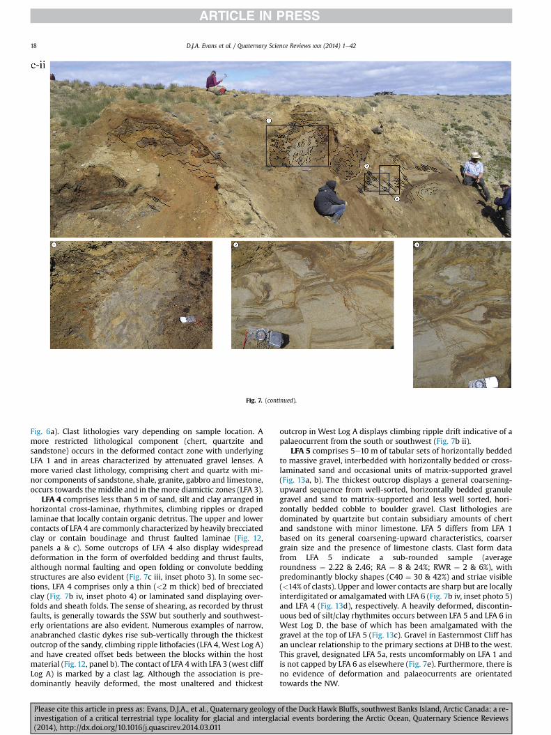
Fig 7 (continued)
DJA Evans et al Quaternary Science Reviews xxx (2014) 1e4218
Fig 6a) Clast lithologies vary depending on sample location Amore restricted lithological component (chert quartzite andsandstone) occurs in the deformed contact zone with underlyingLFA 1 and in areas characterized by attenuated gravel lenses Amore varied clast lithology comprising chert and quartz with mi-nor components of sandstone shale granite gabbro and limestoneoccurs towards the middle and in the more diamictic zones (LFA 3)
LFA 4 comprises less than 5 m of sand silt and clay arranged inhorizontal cross-laminae rhythmites climbing ripples or drapedlaminae that locally contain organic detritus The upper and lowercontacts of LFA 4 are commonly characterized by heavily brecciatedclay or contain boudinage and thrust faulted laminae (Fig 12panels a amp c) Some outcrops of LFA 4 also display widespreaddeformation in the form of overfolded bedding and thrust faultsalthough normal faulting and open folding or convolute beddingstructures are also evident (Fig 7c iii inset photo 3) In some sec-tions LFA 4 comprises only a thin (lt2 m thick) bed of brecciatedclay (Fig 7b iv inset photo 4) or laminated sand displaying over-folds and sheath folds The sense of shearing as recorded by thrustfaults is generally towards the SSW but southerly and southwest-erly orientations are also evident Numerous examples of narrowanabranched clastic dykes rise sub-vertically through the thickestoutcrop of the sandy climbing ripple lithofacies (LFA 4 West Log A)and have created offset beds between the blocks within the hostmaterial (Fig 12 panel b) The contact of LFA 4 with LFA 3 (west cliffLog A) is marked by a clast lag Although the association is pre-dominantly heavily deformed the most unaltered and thickest
Please cite this article in press as Evans DJA et al Quaternary geologyinvestigation of a critical terrestrial type locality for glacial and intergla(2014) httpdxdoiorg101016jquascirev201403011
outcrop in West Log A displays climbing ripple drift indicative of apalaeocurrent from the south or southwest (Fig 7b ii)
LFA 5 comprises 5e10 m of tabular sets of horizontally beddedto massive gravel interbedded with horizontally bedded or cross-laminated sand and occasional units of matrix-supported gravel(Fig 13a b) The thickest outcrop displays a general coarsening-upward sequence from well-sorted horizontally bedded granulegravel and sand to matrix-supported and less well sorted hori-zontally bedded cobble to boulder gravel Clast lithologies aredominated by quartzite but contain subsidiary amounts of chertand sandstone with minor limestone LFA 5 differs from LFA 1based on its general coarsening-upward characteristics coarsergrain size and the presence of limestone clasts Clast form datafrom LFA 5 indicate a sub-rounded sample (averageroundness frac14 222 amp 246 RA frac14 8 amp 24 RWR frac14 2 amp 6) withpredominantly blocky shapes (C40 frac14 30 amp 42) and striae visible(lt14 of clasts) Upper and lower contacts are sharp but are locallyinterdigitated or amalgamated with LFA 6 (Fig 7b iv inset photo 5)and LFA 4 (Fig 13d) respectively A heavily deformed discontin-uous bed of siltclay rhythmites occurs between LFA 5 and LFA 6 inWest Log D the base of which has been amalgamated with thegravel at the top of LFA 5 (Fig 13c) Gravel in Easternmost Cliff hasan unclear relationship to the primary sections at DHB to the westThis gravel designated LFA 5a rests uncomformably on LFA 1 andis not capped by LFA 6 as elsewhere (Fig 7e) Furthermore there isno evidence of deformation and palaeocurrents are orientatedtowards the NW
of the Duck Hawk Bluffs southwest Banks Island Arctic Canada a re-cial events bordering the Arctic Ocean Quaternary Science Reviews
Fig 7 (continued)
DJA Evans et al Quaternary Science Reviews xxx (2014) 1e42 19
Please cite this article in press as Evans DJA et al Quaternary geology of the Duck Hawk Bluffs southwest Banks Island Arctic Canada a re-investigation of a critical terrestrial type locality for glacial and interglacial events bordering the Arctic Ocean Quaternary Science Reviews(2014) httpdxdoiorg101016jquascirev201403011
Fig 7 (continued)
DJA Evans et al Quaternary Science Reviews xxx (2014) 1e4220
Please cite this article in press as Evans DJA et al Quaternary geology of the Duck Hawk Bluffs southwest Banks Island Arctic Canada a re-investigation of a critical terrestrial type locality for glacial and interglacial events bordering the Arctic Ocean Quaternary Science Reviews(2014) httpdxdoiorg101016jquascirev201403011
Fig 7 (continued)
DJA Evans et al Quaternary Science Reviews xxx (2014) 1e42 21
Please cite this article in press as Evans DJA et al Quaternary geology of the Duck Hawk Bluffs southwest Banks Island Arctic Canada a re-investigation of a critical terrestrial type locality for glacial and interglacial events bordering the Arctic Ocean Quaternary Science Reviews(2014) httpdxdoiorg101016jquascirev201403011
Fig 7 (continued)
DJA Evans et al Quaternary Science Reviews xxx (2014) 1e4222
Please cite this article in press as Evans DJA et al Quaternary geology of the Duck Hawk Bluffs southwest Banks Island Arctic Canada a re-investigation of a critical terrestrial type locality for glacial and interglacial events bordering the Arctic Ocean Quaternary Science Reviews(2014) httpdxdoiorg101016jquascirev201403011
Fig 7 (continued)
DJA Evans et al Quaternary Science Reviews xxx (2014) 1e42 23
Please cite this article in press as Evans DJA et al Quaternary geology of the Duck Hawk Bluffs southwest Banks Island Arctic Canada a re-investigation of a critical terrestrial type locality for glacial and interglacial events bordering the Arctic Ocean Quaternary Science Reviews(2014) httpdxdoiorg101016jquascirev201403011
Fig 7 (continued)
DJA Evans et al Quaternary Science Reviews xxx (2014) 1e4224
LFA 6 crops out along the length of DHB and varies widely inthickness (1e11 m) displaying the most complex deformationstructures of any of the sediment bodies at DHB It comprises apredominantly heterogeneous diamicton or a meacutelange of discon-tinuous interbeds of massive matrix-supported diamicton matrix-supported gravel and laminated sand silt and clay with localizedattenuated lenses of degraded organics (Fig 7a ivevi 7b i iv 7c iiiii) Three samples of highly compressed and fragmented detritalmaterial displaying poor preservation were collected for identifi-cation Collectively LFA 6 has the appearance of a stratified dia-micton but locally it displays a more massive to pseudo-laminatedcharacter where sand silt and gravel lenses and occasional gravellags occur as thin beds stringers or wisps Some laminated sand siltand clay bodies appear to be rafts within the diamicton (intraclasts)due to their heavily deformed internal bedding and deformedcontacts or attenuated appearance Basal contacts with other lith-ofacies associations are typically erosional or deformed and asso-ciated with fissility boudinage and pseudo-lamination insediments on either side of the contact Basal diamictons can alsodisplay a higher concentration of gravel clasts that locally result in aclast-supported character or even a several metre-thick highlycontorted meacutelange of diamicton and stratified sediment bodies Insome sections the whole of LFA 6 has been complexly deformed toproduce stacked overfolds and thrust faults indicative of shearingtowards the southwest or WSW Clast macrofabrics are onlymoderately clustered (S1 frac14 0456e0637) but indicate stressdirected predominantly towards the SW Clast macrofabricstrengths as quantified by the fabric shape ternary plot (Fig 6a)and themodalityisotropy plot (Fig 6b) are variable and range frombi-modal to multi-modal Overall the macrofabric shapes in theternary graph plot across the spectrums of the glacitectonite andsubglacial traction till envelopes but there is a trend of changing
Please cite this article in press as Evans DJA et al Quaternary geologyinvestigation of a critical terrestrial type locality for glacial and intergla(2014) httpdxdoiorg101016jquascirev201403011
fabric strength vertically through LFA 6 The strongest clusters arefrom the basal diamictic zones (eg CCA F1 amp F3 AB plane data)whereas the weakest are from the top of the association (eg WCAF3 A-axes amp CCA F2 AB planes) where relatively low strain defor-mation indicators (open and recumbent folds) are ubiquitous
Clast lithologies in LFA 6 are dominated by quartz chert andsandstone although one diamict reveals a concentration of sand-stone lithologies at the expense of chert Clast forms similarlyreflect the nature of the sampled materials whereby the gravellysample (CCA 2) was characterized by relatively low C40 (38) andRA (12) values and a high average roundness (256) compared tothe same values for the diamictons of LFA 6 (C40 frac14 50e74RA frac14 38e52 average roundness frac14 174e204) A small number ofclasts (lt10) in LFA 6 were striated
512 Interpretation5121 LFA 1 The thick tabular sequence of well sorted cross-stratified sand and gravel records deposition by a former glaci-fluvial braided river typified by fluctuating discharge (eg Church1972 Boothroyd and Ashley 1975 Miall 1978 1985 1992Marren 2005) The highest discharge is recorded by matrix-supported gravel with boulders indicative of hyperconcentratedflows or a traction carpet (Maizels 1989ab Siegenthaler andHuggenberger 1993 Mulder and Alexander 2001) These areseparated by and vertically give way to lower discharges recordedby planar or trough cross-bedded sand and horizontal to planar ortrough cross-bedded gravel These deposits record aggradation andmigration of gravel bars and sheets and downstream accretionarymacroforms with relatively tightly constrained palaeocurrent in-dicators (Miall 1977 1985 Collinson 1996) The general lack ofscour fills and an overall fining-upward is indicative of an aggradingsystem initially characterized by high magnitudehigh frequency
of the Duck Hawk Bluffs southwest Banks Island Arctic Canada a re-cial events bordering the Arctic Ocean Quaternary Science Reviews
Fig 7 (continued)
DJA Evans et al Quaternary Science Reviews xxx (2014) 1e42 25
Please cite this article in press as Evans DJA et al Quaternary geology of the Duck Hawk Bluffs southwest Banks Island Arctic Canada a re-investigation of a critical terrestrial type locality for glacial and interglacial events bordering the Arctic Ocean Quaternary Science Reviews(2014) httpdxdoiorg101016jquascirev201403011
Fig 7 (continued)
DJA Evans et al Quaternary Science Reviews xxx (2014) 1e4226
Please cite this article in press as Evans DJA et al Quaternary geology of the Duck Hawk Bluffs southwest Banks Island Arctic Canada a re-investigation of a critical terrestrial type locality for glacial and interglacial events bordering the Arctic Ocean Quaternary Science Reviews(2014) httpdxdoiorg101016jquascirev201403011
DJA Evans et al Quaternary Science Reviews xxx (2014) 1e42 27
events that were gradually replaced by low magnitudehigh fre-quency events (Marren 2005) Partially to heavily-scoured rem-nants of laminated and massive fines represent deposition duringlow flow conditions in abandoned shallow channels The palae-ocurrent data from LFA 1 indicate that the outwash streams wereflowing westerly away from a glacier source located in AmundsenGulf This glacier likely eroded the abundant LFA 1 lithologies(chert quartzite and sandstone) from Mesoproterozoic and Neo-proterozoic bedrock widely distributed to the east and south(western Victoria Island Amundsen Gulf and the adjacent main-land Harrison et al 2013) These lithologies are consistent with theadvance of the NW Laurentide Ice Sheet through Amundsen Gulf(cf Dyke et al 2002 Batchelor et al 2012 MacLean et al 2013)
The crudely bedded organic detritus and degraded tree frag-ments (stumps) in LFA 1 are clearly reworked (cf Matthews et al1986 Fyles 1990 Vincent 1990) The finer grained detritus wasdeposited in concentrated pockets during waning flow stageswhereas horizons of logs and larger tree fragments were emplacedwith the coarser grained and poorly sorted sediments associatedwith hyperconcentrated flows or traction carpets during highdischarge These reworked organics also differ significantly fromthe type location of the Beaufort Fm a characteristic that promptedFyles (1990) to distinguish them as lsquotheMary Sachs Gravelrsquo Notablythe enclosing gravel and sand of LFA 1 is much coarser and exhibitsan entirely different fluvial architecture than the sandier BeaufortFm The composition and degraded nature of the LFA 1 organicssuggests that they were eroded by glaciers or their meltwater fromNeogene andor Paleogene sediments presumably to the southeastof Banks Island (eg Fyles 1990 Fyles et al 1994) The proximity ofa glacier is highlighted by the preservation of striae on individualclasts especially in the very coarse lower gravel The verticaldecrease in striae preservation and angularity (RA) and concomi-tant increase in roundness and upward-fining in LFA 1 is indicativeof an increasingly distal ice margin The co-variance plots (Fig 5)indicate a strong fluvial signature especially in the C40RA data butsubglacial characteristics are also evident particularly in the C40RWR data for the coarser grained and more matrix-supportedgravel as would be expected in ice-proximal settings
It is important to note that the widespread thrusting of LFA 1and underlying Kanguk Formation towards the southwest occurredpost-depositionally This glacitectonic thrusting was produced byLaurentide ice that advanced from the Kellett River valley (interiorBanks Island) during the emplacement of LFA 6 (see below) Theinjection of clastic dykes and fissure fills during this glacitectonicdisturbance was due to the overpressurizing of groundwater ingravel aquifers likely in taliks The branching limbs of many of thedykes are indicative of burst-out structures diagnostic of hydro-fracturing by vertically escaping groundwater pressurized byglacier overriding (cf Rijsdijk et al 1999 Le Heron and Etienne2005)
5122 LFA 2 At the top of LFA 1 rhythmites with lonestonesoverlie prominent clinoforms or foreset beds recording a changefrom subaerial glacifluvial to subaqueous deposition This wasinitially on a shallow delta front prograding foreset beds in asouthwesterly direction followed by suspension sedimentationwith dropstones presumably from floating ice in a marine orlacustrine basin The occurrence of matrix-supported gravelly scourfills with logs and woody detritus suggests pulses of cohesionlesssediment gravity flows into the basin Overlying the rhythmically-bedded sand prominent ice wedge pseudomorphs (up to 4 mdeep Fig 9aec cf Mackay and Burn 2002) are interspersed withthick (gt1m) sections of compressed in situ bryophytes (Figs 9d 7e)indicating the establishment of a tundra surface Four bryophytefamilies and 10 distinct species have been determined from LFA2
Please cite this article in press as Evans DJA et al Quaternary geologyinvestigation of a critical terrestrial type locality for glacial and intergla(2014) httpdxdoiorg101016jquascirev201403011
with the most abundant material from the Calliergonaceae andCampyliaceae (Table 1) These macrofossils are exceptionally wellpreserved including material with intact fragile alar cells typical ofthese two families (Fig 14cef) The data from these autochthonousdeposits indicate a wetland environment characterized as a richfen This ecosystem and habitats therein are consistent with speciesfound in the extant flora of Banks Island (Fig 14b) The autecologyfrom this range of species suggest hydric to mesic habitatsincluding standing pools wet meadows and microhabitats createdby ice wedges Despite the predominance of bryophytes in LFA 2these macrofossils had not been previously documented at DHB Incontrast a minimal proportion of the samples (lt5) consisted ofvascular plant material (including Cyperaceae seeds gramminoidleaves and woody twig fragments) Collectively the ice wedgepseudomorphs and vegetation within LFA 2 represent an isochro-nous terrestrial surface of interglacial rank
Following the formation of ice wedges the injection of intra-formational clastic dykes and fissure fills in LFA 2 relates to theoverpressurizing of groundwater in gravel aquifers or taliks due toglacier overriding The branching dyke limbs that emanate fromunderlying LFA 1 gravels and sands are indicative of the burst-outstructures that develop during hydrofracturing (cf Rijsdijk et al1999 Le Heron and Etienne 2005) A variant of the gravel andsand filled clastic dykes occurs within the sequence of glaci-tectonite and rhythmites near west Log D (Fig 11) Here thevertically-widening fracture is characterized by a mosaic ofpartially disaggregated blocks of the host materials in its widestzone where it contains gravels injected from underlying LFA 1Because these gravels only occur in the basal narrow neck theypresumably record the rapid reduction in flow competence duringhydrofracture filling
Deformation structures including overfolded or crumpledbedding and thrust faults associated with boudinage or highfissilitypseudo-lamination are representative of simple shear andwere also induced by glacitectonic disturbance (cf van derWateren 1995 McCarroll and Rijsdijk 2003) This predominantlyrecords a glacier advance from the northeast Subsidiary shear in-dicators record deformation from the south or southeast but theseoccur only at the top of LFA 2 and the base of LFA 3 suggestingearlier emplacement (see below) The development of zones ofboudinage shallow thrust faults overfolding or bed crumpling atdifferent levels within LFA 2 e especially at the contact separatingsediments of different grain size e represents deformation parti-tioning due to contrasting rheological properties Blind thrustswere also initiated in underlying LFA 1 increasingly towards thecentral and eastern cliffs where large-scale deformation is moreprevalent (Fig 7c d) A zone of intense deformation is recorded by alens of LFA 3 diamicton in fault contact with LFA 2 (east cliff Log AFig 7d i) This constitutes a type B glacitectonite (non-penetrativelydeformed pre-existing sediments sensu Benn and Evans 1996Evans et al 2006) developed during the emplacement of LFA 3(see below) A similar glacitectonite occurs at the junction of LFA 1and LFA 3 near west Log D (Fig 11) Bed attenuation by deformationis best developed in lower LFA 2 where the greater differences insediment grain size and hence rheology exist
5123 LFA 3 Within LFA 3 locally abundant stratified lensesindicate subaqueous deposition These stratified sediments weresubsequently thrust faulted folded and attenuated - most evidentin the upper and lower zones of LFA 3 This deformation was likelyresponsible for the intraclast boudinage and pseudo-lamination inthe surrounding diamicton (eg Hart and Roberts 1994 Robertsand Hart 2005 Oacute Cofaigh et al 2011) This process was alsoassociatedwith the attenuation of LFA 1 and 2 sediments within theheavily deformed base of LFA 3 some of which may have been
of the Duck Hawk Bluffs southwest Banks Island Arctic Canada a re-cial events bordering the Arctic Ocean Quaternary Science Reviews
Fig 8 Details of LFA 1 a) example of a concentration of logs with degraded rootballs in the stacked tabular units of cross-bedded sands and gravels and crudely stratified matrix-supported cobble to boulder gravels in the west cliff b) poorly-sorted and crudely horizontally bedded cobble to boulder gravel containing laminated clay intraclast (immediatelyabove compass) c) shallow locally graded foreset beds composed of openwork to sandy matrix-supported cobble to granule gravels in central cliff Log A d) planar bedded sandy
DJA Evans et al Quaternary Science Reviews xxx (2014) 1e4228
Please cite this article in press as Evans DJA et al Quaternary geology of the Duck Hawk Bluffs southwest Banks Island Arctic Canada a re-investigation of a critical terrestrial type locality for glacial and interglacial events bordering the Arctic Ocean Quaternary Science Reviews(2014) httpdxdoiorg101016jquascirev201403011
DJA Evans et al Quaternary Science Reviews xxx (2014) 1e42 29
cannibalized and rafted by the deformation process within a shearzone at the contact of LFA 3 with older sediments The shearingdirection from the south and southeast recorded in lower LFA 3also impacted upper LFA 2 whereas the more prominent shearingdirection throughout LFA 3 is from the northeast (also recorded inLFA 4) The local development of a heavily deformed zone at the topof LFA 3 was likely imparted during the shearing of overlying LFA 4sediments Although clast macrofabric strengths from the LFA 3diamicton are variable they possess shapes that compare withglacitectonites and subglacial traction tills and in some cases amodalityisotropy signature that reflects high lodgementcomponents
The similar orientation of the macrofabrics and shear indicatorsare considered diagnostic of a glacitectonite derived from stratifiedsediments (eg interbedded mass flow diamictons gravelly massflows and localized traction current sands and suspension de-posits) This evidence indicates that LFA 3 like all the other LFAsand the underlying Kanguk Fm bedrock has been displaced by aglacier advancing from the NNE or NE (ie Laurentide ice crossingthe interior of Banks Island) Minor south to north shearing in-dicates that LFA 3 and upper LFA 2were also disturbed by glacier iceflowing northwards (ie Laurentide ice advancing throughAmundsen Gulf) The appearance of granite and gabbro clastswithin the LFA 3 diamict records the arrival of far-travelled Lau-rentide ice from mainland Canada Clast form co-variance stronglyindicates a subglacial (abraded) source for LFA 3 with a minorfluvial component (Fig 5) including glacifluvial clasts locallycannibalized from LFA 1 by overriding ice
5124 LFA 4 LFA 4 has restricted outcrops is heavily deformedand contains organic detritus that is clearly allochthonous andhighly degraded Nonetheless a variety of indicators (fine-grainedhorizontally bedded cross-laminae rhythmites climbing ripplesand draped laminae) demonstrate that LFA 4 was deposited in asubaqueous environment with palaeocurrents from the south orsouthwest Traction currents were likely responsible for thedevelopment of the clast lag at the contact between lower LFA 4and underlying LFA 3 (west cliff Log A Fig 7b ii) LFA 4 coarsensupwards indicative of basin infilling andor an approaching sedi-ment source The narrow anabranched clastic dykes in the sandyclimbing ripples (LFA 4 west cliff Log A) record hydrofracturing bythe upward injection of overpressurized groundwater duringshearing The branching limbs of the dykes are similar to the burst-out structures reported by Rijsdijk et al (1999) but differ becausethey are composed solely of sand derived from the walls of the hostsediment rather than from an underlying gravel aquifer (cf LeHeron and Etienne 2005) Hence the pressurized water wasgenerated at the contact between the sand and underlying imper-meable brecciated clays The development of thin zones of brecci-ation boudinage sheath folding or thrust faulting at the upper andlower contacts of LFA 4 relates to the localized partitioning ofdeformation controlled by the location of claysilt beds Thejuxtaposition of this style of deformation with the larger scaleoverfolds and thrust faults developed in the extensive bodies ofsandy lithofacies is indicative of a Type B glacitectonite (sensu Bennand Evans 1996) This was constructed by the overriding of glacierice advancing from the north or northeast These shear directionsare compatible with those developed in the underlying LFAs
granule gravels with gravel lags (top and bottom of image) interrupted by an intervening unbedded granule to pebble gravel and massive cobble to pebble gravel A cluster of small treesequence of stacked tabular units of predominantly horizontally bedded sands and gravels ingravels containing clusters of wood detritus in the coarser gravel beds (central cliff Log A)wood fragments (central cliff Log A)
Please cite this article in press as Evans DJA et al Quaternary geologyinvestigation of a critical terrestrial type locality for glacial and intergla(2014) httpdxdoiorg101016jquascirev201403011
5125 LFA 5 The primary characteristics of LFA 5 are typical ofgravel sheet and occasional traction-carpet sedimentation in anice-proximal sandur (eg Boothroyd and Ashley 1975 Miall 19781985 1992 Maizels 1989ab Siegenthaler and Huggenberger1993 Mulder and Alexander 2001 Marren 2005) Glacier prox-imity is supported by the subglacial to fluvial signature of the clastforms (Fig 5) The coarsening-upward sequence including striatedclasts culminates in the arrival of a glacier that overrode the sitedepositing LFA 6 Post-depositional shearing within underlying LFA4 is recorded by attenuation and interdigitation at the contact withLFA 5 imparted during deposition of LFA 6 The contact betweenLFA 5 and 6 reflects the development of a shear zone where upperLFA 5 sediments have been cannibalized producing a meacutelange ofcrudely stratified diamictons with discontinuous interbeds ofmatrix-supported gravel laminated sand silt and clay (LFA 6 seebelow)
5126 LFA5a At Easternmost Cliff glacifluvial gravel (LFA 5a)unconformably overlies LFA 1 (Fig 7e) rendering uncertain itsrelationshipwith respect to LFA 5 in themain sections of DHB to thewest The fact that LFA 5a extends to the modern surface appearsundeformed and has palaeocurrents orientated to the NW requiresthat it is younger than LFA 5 Indeed we interpret LFA 5a asdeglacial outwash deposited from retreating Laurentide ice in theKellett River valley and Amundsen Gulf at the end of the lastglaciation (see Discussion)
5127 LFA 6 Based on its heterogeneity strongly orientated clastmacrofabrics and macroscale deformation structures LFA 6 con-stitutes a Type B glacitectonite (sensu Benn and Evans 1996)However zones of more highly strained Type A glacitectonite(sensu Benn and Evans 1996) at the basal contact with older LFAsare recorded by intraclastinterbed attenuation (pseudo-lamina-tion) strong boudinage or fissility and strengthened clast macro-fabrics The production of this meacutelange is attributed to two separateprocesses 1) primary sedimentation as interbedded and interdig-itated mass flow debris fluvial gravel and sand and subaqueoussuspension sediments and 2) cannibalization of underlying strat-ified sediments (LFAs 4 and 5) This produced a continuum of formsranging from low strain fold structures to attenuated rafts to tec-tonic lamination (eg Fig 7) The discontinuous lenses of degradedorganics (black stems and woody twigs gramminoid leaveswhitened rootlets) within LFA 6 are rafts and include seven speciesof bryophytes (Table 1) The material was highly compressed anddifficult to separate into distinct taxa Indeed one of the threesamples analysed was too degraded to recover any taxa Much ofthe material consisted of only fragmented leaves and only theminute taxa had stems with intact leaves The bryophytes thatcharacterize the LFA 6 samples represent hydric (Calliergon sppTomenthypnum nitens) to mesic (Ditrichum flexicaule Dicranum sp)habitats Three species collected from LFA 6 were also present inLFA 2 whereas four others were not found in LFA 2 but are com-mon in the modern flora The poor preservation quality suggeststhat the material has been redeposited from unknown sources andis clearly allochthonous
The predominant shearing direction within LFA 6 records an iceadvance from the interior of Banks Island (NE) This has resulted incomplex folding and thrusting and localized thickening of LFA 6
it of cross-bedded poorly-sorted to openwork cobble to boulder gravel crudely planar-fragments occur at the base of the cobble to boulder gravels at image centre e) middleDHB west cliff Log D f) sequence of fining-upward planar-bedded cobble to sandy fineg) planar cross-bedded sandy granule to pebble gravels with pebble to cobble lags and
of the Duck Hawk Bluffs southwest Banks Island Arctic Canada a re-cial events bordering the Arctic Ocean Quaternary Science Reviews
Fig 9 Details of LFA 2 from the west cliff a) narrow necked ice wedge pseudomorph with upturned marginal bedding in sand silt and clay rhythmites b) wide necked ice wedgepseudomorph c) ice wedge pseudomorph with overturned silt sand and clay rhythmites developed at the top of LFA 2 and sealed by overlying LFA 3 laminated diamicton d)horizontally bedded sand and silt containing well preserved moss macrofossils e) zone of disharmonically folded sandsilt laminae with well preserved moss peat located at thebase of LFA 2
DJA Evans et al Quaternary Science Reviews xxx (2014) 1e4230
Please cite this article in press as Evans DJA et al Quaternary geology of the Duck Hawk Bluffs southwest Banks Island Arctic Canada a re-investigation of a critical terrestrial type locality for glacial and interglacial events bordering the Arctic Ocean Quaternary Science Reviews(2014) httpdxdoiorg101016jquascirev201403011
Fig 10 Details of simple shear structures developed in fine sand and silt laminae at the centre of the thickest outcrop of LFA 2 in west cliff Log B a) overview of large scaleanastomosing shear faults with zones of smaller scale densely spaced anastomosing shears towards the base of the photograph b) details of large scale shear faults separatingzones of variably but predominantly densely spaced shears c) close details of shear zone comprising densely spaced anastomosing fractures d) details of ascending kink zonecross-cutting large scale anastomising shear faults Shearing direction is coming out of the cliff and towards the left in each image
DJA Evans et al Quaternary Science Reviews xxx (2014) 1e42 31
This shearing direction is recorded throughout underlying LFAs 1e4as well as the Kanguk Formation demonstrating deep-seated butpartitioned glacitectonic disturbance imparted during theemplacement of LFA 6 This strain signature was therefore over-printed on the northerlynortheasterly aligned shearing directionrecorded in LFA 3 and upper LFA 2 by the earlier northerly flowingice that deposited LFA 3 One anomalous clast macrofabric(northerly CCA F1) occurs in the basal meacutelange of LFA 6 Howeverthis sample is from an isolated outcrop (Fig 7c i) rendering itsapparent shearing direction equivocal
Please cite this article in press as Evans DJA et al Quaternary geologyinvestigation of a critical terrestrial type locality for glacial and intergla(2014) httpdxdoiorg101016jquascirev201403011
52 Sedimentology and stratigraphy (Mary Sachs Creek cliff)
The cliffs east of Mary Sachs Creek (Figs 2b 3) provides a cross-section through the seaward margin of the coast-parallel SachsMoraine (ldquosection Jrdquo Vincent et al 1983 Vaughan 2014) Weprovide a summary of two logs based on a reconnaissance survey ofthese sediments Log A is closest toMary Sachs Creekwhereas Log Boccursw1 km farther east (Figs 3 15a amp b) The sediments exposedin Log A appear to descend eastward and disappear below themodern beach and therefore are assumed to stratigraphically
of the Duck Hawk Bluffs southwest Banks Island Arctic Canada a re-cial events bordering the Arctic Ocean Quaternary Science Reviews
Fig 11 Details of LFA 2 near west Log D Lower box shows a 1e2 m thick basal zone comprising highly attenuated inter-digitated beds of gravelly to clay-rich diamictons and sandsiltclay rhythmites Upper box shows rhythmites containing diamictic intraclasts with sharp and angular boundaries also visible is the draping and deforming of the rhythmitebedding over and under the intraclasts respectively ldquoTailsrdquo extending from the diamictic intraclasts and thin but discontinuous diamictic beds are also visible in the upper box
DJA Evans et al Quaternary Science Reviews xxx (2014) 1e4232
underlie the sediments of Log B A sand and gravel- bench caps bothlogs at w15 m asl incised into the seaward margin of the SachsMoraine
521 DescriptionLog A contains a sequence of upward-fining highly contorted
cross-stratified sand and fine gravel to rhythmically bedded sandsilt clay with minor pebble gravel and sporadic clots of gravellydiamicton (Fig 15a) An ice wedge was initially developed in thelower cross-stratified sand and fine gravel before they were foldedand thrust faulted The deformed ice wedge pseudomorph is un-conformably overlain by a relatively undisturbed lens of laminatedsilty clay with dropstones interbedded with gravelly diamictonthat contains a bed (10 cm) of sandy black organics containingwood fragments (Fig 15a) This organic material occurs repeatedlyup-section as discontinuous stringers Log A is capped by 1e2 m ofpoorly exposed and heavily cryoturbated gravelly diamicton Thegeneral sense of displacement on shallow reverse faults over-turned bedding and boudinage structures is from the southeast
Log B (12 m) displays a coarsening-upward sequence of hori-zontally bedded sandy granule gravel with occasional silty sandlaminae (Fig 15b iii) that grades to poorly-sorted cobble to bouldergravel and bouldery matrix-supported gravel (Fig 15b ii) This iscapped by laminated to crudely stratified cobbly diamicton that issilt and clay-rich abruptly and conformably overlain by
Please cite this article in press as Evans DJA et al Quaternary geologyinvestigation of a critical terrestrial type locality for glacial and intergla(2014) httpdxdoiorg101016jquascirev201403011
interlaminated silt clay and pebbly silty sand (Fig 15b i) Althoughthe bedding on these units dips towards the NW individuallaminae do not thicken in that direction indicating post-depositional tilting The uppermost part of the log (underlyingthe 15 m bench) contains 2 m of clay-rich massive diamictoninterfingered with the underlying laminated sediments and cobblydiamicton
522 Interpretation
5221 Log A Broadly the sedimentology of log A including thedeformed ice wedge pseudomorph is similar to LFA 2 in DHB (egcentral cliff Log A Fig 7c iii) Prior to glacitectonic disturbance theoverlying organic bed (Fig 15a) was redeposited into a sequence ofsubaqueous siltclay rhythmites containing dropstones and gravellymass flows The highly attenuated shear margins bracketing theorganic bed in Log A demonstrate that it has been displaced as atectonic raft Previous research proposed that the organic beds e
similar to those described in Log A e be assigned to the LastInterglacial (locally called the Cape Collinson Vincent 1982 1983)Because these organic beds are clearly a raft they cannot constitutean iscochronous surface precluding chronostratigraphic signifi-cance (see Discussion) Shearing of the Log A sediments from thesoutheast documents an ice advance from Amundsen Gulf corre-sponding to the earliest of two primary shearing directions recor-ded at DHB (imparted during the emplacement of LFA 3) Therefore
of the Duck Hawk Bluffs southwest Banks Island Arctic Canada a re-cial events bordering the Arctic Ocean Quaternary Science Reviews
Fig 12 Details of LFA 4 in West Log A a) heavily deformed upper contact of LFA 4 comprising sandsiltclay rhythmites displaying well developed boudinage sheath folds andimmature tectonic laminae and an interdigitatedsheared boundary with underlying climbing ripple sands The contact with overlying LFA 6 is marked by an interdigitated zonecontaining rooted and de-rooted folds or rhythmite rafts in a sand gravel and diamicton meacutelange b) narrow anabranched clastic dykes ascending sub-vertically through climbingripple drift and resulting in offset bedding between blocks of host material c) abrupt contact between sheared sands and rhythmites of LFA 4 and overlying sand gravel anddiamicton meacutelange
Fig 13 Details of LFA 5 a) poorly sorted and matrix-supported pebble to cobble gravel b) tabular sequence of horizontally bedded to massive gravel and matrix-supported gravelcontaining a horizon of striated cobbles and boulders c) heavily deformed discontinuous bed of siltclay rhythmites between LFA 5 and LFA 6 in West Log D showing theamalgamation zone with the LFA 5 gravels immediately above the compass d) interdigitateddeformed contact between LFA 5 granule to pebble gravels and underlying LFA 4laminated silts and clays with organic detritus in West Log B
DJA Evans et al Quaternary Science Reviews xxx (2014) 1e42 33
Please cite this article in press as Evans DJA et al Quaternary geology of the Duck Hawk Bluffs southwest Banks Island Arctic Canada a re-investigation of a critical terrestrial type locality for glacial and interglacial events bordering the Arctic Ocean Quaternary Science Reviews(2014) httpdxdoiorg101016jquascirev201403011
Table 1List of bryophytes and vascular plants from LFAs 2 and 6
LFA2 WestCliff Log B
LFA6 CentralCliff Log A
Elevation (m) 185 m asl w45 m aslSample 4e12 1e3 taxa 10 7
Bryophyta (mosses)AmblystegiaceaeAmblystegium serpens (Hedw) Schimp x
CamyliaceaeCampylium polygamum (Schimp) CEO Jensen xCampylium stellatum (Hedw) CEO Jensen x xDrepanocladus aduncus (Hedw) Warnst xDrepanocladus sp xTomentypnum nitens (Hedw) Loeske x
CalliergonaceaeCalliergon giganteum (Schimp) Kindb xCalliergon richardsonii (Mitt) Kindb xthornthornthornthorn xCalliergon sp xWarnstorfia exannulatus (Schimp) Loeske xthornthornthornthorn x
BrachytheciaceaeBrachythecium turgidum (Hartm) Kindb x
MniaceaeCyrtomnium cf hymenophylloides(Hbener) TJ Kop
x
DicranaceaeDicranum sp x
DitrichaceaeDitrichum flexicaule (Schwaumlgr) Hampe x
Tracheophyta (vascular plants)CyperaceaeSeeds (triangular amp flattened) x x
Gramminoid leaf material x xWoody twig fragments x xRootlets x
Fig 14 The moss peat and associated microfossils of LFA 2 a) exposure through lower LFAsouthern Banks Island analogue of a rich tundra fen environment for the bryophyte assemblfrom LFA 2 showing the exceptional preservation of Calliergonaceae and Campyliaceae ma
DJA Evans et al Quaternary Science Reviews xxx (2014) 1e4234
Please cite this article in press as Evans DJA et al Quaternary geologyinvestigation of a critical terrestrial type locality for glacial and intergla(2014) httpdxdoiorg101016jquascirev201403011
these deformed deposits are interpreted as a Type B glacitectonite(sensu Benn and Evans 1996) possibly derived from LFA 2
5222 Log B The coarsening upward gravel in Log B recordshighly turbid to hyperconcentrated discharge in non-channelizedsheets This is interpreted as aggrading glacifluvial outwash froman approaching ice margin The capping sequence of crudelystratified diamicton and laminated sediments records a changefrom glacifluvial to subaqueous sedimentation prior to overridingby a glacier of unknown age that tilted the upper beds Thecoarsening-upward sequence apparent tectonism and cappingdiamict at Log B clearly distinguishes these deposits from those ofLFA 5a (west of Mary Sachs Creek easternmost cliff Fig 3)Furthermore although there is lithological similarity between LogB and LFA 5 throughout DHB the sense of shearing is dissimilar (LFA5 from the NE and Log B from the SE) The simplest explanation forthis difference in shear direction is that LFA 5 (DHB) was displacedby interior ice advancing down the Kellett River whereas Log B wasdisplaced by ice advancing along Amundsen Gulf (Fig 2b)
6 Discussion
61 Large scale glacitectonic structures and stratigraphicarchitecture
The glacitectonic structures identified within the lithofaciesassociations at DHB record two phases of deformation (early NeSand later NEeSW) This deformation together with the DHBstratigraphic architecture (Fig 16) helps to explain both thekinetostratigraphy (sensu Berthelsen1978) and the evolution of thelocal glacial geomorphology The large scale glacitectonic defor-mation is most clearly manifest in the thrust faulting and conjugate
2 at DHB west log B showing the sampling locations for in situ moss peat b) a modernages of LFA 2 c)ef) details of the typical moss peat and associated microfossil materialscrofossils including material with intact fragile alar cells
of the Duck Hawk Bluffs southwest Banks Island Arctic Canada a re-cial events bordering the Arctic Ocean Quaternary Science Reviews
Fig 15 The stratigraphy of Mary Sachs Creek cliff a) photographic compilation log A showing upward-fining highly contorted (i) cross-stratified sands and fine gravels torhythmically bedded sands silts clays and minor pebble gravels Also visible in (ii) is a lens of interbedded laminated silty clays with dropstones and gravelly diamictons containingsandy black coloured organic material with wood fragments An ice wedge pseudomorph is visible (iii) to the right of the exposure b) photographic compilation log B showing i)laminated to crudely stratified cobbly but siltclay-rich diamicton grading into interlaminated silts clays and pebbly silty sands ii) poorly-sorted cobble to boulder gravel andbouldery matrix-supported gravel iii) coarsening-upward sequence of horizontally bedded sandy granule gravels with occasional silty sand laminae iv amp v) pebble to cobble graveland matrix-supported gravel
DJA Evans et al Quaternary Science Reviews xxx (2014) 1e42 35
shear development in the Kanguk Fm bedrock and overlying LFA 1(east cliff Fig 7d ivevi) Here predominantly northeasterly dippingthrust slices have been stacked truncated and overlain by LFA 6during the second and strongest (NEeSW) deformation phase(Fig 16 note bedrock slice within the imbricated stacked sequenceof LFA 1) These structures demonstrate significant compressionand thickening of the stratigraphic sequence including w40 m ofvertical offset within the Kanguk Formation acrossw3 km (Fig 16)Prominent hydrofracture fills in LFAs 1 and 2 record elevatedporewater pressure during this thrusting Smaller scale shear zoneshave also developed in the finer grained interbeds within thrustslabs (Fig 7d vii) indicative of deformation partitioning by strataprone to ductile failure This zone of greatest displacement alsocoincides with the highest topography (Fig 16) Lower angle thrustfaults propagate in a southwesterly direction predominantlythrough LFA 1 but are also developed through LFA 2 in the footwallblock (east cliff Fig 16)
The thrust stacking of bedrock and LFAs 1e5 in east cliff (obliqueto Fig 16) represents the ice-proximal zone of a thrust-blockmorainecomposite ridge constructed by a glacier advancing fromthe northeast (ie the interior of Banks Island) This glacitectonicdeformation propagated southwestward to distal parts of theproglacial stress field as recorded bywell-developed shear zones inthe finer grained sediments of LFAs 2e5 In the more distal westcliff open folds (LFA 2 Fig 16) appear to be the product of a blindthrust within underlying LFA 1 This style of tectonism is typical oflsquopiggyback-style thrustingrsquo wherein steeply inclined thrust blocksat the advancing ice margin propagate new thrusts in the footwall(Fig 16 Park 1983 Mulugeta and Koyi 1987) The angle of thesefootwall thrusts becomes progressively shallower southwestward
Please cite this article in press as Evans DJA et al Quaternary geologyinvestigation of a critical terrestrial type locality for glacial and intergla(2014) httpdxdoiorg101016jquascirev201403011
(ice-distal) in LFA 1e5 where deformation partitioning developedin finer grained lithofacies (Fig 16)
The densely spaced ponds and depressions immediately to thenortheast of DHB (Figs 2b 3) constitute the depression fromwhich the thrust mass was excavated (eg Aber et al 1989Evans and England 1991 van der Wateren 1995) This inter-pretation is consistent with the strong northeast to southwestshear direction in the second phase glacitectonic structures andin LFA 6 clast macrofabrics This indicates that construction ofDHB occurred at the margin of a glacier advancing from thenortheast (ie from Kellett River valley) overtopping DHB anddepositing the LFA 6 glacitectonite The continued advance ofKellett ice coalesced with a glacier in Amundsen Gulf marked bythe interlobate Sachs Moraine containing ice-transported shellsas young as 24 cal ka BP (21020 70 yrs BP UCIAMS-89674)assigning this glaciation to the Late Wisconsin (Vaughan 2014)East of Mary Sachs Creek the deformation of Log B outwash(from the southeast Figs 15 16) likely records overriding by thesame Amundsen Gulf glacier (coeval with LFA 6 Late Wiscon-sinan) During ice retreat when Kellett River and Amundsen Gulfice decoupled DHB was exposed allowing the northwesterly-flowing proglacial outwash (LFA 5a) west of Mary Sachs Creekto extend to the shoreline marking postglacial marine limit atKellett Point (11 m asl Vaughan 2014 Fig 3) Collectively thisreconstruction supports a Late Wisconsinan age for the con-struction of DHB thrust block moraine although its stratigraphyincludes a range of ages A palaeogeographic reconstruction ofevents based upon our interpretation of the sedimentologystratigraphic architecture tectonism and geomorphology is pre-sented in Fig 17
of the Duck Hawk Bluffs southwest Banks Island Arctic Canada a re-cial events bordering the Arctic Ocean Quaternary Science Reviews
Fig 15 (continued)
DJA Evans et al Quaternary Science Reviews xxx (2014) 1e4236
62 Comparison and revision of previous DHB model
DHB was previously interpreted to record horizontally beddedNeogene to Quaternary sediments assigned to preglacial fluvialand multiple glacial and interglacial episodes (Vincent 1982 19831990 Vincent et al 1983 1984 Barendregt et al 1998) A com-posite palaeomagnetic record was also presented for this proposedstratigraphy placing most of this deposition before the BrunhesMatuyama boundary (Fig 1c) However prior to our work detailedstudies had not been undertaken on the sedimentology structuralgeology or stratigraphic architecture of DHB Rather the originalstratigraphy was restricted to a series of composite logs (our Fig 4reproduced from Vincent et al 1983) that notably omitted thepervasive deformation structures including the thrust bedrock ineast cliff (Fig 16)
Please cite this article in press as Evans DJA et al Quaternary geologyinvestigation of a critical terrestrial type locality for glacial and intergla(2014) httpdxdoiorg101016jquascirev201403011
Our reinterpretation dismisses several key elements of theoriginal DHB model outlined below (oldest to youngest) We havedetermined that the lowermost unit (LFA 1) is not preglacial (Fyles1990) but rather is composed of glacial outwash providing theearliest terrestrial evidence for glaciation in the area and containingallochthonous organics (including tree stumps) of unknown prov-enance Because LFA 1 is a glacifluvial braidplain (Fig 17a) it is notpart of the Beaufort Fm (Fyles 1990) even though it containsreworked macrofossils presumably derived from it (eg Craig andFyles 1960 Hills et al 1974 Vincent et al 1983)
Our analysis of LFA 2 indicates that it is also not preglacial norcan it be the Worth Point Fm as previously proposed (cf Vincent1982 1983 1990 Vincent et al 1983 Matthews et al 1986)Indeed the type locality of the Worth Point Fm has been invali-dated because it is now recognized to be an ice-transported and
of the Duck Hawk Bluffs southwest Banks Island Arctic Canada a re-cial events bordering the Arctic Ocean Quaternary Science Reviews
LFA4
Fig16
Stratigrap
hiccross-profi
lerun
ning
westto
easto
fDuc
kHaw
kBluffs
basedup
oninterpolations
betw
eenthemainsectionlogs
andsh
owingthesixLFAstheKan
gukFo
rmationbe
droc
kex
posu
resmajor
structural
features
and
thepo
sition
sof
icewed
geps
eudo
morph
san
dsign
ificant
clasticdy
kesAtthe
easternen
dof
thecross-profi
lethe
sedimen
tsat
theco
reof
MarySa
chsCree
kcliff
logAaretentativelyclassified
asLFA2
althou
ghthesematerialsarelik
ely
notin
situN
otethat
thecross-profi
ledo
esno
tex
tend
asfarea
stas
MarySa
chsCree
kcliff
logB
DJA Evans et al Quaternary Science Reviews xxx (2014) 1e42 37
Please cite this article in press as Evans DJA et al Quaternary geologyinvestigation of a critical terrestrial type locality for glacial and intergla(2014) httpdxdoiorg101016jquascirev201403011
glacitectonized raft (Vaughan et al 2014) In contrast our LFA 2 ischaracterized by an isochronous tundra surface with ice wedgesand intervening shallow ponds andwetmeadows The peat at LFA 2is dominated by bryophytes (gt95 by volume) and yet none ofthese macrofossils had been previously documented The diversein situ bryophyte species record a flora similar to that on BanksIsland today suggesting that LFA 2 warrants an interglacial rankThis conclusion is supported by the limited vascular plant record(five taxa no species indicated Vincent 1990) that also suggest awet meadow environment The absolute age of LFA 2 remains un-known but is apparently older than the BrunhesMatayamaboundary (gt780 ka Fig 18 cf Vincent et al 1984 Barendregt andVincent 1990 Barendregt et al 1998 see below)
LFA 3 in both our model and that of Vincent et al (1983) pro-vides the first direct evidence of ice reaching DHB In the previousmodel this was interpreted as Bernard Till (Banks Glaciation) thatwas bracketed by glacioisostatically induced marine transgressions(pre- and post-Banks seas Vincent 1982 1983) Within basal LFA 3we recognized highly deformed stratified sediment that wasdeposited in a subaqueous environment (deep water Fig 17c) priorto the arrival of overriding ice from the south (recorded by graniteand gabbro erratics Figs 17c 18) We regard LFA 3 to be equivalentto the Banks Glaciation (Vincent 1982 1983 Vincent et al 1983)including its pre- and post-Banks seas represented by the stratifiedsediments that bracket the central diamicton The LFA 3 sedimentsare also reported to be magnetically reversed thereby predatingthe BrunheseMatayama boundary (gt780 ka Fig 18 Vincent et al1984 Barendregt and Vincent 1990 Barendregt et al 1998)
Following the Banks Glaciation (our LFA 3 at DHB) Vincent(1982 1983) and Vincent et al (1983) recognized two in-terglacials (Morgan Bluffs and Cape Collinson) separated by anintervening marine episode This marine episode correspondedwith the glacioisostatic loading of a Laurentide ice margin confinedto the eastern half of Banks Island (Thomsen Glaciation) HoweverLFA 4 contains coarsening-upward subaqueous sedimentation fromthe south or southwest reflecting continued marine regressionfollowing LFA 3 (Fig 17c d) The coarsening-upward sequence ofLFA 4 is supplanted by coarse gravel outwash (LFA 5) supplied by aglacier readvancing from the northeast (Kellett River valley iceFig 17e) Glacier overriding is recorded by LFA 6 glacitectonite thatcaps the DHB thrust-block moraine composed of the entireassemblage of underlying LFAs (Fig 16)
Notably we have not observed any sediments characteristic oftwo interglacial deposits above LFA 3 hence dismiss the presence ofthe Morgan Bluffs and Cape Collinson interglacials at DHB Causseand Vincent (1989) report a U-series date of gt200 ka (UQT-229)from above our LFA 3 but this is almost certainly reworked andlacks chronostratigraphic significance Nor have we observedintervening marine sediments attributable to the Thomsen Glaci-ation (eg lsquoBig Searsquo Vincent 1982 1983 Vincent et al 1983)Rather following the deposition of the subaqueous sediments ofupper LFAs 3 and 4 (post-Banks Glaciation) LFAs 5 and 6 record asingle ice advance reaching DHB from the Kellett River valley(Banks Island interior) that was not reported by Vincent et al(1983) It was instead assumed that after the Banks GlaciationDHB lay distal to any later ice advances The nearest subsequentLaurentide margin to DHB recognized by Vincent et al (1983) wasassigned to the Sachs Moraine (immediately east of DHB) that waspresumed to be of EarlyWisconsin age (Fig 2b) However the SachsMoraine is nowdated to24 cal ka BP (LateWisconsinan Vaughan2014) andwas formed by the coalescence of Amundsen Gulf ice andthe Kellett River ice that deformed DHB (Fig 17) On the east side ofMary Sachs Creek the deposition of the Sachs Moraine coincideswith the deformation (from the southeast) of the underlying Log Boutwash gravel (Figs 3 15b)
of the Duck Hawk Bluffs southwest Banks Island Arctic Canada a re-cial events bordering the Arctic Ocean Quaternary Science Reviews
Fig 17 The palaeogeography of southwest Banks Island based upon interpretations of the principal lithofacies associations and structural architecture recognized at Duck HawkBluffs and the geomorphology of the surrounding terrain See text for detailed explanations
DJA Evans et al Quaternary Science Reviews xxx (2014) 1e4238
Although interglacial deposits were previously reported fromthe cliffs east of Mary Sachs Creek (ie Cape Collinson InterglacialVincent et al 1983) we found no similar evidence Rather the onlydeposit that we observed that may have been construed as inter-glacial sediments occurs in our Log A (Figs 3 15a) Here a darkdiscontinuous band of allochthonous organics (Fig15a) sits severedwithin a heavily tectonized melange (type B glacitectonite) and istherefore clearly a raft Although the absolute ages of the deformedunits east of Mary Sachs Creek (Logs A amp B) remain uncertain theyare apparently normally magnetized (Vincent et al 1984Barendregt and Vincent 1990) Blake (1987) also reports non-finite radiocarbon dates (gt36000 amp 49000 BP GSC-3560 amp 3560-2) obtained on ldquocompressed and deformed black woody peatrdquopurportedly from Cape Collinson beds (Vincent et al 1983 p 1708)Additionally Causse and Vincent (1989) report a U-series date onshells of 924 ka (UQT-143) from beds similar to the Log B gravelAgain all of these dated units have been displaced from unknownlocations limiting their utility for palaeoenvironmental recon-struction The last glacially influenced sedimentation at DHB isrecorded by northwesterly directed outwash (easternmost cliff LFA5a Figs 3 16 17g) We infer that this outwash fed the gravel beachmarking marine limit (11 m asl) in the lower Kellett River duringLate Wisconsinan retreat from the Sachs Moraine
63 Regional context
The stratigraphy at Duck Hawk Bluffs records three glacialevents The earliest of these is recorded by the aggradation of a
Please cite this article in press as Evans DJA et al Quaternary geologyinvestigation of a critical terrestrial type locality for glacial and intergla(2014) httpdxdoiorg101016jquascirev201403011
glacifluvial braidplain (LFA 1) that contains allochthonous pre-glacial material of diverse age However within LFA 1 there is noevidence that the ice reached DHB although it must have beennearby (southeast in Amundsen Gulf) The age of this glaciationremains unknown but the palaeomagnetic polarity of LFA 1 in-dicates that it is gt780 ka BP (Barendregt and Vincent 1990)Although Barendregt et al (1998) assigned part of the Worth PointFm to the normally polarized Olduvai sub-zone (MIS 64e74) itshould be noted that the Worth Point section is located 30 kmnorthwest of DHB There a stratigraphic revision has demonstratedthat this ldquotype sectionrdquo of the Worth Point Fm is in fact a glaci-tectonized raft (Vaughan et al 2014) This observation invalidatesthe previous correlation from Worth Point to purportedly coevalbeds at DHB (our LFA 2) Furthermore the diverse plant assem-blages in the Worth Point raft include preglacial tree stumps andSphagnum spp that do not occur on Banks Island today and are notfound in the wet meadow assemblages (rich fen) of LFA 2 that weinterpret to be of interglacial rank Therefore the sediments at DHB(LFAs 1 amp 2) do not support an age assignment of MIS 64e74(Olduvai subzone) proposed by Barendregt et al (1998) Currentlythe available palaeomagnetic record at DHB simply separates theentire section into a lower lsquoreversedrsquo unit and an upper lsquonormalrsquoone We place this boundary within our LFA 4 (Fig 18)
The overriding of DHB by glaciers is recorded in LFAs 3 amp 6These two glacial deposits may correspond to parts of the record ofstacked till sheets reported from the offshore seismic stratigraphy(Batchelor et al 2012) LFA 3 glaciationmay have contributed to theonset of mid-Pleistocene ice-rafted debris (IRD Ca-rich) attributed
of the Duck Hawk Bluffs southwest Banks Island Arctic Canada a re-cial events bordering the Arctic Ocean Quaternary Science Reviews
B-M
B-M
gt19
Fig
18A
revisedlitho
stratigrap
hyforDuc
kHaw
kBluffsPrev
ious
lyrepo
rted
ageco
nstraintsarealso
depicted
toge
ther
withatentativeallocation
ofMIS
stag
es(positione
dalon
gsideEa
stCliff
LogA
forclarity)
basedup
onthe
palaeo
mag
neticreco
rd
DJA Evans et al Quaternary Science Reviews xxx (2014) 1e42 39
Please cite this article in press as Evans DJA et al Quaternary geology of the Duck Hawk Bluffs southwest Banks Island Arctic Canada a re-investigation of a critical terrestrial type locality for glacial and interglacial events bordering the Arctic Ocean Quaternary Science Reviews(2014) httpdxdoiorg101016jquascirev201403011
DJA Evans et al Quaternary Science Reviews xxx (2014) 1e4240
to the Canadian Arctic Archipelago (CAA) and recorded in sedimentcores from the Arctic Ocean basin (Polyak et al 2009 2013OrsquoRegan et al 2010 Stein et al 2010) However Stein et al(2010) place the onset of Ca-rich ice-rafted debris within MIS 16(w659 ka BP Lisiecki and Raymo 2005) with subsequent peaks atMIS 12 10 and 8 all of which postdate the gt780 ka BP palae-omagnetic age proposed for LFA 3 (above) Polyak et al (2013) placethe onset of Ca-rich ice-rafted debris in the central Arctic Oceancloser to MIS 19 (790 ka BP) which is broadly compatible with theDHB palaeomagnetic record LFA 6 records the last glaciation ofDHB and we assign this to the Late Wisconsinan when Banks Is-land ice (Kellett River) coalesced with the Amundsen Gulf IceStream (Stokes et al 2006 MacLean et al 2013) During this in-terval the northwest Laurentide Ice Sheet likely reached the edgeof the polar continental shelf (Stokes et al 2005 2006 Englandet al 2009 Batchelor et al 2012 Lakeman and England 2013MacLean et al 2013)
7 Conclusions
New sedimentological and stratigraphic analyses of DHB funda-mentally revise the previous reconstruction of the Neogene andQuaternary history of Banks Island DHB and two other widely citedsections on Banks Island have been reported as important unde-formed terrestrial archives of glacial and interglacial sedimentationat the northwest limit of the Laurentide Ice Sheet that all have beenrecently revised (Vaughan et al 2014 Lakeman and England inpress) The recognition of pervasive large-scale deformation ofDHB necessitates a fundamental re-assessment of its previouslydescribed layer-cake stratigraphy We document that the oldestsediments (LFA 1) at DHB are not preglacial fluvial deposits (Beau-fort Fm) but rather record proglacial outwash from ice in AmundsenGulf that did not reach the site This was followed by the estab-lishment of an isochronous tundra surface of interglacial rank (LFA2) characterized by ice wedge polygons within a wet meadow thatsupported a bryophyte community similar to modern Subse-quently glacial sedimentation resumed initially in an ice-proximalsubaqueous environment followed by ice arrival and glacitectonicdeformation (LFA 3) The overlying deposits at DHB indicate post-glacial marine sedimentation (LFA 4) followed by the aggradationof glacifluvial sand and gravel (LFA 5) from an advancing ice marginthat culminated with the emplacement of a glacitectonite (LFA 6)during the Late Wisconsin This ice advance constructed a previ-ously undescribed thrust-block moraine (60 m high 8 km long) thatexhibits pervasive deformation and includes a substantial raft ofCretaceous Kanguk Fm bedrock (Fig 16) Furthermore the produc-tion of the glacitectonite (LFA 6) cannibalized LFAs 1e5 which atsome sites were previously thought to be in situ interglacial de-posits Finally outwash (LFA 5a) incised the DHB thrust block duringdeglaciation of the site when ice in the Kellett River and AmundsenGulf separated and proglacial meltwater drained northwestward tomarine limit (11 m asl) Refinements to the evolution and chronol-ogy of DHB and other sections around Banks Island will furthercontribute to the understanding of high latitude environmentalchange especially the complementary marine archives of theadjacent polar continental shelf and Arctic Ocean
Acknowledgements
Funding for this research was provided by the Natural Sciencesand Engineering Research Council of Canada (NSERC) NorthernResearch Chair Program and a complementary NSERC DiscoveryGrant (A6680) (both to JH England) Coulthard Lakeman andVaughan were supported by CBAR grants Canadian CircumpolarInstitute University of Alberta Coulthard and Lakeman were also
Please cite this article in press as Evans DJA et al Quaternary geologyinvestigation of a critical terrestrial type locality for glacial and intergla(2014) httpdxdoiorg101016jquascirev201403011
supported by Northern Scientific Training Program grantsAboriginal Affairs and Northern Development Canada The PolarContinental Shelf Program Natural Resources Canada(_501100000159) supplied additional funding and aircraft supportField and logistical assistance from Issac Elanik Vernon AmosTrevor Lucas and Roger Kuptana of Sachs Harbour is gratefullyacknowledged
References
Aber JS Croot DG Fenton MM 1989 Glaciotectonic Landforms and StructuresKluwer Dordrecht
Barendregt RW Vincent J-S 1990 Late Cenozoic paleomagnetic record of DuckHawk Bluffs Banks Island Canadian Arctic Archipelago Can J Earth Sci 27124e130
Barendregt RW Duk-Rodkin A 2011 Chronology and extent of Late Cenozoic icesheets in North America a magnetostratigraphical assessment In Ehlers JGibbard PL Hughes PD (Eds) Quaternary Glaciations e Extent and Chro-nolgy a Closer Look Elsevier Amsterdam pp 419e426
Barendregt RW Vincent J-S Irving E Baker J 1998 Magnetostratigraphy ofQuaternary and late Tertiary sediments on Banks Island Canadian Arctic Ar-chipelago Can J Earth Sci 35 147e161
Batchelor CL Dowdeswell JA Pietras JT 2012 Variable history of Quaternaryice-sheet advance across the Beaufort Sea margin Arctic Ocean Geology httpdxdoiorg101130G336691
Batchelor CL Dowdeswell JA Pietras JT 2013 Seismic stratigraphy sedimen-tary architecture and palaeo-glaciology of the Mackenzie Trough evidence fortwo Quaternary ice advances and limited fan development on the westernCanadian Beaufort Sea margin Quat Sci Rev 65 73e87
Benn DI 1994 Fabric shape and the interpretation of sedimentary fabric dataJ Sediment Res 64 910e915
Benn DI 1995 Fabric signature of till deformation Breiethamerkurjoumlkull IcelandSedimentology 42 735e747
Benn DI 2004 Clast morphology In Evans DJA Benn DI (Eds) A PracticalGuide to the Study of Glacial Sediments Arnold London pp 77e92
Benn DI Ballantyne CK 1994 Reconstructing the transport history of glaciogenicsediments a new approach based on the co-variance of clast form indicesSediment Geol 91 215e227
Benn DI Evans DJA 1996 The interpretation and classification of subglaciallydeformed materials Quat Sci Rev 15 23e52
Benn DI Evans DJA Phillips ER Hiemstra JF Walden J Hoey TB 2004 Theresearch project d a case study of Quaternary glacial sediments InEvans DJA Benn DI (Eds) A Practical Guide to the Study of Glacial Sedi-ments Arnold London pp 209e234
Berthelsen A 1978 The methodology of kineto-stratigraphy as applied to glacialgeology Bull Geol Soc Den 27 25e38
Blake Jr W 1987 Geological Survey of Canada Radiocarbon Dates XXVI InGeological Survey of Canada Paper 86-7 60 pp
Boothroyd JC Ashley GM 1975 Processes bar morphology and sedimentarystructures on braided outwash fans northeastern Gulf of Alaska InJopling AV McDonald BC (Eds) Glaciofluvial and Glaciolacustrine Sedi-mentation Society of Economic Paleontologists and Mineralogists SpecialPublication No 23
Causse C Vincent J-S 1989 TheU disequilibrium dating of Middle and LatePleistocene wood and shells from Banks and Victoria islands Arctic CanadaCan J Earth Sci 26 2718e2723
Church MA 1972 Baffin Island sandurs a study of Arctic fluvial processes GeolSurv Can Bull 216 208
Clark DL Vincent J-S Jones GA Morris WA 1984 Corrrelation of marine andcontinental glacial and interglacial events Arctic Ocean and Banks Island Na-ture 311 147e149
Collinson JD 1996 Alluvial sediments In Reading HG (Ed) Sedimentary Envi-ronments and Facies third ed Blackwell Oxford pp 37e82
Craig BG Fyles JG 1960 Pleistocene Geology of Arctic Canada In GeologicalSurvey of Canada Paper 60-10 21 pp
Crosby MR Magill RE Allen B He S 1999 A Checklist of the Mosses MissouriBotanical Garden St Louis 320 pp
Duk-Rodkin A Barendregt RW 2011 Stratigraphical records of glacialsin-terglacials in northwest Canada In Ehlers J Gibbard PL Hughes PD (Eds)Quaternary Glaciations e Extent and Chronology a Closer Look ElsevierAmsterdam pp 661e698
Dyke AS Andrews JT Clark PU England JH Miller GH Shaw J Veillette JJ2002 The Laurentide and Innuitian ice sheets during the Last Glacial MaximumQuat Sci Rev 21 9e31
England JH Furze MFA Doupeacute JP 2009 Revision of the NW Laurentide IceSheet implications for the paleoclimate the northeast extremity of Beringiaand Arctic Ocean sedimentation Quat Sci Rev 28 1573e1596
Evans DJA 2010 Controlled moraine development and debris transport pathwaysin polythermal plateau icefields examples from Tungnafellsjoumlkull IcelandEarth Surf Process Landf 35 1430e1444
of the Duck Hawk Bluffs southwest Banks Island Arctic Canada a re-cial events bordering the Arctic Ocean Quaternary Science Reviews
DJA Evans et al Quaternary Science Reviews xxx (2014) 1e42 41
Evans DJA Benn DI 2004 Facies description and the logging of sedimentaryexposures In Evans DJA Benn DI (Eds) A Practical Guide to the Study ofGlacial Sediments Arnold London pp 11e51
Evans DJA England J 1991 Canadian landform examples 19 high arctic thrustblock moraines Can Geogr 35 93e97
Evans DJA Rea BR Benn DI 1998 Subglacial deformation and bedrockplucking in areas of hard bedrock Glacial Geology and Geomorphology rp041998 httpgggqubacukgggpapersfull1998rp041998rp04html
Evans DJA Hiemstra JF 2005 Till deposition by glacier submarginal incre-mental thickening Earth Surf Process Landf 30 1633e1662
Evans DJA Hiemstra JF Oacute Cofaigh C 2007 An assessment of clast macrofabricsin glaciogenic sediments based on AB plane data Geogr Ann A89 103e120
Evans DJA Phillips ER Hiemstra JF Auton CA 2006 Subglacial till formationsedimentary characteristics and classification Earth Sci Rev 78 115e176
Evans DJA Shulmeister J Hyatt OM 2010 Sedimentology of latero-frontalmoraines and fans on the west coast of South Island New Zealand Quat SciRev 29 3790e3811
Eyles N Eyles CH Miall AD 1983 Lithofacies types and vertical profile modelsan alternative approach to the description and environmental interpretation ofglacial diamicts and diamictite sequences Sedimentology 30 393e410
Fyles JG 1990 Beaufort Formation (late Tertiary) as seen from Prince Patrick Is-land Arctic Canada Arctic 43 393e403
Fyles JG Hills LV Matthews Jr JV Barendregt R Baker J Irving E Jette H1994 Ballast Brook and Beaufort Formations (Late Tertiary) on northern BanksIsland Arctic Canada Quat Int 2223 141e171
Harrison JC Mayr U McNeil DH Sweet AR McIntyre DJ Eberle JJHarington CR Chalmers JA Dam G Nohr-Hansen H 1999 Correlation ofCenozoic sequences of the Canadian Arctic region and Greenland implicationsfor the tectonic history of northern North America Bull Can Pet Geol 47 223e254
Harrison JC Ford A Miall AD Rainbird RH Hulbert LJ Chritie RLCampbell FHA 2013 Geology Tectonic Assemblage Map of Aulavik BanksIsland and Northwestern Victoria Island Northwest Territories GeologicalSurvey of Canada Canadian Geoscience Map 35 (preliminary) scale 1500 000httpdxdoiorg104095292833
Hart JK Roberts DH 1994 Criteria to distinguish between subglacial glaciotec-tonic and glaciomarine sedimentation I Deformation styles and sedimen-tology Sediment Geol 91 191e213
Hedenaumls L 1993 A generic revision of the Warnstorfia Calliergon group J Bryol 17447e479
Hedenaumls L 2006 Additional insights into the phylogeny of Calliergon LoeskypnumStraminergon and Warnstorfia (Bryophyta Calliergonaceae) J Hattori Bot Lab100 125e134
Hicock SR Goff JR Lian OB Little EC 1996 On the interpretation of subglacialtill fabric J Sediment Res 66 928e934
Hiemstra JF Evans DJA Oacute Cofaigh C 2007 The role of glaciotectonic rafting andcommunition in the production of subglacial tills examples from SW Irelandand Antarctica Boreas 36 386e399
Hills LV 1975 Late Tertiary floras Arctic Canada an interpretation In Proceedingsof Circumpolar Conference on Northern Ecology National Research Council ofCanada pp I(65)eI(71)
Hills LV Klovan JE Sweet AR 1974 Juglans eocineria n Beaufort Formation(Tertiary) southwestern Banks Island Arctic Canada Can J Bot 52 65e90
Janssens JAP 1983 Quaternary fossil bryophytes in North America new recordsLindbergia 9 137e151
Kuc M 1974 Calliergon aftonianum Steere in Late Tertiary and Pleistocene Depositsof Canada In Geological Survey of Canada Paper 74e24
Kuc M Hills LV 1971 Fossil mosses Beaufort Formation (Tertiary) NorthwesternBanks Island Western Canada Arctic Can J Bot 49 1089e1094
Lakeman TR England JH 2012 Paleoglaciological insights from the age andmorphology of the Jesse moraine belt western Canadian Arctic Quat Sci Rev47 82e100
Lakeman TR England JH 2013 Late Wisconsinan glaciation and postglacialrelative sea-level change on western Banks Island Canadian Arctic ArchipelagoQuat Res 80 99e112
Lakeman TR England JH 2014 Facies and stratigraphic analyses of glacial andinterglacial sediments at Morgan Bluffs Banks Island Canadian Arctic Archi-pelago Boreas httpdxdoiorg101111bor12069 (in press)
Lawton E 1971 Moss Flora of the Pacific Northwest The Hattori Botanical Labo-ratory Ninchen Miyazaki Japan
Le Heron DP Etienne JL 2005 A complex subglacial clastic dyke swarm Sol-heimajoumlkull southern Iceland Sediment Geol 181 25e37
Li G Piper DJW Campbell DC 2011 The Quaternary Lancaster Sound trough-mouth fan NW Baffin Bay J Quat Sci 26 511e522
Lisiecki LE Raymo ME 2005 A Pliocene-Pleistocene stack of 57 globallydistributed benthic d18O records Paleoceanography 20 PA1003 httpdxdoiorg1010292004PA001071
Lukas S Benn DI Boston CM Brook M Coray S Evans DJA Graf A Kellerer-Pirklbauer A Kirkbride MP Krabbendam M Lovell H Machiedo MMills SC Nye K Reinardy BTI Ross FH Signer M 2013 Clast shapeanalysis and clast transport paths in glacial environments a critical review ofmethods and the role of lithology Earth-Sci Rev 121 96e116
Lukas S Coray S Graf A Schluumlchter C 2014 The influence of clast lithology andfluvial reworking on the reliability of clast shape measurements in glacial en-vironments e a case study from a temperate Alpine glacier In Bridgland DR
Please cite this article in press as Evans DJA et al Quaternary geologyinvestigation of a critical terrestrial type locality for glacial and intergla(2014) httpdxdoiorg101016jquascirev201403011
(Ed) Clast Lithological Analysis Technical Guide Quaternary Research Asso-ciation London (in press)
Mackay JR Burn CR 2002 The first 20 years (1978e1979 to 1998e1999) of icewedge growth at the Illisarvik experimental drained lake site western Arcticcoast Canada Can J Earth Sci 39 95e111
MacLean B Blasco S Bennett R Lakeman T Hughes-Clarke J Kuus PPatton E 2013 Marine evidence for a Glacial ice stream in Amundsen GulfCanadian Arctic Archipelago In Canadian Quaternary Association (CANQUA)Meeting August 18e22 2013 Edmonton AB Canada
Maizels JK 1989a Sedimentology palaeoflow dynamics and flood history ofjokulhlaup deposits palaeohydrology of Holocene sediment sequences insouthern Iceland sandur deposits J Sediment Petrol 59 204e223
Maizels JK 1989b Sedimentology and palaeohydrology of Holocene flood depositsin front of a jokulhlaup glacier south Iceland In Bevan K Carling PJ (Eds)Floods the Geomorphological Hydrological and Sedimentological Conse-quences Wiley New York pp 239e251
Marren PM 2005 Magnitude and frequency in proglacial rivers a geomorpho-logical and sedimentological perspective Earth-Sci Rev 70 203e251
Matthews JV 1987 Plant macrofossils from the Neogene Beaufort Formation onBanks and Meighen islands District of Franklin In Current Research Part AGeological Survey of Canada Paper 87-1A pp 73e87
Matthews Jr JV Ovenden LE 1990 Late Tertiary plant macrofossils from local-ities in ArcticSubarctic North America a review of the data Arctic 43 364e392
Matthews JV Mott RJ Vincent J-S 1986 Preglacial and interglacial environ-ments of Banks Island pollen and macrofossils from Duck Hawk Bluffs andrelated sites Geogr Phys Quat XL 279e298
McCarroll D Rijsdijk KF 2003 Deformation styles as a key for interpreting glacialdepositional environments J Quat Sci 18 473e489
Miall AD 1977 A review of the braided river depositional environment Earth-SciRev 13 1e62
Miall AD 1978 Lithofacies types and vertical profile models in braided river de-posits a summary In Miall AD (Ed) Fluvial Sedimentology Canadian Societyof Petroleum Geologists Memoir 5 pp 597e604
Miall AD 1985 Architectural-element analysis a new method of facies analysisapplied to fluvial deposits Earth Sci Rev 22 261e308
Miall AD 1992 Alluvial deposits In Walker RG James NP (Eds) Facies ModelsResponse to Sea-level Change Geological Association of Canada Torontopp 119e142
Mulder T Alexander J 2001 The physical character of subaqueous sedimentarydensity flows and their deposits Sedimentology 48 269e299
Mulugeta G Koyi H 1987 Three-dimensional geometry and kinematics ofexperimental piggyback thrusting Geology 15 1052e1056
Nyholm E 1956e1965 Illustrated Moss Flora of Fennoscandia II Musci Fasc 1-6Lund pp 1e788
Oacute Cofaigh C Evans DJA Hiemstra JF 2011 Formation of a stratified subglacial lsquotillrsquoassemblage by ice-marginal thrusting and glacier overriding Boreas 40 1e14
OrsquoRegan M St John K Moran K Backman J King J Haley BA Jakobsson MFrank M Roumlhl U 2010 Plio-Pleistocene trends in ice rafted debris on theLomonosov Ridge Quat Int 219 168e176
OrsquoRegan M Williams CJ Frey KE Jakobsson M 2011 A synthesis of the long-term paleoclimatic evolution of the Arctic Oceanography 24 66e80
Park RG 1983 Foundations of Structural Geology Blackie LondonPolyak L Bischof J Ortiz JD Darby DA Channell JET Xuan C Kaufman DS
Loslashvlie R Schneider DA Eberl DD Adler RE Council EA 2009 LateQuaternary stratigraphy and sedimentation patterns in the western ArcticOcean Glob Planet Change 68 5e17
Polyak L Best KM Crawford KA Council EA St-Onge G 2013 Quaternaryhistory of sea ice in the western Arctic Ocean based on foraminifera Quat SciRev 79 145e156
Rijsdijk KF Owen G Warren WP 1999 Clastic dykes in overconsolidated tillsevidence for subglacial hydrofracturing at Killiney Bay eastern Ireland Sedi-ment Geol 129 111e126
Roberts DH Hart JK 2005 The deforming bed characteristics of a stratified tillassemblage in north east Anglia UK investigating controls on sedimentrheology and strain signatures Quat Sci Rev 24 123e140
Roy SK Hills LV 1972 Fossil woods from the Beaufort Formation (Tertiary)northwestern Banks Island Canada Can J Bot 50 2637e2648
Siegenthaler C Huggenberger P 1993 Pleistocene Rhine gravel deposits of abraided river systemwith dominant pool preservation In Best JL Bristow CS(Eds) Braided Rivers Geological Society London Special Publication 75pp 147e162
Spedding N Evans DJA 2002 Sediments and landforms at Kviacuteaacuterjoumlkull southeastIceland a reappraisal of the glaciated valley landsystem Sediment Geol 14921e42
Steere WC 1978 The Mosses of Arctic Alaska In Bryophytorum Bibliotheca vol14 J Cramer Lehre Germany 507 pp
Steere WC Scotter GW 1979 Bryophytes of Banks Island Northwest TerritoriesCanada Can J Bot 57 1136e1149
Stein R Matthiessen J Niessen F Krylov R Nam S Bazhenova E 2010 Towardsa better (litho-) stratigraphy and reconstruction of Quaternary palaeoenviron-ment in the Amerasian Basin (Arctic Ocean) Polarforschung 79 97e121
Stokes CR Clark CD Darby DA Hodgson DA 2005 Late Pleistocene ice exportevents into the Arctic Ocean from the MrsquoClure Strait Ice Stream Canadian ArcticArchipelago Glob Planet Change 49 139e162
of the Duck Hawk Bluffs southwest Banks Island Arctic Canada a re-cial events bordering the Arctic Ocean Quaternary Science Reviews
DJA Evans et al Quaternary Science Reviews xxx (2014) 1e4242
Stokes CR Clark C Winsborrow M 2006 Subglacial bedform evidence for amajor palaeo-ice stream in Amundsen Gulf and its retreat phases CanadianArctic Archipelago J Quat Sci 21 300e412
van der Wateren DFM 1995 Processes of glaciotectonism In Menzies J (Ed)Glacial Environments Modern Glacial Environments Processes Dynamics andSediments vol 1 Butterworth-Heinemann Oxford pp 309e335
Vaughan J 2014 The Glacial and Sea Level History of South Banks Island NT(Unpublished PhD thesis) University of Alberta Edmonton
Vaughan J England J Evans DJA 2014 Glaciotectonic deformation and rein-terpretation of the Worth Point stratigraphic sequence Banks Island NT Can-ada Quat Sci Rev httpdxdoiorg101016jquascirev201311005
Vincent J-S 1982 The Quaternary history of Banks Island Northwest TerritoriesCanada Geogr Phys Quat 36 209e232
Please cite this article in press as Evans DJA et al Quaternary geologyinvestigation of a critical terrestrial type locality for glacial and intergla(2014) httpdxdoiorg101016jquascirev201403011
Vincent J-S 1983 La geologie du quaternaire et la geomorpholie de Lrsquoile Banksarctique Canadien Geological Survey of Canada Memoir 405
Vincent J-S 1984 Quaternary stratigraphy of the western Canadian Arctic Archi-pelago In Fulton RJ (Ed) Quaternary Stratigraphy of Canada e a CanadianContribution to IGCP Project 24 Geological Survey of Canada Paper 84-10pp 87e100
Vincent J-S 1990 Late Tertiary and Early Pleistocene deposits and history of BanksIsland southwestern Canadian Arctic Archipelago Arctic 43 339e363
Vincent J-S Occhietti S Rutter N Lortie G Guilbault J-P De Boutray B 1983The Late TertiaryeQuaternary record of the Duck Hawk Bluffs Banks IslandCanadian Arctic Archipelago Can J Earth Sci 20 1694e1712
Vincent J-S Morris WA Occhietti S 1984 Glacial and non-glacial sediments ofMatuyama paleomagnetic age on Banks Island Canadian Arctic ArchipelagoGeology 12 139e142
of the Duck Hawk Bluffs southwest Banks Island Arctic Canada a re-cial events bordering the Arctic Ocean Quaternary Science Reviews
- Quaternary geology of the Duck Hawk Bluffs southwest Banks Island Arctic Canada a re-investigation of a critical terrest
-
- 1 Introduction
- 2 Study area and previous research
- 3 Methods
- 4 Organics
- 5 Results
-
- 51 Sedimentology and stratigraphy (Duck Hawk Bluffs)
-
- 511 Description
- 512 Interpretation
-
- 5121 LFA 1
- 5122 LFA 2
- 5123 LFA 3
- 5124 LFA 4
- 5125 LFA 5
- 5126 LFA5a
- 5127 LFA 6
-
- 52 Sedimentology and stratigraphy (Mary Sachs Creek cliff)
-
- 521 Description
- 522 Interpretation
-
- 5221 Log A
- 5222 Log B
-
- 6 Discussion
-
- 61 Large scale glacitectonic structures and stratigraphic architecture
- 62 Comparison and revision of previous DHB model
- 63 Regional context
-
- 7 Conclusions
- Acknowledgements
- References
-
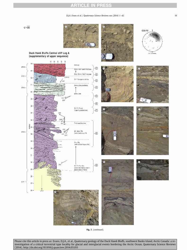
Fig 7 (continued)
DJA Evans et al Quaternary Science Reviews xxx (2014) 1e42 19
Please cite this article in press as Evans DJA et al Quaternary geology of the Duck Hawk Bluffs southwest Banks Island Arctic Canada a re-investigation of a critical terrestrial type locality for glacial and interglacial events bordering the Arctic Ocean Quaternary Science Reviews(2014) httpdxdoiorg101016jquascirev201403011
Fig 7 (continued)
DJA Evans et al Quaternary Science Reviews xxx (2014) 1e4220
Please cite this article in press as Evans DJA et al Quaternary geology of the Duck Hawk Bluffs southwest Banks Island Arctic Canada a re-investigation of a critical terrestrial type locality for glacial and interglacial events bordering the Arctic Ocean Quaternary Science Reviews(2014) httpdxdoiorg101016jquascirev201403011
Fig 7 (continued)
DJA Evans et al Quaternary Science Reviews xxx (2014) 1e42 21
Please cite this article in press as Evans DJA et al Quaternary geology of the Duck Hawk Bluffs southwest Banks Island Arctic Canada a re-investigation of a critical terrestrial type locality for glacial and interglacial events bordering the Arctic Ocean Quaternary Science Reviews(2014) httpdxdoiorg101016jquascirev201403011
Fig 7 (continued)
DJA Evans et al Quaternary Science Reviews xxx (2014) 1e4222
Please cite this article in press as Evans DJA et al Quaternary geology of the Duck Hawk Bluffs southwest Banks Island Arctic Canada a re-investigation of a critical terrestrial type locality for glacial and interglacial events bordering the Arctic Ocean Quaternary Science Reviews(2014) httpdxdoiorg101016jquascirev201403011
Fig 7 (continued)
DJA Evans et al Quaternary Science Reviews xxx (2014) 1e42 23
Please cite this article in press as Evans DJA et al Quaternary geology of the Duck Hawk Bluffs southwest Banks Island Arctic Canada a re-investigation of a critical terrestrial type locality for glacial and interglacial events bordering the Arctic Ocean Quaternary Science Reviews(2014) httpdxdoiorg101016jquascirev201403011
Fig 7 (continued)
DJA Evans et al Quaternary Science Reviews xxx (2014) 1e4224
LFA 6 crops out along the length of DHB and varies widely inthickness (1e11 m) displaying the most complex deformationstructures of any of the sediment bodies at DHB It comprises apredominantly heterogeneous diamicton or a meacutelange of discon-tinuous interbeds of massive matrix-supported diamicton matrix-supported gravel and laminated sand silt and clay with localizedattenuated lenses of degraded organics (Fig 7a ivevi 7b i iv 7c iiiii) Three samples of highly compressed and fragmented detritalmaterial displaying poor preservation were collected for identifi-cation Collectively LFA 6 has the appearance of a stratified dia-micton but locally it displays a more massive to pseudo-laminatedcharacter where sand silt and gravel lenses and occasional gravellags occur as thin beds stringers or wisps Some laminated sand siltand clay bodies appear to be rafts within the diamicton (intraclasts)due to their heavily deformed internal bedding and deformedcontacts or attenuated appearance Basal contacts with other lith-ofacies associations are typically erosional or deformed and asso-ciated with fissility boudinage and pseudo-lamination insediments on either side of the contact Basal diamictons can alsodisplay a higher concentration of gravel clasts that locally result in aclast-supported character or even a several metre-thick highlycontorted meacutelange of diamicton and stratified sediment bodies Insome sections the whole of LFA 6 has been complexly deformed toproduce stacked overfolds and thrust faults indicative of shearingtowards the southwest or WSW Clast macrofabrics are onlymoderately clustered (S1 frac14 0456e0637) but indicate stressdirected predominantly towards the SW Clast macrofabricstrengths as quantified by the fabric shape ternary plot (Fig 6a)and themodalityisotropy plot (Fig 6b) are variable and range frombi-modal to multi-modal Overall the macrofabric shapes in theternary graph plot across the spectrums of the glacitectonite andsubglacial traction till envelopes but there is a trend of changing
Please cite this article in press as Evans DJA et al Quaternary geologyinvestigation of a critical terrestrial type locality for glacial and intergla(2014) httpdxdoiorg101016jquascirev201403011
fabric strength vertically through LFA 6 The strongest clusters arefrom the basal diamictic zones (eg CCA F1 amp F3 AB plane data)whereas the weakest are from the top of the association (eg WCAF3 A-axes amp CCA F2 AB planes) where relatively low strain defor-mation indicators (open and recumbent folds) are ubiquitous
Clast lithologies in LFA 6 are dominated by quartz chert andsandstone although one diamict reveals a concentration of sand-stone lithologies at the expense of chert Clast forms similarlyreflect the nature of the sampled materials whereby the gravellysample (CCA 2) was characterized by relatively low C40 (38) andRA (12) values and a high average roundness (256) compared tothe same values for the diamictons of LFA 6 (C40 frac14 50e74RA frac14 38e52 average roundness frac14 174e204) A small number ofclasts (lt10) in LFA 6 were striated
512 Interpretation5121 LFA 1 The thick tabular sequence of well sorted cross-stratified sand and gravel records deposition by a former glaci-fluvial braided river typified by fluctuating discharge (eg Church1972 Boothroyd and Ashley 1975 Miall 1978 1985 1992Marren 2005) The highest discharge is recorded by matrix-supported gravel with boulders indicative of hyperconcentratedflows or a traction carpet (Maizels 1989ab Siegenthaler andHuggenberger 1993 Mulder and Alexander 2001) These areseparated by and vertically give way to lower discharges recordedby planar or trough cross-bedded sand and horizontal to planar ortrough cross-bedded gravel These deposits record aggradation andmigration of gravel bars and sheets and downstream accretionarymacroforms with relatively tightly constrained palaeocurrent in-dicators (Miall 1977 1985 Collinson 1996) The general lack ofscour fills and an overall fining-upward is indicative of an aggradingsystem initially characterized by high magnitudehigh frequency
of the Duck Hawk Bluffs southwest Banks Island Arctic Canada a re-cial events bordering the Arctic Ocean Quaternary Science Reviews
Fig 7 (continued)
DJA Evans et al Quaternary Science Reviews xxx (2014) 1e42 25
Please cite this article in press as Evans DJA et al Quaternary geology of the Duck Hawk Bluffs southwest Banks Island Arctic Canada a re-investigation of a critical terrestrial type locality for glacial and interglacial events bordering the Arctic Ocean Quaternary Science Reviews(2014) httpdxdoiorg101016jquascirev201403011
Fig 7 (continued)
DJA Evans et al Quaternary Science Reviews xxx (2014) 1e4226
Please cite this article in press as Evans DJA et al Quaternary geology of the Duck Hawk Bluffs southwest Banks Island Arctic Canada a re-investigation of a critical terrestrial type locality for glacial and interglacial events bordering the Arctic Ocean Quaternary Science Reviews(2014) httpdxdoiorg101016jquascirev201403011
DJA Evans et al Quaternary Science Reviews xxx (2014) 1e42 27
events that were gradually replaced by low magnitudehigh fre-quency events (Marren 2005) Partially to heavily-scoured rem-nants of laminated and massive fines represent deposition duringlow flow conditions in abandoned shallow channels The palae-ocurrent data from LFA 1 indicate that the outwash streams wereflowing westerly away from a glacier source located in AmundsenGulf This glacier likely eroded the abundant LFA 1 lithologies(chert quartzite and sandstone) from Mesoproterozoic and Neo-proterozoic bedrock widely distributed to the east and south(western Victoria Island Amundsen Gulf and the adjacent main-land Harrison et al 2013) These lithologies are consistent with theadvance of the NW Laurentide Ice Sheet through Amundsen Gulf(cf Dyke et al 2002 Batchelor et al 2012 MacLean et al 2013)
The crudely bedded organic detritus and degraded tree frag-ments (stumps) in LFA 1 are clearly reworked (cf Matthews et al1986 Fyles 1990 Vincent 1990) The finer grained detritus wasdeposited in concentrated pockets during waning flow stageswhereas horizons of logs and larger tree fragments were emplacedwith the coarser grained and poorly sorted sediments associatedwith hyperconcentrated flows or traction carpets during highdischarge These reworked organics also differ significantly fromthe type location of the Beaufort Fm a characteristic that promptedFyles (1990) to distinguish them as lsquotheMary Sachs Gravelrsquo Notablythe enclosing gravel and sand of LFA 1 is much coarser and exhibitsan entirely different fluvial architecture than the sandier BeaufortFm The composition and degraded nature of the LFA 1 organicssuggests that they were eroded by glaciers or their meltwater fromNeogene andor Paleogene sediments presumably to the southeastof Banks Island (eg Fyles 1990 Fyles et al 1994) The proximity ofa glacier is highlighted by the preservation of striae on individualclasts especially in the very coarse lower gravel The verticaldecrease in striae preservation and angularity (RA) and concomi-tant increase in roundness and upward-fining in LFA 1 is indicativeof an increasingly distal ice margin The co-variance plots (Fig 5)indicate a strong fluvial signature especially in the C40RA data butsubglacial characteristics are also evident particularly in the C40RWR data for the coarser grained and more matrix-supportedgravel as would be expected in ice-proximal settings
It is important to note that the widespread thrusting of LFA 1and underlying Kanguk Formation towards the southwest occurredpost-depositionally This glacitectonic thrusting was produced byLaurentide ice that advanced from the Kellett River valley (interiorBanks Island) during the emplacement of LFA 6 (see below) Theinjection of clastic dykes and fissure fills during this glacitectonicdisturbance was due to the overpressurizing of groundwater ingravel aquifers likely in taliks The branching limbs of many of thedykes are indicative of burst-out structures diagnostic of hydro-fracturing by vertically escaping groundwater pressurized byglacier overriding (cf Rijsdijk et al 1999 Le Heron and Etienne2005)
5122 LFA 2 At the top of LFA 1 rhythmites with lonestonesoverlie prominent clinoforms or foreset beds recording a changefrom subaerial glacifluvial to subaqueous deposition This wasinitially on a shallow delta front prograding foreset beds in asouthwesterly direction followed by suspension sedimentationwith dropstones presumably from floating ice in a marine orlacustrine basin The occurrence of matrix-supported gravelly scourfills with logs and woody detritus suggests pulses of cohesionlesssediment gravity flows into the basin Overlying the rhythmically-bedded sand prominent ice wedge pseudomorphs (up to 4 mdeep Fig 9aec cf Mackay and Burn 2002) are interspersed withthick (gt1m) sections of compressed in situ bryophytes (Figs 9d 7e)indicating the establishment of a tundra surface Four bryophytefamilies and 10 distinct species have been determined from LFA2
Please cite this article in press as Evans DJA et al Quaternary geologyinvestigation of a critical terrestrial type locality for glacial and intergla(2014) httpdxdoiorg101016jquascirev201403011
with the most abundant material from the Calliergonaceae andCampyliaceae (Table 1) These macrofossils are exceptionally wellpreserved including material with intact fragile alar cells typical ofthese two families (Fig 14cef) The data from these autochthonousdeposits indicate a wetland environment characterized as a richfen This ecosystem and habitats therein are consistent with speciesfound in the extant flora of Banks Island (Fig 14b) The autecologyfrom this range of species suggest hydric to mesic habitatsincluding standing pools wet meadows and microhabitats createdby ice wedges Despite the predominance of bryophytes in LFA 2these macrofossils had not been previously documented at DHB Incontrast a minimal proportion of the samples (lt5) consisted ofvascular plant material (including Cyperaceae seeds gramminoidleaves and woody twig fragments) Collectively the ice wedgepseudomorphs and vegetation within LFA 2 represent an isochro-nous terrestrial surface of interglacial rank
Following the formation of ice wedges the injection of intra-formational clastic dykes and fissure fills in LFA 2 relates to theoverpressurizing of groundwater in gravel aquifers or taliks due toglacier overriding The branching dyke limbs that emanate fromunderlying LFA 1 gravels and sands are indicative of the burst-outstructures that develop during hydrofracturing (cf Rijsdijk et al1999 Le Heron and Etienne 2005) A variant of the gravel andsand filled clastic dykes occurs within the sequence of glaci-tectonite and rhythmites near west Log D (Fig 11) Here thevertically-widening fracture is characterized by a mosaic ofpartially disaggregated blocks of the host materials in its widestzone where it contains gravels injected from underlying LFA 1Because these gravels only occur in the basal narrow neck theypresumably record the rapid reduction in flow competence duringhydrofracture filling
Deformation structures including overfolded or crumpledbedding and thrust faults associated with boudinage or highfissilitypseudo-lamination are representative of simple shear andwere also induced by glacitectonic disturbance (cf van derWateren 1995 McCarroll and Rijsdijk 2003) This predominantlyrecords a glacier advance from the northeast Subsidiary shear in-dicators record deformation from the south or southeast but theseoccur only at the top of LFA 2 and the base of LFA 3 suggestingearlier emplacement (see below) The development of zones ofboudinage shallow thrust faults overfolding or bed crumpling atdifferent levels within LFA 2 e especially at the contact separatingsediments of different grain size e represents deformation parti-tioning due to contrasting rheological properties Blind thrustswere also initiated in underlying LFA 1 increasingly towards thecentral and eastern cliffs where large-scale deformation is moreprevalent (Fig 7c d) A zone of intense deformation is recorded by alens of LFA 3 diamicton in fault contact with LFA 2 (east cliff Log AFig 7d i) This constitutes a type B glacitectonite (non-penetrativelydeformed pre-existing sediments sensu Benn and Evans 1996Evans et al 2006) developed during the emplacement of LFA 3(see below) A similar glacitectonite occurs at the junction of LFA 1and LFA 3 near west Log D (Fig 11) Bed attenuation by deformationis best developed in lower LFA 2 where the greater differences insediment grain size and hence rheology exist
5123 LFA 3 Within LFA 3 locally abundant stratified lensesindicate subaqueous deposition These stratified sediments weresubsequently thrust faulted folded and attenuated - most evidentin the upper and lower zones of LFA 3 This deformation was likelyresponsible for the intraclast boudinage and pseudo-lamination inthe surrounding diamicton (eg Hart and Roberts 1994 Robertsand Hart 2005 Oacute Cofaigh et al 2011) This process was alsoassociatedwith the attenuation of LFA 1 and 2 sediments within theheavily deformed base of LFA 3 some of which may have been
of the Duck Hawk Bluffs southwest Banks Island Arctic Canada a re-cial events bordering the Arctic Ocean Quaternary Science Reviews
Fig 8 Details of LFA 1 a) example of a concentration of logs with degraded rootballs in the stacked tabular units of cross-bedded sands and gravels and crudely stratified matrix-supported cobble to boulder gravels in the west cliff b) poorly-sorted and crudely horizontally bedded cobble to boulder gravel containing laminated clay intraclast (immediatelyabove compass) c) shallow locally graded foreset beds composed of openwork to sandy matrix-supported cobble to granule gravels in central cliff Log A d) planar bedded sandy
DJA Evans et al Quaternary Science Reviews xxx (2014) 1e4228
Please cite this article in press as Evans DJA et al Quaternary geology of the Duck Hawk Bluffs southwest Banks Island Arctic Canada a re-investigation of a critical terrestrial type locality for glacial and interglacial events bordering the Arctic Ocean Quaternary Science Reviews(2014) httpdxdoiorg101016jquascirev201403011
DJA Evans et al Quaternary Science Reviews xxx (2014) 1e42 29
cannibalized and rafted by the deformation process within a shearzone at the contact of LFA 3 with older sediments The shearingdirection from the south and southeast recorded in lower LFA 3also impacted upper LFA 2 whereas the more prominent shearingdirection throughout LFA 3 is from the northeast (also recorded inLFA 4) The local development of a heavily deformed zone at the topof LFA 3 was likely imparted during the shearing of overlying LFA 4sediments Although clast macrofabric strengths from the LFA 3diamicton are variable they possess shapes that compare withglacitectonites and subglacial traction tills and in some cases amodalityisotropy signature that reflects high lodgementcomponents
The similar orientation of the macrofabrics and shear indicatorsare considered diagnostic of a glacitectonite derived from stratifiedsediments (eg interbedded mass flow diamictons gravelly massflows and localized traction current sands and suspension de-posits) This evidence indicates that LFA 3 like all the other LFAsand the underlying Kanguk Fm bedrock has been displaced by aglacier advancing from the NNE or NE (ie Laurentide ice crossingthe interior of Banks Island) Minor south to north shearing in-dicates that LFA 3 and upper LFA 2were also disturbed by glacier iceflowing northwards (ie Laurentide ice advancing throughAmundsen Gulf) The appearance of granite and gabbro clastswithin the LFA 3 diamict records the arrival of far-travelled Lau-rentide ice from mainland Canada Clast form co-variance stronglyindicates a subglacial (abraded) source for LFA 3 with a minorfluvial component (Fig 5) including glacifluvial clasts locallycannibalized from LFA 1 by overriding ice
5124 LFA 4 LFA 4 has restricted outcrops is heavily deformedand contains organic detritus that is clearly allochthonous andhighly degraded Nonetheless a variety of indicators (fine-grainedhorizontally bedded cross-laminae rhythmites climbing ripplesand draped laminae) demonstrate that LFA 4 was deposited in asubaqueous environment with palaeocurrents from the south orsouthwest Traction currents were likely responsible for thedevelopment of the clast lag at the contact between lower LFA 4and underlying LFA 3 (west cliff Log A Fig 7b ii) LFA 4 coarsensupwards indicative of basin infilling andor an approaching sedi-ment source The narrow anabranched clastic dykes in the sandyclimbing ripples (LFA 4 west cliff Log A) record hydrofracturing bythe upward injection of overpressurized groundwater duringshearing The branching limbs of the dykes are similar to the burst-out structures reported by Rijsdijk et al (1999) but differ becausethey are composed solely of sand derived from the walls of the hostsediment rather than from an underlying gravel aquifer (cf LeHeron and Etienne 2005) Hence the pressurized water wasgenerated at the contact between the sand and underlying imper-meable brecciated clays The development of thin zones of brecci-ation boudinage sheath folding or thrust faulting at the upper andlower contacts of LFA 4 relates to the localized partitioning ofdeformation controlled by the location of claysilt beds Thejuxtaposition of this style of deformation with the larger scaleoverfolds and thrust faults developed in the extensive bodies ofsandy lithofacies is indicative of a Type B glacitectonite (sensu Bennand Evans 1996) This was constructed by the overriding of glacierice advancing from the north or northeast These shear directionsare compatible with those developed in the underlying LFAs
granule gravels with gravel lags (top and bottom of image) interrupted by an intervening unbedded granule to pebble gravel and massive cobble to pebble gravel A cluster of small treesequence of stacked tabular units of predominantly horizontally bedded sands and gravels ingravels containing clusters of wood detritus in the coarser gravel beds (central cliff Log A)wood fragments (central cliff Log A)
Please cite this article in press as Evans DJA et al Quaternary geologyinvestigation of a critical terrestrial type locality for glacial and intergla(2014) httpdxdoiorg101016jquascirev201403011
5125 LFA 5 The primary characteristics of LFA 5 are typical ofgravel sheet and occasional traction-carpet sedimentation in anice-proximal sandur (eg Boothroyd and Ashley 1975 Miall 19781985 1992 Maizels 1989ab Siegenthaler and Huggenberger1993 Mulder and Alexander 2001 Marren 2005) Glacier prox-imity is supported by the subglacial to fluvial signature of the clastforms (Fig 5) The coarsening-upward sequence including striatedclasts culminates in the arrival of a glacier that overrode the sitedepositing LFA 6 Post-depositional shearing within underlying LFA4 is recorded by attenuation and interdigitation at the contact withLFA 5 imparted during deposition of LFA 6 The contact betweenLFA 5 and 6 reflects the development of a shear zone where upperLFA 5 sediments have been cannibalized producing a meacutelange ofcrudely stratified diamictons with discontinuous interbeds ofmatrix-supported gravel laminated sand silt and clay (LFA 6 seebelow)
5126 LFA5a At Easternmost Cliff glacifluvial gravel (LFA 5a)unconformably overlies LFA 1 (Fig 7e) rendering uncertain itsrelationshipwith respect to LFA 5 in themain sections of DHB to thewest The fact that LFA 5a extends to the modern surface appearsundeformed and has palaeocurrents orientated to the NW requiresthat it is younger than LFA 5 Indeed we interpret LFA 5a asdeglacial outwash deposited from retreating Laurentide ice in theKellett River valley and Amundsen Gulf at the end of the lastglaciation (see Discussion)
5127 LFA 6 Based on its heterogeneity strongly orientated clastmacrofabrics and macroscale deformation structures LFA 6 con-stitutes a Type B glacitectonite (sensu Benn and Evans 1996)However zones of more highly strained Type A glacitectonite(sensu Benn and Evans 1996) at the basal contact with older LFAsare recorded by intraclastinterbed attenuation (pseudo-lamina-tion) strong boudinage or fissility and strengthened clast macro-fabrics The production of this meacutelange is attributed to two separateprocesses 1) primary sedimentation as interbedded and interdig-itated mass flow debris fluvial gravel and sand and subaqueoussuspension sediments and 2) cannibalization of underlying strat-ified sediments (LFAs 4 and 5) This produced a continuum of formsranging from low strain fold structures to attenuated rafts to tec-tonic lamination (eg Fig 7) The discontinuous lenses of degradedorganics (black stems and woody twigs gramminoid leaveswhitened rootlets) within LFA 6 are rafts and include seven speciesof bryophytes (Table 1) The material was highly compressed anddifficult to separate into distinct taxa Indeed one of the threesamples analysed was too degraded to recover any taxa Much ofthe material consisted of only fragmented leaves and only theminute taxa had stems with intact leaves The bryophytes thatcharacterize the LFA 6 samples represent hydric (Calliergon sppTomenthypnum nitens) to mesic (Ditrichum flexicaule Dicranum sp)habitats Three species collected from LFA 6 were also present inLFA 2 whereas four others were not found in LFA 2 but are com-mon in the modern flora The poor preservation quality suggeststhat the material has been redeposited from unknown sources andis clearly allochthonous
The predominant shearing direction within LFA 6 records an iceadvance from the interior of Banks Island (NE) This has resulted incomplex folding and thrusting and localized thickening of LFA 6
it of cross-bedded poorly-sorted to openwork cobble to boulder gravel crudely planar-fragments occur at the base of the cobble to boulder gravels at image centre e) middleDHB west cliff Log D f) sequence of fining-upward planar-bedded cobble to sandy fineg) planar cross-bedded sandy granule to pebble gravels with pebble to cobble lags and
of the Duck Hawk Bluffs southwest Banks Island Arctic Canada a re-cial events bordering the Arctic Ocean Quaternary Science Reviews
Fig 9 Details of LFA 2 from the west cliff a) narrow necked ice wedge pseudomorph with upturned marginal bedding in sand silt and clay rhythmites b) wide necked ice wedgepseudomorph c) ice wedge pseudomorph with overturned silt sand and clay rhythmites developed at the top of LFA 2 and sealed by overlying LFA 3 laminated diamicton d)horizontally bedded sand and silt containing well preserved moss macrofossils e) zone of disharmonically folded sandsilt laminae with well preserved moss peat located at thebase of LFA 2
DJA Evans et al Quaternary Science Reviews xxx (2014) 1e4230
Please cite this article in press as Evans DJA et al Quaternary geology of the Duck Hawk Bluffs southwest Banks Island Arctic Canada a re-investigation of a critical terrestrial type locality for glacial and interglacial events bordering the Arctic Ocean Quaternary Science Reviews(2014) httpdxdoiorg101016jquascirev201403011
Fig 10 Details of simple shear structures developed in fine sand and silt laminae at the centre of the thickest outcrop of LFA 2 in west cliff Log B a) overview of large scaleanastomosing shear faults with zones of smaller scale densely spaced anastomosing shears towards the base of the photograph b) details of large scale shear faults separatingzones of variably but predominantly densely spaced shears c) close details of shear zone comprising densely spaced anastomosing fractures d) details of ascending kink zonecross-cutting large scale anastomising shear faults Shearing direction is coming out of the cliff and towards the left in each image
DJA Evans et al Quaternary Science Reviews xxx (2014) 1e42 31
This shearing direction is recorded throughout underlying LFAs 1e4as well as the Kanguk Formation demonstrating deep-seated butpartitioned glacitectonic disturbance imparted during theemplacement of LFA 6 This strain signature was therefore over-printed on the northerlynortheasterly aligned shearing directionrecorded in LFA 3 and upper LFA 2 by the earlier northerly flowingice that deposited LFA 3 One anomalous clast macrofabric(northerly CCA F1) occurs in the basal meacutelange of LFA 6 Howeverthis sample is from an isolated outcrop (Fig 7c i) rendering itsapparent shearing direction equivocal
Please cite this article in press as Evans DJA et al Quaternary geologyinvestigation of a critical terrestrial type locality for glacial and intergla(2014) httpdxdoiorg101016jquascirev201403011
52 Sedimentology and stratigraphy (Mary Sachs Creek cliff)
The cliffs east of Mary Sachs Creek (Figs 2b 3) provides a cross-section through the seaward margin of the coast-parallel SachsMoraine (ldquosection Jrdquo Vincent et al 1983 Vaughan 2014) Weprovide a summary of two logs based on a reconnaissance survey ofthese sediments Log A is closest toMary Sachs Creekwhereas Log Boccursw1 km farther east (Figs 3 15a amp b) The sediments exposedin Log A appear to descend eastward and disappear below themodern beach and therefore are assumed to stratigraphically
of the Duck Hawk Bluffs southwest Banks Island Arctic Canada a re-cial events bordering the Arctic Ocean Quaternary Science Reviews
Fig 11 Details of LFA 2 near west Log D Lower box shows a 1e2 m thick basal zone comprising highly attenuated inter-digitated beds of gravelly to clay-rich diamictons and sandsiltclay rhythmites Upper box shows rhythmites containing diamictic intraclasts with sharp and angular boundaries also visible is the draping and deforming of the rhythmitebedding over and under the intraclasts respectively ldquoTailsrdquo extending from the diamictic intraclasts and thin but discontinuous diamictic beds are also visible in the upper box
DJA Evans et al Quaternary Science Reviews xxx (2014) 1e4232
underlie the sediments of Log B A sand and gravel- bench caps bothlogs at w15 m asl incised into the seaward margin of the SachsMoraine
521 DescriptionLog A contains a sequence of upward-fining highly contorted
cross-stratified sand and fine gravel to rhythmically bedded sandsilt clay with minor pebble gravel and sporadic clots of gravellydiamicton (Fig 15a) An ice wedge was initially developed in thelower cross-stratified sand and fine gravel before they were foldedand thrust faulted The deformed ice wedge pseudomorph is un-conformably overlain by a relatively undisturbed lens of laminatedsilty clay with dropstones interbedded with gravelly diamictonthat contains a bed (10 cm) of sandy black organics containingwood fragments (Fig 15a) This organic material occurs repeatedlyup-section as discontinuous stringers Log A is capped by 1e2 m ofpoorly exposed and heavily cryoturbated gravelly diamicton Thegeneral sense of displacement on shallow reverse faults over-turned bedding and boudinage structures is from the southeast
Log B (12 m) displays a coarsening-upward sequence of hori-zontally bedded sandy granule gravel with occasional silty sandlaminae (Fig 15b iii) that grades to poorly-sorted cobble to bouldergravel and bouldery matrix-supported gravel (Fig 15b ii) This iscapped by laminated to crudely stratified cobbly diamicton that issilt and clay-rich abruptly and conformably overlain by
Please cite this article in press as Evans DJA et al Quaternary geologyinvestigation of a critical terrestrial type locality for glacial and intergla(2014) httpdxdoiorg101016jquascirev201403011
interlaminated silt clay and pebbly silty sand (Fig 15b i) Althoughthe bedding on these units dips towards the NW individuallaminae do not thicken in that direction indicating post-depositional tilting The uppermost part of the log (underlyingthe 15 m bench) contains 2 m of clay-rich massive diamictoninterfingered with the underlying laminated sediments and cobblydiamicton
522 Interpretation
5221 Log A Broadly the sedimentology of log A including thedeformed ice wedge pseudomorph is similar to LFA 2 in DHB (egcentral cliff Log A Fig 7c iii) Prior to glacitectonic disturbance theoverlying organic bed (Fig 15a) was redeposited into a sequence ofsubaqueous siltclay rhythmites containing dropstones and gravellymass flows The highly attenuated shear margins bracketing theorganic bed in Log A demonstrate that it has been displaced as atectonic raft Previous research proposed that the organic beds e
similar to those described in Log A e be assigned to the LastInterglacial (locally called the Cape Collinson Vincent 1982 1983)Because these organic beds are clearly a raft they cannot constitutean iscochronous surface precluding chronostratigraphic signifi-cance (see Discussion) Shearing of the Log A sediments from thesoutheast documents an ice advance from Amundsen Gulf corre-sponding to the earliest of two primary shearing directions recor-ded at DHB (imparted during the emplacement of LFA 3) Therefore
of the Duck Hawk Bluffs southwest Banks Island Arctic Canada a re-cial events bordering the Arctic Ocean Quaternary Science Reviews
Fig 12 Details of LFA 4 in West Log A a) heavily deformed upper contact of LFA 4 comprising sandsiltclay rhythmites displaying well developed boudinage sheath folds andimmature tectonic laminae and an interdigitatedsheared boundary with underlying climbing ripple sands The contact with overlying LFA 6 is marked by an interdigitated zonecontaining rooted and de-rooted folds or rhythmite rafts in a sand gravel and diamicton meacutelange b) narrow anabranched clastic dykes ascending sub-vertically through climbingripple drift and resulting in offset bedding between blocks of host material c) abrupt contact between sheared sands and rhythmites of LFA 4 and overlying sand gravel anddiamicton meacutelange
Fig 13 Details of LFA 5 a) poorly sorted and matrix-supported pebble to cobble gravel b) tabular sequence of horizontally bedded to massive gravel and matrix-supported gravelcontaining a horizon of striated cobbles and boulders c) heavily deformed discontinuous bed of siltclay rhythmites between LFA 5 and LFA 6 in West Log D showing theamalgamation zone with the LFA 5 gravels immediately above the compass d) interdigitateddeformed contact between LFA 5 granule to pebble gravels and underlying LFA 4laminated silts and clays with organic detritus in West Log B
DJA Evans et al Quaternary Science Reviews xxx (2014) 1e42 33
Please cite this article in press as Evans DJA et al Quaternary geology of the Duck Hawk Bluffs southwest Banks Island Arctic Canada a re-investigation of a critical terrestrial type locality for glacial and interglacial events bordering the Arctic Ocean Quaternary Science Reviews(2014) httpdxdoiorg101016jquascirev201403011
Table 1List of bryophytes and vascular plants from LFAs 2 and 6
LFA2 WestCliff Log B
LFA6 CentralCliff Log A
Elevation (m) 185 m asl w45 m aslSample 4e12 1e3 taxa 10 7
Bryophyta (mosses)AmblystegiaceaeAmblystegium serpens (Hedw) Schimp x
CamyliaceaeCampylium polygamum (Schimp) CEO Jensen xCampylium stellatum (Hedw) CEO Jensen x xDrepanocladus aduncus (Hedw) Warnst xDrepanocladus sp xTomentypnum nitens (Hedw) Loeske x
CalliergonaceaeCalliergon giganteum (Schimp) Kindb xCalliergon richardsonii (Mitt) Kindb xthornthornthornthorn xCalliergon sp xWarnstorfia exannulatus (Schimp) Loeske xthornthornthornthorn x
BrachytheciaceaeBrachythecium turgidum (Hartm) Kindb x
MniaceaeCyrtomnium cf hymenophylloides(Hbener) TJ Kop
x
DicranaceaeDicranum sp x
DitrichaceaeDitrichum flexicaule (Schwaumlgr) Hampe x
Tracheophyta (vascular plants)CyperaceaeSeeds (triangular amp flattened) x x
Gramminoid leaf material x xWoody twig fragments x xRootlets x
Fig 14 The moss peat and associated microfossils of LFA 2 a) exposure through lower LFAsouthern Banks Island analogue of a rich tundra fen environment for the bryophyte assemblfrom LFA 2 showing the exceptional preservation of Calliergonaceae and Campyliaceae ma
DJA Evans et al Quaternary Science Reviews xxx (2014) 1e4234
Please cite this article in press as Evans DJA et al Quaternary geologyinvestigation of a critical terrestrial type locality for glacial and intergla(2014) httpdxdoiorg101016jquascirev201403011
these deformed deposits are interpreted as a Type B glacitectonite(sensu Benn and Evans 1996) possibly derived from LFA 2
5222 Log B The coarsening upward gravel in Log B recordshighly turbid to hyperconcentrated discharge in non-channelizedsheets This is interpreted as aggrading glacifluvial outwash froman approaching ice margin The capping sequence of crudelystratified diamicton and laminated sediments records a changefrom glacifluvial to subaqueous sedimentation prior to overridingby a glacier of unknown age that tilted the upper beds Thecoarsening-upward sequence apparent tectonism and cappingdiamict at Log B clearly distinguishes these deposits from those ofLFA 5a (west of Mary Sachs Creek easternmost cliff Fig 3)Furthermore although there is lithological similarity between LogB and LFA 5 throughout DHB the sense of shearing is dissimilar (LFA5 from the NE and Log B from the SE) The simplest explanation forthis difference in shear direction is that LFA 5 (DHB) was displacedby interior ice advancing down the Kellett River whereas Log B wasdisplaced by ice advancing along Amundsen Gulf (Fig 2b)
6 Discussion
61 Large scale glacitectonic structures and stratigraphicarchitecture
The glacitectonic structures identified within the lithofaciesassociations at DHB record two phases of deformation (early NeSand later NEeSW) This deformation together with the DHBstratigraphic architecture (Fig 16) helps to explain both thekinetostratigraphy (sensu Berthelsen1978) and the evolution of thelocal glacial geomorphology The large scale glacitectonic defor-mation is most clearly manifest in the thrust faulting and conjugate
2 at DHB west log B showing the sampling locations for in situ moss peat b) a modernages of LFA 2 c)ef) details of the typical moss peat and associated microfossil materialscrofossils including material with intact fragile alar cells
of the Duck Hawk Bluffs southwest Banks Island Arctic Canada a re-cial events bordering the Arctic Ocean Quaternary Science Reviews
Fig 15 The stratigraphy of Mary Sachs Creek cliff a) photographic compilation log A showing upward-fining highly contorted (i) cross-stratified sands and fine gravels torhythmically bedded sands silts clays and minor pebble gravels Also visible in (ii) is a lens of interbedded laminated silty clays with dropstones and gravelly diamictons containingsandy black coloured organic material with wood fragments An ice wedge pseudomorph is visible (iii) to the right of the exposure b) photographic compilation log B showing i)laminated to crudely stratified cobbly but siltclay-rich diamicton grading into interlaminated silts clays and pebbly silty sands ii) poorly-sorted cobble to boulder gravel andbouldery matrix-supported gravel iii) coarsening-upward sequence of horizontally bedded sandy granule gravels with occasional silty sand laminae iv amp v) pebble to cobble graveland matrix-supported gravel
DJA Evans et al Quaternary Science Reviews xxx (2014) 1e42 35
shear development in the Kanguk Fm bedrock and overlying LFA 1(east cliff Fig 7d ivevi) Here predominantly northeasterly dippingthrust slices have been stacked truncated and overlain by LFA 6during the second and strongest (NEeSW) deformation phase(Fig 16 note bedrock slice within the imbricated stacked sequenceof LFA 1) These structures demonstrate significant compressionand thickening of the stratigraphic sequence including w40 m ofvertical offset within the Kanguk Formation acrossw3 km (Fig 16)Prominent hydrofracture fills in LFAs 1 and 2 record elevatedporewater pressure during this thrusting Smaller scale shear zoneshave also developed in the finer grained interbeds within thrustslabs (Fig 7d vii) indicative of deformation partitioning by strataprone to ductile failure This zone of greatest displacement alsocoincides with the highest topography (Fig 16) Lower angle thrustfaults propagate in a southwesterly direction predominantlythrough LFA 1 but are also developed through LFA 2 in the footwallblock (east cliff Fig 16)
The thrust stacking of bedrock and LFAs 1e5 in east cliff (obliqueto Fig 16) represents the ice-proximal zone of a thrust-blockmorainecomposite ridge constructed by a glacier advancing fromthe northeast (ie the interior of Banks Island) This glacitectonicdeformation propagated southwestward to distal parts of theproglacial stress field as recorded bywell-developed shear zones inthe finer grained sediments of LFAs 2e5 In the more distal westcliff open folds (LFA 2 Fig 16) appear to be the product of a blindthrust within underlying LFA 1 This style of tectonism is typical oflsquopiggyback-style thrustingrsquo wherein steeply inclined thrust blocksat the advancing ice margin propagate new thrusts in the footwall(Fig 16 Park 1983 Mulugeta and Koyi 1987) The angle of thesefootwall thrusts becomes progressively shallower southwestward
Please cite this article in press as Evans DJA et al Quaternary geologyinvestigation of a critical terrestrial type locality for glacial and intergla(2014) httpdxdoiorg101016jquascirev201403011
(ice-distal) in LFA 1e5 where deformation partitioning developedin finer grained lithofacies (Fig 16)
The densely spaced ponds and depressions immediately to thenortheast of DHB (Figs 2b 3) constitute the depression fromwhich the thrust mass was excavated (eg Aber et al 1989Evans and England 1991 van der Wateren 1995) This inter-pretation is consistent with the strong northeast to southwestshear direction in the second phase glacitectonic structures andin LFA 6 clast macrofabrics This indicates that construction ofDHB occurred at the margin of a glacier advancing from thenortheast (ie from Kellett River valley) overtopping DHB anddepositing the LFA 6 glacitectonite The continued advance ofKellett ice coalesced with a glacier in Amundsen Gulf marked bythe interlobate Sachs Moraine containing ice-transported shellsas young as 24 cal ka BP (21020 70 yrs BP UCIAMS-89674)assigning this glaciation to the Late Wisconsin (Vaughan 2014)East of Mary Sachs Creek the deformation of Log B outwash(from the southeast Figs 15 16) likely records overriding by thesame Amundsen Gulf glacier (coeval with LFA 6 Late Wiscon-sinan) During ice retreat when Kellett River and Amundsen Gulfice decoupled DHB was exposed allowing the northwesterly-flowing proglacial outwash (LFA 5a) west of Mary Sachs Creekto extend to the shoreline marking postglacial marine limit atKellett Point (11 m asl Vaughan 2014 Fig 3) Collectively thisreconstruction supports a Late Wisconsinan age for the con-struction of DHB thrust block moraine although its stratigraphyincludes a range of ages A palaeogeographic reconstruction ofevents based upon our interpretation of the sedimentologystratigraphic architecture tectonism and geomorphology is pre-sented in Fig 17
of the Duck Hawk Bluffs southwest Banks Island Arctic Canada a re-cial events bordering the Arctic Ocean Quaternary Science Reviews
Fig 15 (continued)
DJA Evans et al Quaternary Science Reviews xxx (2014) 1e4236
62 Comparison and revision of previous DHB model
DHB was previously interpreted to record horizontally beddedNeogene to Quaternary sediments assigned to preglacial fluvialand multiple glacial and interglacial episodes (Vincent 1982 19831990 Vincent et al 1983 1984 Barendregt et al 1998) A com-posite palaeomagnetic record was also presented for this proposedstratigraphy placing most of this deposition before the BrunhesMatuyama boundary (Fig 1c) However prior to our work detailedstudies had not been undertaken on the sedimentology structuralgeology or stratigraphic architecture of DHB Rather the originalstratigraphy was restricted to a series of composite logs (our Fig 4reproduced from Vincent et al 1983) that notably omitted thepervasive deformation structures including the thrust bedrock ineast cliff (Fig 16)
Please cite this article in press as Evans DJA et al Quaternary geologyinvestigation of a critical terrestrial type locality for glacial and intergla(2014) httpdxdoiorg101016jquascirev201403011
Our reinterpretation dismisses several key elements of theoriginal DHB model outlined below (oldest to youngest) We havedetermined that the lowermost unit (LFA 1) is not preglacial (Fyles1990) but rather is composed of glacial outwash providing theearliest terrestrial evidence for glaciation in the area and containingallochthonous organics (including tree stumps) of unknown prov-enance Because LFA 1 is a glacifluvial braidplain (Fig 17a) it is notpart of the Beaufort Fm (Fyles 1990) even though it containsreworked macrofossils presumably derived from it (eg Craig andFyles 1960 Hills et al 1974 Vincent et al 1983)
Our analysis of LFA 2 indicates that it is also not preglacial norcan it be the Worth Point Fm as previously proposed (cf Vincent1982 1983 1990 Vincent et al 1983 Matthews et al 1986)Indeed the type locality of the Worth Point Fm has been invali-dated because it is now recognized to be an ice-transported and
of the Duck Hawk Bluffs southwest Banks Island Arctic Canada a re-cial events bordering the Arctic Ocean Quaternary Science Reviews
LFA4
Fig16
Stratigrap
hiccross-profi
lerun
ning
westto
easto
fDuc
kHaw
kBluffs
basedup
oninterpolations
betw
eenthemainsectionlogs
andsh
owingthesixLFAstheKan
gukFo
rmationbe
droc
kex
posu
resmajor
structural
features
and
thepo
sition
sof
icewed
geps
eudo
morph
san
dsign
ificant
clasticdy
kesAtthe
easternen
dof
thecross-profi
lethe
sedimen
tsat
theco
reof
MarySa
chsCree
kcliff
logAaretentativelyclassified
asLFA2
althou
ghthesematerialsarelik
ely
notin
situN
otethat
thecross-profi
ledo
esno
tex
tend
asfarea
stas
MarySa
chsCree
kcliff
logB
DJA Evans et al Quaternary Science Reviews xxx (2014) 1e42 37
Please cite this article in press as Evans DJA et al Quaternary geologyinvestigation of a critical terrestrial type locality for glacial and intergla(2014) httpdxdoiorg101016jquascirev201403011
glacitectonized raft (Vaughan et al 2014) In contrast our LFA 2 ischaracterized by an isochronous tundra surface with ice wedgesand intervening shallow ponds andwetmeadows The peat at LFA 2is dominated by bryophytes (gt95 by volume) and yet none ofthese macrofossils had been previously documented The diversein situ bryophyte species record a flora similar to that on BanksIsland today suggesting that LFA 2 warrants an interglacial rankThis conclusion is supported by the limited vascular plant record(five taxa no species indicated Vincent 1990) that also suggest awet meadow environment The absolute age of LFA 2 remains un-known but is apparently older than the BrunhesMatayamaboundary (gt780 ka Fig 18 cf Vincent et al 1984 Barendregt andVincent 1990 Barendregt et al 1998 see below)
LFA 3 in both our model and that of Vincent et al (1983) pro-vides the first direct evidence of ice reaching DHB In the previousmodel this was interpreted as Bernard Till (Banks Glaciation) thatwas bracketed by glacioisostatically induced marine transgressions(pre- and post-Banks seas Vincent 1982 1983) Within basal LFA 3we recognized highly deformed stratified sediment that wasdeposited in a subaqueous environment (deep water Fig 17c) priorto the arrival of overriding ice from the south (recorded by graniteand gabbro erratics Figs 17c 18) We regard LFA 3 to be equivalentto the Banks Glaciation (Vincent 1982 1983 Vincent et al 1983)including its pre- and post-Banks seas represented by the stratifiedsediments that bracket the central diamicton The LFA 3 sedimentsare also reported to be magnetically reversed thereby predatingthe BrunheseMatayama boundary (gt780 ka Fig 18 Vincent et al1984 Barendregt and Vincent 1990 Barendregt et al 1998)
Following the Banks Glaciation (our LFA 3 at DHB) Vincent(1982 1983) and Vincent et al (1983) recognized two in-terglacials (Morgan Bluffs and Cape Collinson) separated by anintervening marine episode This marine episode correspondedwith the glacioisostatic loading of a Laurentide ice margin confinedto the eastern half of Banks Island (Thomsen Glaciation) HoweverLFA 4 contains coarsening-upward subaqueous sedimentation fromthe south or southwest reflecting continued marine regressionfollowing LFA 3 (Fig 17c d) The coarsening-upward sequence ofLFA 4 is supplanted by coarse gravel outwash (LFA 5) supplied by aglacier readvancing from the northeast (Kellett River valley iceFig 17e) Glacier overriding is recorded by LFA 6 glacitectonite thatcaps the DHB thrust-block moraine composed of the entireassemblage of underlying LFAs (Fig 16)
Notably we have not observed any sediments characteristic oftwo interglacial deposits above LFA 3 hence dismiss the presence ofthe Morgan Bluffs and Cape Collinson interglacials at DHB Causseand Vincent (1989) report a U-series date of gt200 ka (UQT-229)from above our LFA 3 but this is almost certainly reworked andlacks chronostratigraphic significance Nor have we observedintervening marine sediments attributable to the Thomsen Glaci-ation (eg lsquoBig Searsquo Vincent 1982 1983 Vincent et al 1983)Rather following the deposition of the subaqueous sediments ofupper LFAs 3 and 4 (post-Banks Glaciation) LFAs 5 and 6 record asingle ice advance reaching DHB from the Kellett River valley(Banks Island interior) that was not reported by Vincent et al(1983) It was instead assumed that after the Banks GlaciationDHB lay distal to any later ice advances The nearest subsequentLaurentide margin to DHB recognized by Vincent et al (1983) wasassigned to the Sachs Moraine (immediately east of DHB) that waspresumed to be of EarlyWisconsin age (Fig 2b) However the SachsMoraine is nowdated to24 cal ka BP (LateWisconsinan Vaughan2014) andwas formed by the coalescence of Amundsen Gulf ice andthe Kellett River ice that deformed DHB (Fig 17) On the east side ofMary Sachs Creek the deposition of the Sachs Moraine coincideswith the deformation (from the southeast) of the underlying Log Boutwash gravel (Figs 3 15b)
of the Duck Hawk Bluffs southwest Banks Island Arctic Canada a re-cial events bordering the Arctic Ocean Quaternary Science Reviews
Fig 17 The palaeogeography of southwest Banks Island based upon interpretations of the principal lithofacies associations and structural architecture recognized at Duck HawkBluffs and the geomorphology of the surrounding terrain See text for detailed explanations
DJA Evans et al Quaternary Science Reviews xxx (2014) 1e4238
Although interglacial deposits were previously reported fromthe cliffs east of Mary Sachs Creek (ie Cape Collinson InterglacialVincent et al 1983) we found no similar evidence Rather the onlydeposit that we observed that may have been construed as inter-glacial sediments occurs in our Log A (Figs 3 15a) Here a darkdiscontinuous band of allochthonous organics (Fig15a) sits severedwithin a heavily tectonized melange (type B glacitectonite) and istherefore clearly a raft Although the absolute ages of the deformedunits east of Mary Sachs Creek (Logs A amp B) remain uncertain theyare apparently normally magnetized (Vincent et al 1984Barendregt and Vincent 1990) Blake (1987) also reports non-finite radiocarbon dates (gt36000 amp 49000 BP GSC-3560 amp 3560-2) obtained on ldquocompressed and deformed black woody peatrdquopurportedly from Cape Collinson beds (Vincent et al 1983 p 1708)Additionally Causse and Vincent (1989) report a U-series date onshells of 924 ka (UQT-143) from beds similar to the Log B gravelAgain all of these dated units have been displaced from unknownlocations limiting their utility for palaeoenvironmental recon-struction The last glacially influenced sedimentation at DHB isrecorded by northwesterly directed outwash (easternmost cliff LFA5a Figs 3 16 17g) We infer that this outwash fed the gravel beachmarking marine limit (11 m asl) in the lower Kellett River duringLate Wisconsinan retreat from the Sachs Moraine
63 Regional context
The stratigraphy at Duck Hawk Bluffs records three glacialevents The earliest of these is recorded by the aggradation of a
Please cite this article in press as Evans DJA et al Quaternary geologyinvestigation of a critical terrestrial type locality for glacial and intergla(2014) httpdxdoiorg101016jquascirev201403011
glacifluvial braidplain (LFA 1) that contains allochthonous pre-glacial material of diverse age However within LFA 1 there is noevidence that the ice reached DHB although it must have beennearby (southeast in Amundsen Gulf) The age of this glaciationremains unknown but the palaeomagnetic polarity of LFA 1 in-dicates that it is gt780 ka BP (Barendregt and Vincent 1990)Although Barendregt et al (1998) assigned part of the Worth PointFm to the normally polarized Olduvai sub-zone (MIS 64e74) itshould be noted that the Worth Point section is located 30 kmnorthwest of DHB There a stratigraphic revision has demonstratedthat this ldquotype sectionrdquo of the Worth Point Fm is in fact a glaci-tectonized raft (Vaughan et al 2014) This observation invalidatesthe previous correlation from Worth Point to purportedly coevalbeds at DHB (our LFA 2) Furthermore the diverse plant assem-blages in the Worth Point raft include preglacial tree stumps andSphagnum spp that do not occur on Banks Island today and are notfound in the wet meadow assemblages (rich fen) of LFA 2 that weinterpret to be of interglacial rank Therefore the sediments at DHB(LFAs 1 amp 2) do not support an age assignment of MIS 64e74(Olduvai subzone) proposed by Barendregt et al (1998) Currentlythe available palaeomagnetic record at DHB simply separates theentire section into a lower lsquoreversedrsquo unit and an upper lsquonormalrsquoone We place this boundary within our LFA 4 (Fig 18)
The overriding of DHB by glaciers is recorded in LFAs 3 amp 6These two glacial deposits may correspond to parts of the record ofstacked till sheets reported from the offshore seismic stratigraphy(Batchelor et al 2012) LFA 3 glaciationmay have contributed to theonset of mid-Pleistocene ice-rafted debris (IRD Ca-rich) attributed
of the Duck Hawk Bluffs southwest Banks Island Arctic Canada a re-cial events bordering the Arctic Ocean Quaternary Science Reviews
B-M
B-M
gt19
Fig
18A
revisedlitho
stratigrap
hyforDuc
kHaw
kBluffsPrev
ious
lyrepo
rted
ageco
nstraintsarealso
depicted
toge
ther
withatentativeallocation
ofMIS
stag
es(positione
dalon
gsideEa
stCliff
LogA
forclarity)
basedup
onthe
palaeo
mag
neticreco
rd
DJA Evans et al Quaternary Science Reviews xxx (2014) 1e42 39
Please cite this article in press as Evans DJA et al Quaternary geology of the Duck Hawk Bluffs southwest Banks Island Arctic Canada a re-investigation of a critical terrestrial type locality for glacial and interglacial events bordering the Arctic Ocean Quaternary Science Reviews(2014) httpdxdoiorg101016jquascirev201403011
DJA Evans et al Quaternary Science Reviews xxx (2014) 1e4240
to the Canadian Arctic Archipelago (CAA) and recorded in sedimentcores from the Arctic Ocean basin (Polyak et al 2009 2013OrsquoRegan et al 2010 Stein et al 2010) However Stein et al(2010) place the onset of Ca-rich ice-rafted debris within MIS 16(w659 ka BP Lisiecki and Raymo 2005) with subsequent peaks atMIS 12 10 and 8 all of which postdate the gt780 ka BP palae-omagnetic age proposed for LFA 3 (above) Polyak et al (2013) placethe onset of Ca-rich ice-rafted debris in the central Arctic Oceancloser to MIS 19 (790 ka BP) which is broadly compatible with theDHB palaeomagnetic record LFA 6 records the last glaciation ofDHB and we assign this to the Late Wisconsinan when Banks Is-land ice (Kellett River) coalesced with the Amundsen Gulf IceStream (Stokes et al 2006 MacLean et al 2013) During this in-terval the northwest Laurentide Ice Sheet likely reached the edgeof the polar continental shelf (Stokes et al 2005 2006 Englandet al 2009 Batchelor et al 2012 Lakeman and England 2013MacLean et al 2013)
7 Conclusions
New sedimentological and stratigraphic analyses of DHB funda-mentally revise the previous reconstruction of the Neogene andQuaternary history of Banks Island DHB and two other widely citedsections on Banks Island have been reported as important unde-formed terrestrial archives of glacial and interglacial sedimentationat the northwest limit of the Laurentide Ice Sheet that all have beenrecently revised (Vaughan et al 2014 Lakeman and England inpress) The recognition of pervasive large-scale deformation ofDHB necessitates a fundamental re-assessment of its previouslydescribed layer-cake stratigraphy We document that the oldestsediments (LFA 1) at DHB are not preglacial fluvial deposits (Beau-fort Fm) but rather record proglacial outwash from ice in AmundsenGulf that did not reach the site This was followed by the estab-lishment of an isochronous tundra surface of interglacial rank (LFA2) characterized by ice wedge polygons within a wet meadow thatsupported a bryophyte community similar to modern Subse-quently glacial sedimentation resumed initially in an ice-proximalsubaqueous environment followed by ice arrival and glacitectonicdeformation (LFA 3) The overlying deposits at DHB indicate post-glacial marine sedimentation (LFA 4) followed by the aggradationof glacifluvial sand and gravel (LFA 5) from an advancing ice marginthat culminated with the emplacement of a glacitectonite (LFA 6)during the Late Wisconsin This ice advance constructed a previ-ously undescribed thrust-block moraine (60 m high 8 km long) thatexhibits pervasive deformation and includes a substantial raft ofCretaceous Kanguk Fm bedrock (Fig 16) Furthermore the produc-tion of the glacitectonite (LFA 6) cannibalized LFAs 1e5 which atsome sites were previously thought to be in situ interglacial de-posits Finally outwash (LFA 5a) incised the DHB thrust block duringdeglaciation of the site when ice in the Kellett River and AmundsenGulf separated and proglacial meltwater drained northwestward tomarine limit (11 m asl) Refinements to the evolution and chronol-ogy of DHB and other sections around Banks Island will furthercontribute to the understanding of high latitude environmentalchange especially the complementary marine archives of theadjacent polar continental shelf and Arctic Ocean
Acknowledgements
Funding for this research was provided by the Natural Sciencesand Engineering Research Council of Canada (NSERC) NorthernResearch Chair Program and a complementary NSERC DiscoveryGrant (A6680) (both to JH England) Coulthard Lakeman andVaughan were supported by CBAR grants Canadian CircumpolarInstitute University of Alberta Coulthard and Lakeman were also
Please cite this article in press as Evans DJA et al Quaternary geologyinvestigation of a critical terrestrial type locality for glacial and intergla(2014) httpdxdoiorg101016jquascirev201403011
supported by Northern Scientific Training Program grantsAboriginal Affairs and Northern Development Canada The PolarContinental Shelf Program Natural Resources Canada(_501100000159) supplied additional funding and aircraft supportField and logistical assistance from Issac Elanik Vernon AmosTrevor Lucas and Roger Kuptana of Sachs Harbour is gratefullyacknowledged
References
Aber JS Croot DG Fenton MM 1989 Glaciotectonic Landforms and StructuresKluwer Dordrecht
Barendregt RW Vincent J-S 1990 Late Cenozoic paleomagnetic record of DuckHawk Bluffs Banks Island Canadian Arctic Archipelago Can J Earth Sci 27124e130
Barendregt RW Duk-Rodkin A 2011 Chronology and extent of Late Cenozoic icesheets in North America a magnetostratigraphical assessment In Ehlers JGibbard PL Hughes PD (Eds) Quaternary Glaciations e Extent and Chro-nolgy a Closer Look Elsevier Amsterdam pp 419e426
Barendregt RW Vincent J-S Irving E Baker J 1998 Magnetostratigraphy ofQuaternary and late Tertiary sediments on Banks Island Canadian Arctic Ar-chipelago Can J Earth Sci 35 147e161
Batchelor CL Dowdeswell JA Pietras JT 2012 Variable history of Quaternaryice-sheet advance across the Beaufort Sea margin Arctic Ocean Geology httpdxdoiorg101130G336691
Batchelor CL Dowdeswell JA Pietras JT 2013 Seismic stratigraphy sedimen-tary architecture and palaeo-glaciology of the Mackenzie Trough evidence fortwo Quaternary ice advances and limited fan development on the westernCanadian Beaufort Sea margin Quat Sci Rev 65 73e87
Benn DI 1994 Fabric shape and the interpretation of sedimentary fabric dataJ Sediment Res 64 910e915
Benn DI 1995 Fabric signature of till deformation Breiethamerkurjoumlkull IcelandSedimentology 42 735e747
Benn DI 2004 Clast morphology In Evans DJA Benn DI (Eds) A PracticalGuide to the Study of Glacial Sediments Arnold London pp 77e92
Benn DI Ballantyne CK 1994 Reconstructing the transport history of glaciogenicsediments a new approach based on the co-variance of clast form indicesSediment Geol 91 215e227
Benn DI Evans DJA 1996 The interpretation and classification of subglaciallydeformed materials Quat Sci Rev 15 23e52
Benn DI Evans DJA Phillips ER Hiemstra JF Walden J Hoey TB 2004 Theresearch project d a case study of Quaternary glacial sediments InEvans DJA Benn DI (Eds) A Practical Guide to the Study of Glacial Sedi-ments Arnold London pp 209e234
Berthelsen A 1978 The methodology of kineto-stratigraphy as applied to glacialgeology Bull Geol Soc Den 27 25e38
Blake Jr W 1987 Geological Survey of Canada Radiocarbon Dates XXVI InGeological Survey of Canada Paper 86-7 60 pp
Boothroyd JC Ashley GM 1975 Processes bar morphology and sedimentarystructures on braided outwash fans northeastern Gulf of Alaska InJopling AV McDonald BC (Eds) Glaciofluvial and Glaciolacustrine Sedi-mentation Society of Economic Paleontologists and Mineralogists SpecialPublication No 23
Causse C Vincent J-S 1989 TheU disequilibrium dating of Middle and LatePleistocene wood and shells from Banks and Victoria islands Arctic CanadaCan J Earth Sci 26 2718e2723
Church MA 1972 Baffin Island sandurs a study of Arctic fluvial processes GeolSurv Can Bull 216 208
Clark DL Vincent J-S Jones GA Morris WA 1984 Corrrelation of marine andcontinental glacial and interglacial events Arctic Ocean and Banks Island Na-ture 311 147e149
Collinson JD 1996 Alluvial sediments In Reading HG (Ed) Sedimentary Envi-ronments and Facies third ed Blackwell Oxford pp 37e82
Craig BG Fyles JG 1960 Pleistocene Geology of Arctic Canada In GeologicalSurvey of Canada Paper 60-10 21 pp
Crosby MR Magill RE Allen B He S 1999 A Checklist of the Mosses MissouriBotanical Garden St Louis 320 pp
Duk-Rodkin A Barendregt RW 2011 Stratigraphical records of glacialsin-terglacials in northwest Canada In Ehlers J Gibbard PL Hughes PD (Eds)Quaternary Glaciations e Extent and Chronology a Closer Look ElsevierAmsterdam pp 661e698
Dyke AS Andrews JT Clark PU England JH Miller GH Shaw J Veillette JJ2002 The Laurentide and Innuitian ice sheets during the Last Glacial MaximumQuat Sci Rev 21 9e31
England JH Furze MFA Doupeacute JP 2009 Revision of the NW Laurentide IceSheet implications for the paleoclimate the northeast extremity of Beringiaand Arctic Ocean sedimentation Quat Sci Rev 28 1573e1596
Evans DJA 2010 Controlled moraine development and debris transport pathwaysin polythermal plateau icefields examples from Tungnafellsjoumlkull IcelandEarth Surf Process Landf 35 1430e1444
of the Duck Hawk Bluffs southwest Banks Island Arctic Canada a re-cial events bordering the Arctic Ocean Quaternary Science Reviews
DJA Evans et al Quaternary Science Reviews xxx (2014) 1e42 41
Evans DJA Benn DI 2004 Facies description and the logging of sedimentaryexposures In Evans DJA Benn DI (Eds) A Practical Guide to the Study ofGlacial Sediments Arnold London pp 11e51
Evans DJA England J 1991 Canadian landform examples 19 high arctic thrustblock moraines Can Geogr 35 93e97
Evans DJA Rea BR Benn DI 1998 Subglacial deformation and bedrockplucking in areas of hard bedrock Glacial Geology and Geomorphology rp041998 httpgggqubacukgggpapersfull1998rp041998rp04html
Evans DJA Hiemstra JF 2005 Till deposition by glacier submarginal incre-mental thickening Earth Surf Process Landf 30 1633e1662
Evans DJA Hiemstra JF Oacute Cofaigh C 2007 An assessment of clast macrofabricsin glaciogenic sediments based on AB plane data Geogr Ann A89 103e120
Evans DJA Phillips ER Hiemstra JF Auton CA 2006 Subglacial till formationsedimentary characteristics and classification Earth Sci Rev 78 115e176
Evans DJA Shulmeister J Hyatt OM 2010 Sedimentology of latero-frontalmoraines and fans on the west coast of South Island New Zealand Quat SciRev 29 3790e3811
Eyles N Eyles CH Miall AD 1983 Lithofacies types and vertical profile modelsan alternative approach to the description and environmental interpretation ofglacial diamicts and diamictite sequences Sedimentology 30 393e410
Fyles JG 1990 Beaufort Formation (late Tertiary) as seen from Prince Patrick Is-land Arctic Canada Arctic 43 393e403
Fyles JG Hills LV Matthews Jr JV Barendregt R Baker J Irving E Jette H1994 Ballast Brook and Beaufort Formations (Late Tertiary) on northern BanksIsland Arctic Canada Quat Int 2223 141e171
Harrison JC Mayr U McNeil DH Sweet AR McIntyre DJ Eberle JJHarington CR Chalmers JA Dam G Nohr-Hansen H 1999 Correlation ofCenozoic sequences of the Canadian Arctic region and Greenland implicationsfor the tectonic history of northern North America Bull Can Pet Geol 47 223e254
Harrison JC Ford A Miall AD Rainbird RH Hulbert LJ Chritie RLCampbell FHA 2013 Geology Tectonic Assemblage Map of Aulavik BanksIsland and Northwestern Victoria Island Northwest Territories GeologicalSurvey of Canada Canadian Geoscience Map 35 (preliminary) scale 1500 000httpdxdoiorg104095292833
Hart JK Roberts DH 1994 Criteria to distinguish between subglacial glaciotec-tonic and glaciomarine sedimentation I Deformation styles and sedimen-tology Sediment Geol 91 191e213
Hedenaumls L 1993 A generic revision of the Warnstorfia Calliergon group J Bryol 17447e479
Hedenaumls L 2006 Additional insights into the phylogeny of Calliergon LoeskypnumStraminergon and Warnstorfia (Bryophyta Calliergonaceae) J Hattori Bot Lab100 125e134
Hicock SR Goff JR Lian OB Little EC 1996 On the interpretation of subglacialtill fabric J Sediment Res 66 928e934
Hiemstra JF Evans DJA Oacute Cofaigh C 2007 The role of glaciotectonic rafting andcommunition in the production of subglacial tills examples from SW Irelandand Antarctica Boreas 36 386e399
Hills LV 1975 Late Tertiary floras Arctic Canada an interpretation In Proceedingsof Circumpolar Conference on Northern Ecology National Research Council ofCanada pp I(65)eI(71)
Hills LV Klovan JE Sweet AR 1974 Juglans eocineria n Beaufort Formation(Tertiary) southwestern Banks Island Arctic Canada Can J Bot 52 65e90
Janssens JAP 1983 Quaternary fossil bryophytes in North America new recordsLindbergia 9 137e151
Kuc M 1974 Calliergon aftonianum Steere in Late Tertiary and Pleistocene Depositsof Canada In Geological Survey of Canada Paper 74e24
Kuc M Hills LV 1971 Fossil mosses Beaufort Formation (Tertiary) NorthwesternBanks Island Western Canada Arctic Can J Bot 49 1089e1094
Lakeman TR England JH 2012 Paleoglaciological insights from the age andmorphology of the Jesse moraine belt western Canadian Arctic Quat Sci Rev47 82e100
Lakeman TR England JH 2013 Late Wisconsinan glaciation and postglacialrelative sea-level change on western Banks Island Canadian Arctic ArchipelagoQuat Res 80 99e112
Lakeman TR England JH 2014 Facies and stratigraphic analyses of glacial andinterglacial sediments at Morgan Bluffs Banks Island Canadian Arctic Archi-pelago Boreas httpdxdoiorg101111bor12069 (in press)
Lawton E 1971 Moss Flora of the Pacific Northwest The Hattori Botanical Labo-ratory Ninchen Miyazaki Japan
Le Heron DP Etienne JL 2005 A complex subglacial clastic dyke swarm Sol-heimajoumlkull southern Iceland Sediment Geol 181 25e37
Li G Piper DJW Campbell DC 2011 The Quaternary Lancaster Sound trough-mouth fan NW Baffin Bay J Quat Sci 26 511e522
Lisiecki LE Raymo ME 2005 A Pliocene-Pleistocene stack of 57 globallydistributed benthic d18O records Paleoceanography 20 PA1003 httpdxdoiorg1010292004PA001071
Lukas S Benn DI Boston CM Brook M Coray S Evans DJA Graf A Kellerer-Pirklbauer A Kirkbride MP Krabbendam M Lovell H Machiedo MMills SC Nye K Reinardy BTI Ross FH Signer M 2013 Clast shapeanalysis and clast transport paths in glacial environments a critical review ofmethods and the role of lithology Earth-Sci Rev 121 96e116
Lukas S Coray S Graf A Schluumlchter C 2014 The influence of clast lithology andfluvial reworking on the reliability of clast shape measurements in glacial en-vironments e a case study from a temperate Alpine glacier In Bridgland DR
Please cite this article in press as Evans DJA et al Quaternary geologyinvestigation of a critical terrestrial type locality for glacial and intergla(2014) httpdxdoiorg101016jquascirev201403011
(Ed) Clast Lithological Analysis Technical Guide Quaternary Research Asso-ciation London (in press)
Mackay JR Burn CR 2002 The first 20 years (1978e1979 to 1998e1999) of icewedge growth at the Illisarvik experimental drained lake site western Arcticcoast Canada Can J Earth Sci 39 95e111
MacLean B Blasco S Bennett R Lakeman T Hughes-Clarke J Kuus PPatton E 2013 Marine evidence for a Glacial ice stream in Amundsen GulfCanadian Arctic Archipelago In Canadian Quaternary Association (CANQUA)Meeting August 18e22 2013 Edmonton AB Canada
Maizels JK 1989a Sedimentology palaeoflow dynamics and flood history ofjokulhlaup deposits palaeohydrology of Holocene sediment sequences insouthern Iceland sandur deposits J Sediment Petrol 59 204e223
Maizels JK 1989b Sedimentology and palaeohydrology of Holocene flood depositsin front of a jokulhlaup glacier south Iceland In Bevan K Carling PJ (Eds)Floods the Geomorphological Hydrological and Sedimentological Conse-quences Wiley New York pp 239e251
Marren PM 2005 Magnitude and frequency in proglacial rivers a geomorpho-logical and sedimentological perspective Earth-Sci Rev 70 203e251
Matthews JV 1987 Plant macrofossils from the Neogene Beaufort Formation onBanks and Meighen islands District of Franklin In Current Research Part AGeological Survey of Canada Paper 87-1A pp 73e87
Matthews Jr JV Ovenden LE 1990 Late Tertiary plant macrofossils from local-ities in ArcticSubarctic North America a review of the data Arctic 43 364e392
Matthews JV Mott RJ Vincent J-S 1986 Preglacial and interglacial environ-ments of Banks Island pollen and macrofossils from Duck Hawk Bluffs andrelated sites Geogr Phys Quat XL 279e298
McCarroll D Rijsdijk KF 2003 Deformation styles as a key for interpreting glacialdepositional environments J Quat Sci 18 473e489
Miall AD 1977 A review of the braided river depositional environment Earth-SciRev 13 1e62
Miall AD 1978 Lithofacies types and vertical profile models in braided river de-posits a summary In Miall AD (Ed) Fluvial Sedimentology Canadian Societyof Petroleum Geologists Memoir 5 pp 597e604
Miall AD 1985 Architectural-element analysis a new method of facies analysisapplied to fluvial deposits Earth Sci Rev 22 261e308
Miall AD 1992 Alluvial deposits In Walker RG James NP (Eds) Facies ModelsResponse to Sea-level Change Geological Association of Canada Torontopp 119e142
Mulder T Alexander J 2001 The physical character of subaqueous sedimentarydensity flows and their deposits Sedimentology 48 269e299
Mulugeta G Koyi H 1987 Three-dimensional geometry and kinematics ofexperimental piggyback thrusting Geology 15 1052e1056
Nyholm E 1956e1965 Illustrated Moss Flora of Fennoscandia II Musci Fasc 1-6Lund pp 1e788
Oacute Cofaigh C Evans DJA Hiemstra JF 2011 Formation of a stratified subglacial lsquotillrsquoassemblage by ice-marginal thrusting and glacier overriding Boreas 40 1e14
OrsquoRegan M St John K Moran K Backman J King J Haley BA Jakobsson MFrank M Roumlhl U 2010 Plio-Pleistocene trends in ice rafted debris on theLomonosov Ridge Quat Int 219 168e176
OrsquoRegan M Williams CJ Frey KE Jakobsson M 2011 A synthesis of the long-term paleoclimatic evolution of the Arctic Oceanography 24 66e80
Park RG 1983 Foundations of Structural Geology Blackie LondonPolyak L Bischof J Ortiz JD Darby DA Channell JET Xuan C Kaufman DS
Loslashvlie R Schneider DA Eberl DD Adler RE Council EA 2009 LateQuaternary stratigraphy and sedimentation patterns in the western ArcticOcean Glob Planet Change 68 5e17
Polyak L Best KM Crawford KA Council EA St-Onge G 2013 Quaternaryhistory of sea ice in the western Arctic Ocean based on foraminifera Quat SciRev 79 145e156
Rijsdijk KF Owen G Warren WP 1999 Clastic dykes in overconsolidated tillsevidence for subglacial hydrofracturing at Killiney Bay eastern Ireland Sedi-ment Geol 129 111e126
Roberts DH Hart JK 2005 The deforming bed characteristics of a stratified tillassemblage in north east Anglia UK investigating controls on sedimentrheology and strain signatures Quat Sci Rev 24 123e140
Roy SK Hills LV 1972 Fossil woods from the Beaufort Formation (Tertiary)northwestern Banks Island Canada Can J Bot 50 2637e2648
Siegenthaler C Huggenberger P 1993 Pleistocene Rhine gravel deposits of abraided river systemwith dominant pool preservation In Best JL Bristow CS(Eds) Braided Rivers Geological Society London Special Publication 75pp 147e162
Spedding N Evans DJA 2002 Sediments and landforms at Kviacuteaacuterjoumlkull southeastIceland a reappraisal of the glaciated valley landsystem Sediment Geol 14921e42
Steere WC 1978 The Mosses of Arctic Alaska In Bryophytorum Bibliotheca vol14 J Cramer Lehre Germany 507 pp
Steere WC Scotter GW 1979 Bryophytes of Banks Island Northwest TerritoriesCanada Can J Bot 57 1136e1149
Stein R Matthiessen J Niessen F Krylov R Nam S Bazhenova E 2010 Towardsa better (litho-) stratigraphy and reconstruction of Quaternary palaeoenviron-ment in the Amerasian Basin (Arctic Ocean) Polarforschung 79 97e121
Stokes CR Clark CD Darby DA Hodgson DA 2005 Late Pleistocene ice exportevents into the Arctic Ocean from the MrsquoClure Strait Ice Stream Canadian ArcticArchipelago Glob Planet Change 49 139e162
of the Duck Hawk Bluffs southwest Banks Island Arctic Canada a re-cial events bordering the Arctic Ocean Quaternary Science Reviews
DJA Evans et al Quaternary Science Reviews xxx (2014) 1e4242
Stokes CR Clark C Winsborrow M 2006 Subglacial bedform evidence for amajor palaeo-ice stream in Amundsen Gulf and its retreat phases CanadianArctic Archipelago J Quat Sci 21 300e412
van der Wateren DFM 1995 Processes of glaciotectonism In Menzies J (Ed)Glacial Environments Modern Glacial Environments Processes Dynamics andSediments vol 1 Butterworth-Heinemann Oxford pp 309e335
Vaughan J 2014 The Glacial and Sea Level History of South Banks Island NT(Unpublished PhD thesis) University of Alberta Edmonton
Vaughan J England J Evans DJA 2014 Glaciotectonic deformation and rein-terpretation of the Worth Point stratigraphic sequence Banks Island NT Can-ada Quat Sci Rev httpdxdoiorg101016jquascirev201311005
Vincent J-S 1982 The Quaternary history of Banks Island Northwest TerritoriesCanada Geogr Phys Quat 36 209e232
Please cite this article in press as Evans DJA et al Quaternary geologyinvestigation of a critical terrestrial type locality for glacial and intergla(2014) httpdxdoiorg101016jquascirev201403011
Vincent J-S 1983 La geologie du quaternaire et la geomorpholie de Lrsquoile Banksarctique Canadien Geological Survey of Canada Memoir 405
Vincent J-S 1984 Quaternary stratigraphy of the western Canadian Arctic Archi-pelago In Fulton RJ (Ed) Quaternary Stratigraphy of Canada e a CanadianContribution to IGCP Project 24 Geological Survey of Canada Paper 84-10pp 87e100
Vincent J-S 1990 Late Tertiary and Early Pleistocene deposits and history of BanksIsland southwestern Canadian Arctic Archipelago Arctic 43 339e363
Vincent J-S Occhietti S Rutter N Lortie G Guilbault J-P De Boutray B 1983The Late TertiaryeQuaternary record of the Duck Hawk Bluffs Banks IslandCanadian Arctic Archipelago Can J Earth Sci 20 1694e1712
Vincent J-S Morris WA Occhietti S 1984 Glacial and non-glacial sediments ofMatuyama paleomagnetic age on Banks Island Canadian Arctic ArchipelagoGeology 12 139e142
of the Duck Hawk Bluffs southwest Banks Island Arctic Canada a re-cial events bordering the Arctic Ocean Quaternary Science Reviews
- Quaternary geology of the Duck Hawk Bluffs southwest Banks Island Arctic Canada a re-investigation of a critical terrest
-
- 1 Introduction
- 2 Study area and previous research
- 3 Methods
- 4 Organics
- 5 Results
-
- 51 Sedimentology and stratigraphy (Duck Hawk Bluffs)
-
- 511 Description
- 512 Interpretation
-
- 5121 LFA 1
- 5122 LFA 2
- 5123 LFA 3
- 5124 LFA 4
- 5125 LFA 5
- 5126 LFA5a
- 5127 LFA 6
-
- 52 Sedimentology and stratigraphy (Mary Sachs Creek cliff)
-
- 521 Description
- 522 Interpretation
-
- 5221 Log A
- 5222 Log B
-
- 6 Discussion
-
- 61 Large scale glacitectonic structures and stratigraphic architecture
- 62 Comparison and revision of previous DHB model
- 63 Regional context
-
- 7 Conclusions
- Acknowledgements
- References
-
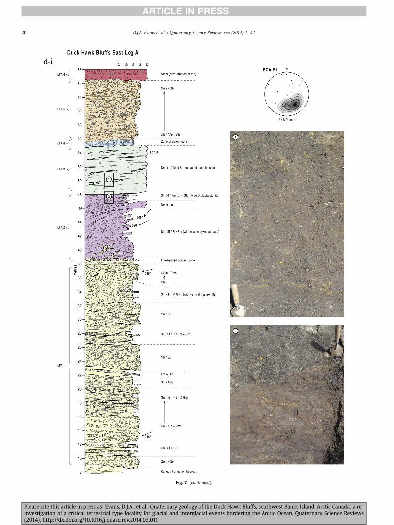
Fig 7 (continued)
DJA Evans et al Quaternary Science Reviews xxx (2014) 1e4220
Please cite this article in press as Evans DJA et al Quaternary geology of the Duck Hawk Bluffs southwest Banks Island Arctic Canada a re-investigation of a critical terrestrial type locality for glacial and interglacial events bordering the Arctic Ocean Quaternary Science Reviews(2014) httpdxdoiorg101016jquascirev201403011
Fig 7 (continued)
DJA Evans et al Quaternary Science Reviews xxx (2014) 1e42 21
Please cite this article in press as Evans DJA et al Quaternary geology of the Duck Hawk Bluffs southwest Banks Island Arctic Canada a re-investigation of a critical terrestrial type locality for glacial and interglacial events bordering the Arctic Ocean Quaternary Science Reviews(2014) httpdxdoiorg101016jquascirev201403011
Fig 7 (continued)
DJA Evans et al Quaternary Science Reviews xxx (2014) 1e4222
Please cite this article in press as Evans DJA et al Quaternary geology of the Duck Hawk Bluffs southwest Banks Island Arctic Canada a re-investigation of a critical terrestrial type locality for glacial and interglacial events bordering the Arctic Ocean Quaternary Science Reviews(2014) httpdxdoiorg101016jquascirev201403011
Fig 7 (continued)
DJA Evans et al Quaternary Science Reviews xxx (2014) 1e42 23
Please cite this article in press as Evans DJA et al Quaternary geology of the Duck Hawk Bluffs southwest Banks Island Arctic Canada a re-investigation of a critical terrestrial type locality for glacial and interglacial events bordering the Arctic Ocean Quaternary Science Reviews(2014) httpdxdoiorg101016jquascirev201403011
Fig 7 (continued)
DJA Evans et al Quaternary Science Reviews xxx (2014) 1e4224
LFA 6 crops out along the length of DHB and varies widely inthickness (1e11 m) displaying the most complex deformationstructures of any of the sediment bodies at DHB It comprises apredominantly heterogeneous diamicton or a meacutelange of discon-tinuous interbeds of massive matrix-supported diamicton matrix-supported gravel and laminated sand silt and clay with localizedattenuated lenses of degraded organics (Fig 7a ivevi 7b i iv 7c iiiii) Three samples of highly compressed and fragmented detritalmaterial displaying poor preservation were collected for identifi-cation Collectively LFA 6 has the appearance of a stratified dia-micton but locally it displays a more massive to pseudo-laminatedcharacter where sand silt and gravel lenses and occasional gravellags occur as thin beds stringers or wisps Some laminated sand siltand clay bodies appear to be rafts within the diamicton (intraclasts)due to their heavily deformed internal bedding and deformedcontacts or attenuated appearance Basal contacts with other lith-ofacies associations are typically erosional or deformed and asso-ciated with fissility boudinage and pseudo-lamination insediments on either side of the contact Basal diamictons can alsodisplay a higher concentration of gravel clasts that locally result in aclast-supported character or even a several metre-thick highlycontorted meacutelange of diamicton and stratified sediment bodies Insome sections the whole of LFA 6 has been complexly deformed toproduce stacked overfolds and thrust faults indicative of shearingtowards the southwest or WSW Clast macrofabrics are onlymoderately clustered (S1 frac14 0456e0637) but indicate stressdirected predominantly towards the SW Clast macrofabricstrengths as quantified by the fabric shape ternary plot (Fig 6a)and themodalityisotropy plot (Fig 6b) are variable and range frombi-modal to multi-modal Overall the macrofabric shapes in theternary graph plot across the spectrums of the glacitectonite andsubglacial traction till envelopes but there is a trend of changing
Please cite this article in press as Evans DJA et al Quaternary geologyinvestigation of a critical terrestrial type locality for glacial and intergla(2014) httpdxdoiorg101016jquascirev201403011
fabric strength vertically through LFA 6 The strongest clusters arefrom the basal diamictic zones (eg CCA F1 amp F3 AB plane data)whereas the weakest are from the top of the association (eg WCAF3 A-axes amp CCA F2 AB planes) where relatively low strain defor-mation indicators (open and recumbent folds) are ubiquitous
Clast lithologies in LFA 6 are dominated by quartz chert andsandstone although one diamict reveals a concentration of sand-stone lithologies at the expense of chert Clast forms similarlyreflect the nature of the sampled materials whereby the gravellysample (CCA 2) was characterized by relatively low C40 (38) andRA (12) values and a high average roundness (256) compared tothe same values for the diamictons of LFA 6 (C40 frac14 50e74RA frac14 38e52 average roundness frac14 174e204) A small number ofclasts (lt10) in LFA 6 were striated
512 Interpretation5121 LFA 1 The thick tabular sequence of well sorted cross-stratified sand and gravel records deposition by a former glaci-fluvial braided river typified by fluctuating discharge (eg Church1972 Boothroyd and Ashley 1975 Miall 1978 1985 1992Marren 2005) The highest discharge is recorded by matrix-supported gravel with boulders indicative of hyperconcentratedflows or a traction carpet (Maizels 1989ab Siegenthaler andHuggenberger 1993 Mulder and Alexander 2001) These areseparated by and vertically give way to lower discharges recordedby planar or trough cross-bedded sand and horizontal to planar ortrough cross-bedded gravel These deposits record aggradation andmigration of gravel bars and sheets and downstream accretionarymacroforms with relatively tightly constrained palaeocurrent in-dicators (Miall 1977 1985 Collinson 1996) The general lack ofscour fills and an overall fining-upward is indicative of an aggradingsystem initially characterized by high magnitudehigh frequency
of the Duck Hawk Bluffs southwest Banks Island Arctic Canada a re-cial events bordering the Arctic Ocean Quaternary Science Reviews
Fig 7 (continued)
DJA Evans et al Quaternary Science Reviews xxx (2014) 1e42 25
Please cite this article in press as Evans DJA et al Quaternary geology of the Duck Hawk Bluffs southwest Banks Island Arctic Canada a re-investigation of a critical terrestrial type locality for glacial and interglacial events bordering the Arctic Ocean Quaternary Science Reviews(2014) httpdxdoiorg101016jquascirev201403011
Fig 7 (continued)
DJA Evans et al Quaternary Science Reviews xxx (2014) 1e4226
Please cite this article in press as Evans DJA et al Quaternary geology of the Duck Hawk Bluffs southwest Banks Island Arctic Canada a re-investigation of a critical terrestrial type locality for glacial and interglacial events bordering the Arctic Ocean Quaternary Science Reviews(2014) httpdxdoiorg101016jquascirev201403011
DJA Evans et al Quaternary Science Reviews xxx (2014) 1e42 27
events that were gradually replaced by low magnitudehigh fre-quency events (Marren 2005) Partially to heavily-scoured rem-nants of laminated and massive fines represent deposition duringlow flow conditions in abandoned shallow channels The palae-ocurrent data from LFA 1 indicate that the outwash streams wereflowing westerly away from a glacier source located in AmundsenGulf This glacier likely eroded the abundant LFA 1 lithologies(chert quartzite and sandstone) from Mesoproterozoic and Neo-proterozoic bedrock widely distributed to the east and south(western Victoria Island Amundsen Gulf and the adjacent main-land Harrison et al 2013) These lithologies are consistent with theadvance of the NW Laurentide Ice Sheet through Amundsen Gulf(cf Dyke et al 2002 Batchelor et al 2012 MacLean et al 2013)
The crudely bedded organic detritus and degraded tree frag-ments (stumps) in LFA 1 are clearly reworked (cf Matthews et al1986 Fyles 1990 Vincent 1990) The finer grained detritus wasdeposited in concentrated pockets during waning flow stageswhereas horizons of logs and larger tree fragments were emplacedwith the coarser grained and poorly sorted sediments associatedwith hyperconcentrated flows or traction carpets during highdischarge These reworked organics also differ significantly fromthe type location of the Beaufort Fm a characteristic that promptedFyles (1990) to distinguish them as lsquotheMary Sachs Gravelrsquo Notablythe enclosing gravel and sand of LFA 1 is much coarser and exhibitsan entirely different fluvial architecture than the sandier BeaufortFm The composition and degraded nature of the LFA 1 organicssuggests that they were eroded by glaciers or their meltwater fromNeogene andor Paleogene sediments presumably to the southeastof Banks Island (eg Fyles 1990 Fyles et al 1994) The proximity ofa glacier is highlighted by the preservation of striae on individualclasts especially in the very coarse lower gravel The verticaldecrease in striae preservation and angularity (RA) and concomi-tant increase in roundness and upward-fining in LFA 1 is indicativeof an increasingly distal ice margin The co-variance plots (Fig 5)indicate a strong fluvial signature especially in the C40RA data butsubglacial characteristics are also evident particularly in the C40RWR data for the coarser grained and more matrix-supportedgravel as would be expected in ice-proximal settings
It is important to note that the widespread thrusting of LFA 1and underlying Kanguk Formation towards the southwest occurredpost-depositionally This glacitectonic thrusting was produced byLaurentide ice that advanced from the Kellett River valley (interiorBanks Island) during the emplacement of LFA 6 (see below) Theinjection of clastic dykes and fissure fills during this glacitectonicdisturbance was due to the overpressurizing of groundwater ingravel aquifers likely in taliks The branching limbs of many of thedykes are indicative of burst-out structures diagnostic of hydro-fracturing by vertically escaping groundwater pressurized byglacier overriding (cf Rijsdijk et al 1999 Le Heron and Etienne2005)
5122 LFA 2 At the top of LFA 1 rhythmites with lonestonesoverlie prominent clinoforms or foreset beds recording a changefrom subaerial glacifluvial to subaqueous deposition This wasinitially on a shallow delta front prograding foreset beds in asouthwesterly direction followed by suspension sedimentationwith dropstones presumably from floating ice in a marine orlacustrine basin The occurrence of matrix-supported gravelly scourfills with logs and woody detritus suggests pulses of cohesionlesssediment gravity flows into the basin Overlying the rhythmically-bedded sand prominent ice wedge pseudomorphs (up to 4 mdeep Fig 9aec cf Mackay and Burn 2002) are interspersed withthick (gt1m) sections of compressed in situ bryophytes (Figs 9d 7e)indicating the establishment of a tundra surface Four bryophytefamilies and 10 distinct species have been determined from LFA2
Please cite this article in press as Evans DJA et al Quaternary geologyinvestigation of a critical terrestrial type locality for glacial and intergla(2014) httpdxdoiorg101016jquascirev201403011
with the most abundant material from the Calliergonaceae andCampyliaceae (Table 1) These macrofossils are exceptionally wellpreserved including material with intact fragile alar cells typical ofthese two families (Fig 14cef) The data from these autochthonousdeposits indicate a wetland environment characterized as a richfen This ecosystem and habitats therein are consistent with speciesfound in the extant flora of Banks Island (Fig 14b) The autecologyfrom this range of species suggest hydric to mesic habitatsincluding standing pools wet meadows and microhabitats createdby ice wedges Despite the predominance of bryophytes in LFA 2these macrofossils had not been previously documented at DHB Incontrast a minimal proportion of the samples (lt5) consisted ofvascular plant material (including Cyperaceae seeds gramminoidleaves and woody twig fragments) Collectively the ice wedgepseudomorphs and vegetation within LFA 2 represent an isochro-nous terrestrial surface of interglacial rank
Following the formation of ice wedges the injection of intra-formational clastic dykes and fissure fills in LFA 2 relates to theoverpressurizing of groundwater in gravel aquifers or taliks due toglacier overriding The branching dyke limbs that emanate fromunderlying LFA 1 gravels and sands are indicative of the burst-outstructures that develop during hydrofracturing (cf Rijsdijk et al1999 Le Heron and Etienne 2005) A variant of the gravel andsand filled clastic dykes occurs within the sequence of glaci-tectonite and rhythmites near west Log D (Fig 11) Here thevertically-widening fracture is characterized by a mosaic ofpartially disaggregated blocks of the host materials in its widestzone where it contains gravels injected from underlying LFA 1Because these gravels only occur in the basal narrow neck theypresumably record the rapid reduction in flow competence duringhydrofracture filling
Deformation structures including overfolded or crumpledbedding and thrust faults associated with boudinage or highfissilitypseudo-lamination are representative of simple shear andwere also induced by glacitectonic disturbance (cf van derWateren 1995 McCarroll and Rijsdijk 2003) This predominantlyrecords a glacier advance from the northeast Subsidiary shear in-dicators record deformation from the south or southeast but theseoccur only at the top of LFA 2 and the base of LFA 3 suggestingearlier emplacement (see below) The development of zones ofboudinage shallow thrust faults overfolding or bed crumpling atdifferent levels within LFA 2 e especially at the contact separatingsediments of different grain size e represents deformation parti-tioning due to contrasting rheological properties Blind thrustswere also initiated in underlying LFA 1 increasingly towards thecentral and eastern cliffs where large-scale deformation is moreprevalent (Fig 7c d) A zone of intense deformation is recorded by alens of LFA 3 diamicton in fault contact with LFA 2 (east cliff Log AFig 7d i) This constitutes a type B glacitectonite (non-penetrativelydeformed pre-existing sediments sensu Benn and Evans 1996Evans et al 2006) developed during the emplacement of LFA 3(see below) A similar glacitectonite occurs at the junction of LFA 1and LFA 3 near west Log D (Fig 11) Bed attenuation by deformationis best developed in lower LFA 2 where the greater differences insediment grain size and hence rheology exist
5123 LFA 3 Within LFA 3 locally abundant stratified lensesindicate subaqueous deposition These stratified sediments weresubsequently thrust faulted folded and attenuated - most evidentin the upper and lower zones of LFA 3 This deformation was likelyresponsible for the intraclast boudinage and pseudo-lamination inthe surrounding diamicton (eg Hart and Roberts 1994 Robertsand Hart 2005 Oacute Cofaigh et al 2011) This process was alsoassociatedwith the attenuation of LFA 1 and 2 sediments within theheavily deformed base of LFA 3 some of which may have been
of the Duck Hawk Bluffs southwest Banks Island Arctic Canada a re-cial events bordering the Arctic Ocean Quaternary Science Reviews
Fig 8 Details of LFA 1 a) example of a concentration of logs with degraded rootballs in the stacked tabular units of cross-bedded sands and gravels and crudely stratified matrix-supported cobble to boulder gravels in the west cliff b) poorly-sorted and crudely horizontally bedded cobble to boulder gravel containing laminated clay intraclast (immediatelyabove compass) c) shallow locally graded foreset beds composed of openwork to sandy matrix-supported cobble to granule gravels in central cliff Log A d) planar bedded sandy
DJA Evans et al Quaternary Science Reviews xxx (2014) 1e4228
Please cite this article in press as Evans DJA et al Quaternary geology of the Duck Hawk Bluffs southwest Banks Island Arctic Canada a re-investigation of a critical terrestrial type locality for glacial and interglacial events bordering the Arctic Ocean Quaternary Science Reviews(2014) httpdxdoiorg101016jquascirev201403011
DJA Evans et al Quaternary Science Reviews xxx (2014) 1e42 29
cannibalized and rafted by the deformation process within a shearzone at the contact of LFA 3 with older sediments The shearingdirection from the south and southeast recorded in lower LFA 3also impacted upper LFA 2 whereas the more prominent shearingdirection throughout LFA 3 is from the northeast (also recorded inLFA 4) The local development of a heavily deformed zone at the topof LFA 3 was likely imparted during the shearing of overlying LFA 4sediments Although clast macrofabric strengths from the LFA 3diamicton are variable they possess shapes that compare withglacitectonites and subglacial traction tills and in some cases amodalityisotropy signature that reflects high lodgementcomponents
The similar orientation of the macrofabrics and shear indicatorsare considered diagnostic of a glacitectonite derived from stratifiedsediments (eg interbedded mass flow diamictons gravelly massflows and localized traction current sands and suspension de-posits) This evidence indicates that LFA 3 like all the other LFAsand the underlying Kanguk Fm bedrock has been displaced by aglacier advancing from the NNE or NE (ie Laurentide ice crossingthe interior of Banks Island) Minor south to north shearing in-dicates that LFA 3 and upper LFA 2were also disturbed by glacier iceflowing northwards (ie Laurentide ice advancing throughAmundsen Gulf) The appearance of granite and gabbro clastswithin the LFA 3 diamict records the arrival of far-travelled Lau-rentide ice from mainland Canada Clast form co-variance stronglyindicates a subglacial (abraded) source for LFA 3 with a minorfluvial component (Fig 5) including glacifluvial clasts locallycannibalized from LFA 1 by overriding ice
5124 LFA 4 LFA 4 has restricted outcrops is heavily deformedand contains organic detritus that is clearly allochthonous andhighly degraded Nonetheless a variety of indicators (fine-grainedhorizontally bedded cross-laminae rhythmites climbing ripplesand draped laminae) demonstrate that LFA 4 was deposited in asubaqueous environment with palaeocurrents from the south orsouthwest Traction currents were likely responsible for thedevelopment of the clast lag at the contact between lower LFA 4and underlying LFA 3 (west cliff Log A Fig 7b ii) LFA 4 coarsensupwards indicative of basin infilling andor an approaching sedi-ment source The narrow anabranched clastic dykes in the sandyclimbing ripples (LFA 4 west cliff Log A) record hydrofracturing bythe upward injection of overpressurized groundwater duringshearing The branching limbs of the dykes are similar to the burst-out structures reported by Rijsdijk et al (1999) but differ becausethey are composed solely of sand derived from the walls of the hostsediment rather than from an underlying gravel aquifer (cf LeHeron and Etienne 2005) Hence the pressurized water wasgenerated at the contact between the sand and underlying imper-meable brecciated clays The development of thin zones of brecci-ation boudinage sheath folding or thrust faulting at the upper andlower contacts of LFA 4 relates to the localized partitioning ofdeformation controlled by the location of claysilt beds Thejuxtaposition of this style of deformation with the larger scaleoverfolds and thrust faults developed in the extensive bodies ofsandy lithofacies is indicative of a Type B glacitectonite (sensu Bennand Evans 1996) This was constructed by the overriding of glacierice advancing from the north or northeast These shear directionsare compatible with those developed in the underlying LFAs
granule gravels with gravel lags (top and bottom of image) interrupted by an intervening unbedded granule to pebble gravel and massive cobble to pebble gravel A cluster of small treesequence of stacked tabular units of predominantly horizontally bedded sands and gravels ingravels containing clusters of wood detritus in the coarser gravel beds (central cliff Log A)wood fragments (central cliff Log A)
Please cite this article in press as Evans DJA et al Quaternary geologyinvestigation of a critical terrestrial type locality for glacial and intergla(2014) httpdxdoiorg101016jquascirev201403011
5125 LFA 5 The primary characteristics of LFA 5 are typical ofgravel sheet and occasional traction-carpet sedimentation in anice-proximal sandur (eg Boothroyd and Ashley 1975 Miall 19781985 1992 Maizels 1989ab Siegenthaler and Huggenberger1993 Mulder and Alexander 2001 Marren 2005) Glacier prox-imity is supported by the subglacial to fluvial signature of the clastforms (Fig 5) The coarsening-upward sequence including striatedclasts culminates in the arrival of a glacier that overrode the sitedepositing LFA 6 Post-depositional shearing within underlying LFA4 is recorded by attenuation and interdigitation at the contact withLFA 5 imparted during deposition of LFA 6 The contact betweenLFA 5 and 6 reflects the development of a shear zone where upperLFA 5 sediments have been cannibalized producing a meacutelange ofcrudely stratified diamictons with discontinuous interbeds ofmatrix-supported gravel laminated sand silt and clay (LFA 6 seebelow)
5126 LFA5a At Easternmost Cliff glacifluvial gravel (LFA 5a)unconformably overlies LFA 1 (Fig 7e) rendering uncertain itsrelationshipwith respect to LFA 5 in themain sections of DHB to thewest The fact that LFA 5a extends to the modern surface appearsundeformed and has palaeocurrents orientated to the NW requiresthat it is younger than LFA 5 Indeed we interpret LFA 5a asdeglacial outwash deposited from retreating Laurentide ice in theKellett River valley and Amundsen Gulf at the end of the lastglaciation (see Discussion)
5127 LFA 6 Based on its heterogeneity strongly orientated clastmacrofabrics and macroscale deformation structures LFA 6 con-stitutes a Type B glacitectonite (sensu Benn and Evans 1996)However zones of more highly strained Type A glacitectonite(sensu Benn and Evans 1996) at the basal contact with older LFAsare recorded by intraclastinterbed attenuation (pseudo-lamina-tion) strong boudinage or fissility and strengthened clast macro-fabrics The production of this meacutelange is attributed to two separateprocesses 1) primary sedimentation as interbedded and interdig-itated mass flow debris fluvial gravel and sand and subaqueoussuspension sediments and 2) cannibalization of underlying strat-ified sediments (LFAs 4 and 5) This produced a continuum of formsranging from low strain fold structures to attenuated rafts to tec-tonic lamination (eg Fig 7) The discontinuous lenses of degradedorganics (black stems and woody twigs gramminoid leaveswhitened rootlets) within LFA 6 are rafts and include seven speciesof bryophytes (Table 1) The material was highly compressed anddifficult to separate into distinct taxa Indeed one of the threesamples analysed was too degraded to recover any taxa Much ofthe material consisted of only fragmented leaves and only theminute taxa had stems with intact leaves The bryophytes thatcharacterize the LFA 6 samples represent hydric (Calliergon sppTomenthypnum nitens) to mesic (Ditrichum flexicaule Dicranum sp)habitats Three species collected from LFA 6 were also present inLFA 2 whereas four others were not found in LFA 2 but are com-mon in the modern flora The poor preservation quality suggeststhat the material has been redeposited from unknown sources andis clearly allochthonous
The predominant shearing direction within LFA 6 records an iceadvance from the interior of Banks Island (NE) This has resulted incomplex folding and thrusting and localized thickening of LFA 6
it of cross-bedded poorly-sorted to openwork cobble to boulder gravel crudely planar-fragments occur at the base of the cobble to boulder gravels at image centre e) middleDHB west cliff Log D f) sequence of fining-upward planar-bedded cobble to sandy fineg) planar cross-bedded sandy granule to pebble gravels with pebble to cobble lags and
of the Duck Hawk Bluffs southwest Banks Island Arctic Canada a re-cial events bordering the Arctic Ocean Quaternary Science Reviews
Fig 9 Details of LFA 2 from the west cliff a) narrow necked ice wedge pseudomorph with upturned marginal bedding in sand silt and clay rhythmites b) wide necked ice wedgepseudomorph c) ice wedge pseudomorph with overturned silt sand and clay rhythmites developed at the top of LFA 2 and sealed by overlying LFA 3 laminated diamicton d)horizontally bedded sand and silt containing well preserved moss macrofossils e) zone of disharmonically folded sandsilt laminae with well preserved moss peat located at thebase of LFA 2
DJA Evans et al Quaternary Science Reviews xxx (2014) 1e4230
Please cite this article in press as Evans DJA et al Quaternary geology of the Duck Hawk Bluffs southwest Banks Island Arctic Canada a re-investigation of a critical terrestrial type locality for glacial and interglacial events bordering the Arctic Ocean Quaternary Science Reviews(2014) httpdxdoiorg101016jquascirev201403011
Fig 10 Details of simple shear structures developed in fine sand and silt laminae at the centre of the thickest outcrop of LFA 2 in west cliff Log B a) overview of large scaleanastomosing shear faults with zones of smaller scale densely spaced anastomosing shears towards the base of the photograph b) details of large scale shear faults separatingzones of variably but predominantly densely spaced shears c) close details of shear zone comprising densely spaced anastomosing fractures d) details of ascending kink zonecross-cutting large scale anastomising shear faults Shearing direction is coming out of the cliff and towards the left in each image
DJA Evans et al Quaternary Science Reviews xxx (2014) 1e42 31
This shearing direction is recorded throughout underlying LFAs 1e4as well as the Kanguk Formation demonstrating deep-seated butpartitioned glacitectonic disturbance imparted during theemplacement of LFA 6 This strain signature was therefore over-printed on the northerlynortheasterly aligned shearing directionrecorded in LFA 3 and upper LFA 2 by the earlier northerly flowingice that deposited LFA 3 One anomalous clast macrofabric(northerly CCA F1) occurs in the basal meacutelange of LFA 6 Howeverthis sample is from an isolated outcrop (Fig 7c i) rendering itsapparent shearing direction equivocal
Please cite this article in press as Evans DJA et al Quaternary geologyinvestigation of a critical terrestrial type locality for glacial and intergla(2014) httpdxdoiorg101016jquascirev201403011
52 Sedimentology and stratigraphy (Mary Sachs Creek cliff)
The cliffs east of Mary Sachs Creek (Figs 2b 3) provides a cross-section through the seaward margin of the coast-parallel SachsMoraine (ldquosection Jrdquo Vincent et al 1983 Vaughan 2014) Weprovide a summary of two logs based on a reconnaissance survey ofthese sediments Log A is closest toMary Sachs Creekwhereas Log Boccursw1 km farther east (Figs 3 15a amp b) The sediments exposedin Log A appear to descend eastward and disappear below themodern beach and therefore are assumed to stratigraphically
of the Duck Hawk Bluffs southwest Banks Island Arctic Canada a re-cial events bordering the Arctic Ocean Quaternary Science Reviews
Fig 11 Details of LFA 2 near west Log D Lower box shows a 1e2 m thick basal zone comprising highly attenuated inter-digitated beds of gravelly to clay-rich diamictons and sandsiltclay rhythmites Upper box shows rhythmites containing diamictic intraclasts with sharp and angular boundaries also visible is the draping and deforming of the rhythmitebedding over and under the intraclasts respectively ldquoTailsrdquo extending from the diamictic intraclasts and thin but discontinuous diamictic beds are also visible in the upper box
DJA Evans et al Quaternary Science Reviews xxx (2014) 1e4232
underlie the sediments of Log B A sand and gravel- bench caps bothlogs at w15 m asl incised into the seaward margin of the SachsMoraine
521 DescriptionLog A contains a sequence of upward-fining highly contorted
cross-stratified sand and fine gravel to rhythmically bedded sandsilt clay with minor pebble gravel and sporadic clots of gravellydiamicton (Fig 15a) An ice wedge was initially developed in thelower cross-stratified sand and fine gravel before they were foldedand thrust faulted The deformed ice wedge pseudomorph is un-conformably overlain by a relatively undisturbed lens of laminatedsilty clay with dropstones interbedded with gravelly diamictonthat contains a bed (10 cm) of sandy black organics containingwood fragments (Fig 15a) This organic material occurs repeatedlyup-section as discontinuous stringers Log A is capped by 1e2 m ofpoorly exposed and heavily cryoturbated gravelly diamicton Thegeneral sense of displacement on shallow reverse faults over-turned bedding and boudinage structures is from the southeast
Log B (12 m) displays a coarsening-upward sequence of hori-zontally bedded sandy granule gravel with occasional silty sandlaminae (Fig 15b iii) that grades to poorly-sorted cobble to bouldergravel and bouldery matrix-supported gravel (Fig 15b ii) This iscapped by laminated to crudely stratified cobbly diamicton that issilt and clay-rich abruptly and conformably overlain by
Please cite this article in press as Evans DJA et al Quaternary geologyinvestigation of a critical terrestrial type locality for glacial and intergla(2014) httpdxdoiorg101016jquascirev201403011
interlaminated silt clay and pebbly silty sand (Fig 15b i) Althoughthe bedding on these units dips towards the NW individuallaminae do not thicken in that direction indicating post-depositional tilting The uppermost part of the log (underlyingthe 15 m bench) contains 2 m of clay-rich massive diamictoninterfingered with the underlying laminated sediments and cobblydiamicton
522 Interpretation
5221 Log A Broadly the sedimentology of log A including thedeformed ice wedge pseudomorph is similar to LFA 2 in DHB (egcentral cliff Log A Fig 7c iii) Prior to glacitectonic disturbance theoverlying organic bed (Fig 15a) was redeposited into a sequence ofsubaqueous siltclay rhythmites containing dropstones and gravellymass flows The highly attenuated shear margins bracketing theorganic bed in Log A demonstrate that it has been displaced as atectonic raft Previous research proposed that the organic beds e
similar to those described in Log A e be assigned to the LastInterglacial (locally called the Cape Collinson Vincent 1982 1983)Because these organic beds are clearly a raft they cannot constitutean iscochronous surface precluding chronostratigraphic signifi-cance (see Discussion) Shearing of the Log A sediments from thesoutheast documents an ice advance from Amundsen Gulf corre-sponding to the earliest of two primary shearing directions recor-ded at DHB (imparted during the emplacement of LFA 3) Therefore
of the Duck Hawk Bluffs southwest Banks Island Arctic Canada a re-cial events bordering the Arctic Ocean Quaternary Science Reviews
Fig 12 Details of LFA 4 in West Log A a) heavily deformed upper contact of LFA 4 comprising sandsiltclay rhythmites displaying well developed boudinage sheath folds andimmature tectonic laminae and an interdigitatedsheared boundary with underlying climbing ripple sands The contact with overlying LFA 6 is marked by an interdigitated zonecontaining rooted and de-rooted folds or rhythmite rafts in a sand gravel and diamicton meacutelange b) narrow anabranched clastic dykes ascending sub-vertically through climbingripple drift and resulting in offset bedding between blocks of host material c) abrupt contact between sheared sands and rhythmites of LFA 4 and overlying sand gravel anddiamicton meacutelange
Fig 13 Details of LFA 5 a) poorly sorted and matrix-supported pebble to cobble gravel b) tabular sequence of horizontally bedded to massive gravel and matrix-supported gravelcontaining a horizon of striated cobbles and boulders c) heavily deformed discontinuous bed of siltclay rhythmites between LFA 5 and LFA 6 in West Log D showing theamalgamation zone with the LFA 5 gravels immediately above the compass d) interdigitateddeformed contact between LFA 5 granule to pebble gravels and underlying LFA 4laminated silts and clays with organic detritus in West Log B
DJA Evans et al Quaternary Science Reviews xxx (2014) 1e42 33
Please cite this article in press as Evans DJA et al Quaternary geology of the Duck Hawk Bluffs southwest Banks Island Arctic Canada a re-investigation of a critical terrestrial type locality for glacial and interglacial events bordering the Arctic Ocean Quaternary Science Reviews(2014) httpdxdoiorg101016jquascirev201403011
Table 1List of bryophytes and vascular plants from LFAs 2 and 6
LFA2 WestCliff Log B
LFA6 CentralCliff Log A
Elevation (m) 185 m asl w45 m aslSample 4e12 1e3 taxa 10 7
Bryophyta (mosses)AmblystegiaceaeAmblystegium serpens (Hedw) Schimp x
CamyliaceaeCampylium polygamum (Schimp) CEO Jensen xCampylium stellatum (Hedw) CEO Jensen x xDrepanocladus aduncus (Hedw) Warnst xDrepanocladus sp xTomentypnum nitens (Hedw) Loeske x
CalliergonaceaeCalliergon giganteum (Schimp) Kindb xCalliergon richardsonii (Mitt) Kindb xthornthornthornthorn xCalliergon sp xWarnstorfia exannulatus (Schimp) Loeske xthornthornthornthorn x
BrachytheciaceaeBrachythecium turgidum (Hartm) Kindb x
MniaceaeCyrtomnium cf hymenophylloides(Hbener) TJ Kop
x
DicranaceaeDicranum sp x
DitrichaceaeDitrichum flexicaule (Schwaumlgr) Hampe x
Tracheophyta (vascular plants)CyperaceaeSeeds (triangular amp flattened) x x
Gramminoid leaf material x xWoody twig fragments x xRootlets x
Fig 14 The moss peat and associated microfossils of LFA 2 a) exposure through lower LFAsouthern Banks Island analogue of a rich tundra fen environment for the bryophyte assemblfrom LFA 2 showing the exceptional preservation of Calliergonaceae and Campyliaceae ma
DJA Evans et al Quaternary Science Reviews xxx (2014) 1e4234
Please cite this article in press as Evans DJA et al Quaternary geologyinvestigation of a critical terrestrial type locality for glacial and intergla(2014) httpdxdoiorg101016jquascirev201403011
these deformed deposits are interpreted as a Type B glacitectonite(sensu Benn and Evans 1996) possibly derived from LFA 2
5222 Log B The coarsening upward gravel in Log B recordshighly turbid to hyperconcentrated discharge in non-channelizedsheets This is interpreted as aggrading glacifluvial outwash froman approaching ice margin The capping sequence of crudelystratified diamicton and laminated sediments records a changefrom glacifluvial to subaqueous sedimentation prior to overridingby a glacier of unknown age that tilted the upper beds Thecoarsening-upward sequence apparent tectonism and cappingdiamict at Log B clearly distinguishes these deposits from those ofLFA 5a (west of Mary Sachs Creek easternmost cliff Fig 3)Furthermore although there is lithological similarity between LogB and LFA 5 throughout DHB the sense of shearing is dissimilar (LFA5 from the NE and Log B from the SE) The simplest explanation forthis difference in shear direction is that LFA 5 (DHB) was displacedby interior ice advancing down the Kellett River whereas Log B wasdisplaced by ice advancing along Amundsen Gulf (Fig 2b)
6 Discussion
61 Large scale glacitectonic structures and stratigraphicarchitecture
The glacitectonic structures identified within the lithofaciesassociations at DHB record two phases of deformation (early NeSand later NEeSW) This deformation together with the DHBstratigraphic architecture (Fig 16) helps to explain both thekinetostratigraphy (sensu Berthelsen1978) and the evolution of thelocal glacial geomorphology The large scale glacitectonic defor-mation is most clearly manifest in the thrust faulting and conjugate
2 at DHB west log B showing the sampling locations for in situ moss peat b) a modernages of LFA 2 c)ef) details of the typical moss peat and associated microfossil materialscrofossils including material with intact fragile alar cells
of the Duck Hawk Bluffs southwest Banks Island Arctic Canada a re-cial events bordering the Arctic Ocean Quaternary Science Reviews
Fig 15 The stratigraphy of Mary Sachs Creek cliff a) photographic compilation log A showing upward-fining highly contorted (i) cross-stratified sands and fine gravels torhythmically bedded sands silts clays and minor pebble gravels Also visible in (ii) is a lens of interbedded laminated silty clays with dropstones and gravelly diamictons containingsandy black coloured organic material with wood fragments An ice wedge pseudomorph is visible (iii) to the right of the exposure b) photographic compilation log B showing i)laminated to crudely stratified cobbly but siltclay-rich diamicton grading into interlaminated silts clays and pebbly silty sands ii) poorly-sorted cobble to boulder gravel andbouldery matrix-supported gravel iii) coarsening-upward sequence of horizontally bedded sandy granule gravels with occasional silty sand laminae iv amp v) pebble to cobble graveland matrix-supported gravel
DJA Evans et al Quaternary Science Reviews xxx (2014) 1e42 35
shear development in the Kanguk Fm bedrock and overlying LFA 1(east cliff Fig 7d ivevi) Here predominantly northeasterly dippingthrust slices have been stacked truncated and overlain by LFA 6during the second and strongest (NEeSW) deformation phase(Fig 16 note bedrock slice within the imbricated stacked sequenceof LFA 1) These structures demonstrate significant compressionand thickening of the stratigraphic sequence including w40 m ofvertical offset within the Kanguk Formation acrossw3 km (Fig 16)Prominent hydrofracture fills in LFAs 1 and 2 record elevatedporewater pressure during this thrusting Smaller scale shear zoneshave also developed in the finer grained interbeds within thrustslabs (Fig 7d vii) indicative of deformation partitioning by strataprone to ductile failure This zone of greatest displacement alsocoincides with the highest topography (Fig 16) Lower angle thrustfaults propagate in a southwesterly direction predominantlythrough LFA 1 but are also developed through LFA 2 in the footwallblock (east cliff Fig 16)
The thrust stacking of bedrock and LFAs 1e5 in east cliff (obliqueto Fig 16) represents the ice-proximal zone of a thrust-blockmorainecomposite ridge constructed by a glacier advancing fromthe northeast (ie the interior of Banks Island) This glacitectonicdeformation propagated southwestward to distal parts of theproglacial stress field as recorded bywell-developed shear zones inthe finer grained sediments of LFAs 2e5 In the more distal westcliff open folds (LFA 2 Fig 16) appear to be the product of a blindthrust within underlying LFA 1 This style of tectonism is typical oflsquopiggyback-style thrustingrsquo wherein steeply inclined thrust blocksat the advancing ice margin propagate new thrusts in the footwall(Fig 16 Park 1983 Mulugeta and Koyi 1987) The angle of thesefootwall thrusts becomes progressively shallower southwestward
Please cite this article in press as Evans DJA et al Quaternary geologyinvestigation of a critical terrestrial type locality for glacial and intergla(2014) httpdxdoiorg101016jquascirev201403011
(ice-distal) in LFA 1e5 where deformation partitioning developedin finer grained lithofacies (Fig 16)
The densely spaced ponds and depressions immediately to thenortheast of DHB (Figs 2b 3) constitute the depression fromwhich the thrust mass was excavated (eg Aber et al 1989Evans and England 1991 van der Wateren 1995) This inter-pretation is consistent with the strong northeast to southwestshear direction in the second phase glacitectonic structures andin LFA 6 clast macrofabrics This indicates that construction ofDHB occurred at the margin of a glacier advancing from thenortheast (ie from Kellett River valley) overtopping DHB anddepositing the LFA 6 glacitectonite The continued advance ofKellett ice coalesced with a glacier in Amundsen Gulf marked bythe interlobate Sachs Moraine containing ice-transported shellsas young as 24 cal ka BP (21020 70 yrs BP UCIAMS-89674)assigning this glaciation to the Late Wisconsin (Vaughan 2014)East of Mary Sachs Creek the deformation of Log B outwash(from the southeast Figs 15 16) likely records overriding by thesame Amundsen Gulf glacier (coeval with LFA 6 Late Wiscon-sinan) During ice retreat when Kellett River and Amundsen Gulfice decoupled DHB was exposed allowing the northwesterly-flowing proglacial outwash (LFA 5a) west of Mary Sachs Creekto extend to the shoreline marking postglacial marine limit atKellett Point (11 m asl Vaughan 2014 Fig 3) Collectively thisreconstruction supports a Late Wisconsinan age for the con-struction of DHB thrust block moraine although its stratigraphyincludes a range of ages A palaeogeographic reconstruction ofevents based upon our interpretation of the sedimentologystratigraphic architecture tectonism and geomorphology is pre-sented in Fig 17
of the Duck Hawk Bluffs southwest Banks Island Arctic Canada a re-cial events bordering the Arctic Ocean Quaternary Science Reviews
Fig 15 (continued)
DJA Evans et al Quaternary Science Reviews xxx (2014) 1e4236
62 Comparison and revision of previous DHB model
DHB was previously interpreted to record horizontally beddedNeogene to Quaternary sediments assigned to preglacial fluvialand multiple glacial and interglacial episodes (Vincent 1982 19831990 Vincent et al 1983 1984 Barendregt et al 1998) A com-posite palaeomagnetic record was also presented for this proposedstratigraphy placing most of this deposition before the BrunhesMatuyama boundary (Fig 1c) However prior to our work detailedstudies had not been undertaken on the sedimentology structuralgeology or stratigraphic architecture of DHB Rather the originalstratigraphy was restricted to a series of composite logs (our Fig 4reproduced from Vincent et al 1983) that notably omitted thepervasive deformation structures including the thrust bedrock ineast cliff (Fig 16)
Please cite this article in press as Evans DJA et al Quaternary geologyinvestigation of a critical terrestrial type locality for glacial and intergla(2014) httpdxdoiorg101016jquascirev201403011
Our reinterpretation dismisses several key elements of theoriginal DHB model outlined below (oldest to youngest) We havedetermined that the lowermost unit (LFA 1) is not preglacial (Fyles1990) but rather is composed of glacial outwash providing theearliest terrestrial evidence for glaciation in the area and containingallochthonous organics (including tree stumps) of unknown prov-enance Because LFA 1 is a glacifluvial braidplain (Fig 17a) it is notpart of the Beaufort Fm (Fyles 1990) even though it containsreworked macrofossils presumably derived from it (eg Craig andFyles 1960 Hills et al 1974 Vincent et al 1983)
Our analysis of LFA 2 indicates that it is also not preglacial norcan it be the Worth Point Fm as previously proposed (cf Vincent1982 1983 1990 Vincent et al 1983 Matthews et al 1986)Indeed the type locality of the Worth Point Fm has been invali-dated because it is now recognized to be an ice-transported and
of the Duck Hawk Bluffs southwest Banks Island Arctic Canada a re-cial events bordering the Arctic Ocean Quaternary Science Reviews
LFA4
Fig16
Stratigrap
hiccross-profi
lerun
ning
westto
easto
fDuc
kHaw
kBluffs
basedup
oninterpolations
betw
eenthemainsectionlogs
andsh
owingthesixLFAstheKan
gukFo
rmationbe
droc
kex
posu
resmajor
structural
features
and
thepo
sition
sof
icewed
geps
eudo
morph
san
dsign
ificant
clasticdy
kesAtthe
easternen
dof
thecross-profi
lethe
sedimen
tsat
theco
reof
MarySa
chsCree
kcliff
logAaretentativelyclassified
asLFA2
althou
ghthesematerialsarelik
ely
notin
situN
otethat
thecross-profi
ledo
esno
tex
tend
asfarea
stas
MarySa
chsCree
kcliff
logB
DJA Evans et al Quaternary Science Reviews xxx (2014) 1e42 37
Please cite this article in press as Evans DJA et al Quaternary geologyinvestigation of a critical terrestrial type locality for glacial and intergla(2014) httpdxdoiorg101016jquascirev201403011
glacitectonized raft (Vaughan et al 2014) In contrast our LFA 2 ischaracterized by an isochronous tundra surface with ice wedgesand intervening shallow ponds andwetmeadows The peat at LFA 2is dominated by bryophytes (gt95 by volume) and yet none ofthese macrofossils had been previously documented The diversein situ bryophyte species record a flora similar to that on BanksIsland today suggesting that LFA 2 warrants an interglacial rankThis conclusion is supported by the limited vascular plant record(five taxa no species indicated Vincent 1990) that also suggest awet meadow environment The absolute age of LFA 2 remains un-known but is apparently older than the BrunhesMatayamaboundary (gt780 ka Fig 18 cf Vincent et al 1984 Barendregt andVincent 1990 Barendregt et al 1998 see below)
LFA 3 in both our model and that of Vincent et al (1983) pro-vides the first direct evidence of ice reaching DHB In the previousmodel this was interpreted as Bernard Till (Banks Glaciation) thatwas bracketed by glacioisostatically induced marine transgressions(pre- and post-Banks seas Vincent 1982 1983) Within basal LFA 3we recognized highly deformed stratified sediment that wasdeposited in a subaqueous environment (deep water Fig 17c) priorto the arrival of overriding ice from the south (recorded by graniteand gabbro erratics Figs 17c 18) We regard LFA 3 to be equivalentto the Banks Glaciation (Vincent 1982 1983 Vincent et al 1983)including its pre- and post-Banks seas represented by the stratifiedsediments that bracket the central diamicton The LFA 3 sedimentsare also reported to be magnetically reversed thereby predatingthe BrunheseMatayama boundary (gt780 ka Fig 18 Vincent et al1984 Barendregt and Vincent 1990 Barendregt et al 1998)
Following the Banks Glaciation (our LFA 3 at DHB) Vincent(1982 1983) and Vincent et al (1983) recognized two in-terglacials (Morgan Bluffs and Cape Collinson) separated by anintervening marine episode This marine episode correspondedwith the glacioisostatic loading of a Laurentide ice margin confinedto the eastern half of Banks Island (Thomsen Glaciation) HoweverLFA 4 contains coarsening-upward subaqueous sedimentation fromthe south or southwest reflecting continued marine regressionfollowing LFA 3 (Fig 17c d) The coarsening-upward sequence ofLFA 4 is supplanted by coarse gravel outwash (LFA 5) supplied by aglacier readvancing from the northeast (Kellett River valley iceFig 17e) Glacier overriding is recorded by LFA 6 glacitectonite thatcaps the DHB thrust-block moraine composed of the entireassemblage of underlying LFAs (Fig 16)
Notably we have not observed any sediments characteristic oftwo interglacial deposits above LFA 3 hence dismiss the presence ofthe Morgan Bluffs and Cape Collinson interglacials at DHB Causseand Vincent (1989) report a U-series date of gt200 ka (UQT-229)from above our LFA 3 but this is almost certainly reworked andlacks chronostratigraphic significance Nor have we observedintervening marine sediments attributable to the Thomsen Glaci-ation (eg lsquoBig Searsquo Vincent 1982 1983 Vincent et al 1983)Rather following the deposition of the subaqueous sediments ofupper LFAs 3 and 4 (post-Banks Glaciation) LFAs 5 and 6 record asingle ice advance reaching DHB from the Kellett River valley(Banks Island interior) that was not reported by Vincent et al(1983) It was instead assumed that after the Banks GlaciationDHB lay distal to any later ice advances The nearest subsequentLaurentide margin to DHB recognized by Vincent et al (1983) wasassigned to the Sachs Moraine (immediately east of DHB) that waspresumed to be of EarlyWisconsin age (Fig 2b) However the SachsMoraine is nowdated to24 cal ka BP (LateWisconsinan Vaughan2014) andwas formed by the coalescence of Amundsen Gulf ice andthe Kellett River ice that deformed DHB (Fig 17) On the east side ofMary Sachs Creek the deposition of the Sachs Moraine coincideswith the deformation (from the southeast) of the underlying Log Boutwash gravel (Figs 3 15b)
of the Duck Hawk Bluffs southwest Banks Island Arctic Canada a re-cial events bordering the Arctic Ocean Quaternary Science Reviews
Fig 17 The palaeogeography of southwest Banks Island based upon interpretations of the principal lithofacies associations and structural architecture recognized at Duck HawkBluffs and the geomorphology of the surrounding terrain See text for detailed explanations
DJA Evans et al Quaternary Science Reviews xxx (2014) 1e4238
Although interglacial deposits were previously reported fromthe cliffs east of Mary Sachs Creek (ie Cape Collinson InterglacialVincent et al 1983) we found no similar evidence Rather the onlydeposit that we observed that may have been construed as inter-glacial sediments occurs in our Log A (Figs 3 15a) Here a darkdiscontinuous band of allochthonous organics (Fig15a) sits severedwithin a heavily tectonized melange (type B glacitectonite) and istherefore clearly a raft Although the absolute ages of the deformedunits east of Mary Sachs Creek (Logs A amp B) remain uncertain theyare apparently normally magnetized (Vincent et al 1984Barendregt and Vincent 1990) Blake (1987) also reports non-finite radiocarbon dates (gt36000 amp 49000 BP GSC-3560 amp 3560-2) obtained on ldquocompressed and deformed black woody peatrdquopurportedly from Cape Collinson beds (Vincent et al 1983 p 1708)Additionally Causse and Vincent (1989) report a U-series date onshells of 924 ka (UQT-143) from beds similar to the Log B gravelAgain all of these dated units have been displaced from unknownlocations limiting their utility for palaeoenvironmental recon-struction The last glacially influenced sedimentation at DHB isrecorded by northwesterly directed outwash (easternmost cliff LFA5a Figs 3 16 17g) We infer that this outwash fed the gravel beachmarking marine limit (11 m asl) in the lower Kellett River duringLate Wisconsinan retreat from the Sachs Moraine
63 Regional context
The stratigraphy at Duck Hawk Bluffs records three glacialevents The earliest of these is recorded by the aggradation of a
Please cite this article in press as Evans DJA et al Quaternary geologyinvestigation of a critical terrestrial type locality for glacial and intergla(2014) httpdxdoiorg101016jquascirev201403011
glacifluvial braidplain (LFA 1) that contains allochthonous pre-glacial material of diverse age However within LFA 1 there is noevidence that the ice reached DHB although it must have beennearby (southeast in Amundsen Gulf) The age of this glaciationremains unknown but the palaeomagnetic polarity of LFA 1 in-dicates that it is gt780 ka BP (Barendregt and Vincent 1990)Although Barendregt et al (1998) assigned part of the Worth PointFm to the normally polarized Olduvai sub-zone (MIS 64e74) itshould be noted that the Worth Point section is located 30 kmnorthwest of DHB There a stratigraphic revision has demonstratedthat this ldquotype sectionrdquo of the Worth Point Fm is in fact a glaci-tectonized raft (Vaughan et al 2014) This observation invalidatesthe previous correlation from Worth Point to purportedly coevalbeds at DHB (our LFA 2) Furthermore the diverse plant assem-blages in the Worth Point raft include preglacial tree stumps andSphagnum spp that do not occur on Banks Island today and are notfound in the wet meadow assemblages (rich fen) of LFA 2 that weinterpret to be of interglacial rank Therefore the sediments at DHB(LFAs 1 amp 2) do not support an age assignment of MIS 64e74(Olduvai subzone) proposed by Barendregt et al (1998) Currentlythe available palaeomagnetic record at DHB simply separates theentire section into a lower lsquoreversedrsquo unit and an upper lsquonormalrsquoone We place this boundary within our LFA 4 (Fig 18)
The overriding of DHB by glaciers is recorded in LFAs 3 amp 6These two glacial deposits may correspond to parts of the record ofstacked till sheets reported from the offshore seismic stratigraphy(Batchelor et al 2012) LFA 3 glaciationmay have contributed to theonset of mid-Pleistocene ice-rafted debris (IRD Ca-rich) attributed
of the Duck Hawk Bluffs southwest Banks Island Arctic Canada a re-cial events bordering the Arctic Ocean Quaternary Science Reviews
B-M
B-M
gt19
Fig
18A
revisedlitho
stratigrap
hyforDuc
kHaw
kBluffsPrev
ious
lyrepo
rted
ageco
nstraintsarealso
depicted
toge
ther
withatentativeallocation
ofMIS
stag
es(positione
dalon
gsideEa
stCliff
LogA
forclarity)
basedup
onthe
palaeo
mag
neticreco
rd
DJA Evans et al Quaternary Science Reviews xxx (2014) 1e42 39
Please cite this article in press as Evans DJA et al Quaternary geology of the Duck Hawk Bluffs southwest Banks Island Arctic Canada a re-investigation of a critical terrestrial type locality for glacial and interglacial events bordering the Arctic Ocean Quaternary Science Reviews(2014) httpdxdoiorg101016jquascirev201403011
DJA Evans et al Quaternary Science Reviews xxx (2014) 1e4240
to the Canadian Arctic Archipelago (CAA) and recorded in sedimentcores from the Arctic Ocean basin (Polyak et al 2009 2013OrsquoRegan et al 2010 Stein et al 2010) However Stein et al(2010) place the onset of Ca-rich ice-rafted debris within MIS 16(w659 ka BP Lisiecki and Raymo 2005) with subsequent peaks atMIS 12 10 and 8 all of which postdate the gt780 ka BP palae-omagnetic age proposed for LFA 3 (above) Polyak et al (2013) placethe onset of Ca-rich ice-rafted debris in the central Arctic Oceancloser to MIS 19 (790 ka BP) which is broadly compatible with theDHB palaeomagnetic record LFA 6 records the last glaciation ofDHB and we assign this to the Late Wisconsinan when Banks Is-land ice (Kellett River) coalesced with the Amundsen Gulf IceStream (Stokes et al 2006 MacLean et al 2013) During this in-terval the northwest Laurentide Ice Sheet likely reached the edgeof the polar continental shelf (Stokes et al 2005 2006 Englandet al 2009 Batchelor et al 2012 Lakeman and England 2013MacLean et al 2013)
7 Conclusions
New sedimentological and stratigraphic analyses of DHB funda-mentally revise the previous reconstruction of the Neogene andQuaternary history of Banks Island DHB and two other widely citedsections on Banks Island have been reported as important unde-formed terrestrial archives of glacial and interglacial sedimentationat the northwest limit of the Laurentide Ice Sheet that all have beenrecently revised (Vaughan et al 2014 Lakeman and England inpress) The recognition of pervasive large-scale deformation ofDHB necessitates a fundamental re-assessment of its previouslydescribed layer-cake stratigraphy We document that the oldestsediments (LFA 1) at DHB are not preglacial fluvial deposits (Beau-fort Fm) but rather record proglacial outwash from ice in AmundsenGulf that did not reach the site This was followed by the estab-lishment of an isochronous tundra surface of interglacial rank (LFA2) characterized by ice wedge polygons within a wet meadow thatsupported a bryophyte community similar to modern Subse-quently glacial sedimentation resumed initially in an ice-proximalsubaqueous environment followed by ice arrival and glacitectonicdeformation (LFA 3) The overlying deposits at DHB indicate post-glacial marine sedimentation (LFA 4) followed by the aggradationof glacifluvial sand and gravel (LFA 5) from an advancing ice marginthat culminated with the emplacement of a glacitectonite (LFA 6)during the Late Wisconsin This ice advance constructed a previ-ously undescribed thrust-block moraine (60 m high 8 km long) thatexhibits pervasive deformation and includes a substantial raft ofCretaceous Kanguk Fm bedrock (Fig 16) Furthermore the produc-tion of the glacitectonite (LFA 6) cannibalized LFAs 1e5 which atsome sites were previously thought to be in situ interglacial de-posits Finally outwash (LFA 5a) incised the DHB thrust block duringdeglaciation of the site when ice in the Kellett River and AmundsenGulf separated and proglacial meltwater drained northwestward tomarine limit (11 m asl) Refinements to the evolution and chronol-ogy of DHB and other sections around Banks Island will furthercontribute to the understanding of high latitude environmentalchange especially the complementary marine archives of theadjacent polar continental shelf and Arctic Ocean
Acknowledgements
Funding for this research was provided by the Natural Sciencesand Engineering Research Council of Canada (NSERC) NorthernResearch Chair Program and a complementary NSERC DiscoveryGrant (A6680) (both to JH England) Coulthard Lakeman andVaughan were supported by CBAR grants Canadian CircumpolarInstitute University of Alberta Coulthard and Lakeman were also
Please cite this article in press as Evans DJA et al Quaternary geologyinvestigation of a critical terrestrial type locality for glacial and intergla(2014) httpdxdoiorg101016jquascirev201403011
supported by Northern Scientific Training Program grantsAboriginal Affairs and Northern Development Canada The PolarContinental Shelf Program Natural Resources Canada(_501100000159) supplied additional funding and aircraft supportField and logistical assistance from Issac Elanik Vernon AmosTrevor Lucas and Roger Kuptana of Sachs Harbour is gratefullyacknowledged
References
Aber JS Croot DG Fenton MM 1989 Glaciotectonic Landforms and StructuresKluwer Dordrecht
Barendregt RW Vincent J-S 1990 Late Cenozoic paleomagnetic record of DuckHawk Bluffs Banks Island Canadian Arctic Archipelago Can J Earth Sci 27124e130
Barendregt RW Duk-Rodkin A 2011 Chronology and extent of Late Cenozoic icesheets in North America a magnetostratigraphical assessment In Ehlers JGibbard PL Hughes PD (Eds) Quaternary Glaciations e Extent and Chro-nolgy a Closer Look Elsevier Amsterdam pp 419e426
Barendregt RW Vincent J-S Irving E Baker J 1998 Magnetostratigraphy ofQuaternary and late Tertiary sediments on Banks Island Canadian Arctic Ar-chipelago Can J Earth Sci 35 147e161
Batchelor CL Dowdeswell JA Pietras JT 2012 Variable history of Quaternaryice-sheet advance across the Beaufort Sea margin Arctic Ocean Geology httpdxdoiorg101130G336691
Batchelor CL Dowdeswell JA Pietras JT 2013 Seismic stratigraphy sedimen-tary architecture and palaeo-glaciology of the Mackenzie Trough evidence fortwo Quaternary ice advances and limited fan development on the westernCanadian Beaufort Sea margin Quat Sci Rev 65 73e87
Benn DI 1994 Fabric shape and the interpretation of sedimentary fabric dataJ Sediment Res 64 910e915
Benn DI 1995 Fabric signature of till deformation Breiethamerkurjoumlkull IcelandSedimentology 42 735e747
Benn DI 2004 Clast morphology In Evans DJA Benn DI (Eds) A PracticalGuide to the Study of Glacial Sediments Arnold London pp 77e92
Benn DI Ballantyne CK 1994 Reconstructing the transport history of glaciogenicsediments a new approach based on the co-variance of clast form indicesSediment Geol 91 215e227
Benn DI Evans DJA 1996 The interpretation and classification of subglaciallydeformed materials Quat Sci Rev 15 23e52
Benn DI Evans DJA Phillips ER Hiemstra JF Walden J Hoey TB 2004 Theresearch project d a case study of Quaternary glacial sediments InEvans DJA Benn DI (Eds) A Practical Guide to the Study of Glacial Sedi-ments Arnold London pp 209e234
Berthelsen A 1978 The methodology of kineto-stratigraphy as applied to glacialgeology Bull Geol Soc Den 27 25e38
Blake Jr W 1987 Geological Survey of Canada Radiocarbon Dates XXVI InGeological Survey of Canada Paper 86-7 60 pp
Boothroyd JC Ashley GM 1975 Processes bar morphology and sedimentarystructures on braided outwash fans northeastern Gulf of Alaska InJopling AV McDonald BC (Eds) Glaciofluvial and Glaciolacustrine Sedi-mentation Society of Economic Paleontologists and Mineralogists SpecialPublication No 23
Causse C Vincent J-S 1989 TheU disequilibrium dating of Middle and LatePleistocene wood and shells from Banks and Victoria islands Arctic CanadaCan J Earth Sci 26 2718e2723
Church MA 1972 Baffin Island sandurs a study of Arctic fluvial processes GeolSurv Can Bull 216 208
Clark DL Vincent J-S Jones GA Morris WA 1984 Corrrelation of marine andcontinental glacial and interglacial events Arctic Ocean and Banks Island Na-ture 311 147e149
Collinson JD 1996 Alluvial sediments In Reading HG (Ed) Sedimentary Envi-ronments and Facies third ed Blackwell Oxford pp 37e82
Craig BG Fyles JG 1960 Pleistocene Geology of Arctic Canada In GeologicalSurvey of Canada Paper 60-10 21 pp
Crosby MR Magill RE Allen B He S 1999 A Checklist of the Mosses MissouriBotanical Garden St Louis 320 pp
Duk-Rodkin A Barendregt RW 2011 Stratigraphical records of glacialsin-terglacials in northwest Canada In Ehlers J Gibbard PL Hughes PD (Eds)Quaternary Glaciations e Extent and Chronology a Closer Look ElsevierAmsterdam pp 661e698
Dyke AS Andrews JT Clark PU England JH Miller GH Shaw J Veillette JJ2002 The Laurentide and Innuitian ice sheets during the Last Glacial MaximumQuat Sci Rev 21 9e31
England JH Furze MFA Doupeacute JP 2009 Revision of the NW Laurentide IceSheet implications for the paleoclimate the northeast extremity of Beringiaand Arctic Ocean sedimentation Quat Sci Rev 28 1573e1596
Evans DJA 2010 Controlled moraine development and debris transport pathwaysin polythermal plateau icefields examples from Tungnafellsjoumlkull IcelandEarth Surf Process Landf 35 1430e1444
of the Duck Hawk Bluffs southwest Banks Island Arctic Canada a re-cial events bordering the Arctic Ocean Quaternary Science Reviews
DJA Evans et al Quaternary Science Reviews xxx (2014) 1e42 41
Evans DJA Benn DI 2004 Facies description and the logging of sedimentaryexposures In Evans DJA Benn DI (Eds) A Practical Guide to the Study ofGlacial Sediments Arnold London pp 11e51
Evans DJA England J 1991 Canadian landform examples 19 high arctic thrustblock moraines Can Geogr 35 93e97
Evans DJA Rea BR Benn DI 1998 Subglacial deformation and bedrockplucking in areas of hard bedrock Glacial Geology and Geomorphology rp041998 httpgggqubacukgggpapersfull1998rp041998rp04html
Evans DJA Hiemstra JF 2005 Till deposition by glacier submarginal incre-mental thickening Earth Surf Process Landf 30 1633e1662
Evans DJA Hiemstra JF Oacute Cofaigh C 2007 An assessment of clast macrofabricsin glaciogenic sediments based on AB plane data Geogr Ann A89 103e120
Evans DJA Phillips ER Hiemstra JF Auton CA 2006 Subglacial till formationsedimentary characteristics and classification Earth Sci Rev 78 115e176
Evans DJA Shulmeister J Hyatt OM 2010 Sedimentology of latero-frontalmoraines and fans on the west coast of South Island New Zealand Quat SciRev 29 3790e3811
Eyles N Eyles CH Miall AD 1983 Lithofacies types and vertical profile modelsan alternative approach to the description and environmental interpretation ofglacial diamicts and diamictite sequences Sedimentology 30 393e410
Fyles JG 1990 Beaufort Formation (late Tertiary) as seen from Prince Patrick Is-land Arctic Canada Arctic 43 393e403
Fyles JG Hills LV Matthews Jr JV Barendregt R Baker J Irving E Jette H1994 Ballast Brook and Beaufort Formations (Late Tertiary) on northern BanksIsland Arctic Canada Quat Int 2223 141e171
Harrison JC Mayr U McNeil DH Sweet AR McIntyre DJ Eberle JJHarington CR Chalmers JA Dam G Nohr-Hansen H 1999 Correlation ofCenozoic sequences of the Canadian Arctic region and Greenland implicationsfor the tectonic history of northern North America Bull Can Pet Geol 47 223e254
Harrison JC Ford A Miall AD Rainbird RH Hulbert LJ Chritie RLCampbell FHA 2013 Geology Tectonic Assemblage Map of Aulavik BanksIsland and Northwestern Victoria Island Northwest Territories GeologicalSurvey of Canada Canadian Geoscience Map 35 (preliminary) scale 1500 000httpdxdoiorg104095292833
Hart JK Roberts DH 1994 Criteria to distinguish between subglacial glaciotec-tonic and glaciomarine sedimentation I Deformation styles and sedimen-tology Sediment Geol 91 191e213
Hedenaumls L 1993 A generic revision of the Warnstorfia Calliergon group J Bryol 17447e479
Hedenaumls L 2006 Additional insights into the phylogeny of Calliergon LoeskypnumStraminergon and Warnstorfia (Bryophyta Calliergonaceae) J Hattori Bot Lab100 125e134
Hicock SR Goff JR Lian OB Little EC 1996 On the interpretation of subglacialtill fabric J Sediment Res 66 928e934
Hiemstra JF Evans DJA Oacute Cofaigh C 2007 The role of glaciotectonic rafting andcommunition in the production of subglacial tills examples from SW Irelandand Antarctica Boreas 36 386e399
Hills LV 1975 Late Tertiary floras Arctic Canada an interpretation In Proceedingsof Circumpolar Conference on Northern Ecology National Research Council ofCanada pp I(65)eI(71)
Hills LV Klovan JE Sweet AR 1974 Juglans eocineria n Beaufort Formation(Tertiary) southwestern Banks Island Arctic Canada Can J Bot 52 65e90
Janssens JAP 1983 Quaternary fossil bryophytes in North America new recordsLindbergia 9 137e151
Kuc M 1974 Calliergon aftonianum Steere in Late Tertiary and Pleistocene Depositsof Canada In Geological Survey of Canada Paper 74e24
Kuc M Hills LV 1971 Fossil mosses Beaufort Formation (Tertiary) NorthwesternBanks Island Western Canada Arctic Can J Bot 49 1089e1094
Lakeman TR England JH 2012 Paleoglaciological insights from the age andmorphology of the Jesse moraine belt western Canadian Arctic Quat Sci Rev47 82e100
Lakeman TR England JH 2013 Late Wisconsinan glaciation and postglacialrelative sea-level change on western Banks Island Canadian Arctic ArchipelagoQuat Res 80 99e112
Lakeman TR England JH 2014 Facies and stratigraphic analyses of glacial andinterglacial sediments at Morgan Bluffs Banks Island Canadian Arctic Archi-pelago Boreas httpdxdoiorg101111bor12069 (in press)
Lawton E 1971 Moss Flora of the Pacific Northwest The Hattori Botanical Labo-ratory Ninchen Miyazaki Japan
Le Heron DP Etienne JL 2005 A complex subglacial clastic dyke swarm Sol-heimajoumlkull southern Iceland Sediment Geol 181 25e37
Li G Piper DJW Campbell DC 2011 The Quaternary Lancaster Sound trough-mouth fan NW Baffin Bay J Quat Sci 26 511e522
Lisiecki LE Raymo ME 2005 A Pliocene-Pleistocene stack of 57 globallydistributed benthic d18O records Paleoceanography 20 PA1003 httpdxdoiorg1010292004PA001071
Lukas S Benn DI Boston CM Brook M Coray S Evans DJA Graf A Kellerer-Pirklbauer A Kirkbride MP Krabbendam M Lovell H Machiedo MMills SC Nye K Reinardy BTI Ross FH Signer M 2013 Clast shapeanalysis and clast transport paths in glacial environments a critical review ofmethods and the role of lithology Earth-Sci Rev 121 96e116
Lukas S Coray S Graf A Schluumlchter C 2014 The influence of clast lithology andfluvial reworking on the reliability of clast shape measurements in glacial en-vironments e a case study from a temperate Alpine glacier In Bridgland DR
Please cite this article in press as Evans DJA et al Quaternary geologyinvestigation of a critical terrestrial type locality for glacial and intergla(2014) httpdxdoiorg101016jquascirev201403011
(Ed) Clast Lithological Analysis Technical Guide Quaternary Research Asso-ciation London (in press)
Mackay JR Burn CR 2002 The first 20 years (1978e1979 to 1998e1999) of icewedge growth at the Illisarvik experimental drained lake site western Arcticcoast Canada Can J Earth Sci 39 95e111
MacLean B Blasco S Bennett R Lakeman T Hughes-Clarke J Kuus PPatton E 2013 Marine evidence for a Glacial ice stream in Amundsen GulfCanadian Arctic Archipelago In Canadian Quaternary Association (CANQUA)Meeting August 18e22 2013 Edmonton AB Canada
Maizels JK 1989a Sedimentology palaeoflow dynamics and flood history ofjokulhlaup deposits palaeohydrology of Holocene sediment sequences insouthern Iceland sandur deposits J Sediment Petrol 59 204e223
Maizels JK 1989b Sedimentology and palaeohydrology of Holocene flood depositsin front of a jokulhlaup glacier south Iceland In Bevan K Carling PJ (Eds)Floods the Geomorphological Hydrological and Sedimentological Conse-quences Wiley New York pp 239e251
Marren PM 2005 Magnitude and frequency in proglacial rivers a geomorpho-logical and sedimentological perspective Earth-Sci Rev 70 203e251
Matthews JV 1987 Plant macrofossils from the Neogene Beaufort Formation onBanks and Meighen islands District of Franklin In Current Research Part AGeological Survey of Canada Paper 87-1A pp 73e87
Matthews Jr JV Ovenden LE 1990 Late Tertiary plant macrofossils from local-ities in ArcticSubarctic North America a review of the data Arctic 43 364e392
Matthews JV Mott RJ Vincent J-S 1986 Preglacial and interglacial environ-ments of Banks Island pollen and macrofossils from Duck Hawk Bluffs andrelated sites Geogr Phys Quat XL 279e298
McCarroll D Rijsdijk KF 2003 Deformation styles as a key for interpreting glacialdepositional environments J Quat Sci 18 473e489
Miall AD 1977 A review of the braided river depositional environment Earth-SciRev 13 1e62
Miall AD 1978 Lithofacies types and vertical profile models in braided river de-posits a summary In Miall AD (Ed) Fluvial Sedimentology Canadian Societyof Petroleum Geologists Memoir 5 pp 597e604
Miall AD 1985 Architectural-element analysis a new method of facies analysisapplied to fluvial deposits Earth Sci Rev 22 261e308
Miall AD 1992 Alluvial deposits In Walker RG James NP (Eds) Facies ModelsResponse to Sea-level Change Geological Association of Canada Torontopp 119e142
Mulder T Alexander J 2001 The physical character of subaqueous sedimentarydensity flows and their deposits Sedimentology 48 269e299
Mulugeta G Koyi H 1987 Three-dimensional geometry and kinematics ofexperimental piggyback thrusting Geology 15 1052e1056
Nyholm E 1956e1965 Illustrated Moss Flora of Fennoscandia II Musci Fasc 1-6Lund pp 1e788
Oacute Cofaigh C Evans DJA Hiemstra JF 2011 Formation of a stratified subglacial lsquotillrsquoassemblage by ice-marginal thrusting and glacier overriding Boreas 40 1e14
OrsquoRegan M St John K Moran K Backman J King J Haley BA Jakobsson MFrank M Roumlhl U 2010 Plio-Pleistocene trends in ice rafted debris on theLomonosov Ridge Quat Int 219 168e176
OrsquoRegan M Williams CJ Frey KE Jakobsson M 2011 A synthesis of the long-term paleoclimatic evolution of the Arctic Oceanography 24 66e80
Park RG 1983 Foundations of Structural Geology Blackie LondonPolyak L Bischof J Ortiz JD Darby DA Channell JET Xuan C Kaufman DS
Loslashvlie R Schneider DA Eberl DD Adler RE Council EA 2009 LateQuaternary stratigraphy and sedimentation patterns in the western ArcticOcean Glob Planet Change 68 5e17
Polyak L Best KM Crawford KA Council EA St-Onge G 2013 Quaternaryhistory of sea ice in the western Arctic Ocean based on foraminifera Quat SciRev 79 145e156
Rijsdijk KF Owen G Warren WP 1999 Clastic dykes in overconsolidated tillsevidence for subglacial hydrofracturing at Killiney Bay eastern Ireland Sedi-ment Geol 129 111e126
Roberts DH Hart JK 2005 The deforming bed characteristics of a stratified tillassemblage in north east Anglia UK investigating controls on sedimentrheology and strain signatures Quat Sci Rev 24 123e140
Roy SK Hills LV 1972 Fossil woods from the Beaufort Formation (Tertiary)northwestern Banks Island Canada Can J Bot 50 2637e2648
Siegenthaler C Huggenberger P 1993 Pleistocene Rhine gravel deposits of abraided river systemwith dominant pool preservation In Best JL Bristow CS(Eds) Braided Rivers Geological Society London Special Publication 75pp 147e162
Spedding N Evans DJA 2002 Sediments and landforms at Kviacuteaacuterjoumlkull southeastIceland a reappraisal of the glaciated valley landsystem Sediment Geol 14921e42
Steere WC 1978 The Mosses of Arctic Alaska In Bryophytorum Bibliotheca vol14 J Cramer Lehre Germany 507 pp
Steere WC Scotter GW 1979 Bryophytes of Banks Island Northwest TerritoriesCanada Can J Bot 57 1136e1149
Stein R Matthiessen J Niessen F Krylov R Nam S Bazhenova E 2010 Towardsa better (litho-) stratigraphy and reconstruction of Quaternary palaeoenviron-ment in the Amerasian Basin (Arctic Ocean) Polarforschung 79 97e121
Stokes CR Clark CD Darby DA Hodgson DA 2005 Late Pleistocene ice exportevents into the Arctic Ocean from the MrsquoClure Strait Ice Stream Canadian ArcticArchipelago Glob Planet Change 49 139e162
of the Duck Hawk Bluffs southwest Banks Island Arctic Canada a re-cial events bordering the Arctic Ocean Quaternary Science Reviews
DJA Evans et al Quaternary Science Reviews xxx (2014) 1e4242
Stokes CR Clark C Winsborrow M 2006 Subglacial bedform evidence for amajor palaeo-ice stream in Amundsen Gulf and its retreat phases CanadianArctic Archipelago J Quat Sci 21 300e412
van der Wateren DFM 1995 Processes of glaciotectonism In Menzies J (Ed)Glacial Environments Modern Glacial Environments Processes Dynamics andSediments vol 1 Butterworth-Heinemann Oxford pp 309e335
Vaughan J 2014 The Glacial and Sea Level History of South Banks Island NT(Unpublished PhD thesis) University of Alberta Edmonton
Vaughan J England J Evans DJA 2014 Glaciotectonic deformation and rein-terpretation of the Worth Point stratigraphic sequence Banks Island NT Can-ada Quat Sci Rev httpdxdoiorg101016jquascirev201311005
Vincent J-S 1982 The Quaternary history of Banks Island Northwest TerritoriesCanada Geogr Phys Quat 36 209e232
Please cite this article in press as Evans DJA et al Quaternary geologyinvestigation of a critical terrestrial type locality for glacial and intergla(2014) httpdxdoiorg101016jquascirev201403011
Vincent J-S 1983 La geologie du quaternaire et la geomorpholie de Lrsquoile Banksarctique Canadien Geological Survey of Canada Memoir 405
Vincent J-S 1984 Quaternary stratigraphy of the western Canadian Arctic Archi-pelago In Fulton RJ (Ed) Quaternary Stratigraphy of Canada e a CanadianContribution to IGCP Project 24 Geological Survey of Canada Paper 84-10pp 87e100
Vincent J-S 1990 Late Tertiary and Early Pleistocene deposits and history of BanksIsland southwestern Canadian Arctic Archipelago Arctic 43 339e363
Vincent J-S Occhietti S Rutter N Lortie G Guilbault J-P De Boutray B 1983The Late TertiaryeQuaternary record of the Duck Hawk Bluffs Banks IslandCanadian Arctic Archipelago Can J Earth Sci 20 1694e1712
Vincent J-S Morris WA Occhietti S 1984 Glacial and non-glacial sediments ofMatuyama paleomagnetic age on Banks Island Canadian Arctic ArchipelagoGeology 12 139e142
of the Duck Hawk Bluffs southwest Banks Island Arctic Canada a re-cial events bordering the Arctic Ocean Quaternary Science Reviews
- Quaternary geology of the Duck Hawk Bluffs southwest Banks Island Arctic Canada a re-investigation of a critical terrest
-
- 1 Introduction
- 2 Study area and previous research
- 3 Methods
- 4 Organics
- 5 Results
-
- 51 Sedimentology and stratigraphy (Duck Hawk Bluffs)
-
- 511 Description
- 512 Interpretation
-
- 5121 LFA 1
- 5122 LFA 2
- 5123 LFA 3
- 5124 LFA 4
- 5125 LFA 5
- 5126 LFA5a
- 5127 LFA 6
-
- 52 Sedimentology and stratigraphy (Mary Sachs Creek cliff)
-
- 521 Description
- 522 Interpretation
-
- 5221 Log A
- 5222 Log B
-
- 6 Discussion
-
- 61 Large scale glacitectonic structures and stratigraphic architecture
- 62 Comparison and revision of previous DHB model
- 63 Regional context
-
- 7 Conclusions
- Acknowledgements
- References
-
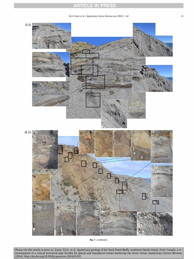
Fig 7 (continued)
DJA Evans et al Quaternary Science Reviews xxx (2014) 1e42 21
Please cite this article in press as Evans DJA et al Quaternary geology of the Duck Hawk Bluffs southwest Banks Island Arctic Canada a re-investigation of a critical terrestrial type locality for glacial and interglacial events bordering the Arctic Ocean Quaternary Science Reviews(2014) httpdxdoiorg101016jquascirev201403011
Fig 7 (continued)
DJA Evans et al Quaternary Science Reviews xxx (2014) 1e4222
Please cite this article in press as Evans DJA et al Quaternary geology of the Duck Hawk Bluffs southwest Banks Island Arctic Canada a re-investigation of a critical terrestrial type locality for glacial and interglacial events bordering the Arctic Ocean Quaternary Science Reviews(2014) httpdxdoiorg101016jquascirev201403011
Fig 7 (continued)
DJA Evans et al Quaternary Science Reviews xxx (2014) 1e42 23
Please cite this article in press as Evans DJA et al Quaternary geology of the Duck Hawk Bluffs southwest Banks Island Arctic Canada a re-investigation of a critical terrestrial type locality for glacial and interglacial events bordering the Arctic Ocean Quaternary Science Reviews(2014) httpdxdoiorg101016jquascirev201403011
Fig 7 (continued)
DJA Evans et al Quaternary Science Reviews xxx (2014) 1e4224
LFA 6 crops out along the length of DHB and varies widely inthickness (1e11 m) displaying the most complex deformationstructures of any of the sediment bodies at DHB It comprises apredominantly heterogeneous diamicton or a meacutelange of discon-tinuous interbeds of massive matrix-supported diamicton matrix-supported gravel and laminated sand silt and clay with localizedattenuated lenses of degraded organics (Fig 7a ivevi 7b i iv 7c iiiii) Three samples of highly compressed and fragmented detritalmaterial displaying poor preservation were collected for identifi-cation Collectively LFA 6 has the appearance of a stratified dia-micton but locally it displays a more massive to pseudo-laminatedcharacter where sand silt and gravel lenses and occasional gravellags occur as thin beds stringers or wisps Some laminated sand siltand clay bodies appear to be rafts within the diamicton (intraclasts)due to their heavily deformed internal bedding and deformedcontacts or attenuated appearance Basal contacts with other lith-ofacies associations are typically erosional or deformed and asso-ciated with fissility boudinage and pseudo-lamination insediments on either side of the contact Basal diamictons can alsodisplay a higher concentration of gravel clasts that locally result in aclast-supported character or even a several metre-thick highlycontorted meacutelange of diamicton and stratified sediment bodies Insome sections the whole of LFA 6 has been complexly deformed toproduce stacked overfolds and thrust faults indicative of shearingtowards the southwest or WSW Clast macrofabrics are onlymoderately clustered (S1 frac14 0456e0637) but indicate stressdirected predominantly towards the SW Clast macrofabricstrengths as quantified by the fabric shape ternary plot (Fig 6a)and themodalityisotropy plot (Fig 6b) are variable and range frombi-modal to multi-modal Overall the macrofabric shapes in theternary graph plot across the spectrums of the glacitectonite andsubglacial traction till envelopes but there is a trend of changing
Please cite this article in press as Evans DJA et al Quaternary geologyinvestigation of a critical terrestrial type locality for glacial and intergla(2014) httpdxdoiorg101016jquascirev201403011
fabric strength vertically through LFA 6 The strongest clusters arefrom the basal diamictic zones (eg CCA F1 amp F3 AB plane data)whereas the weakest are from the top of the association (eg WCAF3 A-axes amp CCA F2 AB planes) where relatively low strain defor-mation indicators (open and recumbent folds) are ubiquitous
Clast lithologies in LFA 6 are dominated by quartz chert andsandstone although one diamict reveals a concentration of sand-stone lithologies at the expense of chert Clast forms similarlyreflect the nature of the sampled materials whereby the gravellysample (CCA 2) was characterized by relatively low C40 (38) andRA (12) values and a high average roundness (256) compared tothe same values for the diamictons of LFA 6 (C40 frac14 50e74RA frac14 38e52 average roundness frac14 174e204) A small number ofclasts (lt10) in LFA 6 were striated
512 Interpretation5121 LFA 1 The thick tabular sequence of well sorted cross-stratified sand and gravel records deposition by a former glaci-fluvial braided river typified by fluctuating discharge (eg Church1972 Boothroyd and Ashley 1975 Miall 1978 1985 1992Marren 2005) The highest discharge is recorded by matrix-supported gravel with boulders indicative of hyperconcentratedflows or a traction carpet (Maizels 1989ab Siegenthaler andHuggenberger 1993 Mulder and Alexander 2001) These areseparated by and vertically give way to lower discharges recordedby planar or trough cross-bedded sand and horizontal to planar ortrough cross-bedded gravel These deposits record aggradation andmigration of gravel bars and sheets and downstream accretionarymacroforms with relatively tightly constrained palaeocurrent in-dicators (Miall 1977 1985 Collinson 1996) The general lack ofscour fills and an overall fining-upward is indicative of an aggradingsystem initially characterized by high magnitudehigh frequency
of the Duck Hawk Bluffs southwest Banks Island Arctic Canada a re-cial events bordering the Arctic Ocean Quaternary Science Reviews
Fig 7 (continued)
DJA Evans et al Quaternary Science Reviews xxx (2014) 1e42 25
Please cite this article in press as Evans DJA et al Quaternary geology of the Duck Hawk Bluffs southwest Banks Island Arctic Canada a re-investigation of a critical terrestrial type locality for glacial and interglacial events bordering the Arctic Ocean Quaternary Science Reviews(2014) httpdxdoiorg101016jquascirev201403011
Fig 7 (continued)
DJA Evans et al Quaternary Science Reviews xxx (2014) 1e4226
Please cite this article in press as Evans DJA et al Quaternary geology of the Duck Hawk Bluffs southwest Banks Island Arctic Canada a re-investigation of a critical terrestrial type locality for glacial and interglacial events bordering the Arctic Ocean Quaternary Science Reviews(2014) httpdxdoiorg101016jquascirev201403011
DJA Evans et al Quaternary Science Reviews xxx (2014) 1e42 27
events that were gradually replaced by low magnitudehigh fre-quency events (Marren 2005) Partially to heavily-scoured rem-nants of laminated and massive fines represent deposition duringlow flow conditions in abandoned shallow channels The palae-ocurrent data from LFA 1 indicate that the outwash streams wereflowing westerly away from a glacier source located in AmundsenGulf This glacier likely eroded the abundant LFA 1 lithologies(chert quartzite and sandstone) from Mesoproterozoic and Neo-proterozoic bedrock widely distributed to the east and south(western Victoria Island Amundsen Gulf and the adjacent main-land Harrison et al 2013) These lithologies are consistent with theadvance of the NW Laurentide Ice Sheet through Amundsen Gulf(cf Dyke et al 2002 Batchelor et al 2012 MacLean et al 2013)
The crudely bedded organic detritus and degraded tree frag-ments (stumps) in LFA 1 are clearly reworked (cf Matthews et al1986 Fyles 1990 Vincent 1990) The finer grained detritus wasdeposited in concentrated pockets during waning flow stageswhereas horizons of logs and larger tree fragments were emplacedwith the coarser grained and poorly sorted sediments associatedwith hyperconcentrated flows or traction carpets during highdischarge These reworked organics also differ significantly fromthe type location of the Beaufort Fm a characteristic that promptedFyles (1990) to distinguish them as lsquotheMary Sachs Gravelrsquo Notablythe enclosing gravel and sand of LFA 1 is much coarser and exhibitsan entirely different fluvial architecture than the sandier BeaufortFm The composition and degraded nature of the LFA 1 organicssuggests that they were eroded by glaciers or their meltwater fromNeogene andor Paleogene sediments presumably to the southeastof Banks Island (eg Fyles 1990 Fyles et al 1994) The proximity ofa glacier is highlighted by the preservation of striae on individualclasts especially in the very coarse lower gravel The verticaldecrease in striae preservation and angularity (RA) and concomi-tant increase in roundness and upward-fining in LFA 1 is indicativeof an increasingly distal ice margin The co-variance plots (Fig 5)indicate a strong fluvial signature especially in the C40RA data butsubglacial characteristics are also evident particularly in the C40RWR data for the coarser grained and more matrix-supportedgravel as would be expected in ice-proximal settings
It is important to note that the widespread thrusting of LFA 1and underlying Kanguk Formation towards the southwest occurredpost-depositionally This glacitectonic thrusting was produced byLaurentide ice that advanced from the Kellett River valley (interiorBanks Island) during the emplacement of LFA 6 (see below) Theinjection of clastic dykes and fissure fills during this glacitectonicdisturbance was due to the overpressurizing of groundwater ingravel aquifers likely in taliks The branching limbs of many of thedykes are indicative of burst-out structures diagnostic of hydro-fracturing by vertically escaping groundwater pressurized byglacier overriding (cf Rijsdijk et al 1999 Le Heron and Etienne2005)
5122 LFA 2 At the top of LFA 1 rhythmites with lonestonesoverlie prominent clinoforms or foreset beds recording a changefrom subaerial glacifluvial to subaqueous deposition This wasinitially on a shallow delta front prograding foreset beds in asouthwesterly direction followed by suspension sedimentationwith dropstones presumably from floating ice in a marine orlacustrine basin The occurrence of matrix-supported gravelly scourfills with logs and woody detritus suggests pulses of cohesionlesssediment gravity flows into the basin Overlying the rhythmically-bedded sand prominent ice wedge pseudomorphs (up to 4 mdeep Fig 9aec cf Mackay and Burn 2002) are interspersed withthick (gt1m) sections of compressed in situ bryophytes (Figs 9d 7e)indicating the establishment of a tundra surface Four bryophytefamilies and 10 distinct species have been determined from LFA2
Please cite this article in press as Evans DJA et al Quaternary geologyinvestigation of a critical terrestrial type locality for glacial and intergla(2014) httpdxdoiorg101016jquascirev201403011
with the most abundant material from the Calliergonaceae andCampyliaceae (Table 1) These macrofossils are exceptionally wellpreserved including material with intact fragile alar cells typical ofthese two families (Fig 14cef) The data from these autochthonousdeposits indicate a wetland environment characterized as a richfen This ecosystem and habitats therein are consistent with speciesfound in the extant flora of Banks Island (Fig 14b) The autecologyfrom this range of species suggest hydric to mesic habitatsincluding standing pools wet meadows and microhabitats createdby ice wedges Despite the predominance of bryophytes in LFA 2these macrofossils had not been previously documented at DHB Incontrast a minimal proportion of the samples (lt5) consisted ofvascular plant material (including Cyperaceae seeds gramminoidleaves and woody twig fragments) Collectively the ice wedgepseudomorphs and vegetation within LFA 2 represent an isochro-nous terrestrial surface of interglacial rank
Following the formation of ice wedges the injection of intra-formational clastic dykes and fissure fills in LFA 2 relates to theoverpressurizing of groundwater in gravel aquifers or taliks due toglacier overriding The branching dyke limbs that emanate fromunderlying LFA 1 gravels and sands are indicative of the burst-outstructures that develop during hydrofracturing (cf Rijsdijk et al1999 Le Heron and Etienne 2005) A variant of the gravel andsand filled clastic dykes occurs within the sequence of glaci-tectonite and rhythmites near west Log D (Fig 11) Here thevertically-widening fracture is characterized by a mosaic ofpartially disaggregated blocks of the host materials in its widestzone where it contains gravels injected from underlying LFA 1Because these gravels only occur in the basal narrow neck theypresumably record the rapid reduction in flow competence duringhydrofracture filling
Deformation structures including overfolded or crumpledbedding and thrust faults associated with boudinage or highfissilitypseudo-lamination are representative of simple shear andwere also induced by glacitectonic disturbance (cf van derWateren 1995 McCarroll and Rijsdijk 2003) This predominantlyrecords a glacier advance from the northeast Subsidiary shear in-dicators record deformation from the south or southeast but theseoccur only at the top of LFA 2 and the base of LFA 3 suggestingearlier emplacement (see below) The development of zones ofboudinage shallow thrust faults overfolding or bed crumpling atdifferent levels within LFA 2 e especially at the contact separatingsediments of different grain size e represents deformation parti-tioning due to contrasting rheological properties Blind thrustswere also initiated in underlying LFA 1 increasingly towards thecentral and eastern cliffs where large-scale deformation is moreprevalent (Fig 7c d) A zone of intense deformation is recorded by alens of LFA 3 diamicton in fault contact with LFA 2 (east cliff Log AFig 7d i) This constitutes a type B glacitectonite (non-penetrativelydeformed pre-existing sediments sensu Benn and Evans 1996Evans et al 2006) developed during the emplacement of LFA 3(see below) A similar glacitectonite occurs at the junction of LFA 1and LFA 3 near west Log D (Fig 11) Bed attenuation by deformationis best developed in lower LFA 2 where the greater differences insediment grain size and hence rheology exist
5123 LFA 3 Within LFA 3 locally abundant stratified lensesindicate subaqueous deposition These stratified sediments weresubsequently thrust faulted folded and attenuated - most evidentin the upper and lower zones of LFA 3 This deformation was likelyresponsible for the intraclast boudinage and pseudo-lamination inthe surrounding diamicton (eg Hart and Roberts 1994 Robertsand Hart 2005 Oacute Cofaigh et al 2011) This process was alsoassociatedwith the attenuation of LFA 1 and 2 sediments within theheavily deformed base of LFA 3 some of which may have been
of the Duck Hawk Bluffs southwest Banks Island Arctic Canada a re-cial events bordering the Arctic Ocean Quaternary Science Reviews
Fig 8 Details of LFA 1 a) example of a concentration of logs with degraded rootballs in the stacked tabular units of cross-bedded sands and gravels and crudely stratified matrix-supported cobble to boulder gravels in the west cliff b) poorly-sorted and crudely horizontally bedded cobble to boulder gravel containing laminated clay intraclast (immediatelyabove compass) c) shallow locally graded foreset beds composed of openwork to sandy matrix-supported cobble to granule gravels in central cliff Log A d) planar bedded sandy
DJA Evans et al Quaternary Science Reviews xxx (2014) 1e4228
Please cite this article in press as Evans DJA et al Quaternary geology of the Duck Hawk Bluffs southwest Banks Island Arctic Canada a re-investigation of a critical terrestrial type locality for glacial and interglacial events bordering the Arctic Ocean Quaternary Science Reviews(2014) httpdxdoiorg101016jquascirev201403011
DJA Evans et al Quaternary Science Reviews xxx (2014) 1e42 29
cannibalized and rafted by the deformation process within a shearzone at the contact of LFA 3 with older sediments The shearingdirection from the south and southeast recorded in lower LFA 3also impacted upper LFA 2 whereas the more prominent shearingdirection throughout LFA 3 is from the northeast (also recorded inLFA 4) The local development of a heavily deformed zone at the topof LFA 3 was likely imparted during the shearing of overlying LFA 4sediments Although clast macrofabric strengths from the LFA 3diamicton are variable they possess shapes that compare withglacitectonites and subglacial traction tills and in some cases amodalityisotropy signature that reflects high lodgementcomponents
The similar orientation of the macrofabrics and shear indicatorsare considered diagnostic of a glacitectonite derived from stratifiedsediments (eg interbedded mass flow diamictons gravelly massflows and localized traction current sands and suspension de-posits) This evidence indicates that LFA 3 like all the other LFAsand the underlying Kanguk Fm bedrock has been displaced by aglacier advancing from the NNE or NE (ie Laurentide ice crossingthe interior of Banks Island) Minor south to north shearing in-dicates that LFA 3 and upper LFA 2were also disturbed by glacier iceflowing northwards (ie Laurentide ice advancing throughAmundsen Gulf) The appearance of granite and gabbro clastswithin the LFA 3 diamict records the arrival of far-travelled Lau-rentide ice from mainland Canada Clast form co-variance stronglyindicates a subglacial (abraded) source for LFA 3 with a minorfluvial component (Fig 5) including glacifluvial clasts locallycannibalized from LFA 1 by overriding ice
5124 LFA 4 LFA 4 has restricted outcrops is heavily deformedand contains organic detritus that is clearly allochthonous andhighly degraded Nonetheless a variety of indicators (fine-grainedhorizontally bedded cross-laminae rhythmites climbing ripplesand draped laminae) demonstrate that LFA 4 was deposited in asubaqueous environment with palaeocurrents from the south orsouthwest Traction currents were likely responsible for thedevelopment of the clast lag at the contact between lower LFA 4and underlying LFA 3 (west cliff Log A Fig 7b ii) LFA 4 coarsensupwards indicative of basin infilling andor an approaching sedi-ment source The narrow anabranched clastic dykes in the sandyclimbing ripples (LFA 4 west cliff Log A) record hydrofracturing bythe upward injection of overpressurized groundwater duringshearing The branching limbs of the dykes are similar to the burst-out structures reported by Rijsdijk et al (1999) but differ becausethey are composed solely of sand derived from the walls of the hostsediment rather than from an underlying gravel aquifer (cf LeHeron and Etienne 2005) Hence the pressurized water wasgenerated at the contact between the sand and underlying imper-meable brecciated clays The development of thin zones of brecci-ation boudinage sheath folding or thrust faulting at the upper andlower contacts of LFA 4 relates to the localized partitioning ofdeformation controlled by the location of claysilt beds Thejuxtaposition of this style of deformation with the larger scaleoverfolds and thrust faults developed in the extensive bodies ofsandy lithofacies is indicative of a Type B glacitectonite (sensu Bennand Evans 1996) This was constructed by the overriding of glacierice advancing from the north or northeast These shear directionsare compatible with those developed in the underlying LFAs
granule gravels with gravel lags (top and bottom of image) interrupted by an intervening unbedded granule to pebble gravel and massive cobble to pebble gravel A cluster of small treesequence of stacked tabular units of predominantly horizontally bedded sands and gravels ingravels containing clusters of wood detritus in the coarser gravel beds (central cliff Log A)wood fragments (central cliff Log A)
Please cite this article in press as Evans DJA et al Quaternary geologyinvestigation of a critical terrestrial type locality for glacial and intergla(2014) httpdxdoiorg101016jquascirev201403011
5125 LFA 5 The primary characteristics of LFA 5 are typical ofgravel sheet and occasional traction-carpet sedimentation in anice-proximal sandur (eg Boothroyd and Ashley 1975 Miall 19781985 1992 Maizels 1989ab Siegenthaler and Huggenberger1993 Mulder and Alexander 2001 Marren 2005) Glacier prox-imity is supported by the subglacial to fluvial signature of the clastforms (Fig 5) The coarsening-upward sequence including striatedclasts culminates in the arrival of a glacier that overrode the sitedepositing LFA 6 Post-depositional shearing within underlying LFA4 is recorded by attenuation and interdigitation at the contact withLFA 5 imparted during deposition of LFA 6 The contact betweenLFA 5 and 6 reflects the development of a shear zone where upperLFA 5 sediments have been cannibalized producing a meacutelange ofcrudely stratified diamictons with discontinuous interbeds ofmatrix-supported gravel laminated sand silt and clay (LFA 6 seebelow)
5126 LFA5a At Easternmost Cliff glacifluvial gravel (LFA 5a)unconformably overlies LFA 1 (Fig 7e) rendering uncertain itsrelationshipwith respect to LFA 5 in themain sections of DHB to thewest The fact that LFA 5a extends to the modern surface appearsundeformed and has palaeocurrents orientated to the NW requiresthat it is younger than LFA 5 Indeed we interpret LFA 5a asdeglacial outwash deposited from retreating Laurentide ice in theKellett River valley and Amundsen Gulf at the end of the lastglaciation (see Discussion)
5127 LFA 6 Based on its heterogeneity strongly orientated clastmacrofabrics and macroscale deformation structures LFA 6 con-stitutes a Type B glacitectonite (sensu Benn and Evans 1996)However zones of more highly strained Type A glacitectonite(sensu Benn and Evans 1996) at the basal contact with older LFAsare recorded by intraclastinterbed attenuation (pseudo-lamina-tion) strong boudinage or fissility and strengthened clast macro-fabrics The production of this meacutelange is attributed to two separateprocesses 1) primary sedimentation as interbedded and interdig-itated mass flow debris fluvial gravel and sand and subaqueoussuspension sediments and 2) cannibalization of underlying strat-ified sediments (LFAs 4 and 5) This produced a continuum of formsranging from low strain fold structures to attenuated rafts to tec-tonic lamination (eg Fig 7) The discontinuous lenses of degradedorganics (black stems and woody twigs gramminoid leaveswhitened rootlets) within LFA 6 are rafts and include seven speciesof bryophytes (Table 1) The material was highly compressed anddifficult to separate into distinct taxa Indeed one of the threesamples analysed was too degraded to recover any taxa Much ofthe material consisted of only fragmented leaves and only theminute taxa had stems with intact leaves The bryophytes thatcharacterize the LFA 6 samples represent hydric (Calliergon sppTomenthypnum nitens) to mesic (Ditrichum flexicaule Dicranum sp)habitats Three species collected from LFA 6 were also present inLFA 2 whereas four others were not found in LFA 2 but are com-mon in the modern flora The poor preservation quality suggeststhat the material has been redeposited from unknown sources andis clearly allochthonous
The predominant shearing direction within LFA 6 records an iceadvance from the interior of Banks Island (NE) This has resulted incomplex folding and thrusting and localized thickening of LFA 6
it of cross-bedded poorly-sorted to openwork cobble to boulder gravel crudely planar-fragments occur at the base of the cobble to boulder gravels at image centre e) middleDHB west cliff Log D f) sequence of fining-upward planar-bedded cobble to sandy fineg) planar cross-bedded sandy granule to pebble gravels with pebble to cobble lags and
of the Duck Hawk Bluffs southwest Banks Island Arctic Canada a re-cial events bordering the Arctic Ocean Quaternary Science Reviews
Fig 9 Details of LFA 2 from the west cliff a) narrow necked ice wedge pseudomorph with upturned marginal bedding in sand silt and clay rhythmites b) wide necked ice wedgepseudomorph c) ice wedge pseudomorph with overturned silt sand and clay rhythmites developed at the top of LFA 2 and sealed by overlying LFA 3 laminated diamicton d)horizontally bedded sand and silt containing well preserved moss macrofossils e) zone of disharmonically folded sandsilt laminae with well preserved moss peat located at thebase of LFA 2
DJA Evans et al Quaternary Science Reviews xxx (2014) 1e4230
Please cite this article in press as Evans DJA et al Quaternary geology of the Duck Hawk Bluffs southwest Banks Island Arctic Canada a re-investigation of a critical terrestrial type locality for glacial and interglacial events bordering the Arctic Ocean Quaternary Science Reviews(2014) httpdxdoiorg101016jquascirev201403011
Fig 10 Details of simple shear structures developed in fine sand and silt laminae at the centre of the thickest outcrop of LFA 2 in west cliff Log B a) overview of large scaleanastomosing shear faults with zones of smaller scale densely spaced anastomosing shears towards the base of the photograph b) details of large scale shear faults separatingzones of variably but predominantly densely spaced shears c) close details of shear zone comprising densely spaced anastomosing fractures d) details of ascending kink zonecross-cutting large scale anastomising shear faults Shearing direction is coming out of the cliff and towards the left in each image
DJA Evans et al Quaternary Science Reviews xxx (2014) 1e42 31
This shearing direction is recorded throughout underlying LFAs 1e4as well as the Kanguk Formation demonstrating deep-seated butpartitioned glacitectonic disturbance imparted during theemplacement of LFA 6 This strain signature was therefore over-printed on the northerlynortheasterly aligned shearing directionrecorded in LFA 3 and upper LFA 2 by the earlier northerly flowingice that deposited LFA 3 One anomalous clast macrofabric(northerly CCA F1) occurs in the basal meacutelange of LFA 6 Howeverthis sample is from an isolated outcrop (Fig 7c i) rendering itsapparent shearing direction equivocal
Please cite this article in press as Evans DJA et al Quaternary geologyinvestigation of a critical terrestrial type locality for glacial and intergla(2014) httpdxdoiorg101016jquascirev201403011
52 Sedimentology and stratigraphy (Mary Sachs Creek cliff)
The cliffs east of Mary Sachs Creek (Figs 2b 3) provides a cross-section through the seaward margin of the coast-parallel SachsMoraine (ldquosection Jrdquo Vincent et al 1983 Vaughan 2014) Weprovide a summary of two logs based on a reconnaissance survey ofthese sediments Log A is closest toMary Sachs Creekwhereas Log Boccursw1 km farther east (Figs 3 15a amp b) The sediments exposedin Log A appear to descend eastward and disappear below themodern beach and therefore are assumed to stratigraphically
of the Duck Hawk Bluffs southwest Banks Island Arctic Canada a re-cial events bordering the Arctic Ocean Quaternary Science Reviews
Fig 11 Details of LFA 2 near west Log D Lower box shows a 1e2 m thick basal zone comprising highly attenuated inter-digitated beds of gravelly to clay-rich diamictons and sandsiltclay rhythmites Upper box shows rhythmites containing diamictic intraclasts with sharp and angular boundaries also visible is the draping and deforming of the rhythmitebedding over and under the intraclasts respectively ldquoTailsrdquo extending from the diamictic intraclasts and thin but discontinuous diamictic beds are also visible in the upper box
DJA Evans et al Quaternary Science Reviews xxx (2014) 1e4232
underlie the sediments of Log B A sand and gravel- bench caps bothlogs at w15 m asl incised into the seaward margin of the SachsMoraine
521 DescriptionLog A contains a sequence of upward-fining highly contorted
cross-stratified sand and fine gravel to rhythmically bedded sandsilt clay with minor pebble gravel and sporadic clots of gravellydiamicton (Fig 15a) An ice wedge was initially developed in thelower cross-stratified sand and fine gravel before they were foldedand thrust faulted The deformed ice wedge pseudomorph is un-conformably overlain by a relatively undisturbed lens of laminatedsilty clay with dropstones interbedded with gravelly diamictonthat contains a bed (10 cm) of sandy black organics containingwood fragments (Fig 15a) This organic material occurs repeatedlyup-section as discontinuous stringers Log A is capped by 1e2 m ofpoorly exposed and heavily cryoturbated gravelly diamicton Thegeneral sense of displacement on shallow reverse faults over-turned bedding and boudinage structures is from the southeast
Log B (12 m) displays a coarsening-upward sequence of hori-zontally bedded sandy granule gravel with occasional silty sandlaminae (Fig 15b iii) that grades to poorly-sorted cobble to bouldergravel and bouldery matrix-supported gravel (Fig 15b ii) This iscapped by laminated to crudely stratified cobbly diamicton that issilt and clay-rich abruptly and conformably overlain by
Please cite this article in press as Evans DJA et al Quaternary geologyinvestigation of a critical terrestrial type locality for glacial and intergla(2014) httpdxdoiorg101016jquascirev201403011
interlaminated silt clay and pebbly silty sand (Fig 15b i) Althoughthe bedding on these units dips towards the NW individuallaminae do not thicken in that direction indicating post-depositional tilting The uppermost part of the log (underlyingthe 15 m bench) contains 2 m of clay-rich massive diamictoninterfingered with the underlying laminated sediments and cobblydiamicton
522 Interpretation
5221 Log A Broadly the sedimentology of log A including thedeformed ice wedge pseudomorph is similar to LFA 2 in DHB (egcentral cliff Log A Fig 7c iii) Prior to glacitectonic disturbance theoverlying organic bed (Fig 15a) was redeposited into a sequence ofsubaqueous siltclay rhythmites containing dropstones and gravellymass flows The highly attenuated shear margins bracketing theorganic bed in Log A demonstrate that it has been displaced as atectonic raft Previous research proposed that the organic beds e
similar to those described in Log A e be assigned to the LastInterglacial (locally called the Cape Collinson Vincent 1982 1983)Because these organic beds are clearly a raft they cannot constitutean iscochronous surface precluding chronostratigraphic signifi-cance (see Discussion) Shearing of the Log A sediments from thesoutheast documents an ice advance from Amundsen Gulf corre-sponding to the earliest of two primary shearing directions recor-ded at DHB (imparted during the emplacement of LFA 3) Therefore
of the Duck Hawk Bluffs southwest Banks Island Arctic Canada a re-cial events bordering the Arctic Ocean Quaternary Science Reviews
Fig 12 Details of LFA 4 in West Log A a) heavily deformed upper contact of LFA 4 comprising sandsiltclay rhythmites displaying well developed boudinage sheath folds andimmature tectonic laminae and an interdigitatedsheared boundary with underlying climbing ripple sands The contact with overlying LFA 6 is marked by an interdigitated zonecontaining rooted and de-rooted folds or rhythmite rafts in a sand gravel and diamicton meacutelange b) narrow anabranched clastic dykes ascending sub-vertically through climbingripple drift and resulting in offset bedding between blocks of host material c) abrupt contact between sheared sands and rhythmites of LFA 4 and overlying sand gravel anddiamicton meacutelange
Fig 13 Details of LFA 5 a) poorly sorted and matrix-supported pebble to cobble gravel b) tabular sequence of horizontally bedded to massive gravel and matrix-supported gravelcontaining a horizon of striated cobbles and boulders c) heavily deformed discontinuous bed of siltclay rhythmites between LFA 5 and LFA 6 in West Log D showing theamalgamation zone with the LFA 5 gravels immediately above the compass d) interdigitateddeformed contact between LFA 5 granule to pebble gravels and underlying LFA 4laminated silts and clays with organic detritus in West Log B
DJA Evans et al Quaternary Science Reviews xxx (2014) 1e42 33
Please cite this article in press as Evans DJA et al Quaternary geology of the Duck Hawk Bluffs southwest Banks Island Arctic Canada a re-investigation of a critical terrestrial type locality for glacial and interglacial events bordering the Arctic Ocean Quaternary Science Reviews(2014) httpdxdoiorg101016jquascirev201403011
Table 1List of bryophytes and vascular plants from LFAs 2 and 6
LFA2 WestCliff Log B
LFA6 CentralCliff Log A
Elevation (m) 185 m asl w45 m aslSample 4e12 1e3 taxa 10 7
Bryophyta (mosses)AmblystegiaceaeAmblystegium serpens (Hedw) Schimp x
CamyliaceaeCampylium polygamum (Schimp) CEO Jensen xCampylium stellatum (Hedw) CEO Jensen x xDrepanocladus aduncus (Hedw) Warnst xDrepanocladus sp xTomentypnum nitens (Hedw) Loeske x
CalliergonaceaeCalliergon giganteum (Schimp) Kindb xCalliergon richardsonii (Mitt) Kindb xthornthornthornthorn xCalliergon sp xWarnstorfia exannulatus (Schimp) Loeske xthornthornthornthorn x
BrachytheciaceaeBrachythecium turgidum (Hartm) Kindb x
MniaceaeCyrtomnium cf hymenophylloides(Hbener) TJ Kop
x
DicranaceaeDicranum sp x
DitrichaceaeDitrichum flexicaule (Schwaumlgr) Hampe x
Tracheophyta (vascular plants)CyperaceaeSeeds (triangular amp flattened) x x
Gramminoid leaf material x xWoody twig fragments x xRootlets x
Fig 14 The moss peat and associated microfossils of LFA 2 a) exposure through lower LFAsouthern Banks Island analogue of a rich tundra fen environment for the bryophyte assemblfrom LFA 2 showing the exceptional preservation of Calliergonaceae and Campyliaceae ma
DJA Evans et al Quaternary Science Reviews xxx (2014) 1e4234
Please cite this article in press as Evans DJA et al Quaternary geologyinvestigation of a critical terrestrial type locality for glacial and intergla(2014) httpdxdoiorg101016jquascirev201403011
these deformed deposits are interpreted as a Type B glacitectonite(sensu Benn and Evans 1996) possibly derived from LFA 2
5222 Log B The coarsening upward gravel in Log B recordshighly turbid to hyperconcentrated discharge in non-channelizedsheets This is interpreted as aggrading glacifluvial outwash froman approaching ice margin The capping sequence of crudelystratified diamicton and laminated sediments records a changefrom glacifluvial to subaqueous sedimentation prior to overridingby a glacier of unknown age that tilted the upper beds Thecoarsening-upward sequence apparent tectonism and cappingdiamict at Log B clearly distinguishes these deposits from those ofLFA 5a (west of Mary Sachs Creek easternmost cliff Fig 3)Furthermore although there is lithological similarity between LogB and LFA 5 throughout DHB the sense of shearing is dissimilar (LFA5 from the NE and Log B from the SE) The simplest explanation forthis difference in shear direction is that LFA 5 (DHB) was displacedby interior ice advancing down the Kellett River whereas Log B wasdisplaced by ice advancing along Amundsen Gulf (Fig 2b)
6 Discussion
61 Large scale glacitectonic structures and stratigraphicarchitecture
The glacitectonic structures identified within the lithofaciesassociations at DHB record two phases of deformation (early NeSand later NEeSW) This deformation together with the DHBstratigraphic architecture (Fig 16) helps to explain both thekinetostratigraphy (sensu Berthelsen1978) and the evolution of thelocal glacial geomorphology The large scale glacitectonic defor-mation is most clearly manifest in the thrust faulting and conjugate
2 at DHB west log B showing the sampling locations for in situ moss peat b) a modernages of LFA 2 c)ef) details of the typical moss peat and associated microfossil materialscrofossils including material with intact fragile alar cells
of the Duck Hawk Bluffs southwest Banks Island Arctic Canada a re-cial events bordering the Arctic Ocean Quaternary Science Reviews
Fig 15 The stratigraphy of Mary Sachs Creek cliff a) photographic compilation log A showing upward-fining highly contorted (i) cross-stratified sands and fine gravels torhythmically bedded sands silts clays and minor pebble gravels Also visible in (ii) is a lens of interbedded laminated silty clays with dropstones and gravelly diamictons containingsandy black coloured organic material with wood fragments An ice wedge pseudomorph is visible (iii) to the right of the exposure b) photographic compilation log B showing i)laminated to crudely stratified cobbly but siltclay-rich diamicton grading into interlaminated silts clays and pebbly silty sands ii) poorly-sorted cobble to boulder gravel andbouldery matrix-supported gravel iii) coarsening-upward sequence of horizontally bedded sandy granule gravels with occasional silty sand laminae iv amp v) pebble to cobble graveland matrix-supported gravel
DJA Evans et al Quaternary Science Reviews xxx (2014) 1e42 35
shear development in the Kanguk Fm bedrock and overlying LFA 1(east cliff Fig 7d ivevi) Here predominantly northeasterly dippingthrust slices have been stacked truncated and overlain by LFA 6during the second and strongest (NEeSW) deformation phase(Fig 16 note bedrock slice within the imbricated stacked sequenceof LFA 1) These structures demonstrate significant compressionand thickening of the stratigraphic sequence including w40 m ofvertical offset within the Kanguk Formation acrossw3 km (Fig 16)Prominent hydrofracture fills in LFAs 1 and 2 record elevatedporewater pressure during this thrusting Smaller scale shear zoneshave also developed in the finer grained interbeds within thrustslabs (Fig 7d vii) indicative of deformation partitioning by strataprone to ductile failure This zone of greatest displacement alsocoincides with the highest topography (Fig 16) Lower angle thrustfaults propagate in a southwesterly direction predominantlythrough LFA 1 but are also developed through LFA 2 in the footwallblock (east cliff Fig 16)
The thrust stacking of bedrock and LFAs 1e5 in east cliff (obliqueto Fig 16) represents the ice-proximal zone of a thrust-blockmorainecomposite ridge constructed by a glacier advancing fromthe northeast (ie the interior of Banks Island) This glacitectonicdeformation propagated southwestward to distal parts of theproglacial stress field as recorded bywell-developed shear zones inthe finer grained sediments of LFAs 2e5 In the more distal westcliff open folds (LFA 2 Fig 16) appear to be the product of a blindthrust within underlying LFA 1 This style of tectonism is typical oflsquopiggyback-style thrustingrsquo wherein steeply inclined thrust blocksat the advancing ice margin propagate new thrusts in the footwall(Fig 16 Park 1983 Mulugeta and Koyi 1987) The angle of thesefootwall thrusts becomes progressively shallower southwestward
Please cite this article in press as Evans DJA et al Quaternary geologyinvestigation of a critical terrestrial type locality for glacial and intergla(2014) httpdxdoiorg101016jquascirev201403011
(ice-distal) in LFA 1e5 where deformation partitioning developedin finer grained lithofacies (Fig 16)
The densely spaced ponds and depressions immediately to thenortheast of DHB (Figs 2b 3) constitute the depression fromwhich the thrust mass was excavated (eg Aber et al 1989Evans and England 1991 van der Wateren 1995) This inter-pretation is consistent with the strong northeast to southwestshear direction in the second phase glacitectonic structures andin LFA 6 clast macrofabrics This indicates that construction ofDHB occurred at the margin of a glacier advancing from thenortheast (ie from Kellett River valley) overtopping DHB anddepositing the LFA 6 glacitectonite The continued advance ofKellett ice coalesced with a glacier in Amundsen Gulf marked bythe interlobate Sachs Moraine containing ice-transported shellsas young as 24 cal ka BP (21020 70 yrs BP UCIAMS-89674)assigning this glaciation to the Late Wisconsin (Vaughan 2014)East of Mary Sachs Creek the deformation of Log B outwash(from the southeast Figs 15 16) likely records overriding by thesame Amundsen Gulf glacier (coeval with LFA 6 Late Wiscon-sinan) During ice retreat when Kellett River and Amundsen Gulfice decoupled DHB was exposed allowing the northwesterly-flowing proglacial outwash (LFA 5a) west of Mary Sachs Creekto extend to the shoreline marking postglacial marine limit atKellett Point (11 m asl Vaughan 2014 Fig 3) Collectively thisreconstruction supports a Late Wisconsinan age for the con-struction of DHB thrust block moraine although its stratigraphyincludes a range of ages A palaeogeographic reconstruction ofevents based upon our interpretation of the sedimentologystratigraphic architecture tectonism and geomorphology is pre-sented in Fig 17
of the Duck Hawk Bluffs southwest Banks Island Arctic Canada a re-cial events bordering the Arctic Ocean Quaternary Science Reviews
Fig 15 (continued)
DJA Evans et al Quaternary Science Reviews xxx (2014) 1e4236
62 Comparison and revision of previous DHB model
DHB was previously interpreted to record horizontally beddedNeogene to Quaternary sediments assigned to preglacial fluvialand multiple glacial and interglacial episodes (Vincent 1982 19831990 Vincent et al 1983 1984 Barendregt et al 1998) A com-posite palaeomagnetic record was also presented for this proposedstratigraphy placing most of this deposition before the BrunhesMatuyama boundary (Fig 1c) However prior to our work detailedstudies had not been undertaken on the sedimentology structuralgeology or stratigraphic architecture of DHB Rather the originalstratigraphy was restricted to a series of composite logs (our Fig 4reproduced from Vincent et al 1983) that notably omitted thepervasive deformation structures including the thrust bedrock ineast cliff (Fig 16)
Please cite this article in press as Evans DJA et al Quaternary geologyinvestigation of a critical terrestrial type locality for glacial and intergla(2014) httpdxdoiorg101016jquascirev201403011
Our reinterpretation dismisses several key elements of theoriginal DHB model outlined below (oldest to youngest) We havedetermined that the lowermost unit (LFA 1) is not preglacial (Fyles1990) but rather is composed of glacial outwash providing theearliest terrestrial evidence for glaciation in the area and containingallochthonous organics (including tree stumps) of unknown prov-enance Because LFA 1 is a glacifluvial braidplain (Fig 17a) it is notpart of the Beaufort Fm (Fyles 1990) even though it containsreworked macrofossils presumably derived from it (eg Craig andFyles 1960 Hills et al 1974 Vincent et al 1983)
Our analysis of LFA 2 indicates that it is also not preglacial norcan it be the Worth Point Fm as previously proposed (cf Vincent1982 1983 1990 Vincent et al 1983 Matthews et al 1986)Indeed the type locality of the Worth Point Fm has been invali-dated because it is now recognized to be an ice-transported and
of the Duck Hawk Bluffs southwest Banks Island Arctic Canada a re-cial events bordering the Arctic Ocean Quaternary Science Reviews
LFA4
Fig16
Stratigrap
hiccross-profi
lerun
ning
westto
easto
fDuc
kHaw
kBluffs
basedup
oninterpolations
betw
eenthemainsectionlogs
andsh
owingthesixLFAstheKan
gukFo
rmationbe
droc
kex
posu
resmajor
structural
features
and
thepo
sition
sof
icewed
geps
eudo
morph
san
dsign
ificant
clasticdy
kesAtthe
easternen
dof
thecross-profi
lethe
sedimen
tsat
theco
reof
MarySa
chsCree
kcliff
logAaretentativelyclassified
asLFA2
althou
ghthesematerialsarelik
ely
notin
situN
otethat
thecross-profi
ledo
esno
tex
tend
asfarea
stas
MarySa
chsCree
kcliff
logB
DJA Evans et al Quaternary Science Reviews xxx (2014) 1e42 37
Please cite this article in press as Evans DJA et al Quaternary geologyinvestigation of a critical terrestrial type locality for glacial and intergla(2014) httpdxdoiorg101016jquascirev201403011
glacitectonized raft (Vaughan et al 2014) In contrast our LFA 2 ischaracterized by an isochronous tundra surface with ice wedgesand intervening shallow ponds andwetmeadows The peat at LFA 2is dominated by bryophytes (gt95 by volume) and yet none ofthese macrofossils had been previously documented The diversein situ bryophyte species record a flora similar to that on BanksIsland today suggesting that LFA 2 warrants an interglacial rankThis conclusion is supported by the limited vascular plant record(five taxa no species indicated Vincent 1990) that also suggest awet meadow environment The absolute age of LFA 2 remains un-known but is apparently older than the BrunhesMatayamaboundary (gt780 ka Fig 18 cf Vincent et al 1984 Barendregt andVincent 1990 Barendregt et al 1998 see below)
LFA 3 in both our model and that of Vincent et al (1983) pro-vides the first direct evidence of ice reaching DHB In the previousmodel this was interpreted as Bernard Till (Banks Glaciation) thatwas bracketed by glacioisostatically induced marine transgressions(pre- and post-Banks seas Vincent 1982 1983) Within basal LFA 3we recognized highly deformed stratified sediment that wasdeposited in a subaqueous environment (deep water Fig 17c) priorto the arrival of overriding ice from the south (recorded by graniteand gabbro erratics Figs 17c 18) We regard LFA 3 to be equivalentto the Banks Glaciation (Vincent 1982 1983 Vincent et al 1983)including its pre- and post-Banks seas represented by the stratifiedsediments that bracket the central diamicton The LFA 3 sedimentsare also reported to be magnetically reversed thereby predatingthe BrunheseMatayama boundary (gt780 ka Fig 18 Vincent et al1984 Barendregt and Vincent 1990 Barendregt et al 1998)
Following the Banks Glaciation (our LFA 3 at DHB) Vincent(1982 1983) and Vincent et al (1983) recognized two in-terglacials (Morgan Bluffs and Cape Collinson) separated by anintervening marine episode This marine episode correspondedwith the glacioisostatic loading of a Laurentide ice margin confinedto the eastern half of Banks Island (Thomsen Glaciation) HoweverLFA 4 contains coarsening-upward subaqueous sedimentation fromthe south or southwest reflecting continued marine regressionfollowing LFA 3 (Fig 17c d) The coarsening-upward sequence ofLFA 4 is supplanted by coarse gravel outwash (LFA 5) supplied by aglacier readvancing from the northeast (Kellett River valley iceFig 17e) Glacier overriding is recorded by LFA 6 glacitectonite thatcaps the DHB thrust-block moraine composed of the entireassemblage of underlying LFAs (Fig 16)
Notably we have not observed any sediments characteristic oftwo interglacial deposits above LFA 3 hence dismiss the presence ofthe Morgan Bluffs and Cape Collinson interglacials at DHB Causseand Vincent (1989) report a U-series date of gt200 ka (UQT-229)from above our LFA 3 but this is almost certainly reworked andlacks chronostratigraphic significance Nor have we observedintervening marine sediments attributable to the Thomsen Glaci-ation (eg lsquoBig Searsquo Vincent 1982 1983 Vincent et al 1983)Rather following the deposition of the subaqueous sediments ofupper LFAs 3 and 4 (post-Banks Glaciation) LFAs 5 and 6 record asingle ice advance reaching DHB from the Kellett River valley(Banks Island interior) that was not reported by Vincent et al(1983) It was instead assumed that after the Banks GlaciationDHB lay distal to any later ice advances The nearest subsequentLaurentide margin to DHB recognized by Vincent et al (1983) wasassigned to the Sachs Moraine (immediately east of DHB) that waspresumed to be of EarlyWisconsin age (Fig 2b) However the SachsMoraine is nowdated to24 cal ka BP (LateWisconsinan Vaughan2014) andwas formed by the coalescence of Amundsen Gulf ice andthe Kellett River ice that deformed DHB (Fig 17) On the east side ofMary Sachs Creek the deposition of the Sachs Moraine coincideswith the deformation (from the southeast) of the underlying Log Boutwash gravel (Figs 3 15b)
of the Duck Hawk Bluffs southwest Banks Island Arctic Canada a re-cial events bordering the Arctic Ocean Quaternary Science Reviews
Fig 17 The palaeogeography of southwest Banks Island based upon interpretations of the principal lithofacies associations and structural architecture recognized at Duck HawkBluffs and the geomorphology of the surrounding terrain See text for detailed explanations
DJA Evans et al Quaternary Science Reviews xxx (2014) 1e4238
Although interglacial deposits were previously reported fromthe cliffs east of Mary Sachs Creek (ie Cape Collinson InterglacialVincent et al 1983) we found no similar evidence Rather the onlydeposit that we observed that may have been construed as inter-glacial sediments occurs in our Log A (Figs 3 15a) Here a darkdiscontinuous band of allochthonous organics (Fig15a) sits severedwithin a heavily tectonized melange (type B glacitectonite) and istherefore clearly a raft Although the absolute ages of the deformedunits east of Mary Sachs Creek (Logs A amp B) remain uncertain theyare apparently normally magnetized (Vincent et al 1984Barendregt and Vincent 1990) Blake (1987) also reports non-finite radiocarbon dates (gt36000 amp 49000 BP GSC-3560 amp 3560-2) obtained on ldquocompressed and deformed black woody peatrdquopurportedly from Cape Collinson beds (Vincent et al 1983 p 1708)Additionally Causse and Vincent (1989) report a U-series date onshells of 924 ka (UQT-143) from beds similar to the Log B gravelAgain all of these dated units have been displaced from unknownlocations limiting their utility for palaeoenvironmental recon-struction The last glacially influenced sedimentation at DHB isrecorded by northwesterly directed outwash (easternmost cliff LFA5a Figs 3 16 17g) We infer that this outwash fed the gravel beachmarking marine limit (11 m asl) in the lower Kellett River duringLate Wisconsinan retreat from the Sachs Moraine
63 Regional context
The stratigraphy at Duck Hawk Bluffs records three glacialevents The earliest of these is recorded by the aggradation of a
Please cite this article in press as Evans DJA et al Quaternary geologyinvestigation of a critical terrestrial type locality for glacial and intergla(2014) httpdxdoiorg101016jquascirev201403011
glacifluvial braidplain (LFA 1) that contains allochthonous pre-glacial material of diverse age However within LFA 1 there is noevidence that the ice reached DHB although it must have beennearby (southeast in Amundsen Gulf) The age of this glaciationremains unknown but the palaeomagnetic polarity of LFA 1 in-dicates that it is gt780 ka BP (Barendregt and Vincent 1990)Although Barendregt et al (1998) assigned part of the Worth PointFm to the normally polarized Olduvai sub-zone (MIS 64e74) itshould be noted that the Worth Point section is located 30 kmnorthwest of DHB There a stratigraphic revision has demonstratedthat this ldquotype sectionrdquo of the Worth Point Fm is in fact a glaci-tectonized raft (Vaughan et al 2014) This observation invalidatesthe previous correlation from Worth Point to purportedly coevalbeds at DHB (our LFA 2) Furthermore the diverse plant assem-blages in the Worth Point raft include preglacial tree stumps andSphagnum spp that do not occur on Banks Island today and are notfound in the wet meadow assemblages (rich fen) of LFA 2 that weinterpret to be of interglacial rank Therefore the sediments at DHB(LFAs 1 amp 2) do not support an age assignment of MIS 64e74(Olduvai subzone) proposed by Barendregt et al (1998) Currentlythe available palaeomagnetic record at DHB simply separates theentire section into a lower lsquoreversedrsquo unit and an upper lsquonormalrsquoone We place this boundary within our LFA 4 (Fig 18)
The overriding of DHB by glaciers is recorded in LFAs 3 amp 6These two glacial deposits may correspond to parts of the record ofstacked till sheets reported from the offshore seismic stratigraphy(Batchelor et al 2012) LFA 3 glaciationmay have contributed to theonset of mid-Pleistocene ice-rafted debris (IRD Ca-rich) attributed
of the Duck Hawk Bluffs southwest Banks Island Arctic Canada a re-cial events bordering the Arctic Ocean Quaternary Science Reviews
B-M
B-M
gt19
Fig
18A
revisedlitho
stratigrap
hyforDuc
kHaw
kBluffsPrev
ious
lyrepo
rted
ageco
nstraintsarealso
depicted
toge
ther
withatentativeallocation
ofMIS
stag
es(positione
dalon
gsideEa
stCliff
LogA
forclarity)
basedup
onthe
palaeo
mag
neticreco
rd
DJA Evans et al Quaternary Science Reviews xxx (2014) 1e42 39
Please cite this article in press as Evans DJA et al Quaternary geology of the Duck Hawk Bluffs southwest Banks Island Arctic Canada a re-investigation of a critical terrestrial type locality for glacial and interglacial events bordering the Arctic Ocean Quaternary Science Reviews(2014) httpdxdoiorg101016jquascirev201403011
DJA Evans et al Quaternary Science Reviews xxx (2014) 1e4240
to the Canadian Arctic Archipelago (CAA) and recorded in sedimentcores from the Arctic Ocean basin (Polyak et al 2009 2013OrsquoRegan et al 2010 Stein et al 2010) However Stein et al(2010) place the onset of Ca-rich ice-rafted debris within MIS 16(w659 ka BP Lisiecki and Raymo 2005) with subsequent peaks atMIS 12 10 and 8 all of which postdate the gt780 ka BP palae-omagnetic age proposed for LFA 3 (above) Polyak et al (2013) placethe onset of Ca-rich ice-rafted debris in the central Arctic Oceancloser to MIS 19 (790 ka BP) which is broadly compatible with theDHB palaeomagnetic record LFA 6 records the last glaciation ofDHB and we assign this to the Late Wisconsinan when Banks Is-land ice (Kellett River) coalesced with the Amundsen Gulf IceStream (Stokes et al 2006 MacLean et al 2013) During this in-terval the northwest Laurentide Ice Sheet likely reached the edgeof the polar continental shelf (Stokes et al 2005 2006 Englandet al 2009 Batchelor et al 2012 Lakeman and England 2013MacLean et al 2013)
7 Conclusions
New sedimentological and stratigraphic analyses of DHB funda-mentally revise the previous reconstruction of the Neogene andQuaternary history of Banks Island DHB and two other widely citedsections on Banks Island have been reported as important unde-formed terrestrial archives of glacial and interglacial sedimentationat the northwest limit of the Laurentide Ice Sheet that all have beenrecently revised (Vaughan et al 2014 Lakeman and England inpress) The recognition of pervasive large-scale deformation ofDHB necessitates a fundamental re-assessment of its previouslydescribed layer-cake stratigraphy We document that the oldestsediments (LFA 1) at DHB are not preglacial fluvial deposits (Beau-fort Fm) but rather record proglacial outwash from ice in AmundsenGulf that did not reach the site This was followed by the estab-lishment of an isochronous tundra surface of interglacial rank (LFA2) characterized by ice wedge polygons within a wet meadow thatsupported a bryophyte community similar to modern Subse-quently glacial sedimentation resumed initially in an ice-proximalsubaqueous environment followed by ice arrival and glacitectonicdeformation (LFA 3) The overlying deposits at DHB indicate post-glacial marine sedimentation (LFA 4) followed by the aggradationof glacifluvial sand and gravel (LFA 5) from an advancing ice marginthat culminated with the emplacement of a glacitectonite (LFA 6)during the Late Wisconsin This ice advance constructed a previ-ously undescribed thrust-block moraine (60 m high 8 km long) thatexhibits pervasive deformation and includes a substantial raft ofCretaceous Kanguk Fm bedrock (Fig 16) Furthermore the produc-tion of the glacitectonite (LFA 6) cannibalized LFAs 1e5 which atsome sites were previously thought to be in situ interglacial de-posits Finally outwash (LFA 5a) incised the DHB thrust block duringdeglaciation of the site when ice in the Kellett River and AmundsenGulf separated and proglacial meltwater drained northwestward tomarine limit (11 m asl) Refinements to the evolution and chronol-ogy of DHB and other sections around Banks Island will furthercontribute to the understanding of high latitude environmentalchange especially the complementary marine archives of theadjacent polar continental shelf and Arctic Ocean
Acknowledgements
Funding for this research was provided by the Natural Sciencesand Engineering Research Council of Canada (NSERC) NorthernResearch Chair Program and a complementary NSERC DiscoveryGrant (A6680) (both to JH England) Coulthard Lakeman andVaughan were supported by CBAR grants Canadian CircumpolarInstitute University of Alberta Coulthard and Lakeman were also
Please cite this article in press as Evans DJA et al Quaternary geologyinvestigation of a critical terrestrial type locality for glacial and intergla(2014) httpdxdoiorg101016jquascirev201403011
supported by Northern Scientific Training Program grantsAboriginal Affairs and Northern Development Canada The PolarContinental Shelf Program Natural Resources Canada(_501100000159) supplied additional funding and aircraft supportField and logistical assistance from Issac Elanik Vernon AmosTrevor Lucas and Roger Kuptana of Sachs Harbour is gratefullyacknowledged
References
Aber JS Croot DG Fenton MM 1989 Glaciotectonic Landforms and StructuresKluwer Dordrecht
Barendregt RW Vincent J-S 1990 Late Cenozoic paleomagnetic record of DuckHawk Bluffs Banks Island Canadian Arctic Archipelago Can J Earth Sci 27124e130
Barendregt RW Duk-Rodkin A 2011 Chronology and extent of Late Cenozoic icesheets in North America a magnetostratigraphical assessment In Ehlers JGibbard PL Hughes PD (Eds) Quaternary Glaciations e Extent and Chro-nolgy a Closer Look Elsevier Amsterdam pp 419e426
Barendregt RW Vincent J-S Irving E Baker J 1998 Magnetostratigraphy ofQuaternary and late Tertiary sediments on Banks Island Canadian Arctic Ar-chipelago Can J Earth Sci 35 147e161
Batchelor CL Dowdeswell JA Pietras JT 2012 Variable history of Quaternaryice-sheet advance across the Beaufort Sea margin Arctic Ocean Geology httpdxdoiorg101130G336691
Batchelor CL Dowdeswell JA Pietras JT 2013 Seismic stratigraphy sedimen-tary architecture and palaeo-glaciology of the Mackenzie Trough evidence fortwo Quaternary ice advances and limited fan development on the westernCanadian Beaufort Sea margin Quat Sci Rev 65 73e87
Benn DI 1994 Fabric shape and the interpretation of sedimentary fabric dataJ Sediment Res 64 910e915
Benn DI 1995 Fabric signature of till deformation Breiethamerkurjoumlkull IcelandSedimentology 42 735e747
Benn DI 2004 Clast morphology In Evans DJA Benn DI (Eds) A PracticalGuide to the Study of Glacial Sediments Arnold London pp 77e92
Benn DI Ballantyne CK 1994 Reconstructing the transport history of glaciogenicsediments a new approach based on the co-variance of clast form indicesSediment Geol 91 215e227
Benn DI Evans DJA 1996 The interpretation and classification of subglaciallydeformed materials Quat Sci Rev 15 23e52
Benn DI Evans DJA Phillips ER Hiemstra JF Walden J Hoey TB 2004 Theresearch project d a case study of Quaternary glacial sediments InEvans DJA Benn DI (Eds) A Practical Guide to the Study of Glacial Sedi-ments Arnold London pp 209e234
Berthelsen A 1978 The methodology of kineto-stratigraphy as applied to glacialgeology Bull Geol Soc Den 27 25e38
Blake Jr W 1987 Geological Survey of Canada Radiocarbon Dates XXVI InGeological Survey of Canada Paper 86-7 60 pp
Boothroyd JC Ashley GM 1975 Processes bar morphology and sedimentarystructures on braided outwash fans northeastern Gulf of Alaska InJopling AV McDonald BC (Eds) Glaciofluvial and Glaciolacustrine Sedi-mentation Society of Economic Paleontologists and Mineralogists SpecialPublication No 23
Causse C Vincent J-S 1989 TheU disequilibrium dating of Middle and LatePleistocene wood and shells from Banks and Victoria islands Arctic CanadaCan J Earth Sci 26 2718e2723
Church MA 1972 Baffin Island sandurs a study of Arctic fluvial processes GeolSurv Can Bull 216 208
Clark DL Vincent J-S Jones GA Morris WA 1984 Corrrelation of marine andcontinental glacial and interglacial events Arctic Ocean and Banks Island Na-ture 311 147e149
Collinson JD 1996 Alluvial sediments In Reading HG (Ed) Sedimentary Envi-ronments and Facies third ed Blackwell Oxford pp 37e82
Craig BG Fyles JG 1960 Pleistocene Geology of Arctic Canada In GeologicalSurvey of Canada Paper 60-10 21 pp
Crosby MR Magill RE Allen B He S 1999 A Checklist of the Mosses MissouriBotanical Garden St Louis 320 pp
Duk-Rodkin A Barendregt RW 2011 Stratigraphical records of glacialsin-terglacials in northwest Canada In Ehlers J Gibbard PL Hughes PD (Eds)Quaternary Glaciations e Extent and Chronology a Closer Look ElsevierAmsterdam pp 661e698
Dyke AS Andrews JT Clark PU England JH Miller GH Shaw J Veillette JJ2002 The Laurentide and Innuitian ice sheets during the Last Glacial MaximumQuat Sci Rev 21 9e31
England JH Furze MFA Doupeacute JP 2009 Revision of the NW Laurentide IceSheet implications for the paleoclimate the northeast extremity of Beringiaand Arctic Ocean sedimentation Quat Sci Rev 28 1573e1596
Evans DJA 2010 Controlled moraine development and debris transport pathwaysin polythermal plateau icefields examples from Tungnafellsjoumlkull IcelandEarth Surf Process Landf 35 1430e1444
of the Duck Hawk Bluffs southwest Banks Island Arctic Canada a re-cial events bordering the Arctic Ocean Quaternary Science Reviews
DJA Evans et al Quaternary Science Reviews xxx (2014) 1e42 41
Evans DJA Benn DI 2004 Facies description and the logging of sedimentaryexposures In Evans DJA Benn DI (Eds) A Practical Guide to the Study ofGlacial Sediments Arnold London pp 11e51
Evans DJA England J 1991 Canadian landform examples 19 high arctic thrustblock moraines Can Geogr 35 93e97
Evans DJA Rea BR Benn DI 1998 Subglacial deformation and bedrockplucking in areas of hard bedrock Glacial Geology and Geomorphology rp041998 httpgggqubacukgggpapersfull1998rp041998rp04html
Evans DJA Hiemstra JF 2005 Till deposition by glacier submarginal incre-mental thickening Earth Surf Process Landf 30 1633e1662
Evans DJA Hiemstra JF Oacute Cofaigh C 2007 An assessment of clast macrofabricsin glaciogenic sediments based on AB plane data Geogr Ann A89 103e120
Evans DJA Phillips ER Hiemstra JF Auton CA 2006 Subglacial till formationsedimentary characteristics and classification Earth Sci Rev 78 115e176
Evans DJA Shulmeister J Hyatt OM 2010 Sedimentology of latero-frontalmoraines and fans on the west coast of South Island New Zealand Quat SciRev 29 3790e3811
Eyles N Eyles CH Miall AD 1983 Lithofacies types and vertical profile modelsan alternative approach to the description and environmental interpretation ofglacial diamicts and diamictite sequences Sedimentology 30 393e410
Fyles JG 1990 Beaufort Formation (late Tertiary) as seen from Prince Patrick Is-land Arctic Canada Arctic 43 393e403
Fyles JG Hills LV Matthews Jr JV Barendregt R Baker J Irving E Jette H1994 Ballast Brook and Beaufort Formations (Late Tertiary) on northern BanksIsland Arctic Canada Quat Int 2223 141e171
Harrison JC Mayr U McNeil DH Sweet AR McIntyre DJ Eberle JJHarington CR Chalmers JA Dam G Nohr-Hansen H 1999 Correlation ofCenozoic sequences of the Canadian Arctic region and Greenland implicationsfor the tectonic history of northern North America Bull Can Pet Geol 47 223e254
Harrison JC Ford A Miall AD Rainbird RH Hulbert LJ Chritie RLCampbell FHA 2013 Geology Tectonic Assemblage Map of Aulavik BanksIsland and Northwestern Victoria Island Northwest Territories GeologicalSurvey of Canada Canadian Geoscience Map 35 (preliminary) scale 1500 000httpdxdoiorg104095292833
Hart JK Roberts DH 1994 Criteria to distinguish between subglacial glaciotec-tonic and glaciomarine sedimentation I Deformation styles and sedimen-tology Sediment Geol 91 191e213
Hedenaumls L 1993 A generic revision of the Warnstorfia Calliergon group J Bryol 17447e479
Hedenaumls L 2006 Additional insights into the phylogeny of Calliergon LoeskypnumStraminergon and Warnstorfia (Bryophyta Calliergonaceae) J Hattori Bot Lab100 125e134
Hicock SR Goff JR Lian OB Little EC 1996 On the interpretation of subglacialtill fabric J Sediment Res 66 928e934
Hiemstra JF Evans DJA Oacute Cofaigh C 2007 The role of glaciotectonic rafting andcommunition in the production of subglacial tills examples from SW Irelandand Antarctica Boreas 36 386e399
Hills LV 1975 Late Tertiary floras Arctic Canada an interpretation In Proceedingsof Circumpolar Conference on Northern Ecology National Research Council ofCanada pp I(65)eI(71)
Hills LV Klovan JE Sweet AR 1974 Juglans eocineria n Beaufort Formation(Tertiary) southwestern Banks Island Arctic Canada Can J Bot 52 65e90
Janssens JAP 1983 Quaternary fossil bryophytes in North America new recordsLindbergia 9 137e151
Kuc M 1974 Calliergon aftonianum Steere in Late Tertiary and Pleistocene Depositsof Canada In Geological Survey of Canada Paper 74e24
Kuc M Hills LV 1971 Fossil mosses Beaufort Formation (Tertiary) NorthwesternBanks Island Western Canada Arctic Can J Bot 49 1089e1094
Lakeman TR England JH 2012 Paleoglaciological insights from the age andmorphology of the Jesse moraine belt western Canadian Arctic Quat Sci Rev47 82e100
Lakeman TR England JH 2013 Late Wisconsinan glaciation and postglacialrelative sea-level change on western Banks Island Canadian Arctic ArchipelagoQuat Res 80 99e112
Lakeman TR England JH 2014 Facies and stratigraphic analyses of glacial andinterglacial sediments at Morgan Bluffs Banks Island Canadian Arctic Archi-pelago Boreas httpdxdoiorg101111bor12069 (in press)
Lawton E 1971 Moss Flora of the Pacific Northwest The Hattori Botanical Labo-ratory Ninchen Miyazaki Japan
Le Heron DP Etienne JL 2005 A complex subglacial clastic dyke swarm Sol-heimajoumlkull southern Iceland Sediment Geol 181 25e37
Li G Piper DJW Campbell DC 2011 The Quaternary Lancaster Sound trough-mouth fan NW Baffin Bay J Quat Sci 26 511e522
Lisiecki LE Raymo ME 2005 A Pliocene-Pleistocene stack of 57 globallydistributed benthic d18O records Paleoceanography 20 PA1003 httpdxdoiorg1010292004PA001071
Lukas S Benn DI Boston CM Brook M Coray S Evans DJA Graf A Kellerer-Pirklbauer A Kirkbride MP Krabbendam M Lovell H Machiedo MMills SC Nye K Reinardy BTI Ross FH Signer M 2013 Clast shapeanalysis and clast transport paths in glacial environments a critical review ofmethods and the role of lithology Earth-Sci Rev 121 96e116
Lukas S Coray S Graf A Schluumlchter C 2014 The influence of clast lithology andfluvial reworking on the reliability of clast shape measurements in glacial en-vironments e a case study from a temperate Alpine glacier In Bridgland DR
Please cite this article in press as Evans DJA et al Quaternary geologyinvestigation of a critical terrestrial type locality for glacial and intergla(2014) httpdxdoiorg101016jquascirev201403011
(Ed) Clast Lithological Analysis Technical Guide Quaternary Research Asso-ciation London (in press)
Mackay JR Burn CR 2002 The first 20 years (1978e1979 to 1998e1999) of icewedge growth at the Illisarvik experimental drained lake site western Arcticcoast Canada Can J Earth Sci 39 95e111
MacLean B Blasco S Bennett R Lakeman T Hughes-Clarke J Kuus PPatton E 2013 Marine evidence for a Glacial ice stream in Amundsen GulfCanadian Arctic Archipelago In Canadian Quaternary Association (CANQUA)Meeting August 18e22 2013 Edmonton AB Canada
Maizels JK 1989a Sedimentology palaeoflow dynamics and flood history ofjokulhlaup deposits palaeohydrology of Holocene sediment sequences insouthern Iceland sandur deposits J Sediment Petrol 59 204e223
Maizels JK 1989b Sedimentology and palaeohydrology of Holocene flood depositsin front of a jokulhlaup glacier south Iceland In Bevan K Carling PJ (Eds)Floods the Geomorphological Hydrological and Sedimentological Conse-quences Wiley New York pp 239e251
Marren PM 2005 Magnitude and frequency in proglacial rivers a geomorpho-logical and sedimentological perspective Earth-Sci Rev 70 203e251
Matthews JV 1987 Plant macrofossils from the Neogene Beaufort Formation onBanks and Meighen islands District of Franklin In Current Research Part AGeological Survey of Canada Paper 87-1A pp 73e87
Matthews Jr JV Ovenden LE 1990 Late Tertiary plant macrofossils from local-ities in ArcticSubarctic North America a review of the data Arctic 43 364e392
Matthews JV Mott RJ Vincent J-S 1986 Preglacial and interglacial environ-ments of Banks Island pollen and macrofossils from Duck Hawk Bluffs andrelated sites Geogr Phys Quat XL 279e298
McCarroll D Rijsdijk KF 2003 Deformation styles as a key for interpreting glacialdepositional environments J Quat Sci 18 473e489
Miall AD 1977 A review of the braided river depositional environment Earth-SciRev 13 1e62
Miall AD 1978 Lithofacies types and vertical profile models in braided river de-posits a summary In Miall AD (Ed) Fluvial Sedimentology Canadian Societyof Petroleum Geologists Memoir 5 pp 597e604
Miall AD 1985 Architectural-element analysis a new method of facies analysisapplied to fluvial deposits Earth Sci Rev 22 261e308
Miall AD 1992 Alluvial deposits In Walker RG James NP (Eds) Facies ModelsResponse to Sea-level Change Geological Association of Canada Torontopp 119e142
Mulder T Alexander J 2001 The physical character of subaqueous sedimentarydensity flows and their deposits Sedimentology 48 269e299
Mulugeta G Koyi H 1987 Three-dimensional geometry and kinematics ofexperimental piggyback thrusting Geology 15 1052e1056
Nyholm E 1956e1965 Illustrated Moss Flora of Fennoscandia II Musci Fasc 1-6Lund pp 1e788
Oacute Cofaigh C Evans DJA Hiemstra JF 2011 Formation of a stratified subglacial lsquotillrsquoassemblage by ice-marginal thrusting and glacier overriding Boreas 40 1e14
OrsquoRegan M St John K Moran K Backman J King J Haley BA Jakobsson MFrank M Roumlhl U 2010 Plio-Pleistocene trends in ice rafted debris on theLomonosov Ridge Quat Int 219 168e176
OrsquoRegan M Williams CJ Frey KE Jakobsson M 2011 A synthesis of the long-term paleoclimatic evolution of the Arctic Oceanography 24 66e80
Park RG 1983 Foundations of Structural Geology Blackie LondonPolyak L Bischof J Ortiz JD Darby DA Channell JET Xuan C Kaufman DS
Loslashvlie R Schneider DA Eberl DD Adler RE Council EA 2009 LateQuaternary stratigraphy and sedimentation patterns in the western ArcticOcean Glob Planet Change 68 5e17
Polyak L Best KM Crawford KA Council EA St-Onge G 2013 Quaternaryhistory of sea ice in the western Arctic Ocean based on foraminifera Quat SciRev 79 145e156
Rijsdijk KF Owen G Warren WP 1999 Clastic dykes in overconsolidated tillsevidence for subglacial hydrofracturing at Killiney Bay eastern Ireland Sedi-ment Geol 129 111e126
Roberts DH Hart JK 2005 The deforming bed characteristics of a stratified tillassemblage in north east Anglia UK investigating controls on sedimentrheology and strain signatures Quat Sci Rev 24 123e140
Roy SK Hills LV 1972 Fossil woods from the Beaufort Formation (Tertiary)northwestern Banks Island Canada Can J Bot 50 2637e2648
Siegenthaler C Huggenberger P 1993 Pleistocene Rhine gravel deposits of abraided river systemwith dominant pool preservation In Best JL Bristow CS(Eds) Braided Rivers Geological Society London Special Publication 75pp 147e162
Spedding N Evans DJA 2002 Sediments and landforms at Kviacuteaacuterjoumlkull southeastIceland a reappraisal of the glaciated valley landsystem Sediment Geol 14921e42
Steere WC 1978 The Mosses of Arctic Alaska In Bryophytorum Bibliotheca vol14 J Cramer Lehre Germany 507 pp
Steere WC Scotter GW 1979 Bryophytes of Banks Island Northwest TerritoriesCanada Can J Bot 57 1136e1149
Stein R Matthiessen J Niessen F Krylov R Nam S Bazhenova E 2010 Towardsa better (litho-) stratigraphy and reconstruction of Quaternary palaeoenviron-ment in the Amerasian Basin (Arctic Ocean) Polarforschung 79 97e121
Stokes CR Clark CD Darby DA Hodgson DA 2005 Late Pleistocene ice exportevents into the Arctic Ocean from the MrsquoClure Strait Ice Stream Canadian ArcticArchipelago Glob Planet Change 49 139e162
of the Duck Hawk Bluffs southwest Banks Island Arctic Canada a re-cial events bordering the Arctic Ocean Quaternary Science Reviews
DJA Evans et al Quaternary Science Reviews xxx (2014) 1e4242
Stokes CR Clark C Winsborrow M 2006 Subglacial bedform evidence for amajor palaeo-ice stream in Amundsen Gulf and its retreat phases CanadianArctic Archipelago J Quat Sci 21 300e412
van der Wateren DFM 1995 Processes of glaciotectonism In Menzies J (Ed)Glacial Environments Modern Glacial Environments Processes Dynamics andSediments vol 1 Butterworth-Heinemann Oxford pp 309e335
Vaughan J 2014 The Glacial and Sea Level History of South Banks Island NT(Unpublished PhD thesis) University of Alberta Edmonton
Vaughan J England J Evans DJA 2014 Glaciotectonic deformation and rein-terpretation of the Worth Point stratigraphic sequence Banks Island NT Can-ada Quat Sci Rev httpdxdoiorg101016jquascirev201311005
Vincent J-S 1982 The Quaternary history of Banks Island Northwest TerritoriesCanada Geogr Phys Quat 36 209e232
Please cite this article in press as Evans DJA et al Quaternary geologyinvestigation of a critical terrestrial type locality for glacial and intergla(2014) httpdxdoiorg101016jquascirev201403011
Vincent J-S 1983 La geologie du quaternaire et la geomorpholie de Lrsquoile Banksarctique Canadien Geological Survey of Canada Memoir 405
Vincent J-S 1984 Quaternary stratigraphy of the western Canadian Arctic Archi-pelago In Fulton RJ (Ed) Quaternary Stratigraphy of Canada e a CanadianContribution to IGCP Project 24 Geological Survey of Canada Paper 84-10pp 87e100
Vincent J-S 1990 Late Tertiary and Early Pleistocene deposits and history of BanksIsland southwestern Canadian Arctic Archipelago Arctic 43 339e363
Vincent J-S Occhietti S Rutter N Lortie G Guilbault J-P De Boutray B 1983The Late TertiaryeQuaternary record of the Duck Hawk Bluffs Banks IslandCanadian Arctic Archipelago Can J Earth Sci 20 1694e1712
Vincent J-S Morris WA Occhietti S 1984 Glacial and non-glacial sediments ofMatuyama paleomagnetic age on Banks Island Canadian Arctic ArchipelagoGeology 12 139e142
of the Duck Hawk Bluffs southwest Banks Island Arctic Canada a re-cial events bordering the Arctic Ocean Quaternary Science Reviews
- Quaternary geology of the Duck Hawk Bluffs southwest Banks Island Arctic Canada a re-investigation of a critical terrest
-
- 1 Introduction
- 2 Study area and previous research
- 3 Methods
- 4 Organics
- 5 Results
-
- 51 Sedimentology and stratigraphy (Duck Hawk Bluffs)
-
- 511 Description
- 512 Interpretation
-
- 5121 LFA 1
- 5122 LFA 2
- 5123 LFA 3
- 5124 LFA 4
- 5125 LFA 5
- 5126 LFA5a
- 5127 LFA 6
-
- 52 Sedimentology and stratigraphy (Mary Sachs Creek cliff)
-
- 521 Description
- 522 Interpretation
-
- 5221 Log A
- 5222 Log B
-
- 6 Discussion
-
- 61 Large scale glacitectonic structures and stratigraphic architecture
- 62 Comparison and revision of previous DHB model
- 63 Regional context
-
- 7 Conclusions
- Acknowledgements
- References
-
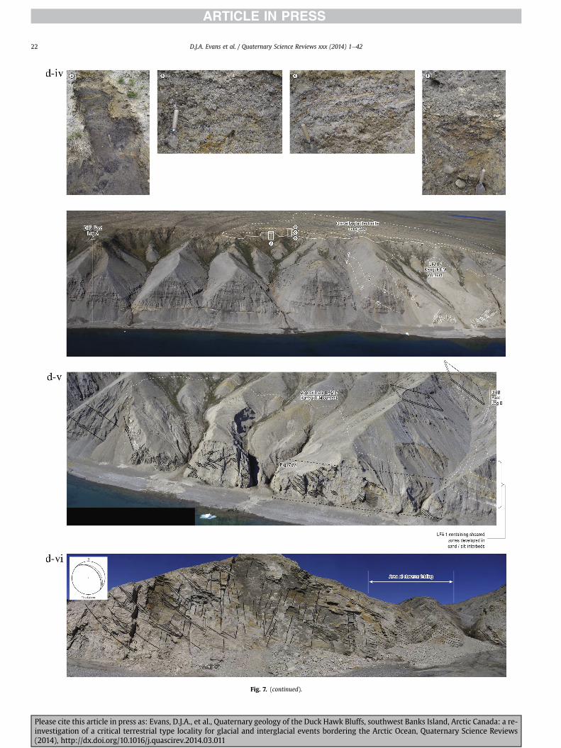
Fig 7 (continued)
DJA Evans et al Quaternary Science Reviews xxx (2014) 1e4222
Please cite this article in press as Evans DJA et al Quaternary geology of the Duck Hawk Bluffs southwest Banks Island Arctic Canada a re-investigation of a critical terrestrial type locality for glacial and interglacial events bordering the Arctic Ocean Quaternary Science Reviews(2014) httpdxdoiorg101016jquascirev201403011
Fig 7 (continued)
DJA Evans et al Quaternary Science Reviews xxx (2014) 1e42 23
Please cite this article in press as Evans DJA et al Quaternary geology of the Duck Hawk Bluffs southwest Banks Island Arctic Canada a re-investigation of a critical terrestrial type locality for glacial and interglacial events bordering the Arctic Ocean Quaternary Science Reviews(2014) httpdxdoiorg101016jquascirev201403011
Fig 7 (continued)
DJA Evans et al Quaternary Science Reviews xxx (2014) 1e4224
LFA 6 crops out along the length of DHB and varies widely inthickness (1e11 m) displaying the most complex deformationstructures of any of the sediment bodies at DHB It comprises apredominantly heterogeneous diamicton or a meacutelange of discon-tinuous interbeds of massive matrix-supported diamicton matrix-supported gravel and laminated sand silt and clay with localizedattenuated lenses of degraded organics (Fig 7a ivevi 7b i iv 7c iiiii) Three samples of highly compressed and fragmented detritalmaterial displaying poor preservation were collected for identifi-cation Collectively LFA 6 has the appearance of a stratified dia-micton but locally it displays a more massive to pseudo-laminatedcharacter where sand silt and gravel lenses and occasional gravellags occur as thin beds stringers or wisps Some laminated sand siltand clay bodies appear to be rafts within the diamicton (intraclasts)due to their heavily deformed internal bedding and deformedcontacts or attenuated appearance Basal contacts with other lith-ofacies associations are typically erosional or deformed and asso-ciated with fissility boudinage and pseudo-lamination insediments on either side of the contact Basal diamictons can alsodisplay a higher concentration of gravel clasts that locally result in aclast-supported character or even a several metre-thick highlycontorted meacutelange of diamicton and stratified sediment bodies Insome sections the whole of LFA 6 has been complexly deformed toproduce stacked overfolds and thrust faults indicative of shearingtowards the southwest or WSW Clast macrofabrics are onlymoderately clustered (S1 frac14 0456e0637) but indicate stressdirected predominantly towards the SW Clast macrofabricstrengths as quantified by the fabric shape ternary plot (Fig 6a)and themodalityisotropy plot (Fig 6b) are variable and range frombi-modal to multi-modal Overall the macrofabric shapes in theternary graph plot across the spectrums of the glacitectonite andsubglacial traction till envelopes but there is a trend of changing
Please cite this article in press as Evans DJA et al Quaternary geologyinvestigation of a critical terrestrial type locality for glacial and intergla(2014) httpdxdoiorg101016jquascirev201403011
fabric strength vertically through LFA 6 The strongest clusters arefrom the basal diamictic zones (eg CCA F1 amp F3 AB plane data)whereas the weakest are from the top of the association (eg WCAF3 A-axes amp CCA F2 AB planes) where relatively low strain defor-mation indicators (open and recumbent folds) are ubiquitous
Clast lithologies in LFA 6 are dominated by quartz chert andsandstone although one diamict reveals a concentration of sand-stone lithologies at the expense of chert Clast forms similarlyreflect the nature of the sampled materials whereby the gravellysample (CCA 2) was characterized by relatively low C40 (38) andRA (12) values and a high average roundness (256) compared tothe same values for the diamictons of LFA 6 (C40 frac14 50e74RA frac14 38e52 average roundness frac14 174e204) A small number ofclasts (lt10) in LFA 6 were striated
512 Interpretation5121 LFA 1 The thick tabular sequence of well sorted cross-stratified sand and gravel records deposition by a former glaci-fluvial braided river typified by fluctuating discharge (eg Church1972 Boothroyd and Ashley 1975 Miall 1978 1985 1992Marren 2005) The highest discharge is recorded by matrix-supported gravel with boulders indicative of hyperconcentratedflows or a traction carpet (Maizels 1989ab Siegenthaler andHuggenberger 1993 Mulder and Alexander 2001) These areseparated by and vertically give way to lower discharges recordedby planar or trough cross-bedded sand and horizontal to planar ortrough cross-bedded gravel These deposits record aggradation andmigration of gravel bars and sheets and downstream accretionarymacroforms with relatively tightly constrained palaeocurrent in-dicators (Miall 1977 1985 Collinson 1996) The general lack ofscour fills and an overall fining-upward is indicative of an aggradingsystem initially characterized by high magnitudehigh frequency
of the Duck Hawk Bluffs southwest Banks Island Arctic Canada a re-cial events bordering the Arctic Ocean Quaternary Science Reviews
Fig 7 (continued)
DJA Evans et al Quaternary Science Reviews xxx (2014) 1e42 25
Please cite this article in press as Evans DJA et al Quaternary geology of the Duck Hawk Bluffs southwest Banks Island Arctic Canada a re-investigation of a critical terrestrial type locality for glacial and interglacial events bordering the Arctic Ocean Quaternary Science Reviews(2014) httpdxdoiorg101016jquascirev201403011
Fig 7 (continued)
DJA Evans et al Quaternary Science Reviews xxx (2014) 1e4226
Please cite this article in press as Evans DJA et al Quaternary geology of the Duck Hawk Bluffs southwest Banks Island Arctic Canada a re-investigation of a critical terrestrial type locality for glacial and interglacial events bordering the Arctic Ocean Quaternary Science Reviews(2014) httpdxdoiorg101016jquascirev201403011
DJA Evans et al Quaternary Science Reviews xxx (2014) 1e42 27
events that were gradually replaced by low magnitudehigh fre-quency events (Marren 2005) Partially to heavily-scoured rem-nants of laminated and massive fines represent deposition duringlow flow conditions in abandoned shallow channels The palae-ocurrent data from LFA 1 indicate that the outwash streams wereflowing westerly away from a glacier source located in AmundsenGulf This glacier likely eroded the abundant LFA 1 lithologies(chert quartzite and sandstone) from Mesoproterozoic and Neo-proterozoic bedrock widely distributed to the east and south(western Victoria Island Amundsen Gulf and the adjacent main-land Harrison et al 2013) These lithologies are consistent with theadvance of the NW Laurentide Ice Sheet through Amundsen Gulf(cf Dyke et al 2002 Batchelor et al 2012 MacLean et al 2013)
The crudely bedded organic detritus and degraded tree frag-ments (stumps) in LFA 1 are clearly reworked (cf Matthews et al1986 Fyles 1990 Vincent 1990) The finer grained detritus wasdeposited in concentrated pockets during waning flow stageswhereas horizons of logs and larger tree fragments were emplacedwith the coarser grained and poorly sorted sediments associatedwith hyperconcentrated flows or traction carpets during highdischarge These reworked organics also differ significantly fromthe type location of the Beaufort Fm a characteristic that promptedFyles (1990) to distinguish them as lsquotheMary Sachs Gravelrsquo Notablythe enclosing gravel and sand of LFA 1 is much coarser and exhibitsan entirely different fluvial architecture than the sandier BeaufortFm The composition and degraded nature of the LFA 1 organicssuggests that they were eroded by glaciers or their meltwater fromNeogene andor Paleogene sediments presumably to the southeastof Banks Island (eg Fyles 1990 Fyles et al 1994) The proximity ofa glacier is highlighted by the preservation of striae on individualclasts especially in the very coarse lower gravel The verticaldecrease in striae preservation and angularity (RA) and concomi-tant increase in roundness and upward-fining in LFA 1 is indicativeof an increasingly distal ice margin The co-variance plots (Fig 5)indicate a strong fluvial signature especially in the C40RA data butsubglacial characteristics are also evident particularly in the C40RWR data for the coarser grained and more matrix-supportedgravel as would be expected in ice-proximal settings
It is important to note that the widespread thrusting of LFA 1and underlying Kanguk Formation towards the southwest occurredpost-depositionally This glacitectonic thrusting was produced byLaurentide ice that advanced from the Kellett River valley (interiorBanks Island) during the emplacement of LFA 6 (see below) Theinjection of clastic dykes and fissure fills during this glacitectonicdisturbance was due to the overpressurizing of groundwater ingravel aquifers likely in taliks The branching limbs of many of thedykes are indicative of burst-out structures diagnostic of hydro-fracturing by vertically escaping groundwater pressurized byglacier overriding (cf Rijsdijk et al 1999 Le Heron and Etienne2005)
5122 LFA 2 At the top of LFA 1 rhythmites with lonestonesoverlie prominent clinoforms or foreset beds recording a changefrom subaerial glacifluvial to subaqueous deposition This wasinitially on a shallow delta front prograding foreset beds in asouthwesterly direction followed by suspension sedimentationwith dropstones presumably from floating ice in a marine orlacustrine basin The occurrence of matrix-supported gravelly scourfills with logs and woody detritus suggests pulses of cohesionlesssediment gravity flows into the basin Overlying the rhythmically-bedded sand prominent ice wedge pseudomorphs (up to 4 mdeep Fig 9aec cf Mackay and Burn 2002) are interspersed withthick (gt1m) sections of compressed in situ bryophytes (Figs 9d 7e)indicating the establishment of a tundra surface Four bryophytefamilies and 10 distinct species have been determined from LFA2
Please cite this article in press as Evans DJA et al Quaternary geologyinvestigation of a critical terrestrial type locality for glacial and intergla(2014) httpdxdoiorg101016jquascirev201403011
with the most abundant material from the Calliergonaceae andCampyliaceae (Table 1) These macrofossils are exceptionally wellpreserved including material with intact fragile alar cells typical ofthese two families (Fig 14cef) The data from these autochthonousdeposits indicate a wetland environment characterized as a richfen This ecosystem and habitats therein are consistent with speciesfound in the extant flora of Banks Island (Fig 14b) The autecologyfrom this range of species suggest hydric to mesic habitatsincluding standing pools wet meadows and microhabitats createdby ice wedges Despite the predominance of bryophytes in LFA 2these macrofossils had not been previously documented at DHB Incontrast a minimal proportion of the samples (lt5) consisted ofvascular plant material (including Cyperaceae seeds gramminoidleaves and woody twig fragments) Collectively the ice wedgepseudomorphs and vegetation within LFA 2 represent an isochro-nous terrestrial surface of interglacial rank
Following the formation of ice wedges the injection of intra-formational clastic dykes and fissure fills in LFA 2 relates to theoverpressurizing of groundwater in gravel aquifers or taliks due toglacier overriding The branching dyke limbs that emanate fromunderlying LFA 1 gravels and sands are indicative of the burst-outstructures that develop during hydrofracturing (cf Rijsdijk et al1999 Le Heron and Etienne 2005) A variant of the gravel andsand filled clastic dykes occurs within the sequence of glaci-tectonite and rhythmites near west Log D (Fig 11) Here thevertically-widening fracture is characterized by a mosaic ofpartially disaggregated blocks of the host materials in its widestzone where it contains gravels injected from underlying LFA 1Because these gravels only occur in the basal narrow neck theypresumably record the rapid reduction in flow competence duringhydrofracture filling
Deformation structures including overfolded or crumpledbedding and thrust faults associated with boudinage or highfissilitypseudo-lamination are representative of simple shear andwere also induced by glacitectonic disturbance (cf van derWateren 1995 McCarroll and Rijsdijk 2003) This predominantlyrecords a glacier advance from the northeast Subsidiary shear in-dicators record deformation from the south or southeast but theseoccur only at the top of LFA 2 and the base of LFA 3 suggestingearlier emplacement (see below) The development of zones ofboudinage shallow thrust faults overfolding or bed crumpling atdifferent levels within LFA 2 e especially at the contact separatingsediments of different grain size e represents deformation parti-tioning due to contrasting rheological properties Blind thrustswere also initiated in underlying LFA 1 increasingly towards thecentral and eastern cliffs where large-scale deformation is moreprevalent (Fig 7c d) A zone of intense deformation is recorded by alens of LFA 3 diamicton in fault contact with LFA 2 (east cliff Log AFig 7d i) This constitutes a type B glacitectonite (non-penetrativelydeformed pre-existing sediments sensu Benn and Evans 1996Evans et al 2006) developed during the emplacement of LFA 3(see below) A similar glacitectonite occurs at the junction of LFA 1and LFA 3 near west Log D (Fig 11) Bed attenuation by deformationis best developed in lower LFA 2 where the greater differences insediment grain size and hence rheology exist
5123 LFA 3 Within LFA 3 locally abundant stratified lensesindicate subaqueous deposition These stratified sediments weresubsequently thrust faulted folded and attenuated - most evidentin the upper and lower zones of LFA 3 This deformation was likelyresponsible for the intraclast boudinage and pseudo-lamination inthe surrounding diamicton (eg Hart and Roberts 1994 Robertsand Hart 2005 Oacute Cofaigh et al 2011) This process was alsoassociatedwith the attenuation of LFA 1 and 2 sediments within theheavily deformed base of LFA 3 some of which may have been
of the Duck Hawk Bluffs southwest Banks Island Arctic Canada a re-cial events bordering the Arctic Ocean Quaternary Science Reviews
Fig 8 Details of LFA 1 a) example of a concentration of logs with degraded rootballs in the stacked tabular units of cross-bedded sands and gravels and crudely stratified matrix-supported cobble to boulder gravels in the west cliff b) poorly-sorted and crudely horizontally bedded cobble to boulder gravel containing laminated clay intraclast (immediatelyabove compass) c) shallow locally graded foreset beds composed of openwork to sandy matrix-supported cobble to granule gravels in central cliff Log A d) planar bedded sandy
DJA Evans et al Quaternary Science Reviews xxx (2014) 1e4228
Please cite this article in press as Evans DJA et al Quaternary geology of the Duck Hawk Bluffs southwest Banks Island Arctic Canada a re-investigation of a critical terrestrial type locality for glacial and interglacial events bordering the Arctic Ocean Quaternary Science Reviews(2014) httpdxdoiorg101016jquascirev201403011
DJA Evans et al Quaternary Science Reviews xxx (2014) 1e42 29
cannibalized and rafted by the deformation process within a shearzone at the contact of LFA 3 with older sediments The shearingdirection from the south and southeast recorded in lower LFA 3also impacted upper LFA 2 whereas the more prominent shearingdirection throughout LFA 3 is from the northeast (also recorded inLFA 4) The local development of a heavily deformed zone at the topof LFA 3 was likely imparted during the shearing of overlying LFA 4sediments Although clast macrofabric strengths from the LFA 3diamicton are variable they possess shapes that compare withglacitectonites and subglacial traction tills and in some cases amodalityisotropy signature that reflects high lodgementcomponents
The similar orientation of the macrofabrics and shear indicatorsare considered diagnostic of a glacitectonite derived from stratifiedsediments (eg interbedded mass flow diamictons gravelly massflows and localized traction current sands and suspension de-posits) This evidence indicates that LFA 3 like all the other LFAsand the underlying Kanguk Fm bedrock has been displaced by aglacier advancing from the NNE or NE (ie Laurentide ice crossingthe interior of Banks Island) Minor south to north shearing in-dicates that LFA 3 and upper LFA 2were also disturbed by glacier iceflowing northwards (ie Laurentide ice advancing throughAmundsen Gulf) The appearance of granite and gabbro clastswithin the LFA 3 diamict records the arrival of far-travelled Lau-rentide ice from mainland Canada Clast form co-variance stronglyindicates a subglacial (abraded) source for LFA 3 with a minorfluvial component (Fig 5) including glacifluvial clasts locallycannibalized from LFA 1 by overriding ice
5124 LFA 4 LFA 4 has restricted outcrops is heavily deformedand contains organic detritus that is clearly allochthonous andhighly degraded Nonetheless a variety of indicators (fine-grainedhorizontally bedded cross-laminae rhythmites climbing ripplesand draped laminae) demonstrate that LFA 4 was deposited in asubaqueous environment with palaeocurrents from the south orsouthwest Traction currents were likely responsible for thedevelopment of the clast lag at the contact between lower LFA 4and underlying LFA 3 (west cliff Log A Fig 7b ii) LFA 4 coarsensupwards indicative of basin infilling andor an approaching sedi-ment source The narrow anabranched clastic dykes in the sandyclimbing ripples (LFA 4 west cliff Log A) record hydrofracturing bythe upward injection of overpressurized groundwater duringshearing The branching limbs of the dykes are similar to the burst-out structures reported by Rijsdijk et al (1999) but differ becausethey are composed solely of sand derived from the walls of the hostsediment rather than from an underlying gravel aquifer (cf LeHeron and Etienne 2005) Hence the pressurized water wasgenerated at the contact between the sand and underlying imper-meable brecciated clays The development of thin zones of brecci-ation boudinage sheath folding or thrust faulting at the upper andlower contacts of LFA 4 relates to the localized partitioning ofdeformation controlled by the location of claysilt beds Thejuxtaposition of this style of deformation with the larger scaleoverfolds and thrust faults developed in the extensive bodies ofsandy lithofacies is indicative of a Type B glacitectonite (sensu Bennand Evans 1996) This was constructed by the overriding of glacierice advancing from the north or northeast These shear directionsare compatible with those developed in the underlying LFAs
granule gravels with gravel lags (top and bottom of image) interrupted by an intervening unbedded granule to pebble gravel and massive cobble to pebble gravel A cluster of small treesequence of stacked tabular units of predominantly horizontally bedded sands and gravels ingravels containing clusters of wood detritus in the coarser gravel beds (central cliff Log A)wood fragments (central cliff Log A)
Please cite this article in press as Evans DJA et al Quaternary geologyinvestigation of a critical terrestrial type locality for glacial and intergla(2014) httpdxdoiorg101016jquascirev201403011
5125 LFA 5 The primary characteristics of LFA 5 are typical ofgravel sheet and occasional traction-carpet sedimentation in anice-proximal sandur (eg Boothroyd and Ashley 1975 Miall 19781985 1992 Maizels 1989ab Siegenthaler and Huggenberger1993 Mulder and Alexander 2001 Marren 2005) Glacier prox-imity is supported by the subglacial to fluvial signature of the clastforms (Fig 5) The coarsening-upward sequence including striatedclasts culminates in the arrival of a glacier that overrode the sitedepositing LFA 6 Post-depositional shearing within underlying LFA4 is recorded by attenuation and interdigitation at the contact withLFA 5 imparted during deposition of LFA 6 The contact betweenLFA 5 and 6 reflects the development of a shear zone where upperLFA 5 sediments have been cannibalized producing a meacutelange ofcrudely stratified diamictons with discontinuous interbeds ofmatrix-supported gravel laminated sand silt and clay (LFA 6 seebelow)
5126 LFA5a At Easternmost Cliff glacifluvial gravel (LFA 5a)unconformably overlies LFA 1 (Fig 7e) rendering uncertain itsrelationshipwith respect to LFA 5 in themain sections of DHB to thewest The fact that LFA 5a extends to the modern surface appearsundeformed and has palaeocurrents orientated to the NW requiresthat it is younger than LFA 5 Indeed we interpret LFA 5a asdeglacial outwash deposited from retreating Laurentide ice in theKellett River valley and Amundsen Gulf at the end of the lastglaciation (see Discussion)
5127 LFA 6 Based on its heterogeneity strongly orientated clastmacrofabrics and macroscale deformation structures LFA 6 con-stitutes a Type B glacitectonite (sensu Benn and Evans 1996)However zones of more highly strained Type A glacitectonite(sensu Benn and Evans 1996) at the basal contact with older LFAsare recorded by intraclastinterbed attenuation (pseudo-lamina-tion) strong boudinage or fissility and strengthened clast macro-fabrics The production of this meacutelange is attributed to two separateprocesses 1) primary sedimentation as interbedded and interdig-itated mass flow debris fluvial gravel and sand and subaqueoussuspension sediments and 2) cannibalization of underlying strat-ified sediments (LFAs 4 and 5) This produced a continuum of formsranging from low strain fold structures to attenuated rafts to tec-tonic lamination (eg Fig 7) The discontinuous lenses of degradedorganics (black stems and woody twigs gramminoid leaveswhitened rootlets) within LFA 6 are rafts and include seven speciesof bryophytes (Table 1) The material was highly compressed anddifficult to separate into distinct taxa Indeed one of the threesamples analysed was too degraded to recover any taxa Much ofthe material consisted of only fragmented leaves and only theminute taxa had stems with intact leaves The bryophytes thatcharacterize the LFA 6 samples represent hydric (Calliergon sppTomenthypnum nitens) to mesic (Ditrichum flexicaule Dicranum sp)habitats Three species collected from LFA 6 were also present inLFA 2 whereas four others were not found in LFA 2 but are com-mon in the modern flora The poor preservation quality suggeststhat the material has been redeposited from unknown sources andis clearly allochthonous
The predominant shearing direction within LFA 6 records an iceadvance from the interior of Banks Island (NE) This has resulted incomplex folding and thrusting and localized thickening of LFA 6
it of cross-bedded poorly-sorted to openwork cobble to boulder gravel crudely planar-fragments occur at the base of the cobble to boulder gravels at image centre e) middleDHB west cliff Log D f) sequence of fining-upward planar-bedded cobble to sandy fineg) planar cross-bedded sandy granule to pebble gravels with pebble to cobble lags and
of the Duck Hawk Bluffs southwest Banks Island Arctic Canada a re-cial events bordering the Arctic Ocean Quaternary Science Reviews
Fig 9 Details of LFA 2 from the west cliff a) narrow necked ice wedge pseudomorph with upturned marginal bedding in sand silt and clay rhythmites b) wide necked ice wedgepseudomorph c) ice wedge pseudomorph with overturned silt sand and clay rhythmites developed at the top of LFA 2 and sealed by overlying LFA 3 laminated diamicton d)horizontally bedded sand and silt containing well preserved moss macrofossils e) zone of disharmonically folded sandsilt laminae with well preserved moss peat located at thebase of LFA 2
DJA Evans et al Quaternary Science Reviews xxx (2014) 1e4230
Please cite this article in press as Evans DJA et al Quaternary geology of the Duck Hawk Bluffs southwest Banks Island Arctic Canada a re-investigation of a critical terrestrial type locality for glacial and interglacial events bordering the Arctic Ocean Quaternary Science Reviews(2014) httpdxdoiorg101016jquascirev201403011
Fig 10 Details of simple shear structures developed in fine sand and silt laminae at the centre of the thickest outcrop of LFA 2 in west cliff Log B a) overview of large scaleanastomosing shear faults with zones of smaller scale densely spaced anastomosing shears towards the base of the photograph b) details of large scale shear faults separatingzones of variably but predominantly densely spaced shears c) close details of shear zone comprising densely spaced anastomosing fractures d) details of ascending kink zonecross-cutting large scale anastomising shear faults Shearing direction is coming out of the cliff and towards the left in each image
DJA Evans et al Quaternary Science Reviews xxx (2014) 1e42 31
This shearing direction is recorded throughout underlying LFAs 1e4as well as the Kanguk Formation demonstrating deep-seated butpartitioned glacitectonic disturbance imparted during theemplacement of LFA 6 This strain signature was therefore over-printed on the northerlynortheasterly aligned shearing directionrecorded in LFA 3 and upper LFA 2 by the earlier northerly flowingice that deposited LFA 3 One anomalous clast macrofabric(northerly CCA F1) occurs in the basal meacutelange of LFA 6 Howeverthis sample is from an isolated outcrop (Fig 7c i) rendering itsapparent shearing direction equivocal
Please cite this article in press as Evans DJA et al Quaternary geologyinvestigation of a critical terrestrial type locality for glacial and intergla(2014) httpdxdoiorg101016jquascirev201403011
52 Sedimentology and stratigraphy (Mary Sachs Creek cliff)
The cliffs east of Mary Sachs Creek (Figs 2b 3) provides a cross-section through the seaward margin of the coast-parallel SachsMoraine (ldquosection Jrdquo Vincent et al 1983 Vaughan 2014) Weprovide a summary of two logs based on a reconnaissance survey ofthese sediments Log A is closest toMary Sachs Creekwhereas Log Boccursw1 km farther east (Figs 3 15a amp b) The sediments exposedin Log A appear to descend eastward and disappear below themodern beach and therefore are assumed to stratigraphically
of the Duck Hawk Bluffs southwest Banks Island Arctic Canada a re-cial events bordering the Arctic Ocean Quaternary Science Reviews
Fig 11 Details of LFA 2 near west Log D Lower box shows a 1e2 m thick basal zone comprising highly attenuated inter-digitated beds of gravelly to clay-rich diamictons and sandsiltclay rhythmites Upper box shows rhythmites containing diamictic intraclasts with sharp and angular boundaries also visible is the draping and deforming of the rhythmitebedding over and under the intraclasts respectively ldquoTailsrdquo extending from the diamictic intraclasts and thin but discontinuous diamictic beds are also visible in the upper box
DJA Evans et al Quaternary Science Reviews xxx (2014) 1e4232
underlie the sediments of Log B A sand and gravel- bench caps bothlogs at w15 m asl incised into the seaward margin of the SachsMoraine
521 DescriptionLog A contains a sequence of upward-fining highly contorted
cross-stratified sand and fine gravel to rhythmically bedded sandsilt clay with minor pebble gravel and sporadic clots of gravellydiamicton (Fig 15a) An ice wedge was initially developed in thelower cross-stratified sand and fine gravel before they were foldedand thrust faulted The deformed ice wedge pseudomorph is un-conformably overlain by a relatively undisturbed lens of laminatedsilty clay with dropstones interbedded with gravelly diamictonthat contains a bed (10 cm) of sandy black organics containingwood fragments (Fig 15a) This organic material occurs repeatedlyup-section as discontinuous stringers Log A is capped by 1e2 m ofpoorly exposed and heavily cryoturbated gravelly diamicton Thegeneral sense of displacement on shallow reverse faults over-turned bedding and boudinage structures is from the southeast
Log B (12 m) displays a coarsening-upward sequence of hori-zontally bedded sandy granule gravel with occasional silty sandlaminae (Fig 15b iii) that grades to poorly-sorted cobble to bouldergravel and bouldery matrix-supported gravel (Fig 15b ii) This iscapped by laminated to crudely stratified cobbly diamicton that issilt and clay-rich abruptly and conformably overlain by
Please cite this article in press as Evans DJA et al Quaternary geologyinvestigation of a critical terrestrial type locality for glacial and intergla(2014) httpdxdoiorg101016jquascirev201403011
interlaminated silt clay and pebbly silty sand (Fig 15b i) Althoughthe bedding on these units dips towards the NW individuallaminae do not thicken in that direction indicating post-depositional tilting The uppermost part of the log (underlyingthe 15 m bench) contains 2 m of clay-rich massive diamictoninterfingered with the underlying laminated sediments and cobblydiamicton
522 Interpretation
5221 Log A Broadly the sedimentology of log A including thedeformed ice wedge pseudomorph is similar to LFA 2 in DHB (egcentral cliff Log A Fig 7c iii) Prior to glacitectonic disturbance theoverlying organic bed (Fig 15a) was redeposited into a sequence ofsubaqueous siltclay rhythmites containing dropstones and gravellymass flows The highly attenuated shear margins bracketing theorganic bed in Log A demonstrate that it has been displaced as atectonic raft Previous research proposed that the organic beds e
similar to those described in Log A e be assigned to the LastInterglacial (locally called the Cape Collinson Vincent 1982 1983)Because these organic beds are clearly a raft they cannot constitutean iscochronous surface precluding chronostratigraphic signifi-cance (see Discussion) Shearing of the Log A sediments from thesoutheast documents an ice advance from Amundsen Gulf corre-sponding to the earliest of two primary shearing directions recor-ded at DHB (imparted during the emplacement of LFA 3) Therefore
of the Duck Hawk Bluffs southwest Banks Island Arctic Canada a re-cial events bordering the Arctic Ocean Quaternary Science Reviews
Fig 12 Details of LFA 4 in West Log A a) heavily deformed upper contact of LFA 4 comprising sandsiltclay rhythmites displaying well developed boudinage sheath folds andimmature tectonic laminae and an interdigitatedsheared boundary with underlying climbing ripple sands The contact with overlying LFA 6 is marked by an interdigitated zonecontaining rooted and de-rooted folds or rhythmite rafts in a sand gravel and diamicton meacutelange b) narrow anabranched clastic dykes ascending sub-vertically through climbingripple drift and resulting in offset bedding between blocks of host material c) abrupt contact between sheared sands and rhythmites of LFA 4 and overlying sand gravel anddiamicton meacutelange
Fig 13 Details of LFA 5 a) poorly sorted and matrix-supported pebble to cobble gravel b) tabular sequence of horizontally bedded to massive gravel and matrix-supported gravelcontaining a horizon of striated cobbles and boulders c) heavily deformed discontinuous bed of siltclay rhythmites between LFA 5 and LFA 6 in West Log D showing theamalgamation zone with the LFA 5 gravels immediately above the compass d) interdigitateddeformed contact between LFA 5 granule to pebble gravels and underlying LFA 4laminated silts and clays with organic detritus in West Log B
DJA Evans et al Quaternary Science Reviews xxx (2014) 1e42 33
Please cite this article in press as Evans DJA et al Quaternary geology of the Duck Hawk Bluffs southwest Banks Island Arctic Canada a re-investigation of a critical terrestrial type locality for glacial and interglacial events bordering the Arctic Ocean Quaternary Science Reviews(2014) httpdxdoiorg101016jquascirev201403011
Table 1List of bryophytes and vascular plants from LFAs 2 and 6
LFA2 WestCliff Log B
LFA6 CentralCliff Log A
Elevation (m) 185 m asl w45 m aslSample 4e12 1e3 taxa 10 7
Bryophyta (mosses)AmblystegiaceaeAmblystegium serpens (Hedw) Schimp x
CamyliaceaeCampylium polygamum (Schimp) CEO Jensen xCampylium stellatum (Hedw) CEO Jensen x xDrepanocladus aduncus (Hedw) Warnst xDrepanocladus sp xTomentypnum nitens (Hedw) Loeske x
CalliergonaceaeCalliergon giganteum (Schimp) Kindb xCalliergon richardsonii (Mitt) Kindb xthornthornthornthorn xCalliergon sp xWarnstorfia exannulatus (Schimp) Loeske xthornthornthornthorn x
BrachytheciaceaeBrachythecium turgidum (Hartm) Kindb x
MniaceaeCyrtomnium cf hymenophylloides(Hbener) TJ Kop
x
DicranaceaeDicranum sp x
DitrichaceaeDitrichum flexicaule (Schwaumlgr) Hampe x
Tracheophyta (vascular plants)CyperaceaeSeeds (triangular amp flattened) x x
Gramminoid leaf material x xWoody twig fragments x xRootlets x
Fig 14 The moss peat and associated microfossils of LFA 2 a) exposure through lower LFAsouthern Banks Island analogue of a rich tundra fen environment for the bryophyte assemblfrom LFA 2 showing the exceptional preservation of Calliergonaceae and Campyliaceae ma
DJA Evans et al Quaternary Science Reviews xxx (2014) 1e4234
Please cite this article in press as Evans DJA et al Quaternary geologyinvestigation of a critical terrestrial type locality for glacial and intergla(2014) httpdxdoiorg101016jquascirev201403011
these deformed deposits are interpreted as a Type B glacitectonite(sensu Benn and Evans 1996) possibly derived from LFA 2
5222 Log B The coarsening upward gravel in Log B recordshighly turbid to hyperconcentrated discharge in non-channelizedsheets This is interpreted as aggrading glacifluvial outwash froman approaching ice margin The capping sequence of crudelystratified diamicton and laminated sediments records a changefrom glacifluvial to subaqueous sedimentation prior to overridingby a glacier of unknown age that tilted the upper beds Thecoarsening-upward sequence apparent tectonism and cappingdiamict at Log B clearly distinguishes these deposits from those ofLFA 5a (west of Mary Sachs Creek easternmost cliff Fig 3)Furthermore although there is lithological similarity between LogB and LFA 5 throughout DHB the sense of shearing is dissimilar (LFA5 from the NE and Log B from the SE) The simplest explanation forthis difference in shear direction is that LFA 5 (DHB) was displacedby interior ice advancing down the Kellett River whereas Log B wasdisplaced by ice advancing along Amundsen Gulf (Fig 2b)
6 Discussion
61 Large scale glacitectonic structures and stratigraphicarchitecture
The glacitectonic structures identified within the lithofaciesassociations at DHB record two phases of deformation (early NeSand later NEeSW) This deformation together with the DHBstratigraphic architecture (Fig 16) helps to explain both thekinetostratigraphy (sensu Berthelsen1978) and the evolution of thelocal glacial geomorphology The large scale glacitectonic defor-mation is most clearly manifest in the thrust faulting and conjugate
2 at DHB west log B showing the sampling locations for in situ moss peat b) a modernages of LFA 2 c)ef) details of the typical moss peat and associated microfossil materialscrofossils including material with intact fragile alar cells
of the Duck Hawk Bluffs southwest Banks Island Arctic Canada a re-cial events bordering the Arctic Ocean Quaternary Science Reviews
Fig 15 The stratigraphy of Mary Sachs Creek cliff a) photographic compilation log A showing upward-fining highly contorted (i) cross-stratified sands and fine gravels torhythmically bedded sands silts clays and minor pebble gravels Also visible in (ii) is a lens of interbedded laminated silty clays with dropstones and gravelly diamictons containingsandy black coloured organic material with wood fragments An ice wedge pseudomorph is visible (iii) to the right of the exposure b) photographic compilation log B showing i)laminated to crudely stratified cobbly but siltclay-rich diamicton grading into interlaminated silts clays and pebbly silty sands ii) poorly-sorted cobble to boulder gravel andbouldery matrix-supported gravel iii) coarsening-upward sequence of horizontally bedded sandy granule gravels with occasional silty sand laminae iv amp v) pebble to cobble graveland matrix-supported gravel
DJA Evans et al Quaternary Science Reviews xxx (2014) 1e42 35
shear development in the Kanguk Fm bedrock and overlying LFA 1(east cliff Fig 7d ivevi) Here predominantly northeasterly dippingthrust slices have been stacked truncated and overlain by LFA 6during the second and strongest (NEeSW) deformation phase(Fig 16 note bedrock slice within the imbricated stacked sequenceof LFA 1) These structures demonstrate significant compressionand thickening of the stratigraphic sequence including w40 m ofvertical offset within the Kanguk Formation acrossw3 km (Fig 16)Prominent hydrofracture fills in LFAs 1 and 2 record elevatedporewater pressure during this thrusting Smaller scale shear zoneshave also developed in the finer grained interbeds within thrustslabs (Fig 7d vii) indicative of deformation partitioning by strataprone to ductile failure This zone of greatest displacement alsocoincides with the highest topography (Fig 16) Lower angle thrustfaults propagate in a southwesterly direction predominantlythrough LFA 1 but are also developed through LFA 2 in the footwallblock (east cliff Fig 16)
The thrust stacking of bedrock and LFAs 1e5 in east cliff (obliqueto Fig 16) represents the ice-proximal zone of a thrust-blockmorainecomposite ridge constructed by a glacier advancing fromthe northeast (ie the interior of Banks Island) This glacitectonicdeformation propagated southwestward to distal parts of theproglacial stress field as recorded bywell-developed shear zones inthe finer grained sediments of LFAs 2e5 In the more distal westcliff open folds (LFA 2 Fig 16) appear to be the product of a blindthrust within underlying LFA 1 This style of tectonism is typical oflsquopiggyback-style thrustingrsquo wherein steeply inclined thrust blocksat the advancing ice margin propagate new thrusts in the footwall(Fig 16 Park 1983 Mulugeta and Koyi 1987) The angle of thesefootwall thrusts becomes progressively shallower southwestward
Please cite this article in press as Evans DJA et al Quaternary geologyinvestigation of a critical terrestrial type locality for glacial and intergla(2014) httpdxdoiorg101016jquascirev201403011
(ice-distal) in LFA 1e5 where deformation partitioning developedin finer grained lithofacies (Fig 16)
The densely spaced ponds and depressions immediately to thenortheast of DHB (Figs 2b 3) constitute the depression fromwhich the thrust mass was excavated (eg Aber et al 1989Evans and England 1991 van der Wateren 1995) This inter-pretation is consistent with the strong northeast to southwestshear direction in the second phase glacitectonic structures andin LFA 6 clast macrofabrics This indicates that construction ofDHB occurred at the margin of a glacier advancing from thenortheast (ie from Kellett River valley) overtopping DHB anddepositing the LFA 6 glacitectonite The continued advance ofKellett ice coalesced with a glacier in Amundsen Gulf marked bythe interlobate Sachs Moraine containing ice-transported shellsas young as 24 cal ka BP (21020 70 yrs BP UCIAMS-89674)assigning this glaciation to the Late Wisconsin (Vaughan 2014)East of Mary Sachs Creek the deformation of Log B outwash(from the southeast Figs 15 16) likely records overriding by thesame Amundsen Gulf glacier (coeval with LFA 6 Late Wiscon-sinan) During ice retreat when Kellett River and Amundsen Gulfice decoupled DHB was exposed allowing the northwesterly-flowing proglacial outwash (LFA 5a) west of Mary Sachs Creekto extend to the shoreline marking postglacial marine limit atKellett Point (11 m asl Vaughan 2014 Fig 3) Collectively thisreconstruction supports a Late Wisconsinan age for the con-struction of DHB thrust block moraine although its stratigraphyincludes a range of ages A palaeogeographic reconstruction ofevents based upon our interpretation of the sedimentologystratigraphic architecture tectonism and geomorphology is pre-sented in Fig 17
of the Duck Hawk Bluffs southwest Banks Island Arctic Canada a re-cial events bordering the Arctic Ocean Quaternary Science Reviews
Fig 15 (continued)
DJA Evans et al Quaternary Science Reviews xxx (2014) 1e4236
62 Comparison and revision of previous DHB model
DHB was previously interpreted to record horizontally beddedNeogene to Quaternary sediments assigned to preglacial fluvialand multiple glacial and interglacial episodes (Vincent 1982 19831990 Vincent et al 1983 1984 Barendregt et al 1998) A com-posite palaeomagnetic record was also presented for this proposedstratigraphy placing most of this deposition before the BrunhesMatuyama boundary (Fig 1c) However prior to our work detailedstudies had not been undertaken on the sedimentology structuralgeology or stratigraphic architecture of DHB Rather the originalstratigraphy was restricted to a series of composite logs (our Fig 4reproduced from Vincent et al 1983) that notably omitted thepervasive deformation structures including the thrust bedrock ineast cliff (Fig 16)
Please cite this article in press as Evans DJA et al Quaternary geologyinvestigation of a critical terrestrial type locality for glacial and intergla(2014) httpdxdoiorg101016jquascirev201403011
Our reinterpretation dismisses several key elements of theoriginal DHB model outlined below (oldest to youngest) We havedetermined that the lowermost unit (LFA 1) is not preglacial (Fyles1990) but rather is composed of glacial outwash providing theearliest terrestrial evidence for glaciation in the area and containingallochthonous organics (including tree stumps) of unknown prov-enance Because LFA 1 is a glacifluvial braidplain (Fig 17a) it is notpart of the Beaufort Fm (Fyles 1990) even though it containsreworked macrofossils presumably derived from it (eg Craig andFyles 1960 Hills et al 1974 Vincent et al 1983)
Our analysis of LFA 2 indicates that it is also not preglacial norcan it be the Worth Point Fm as previously proposed (cf Vincent1982 1983 1990 Vincent et al 1983 Matthews et al 1986)Indeed the type locality of the Worth Point Fm has been invali-dated because it is now recognized to be an ice-transported and
of the Duck Hawk Bluffs southwest Banks Island Arctic Canada a re-cial events bordering the Arctic Ocean Quaternary Science Reviews
LFA4
Fig16
Stratigrap
hiccross-profi
lerun
ning
westto
easto
fDuc
kHaw
kBluffs
basedup
oninterpolations
betw
eenthemainsectionlogs
andsh
owingthesixLFAstheKan
gukFo
rmationbe
droc
kex
posu
resmajor
structural
features
and
thepo
sition
sof
icewed
geps
eudo
morph
san
dsign
ificant
clasticdy
kesAtthe
easternen
dof
thecross-profi
lethe
sedimen
tsat
theco
reof
MarySa
chsCree
kcliff
logAaretentativelyclassified
asLFA2
althou
ghthesematerialsarelik
ely
notin
situN
otethat
thecross-profi
ledo
esno
tex
tend
asfarea
stas
MarySa
chsCree
kcliff
logB
DJA Evans et al Quaternary Science Reviews xxx (2014) 1e42 37
Please cite this article in press as Evans DJA et al Quaternary geologyinvestigation of a critical terrestrial type locality for glacial and intergla(2014) httpdxdoiorg101016jquascirev201403011
glacitectonized raft (Vaughan et al 2014) In contrast our LFA 2 ischaracterized by an isochronous tundra surface with ice wedgesand intervening shallow ponds andwetmeadows The peat at LFA 2is dominated by bryophytes (gt95 by volume) and yet none ofthese macrofossils had been previously documented The diversein situ bryophyte species record a flora similar to that on BanksIsland today suggesting that LFA 2 warrants an interglacial rankThis conclusion is supported by the limited vascular plant record(five taxa no species indicated Vincent 1990) that also suggest awet meadow environment The absolute age of LFA 2 remains un-known but is apparently older than the BrunhesMatayamaboundary (gt780 ka Fig 18 cf Vincent et al 1984 Barendregt andVincent 1990 Barendregt et al 1998 see below)
LFA 3 in both our model and that of Vincent et al (1983) pro-vides the first direct evidence of ice reaching DHB In the previousmodel this was interpreted as Bernard Till (Banks Glaciation) thatwas bracketed by glacioisostatically induced marine transgressions(pre- and post-Banks seas Vincent 1982 1983) Within basal LFA 3we recognized highly deformed stratified sediment that wasdeposited in a subaqueous environment (deep water Fig 17c) priorto the arrival of overriding ice from the south (recorded by graniteand gabbro erratics Figs 17c 18) We regard LFA 3 to be equivalentto the Banks Glaciation (Vincent 1982 1983 Vincent et al 1983)including its pre- and post-Banks seas represented by the stratifiedsediments that bracket the central diamicton The LFA 3 sedimentsare also reported to be magnetically reversed thereby predatingthe BrunheseMatayama boundary (gt780 ka Fig 18 Vincent et al1984 Barendregt and Vincent 1990 Barendregt et al 1998)
Following the Banks Glaciation (our LFA 3 at DHB) Vincent(1982 1983) and Vincent et al (1983) recognized two in-terglacials (Morgan Bluffs and Cape Collinson) separated by anintervening marine episode This marine episode correspondedwith the glacioisostatic loading of a Laurentide ice margin confinedto the eastern half of Banks Island (Thomsen Glaciation) HoweverLFA 4 contains coarsening-upward subaqueous sedimentation fromthe south or southwest reflecting continued marine regressionfollowing LFA 3 (Fig 17c d) The coarsening-upward sequence ofLFA 4 is supplanted by coarse gravel outwash (LFA 5) supplied by aglacier readvancing from the northeast (Kellett River valley iceFig 17e) Glacier overriding is recorded by LFA 6 glacitectonite thatcaps the DHB thrust-block moraine composed of the entireassemblage of underlying LFAs (Fig 16)
Notably we have not observed any sediments characteristic oftwo interglacial deposits above LFA 3 hence dismiss the presence ofthe Morgan Bluffs and Cape Collinson interglacials at DHB Causseand Vincent (1989) report a U-series date of gt200 ka (UQT-229)from above our LFA 3 but this is almost certainly reworked andlacks chronostratigraphic significance Nor have we observedintervening marine sediments attributable to the Thomsen Glaci-ation (eg lsquoBig Searsquo Vincent 1982 1983 Vincent et al 1983)Rather following the deposition of the subaqueous sediments ofupper LFAs 3 and 4 (post-Banks Glaciation) LFAs 5 and 6 record asingle ice advance reaching DHB from the Kellett River valley(Banks Island interior) that was not reported by Vincent et al(1983) It was instead assumed that after the Banks GlaciationDHB lay distal to any later ice advances The nearest subsequentLaurentide margin to DHB recognized by Vincent et al (1983) wasassigned to the Sachs Moraine (immediately east of DHB) that waspresumed to be of EarlyWisconsin age (Fig 2b) However the SachsMoraine is nowdated to24 cal ka BP (LateWisconsinan Vaughan2014) andwas formed by the coalescence of Amundsen Gulf ice andthe Kellett River ice that deformed DHB (Fig 17) On the east side ofMary Sachs Creek the deposition of the Sachs Moraine coincideswith the deformation (from the southeast) of the underlying Log Boutwash gravel (Figs 3 15b)
of the Duck Hawk Bluffs southwest Banks Island Arctic Canada a re-cial events bordering the Arctic Ocean Quaternary Science Reviews
Fig 17 The palaeogeography of southwest Banks Island based upon interpretations of the principal lithofacies associations and structural architecture recognized at Duck HawkBluffs and the geomorphology of the surrounding terrain See text for detailed explanations
DJA Evans et al Quaternary Science Reviews xxx (2014) 1e4238
Although interglacial deposits were previously reported fromthe cliffs east of Mary Sachs Creek (ie Cape Collinson InterglacialVincent et al 1983) we found no similar evidence Rather the onlydeposit that we observed that may have been construed as inter-glacial sediments occurs in our Log A (Figs 3 15a) Here a darkdiscontinuous band of allochthonous organics (Fig15a) sits severedwithin a heavily tectonized melange (type B glacitectonite) and istherefore clearly a raft Although the absolute ages of the deformedunits east of Mary Sachs Creek (Logs A amp B) remain uncertain theyare apparently normally magnetized (Vincent et al 1984Barendregt and Vincent 1990) Blake (1987) also reports non-finite radiocarbon dates (gt36000 amp 49000 BP GSC-3560 amp 3560-2) obtained on ldquocompressed and deformed black woody peatrdquopurportedly from Cape Collinson beds (Vincent et al 1983 p 1708)Additionally Causse and Vincent (1989) report a U-series date onshells of 924 ka (UQT-143) from beds similar to the Log B gravelAgain all of these dated units have been displaced from unknownlocations limiting their utility for palaeoenvironmental recon-struction The last glacially influenced sedimentation at DHB isrecorded by northwesterly directed outwash (easternmost cliff LFA5a Figs 3 16 17g) We infer that this outwash fed the gravel beachmarking marine limit (11 m asl) in the lower Kellett River duringLate Wisconsinan retreat from the Sachs Moraine
63 Regional context
The stratigraphy at Duck Hawk Bluffs records three glacialevents The earliest of these is recorded by the aggradation of a
Please cite this article in press as Evans DJA et al Quaternary geologyinvestigation of a critical terrestrial type locality for glacial and intergla(2014) httpdxdoiorg101016jquascirev201403011
glacifluvial braidplain (LFA 1) that contains allochthonous pre-glacial material of diverse age However within LFA 1 there is noevidence that the ice reached DHB although it must have beennearby (southeast in Amundsen Gulf) The age of this glaciationremains unknown but the palaeomagnetic polarity of LFA 1 in-dicates that it is gt780 ka BP (Barendregt and Vincent 1990)Although Barendregt et al (1998) assigned part of the Worth PointFm to the normally polarized Olduvai sub-zone (MIS 64e74) itshould be noted that the Worth Point section is located 30 kmnorthwest of DHB There a stratigraphic revision has demonstratedthat this ldquotype sectionrdquo of the Worth Point Fm is in fact a glaci-tectonized raft (Vaughan et al 2014) This observation invalidatesthe previous correlation from Worth Point to purportedly coevalbeds at DHB (our LFA 2) Furthermore the diverse plant assem-blages in the Worth Point raft include preglacial tree stumps andSphagnum spp that do not occur on Banks Island today and are notfound in the wet meadow assemblages (rich fen) of LFA 2 that weinterpret to be of interglacial rank Therefore the sediments at DHB(LFAs 1 amp 2) do not support an age assignment of MIS 64e74(Olduvai subzone) proposed by Barendregt et al (1998) Currentlythe available palaeomagnetic record at DHB simply separates theentire section into a lower lsquoreversedrsquo unit and an upper lsquonormalrsquoone We place this boundary within our LFA 4 (Fig 18)
The overriding of DHB by glaciers is recorded in LFAs 3 amp 6These two glacial deposits may correspond to parts of the record ofstacked till sheets reported from the offshore seismic stratigraphy(Batchelor et al 2012) LFA 3 glaciationmay have contributed to theonset of mid-Pleistocene ice-rafted debris (IRD Ca-rich) attributed
of the Duck Hawk Bluffs southwest Banks Island Arctic Canada a re-cial events bordering the Arctic Ocean Quaternary Science Reviews
B-M
B-M
gt19
Fig
18A
revisedlitho
stratigrap
hyforDuc
kHaw
kBluffsPrev
ious
lyrepo
rted
ageco
nstraintsarealso
depicted
toge
ther
withatentativeallocation
ofMIS
stag
es(positione
dalon
gsideEa
stCliff
LogA
forclarity)
basedup
onthe
palaeo
mag
neticreco
rd
DJA Evans et al Quaternary Science Reviews xxx (2014) 1e42 39
Please cite this article in press as Evans DJA et al Quaternary geology of the Duck Hawk Bluffs southwest Banks Island Arctic Canada a re-investigation of a critical terrestrial type locality for glacial and interglacial events bordering the Arctic Ocean Quaternary Science Reviews(2014) httpdxdoiorg101016jquascirev201403011
DJA Evans et al Quaternary Science Reviews xxx (2014) 1e4240
to the Canadian Arctic Archipelago (CAA) and recorded in sedimentcores from the Arctic Ocean basin (Polyak et al 2009 2013OrsquoRegan et al 2010 Stein et al 2010) However Stein et al(2010) place the onset of Ca-rich ice-rafted debris within MIS 16(w659 ka BP Lisiecki and Raymo 2005) with subsequent peaks atMIS 12 10 and 8 all of which postdate the gt780 ka BP palae-omagnetic age proposed for LFA 3 (above) Polyak et al (2013) placethe onset of Ca-rich ice-rafted debris in the central Arctic Oceancloser to MIS 19 (790 ka BP) which is broadly compatible with theDHB palaeomagnetic record LFA 6 records the last glaciation ofDHB and we assign this to the Late Wisconsinan when Banks Is-land ice (Kellett River) coalesced with the Amundsen Gulf IceStream (Stokes et al 2006 MacLean et al 2013) During this in-terval the northwest Laurentide Ice Sheet likely reached the edgeof the polar continental shelf (Stokes et al 2005 2006 Englandet al 2009 Batchelor et al 2012 Lakeman and England 2013MacLean et al 2013)
7 Conclusions
New sedimentological and stratigraphic analyses of DHB funda-mentally revise the previous reconstruction of the Neogene andQuaternary history of Banks Island DHB and two other widely citedsections on Banks Island have been reported as important unde-formed terrestrial archives of glacial and interglacial sedimentationat the northwest limit of the Laurentide Ice Sheet that all have beenrecently revised (Vaughan et al 2014 Lakeman and England inpress) The recognition of pervasive large-scale deformation ofDHB necessitates a fundamental re-assessment of its previouslydescribed layer-cake stratigraphy We document that the oldestsediments (LFA 1) at DHB are not preglacial fluvial deposits (Beau-fort Fm) but rather record proglacial outwash from ice in AmundsenGulf that did not reach the site This was followed by the estab-lishment of an isochronous tundra surface of interglacial rank (LFA2) characterized by ice wedge polygons within a wet meadow thatsupported a bryophyte community similar to modern Subse-quently glacial sedimentation resumed initially in an ice-proximalsubaqueous environment followed by ice arrival and glacitectonicdeformation (LFA 3) The overlying deposits at DHB indicate post-glacial marine sedimentation (LFA 4) followed by the aggradationof glacifluvial sand and gravel (LFA 5) from an advancing ice marginthat culminated with the emplacement of a glacitectonite (LFA 6)during the Late Wisconsin This ice advance constructed a previ-ously undescribed thrust-block moraine (60 m high 8 km long) thatexhibits pervasive deformation and includes a substantial raft ofCretaceous Kanguk Fm bedrock (Fig 16) Furthermore the produc-tion of the glacitectonite (LFA 6) cannibalized LFAs 1e5 which atsome sites were previously thought to be in situ interglacial de-posits Finally outwash (LFA 5a) incised the DHB thrust block duringdeglaciation of the site when ice in the Kellett River and AmundsenGulf separated and proglacial meltwater drained northwestward tomarine limit (11 m asl) Refinements to the evolution and chronol-ogy of DHB and other sections around Banks Island will furthercontribute to the understanding of high latitude environmentalchange especially the complementary marine archives of theadjacent polar continental shelf and Arctic Ocean
Acknowledgements
Funding for this research was provided by the Natural Sciencesand Engineering Research Council of Canada (NSERC) NorthernResearch Chair Program and a complementary NSERC DiscoveryGrant (A6680) (both to JH England) Coulthard Lakeman andVaughan were supported by CBAR grants Canadian CircumpolarInstitute University of Alberta Coulthard and Lakeman were also
Please cite this article in press as Evans DJA et al Quaternary geologyinvestigation of a critical terrestrial type locality for glacial and intergla(2014) httpdxdoiorg101016jquascirev201403011
supported by Northern Scientific Training Program grantsAboriginal Affairs and Northern Development Canada The PolarContinental Shelf Program Natural Resources Canada(_501100000159) supplied additional funding and aircraft supportField and logistical assistance from Issac Elanik Vernon AmosTrevor Lucas and Roger Kuptana of Sachs Harbour is gratefullyacknowledged
References
Aber JS Croot DG Fenton MM 1989 Glaciotectonic Landforms and StructuresKluwer Dordrecht
Barendregt RW Vincent J-S 1990 Late Cenozoic paleomagnetic record of DuckHawk Bluffs Banks Island Canadian Arctic Archipelago Can J Earth Sci 27124e130
Barendregt RW Duk-Rodkin A 2011 Chronology and extent of Late Cenozoic icesheets in North America a magnetostratigraphical assessment In Ehlers JGibbard PL Hughes PD (Eds) Quaternary Glaciations e Extent and Chro-nolgy a Closer Look Elsevier Amsterdam pp 419e426
Barendregt RW Vincent J-S Irving E Baker J 1998 Magnetostratigraphy ofQuaternary and late Tertiary sediments on Banks Island Canadian Arctic Ar-chipelago Can J Earth Sci 35 147e161
Batchelor CL Dowdeswell JA Pietras JT 2012 Variable history of Quaternaryice-sheet advance across the Beaufort Sea margin Arctic Ocean Geology httpdxdoiorg101130G336691
Batchelor CL Dowdeswell JA Pietras JT 2013 Seismic stratigraphy sedimen-tary architecture and palaeo-glaciology of the Mackenzie Trough evidence fortwo Quaternary ice advances and limited fan development on the westernCanadian Beaufort Sea margin Quat Sci Rev 65 73e87
Benn DI 1994 Fabric shape and the interpretation of sedimentary fabric dataJ Sediment Res 64 910e915
Benn DI 1995 Fabric signature of till deformation Breiethamerkurjoumlkull IcelandSedimentology 42 735e747
Benn DI 2004 Clast morphology In Evans DJA Benn DI (Eds) A PracticalGuide to the Study of Glacial Sediments Arnold London pp 77e92
Benn DI Ballantyne CK 1994 Reconstructing the transport history of glaciogenicsediments a new approach based on the co-variance of clast form indicesSediment Geol 91 215e227
Benn DI Evans DJA 1996 The interpretation and classification of subglaciallydeformed materials Quat Sci Rev 15 23e52
Benn DI Evans DJA Phillips ER Hiemstra JF Walden J Hoey TB 2004 Theresearch project d a case study of Quaternary glacial sediments InEvans DJA Benn DI (Eds) A Practical Guide to the Study of Glacial Sedi-ments Arnold London pp 209e234
Berthelsen A 1978 The methodology of kineto-stratigraphy as applied to glacialgeology Bull Geol Soc Den 27 25e38
Blake Jr W 1987 Geological Survey of Canada Radiocarbon Dates XXVI InGeological Survey of Canada Paper 86-7 60 pp
Boothroyd JC Ashley GM 1975 Processes bar morphology and sedimentarystructures on braided outwash fans northeastern Gulf of Alaska InJopling AV McDonald BC (Eds) Glaciofluvial and Glaciolacustrine Sedi-mentation Society of Economic Paleontologists and Mineralogists SpecialPublication No 23
Causse C Vincent J-S 1989 TheU disequilibrium dating of Middle and LatePleistocene wood and shells from Banks and Victoria islands Arctic CanadaCan J Earth Sci 26 2718e2723
Church MA 1972 Baffin Island sandurs a study of Arctic fluvial processes GeolSurv Can Bull 216 208
Clark DL Vincent J-S Jones GA Morris WA 1984 Corrrelation of marine andcontinental glacial and interglacial events Arctic Ocean and Banks Island Na-ture 311 147e149
Collinson JD 1996 Alluvial sediments In Reading HG (Ed) Sedimentary Envi-ronments and Facies third ed Blackwell Oxford pp 37e82
Craig BG Fyles JG 1960 Pleistocene Geology of Arctic Canada In GeologicalSurvey of Canada Paper 60-10 21 pp
Crosby MR Magill RE Allen B He S 1999 A Checklist of the Mosses MissouriBotanical Garden St Louis 320 pp
Duk-Rodkin A Barendregt RW 2011 Stratigraphical records of glacialsin-terglacials in northwest Canada In Ehlers J Gibbard PL Hughes PD (Eds)Quaternary Glaciations e Extent and Chronology a Closer Look ElsevierAmsterdam pp 661e698
Dyke AS Andrews JT Clark PU England JH Miller GH Shaw J Veillette JJ2002 The Laurentide and Innuitian ice sheets during the Last Glacial MaximumQuat Sci Rev 21 9e31
England JH Furze MFA Doupeacute JP 2009 Revision of the NW Laurentide IceSheet implications for the paleoclimate the northeast extremity of Beringiaand Arctic Ocean sedimentation Quat Sci Rev 28 1573e1596
Evans DJA 2010 Controlled moraine development and debris transport pathwaysin polythermal plateau icefields examples from Tungnafellsjoumlkull IcelandEarth Surf Process Landf 35 1430e1444
of the Duck Hawk Bluffs southwest Banks Island Arctic Canada a re-cial events bordering the Arctic Ocean Quaternary Science Reviews
DJA Evans et al Quaternary Science Reviews xxx (2014) 1e42 41
Evans DJA Benn DI 2004 Facies description and the logging of sedimentaryexposures In Evans DJA Benn DI (Eds) A Practical Guide to the Study ofGlacial Sediments Arnold London pp 11e51
Evans DJA England J 1991 Canadian landform examples 19 high arctic thrustblock moraines Can Geogr 35 93e97
Evans DJA Rea BR Benn DI 1998 Subglacial deformation and bedrockplucking in areas of hard bedrock Glacial Geology and Geomorphology rp041998 httpgggqubacukgggpapersfull1998rp041998rp04html
Evans DJA Hiemstra JF 2005 Till deposition by glacier submarginal incre-mental thickening Earth Surf Process Landf 30 1633e1662
Evans DJA Hiemstra JF Oacute Cofaigh C 2007 An assessment of clast macrofabricsin glaciogenic sediments based on AB plane data Geogr Ann A89 103e120
Evans DJA Phillips ER Hiemstra JF Auton CA 2006 Subglacial till formationsedimentary characteristics and classification Earth Sci Rev 78 115e176
Evans DJA Shulmeister J Hyatt OM 2010 Sedimentology of latero-frontalmoraines and fans on the west coast of South Island New Zealand Quat SciRev 29 3790e3811
Eyles N Eyles CH Miall AD 1983 Lithofacies types and vertical profile modelsan alternative approach to the description and environmental interpretation ofglacial diamicts and diamictite sequences Sedimentology 30 393e410
Fyles JG 1990 Beaufort Formation (late Tertiary) as seen from Prince Patrick Is-land Arctic Canada Arctic 43 393e403
Fyles JG Hills LV Matthews Jr JV Barendregt R Baker J Irving E Jette H1994 Ballast Brook and Beaufort Formations (Late Tertiary) on northern BanksIsland Arctic Canada Quat Int 2223 141e171
Harrison JC Mayr U McNeil DH Sweet AR McIntyre DJ Eberle JJHarington CR Chalmers JA Dam G Nohr-Hansen H 1999 Correlation ofCenozoic sequences of the Canadian Arctic region and Greenland implicationsfor the tectonic history of northern North America Bull Can Pet Geol 47 223e254
Harrison JC Ford A Miall AD Rainbird RH Hulbert LJ Chritie RLCampbell FHA 2013 Geology Tectonic Assemblage Map of Aulavik BanksIsland and Northwestern Victoria Island Northwest Territories GeologicalSurvey of Canada Canadian Geoscience Map 35 (preliminary) scale 1500 000httpdxdoiorg104095292833
Hart JK Roberts DH 1994 Criteria to distinguish between subglacial glaciotec-tonic and glaciomarine sedimentation I Deformation styles and sedimen-tology Sediment Geol 91 191e213
Hedenaumls L 1993 A generic revision of the Warnstorfia Calliergon group J Bryol 17447e479
Hedenaumls L 2006 Additional insights into the phylogeny of Calliergon LoeskypnumStraminergon and Warnstorfia (Bryophyta Calliergonaceae) J Hattori Bot Lab100 125e134
Hicock SR Goff JR Lian OB Little EC 1996 On the interpretation of subglacialtill fabric J Sediment Res 66 928e934
Hiemstra JF Evans DJA Oacute Cofaigh C 2007 The role of glaciotectonic rafting andcommunition in the production of subglacial tills examples from SW Irelandand Antarctica Boreas 36 386e399
Hills LV 1975 Late Tertiary floras Arctic Canada an interpretation In Proceedingsof Circumpolar Conference on Northern Ecology National Research Council ofCanada pp I(65)eI(71)
Hills LV Klovan JE Sweet AR 1974 Juglans eocineria n Beaufort Formation(Tertiary) southwestern Banks Island Arctic Canada Can J Bot 52 65e90
Janssens JAP 1983 Quaternary fossil bryophytes in North America new recordsLindbergia 9 137e151
Kuc M 1974 Calliergon aftonianum Steere in Late Tertiary and Pleistocene Depositsof Canada In Geological Survey of Canada Paper 74e24
Kuc M Hills LV 1971 Fossil mosses Beaufort Formation (Tertiary) NorthwesternBanks Island Western Canada Arctic Can J Bot 49 1089e1094
Lakeman TR England JH 2012 Paleoglaciological insights from the age andmorphology of the Jesse moraine belt western Canadian Arctic Quat Sci Rev47 82e100
Lakeman TR England JH 2013 Late Wisconsinan glaciation and postglacialrelative sea-level change on western Banks Island Canadian Arctic ArchipelagoQuat Res 80 99e112
Lakeman TR England JH 2014 Facies and stratigraphic analyses of glacial andinterglacial sediments at Morgan Bluffs Banks Island Canadian Arctic Archi-pelago Boreas httpdxdoiorg101111bor12069 (in press)
Lawton E 1971 Moss Flora of the Pacific Northwest The Hattori Botanical Labo-ratory Ninchen Miyazaki Japan
Le Heron DP Etienne JL 2005 A complex subglacial clastic dyke swarm Sol-heimajoumlkull southern Iceland Sediment Geol 181 25e37
Li G Piper DJW Campbell DC 2011 The Quaternary Lancaster Sound trough-mouth fan NW Baffin Bay J Quat Sci 26 511e522
Lisiecki LE Raymo ME 2005 A Pliocene-Pleistocene stack of 57 globallydistributed benthic d18O records Paleoceanography 20 PA1003 httpdxdoiorg1010292004PA001071
Lukas S Benn DI Boston CM Brook M Coray S Evans DJA Graf A Kellerer-Pirklbauer A Kirkbride MP Krabbendam M Lovell H Machiedo MMills SC Nye K Reinardy BTI Ross FH Signer M 2013 Clast shapeanalysis and clast transport paths in glacial environments a critical review ofmethods and the role of lithology Earth-Sci Rev 121 96e116
Lukas S Coray S Graf A Schluumlchter C 2014 The influence of clast lithology andfluvial reworking on the reliability of clast shape measurements in glacial en-vironments e a case study from a temperate Alpine glacier In Bridgland DR
Please cite this article in press as Evans DJA et al Quaternary geologyinvestigation of a critical terrestrial type locality for glacial and intergla(2014) httpdxdoiorg101016jquascirev201403011
(Ed) Clast Lithological Analysis Technical Guide Quaternary Research Asso-ciation London (in press)
Mackay JR Burn CR 2002 The first 20 years (1978e1979 to 1998e1999) of icewedge growth at the Illisarvik experimental drained lake site western Arcticcoast Canada Can J Earth Sci 39 95e111
MacLean B Blasco S Bennett R Lakeman T Hughes-Clarke J Kuus PPatton E 2013 Marine evidence for a Glacial ice stream in Amundsen GulfCanadian Arctic Archipelago In Canadian Quaternary Association (CANQUA)Meeting August 18e22 2013 Edmonton AB Canada
Maizels JK 1989a Sedimentology palaeoflow dynamics and flood history ofjokulhlaup deposits palaeohydrology of Holocene sediment sequences insouthern Iceland sandur deposits J Sediment Petrol 59 204e223
Maizels JK 1989b Sedimentology and palaeohydrology of Holocene flood depositsin front of a jokulhlaup glacier south Iceland In Bevan K Carling PJ (Eds)Floods the Geomorphological Hydrological and Sedimentological Conse-quences Wiley New York pp 239e251
Marren PM 2005 Magnitude and frequency in proglacial rivers a geomorpho-logical and sedimentological perspective Earth-Sci Rev 70 203e251
Matthews JV 1987 Plant macrofossils from the Neogene Beaufort Formation onBanks and Meighen islands District of Franklin In Current Research Part AGeological Survey of Canada Paper 87-1A pp 73e87
Matthews Jr JV Ovenden LE 1990 Late Tertiary plant macrofossils from local-ities in ArcticSubarctic North America a review of the data Arctic 43 364e392
Matthews JV Mott RJ Vincent J-S 1986 Preglacial and interglacial environ-ments of Banks Island pollen and macrofossils from Duck Hawk Bluffs andrelated sites Geogr Phys Quat XL 279e298
McCarroll D Rijsdijk KF 2003 Deformation styles as a key for interpreting glacialdepositional environments J Quat Sci 18 473e489
Miall AD 1977 A review of the braided river depositional environment Earth-SciRev 13 1e62
Miall AD 1978 Lithofacies types and vertical profile models in braided river de-posits a summary In Miall AD (Ed) Fluvial Sedimentology Canadian Societyof Petroleum Geologists Memoir 5 pp 597e604
Miall AD 1985 Architectural-element analysis a new method of facies analysisapplied to fluvial deposits Earth Sci Rev 22 261e308
Miall AD 1992 Alluvial deposits In Walker RG James NP (Eds) Facies ModelsResponse to Sea-level Change Geological Association of Canada Torontopp 119e142
Mulder T Alexander J 2001 The physical character of subaqueous sedimentarydensity flows and their deposits Sedimentology 48 269e299
Mulugeta G Koyi H 1987 Three-dimensional geometry and kinematics ofexperimental piggyback thrusting Geology 15 1052e1056
Nyholm E 1956e1965 Illustrated Moss Flora of Fennoscandia II Musci Fasc 1-6Lund pp 1e788
Oacute Cofaigh C Evans DJA Hiemstra JF 2011 Formation of a stratified subglacial lsquotillrsquoassemblage by ice-marginal thrusting and glacier overriding Boreas 40 1e14
OrsquoRegan M St John K Moran K Backman J King J Haley BA Jakobsson MFrank M Roumlhl U 2010 Plio-Pleistocene trends in ice rafted debris on theLomonosov Ridge Quat Int 219 168e176
OrsquoRegan M Williams CJ Frey KE Jakobsson M 2011 A synthesis of the long-term paleoclimatic evolution of the Arctic Oceanography 24 66e80
Park RG 1983 Foundations of Structural Geology Blackie LondonPolyak L Bischof J Ortiz JD Darby DA Channell JET Xuan C Kaufman DS
Loslashvlie R Schneider DA Eberl DD Adler RE Council EA 2009 LateQuaternary stratigraphy and sedimentation patterns in the western ArcticOcean Glob Planet Change 68 5e17
Polyak L Best KM Crawford KA Council EA St-Onge G 2013 Quaternaryhistory of sea ice in the western Arctic Ocean based on foraminifera Quat SciRev 79 145e156
Rijsdijk KF Owen G Warren WP 1999 Clastic dykes in overconsolidated tillsevidence for subglacial hydrofracturing at Killiney Bay eastern Ireland Sedi-ment Geol 129 111e126
Roberts DH Hart JK 2005 The deforming bed characteristics of a stratified tillassemblage in north east Anglia UK investigating controls on sedimentrheology and strain signatures Quat Sci Rev 24 123e140
Roy SK Hills LV 1972 Fossil woods from the Beaufort Formation (Tertiary)northwestern Banks Island Canada Can J Bot 50 2637e2648
Siegenthaler C Huggenberger P 1993 Pleistocene Rhine gravel deposits of abraided river systemwith dominant pool preservation In Best JL Bristow CS(Eds) Braided Rivers Geological Society London Special Publication 75pp 147e162
Spedding N Evans DJA 2002 Sediments and landforms at Kviacuteaacuterjoumlkull southeastIceland a reappraisal of the glaciated valley landsystem Sediment Geol 14921e42
Steere WC 1978 The Mosses of Arctic Alaska In Bryophytorum Bibliotheca vol14 J Cramer Lehre Germany 507 pp
Steere WC Scotter GW 1979 Bryophytes of Banks Island Northwest TerritoriesCanada Can J Bot 57 1136e1149
Stein R Matthiessen J Niessen F Krylov R Nam S Bazhenova E 2010 Towardsa better (litho-) stratigraphy and reconstruction of Quaternary palaeoenviron-ment in the Amerasian Basin (Arctic Ocean) Polarforschung 79 97e121
Stokes CR Clark CD Darby DA Hodgson DA 2005 Late Pleistocene ice exportevents into the Arctic Ocean from the MrsquoClure Strait Ice Stream Canadian ArcticArchipelago Glob Planet Change 49 139e162
of the Duck Hawk Bluffs southwest Banks Island Arctic Canada a re-cial events bordering the Arctic Ocean Quaternary Science Reviews
DJA Evans et al Quaternary Science Reviews xxx (2014) 1e4242
Stokes CR Clark C Winsborrow M 2006 Subglacial bedform evidence for amajor palaeo-ice stream in Amundsen Gulf and its retreat phases CanadianArctic Archipelago J Quat Sci 21 300e412
van der Wateren DFM 1995 Processes of glaciotectonism In Menzies J (Ed)Glacial Environments Modern Glacial Environments Processes Dynamics andSediments vol 1 Butterworth-Heinemann Oxford pp 309e335
Vaughan J 2014 The Glacial and Sea Level History of South Banks Island NT(Unpublished PhD thesis) University of Alberta Edmonton
Vaughan J England J Evans DJA 2014 Glaciotectonic deformation and rein-terpretation of the Worth Point stratigraphic sequence Banks Island NT Can-ada Quat Sci Rev httpdxdoiorg101016jquascirev201311005
Vincent J-S 1982 The Quaternary history of Banks Island Northwest TerritoriesCanada Geogr Phys Quat 36 209e232
Please cite this article in press as Evans DJA et al Quaternary geologyinvestigation of a critical terrestrial type locality for glacial and intergla(2014) httpdxdoiorg101016jquascirev201403011
Vincent J-S 1983 La geologie du quaternaire et la geomorpholie de Lrsquoile Banksarctique Canadien Geological Survey of Canada Memoir 405
Vincent J-S 1984 Quaternary stratigraphy of the western Canadian Arctic Archi-pelago In Fulton RJ (Ed) Quaternary Stratigraphy of Canada e a CanadianContribution to IGCP Project 24 Geological Survey of Canada Paper 84-10pp 87e100
Vincent J-S 1990 Late Tertiary and Early Pleistocene deposits and history of BanksIsland southwestern Canadian Arctic Archipelago Arctic 43 339e363
Vincent J-S Occhietti S Rutter N Lortie G Guilbault J-P De Boutray B 1983The Late TertiaryeQuaternary record of the Duck Hawk Bluffs Banks IslandCanadian Arctic Archipelago Can J Earth Sci 20 1694e1712
Vincent J-S Morris WA Occhietti S 1984 Glacial and non-glacial sediments ofMatuyama paleomagnetic age on Banks Island Canadian Arctic ArchipelagoGeology 12 139e142
of the Duck Hawk Bluffs southwest Banks Island Arctic Canada a re-cial events bordering the Arctic Ocean Quaternary Science Reviews
- Quaternary geology of the Duck Hawk Bluffs southwest Banks Island Arctic Canada a re-investigation of a critical terrest
-
- 1 Introduction
- 2 Study area and previous research
- 3 Methods
- 4 Organics
- 5 Results
-
- 51 Sedimentology and stratigraphy (Duck Hawk Bluffs)
-
- 511 Description
- 512 Interpretation
-
- 5121 LFA 1
- 5122 LFA 2
- 5123 LFA 3
- 5124 LFA 4
- 5125 LFA 5
- 5126 LFA5a
- 5127 LFA 6
-
- 52 Sedimentology and stratigraphy (Mary Sachs Creek cliff)
-
- 521 Description
- 522 Interpretation
-
- 5221 Log A
- 5222 Log B
-
- 6 Discussion
-
- 61 Large scale glacitectonic structures and stratigraphic architecture
- 62 Comparison and revision of previous DHB model
- 63 Regional context
-
- 7 Conclusions
- Acknowledgements
- References
-
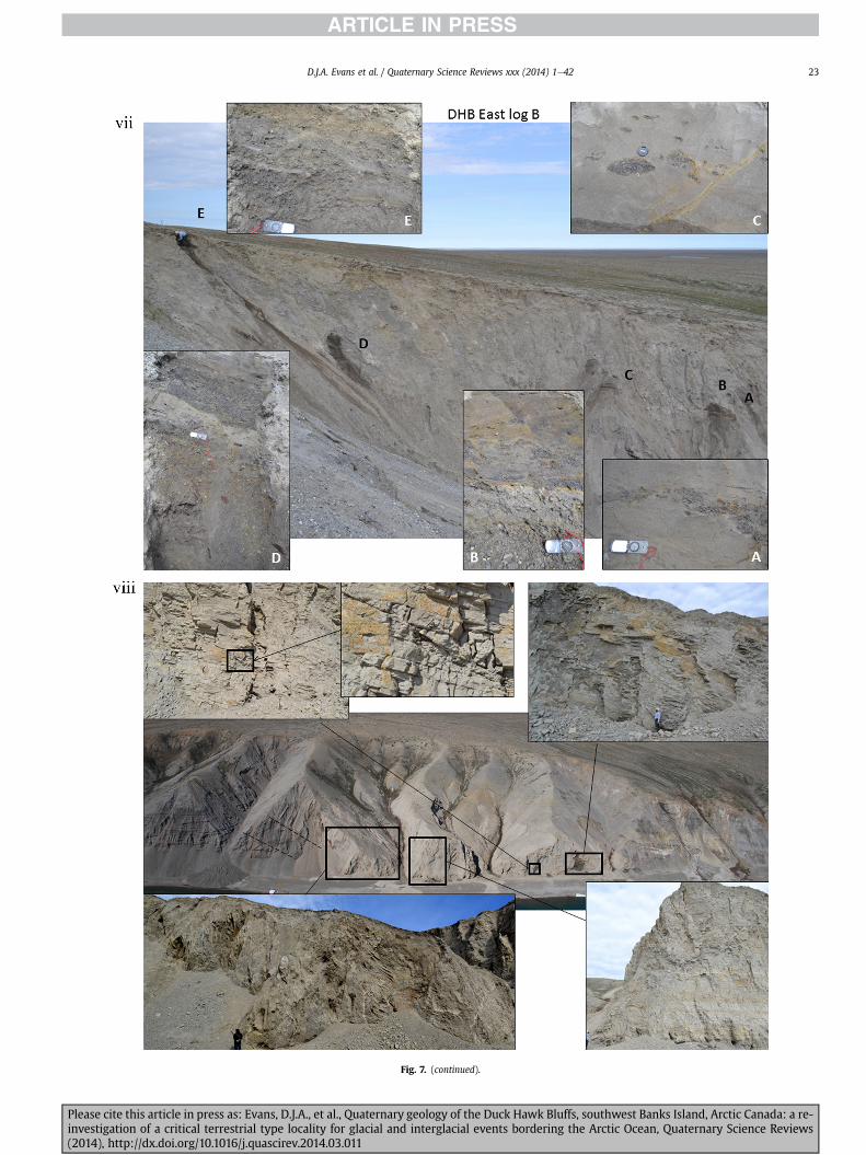
Fig 7 (continued)
DJA Evans et al Quaternary Science Reviews xxx (2014) 1e42 23
Please cite this article in press as Evans DJA et al Quaternary geology of the Duck Hawk Bluffs southwest Banks Island Arctic Canada a re-investigation of a critical terrestrial type locality for glacial and interglacial events bordering the Arctic Ocean Quaternary Science Reviews(2014) httpdxdoiorg101016jquascirev201403011
Fig 7 (continued)
DJA Evans et al Quaternary Science Reviews xxx (2014) 1e4224
LFA 6 crops out along the length of DHB and varies widely inthickness (1e11 m) displaying the most complex deformationstructures of any of the sediment bodies at DHB It comprises apredominantly heterogeneous diamicton or a meacutelange of discon-tinuous interbeds of massive matrix-supported diamicton matrix-supported gravel and laminated sand silt and clay with localizedattenuated lenses of degraded organics (Fig 7a ivevi 7b i iv 7c iiiii) Three samples of highly compressed and fragmented detritalmaterial displaying poor preservation were collected for identifi-cation Collectively LFA 6 has the appearance of a stratified dia-micton but locally it displays a more massive to pseudo-laminatedcharacter where sand silt and gravel lenses and occasional gravellags occur as thin beds stringers or wisps Some laminated sand siltand clay bodies appear to be rafts within the diamicton (intraclasts)due to their heavily deformed internal bedding and deformedcontacts or attenuated appearance Basal contacts with other lith-ofacies associations are typically erosional or deformed and asso-ciated with fissility boudinage and pseudo-lamination insediments on either side of the contact Basal diamictons can alsodisplay a higher concentration of gravel clasts that locally result in aclast-supported character or even a several metre-thick highlycontorted meacutelange of diamicton and stratified sediment bodies Insome sections the whole of LFA 6 has been complexly deformed toproduce stacked overfolds and thrust faults indicative of shearingtowards the southwest or WSW Clast macrofabrics are onlymoderately clustered (S1 frac14 0456e0637) but indicate stressdirected predominantly towards the SW Clast macrofabricstrengths as quantified by the fabric shape ternary plot (Fig 6a)and themodalityisotropy plot (Fig 6b) are variable and range frombi-modal to multi-modal Overall the macrofabric shapes in theternary graph plot across the spectrums of the glacitectonite andsubglacial traction till envelopes but there is a trend of changing
Please cite this article in press as Evans DJA et al Quaternary geologyinvestigation of a critical terrestrial type locality for glacial and intergla(2014) httpdxdoiorg101016jquascirev201403011
fabric strength vertically through LFA 6 The strongest clusters arefrom the basal diamictic zones (eg CCA F1 amp F3 AB plane data)whereas the weakest are from the top of the association (eg WCAF3 A-axes amp CCA F2 AB planes) where relatively low strain defor-mation indicators (open and recumbent folds) are ubiquitous
Clast lithologies in LFA 6 are dominated by quartz chert andsandstone although one diamict reveals a concentration of sand-stone lithologies at the expense of chert Clast forms similarlyreflect the nature of the sampled materials whereby the gravellysample (CCA 2) was characterized by relatively low C40 (38) andRA (12) values and a high average roundness (256) compared tothe same values for the diamictons of LFA 6 (C40 frac14 50e74RA frac14 38e52 average roundness frac14 174e204) A small number ofclasts (lt10) in LFA 6 were striated
512 Interpretation5121 LFA 1 The thick tabular sequence of well sorted cross-stratified sand and gravel records deposition by a former glaci-fluvial braided river typified by fluctuating discharge (eg Church1972 Boothroyd and Ashley 1975 Miall 1978 1985 1992Marren 2005) The highest discharge is recorded by matrix-supported gravel with boulders indicative of hyperconcentratedflows or a traction carpet (Maizels 1989ab Siegenthaler andHuggenberger 1993 Mulder and Alexander 2001) These areseparated by and vertically give way to lower discharges recordedby planar or trough cross-bedded sand and horizontal to planar ortrough cross-bedded gravel These deposits record aggradation andmigration of gravel bars and sheets and downstream accretionarymacroforms with relatively tightly constrained palaeocurrent in-dicators (Miall 1977 1985 Collinson 1996) The general lack ofscour fills and an overall fining-upward is indicative of an aggradingsystem initially characterized by high magnitudehigh frequency
of the Duck Hawk Bluffs southwest Banks Island Arctic Canada a re-cial events bordering the Arctic Ocean Quaternary Science Reviews
Fig 7 (continued)
DJA Evans et al Quaternary Science Reviews xxx (2014) 1e42 25
Please cite this article in press as Evans DJA et al Quaternary geology of the Duck Hawk Bluffs southwest Banks Island Arctic Canada a re-investigation of a critical terrestrial type locality for glacial and interglacial events bordering the Arctic Ocean Quaternary Science Reviews(2014) httpdxdoiorg101016jquascirev201403011
Fig 7 (continued)
DJA Evans et al Quaternary Science Reviews xxx (2014) 1e4226
Please cite this article in press as Evans DJA et al Quaternary geology of the Duck Hawk Bluffs southwest Banks Island Arctic Canada a re-investigation of a critical terrestrial type locality for glacial and interglacial events bordering the Arctic Ocean Quaternary Science Reviews(2014) httpdxdoiorg101016jquascirev201403011
DJA Evans et al Quaternary Science Reviews xxx (2014) 1e42 27
events that were gradually replaced by low magnitudehigh fre-quency events (Marren 2005) Partially to heavily-scoured rem-nants of laminated and massive fines represent deposition duringlow flow conditions in abandoned shallow channels The palae-ocurrent data from LFA 1 indicate that the outwash streams wereflowing westerly away from a glacier source located in AmundsenGulf This glacier likely eroded the abundant LFA 1 lithologies(chert quartzite and sandstone) from Mesoproterozoic and Neo-proterozoic bedrock widely distributed to the east and south(western Victoria Island Amundsen Gulf and the adjacent main-land Harrison et al 2013) These lithologies are consistent with theadvance of the NW Laurentide Ice Sheet through Amundsen Gulf(cf Dyke et al 2002 Batchelor et al 2012 MacLean et al 2013)
The crudely bedded organic detritus and degraded tree frag-ments (stumps) in LFA 1 are clearly reworked (cf Matthews et al1986 Fyles 1990 Vincent 1990) The finer grained detritus wasdeposited in concentrated pockets during waning flow stageswhereas horizons of logs and larger tree fragments were emplacedwith the coarser grained and poorly sorted sediments associatedwith hyperconcentrated flows or traction carpets during highdischarge These reworked organics also differ significantly fromthe type location of the Beaufort Fm a characteristic that promptedFyles (1990) to distinguish them as lsquotheMary Sachs Gravelrsquo Notablythe enclosing gravel and sand of LFA 1 is much coarser and exhibitsan entirely different fluvial architecture than the sandier BeaufortFm The composition and degraded nature of the LFA 1 organicssuggests that they were eroded by glaciers or their meltwater fromNeogene andor Paleogene sediments presumably to the southeastof Banks Island (eg Fyles 1990 Fyles et al 1994) The proximity ofa glacier is highlighted by the preservation of striae on individualclasts especially in the very coarse lower gravel The verticaldecrease in striae preservation and angularity (RA) and concomi-tant increase in roundness and upward-fining in LFA 1 is indicativeof an increasingly distal ice margin The co-variance plots (Fig 5)indicate a strong fluvial signature especially in the C40RA data butsubglacial characteristics are also evident particularly in the C40RWR data for the coarser grained and more matrix-supportedgravel as would be expected in ice-proximal settings
It is important to note that the widespread thrusting of LFA 1and underlying Kanguk Formation towards the southwest occurredpost-depositionally This glacitectonic thrusting was produced byLaurentide ice that advanced from the Kellett River valley (interiorBanks Island) during the emplacement of LFA 6 (see below) Theinjection of clastic dykes and fissure fills during this glacitectonicdisturbance was due to the overpressurizing of groundwater ingravel aquifers likely in taliks The branching limbs of many of thedykes are indicative of burst-out structures diagnostic of hydro-fracturing by vertically escaping groundwater pressurized byglacier overriding (cf Rijsdijk et al 1999 Le Heron and Etienne2005)
5122 LFA 2 At the top of LFA 1 rhythmites with lonestonesoverlie prominent clinoforms or foreset beds recording a changefrom subaerial glacifluvial to subaqueous deposition This wasinitially on a shallow delta front prograding foreset beds in asouthwesterly direction followed by suspension sedimentationwith dropstones presumably from floating ice in a marine orlacustrine basin The occurrence of matrix-supported gravelly scourfills with logs and woody detritus suggests pulses of cohesionlesssediment gravity flows into the basin Overlying the rhythmically-bedded sand prominent ice wedge pseudomorphs (up to 4 mdeep Fig 9aec cf Mackay and Burn 2002) are interspersed withthick (gt1m) sections of compressed in situ bryophytes (Figs 9d 7e)indicating the establishment of a tundra surface Four bryophytefamilies and 10 distinct species have been determined from LFA2
Please cite this article in press as Evans DJA et al Quaternary geologyinvestigation of a critical terrestrial type locality for glacial and intergla(2014) httpdxdoiorg101016jquascirev201403011
with the most abundant material from the Calliergonaceae andCampyliaceae (Table 1) These macrofossils are exceptionally wellpreserved including material with intact fragile alar cells typical ofthese two families (Fig 14cef) The data from these autochthonousdeposits indicate a wetland environment characterized as a richfen This ecosystem and habitats therein are consistent with speciesfound in the extant flora of Banks Island (Fig 14b) The autecologyfrom this range of species suggest hydric to mesic habitatsincluding standing pools wet meadows and microhabitats createdby ice wedges Despite the predominance of bryophytes in LFA 2these macrofossils had not been previously documented at DHB Incontrast a minimal proportion of the samples (lt5) consisted ofvascular plant material (including Cyperaceae seeds gramminoidleaves and woody twig fragments) Collectively the ice wedgepseudomorphs and vegetation within LFA 2 represent an isochro-nous terrestrial surface of interglacial rank
Following the formation of ice wedges the injection of intra-formational clastic dykes and fissure fills in LFA 2 relates to theoverpressurizing of groundwater in gravel aquifers or taliks due toglacier overriding The branching dyke limbs that emanate fromunderlying LFA 1 gravels and sands are indicative of the burst-outstructures that develop during hydrofracturing (cf Rijsdijk et al1999 Le Heron and Etienne 2005) A variant of the gravel andsand filled clastic dykes occurs within the sequence of glaci-tectonite and rhythmites near west Log D (Fig 11) Here thevertically-widening fracture is characterized by a mosaic ofpartially disaggregated blocks of the host materials in its widestzone where it contains gravels injected from underlying LFA 1Because these gravels only occur in the basal narrow neck theypresumably record the rapid reduction in flow competence duringhydrofracture filling
Deformation structures including overfolded or crumpledbedding and thrust faults associated with boudinage or highfissilitypseudo-lamination are representative of simple shear andwere also induced by glacitectonic disturbance (cf van derWateren 1995 McCarroll and Rijsdijk 2003) This predominantlyrecords a glacier advance from the northeast Subsidiary shear in-dicators record deformation from the south or southeast but theseoccur only at the top of LFA 2 and the base of LFA 3 suggestingearlier emplacement (see below) The development of zones ofboudinage shallow thrust faults overfolding or bed crumpling atdifferent levels within LFA 2 e especially at the contact separatingsediments of different grain size e represents deformation parti-tioning due to contrasting rheological properties Blind thrustswere also initiated in underlying LFA 1 increasingly towards thecentral and eastern cliffs where large-scale deformation is moreprevalent (Fig 7c d) A zone of intense deformation is recorded by alens of LFA 3 diamicton in fault contact with LFA 2 (east cliff Log AFig 7d i) This constitutes a type B glacitectonite (non-penetrativelydeformed pre-existing sediments sensu Benn and Evans 1996Evans et al 2006) developed during the emplacement of LFA 3(see below) A similar glacitectonite occurs at the junction of LFA 1and LFA 3 near west Log D (Fig 11) Bed attenuation by deformationis best developed in lower LFA 2 where the greater differences insediment grain size and hence rheology exist
5123 LFA 3 Within LFA 3 locally abundant stratified lensesindicate subaqueous deposition These stratified sediments weresubsequently thrust faulted folded and attenuated - most evidentin the upper and lower zones of LFA 3 This deformation was likelyresponsible for the intraclast boudinage and pseudo-lamination inthe surrounding diamicton (eg Hart and Roberts 1994 Robertsand Hart 2005 Oacute Cofaigh et al 2011) This process was alsoassociatedwith the attenuation of LFA 1 and 2 sediments within theheavily deformed base of LFA 3 some of which may have been
of the Duck Hawk Bluffs southwest Banks Island Arctic Canada a re-cial events bordering the Arctic Ocean Quaternary Science Reviews
Fig 8 Details of LFA 1 a) example of a concentration of logs with degraded rootballs in the stacked tabular units of cross-bedded sands and gravels and crudely stratified matrix-supported cobble to boulder gravels in the west cliff b) poorly-sorted and crudely horizontally bedded cobble to boulder gravel containing laminated clay intraclast (immediatelyabove compass) c) shallow locally graded foreset beds composed of openwork to sandy matrix-supported cobble to granule gravels in central cliff Log A d) planar bedded sandy
DJA Evans et al Quaternary Science Reviews xxx (2014) 1e4228
Please cite this article in press as Evans DJA et al Quaternary geology of the Duck Hawk Bluffs southwest Banks Island Arctic Canada a re-investigation of a critical terrestrial type locality for glacial and interglacial events bordering the Arctic Ocean Quaternary Science Reviews(2014) httpdxdoiorg101016jquascirev201403011
DJA Evans et al Quaternary Science Reviews xxx (2014) 1e42 29
cannibalized and rafted by the deformation process within a shearzone at the contact of LFA 3 with older sediments The shearingdirection from the south and southeast recorded in lower LFA 3also impacted upper LFA 2 whereas the more prominent shearingdirection throughout LFA 3 is from the northeast (also recorded inLFA 4) The local development of a heavily deformed zone at the topof LFA 3 was likely imparted during the shearing of overlying LFA 4sediments Although clast macrofabric strengths from the LFA 3diamicton are variable they possess shapes that compare withglacitectonites and subglacial traction tills and in some cases amodalityisotropy signature that reflects high lodgementcomponents
The similar orientation of the macrofabrics and shear indicatorsare considered diagnostic of a glacitectonite derived from stratifiedsediments (eg interbedded mass flow diamictons gravelly massflows and localized traction current sands and suspension de-posits) This evidence indicates that LFA 3 like all the other LFAsand the underlying Kanguk Fm bedrock has been displaced by aglacier advancing from the NNE or NE (ie Laurentide ice crossingthe interior of Banks Island) Minor south to north shearing in-dicates that LFA 3 and upper LFA 2were also disturbed by glacier iceflowing northwards (ie Laurentide ice advancing throughAmundsen Gulf) The appearance of granite and gabbro clastswithin the LFA 3 diamict records the arrival of far-travelled Lau-rentide ice from mainland Canada Clast form co-variance stronglyindicates a subglacial (abraded) source for LFA 3 with a minorfluvial component (Fig 5) including glacifluvial clasts locallycannibalized from LFA 1 by overriding ice
5124 LFA 4 LFA 4 has restricted outcrops is heavily deformedand contains organic detritus that is clearly allochthonous andhighly degraded Nonetheless a variety of indicators (fine-grainedhorizontally bedded cross-laminae rhythmites climbing ripplesand draped laminae) demonstrate that LFA 4 was deposited in asubaqueous environment with palaeocurrents from the south orsouthwest Traction currents were likely responsible for thedevelopment of the clast lag at the contact between lower LFA 4and underlying LFA 3 (west cliff Log A Fig 7b ii) LFA 4 coarsensupwards indicative of basin infilling andor an approaching sedi-ment source The narrow anabranched clastic dykes in the sandyclimbing ripples (LFA 4 west cliff Log A) record hydrofracturing bythe upward injection of overpressurized groundwater duringshearing The branching limbs of the dykes are similar to the burst-out structures reported by Rijsdijk et al (1999) but differ becausethey are composed solely of sand derived from the walls of the hostsediment rather than from an underlying gravel aquifer (cf LeHeron and Etienne 2005) Hence the pressurized water wasgenerated at the contact between the sand and underlying imper-meable brecciated clays The development of thin zones of brecci-ation boudinage sheath folding or thrust faulting at the upper andlower contacts of LFA 4 relates to the localized partitioning ofdeformation controlled by the location of claysilt beds Thejuxtaposition of this style of deformation with the larger scaleoverfolds and thrust faults developed in the extensive bodies ofsandy lithofacies is indicative of a Type B glacitectonite (sensu Bennand Evans 1996) This was constructed by the overriding of glacierice advancing from the north or northeast These shear directionsare compatible with those developed in the underlying LFAs
granule gravels with gravel lags (top and bottom of image) interrupted by an intervening unbedded granule to pebble gravel and massive cobble to pebble gravel A cluster of small treesequence of stacked tabular units of predominantly horizontally bedded sands and gravels ingravels containing clusters of wood detritus in the coarser gravel beds (central cliff Log A)wood fragments (central cliff Log A)
Please cite this article in press as Evans DJA et al Quaternary geologyinvestigation of a critical terrestrial type locality for glacial and intergla(2014) httpdxdoiorg101016jquascirev201403011
5125 LFA 5 The primary characteristics of LFA 5 are typical ofgravel sheet and occasional traction-carpet sedimentation in anice-proximal sandur (eg Boothroyd and Ashley 1975 Miall 19781985 1992 Maizels 1989ab Siegenthaler and Huggenberger1993 Mulder and Alexander 2001 Marren 2005) Glacier prox-imity is supported by the subglacial to fluvial signature of the clastforms (Fig 5) The coarsening-upward sequence including striatedclasts culminates in the arrival of a glacier that overrode the sitedepositing LFA 6 Post-depositional shearing within underlying LFA4 is recorded by attenuation and interdigitation at the contact withLFA 5 imparted during deposition of LFA 6 The contact betweenLFA 5 and 6 reflects the development of a shear zone where upperLFA 5 sediments have been cannibalized producing a meacutelange ofcrudely stratified diamictons with discontinuous interbeds ofmatrix-supported gravel laminated sand silt and clay (LFA 6 seebelow)
5126 LFA5a At Easternmost Cliff glacifluvial gravel (LFA 5a)unconformably overlies LFA 1 (Fig 7e) rendering uncertain itsrelationshipwith respect to LFA 5 in themain sections of DHB to thewest The fact that LFA 5a extends to the modern surface appearsundeformed and has palaeocurrents orientated to the NW requiresthat it is younger than LFA 5 Indeed we interpret LFA 5a asdeglacial outwash deposited from retreating Laurentide ice in theKellett River valley and Amundsen Gulf at the end of the lastglaciation (see Discussion)
5127 LFA 6 Based on its heterogeneity strongly orientated clastmacrofabrics and macroscale deformation structures LFA 6 con-stitutes a Type B glacitectonite (sensu Benn and Evans 1996)However zones of more highly strained Type A glacitectonite(sensu Benn and Evans 1996) at the basal contact with older LFAsare recorded by intraclastinterbed attenuation (pseudo-lamina-tion) strong boudinage or fissility and strengthened clast macro-fabrics The production of this meacutelange is attributed to two separateprocesses 1) primary sedimentation as interbedded and interdig-itated mass flow debris fluvial gravel and sand and subaqueoussuspension sediments and 2) cannibalization of underlying strat-ified sediments (LFAs 4 and 5) This produced a continuum of formsranging from low strain fold structures to attenuated rafts to tec-tonic lamination (eg Fig 7) The discontinuous lenses of degradedorganics (black stems and woody twigs gramminoid leaveswhitened rootlets) within LFA 6 are rafts and include seven speciesof bryophytes (Table 1) The material was highly compressed anddifficult to separate into distinct taxa Indeed one of the threesamples analysed was too degraded to recover any taxa Much ofthe material consisted of only fragmented leaves and only theminute taxa had stems with intact leaves The bryophytes thatcharacterize the LFA 6 samples represent hydric (Calliergon sppTomenthypnum nitens) to mesic (Ditrichum flexicaule Dicranum sp)habitats Three species collected from LFA 6 were also present inLFA 2 whereas four others were not found in LFA 2 but are com-mon in the modern flora The poor preservation quality suggeststhat the material has been redeposited from unknown sources andis clearly allochthonous
The predominant shearing direction within LFA 6 records an iceadvance from the interior of Banks Island (NE) This has resulted incomplex folding and thrusting and localized thickening of LFA 6
it of cross-bedded poorly-sorted to openwork cobble to boulder gravel crudely planar-fragments occur at the base of the cobble to boulder gravels at image centre e) middleDHB west cliff Log D f) sequence of fining-upward planar-bedded cobble to sandy fineg) planar cross-bedded sandy granule to pebble gravels with pebble to cobble lags and
of the Duck Hawk Bluffs southwest Banks Island Arctic Canada a re-cial events bordering the Arctic Ocean Quaternary Science Reviews
Fig 9 Details of LFA 2 from the west cliff a) narrow necked ice wedge pseudomorph with upturned marginal bedding in sand silt and clay rhythmites b) wide necked ice wedgepseudomorph c) ice wedge pseudomorph with overturned silt sand and clay rhythmites developed at the top of LFA 2 and sealed by overlying LFA 3 laminated diamicton d)horizontally bedded sand and silt containing well preserved moss macrofossils e) zone of disharmonically folded sandsilt laminae with well preserved moss peat located at thebase of LFA 2
DJA Evans et al Quaternary Science Reviews xxx (2014) 1e4230
Please cite this article in press as Evans DJA et al Quaternary geology of the Duck Hawk Bluffs southwest Banks Island Arctic Canada a re-investigation of a critical terrestrial type locality for glacial and interglacial events bordering the Arctic Ocean Quaternary Science Reviews(2014) httpdxdoiorg101016jquascirev201403011
Fig 10 Details of simple shear structures developed in fine sand and silt laminae at the centre of the thickest outcrop of LFA 2 in west cliff Log B a) overview of large scaleanastomosing shear faults with zones of smaller scale densely spaced anastomosing shears towards the base of the photograph b) details of large scale shear faults separatingzones of variably but predominantly densely spaced shears c) close details of shear zone comprising densely spaced anastomosing fractures d) details of ascending kink zonecross-cutting large scale anastomising shear faults Shearing direction is coming out of the cliff and towards the left in each image
DJA Evans et al Quaternary Science Reviews xxx (2014) 1e42 31
This shearing direction is recorded throughout underlying LFAs 1e4as well as the Kanguk Formation demonstrating deep-seated butpartitioned glacitectonic disturbance imparted during theemplacement of LFA 6 This strain signature was therefore over-printed on the northerlynortheasterly aligned shearing directionrecorded in LFA 3 and upper LFA 2 by the earlier northerly flowingice that deposited LFA 3 One anomalous clast macrofabric(northerly CCA F1) occurs in the basal meacutelange of LFA 6 Howeverthis sample is from an isolated outcrop (Fig 7c i) rendering itsapparent shearing direction equivocal
Please cite this article in press as Evans DJA et al Quaternary geologyinvestigation of a critical terrestrial type locality for glacial and intergla(2014) httpdxdoiorg101016jquascirev201403011
52 Sedimentology and stratigraphy (Mary Sachs Creek cliff)
The cliffs east of Mary Sachs Creek (Figs 2b 3) provides a cross-section through the seaward margin of the coast-parallel SachsMoraine (ldquosection Jrdquo Vincent et al 1983 Vaughan 2014) Weprovide a summary of two logs based on a reconnaissance survey ofthese sediments Log A is closest toMary Sachs Creekwhereas Log Boccursw1 km farther east (Figs 3 15a amp b) The sediments exposedin Log A appear to descend eastward and disappear below themodern beach and therefore are assumed to stratigraphically
of the Duck Hawk Bluffs southwest Banks Island Arctic Canada a re-cial events bordering the Arctic Ocean Quaternary Science Reviews
Fig 11 Details of LFA 2 near west Log D Lower box shows a 1e2 m thick basal zone comprising highly attenuated inter-digitated beds of gravelly to clay-rich diamictons and sandsiltclay rhythmites Upper box shows rhythmites containing diamictic intraclasts with sharp and angular boundaries also visible is the draping and deforming of the rhythmitebedding over and under the intraclasts respectively ldquoTailsrdquo extending from the diamictic intraclasts and thin but discontinuous diamictic beds are also visible in the upper box
DJA Evans et al Quaternary Science Reviews xxx (2014) 1e4232
underlie the sediments of Log B A sand and gravel- bench caps bothlogs at w15 m asl incised into the seaward margin of the SachsMoraine
521 DescriptionLog A contains a sequence of upward-fining highly contorted
cross-stratified sand and fine gravel to rhythmically bedded sandsilt clay with minor pebble gravel and sporadic clots of gravellydiamicton (Fig 15a) An ice wedge was initially developed in thelower cross-stratified sand and fine gravel before they were foldedand thrust faulted The deformed ice wedge pseudomorph is un-conformably overlain by a relatively undisturbed lens of laminatedsilty clay with dropstones interbedded with gravelly diamictonthat contains a bed (10 cm) of sandy black organics containingwood fragments (Fig 15a) This organic material occurs repeatedlyup-section as discontinuous stringers Log A is capped by 1e2 m ofpoorly exposed and heavily cryoturbated gravelly diamicton Thegeneral sense of displacement on shallow reverse faults over-turned bedding and boudinage structures is from the southeast
Log B (12 m) displays a coarsening-upward sequence of hori-zontally bedded sandy granule gravel with occasional silty sandlaminae (Fig 15b iii) that grades to poorly-sorted cobble to bouldergravel and bouldery matrix-supported gravel (Fig 15b ii) This iscapped by laminated to crudely stratified cobbly diamicton that issilt and clay-rich abruptly and conformably overlain by
Please cite this article in press as Evans DJA et al Quaternary geologyinvestigation of a critical terrestrial type locality for glacial and intergla(2014) httpdxdoiorg101016jquascirev201403011
interlaminated silt clay and pebbly silty sand (Fig 15b i) Althoughthe bedding on these units dips towards the NW individuallaminae do not thicken in that direction indicating post-depositional tilting The uppermost part of the log (underlyingthe 15 m bench) contains 2 m of clay-rich massive diamictoninterfingered with the underlying laminated sediments and cobblydiamicton
522 Interpretation
5221 Log A Broadly the sedimentology of log A including thedeformed ice wedge pseudomorph is similar to LFA 2 in DHB (egcentral cliff Log A Fig 7c iii) Prior to glacitectonic disturbance theoverlying organic bed (Fig 15a) was redeposited into a sequence ofsubaqueous siltclay rhythmites containing dropstones and gravellymass flows The highly attenuated shear margins bracketing theorganic bed in Log A demonstrate that it has been displaced as atectonic raft Previous research proposed that the organic beds e
similar to those described in Log A e be assigned to the LastInterglacial (locally called the Cape Collinson Vincent 1982 1983)Because these organic beds are clearly a raft they cannot constitutean iscochronous surface precluding chronostratigraphic signifi-cance (see Discussion) Shearing of the Log A sediments from thesoutheast documents an ice advance from Amundsen Gulf corre-sponding to the earliest of two primary shearing directions recor-ded at DHB (imparted during the emplacement of LFA 3) Therefore
of the Duck Hawk Bluffs southwest Banks Island Arctic Canada a re-cial events bordering the Arctic Ocean Quaternary Science Reviews
Fig 12 Details of LFA 4 in West Log A a) heavily deformed upper contact of LFA 4 comprising sandsiltclay rhythmites displaying well developed boudinage sheath folds andimmature tectonic laminae and an interdigitatedsheared boundary with underlying climbing ripple sands The contact with overlying LFA 6 is marked by an interdigitated zonecontaining rooted and de-rooted folds or rhythmite rafts in a sand gravel and diamicton meacutelange b) narrow anabranched clastic dykes ascending sub-vertically through climbingripple drift and resulting in offset bedding between blocks of host material c) abrupt contact between sheared sands and rhythmites of LFA 4 and overlying sand gravel anddiamicton meacutelange
Fig 13 Details of LFA 5 a) poorly sorted and matrix-supported pebble to cobble gravel b) tabular sequence of horizontally bedded to massive gravel and matrix-supported gravelcontaining a horizon of striated cobbles and boulders c) heavily deformed discontinuous bed of siltclay rhythmites between LFA 5 and LFA 6 in West Log D showing theamalgamation zone with the LFA 5 gravels immediately above the compass d) interdigitateddeformed contact between LFA 5 granule to pebble gravels and underlying LFA 4laminated silts and clays with organic detritus in West Log B
DJA Evans et al Quaternary Science Reviews xxx (2014) 1e42 33
Please cite this article in press as Evans DJA et al Quaternary geology of the Duck Hawk Bluffs southwest Banks Island Arctic Canada a re-investigation of a critical terrestrial type locality for glacial and interglacial events bordering the Arctic Ocean Quaternary Science Reviews(2014) httpdxdoiorg101016jquascirev201403011
Table 1List of bryophytes and vascular plants from LFAs 2 and 6
LFA2 WestCliff Log B
LFA6 CentralCliff Log A
Elevation (m) 185 m asl w45 m aslSample 4e12 1e3 taxa 10 7
Bryophyta (mosses)AmblystegiaceaeAmblystegium serpens (Hedw) Schimp x
CamyliaceaeCampylium polygamum (Schimp) CEO Jensen xCampylium stellatum (Hedw) CEO Jensen x xDrepanocladus aduncus (Hedw) Warnst xDrepanocladus sp xTomentypnum nitens (Hedw) Loeske x
CalliergonaceaeCalliergon giganteum (Schimp) Kindb xCalliergon richardsonii (Mitt) Kindb xthornthornthornthorn xCalliergon sp xWarnstorfia exannulatus (Schimp) Loeske xthornthornthornthorn x
BrachytheciaceaeBrachythecium turgidum (Hartm) Kindb x
MniaceaeCyrtomnium cf hymenophylloides(Hbener) TJ Kop
x
DicranaceaeDicranum sp x
DitrichaceaeDitrichum flexicaule (Schwaumlgr) Hampe x
Tracheophyta (vascular plants)CyperaceaeSeeds (triangular amp flattened) x x
Gramminoid leaf material x xWoody twig fragments x xRootlets x
Fig 14 The moss peat and associated microfossils of LFA 2 a) exposure through lower LFAsouthern Banks Island analogue of a rich tundra fen environment for the bryophyte assemblfrom LFA 2 showing the exceptional preservation of Calliergonaceae and Campyliaceae ma
DJA Evans et al Quaternary Science Reviews xxx (2014) 1e4234
Please cite this article in press as Evans DJA et al Quaternary geologyinvestigation of a critical terrestrial type locality for glacial and intergla(2014) httpdxdoiorg101016jquascirev201403011
these deformed deposits are interpreted as a Type B glacitectonite(sensu Benn and Evans 1996) possibly derived from LFA 2
5222 Log B The coarsening upward gravel in Log B recordshighly turbid to hyperconcentrated discharge in non-channelizedsheets This is interpreted as aggrading glacifluvial outwash froman approaching ice margin The capping sequence of crudelystratified diamicton and laminated sediments records a changefrom glacifluvial to subaqueous sedimentation prior to overridingby a glacier of unknown age that tilted the upper beds Thecoarsening-upward sequence apparent tectonism and cappingdiamict at Log B clearly distinguishes these deposits from those ofLFA 5a (west of Mary Sachs Creek easternmost cliff Fig 3)Furthermore although there is lithological similarity between LogB and LFA 5 throughout DHB the sense of shearing is dissimilar (LFA5 from the NE and Log B from the SE) The simplest explanation forthis difference in shear direction is that LFA 5 (DHB) was displacedby interior ice advancing down the Kellett River whereas Log B wasdisplaced by ice advancing along Amundsen Gulf (Fig 2b)
6 Discussion
61 Large scale glacitectonic structures and stratigraphicarchitecture
The glacitectonic structures identified within the lithofaciesassociations at DHB record two phases of deformation (early NeSand later NEeSW) This deformation together with the DHBstratigraphic architecture (Fig 16) helps to explain both thekinetostratigraphy (sensu Berthelsen1978) and the evolution of thelocal glacial geomorphology The large scale glacitectonic defor-mation is most clearly manifest in the thrust faulting and conjugate
2 at DHB west log B showing the sampling locations for in situ moss peat b) a modernages of LFA 2 c)ef) details of the typical moss peat and associated microfossil materialscrofossils including material with intact fragile alar cells
of the Duck Hawk Bluffs southwest Banks Island Arctic Canada a re-cial events bordering the Arctic Ocean Quaternary Science Reviews
Fig 15 The stratigraphy of Mary Sachs Creek cliff a) photographic compilation log A showing upward-fining highly contorted (i) cross-stratified sands and fine gravels torhythmically bedded sands silts clays and minor pebble gravels Also visible in (ii) is a lens of interbedded laminated silty clays with dropstones and gravelly diamictons containingsandy black coloured organic material with wood fragments An ice wedge pseudomorph is visible (iii) to the right of the exposure b) photographic compilation log B showing i)laminated to crudely stratified cobbly but siltclay-rich diamicton grading into interlaminated silts clays and pebbly silty sands ii) poorly-sorted cobble to boulder gravel andbouldery matrix-supported gravel iii) coarsening-upward sequence of horizontally bedded sandy granule gravels with occasional silty sand laminae iv amp v) pebble to cobble graveland matrix-supported gravel
DJA Evans et al Quaternary Science Reviews xxx (2014) 1e42 35
shear development in the Kanguk Fm bedrock and overlying LFA 1(east cliff Fig 7d ivevi) Here predominantly northeasterly dippingthrust slices have been stacked truncated and overlain by LFA 6during the second and strongest (NEeSW) deformation phase(Fig 16 note bedrock slice within the imbricated stacked sequenceof LFA 1) These structures demonstrate significant compressionand thickening of the stratigraphic sequence including w40 m ofvertical offset within the Kanguk Formation acrossw3 km (Fig 16)Prominent hydrofracture fills in LFAs 1 and 2 record elevatedporewater pressure during this thrusting Smaller scale shear zoneshave also developed in the finer grained interbeds within thrustslabs (Fig 7d vii) indicative of deformation partitioning by strataprone to ductile failure This zone of greatest displacement alsocoincides with the highest topography (Fig 16) Lower angle thrustfaults propagate in a southwesterly direction predominantlythrough LFA 1 but are also developed through LFA 2 in the footwallblock (east cliff Fig 16)
The thrust stacking of bedrock and LFAs 1e5 in east cliff (obliqueto Fig 16) represents the ice-proximal zone of a thrust-blockmorainecomposite ridge constructed by a glacier advancing fromthe northeast (ie the interior of Banks Island) This glacitectonicdeformation propagated southwestward to distal parts of theproglacial stress field as recorded bywell-developed shear zones inthe finer grained sediments of LFAs 2e5 In the more distal westcliff open folds (LFA 2 Fig 16) appear to be the product of a blindthrust within underlying LFA 1 This style of tectonism is typical oflsquopiggyback-style thrustingrsquo wherein steeply inclined thrust blocksat the advancing ice margin propagate new thrusts in the footwall(Fig 16 Park 1983 Mulugeta and Koyi 1987) The angle of thesefootwall thrusts becomes progressively shallower southwestward
Please cite this article in press as Evans DJA et al Quaternary geologyinvestigation of a critical terrestrial type locality for glacial and intergla(2014) httpdxdoiorg101016jquascirev201403011
(ice-distal) in LFA 1e5 where deformation partitioning developedin finer grained lithofacies (Fig 16)
The densely spaced ponds and depressions immediately to thenortheast of DHB (Figs 2b 3) constitute the depression fromwhich the thrust mass was excavated (eg Aber et al 1989Evans and England 1991 van der Wateren 1995) This inter-pretation is consistent with the strong northeast to southwestshear direction in the second phase glacitectonic structures andin LFA 6 clast macrofabrics This indicates that construction ofDHB occurred at the margin of a glacier advancing from thenortheast (ie from Kellett River valley) overtopping DHB anddepositing the LFA 6 glacitectonite The continued advance ofKellett ice coalesced with a glacier in Amundsen Gulf marked bythe interlobate Sachs Moraine containing ice-transported shellsas young as 24 cal ka BP (21020 70 yrs BP UCIAMS-89674)assigning this glaciation to the Late Wisconsin (Vaughan 2014)East of Mary Sachs Creek the deformation of Log B outwash(from the southeast Figs 15 16) likely records overriding by thesame Amundsen Gulf glacier (coeval with LFA 6 Late Wiscon-sinan) During ice retreat when Kellett River and Amundsen Gulfice decoupled DHB was exposed allowing the northwesterly-flowing proglacial outwash (LFA 5a) west of Mary Sachs Creekto extend to the shoreline marking postglacial marine limit atKellett Point (11 m asl Vaughan 2014 Fig 3) Collectively thisreconstruction supports a Late Wisconsinan age for the con-struction of DHB thrust block moraine although its stratigraphyincludes a range of ages A palaeogeographic reconstruction ofevents based upon our interpretation of the sedimentologystratigraphic architecture tectonism and geomorphology is pre-sented in Fig 17
of the Duck Hawk Bluffs southwest Banks Island Arctic Canada a re-cial events bordering the Arctic Ocean Quaternary Science Reviews
Fig 15 (continued)
DJA Evans et al Quaternary Science Reviews xxx (2014) 1e4236
62 Comparison and revision of previous DHB model
DHB was previously interpreted to record horizontally beddedNeogene to Quaternary sediments assigned to preglacial fluvialand multiple glacial and interglacial episodes (Vincent 1982 19831990 Vincent et al 1983 1984 Barendregt et al 1998) A com-posite palaeomagnetic record was also presented for this proposedstratigraphy placing most of this deposition before the BrunhesMatuyama boundary (Fig 1c) However prior to our work detailedstudies had not been undertaken on the sedimentology structuralgeology or stratigraphic architecture of DHB Rather the originalstratigraphy was restricted to a series of composite logs (our Fig 4reproduced from Vincent et al 1983) that notably omitted thepervasive deformation structures including the thrust bedrock ineast cliff (Fig 16)
Please cite this article in press as Evans DJA et al Quaternary geologyinvestigation of a critical terrestrial type locality for glacial and intergla(2014) httpdxdoiorg101016jquascirev201403011
Our reinterpretation dismisses several key elements of theoriginal DHB model outlined below (oldest to youngest) We havedetermined that the lowermost unit (LFA 1) is not preglacial (Fyles1990) but rather is composed of glacial outwash providing theearliest terrestrial evidence for glaciation in the area and containingallochthonous organics (including tree stumps) of unknown prov-enance Because LFA 1 is a glacifluvial braidplain (Fig 17a) it is notpart of the Beaufort Fm (Fyles 1990) even though it containsreworked macrofossils presumably derived from it (eg Craig andFyles 1960 Hills et al 1974 Vincent et al 1983)
Our analysis of LFA 2 indicates that it is also not preglacial norcan it be the Worth Point Fm as previously proposed (cf Vincent1982 1983 1990 Vincent et al 1983 Matthews et al 1986)Indeed the type locality of the Worth Point Fm has been invali-dated because it is now recognized to be an ice-transported and
of the Duck Hawk Bluffs southwest Banks Island Arctic Canada a re-cial events bordering the Arctic Ocean Quaternary Science Reviews
LFA4
Fig16
Stratigrap
hiccross-profi
lerun
ning
westto
easto
fDuc
kHaw
kBluffs
basedup
oninterpolations
betw
eenthemainsectionlogs
andsh
owingthesixLFAstheKan
gukFo
rmationbe
droc
kex
posu
resmajor
structural
features
and
thepo
sition
sof
icewed
geps
eudo
morph
san
dsign
ificant
clasticdy
kesAtthe
easternen
dof
thecross-profi
lethe
sedimen
tsat
theco
reof
MarySa
chsCree
kcliff
logAaretentativelyclassified
asLFA2
althou
ghthesematerialsarelik
ely
notin
situN
otethat
thecross-profi
ledo
esno
tex
tend
asfarea
stas
MarySa
chsCree
kcliff
logB
DJA Evans et al Quaternary Science Reviews xxx (2014) 1e42 37
Please cite this article in press as Evans DJA et al Quaternary geologyinvestigation of a critical terrestrial type locality for glacial and intergla(2014) httpdxdoiorg101016jquascirev201403011
glacitectonized raft (Vaughan et al 2014) In contrast our LFA 2 ischaracterized by an isochronous tundra surface with ice wedgesand intervening shallow ponds andwetmeadows The peat at LFA 2is dominated by bryophytes (gt95 by volume) and yet none ofthese macrofossils had been previously documented The diversein situ bryophyte species record a flora similar to that on BanksIsland today suggesting that LFA 2 warrants an interglacial rankThis conclusion is supported by the limited vascular plant record(five taxa no species indicated Vincent 1990) that also suggest awet meadow environment The absolute age of LFA 2 remains un-known but is apparently older than the BrunhesMatayamaboundary (gt780 ka Fig 18 cf Vincent et al 1984 Barendregt andVincent 1990 Barendregt et al 1998 see below)
LFA 3 in both our model and that of Vincent et al (1983) pro-vides the first direct evidence of ice reaching DHB In the previousmodel this was interpreted as Bernard Till (Banks Glaciation) thatwas bracketed by glacioisostatically induced marine transgressions(pre- and post-Banks seas Vincent 1982 1983) Within basal LFA 3we recognized highly deformed stratified sediment that wasdeposited in a subaqueous environment (deep water Fig 17c) priorto the arrival of overriding ice from the south (recorded by graniteand gabbro erratics Figs 17c 18) We regard LFA 3 to be equivalentto the Banks Glaciation (Vincent 1982 1983 Vincent et al 1983)including its pre- and post-Banks seas represented by the stratifiedsediments that bracket the central diamicton The LFA 3 sedimentsare also reported to be magnetically reversed thereby predatingthe BrunheseMatayama boundary (gt780 ka Fig 18 Vincent et al1984 Barendregt and Vincent 1990 Barendregt et al 1998)
Following the Banks Glaciation (our LFA 3 at DHB) Vincent(1982 1983) and Vincent et al (1983) recognized two in-terglacials (Morgan Bluffs and Cape Collinson) separated by anintervening marine episode This marine episode correspondedwith the glacioisostatic loading of a Laurentide ice margin confinedto the eastern half of Banks Island (Thomsen Glaciation) HoweverLFA 4 contains coarsening-upward subaqueous sedimentation fromthe south or southwest reflecting continued marine regressionfollowing LFA 3 (Fig 17c d) The coarsening-upward sequence ofLFA 4 is supplanted by coarse gravel outwash (LFA 5) supplied by aglacier readvancing from the northeast (Kellett River valley iceFig 17e) Glacier overriding is recorded by LFA 6 glacitectonite thatcaps the DHB thrust-block moraine composed of the entireassemblage of underlying LFAs (Fig 16)
Notably we have not observed any sediments characteristic oftwo interglacial deposits above LFA 3 hence dismiss the presence ofthe Morgan Bluffs and Cape Collinson interglacials at DHB Causseand Vincent (1989) report a U-series date of gt200 ka (UQT-229)from above our LFA 3 but this is almost certainly reworked andlacks chronostratigraphic significance Nor have we observedintervening marine sediments attributable to the Thomsen Glaci-ation (eg lsquoBig Searsquo Vincent 1982 1983 Vincent et al 1983)Rather following the deposition of the subaqueous sediments ofupper LFAs 3 and 4 (post-Banks Glaciation) LFAs 5 and 6 record asingle ice advance reaching DHB from the Kellett River valley(Banks Island interior) that was not reported by Vincent et al(1983) It was instead assumed that after the Banks GlaciationDHB lay distal to any later ice advances The nearest subsequentLaurentide margin to DHB recognized by Vincent et al (1983) wasassigned to the Sachs Moraine (immediately east of DHB) that waspresumed to be of EarlyWisconsin age (Fig 2b) However the SachsMoraine is nowdated to24 cal ka BP (LateWisconsinan Vaughan2014) andwas formed by the coalescence of Amundsen Gulf ice andthe Kellett River ice that deformed DHB (Fig 17) On the east side ofMary Sachs Creek the deposition of the Sachs Moraine coincideswith the deformation (from the southeast) of the underlying Log Boutwash gravel (Figs 3 15b)
of the Duck Hawk Bluffs southwest Banks Island Arctic Canada a re-cial events bordering the Arctic Ocean Quaternary Science Reviews
Fig 17 The palaeogeography of southwest Banks Island based upon interpretations of the principal lithofacies associations and structural architecture recognized at Duck HawkBluffs and the geomorphology of the surrounding terrain See text for detailed explanations
DJA Evans et al Quaternary Science Reviews xxx (2014) 1e4238
Although interglacial deposits were previously reported fromthe cliffs east of Mary Sachs Creek (ie Cape Collinson InterglacialVincent et al 1983) we found no similar evidence Rather the onlydeposit that we observed that may have been construed as inter-glacial sediments occurs in our Log A (Figs 3 15a) Here a darkdiscontinuous band of allochthonous organics (Fig15a) sits severedwithin a heavily tectonized melange (type B glacitectonite) and istherefore clearly a raft Although the absolute ages of the deformedunits east of Mary Sachs Creek (Logs A amp B) remain uncertain theyare apparently normally magnetized (Vincent et al 1984Barendregt and Vincent 1990) Blake (1987) also reports non-finite radiocarbon dates (gt36000 amp 49000 BP GSC-3560 amp 3560-2) obtained on ldquocompressed and deformed black woody peatrdquopurportedly from Cape Collinson beds (Vincent et al 1983 p 1708)Additionally Causse and Vincent (1989) report a U-series date onshells of 924 ka (UQT-143) from beds similar to the Log B gravelAgain all of these dated units have been displaced from unknownlocations limiting their utility for palaeoenvironmental recon-struction The last glacially influenced sedimentation at DHB isrecorded by northwesterly directed outwash (easternmost cliff LFA5a Figs 3 16 17g) We infer that this outwash fed the gravel beachmarking marine limit (11 m asl) in the lower Kellett River duringLate Wisconsinan retreat from the Sachs Moraine
63 Regional context
The stratigraphy at Duck Hawk Bluffs records three glacialevents The earliest of these is recorded by the aggradation of a
Please cite this article in press as Evans DJA et al Quaternary geologyinvestigation of a critical terrestrial type locality for glacial and intergla(2014) httpdxdoiorg101016jquascirev201403011
glacifluvial braidplain (LFA 1) that contains allochthonous pre-glacial material of diverse age However within LFA 1 there is noevidence that the ice reached DHB although it must have beennearby (southeast in Amundsen Gulf) The age of this glaciationremains unknown but the palaeomagnetic polarity of LFA 1 in-dicates that it is gt780 ka BP (Barendregt and Vincent 1990)Although Barendregt et al (1998) assigned part of the Worth PointFm to the normally polarized Olduvai sub-zone (MIS 64e74) itshould be noted that the Worth Point section is located 30 kmnorthwest of DHB There a stratigraphic revision has demonstratedthat this ldquotype sectionrdquo of the Worth Point Fm is in fact a glaci-tectonized raft (Vaughan et al 2014) This observation invalidatesthe previous correlation from Worth Point to purportedly coevalbeds at DHB (our LFA 2) Furthermore the diverse plant assem-blages in the Worth Point raft include preglacial tree stumps andSphagnum spp that do not occur on Banks Island today and are notfound in the wet meadow assemblages (rich fen) of LFA 2 that weinterpret to be of interglacial rank Therefore the sediments at DHB(LFAs 1 amp 2) do not support an age assignment of MIS 64e74(Olduvai subzone) proposed by Barendregt et al (1998) Currentlythe available palaeomagnetic record at DHB simply separates theentire section into a lower lsquoreversedrsquo unit and an upper lsquonormalrsquoone We place this boundary within our LFA 4 (Fig 18)
The overriding of DHB by glaciers is recorded in LFAs 3 amp 6These two glacial deposits may correspond to parts of the record ofstacked till sheets reported from the offshore seismic stratigraphy(Batchelor et al 2012) LFA 3 glaciationmay have contributed to theonset of mid-Pleistocene ice-rafted debris (IRD Ca-rich) attributed
of the Duck Hawk Bluffs southwest Banks Island Arctic Canada a re-cial events bordering the Arctic Ocean Quaternary Science Reviews
B-M
B-M
gt19
Fig
18A
revisedlitho
stratigrap
hyforDuc
kHaw
kBluffsPrev
ious
lyrepo
rted
ageco
nstraintsarealso
depicted
toge
ther
withatentativeallocation
ofMIS
stag
es(positione
dalon
gsideEa
stCliff
LogA
forclarity)
basedup
onthe
palaeo
mag
neticreco
rd
DJA Evans et al Quaternary Science Reviews xxx (2014) 1e42 39
Please cite this article in press as Evans DJA et al Quaternary geology of the Duck Hawk Bluffs southwest Banks Island Arctic Canada a re-investigation of a critical terrestrial type locality for glacial and interglacial events bordering the Arctic Ocean Quaternary Science Reviews(2014) httpdxdoiorg101016jquascirev201403011
DJA Evans et al Quaternary Science Reviews xxx (2014) 1e4240
to the Canadian Arctic Archipelago (CAA) and recorded in sedimentcores from the Arctic Ocean basin (Polyak et al 2009 2013OrsquoRegan et al 2010 Stein et al 2010) However Stein et al(2010) place the onset of Ca-rich ice-rafted debris within MIS 16(w659 ka BP Lisiecki and Raymo 2005) with subsequent peaks atMIS 12 10 and 8 all of which postdate the gt780 ka BP palae-omagnetic age proposed for LFA 3 (above) Polyak et al (2013) placethe onset of Ca-rich ice-rafted debris in the central Arctic Oceancloser to MIS 19 (790 ka BP) which is broadly compatible with theDHB palaeomagnetic record LFA 6 records the last glaciation ofDHB and we assign this to the Late Wisconsinan when Banks Is-land ice (Kellett River) coalesced with the Amundsen Gulf IceStream (Stokes et al 2006 MacLean et al 2013) During this in-terval the northwest Laurentide Ice Sheet likely reached the edgeof the polar continental shelf (Stokes et al 2005 2006 Englandet al 2009 Batchelor et al 2012 Lakeman and England 2013MacLean et al 2013)
7 Conclusions
New sedimentological and stratigraphic analyses of DHB funda-mentally revise the previous reconstruction of the Neogene andQuaternary history of Banks Island DHB and two other widely citedsections on Banks Island have been reported as important unde-formed terrestrial archives of glacial and interglacial sedimentationat the northwest limit of the Laurentide Ice Sheet that all have beenrecently revised (Vaughan et al 2014 Lakeman and England inpress) The recognition of pervasive large-scale deformation ofDHB necessitates a fundamental re-assessment of its previouslydescribed layer-cake stratigraphy We document that the oldestsediments (LFA 1) at DHB are not preglacial fluvial deposits (Beau-fort Fm) but rather record proglacial outwash from ice in AmundsenGulf that did not reach the site This was followed by the estab-lishment of an isochronous tundra surface of interglacial rank (LFA2) characterized by ice wedge polygons within a wet meadow thatsupported a bryophyte community similar to modern Subse-quently glacial sedimentation resumed initially in an ice-proximalsubaqueous environment followed by ice arrival and glacitectonicdeformation (LFA 3) The overlying deposits at DHB indicate post-glacial marine sedimentation (LFA 4) followed by the aggradationof glacifluvial sand and gravel (LFA 5) from an advancing ice marginthat culminated with the emplacement of a glacitectonite (LFA 6)during the Late Wisconsin This ice advance constructed a previ-ously undescribed thrust-block moraine (60 m high 8 km long) thatexhibits pervasive deformation and includes a substantial raft ofCretaceous Kanguk Fm bedrock (Fig 16) Furthermore the produc-tion of the glacitectonite (LFA 6) cannibalized LFAs 1e5 which atsome sites were previously thought to be in situ interglacial de-posits Finally outwash (LFA 5a) incised the DHB thrust block duringdeglaciation of the site when ice in the Kellett River and AmundsenGulf separated and proglacial meltwater drained northwestward tomarine limit (11 m asl) Refinements to the evolution and chronol-ogy of DHB and other sections around Banks Island will furthercontribute to the understanding of high latitude environmentalchange especially the complementary marine archives of theadjacent polar continental shelf and Arctic Ocean
Acknowledgements
Funding for this research was provided by the Natural Sciencesand Engineering Research Council of Canada (NSERC) NorthernResearch Chair Program and a complementary NSERC DiscoveryGrant (A6680) (both to JH England) Coulthard Lakeman andVaughan were supported by CBAR grants Canadian CircumpolarInstitute University of Alberta Coulthard and Lakeman were also
Please cite this article in press as Evans DJA et al Quaternary geologyinvestigation of a critical terrestrial type locality for glacial and intergla(2014) httpdxdoiorg101016jquascirev201403011
supported by Northern Scientific Training Program grantsAboriginal Affairs and Northern Development Canada The PolarContinental Shelf Program Natural Resources Canada(_501100000159) supplied additional funding and aircraft supportField and logistical assistance from Issac Elanik Vernon AmosTrevor Lucas and Roger Kuptana of Sachs Harbour is gratefullyacknowledged
References
Aber JS Croot DG Fenton MM 1989 Glaciotectonic Landforms and StructuresKluwer Dordrecht
Barendregt RW Vincent J-S 1990 Late Cenozoic paleomagnetic record of DuckHawk Bluffs Banks Island Canadian Arctic Archipelago Can J Earth Sci 27124e130
Barendregt RW Duk-Rodkin A 2011 Chronology and extent of Late Cenozoic icesheets in North America a magnetostratigraphical assessment In Ehlers JGibbard PL Hughes PD (Eds) Quaternary Glaciations e Extent and Chro-nolgy a Closer Look Elsevier Amsterdam pp 419e426
Barendregt RW Vincent J-S Irving E Baker J 1998 Magnetostratigraphy ofQuaternary and late Tertiary sediments on Banks Island Canadian Arctic Ar-chipelago Can J Earth Sci 35 147e161
Batchelor CL Dowdeswell JA Pietras JT 2012 Variable history of Quaternaryice-sheet advance across the Beaufort Sea margin Arctic Ocean Geology httpdxdoiorg101130G336691
Batchelor CL Dowdeswell JA Pietras JT 2013 Seismic stratigraphy sedimen-tary architecture and palaeo-glaciology of the Mackenzie Trough evidence fortwo Quaternary ice advances and limited fan development on the westernCanadian Beaufort Sea margin Quat Sci Rev 65 73e87
Benn DI 1994 Fabric shape and the interpretation of sedimentary fabric dataJ Sediment Res 64 910e915
Benn DI 1995 Fabric signature of till deformation Breiethamerkurjoumlkull IcelandSedimentology 42 735e747
Benn DI 2004 Clast morphology In Evans DJA Benn DI (Eds) A PracticalGuide to the Study of Glacial Sediments Arnold London pp 77e92
Benn DI Ballantyne CK 1994 Reconstructing the transport history of glaciogenicsediments a new approach based on the co-variance of clast form indicesSediment Geol 91 215e227
Benn DI Evans DJA 1996 The interpretation and classification of subglaciallydeformed materials Quat Sci Rev 15 23e52
Benn DI Evans DJA Phillips ER Hiemstra JF Walden J Hoey TB 2004 Theresearch project d a case study of Quaternary glacial sediments InEvans DJA Benn DI (Eds) A Practical Guide to the Study of Glacial Sedi-ments Arnold London pp 209e234
Berthelsen A 1978 The methodology of kineto-stratigraphy as applied to glacialgeology Bull Geol Soc Den 27 25e38
Blake Jr W 1987 Geological Survey of Canada Radiocarbon Dates XXVI InGeological Survey of Canada Paper 86-7 60 pp
Boothroyd JC Ashley GM 1975 Processes bar morphology and sedimentarystructures on braided outwash fans northeastern Gulf of Alaska InJopling AV McDonald BC (Eds) Glaciofluvial and Glaciolacustrine Sedi-mentation Society of Economic Paleontologists and Mineralogists SpecialPublication No 23
Causse C Vincent J-S 1989 TheU disequilibrium dating of Middle and LatePleistocene wood and shells from Banks and Victoria islands Arctic CanadaCan J Earth Sci 26 2718e2723
Church MA 1972 Baffin Island sandurs a study of Arctic fluvial processes GeolSurv Can Bull 216 208
Clark DL Vincent J-S Jones GA Morris WA 1984 Corrrelation of marine andcontinental glacial and interglacial events Arctic Ocean and Banks Island Na-ture 311 147e149
Collinson JD 1996 Alluvial sediments In Reading HG (Ed) Sedimentary Envi-ronments and Facies third ed Blackwell Oxford pp 37e82
Craig BG Fyles JG 1960 Pleistocene Geology of Arctic Canada In GeologicalSurvey of Canada Paper 60-10 21 pp
Crosby MR Magill RE Allen B He S 1999 A Checklist of the Mosses MissouriBotanical Garden St Louis 320 pp
Duk-Rodkin A Barendregt RW 2011 Stratigraphical records of glacialsin-terglacials in northwest Canada In Ehlers J Gibbard PL Hughes PD (Eds)Quaternary Glaciations e Extent and Chronology a Closer Look ElsevierAmsterdam pp 661e698
Dyke AS Andrews JT Clark PU England JH Miller GH Shaw J Veillette JJ2002 The Laurentide and Innuitian ice sheets during the Last Glacial MaximumQuat Sci Rev 21 9e31
England JH Furze MFA Doupeacute JP 2009 Revision of the NW Laurentide IceSheet implications for the paleoclimate the northeast extremity of Beringiaand Arctic Ocean sedimentation Quat Sci Rev 28 1573e1596
Evans DJA 2010 Controlled moraine development and debris transport pathwaysin polythermal plateau icefields examples from Tungnafellsjoumlkull IcelandEarth Surf Process Landf 35 1430e1444
of the Duck Hawk Bluffs southwest Banks Island Arctic Canada a re-cial events bordering the Arctic Ocean Quaternary Science Reviews
DJA Evans et al Quaternary Science Reviews xxx (2014) 1e42 41
Evans DJA Benn DI 2004 Facies description and the logging of sedimentaryexposures In Evans DJA Benn DI (Eds) A Practical Guide to the Study ofGlacial Sediments Arnold London pp 11e51
Evans DJA England J 1991 Canadian landform examples 19 high arctic thrustblock moraines Can Geogr 35 93e97
Evans DJA Rea BR Benn DI 1998 Subglacial deformation and bedrockplucking in areas of hard bedrock Glacial Geology and Geomorphology rp041998 httpgggqubacukgggpapersfull1998rp041998rp04html
Evans DJA Hiemstra JF 2005 Till deposition by glacier submarginal incre-mental thickening Earth Surf Process Landf 30 1633e1662
Evans DJA Hiemstra JF Oacute Cofaigh C 2007 An assessment of clast macrofabricsin glaciogenic sediments based on AB plane data Geogr Ann A89 103e120
Evans DJA Phillips ER Hiemstra JF Auton CA 2006 Subglacial till formationsedimentary characteristics and classification Earth Sci Rev 78 115e176
Evans DJA Shulmeister J Hyatt OM 2010 Sedimentology of latero-frontalmoraines and fans on the west coast of South Island New Zealand Quat SciRev 29 3790e3811
Eyles N Eyles CH Miall AD 1983 Lithofacies types and vertical profile modelsan alternative approach to the description and environmental interpretation ofglacial diamicts and diamictite sequences Sedimentology 30 393e410
Fyles JG 1990 Beaufort Formation (late Tertiary) as seen from Prince Patrick Is-land Arctic Canada Arctic 43 393e403
Fyles JG Hills LV Matthews Jr JV Barendregt R Baker J Irving E Jette H1994 Ballast Brook and Beaufort Formations (Late Tertiary) on northern BanksIsland Arctic Canada Quat Int 2223 141e171
Harrison JC Mayr U McNeil DH Sweet AR McIntyre DJ Eberle JJHarington CR Chalmers JA Dam G Nohr-Hansen H 1999 Correlation ofCenozoic sequences of the Canadian Arctic region and Greenland implicationsfor the tectonic history of northern North America Bull Can Pet Geol 47 223e254
Harrison JC Ford A Miall AD Rainbird RH Hulbert LJ Chritie RLCampbell FHA 2013 Geology Tectonic Assemblage Map of Aulavik BanksIsland and Northwestern Victoria Island Northwest Territories GeologicalSurvey of Canada Canadian Geoscience Map 35 (preliminary) scale 1500 000httpdxdoiorg104095292833
Hart JK Roberts DH 1994 Criteria to distinguish between subglacial glaciotec-tonic and glaciomarine sedimentation I Deformation styles and sedimen-tology Sediment Geol 91 191e213
Hedenaumls L 1993 A generic revision of the Warnstorfia Calliergon group J Bryol 17447e479
Hedenaumls L 2006 Additional insights into the phylogeny of Calliergon LoeskypnumStraminergon and Warnstorfia (Bryophyta Calliergonaceae) J Hattori Bot Lab100 125e134
Hicock SR Goff JR Lian OB Little EC 1996 On the interpretation of subglacialtill fabric J Sediment Res 66 928e934
Hiemstra JF Evans DJA Oacute Cofaigh C 2007 The role of glaciotectonic rafting andcommunition in the production of subglacial tills examples from SW Irelandand Antarctica Boreas 36 386e399
Hills LV 1975 Late Tertiary floras Arctic Canada an interpretation In Proceedingsof Circumpolar Conference on Northern Ecology National Research Council ofCanada pp I(65)eI(71)
Hills LV Klovan JE Sweet AR 1974 Juglans eocineria n Beaufort Formation(Tertiary) southwestern Banks Island Arctic Canada Can J Bot 52 65e90
Janssens JAP 1983 Quaternary fossil bryophytes in North America new recordsLindbergia 9 137e151
Kuc M 1974 Calliergon aftonianum Steere in Late Tertiary and Pleistocene Depositsof Canada In Geological Survey of Canada Paper 74e24
Kuc M Hills LV 1971 Fossil mosses Beaufort Formation (Tertiary) NorthwesternBanks Island Western Canada Arctic Can J Bot 49 1089e1094
Lakeman TR England JH 2012 Paleoglaciological insights from the age andmorphology of the Jesse moraine belt western Canadian Arctic Quat Sci Rev47 82e100
Lakeman TR England JH 2013 Late Wisconsinan glaciation and postglacialrelative sea-level change on western Banks Island Canadian Arctic ArchipelagoQuat Res 80 99e112
Lakeman TR England JH 2014 Facies and stratigraphic analyses of glacial andinterglacial sediments at Morgan Bluffs Banks Island Canadian Arctic Archi-pelago Boreas httpdxdoiorg101111bor12069 (in press)
Lawton E 1971 Moss Flora of the Pacific Northwest The Hattori Botanical Labo-ratory Ninchen Miyazaki Japan
Le Heron DP Etienne JL 2005 A complex subglacial clastic dyke swarm Sol-heimajoumlkull southern Iceland Sediment Geol 181 25e37
Li G Piper DJW Campbell DC 2011 The Quaternary Lancaster Sound trough-mouth fan NW Baffin Bay J Quat Sci 26 511e522
Lisiecki LE Raymo ME 2005 A Pliocene-Pleistocene stack of 57 globallydistributed benthic d18O records Paleoceanography 20 PA1003 httpdxdoiorg1010292004PA001071
Lukas S Benn DI Boston CM Brook M Coray S Evans DJA Graf A Kellerer-Pirklbauer A Kirkbride MP Krabbendam M Lovell H Machiedo MMills SC Nye K Reinardy BTI Ross FH Signer M 2013 Clast shapeanalysis and clast transport paths in glacial environments a critical review ofmethods and the role of lithology Earth-Sci Rev 121 96e116
Lukas S Coray S Graf A Schluumlchter C 2014 The influence of clast lithology andfluvial reworking on the reliability of clast shape measurements in glacial en-vironments e a case study from a temperate Alpine glacier In Bridgland DR
Please cite this article in press as Evans DJA et al Quaternary geologyinvestigation of a critical terrestrial type locality for glacial and intergla(2014) httpdxdoiorg101016jquascirev201403011
(Ed) Clast Lithological Analysis Technical Guide Quaternary Research Asso-ciation London (in press)
Mackay JR Burn CR 2002 The first 20 years (1978e1979 to 1998e1999) of icewedge growth at the Illisarvik experimental drained lake site western Arcticcoast Canada Can J Earth Sci 39 95e111
MacLean B Blasco S Bennett R Lakeman T Hughes-Clarke J Kuus PPatton E 2013 Marine evidence for a Glacial ice stream in Amundsen GulfCanadian Arctic Archipelago In Canadian Quaternary Association (CANQUA)Meeting August 18e22 2013 Edmonton AB Canada
Maizels JK 1989a Sedimentology palaeoflow dynamics and flood history ofjokulhlaup deposits palaeohydrology of Holocene sediment sequences insouthern Iceland sandur deposits J Sediment Petrol 59 204e223
Maizels JK 1989b Sedimentology and palaeohydrology of Holocene flood depositsin front of a jokulhlaup glacier south Iceland In Bevan K Carling PJ (Eds)Floods the Geomorphological Hydrological and Sedimentological Conse-quences Wiley New York pp 239e251
Marren PM 2005 Magnitude and frequency in proglacial rivers a geomorpho-logical and sedimentological perspective Earth-Sci Rev 70 203e251
Matthews JV 1987 Plant macrofossils from the Neogene Beaufort Formation onBanks and Meighen islands District of Franklin In Current Research Part AGeological Survey of Canada Paper 87-1A pp 73e87
Matthews Jr JV Ovenden LE 1990 Late Tertiary plant macrofossils from local-ities in ArcticSubarctic North America a review of the data Arctic 43 364e392
Matthews JV Mott RJ Vincent J-S 1986 Preglacial and interglacial environ-ments of Banks Island pollen and macrofossils from Duck Hawk Bluffs andrelated sites Geogr Phys Quat XL 279e298
McCarroll D Rijsdijk KF 2003 Deformation styles as a key for interpreting glacialdepositional environments J Quat Sci 18 473e489
Miall AD 1977 A review of the braided river depositional environment Earth-SciRev 13 1e62
Miall AD 1978 Lithofacies types and vertical profile models in braided river de-posits a summary In Miall AD (Ed) Fluvial Sedimentology Canadian Societyof Petroleum Geologists Memoir 5 pp 597e604
Miall AD 1985 Architectural-element analysis a new method of facies analysisapplied to fluvial deposits Earth Sci Rev 22 261e308
Miall AD 1992 Alluvial deposits In Walker RG James NP (Eds) Facies ModelsResponse to Sea-level Change Geological Association of Canada Torontopp 119e142
Mulder T Alexander J 2001 The physical character of subaqueous sedimentarydensity flows and their deposits Sedimentology 48 269e299
Mulugeta G Koyi H 1987 Three-dimensional geometry and kinematics ofexperimental piggyback thrusting Geology 15 1052e1056
Nyholm E 1956e1965 Illustrated Moss Flora of Fennoscandia II Musci Fasc 1-6Lund pp 1e788
Oacute Cofaigh C Evans DJA Hiemstra JF 2011 Formation of a stratified subglacial lsquotillrsquoassemblage by ice-marginal thrusting and glacier overriding Boreas 40 1e14
OrsquoRegan M St John K Moran K Backman J King J Haley BA Jakobsson MFrank M Roumlhl U 2010 Plio-Pleistocene trends in ice rafted debris on theLomonosov Ridge Quat Int 219 168e176
OrsquoRegan M Williams CJ Frey KE Jakobsson M 2011 A synthesis of the long-term paleoclimatic evolution of the Arctic Oceanography 24 66e80
Park RG 1983 Foundations of Structural Geology Blackie LondonPolyak L Bischof J Ortiz JD Darby DA Channell JET Xuan C Kaufman DS
Loslashvlie R Schneider DA Eberl DD Adler RE Council EA 2009 LateQuaternary stratigraphy and sedimentation patterns in the western ArcticOcean Glob Planet Change 68 5e17
Polyak L Best KM Crawford KA Council EA St-Onge G 2013 Quaternaryhistory of sea ice in the western Arctic Ocean based on foraminifera Quat SciRev 79 145e156
Rijsdijk KF Owen G Warren WP 1999 Clastic dykes in overconsolidated tillsevidence for subglacial hydrofracturing at Killiney Bay eastern Ireland Sedi-ment Geol 129 111e126
Roberts DH Hart JK 2005 The deforming bed characteristics of a stratified tillassemblage in north east Anglia UK investigating controls on sedimentrheology and strain signatures Quat Sci Rev 24 123e140
Roy SK Hills LV 1972 Fossil woods from the Beaufort Formation (Tertiary)northwestern Banks Island Canada Can J Bot 50 2637e2648
Siegenthaler C Huggenberger P 1993 Pleistocene Rhine gravel deposits of abraided river systemwith dominant pool preservation In Best JL Bristow CS(Eds) Braided Rivers Geological Society London Special Publication 75pp 147e162
Spedding N Evans DJA 2002 Sediments and landforms at Kviacuteaacuterjoumlkull southeastIceland a reappraisal of the glaciated valley landsystem Sediment Geol 14921e42
Steere WC 1978 The Mosses of Arctic Alaska In Bryophytorum Bibliotheca vol14 J Cramer Lehre Germany 507 pp
Steere WC Scotter GW 1979 Bryophytes of Banks Island Northwest TerritoriesCanada Can J Bot 57 1136e1149
Stein R Matthiessen J Niessen F Krylov R Nam S Bazhenova E 2010 Towardsa better (litho-) stratigraphy and reconstruction of Quaternary palaeoenviron-ment in the Amerasian Basin (Arctic Ocean) Polarforschung 79 97e121
Stokes CR Clark CD Darby DA Hodgson DA 2005 Late Pleistocene ice exportevents into the Arctic Ocean from the MrsquoClure Strait Ice Stream Canadian ArcticArchipelago Glob Planet Change 49 139e162
of the Duck Hawk Bluffs southwest Banks Island Arctic Canada a re-cial events bordering the Arctic Ocean Quaternary Science Reviews
DJA Evans et al Quaternary Science Reviews xxx (2014) 1e4242
Stokes CR Clark C Winsborrow M 2006 Subglacial bedform evidence for amajor palaeo-ice stream in Amundsen Gulf and its retreat phases CanadianArctic Archipelago J Quat Sci 21 300e412
van der Wateren DFM 1995 Processes of glaciotectonism In Menzies J (Ed)Glacial Environments Modern Glacial Environments Processes Dynamics andSediments vol 1 Butterworth-Heinemann Oxford pp 309e335
Vaughan J 2014 The Glacial and Sea Level History of South Banks Island NT(Unpublished PhD thesis) University of Alberta Edmonton
Vaughan J England J Evans DJA 2014 Glaciotectonic deformation and rein-terpretation of the Worth Point stratigraphic sequence Banks Island NT Can-ada Quat Sci Rev httpdxdoiorg101016jquascirev201311005
Vincent J-S 1982 The Quaternary history of Banks Island Northwest TerritoriesCanada Geogr Phys Quat 36 209e232
Please cite this article in press as Evans DJA et al Quaternary geologyinvestigation of a critical terrestrial type locality for glacial and intergla(2014) httpdxdoiorg101016jquascirev201403011
Vincent J-S 1983 La geologie du quaternaire et la geomorpholie de Lrsquoile Banksarctique Canadien Geological Survey of Canada Memoir 405
Vincent J-S 1984 Quaternary stratigraphy of the western Canadian Arctic Archi-pelago In Fulton RJ (Ed) Quaternary Stratigraphy of Canada e a CanadianContribution to IGCP Project 24 Geological Survey of Canada Paper 84-10pp 87e100
Vincent J-S 1990 Late Tertiary and Early Pleistocene deposits and history of BanksIsland southwestern Canadian Arctic Archipelago Arctic 43 339e363
Vincent J-S Occhietti S Rutter N Lortie G Guilbault J-P De Boutray B 1983The Late TertiaryeQuaternary record of the Duck Hawk Bluffs Banks IslandCanadian Arctic Archipelago Can J Earth Sci 20 1694e1712
Vincent J-S Morris WA Occhietti S 1984 Glacial and non-glacial sediments ofMatuyama paleomagnetic age on Banks Island Canadian Arctic ArchipelagoGeology 12 139e142
of the Duck Hawk Bluffs southwest Banks Island Arctic Canada a re-cial events bordering the Arctic Ocean Quaternary Science Reviews
- Quaternary geology of the Duck Hawk Bluffs southwest Banks Island Arctic Canada a re-investigation of a critical terrest
-
- 1 Introduction
- 2 Study area and previous research
- 3 Methods
- 4 Organics
- 5 Results
-
- 51 Sedimentology and stratigraphy (Duck Hawk Bluffs)
-
- 511 Description
- 512 Interpretation
-
- 5121 LFA 1
- 5122 LFA 2
- 5123 LFA 3
- 5124 LFA 4
- 5125 LFA 5
- 5126 LFA5a
- 5127 LFA 6
-
- 52 Sedimentology and stratigraphy (Mary Sachs Creek cliff)
-
- 521 Description
- 522 Interpretation
-
- 5221 Log A
- 5222 Log B
-
- 6 Discussion
-
- 61 Large scale glacitectonic structures and stratigraphic architecture
- 62 Comparison and revision of previous DHB model
- 63 Regional context
-
- 7 Conclusions
- Acknowledgements
- References
-
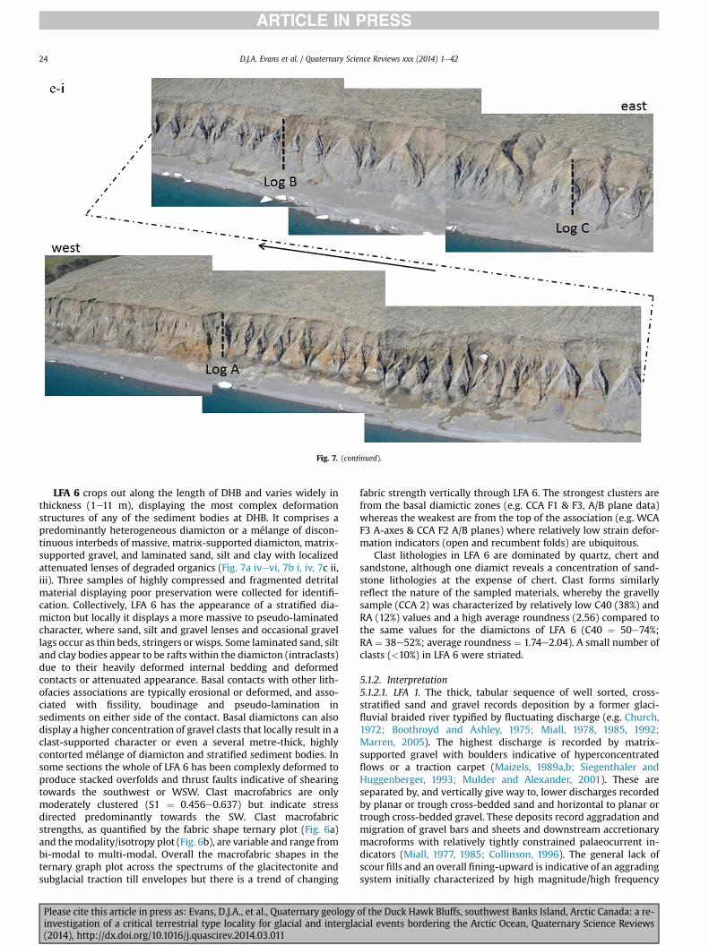
Fig 7 (continued)
DJA Evans et al Quaternary Science Reviews xxx (2014) 1e4224
LFA 6 crops out along the length of DHB and varies widely inthickness (1e11 m) displaying the most complex deformationstructures of any of the sediment bodies at DHB It comprises apredominantly heterogeneous diamicton or a meacutelange of discon-tinuous interbeds of massive matrix-supported diamicton matrix-supported gravel and laminated sand silt and clay with localizedattenuated lenses of degraded organics (Fig 7a ivevi 7b i iv 7c iiiii) Three samples of highly compressed and fragmented detritalmaterial displaying poor preservation were collected for identifi-cation Collectively LFA 6 has the appearance of a stratified dia-micton but locally it displays a more massive to pseudo-laminatedcharacter where sand silt and gravel lenses and occasional gravellags occur as thin beds stringers or wisps Some laminated sand siltand clay bodies appear to be rafts within the diamicton (intraclasts)due to their heavily deformed internal bedding and deformedcontacts or attenuated appearance Basal contacts with other lith-ofacies associations are typically erosional or deformed and asso-ciated with fissility boudinage and pseudo-lamination insediments on either side of the contact Basal diamictons can alsodisplay a higher concentration of gravel clasts that locally result in aclast-supported character or even a several metre-thick highlycontorted meacutelange of diamicton and stratified sediment bodies Insome sections the whole of LFA 6 has been complexly deformed toproduce stacked overfolds and thrust faults indicative of shearingtowards the southwest or WSW Clast macrofabrics are onlymoderately clustered (S1 frac14 0456e0637) but indicate stressdirected predominantly towards the SW Clast macrofabricstrengths as quantified by the fabric shape ternary plot (Fig 6a)and themodalityisotropy plot (Fig 6b) are variable and range frombi-modal to multi-modal Overall the macrofabric shapes in theternary graph plot across the spectrums of the glacitectonite andsubglacial traction till envelopes but there is a trend of changing
Please cite this article in press as Evans DJA et al Quaternary geologyinvestigation of a critical terrestrial type locality for glacial and intergla(2014) httpdxdoiorg101016jquascirev201403011
fabric strength vertically through LFA 6 The strongest clusters arefrom the basal diamictic zones (eg CCA F1 amp F3 AB plane data)whereas the weakest are from the top of the association (eg WCAF3 A-axes amp CCA F2 AB planes) where relatively low strain defor-mation indicators (open and recumbent folds) are ubiquitous
Clast lithologies in LFA 6 are dominated by quartz chert andsandstone although one diamict reveals a concentration of sand-stone lithologies at the expense of chert Clast forms similarlyreflect the nature of the sampled materials whereby the gravellysample (CCA 2) was characterized by relatively low C40 (38) andRA (12) values and a high average roundness (256) compared tothe same values for the diamictons of LFA 6 (C40 frac14 50e74RA frac14 38e52 average roundness frac14 174e204) A small number ofclasts (lt10) in LFA 6 were striated
512 Interpretation5121 LFA 1 The thick tabular sequence of well sorted cross-stratified sand and gravel records deposition by a former glaci-fluvial braided river typified by fluctuating discharge (eg Church1972 Boothroyd and Ashley 1975 Miall 1978 1985 1992Marren 2005) The highest discharge is recorded by matrix-supported gravel with boulders indicative of hyperconcentratedflows or a traction carpet (Maizels 1989ab Siegenthaler andHuggenberger 1993 Mulder and Alexander 2001) These areseparated by and vertically give way to lower discharges recordedby planar or trough cross-bedded sand and horizontal to planar ortrough cross-bedded gravel These deposits record aggradation andmigration of gravel bars and sheets and downstream accretionarymacroforms with relatively tightly constrained palaeocurrent in-dicators (Miall 1977 1985 Collinson 1996) The general lack ofscour fills and an overall fining-upward is indicative of an aggradingsystem initially characterized by high magnitudehigh frequency
of the Duck Hawk Bluffs southwest Banks Island Arctic Canada a re-cial events bordering the Arctic Ocean Quaternary Science Reviews
Fig 7 (continued)
DJA Evans et al Quaternary Science Reviews xxx (2014) 1e42 25
Please cite this article in press as Evans DJA et al Quaternary geology of the Duck Hawk Bluffs southwest Banks Island Arctic Canada a re-investigation of a critical terrestrial type locality for glacial and interglacial events bordering the Arctic Ocean Quaternary Science Reviews(2014) httpdxdoiorg101016jquascirev201403011
Fig 7 (continued)
DJA Evans et al Quaternary Science Reviews xxx (2014) 1e4226
Please cite this article in press as Evans DJA et al Quaternary geology of the Duck Hawk Bluffs southwest Banks Island Arctic Canada a re-investigation of a critical terrestrial type locality for glacial and interglacial events bordering the Arctic Ocean Quaternary Science Reviews(2014) httpdxdoiorg101016jquascirev201403011
DJA Evans et al Quaternary Science Reviews xxx (2014) 1e42 27
events that were gradually replaced by low magnitudehigh fre-quency events (Marren 2005) Partially to heavily-scoured rem-nants of laminated and massive fines represent deposition duringlow flow conditions in abandoned shallow channels The palae-ocurrent data from LFA 1 indicate that the outwash streams wereflowing westerly away from a glacier source located in AmundsenGulf This glacier likely eroded the abundant LFA 1 lithologies(chert quartzite and sandstone) from Mesoproterozoic and Neo-proterozoic bedrock widely distributed to the east and south(western Victoria Island Amundsen Gulf and the adjacent main-land Harrison et al 2013) These lithologies are consistent with theadvance of the NW Laurentide Ice Sheet through Amundsen Gulf(cf Dyke et al 2002 Batchelor et al 2012 MacLean et al 2013)
The crudely bedded organic detritus and degraded tree frag-ments (stumps) in LFA 1 are clearly reworked (cf Matthews et al1986 Fyles 1990 Vincent 1990) The finer grained detritus wasdeposited in concentrated pockets during waning flow stageswhereas horizons of logs and larger tree fragments were emplacedwith the coarser grained and poorly sorted sediments associatedwith hyperconcentrated flows or traction carpets during highdischarge These reworked organics also differ significantly fromthe type location of the Beaufort Fm a characteristic that promptedFyles (1990) to distinguish them as lsquotheMary Sachs Gravelrsquo Notablythe enclosing gravel and sand of LFA 1 is much coarser and exhibitsan entirely different fluvial architecture than the sandier BeaufortFm The composition and degraded nature of the LFA 1 organicssuggests that they were eroded by glaciers or their meltwater fromNeogene andor Paleogene sediments presumably to the southeastof Banks Island (eg Fyles 1990 Fyles et al 1994) The proximity ofa glacier is highlighted by the preservation of striae on individualclasts especially in the very coarse lower gravel The verticaldecrease in striae preservation and angularity (RA) and concomi-tant increase in roundness and upward-fining in LFA 1 is indicativeof an increasingly distal ice margin The co-variance plots (Fig 5)indicate a strong fluvial signature especially in the C40RA data butsubglacial characteristics are also evident particularly in the C40RWR data for the coarser grained and more matrix-supportedgravel as would be expected in ice-proximal settings
It is important to note that the widespread thrusting of LFA 1and underlying Kanguk Formation towards the southwest occurredpost-depositionally This glacitectonic thrusting was produced byLaurentide ice that advanced from the Kellett River valley (interiorBanks Island) during the emplacement of LFA 6 (see below) Theinjection of clastic dykes and fissure fills during this glacitectonicdisturbance was due to the overpressurizing of groundwater ingravel aquifers likely in taliks The branching limbs of many of thedykes are indicative of burst-out structures diagnostic of hydro-fracturing by vertically escaping groundwater pressurized byglacier overriding (cf Rijsdijk et al 1999 Le Heron and Etienne2005)
5122 LFA 2 At the top of LFA 1 rhythmites with lonestonesoverlie prominent clinoforms or foreset beds recording a changefrom subaerial glacifluvial to subaqueous deposition This wasinitially on a shallow delta front prograding foreset beds in asouthwesterly direction followed by suspension sedimentationwith dropstones presumably from floating ice in a marine orlacustrine basin The occurrence of matrix-supported gravelly scourfills with logs and woody detritus suggests pulses of cohesionlesssediment gravity flows into the basin Overlying the rhythmically-bedded sand prominent ice wedge pseudomorphs (up to 4 mdeep Fig 9aec cf Mackay and Burn 2002) are interspersed withthick (gt1m) sections of compressed in situ bryophytes (Figs 9d 7e)indicating the establishment of a tundra surface Four bryophytefamilies and 10 distinct species have been determined from LFA2
Please cite this article in press as Evans DJA et al Quaternary geologyinvestigation of a critical terrestrial type locality for glacial and intergla(2014) httpdxdoiorg101016jquascirev201403011
with the most abundant material from the Calliergonaceae andCampyliaceae (Table 1) These macrofossils are exceptionally wellpreserved including material with intact fragile alar cells typical ofthese two families (Fig 14cef) The data from these autochthonousdeposits indicate a wetland environment characterized as a richfen This ecosystem and habitats therein are consistent with speciesfound in the extant flora of Banks Island (Fig 14b) The autecologyfrom this range of species suggest hydric to mesic habitatsincluding standing pools wet meadows and microhabitats createdby ice wedges Despite the predominance of bryophytes in LFA 2these macrofossils had not been previously documented at DHB Incontrast a minimal proportion of the samples (lt5) consisted ofvascular plant material (including Cyperaceae seeds gramminoidleaves and woody twig fragments) Collectively the ice wedgepseudomorphs and vegetation within LFA 2 represent an isochro-nous terrestrial surface of interglacial rank
Following the formation of ice wedges the injection of intra-formational clastic dykes and fissure fills in LFA 2 relates to theoverpressurizing of groundwater in gravel aquifers or taliks due toglacier overriding The branching dyke limbs that emanate fromunderlying LFA 1 gravels and sands are indicative of the burst-outstructures that develop during hydrofracturing (cf Rijsdijk et al1999 Le Heron and Etienne 2005) A variant of the gravel andsand filled clastic dykes occurs within the sequence of glaci-tectonite and rhythmites near west Log D (Fig 11) Here thevertically-widening fracture is characterized by a mosaic ofpartially disaggregated blocks of the host materials in its widestzone where it contains gravels injected from underlying LFA 1Because these gravels only occur in the basal narrow neck theypresumably record the rapid reduction in flow competence duringhydrofracture filling
Deformation structures including overfolded or crumpledbedding and thrust faults associated with boudinage or highfissilitypseudo-lamination are representative of simple shear andwere also induced by glacitectonic disturbance (cf van derWateren 1995 McCarroll and Rijsdijk 2003) This predominantlyrecords a glacier advance from the northeast Subsidiary shear in-dicators record deformation from the south or southeast but theseoccur only at the top of LFA 2 and the base of LFA 3 suggestingearlier emplacement (see below) The development of zones ofboudinage shallow thrust faults overfolding or bed crumpling atdifferent levels within LFA 2 e especially at the contact separatingsediments of different grain size e represents deformation parti-tioning due to contrasting rheological properties Blind thrustswere also initiated in underlying LFA 1 increasingly towards thecentral and eastern cliffs where large-scale deformation is moreprevalent (Fig 7c d) A zone of intense deformation is recorded by alens of LFA 3 diamicton in fault contact with LFA 2 (east cliff Log AFig 7d i) This constitutes a type B glacitectonite (non-penetrativelydeformed pre-existing sediments sensu Benn and Evans 1996Evans et al 2006) developed during the emplacement of LFA 3(see below) A similar glacitectonite occurs at the junction of LFA 1and LFA 3 near west Log D (Fig 11) Bed attenuation by deformationis best developed in lower LFA 2 where the greater differences insediment grain size and hence rheology exist
5123 LFA 3 Within LFA 3 locally abundant stratified lensesindicate subaqueous deposition These stratified sediments weresubsequently thrust faulted folded and attenuated - most evidentin the upper and lower zones of LFA 3 This deformation was likelyresponsible for the intraclast boudinage and pseudo-lamination inthe surrounding diamicton (eg Hart and Roberts 1994 Robertsand Hart 2005 Oacute Cofaigh et al 2011) This process was alsoassociatedwith the attenuation of LFA 1 and 2 sediments within theheavily deformed base of LFA 3 some of which may have been
of the Duck Hawk Bluffs southwest Banks Island Arctic Canada a re-cial events bordering the Arctic Ocean Quaternary Science Reviews
Fig 8 Details of LFA 1 a) example of a concentration of logs with degraded rootballs in the stacked tabular units of cross-bedded sands and gravels and crudely stratified matrix-supported cobble to boulder gravels in the west cliff b) poorly-sorted and crudely horizontally bedded cobble to boulder gravel containing laminated clay intraclast (immediatelyabove compass) c) shallow locally graded foreset beds composed of openwork to sandy matrix-supported cobble to granule gravels in central cliff Log A d) planar bedded sandy
DJA Evans et al Quaternary Science Reviews xxx (2014) 1e4228
Please cite this article in press as Evans DJA et al Quaternary geology of the Duck Hawk Bluffs southwest Banks Island Arctic Canada a re-investigation of a critical terrestrial type locality for glacial and interglacial events bordering the Arctic Ocean Quaternary Science Reviews(2014) httpdxdoiorg101016jquascirev201403011
DJA Evans et al Quaternary Science Reviews xxx (2014) 1e42 29
cannibalized and rafted by the deformation process within a shearzone at the contact of LFA 3 with older sediments The shearingdirection from the south and southeast recorded in lower LFA 3also impacted upper LFA 2 whereas the more prominent shearingdirection throughout LFA 3 is from the northeast (also recorded inLFA 4) The local development of a heavily deformed zone at the topof LFA 3 was likely imparted during the shearing of overlying LFA 4sediments Although clast macrofabric strengths from the LFA 3diamicton are variable they possess shapes that compare withglacitectonites and subglacial traction tills and in some cases amodalityisotropy signature that reflects high lodgementcomponents
The similar orientation of the macrofabrics and shear indicatorsare considered diagnostic of a glacitectonite derived from stratifiedsediments (eg interbedded mass flow diamictons gravelly massflows and localized traction current sands and suspension de-posits) This evidence indicates that LFA 3 like all the other LFAsand the underlying Kanguk Fm bedrock has been displaced by aglacier advancing from the NNE or NE (ie Laurentide ice crossingthe interior of Banks Island) Minor south to north shearing in-dicates that LFA 3 and upper LFA 2were also disturbed by glacier iceflowing northwards (ie Laurentide ice advancing throughAmundsen Gulf) The appearance of granite and gabbro clastswithin the LFA 3 diamict records the arrival of far-travelled Lau-rentide ice from mainland Canada Clast form co-variance stronglyindicates a subglacial (abraded) source for LFA 3 with a minorfluvial component (Fig 5) including glacifluvial clasts locallycannibalized from LFA 1 by overriding ice
5124 LFA 4 LFA 4 has restricted outcrops is heavily deformedand contains organic detritus that is clearly allochthonous andhighly degraded Nonetheless a variety of indicators (fine-grainedhorizontally bedded cross-laminae rhythmites climbing ripplesand draped laminae) demonstrate that LFA 4 was deposited in asubaqueous environment with palaeocurrents from the south orsouthwest Traction currents were likely responsible for thedevelopment of the clast lag at the contact between lower LFA 4and underlying LFA 3 (west cliff Log A Fig 7b ii) LFA 4 coarsensupwards indicative of basin infilling andor an approaching sedi-ment source The narrow anabranched clastic dykes in the sandyclimbing ripples (LFA 4 west cliff Log A) record hydrofracturing bythe upward injection of overpressurized groundwater duringshearing The branching limbs of the dykes are similar to the burst-out structures reported by Rijsdijk et al (1999) but differ becausethey are composed solely of sand derived from the walls of the hostsediment rather than from an underlying gravel aquifer (cf LeHeron and Etienne 2005) Hence the pressurized water wasgenerated at the contact between the sand and underlying imper-meable brecciated clays The development of thin zones of brecci-ation boudinage sheath folding or thrust faulting at the upper andlower contacts of LFA 4 relates to the localized partitioning ofdeformation controlled by the location of claysilt beds Thejuxtaposition of this style of deformation with the larger scaleoverfolds and thrust faults developed in the extensive bodies ofsandy lithofacies is indicative of a Type B glacitectonite (sensu Bennand Evans 1996) This was constructed by the overriding of glacierice advancing from the north or northeast These shear directionsare compatible with those developed in the underlying LFAs
granule gravels with gravel lags (top and bottom of image) interrupted by an intervening unbedded granule to pebble gravel and massive cobble to pebble gravel A cluster of small treesequence of stacked tabular units of predominantly horizontally bedded sands and gravels ingravels containing clusters of wood detritus in the coarser gravel beds (central cliff Log A)wood fragments (central cliff Log A)
Please cite this article in press as Evans DJA et al Quaternary geologyinvestigation of a critical terrestrial type locality for glacial and intergla(2014) httpdxdoiorg101016jquascirev201403011
5125 LFA 5 The primary characteristics of LFA 5 are typical ofgravel sheet and occasional traction-carpet sedimentation in anice-proximal sandur (eg Boothroyd and Ashley 1975 Miall 19781985 1992 Maizels 1989ab Siegenthaler and Huggenberger1993 Mulder and Alexander 2001 Marren 2005) Glacier prox-imity is supported by the subglacial to fluvial signature of the clastforms (Fig 5) The coarsening-upward sequence including striatedclasts culminates in the arrival of a glacier that overrode the sitedepositing LFA 6 Post-depositional shearing within underlying LFA4 is recorded by attenuation and interdigitation at the contact withLFA 5 imparted during deposition of LFA 6 The contact betweenLFA 5 and 6 reflects the development of a shear zone where upperLFA 5 sediments have been cannibalized producing a meacutelange ofcrudely stratified diamictons with discontinuous interbeds ofmatrix-supported gravel laminated sand silt and clay (LFA 6 seebelow)
5126 LFA5a At Easternmost Cliff glacifluvial gravel (LFA 5a)unconformably overlies LFA 1 (Fig 7e) rendering uncertain itsrelationshipwith respect to LFA 5 in themain sections of DHB to thewest The fact that LFA 5a extends to the modern surface appearsundeformed and has palaeocurrents orientated to the NW requiresthat it is younger than LFA 5 Indeed we interpret LFA 5a asdeglacial outwash deposited from retreating Laurentide ice in theKellett River valley and Amundsen Gulf at the end of the lastglaciation (see Discussion)
5127 LFA 6 Based on its heterogeneity strongly orientated clastmacrofabrics and macroscale deformation structures LFA 6 con-stitutes a Type B glacitectonite (sensu Benn and Evans 1996)However zones of more highly strained Type A glacitectonite(sensu Benn and Evans 1996) at the basal contact with older LFAsare recorded by intraclastinterbed attenuation (pseudo-lamina-tion) strong boudinage or fissility and strengthened clast macro-fabrics The production of this meacutelange is attributed to two separateprocesses 1) primary sedimentation as interbedded and interdig-itated mass flow debris fluvial gravel and sand and subaqueoussuspension sediments and 2) cannibalization of underlying strat-ified sediments (LFAs 4 and 5) This produced a continuum of formsranging from low strain fold structures to attenuated rafts to tec-tonic lamination (eg Fig 7) The discontinuous lenses of degradedorganics (black stems and woody twigs gramminoid leaveswhitened rootlets) within LFA 6 are rafts and include seven speciesof bryophytes (Table 1) The material was highly compressed anddifficult to separate into distinct taxa Indeed one of the threesamples analysed was too degraded to recover any taxa Much ofthe material consisted of only fragmented leaves and only theminute taxa had stems with intact leaves The bryophytes thatcharacterize the LFA 6 samples represent hydric (Calliergon sppTomenthypnum nitens) to mesic (Ditrichum flexicaule Dicranum sp)habitats Three species collected from LFA 6 were also present inLFA 2 whereas four others were not found in LFA 2 but are com-mon in the modern flora The poor preservation quality suggeststhat the material has been redeposited from unknown sources andis clearly allochthonous
The predominant shearing direction within LFA 6 records an iceadvance from the interior of Banks Island (NE) This has resulted incomplex folding and thrusting and localized thickening of LFA 6
it of cross-bedded poorly-sorted to openwork cobble to boulder gravel crudely planar-fragments occur at the base of the cobble to boulder gravels at image centre e) middleDHB west cliff Log D f) sequence of fining-upward planar-bedded cobble to sandy fineg) planar cross-bedded sandy granule to pebble gravels with pebble to cobble lags and
of the Duck Hawk Bluffs southwest Banks Island Arctic Canada a re-cial events bordering the Arctic Ocean Quaternary Science Reviews
Fig 9 Details of LFA 2 from the west cliff a) narrow necked ice wedge pseudomorph with upturned marginal bedding in sand silt and clay rhythmites b) wide necked ice wedgepseudomorph c) ice wedge pseudomorph with overturned silt sand and clay rhythmites developed at the top of LFA 2 and sealed by overlying LFA 3 laminated diamicton d)horizontally bedded sand and silt containing well preserved moss macrofossils e) zone of disharmonically folded sandsilt laminae with well preserved moss peat located at thebase of LFA 2
DJA Evans et al Quaternary Science Reviews xxx (2014) 1e4230
Please cite this article in press as Evans DJA et al Quaternary geology of the Duck Hawk Bluffs southwest Banks Island Arctic Canada a re-investigation of a critical terrestrial type locality for glacial and interglacial events bordering the Arctic Ocean Quaternary Science Reviews(2014) httpdxdoiorg101016jquascirev201403011
Fig 10 Details of simple shear structures developed in fine sand and silt laminae at the centre of the thickest outcrop of LFA 2 in west cliff Log B a) overview of large scaleanastomosing shear faults with zones of smaller scale densely spaced anastomosing shears towards the base of the photograph b) details of large scale shear faults separatingzones of variably but predominantly densely spaced shears c) close details of shear zone comprising densely spaced anastomosing fractures d) details of ascending kink zonecross-cutting large scale anastomising shear faults Shearing direction is coming out of the cliff and towards the left in each image
DJA Evans et al Quaternary Science Reviews xxx (2014) 1e42 31
This shearing direction is recorded throughout underlying LFAs 1e4as well as the Kanguk Formation demonstrating deep-seated butpartitioned glacitectonic disturbance imparted during theemplacement of LFA 6 This strain signature was therefore over-printed on the northerlynortheasterly aligned shearing directionrecorded in LFA 3 and upper LFA 2 by the earlier northerly flowingice that deposited LFA 3 One anomalous clast macrofabric(northerly CCA F1) occurs in the basal meacutelange of LFA 6 Howeverthis sample is from an isolated outcrop (Fig 7c i) rendering itsapparent shearing direction equivocal
Please cite this article in press as Evans DJA et al Quaternary geologyinvestigation of a critical terrestrial type locality for glacial and intergla(2014) httpdxdoiorg101016jquascirev201403011
52 Sedimentology and stratigraphy (Mary Sachs Creek cliff)
The cliffs east of Mary Sachs Creek (Figs 2b 3) provides a cross-section through the seaward margin of the coast-parallel SachsMoraine (ldquosection Jrdquo Vincent et al 1983 Vaughan 2014) Weprovide a summary of two logs based on a reconnaissance survey ofthese sediments Log A is closest toMary Sachs Creekwhereas Log Boccursw1 km farther east (Figs 3 15a amp b) The sediments exposedin Log A appear to descend eastward and disappear below themodern beach and therefore are assumed to stratigraphically
of the Duck Hawk Bluffs southwest Banks Island Arctic Canada a re-cial events bordering the Arctic Ocean Quaternary Science Reviews
Fig 11 Details of LFA 2 near west Log D Lower box shows a 1e2 m thick basal zone comprising highly attenuated inter-digitated beds of gravelly to clay-rich diamictons and sandsiltclay rhythmites Upper box shows rhythmites containing diamictic intraclasts with sharp and angular boundaries also visible is the draping and deforming of the rhythmitebedding over and under the intraclasts respectively ldquoTailsrdquo extending from the diamictic intraclasts and thin but discontinuous diamictic beds are also visible in the upper box
DJA Evans et al Quaternary Science Reviews xxx (2014) 1e4232
underlie the sediments of Log B A sand and gravel- bench caps bothlogs at w15 m asl incised into the seaward margin of the SachsMoraine
521 DescriptionLog A contains a sequence of upward-fining highly contorted
cross-stratified sand and fine gravel to rhythmically bedded sandsilt clay with minor pebble gravel and sporadic clots of gravellydiamicton (Fig 15a) An ice wedge was initially developed in thelower cross-stratified sand and fine gravel before they were foldedand thrust faulted The deformed ice wedge pseudomorph is un-conformably overlain by a relatively undisturbed lens of laminatedsilty clay with dropstones interbedded with gravelly diamictonthat contains a bed (10 cm) of sandy black organics containingwood fragments (Fig 15a) This organic material occurs repeatedlyup-section as discontinuous stringers Log A is capped by 1e2 m ofpoorly exposed and heavily cryoturbated gravelly diamicton Thegeneral sense of displacement on shallow reverse faults over-turned bedding and boudinage structures is from the southeast
Log B (12 m) displays a coarsening-upward sequence of hori-zontally bedded sandy granule gravel with occasional silty sandlaminae (Fig 15b iii) that grades to poorly-sorted cobble to bouldergravel and bouldery matrix-supported gravel (Fig 15b ii) This iscapped by laminated to crudely stratified cobbly diamicton that issilt and clay-rich abruptly and conformably overlain by
Please cite this article in press as Evans DJA et al Quaternary geologyinvestigation of a critical terrestrial type locality for glacial and intergla(2014) httpdxdoiorg101016jquascirev201403011
interlaminated silt clay and pebbly silty sand (Fig 15b i) Althoughthe bedding on these units dips towards the NW individuallaminae do not thicken in that direction indicating post-depositional tilting The uppermost part of the log (underlyingthe 15 m bench) contains 2 m of clay-rich massive diamictoninterfingered with the underlying laminated sediments and cobblydiamicton
522 Interpretation
5221 Log A Broadly the sedimentology of log A including thedeformed ice wedge pseudomorph is similar to LFA 2 in DHB (egcentral cliff Log A Fig 7c iii) Prior to glacitectonic disturbance theoverlying organic bed (Fig 15a) was redeposited into a sequence ofsubaqueous siltclay rhythmites containing dropstones and gravellymass flows The highly attenuated shear margins bracketing theorganic bed in Log A demonstrate that it has been displaced as atectonic raft Previous research proposed that the organic beds e
similar to those described in Log A e be assigned to the LastInterglacial (locally called the Cape Collinson Vincent 1982 1983)Because these organic beds are clearly a raft they cannot constitutean iscochronous surface precluding chronostratigraphic signifi-cance (see Discussion) Shearing of the Log A sediments from thesoutheast documents an ice advance from Amundsen Gulf corre-sponding to the earliest of two primary shearing directions recor-ded at DHB (imparted during the emplacement of LFA 3) Therefore
of the Duck Hawk Bluffs southwest Banks Island Arctic Canada a re-cial events bordering the Arctic Ocean Quaternary Science Reviews
Fig 12 Details of LFA 4 in West Log A a) heavily deformed upper contact of LFA 4 comprising sandsiltclay rhythmites displaying well developed boudinage sheath folds andimmature tectonic laminae and an interdigitatedsheared boundary with underlying climbing ripple sands The contact with overlying LFA 6 is marked by an interdigitated zonecontaining rooted and de-rooted folds or rhythmite rafts in a sand gravel and diamicton meacutelange b) narrow anabranched clastic dykes ascending sub-vertically through climbingripple drift and resulting in offset bedding between blocks of host material c) abrupt contact between sheared sands and rhythmites of LFA 4 and overlying sand gravel anddiamicton meacutelange
Fig 13 Details of LFA 5 a) poorly sorted and matrix-supported pebble to cobble gravel b) tabular sequence of horizontally bedded to massive gravel and matrix-supported gravelcontaining a horizon of striated cobbles and boulders c) heavily deformed discontinuous bed of siltclay rhythmites between LFA 5 and LFA 6 in West Log D showing theamalgamation zone with the LFA 5 gravels immediately above the compass d) interdigitateddeformed contact between LFA 5 granule to pebble gravels and underlying LFA 4laminated silts and clays with organic detritus in West Log B
DJA Evans et al Quaternary Science Reviews xxx (2014) 1e42 33
Please cite this article in press as Evans DJA et al Quaternary geology of the Duck Hawk Bluffs southwest Banks Island Arctic Canada a re-investigation of a critical terrestrial type locality for glacial and interglacial events bordering the Arctic Ocean Quaternary Science Reviews(2014) httpdxdoiorg101016jquascirev201403011
Table 1List of bryophytes and vascular plants from LFAs 2 and 6
LFA2 WestCliff Log B
LFA6 CentralCliff Log A
Elevation (m) 185 m asl w45 m aslSample 4e12 1e3 taxa 10 7
Bryophyta (mosses)AmblystegiaceaeAmblystegium serpens (Hedw) Schimp x
CamyliaceaeCampylium polygamum (Schimp) CEO Jensen xCampylium stellatum (Hedw) CEO Jensen x xDrepanocladus aduncus (Hedw) Warnst xDrepanocladus sp xTomentypnum nitens (Hedw) Loeske x
CalliergonaceaeCalliergon giganteum (Schimp) Kindb xCalliergon richardsonii (Mitt) Kindb xthornthornthornthorn xCalliergon sp xWarnstorfia exannulatus (Schimp) Loeske xthornthornthornthorn x
BrachytheciaceaeBrachythecium turgidum (Hartm) Kindb x
MniaceaeCyrtomnium cf hymenophylloides(Hbener) TJ Kop
x
DicranaceaeDicranum sp x
DitrichaceaeDitrichum flexicaule (Schwaumlgr) Hampe x
Tracheophyta (vascular plants)CyperaceaeSeeds (triangular amp flattened) x x
Gramminoid leaf material x xWoody twig fragments x xRootlets x
Fig 14 The moss peat and associated microfossils of LFA 2 a) exposure through lower LFAsouthern Banks Island analogue of a rich tundra fen environment for the bryophyte assemblfrom LFA 2 showing the exceptional preservation of Calliergonaceae and Campyliaceae ma
DJA Evans et al Quaternary Science Reviews xxx (2014) 1e4234
Please cite this article in press as Evans DJA et al Quaternary geologyinvestigation of a critical terrestrial type locality for glacial and intergla(2014) httpdxdoiorg101016jquascirev201403011
these deformed deposits are interpreted as a Type B glacitectonite(sensu Benn and Evans 1996) possibly derived from LFA 2
5222 Log B The coarsening upward gravel in Log B recordshighly turbid to hyperconcentrated discharge in non-channelizedsheets This is interpreted as aggrading glacifluvial outwash froman approaching ice margin The capping sequence of crudelystratified diamicton and laminated sediments records a changefrom glacifluvial to subaqueous sedimentation prior to overridingby a glacier of unknown age that tilted the upper beds Thecoarsening-upward sequence apparent tectonism and cappingdiamict at Log B clearly distinguishes these deposits from those ofLFA 5a (west of Mary Sachs Creek easternmost cliff Fig 3)Furthermore although there is lithological similarity between LogB and LFA 5 throughout DHB the sense of shearing is dissimilar (LFA5 from the NE and Log B from the SE) The simplest explanation forthis difference in shear direction is that LFA 5 (DHB) was displacedby interior ice advancing down the Kellett River whereas Log B wasdisplaced by ice advancing along Amundsen Gulf (Fig 2b)
6 Discussion
61 Large scale glacitectonic structures and stratigraphicarchitecture
The glacitectonic structures identified within the lithofaciesassociations at DHB record two phases of deformation (early NeSand later NEeSW) This deformation together with the DHBstratigraphic architecture (Fig 16) helps to explain both thekinetostratigraphy (sensu Berthelsen1978) and the evolution of thelocal glacial geomorphology The large scale glacitectonic defor-mation is most clearly manifest in the thrust faulting and conjugate
2 at DHB west log B showing the sampling locations for in situ moss peat b) a modernages of LFA 2 c)ef) details of the typical moss peat and associated microfossil materialscrofossils including material with intact fragile alar cells
of the Duck Hawk Bluffs southwest Banks Island Arctic Canada a re-cial events bordering the Arctic Ocean Quaternary Science Reviews
Fig 15 The stratigraphy of Mary Sachs Creek cliff a) photographic compilation log A showing upward-fining highly contorted (i) cross-stratified sands and fine gravels torhythmically bedded sands silts clays and minor pebble gravels Also visible in (ii) is a lens of interbedded laminated silty clays with dropstones and gravelly diamictons containingsandy black coloured organic material with wood fragments An ice wedge pseudomorph is visible (iii) to the right of the exposure b) photographic compilation log B showing i)laminated to crudely stratified cobbly but siltclay-rich diamicton grading into interlaminated silts clays and pebbly silty sands ii) poorly-sorted cobble to boulder gravel andbouldery matrix-supported gravel iii) coarsening-upward sequence of horizontally bedded sandy granule gravels with occasional silty sand laminae iv amp v) pebble to cobble graveland matrix-supported gravel
DJA Evans et al Quaternary Science Reviews xxx (2014) 1e42 35
shear development in the Kanguk Fm bedrock and overlying LFA 1(east cliff Fig 7d ivevi) Here predominantly northeasterly dippingthrust slices have been stacked truncated and overlain by LFA 6during the second and strongest (NEeSW) deformation phase(Fig 16 note bedrock slice within the imbricated stacked sequenceof LFA 1) These structures demonstrate significant compressionand thickening of the stratigraphic sequence including w40 m ofvertical offset within the Kanguk Formation acrossw3 km (Fig 16)Prominent hydrofracture fills in LFAs 1 and 2 record elevatedporewater pressure during this thrusting Smaller scale shear zoneshave also developed in the finer grained interbeds within thrustslabs (Fig 7d vii) indicative of deformation partitioning by strataprone to ductile failure This zone of greatest displacement alsocoincides with the highest topography (Fig 16) Lower angle thrustfaults propagate in a southwesterly direction predominantlythrough LFA 1 but are also developed through LFA 2 in the footwallblock (east cliff Fig 16)
The thrust stacking of bedrock and LFAs 1e5 in east cliff (obliqueto Fig 16) represents the ice-proximal zone of a thrust-blockmorainecomposite ridge constructed by a glacier advancing fromthe northeast (ie the interior of Banks Island) This glacitectonicdeformation propagated southwestward to distal parts of theproglacial stress field as recorded bywell-developed shear zones inthe finer grained sediments of LFAs 2e5 In the more distal westcliff open folds (LFA 2 Fig 16) appear to be the product of a blindthrust within underlying LFA 1 This style of tectonism is typical oflsquopiggyback-style thrustingrsquo wherein steeply inclined thrust blocksat the advancing ice margin propagate new thrusts in the footwall(Fig 16 Park 1983 Mulugeta and Koyi 1987) The angle of thesefootwall thrusts becomes progressively shallower southwestward
Please cite this article in press as Evans DJA et al Quaternary geologyinvestigation of a critical terrestrial type locality for glacial and intergla(2014) httpdxdoiorg101016jquascirev201403011
(ice-distal) in LFA 1e5 where deformation partitioning developedin finer grained lithofacies (Fig 16)
The densely spaced ponds and depressions immediately to thenortheast of DHB (Figs 2b 3) constitute the depression fromwhich the thrust mass was excavated (eg Aber et al 1989Evans and England 1991 van der Wateren 1995) This inter-pretation is consistent with the strong northeast to southwestshear direction in the second phase glacitectonic structures andin LFA 6 clast macrofabrics This indicates that construction ofDHB occurred at the margin of a glacier advancing from thenortheast (ie from Kellett River valley) overtopping DHB anddepositing the LFA 6 glacitectonite The continued advance ofKellett ice coalesced with a glacier in Amundsen Gulf marked bythe interlobate Sachs Moraine containing ice-transported shellsas young as 24 cal ka BP (21020 70 yrs BP UCIAMS-89674)assigning this glaciation to the Late Wisconsin (Vaughan 2014)East of Mary Sachs Creek the deformation of Log B outwash(from the southeast Figs 15 16) likely records overriding by thesame Amundsen Gulf glacier (coeval with LFA 6 Late Wiscon-sinan) During ice retreat when Kellett River and Amundsen Gulfice decoupled DHB was exposed allowing the northwesterly-flowing proglacial outwash (LFA 5a) west of Mary Sachs Creekto extend to the shoreline marking postglacial marine limit atKellett Point (11 m asl Vaughan 2014 Fig 3) Collectively thisreconstruction supports a Late Wisconsinan age for the con-struction of DHB thrust block moraine although its stratigraphyincludes a range of ages A palaeogeographic reconstruction ofevents based upon our interpretation of the sedimentologystratigraphic architecture tectonism and geomorphology is pre-sented in Fig 17
of the Duck Hawk Bluffs southwest Banks Island Arctic Canada a re-cial events bordering the Arctic Ocean Quaternary Science Reviews
Fig 15 (continued)
DJA Evans et al Quaternary Science Reviews xxx (2014) 1e4236
62 Comparison and revision of previous DHB model
DHB was previously interpreted to record horizontally beddedNeogene to Quaternary sediments assigned to preglacial fluvialand multiple glacial and interglacial episodes (Vincent 1982 19831990 Vincent et al 1983 1984 Barendregt et al 1998) A com-posite palaeomagnetic record was also presented for this proposedstratigraphy placing most of this deposition before the BrunhesMatuyama boundary (Fig 1c) However prior to our work detailedstudies had not been undertaken on the sedimentology structuralgeology or stratigraphic architecture of DHB Rather the originalstratigraphy was restricted to a series of composite logs (our Fig 4reproduced from Vincent et al 1983) that notably omitted thepervasive deformation structures including the thrust bedrock ineast cliff (Fig 16)
Please cite this article in press as Evans DJA et al Quaternary geologyinvestigation of a critical terrestrial type locality for glacial and intergla(2014) httpdxdoiorg101016jquascirev201403011
Our reinterpretation dismisses several key elements of theoriginal DHB model outlined below (oldest to youngest) We havedetermined that the lowermost unit (LFA 1) is not preglacial (Fyles1990) but rather is composed of glacial outwash providing theearliest terrestrial evidence for glaciation in the area and containingallochthonous organics (including tree stumps) of unknown prov-enance Because LFA 1 is a glacifluvial braidplain (Fig 17a) it is notpart of the Beaufort Fm (Fyles 1990) even though it containsreworked macrofossils presumably derived from it (eg Craig andFyles 1960 Hills et al 1974 Vincent et al 1983)
Our analysis of LFA 2 indicates that it is also not preglacial norcan it be the Worth Point Fm as previously proposed (cf Vincent1982 1983 1990 Vincent et al 1983 Matthews et al 1986)Indeed the type locality of the Worth Point Fm has been invali-dated because it is now recognized to be an ice-transported and
of the Duck Hawk Bluffs southwest Banks Island Arctic Canada a re-cial events bordering the Arctic Ocean Quaternary Science Reviews
LFA4
Fig16
Stratigrap
hiccross-profi
lerun
ning
westto
easto
fDuc
kHaw
kBluffs
basedup
oninterpolations
betw
eenthemainsectionlogs
andsh
owingthesixLFAstheKan
gukFo
rmationbe
droc
kex
posu
resmajor
structural
features
and
thepo
sition
sof
icewed
geps
eudo
morph
san
dsign
ificant
clasticdy
kesAtthe
easternen
dof
thecross-profi
lethe
sedimen
tsat
theco
reof
MarySa
chsCree
kcliff
logAaretentativelyclassified
asLFA2
althou
ghthesematerialsarelik
ely
notin
situN
otethat
thecross-profi
ledo
esno
tex
tend
asfarea
stas
MarySa
chsCree
kcliff
logB
DJA Evans et al Quaternary Science Reviews xxx (2014) 1e42 37
Please cite this article in press as Evans DJA et al Quaternary geologyinvestigation of a critical terrestrial type locality for glacial and intergla(2014) httpdxdoiorg101016jquascirev201403011
glacitectonized raft (Vaughan et al 2014) In contrast our LFA 2 ischaracterized by an isochronous tundra surface with ice wedgesand intervening shallow ponds andwetmeadows The peat at LFA 2is dominated by bryophytes (gt95 by volume) and yet none ofthese macrofossils had been previously documented The diversein situ bryophyte species record a flora similar to that on BanksIsland today suggesting that LFA 2 warrants an interglacial rankThis conclusion is supported by the limited vascular plant record(five taxa no species indicated Vincent 1990) that also suggest awet meadow environment The absolute age of LFA 2 remains un-known but is apparently older than the BrunhesMatayamaboundary (gt780 ka Fig 18 cf Vincent et al 1984 Barendregt andVincent 1990 Barendregt et al 1998 see below)
LFA 3 in both our model and that of Vincent et al (1983) pro-vides the first direct evidence of ice reaching DHB In the previousmodel this was interpreted as Bernard Till (Banks Glaciation) thatwas bracketed by glacioisostatically induced marine transgressions(pre- and post-Banks seas Vincent 1982 1983) Within basal LFA 3we recognized highly deformed stratified sediment that wasdeposited in a subaqueous environment (deep water Fig 17c) priorto the arrival of overriding ice from the south (recorded by graniteand gabbro erratics Figs 17c 18) We regard LFA 3 to be equivalentto the Banks Glaciation (Vincent 1982 1983 Vincent et al 1983)including its pre- and post-Banks seas represented by the stratifiedsediments that bracket the central diamicton The LFA 3 sedimentsare also reported to be magnetically reversed thereby predatingthe BrunheseMatayama boundary (gt780 ka Fig 18 Vincent et al1984 Barendregt and Vincent 1990 Barendregt et al 1998)
Following the Banks Glaciation (our LFA 3 at DHB) Vincent(1982 1983) and Vincent et al (1983) recognized two in-terglacials (Morgan Bluffs and Cape Collinson) separated by anintervening marine episode This marine episode correspondedwith the glacioisostatic loading of a Laurentide ice margin confinedto the eastern half of Banks Island (Thomsen Glaciation) HoweverLFA 4 contains coarsening-upward subaqueous sedimentation fromthe south or southwest reflecting continued marine regressionfollowing LFA 3 (Fig 17c d) The coarsening-upward sequence ofLFA 4 is supplanted by coarse gravel outwash (LFA 5) supplied by aglacier readvancing from the northeast (Kellett River valley iceFig 17e) Glacier overriding is recorded by LFA 6 glacitectonite thatcaps the DHB thrust-block moraine composed of the entireassemblage of underlying LFAs (Fig 16)
Notably we have not observed any sediments characteristic oftwo interglacial deposits above LFA 3 hence dismiss the presence ofthe Morgan Bluffs and Cape Collinson interglacials at DHB Causseand Vincent (1989) report a U-series date of gt200 ka (UQT-229)from above our LFA 3 but this is almost certainly reworked andlacks chronostratigraphic significance Nor have we observedintervening marine sediments attributable to the Thomsen Glaci-ation (eg lsquoBig Searsquo Vincent 1982 1983 Vincent et al 1983)Rather following the deposition of the subaqueous sediments ofupper LFAs 3 and 4 (post-Banks Glaciation) LFAs 5 and 6 record asingle ice advance reaching DHB from the Kellett River valley(Banks Island interior) that was not reported by Vincent et al(1983) It was instead assumed that after the Banks GlaciationDHB lay distal to any later ice advances The nearest subsequentLaurentide margin to DHB recognized by Vincent et al (1983) wasassigned to the Sachs Moraine (immediately east of DHB) that waspresumed to be of EarlyWisconsin age (Fig 2b) However the SachsMoraine is nowdated to24 cal ka BP (LateWisconsinan Vaughan2014) andwas formed by the coalescence of Amundsen Gulf ice andthe Kellett River ice that deformed DHB (Fig 17) On the east side ofMary Sachs Creek the deposition of the Sachs Moraine coincideswith the deformation (from the southeast) of the underlying Log Boutwash gravel (Figs 3 15b)
of the Duck Hawk Bluffs southwest Banks Island Arctic Canada a re-cial events bordering the Arctic Ocean Quaternary Science Reviews
Fig 17 The palaeogeography of southwest Banks Island based upon interpretations of the principal lithofacies associations and structural architecture recognized at Duck HawkBluffs and the geomorphology of the surrounding terrain See text for detailed explanations
DJA Evans et al Quaternary Science Reviews xxx (2014) 1e4238
Although interglacial deposits were previously reported fromthe cliffs east of Mary Sachs Creek (ie Cape Collinson InterglacialVincent et al 1983) we found no similar evidence Rather the onlydeposit that we observed that may have been construed as inter-glacial sediments occurs in our Log A (Figs 3 15a) Here a darkdiscontinuous band of allochthonous organics (Fig15a) sits severedwithin a heavily tectonized melange (type B glacitectonite) and istherefore clearly a raft Although the absolute ages of the deformedunits east of Mary Sachs Creek (Logs A amp B) remain uncertain theyare apparently normally magnetized (Vincent et al 1984Barendregt and Vincent 1990) Blake (1987) also reports non-finite radiocarbon dates (gt36000 amp 49000 BP GSC-3560 amp 3560-2) obtained on ldquocompressed and deformed black woody peatrdquopurportedly from Cape Collinson beds (Vincent et al 1983 p 1708)Additionally Causse and Vincent (1989) report a U-series date onshells of 924 ka (UQT-143) from beds similar to the Log B gravelAgain all of these dated units have been displaced from unknownlocations limiting their utility for palaeoenvironmental recon-struction The last glacially influenced sedimentation at DHB isrecorded by northwesterly directed outwash (easternmost cliff LFA5a Figs 3 16 17g) We infer that this outwash fed the gravel beachmarking marine limit (11 m asl) in the lower Kellett River duringLate Wisconsinan retreat from the Sachs Moraine
63 Regional context
The stratigraphy at Duck Hawk Bluffs records three glacialevents The earliest of these is recorded by the aggradation of a
Please cite this article in press as Evans DJA et al Quaternary geologyinvestigation of a critical terrestrial type locality for glacial and intergla(2014) httpdxdoiorg101016jquascirev201403011
glacifluvial braidplain (LFA 1) that contains allochthonous pre-glacial material of diverse age However within LFA 1 there is noevidence that the ice reached DHB although it must have beennearby (southeast in Amundsen Gulf) The age of this glaciationremains unknown but the palaeomagnetic polarity of LFA 1 in-dicates that it is gt780 ka BP (Barendregt and Vincent 1990)Although Barendregt et al (1998) assigned part of the Worth PointFm to the normally polarized Olduvai sub-zone (MIS 64e74) itshould be noted that the Worth Point section is located 30 kmnorthwest of DHB There a stratigraphic revision has demonstratedthat this ldquotype sectionrdquo of the Worth Point Fm is in fact a glaci-tectonized raft (Vaughan et al 2014) This observation invalidatesthe previous correlation from Worth Point to purportedly coevalbeds at DHB (our LFA 2) Furthermore the diverse plant assem-blages in the Worth Point raft include preglacial tree stumps andSphagnum spp that do not occur on Banks Island today and are notfound in the wet meadow assemblages (rich fen) of LFA 2 that weinterpret to be of interglacial rank Therefore the sediments at DHB(LFAs 1 amp 2) do not support an age assignment of MIS 64e74(Olduvai subzone) proposed by Barendregt et al (1998) Currentlythe available palaeomagnetic record at DHB simply separates theentire section into a lower lsquoreversedrsquo unit and an upper lsquonormalrsquoone We place this boundary within our LFA 4 (Fig 18)
The overriding of DHB by glaciers is recorded in LFAs 3 amp 6These two glacial deposits may correspond to parts of the record ofstacked till sheets reported from the offshore seismic stratigraphy(Batchelor et al 2012) LFA 3 glaciationmay have contributed to theonset of mid-Pleistocene ice-rafted debris (IRD Ca-rich) attributed
of the Duck Hawk Bluffs southwest Banks Island Arctic Canada a re-cial events bordering the Arctic Ocean Quaternary Science Reviews
B-M
B-M
gt19
Fig
18A
revisedlitho
stratigrap
hyforDuc
kHaw
kBluffsPrev
ious
lyrepo
rted
ageco
nstraintsarealso
depicted
toge
ther
withatentativeallocation
ofMIS
stag
es(positione
dalon
gsideEa
stCliff
LogA
forclarity)
basedup
onthe
palaeo
mag
neticreco
rd
DJA Evans et al Quaternary Science Reviews xxx (2014) 1e42 39
Please cite this article in press as Evans DJA et al Quaternary geology of the Duck Hawk Bluffs southwest Banks Island Arctic Canada a re-investigation of a critical terrestrial type locality for glacial and interglacial events bordering the Arctic Ocean Quaternary Science Reviews(2014) httpdxdoiorg101016jquascirev201403011
DJA Evans et al Quaternary Science Reviews xxx (2014) 1e4240
to the Canadian Arctic Archipelago (CAA) and recorded in sedimentcores from the Arctic Ocean basin (Polyak et al 2009 2013OrsquoRegan et al 2010 Stein et al 2010) However Stein et al(2010) place the onset of Ca-rich ice-rafted debris within MIS 16(w659 ka BP Lisiecki and Raymo 2005) with subsequent peaks atMIS 12 10 and 8 all of which postdate the gt780 ka BP palae-omagnetic age proposed for LFA 3 (above) Polyak et al (2013) placethe onset of Ca-rich ice-rafted debris in the central Arctic Oceancloser to MIS 19 (790 ka BP) which is broadly compatible with theDHB palaeomagnetic record LFA 6 records the last glaciation ofDHB and we assign this to the Late Wisconsinan when Banks Is-land ice (Kellett River) coalesced with the Amundsen Gulf IceStream (Stokes et al 2006 MacLean et al 2013) During this in-terval the northwest Laurentide Ice Sheet likely reached the edgeof the polar continental shelf (Stokes et al 2005 2006 Englandet al 2009 Batchelor et al 2012 Lakeman and England 2013MacLean et al 2013)
7 Conclusions
New sedimentological and stratigraphic analyses of DHB funda-mentally revise the previous reconstruction of the Neogene andQuaternary history of Banks Island DHB and two other widely citedsections on Banks Island have been reported as important unde-formed terrestrial archives of glacial and interglacial sedimentationat the northwest limit of the Laurentide Ice Sheet that all have beenrecently revised (Vaughan et al 2014 Lakeman and England inpress) The recognition of pervasive large-scale deformation ofDHB necessitates a fundamental re-assessment of its previouslydescribed layer-cake stratigraphy We document that the oldestsediments (LFA 1) at DHB are not preglacial fluvial deposits (Beau-fort Fm) but rather record proglacial outwash from ice in AmundsenGulf that did not reach the site This was followed by the estab-lishment of an isochronous tundra surface of interglacial rank (LFA2) characterized by ice wedge polygons within a wet meadow thatsupported a bryophyte community similar to modern Subse-quently glacial sedimentation resumed initially in an ice-proximalsubaqueous environment followed by ice arrival and glacitectonicdeformation (LFA 3) The overlying deposits at DHB indicate post-glacial marine sedimentation (LFA 4) followed by the aggradationof glacifluvial sand and gravel (LFA 5) from an advancing ice marginthat culminated with the emplacement of a glacitectonite (LFA 6)during the Late Wisconsin This ice advance constructed a previ-ously undescribed thrust-block moraine (60 m high 8 km long) thatexhibits pervasive deformation and includes a substantial raft ofCretaceous Kanguk Fm bedrock (Fig 16) Furthermore the produc-tion of the glacitectonite (LFA 6) cannibalized LFAs 1e5 which atsome sites were previously thought to be in situ interglacial de-posits Finally outwash (LFA 5a) incised the DHB thrust block duringdeglaciation of the site when ice in the Kellett River and AmundsenGulf separated and proglacial meltwater drained northwestward tomarine limit (11 m asl) Refinements to the evolution and chronol-ogy of DHB and other sections around Banks Island will furthercontribute to the understanding of high latitude environmentalchange especially the complementary marine archives of theadjacent polar continental shelf and Arctic Ocean
Acknowledgements
Funding for this research was provided by the Natural Sciencesand Engineering Research Council of Canada (NSERC) NorthernResearch Chair Program and a complementary NSERC DiscoveryGrant (A6680) (both to JH England) Coulthard Lakeman andVaughan were supported by CBAR grants Canadian CircumpolarInstitute University of Alberta Coulthard and Lakeman were also
Please cite this article in press as Evans DJA et al Quaternary geologyinvestigation of a critical terrestrial type locality for glacial and intergla(2014) httpdxdoiorg101016jquascirev201403011
supported by Northern Scientific Training Program grantsAboriginal Affairs and Northern Development Canada The PolarContinental Shelf Program Natural Resources Canada(_501100000159) supplied additional funding and aircraft supportField and logistical assistance from Issac Elanik Vernon AmosTrevor Lucas and Roger Kuptana of Sachs Harbour is gratefullyacknowledged
References
Aber JS Croot DG Fenton MM 1989 Glaciotectonic Landforms and StructuresKluwer Dordrecht
Barendregt RW Vincent J-S 1990 Late Cenozoic paleomagnetic record of DuckHawk Bluffs Banks Island Canadian Arctic Archipelago Can J Earth Sci 27124e130
Barendregt RW Duk-Rodkin A 2011 Chronology and extent of Late Cenozoic icesheets in North America a magnetostratigraphical assessment In Ehlers JGibbard PL Hughes PD (Eds) Quaternary Glaciations e Extent and Chro-nolgy a Closer Look Elsevier Amsterdam pp 419e426
Barendregt RW Vincent J-S Irving E Baker J 1998 Magnetostratigraphy ofQuaternary and late Tertiary sediments on Banks Island Canadian Arctic Ar-chipelago Can J Earth Sci 35 147e161
Batchelor CL Dowdeswell JA Pietras JT 2012 Variable history of Quaternaryice-sheet advance across the Beaufort Sea margin Arctic Ocean Geology httpdxdoiorg101130G336691
Batchelor CL Dowdeswell JA Pietras JT 2013 Seismic stratigraphy sedimen-tary architecture and palaeo-glaciology of the Mackenzie Trough evidence fortwo Quaternary ice advances and limited fan development on the westernCanadian Beaufort Sea margin Quat Sci Rev 65 73e87
Benn DI 1994 Fabric shape and the interpretation of sedimentary fabric dataJ Sediment Res 64 910e915
Benn DI 1995 Fabric signature of till deformation Breiethamerkurjoumlkull IcelandSedimentology 42 735e747
Benn DI 2004 Clast morphology In Evans DJA Benn DI (Eds) A PracticalGuide to the Study of Glacial Sediments Arnold London pp 77e92
Benn DI Ballantyne CK 1994 Reconstructing the transport history of glaciogenicsediments a new approach based on the co-variance of clast form indicesSediment Geol 91 215e227
Benn DI Evans DJA 1996 The interpretation and classification of subglaciallydeformed materials Quat Sci Rev 15 23e52
Benn DI Evans DJA Phillips ER Hiemstra JF Walden J Hoey TB 2004 Theresearch project d a case study of Quaternary glacial sediments InEvans DJA Benn DI (Eds) A Practical Guide to the Study of Glacial Sedi-ments Arnold London pp 209e234
Berthelsen A 1978 The methodology of kineto-stratigraphy as applied to glacialgeology Bull Geol Soc Den 27 25e38
Blake Jr W 1987 Geological Survey of Canada Radiocarbon Dates XXVI InGeological Survey of Canada Paper 86-7 60 pp
Boothroyd JC Ashley GM 1975 Processes bar morphology and sedimentarystructures on braided outwash fans northeastern Gulf of Alaska InJopling AV McDonald BC (Eds) Glaciofluvial and Glaciolacustrine Sedi-mentation Society of Economic Paleontologists and Mineralogists SpecialPublication No 23
Causse C Vincent J-S 1989 TheU disequilibrium dating of Middle and LatePleistocene wood and shells from Banks and Victoria islands Arctic CanadaCan J Earth Sci 26 2718e2723
Church MA 1972 Baffin Island sandurs a study of Arctic fluvial processes GeolSurv Can Bull 216 208
Clark DL Vincent J-S Jones GA Morris WA 1984 Corrrelation of marine andcontinental glacial and interglacial events Arctic Ocean and Banks Island Na-ture 311 147e149
Collinson JD 1996 Alluvial sediments In Reading HG (Ed) Sedimentary Envi-ronments and Facies third ed Blackwell Oxford pp 37e82
Craig BG Fyles JG 1960 Pleistocene Geology of Arctic Canada In GeologicalSurvey of Canada Paper 60-10 21 pp
Crosby MR Magill RE Allen B He S 1999 A Checklist of the Mosses MissouriBotanical Garden St Louis 320 pp
Duk-Rodkin A Barendregt RW 2011 Stratigraphical records of glacialsin-terglacials in northwest Canada In Ehlers J Gibbard PL Hughes PD (Eds)Quaternary Glaciations e Extent and Chronology a Closer Look ElsevierAmsterdam pp 661e698
Dyke AS Andrews JT Clark PU England JH Miller GH Shaw J Veillette JJ2002 The Laurentide and Innuitian ice sheets during the Last Glacial MaximumQuat Sci Rev 21 9e31
England JH Furze MFA Doupeacute JP 2009 Revision of the NW Laurentide IceSheet implications for the paleoclimate the northeast extremity of Beringiaand Arctic Ocean sedimentation Quat Sci Rev 28 1573e1596
Evans DJA 2010 Controlled moraine development and debris transport pathwaysin polythermal plateau icefields examples from Tungnafellsjoumlkull IcelandEarth Surf Process Landf 35 1430e1444
of the Duck Hawk Bluffs southwest Banks Island Arctic Canada a re-cial events bordering the Arctic Ocean Quaternary Science Reviews
DJA Evans et al Quaternary Science Reviews xxx (2014) 1e42 41
Evans DJA Benn DI 2004 Facies description and the logging of sedimentaryexposures In Evans DJA Benn DI (Eds) A Practical Guide to the Study ofGlacial Sediments Arnold London pp 11e51
Evans DJA England J 1991 Canadian landform examples 19 high arctic thrustblock moraines Can Geogr 35 93e97
Evans DJA Rea BR Benn DI 1998 Subglacial deformation and bedrockplucking in areas of hard bedrock Glacial Geology and Geomorphology rp041998 httpgggqubacukgggpapersfull1998rp041998rp04html
Evans DJA Hiemstra JF 2005 Till deposition by glacier submarginal incre-mental thickening Earth Surf Process Landf 30 1633e1662
Evans DJA Hiemstra JF Oacute Cofaigh C 2007 An assessment of clast macrofabricsin glaciogenic sediments based on AB plane data Geogr Ann A89 103e120
Evans DJA Phillips ER Hiemstra JF Auton CA 2006 Subglacial till formationsedimentary characteristics and classification Earth Sci Rev 78 115e176
Evans DJA Shulmeister J Hyatt OM 2010 Sedimentology of latero-frontalmoraines and fans on the west coast of South Island New Zealand Quat SciRev 29 3790e3811
Eyles N Eyles CH Miall AD 1983 Lithofacies types and vertical profile modelsan alternative approach to the description and environmental interpretation ofglacial diamicts and diamictite sequences Sedimentology 30 393e410
Fyles JG 1990 Beaufort Formation (late Tertiary) as seen from Prince Patrick Is-land Arctic Canada Arctic 43 393e403
Fyles JG Hills LV Matthews Jr JV Barendregt R Baker J Irving E Jette H1994 Ballast Brook and Beaufort Formations (Late Tertiary) on northern BanksIsland Arctic Canada Quat Int 2223 141e171
Harrison JC Mayr U McNeil DH Sweet AR McIntyre DJ Eberle JJHarington CR Chalmers JA Dam G Nohr-Hansen H 1999 Correlation ofCenozoic sequences of the Canadian Arctic region and Greenland implicationsfor the tectonic history of northern North America Bull Can Pet Geol 47 223e254
Harrison JC Ford A Miall AD Rainbird RH Hulbert LJ Chritie RLCampbell FHA 2013 Geology Tectonic Assemblage Map of Aulavik BanksIsland and Northwestern Victoria Island Northwest Territories GeologicalSurvey of Canada Canadian Geoscience Map 35 (preliminary) scale 1500 000httpdxdoiorg104095292833
Hart JK Roberts DH 1994 Criteria to distinguish between subglacial glaciotec-tonic and glaciomarine sedimentation I Deformation styles and sedimen-tology Sediment Geol 91 191e213
Hedenaumls L 1993 A generic revision of the Warnstorfia Calliergon group J Bryol 17447e479
Hedenaumls L 2006 Additional insights into the phylogeny of Calliergon LoeskypnumStraminergon and Warnstorfia (Bryophyta Calliergonaceae) J Hattori Bot Lab100 125e134
Hicock SR Goff JR Lian OB Little EC 1996 On the interpretation of subglacialtill fabric J Sediment Res 66 928e934
Hiemstra JF Evans DJA Oacute Cofaigh C 2007 The role of glaciotectonic rafting andcommunition in the production of subglacial tills examples from SW Irelandand Antarctica Boreas 36 386e399
Hills LV 1975 Late Tertiary floras Arctic Canada an interpretation In Proceedingsof Circumpolar Conference on Northern Ecology National Research Council ofCanada pp I(65)eI(71)
Hills LV Klovan JE Sweet AR 1974 Juglans eocineria n Beaufort Formation(Tertiary) southwestern Banks Island Arctic Canada Can J Bot 52 65e90
Janssens JAP 1983 Quaternary fossil bryophytes in North America new recordsLindbergia 9 137e151
Kuc M 1974 Calliergon aftonianum Steere in Late Tertiary and Pleistocene Depositsof Canada In Geological Survey of Canada Paper 74e24
Kuc M Hills LV 1971 Fossil mosses Beaufort Formation (Tertiary) NorthwesternBanks Island Western Canada Arctic Can J Bot 49 1089e1094
Lakeman TR England JH 2012 Paleoglaciological insights from the age andmorphology of the Jesse moraine belt western Canadian Arctic Quat Sci Rev47 82e100
Lakeman TR England JH 2013 Late Wisconsinan glaciation and postglacialrelative sea-level change on western Banks Island Canadian Arctic ArchipelagoQuat Res 80 99e112
Lakeman TR England JH 2014 Facies and stratigraphic analyses of glacial andinterglacial sediments at Morgan Bluffs Banks Island Canadian Arctic Archi-pelago Boreas httpdxdoiorg101111bor12069 (in press)
Lawton E 1971 Moss Flora of the Pacific Northwest The Hattori Botanical Labo-ratory Ninchen Miyazaki Japan
Le Heron DP Etienne JL 2005 A complex subglacial clastic dyke swarm Sol-heimajoumlkull southern Iceland Sediment Geol 181 25e37
Li G Piper DJW Campbell DC 2011 The Quaternary Lancaster Sound trough-mouth fan NW Baffin Bay J Quat Sci 26 511e522
Lisiecki LE Raymo ME 2005 A Pliocene-Pleistocene stack of 57 globallydistributed benthic d18O records Paleoceanography 20 PA1003 httpdxdoiorg1010292004PA001071
Lukas S Benn DI Boston CM Brook M Coray S Evans DJA Graf A Kellerer-Pirklbauer A Kirkbride MP Krabbendam M Lovell H Machiedo MMills SC Nye K Reinardy BTI Ross FH Signer M 2013 Clast shapeanalysis and clast transport paths in glacial environments a critical review ofmethods and the role of lithology Earth-Sci Rev 121 96e116
Lukas S Coray S Graf A Schluumlchter C 2014 The influence of clast lithology andfluvial reworking on the reliability of clast shape measurements in glacial en-vironments e a case study from a temperate Alpine glacier In Bridgland DR
Please cite this article in press as Evans DJA et al Quaternary geologyinvestigation of a critical terrestrial type locality for glacial and intergla(2014) httpdxdoiorg101016jquascirev201403011
(Ed) Clast Lithological Analysis Technical Guide Quaternary Research Asso-ciation London (in press)
Mackay JR Burn CR 2002 The first 20 years (1978e1979 to 1998e1999) of icewedge growth at the Illisarvik experimental drained lake site western Arcticcoast Canada Can J Earth Sci 39 95e111
MacLean B Blasco S Bennett R Lakeman T Hughes-Clarke J Kuus PPatton E 2013 Marine evidence for a Glacial ice stream in Amundsen GulfCanadian Arctic Archipelago In Canadian Quaternary Association (CANQUA)Meeting August 18e22 2013 Edmonton AB Canada
Maizels JK 1989a Sedimentology palaeoflow dynamics and flood history ofjokulhlaup deposits palaeohydrology of Holocene sediment sequences insouthern Iceland sandur deposits J Sediment Petrol 59 204e223
Maizels JK 1989b Sedimentology and palaeohydrology of Holocene flood depositsin front of a jokulhlaup glacier south Iceland In Bevan K Carling PJ (Eds)Floods the Geomorphological Hydrological and Sedimentological Conse-quences Wiley New York pp 239e251
Marren PM 2005 Magnitude and frequency in proglacial rivers a geomorpho-logical and sedimentological perspective Earth-Sci Rev 70 203e251
Matthews JV 1987 Plant macrofossils from the Neogene Beaufort Formation onBanks and Meighen islands District of Franklin In Current Research Part AGeological Survey of Canada Paper 87-1A pp 73e87
Matthews Jr JV Ovenden LE 1990 Late Tertiary plant macrofossils from local-ities in ArcticSubarctic North America a review of the data Arctic 43 364e392
Matthews JV Mott RJ Vincent J-S 1986 Preglacial and interglacial environ-ments of Banks Island pollen and macrofossils from Duck Hawk Bluffs andrelated sites Geogr Phys Quat XL 279e298
McCarroll D Rijsdijk KF 2003 Deformation styles as a key for interpreting glacialdepositional environments J Quat Sci 18 473e489
Miall AD 1977 A review of the braided river depositional environment Earth-SciRev 13 1e62
Miall AD 1978 Lithofacies types and vertical profile models in braided river de-posits a summary In Miall AD (Ed) Fluvial Sedimentology Canadian Societyof Petroleum Geologists Memoir 5 pp 597e604
Miall AD 1985 Architectural-element analysis a new method of facies analysisapplied to fluvial deposits Earth Sci Rev 22 261e308
Miall AD 1992 Alluvial deposits In Walker RG James NP (Eds) Facies ModelsResponse to Sea-level Change Geological Association of Canada Torontopp 119e142
Mulder T Alexander J 2001 The physical character of subaqueous sedimentarydensity flows and their deposits Sedimentology 48 269e299
Mulugeta G Koyi H 1987 Three-dimensional geometry and kinematics ofexperimental piggyback thrusting Geology 15 1052e1056
Nyholm E 1956e1965 Illustrated Moss Flora of Fennoscandia II Musci Fasc 1-6Lund pp 1e788
Oacute Cofaigh C Evans DJA Hiemstra JF 2011 Formation of a stratified subglacial lsquotillrsquoassemblage by ice-marginal thrusting and glacier overriding Boreas 40 1e14
OrsquoRegan M St John K Moran K Backman J King J Haley BA Jakobsson MFrank M Roumlhl U 2010 Plio-Pleistocene trends in ice rafted debris on theLomonosov Ridge Quat Int 219 168e176
OrsquoRegan M Williams CJ Frey KE Jakobsson M 2011 A synthesis of the long-term paleoclimatic evolution of the Arctic Oceanography 24 66e80
Park RG 1983 Foundations of Structural Geology Blackie LondonPolyak L Bischof J Ortiz JD Darby DA Channell JET Xuan C Kaufman DS
Loslashvlie R Schneider DA Eberl DD Adler RE Council EA 2009 LateQuaternary stratigraphy and sedimentation patterns in the western ArcticOcean Glob Planet Change 68 5e17
Polyak L Best KM Crawford KA Council EA St-Onge G 2013 Quaternaryhistory of sea ice in the western Arctic Ocean based on foraminifera Quat SciRev 79 145e156
Rijsdijk KF Owen G Warren WP 1999 Clastic dykes in overconsolidated tillsevidence for subglacial hydrofracturing at Killiney Bay eastern Ireland Sedi-ment Geol 129 111e126
Roberts DH Hart JK 2005 The deforming bed characteristics of a stratified tillassemblage in north east Anglia UK investigating controls on sedimentrheology and strain signatures Quat Sci Rev 24 123e140
Roy SK Hills LV 1972 Fossil woods from the Beaufort Formation (Tertiary)northwestern Banks Island Canada Can J Bot 50 2637e2648
Siegenthaler C Huggenberger P 1993 Pleistocene Rhine gravel deposits of abraided river systemwith dominant pool preservation In Best JL Bristow CS(Eds) Braided Rivers Geological Society London Special Publication 75pp 147e162
Spedding N Evans DJA 2002 Sediments and landforms at Kviacuteaacuterjoumlkull southeastIceland a reappraisal of the glaciated valley landsystem Sediment Geol 14921e42
Steere WC 1978 The Mosses of Arctic Alaska In Bryophytorum Bibliotheca vol14 J Cramer Lehre Germany 507 pp
Steere WC Scotter GW 1979 Bryophytes of Banks Island Northwest TerritoriesCanada Can J Bot 57 1136e1149
Stein R Matthiessen J Niessen F Krylov R Nam S Bazhenova E 2010 Towardsa better (litho-) stratigraphy and reconstruction of Quaternary palaeoenviron-ment in the Amerasian Basin (Arctic Ocean) Polarforschung 79 97e121
Stokes CR Clark CD Darby DA Hodgson DA 2005 Late Pleistocene ice exportevents into the Arctic Ocean from the MrsquoClure Strait Ice Stream Canadian ArcticArchipelago Glob Planet Change 49 139e162
of the Duck Hawk Bluffs southwest Banks Island Arctic Canada a re-cial events bordering the Arctic Ocean Quaternary Science Reviews
DJA Evans et al Quaternary Science Reviews xxx (2014) 1e4242
Stokes CR Clark C Winsborrow M 2006 Subglacial bedform evidence for amajor palaeo-ice stream in Amundsen Gulf and its retreat phases CanadianArctic Archipelago J Quat Sci 21 300e412
van der Wateren DFM 1995 Processes of glaciotectonism In Menzies J (Ed)Glacial Environments Modern Glacial Environments Processes Dynamics andSediments vol 1 Butterworth-Heinemann Oxford pp 309e335
Vaughan J 2014 The Glacial and Sea Level History of South Banks Island NT(Unpublished PhD thesis) University of Alberta Edmonton
Vaughan J England J Evans DJA 2014 Glaciotectonic deformation and rein-terpretation of the Worth Point stratigraphic sequence Banks Island NT Can-ada Quat Sci Rev httpdxdoiorg101016jquascirev201311005
Vincent J-S 1982 The Quaternary history of Banks Island Northwest TerritoriesCanada Geogr Phys Quat 36 209e232
Please cite this article in press as Evans DJA et al Quaternary geologyinvestigation of a critical terrestrial type locality for glacial and intergla(2014) httpdxdoiorg101016jquascirev201403011
Vincent J-S 1983 La geologie du quaternaire et la geomorpholie de Lrsquoile Banksarctique Canadien Geological Survey of Canada Memoir 405
Vincent J-S 1984 Quaternary stratigraphy of the western Canadian Arctic Archi-pelago In Fulton RJ (Ed) Quaternary Stratigraphy of Canada e a CanadianContribution to IGCP Project 24 Geological Survey of Canada Paper 84-10pp 87e100
Vincent J-S 1990 Late Tertiary and Early Pleistocene deposits and history of BanksIsland southwestern Canadian Arctic Archipelago Arctic 43 339e363
Vincent J-S Occhietti S Rutter N Lortie G Guilbault J-P De Boutray B 1983The Late TertiaryeQuaternary record of the Duck Hawk Bluffs Banks IslandCanadian Arctic Archipelago Can J Earth Sci 20 1694e1712
Vincent J-S Morris WA Occhietti S 1984 Glacial and non-glacial sediments ofMatuyama paleomagnetic age on Banks Island Canadian Arctic ArchipelagoGeology 12 139e142
of the Duck Hawk Bluffs southwest Banks Island Arctic Canada a re-cial events bordering the Arctic Ocean Quaternary Science Reviews
- Quaternary geology of the Duck Hawk Bluffs southwest Banks Island Arctic Canada a re-investigation of a critical terrest
-
- 1 Introduction
- 2 Study area and previous research
- 3 Methods
- 4 Organics
- 5 Results
-
- 51 Sedimentology and stratigraphy (Duck Hawk Bluffs)
-
- 511 Description
- 512 Interpretation
-
- 5121 LFA 1
- 5122 LFA 2
- 5123 LFA 3
- 5124 LFA 4
- 5125 LFA 5
- 5126 LFA5a
- 5127 LFA 6
-
- 52 Sedimentology and stratigraphy (Mary Sachs Creek cliff)
-
- 521 Description
- 522 Interpretation
-
- 5221 Log A
- 5222 Log B
-
- 6 Discussion
-
- 61 Large scale glacitectonic structures and stratigraphic architecture
- 62 Comparison and revision of previous DHB model
- 63 Regional context
-
- 7 Conclusions
- Acknowledgements
- References
-
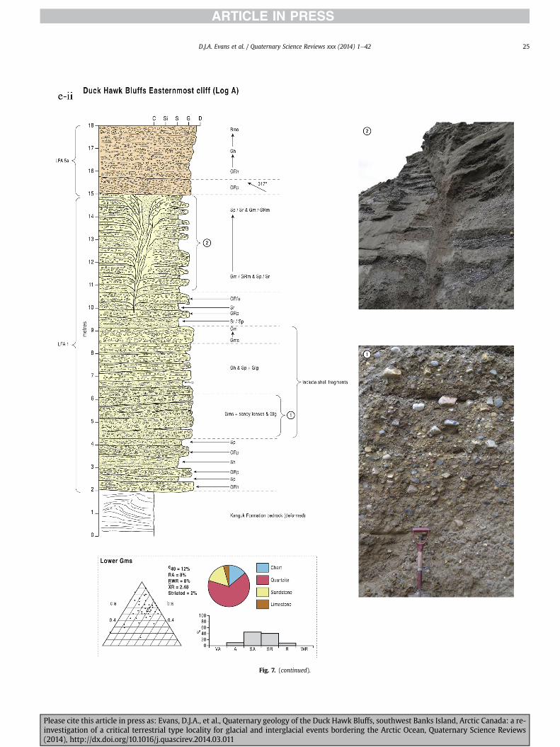
Fig 7 (continued)
DJA Evans et al Quaternary Science Reviews xxx (2014) 1e42 25
Please cite this article in press as Evans DJA et al Quaternary geology of the Duck Hawk Bluffs southwest Banks Island Arctic Canada a re-investigation of a critical terrestrial type locality for glacial and interglacial events bordering the Arctic Ocean Quaternary Science Reviews(2014) httpdxdoiorg101016jquascirev201403011
Fig 7 (continued)
DJA Evans et al Quaternary Science Reviews xxx (2014) 1e4226
Please cite this article in press as Evans DJA et al Quaternary geology of the Duck Hawk Bluffs southwest Banks Island Arctic Canada a re-investigation of a critical terrestrial type locality for glacial and interglacial events bordering the Arctic Ocean Quaternary Science Reviews(2014) httpdxdoiorg101016jquascirev201403011
DJA Evans et al Quaternary Science Reviews xxx (2014) 1e42 27
events that were gradually replaced by low magnitudehigh fre-quency events (Marren 2005) Partially to heavily-scoured rem-nants of laminated and massive fines represent deposition duringlow flow conditions in abandoned shallow channels The palae-ocurrent data from LFA 1 indicate that the outwash streams wereflowing westerly away from a glacier source located in AmundsenGulf This glacier likely eroded the abundant LFA 1 lithologies(chert quartzite and sandstone) from Mesoproterozoic and Neo-proterozoic bedrock widely distributed to the east and south(western Victoria Island Amundsen Gulf and the adjacent main-land Harrison et al 2013) These lithologies are consistent with theadvance of the NW Laurentide Ice Sheet through Amundsen Gulf(cf Dyke et al 2002 Batchelor et al 2012 MacLean et al 2013)
The crudely bedded organic detritus and degraded tree frag-ments (stumps) in LFA 1 are clearly reworked (cf Matthews et al1986 Fyles 1990 Vincent 1990) The finer grained detritus wasdeposited in concentrated pockets during waning flow stageswhereas horizons of logs and larger tree fragments were emplacedwith the coarser grained and poorly sorted sediments associatedwith hyperconcentrated flows or traction carpets during highdischarge These reworked organics also differ significantly fromthe type location of the Beaufort Fm a characteristic that promptedFyles (1990) to distinguish them as lsquotheMary Sachs Gravelrsquo Notablythe enclosing gravel and sand of LFA 1 is much coarser and exhibitsan entirely different fluvial architecture than the sandier BeaufortFm The composition and degraded nature of the LFA 1 organicssuggests that they were eroded by glaciers or their meltwater fromNeogene andor Paleogene sediments presumably to the southeastof Banks Island (eg Fyles 1990 Fyles et al 1994) The proximity ofa glacier is highlighted by the preservation of striae on individualclasts especially in the very coarse lower gravel The verticaldecrease in striae preservation and angularity (RA) and concomi-tant increase in roundness and upward-fining in LFA 1 is indicativeof an increasingly distal ice margin The co-variance plots (Fig 5)indicate a strong fluvial signature especially in the C40RA data butsubglacial characteristics are also evident particularly in the C40RWR data for the coarser grained and more matrix-supportedgravel as would be expected in ice-proximal settings
It is important to note that the widespread thrusting of LFA 1and underlying Kanguk Formation towards the southwest occurredpost-depositionally This glacitectonic thrusting was produced byLaurentide ice that advanced from the Kellett River valley (interiorBanks Island) during the emplacement of LFA 6 (see below) Theinjection of clastic dykes and fissure fills during this glacitectonicdisturbance was due to the overpressurizing of groundwater ingravel aquifers likely in taliks The branching limbs of many of thedykes are indicative of burst-out structures diagnostic of hydro-fracturing by vertically escaping groundwater pressurized byglacier overriding (cf Rijsdijk et al 1999 Le Heron and Etienne2005)
5122 LFA 2 At the top of LFA 1 rhythmites with lonestonesoverlie prominent clinoforms or foreset beds recording a changefrom subaerial glacifluvial to subaqueous deposition This wasinitially on a shallow delta front prograding foreset beds in asouthwesterly direction followed by suspension sedimentationwith dropstones presumably from floating ice in a marine orlacustrine basin The occurrence of matrix-supported gravelly scourfills with logs and woody detritus suggests pulses of cohesionlesssediment gravity flows into the basin Overlying the rhythmically-bedded sand prominent ice wedge pseudomorphs (up to 4 mdeep Fig 9aec cf Mackay and Burn 2002) are interspersed withthick (gt1m) sections of compressed in situ bryophytes (Figs 9d 7e)indicating the establishment of a tundra surface Four bryophytefamilies and 10 distinct species have been determined from LFA2
Please cite this article in press as Evans DJA et al Quaternary geologyinvestigation of a critical terrestrial type locality for glacial and intergla(2014) httpdxdoiorg101016jquascirev201403011
with the most abundant material from the Calliergonaceae andCampyliaceae (Table 1) These macrofossils are exceptionally wellpreserved including material with intact fragile alar cells typical ofthese two families (Fig 14cef) The data from these autochthonousdeposits indicate a wetland environment characterized as a richfen This ecosystem and habitats therein are consistent with speciesfound in the extant flora of Banks Island (Fig 14b) The autecologyfrom this range of species suggest hydric to mesic habitatsincluding standing pools wet meadows and microhabitats createdby ice wedges Despite the predominance of bryophytes in LFA 2these macrofossils had not been previously documented at DHB Incontrast a minimal proportion of the samples (lt5) consisted ofvascular plant material (including Cyperaceae seeds gramminoidleaves and woody twig fragments) Collectively the ice wedgepseudomorphs and vegetation within LFA 2 represent an isochro-nous terrestrial surface of interglacial rank
Following the formation of ice wedges the injection of intra-formational clastic dykes and fissure fills in LFA 2 relates to theoverpressurizing of groundwater in gravel aquifers or taliks due toglacier overriding The branching dyke limbs that emanate fromunderlying LFA 1 gravels and sands are indicative of the burst-outstructures that develop during hydrofracturing (cf Rijsdijk et al1999 Le Heron and Etienne 2005) A variant of the gravel andsand filled clastic dykes occurs within the sequence of glaci-tectonite and rhythmites near west Log D (Fig 11) Here thevertically-widening fracture is characterized by a mosaic ofpartially disaggregated blocks of the host materials in its widestzone where it contains gravels injected from underlying LFA 1Because these gravels only occur in the basal narrow neck theypresumably record the rapid reduction in flow competence duringhydrofracture filling
Deformation structures including overfolded or crumpledbedding and thrust faults associated with boudinage or highfissilitypseudo-lamination are representative of simple shear andwere also induced by glacitectonic disturbance (cf van derWateren 1995 McCarroll and Rijsdijk 2003) This predominantlyrecords a glacier advance from the northeast Subsidiary shear in-dicators record deformation from the south or southeast but theseoccur only at the top of LFA 2 and the base of LFA 3 suggestingearlier emplacement (see below) The development of zones ofboudinage shallow thrust faults overfolding or bed crumpling atdifferent levels within LFA 2 e especially at the contact separatingsediments of different grain size e represents deformation parti-tioning due to contrasting rheological properties Blind thrustswere also initiated in underlying LFA 1 increasingly towards thecentral and eastern cliffs where large-scale deformation is moreprevalent (Fig 7c d) A zone of intense deformation is recorded by alens of LFA 3 diamicton in fault contact with LFA 2 (east cliff Log AFig 7d i) This constitutes a type B glacitectonite (non-penetrativelydeformed pre-existing sediments sensu Benn and Evans 1996Evans et al 2006) developed during the emplacement of LFA 3(see below) A similar glacitectonite occurs at the junction of LFA 1and LFA 3 near west Log D (Fig 11) Bed attenuation by deformationis best developed in lower LFA 2 where the greater differences insediment grain size and hence rheology exist
5123 LFA 3 Within LFA 3 locally abundant stratified lensesindicate subaqueous deposition These stratified sediments weresubsequently thrust faulted folded and attenuated - most evidentin the upper and lower zones of LFA 3 This deformation was likelyresponsible for the intraclast boudinage and pseudo-lamination inthe surrounding diamicton (eg Hart and Roberts 1994 Robertsand Hart 2005 Oacute Cofaigh et al 2011) This process was alsoassociatedwith the attenuation of LFA 1 and 2 sediments within theheavily deformed base of LFA 3 some of which may have been
of the Duck Hawk Bluffs southwest Banks Island Arctic Canada a re-cial events bordering the Arctic Ocean Quaternary Science Reviews
Fig 8 Details of LFA 1 a) example of a concentration of logs with degraded rootballs in the stacked tabular units of cross-bedded sands and gravels and crudely stratified matrix-supported cobble to boulder gravels in the west cliff b) poorly-sorted and crudely horizontally bedded cobble to boulder gravel containing laminated clay intraclast (immediatelyabove compass) c) shallow locally graded foreset beds composed of openwork to sandy matrix-supported cobble to granule gravels in central cliff Log A d) planar bedded sandy
DJA Evans et al Quaternary Science Reviews xxx (2014) 1e4228
Please cite this article in press as Evans DJA et al Quaternary geology of the Duck Hawk Bluffs southwest Banks Island Arctic Canada a re-investigation of a critical terrestrial type locality for glacial and interglacial events bordering the Arctic Ocean Quaternary Science Reviews(2014) httpdxdoiorg101016jquascirev201403011
DJA Evans et al Quaternary Science Reviews xxx (2014) 1e42 29
cannibalized and rafted by the deformation process within a shearzone at the contact of LFA 3 with older sediments The shearingdirection from the south and southeast recorded in lower LFA 3also impacted upper LFA 2 whereas the more prominent shearingdirection throughout LFA 3 is from the northeast (also recorded inLFA 4) The local development of a heavily deformed zone at the topof LFA 3 was likely imparted during the shearing of overlying LFA 4sediments Although clast macrofabric strengths from the LFA 3diamicton are variable they possess shapes that compare withglacitectonites and subglacial traction tills and in some cases amodalityisotropy signature that reflects high lodgementcomponents
The similar orientation of the macrofabrics and shear indicatorsare considered diagnostic of a glacitectonite derived from stratifiedsediments (eg interbedded mass flow diamictons gravelly massflows and localized traction current sands and suspension de-posits) This evidence indicates that LFA 3 like all the other LFAsand the underlying Kanguk Fm bedrock has been displaced by aglacier advancing from the NNE or NE (ie Laurentide ice crossingthe interior of Banks Island) Minor south to north shearing in-dicates that LFA 3 and upper LFA 2were also disturbed by glacier iceflowing northwards (ie Laurentide ice advancing throughAmundsen Gulf) The appearance of granite and gabbro clastswithin the LFA 3 diamict records the arrival of far-travelled Lau-rentide ice from mainland Canada Clast form co-variance stronglyindicates a subglacial (abraded) source for LFA 3 with a minorfluvial component (Fig 5) including glacifluvial clasts locallycannibalized from LFA 1 by overriding ice
5124 LFA 4 LFA 4 has restricted outcrops is heavily deformedand contains organic detritus that is clearly allochthonous andhighly degraded Nonetheless a variety of indicators (fine-grainedhorizontally bedded cross-laminae rhythmites climbing ripplesand draped laminae) demonstrate that LFA 4 was deposited in asubaqueous environment with palaeocurrents from the south orsouthwest Traction currents were likely responsible for thedevelopment of the clast lag at the contact between lower LFA 4and underlying LFA 3 (west cliff Log A Fig 7b ii) LFA 4 coarsensupwards indicative of basin infilling andor an approaching sedi-ment source The narrow anabranched clastic dykes in the sandyclimbing ripples (LFA 4 west cliff Log A) record hydrofracturing bythe upward injection of overpressurized groundwater duringshearing The branching limbs of the dykes are similar to the burst-out structures reported by Rijsdijk et al (1999) but differ becausethey are composed solely of sand derived from the walls of the hostsediment rather than from an underlying gravel aquifer (cf LeHeron and Etienne 2005) Hence the pressurized water wasgenerated at the contact between the sand and underlying imper-meable brecciated clays The development of thin zones of brecci-ation boudinage sheath folding or thrust faulting at the upper andlower contacts of LFA 4 relates to the localized partitioning ofdeformation controlled by the location of claysilt beds Thejuxtaposition of this style of deformation with the larger scaleoverfolds and thrust faults developed in the extensive bodies ofsandy lithofacies is indicative of a Type B glacitectonite (sensu Bennand Evans 1996) This was constructed by the overriding of glacierice advancing from the north or northeast These shear directionsare compatible with those developed in the underlying LFAs
granule gravels with gravel lags (top and bottom of image) interrupted by an intervening unbedded granule to pebble gravel and massive cobble to pebble gravel A cluster of small treesequence of stacked tabular units of predominantly horizontally bedded sands and gravels ingravels containing clusters of wood detritus in the coarser gravel beds (central cliff Log A)wood fragments (central cliff Log A)
Please cite this article in press as Evans DJA et al Quaternary geologyinvestigation of a critical terrestrial type locality for glacial and intergla(2014) httpdxdoiorg101016jquascirev201403011
5125 LFA 5 The primary characteristics of LFA 5 are typical ofgravel sheet and occasional traction-carpet sedimentation in anice-proximal sandur (eg Boothroyd and Ashley 1975 Miall 19781985 1992 Maizels 1989ab Siegenthaler and Huggenberger1993 Mulder and Alexander 2001 Marren 2005) Glacier prox-imity is supported by the subglacial to fluvial signature of the clastforms (Fig 5) The coarsening-upward sequence including striatedclasts culminates in the arrival of a glacier that overrode the sitedepositing LFA 6 Post-depositional shearing within underlying LFA4 is recorded by attenuation and interdigitation at the contact withLFA 5 imparted during deposition of LFA 6 The contact betweenLFA 5 and 6 reflects the development of a shear zone where upperLFA 5 sediments have been cannibalized producing a meacutelange ofcrudely stratified diamictons with discontinuous interbeds ofmatrix-supported gravel laminated sand silt and clay (LFA 6 seebelow)
5126 LFA5a At Easternmost Cliff glacifluvial gravel (LFA 5a)unconformably overlies LFA 1 (Fig 7e) rendering uncertain itsrelationshipwith respect to LFA 5 in themain sections of DHB to thewest The fact that LFA 5a extends to the modern surface appearsundeformed and has palaeocurrents orientated to the NW requiresthat it is younger than LFA 5 Indeed we interpret LFA 5a asdeglacial outwash deposited from retreating Laurentide ice in theKellett River valley and Amundsen Gulf at the end of the lastglaciation (see Discussion)
5127 LFA 6 Based on its heterogeneity strongly orientated clastmacrofabrics and macroscale deformation structures LFA 6 con-stitutes a Type B glacitectonite (sensu Benn and Evans 1996)However zones of more highly strained Type A glacitectonite(sensu Benn and Evans 1996) at the basal contact with older LFAsare recorded by intraclastinterbed attenuation (pseudo-lamina-tion) strong boudinage or fissility and strengthened clast macro-fabrics The production of this meacutelange is attributed to two separateprocesses 1) primary sedimentation as interbedded and interdig-itated mass flow debris fluvial gravel and sand and subaqueoussuspension sediments and 2) cannibalization of underlying strat-ified sediments (LFAs 4 and 5) This produced a continuum of formsranging from low strain fold structures to attenuated rafts to tec-tonic lamination (eg Fig 7) The discontinuous lenses of degradedorganics (black stems and woody twigs gramminoid leaveswhitened rootlets) within LFA 6 are rafts and include seven speciesof bryophytes (Table 1) The material was highly compressed anddifficult to separate into distinct taxa Indeed one of the threesamples analysed was too degraded to recover any taxa Much ofthe material consisted of only fragmented leaves and only theminute taxa had stems with intact leaves The bryophytes thatcharacterize the LFA 6 samples represent hydric (Calliergon sppTomenthypnum nitens) to mesic (Ditrichum flexicaule Dicranum sp)habitats Three species collected from LFA 6 were also present inLFA 2 whereas four others were not found in LFA 2 but are com-mon in the modern flora The poor preservation quality suggeststhat the material has been redeposited from unknown sources andis clearly allochthonous
The predominant shearing direction within LFA 6 records an iceadvance from the interior of Banks Island (NE) This has resulted incomplex folding and thrusting and localized thickening of LFA 6
it of cross-bedded poorly-sorted to openwork cobble to boulder gravel crudely planar-fragments occur at the base of the cobble to boulder gravels at image centre e) middleDHB west cliff Log D f) sequence of fining-upward planar-bedded cobble to sandy fineg) planar cross-bedded sandy granule to pebble gravels with pebble to cobble lags and
of the Duck Hawk Bluffs southwest Banks Island Arctic Canada a re-cial events bordering the Arctic Ocean Quaternary Science Reviews
Fig 9 Details of LFA 2 from the west cliff a) narrow necked ice wedge pseudomorph with upturned marginal bedding in sand silt and clay rhythmites b) wide necked ice wedgepseudomorph c) ice wedge pseudomorph with overturned silt sand and clay rhythmites developed at the top of LFA 2 and sealed by overlying LFA 3 laminated diamicton d)horizontally bedded sand and silt containing well preserved moss macrofossils e) zone of disharmonically folded sandsilt laminae with well preserved moss peat located at thebase of LFA 2
DJA Evans et al Quaternary Science Reviews xxx (2014) 1e4230
Please cite this article in press as Evans DJA et al Quaternary geology of the Duck Hawk Bluffs southwest Banks Island Arctic Canada a re-investigation of a critical terrestrial type locality for glacial and interglacial events bordering the Arctic Ocean Quaternary Science Reviews(2014) httpdxdoiorg101016jquascirev201403011
Fig 10 Details of simple shear structures developed in fine sand and silt laminae at the centre of the thickest outcrop of LFA 2 in west cliff Log B a) overview of large scaleanastomosing shear faults with zones of smaller scale densely spaced anastomosing shears towards the base of the photograph b) details of large scale shear faults separatingzones of variably but predominantly densely spaced shears c) close details of shear zone comprising densely spaced anastomosing fractures d) details of ascending kink zonecross-cutting large scale anastomising shear faults Shearing direction is coming out of the cliff and towards the left in each image
DJA Evans et al Quaternary Science Reviews xxx (2014) 1e42 31
This shearing direction is recorded throughout underlying LFAs 1e4as well as the Kanguk Formation demonstrating deep-seated butpartitioned glacitectonic disturbance imparted during theemplacement of LFA 6 This strain signature was therefore over-printed on the northerlynortheasterly aligned shearing directionrecorded in LFA 3 and upper LFA 2 by the earlier northerly flowingice that deposited LFA 3 One anomalous clast macrofabric(northerly CCA F1) occurs in the basal meacutelange of LFA 6 Howeverthis sample is from an isolated outcrop (Fig 7c i) rendering itsapparent shearing direction equivocal
Please cite this article in press as Evans DJA et al Quaternary geologyinvestigation of a critical terrestrial type locality for glacial and intergla(2014) httpdxdoiorg101016jquascirev201403011
52 Sedimentology and stratigraphy (Mary Sachs Creek cliff)
The cliffs east of Mary Sachs Creek (Figs 2b 3) provides a cross-section through the seaward margin of the coast-parallel SachsMoraine (ldquosection Jrdquo Vincent et al 1983 Vaughan 2014) Weprovide a summary of two logs based on a reconnaissance survey ofthese sediments Log A is closest toMary Sachs Creekwhereas Log Boccursw1 km farther east (Figs 3 15a amp b) The sediments exposedin Log A appear to descend eastward and disappear below themodern beach and therefore are assumed to stratigraphically
of the Duck Hawk Bluffs southwest Banks Island Arctic Canada a re-cial events bordering the Arctic Ocean Quaternary Science Reviews
Fig 11 Details of LFA 2 near west Log D Lower box shows a 1e2 m thick basal zone comprising highly attenuated inter-digitated beds of gravelly to clay-rich diamictons and sandsiltclay rhythmites Upper box shows rhythmites containing diamictic intraclasts with sharp and angular boundaries also visible is the draping and deforming of the rhythmitebedding over and under the intraclasts respectively ldquoTailsrdquo extending from the diamictic intraclasts and thin but discontinuous diamictic beds are also visible in the upper box
DJA Evans et al Quaternary Science Reviews xxx (2014) 1e4232
underlie the sediments of Log B A sand and gravel- bench caps bothlogs at w15 m asl incised into the seaward margin of the SachsMoraine
521 DescriptionLog A contains a sequence of upward-fining highly contorted
cross-stratified sand and fine gravel to rhythmically bedded sandsilt clay with minor pebble gravel and sporadic clots of gravellydiamicton (Fig 15a) An ice wedge was initially developed in thelower cross-stratified sand and fine gravel before they were foldedand thrust faulted The deformed ice wedge pseudomorph is un-conformably overlain by a relatively undisturbed lens of laminatedsilty clay with dropstones interbedded with gravelly diamictonthat contains a bed (10 cm) of sandy black organics containingwood fragments (Fig 15a) This organic material occurs repeatedlyup-section as discontinuous stringers Log A is capped by 1e2 m ofpoorly exposed and heavily cryoturbated gravelly diamicton Thegeneral sense of displacement on shallow reverse faults over-turned bedding and boudinage structures is from the southeast
Log B (12 m) displays a coarsening-upward sequence of hori-zontally bedded sandy granule gravel with occasional silty sandlaminae (Fig 15b iii) that grades to poorly-sorted cobble to bouldergravel and bouldery matrix-supported gravel (Fig 15b ii) This iscapped by laminated to crudely stratified cobbly diamicton that issilt and clay-rich abruptly and conformably overlain by
Please cite this article in press as Evans DJA et al Quaternary geologyinvestigation of a critical terrestrial type locality for glacial and intergla(2014) httpdxdoiorg101016jquascirev201403011
interlaminated silt clay and pebbly silty sand (Fig 15b i) Althoughthe bedding on these units dips towards the NW individuallaminae do not thicken in that direction indicating post-depositional tilting The uppermost part of the log (underlyingthe 15 m bench) contains 2 m of clay-rich massive diamictoninterfingered with the underlying laminated sediments and cobblydiamicton
522 Interpretation
5221 Log A Broadly the sedimentology of log A including thedeformed ice wedge pseudomorph is similar to LFA 2 in DHB (egcentral cliff Log A Fig 7c iii) Prior to glacitectonic disturbance theoverlying organic bed (Fig 15a) was redeposited into a sequence ofsubaqueous siltclay rhythmites containing dropstones and gravellymass flows The highly attenuated shear margins bracketing theorganic bed in Log A demonstrate that it has been displaced as atectonic raft Previous research proposed that the organic beds e
similar to those described in Log A e be assigned to the LastInterglacial (locally called the Cape Collinson Vincent 1982 1983)Because these organic beds are clearly a raft they cannot constitutean iscochronous surface precluding chronostratigraphic signifi-cance (see Discussion) Shearing of the Log A sediments from thesoutheast documents an ice advance from Amundsen Gulf corre-sponding to the earliest of two primary shearing directions recor-ded at DHB (imparted during the emplacement of LFA 3) Therefore
of the Duck Hawk Bluffs southwest Banks Island Arctic Canada a re-cial events bordering the Arctic Ocean Quaternary Science Reviews
Fig 12 Details of LFA 4 in West Log A a) heavily deformed upper contact of LFA 4 comprising sandsiltclay rhythmites displaying well developed boudinage sheath folds andimmature tectonic laminae and an interdigitatedsheared boundary with underlying climbing ripple sands The contact with overlying LFA 6 is marked by an interdigitated zonecontaining rooted and de-rooted folds or rhythmite rafts in a sand gravel and diamicton meacutelange b) narrow anabranched clastic dykes ascending sub-vertically through climbingripple drift and resulting in offset bedding between blocks of host material c) abrupt contact between sheared sands and rhythmites of LFA 4 and overlying sand gravel anddiamicton meacutelange
Fig 13 Details of LFA 5 a) poorly sorted and matrix-supported pebble to cobble gravel b) tabular sequence of horizontally bedded to massive gravel and matrix-supported gravelcontaining a horizon of striated cobbles and boulders c) heavily deformed discontinuous bed of siltclay rhythmites between LFA 5 and LFA 6 in West Log D showing theamalgamation zone with the LFA 5 gravels immediately above the compass d) interdigitateddeformed contact between LFA 5 granule to pebble gravels and underlying LFA 4laminated silts and clays with organic detritus in West Log B
DJA Evans et al Quaternary Science Reviews xxx (2014) 1e42 33
Please cite this article in press as Evans DJA et al Quaternary geology of the Duck Hawk Bluffs southwest Banks Island Arctic Canada a re-investigation of a critical terrestrial type locality for glacial and interglacial events bordering the Arctic Ocean Quaternary Science Reviews(2014) httpdxdoiorg101016jquascirev201403011
Table 1List of bryophytes and vascular plants from LFAs 2 and 6
LFA2 WestCliff Log B
LFA6 CentralCliff Log A
Elevation (m) 185 m asl w45 m aslSample 4e12 1e3 taxa 10 7
Bryophyta (mosses)AmblystegiaceaeAmblystegium serpens (Hedw) Schimp x
CamyliaceaeCampylium polygamum (Schimp) CEO Jensen xCampylium stellatum (Hedw) CEO Jensen x xDrepanocladus aduncus (Hedw) Warnst xDrepanocladus sp xTomentypnum nitens (Hedw) Loeske x
CalliergonaceaeCalliergon giganteum (Schimp) Kindb xCalliergon richardsonii (Mitt) Kindb xthornthornthornthorn xCalliergon sp xWarnstorfia exannulatus (Schimp) Loeske xthornthornthornthorn x
BrachytheciaceaeBrachythecium turgidum (Hartm) Kindb x
MniaceaeCyrtomnium cf hymenophylloides(Hbener) TJ Kop
x
DicranaceaeDicranum sp x
DitrichaceaeDitrichum flexicaule (Schwaumlgr) Hampe x
Tracheophyta (vascular plants)CyperaceaeSeeds (triangular amp flattened) x x
Gramminoid leaf material x xWoody twig fragments x xRootlets x
Fig 14 The moss peat and associated microfossils of LFA 2 a) exposure through lower LFAsouthern Banks Island analogue of a rich tundra fen environment for the bryophyte assemblfrom LFA 2 showing the exceptional preservation of Calliergonaceae and Campyliaceae ma
DJA Evans et al Quaternary Science Reviews xxx (2014) 1e4234
Please cite this article in press as Evans DJA et al Quaternary geologyinvestigation of a critical terrestrial type locality for glacial and intergla(2014) httpdxdoiorg101016jquascirev201403011
these deformed deposits are interpreted as a Type B glacitectonite(sensu Benn and Evans 1996) possibly derived from LFA 2
5222 Log B The coarsening upward gravel in Log B recordshighly turbid to hyperconcentrated discharge in non-channelizedsheets This is interpreted as aggrading glacifluvial outwash froman approaching ice margin The capping sequence of crudelystratified diamicton and laminated sediments records a changefrom glacifluvial to subaqueous sedimentation prior to overridingby a glacier of unknown age that tilted the upper beds Thecoarsening-upward sequence apparent tectonism and cappingdiamict at Log B clearly distinguishes these deposits from those ofLFA 5a (west of Mary Sachs Creek easternmost cliff Fig 3)Furthermore although there is lithological similarity between LogB and LFA 5 throughout DHB the sense of shearing is dissimilar (LFA5 from the NE and Log B from the SE) The simplest explanation forthis difference in shear direction is that LFA 5 (DHB) was displacedby interior ice advancing down the Kellett River whereas Log B wasdisplaced by ice advancing along Amundsen Gulf (Fig 2b)
6 Discussion
61 Large scale glacitectonic structures and stratigraphicarchitecture
The glacitectonic structures identified within the lithofaciesassociations at DHB record two phases of deformation (early NeSand later NEeSW) This deformation together with the DHBstratigraphic architecture (Fig 16) helps to explain both thekinetostratigraphy (sensu Berthelsen1978) and the evolution of thelocal glacial geomorphology The large scale glacitectonic defor-mation is most clearly manifest in the thrust faulting and conjugate
2 at DHB west log B showing the sampling locations for in situ moss peat b) a modernages of LFA 2 c)ef) details of the typical moss peat and associated microfossil materialscrofossils including material with intact fragile alar cells
of the Duck Hawk Bluffs southwest Banks Island Arctic Canada a re-cial events bordering the Arctic Ocean Quaternary Science Reviews
Fig 15 The stratigraphy of Mary Sachs Creek cliff a) photographic compilation log A showing upward-fining highly contorted (i) cross-stratified sands and fine gravels torhythmically bedded sands silts clays and minor pebble gravels Also visible in (ii) is a lens of interbedded laminated silty clays with dropstones and gravelly diamictons containingsandy black coloured organic material with wood fragments An ice wedge pseudomorph is visible (iii) to the right of the exposure b) photographic compilation log B showing i)laminated to crudely stratified cobbly but siltclay-rich diamicton grading into interlaminated silts clays and pebbly silty sands ii) poorly-sorted cobble to boulder gravel andbouldery matrix-supported gravel iii) coarsening-upward sequence of horizontally bedded sandy granule gravels with occasional silty sand laminae iv amp v) pebble to cobble graveland matrix-supported gravel
DJA Evans et al Quaternary Science Reviews xxx (2014) 1e42 35
shear development in the Kanguk Fm bedrock and overlying LFA 1(east cliff Fig 7d ivevi) Here predominantly northeasterly dippingthrust slices have been stacked truncated and overlain by LFA 6during the second and strongest (NEeSW) deformation phase(Fig 16 note bedrock slice within the imbricated stacked sequenceof LFA 1) These structures demonstrate significant compressionand thickening of the stratigraphic sequence including w40 m ofvertical offset within the Kanguk Formation acrossw3 km (Fig 16)Prominent hydrofracture fills in LFAs 1 and 2 record elevatedporewater pressure during this thrusting Smaller scale shear zoneshave also developed in the finer grained interbeds within thrustslabs (Fig 7d vii) indicative of deformation partitioning by strataprone to ductile failure This zone of greatest displacement alsocoincides with the highest topography (Fig 16) Lower angle thrustfaults propagate in a southwesterly direction predominantlythrough LFA 1 but are also developed through LFA 2 in the footwallblock (east cliff Fig 16)
The thrust stacking of bedrock and LFAs 1e5 in east cliff (obliqueto Fig 16) represents the ice-proximal zone of a thrust-blockmorainecomposite ridge constructed by a glacier advancing fromthe northeast (ie the interior of Banks Island) This glacitectonicdeformation propagated southwestward to distal parts of theproglacial stress field as recorded bywell-developed shear zones inthe finer grained sediments of LFAs 2e5 In the more distal westcliff open folds (LFA 2 Fig 16) appear to be the product of a blindthrust within underlying LFA 1 This style of tectonism is typical oflsquopiggyback-style thrustingrsquo wherein steeply inclined thrust blocksat the advancing ice margin propagate new thrusts in the footwall(Fig 16 Park 1983 Mulugeta and Koyi 1987) The angle of thesefootwall thrusts becomes progressively shallower southwestward
Please cite this article in press as Evans DJA et al Quaternary geologyinvestigation of a critical terrestrial type locality for glacial and intergla(2014) httpdxdoiorg101016jquascirev201403011
(ice-distal) in LFA 1e5 where deformation partitioning developedin finer grained lithofacies (Fig 16)
The densely spaced ponds and depressions immediately to thenortheast of DHB (Figs 2b 3) constitute the depression fromwhich the thrust mass was excavated (eg Aber et al 1989Evans and England 1991 van der Wateren 1995) This inter-pretation is consistent with the strong northeast to southwestshear direction in the second phase glacitectonic structures andin LFA 6 clast macrofabrics This indicates that construction ofDHB occurred at the margin of a glacier advancing from thenortheast (ie from Kellett River valley) overtopping DHB anddepositing the LFA 6 glacitectonite The continued advance ofKellett ice coalesced with a glacier in Amundsen Gulf marked bythe interlobate Sachs Moraine containing ice-transported shellsas young as 24 cal ka BP (21020 70 yrs BP UCIAMS-89674)assigning this glaciation to the Late Wisconsin (Vaughan 2014)East of Mary Sachs Creek the deformation of Log B outwash(from the southeast Figs 15 16) likely records overriding by thesame Amundsen Gulf glacier (coeval with LFA 6 Late Wiscon-sinan) During ice retreat when Kellett River and Amundsen Gulfice decoupled DHB was exposed allowing the northwesterly-flowing proglacial outwash (LFA 5a) west of Mary Sachs Creekto extend to the shoreline marking postglacial marine limit atKellett Point (11 m asl Vaughan 2014 Fig 3) Collectively thisreconstruction supports a Late Wisconsinan age for the con-struction of DHB thrust block moraine although its stratigraphyincludes a range of ages A palaeogeographic reconstruction ofevents based upon our interpretation of the sedimentologystratigraphic architecture tectonism and geomorphology is pre-sented in Fig 17
of the Duck Hawk Bluffs southwest Banks Island Arctic Canada a re-cial events bordering the Arctic Ocean Quaternary Science Reviews
Fig 15 (continued)
DJA Evans et al Quaternary Science Reviews xxx (2014) 1e4236
62 Comparison and revision of previous DHB model
DHB was previously interpreted to record horizontally beddedNeogene to Quaternary sediments assigned to preglacial fluvialand multiple glacial and interglacial episodes (Vincent 1982 19831990 Vincent et al 1983 1984 Barendregt et al 1998) A com-posite palaeomagnetic record was also presented for this proposedstratigraphy placing most of this deposition before the BrunhesMatuyama boundary (Fig 1c) However prior to our work detailedstudies had not been undertaken on the sedimentology structuralgeology or stratigraphic architecture of DHB Rather the originalstratigraphy was restricted to a series of composite logs (our Fig 4reproduced from Vincent et al 1983) that notably omitted thepervasive deformation structures including the thrust bedrock ineast cliff (Fig 16)
Please cite this article in press as Evans DJA et al Quaternary geologyinvestigation of a critical terrestrial type locality for glacial and intergla(2014) httpdxdoiorg101016jquascirev201403011
Our reinterpretation dismisses several key elements of theoriginal DHB model outlined below (oldest to youngest) We havedetermined that the lowermost unit (LFA 1) is not preglacial (Fyles1990) but rather is composed of glacial outwash providing theearliest terrestrial evidence for glaciation in the area and containingallochthonous organics (including tree stumps) of unknown prov-enance Because LFA 1 is a glacifluvial braidplain (Fig 17a) it is notpart of the Beaufort Fm (Fyles 1990) even though it containsreworked macrofossils presumably derived from it (eg Craig andFyles 1960 Hills et al 1974 Vincent et al 1983)
Our analysis of LFA 2 indicates that it is also not preglacial norcan it be the Worth Point Fm as previously proposed (cf Vincent1982 1983 1990 Vincent et al 1983 Matthews et al 1986)Indeed the type locality of the Worth Point Fm has been invali-dated because it is now recognized to be an ice-transported and
of the Duck Hawk Bluffs southwest Banks Island Arctic Canada a re-cial events bordering the Arctic Ocean Quaternary Science Reviews
LFA4
Fig16
Stratigrap
hiccross-profi
lerun
ning
westto
easto
fDuc
kHaw
kBluffs
basedup
oninterpolations
betw
eenthemainsectionlogs
andsh
owingthesixLFAstheKan
gukFo
rmationbe
droc
kex
posu
resmajor
structural
features
and
thepo
sition
sof
icewed
geps
eudo
morph
san
dsign
ificant
clasticdy
kesAtthe
easternen
dof
thecross-profi
lethe
sedimen
tsat
theco
reof
MarySa
chsCree
kcliff
logAaretentativelyclassified
asLFA2
althou
ghthesematerialsarelik
ely
notin
situN
otethat
thecross-profi
ledo
esno
tex
tend
asfarea
stas
MarySa
chsCree
kcliff
logB
DJA Evans et al Quaternary Science Reviews xxx (2014) 1e42 37
Please cite this article in press as Evans DJA et al Quaternary geologyinvestigation of a critical terrestrial type locality for glacial and intergla(2014) httpdxdoiorg101016jquascirev201403011
glacitectonized raft (Vaughan et al 2014) In contrast our LFA 2 ischaracterized by an isochronous tundra surface with ice wedgesand intervening shallow ponds andwetmeadows The peat at LFA 2is dominated by bryophytes (gt95 by volume) and yet none ofthese macrofossils had been previously documented The diversein situ bryophyte species record a flora similar to that on BanksIsland today suggesting that LFA 2 warrants an interglacial rankThis conclusion is supported by the limited vascular plant record(five taxa no species indicated Vincent 1990) that also suggest awet meadow environment The absolute age of LFA 2 remains un-known but is apparently older than the BrunhesMatayamaboundary (gt780 ka Fig 18 cf Vincent et al 1984 Barendregt andVincent 1990 Barendregt et al 1998 see below)
LFA 3 in both our model and that of Vincent et al (1983) pro-vides the first direct evidence of ice reaching DHB In the previousmodel this was interpreted as Bernard Till (Banks Glaciation) thatwas bracketed by glacioisostatically induced marine transgressions(pre- and post-Banks seas Vincent 1982 1983) Within basal LFA 3we recognized highly deformed stratified sediment that wasdeposited in a subaqueous environment (deep water Fig 17c) priorto the arrival of overriding ice from the south (recorded by graniteand gabbro erratics Figs 17c 18) We regard LFA 3 to be equivalentto the Banks Glaciation (Vincent 1982 1983 Vincent et al 1983)including its pre- and post-Banks seas represented by the stratifiedsediments that bracket the central diamicton The LFA 3 sedimentsare also reported to be magnetically reversed thereby predatingthe BrunheseMatayama boundary (gt780 ka Fig 18 Vincent et al1984 Barendregt and Vincent 1990 Barendregt et al 1998)
Following the Banks Glaciation (our LFA 3 at DHB) Vincent(1982 1983) and Vincent et al (1983) recognized two in-terglacials (Morgan Bluffs and Cape Collinson) separated by anintervening marine episode This marine episode correspondedwith the glacioisostatic loading of a Laurentide ice margin confinedto the eastern half of Banks Island (Thomsen Glaciation) HoweverLFA 4 contains coarsening-upward subaqueous sedimentation fromthe south or southwest reflecting continued marine regressionfollowing LFA 3 (Fig 17c d) The coarsening-upward sequence ofLFA 4 is supplanted by coarse gravel outwash (LFA 5) supplied by aglacier readvancing from the northeast (Kellett River valley iceFig 17e) Glacier overriding is recorded by LFA 6 glacitectonite thatcaps the DHB thrust-block moraine composed of the entireassemblage of underlying LFAs (Fig 16)
Notably we have not observed any sediments characteristic oftwo interglacial deposits above LFA 3 hence dismiss the presence ofthe Morgan Bluffs and Cape Collinson interglacials at DHB Causseand Vincent (1989) report a U-series date of gt200 ka (UQT-229)from above our LFA 3 but this is almost certainly reworked andlacks chronostratigraphic significance Nor have we observedintervening marine sediments attributable to the Thomsen Glaci-ation (eg lsquoBig Searsquo Vincent 1982 1983 Vincent et al 1983)Rather following the deposition of the subaqueous sediments ofupper LFAs 3 and 4 (post-Banks Glaciation) LFAs 5 and 6 record asingle ice advance reaching DHB from the Kellett River valley(Banks Island interior) that was not reported by Vincent et al(1983) It was instead assumed that after the Banks GlaciationDHB lay distal to any later ice advances The nearest subsequentLaurentide margin to DHB recognized by Vincent et al (1983) wasassigned to the Sachs Moraine (immediately east of DHB) that waspresumed to be of EarlyWisconsin age (Fig 2b) However the SachsMoraine is nowdated to24 cal ka BP (LateWisconsinan Vaughan2014) andwas formed by the coalescence of Amundsen Gulf ice andthe Kellett River ice that deformed DHB (Fig 17) On the east side ofMary Sachs Creek the deposition of the Sachs Moraine coincideswith the deformation (from the southeast) of the underlying Log Boutwash gravel (Figs 3 15b)
of the Duck Hawk Bluffs southwest Banks Island Arctic Canada a re-cial events bordering the Arctic Ocean Quaternary Science Reviews
Fig 17 The palaeogeography of southwest Banks Island based upon interpretations of the principal lithofacies associations and structural architecture recognized at Duck HawkBluffs and the geomorphology of the surrounding terrain See text for detailed explanations
DJA Evans et al Quaternary Science Reviews xxx (2014) 1e4238
Although interglacial deposits were previously reported fromthe cliffs east of Mary Sachs Creek (ie Cape Collinson InterglacialVincent et al 1983) we found no similar evidence Rather the onlydeposit that we observed that may have been construed as inter-glacial sediments occurs in our Log A (Figs 3 15a) Here a darkdiscontinuous band of allochthonous organics (Fig15a) sits severedwithin a heavily tectonized melange (type B glacitectonite) and istherefore clearly a raft Although the absolute ages of the deformedunits east of Mary Sachs Creek (Logs A amp B) remain uncertain theyare apparently normally magnetized (Vincent et al 1984Barendregt and Vincent 1990) Blake (1987) also reports non-finite radiocarbon dates (gt36000 amp 49000 BP GSC-3560 amp 3560-2) obtained on ldquocompressed and deformed black woody peatrdquopurportedly from Cape Collinson beds (Vincent et al 1983 p 1708)Additionally Causse and Vincent (1989) report a U-series date onshells of 924 ka (UQT-143) from beds similar to the Log B gravelAgain all of these dated units have been displaced from unknownlocations limiting their utility for palaeoenvironmental recon-struction The last glacially influenced sedimentation at DHB isrecorded by northwesterly directed outwash (easternmost cliff LFA5a Figs 3 16 17g) We infer that this outwash fed the gravel beachmarking marine limit (11 m asl) in the lower Kellett River duringLate Wisconsinan retreat from the Sachs Moraine
63 Regional context
The stratigraphy at Duck Hawk Bluffs records three glacialevents The earliest of these is recorded by the aggradation of a
Please cite this article in press as Evans DJA et al Quaternary geologyinvestigation of a critical terrestrial type locality for glacial and intergla(2014) httpdxdoiorg101016jquascirev201403011
glacifluvial braidplain (LFA 1) that contains allochthonous pre-glacial material of diverse age However within LFA 1 there is noevidence that the ice reached DHB although it must have beennearby (southeast in Amundsen Gulf) The age of this glaciationremains unknown but the palaeomagnetic polarity of LFA 1 in-dicates that it is gt780 ka BP (Barendregt and Vincent 1990)Although Barendregt et al (1998) assigned part of the Worth PointFm to the normally polarized Olduvai sub-zone (MIS 64e74) itshould be noted that the Worth Point section is located 30 kmnorthwest of DHB There a stratigraphic revision has demonstratedthat this ldquotype sectionrdquo of the Worth Point Fm is in fact a glaci-tectonized raft (Vaughan et al 2014) This observation invalidatesthe previous correlation from Worth Point to purportedly coevalbeds at DHB (our LFA 2) Furthermore the diverse plant assem-blages in the Worth Point raft include preglacial tree stumps andSphagnum spp that do not occur on Banks Island today and are notfound in the wet meadow assemblages (rich fen) of LFA 2 that weinterpret to be of interglacial rank Therefore the sediments at DHB(LFAs 1 amp 2) do not support an age assignment of MIS 64e74(Olduvai subzone) proposed by Barendregt et al (1998) Currentlythe available palaeomagnetic record at DHB simply separates theentire section into a lower lsquoreversedrsquo unit and an upper lsquonormalrsquoone We place this boundary within our LFA 4 (Fig 18)
The overriding of DHB by glaciers is recorded in LFAs 3 amp 6These two glacial deposits may correspond to parts of the record ofstacked till sheets reported from the offshore seismic stratigraphy(Batchelor et al 2012) LFA 3 glaciationmay have contributed to theonset of mid-Pleistocene ice-rafted debris (IRD Ca-rich) attributed
of the Duck Hawk Bluffs southwest Banks Island Arctic Canada a re-cial events bordering the Arctic Ocean Quaternary Science Reviews
B-M
B-M
gt19
Fig
18A
revisedlitho
stratigrap
hyforDuc
kHaw
kBluffsPrev
ious
lyrepo
rted
ageco
nstraintsarealso
depicted
toge
ther
withatentativeallocation
ofMIS
stag
es(positione
dalon
gsideEa
stCliff
LogA
forclarity)
basedup
onthe
palaeo
mag
neticreco
rd
DJA Evans et al Quaternary Science Reviews xxx (2014) 1e42 39
Please cite this article in press as Evans DJA et al Quaternary geology of the Duck Hawk Bluffs southwest Banks Island Arctic Canada a re-investigation of a critical terrestrial type locality for glacial and interglacial events bordering the Arctic Ocean Quaternary Science Reviews(2014) httpdxdoiorg101016jquascirev201403011
DJA Evans et al Quaternary Science Reviews xxx (2014) 1e4240
to the Canadian Arctic Archipelago (CAA) and recorded in sedimentcores from the Arctic Ocean basin (Polyak et al 2009 2013OrsquoRegan et al 2010 Stein et al 2010) However Stein et al(2010) place the onset of Ca-rich ice-rafted debris within MIS 16(w659 ka BP Lisiecki and Raymo 2005) with subsequent peaks atMIS 12 10 and 8 all of which postdate the gt780 ka BP palae-omagnetic age proposed for LFA 3 (above) Polyak et al (2013) placethe onset of Ca-rich ice-rafted debris in the central Arctic Oceancloser to MIS 19 (790 ka BP) which is broadly compatible with theDHB palaeomagnetic record LFA 6 records the last glaciation ofDHB and we assign this to the Late Wisconsinan when Banks Is-land ice (Kellett River) coalesced with the Amundsen Gulf IceStream (Stokes et al 2006 MacLean et al 2013) During this in-terval the northwest Laurentide Ice Sheet likely reached the edgeof the polar continental shelf (Stokes et al 2005 2006 Englandet al 2009 Batchelor et al 2012 Lakeman and England 2013MacLean et al 2013)
7 Conclusions
New sedimentological and stratigraphic analyses of DHB funda-mentally revise the previous reconstruction of the Neogene andQuaternary history of Banks Island DHB and two other widely citedsections on Banks Island have been reported as important unde-formed terrestrial archives of glacial and interglacial sedimentationat the northwest limit of the Laurentide Ice Sheet that all have beenrecently revised (Vaughan et al 2014 Lakeman and England inpress) The recognition of pervasive large-scale deformation ofDHB necessitates a fundamental re-assessment of its previouslydescribed layer-cake stratigraphy We document that the oldestsediments (LFA 1) at DHB are not preglacial fluvial deposits (Beau-fort Fm) but rather record proglacial outwash from ice in AmundsenGulf that did not reach the site This was followed by the estab-lishment of an isochronous tundra surface of interglacial rank (LFA2) characterized by ice wedge polygons within a wet meadow thatsupported a bryophyte community similar to modern Subse-quently glacial sedimentation resumed initially in an ice-proximalsubaqueous environment followed by ice arrival and glacitectonicdeformation (LFA 3) The overlying deposits at DHB indicate post-glacial marine sedimentation (LFA 4) followed by the aggradationof glacifluvial sand and gravel (LFA 5) from an advancing ice marginthat culminated with the emplacement of a glacitectonite (LFA 6)during the Late Wisconsin This ice advance constructed a previ-ously undescribed thrust-block moraine (60 m high 8 km long) thatexhibits pervasive deformation and includes a substantial raft ofCretaceous Kanguk Fm bedrock (Fig 16) Furthermore the produc-tion of the glacitectonite (LFA 6) cannibalized LFAs 1e5 which atsome sites were previously thought to be in situ interglacial de-posits Finally outwash (LFA 5a) incised the DHB thrust block duringdeglaciation of the site when ice in the Kellett River and AmundsenGulf separated and proglacial meltwater drained northwestward tomarine limit (11 m asl) Refinements to the evolution and chronol-ogy of DHB and other sections around Banks Island will furthercontribute to the understanding of high latitude environmentalchange especially the complementary marine archives of theadjacent polar continental shelf and Arctic Ocean
Acknowledgements
Funding for this research was provided by the Natural Sciencesand Engineering Research Council of Canada (NSERC) NorthernResearch Chair Program and a complementary NSERC DiscoveryGrant (A6680) (both to JH England) Coulthard Lakeman andVaughan were supported by CBAR grants Canadian CircumpolarInstitute University of Alberta Coulthard and Lakeman were also
Please cite this article in press as Evans DJA et al Quaternary geologyinvestigation of a critical terrestrial type locality for glacial and intergla(2014) httpdxdoiorg101016jquascirev201403011
supported by Northern Scientific Training Program grantsAboriginal Affairs and Northern Development Canada The PolarContinental Shelf Program Natural Resources Canada(_501100000159) supplied additional funding and aircraft supportField and logistical assistance from Issac Elanik Vernon AmosTrevor Lucas and Roger Kuptana of Sachs Harbour is gratefullyacknowledged
References
Aber JS Croot DG Fenton MM 1989 Glaciotectonic Landforms and StructuresKluwer Dordrecht
Barendregt RW Vincent J-S 1990 Late Cenozoic paleomagnetic record of DuckHawk Bluffs Banks Island Canadian Arctic Archipelago Can J Earth Sci 27124e130
Barendregt RW Duk-Rodkin A 2011 Chronology and extent of Late Cenozoic icesheets in North America a magnetostratigraphical assessment In Ehlers JGibbard PL Hughes PD (Eds) Quaternary Glaciations e Extent and Chro-nolgy a Closer Look Elsevier Amsterdam pp 419e426
Barendregt RW Vincent J-S Irving E Baker J 1998 Magnetostratigraphy ofQuaternary and late Tertiary sediments on Banks Island Canadian Arctic Ar-chipelago Can J Earth Sci 35 147e161
Batchelor CL Dowdeswell JA Pietras JT 2012 Variable history of Quaternaryice-sheet advance across the Beaufort Sea margin Arctic Ocean Geology httpdxdoiorg101130G336691
Batchelor CL Dowdeswell JA Pietras JT 2013 Seismic stratigraphy sedimen-tary architecture and palaeo-glaciology of the Mackenzie Trough evidence fortwo Quaternary ice advances and limited fan development on the westernCanadian Beaufort Sea margin Quat Sci Rev 65 73e87
Benn DI 1994 Fabric shape and the interpretation of sedimentary fabric dataJ Sediment Res 64 910e915
Benn DI 1995 Fabric signature of till deformation Breiethamerkurjoumlkull IcelandSedimentology 42 735e747
Benn DI 2004 Clast morphology In Evans DJA Benn DI (Eds) A PracticalGuide to the Study of Glacial Sediments Arnold London pp 77e92
Benn DI Ballantyne CK 1994 Reconstructing the transport history of glaciogenicsediments a new approach based on the co-variance of clast form indicesSediment Geol 91 215e227
Benn DI Evans DJA 1996 The interpretation and classification of subglaciallydeformed materials Quat Sci Rev 15 23e52
Benn DI Evans DJA Phillips ER Hiemstra JF Walden J Hoey TB 2004 Theresearch project d a case study of Quaternary glacial sediments InEvans DJA Benn DI (Eds) A Practical Guide to the Study of Glacial Sedi-ments Arnold London pp 209e234
Berthelsen A 1978 The methodology of kineto-stratigraphy as applied to glacialgeology Bull Geol Soc Den 27 25e38
Blake Jr W 1987 Geological Survey of Canada Radiocarbon Dates XXVI InGeological Survey of Canada Paper 86-7 60 pp
Boothroyd JC Ashley GM 1975 Processes bar morphology and sedimentarystructures on braided outwash fans northeastern Gulf of Alaska InJopling AV McDonald BC (Eds) Glaciofluvial and Glaciolacustrine Sedi-mentation Society of Economic Paleontologists and Mineralogists SpecialPublication No 23
Causse C Vincent J-S 1989 TheU disequilibrium dating of Middle and LatePleistocene wood and shells from Banks and Victoria islands Arctic CanadaCan J Earth Sci 26 2718e2723
Church MA 1972 Baffin Island sandurs a study of Arctic fluvial processes GeolSurv Can Bull 216 208
Clark DL Vincent J-S Jones GA Morris WA 1984 Corrrelation of marine andcontinental glacial and interglacial events Arctic Ocean and Banks Island Na-ture 311 147e149
Collinson JD 1996 Alluvial sediments In Reading HG (Ed) Sedimentary Envi-ronments and Facies third ed Blackwell Oxford pp 37e82
Craig BG Fyles JG 1960 Pleistocene Geology of Arctic Canada In GeologicalSurvey of Canada Paper 60-10 21 pp
Crosby MR Magill RE Allen B He S 1999 A Checklist of the Mosses MissouriBotanical Garden St Louis 320 pp
Duk-Rodkin A Barendregt RW 2011 Stratigraphical records of glacialsin-terglacials in northwest Canada In Ehlers J Gibbard PL Hughes PD (Eds)Quaternary Glaciations e Extent and Chronology a Closer Look ElsevierAmsterdam pp 661e698
Dyke AS Andrews JT Clark PU England JH Miller GH Shaw J Veillette JJ2002 The Laurentide and Innuitian ice sheets during the Last Glacial MaximumQuat Sci Rev 21 9e31
England JH Furze MFA Doupeacute JP 2009 Revision of the NW Laurentide IceSheet implications for the paleoclimate the northeast extremity of Beringiaand Arctic Ocean sedimentation Quat Sci Rev 28 1573e1596
Evans DJA 2010 Controlled moraine development and debris transport pathwaysin polythermal plateau icefields examples from Tungnafellsjoumlkull IcelandEarth Surf Process Landf 35 1430e1444
of the Duck Hawk Bluffs southwest Banks Island Arctic Canada a re-cial events bordering the Arctic Ocean Quaternary Science Reviews
DJA Evans et al Quaternary Science Reviews xxx (2014) 1e42 41
Evans DJA Benn DI 2004 Facies description and the logging of sedimentaryexposures In Evans DJA Benn DI (Eds) A Practical Guide to the Study ofGlacial Sediments Arnold London pp 11e51
Evans DJA England J 1991 Canadian landform examples 19 high arctic thrustblock moraines Can Geogr 35 93e97
Evans DJA Rea BR Benn DI 1998 Subglacial deformation and bedrockplucking in areas of hard bedrock Glacial Geology and Geomorphology rp041998 httpgggqubacukgggpapersfull1998rp041998rp04html
Evans DJA Hiemstra JF 2005 Till deposition by glacier submarginal incre-mental thickening Earth Surf Process Landf 30 1633e1662
Evans DJA Hiemstra JF Oacute Cofaigh C 2007 An assessment of clast macrofabricsin glaciogenic sediments based on AB plane data Geogr Ann A89 103e120
Evans DJA Phillips ER Hiemstra JF Auton CA 2006 Subglacial till formationsedimentary characteristics and classification Earth Sci Rev 78 115e176
Evans DJA Shulmeister J Hyatt OM 2010 Sedimentology of latero-frontalmoraines and fans on the west coast of South Island New Zealand Quat SciRev 29 3790e3811
Eyles N Eyles CH Miall AD 1983 Lithofacies types and vertical profile modelsan alternative approach to the description and environmental interpretation ofglacial diamicts and diamictite sequences Sedimentology 30 393e410
Fyles JG 1990 Beaufort Formation (late Tertiary) as seen from Prince Patrick Is-land Arctic Canada Arctic 43 393e403
Fyles JG Hills LV Matthews Jr JV Barendregt R Baker J Irving E Jette H1994 Ballast Brook and Beaufort Formations (Late Tertiary) on northern BanksIsland Arctic Canada Quat Int 2223 141e171
Harrison JC Mayr U McNeil DH Sweet AR McIntyre DJ Eberle JJHarington CR Chalmers JA Dam G Nohr-Hansen H 1999 Correlation ofCenozoic sequences of the Canadian Arctic region and Greenland implicationsfor the tectonic history of northern North America Bull Can Pet Geol 47 223e254
Harrison JC Ford A Miall AD Rainbird RH Hulbert LJ Chritie RLCampbell FHA 2013 Geology Tectonic Assemblage Map of Aulavik BanksIsland and Northwestern Victoria Island Northwest Territories GeologicalSurvey of Canada Canadian Geoscience Map 35 (preliminary) scale 1500 000httpdxdoiorg104095292833
Hart JK Roberts DH 1994 Criteria to distinguish between subglacial glaciotec-tonic and glaciomarine sedimentation I Deformation styles and sedimen-tology Sediment Geol 91 191e213
Hedenaumls L 1993 A generic revision of the Warnstorfia Calliergon group J Bryol 17447e479
Hedenaumls L 2006 Additional insights into the phylogeny of Calliergon LoeskypnumStraminergon and Warnstorfia (Bryophyta Calliergonaceae) J Hattori Bot Lab100 125e134
Hicock SR Goff JR Lian OB Little EC 1996 On the interpretation of subglacialtill fabric J Sediment Res 66 928e934
Hiemstra JF Evans DJA Oacute Cofaigh C 2007 The role of glaciotectonic rafting andcommunition in the production of subglacial tills examples from SW Irelandand Antarctica Boreas 36 386e399
Hills LV 1975 Late Tertiary floras Arctic Canada an interpretation In Proceedingsof Circumpolar Conference on Northern Ecology National Research Council ofCanada pp I(65)eI(71)
Hills LV Klovan JE Sweet AR 1974 Juglans eocineria n Beaufort Formation(Tertiary) southwestern Banks Island Arctic Canada Can J Bot 52 65e90
Janssens JAP 1983 Quaternary fossil bryophytes in North America new recordsLindbergia 9 137e151
Kuc M 1974 Calliergon aftonianum Steere in Late Tertiary and Pleistocene Depositsof Canada In Geological Survey of Canada Paper 74e24
Kuc M Hills LV 1971 Fossil mosses Beaufort Formation (Tertiary) NorthwesternBanks Island Western Canada Arctic Can J Bot 49 1089e1094
Lakeman TR England JH 2012 Paleoglaciological insights from the age andmorphology of the Jesse moraine belt western Canadian Arctic Quat Sci Rev47 82e100
Lakeman TR England JH 2013 Late Wisconsinan glaciation and postglacialrelative sea-level change on western Banks Island Canadian Arctic ArchipelagoQuat Res 80 99e112
Lakeman TR England JH 2014 Facies and stratigraphic analyses of glacial andinterglacial sediments at Morgan Bluffs Banks Island Canadian Arctic Archi-pelago Boreas httpdxdoiorg101111bor12069 (in press)
Lawton E 1971 Moss Flora of the Pacific Northwest The Hattori Botanical Labo-ratory Ninchen Miyazaki Japan
Le Heron DP Etienne JL 2005 A complex subglacial clastic dyke swarm Sol-heimajoumlkull southern Iceland Sediment Geol 181 25e37
Li G Piper DJW Campbell DC 2011 The Quaternary Lancaster Sound trough-mouth fan NW Baffin Bay J Quat Sci 26 511e522
Lisiecki LE Raymo ME 2005 A Pliocene-Pleistocene stack of 57 globallydistributed benthic d18O records Paleoceanography 20 PA1003 httpdxdoiorg1010292004PA001071
Lukas S Benn DI Boston CM Brook M Coray S Evans DJA Graf A Kellerer-Pirklbauer A Kirkbride MP Krabbendam M Lovell H Machiedo MMills SC Nye K Reinardy BTI Ross FH Signer M 2013 Clast shapeanalysis and clast transport paths in glacial environments a critical review ofmethods and the role of lithology Earth-Sci Rev 121 96e116
Lukas S Coray S Graf A Schluumlchter C 2014 The influence of clast lithology andfluvial reworking on the reliability of clast shape measurements in glacial en-vironments e a case study from a temperate Alpine glacier In Bridgland DR
Please cite this article in press as Evans DJA et al Quaternary geologyinvestigation of a critical terrestrial type locality for glacial and intergla(2014) httpdxdoiorg101016jquascirev201403011
(Ed) Clast Lithological Analysis Technical Guide Quaternary Research Asso-ciation London (in press)
Mackay JR Burn CR 2002 The first 20 years (1978e1979 to 1998e1999) of icewedge growth at the Illisarvik experimental drained lake site western Arcticcoast Canada Can J Earth Sci 39 95e111
MacLean B Blasco S Bennett R Lakeman T Hughes-Clarke J Kuus PPatton E 2013 Marine evidence for a Glacial ice stream in Amundsen GulfCanadian Arctic Archipelago In Canadian Quaternary Association (CANQUA)Meeting August 18e22 2013 Edmonton AB Canada
Maizels JK 1989a Sedimentology palaeoflow dynamics and flood history ofjokulhlaup deposits palaeohydrology of Holocene sediment sequences insouthern Iceland sandur deposits J Sediment Petrol 59 204e223
Maizels JK 1989b Sedimentology and palaeohydrology of Holocene flood depositsin front of a jokulhlaup glacier south Iceland In Bevan K Carling PJ (Eds)Floods the Geomorphological Hydrological and Sedimentological Conse-quences Wiley New York pp 239e251
Marren PM 2005 Magnitude and frequency in proglacial rivers a geomorpho-logical and sedimentological perspective Earth-Sci Rev 70 203e251
Matthews JV 1987 Plant macrofossils from the Neogene Beaufort Formation onBanks and Meighen islands District of Franklin In Current Research Part AGeological Survey of Canada Paper 87-1A pp 73e87
Matthews Jr JV Ovenden LE 1990 Late Tertiary plant macrofossils from local-ities in ArcticSubarctic North America a review of the data Arctic 43 364e392
Matthews JV Mott RJ Vincent J-S 1986 Preglacial and interglacial environ-ments of Banks Island pollen and macrofossils from Duck Hawk Bluffs andrelated sites Geogr Phys Quat XL 279e298
McCarroll D Rijsdijk KF 2003 Deformation styles as a key for interpreting glacialdepositional environments J Quat Sci 18 473e489
Miall AD 1977 A review of the braided river depositional environment Earth-SciRev 13 1e62
Miall AD 1978 Lithofacies types and vertical profile models in braided river de-posits a summary In Miall AD (Ed) Fluvial Sedimentology Canadian Societyof Petroleum Geologists Memoir 5 pp 597e604
Miall AD 1985 Architectural-element analysis a new method of facies analysisapplied to fluvial deposits Earth Sci Rev 22 261e308
Miall AD 1992 Alluvial deposits In Walker RG James NP (Eds) Facies ModelsResponse to Sea-level Change Geological Association of Canada Torontopp 119e142
Mulder T Alexander J 2001 The physical character of subaqueous sedimentarydensity flows and their deposits Sedimentology 48 269e299
Mulugeta G Koyi H 1987 Three-dimensional geometry and kinematics ofexperimental piggyback thrusting Geology 15 1052e1056
Nyholm E 1956e1965 Illustrated Moss Flora of Fennoscandia II Musci Fasc 1-6Lund pp 1e788
Oacute Cofaigh C Evans DJA Hiemstra JF 2011 Formation of a stratified subglacial lsquotillrsquoassemblage by ice-marginal thrusting and glacier overriding Boreas 40 1e14
OrsquoRegan M St John K Moran K Backman J King J Haley BA Jakobsson MFrank M Roumlhl U 2010 Plio-Pleistocene trends in ice rafted debris on theLomonosov Ridge Quat Int 219 168e176
OrsquoRegan M Williams CJ Frey KE Jakobsson M 2011 A synthesis of the long-term paleoclimatic evolution of the Arctic Oceanography 24 66e80
Park RG 1983 Foundations of Structural Geology Blackie LondonPolyak L Bischof J Ortiz JD Darby DA Channell JET Xuan C Kaufman DS
Loslashvlie R Schneider DA Eberl DD Adler RE Council EA 2009 LateQuaternary stratigraphy and sedimentation patterns in the western ArcticOcean Glob Planet Change 68 5e17
Polyak L Best KM Crawford KA Council EA St-Onge G 2013 Quaternaryhistory of sea ice in the western Arctic Ocean based on foraminifera Quat SciRev 79 145e156
Rijsdijk KF Owen G Warren WP 1999 Clastic dykes in overconsolidated tillsevidence for subglacial hydrofracturing at Killiney Bay eastern Ireland Sedi-ment Geol 129 111e126
Roberts DH Hart JK 2005 The deforming bed characteristics of a stratified tillassemblage in north east Anglia UK investigating controls on sedimentrheology and strain signatures Quat Sci Rev 24 123e140
Roy SK Hills LV 1972 Fossil woods from the Beaufort Formation (Tertiary)northwestern Banks Island Canada Can J Bot 50 2637e2648
Siegenthaler C Huggenberger P 1993 Pleistocene Rhine gravel deposits of abraided river systemwith dominant pool preservation In Best JL Bristow CS(Eds) Braided Rivers Geological Society London Special Publication 75pp 147e162
Spedding N Evans DJA 2002 Sediments and landforms at Kviacuteaacuterjoumlkull southeastIceland a reappraisal of the glaciated valley landsystem Sediment Geol 14921e42
Steere WC 1978 The Mosses of Arctic Alaska In Bryophytorum Bibliotheca vol14 J Cramer Lehre Germany 507 pp
Steere WC Scotter GW 1979 Bryophytes of Banks Island Northwest TerritoriesCanada Can J Bot 57 1136e1149
Stein R Matthiessen J Niessen F Krylov R Nam S Bazhenova E 2010 Towardsa better (litho-) stratigraphy and reconstruction of Quaternary palaeoenviron-ment in the Amerasian Basin (Arctic Ocean) Polarforschung 79 97e121
Stokes CR Clark CD Darby DA Hodgson DA 2005 Late Pleistocene ice exportevents into the Arctic Ocean from the MrsquoClure Strait Ice Stream Canadian ArcticArchipelago Glob Planet Change 49 139e162
of the Duck Hawk Bluffs southwest Banks Island Arctic Canada a re-cial events bordering the Arctic Ocean Quaternary Science Reviews
DJA Evans et al Quaternary Science Reviews xxx (2014) 1e4242
Stokes CR Clark C Winsborrow M 2006 Subglacial bedform evidence for amajor palaeo-ice stream in Amundsen Gulf and its retreat phases CanadianArctic Archipelago J Quat Sci 21 300e412
van der Wateren DFM 1995 Processes of glaciotectonism In Menzies J (Ed)Glacial Environments Modern Glacial Environments Processes Dynamics andSediments vol 1 Butterworth-Heinemann Oxford pp 309e335
Vaughan J 2014 The Glacial and Sea Level History of South Banks Island NT(Unpublished PhD thesis) University of Alberta Edmonton
Vaughan J England J Evans DJA 2014 Glaciotectonic deformation and rein-terpretation of the Worth Point stratigraphic sequence Banks Island NT Can-ada Quat Sci Rev httpdxdoiorg101016jquascirev201311005
Vincent J-S 1982 The Quaternary history of Banks Island Northwest TerritoriesCanada Geogr Phys Quat 36 209e232
Please cite this article in press as Evans DJA et al Quaternary geologyinvestigation of a critical terrestrial type locality for glacial and intergla(2014) httpdxdoiorg101016jquascirev201403011
Vincent J-S 1983 La geologie du quaternaire et la geomorpholie de Lrsquoile Banksarctique Canadien Geological Survey of Canada Memoir 405
Vincent J-S 1984 Quaternary stratigraphy of the western Canadian Arctic Archi-pelago In Fulton RJ (Ed) Quaternary Stratigraphy of Canada e a CanadianContribution to IGCP Project 24 Geological Survey of Canada Paper 84-10pp 87e100
Vincent J-S 1990 Late Tertiary and Early Pleistocene deposits and history of BanksIsland southwestern Canadian Arctic Archipelago Arctic 43 339e363
Vincent J-S Occhietti S Rutter N Lortie G Guilbault J-P De Boutray B 1983The Late TertiaryeQuaternary record of the Duck Hawk Bluffs Banks IslandCanadian Arctic Archipelago Can J Earth Sci 20 1694e1712
Vincent J-S Morris WA Occhietti S 1984 Glacial and non-glacial sediments ofMatuyama paleomagnetic age on Banks Island Canadian Arctic ArchipelagoGeology 12 139e142
of the Duck Hawk Bluffs southwest Banks Island Arctic Canada a re-cial events bordering the Arctic Ocean Quaternary Science Reviews
- Quaternary geology of the Duck Hawk Bluffs southwest Banks Island Arctic Canada a re-investigation of a critical terrest
-
- 1 Introduction
- 2 Study area and previous research
- 3 Methods
- 4 Organics
- 5 Results
-
- 51 Sedimentology and stratigraphy (Duck Hawk Bluffs)
-
- 511 Description
- 512 Interpretation
-
- 5121 LFA 1
- 5122 LFA 2
- 5123 LFA 3
- 5124 LFA 4
- 5125 LFA 5
- 5126 LFA5a
- 5127 LFA 6
-
- 52 Sedimentology and stratigraphy (Mary Sachs Creek cliff)
-
- 521 Description
- 522 Interpretation
-
- 5221 Log A
- 5222 Log B
-
- 6 Discussion
-
- 61 Large scale glacitectonic structures and stratigraphic architecture
- 62 Comparison and revision of previous DHB model
- 63 Regional context
-
- 7 Conclusions
- Acknowledgements
- References
-
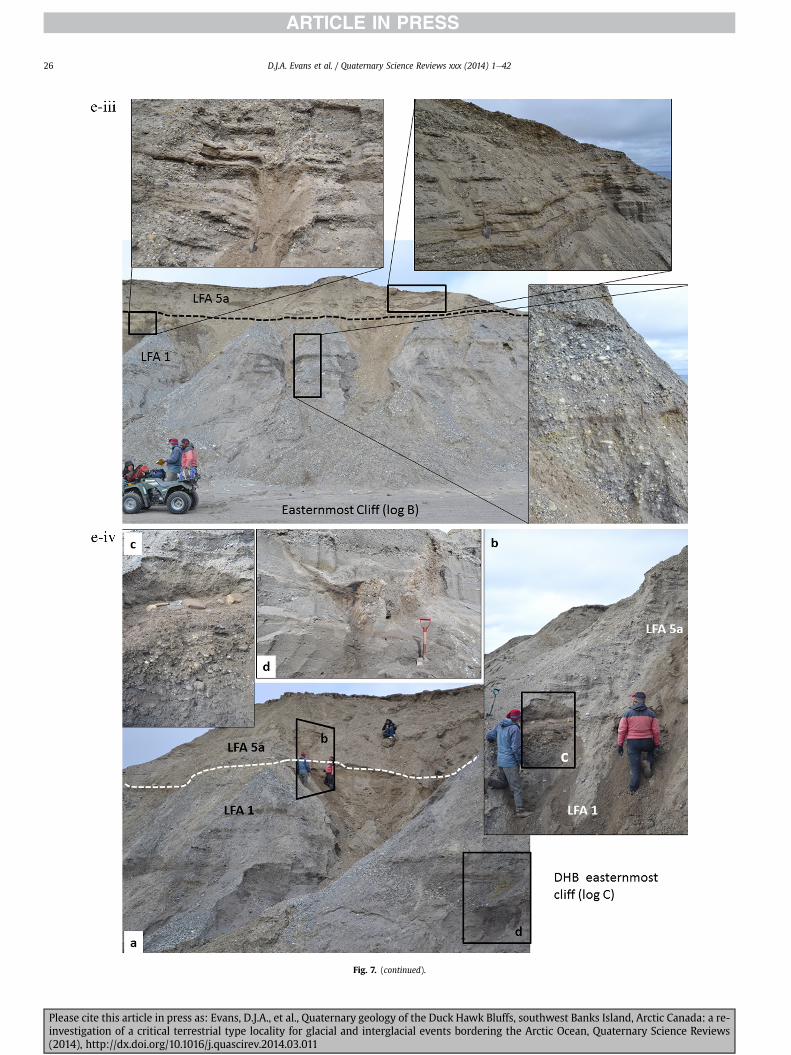
Fig 7 (continued)
DJA Evans et al Quaternary Science Reviews xxx (2014) 1e4226
Please cite this article in press as Evans DJA et al Quaternary geology of the Duck Hawk Bluffs southwest Banks Island Arctic Canada a re-investigation of a critical terrestrial type locality for glacial and interglacial events bordering the Arctic Ocean Quaternary Science Reviews(2014) httpdxdoiorg101016jquascirev201403011
DJA Evans et al Quaternary Science Reviews xxx (2014) 1e42 27
events that were gradually replaced by low magnitudehigh fre-quency events (Marren 2005) Partially to heavily-scoured rem-nants of laminated and massive fines represent deposition duringlow flow conditions in abandoned shallow channels The palae-ocurrent data from LFA 1 indicate that the outwash streams wereflowing westerly away from a glacier source located in AmundsenGulf This glacier likely eroded the abundant LFA 1 lithologies(chert quartzite and sandstone) from Mesoproterozoic and Neo-proterozoic bedrock widely distributed to the east and south(western Victoria Island Amundsen Gulf and the adjacent main-land Harrison et al 2013) These lithologies are consistent with theadvance of the NW Laurentide Ice Sheet through Amundsen Gulf(cf Dyke et al 2002 Batchelor et al 2012 MacLean et al 2013)
The crudely bedded organic detritus and degraded tree frag-ments (stumps) in LFA 1 are clearly reworked (cf Matthews et al1986 Fyles 1990 Vincent 1990) The finer grained detritus wasdeposited in concentrated pockets during waning flow stageswhereas horizons of logs and larger tree fragments were emplacedwith the coarser grained and poorly sorted sediments associatedwith hyperconcentrated flows or traction carpets during highdischarge These reworked organics also differ significantly fromthe type location of the Beaufort Fm a characteristic that promptedFyles (1990) to distinguish them as lsquotheMary Sachs Gravelrsquo Notablythe enclosing gravel and sand of LFA 1 is much coarser and exhibitsan entirely different fluvial architecture than the sandier BeaufortFm The composition and degraded nature of the LFA 1 organicssuggests that they were eroded by glaciers or their meltwater fromNeogene andor Paleogene sediments presumably to the southeastof Banks Island (eg Fyles 1990 Fyles et al 1994) The proximity ofa glacier is highlighted by the preservation of striae on individualclasts especially in the very coarse lower gravel The verticaldecrease in striae preservation and angularity (RA) and concomi-tant increase in roundness and upward-fining in LFA 1 is indicativeof an increasingly distal ice margin The co-variance plots (Fig 5)indicate a strong fluvial signature especially in the C40RA data butsubglacial characteristics are also evident particularly in the C40RWR data for the coarser grained and more matrix-supportedgravel as would be expected in ice-proximal settings
It is important to note that the widespread thrusting of LFA 1and underlying Kanguk Formation towards the southwest occurredpost-depositionally This glacitectonic thrusting was produced byLaurentide ice that advanced from the Kellett River valley (interiorBanks Island) during the emplacement of LFA 6 (see below) Theinjection of clastic dykes and fissure fills during this glacitectonicdisturbance was due to the overpressurizing of groundwater ingravel aquifers likely in taliks The branching limbs of many of thedykes are indicative of burst-out structures diagnostic of hydro-fracturing by vertically escaping groundwater pressurized byglacier overriding (cf Rijsdijk et al 1999 Le Heron and Etienne2005)
5122 LFA 2 At the top of LFA 1 rhythmites with lonestonesoverlie prominent clinoforms or foreset beds recording a changefrom subaerial glacifluvial to subaqueous deposition This wasinitially on a shallow delta front prograding foreset beds in asouthwesterly direction followed by suspension sedimentationwith dropstones presumably from floating ice in a marine orlacustrine basin The occurrence of matrix-supported gravelly scourfills with logs and woody detritus suggests pulses of cohesionlesssediment gravity flows into the basin Overlying the rhythmically-bedded sand prominent ice wedge pseudomorphs (up to 4 mdeep Fig 9aec cf Mackay and Burn 2002) are interspersed withthick (gt1m) sections of compressed in situ bryophytes (Figs 9d 7e)indicating the establishment of a tundra surface Four bryophytefamilies and 10 distinct species have been determined from LFA2
Please cite this article in press as Evans DJA et al Quaternary geologyinvestigation of a critical terrestrial type locality for glacial and intergla(2014) httpdxdoiorg101016jquascirev201403011
with the most abundant material from the Calliergonaceae andCampyliaceae (Table 1) These macrofossils are exceptionally wellpreserved including material with intact fragile alar cells typical ofthese two families (Fig 14cef) The data from these autochthonousdeposits indicate a wetland environment characterized as a richfen This ecosystem and habitats therein are consistent with speciesfound in the extant flora of Banks Island (Fig 14b) The autecologyfrom this range of species suggest hydric to mesic habitatsincluding standing pools wet meadows and microhabitats createdby ice wedges Despite the predominance of bryophytes in LFA 2these macrofossils had not been previously documented at DHB Incontrast a minimal proportion of the samples (lt5) consisted ofvascular plant material (including Cyperaceae seeds gramminoidleaves and woody twig fragments) Collectively the ice wedgepseudomorphs and vegetation within LFA 2 represent an isochro-nous terrestrial surface of interglacial rank
Following the formation of ice wedges the injection of intra-formational clastic dykes and fissure fills in LFA 2 relates to theoverpressurizing of groundwater in gravel aquifers or taliks due toglacier overriding The branching dyke limbs that emanate fromunderlying LFA 1 gravels and sands are indicative of the burst-outstructures that develop during hydrofracturing (cf Rijsdijk et al1999 Le Heron and Etienne 2005) A variant of the gravel andsand filled clastic dykes occurs within the sequence of glaci-tectonite and rhythmites near west Log D (Fig 11) Here thevertically-widening fracture is characterized by a mosaic ofpartially disaggregated blocks of the host materials in its widestzone where it contains gravels injected from underlying LFA 1Because these gravels only occur in the basal narrow neck theypresumably record the rapid reduction in flow competence duringhydrofracture filling
Deformation structures including overfolded or crumpledbedding and thrust faults associated with boudinage or highfissilitypseudo-lamination are representative of simple shear andwere also induced by glacitectonic disturbance (cf van derWateren 1995 McCarroll and Rijsdijk 2003) This predominantlyrecords a glacier advance from the northeast Subsidiary shear in-dicators record deformation from the south or southeast but theseoccur only at the top of LFA 2 and the base of LFA 3 suggestingearlier emplacement (see below) The development of zones ofboudinage shallow thrust faults overfolding or bed crumpling atdifferent levels within LFA 2 e especially at the contact separatingsediments of different grain size e represents deformation parti-tioning due to contrasting rheological properties Blind thrustswere also initiated in underlying LFA 1 increasingly towards thecentral and eastern cliffs where large-scale deformation is moreprevalent (Fig 7c d) A zone of intense deformation is recorded by alens of LFA 3 diamicton in fault contact with LFA 2 (east cliff Log AFig 7d i) This constitutes a type B glacitectonite (non-penetrativelydeformed pre-existing sediments sensu Benn and Evans 1996Evans et al 2006) developed during the emplacement of LFA 3(see below) A similar glacitectonite occurs at the junction of LFA 1and LFA 3 near west Log D (Fig 11) Bed attenuation by deformationis best developed in lower LFA 2 where the greater differences insediment grain size and hence rheology exist
5123 LFA 3 Within LFA 3 locally abundant stratified lensesindicate subaqueous deposition These stratified sediments weresubsequently thrust faulted folded and attenuated - most evidentin the upper and lower zones of LFA 3 This deformation was likelyresponsible for the intraclast boudinage and pseudo-lamination inthe surrounding diamicton (eg Hart and Roberts 1994 Robertsand Hart 2005 Oacute Cofaigh et al 2011) This process was alsoassociatedwith the attenuation of LFA 1 and 2 sediments within theheavily deformed base of LFA 3 some of which may have been
of the Duck Hawk Bluffs southwest Banks Island Arctic Canada a re-cial events bordering the Arctic Ocean Quaternary Science Reviews
Fig 8 Details of LFA 1 a) example of a concentration of logs with degraded rootballs in the stacked tabular units of cross-bedded sands and gravels and crudely stratified matrix-supported cobble to boulder gravels in the west cliff b) poorly-sorted and crudely horizontally bedded cobble to boulder gravel containing laminated clay intraclast (immediatelyabove compass) c) shallow locally graded foreset beds composed of openwork to sandy matrix-supported cobble to granule gravels in central cliff Log A d) planar bedded sandy
DJA Evans et al Quaternary Science Reviews xxx (2014) 1e4228
Please cite this article in press as Evans DJA et al Quaternary geology of the Duck Hawk Bluffs southwest Banks Island Arctic Canada a re-investigation of a critical terrestrial type locality for glacial and interglacial events bordering the Arctic Ocean Quaternary Science Reviews(2014) httpdxdoiorg101016jquascirev201403011
DJA Evans et al Quaternary Science Reviews xxx (2014) 1e42 29
cannibalized and rafted by the deformation process within a shearzone at the contact of LFA 3 with older sediments The shearingdirection from the south and southeast recorded in lower LFA 3also impacted upper LFA 2 whereas the more prominent shearingdirection throughout LFA 3 is from the northeast (also recorded inLFA 4) The local development of a heavily deformed zone at the topof LFA 3 was likely imparted during the shearing of overlying LFA 4sediments Although clast macrofabric strengths from the LFA 3diamicton are variable they possess shapes that compare withglacitectonites and subglacial traction tills and in some cases amodalityisotropy signature that reflects high lodgementcomponents
The similar orientation of the macrofabrics and shear indicatorsare considered diagnostic of a glacitectonite derived from stratifiedsediments (eg interbedded mass flow diamictons gravelly massflows and localized traction current sands and suspension de-posits) This evidence indicates that LFA 3 like all the other LFAsand the underlying Kanguk Fm bedrock has been displaced by aglacier advancing from the NNE or NE (ie Laurentide ice crossingthe interior of Banks Island) Minor south to north shearing in-dicates that LFA 3 and upper LFA 2were also disturbed by glacier iceflowing northwards (ie Laurentide ice advancing throughAmundsen Gulf) The appearance of granite and gabbro clastswithin the LFA 3 diamict records the arrival of far-travelled Lau-rentide ice from mainland Canada Clast form co-variance stronglyindicates a subglacial (abraded) source for LFA 3 with a minorfluvial component (Fig 5) including glacifluvial clasts locallycannibalized from LFA 1 by overriding ice
5124 LFA 4 LFA 4 has restricted outcrops is heavily deformedand contains organic detritus that is clearly allochthonous andhighly degraded Nonetheless a variety of indicators (fine-grainedhorizontally bedded cross-laminae rhythmites climbing ripplesand draped laminae) demonstrate that LFA 4 was deposited in asubaqueous environment with palaeocurrents from the south orsouthwest Traction currents were likely responsible for thedevelopment of the clast lag at the contact between lower LFA 4and underlying LFA 3 (west cliff Log A Fig 7b ii) LFA 4 coarsensupwards indicative of basin infilling andor an approaching sedi-ment source The narrow anabranched clastic dykes in the sandyclimbing ripples (LFA 4 west cliff Log A) record hydrofracturing bythe upward injection of overpressurized groundwater duringshearing The branching limbs of the dykes are similar to the burst-out structures reported by Rijsdijk et al (1999) but differ becausethey are composed solely of sand derived from the walls of the hostsediment rather than from an underlying gravel aquifer (cf LeHeron and Etienne 2005) Hence the pressurized water wasgenerated at the contact between the sand and underlying imper-meable brecciated clays The development of thin zones of brecci-ation boudinage sheath folding or thrust faulting at the upper andlower contacts of LFA 4 relates to the localized partitioning ofdeformation controlled by the location of claysilt beds Thejuxtaposition of this style of deformation with the larger scaleoverfolds and thrust faults developed in the extensive bodies ofsandy lithofacies is indicative of a Type B glacitectonite (sensu Bennand Evans 1996) This was constructed by the overriding of glacierice advancing from the north or northeast These shear directionsare compatible with those developed in the underlying LFAs
granule gravels with gravel lags (top and bottom of image) interrupted by an intervening unbedded granule to pebble gravel and massive cobble to pebble gravel A cluster of small treesequence of stacked tabular units of predominantly horizontally bedded sands and gravels ingravels containing clusters of wood detritus in the coarser gravel beds (central cliff Log A)wood fragments (central cliff Log A)
Please cite this article in press as Evans DJA et al Quaternary geologyinvestigation of a critical terrestrial type locality for glacial and intergla(2014) httpdxdoiorg101016jquascirev201403011
5125 LFA 5 The primary characteristics of LFA 5 are typical ofgravel sheet and occasional traction-carpet sedimentation in anice-proximal sandur (eg Boothroyd and Ashley 1975 Miall 19781985 1992 Maizels 1989ab Siegenthaler and Huggenberger1993 Mulder and Alexander 2001 Marren 2005) Glacier prox-imity is supported by the subglacial to fluvial signature of the clastforms (Fig 5) The coarsening-upward sequence including striatedclasts culminates in the arrival of a glacier that overrode the sitedepositing LFA 6 Post-depositional shearing within underlying LFA4 is recorded by attenuation and interdigitation at the contact withLFA 5 imparted during deposition of LFA 6 The contact betweenLFA 5 and 6 reflects the development of a shear zone where upperLFA 5 sediments have been cannibalized producing a meacutelange ofcrudely stratified diamictons with discontinuous interbeds ofmatrix-supported gravel laminated sand silt and clay (LFA 6 seebelow)
5126 LFA5a At Easternmost Cliff glacifluvial gravel (LFA 5a)unconformably overlies LFA 1 (Fig 7e) rendering uncertain itsrelationshipwith respect to LFA 5 in themain sections of DHB to thewest The fact that LFA 5a extends to the modern surface appearsundeformed and has palaeocurrents orientated to the NW requiresthat it is younger than LFA 5 Indeed we interpret LFA 5a asdeglacial outwash deposited from retreating Laurentide ice in theKellett River valley and Amundsen Gulf at the end of the lastglaciation (see Discussion)
5127 LFA 6 Based on its heterogeneity strongly orientated clastmacrofabrics and macroscale deformation structures LFA 6 con-stitutes a Type B glacitectonite (sensu Benn and Evans 1996)However zones of more highly strained Type A glacitectonite(sensu Benn and Evans 1996) at the basal contact with older LFAsare recorded by intraclastinterbed attenuation (pseudo-lamina-tion) strong boudinage or fissility and strengthened clast macro-fabrics The production of this meacutelange is attributed to two separateprocesses 1) primary sedimentation as interbedded and interdig-itated mass flow debris fluvial gravel and sand and subaqueoussuspension sediments and 2) cannibalization of underlying strat-ified sediments (LFAs 4 and 5) This produced a continuum of formsranging from low strain fold structures to attenuated rafts to tec-tonic lamination (eg Fig 7) The discontinuous lenses of degradedorganics (black stems and woody twigs gramminoid leaveswhitened rootlets) within LFA 6 are rafts and include seven speciesof bryophytes (Table 1) The material was highly compressed anddifficult to separate into distinct taxa Indeed one of the threesamples analysed was too degraded to recover any taxa Much ofthe material consisted of only fragmented leaves and only theminute taxa had stems with intact leaves The bryophytes thatcharacterize the LFA 6 samples represent hydric (Calliergon sppTomenthypnum nitens) to mesic (Ditrichum flexicaule Dicranum sp)habitats Three species collected from LFA 6 were also present inLFA 2 whereas four others were not found in LFA 2 but are com-mon in the modern flora The poor preservation quality suggeststhat the material has been redeposited from unknown sources andis clearly allochthonous
The predominant shearing direction within LFA 6 records an iceadvance from the interior of Banks Island (NE) This has resulted incomplex folding and thrusting and localized thickening of LFA 6
it of cross-bedded poorly-sorted to openwork cobble to boulder gravel crudely planar-fragments occur at the base of the cobble to boulder gravels at image centre e) middleDHB west cliff Log D f) sequence of fining-upward planar-bedded cobble to sandy fineg) planar cross-bedded sandy granule to pebble gravels with pebble to cobble lags and
of the Duck Hawk Bluffs southwest Banks Island Arctic Canada a re-cial events bordering the Arctic Ocean Quaternary Science Reviews
Fig 9 Details of LFA 2 from the west cliff a) narrow necked ice wedge pseudomorph with upturned marginal bedding in sand silt and clay rhythmites b) wide necked ice wedgepseudomorph c) ice wedge pseudomorph with overturned silt sand and clay rhythmites developed at the top of LFA 2 and sealed by overlying LFA 3 laminated diamicton d)horizontally bedded sand and silt containing well preserved moss macrofossils e) zone of disharmonically folded sandsilt laminae with well preserved moss peat located at thebase of LFA 2
DJA Evans et al Quaternary Science Reviews xxx (2014) 1e4230
Please cite this article in press as Evans DJA et al Quaternary geology of the Duck Hawk Bluffs southwest Banks Island Arctic Canada a re-investigation of a critical terrestrial type locality for glacial and interglacial events bordering the Arctic Ocean Quaternary Science Reviews(2014) httpdxdoiorg101016jquascirev201403011
Fig 10 Details of simple shear structures developed in fine sand and silt laminae at the centre of the thickest outcrop of LFA 2 in west cliff Log B a) overview of large scaleanastomosing shear faults with zones of smaller scale densely spaced anastomosing shears towards the base of the photograph b) details of large scale shear faults separatingzones of variably but predominantly densely spaced shears c) close details of shear zone comprising densely spaced anastomosing fractures d) details of ascending kink zonecross-cutting large scale anastomising shear faults Shearing direction is coming out of the cliff and towards the left in each image
DJA Evans et al Quaternary Science Reviews xxx (2014) 1e42 31
This shearing direction is recorded throughout underlying LFAs 1e4as well as the Kanguk Formation demonstrating deep-seated butpartitioned glacitectonic disturbance imparted during theemplacement of LFA 6 This strain signature was therefore over-printed on the northerlynortheasterly aligned shearing directionrecorded in LFA 3 and upper LFA 2 by the earlier northerly flowingice that deposited LFA 3 One anomalous clast macrofabric(northerly CCA F1) occurs in the basal meacutelange of LFA 6 Howeverthis sample is from an isolated outcrop (Fig 7c i) rendering itsapparent shearing direction equivocal
Please cite this article in press as Evans DJA et al Quaternary geologyinvestigation of a critical terrestrial type locality for glacial and intergla(2014) httpdxdoiorg101016jquascirev201403011
52 Sedimentology and stratigraphy (Mary Sachs Creek cliff)
The cliffs east of Mary Sachs Creek (Figs 2b 3) provides a cross-section through the seaward margin of the coast-parallel SachsMoraine (ldquosection Jrdquo Vincent et al 1983 Vaughan 2014) Weprovide a summary of two logs based on a reconnaissance survey ofthese sediments Log A is closest toMary Sachs Creekwhereas Log Boccursw1 km farther east (Figs 3 15a amp b) The sediments exposedin Log A appear to descend eastward and disappear below themodern beach and therefore are assumed to stratigraphically
of the Duck Hawk Bluffs southwest Banks Island Arctic Canada a re-cial events bordering the Arctic Ocean Quaternary Science Reviews
Fig 11 Details of LFA 2 near west Log D Lower box shows a 1e2 m thick basal zone comprising highly attenuated inter-digitated beds of gravelly to clay-rich diamictons and sandsiltclay rhythmites Upper box shows rhythmites containing diamictic intraclasts with sharp and angular boundaries also visible is the draping and deforming of the rhythmitebedding over and under the intraclasts respectively ldquoTailsrdquo extending from the diamictic intraclasts and thin but discontinuous diamictic beds are also visible in the upper box
DJA Evans et al Quaternary Science Reviews xxx (2014) 1e4232
underlie the sediments of Log B A sand and gravel- bench caps bothlogs at w15 m asl incised into the seaward margin of the SachsMoraine
521 DescriptionLog A contains a sequence of upward-fining highly contorted
cross-stratified sand and fine gravel to rhythmically bedded sandsilt clay with minor pebble gravel and sporadic clots of gravellydiamicton (Fig 15a) An ice wedge was initially developed in thelower cross-stratified sand and fine gravel before they were foldedand thrust faulted The deformed ice wedge pseudomorph is un-conformably overlain by a relatively undisturbed lens of laminatedsilty clay with dropstones interbedded with gravelly diamictonthat contains a bed (10 cm) of sandy black organics containingwood fragments (Fig 15a) This organic material occurs repeatedlyup-section as discontinuous stringers Log A is capped by 1e2 m ofpoorly exposed and heavily cryoturbated gravelly diamicton Thegeneral sense of displacement on shallow reverse faults over-turned bedding and boudinage structures is from the southeast
Log B (12 m) displays a coarsening-upward sequence of hori-zontally bedded sandy granule gravel with occasional silty sandlaminae (Fig 15b iii) that grades to poorly-sorted cobble to bouldergravel and bouldery matrix-supported gravel (Fig 15b ii) This iscapped by laminated to crudely stratified cobbly diamicton that issilt and clay-rich abruptly and conformably overlain by
Please cite this article in press as Evans DJA et al Quaternary geologyinvestigation of a critical terrestrial type locality for glacial and intergla(2014) httpdxdoiorg101016jquascirev201403011
interlaminated silt clay and pebbly silty sand (Fig 15b i) Althoughthe bedding on these units dips towards the NW individuallaminae do not thicken in that direction indicating post-depositional tilting The uppermost part of the log (underlyingthe 15 m bench) contains 2 m of clay-rich massive diamictoninterfingered with the underlying laminated sediments and cobblydiamicton
522 Interpretation
5221 Log A Broadly the sedimentology of log A including thedeformed ice wedge pseudomorph is similar to LFA 2 in DHB (egcentral cliff Log A Fig 7c iii) Prior to glacitectonic disturbance theoverlying organic bed (Fig 15a) was redeposited into a sequence ofsubaqueous siltclay rhythmites containing dropstones and gravellymass flows The highly attenuated shear margins bracketing theorganic bed in Log A demonstrate that it has been displaced as atectonic raft Previous research proposed that the organic beds e
similar to those described in Log A e be assigned to the LastInterglacial (locally called the Cape Collinson Vincent 1982 1983)Because these organic beds are clearly a raft they cannot constitutean iscochronous surface precluding chronostratigraphic signifi-cance (see Discussion) Shearing of the Log A sediments from thesoutheast documents an ice advance from Amundsen Gulf corre-sponding to the earliest of two primary shearing directions recor-ded at DHB (imparted during the emplacement of LFA 3) Therefore
of the Duck Hawk Bluffs southwest Banks Island Arctic Canada a re-cial events bordering the Arctic Ocean Quaternary Science Reviews
Fig 12 Details of LFA 4 in West Log A a) heavily deformed upper contact of LFA 4 comprising sandsiltclay rhythmites displaying well developed boudinage sheath folds andimmature tectonic laminae and an interdigitatedsheared boundary with underlying climbing ripple sands The contact with overlying LFA 6 is marked by an interdigitated zonecontaining rooted and de-rooted folds or rhythmite rafts in a sand gravel and diamicton meacutelange b) narrow anabranched clastic dykes ascending sub-vertically through climbingripple drift and resulting in offset bedding between blocks of host material c) abrupt contact between sheared sands and rhythmites of LFA 4 and overlying sand gravel anddiamicton meacutelange
Fig 13 Details of LFA 5 a) poorly sorted and matrix-supported pebble to cobble gravel b) tabular sequence of horizontally bedded to massive gravel and matrix-supported gravelcontaining a horizon of striated cobbles and boulders c) heavily deformed discontinuous bed of siltclay rhythmites between LFA 5 and LFA 6 in West Log D showing theamalgamation zone with the LFA 5 gravels immediately above the compass d) interdigitateddeformed contact between LFA 5 granule to pebble gravels and underlying LFA 4laminated silts and clays with organic detritus in West Log B
DJA Evans et al Quaternary Science Reviews xxx (2014) 1e42 33
Please cite this article in press as Evans DJA et al Quaternary geology of the Duck Hawk Bluffs southwest Banks Island Arctic Canada a re-investigation of a critical terrestrial type locality for glacial and interglacial events bordering the Arctic Ocean Quaternary Science Reviews(2014) httpdxdoiorg101016jquascirev201403011
Table 1List of bryophytes and vascular plants from LFAs 2 and 6
LFA2 WestCliff Log B
LFA6 CentralCliff Log A
Elevation (m) 185 m asl w45 m aslSample 4e12 1e3 taxa 10 7
Bryophyta (mosses)AmblystegiaceaeAmblystegium serpens (Hedw) Schimp x
CamyliaceaeCampylium polygamum (Schimp) CEO Jensen xCampylium stellatum (Hedw) CEO Jensen x xDrepanocladus aduncus (Hedw) Warnst xDrepanocladus sp xTomentypnum nitens (Hedw) Loeske x
CalliergonaceaeCalliergon giganteum (Schimp) Kindb xCalliergon richardsonii (Mitt) Kindb xthornthornthornthorn xCalliergon sp xWarnstorfia exannulatus (Schimp) Loeske xthornthornthornthorn x
BrachytheciaceaeBrachythecium turgidum (Hartm) Kindb x
MniaceaeCyrtomnium cf hymenophylloides(Hbener) TJ Kop
x
DicranaceaeDicranum sp x
DitrichaceaeDitrichum flexicaule (Schwaumlgr) Hampe x
Tracheophyta (vascular plants)CyperaceaeSeeds (triangular amp flattened) x x
Gramminoid leaf material x xWoody twig fragments x xRootlets x
Fig 14 The moss peat and associated microfossils of LFA 2 a) exposure through lower LFAsouthern Banks Island analogue of a rich tundra fen environment for the bryophyte assemblfrom LFA 2 showing the exceptional preservation of Calliergonaceae and Campyliaceae ma
DJA Evans et al Quaternary Science Reviews xxx (2014) 1e4234
Please cite this article in press as Evans DJA et al Quaternary geologyinvestigation of a critical terrestrial type locality for glacial and intergla(2014) httpdxdoiorg101016jquascirev201403011
these deformed deposits are interpreted as a Type B glacitectonite(sensu Benn and Evans 1996) possibly derived from LFA 2
5222 Log B The coarsening upward gravel in Log B recordshighly turbid to hyperconcentrated discharge in non-channelizedsheets This is interpreted as aggrading glacifluvial outwash froman approaching ice margin The capping sequence of crudelystratified diamicton and laminated sediments records a changefrom glacifluvial to subaqueous sedimentation prior to overridingby a glacier of unknown age that tilted the upper beds Thecoarsening-upward sequence apparent tectonism and cappingdiamict at Log B clearly distinguishes these deposits from those ofLFA 5a (west of Mary Sachs Creek easternmost cliff Fig 3)Furthermore although there is lithological similarity between LogB and LFA 5 throughout DHB the sense of shearing is dissimilar (LFA5 from the NE and Log B from the SE) The simplest explanation forthis difference in shear direction is that LFA 5 (DHB) was displacedby interior ice advancing down the Kellett River whereas Log B wasdisplaced by ice advancing along Amundsen Gulf (Fig 2b)
6 Discussion
61 Large scale glacitectonic structures and stratigraphicarchitecture
The glacitectonic structures identified within the lithofaciesassociations at DHB record two phases of deformation (early NeSand later NEeSW) This deformation together with the DHBstratigraphic architecture (Fig 16) helps to explain both thekinetostratigraphy (sensu Berthelsen1978) and the evolution of thelocal glacial geomorphology The large scale glacitectonic defor-mation is most clearly manifest in the thrust faulting and conjugate
2 at DHB west log B showing the sampling locations for in situ moss peat b) a modernages of LFA 2 c)ef) details of the typical moss peat and associated microfossil materialscrofossils including material with intact fragile alar cells
of the Duck Hawk Bluffs southwest Banks Island Arctic Canada a re-cial events bordering the Arctic Ocean Quaternary Science Reviews
Fig 15 The stratigraphy of Mary Sachs Creek cliff a) photographic compilation log A showing upward-fining highly contorted (i) cross-stratified sands and fine gravels torhythmically bedded sands silts clays and minor pebble gravels Also visible in (ii) is a lens of interbedded laminated silty clays with dropstones and gravelly diamictons containingsandy black coloured organic material with wood fragments An ice wedge pseudomorph is visible (iii) to the right of the exposure b) photographic compilation log B showing i)laminated to crudely stratified cobbly but siltclay-rich diamicton grading into interlaminated silts clays and pebbly silty sands ii) poorly-sorted cobble to boulder gravel andbouldery matrix-supported gravel iii) coarsening-upward sequence of horizontally bedded sandy granule gravels with occasional silty sand laminae iv amp v) pebble to cobble graveland matrix-supported gravel
DJA Evans et al Quaternary Science Reviews xxx (2014) 1e42 35
shear development in the Kanguk Fm bedrock and overlying LFA 1(east cliff Fig 7d ivevi) Here predominantly northeasterly dippingthrust slices have been stacked truncated and overlain by LFA 6during the second and strongest (NEeSW) deformation phase(Fig 16 note bedrock slice within the imbricated stacked sequenceof LFA 1) These structures demonstrate significant compressionand thickening of the stratigraphic sequence including w40 m ofvertical offset within the Kanguk Formation acrossw3 km (Fig 16)Prominent hydrofracture fills in LFAs 1 and 2 record elevatedporewater pressure during this thrusting Smaller scale shear zoneshave also developed in the finer grained interbeds within thrustslabs (Fig 7d vii) indicative of deformation partitioning by strataprone to ductile failure This zone of greatest displacement alsocoincides with the highest topography (Fig 16) Lower angle thrustfaults propagate in a southwesterly direction predominantlythrough LFA 1 but are also developed through LFA 2 in the footwallblock (east cliff Fig 16)
The thrust stacking of bedrock and LFAs 1e5 in east cliff (obliqueto Fig 16) represents the ice-proximal zone of a thrust-blockmorainecomposite ridge constructed by a glacier advancing fromthe northeast (ie the interior of Banks Island) This glacitectonicdeformation propagated southwestward to distal parts of theproglacial stress field as recorded bywell-developed shear zones inthe finer grained sediments of LFAs 2e5 In the more distal westcliff open folds (LFA 2 Fig 16) appear to be the product of a blindthrust within underlying LFA 1 This style of tectonism is typical oflsquopiggyback-style thrustingrsquo wherein steeply inclined thrust blocksat the advancing ice margin propagate new thrusts in the footwall(Fig 16 Park 1983 Mulugeta and Koyi 1987) The angle of thesefootwall thrusts becomes progressively shallower southwestward
Please cite this article in press as Evans DJA et al Quaternary geologyinvestigation of a critical terrestrial type locality for glacial and intergla(2014) httpdxdoiorg101016jquascirev201403011
(ice-distal) in LFA 1e5 where deformation partitioning developedin finer grained lithofacies (Fig 16)
The densely spaced ponds and depressions immediately to thenortheast of DHB (Figs 2b 3) constitute the depression fromwhich the thrust mass was excavated (eg Aber et al 1989Evans and England 1991 van der Wateren 1995) This inter-pretation is consistent with the strong northeast to southwestshear direction in the second phase glacitectonic structures andin LFA 6 clast macrofabrics This indicates that construction ofDHB occurred at the margin of a glacier advancing from thenortheast (ie from Kellett River valley) overtopping DHB anddepositing the LFA 6 glacitectonite The continued advance ofKellett ice coalesced with a glacier in Amundsen Gulf marked bythe interlobate Sachs Moraine containing ice-transported shellsas young as 24 cal ka BP (21020 70 yrs BP UCIAMS-89674)assigning this glaciation to the Late Wisconsin (Vaughan 2014)East of Mary Sachs Creek the deformation of Log B outwash(from the southeast Figs 15 16) likely records overriding by thesame Amundsen Gulf glacier (coeval with LFA 6 Late Wiscon-sinan) During ice retreat when Kellett River and Amundsen Gulfice decoupled DHB was exposed allowing the northwesterly-flowing proglacial outwash (LFA 5a) west of Mary Sachs Creekto extend to the shoreline marking postglacial marine limit atKellett Point (11 m asl Vaughan 2014 Fig 3) Collectively thisreconstruction supports a Late Wisconsinan age for the con-struction of DHB thrust block moraine although its stratigraphyincludes a range of ages A palaeogeographic reconstruction ofevents based upon our interpretation of the sedimentologystratigraphic architecture tectonism and geomorphology is pre-sented in Fig 17
of the Duck Hawk Bluffs southwest Banks Island Arctic Canada a re-cial events bordering the Arctic Ocean Quaternary Science Reviews
Fig 15 (continued)
DJA Evans et al Quaternary Science Reviews xxx (2014) 1e4236
62 Comparison and revision of previous DHB model
DHB was previously interpreted to record horizontally beddedNeogene to Quaternary sediments assigned to preglacial fluvialand multiple glacial and interglacial episodes (Vincent 1982 19831990 Vincent et al 1983 1984 Barendregt et al 1998) A com-posite palaeomagnetic record was also presented for this proposedstratigraphy placing most of this deposition before the BrunhesMatuyama boundary (Fig 1c) However prior to our work detailedstudies had not been undertaken on the sedimentology structuralgeology or stratigraphic architecture of DHB Rather the originalstratigraphy was restricted to a series of composite logs (our Fig 4reproduced from Vincent et al 1983) that notably omitted thepervasive deformation structures including the thrust bedrock ineast cliff (Fig 16)
Please cite this article in press as Evans DJA et al Quaternary geologyinvestigation of a critical terrestrial type locality for glacial and intergla(2014) httpdxdoiorg101016jquascirev201403011
Our reinterpretation dismisses several key elements of theoriginal DHB model outlined below (oldest to youngest) We havedetermined that the lowermost unit (LFA 1) is not preglacial (Fyles1990) but rather is composed of glacial outwash providing theearliest terrestrial evidence for glaciation in the area and containingallochthonous organics (including tree stumps) of unknown prov-enance Because LFA 1 is a glacifluvial braidplain (Fig 17a) it is notpart of the Beaufort Fm (Fyles 1990) even though it containsreworked macrofossils presumably derived from it (eg Craig andFyles 1960 Hills et al 1974 Vincent et al 1983)
Our analysis of LFA 2 indicates that it is also not preglacial norcan it be the Worth Point Fm as previously proposed (cf Vincent1982 1983 1990 Vincent et al 1983 Matthews et al 1986)Indeed the type locality of the Worth Point Fm has been invali-dated because it is now recognized to be an ice-transported and
of the Duck Hawk Bluffs southwest Banks Island Arctic Canada a re-cial events bordering the Arctic Ocean Quaternary Science Reviews
LFA4
Fig16
Stratigrap
hiccross-profi
lerun
ning
westto
easto
fDuc
kHaw
kBluffs
basedup
oninterpolations
betw
eenthemainsectionlogs
andsh
owingthesixLFAstheKan
gukFo
rmationbe
droc
kex
posu
resmajor
structural
features
and
thepo
sition
sof
icewed
geps
eudo
morph
san
dsign
ificant
clasticdy
kesAtthe
easternen
dof
thecross-profi
lethe
sedimen
tsat
theco
reof
MarySa
chsCree
kcliff
logAaretentativelyclassified
asLFA2
althou
ghthesematerialsarelik
ely
notin
situN
otethat
thecross-profi
ledo
esno
tex
tend
asfarea
stas
MarySa
chsCree
kcliff
logB
DJA Evans et al Quaternary Science Reviews xxx (2014) 1e42 37
Please cite this article in press as Evans DJA et al Quaternary geologyinvestigation of a critical terrestrial type locality for glacial and intergla(2014) httpdxdoiorg101016jquascirev201403011
glacitectonized raft (Vaughan et al 2014) In contrast our LFA 2 ischaracterized by an isochronous tundra surface with ice wedgesand intervening shallow ponds andwetmeadows The peat at LFA 2is dominated by bryophytes (gt95 by volume) and yet none ofthese macrofossils had been previously documented The diversein situ bryophyte species record a flora similar to that on BanksIsland today suggesting that LFA 2 warrants an interglacial rankThis conclusion is supported by the limited vascular plant record(five taxa no species indicated Vincent 1990) that also suggest awet meadow environment The absolute age of LFA 2 remains un-known but is apparently older than the BrunhesMatayamaboundary (gt780 ka Fig 18 cf Vincent et al 1984 Barendregt andVincent 1990 Barendregt et al 1998 see below)
LFA 3 in both our model and that of Vincent et al (1983) pro-vides the first direct evidence of ice reaching DHB In the previousmodel this was interpreted as Bernard Till (Banks Glaciation) thatwas bracketed by glacioisostatically induced marine transgressions(pre- and post-Banks seas Vincent 1982 1983) Within basal LFA 3we recognized highly deformed stratified sediment that wasdeposited in a subaqueous environment (deep water Fig 17c) priorto the arrival of overriding ice from the south (recorded by graniteand gabbro erratics Figs 17c 18) We regard LFA 3 to be equivalentto the Banks Glaciation (Vincent 1982 1983 Vincent et al 1983)including its pre- and post-Banks seas represented by the stratifiedsediments that bracket the central diamicton The LFA 3 sedimentsare also reported to be magnetically reversed thereby predatingthe BrunheseMatayama boundary (gt780 ka Fig 18 Vincent et al1984 Barendregt and Vincent 1990 Barendregt et al 1998)
Following the Banks Glaciation (our LFA 3 at DHB) Vincent(1982 1983) and Vincent et al (1983) recognized two in-terglacials (Morgan Bluffs and Cape Collinson) separated by anintervening marine episode This marine episode correspondedwith the glacioisostatic loading of a Laurentide ice margin confinedto the eastern half of Banks Island (Thomsen Glaciation) HoweverLFA 4 contains coarsening-upward subaqueous sedimentation fromthe south or southwest reflecting continued marine regressionfollowing LFA 3 (Fig 17c d) The coarsening-upward sequence ofLFA 4 is supplanted by coarse gravel outwash (LFA 5) supplied by aglacier readvancing from the northeast (Kellett River valley iceFig 17e) Glacier overriding is recorded by LFA 6 glacitectonite thatcaps the DHB thrust-block moraine composed of the entireassemblage of underlying LFAs (Fig 16)
Notably we have not observed any sediments characteristic oftwo interglacial deposits above LFA 3 hence dismiss the presence ofthe Morgan Bluffs and Cape Collinson interglacials at DHB Causseand Vincent (1989) report a U-series date of gt200 ka (UQT-229)from above our LFA 3 but this is almost certainly reworked andlacks chronostratigraphic significance Nor have we observedintervening marine sediments attributable to the Thomsen Glaci-ation (eg lsquoBig Searsquo Vincent 1982 1983 Vincent et al 1983)Rather following the deposition of the subaqueous sediments ofupper LFAs 3 and 4 (post-Banks Glaciation) LFAs 5 and 6 record asingle ice advance reaching DHB from the Kellett River valley(Banks Island interior) that was not reported by Vincent et al(1983) It was instead assumed that after the Banks GlaciationDHB lay distal to any later ice advances The nearest subsequentLaurentide margin to DHB recognized by Vincent et al (1983) wasassigned to the Sachs Moraine (immediately east of DHB) that waspresumed to be of EarlyWisconsin age (Fig 2b) However the SachsMoraine is nowdated to24 cal ka BP (LateWisconsinan Vaughan2014) andwas formed by the coalescence of Amundsen Gulf ice andthe Kellett River ice that deformed DHB (Fig 17) On the east side ofMary Sachs Creek the deposition of the Sachs Moraine coincideswith the deformation (from the southeast) of the underlying Log Boutwash gravel (Figs 3 15b)
of the Duck Hawk Bluffs southwest Banks Island Arctic Canada a re-cial events bordering the Arctic Ocean Quaternary Science Reviews
Fig 17 The palaeogeography of southwest Banks Island based upon interpretations of the principal lithofacies associations and structural architecture recognized at Duck HawkBluffs and the geomorphology of the surrounding terrain See text for detailed explanations
DJA Evans et al Quaternary Science Reviews xxx (2014) 1e4238
Although interglacial deposits were previously reported fromthe cliffs east of Mary Sachs Creek (ie Cape Collinson InterglacialVincent et al 1983) we found no similar evidence Rather the onlydeposit that we observed that may have been construed as inter-glacial sediments occurs in our Log A (Figs 3 15a) Here a darkdiscontinuous band of allochthonous organics (Fig15a) sits severedwithin a heavily tectonized melange (type B glacitectonite) and istherefore clearly a raft Although the absolute ages of the deformedunits east of Mary Sachs Creek (Logs A amp B) remain uncertain theyare apparently normally magnetized (Vincent et al 1984Barendregt and Vincent 1990) Blake (1987) also reports non-finite radiocarbon dates (gt36000 amp 49000 BP GSC-3560 amp 3560-2) obtained on ldquocompressed and deformed black woody peatrdquopurportedly from Cape Collinson beds (Vincent et al 1983 p 1708)Additionally Causse and Vincent (1989) report a U-series date onshells of 924 ka (UQT-143) from beds similar to the Log B gravelAgain all of these dated units have been displaced from unknownlocations limiting their utility for palaeoenvironmental recon-struction The last glacially influenced sedimentation at DHB isrecorded by northwesterly directed outwash (easternmost cliff LFA5a Figs 3 16 17g) We infer that this outwash fed the gravel beachmarking marine limit (11 m asl) in the lower Kellett River duringLate Wisconsinan retreat from the Sachs Moraine
63 Regional context
The stratigraphy at Duck Hawk Bluffs records three glacialevents The earliest of these is recorded by the aggradation of a
Please cite this article in press as Evans DJA et al Quaternary geologyinvestigation of a critical terrestrial type locality for glacial and intergla(2014) httpdxdoiorg101016jquascirev201403011
glacifluvial braidplain (LFA 1) that contains allochthonous pre-glacial material of diverse age However within LFA 1 there is noevidence that the ice reached DHB although it must have beennearby (southeast in Amundsen Gulf) The age of this glaciationremains unknown but the palaeomagnetic polarity of LFA 1 in-dicates that it is gt780 ka BP (Barendregt and Vincent 1990)Although Barendregt et al (1998) assigned part of the Worth PointFm to the normally polarized Olduvai sub-zone (MIS 64e74) itshould be noted that the Worth Point section is located 30 kmnorthwest of DHB There a stratigraphic revision has demonstratedthat this ldquotype sectionrdquo of the Worth Point Fm is in fact a glaci-tectonized raft (Vaughan et al 2014) This observation invalidatesthe previous correlation from Worth Point to purportedly coevalbeds at DHB (our LFA 2) Furthermore the diverse plant assem-blages in the Worth Point raft include preglacial tree stumps andSphagnum spp that do not occur on Banks Island today and are notfound in the wet meadow assemblages (rich fen) of LFA 2 that weinterpret to be of interglacial rank Therefore the sediments at DHB(LFAs 1 amp 2) do not support an age assignment of MIS 64e74(Olduvai subzone) proposed by Barendregt et al (1998) Currentlythe available palaeomagnetic record at DHB simply separates theentire section into a lower lsquoreversedrsquo unit and an upper lsquonormalrsquoone We place this boundary within our LFA 4 (Fig 18)
The overriding of DHB by glaciers is recorded in LFAs 3 amp 6These two glacial deposits may correspond to parts of the record ofstacked till sheets reported from the offshore seismic stratigraphy(Batchelor et al 2012) LFA 3 glaciationmay have contributed to theonset of mid-Pleistocene ice-rafted debris (IRD Ca-rich) attributed
of the Duck Hawk Bluffs southwest Banks Island Arctic Canada a re-cial events bordering the Arctic Ocean Quaternary Science Reviews
B-M
B-M
gt19
Fig
18A
revisedlitho
stratigrap
hyforDuc
kHaw
kBluffsPrev
ious
lyrepo
rted
ageco
nstraintsarealso
depicted
toge
ther
withatentativeallocation
ofMIS
stag
es(positione
dalon
gsideEa
stCliff
LogA
forclarity)
basedup
onthe
palaeo
mag
neticreco
rd
DJA Evans et al Quaternary Science Reviews xxx (2014) 1e42 39
Please cite this article in press as Evans DJA et al Quaternary geology of the Duck Hawk Bluffs southwest Banks Island Arctic Canada a re-investigation of a critical terrestrial type locality for glacial and interglacial events bordering the Arctic Ocean Quaternary Science Reviews(2014) httpdxdoiorg101016jquascirev201403011
DJA Evans et al Quaternary Science Reviews xxx (2014) 1e4240
to the Canadian Arctic Archipelago (CAA) and recorded in sedimentcores from the Arctic Ocean basin (Polyak et al 2009 2013OrsquoRegan et al 2010 Stein et al 2010) However Stein et al(2010) place the onset of Ca-rich ice-rafted debris within MIS 16(w659 ka BP Lisiecki and Raymo 2005) with subsequent peaks atMIS 12 10 and 8 all of which postdate the gt780 ka BP palae-omagnetic age proposed for LFA 3 (above) Polyak et al (2013) placethe onset of Ca-rich ice-rafted debris in the central Arctic Oceancloser to MIS 19 (790 ka BP) which is broadly compatible with theDHB palaeomagnetic record LFA 6 records the last glaciation ofDHB and we assign this to the Late Wisconsinan when Banks Is-land ice (Kellett River) coalesced with the Amundsen Gulf IceStream (Stokes et al 2006 MacLean et al 2013) During this in-terval the northwest Laurentide Ice Sheet likely reached the edgeof the polar continental shelf (Stokes et al 2005 2006 Englandet al 2009 Batchelor et al 2012 Lakeman and England 2013MacLean et al 2013)
7 Conclusions
New sedimentological and stratigraphic analyses of DHB funda-mentally revise the previous reconstruction of the Neogene andQuaternary history of Banks Island DHB and two other widely citedsections on Banks Island have been reported as important unde-formed terrestrial archives of glacial and interglacial sedimentationat the northwest limit of the Laurentide Ice Sheet that all have beenrecently revised (Vaughan et al 2014 Lakeman and England inpress) The recognition of pervasive large-scale deformation ofDHB necessitates a fundamental re-assessment of its previouslydescribed layer-cake stratigraphy We document that the oldestsediments (LFA 1) at DHB are not preglacial fluvial deposits (Beau-fort Fm) but rather record proglacial outwash from ice in AmundsenGulf that did not reach the site This was followed by the estab-lishment of an isochronous tundra surface of interglacial rank (LFA2) characterized by ice wedge polygons within a wet meadow thatsupported a bryophyte community similar to modern Subse-quently glacial sedimentation resumed initially in an ice-proximalsubaqueous environment followed by ice arrival and glacitectonicdeformation (LFA 3) The overlying deposits at DHB indicate post-glacial marine sedimentation (LFA 4) followed by the aggradationof glacifluvial sand and gravel (LFA 5) from an advancing ice marginthat culminated with the emplacement of a glacitectonite (LFA 6)during the Late Wisconsin This ice advance constructed a previ-ously undescribed thrust-block moraine (60 m high 8 km long) thatexhibits pervasive deformation and includes a substantial raft ofCretaceous Kanguk Fm bedrock (Fig 16) Furthermore the produc-tion of the glacitectonite (LFA 6) cannibalized LFAs 1e5 which atsome sites were previously thought to be in situ interglacial de-posits Finally outwash (LFA 5a) incised the DHB thrust block duringdeglaciation of the site when ice in the Kellett River and AmundsenGulf separated and proglacial meltwater drained northwestward tomarine limit (11 m asl) Refinements to the evolution and chronol-ogy of DHB and other sections around Banks Island will furthercontribute to the understanding of high latitude environmentalchange especially the complementary marine archives of theadjacent polar continental shelf and Arctic Ocean
Acknowledgements
Funding for this research was provided by the Natural Sciencesand Engineering Research Council of Canada (NSERC) NorthernResearch Chair Program and a complementary NSERC DiscoveryGrant (A6680) (both to JH England) Coulthard Lakeman andVaughan were supported by CBAR grants Canadian CircumpolarInstitute University of Alberta Coulthard and Lakeman were also
Please cite this article in press as Evans DJA et al Quaternary geologyinvestigation of a critical terrestrial type locality for glacial and intergla(2014) httpdxdoiorg101016jquascirev201403011
supported by Northern Scientific Training Program grantsAboriginal Affairs and Northern Development Canada The PolarContinental Shelf Program Natural Resources Canada(_501100000159) supplied additional funding and aircraft supportField and logistical assistance from Issac Elanik Vernon AmosTrevor Lucas and Roger Kuptana of Sachs Harbour is gratefullyacknowledged
References
Aber JS Croot DG Fenton MM 1989 Glaciotectonic Landforms and StructuresKluwer Dordrecht
Barendregt RW Vincent J-S 1990 Late Cenozoic paleomagnetic record of DuckHawk Bluffs Banks Island Canadian Arctic Archipelago Can J Earth Sci 27124e130
Barendregt RW Duk-Rodkin A 2011 Chronology and extent of Late Cenozoic icesheets in North America a magnetostratigraphical assessment In Ehlers JGibbard PL Hughes PD (Eds) Quaternary Glaciations e Extent and Chro-nolgy a Closer Look Elsevier Amsterdam pp 419e426
Barendregt RW Vincent J-S Irving E Baker J 1998 Magnetostratigraphy ofQuaternary and late Tertiary sediments on Banks Island Canadian Arctic Ar-chipelago Can J Earth Sci 35 147e161
Batchelor CL Dowdeswell JA Pietras JT 2012 Variable history of Quaternaryice-sheet advance across the Beaufort Sea margin Arctic Ocean Geology httpdxdoiorg101130G336691
Batchelor CL Dowdeswell JA Pietras JT 2013 Seismic stratigraphy sedimen-tary architecture and palaeo-glaciology of the Mackenzie Trough evidence fortwo Quaternary ice advances and limited fan development on the westernCanadian Beaufort Sea margin Quat Sci Rev 65 73e87
Benn DI 1994 Fabric shape and the interpretation of sedimentary fabric dataJ Sediment Res 64 910e915
Benn DI 1995 Fabric signature of till deformation Breiethamerkurjoumlkull IcelandSedimentology 42 735e747
Benn DI 2004 Clast morphology In Evans DJA Benn DI (Eds) A PracticalGuide to the Study of Glacial Sediments Arnold London pp 77e92
Benn DI Ballantyne CK 1994 Reconstructing the transport history of glaciogenicsediments a new approach based on the co-variance of clast form indicesSediment Geol 91 215e227
Benn DI Evans DJA 1996 The interpretation and classification of subglaciallydeformed materials Quat Sci Rev 15 23e52
Benn DI Evans DJA Phillips ER Hiemstra JF Walden J Hoey TB 2004 Theresearch project d a case study of Quaternary glacial sediments InEvans DJA Benn DI (Eds) A Practical Guide to the Study of Glacial Sedi-ments Arnold London pp 209e234
Berthelsen A 1978 The methodology of kineto-stratigraphy as applied to glacialgeology Bull Geol Soc Den 27 25e38
Blake Jr W 1987 Geological Survey of Canada Radiocarbon Dates XXVI InGeological Survey of Canada Paper 86-7 60 pp
Boothroyd JC Ashley GM 1975 Processes bar morphology and sedimentarystructures on braided outwash fans northeastern Gulf of Alaska InJopling AV McDonald BC (Eds) Glaciofluvial and Glaciolacustrine Sedi-mentation Society of Economic Paleontologists and Mineralogists SpecialPublication No 23
Causse C Vincent J-S 1989 TheU disequilibrium dating of Middle and LatePleistocene wood and shells from Banks and Victoria islands Arctic CanadaCan J Earth Sci 26 2718e2723
Church MA 1972 Baffin Island sandurs a study of Arctic fluvial processes GeolSurv Can Bull 216 208
Clark DL Vincent J-S Jones GA Morris WA 1984 Corrrelation of marine andcontinental glacial and interglacial events Arctic Ocean and Banks Island Na-ture 311 147e149
Collinson JD 1996 Alluvial sediments In Reading HG (Ed) Sedimentary Envi-ronments and Facies third ed Blackwell Oxford pp 37e82
Craig BG Fyles JG 1960 Pleistocene Geology of Arctic Canada In GeologicalSurvey of Canada Paper 60-10 21 pp
Crosby MR Magill RE Allen B He S 1999 A Checklist of the Mosses MissouriBotanical Garden St Louis 320 pp
Duk-Rodkin A Barendregt RW 2011 Stratigraphical records of glacialsin-terglacials in northwest Canada In Ehlers J Gibbard PL Hughes PD (Eds)Quaternary Glaciations e Extent and Chronology a Closer Look ElsevierAmsterdam pp 661e698
Dyke AS Andrews JT Clark PU England JH Miller GH Shaw J Veillette JJ2002 The Laurentide and Innuitian ice sheets during the Last Glacial MaximumQuat Sci Rev 21 9e31
England JH Furze MFA Doupeacute JP 2009 Revision of the NW Laurentide IceSheet implications for the paleoclimate the northeast extremity of Beringiaand Arctic Ocean sedimentation Quat Sci Rev 28 1573e1596
Evans DJA 2010 Controlled moraine development and debris transport pathwaysin polythermal plateau icefields examples from Tungnafellsjoumlkull IcelandEarth Surf Process Landf 35 1430e1444
of the Duck Hawk Bluffs southwest Banks Island Arctic Canada a re-cial events bordering the Arctic Ocean Quaternary Science Reviews
DJA Evans et al Quaternary Science Reviews xxx (2014) 1e42 41
Evans DJA Benn DI 2004 Facies description and the logging of sedimentaryexposures In Evans DJA Benn DI (Eds) A Practical Guide to the Study ofGlacial Sediments Arnold London pp 11e51
Evans DJA England J 1991 Canadian landform examples 19 high arctic thrustblock moraines Can Geogr 35 93e97
Evans DJA Rea BR Benn DI 1998 Subglacial deformation and bedrockplucking in areas of hard bedrock Glacial Geology and Geomorphology rp041998 httpgggqubacukgggpapersfull1998rp041998rp04html
Evans DJA Hiemstra JF 2005 Till deposition by glacier submarginal incre-mental thickening Earth Surf Process Landf 30 1633e1662
Evans DJA Hiemstra JF Oacute Cofaigh C 2007 An assessment of clast macrofabricsin glaciogenic sediments based on AB plane data Geogr Ann A89 103e120
Evans DJA Phillips ER Hiemstra JF Auton CA 2006 Subglacial till formationsedimentary characteristics and classification Earth Sci Rev 78 115e176
Evans DJA Shulmeister J Hyatt OM 2010 Sedimentology of latero-frontalmoraines and fans on the west coast of South Island New Zealand Quat SciRev 29 3790e3811
Eyles N Eyles CH Miall AD 1983 Lithofacies types and vertical profile modelsan alternative approach to the description and environmental interpretation ofglacial diamicts and diamictite sequences Sedimentology 30 393e410
Fyles JG 1990 Beaufort Formation (late Tertiary) as seen from Prince Patrick Is-land Arctic Canada Arctic 43 393e403
Fyles JG Hills LV Matthews Jr JV Barendregt R Baker J Irving E Jette H1994 Ballast Brook and Beaufort Formations (Late Tertiary) on northern BanksIsland Arctic Canada Quat Int 2223 141e171
Harrison JC Mayr U McNeil DH Sweet AR McIntyre DJ Eberle JJHarington CR Chalmers JA Dam G Nohr-Hansen H 1999 Correlation ofCenozoic sequences of the Canadian Arctic region and Greenland implicationsfor the tectonic history of northern North America Bull Can Pet Geol 47 223e254
Harrison JC Ford A Miall AD Rainbird RH Hulbert LJ Chritie RLCampbell FHA 2013 Geology Tectonic Assemblage Map of Aulavik BanksIsland and Northwestern Victoria Island Northwest Territories GeologicalSurvey of Canada Canadian Geoscience Map 35 (preliminary) scale 1500 000httpdxdoiorg104095292833
Hart JK Roberts DH 1994 Criteria to distinguish between subglacial glaciotec-tonic and glaciomarine sedimentation I Deformation styles and sedimen-tology Sediment Geol 91 191e213
Hedenaumls L 1993 A generic revision of the Warnstorfia Calliergon group J Bryol 17447e479
Hedenaumls L 2006 Additional insights into the phylogeny of Calliergon LoeskypnumStraminergon and Warnstorfia (Bryophyta Calliergonaceae) J Hattori Bot Lab100 125e134
Hicock SR Goff JR Lian OB Little EC 1996 On the interpretation of subglacialtill fabric J Sediment Res 66 928e934
Hiemstra JF Evans DJA Oacute Cofaigh C 2007 The role of glaciotectonic rafting andcommunition in the production of subglacial tills examples from SW Irelandand Antarctica Boreas 36 386e399
Hills LV 1975 Late Tertiary floras Arctic Canada an interpretation In Proceedingsof Circumpolar Conference on Northern Ecology National Research Council ofCanada pp I(65)eI(71)
Hills LV Klovan JE Sweet AR 1974 Juglans eocineria n Beaufort Formation(Tertiary) southwestern Banks Island Arctic Canada Can J Bot 52 65e90
Janssens JAP 1983 Quaternary fossil bryophytes in North America new recordsLindbergia 9 137e151
Kuc M 1974 Calliergon aftonianum Steere in Late Tertiary and Pleistocene Depositsof Canada In Geological Survey of Canada Paper 74e24
Kuc M Hills LV 1971 Fossil mosses Beaufort Formation (Tertiary) NorthwesternBanks Island Western Canada Arctic Can J Bot 49 1089e1094
Lakeman TR England JH 2012 Paleoglaciological insights from the age andmorphology of the Jesse moraine belt western Canadian Arctic Quat Sci Rev47 82e100
Lakeman TR England JH 2013 Late Wisconsinan glaciation and postglacialrelative sea-level change on western Banks Island Canadian Arctic ArchipelagoQuat Res 80 99e112
Lakeman TR England JH 2014 Facies and stratigraphic analyses of glacial andinterglacial sediments at Morgan Bluffs Banks Island Canadian Arctic Archi-pelago Boreas httpdxdoiorg101111bor12069 (in press)
Lawton E 1971 Moss Flora of the Pacific Northwest The Hattori Botanical Labo-ratory Ninchen Miyazaki Japan
Le Heron DP Etienne JL 2005 A complex subglacial clastic dyke swarm Sol-heimajoumlkull southern Iceland Sediment Geol 181 25e37
Li G Piper DJW Campbell DC 2011 The Quaternary Lancaster Sound trough-mouth fan NW Baffin Bay J Quat Sci 26 511e522
Lisiecki LE Raymo ME 2005 A Pliocene-Pleistocene stack of 57 globallydistributed benthic d18O records Paleoceanography 20 PA1003 httpdxdoiorg1010292004PA001071
Lukas S Benn DI Boston CM Brook M Coray S Evans DJA Graf A Kellerer-Pirklbauer A Kirkbride MP Krabbendam M Lovell H Machiedo MMills SC Nye K Reinardy BTI Ross FH Signer M 2013 Clast shapeanalysis and clast transport paths in glacial environments a critical review ofmethods and the role of lithology Earth-Sci Rev 121 96e116
Lukas S Coray S Graf A Schluumlchter C 2014 The influence of clast lithology andfluvial reworking on the reliability of clast shape measurements in glacial en-vironments e a case study from a temperate Alpine glacier In Bridgland DR
Please cite this article in press as Evans DJA et al Quaternary geologyinvestigation of a critical terrestrial type locality for glacial and intergla(2014) httpdxdoiorg101016jquascirev201403011
(Ed) Clast Lithological Analysis Technical Guide Quaternary Research Asso-ciation London (in press)
Mackay JR Burn CR 2002 The first 20 years (1978e1979 to 1998e1999) of icewedge growth at the Illisarvik experimental drained lake site western Arcticcoast Canada Can J Earth Sci 39 95e111
MacLean B Blasco S Bennett R Lakeman T Hughes-Clarke J Kuus PPatton E 2013 Marine evidence for a Glacial ice stream in Amundsen GulfCanadian Arctic Archipelago In Canadian Quaternary Association (CANQUA)Meeting August 18e22 2013 Edmonton AB Canada
Maizels JK 1989a Sedimentology palaeoflow dynamics and flood history ofjokulhlaup deposits palaeohydrology of Holocene sediment sequences insouthern Iceland sandur deposits J Sediment Petrol 59 204e223
Maizels JK 1989b Sedimentology and palaeohydrology of Holocene flood depositsin front of a jokulhlaup glacier south Iceland In Bevan K Carling PJ (Eds)Floods the Geomorphological Hydrological and Sedimentological Conse-quences Wiley New York pp 239e251
Marren PM 2005 Magnitude and frequency in proglacial rivers a geomorpho-logical and sedimentological perspective Earth-Sci Rev 70 203e251
Matthews JV 1987 Plant macrofossils from the Neogene Beaufort Formation onBanks and Meighen islands District of Franklin In Current Research Part AGeological Survey of Canada Paper 87-1A pp 73e87
Matthews Jr JV Ovenden LE 1990 Late Tertiary plant macrofossils from local-ities in ArcticSubarctic North America a review of the data Arctic 43 364e392
Matthews JV Mott RJ Vincent J-S 1986 Preglacial and interglacial environ-ments of Banks Island pollen and macrofossils from Duck Hawk Bluffs andrelated sites Geogr Phys Quat XL 279e298
McCarroll D Rijsdijk KF 2003 Deformation styles as a key for interpreting glacialdepositional environments J Quat Sci 18 473e489
Miall AD 1977 A review of the braided river depositional environment Earth-SciRev 13 1e62
Miall AD 1978 Lithofacies types and vertical profile models in braided river de-posits a summary In Miall AD (Ed) Fluvial Sedimentology Canadian Societyof Petroleum Geologists Memoir 5 pp 597e604
Miall AD 1985 Architectural-element analysis a new method of facies analysisapplied to fluvial deposits Earth Sci Rev 22 261e308
Miall AD 1992 Alluvial deposits In Walker RG James NP (Eds) Facies ModelsResponse to Sea-level Change Geological Association of Canada Torontopp 119e142
Mulder T Alexander J 2001 The physical character of subaqueous sedimentarydensity flows and their deposits Sedimentology 48 269e299
Mulugeta G Koyi H 1987 Three-dimensional geometry and kinematics ofexperimental piggyback thrusting Geology 15 1052e1056
Nyholm E 1956e1965 Illustrated Moss Flora of Fennoscandia II Musci Fasc 1-6Lund pp 1e788
Oacute Cofaigh C Evans DJA Hiemstra JF 2011 Formation of a stratified subglacial lsquotillrsquoassemblage by ice-marginal thrusting and glacier overriding Boreas 40 1e14
OrsquoRegan M St John K Moran K Backman J King J Haley BA Jakobsson MFrank M Roumlhl U 2010 Plio-Pleistocene trends in ice rafted debris on theLomonosov Ridge Quat Int 219 168e176
OrsquoRegan M Williams CJ Frey KE Jakobsson M 2011 A synthesis of the long-term paleoclimatic evolution of the Arctic Oceanography 24 66e80
Park RG 1983 Foundations of Structural Geology Blackie LondonPolyak L Bischof J Ortiz JD Darby DA Channell JET Xuan C Kaufman DS
Loslashvlie R Schneider DA Eberl DD Adler RE Council EA 2009 LateQuaternary stratigraphy and sedimentation patterns in the western ArcticOcean Glob Planet Change 68 5e17
Polyak L Best KM Crawford KA Council EA St-Onge G 2013 Quaternaryhistory of sea ice in the western Arctic Ocean based on foraminifera Quat SciRev 79 145e156
Rijsdijk KF Owen G Warren WP 1999 Clastic dykes in overconsolidated tillsevidence for subglacial hydrofracturing at Killiney Bay eastern Ireland Sedi-ment Geol 129 111e126
Roberts DH Hart JK 2005 The deforming bed characteristics of a stratified tillassemblage in north east Anglia UK investigating controls on sedimentrheology and strain signatures Quat Sci Rev 24 123e140
Roy SK Hills LV 1972 Fossil woods from the Beaufort Formation (Tertiary)northwestern Banks Island Canada Can J Bot 50 2637e2648
Siegenthaler C Huggenberger P 1993 Pleistocene Rhine gravel deposits of abraided river systemwith dominant pool preservation In Best JL Bristow CS(Eds) Braided Rivers Geological Society London Special Publication 75pp 147e162
Spedding N Evans DJA 2002 Sediments and landforms at Kviacuteaacuterjoumlkull southeastIceland a reappraisal of the glaciated valley landsystem Sediment Geol 14921e42
Steere WC 1978 The Mosses of Arctic Alaska In Bryophytorum Bibliotheca vol14 J Cramer Lehre Germany 507 pp
Steere WC Scotter GW 1979 Bryophytes of Banks Island Northwest TerritoriesCanada Can J Bot 57 1136e1149
Stein R Matthiessen J Niessen F Krylov R Nam S Bazhenova E 2010 Towardsa better (litho-) stratigraphy and reconstruction of Quaternary palaeoenviron-ment in the Amerasian Basin (Arctic Ocean) Polarforschung 79 97e121
Stokes CR Clark CD Darby DA Hodgson DA 2005 Late Pleistocene ice exportevents into the Arctic Ocean from the MrsquoClure Strait Ice Stream Canadian ArcticArchipelago Glob Planet Change 49 139e162
of the Duck Hawk Bluffs southwest Banks Island Arctic Canada a re-cial events bordering the Arctic Ocean Quaternary Science Reviews
DJA Evans et al Quaternary Science Reviews xxx (2014) 1e4242
Stokes CR Clark C Winsborrow M 2006 Subglacial bedform evidence for amajor palaeo-ice stream in Amundsen Gulf and its retreat phases CanadianArctic Archipelago J Quat Sci 21 300e412
van der Wateren DFM 1995 Processes of glaciotectonism In Menzies J (Ed)Glacial Environments Modern Glacial Environments Processes Dynamics andSediments vol 1 Butterworth-Heinemann Oxford pp 309e335
Vaughan J 2014 The Glacial and Sea Level History of South Banks Island NT(Unpublished PhD thesis) University of Alberta Edmonton
Vaughan J England J Evans DJA 2014 Glaciotectonic deformation and rein-terpretation of the Worth Point stratigraphic sequence Banks Island NT Can-ada Quat Sci Rev httpdxdoiorg101016jquascirev201311005
Vincent J-S 1982 The Quaternary history of Banks Island Northwest TerritoriesCanada Geogr Phys Quat 36 209e232
Please cite this article in press as Evans DJA et al Quaternary geologyinvestigation of a critical terrestrial type locality for glacial and intergla(2014) httpdxdoiorg101016jquascirev201403011
Vincent J-S 1983 La geologie du quaternaire et la geomorpholie de Lrsquoile Banksarctique Canadien Geological Survey of Canada Memoir 405
Vincent J-S 1984 Quaternary stratigraphy of the western Canadian Arctic Archi-pelago In Fulton RJ (Ed) Quaternary Stratigraphy of Canada e a CanadianContribution to IGCP Project 24 Geological Survey of Canada Paper 84-10pp 87e100
Vincent J-S 1990 Late Tertiary and Early Pleistocene deposits and history of BanksIsland southwestern Canadian Arctic Archipelago Arctic 43 339e363
Vincent J-S Occhietti S Rutter N Lortie G Guilbault J-P De Boutray B 1983The Late TertiaryeQuaternary record of the Duck Hawk Bluffs Banks IslandCanadian Arctic Archipelago Can J Earth Sci 20 1694e1712
Vincent J-S Morris WA Occhietti S 1984 Glacial and non-glacial sediments ofMatuyama paleomagnetic age on Banks Island Canadian Arctic ArchipelagoGeology 12 139e142
of the Duck Hawk Bluffs southwest Banks Island Arctic Canada a re-cial events bordering the Arctic Ocean Quaternary Science Reviews
- Quaternary geology of the Duck Hawk Bluffs southwest Banks Island Arctic Canada a re-investigation of a critical terrest
-
- 1 Introduction
- 2 Study area and previous research
- 3 Methods
- 4 Organics
- 5 Results
-
- 51 Sedimentology and stratigraphy (Duck Hawk Bluffs)
-
- 511 Description
- 512 Interpretation
-
- 5121 LFA 1
- 5122 LFA 2
- 5123 LFA 3
- 5124 LFA 4
- 5125 LFA 5
- 5126 LFA5a
- 5127 LFA 6
-
- 52 Sedimentology and stratigraphy (Mary Sachs Creek cliff)
-
- 521 Description
- 522 Interpretation
-
- 5221 Log A
- 5222 Log B
-
- 6 Discussion
-
- 61 Large scale glacitectonic structures and stratigraphic architecture
- 62 Comparison and revision of previous DHB model
- 63 Regional context
-
- 7 Conclusions
- Acknowledgements
- References
-
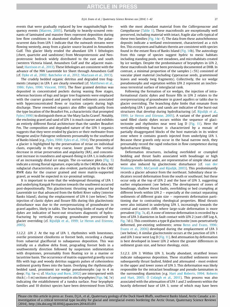
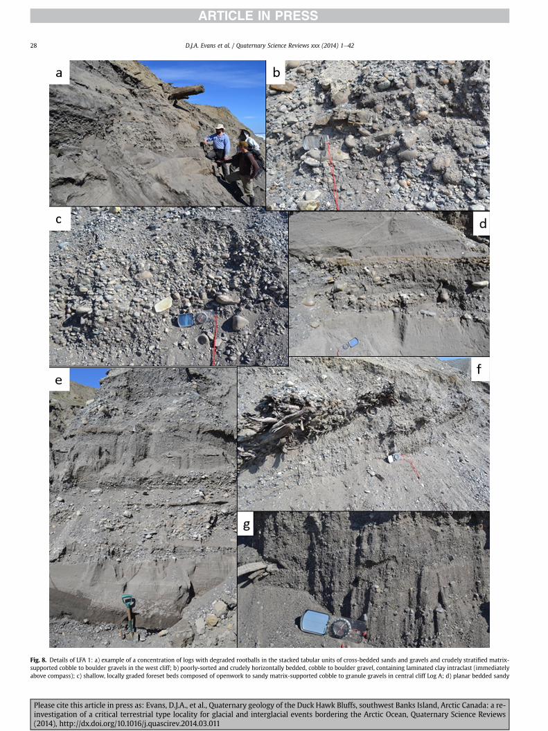
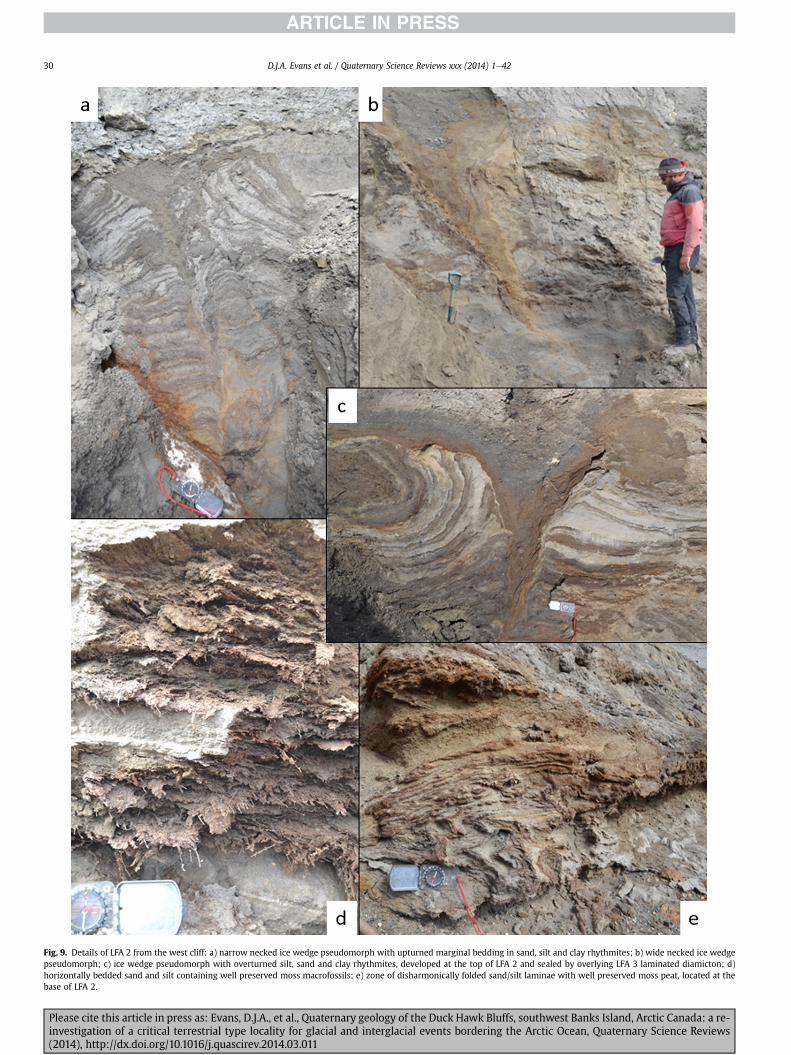
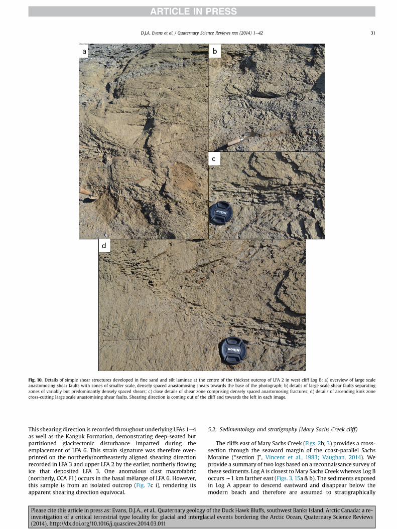
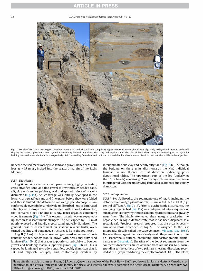
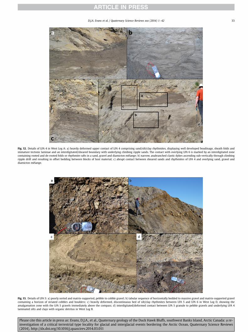
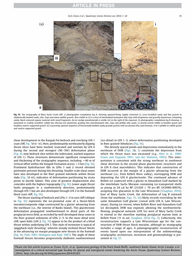
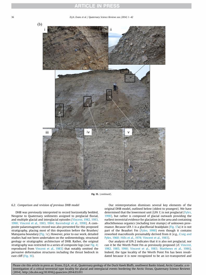
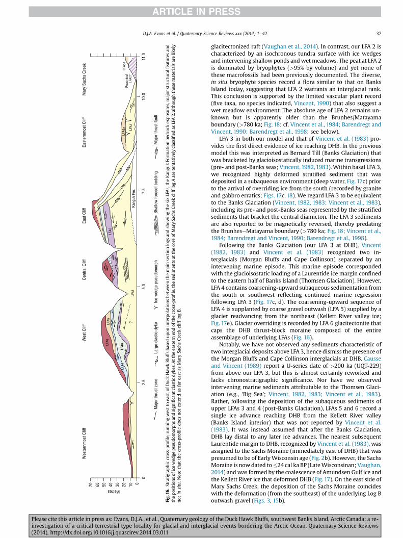
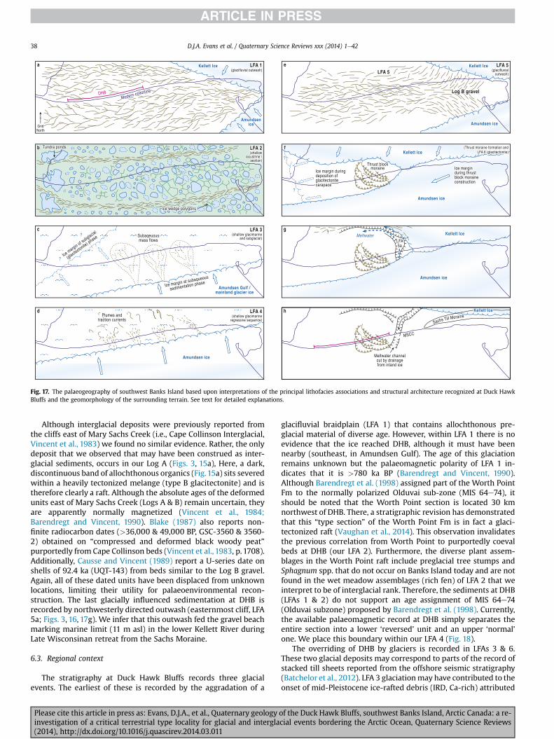
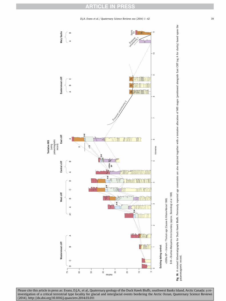
B-M
B-M
gt19
Fig
18A
revisedlitho
stratigrap
hyforDuc
kHaw
kBluffsPrev
ious
lyrepo
rted
ageco
nstraintsarealso
depicted
toge
ther
withatentativeallocation
ofMIS
stag
es(positione
dalon
gsideEa
stCliff
LogA
forclarity)
basedup
onthe
palaeo
mag
neticreco
rd
DJA Evans et al Quaternary Science Reviews xxx (2014) 1e42 39
Please cite this article in press as Evans DJA et al Quaternary geology of the Duck Hawk Bluffs southwest Banks Island Arctic Canada a re-investigation of a critical terrestrial type locality for glacial and interglacial events bordering the Arctic Ocean Quaternary Science Reviews(2014) httpdxdoiorg101016jquascirev201403011
DJA Evans et al Quaternary Science Reviews xxx (2014) 1e4240
to the Canadian Arctic Archipelago (CAA) and recorded in sedimentcores from the Arctic Ocean basin (Polyak et al 2009 2013OrsquoRegan et al 2010 Stein et al 2010) However Stein et al(2010) place the onset of Ca-rich ice-rafted debris within MIS 16(w659 ka BP Lisiecki and Raymo 2005) with subsequent peaks atMIS 12 10 and 8 all of which postdate the gt780 ka BP palae-omagnetic age proposed for LFA 3 (above) Polyak et al (2013) placethe onset of Ca-rich ice-rafted debris in the central Arctic Oceancloser to MIS 19 (790 ka BP) which is broadly compatible with theDHB palaeomagnetic record LFA 6 records the last glaciation ofDHB and we assign this to the Late Wisconsinan when Banks Is-land ice (Kellett River) coalesced with the Amundsen Gulf IceStream (Stokes et al 2006 MacLean et al 2013) During this in-terval the northwest Laurentide Ice Sheet likely reached the edgeof the polar continental shelf (Stokes et al 2005 2006 Englandet al 2009 Batchelor et al 2012 Lakeman and England 2013MacLean et al 2013)
7 Conclusions
New sedimentological and stratigraphic analyses of DHB funda-mentally revise the previous reconstruction of the Neogene andQuaternary history of Banks Island DHB and two other widely citedsections on Banks Island have been reported as important unde-formed terrestrial archives of glacial and interglacial sedimentationat the northwest limit of the Laurentide Ice Sheet that all have beenrecently revised (Vaughan et al 2014 Lakeman and England inpress) The recognition of pervasive large-scale deformation ofDHB necessitates a fundamental re-assessment of its previouslydescribed layer-cake stratigraphy We document that the oldestsediments (LFA 1) at DHB are not preglacial fluvial deposits (Beau-fort Fm) but rather record proglacial outwash from ice in AmundsenGulf that did not reach the site This was followed by the estab-lishment of an isochronous tundra surface of interglacial rank (LFA2) characterized by ice wedge polygons within a wet meadow thatsupported a bryophyte community similar to modern Subse-quently glacial sedimentation resumed initially in an ice-proximalsubaqueous environment followed by ice arrival and glacitectonicdeformation (LFA 3) The overlying deposits at DHB indicate post-glacial marine sedimentation (LFA 4) followed by the aggradationof glacifluvial sand and gravel (LFA 5) from an advancing ice marginthat culminated with the emplacement of a glacitectonite (LFA 6)during the Late Wisconsin This ice advance constructed a previ-ously undescribed thrust-block moraine (60 m high 8 km long) thatexhibits pervasive deformation and includes a substantial raft ofCretaceous Kanguk Fm bedrock (Fig 16) Furthermore the produc-tion of the glacitectonite (LFA 6) cannibalized LFAs 1e5 which atsome sites were previously thought to be in situ interglacial de-posits Finally outwash (LFA 5a) incised the DHB thrust block duringdeglaciation of the site when ice in the Kellett River and AmundsenGulf separated and proglacial meltwater drained northwestward tomarine limit (11 m asl) Refinements to the evolution and chronol-ogy of DHB and other sections around Banks Island will furthercontribute to the understanding of high latitude environmentalchange especially the complementary marine archives of theadjacent polar continental shelf and Arctic Ocean
Acknowledgements
Funding for this research was provided by the Natural Sciencesand Engineering Research Council of Canada (NSERC) NorthernResearch Chair Program and a complementary NSERC DiscoveryGrant (A6680) (both to JH England) Coulthard Lakeman andVaughan were supported by CBAR grants Canadian CircumpolarInstitute University of Alberta Coulthard and Lakeman were also
Please cite this article in press as Evans DJA et al Quaternary geologyinvestigation of a critical terrestrial type locality for glacial and intergla(2014) httpdxdoiorg101016jquascirev201403011
supported by Northern Scientific Training Program grantsAboriginal Affairs and Northern Development Canada The PolarContinental Shelf Program Natural Resources Canada(_501100000159) supplied additional funding and aircraft supportField and logistical assistance from Issac Elanik Vernon AmosTrevor Lucas and Roger Kuptana of Sachs Harbour is gratefullyacknowledged
References
Aber JS Croot DG Fenton MM 1989 Glaciotectonic Landforms and StructuresKluwer Dordrecht
Barendregt RW Vincent J-S 1990 Late Cenozoic paleomagnetic record of DuckHawk Bluffs Banks Island Canadian Arctic Archipelago Can J Earth Sci 27124e130
Barendregt RW Duk-Rodkin A 2011 Chronology and extent of Late Cenozoic icesheets in North America a magnetostratigraphical assessment In Ehlers JGibbard PL Hughes PD (Eds) Quaternary Glaciations e Extent and Chro-nolgy a Closer Look Elsevier Amsterdam pp 419e426
Barendregt RW Vincent J-S Irving E Baker J 1998 Magnetostratigraphy ofQuaternary and late Tertiary sediments on Banks Island Canadian Arctic Ar-chipelago Can J Earth Sci 35 147e161
Batchelor CL Dowdeswell JA Pietras JT 2012 Variable history of Quaternaryice-sheet advance across the Beaufort Sea margin Arctic Ocean Geology httpdxdoiorg101130G336691
Batchelor CL Dowdeswell JA Pietras JT 2013 Seismic stratigraphy sedimen-tary architecture and palaeo-glaciology of the Mackenzie Trough evidence fortwo Quaternary ice advances and limited fan development on the westernCanadian Beaufort Sea margin Quat Sci Rev 65 73e87
Benn DI 1994 Fabric shape and the interpretation of sedimentary fabric dataJ Sediment Res 64 910e915
Benn DI 1995 Fabric signature of till deformation Breiethamerkurjoumlkull IcelandSedimentology 42 735e747
Benn DI 2004 Clast morphology In Evans DJA Benn DI (Eds) A PracticalGuide to the Study of Glacial Sediments Arnold London pp 77e92
Benn DI Ballantyne CK 1994 Reconstructing the transport history of glaciogenicsediments a new approach based on the co-variance of clast form indicesSediment Geol 91 215e227
Benn DI Evans DJA 1996 The interpretation and classification of subglaciallydeformed materials Quat Sci Rev 15 23e52
Benn DI Evans DJA Phillips ER Hiemstra JF Walden J Hoey TB 2004 Theresearch project d a case study of Quaternary glacial sediments InEvans DJA Benn DI (Eds) A Practical Guide to the Study of Glacial Sedi-ments Arnold London pp 209e234
Berthelsen A 1978 The methodology of kineto-stratigraphy as applied to glacialgeology Bull Geol Soc Den 27 25e38
Blake Jr W 1987 Geological Survey of Canada Radiocarbon Dates XXVI InGeological Survey of Canada Paper 86-7 60 pp
Boothroyd JC Ashley GM 1975 Processes bar morphology and sedimentarystructures on braided outwash fans northeastern Gulf of Alaska InJopling AV McDonald BC (Eds) Glaciofluvial and Glaciolacustrine Sedi-mentation Society of Economic Paleontologists and Mineralogists SpecialPublication No 23
Causse C Vincent J-S 1989 TheU disequilibrium dating of Middle and LatePleistocene wood and shells from Banks and Victoria islands Arctic CanadaCan J Earth Sci 26 2718e2723
Church MA 1972 Baffin Island sandurs a study of Arctic fluvial processes GeolSurv Can Bull 216 208
Clark DL Vincent J-S Jones GA Morris WA 1984 Corrrelation of marine andcontinental glacial and interglacial events Arctic Ocean and Banks Island Na-ture 311 147e149
Collinson JD 1996 Alluvial sediments In Reading HG (Ed) Sedimentary Envi-ronments and Facies third ed Blackwell Oxford pp 37e82
Craig BG Fyles JG 1960 Pleistocene Geology of Arctic Canada In GeologicalSurvey of Canada Paper 60-10 21 pp
Crosby MR Magill RE Allen B He S 1999 A Checklist of the Mosses MissouriBotanical Garden St Louis 320 pp
Duk-Rodkin A Barendregt RW 2011 Stratigraphical records of glacialsin-terglacials in northwest Canada In Ehlers J Gibbard PL Hughes PD (Eds)Quaternary Glaciations e Extent and Chronology a Closer Look ElsevierAmsterdam pp 661e698
Dyke AS Andrews JT Clark PU England JH Miller GH Shaw J Veillette JJ2002 The Laurentide and Innuitian ice sheets during the Last Glacial MaximumQuat Sci Rev 21 9e31
England JH Furze MFA Doupeacute JP 2009 Revision of the NW Laurentide IceSheet implications for the paleoclimate the northeast extremity of Beringiaand Arctic Ocean sedimentation Quat Sci Rev 28 1573e1596
Evans DJA 2010 Controlled moraine development and debris transport pathwaysin polythermal plateau icefields examples from Tungnafellsjoumlkull IcelandEarth Surf Process Landf 35 1430e1444
of the Duck Hawk Bluffs southwest Banks Island Arctic Canada a re-cial events bordering the Arctic Ocean Quaternary Science Reviews
DJA Evans et al Quaternary Science Reviews xxx (2014) 1e42 41
Evans DJA Benn DI 2004 Facies description and the logging of sedimentaryexposures In Evans DJA Benn DI (Eds) A Practical Guide to the Study ofGlacial Sediments Arnold London pp 11e51
Evans DJA England J 1991 Canadian landform examples 19 high arctic thrustblock moraines Can Geogr 35 93e97
Evans DJA Rea BR Benn DI 1998 Subglacial deformation and bedrockplucking in areas of hard bedrock Glacial Geology and Geomorphology rp041998 httpgggqubacukgggpapersfull1998rp041998rp04html
Evans DJA Hiemstra JF 2005 Till deposition by glacier submarginal incre-mental thickening Earth Surf Process Landf 30 1633e1662
Evans DJA Hiemstra JF Oacute Cofaigh C 2007 An assessment of clast macrofabricsin glaciogenic sediments based on AB plane data Geogr Ann A89 103e120
Evans DJA Phillips ER Hiemstra JF Auton CA 2006 Subglacial till formationsedimentary characteristics and classification Earth Sci Rev 78 115e176
Evans DJA Shulmeister J Hyatt OM 2010 Sedimentology of latero-frontalmoraines and fans on the west coast of South Island New Zealand Quat SciRev 29 3790e3811
Eyles N Eyles CH Miall AD 1983 Lithofacies types and vertical profile modelsan alternative approach to the description and environmental interpretation ofglacial diamicts and diamictite sequences Sedimentology 30 393e410
Fyles JG 1990 Beaufort Formation (late Tertiary) as seen from Prince Patrick Is-land Arctic Canada Arctic 43 393e403
Fyles JG Hills LV Matthews Jr JV Barendregt R Baker J Irving E Jette H1994 Ballast Brook and Beaufort Formations (Late Tertiary) on northern BanksIsland Arctic Canada Quat Int 2223 141e171
Harrison JC Mayr U McNeil DH Sweet AR McIntyre DJ Eberle JJHarington CR Chalmers JA Dam G Nohr-Hansen H 1999 Correlation ofCenozoic sequences of the Canadian Arctic region and Greenland implicationsfor the tectonic history of northern North America Bull Can Pet Geol 47 223e254
Harrison JC Ford A Miall AD Rainbird RH Hulbert LJ Chritie RLCampbell FHA 2013 Geology Tectonic Assemblage Map of Aulavik BanksIsland and Northwestern Victoria Island Northwest Territories GeologicalSurvey of Canada Canadian Geoscience Map 35 (preliminary) scale 1500 000httpdxdoiorg104095292833
Hart JK Roberts DH 1994 Criteria to distinguish between subglacial glaciotec-tonic and glaciomarine sedimentation I Deformation styles and sedimen-tology Sediment Geol 91 191e213
Hedenaumls L 1993 A generic revision of the Warnstorfia Calliergon group J Bryol 17447e479
Hedenaumls L 2006 Additional insights into the phylogeny of Calliergon LoeskypnumStraminergon and Warnstorfia (Bryophyta Calliergonaceae) J Hattori Bot Lab100 125e134
Hicock SR Goff JR Lian OB Little EC 1996 On the interpretation of subglacialtill fabric J Sediment Res 66 928e934
Hiemstra JF Evans DJA Oacute Cofaigh C 2007 The role of glaciotectonic rafting andcommunition in the production of subglacial tills examples from SW Irelandand Antarctica Boreas 36 386e399
Hills LV 1975 Late Tertiary floras Arctic Canada an interpretation In Proceedingsof Circumpolar Conference on Northern Ecology National Research Council ofCanada pp I(65)eI(71)
Hills LV Klovan JE Sweet AR 1974 Juglans eocineria n Beaufort Formation(Tertiary) southwestern Banks Island Arctic Canada Can J Bot 52 65e90
Janssens JAP 1983 Quaternary fossil bryophytes in North America new recordsLindbergia 9 137e151
Kuc M 1974 Calliergon aftonianum Steere in Late Tertiary and Pleistocene Depositsof Canada In Geological Survey of Canada Paper 74e24
Kuc M Hills LV 1971 Fossil mosses Beaufort Formation (Tertiary) NorthwesternBanks Island Western Canada Arctic Can J Bot 49 1089e1094
Lakeman TR England JH 2012 Paleoglaciological insights from the age andmorphology of the Jesse moraine belt western Canadian Arctic Quat Sci Rev47 82e100
Lakeman TR England JH 2013 Late Wisconsinan glaciation and postglacialrelative sea-level change on western Banks Island Canadian Arctic ArchipelagoQuat Res 80 99e112
Lakeman TR England JH 2014 Facies and stratigraphic analyses of glacial andinterglacial sediments at Morgan Bluffs Banks Island Canadian Arctic Archi-pelago Boreas httpdxdoiorg101111bor12069 (in press)
Lawton E 1971 Moss Flora of the Pacific Northwest The Hattori Botanical Labo-ratory Ninchen Miyazaki Japan
Le Heron DP Etienne JL 2005 A complex subglacial clastic dyke swarm Sol-heimajoumlkull southern Iceland Sediment Geol 181 25e37
Li G Piper DJW Campbell DC 2011 The Quaternary Lancaster Sound trough-mouth fan NW Baffin Bay J Quat Sci 26 511e522
Lisiecki LE Raymo ME 2005 A Pliocene-Pleistocene stack of 57 globallydistributed benthic d18O records Paleoceanography 20 PA1003 httpdxdoiorg1010292004PA001071
Lukas S Benn DI Boston CM Brook M Coray S Evans DJA Graf A Kellerer-Pirklbauer A Kirkbride MP Krabbendam M Lovell H Machiedo MMills SC Nye K Reinardy BTI Ross FH Signer M 2013 Clast shapeanalysis and clast transport paths in glacial environments a critical review ofmethods and the role of lithology Earth-Sci Rev 121 96e116
Lukas S Coray S Graf A Schluumlchter C 2014 The influence of clast lithology andfluvial reworking on the reliability of clast shape measurements in glacial en-vironments e a case study from a temperate Alpine glacier In Bridgland DR
Please cite this article in press as Evans DJA et al Quaternary geologyinvestigation of a critical terrestrial type locality for glacial and intergla(2014) httpdxdoiorg101016jquascirev201403011
(Ed) Clast Lithological Analysis Technical Guide Quaternary Research Asso-ciation London (in press)
Mackay JR Burn CR 2002 The first 20 years (1978e1979 to 1998e1999) of icewedge growth at the Illisarvik experimental drained lake site western Arcticcoast Canada Can J Earth Sci 39 95e111
MacLean B Blasco S Bennett R Lakeman T Hughes-Clarke J Kuus PPatton E 2013 Marine evidence for a Glacial ice stream in Amundsen GulfCanadian Arctic Archipelago In Canadian Quaternary Association (CANQUA)Meeting August 18e22 2013 Edmonton AB Canada
Maizels JK 1989a Sedimentology palaeoflow dynamics and flood history ofjokulhlaup deposits palaeohydrology of Holocene sediment sequences insouthern Iceland sandur deposits J Sediment Petrol 59 204e223
Maizels JK 1989b Sedimentology and palaeohydrology of Holocene flood depositsin front of a jokulhlaup glacier south Iceland In Bevan K Carling PJ (Eds)Floods the Geomorphological Hydrological and Sedimentological Conse-quences Wiley New York pp 239e251
Marren PM 2005 Magnitude and frequency in proglacial rivers a geomorpho-logical and sedimentological perspective Earth-Sci Rev 70 203e251
Matthews JV 1987 Plant macrofossils from the Neogene Beaufort Formation onBanks and Meighen islands District of Franklin In Current Research Part AGeological Survey of Canada Paper 87-1A pp 73e87
Matthews Jr JV Ovenden LE 1990 Late Tertiary plant macrofossils from local-ities in ArcticSubarctic North America a review of the data Arctic 43 364e392
Matthews JV Mott RJ Vincent J-S 1986 Preglacial and interglacial environ-ments of Banks Island pollen and macrofossils from Duck Hawk Bluffs andrelated sites Geogr Phys Quat XL 279e298
McCarroll D Rijsdijk KF 2003 Deformation styles as a key for interpreting glacialdepositional environments J Quat Sci 18 473e489
Miall AD 1977 A review of the braided river depositional environment Earth-SciRev 13 1e62
Miall AD 1978 Lithofacies types and vertical profile models in braided river de-posits a summary In Miall AD (Ed) Fluvial Sedimentology Canadian Societyof Petroleum Geologists Memoir 5 pp 597e604
Miall AD 1985 Architectural-element analysis a new method of facies analysisapplied to fluvial deposits Earth Sci Rev 22 261e308
Miall AD 1992 Alluvial deposits In Walker RG James NP (Eds) Facies ModelsResponse to Sea-level Change Geological Association of Canada Torontopp 119e142
Mulder T Alexander J 2001 The physical character of subaqueous sedimentarydensity flows and their deposits Sedimentology 48 269e299
Mulugeta G Koyi H 1987 Three-dimensional geometry and kinematics ofexperimental piggyback thrusting Geology 15 1052e1056
Nyholm E 1956e1965 Illustrated Moss Flora of Fennoscandia II Musci Fasc 1-6Lund pp 1e788
Oacute Cofaigh C Evans DJA Hiemstra JF 2011 Formation of a stratified subglacial lsquotillrsquoassemblage by ice-marginal thrusting and glacier overriding Boreas 40 1e14
OrsquoRegan M St John K Moran K Backman J King J Haley BA Jakobsson MFrank M Roumlhl U 2010 Plio-Pleistocene trends in ice rafted debris on theLomonosov Ridge Quat Int 219 168e176
OrsquoRegan M Williams CJ Frey KE Jakobsson M 2011 A synthesis of the long-term paleoclimatic evolution of the Arctic Oceanography 24 66e80
Park RG 1983 Foundations of Structural Geology Blackie LondonPolyak L Bischof J Ortiz JD Darby DA Channell JET Xuan C Kaufman DS
Loslashvlie R Schneider DA Eberl DD Adler RE Council EA 2009 LateQuaternary stratigraphy and sedimentation patterns in the western ArcticOcean Glob Planet Change 68 5e17
Polyak L Best KM Crawford KA Council EA St-Onge G 2013 Quaternaryhistory of sea ice in the western Arctic Ocean based on foraminifera Quat SciRev 79 145e156
Rijsdijk KF Owen G Warren WP 1999 Clastic dykes in overconsolidated tillsevidence for subglacial hydrofracturing at Killiney Bay eastern Ireland Sedi-ment Geol 129 111e126
Roberts DH Hart JK 2005 The deforming bed characteristics of a stratified tillassemblage in north east Anglia UK investigating controls on sedimentrheology and strain signatures Quat Sci Rev 24 123e140
Roy SK Hills LV 1972 Fossil woods from the Beaufort Formation (Tertiary)northwestern Banks Island Canada Can J Bot 50 2637e2648
Siegenthaler C Huggenberger P 1993 Pleistocene Rhine gravel deposits of abraided river systemwith dominant pool preservation In Best JL Bristow CS(Eds) Braided Rivers Geological Society London Special Publication 75pp 147e162
Spedding N Evans DJA 2002 Sediments and landforms at Kviacuteaacuterjoumlkull southeastIceland a reappraisal of the glaciated valley landsystem Sediment Geol 14921e42
Steere WC 1978 The Mosses of Arctic Alaska In Bryophytorum Bibliotheca vol14 J Cramer Lehre Germany 507 pp
Steere WC Scotter GW 1979 Bryophytes of Banks Island Northwest TerritoriesCanada Can J Bot 57 1136e1149
Stein R Matthiessen J Niessen F Krylov R Nam S Bazhenova E 2010 Towardsa better (litho-) stratigraphy and reconstruction of Quaternary palaeoenviron-ment in the Amerasian Basin (Arctic Ocean) Polarforschung 79 97e121
Stokes CR Clark CD Darby DA Hodgson DA 2005 Late Pleistocene ice exportevents into the Arctic Ocean from the MrsquoClure Strait Ice Stream Canadian ArcticArchipelago Glob Planet Change 49 139e162
of the Duck Hawk Bluffs southwest Banks Island Arctic Canada a re-cial events bordering the Arctic Ocean Quaternary Science Reviews
DJA Evans et al Quaternary Science Reviews xxx (2014) 1e4242
Stokes CR Clark C Winsborrow M 2006 Subglacial bedform evidence for amajor palaeo-ice stream in Amundsen Gulf and its retreat phases CanadianArctic Archipelago J Quat Sci 21 300e412
van der Wateren DFM 1995 Processes of glaciotectonism In Menzies J (Ed)Glacial Environments Modern Glacial Environments Processes Dynamics andSediments vol 1 Butterworth-Heinemann Oxford pp 309e335
Vaughan J 2014 The Glacial and Sea Level History of South Banks Island NT(Unpublished PhD thesis) University of Alberta Edmonton
Vaughan J England J Evans DJA 2014 Glaciotectonic deformation and rein-terpretation of the Worth Point stratigraphic sequence Banks Island NT Can-ada Quat Sci Rev httpdxdoiorg101016jquascirev201311005
Vincent J-S 1982 The Quaternary history of Banks Island Northwest TerritoriesCanada Geogr Phys Quat 36 209e232
Please cite this article in press as Evans DJA et al Quaternary geologyinvestigation of a critical terrestrial type locality for glacial and intergla(2014) httpdxdoiorg101016jquascirev201403011
Vincent J-S 1983 La geologie du quaternaire et la geomorpholie de Lrsquoile Banksarctique Canadien Geological Survey of Canada Memoir 405
Vincent J-S 1984 Quaternary stratigraphy of the western Canadian Arctic Archi-pelago In Fulton RJ (Ed) Quaternary Stratigraphy of Canada e a CanadianContribution to IGCP Project 24 Geological Survey of Canada Paper 84-10pp 87e100
Vincent J-S 1990 Late Tertiary and Early Pleistocene deposits and history of BanksIsland southwestern Canadian Arctic Archipelago Arctic 43 339e363
Vincent J-S Occhietti S Rutter N Lortie G Guilbault J-P De Boutray B 1983The Late TertiaryeQuaternary record of the Duck Hawk Bluffs Banks IslandCanadian Arctic Archipelago Can J Earth Sci 20 1694e1712
Vincent J-S Morris WA Occhietti S 1984 Glacial and non-glacial sediments ofMatuyama paleomagnetic age on Banks Island Canadian Arctic ArchipelagoGeology 12 139e142
of the Duck Hawk Bluffs southwest Banks Island Arctic Canada a re-cial events bordering the Arctic Ocean Quaternary Science Reviews
- Quaternary geology of the Duck Hawk Bluffs southwest Banks Island Arctic Canada a re-investigation of a critical terrest
-
- 1 Introduction
- 2 Study area and previous research
- 3 Methods
- 4 Organics
- 5 Results
-
- 51 Sedimentology and stratigraphy (Duck Hawk Bluffs)
-
- 511 Description
- 512 Interpretation
-
- 5121 LFA 1
- 5122 LFA 2
- 5123 LFA 3
- 5124 LFA 4
- 5125 LFA 5
- 5126 LFA5a
- 5127 LFA 6
-
- 52 Sedimentology and stratigraphy (Mary Sachs Creek cliff)
-
- 521 Description
- 522 Interpretation
-
- 5221 Log A
- 5222 Log B
-
- 6 Discussion
-
- 61 Large scale glacitectonic structures and stratigraphic architecture
- 62 Comparison and revision of previous DHB model
- 63 Regional context
-
- 7 Conclusions
- Acknowledgements
- References
-