quarterly report for major projects - dot.nv.gov
TRANSCRIPT
STATE OF NEVADA DEPARTMENT OF TRANSPORTATION
QUARTERLY REPORT FOR MAJOR PROJECTS
For Quarter Ending December 31, 2012
Brian Sandoval Governor
Rudy Malfabon, PE Director

Nevada Department of Transportation
QUARTERLY REPORT FOR MAJOR PROJECTS
December 31, 2012
TABLE OF CONTENTS
Page 1.0 INTRODUCTION 2
2.0 PROJECT STATUS SHEET EXPLANATION 3
3.0 MAJOR PROJECTS 4
4.0 COMPLETED MAJOR PROJECTS 37
1

1.0 INTRODUCTION The primary purpose of this quarterly report, ending December 31, 2012, is to provide the Nevada Legislature, the Transportation Board of Directors, and the general public with the status of major projects undertaken by the Nevada Department of Transportation (NDOT) as required by Assembly Bill 595 that was passed in 2007. This quarterly report specifically addresses the reporting requirements of Section 55.5. This status report is based on the major assumption that funding will be available for the major projects in a timely fashion. Section 2 of this report provides a detailed description and explanation of the information on each project status sheet. Section 3 of this report includes project status sheets for all major projects as required by AB 595. There are project sheets for highway capital projects indentified in the December 2006 Blue Ribbon Task Force report: “Roads to the Future” and any other proposed super or mega projects. All of these projects are simply characterized as major projects (projects exceeding $100 million). Section 4 of this report identifies any major projects completed during this quarter.
2

2.0 PROJECT STATUS SHEET EXPLANATION
The information contained on the project status sheet is centered on the Department’s project development process. This process typically consists of the four major phases: planning, environmental clearance, final design and construction. Additional details of these phases are contained in Appendix A, which details the project development process utilized by the Department of Transportation. The project status sheets contain several items of information as follows:
Project Description: Contains the preliminary project scope, which generally identifies features of the project i.e. length, structures, widening, and interchanges, and directs the project development process.
Project Benefits: Summarizes the primary favorable outcomes expected by delivering the project.
Project Risks: Indentifies the major risks that might impact project scope, cost, and schedule. Unforeseen environmental mitigation, right-of-way litigation, and inflation of construction materials or land values are only a few items that can adversely effect project development. Appendix B, Dealing with Project Risk, provides more details.
Schedule: Provides the time ranges for the four primary phases of project development: planning, environmental clearance, final design, and construction. Generally the schedule, by state fiscal years, reveals the time range for starting or completing a phase. It indicates the starting range early in the development process and completion range latter in the process. Appendix B, Dealing with Project Risks, provides more details concerning the time ranges.
Project Costs: Project cost ranges are provided by activity: 1) engineering activities thatincludes planning, environmental clearance and final design costs, 2) right-of-way acquisition, and 3) construction. Costs are adjusted for inflation to the anticipated mid-point of completing a phase. Appendix B, Dealing with Project Risks, provides more detail on the range of project cost estimates.
What’s changed since last update? Contains summaries of the project scope, cost, and schedule changes, if any.
Financial Fine Points: Includes the total expended project costs and brief summary of financial issues.
Status Bars at the Bottom of the Form: Shows the percentage completion for the primary project development activities that are in progress: planning, environmental clearance, final design, right-of-way acquisition, and construction.
3

3.0 MAJOR PROJECTS
I-15 Projects I-15 North Phase 2 – Craig Road to Speedway Boulevard 5 I-15 North Phase 3 – Speedway Boulevard to Apex Interchange 6 I-15 North Phase 4 – I-15/CC-215 Northern Beltway Interchange 7 I-15 NEON 8 I-15 Urban Resort Corridor Study 9 I-15 South Freeway Improvements Phase 1 Blue Diamond to Tropicana 10 I-15 South Bermuda Road Interchange 11 I-15 South Pebble Road Overpass 12 I-15 South Starr Avenue Interchange 13 I-15 South Cactus Avenue Interchange 14 I-15 South Las Vegas Boulevard from St. Rose Parkway to Sunset Road 15 I-15 South Phase 1B From Blue Diamond (SR 160) to Tropicana Avenue 16 I-15 South Phase 2 Sloan Road to Blue Diamond (SR 160) 17 I-15 South Sloan Road Interchange 18 I-15 South – Stateline to Sloan Road 19
I-515/US-95/US Projects I-515 Freeway Improvements – I-15 to Horizon Drive 20 I-515/US-95/US-93:Boulder City Bypass Phase 1 – Foothill Drive to US-95 21I-515/US-95/US-93:Boulder City Bypass Phase 1 Pkg 2B 22I-515/US-95/US-93:Boulder City Bypass Phase 1 Pkg 3 23 I-515/US-95/US-93:Boulder City Bypass Phase 2 – US-95 to Hoover Dam Bypass 24
US-95 Northwest Projects US-95 Northwest Phase 1 – Rainbow Boulevard (SR 595) to Ann Road 25 US-95 Northwest Phase 2 – Ann Road to Kyle Canyon Road (SR 157) 26 US-95 Northwest Phase 3 – CC 215 Beltway Interchange 27 US-95 Northwest Phase 5 – Kyle Canyon Road (SR 157) Interchange 28
Northern Nevada Projects I-80 – Robb to Vista 29I-80 - Robb to Vista Design-Build 30 I-580 Freeway Extension 31 US-395 North – McCarran Blvd. to Stead Blvd. 32 US-395 Northbound – Moana Lane to I-80 33 SR-445 – Pyramid Highway Improvements 34 US-395 Carson City Freeway Phase 2B – S. Carson St. to Fairview Dr. 35 I-580 at Meadowood Mall Way 36
4

I 15 North - Phase 2
Craig Road (SR 573) to Speedway Boulevard
Project Sponsor: NDOT
Project Manager: Luis Garay, P.E.
(702) 671-8858
Project Description:
This is the second of four phases of improvements to the I-15 North Corridor between US 95 and Apex Interchange.
Widen I-15 from 4 lanes to 6 lanes from Craig Road (SR 573) to Speedway Boulevard.
3R project from Craig Road to Speedway Boulevard
ITS elements from Craig Road to Apex
Improvements will be constructed within the existing I-15 Right-of-Way.
Widen 4 bridges over 2 UPRR crossings within UPRR and private Right of Way.
The project has been broken out to 5 packages: Package A is a pavement restoration project with replacement of the existing right of way fence; Package B is the ITS elements South of Speedway Blvd; Package C is for bridge - widening and seismic retrofit; Package D is for capacity improvements (widening from 4 lanes to 6 lanes), landscaping and drainage improvements; and Package E the ITS elements North of Speedway Blvd
Package B was awarded 4th quarter of 2012
Project length: 4.8 miles
Schedule: Planning: Complete Environmental Phase: Complete Final Design: 2013 - 2015 Construction: 2013 - 2017
Project Cost Range:Engineering: $5 - $15 Million Right of Way: $1 - $2 Million Construction: $49 - $58 Million Total Project Cost: $55 - $75 Million
Project Benefits:
Improve capacity
Improve mobility
Reduce trip times
Improve operations
Improve safety What's Changed Since Last Update?
Scope - No Change Schedule - Construction changed from 2015- 2017 since Package B will
be under construction 1st quarter 2013 Cost - Construction package costs are presently being reviewed
Project risks:
Completion of construction packages will depend on availability of funding
Coordination with UPRR may delay project schedule
Environmental permits may delay project schedule
Financial Fine Points(Key Assumptions):
Total funding expended for Phase 2: $1,328,400
Total funding expended for the Environmental Phase: $875,000
Construction inflation escalation (4%) is to 2014 approximate midpoint of construction
Funding source for the project engineering is AB 595 (State).
Design CompleteJanuary
2013
5

I 15 North - Phase 3
Speedway Boulevard to Apex Interchange
Project Sponsors: NDOT
Project Manager: Luis Garay, P. E.
(702) 671-8858
Project Description:
This is the third phase of improvements to the I-15 North Corridor between US 95 and Apex Interchange.
Widen I-15 from four lanes to six lanes from Speedway Boulevard to the Apex Interchange.
Project length: 4.6 miles
Schedule: Planning: Complete Environmental Phase: Complete Final Design: Start 2016 - 2017 Construction: TBD
Project Cost Range:Engineering: $10 - $12 million Right-of-Way: $3 - $3.6 million Construction: $75 - $85 million Total Project Cost: $88 - $101 million
Project Benefits:
Improve capacity
Reduce trip times
Improve access to areas planned for development in North Las Vegas
Improve operations
Improve safety What's Changed Since Last Update?
Scope - No Change Schedule - Updated Final Design to 2016-2017 and Construction
to TBD Cost - No Change
Project risks:
Project completion will depend on the availability of funding.
Uncertainty of proposed Sheep Mountain Parkway terminus.
Financial Fine Points(Key Assumptions):
Total funding expended for phase 3: $0 (design phase not started)
Total funding expended for I 15 North Environmental phase: $875,000
Inflation excalation (4%) is to 2016 approximate midpoint of construction
Funding source for this project has not yet been identified.
Environmental
complete
Updated:January
2013
6

I 15 North - Phase 4
I 15 / CC 215 Northern Beltway Interchange
Project Sponsor: NDOT
Project Manager: Luis Garay, P. E.
(702) 671-8858
Project Description:
Construct new ramps to complete a system-to-system interchange configuration at the I-15 / CC-215 Las Vegas Beltway interchange.
Improvements will be constructed within the existing I-15 and CC-215 Right-of-Way.
This is the last of four phases of improvements to the I-15 North Corridor between US 95 and Apex Interchange (15 miles).
Schedule: Planning: Complete Environmental Clearance: Complete Final Design: Start 2013 - 2018 Construction: TBD
Project Cost Range:Engineering: $7.4 - $14.0 million Right-of-Way: $1.0 - $5.0 million Construction: $123.0 - $140.0 million Total Project Cost: $131.4 - $159.0 million
Project Benefits:
Improve capacity.
Reduce trip times.
Improve access to areas planned for development in North Las Vegas.
Improve operations with full freeway-to-freeway connectivity.
Improve safety.
What's Changed Since Last Update?
Scope - No Change Schedule - Advertisement date moved to 2018 due to lack of
construction funding availability Cost - No Change
Project risks:
Uncertainty of future construction and labor costs.
Construction funding availability.
Railroad Involvement - UPRR Permits
Financial Fine Points(Key Assumptions):
Total funding expended: $109,600
Total funding expended for I-15 North Environmental phase: $875,000
Inflation escalation (4%) is to 2018 approximate midpoint of construction.
Construction funding for this project has not yet been identified.
% Design Complete
Updated:January
2013
7
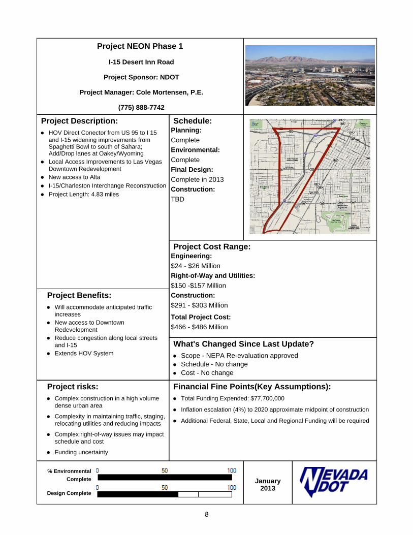
Project NEON Phase 1
I-15 Desert Inn Road
Project Sponsor: NDOT
Project Manager: Cole Mortensen, P.E.
(775) 888-7742
Project Description: HOV Direct Conector from US 95 to I 15
and I-15 widening improvements from Spaghetti Bowl to south of Sahara; Add/Drop lanes at Oakey/Wyoming
Local Access Improvements to Las Vegas Downtown Redevelopment
New access to Alta
I-15/Charleston Interchange Reconstruction
Project Length: 4.83 miles
Schedule: Planning: Complete Environmental: Complete Final Design: Complete in 2013 Construction: TBD
Project Cost Range:Engineering: $24 - $26 Million Right-of-Way and Utilities: $150 -$157 Million Construction: $291 - $303 Million Total Project Cost: $466 - $486 Million
Project Benefits: Will accommodate anticipated traffic
increases New access to Downtown
Redevelopment Reduce congestion along local streets
and I-15 Extends HOV System
What's Changed Since Last Update? Scope - NEPA Re-evaluation approved Schedule - No change Cost - No change
Project risks: Complex construction in a high volume
dense urban area
Complexity in maintaining traffic, staging, relocating utilities and reducing impacts
Complex right-of-way issues may impact schedule and cost
Funding uncertainty
Financial Fine Points(Key Assumptions): Total Funding Expended: $77,700,000
Inflation escalation (4%) to 2020 approximate midpoint of construction
Additional Federal, State, Local and Regional Funding will be required
% Environmental
Complete
Design Complete
Updated: January 2013
8

I 15 Urban Resort Corridor Study
Project Sponsor: NDOT
Senior Project Manager: Jeff Lerud
(775) 888-7589
Project Description: The I-15 Urban Resort Corridor Study along
I-15 from I-215 (Bruce Woodbury Beltway) to the south, to US 95 (Spaghetti Bowl) to the north.
Enhance access and mobility within the resort corridor; develop a phased implementation stragegy for future improvements to I-15 in the resort corridor area in addition to currently planned improvements.
Prepare an early action plan for near-term improvements to enhance mobility and operations.
Schedule: Planning: TBD Environmental: TBD Final Design: TBD Construction: TBD
Project Cost Range:Engineering: TBD Right-of-Way: TBD Construction: TBD Total Project Cost: TBD
Project Benefits: Improve capacity, operations, safety,
access and mobility. Meet stakeholders/public expectations.
Improve quality of life.
Support economic development.
Reduce trip times. What's Changed Since Last Update? Scope - No Change Schedule - No Change Cost - No Change
Project risks: Consensus building among the resort
owners.
Funding uncertainty.
Economic development along the corridor could require design changes affecting scope, schedule and budget.
Financial Fine Points(Key Assumptions): Total funding expended: $786,738
Planning complete
Updated: January 2013
9

I 15 South - Phase 1A
From Blue Diamond Road to Tropicana Avenue
Project Sponsor: NDOT
Asst Chief Project Management: John Terry, P.E.
(702) 671-6601
Contractor: Las Vegas Paving Corporation
Project Description: This is the 1st Phase of the I 15 South Project,
from Silverado Ranch Road To Tropicana Avenue (3.86 miles).
Add collector-distributor lanes from Blue Diamond Road to Tropicana Avenue.
Braid collector-distributor roads to eliminate weaves between I 215 and Tropicana Avenue.
Construct Sunset Road Bridge over I 15 and reconstruct Warm Springs Bridge over I 15.
Delivery and Procurement by Design-Build method.
Schedule: Planning: Complete Environmental: Complete Final Design: Complete Construction: Complete
Project Cost Range:Engineering: $11 - 12 million Right-of-Way: $0 - $5 million Total Estimated Project Cost: $290 - $294 million
Project Benefits: Provide additional capacity on I 15
Reduce operational conflicts between Blue Diamond Road, I 215, Harmon Avenue and Tropicana Avenue
Improve east-west access across I 15
Reduce collisions
Improve transportation system performance
What's Changed Since Last Update? Scope - No change Schedule: No Change Cost- No Change
Project risks: Major Project Plan required
New bridges over UPRR require close cooperation
Tight Right of Way (ROW)
Difficult schedule for Design-Build process
Working within Clark Co. ROW
Working within UPRR ROW
Financial Fine Points(Key Assumptions): Total funding expended Environmental Study: $3.5 million
Total funding expended Phase 1A: $288 million
Project funding source: AB 595 (LVCVA via Bonding, Clark County, and State)
% Design Complete
% Construction Complete
January 2013
10

I 15 South - Bermuda Road Interchange
Project Sponsor: City of Henderson
Senior Project Manager: Eduardo P. Miranda, P.E.
(702) 671-8856
Project Description:
I-15 South Project from Sloan to Tropicana has been broken into nine (9) Project elements to address funding and constructability opportunities.
This is one element of the I-15 South project.
Construct new interchanges at Bermuda Road.
Schedule: Planning: Complete Environmental: Complete Final Design: 2026 - 2027 Construction: TBD
Project Cost Range: (Environmental Phase Estimates) Engineering: $16 - $17.5 million Right-of-Way: $3.5 - $4 million Construction: $128.5 - $134.5 million Total Project Cost: $148 - $156 million
Project Benefits:
Interchanges on I-15 reduce congested traffic in main lines and other existing facilities.
Connect Regional traffic.
What's Changed Since Last Update?
Scope - No Change Schedule - No Schedule. Unfunded on 2035 RTP. Cost - No Change
Project risks:
Unit price and property escalation may affect project cost.
Financial Fine Points(Key Assumptions):
Funding not available until 2026-2030 per current Financial Plan.
Total funding expended for I-15 South Environmental Studies (all phases): $3.5 million
Inflation index distribution of 2% - 5% is to 2029 approximate midpoint of construction.
Funding Source (Financial Plan 2009): Q10 Extended ($57.1M) and STP Clark County ($60M).
% Environmental
Complete
% Design Complete
Updated:January
2013
11

I 15 South - Pebble Road Overpass
Project Sponsor: Clark County
Senior Project Manager: Eduardo P. Miranda, P.E.
(702) 671-8856
Project Description:
I-15 South Project from Sloan to Tropicana has been broken into nine (9) Project elements to address funding and constructability opportunities.
This is one element of the I-15 South Project.
Construct overpass at Pebble Road and I-15
Schedule: Planning: Complete Environmental: Complete Final Design: TBD Construction: TBD
Project Cost Range: (Environmental Phase Estimates/Removal from RTP) Engineering: $6.5 - $7 million Right-of-Way: $8 - $10 million Construction: $51.5 - $53 million Total Project Cost: $66 - $70 million
Project Benefits:
Interchanges on I-15 reduce congested traffic in main lines and other existing facilities.
Connect regional traffic.
Improve origin destination time of travel.
What's Changed Since Last Update?
Scope - No Change Schedule - This project was removed from 2030 RTP. Cost - No Change
Project risks:
Unit price and property escalation may affect project cost.
Financial Fine Points(Key Assumptions):
Funding not available until 2040. Project was removed from current Financial Plan. Project costs will be impacted due to inflation.
Total funding expended for I-15 South Environmental Studies (all phases): $3.5 million
Financial Plan 2009: Inflation index distribution of 2% - 5% is to 2029 approximate midpoint of construction.
Funding Source (Financial Plan 2009): Private Developers ($30M)
% Environmental
Complete
% Design Complete
Updated:January
2013
12
I 15 South - Starr Avenue Interchange
Project Sponsor: NDOT
Senior Project Manager: Eduardo P. Miranda, P.E.
(702) 671-8856
Project Description:
I-15 South, from Sloan Road to Tropicana Ave. has been broken into nine packages to address funding and constructability opportunities.
Construct a new interchange at Starr Avenue with on & off-ramps
Connect to Las Vegas Blvd (east side) and Dean Martin Drive (west side)
I-15 over Starr Avenue and shifted 50 ft. to the east of the existing I-15.
Schedule: Planning: Complete Environmental: Complete Final Design: 2010-2014 Construction: 2016-2020
Project Cost Range: (Environmental Phase Estimates) Preliminary Engineering: $10 - $11 million Right-of-Way: $15 - $24 million Construction: $47 - $66 million Total Project Cost: $72 - $101 million
Project Benefits:
Improve access to I-15 with new interchange
Connect east-west regional traffic from Las Vegas Blvd to/from Dean Martin Drive
Improve I-15 mainline capacity
What's Changed Since Last Update?
Scope - No change Schedule - No change Cost - Reduction $5.5 million due to the update of costs.
Project risks:
Uncertain Right of Way costs
Material and labor cost escalation
Year when construction funds are available
Utility & bill board relocation
Cell phone tower, re-location potential or avoidance
Financial Fine Points(Key Assumptions):
Total funding expended for Starr Interchange: $121,800
Total funding expended for I-15 South Environmental Studies (all phases): $3.5 million
Inflation index distribution of 2% - 5% for year 2024 approximate midpoint of construction.
Funding Source (RTP 2035): Interstate Maintenance Discretionary ($3.44M), SAFETEA-LU Priority Project ($7.20M), Local Funds ($12.98 M), STP Clark County ($52.80 M) and Public Lands Highways ($1.19 M).
% EnvironmentalComplete
% Design Complete
January 2013
13

I 15 South - Cactus Avenue Interchange
Project Sponsor: NDOT
Senior Project Manager: Eduardo P. Miranda, P.E.
(702) 671-8856
Project Description: I-15 South Project from Sloan to Tropicana has been
broken into nine (9) Project elements to address funding and constructability opportunities.
Construct new interchange at Cactus Avenue.
Schedule: Planning: Complete Environmental: Complete Final Design: Complete Advertise: Complete Construction: Start 1st Quarter 2013 -
Complete 1st Quarter 2015
Project Cost Range: (Environmental Phase Estimates) Engineering: $5.5 - $6.5 million Right-of-Way: $8 - $15 million Construction: $43 million Total Project Cost: $56.5 - $64.5 million
Project Benefits: Reduce congested traffic on I-15.
Connect regional traffic.
What's Changed Since Last Update? Scope - No Change Schedule - No Change Cost - Reduction by $13 - 19 million due to the update of costs.
Project risks: Unit price and property escalation may affect project
cost.
Financial Fine Points(Key Assumptions): Funding expended for Cactus Interchange: $6.7 Million
Total funding expended for I-15 South Environmental Studies (all phases): $3.5 million
Inflation index distribution of 2% - 5% is to 2014 approximate midpoint of construction
Funding Source: Interstate Maintenance Discretionary ($4.9M), SAFETEA-LU High Priority Projects ($16.6M), STP Clark County ($34.9M), National Highway System ($18.2M), Old Ear Mark Remnant (0.14M) and Section 115 Transfer Project (0.9M).
Construction: 2013 - 2015
% EnvironmentalComplete
% Design Complete
% Construction
January 2013
14

I 15 South - Las Vegas Boulevard
St. Rose Parkway to Sunset Road
Project Sponsor: Clark County
Project Manager: Jason S. Tyrrell, P.E.
(702) 671-8852
Project Description: I-15 South from Sloan to Tropicana has been
broken into nine (9) Project elements to address funding and constructability opportunities.
This is one element of the I-15 South Project.
Widening of Las Vegas Boulevard (parallel to I-15) from St. rose Parkway (SR 146) to Sunset Road from 2 to 3 lanes in each direction.
Project Length: 7.2 miles
This project will be constructed in two packages:
Package 1: Las Vegas Boulevard from Silverado to Sunset - *Completed as of July 2011
Package 2: Las Vegas Boulevard from St. Rose to Silverado Ranch
Schedule: Planning: Complete Environmental Clearance: Complete Final Design: Package 1- Complete ,
Package 2- 70% Construction: Package 1 -Complete,
Package 2 TBD
Project Cost Range:(Environmental phase estimates): Engineering: $4 - $4.5 million Right-of-Way: $0 Construction: $31.5 - $33 million Total Project Cost: $35.5 - $37.5 million
Project Benefits: Increase capacity
Improve safety
Improve access
Reduce trip times
Reduce vehicle emissions
Reduce idling
Improve driver comfort What's Changed Since Last Update? Scope - No Change Schedule - No Change Cost - No Change
Project risks: Complexity in maintaining traffic staging,
relocating utilities and reducing impacts to traveling public.
Financial Fine Points(Key Assumptions): Total NDOT Funding Expended for LV Blvd.: $0
Total funding expended for I-15 South Environmental studies (all phases): $3.5 million
Inflation index distribution of 2% - 5% is to 2011 approximate midpoint of construction.
Funding Source: STP Clark County ($8.3M)
% EnvironmentalComplete
% Design Complete
January 2013
15

I 15 South - Phase 1B
Blue Diamond (SR 160) to Tropicana Avenue
Project Sponsor: NDOT
Senior Project Manager: Eduardo P. Miranda, P.E.
(702) 671-8856
Project Description:
I-15 South Project from Tropicana to Sloan has been broken into nine (9) Project elements to address funding and constructability opportunities.
This is one of the elements of the I-15 South Project.
Construct one lane in each direction in the median area.
Project length: 3.8 miles
Constructed as part of I-15 South - Phase 1A Design Build (Blue Diamond to Tropicana)
Schedule: Planning: Complete Environmental: Complete Final Design: Complete (Design
Build 2012) Construction: Complete (Design
Build 2012)
Project Cost Range:Engineering: $0.5 million Right-of-Way: $0 Construction: $3.0 million Total Project Cost: $3.5 million
Project Benefits:
Increase capacity
Improve safety
Improve access
Reduce trip times
Reduce vehicle emissions
Reduce idling
Improve driver comfort
What's Changed Since Last Update?
Scope - Project has been constructed. Schedule - It was included in the Design Build Cost - Phase 1B was constructed as part of the I-15 South
Design Build contract. Financial Plan 2009 cost was $23 million, actual cost is $3.5 million which saved $19.5 million.
Project risks:
No risks. Project has been completed with Design Build.
Financial Fine Points(Key Assumptions):
Total funding expended for I-15 South Environmental studies (all phases): $3.5 million
Cost included as part of Phase 1A Design Build.
% Environmental
Complete
% Design Complete
% Construction
Updated:January
2013
16

I 15 South - Phase 2
Sloan Road to Blue Diamond (SR-160)
Project Sponsor: NDOT
Senior Project Manager: Eduardo P. Miranda, P.E.
(702) 671-8856
Project Description:
I-15 South project from Sloan to Tropicana has been broken into nine (9) project phases to address funding and constructability opportunities.
This is one element of I-15 South Project.
Widen I-15 from Sloan Road to Blue Diamond Road from 6 to 10 lanes.
Project Length: 8.2 miles
This project has been divided in two phases: Phase 2A-Widening I-15 from Sloan to Blue Diamond (SR160) 6 to 8 lanes and, Phase 2B-Widen from Sloan to Blue Diamond (SR160) 8 to 10 lanes, restripe C-D from Blue Diamond (SR160) to Tropicana Ave, replace concrete section between I-215 & Tropicana Ave and replace Tropicana Interchange.
Schedule: Planning: Complete Environmental: Complete Final Design: TBD Construction: TBD
Project Cost Range: (Environmental Phase Estimates) Engineering: $47.5 - $51 million Right-of-Way: $0 Construction: $371 - $392.5 million Total Project Cost: $418.5 - $443.5 million
Project Benefits:
Increase capacity
Improve safety
Improve access
Reduce trip times
Reduce vehicle emissions
Reduce idling
Improve driver comfort
What's Changed Since Last Update?
Scope - No Change Schedule - No Change Cost - No Change
Project risks:
Complexity in maintaining traffic staging, relocating utilities and reducing impacts to traveling public.
Assumes Sloan Interchange is constructed (Existing Interchange for cost and design purpose)
Financial Fine Points(Key Assumptions):
Funding not available until 2016-2020 per current Financial Plan.
Total funding expended for I-15 South Environmental Studies (all phases): $3.5 million
Inflation index distribution of 2% - 5% is to 2029 approximate midpoint of construction.
Environmental
Complete
Design Complete
Updated:January
2013
17

I 15 South - Sloan Road Interchange
Project Sponsor: City of Henderson
Senior Project Manager: Eduardo P. Miranda, P.E.
(702) 671-8856
Project Description:
I-15 South Project from Sloan to Tropicana has been broken into nine (9) project elements to address funding and constructability opportunities.
This is one element of the I-15 South Project.
Reconstruct interchange at Sloan Road.
Schedule: Planning: Complete Environmental: Complete Final Design: TBD Construction: TBD
Project Cost Range: (Environmental Phase Estimates) Engineering: $19.5 - $21 million Right-of-Way: $35 - $40 million Construction: $156.5 - $162.5 million Total Project Cost: $211 - $223.5 million
Project Benefits:
Interchanges on I-15 reduce congested traffic in main lines and other existing facilities.
Connect Regional traffic
Improve origin destination time of travel.
What's Changed Since Last Update?
Scope - No Change Schedule - No Change Cost - No Change
Project risks:
Unit price and property escalation may affect project cost.
Financial Fine Points(Key Assumptions):
Funding not available until 2026-2030 per current Financial Plan.
Total funding expended for I-15 South Environmental Studies (all phases): $3.5 million
Inflation index distribution of 2% - 5% is to 2029 approximate midpoint of construction
Funding source (RTP 2035): STP Clark County ($65M)
Environmental
Complete
Design Complete:
Updated:January
2013
18

I 15 South - Stateline to Sloan
Project Sponsor: NDOT
Project Manager: Eduardo P. Miranda, P. E.
(702) 671-8856
Project Description:
To reconstruct interchange ramps on Primm, Jean and Sloan Interchanges to address safety issues.
Signing improvements with DMS signs on I-15.
Shoulder improvements.
Schedule: Planning: 2013 - 2015 Environmental: TBD Final Design: TBD Construction: TBD
Project Cost Range:Engineering: $3 - $4 million Right-of-Way: TBD Construction: $35 - $50 million Total Project Cost: $38 - $54 million
Project Benefits:
Update ramp geometrics to current standards.
Decrease congestion.
Improve communications and driver awareness with message signs.
Improve on/off ramps at Primm, Jean and Sloan Interchanges.
What's Changed Since Last Update?
Scope -Scope modified to Safety project Schedule - No Change Cost - No Change.
Project risks:
Uncertainty of future construction materials and labor costs.
Complex construction in a high volume rural area may affect schedule and costs.
Funding uncertainty.
Financial Fine Points(Key Assumptions):
Total funding expended: $0
Funding: Government Services Tax $52 Million
Inflation Index of 3% is to 2014 approximate midpoint of construction.
Planning Scoping
Updated:January
2013
19

I 515 Freeway Improvements
Planning and Environmental Impact Statement Development
I 15 to Horizon Drive
Project Sponsor: NDOT
Senior Project Manager: Dwayne Wilkinson
(702) 671-8879
Project Description:
Provide planning and environmental for future design and construction
Proposed new study will analyze traffic operations and safety from Rancho to Charleston (5.13 miles). This approach needs to be confirmed with FHWA and other stakeholders
Schedule: Planning: Complete Environmental: TBD Final Design: TBD Construction: TBD
Project Cost Range:Engineering: TBD Right-of-Way: TBD Construction: TBD Total Project Costs: TBD
Project Benefits:
Identification of possible operational efficiency, capacity and safety improvements
Evaluation of possible future construction project phasing
What's Changed Since Last Update?
Scope - Being reassessed. Notice of Intent to prepare EIS withdrawn
Schedule - Being reassessed. Notice of Intent to prepare EIS withdrawn
Cost - Being reassessed. Notice of Intent to prepare EIS withdrawn
Project risks:
Scope and project limits may change due to new approach.
Financial Fine Points(Key Assumptions):
Total funding expended: $7.872 Million for Planning and Environmental Impact Statement Development
% Environmental
Complete
Updated:January
2013
20

US 93 / US 95 Boulder City Bypass - Phase 1
Foothill Drive to US 95
Project Sponsor: NDOT
Senior Project Manager : Tony Lorenzi, P.E.
(775) 888-7317
Project Description:
Phase 1 is divided into 6 packages: Package 1 - Right-of-Way Acquisitions
Package 2A - Tortoise Fencing/Plant Salvaging
Package 2B - Frontage Road/Utility Relocations
Package 3 - Mainline from Foothills Grade Separation to RR Pass Interchange
Package 4 - Mainline from RR Pass Interchange to US 95
Package 5 - Mainline/RR Bridge
Realignment of US 93 / US 95 to create an access controlled facility from Foothill Drive to US 95.
One new diamond interchange and one new half interchange along with one Frontage Road will be constructed.
Direct Connector Ramps from the new facility to and from US 93 will be constructed.
Direct Connector Ramps from US 95 to the new facility will be constructed.
Existing access will be perpetuated.
Project length: 3 miles.
Schedule: Planning:
Complete
Environmental:
Complete
Final Design:
Package 2A Ad Date, Fall
2012; Package 2B Ad Date,
Fall 2012; Package 3 Ad
Date, Fall 2013; Package 4
Ad Date TBD
Construction:
Package 2A - Begin 4th Qtr
2012; Package 2B - Begin
2nd Qtr 2013; Package 3 -
Begin 2nd Qtr 2014;
Package 4 TBD
Project Cost Range: (Final Design Phase Estimates)
Engineering:
$5 - $8 million
Right-of-Way:
$10 - $22 million
Construction:
$115 - $132 million
Total Project Cost:
$130 - $162 million *** Construction and Total Project Costs were revised per updated Financial Plan
Project Benefits:
Improves safety by eliminating a signal at US 93 and Railroad Pass Casino.
Improves operations for Trucks from US 95 to US 93.
Improves operations for peak trips from Boulder City to Las Vegas.
Improves local circulation.
Completes initial bypass phase. What's Changed Since Last Update?
Scope - No change Cost - Cost range changed based on new engineering estimate. Package 2 delivery in late 2012/early 2013, Package 3 delivery 2015 Package 2 divided into 2A (Tortoise Fencing & Plant Salvaging) and 2B
(Frontage Road with Retaining Wall & Utility Relocations) Package 4 TBD; Railroad/Mainline bridge will be constructed as Package 5
Project risks:
Concurrent utility relocations may affect schedule.
Unit price and property escalation may affect project cost.
Construction is not funded
Resource conflict with other on-going projects.
Right-of-Way acquisition schedule
Utility Agreements are a major risk as we get closer to doc date
Financial Fine Points(Key Assumptions):
Total funding Expended (Engineering & Right-of-Way): $5,091,487
Total funding Expended for BC Bypass Environmental studies (all phases): $5,199,679
Inflation escalation (4%) is to 2013 approximate midpoint of construction
Additional Federal, State, Local, and Regional Funding will be required
% Design Complete
% Row Complete
January 2013
21
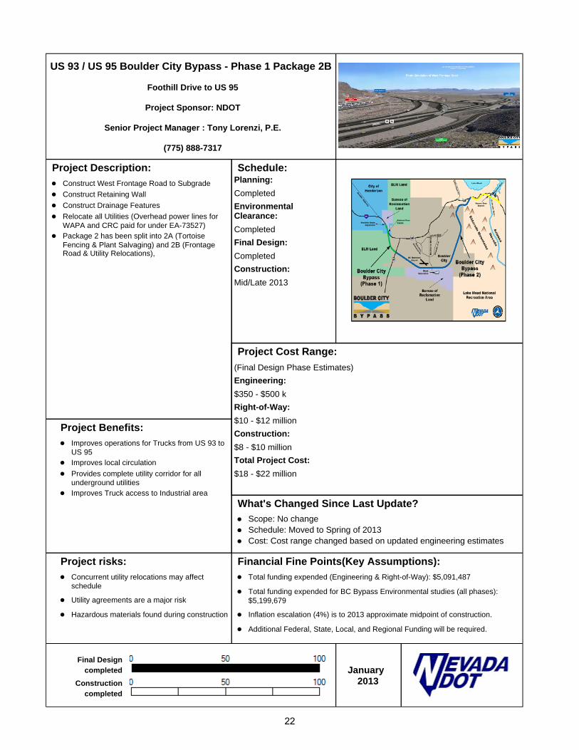
US 93 / US 95 Boulder City Bypass - Phase 1 Package 2B
Foothill Drive to US 95
Project Sponsor: NDOT
Senior Project Manager : Tony Lorenzi, P.E.
(775) 888-7317
Project Description:
Construct West Frontage Road to Subgrade
Construct Retaining Wall
Construct Drainage Features
Relocate all Utilities (Overhead power lines for WAPA and CRC paid for under EA-73527)
Package 2 has been split into 2A (Tortoise Fencing & Plant Salvaging) and 2B (Frontage Road & Utility Relocations),
Schedule: Planning: Completed Environmental Clearance: Completed Final Design: Completed Construction: Mid/Late 2013
Project Cost Range: (Final Design Phase Estimates) Engineering: $350 - $500 k Right-of-Way: $10 - $12 million Construction: $8 - $10 million Total Project Cost: $18 - $22 million
Project Benefits:
Improves operations for Trucks from US 93 to US 95
Improves local circulation
Provides complete utility corridor for all underground utilities
Improves Truck access to Industrial area
What's Changed Since Last Update?
Scope: No change Schedule: Moved to Spring of 2013 Cost: Cost range changed based on updated engineering estimates
Project risks:
Concurrent utility relocations may affect schedule
Utility agreements are a major risk
Hazardous materials found during construction
Financial Fine Points(Key Assumptions):
Total funding expended (Engineering & Right-of-Way): $5,091,487
Total funding expended for BC Bypass Environmental studies (all phases): $5,199,679
Inflation escalation (4%) is to 2013 approximate midpoint of construction.
Additional Federal, State, Local, and Regional Funding will be required.
Final Design completed
Constructioncompleted
January
2013
22

US 93 / US 95 Boulder City Bypass - Phase 1 Package 3
Foothill Drive Grade Sep to the Railroad Pass Interchange
Project Sponsor: NDOT
Senior Project Manager : Tony Lorenzi, P.E.
(775) 888-7317
Project Description:
Realignment of US 93 / US 95 to create an access controlled facility from Foothill Drive to US 95.
One new diamond interchange and one new half diamond interchange along with one Frontage Road will be constructed.
Direct Connector Ramps from the new facility to and from US 93 will be constructed.
Direct Connector Ramps from US 95 to the new facility will be constructed.
Existing access will be perpetuated.
Project length: 2 miles
Schedule: Planning:
Completed
Environmental Clearance:
Completed
Final Design:
Package 3 Ad Date, Fall
2014
Construction:
Mid/Late 2015
Project Cost Range: (Final Design Phase Estimates)
Engineering:
$750k - $1 million
Right-of-Way:
Incidental
Construction:
$46 - $55 million
Total Project Cost:
$47 - $56 million
Project Benefits:
Improves safety by eliminating a signal at US 93 and Railroad Pass Casino.
Improves operations for Trucks from US 95 to US 93.
Improves operations for peak trips from Boulder City to Las Vegas.
Improves local circulation.
Completes initial bypass phase. What's Changed Since Last Update?
Scope: No change Schedule: Package 3 delivery moved to FY 2015 Cost: Cost range changed based on new engineering estimate
Project risks:
Unit price and property escalation may affect project
Construction is not funded
Resource conflict with other on-going projects
Right-of-Way acquisition costs
Field Changes
Increased Roadway Excavation unit prices due to additional blasting
Design omissions
Landscaping redesign
Hazardous materials found during construction
Financial Fine Points(Key Assumptions):
Total funding expended (Engineering & Right-of-Way): $5,091,487
Total funding expended for BC Bypass Environmental studies (all phases): $5,199,679
Inflation escalation (4%) is to 2013 approximate midpoint of construction.
Additional Federal, State, Local and Regional Funding will be required.
% Design Complete
% ROW Complete
January 2013
23

US 93 / US 95 Boulder City Bypass - Phase 2
US 95 to Hoover Dam Bypass
Project Sponsor: NDOT
Senior Project Manager: Tony Lorenzi, P.E.
(775) 888-7317
Project Description:
Provide extension of Phase I from US 95 to tie into the Hoover Dam Bypass at Nevada Interchange
Provide limited access bypass to the south of Boulder City for US 93 traffic
4 lane divided highway facility
Require several bridge structures over existing access roads and to provide wildlife access
NDOT working with RTC to administer Design/Financial Analysis/Environmental studies for Toll Road Analysis
Project length: 12 miles
Schedule: Planning: Complete Environmental: Complete Final Design: TBD Construction: TBD
Project Cost Range:(Planning phase estimates): Engineering: $15 - $30 million Right-of-Way: $2 - $4 million Construction: $350 - $450 million Total Project Cost: $365 - $480 million
Project Benefits:
Reduce congestion of US 93 through Boulder City
Provide additional safety to existing US 93 within Boulder City
Decrease travel time from Las Vegas to Nevada/Arizona border
What's Changed Since Last Update?
Scope - No change Schedule - No change Cost - No change
Project risks:
Project unfunded - may delay schedule and increase costs.
Unit price escalation may affect project cost.
Difficult design & construction issues in a mountainous terrain may affect cost & schedule.
Project is being studied for PPP delivery including tolling and availability payment.
Financial Fine Points(Key Assumptions):
Total funded Expended (Engineering & Right-of-Way): $3,062,767
Total funding Expended for BC Bypass environmental studies (all phases): $5,199,679
Inflation escalation (4%) is to 2027 approximate midpoint of construction.
Additional Federal, State, Local and Regional Funding will be required.
% Design Complete
% ROW Complete
January
2013
24

US 95 Northwest - Phase 1
Rainbow Boulevard (SR 595) to Ann Road
Project Sponsor: NDOT
Project Manager: Nick Johnson, PE
(775) 888-7319
Contractor: Capriati Construction
Project Description: This is the first phase of the US 95 Northwest Project
that extends from Washington Avenue to Kyle Canyon Road.
Alleviate congestion within the corridor by increasing capacity.
Provide new and improved freeway connections to improve regional connectivity, consistent with land use planning
Project length: 6.02 miles
Schedule: Planning: Complete Environmental: Complete Final Design: Complete Advertise Project: Complete Construction: Begin August 2010; 520
working days; anticipated
completion Fall 2012
Project Cost Range:(Construction Phase Estimates): Engineering: $3.5 million Right-of-Way: $0.1 million Construction: $73 - $77 million Total Project Cost: $76.6 - $80.6 million
Project Benefits: Increase capacity
Improve safety
Improve access
Meet stakeholder/public expectations
Reduce trip times
Reduce vehicle emissions
Reduce idling
Beautify corridor
Improve driver comfort
What's Changed Since Last Update? Scope - No change Schedule - No change Cost - No change
Project risks: Change in site conditions
Contractor delays
Financial Fine Points(Key Assumptions): Total Expended for Construction: $0.4 million
Total Expended for Final Design: $3.6 million
Total Expended for Environmental Studies (all US 95 Northwest phases): $4.8 million
Funding source:
*$60 million AB 595
*$42.5 million Federal
*$2.3 million State
% Construction Complete
January 2013
25

US 95 Northwest - Phase 2
Ann Road to Kyle Canyon Road (SR 157)
Project Sponsor: NDOT
Project Manager: Nick Johnson, P.E.
(775) 888-7319
Project Description: This is the second phase of the US 95 Northwest
Project that extends from Washington Avenue to Kyle Canyon Road
Alleviate congestion within the corridor by increasing capacity
Provide new and improved freeway connections to improve regional connectivity, consistent with land use planning
Project length: 5.55 miles
This project is anticipated to be constructed in 2 phases
Schedule: Planning: Complete Environmental: Complete Final Design: TBD Construction: TBD
Project Cost Range:(Environmental Phase Estimates): Engineering: $5.5 - $6.5 million Right-of-Way: $0, No acquisitions required Construction: $75 - $85 million Total Project Cost: $81 - $92 million
Project Benefits: Increase capacity
Improve safety
Improve access
Meet stakeholder/public expectations
Reduce trip times
Reduce vehicle emissions
Reduce idling
Beautify corridor
Improve driver comfort
What's Changed Since Last Update? Scope - No change Schedule - The project design is 90% complete and has been put on
hold; subject to funding availability. Cost - No change
Project risks: Unit price escalation may affect project cost
Complex design issues may impact schedule and scope
Complex right-of-way and utilities issues may impact schedule and cost
Financial Fine Points(Key Assumptions): Total funding Expended for Phase 2: $770,000
Total funding Expended for US 95 Northwest Environmental Studies (all phases): $5 million
Inflation escalation (2.7%) to midpoint of construction in 2017
Funding source: TBD
% Design Complete January
2013
26

US 95 Northwest - Phase 3 Clark County 215 Interchange
Project Sponsor: NDOT and Clark County
Senior Project Manager: Nick Johnson, P. E.
(775) 888-7319
Project Description: This is the third phase of the US 95
Northwest project that extends from Washington Ave to Kyle Canyon Rd
Alleviate congestion within the corridor by increasing capacity
Provide new and improved freeway connections to improve regional connectivity, consistent with land use planning
Construct new system to system interchange at CC 215
This project is anticipated to be constructed in 4 phases.
Schedule: Planning: Complete Environmental: Complete Final Design: TBD Construction: TBD
Project Cost Range:(Final Design Phase Estimates): Engineering: $13.6 - $14.3 million Right-of-Way: $0 - $0.4 Million Construction: $219 - $276 million Total Project Cost: $233 - $290 million
Project Benefits: Increase capacity
Improve safety
Improve access
Meet stakeholder/public expectations
Reduce trip times
Reduce vehicle emissions
Reduce idling
Beautify corridor
Improve driver comfort
What's Changed Since Last Update? Scope - The project is anticipated to be constructed in 4 phases. Schedule - No Change Cost - No Change
Project risks: Cost and schedule impacts of
perpetuating local access has yet to be quantified
Unit price escalation may affect project cost
Complex right of way and utility issues may impact schedule and costs.
Financial Fine Points(Key Assumptions): Total funding Expended for Phase 3: $2,800,000
Total funding Expended for US 95 Northwest Environmental Studies (all phases): $5 million
Inflation escalation (4%) to midpoint of construction 2018
Funding source: TBD
% Design Complete
% ROW Complete
Updated: January 2013
27

US 95 Northwest - Phase 5 Kyle Canyon Road Interchange
Project Sponsor: City of Las Vegas and NDOT
Senior Project Manager: Nick Johnson, P.E.
(775) 888-7319
Project Description: This is the fifth phase of the US 95 Northwest Project
that extends from Washington Ave to Kyle Canyon Road.
Alleviate congestion within the corridor by increasing capacity.
Provide new and improved freeway connections to improve regional connectivity, consistent with land use planning.
Construct new interchange at Kyle Canyon Road.
Schedule: Planning: Complete Environmental: Complete Final Design: TBD Construction: TBD
Project Cost Range:Engineering: $2.5 - $3 million Right-of-Way: $1 - $1.5 million Construction: $32 - $36.5 million Total Project Cost: $35.5 - $41 million
Project Benefits: Increase capacity
Improve safety
Improve access
Meet stakeholder/public expectations
Reduce trip times
Reduce vehicle emissions
Reduce idling
Beautify corridor
Improve driver comfort
What's Changed Since Last Update? Scope - No change Schedule - No change Cost - No change
Project risks: Unit price escalation may affect project cost
Complex design issues may impact schedule and scope
Complex right of way and utility issues may impact schedule and costs.
Financial Fine Points(Key Assumptions): Total Expended for Final Design: $0 (Design phase not started)
Total Expended for Environmental Studies (all US 95 Northwest phases): $5 million
Inflation escalation (4%) to midpoint of Construction in 2027
Funding source:
*11 million Federal
*$0.5 million State
*$6.5 million Local
*$18.5 million Private
Design complete
ROW complete
January 2013
28

I 80 Robb to Vista
Project Sponsor: NDOT
Senior Project Manager: Jeff Lerud
(775) 888-7589
Project Description:
Make operational and capacity improvements to I-80 from Robb Drive to Vista Blvd.
Make operational and capacity improvements to the I-80/I-580 interchange (Spaghetti Bowl)
Early Action and Phase 1 (I-80 Robb to Vista Design-Build) projects from Washoe County Freeway Corridor Study scoping report completed.
Phase II scoping will commence after completion of the I-80 Robb to Vista design/build project.
Project Length: 10.4 miles
Schedule: Planning: 2008 - 2012 Environmental: TBD Final Design: TBD Construction: TBD
Project Cost Range: (Planning Phase Estimates) Engineering: $85 - $105 million Right-of-Way: $95 - $125 million Construction: $900 - $1.1 billion Total Project Cost: $1.08 billion - $1.33 billion
Project Benefits:
Improve operations and capacity along I-80.
Improve safety
Provide better connectivity between I-80 and I-580/US 395.
Accommodate future projected traffic.
What's Changed Since Last Update?
Scope - No change Schedule - No change Cost - No change
Project risks:
Limited Right-of-Way
Phase II and beyond unfunded- delay in identifying needed funds will affect schedule and increase costs.
Environmental process not started - Project cost, scope and schedule may be impacted.
Resources may need to be reallocated to higher priority projects - project cost, scope and schedule may be impacted.
Financial Fine Points(Key Assumptions):
Total Funding Expended by NDOT: $140, 000
Inflation escalation (4%) is to 2020 approximate midpoint of construction
Additional Federal, State, and local funding will/may be required
Planning CompleteJanuary
2013
29

I 80 Robb Drive to Vista Boulevard - Design Build (Phase 1)
Project Sponsor: NDOT
Senior Project Manager: Jeff Lerud, P.E.
(775) 888-7589
Contractor: Granite Construction
Project Description: Procurement & Delivery will be by Design
Build method. Make operational and capacity improvements to I-80 from Robb Drive to Vista Blvd.
Pavement reconstruction from Keytone Avenue to 4th Street.
ITS infrastructure from Robb to Vista.
Signing and Striping improvements from Robb to Vista.
Auxiliary lanes from E. McCarran to Vista.
Sparks loop ramp (westbound on ramp); Triple lefts (Eastbound off ramp)
Landscape and Aesthetics from Robb to Vista.
Project Length: 10.4 miles
Schedule: Planning: Complete Environmental: Complete Design: Complete Construction: Complete
Project Cost Range:Engineering/Construction: $72 - $85 million Right-of-Way: $0 Total Project Cost: $72 - $85 million
Project Benefits: Improve operations and capacity along I-
80. Improve safety.
Increase mobility.
Improve ride quality
Reduce maintenance costs.
What's Changed Since Last Update? Scope - No change Schedule - No change Budget - No change
Project risks: Maintenance of traffic: two lanes of traffic
open in each direction.
Environmental requirements may delay project.
Weather: two seasons of construction.
Financial Fine Points(Key Assumptions): Total funding expended: $79,868,850
Funding source: Federal, State & Local Funds
% Construction
Complete
Updated: January 2013
30

I 580 Freeway Extension
Project Sponsor - Nevada Department of Transportation
NDOT Senior Project Manager - Tony Lorenzi, P.E.
Phone: (775) 888-7317
Contractor: Fisher Industries
Project Description: 8.5 Miles of new 6-lane controlled access
freeway Complete Mt. Rose Interchange (SR431) and
construct a new interchange at Bowers Mansion Road (SR 429)
Construct two grade separations and five bridges
Construct Kelly Canyon Road (frontage road) and Parker Ranch Road to maintain local access at south end of project
Ten water quality basins for treating storm water runoff
Schedule: Planning: Complete Environmental: Complete Final Design: Complete Construction: Complete
Project Cost Range:Engineering: $31 M Right-of-Way: $51 M Construction: $500 M to $575 M Estimated Total Project Costs: $582 M to $657 M
Project Benefits: Construction will result in 27 miles of
uninterrupted controlled access facility that meets interstate standards
Will serve as the primary interstate highway for transportation linking Mexico with Canada and a major local arterial
Will provide only all weather route connection between Carson City and Reno, Sparks & I 80
Completion will alleviate congestion and explosive growth of over 61,700 vehicles per day predicted to travel in North Carson on I 580/US 395
Projected to reduce the over 2,570 accidents and 16 fatalities that occurred in a 10 year span within similar limits
What's Changed Since Last Update? Scope - No change. Schedule - No change Cost - No change
Project risks: Complex construction in a rural mountainous
freeway setting (High)
Construction in geothermally altered earth (Medium)
Delays due to weather/temperatures (Low)
Financial Fine Points(Key Assumptions): Total Funding Expended - $532,134,619
Final Design - $6,322,902
Right-of-Way - $50,021,603
Constr Engineering - $42,596,028
Construction - $433,194,086
Bond Funds
% Construction Complete
January 2013
31

US 395 North - McCarran Blvd to Stead Blvd
Project Sponsor: NDOT
Senior Project Manager: Jeff Lerud, P.E.
(775) 888-7589
Project Description: Widen US 395 to increase capacity and improve
traffic operations. Modify interchange ramps and cross streets as
necessary to improve operations. Widen bridge structures at Stead, Lemmon Drive,
Golden Valley, UPRR, Virginia Street, Panther Valley, Parr Blvd and Clear Acre Lane if necessary.
Perpetuate drainage features.
Replace and install new signs.
Schedule: Planning: TBD Environmental: TBD Final Design: TBD Construction: TBD
Project Cost Range: (Planning Phase Estimates) Engineering: $7 - $9 million Right-of-Way: $3 - $6 million Construction: $70 - $85 million Total Project Cost: $80 - $100 million
Project Benefits: Relieve heavy peak hour congestion and
reduces crashes associated with congestion. Reduces travel time.
Improves overall traffic operations.
What's Changed Since Last Update? Scope - No Change Schedule - The project has been put on hold subject to funding
availability. Cost - No Change
Project risks: Environmental requirements.
UPRR Clearance and requirements.
Unknown Right-of-Way and utility impacts.
Impact of new development in the region.
Concurrent planning associated with the Pyramid Connector.
Financial Fine Points(Key Assumptions): Total funding expended: $50,000
Inflation escalation (4%) is to 2015, approximate mid-point of construction
No funding has been identified for this project
Planning Complete: January
2013
32

US 395 Northbound - Moana Lane to I-80
Project Sponsor: NDOT
Senior Project Manager: Jeff Lerud, P. E.
(775) 888-7589
Project Description: Widen northbound US 395 to improve traffic
operatons from the Moana Lane interchange to the I-80 interchange.
Widen northbound bridges at Vassar, Mill, Glendale, Truckee River, Kietzke, UPRR, and 4th Street.
Replace overhead sign structures.
Perpetuate drainage features.
Reconstruct northbound ramps at Mill, Glendale, Villanova & I-80.
Project length: 2.87 miles
Schedule: Planning: Complete Environmental: Complete Final Design: Complete Construction: Complete
Project Cost Range:(Final Design Phase Estimates): Engineering: $9 - $10 million Right-of-Way: $2 - $5 million Construction: $50 - $60 million Total Project Cost: $61 - $75 million
Project Benefits: Relieves heavy northbound peak hour
congestion and reduces crashes associated with congestion.
Reduces northbound travel time from 16 minutes to 3 minutes in peak hour from Moana to I-80.
Improves overall northbound traffic operations and reduces multiple weaves and lane changes at the Spaghetti Bowl interchange.
What's Changed Since Last Update? Scope - No change Schedule - Project Completed. Cost - No change.
Project risks: Unexpected design or contract document
changes during construction
Private development along the freeway alters the project design and/or construction
Financial Fine Points(Key Assumptions): Total funding Expended: $34.9 million.
Inflation escalation (4%) is to 2011, mid-point of construction.
Washoe County RTC contributed $20 million towards the project.
The AB 595 income stream, federal and state funds will be used to fund the rest of the project.
Construction
January2013
33

SR 445 Pyramid Highway Improvements
Project Sponsor: Washoe County RTC and NDOT
Washoe RTC Project Manager: Doug Maloy, P.E.
NDOT Project Manager: Nick Johnson
Phone: (775) 888-7319
Project Description: Calle de la Plato to La Pasada- Transition
from 4 Lane Arterial to 6 lane freeway La Pasada to Sparks Blvd. - Develop
Pyramid alignment into 6 lane freeway with frontage roads.
Continue 6 lane freeway from Sparks Blvd. to Dics Dr. either on the Pyramid alignment with frontage roads or on a separate alignment to the west.
Extend 6 lane freeway through Sun Valley to US-395
Widen and improve Pyramid highway from Disc Dr. to Queen Way
Widen and extend Disc Dr. to Vista Blvd.
Schedule: Planning: Complete Environmental: 2010 - 2014 Final Design: TBD Construction: TBD
Project Cost Range: (Planning phase estimates) Engineering: $40M - $60M Right-of-Way: $100M - $150M Construction: $410M - $660M Total Project Costs: $550M - $870M
Project Benefits: Address congestion and safety along the
Pyramid Highway and McCarran Blvd. Corridors
Provide alternative access to freeway system
Improve safety What's Changed Since Last Update? Scope - No change. Schedule - No change Cost - No change.
Project risks: Construction in a dense urban residential
area
Funding sources for all phases not identified
Complex right of way and utility issues may impact schedule and costs.
Financial Fine Points(Key Assumptions): Total RTC Funding Expended - $7,300,000
Inflation escalation (2.7%) to midpoint of construction in 2020
% Environmental
Complete
Updated: January 2013
34
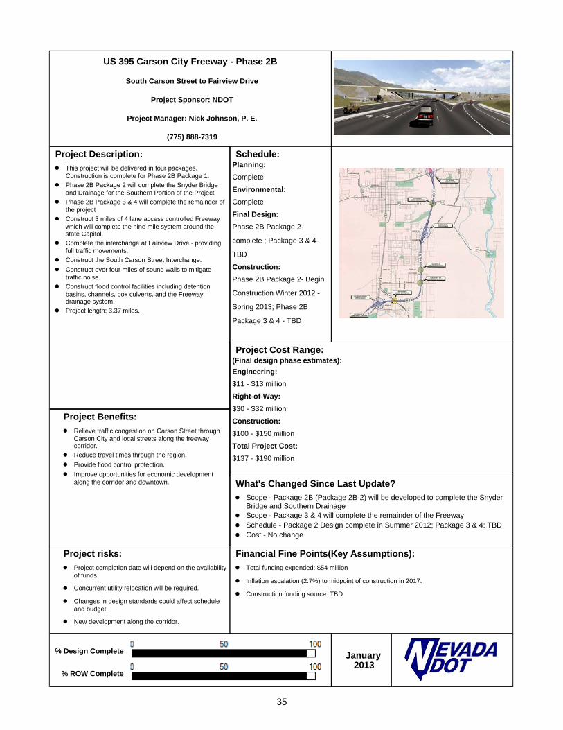
US 395 Carson City Freeway - Phase 2B
South Carson Street to Fairview Drive
Project Sponsor: NDOT
Project Manager: Nick Johnson, P. E.
(775) 888-7319
Project Description: This project will be delivered in four packages.
Construction is complete for Phase 2B Package 1.
Phase 2B Package 2 will complete the Snyder Bridge and Drainage for the Southern Portion of the Project
Phase 2B Package 3 & 4 will complete the remainder of the project
Construct 3 miles of 4 lane access controlled Freeway which will complete the nine mile system around the state Capitol.
Complete the interchange at Fairview Drive - providing full traffic movements.
Construct the South Carson Street Interchange.
Construct over four miles of sound walls to mitigate traffic noise.
Construct flood control facilities including detention basins, channels, box culverts, and the Freeway drainage system.
Project length: 3.37 miles.
Schedule: Planning: Complete Environmental: Complete Final Design: Phase 2B Package 2-
complete ; Package 3 & 4-
TBD Construction: Phase 2B Package 2- Begin
Construction Winter 2012 -
Spring 2013; Phase 2B
Package 3 & 4 - TBD
Project Cost Range:(Final design phase estimates): Engineering: $11 - $13 million Right-of-Way: $30 - $32 million Construction: $100 - $150 million Total Project Cost: $137 - $190 million
Project Benefits: Relieve traffic congestion on Carson Street through
Carson City and local streets along the freeway corridor.
Reduce travel times through the region.
Provide flood control protection.
Improve opportunities for economic development along the corridor and downtown. What's Changed Since Last Update?
Scope - Package 2B (Package 2B-2) will be developed to complete the Snyder Bridge and Southern Drainage
Scope - Package 3 & 4 will complete the remainder of the Freeway Schedule - Package 2 Design complete in Summer 2012; Package 3 & 4: TBD Cost - No change
Project risks: Project completion date will depend on the availability
of funds.
Concurrent utility relocation will be required.
Changes in design standards could affect schedule and budget.
New development along the corridor.
Financial Fine Points(Key Assumptions): Total funding expended: $54 million
Inflation escalation (2.7%) to midpoint of construction in 2017.
Construction funding source: TBD
% Design Complete
% ROW Complete
January 2013
35

I 580 at Meadowood Mall Way
Project Sponsors: Washoe County Regional Transportation Commission and Nevada Department of Transportation
Washoe RTC Project Manager: Michele Dennis, P.E.
Phone: (775) 335-1861
NDOT Project Manager: Adam T. Searcy, P.E.
(775) 888-7597
Contractor: Meadow Valley Contractors Project Description: Construct grade separation at I 580 and
Meadowood Mall Way. Extend Meadowood Mall Way from S. Virginia
Street to Kietzke Lane. Add I 580 southbound off- and northbound on-
ramps at Meadowood Mall Way. Add frontage roads between Neil Road and
Meadowood Mall Way.
Schedule: Final Design: Complete Construction: Substantial Completion,
4th quarter 2012
Project Cost Range:(Design phase estimates): Engineering: $7 million Right-of-Way: $5 million Construction: $22 - $24 million Total Project Cost: $34 - $36 million
Project Benefits: Accommodate present and future traffic
demand entering and exiting I 580. Reduce traffic volumes at the on- and off-
ramps in the project area. Improve the levels of service (LOS) at several
key intersections in the project area. Provide additional Freeway access to reduce
the volume of traffic using the south Virginia Street ramps.
Reduce traffic at the intersection of South McCarran Blvd./South Virginia Street.
Improve traffic circulation on arterial streets in the area.
What's Changed Since Last Update? Scope - No Change Schedule - Traffic opening was achieved on 11/21/12 Cost - No Change
Project risks: Complex construction in an urban/retail
commercial area.
Complexity in maintaining traffic, and reducing impacts to retail businesses.
Simultaneous construction adminstered by RTC in project limits.
Financial Fine Points(Key Assumptions): $22 million ARRA Federal Stimulus Funds applied to awarded Contract 3389
Construction January
2013
36
4.0 COMPLETED MAJOR PROJECTS
As a part of the reporting requirements in Section 55.5 of AB 595, the Department is to report the number of major projects for which construction was completed during this quarter. For each completed project, the Department is to report on the following:
1. Whether the project was completed early or on time. 2. Whether the project remained within its planned scope. 3. Whether the project was completed for less than or for the amount of its budgeted expenses. 4. Any specific measures of transportation improvement resulting from the project.
For the quarter ending December 31, 2012, the US395 Northbound project was completed five months ahead of schedule, remained in the planned scope of work and within the original budget. During the peak hour, travel times were decreased an average of 16 minutes to 3 minutes from Moana Lane to the Spaghetti Bowl.
37