quarry detection monitoring wells completion report …
TRANSCRIPT

IIII
DOE/OR/21548-224
CONTRACT NO. DE-AC05-86OR2.1548 ,_
OCT 2 8 !ggt
QUARRY DETECTION MONITORINGWELLS COMPLETION REPORT WP-166
Weldon Spring Site Remedial Action ProjectWeldon Spring, Missouri
SEPTEMBER 1991 REV. 0
U.S. Department of EnergyOak Ridge Operations OfficeWeldon Spring Site Remedial Action Project
DIS'[RIBLJ;I(jt.,, L.,_: i! ,:,::., ,..'..,,_',_,IEN i ii-, UNLiMIIIEID

Printed in the United States of America. Available from the National Technical
Information Service, NTIS, U.S. Department of Commerce, 5285 Port Royal Road,Springfield, Virginia 22161
NTIS Price Codes- Printed copy: A04Microfiche: A01 DOE/OR/21548--224
DE92 001946
m:\ueers2_joanne_jonee\wp166.cr
DISTRIBUTION OF TI-tI,S DOCUMENT 18 LIi_iLIMITED

,,, , ,, ,
(_ MK-FERGUSON F.vNo0A___ Issue Date:
Weldon Spring Site Remedial Action Project Page 1 of 1Contract No. DE-ACOS-860R21548
PLAN TITLE: Quarry Detection Monitoring Wells CompletionReport WP-166
APPROVALS
PMC Envir ntal Safe _7_uaL_l
Health Manager
PMC C_nstr_tion_agement andOperations Manager
PM C_i_ Assurance Managerroj_ir D__ _qD a£ePMC Dainty P actor _/_/
PMC Project Director Da£e
[DISTRIBUTION OF TFiI,S DOCUMENT IS UNLIMITED

DOE/OR/21548-224
Weldon Spring Site Remedial Action Project
Quarry Detection Monitoring Wells Completion Report WP-166
Revision 0
September 1991
Prepared by
MK-FERGUSON COMPANYand
JACOBS ENGINEERING GROUP7295 Highway 94 South
St. Charles, Missouri 63304
for the
U.S. DEPARTMENT OF ENERGY
Oak Ridge Operations OfficeUnder Contract DE-AC05-86OR21548
MASTERm:\users2_oanne_jones\wp166.cr LIMITEDDISTRtE3UTION OF THkS DOCUMENT IS UN

001801
TABLE OF CONTENTS
SECTION PAGE
1 INTRODUCTION ................................................ 1
1.1 Purpose .................................................... 11.2 Overview ................................................... 1
2 ABANDONMENT ............................................... 3
2.1 Monitoring Weil-1025 ......................................... 3
3 DRILLING ..................................................... 4
3.1 Monitoring WeU-1029 ......................................... 43.2 Monitoring Weil-1030 ......................................... 53.3 Monitoring WeU-1031 ......................................... 53.4 Monitoring WeU-1032 ......................................... 63.5 Monitoring WeU-1033 ......................................... 63.6 Monitoring Weil-1034 ......................................... 7
4 WEI2_ INSTAU_TION ........................................... 8
4.1 Monitoring WeU-1029 ......................................... 84.2 Monitoring Weil-1030 ......................................... 84.3 Monitoring Weil-1031 ......................................... 84.4 Monitoring WeU-1032 ......................................... 94.5 Monitoring Weil-1033 ......................................... 94.6 Monitoring Weil-1034 ......................................... 9
5 WELL DEVELOPMENT ......................................... 106 SITE RESTORATION ........................................... 117 DECONTAMINATION ........................................... 128 ANALYTICAL RESULTS ......................................... 13
APPENDIXES
A Completed Borehole, Well Installation, Development, And Abandonment LogForms
m:\users2_oanne_jones\wp166.cr jl

091891
LIST OF FIGURES
_YMBER PAGE
1-1 Monitoring Well Locations ....................................... 2
m:\users2_joanne_jones\wp166.cr i_i
091891
1 INTRODUCTION
1.1 Purpose
The purpose of this report is to document the activities undertaken during
implementation of Work Package 166, Quarry Detection Monitoring Wells. The subcontract
specifications should be consulted for specific details regarding this work effort.
1.2 Overview
On January 2, 1991, Geotechnology, a subcontractor, began the work for Work
Package 166 (WP-166) which involved the abandonment of MW-1025, and the installation
and development of monitoring wells MW- 1029,MW- 1030, MW- 1031, MW- 1032, MW- 1033,
and MW-1034 ali of which are located r,ear the Weldon Spring quarry. Refer to Figure 1-1for monitoring well locations. This work provided additional characterization needed for the
quarry and replaced MW-1025 with MW-1034 because MW-1025 would have been impacted
by the Highway 94 relocation effort. Geotechnology personnel present during this work
included Dale Meyer, Superintendent/Senior Driller; Andy Limmer, Geologist; ScottHildabrandt, Senior Driller's Assistant; and Paul Guerrin, Driller's Assistant. The
Construction Engineer was Vernon Taylor of the Construction Management & Operations(CM&O) Department with field representation provided by Craig Jones and Richard
Spurgeon of the Environmental, Safety and Health (ES&H) Department. Data for
completed well abandonment, well installation, well development, and boring logs for ali
monitoring wells installed for WP-166 are in Weldon Spring Site Remedial Action Project
(WSSRAP) Quality Assurance (QA) and ES&H files, and are also included in appendix A
of this report.
m:\usem_oanne_ones\wp166.cr I

It STATE RouTE 94
• MW-1034 _I
/' MW-1029 I
/
/
MW-lO3
MW-1032e,=,,
MW-1031e
fFEMME OSAGE:SLOUGH
MW-1033
O'QUARRY MONITORING WELL WP-166 MONITORING WELL LOCATIONS
i
0 250 500 FT FIGURE 1
0 76.2 152.4 M _z_,,o_,_ Iuo"''N°" AIQYI06310891

091891
2 ABANDONMENT
2.1 Monitoring We11.1025
On January 2 and 3, 1991, monitoring well MW-1025 was abandoned according to
State and Federal Regulations and ES&H Procedure 4.4.4s. Only 25 fl of the original riser
(stainless steel) was extracted intact. However, a total depth of 56 ft was drilled, including
drilling approximately 12 fl into bedrock as indicated by the previous log for this weil. The
boring was overdril!e'_ using 10 in. augers (original hole was 8.5 in.) and then grouted to the
ground surface using Volclay grout as specified.
The primary problem encountered during the abandonment occurred when the drill
bit severed the casing at a depth of approximately 25 ft and was no longer centered on the
well casing. The driller continued with drilling operations; however, he was not able to
realign the drill bit over the well casing as fragments of stainless steel casing were present
in the cuttings. The driller continued 12 fl into the bedrock, and then grouted the hole from
a total depth of 56 ft below ground surface to the surface. Cuttings were allowed to be
spread in the surrounding area as stated in the specifications; however, the weil materials
were screened from the cuttings and were disposed of by Geotechnology in accordance with
the subcontract specifications.
m:\ueers2_joanne_jones\wp166.cr 3

091891
3 DRILLING
The six boreholes for well installation were drilled using a truck mounted CME 75
drilling rig with 6 1/4 in. ID hollow stem augers, NX size wireline core barrels, 2 in. OD split
spoons, and a 6 in. hammer bit. A total of 465.0 ft were drilled for the six wells using
approved drilling methods for both overburden materials and bedrock. Typically, 2 ft split
spoon samples were collected continuously from 0 ft to 10 ft and then every 5 ft thereafter
unless otherwise specified until bedrock waz encountered. When core drilling in bedrock,
the continuous wireline system was utilized using 10 ft runs. Once a total depth was
determined, the hole was reamed with the hammer bit. Specifics for each boring drilled are
provided below.
3.1 Monitoring We11.1029
The borehole used for installation of MW-1029 is located on the rim of the quarry
near the north gate. This borehole was drilled from January 14 through January 17, 1991.
For the most part, silts, clays, and silt/clay mixtures were present from the ground
surface to 29.5 ft. As specified, no environmental samples were collected for analysis. From
29.5 ft to 34.5 ft, highly weathered Kimmswick limestone was encountered followed by an
additional 65 ft of highly fractured (both vertically and horizontally) Kimmswick limestone
to a depth of 99.5 ft below the ground surface (bgs). Circulation was lost at an approximate
depth of 45 ft and was never regained. This was consistent with the fractures and vugs
identified within the core samples. At 98 ft below the ground surface, water was
encountered within the Kimmswick Limestone. The core samples of the Kimmswick
Limestone were typically hard, gray, and fossiliferous and contained solution features such
as vugs and styolites. Also, the rock quality of the Kimmswick core samples was typically
50% and less. At approximately 99.5 ft below the surface, rocks of the Decarah Group were
encountered. The Decorah Group, typically a gray limestone with shale partings, was highly
to slightly weathered with iron staining and fractures present. A 10 in. shale layer was
encountered at 108 ft bgs; however, this shale bed was the only parting present within the
11 ft of the Decorah sampled. Water was encountered at 98 ft, and the hole was terminated
at 110.5 ft. All core samples were scanned for radioactivity, and all samples were released
as clean except for the clay layer encountered at 108 ft bgs which indicated approximately
200 to 250 counts per minute (6-7 times background). All soil cuttings and soil samples were
m:\users2_oanne_ones\wp166.cr 4

091891
containerized in four drums and disposed of in the contaminated stockpile located in the
inner quarry. After all material was emptied from the drums, the drums were
decontaminated and scanned prior to their release from the inner quarry.
3.2 Monitoring Well.lO30
From January 22 through January 24, 1991, a borehole was drilled for MW-1030 on
l the southwest rim within the inner quarry fence.
Mostly silts and clays were encountered to depths of 50 ft below the ground surface.
Soil samples were collected from 0 ft to 10 ft and from 30 ft to 36 ft below the ground
surface. Portions of these samples were analyzed for environmental contaminants. Sampling
parameters included the entire Hazardous Substance List, nitroaromatics, natural uranium,
Th-230, and Th-232. Bedrock encountered from 50 ft to 95 ft below the ground surface wascored using the wireline method. Kimmswick Limestone was encountered between 50 ft and
80 ft below the ground surface. Many solution features including styolites and vugs were
present as were many horizontal and vertical fractures. Rocks of the Decorah Group were
encountered 80 ft below the surface, consisting of fresh limestone with only a few shale
partings, the thickest being less than 1 ft. Groundwater was present approximately 87 ft
below the ground surface. All cuttings produced were placed in drums and disposed of
within the inner quarry, as described in Section 3.1 for MW-1029 borehole. No majordifficulties were encountered when drilling this borehole.
3.3 Monitoring Weil-lO31
The borehole for monitoring well MW-1031, located north of the Femme Osage
Slough with the existing well cluster MW-1013 and MW-1014, was drilled on January 28 and29, 1991.
Twenty feet of soil consisting of mostly silty clays with two very thin sand layers
encountered above the bedrock was sampled and analyzed for uranium, Th-230, Th-232 and
nitroaromatics. The bedrock encountered at 20 ft bgs was cored to a total depth of 56.5 ftusing the wireEne method. The Decorah Group was encountered from 20 ft to 35 ft below
the ground surface and the Plattin Limestone was encountered from 35 ft to 56.6 ft below
the ground surface. Groundwater was present at a depth of approximately 14 ft below the
ground surface; however, this borehole was drilled for monitoring groundwater within the
m:\users2_joanne_jones\wp166.cr 5

091891
Plattin. Therefore, the borehole was terminated at 56.5 ft, approximately 21 ft into the
Plattin. Groundwater located well above the Plattin was cased to prevent mixing. Cuttings
generated from the borehole were drummed and disposed of within the inner quarry in the
same manner as for MW-1029. No major difficulties were encountered during drilling
operations for this borehole.
3.4 Monitoring WeU-1032
The borehole for monitoring well MW-1932 is located north of the slough with the
existing weU cluster MW-1008 and MW-1009. This borehole was drilled on January 31, and
February 1, 1991.
Silty clay with one small sand lens was encountered to 12 ft below the ground
surface. The 12 ft of soil was sampled and analyzed for uranium, Th-230, Th-232,nitroaromatics, and the total Hazardous Substance List. The bedrock encountered from 12
ft to 30 ft known as the Decorah Group consisted of highly fractured limestone with a shale
parting. Groundwater was present at 8 ft below the ground surface; however, this borehole
was drilled to monitor the Decorah Group, therefore the borehole was terminated at 30 ft,
approximately 18 ft into the Decorah. The soils in the surrounding area are known to
contain low levels of radiological contamination, therefore, the rig was scanned prior to its
departure. No contamination on the rig was detected prior to its departure. _lso, ali
cuttings generated during drilling operations were disposed of within the inner quarry as
described for MW-1029. No major difficulties were encountered during the drilling of thisborehole.
3.5 Monitoring Well-lO33
The borehole for monitoring well MW-1033, located south of the slough with well
cluster MW-1019 and MW-1020, was drilled on February 13 and 14, 1991.
Silty clays were encountered to approximately 15 ft with fine sand present to 20 ft
below the ground surface. This 20 ft of material was sampled and analyzed for uranium, Th-
230, Th-232, and nitroaromatics. Well graded sands and gravels were encountered from 20
ft to 82.5 ft below the ground surface. This material was not sampled. Bedrock encountered
from 82.5 to 97.5 ft is known as the Plattin Limestone and consisted primarily of fresh grey
m :\ueers2_joanne_jones\wp166.cr 6

091891
limestone with styolites. The formation appeared very tight with few fractures noted.
Although it was very difficult to determine if groundwater was present within the Plattin, the
borehole was terminated 15 ft within the bedrock as specified in the specifications. It should
be noted that groundwater was present at a depth of 20 ft below the ground surface (within
the alluvium). Cuttings generated during this operation were spread on the surface near the
borehole location as specified.
One major difficulty was encountered during drilling this borehole. Heaving sands
began to give the driller many problems at a depth of approximately 22 ft below the ground
surface. To correct this problem, several hundred gallons of water obtained from the St.
Charles County Water Treatment Plant were pumped into the borehole to create a settling
effect. No other major problems were encountered during this operation.
3.6 Monitoring Well-lO34
The borehole used for monitoring well MW-1034 is located approximately 100 ft due
north of MW-1025 and was drilled from January. 3 to January 11, 1991.
This borehole replaced MW-1025 and took several days to drill due to inclement
weather. Silty clay with very few sand lenses was encountered to a depth of approximately
55 ft. Samples were collected from 0 ft to 5 ft and 40 ft to 45 ft below the ground surface
and analyzed for uranium, nitroaromatics, and the total Hazardous Substance List. Bedrock
encountered from 55 ft to 75 ft below the ground surface consisted of fossiliferous, grey
limestone. The Kimmswick Limestone was identified as the layer from 55 ft to
approximately 70 ft below the ground surface, while the remaining 5 ft was identified as the
Decorah Group. Groundwater was encountered at approximately 60 ft; therefore, the
borehole was terminated at 75 ft below the ground surface. Cuttings generated at this
location were spread on the surface near the borehole as specified. No major difficultieswere encountered at this location.
rn:\users2_joanne_jones\wp166.cr 7

091891
4 WELL INSTAIXATION
All well casing and screen materials were made of 316L stainless steel with a locking
steel protective surface casing (4 in. square) centered over the top of the well casing. Pads
were constructed of ready mix concrete and were approximately 2.5 ft x 2.5 ft square with
posts (6 in. diameter) instaUed surrounding the wells for protection. Refer to the
specifications for the protective casing and pad diagrams.
4.1 Monitoring WeU-1029
On January 18 through 21, 1991, monitoring well MW-1029 was installed within the
Decorah Group. The screened interval for the well was between 110.5 ft and 100.5 ft below
the ground surface (bgs). The sand pack was placed to 95 ft bgs and the seal (bentonite 3/4
in. pellets) to 91.5 ft bgs. The sand pack consisted of WB-40 Meramac sand. The
remainder of the hole was backf_ed with Volclay grout using a tremie pipe. Approximately
twice the amount of volclay grout anticipated was used indicating that voids or fractures
around the well absorbed the grout.
4.2 Monitoring Well.lO30
From January 24 through 28, 1991, monitoring well MW-1030 was installed within the
Decorah Group. The screened interval for the well was between 90 ft and 8(_ft below the
ground surface. The sand pack (WB-40 Meramac sand) was placed from the bottom of the
borehole (95 ft bgs) to 72 ft bgs with a 4 ft seal of bentonite 3/4 in. pellets above the sand
pack to 68 ft below the surface. The remainder of the hole was backfilled with Volclay
grout using a tremie pipe.
4.3 Monitoring We11-1031
On January 29, 1991, monitoring well MW-1031 was installed within the Plattin
Limestone. The screened interval for the well was between 53 ft and 43 ft below the ground
surface. The sand pack (WB-40 Meramac sand) was placed from the bottom of the
borehole (56.5 ft bgs) to 39.5 ft bgs with a 3.5 ft seal (bentonite 3/4 in. pellets) above the
sand pack. The remainder of the hole was backfilled with Volclay grout using a tremie pipe.
rn:\users2_oanne_jones\wp166.cr 8

091891
4.4 Monitoring We11-1032
On February 1, 1991, monitoring well MW-1032 was installed within the Decorah
Group. The screened interval for the well was between 29 ft and 19 ft below ground
surface. The sand pack (WB-40 Meramac sand) was placed from the bottom of the
borehole (30 ft bgs) to 17 ft bgs with a 3 ft seal (bentonite 3/4 in. pellets) above the sand
pack. The remainder of the hole was backfilled with Volclay grout using a tremie pipe.
4.5 Monitoring Weil-lO33
On February 20, 1991, monitoring well MW-1033 was installed within the PlattinLimestone. The screened interval for the well was between 97.5 ft aad 87.5 ft below the
ground surface. The sand pack (WB-40) was placed from the bottom af the borehole (97.5
ft bgs) to 85 ft bgs with a 4 ft seal (bentonite 3/4 in. pellets) above the sand pack. The
remainder of the hole was backfilled with Volclay grout using a tremic pipe.
4.6 Monitoring We!1-1034
On January 10, 1991, monitoring well MW-1034 was installed across the Kimmswick-Decorah contact. The screened interval for the well was between 74 ft and 64 ft below
ground surface. The sand pack (WB-40) was placed from the bottom of the borehole (75
ft bgs) to 58 ft bgs with a 3 ft seal (bentonite 3/4 in. pellets) above the sand pack. The
remainder of the hole was backfilled with Volclay grout using a tremie pipe.
m:\usersL_oanne_jones\wp166.cr 9

091891
$ WELL DEVELOPMENT
Well development was performed on each of the wells drilled. Development did not
commence until a minimum of 48 hrs after well installation to ensure that the grout column
and concrete pad were completely set up. All wells were bailed dry 10 times because the
volume of water required for removal could not be removed due to the slow recharge of the
bedrock formations. However, the wells were developed until the following conditions were
met as set forth in the specifications: (1) three conductivity measurements within plus or
minus 20%; (2) three pH measurements within plus or minus 0.2 standard units; and (3)
three temperature measurements within +_ 1°C.
m :\users2._joanne_jones\wp166.cr ] 0

091891
6 SITE RESTORATION
Site restoration was performed only at monitoring well locations MW-1031, MW-1032,
and MW-1034. MW-1029 and MW-1030 are located within the inner quarry on the rim and
MW-1033 is located adjacent to crops and did not require seeding. Monitoring well
locations MW-1031, MW-1032 and MW-1034 were graded to conform to natural ground
elevations and seeded with a winter seed mix in sufficient quantity to ensure dense growth.
Ali locations were cleaned to remove trash and debris and restored as per specifications.
m:\ueers2_joanne_jonee\wp166.cr 1 ]

O91891
7 DECONTAMINATION
All coring, sampling, augering, and drilling equipment and all tools were
decontaminated by hot water cleaning between each borehole/monitoring well location. This
operation was performed within the lower inner quarry to contain all fluids generated, with
the exception of decontamination after installation of MW-1034. Decontamination at the
site of MW-1034 was allowed as this well was a replacement for MW-1025.
Dccontamination operations for this work package were performed in accordance with the
specifications.
m:\user_oanne_jones\wp166.cr 12

091891
8 ANALYTICAL RESULTS
Analytical parameters for soil samples collected for aU boreholes except MW-1029
were analyzed for uranium, thorium, cyanide, nitroaromatics, and all Hazardous Substance
List parameters including volatiles, semivolatiles, pesticides, polychlorinated biphenyls (PCBs)
and metals. No soil samples were collected at MW-1029 as per specifications.
Uranium results for all boreholes sampled were at background levels with the
exception of MW-1031 and MW-1032. Uranium results for MW-1031 were only slightly
above background; results for MW-1032 were as high as 67 pCi/g. Thorium results for all
boreholes sampled were at or near background levels.
Nitroaromatics and cyanide were not detected in any of the samples collected.
Volatile and semivolatile organics were not detected in the soil samples collected from the
boreholes, with the exception of common lab contaminants such as methylene chloride,
toluene, acetone, and pthalates.
All metals results were either within their natural background ranges or below the
detection limit of the instrument. PCB's were not detected within any of the boreholes.
Pesticides detected (aldrin and methoxychlor) within MW-1034 near the surface may be
attributed to previous spraying of pesticides on the Highway 94 right-of-way.
In conclusion, the analytical results show that only uranium was detected in significant
quantities; ali other results were below the detection limit, very near the detection limit, or
within natural background ranges.
m:_,users2_joanne_jones\wp166.cr 13

APPENDIX A
Completed BGrehole, Well Installation,
Development and Abandonment Log Forms

EXHIBIT 4.4.4.1
- MK-FERGUSON LEPLU" ..,o.,..o.,..u=,..=.,.,..., WE GGING AND ABANDONMENT LOG FORM
.--_.pATEOF ABANDONMENT O1 02 1 0
-" ORIGINAL WELL DA TA: ._
WELLLOCATION DESIGNATION 1_-1025
SURVEY COORDINATES OF WELL , ,
SCREENED OR OPEN HOLE? screened
TOTAL DEPTH OF BOREHOLE ,,,80.2 '
TOTAL DEPTH OF WELL 80.2 v22.2' z
LENGTH OF FILTER PACK • "
I_EFTH TO BED ROCK (IF APPROPRIATE) 44 . 3 ' ,,=,=,=== _=:_z
BOREHOLE DIAMETER 8.5 ' I=
WELL PIPE DIAMETER 2.0" =. ......... p-m
LENGTH OF GROUT COLUMN ,58"0' (inclds3' s =.al)(/1
TOP OF FILTER PACK ELEVATION 58.0' b_l ,..-.-.._ z
COMMENTS using I0" OD HS augers _<P>uJ
>-
.J
_..___ _z• DRILLING AND PLUGGNG INFORMATION z
•WELL CASING EXTRACTED: ' NO _" =n1,,_j P'_ o ,,,O ¢0
EXTRACTION METHOD" PULLED 25 ' of8C ' Lu -------t_ uJn
DEPTH DRILLED 56' FEET uJ _
COMPLETE REMOVAL ACHIEVED YES "----- -,_- Ok- n-
IF PARTIAL EXTRACTION, EXPLAIN: Drilled to 35' bgl, _ oO o_
noticed SS in cuttin_s_ Dulled 25' of SS casin_ -- ..____ z _, O a:
cut through casin_., tried to center SS casin_, but ocouldn't as casing was outside of augers--terminated * .j <
GROUT TYPE USED (MIX) -'---- _< _'oU.
Volclay W/initiator o
VOLUME USED (DESCRIBE ZONES OF LESS) _--'_
250 _allons (9)-50 lb. ba_s volclay grout, initiator... ------ =° ,T'J
SKETCH GROUTING PROFILE: used =_ .8tu uJa
!tl a.
PROBLEMS (BIT DEVIATION, ETC.) _=
•drillin_ @ 56; 12 _to bedrock uJ O.... Q z
_ uj Z
SUBCONTRACTOR NAME: Geotechnology <m <-m _,,J UJ
I-CE SIGNATURE:DATE: 1/3/9
I .............. i ...... |

ii ii iiii i iii
WELDON SPRING SITE REMEDIAL ACTION PROJECT
WELL COMPLETION RECORD
WELL NUMBER HW-1029 DATE INSTALLED 18 Jan 91
PMC REPRESENTATIVE Crai_ S. Jones DRILLER Dale MeyerIII II III
i,i
TOP OFPROTECTIVE CASING 2.5'
TOP OF CASING 2.0' _ LOCKED-DATE 01-23-91
SURFACE SEAL TYPE ready mix
GROUND _ _ THICKNESS 3'SURFACE --- "-
TOP OF I t----- BOREHOLE DIAMETER 6"GROUT 1.0' I:; CASING TYPE stainless steelii;, I DIAMETERPROTECTIVE CASING 2,5 / I i I
I° i
iL =-------- OUTER CASING TYPE n/a
.BOTTOM OF DIAMETER n/aOUTER CASING n/a
TOP OF SEAL 91.3' GROUT TYPE volclay. & initiator
TOP OF --FILTER PACK 95' _ _ SEAL TYPE Bentonite 3/4" pellet:r///_
TOP 100.5'OF SCREEN >
= t SCREEN TYPE stainless steel
CENTRALIZER DIAMETER 2"DEPTHS 109.5' & 100.5' ----- SLOT SIZE 0.010
BOTTOM ._=------- FILTER PACK TYPE WB-40OF SCREEN 110.5' >
111.0'TOTAL DEPTH
Grout @ 41' Fri 18 Jan 91, Grout down @ 60' Mon 21 Jan 91COMMENTS
PMC REPRESENTATIVE SIgNAl UHf-. _-,"\__'---"" DATE ,ox-_ II I I I I III II I I I I illl ii •
.................................. ,,.....

WELDON SPRING SITE REMEDIAL ACTION PROJECTBOREHOLE LOG
PAGE. ,1 OF- 4
GROUNDWATER LEVELS
lTE lD: QY _ LOCATION lD:. MW-1029 DATE" TIMF_ ..... DEPTH"(FT.)-lTE COORDINATES (FT.): ............
E .... 01-15.,91 .1630 98.0' bgl
ROUND ELEVATION (FT. MSL): _ " ...........HSA 6 I14" ld, NR 2" id
,RILLING METHOD: - 'Geotechnology, Inc. LOCATION DESCRIPTION Near quarr_ fence
,RILLING CONTR.:
JATE STARTED: - 14 Jan 91 and monitoring devices
JATE COMPLETED: 17 Jan 91 SITE CONDITION Snow and ice on ground
IELD GEOLOGIST/ENGINEER: A. Limmer _ 40 °F
VISUALCLASSIFICATIONDEPTH --_=._ _ (oPT.) PEn6_. >
0-2 5" _ 0-0-i-I 4" ice I" brown silty clay - CL
2-4 18" _ 1-3-5-5 Stiff broWn silty clay - CL
4-6 24" _ 2-2-3-4 M. stiff brown silty clay - CL" 5 -
-- . 6-8 24" _ 2-2-2-3 Brown silty clay - CL
1-2-2-2 Soft brown silty clay - CL8-10 24"
- I0
-- 14.5- 24" ..... 2-2-3-4 iM. stiff brown silty clay - CL- 15
16.5
19-5 24" _ 2-2-3-5 Brown silty clay - CL- 20
21-5
9-15-8-5 4" reddish brown clay, some silt to24.5- 6"chert and limestone gravel and fragment
_- 25 26.5 _
_ Highly weathered limestone, sand,gravel,
30 31.5 _ 12'_ _ 5_6-18-23 L.._ trace cia
UUM_=r_---_--"_'''"L'*rm:No sam)les taken at MW-1029 as per.specs!

°
iii ii ii l i i | r •| |
WELDON SPRING SITE REMEDIAL ACTION PROJECTBOREHOLE LOG
PAGE _Z___ OF _4,__
QY LOCATION lD:.MW-1029 ' GROUNDWATERLEVELS ' _'1,
lTE lD: _ - ..... -' DATE' ' TIMIE....... DEPTH"('FT.)-_E COORDINATES (FT.): 01-15-91 1630 98 0' b'$i ' -E _ ,, ,, •
ROUND ELEVATION (FT. MSL): ..... .......RiLLINGMETHOD: HSA6 1/4";NQ 2"£d .... _RLLING CONTR.: Geocechnolu?-_Svc !nc LOCATION DESCRIPTION Near fence and
ATE STARTED. 14 Jan 91 small electrical conduit
ATE COMPLETED: 17 Jan 9! SITE CONDITION Snow and ice on ground
IELD GEOLO GIST/ENGIIu_ER: A. Limmer 40°F
|1 -' 1
i
,.J=. _ o. CPM BLOWS z :D VISUAL CLASSIFICATION
DEPTH _ uJp.. _ (OPT.) PER 6 IN. '<:>_ o_=: ..... ,..........
_ Highly weEthered ims; sand, gravel, cia:
34.5- 6" 26-32-50/3 Limestone hQrd, white, few rugs, slightly
35 -- 35.2 to moderately weathered, fossiliferous(siliceous) some chert dark gray and
__ " - brown. Good H_0 return. Slightly
100% _ stylolitic, aphenitic
• 40 -
-
44.3 - Limestone h4rd, gray, aphenitic," stylolJ ic
- _slightly weathered, some calcit• 45 -- present @ 46.5' Few fossils, _renQrceeus
" No H20 return100% ._
48.8 Limestone herd, gray aphenitic, stylolit
49.5 100% Fresh to slightly weathered,
" 50 - - No I]20 return
- 55 - Limestone hard, gray, stylolitic,
_ _ IC0% - f-__rous, slightly weatheredL
_
59.4 ,, No H 0 r_tur_ .....J
_,OMMENTS: Auger refuse_ @ 35, beKan isr run @ 5.2
2

i i i i i , mii i
WELDON SPRING SITE REMEDIAL ACTION PROJECTBOREHOLE LOG
PAGE. 3 OF 4i ,
;lTE lD: _ qY LOCATION lD: _ MW-1029 GROUNDWATER LEVELS;lTE COORDINATES (FT.): DATE TIME DE'PTH (FT.), E ',i i630 980'IROUND ELEVATICN (FT. MSL): •pRH.LIqGMETHOD: HSA 6}"id; Nq 2" id _ ..... _ ......
pRLL_G CONTR.: GeotechnoloRy, Inc. LOCATION DESCRIPTION , Near quarry fence
lATE STARTED: 14 Jan 91 and air monitors
)ATE COMPLETED: 17 Jan 91 SErE CONDrTION Snow and ice on _round_
_IELD GEOLOGIST/ENGINEER: A. Limmer cloudy, 40°F
, ,,
.J"J o CPM BLOWS :_a. =: =- z .J VISUALCLASSIFICATION< p.. (O PT.) PER 6 IN. >'<¢0_ ¢0 n" ........
59.4 Limestone h_rd, gray, slightly to ....moderately weathered, stylolitic, few
-- - pits and v_gs with calcite crystals,
No H20 return Small void @ 69'
9.5'65 ....
•95%
1-- L,- 69.4
70 -
,,
.... Limestone hQrd, gray, moderatelyJ
- 75 _ 9.2' weathered, stylolitic, vertical fractur_with weathering. Some voids, many chert
n=_o inclusions below 66', aphenitic
- No H20 return
79.4- 80
, ,
7.3' Limestone hQrd, gray, aphenitic,
stylolitic, fresh to slightly weathered
-- 73% voids from 79.4-82'. Some chert,
- fossiliferous, no H20 return-85
,,
-- I90 ,89.4 .............._ ,,,
COMMENTS:

-- i_,_ ilii ii L i _ i iii i i
i
WELDON SPRING SITE REMEDIAL ACTION PROJECTBOREHOLE LOG
PAGE 4 OF 4
rE lD'_ (_Y _ LOCAT,_)N 1_. _q-]0;q 'i ' GROONDWATER LEVELS
CECOORD_ATES (FT.): ,,, BATE III Ti_IE' DEPTH'(F3:.) -E 0 I -- i 5--911"' ' 1630i 98 0' bgL
_OUND ELEVATION (FT. MSL): _ i .......HSA 6}"icl; Nq 2"ld ...... _.
;ILLING METHOD:
;g_LtNG CONTR.: Geotechnolo_v, I nc, -- LOCATION DESCRIPTION Inside quarryI_4Jan 91 gate near monitoring devices_TE STARTED:
_TE COMPLETED: 17 Jan 91 SITE CONDITION.Snow on ground_ r_inin_;, :
GEOLOGIST/ENGINEER: A. Limmer 35°F_LD
-J CPM BLOWS :D_ _ Z .J VISUAL CLASS_F3CATK)N
EPTH <_ _-w <_ _ (OPT.) PER 6 _4. ><coZ- (n °" ....................
89.4 _ Limestone h_rd, gray, aphenitic, freshto moderately weathered below 97'.
.... '" :- Stylolitic., some chert inclusions,
., - highly fossiliferous. No H20 return100%
95 -
- !99.4 .--
lO099.4
- " Limestone h_rd, gray, aphenitic, highly
I to slightly weathered,argillaceous below_ _ 106'. Shale layer i0" thick @ 108"
(top of decorah) No H20 return xx105 '_ --
_
-
109.4 -- Limestone hard, gray, fresh, aphenitic,ii0 -- highly fossiliferous, ergillaceous
. !00% - No H20 return112 --
f -, ,,, _
115 -
120 I"' , ......
Boring terminated @ I12.0', Schrammed to 117._'. Hole slumT_edOMM-"_S:=N,and re-shcrammed to i17.5' . Next morning 18 Jan Friday hole open to iiI.5' .
I

WELDON SPRING SITE REMEDIAL ACTION PROJECT
WELL DEVELOPMENT FORM
PAGE i OF 2
WELL NUMBER MW-lO29 DATE 06 Feb 91
FIELO PERSONNEL . Scott Hilderbrand/Paul G_errein/A. Limmer
ST_,TIC WATER LEVEL 92' bgl 02-06-91 TOTAL DEPTH 110' .,
WELL VOLUME (CASING AND FILTER PACK)
DEVELOPMENT METHOD(S) 2" stainless steel bailer by hand
BEGINNING TIME 1445
INITIA°L WATER CONDITIONS cloudy
RECHARGE RATE very, very slow
END TIME 1540
TOTAL VOLUME REMOVED 48 GALS.
TOTAL WELL VOLUMES REMOVED n/a GALS.
FINAL TURBSDITY MEASUREMENT n/a NTU
FINAL WATER LEVEL ...... FINAL DEPTH
COMMENTS -see attached (bailed well dry I0 times)
-water _,learduring development and @ end of development

Subject MW-1029 Page 2 of 2
1) 06 Feb 91water level @ 92'
7.52 pH, 10°C, 700 umohs
dry after 8 gal removed
2) 07 Feb 91water level @ 100.5'
6.95 pH, 10°C, 730 u_ohs
dry after 4 gal removed
3) 08 Feb 91water level @ I01'
6.80 _H, 9°C, 870 uHohs
dry after 2.5 gal removed
4) 11 Feb 91• .
water level @ 94'
7.35 pH, 10°C, 950 uHohs
dry after 5 gal removed
5) 12 Feb 91water level @ 103'
7.30 pH, 10°C, 990 umohs
dry after 3 gal removedo
6) 14 _'eb 91water level @ 95'
".30 pH, 9°C, 1060 umohs
• dry after 4.5 gal removed
7) 21 Feb 91water level @ 95'
6.94 pH, 16°C, 810 umohs
dry after 8 gal removed
8) 26 Feb 91wter level @ 93.5'
7.35 pH, 9°C, I000 umohs
dry after 5.5 gal removed
9) 28 Feb 91water level @ I00'
7.79 pH, 10°C, 870 umohs
dry after 5.5 gal removed
I0) 01 Mar 91water level @ 105'
7.90 pH, 10°C, 870 umohs
dry after 2 gal removed
II0' well

iii ii I I I I III
WELDON SPRING SITE REMEDIAL ACTION PROJECT
WELL COMPLETION RECORD
WELL NUMBER HW-1030 DATE INSTALLED_ _z, .T_,_q]
PMC REPRESENTATIVE Craig S. Jones DRILLER Dale Meyer
I l . m _ n ii i liI II
TOP OFPROTECTIVE CASING 3.0'
TOP OF CASING 2-5' _ LOCKED-DATE 01-31-91
, _SURFACE SEAL TYPE ready mix
GROUND .... _"_ THICKNESS 3'+SURFACE _ J_TOP OF ,4t t l-,_---- BOREHOLE DIAMETER 10"GROUT 5' / II:ii CASING TYPE stainless steel
I II 2"BOTTOM OF I II DIAMETERPROTECTIVE CASING 2.0' I II
I III III I
_m-- OUTER CASING TYPE ----ZL/'__
BOTTOM OF I I" I I DIAMETER" n/aOUTER CASING n/a .___._ I
TOP OF SEAL 68' -_=. GROUT TYPE Volclay.
TOP OF 'X_
FILTER PACK 72' __ ,,,_ SEAL TYPE 1/2 pellets
TOPOF SCREEN 8O'
) :I SCREEN TYPE stainless steel
CENTRALIZER / - I DIAMETER 2"
DEPTHS 88' & 79' SLOT SIZE 0.010
BOTTOM _ -" .. FILTER PACK TYPE WB-40OF SCREEN 90' ------ >)
ITOTAL DEPTH 95' I _
I' plug 90-91'COMMENTS
4' sand below plug
PMC REPRESENTATIVE SIGNATURE _ -_"',,_"_'_._'-'_ ,,, DATE ¢)_"0_"°_
I • I mll ii I m
...................................., ,,, 1. , , ,_-

t
i ii -- i ii J | |, i! i aa ii|i
WELDON SPRING SITE REMEDIAL ACTION PROJECTBOREHOLE LOG
PAGE, 1 OF - 4
| J i
lTE lD: QY LOCATION _ HW-1030 GROUNDWATER LE_/ELS- -- -- DATE ' TIME DEPTH ('FT.) -
ErE COORDINATES (FT.): 01'28-_)'1 ' 0930 87 0 bgl "E __ , ,, , ,I,
ROUND ELEVATION (FT. MSL): - . .....
RILLING METHOD: HSA 6}"ld; NX 2"ld
,RLLING CONTR" Geotechnology, Inc. LO._,,_ N DESCRIPTION Quarry @ SE corner
IATE ST.ARTED: 22 Jan 91 of fen_.e, wooded
PATE COMPLETED: 24 Jan 91 - SITE COF'DITION ....icy, slight slope 30°F
IELD GEOLOGIST/ENGINEER: A. Li=mer
,=
=' BLOWS ==L a. z .J VISUALCLASSIFICATIONDEPTH _ uJ =E_ (OPT._ PER 6 IN. <
< P > 2" top soil_;= _,-,- . ,.......| i i
0-2 g" 3-2-2-3 M. stiff brown silty clay- CL
2-4 18" 2-4-6-6 Stiff browh silty clay - CL-,,,
- 4-6 24" 3-4-4-6 Stiff brown silty clay - CL- 5 _- 3001
- 6-8 24" 2-3-3-3 M. stiff brown silty clay - CL
-- 8-10 26" 1-3-4-5 Stiff brown silty clay - CL
- I0
14-16 24'I 2-4-5-7 Stiff brown silt with v. fine sand - ML- 15
__-19-21 24" 3-6-8-9 V. stiff brown silt with v. fine sand- 20 -- and some clay below 19' - ML
,
-- 24-26 24" _ 2-7-10-11 v. stiff brown, v. silty clay, trace
_. 25 _ organics, tr. sand- CL- ML
,,
- 30 30-32 24" , 3-4-6-6 stiff reddish brown silty clay - CL ,
COMMENTS: Natural Uranium/Thorium samples were topped off with cuttings.Not enough soil in split spoons.
lI
, ......... I

i ii ii •| mnt i
WELDON SPRING SITE REMEDIAL ACTION PROJECTBOREHOLE LOG
PAGE 2 OF 4._
" GROUNDWATER LEVEL'S ' -,'E lD" _--.0 Y- _ LOCATK)N tiD: MW-1030 DATE .... TIME DEPTH'iFT.) -E COORD3NATES (FT.) ...... , --
E 01-28-91 0930 87.0' bgl ......
OUND ELEVATION (FT. MSL): .........ii_LING METHOD: HSA 6}"id; NX 2"ld .... _ ..
Geotechnology, Inc. LOCATION DESCRIPTION wooded, quarry_LING CONTR"TE STARTED: 22 Jan 91 _ @.SE corner of fence
TE COMPLETED: 24 Jan 91 S_E CONDITION icyt slight slope, 30°F
-LD GEOLOGIST/ENGINEER: A. Limmer ....
..... " I "'_ _ CPM I BLOWS =n. " z ..J VISUALCLASSP,CATIONEPTH =_ uJ _ _ (OPT.) i PER 6 IN. <
CO°" _ ...... -- .......
30-32 24" 3-4-6-6 stiff reddish brown silty clay CL
32-34 24"" 3002 3-3-6-12 Iv. stiff r_ddish brown silty clay to 33.-- breddish brown clay and gravel - CL to CH
, ,_
34-36 12" 3-4-9-9 v. stiff reddish b'rown clay with silt35 -- and chert gravel and fragments - CH
I , =i
I
_
'40 -- 140-42 124" 4-8-10-13 v. stiff reddish brown clay with chert
i " gravel and fragments - CH,, •
L I-- - 42-44 I _ 9-18-13-7 v. stiff reddish brown clay with
- - limestone gravel - CH, .
45 -_
,,=
50 - Limestone hard, _.hite, finely crystallir ,
51 sty-_olitic, few fossils, siliceous,
_ _- slightly weathered to moderatelyweathered with small voids @ 58' to 60.3
void @ 58.8' to 60.3' some brown clay
-- 7.8' I _ in shoe of sample barrel, possible55
claysemm.O_ ¢_ I', _)J/o
, ,
6_- 60.3 i i . .....
OMMENTS: Auger refusal @ _0'. Run 1 started @ 51'1". Void @ 58.8'-60.3;
/ ,, ,,

WELDON SPRING SiTE REMEDIAL ACTION. PROJECTBOREHOLE LOG PAGE. 3 OF_4 .
rE _D" QY LOCAT, N _D: MW-1030 GROUNDWATER LEVEI.S-- _ DATE ........ TiME 1 DEPTH (FT.)_ ,,,, _ , i _ , i ,.
[E COORD_qATES (FT.): 01-28-91 "0930 87.0 bglE __ • .,. , ,, .,
_OUND ELEVATION (FT. MSt): -- - _HSA 6 'ld" NX 2""
}!LLfqG METHOD: HSA 6 'ld- NX 2"" ...
tILLING CONTR" Geotechnolo IB____n___ LOCATION DESCRIPTION wooded, in quarry22 Jan 91 @.SE cmrner of fence
_,TE STARTED: °_TE COMPLETED: 24 Jan 91 SFFE CONDF[ION ..... icy, slight slope 36 F
ELD GEOLOGIST/ENGINEER: -
='g cPM Lows =_. tr 0- ..J VISUALCLASSIFICATION)EPTH _ uJ _ o (OPT.) PER 6 IN. <
,< I--" ,_lJJ >O3Z O91Z:
60.3 - clay seam, brown stiff sandy with rock
---------- _ fragments from 59.0' to 60.6'_ -- __ ,..;._..- ..-,.; f:.- ".
-- t
11.3 clay to 61'
-- i00% ,,--65 _ '
-------- --------" I Limestone hard,, white* -- - aphenitic, stylolitic, moderately
-- weathered to highly weathered with_
70.3 _ voids and rugs - siliceous
-70 I
19' Limestone hard, white, aphenitic,moderately weathered with small vugs and
100% voids Calcite crystals in vugs @ 75.6'.-75
Becoming argillaceous below 77'.Fossiliferous below 77.5'. Small dark
argillaceous _and @ 78' with stylolite
79 3 I conflict. 2" gray clay @ 79.1'. 79.3' to• 79.5' shale gray, fissile, soft, fresh,
79.5'-79.6' very argillaceous limestone
-80 80.8 dark gray, moderately hard, 79.6'-79.8'
shaley limestone, soft, dark gray, some
46% fissility, 79.8'-80' argillaceous lime-
stone embedded with fissile shale, shale
46% limestone and clay ending @ 80.6'-80.8'--85 _ white limestone discolored brown.
85.5 Shale @ 80.8'-80.9' brown, fresh,
Limestone white, hard, fossiliferous,
I ;h to slightly weathered small brown
-- -- 100% I zlay
-- i
90 i" Recovered clay from end of first run in second run barrel.
cOMMENTS:

°
WELDON SPRING SITE REMEDIAL ACTION PROJECTBOREHOLE LOG
PAGE_ 4 OF
rrE lD: QY LOCATION lD: Hw-1030 _ GROUNDWATEI_" LE_/ELS_- .... DATE TIME .... DEPTH (FT.)lTE COORDINATES (FT.): .........
E .... 01-25-91 0930 87.0 bgl
ROUND ELEVATION (FT. MSL): - ,........ ,
RILLING METHOD: HSA 6}'±d i NX 2"±d .... I
RILLING CONTR.: Geotechnolo_v, Inc. LOCATION DESCRIPTION wooded, SE corner22 Jan 91 of fence
ATE STARTED: 24 Jan 91 ,, SITE CONDITION snow on ground, slSghtATE COMPLETED:
IELD GEOLOGIST/ENGINEER: - A. L_ slope, 40°F
'-" s .owsa. " VISUALCLASSIF_ATION
DEPTH _ _ _ _ (OPT.) PER 6 _. _I
-----'-"_ Limestone hard, white and dark gray90.8 . b_nding to white and brown b_.aqding;
_ ] - fresh, highly fossiliferous, argillaceou______________.-------- medium crystalline.i
-- : !
q
,I
.._.___..._._ ' _
_D
Schrammed to 95' set well @ 90 .COMMENTS:
/

WELDON SPRING SITE REMEDIAL ACTION PROJECT
WELL DEVELOPMENT FORM
PAGE i OF 2
WELL NUMBER. MW-1030 DATE 07 Feb 91
FIELD PERSONNEL, Scott Hilderbrand/Paul Guerrein/A. Limmer/Dale Meyer
STATIC WATER LEVEL- 85' bgl 02-07-91 . TOTAL DEPTH 90'
WELL VOLUME (CASING AND FILTER PACK) ....
DEVELOPMENT METHOD(S) _ bailer
• ,,
BEGINNING TIME 1020
INITIA'L WATER CONDITIONS cloudy
RECHARGE RATE very, very slow
END TIME n/a
TOT_' VOLUME REMOVED 8.25 GALS.
TOTAL WELL VOLUMES REMOVED n/a GALS.
FINAL TURBIDITY MEASUREMENT _ n/a NTU
FINAL WATER LEVEL .... FINAL DEPTH ....
COMMENTS -see attachment (b_$1_ we!_ ,dry 10 times) ,
-water cl¢_r @ end of development
PMC REPRESENTATIVE SIGNATURE .... ___ DATE t_-_-__! .....

Subject MW-1030 Page 2 of 2
I) 07 Feb 91water level @ 85'
7.50 pH, 9°C, 1280 umohs
dry after 1.5 gal removed
2) 08 Feb 91water level @ 88.5'
6.91 pH, 9°C, 1480 umohs
dry after 1 gal removed
3) II Feb 91water level @ 88.5'
7.05 pH, 10°C, 1340umohs
dry after 3/4 gal removed
4) 12 Feb 91water level @ 89'
6.97 pH, 9°C, 1490 umohs
dry after 1/2 gal removed
5) 14 Feb 91water level @ 88.5'o
6.78 pH, 9°C, 1480 umohs
dry after 1 gal removed
6) 21 Feb 91water level @ 87'
6.62 pH, 15°C, 1118 umohs
dry after 1 gal removed
7) 25 Feb 91water level @ 87.5'
7.10 pH, 12°C, 1240 umohs
dry after i gal removed
8) 27 Feb 91water level @ 87.5'
7.65 pH, II°C, Iii0 umohs
dry after i gal removed
9) 28 Feb 91water level @ 88'
7.85 pH, 12°C, 1070 umohs
dry after 1/2 gal removed
I0) 01 Mar 91water level @ 88.5'
7.80 pH, 12°C, ii00 umohs
dry after I/2 gal removed
90' well

iiii II li i I -- I I I
WELDON SPRING SITE REMEDIAL ACTION PROJECT
WELL COMPLETION RECORD
WELL NUMBER E_/-I031 DATE INSTALLED 29 Jan 91
PMC REPRESENTATIVE- CralR S. Jones DRILLER Dale MeyerI I III I IIII III
TOP OFPROTECTIVE CASING 2.5'
TOP OF CASING +2.0' ,. _ LOCKED-DATE 02-01-91
SURFACE SEAL TYPE pre mix
GROUND __ THICKNESS 1'SURFACE ....
TOP OF t ,i----- BOREHOLE DIAMETER i0"
GROUT 0'I CASING TYPE stainless steel
illBOTTOM OF I DIAMETER 2"PROTECTIVE CASING 2.5' I
. It tlt tlI ii_ OUTER CASING TYPE n/ai 17"
"BOTTOM OF n/a I I DIAMETER n/aOUTER CASING I
TOP OF SEAL 35' -.,:. GROUT TYPE Volclay
FILTER PACK 39 5'• _ SEAL TYPE 1/2" Bentonite
TOPOF SCREEN 43'
>1=I - SCREEN TYPE stainless steel
CENTRALIZER _ DIAMETER 2"DEPTHS 52' & 42' SLOT SIZE 0.010
BOTTOM ----- -=------ FILTER PACK TYPE _TB-40OF SCREEN 53' _ >1
TOTAL DEPTH 56.5' ---'-" i
COMMENTS
PM C REPRESENTATIVE SIGNATURE C"__,_ .,_U..._._.._ ..... DATE ,_-c_-cL_ iI II II I I II I I I I I I I

, °
• i ii
WELDON SPRING SITE REMEDIAL ACTION PROJECTBOREHOLE LOG
PAGE .._.L_1 OFb
ilTE lD: SLOUGH LOCATION liD:.MW-1031 ...... GR._O_UNDWATERLEVELS --;i'rE COORDINATES(FT.): : DATE.... TIME : DEPTH.(FT.)j E 01-28,91 .... 1.1.30 14..0'
|ROUND ELEVATION (FT. MSL): , .)RILLING METHOD: HSA 6}': NX 2"td ,,- _ I ,.
)RE.LINGCONTR.: Geotechnolo_y, Inc. LOCATION DESCRIPTION-wooded)ATE STARTED: 28 Jan 91
_}ATE COMPLETED: _ 29 Jan _)1 .. SITE CONDITION muddyp sun :f, .25°F:IELD GEOLOGIST/ENGINEER: A. Lt_nm.r ....
--roll|
o. n- ¢L CPM BLOWS Z D-J VISUALCLASSIFICATION
DEPTH _ uJI- _ _ (OPT.) PER 6 IN. <>o_ ¢o_" ii
i ii
3101 0-2 18" _ 3-2-12 brown silty clay "
13102 2'-4 24" __ I-2-I-I brown sil_y sand - SM ,
"" i
3!03 4-6 24" 0-2-2-i brown silty clay with organics - CL5 - _ _
,, brown silty clay with organics some i3104 " 6-8 24 __ 0-0-i-2 sand - CL I
13105 _______________.8-1024" 1-1-1-2 brown silty clay to 9.5' gray clay w/saI(I,
-- I0 - i0-12 24" _ 0-2-3-1 gray clay - CH II
3106 12-14 24" _ 0-i-i-i gray clay - CH " II
3107 14-16 24" _ 0-2-3-5 gray clay with silt to 15.8', gray silt i
-- 15 - _ and sand I3108 16-18 i0" _ 4-6-19-50 gray silty clay to 17', limestone I
., gravel and fragments I
3109 18-20 13" _ 30-20-50/2 sand and gravel to 18.5',limestone grav1_l
I-- 20 20.8 ___-_-
Limestone herd, white, microcrystailine_- _all shale layer @ 26 '-- Decorah
.,
100% ..25 -
,,
....
,,
29.8 .
COMMENTS:, Water @ 14' AR @ PO.5'
2
., . .
,

WELDOH SPRING SITE REMEDIAL ACTION PROJECTBOREHOLE LOG
PAGE 2 _ OF 2
• • i R __ i ... ,, ,,,G OUNDWATER LEVELS " _L
CE lD: SLOUGH LOCATK_N E_: _ bATE ' TIM'E DEPTH (FT.)-- i |1, m ill , _ , , ,, -
"E cOORDCqATES (FT.)" 01-28-91 1130 14.0'E __ ,, ,
;OUND ELEVATION (FT. MSL): _ " - ' " 4;ILL_G METHOD: HSA 6_"; NX 2"id
-- i
GeotechnoIo_y, Inc. - LOCATION DESCRIPTION wooded,H_L_qG CONTR"_TE STARTED: 28 Jan 91
•,TE COMPLETED: 29 Jan 91 SrTE COND_ION _ cleared by dozer-
=LD GEOLOGIST/ENGINEER: LA" Li._er sunny
LU _ uJ-_ _ ! cPM BLOWS"_. m z J VISUALCLASSiFiCATION:_ uJ :_ _ I (OPT.) PER 6 kN. <
I'- _LU • .... ;>1
.. _
30 29.8 I -- Limestone herd, white and gray, fresh,-------- argillaceous large hornblende, and
- calcite inclusion @ 31.5 microcr' e_
..
_5 ----- I 100% _ plattin @ 35'
|
39.8
'_0 --_39.8 ,, _ __Limestone hQrd, white, gray banding,
• - fresh, slightly stylolitic, .
_ microcrystalline, argillaceous, ,
100z45 ....
49.850 -
_ •
- ' Limestone hard; '.white and gray, fresh,
__ I_= stylolitic, microcrystalline,-----'----- argillaceous "--
-- 59.8 --55 ......
_ --" [
"-_- .--- Weil set @ 43 t_--_3'.OMM_N _

WELDON SPRING SITE REMEDIAL ACTION PROJECT
WELL DEVELOPMENT FORM
PAGE 1 OF 2
WELL NUMBER MW-lO31 DATE 07 Feb 91
FIELD PERSONNEL. D_%e Mever/Pau! Guerrein/Scott Hilderbrand/A. Limmer
STATIC WATER LEVEL 10' bR1 02-07-9,1 , TOTAL DEPTH, 53'
WELL VOLUME (CASING AND FILTER PACK)
DEVELOPMENT METHOD(S) , 2" pvc bailer by hand
BEGINNING TIME
INITIAl_ WATER CONDITIONS cloudy
RECHARGE RATE very, very slow
END TIME
TOTAL VOLUME REMOVED 47 GALS.
TOTAL WELL VOLUMES REMOVED n/a GALS.
n/a NTUFINAL TURBIDITY MEASUREMENT ......
FINAL WATER LEVEL FINAL DEPTH
COMMENTS -see attached (well bailed dry I0 times)
-water clear @ end of development
PMC REPRESENTATIVE SIGNATURE _J__)_---JP DATE (3_-0_-_,_.... ¢_j_ _"

Subject MW-1031 Page 2 of 2
i) 07 Feb 91water level @ I0'
6.88 pH, 10°C, 1070 umohs
dry after 15 gal removed
2) 08 Feb 91water level @ 49'
no tests
dry after 2.5 gal removed
3) II Feb 91water level @ 46'
7.25 pH, 10°C, 950 umohs
dry after 4 gal removed
4) 12 Feb 91water level @ 49'
7.07 pH, 10°C, 880 umohs
dry after 2.5 gal removed
5) 14 Feb 91water level @ 47'
7.11 pH, 9°C, 990 umohs
dry after 2.5 gal removed
6) 22" Feb 91water level @ 30'
• 7.35 pH, 9°C, 880 umohs
dry after 9.5 gal removed
7) 26 Feb 91wter level @ 37'
7.70 pH, II°C, 740 umohs
dry after 2.5 gal removed
8) 27 Feb 91water level @ 49'
7.43 pH, 10°C, 720 umohs
dry after 2.5 gal removed
9) 28 Feb 91water level @ 49'
8.05 pH, 10°C, 650 umohs
dry after 2.5 gal removed
I0) 01 Mar 91water level @ 49.5'
7.83 pH, 10°C, 680 umoh _.
dry after 1 gal removed
53' well

i II II| i i I I I aI
WELDON SPRING SITE REMEDIAL ACTION PROJECT
WELL COMPLETION RECORD
WELL HUMBER H'W-1032 DATE INSTALLED O1 Feb 91
;.:MC REPRESENTATIVE Craig S. Jones DRILLER Dale MeyerI i i I .
III II •
TOP OFPROTECTIVE CASING 2.0'
TOP OF CASING 1.0' LOCKED-DATE 02-01-91
SURFACE SEAL TYPE pre mix
GROUND __ 1'
SURFACE .... - _ THICKNESS=,,..-
TOP OF _ _ BOREHOLE DIAMETER 10"GROUT 1' "1 CASING TYPE stainless
BOTTOM OF I i ,,PROTECTIVE CASING 3.0' I DIAMETER 2-- I
. I II II IJ L. OUTER CASING TYPE n/a
BOTTOM OF I I n/a• I I DIAMETEROUTER CASING n/a _ _ I
TOP OF SEAL 14.0' = GROUT TYPE Volclay\
TOP OF _FILTER PACK 17.0' "
._ _-_------ SEAL TYPE Bentonite ½"pelletTOP
OF SCREEN 19.0' /_i >
= SCREEN TYPE stainless
CENTRALIZER DIAMETER 2"DEPTHS 19' & 29' SLOT SIZE 0.010
BOTTOM _ __ __ FILTER PACK TYPE _B-40
OF SCREEN 29.0'
TOTAL DEPTH 30' _,_
COMMENTS
PMC REPRESENTATIVE SIGNATURE ..... DATE _._--O;_-c...'-, I
I II --LI '" , ,',, ,II

• i i i | iii
WELDON SPRING SITE REMEDIAL ACTION PROJECTBOREHOLE LOG
PAGE 1 OF 1
rTE lD: SLOUGH _ LOCATION HD:HW-1032 " GROUNDWATER LEVELSTE COORDINATES (FT.): .... DATE TIME " DEP}__;' (FT.)
E 01-31-91 1130 8.0'
ROUND ELEVATION (FT. MSL): ,RILLING METHOD: HSA 6];'id ._RILLING CONTR.: GeotechnoloKy LOCATION DESCRIPTION _woodedATE ST.ARTED: 31 Jan 91
ATE COMPLETED: 04 Feb 91 SITE CONDITION frozen sround, cleared
IELD GEOLOGIST/ENGINEER: A. Litter with dozer 25°F
_. _ a. CPM BLOWS z _, VISUALCLASSFICATIONDEPTH _ I.U _<v. _ (OPT.) PER 6 IN. ',£>
_ _= ,, ,, ,0-2 ' 8" 3-2-2-3 8" top soil dark brown to soft brownish
gray silty clay3201
2-4 18" 0-1-2-1 soft brown" silty clay with organics - CI
3202 4-6 24" 0-i-I-I soft brown silty clay to gray silty cla_5 with sand - CL
_
3203 ° 6-8 24" 0-0-0-0 v. soft gray silty clay, trace sand - CI.
3204 8-10 18" _ 0-0-0-I v. soft gray silty clay trace sand to
- 8,3' loose gray sand some clay-CL to 5C
I0 10-12 12" 0-1-1-2 v. loose gray clay sand and organics to11.8' brown fine and med sand-SC/OL to c
12-12 i" 50/1" stiff yellowish brown clay and limestone
fragments
1415
,
50% • Limestone hard, gray, microcystalline,
17.8 highly fractured and broken, possibly_. mechanical break. Good H^O return
fracture or void @ 17.5'z
20_l
l
100% Limestone hard, white, microcrystalline,
highly fractured and argillaceous to
18.2' some green clay. 4" gray shale @
25 -- 19' very argillaceous limestone green
and gray to 21' gray argillaceous llme-___ 311stone some discoloration, stylolitic,
427.8 clay seam @ 25'. Vug filled with calcite
crystals @ 27.3'
100% _ Limestone hord, white, microcrystalline,
30 30 fresh, ar_illaceous some discolorationwater @ 8' AR @" 14'
_OMMENTS"
!

WELDON SPRING SITE REMEDIAL ACTION PROJECT
WELL DEVELOPMENT FORM
PAGE l OF 2
WELL NUMBER MW-1032 DATE 07 Feb 91
FIELD PERSONNEL , Dale Meyer/Scott Hilderbrand/A. Limmer
STATIC WATER LEVEL4' bmi 02-07-91 TOTAL DEPTH 30'
WELL VOLUME (CASING AND FILTER PACK)
DEVELOPMENT METHOD(S) 2" pvc bailer by hand
BEGINNING TIME
INITIA'L WATER CONDITIONS clear in first bailer_ cloudy after
RECHARGE RATE slow
END TIME
TOTAL VOLUME REMOVED 68.5 GALS.
TOTAL WELL VOLUMES REMOVED n/a GALS.
FINAL TURBIDITY MEASUREMENT n/a NTU
FINAL WATER LEVEL FINAL DEPTH
COMMENTS -see attached ( well bailed dry I0 times)
-water clear @ end of development
PMC REPRESENTATIVE SIGNATURE _'_',-.--.'_ DATE O'_-0_"_I.... _ V....
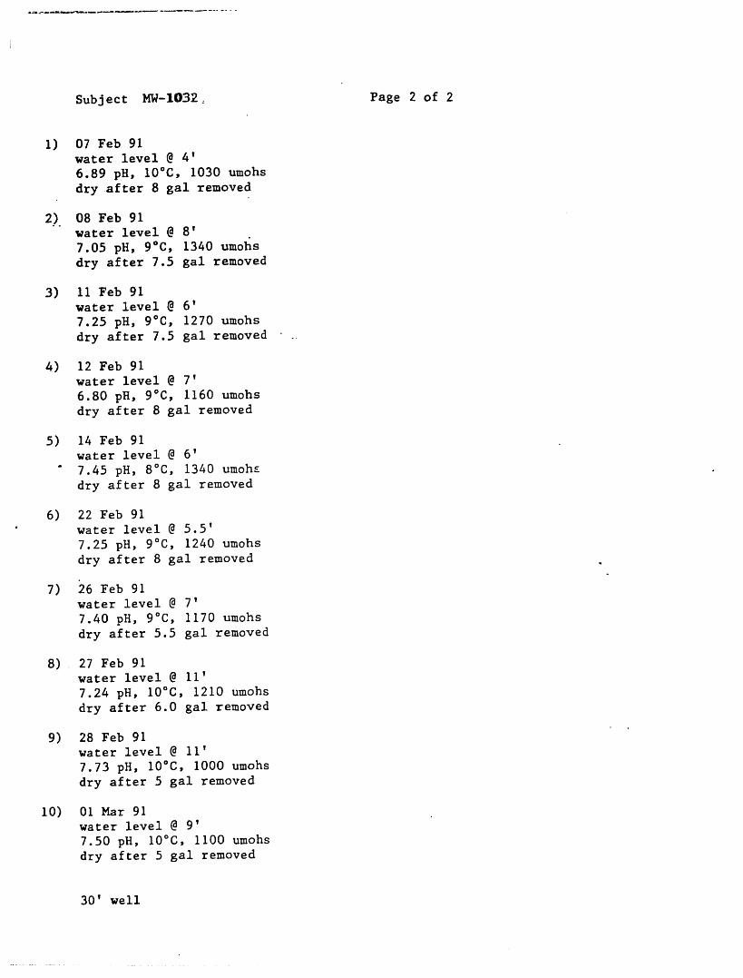
Subject MW-lO32: Page 2 of 2
1) 07 Feb 91water level @ 4'
6.89 pH, 10°C, 1030 umohs
dry after 8 gal removed
2) 08 Feb 91water level @ 8'
7.05 pH, 9°C, 1340 umohs
dry after 7.5 gal removed
3) 11 Feb 91water level @ 6'
7.25 pH, 9°C, 1270 umohs
dry after 7.5 gal removed ..
4) 12 Feb 91
water level @ 7'
6.80 pH, 9°C, 1160 umohs
dry after 8 gal removed
5) 14 Feb 91water level @ 6'
" 7.45 pH, 8°C, 1340 umohE
dry after 8 gal removed
6) 22 Feb 91• water level @ 5.5'
7.25 pH, 9°C, 1240 umohs
dry after 8 gal removed
7) 26 Feb 91water level @ 7'
7.40 pH, 9°C, 1170 umohs
dry after 5.5 gal removed
8) 27 Feb 91water level @ ii'
7.24 pH, 10°C, 1210 umohs
dry after 6.0 gal removed
9) 28 Feb 91water level @ 11'
7.73 pH, 10°C, 1000 umohs
dry after 5 gal removed
I0) 01 Mar 91water level @ 9'
7.50 pH, 10°C, 1100 umohs
dry after 5 gal removed
30' well

i iii Bill ii I li i IIi II
WELDON SPRING SITE REMEDIAL ACTION PROJECT
WELL COMPLETION RECORD
WELL NUMBER MW-1033 DATE INSTALLED 20 Feb 91
PMC REPRESENTATIVE Craig S. Jones DRILLER Dale Meyer
I I I I i III I I II I IIII III
TOP OFPROTECTIVE CASING 3.0'
TOP OF CASING 2.5' _ LOCKED-DATE 02-22-91
SURFACE SEAL TYPE ][eadv ,mix
GROUNDSURFACE _ _ __ THICKNESS3'TOP OF s4fl i BOREHOLE DIAMETER__
, / IGROUT 1 _ :; CASING TYPE stainless
BOTTOM OF --/II I DIAMETER 2"
PROTECTIVE CASING 2.0' / I II II II Iv I _ OUTER CASING TYPE. n/aI I-"
•BOTTOM OF I I DIAMETER n/aOUTER CASING n/a .L I
TOP OF SEAL 81' --- GROUT TYPE Volclay & initiatork
TOP OF _ _
FILTER PACK 85' _ _ __------SEAL TYPE ½" Bentonite pelletTOPOF SCREEN 87.5'
< -- >
A = SCREEN TYPE stainless steelCENTRALIZER DIAMETER 2"DEPTHS 97' & 86' SLOT SIZE 0.010
BOTTOM -m------ FILTER PACK TYPE WB-40OF SCREEN 97.5' >
TOTAL DEPTH 97"5' - .-|111 I iii I I iii i III I •lUl
i I i
COMMENTS Casing to have another riser added to it before protective casinginstalled.
PMC REPRESENTATIVE SIGNATURE _ j_h_._. DATE O_.O_-%\_O'-IIII I I I J I I

WELDON SPRING SITE REMEDIAL ACTION. PROJECTBOREHOLE LOG
PAGE .1 OF 4[ i| _ i i
rE lD: SLOUGH LOCATION IO: MW-1033_ _ GROUNDWATER LEVELS-_ -- - DATE I TIME ' DEPTH (FT.)-''E COORD_qATES (FT.): "' 02-13-91 ' ""-1330 20.0 --
E ,, -- ,.= , ,
;OUND ELEVATION (FT. MSL): _ ,, - , ,,} ,,:iLL_NG METHOD: HSA 6} 'ld - .....
:U_LffqG CONTR.: Geotechnolo_y LOCATION DESCRIPTION S o.f slough
_TE STARTED: 13 Feb 91
_TE COMPLETED: 20 Feb 91 SEE CONDFFION open fieldnFOLOGIST/ENGINEER: A. Limmer_LD
-J CPM BLOWS_. E a. _ -J V_UAL CLASS_=_3ATK)N
EPTH :_ uJ _. o (OPT.) PER 6 IN. <P _uJ :>< z Eo9 - r.o ., • ,
_- 0-2 8" _ 2-2-3-4 dk. brown silty clay - CL
2-4 12" i-3-3-3 m. stiff 5rm_n silty clay - CL/CH
_301 __ _1-2-2-3 m. stiff brown clay with silt to siltyo 4-6 18"
5 ---' clay, some organics - CH to CL,.
- q; 6-8 _ 24" ___ _ i-2-2-3 m. stiff brown silty clay - CL
-- | 8-10 24" _ _ 2-3-4-5 stiff brown clay - Ch
lO -- 10-i2 .30" 1-3-3-5 m. stiff brown and gray clay - eH
3303 ,,
-- 12-14 30" 2-2-2-2 soft: brownish gray clay trace sand to s lty- clay trace sand-eH to eL with sand laye s
,,
__ 2-5-7-7 m. dense sandy clay to silty sand, fine14-16 24" , ,,
3_4-_._u __ brown SC-SM
-- 16-18 12" _ _ 2-3-3-3 loose brown fine silty sand to fine.... sand - SM-SP
___ 18-20 _ 18'----7-'--_-----'_-------1-3-3-7 m.sanddense_brownsP_SCfine sand to gray clayey
20 - 20-22 -2"12" _-------- i-2-4-4 m. dense gray fine sand - SP
i25 -- '
_
-
30 _ _ _ _._..m_._., ........ ,j l,
-----'----_ . Sand heaving up into augers.OMMENTS: Hit water @ 20 . Stopped sampling @ 22'
Checked every five feet .... r z -, -_-................ _-- -,--,, /-, _ _ ,: ---" _ .....
augers. Hit gravel @ 65'.

r
i i n lull I i i I1| I i n IINNNII I
WELDON SPRING SITE REMEDIAL ACTION PROJECT •BOREHOLE LOG
PAGE _2.__ OF -4
i li ,, i
rrE lD: SLOUGH LOCATKON Ek. MW-1033 GROUNDWATER LEVELS- • -- DATE TIME ' DEPTH (FT.)[PE COORDWqATES (FT.): ........
E 02-13-91 133() ......20'.'()'
ROUND ELEVATION (FT. MSL): _
RLL#qG METHOD: HSA 6_'idRR_L_G CONTR.: Geotechnolo_y LOCATION DESCRIPTION s. of slou_h
ATE STARTED: 13 Feb 91
ATE COMPLETED: 20 Feb 91 - S_E CONDrRON, open field •IELD GEOLOGIST/ENGINEER: A. Limmer
n. CPM BLOWSn. Z .J V_UAL CLASSI=_3ATK3N
DEPTH _ Ua _< OUap (OPT.) PER 6 _q. <:>_o_ ,,on- ..............
Sand
,, SP
35 -
d,
, 40 -
,_ ,,,.. _
" 45 --
i
- 50 -
- 55 -
COMMENTS:
/
i

°
WELDON SPR|NG SITE REMEDIAL ACTION PROJECTBOREHOLE LOG
PAGE __!_..3 OF __L4 .
GROUNDWA']"ER LE_/ELS ' '--
'E lD: SLOUGH _ LOCATION lD: L MW--I033_ ' D_ATE 'TIME ' DEPTH (FT.) -E COORDINATES (FT.): ................ -02-13-91 1330 20.0'
E __ , , .. , , ,,
OUND ELEVATION (FT. MSL): _ - , _ , , ,K.LING METHOD: HSA 6_"id .......ILLING CONTR.: -- Geotechnolo_y LOCATION DESCRIPTION _ S. of slou_;h.TE ST.ARTED: 13 Feb 91
.TE COMPLETED: 20 Feb 91 SITE CONDITION open field
tLD GEOLOGIST/ENGINEER: _" Limper
EPTH _: pW _ _ . PER 6 IN. >_Z o_" ----
_
._.L
65-67 2" 7-ii-i0-13 gray fine sand to multicolored fine55 - gravel - SP/GP
----- I
70 -----
75
80 - 81.8 Gravel to 82.5'Limes tone hdrd, white and gray,
---------_ _ _ aphenitic, stylolitic, fresh ..,_..8"2;.5'
, -- Plattin _:.85 -- • , "-_"
i09_
J
ii
9-F--, Hit refusal @ 2.5'.OMMENTS:
lm ,, i, i i , i ,,,, , _ _
/

| |1 i iiii i _ i iiii
WELDON SPRING SITE REMEDIAL ACTION PROJECTBOREHOLE LOG
PAGE. 4 OF 4._
GRouNDwATER LEVELS
lTE lD: SLOUGH ,, LOCATION _: _ , DATE' " TIMIE DEPTH'iFT.)rrE COORDINATES (FT.): .........
-- E _ 02-13-91 , 1,330 20.0'-- .
ROUND ELEVATION (FT. MSL): _ 2"HSA 61"id; NX coreRE.LING METHOD: - " ' -- -RX.L_G CONTR.: Geotechnology LOCATION DESCRIPTION : S. of slough
ATE STARTED: 13 Feb 91 _ . •
,ATE COMPLETED: 20 Feb 9I SITE CONDITION open field
IELD GEOLOGIST/ENGINEER: A. Limmer _ .,.,,
-J "J CPM BLOWS m¢ _ z ,.J VISUALCLASSIFICATIONDEPTH _ uJ _<v. _ (OPT.) PER 6 IN. <>
_ _¢ .....
-- 90 Lime:tone herd, white and gray, ',,
aphenitic, stylolitic, fresh plattin._
_oo_
95 -
° 97.5core TD @ 97.5'
ream TD @ 97.5'
I00 -, a
...... _
li • I ' I l I, II • '

WELDON SPRING SITE REMEDIAL ACTION PROJECT
WELL DEVELOPMENT FORM
PAGE 1 OF 2
WELL NUMBER MW-1033 DATE - 07 Mar 91
FIELD PERSONNEL. Paul Guerrein/A. Limmer
STATIC WATER LEVEL 2' of water in hole ..... TOTAL DEPTH 97' bg !
WELL VOLUME (CASING AND FILTER PACK)
DEVELOPMENT METHOD(S) 2"_vc .bailer by h_pd
BEGINNING TIME
INITIAL WATER CONDIT.IONS cloudy
RECHARGE RATE very, very slow
--_--m--
END TIME
TOTAL VOLUME REMOVED 28 GALS.
TOTAL WELL VOLUMES REMOVED GALS.
n/aFINAL TURBIDITY MEASUREMENT ........ NTU
FINAL WATER LEVEL 2' of water in hole FINAL DEPTH ....
COMMENTS -bailed well i0 times
-water clear @ end of development
PMC REPRESENTATIVE SIGNATURE _ _ __ _ _ DATE_O_-_-_._

Subject MW-lO33 Page 2 of 2
I) 22 Feb 91water level @ 17'
8.55 pH, II°C, 490 umohs
dry after 22 gal removed
2) 25 Feb 91water level @ 95'
8.45 pH, 10°C, 640 umohs
dry after 2 gal removed
3) 26 Feb 91water level @ 96'
8.41 pH, 10°C, 620 umohs
dry after 1/2 gal removed
4) 27 Feb 91water level @ 96'
8.15 pH, 10°C, 720 umohs
dry after I/2 gal removed
5) 28 Feb 91water level @ 96'
8.33 pH, 13°C, 730 umohs
" dry after i/2 gal removed
6) Ol Mar 91water level @ 96'
• 8.52 pH, 10°C, 660 umohs
dry after i/2 gal removed
7) 04 Mar 91water level @ 96'
7.22 pH, II°C, 650 umohs
dry after I/2 gal removed
8) 05 Mar 91water level @ 96'
7.17 pH, 12°C, 810 umohs
dry after i/2 gal removed
9) 06 Mar 91water level @ 96'
7.29 pH, II°C, 890 umohs
dry after i/2 gal removed
i0) 07 Mar 91water level @ 96'
7.65 pH, II°C, 820 umokls
dry after i/2 gal removed
97' well

iii I ii I II
WELDON SPRING SITE REMEDIAL ACTION PROJECT
WELL COMPLETION RECORD
WELL NUMBER HW-I034 DATE INSTALLED I0 Jan 91
PMC REPRESENTATIVE Craig S. Jones DRILLER Dale Me}terI I - I I
II I
TOP OFPROTECTIVE CASING 2.0'
\ •TOP OF CASING 1.0' _ LOCKED-DATE 10 Jan 91
I SURFACE SEAL TYPE
GROUND _ THICKNESS 2.0'SURFACE =_ _,_,,
GROUT 1.5'! CASING TYPE _t_n]_s steel/
BOTTOM OF/I DIAMETER 2"
PROTECTIVE CASING _.0' / II
==
IIz OUTER CASING TYPE n/a
I DIAMETER n/a•BOTTOM OF IOUTER CASING n/a _.t
TOP OF SEAL 55' ------GROUT TYPE Volclay & initiator
TOP OF X_ ill I
FILTER PACK 58.0' :;;._ _ SEAL TYPE 3/4" Bentonit.epellet
TOPOF SCREEN 64.0'
SCREEN TYPE s_ta±nlesss,.tee!C ENT R A L IZE R DIA METER 2"DEPTHS 73' & 63.5'
SLOT SIZE 0.010BOTTOM
OF SCREEN 74.0' _ FILTER PACK TYPE WB-40
TOTAL DEPTH 75.0' .-II II ii
COMMENTS
PMC REPRESENTATIVE SIGNATURE _"_ _ _Wk''--_'''"..... DATE_ t:>X.-n_-'%l(...j"
i i i I I I III IIII - I

t
.i i i J iii i ....
i
WELDON SPRING SITE REMEDIAL ACTION PROJECTBOREHOLE LOG
• PAGE-1 OF 3
- T I I ni I , , , __
"E lD: QY LOCATION HD: _-1034 GROUNDWATER LEVEL %DATE I TIMIE ' PTH (FT.)
"E COORDINATES (FT.): -_ 0i-07-91 ...... 0900 '60_2'. bg'l-E , ,,,,
-OUND ELEVATION (FT. MSL): _ - ,,HSA 6}"id; 2"ld NX '
ILLING METHOD: ....... "'ILLING CONTR.: GeotechnoloKy - LOCATION DESCRIPTION wooded
,TE ST.ARTED: 03 Jan 91 •
,TE COMPLETED: 09 Jan 91 SITE CONDITION" snow on ground, sunny30=F"LD GEOLOGIST/ENGINEER: _A..L_mmer _
6_._.m._. _ _..__.._.._u___. _ .... , , .. ---- ., ,, , ..= __w
-u cPM BLOWS Z_ =L VISUAL CLASSIFICATION
EPTH :_ uJ _ _ (OPT.) PER 6 IN. <,< P- >Z tr(1) -- co .........
-- ' 12"- 4'5-2-4 . gravel to 2" brown silty clay - Ct,
340i _ !8" . - 1-2-3-4 brown and gray silty clay with Festains - CL
,
on" -- 2-5-5-7_ &.%/
.=,
I0 4-7-8-i0 brown silty clay- CL, .,.
15 -2.4" - 4-9-9-10 brown and gray silty clay with sand-CL
- - 7-9-8-6 brown and gray silt, some v. fine sand,20 _'"__ trace clay to 20,5' 4" lt. brown silty
sand seam 20.9' brown, silty clay withsand
n,,, -- 4-7-7-8 brown silty clay, trace to with sand-CL25 "_
4" reddish brown clayey sand to 29.3'
30 , , 4-5-5-6 i lt. brown v. fine sand, no _radin_-SP
OMMENTS: ..
/
/
' T.._ " , ......... , , i......

°
WELDON SPRING SITE REMEDIAL ACTION PROJECTBOREHOLE LOG
PAGE, 2 OF 3
" " GROUNDWATER LEvELs
'E lD: QY .... LOCATE)N E): LMW-1034-- , DATI= ......... TIME '-DEPTH (FT.) "E COORDINATES (FT.)" .............
E _ 01-07-90 0900.. .60.2' bgl
OUND ELEVATION (FT. MSL): _ - ........HSA 6}"ld; NX 2"lD
iLLING METHOD:ILLING CONTR.: Ge°techn°l°_7 _ LOCATION DESCRIPTION , wooded
03 Jan 91.TE STARTED:
.TE COMPLETED: 09 Jan 91 SITE CONDEION __snow on groun,dz sunny _A. Limmer 28-30°F
;LD GEOLOGIST/ENGiNEER:• __ _. __
n. 0 cPM BLOWS = _ VISUALCLASSIFICATION
_ _ O (OPT.) PER 6 IN. <>,.. ii |. i i i i i i i1_ i ii i
. ,
_0 29-31 24" 4-5-5-6
,,
_
-- ---L_- "
-- 34 -- 24" 3-10-9-12 brown v. fine sand some silt to 35'
35 - 36 _ it. brown v. fine sand - SP
-- 39 I _,,, J. 3-6-4-5 brown silt and sand with clay -SM/ML.40 .....,,
-- brown v. fine sandy silt to 42' brown-- 3402 24" 3-4-4-5__ _ v. fine sandy clay to 42.7' lt. "brown v i
_ 24" 3-2-3-3 fine sand -CL/SM to CL/SC to SP " I45 ,._ I.,., -- , brown silty clay w_th v. fine sand to I
_ -- 44.2' brown silt/ clay -CL/CH " !
• oversaturated from 44 to 44.5' I
___
49 24" -- 2-4-5-6 tan and gray clay with silt and Mg _ode_
50 51 trace Fe staining- CH 1
---------_---'----''----------- redddi;h biO_s _la; lSt,h Vth_icedllY:llow"
----- 5455 -- _" - 2-25-27-50 3"
56 I=_ r h e, - residue) -CH to 54.5 white sand and
-- i__.____.----------- ims fragments to yellow highly weathered--'-----'-----'---- . ims.
60....
OMME qTS: Red head broke @ !550. ReLnovea i5' of au£ers and spun cuttin£s ,up.AL @ 57.5 began coring @ 59.5'.
/

• i ii i -- i i liI I
..--.--_"
WELDON SPRING SITE REMEDIAL ACTION PkOJECTBOREHOLE LOG
PAGE 3 OF|1 ii =1
ilTE lD: QY LOCATION lD: MW-1034 GROUNDWATER LEVELS;lTE COORDINATES (FT.): DATE TIME ' ' DEPTH (FT.) -
01-07i91 ,.09'00 ....... 60.2' bgl -EI ,, ,,
IROUND ELEVATION (FT. MSL): ......HSA 6}'id; NX 2"id
pRILLINGMETHOD: .....Geotechnology LOCATION DESCRIPTION - woodedtRILLING CONTR.:03 Jan 91
)ATE STARTED:)ATE COMPLETED: 09 Jan 91 SITE CONDITION snow and ice on _round"IELD GEOLOGIST/ENGINEER: A. Limmer sunny with clouds_ 20°F
CPM BLOWSo. _- z -i VISUALCLASSIFICATIONDEPTH =E _ _<Ouj (OPT.) PER 6 IN. <.< :>_;_ _,-,- ..............
59 5 No H^O return.• Z
Limestone h_rd, gray, slightly fossilif rous
-- "_ineiy crystalline, large vugs to 52.5'
with Fe staining. Fe staining to 64'.
Limestone gray and white, argillaceous,
_ h_rd, aphenitic, few small clay seams.- 65L 0.05' shale @ 67.6 fissile.
. 100%. _
-- 69.5- 70 - poor H20 return• Limestone hQrd, gray and white, aphenit c
qreneceous, fossiliferous
- 100%
74.7- 75
--
__
__
_
J__
_
_
l
,,
i i i i ii ii i=llj i ,i i ii, iiii
Boring terminated @ 74.7' (core)COMMENTS: Reamed to 75'.i,
/

WELDON SPRING SITE REMEDIAL ACTION PROJECT
WELL DEVELOPMENT FORM
PAGE 1 OF 2
WELL NUMBER MW-1034 DATE 06 Feb 91
FIELD PERSONNEL. Paul Guerrein/Scott Hilderbrand/A. Limmer
STATIC WATER LEVEL 57' bgl 02-06-91 TOTAL DEPTH 75'
WELL VOLUME (CASING AND FILTER PACK)
DEVELOPMENT METHOD(S) r 2" stainless steel bailer by hand
BEGINNING TIME ....
INITi_L WATER CONDITIONS ¢loud,y
RECHARGE RATE very, very slow
END TIME
TOTAL VOLUME REMOVED 47 GALS.
TOTAL WELL VOLUMES REMOVED n/a GALS.
n/aFINAL TURBIDITY MEASUREMENT NTU
FINAL WATER LEVEL FINAL DEPTH
COMMENTS -see attached (well bailed dry I0 times)
-water clear @ end of development, ,,

Subject MW-1034 Page 2 of 2
I) 06 Feb 91 I0) Ol Mar 91water level @ 57' water level @ 70'
7.30 pH, 10=C, 770 umohs 8_22 pH, Ii °C, 720 umohs
dry after 7 gal removed dry after 1 gal removed
.... 07 Feb 91
water level @ 68' 75' well
did not bail or test q
2) 08 Feb 91water level @ 66'
7.05 pH, 9°C, 870 umohs
dry after 3.5 gal removed
3) ii Feb 91waterlevel @ 63'
7.25 pH, 10°C, 800 umohs
dry after 5.5 gal removed
12 Feb 91
water level @ 68'
did not bail or test
4) 14 Feb 91water level @ 61.5
6.87 pH, 9°C, 840 umohs
- dry after 6.5 gal removed
5) 21 Feb 91water level @ 58'
7.17 pH, 14°C, 580 umohs
dry after 7 gal removed
6) 26 Feb 91water level @ 61'
7.30 pH, 12°C, 730 umohs
dry after 7 gal removed
7) 27 Feb 91water level @ 69'
7.53 pH, II°C, 870 umohs
dry after 4.5 gal removed
8) 28 Feb 91water level @ 64'
7.95 pH, II°C, 870 umohs
dry after 4 gal removed
9) 28 Feb 91water level @ 70'
8.25 pH, 12°C, 670 umohs
dry after 1 gal removed

