quake the killer - weebly
TRANSCRIPT
The lethal fault cuts through the middle of a Tennessee bean field and then ducks beneath the Mississippi River, making a beeline for New Madrid, Missouri. Named
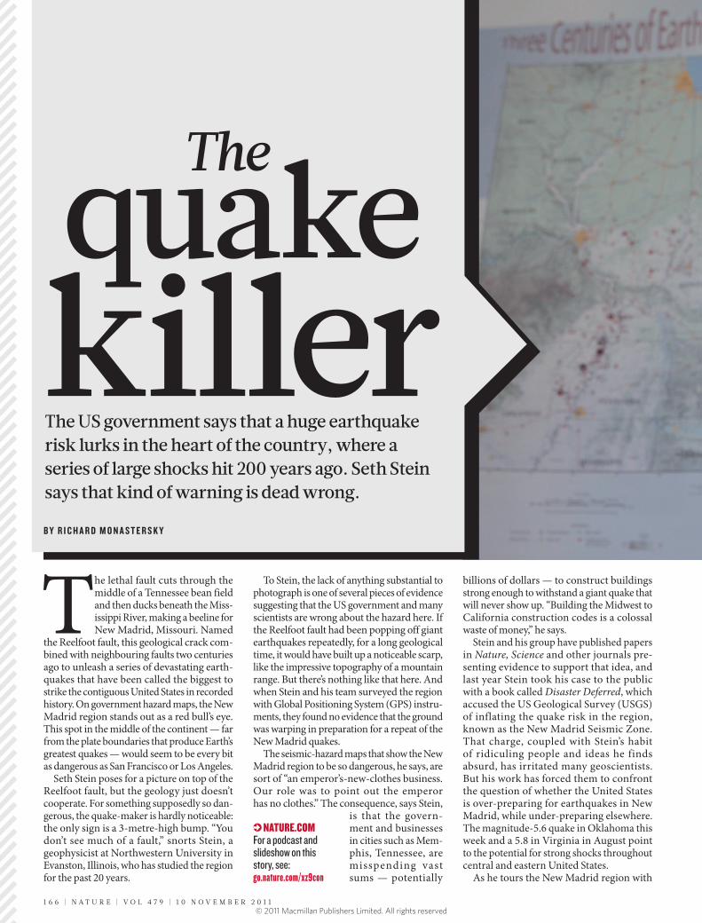
the Reelfoot fault, this geological crack combined with neighbouring faults two centuries ago to unleash a series of devastating earthquakes that have been called the biggest to strike the contiguous United States in recorded history. On government hazard maps, the New Madrid region stands out as a red bull’s eye. This spot in the middle of the continent — far from the plate boundaries that produce Earth’s greatest quakes — would seem to be every bit as dangerous as San Francisco or Los Angeles.
Seth Stein poses for a picture on top of the Reelfoot fault, but the geology just doesn’t cooperate. For something supposedly so dangerous, the quakemaker is hardly noticeable: the only sign is a 3metrehigh bump. “You don’t see much of a fault,” snorts Stein, a geophysicist at Northwestern University in Evanston, Illinois, who has studied the region for the past 20 years.
To Stein, the lack of anything substantial to photograph is one of several pieces of evidence suggesting that the US government and many scientists are wrong about the hazard here. If the Reelfoot fault had been popping off giant earthquakes repeatedly, for a long geological time, it would have built up a noticeable scarp, like the impressive topography of a mountain range. But there’s nothing like that here. And when Stein and his team surveyed the region with Global Positioning System (GPS) instruments, they found no evidence that the ground was warping in preparation for a repeat of the New Madrid quakes.
The seismichazard maps that show the New Madrid region to be so dangerous, he says, are sort of “an emperor’snewclothes business. Our role was to point out the emperor has no clothes.” The consequence, says Stein,
is that the government and businesses in cities such as Memphis, Tennessee, are misspending vast sums — potentially
billions of dollars — to construct buildings strong enough to withstand a giant quake that will never show up. “Building the Midwest to California construction codes is a colossal waste of money,” he says.
Stein and his group have published papers in Nature, Science and other journals presenting evidence to support that idea, and last year Stein took his case to the public with a book called Disaster Deferred, which accused the US Geological Survey (USGS) of inflating the quake risk in the region, known as the New Madrid Seismic Zone. That charge, coupled with Stein’s habit of ridiculing people and ideas he finds absurd, has irritated many geoscientists. But his work has forced them to confront the question of whether the United States is overpreparing for earthquakes in New Madrid, while underpreparing elsewhere. The magnitude5.6 quake in Oklahoma this week and a 5.8 in Virginia in August point to the potential for strong shocks throughout central and eastern United States.
As he tours the New Madrid region with
B Y R I C H A R D M O N A S T E R S K Y
NATURE.COMFor a podcast and slideshow on this story, see:go.nature.com/xz9con
The US government says that a huge earthquake risk lurks in the heart of the country, where a series of large shocks hit 200 years ago. Seth Stein says that kind of warning is dead wrong.
The
killerquake
1 6 6 | N A T U R E | V O L 4 7 9 | 1 0 N O V E M B E R 2 0 1 1© 2011 Macmillan Publishers Limited. All rights reserved

Nature, Stein lays out his case. The evidence emerging from New Madrid, he says, suggests that the faults involved in the quakes of 1811–12 are shutting down, shifting the hazard to other faults perhaps hundreds of kilometres away. Stein has hypothesized that the centres of other continents behave in a similar way, with patches of earthquake activity that harass one locale for thousands of years and then jump to other regions.
Some of his arguments are gaining ground, although few researchers go as far as Stein in playing down the dangers in the New Madrid area. “What he’s doing here is good; he’s raising issues and making hypotheses that could well be true,” says John Vidale, a seismologist at the University of Washington in Seattle, who this year led a federal panel that investigated the hazard in New Madrid. “The only thing that angers the community is when he argues that he’s right and everybody else is wrong.”
New Madrid is a quiet outpost on the banks of the Mississippi, where the mighty river meanders briefly north and then makes
a complete Uturn back south. Throughout much of its history, the town fought — and lost — epic battles with the evershifting river, until levees were built in the early twentieth century.
The New Madrid Historical Museum sits next to the levee and honours the town’s seismic history with a detailed exhibition, currently being upgraded in advance of the quakes’ bicentennial next month. At the time of the shocks, New Madrid was a bustling port — one of the most important on the lower half of the Mississippi River.
The devastating seismic sequence started with a thunderous bang at around 2 a.m. on 16 December 1811. According to one resident: “We were awakened by a most tremendous noise, while the house danced about and seemed as if it would fall on our heads.” The quake and its immediate aftershocks scared many of the residents deeply, but few were killed. “Several men, I am informed, on the night of the first shock deserted their families, and have not been heard of since,” wrote the New Madrid resident.
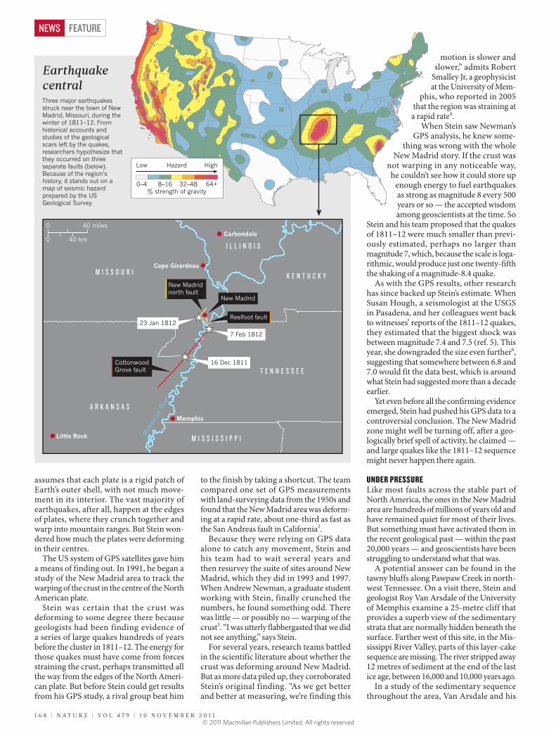
Over the next few weeks, hundreds of aftershocks rattled the region, followed by two more major shocks on 23 January and 7 February 1812. The February quake caused the land southwest of the Reelfoot fault to jerk up, whereas New Madrid and the rest of the land northeast of the fault dropped by a combined total of about 3 metres or more. The quake destroyed the town and the Mississippi soon swallowed the land, forcing residents to rebuild farther from the river. The vibrations from the quakes were felt across an area of more than 2.6 million square kilometres — about onethird of the area of the contiguous United States (see ‘Earthquake central’).
Because the quakes happened before the advent of modern seismometers — and in such a sparsely settled part of the young country — researchers have struggled over the years to determine just how big they were. In 1996, Arch Johnston, a geophysicist at the University of Memphis, used historical accounts of the quakes to estimate that the first shock, which he thought was the largest, had a magnitude somewhere between 7.8 and 8.4 — a truly monstrous earthquake, bigger than any in the history of the United States outside of Alaska1.
The events sound even worse in the museum, where a film calls the largest shock “the worst earthquake in recorded history”. Virtually the entire North American continent experienced some shaking, claims the film.
A museum pamphlet cites a study, sponsored by the Federal Emergency Management Agency, projecting that 3,500 people would die if a magnitude7.7 earthquake were to strike the New Madrid region today. The economic losses, according to the pamphlet, could exceed US$300 billion. Stein grimaces at the film and scoffs at what he considers hazardmongering. “The scary thing is how much of this is completely wrong,” he says. “The hazard here is wildly overestimated.”
FINDING FAULTIt is that kind of pronouncement that wins Stein few points with his rivals. In debates, his attacks on positions he feels are unsupportable can be hyperbolic. And when his rants reach full steam, he seems like a hyperintelligent version of George Costanza, the evercomplaining character from the television show Seinfeld, who, like Stein, also happens to be short and bald with glasses.
But Stein has a fertile imagination and has made several important advances in geophysics. As a young faculty member at Northwestern in the 1980s, he and his colleagues developed a widely used model quantifying how Earth’s plates have moved over the past 3 million years. The model
Seth Stein argues that money is being wasted preparing the American Midwest for a major earthquake that may never come.
JEA
N-M
AR
C G
IBO
UX/G
A B
Y G
ETTY
IMAG
ES
1 0 N O V E M B E R 2 0 1 1 | V O L 4 7 9 | N A T U R E | 1 6 7
FEATURE NEWS
© 2011 Macmillan Publishers Limited. All rights reserved
assumes that each plate is a rigid patch of Earth’s outer shell, with not much movement in its interior. The vast majority of earthquakes, after all, happen at the edges of plates, where they crunch together and warp into mountain ranges. But Stein wondered how much the plates were deforming in their centres.
The US system of GPS satellites gave him a means of finding out. In 1991, he began a study of the New Madrid area to track the warping of the crust in the centre of the North American plate.
Stein was certain that the crust was deforming to some degree there because geo logists had been finding evidence of a series of large quakes hundreds of years before the cluster in 1811–12. The energy for those quakes must have come from forces straining the crust, perhaps transmitted all the way from the edges of the North American plate. But before Stein could get results from his GPS study, a rival group beat him
to the finish by taking a shortcut. The team compared one set of GPS measurements with landsurveying data from the 1950s and found that the New Madrid area was deforming at a rapid rate, about onethird as fast as the San Andreas fault in California2.
Because they were relying on GPS data alone to catch any movement, Stein and his team had to wait several years and then resurvey the suite of sites around New Madrid, which they did in 1993 and 1997. When Andrew Newman, a graduate student working with Stein, finally crunched the numbers, he found something odd. There was little — or possibly no — warping of the crust3. “I was utterly flabbergasted that we did not see anything,” says Stein.
For several years, research teams battled in the scientific literature about whether the crust was deforming around New Madrid. But as more data piled up, they corroborated Stein’s original finding. “As we get better and better at measuring, we’re finding this
motion is slower and slower,” admits Robert
Smalley Jr, a geophysicist at the University of Mem
phis, who reported in 2005 that the region was straining at a rapid rate4.
When Stein saw Newman’s GPS analysis, he knew some
thing was wrong with the whole New Madrid story. If the crust was
not warping in any noticeable way, he couldn’t see how it could store up
enough energy to fuel earthquakes as strong as magnitude 8 every 500 years or so — the accepted wisdom among geoscientists at the time. So
Stein and his team proposed that the quakes of 1811–12 were much smaller than previously estimated, perhaps no larger than magnitude 7, which, because the scale is logarithmic, would produce just one twentyfifth the shaking of a magnitude8.4 quake.
As with the GPS results, other research has since backed up Stein’s estimate. When Susan Hough, a seismologist at the USGS in Pasadena, and her colleagues went back to witnesses’ reports of the 1811–12 quakes, they estimated that the biggest shock was between magnitude 7.4 and 7.5 (ref. 5). This year, she downgraded the size even further6, suggesting that somewhere between 6.8 and 7.0 would fit the data best, which is around what Stein had suggested more than a decade earlier.
Yet even before all the confirming evidence emerged, Stein had pushed his GPS data to a controversial conclusion. The New Madrid zone might well be turning off, after a geologically brief spell of activity, he claimed — and large quakes like the 1811–12 sequence might never happen there again.
UNDER PRESSURELike most faults across the stable part of North America, the ones in the New Madrid area are hundreds of millions of years old and have remained quiet for most of their lives. But something must have activated them in the recent geological past — within the past 20,000 years — and geoscientists have been struggling to understand what that was.
A potential answer can be found in the tawny bluffs along Pawpaw Creek in northwest Tennessee. On a visit there, Stein and geologist Roy Van Arsdale of the University of Memphis examine a 25metre cliff that provides a superb view of the sedimentary strata that are normally hidden beneath the surface. Farther west of this site, in the Mississippi River Valley, parts of this layercake sequence are missing. The river stripped away 12 metres of sediment at the end of the last ice age, between 16,000 and 10,000 years ago.
In a study of the sedimentary sequence throughout the area, Van Arsdale and his
40 miles0
40 km0
Reelfoot fault
New Madrid
16 Dec 1811
Miss
issip
pi R
iver
New Madrid north fault
Cottonwood Grove fault
7 Feb 1812
23 Jan 1812
Little Rock
Carbondale
I L L I N O I S
A R K A N S A S
M I S S I S S I P P I
M I S S O U R I K E N T U C K Y
T E N N E S S E E
Memphis
Cape Girardeau
Earthquake centralThree major earthquakes struck near the town of New Madrid, Missouri, during the winter of 1811–12. From historical accounts and studies of the geological scars left by the quakes, researchers hypothesize that they occurred on three separate faults (below). Because of the region’s history, it stands out on a map of seismic hazard prepared by the US Geological Survey.
% strength of gravity32–48 64+8–160–4
HighLow Hazard
1 6 8 | N A T U R E | V O L 4 7 9 | 1 0 N O V E M B E R 2 0 1 1
FEATURENEWS
© 2011 Macmillan Publishers Limited. All rights reserved
colleagues found that the erosion of those sediments happened right above the faults that have been implicated in the New Madrid earthquakes. They proposed that the removal of all that weight altered the stresses in the subsurface rocks enough to reactivate the New Madrid faults7.
To test that idea, Van Arsdale and Stein worked with Eric Calais and Andrew Freed at Purdue University in West Lafayette, Indiana, to model the effects of removing so much weight from above the faults. They calculated that the erosion unclamped the faults enough for the ones on the verge of an earthquake to fail, releasing energy that had accumulated over the past — perhaps millions of years earlier during events such as the growth of mountains in western North America8. But once a particular fault has broken, the scientists suggested, there would not be enough stress in the region to trigger another big quake there. So the large prehistoric quakes in that region must have happened on different fault segments from the ones that broke two centuries ago.
Rather than seeing the faults around New Madrid in isolation, Stein suggests that they are part of a broad system of interacting faults, and that seismic activity shifts from one set of faults to others over hundreds or thousands of years. He sees a similar pattern in Europe, Australia and China, where earthquakes often do not recur in the same spots.
If the New Madrid area were to shut down, the seismic activity would eventually transfer somewhere else, says Stein, probably to the southwest or to the Wabash Valley fault system in Indiana and Illinois, which had a major earthquake 6,000 years ago. Van Arsdale is concerned about the possibility of quakes shifting south towards Memphis, along the edge of the Reelfoot rift, where the North American continent began, briefly, to pull apart some 500 million years ago.
Stein, Van Arsdale and others would now like to get GPS measurements and construct a detailed earthquake history of a much broader region around New Madrid, to determine how seismic patterns have moved
among the different faults in the central United States. “Compared with ten years ago, we’ve made a hell of a lot of progress,” says Stein. “I think we’re now poised to make significant advances.”
The evidence already available, however, is enough to undermine the government’s assessment of the earthquake danger in the New Madrid area, Stein says. “How on Earth
did the survey make this the most dangerous place in North America?” he asks. “It’s a relatively small hazard.”
This year, the National Earthquake Prediction Evaluation Council, which advises the USGS, convened a panel of independent
scientists and engineers to examine the issue. Vidale, who led the panel, said they were motivated in part by Stein’s persistent criticism as well as by the impending bicentennial of the quakes. The panel in general supported the survey’s most recent assessment from 2008, which showed that the hazard in parts of the New Madrid region surpasses that in Los Angeles or San Francisco, although it said
“it is likely that the estimated New Madrid Seismic Zone hazard may decline moderately in the next hazard assessment due to improved knowledge of past earthquakes and current deformation” (see ‘Do maps magnify the earthquake hazard?’).
According to Vidale, the main problem is that the region remains poorly understood. “We basically found that there’s a lot of uncertainty. Because we don’t know exactly what’s going on, we need to be prepared for large earthquakes.” But he also acknowledges the possibility that a large earthquake might never come.
About Stein, Vidale says: “None of his ideas are bad. It’s just that he presents them in an extreme way and doesn’t allow for the possibility that he might not be right.”
Stein’s overall argument gets little backing even from Hough, who has argued strongly that the earthquakes 200 years ago were much smaller than once thought. “Seth argues that the zone is dead because you don’t see strain.
On official seismic-hazard maps, the midsection of the United States looks as risky as the quake-prone West Coast (see ‘Earthquake central’). That’s because the Missouri area was hit by major quakes in 1811–12 and because there is concern about another large quake. But some researchers argue that the assumptions that go into the hazard maps — and the way that the maps are produced — make the region look even more dangerous.
Used to set building requirements, the hazard maps created by the US Geological Survey (USGS) represent estimates of the probability that ground shaking in a given area will exceed certain levels.
Arthur Frankel, a seismologist with the USGS in Seattle, Washington, who led a 2002 assessment, says that the New Madrid area has a high hazard largely because seismic waves travel efficiently through the hard rock of the central and eastern United States. So the rare, large earthquakes in New Madrid affect a much larger area than do similarly sized quakes in California.
But the criteria used to make the maps also have a role. The USGS produces several types of maps that estimate the strength of shaking in a given area from all potential seismic sources. The agency — like the engineers who set building codes — favours maps that show the levels of shaking that have a 2% chance of being exceeded in a 50-year period. These correspond to relatively rare but large events. Another set of
maps estimates the strength of shaking that has a 10% chance of being exceeded in 50 years, which reflects the kind of earthquakes that strike more frequently. The New Madrid area looks less hazardous in the 10% maps than in the 2% maps, because the geological evidence suggests that clusters of large quakes in that region might occur at intervals of 500 years or more, whereas smaller ones happen more frequently.
Seth Stein, a geophysicist at Northwestern University in Evanston, Illinois, has argued that the survey — and building codes — should work from the maps that depict levels that have a 10% chance of being exceeded in 50 years; these are the hazard probabilities used in Europe to set building codes and they better represent the risks that people and structures will probably face in the near future, he says.
But that can lead to problems, says Gail Atkinson, a seismologist at the University of Western Ontario in London, Canada. Atkinson helps develop building codes for Canada, which uses the 2%-in-50-year estimates. She notes that New Zealand designs for the 10%-in-50-year shaking levels and suffered tremendous losses from an earthquake in Christchurch in February, which killed 181 people. “I don’t think most people in New Madrid would be pleased with that sort of an outcome,” she says. If the country had prepared for extreme, rare events, then more buildings might have withstood the shock. R.M.
R I S K Y S C I E N C E
Do maps magnify the earthquake hazard?
1 0 N O V E M B E R 2 0 1 1 | V O L 4 7 9 | N A T U R E | 1 6 9
FEATURE NEWS
“How on Earth did the survey make this the most dangerous place in North America?”
© 2011 Macmillan Publishers Limited. All rights reserved
And I don’t think that’s a valid conclusion,” she says. “There’s enough strain around that could produce a magnitude 7.”
Stein, though, denies that he has been so dogmatic. He says that, in his book and in papers, he presents the idea of New Madrid turning off as a possibility — not a certainty.
REALITY CHECKThese issues all come to a head in downtown Memphis, which is full of office buildings, apartments and hotels constructed during the first third of the twentieth century. Many of them are unreinforced masonry — made of concrete blocks or bricks without any metal skeleton. Engineers consider this class of structure to be one of the most vulnerable during an earthquake. If a quake near magnitude 8
were to strike within the next few decades, it could topple many of these buildings. But if no large quake comes for 50 years or more, most of these buildings will probably be long gone, replaced by newer structures.
The Federal Emergency Management Agency has been pushing municipalities in the Memphis area to adopt a standard International Building Code (IBC) that would require new buildings to withstand 3 to 4 times stronger shaking than was required by earlier codes, says Joseph
Tomasello, an engineer with the Reaves Firm in Memphis who has collabor ated with Stein. But many people in the area have baulked at such stringent requirements, and the city is allowing owners to build to a less restrictive code until it adopts the 2009 version of the IBC, which is expected to happen around the end of this year.
Some engineers suggest that the code’s enhanced seismic provisions would increase building costs only marginally, but Tomasello contends that they could add an extra 10–15%. If all new construction were required to meet the newer code, building costs in the Memphis metropolitan area would be increased by $200 million a year, he estimates. “When you look at the hazard, it just doesn’t make any sense,” says Tomasello.
To Stein, building to a lower level of protection makes sense. The faults that produced the 1811–12 quakes are still crackling with aftershocks, and there is a chance that one of them could be as large as magnitude 6.7. But building to the new IBC in Memphis would be a waste of money, he says. “There’s a good chance that all the money you would spend would save no lives at all. But if you spend that money on schools or health care, you’re almost guaranteed to save lives.” The most important thing, Stein says, is for the
government to do a rigorous analysis of the costs and benefits of seismic building codes, before forcing people to foot the bill for expensive protections.
The next day, as Stein walks through Memphis airport on his way back home, he brings up the issue again. It is 13 September, just two days after the tenth anniversary of the 2001 terrorist attacks on the United States. In the intervening decade, the country has spent $1.3 trillion waging two wars and has instituted timeconsuming security provisions at airports, such as herding travellers through scanning machines capable of peering through clothes.
To Stein, these are all examples of mis understood risks and squandered resources. “I can’t do anything about the thousand things the government does that I’m unhappy about,” he says in a quiet moment. But with New Madrid, “I can do something about that”. ■
Richard Monastersky is a features editor for Nature in Washington DC.
1. Johnston, A. C. Geophys. J. Int. 126, 314–344 (1996).
2. Liu, L., Zoback, M. D. & Segall, P. Science 257, 1666–1669 (1992).
3. Newman, A. et al. Science 284, 619–621 (1999).4. Smalley, R. Jr, Ellis, M. A., Paul, J. & Van Arsdale, R.
B. Nature 435, 1088–1090 (2005).5. Hough, S. E., Armbruster, J. G., Seeber, L. & Hough,
J. F. J. Geophys. Res. 105, 23839–23864 (2000).6. Hough, S. E. & Page, M. J. Geophys. Res. 116,
B03311 (2011). 7. Van Arsdale, R., Bresnahan, R., McCallister, N.
& Waldron, B. Geol. Soc. Am. Spec. Pap. 425, 177–192 (2007).
8. Calais, E., Freed, A. M., Van Arsdale, R. & Stein, S. Nature 466, 608–611 (2010).
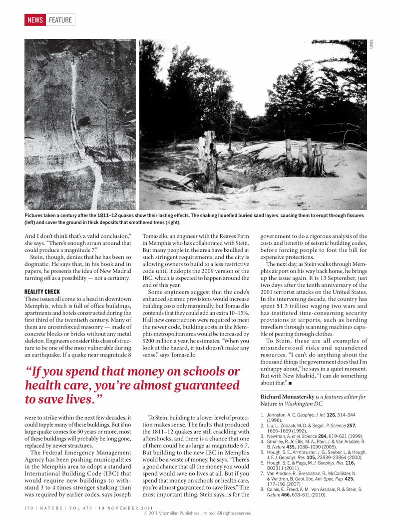
Pictures taken a century after the 1811–12 quakes show their lasting effects. The shaking liquefied buried sand layers, causing them to erupt through fissures (left) and cover the ground in thick deposits that smothered trees (right).
US
GS
1 7 0 | N A T U R E | V O L 4 7 9 | 1 0 N O V E M B E R 2 0 1 1
FEATURENEWS
“If you spend that money on schools or health care, you’re almost guaranteed to save lives.”
© 2011 Macmillan Publishers Limited. All rights reserved