pv technical series no.24 intertidal reef biota of northern port
TRANSCRIPT

P A R K S V I C T O R I A T E C H N I C A L S E R I E S
NUMBER 24
Victorian Intertidal Reef Monitoring Program
The Intertidal Reef Biota of Northern Port Phillip Bay Marine Sanctuaries
Authors: Simon P Hart, Matt Edmunds,
Chelsea Ingwersen, Malcolm Lindsay
March 2005
© Parks Victoria
All rights reserved. This document is subject to the Copyright Act 1968, no part of this publication may be reproduced, stored in a retrieval system, or transmitted in any form, or by any means, electronic, mechanical, photocopying or otherwise without the prior permission of the publisher.
First published 2005
Published by Parks Victoria Level 10, 535 Bourke Street, Melbourne Victoria 3000
Opinions expressed by the Authors of this publication are not necessarily those of Parks Victoria, unless expressly stated. Parks Victoria and all persons involved in the preparation and distribution of this publication do not accept any responsibility for the accuracy of any of the opinions or information contained in the publication.
Authors:
Simon P Hart Matt Edmunds Chelsea Ingwersen Malcolm Lindsay
National Library of Australia Cataloguing-in-publication data
Includes bibliography. ISSN 1448-4935
Citation
Hart, S.P., Edmunds, M., Ingwersen, C. and Lindsay, M. (2005) Victorian Intertidal Reef Monitoring Program: The Intertidal Reef Biota of Northern Port Phillip Bay Marine Sanctuaries. Parks Victoria Technical Series No. 24. Parks Victoria, Melbourne.
Printed on environmentally friendly paper

Parks Victoria Technical Series No. 24
Victorian Intertidal Reef Monitoring Program:
The Intertidal Reef Biota of Northern Port Phillip Bay Marine Sanctuaries
Simon P Hart
Matt Edmunds
Chelsea Ingwersen
Malcolm Lindsay
Australian Marine Ecology Pty Ltd
March 2005

Parks Victoria Technical Series No. 24 West Coast Subtidal Reef Monitoring
IV
EXECUTIVE SUMMARY Intertidal reefs in Victoria are typically present on headlands and points throughout Victoria, providing
a variety of different habitats between the marine and terrestrial environments. Intertidal reefs have
important social and cultural values and, because of their accessibility and proximity to land, are
subject to human pressures, including collection, trampling and pollution. To effectively manage and
conserve these habitats, the Victorian Government has established a long-term Intertidal Reef
Monitoring Program (IRMP). Over time, the IRMP will provide information on the status of Victorian
intertidal reef flora and fauna and determine the nature and magnitude of trends in species
populations and species diversity through time.
Within the Victorian Embayments bioregion, intertidal survey sites were established on reefs in the
northern Port Phillip Bay marine sanctuaries at Point Cook, Jawbone and Ricketts Point. Reference
sites were also surveyed in association with each of these sanctuaries.
The IRMP uses standardised visual census methods for surveying invertebrates and macroalgae on
intertidal reefs. The standard operating procedures were modified in consultation with Parks Victoria
after the first survey of reefs in 2003. All existing monitoring sites were resurveyed in 2004 using the
revised standard operating procedures.
The objectives of this report are to:
1.provide an overview of the methods used for the IRMP;
2.provide general descriptions of the biological communities and species populations at each
monitoring site in May 2004;
identify any unusual biological phenomena, interesting or unique communities or species; and
identify any introduced species at the monitoring locations
Surveys occur at a single reef during a single low tide and target the predominant substratum type.
Five fixed transects, each running from high to low shore, are positioned at equal distance across the
intertidal area to be surveyed, which is 30-100 m in length. Surveys of biota occur in quadrats at
sample locations along each transect and are surveyed for: (1) the density of non-sessile
invertebrates; and (2) the percentage cover of macroalgae and aggregated sessile invertebrates.
There were generally few species and sparse cover of macroalgae on all intertidal reefs surveyed in
the north of the Bay. The brown alga Neptune’s necklace Hormosira banksii covering substantial
areas low on the shore at most sites and the green algae Ulva spp and Enteromorpha spp occurred as
small patchily distributed tufts. Extensive quantities of drift algae washed onto shore at Point Cook.
Small aggregations of sessile animals were present, including the calcareous tube-worm Galeolaria
caespitosa and the mussel Mytilus edulis.
Parks Victoria Technical Series No. 24 West Coast Subtidal Reef Monitoring
V
The intertidal invertebrate communities of Port Phillip Bay were generally composed of few species
and there were no clear community patterns across the intertidal sites. Most sites were dominated by
the herbivorous species Austrocochlea porcata, Bembicium nanum and the limpet Cellana
tramoserica, in varying abundances between sites. In addition, the carnivorous gastropods Lepsiella
vinosa and Cominella lineolatus were generally present at most sites, in low densities.
The results in this report present a snapshot in time for community structures and species population
trends, which operate over long time scales. As monitoring continues and longer-term data sets are
accumulated (over multiple years to decades) the program will be able to more adequately assess
trends and ecological patterns occurring in the system.
Parks Victoria Technical Series No. 24 West Coast Subtidal Reef Monitoring
VI
CONTENTS EXECUTIVE SUMMARY........................................................................................... IV
Figures.............................................................................................................................................. VII Tables.............................................................................................................................................. VIII
1.0 INTRODUCTION ................................................................................................. 1 1.1 Intertidal Reef Ecosystems...........................................................................................................1 1.2 Intertidal Reef Monitoring Program ..............................................................................................2
2.0 METHODS........................................................................................................... 6 2.1 Site Selection and Survey Times .................................................................................................6 2.2 General Description of Survey Technique ....................................................................................7 2.3 Visual Census Techniques...........................................................................................................9 2.4 Data Analysis .............................................................................................................................13
3.0 REGIONAL ANALYSIS..................................................................................... 15 3.1 Biogeography ..............................................................................................................................15 3.2 Macroalgae and Aggregating Sessile Invertebrates ...................................................................15 3.3 Invertebrates ..............................................................................................................................15 3.4 Species Populations...................................................................................................................17
4.0 POINT COOK MARINE SANCTUARY .............................................................. 19 4.1 Site Description and Transect Layout ........................................................................................19 4.2 Macroalgae and Aggregating Sessile Invertebrates ..................................................................20 4.3 Invertebrates ..............................................................................................................................21
5.0 JAWBONE MARINE SANCTUARY................................................................... 24 5.1 Site Description and Transect Layout ........................................................................................24 5.2 Macroalgae And Aggregating Sessile Invertebrates..................................................................25 5.3 Invertebrates ..............................................................................................................................26
6.0 RICKETTS POINT............................................................................................. 29 6.1. Site Description and Transect Layout ........................................................................................29 6.2 Macroalgae and Aggregating Sessile Invertebrates ...................................................................30 6.3 Invertebrates ...............................................................................................................................31
7.0 REFERENCES .................................................................................................. 33 8.0 ACKNOWLEDGEMENTS ................................................................................. 35

Parks Victoria Technical Series No. 24 West Coast Subtidal Reef Monitoring
VII
INDEX OF FIGURES AND TABLES Figures Figure 1.1 An example plot depicting change in an environmental, population or community variable over time (days, months or years). The black circles denote examples of monitoring times. Note how data from these times may not necessarily reflect patterns over shorter time periods, or true maxima or minima over longer time periods. Note further how data from any window of 2 or 3 consecutive monitoring times fails to adequately estimate the patterns or variation over the longer time period. 3 Figure 1.2 Parks Victoria Ranger Mr Dale Appleton working with marine biologist during intertidal reef monitoring surveys. 4 Figure 2.1 Location of intertidal monitoring sites in northern Port Phillip Bay. Marine Sanctuary boundaries are indicated in blue. 6 Figure 2.2 Example layout of high and low shore baselines and transects on an intertidal reef. Transects (T1-T5) run across the shore from right to left when looking towards the water. Endpoints of each transect are equidistant along each of the baselines. Sampling Locations (S1-S5) are arranged downshore along each transect and encompass differences in substratum height down the shore.8 Figure 2.3 Configuration of a sampling location along a transect. Each 2 x 2 m sampling location is centred on a point along the transect line. A quadrat is placed randomly within the sampling location using random x- and y-coordinates between -1 and 1. 8 Figure 2.4 Quadrat with the alga Hormosira banksii and snail Bembicium nanum. The abundance of each gastropod is counted within the quadrat. The cover of macrophytes and highly aggregated animals is measured by the number of points intersecting each species on the quadrat grid. 10 Figure 2.5 Marine biologist counting invertebrates within quadrats during intertidal reef monitoring surveys at Altona. 11 Figure 2.6 Examples of typical flora and fauna on intertidal reefs: (a) the green alga Hormosira banksii; (b) the common limpet Cellana tramoserica; (c) the limpets Siphonaria diemenensis (centre) and Notoacmea mayi; (d) the gastropods Bembicium namum (bottom) and Austrocochlea constricta; (e) the gastropods Cominella lineolata (top) and Dicathais orbita; and (f) the anemone Aulactinia veratra and the green alga Ulva spp in standing water. 12 Figure 3.1 MDS plot of invertebrate assemblages on intertidal reefs in northern Port Phillip Bay. Legend: Marine Sanctuary = Blue; Reference Sites = Red; Point Cook (S4107) and Altona (S4108) = Circle; Jawbone (S4109) and Point Gellibrand (S4110) = Triangle; Ricketts Point (S4111) and Halfmoon Bay (S4112) = Square. Kruskal stress = 0.06. 16 Figure 3.2 Box plots of abundance (per 0.25 m²) of common intertidal gastropods Cellana tramoserica and Austrocochlea porcata 18 Figure 4.1 Size frequency histograms of Austrocochlea porcata for Suvery 1 (2003) and Survey 2 (2004) at Point Cook and Altona. 23 Figure 5.1 Size frequency histograms of Cellana tramoserica for Suvery 1 (2003) and Survey 2 (2004) at Jawbone and Point Gellibrand. 27 Figure 5.2 Size frequency histograms of Austrocochlea porcata for Suvery 1 (2003) and Survey 2 (2004) at Jawbone and Point Gellibrand. 28 Figure 6.1 The intertidal reef monitoring site at Halfmoon Bay. The high-shore baseline is at the right of the reef. Transects 2-5 can be seen running towards the low shore baseline at left. 30 Figure 6.2 Size frequency histograms of Austrocochlea porcata for Suvery 1 (2003) and Survey 2 (2004) at Ricketts Point and Halfmoon Bay. 33

Parks Victoria Technical Series No. 24 West Coast Subtidal Reef Monitoring
VIII
Tables Table 2.1 Intertidal reef monitoring sites in northern Port Phillip Bay. 6 Table 2.2 Intertidal species in south eastern Australia surveyed using Methods A and B. 11 Table 3.1 Diversity statistics for macroalgae on intertidal reefs in northern Port Phillip Bay. 15 Table 3.2 Diversity statistics for invertebrates on intertidal reefs in northern Port Phillip Bay. 16 Table 4.1 Abundance (percent cover) of macroalgae and aggregating sessile invertebrates at Point Cook and Altona in May 2004. 21 Table 4.2 Density of megafaunal invertebrates per 0.25m-2 at Point Cook and Altona in May 2004. 22 Table 5.1 Abundance (percent cover) of macroalgae and aggregating sessile invertebrates at Jawbone and Point Gellibrand in May 2004. 25 Table 5.2 Density of megafaunal invertebrates per 0.25 m-2 at Jawbone and Point Gellibrand in May 2004. 26 Table 6.1 Abundance (percent cover) of macroalgae and aggregating sessile invertebrates at Ricketts Point and Halfmoon Bay in May 2004. 31 Table 6.2 Density of megafaunal invertebrates per 0.25 m-2 at Ricketts Point Marine Sanctuary and Halfmoon Bay in May 2004. 32

Parks Victoria Technical Series No. 24 Northern Port Phillip Bay Intertidal Reef Monitoring
1
1.0 INTRODUCTION 1.1 Intertidal Reef Ecosystems Rocky intertidal reefs are restricted to a narrow fringe between fully terrestrial environments on land
and fully submerged subtidal environments further offshore. Intertidal reefs in Victoria are generally
restricted to headlands and points and are often isolated from each other by stretches of sandy beach.
Victorian intertidal reefs vary in structure from steep sloping rock faces to relatively flat or gently
sloping boulder fields and rock platforms. Weathering creates features on intertidal reefs including
cobble fields, vertical steps, undulations in the reef, crevices, patches of sand and rock pools. The
influence of the regular tidal cycle is the most important determinant of the types of biota inhabiting
rocky reefs. Intertidal reefs tend to experience rapid changes and extremes in environmental
conditions including temperature, salinity and exposure to air causing desiccation stress.
Typical algal species on protected intertidal reefs include the mat forming brown algae Neptune’s
necklace Hormosira banksii and the green algae sea lettuce Ulva spp and Enteromorpha sp. Other
small turfing species are also often present. Less conspicuous is a thin layer of microscopic algae
growing directly on the surface of the reef, which is an important food source for species of grazing
molluscs.
Molluscs tend to be the dominant faunal component on intertidal reefs. Herbivorous species include
the limpet Cellana tramoserica, as well as other species such as Austrocochlea porcata and
Bembicium nanum. Molluscan predators include Cominella lineolata and Lepsiella vinosa. The small
mussel Xenostrobus pulex and tubeworms such as Galeolaria caespitosa create encrusting mats on
the surface of the reef. Other invertebrates on intertidal reefs include small crustaceans such as crabs
and amphipods, as well as sessile animals including anemones. Fishes move in over the reef as the
tide rises and can be important structuring components of intertidal reef communities.
Intertidal reefs are the most accessible component of marine environments and consequently these
habitats have important social and cultural values. Intertidal reefs are sometimes subject to human
pressures, including collection of animals for food and fishing bait, trampling and pollution from
catchment discharges.

Parks Victoria Technical Series No. 24 Northern Port Phillip Bay Intertidal Reef Monitoring
2
1.2 Intertidal Reef Monitoring Program 1.2.1 Objectives An important aspect in the management and conservation of Victorian marine natural resources and
assets is assessing the condition of the ecosystem and how this changes over time. Combined with an
understanding of ecosystem processes, this information can be used to manage threats or pressures
on the environment to ensure ecosystem sustainability.
Consequently, Parks Victoria established a long-term Intertidal Reef Monitoring Program (IRMP). The
primary objective of the IRMP is to provide information on the status of Victorian reef flora and fauna.
This includes monitoring the nature and magnitude of trends in species abundances, species diversity
and community structure. This will be achieved through regular surveys at locations throughout
Victoria, encompassing both representative and unique habitats and communities.
Information from the IRMP is allowing managers to better understand and interpret long-term changes
in the population and community dynamics of Victoria’s reef flora and fauna. As a longer time series of
data is collected, the IRMP will allow managers to:
compare changes in the status of species populations and biological communities
between highly protected marine national parks and marine sanctuaries and other
Victorian reefs;
determine associations among species and between species and environmental
parameters (e.g. exposure, reef topography) and assess how these associations vary
through space and time;
provide benchmarks for assessing the effectiveness of management actions, especially in
relation to identified threats to these environments like human trampling, in accordance
with international best practice for quality environmental management systems; and
provide baseline data to detect the responses of species and communities to unforeseen
and unpredictable events such as marine pest invasions, mass mortality events, oil spills,
severe storm events and climate change.
A monitoring survey gives an estimate of population abundance and community structure at a small
window in time. Patterns seen in data from periodic surveys are unlikely to exactly match changes in
the real populations over time or definitively predict the size and nature of future variation. Plots of
changes over time are unlikely to match the changes in real populations because changes over
shorter time periods and actual minima and maxima may not be adequately sampled (Figure 1.1).
Furthermore, because the nature and magnitude of environmental variation is different over different
time scales, variation over long periods may not be adequately predicted from shorter-term data.

Parks Victoria Technical Series No. 24 Northern Port Phillip Bay Intertidal Reef Monitoring
3
Sources of environmental variation can operate at the scale of months (e.g. seasonal variation), years
(e.g. El Niño), decades (e.g. extreme storm events) or even centuries (e.g. global warming). Other
studies indicate this monitoring program will begin to adequately reflect average trends and patterns
as the surveys continue over longer periods (multiple years to decades). Results always need to be
interpreted within the context of the time scale over which they have been measured.
Figure 1.1 An example plot depicting change in an environmental, population or community variable over time (days, months or years). The black circles denote examples of monitoring times. Note how data from these times may not necessarily reflect patterns over shorter time periods, or true maxima or minima over longer time periods. Note further how data from any window of 2 or 3 consecutive monitoring times fails to adequately estimate the patterns or variation over the longer time period.
1.2.2 Monitoring Protocols and Locations The IRMP uses standardised visual census methods for surveying invertebrates and macroalgae on
intertidal reefs. Details of standard operational procedures (SOP) and quality control protocols are
described in Hart and Edmunds (Hart & Edmunds 2005).
The IRMP was initiated in April 2003 with 14 sites established on intertidal reef habitats inside and
outside the following marine protected areas:
Point Addis Marine National Park;
Point Danger Marine Sanctuary;
Barwon Heads Marine Sanctuary;
Point Cook Marine Sanctuary;
Time
Par
amet
er

Parks Victoria Technical Series No. 24 Northern Port Phillip Bay Intertidal Reef Monitoring
4
Jawbone Marine Sanctuary;
Ricketts Point Marine Sanctuary; and
Mushroom Reef Marine Sanctuary.
The Intertidal Standard Operating Procedures (Edmunds et al. 2003) were peer reviewed after the first
survey of reefs in 2003. The SOP was modified in consultation with Parks Victoria and according to
recommendations made during the peer review process.
All existing monitoring sites were resurveyed in 2004 using the revised standard operating procedures.
In addition, sites were established and surveyed at Bunurong Marine National Park and Port Phillip
Heads Marine National Park (Point Lonsdale).
Figure 1.2 Parks Victoria Ranger, Dale Appleton, working with marine biologist during intertidal reef monitoring surveys.
1.2.3 Monitoring in the Northern Port Phillip Bay Marine Sanctuaries This report describes the intertidal reef monitoring program and results from surveys in northern Port
Phillip Bay at Point Cook, Jawbone and Ricketts Point Marine Sanctuaries and the corresponding
reference sites. The objectives of this report are to:
1. provide an overview of the methods used for the IRMP;

Parks Victoria Technical Series No. 24 Northern Port Phillip Bay Intertidal Reef Monitoring
5
2. provide general descriptions of the biological communities and species populations at each
monitoring site in May 2004;
3. identify any unusual biological phenomena, interesting or unique communities or species; and
4. identify any introduced species at the monitoring locations.

Parks Victoria Technical Series No. 24 Northern Port Phillip Bay Intertidal Reef Monitoring
6
2.0 METHODS 2.1 Site Selection and Survey Times Intertidal survey sites were established on intertidal reefs in the northern Port Phillip Bay at Point
Cook, Jawbone and Ricketts Point Marine Sanctuaries. A reference site was established in
association with each of these marine protected areas (Table 2.1; Figure 2.1). Each site was
assigned a number in accordance with the Parks Victoria and Department of Sustainability and
Environment database system for marine monitoring. A description of each intertidal reef and
sampling considerations at each site is given separately for each marine sanctuary in Sections 4 to 6.
144.600 144.700 144.800 144.900 145.000 145.100 145.200Longitude
-38.050
-38.000
-37.950
-37.900
-37.850
-37.800
Latit
ude
4111
4112
411041094108
4107
Ricketts Point
Point Cooke
Jawbone
Figure 2.1 Location of intertidal monitoring sites in northern Port Phillip Bay. Marine Sanctuary boundaries are outlined. Table 2.1 Intertidal reef monitoring sites in northern Port Phillip Bay.
Site No. Site Name Status Easting
(MGA) Northing (MGA)
Point Cook MS
4107 Point Cook Sanctuary 305876 5799893
4108 Altona Reference 309907 5806049
Jawbone MS
4109 Jawbone Sanctuary 313062 5807137
4110 Point Gellibrand Reference 315545 5806228
Ricketts Point MS
4111 Ricketts Point Sanctuary 326889 5792768
4112 Halfmoon Bay Reference 325005 5795539

Parks Victoria Technical Series No. 24 Northern Port Phillip Bay Intertidal Reef Monitoring
7
2.2 General Description of Survey Technique Surveys occur at a single reef during a single low tide. Surveys are targeted to the predominant
substratum type at each intertidal reef. At each location, the predominant broad substratum type is
recorded (e.g. basalt boulder field, flat sandstone reef, basalt reef). The maximum along-shore
distance that is practical to sample in a single tide using this method is 100 m. If different areas of the
shore have different susceptibilities to impacts, then surveys occur on the area most susceptible to
impacts.
Within the area to be surveyed, the high and low shore regions are identified. On vertically sloping
shores, the high shore corresponds to the area that is submerged for the shortest period of time during
each tidal cycle. On relatively flat shores with little variation in vertical height across the shore, the high
shore is at the landward edge and the low shore is at the seaward edge. A weighted tape measure or
numbered transect line is placed along the high shore, beginning at the right hand side of the shore
when looking towards the sea. This is the high-shore baseline (Figure 2.2). Similarly, a low shore
baseline is established by placing a transect line along the low shore. The positions of each end of
both baselines are recorded using a GPS, photographed and permanently marked using minimally
invasive techniques (providing appropriate approval has been provided). If approval has not been
provided then endpoints are not marked.
Five fixed transects, each running from high to low shore, are positioned across the intertidal area to
be surveyed (Figure 2.2). Transect 1 is furthest to the right-hand side and Transect 5 to the left-hand
side of the reef when looking out to sea. Each transect runs between points on the high and low shore
baselines. Adjacent transects are roughly equidistant from each other.
Surveys of biota occur in quadrats, which are randomly placed during each survey, at five fixed
sampling locations (2 m x 2 m area) along each transect (Figure 2.2). The fixed sampling locations are
positioned to distribute sampling effort along each transect and to encompass any changes in
substratum height across the reef.

Parks Victoria Technical Series No. 24 Northern Port Phillip Bay Intertidal Reef Monitoring
8
Figure 2.2 Example layout of high and low shore baselines and transects on an intertidal reef. Transects (T1-T5) run across the shore from right to left when looking towards the water. Endpoints of each transect are equidistant along each of the baselines. Sampling Locations (S1-S5) are arranged downshore along each transect and encompass differences in substratum height down the shore.
Figure 2.3 Configuration of a sampling location along a transect. Each 2 x 2 m sampling location is centred on a point along the transect line. A quadrat is placed randomly within the sampling location using random x- and y-coordinates between -1 and 1.
S1 T1 T2 T3 T4 T5
low-shore baseline
high-shore baseline
S2
S3
S4
S5
(1, 1)
(-1, -1)
2 m
(0,0) 2 m
Transect Line

Parks Victoria Technical Series No. 24 Northern Port Phillip Bay Intertidal Reef Monitoring
9
2.3 Visual Census Techniques 2.3.1 Method A – Mobile Invertebrates The density of non-sessile invertebrates, such as gastropods and sea stars, is measured by counting
individuals within 0.5 x 0.5 m quadrats (Figures 2.4, 2.5; Table 2.2). The observer counts all
observable individuals on the rock surface or within crevices and algal fronds. To ensure the
monitoring has minimal impact over time, rocks are not overturned or disturbed. Selected specimens
are collected for identification and preservation in a reference collection.
The shell length of 50-100 individuals of abundant species of gastropod are measured at each site.
This is done to identify changes in the size structure of commonly collected species over time, which
may indicate impacts on populations because of illegal shellfish collection. Data collected also
provides general information on population size structure and recruitment dynamics. Species
measured include those that are commonly collected on intertidal shores for bait or food, such as
Cellana tramoserica and Austrocochlea porcata as well as non-collected ‘control’ species, including
Siphonaria diamenensis, Cominella lineolata and Bembicium nanum. Individuals are selected
randomly by selecting five individuals (of each species) encountered within each quadrat location. If
necessary, at the end of the quadrat sampling, additional size measurements are taken from all
individuals within aggregations nearest to the observer.
2.3.2 Method B – Macroalgae and Sessile Invertebrates The abundance of algae and highly aggregated sessile invertebrates, such as tubeworms and
mussels, is measured as proportional cover of the substratum. This is done using a points-intersection
method. The 0.5 x 0.5 m quadrat is divided into a grid of 7 x 7 perpendicular wires, giving 50 regularly
spaced points (including one corner). Cover is estimated by the number of points directly above each
species (Figures 2.4). Selected specimens are collected for identification and preservation in a
reference collection.
Some species have been shown to respond to changes in nutrient and freshwater inputs on Victorian
intertidal reefs (Fox et al. 2000). Fluctuations in the population status of these species may indicate
changes in nutrient loadings affecting MPAs or other intertidal areas. Species that may respond
include the algae Ulva rigida, Cladophora subsimplex, Capreolia implexia, Ceramium flaccidum,
Corallina officinalis, Hormosira banksii and the tubeworm Boccardia proboscidea. The
presence/absence of these species within each quadrat is recorded (if present and not detected under
any points).

Parks Victoria Technical Series No. 24 Northern Port Phillip Bay Intertidal Reef Monitoring
10
2.3.3 Video/Photo Quadrats Whenever weather conditions and time permit, a digital photograph is taken of the substratum and
biota at each quadrat position. This is done to provide a permanent qualitative record of the biota and
microhabitat conditions. The photograph is taken such that the minimum dimension is 50 cm (i.e. at
the scale of a quadrat).
2.3.4 Qualitative Observations At each site, observers record general observations of topography, reef structure (rugosity, relief,
boulder sizes, etc.), biogenic habitat structure (Hormosira, algal turfs) and a general description of the
flora and fauna. Video and photographic records are also taken at each site.
For each quadrat, the substratum microhabitats present are recorded. These are classified as:
(h) horizontal surface, flat, rock top;
(p) rock pool;
(r) rocky rubble or cobble;
(s) sand; and
(v) vertical surface, rock side, crevice.
Figure 2.4 Quadrat with the alga Hormosira banksii and snail Bembicium nanum. The abundance of each gastropod is counted within the quadrat. The cover of macrophytes and highly aggregated animals is measured by the number of points intersecting each species on the quadrat grid.
Parks Victoria Technical Series No. 24 Northern Port Phillip Bay Intertidal Reef Monitoring
11
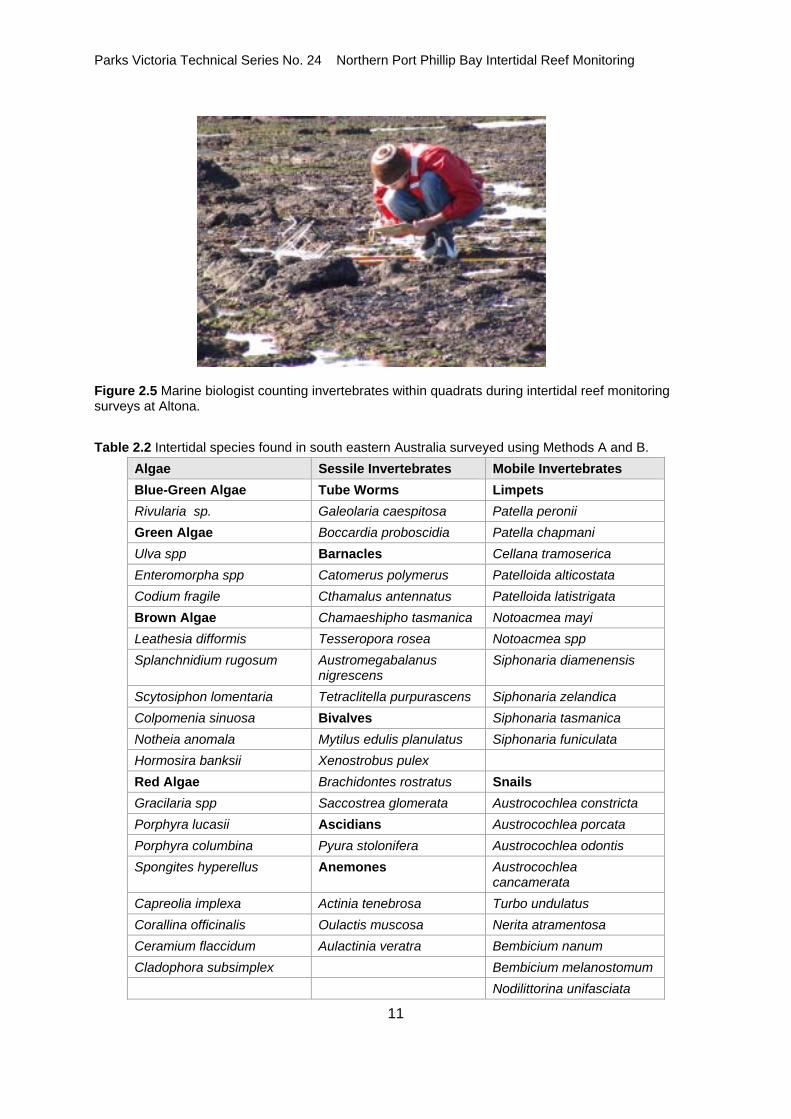
Figure 2.5 Marine biologist counting invertebrates within quadrats during intertidal reef monitoring surveys at Altona. Table 2.2 Intertidal species found in south eastern Australia surveyed using Methods A and B.
Algae Sessile Invertebrates Mobile Invertebrates Blue-Green Algae Tube Worms Limpets Rivularia sp. Galeolaria caespitosa Patella peronii Green Algae Boccardia proboscidia Patella chapmani Ulva spp Barnacles Cellana tramoserica Enteromorpha spp Catomerus polymerus Patelloida alticostata Codium fragile Cthamalus antennatus Patelloida latistrigata Brown Algae Chamaeshipho tasmanica Notoacmea mayi Leathesia difformis Tesseropora rosea Notoacmea spp Splanchnidium rugosum Austromegabalanus
nigrescens Siphonaria diamenensis
Scytosiphon lomentaria Tetraclitella purpurascens Siphonaria zelandica Colpomenia sinuosa Bivalves Siphonaria tasmanica Notheia anomala Mytilus edulis planulatus Siphonaria funiculata Hormosira banksii Xenostrobus pulex Red Algae Brachidontes rostratus Snails Gracilaria spp Saccostrea glomerata Austrocochlea constricta Porphyra lucasii Ascidians Austrocochlea porcata Porphyra columbina Pyura stolonifera Austrocochlea odontis Spongites hyperellus Anemones Austrocochlea
cancamerata Capreolia implexa Actinia tenebrosa Turbo undulatus Corallina officinalis Oulactis muscosa Nerita atramentosa Ceramium flaccidum Aulactinia veratra Bembicium nanum Cladophora subsimplex Bembicium melanostomum Nodilittorina unifasciata

Parks Victoria Technical Series No. 24 Northern Port Phillip Bay Intertidal Reef Monitoring
12
Sea Slugs Sea stars Snails continued Onchidella patelloides Patiriella exigua Dicathais orbita Patiriella calcar Lepsiella vinosa Cominella lineolata
A B
C D
E F
Figure 2.6 Examples of typical flora and fauna on intertidal reefs: (a) the green alga Hormosira banksii; (b) the common limpet Cellana tramoserica; (c) the limpets Siphonaria diemenensis (centre) and Notoacmea mayi; (d) the gastropods Bembicium namum (bottom) and Austrocochlea constricta; (e) the gastropods Cominella lineolata (top) and Dicathais orbita; and (f) the anemone Aulactinia veratra and the green alga Ulva spp in standing water.

Parks Victoria Technical Series No. 24 Northern Port Phillip Bay Intertidal Reef Monitoring
13
2.4 Data Analysis 2.4.2 Community Structure Community structure is a multivariate function of both the type of species present and the abundance
of each species. The community structure between pairs of samples was compared using the Bray-
Curtis dissimilarity coefficient. This index compares the abundance of each species between two
samples to give a single value of the difference between the samples, expressed as a percentage
(Faith et al. 1987; Clarke 1993).
Prior to analysis, the data were log transformed to down-weight the influence of highly abundant
species in describing community structure, giving a more even weighting between abundant and rarer
species (following abundance transformations by Sweatman et al. 2000).
The multivariate information in the dissimilarity matrix was simplified and depicted using non-metric
multidimensional scaling (MDS; Clarke 1993). This ordination method finds the representation in fewer
dimensions that best depicts the actual patterns in higher dimensions. The MDS results were then
depicted graphically to show differences between the replicates at each location. The distance
between points on the MDS plot is representative of the relative difference in community structure.
Kruskall stress is an indicator statistic calculated during the ordination process and indicates the
degree of disparity between the reduced dimensional data set and the original hyper-dimensional data
set. A guide to interpreting the Kruskal stress indicator is given by Clarke (1993): (< 0.1) a good
ordination with no real risk of drawing false inferences; (< 0.2) can lead to a usable picture, although
for values at the upper end of this range there is potential to mislead; and (> 0.2) likely to yield plots
which can be dangerous to interpret.
2.4.3 Species Diversity Species diversity involves the consideration of two components: species richness and evenness.
Species richness is the number of species present in the community while evenness is the degree of
similarity of abundances between species. If all species in a community have similar abundances,
then the community has a high degree of evenness. If a community has most of the individuals
belonging to one species, it has low evenness. Species diversity is a combination of species richness
and the relative abundance of each species, and is often referred to as species heterogeneity.
Measures of diversity give an indication of the likelihood that two individuals selected at random from a
community are different species.
Species richness (S) was enumerated by the total species count per site. This value was used for
calculation of evenness and heterogeneity statistics. Species diversity (i.e. heterogeneity among
species) was described using the reciprocal of Simpson’s index (1/DSimpson = Hill’s N2). This index
provides more weighting for common species, as opposed to the weighting of rarer species such as by
the Shannon-Weiner Index (Krebs 1999). The weighting of common species was considered more

Parks Victoria Technical Series No. 24 Northern Port Phillip Bay Intertidal Reef Monitoring
14
appropriate for this study, the sampling being directed more towards the enumeration of common
species rather than rarer ones.
2.4.4 Species Populations The abundances of each species were summarised by calculating the mean density per quadrat
(0.25m-2) for each site. The variability in density between quadrats was visually examined for the
highly abundant species Austrocochlea porcata and Cellana tramoserica using box plots. The edges
of box plots indicate the inter-quartile range and the median is indicated within the box. The whiskers
on the boxes indicate values encompassing 1.5 times the inter-quartile range, either side of the
median. Outliers are indicated by circles.
The population size structure for Austrocochlea porcata and Cellana tramoserica was assessed by
calculating mean lengths and size frequency curves for each site where there was a high abundance
of individuals.
2.4.5 Initial Analyses It should be noted that, for the initial IRMP surveys there will only be cursory exploration and
investigation of the data. When a longer time series of data is available, there will be more detailed
assessments of temporal trends and differences between sites.

Parks Victoria Technical Series No. 24 Northern Port Phillip Bay Intertidal Reef Monitoring
15
3.0 REGIONAL ANALYSIS 3.1 Biogeography Victoria’s marine environment has been classified into five bioregions. These bioregions reflect
differences in physical processes such as ocean currents and geology, which in turn influence the
distribution of ecosystems and diversity over scales of 100-1000 km. Point Cook, Jawbone and
Ricketts Point marine sanctuaries are in the Victorian Embayments bioregion (which includes Port
Phillip Bay, Westernport Bay and Corner Inlet). Habitats in this bioregion are mostly sheltered from
large swells and currents typical of open coastal locations. There also tends to be a larger estuarine
influence on habitats in this bioregion.
3.2 Macroalgae and Aggregating Sessile Invertebrates There were generally few species and sparse cover of macroalgae on all intertidal reefs surveyed in
the north of the Bay. Ricketts Point had the highest cover of attached macroalgae with Neptune’s
necklace Hormosira banksii covering substantial areas low on the shore. Hormosira banksii also
occurred low on the shore but in lower abundance at Point Gellibrand. The green algae Ulva spp and
Enteromorpha spp occurred as small patchily distributed tufts at most sites. Patches of small
filamentous turfing species also occurred at most locations but in low abundance. No macroalgae
occurred at Altona.
Point Cook had the highest species richness and diversity of macroalgal species compared with other
regions in northern Port Phillip Bay. This was because of a few species of small attached filamentous
and thallose red algae distributed across the shore. These species contributed little to total algal
cover. Unattached drift algal species covered large areas of the high shore region at Point Cook and
caused anoxic conditions on some areas of this shore.
Aggregating sessile invertebrates did not tend to be important components of the intertidal
assemblages surveyed. The tubeworm Galeolaria caespitosa occurred at several sites but not in large
encrusting aggregations.
Table 3.1 Diversity statistics for macroalgae on intertidal reefs in northern Port Phillip Bay.
Site Species Richness Heterogeneity 1/D=N2
Evenness E1/D
Point Cook MS 8 2.73 0.34 Altona 0 - - Jawbone MS 3 1.97 0.66 Point Gellibrand 5 1.28 0.26 Ricketts Point MS 4 2.11 0.53 Half Moon Bay 4 1.70 0.43
3.3 Invertebrates

Parks Victoria Technical Series No. 24 Northern Port Phillip Bay Intertidal Reef Monitoring
16
The intertidal invertebrate communities of Port Phillip Bay generally composed of few species. There
were no clear community patterns for the intertidal sites (Figure 3.1). Most sites were dominated by
the herbivorous species Austrocochlea porcata, Bembicium nanum and the limpet Cellana
tramoserica in varying abundances. In addition, the carnivorous gastropods Lepsiella vinosa and
Cominella lineolatus were generally present on the site at low densities.
Halfmoon Bay (S4112) was the most diverse and species rich site by a relatively large margin (Table
3.2). This small site had the only recorded presence of the species Patelloidea alticosta, Notoacmea
mayi and Onchidella patelloides which are typical of intertidal reefs on Victoria’s exposed coast.
Halfmoon Bay had moderate abundances of the common Austrocochlea porcata and Cellana
tramoserica, as well as high abundances of Turbo undulatus, Lepsiella vinosa and Nerita atramentosa
which if present, are rare at other sites. Point Cook (S4107) had the lowest richness and diversity of
mobile invertebrates with only the commonest species present in low numbers.
S4107
S4108
S4110
S4109
S4111
S4112
Figure 3.1 MDS plot of invertebrate assemblages on intertidal reefs in northern Port Phillip Bay. Legend: Marine Sanctuary = Blue; Reference Sites = Red; Point Cook (S4107) and Altona (S4108) = Circle; Jawbone (S4109) and Point Gellibrand (S4110) = Triangle; Ricketts Point (S4111) and Halfmoon Bay (S4112) = Square. Kruskal stress = 0.06. Table 3.2 Diversity statistics for invertebrates on intertidal reefs in northern Port Phillip Bay.
Site Species Richness Heterogeneity 1/D=N2
Evenness E1/D
Point Cook 5 1.27 0.25 Altona 9 1.59 0.18

Parks Victoria Technical Series No. 24 Northern Port Phillip Bay Intertidal Reef Monitoring
17
Jawbone 8 3.09 0.39 Point Gellibrand 6 3.57 0.59 Ricketts Point 8 1.32 0.17 Halfmoon Bay 18 6.77 0.38
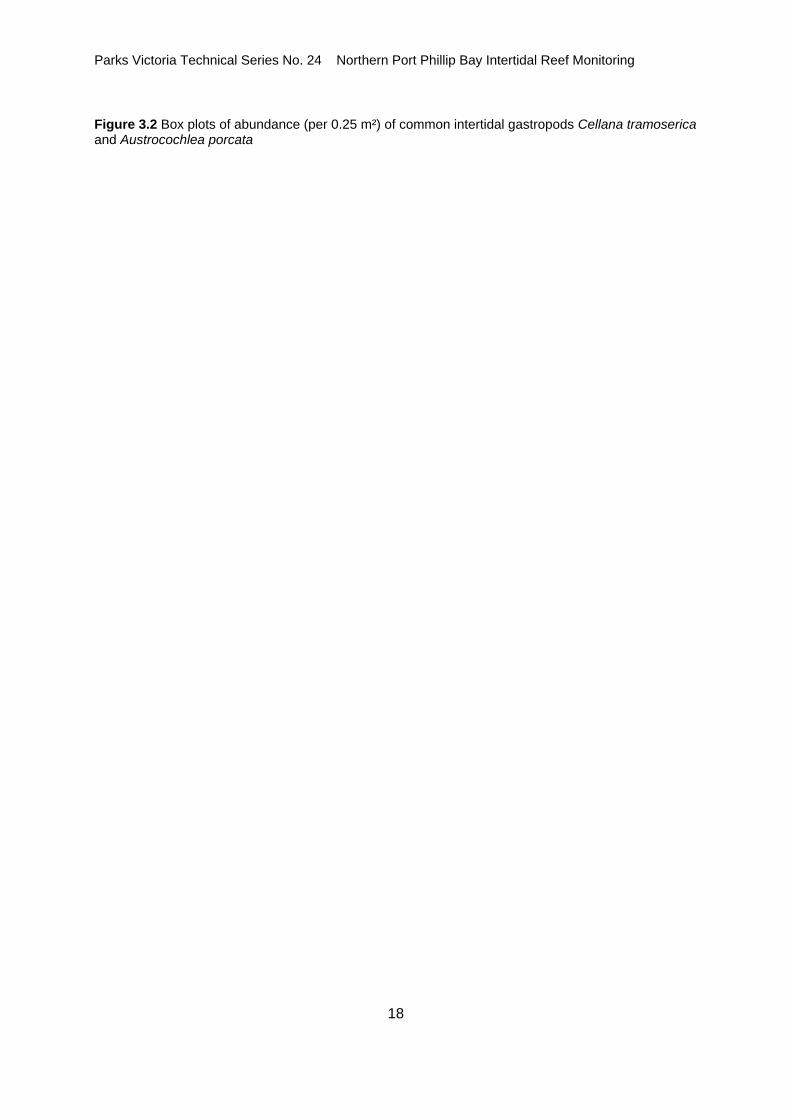
3.4 Species Populations The densities of the common species Cellana tramoserica and Austrocochlea porcata changed little
between the two survey periods. The limpet Cellana tramoserica showed similar means and variance
in density per 0.25 m² for most sites. Changes were observed at Jawbone (Site 4109) where although
the range of densities encountered was similar, the mean dropped between the years. At Point
Gellibrand (Site 4110) there was an overall decrease in both mean and range of density. For the
abundant gastropod Austrocochlea porcata, the mean densities and range were similar for all but one
site. At Ricketts Point (Site 4111), there was a substantial drop in the mean density and range
between the two years.
Cellana tramoserica
4107 4108 4109 4110 4111 4112Site
0
10
20
30
Abu
n dan
ce (p
e r 0
.25
m2 )
2003
4107 4108 4109 4110 4111 4112Site
0
10
20
302004
Austrocochlea porcata
4107 4108 4109 4110 4111 4112Site
0
10
20
30
40
50
60
70
Abu
n dan
ce (p
e r 0
.25
m2 )
2003
4107 4108 4109 4110 4111 4112Site
0
10
20
30
40
50
60
70 2004
Parks Victoria Technical Series No. 24 Northern Port Phillip Bay Intertidal Reef Monitoring
18
Figure 3.2 Box plots of abundance (per 0.25 m²) of common intertidal gastropods Cellana tramoserica and Austrocochlea porcata

Parks Victoria Technical Series No. 24 Northern Port Phillip Bay Intertidal Reef Monitoring
19
4.0 POINT COOK MARINE SANCTUARY 4.1 Site Description and Transect Layout 4.1.1 Point Cook Marine Sanctuary (Site 4107) The intertidal area at Point Cook is an extensive basalt rock platform and basalt boulder and cobble
field. The intertidal area is 300-400 m long, extending from just north of Point Cook to the south and
west. Large patches of sand and intertidal seagrass Zostera marina occur predominantly across the
northeastern section of the intertidal area with more continuous patches of reef occurring further south
and west. The intertidal reef is generally flat. However, small undulations across the reef mean that
tidal inundation does not occur evenly across the reef. Strong southerly winds often cause large
amounts of subtidal drift algae to be washed onto the intertidal reef area.
The survey site was established on the largest continuous area of reef to the west of Point Cook. Both
the high-shore and low-shore baselines were 100 m long and were approximately parallel. During the
2004 survey, a large amount of drift algae was present along the high shore, covering a large area of
intertidal reef. The high shore baseline was placed across the drift algae during this survey. Five
transects placed between the baselines were between 30 m and 35 m long and were equidistant from
each other. Quadrats were placed at roughly equal distances along each transect.
4.1.2 Altona Reference (Site 4108) A suitable reference site, with intertidal habitat similar to that at Point Cook could not be found.
However, the intertidal area at Altona was established in 2003 as a reference site for Point Cook
Marine Sanctuary. The intertidal monitoring site at Point Gellibrand (Site 4110; Section 5.1.2) would
also be used as a long-term reference site for Point Cook.
The intertidal area at Altona consists of basalt reef and boulder fields interspersed with sand and
seagrass flats. The survey site was established on a relatively large and continuous area of solid
basalt reef and basalt boulders directly adjacent to large patches of sand and seagrass. The intertidal
reef is generally flat with most variation in substratum height occurring at the level of individual
boulders rather than across the shore. Most boulders in the survey area are substantially bigger
(approximately 20-40 cm diameter) than those occurring at Point Cook. Consequently, there are a
large number of crevices and a substantial area of vertical substratum on the sides of boulders. The
survey site has an estuarine influence because of its proximity to Kororoit Creek.

Parks Victoria Technical Series No. 24 Northern Port Phillip Bay Intertidal Reef Monitoring
20
4.2 Macroalgae and Aggregating Sessile Invertebrates There was a very large amount of drift algae smothering the higher shore areas of the intertidal reef at
Point Cook during May 2004. This drift algal mat was up to 40-50 cm thick. The high shore baseline
traversed the drift algal mat and consequently, there was 100 % cover of drift algae in all quadrats
placed high on the shore (Table 4.1). Any biota occurring on the reef below the drift algal mat was
completely smothered by drift algae during this survey. Drift algal mats commonly occur subtidally
along the northwestern shore of Port Phillip Bay and are periodically washed ashore during strong
windy conditions. The drift algal mat consisted of two portions of algae in very different stages of
decay. This appeared to indicate that most of the drift algae had been washed ashore during two
separate events. Although the drift algal mat was confined mostly to the higher regions of the shore,
its influence extended further seaward. Large areas of reef and rock pools adjacent to the algal mat
were clearly anoxic and large numbers of dead shells and little attached algae occurred in these
areas.
There was a relatively high total cover of the green alga Ulva spp. and Enteromorpha spp. at Point
Cook. The distribution of these species was patchy along the shore but with higher abundances
occurring in the lower shore regions. Small attached thallose and filamentous red algal species such
as Ceramium flaccidum and Grateloupa filicina also occurred at Point Cook.
There was no attached macroalgal cover at Altona. There was a relatively small amount of drift algae
(mostly large brown algal species such as Sargassum spp and Cystophora spp) and drift seagrass at
this site.
There was a relatively large amount of sand inundation at both sites.

Parks Victoria Technical Series No. 24 Northern Port Phillip Bay Intertidal Reef Monitoring
21
Table 4.1 Abundance (percent cover) of macroalgae and aggregating sessile invertebrates at Point Cook and Altona in May 2004.
Species Point Cook MS Altona (reference)
Macrophytes Algal turf 1.2 Ceramium flaccidum 0.2 Grateloupia filicina 0.1 Hypnea sp. 1.0 Filamentous red algae 0.6 Corallina officinalis 1.2 Enteromorpha spp. 2.6 Ulva spp. 8.9 Drift macroalgae 20.0 0.1 Drift seagrass 2.7 Sessile Invertebrates Mytilus edulis 0.1 Galeolaria caespitosa 2.0 Other sponges 0.2 0.2 Other Sand 15.0 18.5
4.3 Invertebrates Large mobile invertebrates were in low densities at Point Cook (Table 4.2). Most mobile invertebrates
occurred in higher abundances lower on the shore. Anoxic sediments and large numbers of dead
shells were observed higher on the shore because of the influence of the drift algal mat. The
herbivorous gastropod Austrocochlea porcata was the most abundant invertebrate with highest
abundances occurring low on the shore. There were very low densities of a similar species,
Austrocochlea odontis. This species is typically in lower abundance than its congeners on intertidal
reefs. Two carnivorous gastropods were in low densities on the shore: Cominella lineolata and
Lepsiella vinosa.
Densities of invertebrates, particularly gastropod molluscs, were considerably higher at Altona. As at
Point Cook, Austrocochlea porcata was the most abundant species. However, in contrast to Point
Cook, there was a much higher density of this species at Altona with more than 20 individuals per 0.25
m-2. At Altona, A. porcata was relatively evenly distributed along and down the shore.
The limpet Cellana tramoserica is a common invertebrate on southern Australian reefs. This species
was in moderate abundance at Altona but was not present within the quadrats at Point Cook. Two
species of Bembicium were also in moderate numbers at this site. The species of herbivorous

Parks Victoria Technical Series No. 24 Northern Port Phillip Bay Intertidal Reef Monitoring
22
gastropods at Altona did not appear to be separated across the shore but tended to occur together in
survey quadrats.
There were low abundances of the carnivorous gastropods Cominella lineolata and Lepsiella vinosa at
Altona. The eleven individuals of Lepsiella vinosa that were recorded during this survey occurred in a
single quadrat.
The seastar Patiriella exigua occurred on the seaward edge of the intertidal reef at Altona in moderate
densities.
Table 4.2 Density of megafaunal invertebrates per 0.25m-2 at Point Cook and Altona in May 2004.
Species Point Cook MS Altona (reference)
Austrocochlea odontis 0.2 0.0 Austrocochlea porcata 5.8 20.5 Turbo undulatus 0.0 0.0 Bembicium melanostomum 0.0 1.0 Bembicium nanum 0.0 0.6 Nerita atramentosa 0.0 0.0 Nodilittorina unifasciata 0.0 0.2 Cellana tramoserica 0.0 2.7 Cominella lineolata 0.4 0.1 Lepsiella vinosa 0.2 0.4 Patiriella exigua 0.0 0.6 Capreolia implexa 0.1 0.0
The sizes of the herbivorous gastropod Austrocochlea porcata varied between the two sites (Figure
4.1). At Point Cook, the mean shell length was approximately 20 mm in 2003 and 2004, although more
smaller individuals were detected in 2004. At Altona, mean shell length was much smaller (15 mm)
and not as variable between individuals (Figure 4.1).

Parks Victoria Technical Series No. 24 Northern Port Phillip Bay Intertidal Reef Monitoring
23
0 5 10 15 20 25 300
20
40
60
80
Freq
uen c
y
Point CookeSurvey 1
0 5 10 15 20 25 300
20
40
60
80 AltonaSurvey 1
0 5 10 15 20 25 30Length (mm)
0
20
40
60
80
Freq
uen c
y
Survey 2
0 5 10 15 20 25 30Length (mm)
0
20
40
60
80Survey 2
Mean = 21N = 99
Mean = 15N = 107
Mean = 20N = 224
Mean = 14N = 102
Figure 4.1 Size frequency histograms of Austrocochlea porcata for Survey 1 (2003) and Survey 2
(2004) at Point Cook and Altona.

Parks Victoria Technical Series No. 24 Northern Port Phillip Bay Intertidal Reef Monitoring
24
5.0 JAWBONE MARINE SANCTUARY
5.1 Site Description and Transect Layout 5.1.1 Jawbone Marine Sanctuary (Site 4109) There is an extensive area of fractured basalt reef and boulder field at Jawbone Marine Sanctuary
(Site 4109). The reef forms a band up to 30 m wide and extends for several hundred metres from the
point at Jawbone to the boundary of the Sanctuary to the southwest. The large basalt boulders create
medium to high relief intertidal reef with considerable habitat structure because of the large amount of
vertical substratum and crevices. The intertidal reef at Jawbone Marine Sanctuary has a large
estuarine influence because of the proximity of Kororoit Creek and there is an area of mangrove and
salt marsh habitat at the eastern end of the sanctuary. This area is also a Ramsar site and is an
important habitat for migratory shorebirds.
The establishment of the survey site on the intertidal reef at Jawbone was uncomplicated. The high-
shore and low-shore baselines were run parallel to each other and the shore and were 100 m in
length. Five transects were placed from the high-shore baseline to the low-shore baseline, at
equidistant intervals along the shore. These transects were 6 to 18 m in length.
5.1.2 Point Gellibrand Reference (Site 4110) The reference site for the Jawbone Marine Sanctuary was the intertidal reef at Point Gellibrand,
Williamstown (site 4110). The intertidal area at Point Gellibrand is similar to Jawbone Marine
Sanctuary in being composed of a fractured basalt reef and boulder field. The size of the boulders was
much smaller at Point Gellibrand and consequently there is less vertical structure and fewer crevices
at Point Gellibrand. The intertidal reef at Point Gellibrand has a south-westerly aspect.
The curved nature of the shore line at the survey site restricted the length of the high-shore baseline to
62 m. The low-shore baseline was 100 m in length. The five transects established were 30-44 m in
length and were equidistant from each other but, because of the difference in baseline lengths, were
not parallel. Quadrats were placed at similar distances along each transect.

Parks Victoria Technical Series No. 24 Northern Port Phillip Bay Intertidal Reef Monitoring
25
5.2 Macroalgae and Aggregating Sessile Invertebrates The abundance of macroalgae and sessile invertebrates was very low at both sites (Table 5.1).
Smaller patches of filamentous algal turf at Jawbone (Site 4109) contributed most of the observed
algal cover. There was also a low abundance of the green sea lettuce Ulva spp. These small patches
of attached algae occurred in the lower shore region of the survey site. There was a relatively small
amount of unattached drift seagrass in small sections along the shore at Jawbone.
In contrast to Jawbone, macroalgal cover at Point Gellibrand (Site 4110) was predominantly the brown
alga Neptune’s necklace Hormosira banksii, which occurred in patches on the lower region of the
shore on established reef. A low abundance of Ulva spp and algal turf also contributed to the
macroalgal cover.
The only aggregations of sessile animals observed were small patches of the calcareous tube-worm
Galeolaria caespitosa. This species made up a very small percentage of the total cover at both sites. It
was present across the shore but was higher in abundance in the lower shore region.
Table 5.1 Abundance (percent cover) of macroalgae and aggregating sessile invertebrates at Jawbone and Point Gellibrand in May 2004.
Species Jawbone Marine Sanctuary
Pt Gellibrand Reference
Macrophytes Algal turf 2.5 0.1 Ulva spp 1.3 0.1 Enteromorpha sp. + Filamentous greens 0.1 Hormosira Banksii 6.9 Heterozostera tasmanica 0.2 Drift seagrass 1.2 0.2 Sessile Invertebrates Galeolaria caespitosa 0.2 1.4 Other Sand 0.7
Parks Victoria Technical Series No. 24 Northern Port Phillip Bay Intertidal Reef Monitoring
26
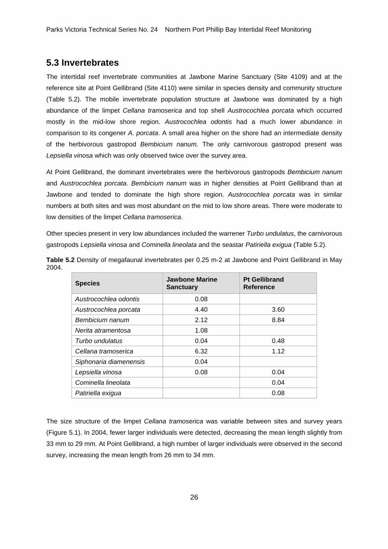
5.3 Invertebrates The intertidal reef invertebrate communities at Jawbone Marine Sanctuary (Site 4109) and at the
reference site at Point Gellibrand (Site 4110) were similar in species density and community structure
(Table 5.2). The mobile invertebrate population structure at Jawbone was dominated by a high
abundance of the limpet Cellana tramoserica and top shell Austrocochlea porcata which occurred
mostly in the mid-low shore region. Austrocochlea odontis had a much lower abundance in
comparison to its congener A. porcata. A small area higher on the shore had an intermediate density
of the herbivorous gastropod Bembicium nanum. The only carnivorous gastropod present was
Lepsiella vinosa which was only observed twice over the survey area.
At Point Gellibrand, the dominant invertebrates were the herbivorous gastropods Bembicium nanum
and Austrocochlea porcata. Bembicium nanum was in higher densities at Point Gellibrand than at
Jawbone and tended to dominate the high shore region. Austrocochlea porcata was in similar
numbers at both sites and was most abundant on the mid to low shore areas. There were moderate to
low densities of the limpet Cellana tramoserica.
Other species present in very low abundances included the warrener Turbo undulatus, the carnivorous
gastropods Lepsiella vinosa and Cominella lineolata and the seastar Patiriella exigua (Table 5.2).
Table 5.2 Density of megafaunal invertebrates per 0.25 m-2 at Jawbone and Point Gellibrand in May 2004.
Species Jawbone Marine Sanctuary
Pt Gellibrand Reference
Austrocochlea odontis 0.08 Austrocochlea porcata 4.40 3.60 Bembicium nanum 2.12 8.84 Nerita atramentosa 1.08 Turbo undulatus 0.04 0.48 Cellana tramoserica 6.32 1.12 Siphonaria diamenensis 0.04 Lepsiella vinosa 0.08 0.04 Cominella lineolata 0.04 Patiriella exigua 0.08
The size structure of the limpet Cellana tramoserica was variable between sites and survey years
(Figure 5.1). In 2004, fewer larger individuals were detected, decreasing the mean length slightly from
33 mm to 29 mm. At Point Gellibrand, a high number of larger individuals were observed in the second
survey, increasing the mean length from 26 mm to 34 mm.

Parks Victoria Technical Series No. 24 Northern Port Phillip Bay Intertidal Reef Monitoring
27
For the gastropod Austrocochlea porcata, the size distribution was variable between sites and times,
although the mean was only different at Jawbone for the second survey (12 mm c.f. 17-18 mm; Figure
5.2).
0 10 20 30 40 50 600
10
20
30
Freq
uenc
y
JawboneSurvey 1
0 10 20 30 40 50 600
10
20
30 Point GellibrandSurvey 1
0 10 20 30 40 50 60Length (mm)
0
10
20
30
Freq
uenc
y
Survey 2
0 10 20 30 40 50 60Length (mm)
0
10
20
30Survey 2
Mean = 33N = 120
Mean = 26N = 88
Mean = 29N = 93
Mean = 34N = 61
Figure 5.1 Size frequency histograms of Cellana tramoserica for Survey 1 (2003) and Survey 2 (2004) at Jawbone and Point Gellibrand.

Parks Victoria Technical Series No. 24 Northern Port Phillip Bay Intertidal Reef Monitoring
28
0 5 10 15 20 25 300
10
20
30
40
Freq
u enc
y
JawboneSurvey 1
0 5 10 15 20 25 300
10
20
30
40 Point GellibrandSurvey 1
0 5 10 15 20 25 30Length (mm)
0
10
20
30
40
Freq
u enc
y
Survey 2
0 5 10 15 20 25 30Length (mm)
0
10
20
30
40Survey 2
Mean = 18N = 96
Mean = 18N = 87
Mean = 12N = 98
Mean = 17N = 115
Figure 5.2 Size frequency histograms of Austrocochlea porcata for Survey 1 (2003) and Survey 2
(2004) at Jawbone and Point Gellibrand.
Parks Victoria Technical Series No. 24 Northern Port Phillip Bay Intertidal Reef Monitoring
29
6.0 RICKETTS POINT
6.1. Site Description and Transect Layout 6.1.1 Ricketts Point Marine Sanctuary (Site 4111) There are several sections of intertidal reef in the Ricketts Point Marine Sanctuary. The main intertidal
reef is an extension of the Ricketts Point Headland. This reef is large (approximately 60 m by 70 m)
and encompasses several different habitat types including fractured basalt reef with prominent
outcrops and steps, cobble field habitat and areas of intertidal mud and seagrass.
The central region of the platform at Ricketts Point is solid basalt reef that is above the high tide mark
and supports patches of the salt-tolerant plant samphire Sarcornia quinqueflora. There are also small
ephemeral rock pools in this central area and typically very low densities of gastropods. This high
central region drops away on almost all sides in one or two sharp steps. Below these rock steps the
reef slopes away more gradually towards the subtidal. To the north and south are predominantly
cobble field and mud habitats. However, most of the western seaward edge of the platform is fractured
basalt reef with small boulders. Across the intertidal area there are prominent solid basalt reef
outcrops, which provide vertical structure.
The main difficulties in establishing a monitoring site at Ricketts Point were: (1) determining which of
cobble field or solid basalt reef was the predominant habitat type; and (2) the irregularity in height
across the intertidal platform. The monitoring site was placed on solid basalt reef at the western
seaward edge of the intertidal area. The high shore baseline was 40 m long and ran north-south
above a rock step. Below the rock step the shore sloped away more gradually. The low shore baseline
was 40 m long and ran parallel to the high shore baseline. The low-shore baseline traversed
Neptune’s necklace Hormosira banksii habitat and some shallow rock pools. There were also small
basalt boulders towards the low tide mark. The five transects were between the baselines and were
approximately 18 m long and 7 m apart. The high shore quadrat on each transect was above the rock
step, while the lower shore quadrats were mostly below the step.
6.1.2 Halfmoon Bay Reference (Site 4112) The reference site for Ricketts Point Marine Sanctuary was on a small area of intertidal reef at
Halfmoon Bay (Site 4112). The main section of this reef extends as a tongue of relatively flat basalt
reef extending 20 m north from a high-relief basalt outcrop. This tongue of reef is surrounded by water
on three sides. The high shore baseline was placed along the eastern edge of the platform which is
slightly higher than the western edge. The upper baseline was 25 m long, and ran parallel to the lower
baseline which was 30 m long. Transects running between the baselines were approximately 10 m
long and 5 m apart (Figure 6.1).

Parks Victoria Technical Series No. 24 Northern Port Phillip Bay Intertidal Reef Monitoring
30
Figure 6.1 The intertidal reef monitoring site at Halfmoon Bay. The high-shore baseline is at the right of the reef. Transects 2-5 can be seen running towards the low shore baseline at left.
6.2 Macroalgae and Aggregating Sessile Invertebrates The high shore area of the Ricketts Point site is exposed for long times between high tide periods and
as a result there was moderate algal coverage and some terrestrial lichens present (Table 6.1).
Macroalgal cover was dispersed along the seaward edge of the platform and was predominantly the
brown alga Neptune’s necklace Hormosira banksii. This species is common on intertidal reefs in
Victoria and provides important habitat for epiphytic algae and small invertebrates. Patches of algal tuf
and Enteromorpha sp. were also present in low abundance.
Cyanobacteria Symploca sp was found in the form of small mats, typically in rock pools. The only
aggregations of sessile animals observed were small patches of the calcareous tube-worm Galeolaria
caespitosa that were distributed across the shore but were higher in abundance on the low shore. This
made up a very small percentage of the total cover at both sites (Table 6.1).
Halfmoon Bay had a lower proportion of macroalgal cover than Ricketts Point and consisted of small
patches of algal turf coverage and the green filamentous Enteromorpha sp.
The filter-feeding polychaete Galeolaria caespitosa was moderately abundant at Halfmoon Bay
forming aggregations in some areas of the low shore region. This was in contrast to the low coverage
at Ricketts Point.

Parks Victoria Technical Series No. 24 Northern Port Phillip Bay Intertidal Reef Monitoring
31
Table 6.1 Abundance (percent cover) of macroalgae and aggregating sessile invertebrates at Ricketts Point and Halfmoon Bay in May 2004.
Species Ricketts Point Marine Sanctuary
Halfmoon Bay Reference
Macrophytes
Algal turf 6.96 7.36 Brown algal turf 0.08 Enteromorpha sp. 2.40 2.08 Hormosira banksii 16.72 Ulva spp 0.40 0.32 Corallina officinalis 0.24 Sessile Invertebrates Galeolaria caespitosa 2.24 11.84 Other Symploca 2.96 Unidentified lichen 0.48
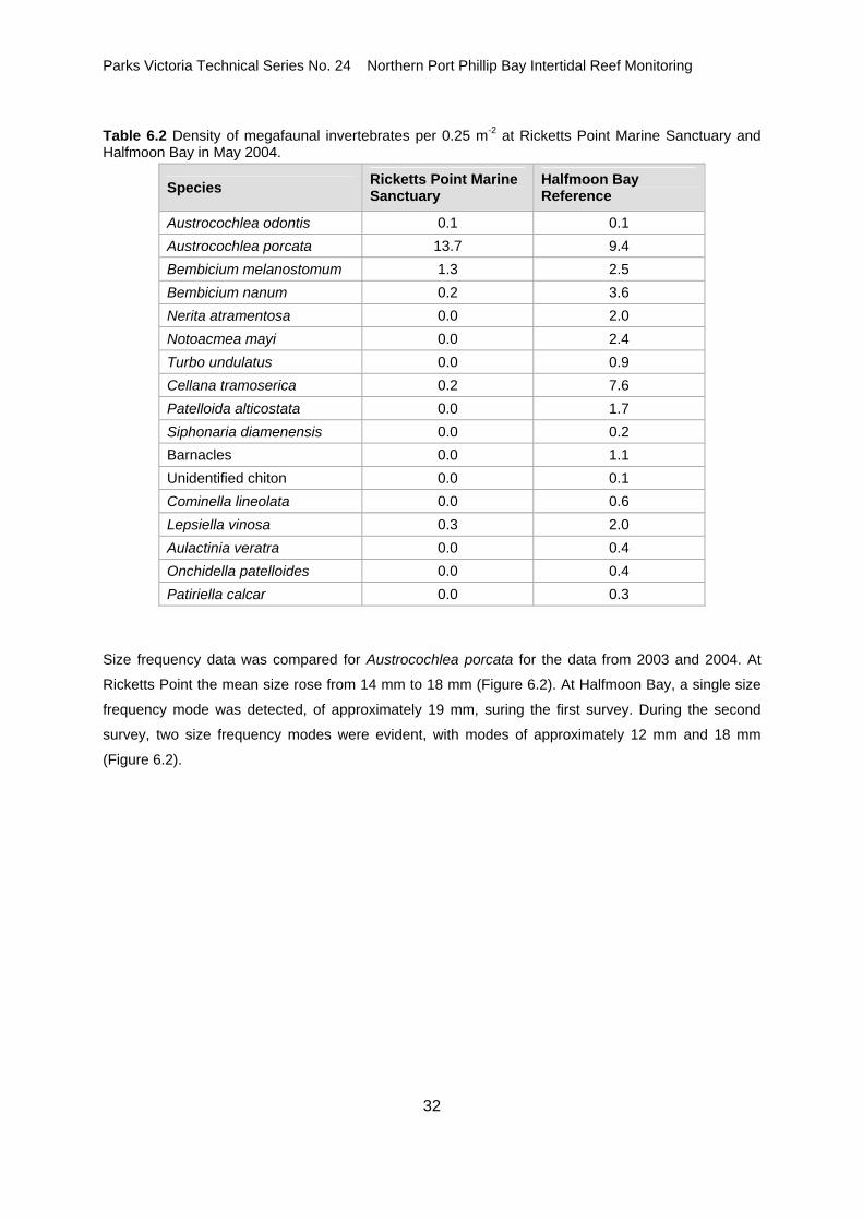
6.3 Invertebrates At Ricketts Point the mobile invertebrate community had low species diversity. The herbivorous
gastropod Austrocochlea porcata was the only species at the site that was highly abundant and was
distributed relatively evenly along and down the shore (Table 6.2). Bembicium nanum was present in
low densities on small sections of the high to mid shore region.
Two carnivorous gastropods were in low densities on the shore: Cominella lineolata and Lepsiella
vinosa.
In contrast to Ricketts Point, there was a high abundance and species diversity of mobile invertebrates
at Halfmoon Bay. The most abundant species were Austrocochela porcata and the limpet Cellana
tramoserica which were distributed across the platform.
Other herbivorous gastropods including Bembicium melanostomum, Bembicium nanum, Nerita
atramentosa, Notoacmea mayi and Patelloida alticostata had a moderate abundance. The distribution
of these species tended to be concentrated in small areas across the platform. A very high proportion
of B. nanum were found in a single quadrat on the high shore.
The carnivorous gastropods Lepsiella vinosa and Cominella lineolata had a higher abundance at
Halfmoon Bay than at Ricketts Point and were present in moderate and low densities respectively.
Other distinguishing features of the Halfmoon Bay site included the anemone Aulactina veratra and
seastar Patiriella calcar, which were present in small rock pools on the seaward edge of the intertidal
reef, as well as the air-breathing sea slug Onchidella patelloides and barnacles.
Parks Victoria Technical Series No. 24 Northern Port Phillip Bay Intertidal Reef Monitoring
32
Table 6.2 Density of megafaunal invertebrates per 0.25 m-2 at Ricketts Point Marine Sanctuary and Halfmoon Bay in May 2004.
Species Ricketts Point Marine Sanctuary
Halfmoon Bay Reference
Austrocochlea odontis 0.1 0.1 Austrocochlea porcata 13.7 9.4 Bembicium melanostomum 1.3 2.5 Bembicium nanum 0.2 3.6 Nerita atramentosa 0.0 2.0 Notoacmea mayi 0.0 2.4 Turbo undulatus 0.0 0.9 Cellana tramoserica 0.2 7.6 Patelloida alticostata 0.0 1.7 Siphonaria diamenensis 0.0 0.2 Barnacles 0.0 1.1 Unidentified chiton 0.0 0.1 Cominella lineolata 0.0 0.6 Lepsiella vinosa 0.3 2.0 Aulactinia veratra 0.0 0.4 Onchidella patelloides 0.0 0.4 Patiriella calcar 0.0 0.3
Size frequency data was compared for Austrocochlea porcata for the data from 2003 and 2004. At
Ricketts Point the mean size rose from 14 mm to 18 mm (Figure 6.2). At Halfmoon Bay, a single size
frequency mode was detected, of approximately 19 mm, suring the first survey. During the second
survey, two size frequency modes were evident, with modes of approximately 12 mm and 18 mm
(Figure 6.2).

Parks Victoria Technical Series No. 24 Northern Port Phillip Bay Intertidal Reef Monitoring
33
0 5 10 15 20 25 300
10
20
30
40Fr
eque
ncy
Ricketts PointSurvey 1
0 5 10 15 20 25 300
10
20
30
40 Halfmoon BaySurvey 1
0 5 10 15 20 25 30Length (mm)
0
10
20
30
40
Freq
uenc
y
Survey 2
0 5 10 15 20 25 30Length (mm)
0
10
20
30
40Survey 2
Mean = 14N = 78
Mean = 19N = 57
Mean = 18N = 101
Mean = 16N = 113
Figure 6.2 Size frequency histograms of Austrocochlea porcata for Survey 1 (2003) and Survey 2 (2004) at Ricketts Point and Halfmoon Bay.
7.0 REFERENCES Clarke K. R. (1993) Non-parametric multivariate analyses of changes in community structure.
Australian Journal of Ecology 18: 117-143.
Edmunds, M., Hart, S., Elias, J. and Power, B. (2003). Marine National Parks and Sanctuaries
Intertidal Reef Monitoring Program: Central Victoria and Port Phillip Bay, 2003. Report to Parks
Victoria. Australian Marine Ecology Report No. 156, Melbourne, 45 pp.
Faith, D., Minchin, P. and Belbin, L. (1987) Compositional dissimilarity as a robust measure of
ecological distance. Vegetation 69: 57-68.

Parks Victoria Technical Series No. 24 Northern Port Phillip Bay Intertidal Reef Monitoring
34
Fox D, Jacoby C. and Molloy R. 2000. Eastern Treatment Plant: Monitoring the Receiving
Environment. Monitoring Program – 2001 to 2003. Report to the Melbourne Water Corporation.
CSIRO Environmental Projects Office, Melbourne.
Hart, S.P. & Edmunds, M. (2005) Parks Victoria Standard Operating Procedure: Biological Monitoring
of Intertidal Reefs. Parks Victoria Technical Series No. 21. Parks Victoria, Melbourne.
Krebs, C.J. (1999) Ecological Methodology, Second Edition. Benjamin/Cummings, Menlo Park.
Sweatman, H., Cheal, A., Coleman, G., Fitzpatrick, B., Miller. I., Ninio. R., Osborne. K., Page. C.,
Ryan. D., Thompson. A. and Tomkins. P. (2000) Long-term Monitoring of the Great Barrier Reef.
Status Report Number 4. Australian Institute of Marine Science, Townsville.

Parks Victoria Technical Series No. 24 Northern Port Phillip Bay Intertidal Reef Monitoring
35
8.0 ACKNOWLEDGEMENTS
This project was funded by Parks Victoria and supervised by Dr Anthony Boxshall.
We wish to extend our gratitude to Mr Nick Yee and Mr Anh Tuan Ngo for their assistance in the field.

Parks Victoria is responsible for managing the Victorian protected
area network, which ranges from wilderness areas to metropolitan
parks and includes both marine and terrestrial components.
Our role is to protect the natural and cultural values of the parks
and other assets we manage, while providing a great range of
outdoor opportunities for all Victorians and visitors.
A broad range of environmental research and monitoring activities
supported by Parks Victoria provides information to enhance park
management decisions. This Technical Series highlights some of
the environmental research and monitoring activities done within
Victoria’s protected area network.
Healthy Parks Healthy People
For more information contact the Parks Victoria Information Centre
on 13 1963, or visit www.parkweb.vic.gov.au