purpose of this paper - water and catchments web viewthe changes to terminology and definition for...
TRANSCRIPT

State Environment Protection Policy (Waters) Review
Part 2 Matching Beneficial Uses to SegmentsJuly 2017
Part 1 provides a summary of the beneficial use changes proposed for the revised SEPP (Waters).
Purpose of this paperThis paper provides an overview of the proposed new segments for the State Environment Protection Policy (SEPP) (Waters) with the associated beneficial uses to be protected in each segment. This has been determined by matching the current policy segments and beneficial uses to the proposed segments. These will be included in the formal Draft SEPP (Waters), to be released for 3-months public consultation late 2017.
‘Beneficial use’ is the term used in the SEPP (Waters) to describe the values and uses of water environments that Victorians want to protect.
ContentsPurpose of this paper............................................................................................................................1
Context..................................................................................................................................................2
Water segments....................................................................................................................................2
Method for matching beneficial uses to segments................................................................................2
Groundwater segments and beneficial uses..........................................................................................3
Surface water segments and beneficial uses.........................................................................................7
References...........................................................................................................................................19
Attachment 1: Current beneficial use exclusions.................................................................................20
Attachment 2: SEPP (Waters) proposed segments matched to SEPP (WoV) and schedules...............27
Attachment 3: Surface water beneficial uses mapped to proposed new segments............................28
Attachment 4: Schedule X SEPP (Waters)............................................................................................29
1

ContextThe primary regulatory mechanism used for addressing problems that impact on the water quality in Victoria’s water bodies is the Environment Protection Act 1970 (the Act). The Act defines high level objectives for protection of Victoria’s environments (including water-related environments) and gives the Environment Protection Authority (EPA) roles, responsibilities and powers in respect to environmental protection.
Statutory policies – State Environment Protection Policies (SEPPs) – provide detailed requirements and guidance to help apply the Act. They aim to protect environmental values and human activities in Victoria from the effects of pollution and waste.
The SEPPs are reviewed periodically, typically every 10 years. The two water-related SEPPs and Schedules are being reviewed concurrently, with aim of producing a single SEPP that includes both surface water and groundwater. This will be known as SEPP (Waters).
Initial feedback on beneficial uses indicated that existing beneficial uses should be retained and that some beneficial uses could be stream-lined. A paper titled ‘Beneficial uses – proposed changes’ (DELWP 2017) provides an overview of the proposed changes to beneficial uses, the intent and a description of each beneficial use. This paper matches the beneficial uses to the proposed new segments for inclusion in the draft SEPP (Waters).
Water segmentsThe new SEPP (Waters) will replace SEPP (Waters of Victoria; WoV, 2003) and its associated Schedules, and SEPP (Groundwaters of Victoria; GoV, 2002) into a single policy resulting in changes to how the water segments are defined. Under the direction of the Independent Scientific Advisory Panel (SAP), a review of all water segments was completed with changes to segments proposed for all waters. The recommended changes are described below and include:
- an increase in the number of groundwater segments from five to seven;- the incorporation of the Schedule segments for inland waters into the broader state-wide
segments; - changes to the marine and estuarine segments.
Method for matching beneficial uses to segmentsThe method of assigning beneficial uses to the proposed new segments followed the recommendations of Alluvium (2016). Alluvium identified two approaches for assigning beneficial uses to segments for surface waters and one for groundwater. The recommended approach varied depending on water type and beneficial use as summarised in Table 1 and Table 2.
Table 1 Recommended approaches for matching beneficial uses to segments
Beneficial Use Inland waters Marine waters GroundwaterAquatic ecosystems (largely unmodified) Option 2 Option 2
Option 1Aquatic ecosystems (slightly to moderately modified) Option 2 Option 2
Aquatic ecosystems (highly modified) Option 2 Option 2Primary contact recreation Option 21 Option 21 Option 1
Secondary contact recreation Option 21 Option 21
Aesthetic enjoyment Option 6 Option 6
1 Recreational uses could also be addressed using Option 6 with very little change in either the effectiveness or ease of implementation. Option 2 was the preferred option.
2

Beneficial Use Inland waters Marine waters GroundwaterIndigenous cultural and spiritual values Option 6 Option 6Non-indigenous cultural and spiritual values Option 6 Option 6
Agriculture and irrigation (including stock watering) Option 6 Option 6 Option 1Aquaculture Option 62 Option 2
Industrial and commercial use Option 6 Option 6 Option 1Human consumption after appropriate treatment / Potable water supply / potable mineral supply
Option 6 Option 6 Option 1
Harvesting fish, crustacea & molluscs for human consumption Option 2 Option 2Aquifer recharge NA
Navigation and shipping Option 2 Option 2
Passage of indigenous fishIncorporated into
Aquatic ecosystems
Indigenous riparian vegetationIncorporated into
Aquatic ecosystemsBuildings and structures Option 1
Table 2 Methods for matching beneficial uses to segments
Approach MethodOption 1 Use current water quality (TDS) to apply beneficial uses/ classify segments
1. Collate and clarify all relevant beneficial use exclusions 2. Assign beneficial uses according to water quality (TDS)
Option 2 Beneficial uses applied everywhere and exclusions used to provide finer detail. Attainment program/risk assessment to inform management
1. Collate and clarify all relevant beneficial use exclusions (spatial and temporal exclusions, and all relevant legislation)
2. Assign beneficial uses according to current and future use, applying a beneficial use where uncertain by doing the following:a. Apply everywhere within a segment, then map the exclusionsb. Apply everywhere within a segment, then exclude via description or reference to other
document
Option 6 Use general wording (clauses) about beneficial uses rather than assigning them geographically1. Collate all existing exclusion clauses2. Modify existing clauses to ensure they are specific and easy to interpret3. Collate existing legislation for assigning certain beneficial uses (e.g. designated water supply
areas)4. Create clear statements for each beneficial use using clauses and legislation
Attachment 1 contains details of all current beneficial use exclusions.
Groundwater segments and beneficial usesThe recommended approach to matching beneficial uses to segments for groundwater follows the same approach taken in the current (existing) policy. Under this approach the groundwater environment is divided into segments based on the background (naturally occurring) level of total dissolved solids (TDS). The groundwater segments are used to determine which segment is applicable to a beneficial use of groundwater.
2 This could be tested upon application to see whether Option 2 would be more appropriate (i.e. whether mapping information is available).
3

Following an extensive review of guidelines, literature and analysis of Victorian groundwater data (Lanigan et al 2016; Senversa 2015), the following segment thresholds were identified to more accurately reflect the beneficial uses of groundwater (Table 3).
Table 3 Groundwater beneficial uses mapped to proposed new segments
Beneficial Use
Segment(mg/L TDS)
A1(0
-600
)
A2(6
01-1
,200
)
B(1
,201
-3,
100)
C(3
,101
- 5,
400)
D(5
,401
-7,
100)
E(7
,101
- 10
,000
)F
>10,
001
Protection of water dependent ecosystems and species
Potable water supply - desirable Potable water supply - acceptable Potable mineral water supply Agriculture and irrigation - irrigation Agriculture and irrigation – stock watering Industrial and commercial Water based recreation - primary contact recreation
Buildings and structures Geothermal (new) Cultural and spiritual values (new)
A review of the existing beneficial uses exclusions identified five general exclusions relevant to groundwater to be retained in the policy.
Policy area exclusion (clause 6 of SEPP (GoV) 2002):
1. Groundwater within any landfill cell
Beneficial use exclusion (clause 9 of SEPP (GoV) 2002):
2. Insufficient yield to sustain the beneficial use3. Background level may be detrimental to the beneficial use4. Impracticable due to one or more soil characteristics 5. Groundwater Quality Restricted Use Zones (GQRUZs)
The clause related to soil characteristics has been revised to give more clarity when making a determination in relation to a beneficial use exclusion. This exclusion relates to the soils ability to have high TDS water applied to it. In some cases, the characteristics of the soil limit its ability to buffer high TDS water, and the application of water to this soil may create environmental degradation. The revision to the clause allows for an exclusion in the application of a beneficial use on the basis of soil type. This will ensure that irrigation beneficial uses are not protected for relatively high TDS groundwater where the local soils could not sustain such irrigation (e.g. basaltic soils; EPA 2016c).
The beneficial use, potable water – acceptable, applied to groundwater of 1,001 – 1,500 mg/L TDS where that beneficial use existed at the time of the policy gazettal (17 December 1997). This clause
4

(SEPP (GoV) Clause 9 (4)) is proposed to be removed as the TDS range for this beneficial use is now proposed to be 601 – 1,200 mg/L TDS, removing the need for this clause. The clause was originally introduced to protect the Port Fairy potable water supply which was 1,050 mg/L TDS at the time of the 1997 policy gazettal. As the range for potable water supply – acceptable has been extended from 1,000 mg/L to 1,200 mg/L the Port Fairy potable water supply remains protected.
Minor changes are proposed to the definitions of key terms in the clause as detailed below (EPA 2016c):
Aquifer yield: “Aquifer yield is represented by hydraulic conductivity, which is a measure of permeability. The permeability of an aquifer defines the potential rate of flow through a porous media. (e.g. aquifer). Insufficient aquifer yield is any porous media with a hydraulic conductivity less than 0.0001 m/day.”
Soil characteristics: “Soil characteristics are the chemical, biological or physical properties of a soil”.
Proposed changes to beneficial uses are detailed in the Beneficial uses – proposed changes paper (DELWP 2017) with the following changes proposed for groundwater:
1. Maintenance of ecosystemsThe term ‘water dependent ecosystems and species’ has been used in place of ‘maintenance of ecosystems’ to allow a broader intent of the beneficial use. This incorporates the protection of groundwater dependent and subterranean ecosystems and therefore an additional ‘exclusion’ was added so that will only apply in areas designated by the Authority (EPA 2016b). Further detail is provided in DELWP 2017.
2. New beneficial usesGeothermal, and cultural and spiritual values are proposed as new beneficial uses for groundwater.
The revision of groundwater segments has not resulted in any change to the protection of existing groundwater beneficial uses, however it should be noted that the beneficial use “maintenance of ecosystems” is proposed to be changed to “water dependent ecosystems and species”.
Two new beneficial uses are proposed that will apply to all segments.
The existing policy exclusions will be retained and an additional exclusion added related to the “water dependent ecosystems and species” beneficial use.
The changes to terminology and definition for beneficial uses have been made to harmonise groundwater and surface water beneficial uses and provide clarity.
There are a number of definitions included in this clause which have been revised or included e.g. aquifer yield, soil characteristics.
5

Draft proposed SEPP (Waters) beneficial uses clause (groundwater)3
Beneficial uses of groundwater
(1) Subject to sub-clause (2) this policy protects the beneficial uses set out in Table 3, Schedule X for groundwater in each segment marked by a tick.
(2) The Authority may determine that a beneficial use specified in Table 3 does not apply to groundwater where:
a) there is insufficient aquifer yield to sustain the beneficial use;
b) the background level of an environmental quality indicator, other than TDS, may be detrimental to the beneficial use;
c) the application of groundwater may be detrimental to soil or the broader environment due to soil characteristics where irrigation is to occur;
d) a groundwater quality restricted use zone has been determined by the Authority under Clause X;
e) to water within artificial assets4 that have been constructed for a specific purpose. These artificial assets must be:
(i) managed for the purposes for which they are constructed;
(ii) designed and managed so they are not harmful to humans or have unacceptable impacts on animals; and
(iii) managed so that their impact on beneficial uses in receiving waters is minimised.
f) the beneficial use specified in the definition of water dependent ecosystems and species relates to cave ecosystems and subterranean fauna.
(3) When making a determination under sub-clause (2)(a) the Authority-
a) may take into account possible variations within the aquifer and reasonable yield enhancement techniques; and
b) must be satisfied that-
(i) the beneficial use water dependent ecosystems and species is protected;
(ii) there is no risk of adversely affecting any beneficial uses in surrounding areas; and
(iii) fracture flow or solution channelling is not the dominant mode of permeability.
(4) When making a determination under sub-clause (2)(f) a person will only be required to conduct an assessment of cave ecosystems and subterranean fauna where specifically requested in a works approval, licence, notice or as required by the Authority.
3 Draft proposal only that will be subject to legal review and drafting4 Artificial assets include landfill cells, artificial stormwater drains, artificial agricultural drains, artificial irrigation channels & drains, artificial wetlands, waste treatment systems, artificial wastewater treatment systems, reticulated water supply distribution treatment systems, off-stream private dams, piped or underground drains.
6

Surface water segments and beneficial usesMatching beneficial uses to segments for surface waters required the review of the principle policy (SEPP (WoV)) and its associated schedules (SEPP F3, F5, F6, F7 and F8).
Schedule F3 - Gippsland Lakes and Catchment, 1988 (excludes the catchment area covered by F5);
Schedule F5 - Waters of the Latrobe and Thomson and Merriman Creek catchments, 1996; Schedule F6 - Waters of Port Phillip Bay, 1997 (the attainment program includes catchment
areas not included Schedule F7); Schedule F7 - Waters of the Yarra Catchment, 1999; and Schedule F8 - Waters of Western Port and Catchment, 2001.
The proposed new surface water segments have been defined based on agreed criteria for regionalisation including water quality in the system, effects of climate, physical characteristics, ecosystem character, population pressure, analysis of spatial gradients and system dynamics (EPA 2016a). This approach to regionalisation was endorsed by the Independent SAP specifically set up to review the science work undertaken by EPA. The approach to regionalisation has resulted in numerous changes including:
- inland segments defined in the various Schedules have been incorporated into the broader SEPP (WoV) segments with some change to segment names;
- new sub-segments to define open coasts, wetlands, lakes and swamps;- revised sub-segments Port Phillip Bay and Gippsland Lakes segments; and- a new segment for Corner Inlet.
A summary of the proposed new segments and how the current segments fit within these is provided in Attachment 2.
The review of beneficial use exclusions identified an extensive list of exclusions (Attachment 1) which can be broadly summarised into five broad themes listed in
below. These themes are area/system exclusions; background condition exclusions; legislative exclusions, risk to human health exclusions and exclusions based on unsuitable environmental conditions. The list of exclusions under each of the themes has been applied to each beneficial use in
.
7

Table 4 Summary of beneficial use exclusions for surface waters
Current policy exclusions
Beneficial Use Area / system Background conditions Prohibited by law Risk to human
health
Environmental conditions are unsuitable
All BU’s
BU’s are not protected in artificial assets5 that have been constructed for a specific purpose.
Background level6 would not provide for their protection.
Within a mixing zone, designated environmental quality objectives do not need to be met and therefore BU's may not be protected.
Protection of water dependent ecosystems and species - highly
unmodified- slightly to
moderately modified
- highly modified
Protection level assigned based on ecosystem condition
Water based recreation- primary contact
recreation- secondary
contact recreation
- aesthetic enjoyment
Within water supply areas with restricted public access. Rainfall run-off
events
Some wetland areas
In some areas of the Yarra River. Irrigation drains
Cultural and spiritual values- indigenous- non indigenous
Agriculture & irrigation- irrigation- stock watering
In reserved areas of high conservation value
Marine and estuarine watersSome wetland areas
Within water supply areas with restricted public access.
Industrial/urban waters
Irrigation drains
Aquaculture
Only protected in areas where the environmental quality is suitable and it has been approved by the Government in accordance with the Fisheries Act 1995.
5 Artificial assets include landfill cells, artificial stormwater drains, artificial agricultural drains, artificial irrigation channels & drains, artificial wetlands, waste treatment systems, artificial wastewater treatment systems, reticulated water supply distribution treatment systems, off-stream private dams, piped or underground drains.6 Background level means the level of an indicator in surface waters or their aquatic ecosystem, outside the influence of any waste containing a measurable level of that indicator.
8

Current policy exclusions
Beneficial Use Area / system Background conditions Prohibited by law Risk to human
health
Environmental conditions are unsuitable
Harvesting fish, crustacea & molluscs for human consumption
In reserved areas of high conservation value
Contamination potentially affecting the health of consumers
Within water
supply areas with restricted public access.
Human consumption after appropriate treatment
Level of treatment dependent on existing condition
For safe consumption
Industrial and commercial use
In reserved areas of high conservation value
To conduct operations
Within water supply areas with restricted public access.
Navigation & Shipping
In aquatic reserves
Rivers and streamsWetlands and lakesShallow, intertidal areas
Aquifer recharge All segments except Schedule F5 area
Passage of indigenous fish
All segments except five Schedule F7 segments
Indigenous riparian vegetation
All segments except six Schedule F7 segments
The exclusions for each beneficial use were tested with government stakeholders and considered to still be relevant therefore the broad themes are proposed to be retained in the revised policy as criteria for the Authority to inform decisions about where a beneficial use may not apply.
The Authority may determine that a beneficial use does not apply to surface waters:a) in circumstances where the background level of a water quality indicator would not
provide for the protection of the beneficial use. b) to water within artificial assets that have been constructed for a specific purpose. These
artificial assets must be:i) managed for the purposes for which they are constructed; ii) designed and managed so they are not harmful to humans or have unacceptable
impacts on animals; and iii) managed so that their impact on beneficial uses in receiving waters is
minimised. c) where it is prohibited by any law or where it is not a permitted activity.
9

Determinations by the Authority
Beneficial uses are assigned to each segment based on whether the quality of the water is suitable to support that use or value. For surface waters, a beneficial use is assigned to a segment where the quality of water is, or has the potential to, support that use or value, except where exclusions have been identified.
Both the current SEPP (WoV) and SEPP (GoV) have provisions where the Authority can determine which segment and beneficial use will apply. In making a decision, the Authority should have regard to as many sources of information as are reasonably available to the Authority. Criteria to inform decisions by the Authority are described in the policy clauses.
Specific beneficial uses – changes and exclusions
Bringing together the various schedules of SEPP (WoV) and the proposed new segments will see some changes to the specific beneficial uses proposed for surface waters. Attachment 3 contains a table that shows the existing application of beneficial uses to segments in the current policy and schedules (marked with a where protected or E where there is a current exclusion) and the proposed allocation of beneficial uses (green highlight) in the draft SEPP (Waters) policy. Details about each of the specific beneficial uses is provided below.
Protection of water dependent ecosystems and species (previously aquatic ecosystems)
The beneficial use, protection of water dependent ecosystems and species, protects the integrity and biodiversity of ecosystems in all water segments. This beneficial use applies to all surface water segments with three levels of protection, to recognise that ecosystems can be protected to different levels depending on whether they have been largely unmodified, slightly to moderately modified or highly modified. This follows the approach outlined in the Australian and New Zealand Guidelines for Fresh and Marine Water Quality (ANZECC 2000) (
). Water quality data and expert opinion were used to assign a level of protection to each of the proposed surface water segments. The level of protection varies in some segments from the current policy based on advice from the Scientific Advisory Panel and because of differences between Schedule segments. Water quality objectives have been developed to match these three levels of protection.
The maintenance of riparian vegetation and fish passage from Schedule F7 (Waters of the Yarra Catchment), are to be incorporated into the harmonised beneficial use as detailed in the Beneficial uses – proposed changes paper (DELWP 2017).
10

Table 4 Matching of the beneficial use water dependent ecosystems and species level of protection to proposed segments
Water Proposed New Segment Proposed New Sub-segment
Wat
er d
epen
dent
ec
osys
tem
& sp
ecie
s:
larg
ely
unm
odifi
ed
Wat
er d
epen
dent
ec
osys
tem
& sp
ecie
s:
sligh
tly to
mod
erat
ely
mod
ified
Wat
er d
epen
dent
ec
osys
tem
& sp
ecie
s:
high
ly m
odifi
ed
Aquatic Reserves Aquatic Reserves
Wetlands and Lakes Wetlands Lakes and Swamps
Rivers and Streams
Highlands Uplands A
Uplands B Murray and Western Plains
Central Foothills and Coastal Plains
Urban
Marine and Estuarine
Estuaries and Inlets
Port Phillip Bay
Hobsons Bay Central-East
Geelong Arm - Werribee Exchange
Western PortEntrance and north arm
East arm Corner Inlet
Gippsland Lakes
Lake Wellington Lake Victoria
Lake King
Lake Reeve
Exchange
Open Coast
Otway
Central Bass Strait
Twofold (Gippsland)
= current SEPP policy and schedules E = current policy exclusion Proposed SEPP (Waters)
The beneficial use, protection of water dependent ecosystems and species, applies to all surface water segments at the defined level of protection as shown in
(green shading).
11

Water based recreation
Water based recreation incorporates primary contact, secondary contact and aesthetic enjoyment. Water based recreation will continue to be protected in all surface water segments except where specific exclusions apply.
The following current exclusions apply to water based recreation:
Aquatic reserves: water based recreation is not a protected beneficial use within water supply areas with restricted public access. These water supply areas are currently only defined in Schedule F7 (Waters of the Yarra Catchment), and apply within a specific area of Melbourne Water’s responsibility. Under the Water Act 1989, two by-laws have been made to protect catchments and water supply areas and prohibit certain activities (https://www.melbournewater.com.au/aboutus/whoweare/Legislationandpolicies/Pages/Water-act.aspx). The surface waters where this exclusion applies, are proposed to be retained in the new policy for continued protection of Melbourne’s water supply. Additional water supply areas with restricted public access within the Aquatic reserves segment have also been identified in areas under the management of Barwon Water and Wannon Water. These exclusions are also proposed to be included in the revised policy (Attachment 4).
Wetlands: primary contact recreation is not a protected beneficial use in the wetland segment of the current schedule F5 (Waters of the Latrobe and Thomson and Merriman Creek catchments), due to the impracticability of achieving suitable water in these areas. The nature of wetlands (e.g. some wetlands naturally have water in them all the time, whilst others naturally dry out for short or long periods of time) and the importance of many for birdlife mean it may not be possible in all cases to ensure water quality is suitable for primary contact recreation. Under the current SEPP (WoV) policy, primary contact recreation is a protected beneficial use in wetlands. To enable the continued protection of this beneficial use in wetlands where it is possible to achieve the required water quality, it is proposed that primary contact recreation be protected in this segment. The Authority may then determine that this beneficial use does not apply in specific circumstances.
Central Foothills and Coastal Plains: there are several exclusions in various schedules that are proposed to be incorporated into this segment. These exclusions include:
Schedule F5 (Waters of the Latrobe and Thomson and Merriman Creek catchments), natural watercourses draining irrigation: primary and secondary contact are not protected in this segment in recognition of the impracticality of achieving suitable water quality in these areas. These natural watercourses were defined by the community in 1996 as it was identified that these should be given special recognition for their extensive use as irrigation drains. Under the current SEPP (WoV) policy, primary and secondary contact is a protected beneficial use across most of the waters within this segment and it is proposed to extend this across the entire segment. The Authority may then determine that this beneficial use does not apply in specific circumstances.
Schedule F7 (Waters of the Yarra Catchment), urban waterways: primary contact recreation is only a protected beneficial use during base flows and after a minimum of five days have elapsed since a rainfall runoff event in those waters where it is not prohibited by law. As noted above, primary contact recreation is a protected beneficial use across most of the waters within this segment and it is proposed that primary contact be applied across the segment. There is an existing process in place to communicate risk if recreational water quality objectives are not being met due to
12

stormwater pollution and to ensure consistency with this process, the exclusion is not proposed to be retained in the new policy.
Schedule F7 (Waters of the Yarra Catchment), Yarra Port: primary contact recreation is not a protected beneficial use in this segment as it is illegal to swim in the Yarra River downstream from the Gipps Street Bridge in Abbotsford. As the exclusion is already addressed through existing legislation and better defined elsewhere, it is not proposed to retain this exclusion in the new policy.
Schedule F8 (Waters of Western Port and Catchment), Peninsula segment: primary contact is not a protected beneficial use in this segment. This appears to have been incorrectly carried over from 1979 policy as the Schedule F8 (Waters of Western Port and Catchment), Policy Impact Assessment (PIA) proposed that this should be a protected beneficial use in this segment due to its popularity, particularly in the summer months. The exclusion is not proposed to be retained in the new policy.
Port Phillip Bay, Geelong Arm – Werribee sub-segment: Primary contact recreation is not currently protected in the Werribee segment of Port Phillip Bay which is proposed to be incorporated into a new Geelong Arm – Werribee sub-segment. The Geelong Arm – Werribee sub-segment segment also includes parts of the General, Inshore and Corio segments where primary contact recreation is currently a protected beneficial use.
The Western Treatment Plant (WTP) has a wastewater discharge licence with a mixing zone that discharges into the current Werribee segment (and proposed Geelong Arm – Werribee sub-segment of Port Phillip Bay). The Werribee segment was originally created before the introduction of mixing zones and was then retained to buffer the effect of the WTP beyond the boundaries of its licensed mixing zone. Results from a recent quantitative microbial risk assessment (QMRA) found that the tolerable risk level for primary and secondary contact recreation was not exceeded at the boundary of the mixing zone. No change is proposed to the current exclusion for primary contact recreation in the area defined by the Werribee segment. The surface waters where these exclusions apply will be retained in the new policy (Attachment 4).
The beneficial use, water based recreation, applies to all surface water segments except where identified in Attachment 4.
Cultural and spiritual values
This beneficial use is protected in all surface waters segments and includes the spiritual values of surface waters held by Traditional Owners’ and Aboriginal Victorians’ and the cultural values held by both urban and rural communities (e.g. water based festivals and celebrations). This beneficial use will continue to apply to all surface water segments.
The beneficial use, cultural and spiritual values, applies to all surface water segments.
Agriculture and Irrigation
Agriculture and irrigation, including stock watering, will continue to be protected in those surface water segments where it is currently protected. This includes the most of the wetlands segment and all inland water segments. All existing exclusions for this beneficial use apply to the F5 Schedule (Waters of the Latrobe and Thomson and Merriman Creek catchments) area.
Agriculture and irrigation is not permitted in aquatic reserves and reserved areas of high conservation value. In the current F5 Schedule (Waters of the Latrobe and Thomson and Merriman
13

Creek catchments), there are several aquatic reserves that were within segments where agriculture and irrigation was a protected beneficial use. These areas, which include National Parks, are proposed to be incorporated into the aquatic reserves segment to ensure a consistent approach across the state for these defined areas of conservation value.
Water quality is unsuitable for agriculture and irrigation in marine and estuarine waters and those wetlands defined in Schedule F5 (Waters of the Latrobe and Thomson and Merriman Creek catchments). Most wetlands in this region have been designated as "wetlands of international significance" under the Ramsar and JAMBA international agreements relating to the protection of migratory birds. This contrasts with the principle policy (SEPP (WoV)) which provides for the protection of agriculture and irrigation in the wetlands and lakes segment. Wetlands of high conservation value i.e. Ramsar wetlands will be incorporated into the aquatic reserves segment in the new policy. Agriculture and irrigation will continue to be protected in the wetland segment where water quality is suitable to support that use. The Authority may then determine that this beneficial use does not apply in specific circumstances.
Within the F5 Schedule (Waters of the Latrobe and Thomson and Merriman Creek catchments) segment, natural watercourses draining irrigation, the beneficial use of irrigation was not protected. These watercourses were recognised in 1996 for their extensive use as irrigation drains and the high salt content of this water was unsuitable for irrigation. This F5 segment is proposed to be incorporated into the central foothills and coastal plains segment where agriculture and irrigation is a protected beneficial use across most of the segment. It is proposed that agriculture and irrigation be protected in this segment. The Authority may then determine that this beneficial use does not apply in specific circumstances, i.e. where the salt content of this water is unsuitable.
The existing exclusions are proposed to be maintained with the following statement.
The beneficial use, agriculture and irrigation, applies to the wetlands, and rivers and streams segments.
Aquaculture
Aquaculture is currently only protected in areas where the environmental quality is suitable and it has been approved by the Government in accordance with the Fisheries Act 1995. The current exclusion is proposed to be maintained with the following statement.
The beneficial use of aquaculture only applies to those surface water segments where the environmental quality is suitable and it has been approved by the Government in accordance with the Fisheries Act 1995.
Human consumption of aquatic foods (natural populations - commercial and recreational catch)
Human consumption of aquatic foods will continue to be protected in all surface waters except where current exclusions apply. All current exclusions apply to Port Phillip Bay and these are proposed to be retained in the new policy.
It is not a beneficial use within the Port Phillip Bay aquatic reserves segment except where the activity is permitted under approved fisheries management plans. In Port Phillip Bay, aquatic reserves include declared fisheries reserves under the Fisheries Act 1995.
14

Exclusions also apply to several segments where there were concerns associated with the consumption of molluscs based on a 1991 review of bacterial water quality. For the commercial fishing and aquaculture sector the risk is mitigated through licensing under the Seafood Safety Act 2003 which requires seafood businesses to comply with relevant Australian and Victorian standards, and guidelines, ensuring that seafood is safe for human consumption. There is no recent science or monitoring program that demonstrates that the water quality has improved to the extent that concerns associated with recreational consumption of molluscs is no longer applicable and this exclusion is proposed to be retained in the policy. It is important to note that a beneficial use does not prohibit or permit the use of surface waters for any particular purpose but requires waters to be of a suitable quality to support that use.
The existing exclusions are proposed to be maintained with the following statement and reference to existing exclusions (Attachment 4).
The beneficial use, human consumption of aquatic foods, applies to all surface water segments except where identified in Attachment 4.
Human consumption after appropriate treatment
This beneficial use will continue to apply to areas where harvesting occurs for water supply (as defined under the Safe Drinking Water Act 2003 and the Safe Drinking Water Regulations), in addition to declared Special Water Supply Catchment areas.
The beneficial use, human consumption after appropriate treatment, only applies to those surface water segments where harvesting occurs for water supply (as defined under the Safe Drinking Water Act 2003), in addition to Special Water Supply Catchment Areas.
Industrial and commercial use
Industrial and commercial use will continue to apply to all surface waters where industrial and commercial activities require water of a suitable quality to run their operations, except where current exclusions apply.
It is not a beneficial use in the aquatic reserves segment, wetlands segment, Gippsland Lakes segment and Western Port – east arm sub-segment and these exclusions are proposed to be retained for these areas in the new policy.
Industrial and commercial use is not a beneficial use in the Highlands segment in SEPP (WoV) except for these waters that are proposed to be incorporated within this segment that were previously defined in segment B of the F5 Schedule (Waters of the Latrobe and Thomson and Merriman Creek catchments). The Highlands segment is largely natural, with alpine and sub-alpine environments and is generally above 1,000 metres in altitude. To enable the continued protection of these largely natural waterways, it is proposed that the beneficial use of industrial and commercial use not be protected in this segment.
Industrial and commercial use is not a protected beneficial use in the Parks and Forest segment of Schedule F7 (Waters of the Yarra Catchment), of which some surface waters are now included in the Uplands A segment where industrial and commercial use is a beneficial use. Areas of the Parks and Forest segment have also been incorporated into the Aquatic Reserves segment where industrial and commercial use is not a beneficial use providing protection for these high value areas. It is
15

proposed that the beneficial use of industrial and commercial applies to the Uplands A segment as the beneficial use already applies across most this segment.
Existing exclusions are proposed to be retained as shown in Table 5.
The beneficial use, industrial and commercial use, applies to all surface water segments where identified in Table 5.
Navigation and shipping
Navigation and shipping will continue to apply to the marine and estuarine waters of the Yarra, Port Phillip Bay and Western Port except where current exclusions apply.
Navigation and shipping is a beneficial use in Port Phillip Bay except within the aquatic reserves segment. The exception to this is where the activity is permitted under an approved management plan (e.g. a safety and environment management plan prepared under the Port Management Act 1995). This exception for aquatic reserves in Port Phillip Bay is proposed to be will be retained in the new policy (Attachment 4).
The only other segments where navigation and shipping is a beneficial use is in the marine waters of the entrance and North Arm of Western Port and the Yarra estuary section of the Estuaries and Inlets segment and no change is proposed for the new policy.
Existing exclusions are proposed to be retained through the following specific statement and reference to existing exclusions (Attachment 4).
The beneficial use, navigation and shipping, applies to the marine and estuarine waters of the Yarra River, Port Phillip Bay and Western Port, except where identified in attachment 4.
Surface water summary
Surface water segments have been redefined based on agreed criteria for regionalisation.
The revision of surface water segments and the incorporation of the various Schedule segments has resulted in changes to the protection of beneficial uses including:
- improved protection for water dependent ecosystems and species; and- broader application of beneficial uses across segments where the majority of waters are
currently protected.
Criteria have been developed to inform determinations by the Authority about when a beneficial use is not protected including:
- background conditions;- artificial assets; and- prohibited by law.
16

Draft proposed SEPP (Waters) beneficial uses clause (surface waters)7
Beneficial uses of surface waters(1) Subject to sub-clauses (2) to (4), this policy protects the beneficial uses set out in Table 5,
Schedule Y for surface water in each segment marked by a tick. (2) The following beneficial uses apply in each segment marked with a tick, only to the extent
indicated below:(a) protection of water dependent ecosystems and species applies to all surface water
segments at the defined level of protection as shown in Table 5;(b) aquaculture only applies to those surface water segments where the environmental
quality is suitable and it has been approved by the Government in accordance with the Fisheries Act 1995;
(c) human consumption after appropriate treatment only applies to those surface waters where harvesting occurs for potable water supply as defined under the Safe Drinking Water Act 2003, in addition to declared Special Water Supply Catchment Areas.
(3) Exclusions to the protection of a beneficial use within a segment are marked with an asterisk and detailed in Attachment 4.
(4) The Authority may determine that a beneficial use in a surface water segment does not apply: (a) in circumstances where the background level of an environmental quality indicator
would not provide for the protection of the beneficial use;(b) to water within artificial assets that have been constructed for a specific purpose.
These artificial assets must be:(i) managed for the purposes for which they are constructed; (ii) designed and managed so they are not harmful to humans or have
unacceptable impacts on animals; and (iii) managed so that their impact on beneficial uses in receiving waters is
minimised. (c) where it is prohibited by any law or where it is not a permitted activity.
7 Draft proposal only that will be subject to legal review and drafting
17

Table 5 Beneficial uses of surface waters protected by this policy
Beneficial uses
WaterAquatic
Reserves
Wetlands and
Lakes Rivers and Streams Marine and Estuarine
Proposed segment
Aqua
tic
Rese
rves
Wet
land
s
High
land
s
Upl
ands
A
Upl
ands
B
Mur
ray
and
wes
tern
pla
ins
Cent
ral
foot
hills
and
co
asta
l pla
ins
Urb
an
Estu
arie
s and
In
lets
Port
Phi
llip
Bay
Wes
tern
Por
t
Corn
er In
let
Gipp
slan
d La
kes
Ope
n Co
ast
Proposed sub-segment Lake
s and
Sw
amps
Hobs
ons B
ay
Cent
ral-E
ast
Geel
ong
Arm
- W
errib
ee
Exch
ange
Entr
ance
s and
Nor
th A
rm
East
arm
Lake
Wel
lingt
on
Lake
Vic
toria
Lake
Kin
g
Lake
Ree
ve
Exch
ange
Otw
ay
Cent
ral B
ass S
trai
t
Twof
old
(Gip
psla
nd)
Water dependent ecosystems and species that are:
largely unmodified slightly to moderately modified
highly modified
Water suitable for:
Primary contact recreation * * Secondary contact recreation * Aesthetic enjoyment * Cultural and spiritual
Human consumption after treatment
where harvesting occurs for water supply (as defined under the Safe Drinking Water Act 2003), in addition to special water supply catchment
areas
Aquaculture where the environmental quality is suitable and it has been approved by the Government in accordance with the Fisheries Act 1995.Human consumption of aquatic foods (natural populations - commercial and recreational catch)
* * * * *
Agriculture and Irrigation
Industrial and Commercial Navigation and Shipping * *
18

ReferencesAlluvium (2016) Developing a range of options to assign beneficial uses to be protected in SEPP segments, Final report submitted for the SEPP (Waters) Review, unpublished report submitted for the SEPP (Waters) Review.
EPA (2016a) SEPP (Waters) Review regionalisation science discussion papers, unpublished reports submitted to Scientific Advisory Panel for the SEPP (Waters) Review
EPA (2016b) Groundwater Beneficial Use decision review - Project 2C Science Discussion Paper, unpublished report submitted to Scientific Advisory Panel for the SEPP (Waters) Review
EPA (2016c) Groundwater Quality Indicators and Objectives Review Science Discussion Paper, unpublished report submitted to Scientific Advisory Panel for the SEPP (Waters) Review
DELWP (2017) State Environment Protection Policy (Waters) Review, Beneficial Uses – Proposed Changes, unpublished report submitted for the SEPP (Waters) Review.
Lanigan, Drake, Bartley (2016) SEPP (Groundwaters of Victoria) segments review, unpublished report submitted to Scientific Advisory Panel for the SEPP (Waters) Review
Senversa (2015) Water SEPP Review, Literature review of groundwater science components, unpublished report submitted for the SEPP (Waters) Review
19

Attachment 1: Current beneficial use exclusionsThe table below details all the existing beneficial exclusion clauses in the Policy and Schedule documents for surface and ground waters.
Policy Clause ExceptionSEPP (GoV) 6. Policy Area
(1) Subject to sub-clause (2), this policy shall be observed throughout the State of Victoria and shall apply to all groundwaters and aquifers.(2) This policy does not apply to groundwater within any landfill cell.
Policy does not apply to groundwater within any landfill cell
SEPP (GoV) 9. Beneficial Uses(1)Subject to sub-clause (2) the beneficial uses specified in Table 2 will be protected in each segment marked by a tick.(2) The Authority may determine that a beneficial use specified in Table 2 does not apply to groundwater where - (a) there is insufficient aquifer yield to sustain the beneficial use;(b) based on Table 3 the background level of a water quality indicator other than TDS may be detrimental to the beneficial use;(c) the beneficial use is impracticable due to one or more soil characteristics; or(d) a Groundwater Quality Restricted Use Zones (GQRUZs) has been identified by the Authority.(3) When making a determination under sub-clause 2(a) the Authority - (a) will take into account possible variations within the aquifer and reasonable yield enhancement techniques; and(b) must be satisfied that - (i) the beneficial use maintenance of ecosystems is protected.(ii) there is no risk of adversely affecting any beneficial uses in surrounding areas; and(iii) fracture flow or solution channelling is not the dominant mode of permeability.(4) The beneficial use 'potable water-acceptable' shall apply to groundwater of 1,001-1,500 mg/L TDS where that beneficial use exists at the date of publication of this policy in the Victorian Government Gazette.
The Authority may determine that a beneficial use specified in Table 2 does not apply to groundwater where - (a) there is insufficient aquifer yield to sustain the beneficial use;(b) based on Table 3 the background level of a water quality indicator other than TDS may be detrimental to the beneficial use;(c) the beneficial use is impracticable due to one or more soil characteristics; or(d) a Groundwater Quality Restricted Use Zones (GQRUZs) has been identified by the Authority.
SEPP (GoV) Table 2 - Protected beneficial uses of segments1. Maintenance of ecosystems2. Potable water supply3. Potable mineral water supply4. Agriculture, parks and gardens5. Stock watering6. Industrial water use7. Primary contact recreation8. Buildings and structures
Potable water supply: desirable is not a protected BU in the Segments A2, B, C, DPotable water supply: acceptable is not a protected BU in the Segments A1, B, C, DPotable mineral water supply is not a protected BU in the Segments C, DAgriculture, parks and gardens is not a protected BU in the Segments C, DPrimary contact recreation is not a protected BU in the Segment DStock watering is not a protected BU in the Segment D
SEPP (GoV) 17 Attenuation Zones(1) Without limiting its other powers, in issuing and amending a works approval, licence or notice under the EP Act, the Authority may designate an attenuation zone within which some or all of the water quality objectives specified in Table 3 are not required to be achieved.(2) The designation of an attenuation zone is subject to the following conditions - (a) the Authority must be satisfied that all practicable measures have been taken to prevent pollution of groundwater; and(b) an attenuation zone may only be designated for landfills receiving municipal waste, waste water irrigation, ash ponds or evaporation basins that are incorporated in Government approved salinity management plans(3) An attenuation zone will not be designated-(a) unless the groundwater quality objectives specified in Table 3 are met at the boundaries of the premises to which the works approval, licence or notice relates;(b) within a groundwater protection zone specified in schedule A(c) where the Authority is satisfied there is an unacceptable risk of detriment to an existing beneficial use; or(d) in aquifers with high permeability or low attenuation properties(4) A works approval, licence or notice will-(a) specify the location and boundaries of the attenuation zone and which water quality objectives are not required to be achieved within the attenuation zone;(b) if appropriate, include a groundwater monitoring program that is to be carried out from sampling points at the boundaries of the attenuation zone and/or close to any source; and(c) require the proponent of the works, licensee or notice recipient to prepare a contingency plan to the Authority's satisfaction that will be implemented if groundwater at or beyond the boundaries of the attenuation zone is polluted.(5) upon revocation of any notice or upon surrender or revocation of any licence in which an attenuation zone has been designated, the Authority may identify that area as a groundwater quality restricted zone.
The Authority may designate an attenuation zone within which some or all of the water quality objectives (and associated BU) specified in Table 3 are not required to be achieved.
20
Policy Clause ExceptionSEPP (GoV) 19. Groundwater Quality Restricted Use Zones (GQRUZs)
(1) Where the Authority is satisfied that an existing level of contamination of groundwater precludes one or more beneficial uses that would otherwise apply to that groundwater, the Authority may identify a groundwater quality restricted use zone.(2) The Authority will require groundwater within the groundwater quality restricted use zones to be:(a) managed to contain polluted groundwater within the zone; and(b) cleaned up to the extent practicable in order to move towards objectives prescribed in this policy to protect beneficial uses.(3) The Authority will periodically require the reassessment of the practicability of clean up of polluted groundwater within groundwater quality restricted use zones.(4) The Authority will not issue or amend any works approval or licence, or transfer any licence in respect of any premises situated within a groundwater quality restricted use zone unless the Authority is satisfied that: (a) beyond any proposed or currently designated attenuation zone there will not be any risk of further degradation of groundwater quality in the groundwater quality restricted use zone as a result of any activity or proposed activity at the premises; and (b) there will not be any detriment to any beneficial use of surface waters or groundwater beyond the boundaries of the groundwater quality restricted use zone.
Where the Authority is satisfied that an existing level of contamination of groundwater precludes one or more beneficial uses that would otherwise apply to that groundwater, the Authority may identify a groundwater quality restricted use zone
SEPP (WoV) 8. Policy areaThe policy area is represented in Figure 1 and includes all Victorian surface waters and the catchments that supply them.For the purpose of the Policy, surface waters excludes groundwaters and waters within artificial wastewater treatment systems, reticulated water supply distribution systems, off-stream private dams, and piped or underground drains.While the Policy’s beneficial uses and environmental quality objectives apply to surface waters, the provisions of the attainment program apply to both surface waters and their catchments, and to activities undertaken within them that may impact on surface waters.Unless otherwise stated in a State environment protection policy, the provisions of this Policy must be observed throughout the policy area.
For the purpose of the Policy, surface waters excludes groundwaters, and waters within artificial wastewatertreatment systems, reticulated water supply distribution systems, off-stream private dams and piped and underground drains.
SEPP (WoV) 10. Beneficial UsesBeneficial uses for each segment of the water environment are listed in Table 1 and marked with a tick.The variation of environmental quality of surface waters on a state-wide scale will mean that:(1) some beneficial uses are currently protected and will remain protected;(2) some beneficial uses may not be fully attained in all segments within the 10-year lifetime of the Policy. In these cases, the regional catchment and coastal management processes will set regional targets to be achieved over the Policy’s life, as provided for in clauses 15, 16 and 24;(3) some beneficial uses in some surface waters may not be fully attained due to extensive environmental modification. This should be taken into account when developing and prioritising actions to improve environmental quality.Beneficial uses are protected except:(1) in circumstances where the background level would not provide for their protection;(2) in artificial stormwater drains, artificial agricultural drains, artificial irrigation channels and drains or artificial wetlands (see clauses 46 and 51). These artificial environments need to be managed for the purposes for which they were constructed and must be designed and managed so that they are not harmful to humans or have unacceptable impacts on animals, and so that their impact on surface waters is minimised. Although beneficial uses are not protected in these artificial environments, it is not acceptable to dump or illegally discharge wastes into them.(3) where otherwise specified in the Policy (see clause 48).
(2) Some beneficial uses may not be fully attained in all segments within the 10-year lifetime of the Policy. In these cases, the regional catchment and coastal management processes will set regional targets to be achieved over the Policy’s life, as provided for in clauses 15, 16 and 24(3) Some beneficial uses in some surface waters may not be fully attained due to extensive environmental modification. This should be taken into account when developing and prioritising actions to improve environmental quality.Beneficial uses are protected except:(1) In circumstances where the background level would not provide for their protection
"Background level” means the level of an indicator in surface waters or their aquatic ecosystem, outside the influence of any waste containing a measurable level of that indicator.Beneficial uses are protected except:(2) in artificial stormwater drains, artificial agricultural drains, artificial irrigation channels and drains or artificial wetlands (see clauses 46 and 51). These artificial environments need to be managed for the purposes for which they were constructed and must be designed and managed so that they are not harmful to humans or have unacceptable impacts on animals, and so that their impact on surface waters is minimised. Although beneficial uses are not protected in these artificial environments, it is not acceptable to dump or illegally discharge wastes into them.Beneficial uses are protected except:(3) where otherwise specified in the Policy (see clause 48).
SEPP (WoV) Table 1. Beneficial uses to be protected Aquatic ecosystems that are largely unmodified is not a protected BU in Wetlands and Lakes, Cleared Hills and Coastal Plains, Murray and Western Plains, Estuaries and InletsAgriculture and Irrigation is not a protected BU in Aquatic Reserves, Estuaries and Inlets, Open CoastsAquaculture is not a protected BU in Aquatic Reserves, HighlandsIndustrial and Commercial Use is not a protected BU in Aquatic Reserves, Wetlands and Lakes, HighlandsHuman consumption after appropriate treatment is not a protected BU in Aquatic Reserves, Estuaries and Inlets, Open CoastsFish, crustacea and molluscs for human consumption is not a protected BU in Aquatic Reserves
SEPP (WoV) 28. New wastewater dischargesThe potential impact of new wastewater discharges needs to be minimised to protect beneficial uses. To enable this:(1) the Environment Protection Authority:(a) will require applicants for works approvals to incorporate measures that avoid, re-use and recycle wastewater;(b) will, where a discharge cannot be avoided, re-used and recycled, require applicants of works approvals to incorporate
The EPA may approve a mixing zone as part of a discharge licence where a discharge cannot practicably be avoided, reused and recycled, and where wastewater management practices are not effective in fully protecting beneficial uses.
21
Policy Clause Exceptioneffective wastewater management practices to avoid the discharge resulting in the exceedance of environmental quality objectives in surface waters;(c) may approve a mixing zone as part of a discharge licence where a discharge cannot practicably be avoided, reused and recycled, and where wastewater management practices are not effective in fully protecting beneficial uses;(2) the Environment Protection Authority will, if a licence is approved, ensure that it is consistent with the Policy and includes an environment improvement plan to progressively reduce the impacts of wastewater discharges on beneficial uses, and a monitoring program to assess the impact of the wastewater discharge on beneficial uses; and(3) will not approve any new discharges:(a) to the Aquatic Reserves, Wetlands and Lakes or Estuaries and Inlets segments or to waters in areas of high conservation significance, including those listed in Schedule B, except in accordance with the provisions of clause 31;(b) to waters in special water supply catchments or where a discharge will impact on authorised potable supplies;(c) where a discharge would pose an environmental risk to beneficial uses and best management practice has not been adopted.
SEPP (WoV) 29. Existing wastewater dischargesTo protect beneficial uses, the discharge of wastewater to surface waters needs to be managed to minimise environmental risks to beneficial uses. To enable this, the Environment Protection Authority:(1) will revise existing licences to ensure they are consistent with the Policy and include a monitoring program to assess the impact of wastewater discharges on beneficial uses;(2) will require licence holders to assess options to maximise the implementation of the waste hierarchy and develop environment improvement plans to implement preferred options and to progressively reduce the impacts of wastewater discharges on beneficial uses; and(3) may approve a mixing zone as part of a discharge licence where a discharge cannot practicably be avoided, re-used and recycled, and where wastewater management practices are not effective in fully protecting beneficial uses.In particular, a priority needs to be placed on the avoidance, re-use, recycling and management of wastewater that is currently discharged to the Aquatic Reserves, Wetlands and Lakes or Estuaries and Inlets segments, unless that wastewater is managed in accordance with the provisions of clause 31. Where a discharge cannot be avoided, it must be below the low water mark and should be beyond the surf zone.
SEPP (WoV) 30. Mixing zonesIn issuing a licence, the Environment Protection Authority may approve a mixing zone where it is not practicable to avoid, re-use, recycle and effectively manage wastewater. Within a mixing zone, designated environmental quality objectives do not need to be met and therefore beneficial uses may not be protected. The Environment Protection Authority:(1) will not approve a mixing zone if it will result in:(a) environmental risks to beneficial uses outside the mixing zone;(b) harm to humans, unacceptable impacts on plants and animals or where it will cause a loss of aesthetic enjoyment or an objectionable odour;(2) will require affected licence holders to develop and implement an environment improvement plan that includes effective management practices aimed at continuously reducing the size of the mixing zone and preferably achieving its complete elimination;(3) will regularly review mixing zones and the implementation of environment improvement plans, to ensure that the size of mixing zones is minimised;(4) will provide guidance on criteria for establishing an acceptable mixing zone, including requirements for community and stakeholder consultation.
SEPP (WoV) 46. Urban stormwaterArtificial stormwater drains and artificial stormwater management wetlands need to be managed for the purposes for which they were constructed (see clause 10). They need to be designed and managed so that their waters are not harmful to humans or have unacceptable impacts on animals, and so that the impacts of flow, sediments, nutrients, toxicants, litter and other pollutants on surface waters are minimised.To enable this...avoidance measures
Beneficial uses are not protected artificial stormwater drains and artificial stormwater management wetlands.
SEPP (WoV) 48. Aquaculture activitiesAquaculture activities need to be managed so that environmental risks to beneficial uses, particularly those posed by inputs of nutrients, pathogens and aquatic pests, are minimised. To enable this, the Environment Protection Authority, the Department of Primary Industries and the Department of Sustainability and Environment will:(1) ensure that aquaculture operators implement effective environmental management practices and appropriate environmental monitoring systems;(2) provide guidance on effective management practices and environmental monitoring requirements to managers of aquaculture operations.The beneficial use of aquaculture is only protected in areas where the environmental quality is suitable and where it has
The beneficial use of aquaculture is only protected in areas where the environmental quality is suitable and where it has been approved by the Government in accordance with the Fisheries Act 1995.The following areas have been approved (declared) as an Aquaculture Fisheries Reserve:
Pinnace Channel (PPB exchange)Grassy Point (PPB exchange)Dromana (PPB exchange)Clifton Springs (PPB corio)Kirk Point (PPB corio)Bates Point (PPB corio)
22

Policy Clause Exceptionbeen approved by the Government in accordance with the Fisheries Act 1995. Mt Martha (PPB central)
Beaumaris (PPB central)Flinders (WP entrance and north arm)Portland (Otway open coast)Point Lilias & Avalon (land-based)
SEPP (WoV) 51. Irrigation channels and drainsArtificial irrigation channels and artificial irrigation drains need to be managed for the purposes for which they were constructed (see clause 10). They must be designed and managed so that their waters are not harmful to humans or have unacceptable impacts on animals, and so that the impact of their flow, sediments, nutrients, salt and other pollutants on surface water and groundwater is minimised.To enable this....on surface waters
Beneficial uses are not protected in artificial irrigation channels and artificial irrigation drains.
SEPP F3Gippsland Lakes and Catchment
Gippsland Lakes beneficial uses and objectivesBeneficial uses and objectives contained in the Policy apply to the Gippsland Lakes catchment except where varied below [in Beneficial uses table].
Maintenance of natural aquatic ecosystems and associated wild life - high protection (level 2) is not a protected BU in Segment B, C, F, H [protected in A, D, E, G]Maintenance of natural aquatic ecosystems and associated wild life - wide safety margin (level 3) is not a protected BU in Segment C, F, H [protected in B]
SEPP F5Waters of the Latrobe and Thomson and Merriman Creek catchments
7. Beneficial uses(1) Clause 10 of the Policy does not apply to the Schedule area(2) The beneficial uses specified in the left hand column in Table 1 shall be protected in each segment marked with a tick in the appropriate right hand column, except for Segment E in which segment beneficial uses shall be protected to the extent described in Table 1.Table 1. Beneficial uses in the Schedule area
Maintenance of natural aquatic ecosystems and associated wild life: Natural ecosystems is not a protected BU in Segments B, C, D, E, F, G [protected in A]Maintenance of natural aquatic ecosystems and associated wild life: Natural ecosystems with occasional disturbance due to human activity is not a protected BU in Segments C, D, E, F [protected in B, G]Maintenance of natural aquatic ecosystems and associated wild life: Substantially natural ecosystems with some modifications is not a protected BU in Segments D, E (except Avon River downstream of Redbank only), F [protected in C, E (Avon River downstream of Redbank only)]
Maintenance of natural aquatic ecosystems and associated wild life: modified ecosystems is not a protected BU in Segment F [protected in D and E (excluding Avon River downstream of Redbank, Morwell River downstream of Eel Hole Creek and Bennetts Creek only)],
Potable water supply with treatment (disinfection only) is not a protected BU in Segments C, D, E, F, GPotable water supply with treatment (with disinfection and removal of suspended solids) is not a protected BU in Segments E, F, GPrimary contact recreation is not a protected BU in Segments F and GSecondary contact recreation is not a protected BU in Segment F Agricultural water supply: Stock watering is not a protected BU in Segments A and GAgricultural water supply: Irrigation is not a protected BU in Segments A, estuarine areas of Segment E, F and GIndustrial water use is not a protected BU in Segments A and G
SEPP F6 Waters of Port Phillip Bay
7. Beneficial uses(1) Clause 10 of the Policy does not apply to the schedule area.(2) Subject to subclause (3) the beneficial uses shown in Table 1 shall be protected in each segment marked with a tick(3) In the Aquatic Reserves segment the beneficial uses of “production of molluscs for human consumption - natural populations,” “production of molluscs for human consumption - aquaculture,” “commercial and recreational use of edible fish and crustacea”, “aquaculture” and “navigation and shipping” are protected only in those parts of the segment where the activity is permitted under management plans approved by the Secretary, Department of Natural Resources and Environment.
Aquatic reserves include:- reference areas proclaimed under the Reference Areas Act 1978- National and state parks and reserves proclaimed under the National Parks Act 1975- marine reserves under provisions of section 88(5) of the Fisheries Act 1995- other marine parks and reserves established under the Crown Land (Reserves) Act 1978
The following beneficial uses are only protected in Aquatic Reserves where the activity is permitted under management plans approved by the Secretary:- "production of molluscs for human consumption - natural populations" - "production of molluscs for human consumption - aquaculture"- "commercial and recreational use of edible fish and crustacea"- "aquaculture" - "navigation and shipping"
Aquaculture Fisheries Reserve Management Plans include:- Pinnace Channel Aquaculture Fisheries Reserve Management Plan 2005- Geelong Arm Aquaculture Fisheries Reserves Management Plan 2005- Eastern Port Phillip Bay Aquaculture Fisheries Reserves Management Plan 2005
SEPP F6 Waters of Port Phillip Bay
Table 1- Protected Beneficial Uses in the Schedule Area Maintenance of aquatic ecosystems and associated wild life: Natural ecosystems is not a protected BU in the Corio, Hobsons, Werribee, Inshore and General segmentsMaintenance of aquatic ecosystems and associated wild life: substantially natural ecosystems with some modification is not a protected BU in the Corio, Hobsons and Werribee segments
23

Policy Clause ExceptionWater based recreation: primary contact is not protected BU in the Werribee segmentProduction of molluscs for human consumption: Natural populations - the consumption of naturally occurring molluscs is not a protected BU in the Corio, Hobsons, Werribee and Inshore segments Not protected in the Aquatic Reserves segment unless permitted under approved management plans
Production of molluscs for human consumption: Aquaculture - the consumption of molluscs from declared aquaculture zones included in a shellfish sanitisation program by the Responsible Authority is not a protected BU in the Corio, Hobsons, Werribee segmentsNot protected in the Aquatic Reserves segment unless permitted under approved management plans
Commercial and recreational use of edible fish and crustacea - the consumption of seafood other than molluscs is not a protected BU in the Aquatic Reserves segment unless permitted under approved management planNavigation and shipping - the use of Port Phillip Bay waters for shipping transport and harbour facilities is not a protected BU in the Aquatic Reserves segment unless permitted under approved management plan.Industrial water use - the use of Port Phillip Bay waters as an industrial resource (eg water for salt production, cooling operations) is not a protected BU in the Aquatic Reserve segment.
SEPP F7Waters of the Yarra Catchment
7. Beneficial uses(1) Clause 10 of the Policy does not apply to this schedule.(2) Subject to sub-clauses (3), (4) and (5), the beneficial uses shown in Table 1 shall be protected in each segment marked with a tick.(3) For the purposes of Table 1, the letters super-scripted after the allocation of beneficial uses to segments have the following meanings -“a” means that within the Aquatic Reserves Segment, “Passage of indigenous fish” past the Upper Yarra, Maroondah and Toorourong Reservoirs is not a protected beneficial use;“b” means that within the Urban Waterways Segment -(i) until and including 31 December 2002, “primary contact recreation” shall not be a protected beneficial use except in the waters of the Yarra River;(ii) after 31 December 2002, “primary contact recreation” shall be a protected beneficial use during base flow periods and after a minimum period of five days has elapsed since the occurrence of a rainfall run-off event in those surface waters -- where primary contact recreation is not prohibited by any law; and- that are at least one metre in depth during base flow conditions and have at that depth, the shortest surface dimension of at least 6 metres and the longest surface dimension of at least 10 metres;“c” means that within the Upper Estuary Segment “primary contact recreation” shall not be a protected beneficial use until and including 31 December 2002;“d” means that within the Aquatic Reserves Segment, “Water based recreation” and “Commercial and recreational use of edible fish and crustacea” are not protected beneficial uses within the water supply areas with restricted public access identified in clauses 6(2)(a)(i) and 6(2)(a)(ii).
Within the aquatic reserves segment, the "passage of indigenous fish" past the Upper Yarra, Maroondah and Toorourong Reservoirs is not a protected beneficial use
Aquatic Reserves Segment includes the surface waters of -(i) the catchments upstream of the water supply off-takes at Upper Yarra Reservoir, O'Shannassy Weir, Armstrong Creek Weirs (east and west branches), Starvation Creek Weir, Big Flume Weir, Cement Creek (east branch) Weir, Coranderrk Creek Weir, Graceburn Creek Weir, Maroondah Reservoir, Sawpit Creek Weir, Donnelly's Creek Weir, Torrourrong Reservoir, Yan Yean Reservoir, Silvan Reservoir and Greenvale Reservoir (not including catchment upstream of diversion drains);(ii) the catchments upstream of O'Shannassy Aqueduct from which waters drain directly into the aqueduct;(iii) the Yarra Ranges National Park, except for tributaries to the Yarra River from the north of the Yarra River between O'Shannassy River and Armstrong Creek;(iv) Watsons Creek and its catchment within Kinglake National Park;(v) Dry Creek and its catchment within Kinglake National Park upstream of A.M.G. Easting E 355000 (approximately 1 kilometre upstream of the crossing of Dry Creek by Jerusalem Track); and(vi) the un-named creek and its catchment on the north-west side of Mt Everard upstream of the point where that creek crosses the Kinglake National Park Boundary (A.M.G. Co-ordinates E 350850 N 5839900).Within the Urban Waterways Segment -(i) until and including 31 December 2002, “primary contact recreation” shall not be a protected beneficial use except in the waters of the Yarra River;(ii) after 31 December 2002, “primary contact recreation” shall be a protected beneficial use during base flow periods and after a minimum period of five days has elapsed since the occurrence of a rainfall run-off event in those surface waters -- where primary contact recreation is not prohibited by any law; and- that are at least one metre in depth during base flow conditions and have at that depth, the shortest surface dimension of at least 6 metres and the longest surface dimension of at least 10 metres;
Urban waterways segment is defined as: Urban Waterways Segment, consisting of the surface waters of-(i) the Yarra River from the Sugarloaf Reservoir diversion at Yering Gorge to Dights Falls;(ii) Olinda Creek and its catchment downstream from York Road, Mt Evelyn to Stringybark Creek;(iii) the catchments of the southern tributaries to the Yarra River downstream from the Sugarloaf Reservoir diversion at Yering Gorge; and(iv) the catchments of the northern tributaries to the Yarra River downstream of its junction with Watsons Creek, but not including Railway Canal or Moonee Ponds Creek south of Macaulay Road, Flemington -but not including any of the surface waters of the Aquatic Reserves Segment, the Parks and Forests Segment, the Rural Eastern Waterways Segment and the Rural Western Waterways Segment.Primary contact recreation (swimming) is illegal in the Yarra River downstream of Gipps St Abbotsford.Within the Upper Estuary Segment “primary contact recreation” shall not be a protected beneficial use until and including 31 December 2002Upper Estuary Segment, consisting of the surface waters of -(i) the Yarra River between Dights Falls and A.M.G. Easting E 3178000 (to the west of Victoria Dock); and(ii) Victoria Dock.
24
Policy Clause ExceptionWithin the Aquatic Reserves Segment, “Water based recreation” and “Commercial and recreational use of edible fish and crustacea” are not protected beneficial uses within the water supply areas with restricted public access identified in clauses 6(2)(a)(i) and 6(2)(a)(ii).
Water supply areas identified are:
6 (2)(a)(i) the catchments upstream of the water supply off-takes at Upper Yarra Reservoir, O'Shannassy Weir, Armstrong Creek Weirs (east and west branches), Starvation Creek Weir, Big Flume Weir, Cement Creek (east branch) Weir, Coranderrk Creek Weir, Graceburn Creek Weir, Maroondah Reservoir, Sawpit Creek Weir, Donnelly's Creek Weir, Torrourrong Reservoir, Yan Yean Reservoir, Silvan Reservoir and Greenvale Reservoir (not including catchment upstream of diversion drains).
6 (2)(a)(ii) the catchments upstream of O'Shannassy Aqueduct from which waters drain directly into the aqueduct.SEPP F7Waters of the Yarra Catchment
TABLE 1. Beneficial Uses to be Protected in Segments Maintenance of natural aquatic ecosystems and associated wildlife: Natural ecosystems is not a protected BU in the Parks and Forests, Rural Eastern Waterways, Rural Western Waterways, Urban waterways, Upper Estuary and Yarra Port segmentsMaintenance of natural aquatic ecosystems and associated wildlife: Natural ecosystems with occasional disturbance due to human activity is not a protected BU in the Rural Eastern Waterways, Rural Western Waterways, Urban waterways, Upper Estuary and Yarra Port segmentsMaintenance of natural aquatic ecosystems and associated wildlife: Substantially natural ecosystems with some modification is not a protected BU in the Rural Western Waterways, Urban waterways, Upper Estuary and Yarra Port segmentsMaintenance of natural aquatic ecosystems and associated wildlife: Modified ecosystems is not a protected BU in the Upper Estuary and Yarra Port segmentsMaintenance of indigenous riparian vegetation is not a protected BU in the Upper Estuary and Yarra Port segmentsPrimary contact recreation is not a protected BU in the Yarra Port segmentPotable water supply: untreated is not a protected BU in the Parks and Forests, Rural Eastern Waterways, Rural Western Waterways, Urban waterways, Upper Estuary and Yarra Port segmentsPotable water supply: with treatment (disinfection only) is not a protected BU in the Rural Eastern Waterways, Rural Western Waterways, Urban waterways, Upper Estuary and Yarra Port segmentsPotable water supply: with treatment (disinfection and removal of suspended solids) is not a protected BU in the Rural Western Waterways, Urban waterways, Upper Estuary and Yarra Port segmentsAgricultural water supply: Stock water is not a protected BU in the Aquatic Reserves, Upper estuary and Yarra Port segments
Agricultural water supply: Irrigation (including watering parks and gardens) is not a protected BU in the Aquatic Reserves and Yarra Port segmentsOther Commercial Purposes: Industrial water use is not a protected BU in the Aquatic Reserves and Parks and Forest segmentsOther Commercial Purposes: Navigation and shipping is not a protected BU in the Aquatic Reserves, Parks and Forest, Rural Eastern Waterways, Rural Western Waterways and Urban waterways segments
SEPP F8Waters of Western Port and Catchment
10. Beneficial Uses(1) The beneficial uses listed in Table 1 must be protected in each segment marked with a “tick”.(2) Beneficial uses are not protected in circumstances where the background level would not provide for their protection (see clause 3 for definition of ‘background level’).(3) The beneficial use of ‘aquaculture’ is only protected in those parts of the segment where it is approved by the Minister responsible for administering the Fisheries Act 1995.(4) Beneficial uses listed in the principal policy do not apply to the schedule area.
Beneficial uses are not protected in circumstances where the background level would not provide for their protection
"Background level” means the level of an indicator in surface waters or their aquatic ecosystem, outside the influence of any waste containing a measurable level of that indicator.The beneficial use of "aquaculture" is only protected in those parts of the segment where it is approved by the Minister responsible for administering the Fisheries Act 1995.
Approved area: Flinders Aquaculture Fisheries Reserve (refer to Flinders Aquaculture Fisheries Reserve Management Plan 2005)
SEPP F8Waters of Western Port and Catchment
Table 1: Beneficial uses to be protected. Aquatic ecosystems: Largely unmodified aquatic ecosystems is not a protected BU in the East Arm, Peninsula, French Island, South Eastern Rural and Lowland and Phillip Island SegmentsAquatic ecosystems: Largely modified aquatic ecosystems is not a protected BU in the Entrances and North Arm and Northern Hills SegmentsPrimary contact recreation is not a protected BU in the Peninsula segmentAgriculture is not a protected BU in the Entrances & North Arm and East Arm segmentsAquaculture is not a protected BU in the East Arm, Northern Hills, Peninsula, French Island, South Eastern Rural and Lowland and Phillip Island segmentsIndustrial and commercial Use is not a protected BU in East Arm segment
25

Policy Clause ExceptionNavigation and Shipping is not a protected BU in the East Arm, Northern Hills, Peninsula, French Island, South Eastern Rural and Lowland and Phillip Island segmentsHuman consumption after disinfection is not a protected BU in the Entrances & North Arm, East Arm, Peninsula, French Island, South Eastern Rural and Lowland and Phillip Island segmentsHuman consumption after disinfection and removal of suspended solids is not a protected BU in the Entrances & North Arm, East Arm, Northern Hills segments
26
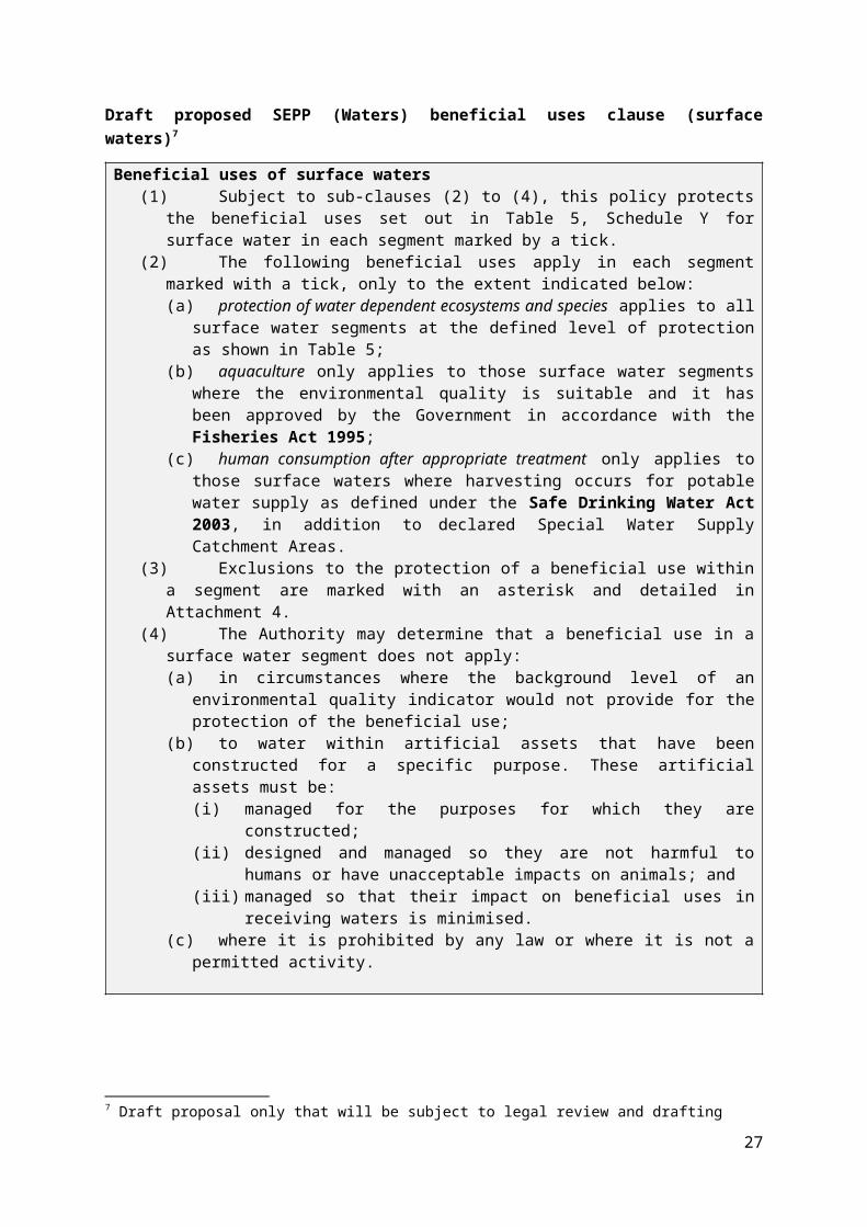
Attachment 2: SEPP (Waters) proposed segments matched to SEPP (WoV) and schedulesWater Proposed New Segment Proposed New Sub-segment SEPP (WoV) F3 Gippsland Lakes and
CatchmentF5 Waters of the Latrobe and Thomson and Merriman Creek catchments
F6 Waters of Port Phillip Bay
F7 Waters of the Yarra Catchment
F8 Waters of Western Port and Catchment
Aquatic Reserves Aquatic Reserves Aquatic Reserves
D: Eastern LakesF: Lake ColemanG: WetlandsH: Macleods Morass
A: predominately reserves and conservation areas
B: predominately forests and forestry activitiesC: mixed forestry and agricultural activities D: predominantly agricultural activities
Aquatic Reserves Aquatic ReservesParks and Forests
Wetlands and Lakes Wetlands and Lakes Wetlands and Lakes D: Eastern Lakes
G: Wetlands
C: mixed forestry and agricultural activities D: predominantly agricultural activitiesG: wetlands
Rivers and Streams
Highlands Highlands A: Upper riverine B: predominately forests and forestry activities
Uplands A Forest A B: predominately forests and forestry activities C: mixed forestry and agricultural activities D: predominantly agricultural activities
Parks and Forests Rural Eastern waterwaysRural Western waterways
Northern Hills
Uplands B Forest B A: Upper riverine B: predominately forests and forestry activities
Murray and western plains Murray and western plains
Central foothills and coastal plains Cleared hills and coastal plains
A: Upper riverine B: Lower riverine
B: predominately forests and forestry activitiesC: mixed forestry and agricultural activities D: predominantly agricultural activitiesE: predominately the industrial area of the Latrobe Valley F: natural watercourses draining irrigation
Rural Eastern waterways Rural Western waterwaysUrban waterways
Northern HillsFrench IslandPeninsulaSouth Eastern RuralLowlands and Phillip Island
Urban Rural Western waterwaysUrban waterways
Northern HillsPeninsulaLowlands and Phillip Island
Marine and Estuarine
Estuaries and Inlets Estuaries and Inlets Upper Estuary Yarra Port
Port Phillip Bay
Hobsons Bay Hobson, General, Inshore
Central-East General , Inshore
Geelong Arm - Werribee Corio, Werribee, Inshore
Exchange General , Inshore
Western PortEntrance and north arm Entrance and north arm
East arm East arm
Corner Inlet Estuaries and inlets
Gippsland Lakes
Lake Wellington C: Lake Wellington
Lake Victoria D: Eastern Lakes
Lake King B: Lower riverineD: Eastern Lakes
Lake Reeve E: Lake Reeve G: wetlands
Exchange B: Lower riverineD: Eastern Lakes
Open Coast
Otway
Open Coast
Bass (Central)
Twofold (Gippsland)
Attachment 3: Surface water beneficial uses mapped to proposed new segmentsThe table below shows the existing assignment of beneficial uses to segments in the current policy and schedules and the proposed assignment of beneficial uses (green highlight) in the draft SEPP (Waters) policy.
27

Water Proposed New Segment Proposed New Sub-segment
Aqua
tic e
cosy
stem
: lar
gely
unm
odifi
ed
Aqua
tic e
cosy
stem
: slig
htly
to m
oder
atel
y m
odifi
ed
Aqua
tic e
cosy
stem
: hig
hly
mod
ified
Prim
ary
cont
act r
ecre
ation
Seco
ndar
y co
ntac
t rec
reati
on
Aest
hetic
enj
oym
ent
Cultu
ral a
nd sp
iritu
al
Agric
ultu
re a
nd Ir
rigati
on
Aqua
cultu
re
Indu
stria
l and
com
mer
cial
Hum
an co
nsum
ption
afte
r tre
atm
ent
Harv
estin
g fo
r hum
an c
onsu
mpti
on
Nav
igati
on a
nd sh
ippi
ng
Aqui
fer r
echa
rge
Pass
age
of in
dige
nous
fish
Indi
geno
us ri
paria
n ve
geta
tion
Aquatic Reserves Aquatic Reserves E E E E E E E E E E
Wetlands and Lakes Wetlands and Lakes E E E E E
Rivers and Streams
Highlands E E E
Uplands A E E E E E E
Uplands B E E
Murray and western plains E
Central foothills and coastal plains E E E E E E E E
Urban E E E E E
Marine and Estuarine
Estuaries and Inlets E E E
Port Phillip Bay
Hobsons Bay E E Central-East E E Geelong Arm - Werribee E E E Exchange E E
Western PortEntrance and north arm E East arm E
Corner Inlet E
Gippsland Lakes
Lake Wellington E Lake Victoria E Lake King E Lake Reeve E E E Exchange E
Open Coast
Otway E Central Bass Strait E Twofold /(Gippsland) E
= current SEPP policy and schedules E = current policy exclusion Proposed SEPP (Waters) Remove from SEPP (Waters)
28

Attachment 4: Schedule X SEPP (Waters) Beneficial use Segment Exclusion
Water based recreation Aquatic Reserves
Within the Aquatic Reserves Segment, water based recreation is not a beneficial use within water supply areas with restricted public access. This consists of the surface waters of -
i) the catchments upstream of the water supply off-takes at Upper Yarra Reservoir, O'Shannassy Weir, Armstrong Creek Weirs (east and west branches), Starvation Creek Weir, Big Flume Weir, Cement Creek (east branch) Weir, Coranderrk Creek Weir, Graceburn Creek Weir, Maroondah Reservoir, Sawpit Creek Weir, Donnelly's Creek Weir, Torrourrong Reservoir, Yan Yean Reservoir, Silvan Reservoir and Greenvale Reservoir (not including catchment upstream of diversion drains);
ii) the catchments upstream of O'Shannassy Aqueduct from which waters drain directly into the aqueduct
Water based recreation – primary contact recreation Port Phillip Bay
Within the Port Phillip Bay segment, water based recreation – primary contact recreation is not a beneficial use in the Geelong Arm sub-segment consisting of the surface waters bounded by a line which spans the shortest distance between the point of intersection of the high water mark and longitude 144°41'30''E and the 10 m depth contour to the south-east, generally south-west following the contour to its intersection with longitude 144°38'30''E, from this point directly to the high water mark at Point Wilson, and along the high water mark to the origin at the intersection of longitude 144°41'30''E.
Human consumption of aquatic foods
Port Phillip Bay Aquatic Reserves
Within the Aquatic Reserves Segment of Port Phillip Bay, human consumption of aquatic foods, is not a beneficial use except in those parts of the segment where the activity is permitted under approved fisheries management plans
Human consumption of aquatic foods
Port Phillip Bay Within the Port Phillip Bay segment, human consumption of aquatic foods (molluscs only), is not a beneficial use -
i) off the Werribee coast consisting of the surface waters bounded by a line which spans the shortest distance between the point of intersection of the high water mark and longitude 144°41'30''E and the 10 m depth contour to the south-east, generally south-west following the contour to its intersection with longitude 144°38'30''E, from this point directly to the high water mark at Point Wilson, and along the high water mark to the origin at the intersection of longitude 144°41'30''E;
ii) in the surface waters of Corio Bay lying west of a line drawn between Point Henry and Point Lillias and bounded by the high water mark;
iii) in the surface waters of Hobsons Bay bounded to the north by latitude 37°50'30"S (across the Yarra River), to the south by a line drawn from Point Gellibrand to Point Ormond, and to the west and east by the high water mark; and
29

Beneficial use Segment Exclusion
iv) in the surface waters outside the above three areas and bounded by the high water mark and a line drawn 600 m seawards from the low water mark.except within declared aquaculture and commercial fishing zones subject to Fisheries Act 1995 and Seafood Safety Act 2003 licensing requirements.
Navigation and
shipping
Port Phillip Bay
Aquatic Reserves
Within the Aquatic Reserves Segment of Port Phillip Bay, navigation and shipping, is not a beneficial use except in those parts of the segment where the activity is permitted under approved management plans.
Navigation and shipping Western Port
Within Western Port, navigation and shipping is not a beneficial use except in the surface waters of the entrances and north arm segment bounded by the high water mark and within an area north of a line drawn between West Head and Point Grant and north of a line drawn at a 45° angle in a north-easterly direction from Cape Woolamai to the coast, and south of a line drawn between Stockyard Point and Settlement Point and west of a line drawn between Pelican Point and Palmer Point.
Navigation and shipping
Estuaries and Inlets
Within the estuaries and inlets segment, navigation and shipping is not a beneficial use except in the surface waters of –
i) off the Werribee coast consisting of the surface waters bounded by a line which spans the shortest distance between the point of intersection of the high water mark and longitude 144°41'30''E and the 10 m depth contour to the south-east, generally south-west following the contour to its intersection with longitude 144°38'30''E, from this point directly to the high water mark at Point Wilson, and along the high water mark to the origin at the intersection of longitude 144°41'30''E;
ii) the Yarra River between Dights Falls and A.M.G. Easting E 3178000 (to the west of Victoria Dock);
iii) Victoria Dock;
iv) the Yarra River between A.M.G. Easting E 3178000 (to the west of Victoria Dock) and a line drawn across the mouth of the Yarra River (A.M.G. Co-ordinates E 315300 N 5809000) corresponding with the parallel 37° 50' 30";
v) Stony Creek east of Hyde Street, City of Hobsons Bay;
vi) Swanson Dock and Appleton Dock; and
vii) Railway Canal or Moonee Ponds Creek south of Macaulay Road, Flemington -but not including any of the surface waters of the Maribyrnong River north of a line drawn from the eastern end of Lyell Street, Yarraville to the southern-most point of Coode Island.
30