public works department works department uttar pradesh core road network development program part a:...
TRANSCRIPT

Uttar Pradesh Core Road Network Development Program
DETAILED PROJECT REPORT
Volume-VIII: EIA and EMP Report
Gola – Shahjahanpur Road (SH-93)
Page i| Rev: R3
,
Document Name
Volume-VIII : Environmental Impact Assessment Report (EIA) and Environmental Management Plan (EMP)
(Detailed Project Report)
Document Number EIRH1UP020/DPR/SH-93/GS/004/VIII
Project Name
Uttar Pradesh Core Road Network Development Program
Part – A: Project Preparation including Detailed Engineering Design and Contract Documentation
Project Number EIRH1UP020
Document Authentication
Name Designation
Prepared by Dr. S.S. Deepak Environmental Specialist
Reviewed by Sudhendra Kumar Karanam
Rajeev Kumar Gupta
Avadesh Singh
Sr. General Manager (Roads & Highways)
Deputy Team Leader
Technical Head
Approved by Rick Camise Team Leader
History of Revisions
Version Date Description of Change(s)
Rev. 0 19/12/2014 First Submission
Rev. 1 29/12/2014 Second Submission after incorporating World Bank’s Comments and Suggestions
Rev. 2 13/01/2015 Incorporating World Bank’s Comments and Suggestions
Rev. 3 16/07/2015 Revision after discussion with Independent Consultant

Uttar Pradesh Core Road Network Development Program
DETAILED PROJECT REPORT
Volume-VIII: EIA and EMP Report
Gola – Shahjahanpur Road (SH-93)
Page ii| Rev: R3
,
TABLE OF CONTENTS
Chapter Description Page
0 EXECUTIVE SUMMARY .................................................................................... 0-1
0.1 Environmental Regulations and Policy .................................................................................. 0-2
0.2 Current Environmental Conditions ........................................................................................ 0-3
0.3 Public Consultation ............................................................................................................. 0-6
0.4 Potential Environmental Impacts ......................................................................................... 0-7
0.5 Analysis of Alternatives ..................................................................................................... 0-19
0.6 Environmental Management Plan ....................................................................................... 0-19
0.7 Conclusions ..................................................................................................................... 0-21
1 INTRODUCTION .............................................................................................. 1-1
1.1 Purpose of the Report ......................................................................................................... 1-1
1.2 Project Background ............................................................................................................ 1-1
1.3 The Project Road ............................................................................................................... 1-2
1.4 Environmental Impact Assessment Study of Project Road ...................................................... 1-4
1.5 Objectives of the Study ....................................................................................................... 1-4
1.6 Scope of the Study ............................................................................................................. 1-4
1.7 Structure of the Environmental Assessment Report ............................................................... 1-4
2 Project Description ......................................................................................... 2-1
2.1 Introduction ....................................................................................................................... 2-1
2.2 Need for the Project ........................................................................................................... 2-1
2.3 Project Objective ................................................................................................................ 2-1
2.4 Project Approach for Environmental Studies ......................................................................... 2-2
2.5 Project Location ................................................................................................................. 2-2
2.6 Proposed Development ....................................................................................................... 2-3
2.7 Project Proposal ................................................................................................................. 2-4
2.8 Material Requirements ........................................................................................................ 2-9
2.9 Typical Cross Section .......................................................................................................... 2-9
3 Methodology ................................................................................................... 3-1
3.1 Introduction ....................................................................................................................... 3-1
3.2 Study Area ........................................................................................................................ 3-4
3.3 Task 1: Collection of Baseline Environmental Data ................................................................ 3-4
3.4 Task 2: Review of Policies, Regulations and Institutional Arrangements .................................. 3-6
3.5 Task 3: Identification of Potential Environmental Impacts ...................................................... 3-7
3.6 Task 4: Preparation of Environmental Management and Monitoring Plan ................................. 3-7
4 ENVIRONMENTAL REGULATORY FRAMEWORK .............................................. 4-1
4.1 Introduction ....................................................................................................................... 4-1
4.2 Institutional Framework ...................................................................................................... 4-1
4.3 Key Environmental Laws and Regulation .............................................................................. 4-1
4.4 World Bank Safeguard Policies ............................................................................................ 4-6
4.5 Statutory Clearance for Borrow area and stone quarry ........................................................... 4-9

Uttar Pradesh Core Road Network Development Program
DETAILED PROJECT REPORT
Volume-VIII: EIA and EMP Report
Gola – Shahjahanpur Road (SH-93)
Page iii| Rev: R3
,
4.6 Other Legislation Applicable to Road Construction Projects .................................................. 4-10
4.7 Summary of Statutory Clearance/Permits Requirement ........................................................ 4-11
5 Current Environmental Conditions ................................................................. 5-1
5.1 Physical Environment .......................................................................................................... 5-1
5.2 Ecological Resources ........................................................................................................ 5-21
5.3 Social Environment ........................................................................................................... 5-27
5.4 Economic Development .................................................................................................... 5-30
6 ENVIRONMENTAL IMPACTS AND MITIGATION MEASURES .......................... 6-1
6.1 Impacts During Design/ Pre-constructional Phase.................................................................. 6-2
6.2 Impacts during Construction Phase ...................................................................................... 6-4
6.3 Impacts during Operational Phase ..................................................................................... 6-17
7 ANALYSIS OF ALTERNATIVES ........................................................................ 7-1
7.1 Introduction ....................................................................................................................... 7-1
7.2 “With” and “Without” Project Scenario ................................................................................. 7-1
8 PUBLIC CONSULTATION ................................................................................. 8-1
8.1 Focus Group Discussion (FGD)............................................................................................. 8-1
9 ENVIRONMENTAL MANAGEMENT PLAN (EMP) .............................................. 9-1
9.1 Objectives of the EMP ......................................................................................................... 9-1
9.2 Critical Environmental Issues ............................................................................................... 9-2
9.3 Environmental Management Action Plan ............................................................................... 9-2
9.4 Environmental Enhancement ............................................................................................. 9-25
9.5 Environmental Monitoring Programme ................................................................................ 9-25
9.6 Environmental Monitoring Action Plan ................................................................................ 9-27
9.7 Environmental Reporting System ....................................................................................... 9-27
9.8 Environmental Monitoring Cost .......................................................................................... 9-27
9.9 Institutional Arrangement for Implementation of EMP ......................................................... 9-33
9.10 Environmental Training ..................................................................................................... 9-37
9.11 Grievance Redressal Mechanism ........................................................................................ 9-38
9.12 Environmental Budgeting .................................................................................................. 9-39
Uttar Pradesh Core Road Network Development Program
DETAILED PROJECT REPORT
Volume-VIII: EIA and EMP Report
Gola – Shahjahanpur Road (SH-93)
Page iv| Rev: R3
,
LIST OF TABLES
Table 0.1: Salient Design Features of Gola-Shahjahanpur Road Project ............................................... 0-1
Table 0.2: Summary of Statutory Clearance Requirement of the Project .............................................. 0-2
Table 0.3: Anticipated Environmental Impacts due to Proposed Project and their Mitigation Measures during Design/ Pre-construction Stage ............................................................................................. 0-7
Table 0.4: Matrix of Potential Environmental Impacts and Mitigation Measures during Construction and Operation Stage ........................................................................................................................... 0-11
Table 0.5: Roles and Responsibilities of Environmental Personnel at Different Levels ......................... 0-19
Table 2.1: Salient Features of the Project ......................................................................................... 2-3
Table 2.2: Base Year Traffic Volumes ............................................................................................... 2-4
Table 2.3: Traffic Projection for Homogeneous Sections .................................................................... 2-5
Table 2.4: Summary of Improvement of Culverts .............................................................................. 2-5
Table 2.5: Summary of Improvement of Bridges ............................................................................... 2-6
Table 2.6: List of Proposed Bus bays ............................................................................................... 2-6
Table 2.7: List of Proposed Truck Lay-byes ...................................................................................... 2-6
Table 2.8: Details of Accident Data collected .................................................................................... 2-7
Table 2.9: Road Safety Measures .................................................................................................... 2-7
Table 2.10: Typical cross-sections ................................................................................................... 2-9
Table 3.1: Environmental Screening Matrix for Gola-Shahjahanpur of SH-93 Project ............................ 3-1
Table 3.2: Sources of Secondary Data ............................................................................................. 3-4
Table 4.1: Summary of Relevant Environmental Legislations .............................................................. 4-1
Table 4.2: Safeguard Policies of World Bank ..................................................................................... 4-6
Table4.3: Summary of Statutory Clearance Requirement of the Project ............................................. 4-11
Table 5.1: Identified Soil Sampling Location along the Project Road ................................................... 5-4
Table 5.2: Physico-chemical Characteristics of Soil ............................................................................ 5-5
Table 5.3: Description of Soil Borrow Sources ................................................................................... 5-7
Table 5.4: Aggregate and crushed stone Quarry Location along the Project Road ................................ 5-7
Table 5.5: Land use pattern of Lakimpur Kheri and Shahjahanpur District (Area in ‘000 ha.) ................ 5-9
Table 5.6: Land use along the project road ...................................................................................... 5-9
Table 5.7: Water Bodies along the Project Road ............................................................................. 5-11
Table 5.8: Locations of Surface Water Sampling ............................................................................. 5-12
Table 5.9: Characteristics of Surface Water in the Project Area ........................................................ 5-12
Table 5.10: Locations of Ground Water Sampling ............................................................................ 5-13
Table 5.11: Physico-Chemical Characteristics of Ground Water Samples ............................................ 5-17
Table 5.12: Proposed Air Quality Sample Location ........................................................................... 5-19
Table 5.13: Ambient Air Quality at Different Locations along Project Corridor .................................... 5-19
Table 5.14: Noise Monitoring Locations .......................................................................................... 5-20
Table 5.15: Noise Level along Project Alignment ............................................................................. 5-20
Table 5.16: District-wise Forest Coverage along Project Road .......................................................... 5-22
Table 5.17: Wildlife Sanctuaries/ National Parks in Uttar Pradesh ..................................................... 5-23
Uttar Pradesh Core Road Network Development Program
DETAILED PROJECT REPORT
Volume-VIII: EIA and EMP Report
Gola – Shahjahanpur Road (SH-93)
Page v| Rev: R3
,
Table 5.18: Kilometer wise distribution of trees along the Project Road ............................................ 5-25
Table 5.19: Species-wise Distribution of Trees along the Project Road .............................................. 5-26
Table 5.20: District wise Demographic Profile of the Project Area ..................................................... 5-27
Table 5.21: SC and ST Population of Concern District in Project Area ................................................ 5-28
Table 5.22: Literacy Rate .............................................................................................................. 5-28
Table 5.23: Work Participation for the Marginal Workers ................................................................. 5-29
Table 5.24: Work Participation for the Main Workers ....................................................................... 5-29
Table 5.25: Area, Production and Productivity of Major Crops Cultivated in the Lakhimpur Kheri District . 5-30
Table 5.26: Area, Production and Productivity of Major Crops Cultivated in the Shahjahanpur District .. 5-30
Table 5.27: List of Environmental Sensitive Receptors along ROW of Project Road ............................. 5-31
Table 5.28: Industrial Scenario of Lakhimpur Kheri district ............................................................... 5-31
Table 5.29: Industrial Scenario of Shahjahanpur District .................................................................. 5-32
Table 5.30: Industrial Units along the Project Road ......................................................................... 5-32
Table 5.31: List of Religious Cultural Features along the Project Roads ............................................. 5-32
Table 5.32: : Archaeological sites within Lakhimpur Kheri district ..................................................... 5-33
Table 6.1: Typical Noise Levels of Principal Construction Equipment during Major Construction Activity (Noise Level in dB(A) at 50 Feet) ................................................................................................... 6-11
Table 6.2: Fuel Savings [MT Fuel Consumption per 1000 veh-km] due to project ............................... 6-19
Table 6.3: Fuel Saving in “With” and “Without Project” Scenario ...................................................... 6-19
Table 6.4: Green House Gas Emission in “With” and “Without” Project Scenario ................................ 6-20
Table 6.5: The design discharge and afflux HFL at Bridge locations .................................................. 6-20
Table 7.1: ‘With’ and ‘Without’ Project Scenario ................................................................................ 7-1
Table 7.2: Widening options ........................................................................................................... 7-3
Table 8.1: Outputs of First Stage Consultations ................................................................................ 8-2
Table 9.1: Critical Environmental Issues to be Addressed .................................................................. 9-2
Table 9.2: Environnemental Management Plan ................................................................................. 9-3
Table 9.3: Environmental Monitoring Plan ...................................................................................... 9-28
Table 9.4: Roles and Responsibility of Implementing Agency/Organisations ...................................... 9-34
Table 9.5: Details of Proposed Training Program on Environmental Issues ........................................ 9-37
Table 9.6: Proposed EMP cost for Project section "Gola-Shahjahanpur section of SH-93 from Km 0+000 to Km 59+000 in Lakhimpur Kheri and Shahjahanpur districts of Uttar Pradesh" ................................... 9-41

Uttar Pradesh Core Road Network Development Program
DETAILED PROJECT REPORT
Volume-VIII: EIA and EMP Report
Gola – Shahjahanpur Road (SH-93)
Page vi| Rev: R3
,
LIST OF FIGURES
Figure 1.1: Location Map ................................................................................................................ 1-3
Figure 2.1: Project Location ............................................................................................................ 2-2
Figure 2.2: Typical Cross-section ................................................................................................... 2-12
Figure 3.1: Environmental Monitoring Location along Gola-Shahjahanpur section of SH-93 ................... 3-6
Figure 5.1: Physiographic Map of Uttar Pradesh ................................................................................ 5-2
Figure 5.2: Physical Map of Uttar Pradesh ........................................................................................ 5-3
Figure 5.3: Geological Map of Uttar Pradesh ..................................................................................... 5-4
Figure 5.4: Seismic Zone of India Indecating Project Stretch .............................................................. 5-6
Figure 5.5: Borrow Area Location Chart............................................................................................ 5-8
Figure 5.6: Land Use Pattern along the Project Section ................................................................... 5-10
Figure 5.7: Photographs of Water Bodies along the Project Road ..................................................... 5-11
Figure 5.8: Forest Cover in the state of Uttar Pradesh ..................................................................... 5-21
Figure 5.9: Forest Cover Map of Uttar Pradesh ............................................................................... 5-22
Figure 5.10: Reserved Forest Pockets along the Project Road .......................................................... 5-23
Figure 5.11: Wildlife Sanctuaries and National Parks in Uttar Pradesh ............................................... 5-24
Figure 5.12: Institutions along the Project Road ............................................................................. 5-31
Figure 9.1: Proposed Organisational Setup for EMP Implementation ................................................. 9-36
Figure 9.2: Organizational chart for Grievance Redressal System ...................................................... 9-39

Uttar Pradesh Core Road Network Development Program
DETAILED PROJECT REPORT
Volume-VIII: EIA and EMP Report
Gola – Shahjahanpur Road (SH-93)
Page vii| Rev: R3
,
LIST OF ANNEXURES
Annexure – 5.1 : Photo clips of sampling of Environmental Quality Attributes at sites
Annexure – 5.2 : Notification for Declaration of Protected Forest
Annexure – 5.3 : Kilometer wise and Girthwise Tree Details
Annexure – 5.4 : Strip-Plan Showing Various Environmental Features
Annexure – 8.1 : Environmental Questionnaire used during Public Consultation
Annexure – 8.2 : Attendance Sheet of Public Consultation
Annexure – 8.3 : Photographs of Public Consultation
Annexure – 9.1 : Tree Plantation Strategy
Annexure – 9.2 : Plant Site Management
Annexure – 9.3 : Guidelines for Redevelopment of Borrow Areas
Annexure – 9.4 : Quarry Area Management Plan
Annexure – 9.5 : Schematic Plan of Rain Water Harvesting Pit
Annexure – 9.6 : Schematic Plan of Oil Interceptor for Removal of Oil & Grease from Surface
Runoff Water
Annexure – 9.7 : National Ambient Air Quality Standards
Annexure – 9.8 : National Ambient Noise Monitoring Standards
Annexure – 9.9 : Water Quality Standard as per BIS (IS: 10500:1991)
Annexure –9.10 : Use Based Classification of Surface Waters in India
Annexure – 9.11 : Proposed Environmental Enhancement Measures
Appendix – 9.1 : Disaster Management Plan

Uttar Pradesh Core Road Network Development Program
DETAILED PROJECT REPORT
Volume-VIII: EIA and EMP Report
Gola – Shahjahanpur Road (SH-93)
Page viii| Rev: R3
,
ABBREVIATIONS
ASI Archaeological Survey of India
AADT Annual Average Daily Traffic
CFE Consent for Establishment
CFO Consent for Operation
CoI Corridor of Impact
CPCB Central Pollution Control Board
CO Carbon Monoxide
CSC Construction Supervision Consultants
EIA Environmental Impact Assessment
EMP Environmental Management Plan
EMPIU Environmental Management Plan Implementation Unit
EO Environmental Officer
EC Environmental Clearance
EPA Environment (Protection) Act
EMMP Environmental Monitoring and Management Plan
FGD Focus Group Discussion
GoI Government of India
GM General Manager
IEE Initial Environmental Examination
IRC Indian Road Congress
MoEFCC Ministry of Environment Forests and Climate Change
MFI Multilateral Financing Institutions
NO2 Oxides of Nitrogen
PM Particulate Matter
PIU Project Implementing Unit
PHC Primary Health Centre
PPE Personnel Protective Equipments
PIs Performance Indicators
RoW Right of Way
R&R Resettlement and Rehabilitation
SPS Safeguard Policy Statement
SEIAA State Level Environment Impact Assessment Authority
SEAC State Level Environmental Appraisal Committee
SO2 Sulphur-dioxide
SIA Social Impact Assessment
WB World Bank

Uttar Pradesh Core Road Network Development Program
DETAILED PROJECT REPORT
Volume-VIII: EIA and EMP Report
Gola – Shahjahanpur Road (SH-93)
Page 0-1| Rev: R3
,
0 EXECUTIVE SUMMARY
A project specific Environmental Assessment study has been carried out for proposed upgradation
and improvement of Gola-Shahjahanpur section of state highway no. 93 (SH-93) in accordance
with the Environmental and Social Management Framework (ESMF) developed for UPCRNDP
Projects, guidelines and operational manual of World Bank and guidelines of Ministry of
Environment, & Forests and Climate Change (MOEFCC), Government of India.
The project section is a part of SH-93. The proposed project section starts from Gola Market at
existing Chainage Km 1+280 and ends at Shahjahanpur at Km 58+580 in the state of Uttar
Pradesh. As per design the total length of the project is 58.100 Km.
The major objective of this study is to establish present environmental conditions along the
project corridor through available data and information supported by field studies to evaluate the
impacts on relevant environmental attributes due to the construction & operation of the proposed
project, to recommend adequate mitigation measures to minimize /reduce adverse impacts and
to prepare an Environmental Management Plan (EMP) for timely implementation of the mitigation
measures to make the project environmentally sound and sustainable. The EMP will be part of the
bid document for construction of the project.
The specific environmental issues considered are physiography and soils, topography, climate,
borrow area and quarry sites, water resources, drainage pattern air, noise, soil quality, biological
characteristics, social environment and other sensitive environmental sites.
The existing carriageway of this highway section is sub standard two lane. The type of pavement
is flexible. It is proposed to improve the road to a full two lane configuration with 7.0 m main
carriageway and 1.5 m wide paved shoulder on either side. In addition to this there are
provisions of additional cross drain structures, longitudinal drains and sidewalks in urban areas,
parking places and other public facilities along the project section. There is also provision of
rainwater harvesting pits along the project road.
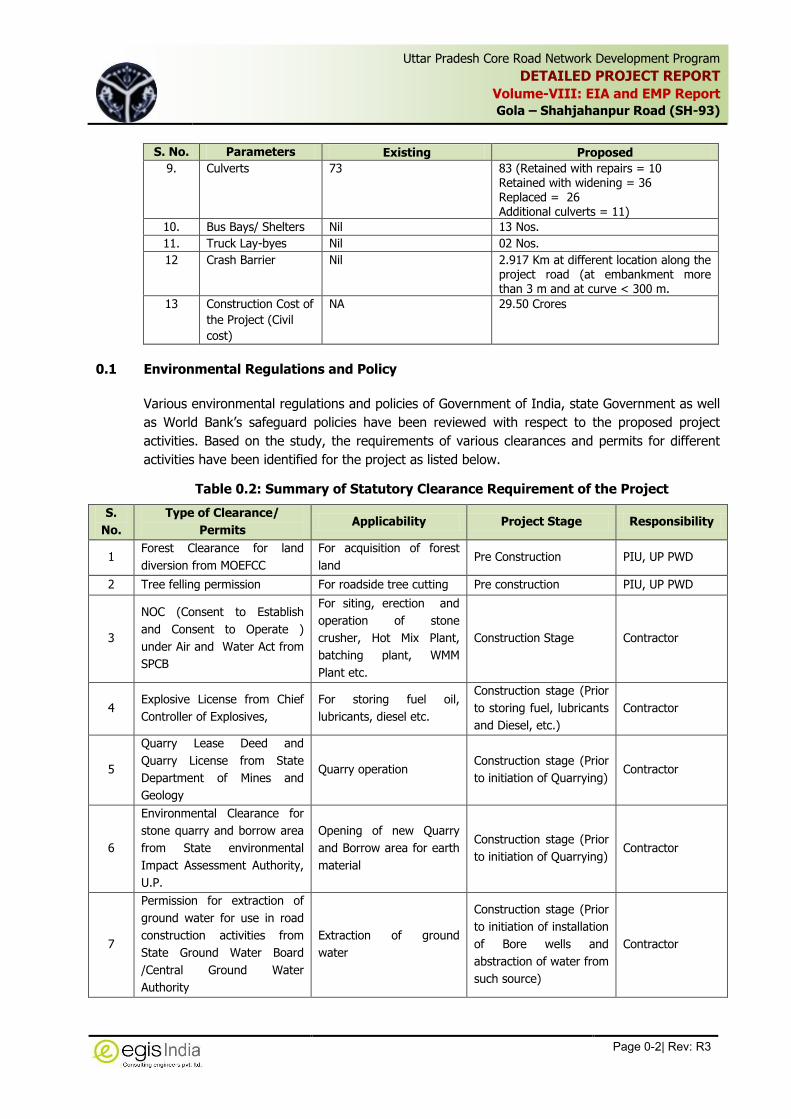
Table 0.1: Salient Design Features of Gola-Shahjahanpur Road Project
S. No. Parameters Existing Proposed
1. Project Length 58.1 Km 58.1 Km
2. ROW Varying from 24 m-36 m Marginal land acquisition for bridge approaches of 5 new bridges
3. Design Speed 100 Kmph
4. Land use Pattern Predominantly agriculture, followed by built up & commercial area
Predominantly agriculture followed by built up & commercial area.
5. Carriageway 2 lane carriageway of 7.0 m without paved shoulder
2 lane carriageway of 7.0 m and 1.5 m paved shoulder
6. Realignment NA 5 due to reconstruction of 4 minor bridges and 1 major bridge
7. Major Bridge 1 No. 1 to be replaced. No additional bridge is proposed
8. No. of Minor Bridge 12 Nos. 12 Nos.(Retained with repairs= 4 Retained with widening = 3 Replaced with new 2 lane bridge = 5). No additional bridge is proposed.
Uttar Pradesh Core Road Network Development Program
DETAILED PROJECT REPORT
Volume-VIII: EIA and EMP Report
Gola – Shahjahanpur Road (SH-93)
Page 0-2| Rev: R3
,
S. No. Parameters Existing Proposed
9. Culverts 73 83 (Retained with repairs = 10 Retained with widening = 36 Replaced = 26 Additional culverts = 11)
10. Bus Bays/ Shelters Nil 13 Nos.
11. Truck Lay-byes Nil 02 Nos.
12 Crash Barrier Nil 2.917 Km at different location along the project road (at embankment more than 3 m and at curve < 300 m.
13 Construction Cost of
the Project (Civil
cost)
NA 29.50 Crores
0.1 Environmental Regulations and Policy
Various environmental regulations and policies of Government of India, state Government as well
as World Bank’s safeguard policies have been reviewed with respect to the proposed project
activities. Based on the study, the requirements of various clearances and permits for different
activities have been identified for the project as listed below.
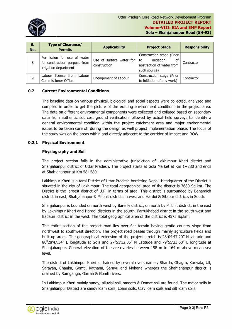
Table 0.2: Summary of Statutory Clearance Requirement of the Project
S.
No.
Type of Clearance/
Permits Applicability Project Stage Responsibility
1 Forest Clearance for land
diversion from MOEFCC
For acquisition of forest
land Pre Construction PIU, UP PWD
2 Tree felling permission For roadside tree cutting Pre construction PIU, UP PWD
3
NOC (Consent to Establish
and Consent to Operate )
under Air and Water Act from
SPCB
For siting, erection and
operation of stone
crusher, Hot Mix Plant,
batching plant, WMM
Plant etc.
Construction Stage Contractor
4 Explosive License from Chief
Controller of Explosives,
For storing fuel oil,
lubricants, diesel etc.
Construction stage (Prior
to storing fuel, lubricants
and Diesel, etc.)
Contractor
5
Quarry Lease Deed and
Quarry License from State
Department of Mines and
Geology
Quarry operation Construction stage (Prior
to initiation of Quarrying) Contractor
6
Environmental Clearance for
stone quarry and borrow area
from State environmental
Impact Assessment Authority,
U.P.
Opening of new Quarry
and Borrow area for earth
material
Construction stage (Prior
to initiation of Quarrying) Contractor
7
Permission for extraction of
ground water for use in road
construction activities from
State Ground Water Board
/Central Ground Water
Authority
Extraction of ground
water
Construction stage (Prior
to initiation of installation
of Bore wells and
abstraction of water from
such source)
Contractor
Uttar Pradesh Core Road Network Development Program
DETAILED PROJECT REPORT
Volume-VIII: EIA and EMP Report
Gola – Shahjahanpur Road (SH-93)
Page 0-3| Rev: R3
,
S.
No.
Type of Clearance/
Permits Applicability Project Stage Responsibility
8
Permission for use of water
for construction purpose from
irrigation department
Use of surface water for
construction
Construction stage (Prior
to initiation of
abstraction of water from
such source)
Contractor
9 Labour license from Labour
Commissioner Office Engagement of Labour
Construction stage (Prior
to initiation of any work) Contractor
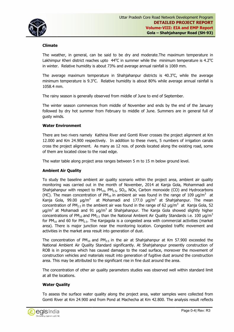
0.2 Current Environmental Conditions
The baseline data on various physical, biological and social aspects were collected, analyzed and
compiled in order to get the picture of the existing environment conditions in the project area.
The data on different environmental components were collected and collated based on secondary
data from authentic sources, ground verification followed by actual field surveys to identify a
general environmental condition within the project catchment area and major environmental
issues to be taken care off during the design as well project implementation phase. The focus of
the study was on the areas within and directly adjacent to the corridor of impact and ROW.
0.2.1 Physical Environment
Physiography and Soil
The project section falls in the administrative jurisdiction of Lakhimpur Kheri district and
Shahjahanpur district of Uttar Pradesh. The project starts at Gola Market at Km 1+280 and ends
at Shahjahanpur at Km 58+580.
Lakhimpur Kheri is a tarai District of Uttar Pradesh bordering Nepal. Headquarter of the District is
situated in the city of Lakhimpur. The total geographical area of the district is 7680 Sq.km. The
District is the largest district of U.P. in terms of area. This district is surrounded by Baharaich
district in east, Shahjahanpur & Pilibhit districts in west and Hardoi & Sitapur districts in South.
Shahjahanpur is bounded on north west by Bareilly district, on north by Pilibhit district, in the east
by Lakhimpur Kheri and Hardoi districts in the sourth, Farrukhabad district in the south west and
Badaun district in the west. The total geographical area of the district is 4575 Sq.km.
The entire section of the project road lies over flat terrain having gentle country slope from
northwest to southwest direction. The project road passes through mainly agriculture fields and
built-up areas. The geographical extension of the project stretch is 28004’47.20’’ N latitude and
80028’47.34” E longitude at Gola and 27051’12.05’’ N Latitude and 79055’23.60’’ E longitude at
Shahjahanpur. General elevation of the area varies between 158 m to 164 m above mean sea
level.
The district of Lakhimpur Kheri is drained by several rivers namely Sharda, Ghagra, Koriyala, Ull,
Sarayan, Chauka, Gomti, Kathana, Sarayu and Mohana whereas the Shahjahanpur district is
drained by Ramganga, Garrah & Gomti rivers.
In Lakhimpur Kheri mainly sandy, alluvial soil, smooth & Domat soil are found. The major soils in
Shahjahanpur District are sandy loam soils, Loam soils, Clay loam soils and silt loam soils.
Uttar Pradesh Core Road Network Development Program
DETAILED PROJECT REPORT
Volume-VIII: EIA and EMP Report
Gola – Shahjahanpur Road (SH-93)
Page 0-4| Rev: R3
,
Climate
The weather, in general, can be said to be dry and moderate.The maximum temperature in
Lakhimpur Kheri district reaches upto 44oC in summer while the minimum temperature is 4.2oC
in winter. Relative humidity is about 73% and average annual rainfall is 1069 mm.
The average maximum temperature in Shahjahanpur districts is 40.3oC, while the average
minimum temperature is 9.3oC. Relative humidity is about 80% while average annual rainfall is
1058.4 mm.
The rainy season is generally observed from middle of June to end of September.
The winter season commences from middle of November and ends by the end of the January
followed by dry hot summer from February to middle of June. Summers are in general full of
gusty winds.
Water Environment
There are two rivers namely Kathina River and Gomti River crosses the project alignment at Km
12.000 and Km 24.900 respectively. In addition to these rivers, 5 numbers of irrigation canals
cross the project alignment. As many as 12 nos. of ponds located along the existing road, some
of them are located close to the road edge.
The water table along project area ranges between 5 m to 15 m below ground level.
Ambient Air Quality
To study the baseline ambient air quality scenario within the project area, ambient air quality
monitoring was carried out in the month of November, 2014 at Kanja Gola, Mohammadi and
Shahjahanpur with respect to PM10, PM2.5, SO2, NOx, Carbon monoxide (CO) and Hydrocarbons
(HC). The mean concentration of PM10 in ambient air was found in the range of 109 µg/m3 at
Kanja Gola, 99.00 µg/m3 at Mohamadi and 177.0 µg/m3 at Shahjahanpur. The mean
concentration of PM2.5 in the ambient air was found in the range of 62 µg/m3 at Kanja Gola, 52
µg/m3 at Mohamadi and 91 µg/m3 at Shahjahanpur. The Kanja Gola showed slightly higher
concentrations of PM10 and PM2.5 than the National Ambient Air Quality Standards i.e. 100 µg/m3
for PM10 and 60 for PM2.5. The Kanjagola is a congested area with commercial activities (market
area). There is major junction near the monitoring location. Congested traffic movement and
activities in the market area result into generation of dust.
The concentration of PM10 and PM2.5 in the air at Shahjahanpur at Km 57.900 exceeded the
National Ambient Air Quality Standard significantly. At Shahjahanpur presently construction of
ROB is in progress which has caused damage to the road surface, moreover the movement of
construction vehicles and materials result into generation of fugitive dust around the construction
area. This may be attributed to the significant rise in fine dust around the area.
The concentration of other air quality parameters studies was observed well within standard limit
at all the locations.
Water Quality
To assess the surface water quality along the project area, water samples were collected from
Gomti River at Km 24.900 and from Pond at Machecha at Km 42.800. The analysis result reflects

Uttar Pradesh Core Road Network Development Program
DETAILED PROJECT REPORT
Volume-VIII: EIA and EMP Report
Gola – Shahjahanpur Road (SH-93)
Page 0-5| Rev: R3
,
that all the surface water bodies from which the water samples were taken, meet the quality
criteria for Class C (Drinking water source after conventional treatment and disinfection) and
Class D (Propagation of Wildlife and Fisheries) of surface water.
To assess the ground water quality along project area, water samples were collected from hand
pumps at Gola, Mohammadi and Shahjahanpur. The pH of the ground water samples varied
between 7.19 to 7.61, which are within the permissible level. The total dissolve solid (TDS) varied
between 320.00 mg/l to 618.00 mg/l, which are within the maximum permissible level as per
IS:10500. The Total hardness (as CaCO3) ranged from 250.8 mg/l to 450.8 mg/l at different
locations along the project road. At Gola and Mohammadi, the Total hardness was more than the
desirable limit of 300 mg/l but within maximum permissible limit as per IS: 10500. The
concentration of Fluoride (as F) is below the permissible limit in all the samples taken along the
project road.
Ambient Noise Levels
The ambient noise level was monitored along project corridor at four locations to assess the noise
pollution levels. The average daytime equivalent noise level was recorded in the range of 53.8
Leq dB(A) to 72.1 Leq dB(A) whereas the same varied from 45.3 Leq dB(A) to 59.2 Leq dB(A)
during night time. The noise level were observed within permissible level for commercial and
mixed area at all the locations except at Shahjahanpur. At Shahjahanpur daytime equivalent
noise was recorded to 72.1 Leq dB(A) which is higher than permissible limit for Commercial and
mixed rea (65 Leq dB(A)) but within permissible level for industrial area. The higher noise level at
Shahjahanpur may be attributed to due to congested built-up area located along the project road
on both the side and congested traffic movement, sugar factory and construction of ROB around
the area at Shahjahanpur. The nighttime equivalent noise levels were within the permissible level
at all the location with their respective to land use zone.
0.2.2 Natural Environment
The Project area is devoid of wildlife sanctuary, national park or notified ecologically sensitive
areas or any other significant area of ecological interest, neither these features are located within
10 km of radius of the project. No threatened or endangered flora or fauna exists along the
project corridor. About 5289 trees falls within ROW which are likely to be affected due to
widening. The predominant tree species are Eucalyptus, Siris, Neem, Sheesham, Mango, etc.
Pockets of reserved forest is located along the project section between Km 12.800 to Km 15.600
on either side of the existing road covering a total length of about 2.800 Km. In these pockets of
reserve forest area plantation of teak, sal and sheesham trees has been done by the local forest
department for commercial utilization. No rare and endangered species are identified in these
areas.
The roadside tree plantation within ROW is declared as Protected Forest; hence the felling of
roadside tree shall attract the provisions of Forest (Conservation) Act and will require forest
clearance for diversion of forest area.
Domesticated animals constitute the faunal density in the area surrounding the project road.
Neelgai, Fox, jackals, etc are spotted in the project area. Damages to the crop by Neelgai are
reported by the local public.

Uttar Pradesh Core Road Network Development Program
DETAILED PROJECT REPORT
Volume-VIII: EIA and EMP Report
Gola – Shahjahanpur Road (SH-93)
Page 0-6| Rev: R3
,
0.2.3 Socio-economic Environment
The project stretch is located in Lakhimpur Kheri and Shahjahanpur districts of Uttar Pradesh
districts. It crosses 34 villages.
Demographic Profile
As per census of India 2011 the Lakhimpur Kheri and Shahjahanpur districts has a population of
527501 persons and 745077 persons respectively. The population density in Lakhimpur Kheri and
Shahjahanpur districts are 382 persons and 858 persons per square Km, respectively. The sex
ratios of Lakhimpur Kheri and Shahjahanpur district are 871 and 894 females respectively for
every 1000 males, which is lower than the state’s ratio of 912. The literacy rates in the districts
are mere 49.58 percent in Lakhimpur Kheri and 50.58 percent in Shahjahanpur district which is
below the literacy rate in the state of Uttar Pradesh (57.25%).
Agriculture Pattern
Agriculture remains the main occupation of the people of the project concerned district and about
80% of the population depends on agriculture for its livelihood. The distribution of area of land
irrigated by different sources of irrigation is Canals and bore wells.
Industries
The project corridor lacks any major industrial establishment except few Rice Mills and Brick Kiln
units have been recorded along the project road..
Cultural Properties
A total number of 22 religious/cultural structures are located along the road. There is no
archaeological structure/monument located in the proximity of project corridor. There are 12
numbers of educational institutions located along the ROW. They constitute sensitive receptor
and will require adequate attention during construction. Apart from these a number of other
community features such as well, hand pumps, bus shelters, etc. are situated which has been
detailed in R&R section.
0.3 Public Consultation
Public consultation has been conducted as an integral part of social and environmental
assessment process of the project with an objective to inform and educate stakeholders about
the proposed action and to receive the public perception about the project. It assists in
identification of the problems associated with the project as well as the needs of the population
likely to be impacted. This participatory process helps in reducing the public resistance to change
and enabled the participation of the local people in this development process. The Public
Consultation was conducted at two levels. The first level public consultation was conducted
before preparation of EIA report in order to identify people’s perception, environmental issues in
the project area and their preferences. After completion of EIA report preparation, second level
Public Consultation was conducted to make people aware about the likely impacts and provisions
made in the project and to invite their objections and suggestions.
During public consultation most of the participants were interested to know about the
compensation issues. With respect to the status of air and water pollution along the project area,
the participants expressed their satisfaction,
Uttar Pradesh Core Road Network Development Program
DETAILED PROJECT REPORT
Volume-VIII: EIA and EMP Report
Gola – Shahjahanpur Road (SH-93)
Page 0-7| Rev: R3
,
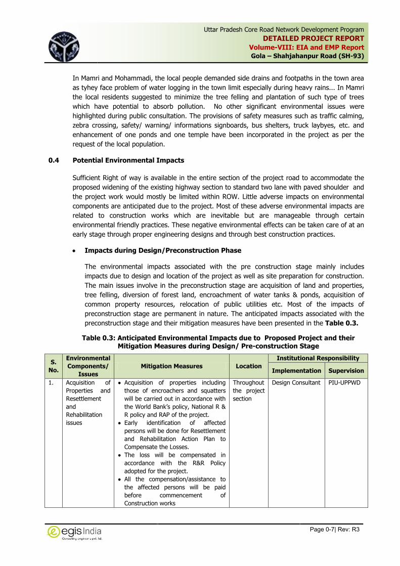
In Mamri and Mohammadi, the local people demanded side drains and footpaths in the town area
as tyhey face problem of water logging in the town limit especially during heavy rains... In Mamri
the local residents suggested to minimize the tree felling and plantation of such type of trees
which have potential to absorb pollution. No other significant environmental issues were
highlighted during public consultation. The provisions of safety measures such as traffic calming,
zebra crossing, safety/ warning/ informations signboards, bus shelters, truck laybyes, etc. and
enhancement of one ponds and one temple have been incorporated in the project as per the
request of the local population.
0.4 Potential Environmental Impacts
Sufficient Right of way is available in the entire section of the project road to accommodate the
proposed widening of the existing highway section to standard two lane with paved shoulder and
the project work would mostly be limited within ROW. Little adverse impacts on environmental
components are anticipated due to the project. Most of these adverse environmental impacts are
related to construction works which are inevitable but are manageable through certain
environmental friendly practices. These negative environmental effects can be taken care of at an
early stage through proper engineering designs and through best construction practices.
Impacts during Design/Preconstruction Phase
The environmental impacts associated with the pre construction stage mainly includes
impacts due to design and location of the project as well as site preparation for construction.
The main issues involve in the preconstruction stage are acquisition of land and properties,
tree felling, diversion of forest land, encroachment of water tanks & ponds, acquisition of
common property resources, relocation of public utilities etc. Most of the impacts of
preconstruction stage are permanent in nature. The anticipated impacts associated with the
preconstruction stage and their mitigation measures have been presented in the Table 0.3.
Table 0.3: Anticipated Environmental Impacts due to Proposed Project and their Mitigation Measures during Design/ Pre-construction Stage
S.
No.
Environmental
Components/
Issues
Mitigation Measures Location
Institutional Responsibility
Implementation Supervision
1.
Acquisition of
Properties and
Resettlement
and
Rehabilitation
issues
Acquisition of properties including
those of encroachers and squatters
will be carried out in accordance with
the World Bank’s policy, National R &
R policy and RAP of the project.
Early identification of affected
persons will be done for Resettlement
and Rehabilitation Action Plan to
Compensate the Losses.
The loss will be compensated in
accordance with the R&R Policy
adopted for the project.
All the compensation/assistance to
the affected persons will be paid
before commencement of
Construction works
Throughout
the project
section
Design Consultant PIU-UPPWD

Uttar Pradesh Core Road Network Development Program
DETAILED PROJECT REPORT
Volume-VIII: EIA and EMP Report
Gola – Shahjahanpur Road (SH-93)
Page 0-8| Rev: R3
,
S.
No.
Environmental
Components/
Issues
Mitigation Measures Location
Institutional Responsibility
Implementation Supervision
2 Inadequate
provision of
cross water
drainage for
regulating
runoff
discharge.
Additional Balancing culverts have
been proposed for ensuring flow of
water and avoiding flooding.
Unlined drains have been proposed
near the ROW limits in open areas
whereas , sufficiently away from the
toe of the embankment.
Lined cover drains have been
proposed in builtup areas to drain
off surface run off from the road
and to intercept sullage from road
side properties
Drains cum raised footpath have
been provided in 11 placed along
the project section.
Provision of rainwater harvesting
pits and the maintenance will be
carried out by the Contractor till
defect liability period and thereafter
by UPPWD
Throughout
the project
section
Design Consultant PIU-UPPWD
3. Cutting of
Roadside Trees
A total number of 5289 trees will be
required to be felled due to the
proposed widening.
All efforts will be made to safeguard
the trees by restricting tree cutting
within the formation width only.
As consultation with Forest
Department, compensatory
plantation will be carried out within
available ROW and land provided by
the Forest Department in the ratio
of 1:2.
Throughout
the project
section
Design Consultant PIU-UPPWD
4. Diversion of
Protected Forest
Area (Roadside
Plantation
within ROW
declared as
Protected
Forest)
Forest Clearance for diversion of
forest area will be obtained prior to
cutting of roadside trees.
Compensatory afforestation will be
carried out as per stipulation under
forest clearance.
Throughout
the project
section
Design Consultant PIU-UPPWD
5. Diversion of
Reserved Forest
area
Diversion of forest land from reserved
forest pocket will attract the provision
of Forest (Conservation) Act and
hence forest clearance would be
required for acquisition of reserve
forest land.
All the conditions stipulated in the
forest clearance will be complied with
during construction.
Between
Km 12.800
to Km
15.600
PIU-UPPWD &
Design Consultant
Contractor
PIU-UPPWD
PMC/PIU-
UPPWD

Uttar Pradesh Core Road Network Development Program
DETAILED PROJECT REPORT
Volume-VIII: EIA and EMP Report
Gola – Shahjahanpur Road (SH-93)
Page 0-9| Rev: R3
,
S.
No.
Environmental
Components/
Issues
Mitigation Measures Location
Institutional Responsibility
Implementation Supervision
No construction Plants, construction
camp, labour camps, borrow area,
stock yards or disposal sites will be
located in the project stretch long the
Reserved Forest. A minimum distance
of 1.000 Km from the reserved forest
patch will be maintained for siting
these features.
The contractor will take all
precautionary measures in the forest
stretch to avoid any incidence of
forest fire.
Contractor PMC/PIU-
UPPWD
6. Common
Resource/
Cultural
Features
A total number of 4 Religious/Cultural
Features, which are located very
close to the road edge, are likely to
be affected due to proposed
widening.
The rehabilitation/ relocation of
structures will be carried out in
consultation with the local community
and compensation will be paid in
accordance with the R&R Policy and
RAP of the project.
The safe entry to these structures
needs to be provided to avoid
accidents and interruption in traffic
movement.
Religious
features
along the
ROW
Design Consultant PIU-UPPWD
7. Ponds Suitable adjustment in the alignment
has been made to avoid
encroachment in the pond.
Stone pitching for protection of slope
have been proposed along the pond.
Additional safety measures in the
form of metal crash barriers along all
the ponds/ abandoned pits have
been proposed.
7 Number
of Ponds
located
along the
ROW
Design Consultant PIU-UPPWD
8. Shifting of
Public Utilities
Shifting of electric poles, hand
pumps, telephone poles and
transformers and underground water
pipelines will be carried out prior to
construction in the stretch with
requisite permission from the line
department.
Alternate arrangement will be made
prior to shifting of these public
utilities
Utility ducts will be provided in
design in order to minimize the
impact on roads during operations.
Throughout
the stretch
Design
Consultant/PIU-
UPPWD
PIU-UPPWD

Uttar Pradesh Core Road Network Development Program
DETAILED PROJECT REPORT
Volume-VIII: EIA and EMP Report
Gola – Shahjahanpur Road (SH-93)
Page 0-10| Rev: R3
,
S.
No.
Environmental
Components/
Issues
Mitigation Measures Location
Institutional Responsibility
Implementation Supervision
9. Flooding and
Damage to the
road due to
overtopping
It is proposed to raise the vertical
profile of the road in the overtopping
sections at one location. Additional
11 numbers of balancing culverts
have been proposed in such sections
to allow passage of water during any
flood. These will have positive
impacts on drainage in this section.
In the
overtopping
section
Design Consultant PIU-UPPWD
10. Traffic Safety/
Accident
Hazards
Geometric corrections, scientifically
designed bus stand and bus bays (13
nos.), , zebra crossings (non-urban
areas), junction improvements (all
major and minor junctions along the
road), and truck lay byes (2 nos.),
regulatory and informative
signboards (all along the project
road), etc have been provided in the
project as per IRC codes.
Traffic calming Measures have been
proposed at fourteen built-up areas
along the project road.
Throughout
the project
section
Design Consultant PIU-UPPWD
Impact during Construction and Operation Phase
During construction period the major environmental issues will be related to dust generation,
emission of gaseous emissions, borrow area and quarry operations, pollution due to operation
of plants and equipments, contamination of land and soil, contamination of water bodies and
public as well as workers health and safety. These anticipated impacts will be mainly
temporary and localised in nature and are likely to persist for short duration till the
construction activities are over in a particular area. However there are some long term
adverse impacts due to construction. The likely impacts due to construction activities and
operation of the project are explained along with the mitigation measures and institutional
responsibility of implementation of environmental safeguards measures in Table 0.4.
Uttar Pradesh Core Road Network Development Program
DETAILED PROJECT REPORT
Volume-VIII: EIA and EMP Report
Gola - Shahajahanpur Road (SH-93)
Page 0-11| Rev: R3
,
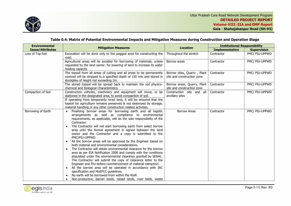
Table 0.4: Matrix of Potential Environmental Impacts and Mitigation Measures during Construction and Operation Stage
Environmental Issue/Attributes
Mitigation Measures Location Institutional Responsibility
Implementation Supervision
Loss of Top Soil Excavation will be done only to the pegged area for constructing the road.
Throughout the stretch Contractor PMC/ PIU-UPPWD
Agricultural areas will be avoided for borrowing of materials, unless requested by the land owner. for lowering of land to increase its water holding capacity.
Borrow areas Contractor PMC/ PIU-UPPWD
The topsoil from all areas of cutting and all areas to be permanently covered will be stripped to a specified depth of 150 mm and stored in stockpiles of height not exceeding 2m.
Borrow sites, Quarry , Plant site and construction zone
Contractor PMC/ PIU-UPPWD
The stored topsoil will be spread back to maintain the soil physico-chemical and biological Characteristics.
Borrow areas, Quarry, Plant site and construction zone
Contractor PMC/ PIU-UPPWD
Compaction of Soil Construction vehicles, machinery and equipment will move, or be stationed in the designated area, to avoid compaction of soil.
Construction site and all ancillary sites
Contractor
PMC/ PIU-UPPWD
If operating from temporarily hired land, it will be ensured that the topsoil for agriculture remains preserved & not destroyed by storage, material handling or any other construction related activities.
Borrowing of Earth Finalizing borrow areas for borrowing earth and all logistic arrangements as well as compliance to environmental requirements, as applicable, will be the sole responsibility of the Contractor.
The Contractor will not start borrowing earth from select borrow area until the formal agreement is signed between the land owner and the Contractor and a copy is submitted to the PMC/PIU-UPPWD.
All the borrow areas will be approved by the Engineer based on
both material and environmental considerations. The Contractor will obtain environmental clearance for the borrow
area as per EIA Notification 2006 and comply with the conditions stipulated under the environmental clearance granted by SEIAA.. The Contractor will submit the copy of clearance letter to the Engineer and PIU before commencement of material extraction.
All the borrow area will be operated in accordance with IRC specification and MoEFCC guidelines.
No earth will be borrowed from within the RoW. Non-productive, barren lands, raised lands, river beds, waste
Borrow Areas Contractor PMC/ PIU-UPPWD

Uttar Pradesh Core Road Network Development Program
DETAILED PROJECT REPORT
Volume-VIII: EIA and EMP Report
Gola - Shahajahanpur Road (SH-93)
Page 0-12| Rev: R3
,
Environmental Issue/Attributes
Mitigation Measures Location Institutional Responsibility
Implementation Supervision
lands are recommended for borrowing earth. The unpaved surfaces used for the haulage of borrow materials
will be maintained properly To avoid any embankment slippages, the borrow areas will not be
dug continuously, and the size and shape of borrow pits will be decided by the Engineer.
Each borrow area will be rehabilitated within one month after completion of extraction of materials to the satisfactions of the land owner and the Engineer.
Borrow area will be manage as per the Borrow Area Management
Plan as per the Annexure 9.3. Before start of extraction of borrow materials, top soil shall be
stripped to a specified depth of 150mm and stored in stockpilesat corners of the borrow area. The height of the stockpile will be restricted to 2m with minimum slope of 1:2 (vertical to horizontal).
The stockpiles of top soil will be covered with gunny bags or tarpaulin.
It will be ensured by the contractor that the topsoil will not be unnecessarily trafficked either before stripping or when in stockpiles. Top soil will be reused/re-laid as per agreed plan. Top soil will also be utilized for redevelopment of borrow areas, landscaping along slopes etc,
Stone Quarry The quarry material will be obtained from licensed sites only, which operate with proper environmental clearances, including clearances under the Air Act.
If the Contractor wants to open a new Quarry, then he has to
obtain necessary environmental clearance from MoEFCC and lease license from Directorate of Geology and Mines.
All the quarries will be approved by the Engineer based on both material and environmental considerations.
The quarry operations will be undertaken within the rules and regulations in force. All safety and environmental concerns will be addresses adequately during quarry operations and transportation of materials as per prevailing rules.
Only controlled blasting shall be carried out, if necessary for
Quarry sites Contractor PMC/ PIU-UPPWD

Uttar Pradesh Core Road Network Development Program
DETAILED PROJECT REPORT
Volume-VIII: EIA and EMP Report
Gola - Shahajahanpur Road (SH-93)
Page 0-13| Rev: R3
,
Environmental Issue/Attributes
Mitigation Measures Location Institutional Responsibility
Implementation Supervision
extraction of stone materials in strict compliance with the statutory norms and specification
The restoration of Quarry will be done as per the conditions of the owner before handing over the site back to the owner.
Soil Contamination from Fuel and lubricants
Impervious platform and oil and grease trap for collection of spillage from constructions and petroleum storage areas, equipment vehicle maintenance platform will be appropriately provided at construction camp, servicing area and liquid fuel as well as lubes at storage areas.
Construction Camp, Vehicle and Equipment Servicing Centre and Construction site
Contractor PMC/ PIU-UPPWD
Soil Contamination from Construction waste and
spoils
All spoils will be disposed off as desired and the site will be fully cleaned before handing over.
Construction site throughout the project stretch
Contractor PMC/ PIU-UPPWD
The non-usable bitumen spoils will be disposed off in a deep trench providing clay lining at the bottom and filled with soil at the top (for at least 0.5 m)
Community water Source Any community water source as wells, tube-wells, etc., lost incidentally will be replaced immediately
Throughout the project stretch
Contractor PMC/ PIU-UPPWD
Drainage and run off Earth, stones, wastes and spoils would be properly disposed off, to avoid blockage of any drainage channel.
Throughout the project stretch
Contractor PMC/ PIU-UPPWD
All necessary precautions will be taken to construct temporary or permanent devices to prevent inundation or ponding.
Contamination of water from construction and allied activities
All necessary precautions will be taken to construct temporary or permanent devices to prevent water pollution due to increased siltation and turbidity.
Throughout the project stretch and allied sites including Construction camp and labour camp
Contractor PMC/ PIU-UPPWD
All wastes arising from the project will be disposed off, as per SPCB norms, so as not to block the flow of water.
Wastes must be collected, stored and taken to approved disposal site.
Sanitation and waste disposal in construction camps
Garbage collection and disposal as well as sanitation facilities will be provided at camps
Construction Camp Contractor PMC/ PIU-UPPWD
The construction camps will be located away from water sources.
Sanitary and sewage disposal facilities at camp to avoid epidemics
The workplace will have proper medical approval by local medical, health or municipal authorities.
Use of water for construction
The Contractor will make arrangements for water required for construction in such a way that the water availability and supply to nearby communities remain unaffected.
Campsites and Plant sites Contractor PMC/ PIU-UPPWD
If a new tube-well is to be bored, prior sanction and approval by the

Uttar Pradesh Core Road Network Development Program
DETAILED PROJECT REPORT
Volume-VIII: EIA and EMP Report
Gola - Shahajahanpur Road (SH-93)
Page 0-14| Rev: R3
,
Environmental Issue/Attributes
Mitigation Measures Location Institutional Responsibility
Implementation Supervision
Ground Water Board/Authority will be obtained
Wastage of water during construction will be minimized.
Emissions from Vehicles and Equipments
All vehicles, equipment and machinery used for construction will be regularly maintained to ensure that the pollution emission levels conform to the statutory norms.
Plant sites Contractor PMC/ PIU-UPPWD PMC; UP State
Pollution Control Board, The asphalt plants, crushers and the batching plants will be sited at
least 1.0 km in the downwind direction from the nearest human settlement and forest area
Dust Generation The hot-mix plants, crushers and batching plants will be sited at least 1.0 km downwind from the nearest habitation. The hot mix plant will be fitted with dust suppression system.
Plant sites and Construction site
Contractor PMC/ PIU-UPPWD
UP State Pollution Control Board, Water will be sprayed in the lime/cement and earth mixing sites,
asphalt mixing site and temporary service and access roads.
After compacting, water will be sprayed on the earthwork regularly to prevent dust.
Material transportation will be carried out in covered vehicles
Vehicles and machinery will be regularly checked to conform to the CPCB Standards for emission
Concrete mixing, batch mix plant, stone crushers, hot mix plant will be well sealed. equipped with dust suppression system
Fly ash will be handled and transported as per IRC specifications to avoid dust generation due to fly ash
Workers at mixing sites will wear nasal masks to reduce the chances of exposure to fine dusts (PM10 & PM2.5)
Regular monitoring of PM10, PM2.5, SO2, NO2, CO and /HC will be carried out as mentioned in the Environmental Monitoring Plan
Noise Pollution from Construction vehicles and Machinery
The plants and equipment used for construction will strictly conform to CPCB noise standards.
Plant sites and Construction site
Contractor PMC/ PIU-UPPWD UP State Pollution
Control Board, Vehicles and equipments used will be fitted with silencer and maintained accordingly.
Noise standards of industrial enterprises will be strictly enforced to protect construction workers from severe noise impacts.
Noise to be monitored (for 24 hrs.) as per monitoring plan
Noise Pollution from Blasting Operation
Only controlled blasting as per Indian Explosives Act will be adopted in quarry area
Quarry site Contractor PMC; PIU-UPPWD, UP State Pollution

Uttar Pradesh Core Road Network Development Program
DETAILED PROJECT REPORT
Volume-VIII: EIA and EMP Report
Gola - Shahajahanpur Road (SH-93)
Page 0-15| Rev: R3
,
Environmental Issue/Attributes
Mitigation Measures Location Institutional Responsibility
Implementation Supervision
People living near such blasting sites will have prior information of operational hours.
Control Board,
Workers at blasting sites will be provided with earplugs
Loss or Damage to Vegetation
Apart from trees earmarked for felling, no additional tree clearing within the RoW will be carried out.
Throughout the stretch Contractor PMC; PIU-UPPWD and Forest Dept.
Area of tree plantation cleared will be replaced according to compensatory Afforestation Policy under Forest Conservation Act-1980.
Compaction of Vegetation Construction vehicles, machinery and equipment will move or be stationed in the designated area only to prevent compaction of vegetation outside the RoW.
Throughout the stretch Contractor PMC/ PIU-UPPWD
While operating on temporarily acquired land for traffic detours, storage, material handling or any other construction related or incidental activities, it will be ensured that the trampling of soil and damage to naturally occurring herbs and grasses is avoided.
Throughout the stretch
Occupational Health & Safety
The Contractor will comply with the requirements of the Environmental, Health, and Safety (EHS), Guidelines of the World Bank Group, April 20071 and the statutory norms of safety during construction. The relevant ones are general guidelines available on the internet.
At Work sites, camp sites and other allied sites
Contractor PMC/ PIU-UPPWD
Adequate drainage, sanitation and waste disposal will be provided at workplaces.
Proper drainage will be maintained around sites to avoid water logging leading to various diseases.
Adequate sanitation and waste disposal facilities will be provided at construction camps by means of septic tanks, soakage pits etc.
A health care system will be maintained at construction camp for routine checkup of workers and avoidance of spread of any communicable disease
Safety of workers undertaking various operations during construction will be ensured by providing appropriate Personnel Protective Equipments (PPEs) such as helmets, masks, safety goggles, safety
1 Reference: (i) http://www.ifc.org/wps/wcm/connect/554e8d80488658e4b76af76a6515bb18/Final%2B-%2BGeneral%2BEHS%2BGuidelines.pdf?MOD=AJPERES and (ii) http://www.ifc.org/wps/wcm/connect/7e4c7f80488554d5b45cf66a6515bb18/Final%2B-%2BToll%2BRoads.pdf?MOD=AJPERES&id=1323162564158]

Uttar Pradesh Core Road Network Development Program
DETAILED PROJECT REPORT
Volume-VIII: EIA and EMP Report
Gola - Shahajahanpur Road (SH-93)
Page 0-16| Rev: R3
,
Environmental Issue/Attributes
Mitigation Measures Location Institutional Responsibility
Implementation Supervision
belts, ear plugs etc. Contractor will also provide safety plans for working at height and electrical safety.
The electrical equipment will be checked regularly
At every work place, a readily available first aid unit including an adequate supply of dressing materials, a mode of transport (ambulance), nursing staff and an attending doctor will be provided.
The Contractor will organize awareness program on HIV aids and sexually transmitted diseases (STDs) for workers on periodic basis.
Public Safety The Contractor will comply with the requirements of the Environmental, Health, and Safety (EHS), Guidelines of the World Bank, April, 2007 and the statutory norms of safety during construction.
At all work zones, borrow areas and other allied sites
Contractor PMC/ PIU-UPPWD
To ensure safe construction in the temporary accesses during construction, lighting devices and safety signal devices will be installed.
Traffic rules and regulations will be strictly adhered to.
Road safety education will be imparted to drivers running construction vehicles.
Adequate signage, barriers and persons with flags during construction to control the traffic will be provided.
Proper barricading will be provided at all the work sites, borrow areas near habitation areas and camp sites will be
At all time safe access for public movement near habitation area will be ensured
Clean-up Operations, Restoration and Rehabilitation
Contractor will prepare site restoration plans, which will be approved by the Engineer.
The cleanup and restoration operations are to be implemented by the Contractor prior to demobilization.
The contractor will clear all the debris material at site, temporary structures; dispose all garbage, night soils and POL waste as per Comprehensive Waste Management Plan and as approved by the Engineer (PMC).
All disposal pits or trenches will be filled in and effectively sealed off. Residual topsoil, if any will be distributed on adjoining/ proximate barren land or areas identified by the PMC in a layer of
Construction zones, Camp and other allied sites After Completion of Construction and before demobilization of Construction Team
Contractor PMC/ PIU-UPPWD

Uttar Pradesh Core Road Network Development Program
DETAILED PROJECT REPORT
Volume-VIII: EIA and EMP Report
Gola - Shahajahanpur Road (SH-93)
Page 0-17| Rev: R3
,
Environmental Issue/Attributes
Mitigation Measures Location Institutional Responsibility
Implementation Supervision
thickness of 75 mm-150 mm. All construction zones including river-beds, culverts, road-side
areas, camps, hot mix plant sites, crushers, batching plant sites and any other area
used/affected by the project will be Left clean and tidy, at the contractor's expense, to the entire
satisfaction of the Engineer (PMC).
Chance finding of Archaeological/historical Properties
All fossils, coins, articles of value of antiquity, structures and other remains of archaeological interests discovered on the site shall be the property of the Government and shall be dealt with as per permissions of the relevant legislation.
The Contractor shall take reasonable precautions to prevent his workmen or any other persons from removing and damaging such articles or things.
The Contractor will immediately stop the work at site upon discovery of such articles or things or archaeological importance during construction.
The Contractor shall, immediately upon discovery thereof and before removal, acquaint the Engineer of such discovery and carry out the Engineer’s instructions for dealing with the same.
The Engineer/PWD will seek direction from the respective Archaeology Department before instructing the Contractor to recommend the work in the site.
Along the project stretch and allied sites of excavation
Contractor PMU/PIU, UPPWD
Operation Phase
Monitoring of Operation Performance
The PIU-UPPWD will monitor the operational performance of the various mitigation/enhancement measures carried out as a part of the project.
The indicators selected for monitoring include the survival rate of trees; utility of enhancement provision for relocated utilities, hand pumps and other relocated structures if any; status of rehabilitation of borrow areas etc.
Throughout the project stretch
Maintenance of Drainage PIU-UPPWD will ensure that all drains (side drains, cross drains etc.) are periodically cleared especially before monsoon season to facilitate the quick passage of rainwater and avoid flooding.
PIU-UPPWD will ensure that all the sediment and oil and grease
Throughout the project Stretch
Contractor till Defect liability period, then PIU-UPPWD
PIU, UPPWD
Uttar Pradesh Core Road Network Development Program
DETAILED PROJECT REPORT
Volume-VIII: EIA and EMP Report
Gola - Shahajahanpur Road (SH-93)
Page 0-18| Rev: R3
,
Environmental Issue/Attributes
Mitigation Measures Location Institutional Responsibility
Implementation Supervision
traps set up at the water bodies are cleared once in every three months.
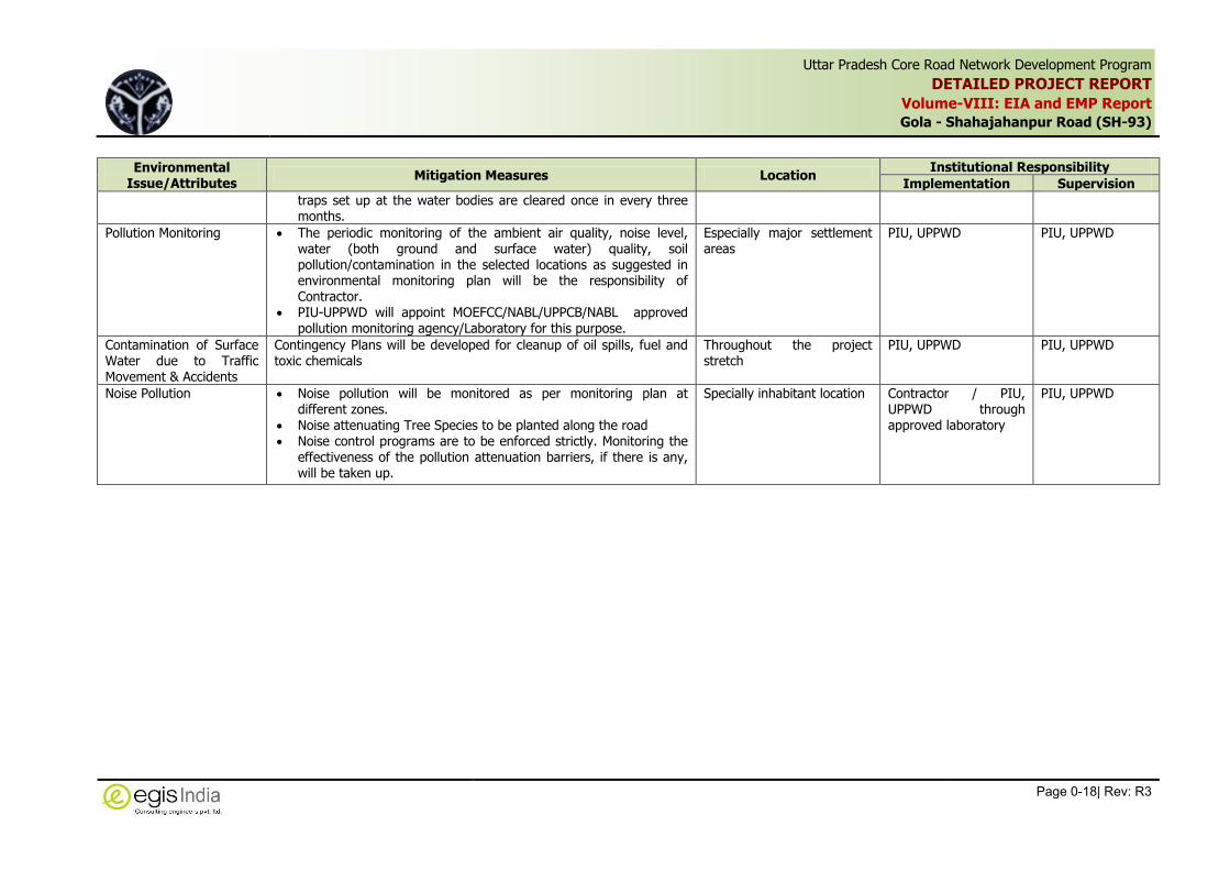
Pollution Monitoring The periodic monitoring of the ambient air quality, noise level, water (both ground and surface water) quality, soil pollution/contamination in the selected locations as suggested in environmental monitoring plan will be the responsibility of Contractor.
PIU-UPPWD will appoint MOEFCC/NABL/UPPCB/NABL approved pollution monitoring agency/Laboratory for this purpose.
Especially major settlement areas
PIU, UPPWD PIU, UPPWD
Contamination of Surface Water due to Traffic Movement & Accidents
Contingency Plans will be developed for cleanup of oil spills, fuel and toxic chemicals
Throughout the project stretch
PIU, UPPWD PIU, UPPWD
Noise Pollution Noise pollution will be monitored as per monitoring plan at different zones.
Noise attenuating Tree Species to be planted along the road Noise control programs are to be enforced strictly. Monitoring the
effectiveness of the pollution attenuation barriers, if there is any, will be taken up.
Specially inhabitant location Contractor / PIU, UPPWD through approved laboratory
PIU, UPPWD

Uttar Pradesh Core Road Network Development Program
DETAILED PROJECT REPORT
Volume-VIII: EIA and EMP Report
Gola - Shahjahanpur Road (SH-93)
Page 0-19| Rev: R3
,
0.5 Analysis of Alternatives
An analysis of “With” and “Without” Project scenario reveals that the positive impacts
outnumbered the negative impacts due to the proposed development. The negative impacts are
envisaged only during the construction period which will be temporary in nature and of short
duration. Further mitigation measures will be adopted to limit the impacts during the construction
phase. The proposed expansion will add in infrastructure development and will act as a catalyst to
boost the economic progress. It was revealed during discussions with various stakeholders that
safety is a major concern along the existing highway section. The safety aspect will be enhanced
considerably with the provision of pedestrian crossings, additional designed bus stands, bus
bays and truck lay byes, which are the significant part of the project.
0.6 Environmental Management Plan
Environmental Management Plan (EMP) is the key to ensure effective implementation of
environmental safeguard measures during different stage of the project. The project specific EMP
has been formulated for mitigating and offsetting the anticipated adverse impacts arising out of
the project activities. The EMP also includes provision of environmental enhancement measures.
The Environmental Management Plan includes implementation Framework, budget, supervision,
monitoring and reporting requirements. Based on identified potential environmental impacts due
to the projects, an Environmental Management Action plan has been develop for implementing
the mitigation measures at different locations as well as different stages of the project. The
institutional responsibility, timeframe and institutional capacity building measures and grievance
redress mechanism have also been included in the EMP. Additional plans like Borrow Area
management, Plant site management, quarry management, campsite management and
plantation scheme are also included in EMP.
Institutional Arrangement for Implementation of EMP
During Preconstruction stage the responsibility of the implementation of mitigation measures is
mainly with Project Implementation Unit of UPPWD. During Construction the primary
responsibility of implementing environmental safeguards measures is with Contractor. The PMC’s
role is supervisory role and they have to ensure the compliance with the provision of
environmental safeguards by the Contractor. The UPPWD will be overall responsible for EMP
implementation.
The UPPWD has established at Environmental and Social Development Cell at both PMU and PIU
level to deal with environmental issues of the project. The PMU has appointed Project
Management Consultant to assist with project preparation and support implementation as
Engineer in-charge who will supervise the Contractors activities, compliances and monitor the
overall progress of work. There is provision of Environmental Specialist in PMC. The Contractor
team will also include Environment and Safety Officer. The Roles and responsibility of
implementation and Supervision Agencies at different levels have been defined in table below.
Table 0.5: Roles and Responsibilities of Environmental Personnel at Different Levels
Position Roles & Responsibilities
PMU’s Environmental and Social Nodal Officer (ESD Cell)
Finalize the EIA and EMP for individual sub-project with inputs from PMC
Confirm integration of EMP provision related to works in the contract documents

Uttar Pradesh Core Road Network Development Program
DETAILED PROJECT REPORT
Volume-VIII: EIA and EMP Report
Gola - Shahjahanpur Road (SH-93)
Page 0-20| Rev: R3
,
Position Roles & Responsibilities
Provide guidance on environmental issues to PIUs Environmental and
Social officers as requested. Coordinate with regulatory agencies like Forest Departments, and at
request of PMC and/or Contractor, UPPCB Prepare regular reports on progress on EMP implementation across the
project with inputs from the PMC’s environmental specialist Document experiences of developing and implementing environmental
mitigation measures an convert it into training material for internal and external capacity building
Facilitate interaction between environmental teams of different sub-projects to allow cross-fertilization of ideas, successes and learnings
Environmental and Social Nodal Officer at PIU (Division Office)
Coordinate with PMC’s environmental specialist to monitor and report on progress on EMP implementation as part of works contracts
Participate in and facilitate consultations with stakeholders Participate in project meetings and report on the issues related to
environmental management to provide for any mid-course corrections that may be required based on situation on the ground
Coordinate on the training and capacity building initiatives
Environmental Specialist, PMC
Lead the development of the sub-project specific EIA and EMP for the entire project
Review contract documents to ensure that EMP provisions related to works are included in the contract documents
Assist the Environmental Specialist in the PMU to follow-up with state government departments
Oversee and report to the PMU on implementation of EMP provisions included in the works contract for each sub-project
Act as a resource person in trainings based on experience on implementing this project and previous relevant work
Contractors’ Environmental and Safety Officer
Lead the implementation of EMP measures included in the Contract Report on progress and shortcomings of the measures implemented to
Environmental Specialist of PMC
Environmental Monitoring Plan
Monitoring of environmental quality during construction and operation stages reflects the success
of implementation of the mitigation measures. Also it provides a chance to review the suggested
measure and improve upon the measures. To ensure the effective implementation of the
Environmental Management Plan (EMP), it is essential that an effective monitoring plan be
designed and carried out. The environmental monitoring plan covering various performance
indicators including periodic monitoring of environmental quality in terms of Air, water, noise and
soil quality, frequency and institutional arrangements for the project in the construction and
operation stages has been formulated for the project. Environmental Monitoring of performance
indicators will be conducted by the project authority. The monitoring plan has been suggested
with performance indicators to be monitored, locations, frequency and timeframe of monitoring.
Periodical monitoring of air, water, noise quality and survival rate of plantations also has been
suggested.
Environmental Enhancement
Enhancement measures for community properties located adjacent to the road has been
proposed in consultation with the local population. The locations identified for enhancements are
at Bagchan Village at Km 9+300, Mohammadi Village at Km 28+000 and at Piperiya Sadak Village
at Km 52+000.
Uttar Pradesh Core Road Network Development Program
DETAILED PROJECT REPORT
Volume-VIII: EIA and EMP Report
Gola - Shahjahanpur Road (SH-93)
Page 0-21| Rev: R3
,
Grievance Redressal Mechanism (GRM)
An integrated system will be established with Grievance Redressal Cells (GRCs), with necessary
officers, officials and systems, at the state as well as sub project levels. Grievances if any, may be
submitted through various mediums, including in person, in written form to a noted address,
through a toll free phone line or through direct calls to concerned officials, and online. PWD will
appoint a person to receive such calls and online messages. A timeframe will be decided for
disposal of redressal. A record will be maintained for action taken to resolve the issues.
Environmental Budgeting
A budgetary provision of Rs. 8.73 Crores has been proposed for implementation of EMP in the
project, which includes various mitigation costs during preconstruction, construction and
operation stages, environmental enhancement measures, as well as environmental monitoring
cost.
0.7 Conclusions
The proposed expansion will add in infrastructure development and will act as a catalyst to boost
the economic progress of the state. It was revealed during discussions with various stakeholders
that after the widening the existing road will ensure smooth flow of traffic thereby will increase
the public safety and comfort. Benefits of the project will be the reduction in air pollution due to
better service levels of the road, reduction in travel time and accidents and better connectivity.
This will definitely encourage the economic along the project stretch, thereby improvement of
socio-economic condition of the area along the project corridor.
With best management practices and a proper environmental management & monitoring plan in
place during construction and operation stages, the proposed project is not expected to cause
any significant adverse effects on the surrounding environment.

Uttar Pradesh Core Road Network Development Program
DETAILED PROJECT REPORT
Volume-VIII: EIA and EMP Report
Gola - Shahjahanpur Road (SH-93)
Page 1-1| Rev: R3
,
1 INTRODUCTION
1.1 Purpose of the Report
Road projects are meant for improving the quality of life for people and developing the country’s
economy. For all positive impacts of the road projects, there may be also some significant
detrimental impacts on nearby communities and natural environment. There may be impact on
properties of people, their livelihood and other social components. Similarly, there can be direct
or indirect impact on flora, fauna, water resources, land use etc. The environment has a limited
carrying capacity and it can only sustain a negative impact up to a level without further
degradation. Several systems, however, temporarily disturb it leading to a new balance in order
to re-establish the equilibrium between human activity and nature. But sensitive systems are not
so resilient to cope up with changes in physical and natural Environment, thus not only leading to
negative impact on them but also, socio-economic losses may occur. To account for all these
issues, environmental and social impact assessment is utmost necessary. These concerns for
environmental and social issues in road projects have also become a part of legal requirements
and for obtaining financial support. Environmental considerations are therefore of prime
importance in road projects.
The EIA study has been conducted for the Gola-Shahjahanpur section of State Highway no. 93
(SH-93) in the district of Lakhimpur Kheri and Shahjahanpur of Uttar Pradesh in accordance with
ESMF prepared for UPCRNDP. The main objective of the study is to incorporate the environmental
consideration in project planning and designing and formulating the Environmental Management
Plan for implementing the environmental safeguards at different states of the project. The
Environmental Management Plan will be part of the bidding document for construction.
1.2 Project Background
The Government of Uttar Pradesh has requested the World Bank through Government of India to
provide assistance for improvement of the Core Road Network of the state.
The state has a road network of 299,604 km, out of which 174,451 km are under Uttar Pradesh
Public Works Department (PWD). The roads under PWD comprise 7,550 km of National Highways
(NHs), 7,530 km of State Highways (SHs), 5,761 km of Major District Roads (MDRs), 3,254 km of
Other District Roads (ODRs) and 138,702 km of Village Roads (VRs). Only about 60% of SHs are
two-lane (7 m). In the entire state 62% of MDRs and 83% of ODRs have widths less than 7 m.
With a view to improve the transport network system, UPPWD has identified 24,095 km of Core
Road Network for the development. This network comprise NH, SH, MDR, ODR and the details
are presented in the table below.
Road Category Length (km)
National Highway (NH) 7.550
State Highway (SH) 7,530
Major District Road (MDR) 5.761
Other District Road (ODR) 3,254
Total 24,095

Uttar Pradesh Core Road Network Development Program
DETAILED PROJECT REPORT
Volume-VIII: EIA and EMP Report
Gola - Shahjahanpur Road (SH-93)
Page 1-2| Rev: R3
,
The Government of Uttar Pradesh has a long-term program to improve the Core Road Network
(CRN) and, as part of this program, has applied for a financial assistance from the World Bank for
developing the Uttar Pradesh Core road Network Development Project (UPCRNDP). The Public
Works Department (PWD) on behalf of Government of Uttar Pradesh engaged Egis India
Consulting Engineers Pvt. Ltd. to carry out Consultancy Services for Uttar Pradesh Core Road
Network Development Plan.
The UPCRNDP will have three Components:
i) Upgrading/reconstruction/widening as well as rehabilitation of selected roads from the
Core Road Network (CRN) including construction of a new Sharda Bridge at Pachpheri
Ghat in Lakhimpur district.
ii) Road Safety Component: A comprehensive and coordinated package of road safety sub-
components to be delivered by the Transport, Home, Public Works and Health
Departments
iii) Road Sector and Institutional Reform Component: This component is likely to include a
program to strengthen PWD asset management of SHs, MDRs and ODRs, to support the
application of IT systems for human resource management and works budgeting and
management across the PWD organization
The improvement works shall primarily consist of raising the formation level, widening to a full
two lanes from the existing single and intermediate lane widths, and/or pavement
rehabilitation/strengthening. Road sections with high volumes of non-motorised traffic will be
widened to 10m with 1.5m full paved shoulders. Roads in urban areas may also require further
widening for provision for drains, sidewalks, accommodate local traffic and parking where
required.
1.3 The Project Road
The proposed project is up-gradation and maintenance of Gola-Shahajahanpur section of SH-93.
from Km 1+280 to Km 58+580, covering a design length of 58.100 km. The road section falls in
two districts namely Lakhimpur Kheri (Km 1+280 to Km 49+000) and Shahjahanpur (Km 49+000
to Km 58+580) in the state of Uttar Pradesh. The project stretch passes through major
settlement areas namely Gola, Mamri, Maheshpur, Mohammadi, Mohamadpur, and Shahjahanpur.
Figure 1.1 illustrates the location of the project road.
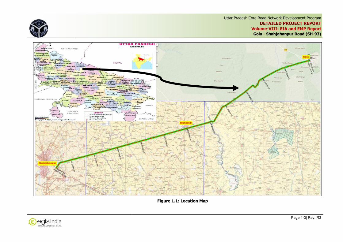
Uttar Pradesh Core Road Network Development Program
DETAILED PROJECT REPORT
Volume-VIII: EIA and EMP Report
Gola - Shahjahanpur Road (SH-93)
Page 1-3| Rev: R3
,
Figure 1.1: Location Map

Uttar Pradesh Core Road Network Development Program
DETAILED PROJECT REPORT
Volume-VIII: EIA and EMP Report
Gola - Shahjahanpur Road (SH-93)
Page 1-4| Rev: R3
,
1.4 Environmental Impact Assessment Study of Project Road
The environmental assessment preparation led to identification of potential environmental
hazards and their feasible remedial measures, based on which the environmental mitigation
measures have been prepared.
1.5 Objectives of the Study
The major objective of this study is to establish present environmental condition along the project
corridor through available data / information supported by field studies to evaluate the impacts
on relevant environmental attributes due to the construction & operation of the proposed project;
to recommend adequate mitigation measures to minimize / reduce adverse impacts and to
prepare an Environmental Management Plan (EMP) for timely implementation of the mitigation
measures to make the project environmentally sound and sustainable. An Environmental Impact
Assessment (EIA) study basically includes:
Establishment of the present environmental scenario;
Study of the specific activities related to the project;
Evaluation of the probable environmental impacts;
Recommendations of necessary environmental control measures; and
Preparation of Environmental Management Plan.
1.6 Scope of the Study
Environmental assessment is a detailed process, which starts from the conception of the project
and continues till the operation phase. The steps for environmental assessment are therefore
different at different phases. The present report details the environmental setting of the project
zone, collects the baseline data and then identifies the anticipated environmental impact and
finally suggests appropriate mitigation measures and mechanism for ensuring effective
implementation of the environmental safeguard measures at different stages of the project.
1.7 Structure of the Environmental Assessment Report
Chapter 1 Introduction
Chapter 2 Project Description
Chapter 3 Methodology
Chapter 4 Environmental Regulatory Framework
Chapter 5 Current Environmental Conditions
Chapter 6 Environmental Impacts and Mitigation Measures
Chapter 7 Analysis of Alternatives
Chapter 8 Public Consultation
Chapter 9 Environmental Management Plan

Uttar Pradesh Core Road Network Development Program
DETAILED PROJECT REPORT
Volume-VIII: EIA and EMP Report
Gola - Shahjahanpur Road (SH-93)
Page 2-1| Rev: R3
,
2 PROJECT DESCRIPTION
2.1 Introduction
The Government of Uttar Pradesh has requested the World Bank through Government of India
(GoI) to provide assistance for improvement of the Core Road Network (CRN) of the state.
The Government of Uttar Pradesh has a long-term program to improve the Core Road Network
(CRN) and, as part of this program, has applied for a financial assistance from the World Bank for
developing the Uttar Pradesh Core road Network Development Project (UPCRNDP). The Public
Works Department (PWD) on behalf of Government of Uttar Pradesh engaged Egis India
Consulting Engineers Pvt. Ltd. to carry out Consultancy Services for Uttar Pradesh Core Road
Network Development Plan.
The improvement works shall primarily consist of raising the formation level, widening to a full
two lanes with paved shoulder from the existing single and intermediate lane widths and/or
pavement rehabilitation/ strengthening. Roads in urban areas may also require further widening
for provision for drains, sidewalks, accommodate local traffic and parking where required.
2.2 Need for the Project
Road projects are generally undertaken to improve the economic and social welfare of those
using the road or served by it. Increased road capacity and improved pavements can reduce
travel times and lower the costs of vehicle use. Benefits include increased access to markets,
jobs, education and health services, and reduced transport costs for both freight and passengers,
reduce fuel consumption and exhaust emissions from the vehicle plying on the road. It became
imperative to improve the connectivity by widening the road section for overall socio-economic
growth in the area.
2.3 Project Objective
The key objective of PWD is to improve “Core Road Network” and the consultant’s services should
deliver and manage the identified road through scientific tools for planning, programming and
budgeting; enhancing safety and capacity of existing roads.
On completion and/ or during progress of the proposed services, the UPCRNDP will able to:
upgrade/ reconstruct/ widen as well rehabilitate selected roads:
carry out road safety enhancement work;
do planning, budgeting and programme to strengthen PWD project, asset and financial
management;
use Information Technology and integrated IT systems efficiently and effectively;
have trained staff for new processes and procedures; and
improve public and external stakeholder support and awareness.

Uttar Pradesh Core Road Network Development Program
DETAILED PROJECT REPORT
Volume-VIII: EIA and EMP Report
Gola - Shahjahanpur Road (SH-93)
Page 2-2| Rev: R3
,
2.4 Project Approach for Environmental Studies
The basic approach adopted for conducting the environmental study for the project is to strongly
pursue the prevailing institutional and legislative setup of the Government of India (GoI) and
World Bank Safeguard Policies on this subject. The main approaches for the study are:
Identification, appraisal and division between positive and negative impacts, direct and
indirect impacts, and instant and long-term impacts likely to result from project road;
Identification of unavoidable or irreversible impacts;
Identification of un-mitigated negative impacts;
Exploration towards the opportunities for environmental enhancement; and
Identification of feasible and cost effective mitigation measures to minimize negative
impacts and enhance positive impacts by incorporating in the preliminary engineering
design.
Preparation of Environmental Management Plan for effective implementation of
environmental mitigation measures at different stages of the project.
2.5 Project Location
The project road is part of of State Highway No. 93 (SH-93), which is located in the districts of
Lakhimpur Kheri and Shahajahanpur. The project section of SH-93 starts from Gola Market at Km
1.280 and ends at Shahjahanpur at Km 58.580, covering a design length of 58.100 km. The key
location of project road is indicated in Figure 2.1.
Figure 2.1: Project Location
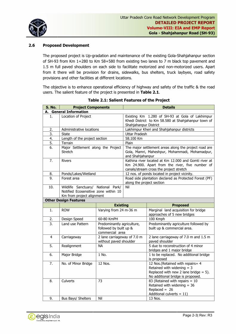
Uttar Pradesh Core Road Network Development Program
DETAILED PROJECT REPORT
Volume-VIII: EIA and EMP Report
Gola - Shahjahanpur Road (SH-93)
Page 2-3| Rev: R3
,
2.6 Proposed Development
The proposed project is Up-gradation and maintenance of the existing Gola-Shahjahanpur section
of SH-93 from Km 1+280 to Km 58+580 from existing two lanes to 7 m black top pavement and
1.5 m full paved shoulders on each side to facilitate motorized and non-motorized users. Apart
from it there will be provision for drains, sidewalks, bus shelters, truck laybyes, road safety
provisions and other facilities at different locations.
The objective is to enhance operational efficiency of highway and safety of the traffic & the road
users. The salient feature of the project is presented in Table 2.1.
Table 2.1: Salient Features of the Project
S. No. Project Components Details
A. General Information
1. Location of Project Existing Km 1.280 of SH-93 at Gola of Lakhimpur Khedi District to Km 58.580 at Shahjahanpur town of Shahjahanpur District
2. Administrative locations Lakhimpur Kheri and Shahjahanpur districts
3. State Uttar Pradesh
4. Length of the project section 58.100 Km
5. Terrain Plain
6. Major Settlement along the Project Stretch
The major settlement areas along the project road are Gola, Mamri, Maheshpur, Mohammadi, Mohamadpur, and Shahjahanpur
7. Rivers Kathina river located at Km 12.000 and Gomti river at Km 24.900. Apart from the river, five number of canals/stream cross the project stretch
8. Ponds/Lakes/Wetland 12 nos. of ponds located in project vicinity.
9. Forest area Road side plantation declared as Protected Forest (PF) along the project section
10. Wildlife Sanctuary/ National Park/ Notified Ecosensitive zone within 10 Km from project alignment
Nil
Other Design Features
Existing Proposed
1. ROW Varying from 24 m-36 m Marginal land acquisition for bridge approaches of 5 new bridges
2. Design Speed 60-80 KmPH 100 Kmph
3. Land use Pattern Predominantly agriculture, followed by built up & commercial area
Predominantly agriculture followed by built up & commercial area.
4 Carriageway 2 lane carriageway of 7.0 m without paved shoulder
2 lane carriageway of 7.0 m and 1.5 m paved shoulder
5. Realignment NA 5 due to reconstruction of 4 minor bridges and 1 major bridge
6. Major Bridge 1 No. 1 to be replaced. No additional bridge is proposed
7. No. of Minor Bridge 12 Nos. 12 Nos.(Retained with repairs= 4 Retained with widening = 3 Replaced with new 2 lane bridge = 5). No additional bridge is proposed.
8. Culverts 73 83 (Retained with repairs = 10 Retained with widening = 36 Replaced = 26 Additional culverts = 11)
9. Bus Bays/ Shelters Nil 13 Nos.
Uttar Pradesh Core Road Network Development Program
DETAILED PROJECT REPORT
Volume-VIII: EIA and EMP Report
Gola - Shahjahanpur Road (SH-93)
Page 2-4| Rev: R3
,
S. No. Project Components Details
10. Truck Lay-byes Nil 02 Nos.
11. Crash Barrier Nil 2.917 Km at different location along the project road (at embankment more than 3 m and at curve < 300 m.
12. Construction Cost of
the Project (Civil
cost)
NA 29.50 Crores
2.7 Project Proposal
2.7.1 Right of Way (ROW)
The ROW details are being furnished as per revenue records/maps for further processing. The
ROW of project road varying from 24 m-36 m.
2.7.2 Traffic Volume
A detailed traffic surveys and analysis for the project roads have been conducted in the year
2014, hereinafter called, “Base Year”. Detailed traffic projections over the design life and growth
rates obtained for different types of vehicles are discussed in traffic chapter. For the purpose of
pavement design, commercial vehicles of gross vehicle weight more than 3 ton have been
considered. Such vehicles consisted of buses, LCVs, 2 axle trucks, 3 axle trucks and multi axle
trucks.
From total projected base year AADT and estimated traffic growth rates, vehicle category-wise
traffic volume projections have been made for various design periods. Table 2.2 gives the total
projected base year (2014) traffic volumes in terms of AADT for each of the identified traffic
homogeneous section and has been used for the estimation of design traffic in terms of MSA for
pavement design.
Table 2.2: Base Year Traffic Volumes
Vehicle Type Near Mamri at Km 5+900
(Gola-Gomtimore)
Near Mohmmadpur at Km 47+000 (Gomti More to
Shahjahanpur)
Two Wheeler 4603 3096
Three Wheeler 317 403
Car/Van/Jeep 724 766
Mini Bus 87 91
Standard Bus 87 95
LCV 41 145
2 Axle Truck 54 105
3 Axle Truck 60 274
MAV 16 71
Agricultural Tractor 8 12
Agricultural Tractor & Trailor 56 47
Non Motorised Vehicles
Cycle 5578 1374
Cycle Rickshaw 16 7
Animal Drawn Vehicles 72 68

Uttar Pradesh Core Road Network Development Program
DETAILED PROJECT REPORT
Volume-VIII: EIA and EMP Report
Gola - Shahjahanpur Road (SH-93)
Page 2-5| Rev: R3
,
Vehicle Type Near Mamri at Km 5+900
(Gola-Gomtimore)
Near Mohmmadpur at Km 47+000 (Gomti More to
Shahjahanpur)
Hand Cart 2 3
Others 0 0
Vehicles
Motorised 6053 5105
Non Motorised 5668 1452
Total 11721 6557
PCU
Motorised 4474 5042
Non Motorised 3115 982
Total 7589 6024
2.7.3 Traffic Projection
The total corridor traffic is the sum of normal traffic and induced traffic. The total estimated
traffic on the project road has been presented in the Table 2.3.
Table 2.3: Traffic Projection for Homogeneous Sections
Year Gola-Gomtimore Gomtimore-Shahjahanpur
Vehicles PCU Vehicles PCU
2014-2015 11721 7589 6557 6024
2019-2020 14335 9641 8642 7936
2024-2025 18394 12296 11838 10545
2029-2030 24692 16347 16741 14422
2034-2035 33341 21826 23429 19584
2039-2040 46034 29778 33179 26945
2042-2043 56350 36185 41066 32812
2.7.4 Structures
As per inventory survey, the project road has 13 bridges out of which 12 are minor bridges and 1
major bridge. There are 73 culverts. Based on condition survey, hydraulic studies, size of pipe
culverts, revised profile of the road; it is revealed that a few additional cross-drainage structures
(culverts) shall need to be constructed. The summary of existing and improvement proposals is
given in Table 2.4:
Table 2.4: Summary of Improvement of Culverts
Particulars
Type of Culverts
Pipe Culverts
Arch Culverts
Slab Box Stone Slab Total
Existing culverts 8 42 23 - - 73
Improvement proposals
To be retained with repairs - 3 7 - - 10
To be retained with widening 1 22 13 - - 36
To be Replaced Box culverts - 10 3 - - 13
HP culverts 6* 7 - - - 13
Additional Construction 4 - - 6 - 10
Total 11 42 23 6 0 82
*Pipe culvert at km 58+907 not considered

Uttar Pradesh Core Road Network Development Program
DETAILED PROJECT REPORT
Volume-VIII: EIA and EMP Report
Gola - Shahjahanpur Road (SH-93)
Page 2-6| Rev: R3
,
Improvement proposals category-wise for culverts, minor bridges and major bridges are detailed hereunder.
Table 2.5: Summary of Improvement of Bridges
Particular Minor Bridge Major Bridge Total
Existing Structures 12 1 13
To be retained with repairs 5 - 5
To be retained with widening 3 - 3
To be Replaced 4 1 5
New additional construction - - -
Total 12 1 13
It is proposed to raise the vertical profile of the road in the overtopping sections at one location
between Km 12+200 to Km 12+590 for a length of 390 m due to HFL. Additional 10 numbers of
balancing culverts have been proposed at different locations to allow passage of water during any
flood which will have positive impacts on drainage
2.7.5 Bus Bays and Bus Shelters
Bus stops with bus shelters have been proposed at different locations. Bus lay byes have been
provided on both sides (LHS & RHS) of the road.. The detail locations of busbays and shelters
are provided in Table 2.6.
Table 2.6: List of Proposed Bus bays
S. No. Design Chainage (Km)
Remarks LHS RHS
1 1+575 1+603 Gola Bypass Road
2 6+250 6+060 Mamri Village
3 9+430 9+530 Baga Chana Village
4 11+000 11+120 Maheshpur Village
5 16+860 16+720 Reharia Village
6 19+010 19+110 Pipraiya Dhani Village
7 26+970 26+800 Doon Public School 27.100 /Politechnical College 27.450
8 29+760 29+870 Mohammadi Village
9 31+700 31+540 Dhrampur Village
10 41+270 41+010 BHS Village Road
11 44+260 44+100 Machhechha (Sangasthan Inter College)
12 47+700 47+810 Mohamadpur Village
13 57+970 58+070 Hathora Bajra Village
2.7.6 Truck Lay-byes
Truck laybyes have been provided at 2 locations based on site investigations of freight activities
and stoppage of such heavy vehicles. The list of proposed truck lay-byes is given Table 2.7.
Table 2.7: List of Proposed Truck Lay-byes
S. No. Design Chainage (Km) Remarks
1 24+200 RHS
2 26+250 LHS
2.7.7 Accident Data
The accident data for the analysis were collected from five police stations along the project road,
which is given in Table 2.8.

Uttar Pradesh Core Road Network Development Program
DETAILED PROJECT REPORT
Volume-VIII: EIA and EMP Report
Gola - Shahjahanpur Road (SH-93)
Page 2-7| Rev: R3
,
Table 2.8: Details of Accident Data collected
S. No Road File name Year Data
1 SH-93 Gola 2010-14 9
2 SH-93 Hyderabad 2010-14 17
3 SH-93 Mohammadi 2011-14 53
4 SH-93 Pasagava 2011-14 8
5 SH-93 Roza 2011-14 16
Total 103
2.7.8 Road Safety Measures
The safety aspects have been incorporated in project design, given in Table 2.9 and detailed
have been provided in Improvement Proposal of Detailed Design Report. Also a separate Crash
analysis report has been prepared as part of detailed design report. Crash analysis was carried
out to identify the locations having frequent accidents. This will help to rectify the problems in
those locations causing regular accidents and thereby reducing accident counts.
Table 2.9: Road Safety Measures
S. No. Design Aspect Proposed Locations along the project road
1. The toe wall of varying height
Chainage (Km) Length (m) Side Height
From To
12+790 12+890 100 L 5.0
24+920 25+110 190 L 3.0
25+130 25+300 170 R 2.0
33+675 33+750 75 R 1.0
35+530 35+850 320 R 1.5
36+430 36+690 260 R 1.0
49+185 49+385 200 L 1.0
49+430 49+445 15 L 1.5
2. Crash Barriers (W beam metal crash barrier) provided at curves and at the locations where the embankment is greater than 3 meter, narrow Bridge and at curves less than 300 m radius.
Location of Provision of Crash Barriers
Embankment Height>3m (Left)
From (Design CH) To (Design CH) Length (Km)
5+480 5+560 0.080
12+500 12+730 0.230
12+780 12+800 0.020
24+990 25+050 0.060
25+090 25+100 0.010
25+350 25+540 0.190
25+660 25+770 0.110
35+200 35+240 0.040
46+870 46+955 0.085
46+991 47+120 0.129
Total 0.954
Embankment Height>3m (Right)
From (Design CH) To (Design CH) Length (Km)
5+450 5+590 0.140
25+140 25+283 0.143
43+537 43+650 0.113
43+690 43+820 0.130
Total 0.526

Uttar Pradesh Core Road Network Development Program
DETAILED PROJECT REPORT
Volume-VIII: EIA and EMP Report
Gola - Shahjahanpur Road (SH-93)
Page 2-8| Rev: R3
,
S. No. Design Aspect Proposed Locations along the project road
Curve < 300m Radius(outer Edge)
Design CH. Length (Km)
side
From To
11+267 11+407 Built up Right
12+167 12+374 0.208 left
12+937 13+104 0.167 left
13+454 13+728 0.274 Right
21+309 21+488 0.178 Right
25+283 25+472 0.189 Right
25+738 25+884 0.146 Right
25+885 26+037 0.153 left
43+467 43+537 0.070 left
43+548 43+618 Covered in embankment height Right
58+108 58+160 0.052 Right
Total 1.437
3. Roadway delineators
(a) Roadway indicators Metal roadway indicators with circular cross-section are proposed. These are generally proposed in non-urban sections especially in curved sections of radius less than 360m.
(b) Road Reflector Pavement Markers (RRPM) The road reflective pavement markers (RRPM) i.e. road studs are proposed to improve the visibility in night time and wet weather conditions. Their use is restricted on locations like on approach to narrow bridge and culverts and adjacent to bridge parapet on traffic side, built-up areas and approaches to major intersections.
(c) Hazard Markers Type 2 Stripped markers consisting of alternatively black and yellow stripes are proposed where the objects close to the road constitutes an accident hazard. The locations are all bridge and culvert (primarily narrow) abutments.
4 Table tops / Speed hump These are proposed in advance of sharp curves, traffic calming zones, and village/urban approaches. These are also provided at some hazard locations or accident black spots like approach to temples/ schools etc. Proper sign boards and marking would be provided to advise the drivers in advance of these speed reducing devices.
5 Traffic Calming Measures proposed Gateway Signs Gateway Markings Speed Calming Night time Visibility
Traffic calming Measures have been proposed at following eleven locations:
Built-up Area From CH. (Km) To CH. (Km)
Gola 1+281 3+100
Mamri 5+800 6+500
Baga Chana 9+300 10+000
Maheshpur 10+500 11+700
Reharia 16+600 17+300
Pipraiya Dhani 18+500 20+700
Mohammadi 28+700 31+800
Dhrampur 31+900 32+770
Mohamadpur 46+780 48+200
Hathora Bajra 57+800 58+470
Hathora Bajra 59+035 59+377
6 Road Signs: Cautionary, Mandatory and Informatory Signs
Provided all along the project section

Uttar Pradesh Core Road Network Development Program
DETAILED PROJECT REPORT
Volume-VIII: EIA and EMP Report
Gola - Shahjahanpur Road (SH-93)
Page 2-9| Rev: R3
,
2.8 Material Requirements
The requirement of different materials for construction of roads including bridges and culverts is
given below:
S.
No. Materials Quantity Potential Source
1 Aggregate 554500 cum From Approved Stone
2 Earth 419000cum Soil generated due to roadway cutting and drain excavation
as well as Nearby approved Borrow Areas
3 Sand 16100cum Approved Sand Quarry
4 Bitumen 10100 MT IOC Mathura Refinery / IOC Panipat Refinery
5 Fly ash 24180 Cum Reliance Thermal plant at Rosa
6 Cement 12600 MT Authorized vendor
7 Steel 1474.100 MT Authorized vendors
2.9 Typical Cross Section
Drawings of the typical cross sections (TCS) adopted on the project road are included at the end
of this Chapter. The details of typical cross-sections are given in Table 2.10.
Table 2.10: Typical cross-sections
S. No. Cross Section
Type Description
1. TCS -1A Two lane carriageway with paved and earthen shoulder (rural section) – Overlay section
2. TCS -1B Two lane carriageway with paved and earthen shoulder (rural section) - Reconstruction
3. TCS -1C Two lane carriageway with paved and earthen shoulder (rural section) – New due to raising
4. TCS -1D Two lane carriageway with paved and earthen shoulder (rural section) – realignment
5. TCS -2A Two lane carriageway with paved shoulder and raised footpath cum drain (urban/ semi-urban section) – Overlay section
6. TCS -2B Two lane carriageway with paved shoulder and raised footpath cum drain (urban/ semi-urban section) – Reconstruction section
7. TCS -3 Four lane carriageway with lined drain cum footpath
The typical cross-sections are shown in Figure 2.2.

Uttar Pradesh Core Road Network Development Program
DETAILED PROJECT REPORT
Volume-VIII: EIA and EMP Report
Gola -Shahjahanpur Road (SH-93)
Page 2-10| Rev: R3
,
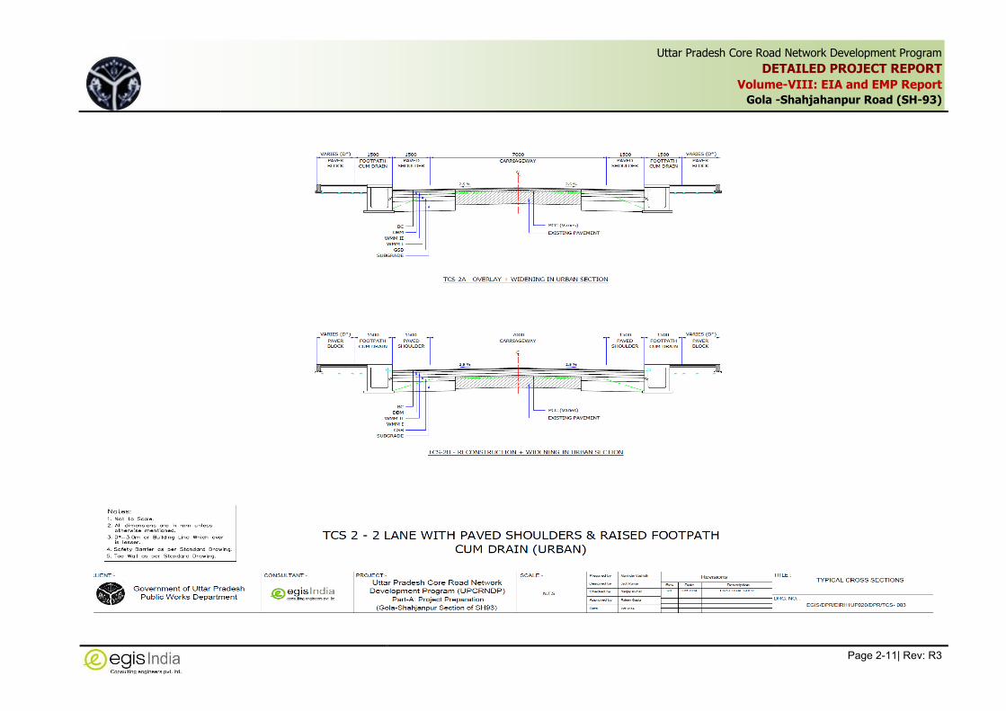
Uttar Pradesh Core Road Network Development Program
DETAILED PROJECT REPORT
Volume-VIII: EIA and EMP Report
Gola -Shahjahanpur Road (SH-93)
Page 2-11| Rev: R3
,

Uttar Pradesh Core Road Network Development Program
DETAILED PROJECT REPORT
Volume-VIII: EIA and EMP Report
Gola -Shahjahanpur Road (SH-93)
Page 2-12| Rev: R3
,
Figure 2.2: Typical Cross-section

Uttar Pradesh Core Road Network Development Program
DETAILED PROJECT REPORT
Volume-VIII: EIA and EMP Report
Gola -Shahjahanpur Road (SH-93)
Page 3-1| Rev: R3
,
3 METHODOLOGY
3.1 Introduction
A project specific Environmental Assessment study has been carried out for proposed upgradation
and improvement of Gola-Shahjahanpur section of State Highway No.-93 in accordance with the
Environmental and Social Management Framework (ESMF) developed for UPCRNDP Projects,
guidelines and operational manual of World Bank and guidelines of Ministry of Environment,
Forests and Climate Change (MOEFCC), Government of India.
The approach to carry out site specific EIA study was organized in four tasks and is based on the
field investigations and reconnaissance surveys in the project area, collection, collation and
analysis of secondary data and discussions with key stakeholders on the potential impacts of the
project. Information on various environmental components were collected through survey
oriented screening, collection of data using questionnaire, monitoring of air, water and soil quality
and collection of secondary data.
The Screening exercise along the existing road pinpointed the environmental constraints. The hot
spots identified during the screening exercise were further assessed for their criticality and
impacts jointly by teams of environmental specialist, social impact specialist, design engineers
and surveyors. The proposed alignment has been examined in detail for any direct, indirect or
impact on environmental characteristics during feasibility report preparation. A variety of
mitigation measures have been included in road design to minimize the adverse effects of road
widening on environmental components. During screening following screening matrix was used to
assess the extent of potential impacts on different environmental components. The Environmental
screening matrix of project is given in Table 3.1.
Table 3.1: Environmental Screening Matrix for Gola-Shahjahanpur of SH-93 Project
S. No.
Environmental Feature
Category Assigned
(High/ Medium/ Low)
Significance (based on extent of length affected
or numbers involved) Remark/Explanation
A. Physical Environment
1 Drainage Conditions Low Nil Drainage has been proposed along the project section
2 Surface Water Resources
Low 2 River and 5 nos. of canals are located in the project corridor, apart from these 12 nos. of ponds are located along the project road
Suitable protection measures in design like provision of toe wall/ retaining wall/ widening on opposite side has been recommended.
3 Erosion Prone stretches
Medium 2 locations for 500 m at High embankment near bridge across Kahthani River at Km 12.000 and at Gomti River at Km 24.900.
Slope Protection has been recommended.
4 Construction Material Medium It has been estimated that due to roadway cutting and drain excavation huge quantity of earth work materials will be generated,
Sufficient borrow/quarry areas are available along the project road. Appropriate Mitigation measures will be required during extraction and

Uttar Pradesh Core Road Network Development Program
DETAILED PROJECT REPORT
Volume-VIII: EIA and EMP Report
Gola -Shahjahanpur Road (SH-93)
Page 3-2| Rev: R3
,
S. No.
Environmental Feature
Category Assigned
(High/ Medium/ Low)
Significance (based on extent of length affected
or numbers involved) Remark/Explanation
which can be reused for sub-grade and earthen shoulder to reduce the additional quantity requirement.
transportation of materials and rehabilitation of the area to minimise the impact. Exploration of use of flyash is required to reduce the required earth quantity for construction. The Impact will be temporary in nature till material extraction and completion of restoration work.
5 Topography - - No Impact on topography is envisaged.
B. Biological Environment
1 National Park / Wildlife Sanctuary
Nil - There is no Wildlife Sanctuary /National Park or eco-sensitive zone within 10 Km radius of project road
2 Non-NP/WLS areas Nil - -
3 Migratory routes Nil - Not any within the project corridor
4 Reserved Forests Medium Km 12.200 to Km 15.600 Roadside plantation along this area. Provisions are made for alternate land for the plantation.
5 Green Tunnels/ Large Trees
Nil - Not any within the project corridor
6 Protected Forests Medium Though out the project section (around 5300 trees are located within ROW, which are likely to be impacted)
Road side plantation within existing ROW has been declared as Protected forest throughout the project road. Provision shall be made for compensatory tree plantation on the basis of minimum 1:2
C. Human Environment
1 Settlement Medium Few encroachers and squatters have been recorded within RoW which are likely to be affected. In the section of junction improvement, ROB, bridge approach and 4-laning will attract acquisition of land and structures beyond ROW especially between Km 12.300 to Km 13.050; Km 25.100 to Km 25.900; Km 43.400 to Km 44.050; Km 46.800 to Km 47.200; and Km 52.000 to Km 52.550.
The project activities will be confined mostly to the available Right of Way (ROW) except at 5 sections where the widening would require additional land acquisition. As per baseline survey on social features within 10 m corridor, it has been revealed that there are number of squatters and encroachers within the existing ROW. So even though the widening is proposed within the existing ROW, the project envisages acquisition of various commercial and residential structures and displacement of Non titleholders (NTH). For assessment of affected titleholders, impact on land

Uttar Pradesh Core Road Network Development Program
DETAILED PROJECT REPORT
Volume-VIII: EIA and EMP Report
Gola -Shahjahanpur Road (SH-93)
Page 3-3| Rev: R3
,
S. No.
Environmental Feature
Category Assigned
(High/ Medium/ Low)
Significance (based on extent of length affected
or numbers involved) Remark/Explanation
and properties as well as persons will be estimated after detailed survey. The compensation will be paid as per defined R & R Policy in the project.
2 Sensitive Receptors Medium There are 12 numbers of educational institutions/ hospitals/ heath centres located along ROW.
Sensitive receptors are located adjacent to ROW and during construction period there will be temporary impact due to dust emission/noise pollution, which will be minimised with proper mitigation measures. No plant and equipment will be erected in the vicinity of these sensitive receptors. During night time, no construction activity will be performed near sensitive receptors.
3 Drinking Water sources
Low About 107 hand pumps are located within ROW.
This is temporary impact on drinking water source, till relocation. The relocation of hand pumps will be ensured with shortest possible time before commencement of construction activities. Alternative arrangement of drinking water will be made till completion of the relocation of water sources.
4 Physical cultural Resources – Religious
Medium There are about 22 numbers of religious structures located in the project corridor.
Adjustment in the alignment to avoids impact on religious structures. A total number of 4 Religious/Cultural Features, which are located very close to the road edge, are likely to be affected due to proposed widening.
5 Utilities like electricity lines, pipelines for gas, etc
Medium Water supply line is observed at Mohammadi at RHS covering a total length of about 3 Kms. About 95 electric poles, 32 transformers, 11 telephone poles and 107 hand pumps are likely to be impacted.
The impact will be temporary. The water supply lines will be shifted during construction stage of the project road. The relocation of hand pumps will be ensured with shortest possible time before commencement of construction activities. Alternative arrangement of drinking water will be made till completion of the relocation of water sources.
Uttar Pradesh Core Road Network Development Program
DETAILED PROJECT REPORT
Volume-VIII: EIA and EMP Report
Gola -Shahjahanpur Road (SH-93)
Page 3-4| Rev: R3
,
The analysis of location of environmental features with respect to the project alignment and
extent of identified impacts due to project, reflect that most of the impacts are of low and
medium extent and mainly related to construction activities which are mostly temporary in
nature. Based on the environmental screening the project is Classified as Category-B project in
accordance with World Bank’s Policy (OP 4.01 Environmental Assessment) and therefore it
warrants site specific Environmental Impact Assessment.
For Environmental Impact Assessment study the task wise activities undertaken is presented
below:
3.2 Study Area
The direct Corridor of Impact has been considered 15m from centerline on either side of the road. The Study area is considered as 1Km on either side of the road. For ecosensitive areas such as wildlife sanctuary, national parks, tiger reserves, notified wetlands, elephant corridors, etc. the study area is extended to 10 km radius.
3.3 Task 1: Collection of Baseline Environmental Data
3.3.1 Secondary Baseline Data
Secondary data of the project area has been collected from secondary sources like published
literatures from various government agencies, or institutions on physical, biological and social
components of environment. The data were reviewed and verified for establishing existing
environmental and ecological status within the project area. Following documents from different
sources were consulted for collection of baseline environmental data. The source of secondary
data is given in Table 3.2.
Table 3.2: Sources of Secondary Data
S. No.
Information Source
1. Toposheets, District Planning Maps
Survey of India, Govt. of India
2. Meteorological data Directorate of Economics and Statistics, Govt. of Uttar Pradesh, Indian Meteorological Department, Govt. of India
3. Geological data Geological Survey of India, Directorate of Mines and Geology, Government of Uttar Pradesh
4. Reserve Forests, Protected Forests and Wildlife Sanctuaries
Department of Forests, Govt. of Uttar Pradesh and State of Forest report, Forest Survey of India
5. Landuse Pattern Department of Economics & Statistics, Government of Uttar Pradesh,
6. Forests Statistics Department of Forests, Govt. of Uttar Pradesh
7. Air & Water Quality UP Pollution Control Board and MoEFCC
8. Wildlife Sanctuary/ National Parks/Tiger Reserves
Wildlife Department/ Forest department, U.P.
9. Wetland Atlas MoEFCC, Govt. of India
10. Demographic Profile District Census Handbook, Govt. of India,
11. Archeological Monuments/Sites Archaeological Survey of India
12. Legislative Acts and Rules Department of Economics & Statistics, Government of Uttar Pradesh, Ministry of Environment and Forest, Govt. of India
13 Census Data of 2011 Census of India, Government of India
14 Statistical Abstract of Uttar Pradesh 2012
Government of Uttar Pradesh

Uttar Pradesh Core Road Network Development Program
DETAILED PROJECT REPORT
Volume-VIII: EIA and EMP Report
Gola -Shahjahanpur Road (SH-93)
Page 3-5| Rev: R3
,
3.3.2 Primary Baseline data
The primary baseline information on different environmental components were collected through
field survey. Field survey were carried out to collect information on the major environmental
features such as settlement facilities, drainage pattern of the area, forest, trees within RoW of the
alignment, water bodies, river crossing, sensitive receptors, air, water, noise and soil quality etc.
and were studied in detail, which helped in identifying areas of concern along the stretch and
critical issues. Consultation with the local officials and public were carried out also on the salient
environmental features of the project area, etc
Further primary samples surveys for the environmental components, such as air, surface water,
noise and soil characteristics that are critical in the context of the project were carried out. The
post-monsoon monitoring was carried out in the month of November, 2014.
Ambient Air Quality
Ambient air monitoring stations were established at various locations along the project section
accessing the ambient air quality in the project area. The air quality parameters considered for
the study included Particulate Matter (PM10), Particulate Matter (PM2.5), Nitrogen oxides (NOx),
Sulphur dioxide (SO2), Carbon Monoxide (CO) and Hydro Carbons (HC). The criteria for the
selection of sampling sites were based on type of activity, residential, commercial, traffic
congestion, urban centres, location of sensitive receptors etc. Monitoring was done 20-30 m away
from the central line of the existing road. 24 hourly monitoring was carried out for 3 consecutive
days at each locations.
Water Quality
Grab samples were collected from 2 sources , i.e., from Gomti river and Pond at Macchecha to
assess the surface water quality in the project area. Ground water samples were collected from
handpums at 3 locations at Gola, Mohammadi and Shahjahanpur. The water samples were tested
for different physico-chemical parameters such as dissolved oxygen, total alkalinity, pH,
conductivity, TDS, BOD, COD, etc. using standard methods (APHA, 1998). Bacteriological quality
of the water was tested using the membrane filter method (APHA, 1998).
Soil Quality
The composite soil samples were collected from 3 locations along the project road. They were
analyzed for relevant physico-chemical parameters using standard analytical methods (Allen,
1989; Anderson and Ingram, 1993; Rowell, 1994) to assess the soil quality of the area.
Noise Level
24 hourly ambient noise level was measured using noise level meter at 4 locations along the
entire stretch of road during day and night time. The selection of sampling locations was based of
land use. The noise levels have been expressed as an equivalent noise level (Leq), which is the
measurement of sound pressure level as the averaging time.
The sampling locations for all the above attributes are depicted in Figure 3.1 and the photo clips
of sampling of environmental quality attributes at site is given in Annexure 5.1.

Uttar Pradesh Core Road Network Development Program
DETAILED PROJECT REPORT
Volume-VIII: EIA and EMP Report
Gola -Shahjahanpur Road (SH-93)
Page 3-6| Rev: R3
,
Figure 3.1: Environmental Monitoring Location along Gola-Shahjahanpur section of SH-93
3.4 Task 2: Review of Policies, Regulations and Institutional Arrangements
A review of all applicable operational policies / directives of MoEFCC, State government, the
World Bank and environmental laws / regulations in India, were carried out in this task. In
addition to the above, the following key environmental regulations / policies in India that may
affect / influence the project environment both during preparation and implementation stages
were also reviewed.
World Bank safeguards Policies:
• OP 4.01: Environmental Assessment
• OP 4.04: Natural Habitats
• OP 4.06: Forests
• OP 4.09: Pest Management
• OP 4.12: Involuntary Resettlement
• OP 4.10: Indigenous People
• OP 4.11: Physical Cultural Resources
• OP 4. 37 Safety of Dams
• OP 7.50 Projects on International Waterways
OP 4.01, OP 4.06, OP4.12 and OP4.11 are triggered in this project.
Uttar Pradesh Core Road Network Development Program
DETAILED PROJECT REPORT
Volume-VIII: EIA and EMP Report
Gola -Shahjahanpur Road (SH-93)
Page 3-7| Rev: R3
,
Other Indian Rules & Regulation and Polices:
• EIA Notification, 2006 and amendment thereafter
• Environment (Protection) Act, 1986
• Water (Prevention & Control) Act, 1974
• Air (Prevention & Control) Act 1981
• Forest (Conservation) Act, 1980
• Manufacture, Storage and Import of Hazardous Chemicals Rules, 1989
• The Motor Vehicle Rule, 1983
• The Explosives Act, 1984
3.5 Task 3: Identification of Potential Environmental Impacts
Based on the baseline environmental profile of the project area and proposed improvement and
project activities, impacts of the proposed project on various environmental components were
identified. The impacts were also analyzed with respect to pre-construction, construction and
operation phases and were categorized in terms of magnitude and significance.
The environmental impacts identified through the earlier tasks were used in the design
formulation process to integrate environmental issues and for identification of suitable mitigation
measures.
Public consultations through informal interviews and focus group discussions were held at various
stages of the project to assess community perceptions towards the projects and assess the
concerns. These were incorporated in the design of the proposed alignment of the project section
and were included in the mitigation measures suggested.
3.6 Task 4: Preparation of Environmental Management and Monitoring Plan
Based on the nature and type of environmental impacts anticipated, mitigation measures for
preventing / minimizing the same were identified and an Environmental Management Plan has
been formulated both for the project execution and operation phases. Monitoring requirements
and institutional responsibilities for the implementation of the suggested management plan has
also been identified as part of this task. The cost for implementing the proposed environmental
mitigation measures has been worked out and presented in the report for necessary budgetary
allocations as part of the project cost.

Uttar Pradesh Core Road Network Development Program
DETAILED PROJECT REPORT
Volume-VIII: EIA and EMP Report
Gola -Shahjahanpur Road (SH-93)
Page 4-1| Rev: R3
,
4 ENVIRONMENTAL REGULATORY FRAMEWORK
4.1 Introduction
The increase of environmental concerns has necessitated appropriate tools to protect the
environment. India has developed a fairly comprehensive regulatory framework to address
environmental and social concerns in relation to development projects. Its wide ranging
enactments cover almost all major issues that need to be addressed in the course of development
of infrastructure from a social and environmental perspective. The following section describes the
institutional set-up and key legislation pertaining to environmental issues.
4.2 Institutional Framework
The Ministry of Environment, Forest and Climate Change (MoEFCC) to serve as the focal point in
the administrative structure for the planning, promotion and coordination of environmental and
forestry programmes. The Ministry of Environment and Forests (MoEF) has been renamed
recently in the year 2014 as Ministry of Environment and Forest and Climate Change (MOEFCC).
The MoEFCC has overall authority for the administration and implementation of government
policies, laws and regulations related to the environment, including conservation, environmental
assessment, sustainable development and pollution control. MOEFCC identifies the need to enact
new laws and amend existing environmental legislation when required, in order to continue to
conserve and protect the environment. At the state level, the MOEFCC authority is implemented
by the Department of the Environment and the Department of Forest.
In 1976, the 42nd Constitutional Amendment created Article 48A and 51A, placing an obligation on
every citizen of the country to attempt to conserve the environment. As a result, a number of
laws related to environmental conservation were passed to strengthen existing legislation.
Environment (Protection) Act, 1986 is the landmark legislation as it provides for the protection of
environment and aims at plugging the loopholes in the other related acts.
The Government of India through specific legislations regulates the environmental management
system in India. The Ministries / Statutory Bodies responsible for ensuring environmental
compliance by project proponents include:
The Ministry of Environment & Forests and Climate Change (MOEFCC)
Central Pollution Control Board (CPCB)
Uttar Pradesh Pollution Control Boards (UPPCB)
Ministry / Department of Environment in the States
4.3 Key Environmental Laws and Regulation
Table 4.1 presents Environmental regulations and legislations relevant to this project, which are
the responsibility of a number of government agencies.
Table 4.1: Summary of Relevant Environmental Legislations
Acts/Rule/Policy Year Objective/ criteria Applicability to this
project Authority
Environmental (Protection) Act
1986 To protect and improve the overall environment.
Yes, Discharge Standards Hazardous Handling Rules
MOEFCC. GoI; UP State Pollution

Uttar Pradesh Core Road Network Development Program
DETAILED PROJECT REPORT
Volume-VIII: EIA and EMP Report
Gola -Shahjahanpur Road (SH-93)
Page 4-2| Rev: R3
,
Acts/Rule/Policy Year Objective/ criteria Applicability to this
project Authority
& Regulations (Construction Stage)
Control Board
Environment Impact Assessment Notification
2006 To provide environmental clearance to new development activities following environmental impact assessment Applicable only for State Highways located in Eco-sensitive Zone and hilly terrain above 1000m amsl
No for project. However clearance shall be required for borrow area and quarry areas.
State Environmental Impact Assessment Authority(SEIAA)
Indian Forest Act The Forest (Conservation) Act The Forest (Conservation) Rules
1927 1980 1981
To check deforestation by restricting conversion of forested areas into non forested areas.
Yes, Diversion of Protected Forest is required as Roadside Plantation has been declared as Protected Forest (Pre-Construction Stage)
Forest Department, Govt. of UP (for land conversion below 5 hectare & 40% density), MOEFCC, Regional Office and MOEFCC.
WildLife (Protection) Act
1972 To protect wildlife through certain of National Parks and Sanctuaries. Only for the project either located inside the boundary of Wildlife Sanctuary or National Park/Tiger reserves. State Highways passing through Eco-sensitive zone outside the boundary of Wildlife Sanctuary/National Parks will also need recommendation of NBWL.
No Chief Conservator. Wildlife, Wildlife Wing, Forest Department, Gov. of U.P. and National Board For Wildlife, GoI.
National Forest Policy National Forest Policy (Revised)
1952 1988
To maintain ecological stability through preservation and restoration of biological diversity.
Yes, For clearing of forest/ felling of Trees (Pre-Construction Stage)
Forest Department, GoI and Govt. of U.P.
Water (Prevention and Control of Pollution) Act
1974 To control water pollution by controlling discharge of pollutants as per the prescribed standards.
Yes, For establishment and operation of Hot Mix/ Stone Crusher/ WMM/ Batching Plants during construction etc (Construction Stage)
UPPCB
Air (Prevention and Control of Pollution) Act
1981 To control air pollution by controlling emission of air pollutants as per the prescribed standards.
Yes, For establishment and operation of Hot Mix/ Stone crusher/ WMM/ Batching Plants during construction, etc (Construction Stage)
UPPCB
Central Motor Vehicle Act Central Motor Vehicle Rules
1988 1989
To check vehicular air and noise pollution.
Yes, For construction vehicles (Construction Stage) – Pollution Under Control Certificate
Transport Department
Ancient Monuments
and Archaeological Sites and Remains Act
1958 Conservation of cultural and
historical remains found in India. For the project located within 300 m from such features
No Archaeological Dept.
GOI, Indian Heritage Society and Indian National Trust for Art and Culture Heritage (INTACH).

Uttar Pradesh Core Road Network Development Program
DETAILED PROJECT REPORT
Volume-VIII: EIA and EMP Report
Gola -Shahjahanpur Road (SH-93)
Page 4-3| Rev: R3
,
Acts/Rule/Policy Year Objective/ criteria Applicability to this
project Authority
Right to fair compensation and transparency in land acquisition, rehabilitation and Resettlement Act
2013 Fair compensation for acquisition of immovable assets; Resettlement of displaced population due to LA and economic rehabilitation of all those who are affected due to land acquisition. In case of acquisition of land
No Revenue Department. Govt. of U.P.
A brief description of relevant laws is given below:
EIA Notification, 2006
This is the Indian Government’s Guidelines for environmental impact assessment governing all of
the development interventions that takes place within the boundaries of India. EIA notification
was issued by Ministry of Environment, Forests and Climate Change (MOEFCC) in 2006 . Under
this EIA Notification, the projects listed in Schedule-1 of the Notification require prior
environmental clearance. The objective of the notification is to formulate a transparent,
decentralized and efficient regulatory mechanism to:
Incorporate necessary environmental safeguards at planning stage
Involve stakeholders in the public consultation process
Identify developmental projects based on impact potential instead of the
investment criteria
As per EIA Notification, 2006 and amendment thereafter, the Expansion of State Highway does
not require environmental clearance except for the State highways expansion project in hilly
terrain (above 1000 m above mean sea level) and/or in eco-sensitive areas . As per Hon’ble
Supermen court’s direction, 10 km radius from the boundary of wildlife sanctuary will be
considered as eco-sensitive zone till the actual radius of the eco-sensitive zone around the wildlife
sanctuary boundary is notified by the state government.
The MDR and ODRs do not come in the purview of EIA Notification, 2006.
Forest (Conservation) Act: This Act is of particular significance in case the project corridors
require acquisition of forest land outside the RoW of the road corridors as a result of the
rehabilitation work proposed.
The Indian Forest Act (1927) was amended in 1980 in an attempt to check the rapid
deforestation occurring throughout India and the Forest (Conservation) Act, 1980 came into
existence. At the state level, the government was empowered to declare reserves and protected
forest and was also given the authority to acquire land for extension and preservation of the
forests. An advisory Committee was formed to supervise compliance, within other government
departments. In December 1996, a Supreme Court Judgment further defined the types of forests
to be protected. The Ministry of Environment and Forests in their Corrigendum to Part II, Section
3, Sub-section (i) of Forest (Conservation) Amendment Rules, 2004 issued vide G.S.R. 107(E)
dated 9th February, 2004, which explains the procedure for application for diversion of forests
land depending on the area involved as follows:
Uttar Pradesh Core Road Network Development Program
DETAILED PROJECT REPORT
Volume-VIII: EIA and EMP Report
Gola -Shahjahanpur Road (SH-93)
Page 4-4| Rev: R3
,
The proposal involving forest land upto 40 hactares shall be forwarded by the concerned
State Government along with its recommendations, to the Chief Conservator or Forests or
the Conservator of Forests of the Regional Office of the Ministry of Environment and Forests
Government of India.
The Chief Conservator of Forests/ Conservator of Forests of the Regional Office shall within a
period of 45 days of the receipt of the proposal from concerned, decide the diversion of
proposal upto 5 Ha.
If the forest land is more than 5 and upto 40 hectare, The Chief Conservator of Forests/
Conservator of Forests of the Regional Office process, scrutinize and forward diversion
proposal along with the recommendations, if any, to Ministry of Environment and Forests,
New Delhi for obtaining decision of the Central Government and inform the State
Government and the User Agency concerned.
The proposal involving more than 40 ha of forest area, shall be forwarded by the concerned
State Government along with its recommendations, to the Ministry of Environment and
Forests, New Delhi
Guidelines For Diversion of Forest Land for Widening or Realignment of Road
As per Forest (Conservation) Act, the roadside plantation within the ROW notified as protected
forests for management purposes will need approval from the Central Government under Forest
(Conservation) Act, 1980.
The Regional Offices shall be competent to finally dispose of all such proposals irrespective of the
area, preferably within 30 days from the date of receipt of the proposal. While the approval, in
place of normal provisions for compensatory afforestation, the Regional Offices will stipulates a
condition that for every tree cut at least two trees should be planted.
However, if the decision is not ordered by the concerned Regional Office within 30 days of the
receipt of fully completed application, the Central Government / State may proceed with the
widening/modernization under intimation to the local State Forest Department and Central
Government.
All the cases for forest clearance are now required to be applied online on the MoEFCC website.
From there the application will be forwarded to the Nodal Officer of respective state for further
processing of application. The user agency will submit the proposal in the prescribed format
through the State Forest Department to the concerned Regional Office of the Ministry.
Wild Life Protection Act: The Wildlife Protection Act, 1972 has allowed the government to
establish a number of National Parks and Sanctuaries over the past 25 years, to protect and
conserve the flora and fauna of the state.
The Water (Prevention and Control of Pollution) Act, 1974 resulted in the establishment
of the Central and State level Pollution Control Boards whose responsibilities include managing
water quality and effluent standards, as well as monitoring water quality, prosecuting offenders
and issuing licenses for construction and operation of any facility. This will include generation of
liquid effluent during construction of road from civil engineering activities or from domestic
activities in workers colony. There are specific penalties for violation, which include imprisonment
for responsible officials.

Uttar Pradesh Core Road Network Development Program
DETAILED PROJECT REPORT
Volume-VIII: EIA and EMP Report
Gola -Shahjahanpur Road (SH-93)
Page 4-5| Rev: R3
,
The Air (Prevention and Control of Pollution) Act, 1981 empowers Central and State
Pollution Control Boards for managing air quality and emission standards, as well as monitoring
air quality, prosecuting offenders and issuing licenses for construction and operation of any
facility. Air quality includes noise level standards. There are specific penalties for violation, which
include imprisonment for responsible officials. This act has notified National Ambient Air Quality
Standard for different regions e.g. Industrial, Residential and Sensitive. Air quality during
construction and operation phases will be guided by this specific act.
Environment (Protection) Act, 1986: This act was passed as an overall comprehensive act
“for protection and improvement of environment” Under this act rules have been specified for
discharge/emission of effluents and different standards for environmental quality. These include
Ambient Noise Standard, Emission from Motor Vehicles, Mass Emission standard for Petrol Driven
Vehicles, General Effluent Standards etc. especially important for road project.
U.P. Roadside Land Control Act, 1945: This is intended to regulate the development along
the roads/highways in the state of UP. For the road sections 220 ft (67.056 m) either side of the
existing National Highways and 55ft (16.76m) has been declared as protected area by the State
Government and no further development is allowed after its notification in that area.
Fly ash Notification, 2009: According to the Notification No. S.O. 763 (E), dated 14.09.1999
and its amendment thereafter on 27.08.2003 and notification S.O. 2804 (E) dated 3rd November
2009 by Ministry of Environment and Forests, it is mandatory to use fly ash within a radius of 100
kilometres of Thermal Power Plant. No agency, person or organization shall within a radius of 100
kilometre of Thermal Power Plant undertake construction or approve design for construction of
roads of flyover embankments in contravention of the guidelines/ specification issued by the
Indian Road Congress (IRC) as contained in IRC specification No. SP: 58: 2001. Any deviation
from this direction can only be agreed to an technical reasons if the same is approved by Chief
Engineer (Design) or Engineer-in-chief of the concerned agency or organization or on production
of certificate of “Pond ash not available” from the Thermal Power Plant(s) located within 100
kilometres of the site construction. This certificate shall be provided by TPP within two working
days from the date of making request for fly ash.
Soil required for top or side cover of embankment of roads or flyovers shall be excavated from
the embankment site and it is not possible to do so, only the minimum quantity of the soil
required for the purpose shall be excavated from soil borrow area. In either case, the topsoil
should be kept or stored separately. Voids created due to soil borrow area shall be filled up with
ash with proper compaction and covered with top soil kept separately as mentioned above.
No agency, person or organization shall within a radius of 100 kilometres of coal or lignite based
Thermal Power Plant allow reclamation and compaction of low lying areas with soil. Only pond
ash shall be used for compaction. They shall also ensure that such reclamation and compaction is
done in accordance with the bye-laws, regulation and specification laid down by Authorities.
All agencies undertaking construction of roads or fly over bridges including Ministry of Shipping
Road Transport and Highways (MoSRTH), National Highways Authority of India (NHAI), Central
Public Works Department (CPWD), State Public Works Department and other State Government
Agencies, shall within three months from the 1st day of September 2003 make provision in their
documents, schedules of approved materials and rates as well as technical documents; including
those related to soil borrow area or pits.

Uttar Pradesh Core Road Network Development Program
DETAILED PROJECT REPORT
Volume-VIII: EIA and EMP Report
Gola -Shahjahanpur Road (SH-93)
Page 4-6| Rev: R3
,
Make necessary specifications/guidelines for road or fly over embankments that are not covered
by the specification laid down by the Indian Road Congress (IRC).
There is one coal based Thermal Power Plant namely Reliance Thermal Power Plant at Rosa
located within 10 Km from Shahjahanpur, which is within 100 km radius of the project road.
Therefore use of fly ash in the project is warranted in the project as per above notification.
4.4 World Bank Safeguard Policies
Projects financed with IDA resources normally need to comply with World Bank Operational
Policies. The World Bank has Environmental and Social Safeguard Policies to reduce or eliminate
the adverse effects of development projects. The safeguard policies of World Bank are provided
in the Table 4.2.
Table 4.2: Safeguard Policies of World Bank
World Bank Safe Guard
Policies Objective
Applicability for the Project
Safeguard Requirements
OP 4.01 Environmental Assessment
The objective of this policy is to ensure that Bank financed projects are environmentally sound and sustainable (Refer analysis part in text below for details)
Yes, it is applicable in this project. UPCRNDP as a whole is classified as “Category A” project requiring Environmental Assessment and site specific EMP. An integrated Environmental Screening and Environmental assessment (EA) with an Environmental Management Plan (EMP) has been developed to manage environmental risks and maximize environmental and social benefits wherever it is applicable.
EIA and/or EMP required.
OP 4.04 Natural Habitats
The policy recognizes that the conservation of natural habitats is essential for long-term sustainable development. The Bank, therefore, supports the protection, maintenance and rehabilitation of natural habitats in its project financing, as well as policy dialogue and analytical work. The Bank supports and expects the Borrowers to apply a precautionary approach to natural resources management to ensure environmentally sustainable development. This policy may be triggered to improvement activity of road requiring forest/ wildlife lands, locating close to the natural habitats with the potential to cause significant adverse impact or degradation of natural habitats
No Not Applicable
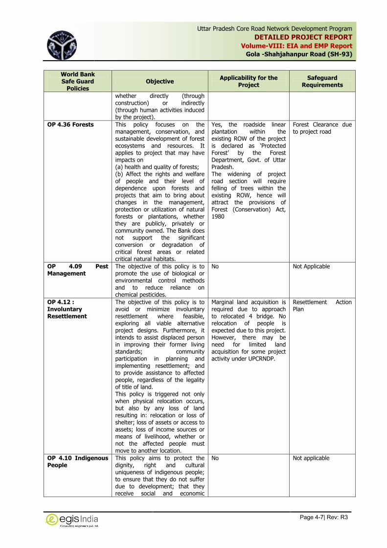
Uttar Pradesh Core Road Network Development Program
DETAILED PROJECT REPORT
Volume-VIII: EIA and EMP Report
Gola -Shahjahanpur Road (SH-93)
Page 4-7| Rev: R3
,
World Bank Safe Guard
Policies Objective
Applicability for the Project
Safeguard Requirements
whether directly (through construction) or indirectly (through human activities induced by the project).
OP 4.36 Forests This policy focuses on the management, conservation, and sustainable development of forest ecosystems and resources. It applies to project that may have impacts on (a) health and quality of forests; (b) Affect the rights and welfare of people and their level of dependence upon forests and projects that aim to bring about changes in the management, protection or utilization of natural forests or plantations, whether they are publicly, privately or community owned. The Bank does not support the significant conversion or degradation of critical forest areas or related critical natural habitats.
Yes, the roadside linear plantation within the existing ROW of the project is declared as ‘Protected Forest’ by the Forest Department, Govt. of Uttar Pradesh. The widening of project road section will require felling of trees within the existing ROW, hence will attract the provisions of Forest (Conservation) Act, 1980
Forest Clearance due to project road
OP 4.09 Pest Management
The objective of this policy is to promote the use of biological or environmental control methods and to reduce reliance on chemical pesticides.
No Not Applicable
OP 4.12 : Involuntary Resettlement
The objective of this policy is to avoid or minimize involuntary resettlement where feasible, exploring all viable alternative project designs. Furthermore, it intends to assist displaced person in improving their former living standards; community participation in planning and implementing resettlement; and to provide assistance to affected people, regardless of the legality of title of land. This policy is triggered not only when physical relocation occurs, but also by any loss of land resulting in: relocation or loss of shelter; loss of assets or access to assets; loss of income sources or means of livelihood, whether or not the affected people must move to another location.
Marginal land acquisition is required due to approach to relocated 4 bridge. No relocation of people is expected due to this project. However, there may be need for limited land acquisition for some project activity under UPCRNDP.
Resettlement Action Plan
OP 4.10 Indigenous People
This policy aims to protect the dignity, right and cultural uniqueness of indigenous people; to ensure that they do not suffer due to development; that they receive social and economic
No Not applicable

Uttar Pradesh Core Road Network Development Program
DETAILED PROJECT REPORT
Volume-VIII: EIA and EMP Report
Gola -Shahjahanpur Road (SH-93)
Page 4-8| Rev: R3
,
World Bank Safe Guard
Policies Objective
Applicability for the Project
Safeguard Requirements
benefits. This policy triggered if there are indigenous people in the project area; when potential adverse impacts on indigenous people are anticipated; and if indigenous people are among the intended beneficiaries.
OP 4.11 Physical Cultural Resources
This policy aims at assisting in the preservation of cultural property, historical, religious and unique natural value-this includes remains left by previous human inhabitants and unique environment features, as well as in the protection and enhancement of cultural properties encountered in Bank- financed project. This policy may be triggered by sub-projects under UPCRNDP in those areas where cultural property, historical, religious and unique natural value-this includes remains left by previous human inhabitants and unique environment features may be affected during widening and strengthening work of the sub-projects.
Yes, A total number of 4
Religious/Cultural Features,
which are located very close
to the road edge, are likely
to be affected due to
proposed widening.
Not applicable
OP 4.37: Safety of Dams
This policy aims for safety of Dams requires (for large dams over a pre-defined criteria) a technical review and periodic safety inspections performed by independent dam safety professionals
Not Applicable Not Applicable
OP 7.50 : Project of International Water Ways
Projects on International Waterways requires projects to ascertain whether riparian agreements are in place, and ensure that riparian states are informed of, and do not object to, project interventions.
Not Applicable Not Applicable
As per the World Bank’s Environmental Safeguard policy, the project coordinating entity or
implementing institution carries out Environmental Assessment (EA) during the preparation of
each proposed subproject according to country requirements and the requirements of this policy.
The Bank appraises and recommends to strengthen the capabilities of the coordinating entity or
the implementing institution to (a) screen subprojects, (b) obtain the necessary expertise to carry
out EA, (c) review all findings and results of EA for individual subprojects, (d) ensure
implementation of mitigation measures (including, where applicable, an EMP), and (e) monitor
environmental conditions during project implementation. If the Bank is not satisfied that adequate
capacity exists for carrying out EA, all Category A sub-projects and, as appropriate, Category B
sub-projects including any EA reports are subject to prior review and approval by the Bank.

Uttar Pradesh Core Road Network Development Program
DETAILED PROJECT REPORT
Volume-VIII: EIA and EMP Report
Gola -Shahjahanpur Road (SH-93)
Page 4-9| Rev: R3
,
The purpose of conducting an environmental assessment (EA) is to identify environmental and
social consequences of the proposed sub-projects or components, in order to:
Ensure the identification of potential environmental issues and social concerns early in
the implementation of a proposed project to incorporate necessary safeguards in project
design in order to prevent potential adverse impacts by determining appropriate
mitigation and compensation measures;
Minimize risks and enhance positive impacts/benefits;
Avoid delays and extra costs which may subsequently arise due to unanticipated
environmental problems;
Identify the potential for maximizing environmental resources management and socio-
economic benefits to local communities within the scope of the subproject.
The EA should cover physical-chemical, biological, socio-economic and cultural issues that
are likely to arise during upgrading and widening of roads safety risks and appurtenance
structures and associated activities as appropriate.
The World Bank has classified the type of projects into following categories depending on the
extent of the impact on environment:
(i) Category A: A proposed project is classified as Category A, if it is likely to have significant adverse environmental impacts that are sensitive, diverse, or unprecedented. Such project requires full EIA study.
(ii) Category B: A proposed project is classified as Category B if its potential adverse environmental impacts on human populations or environmentally important areas—including wetlands, forests, grasslands, and other natural habitats—are less adverse than those of Category A projects. These impacts are site-specific; few if any of them are irreversible; and in most cases mitigatory measures can be designed more readily than for Category A projects.
(iii) Category C: A proposed project is classified as Category C if it is likely to have minimal or no adverse environmental impacts. Beyond screening, no further EA action is required for a Category C project.
(iv) Category FI: A proposed project is classified as Category FI if it involves investment of Bank funds through a financial intermediary, in subprojects that may result in adverse environmental impacts.
Thus for Category-A project detail Environmental Assessment would be required. For the project
requiring Environmental Clearance from the MOEFCC, detailed Environmental Impact Assessment
would be required in accordance with the Environmental Impact Assessment Notification, 2006
and amended thereafter. For Category-B projects site specific EA is required and a generic
environmental management plan (EMP) would be required to be prepared for such project. For
Category C projects no study beyond environmental screening is required.
4.5 Statutory Clearance for Borrow area and stone quarry
Mining of minor minerals such as sand, gravel, clay, marble and other stones will not be allowed
in the country without the approval of the Central government. The Hon’ble Supreme Court, vide
its order dated 27.02.2012 in I.A.No.12-13 of 2011 in SLP (C) No.19628-19629 of 2009 titled
Deepak Kumar etc. Vs. State of Haryana & Ors. has inter alia ordered that leases of minor mineral
including their renewal for an area less than 5 ha be granted by the State / Union Territory only

Uttar Pradesh Core Road Network Development Program
DETAILED PROJECT REPORT
Volume-VIII: EIA and EMP Report
Gola -Shahjahanpur Road (SH-93)
Page 4-10| Rev: R3
,
after getting environment clearance (EC) from the Ministry of Environment,Forests and Climate
Change (MoEFCC). In order to ensure compliance of the aforesaid order of the Hon’ble Supreme
Court, MoEFCC issued an OM No.L-11011/47/2011-IA.II(M) dated 18.05.2012 stating inter alia
that all mining projects of minor minerals including their renewal, irrespective of the size of the
lease would require prior EC and that the projects of minor minerals with lease area less than 5
ha would be treated as Category “B” as defined in EIA Notification, 2006 and will be considered
by the respective State Environment Impact Assessment Authorities (SEIAAs) notified by MoEFCC
and following the procedure prescribed under the EIA Notification, 2006. The mining projects
having more than 5 Ha of lease area will be categorised as Category A project and will be
appraised by Central Committee of MoEFCC.
Regarding the borrow area for ordinary soil, the Contractor has to obtain environmental clearance
from State Environmental Impact Assessment Authority (SEIAA) of MoEFCC in compliance to the
Supreme Court’s order and MoEFCC conditions vide their circular no. L-11011/47/2011-IA.II(M)
dated 20th June, 2013. If the area of a borrow area is less than 5 Ha then this will be treated as
Category-B-2 Project and will be appraised and approved based of only Form-1. No EIA study
will be required for such area. However if the size of the borrow area is more than 5 Ha then it
will be categorized as “Category-B1” and therefore will require EIA study, based on which the
SEIAA will give clearance for the same.
4.6 Other Legislation Applicable to Road Construction Projects
Environmental issues during road construction stage generally involve equity, safety and public
health issues. The road construction agencies require complying with laws of the land, which
include inter alia, the following:
Workmen's Compensation Act 1923 (the Act provides for compensation in case of injury by accident arising out of and during the course of employment);
Payment of Gratuity Act, 1972 (gratuity is payable to an employee under the Act on satisfaction of certain conditions on separation if an employee has completed 5 years);
Employees PF and Miscellaneous Provision Act 1952 (the Act provides for monthly contributions by the employer plus workers);
Maternity Benefit Act, 1951 (the Act provides for leave and some other benefits to women employees in case of confinement or miscarriage, etc.);
Contact Labor (Regulation and Abolition) Act, 1970 (the Act provides for certain welfare measures to be provided by the contractor to contract labour);
Minimum Wages Act, 1948 (the employer is supposed to pay not less than the Minimum Wages fixed by appropriate Government as per provisions);
Payment of Wages Act, 1936 (it lays down as to by what date the wages are to be paid, when it will' be paid and what deductions can be made from the wages of the workers);
Equal Remuneration Act, 1979 (the Act provides for payment of equal wages for work of equal nature to Male and Female workers and not for making discrimination against Female employees);
Payment of Bonus Act, 1965 (the Act provides for payments of annual bonus subject to a minimum of 83.3% of wages and maximum of 20% of wages);
Industrial Disputes Act, 1947 (the Act lays down the machinery and procedure for resolution of industrial disputes, in what situations a strike or lock-out becomes illegal and

Uttar Pradesh Core Road Network Development Program
DETAILED PROJECT REPORT
Volume-VIII: EIA and EMP Report
Gola -Shahjahanpur Road (SH-93)
Page 4-11| Rev: R3
,
what are the requirements for laying off or retrenching the employees or closing down the establishment);
Industrial Employment (Standing Orders) Act, 1946 (the Act provides for laying down rules governing the conditions of employment);
Trade Unions Act, 1926 (the Act lays down the procedure for registration of trade unions of workers and employers. The trade unions registered under the Act have been given certain immunities from civil and criminal liabilities);
Child Labour (Prohibition and Regulation) Act, 1986 (the Act prohibits employment of children below 14 years of age in certain occupations and processes and provides for regulation of employment of children in all other occupations and processes. Employment of child labour is prohibited in Building and Construction Industry);
Inter-State Migrant Workmen’s (Regulation of Employment and Conditions of Service) Act, 1979 (the inter-state migrant workers, in an establishment to which this Act becomes applicable, are required to be provided certain facilities such as housing, medical aid, traveling expenses from home to the establishment and back, etc.);
The Building and Other Construction Workers (Regulation of Employment and Conditions of Service) Act, 1996 (all the establishments who carry on any building or other construction work and employs 10 or more workers are covered under this Act; the employer of the establishment is required to provide safety measures at the building or construction work and other welfare measures, such as canteens, first-aid facilities, ambulance, housing accommodation for Workers near the workplace, etc.);
The Building And Other Construction Workers’ Welfare Cess Act, 1996
Under the Act 2% labour cess is applicable in Uttar Pradesh while obtaining Labour License.
The Factories Act, 1948 (the Act lays down the procedure for approval of plans before setting up a factory, health and safety provisions, welfare provisions, working hours and rendering information-regarding accidents or dangerous occurrences to designated authorities);
Hazardous Wastes (Management and Handling) Rules, 1989;
Chemical Accidents (Emergency Planning, Preparedness and Response) Rules, 1996.
4.7 Summary of Statutory Clearance/Permits Requirement
The project requires a number of statutory clearances under different Acts and Rules at different
stage of the project. These are listed in Table 4.3.
Table4.3: Summary of Statutory Clearance Requirement of the Project
S. No. Type of Clearance/
Permits Applicability Project Stage Responsibility
Time Required
1 Forest Clearance for diversion of Protected Forest Area
For diversion of Protected Forest area as Roadside Plantation within ROW for the project stretch has been declared as Protected Forest
Pre Construction PIU, UP PWD 6-8 months
2 Tree felling permission
For roadside tree cutting
Pre construction PIU, UP PWD 1-2 months

Uttar Pradesh Core Road Network Development Program
DETAILED PROJECT REPORT
Volume-VIII: EIA and EMP Report
Gola -Shahjahanpur Road (SH-93)
Page 4-12| Rev: R3
,
S. No. Type of Clearance/
Permits Applicability Project Stage Responsibility
Time Required
3
NOC (Consent to Establish and Consent to Operate) under Air and Water Act from SPCB
For stone crusher plant, Hot Mix plant, WMM plant and Batching Plant, etc.
Construction Stage Contractor 2-3 months
4 Explosive License from Chief Controller of Explosives,
For storing fuel oil, lubricants, diesel etc.
Construction stage (Prior to storing fuel, lubricants and Diesel, etc.)
Contractor 2-3 months
5
Quarry Lease Deed and Quarry License from State Department of Mines and Geology
Quarry operation Construction stage (Prior to initiation of Quarrying)
Contractor 2-3 months
6
Environmental Clearance for stone quarry and borrow area from State environmental Impact Assessment Authority, U.P.
Opening of new Quarry and Borrow area for earth material
Construction stage (Prior to initiation of Quarrying)
Contractor 5-6 months
7
Permission for extraction of ground water for use in road construction activities from State Ground Water board /Central Ground Water Authority
Extraction of ground water
Construction stage (Prior to initiation of installation of Bore wells and abstraction of water from such source)
Contractor 1-2 months
8
Permission for use of water for construction purpose from irrigation department
Use of surface water for construction
Construction stage (Prior to initiation of abstraction of water from such source)
Contractor 1-2 months
9 Labour license from Labour Commissioner Office
Engagement of Labour
Construction stage (Prior to initiation of any work)
Contractor 2-3 months

Uttar Pradesh Core Road Network Development Program
DETAILED PROJECT REPORT
Volume-VIII: EIA and EMP Report
Gola -Shahjahanpur Road (SH-93)
Page 5-1| Rev: R3
,
5 CURRENT ENVIRONMENTAL CONDITIONS
This chapter reviews the existing conditions of the natural, cultural, economic and social
environments within the project area. The extent of study is within 10 Km on both sides from the
project road. However, the focus of the study was on the areas within and directly adjacent to
the corridor of impact and ROW. The review of the environmental status within the project
corridor is based on the secondary information collected from various sources followed by field
surveys of the project area. All the data have been collected and collated to identify a general
environmental condition within the project area and major environmental issues to be taken care
off during the design as well project implementation phase.
5.1 Physical Environment
5.1.1 Physiography
The project area is located in the districts of Lakhimpur Kheri and Shahjahanpur in state of Uttar
Pradesh. The project location starts at near Gola Market at Km 1+280 and ends at Shahjahanpur
at Km 58+580. Lakhimpur Kheri is a tarai District of Uttar Pradesh bordering Nepal. Headquarter
of the District is situated in the city of Lakhimpur. The total geographical area of the district is
7680 Sq.km. The District is the largest district of U.P. in terms of area. This district is surrounded
by Baharaich district in east, Shahjahanpur & Pilibhit districts in west and Hardoi & Sitapur
districts in South. Shahjahanpur district is bounded on North West by Bareilly district, on north by
Pilibhit district, in the east by Lakhimpur Kheri and Hardoi districts in the sourth, Farrukhabad
district in the south west and Badaun district in the west. The total geographical area of the
district is 4575 Sq.km.
The entire section of the project road lies over flat terrain having gentle country slope from
northwest to southwest direction. The project road passes through mainly agriculture fields and
built-up areas. The geographical extension of the project stretch is 28004’47.20’’ N latitude and
80028’47.34” E longitude at Gola and 27051’12.05’’ N Latitude and 79055’23.60’’ E longitude at
Shahjahanpur. General elevation of the area varies between 158 m to 164 m above mean sea
level. The project districts lie over Ruhilkhand and Sarjupar Plains.
The district of Lakhimpur Kheri is drained by several rivers namely Sharda, Ghagra, Koriyala, Ull,
Sarayan, Chauka, Gomti, Kathana, Sarayu and Mohana whereas the Shahjahanpur district is
drained by Ramganga, Garrah & Gomti rivers.
Physiographic map and Physical map of Uttar Pradesh is given in Figure 5.1 and Figure 5.2
respectively.

Uttar Pradesh Core Road Network Development Program
DETAILED PROJECT REPORT
Volume-VIII: EIA and EMP Report
Gola -Shahjahanpur Road (SH-93)
Page 5-2| Rev: R3
,
Figure 5.1: Physiographic Map of Uttar Pradesh2
2 Source: http://irrigation.up.nic.in/physical_environment.htm

Uttar Pradesh Core Road Network Development Program
DETAILED PROJECT REPORT
Volume-VIII: EIA and EMP Report
Gola -Shahjahanpur Road (SH-93)
Page 5-3| Rev: R3
,
Figure 5.2: Physical Map of Uttar Pradesh3
5.1.2 Geology and Soil
The entire project area is spread in Gangetic plain. The geological formation of both the districts
is river fill sediment of recent origin and younger alluvial plain. The soils found in the project area
are mainly alfisols composed of red sandy and red loamy soil. In Shahjahanpur District there are
sandy loam soils, Loam soils, Clay loam soils and silt loam soils
District Lakhimpur comprises mainly four types of soils are found which are sandy, alluvial soil,
smooth & Domat. Geographically District can be divided in to two parts-(i) Low land (Tarai) and
(ii) Upper Land (uparhar). Sandy soil is met in the bank of rivers and nearby areas. Soil of Tarai
areas is clay and is dark in color, which is very suitable for growing of Rice & Sugar cane. Soil of
Bankeganj, Mohammadi, Kumbhi (Gola), Mitauli, Behjam & Lakhimpur Blocks is normally Domat.
Land of district Shahjahanpur is generally plain and fertile. Land on the side of the river bank is
low (is called Khadar) and other side it is comparatively higher and is called Bangar. Domat type
land can be found on the north side of tehsil Puvayan. Land on the west side is comparatively
very low due to erosion. Due to this reason at the time of rainfall the area become flooded. In the
Kaur, Khutar, Nigohi & Jaitpur block areas, the land is domat and matiyar.
3 Source: http://www.mapsofindia.com/maps/uttarpradesh/uttarpradeshphysical.htm

Uttar Pradesh Core Road Network Development Program
DETAILED PROJECT REPORT
Volume-VIII: EIA and EMP Report
Gola -Shahjahanpur Road (SH-93)
Page 5-4| Rev: R3
,
The geological map of Uttar Pradesh is given in Figure 5.3.
Figure 5.3: Geological Map of Uttar Pradesh
Soil analysis has been carried out for soil samples collected from two locations along the
proposed project alignment covering agriculture field and human activities area especially near
habitation area to understand the Soil characteristics along the project road. The post monsoon
soil samples were collected from fields within 10-15 meter from road edge in the month of
November, 2014. The locations for Soil sampling is presented in Table 5.1. The physico-
chemical characteristics of the soil samples is presented in Table 5.2.
Table 5.1: Identified Soil Sampling Location along the Project Road
Sample Code Locations Chainage (Km) Description of Site
SQ-1 Reserved Forest Area 13+000 Forest Land
SQ-2 Dhewra 34+300 Agriculture Land
SQ-3 Mukrampur 51+200 Agriculture Land
The soil quality analysis shows that at all the locations soil quality are basic in nature and the
moisture retention capacity is less than 17%. The soil texture along the project corridor is varies
between sandy loam to clay with good amount of nitrogen content.

Uttar Pradesh Core Road Network Development Program
DETAILED PROJECT REPORT
Volume-VIII: EIA and EMP Report
Gola -Shahjahanpur Road (SH-93)
Page 5-5| Rev: R3
,
Table 5.2: Physico-chemical Characteristics of Soil
S. No. Parameters Unit Sampling Locations
SQ-1 SQ-2 SQ-3
1 pH ( 1:2.5) at26⁰C 6.16 8.46 8.26
2 Electrical Conductivity at 25oC µS/cm 44.2 163 133
3 Sand % (w/w) 56.7 29.8 30.4
4 Silt % (w/w) 28.1 12.3 19.4
5 Clay % (w/w) 15.2 57.9 50.2
6 Texture Sandy Loam Clay Clay
7 Moisture Retention Capacity % 5.56 15.08 16.23
8 Bulk Density g/c.c 1.21 1.25 1.21
9 Porosity % 49.37 50.79 52.73
10 Organic matter % 1.64 1.14 0.84
11 Nitrogen mg/kg 197.96 250.38 186.34
12 Phosphorous mg/kg 163.78 231.64 172.59
13 Potassium mg/kg 40 40 179.98
14 Pb mg/kg <0.1 4.4 0.4
15 Fe mg/kg <1.4 3.88 5.08
16 TOC % 0.95 0.66 0.49
17 Cd mg/kg <0.04 <0.04 <0.04
18 Mn mg/kg 281.58 178.38 148.84
19 Cu mg/kg 7.69 16.88 13.19
20 Ni mg/kg 9.15 8.86 9.08
21 Zn mg/kg 24.96 105.18 99.65
22 Co mg/kg 5.81 7.94 6.1
Source: Primary Data collected from site
5.1.3 Seismology
According to Global Seismic Hazard Assessment Program (GSHAP) data, the state of Uttar
Pradesh falls in a region of moderate to high seismic hazard. The districts Lakhimpur Kheri and
Shahjahanpur lie in Zone III (moderate Hazard zone) which is comparatively stable zone. No
epicenter of earthquake within the district area has been observed during last 200 years. The
district has, however experienced on few occasions earthquakes originating in the Himalayan
boundary fault zone, Moradabad fault zone and Narmada-Tapti fault zone. The seismic hazard
zone of Uttar Pradesh is given in Figure 5.4.

Uttar Pradesh Core Road Network Development Program
DETAILED PROJECT REPORT
Volume-VIII: EIA and EMP Report
Gola -Shahjahanpur Road (SH-93)
Page 5-6| Rev: R3
,
Figure 5.4: Seismic Zone of India Indecating Project Stretch4
5.1.4 Quarry Site and Borrow Areas
Quarry Areas
Road construction requires earth, stones and sand. These raw materials are to be obtained from
surrounding areas, which are suitable for the project road. The stone materials including sand
and granular ones are needed in large quantities for the pavement construction. The other area
of requirement is concrete structures, which call for a good quality stone.
The potential source for stone aggregates, sand and gravels along the project section has been
identified. Sufficient quantities of construction materials are available in these quarries. The sand
quarries are mainly riverbed sand quarries.
4 Source: : Indian Meteorological Department, Govt. of India

Uttar Pradesh Core Road Network Development Program
DETAILED PROJECT REPORT
Volume-VIII: EIA and EMP Report
Gola -Shahjahanpur Road (SH-93)
Page 5-7| Rev: R3
,
Borrow Areas
The soils to be used, as sub-grade, select sub-grade and shoulder materials need to be hauled
from designated borrow areas. The borrow area along the project section with relevant
consent/NOC from individual land owner will be obtained before operation of borrow area during
construction stage. Location Chart from showing Borrow Areas between Km 1.281 to Km 58.580
is given in Table 5.3 and shown in Figure 5.5.
Table 5.3: Description of Soil Borrow Sources
BA No. Chainage Side Lead (Km) Area
(Acre) Village
1 1+000 LHS 8.000 5.0 Simarai
2 1+000 LHS 4.500 7.0 Rasoolpur
3 10+800 RHS 1.200 2.5 Bagachan
4 13+800 RHS 0.150 5.0 Grant Sahabganj
5 20+030 RHS 0.070 8.0 Padriya
6 25+500 RHS 0.200 15.0 Dilawarpur
7 31+500 LHS 0.800 2.0 Garbapur
8 36+800 RHS 0.200 1.0 Kakraua-Dhakia
9 39+900 LHS 1.200 2.0 Barenchi
10 44+400 LHS 0.200 5.0 Dohak
11 50+800 RHS 2.500 5.0 Bhatpura-Rasoolpur
12 54+200 RHS 1.000 2.0 Salliya
13 57+200 RHS 1.500 4.5 Hitaudia
There is no stone quarry located in nearby area of the project. As enquired from the U.P. Dept. of
Mines and Geology, at present, there are many llicensed quarries in Lalkuwan, which is located
about 208 Kms from the project road. Natural sand is also available for concrete works at
Lalkuwan.
Table 5.4: Aggregate and crushed stone Quarry Location along the Project Road
S. No. Source Location Lead (Km) Chainage (Km)
1 Lalkuwan Quarry 208 30+000
Fly ash
Use of Fly ash in construction of embankment is mandatory as per environmental regulations if
the Thermal Power Plant producing fly ash is situated within 100 km radius of the project road.
There is one thermal power plant namely “Reliance Thermal Power” is located at Rosa, which is
situated within 100 km range from the project road (10 Km from Shahjahanpur). Since the
present road project is to widen the current road to two lanes along the existing alignment,
substantial use of fly ash is not anticipated in this project. Only limited use of fly ash is expected
at few locations, where the road profile has been raised due to HFL criteria/ and or approach
embankments to structures.

Uttar Pradesh Core Road Network Development Program
DETAILED PROJECT REPORT
Volume-VIII: EIA and EMP Report
Gola -Shahjahanpur Road (SH-93)
Page 5-8| Rev: R3
,
BA2, Rasoolpur,lead 4.5 km
BA3, Bagachan,lead 1.2 km
km 1+000
Km 10+800
BA 4,Grant Sahabganj,lead 0.15 km
BA 5,Padriya,lead 0.07 km
Km 25+500
Km 31+500
Km 36+800
Km 50+800
Km 54+200
Km 57+200
END. PT. SH-93, KM
59+500,Shahjahanpur
Borrow area Locations Explored by egis-India
ST. PT. SH-93, KM
0+000, Gola
Km 13+800
Km 20+030
Km 39+900
Km 44+400
BA 9, Barenchi lead 1.20 km
BA 10,Dohak, lead 0.20 km
BA1, Simarai,lead 8.0 km
BA 6,Dilawarpur,lead 0.20 km
BA 7,Garbapur, lead 0.80 km
BA 8,Kakraua-Dhakia,lead 0.20 km
BA 11,Bhatpura-Rasoolpur,lead 2.50 km
BA 12,Salliya,lead 1.00 km
BA 13,Hitaudia,lead 1.50 km
Figure 5.5: Borrow Area Location Chart

Uttar Pradesh Core Road Network Development Program
DETAILED PROJECT REPORT
Volume-VIII: EIA and EMP Report
Gola -Shahjahanpur Road (SH-93)
Page 5-9| Rev: R3
,
5.1.5 Climatic Conditions
The weather, in general, can be said to be dry and moderate.The maximum temperature in
Lakhimpur Kheri district reaches upto 44oC in summer while the minimum temperature is 4.2oC
in winter. Relative humidity is about 73% and average annual rainfall is 1069 mm.
The average maximum temperature in Shahjahanpur districts is 40.3oC, while the average
minimum temperature is 9.3oC. Relative humidity is about 80% while average annual rainfall is
1058.4 mm.
The rainy season is generally observed from middle of June to end of September.
The winter season commences from middle of November and ends by the end of the January
followed by dry hot summer from February to middle of June. Summers are in general full of
gusty winds.
5.1.6 Land Use Pattern
The land use along the project corridor is predominantly agriculture. The land use pattern in
Lakhimpur Kheri and Shahjahanpur district are presented in Table 5.5.
Table 5.5: Land use pattern of Lakimpur Kheri and Shahjahanpur District
(Area in ‘000 ha.)
S. No.
Land Classification Lakhimpur Kheri
District Shahajahanpur
District Uttar Pradesh
1. Total Area reported for Land Utilization 772.8 (100%) 437.77 (100%) 24170 (100%)
2. Forest 164.8 (21.33%) 10.50 (2.42%) 1658 (6.86%)
3. Barren and Uncultivated land 3.6 (0.46%) 6.99 (1.61%) 486 (2.01%)
4. Land under non agriculture uses 78.7 (10.23%) 40.27 (9.26%) 2835 (11.73%)
5. Waste land unfit for Agriculture 3.2 (0.42%) 3.80 (0.87%) 426 (1.76%)
6. Permanent pastures and grazing land 0.9 (0.12%) 0.97 (0.22%) 66 (0.27%)
7. Area under trees and grooves 5.9 (0.77%) 3.92 (0.91%) 354 (1.46%)
8. Current fallow land 31.8 (4.13%) 14.0 (3.22%) 1215 (5.03%)
9. Other fallow land 4.1 (0.53%) 7.07 (1.64%) 538 (2.23%)
10. Net area sown 524.8 (68.22%) 349.96 (80.5%) 16592 (68.65%)
Source: Statistical Abstract, Uttar Pradesh, 2012, Govt. of Uttar Pradesh
As per site inventory, the land use along the highway is predominantly agriculture followed by
built-up area, and water bodies. The land use pattern along the project road is given in Table
5.6 and Figure 5.6.
Table 5.6: Land use along the project road
S. No. Chainage (Km)
Terrain Land use Total Length
(Km) From To
1 1+280 2+600 Plain Built up 1.320
2 2+600 2+900 Plain Agriculture 0.300
3 2+900 3+000 Plain Built up 0.100
4 3+000 3+400 Plain Agriculture 0.400
5 3+400 3+600 Plain Built up 0.200
6 3+600 5+800 Plain Agriculture 2.200
7 5+800 6+700 Plain Built up 0.900
8 6+700 6+740 Plain Water body 0.040
9 6+740 9+600 Plain Agriculture 2.860
10 9+600 9+900 Plain Built up 0.300
11 9+900 10+700 Plain Agriculture 0.800

Uttar Pradesh Core Road Network Development Program
DETAILED PROJECT REPORT
Volume-VIII: EIA and EMP Report
Gola -Shahjahanpur Road (SH-93)
Page 5-10| Rev: R3
,
S. No. Chainage (Km)
Terrain Land use Total Length
(Km) From To
12 10+700 11+600 Plain Built up 0.900
13 11+600 12+000 Plain Agriculture 0.400
14 12+000 12+040 Plain Water body 0.040
15 12+040 13+400 Plain Forest 1.360
16 13+400 14+000 Plain Agriculture 0.600
17 14+000 15+500 Plain Forest 1.500
18 15+500 16+550 Plain Agriculture 1.050
19 16+550 17+150 Plain Built up 0.600
20 17+150 19+200 Plain Agriculture 2.050
21 19+200 19+500 Plain Built up 0.300
22 19+500 19+700 Plain Agriculture 0.200
23 19+700 20+500 Plain Built up 0.800
24 20+500 24+900 Plain Agriculture 4.400
25 24+900 25+000 Plain Water body 0.100
26 25+000 29+100 Plain Agriculture 4.100
27 29+100 32+700 Plain Built up 3.600
28 32+700 34+000 Plain Agriculture 1.300
29 34+000 34+050 Plain Water body 0.050
30 34+050 34+300 Plain Agriculture 0.250
31 34+300 34+600 Plain Built up 0.300
32 34+600 39+800 Plain Agriculture 5.200
33 39+800 39+850 Plain Water body 0.050
34 39+850 40+400 Plain Agriculture 0.550
35 40+400 40+700 Plain Built up 0.300
36 40+700 41+650 Plain Agriculture 0.950
37 41+650 41+700 Plain Water body 0.050
38 41+700 43+400 Plain Agriculture 1.700
39 43+400 43+450 Plain Built up 0.050
40 43+450 43+600 Plain Agriculture 0.150
41 43+600 43+700 Plain Water body 0.100
42 43+700 46+200 Plain Agriculture 2.500
43 46+200 46+220 Plain Water body 0.020
44 46+220 48+100 Plain Built up 1.880
45 48+100 49+400 Plain Agriculture 1.300
46 49+400 49+500 Plain Water body 0.100
47 49+500 51+700 Plain Agriculture 2.200
48 51+700 51+720 Plain Water body 0.020
49 51+720 58+000 Plain Agriculture 6.280
50 58+000 58+580 Plain Built up 0.580
Figure 5.6: Land Use Pattern along the Project Section
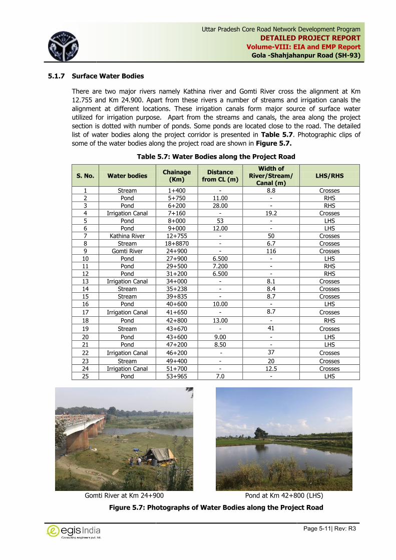
Uttar Pradesh Core Road Network Development Program
DETAILED PROJECT REPORT
Volume-VIII: EIA and EMP Report
Gola -Shahjahanpur Road (SH-93)
Page 5-11| Rev: R3
,
5.1.7 Surface Water Bodies
There are two major rivers namely Kathina river and Gomti River cross the alignment at Km
12.755 and Km 24.900. Apart from these rivers a number of streams and irrigation canals the
alignment at different locations. These irrigation canals form major source of surface water
utilized for irrigation purpose. Apart from the streams and canals, the area along the project
section is dotted with number of ponds. Some ponds are located close to the road. The detailed
list of water bodies along the project corridor is presented in Table 5.7. Photographic clips of
some of the water bodies along the project road are shown in Figure 5.7.
Table 5.7: Water Bodies along the Project Road
S. No. Water bodies Chainage
(Km) Distance
from CL (m)
Width of River/Stream/
Canal (m) LHS/RHS
1 Stream 1+400 - 8.8 Crosses
2 Pond 5+750 11.00 - RHS
3 Pond 6+200 28.00 - RHS
4 Irrigation Canal 7+160 - 19.2 Crosses
5 Pond 8+000 53 - LHS
6 Pond 9+000 12.00 - LHS
7 Kathina River 12+755 - 50 Crosses
8 Stream 18+8870 - 6.7 Crosses
9 Gomti River 24+900 - 116 Crosses
10 Pond 27+900 6.500 - LHS
11 Pond 29+500 7.200 - RHS
12 Pond 31+200 6.500 - RHS
13 Irrigation Canal 34+000 - 8.1 Crosses
14 Stream 35+238 - 8.4 Crosses
15 Stream 39+835 - 8.7 Crosses
16 Pond 40+600 10.00 - LHS
17 Irrigation Canal 41+650 - 8.7 Crosses
18 Pond 42+800 13.00 - RHS
19 Stream 43+670 - 41 Crosses
20 Pond 43+600 9.00 - LHS
21 Pond 47+200 8.50 - LHS
22 Irrigation Canal 46+200 - 37 Crosses
23 Stream 49+400 - 20 Crosses
24 Irrigation Canal 51+700 - 12.5 Crosses
25 Pond 53+965 7.0 - LHS
Gomti River at Km 24+900 Pond at Km 42+800 (LHS)
Figure 5.7: Photographs of Water Bodies along the Project Road

Uttar Pradesh Core Road Network Development Program
DETAILED PROJECT REPORT
Volume-VIII: EIA and EMP Report
Gola -Shahjahanpur Road (SH-93)
Page 5-12| Rev: R3
,
Primary data generation on surface water quality was carried out in the month of November,
2014 in order to assess the surface water quality within the project area. The water samples from
the following water sources were collected for assessing the physico-chemical characteristic of
water are given in Table 5.8. The analysis result of various quality parameters has been
presented in Table 5.9
Table 5.8: Locations of Surface Water Sampling
S. No. Sample Code Sources Location (Name) Chainage (Km)
1. SW-1 Gomti River - 24+900
2. SW-2 Pond Machecha 42+800
Table 5.9: Characteristics of Surface Water in the Project Area
S. No.
Parameters Unit Concentration
Gomti River (SW-1) Pond at Machecha (SW-2)
1 Temperature ° C 25 22
2 pH at 26⁰C 7.90 7.12
3 Turbidity NTU 3.7 74
4 Electrical Conductivity at 25° C
μs/cm 343.0 308
5 Colour Hazen <1.0 4
6 Total Suspended Solids (as TSS)
mg/l 6.4 165
7 Total Dissolved Solids (as TDS)
mg/l 211.00 168
8 Odour Unobjectionable Unobjectionable
9 Dissolved Oxygen mg/l 6.2 6.6
10 Biochemical Oxygen Demand (for 3 days at 270 C)
mg/l <2.0 29.4
11 Chemical Oxygen Demand mg/l <4.0 95.23
12 Total Kjeldahl Nitrogen mg/l <0.3 3.24
13 Total Hardness (as CaCO3) mg/l 168.56 141.12
14 Sodium (as Na) mg/l 18 6
15 Potassium mg/l 4 12
16 Calcium (as Ca) mg/l 34.5 31.36
17 Magnesium mg/l 19.76 15.05
18 Ammonia mg/l <0.1 1.18
19 Chloride (as Cl) mg/l 7.6 7.6
20 Sulfate (as SO4) mg/l 6.76 6.28
21 Phosphate mg/l 0.25 <0.15
22 Nitrate (as NO3) mg/l 1.37 0.94
23 Fluoride (as F) mg/l 0.41 0.46
24 Surfactants mg/l <0.02 <0.02
25 Dissolved Iron mg/l <0.05 <0.05
26 Copper (as Cu) mg/l <0.02 <0.02
27 Zinc (as Zn) mg/l <0.02 <0.02
28 Manganese (as Mn) mg/l 0.13 0.23

Uttar Pradesh Core Road Network Development Program
DETAILED PROJECT REPORT
Volume-VIII: EIA and EMP Report
Gola -Shahjahanpur Road (SH-93)
Page 5-13| Rev: R3
,
S. No.
Parameters Unit Concentration
Gomti River (SW-1) Pond at Machecha (SW-2)
29 Arsenic (as As) mg/l <0.01 <0.01
30 Lead (as Pb) mg/l <0.005 <0.005
31 Mercury (as Hg) mg/l <0.001 <0.001
32 Boron (as B) mg/l <0.5 <0.5
33 Chromium (as Cr) mg/l <0.01 <0.01
34 Phenols mg/l <0.001 <0.001
35 Cadmium (as Cd) mg/l <0.001 <0.001
36 Total coliform MPN/ 100ml
8 2
37 Faecal Coliform /100ml Present Absent
Source: Primary Data collected from site
The analysis result reflects that all the surface water bodies from which the water samples were
taken, meet the quality criteria for Class C (Drinking water source after conventional treatment
and disinfection) and Class D (Propagation of Wildlife and Fisheries) of surface water. The pH is
varying from 7.12 to 7.90, Dissolve Oxygen is varying from 6.2 mg/l to 6.6 mg/l and Biological
Oxygen Demand (BOD) ranged from <2 mg/l to 29.41 mg/l. All the other measured parameters
were observed well within the prescribed limit of water quality standards.
5.1.8 Ground Water Quality
The generation of baseline data on groundwater quality within the project area was carried in the
month of November 2014. The ground water samples were collected from 3 locations along the
project corridor to assess the quality of ground water around project area. The location of
sampling is given in Table 5.10. The result of physico-chemical analysis of ground water is given
in Table 5.11.
Table 5.10: Locations of Ground Water Sampling
S. No. Sample Code Chainage (Km) Location Sources
1. GW-1 1+000 Gola (LHS) Hand Pump
2. GW-2 30+300 Mohammadi (LHS) Hand Pump
3. GW-3 58+400 Shahjahanpur (LHS) Hand Pump

Uttar Pradesh Core Road Network Development Program
DETAILED PROJECT REPORT
Volume-VIII: EIA and EMP Report
Gola-Shahjahanpur Road (SH-93)
Page 5-17| Rev: R3
,
Table 5.11: Physico-Chemical Characteristics of Ground Water Samples
Sl. No. Parameters Unit
Concentration Water Quality Standard as per BIS
(IS: 10500:1991)
GW-1 GW-2 GW-3 Desirable Limit Max. Permissible Limits
in the absence of alternate source
1 Temperature ° C 28 28 27
2 pH at 25⁰C 7.61 7.19 7.31 6.5 to 8.5 No relaxation
3 Turbidity NTU <1.0 <1.0 <1.0 5 10
4 Electrical Conductivity at 25° C
μs/cm 729 1081 563
5 Colour Hazen <1.0 <1.0 <1.0 5 25
6 Total Suspended Solids (as TSS) mg/l <2.5 <2.5 <2.5
7 Total Dissolved Solids (as TDS) mg/l 415 618 320 500 2000
8 Odour Unobjectionable Unobjectionable Unobjectionable Unobjectionable Unobjectionable
9 Dissolved Oxygen mg/l 6.8 6.6 6.1
10 Biochemical Oxygen Demand (for 3 days at 270 C)
mg/l 2.7 <2.0 <2.0
11 Chemical Oxygen Demand mg/l 11.9 <4.0 <4.0
12 Total Kjeldahl Nitrogen mg/l <0.3 <0.3 <0.3
13 Total Hardness (as CaCO3) mg/l 388.08 450.8 250.8 300 600
14 Sodium (as Na) mg/l 22 68 22
15 Potassium mg/l 9.0 9.6 1
16 Calcium (as Ca) mg/l 90.94 90.94 45.47 75 200
17 Magnesium mg/l 38.57 53.62 32.93
18 Ammonia mg/l <0.1 <0.1 <0.1
19 Chloride (as Cl) mg/l 24.69 106.36 13.29 250 1000
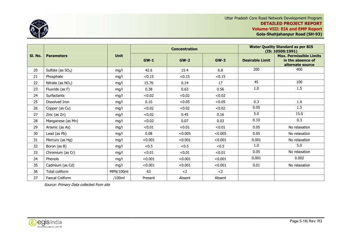
Uttar Pradesh Core Road Network Development Program
DETAILED PROJECT REPORT
Volume-VIII: EIA and EMP Report
Gola-Shahjahanpur Road (SH-93)
Page 5-18| Rev: R3
,
Sl. No. Parameters Unit
Concentration Water Quality Standard as per BIS
(IS: 10500:1991)
GW-1 GW-2 GW-3 Desirable Limit Max. Permissible Limits
in the absence of alternate source
20 Sulfate (as SO4) mg/l 42.6 15.4 6.8 200 400
21 Phosphate mg/l <0.15 <0.15 <0.15
22 Nitrate (as NO3) mg/l 15.76 0.14 17 45 100
23 Fluoride (as F) mg/l 0.38 0.63 0.56 1.0 1.5
24 Surfactants mg/l <0.02 <0.02 <0.02
25 Dissolved Iron mg/l 0.10 <0.05 <0.05 0.3 1.0
26 Copper (as Cu) mg/l <0.02 <0.02 <0.02 0.05 1.5
27 Zinc (as Zn) mg/l <0.02 0.45 0.16 5.0 15.0
28 Manganese (as Mn) mg/l <0.02 0.07 0.03 0.10 0.3
29 Arsenic (as As) mg/l <0.01 <0.01 <0.01 0.05 No relaxation
30 Lead (as Pb) mg/l 0.08 <0.005 <0.005 0.05 No relaxation
31 Mercury (as Hg) mg/l <0.001 <0.001 <0.001 0.001 No relaxation
32 Boron (as B) mg/l <0.5 <0.5 <0.5 1.0 5.0
33 Chromium (as Cr) mg/l <0.01 <0.01 <0.01 0.05 No relaxation
34 Phenols mg/l <0.001 <0.001 <0.001 0.001 0.002
35 Cadmium (as Cd) mg/l <0.001 <0.001 <0.001 0.01 No relaxation
36 Total coliform MPN/100ml 63 <2 <2
37 Faecal Coliform /100ml Present Absent Absent
Source: Primary Data collected from site

Uttar Pradesh Core Road Network Development Program
DETAILED PROJECT REPORT
Volume-VIII: EIA and EMP Report
Gola - Shahjahanpur Road (SH-93)
Page 5-19| Rev: R3
,
The test results of the ground water samples along the project road at all the locations reflect
that the pH was within permissible limit. The same varied between 7.19 to 7.61. The Total
dissolve solid varied from 320.00 mg/l to 618.00 mg/l at different locations along the project
road. The water sample collected from Mohammadi showed TDS as high as 618.00 mg/l which is
higher that the desirable level but within the maximum permissible level as per IS: 10500. The
Total hardness (as CaCO3) ranged from 250.8 mg/l to 450.8 mg/l at different locations along the
project road. The Fluoride (as F) is below the permissible limit in all the samples taken along the
project road.
5.1.9 Ambient Air Quality
To study the baseline ambient air quality scenario within the project corridor with respect to PM10,
PM2.5, SO2, Nox, CO and HC, post-monsoon air sampling was carried out in the month of
November, 2104. The samples of air were collected from three locations covering representative
locations with respect to land use and location of sensitive receptors along the project. The air
sampling locations with respect to the proposed project road has been presented in Table 5.12.
The air quality analysis report is given Table 5.13.
Table 5.12: Proposed Air Quality Sample Location
S. No.
Monitoring Station Code
Location Landuse
Place Chainage (Km)
1. AQ-1 Kanja Gola 2+200 Residential & Commercial area
2. AQ-2 Mohammadi 28+900 Commercial and Mixed activities
3. AQ-3 Shahjahanpur 57+900 Industrial, Commercial and
Mixed Activities
Table 5.13: Ambient Air Quality at Different Locations along Project Corridor
S. No.
Location Chainage
(Km) Concentration
Level
Concentration
PM10
(g
/m3)
PM2.5 (g
/m3)
SO2
(g
/m3)
NOx (g
/m3)
CO (mg /m3)
HC (ppm)
1. Kanja Gola 2+200 Maximum 122 69 6.7 27.8 0.85 0.784
Minimum 96 52 5.4 25.0 0.51 0.575
Mean 109 62 6.7 27.7 0.8 0.777
2. Mohammadi 28+900 Maximum 112 58 5.2 25.3 0.65 0.758
Minimum 88 48 4.5 22.2 0.47 0.568
Mean 99 52 4.9 23.9 0.56 0.653
3 Shahjahanpur 57+900 Maximum 189 94 6.3 26.1 1.050 0.882
Minimum 169 86 5.1 23.7 0.65 0.575
Mean 177 91 5.9 24.7 0.88 701.81
Standard 100.0 60.0 80.0 80.0 2.0 -
Source: Primary Data collected at site
The mean concentration of PM10 in ambient air was found in the range of 109 µg/m3 at Kanja
Gola, 99.00 µg/m3 at Mohamadi and 177.0 µg/m3 at Shahjahanpur. The mean concentration of
PM2.5 in the ambient air was found in the range of 62 µg/m3 at Kanja Gola, 52 µg/m3 at
Mohamadi and 91 µg/m3 at Shahjahanpur. The Kanja Gola showed slightly higher concentrations
of PM10 and PM2.5 than the National Ambient Air Quality Standards i.e. 100 µg/m3 for PM10 and
60 for PM2.5. The Kanjagola is a congested area with commercial activities (market area). There
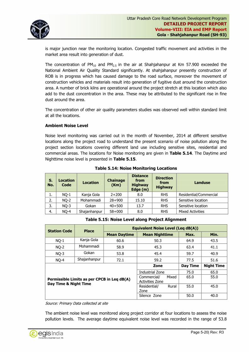
Uttar Pradesh Core Road Network Development Program
DETAILED PROJECT REPORT
Volume-VIII: EIA and EMP Report
Gola - Shahjahanpur Road (SH-93)
Page 5-20| Rev: R3
,
is major junction near the monitoring location. Congested traffic movement and activities in the
market area result into generation of dust.
The concentration of PM10 and PM2.5 in the air at Shahjahanpur at Km 57.900 exceeded the
National Ambient Air Quality Standard significantly. At shahjahanpur presently construction of
ROB is in progress which has caused damage to the road surface, moreover the movement of
construction vehicles and materials result into generation of fugitive dust around the construction
area. A number of brick kilns are operational around the project stretch at this location which also
add to the dust concentration in the area. These may be attributed to the significant rise in fine
dust around the area.
The concentration of other air quality parameters studies was observed well within standard limit
at all the locations.
Ambient Noise Level
Noise level monitoring was carried out in the month of November, 2014 at different sensitive
locations along the project road to understand the present scenario of noise pollution along the
project section locations covering different land use including sensitive sites, residential and
commercial areas. The locations for Noise monitoring are given in Table 5.14. The Daytime and
Nighttime noise level is presented in Table 5.15.
Table 5.14: Noise Monitoring Locations
S. No.
Location Code
Location Chainage
(Km)
Distance from
Highway Edge (m)
Direction from
Highway Landuse
1. NQ-1 Kanja Gola 2+200 8.0 RHS Residential/Commercial
2. NQ-2 Mohammadi 28+900 15.10 RHS Sensitive location
3. NQ-3 Gokan 40+500 13.7 RHS Sensitive location
4. NQ-4 Shajanhanpur 58+000 8.0 RHS Mixed Activities
Table 5.15: Noise Level along Project Alignment
Station Code Place Equivalent Noise Level (Leq dB(A))
Mean Daytime Mean Nighttime Max. Min.
NQ-1 Kanja Gola 60.6 50.3 64.9 43.5
NQ-2 Mohammadi 58.9 45.3 63.4 41.1
NQ-3 Gokan 53.8 45.4 59.7 40.9
NQ-4 Shajanhanpur 72.1 59.2 77.5 51.6
Permissible Limits as per CPCB in Leq dB(A) Day Time & Night Time
Zone Day Time Night Time
Industrial Zone 75.0 65.0
Commercial/ Mixed Activities Zone
65.0 55.0
Residential/ Rural Zone
55.0 45.0
Silence Zone 50.0 40.0
Source: Primary Data collected at site
The ambient noise level was monitored along project corridor at four locations to assess the noise
pollution levels. The average daytime equivalent noise level was recorded in the range of 53.8

Uttar Pradesh Core Road Network Development Program
DETAILED PROJECT REPORT
Volume-VIII: EIA and EMP Report
Gola - Shahjahanpur Road (SH-93)
Page 5-21| Rev: R3
,
Leq dB(A) to 72.1 Leq dB(A) whereas the same varied from 45.3 Leq dB(A) to 59.2 Leq dB(A)
during night time. The noise levels were observed within permissible level for commercial and
mixed area at all the locations except at Shahjahanpur. At Shahjahanpur daytime equivalent noise
was recorded to 72.1 Leq dB(A), which is higher than permissible limit for Commercial and
mixed rea (65 Leq dB(A)) but within permissible level for industrial area . The higher noise level
at Shahjahanpur may be attributed to due to congested built-up area located along the project
road on both the side and congested traffic movement, congestion created around construction of
ROB at Shahjahanpur and frequent horn blows. The nighttime equivalent noise levels were within
the permissible level at all the location with their respective to land use zone.
5.2 Ecological Resources
The project stretch does not pass through any significant natural vegetation community. The
major land use pattern is agriculture followed by built-up area.
5.2.1 Forest Cover
The project road of Gola to Shahjahanpur section of SH-93 is located in the state of Uttar
Pradesh. As per Indian State of Forest Report 2013, the total forest cover in Uttar Pradesh is
14,349 sq.km, which is 5.96% of state geographic area. Out of total forest cover in the state,
very dense forest is spread in 1,623 sq.km, moderately dense forest cover about 4,550 sq. km
and open forest cover about 8,176 sq.km. The forest cover map of Uttar Pradesh is shown in
Figure 5.8.
Source: India State Forest Report 2013
Figure 5.8: Forest Cover in the state of Uttar Pradesh
The forest cover in the concerned project districts as per India State Forest Report 2013 is given
in Table 5.16. The report reflects that forest cover in Lakhimpur Kheri and Shahjahanpur
districts are 17.07 percent and 2.69 percent of total geographical area of the district, respectively.
The district of Lakhimpur Kheri has more percentage of land under forest coverage than the
state’s percentage of forest coverage, whereas the district of Shahjahanpur has lower
percentage of area under forest than that of state’s ratio forest cover.

Uttar Pradesh Core Road Network Development Program
DETAILED PROJECT REPORT
Volume-VIII: EIA and EMP Report
Gola - Shahjahanpur Road (SH-93)
Page 5-22| Rev: R3
,
Table 5.16: District-wise Forest Coverage along Project Road
State/ District District / State Geographical area (sq.km)
Very Dense Forest
(sq.km)
Moderately Dense Forest
(sq.km)
Open Forest
(sq.km)
Total (sq.km)
Percent of Forest from
District Geographical
area
Lakhimpur Kheri 7860 409 475 427 1311 17.07
Shahjahanpur 4575 23 63 37 123 2.69
Uttar Pradesh 240928 1623 4550 8176 14349 5.96
Source: India State Forest Report 2013, Forest Survey of India, MoEFCC
Figure 5.9: Forest Cover Map of Uttar Pradesh
5.2.2 Reserve Forest
Pockets of reserved forest is located along the project section at two locations covering a total
length of about 2.800 Km. The Kathina River forms the boundary of the reserved forest. In these
pockets of reserve forest area plantation of teak, sal and sheesham trees has been done by the
local forest department for commercial utilisation. No rare and endangered species are identified
in these area. The photographs of the reserved forest pockets are shown in Figure 5.10.

Uttar Pradesh Core Road Network Development Program
DETAILED PROJECT REPORT
Volume-VIII: EIA and EMP Report
Gola - Shahjahanpur Road (SH-93)
Page 5-23| Rev: R3
,
Figure 5.10: Reserved Forest Pockets along the Project Road
5.2.3 Wildlife Sanctuary/ National Park/ Tiger Reserve or Eco-sensitive Zone
Uttar Pradesh has one National Park and 23 Wildlife Sanctuary. The Project stretch does not pass
through wildlife sanctuary, national park or notified ecologically sensitive areas or any other
significant area of ecological interest, neither these features are located within 10 Km radius on
either side of the project road. The only National Park in the state i.e. Dudhwa National Park is
located in Lakhimpur Kheri district, which is approximately 50 km away from the Project road.
The list of Wildlife Sanctuary and National Park of the state is given in Table 5.17 and map of
the same is shown in Figure 5.11.
Table 5.17: Wildlife Sanctuaries/ National Parks in Uttar Pradesh
S. No.
National Park/ Sanctuary District Remarks
1 Dudhwa National Park Lakhimpur Kheri All the three wildlife park put together to form the Dudhwa Tiger Reserve.
2 Kishanpur Wildlife Sanctuary Lakhimpur Kheri
3 Katarniaghat Wildlife Sanctuary Bahraich
4 Pilibhit Tiger Reserve Pilibhit
5 Nawabganj Bird Sanctuary Unnao
6 Hastinapur Sanctuary Meerut, Muzaffarnagar, Ghaziabad, Bijnor, Jyoti-ba Phule Nagar
7 National Chambal Wildlife Sanctuary Agra, Etawah
8 Mahavir Swami Sanctuary Lalitpur
9 Ranipur Sanctuary Banda, Chitrakoot
10 Chandra Prabha Sanctuary Chandauli
11 Kaimoor Sanctuary Mirzapur and Sonbhadra
12 Lakh Bahosi Sanctuary Kannauj
13 Samaspur Sanctuary Rae Bareli
14 Suhelva Sanctuary Balrampur, Gonda, Sravasti
15 Sandi Bird Sanctuary Hardoi
16 Bakhira Sanctuary Sant Kabir Nagar
17 Patna Bird Sanctuary Etah
18 Sur Sarovar Sanctuary Agra
19 Suraha Tal Sanctuary Ballia
20 Vijai Sagar Sanctuary Mahoba
21 Saman Sanctuary Mainpuri

Uttar Pradesh Core Road Network Development Program
DETAILED PROJECT REPORT
Volume-VIII: EIA and EMP Report
Gola - Shahjahanpur Road (SH-93)
Page 5-24| Rev: R3
,
S. No.
National Park/ Sanctuary District Remarks
22 Parvati Arga Sanctuary Gonda
23 Okhla Sanctuary Gautam Buddha Nagar
24 Sohagi Barwa Sanctuary Maharajganj
25 Kachhua Sanctuary Varanasi
Figure 5.11: Wildlife Sanctuaries and National Parks in Uttar Pradesh
5.2.4 Threatened or Endangered Species
No threatened or endangered flora or fauna exists along the project corridor
5.2.5 Wetlands of Ecological Importance
The Wetland atlas prepared by the Ministry of Environment and Forests reflects that there is no
significant wetland exists in both the districts district. The site survey also confirms the absence
of such feature along the project corridor.
5.2.6 Protected Forest
In the state of Uttar Pradesh linear plantation along National Highways, State Highways and
Canals within right of way has been declared as Protected Forests by the State’s Department of
Forest and accordingly the land within the ROW was transferred to the Forest Department after
Notification. For the project stretch of SH-93, the roadside plantation within the existing RoW on

Uttar Pradesh Core Road Network Development Program
DETAILED PROJECT REPORT
Volume-VIII: EIA and EMP Report
Gola - Shahjahanpur Road (SH-93)
Page 5-25| Rev: R3
,
either side has been declared as Protected Forest. Hence the felling of tree within RoW will attract
the provision of Forest (Conservation) Act. The notification of the same is enclosed as Annexure
5.2.
5.2.7 Roadside Trees
Plantation of trees along the project section has been recorded within the RoW. The predominant
tree species along roads are Eucalyptus, Siris, Neem, Sheesham, Mango, etc Apart from these
Peepal, Banyan, Palm, Babool etc are also located along the roadside. Mostly single row of linear
plantation is observed along either side of the road except few locations where plantation in two
rows has been observed. Majority of the trees are located with 10 m from centre line on both the
side. Altogether a total number of 5289 trees of varying girth is recorded along the project stretch
within 30 m of road corridor. The kilometer-wise distribution of trees along the project stretch is
presented in the Table 5.18 and the species wise and girth wise details of trees likely to be
affected due to the project is provided in Annexure 5.3.
Table 5.18: Kilometer wise distribution of trees along the Project Road
S. No. Chainage (Km)
LHS RHS Total From To
1 0+000 1+000 23 9 32
2 1+000 2+000 57 35 92
3 2+000 3+000 94 17 111
4 3+000 4+000 47 6 53
5 4+000 5+000 64 63 127
6 5+000 6+000 47 49 96
7 6+000 7+000 46 76 122
8 7+000 8+000 65 76 141
9 8+000 9+000 30 40 70
10 9+000 10+000 43 37 80
11 10+000 11+000 63 74 137
12 11+000 12+000 58 84 142
13 12+000 13+000 26 68 94
14 13+000 14+000 27 44 71
15 14+000 15+000 43 95 138
16 15+000 16+000 20 30 50
17 16+000 17+000 12 40 52
18 17+000 18+000 33 146 179
19 18+000 19+000 28 77 105
20 19+000 20+000 40 66 106
21 20+000 21+000 31 82 113
22 21+000 22+000 40 78 118
23 22+000 23+000 18 38 56
24 23+000 24+000 39 56 95
25 24+000 25+000 43 21 64
26 25+000 26+000 6 52 58
27 26+000 27+000 3 43 46
28 27+000 28+000 20 42 62
29 28+000 29+000 50 71 121
30 29+000 30+000 15 62 77
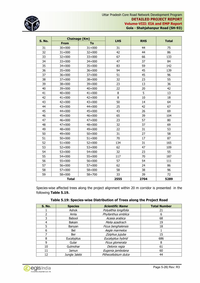
Uttar Pradesh Core Road Network Development Program
DETAILED PROJECT REPORT
Volume-VIII: EIA and EMP Report
Gola - Shahjahanpur Road (SH-93)
Page 5-26| Rev: R3
,
S. No. Chainage (Km)
LHS RHS Total From To
31 30+000 31+000 31 44 75
32 31+000 32+000 42 44 86
33 32+000 33+000 67 66 133
34 33+000 34+000 47 37 84
35 34+000 35+000 83 59 142
36 35+000 36+000 94 45 139
37 36+000 37+000 51 45 96
38 37+000 38+000 32 23 55
39 38+000 39+000 23 13 36
40 39+000 40+000 22 20 42
41 40+000 41+000 8 5 13
42 41+000 42+000 8 10 18
43 42+000 43+000 50 14 64
44 43+000 44+000 25 42 67
45 44+000 45+000 43 26 69
46 45+000 46+000 65 39 104
47 46+000 47+000 23 57 80
48 47+000 48+000 32 37 69
49 48+000 49+000 22 31 53
50 49+000 50+000 31 27 58
51 50+000 51+000 70 17 87
52 51+000 52+000 134 31 165
53 52+000 53+000 62 47 109
54 53+000 54+000 32 23 55
55 54+000 55+000 117 70 187
56 55+000 56+000 57 54 111
57 56+000 57+000 62 24 86
58 57+000 58+000 58 38 96
59 58+000 58+700 33 39 72
Total 2555 2704 5289
Species-wise affected trees along the project alignment within 20 m corridor is presented in the
following Table 5.19.
Table 5.19: Species-wise Distribution of Trees along the Project Road
S. No. Species Scientific Name Total Number
1 Ashok Polyalthia longifolia 21
2 Amla Phyllanthus emblica 6
3 Babool Acasia arabica 68
4 Bakain Melia azadirach 19
5 Banyan Ficus benghalensis 18
6 Bel Aegle marmelos 1
7 Ber Ziziphus jujuba 15
8 Eucalyptus Eucalyptus hybrid 686
9 Gular Ficus glomerata 8
10 Gulmohar Delonix regia 61
11 Jamun Eugenia jambolana 60
12 Jungle Jalebi Pithecellobium dulce 44

Uttar Pradesh Core Road Network Development Program
DETAILED PROJECT REPORT
Volume-VIII: EIA and EMP Report
Gola - Shahjahanpur Road (SH-93)
Page 5-27| Rev: R3
,
S. No. Species Scientific Name Total Number
13 Kadamb Anthocephalus cadamba 16
14 Kanchan Bauhinia sps. 10
15 Kaner Thevetia peruviana 5
16 Karanj Pongamia pinnata 279
17 Khajoor Phoenix dactylifera 2
18 Mahogany Swietenia mahagoni 261
19 Mahua Madhuca indica 1
20 Mango Mangifera indica 469
21 Neem Azadirachta indica 443
22 Pakar Ficus infectoria 302
23 Palm Palmyra Palm 40
24 Peepal Ficus religiosa 64
25 Poplar Populus sps. 26
26 Sheesham Dalbergia sissoo 1499
27 Siris Albizia lebbeck 545
28 Teak Tectona grandis 280
29 Others 40
Total 5289
5.2.8 Green Tunnel
There is no green tunnel situated along the project corridor.
5.2.9 Fauna
Domesticated animals constitute the faunal density in the area surrounding the project road.
These are dogs, cows, ox, buffaloes, goat, etc. Common birds like crow, parrot, pigeon, common
ducks, bagula, etc. are seen here. No endangered flora and fauna species are spotted within the
proposed project corridor. Sometime wild animals like Neel gai, Fox and jackals, etc are observed
in the project vicinity. There is no natural habitat of these animals along the highway section.
5.3 Social Environment
5.3.1 Demographic Profile
The demographic features of the project district as per 2011 Census are provided in Table 5.20.
The population density is far lower in the district with respect to the State’s population density.
The sex ratio reflects the socio-economic and demographic characteristics of the population. It is
an important indicator of migration and gender equity (in a developing country context) since it
helps to point out the employment opportunity in the districts. There are 912 females for every
thousand males in Uttar Pradesh State, while the sex ratios of the project concern districts are
861 females for every 1000 males, which is lower than the state’s ratio.
Table 5.20: District wise Demographic Profile of the Project Area
District / State
Total Rural Urban
Total No of House
Hold
Population Sex
Ratio
Population Density
(no. per sq Km)
Total Male Female
Lakhimpur Kheri
Total 527501 3006538 1606403 1400135 871
382 Rural 425057 2412446 1293714 1118732 864
Urban 102444 594092 312689 281403 900
Shahjahanpur
Total 745077 4021243 2123187 1898056 894
858 Rural 661245 3560208 1880679 1679529 893
Urban 83832 461035 242508 218527 901

Uttar Pradesh Core Road Network Development Program
DETAILED PROJECT REPORT
Volume-VIII: EIA and EMP Report
Gola - Shahjahanpur Road (SH-93)
Page 5-28| Rev: R3
,
District / State
Total Rural Urban
Total No of House
Hold
Population Sex
Ratio
Population Density
(no. per sq Km)
Total Male Female
Uttar Pradesh
Total 33448035 199812341 104480510 95331831 912
829 Rural 25685942 155317278 80992995 74324283 918
Urban 7762093 44495063 23487515 21007548 894
Source: Census of India, 2011 Census
5.3.2 Schedule Castes and Schedule Tribes
The population details of Scheduled Castes (SC) Scheduled Tribes (ST) in Amroha & Mordabad
districts is given in Table 5.21.
The Census of India survey reflects that a small population of Schedule tribes are found in the
concern districts, however at per site survey it has been revealed that there is no population of
ST along the project corridor.
Table 5.21: SC and ST Population of Concern District in Project Area
District/ State
Total Rural Urban
Population
SC ST
Total Male Female Total Male Female
Lakhimpur Kheri
Total 532673 285280 247393 508 259 249
Rural 479352 257180 222172 251 122 129
Urban 53321 28100 25221 257 137 120
Shahjahanpur Total 1061782 559240 502542 53375 26984 26391
Rural 1019387 536713 482674 52446 26460 25986
Urban 42395 22527 19868 929 524 405
Uttar Pradesh
Total 41357608 21676975 19680633 1134273 581083 553190
Rural 35685227 18663920 17021307 1031076 526315 504761
Urban 5672381 3013055 2659326 103197 54768 48429
Source: Census of India, 2011 Census
5.3.3 Literacy Rate
Literacy rate is a significant indicator of any district or state’s economic as well as social
development status. The higher literacy rate indicates higher awareness and vice versa.
The Literacy rate of the state according to the 2011 Census is 57.25%. The literacy rates for
Lakhimpur Keri and Shahjahanpur are 49.58 5 and 50.58 % respectively.
Table 5.22 below provides the area wise male and female literacy rates of the state of Uttar
Pradesh, and the project districts.
Table 5.22: Literacy Rate
District / State
Total Rural Urban
Population % age
Total Male Female
Lakhimpur Kheri
Total 1490930 915142 575788 49.58
Rural 1156822 725363 431459 47.95
Urban 334108 189779 144329 56.24

Uttar Pradesh Core Road Network Development Program
DETAILED PROJECT REPORT
Volume-VIII: EIA and EMP Report
Gola - Shahjahanpur Road (SH-93)
Page 5-29| Rev: R3
,
District / State
Total Rural Urban
Population % age
Total Male Female
Shahjahanpur
Total 2034044 1237157 796887 50.58
Rural 1746934 1076152 670782 49.06
Urban 287110 161005 126105 62.27
Uttar Pradesh
Total 114397555 68234964 46162591 57.25
Rural 85284680 51793688 33490992 54.91
Urban 29112875 16441276 12671599 65.43
Source: Census of India, 2011 Census
5.3.4 Employment Pattern
The work participation rate for total workers is defined as the percentage of total workers to total
population. In a similar way it is defined for main and the marginal workers. Table 5.23 & Table
5.24 illustrate the work participation in the project districts of the state of Uttar Pradesh as a
whole for the marginal workers and the main workers respectively. The relative importance of the
main spheres of economic activity may be gauged from the pattern of distribution of main
workers in cultivation, agricultural labour, household industry and other economic activities.
Table 5.23: Work Participation for the Marginal Workers
District / State
Total Rural Urban
Population
Total Male Female
Lakhimpur Kheri
Total 192711 142593 50118
Rural 158778 115924 42854
Urban 33933 26669 7264
Shahjahanpur
Total 306469 202986 103483
Rural 276078 180374 95704
Urban 30391 22612 7779
Uttar Pradesh
Total 21179223 12426463 8752760
Rural 18412163 10540532 7871631
Urban 2767060 1885931 881129
Source: Census of India, 2011 Census
Table 5.24: Work Participation for the Main Workers
District / State
Total Rural Urban
Population
Total Male Female
Lakhimpur Kheri
Total 699503 640720 58783
Rural 560332 515060 45272
Urban 139171 125660 13511
Shahjahanpur
Total 958249 855497 102752
Rural 849900 758812 91088
Urban 108349 96685 11664
Uttar Pradesh
Total 44635492 37420299 7215193
Rural 33538817 27812347 5726470
Urban 11096675 9607952 1488723
Source: Census of India, 2011 Census
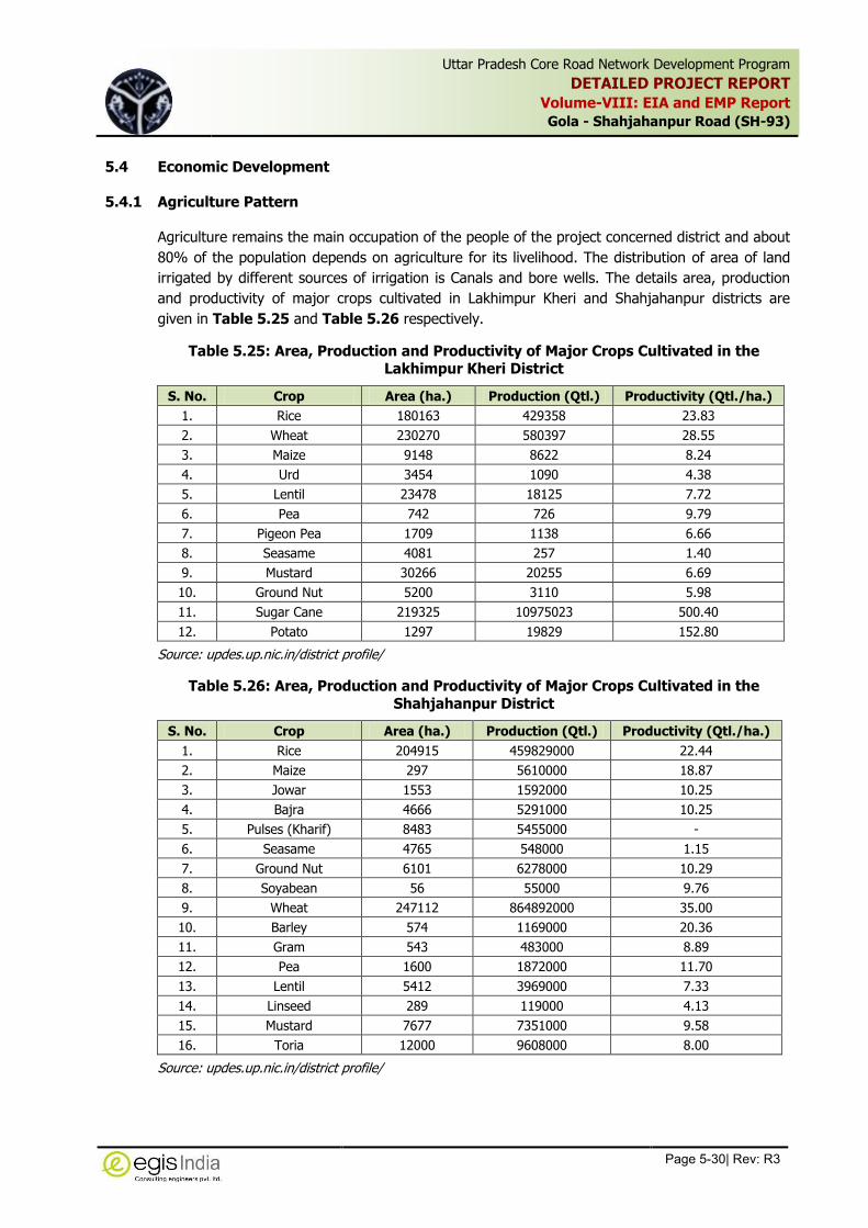
Uttar Pradesh Core Road Network Development Program
DETAILED PROJECT REPORT
Volume-VIII: EIA and EMP Report
Gola - Shahjahanpur Road (SH-93)
Page 5-30| Rev: R3
,
5.4 Economic Development
5.4.1 Agriculture Pattern
Agriculture remains the main occupation of the people of the project concerned district and about
80% of the population depends on agriculture for its livelihood. The distribution of area of land
irrigated by different sources of irrigation is Canals and bore wells. The details area, production
and productivity of major crops cultivated in Lakhimpur Kheri and Shahjahanpur districts are
given in Table 5.25 and Table 5.26 respectively.
Table 5.25: Area, Production and Productivity of Major Crops Cultivated in the Lakhimpur Kheri District
S. No. Crop Area (ha.) Production (Qtl.) Productivity (Qtl./ha.)
1. Rice 180163 429358 23.83
2. Wheat 230270 580397 28.55
3. Maize 9148 8622 8.24
4. Urd 3454 1090 4.38
5. Lentil 23478 18125 7.72
6. Pea 742 726 9.79
7. Pigeon Pea 1709 1138 6.66
8. Seasame 4081 257 1.40
9. Mustard 30266 20255 6.69
10. Ground Nut 5200 3110 5.98
11. Sugar Cane 219325 10975023 500.40
12. Potato 1297 19829 152.80
Source: updes.up.nic.in/district profile/
Table 5.26: Area, Production and Productivity of Major Crops Cultivated in the Shahjahanpur District
S. No. Crop Area (ha.) Production (Qtl.) Productivity (Qtl./ha.)
1. Rice 204915 459829000 22.44
2. Maize 297 5610000 18.87
3. Jowar 1553 1592000 10.25
4. Bajra 4666 5291000 10.25
5. Pulses (Kharif) 8483 5455000 -
6. Seasame 4765 548000 1.15
7. Ground Nut 6101 6278000 10.29
8. Soyabean 56 55000 9.76
9. Wheat 247112 864892000 35.00
10. Barley 574 1169000 20.36
11. Gram 543 483000 8.89
12. Pea 1600 1872000 11.70
13. Lentil 5412 3969000 7.33
14. Linseed 289 119000 4.13
15. Mustard 7677 7351000 9.58
16. Toria 12000 9608000 8.00
Source: updes.up.nic.in/district profile/

Uttar Pradesh Core Road Network Development Program
DETAILED PROJECT REPORT
Volume-VIII: EIA and EMP Report
Gola - Shahjahanpur Road (SH-93)
Page 5-31| Rev: R3
,
5.4.2 Educational Institutes / Hospitals
The educational institutions and hospital/health centers constitute the sensitive environmental
receptors. The list of such features along the ROW along the project roads is presented in Table
5.27. Photographic view of few educational institutions located along the Project Road is shown
in Figure 5.12
Table 5.27: List of Environmental Sensitive Receptors along ROW of Project Road
S. No. Institution / Hospitals Chainage (Km) Distance from CL
LHS/RHS
1 School 0+200 8+500 LHS
2 Sardar Patel Smarak Inter College 5+400 10+500 LHS
3 Mamri School 6+100 15+000 RHS
4 School 9+100 23+500 RHS
5 Mayagrani Bal Vidyamandir 11+550 11+800 LHS
6 School 20+400 15+500 RHS
7 A G Convent School 20+500 20+000 RHS
8 ITI 26+650 15+500 RHS
9 Doon Public School 27+050 18+000 LHS
10 New Gurukool School (Gate) 31+400 12+400 LHS
11 R P Inter College 34+920 14+000 LHS
12 P B Memorial School 40+200 15+500 RHS
ITI at Km 26+650 (RHS) P B Memorial School at Km 40+200 (RHS)
Figure 5.12: Institutions along the Project Road
5.4.3 Industries
The Industrial Scenario of Lakhimpur Kheri and Shahjahanpur districts are given in Table 5.28
and Table 5.29 respectively.
Table 5.28: Industrial Scenario of Lakhimpur Kheri district
S. No Head Unit Particular
1 Registered Industrial Unit No. 495
2 Total Industrial Unit No. 2500
3 Registered Medium and Large Unit No. 15
4 Estimated avg. no. of daily worker employed in small scale industries
No. 1363

Uttar Pradesh Core Road Network Development Program
DETAILED PROJECT REPORT
Volume-VIII: EIA and EMP Report
Gola - Shahjahanpur Road (SH-93)
Page 5-32| Rev: R3
,
S. No Head Unit Particular
5 Employment in large and medium industries No. 8924
6 Nos. of industrial Area No. 3
Source: Ministry of MSME, GoI
Table 5.29: Industrial Scenario of Shahjahanpur District
S. No Head Unit Particular
1 Registered Industrial Unit No. 45529
2 Total Industrial Unit No. 2873
3 Registered Medium and Large Unit No. 9
4 Estimated avg. no. of daily worker employed in small scale industries
No. 27418
5 Employment in large and medium industries No. 4318
6 Nos. of industrial Area No. 3
Source: Ministry of MSME, GoI
There are some industrial establishment observed along the project road, details of which are
presented in Table 5.30. The inventory survey reflects that the major industrial establishments
along the project stretch are brick kiln and rice mill.
Table 5.30: Industrial Units along the Project Road
S. No. Industrial Unit Chainage (Km) RHS/LHS
1 Shee Shyam Udyog Factory (Rice mill) 1+200 LHS
2 Rice Mill 1+600 LHS
3 Rice Mill 1+700 RHS
4 Brick Kiln 8+500 RHS
5 Brick Kiln 3+100 RHS
6 Brick Kiln 25+400 LHS
7 Rice mill 27+700 LHS
8 Brick Kiln 30+400 RHS
9 Brick Kiln 40+400 LHS
10 Brick Kiln 44+500 LHS
11 Brick Kiln 56+500 RHS
12 Brick Kiln 56+800 LHS
13 Brick Kiln 57+200 RHS
5.4.4 Cultural Properties
A number of religious structures are located in the vicinity of project area. Few of these structures
are situated close to the existing road edge which may require to be shifted. The lists of such
features are presented in Table 5.31.
Table 5.31: List of Religious Cultural Features along the Project Roads
S. No. Religious / Cultural
Resources Chainage
(Km) Distance from
CL LHS/RHS
1 Mosque 0+300 8.8 RHS
2 Temple 2+500 10.0 RHS
3 Temple 2+800 7.5 LHS
4 Temple 4+200 7.1 LHS
5 Temple 8+700 12.0 RHS
6 Temple 9+300 9.0 LHS

Uttar Pradesh Core Road Network Development Program
DETAILED PROJECT REPORT
Volume-VIII: EIA and EMP Report
Gola - Shahjahanpur Road (SH-93)
Page 5-33| Rev: R3
,
S. No. Religious / Cultural
Resources Chainage
(Km) Distance from
CL LHS/RHS
7 Temple 11+700 6.5 RHS
8 Shiva Temple 12+400 4.0 RHS
9 Temple 12+700 6.0 RHS
10 Temple 17+400 5.5 RHS
11 Sri Ram Lakhan Janaki
Mandir 19+200 17.0 LHS
12 Mosque 19+300 30.0 RHS
13 Gurudwara 23+200 25.0 LHS
14 Temple 30+700 13.5 LHS
15 Mosque 30+750 21.0 RHS
16 Temple 30+800 11.0 RHS
17 Mosque 31+800 18.0 LHS
18 Temple 36+500 4.0 LHS
19 Mosque 40+800 30.0 RHS
20 Temple 45+300 4.5 RHS
21 Temple 48+100 4.5 RHS
22 Temple 48+600 23.0 RHS
5.4.5 Historical Monument/Archaeological Site
The list of Archaeological sites within Lakhimpur Kheri and Shahjahanpur district are given in
Table 5.32. No Archeological site or historical monument or heritage sites recorded within 500 m
of the existing ROW of the project stretch on either side.
Table 5.32: : Archaeological sites within Lakhimpur Kheri district
Archaeological Sites locality District Tentative Distance from SH-93
British Monuments Aurangabad Lakhimpur Kheri 70 Km
A strip plan indicating different environmental features along the project corridor is given in
Annexure 5.4.

Uttar Pradesh Core Road Network Development Program
DETAILED PROJECT REPORT
Volume-VIII: EIA and EMP Report
Gola - Shahjahanpur Road (SH-93)
Page 6-1| Rev: R3
,
6 ENVIRONMENTAL IMPACTS AND MITIGATION MEASURES
In this chapter, potential environmental impacts, both bio-physical and socio-economic, are
assessed in terms of the direct and indirect nature of the impact, extent, duration and
significance. The level of assessment of each potential impact was based on the important
environmental issues identified in baseline environmental studies and the proposed improvement
and activities of the project.
The impacts of major infrastructure projects can be divided into two principal categories. First
direct impacts which result from physical presence of the facilities and the way they are designed,
built and operated. Second, indirect impacts, which stem from the construction and economic
activities surrounding construction and the induced development resulting from improved access.
The construction activities will mainly be restricted to the proposed ROW along the entire stretch
except for the temporary camp sites, quarry and borrow areas which are the activities associated
with the construction and are usually located beyond the right of way. All the proposed
construction activities will follow the current Indian standards for highway engineering design.
The potential environmental impacts are studied as direct, indirect or cumulative effects on
various environmental components.
Relatively small potential for negative impacts is generally envisaged for road widening and
upgrading project. Most of these negative environmental effects can be 'design out' at an early
stage through proper engineering designs, which will emphasize the contractors to follow
environmentally friendly construction methodology.
Direct environmental impacts are those that are directly caused by road construction or
operation. During construction these impacts primarily occur within the road formation area or
immediately adjacent to it, and at ancillary sites such as quarries and workforce camp. Direct
construction impacts can include the loss of agricultural land damage to ecological features such
as land resources and water bodies, damage to manmade structures and resettlement. During
road operation direct impacts may include a reduction in air and water quality.
The improvement of road have positive influence by virtue of better connectivity and accessibility,
low vehicle operating cost, quick access to marketing centers, educational and medical facilities,
improvement of way side amenities, enhancement of safety for the road users as well as the
population living in the vicinity of the highway, etc. and thus provide tremendous opportunities of
socio-economic development of the region. Besides these, the negative environmental impacts
due to the road development works can be correlated to the loss of land and properties,
deterioration of environmental quality (air, water, soil and noise) and ecological degradation
during various constructional works as well as during operational phase due to increase in traffic
volume, change in land use pattern, landscape deterioration, etc.
The road improvement project may influence various environmental components at different
stages of the project viz: Pre-constructional phase Constructional phase and Operational phase.
The impacts may be direct or indirect and may be beneficial or adverse with respect to the
environment. The major works associated with the construction phase mainly are site clearance,
Earth work in embankment, excavation, pavement and cross drainage works, dumping of spoils

Uttar Pradesh Core Road Network Development Program
DETAILED PROJECT REPORT
Volume-VIII: EIA and EMP Report
Gola - Shahjahanpur Road (SH-93)
Page 6-2| Rev: R3
,
and waste materials and other construction activities and associated works like mobilization of
constructional equipments, setting up of workforce camps, quarrying, transportation and storage
of materials, etc. These activities have potential impacts on physical, biological as well as social
environment. The impacts may be of short terms and temporary or long terms and permanent.
The likely impacts on various environmental components have been described as follows:
6.1 Impacts During Design/ Pre-constructional Phase
Sufficient Right of way is available in the entire section of the project road to accommodate the
proposed widening of the existing highway section to standard two lane with paved shoulder and
the project work would mostly be limited within ROW. Little adverse impacts on environmental
components are anticipated due to the project.
6.1.1 Impact on People and Properties
The project activities will be confined to the available right of way (ROW). As per baseline survey
on social features, it has been revealed that there are number of non-titleholders in the form of
squatters and encroachers will be affected within the ROW. However, at junctions and 4-laning
sections, a number of titleholders will be affected, which will be established after detailed survey
under Resettlement and Rehabilitation Report.
Mitigation Measures:
A separate R&R policy has been framed after identification of different categories of
affected persons to address the issues pertaining to the Project Affected People and their
rehabilitation & resettlement .
The acquisition of private properties will be carried out in accordance with the RAP and
entitlement framework for the project.
Early identification of affected persons for compensation and advance planning of
Resettlement and Rehabilitation Action Plan to Compensate the Losses.
All the affected people will be compensated for the loss as per R & R Policy of the project
before commencement of Construction works
PIU-UPPWD has to ascertain that any additional environmental impacts resulting from
acquisition of properties are addressed and integrated into the EMP and other relevant
documents.
6.1.2 Impacts on Other Assets
In addition to the above features, 107 hand pumps are likely to be affected due to the proposed
widening in both the project sections.
Mitigation Measures: All the affected hand pumps will be relocated at suitable locations before
commencement of construction activities.
6.1.3 Religious, Common and Govt. Property Affected
The baseline study reflects that there are total 22 nos. of religious structures and 107 numbers of
hand pumps located along the project corridor within 20 m corridor. Out 22 nos. religious
structures, 18 nos. are saved, 4 nos. are partially affected.

Uttar Pradesh Core Road Network Development Program
DETAILED PROJECT REPORT
Volume-VIII: EIA and EMP Report
Gola - Shahjahanpur Road (SH-93)
Page 6-3| Rev: R3
,
6.1.4 Impact on Utilities
Several types of utilities serving local and regional needs are falling under COI will need to be
relocated from their present position due to the proposed widening alignment. These services are
mainly electric poles, transformers, bore wells and water supply pipelines which may be required
to be relocated at some locations. The analysis of impact on public utilities reflects that a total
number of 95 electric poles, 107 numbers of hand pumps, 11 numbers of telephone poles and 32
numbers of transformers will be affected and will need to be relocated due to the project. Apart
from these resources, water supply pipelines are located close to the pavement at Mohammadi
(RHS) from Km 28.850 to Km 31.500 and therefore are required shifting to accommodated the
widening of the road. Such type of impacts due to the widening of highways is inevitable. These
will cause disruption in services and inconvenience to the local residents.
Mitigation Measures: All the utilities will be restored in advance prior to the start of
construction works. The required mitigation measures would be to instruct in advance the
relevant owners of these utilities to shift those before construction starts to avoid disruption of
local services. The PIU-UPPWD will liaise with and assist the line department for early and quick
shifting of these utilities in minimum time to avoid such impact on community.
6.1.5 Impact on Roadside Trees
The present project will have varying levels of impact on the roadside plantations throughout the
project stretch. This impact is viewed critical due to the duration required for its reversal and
sometimes it is irreversible. The roadside trees not only provide a healthy aesthetics to the road
users but also provide shade and protect the users from harmful effects of contaminants by
absorbing them through vegetation canopy. The cutting of trees along the rod will result into
reduced buffering of air pollutants, hotter, drier microclimate along the project road.
The tree inventory showed that 5289 trees of varying girth located within the ROW may be
affected due to the proposed widening. The baseline studies showed that there is no any
endangered or rare tree species located within the project area. The predominant tree species
are Babool, Sheesham, Neem, Eucalyptus, etc.
Effort will be made to minimize the tree felling by restricting tree felling within the formation
width only.
Mitigation Measures
Permission of Roadside cutting will be obtained from the line department, i.e. Forest
Department.
All efforts will be made to preserve trees by restricting tree cutting within the formation
width. Special attention will be given for protecting giant trees, and locally important trees
(having cultural importance)
Compensatory plantation will be carried out along the space available within the proposed
ROW in the ratio of at least 2 times as much the trees are proposed to cut as per Forest
(Conservation) Act. In case enough space is not available within ROW for compensatory tree
plantation, then efforts will be made to plant trees on the land provided by the forest
department for compensatory afforestation.
A general guideline for tree plantation will be followed as per IRC: SP: 21:2009 and as per
Tree Plantation Strategy given in Annexure-9.1

Uttar Pradesh Core Road Network Development Program
DETAILED PROJECT REPORT
Volume-VIII: EIA and EMP Report
Gola - Shahjahanpur Road (SH-93)
Page 6-4| Rev: R3
,
6.1.6 Legal implications due to Roadside trees declared as Protected Forest
The tress plantation within ROW on both side of project road section of SH-93 from Gola to
Shahjahanpur is declared as protected forest. Due to protected nature of roadside tree plantation,
tree felling within 10 m corridor on either of the road from existing centerline, will attract the
provision of Forest (Conservation) Act and hence forest clearance would be required for diversion
of forest area for non forest purpose, i.e. widening of road. The proposed widening will require
diversion of about 47.200 Ha of protected forest lands.
6.1.7 Impacts on Reserve Forest:
It is proposed to construct a new bridge on left side of the existing bridge across Kathina River at
Km 12+800. The pocket of Reserve forest is located on both side of the existing road along the
ROW just after the existing bridge. The project road passes through the reserve forest thereby
requiring additional land from the forest area. Thus a small area of about 1.998ha will require to
be diverted from the reserved forest area for construction of approach road to the new bridge.
This will also require felling of about 100 trees. These trees are mainly teak trees planted by the
Forest department in this forest pocket.
Mitigation Measures
Diversion of forest land from reserved forest pocket will attract the provision of Forest
(Conservation) Act and hence forest clearance would be required for acquisition of reserve
forest land.
All the conditions stipulated in the forest clearance will be complied with during construction.
No construction Plants, construction camp or borrow area will be located in the project
stretch long the Reserved Forest. A minimum distance of 1.000 Km from the reserved forest
patch will be maintained for siting these features.
The contractor will take all precautionary measures in the forest stretch to avoid any
incidence of forest fire.
6.2 Impacts during Construction Phase
Most of the adverse environmental impacts are related to construction works which are inevitable
but are manageable through certain environmental friendly practices. The negative environmental
effects can be taken care of at an early stage through proper engineering designs and through
the contract during construction practices.
The standard road construction works involve are site clearance, excavation, filling of earth
materials and sub grade materials, laying of bituminous mixtures, handling of hazardous materials
like bitumen, diesel, etc, dumping of unusable debris materials, transportation of materials from
production site to construction site, and other constructional activities and associated works like
mobilization of constructional equipments, setting up of different construction plants, setting up
of workforce camps, quarrying, material storage etc. These activities have certain impacts of
various magnitudes on different components of environment. The anticipated impacts due to all
these activities have been described below:
6.2.1 Impact on Land Resources
Clearing and grubbing and excavation of the land within the extent of formation width of the
proposed alignment as well as the proposed bypasses are the primary activity to prepare the bed

Uttar Pradesh Core Road Network Development Program
DETAILED PROJECT REPORT
Volume-VIII: EIA and EMP Report
Gola - Shahjahanpur Road (SH-93)
Page 6-5| Rev: R3
,
for road construction. The excavation activity will lead into generation of excavated materials
which would mainly soil mixed with pebbles in the project area. The suitable materials will be re-
used as fill materials, aggregates. The unsuitable excavated material will need to be disposed off
due to non-suitability for use in road fill materials. The disposal of debris materials in haphazard
manner will not only hamper the aesthetic look of the area but at the same time they are
potential contaminant for the surrounding land.
Some land would be needed to establish site offices and construction camps, worker/labour
camps. These will require temporary land acquisition for a short period. Substantial amount of
land would also be required for extraction of borrow materials.
For fulfilling the requirement of soil and aggregates certain land acquisition will be required
followed by excavation of that land area. Such type of activity can lead into disfiguration of
topography of the area. Water stagnation in the borrow pit provides ideal breeding sites for
mosquitoes and thereby can spread malaria and dengue if borrow pit is not properly managed.
Pits near settlements can pose health risk.
As per estimation of quantity of materials for the construction of project road, 4,43,180 Cum of
soil, 554500 Cum of coarse and fine aggregates and 16100 cum of sand would be required. In
addition to these quantities, 12600 tonnes of cement, 10100 tonnes of bitumen and 1474.100
tonnes of steel would be required for construction of roads including bridges and culverts. The
aggregate will be sourced from different quarry areas whereas the earth will be collected from
different borrow areas and reusable earth materials generated due to road cutting and drain
excavation. It has been estimated that due to roadway cutting and drain & toe wall excavation
about 5,80,394 Cum of earth work materials will be generated, out of which 201500 cum cut
materials will be used for sub-grade and embankment. About 24180 Cum fly ash will be utilized
for embankment construction thereby reducing the soil requirement to 4,19,000 Cum. Rest
quantity of cut materials (378894 cum) which is not suitable for construction will require to be
disposed off. About 2,17,500 cum of earth will be required to be taken from borrow areas to
meet the balance requirement of earth. This clearly reflects that the reuse of excavated
materials generated from roadway cutting and drain excavation will reduce the disposable
quantity, which shall have lesser impacts associated with disposal of the entire cutting materials.
However appropriate measures will be required for disposal of unusable materials.
Mitigation Measures
No Borrow area and quarry will be operated without written agreement of the land
owner.
The Contractor will obtain environmental clearance for the borrow area and quarry as per
EIA Notification 2006 and MoEFCC Office Memorandums on environmental clearance for
minor minerals and the conditions stipulated under the environmental clearance will be
binding on the contractor. The Contractor will submit the copy of clearance letter to the
Engineer and PIU before commencement of material extraction.
All the borrow area will be operated in accordance with IRC specification and MoEFCC guidelines.
The earth material generated due to excavation will be used to optimum quantity to
reduce impact on land resources.
No scare will be left unattended after excavation activity.
The Borrow area will be located preferably on barren land or unirrigated land.

Uttar Pradesh Core Road Network Development Program
DETAILED PROJECT REPORT
Volume-VIII: EIA and EMP Report
Gola - Shahjahanpur Road (SH-93)
Page 6-6| Rev: R3
,
The Borrow pits will not be dug within 800 m of town or village settlement, within ROW,
within 1 km from any forest area.
After excavation is over, the borrow area will be rehabilitated suitably
Proper reclamation of pits will be done
Cut face of the pit will be merged with the slope of the adjoining terrain
Bottom of the pits will be graded towards natural outfalls to prevent water accumulation
The reclaimed area will be seeded to provide grass coverage.
Quarrying of metal will be done only at licensed quarry and the area will be suitable
rehabilitated after quarrying is over.
The borrow areas and stone quarry site should be operated and managed as per
guidelines provided in Annexure 9.3 & Annexure 9.4, respectively.
The Construction camps will be located preferably on barren land and sufficiently away
from settlements and water bodies.
The Construction camp will be provided with necessary sanitation arrangements and
basic facilities.
After dismantling of Camp the natural condition of the land will be restored.
6.2.2 Impact on Soil
The site clearance process includes excavation and vegetation clearance which ultimately induces
vegetation loss as well as loss of top soil. Since vegetation clearance shall be confined to the
minimum area required for widening activities beyond the ROW, the area affected would be very
less. The activities associated with the site preparation and excavation plus movement of vehicles
and equipments can disturb the surrounding lands. At the borrow area, temporary camp site or
stockyards, workshops, and other ancillary sites there is chance of loss to soil fertility due to
various activities.
In order to minimize the impact on soil fertility the top soil will be preserved separately and the
top soil will be reused to site restoration work.
6.2.2.1 Contamination of Soil
Contamination of soil during construction stage is primarily due to construction and allied
activities. The sites where construction vehicles are parked and serviced are likely to be
contaminated because of leakage or spillage of fuel and lubricants. Pollution of soil can also occur
in hot-mix plants from leakage or spillage of asphalt or bitumen. Refuse and solid waste from
labour camps can also contaminate the soil. Contamination of soil during construction might be a
major long-term residual negative impact. Unwarranted disposal of construction spoil and debris
will add to soil contamination. This contamination is likely to be carried over to water bodies in
case of dumping being done near water body locations. However, by following mitigation
measures such as maintenance of vehicles and machines and fuel refilling is carried out in a
confined area can avoid contamination of soil to a great extend. The provision for oil interception
chamber is suggested in EMP for treating the waste water generated from vehicle washing,
refilling and maintenance areas. Fuel storage and refilling sites should be kept away from cross
drainage structures and important water bodies. All spoils shall be disposed off as desired and the
site shall be fully cleaned before handing over. These measures are expected to minimise the
impact on soil contamination.
Uttar Pradesh Core Road Network Development Program
DETAILED PROJECT REPORT
Volume-VIII: EIA and EMP Report
Gola - Shahjahanpur Road (SH-93)
Page 6-7| Rev: R3
,
6.2.2.2 Compaction of Soil
Compaction of soil may be anticipated due to the movement of construction vehicles and heavy
machines. Thus regulation of movement of heavy equipments and vehicles shall be essential to
prevent this.
Mitigation Measure
The excavation activities and vegetation clearance will strictly be limited to formation width
only.
All the usable excavated materials will be re-used as fill materials and aggregates.
The movement of construction vehicles and equipments will be restricted to only designated
route.
Designated storage site for fill materials and adequate stockpiling to prevent erosion and
runoff related problem.
6.2.3 Impact on Water Resources
The proposed widening will result into slight increase of surface run-off. The geological studies of
the project area show water table 8-10 m below the ground level. As the depth of the ground
water table is very high no adverse impact is anticipated on ground water. Laying of pavement
within the formation width may lead to reduction in the ground water recharge capacity. But as
the area involved in the road construction is very less, the chances of this influence will be non-
significant.
6.2.3.1 Water Requirement for Construction
The water demands for the construction work may pose severe stress on the public water supply
if the water for construction and allied activities are taken from the same source as the project
area is a water stressed area and water supply sources are limited.
The main source of water for construction and other related activities will be a mixture of surface
water source and ground water source. groundwater may be used by installing bore wells at
different locations such at camp sites and plant sites. Separate water supply arrangement for
construction and allied works will be made in from ground water/surface water source away from
public water supply source so that there is no interfere with the normal public water supply. The
water for the construction will be taken after taking prior permission from Competent Authority
and comply with all the requirements of State Ground Water Authority/ Irrigation Department.
The Contractor will take all the measures in order to minimize wastage of water during the
construction.
The baseline study indicate that the area along the project falls under safe to subcritical zones in
terms of ground water availability, usage and water balance and recharging capacity. The
estimated water requirement is for the entire project length and the abstraction of water will not
be confined to a single location but will be extended at different locations, therefore pressure on
a single aquifer will not be significant.
The Source of water for construction shall be identified by the Contractor depending upon the
location of construction sites, construction camp and plant site locations in consultation with line
department and UPPWD and will obtain all necessary statutory permits for usage of water before
start of abstraction of water.
Uttar Pradesh Core Road Network Development Program
DETAILED PROJECT REPORT
Volume-VIII: EIA and EMP Report
Gola - Shahjahanpur Road (SH-93)
Page 6-8| Rev: R3
,
Mitigation Measures
Longitudinal drains of sufficient capacity will be provided on both sides of the road to
accommodate increased run-off.
In urban stretches, the lined drains will be provided with cut in between to facilitate
ground water recharging. The cut will be made of granular coarse material, which will
increase the infiltration rate.
Rainwater Harvesting pits will be provided in consultation with Ground Water Boards
covering the entire project stretch The recharge pit can only be provided at those
locations where the water table is greater than 5 m deep . The schematic plan of
rainwater harvesting is presented in Annexure 9.5. The Contractor will have to collect
the information about the water table and then construct the rainwater harvesting pits
which will be approved by the Engineer and PIU-UPPWD. The Contractor will submit
completion after construction of rainwater harvesting pits along with their details duly
certified by the Engineer and PIU-UPPWD
The Contractor will arrange separate water supply arrangement for construction work and
will not interfere with the normal public water supply.
The Contractor will maintain the rainwater harvesting pits till defect liability period and
periodical maintenance of the structures will be ensured by the PWD afterwards to keep
them effective.
6.2.4 Impact on Water Quality
No permanent impact is anticipated on water quality due to the project. Construction activity may
temporarily deteriorate surface water quality near the alignment through increase in turbidity as
well as in oil and grease. These impacts can be handled through following proposed mitigation
measures:
All water and liquid wastes arising from construction activities will be
collected and reutilized for the purpose of dust suppression, curing etc..
.
Littering or unauthorized discharge will not be permitted.
Permission of the engineer and the concern regulatory authorities will be obtained for disposal of the waste as the designated disposal point.
The stream course and drain will be kept free from dumping of solid wastes and earth materials.
The construction materials and debris will be stored away from water bodies or water ways and only on the designated sites along the construction zones.
6.2.5 Impact on Ambient Air Quality
The air quality parameter is the most common environmental feature, which is being affected by
any road improvement projects at different stages i.e. during constructional as well as operational
phase. The major indicators of Ambient Air Quality relevant to the road project are suspended
particulate matters (SPM), Particulate matters of size less than 10 µ (PM10), particulate matters of
size less than 2.5 µ (PM2.5), Sulphur dioxide (SO2), nitrogen oxides (NOx), carbon monoxide (CO)
in the atmosphere. Significant amount of dust is likely to be generated due to site clearance and
excavation activities, exhaust of mobile and stationary construction equipment, stone crushing
plant, batching plant, HMP, demolition, embankment and grading activities, transportation of
earth materials and dumping of spoils, which have potential deterioration of air quality during the

Uttar Pradesh Core Road Network Development Program
DETAILED PROJECT REPORT
Volume-VIII: EIA and EMP Report
Gola - Shahjahanpur Road (SH-93)
Page 6-9| Rev: R3
,
process. This can increase the localized concentration of fugitive during construction phase.
During asphalt preparation, operation of hot mixing plants needs burning of fuels that result into
release of significant amount of gaseous pollutants into the atmosphere like oxides of sulfur,
hydrocarbons and particulate matters. These are likely to deteriorate the air quality in general
and also cause occupational exposure in particular. These impacts are, however, temporary one
that will remain only upto the period of clearance and excavation processes. Besides this, air
quality deterioration is also expected at deposits and borrows sites, materials treatment areas,
quarries, access roads and the site where facilities provided for project workers due to dust
generation and gaseous pollutant emission. Additional vehicular emission is expected during the
mobilization of construction equipments, transportation of materials, etc. due to the increased
vehicular number at the project sites but that will be minor in extent as there will not be
significant increase in vehicle numbers.
The improper sanitation at work camps and waste disposal usually lead to odour problem. Foul
odour may also cause during laying of pavement. The abovementioned problems related to the
deterioration of air quality, however, will temporal in nature till the construction period only.
Further, the activities will not be confined to any one place rather, it will progressively move
along the ROW, so prolonged deterioration in air quality will not occur at any one site. The minor
volume of dust generated will cause a short-term localized problem through settlements.
Mitigation Measures
Generation of Dust
Water will be sprayed during construction phase, in earth handling sites, asphalt mixing
sites and other excavation areas for suppressing fugitive dust.
Water sprinkling and transporting construction materials with tarpaulin coverage during
the construction stage.
During the sub-grade construction, sprinkling of water will be carried out on regular basis
during the entire construction period especially in the winter and summer seasons.
In case fly ash is used, dust emission during its loading and unloading, storage at open
place and handling for road construction shall be suppressed by regular water sprinkling.
Dust emission from stock piles of excavated material will be controlled either by covering
the stockpiled materials or water spraying over it.
Special attention will be given when working near educational institutions and health
centers and settlement areas.
As soon as construction is over all the surplus earth will be utilized properly all loose
earth will be removed from the site.
Mitigation Measures for Plants & Equipments
The Stone crusher plant, hotmix plant and Wet Mix Plant will be located sufficiently away
from settlement towards downwind direction and will conform to the siting and operation
requirements under Environmental (Protection) Rules, 1986.
Proper management of all Plant sites having stone crusher unit, Hotmix plants, Batchmix
plant, stockyards.
All the vehicles used during the construction stage to have valid PUC certificate

Uttar Pradesh Core Road Network Development Program
DETAILED PROJECT REPORT
Volume-VIII: EIA and EMP Report
Gola - Shahjahanpur Road (SH-93)
Page 6-10| Rev: R3
,
Provision of effective air pollution control systems in stone crushers, Hotmix Plant,
Batchmix plants such as dust containment cum suppression system for the equipment,
Construction of wind breaking walls along periphery of plant sites, construction of the
metalled roads within the premises, regular cleaning and wetting of the ground within the
premises, etc.
Gaseous Pollution
All the Construction vehicles and machineries will be regularly maintained to conform to
the emission standards stipulated under Environment (Protection) Rules, 1986.
Asphalt mixing /Stone Crusher plans should be located at list 1000 m away from any
habitation or sensitive environmental site and at least from national highway and 250 m
from State Highway away towards downwind direction.
All the DG sets will conform to the emission standards as stipulated under Environment
(Protection) Rules, 1986.
The workers working at asphalt mixing and subsequent application of asphalt mix on road
surface will be provided with heat resistant shoes and masks.
Handling and Transportation of Fly ash:
The fly ash handling and transportation of the same shall be done as per section 4.6 of
IRC: SP: 58-2001. Fly ash being a very fine material gets air borne easily and cause dust
nuisance. Dust at a construction site may be a safety hazard. It may also lead to
environmental pollution, public resentment and damage to internal combustion engine of
the construction equipment besides being a health hazards to workers. To avoid this, fly
ash from hoppers or silos must be conditioned with water at power plant to prevent
dusting enroute. Fly ash is typically delivered to the site in covered dump truck to
minimize loss of moisture and dusting. On the other hand, pond ash generally contains
enough moisture to prevent dusting, and may even contain excess moisture to create
road spillage during transport. In such cases, periodic inspection and lifting of ash from
relatively dry areas of the pond would be needed.
The fly ash may require on site temporary stockpiling if the rate at which the ash is
supplied to the project site is more than the contractor’s demand for an efficient rate of
placement. Such cases should be avoided to the extent possible and in case stockpiling at
site is inevitable, adequate precautions should be taken to prevent dusting by spraying
water on stockpiles at regular intervals. Otherwise, the surface of fly ash stockpile may
be covered with tarpaulins or a thin layer of soil or other granular material not subject to
dusting. Traffic movement may be restricted to those areas which are kept moist to
prevent tyres of passing vehicles dispersing ash into the air.
6.2.6 Impacts on Ambient Noise Level
Operation of heavy machineries; movement of heavy vehicles, stone crushing aggregate mixing
activities generates high noise increasing the ambient noise level in the surrounding. The
behaviour of truck drivers also plays roles in increasing the noise level by the injudicious frequent
use of blow horns. Especially in the settlement area this can pose a problem.
Workers working near the noise generating equipments and plants are likely to be exposed to
high noise level. The acceptable limits (for 8 hour duration) of the equivalent noise level exposure
during one shift is 90 dB(A). Hence, noise generated due to various activities in the construction

Uttar Pradesh Core Road Network Development Program
DETAILED PROJECT REPORT
Volume-VIII: EIA and EMP Report
Gola - Shahjahanpur Road (SH-93)
Page 6-11| Rev: R3
,
camps may affect health of the workers if they are continuously exposed to high noise level. For
reasons of occupational safety, exposure to impulses or impact noise should not exceed 140
dB(A) (peak acoustic pressure). Exposure to 10,000 impulses of 120 dB(A) are permissible in one
day. The noise likely to be generated during excavation, loading and transportation of material
will be in the range of 90 to 105 dB (A) and this will occur only when all the equipment operate
together and simultaneously. This is however, is a remote possibility. The workers in general are
likely to be exposed to an equivalent noise level of 80 to 90 dB (A) in an 8-hour shift, for which all
statutory precautions should be taken into consideration. However, careful planning of machinery
selection, operations and scheduling of operations can reduce these levels. A typical Noise
generation due to different activities has been given in the Table 6.1.
Table 6.1: Typical Noise Levels of Principal Construction Equipment during Major Construction Activity (Noise Level in dB(A) at 50 Feet)
CLEARING
Bulldozer
Front end loader
Dump truck
Jack hammer
Crane with ball
80
72 - 84
83 - 94
81 - 98
75 - 87
EXCAVATION AND EARTH MOVING
Bulldozer
Backhoe
Front end loader
Dump truck
Jack hammer
Scraper
80
72 - 93
72 - 84
83 - 94
81 - 98
80 - 93
STRUCTURE CONSTRUCTION
Crane
Welding generator
Concrete mixer
Concrete pump
Concrete vibrator
Air compressor
Pneumatic tools
Bulldozer
Cement and dump trucks
Front end loader
Dump truck
Paver
75 - 77
71 - 82
74 - 88
81 - 84
76
74 - 87
81 - 98
80
83 - 94
72 - 84
83 - 94
86 - 88
GRAND AND COMPACTING
Grader
Roller
80 -93
73 - 75
PAVING
Paver
Truck
Tamper
86 - 88
83 - 94
74 - 77

Uttar Pradesh Core Road Network Development Program
DETAILED PROJECT REPORT
Volume-VIII: EIA and EMP Report
Gola - Shahjahanpur Road (SH-93)
Page 6-12| Rev: R3
,
LANDSCAPING AND CLEAN UP
Bulldozer
Backhoe
Truck
Front end Loader
Dump Truck
Paver
80
72 - 93
83 - 94
72 - 84
83 - 94
86 - 88
Source: CPCB, Govt. of India
It is evident from the above table that the operation of construction machinery e.g. hot-mixer,
bulldozer, loader, backhoes, concrete mixer, etc will lead to rise in noise level to the range
between 80-95 dB (A). Vehicles carrying construction materials will also act as the noise sources.
The magnitude of impact from noise will depend upon types of equipment to be used,
construction methods and also on work scheduling. However, the noise pollution generated due
to different construction activities is a temporary affair. Each type of activity can generate
different type and levels of noise that continue for a short period during the operations of those
activities.
Implementing proper mitigation measures can reduce a lot of problem associated with noise
pollution due to construction activities.
Mitigation Measures:
All noise generating equipments will be installed sufficiently away from settlement areas.
The main stationary noise producing sources such as generator sets shall be provided
with noise shields around them. The noise shields can either be a brick masonry structure
or any other physical barrier which is effective in adequate attenuation of noise levels. A
three meter high enclosure made up of brick and mud with internal plastering of a non-
reflecting surface will be very effective in these regards
The plants and equipment used for construction will strictly conform to CPCB noise
standards.
Vehicles and equipments used will be fitted with silencer and maintained accordingly.
Noise to be monitored as per monitoring plan and if the noise level at any time found to
be higher than immediate measure to reduce noise in that area will be ensured.
Noise standards of industrial enterprises will be strictly enforced to protect construction
workers from severe noise impacts.
All the workers working very close to the noise generating machinery shall be provided
earplugs to avoid any ill impacts on their health.
An awareness programme will be organized for drivers and equipment operators to make
them aware of the consequences of noise and to act properly at site
6.2.7 Impact on Ecological Resources
The baseline study within the project area did not show any endangered or significant flora or
fauna within the corridor of impact therefore, any potential direct impact on biological
environmental characteristics such as, loss of rare or endangered species, habitat fragmentation
and wild life migrations is not envisaged. The temporary impact may be in the visual appearance

Uttar Pradesh Core Road Network Development Program
DETAILED PROJECT REPORT
Volume-VIII: EIA and EMP Report
Gola - Shahjahanpur Road (SH-93)
Page 6-13| Rev: R3
,
of the trees and shrubs as construction activity may lead to deposition of dust cover over the
leaves and foliage. This is limited to construction period and gets washed away with the first
monsoon shower.
6.2.8 Impact on Social Environment
6.2.8.1 Impairment of access to the properties
During construction of road, cross water and side drain temporary blockage of access or
interference with the access to the properties located along the right of way may occur, causing
inconvenience to the road users and enhances the accident risk if not managed properly. Such
impact can be avoided through proper planning of works and good engineering practices. Safe
and convenient passage for vehicles, pedestrians and livestock to and from roadsides and
property accesses connecting the project road shall be ensured by providing temporary access.
Adequate signage and barricades shall be raised at the expected bottlenecks for safe movement
of people. The Contractor shall provide early information to the affected people. On completion of
the works, all-temporary obstructions to access shall be cleared away, all rubbish and piles of
debris that obstruct access should be cleared.
6.2.8.2 Aesthetics
Disturbance of landscape aesthetics due to excavation of borrow pits, extensive quarrying,
disposal site of spoils, is expected during the constructional phase. However, it is only temporary
one and it can be restored with proper management plans within a short period such as roadside
plantation, etc. During operational phase this will be enhanced with the activities associated with
the maintenance of landscape such as plantation programme, by providing road side amenities,
parks etc.
Mitigation Measures:
The site will be cleaned immediately after the construction activity is over.
The debris materials will be disposed off only at identified area for disposal and proper
levelling will be done after disposing the materials and shall be covered with top soil and
some plantation will be done at the disposal site
The borrow area will be rehabilitated as per site condition. It can either be developed as
ponds, backfilled and levelled matching with the surrounding terrain.
6.2.8.3 Public Health and Safety
Health and safety are of major concern during the construction as well as operational phases. The
impact on health and safety can be envisaged for both workers at site and road users as well as
inhabitants of nearby areas.
Emission of gaseous pollutants and dusts are major result of various processes like material
treatment, operation of hot mix plant, stone crushing, and asphalt preparation. This emission
effect is only for short term till the construction work is over but the effect may be significant
from the point of view that the workers are directly exposed to these emissions. Apart from this,
safety risks to road workers, primarily in the areas of storage and handling of dangerous
materials, and in operation of heavy machinery close to traffic, slopes, power line and water
courses, are also involved during the construction works.

Uttar Pradesh Core Road Network Development Program
DETAILED PROJECT REPORT
Volume-VIII: EIA and EMP Report
Gola - Shahjahanpur Road (SH-93)
Page 6-14| Rev: R3
,
The dust and gaseous pollutant generation within the congested area during the construction
works will adversely affect the health of people residing in the close proximity of the road.
Excavation of borrow pits on both the sides of roads within and outside the existing ROW can
create unhealthy aesthetics and also enhance the risk of malaria. These areas provide ideal
breeding zones for flies and insects. Stagnancy of water in borrow pits located nearby settlements
during rains may enhance the possibility of spreading of diseases. The vehicles and equipment
operation increase the chances of collision with vehicles, pedestrians and livestock. The poor
sanitation and poorly manages dispose off the waste may cause increase in communicable
diseases.
Mitigation Measures
The project will comply with the requirements of the EHS Guidelines of the World Bank
Group, 20075. The relevant ones are general guidelines available on the internet.
The plants and equipments will be installed sufficiently away from the settlement.
All the construction equipments and vehicles will conform with the emission standards stipulated by the CPCB.
Safe working practices will be followed up and all the workers will be trained
All the workers will be provided with proper personal protection equipments at construction as well as plant site
Proper caution signage, barricading, delineators etc. will be installed at Construction zone and temporary diversions
Proper traffic management will be ensured at the Construction zone as per IRC.
An Emergency Response system in case of any incidence will be developed and implemented
Periodical health check facility will be provided at camp sites.
6.2.9 Other Environmental Concerns of Construction Phase:
Various other environmental impacts during construction stage include:
6.2.9.1 Diversion of Traffic
Short term impact associated with the project will be traffic diversion and management during
construction phase. Construction activities will cause hindrance to the existing traffic flow. There
is possibility of accident hazards during construction phase of the widening project. There will be
requirement for diversion of existing traffic at various construction sites during construction
phase. It needs to be mentioned that though there are no direct impacts on the natural
environment due to disruption/diversion of such services, but diversion can also lead to adverse
impacts if not planned properly. Rapid restoration of diverted services can help in minimizing the
severity of impacts arising out due to diversions of existing services.
Mitigation Measures
Proper preventive measures will be taken during the construction activities at the construction sites
Reduce speed through construction zones.
5 Reference: (i) http://www.ifc.org/wps/wcm/connect/554e8d80488658e4b76af76a6515bb18/Final%2B-
%2BGeneral%2BEHS%2BGuidelines.pdf?MOD=AJPERES and (ii) http://www.ifc.org/wps/wcm/connect/7e4c7f80488554d5b45cf66a6515bb18/Final%2B-%2BToll%2BRoads.pdf?MOD=AJPERES&id=1323162564158 ]
Uttar Pradesh Core Road Network Development Program
DETAILED PROJECT REPORT
Volume-VIII: EIA and EMP Report
Gola - Shahjahanpur Road (SH-93)
Page 6-15| Rev: R3
,
Construction of bridges/culverts will be carried out prior to construction of new carriageway at the first stage.
Strengthening/raising of existing two lanes will be done only after the completion of the first stage.
Proper warning signs will be displayed at construction sites.
6.2.9.2 Equipment Servicing and Fuelling
On large road projects, thousands of liters of diesel and many other petroleum products are
transported and used throughout the work site every day. Construction equipment generates
large amount of waste oil, and its proper handling is critical, since improper storage and leakage
can result in the contamination of land and water bodies. Even the spillage can affect surface
water bodies by the road sector project.
Mitigation Measures
The vehicle and equipment service centres will be established away from any water body or
agricultural land.
Proper bunding with appropriate Containment will be provided at the equipment and vehicle
servicing centres. The spent wash from the service centre will be put in separate soak pits
and sand pits
All the fuel and chemical storage will be sited on an impervious base within an embankment
and secured by fencing. The storage area will be located away from water course or wetland.
6.2.9.3 Construction Camps
Workers’ Camp
Construction workers are a very neglected group in the country. Unless the workers are provided
proper amenities to live at the construction site the environmental issues of road construction
cannot be properly met. Apart from labour camps, separate construction Camps also established
where various plants and equipments as well as offices and residential units for technical and non
technical staff are located and often labour camps are also provided in the same premises.
Location of the Construction camp also has certain impacts on surrounding environment if not
properly managed. It is preferred to engage local labour depending upon the aviability in the
area, however generally migrated labours are also engaged for different construction activities. It
is estimated that around 200 labours will be required for different activities of construction during
peak construction period. For migrated labour, camps with appropriate number of dwelling units
is required to be provided by the contractor till the construction period.
At labour and construction camps lot of wastes are generated. These wastes are refuge from the
plants, and equipments, waste water and other domestic waste. These wastes are solid as well as
liquid waste mainly refuse water and kitchen waste. The disposal of such waste material to the
surrounding land can potentially damage the land and would generate health risk to not only
surrounding area but within the premises itself. Improper drainages system within the premises
also creates insanitation condition thereby enhancing health risk.
Mitigation Measures
Contractor will follow all relevant provisions of the Factories Act, 1948 and the Building and
the other Construction Workers (Regulation of Employment and Conditions of Service) Act,

Uttar Pradesh Core Road Network Development Program
DETAILED PROJECT REPORT
Volume-VIII: EIA and EMP Report
Gola - Shahjahanpur Road (SH-93)
Page 6-16| Rev: R3
,
1996 as well as the guidelines of IFC and EBRD6 will be followed for construction and
maintenance of labour camp throughout the construction period.
The Construction/labour camps will be established only on area approved by Supervision
Consultant.
The worker’s/labour camp will be located away from water bodies, schools and residential
areas. The camp will be constructed with proper accommodation facilities.
The workers camp will be provided with drinking water supply system so that local water
sources are not disturbed.
The camp should be provided with fuel for cooking like kerosene and /or LPG to avoid any
cutting of trees for fuel wood.
All camps will be provided with proper sanitation facilities, separate toilets and bathrooms for
female and male workers, septic tanks with soak pits of sufficient size, dust bins etc.
Waste water from domestic uses and solid wastes will be disposed of without violating
environmental norms. The measures will be site specific.
The labour camps will be provided with crèche, first aid facilities, etc as required under
Factory Act.
After completion of construction, the contractor will dismantle the camp and restore it to the
original condition of the area before handing over the site to the land owner.
6.2.9.4 Disruption of Services
Local services, including water supply lines, irrigation line, drainage, ditches, streets are
commonly cut during road earthworks. These activities are required by the local people for crop
production, drinking water supply and access, and have the potential to damage road work too.
These services are often either inadequately reconnected or not reins ted at all.
Mitigation Measures
The Contractor will arrange their own source to cater for their water requirement for
construction and other activities and will not interfere with the local water supply system
All irrigation canals, water supply lines and stand pipes, drainage and streets will be
maintained during construction or if necessary, temporary services shall be arranged of the
owner/ user’s permission for temporary cessation will be gained.
All the Services will be progressively reinstalled as soon as road excavation has been
completed.
6.2.9.5 Chance finding of Archaeological Properties:
Although the baseline study indicates that no structures/features of archaeological importance
situated along the project corridor, however there is Possibility of finding of articles/ things of
archaeological importance such as fossils, coins, articles of antiquity, archaeological remains, etc.
below the ground during excavations at different sites like construction zones, borrow area
excavation, excavation at camp site and other allied sites. In case of discovery of such features
following mitigation measures may be taken to avoid and minimize any adverse impact on such
properties:
6 http://www.ifc.org/wps/wcm/connect/topics_ext_content/ifc_external_corporate_site/ifc+sustainability/learning+and+adapting/knowledge+products/publications/publications_gpn_workersaccommodation
Uttar Pradesh Core Road Network Development Program
DETAILED PROJECT REPORT
Volume-VIII: EIA and EMP Report
Gola - Shahjahanpur Road (SH-93)
Page 6-17| Rev: R3
,
All fossils, coins, articles of value of antiquity, structures and other remains of archaeological interests discovered on the site shall be the property of the Government and shall be dealt with as per permissions of the relevant legislation.
The Contractor shall take reasonable precautions to prevent his workmen or any other persons from removing and damaging such articles or things.
The Contractor will immediately stop the work at site upon discovery of such articles or things or archaeological importance during construction.
The Contractor shall, immediately upon discovery thereof and before removal, acquaint the Engineer of such discovery and carry out the Engineer’s instructions for dealing with the same.
The Engineer/PWD will seek direction from the respective Archaeology Department before instructing the Contractor to recommend the work in the site.
6.3 Impacts during Operational Phase
During operation stage, the main sources of environmental impacts are the increased traffic
volume and speeds and better access to forest lands. The increase in traffic volume and speed
may enhance the safety risk especially in the rural area. The better access to the forest area can
stimulate the human interference in these areas. No sudden change in the traffic volume is
expected due to this road as the road is already existing one and opened for public traffic. The
project also provides the opportunities of the restoration of vegetation around the vicinity of the
worksite and roads by implementing the compensatory plantation programme, which will not only
enhance the aesthetic view but can also help in reclamation of soil. During operational phase this
will be enhanced with the activities associated with the maintenance of landscape such as
plantation programme, by providing roadside amenities, parks etc.
During the operational phase when the plantation works will be adequately implemented will
enhance the aesthetic as well as hygienic environment thereby reducing the chances of diseases
due to vehicular emission. Widening will ensure smooth plying of the vehicles and also will help in
reducing the congested zone and thus will reduce the emission rate of vehicles. Various impacts
during operation phase are discussed below:
6.3.1 Impacts on Water Quality and Resources
During the operation phase, the possibility of degradation of water quality is very remote. The
impact on the surface water quality during operation can be expected due to accidental spillage.
However the probability of such accidents are minimal since enhancement of road safety
measures such as improvement of curves and widening of the roads and other pedestrian
facilities are taken care of in the design stage.
6.3.2 Impact on Air Quality
The baseline study revealed that the people residing along the road face problem due to high
dust along the project section. The dry condition and exposed area, earthen shoulders along the
highway sections is the main reason behind the high concentration dust. Improvement in road
surface condition such as roughness, pot, patch, congestion, etc., improvement of curves and
junctions, provisions of organized parkings will likely to reduce the dust problem in the vicinity of
road. Moreover, the project will ensure smooth traffic flow and reduce idling time of engines thus
will reduce the emission rate of vehicles thereby reducing the magnitude of air quality

Uttar Pradesh Core Road Network Development Program
DETAILED PROJECT REPORT
Volume-VIII: EIA and EMP Report
Gola - Shahjahanpur Road (SH-93)
Page 6-18| Rev: R3
,
degradation. Further, roadside avenue plantation with pollution abating tree species will also help
in reducing the ambient pollution levels. Improved road conditions will attract more traffic and
thus the emissions from the traffic. Traffic projection study has been carried out and it is
estimated that by 2042-2043 traffic will increase to 36185 PCU from 4329 PCU (2014 data) Near
Mamri (Gola-Gomti More) and traffic will increase to 32812 PCU from 4854 PCU (2014 data) near
Mohmmadpur. Concentration of vehicular emissions is likely to increase with increase in nos. of
vehicles. Prediction modeling for CO concentration at sensitive receptors (like schools, hospital
etc) has been carried out for projected traffic of year 2042-2043 near Mamri and Mohammadpur.
CO modeling has been carried for worst case scenario (at wind speed of 1 m/s and 3 m/s).
Incremental value of CO varies from 0.4-1.8 ppm which is very less and will not have significant
impact on air quality. Refer table below for the details.
Traffic survey point
Receptors
Ambient CO Levels
(ppm) (wind
speed-1 m/s)
Predicted Increase CO
Concentration at Receptors
(ppm) (1 m/s)
Incremental CO levels
(ppm) (wind
speed-1 m/s)
Predicted Increase CO
Concentration at Receptors
(ppm) (3 m/s)
Incremental CO levels
(ppm) (wind
speed-3 m/s)
Receptor Near Mamri at Km 5+900 (Gola-Gomti more)
Sardar Patel Smarak Inter College-5.4 km
650 1.8 651.8 0.7 650.7
Receptor Near Mamri at Km 5+900 (Gola-Gomti more)
Mamri School-6.1
650 1.6 651.6 0.6 650.6
Receptor Near Mamri at Km 5+900 (Gola-Gomti more)
School-9.1 650 1.3 651.3 0.4 650.4
Receptor Near Mohmmadpur at
Km 47+000 (Gomti More to Shahjahanpur)
R P Inter College-34.92
1050 1.2 1051.2 0.5 1050.5
Receptor n Near Mohmmadpur at
Km 47+000 (Gomti More to Shahjahanpur)
P B Memorial School-40.2
1050 1.1 1051.1 0.4 1050.4
6.3.3 Impact on Noise Quality
Noise level is a matter of concern. Interrupted movement of heavy and light vehicles at high
speeds and movement in upward direction increase ambient noise levels along the roadway.
Noise produced by vehicles using the road can be attributed to the engine, vibration, friction
between tyres and the road, and horns. Increased levels of noise depend upon volume of traffic,
road condition, vehicle condition, vehicle speed, congestion of traffic and the distance of the
receptor (home, store etc.) from the source. The friction caused due to contact between tires and
pavement increases the traffic noise. The proposed work includes smoothening of pavement,
reduction of curves at several places that will reduce the overall noise level.

Uttar Pradesh Core Road Network Development Program
DETAILED PROJECT REPORT
Volume-VIII: EIA and EMP Report
Gola - Shahjahanpur Road (SH-93)
Page 6-19| Rev: R3
,
6.3.4 Human Use Values
Both land use and aesthetics are in fact, likely to improve due to afforestation and proper
landscaping. Proper engineering design like raising of embankment, provision of sufficient
number of culverts will ensure the reduction of the chances frequent road damages due to water
logging during rains. The provision of parking space, way side amenities, rest area, toilets and
drinking water will also help in smooth and comfortable flow of traffic and better acceptability of
the project by the community.
6.3.5 Impact on Climate Change due to Project
Fuel Consumption in MT per 1000 Veh-Km has been calculated using HDM-4 model. It has been
calculated for 20 years (period 2015 to 2034) considering “with” and “without” project. The
calculated fuel consumption “without” and “with” project is 12,32,419 MT per 1000 veh-km and
13,29,038 MT per 1000 veh-km respectively for 20 years. Fuel consumption has been calculated
for different type of vehicles such as motorcycle, 3-wheeler, passenger car, minibus, big Bus, light
commercial vehicle (LCV), truck-rigid 2-axle, truck-rigid 3 axle, multi axel vehicle (MAV) and horse
& semi-trailer-3 & 4 axles along the project road. There will be slight increase in fuel
consumption. This is due to the fact that the existing road is already two lane and the road
surface is in good condition. Presently the average speed of vehicles is between 60-80 km per
hour. The proposed design is for 100 km speed. It has been assumed that the vehicles will have
uniform speed of 100 Km per hour in open areas and 80 Km per hour in built up section. As a
result of the higher speeds there will be increase in fuel consumption. So, the rise in fuel
consumption may be attributed to rise in average speed of vehicles. The details of change in total
fuel consumption including petrol and diesel “with” and “without project” scenario is depicted in
following Table 6.2.
Table 6.2: Fuel Savings [MT Fuel Consumption per 1000 veh-km] due to project
Project Length (Km)
MT Fuel Consumption per 1000 veh-km (Base/Without
Project)
MT Fuel Consumption per 1000 veh-km
(With Project)
Fuel Savings [MT Fuel Consumption per 1000
veh-km]
48.94 12,32,419 13,29,038 -96,619
Estimation of fuel saving with respect to diesel & petrol is shown in following Table 6.3:
Table 6.3: Fuel Saving in “With” and “Without Project” Scenario
Fuel Type Without Project With Project Fuel Saving
Assuming 60 % Diesel (Quantity in MT) 7,39,451 7,97,423 -57,971
Assuming 40 % Petrol (Quantity in MT) 4,92,968 5,31,615 -38,648
Density of Petrol 0.77 Kg/lt
Density of Diesel 0.832 kg/l
Petrol Quantity (lt) 64,02,17,652 69,04,09,242 -5,01,91,590
Diesel Quantity (lt) 88,87,63,688 95,84,40,714 -6,96,77,026
The Carbon Dioxide (CO2) emissions have been calculated using “mobile combustion GHG
emission calculation tool, version 2.3” and the summary of Carbon Dioxide (CO2) emissions is
given in Table 6.4.

Uttar Pradesh Core Road Network Development Program
DETAILED PROJECT REPORT
Volume-VIII: EIA and EMP Report
Gola - Shahjahanpur Road (SH-93)
Page 6-20| Rev: R3
,
Table 6.4: Green House Gas Emission in “With” and “Without” Project Scenario
Greenhouse gas
Fossil Fuel Emissions
Without Project (metric tonnes) With Project (metric tonnes)
Total (metric tonnes CO2) 38,32,906 41,71,929
The analysis of result with the above details, it may inferred that that there will marginal increase
in fuel consumption and thereby increase in Carbon Dioxide (CO2) emissions in “with” project
scenario as compared to “without” project i.e 8.85 % of CO2 increase. The marginal increase in
fuel consumption and CO2 is because the existing road is already having 2 lane configuration and
in good condition. The proposal is to maintain the two lane configuration with additional paved
shoulders on either side.
Integration of climatic change and change in hydrology in cross drain design:
The hydrological regime of the project stretch has been studies and integrated in designing of
bridges to counter inevitable climate change. The drainage pattern and hydrology of the area has
been assessed and analysed considering the rainfall pattern in the area. The hydrological study
for region has been carried out considering 50 years data of rainfall, temperatures and flood
status.
For the calculation of discharge of the stream by Area-Velocity method, topographical survey
including levelling surveys have been carried out across and along the watercourses to determine
the cross-section and the longitudinal section of stream. A number of cross-sections have been
taken at regular intervals on both upstream and downstream side of the structure, including one
at the proposed location of the structure in accordance with IRC specifications. The peak
discharge and the High Flood Level (HFL) have been calculated. The detailed hydrological
calculations have been carried out for all new/reconstruction Bridges.
Based on the study, no impact on hydrology and discharge is envisaged due to proposed project.
No additional major or minor bridge is proposed in the project. The project road has 13 existing
bridges, out of which 12 are of minor bridges and 1 is major bridge. 5 minor bridges will be
retained with repairs, 3 minor bridge will be retained with widening and 4 to be replaced. 1 major
bridge will be replaced. The design discharge has been taken with 50 years prediction of
discharge. The design discharge and HFL has been estimated as below and has been integrated
in design of cross drain structures:
Table 6.5: The design discharge and afflux HFL at Bridge locations
S. No. Chainage (Km) Design Discharge (Cumec) Affluxed High Flood Level (HFL) in m
1 0+200 7.721 154.889
2 12+900 205.554 149.029
3 24+500 1328.618 148.095
4 33+800 5.208 151.260
5 49+700 45.861 154.913
It is proposed to raise the vertical profile of the road in the overtopping sections at one location
between Km 12+200 to Km 12+590 for a length of 390 m due to HFL. Additional 11 numbers of
balancing culverts have been proposed at different locations to allow passage of water during any
flood which will have positive impacts on drainage.

Uttar Pradesh Core Road Network Development Program
DETAILED PROJECT REPORT
Volume-VIII: EIA and EMP Report
Gola - Shahjahanpur Road (SH-93)
Page 7-1| Rev: R3
,
7 ANALYSIS OF ALTERNATIVES
7.1 Introduction
The project road section of SH-93 starts from Gola Market at Km 1+281 and ends at
Shahjahanpur at Km 58+580, covering a distance of 58.100 km. The road section falls in
Lakhimpur Kheri and Shahjahanpur districts of Uttar Pradesh. The project stretch passes through
major settlement areas namely Gola, Mamri, Maheshpur, Mohammadi, Mohamadpur, and
Shahjahanpur.The analysis of alternatives has been carried out ‘with project’ and ‘without project’
scenarios in terms of potential environmental impacts.
The present alignment has been followed for widening and mainly concentric widening has been
proposed except for few locations where eccentric widening is proposed for the purpose of
widening of bridge, curve correction or widening of culverts. The alignment is to follow the
existing highway section. Therefore the analysis of alternative has been carried out ‘with project’
and ‘without project’ scenarios for the only one possible alternative i.e. to follow the existing
alignment only.
7.2 “With” and “Without” Project Scenario
The proposed development of project road of SH-93 from Km 1.281 to Km 58.580 in the State of
Uttar Pradesh is not only development of surrounding area but will also provide smooth
movement of traffic and linking with other roads of the country. Keeping in view, the site
conditions and the scope of development of the area, the ‘With’ and ‘Without’ project scenarios
has been compared for the lone existing alignment and is represented in Table 7.1.
Table 7.1: ‘With’ and ‘Without’ Project Scenario
With Project Without Project
Positive Impacts Negative Impacts Positive Impacts Negative Impacts
The improvement of road surface and bottlenecks will improve, thus reduce the traffic congestion and reduction in wastage of fuel.
Dust level will decrease in the stretches where road condition is bad at present.
Flourish in trade and commerce Providing better level of service
in terms of improved riding quality and smooth traffic flow.
Reduction in accident rate Access to new employment
opportunities Employment of local workers for
the execution of project Better access to health care and
other social services Improved quality of life of the
local people
Increase of traffic will lead to slight increase in air and noise pollution.
Removal of trees and vegetation due to widening and upgradation
Short term Increase in dust pollution and noise pollution during construction period.
Public Safety and Inconvenience due to construction activities till construction period.
Inconvenience due to interference with public utilities during shifting
No acquisition properties and hence no displacement of families.
No felling of existing trees and vegetation
Travel time and fuel consumption level will be more due to bottlenecks
Increase in dust pollution and vehicular emission
The accident rate will increase
Road Safety is presently most important concern of the people living along the highway which has not been addressed properly.
Further deterioration of project road.

Uttar Pradesh Core Road Network Development Program
DETAILED PROJECT REPORT
Volume-VIII: EIA and EMP Report
Gola - Shahjahanpur Road (SH-93)
Page 7-2| Rev: R3
,
With Project Without Project
Positive Impacts Negative Impacts Positive Impacts Negative Impacts
Better way side amenities and other facilities like bus bays/shelters
Increase of aesthetics and environmental condition due to Avenue Plantation along the project road
Provision of systematic utility duct will enhance the road aesthetics as well as reduction in frequent damage of road due to repairing/ up gradation of utilities.
Increase in groundwater recharge due to proposed rain water harvesting structures.
The existing road is having single lane, intermediate lane and two lane carriageway thus posing
restriction in smooth plying of traffic as well as increases the risk of accidents. Ad-hoc parking of
commercial vehicles often obstructs the free flow of traffic. Major obstructions to free flow of
traffic are numerous intersections, narrow settlement areas, sharp curves, non motorised traffic
and a variety of road users. In case of “Do Nothing” alternative, the regional development as
well as any other developmental activities will be adversely affected due to inadequate service
level of the highway. The maintenance of economic stability and growth of the area will be
impeded not only in the close proximity of the project area but will have its impacts, far and wide.
The quality of life of local people will also be affected as the issues are directly related to the
communication systems available to them.
The proposed project road will have standard two lane carriageway of 7.0 m with 1.5 m paved
shoulders on eitherside throughout the project length. Apart from this there is provision of 18
nos. of bus bays on both sides, 1 no. of truck lay byes, facilities for pedestrian movement, traffic
signboards which will not only enhance the service level but at the same time will enhance the
safety to the highway users and road side communities to a great extent.
Material Requirement
As per estimation of quantity of materials for the construction of project road, 443180 Cum of
soil, 554500 Cum of coarse and fine aggregates and 16100 cum of sand would be required. There
are two alternative for availability of construction materials, one the entire quantity of materials
can be taken from different borrow areas and second reuse of excavated materials for
construction to optimum level and rest to extract from the borrow area.,. About 24180 Cum fly
ash will be utilized for embankment construction thereby reducing the soil requirement to
4,19,000 Cum. It has been estimated that the 5,80,394 Cum of earth work materials will be
generated due to roadway cutting and drain excavation about 580850 m3 earth work materials
will be generated. It is proposed to reuse about 201500 cum cut materials for sub-grade and
embankment. The balance quantity of about 2,17,500 cum of earth will be taken from borrow
areas. Rest quantity of cut materials (378894 cum) which is not suitable for construction will
require to be disposed off. Reuse of excavated materials will not only reduce the impact on land
due to borrowing of earth and at the same of the excavated time the disposable quantity will also
be reduced.

Uttar Pradesh Core Road Network Development Program
DETAILED PROJECT REPORT
Volume-VIII: EIA and EMP Report
Gola - Shahjahanpur Road (SH-93)
Page 7-3| Rev: R3
,
It is also proposed to use 24180 cum of fly ash in embankment. This will further reduce the
requirement of earth for construction to 219000 cum thereby reducing the impact on land.
Widening Options
In general concentric widening has been proposed in order to avoid land acquisition and to
minimize impacts on roadside trees and settlement. 5 nos. of realignment are proposed in the
project of total length of 2.277 Km. However at few locations one side widening is proposed for
alignment improvement, saving built-up area and trees, and widening of CD structures.
Altogether 52.058 Kms will include concentric widening, left widening in 0.77 Kms length and
right side widening in 2.995 Km length.
Table 7.2: Widening options
Chainage (Km) Length (Km) Widening
To From
1+280 6+840 5.559 Concentric
6+840 7+330 0.490 Right
7+330 10+950 3.620 Concentric
10+950 11+100 0.150 Left
11+100 12+250 1.150 Concentric
12+250 12+300 0.050 Left
12+300 12+550 0.250 Concentric
12+550 12+590 0.040 Right
12+590 12+900 0.310 Realignment due to construction of bridge
12+900 12+995 0.095 Concentric
12+995 13+045 0.050 Curve Improvement
13+045 13+480 0.435 Concentric
13+480 13+560 0.080 Left
13+560 13+600 0.040 Concentric
13+600 13+650 0.050 Right
13+650 23+590 9.940 Concentric
23+590 24+880 1.290 Right
24+880 25+810 0.930 Realignment due to reconstruction of major brige and
geometric improvement
25+810 33+520 7.710 Concentric
33+520 33+800 0.280 Left
33+800 40+050 6.250 Concentric
40+050 40+200 0.150 Right
40+200 43+530 3.330 Concentric
43+530 43+870 0.340 Realignment due to reconstruction of bridge
43+870 44+000 0.130 Left
44+000 46+800 2.800 Concentric
46+800 47+132 0.332 Realignment due to reconstruction of bridge
47+132 48+650 1.518 Concentric
48+650 49+540 0.890 Right
49+540 52+250 2.710 Concentric
52+250 52+565 0.315 Realignment due to reconstruction of bridge
52+565 52+600 0.035 Right
52+600 54+120 1.520 Concentric
54+120 54+200 0.080 Left
54+200 58+150 3.950 Concentric
58+150 58+200 0.050 Right
58+200 58+580 0.380 Concentric

Uttar Pradesh Core Road Network Development Program
DETAILED PROJECT REPORT
Volume-VIII: EIA and EMP Report
Gola - Shahjahanpur Road (SH-93)
Page 7-4| Rev: R3
,
To avoid/minimize the impact on adjacent land and properties toe line walls of varying height have
been proposed at 4 locations on LHS covering a length of 0.595 Kms and 6 locations on RHS for a
total length of 1.070 Kms. The location of toe wall has been given in Table 2.7 of Chapter 2.
Drainage conditions
It has been observed that the road section at 1 location gets submerged during flood and thereby
the road gets damaged frequently. To improve drainage condition in this stretch, the proposed
vertical profile of the road has been raised between Km 12.200 to Km 12.590 for a length of 390
m. There are 73 culverts exists in the project road. All the 73 culverts will be retained with
repairs. Additional 11 numbers of balancing culverts have also been proposed in the project in
order to allow passage of water during any flood in order to improve drainage conditions of the
area.
Emission of Greenhouse Gas (CO2)
A comparative analysis of CO2 emission has been carried out in both “With” and “Without
Project” scenario. The analysis reflects that there is slight increase in fuel consumption and
thereby marginal increase in CO2 emission under “with Project” scenario compared to “Without
Project” scenario.
With the above comparison it can be concluded that “With” project scenario, positive/beneficial
impacts will greatly enhance social & economic development of the region and improve the
environment, when compared to the “Without” project scenario, which may further deteriorate
the existing environment and quality of life. Hence the “With” project scenario with some
reversible impacts is an acceptable option rather than “Without” project scenario. The
implementation of the project therefore will definitely be advantageous to improve the
environmental quality of the sub-region besides to achieve an all round development of the
economy and progress of the region.
There is little increase in the pollution levels during construction. Dust and particulate matter
during construction will affect the air quality on a short-term basis but will be temporary in
nature. The safety of road users as well as surrounding population will enhance to great extent
due to the project with provisions of traffic lights, bus shelters, etc which are inadequate in the
present scenario.
Uttar Pradesh Core Road Network Development Program
DETAILED PROJECT REPORT
Volume-VIII: EIA and EMP Report
Gola - Shahjahanpur Road (SH-93)
Page 8-1| Rev: R3
,
8 PUBLIC CONSULTATION
8.1 Focus Group Discussion (FGD)
Public participation and community consultation has been taken up as an integral part of social
and environmental assessment process of the project. Public participation has been viewed as a
continuous two way process, involving promotion of public understanding of the process and
mechanism through which developmental problems and needs are investigated and solved. Focus
Group Discussion (FGD) was used as a tool to inform and educate stakeholders about the
proposed action both before and after the development decision was made. It assisted in
identification of the problems associated with the project as well as the needs of the population
likely to be impacted. This participatory process helped in reducing the public resistance to
change and enabled the participation of the local people in this development process.
8.1.1 Need and Usefulness of Focus Group Discussion (FGD)
Focus Group Discussion (FGD) is useful for gathering environmental data, understanding likely
impacts, determining community and individual preferences, selecting project alternatives and
designing viable and sustainable mitigation and compensation plan.
8.1.2 Objectives
The objectives of Focus Group Discussion for this project are:
Awareness of the project to local people, impacts and their suitable mitigation measures;
Identify alternative design and mitigation measures;
To improve environmental and social conditions;
Establish transparent procedures for carrying out proposed projects;
Create accountability and sense of local ownership during project implementation.
8.1.3 Level of Discussion
The public consultation was carried out at two levels. One before preparation of the project and
EIA report in order to capture the public perception about the project, identification of issues in
the area and their expectations with the project. The second level consultation was carried out
after preparation of the EIA study. The discussion process established for the project has
employed a range of formal consultative tools including in depth interviews with key informants
and on-site Focus Group Discussion and meetings. The enactment of participation and
consultation with villagers en-route has been done at various locations along the project corridor.
The discussion process established for the project has employed a range of formal consultative
tools including in depth interviews with key informants and on-site Focus Group Discussion and
meetings. The enactment of participation and consultation with villagers en-route has been done
at various locations along the project corridor.
8.1.3.1 First Stage Consultation
These discussions were held along the corridor of impact of the project road to inform people
about the purpose and preliminary design of the project. An Environmental questionnaire given in

Uttar Pradesh Core Road Network Development Program
DETAILED PROJECT REPORT
Volume-VIII: EIA and EMP Report
Gola - Shahjahanpur Road (SH-93)
Page 8-2| Rev: R3
,
Annexure 8.1 is used during public consultation along the project road. These discussions were
carried out to identify:
Specific social and environmental issues
Extent of likely impact due to the project
Expectation and reservations of people towards project; and
Resettlement and rehabilitation options.
Village/local level Focus Group Discussions were held at selected locations to understand the
implication of the project impacts on various groups, especially those with distinct degree of
vulnerability. The venues of the meetings were the villages/settlement along the project corridor.
At these meetings, the people were invited covering project affected persons, prominent village
persons, village panchayat members, teachers, health workers, etc.
Local level consultations meetings were carried out in 3 villages namely at Pipariya Dhani,
Mohammadi and Mohammadpur Tajpur along the project road. Table 8.1 presents the location
wise output of the issues discussed, suggestions made by the participants.
The general issues discussed in all locations are given below:
Perception on the existing project road and usage of the road
Benefits and problems faced if any with the existing road
Perception on the proposed 2 lane with paved shoulder improvements and alignment
options
Widening options and impact on local properties and business
Type of environmental enhancement
Identification of environmental issues
Table 8.1: Outputs of First Stage Consultations
S. No.
Name of the Village
Date of Consultation
Participants Suggestions/Observations Remarks
1 Pipariya Dhani village
04.11.2014 Affected villagers, the local residents, roadside residents and probable impacted families and the feasibility study team members.
1. People expressed their happiness that the road is going to be widened. 2. It will lead to development of the village. 3. The water in the area have high iron content. 4. Expansion of road should be to a limited possible extent. 6. Neelgai, Fox, Jackal is commonly seen is observed sometimes. Many times Neelgai causes great damage to their crop. 6. Acquisition of properties should be made after doing justice to the loss.
The widening will be carried out mostly within existing ROW. The affected persons will be compensated for the loss as per R&R policy adopted for UPCRNDP.
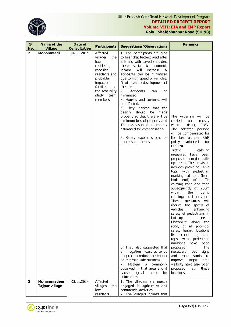
Uttar Pradesh Core Road Network Development Program
DETAILED PROJECT REPORT
Volume-VIII: EIA and EMP Report
Gola - Shahjahanpur Road (SH-93)
Page 8-3| Rev: R3
,
S. No.
Name of the Village
Date of Consultation
Participants Suggestions/Observations Remarks
2 Mohammadi 06.11.2014 Affected villages, the local residents, roadside residents and probable impacted families and the feasibility study team members.
1. The participants are glad to hear that Project road after 2 laning with paved shoulder, there social & economic income will increase & accidents can be minimized due to high speed of vehicles. It will lead to development of the area. 2. Accidents can be minimized 3. Houses and business will be affected. 4. They insisted that the design should be made properly so that there will be minimum loss of property and The losses should be properly estimated for compensation. 5. Safety aspects should be addressed properly 6. They also suggested that all mitigation measures to be adopted to reduce the impact on the road side business. 7. Neelgai is commonly observed in that area and it causes great harm for cultivations.
The widening will be carried out mostly within existing ROW. The affected persons will be compensated for the loss as per R&R policy adopted for UPCRNDP. Traffic calming measures have been proposed in major built-up areas. The provision includes providing Table tops with pedestrian markings at start (from both end) of traffic calming zone and then subsequently at 250m within the traffic calming/ built-up zone. These measures will reduce the speed of vehicles enhancing safety of pedestrians in built-up areas. Elsewhere along the road, at all potential safety hazard locations like school etc, table tops with pedestrian markings have been proposed. The necessary road signs and road studs to improve night time visibility have also been proposed at these locations.
3 Mohammadpur Tajpur village
05.11.2014 Affected villages, the local residents,
1. The villagers are mostly engaged in agriculture and commercial activities. 2. The villagers opined that
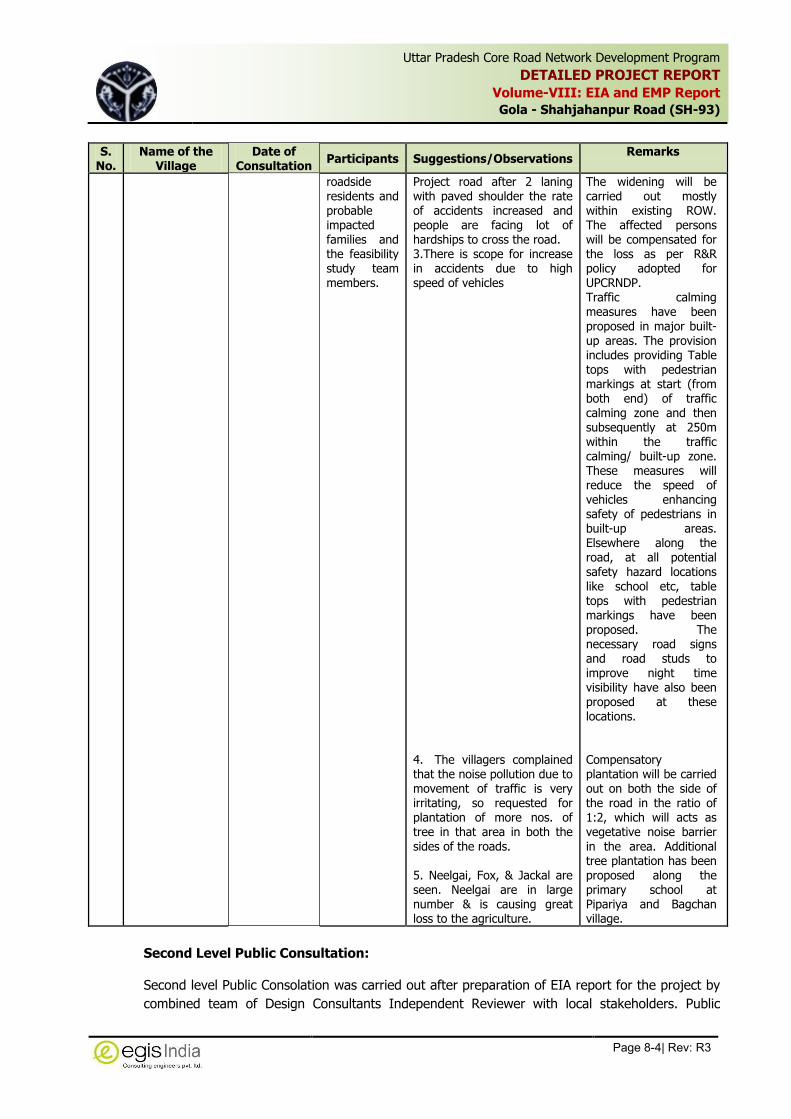
Uttar Pradesh Core Road Network Development Program
DETAILED PROJECT REPORT
Volume-VIII: EIA and EMP Report
Gola - Shahjahanpur Road (SH-93)
Page 8-4| Rev: R3
,
S. No.
Name of the Village
Date of Consultation
Participants Suggestions/Observations Remarks
roadside residents and probable impacted families and the feasibility study team members.
Project road after 2 laning with paved shoulder the rate of accidents increased and people are facing lot of hardships to cross the road. 3.There is scope for increase in accidents due to high speed of vehicles 4. The villagers complained that the noise pollution due to movement of traffic is very irritating, so requested for plantation of more nos. of tree in that area in both the sides of the roads. 5. Neelgai, Fox, & Jackal are seen. Neelgai are in large number & is causing great loss to the agriculture.
The widening will be carried out mostly within existing ROW. The affected persons will be compensated for the loss as per R&R policy adopted for UPCRNDP. Traffic calming measures have been proposed in major built-up areas. The provision includes providing Table tops with pedestrian markings at start (from both end) of traffic calming zone and then subsequently at 250m within the traffic calming/ built-up zone. These measures will reduce the speed of vehicles enhancing safety of pedestrians in built-up areas. Elsewhere along the road, at all potential safety hazard locations like school etc, table tops with pedestrian markings have been proposed. The necessary road signs and road studs to improve night time visibility have also been proposed at these locations. Compensatory plantation will be carried out on both the side of the road in the ratio of 1:2, which will acts as vegetative noise barrier in the area. Additional tree plantation has been proposed along the primary school at Pipariya and Bagchan village.
Second Level Public Consultation:
Second level Public Consolation was carried out after preparation of EIA report for the project by
combined team of Design Consultants Independent Reviewer with local stakeholders. Public

Uttar Pradesh Core Road Network Development Program
DETAILED PROJECT REPORT
Volume-VIII: EIA and EMP Report
Gola - Shahjahanpur Road (SH-93)
Page 8-5| Rev: R3
,
Consultations were conducted at Mamri Village and Mohammadi on 1.5.2015. During the
consultation the finding of the EIA study and the proposed improvement was discussed. In
general the public were well aware about the road improvement and People are well aware about
the project and did not raise any objection with respect to environmental issues. They were keen
to know about the safety provisions, location of bus shelters, junction improvements and
compensation issues.
In Mamri the local residents along the roadside expressed about the problem faced in the town
limt due to flooding in absence of drains. They demanded footpaths and side drains in their area.
In Mohammadi town also there was similar response. The consultant’s representative informed
them the Drain Cum raised Footpath have been provided in all the 11 major settlement area
which includes both Mamri and Mohammadi areas. In Mamri people were interested to know
about tree felling. Some residents suggested to plant such trees which can absorb pollutants
S.
No.
Place of
Consultation
(Date)
Participants Suggestions/Observations
Addressal in project
1. Mamri
(11.5.2015)
The member of
panchayat and
local villagers,
Team member
of DPR and IR
Team
1. People were well aware
about the project. They
expressed their
satisfaction with respect
to the provisions made in
the project.
2. Side drains and footpath
should be provided in the
market area of Mamari .
3. The land acquisition
should be minimized and
compensation should be
paid as per new rule
before start of
construction.
4. Tree cutting should be
minimized. Plantation of
such species of trees
which have high pollution
absorbing properties
should be planted.
Drain Cum raised Footpath have been
provided in all the 11 major settlement
area . This includes Mamri Town also.
Acquisition of land has been avoided at
most of the locations by restricting
widening within existing ROW.
Acquisition of land is proposed only on
the approach roads at proposed new
bridge locations.
The project affected persons will be
compensated as per R&R policy
adopted in the project prior to start of
construction.
1 Mohammadi
(1.5.2015)
Panchayat
members, local
villagers, Team
member of DPR
and IR Team
1. People were well aware
about the project. They
expressed their
satisfaction with respect
to the provisions made in
the project.
2. Side drains and footpath
should be provided in the
market area of Mamari.
3. Median in the town
should be provided to
segregate traffic and
Drain Cum raised Footpath have been
provided in all the 11 major settlement
area . This includes Mamri Town also.

Uttar Pradesh Core Road Network Development Program
DETAILED PROJECT REPORT
Volume-VIII: EIA and EMP Report
Gola - Shahjahanpur Road (SH-93)
Page 8-6| Rev: R3
,
S.
No.
Place of
Consultation
(Date)
Participants Suggestions/Observations
Addressal in project
discourage adhoc parking
in town
4. Suitable dust control
measures should be
adopted during
construction in the town
limit.
5. The land acquisition
should be minimized and
compensation should be
paid as per new rule
before start of
construction.
6. Tree cutting should be
minimized. Plantation of
such species of trees
which have high pollution
absorbing properties
should be planted.
Provision of regular water sprinkling
has been included in EMP to address
dust problem in the habitation area
during construction. Plantation will be
carried out which will help in reducing
the pollution level.
The project affected persons will be
compensated as per R&R policy
adopted in the project
The attendance sheets and photographs of Public Consultations at different locations are provided
in Annexure 8.2 and Annexure 8.3 respectively.

Uttar Pradesh Core Road Network Development Program
DETAILED PROJECT REPORT
Volume-VIII: EIA and EMP Report
Gola - Shahjahanpur Road (SH-93)
Page 9-1| Rev: R3
,
9 ENVIRONMENTAL MANAGEMENT PLAN (EMP)
The present chapter details the Environmental Management Plan for the project section of State
Highway-93 starting from Km 1.280 at Gola Market to Km 58.580 at Shahjahanpur. The
Environmental Management Plan is based on the Environmental Impact Assessment study
carried out for the project.
The Environmental Management Plan (EMP) consists of the set of mitigation, monitoring and
institutional measures to be taken during the design, construction and operation stages of the
project to eliminate adverse environmental impacts, to offset them, or to reduce them to
acceptable levels. The plan also includes the actions needed for the implementation of these
measures.
The major components of the Environmental Management Plan are
Mitigation of potentially adverse impacts
Monitoring during project implementation and operation
Institutional Capacity Building and Training
Implementation Schedule and Environmental Cost Estimates
Integration of EMP with Project planning, design, construction and operation.
9.1 Objectives of the EMP
Road strengthening and widening projects generally produce adverse impacts of lower
magnitude, which can be prevented or mitigated through proper engineering design and by
following environmental friendly construction practices. Environmental management plan is
developed for ensuring the most efficient and cost effective way to mitigate the points of
environmental concern in the construction contract provisions.
The main aim of the Environmental Management Plan is to ensure that the various adverse
impacts are mitigated and the positive impacts are enhanced. The management practices are
developed for all the stages of project, i.e., Pre-construction/Design, Construction and
Operational stages. The objectives of the EMP at various stages of the project planning and
implementation can be summarized as follows:
Design Stage
To have minimum impact on road side trees,
To keep land acquisition and building demolition at a minimum
To provide maximum safety to the highway users and road side communities
To develop a design that incorporates environmental safeguards and
To provide mitigation measures to all expected environmental degradation
Construction Stage
To prevent and reduce the negative environmental impacts of the project by
implementable mitigation measures, to be carried out by the Contractor.

Uttar Pradesh Core Road Network Development Program
DETAILED PROJECT REPORT
Volume-VIII: EIA and EMP Report
Gola - Shahjahanpur Road (SH-93)
Page 9-2| Rev: R3
,
To ensure that the provisions of the EMP are strictly followed and implemented by
strengthening implementation arrangements.
Operation Stage
To prevent deterioration of environment components of air, water, soil, noise etc.
To improve the safety of the highway users and road side communities
9.2 Critical Environmental Issues
The critical environmental components along the project corridor were identified on the basis of
the assessment of the potential impacts. These issues need to be addressed carefully in the
Environmental Management Plan. The most critical issues identified at various locations along the
project corridor are described in the following Table 9.1.
Table 9.1: Critical Environmental Issues to be Addressed
S. No.
Critical Environmental Issues Location
1 Resettlement and Rehabilitation
Issue
For squatters/Encroachers within ROW throughout the
project stretch in built-up sections
2 Removal of trees Throughout the project stretch.
3. Diversion of Protected Forest area Throughout the project stretch as roadside trees declared
as Protected Forest.
4. Reserve Forest
Pocket of Reserve Forest located on both side between Km
12.000 to Km 13.400 and between Km 14.000 to Km
15.500
5. Pond 7 ponds located close to the road
6. Impact of religious features 4 No. of religious structure located in 20 meter road
corridor within existing ROW. All structure have been saved
7. Ambient Air Quality Throughout the corridor
8. Traffic Safety More pronounced in major settlements
9. Noise Pollution In habitation areas during construction
10. Solid Waste Throughout the project stretch
9.3 Environmental Management Action Plan
This section describes the Environmental Management Action Plan during different stages of
project. The Environmental mitigation measures have been incorporated at all the stages of the
project right from Designing phase to Construction and Operational Phase. All care has been
taken to provide mitigation measures for all expected environmental degradation at different
stages. The Environmental Management action plan has been formulated for the present project
for mitigation/management/avoidance of potential adverse impacts and the enhancement of the
various environmental components along with its location, timeframe of implementation, and
overseeing/supervising responsibilities. The safeguard measures identified for different phases
are tabulated in Table 9.2.

Uttar Pradesh Core Road Network Development Program
DETAILED PROJECT REPORT
Volume-VIII: EIA and EMP Report
Gola -Shahjahanpur Road (SH-93)
Page 9-3| Rev: R3
,
Table 9.2: Environnemental Management Plan
Environmental issue/ component
Mitigation Measures Location Timeframe Institutional responsibility
Implementation Supervision
A. PRE-CONSTRUCTION STAGE
PC.1.1 Loss of Properties
There are number of non-titleholders in the form of squatters and encroachers will be affected within the ROW. However, at junctions and 4-laning sections, a number of titleholders will be affected, which will be established after detailed survey. Acquisition of private properties will be carried out in accordance with the RAP and entitlement framework for the project.
Early identification of entitlement for Compensation and Advance
planning of Resettlement and Rehabilitation Action Plan to Compensate the Losses.
All the affected people will be compensated as per RAP of the Project before commencement of Construction works
PIU has to ascertain that any additional environmental impacts resulting from acquisition of land are addressed and integrated into the EMP and other relevant documents.
Habitation area Pre-Construction Stage
PIU-UPPWD, NGOs
PMC/PIU-UPPWD
PC.1.2 Roadside Trees Cutting
A total number of 5289 trees will be affected for which statutory permission for diversion of protected forest and tree felling will be obtained prior to cutting of trees.
All efforts will be made to preserve trees by restricting tree cutting within the formation width.
The tree plantation will be carried out the ratio of 1:2 within the proposed ROW along the project highway as compensatory plantation by following Guidelines for Landscaping and Tree Plantation (IRC: SP:21-2009).
A general compensatory plantation scheme is presented in ANNEXURE 9.1
Through the Project Stretch
Pre-Construction
Stage
Contractor & PMC/PIU-UPPWD
PMC/PIU-UPPWD

Uttar Pradesh Core Road Network Development Program
DETAILED PROJECT REPORT
Volume-VIII: EIA and EMP Report
Gola -Shahjahanpur Road (SH-93)
Page 9-4| Rev: R3
,
Environmental issue/ component
Mitigation Measures Location Timeframe Institutional responsibility
Implementation Supervision
PC.1.3 Reserve Forest Diversion of about 0.098 ha of reserve forest land will be required for diversion for construction of approach road to new proposed bridge at Km 12.900 across Kathina River.
Diversion of forest land from reserved forest pocket will attract the
provision of Forest (Conservation) Act and hence forest clearance
would be required for acquisition of reserve forest land.
All the conditions stipulated in the forest clearance will be complied
with during construction.
No construction Plants, construction camp or borrow area will be
located in the project stretch long the Reserved Forest. A minimum
distance of 1.000 Km from the reserved forest patch will be
maintained for siting these features. The contractor will take all precautionary measures in the forest
stretch to avoid any incidence of forest fire.
Proposed new Bridge acr4ossat Kathina River at
Km 12.900
Preconstruction Stage
PIU-UPPWD/PMC PIU-UPPWD/ PMC
PC.1.3 Relocation of Community Utilities and Common Property Resources
All community utilities and properties i.e., water supply lines at 1 villages, 95 electric poles, 32 transformers, 11 telephone poles and 107 hand pumps will be relocated before start of construction.
The PIU will relocate these properties in consultation and written agreement with the agency/ owner/community.
Environmental considerations with suitable/required actions including health and hygiene aspects will be kept in mind while relocating all community utilities and resources.
Throughout Corridor wherever these features are located
Pre-Construction Stage
PIU-UPPWD, NGOs and R&R unit
PMC/PIU-UPPWD, Line Department
PC.1.4 Relocation of Religious/Cultural Properties
Alignment selected to minimize loss of cultural property. Public consultation carried out for obtaining opinion for shifting of religious structures
World Bank safeguards policy on OP 4.11 on Physical Cultural Resources and its related guidelines should be followed
Throughout Corridor wherever these features are
located
Pre-Construction
Stage
PIU-UPPWD, NGOs and R&R
unit
PIU-UPPWD, PMC

Uttar Pradesh Core Road Network Development Program
DETAILED PROJECT REPORT
Volume-VIII: EIA and EMP Report
Gola -Shahjahanpur Road (SH-93)
Page 9-5| Rev: R3
,
Environmental issue/ component
Mitigation Measures Location Timeframe Institutional responsibility
Implementation Supervision
PC-1.5 Arrangements for pedestrian safety in design
Traffic calming measures have been proposed in major built-up areas. The provision includes providing Table tops with pedestrian markings at start (from both end) of traffic calming zone and then subsequently at 250m within the traffic calming/ built-up zone. These measures will reduce the speed of vehicles enhancing safety of pedestrians in built-up areas. Elsewhere along the road, at all potential safety hazard locations like school etc, table tops with pedestrian markings have been proposed. The necessary road signs and road studs to improve night time visibility have also been proposed at these locations.
Built-up areas Design Stage DPR Consultant PIU-UPPWD
PC-1.6 Arrangements for temporary land for Establishing Camps/Plants/ Temporary diversions, etc.
The Contractor as per prevalent rules will carry out negotiations with the landowners for obtaining their consent for temporary use of lands for workers camp, construction sites/hot mix plants/traffic detours etc.
The Contractor will submit the legal agreement/ written Consent letter from the owner of the land for using fir specific purpose along with its rehabilitation plan as agreed by the owner.
The Contractor will ensure that the site is properly restored to the satisfaction of the land owner prior to handling over to the owner and shall submit satisfactory certificate from the Land Owner.
At temporary camp site, temporary
diversion and plant sites
Pre-Construction
Stage and Post utilization of the
land
Contractor PMC/PIU-UPPWD
PC. 1.7 Establishment of Construction/ Workers Camp
The locations of construction camp to be identified by the Contractor.
Construction camps will not be proposed within 1 Km from the nearest settlements to avoid conflicts and stress over the infrastructure facilities with the local community.
Location for stockyards for construction materials will be identified at least 1000m from water sources / and 10 Km from Wildlife Sanctuary boundary.
The Contractor will submit the legal agreement/ written Consent letter from the owner of the land for using fir specific purpose along with its rehabilitation plan as agreed by the owner.
The Camp site will be provided with all the necessary facilities as per norms.
At temporary camp site, temporary
diversion and plant sites
Pre-Construction
Stage and Post utilization of the
land
Contractor PMC/PIU-UPPWD

Uttar Pradesh Core Road Network Development Program
DETAILED PROJECT REPORT
Volume-VIII: EIA and EMP Report
Gola -Shahjahanpur Road (SH-93)
Page 9-6| Rev: R3
,
Environmental issue/ component
Mitigation Measures Location Timeframe Institutional responsibility
Implementation Supervision
PC 1.8 Establishment of Stone crushers, hot-mix plants, WMM Plant, Concrete Batching plants etc.
Stone crushers, Hot mix plants, WMM Plants and Concrete Batching plants will be sited sufficiently away from settlements, agricultural operations and any commercial establishments. Such plants will be located at least 1000m away from the boundary of the nearest village/settlement and forests towards downwind direction.
The Contractor will conform to the siting and operation requirements of stone crusher unit, Hotmix plants, Batchmix plant, WMM Plants as per Environmental (Protection) Rules, 1986.
The Contractor shall submit a detailed layout plan for all such sites
and approval of the Environmental Expert of PMC shall be necessary prior to their establishment.
All plants will be fitted with adequate dust suppression and emission control equipments and facilities.
Specifications of crushers and hot mix plants will comply with the requirements of the relevant current emission control legislations and Consent/NOC for all such plants shall be obtained from the State Pollution Control Board.
The Contractor shall not operate the plants till the required legal clearance are obtained and submitted.
A general guideline given in ANNEXURE-9.2 will be followed for establishing the plants sites, operation and pollution control measures to be adopted at site.
Plant Site Pre-Construction Stage
Contractor PMC/PIU-UPPWD
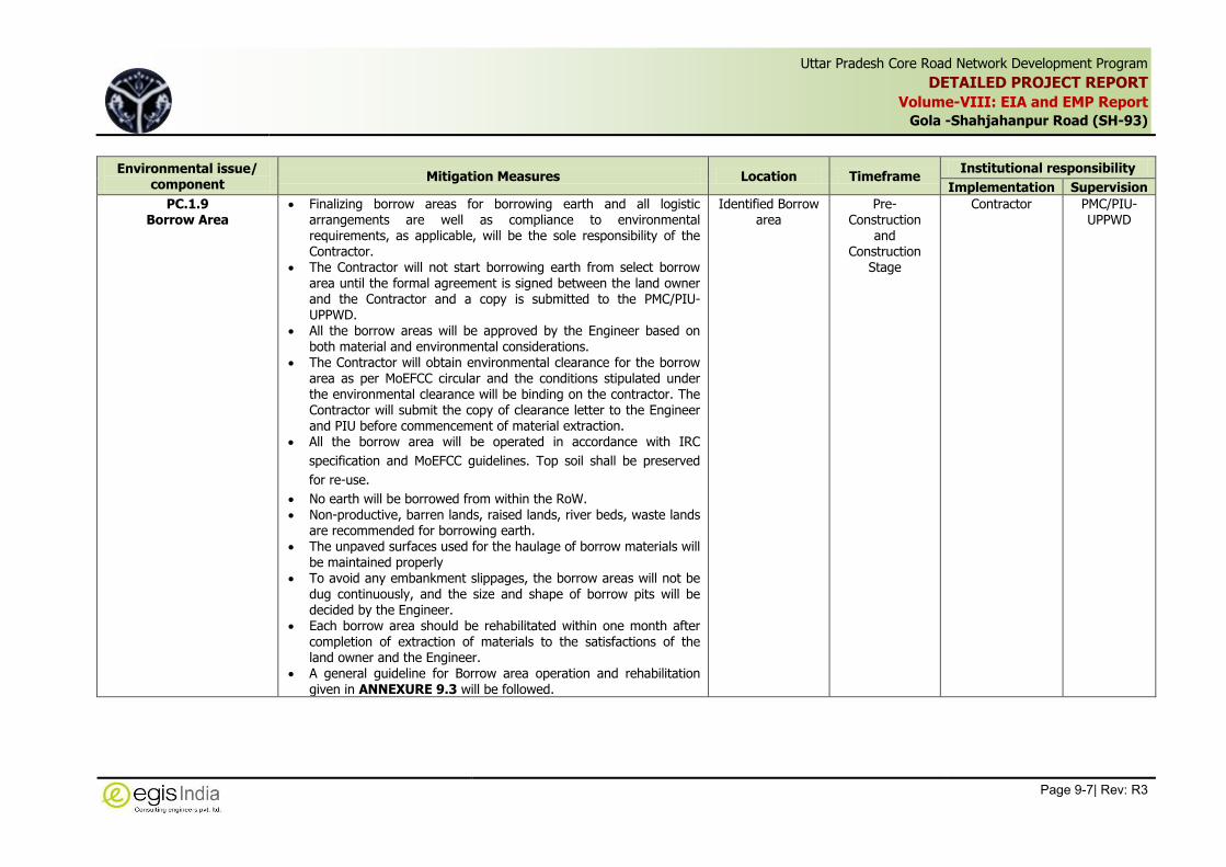
Uttar Pradesh Core Road Network Development Program
DETAILED PROJECT REPORT
Volume-VIII: EIA and EMP Report
Gola -Shahjahanpur Road (SH-93)
Page 9-7| Rev: R3
,
Environmental issue/ component
Mitigation Measures Location Timeframe Institutional responsibility
Implementation Supervision
PC.1.9 Borrow Area
Finalizing borrow areas for borrowing earth and all logistic arrangements are well as compliance to environmental requirements, as applicable, will be the sole responsibility of the Contractor.
The Contractor will not start borrowing earth from select borrow area until the formal agreement is signed between the land owner and the Contractor and a copy is submitted to the PMC/PIU-UPPWD.
All the borrow areas will be approved by the Engineer based on both material and environmental considerations.
The Contractor will obtain environmental clearance for the borrow area as per MoEFCC circular and the conditions stipulated under the environmental clearance will be binding on the contractor. The Contractor will submit the copy of clearance letter to the Engineer and PIU before commencement of material extraction.
All the borrow area will be operated in accordance with IRC
specification and MoEFCC guidelines. Top soil shall be preserved
for re-use.
No earth will be borrowed from within the RoW. Non-productive, barren lands, raised lands, river beds, waste lands
are recommended for borrowing earth. The unpaved surfaces used for the haulage of borrow materials will
be maintained properly To avoid any embankment slippages, the borrow areas will not be
dug continuously, and the size and shape of borrow pits will be decided by the Engineer.
Each borrow area should be rehabilitated within one month after completion of extraction of materials to the satisfactions of the land owner and the Engineer.
A general guideline for Borrow area operation and rehabilitation given in ANNEXURE 9.3 will be followed.
Identified Borrow area
Pre-Construction
and Construction
Stage
Contractor PMC/PIU-UPPWD
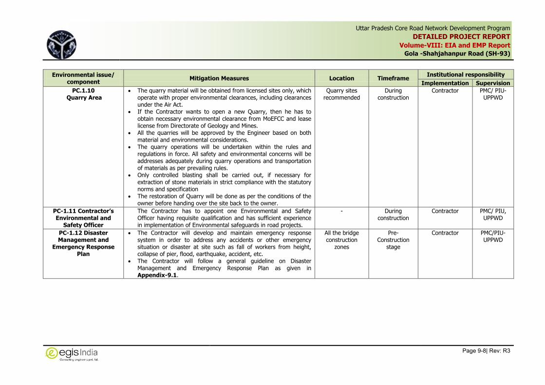
Uttar Pradesh Core Road Network Development Program
DETAILED PROJECT REPORT
Volume-VIII: EIA and EMP Report
Gola -Shahjahanpur Road (SH-93)
Page 9-8| Rev: R3
,
Environmental issue/ component
Mitigation Measures Location Timeframe Institutional responsibility
Implementation Supervision
PC.1.10 Quarry Area
The quarry material will be obtained from licensed sites only, which operate with proper environmental clearances, including clearances under the Air Act.
If the Contractor wants to open a new Quarry, then he has to obtain necessary environmental clearance from MoEFCC and lease license from Directorate of Geology and Mines.
All the quarries will be approved by the Engineer based on both material and environmental considerations.
The quarry operations will be undertaken within the rules and regulations in force. All safety and environmental concerns will be addresses adequately during quarry operations and transportation of materials as per prevailing rules.
Only controlled blasting shall be carried out, if necessary for extraction of stone materials in strict compliance with the statutory norms and specification
The restoration of Quarry will be done as per the conditions of the owner before handing over the site back to the owner.
Quarry sites recommended
During construction
Contractor PMC/ PIU-UPPWD
PC-1.11 Contractor’s Environmental and
Safety Officer
The Contractor has to appoint one Environmental and Safety Officer having requisite qualification and has sufficient experience in implementation of Environmental safeguards in road projects.
- During construction
Contractor PMC/ PIU, UPPWD
PC-1.12 Disaster Management and
Emergency Response Plan
The Contractor will develop and maintain emergency response system in order to address any accidents or other emergency situation or disaster at site such as fall of workers from height, collapse of pier, flood, earthquake, accident, etc.
The Contractor will follow a general guideline on Disaster
Management and Emergency Response Plan as given in Appendix-9.1.
All the bridge construction
zones
Pre-Construction
stage
Contractor PMC/PIU-UPPWD
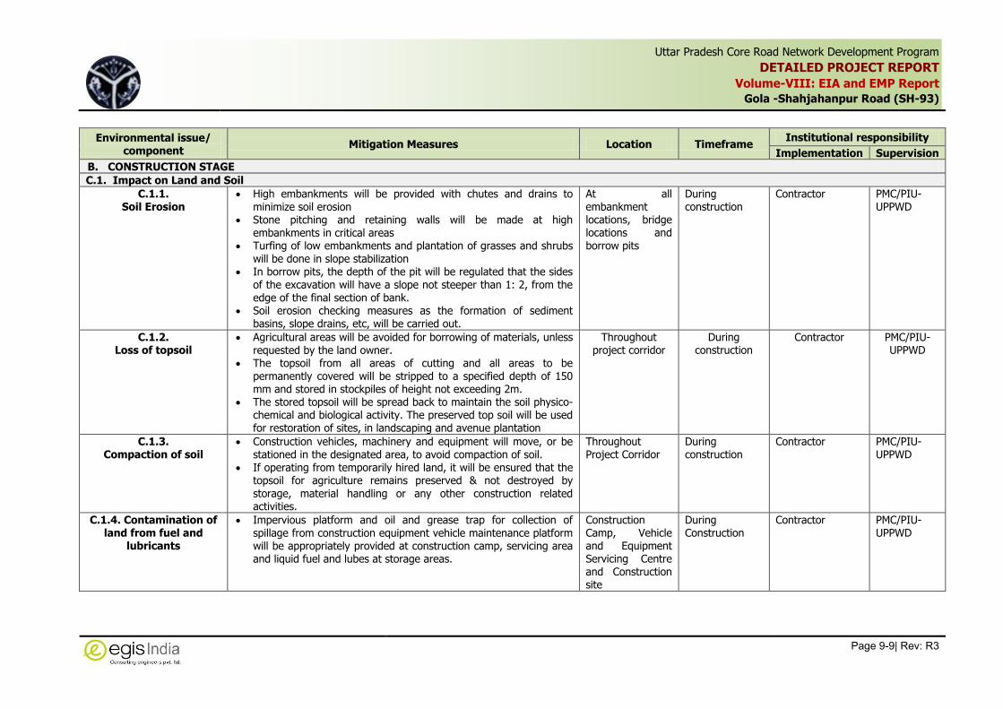
Uttar Pradesh Core Road Network Development Program
DETAILED PROJECT REPORT
Volume-VIII: EIA and EMP Report
Gola -Shahjahanpur Road (SH-93)
Page 9-9| Rev: R3
,
Environmental issue/ component
Mitigation Measures Location Timeframe Institutional responsibility
Implementation Supervision
B. CONSTRUCTION STAGE
C.1. Impact on Land and Soil
C.1.1. Soil Erosion
High embankments will be provided with chutes and drains to minimize soil erosion
Stone pitching and retaining walls will be made at high embankments in critical areas
Turfing of low embankments and plantation of grasses and shrubs will be done in slope stabilization
In borrow pits, the depth of the pit will be regulated that the sides of the excavation will have a slope not steeper than 1: 2, from the edge of the final section of bank.
Soil erosion checking measures as the formation of sediment basins, slope drains, etc, will be carried out.
At all embankment locations, bridge locations and borrow pits
During construction
Contractor PMC/PIU-UPPWD
C.1.2. Loss of topsoil
Agricultural areas will be avoided for borrowing of materials, unless requested by the land owner.
The topsoil from all areas of cutting and all areas to be permanently covered will be stripped to a specified depth of 150 mm and stored in stockpiles of height not exceeding 2m.
The stored topsoil will be spread back to maintain the soil physico-chemical and biological activity. The preserved top soil will be used for restoration of sites, in landscaping and avenue plantation
Throughout project corridor
During construction
Contractor PMC/PIU-UPPWD
C.1.3. Compaction of soil
Construction vehicles, machinery and equipment will move, or be stationed in the designated area, to avoid compaction of soil.
If operating from temporarily hired land, it will be ensured that the topsoil for agriculture remains preserved & not destroyed by
storage, material handling or any other construction related activities.
Throughout Project Corridor
During construction
Contractor PMC/PIU-UPPWD
C.1.4. Contamination of land from fuel and
lubricants
Impervious platform and oil and grease trap for collection of spillage from construction equipment vehicle maintenance platform will be appropriately provided at construction camp, servicing area and liquid fuel and lubes at storage areas.
Construction Camp, Vehicle and Equipment Servicing Centre and Construction site
During Construction
Contractor PMC/PIU-UPPWD
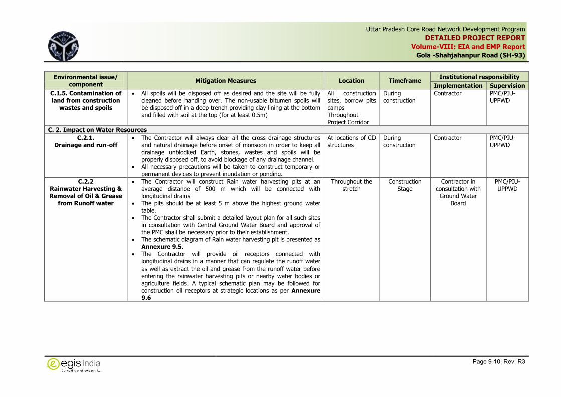
Uttar Pradesh Core Road Network Development Program
DETAILED PROJECT REPORT
Volume-VIII: EIA and EMP Report
Gola -Shahjahanpur Road (SH-93)
Page 9-10| Rev: R3
,
Environmental issue/ component
Mitigation Measures Location Timeframe Institutional responsibility
Implementation Supervision
C.1.5. Contamination of land from construction
wastes and spoils
All spoils will be disposed off as desired and the site will be fully cleaned before handing over. The non-usable bitumen spoils will be disposed off in a deep trench providing clay lining at the bottom and filled with soil at the top (for at least 0.5m)
All construction sites, borrow pits camps Throughout Project Corridor
During construction
Contractor PMC/PIU-UPPWD
C. 2. Impact on Water Resources
C.2.1. Drainage and run-off
The Contractor will always clear all the cross drainage structures and natural drainage before onset of monsoon in order to keep all drainage unblocked Earth, stones, wastes and spoils will be properly disposed off, to avoid blockage of any drainage channel.
All necessary precautions will be taken to construct temporary or permanent devices to prevent inundation or ponding.
At locations of CD structures
During construction
Contractor PMC/PIU-UPPWD
C.2.2 Rainwater Harvesting & Removal of Oil & Grease
from Runoff water
The Contractor will construct Rain water harvesting pits at an average distance of 500 m which will be connected with longitudinal drains
The pits should be at least 5 m above the highest ground water table.
The Contractor shall submit a detailed layout plan for all such sites in consultation with Central Ground Water Board and approval of the PMC shall be necessary prior to their establishment.
The schematic diagram of Rain water harvesting pit is presented as Annexure 9.5.
The Contractor will provide oil receptors connected with longitudinal drains in a manner that can regulate the runoff water as well as extract the oil and grease from the runoff water before entering the rainwater harvesting pits or nearby water bodies or agriculture fields. A typical schematic plan may be followed for construction oil receptors at strategic locations as per Annexure 9.6
Throughout the stretch
Construction Stage
Contractor in consultation with
Ground Water Board
PMC/PIU-UPPWD

Uttar Pradesh Core Road Network Development Program
DETAILED PROJECT REPORT
Volume-VIII: EIA and EMP Report
Gola -Shahjahanpur Road (SH-93)
Page 9-11| Rev: R3
,
Environmental issue/ component
Mitigation Measures Location Timeframe Institutional responsibility
Implementation Supervision
C.2.3. Contamination of water from construction and
allied activities
All necessary precautions will be taken to construct temporary or permanent devices to prevent water pollution due to increased siltation and turbidity.
The Contractor will take all precautionary measures to prevent the wastewater generated during construction from entering into canals, water bodies or the irrigation system and avoid construction works close to canals or water bodies during monsoon.
All wastes arising from the project will be disposed off, as per SPCB norms, so as not to block the flow of water.
No construction materials/ spoils will be stored along the water bodies and adequate provision will be made for preventing spillage of materials into these water bodies.
Wastes must be collected, stored and taken to approve disposal site.
Water quality to be monitored periodically as per Environmental Monitoring Plan.
Throughout Project Corridor where the Water Bodies located
During construction and after
Contractor PMC/PIU-UPPWD
C.2.4. Contamination of water from fuel and
lubricants
The Contractor will ensure that all construction vehicle parking location, fuels/lubricants storage sites, vehicles, machinery and equipment maintenance sites are located at least 100m away from any water body. The Contractor will also ensure that spillage of fuels and lubricants do not contaminate the ground.
The slopes of embankment leading to water bodies will be modified and re chanelised so that contaminants do not enter the water body.
Oil and grease traps will be provided at fuelling locations, to prevent contamination of water.
The Contractor will arrange for collection, strong and disposal of oily wastes to the pre-identified disposal sites (list to be submitted to PMC/PIU-UPPWD) and approved by the Environmental Expert. All spills and collected petroleum products will be disposed off in accordance with statutory guidelines.
Throughout Project Corridor and at all locations of water bodies
During construction
Contractor PMC/PIU-UPPWD

Uttar Pradesh Core Road Network Development Program
DETAILED PROJECT REPORT
Volume-VIII: EIA and EMP Report
Gola -Shahjahanpur Road (SH-93)
Page 9-12| Rev: R3
,
Environmental issue/ component
Mitigation Measures Location Timeframe Institutional responsibility
Implementation Supervision
C.2.5. Sanitation and waste
disposal in construction camps
Garbage tanks and sanitation facilities will be provided at camps. The construction camps will be located away from water sources. Efforts will be made to provide good sanitary conditions at camp to
avoid epidemics. The workplace will have proper medical approval by local medical,
health or municipal authorities.
At Construction camp locations, wherever located along the Project corridor
During construction
Contractor PMC/PIU-UPPWD
C.2.6. Use of water for
construction
The Contractor will use ground water/surface water as a source of water for the construction after taking prior permission from Competent Authority.
The Contractor will provide a list of locations and type of sources
from where water for construction will be used. To avoid disruption/disturbance to other water users, the
Contractor will extract water from fixed locations. The Contractor will not be allowed to pump water from any irrigation canal and surface water bodies used by the community.
The Contractor is required to comply with the requirements of the State Ground Water Department and seek its approval for doing so and submit copies of the permission to Environmental Expert of PMC/PIU-UPPWD.
Wastage of water during the construction will be minimized.
Throughout Project Corridor
During construction
Contractor PMC/PIU-UPPWD
C.2.7 Community water
Source
Damage to any community water source such as wells, tube-wells, water supply pipelines etc., due to construction activities in a particular area, will be replaced immediately by the Contractor at their own cost.
Throughout the Stretch
During construction
Contractor PMC/PIU-UPPWD
C.3. Impact on Air Environment
C.3.1. Emission from
construction vehicles and machinery
All vehicles, equipment and machinery used for construction will be regularly maintained to ensure that the pollution emission levels conform to the SPCB norms.
The asphalt plants, crushers and the batching plants will be sited at least 1000 m in the downwind direction from the nearest human settlement (Boundary of town/village).
Vehicles transporting earth materials will be covered Mixing equipment will be well sealed and equipped as per PCB
norms.
Throughout Project Corridor at construction sites, hot mix plant, concrete batching plant
During construction and after
Contractor PMC/PIU-UPPWD

Uttar Pradesh Core Road Network Development Program
DETAILED PROJECT REPORT
Volume-VIII: EIA and EMP Report
Gola -Shahjahanpur Road (SH-93)
Page 9-13| Rev: R3
,
Environmental issue/ component
Mitigation Measures Location Timeframe Institutional responsibility
Implementation Supervision
C.3.2 Emission from
Construction Vehicles, Equipment and
Machineries
Contractor will ensure that all vehicles, equipment and machinery used for construction are regularly maintained and confirm that pollution emission levels comply with the relevant requirements of UPPCB.
The Contractor will submit PUC certificates for all vehicles/ equipment/machinery used for the project. Monitoring results will also be submitted to ‘PIU’ through the ‘Engineer’.
Periodical monitoring of fine Particulate Matters (PM10 and PM2.5) will be carrier out as per Environmental Monitoring Plan.
Workers at mixing sites will be provided with good quality personal
protective equipments (PPE) reduce the chances of ill effect of dust.
Throughout Project Corridor at construction sites, hot mix plant, concrete batching plant and the equipments and vehicles at sites
During construction
Contractor PMC/PIU-UPPWD
C.3.3 Dust Pollution
The Contractor will take every precaution to control dust nuisance at all the construction zones and allied sites where works are under progress.
Every equipments and machinery will be fitted with dust suppression devices such as water sprinklers, dust bags, cyclone etc. As appropriate.
The Contractor will provide necessary certificates to confirm that all crushers used in construction conform to relevant dust emission control legislation.
At all the construction zones and unpaved lead roads, earthen temporary diversions and plant premises periodical water sprinkling will be carried out to suppress dust.
Transportation of loose earth, sand will be done in covered
vehicles. All equipments and machineries will be maintained properly. Periodical monitoring of fine Particulate Matters (PM10 and PM2.5)
will be carried out as per Environmental Monitoring Plan. Workers at mixing sites will wear masks to reduce the chances of
exposure to fugitive dusts.
Throughout the Construction zones, plant sites, borrow area/quarry sites, camp site
During construction
Contractor Contractor through Approved Monitoring Agency
PMC/PIU-UPPWD

Uttar Pradesh Core Road Network Development Program
DETAILED PROJECT REPORT
Volume-VIII: EIA and EMP Report
Gola -Shahjahanpur Road (SH-93)
Page 9-14| Rev: R3
,
Environmental issue/ component
Mitigation Measures Location Timeframe Institutional responsibility
Implementation Supervision
C.3.4 Fly ash Handling and utilization
The handling and transportation of fly ash will be done as per section 4.6 of IRC: SP: 58-2001.
Fly ash from hoppers or silos must be conditioned with water at power plant to prevent dusting enroute.
Fly ash will be transported to the site in covered dump truck to minimize loss of moisture and dust generation.
The quantity of fly ash will be transported based on utilization as per work plan to avoid stockpiling of exceeds quantity. However if stockpiling is required then Adequate precautions will be taken to prevent dust generation by spraying water on stockpiles at regular intervals.
The stockpile of flyash will be covered with tarpaulins or a thin layer of soil or other granular material to avoid dust generation.
Construction zones and stockyards
During Construction
Contractor PMC/PIU-UPPWD
C.4. Impact on Noise Pollution
C.4.1. Noise from vehicles, asphalt plants and
equipments
The Contractor will conform with the following measures: All plants and equipments used in construction shall strictly
conform to the MoEFCC/CPCB/UPPCB noise standards. All vehicles and equipment used in construction will be fitted with
exhaust silencers. Servicing of all construction vehicles and machinery will be done
for exhaust silences and will be checked and if found defective will be replaced.
All the construction sites within 150m of the nearest habitation, noisy construction work such as crushing, concrete mixing will be stopped during the night time between 10.00 pm to 6.00 am.
No noisy construction activities will be permitted around educational institutions/health centers (silence zones) up to a distance of 100 m from the sensitive receptors.
Monitoring shall be carried out at the construction sites as per the monitoring schedule and results will be submitted to PMC/PIU-UPPWD.
Environmental Expert will be required to inspect regularly to ensure the compliance of EMP.
Throughout Project Corridor and at all construction sites, hot mix plant concrete batching plants
During the construction, till the closure of such sites
Contractor PMC/PIU-UPPWD
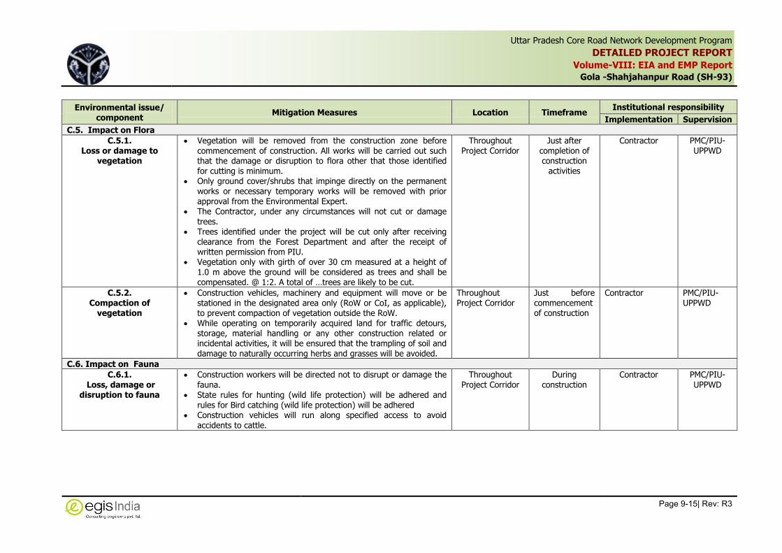
Uttar Pradesh Core Road Network Development Program
DETAILED PROJECT REPORT
Volume-VIII: EIA and EMP Report
Gola -Shahjahanpur Road (SH-93)
Page 9-15| Rev: R3
,
Environmental issue/ component
Mitigation Measures Location Timeframe Institutional responsibility
Implementation Supervision
C.5. Impact on Flora
C.5.1. Loss or damage to
vegetation
Vegetation will be removed from the construction zone before commencement of construction. All works will be carried out such that the damage or disruption to flora other that those identified for cutting is minimum.
Only ground cover/shrubs that impinge directly on the permanent works or necessary temporary works will be removed with prior approval from the Environmental Expert.
The Contractor, under any circumstances will not cut or damage trees.
Trees identified under the project will be cut only after receiving clearance from the Forest Department and after the receipt of written permission from PIU.
Vegetation only with girth of over 30 cm measured at a height of 1.0 m above the ground will be considered as trees and shall be compensated. @ 1:2. A total of …trees are likely to be cut.
Throughout Project Corridor
Just after completion of construction
activities
Contractor PMC/PIU-UPPWD
C.5.2. Compaction of
vegetation
Construction vehicles, machinery and equipment will move or be stationed in the designated area only (RoW or CoI, as applicable), to prevent compaction of vegetation outside the RoW.
While operating on temporarily acquired land for traffic detours, storage, material handling or any other construction related or incidental activities, it will be ensured that the trampling of soil and damage to naturally occurring herbs and grasses will be avoided.
Throughout Project Corridor
Just before commencement of construction
Contractor PMC/PIU-UPPWD
C.6. Impact on Fauna
C.6.1. Loss, damage or
disruption to fauna
Construction workers will be directed not to disrupt or damage the
fauna. State rules for hunting (wild life protection) will be adhered and
rules for Bird catching (wild life protection) will be adhered Construction vehicles will run along specified access to avoid
accidents to cattle.
Throughout Project Corridor
During construction
Contractor PMC/PIU-UPPWD
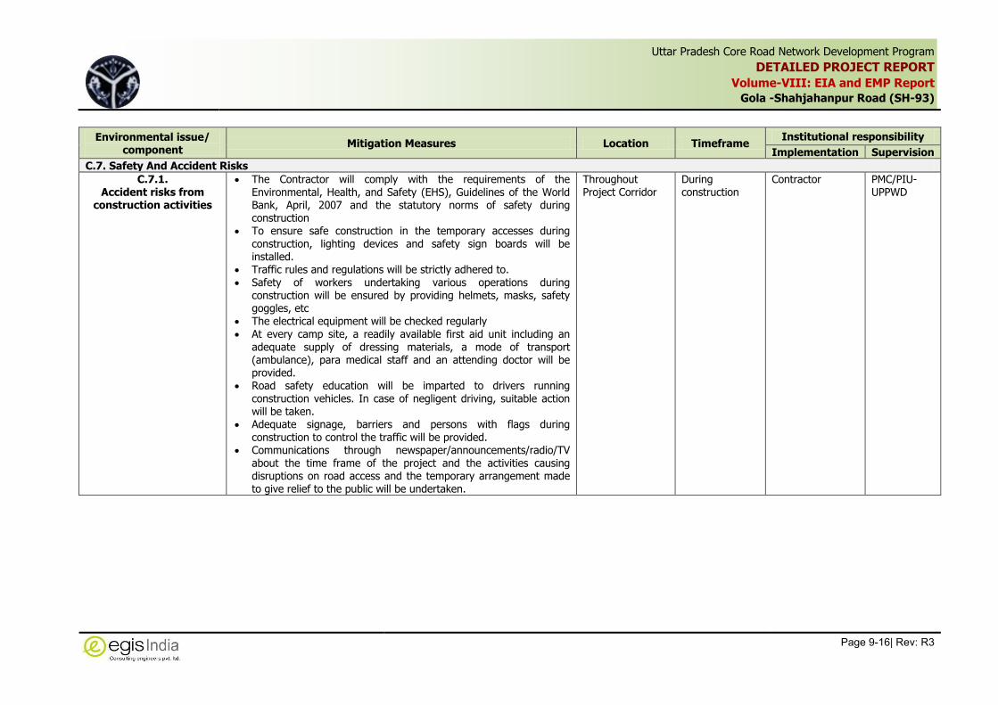
Uttar Pradesh Core Road Network Development Program
DETAILED PROJECT REPORT
Volume-VIII: EIA and EMP Report
Gola -Shahjahanpur Road (SH-93)
Page 9-16| Rev: R3
,
Environmental issue/ component
Mitigation Measures Location Timeframe Institutional responsibility
Implementation Supervision
C.7. Safety And Accident Risks
C.7.1. Accident risks from
construction activities
The Contractor will comply with the requirements of the Environmental, Health, and Safety (EHS), Guidelines of the World Bank, April, 2007 and the statutory norms of safety during construction
To ensure safe construction in the temporary accesses during construction, lighting devices and safety sign boards will be installed.
Traffic rules and regulations will be strictly adhered to. Safety of workers undertaking various operations during
construction will be ensured by providing helmets, masks, safety goggles, etc
The electrical equipment will be checked regularly At every camp site, a readily available first aid unit including an
adequate supply of dressing materials, a mode of transport (ambulance), para medical staff and an attending doctor will be provided.
Road safety education will be imparted to drivers running construction vehicles. In case of negligent driving, suitable action will be taken.
Adequate signage, barriers and persons with flags during construction to control the traffic will be provided.
Communications through newspaper/announcements/radio/TV about the time frame of the project and the activities causing disruptions on road access and the temporary arrangement made to give relief to the public will be undertaken.
Throughout Project Corridor
During construction
Contractor PMC/PIU-UPPWD

Uttar Pradesh Core Road Network Development Program
DETAILED PROJECT REPORT
Volume-VIII: EIA and EMP Report
Gola -Shahjahanpur Road (SH-93)
Page 9-17| Rev: R3
,
Environmental issue/ component
Mitigation Measures Location Timeframe Institutional responsibility
Implementation Supervision
C.7.2 Occupational Health & Safety of
Workers
The Contractor will comply with the requirements of the Environmental, Health, and Safety (EHS), Guidelines of the World Bank, April, 20077 and the statutory norms of safety during construction.
The Contractor will provide adequate good quality Personal Protective Equipments (PPE) to all the workers working at construction zones and Plant sites and will ensure that these PPEs are used by workers at all time during works.
Adequate drainage, sanitation and waste disposal will be provided at workplaces.
Proper drainage will be maintained around sites to avoid water logging leading to various diseases
Adequate sanitation and waste disposal facilities will be provided at construction camps by means of septic tanks, soakage pits etc.
A health care system will be maintained at construction camp for routine checkup of workers and avoidance of spread of any communicable disease
Readily available First Aid kit bearing all necessary first aid items will be proved at all the work sites and should be regularly maintained.
The Contractor will organize awareness program on occupational health and safety aspects as well as on HIV AIDS and sexually transmitted diseases (STDs) for workers on periodic basis.
Workers Camp Site and Construction Zones
During construction
Contractor PMC/PIU-UPPWD
7 Reference: http://www.ifc.org/wps/wcm/connect/554e8d80488658e4b76af76a6515bb18/Final%2B-%2BGeneral%2BEHS%2BGuidelines.pdf?MOD=AJPERES and
http://www.ifc.org/wps/wcm/connect/7e4c7f80488554d5b45cf66a6515bb18/Final%2B-%2BToll%2BRoads.pdf?MOD=AJPERES&id=1323162564158 ]

Uttar Pradesh Core Road Network Development Program
DETAILED PROJECT REPORT
Volume-VIII: EIA and EMP Report
Gola -Shahjahanpur Road (SH-93)
Page 9-18| Rev: R3
,
Environmental issue/ component
Mitigation Measures Location Timeframe Institutional responsibility
Implementation Supervision
C.7.3 Accessibility
The Contractor will all time provide safe and convenient passage for vehicles, pedestrians and livestock to and from roadsides and property access as connecting the project road. The Contractor will also ensure that the existing accesses are not blocked without providing adequate provisions and to the prior satisfaction of Engineer.
The Contractor will take care that the cross roads are constructed in such a sequence so that traffic movement on any given area does not get affected.
At all Construction Zones Along settlement stretches and at major intersections
During construction
Contractor PMC/PIU-UPPWD
C.7.4 Planning for Traffic
diversion
Detailed Traffic Control Plans will be prepared and submitted to the
Engineer and PMC/PIU-UPPWD for approval, five days prior to commencement of works on any section of road. The traffic control plans shall contain details of temporary diversions, traffic safety arrangements for construction under traffic, details of traffic arrangement after cessation hazardous materials and arrangement of flagmen.
The Contractor will provide specific measures for safety of pedestrians and workers at night as a part of traffic control plans. The Contractor will ensure that the diversion/detour is always maintained in running condition, particularly during the monsoon to avoid disruption to traffic flow. The Contractor will also inform local community of changes to traffic routes, conditions and pedestrian access arrangements with assistance from PMC/PIU-UPPWD.
All the Construction Zones
During Construction
Contractor PMC/PIU-UPPWD
C.8. Impact Cultural Properties
C.8.1. Damage or loss of cultural properties
Relocation of adversely impacted cultural properties If any valuable or invaluable articles such as fabrics, coins,
artifacts, structures, or other archaeological relics are discovered, the excavation will be stopped and Archaeology Department, UP will be intimated.
Construction camps blasting sites and all allied construction activities will be located at least 500 m away from the cultural property
Throughout Project Corridor at all locations of Cultural Properties
Before construction starts During construction
Contractor and Archaeology Department UP.
PMC/PIU-UPPWD
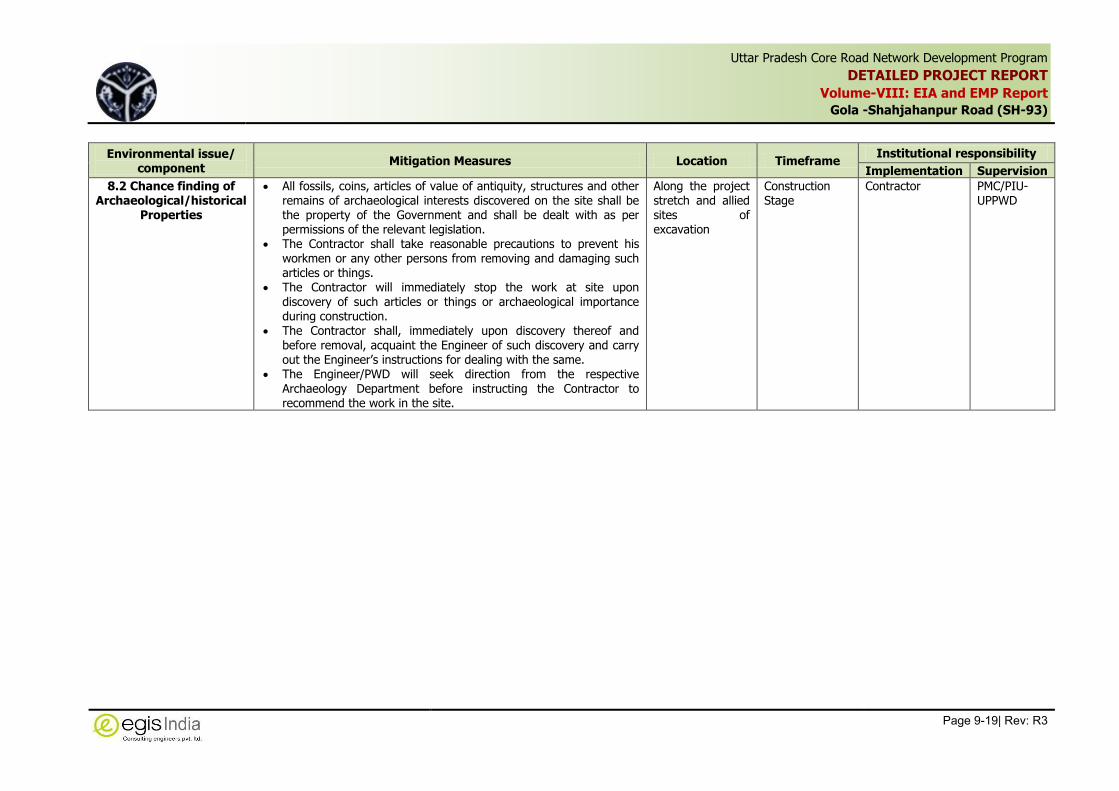
Uttar Pradesh Core Road Network Development Program
DETAILED PROJECT REPORT
Volume-VIII: EIA and EMP Report
Gola -Shahjahanpur Road (SH-93)
Page 9-19| Rev: R3
,
Environmental issue/ component
Mitigation Measures Location Timeframe Institutional responsibility
Implementation Supervision
8.2 Chance finding of Archaeological/historical
Properties
All fossils, coins, articles of value of antiquity, structures and other remains of archaeological interests discovered on the site shall be the property of the Government and shall be dealt with as per permissions of the relevant legislation.
The Contractor shall take reasonable precautions to prevent his workmen or any other persons from removing and damaging such articles or things.
The Contractor will immediately stop the work at site upon discovery of such articles or things or archaeological importance during construction.
The Contractor shall, immediately upon discovery thereof and before removal, acquaint the Engineer of such discovery and carry out the Engineer’s instructions for dealing with the same.
The Engineer/PWD will seek direction from the respective Archaeology Department before instructing the Contractor to recommend the work in the site.
Along the project stretch and allied sites of excavation
Construction Stage
Contractor PMC/PIU-UPPWD

Uttar Pradesh Core Road Network Development Program
DETAILED PROJECT REPORT
Volume-VIII: EIA and EMP Report
Gola -Shahjahanpur Road (SH-93)
Page 9-20| Rev: R3
,
Environmental issue/ component
Mitigation Measures Location Timeframe Institutional responsibility
Implementation Supervision
C.9 Camp Site Management
C.9.1 Labour Camp facility
Contractor will follow all relevant provisions of the Factories Act, 1948 and the Building and the other Construction Workers (Regulation of Employment and Conditions of Service) Act, 1996 as
well as the guidelines of IFC and EBRD8 will be followed for construction and maintenance of labour camp throughout the construction period.
The location, layout and basic facility provision of each labour camp will be submitted to The Engineer and PIU prior to their construction.
The construction will commence only upon the written approval of the Engineer.
The contractor will maintain necessary living accommodation and ancillary facilities in Functional and hygienic manner and as approved by the Engineer.
Periodical medical check-up will be ensured for all the workers at least once in 3 months.
Camp Site Construction Stage
Contractor PMC/PIU-UPPWD
8 http://www.ifc.org/wps/wcm/connect/topics_ext_content/ifc_external_corporate_site/ifc+sustainability/learning+and+adapting/knowledge+products/publications/publications_gpn_workersaccommodation

Uttar Pradesh Core Road Network Development Program
DETAILED PROJECT REPORT
Volume-VIII: EIA and EMP Report
Gola -Shahjahanpur Road (SH-93)
Page 9-21| Rev: R3
,
Environmental issue/ component
Mitigation Measures Location Timeframe Institutional responsibility
Implementation Supervision
C.9.2 Potable Water
The Contractor will provide potable water facilities within the precincts of every workplace in an accessible place.
The Contractor will also guarantee the following: Supply of sufficient quantity of potable water (as per IS) in every
workplace/labour camp at suitable and easily accessible places and regular maintenance of such facilities.
If any water storage tank is provided, the bottom of the tank will be kept at least 1mt. above from the surrounding ground level.
If water is drawn from any existing well, which is within 30mt. proximity of any toilet, drain or other source of pollution, the well will be disinfected before water is used for drinking.
All such wells will be entirely covered and provided with a trap door, which will be dust proof and waterproof.
A reliable pump will be fitted to each covered well. The trap door will be kept locked and opened only for cleaning or inspection, which will be done at least once in a month.
Camp site and work zones
Construction Stage
Contractor PMC/PIU-UPPWD
C.9.3 Sanitation and Sewage
system
The Contractor will ensure that- The sewage system for the camp will be designed, built and operated in such a fashion that it should not pollute the ground water or nearby surface water. Separate toilets/bathrooms, will be arranged for men and women Adequate water supply is to be provided in all toilets and urinals All toilets in workplaces are with dry-earth system (receptacles)
which are to be cleaned and kept in a strict sanitary condition Night soil (human excreta) is to be disposed off by putting layer of
it at the bottom of a permanent tank prepared for the purpose and covered with 15cm, layer of waste or refuse and then covered with a layer of earth for a fortnight.
Camp Site Construction Stage
Contractor PMC/PIU-UPPWD

Uttar Pradesh Core Road Network Development Program
DETAILED PROJECT REPORT
Volume-VIII: EIA and EMP Report
Gola -Shahjahanpur Road (SH-93)
Page 9-22| Rev: R3
,
Environmental issue/ component
Mitigation Measures Location Timeframe Institutional responsibility
Implementation Supervision
C.9.4 Waste disposal
The Contractor will provide segregated garbage bins in the camps and ensure that these are regularly emptied and disposed off in a hygienic manner as per the Comprehensive Solid Waste Management Plan approved by the Environmental Expert of PMC/PIU-UPPWD.
Unless otherwise arranged by local municipal authority, arrangements for disposal of night soils (human excreta) suitably approved by the local municipal authority or as directed by the Engineer, will be arranged by the Contractor.
Camp site Construction Stage
Contractor PMC/PIU-UPPWD
C.10 Monitoring of Pollution
C.10.1 Monitoring of Air, Water & Noise Quality Pollution
Monitoring
The periodic monitoring of the ambient air quality, noise level, water (both ground and surface water) quality, soil pollution/contamination in the selected locations as suggested in environmental monitoring plan will be the responsibility of Contractor.
PIU will appoint MOEFCC/UPPCB approved pollution monitoring agency for this purpose.
As per Environmental Monitoring Plan (Construction Zones and Plant/Camp Sites)
During Construction
Contractor through approved laboratory
PMC/PIU-UPPWD

Uttar Pradesh Core Road Network Development Program
DETAILED PROJECT REPORT
Volume-VIII: EIA and EMP Report
Gola -Shahjahanpur Road (SH-93)
Page 9-23| Rev: R3
,
Environmental issue/ component
Mitigation Measures Location Timeframe Institutional responsibility
Implementation Supervision
C.11 Site Restoration and Rehabilitation
C.11.1 Clean-up
Operations, Restoration and Rehabilitation
Contractor will prepare site restoration plans, which will be approved by the Engineer.
The cleanup and restoration operations are to be implemented by the Contractor prior to demobilization.
The contractor will clear all the debris material at site, temporary structures; dispose all garbage, night soils and POL waste as per Comprehensive Waste Management Plan and as approved by the Engineer (PMC).
All disposal pits or trenches will be filled in and effectively sealed off. Residual topsoil, if any will be distributed on adjoining/ proximate barren land or areas identified by the PMC in a layer of thickness of 75 mm-150 mm.
All construction zones including river-beds, culverts, road-side areas, camps, hot mix plant
sites, crushers, batching plant sites and any other area used/affected by the project will be
left clean and tidy, at the contractor's expense, to the entire satisfaction of the Engineer (PMC).
Construction zones, Camp and other allied sites
After Completion of Construction and before demobilization of Construction Team
Contractor PMC/PIU-UPPWD
C. OPERATION STAGE
O-1: Monitoring of Operation Performance
The PIU-UPPWD will monitor the operational performance of the various mitigation/enhancement measures carried out as a part of the project.
The indicators selected for monitoring include the survival rate of trees; utility of enhancement provision for relocated utilities, hand pumps and other relocated structures if any; status of rehabilitation of borrow areas; and noise barriers, which are proposed at different locations.
Throughout the project Stretch
Operation stage/
Contractor PMC/PIU-UPPWD
O-2: Maintenance of Drainage
PIU-UPPWD will ensure that all drains (side drains, cross drains etc.) are periodically cleared especially before monsoon season to facilitate the quick passage of rainwater and avoid flooding.
PIU-UPPWD will ensure that all the sediment and oil and grease traps set up at the water bodies are cleared once in every three months.
Throughout the project Stretch
Operation stage/
Contractor PMC/PIU-UPPWD

Uttar Pradesh Core Road Network Development Program
DETAILED PROJECT REPORT
Volume-VIII: EIA and EMP Report
Gola -Shahjahanpur Road (SH-93)
Page 9-24| Rev: R3
,
Environmental issue/ component
Mitigation Measures Location Timeframe Institutional responsibility
Implementation Supervision
O-3: Pollution Monitoring The periodic monitoring of the ambient air quality, noise level, water (both ground and surface water) quality, soil pollution/contamination in the selected locations as suggested in environmental monitoring plan will be the responsibility of Contractor.
PIU-UPPWD will appoint MOEFCC/UPPCB approved pollution monitoring agency/Laboratory for this purpose.
As per Environmental Monitoring Plan
Operation stage/
Contractor through approved laboratory
PMC/PIU-UPPWD
O-4: Contamination of Surface Water due to Traffic Movement & Accidents
Contingency Plans will be developed for cleanup of oil spills, fuel and toxic chemicals.
Throughout the project stretch
Operation stage/
Contractor/ PIU-UPPWD
PIU-UPPWD
O.5: Noise Pollution
Noise pollution will be monitored as per monitoring plan at different zones.
Noise attenuating Tree Species to be planted along the road Noise control programs are to be enforced strictly. Monitoring the
effectiveness of the pollution attenuation barriers, if there is any, will be taken up.
Specially inhabitant location
Operation stage Contractor through approved laboratory
PIU-UPPWD
O.6: Accident Hazard and Safety
Provision of elaborate system of sign boards and road markings along the whole stretch
Provision of suitable lighting arrangement at required locations Development of Emergency Response and Contingency Plan for
accidents Regular highway patrolling
Thought the project stretch
Operation Stage Contractor, PMC/PIU-UPPWD
PMC/PIU-UPPWD

Uttar Pradesh Core Road Network Development Program
DETAILED PROJECT REPORT
Volume-VIII: EIA and EMP Report
Gola -Shahjahanpur Road (SH-93)
Page 9-25| Rev: R3
,
9.4 Environmental Enhancement
Enhancement measures for community properties located adjacent to the road has been
proposed at Bagchan Village at Km 9+300, Mohammadi at Km 28+000 and at Pipariya Village at
Km 50+200 The details of enhancement measures is presented in Annexure 9.11.
9.5 Environmental Monitoring Programme
Environmental monitoring provides an essential tool to make necessary recommendations and
adopt suitable control strategies so that menace of rising environmental degradation could be
minimized and a relief be extended to the people including labours in case of any damage caused
under occupational health hazards. The monitoring is necessary for the following reasons:
To see what impacts have occurred;
To evaluate the performance of mitigation measures proposed in the EMP;
To ensure that the conditions of approval are adhered to;
To suggest improvements in management plan, if required;
To see that benefits expected from the EA are achieved as the project proceeds; and
To satisfy the legal and community obligations.
9.5.1 Performance Indicators (PIS)
The physical, biological and social components, which are significant in affecting the environment
at critical locations, have been suggested as Performance Indicators. The following specific
environmental parameters can be qualitatively measured and compared over a period of time and
therefore selected as Performance Indicators for monitoring due to their regulatory importance
and the availability of standardized procedures and relevant expertise.
Soil contamination & Erosion indices
Air quality
Water quality
Noise levels around sensitive locations
Re-plantation success /survival rate
Restoration of borrow pits
Construction camp management
Sedimentation in the ponds adjacent to road
Debris Clarence and disposal
Floral Aspects (Tree Survival)
Safety Aspects
9.5.2 Monitoring of Performance Indicators
Ambient Air Quality (AAQ) Monitoring
Ambient air quality parameters which are recommended for monitoring of widening and
strengthening of state highway are PM10 (Particulate Matter having less than 10 micron size) or
PM2.5 (Particulate Matter having less than 2.5 micron size), Sulphur Dioxide (SO2), Oxides of
Nitrogen (NOx) and Carbon Monoxide (CO) and Hydrocarbon (HC). These parameters are to be
monitored at selected locations such as plant and machinery sites, crusher sites, excavation
works, etc. starting from the commencement of construction activity. Data should be generated
Uttar Pradesh Core Road Network Development Program
DETAILED PROJECT REPORT
Volume-VIII: EIA and EMP Report
Gola -Shahjahanpur Road (SH-93)
Page 9-26| Rev: R3
,
once in a season at the selected monitoring locations in accordance with National Ambient Air
Quality (NAAQ) Standards 2009 (ANNEXURE-9.7).
Ambient Noise Monitoring
The measurement for monitoring the noise levels to be carried out at sensitive locations and at
construction sites along the project road in accordance to the Ambient Noise Standards
formulated by Central Pollution Control Board (CPCB) (ANNEXURE 9.8). Sound pressure level
would be monitored on twenty-four hourly basis. Noise shall be recorded at “A” weighted
frequency using digitized noise monitoring instrument.
Water Quality
Water quality of local water resources that is used by local community shall be monitored. The
physical and chemical parameters recommended for analysis of water quality relevant to road
project are pH, total solids, total suspended solids, total dissolved solids, COD, BOD, DO, Oil and
Grease, Chloride, Iron, etc. The monitoring of the water quality will be carried out at all locations
identified along the project road during construction and operation phase. Monitoring parameters
will be as per IS-10500 (ANNEXURE-9.9) for ground water quality and for surface water quality
as per CPCB Guidelines for used based surface water classification (ANNEXURE-9.10).
Soil Quality
The soil quality of the surround fields close to the construction site and plant site will be
monitored to understand the impact of soil quality. The physic-chemical parameters
recommended for analysis are physical Parameter: Texture, Grain Size, Gravel, Sand, Silt and
Clay and Chemical Parameter: pH, Conductivity, Calcium, Magnesium, Sodium, Nitrogen and
Absorption Ratio.
Tree Survival Rate
Roadside plantation of trees and their management will be an important environmental activity
for the management group. These activities will include selection of plant, development of
nurseries, protection of plant, interaction with roadside communities for plantation management
and their maintenance, etc.
The widening and up gradation of the project requires felling of roadside trees. This lost will be
compensated by compensatory afforestation. The compensatory afforestation will be done as per
Forest (Conservation) Act and policy of Uttar Pradesh Forest Department.
To ensure the proper maintenance and monitoring of the compensatory afforestation, a regular
maintenance and monitoring of the survival rate of the planted trees is being proposed up to a
period of 3 years from the operation of the project. This will be monitored by implementing
agency with the help of Forest Department.
Debris Clearance and Disposal
The contractor has to clear the debris material from the completed sections on regular basis and
the debris are required to be disposed off at approved disposal sites. To ensure regular clearance
and disposal of debris the monitoring will be required for the same. Visual monitoring of the site
will be carried out on periodical basis especially in the section which is completed.

Uttar Pradesh Core Road Network Development Program
DETAILED PROJECT REPORT
Volume-VIII: EIA and EMP Report
Gola -Shahjahanpur Road (SH-93)
Page 9-27| Rev: R3
,
9.6 Environmental Monitoring Action Plan
The monitoring action plan covering various performance indicators, frequency and institutional
arrangements of the project in the construction and operation stages is given in Table 9.3.
9.7 Environmental Reporting System
Monitoring and evaluation are important activities in implementation of all projects. Monitoring
involves periodic checking to ascertain whether activities are going according to the plans. It
provides the necessary feedback for project management to keep the programme on schedule.
The reporting system will operate linearly with the Contractor, who will report to Project
Management Consultant (PMC), who will in turn report to the Project Implementation Unit (PIU).
All reporting by the Contractor and PMC shall be on monthly/quarterly/annual basis. The PIU shall
be responsible for preparing targets for each of identified EMP activities.
The compliance monitoring and the progress reports on environmental components may be
clubbed together and submitted to the PIU regularly during the implementation period. The
operation stage monitoring reports may be annual or biannual. The operation stage monitoring
reports will have to be prepared as specified in the said project Environmental Completion Report.
9.8 Environmental Monitoring Cost
A separate budgetary provision has been made for implementation of Environmental Monitoring
Plan. The environmental monitoring cost is estimated on the basis of the length and existing
environmental scenario of the project road. A budget allocation has been made against
environmental monitoring during construction and operation stages of Rupees 7.68 lakhs and
Rupees 1.74 lakhs respectively. The details are provided in Table 9.3.

Uttar Pradesh Core Road Network Development Program
DETAILED PROJECT REPORT
Volume-VIII: EIA and EMP Report
Gola - Shahjahanpur Road (SH-93)
Page 9-28| Rev: R3
,
Table 9.3: Environmental Monitoring Plan
En
vir
on
me
nt
Co
mp
on
en
t
Pro
ject
Sta
ge
Regular Monitoring Parameters Institutional Responsibilities
Parameters Standards Locations Frequency Duration Action Plan in case criteria
exceeds Implementation Supervision
Air
Co
nstr
ucti
on
PM10 g/m3, PM2.5
g/m3, SO2, NOx,
CO
National Ambient Air Quality Standard (CPCB, 18th Nov, 2009)
Plant site, HMP and Stone Crusher (1 location)
Once in 3 month for 2 years excluding monsoon period)
Continuous 24 hours
Check and modify control device like bag filter/cyclones of hot mix plant
Contractor through approved NABL monitoring agency
PMC & PIU-UP PWD
PM10 g/m3, PM2.5
g/m3, SO2, NOx,
CO
Along the project road at 2 locations in consultation with PMC.
Once in a season excluding the monsoon for 2 Years
Continuous 24 hours
- Contractor through approved NABL monitoring agency
PMC & PIU-UP PWD
Op
era
tio
n PM10 g/m3, PM2.5
g/m3, SO2, NOx,
CO
Along the project road at 2 locations in consultation with PMC
In the interval of 4 months excluding the monsoon for 1 Year
Continuous 24 hours
- Contractor through approved NABL monitoring agency
PMC & PIU-UP PWD
Su
rfa
ce
Wa
ter
Qu
ali
ty
Co
nstr
ucti
on
pH, Temperature, DO, BOD, COD, Oil & Grease, Total Suspended Solid, turbidity, Total Hardness, Chlorine, Iron, Total Coliform
Surface Water Quality Standard
At identified locations (3 locations)
Once in a season excluding monsoon for 2 Years
Grab Sampling Check and modify Oil interceptors, silt fencing devices
Contractor through approved NABL monitoring agency
PMC & PIU-UP PWD

Uttar Pradesh Core Road Network Development Program
DETAILED PROJECT REPORT
Volume-VIII: EIA and EMP Report
Gola - Shahjahanpur Road (SH-93)
Page 9-29| Rev: R3
,
En
vir
on
me
nt
Co
mp
on
en
t
Pro
ject
Sta
ge
Regular Monitoring Parameters Institutional Responsibilities
Parameters Standards Locations Frequency Duration Action Plan in case criteria
exceeds Implementation Supervision
Op
era
tio
n
pH, Temperature, DO, BOD, COD, Oil & Grease, Total Suspended Solid, turbidity, Total Hardness, Chlorine, Iron, Total Coliform
At identified locations (2 locations)
In the interval of 4 months excluding the monsoon for 1 Year
Grab Sampling Check and modify petrol interceptors, silt fencing devices
Contractor through approved NABL monitoring agency
PMC & PIU-UP PWD
Gro
un
d W
ate
r Q
ua
lity
Co
nstr
ucti
on
pH, Temperature, TSS, Total hardness, Suspended Solid, Chlorine, Iron, Sulphate, Nitrate
Ground Water Quality Standard as per IS: 10500, 1991
Construction site (2 locations)
Once in 3 months for 2 Years
Grab Sampling Check and modify petrol interceptors, silt fencing devices
Contractor through approved NABL monitoring agency
PMC & PIU-UP PWD
No
ise
Le
ve
l
Co
nstr
ucti
on
Leq dB (A) (Day and Night)
Average and Peak values
Ambient Noise Standard
(CPCB, 2000)
At equipment yards and locations as identified
along the project road by PMC (3 locations)
In the interval of 3 months
for 2 Years
24 hourly recording of
Leq
Check and modify equipment and
devices used to protect noise level
Contractor through approved NABL
monitoring agency
PMC & PIU-UP PWD

Uttar Pradesh Core Road Network Development Program
DETAILED PROJECT REPORT
Volume-VIII: EIA and EMP Report
Gola - Shahjahanpur Road (SH-93)
Page 9-30| Rev: R3
,
En
vir
on
me
nt
Co
mp
on
en
t
Pro
ject
Sta
ge
Regular Monitoring Parameters Institutional Responsibilities
Parameters Standards Locations Frequency Duration Action Plan in case criteria
exceeds Implementation Supervision
Op
era
tio
n Leq dB (A) (Day
and Night) Average and Peak values
Locations as identified by PMC (3 locations)
In the interval of 4 months for 1 Year
24 hourly recording of Leq
- Contractor through approved NABL monitoring agency
PMC & PIU-UP PWD
So
il
Co
nstr
ucti
on
Physical Parameter: Texture, Grain Size, Gravel, Sand, Silt, Clay; Chemical Parameter: pH, Conductivity, Calcium, Magnesium, Sodium, Nitrogen, Absorption Ratio
Near Construction sites along the road as identified by the PMC (3 locations)
In the interval of 3 months for 2 Years
- - Contractor through approved NABL monitoring agency
PMC & PIU-UP PWD
Op
era
tio
n
Physical Parameter: Texture, Grain Size, Gravel, Sand, Silt, Clay; Chemical Parameter: pH, Conductivity, Calcium, Magnesium, Sodium, Nitrogen, Absorption Ratio
Along the road (2 locations)
In the interval of 4 months for 1 Year
1 Year - Contractor through approved NABL monitoring agency
PMC & PIU-UP PWD
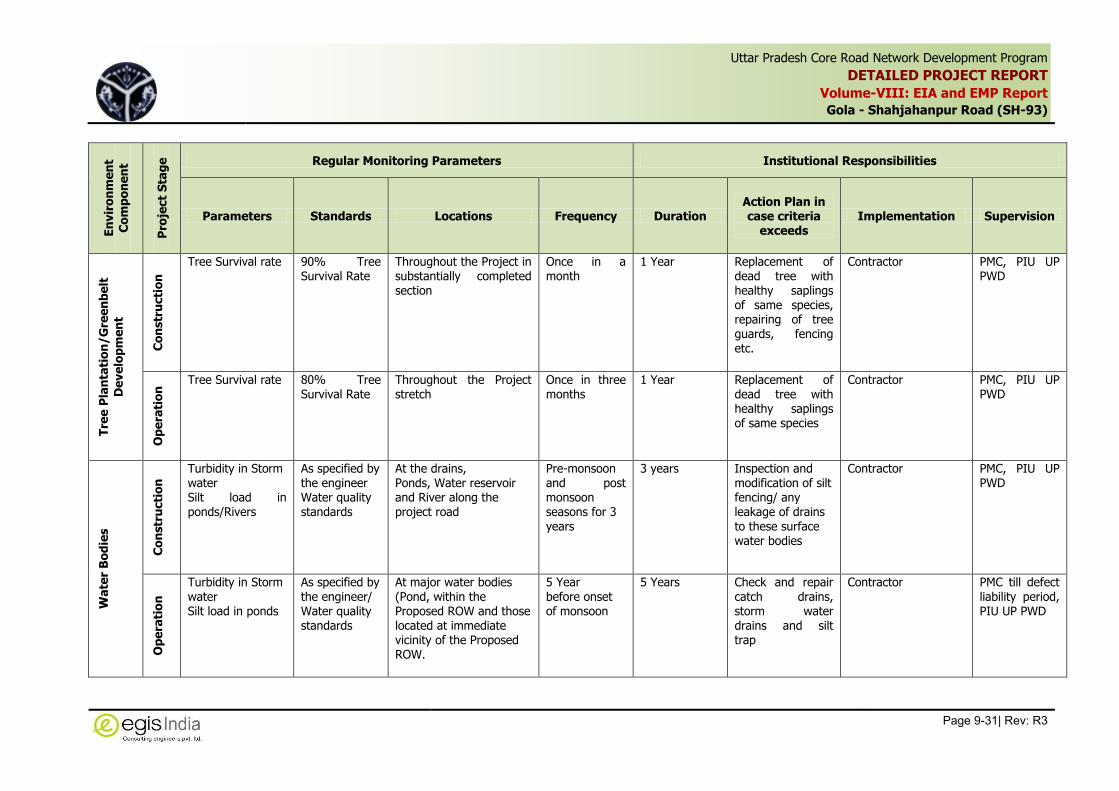
Uttar Pradesh Core Road Network Development Program
DETAILED PROJECT REPORT
Volume-VIII: EIA and EMP Report
Gola - Shahjahanpur Road (SH-93)
Page 9-31| Rev: R3
,
En
vir
on
me
nt
Co
mp
on
en
t
Pro
ject
Sta
ge
Regular Monitoring Parameters Institutional Responsibilities
Parameters Standards Locations Frequency Duration Action Plan in case criteria
exceeds Implementation Supervision
Tre
e P
lan
tati
on
/G
ree
nb
elt
De
ve
lop
me
nt
Co
nstr
ucti
on
Tree Survival rate 90% Tree Survival Rate
Throughout the Project in substantially completed section
Once in a month
1 Year Replacement of dead tree with healthy saplings of same species, repairing of tree guards, fencing etc.
Contractor PMC, PIU UP PWD
Op
era
tio
n Tree Survival rate 80% Tree
Survival Rate Throughout the Project stretch
Once in three months
1 Year Replacement of dead tree with healthy saplings of same species
Contractor PMC, PIU UP PWD
Wa
ter
Bo
die
s
Co
nstr
ucti
on
Turbidity in Storm water Silt load in ponds/Rivers
As specified by the engineer Water quality standards
At the drains, Ponds, Water reservoir and River along the project road
Pre-monsoon and post monsoon seasons for 3 years
3 years Inspection and modification of silt fencing/ any leakage of drains to these surface water bodies
Contractor PMC, PIU UP PWD
Op
era
tio
n
Turbidity in Storm water Silt load in ponds
As specified by the engineer/ Water quality standards
At major water bodies (Pond, within the Proposed ROW and those located at immediate vicinity of the Proposed ROW.
5 Year before onset of monsoon
5 Years Check and repair catch drains, storm water drains and silt trap
Contractor PMC till defect liability period, PIU UP PWD

Uttar Pradesh Core Road Network Development Program
DETAILED PROJECT REPORT
Volume-VIII: EIA and EMP Report
Gola - Shahjahanpur Road (SH-93)
Page 9-32| Rev: R3
,
En
vir
on
me
nt
Co
mp
on
en
t
Pro
ject
Sta
ge
Regular Monitoring Parameters Institutional Responsibilities
Parameters Standards Locations Frequency Duration Action Plan in case criteria
exceeds Implementation Supervision
De
bri
s
Cla
ren
ce
an
d
dis
po
sa
l
Co
nstr
ucti
on
Debris removal from different construction site
Visual observation
Along the project road Once in quarter
3 years Shall be checked in completed section
Contractor PMC, PIU UP PWD

Uttar Pradesh Core Road Network Development Program
DETAILED PROJECT REPORT
Volume-VIII: EIA and EMP Report
Gola -Shahjahanpur Road (SH-93)
Page 9-33| Rev: R3
,
9.9 Institutional Arrangement for Implementation of EMP
The Government of Uttar Pradesh has setup Project Implementation Unit for UPCRNDP to
streamline decision-making and provide more autonomy for project execution and delivery. The
PMU is headed by Chief Engineer, Work Bank (Roads) supported by Superintending Engineer
(Project) and Project Director, UPCRNDP at Head Office. The Superintending Engineer (Projects)
is responsible to assist Chief Engineer in ensuring that overall expenditure under each of the
agreed component does not exceed the total cost specified in the project document, to assist
Chief Engineer in monthly plan review and monitoring meeting wherein physical and financial
review will be done at the level of Chief Engineer and for budget provision/Allotment/CCL/
Assurance/Rules/Draft Para/Audit Para/PAC Para.
The Project Director will have overall responsibility for implementation of projects.
For implementation of EMP/ RP, an Environmental and Social Development Cell (ESDC) has been
set up in PMU. The cell is headed by an Executive Engineer. He is overall responsible for EMP
Implementation, coordinating and laisoning with government organization as well as the World
Bank with respect to different forest and environmental issues. He will also responsible for
progress monitoring of Environmental safeguards during project execution and submission of
quarterly/ annual report on EMP compliance to the funding Agency.
There are three World Bank Circles located at Moradabad, Kanpur and Lucknow which are heads
by respective Superintending Engineers. There is provision of two Executive Engineers in each
World Bank Circle whose responsibility is to oversee the project progress at site in their respective
area. It is proposed to have one Environmental Nodal Officer at Office of each Executive Engineer
who will look into the compliance with the safeguards, laisoning with local authorities in
connection with different permits and licenses, redressing the public complaints on environmental
issues, etc.
The PMU will appoint Project Management Consultant as Engineer in-charge who will supervise
the Contractors activities, compliances and monitor the overall progress of work. There is
provision of Environmental Specialist in PMC who will be responsible for providing technical
guidance to the Contractor for implementation of the EMP and preparation of
checklists/formats/reports, etc. for implementing each of the activities as per the EMP. He will
conduct regular monitoring of the implementation of the EMP by the Contractor and will Prepare
monthly or quarterly and annual monitoring reports on EMP implementation and compliance with
environmental clauses of Contract Agreement. He shall be responsible for record keeping,
providing instructions to the field representatives for corrective actions, ensuring compliance of
various statutory and legislative requirements.
The Contractor will have one Environmental & Safety Officer, who will be directly responsible for
implementation of environmental safeguards at different locations of construction. He will
ensuring compliance of the instructions given by the PMC. He will maintain close interaction with
PMC and his Field Representative and seek instructions and guidance from PMC’s Environmental
Expert on any issue related to implementation of environment and safety measures. He shall be
responsible for record keeping, and reporting to the PMC through PM on actions taken. He will
also give inhouse training to the workers on environment and safety. Maintaining the record of
day to day monitoring of environmental and safety issues at site
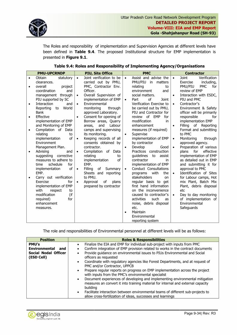
Uttar Pradesh Core Road Network Development Program
DETAILED PROJECT REPORT
Volume-VIII: EIA and EMP Report
Gola -Shahjahanpur Road (SH-93)
Page 9-34| Rev: R3
,
The Roles and responsibility of implementation and Supervision Agencies at different levels have
been defined in Table 9.4. The proposed Institutional structure for EMP implementation is
presented in Figure 9.1.
Table 9.4: Roles and Responsibility of Implementing Agency/Organisations
PMU-UPCRNDP PIU, Site Office PMC Contractor
Obtain statutory clearances.
overall project coordination and management through PIU supported by SC
Interaction and Reporting to World Bank
Effective implementation of EMP and Monitoring of EMP
Compilation of Data relating to implementation of Environment Management Plan.
Advising and suggesting corrective measures to adhere to time schedule for implementation of EMP.
Carry out verification Exercise for implementation of EMP with respect to modification (if required) for enhancement measures.
Joint verification to be carried out by PMU, PMC, Contractor Env. Officer.
Overall Supervision of implementation of EMP
Environmental monitoring through approved Laboratory.
Consent for opening of Borrow areas, Quarry areas, and Labour camps and supervising its monitoring.
Keeping records of all consents obtained by contractor.
Compilation of Data relating to implementation of EMP.
Filling of Summary Sheets and reporting to PMU.
Approval of plans prepared by contractor
Assist and advise the PMU/PIU in matters relating to environment and social matters.
Part of Joint Verification Exercise to be carried out by PMU, PIU and Contractor for review of EMP for modification in enhancement measures (if required)
Supervise
implementation of EMP by contractor
Develop Good Practices construction guidelines to assist contractor in implementation of EMP
Conduct Consultations programs with the stakeholders on regular basis to get first hand information on the inconvenience caused to contractor‟s
activities such as noise, debris disposal etc.
Maintain Environmental reporting system
Joint Verification Exercise including, PMU/PIU PMC for review of EMP
Interaction with ESDC, PIU and PMC
Contractor‟s
Environment & Safety officer will be primarily responsible for implementation EMP
Filling of Reporting Format and submitting to PMC
Monitoring through approved agency.
Preparation of various plans for effective implementation of EMP as detailed out in EMP and submitting it for approval to PMC
Identification of Sites for Labour camps, Hot mix Plant, Batch Mix Plant, debris disposal etc
Day to day monitoring of implementation of Environmental Safeguards
The role and responsibilities of Environmental personnel at different levels will be as follows:
Position Roles & Responsibilities
PMU’s Environmental and Social Nodal Officer (ESD Cell)
Finalize the EIA and EMP for individual sub-project with inputs from PMC Confirm integration of EMP provision related to works in the contract documents Provide guidance on environmental issues to PIUs Environmental and Social
officers as requested Coordinate with regulatory agencies like Forest Departments, and at request of
PMC and/or Contractor, UPPCB Prepare regular reports on progress on EMP implementation across the project
with inputs from the PMC’s environmental specialist Document experiences of developing and implementing environmental mitigation
measures an convert it into training material for internal and external capacity building
Facilitate interaction between environmental teams of different sub-projects to allow cross-fertilization of ideas, successes and learnings

Uttar Pradesh Core Road Network Development Program
DETAILED PROJECT REPORT
Volume-VIII: EIA and EMP Report
Gola -Shahjahanpur Road (SH-93)
Page 9-35| Rev: R3
,
Position Roles & Responsibilities
Environmental and Social Nodal Officer at PIU (Division Office)
Coordinate with PMC’s environmental specialist to monitor and report on progress on EMP implementation as part of works contracts
Participate in and facilitate consultations with stakeholders Participate in project meetings and report on the issues related to environmental
management to provide for any mid-course corrections that may be required based on situation on the ground
Coordinate on the training and capacity building initiatives
Environmental Specialist, PMC
Lead the development of the sub-project specific EIA and EMP for the entire project
Review contract documents to ensure that EMP provisions related to works are included in the contract documents
Assist the Environmental Specialist in the PMU to follow-up with state government departments
Oversee and report to the PMU on implementation of EMP provisions included in the works contract for each sub-project
Act as a resource person in trainings based on experience on implementing this project and previous relevant work
Contractors’ Environmental and Safety Officer
Lead the implementation of EMP measures included in the Contract Report on progress and shortcomings of the measures implemented to
Environmental Specialist of PMC

Uttar Pradesh Core Road Network Development Program
DETAILED PROJECT REPORT
Volume-VIII: EIA and EMP Report
Gola - Shahjahanpur Road (SH-93)
Page 9-36| Rev: R3
,
Figure 9.1: Proposed Organisational Setup for EMP Implementation

Uttar Pradesh Core Road Network Development Program
DETAILED PROJECT REPORT
Volume-VIII: EIA and EMP Report
Gola -Shahjahanpur Road (SH-93)
Page 9-37| Rev: R3
,
9.10 Environmental Training
To enhance the capacity of officials for effective implementation of proposed mitigation measures
and monitoring the resultant effect, as well as create awareness amongst workers and
supervision staff trainings and awareness programmes have been planned and is given in Table
9.5. The institutions/agencies like regional office of MoEFCC, SPCB/CPCB, Indian Institute of
Technologies can be consulted for such trainings. Independent subject’s experts/consultants
can also be the resource persons to impart trainings. These experts/agencies shall be appointed
based on specific need for the training. A budgetary provision of Rs. 4.0 Lakh has been made for
imparting Environmental Training.
Table 9.5: Details of Proposed Training Program on Environmental Issues
Module Title Objectives Time of Training
Duration (Day)
Level Participants
1 Concept of Environmental and Social Management Framework
• Brief up Bank’s safeguard policies and requirements
• Brief up latest on environmental legislations
• Implementation, Supervision and Monitoring Mechanism
• Provision made in Contract Documents
Before awarding contracts
1 State PIU (SE and Executive Engg.) PMU, UP PWD
2 Orientation Workshop on ESMF Implementation
• ESMF requirements
• Implementation, Supervision and Monitoring Mechanism
• Roles and Responsibilities of Contractors and UP, PWD Engineer
• Identification of social issues
• Addressing social impacts
• Preparing mitigation plans
Pre-construction stage (when contractors are substantially mobilized)
1 State PIU (Executive Engg. /AEE/AE, PMU, Contractors and Third Party Monitoring Agency
3 Focused Training on Specific Issue/s
• Analyzing problems, referring stipulations in Contract and GEMP and agreed to feasible solution within specified timeframe
• Issues relating to wage parity, child labor, etc.
During construction, as and when needed.
0.5 District PIU, Contractors and Third Party Monitoring Agency
4 Training on HIV AIDS issues
To increase the level of awareness about prevention and control of HIV/AIDS among the different communities’ particularly tribal communities in scheduled
During construction
1 day District PIU, NGO Contractors

Uttar Pradesh Core Road Network Development Program
DETAILED PROJECT REPORT
Volume-VIII: EIA and EMP Report
Gola -Shahjahanpur Road (SH-93)
Page 9-38| Rev: R3
,
Module Title Objectives Time of Training
Duration (Day)
Level Participants
areas abutting project road; Social and Psychological support to AIDS Infected
5 Road Safety To raise road safety consciousness among the road users; train drivers and medical aid to the victims of road accidents particularly for special target groups like drivers of heavy vehicles/goods vehicles, etc.
During and pre-construction
0.5 District PIU, NGO and contractor
6 EMP Implementation during construction stage
To understand the requirement of EMP and its implementation during construction stage of the project road. Good and bad practice of EMP during construction stage of the project
During Construction stage
0.5 Contractor and their staffs.
9.11 Grievance Redressal Mechanism
An integrated system will be established with Grievance Redressal Cells (GRCs), with necessary
officers, officials and systems, at the state as well as sub project levels. Grievances if any, may be
submitted through various mediums, including in person, in written form to a noted address,
through a toll free phone line or through direct calls to concerned officials, and online. PWD will
appoint a person to receive such calls and online messages. The person incharge based on
nature of complaint, will forward the same to the concerned official. A ticket or a unique number
will be generated for all such call and messages. The complainant will follow up based that
unique number. All calls and messages will be responded within two weeks. In response is not
received within 15 days, the complaint will be escalated to next level.
All local contact information and options for complaint submission will be available on site on local
information boards. Moreover, they will be in addition to the PIO officers to be appointed under
the RTI Act. A half yearly report on Grievance Redressal by the project will be prepared. The
project will abide by the RTI Act of 2005; it will commit itself for proactive disclosure and sharing
of information with the key stakeholders, including the communities/beneficiaries. The project will
have a communication strategy focusing on efficient and effective usage of print and electronic
media, bill boards, posters, wall writing, and adoption of any other method suiting local context,
logistics, human and financial resources.
As part of IGRM, a Grievance Redress Cell (GRC) will be set up at the district level. The staffing of
GRC will include Environment and Social Nodal Officer of PMU; E&S Officer of PIU; and two
representatives from community / beneficiary / affected persons. The head of the cell will be a
person of repute but not continuing in the government service. The GRC will have its own bye
laws. The functions of the GRC will include: (i) to redress grievances of community / beneficiaries
/ project affected persons (PAPs) in all respects; (ii) rehabilitation and resettlement assistance
and related activities; (iii) GRC will only deal/hear the issues related to R&R and environmental
grievance; (iv) GRC will give its decision/verdict within 15 days after hearing the aggrieved

Uttar Pradesh Core Road Network Development Program
DETAILED PROJECT REPORT
Volume-VIII: EIA and EMP Report
Gola -Shahjahanpur Road (SH-93)
Page 9-39| Rev: R3
,
person; (v) final verdict of the GRC will be given by the Chairman/Head of GRC in consultation
with other members of the GRC and will be binding to all other members.
The Organizational chart for Grievance Redressal System is given in Figure 9.2.
Figure 9.2: Organizational chart for Grievance Redressal System
9.11.1 Stakeholders Roles in GRC:
GRC system should cater the following roles:
S. No. Roles Privileges
1. Nodal Officer All Privileges
2. Central Grievance Redressal Officer (NGO) View and Process specific privileges only
3. Category Heads (Social, Environmental and
Technical
View and Process specific privileges only
4. Divisional Grievance Redressal Officer Should able to access and edit only details
relevant to his jurisdiction
5. Monitoring Officer Should be able to access monitoring and
evaluation details, no editing privileges
6. Aggrieved person Should be able to access only details
submitted by him and its status.
9.12 Environmental Budgeting
A budgetary Provision of Rupees 8.73 Crores has been made for the various environmental
mitigation measures and monitoring. The detailed break-up of the budgetary provision is given in
Table 9.6. Some of the provisions of budget for environmental protection measures are the part

Uttar Pradesh Core Road Network Development Program
DETAILED PROJECT REPORT
Volume-VIII: EIA and EMP Report
Gola -Shahjahanpur Road (SH-93)
Page 9-40| Rev: R3
,
of engineering cost and Resettlement and Rehabilitation Cost and hence they have not been
included here. The cost of diversion of Protected forest area has been calculated based on
standard calculation practices of the Forest Department by using current rate of NPV of the
forest area, tree felling cost within the proposed forest area, compensatory afforestation cost,
protection measures and maintenance cost of tree plantation. This figure is only tentative and
may vary after the final demand note received by the Forest Department and as decided by the
Forest Task Force during Forest Clearance. The cost as per the Forest Department will be
deposited to the concern Forest Department before commencement of any construction works in
the forest stretch.

Uttar Pradesh Core Road Network Development Program
DETAILED PROJECT REPORT
Volume-VIII: EIA and EMP Report
Gola-Shahjahanpur Road (SH-93)
Page 9-41| Rev: R3
,
Table 9.6: Proposed EMP cost for Project section "Gola-Shahjahanpur section of SH-93 from Km 0+000 to Km 59+000 in Lakhimpur Kheri and Shahjahanpur districts of Uttar Pradesh"
S. No.
Component Item Unit Estimated Quantity
Rate (Rupees)
Amount (Rupees)
A. Pre-Construction Stage
A.1 Forest Clearance Diversion of forest land for non forest activities (Project road widening)-(a) Total NPV cost/hect (The final cost will be provided by the forest department after joint verification, which is required to be deposited by UP, PWD)
Hect 47.2 9,60,000 4,53,12,000
A.2 Tree cutting along the project road
Clearing of Roadside plantation (from Km 1.281 to Km 59.000)-Tree cutting by Forest Dept/Contractor and MoU shall be signed between them
Girth 30-60 Cm No. 1,052 193 2,03,036
Girth 60-90 Cm No. 1,370 371 5,08,270
Girth 90-180 Cm No. 2385 683 16,28,955
> Girth 180 Cm No. 482 1261 6,07,802
A.3 Tree Plantation along the project road
Compensatory afforestation (minimum of 2 trees planted for every tree cut) including 3 years maintenance
No. 10,578 696 73,62,288
Providing of Half Brick circular tree guard, in 2nd class brick, internal diameter 1.25 meters, and height 1.5 meters, above ground and 0.50 meter below ground, cement mortar 1:6 as per complete design.
No. 10,578 1915 2,02,56,870
Total EMP cost (Rupees) during Pre-Construction Phase 7,58,79,221
B. CONSTRUCTION STAGE
B.1
Proposed Enhancement of Primary School at Bagchan Village at Km 9.300 (RHS)
Tree Plantation including maintenance for 1 year No. 16 696 11,136
Providing of Half Brick circular tree guard, in 2nd class brick, internal diameter 1.25 meters, and height 1.5 meters, above ground and 0.50 meter below ground, cement mortar 1:6 as per complete design.
No. 16 1,915 30,640
B.2
Proposed Enhancement of Primary School at Pipariya Sadak Village at Km 52.000 (LHS)
Tree Plantation including maintenance for 1 year No. 15 696 10,440
Providing of Half Brick circular tree guard, in 2nd class brick, internal diameter 1.25 meters, and height 1.5 meters, above ground and 0.50 meter below ground, cement mortar 1:6 as per complete design.
No. 15 1,915 28,725
B.3 Enhancement of Pond at Km 28.000 (LHS) as
Bathing Ghat of size 5m x 4m
(a) Excavation Cum 37.50 57 2,138
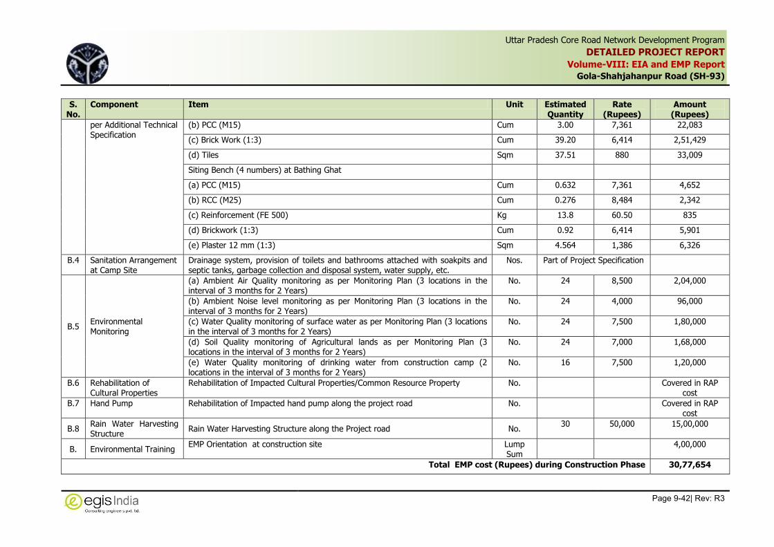
Uttar Pradesh Core Road Network Development Program
DETAILED PROJECT REPORT
Volume-VIII: EIA and EMP Report
Gola-Shahjahanpur Road (SH-93)
Page 9-42| Rev: R3
,
S. No.
Component Item Unit Estimated Quantity
Rate (Rupees)
Amount (Rupees)
per Additional Technical Specification
(b) PCC (M15) Cum 3.00 7,361 22,083
(c) Brick Work (1:3) Cum 39.20 6,414 2,51,429
(d) Tiles Sqm 37.51 880 33,009
Siting Bench (4 numbers) at Bathing Ghat
(a) PCC (M15) Cum 0.632 7,361 4,652
(b) RCC (M25) Cum 0.276 8,484 2,342
(c) Reinforcement (FE 500) Kg 13.8 60.50 835
(d) Brickwork (1:3) Cum 0.92 6,414 5,901
(e) Plaster 12 mm (1:3) Sqm 4.564 1,386 6,326
B.4 Sanitation Arrangement at Camp Site
Drainage system, provision of toilets and bathrooms attached with soakpits and septic tanks, garbage collection and disposal system, water supply, etc.
Nos. Part of Project Specification
B.5 Environmental Monitoring
(a) Ambient Air Quality monitoring as per Monitoring Plan (3 locations in the interval of 3 months for 2 Years)
No. 24 8,500 2,04,000
(b) Ambient Noise level monitoring as per Monitoring Plan (3 locations in the interval of 3 months for 2 Years)
No. 24 4,000 96,000
(c) Water Quality monitoring of surface water as per Monitoring Plan (3 locations in the interval of 3 months for 2 Years)
No. 24 7,500 1,80,000
(d) Soil Quality monitoring of Agricultural lands as per Monitoring Plan (3 locations in the interval of 3 months for 2 Years)
No. 24 7,000 1,68,000
(e) Water Quality monitoring of drinking water from construction camp (2 locations in the interval of 3 months for 2 Years)
No. 16 7,500 1,20,000
B.6 Rehabilitation of Cultural Properties
Rehabilitation of Impacted Cultural Properties/Common Resource Property No. Covered in RAP cost
B.7 Hand Pump Rehabilitation of Impacted hand pump along the project road No. Covered in RAP cost
B.8 Rain Water Harvesting Structure
Rain Water Harvesting Structure along the Project road No. 30 50,000 15,00,000
B. Environmental Training EMP Orientation at construction site Lump
Sum 4,00,000
Total EMP cost (Rupees) during Construction Phase 30,77,654

Uttar Pradesh Core Road Network Development Program
DETAILED PROJECT REPORT
Volume-VIII: EIA and EMP Report
Gola-Shahjahanpur Road (SH-93)
Page 9-43| Rev: R3
,
S. No.
Component Item Unit Estimated Quantity
Rate (Rupees)
Amount (Rupees)
C. OPERATION STAGE
C.1 Environmental Monitoring
(a) Ambient Air Quality monitoring at Residential & Commercial locations along the project road (2 locations in the interval of 4 months for 1 Years)
No. 6 8,500 51,000
(b) Surface Water Quality monitoring along the project road (2 locations in the interval of 4 months for 1 Years)
No. 6 7,500 45,000
(c) Ambient Noise monitoring at sensitive receptors (3 locations in the interval of 4 months for 1 Years)
No. 9 4,000 36,000
(d) Soil Quality monitoring of Agricultural lands (2 locations in the interval of 4 months for 1 Year)
No. 6 7,000 42,000
C.2 Tree plantation monitoring
Along the project corridor for 2 years Lump Sum
2,50,000
Total EMP cost during Operation Phase 4,24,000
Total Cost (A+B+C) 7,93,80,875
Contingency (10%) 79,38,088
Total EMP Cost (Rupees) 8,73,18,963
ANNEXURES

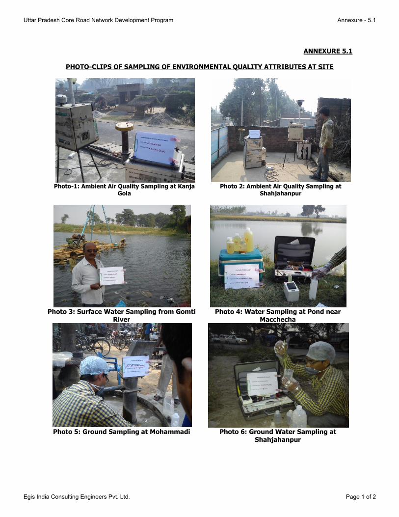
ANNEXURE 5.1
PHOTO-CLIPS OF SAMPLING OF ENVIRONMENTAL QUALITY ATTRIBUTES AT SITE
Photo-1: Ambient Air Quality Sampling at Kanja
Gola Photo 2: Ambient Air Quality Sampling at
Shahjahanpur
Photo 3: Surface Water Sampling from Gomti
River Photo 4: Water Sampling at Pond near
Macchecha
Photo 5: Ground Sampling at Mohammadi Photo 6: Ground Water Sampling at
Shahjahanpur
Uttar Pradesh Core Road Network Development Program Annexure - 5.1
Egis India Consulting Engineers Pvt. Ltd. Page 1 of 2

Photo 7: Noise Level Monitoring at
Mohammadi
Photo 8: Noise Level Monitoring at Gokan
Photo 9: Soil Sampling at Reserved Area Photo 10: Soil Sampling at Mukrampur
Uttar Pradesh Core Road Network Development Program Annexure - 5.1
Egis India Consulting Engineers Pvt. Ltd. Page 2 of 2

ANNEXURE-5.2
Uttar Pradesh Core Road Network Development Program Annexure - 5.2
Egis India Consulting Engineers Pvt. Ltd. Page 1 of 1
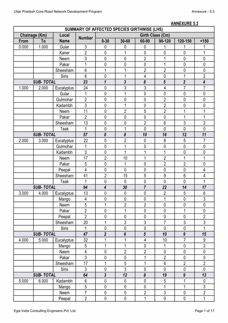
From To 0-30 30-60 60-90 90-120 120-150 <150
0.000 1.000 Gular 3 0 0 0 1 1 1
Kaner 2 0 1 0 0 0 1
Neem 3 0 0 2 1 0 0
Pakar 1 0 0 0 1 0 0
Sheesham 6 1 1 2 2 0 0
Siris 8 0 1 4 0 1 2
23 1 3 8 5 2 4
1.000 2.000 Eucalyptus 24 0 3 3 4 7 7
Gular 1 0 1 0 0 0 0
Gulmohar 2 0 0 0 2 0 0
Kadambh 3 0 1 0 2 0 0
Neem 11 0 2 5 2 1 1
Pakar 2 0 0 0 0 1 1
Sheesham 13 0 0 2 6 3 2
Teak 1 0 1 0 0 0 0
57 0 8 10 16 12 11
2.000 3.000 Eucalyptus 22 0 2 0 8 5 7
Gulmohar 1 0 1 0 0 0 0
Kadambh 3 0 1 1 1 0 0
Neem 17 2 10 1 2 1 1
Pakar 5 0 1 0 2 2 0
Peepal 4 0 0 0 0 0 4
Sheesham 41 2 15 5 9 6 4
Teak 1 0 0 0 0 0 1
94 4 30 7 22 14 17
3.000 4.000 Eucalyptus 13 0 0 0 2 5 6
Mango 4 0 0 0 1 0 3
Neem 5 1 2 2 0 0 0
Pakar 2 0 1 0 0 1 0
Peepal 2 0 0 0 0 0 2
Sheesham 20 1 3 3 7 3 3
Siris 1 0 0 0 0 0 1
47 2 6 5 10 9 15
4.000 5.000 Eucalyptus 32 1 1 4 10 7 9
Mango 5 1 1 0 1 0 2
Neem 4 0 2 2 0 0 0
Pakar 3 0 0 1 2 0 0
Sheesham 17 1 5 1 6 2 2
Siris 3 0 3 0 0 0 0
64 3 12 8 19 9 13
5.000 6.000 Kadambh 6 0 0 0 5 1 0
Mango 5 0 0 0 1 1 3
Neem 7 0 0 2 3 0 2
Peepal 2 0 0 1 0 0 1
SUB- TOTAL
SUMMARY OF AFFECTED SPECIES GIRTHWISE (LHS)
Chainage (Km) Local
NameNumber
Girth Class (Cm)
SUB- TOTAL
SUB- TOTAL
SUB- TOTAL
SUB- TOTAL
ANNEXURE 5.3
Uttar Pradesh Core Road Network Development Program Annexure - 5.3
Egis India Consulting Engineers Pvt. Ltd. Page 1 of 17

From To 0-30 30-60 60-90 90-120 120-150 <150
Chainage (Km) Local
NameNumber
Girth Class (Cm)
Sheesham 17 0 0 8 8 1 0
Siris 10 0 0 4 4 1 1
47 0 0 15 21 4 7
6.000 7.000 Eucalyptus 27 0 0 3 11 5 8
Mango 1 0 0 0 0 0 1
Neem 4 0 0 2 1 1 0
Peepal 3 0 0 0 1 2 0
Pakar 3 0 0 0 0 0 3
Sheesham 8 0 1 3 2 2 0
46 0 1 8 15 10 12
7.000 8.000 Banyan 2 0 0 0 0 0 2
Eucalyptus 30 0 0 0 9 13 8
Mango 10 0 0 0 2 3 5
Neem 16 1 3 3 5 2 2
Pakar 2 0 0 1 0 0 1
Peepal 5 0 0 0 1 0 4
65 1 3 4 17 18 22
8.000 9.000 Eucalyptus 11 0 0 0 3 7 1
Mango 4 0 0 0 0 1 3
Neem 4 0 2 1 1 0 0
Sheesham 11 0 4 1 3 2 1
30 0 6 2 7 10 5
9.000 10.000 Ashok 2 0 1 1 0 0 0
Babool 4 0 3 0 1 0 0
Eucalyptus 6 0 0 2 2 0 2
Mango 15 1 4 0 0 2 8
Neem 4 0 3 0 1 0 0
Peepal 2 0 0 0 0 0 2
Sheesham 5 0 3 1 0 1 0
Siris 5 0 3 1 1 0 0
43 1 17 5 5 3 12
10.000 11.000 Ashok 2 0 1 1 0 0 0
Babool 2 0 0 1 1 0 0
Eucalyptus 21 0 2 3 7 4 5
Mango 7 0 0 2 0 2 3
Neem 1 0 1 0 0 0 0
Peepal 22 3 17 1 1 0 0
Sheesham 3 0 0 3 0 0 0
Siris 5 0 2 2 1 0 0
63 3 23 13 10 6 8
11.000 12.000 Banyan 3 0 0 0 0 0 3
Eucalyptus 15 0 0 1 3 9 2
Gular 2 0 1 1 0 0 0
Kadambh 3 0 3 0 0 0 0
Mango 1 0 0 0 0 1 0
Neem 3 0 3 0 0 0 0
SUB- TOTAL
SUB- TOTAL
SUB- TOTAL
SUB- TOTAL
SUB- TOTAL
SUB- TOTAL
Uttar Pradesh Core Road Network Development Program Annexure - 5.3
Egis India Consulting Engineers Pvt. Ltd. Page 2 of 17

From To 0-30 30-60 60-90 90-120 120-150 <150
Chainage (Km) Local
NameNumber
Girth Class (Cm)
Palm 6 0 4 2 0 0 0
Teak 25 1 11 9 3 1 0
58 1 22 13 6 11 5
12.000 13.000 Bakain 2 0 1 1 0 0 0
Eucalyptus 1 0 0 0 0 1 0
Kaner 3 0 1 0 2 0 0
Mango 3 0 0 0 0 0 3
Neem 5 0 4 0 1 0 0
Plum 2 0 2 0 0 0 0
Siris 6 0 0 1 3 2 0
Teak 4 0 1 2 1 0 0
26 0 9 4 7 3 3
13.000 14.000 Banyan 2 0 0 0 0 0 2
Pakar 1 0 0 0 1 0 0
Sheesham 2 0 1 0 0 1 0
Siris 6 0 1 4 1 0 0
Teak 16 0 8 6 2 0 0
27 0 10 10 4 1 2
14.000 15.000 Junglee 5 0 1 0 0 1 3
Neem 4 0 3 0 0 1 0
Teak 34 2 20 8 4 0 0
43 2 24 8 4 2 3
15.000 16.000 Junglee 3 0 1 0 1 1 0
Kadambh 1 0 0 0 1 0 0
Mango 4 0 0 0 1 2 1
Neem 4 0 2 2 0 0 0
Teak 8 0 3 4 1 0 0
20 0 1 0 1 1 0
16.000 17.000 Ashok 2 0 2 0 0 0 0
Eucalyptus 1 0 0 0 0 1 0
Gulmohar 2 0 0 0 2 0 0
Neem 1 0 1 0 0 0 0
Pakar 1 0 0 0 1 0 0
Sheesham 2 0 1 0 1 0 0
SIris 3 0 1 2 0 0 0
12 0 5 2 4 1 0
17.000 18.000 Eucalyptus 18 0 0 3 4 8 3
Junglee 2 0 0 2 0 0 0
Mango 2 0 0 0 0 1 1
Neem 2 0 1 1 0 0 0
Peepal 1 0 0 0 0 0 1
Sheesham 8 0 1 1 3 3 0
33 0 2 7 7 12 5
18.000 19.000 Eucalyptus 12 0 0 0 3 6 3
Gulmohar 2 0 0 0 2 0 0
Junglee 2 0 1 1 0 0 0
SUB- TOTAL
SUB- TOTAL
SUB- TOTAL
SUB- TOTAL
SUB- TOTAL
SUB- TOTAL
SUB- TOTAL
Uttar Pradesh Core Road Network Development Program Annexure - 5.3
Egis India Consulting Engineers Pvt. Ltd. Page 3 of 17
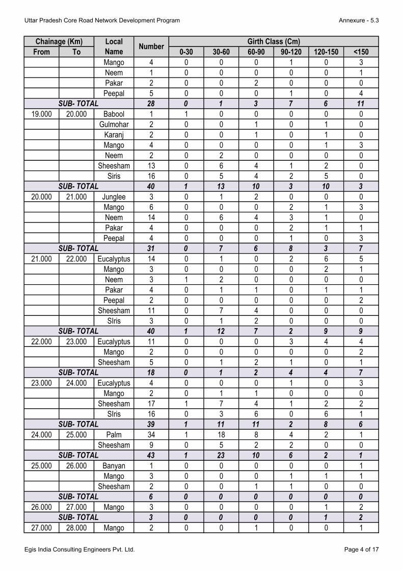
From To 0-30 30-60 60-90 90-120 120-150 <150
Chainage (Km) Local
NameNumber
Girth Class (Cm)
Mango 4 0 0 0 1 0 3
Neem 1 0 0 0 0 0 1
Pakar 2 0 0 2 0 0 0
Peepal 5 0 0 0 1 0 4
28 0 1 3 7 6 11
19.000 20.000 Babool 1 1 0 0 0 0 0
Gulmohar 2 0 0 1 0 1 0
Karanj 2 0 0 1 0 1 0
Mango 4 0 0 0 0 1 3
Neem 2 0 2 0 0 0 0
Sheesham 13 0 6 4 1 2 0
Siris 16 0 5 4 2 5 0
40 1 13 10 3 10 3
20.000 21.000 Junglee 3 0 1 2 0 0 0
Mango 6 0 0 0 2 1 3
Neem 14 0 6 4 3 1 0
Pakar 4 0 0 0 2 1 1
Peepal 4 0 0 0 1 0 3
31 0 7 6 8 3 7
21.000 22.000 Eucalyptus 14 0 1 0 2 6 5
Mango 3 0 0 0 0 2 1
Neem 3 1 2 0 0 0 0
Pakar 4 0 1 1 0 1 1
Peepal 2 0 0 0 0 0 2
Sheesham 11 0 7 4 0 0 0
SIris 3 0 1 2 0 0 0
40 1 12 7 2 9 9
22.000 23.000 Eucalyptus 11 0 0 0 3 4 4
Mango 2 0 0 0 0 0 2
Sheesham 5 0 1 2 1 0 1
18 0 1 2 4 4 7
23.000 24.000 Eucalyptus 4 0 0 0 1 0 3
Mango 2 0 1 1 0 0 0
Sheesham 17 1 7 4 1 2 2
SIris 16 0 3 6 0 6 1
39 1 11 11 2 8 6
24.000 25.000 Palm 34 1 18 8 4 2 1
Sheesham 9 0 5 2 2 0 0
43 1 23 10 6 2 1
25.000 26.000 Banyan 1 0 0 0 0 0 1
Mango 3 0 0 0 1 1 1
Sheesham 2 0 0 1 1 0 0
6 0 0 0 0 0 0
26.000 27.000 Mango 3 0 0 0 0 1 2
3 0 0 0 0 1 2
27.000 28.000 Mango 2 0 0 1 0 0 1
SUB- TOTAL
SUB- TOTAL
SUB- TOTAL
SUB- TOTAL
SUB- TOTAL
SUB- TOTAL
SUB- TOTAL
SUB- TOTAL
SUB- TOTAL
Uttar Pradesh Core Road Network Development Program Annexure - 5.3
Egis India Consulting Engineers Pvt. Ltd. Page 4 of 17

From To 0-30 30-60 60-90 90-120 120-150 <150
Chainage (Km) Local
NameNumber
Girth Class (Cm)
Neem 6 0 4 1 1 0 0
Sheesham 12 0 1 4 5 1 1
20 0 5 6 6 1 2
28.000 29.000 Mango 11 0 0 0 3 2 6
Sheesham 5 0 1 3 1 0 0
Teak 34 0 11 13 6 4 0
50 0 12 16 10 6 6
29.000 30.000 Gular 2 0 0 1 1 0 0
Gulmohar 9 0 0 0 2 2 5
Peepal 4 0 0 0 0 2 2
15 0 0 1 3 4 7
30.000 31.000Jungle
Jalebi3 0 1 2 0 0 0
Pakar 2 0 1 0 0 1 0
Sheesham 21 0 1 9 7 2 2
Siris 5 0 1 3 1 0 0
31 0 4 14 8 3 2
31.000 32.000 Ashok 2 0 0 2 0 0 0
Gulmohar 6 0 0 0 2 2 2
Mango 2 0 0 0 0 1 1
Neem 3 0 1 2 0 0 0
Pakar 1 0 0 1 0 0 0
Sheesham 28 0 14 10 4 0 0
42 0 15 15 6 3 3
32.000 33.000 Mango 11 0 0 1 4 2 4
Sheesham 23 2 10 5 1 2 3
SIris 33 1 11 9 11 0 1
67 3 21 15 16 4 8
33.000 34.000 Gulmohar 2 0 0 0 2 0 0
Mango 5 0 0 1 1 1 2
Neem 2 0 2 0 0 0 0
Pakar 1 0 1 0 0 0 0
Sheesham 21 1 11 4 2 1 2
SIris 16 0 4 5 3 2 2
47 1 18 10 8 4 6
34.000 35.000 Babool 27 1 11 8 4 1 2
Neem 12 0 6 3 1 2 0
Palar 1 0 0 1 0 0 0
Plum 2 1 0 1 0 0 0
Sheesham 41 1 19 7 4 7 3
83 3 36 20 9 10 5
35.000 36.000 Jamun 2 0 1 0 0 1 0
Mango 3 0 0 0 0 1 2
Neem 15 0 6 4 1 2 2
Pakar 1 0 1 0 0 0 0
Peepal 7 0 1 1 1 1 3
SUB- TOTAL
SUB- TOTAL
SUB- TOTAL
SUB- TOTAL
SUB- TOTAL
SUB- TOTAL
SUB- TOTAL
SUB- TOTAL
Uttar Pradesh Core Road Network Development Program Annexure - 5.3
Egis India Consulting Engineers Pvt. Ltd. Page 5 of 17

From To 0-30 30-60 60-90 90-120 120-150 <150
Chainage (Km) Local
NameNumber
Girth Class (Cm)
Sheesham 34 2 16 4 7 3 2
Siris 32 2 27 3 0 0 0
94 4 52 12 9 8 9
36.000 37.000 Mango 15 0 0 1 8 0 6
Sheesham 13 0 2 1 9 0 1
Siris 23 0 0 5 13 3 2
51 0 2 7 30 3 9
37.000 38.000 Mango 2 0 0 0 0 0 2
Sheesham 13 0 0 1 8 4 0
Siris 17 0 0 2 14 1 0
32 0 0 3 22 5 2
38.000 39.000 Mango 2 0 0 1 1 0 0
Neem 3 0 0 0 3 0 0
Sheesham 15 0 3 2 8 0 2
Siris 3 0 0 1 2 0 0
23 0 3 4 14 0 2
39.000 40.000 Neem 3 0 2 1 0 0 0
Sheesham 13 0 2 0 6 4 1
Siris 6 0 1 2 2 0 1
22 0 5 3 8 4 2
40.000 41.000 Poplar 2 0 0 1 1 0 0
SIris 6 0 2 0 2 1 1
8 0 2 1 3 1 1
41.000 42.000 Poplar 8 0 2 3 2 0 1
8 0 2 3 2 0 1
42.000 43.000 Jamun 1 0 0 0 1 0 0
Mango 14 0 0 1 6 1 6
Neem 5 0 1 2 2 0 0
Poplar 5 0 0 2 3 0 0
SIris 25 0 2 14 8 0 1
50 0 3 19 20 1 7
43.000 44.000 Eucalyptus 4 0 0 0 0 1 3
Mango 2 0 0 0 1 0 1
Pakar 2 0 0 0 2 0 0
SIris 17 0 1 7 7 1 1
25 0 1 7 10 2 5
44.000 45.000 Jamun 3 0 2 0 0 1 0
Mango 5 0 2 2 1 0 0
Neem 10 0 3 3 2 2 0
Pakar 1 0 0 0 0 0 1
Sheesham 23 1 4 4 10 2 2
Siris 1 0 0 0 1 0 0
43 1 11 9 14 5 3
45.000 46.000 Mango 4 0 0 0 0 1 3
Poplar 4 0 2 2 0 0 0
Sheesham 57 1 34 12 7 3 0
SUB- TOTAL
SUB- TOTAL
SUB- TOTAL
SUB- TOTAL
SUB- TOTAL
SUB- TOTAL
SUB- TOTAL
SUB- TOTAL
SUB- TOTAL
SUB- TOTAL
Uttar Pradesh Core Road Network Development Program Annexure - 5.3
Egis India Consulting Engineers Pvt. Ltd. Page 6 of 17

From To 0-30 30-60 60-90 90-120 120-150 <150
Chainage (Km) Local
NameNumber
Girth Class (Cm)
65 1 36 14 7 4 3
46.000 47.000 Jamun 2 0 0 1 0 0 1
Mango 2 0 0 0 1 0 1
Sheesham 19 0 0 10 5 3 1
23 0 0 11 6 3 3
47.000 48.000 Jamun 1 0 0 0 1 0 0
Mango 1 0 1 0 0 0 0
Neem 10 2 3 2 3 0 0
Pakar 1 0 0 0 1 0 0
Sheesham 19 0 4 6 3 3 3
32 2 8 8 8 3 3
48.000 49.000 Jamun 1 0 0 0 0 0 1
Karanj 2 0 1 1 0 0 0
Mango 1 0 0 0 1 0 0
Neem 3 0 1 2 0 0 0
Pakar 1 0 0 0 0 1 0
Sheesham 14 1 5 2 5 0 1
22 1 7 5 6 1 2
49.000 50.000 Neem 1 0 0 0 0 1 0
Sheesham 10 1 7 1 1 0 0
Siris 20 0 4 8 6 2 0
31 1 11 9 7 3 0
50.000 51.000 Babool 13 0 0 4 6 1 2
Mango 1 0 0 0 0 0 1
Neem 2 0 1 1 0 0 0
Sheesham 23 0 5 8 5 2 3
SIris 31 0 5 10 12 0 4
70 0 11 23 23 3 10
51.000 52.000 Eucalyptus 21 0 0 5 5 2 9
Jamun 1 0 1 0 0 0 0
Mango 6 0 0 0 1 1 4
Neem 5 0 2 2 1 0 0
Pakar 1 0 0 0 0 0 1
Peepal 2 0 0 0 0 0 2
Sheesham 62 0 8 20 17 12 5
SIris 36 1 4 15 6 9 1
134 1 15 42 30 24 22
52.000 53.000 Jamun 2 0 0 0 1 0 1
Mango 3 0 0 0 1 1 1
Neem 16 1 15 0 0 0 0
Sheesham 41 2 19 10 1 7 2
62 3 34 10 3 8 4
53.000 54.000 Babool 4 0 1 0 3 0 0
Mango 5 0 1 0 1 0 3
Neem 10 0 7 2 1 0 0
Pakar 1 0 0 1 0 0 0
SUB- TOTAL
SUB- TOTAL
SUB- TOTAL
SUB- TOTAL
SUB- TOTAL
SUB- TOTAL
SUB- TOTAL
SUB- TOTAL
Uttar Pradesh Core Road Network Development Program Annexure - 5.3
Egis India Consulting Engineers Pvt. Ltd. Page 7 of 17

From To 0-30 30-60 60-90 90-120 120-150 <150
Chainage (Km) Local
NameNumber
Girth Class (Cm)
Sheesham 12 1 11 0 0 0 0
32 1 20 3 5 0 3
54.000 55.000 Gulmohar 8 0 1 3 2 2 0
Jamun 1 0 0 0 0 1 0
Karanj 9 0 2 6 0 0 1
Mango 4 0 1 3 0 0 0
Neem 51 1 12 15 15 3 5
Pakar 2 0 0 1 0 1 0
Peepal 2 0 0 2 0 0 0
Sheesham 40 0 13 15 7 4 1
117 1 29 45 24 11 7
55.000 56.000 Karanj 7 0 1 4 1 1 0
Mango 12 0 2 0 2 2 6
Neem 12 0 6 4 1 1 0
Poplar 6 0 0 5 1 0 0
Sheesham 21 0 7 8 4 1 1
58 0 16 21 9 5 7
56.000 57.000 Gulmohar 2 0 0 2 0 0 0
Karanj 11 0 3 5 3 0 0
Neem 1 0 0 0 1 0 0
Sheesham 18 0 5 7 5 1 0
Siris 30 0 3 15 7 4 1
62 0 11 29 16 5 1
57.000 58.000 Jamun 3 0 0 1 1 0 1
Karanj 7 0 1 3 3 0 0
Mango 3 0 0 1 1 0 1
Neem 2 0 2 0 0 0 0
Pakar 9 0 1 2 6 0 0
Peepal 1 0 0 0 0 0 1
Sheesham 12 0 4 5 3 0 0
SIris 21 2 4 11 3 1 0
58 2 12 23 17 1 3
58.000 59.000 Karanj 16 0 3 4 6 2 1
Sheesham 26 0 6 8 9 3 0
SIris 11 2 1 3 4 1 0
53 2 10 15 19 6 1
SUB- TOTAL
SUB- TOTAL
SUB- TOTAL
SUB- TOTAL
SUB- TOTAL
SUB- TOTAL
Uttar Pradesh Core Road Network Development Program Annexure - 5.3
Egis India Consulting Engineers Pvt. Ltd. Page 8 of 17

From To 0-30 30-60 60-90 90-120 120-150 >150
0.000 1.000 Eculyptus 2 0 0 1 1 0 0
Mahogany 2 0 0 0 1 1 0
Mahaneem 5 0 0 2 2 1 0
9 0 0 3 4 2 0
1.000 2.000 Peepal 1 0 0 0 0 1 0
Mahogany 8 0 0 3 3 2 0
Eculyptus 26 0 0 8 12 6 0
Neem 1 0 0 0 1 0 0
36 0 0 11 16 9 0
2.000 3.000 Mango 2 0 0 0 1 1 0
Eculyptus 12 0 0 4 6 2 0
Peepal 1 0 0 0 0 1 0
15 0 0 4 7 4 0
3.000 4.000 Eculyptus 6 0 1 3 2 0 0
6 0 1 3 2 0 0
4.000 5.000 Eculyptus 60 0 10 24 14 12 0
Gulmohar 1 0 1 0 0 0 0
Mango 2 0 0 2 0 0 0
63 0 11 26 14 12 0
5.000 6.000 Eculyptus 15 0 4 8 3 0 0
Shisham 7 0 0 5 2 0 0
Mango 4 0 0 2 2 0 0
Gulmohar 1 0 1 0 0 0 0
Neem 5 0 4 1 0 0 0
Pakad 13 0 0 6 7 0 0
Peepal 4 0 0 2 2 0 0
49 0 9 24 16 0 0
6.000 7.000 Eculyptus 57 4 11 13 17 12 0
Shisham 10 0 3 3 4 0 0
Mango 9 0 0 4 4 1 0
76 4 14 20 25 13 0
7.000 8.000 Eculyptus 38 0 8 16 8 6 0
Shisham 22 2 4 6 4 6 0
Karanj 4 0 0 2 2 0 0
Mango 8 0 0 0 5 3 0
72 2 12 24 19 15 0
8.000 9.000 Mango 16 0 0 2 11 3 0
Shisham 10 0 0 4 2 4 0
Eculyptus 13 0 3 2 4 4 0
Karanj 1 0 0 0 1 0 0
40 0 3 8 18 11 0
9.000 10.000 Neem 7 0 2 3 2 0 0
ANNEXURE 5.3
SUMMARY OF AFFECTED SPECIES GIRTHWISE (RHS)
Chainage (Km)Local Name Number
Girth Class (Cm)
Uttar Pradesh Core Road Network Development Program Annexure - 5.3
Egis India Consulting Engineers Pvt. Ltd. Page 9 of 17

From To 0-30 30-60 60-90 90-120 120-150 >150
Chainage (Km)Local Name Number
Girth Class (Cm)
Jamun 2 0 0 0 2 0 0
Ashok 1 0 1 0 0 0 0
Mango 4 0 0 0 2 2 0
Eculyptus 6 0 0 0 2 4 0
Shisham 6 0 0 0 2 4 0
Mahogany 7 0 0 2 2 3 0
Junglee 4 0 1 1 2 0 0
37 0 4 6 14 13 0
10.000 11.000 Mahogany 28 0 6 7 13 2 0
Eculyptus 26 0 3 7 4 8 4
Teak 5 0 0 2 3 0 0
Shisham 15 0 0 6 7 2 0
Peepal 1 0 0 0 0 1 0
Neem 2 0 0 0 0 2 0
Pakad 2 0 0 0 0 2 0
79 0 9 22 27 17 4
11.000 12.000 Babool 8 0 1 4 3 0 0
Teak 21 0 4 5 4 8 0
Eculyptus 3 0 0 0 0 3 0
Karanj 5 0 0 2 3 0 0
Shisham 15 0 2 6 5 2 0
Siris 17 0 1 4 5 5 2
Gulmohar 2 0 2 0 0 0 0
Neem 14 0 0 5 4 5 0
Peepal 1 0 0 0 0 1 0
86 0 10 26 24 24 2
12.000 13.000 Mango 1 0 0 1 0 0 0
Neem 1 0 0 0 1 0 0
Mahogany 2 0 1 1 0 0 0
Teak 60 0 5 14 16 18 7
Siris 4 0 0 1 2 1 0
68 0 6 17 19 19 7
13.000 14.000 Teak 42 0 0 6 15 19 2
Mango 2 0 0 0 1 1 0
44 0 0 6 16 20 2
14.000 15.000 Teak 9 0 0 2 2 3 2
Mahogany 87 0 7 18 25 27 10
96 0 7 20 27 30 12
15.000 16.000 Pakad 5 0 1 2 2 0 0
Banyan 5 0 1 1 2 1 0
Mahogany 4 0 1 2 1 0 0
Jungle jalebi 13 1 3 3 4 2 0
Shisham 4 0 1 2 1 0 0
31 1 7 10 10 3 0
Uttar Pradesh Core Road Network Development Program Annexure - 5.3
Egis India Consulting Engineers Pvt. Ltd. Page 10 of 17
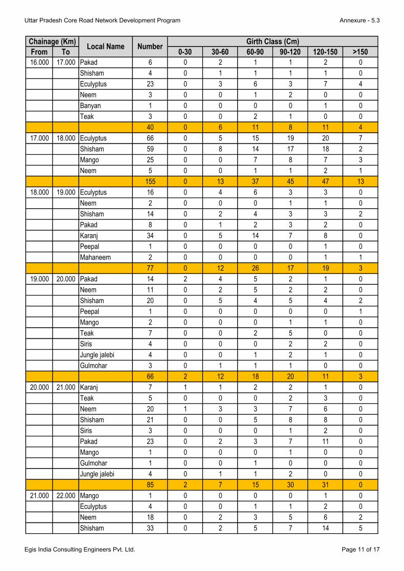
From To 0-30 30-60 60-90 90-120 120-150 >150
Chainage (Km)Local Name Number
Girth Class (Cm)
16.000 17.000 Pakad 6 0 2 1 1 2 0
Shisham 4 0 1 1 1 1 0
Eculyptus 23 0 3 6 3 7 4
Neem 3 0 0 1 2 0 0
Banyan 1 0 0 0 0 1 0
Teak 3 0 0 2 1 0 0
40 0 6 11 8 11 4
17.000 18.000 Eculyptus 66 0 5 15 19 20 7
Shisham 59 0 8 14 17 18 2
Mango 25 0 0 7 8 7 3
Neem 5 0 0 1 1 2 1
155 0 13 37 45 47 13
18.000 19.000 Eculyptus 16 0 4 6 3 3 0
Neem 2 0 0 0 1 1 0
Shisham 14 0 2 4 3 3 2
Pakad 8 0 1 2 3 2 0
Karanj 34 0 5 14 7 8 0
Peepal 1 0 0 0 0 1 0
Mahaneem 2 0 0 0 0 1 1
77 0 12 26 17 19 3
19.000 20.000 Pakad 14 2 4 5 2 1 0
Neem 11 0 2 5 2 2 0
Shisham 20 0 5 4 5 4 2
Peepal 1 0 0 0 0 0 1
Mango 2 0 0 0 1 1 0
Teak 7 0 0 2 5 0 0
Siris 4 0 0 0 2 2 0
Jungle jalebi 4 0 0 1 2 1 0
Gulmohar 3 0 1 1 1 0 0
66 2 12 18 20 11 3
20.000 21.000 Karanj 7 1 1 2 2 1 0
Teak 5 0 0 0 2 3 0
Neem 20 1 3 3 7 6 0
Shisham 21 0 0 5 8 8 0
Siris 3 0 0 0 1 2 0
Pakad 23 0 2 3 7 11 0
Mango 1 0 0 0 1 0 0
Gulmohar 1 0 0 1 0 0 0
Jungle jalebi 4 0 1 1 2 0 0
85 2 7 15 30 31 0
21.000 22.000 Mango 1 0 0 0 0 1 0
Eculyptus 4 0 0 1 1 2 0
Neem 18 0 2 3 5 6 2
Shisham 33 0 2 5 7 14 5
Uttar Pradesh Core Road Network Development Program Annexure - 5.3
Egis India Consulting Engineers Pvt. Ltd. Page 11 of 17

From To 0-30 30-60 60-90 90-120 120-150 >150
Chainage (Km)Local Name Number
Girth Class (Cm)
Karanj 5 0 0 2 1 1 1
Pakad 2 0 0 0 1 1 0
Jamun 4 0 0 2 2 0 0
Jungle jalebi 6 0 0 1 2 3 0
Banyan 4 0 0 0 2 1 1
Siris 4 0 0 0 1 1 2
81 0 4 14 22 30 11
22.000 23.000 Karanj 11 0 4 5 2 0 0
Awala 6 0 2 3 1 0 0
Eculyptus 5 0 0 0 2 3 0
Mahogany 5 0 0 1 2 2 0
Shisham 9 0 2 2 3 2 0
Mango 2 0 0 0 1 1 0
38 0 8 11 11 8 0
23.000 24.000 Karanj 19 4 4 2 4 5 0
Siris 17 0 2 5 3 2 5
Shisham 18 0 4 5 5 2 2
Jungle jalebi 4 0 1 1 1 1 0
58 4 11 13 13 10 7
24.000 25.000 Jungle jalebi 2 0 1 1 0 0 0
Pakad 5 0 0 1 2 2 0
Shisham 6 0 0 2 2 2 0
Mahogany 2 0 0 0 2 0 0
Ber 5 0 1 1 2 1 0
Neem 1 0 0 0 1 0 0
21 0 2 5 9 5 0
25.000 26.000 Shisham 23 0 4 4 8 7 0
Siris 11 0 1 4 4 2 0
Karanj 8 0 0 2 2 2 2
Neem 6 0 0 2 2 2 0
Jungle jalebi 3 0 0 1 1 1 0
51 0 5 13 17 14 2
26.000 27.000 Shisham 24 2 4 8 5 3 2
Neem 4 0 1 1 2 0 0
Siris 2 0 0 0 0 2 0
Mahogany 10 0 2 4 1 1 2
Pakad 2 0 0 1 1 0 0
Mango 1 0 0 0 0 1 0
43 2 7 14 9 7 4
27.000 28.000 Mango 9 0 2 1 2 2 2
Shisham 13 0 1 2 2 4 4
Junglee 2 0 0 1 1 0 0
Karanj 2 0 0 0 1 1 0
Mahogany 7 0 0 2 2 2 1
Uttar Pradesh Core Road Network Development Program Annexure - 5.3
Egis India Consulting Engineers Pvt. Ltd. Page 12 of 17

From To 0-30 30-60 60-90 90-120 120-150 >150
Chainage (Km)Local Name Number
Girth Class (Cm)
Siris 9 0 0 2 2 2 3
42 0 3 8 10 11 10
28.000 29.000 Siris 15 0 2 4 5 4 0
Shisham 24 0 7 3 7 7 0
Babool 1 0 0 1 0 0 0
Mango 6 0 2 2 2 0 0
Pakad 9 0 0 2 3 4 0
Neem 7 0 2 2 2 1 0
Karanj 6 0 0 2 2 2 0
Peepal 1 0 0 0 1 0 0
Ashok 7 0 3 2 2 0 0
76 0 16 18 24 18 0
29.000 30.000 Siris 7 0 2 2 1 2 0
Mango 4 0 0 0 2 2 0
Shisham 24 0 7 6 4 4 3
Gulmohar 10 0 2 2 2 2 2
Neem 5 0 2 1 1 1 0
Pakad 6 0 1 2 2 1 0
Mahaneem 1 0 0 1 0 0 0
Karanj 3 0 1 1 1 0 0
60 0 15 15 13 12 5
30.000 31.000 Pakad 7 0 1 2 2 2 0
Shisham 14 0 2 2 3 4 3
Neem 4 0 0 2 1 1 0
Ashok 3 0 1 1 1 0 0
Mahaneem 6 0 1 2 2 1 0
Gulmohar 5 0 1 2 1 1 0
Mango 2 0 0 0 1 1 0
Junglee 4 0 1 1 1 1 0
Mahogany 2 0 0 1 1 0 0
47 0 7 13 13 11 3
31.000 32.000 Siris 8 0 2 2 2 2 0
Shisham 10 0 2 2 4 2 0
Neem 0 0 0 0 0 0 0
Pakad 0 0 0 0 0 0 0
Peepal 0 0 0 0 0 0 0
Mango 0 0 0 0 0 0 0
Junglee 15 0 7 4 2 2 0
33 0 11 8 8 6 0
32.000 33.000 Mahogany 42 0 6 19 11 6 0
Mango 2 0 0 0 1 1 0
Shisham 10 0 2 2 2 4 0
Kanchan 10 0 0 4 2 2 2
Siris 2 0 0 0 0 2 0
Uttar Pradesh Core Road Network Development Program Annexure - 5.3
Egis India Consulting Engineers Pvt. Ltd. Page 13 of 17

From To 0-30 30-60 60-90 90-120 120-150 >150
Chainage (Km)Local Name Number
Girth Class (Cm)
Jungle jalebi 2 0 0 0 2 0 0
68 0 8 25 18 15 2
33.000 34.000 Neem 11 2 2 2 3 2 0
Shisham 9 0 2 2 1 2 2
Siris 6 0 0 1 2 2 1
Mango 3 0 0 1 1 1 0
Gulmohar 1 0 0 1 0 0 0
Pakad 2 0 0 1 1 0 0
Peepal 1 0 0 0 1 0 0
33 2 4 8 9 7 3
34.000 35.000 Neem 12 2 2 4 2 2 0
Shisham 32 0 2 10 14 2 4
Karanj 4 0 0 2 2 0 0
Babool 3 0 0 1 1 1 0
Pakad 6 0 2 2 2 0 0
Ber 2 0 0 1 1 0 0
59 2 6 20 22 5 4
35.000 36.000 Peepal 1 0 0 0 0 1 0
Shisham 18 0 2 4 4 6 2
Mango 15 0 2 3 4 6 0
Siris 2 0 0 0 1 1 0
Neem 4 0 0 2 2 0 0
Mahogany 2 0 0 1 1 0 0
Jamun 1 0 0 1 0 0 0
43 0 4 11 12 14 2
36.000 37.000 Mango 15 0 3 5 4 1 2
Shisham 18 0 0 5 9 4 0
Karanj 4 0 0 1 1 1 1
Mahogany 6 0 0 1 2 3 0
Siris 1 0 0 0 0 1 0
Bel 1 0 0 1 0 0 0
45 0 3 13 16 10 3
37.000 38.000 Jamun 5 0 1 2 2 0 0
Mango 4 0 0 0 3 1 0
Siris 1 0 0 0 1 0 0
Shisham 12 0 0 4 7 1 0
Mahaneem 2 0 0 0 2 0 0
24 0 1 6 15 2 0
38.000 39.000 Mango 7 0 1 1 2 3 0
Babool 1 0 0 1 0 0 0
Jamun 2 0 1 1 0 0 0
Mahua 1 0 0 1 0 0 0
Neem 1 0 0 0 1 0 0
Karanj 1 0 0 0 1 0 0
Uttar Pradesh Core Road Network Development Program Annexure - 5.3
Egis India Consulting Engineers Pvt. Ltd. Page 14 of 17

From To 0-30 30-60 60-90 90-120 120-150 >150
Chainage (Km)Local Name Number
Girth Class (Cm)
13 0 2 4 4 3 0
39.000 40.000 Neem 3 0 0 1 1 1 0
Shisham 4 0 0 1 1 1 1
Jamun 3 0 1 1 1 0 0
Mango 1 0 0 0 0 1 0
Ber 1 0 0 1 0 0 0
Peepal 2 0 0 0 0 1 1
Pakad 2 0 0 1 1 0 0
Karanj 4 0 1 1 1 1 0
20 0 2 6 5 5 2
40.000 41.000 Jamun 1 0 0 1 0 0 0
Jungle jalebi 2 0 0 1 1 0 0
Shisham 2 0 0 0 1 1 0
5 0 0 2 2 1 0
41.000 42.000 Jungle jalebi 1 0 0 1 0 0 0
Popular 1 0 1 0 0 0 0
Shisham 8 0 1 2 1 2 2
10 0 2 3 1 2 2
42.000 43.000 Mahaneem 1 0 0 1 0 0 0
Pakad 10 0 2 4 2 2 0
Eculyptus 2 0 0 1 1 0 0
Mahogany 1 0 0 0 1 0 0
14 0 2 6 4 2 0
43.000 44.000 Siris 1 0 0 0 1 0 0
Mango 5 0 0 1 3 1 0
Jamun 3 0 1 1 1 0 0
Mahogany 3 0 0 1 1 1 0
Pakad 26 0 4 12 6 4 0
38 0 5 15 12 6 0
44.000 45.000 Pakad 7 0 2 2 1 2 0
Jamun 2 0 0 1 1 0 0
Neem 3 0 0 1 1 1 0
Mango 13 0 0 6 6 1 0
25 0 2 10 9 4 0
45.000 46.000 Mahogany 29 0 5 13 9 2 0
Shisham 1 0 0 0 1 0 0
Mango 4 0 0 1 2 1 0
Jamun 3 0 0 2 1 0 0
Pakad 2 0 0 0 2 0 0
39 0 5 16 15 3 0
46.000 47.000 Mahogany 14 0 2 3 3 4 2
Pakad 39 0 0 14 7 12 6
Khajoor 2 0 0 0 1 1 0
Neem 3 0 1 1 1 0 0
Uttar Pradesh Core Road Network Development Program Annexure - 5.3
Egis India Consulting Engineers Pvt. Ltd. Page 15 of 17

From To 0-30 30-60 60-90 90-120 120-150 >150
Chainage (Km)Local Name Number
Girth Class (Cm)
Mahaneem 0 0 0 0 0 0 0
58 0 3 18 12 17 8
47.000 48.000 Pakad 4 0 1 2 1 0 0
Shisham 3 0 0 1 1 1 0
Mango 27 0 7 8 12 0 0
Neem 1 0 0 1 0 0 0
Jamun 3 0 1 1 1 0 0
38 0 9 13 15 1 0
48.000 49.000 Mango 7 0 2 2 3 0 0
Neem 2 0 0 0 1 1 0
Jamun 2 0 0 1 1 0 0
Shisham 1 0 0 0 1 0 0
Karanj 18 0 0 4 6 6 2
30 0 2 7 12 7 2
49.000 50.000 Karanj 20 0 0 9 8 3 0
Ber 2 0 0 1 1 0 0
Babool 3 0 0 0 1 2 0
Siris 2 0 0 0 1 1 0
27 0 0 10 11 6 0
50.000 51.000 Jamun 3 0 1 1 1 0 0
Karanj 10 0 0 2 6 2 0
Mango 6 0 0 1 2 3 0
19 0 1 4 9 5 0
51.000 52.000 Jamun 1 0 0 1 0 0 0
Mango 7 0 3 2 2 0 0
Eculyptus 19 0 0 4 6 4 5
Pakad 3 0 0 1 1 1 0
Shisham 8 0 0 2 3 2 1
Peepal 1 0 0 0 0 1 0
39 0 3 10 12 8 6
52.000 53.000 Pakad 5 0 0 2 1 1 1
Mango 25 0 1 8 3 6 7
Jamun 2 0 0 1 1 0 0
Shisham 15 0 2 5 3 3 2
47 0 3 16 8 10 10
53.000 54.000 Pakad 5 0 1 1 2 1 0
Neem 1 0 0 0 1 0 0
Mango 3 0 0 2 1 0 0
Shisham 11 0 2 3 5 1 0
Babool 1 0 0 1 0 0 0
Jamun 3 0 1 1 1 0 0
24 0 4 8 10 2 0
54.000 55.000 Shisham 21 0 0 5 8 8 0
Karanj 31 0 2 8 16 2 3
Uttar Pradesh Core Road Network Development Program Annexure - 5.3
Egis India Consulting Engineers Pvt. Ltd. Page 16 of 17

From To 0-30 30-60 60-90 90-120 120-150 >150
Chainage (Km)Local Name Number
Girth Class (Cm)
Mango 1 0 0 0 1 0 0
Ashok 2 0 1 1 0 0 0
Pakad 4 0 1 2 1 0 0
59 0 4 16 26 10 3
55.000 56.000 Mango 13 0 0 2 5 6 0
Jamun 2 0 0 1 1 0 0
Pakad 5 0 1 2 1 1 0
Shisham 27 0 0 4 8 12 3
Karanj 8 0 2 2 2 2 0
Peepal 1 0 0 0 1 0 0
56 0 3 11 18 21 3
56.000 57.000 Shisham 14 0 2 5 2 2 3
Mango 4 0 0 1 2 1 0
Gulmohar 1 0 1 0 0 0 0
Siris 2 0 0 0 1 1 0
Karanj 2 0 0 0 1 1 0
Peepal 1 0 0 0 0 1 0
24 0 3 6 6 6 3
57.000 58.000 Pakad 20 0 2 4 6 8 0
Mango 2 0 0 1 1 0 0
Jamun 1 0 0 1 0 0 0
Shisham 7 0 2 2 3 0 0
Siris 2 0 0 0 1 1 0
Karanj 5 0 1 2 1 1 0
Ber 1 0 0 1 0 0 0
38 0 5 11 12 10 0
58.000 59.000 Siris 12 0 2 3 6 1 0
Karanj 13 0 0 4 7 2 0
Shisham 8 0 0 2 3 3 0
Pakad 6 0 2 2 2 0 0
39 0 4 11 18 6 0
2714 21 322 755 840 631 145TOTAL
Uttar Pradesh Core Road Network Development Program Annexure - 5.3
Egis India Consulting Engineers Pvt. Ltd. Page 17 of 17
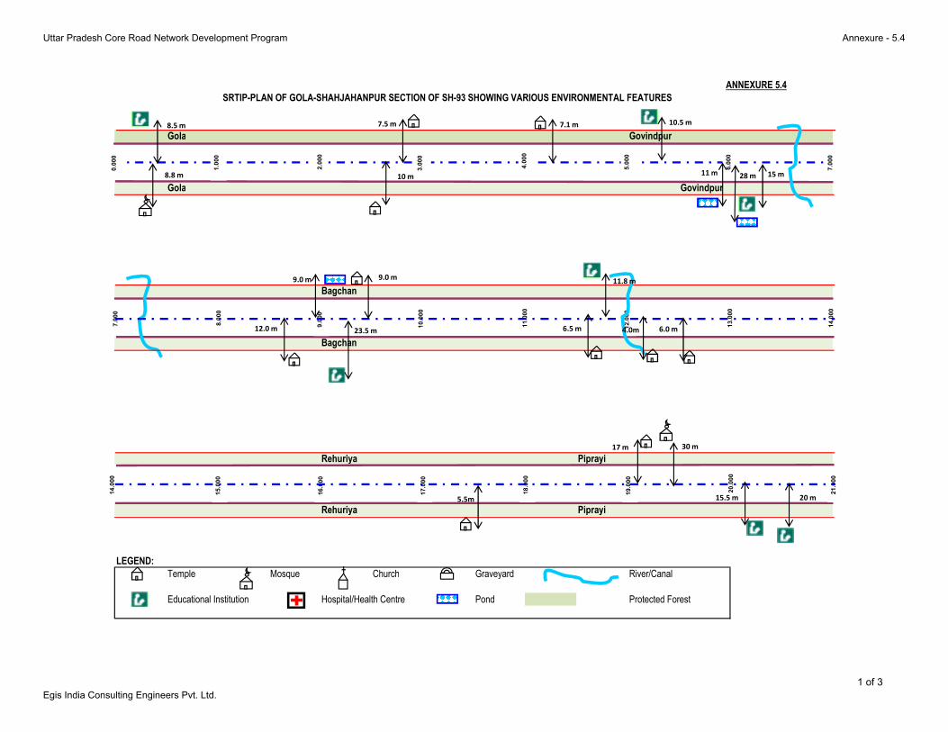
Gola Govindpur
Gola Govindpur
Bagchan
Bagchan
SRTIP-PLAN OF GOLA-SHAHJAHANPUR SECTION OF SH-93 SHOWING VARIOUS ENVIRONMENTAL FEATURES
ANNEXURE 5.4
7.000
8.000
9.000
10.000
11.000
12.000
13.000
14.000
0.000
1.000
2.000
3.000
4.000
5.000
6.000
7.000
8.5 m10.5 m
23.5 m
15 m
11.8 m
8.8 m
7.5 m
10 m
7.1 m
9.0 m
12.0 m 6.5 m 4.0m 6.0 m
11 m28 m
9.0 m
Bagchan
Rehuriya Piprayi
Rehuriya Piprayi
LEGEND:
Temple Mosque Church Graveyard River/Canal
Educational Institution Hospital/Health Centre Pond Protected Forest
14.000
15.000
16.000
17.000
18.000
19.000
20.000
21.000
15.5 m 20 m5.5m
17 m 30 m
1 of 3
Uttar Pradesh Core Road Network Development Program Annexure - 5.4
Egis India Consulting Engineers Pvt. Ltd.
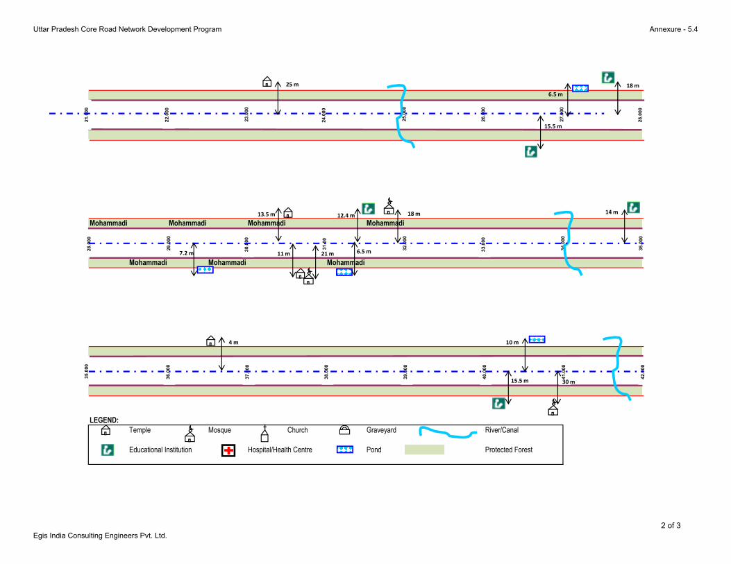
Mohammadi Mohammadi Mohammadi Mohammadi
Mohammadi Mohammadi Mohammadi
21.000
22.000
23.000
24.000
25.000
26.000
27.000
28.000
28.000
29.000
30.000
31.00
32.000
33.000
34.000
35.000
15.5 m
18 m
12.4 m14 m
25 m
11 m
13.5 m
21 m
18 m
6.5 m
7.2 m 6.5 m
Mohammadi Mohammadi Mohammadi
LEGEND:
Temple Mosque Church Graveyard River/Canal
Educational Institution Hospital/Health Centre Pond Protected Forest
35.000
36.000
37.000
38.000
39.000
40.000
41.000
42.000
15.5 m
4 m
30 m
10 m
2 of 3
Uttar Pradesh Core Road Network Development Program Annexure - 5.4
Egis India Consulting Engineers Pvt. Ltd.
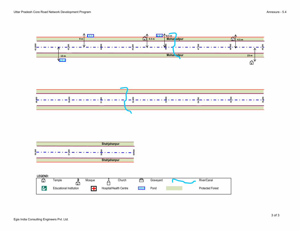
Mohamadpur
Mohamadpur
42.0000
43.000
44.000
45.000
46.000
47.000
48.000
49.000
49.000
50.000
51.000
52.000
53.000
54.000
55.000
56.000
4.5 m 4.5 m
23 m13 m
9 m
8.5 m
Shahjahanpur
Shahjahanpur
LEGEND:
Temple Mosque Church Graveyard River/Canal
Educational Institution Hospital/Health Centre Pond Protected Forest
56.000
57.000
58.000
59.000
3 of 3
Uttar Pradesh Core Road Network Development Program Annexure - 5.4
Egis India Consulting Engineers Pvt. Ltd.
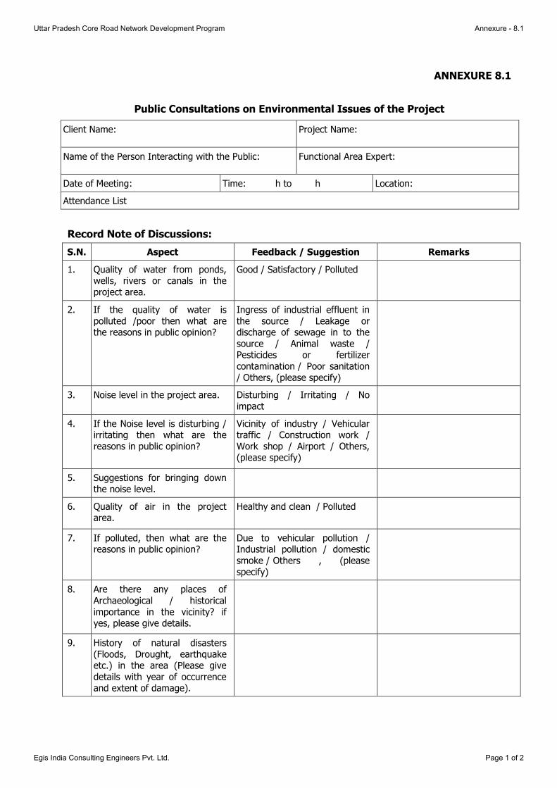
ANNEXURE 8.1
Public Consultations on Environmental Issues of the Project
Client Name: Project Name:
Name of the Person Interacting with the Public: Functional Area Expert:
Date of Meeting: Time: h to h Location:
Attendance List
Record Note of Discussions:
S.N. Aspect Feedback / Suggestion Remarks
1. Quality of water from ponds, wells, rivers or canals in the
project area.
Good / Satisfactory / Polluted
2. If the quality of water is
polluted /poor then what are the reasons in public opinion?
Ingress of industrial effluent in
the source / Leakage or discharge of sewage in to the
source / Animal waste / Pesticides or fertilizer
contamination / Poor sanitation
/ Others, (please specify)
3. Noise level in the project area. Disturbing / Irritating / No
impact
4. If the Noise level is disturbing / irritating then what are the
reasons in public opinion?
Vicinity of industry / Vehicular traffic / Construction work /
Work shop / Airport / Others, (please specify)
5. Suggestions for bringing down
the noise level.
6. Quality of air in the project area.
Healthy and clean / Polluted
7. If polluted, then what are the reasons in public opinion?
Due to vehicular pollution / Industrial pollution / domestic
smoke / Others , (please
specify)
8. Are there any places of
Archaeological / historical
importance in the vicinity? if yes, please give details.
9. History of natural disasters
(Floods, Drought, earthquake etc.) in the area (Please give
details with year of occurrence and extent of damage).
Uttar Pradesh Core Road Network Development Program Annexure - 8.1
Egis India Consulting Engineers Pvt. Ltd. Page 1 of 2

S.N. Aspect Feedback / Suggestion Remarks
10. Are any Species of birds and
animals observed in the area / visiting during different
seasons.
If any rare species is reported,
give complete details.
11. Are there any market place,
melas, common resource
properties etc. impacted by the project? If yes what were the
alternate sites suggested for their relocation.
12. Any other suggestion to
improve the environment (Reduce air, water and noise
pollution).
13. Any Other Concern / Issue /
14.
15.
16.
Note: Please attach photographs of the stakeholder consultations (in softcopy and hardcopy formats)
Uttar Pradesh Core Road Network Development Program Annexure - 8.1
Egis India Consulting Engineers Pvt. Ltd. Page 2 of 2

Annexure 8.2
ATTENDANCE SHEET OF PUBLIC CONSULTATION
1. Pipriya Dhani Village (Km 18.700)
Uttar Pradesh Core Road Network Development Program Annexure - 8.2
Egis India Consulting Engineers Pvt. Ltd. Page 1 of 3
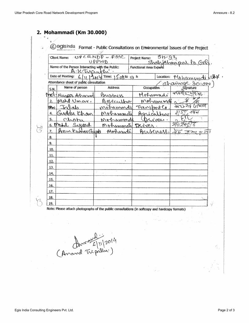
2. Mohammadi (Km 30.000)
Uttar Pradesh Core Road Network Development Program Annexure - 8.2
Egis India Consulting Engineers Pvt. Ltd. Page 2 of 3

3. Mohammadpur Tajpur (Km 46.500)
Uttar Pradesh Core Road Network Development Program Annexure - 8.2
Egis India Consulting Engineers Pvt. Ltd. Page 3 of 3
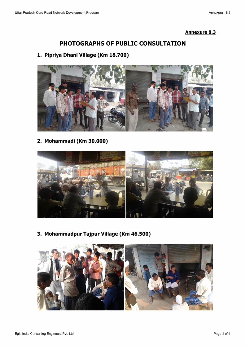
Annexure 8.3
PHOTOGRAPHS OF PUBLIC CONSULTATION
1. Pipriya Dhani Village (Km 18.700)
2. Mohammadi (Km 30.000)
3. Mohammadpur Tajpur Village (Km 46.500)
Uttar Pradesh Core Road Network Development Program Annexure - 8.3
Egis India Consulting Engineers Pvt. Ltd. Page 1 of 1

ANNEXURE-9.1
TREE PLANTATION STRATEGY
The sustainable economic development depends on the rational use of environmental resources
and minimizing, to the extent possible, adverse environmental impacts through improved project
selection and more responsible project planning and design. Under this strategy the development
must be environmentally sound in the broadest sense. In highway development, environmental
planning is concerned with good blending of improvements of physical, social, and economic
parameters. It involves not only the environmental (land, water, and air) but is also concerned with
integration to local, regional and national socio-economic development.
Road development can have wide ranging environmental impacts. This is because roads extend
over long distance and by promoting rapid communication they can catalyze dramatic changes in
land use patterns. Soil degradation, loss of top soil and reduction of the productive capacity of the
soil covered by the road, which is significantly reduced further as a result of compaction with heavy
machinery during construction, is one of the most immediate effects. Landscape and aesthetic
distortions due to road development leads to modifications in the regional landscape and changes
in the natural relief and morphology of the, vegetation, inclusive of avenue trees and recreational
areas. But these impacts can often be significantly reduced through environmentally-sound
construction and operation management practices. Careful consideration and assessment of the
surrounding environment in road construction and improvement will reduce disruption costs and
harmful effects while increasing usage and benefits. Therefore a proper landscape plan should be
made which will protect the road from soil erosion, sinking and also to maintain the aesthetic
beauty. It will also reduce land, water, air and noise pollutions as well.
Aim and Objective of Tree Plantation:-
To create green belt and avenues for meeting aesthetic recreational needs to the people.
To beautify the areas for scenic beauty.
To reduce the surface run-off discharge and checking soil erosion along the embankments.
To reduce the encroachment of road reserve areas.
To reduce temperature and increase humidity.
To reduce noise pollution to the neighboring household population.
To reduce the impacts of air pollution and dust as trees and shrubs are known to be natural
sink for air pollutants.
To provide much needed shade on glaring hot roads during summer.
Moderating the effect of wind and incoming radiation.
To define the ROW especially highlight sharp horizontal curves during night.
To promote road development as eco friendly activity.
Tree Plantation Strategy
Plantation is one of the most important constituents of soft landscaping. Trees, shrubs and climbers
have been used to enhance the soft natural ambience against harsh elements in most of the
enhancement schemes. The planting species are decided based on the physical growth
characteristics of trees, like form and shape, foliage pattern, growth rate, branching pattern, soil
characteristics etc. While selecting the species of trees for landscaping a great care should be taken
Uttar Pradesh Core Road Network Development Program Annexure - 9.1
Egis India Consulting Engineers Pvt. Ltd. Page 1 of 4

to choose the species, which already exist on the project corridor. The tree plantation will be
carried out in accordance with the IRC: SP: 21:2009 guidelines and specifications.
Plantation Pattern
Depending on the availability of the ROW, plantation pattern is worked out as follows:-
1. The first row along the highway to be planted with small to medium sized ornamental trees.
2. Subsequent rows depending on the availability of land will comprise of ornamental or shade
bearing species of more height than those in the first row. Since the proposed Highway
section is passing through the rural sections, the last row will always be of shade bearing tall
trees. Five rows of trees are proposed to be planted on either side.
3. Planting of shrubs in the median.
4. Planting of herbaceous species as ground cover in the median, special landscapes on
embankment slopes.
5. Turfing with grasses in the median and embankment slopes.
6. The last row to be planted with tall shade bearing trees for better road safety and for
enhancing aesthetics.
Tree Plantation along the Highway Section
1st Row
The first row of plantation along the highway section should be worked out by ornamental species.
Since the proposed highway section is passing through the rural areas, the following species are
recommended for the 1st row of avenue plantation.
Table 1.0 Species recommended for 1st row plantation
S. No. Botanical Name Local Name
1 Cassia fistula Amaltas
2 Terminalia arjuna Arjun
3 Delonix regia Gulmohar
4 Bauhinia sps Kachnar
5 Cassia nodusa Cassia
2nd Row
The 2nd row of plantation along the Project stretch should be worked out by ornamental species of
more height i.e. medium height trees, than the first row. The following species are recommended:-
Table 2.0: Species recommended for subsequent row plantation
S. No. Botanical Name Local Name
1 Melia azadiracta Bakain
2 Pongamia pinnata Kanji
3 Gravillea robusta Silver Oak
4 Albizzia lebbek Kala siris
5 Dalbergia sissoo Shisham
Subsequent Rows
The subsequent rows of plantation along the Highway section have been worked out. The tall
shade trees like Peepal, Neem, Mango, Shisham etc have high crown and secure better visibility.
They have a long gestation period and has rapid growth and capacity to resist disease and pests
attack are therefore ideal. These shaded trees should be planted at a spacing of 12m C/C.
Uttar Pradesh Core Road Network Development Program Annexure - 9.1
Egis India Consulting Engineers Pvt. Ltd. Page 2 of 4

The tree species recommended as shade plants for roadside avenues are given the following
table:-
Table 3.0: Species recommended for Subsequent rows
S. No. Botanical Name Local Name
1 Ficus religiosa Peepal
2 Ficus infectoria Paker
3 Madhuca indica Mahua
4 Dalbergia Sissoo Shisham
5 Azadirachta indica Neem
6 Mangifera indica Mango
7 Tamarindus indica Imli
8 Syzynium cuminij Jamun
Shrub plantation for Median
The species to be planted in median would be of low or medium height with ornamental value to
enhance the visual experience of the road corridor. It will also act as a screen to prevent glare from
the incoming vehicles. Depending on the width of the median, which is 6.0 m, two rows of
flowering shrubs will be provided. Some herbaceous species may also be planted as a ground cover
on the median.
Table 4.0: Species recommended for Median
S. No. Botanical Name Local Name
1 Thaventia nerifolia Kaner
2 Bouganvillea sps. Bouganvillea
3 Ipomia
Plantation along the Embankments
On the embankment slopes, some herbaceous species followed by grasses turf will be provided.
The species proposed for the purpose of turfing are Cynodon dactylon, Cythocline perpurea,
Solanum Nigrum, Alternanthera, Chlorophytum, Eupatorium, Wedelia, Duranta, Portulacca,
Ipomea, Pelia Cadrii, Asparagus, Opheopogon grass etc.
Technical specifications for planting along the Highway section are as follows:
1. Ornamental plants except last row
Distance from embankment : 1.0m away from the toe of the embankment
Spacing between plant to plant : 3m
Spacing between rows : 3m
Size of the pits : 60x60x60 cms
For alkaline soils : By auger
Water logged areas : mounds with height varying depending on
the water level
Species recommended : Listed in Table 1.0 and Table 2.0.
No of plants per Km : 333
Height of plant : 1.5 to 2m
2. Shaded plants (Last row)
Distance from the preceding row : 3.0m
Spacing between plant to plant : 12m
Size of the pits
Normal size : 60x60x60 cms
Uttar Pradesh Core Road Network Development Program Annexure - 9.1
Egis India Consulting Engineers Pvt. Ltd. Page 3 of 4
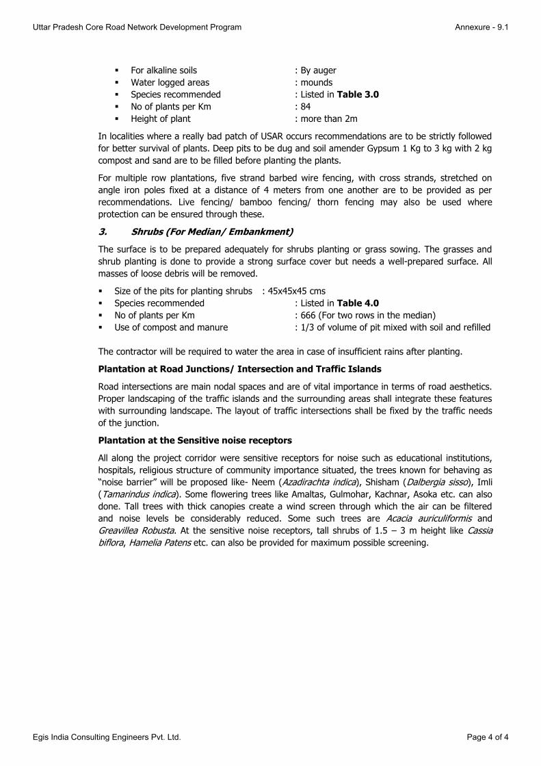
For alkaline soils : By auger
Water logged areas : mounds
Species recommended : Listed in Table 3.0
No of plants per Km : 84
Height of plant : more than 2m
In localities where a really bad patch of USAR occurs recommendations are to be strictly followed
for better survival of plants. Deep pits to be dug and soil amender Gypsum 1 Kg to 3 kg with 2 kg
compost and sand are to be filled before planting the plants.
For multiple row plantations, five strand barbed wire fencing, with cross strands, stretched on
angle iron poles fixed at a distance of 4 meters from one another are to be provided as per
recommendations. Live fencing/ bamboo fencing/ thorn fencing may also be used where
protection can be ensured through these.
3. Shrubs (For Median/ Embankment)
The surface is to be prepared adequately for shrubs planting or grass sowing. The grasses and
shrub planting is done to provide a strong surface cover but needs a well-prepared surface. All
masses of loose debris will be removed.
Size of the pits for planting shrubs : 45x45x45 cms
Species recommended : Listed in Table 4.0
No of plants per Km : 666 (For two rows in the median)
Use of compost and manure : 1/3 of volume of pit mixed with soil and refilled
The contractor will be required to water the area in case of insufficient rains after planting.
Plantation at Road Junctions/ Intersection and Traffic Islands
Road intersections are main nodal spaces and are of vital importance in terms of road aesthetics.
Proper landscaping of the traffic islands and the surrounding areas shall integrate these features
with surrounding landscape. The layout of traffic intersections shall be fixed by the traffic needs
of the junction.
Plantation at the Sensitive noise receptors
All along the project corridor were sensitive receptors for noise such as educational institutions,
hospitals, religious structure of community importance situated, the trees known for behaving as
“noise barrier” will be proposed like- Neem (Azadirachta indica), Shisham (Dalbergia sisso), Imli
(Tamarindus indica). Some flowering trees like Amaltas, Gulmohar, Kachnar, Asoka etc. can also
done. Tall trees with thick canopies create a wind screen through which the air can be filtered
and noise levels be considerably reduced. Some such trees are Acacia auriculiformis and
Greavillea Robusta. At the sensitive noise receptors, tall shrubs of 1.5 – 3 m height like Cassia
biflora, Hamelia Patens etc. can also be provided for maximum possible screening.
Uttar Pradesh Core Road Network Development Program Annexure - 9.1
Egis India Consulting Engineers Pvt. Ltd. Page 4 of 4

Uttar Pradesh Core Road Network Development Program Annexure – 9.2
Egis India Consulting Engineers Pvt. Ltd. Page 1 of 2
ANNEXURE-9.2
PLANT SITE MANAGEMENT
For the construction purpose the major construction plants such as Hot mix plant, Stone Crusher
Plants, batch mix plants, etc. will be required to be established. In case the Concessionaire
establishes their own plan they have to follow all the applicable statutory norms. The objective of this plan is
To ensure that statutory / regulatory requirements are complied with
To ensure that safeguard measures are taken to avoid / mitigate / minimize environmental
impacts.
The present section provides general guidelines for siting of plants and environmental safeguard
measures based on the statutory requirements:
1. Site selection criteria for Hot Mix Plant/ Stone crusher Plant:
1.0 km away from settlement, school, hospital towards downwind directions
1.0 km from any archaeological site
1.0 km from ecologically sensitive areas i.e. forest, national park, sanctuary etc.
1.0 rivers, streams and lakes
500 m from ponds
500 m from National Highway, 250 m from State Highway, 100 m from District roads and
other roads (The distance are to be measured from edge of Road to boundary of site).
Away from agricultural land
Preference to barren land
2. Statutory Requirements:
Obtaining NOC [Consent-to-Establish(CtE) and Consent to Operate(CtO)] under Air and
Water Acts from the Uttar Pradesh Pollution Control Board (UPPCB) before start of
installation.
Complying with the terms and conditions laid down in the CtE and CtO, which generally
include providing Dust containment cum suppression system for the equipment, Construction
of wind breaking walls along periphery of plant sites, construction of the metalled roads
within the premises, regular cleaning and wetting of the ground plantation, periodic
(monthly) pollution monitoring i.e. ambient air, noise and stack emission
The suspended particulate matter contribution value at a distance of 40 m from a controlled
isolated as well as from a unit located in a cluster should be less than 600 g/m3 or as shall
be stipulated by UPPCB.
Obtain certificates from manufacturer for Type Approval and Conformity of Production for
Diesel Generator (DG) set/s. For DG sets of capacity up to 1000 KVA, the noise level at 1m
from the enclosure surface shall not exceed 75 dB (A)
3. Pollution control measures
For HMP, ensure adequate stack height as stipulated in CtE, install emission control devices
such as bag house filters, cyclone separators, water scrubbers etc., as attached with the plant
by the manufacturer or stipulated in CtE.

Uttar Pradesh Core Road Network Development Program Annexure – 9.2
Egis India Consulting Engineers Pvt. Ltd. Page 2 of 2
Prefer bulk bitumen storage with mechanized handling facilities that storage in drums with
manual operation at HMP to prevent / minimize bitumen spillage and thereby contaminating
soil and water.
Impervious platform for storage of bituminous and other liquid hazardous chemical
Bag house filter / multi-cone cyclone for emission control. For bag house, cartridge filters
reported to be more efficient than fabric filters.
The stone crusher plants should be installed with operational water sprinklers over jaw
crusher, conveyor belts and vibratory screens.
Pollution control measures for Diesel Generator (DG) set i.e. stack height, acoustic enclosure
etc.
Periodical maintenance of all the plant and equipments to keep the plants in order.
Damaged bag-house and filters should be immediately replaced.
All the workers shall use all the time helmets, footwear, earplugs, nasalmasks etc. when the
plants are operational. During maintenance of plants also the workers involed in maintenance
will not enter the plant premises without PPE.
No workers should be allowed to work in loose clothes near conveyor belts.
Proper lighting arrangement shall be made around plant site if the plants are operated during
dark hours.
Provision of readily available first aid kit, fire fighting equipments at the plant site at
appropriate location to respond in case of accident.
Periodical monitoring of air quality and noise levels as per conditions stipulated under the
statutory clearance from UPPCB. Whenever the emission exceeds the permissible level the
plants should be stopped and necessary repairing works of faults will be done to bring down
the emission levels.
The office complex, residential units shall be constructed on upwind direction from the plant
site.

ANNEXURE-9.3
GUIDELINES FOR REDEVELOPMENT OF BORROW AREAS
BACKGROUND
The guidelines provide basic information to the contractor on how to redevelop the borrow areas to
ensure compliance with the environmental requirements of MoEFCC, MORTH and as specified in IRC: 10-
1961. The following section provides the guidelines to the contractor for the identifying, siting of borrow
areas and also the enhancement measures to redevelop the areas with community participation.
IDENTIFICATION OF THE BORROW AREAS
Specific locations of borrow areas will be identified by contractor. The selection and recommendations of
borrow areas will be based on environmental as well as civil engineering considerations. Location of
source of supply of material for embankment or sub-grade and the procedure for excavation or transport
of material shall be in compliance with the environmental requirements of MoEFCC (OM No. L-
11011/47/2011-IA.II(M) dated 24 June, 2013), MoRTH and as specified in IRC:SP10-1961.
Certain precautions have to be taken to restrict unauthorized borrowing by the contractor. No borrow
area shall be opened without permission of the Engineer. The borrowing shall not be carried out in
cultivable lands, unless and until, it shall be agreed upon by the engineer that there is no suitable
uncultivable land in the vicinity for borrowing or private landowners are willing to allow borrowing on their
fields.
Borrow Area Identification:
Identify areas having present land use as barren land, riverside land.
Prefer areas of highland with respect to surroundings;
Avoid locating borrow area close to any road (maintain at least 30m distance from ROW and 10
m from toe of embankment, whichever is higher);
Should be at least 1.0 km away from inhabited areas;
Minimum distance of about 1.5 km from ecologically sensitive area i.e. Reserve Forest, Protected
Forest, Sanctuary, wetland etc.;
Minimum distance of about 1.5 km from school, hospital and any archaeological sites;
Having adequate approach road with minimum length of earthen road;
Ensure that unsuitable soft rock is not prominent within the proposed depth of excavation which
will render rehabilitation difficult;
Controlled operation as per agreed / approved plan
Prior approval of Rehabilitation Plan considering terrain, land use and local need;
Restricting operation as agreed by landowner and approved by the
OPERATION
No borrow area will be operational without written consent of the land owner. To avoid any embankment
slippage, the borrow areas will not be dug continuously, and the size and shape of borrow pits will be
decided by the engineer. The contractor shall evolve site-specific redevelopment plans for each borrows
area location, which shall be implemented after the approval of the Supervision /Independent Consultant.
Precautionary measures as the covering of vehicles will be taken to avoid spillage during transport of
borrow materials. To ensure that the spills, which might result from the transport of borrow and quarry
materials do not impact the settlements, it will be ensured that the excavation and carrying of earth will
Uttar Pradesh Core Road Network Development Program Annexure - 9.3
Egis India Consulting Engineers Pvt. Ltd. Page 1 of 2

be done during day time only. The unpaved surfaces used for the haulage of borrow materials will be
maintained properly.
Borrowing of earth shall be carried out at locations recommended as follows:
Non- Cultivable Lands: Borrowing of earth will be carried out up to a depth of 2.0 m from the existing
ground level. Borrowing of earth shall not be done continuously. Ridges of not less than 8 m width shall
be left at intervals not exceeding 300m. Small drains shall be cut through the ridges, if necessary, to
facilitate drainage. Borrow pits shall have slopes not steeper than 1 vertical in 2 horizontal.
Productive Lands: Borrowing of earth shall be avoided on productive lands. However, in the event of
borrowing from productive lands, under circumstances as described above, top soil shall be preserved in
stockpiles. At such locations, the depth of borrow pits shall not exceed 45 cm and it may be dug out to a
depth of not more than 30 cm after stripping the 15 cm top soil aside.
Elevated Lands: At locations where private owners desire their fields to be leveled, the borrowing shall
be done to a depth of not more than 2m or upto the level of surrounding fields.
Borrow pits along Roadside: Borrow pits shall be located 5 m away from the toe of the embankment.
Depth of the pit should be such that the bottom of the pit shall not fall within an imaginary line of slope 1
vertical to 4 horizontal projected from the edge of the final section of the bank. Borrow pits should not be
dug continuously. Ridges of not less than 8 m width should be left at intervals not exceeding 300m. Small
drains should be cut through the ridges to facilitate drainage.
Borrow pits on the riverside: The borrow pit should be located not less than 15m from the toe of the
bank, distance depending on the magnitude and duration of flood to be withstood.
Community/ Private Ponds: Borrowing can be carried out at locations, where the private owners (or
in some cases, the community) desire to develop lands (mostly low-lying areas) for pesciculture purposes
and for use as fishponds.
Borrow Area near Settlements: Borrow pit location shall be located at least 0.8km from village and
settlements. If unavoidable, they should not be dug for more than 30 cm and should be drained.
PRESERVATION OF TOP SOIL:
Before starts of extraction of borrow materials, top soil shall be stripped to a specified depth of 150 mm and stored in stockpiles at corners of the borrow area. The height of the stockpile will be restricted to
2m with minimum slope of 1:2 (vertical to horizontal). The stockpiles will be covered with gunny bags or
tarpaulin. It will be ensured by the contractor that the topsoil will not be unnecessarily trafficked either before stripping or when in stockpiles. Top soil will be reused/re-laid as per agreed plan. Top soil will
also be utilized for redevelopment of borrow areas, landscaping along slopes etc,
BORROW AREA REDEVELOPMENT:
Each borrow area should be rehabilitated immediately after completion of extraction of materials to the
satisfactions of the land owner and the Engineer. The borrow area shall be redeveloped appropriately as
per approved plan and landowner’s requirement. The borrow pits may be developed into pond after
leveling the bottom and slope maintenance. The borrow pits may be refilled with earth materials covered
with fertile to soil. The upland used as borrow area shall be leveled matching with the level of
surrounding area. No scare created due to borrowing of earth should be left unattended. The Contractor
should provide completion certificate of redevelopment of each borrow pit issued by the land owner.
Uttar Pradesh Core Road Network Development Program Annexure - 9.3
Egis India Consulting Engineers Pvt. Ltd. Page 2 of 2

ANNEXURE-9.4
QUARRY AREA MANAGEMENT PLAN
Quarries generally required to provide material for road construction sites, can have significant adverse
environmental effects, especially on ecologically sensitive areas. Quarries can become environmental
hotspots and can significantly affect the visual appearance of an area. Special mitigation and
management measures are often required to avoid or minimize the environmental and impacts of due to
quarry operations. The EMP stipulations will be applicable for new quarries to be identified and operated
by Contractors. In case contractor use the existing licensed quarry a copy of the valid quarry license and
lease / sub-lease agreement should be submitted to the Project Proponent. Contractor shall submit a plan
delineating how he shall comply with requirements stipulated in this plan and elsewhere in the EMP on
quarrying activity.
The guidelines for quarries cover:
Statutory approvals
Environmental and social impacts of quarries
Selection of quarries
Operation of quarries
Rehabilitation of quarries
The guidelines seek to ensure that Contractors:
Comply with the regulatory requirements in force at the time
Reasonably manage any impacts
Reinstate and rehabilitate the land appropriately
Consult with affected communities
Impacts
Some of the potential impacts of quarries are:
Rock blasting causing air pollution, and noise and vibrations
Trucks transporting materials to the site causing air pollution, and noise and vibrations
Ponds of stagnant water forming in excavated areas giving rise to the breeding of
Mosquitoes and the spreading of malaria and other mosquito-borne diseases
Aesthetics of the landscape being affected by excavations and the removal of vegetation
natural drainage systems in the area being affected by excavations
The procedure for identification and finalization of quarry site/s shall be as given below:
The quarry areas identified during Feasibility study are mainly operational government stone quarry. For using these quarry areas, the Contractor has obtained necessary statutory permission from the concern
department. However, selection of new quarry following guidelines should be followed:
Only licensed quarry will be used.
New quarry will be at least 1.5km away from the settlement, forest and other ecologically
sensitive areas
Minimum 500 m away from water bodies
Uttar Pradesh Core Road Network Development Program Annexure - 9.4
Egis India Consulting Engineers Pvt. Ltd. Page 1 of 3

The Contractor shall identify alternative quarry sites along the whole corridor based on required
quantity and environmental consideration and obtained approval from the Engineer (PMC) /
UPPWD
The Contractor should obtains Quarry Lease Deed / License from the Department of Mines and
Geology and provide copy of the same to the PIU-UPPWD prior to start of the material extraction.
The Contractor shall estimate water requirement for dust suppression at quarry sites during
operation and for water spraying on kutcha (non-metal) haul road and ensure availability water
by identifying sources and obtaining necessary permission;
The Contractor shall prepare quarry sites operation and redevelopment plan considering
surrounding land uses, local needs and agreement with the landowner;
Only licensed blaster i.e. short-firer certificate holder will be responsible for quarry Blasting
Permits for transportation, storage and use of explosive, as will be required, shall be obtained
from the Controller of Explosive;
Whenever so advised by the R&B Engineer, controlled blasting e.g. using less charge, restricting
depth and dia or drill holes, cut-off blasting etc., and shall be undertaken.
Quarry operation will be undertaken in stages with adequate benching
Quarry Operation:
The procedure for environmentally sound operation and management of quarry sites is given
below:
Estimating the quantity of quarry material to be collected from each quarry area;
Demarcating the entire quarry area by fencing and putting red-flag poles;
Providing adequate metallic access road;
Preserving topsoil from the quarry compound, if any, by stripping and stacking aside separately at
corners;
Overburden shall be removed and disposed in environmentally sound manner.
All workers safety measures such as helmets, footwear, earplugs, facemasks etc. shall be
undertaken.
The contractor shall ensure maintenance of crushers regularly as per manufacture schedule.
Water sprinkling shall be done to minimize dust generated due to crushing/Vehicle movement.
Carrying out blasting as per agreed operational plan complying with the requirements of MoRTH
Specification (Clause 302 & 303) and Ministry of Environment & Forests (MoEF)
Maintaining a Quarry Material Collection Register on daily material collection for each of the
quarry area, which shall be produced to Engineer’s representative as and when requested;
Redeveloping the area within 2 months (or as will be agreed upon) of completion of quarry
material collection;
Preservation of Top Soil:
Before start of extraction of quarry materials, top soil shall be stripped to a specified depth of 150mm and
stored in stockpiles at designated space in the quarry area. The height of the stockpile will be restricted
to 2m with minimum slope of 1:2 (vertical to horizontal). The stockpiles will be covered with gunny bags
or tarpaulin. It will be ensured by the contractor that the topsoil will not be unnecessarily trafficked either
before stripping or when in stockpiles. Top soil will be reused/re-laid as per agreed plan. Top soil will also
be utilized for redevelopment of borrow areas, landscaping along slopes etc,
Uttar Pradesh Core Road Network Development Program Annexure - 9.4
Egis India Consulting Engineers Pvt. Ltd. Page 2 of 3

Redevelopment of Quarry Area:
All the quarries should be rehabilitated as per approved rehabilitation plan immediately after completion of quarry material extraction. The restoration of Quarry will be done as per the conditions of the owner
before handing over the site back to the owner.
Following rehabilitation works may be taken up with the consent of owner:
Option A: Revegetating the quarry to merge with surrounding landscape. This is done by conserving and
reapplying the topsoil for the vegetative growth.
Option B: Development exhausted quarries as water bodies: The pit shall be reshaped and developed
into pond, for harvesting rainwater. This option shall only be considered where the location of quarry is at
the lowest point, i.e. surrounding area/natural drainage slopes towards it.
Uttar Pradesh Core Road Network Development Program Annexure - 9.4
Egis India Consulting Engineers Pvt. Ltd. Page 3 of 3
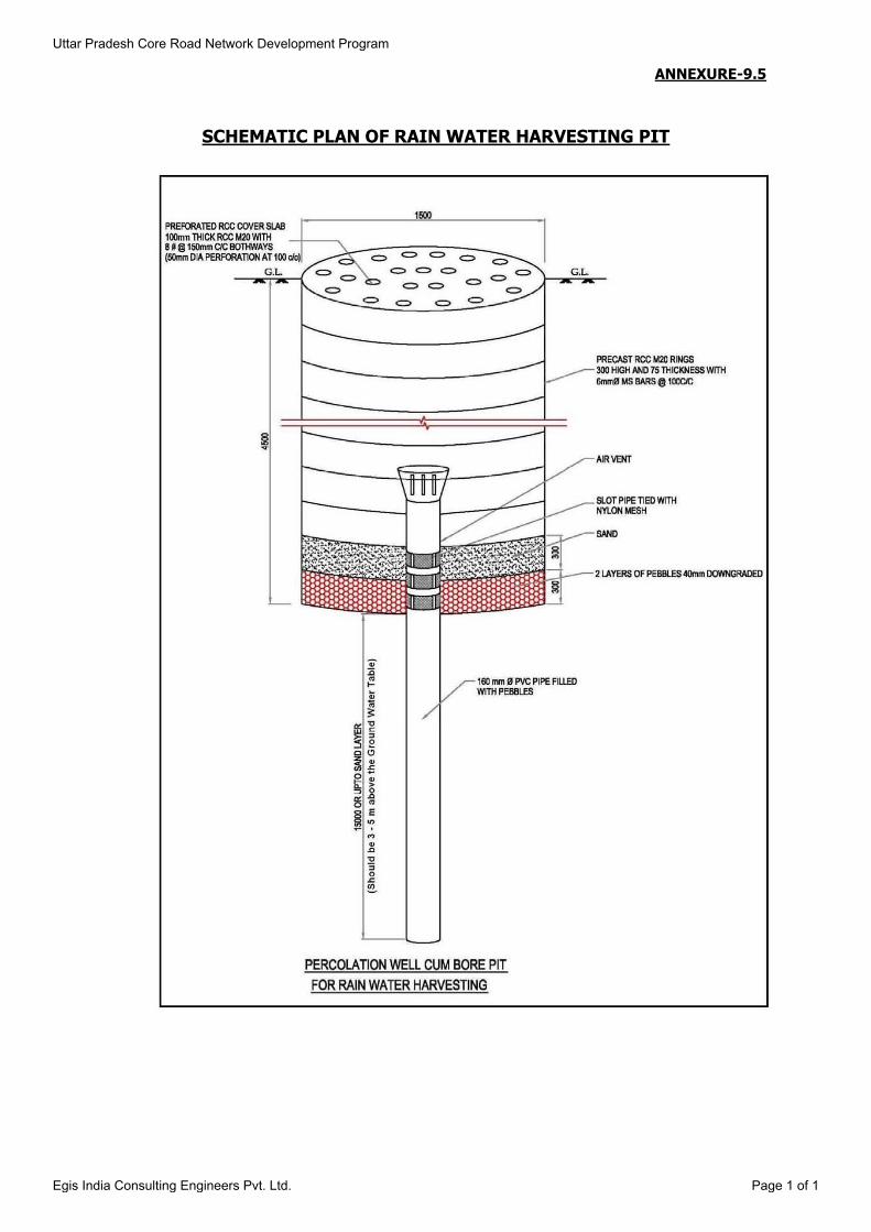
ANNEXURE-9.5
SCHEMATIC PLAN OF RAIN WATER HARVESTING PIT
Uttar Pradesh Core Road Network Development Program
Egis India Consulting Engineers Pvt. Ltd. Page 1 of 1


ANNEXURE-9.6
SCHEMATIC PLAN OF OIL INTERCEPTOR FOR REMOVAL OF OIL & GREASE FROM SURFACE RUNOFF WATER
Uttar Pradesh Core Road Network Development Program
Egis India Consulting Engineers Pvt. Ltd. Page 1 of 1


ANNEXURE 9.7
NATIONAL AMBIENT AIR QUALITY STANDARDS
S. No.
Pollutant Time
Weighted Average
Concentration in Ambient Air
Industrial, Residential,
Rural and Other Area
Ecologically Sensitive Area
(notified by Central
Government)
Method of Measurement
(1) Sulphur Dioxide (SO2) µg/m3
Annual* 50 20 Improved West and Geake Method Ultraviolet Fluorescence
24 hours** 80 80
(2) Oxides of Nitrogen (NOx) µg/m3
Annual* 40 30 Jacob & Hochheiser Modified (Na-Arsenite) Method Chemiluminescence
24 hours** 80 80 Gas Phase
Chemiluminescence
(3) Particulate Matter (Size less than 10 µm) or PM10 µg/m3
Annual* 60 60 Gravimetric TOEM Beta attenuation
24 hours** 100 100
(4) Particulate Matter (Size less than 2.5 µm) or PM2.5 µg/m3
Annual* 40 40 Gravimetric TOEM Beta attenuation
24 hours** 60 60
(5) Ozone (O3) µg/m3
8 hours** 100 100 UV Photometric Chemiluminescence Chemical Method
1 hour** 180 180
(6) Lead (Pb) µg/m3
Annual* 0.5 0.5 ASS/ ICP Method after sampling on EPM 2000 or equivalent Filter paper
ED – XRF using Teflon filter
24 hours** 1.0 1.0
(7) Carbon Monoxide (CO) mg/m3
8 hours** 02 02
Non Dispersive Infra Red (NDIR) Spectroscopy
1 hour** 04 04
(8) Ammonia (NH3) µg/m3
Annual* 100 100 Chemiluminescence Indophenol blue method 24 hours** 400 400
(9) Benzene (C6H6) µg/m3
Annual* 05 05 Gas Chromatography based continuous analyzer Adsorption and Desorption followed by GC analysis
(10) Benzo (a) pyrene (BaP) – Particulate phase only, ng/m3
Annual* 01 01 Solvent extraction followed by HPLC/GC analysis
(11) Arsenic (As) ng/m3
Annual* 06 06 AAS/ICP method after sampling on EPM 2000 or equivalent filter paper
(12) Nickel (Ni) ng/m3
Annual* 20 20 AAS/ICP method after sampling on EPM 2000 or equivalent filter paper
Uttar Pradesh Core Road Network Development Program Annexure - 9.7
Egis India Consulting Engineers Pvt. Ltd. Page 1 of 2

*Annual Arithmetic mean of minimum 104 measurements in a year at a particular site taken twice a week
24 hourly at uniform interval.
**24 hourly or 08 hourly or 01 hourly monitored values, as applicable, shall be complied with 98% of the time in a year. 2% of the time, they may exceed the limits but not on two consecutive days of
monitoring.
Source: National Ambient Air Quality Standards, Central Pollution Control Board Notification No. 29016/20/90/PCI-I dated 18 November, 2009
Uttar Pradesh Core Road Network Development Program Annexure - 9.7
Egis India Consulting Engineers Pvt. Ltd. Page 2 of 2

ANNEXUREC 9.8
NATIONAL AMBIENT NOISE MONITORING STANDARDS
Area/Class Noise Level (Leq dB (A))*
Day Time Night Time
Industrial 75 70
Commercial/Mixed 65 55
Residential/Rural 55 45
Sensitive 50 40
Note-:
1. Day time shall mean from 6 a.m. to 10 p.m.
2. Night time shall mean from 10 p.m. to 6 a.m.
3. Silence Zone is an area comprising not less than 100 meters around hospitals, education institutions, courts, religious places or any other area, which is declared as such by Competent Authority.
4. Mixed categories of areas may be declared as one of the four above-mentioned categories by the Competent Authority.
*dB(A) Leq denotes the time weighted average of the level of decibels on scale A which is related to Human Beings
A “decibel” is the unit in which noise is measured
“A” in dB(A) Leq, denotes the frequency weighted in the measurement of the noise corresponds to frequency response characteristics of the human ear.
Leq: It is an energy means of the noise level over a specified period.
Uttar Pradesh Core Road Network Development Program Annexure - 9.8
Egis India Consulting Engineers Pvt. Ltd. Page 1 of 1

ANNEXURE 9.9
WATER QUALITY STANDARD AS PER BIS (IS: 10500:1991)
S.
No. Parameters Desirable Limit
Max. Permissible Limits in the absence of alternate source
Essential Characteristics:
1. Colour 5 25
2. Odour Unobjectionable Unobjectionable
3. Taste Agreeable Agreeable
4. Turbidity, NTU 5 10
5. pH Value 6.5 to 8.5 No relaxation
6. Total Hardness (as CaCO3), mg/l 300 600
7. Iron as Fe, mg/l 0.3 1.0
8. Chloride as Cl, mg/l 250 1000
9. Residual free Chlorine, mg/l 0.2 -
Desirable Characteristics
10. Dissolved Solids, mg/l 500 2000
11. Calcium as Ca, mg/l 75 200
12. Copper as Cu, mg/l 0.05 1.5
13. Manganese as Mn, mg/l 0.10 0.3
14. Sulphate as SO4, mg/l 200 400
15. Nitrate as NO3, mg/l 45 100
16. Fluoride as F, mg/l 1.0 1.5
17. Phenolic Compounds as C6H5OH, mg/l 0.001 0.002
18. Mercury as Hg, mg/l 0.001 No relaxation
19. Cadmium as Cd, mg/l 0.01 No relaxation
20. Selenium as Se, mg/l 0.01 No relaxation
21. Arsenic as As, mg/l 0.05 No relaxation
22. Cyanide as CN, mg/l 0.05 No relaxation
23. Lead as Pb, mg/l 0.05 No relaxation
24. Zinc as Zn, mg/l 5.0 15.0
25. Anionic detergent as MBAS, mg/l 0.2 1.0
26. Chromium as Cr6+, mg/l 0.05 No relaxation
27. Polynuclear aromatic hydro carbon as PAH, g/l
- -
28. Mineral Oil, mg/l 0.01 0.03
29. Pesticide, mg/l Absent 0.001
30. Radioactive materials:
i. Alpha Emitters, Bq/l ii. Beta Emitters, Bq/l
- -
0.1 1.0
31. Alkalinity, mg/l 200 600
32. Aluminum as Al, mg/l 0.03 0.2
33. Boron, mg/l 1.0 5.0
Uttar Pradesh Core Road Network Development Program Annexure - 9.9
Egis India Consulting Engineers Pvt. Ltd. Page 1 of 1

ANNEXURE 9.10
USE BASED CLASSIFICATION OF SURFACE WATERS IN INDIA
Designated-Best-Use Class of
water Criteria
Drinking Water Source without conventional treatment but after
disinfections
A
i. Total Coliforms Organism MPN/100ml shall be 50 or less
ii. pH between 6.5 and 8.5
iii. Dissolved Oxygen 6mg/l or more
iv. Biochemical Oxygen Demand 5 days 20oC 2mg/l
or less
Outdoor bathing (Organized)
B
i. Total Coliforms Organism MPN/100ml shall be
500 or less
ii. pH between 6.5 and 8.5
iii. Dissolved Oxygen 5mg/l or more
iv. Biochemical Oxygen Demand 5 days 20oC 3mg/l or less
Drinking water source after
conventional treatment and disinfections
C
i. Total Coliforms Organism MPN/100ml shall be
5000 or less
ii. pH between 6 to 9
iii. Dissolved Oxygen 4mg/l or more
iv. Biochemical Oxygen Demand 5 days 20oC
3mg/l or less
Propagation of Wild life and Fisheries
D
i. pH between 6.5 to 8.5
ii. Dissolved Oxygen 4mg/l or more
iii. Free Ammonia (as N) 1.2 mg/l or less
Irrigation, Industrial Cooling, Controlled Waste disposal
E
i. pH between 6.0 to 8.5
ii. Electrical Conductivity at 25oC micro mhos/cm
Max.2250
iii. Sodium absorption Ratio Max. 26
iv. Boron Max. 2mg/l
Source: Guidelines for Water Quality Management – CPCB 2008.
Uttar Pradesh Core Road Network Development Program Annexure - 9.10
Egis India Consulting Engineers Pvt. Ltd. Page 1 of 1

ANNEXURE 9.11
PROPOSED ENVIRONMENTAL ENHANCEMENT MEASURES
Chainage (Km) : 9.300 of SH-93
Village : Bagchan
Side : RHS
Place : Village Primary School
Distance from ECL : 36.0 m
Proposed widening : Concentric
Proposed Enhancement at Km 9.300 (RHS)
S. No Description Unit Quantity Rate Amount (INR)
1 Trees Plantation with maintenance of 1 year No. 16 696 11,136.00
2
Providing of Half Brick circular tree guard, in 2nd class brick, internal diametre 1.25 metres,
and height 1.5 metres, above ground and 0.50
metre below ground, cement mortar 1:6 as per complete design
No. 16 1915 30,640.00
TOTAL COST (INR) 41776.00
Uttar Pradesh Core Road Network Development Program Annexure - 9.11
Egis India Consulting Engineers Pvt. Ltd. Page 1 of 5

Chainage (Km) : 28.000 of SH-93
Village : Mohammadi
Side : LHS
Place : Pond
Distance from ECL : 6.5 m
Proposed widening : Concentric
Proposed Enhancement at Km 28.00 (LHS)
S. No Description Unit Quantity Rate Amount (INR)
1 Bathing Ghat of size 4m x 5m
Excavation Cum 37.50 57 2,138.00
PCC (M15) Cum 3.0 7361 22,083.00
Brick Work (1:3) Cum 39.20 6414 2,51,429.00
Tiles Sqm 37.51 880 33,009.00
2 Sitting Bench (4 numbers) at Bathing Ghat
PCC (M15) Cum 0.632 7,361 4,652
RCC (M25) Cum 0.276 8,484 2,342
Reinforcement (FE 500) Kg 13.8 60.50 835
Brickwork (1:3) Cum 0.92 6,414 5,901
Plaster 12 mm (1:3) Sqm 4.564 1,386 6,326
TOTAL COST (INR) 3,28,713.00
Uttar Pradesh Core Road Network Development Program Annexure - 9.11
Egis India Consulting Engineers Pvt. Ltd. Page 2 of 5
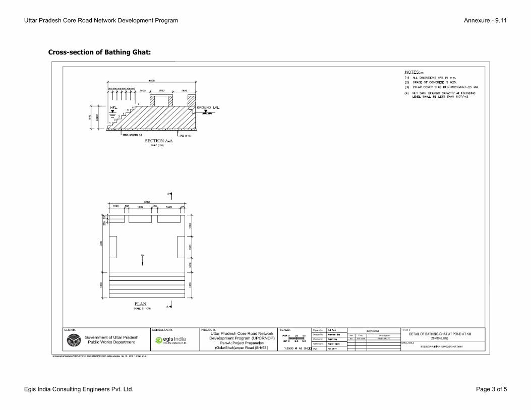
Cross-section of Bathing Ghat:
Uttar Pradesh Core Road Network Development Program Annexure - 9.11
Egis India Consulting Engineers Pvt. Ltd. Page 3 of 5

Cross-section of Seating Bench:
Uttar Pradesh Core Road Network Development Program Annexure - 9.11
Egis India Consulting Engineers Pvt. Ltd. Page 4 of 5
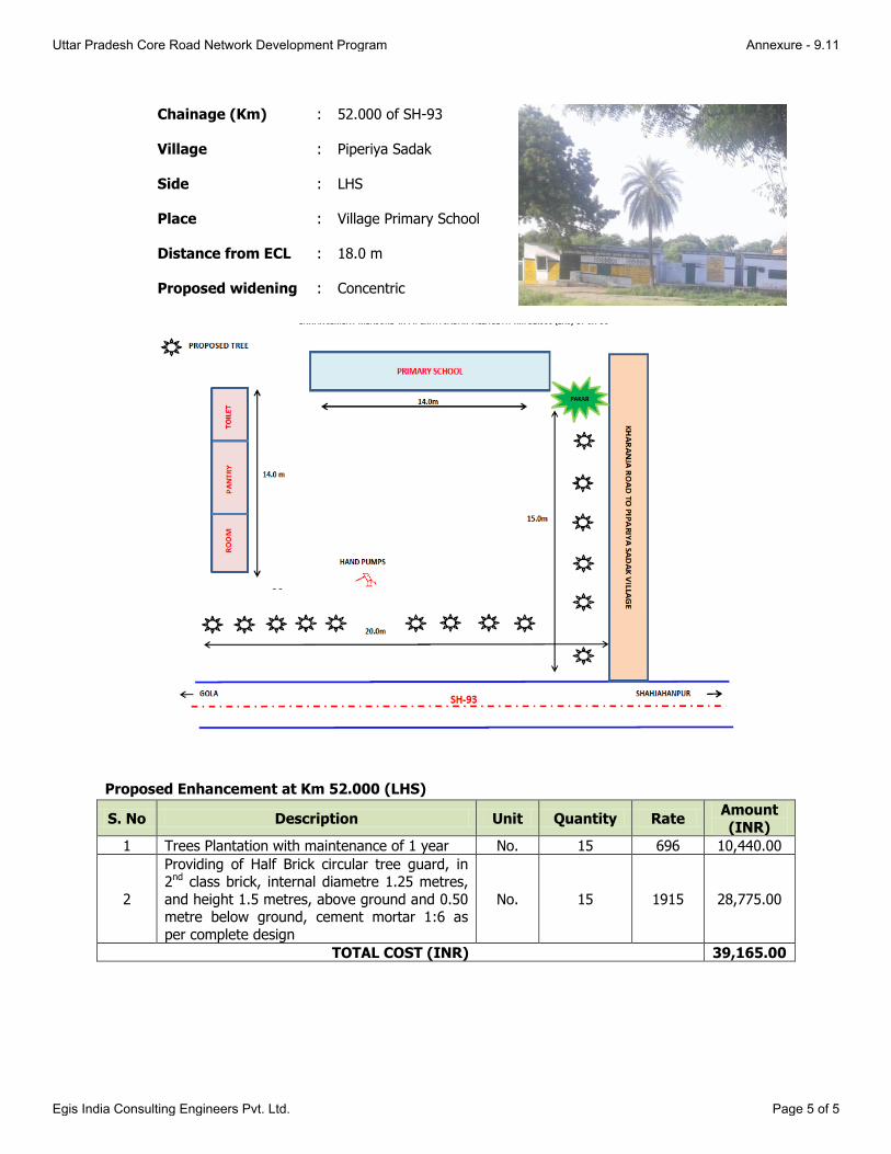
Chainage (Km) : 52.000 of SH-93
Village : Piperiya Sadak
Side : LHS
Place : Village Primary School
Distance from ECL : 18.0 m
Proposed widening : Concentric
Proposed Enhancement at Km 52.000 (LHS)
S. No Description Unit Quantity Rate Amount
(INR)
1 Trees Plantation with maintenance of 1 year No. 15 696 10,440.00
2
Providing of Half Brick circular tree guard, in 2nd class brick, internal diametre 1.25 metres,
and height 1.5 metres, above ground and 0.50 metre below ground, cement mortar 1:6 as
per complete design
No. 15 1915 28,775.00
TOTAL COST (INR) 39,165.00
Uttar Pradesh Core Road Network Development Program Annexure - 9.11
Egis India Consulting Engineers Pvt. Ltd. Page 5 of 5
