public spaces master plan update (pops) · agenda 2 pops timeline public input final pops draft...
TRANSCRIPT

PUBLIC SPACES MASTER PLAN UPDATE (POPS)Long Range Planning Committee December 12, 2018
1

AGENDA
2
POPS Timeline Public Input Final POPS Draft
Strategic Directions Planning Context
o Level of Service o Athletic Fieldso Casual Use Spaceo Trail Loops o Dog Parks & Runso Privately-Owned Public
Spaces o Land Acquisition
Next Steps

Arlington County
Comprehensive Plan
Urban Forest Master Plan
Public Art Master Plan
Natural Resources
Management Plan
UPDATE
REFERENCE
Related Documents:
CIP
Sector Plans
Area Plans
Park Master Plans
Neighborhood Conservation Plans, etc.
PLANNING CONTEXT
3

Win
ter2
015-
16
strategic directions, actions, action steps +
implementation strategy
PUBLIC MEETING
SERIES
POPS POPPING UP EVENTS
definitions, strategic direction prioritization
FINAL DRAFTONLINE + OPEN DOOR
EVENTS
present final draftplan
present preliminary recommendations
options forclassification+ LOS standards
vision statement + strategic directions
FOCUS
MEETINGS
STATISTICALLY VALID SURVEY
ADVI
SORY
CO
MM
ITTE
E EN
GAG
EMEN
T
ADVI
SORY
CO
MM
ITTE
E EN
GAG
EMEN
T
POPS CHARRETTE
ADVI
SORY
CO
MM
ITTE
E EN
GAG
EMEN
T
land acquisition
strategy
draft plan discussions
draft plan
COM
MIS
SIO
N
REVI
EWS
COU
NTY
BO
ARD
AD
OPT
ION
GROUPPUBLIC
MEETINGSERIES
Sprin
g/
Sum
mer
201
6
Jul-
Aug
2016
Dec
2016
Feb
2016
Sum
mer
2017
Fall 2
018
present vision, discuss + prioritize strategic directions, ask targeted questions to inform actions
ADDITIONAL PUBLIC ENGAGEMENTS
Dec
201
7
Win
ter
2018
/201
9
POPS TIMELINE
WE ARE HERE
4
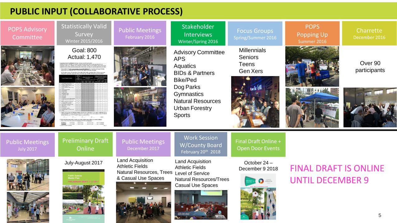
PUBLIC INPUT (COLLABORATIVE PROCESS)
Advisory CommitteeAPSAquaticsBIDs & PartnersBike/PedDog ParksGymnasticsNatural ResourcesUrban ForestrySports
Millennials Seniors TeensGen Xers
Over 90 participants
Public MeetingsFebruary 2016
Stakeholder Interviews
Winter/Spring 2016
Goal: 800Actual: 1,470
Statistically Valid Survey
Winter 2015/2016
POPSPopping UpSummer 2016
Focus GroupsSpring/Summer 2016
CharretteDecember 2016
Public Meetings July 2017
Preliminary Draft Online
FINAL DRAFT IS ONLINE UNTIL DECEMBER 9
Public MeetingsDecember 2017
Land Acquisition Athletic FieldsNatural Resources, Trees & Casual Use Spaces
July-August 2017
5
Work Session W/County Board February 20th 2018
Land Acquisition Athletic FieldsLevel of Service Natural Resources/TreesCasual Use Spaces
POPS AdvisoryCommittee
Final Draft Online + Open Door Events
October 24 –December 9 2018

FINAL POPS DRAFT
6

FINAL POPS DRAFT & COMMISSION REVIEWS
7
Presented to:
September: • Lee Highway Alliance • Park & Recreation Commission • Urban Forest Commission
October:• Commission on Aging• HALRB• E2C2• Sports Commission
November: • Transportation Commission • Open Door Event #1• Bicycle Advisory Committee• NCAC• POPS Advisory Committee

FINAL POPS DRAFT & COMMISSION REVIEWS
8
November: • Pedestrian Advisory Committee• Commission for the Arts • Disability Advisory Commission • Park and Recreation Commission• NAIOP- Northern Virginia • JFAC
December:• Open Door event #2 • Senior Adult Council• LRPC
Remaining Commission Meetings:
December:• POPS Advisory Committee Meeting (December 18)• Planning Commission (TBD)
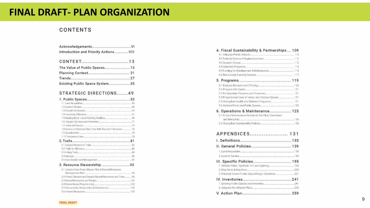
FINAL DRAFT- PLAN ORGANIZATION
9

FINAL DRAFT- PLAN ORGANIZATION
10

FINAL POPS DRAFT (SD1- PUBLIC SPACES)
11
TDR1.1.6. Explore strengthening and expanding the use of the County’s Transfer of Development Rights policy as a tool to create and consolidate future public space.
Sample recommendations: Land Acquisition 1.1. Add at least 30 acres of new public space over the next 10 years.
Zoning Regulations 1.5.8. Review and consider updating the County’s regulations and codes related to parks and public spaces.
Public Space & Other Plans 1.1.2. Secure or expand the public spaces envisioned by sector, corridor, and other plans adopted by the County Board — including the Clarendon Sector Plan, Virginia Square Plan, Courthouse Sector Plan, Rosslyn Sector Plan, Crystal City Sector Plan, and Columbia Pike Form Based Codes — and ensure they provide amenities that meet County needs.1.1.3. Incorporate the recommendations of this PSMP into future sector, corridor, and other Countyplans, and use County-wide needs and level of service analyses to guide the inclusion of additional public space in those plans.

FINAL POPS DRAFT (SD1- PUBLIC SPACES)
12
Sample recommendations:
Structured parking 1.5.9. Consider the use of structured parking to maximize the preservation of public space for recreation, casual use space and natural resources when the cost benefit analysis, including the cost of purchasing land, demonstrates it makes fiscal sense.
Rooftops & Walls 1.5.10. Explore opportunities to add or relocate recreational amenities above structured parking and on roofs and walls of County buildings.
Deck parks 1.1.7. Work with the Commonwealth of Virginia and County-owned street system network to explore opportunities to create new deck parks over I-66 or other highways and primary streets to mitigate highway widening or reclaim public space.
Waterway Access 1.8. Ensure and enhance access to the Potomac River, Four Mile Run, and their tributaries, while improving the tree, canopy, native vegetation, and other natural resources along waterways.

FINAL DRAFT- PLAN ORGANIZATION
13

FINAL POPS DRAFT (SD2- TRAILS)
14
Expand connections 2.1. Expand Arlington’s network of connected multi-use trails.
Trail education & etiquette 2.2. Ensure trails function for a range of users.
Hiking trails 2.3. Provide or make better connections to hiking trails.
Sample recommendations:
Signage 2.4. Develop and implement a consistent signage and wayfinding system.

FINAL DRAFT- PLAN ORGANIZATION
15
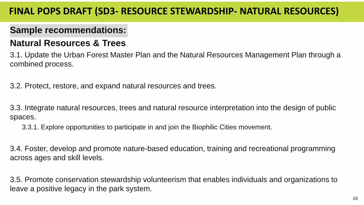
FINAL POPS DRAFT (SD3- RESOURCE STEWARDSHIP- NATURAL RESOURCES)
16
Natural Resources & Trees 3.1. Update the Urban Forest Master Plan and the Natural Resources Management Plan through a combined process.
3.2. Protect, restore, and expand natural resources and trees.
3.3. Integrate natural resources, trees and natural resource interpretation into the design of public spaces.
3.3.1. Explore opportunities to participate in and join the Biophilic Cities movement.
3.4. Foster, develop and promote nature-based education, training and recreational programming across ages and skill levels.
3.5. Promote conservation stewardship volunteerism that enables individuals and organizations to leave a positive legacy in the park system.
Sample recommendations:

FINAL DRAFT- PLAN ORGANIZATION
17

FINAL POPS DRAFT (SD4- FISCAL SUSTAINABILITY & PARTNERSHIPS)
18
APS4.1. Work with Arlington Public Schools to maximize availability and stewardship of public spaces.
Sample recommendations:
4.1.1. Explore opportunities to improve joint-use facilities to maximize public access to amenities and use land and other resources more efficiently. Identify additional existing APS facilities that could be used as public space.
4.1.2. Work jointly with APS to analyze program participation annually and adjust facility scheduling accordingly.
4.1.3. Expand participation in planning for publicly- accessible amenities on APS property.
4.1.4. Use design solutions to overcome security concerns related to the use of APS facilities by the public outside of school hours.

FINAL POPS DRAFT (SD4- FISCAL SUSTAINABILITY & PARTNERSHIPS)
19
APS4.1. Work with Arlington Public Schools to maximize availability and stewardship of public spaces.
Sample recommendations:
4.1.5. Ensure the contributions to capital costs and maintenance of public spaces on County and APS sites are commensurate with use.
4.1.6. Continue to collaborate with APS to preserve natural resources, athletic fields, outdoor learning areas and other public space when designing and building new schools.
4.1.7. Work with APS to expand educational and volunteer opportunities for students to learn about the value of public spaces and natural resources.

FINAL POPS DRAFT (SD4- FISCAL SUSTAINABILITY & PARTNERSHIPS)
20
Sample recommendations:
Regional partnership 4.2. Work with the National Park Service, NOVA Parks and other federal, state and regional bodies to elevate public awareness and access to their facilities and land in Arlington and ensure consistent experiences.
Funding 4.5. Secure funding to support development and maintenance of public spaces and ensure those public funds are efficiently and wisely spent.
Non-profit groups4.3. Support the establishment of non-profit groups or umbrella foundations dedicated to public space advocacy, fundraising, and implementation of public spaces and programs.
Volunteer programs 4.4. Support and strengthen the County’s volunteer programs for public spaces.

FINAL DRAFT- PLAN ORGANIZATION
21

FINAL POPS DRAFT (SD5- PROGRAMS)
22
Evaluation 5.1. Regularly evaluate program demand and adjust offerings.
Diverse programming 5.1.4. Promote and increase the availability of programming that caters to diverse ages, interests, and abilities.
Drop-in 5.1.5. Increase drop-in opportunities to allow more flexibility for residents and improve program participation.
Health and wellness 5.5. Continue to strengthen the County’s commitment to improving public health and wellness through public space programming
Sample recommendations:

FINAL DRAFT- PLAN ORGANIZATION
23

FINAL POPS DRAFT (SD6- OPERATIONS & MAINTENANCE)
24
Standards 6.1. Ensure maintenance standards are clear, consistently implemented, and being met.
Sample recommendations:
6.1.1.Define and regularly review levels of maintenance standards for each type of indoor and outdoor facility to ensure consistency with maintenance policies and guidelines.
6.1.7.Identify and encourage opportunities to share maintenance responsibilities with partner organizations and groups for efficiency.
Sustainability 6.2. Strengthen sustainability policies.
6.2.3.Conduct pilot projects of innovative sustainability measures to test their effectiveness for County-wide implementation.

FINAL DRAFT- PLAN ORGANIZATION
25

26
PLANNING COMMISSION CONTEXT

27
DEFINITIONS
27

LEVEL OF SERVICE
28

LEVEL OF SERVICE
29
Population Based
(Dog Parks Example)
Access
2 case studies: community gardens & diamond fields
Conduct a public space needs assessment, including a statistically valid survey and level of service analysis, on a 5-year cycle.
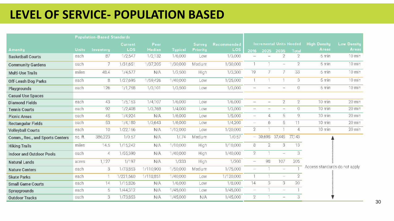
LEVEL OF SERVICE- POPULATION BASED
30

ATHLETIC FIELDS-SYNTHETIC TURF & LIGHTING
31

ATHLETIC FIELDS- SYNTHETIC CONVERSION & LIGHTING
Synthetic Conversion Criteria
All Fields Tested Against the Criteria
Synthetic Turf Conversion
Lighting Criteria All Fields Tested Against the Criteria
Field Lighting
32

ATHLETIC FIELDS- SYNTHETIC TURF CONVERSION CRITERIA
33
General
1. Does the field meet the minimum size requirement: 35,000 square feet for rectangular & diamond & 65,000 square feet for combination fields?
2. Has the field been identified as a synthetic field in a County Board adopted plan?
Site Amenities & Investment
3. Is the field already lighted?
4. Does the site have existing or planned restroom facilities that are permanent structures or attached to buildings with an exterior facing entrance?
5. Are there existing or planned ADA accessible pathways to the field?
6. Does a financial (cost sharing) partnership with APS or another partner exist?
7. Is the field used for scholastic sports programs?
8. Is the field used for physical education classes during the school day or at certain times during the school year?
9. Does the field provide benefits for programming both youth and adult sports leagues?

ATHLETIC FIELDS- SYNTHETIC TURF CONVERSION CRITERIA & STANDARDS
34
Environmental Context
10. Is the proposed field outside the dripline of existing trees or woodlands?
If the proposed project meets enough criteria to move forward, a more detailed tree evaluation would be completed to determine possible impacts.
Location & Context
11. Is the field located in an area identified in the Level of Service (LOS) access analysis as an area where access gaps exist for rectangular or diamond fields?
STANDARDS
The following standards apply to all fields that are candidates for synthetic field conversion:
A. If the estimated disturbance from the field installation is within 100 feet of a documented, significant natural resource feature, the project will go through the Rapid Environment Impact Review (REIR) process to determine impacts on the natural feature(s).
B. Fields will typically be replaced every eight (8) years based on usage and GMAX tests (GMAX testing measures the shock attenuation performance of a sports surface).

ATHLETIC FIELDS- LIGHTING CRITERIA
35
General
1. Does the field meet the minimum size requirement? (35,000 Square Feet for rectangular & diamond & 65,000 Square Feet for combination fields)
2. Has the field been identified as a lighted field in a County Board adopted plan?
Site Amenities & Investment
3. Does the site have existing or planned restroom facilities that are permanent structures or attached to buildings with an exterior facing entrance?
4. Are there existing or planned ADA accessible pathways to the field?
5. Does the financial (cost sharing) partnership with APS or another partner exist?
6. Is the field used for scholastic sports programs?
7. Does the field support both diamond and rectangular sports?
8. Does the field provide benefits for programming both youth and adult sports leagues?

ATHLETIC FIELDS- LIGHTING CRITERIA & STANDARDS
36
Environmental Context
If the proposed project meets enough criteria to move forward, a more detailed tree evaluation would be completed to determine possible impacts.
Location & Context
9. Is the field located in an area identified in the POPS access analysis (LOS) as areas where access gaps exist for rectangular or diamond fields? (See Appendix II- Level of Service)
STANDARDS
The following standards apply to all fields that are candidates for adding new athletic field lighting:
A. If the proposed light locations impact more than three healthy native trees over 12 inches in diameter, either by directly affecting their dripline or requiring removal for access or disturbance, tree protection mitigation measures should be implemented.
B. If the estimated disturbance from light installation is within 100 feet of a documented, significant natural resource feature, the project will go through the Rapid Environment Impact Review (REIR) process to determine any impact on the natural feature.

ATHLETIC FIELD LIGHTING- STANDARDS
37
STANDARDS
Over the years, lighting technology continues to improve in terms of energy efficiency and ability to minimize spill and glare. This is particularly important, since most of Arlington’s parks and fields are in residential neighborhoods. The following standards have been developed to mitigate light intrusion while providing safe play for field users and safe viewing for spectators.
A. In residential areas, the proposed field lighting will be designed and installed to ensure less than or equal to 0.5 foot candles increase at adjacent residential property lines.
B. LED or any other advanced lighting system should be used to achieve efficiency, light uniformity and visual comfort while minimizing light spillage. As lighting technology improves, the County will continuously review and update these standards.
C. Illuminance levels will adhere to the following guidelines for light source intensity for recreation, high school or stadium fields:

ATHLETIC FIELDS LIGHTING- MITIGATION MEASURES
38
MITIGATION MEASURES
To mitigate light intrusion, a variety of techniques may be used depending on the specific context, including:
A. Glare and spill reduction techniques, such as shielding, wattages, mounting height, aiming angles, and dimming controls
B. Design techniques, such as plantings or other physical buffers
C. Operational techniques, such as seasonally-adjusted hours, limiting special events, staff presence, and limited use of amplification
D. County Board approved community agreements and standing committees, regular meetings with civic associations or partner organizations to encourage continued dialogue and feedback

ATHLETIC FIELDS SYNTHETIC TURF & LIGHTING-TREE PRESERVATION TECHNIQUES
39
TREE PRESERVATION TECHNIQUES
Fencing and signage to reduce damage to roots and compaction of soil Root pruning to reduce mechanical damage from construction outside of
fenced area Air spading to find roots and avoid damage Root protection matting where no excavation is occurring Root growth hormone, applied after damage, to encourage root regrowth

CASUAL USE SPACE
40

CASUAL USE SPACES
41
• Recognize the need- Casual Use Spaces
recommendations & description in SD1
• Draft definition
• Design characteristics
• Refine definition
• Explore completing inventory
• Explore opportunities to develop
standards
Short Term (Include in the POPS document)
Long Term (Implementation item after POPS adoption)
Fort C.F. Smith Park

CASUAL USE SPACES
42
Benjamin Banneker Park Framework Plan adopted by the County Board in December 2017
What Are We Already Doing to Plan for Casual Use Spaces?
Short Bridge Park Master Plan adopted by the County Board in January 2018
Jennie Dean Park Master Plan adopted by the County Board in September 2018

TRAIL LOOPS
43

TRAIL LOOPS
2.1. Expand Arlington’s network of connected multi-use trails.
2.1.1. Complete an “inner loop” of protected routes that connects the Custis, Four Mile Run, Arlington Boulevard, and Mount Vernon Trails.
2.1.2. Complete an “outer loop” of protected routes that connects the Four Mile Run, Mount Vernon, and Zachary Taylor Trails.
Preliminary POPS Draft:
44

DOG PARKS & RUNS
45

DOG PARK & RUN STANDARDS
46This Public Spaces Master Plan recommends that the County consider reviewing and revising its Zoning Ordinance and other regulations to allow Dog Parks and Dog Runs on privately owned properties, with or without public access easements (p. 225).

PRIVATELY-OWNED PUBLIC SPACE DESIGN GUIDELINES
47

PRIVATELY OWNED PUBLIC SPACES DESIGN GUIDELINES
48
POPS Advisory Committee Meeting, April 2018

GOOD PRACTICE GUIDELINES & DESIGN ELEMENTS
49
• Planning and Layout• Access and Circulation• User Comfort• Landscaping• Amenities• Signage
Welburn Square, Arlington

FINAL POPS DRAFT (SD1- PUBLIC SPACES)
50
1.5.15. Complete and routinely update the database of all privately-owned public spaces that includes details regarding recorded public access easement or other type of use agreement, ownership and management, layout of the space and design features, signage, accessibility, and hours of operation and create an interactive online map to raise public awareness of such spaces.
Sample recommendations:
1.5.16. Review and explore revising current or creating new policies regarding commercial uses on privately owned public spaces.
Privately-owned Public Spaces 1.5.14. Consider amending standard conditions of site plan approvals to require information about the location, size, and content of signage for privately-owned public spaces to ensure that the signage conforms to County standards and helps make these spaces more visible and welcoming to the public. In addition, each privately owned public space should have an assigned address and name approved by the County.

LAND ACQUISITION
51

LAND ACQUISITION
Potential acquisition sites- mapped (example) Land Acquisition & Methodology
52
List of potential acquisition mechanisms & funding sources
Inventory of past acquisitions

The site is identified within an existing approved park master plan. The site is identified as future parkland in an adopted comprehensive plan element or sector, area, phased development site plan, or corridor plan.
The site is identified as future parkland in an existing neighborhood conservation plan.
PART I: ALIGNMENT WITH OTHER COUNTY PLANS
53

PUBLIC SPACES IDENTIFIED IN ADOPTED PARK MASTER PLANSEXAMPLE: MOSAIC PARK MASTER PLAN (ADOPTED IN 2009)
54

PUBLIC SPACES IDENTIFIED IN SECTOR PLANSEXAMPLE: CRYSTAL CITY SECTOR PLAN (ADOPTED IN 2010)
55
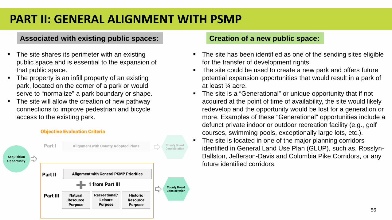
The site shares its perimeter with an existing public space and is essential to the expansion of that public space.
The property is an infill property of an existing park, located on the corner of a park or would serve to “normalize” a park boundary or shape.
The site will allow the creation of new pathway connections to improve pedestrian and bicycle access to the existing park.
PART II: GENERAL ALIGNMENT WITH PSMP
56
The site has been identified as one of the sending sites eligible for the transfer of development rights.
The site could be used to create a new park and offers future potential expansion opportunities that would result in a park of at least ¼ acre.
The site is a “Generational” or unique opportunity that if not acquired at the point of time of availability, the site would likely redevelop and the opportunity would be lost for a generation or more. Examples of these “Generational” opportunities include a defunct private indoor or outdoor recreation facility (e.g., golf courses, swimming pools, exceptionally large lots, etc.).
The site is located in one of the major planning corridors identified in General Land Use Plan (GLUP), such as, Rosslyn-Ballston, Jefferson-Davis and Columbia Pike Corridors, or any future identified corridors.
Creation of a new public space:Associated with existing public spaces:

The site could be used to enhance, protect, or expand natural resources, such as tree canopy, meadow, stream valley, forested natural area or other appropriate ecosystems.
The site could protect or expand a Natural Resource Conservation Area.
PART III: ALIGNMENT WITH PSMP PRIORITIES/SITE INTENDED PURPOSE
57
The site could be designed to support casual, impromptu use or connection with nature.
The site could be used to create a new multi-use activity center to provide year-round access to indoor athletic courts and fields.
The site is part of a planned joint-use facility with APS or could be used for co-locating complimentary public uses (e.g., library, etc.)
Recreational/Leisure Purpose (examples):Natural Resources Purpose (examples):
Historic Preservation Purpose (examples):
The site is called out for acquisition based on its historical and/ or cultural value by an accepted Neighborhood Conservation Plan.
The site is listed on the County’s Cemetery Inventory and/or the Arlington Genealogical Society’s Cemetery List.

SITES THAT MEET CRITERIA FROM PART II & IIIEXAMPLE: LANG STREET COMMUNITY GARDEN EXPANSION (ACQUIRED IN FY2015/2016)
Part II: The site shares its perimeter with an existing
public space and is essential to the expansion of that public space.
Part III: The site could facilitate adding or expanding
recreational amenities that are needed based on the Level of Service Analysis (e.g., community gardens, athletic courts, etc.)
58

59
FEEDBACK & NEXT STEPS

FINAL POPS DRAFT- FEEDBACK
60
285 comments online & 40+ emails & 2 open door events
Major Themes: o SD1: land acquisition, LOS, athletic fields, pickleball o SD2: trails, mountain biking/cyclocross/pump tracko SD3: trees and natural resources

FINAL POPS DRAFT & NEXT STEPS
61
Fall/Winter: o POPS Advisory Committee Meeting (December 18)o RTA (February 2019)o Planning Commission Action (March 2019)o County Board Action (March 2019)