public land auction - st. clair county
TRANSCRIPT

Public Land Auction
Saint Clair County
August 29th, 2013
Registration: 11:30am
Auction 12:00pm
Double Tree by Hilton
500 Thomas Edison Parkway
Port Huron, MI 48060
Announcements made on the day of the sale supersede any previous
printed matter.
www.tax-sale.info

6/17/13 500 Thomas Edison Parkway Port Huron, MI 48060 - Google Maps
https://maps.google.com/maps?q=500+Thomas+Edison+Parkway+Port+Huron,+MI+48060&ie=UTF8&hq=&hnear=500+Thomas+Edison+Pkwy,+Port+Huron,… 1/1
Address 500 Thomas Edison PkwyPort Huron, MI 48060
Double Tree by Hilton
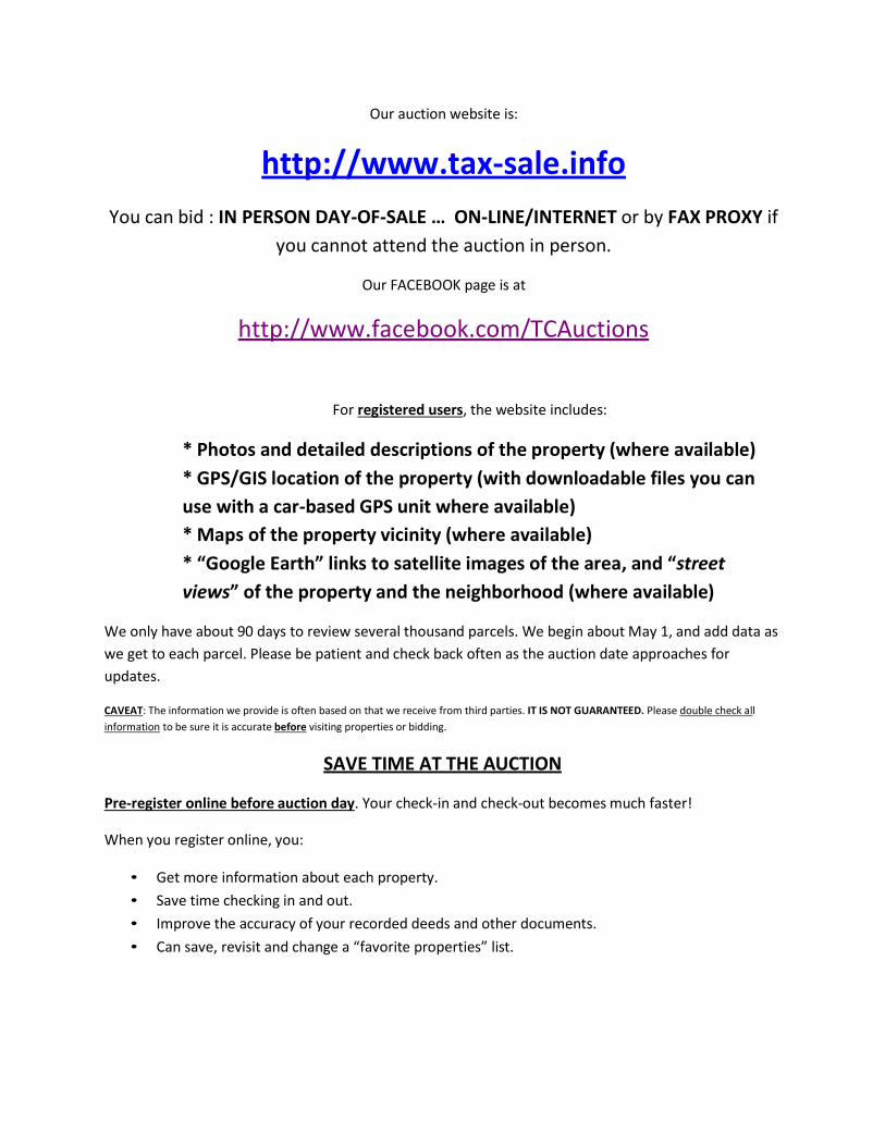
Our auction website is:
http://www.tax-sale.info
You can bid : IN PERSON DAY-OF-SALE … ON-LINE/INTERNET or by FAX PROXY if
you cannot attend the auction in person.
Our FACEBOOK page is at
http://www.facebook.com/TCAuctions
For registered users, the website includes:
* Photos and detailed descriptions of the property (where available)
* GPS/GIS location of the property (with downloadable files you can
use with a car-based GPS unit where available)
* Maps of the property vicinity (where available)
* “Google Earth” links to satellite images of the area, and “street
views” of the property and the neighborhood (where available)
We only have about 90 days to review several thousand parcels. We begin about May 1, and add data as
we get to each parcel. Please be patient and check back often as the auction date approaches for
updates.
CAVEAT: The information we provide is often based on that we receive from third parties. IT IS NOT GUARANTEED. Please double check all
information to be sure it is accurate before visiting properties or bidding.
SAVE TIME AT THE AUCTION
Pre-register online before auction day. Your check-in and check-out becomes much faster!
When you register online, you:
• Get more information about each property.
• Save time checking in and out.
• Improve the accuracy of your recorded deeds and other documents.
• Can save, revisit and change a “favorite properties” list.

PLEASE REMEMBER that property lists can change up to the day-of-auction.
Visiting and viewing property BEFORE auction:
The auction list being furnished is of property that MAY be offered. Many parcels on early lists do not
actually proceed to the auction for a variety of reasons.
• PLEASE FOLLOW PROPERTIES YOU ARE INTERESTED IN ON THE WEBSITE. They may be removed
from the list, which will be updated daily on the website if the status is changed.
• If you do not use the internet, please verify current status with the Treasurers office regularly.
You are NOT AUTHORIZED to enter any buildings, even if they are unlocked or open to
access. Entering into a tax auction property to “see it” is breaking and entering. It is a criminal offense.
Please limit your review to looking through the windows and other external inspection. We will post
exterior and interior photos, and provide other commentary as available.
Entering properties (even vacant land) can be dangerous because of condition. You assume all liability
for injuries and other damage if you go onto these lands.
Properties may be OCCUPIED or “being watched” by former owners or neighbors sympathetic with
former owners. Occupants are often UNKNOWN and could potentially be volatile, unstable or “anti-
government” persons. Even vacant land presents potential for conflict.
Some properties still contain the personal property of former owners (vehicles, furnishings, appliances
etc). These items are NOT SOLD at our auction. We are only selling the REAL ESTATE (land) and whatever
is attached to it (land, buildings and fixtures).
• You are NOT AUTHORIZED to remove ANY “personal” property, “scrap”
metal or fixtures from auction parcels. This is THEFT AND WILL BE PROSECUTED. We
often ask neighbors to watch property for theft and vandalism and report this to local police.
You have been warned…
• PROPERTY IS SOLD “AS IS” IN EVERY RESPECT. Please check zoning, building code violation
records, property boundaries, condition of buildings and all local records.
• THERE ARE NO REFUNDS AND NO SALE CANCELLATIONS AT BUYERS OPTION.
• INFORMATION OFFERED ON THE WEBSITE OR IN THE SALE BOOK
IS DEEMED RELIABLE BUT IS NOT GUARANTEED. We suggest reviewing the
records of the local ASSESSORS office to be sure that what we are selling is what you think it is.
We sell by the LEGAL DESCRIPTION ONLY.
• YOU SHOULD CONSIDER OBTAINING PROFESSIONAL ASSISTANCE from land surveyors,
property inspection companies or others if you have questions about property attributes.

Please do NOT arrive before this time, as it delays setting up the sale.
PAYING FOR YOUR AUCTION PURCHASES
• The first (up to) $1000 in purchases MUST be paid for in CASH or a CASHIERS CHECK from a bank or credit union. This is a NON-REFUNDABLE DEPOSIT. It is forfeited if you fail to pay the balance due, or if your payment is dishonored.
• Amounts over $1000 can be paid for by personal or business check, credit card, money orders, or cashier checks.
• For your safety and ours, WE WILL NOT ACCEPT MORE THAN
$1000 IN CASH FROM ANY BUYER. Please do not bring large amounts of cash to the auction!
• If you are bringing cashier checks, have the bank or credit union make them out to YOU as the payee. If they are unused, you can simply endorse them and re- deposit into your account.
• If paying by cashier checks, bring several in different amounts. (Example: You plan to spend between $20,000 and $40,000 … Bring (2) for $10,000 each, (2) for $5000 each, (2) for $2500 each, and (5) for $1000 each).
• There is a buyer premium fee added to the final purchase price. For credit card purchases the fee is 13%. For all other forms of payment this fee is discounted to 10%. There is also a $20 per parcel fee for preparing, recording and returning the deed to you.
• Your total price = Bid amount + Buyer premium + $20 recording fee.
Online bidding You can place bids online. To do so you will need to pre-authorize a $1000 credit card “hold” as a deposit. See http://www.tax-sale.info for more information. Your card is not
charged unless you win, however the hold may reduce your available credit until it is released by your credit card issuer (usually 30 days).
Absentee bidding
If you do not have internet access, you can submit an absentee bid by FAX. You will need to pre-authorize a $1000 deposit on a major credit card. Contact Adam or Brandon at 269.226.2600 for more information. Your card is not charged unless you win, however the
hold may reduce your available credit until it is released by your credit card issuer (usually 30 days).
On-site bidding
The doors to the auction locations open ONE HOUR before the stated
auction time.

2013 AUCTION SCHEDULE ROUND 1
Barry/Ionia
7/30/2013
Ionia, MI
Chippewa County
8/1/2013
Sault Ste. Marie, MI
Central UP
8/2/2013
Marquette, MI
Western UP
8/3/2013
Watersmeet, MI
Eastern Northern Lower
8/5/2013
Grayling, MI
Northwestern Lower
8/6/2013
Boyne Falls, MI
Western MI
8/7/2013
Manistee, MI
Clare/Gladwin
8/8/2013
Beaverton, MI
Bay/Tuscola
8/9/2013
Bay City, MI
Leelanau/Grand Traverse
8/15/2013
Grand Traverse, MI
Montcalm
8/16/2013
Sheridan, MI
Northeastern Lower
8/17/2013
Indian River, MI
Muskegon
8/19/2013
Muskegon, MI
Jackson
8/20/2013
Jackson, MI
Kent
8/21/2013
Grand Rapids, MI
Kalamazoo
8/22/2013
Kalamazoo, MI
Lake County
8/23/2013
Baldwin, MI
Allegan/Ottawa
8/24/2013
West Olive, MI
Southwest MI
8/26/2013
Paw Paw, MI
Monroe County
8/27/2013
Monroe, MI
Lapeer County
8/28/2013
Metamora, MI
St. Clair
8/29/2013
Port Huron, MI
Central Northern Lower
8/30/2013
Tustin, MI
Arenac/Ogemaw
9/3/2013
West Branch, MI
Saginaw
9/4/2013
Saginaw, MI
Genesee
9/5/2013
Flint, MI
Calhoun
County 9/12/13
Battle Creek, MI

The rules in the printable salebook for this county will be modified as needed by the County Treasurer, and
Auction House prior to auction. Please check back regularly for changes to these rules and requirements
2013 Rules and Regulations
1. Registration
On site registration will begin at 11:30AM and all sales will begin at 12:00PM, unless noted otherwise with a special start time for the auction. No bids will be accepted unless the bidder has registered and received a pre-numbered bid card. Driver's license and social security number will be required to register. Driver's license or state I.D. must be presented in order to receive a bidder number.
2. Properties Offered
The attached list of County Treasurer owned properties being offered, identified by sale unit numbers, have been approved for sale at
public auction by the County Treasurer. The County Treasurer reserves the right to pull parcels from the sale at any time prior to the
auction.
According to state statutes, ALL PRIOR liens (other than IRS & DEQ liens), encumbrances and taxes are cancelled by Circuit Court
Order. The County Treasurer has attempted to include in the minimum bid, liens that have accrued since foreclosure, such as nuisance or
water bills; all other outstanding bills since foreclosure are the responsibility of the buyer. These properties are subject to any
state, county, or local zoning or building ordinances. The County Treasurer does not guarantee the usability or access to any of these
lands.
It is the responsibility of the prospective purchaser to do their own research as to the use of the land for their intended
purpose and to make a personal inspection of the property on the ground to determine if it will be suitable for the purposes
for which it is being purchased. The County Treasurer makes neither representations nor claims as to fitness for purpose,
ingress/egress, conditions, covenants, or restrictions. Structures may not be entered without the written permission of the
County Treasurer. Some structures may be occupied, and occupants should not be disturbed.
RESERVATION OF REVERTER - It is an express condition of sale, and deeds will contain a reverter clause that prohibits future severing of
the mineral rights (if any) or splitting the parcel sold into smaller units which do not meet zoning requirements for minimum lot size or
dimension. In the event of violation of this deed restriction, the property will revert to the Foreclosing Governmental Unit without refund.
All offered properties may be subject to flooding. Any new construction or reconstruction should be elevated above the 100-year flood
plain. Also, any filling, dredging, or other permanent construction below the ordinary high-water mark of the water body involved may be
subject to the provisions of 1972 Public Act 346. Any earth change on the property may be subject to the provisions of 1972 Public Act
347. These properties may also be subject to the Goemaere-Anderson Wetland Protection Act, 1979, Public Act 203.
3. Starting Bid Price
The starting bid prices are shown on the list. At auctions with a minimum bid, no sales can be made for less than the starting price
indicated. The starting bid for no minimum bid sales will be at the discretion of the auctioneer.
4. Bidding
Any registered person may bid on the properties offered. Any person unable to attend the sale can be represented at the sale by an agent
or other representative with authority to bid and otherwise represent the person. The registered bidder is legally and financially
responsible for all parcels bid upon whether representing one's self or acting as an agent. Each sale unit will be offered separately and in
the order appearing on the list. Each sale will be awarded to the individual bidding the highest amount equal or greater than the starting
bid.
We will accept an absentee bid in increments up to the amount that you pre-approve. Absentee bids require a $1,000 pre-authorization
on a major credit card or a $1,000 deposit prior to accepting the bid. Absentee bids must be submitted 48 hours prior to the date of the
Auction by calling 1.800.259.7470. An absentee bid form is also available on www.tax-sale.info.
An oral bid accepted at public auction is a legal and binding contract to purchase. No sealed bids will be accepted and the County
Treasurer reserves the right to reject any or all bids.

BID INCREMENTS
Floor bidders MUST bid in the same increments as online bidders. We will not accept odd bid increments in
fairness to online bidders!
BID AMOUNT INCREMENT
$1 to $99 $ 10.00
$100 to $999 $ 50.00
$1000 to $9999 $ 100.00
Over $10,000 $ 250.00
On-line bidding will be available on the day of the auction at www.tax-sale.info.
5. Terms of Sale
The full purchase price must be paid the day of the sale, within an hour of the end of the Auction!
THE FIRST $1,000 OF THE FINAL SELLING PRICE MUST BE PAID IN CASH OR CERTIFIED FUNDS! This $1,000 will only be
needed if you are successful as the winning bidder on a parcel. The $1,000 is not necessary to bid on-site at the auction.
The purchase price consists of the final bid price plus 13%* of bid price as buyer premium, and $20.00 processing fee. Cash, money
orders, personal checks, major credit cards, and wire transfers will be accepted. (*There is a 3% discount on the buyer’s premium when
paying by cash, check or wire transfer) The first $1,000 of the selling price must be deposited in the form of cash, or certified
funds. The balance may be paid by personal check, credit card, or cashier’s check. ONLY THE FIRST $1000
MAY BE PAID WITH CASH. Wire transfers are not able to be processed or handled at the auction on-site.
Any bidder whose balance payment is dishonored for any reason will forfeit the $1000 DEPOSIT to the County Treasurer. The
County Treasurer may prosecute any purchaser who bounces a check or fails to consummate a purchase.
Any bidder who fails to consummate a purchase will be banned from bidding at all future land auctions. No purchases can be made on a
time-payment plan. Any disputes or matters involving online bidding or purchases, the venue for litigation or arbitration shall be fixed as
being Kalamazoo County, State of Michigan.
The buyer premium is not subject to any broker fees. There are no co-brokerage or other fees or rebates available.
The County Treasurer reserves the right to cancel ANY sale, at ANY time prior to the issuance of the deed.
It is the responsibility of the purchaser of property to file a Property Transfer Affidavit
with the Assessor for the city or township where the property is located within 45 days of the transfer. If it is not
filed timely, a penalty of $5/day (maximum $200) applies. The information on this form is NOT
CONFIDENTIAL. 6. Purchase Receipts
Successful bidders at the sale will be issued a receipt for their purchases upon payment. Purchasers will be entitled to deeds for the
property descriptions identified by the assigned sale unit numbers noted on the receipts.
7. Title Being Conveyed
Quit-claim deeds will be issued conveying only such title as received by the County Treasurer through tax foreclosure. Title insurance
companies may or may not issue title insurance on properties purchased at this sale. The County Treasurer makes no representation as to
the availability of title insurance and the Unavailability of title insurance is not grounds for reconveyance to the County
Treasurer. The purchaser may incur legal costs for Quiet Title Action to satisfy the requirements of title insurance companies in order to
obtain title insurance.
8. Special Assessments
Special assessments through tax year 2012 are included in the starting bids. We have identified those parcels with known special
assessments with a note on the parcel detail page.
Outstanding bonded assessments: Parcels sold are subject to property taxes for the entire current tax year, as well as current and future
installments of any outstanding bonded assessments.
All bidders should contact city or township offices to determine if there are any outstanding bonded assessments for future tax years on
the properties being offered.
9. Possession of Property
We recommend that no purchaser take physical possession of any property bid upon at this sale until a deed has been executed and
delivered to the purchaser. No activities should be conducted on the site other than a baseline environmental assessment to assess the
condition of potentially contaminated properties.
However, steps should be taken to protect your equity in this property by securing vacant structures against entry and
obtaining (homeowners) insurance for occupied property. Buyers will be responsible for all procedures and legal
requirements for conducting evictions. Additionally, buyers are responsible for contacting local units of government to
prevent possible demolition of structures situated on parcels.
10. Conditions
The purchaser accepts the premises in its present "as is" condition, and releases the County Treasurer and employees and agents from all
liability whatsoever arising from any condition of the premises, whether now known or subsequently discovered, including but not limited
to all claims based on environmental contamination of the premises.
A person who acquires property that is contaminated (a "facility" pursuant to Section 20201(1)(1) of Natural Resources and
Environmental Act (NREPA), 1994 P.A. 451, as amended) as a result of release(s) of a hazardous substance(s) may become liable for all
costs of cleaning up the property and any other properties impacted by the release(s). Liability may be imposed upon the person
acquiring the property even in the absence of any personal responsibility for, or knowledge of, the release. Protection from such liability
may be obtained by conducting a Baseline Environmental Assessment (BEA) as provided for under Section 20126(1) (c) of NREPA.
However, the BEA must be conducted prior to or within 45 days of the earliest date of purchase or occupancy of the property. Persons
who acquire contaminated property may have "due care" obligations under Section 20107a of NREPA even if they conduct a BEA and are
not liable for the contamination.
Pursuant to part 201 of NREPA, the person(s) responsible for an activity causing a release at the property is obligated to pursue response
activities at the property. Consequently, the non-liable purchaser may be required to provide access to the liable party to conduct
response activities at the property in the future. Section 20116 of the NREPA requires that a person who has knowledge that their
property is contaminated provide a written notice to the purchaser or other person to whom the property is transferred which discloses
the general nature and extent of the release. Additional disclosure obligations may also apply at the time the property, or an interest in
the property, is transferred. Accordingly, the County Treasurer recommends that a person who is interested in acquiring surplus County
property contact an attorney or an environmental consultant for advice prior to the acquisition of any surplus County property that may
be contaminated.
11. Deeds
Deeds will be created and executed within 30 days. It will be the responsibility of the County Treasurer to record the deeds and remit
them to the purchaser after completion of recording by the Register of Deeds. This process takes between 45 and 60 days
normally. In some counties where the Register of Deeds is “backed up” it can take up to 90 to 120 days. Please be patient!
12. Property Taxes
All property taxes that became due and payable after March 31, 2013 will be the responsibility of the purchaser.
PLEASE UNDERSTAND THAT YOU ARE RESPONSIBLE FOR ALL CURRENT YEAR TAXES!
13. Other:
Personal Property:
Personal property (items not attached to buildings and lands such as furnishings, automobiles etc) located on tax foreclosed land or within
structures situated on foreclosed land was not taxed as part of the real estate, does not belong to the Treasurer and is not sold to the
purchaser of the real estate in this transaction. You are advised to contact former owners of the lands and provide them an opportunity to
reclaim contents. A certified mail notice to their last known address is strongly advised.
Mobile Homes may be titled separately and considered personal property.
Mineral Rights:
You will receive any and all title that the Treasurer obtains via their tax foreclosure through a quit-claim deed. If the owner of the surface
rights to the property also owned the mineral rights, those will become part of your title interest. However this will be subject to the rights of
any outstanding leaseholders of oil, gas, mineral or storage rights. You would be obligated to honor the balance of any remaining lease (with
automatic renewals if so written) but the royalty payments would be payable to you.
However if the mineral rights have been severed (split from the surface rights) and are owned by a third party, they have not been foreclosed
by the Treasurer and are not included in the mineral rights conveyed to you. In either instance, the leaseholder still has the right to explore
for and/or extract minerals under the terms of any outstanding agreement.

Saint Clair County Public Auction
Lot # Parcel ID & Legal Description Address MinimumBid
SellingPrice
4600 01-145-0054-000 LOTS 60 & 62 KENDALL FARM SUBD CENTER ST VL
ALGONAC
$2300
4601 01-151-0027-000 LOT 36 LOCUST POINT SEC 02 T2N R16E
392 SHERWOOD LN ALGONAC
$5700
4605 01-900-0112-000 UNIT 112 ALGONAC HARBORCONDOMINIUM
PTE TREMBLE RD SLIP112 ALGONAC
$3100
4606 02-001-2023-004 N 116' OF S 166' OF THAT PART OF FRACSECTION 1 LYING N OF BLOCK 2 DEMONT'S ADDITION, EOF BELLE RIVER ROAD & W OF BELLE RIVER FRACSECTION 1 T3N R16E 0.07 A
N BELLE RIVER AVE MARINE CITY
$600
4607 02-200-0044-000 LOT 43 EX E LY 5 FT THEREOF BROWNAND COTTRELLS SUB- DIVISION T3N R16E SEC 01
327 CARROLL ST MARINE CITY
$7300
4608 02-575-0014-000 LOT 3 BLK C AMENDED PLAT OF MCELROY AND PEARCES ADDI- TION T3N R16E SEC 01
897 CARROLL ST MARINE CITY
$4200
4610 03-052-0039-370 BEG N87^46'50"E 1381.42' FROM INT/SECOF W'LY LINE OF PC 406 & S LINE SEC 7 T5N R17E, THN81^13'14"W 132.50' TH N87^46'50"E 23.45', TH N'LY 546.39' ALONG CURVE CONCAVE TO NW, RADIUS 260', LCBEARING N27^34'36" E 451.26' TH S47^2'49"E 448.76', THSS6^5'50"E 98.83", TH S87^46'50"W 440.67' TO BEG PC 4062.03A
Huron Plastics CommonsRd, MARYSVILLE
$4400
4611 03-092-0004-000 SWLY 137 FT OF NWLY 17 FT OF LOT 2.ASSESSORS PLAT OF DOW ADDITION TO THE CITY OFMARYSVILLE, MICHIGAN
Wills Rd., MARYSVILLE $500
4612 03-766-0089-000 LOTS 1 TO 5 INC BLK 25 SUBD CVILLAGE OF MARYSVILLE
14th St., Marysville $5800
4613 03-766-0119-000 LOT 25 BLK 27 SUBD C VILLAGE OFMARYSVILLE
Georgia Ave, MARYSVILLE
$900
4614 03-773-0048-000 LOTS 25, 26, 27 & 28 BLK 19 & 1/2 VACALLEY ADJ SUBD P VILLAGE OF MARYSVILLE
1810 GRATIOT BLVD MARYSVILLE
$20250
4615 03-865-0047-101 LOTS 1, 2, & 3 BLK 15 WOOD ANDHOLBROOKS PLAT OF SOUTH PORT HURON
Maywood St MARYSVILLE
$3200

Lot # Parcel ID & Legal Description Address MinimumBid
SellingPrice
4616 06-118-0032-000 LOT 24 ASSESSOR'S GRATIOT AVE.PLAT
3100 VACANT LOTFOREST ST PORTHURON
$600
4617 06-121-0012-000 LOT 12 ASSESSOR'S PLAT OF GORDONAND KEAN LAND Parcel to be demolished by the City of PortHuron
1327 LAPEER AVE PORTHURON
$10500
4618 06-121-0024-000 LOT 23 ASSESSOR'S PLAT OF GORDONAND KEAN LAND
602 14TH ST PORTHURON
$9400
4619 06-121-0031-000 LOT 29 ASSESSOR'S PLAT OF GORDONAND KEAN LAND
607 13TH ST PORTHURON
$5100
4620 06-186-0062-000 S 248 FT OF W 200 FT OUTLOT AASSESSOR'S VANNESS AND MOAK PLAT NO 2
3119 MOAK ST PORTHURON
$10000
4621 06-204-0007-000 LOT 9 ASSESSOR'S REPLAT OF BLOCK116 OF WHITE'S PLAT
1034 LAPEER AVE PORTHURON
$9000
4622 06-204-0009-000 LOT 12 ASSESSOR'S REPLAT OF BLOCK116 OF WHITE'S PLAT
720 11TH ST PORTHURON
$7100
4623 06-235-0024-000 LOTS 8 & 9 BLK 2 BANCROFT'SADDITION
738 BANCROFT ST PORT HURON
$6800
4624 06-270-0030-800 LOT 9, 12 & 13 EX SE 140', EX SW 70'AND EX NE 70' THEREOF & EX SW 83' OF NW 74' OF THESE 214' LOT 12 EX THE NE 40' OF THE NW 74' OF THE SE214' OF LOT 13 EX SW 55' OF NE 95' OF NW 49' OF SE 189'LOT 13 BOYNTON'S PLAT
1819 KERN ST PORTHURON
$20500
4625 06-292-0001-000 LOT 1 BROWN HOFFMAN PLAT 1100 VACANT LOT
WATER ST PORTHURON
$8100
4626 06-292-0002-000 LOT 2 BROWN HOFFMAN PLAT 1011 VARNEY AVE
PORT HURON
$8600
4627 06-342-0048-000 E 1/2 LOT 3 BLK 2 FACTORY LANDCOMPANY'S PLAT NO. 1
2814 GOULDEN ST PORT HURON
$3600
4628 06-343-0097-000 E 9 FT LOT 40, LOT 41 & W 6 FT LOT 42BLK 4 FACTORY LAND COMPANY'S PLAT NO. 2 INCL 1/2OF VAC ALLEY ADJ
2500 VANNESS ST PORTHURON
$9000
4629 06-345-0107-000 LOT 4 BLK 6 FACTORY LAND CO.'S PLATNO. 4 INCL S 1/2 & E 1/2 OF VAC ALLEYS ADJ
2900 25TH ST PORTHURON
$500

Lot # Parcel ID & Legal Description Address MinimumBid
SellingPrice
4630 06-362-0007-000 LOTS 9, 10 & 11 BLK 28 PLAT OFVILLAGE OF FORT GRATIOT
2726 FOREST ST PORTHURON
$8800
4631 06-362-0034-000 LOTS 12 & 13 BLK 30 PLAT OF VILLAGEOF FORT GRATIOT
2532 FOREST ST PORTHURON
$5000
4632 06-362-0078-000 LOTS 13 & 14 BLK 35 PLAT OF VILLAGEOF FORT GRATIOT
2500 VACANT LOTGRATIOT AVE PORTHURON
$1400
4633 06-362-0091-000 LOTS 1 & 2, S 10 FT OF LOT 3, E 20 FTOF N 15 FT LOT 3 & S 5 FT OF E 20 FT LOT 4 BLK 36 PLATOF VILLAGE OF FORT GRATIOT
2602 GRATIOT AVE PORT HURON
$12500
4634 06-362-0365-000 LOT 13 BLK 86 PLAT OF VILLAGE OFFORT GRATIOT
2419 WALNUT ST PORTHURON
$5100
4635 06-362-0394-000 LOT 5 BLK 88 PLAT OF VILLAGE OFFORT GRATIOT
2624 STONE ST PORTHURON
$21000
4636 06-365-0001-000 S 1/2 OF N 2/3 LOTS 1 & 2 BLK 1SUBDIVISION OF THE FORT GRATIOT MILITARYRESERVATION
824 MICHIGAN ST PORTHURON
$5200
4637 06-365-0111-000 LOT 7 BLK 9 SUBDIVISION OF THE FORTGRATIOT MILITARY RESERVATION
807 STANTON ST PORTHURON
$20000
4638 06-365-0114-000 N 44 FT OF S 84 FT LOTS 1 & 2 BLK 10SUBDIVISION OF THE FORT GRATIOT MILITARYRESERVATION
921 ONTARIO ST PORTHURON
$6100
4639 06-366-0121-000 S 60 FT LOT 7 BLK 81 ADDITION TO THECITY OF PORT HURON, BEING A SUBDIVISION OF APORTION OF FORT GRATIOT MILITARY RESERVATION
1009 RAWLINS ST PORTHURON
$5100
4640 06-422-0050-000 SELY 60 FT LOT 12 & LOT 13 EX SW 30FT DEEDED TO CITY FOR STREET & EX NWLY 287 FTBLK 2 HAYNES AND RUNNELS SUBDIVISION OF A PARTOF SECTION 4
1825 KERN ST PORTHURON
$16250
4641 06-428-0146-000 LOT 51 BLK 3 HIGHLAND PARK PLAT 1629 THOMAS ST PORT
HURON
$12500
4642 06-516-0029-000 W 40 FT OF LOTS 15 & 16 BLK 2MILLER'S GRISWOLD STREET PLAT INCL E 1/2 VACALLEY ADJ
1711 OAK ST PORTHURON
$4000
4643 06-517-0005-000 N 21.75 FT LOT 7 BLK 1 MILLS' LAPEERAVE. SUBDIVISION
200 VACANT LOT 17THST PORT HURON
$500

Lot # Parcel ID & Legal Description Address MinimumBid
SellingPrice
4644 06-562-0153-000 S 68.5 FT LOTS 17, 18 & 19 BLK NVICTORIA PETIT PLAT
2024 14TH ST PORTHURON
$9500
4645 06-571-0094-000 LOT 10 BLK 8 P.H. & N.W. RY. PLAT OF APORTION OF THE FORT GRATIOT MILITARYRESERVATION
2013 ST CLAIR ST PORTHURON
$22500
4646 06-638-0026-000 E 11 FT LOT 25 & W 28 FT LOT 26CHRISTINA SCHULTZ'S SUBDIVISION OF LOT 4, MCNEILTRACT VILLAGE OF FORT GRATIOT
1122 CHURCH ST PORTHURON
$10500
4647 06-666-0011-000 LOT 11 BLK 1 CYRUS M. STOCKWELLESTATE
1800 OAK ST PORTHURON
$2300
4648 06-666-0012-000 LOT 12 BLK 1 CYRUS M. STOCKWELLESTATE
1801 OAK ST PORTHURON
$15500
4649 06-666-0022-000 LOT 10 BLK 2 CYRUS M. STOCKWELLESTATE
1911 OAK ST PORTHURON
$8800
4650 06-666-0032-000 LOT 9 BLK 3 CYRUS M. STOCKWELLESTATE
1915 DIVISION ST PORTHURON
$14750
4652 06-734-0125-000 N 113 FT LOT 1 & N 113 FT OF E 5 FT LOT2 BLK 163 WELLS' PLAT
1207 12TH ST PORTHURON
$14000
4653 06-743-0243-000 S 89 FT LOT 18 BLK 17 WHITE PLAT 901 WALL ST PORT
HURON
$9100
4654 06-743-0480-000 LOT 13 BLK 35 WHITE PLAT 719 WHITE ST PORT
HURON
$11750
4655 06-743-0508-000 LOT 12 BLK 37 WHITE PLAT 723 UNION ST PORT
HURON
$2500
4656 06-743-0538-000 LOT 8 BLK 39 WHITE PLAT 723 Wall St., PORT
HURON
$2900
4657 06-743-0570-000 E 44 FT LOT 1 BLK 44 WHITE PLAT Parcelto be demolished by the City of Port Huron
620 UNION ST PORTHURON
$31250
4658 06-743-0948-000 S 90 FT OF E 28 FT LOT 12 & UND 1/3 OFN 10 FT OF S 100 FT OF E 61.24 FT LOT 12 BLK 108WHITE PLAT
803 PINE ST & 1/2 PORTHURON
$10500
4659 06-743-1013-000 N 35 FT OF E 80 FT LOT 1 BLK 117 WHITEPLAT
801 10TH ST PORTHURON
$15000

Lot # Parcel ID & Legal Description Address MinimumBid
SellingPrice
4660 06-743-1082-000 N 65 FT LOT 12 BLK 122 WHITE PLAT 1040 UNION ST PORT
HURON
$6900
4661 06-743-1144-000 LOT 16 BLK 126 WHITE PLAT 1017 DIVISION ST PORT
HURON
$8000
4662 06-743-1281-000 W 31 FT LOT 6 & E 10 FT LOT 7 BLK 139WHITE PLAT
1130 HOWARD ST PORTHURON
$12500
4663 06-743-1439-000 N 32 FT OF S 40 FT OF LOT 1 & N 32 FTOF S 40 FT OF E 15 FT OF LOT 2 BLK 159 WHITE PLAT
815 12TH ST PORTHURON
$5300
4665 07-053-0140-000 S97' OF E 271' OF THAT PART OF 5 ALOT 18 LYING W OF 6TH ST R/W MAP OF PC 304 & 305 &N 2.5' OF E 214.18' OF OUTLOT A ASSESSORS SUBD OFLOT 23 OF SUBD OF PART OF PC 304 & 305 OWNED &OCC AS ONE PARCEL
817 N SIXTH ST SAINTCLAIR
$11250
4666 07-155-0003-000 E135' OF LOT 3 BRANDYWINE ESTATES 1901 KAREN AVE SAINT
CLAIR
$2700
4668 07-970-0020-000 UNIT 20 JORDAN CREEKCONDOMINIUMS ST CLAIR COUNTY CONDOMINIUMPLAN NO. 31 RECORDED IN LIBER 1103 PAGES 871 TO912
806 JORDAN CREEK DR SAINT CLAIR
$800
4669 07-970-0021-000 UNIT 21 JORDAN CREEKCONDOMINIUMS ST CLAIR COUNTY CONDOMINIUMPLAN NO. 31 RECORDED IN LIBER 1103 PAGES 871 TO912
730 JORDAN CREEK DR SAINT CLAIR
$800
4670 07-970-0022-000 UNIT 22 JORDAN CREEKCONDOMINIUMS ST CLAIR COUNTY CONDOMINIUMPLAN NO. 31 RECORDED IN LIBER 1103 PAGES 871 TO912
732 JORDAN CREEK DR SAINT CLAIR
$800
4672 08-061-0058-000 LOT 37 BLOCK 5 MAP OF BROCKWAYCENTRE
302 S KENNEFIC ST YALE
$7500
4673 08-065-0026-000 LOT 16 ASSESSORS JOHN BRIGHT PLATIN CITY OF YALE
307 NORTH ST YALE $7300
4674 08-178-0041-000 ALL OF LOT 1 & THE NORTH 44 FT OFLOT 2, BLOCK 5 CHAMBERLAINS ADD TO THE VILLAGEOF BROCKWAY CENTER
206 E WOOD ST YALE $8600
4678 10-021-4005-200 N 330' OF S 990' OF W 1/2 OF SW 1/4 OFSW 1/4 SECTION 21 T8N R14E 5 A
ARENDT RD BROCKWAY
$7000

Lot # Parcel ID & Legal Description Address MinimumBid
SellingPrice
4682 12-025-4004-100 BEG N 1265' FROM SW SEC COR, TH N234.12', TH N 89 D 41M 30S E 297', TH N 181.50', TH N 89D54M 46S E 138.6', TH N 26.66', TH N 88D 55M 19S E 912.38', TH S 0D 1M E 454', TH S 89D 41M 30S W 1347.93' TOBEG SECTION 25 T4N R15E 12.29 A
PALMS RD $2200
4683 12-220-0001-000 LOT 1 EXC S 92 FT. SUP. STERNSREPLAT OF VILL OF ADAIR. T4N R15E
Palms Rd, Village of Adair $1600
4685 14-244-0123-000 LOTS 297 & 298 EDGEWATER PARKFRAC SECS 4 & 5 T2N R16E
BEECH ST $700
4686 14-442-0106-000 PART LOT 255, BEG N 73 DEG 31 MIN W452.31 FT FROM ITS SE COR, TH N 73 DEG 31 MIN W 60FT, TH N 16 DEG 29 MIN E 141 FT, TH S 73 DEG 31 MIN E115.07 FT TH S 37 DEG 52"W 151.37' TO BEG EXC M-29R/W (45' N OF C/L OF ROAD) SUPERVISOR ROY TGILBERT'S PLAT NO. 2
2204 PTE TREMBLE RD ALGONAC
$2400
4687 14-442-0174-000 LOT 372 SUP ROY T GILBERTS PLAT NO2 FRAC SECS 8, 9 & 10 T2N R16E
3441 PTE TREMBLE RD ALGONAC
$14000
4688 14-631-0012-000 NELY 30 FT OF LOT 16, ALL OF LOT 17 &SWLY 30 FT OF LOT 18 ASSESSORS PLAT NO. 1 OFHARSENS ISLAND PC LOT 5
MIDDLE CHANNEL DR $1900
4689 14-676-0148-000 SWLY 50' OF LOT M WM & A.T.FISCHERS SUBD OF A PART OF LOT 2, HARSENSISLAND. (W03061)
ST CLAIR AVE ALGONAC
$2200
4690 16-023-1001-000 S 493' OF E 445' OF W 1/2 OF NW 1/4 SEC23 T5N R15E 5.04 A
8386 SHORT RD $7200
4691 16-023-4002-000 BEG N 89^59'40"E 1086.11' & S 0^21'48"W871.03' FROM W 1/4 COR,TH N 62^4'10"E 310.47',TH S0^21'48"W 798.29', TH S 62^4'10"W 310.47',TH N 0^21'48"E798.29' TO BEG SECTION 23 T5N R15E 5.01 A
GRATIOT AVE $15500
4692 17-020-4004-200 BEG NORTH 1 DEG 10 MIN EAST 649.93FEET FROM SOUTH 1/4 COR, TH NORTH 88 DEG 31 MIN10 SEC WEST 660.01 FEET TH NORTH 1 DEG 10 MINSEAST 189.71 FEET TH SOUTH 88 DEG 58 MIN 20 SECSEAST 660 FEET TH SOUTH 1 DEG 10 MIN WEST 194.93FEET TO BEG SECTION 20 T3N R16E 2.91 ACRES.
MORROW RD $4100
4693 18-195-0003-000 LOT 5 COLUMBIA ADDITION TO SOUTHST CLAIR
141 HATHAWAY ST EAST CHINA
$7500
4694 18-917-0051-000 UNIT 51 BOULDER CREEKCONDOMINIUM
RIVER RD UNIT 51 $4700

Lot # Parcel ID & Legal Description Address MinimumBid
SellingPrice
4695 18-917-0052-000 UNIT 52 BOULDER CREEKCONDOMINIUM
RIVER RD UNIT 52 $4700
4696 19-003-2002-200 BEG S0^0'34"W 658.01' FROM NE SECCOR,TH S0^0'34"W 320',TH N89^47'45"W 680.63' THN0^0'34"W 320',TH S89^47'45"E 680.63' TO BEG SECTION 3T7N R14E 5.0 A
GLEASON RD $3000
4697 20-004-4021-000 S 300' OF E 100' OF SW 1/4 OF SE 1/4 OFSW 1/4 FRAC SECTION 4 T7N R17E .75 A
3278 BRACE RD FORTGRATIOT
$7500
4698 20-150-0029-000 S 240' OF LOT 19 EXC E 24.31' THEREOFBON MOORE GARDENS SECTION 21 .56 A
4004 BONISTEEL RD FORT GRATIOT
$20250
4699 20-995-0002-000 UNIT 2 WEST MONTEVISTACONDOMINIUM
W MONTEVISTA DR FORT GRATIOT
$2400
4700 20-995-0003-000 UNIT 3 WEST MONTEVISTACONDOMINIUM
W MONTEVISTA DR FORT GRATIOT
$2300
4701 20-995-0004-000 UNIT 4 WEST MONTEVISTACONDOMINIUM
W MONTEVISTA DR FORT GRATIOT
$2400
4702 20-995-0005-000 UNIT 5 WEST MONTEVISTACONDOMINIUM
W MONTEVISTA DR FORT GRATIOT
$1600
4703 22-007-3003-000 N 661' OF S 990' OF E 660' OF SE 1/4 EXCS 485' OF E 450' THEREOF SECTION 7 T8N R15E 5.01A
8075 BRICKER RD $3400
4704 23-640-0082-000 LOT 64 & THAT PART OF LOT 65 LYINGW OF A LINE JOINING NW COR OF LOT 65 WITH A POINTON S LINE OF SAID LOT 65, 4.52' ELY FROM SW CORSUPERVISOR BOWERS FAIR HAVEN PLAT
8829 VERNIER RD FAIRHAVEN
$5600
4705 24-003-4006-000 THAT PART OF S 1/2 OF S 1/2 OF SW 1/4LYING N OF MAP OF AVOCA & BETWEEN THE EXTENDEDW LINE OF CHERRY ST & EXTENDED W LINE OF LOT 10BLK 10 OF AVOCA EXC E 110' & EXC W 60' OF E 170' OF N120' OF S 153' THEREOF FRAC SEC 3 T7N R15E 1.53 A
CHERRY ST AVOCA $600
4706 25-010-4009-000 S185 FT OF W 91 FT OF SW 1/4 0.34 ASEC 10 T6N R16E
5992 GRISWOLD RD KIMBALL
$1100
4707 25-016-2009-000 W82.5 FT OF E 1103.5 FT OF N 1/2 OF N1/2 OF NE 1/4 A SEC 16 T6N R16E 1.31A
6099 GRISWOLD RD KIMBALL
$9100

Lot # Parcel ID & Legal Description Address MinimumBid
SellingPrice
4708 25-025-2025-100 BEG S 2D 17M E 1685.50' & S 87D 11M30S W 240' FROM NE SEC COR TH S 87D 11M 30S W 220'TH S 2D 17M E 200' TH N 87D 11M 30S E 220' TH N 2D 17MW 200' TO BEG SEC 25 T6N R16E 1.01 AC
LA FRANCE BLVD KIMBALL
$9100
4709 25-025-4005-000 E120 FT OF W 770 FT OF N 392.35 FT OFNW 1/4 OF SW 1/4 1.08 A SEC 25 T6N R16E
VACANT LOT NO ACC KIMBALL
$1100
4710 25-025-4008-000 THE E 120 FT OF THE W 1070 FT OF THEN 32.35 FT OF THE NW 1/4 OF SW 1/4 .08 A SEC 25 T6NR16E
VACANT LOT NO ACC KIMBALL
$700
4711 25-250-0019-000 LOT 20 FARR ACRES PLAT SEC 26 T6NR16E
ALLEN RD KIMBALL $8000
4712 25-280-0018-000 W200 FT OF LOT 15 HASTINGS PLATSEC 13 T6N R16E
1914 LELAND RD KIMBALL
$19000
4713 25-295-0005-000 LOT 70 HURON BLVD SUBD. SEC 25 T6NR16E
Off Smiths Creek Rd. KIMBALL
$700
4714 25-370-0110-000 LOT 524 LINCOLN PARK PLAT 11TH ST KIMBALL $5200
4717 25-475-0010-000 LOT 62 PARKDALE-MANOR SUBD. RANGE RD KIMBALL $1700
4718 25-595-0015-200 LOT 10 SUPERVISOR'S HUPERT PLAT 5364 GRISWOLD RD
KIMBALL
$8400
4720 25-745-0109-000 LOT 4 BLK 10 URBANREST SUBD OF THEFISH FARM SECS 6 & 7 T6N R17E & SECS 1, 11 & 12 T6NR16E
HOWARD RD KIMBALL $1300
4721 25-745-0133-100 S 80' OF N 373.86' E 160' LOT 1 BLK 11URBANREST SUD. OF THE FISH FARMS
2207 ALLEN RD KIMBALL $6900
4722 25-775-0010-000 LOT 21 EXC W 50 FT PLAT OF THEVILLAGE OF SMITHVILLE
RAILROAD ST KIMBALL $1300
4723 26-023-4006-000 BEG N 87D 7M W 660' FROM S 1/4 COR,TH N 87D 7M W 545', TH N 1D 26M E 400.74', TH S 87D 7ME 545', TH S 1D 26M W 400.74' TO BEG. SEC 23 T8N R13E5.05 A
TURNER RD $1500
4724 26-035-4002-300 BEG N 1221.23' FROM S 1/4 COR, TH N357.96', TH N 88D 35M 32S W 1319.4', TH S 0D 4M 47S W357.37', TH S 88D 34M 1S E 1319.91' TO BEG SECTION 35T8N R13E 10.83 A
HACKMAN RD $6900

Lot # Parcel ID & Legal Description Address MinimumBid
SellingPrice
4725 26-035-4002-400 BEG N 863.27' FROM S 1/4 COR, TH N357.96', TH N 88D 34M 1S W 1319.91', TH S 0D 4M 47S W357.37', TH S 88D 32M 31S E 1320.42' TO BEG SECTION 35T8N R13E 10.84 A
HACKMAN RD $6900
4726 27-021-2020-000 PART OF S 1/2 OF NE 1/4, BEG AT NECOR, TH S 0 DEG 3 MIN 20 SECONDS E ON E LINE 180.67FT, TH N 79 DEG 30 1/2 MIN W 99.4 FT, TH N 38 DEG 37MIN W 209.55 FT TO N LINE, TH S 89 DEG 37 1/2 MIN E228.35 FT TO BEG. 0.6 A SEC 21 T7N R13E Contaminatedsite
15004 DOWNEY RD $83000
4727 28-018-2009-000 THAT PART OF NE 1/4 OF NE 1/4 & W 1/2OF NE 1/4 LYING S OF GTRR DETROIT DIV & E OF I-94HWY. EXC MICHIGAN RD R/W SEC 18 T6N R17E 30.6 A
MICHIGAN RD PORTHURON
$11250
4728 28-020-1035-000 SE 1/4 OF SE 1/4 OF NW 1/4 EXC W 314.5FT THEREOF & EXC S 271.1 FT OF E 356.3 FT. SEC 20T6N R17E 3.28 A
40TH ST PORT HURON $1100
4729 28-020-1038-000 W100 FT OF E 356.3 FT OF S 271.1 FT OFSE 1/4 OF SE 1/4 OF NW 1/4 SEC 20 T6N R17E 0.62 A
MOAK ST PORT HURON $1200
4731 28-100-0016-000 LOT 17 AVONDALE MANOR 2601 OAKWOOD DR
PORT HURON
$15000
4732 28-218-0004-000 THAT PART OF SLY 310' OF LOT 2 LYINGW OF BELT LINE HWY DAVIS SUBDIVISION
3002 LAPEER RD PORTHURON
$45000
4733 28-245-0014-000 LOTS 34 & 35 EDISON PARK PLAT WISCONSIN AVE PORT
HURON
$800
4734 28-245-0018-500 LOTS 78 & 79 EDISON PARK PLAT COLORADO AVE PORT
HURON
$1700
4735 28-245-0020-000 LOT 49 EXC N 30' EDISON PARK PLAT WISCONSIN AVE PORT
HURON
$700
4736 28-272-0011-000 LOT 12 BLK 1 FACTORY LAND COS PLATNO 3
MOAK ST PORT HURON $900
4737 28-272-0012-000 LOTS 13, 14 & 15 BLK 1 FACTORY LANDCOS PLAT NO 3
PARKER ST PORTHURON
$1400
4738 28-272-0032-000 E36 FT OF N 1/2 OF LOT 4 BLK 3FACTORY LAND COS PLAT NO 3
VANNESS ST PORTHURON
$500
4739 28-272-0043-000 LOT 9 BLK 4 FACTORY LAND COS PLATNO 3
3270 LITTLE ST PORTHURON
$6300

Lot # Parcel ID & Legal Description Address MinimumBid
SellingPrice
4740 28-272-0073-000 LOT 5 BLK 9 FACTORY LAND COS PLATNO 3
LITTLE ST PORT HURON $900
4741 28-272-0074-000 LOT 6 BLK 9 FACTORY LAND COS PLATNO 3
3292 MOAK ST VL PORTHURON
$1500
4742 28-610-0005-000 LOTS 17 TO 20 INC & LOTS 116 TO 126INC PARK VIEW
39TH ST PORT HURON $900
4743 28-610-0019-000 LOTS 157 & 158 PARK VIEW 39TH ST PORT HURON $800
4744 28-742-0035-000 LOTS 331 TO 333 INC ST CLAIR BLVDSUBD
VACANT LOT PORTHURON
$800
4745 28-756-0020-000 W75 FT OF N 200 FT OF LOT 15 SUPVPLAT OF ONEILLS SUBD
4311 WALL RD PORTHURON
$3100
4746 30-003-1012-000 COM ON E&W 1/4 LINE S 88 DEG 49 MIN38 SECONDS E 1336.28 FT OF W 1/4 COR, TH N 0 DEG 33MIN E 2001.75 FT TO BEG OF DESC, TH S 89 DEG 46 MIN53 SECONDS W 984.78 FT TO C.L. OF RD, TH NE LY ONCURVE TO RT 105 FT TH N 43 DEG 28 MIN E 376.7 FT, THN 89 DEG 1 MIN E 657.88 FT, TH S 0 DEG 33 MIN W 346 FTTO BEG. FRAC SECTION 3 T5N R16E 6.8 A
31 WADHAMS RD $5900
4748 30-007-2001-300 BEG S033'E 712.59' FROM NE SEC COR,TH S033'E 299.14', TH S8958'41"W 582.50' TH N033'W 299.14',TH N8958'41"E 582.50' TO BEG. SECTION 7 T5N R16E 4A
RICHMAN RD $3300
4749 30-550-0121-000 LOTS 166 TO 171 INC EXC I-94 R/W.PARK PLAT
16TH ST $1200
4750 31-023-2001-000 THAT PART OF NW 1/4 OF NW 1/4 OF NE1/4 EXC E 132' LYING S OF CO RD AD-8 SEC 23 T6N R15E7.97 A
8237 LAMBS RD WALES $1900
4751 40-750-0062-000 LOT 28 SUPERVISOR JOHN BOWERSPLAT OF THE VILLAGE OF CAPAC SEC 21, 22, 27 & 28T7N R13E
04TH ST $1100
4752 40-750-0063-000 LOT 29 SUPERVISOR JOHN BOWERSPLAT OF THE VILLAGE OF CAPAC SEC 21, 22, 27 & 28T7N R13E
04TH ST $1300
4753 40-750-0064-000 LOT 30 SUPERVISOR JOHN BOWERSPLAT OF THE VILLAGE OF CAPAC SEC 21, 22, 27 & 28T7N R13E
04TH ST $1300
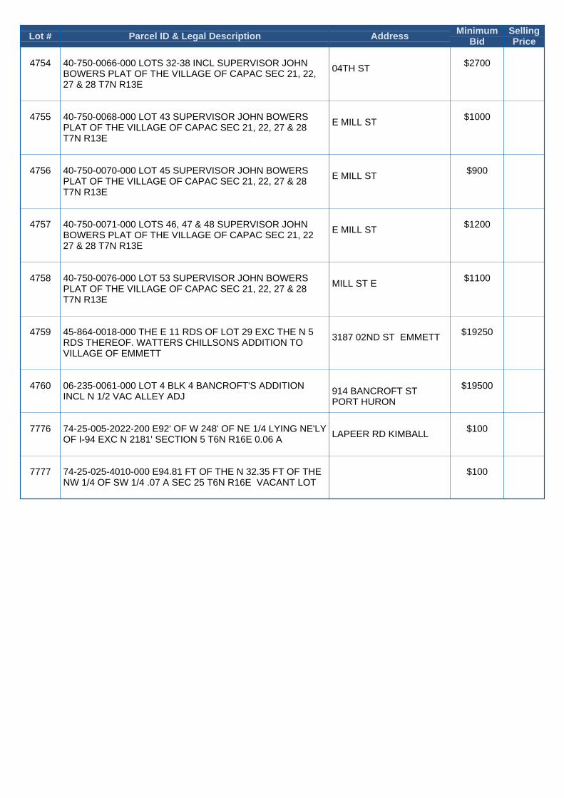
Lot # Parcel ID & Legal Description Address MinimumBid
SellingPrice
4754 40-750-0066-000 LOTS 32-38 INCL SUPERVISOR JOHNBOWERS PLAT OF THE VILLAGE OF CAPAC SEC 21, 22,27 & 28 T7N R13E
04TH ST $2700
4755 40-750-0068-000 LOT 43 SUPERVISOR JOHN BOWERSPLAT OF THE VILLAGE OF CAPAC SEC 21, 22, 27 & 28T7N R13E
E MILL ST $1000
4756 40-750-0070-000 LOT 45 SUPERVISOR JOHN BOWERSPLAT OF THE VILLAGE OF CAPAC SEC 21, 22, 27 & 28T7N R13E
E MILL ST $900
4757 40-750-0071-000 LOTS 46, 47 & 48 SUPERVISOR JOHNBOWERS PLAT OF THE VILLAGE OF CAPAC SEC 21, 2227 & 28 T7N R13E
E MILL ST $1200
4758 40-750-0076-000 LOT 53 SUPERVISOR JOHN BOWERSPLAT OF THE VILLAGE OF CAPAC SEC 21, 22, 27 & 28T7N R13E
MILL ST E $1100
4759 45-864-0018-000 THE E 11 RDS OF LOT 29 EXC THE N 5RDS THEREOF. WATTERS CHILLSONS ADDITION TOVILLAGE OF EMMETT
3187 02ND ST EMMETT $19250
4760 06-235-0061-000 LOT 4 BLK 4 BANCROFT'S ADDITIONINCL N 1/2 VAC ALLEY ADJ
914 BANCROFT ST PORT HURON
$19500
7776 74-25-005-2022-200 E92' OF W 248' OF NE 1/4 LYING NE'LYOF I-94 EXC N 2181' SECTION 5 T6N R16E 0.06 A
LAPEER RD KIMBALL $100
7777 74-25-025-4010-000 E94.81 FT OF THE N 32.35 FT OF THENW 1/4 OF SW 1/4 .07 A SEC 25 T6N R16E VACANT LOT
$100


Public Land Auction ABSENTEE BID FORM
Date: _______________________
Name: __________________________________
State Issued ID# _______________________________________
Address: ____________________________________ City______________________ State____ Zip_________
Email Address: ___________________________________________
Phone: ___________________________________
County parcel is in : ________________________ Street parcel is on : __________________________
Auction Lot#________________ Parcel ID # : _________________________________
Terms of Sale
It is agreed and understood that I am entering an absentee bid in the amount of $_________ for the
referenced parcel. If I am the high bidder at the end of the sale, I agree to consummate the purchase.
It is agreed and understood that in order to place this bid I will provide Title Check, LLC with a $1000
“hold” on a major credit card. If I fail to complete the sale I understand that I forfeit the $1000 to the
County Treasurer that the property belongs to, and the property is resold with no refund to me.
I understand that this property is being auctioned on www.tax-sale.info, and that I am bidding against
online bidders and other absentee bidders until such time as that online auction is completed.
THE FULL PURCHASE PRICE MUST BE PAID WITHIN FIVE DAYS AFTER THE END OF THE
SALE. The purchase price consists of the final bid price, plus a 13% buyer’s premium (with a 3%
discount when paying by Cash, Certified Checks, or Wire Transfer) plus a $20 processing fee. Payments
may be made as stated in the auction rules. The County Treasurer may prosecute any purchaser who
bounces a check or fails to consummate a purchase. Any bidder who fails to consummate a purchase will
be banned from bidding at al future land auctions. No purchases can be made on a time-payment plan.
I authorize Title Check, LLC to enter a bid on my behalf up to the amount stated above, in increments as
required by the Auction Rules.
I have read and agree to all the rules and regulations for this auction.
Card Type: ________________
Card Number: ____________________________________
CID: _________ Exp. Date: ______________
___________________________________ ________________
Signature Date

COMPLETED FORM MUST BE RECEIVED BY TITLE
CHECK, LLC AT 269.585.5993 AT LEAST 48 HOURS
BEFORE THE DAY OF THE AUCTION.
Need Help ? Call (800) 259.7470 or (269) 226.2600
Mail Forms to:
Title Check, LLC
622 Kalamazoo Ave.
Kalamazoo, MI 49007
Fax to:
269-585-5993
Email to (AT YOUR OWN RISK):
Please note that if your card is declined for any reason, or you absentee bid form is not
fully completed, your bid will not be entered. We apologize, but we cannot “track
down” bidders whose credit cards are declined, or do not provide the necessary
information.

DEEDING INFORMATION
This form is used to provide us with the names you would like to use for creating the DEED for the
property you buy today. This information is never sold or used for any other purpose. This form is
destroyed after data entry and verification.
A time-saving tip:
• You can eliminate data entry errors, and save time STANDING IN
LINE by entering this information ONLINE at http://www.tax-
sale.info.
Bidder Information:
Name:
Phone #:
Email:
Bidder #:
Property is to be deeded to :
Name: (Please use your FULL LEGAL NAMES and MIDDLE INITIAL. Do NOT use “nicknames”)
Street Address:
City, State, Zip:
Legal status: A Single Person
A Married Man
Husband and Wife A married woman taking title in her own name only (Married men take title with their wife under
law)
A (circle one):
• Corporation
• Limited Liability Company
• Partnership
• Trust
That is registered/recorded in the County of and State of .

IF THERE IS MORE THAN ONE DEED PARTY, PLEASE LIST OTHERS BELOW WITH NAME(S), ADDRESS, AND
LEGAL STATUS.
If there is more than one deed party (or married couple) you need to tell us your “tenancy” type in the
event of death (circle one):
• TENANTS IN COMMON: If one deed party dies, their “share” of the property passes to their
HEIRS under law.
• JOINT TENANTS: If one deed party dies, their “share” of the property automatically transfers to
the remaining deed parties.
• NOTE: Husband and wife are “Tenants by Entireties” under Michigan law and the deed rights of
one pass to the other automatically.
Additional parties (list all below):
• Name
• Address
• City, State, Zip Code
• Legal Status (see prior page)