pub. 113 list of lights - maritime safety information
TRANSCRIPT
PUB. 113
LIST OF LIGHTSRADIO AIDS AND FOG SIGNALS
2019
IMPORTANTTHIS PUBLICATION SHOULD BE CORRECTED
EACH WEEK FROM THE NOTICE TO MARINERS
THE WEST COASTS OF EUROPE AND AFRICA, THE MEDITERRANEAN SEA,
BLACK SEA AND AZOVSKOYE MORE (SEA OF AZOV)
Prepared and published by theNATIONAL GEOSPATIAL-INTELLIGENCE AGENCY
Springfield, VA
© COPYRIGHT 2019 BY THE UNITED STATES GOVERNMENT.NO COPYRIGHT CLAIMED UNDER TITLE 17 U.S.C.
For sale by the Superintendant of Documents, U.S. Government Printing Office

LIST OF LIGHTS LIMITSNATIONAL GEOSPATIAL-INTELLIGENCE AGENCY

WARNING ON USE OF FLOATING AIDS TO NAVIGATION TO FIX A NAVIGATIONAL POSITION
The aids to navigation depicted on charts comprise a system consisting of fixed and floating aids with varying degrees of reliability. Therefore, prudent mariners will not rely solely on any single aid to navigation, particularly a floating aid.
The buoy symbol is used to indicate the approximate position of the buoy body and the sinker which secures the buoy to the seabed. The approximate position is used because of practical limitations in positioning and maintaining buoys and their sinkers in precise geographical locations. These limitations include, but are not limited to, inherent imprecisions in position fixing methods, prevailing atmospheric and sea conditions, the slope of and the material making up the seabed, the fact that buoys are moored to sinkers by varying lengths of chain, and the fact that buoy and/or sinker positions are not under continuous surveillance but are normally checked only during periodic maintenance visits which often occur more than a year apart. The position of the buoy body can be expected to shift inside and outside the charting symbol due to the forces of nature. The mariner is also cautioned that buoys are liable to be carried away, shifted, capsized, sunk, etc. Lighted buoys may be extinguished or sound signals may not function as the result of ice or other natural causes, collisions, or other accidents.
For the foregoing reasons, a prudent mariner must not rely completely upon the position or operation of floating aids to navigation, but will also utilize bearings from fixed objects and aids to navigation on shore. Further, a vessel attempting to pass close aboard always risks collision with a yawing buoy or with the obstruction the buoy marks.

I
PREFACE
The 2019 edition of Pub. 113, List of Lights, Radio Aids and Fog Signals for the West Coasts of Europe and Africa, the Mediterranean Sea, Black Sea and Azovskoye More (Sea of Azov), cancels the previous edition of Pub. 113.
This edition contains information available to the National Geospatial-Intelligence Agency (NGA) up to 29 June 2019, including Notice to Mariners No. 26 of 2019.
A summary of corrections subsequent to the above date will be in Section II of the Notice to Mariners which announced the issuance of this publication.
In the interval between new editions, corrective information affecting this publication will be published in the Notice to Mariners and must be applied in order to keep this publication current.
Nothing in the manner of presentation of information in this publication or in the arrangement of material implies endorsement or acceptance by NGA in matters affecting the status and boundaries of States and Territories.
RECORD OF CORRECTIONS PUBLISHED IN WEEKLY NOTICE TO MARINERS
NOTICE TO MARINERS
YEAR 2019 YEAR 2020
1........ 14........ 27........ 40........ 1........ 14........ 27........ 40........
2........ 15........ 28........ 41........ 2........ 15........ 28........ 41........
3........ 16........ 29........ 42........ 3........ 16........ 29........ 42........
4........ 17........ 30........ 43........ 4........ 17........ 30........ 43........
5........ 18........ 31........ 44........ 5........ 18........ 31........ 44........
6........ 19........ 32........ 45........ 6........ 19........ 32........ 45........
7........ 20........ 33........ 46........ 7........ 20........ 33........ 46........
8........ 21........ 34........ 47........ 8........ 21........ 34........ 47........
9........ 22........ 35........ 48........ 9........ 22........ 35........ 48........
10........ 23........ 36........ 49........ 10........ 23........ 36........ 49........
11........ 24........ 37........ 50........ 11........ 24........ 37........ 50........
12........ 25........ 38........ 51........ 12........ 25........ 38........ 51........
13........ 26........ 39........ 52........ 13........ 26........ 39........ 52........

TABLE OF CONTENTS
III
Index Chartlet. . . . . . . . . . . . . . . . . . . . . . . . . . . . . . . . . . . . . . . . . . . . . . . . . . . . . . . . . . . . . . . . . . . . Back of front coverPreface and Record of Corrections Published in Weekly Notice to Mariners . . . . . . . . . . . . . . . . . . . . . . . . . . . . . . . . . IIntroduction . . . . . . . . . . . . . . . . . . . . . . . . . . . . . . . . . . . . . . . . . . . . . . . . . . . . . . . . . . . . . . . . . . . . . . . . . . . . . . . . . . VIIIALA Buoyage System . . . . . . . . . . . . . . . . . . . . . . . . . . . . . . . . . . . . . . . . . . . . . . . . . . . . . . . . . . . . . . . . . . . . . . . . VIIIMaritime Safety Website . . . . . . . . . . . . . . . . . . . . . . . . . . . . . . . . . . . . . . . . . . . . . . . . . . . . . . . . . . . . . . . . . . . . . . . . IXDescription (Lights, Buoys, RACONs, RAMARKs) . . . . . . . . . . . . . . . . . . . . . . . . . . . . . . . . . . . . . . . . . . . . . . . . . . .XICharacteristics of Lights . . . . . . . . . . . . . . . . . . . . . . . . . . . . . . . . . . . . . . . . . . . . . . . . . . . . . . . . . . . . . . . . . . . . . . . . XIINomenclature of Lights . . . . . . . . . . . . . . . . . . . . . . . . . . . . . . . . . . . . . . . . . . . . . . . . . . . . . . . . . . . . . . . . . . . . . . . XIVLightships, Superbuoys, and Offshore Light Stations . . . . . . . . . . . . . . . . . . . . . . . . . . . . . . . . . . . . . . . . . . . . . . . . XVIFog Signals . . . . . . . . . . . . . . . . . . . . . . . . . . . . . . . . . . . . . . . . . . . . . . . . . . . . . . . . . . . . . . . . . . . . . . . . . . . . . . . . .XVIIVisibility Table . . . . . . . . . . . . . . . . . . . . . . . . . . . . . . . . . . . . . . . . . . . . . . . . . . . . . . . . . . . . . . . . . . . . . . . . . . . . . XVIIIConversion Table — Feet to Whole Meters . . . . . . . . . . . . . . . . . . . . . . . . . . . . . . . . . . . . . . . . . . . . . . . . . . . . . . . . XIXRadiobeacons . . . . . . . . . . . . . . . . . . . . . . . . . . . . . . . . . . . . . . . . . . . . . . . . . . . . . . . . . . . . . . . . . . . . . . . . . . . . . . . . XXDescription (Radiobeacons) . . . . . . . . . . . . . . . . . . . . . . . . . . . . . . . . . . . . . . . . . . . . . . . . . . . . . . . . . . . . . . . . . . . .XXVTable of Symbols . . . . . . . . . . . . . . . . . . . . . . . . . . . . . . . . . . . . . . . . . . . . . . . . . . . . . . . . . . . . . . . . . . . . . . . . . . . XXVIDifferential Global Positioning System (DGPS) . . . . . . . . . . . . . . . . . . . . . . . . . . . . . . . . . . . . . . . . . . . . . . . . . . . XXIXDescription (Differential GPS Stations) . . . . . . . . . . . . . . . . . . . . . . . . . . . . . . . . . . . . . . . . . . . . . . . . . . . . . . . . . . .XXX
List of Lights for:
Section 1West Coast of France
France-West Coast . . . . . . . . . . . . . . . . . . . . . . . . . . . . . . . . . . . . . . . . . . . . . . . . . . . . . . . . . . . . . . . . . . . . . . . . . 1
Section 2North and West Coasts of Spain
Spain-North Coast . . . . . . . . . . . . . . . . . . . . . . . . . . . . . . . . . . . . . . . . . . . . . . . . . . . . . . . . . . . . . . . . . . . . . . . . 26Spain-West Coast . . . . . . . . . . . . . . . . . . . . . . . . . . . . . . . . . . . . . . . . . . . . . . . . . . . . . . . . . . . . . . . . . . . . . . . . 44
Section 3Portugal, Southwest Coast of Spain and Gibraltar
Portugal . . . . . . . . . . . . . . . . . . . . . . . . . . . . . . . . . . . . . . . . . . . . . . . . . . . . . . . . . . . . . . . . . . . . . . . . . . . . . . . . 52Spain-Southwest Coast . . . . . . . . . . . . . . . . . . . . . . . . . . . . . . . . . . . . . . . . . . . . . . . . . . . . . . . . . . . . . . . . . . . . 63Strait of Gibraltar-North Side . . . . . . . . . . . . . . . . . . . . . . . . . . . . . . . . . . . . . . . . . . . . . . . . . . . . . . . . . . . . . . . 69
Section 4Mediterranean Coast of SpainIncluding Balearic Islands
Spain-Mediterranean Sea . . . . . . . . . . . . . . . . . . . . . . . . . . . . . . . . . . . . . . . . . . . . . . . . . . . . . . . . . . . . . . . . 73, 96Spain-Islas Baleares . . . . . . . . . . . . . . . . . . . . . . . . . . . . . . . . . . . . . . . . . . . . . . . . . . . . . . . . . . . . . . . . . . . . . . . 83
Section 5Mediterranean Coast of France and Monaco
France-Mediterranean Sea . . . . . . . . . . . . . . . . . . . . . . . . . . . . . . . . . . . . . . . . . . . . . . . . . . . . . . . . . . . . . 113, 132Monaco . . . . . . . . . . . . . . . . . . . . . . . . . . . . . . . . . . . . . . . . . . . . . . . . . . . . . . . . . . . . . . . . . . . . . . . . . . . . . . . 132
Section 6Corsica, Sardinia and Northwest Coast of Italy
Italy-West Coast . . . . . . . . . . . . . . . . . . . . . . . . . . . . . . . . . . . . . . . . . . . . . . . . . . . . . . . . . . . . . . . . . . . . . . . . 134Corse (Corsica) (F.) . . . . . . . . . . . . . . . . . . . . . . . . . . . . . . . . . . . . . . . . . . . . . . . . . . . . . . . . . . . . . . . . . . . . . . 142Sardegna (Sardinia) (I.) . . . . . . . . . . . . . . . . . . . . . . . . . . . . . . . . . . . . . . . . . . . . . . . . . . . . . . . . . . . . . . . . . . . 146
Section 7West Coast of Italy and Sicily
Italy-West Coast and Adjacent Islands . . . . . . . . . . . . . . . . . . . . . . . . . . . . . . . . . . . . . . . . . . . . . . . . . . . . . . . 159Sicilia (Sicily) and Adjacent Islands (I.) . . . . . . . . . . . . . . . . . . . . . . . . . . . . . . . . . . . . . . . . . . . . . . . . . . . . . . 174

IV
Section 8Malta, South and East Coasts of Italy, and Slovenia
Malta and Ghawdex (Gozo) . . . . . . . . . . . . . . . . . . . . . . . . . . . . . . . . . . . . . . . . . . . . . . . . . . . . . . . . . . . . . . . 186Italy-Southeast Coast . . . . . . . . . . . . . . . . . . . . . . . . . . . . . . . . . . . . . . . . . . . . . . . . . . . . . . . . . . . . . . . . . . . . 187Italy-East Coast . . . . . . . . . . . . . . . . . . . . . . . . . . . . . . . . . . . . . . . . . . . . . . . . . . . . . . . . . . . . . . . . . . . . . . . . . 190Italy-Northeast Coast . . . . . . . . . . . . . . . . . . . . . . . . . . . . . . . . . . . . . . . . . . . . . . . . . . . . . . . . . . . . . . . . . . . . 199Slovenia . . . . . . . . . . . . . . . . . . . . . . . . . . . . . . . . . . . . . . . . . . . . . . . . . . . . . . . . . . . . . . . . . . . . . . . . . . . . . . 206
Section 9Croatia
Croatia . . . . . . . . . . . . . . . . . . . . . . . . . . . . . . . . . . . . . . . . . . . . . . . . . . . . . . . . . . . . . . . . . . . . . . . . . . . . . . . . 208
Section 10Montenegro, Albania, and South and West Coasts of GreeceIncluding Peleponnisos
Montenegro . . . . . . . . . . . . . . . . . . . . . . . . . . . . . . . . . . . . . . . . . . . . . . . . . . . . . . . . . . . . . . . . . . . . . . . . . . . . 248Albania . . . . . . . . . . . . . . . . . . . . . . . . . . . . . . . . . . . . . . . . . . . . . . . . . . . . . . . . . . . . . . . . . . . . . . . . . . . . . . . 248Greece-West Coast-Ionioi Nisoi (Ionian Islands) . . . . . . . . . . . . . . . . . . . . . . . . . . . . . . . . . . . . . . . . . . . . . . . 250Greece . . . . . . . . . . . . . . . . . . . . . . . . . . . . . . . . . . . . . . . . . . . . . . . . . . . . . . . . . . . . . . . . . . . . . . . . . . . . . . . . 263
Section 11Kikladhes Islands, Crete and East Coast of Greece
Greece-Kikladhes . . . . . . . . . . . . . . . . . . . . . . . . . . . . . . . . . . . . . . . . . . . . . . . . . . . . . . . . . . . . . . . . . . . . . . . 272Greece-Kriti (Crete) . . . . . . . . . . . . . . . . . . . . . . . . . . . . . . . . . . . . . . . . . . . . . . . . . . . . . . . . . . . . . . . . . . . . . 279Greece . . . . . . . . . . . . . . . . . . . . . . . . . . . . . . . . . . . . . . . . . . . . . . . . . . . . . . . . . . . . . . . . . . . . . . . . . . . . . . . . 282
Section 12Northeastern Aegean Sea, Sea of Marmara, Bulgaria, Romania and UkraineIncluding Dardanelles and Bosporus
Greece-Turkey . . . . . . . . . . . . . . . . . . . . . . . . . . . . . . . . . . . . . . . . . . . . . . . . . . . . . . . . . . . . . . . . . . . . . . . . . 297Turkey . . . . . . . . . . . . . . . . . . . . . . . . . . . . . . . . . . . . . . . . . . . . . . . . . . . . . . . . . . . . . . . . . . . . . . . . . . . . . . . . 299Turkey-Black Sea . . . . . . . . . . . . . . . . . . . . . . . . . . . . . . . . . . . . . . . . . . . . . . . . . . . . . . . . . . . . . . . . . . . . . . . 314Bulgaria . . . . . . . . . . . . . . . . . . . . . . . . . . . . . . . . . . . . . . . . . . . . . . . . . . . . . . . . . . . . . . . . . . . . . . . . . . . . . . . 314Romania . . . . . . . . . . . . . . . . . . . . . . . . . . . . . . . . . . . . . . . . . . . . . . . . . . . . . . . . . . . . . . . . . . . . . . . . . . . . . . 316Ukraine . . . . . . . . . . . . . . . . . . . . . . . . . . . . . . . . . . . . . . . . . . . . . . . . . . . . . . . . . . . . . . . . . . . . . . . . . . . . . . . 317Azovskoye More (Sea of Azov) . . . . . . . . . . . . . . . . . . . . . . . . . . . . . . . . . . . . . . . . . . . . . . . . . . . . . . . . . . . . 326
Section 13Russia, Georgia, Turkey and Islands of the Eastern Aegean SeaIncluding Dhodhekanisos
Russia . . . . . . . . . . . . . . . . . . . . . . . . . . . . . . . . . . . . . . . . . . . . . . . . . . . . . . . . . . . . . . . . . . . . . . . . . . . . . . . . 329Georgia . . . . . . . . . . . . . . . . . . . . . . . . . . . . . . . . . . . . . . . . . . . . . . . . . . . . . . . . . . . . . . . . . . . . . . . . . . . . . . . 333Turkey-Black Sea . . . . . . . . . . . . . . . . . . . . . . . . . . . . . . . . . . . . . . . . . . . . . . . . . . . . . . . . . . . . . . . . . . . . . . . 335Turkey-Greece . . . . . . . . . . . . . . . . . . . . . . . . . . . . . . . . . . . . . . . . . . . . . . . . . . . . . . . . . . . . . . . . . . . . . . . . . 342Greece-Dhodhekanisoi . . . . . . . . . . . . . . . . . . . . . . . . . . . . . . . . . . . . . . . . . . . . . . . . . . . . . . . . . . . . . . . . . . . 356Turkey-South Coast . . . . . . . . . . . . . . . . . . . . . . . . . . . . . . . . . . . . . . . . . . . . . . . . . . . . . . . . . . . . . . . . . . . . . 359
Section 14Cyprus, Syria, Lebanon, Israel, Egypt, Libya and Tunisia
Cyprus . . . . . . . . . . . . . . . . . . . . . . . . . . . . . . . . . . . . . . . . . . . . . . . . . . . . . . . . . . . . . . . . . . . . . . . . . . . . . . . . 368Syria . . . . . . . . . . . . . . . . . . . . . . . . . . . . . . . . . . . . . . . . . . . . . . . . . . . . . . . . . . . . . . . . . . . . . . . . . . . . . . . . . 370Lebanon . . . . . . . . . . . . . . . . . . . . . . . . . . . . . . . . . . . . . . . . . . . . . . . . . . . . . . . . . . . . . . . . . . . . . . . . . . . . . . 371Israel . . . . . . . . . . . . . . . . . . . . . . . . . . . . . . . . . . . . . . . . . . . . . . . . . . . . . . . . . . . . . . . . . . . . . . . . . . . . . . . . . 373Egypt . . . . . . . . . . . . . . . . . . . . . . . . . . . . . . . . . . . . . . . . . . . . . . . . . . . . . . . . . . . . . . . . . . . . . . . . . . . . . . . . . 375Libya . . . . . . . . . . . . . . . . . . . . . . . . . . . . . . . . . . . . . . . . . . . . . . . . . . . . . . . . . . . . . . . . . . . . . . . . . . . . . . . . . 378Tunisia . . . . . . . . . . . . . . . . . . . . . . . . . . . . . . . . . . . . . . . . . . . . . . . . . . . . . . . . . . . . . . . . . . . . . . . . . . . . . . . 384

V
Section 15Algeria and Morocco
Algeria . . . . . . . . . . . . . . . . . . . . . . . . . . . . . . . . . . . . . . . . . . . . . . . . . . . . . . . . . . . . . . . . . . . . . . . . . . . . . . . 392Morocco . . . . . . . . . . . . . . . . . . . . . . . . . . . . . . . . . . . . . . . . . . . . . . . . . . . . . . . . . . . . . . . . . . . . . . . . . . . . . . 399
Section 16Islands of the Eastern North Atlantic
Acores (Azores) (P.) . . . . . . . . . . . . . . . . . . . . . . . . . . . . . . . . . . . . . . . . . . . . . . . . . . . . . . . . . . . . . . . . . . . . . 408Arquipelago da Madeira (Madeira Islands) (P.) . . . . . . . . . . . . . . . . . . . . . . . . . . . . . . . . . . . . . . . . . . . . . . . . 415Islas Canarias (Canary Islands) (S.) . . . . . . . . . . . . . . . . . . . . . . . . . . . . . . . . . . . . . . . . . . . . . . . . . . . . . . . . . 416Arquipelago de Cabo Verde (Cape Verde Islands) . . . . . . . . . . . . . . . . . . . . . . . . . . . . . . . . . . . . . . . . . . . . . 426
Section 17West Coast of Africa and Islands of The Eastern North Atlantic
Western Sahara . . . . . . . . . . . . . . . . . . . . . . . . . . . . . . . . . . . . . . . . . . . . . . . . . . . . . . . . . . . . . . . . . . . . . . . . . 430Mauritania . . . . . . . . . . . . . . . . . . . . . . . . . . . . . . . . . . . . . . . . . . . . . . . . . . . . . . . . . . . . . . . . . . . . . . . . . . . . . 431Senegal . . . . . . . . . . . . . . . . . . . . . . . . . . . . . . . . . . . . . . . . . . . . . . . . . . . . . . . . . . . . . . . . . . . . . . . . . . . 432, 433The Gambia . . . . . . . . . . . . . . . . . . . . . . . . . . . . . . . . . . . . . . . . . . . . . . . . . . . . . . . . . . . . . . . . . . . . . . . . . . . 433Guinea . . . . . . . . . . . . . . . . . . . . . . . . . . . . . . . . . . . . . . . . . . . . . . . . . . . . . . . . . . . . . . . . . . . . . . . . . . . . . . . . 434Sierra Leone . . . . . . . . . . . . . . . . . . . . . . . . . . . . . . . . . . . . . . . . . . . . . . . . . . . . . . . . . . . . . . . . . . . . . . . . . . . 435Liberia . . . . . . . . . . . . . . . . . . . . . . . . . . . . . . . . . . . . . . . . . . . . . . . . . . . . . . . . . . . . . . . . . . . . . . . . . . . . . . . . 436Ivory Coast . . . . . . . . . . . . . . . . . . . . . . . . . . . . . . . . . . . . . . . . . . . . . . . . . . . . . . . . . . . . . . . . . . . . . . . . . . . . 437Ghana . . . . . . . . . . . . . . . . . . . . . . . . . . . . . . . . . . . . . . . . . . . . . . . . . . . . . . . . . . . . . . . . . . . . . . . . . . . . . . . . 438Togo . . . . . . . . . . . . . . . . . . . . . . . . . . . . . . . . . . . . . . . . . . . . . . . . . . . . . . . . . . . . . . . . . . . . . . . . . . . . . . . . . 439Benin . . . . . . . . . . . . . . . . . . . . . . . . . . . . . . . . . . . . . . . . . . . . . . . . . . . . . . . . . . . . . . . . . . . . . . . . . . . . . . . . . 439Nigeria . . . . . . . . . . . . . . . . . . . . . . . . . . . . . . . . . . . . . . . . . . . . . . . . . . . . . . . . . . . . . . . . . . . . . . . . . . . . . . . 440Cameroon . . . . . . . . . . . . . . . . . . . . . . . . . . . . . . . . . . . . . . . . . . . . . . . . . . . . . . . . . . . . . . . . . . . . . . . . . 441, 444Offshore Islands . . . . . . . . . . . . . . . . . . . . . . . . . . . . . . . . . . . . . . . . . . . . . . . . . . . . . . . . . . . . . . . . . . . . . . . . 442Equatorial Guinea . . . . . . . . . . . . . . . . . . . . . . . . . . . . . . . . . . . . . . . . . . . . . . . . . . . . . . . . . . . . . . . . . . . . . . . 444Gabon . . . . . . . . . . . . . . . . . . . . . . . . . . . . . . . . . . . . . . . . . . . . . . . . . . . . . . . . . . . . . . . . . . . . . . . . . . . . . . . . 445Congo . . . . . . . . . . . . . . . . . . . . . . . . . . . . . . . . . . . . . . . . . . . . . . . . . . . . . . . . . . . . . . . . . . . . . . . . . . . . . . . . 446Cabinda . . . . . . . . . . . . . . . . . . . . . . . . . . . . . . . . . . . . . . . . . . . . . . . . . . . . . . . . . . . . . . . . . . . . . . . . . . . . . . . 447Zaire . . . . . . . . . . . . . . . . . . . . . . . . . . . . . . . . . . . . . . . . . . . . . . . . . . . . . . . . . . . . . . . . . . . . . . . . . . . . . . . . . 447Angola . . . . . . . . . . . . . . . . . . . . . . . . . . . . . . . . . . . . . . . . . . . . . . . . . . . . . . . . . . . . . . . . . . . . . . . . . . . . . . . . 447Namibia . . . . . . . . . . . . . . . . . . . . . . . . . . . . . . . . . . . . . . . . . . . . . . . . . . . . . . . . . . . . . . . . . . . . . . . . . . . . . . . 450South Africa . . . . . . . . . . . . . . . . . . . . . . . . . . . . . . . . . . . . . . . . . . . . . . . . . . . . . . . . . . . . . . . . . . . . . . . . . . . 451South Atlantic Islands . . . . . . . . . . . . . . . . . . . . . . . . . . . . . . . . . . . . . . . . . . . . . . . . . . . . . . . . . . . . . . . . . . . . 455
Section 18Radiobeacons
Croatia . . . . . . . . . . . . . . . . . . . . . . . . . . . . . . . . . . . . . . . . . . . . . . . . . . . . . . . . . . . . . . . . . . . . . . . . . . . . . . . . 457Malta . . . . . . . . . . . . . . . . . . . . . . . . . . . . . . . . . . . . . . . . . . . . . . . . . . . . . . . . . . . . . . . . . . . . . . . . . . . . . . . . . 457Greece . . . . . . . . . . . . . . . . . . . . . . . . . . . . . . . . . . . . . . . . . . . . . . . . . . . . . . . . . . . . . . . . . . . . . . . . . . . . . . . . 457Ukraine . . . . . . . . . . . . . . . . . . . . . . . . . . . . . . . . . . . . . . . . . . . . . . . . . . . . . . . . . . . . . . . . . . . . . . . . . . . . . . . 457Turkey . . . . . . . . . . . . . . . . . . . . . . . . . . . . . . . . . . . . . . . . . . . . . . . . . . . . . . . . . . . . . . . . . . . . . . . . . . . . . . . . 457Syria - Israel . . . . . . . . . . . . . . . . . . . . . . . . . . . . . . . . . . . . . . . . . . . . . . . . . . . . . . . . . . . . . . . . . . . . . . . . . . . 458Egypt . . . . . . . . . . . . . . . . . . . . . . . . . . . . . . . . . . . . . . . . . . . . . . . . . . . . . . . . . . . . . . . . . . . . . . . . . . . . . . . . . 458Libya . . . . . . . . . . . . . . . . . . . . . . . . . . . . . . . . . . . . . . . . . . . . . . . . . . . . . . . . . . . . . . . . . . . . . . . . . . . . . . . . . 458Tunisia . . . . . . . . . . . . . . . . . . . . . . . . . . . . . . . . . . . . . . . . . . . . . . . . . . . . . . . . . . . . . . . . . . . . . . . . . . . . . . . 458Azores . . . . . . . . . . . . . . . . . . . . . . . . . . . . . . . . . . . . . . . . . . . . . . . . . . . . . . . . . . . . . . . . . . . . . . . . . . . . . . . . 458Cape Verde . . . . . . . . . . . . . . . . . . . . . . . . . . . . . . . . . . . . . . . . . . . . . . . . . . . . . . . . . . . . . . . . . . . . . . . . . . . . 458Africa - West Coast . . . . . . . . . . . . . . . . . . . . . . . . . . . . . . . . . . . . . . . . . . . . . . . . . . . . . . . . . . . . . . . . . . . . . 458Angola . . . . . . . . . . . . . . . . . . . . . . . . . . . . . . . . . . . . . . . . . . . . . . . . . . . . . . . . . . . . . . . . . . . . . . . . . . . . . . . . 459

VI
Section 19Differential GPS Stations
Egypt . . . . . . . . . . . . . . . . . . . . . . . . . . . . . . . . . . . . . . . . . . . . . . . . . . . . . . . . . . . . . . . . . . . . . . . . . . . . . . . . . 461
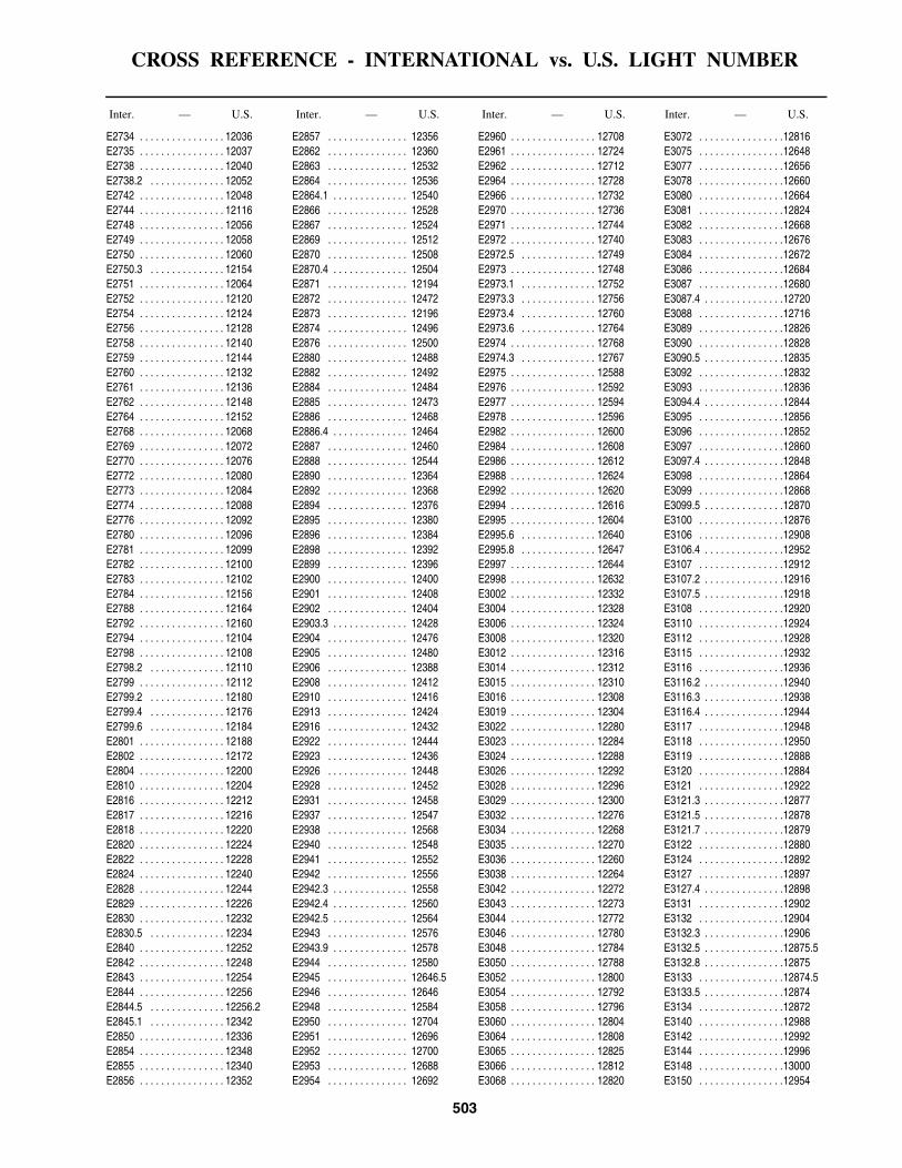
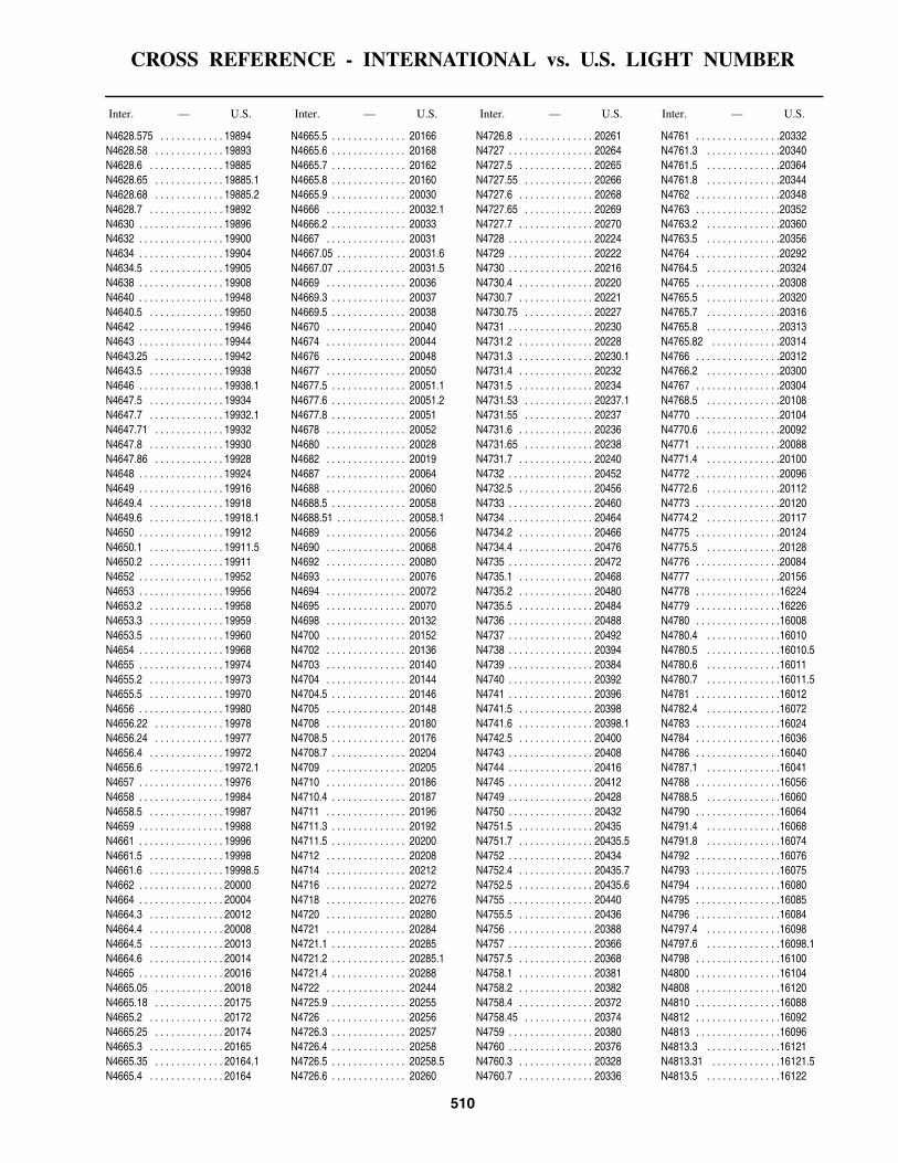
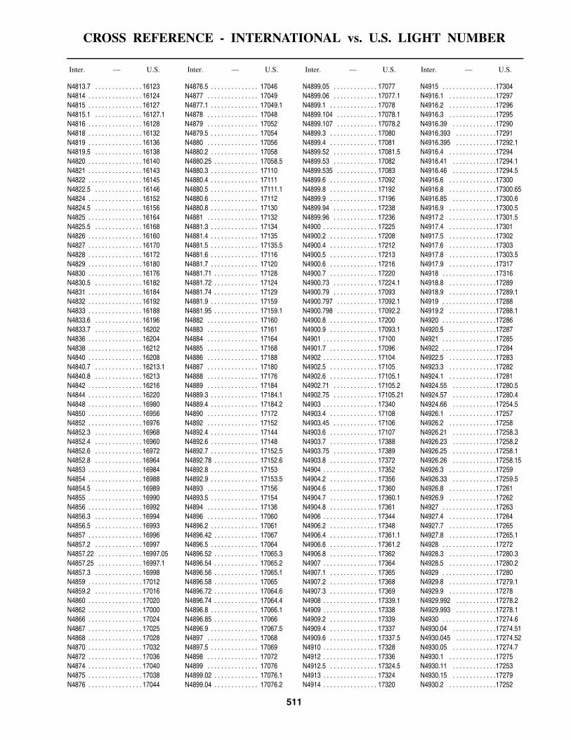
Index-Lights . . . . . . . . . . . . . . . . . . . . . . . . . . . . . . . . . . . . . . . . . . . . . . . . . . . . . . . . . . . . . . . . . . . . . . . . . . . . . . . . . 463Index-Radiobeacons . . . . . . . . . . . . . . . . . . . . . . . . . . . . . . . . . . . . . . . . . . . . . . . . . . . . . . . . . . . . . . . . . . . . . . . . . . . 483Index-Differential GPS Beacons . . . . . . . . . . . . . . . . . . . . . . . . . . . . . . . . . . . . . . . . . . . . . . . . . . . . . . . . . . . . . . . . . . 485Cross Reference-International vs. U.S. Light Number . . . . . . . . . . . . . . . . . . . . . . . . . . . . . . . . . . . . . . . . . . . . . . . . . 487

VII
INTRODUCTION
The National Geospatial-Intelligence Agency publishes a List of Lights, Radio Aids and Fog Signals in seven vol-umes divided geographically as shown on the index chart-let on the inside front cover of this book. Major fixed and outermost floating aids to navigation, such as sea buoys, safety fairway buoys, traffic separation buoys, etc., are listed. Other floating aids are not generally listed. Storm signals, signal stations, radio direction finders, radiobea-cons, RACONs and RAMARKs located at or near lights are found in this List. Radiobeacons are listed in a separate section in the back of this publication.
The date to which this publication has been corrected can be found in the Preface. In the interval between new editions, corrective information affecting this publication will be published in Section II of Notice to Mariners, and must be applied to keep this publication current. All of these corrections should be applied in the appropriate places and their insertion noted in the “Record of Correc-tions.”
Mariners and other users are requested to forward new or corrective information useful in the correction of this publication to:
MARITIME SAFETY OFFICEN64-SFHNATIONAL GEOSPATIAL-INTELLIGENCE AGENCY7500 GEOINT DRIVESPRINGFIELD VA 22150-7500

VIII
IALA BUOYAGE SYSTEM

IX
THE NATIONAL GEOSPATIAL-INTELLIGENCE AGENCYMARITIME SAFETY WEBSITE
The National Geospatial-Intelligence Agency (NGA) Maritime Safety Website provides worldwide remote query access to extensive menus of maritime safety information 24 hours a day.
Databases made available for access, query and download include Chart Corrections, Publication Corrections, NGA Hydrographic Catalog Corrections, Chart and Publication Reference Data (current edition number, dates, title, scale), NGA List of Lights, USCG Light Lists, WorldWide Navigational Warning Service (WWNWS) Broadcast Warnings, Maritime Administration (MARAD) Advisories, Department of State Special Warnings, Mobile Offshore Drilling Units (MODUs), Anti-Shipping Activity Messages (ASAMs), World Port Index, and Radio Navigational Aids. Publications that are also made available as PDF files include the U.S. Notice to Mariners, U.S. Chart No. 1, The American Practical Navigator (Bowditch), International Code of Signals, Radio Navigational Aids, World Port Index, Distances Between Ports, Sight Reduction Tables for Marine and Air Navigation, and the Radar Navigation and Maneuvering Board Manual.
The Maritime Safety Website can be accessed via the NGA Homepage (www.nga.mil) under the Products and Services link or directly at https://msi.nga.mil/NGAPortal/MSI.portal. Any questions concerning the Maritime Safety Website should be directed to:
MARITIME SAFETY OFFICEATTN: NSS STAFFN64-SFHNATIONAL GEOSPATIAL-INTELLIGENCE AGENCY7500 GEOINT DRIVESPRINGFIELD, VA 22150-7500
Telephone: (1) 571-557-7103 or DSN 547-7103E-mail: [email protected]

XI
DESCRIPTION
(Lights, Buoys, RACONs, RAMARKs)
Information is tabulated in eight columns as follows:Column 1: The number assigned to each light, RACON
or RAMARK by this Agency. International numbers arelisted below this number in italic type and in a crossreference in the back of the book. RACONs andRAMARKs located at a light are listed with the light.Those not located at a light are assigned separate numbers.
Column 2: Name and descriptive location of the lightor buoy, RACON or RAMARK. A dash (-) or dashes (--)in this column is used to reduce repetition of principalgeographic names. This column is intended to describe thelocation of the navigational aid and to distinguish it fromothers in proximity. Differences in type indicate thefollowing:
Bold-faced: Lights intended for landfall or having avisibility (range) of 15 miles or more.
Italics: Floating aids.ITALICS CAPITALS: Lightships and LANBYs.Roman: All other lights not mentioned above.Column 3: Approximate latitude and longitude of a
navigational aid to the nearest tenth of a minute, intendedto facilitate chart orientation (use column 2 and theappropriate chart for precise positioning).
Column 4: Light, buoy, RACON or RAMARKcharacteristic (see Characteristics of Lights chart forexplanation of lights).
Column 5: Height of light in feet (Roman type)equivalent measurement (below) given in meters(Bold-faced type).
Column 6: Range. The distance, expressed in nauticalmiles, that a light can be seen in clear weather or that aRACON or RAMARK can be received.
Column 7: Description of the structure and its height infeet.
Note–Stripes are vertical. Bands are horizontal. The use of the term “diagonal stripes” is the exception.
Column 8: Remarks–sectors, fog signals, radarreflectors, minor lights close by, radiobeacons, stormsignals, signal stations, radio direction finders, and otherpertinent information.
Geographic names or their spellings do not necessarily reflect recognition of the political status of an area by the
United States Government.The names of lights may differ from geographic names
on charts.
ABBREVIATIONS
Where the lights of different countries intermingle in the list they are distinguished by the following letters:
Other abbreviations:
(A.) Albania (L.) Liberia
(Bu.) Bulgaria (P.) Portugal
(E.) Egypt (Ro.) Romania
(F.) France (S.) Spain
(Gr.) Greece (T.) Turkey
(I.) Italy (U.K.) United Kingdom
Al.—alternating lt.—lit
bl.—blast Mo.—Morse code
Bu.—blue min.—minute
Dir.—directional obsc.—obscured
ec.—eclipsed Oc.—occulting
ev.—every Or.—orange
F.—fixed Q.—quick flashing
Fl.—flashing R.—red
fl.—flash s.—seconds
G.—green si.—silent
horiz.—horizontal U.Q.—ultra quick flashingintens.—intensified
I.Q.— interrupted quick flashing
unintens.—unintensified
vert.—vertical
Iso.—isophase Vi.—violet
I.V.Q.—interrupted very quick flashing
vis.—visible
V.Q.— very quick flashingKm.— kilometer
(0.62137 mile) W.—white
L.Fl.—long flashing Y.—yellow

XII
CHARACTERISTICS OF LIGHTS
TYPE ABBR. GENERAL DESCRIPTION ILLUSTRATION
Fixed F. A continuous and steady light.
Occulting Oc. The total duration of light in a period islonger than the total duration of darknessand the intervals of darkness (eclipses) areusually of equal duration. Eclipseregularly repeated.
Group occulting Oc.(2) An occulting light for which a group ofeclipses, specified in number, is regularlyrepeated.
Composite group occulting
Oc.(2+1) A light similar to a group occulting lightexcept that successive groups in a periodhave different numbers of eclipses.
Isophase Iso. A light for which all durations of light anddarkness are clearly equal.
Flashing Fl. A light for which the total duration of lightin a period is shorter than the totalduration of darkness and the appearancesof light (flashes) are usually of equalduration (at a rate of less than 50 flashesper minute).
Long flashing L.Fl. A single flashing light for which anappearance of light of not less than 2 sec.duration (long flash) is regularly repeated.
Group flashing Fl.(3) A flashing light for which a group offlashes, specified in number, is regularlyrepeated.
Composite group flashing
Fl.(2+1) A light similar to a group flashing lightexcept that successive groups in a periodhave different numbers of flashes.
Quick flashing Q. A light for which a flash is regularlyrepeated at a rate of not less than 50flashes per minute but less than 80 flashesper minute.
Group quick flashing Q.(3) A light for which a specified group offlashes is regularly repeated; flashes arerepeated at a rate of not less than 50flashes per minute but less than 80 flashesper minute.
Q.(9)
Q.(6)+L.Fl.
XIII
Interrupted quick flashing
I.Q. A light for which the sequence of quickflashes is interrupted by regularly repeatedeclipses of constant and long duration.
Very quick flashing
V.Q. A light for which a flash is regularlyrepeated at a rate of not less than 80flashes per minute but less than 160flashes per minute.
Group very quick flashing
V.Q.(3) A light for which a specified group of veryquick flashes is regularly repeated.
V.Q.(9)
V.Q.(6)+L.Fl.
Interrupted very quick flashing
I.V.Q. A light for which the sequence of veryquick flashes is interrupted by regularlyrepeated eclipses of constant and longduration.
Ultra quick flashing
U.Q. A light for which a flash is regularlyrepeated at a rate of not less than 160flashes per minute.
Interrupted ultra quick flashing
I.U.Q. A light for which the sequence of ultraquick flashes is interrupted by regularlyrepeated eclipses of constant and longduration.
Morse code Mo.(U) A light for which appearances of light oftwo clearly different durations are groupedto represent a character or characters inMorse Code.
Fixed and flashing F.Fl. A light for which a fixed light is combinedwith a flashing light of greater luminousintensity.
Alternating light Al. A light showing different colorsalternately.
NOTE - Alternating lights may be used in combined form with most of the previous types of lights.
TYPE ABBR. GENERAL DESCRIPTION ILLUSTRATION

XIV
NOMENCLATURE OF LIGHTS
Lights exhibit a distinctive appearance by which they are recognized, e.g. Fixed, Flashing, Group Flashing, etc. The properties of their appearance, by which they are dis-tinguished, are referred to as the characteristics of the light. The principal characteristics are generally the sequence of intervals of light and darkness, and, in some cases, the sequence of colors of light exhibited.
Fixed lights—those which exhibit a continuous steady light.
Rhythmic lights—those which exhibit a sequence of intervals of light and eclipse (repeated at regular intervals) in a manner described in Chart No. 1 and this volume.
Alternating lights—rhythmic lights which exhibit dif-ferent colors during each sequence.
Period of a light—the time occupied by an entire cycle of intervals of light(s) and eclipse(s).
Range: Meteorological visibility—the greatest distance at which a black object of suitable dimensions can be seen and recognized against the horizon sky or, in the case of night observations, could be seen and recognized if the general illumination were raised to the normal daylight level.
Luminous range of a light—the greatest distance at which a light can be seen merely as a function of its lumi-nous intensity, the meteorological visibility, and the sensi-tivity of the observer’s eyes.
Nominal range of the light—the luminous range of a light in a homogeneous atmosphere in which the meteoro-logical visibility is 10 nautical miles.
Geographical range of a light—the greatest distance at which a light can be seen as a function of the curvature of the earth, the height of the light source and the height of the observer.
The visibility of a light is usually the distance that it can be seen in clear weather and is expressed in nautical miles. Visibilities listed are values received from foreign sources.
Range lights—two or more lights at different elevations, so situated to form a range (leading line) when brought into transit. The light nearest the observer is the front light and the one farthest from the observer is the rear light. The front light is normally at a lower elevation than the rear light.
Directional lights—lights illuminating a sector of very narrow angle and intended to mark a direction to be fol-lowed.
Vertical lights—Two or more lights disposed vertically or geometrically to form a triangle, square, or other figure. If the individual lights serve different purposes, those of lesser importance are called Auxiliary lights.
Occasional lights—lights exhibited only when specially
needed:(a) Tidal light—shown at the entrance of a harbor, to
indicate tide and tidal current conditions within the harbor.(b) Fishing light—for the use of fishermen and shown
when required.(c) Private light—maintained by a private authority
for its own purposes. The mariner should exercise special caution when using a private light for general navigation.
Seasonal lights—usually shown only during the naviga-tion season or for a lesser time period within that season.
Articulated lights—offshore aids to navigation consist-ing of a length of pipe attached directly to a sinker by means of a pivot or such other device employing the prin-ciple of the universal joint. The positional integrity is intermediary between that of a buoy and a fixed aid.
Aeronautical lights—lights of high intensity which may be the first lights observed at night from vessels approach-ing the coast. Those lights situated near the coast are listed in the List of Lights in order that the navigator may be able to obtain more information concerning their description.
These lights are not designed or maintained for marine navigation and they are subject to change without prompt notification.
These lights are indicated in this List by the designation AVIATION LIGHT and are placed in geographical sequence in the body of the text along with lights for sur-face navigation.
Aeromarine lights—marine-type lights for which part of the beam is deflected to an angle of 10 to 15 degrees above the horizon to facilitate use by aircraft.
Sector limits and arcs of visibility—these are arranged clockwise and are given from seaward toward the light. Thus, in the diagram, the sectors of the light are defined as: obscured from shore to 302°, red to 358°, green to 052°, white to shore. These are bearings of the light as seen from a vessel crossing the sector lines.
Under some conditions of the atmosphere, white lights may have a reddish hue. The mariner should not judge solely by color where there are sectors but should verify this position by taking a bearing of the light. On either side of the line of demarcation between white and red there is always a small sector of uncertain color, as the edges of a sector of visibility cannot be clearly defined.
When a light is obscured by adjoining land and the arc of visibility is given, the bearing on which the light disap-pears may vary with the distance from which it is observed. When the light is cut off by a sloping point of land or hill, the light may be seen over a wider arc by a ship farther off than by one closer.
Bearings—all bearings are true, measured clockwise from 000°, and given in degrees or degrees and minutes.

XV

XVI
LIGHTSHIPS, SUPERBUOYS, AND OFFSHORE LIGHT STATIONS
Courses should be set to pass all floating aids to naviga-tion with sufficient clearance to avoid the possibility of collision from any cause. Experience shows that floating aids to navigation cannot be safely used as leading marks to be passed close aboard, but should always be left broad off the course, whenever searoom permits.
When approaching a lightship, superbuoy, or a station on a submarine site on radio bearings, the risk of collision will be avoided by insuring that the radio bearing does not remain constant.
Most lightships and large buoys are anchored with a very long scope of chain and, as a result, the radius of their swinging circle is considerable. The charted position is the location of the anchor. Furthermore, under certain condi-tions of wind and current, they are subject to sudden and unexpected sheers which are certain to hazard a vessel attempting to pass close aboard.
During extremely heavy weather and due to their exposed locations, lightships may be carried off station. The mariner should, therefore, not implicitly rely on a lightship maintaining its precisely charted position during and immediately following severe storms. A lightship known to be off station will secure her light, fog signal, and radiobeacon and fly the International Code signal “LO” signifying “I am not in my correct position.”
Russian lightships are on station during periods of navi-gation and leave their stations only when forced to because of ice and are then replaced as soon as possible. Lightships by day show a ball over a yellow flag with a blue St. George's cross. if a vessel is seen standing into danger the signal “NF” of the International Code of Signals is hoisted, and if not immediately seen, rockets with two explosions and bright stars may be fired every minute: by night the rockets only are used.
When not on their proper stations, the light vessels dis-continue their characteristic lights and fog signals and, if possible, will lower their daymarks. They will show instead two black balls, one forward and one aft, or two red lights, one forward and one aft. In addition they will hoist the International Code signal “LO” or will show a
red and a white flare-up light or flash simultaneously at least every 15 minutes.
Red flags in place of the black balls and red and a white light shown simultaneously may be used in place of the flare-up light or flash.
A lightship under way shows the same lights and makes the same sound signals as other vessels under way and, if preceding under its own power, hoists two black balls, one forward and one aft.
Relief lightships are painted red, with two masts. By day they display a red ball at each mast, and by night exhibit a fixed red light from the same positions. Fog signals are sounded and the warning signals described above are employed.
Fog bells at Russian lighthouses and lightships are sounded, unless stated otherwise, in the following uniform manner:
(a) at lighthouses: in groups of double strokes, theinterval between the groups being not more than 3minutes.
(b) at lightships: in groups of triple strokes, the intervalbetween the groups being not more than 2 minutes.
When the fog signal of an approaching vessel is heard, the intervals between the double and triple strokes in the groups are reduced and the bell is sounded continuously in double or triple strokes until the vessel is past the light or clear of danger.
Due to a lack of information it is not possible to ensure that the details of navigational aids are correct.
In France, Lebanon and Tunisia lights may be shown by day in poor visibility.
In Spain and Morocco lights are shown from 15 minutes after sunset until 15 minutes before sunrise.
Oil rigs in Angolan waters marked by Mo(U) W 18s Siren 20s are moored inside the 600 fathom contour. Such lights are not included in this list.
It has been reported that the lights of Guinea and Liberia are unreliable.

XVII
FOG SIGNALS
The function of a fog signal in the system of aids to nav-igation is to warn of danger and to provide the mariner with an audible means of approximating his position rela-tive to the fog signal when the station, or any visual signal which it displays, is obscured from view by atmospheric conditions.
Fog signals depend upon the transmission of sound through air. As aids to navigation, they have certain inher-ent defects that should be considered. Sound travels through the air in a variable and frequently unpredictable manner.
It has been established that:fog signals are heard at greatly varying distances and
that the distance at which a fog signal can be heard may vary with the bearing of the signal and may be different on different occasions;
under certain conditions of atmosphere, when a fog sig-nal has a combination of high and low tones, it is not unusual for one of the tones to be inaudible. In the case of sirens, which produce a varying tone, portions of the blast may not be heard;
there are occasionally areas close to the signal in which it is wholly inaudible. This is particularly true when the fog signal is screened by intervening land or other obstruc-tions;
fog may exist a short distance from a station and not be observable from it, so that the signal may not be in opera-tion;
even though a fog signal may not be heard from the deck or bridge of a ship when the engines are in motion, it may be heard when the ship is stopped, or from a quiet position. Sometimes it may be heard from aloft though not on deck;
the intensity of the sound emitted by a fog signal may be greater at a distance than in immediate proximity.
All these considerations point to the necessity for the utmost caution when navigating near land in fog. Particu-lar attention should be given to placing lookouts in posi-tions in which the noises in the ship are least likely to interfere with hearing a fog signal. Fog signals are valu-able as warnings, but the mariner should not place implicit reliance upon them in navigating his vessel. They should be considered solely as warning devices.
Among the devices in common use as fog signals are:Radiobeacons which broadcast simple dot-and-dash
combinations by means of a transmitter emitting modu-lated continuous waves;
Diaphones which produce sound by means of a slotted reciprocating piston actuated by compressed air. Blasts
may consist of two tones of different pitch, in which case the first part of the blast is high and the last of a low pitch. These alternate pitch signals are called “two-tone;”
Diaphragm horns which produce sound by means of a diaphragm vibrated by compressed air, steam, or electric-ity. Duplex or triplex horn units of differing pitch produce a chime signal;
Nautophones, electrically operated instruments, each comprising a vibrating diaphragm, fitted with a horn, which emits a high note similar in power and tone to that of the reed;
Reed horns which produce sound by means of a steel reed vibrator by compressed air;
Sirens which produce sound by means of either a disk or a cup-shaped rotor actuated by compressed air or electric-ity;
Whistles which produce sound by compressed air emit-ted through a circumferential slot into a cylindrical bell chamber;
Bells which are sounded by means of a hammer actu-ated by hand, wave motion, by a descending weight, com-pressed gas, or electricity;
Guns and explosive signals which are produced by fir-ing of explosive charges, the former being discharged from a gun, and the latter being exploded in midair;
Fog Detector Lights—certain light stations, in addition to the main light, are equipped with fog detector lights for automatic detection of fog. These lights sweep back and forth through an area over which the fog watch is neces-sary, showing a powerful bluish-white flash of about 1 second in duration. The interval between successive flashes will vary with the position of the vessel within the sector. At the limits of the sector the duration of the flash may be considerably longer than 1 second.
Fog detector lights operate continuously.Standby fog signals are sounded at some of the light and
fog signal stations when the main fog signal is inoperative. Some of these standby fog signals are of a different type and characteristic than the main fog signal.
Radiobeacons, RACONs, RAMARKs, and radio direc-tion-finders are mentioned in the List of Lights, but for detailed information, including the synchronization of radio signals and sound signals for distance finding, the navigator should consult Pub. 117, Radio Navigational Aids.
Note—use Chart No. 1 for the complete list of symbolsand abbreviations commonly used in presenting theessential characteristics of lights, fog signals, and radioaids found on charts.

XVIII
VISIBILITY TABLE
Explanation.—The line of sight connecting the observer and a distant object is at maximum length tangent with the spherical surface of the sea. It is from this point of tangency that the tabular distances are calculated. The table must accordingly be entered twice to obtain the actual geographic visibility of the object—first with the height of the object, and second with the height of the observer’s eye—and the two figures so obtained must be added. Thus, if it is desired to find the maximum distance
at which a powerful light may be seen from the bridge of a vessel where the height of eye of the observer is 55 feet above the sea, from the table:
Nautical Miles55 feet height of observer (visible). . . . . . . . . . . . . 8.7200 feet height of light (visible) . . . . . . . . . . . . . . 16.5Distance visible . . . . . . . . . . . . . . . . . . . . . . . . . . 25.2
Table of distances at which objects can be seen at sea according to their respective elevations and the elevation of the eye of the observer.
Height in Feet
Distance in geographic or nautical
miles
Height in feet
Distance in geographic or nautical
miles
Height in feet
Distance in geographic or nautical
miles
Height in feet
Distance in geographic or nautical
miles
Height in feet
Distance in geographic or nautical
miles
Height in feet
Distance in geographic or nautical
miles
1 1.2 23 5.6 45 7.8 135 13.6 340 21.6 600 28.7
2 1.7 24 5.7 46 7.9 140 13.8 350 21.9 620 29.1
3 2.0 25 5.9 47 8.0 145 14.1 360 22.2 640 29.5
4 2.3 26 6.0 48 8.1 150 14.3 370 22.5 660 30.1
5 2.6 27 6.1 49 8.2 160 14.8 380 22.8 680 30.5
6 2.9 28 6.2 50 8.3 170 15.3 390 23.1 700 31.0
7 3.1 29 6.3 55 8.7 180 15.7 400 23.4 720 31.4
8 3.3 30 6.4 60 9.1 190 16.1 410 23.7 740 31.8
9 3.5 31 6.5 65 9.4 200 16.5 420 24.0 760 32.3
10 3.7 32 6.6 70 9.8 210 17.0 430 24.3 780 32.7
11 3.9 33 6.7 75 10.1 220 17.4 440 24.5 800 33.1
12 4.1 34 6.8 80 10.5 230 17.7 450 24.8 820 33.5
13 4.2 35 6.9 85 10.8 240 18.1 460 25.1 840 33.9
14 4.4 36 7.0 90 11.1 250 18.5 470 25.4 860 34.3
15 4.5 37 7.1 95 11.4 260 18.9 480 25.6 880 34.7
16 4.7 38 7.2 100 11.7 270 19.2 490 25.9 900 35.1
17 4.8 39 7.3 105 12.0 280 19.6 500 26.2 920 35.5
18 5.0 40 7.4 110 12.3 290 19.9 520 26.7 940 35.9
19 5.1 41 7.5 115 12.5 300 20.3 540 27.2 960 36.3
20 5.2 42 7.6 120 12.8 310 20.6 560 27.7 980 36.6
21 5.4 43 7.7 125 13.1 320 20.9 580 28.2 1000 37.0
22 5.5 44 7.8 130 13.3 330 21.3

XIX
CONVERSION TABLE — FEET TO WHOLE METERS
(FOR HEIGHTS OF LIGHTS)1 foot = 0.3048 meter
Feet Meters Feet Meters Feet Meters Feet Meters Feet Meters Feet Meters
40 12 80 24 120 37 160 49 200 611 0 41 12 81 25 121 37 161 49 300 912 1 42 13 82 25 122 37 162 49 400 1223 1 43 13 83 25 123 37 163 50 500 1524 1 44 13 84 26 124 38 164 50 600 183
5 2 45 14 85 26 125 38 165 50 700 2136 2 46 14 86 26 126 38 166 51 800 2447 2 47 14 87 27 127 39 167 51 900 2748 2 48 15 88 27 128 39 168 51 1000 3059 3 49 15 89 27 129 39 169 52
10 3 50 15 90 27 130 40 170 5211 3 51 16 91 28 131 40 171 5212 4 52 16 92 28 132 40 172 5213 4 53 16 93 28 133 41 173 5314 4 54 16 94 29 134 41 174 53
15 5 55 17 95 29 135 41 175 5316 5 56 17 96 29 136 41 176 5417 5 57 17 97 30 137 42 177 5418 5 58 18 98 30 138 42 178 5419 6 59 18 99 30 139 42 179 55
20 6 60 18 100 30 140 43 180 5521 6 61 19 101 31 141 43 181 5522 7 62 19 102 31 142 43 182 5523 7 63 19 103 31 143 44 183 5624 7 64 20 104 32 144 44 184 56
25 8 65 20 105 32 145 44 185 5626 8 66 20 106 32 146 45 186 5727 8 67 20 107 33 147 45 187 5728 9 68 21 108 33 148 45 188 5729 9 69 21 109 33 149 45 189 58
30 9 70 21 110 34 150 46 190 5831 9 71 22 111 34 151 46 191 5832 10 72 22 112 34 152 46 192 5933 10 73 22 113 34 153 47 193 5934 10 74 23 114 35 154 47 194 59
35 11 75 23 115 35 155 47 195 5936 11 76 23 116 35 156 48 196 6037 11 77 23 117 36 157 48 197 6038 12 78 24 118 36 158 48 198 6039 12 79 24 119 36 159 48 199 61

XX
RADIOBEACONS
RADIO DIRECTION-FINDER SETS ON SHIPS
Radio direction-finder sets on board ship enable bear-ings to be taken of transmissions from other ships, aircraft, shore stations, marine radiobeacons, and the coastal sta-tions of the radio communication network. When located in the pilothouse or on the navigating bridge, the direc-tion-finder enables the navigating officer to obtain bear-ings himself without reference to others and without delay.
Due to the great value of radio bearings, particularly when visibility is poor and when celestial observations cannot be obtained, the radio direction-finder on board ship deserves the same consideration and care as are given to the sextant and compass. It has the following character-istics in common with the two latter navigational instru-ments: the readings are subject to certain errors; these errors may be reduced by skillful and intelligent operation; the dangers of using erroneous readings may be greatly reduced by the intelligence and good judgment of the mar-iner. In order to acquire experienced judgment in the oper-ation of the instrument, it is essential that the mariner use it as much as practicable.
Troubles from interference and weak signals are greatly reduced by the use of direction-finders of proper selectiv-ity. The bearings must be corrected for radio deviation as shown by the calibration curve of the set.
Types of Radiobeacons
1. Directional radiobeacons which transmit radio waves in beams along fixed bearings.
2. Rotating radiobeacons by which a beam of radio waves is resolved in azimuth in a manner similar to the beam of light sent out by rotating lights.
3. Circular radiobeacons which send out waves of approximately uniform strength in all directions so that ships may take radio bearings of them by means of the ship’s radio direction-finder sets. This is the most common type of radiobeacon.
To extend the usefulness of marine radiobeacons to ships and aircraft employing automatic radio direction finders, U.S. marine radiobeacons on the Atlantic and Pacific Coasts and Great Lakes have been modified to transmit a continuous carrier signal during the entire radio-beacon operating period with keyed modulation providing the characteristic signal. Unless a beat frequency oscillator is installed, the continuous carrier signals are not audible to the operator of an aural null direction finder. A ten sec-ond dash has been included in the characteristic of these radiobeacons, to enable the navigator using a conventional aural null direction finder to refine his bearing. Vessels with direction finders will be able to use the United States
radiobeacons located on the Atlantic and Pacific Coasts, and Great Lakes at any time in their assigned sequence.
Aeronautical Radio Aids
Aeronautical radiobeacons and radio ranges are often used by navigators of marine craft in the same manner as marine radiobeacons are used for determining lines of positions. They are particularly useful along coasts where marine broadcast coverage is inadequate. Aeronautical aids situated inland become less trustworthy, so far as ships are concerned, when high land intervenes between them and the coast. They are established to be of primary usefulness to aircraft, and surface craft should use these aids with caution. Only those aeronautical radiobeacons considered to be of use to the mariner have been selected for inclusion in this publication.
AERONAUTICAL RADIOBEACONS. Like marineradiobeacons, these aids broadcast a characteristic signalon a fixed frequency.
NOTE: The assigned frequency of aeronauticalradiobeacons is normally from 200 to 415 kHz while thefrequency of marine radiobeacons is normally from 285 to325 kHz. Aeronautical radiobeacons not within the marineradiobeacon band will not normally be listed in thispublication.
The range signals are interrupted at intervals to permit broadcast of the identification signal. In aviation publica-tions the range leg bearings are most often given as mag-netic bearings toward the station; in this publication they are given as true bearings toward the station. Unless other-wise stated in the station details, aeronautical radio aids mentioned in this publication transmit continuously.
NOTE: Mariners are advised that changes to anddeficiencies in aeronautical radio facilities are not alwaysimmediately available to maritime interests and thepositions are approximate and listed to the nearest minuteonly.
Obligations of Administrations Operating Radiobeacons
The obligations of nations and other administrations operating radiobeacons are given in Article 43 of the Radio Regulations of the International Telecommunica-tion Union, Geneva.
Accuracy of Bearings Taken Aboard Ship
No exact rules can be given as to the accuracy to be expected in radio bearings taken by a ship as the accuracy depends to a large extent upon the skill of the ship’s oper-ator, the condition of the ship’s equipment, and the accu-

XXI
racy of the ship’s calibration curve. Mariners are urged to obtain this information by taking frequent radio bearings when their ship’s position is accurately known and by recording the results. Normally, United States radiobea-cons are operated in a group of six, each station in a group using the same frequency and transmitting for one minute in its proper sequence, and operate during all periods, either sequenced or continuously, regardless of weather conditions.
SKILL OF OPERATOR: Skill in the operation of theradio direction-finder can be obtained only by practice andby observing the technical instructions for the set inquestion. For these reasons the operator should carefullystudy the instructions issued with the set and shouldpractice taking bearings frequently.
OPERATOR’S ERROR: As the operator obtainsbearings by revolving the direction-finder coil until thesignal disappears or becomes a minimum, the operator cantell by the size of the arc of silence or of minimum strengthapproximately how accurately the bearing has been taken.For instance, if the minimum is broad and the residualsignal covers about 10° with equal strength, it is doubtful ifthe bearing can be accurately estimated. On the other hand,if a sharp minimum can be obtained, the operator candetermine the bearing to within a half of a degree.
In this connection it should be noted that a properly operating and correctly adjusted direction-finder should in no case produce other than a point or arc of absolute silence. That is, there should be no “residual” signal at the point or arc of observation. The sharpness and complete-ness of the arc of silence are the best indications of a prop-erly operating direction-finder, and their absence is the best indication of the presence of “night effect.”
SUNRISE, SUNSET, OR NIGHT EFFECT: Bearingsobtained from about half an hour before sunset to abouthalf an hour after sunrise may be subject to errors dueto night effect. On some nights this effect is morepronounced than on others and effect is usually greatestduring the hours of twilight. Night effect may bedetected by a broadening of the arc of minimum signalsand by a fluctuation in the strength of the signals. Itmay also be indicated by difficulty in obtaining aminimum or by a rapidly shifting minimum. It issometimes accompanied by an actual shift in thedirection of the bearings. If it is essential to obtain abearing when the night effect is pronounced, severalbearings should be taken over a short period of time andan average taken of them.
RADIO DIRECTION FINDER WITHOUT GYRO REPEATERS: The ship’s compass must be read as the bearing is taken or an error may be introduced equal to the amount that the ship has yawed in the interval between taking the bearing and reading the compass. Any error in the ship’s compass must be applied to the bearing.
RECIPROCAL BEARINGS: In some direction-findersets, the operator cannot tell from which side of the shipthe signals are coming. With these sets the operator shallcorrect both bearings for their respective deviations andgive both corrected bearings to the person who is plottingthe bearings on the chart. If the mariner is in doubt as tothe side of the ship from which the bearings are coming,this difficulty can usually be solved by having anotherbearing taken after the ship has steamed a short distanceand noting in which direction the bearing is changing.
CALIBRATION: It is essential that the radiodirection-finder be accurately calibrated in order that thebearings may be corrected for deviation. While thebearings are being taken, other radio antennas on boardmust be in the same condition as they were when thecalibration was made; movable parts of the ship’ssuperstructure such as booms, davits, wire rigging, etc.,must be secured in the positions which they occupiedwhen the direction-finder was calibrated. Unusual cargoessuch as large quantities of metals and extraordinaryconditions of loading may cause errors.
The direction-finder should be recalibrated after any changes have been made in the set or its surroundings (this includes alterations to or changes in position of antennas, wire rigging, boat davits, booms, etc.) whenever there is reason to believe that the previous calibration has become inaccurate, and also at periodic intervals.
The calibration must be made on approximately the same frequency or frequencies as will be used to take bear-ings because the deviation for several frequencies is not likely to be the same. It is believed that one calibration curve is satisfactory for the normal radiobeacon frequency (285 to 325 kHz), but the instructions issued by the manu-facturer of the particular direction-finder in question should be studied in this connection.
To facilitate the calibration of ship’s direction-finders, special arrangements have been made by some services for operation of their radiobeacons at times other than their published schedules. Information as to the arrangements made by the United States stations in this respect is as fol-lows:
Sequenced radiobeacons cannot broadcast at any time other than on their assigned operating minute for the pur-pose of enabling vessels to calibrate their radio direction finders without causing interference. Special radio direc-tion finder calibration transmitters of short range are oper-ated at certain localities to provide continuous calibration service.
The position given for the antenna is the point from which the radiobeacon signal is emitted.
If it is not practicable to determine the time of calibra-tion sufficiently in advance to contact the district com-mander, request may be made directly to the stations by means of telephone, telegraph, or a whistle signal consist-ing of three long blasts; followed by three short blasts.

XXII
This whistle signal is to be repeated until it is acknowl-edged by the station through the starting of the transmitter. The same group of signals should be sounded at the termi-nation of calibration.
The work of the station personnel is not confined to standing watch and there may be times when the whistle request for calibration is not immediately heard, due to the noise from operating station machinery, etc. Usually, a repeated signal not too far from the station will attract attention.
“COMPENSATED” RADIO DIRECTION-FINDERS:Many radio direction-finders are “compensated” and nocalibration chart or curve is used. Attention is invited tothe fact that such compensation is just as vulnerable as thecalibration data due to changes made in the set or itssurroundings.
CHECK THE CALIBRATION: The calibration ofcompensation should be checked frequently by takingbearings when the ship’s position is accurately known andthe results should be recorded for future reference.
CALIBRATION RADIOBEACONS: In the UnitedStates and certain other areas special radiobeacons,primarily for calibrating shipboard direction-finders are inoperation. These radiobeacons transmit eithercontinuously during scheduled hours or upon request, asindicated in station details.
COASTAL REFRACTION (OR LAND EFFECT):Errors may occur in bearings taken by ships so located thatthe line of observation to the radiobeacon passes over landor along the shore line. However, many observations seemto indicate that such errors are negligible when theobserving vessel is well out from the shore. Bearingssecured entirely over water areas are to be preferred since“land effect” is thus eliminated. Bearings taken at sunsetand sunrise are likely to be erratic, and observations takenat these hours should therefore be repeated and checked asmay be feasible.
PROGRAM BROADCASTING STATIONS: Beforetaking bearings on a station broadcasting entertainmentprograms a mariner should consider that frequency maydiffer widely from the frequency for which the set iscalibrated, that the published location of the station maybe that of its studio and not that of its transmitting antenna,that if the station is synchronized with other stations itmay be impossible to tell on which station the bearing wastaken, and that as the majority of these stations are inland,the coastal refraction may be excessive.
Station Details
FREQUENCY: The frequency listed is that used by thestation in transmitting its “Characteristic Signal.” Callingfrequencies, if any, will be given under “remarks.”
RANGE: In this book the range of radiobeacons is onlyapproximate and is given merely to assist mariners in
planning their voyages and to inform them of severalradiobeacons they will probably hear first. Frequently,when conditions for radio reception are good,radiobeacons may be heard at greater distances thanindicated. The mariner who is at a greater distance than therange indicated should attempt to obtain bearings whennecessary, and not assume that the radiobeacon will beunheard beyond its indicated range.
GROUP SEQUENCE: Selected radiobeacons aregrouped together on the same operating frequency and areassigned a specific sequence of transmission within thisgroup. This reduces station interference and unnecessaryreturning.
ANTENNA LEAD-IN: Included in the details of manyradiobeacons located at or near light stations is a statementof the distance and bearing of the radiobeacon transmittingantenna from the light tower. Use should be made of thisinformation when calibrating the ship’s direction-findingequipment by means of simultaneous visual and radiobearings.
Plotting Radio Bearings
The procedure for converting radio (great circle) bear-ings as received by direction-finder equipment aboard ship is identical with that used in converting radio bearings supplied by direction-finder stations on shore and is described in section 100E “Plotting Radio Bearings” of Pub. 117, Radio Navigational Aids.
Synchronization for Distance Finding
At some radiobeacon stations, sound signals, either sub-marine or air or both, are synchronized with the radiobea-con signals for distance finding. Ordinarily, the sound signals do not operate during the transmission period of the radio signal in clear weather. The methods in use employ, as a rule, distinctive signals to indicate the point of synchronization, and make use, for determining dis-tance, of the lag of signals traveling through air or water as compared to the practically instantaneous travel of the radio signals.
In the case of some sound signals, a series of short radio dashes is transmitted at intervals following the synchroniz-ing point, so that by counting the number of such short dashes heard after the distinctive radio signal and before hearing the corresponding distinctive sound signal, the observer obtains the distance, in miles equal to the number of dashes counted, from the sound signal apparatus unless stated otherwise.
In the case of other signals, the observer notes the num-ber of seconds intervening between the reception of the distinctive radio signal and the corresponding sound signal and uses a factor to determine distances in miles as fol-lows:

XXIII
Submarine signals–multiply the observed numbers of seconds by 0.8 or divide by 1.25 distance in nautical miles.
Air signals–multiply the observed number of seconds by 0.18 or divide by 5.5. For more approximate results or for statute miles, multiply the observed number of seconds by 0.2 or divide by 5.
REMARKS: Average speed of sound travel in water is 1nautical mile in 11/4 seconds.
The speed of sound travel is influenced by a number of conditions making it impracticable to state a factor that will give exact results under all conditions. The results obtained by the methods described may be accepted as being accurate to within 10 percent of the distance.
Methods of synchronizing the signals vary and are described or illustrated in official announcements regard-ing them. It is essential to note carefully the point of syn-chronization used so that no error will be made through taking time on the wrong signal or the wrong part of it.
In observing air signals it is usually sufficient to use a watch with second hand, although a stop watch is helpful. For submarine signals where the interval is shorter and a time error correspondingly more important, it is essential that a stop watch or other timing device be used. Where the radiobeacon and submarine signals are not received at the same point on the vessel, means of instant communica-tion between two observers should be available or syn-chronized stop watches provided for each.
Ships not equipped with a DF receiver can take advan-tage of the distance-finding feature of a radiobeacon sta-tion, if equipped with a radio receiver capable of receiving
the transmission. In the case of obtaining distance from a radiobeacon station which is synchronized with a subma-rine sound signal, the ship must also be equipped with a device for picking up submarine sound signals.
Rotating Loop Radiobeacon
MODE OF OPERATION: (1) The radiobeacon consists of a rotating loop trans-
mitter having directional properties by which an observer in a ship can obtain his bearing from the beacon without the use of a direction-finder. Any ordinary receiving set capable of being tuned to the radiobeacon’s frequency may be used. The only other equipment required is a reli-able stop watch or chronograph with a sweep second hand. Stop watches and clocks with dials graduated in degrees may be used, from which bearings may be read directly without any mathematical calculation.
(2) During each revolution of the beacon, the signals received by the observer will rise and fall in intensity, passing through a maximum and a minimum twice each minute. The positions of minimum intensity, which occur at intervals of thirty seconds from one another, are very sharp and can be accurately observed. These are, there-fore, used for navigation purposes.
The beacon may be regarded as having a line or beam of minimum intensity which rotates at a uniform speed of 360° in 1 minute (i.e. 6° in 1 second) based on the true meridian as starting point. Therefore, if the observer can (a) identify the beacon and (b) measure the number of sec-onds which this minimum beam takes to reach their posi-tion starting from the true meridian, this number multiplied by six will give their true bearing from the bea-con or its reciprocal.
The signals which enable the beacon to be identified and the bearing to be calculated are described in the fol-lowing paragraphs:
Signals transmitted by the beacon: Each transmission from the beacon lasts for 4 minutes; the beacon is then silent for 8 minutes, and automatically starts again at the end of the silent period. Each transmission consists of two parts: (a) the identification signal of the station set at a slow speed for the first minute, commencing when the minimum beam is true east and west and followed by a long dash of about 12 seconds duration; (b) the signal group commencing when the minimum beam is approaching the true meridian, and consisting of (i) the north starting signal, which is the letter V followed by two dots (••• – ••); (ii) a long dash of about 12 seconds duration; (iii) the east starting signal, which is the letter B followed by two dots (– ••• ••); and (iv) a long dash for about 42 seconds.
The navigation signals are repeated during the remain-der of the transmission and signals cease when the mini-mum beam is in the east and west position.
Tables for finding distance
Interval in seconds
Distances in nautical miles from sound signal source
Air Submarine
1 0.18 0.82 0.36 1.63 0.54 2.44 0.72 3.25 0.90 4.06 1.08 4.87 1.26 5.68 1.44 6.49 1.62 7.210 1.80 8.020 3.60 16.030 5.40 24.040 7.2050 9.0060 10.80
XXIV
INSTRUCTIONS FOR TAKING BEARINGS
(i) Set stop watch to zero.(ii) Listen for identification signal.(iii) When the first long dash begins (at A on
diagram) get ready for the “north signal.”(iv) After the “north signal,” start stop watch exactly
at beginning of long dash (see “00 seconds” ondiagram) counting one-two with the twopreceding dots, and 3 for the start of the stopwatch.
(v) Listen for minimum and note its exact time bystop watch.
NOTE: If stop watch is graduated in degrees note exact angle, which is the bearing.(vi) Multiply number of seconds by 6° for bearing.(vii) Determine whether bearing is direct or
reciprocal.(viii) If the “north signal” is faint, use the “east signal,”
but add 090° to final bearing.Particular attention is directed to the following:(a) The stop watch must be started exactly at the
beginning of the long dash for each series of observations.(b) The time of occurrence of the minimum must be
read to the nearest fifth of a second.(c) The bearing obtained will be either the direct
bearing or its reciprocal.(d) When using the east signal, add 090° to obtain
bearings from true north.(e) The beacon is set up on the true meridian, and no
correction is required for magnetic variation.(f) No quadrantal error arises, and no corrections are
necessary except as in (c) and (d) above.(A correction must, of course, be made for convergency;
this should be applied as if the beacon were a shore radio direction-finder station.)
(g) A comparatively large error of bearing may occurdue to inaccuracy in the stop watch, and to obviate this,
observers or navigators should check their stop watches onthe beacon station before taking bearings. This can easilybe done by checking the time by stop watch of thecomplete revolution of the beacon transmission. Any errorfound can then be allowed for.
Caution
Due to the many factors which enter into the transmis-sion and reception of radio signals, a mariner cannot prac-tically estimate its distance from a radiobeacon either by the strength of the signals received or by the time at which the signals were first heard. Mariners should give this fact careful consideration in approaching radiobeacons. A dia-gram showing the signals used is given below.
ROTATING RADIOBEACON SIGNAL DIAGRAM

XXV
DESCRIPTION
(Radiobeacons)
Information is tabulated in eight columns as follows:
Column 1: The number assigned to each radiobeacon bythis Agency.
Column 2: Name and/or descriptive location of theradiobeacon.
Column 3: Approximate latitude and longitude of theradiobeacon to the nearest tenth of a minute.
Column 4: Radiobeacon characteristics. Included in thiscolumn are the Morse code, period in seconds, length oftransmission and silence time.
Column 5: Range (approximate) in nautical miles.
Column 6: Group sequence. Selected radiobeacons aregrouped together on the same operating frequency and areassigned a specific sequence of transmission within thisgroup. This reduces station interference and unnecessaryreturn.
Column 7: Frequency (given in kilohertz) and amplitudemodulation (see Table Symbols).
Column 8: Remarks. Transmission synchronization, typeof radiobeacon (marine, aero, etc.), calibration, antennalead-in, calling frequencies, distance-finding information,service charges, hours of transmission, directional signalsand other pertinent information.
ABBREVIATIONS
aero . . . . . . . . . . . . . . . . . . . . . . . . . . . . aeronauticaltr . . . . . . . . . . . . . . . . . . . . . . . . . . . . . transmission si . . . . . . . . . . . . . . . . . . . . . . . . . . . . . . . . . . silence s . . . . . . . . . . . . . . . . . . . . . . . . . . . . . . . . . . seconds(4) . . . . . . . . . . . . . . . . . . . . . . . . . . . . . . . . . 4 times Transmission is continuous unless otherwise stated.

XXVI
TABLE OF SYMBOLS
LEGEND
(1) Type of modulation of the main carrier.(2) Nature of signal(s) modulating the main carrier. (3) Type of “information” to be transmitted. “Information” does not include information of a constant, unvarying naturesuch as provided by standard frequency emissions, continuous wave and pulse radars, etc.
AMPLITUDE MODULATION:
N0N
(1) Emission of an unmodulated carrier.(2) No modulating signal. (3) No information transmitted.
A1A
(1) Double-sideband. (2) Single channel containing quantized or digital information without the use of a modulating subcarrier. (3) Telegraphy (for aural reception).
A2A
(1) Double-sideband. (2) Single channel containing quantized or digital information with the use of a modulating subcarrier. (3) Telegraphy (for aural reception).
A3E
(1) Double-sideband. (2) Single channel containing analog information. (3) Telephony (including sound broadcasting).
R3E
(1) Single-sideband (reduced or variable level carrier).(2) Single channel containing analog information. (3) Telephony (including sound broadcasting).
B8E
(1) Independent sidebands.(2) Two or more channels containing analog information.(3) Telephony (including sound broadcasting).
H2A
(1) Single-sideband (full carrier). (2) Single channel containing quantized or digital information with the use of a modulating subcarrier. (3) Telegraphy (for aural reception).

XXVII
H3E
(1) Single-sideband (full carrier). (2) Single channel containing analog information. (3) Telephony (including sound broadcasting).
J3E
(1) Single-sideband (suppressed carrier). (2) Single channel containing analog information.(3) Telephony (including sound broadcasting).
A3C
(1) Double-sideband. (2) Single channel containing analog information.(3) Facsimile.
A3F
(1) Double-sideband. (2) Single channel containing analog information.(3) Television (video).
B7D
(1) Independent sidebands. (2) Two or more channels containing quantized or digital information.(3) Data transmissions, telemetry, telecommand.
Note: With 6 kHz. EDW operation in the bands below 30 MHz allocated exclusively for Maritime Mobile Service (FC, MO).
FREQUENCY (OR PHASE) MODULATION:
F1B
(1) Frequency modulation. (2) Single channel containing quantized or digital information without the use of a modulating subcarrier. (3) Telegraphy (for automatic reception).
F2A
(1) Frequency modulation.(2) Single channel containing quantized or digital information with the use of a modulating subcarrier. (3) Telegraphy (for aural reception).
F3E
(1) Frequency modulation.(2) Single channel containing analog information. (3) Telephony (including sound broadcasting).

XXVIII
F3C
(1) Frequency modulation. (2) Single channel containing analog information.(3) Facsimile.
F3F
(1) Frequency modulation. (2) Single channel containing analog information.(3) Television (video).
P1B
(1) Sequence of unmodulated pulses. (2) Single channel containing quantized or digital information without the use of a modulating subcarrier. (3) Telegraphy (for automatic reception).
Pulse Modulation:GHz = gigahertzkHz = kilohertzMHz = megahertz

XXIX
DIFFERENTIAL GLOBAL POSITIONING SYSTEM (DGPS)
Differential Global Positioning System (DGPS) is aradio-based navigation system that eliminates errors in aGPS receiver that will allow the accuracy level to be sig-nificantly enhanced. DGPS accuracy can be 10 meters orbetter, compared with 100 meters or better with GPS. Thisis possible by placing a high-performance GPS receiver(reference station) at a known location. Because thereceiver knows its exact location, it can determine theerrors in the satellite signals. The satellite measures theranges to each satellite using the signals received and com-paring these measured ranges to the actual ranges calcu-lated from its known position. The total error is thedifference between the measured and calculated range.The error data for each tracked satellite is formatted into acorrection message and transmitted to GPS users. The cor-rection message format follows the standard establishedby the Radio Technical Commission for Maritime Ser-vices, Special Committee 104 (RTCM-SC104). These dif-ferential corrections are then applied to the GPScalculations, thus removing most of the satellite signalerror and improving accuracy.
Terms for understanding DGPS:
DGPS Correction Receiver
A DGPS correction receiver decodes the signalsreceived from a reference site. Data is formatted into aserial RTCM SC104 data stream and provided to theremote GPS receiver. There are many types of DGPS cor-rection receivers.
GPS Receivers
The GPS receiver measures ranges to each satellite, butbefore the measurements are used to calculate position,corrections received from the DGPS receiver are appliedto the measurements. The position is then calculated usingthe corrected range measurements providing vastlyincreased accuracy.
Modulator
Depending on the transmission format, the modulatorencodes the data as necessary for transmission.
Reference Station
The reference station GPS receiver knows exactly theposition of its antenna, therefore it knows what each satel-lite range measurement should be. It measures the rangesto each satellite using the received signals just as if it wasgoing to calculate position. The measured ranges are sub-tracted from the known ranges and the result is rangeerror. The range error values for each satellite are format-ted into messages in the RTCM SC104 format and trans-mitted continuously.
Transmitter
The transmitter is basically a power amplifier which isconnected to an antenna system. The modulated carrier isamplified and driven to the antenna. In the United StatesCoast Guard system, the transmitter is 250-1000 Wattsand operates in the 300Khz frequency range. The ampli-fied signal is radiated via the antenna to remote DGPSreceivers for real-time position correction.

XXX
DESCRIPTION
(Differential GPS Stations)
Information is tabulated in eight columns as follows:
Column 1: The number assigned to each DGPS Station bythis Agency.
Column 2: Name of the DGPS Station
Column 3: Approximate latitude and longitude of theDGPS Transmitting Station to the nearest tenth of aminute.
Column 4: Station ID which can be found in the IALAMaster list. No two stations have the same ID. T denotesthe Transmitting Station, R denotes the Reference Station.
Column 5: Range (approximate) in nautical miles.
Column 6: Frequency in kHz.
Column 7: Transfer Rate which equates to the baud rateand will be published as a whole number without anyadditional abbreviations such as “bps” (bits per second)
Column 8: Remarks. This column contains informationabout the reference stations and messages typestransmitted. GPS Message Type Numbers are 1, 3, 4, 5, 6,7, 9, 15 and 16. (Refer to message type descriptions below)
GPS MESSAGE TYPE NUMBER INDICATORS
1 Differential GNSS corrections (full set of satellites)3 Reference stations parameters4 Datum used5 Constellation health6 Null frame (no information)7 Radiobeacons Almanacs9 Sub-set differential GNSS corrections15 Ionospheric corrections16 Special messages
1
(1)No.
(2)Name and Location
(3)Position
(4)Characteristic
(5)Height
(6)Range
(7)Structure
(8)Remarks
Section 1West Coast of France
FRANCE-WEST COAST
ILE D'OUESSANT:
4A 1844
-Pointe de Creach. 48° 27.5´ N5° 07.7´ W
Fl.(2)W.period 10sfl. 0.1s, ec. 2.4sfl. 0.1s, ec. 7.4s
23070
30 White tower, black bands; 180. Visible 255°-247°.
16A 1842
-Le Stiff. 48° 28.5´ N5° 03.4´ W
Fl.(2)R.period 20sfl. 0.7s, ec. 4.3sfl. 0.7s, ec. 14.3s
27985
22 Two adjoining white towers; 105. Radar tower 0.2 mile N. marked by Q.W. by day and F.R. by night.
18A 1843
-Port du Stiff, E. mole, head. 48° 28.2´ N5° 03.2´ W
Dir.W.R.G. 3611
W. 10R. 7G. 7
White tower, green top; 20. Q.G. 251°-254°, Q.W.-264°, Q.R.-267°.
20A 1846
-Nividic. 48° 26.7´ N5° 09.1´ W
V.Q.(9)W.period 10s
9228
6 Gray octagonal tower; 118.Helicopter platform.
Visible 290°-225°.
24A 1848
-La Jument. 48° 25.3´ N5° 08.0´ W
Fl.(3)R.period 12sfl. 1s, ec. 1.5sfl. 1s, ec. 1.5sfl. 1s, ec. 6s
11836
10 Gray octagonal tower, red top; 157.
Visible 241°-199°.
28A 1852
-Men-Korn. 48° 28.0´ N5° 01.3´ W
V.Q.(3)W.R.period 5s
6821
8 E. CARDINALBYB, tower, topmark; 95.
W. 145°-040°, R.-145°.
38A 1850
Men-Tensel (Kereon). 48° 26.2´ N5° 01.6´ W
Oc.(3)W.R.period 12slt. 1.5s, ec. 4.5slt. 1.5s, ec. 1.5slt. 1.5s, ec. 1.5s
12538
10 Gray tower; 134. W. 019°-248°, R.-019°.
40A 1870
Les Trois Pierres, NE. of Molene.
48° 24.7´ N4° 56.8´ W
Iso.W.R.G.period 4s
4915
W. 9R. 6G. 6
White column; 52. G. 070°-147°, W.-185°, R.-191°, G.-197°, W.-213°, R.-070°.
44A 1871
Ile Molene, mole, head. 48° 23.8´ N4° 57.3´ W
Fl.(3)W.R.G.period 12sfl. 1s, ec. 1.5sfl. 1s, ec. 1.5sfl. 1s, ec. 6s
196
W. 9R. 7G. 7
Column, hut; 16. G. 183°-190°, W.-192°, R.-203°.
Fl.(2)W.R.G.period 6sfl. 1s, ec. 1sfl. 1s, ec. 3s
299
W. 9R. 7G. 7
G. 252°30′-259°30′, W.-262°30′, R.-269°30′.
48A 1854
Le Four. 48° 31.4´ N4° 48.4´ W
Fl.(5)W.period 15sfl. 0.4s, ec. 1.7sfl. 0.4s, ec. 1.7sfl. 0.4s, ec. 1.7sfl. 0.4s, ec. 1.7sfl. 0.4s, ec. 6.2s
9228
22 Gray truncated conical tower; 92.
52A 1856
Aber Ildut. 48° 28.3´ N4° 45.5´ W
Oc.(2)W.R.G.period 6slt. 3s, ec. 1slt. 1s, ec. 1s
4012
10 White buildings; 16. G. 078°-081°, W.-085°, R.-088°.
56A 1862
Le Faix. 48° 25.7´ N4° 53.9´ W
V.Q.W. 5216
8 N. CARDINALBY, tower, topmark; 69.
76A 1873.9
Trezien. 48° 25.4´ N4° 46.7´ W
Oc.(2)W.period 6slt. 3s, ec. 1slt. 1s, ec. 1s
27684
20 Gray truncated conical tower, white on S. side; 121.
Intensified from 003°-011°.Forms range 007° with 84.AIS (MMSI No 992271309).

2
(1)No.
(2)Name and Location
(3)Position
(4)Characteristic
(5)Height
(6)Range
(7)Structure
(8)Remarks
80A 1876
Pointe de Corsen. 48° 24.9´ N4° 47.6´ W
Dir.W.R.G. 10833
W. 12R. 8G. 8
White hut, walls; 10. Q.R. 008°-012°, Q.W.-015°, Q.G.-021°.
F.R. obstruction light on mast 400 meters ESE.
Signal station.
84A 1874
Kermovan. 48° 21.7´ N4° 47.4´ W
Fl.W.period 5sfl. 0.3s, ec. 4.7s
6620
22 White square tower; 66. In line with 76, 88 and 104.AIS (MMSI No 992271316).
84.1A 1873
Le Conquet. 48° 21.6´ N4° 47.0´ W
Fl.G.period 2.5s
165
6 Green mast; 13.
88A 1880
Lochrist. 48° 20.6´ N4° 45.8´ W
Oc.(3)W.period 12slt. 1.5s, ec. 1.5slt. 1.5s, ec. 1.5slt. 4.5s, ec. 1.5s
16149
22 White octagonal tower, red top; 56.
Intensified 135°24′-140°24′.In line with 84.AIS (MMSI No 992271310).
92A 1872
La Grande Vinotiere. 48° 21.9´ N4° 48.4´ W
Fl.R.period 4s
3912
5 Red octagonal tower; 62.
104A 1874.1
St. Mathieu. 48° 19.8´ N4° 46.3´ W
Fl.W.period 15sfl. 0.2s, ec. 14.8s
18456
24 White truncated conical tower, red top; 121.
AIS (MMSI No 992271318).
F.W. 17754
28 Intensified 157°30′-159°30′.Forms range 158° with 84.
108A 1875
-Auxiliary, about 54 meters 291° from St. Mathieu.
48° 19.8´ N4° 46.3´ W
Q.W.R.G. 8526
W. 12R. 8G. 8
White tower. G. 085°-107°, W.-116°, R.-134°.
112A 1884
Les Vieux Moines, Pointe de St. Mathieu, SW. head.
48° 19.3´ N4° 46.6´ W
Fl.R.period 4sfl. 1s, ec. 3s
3912
5 Red octagonal tower; 62. Visible 280°-133°.
116A 1886
Les Pierres Noires. 48° 18.7´ N4° 54.9´ W
Fl.R.period 5sfl. 0.4s, ec. 4.6s
8927
19 White truncated conical tower, red top; 92.
136D 0820
La Parquette. 48° 15.9´ N4° 44.3´ W
Fl.R.G.period 4sfl. 1s, ec. 3s
5617
6 White octagonal tower, black diagonal stripes; 82.
R. 244°-285°, G.-244°.
140D 0818
Pointe du Toulinguet. 48° 16.8´ N4° 37.7´ W
Oc.(3)W.R.period 12slt. 4.5s, ec. 1.5slt. 1.5s, ec. 1.5slt. 1.5s, ec. 1.5s
16149
W. 15R. 11
White square tower, building; 46. W. 299°-028°, R.-090°, W.-268°.
144D 0816
Camaret-Sur-Mer, N. mole extension.
48° 16.9´ N4° 35.3´ W
Iso.W.G.period 4s
237
W. 12G. 9
White and green pylon; 23. W. 135°-182°, G.-027°.
148D 0817
-S. mole. 48° 16.6´ N4° 35.3´ W
Fl.(2)R.period 6sfl. 1s, ec. 1sfl. 1s, ec. 3s
299
5 Red pylon; 26.
152D 0790
Pointe du Petit-Minou. 48° 20.2´ N4° 36.9´ W
Fl.(2)W.R.period 6sfl. 1s, ec. 1sfl. 1s, ec. 3s
10532
W. 17R. 13
Gray tower, white on SW. side, red top, attached to smaller white tower, black bands; 85.
W. 070°30′-108°, R.-252°, W.-260°, R.-307°, W.(unintensified)-015°, W.-065°30'.
AIS (MMSI No 992271300).
Q.W. 9830
22 Intensified 067°18′-068°48′.Forms range 068° with 160.
F.G. Fog detection light, 420 meters NW.
154D 0792
Roche Mengam, in Goulet de Brest.
48° 20.3´ N4° 34.6´ W
Fl.(3)W.R.period 12sfl. 1s, ec. 1.5sfl. 1s, ec. 1.5sfl. 1s, ec. 6s
3310
W. 9R. 6
ISOLATED DANGERBRB, tower beacon, topmark; 49.
R. 034°-054°, W.-034°.
156D 0794
I.F.R.E.M.E.R., dolphin, SE. side.
48° 21.6´ N4° 33.0´ W
Fl.R.period 2sfl. 0.4s, ec. 1.6s
165
2 Gray dolphin; 7.
FRANCE-WEST COAST
3
(1)No.
(2)Name and Location
(3)Position
(4)Characteristic
(5)Height
(6)Range
(7)Structure
(8)Remarks
160D 0790.1
Pointe Du Portzic. 48° 21.5´ N4° 32.0´ W
Oc.(2)W.R.period 12slt. 2.5s, ec. 1.5slt. 6.5s, ec. 1.5s
18456
W. 17R. 13
Gray octagonal tower; 115. W. 070°30′-219°, R.-259°, W.-338°, R.-000°, W.-065°30′.
Visible W. of Le Goulet 041°- 069°.
Q.W. 17754
22 Intensified 065°-071°.In line with 152.
Q.(6)+L.Fl.W.period 15s
17754
22 Intensified 045°-050°.
BREST:
-Rade-Abri:
176D 0798
- -E. breakwater, head. 48° 22.2´ N4° 29.2´ W
Q.G. 3310
6 STARBOARD (A)G, tower, topmark; 33.
178D 0796
- -W. breakwater, head. 48° 22.1´ N4° 29.4´ W
Q.R. 3310
6 PORT (A)R, tower, topmark; 30.
180D 0799
- -Range, front. 48° 22.8´ N4° 29.6´ W
Q.W.R.G. 7924
W. 9R. 6G. 6
White tower. G. 334°-342°, W.-346°, R.-024°.
F.W. 3 Visible 338°-349°.Shown by day.
180.1D 0799.1
- - -Rear, 100 meters 344° from front.
48° 22.9´ N4° 29.6´ W
Q.W. 10532
9 Building. Intensified 342°-346°.
F.W. 3 Visible 338°-349°.Shown by day.
182D 0801
- -Jean-Bart Quay Range, front. 48° 22.9´ N4° 29.9´ W
Iso.R.period 5s
309
White pylon, red top; 26. Intensified 309°-319°.
182.1D 0801.1
- - -Rear, 17 meters 314° from front.
48° 22.9´ N4° 30.0´ W
Iso.R.period 5s
5216
Building; 49. Intensified 309°-319°.Synchronized with front.
-Commercial Port:
184D 0806
- -Breakwater, W. entrance, S. side.
48° 22.6´ N4° 29.1´ W
Iso.G.period 4s
3310
6 White tower, green top, green triangular daymark point up; 33.
188D 0804
- -W. jetty, head. 48° 22.7´ N4° 29.1´ W
Iso.R.period 4s
3310
6 White column, red top; 36.
192D 0802
- -Detached breakwater, E. entrance, S. side.
48° 22.7´ N4° 28.5´ W
Oc.(2)R.period 6slt. 3s, ec. 1slt. 1s, ec. 1s
268
6 White pylon, red top, red square daymark; 23.
196D 0803
- -W. jetty, head. 48° 22.8´ N4° 28.5´ W
Oc.(2)G.period 6slt. 3s, ec. 1slt. 1s, ec. 1s
268
6 White tower, green top, green triangular daymark point up; 30.
POINTE DE L'ILE LONGUE
200D 0814.5
-Range, front. 48° 18.4´ N4° 30.1´ W
F.R. Occasional.
200.1D 0814.51
- - Rear, 60 meters 281° from front.
48° 18.4´ N4° 30.1´ W
F.R. Occasional.
BAIE DE DOUARNENEZ:
208D 0829
-Basse Vielle Buoy. 48° 08.3´ N4° 35.7´ W
Fl.(2)W.period 6sfl. 1s, ec. 1sfl. 1s, ec. 3s
268
4 ISOLATED DANGERBRB, pillar, topmark.
Radar reflector.
FRANCE-WEST COAST

4
(1)No.
(2)Name and Location
(3)Position
(4)Characteristic
(5)Height
(6)Range
(7)Structure
(8)Remarks
212D 0826
-Pointe de Morgat. 48° 13.2´ N4° 29.8´ W
Oc.(4)W.R.G.period 12slt. 5s, ec. 1slt. 1s, ec. 1slt. 1s, ec. 1slt. 1s, ec. 1s
25377
W. 15R. 11G. 10
White square tower, dwelling, red top; 49.
W. 180°-281°, G.-301°, W.-021°, R.-043°.
-Douarnenez:
220D 0830
- -Ile Tristan. 48° 06.1´ N4° 20.2´ W
Fl.(3)W.R.period 12sfl. 1s, ec. 1.5sfl. 1s, ec. 1.5sfl. 1s, ec. 6s
11535
6 Gray tower, white band, black top; 36.
W. 029°-138°, R.-153°, W.-299°.
224D 0831
- -Bassin Nord, N. mole, head. 48° 06.0´ N4° 19.3´ W
Fl.(2)G.period 6sfl. 1s, ec. 1sfl. 1s, ec. 3s
309
6 White and green pylon; 26. Synchronized with 228.
228D 0831.2
- - -S. mole, head. 48° 05.9´ N4° 19.3´ W
Fl.(2)R.period 6sfl. 1s, ec. 1sfl. 1s, ec. 3s
196
6 White and red pylon; 16. Synchronized with 224.
232D 0832
- -Rosmeur, mole. 48° 05.9´ N4° 19.3´ W
Fl.(3)G.period 12sfl. 1s, ec. 1.5sfl. 1s, ec. 1.5sfl. 1s, ec. 6s
206
4 White pylon, green top; 20.
236D 0834
- -Treboul, Epi de Biron. 48° 06.1´ N4° 20.4´ W
Q.G. 237
6 White metal column, green top; 23.
240D 0836
-Point du Millier. 48° 05.9´ N4° 27.9´ W
Oc.(2)W.R.G.period 6slt. 3s, ec. 1slt. 1s, ec. 1s
11234
W. 16R. 12G. 11
White dwelling; 26. G. 080°-087°, W.-113°, R.-120°, W.-129°, G.-148°, W.-251°, R.-258°.
AIS (MMSI No 992271015).
CHAUSEE DE SEIN:
248D 0852
-Ar-Men. 48° 03.0´ N4° 59.9´ W
Fl.(3)W.period 20sfl. 0.4s, ec. 3.6sfl. 0.4s, ec. 3.6sfl. 0.4s, ec. 11.6s
9429
21 White tower, dark base, black top; 121.
AIS (MMSI No 992271044).
252D 0856
-Ile de Sein. 48° 02.6´ N4° 52.0´ W
Fl.(4)W.period 25sfl. 0.1s, ec. 2.9sfl. 0.1s, ec. 2.9sfl. 0.1s, ec. 2.9sfl. 0.1s, ec. 15.9s
16149
28 White truncated conical tower, black top; 167.
AIS (MMSI No 992271043).
Dir.W.R.G. W. 8R. 6G. 6
Q.G. 267°-269°, Q.W.-271°, Q.R.-275°.
256D 0860
-Men-Brial. 48° 02.3´ N4° 50.9´ W
Oc.(2)W.R.G.period 6slt. 3s, ec. 1slt. 1s, ec. 1s
5216
W. 12R. 9G. 7
White and green tower; 45. G. 149°-186°, W.-192°, R.-221°, W.-227°, G.-254°.
RAZ DE SEIN:
268D 0862
-Le Chat. 48° 01.5´ N4° 48.9´ W
Fl.(2)W.R.G.period 6sfl. 1s, ec. 1sfl. 1s, ec. 3s
9027
W. 9R. 6G. 6
Tower, two triangular daymarks points down; 102.
G. 096°-215°, W.-230°, R.-271°, G.-286°, R.-096°.
Radar reflector.
272D 0870
-La Vielle. 48° 02.4´ N4° 45.4´ W
Oc.(2+1)W.R.G.period 12slt. 4s, ec. 1slt. 4s, ec. 1slt. 1s, ec. 1s
10833
W. 15R. 11G. 11
Gray square tower, black top; 88. W. 290°-298°, R.-325°, W.-355°, G.-017°, W.-035°, G.-105°, W.-123°, R.-158°, W.-205°.
FRANCE-WEST COAST

5
(1)No.
(2)Name and Location
(3)Position
(4)Characteristic
(5)Height
(6)Range
(7)Structure
(8)Remarks
274 Chaussee de Sein Buoy. 48° 03.8´ N5° 07.7´ W
V.Q.(9)W.period 10s
309
4 W. CARDINALYBY, pillar, topmark.
AIS (MMSI No 992271305).Whistle. Radar reflector.
RACON O(– – –)period 120s
10 (3cm).
276D 0866
- -Tevennec. 48° 04.3´ N4° 47.7´ W
Q.W.R. 9228
W. 9R. 6
White square tower, dwelling; 49. R. 345°-090°, W.-345°.
Fl.W.period 4sfl. 1s, ec. 3s
7924
12 Intensified 324°-332°.Reserve light.
284D 0872
La Plate. 48° 02.4´ N4° 45.6´ W
Q.(9)W.period 15s
5617
6 W. CARDINALYBY, tower, topmark; 75.
AUDIERNE:
288D 0877.1
-Kergadec. 48° 01.0´ N4° 32.8´ W
Q.W.R.G. 14143
W. 12R. 9G. 9
White octagonal tower, red top; 49.
G. 000°-005°18′, W.-006°42′, R.-017°.
292D 0875
-Jetee de Ste. Evette, head. 48° 00.3´ N4° 33.1´ W
Fl.(2)R.period 6sfl. 1s, ec. 1sfl. 1s, ec. 3s
72
4 Red cylindrical structure; 7. Visible 090°-000°.
296D 0877
-Raoulic, jetty, head. 48° 00.5´ N4° 32.5´ W
Fl.(3)R.G.period 12sfl. 1s, ec. 1.5sfl. 1s, ec. 1.5sfl. 1s, ec. 6s
3611
6 White tower; 36. G. 034°-085°, R.-034°.
300D 0874
-Pointe de Lervily. 48° 00.0´ N4° 33.9´ W
Fl.W.R.period 4s
6620
W. 14R. 11
White tower, red top; 39. W. 236°-269°, R.-294°, W.-087°, R.-109°.
304D 0884
Pors-Poulhan, entrance, W. side.
47° 59.1´ N4° 27.9´ W
Q.R. 4514
6 White square tower, red top; 20.
308D 0890
Pointe de Penmarc′h. 47° 47.9´ N4° 22.4´ W
Fl.W.period 5sfl. 0.1s, ec. 4.9s
19760
23 Gray octagonal tower; 213.
SAINT GUENOLE:
312D 0886
-Groumilli Range, front. 47° 48.1´ N4° 22.7´ W
Q.G. 309
7 Black column, white bands, orange square daymark; 36.
Visible 119°30′-126°30′.
316D 0886.1
- -Rear, 300 meters 123° from front.
47° 48.0´ N4° 22.5´ W
Q.G. 4313
7 Black column, white bands, orange square daymark; 46.
Visible 119°30′-126°30′.Synchronized with front.
328D 0887
-Range, front. 47° 48.7´ N4° 22.8´ W
V.Q.W. 165
2 White metal column, green top, platform.
332D 0887.1
- -Rear, 320 meters 055°24′ from front.
47° 48.8´ N4° 22.6´ W
V.Q.W. 4915
4 White metal post, green top, platform.
Visible 040°-070°.
336D 0893
-Scoedec. 47° 48.4´ N4° 23.2´ W
Fl.(2)G.period 6sfl. 0.5s, ec. 1.5sfl. 0.5s, ec. 3.5s
206
3 Green tower; 23.
344D 0892
La Menhir, Penmarc'h, W. extremity of rocks.
47° 47.8´ N4° 24.0´ W
Fl.(2)W.G.period 6sfl. 1s, ec. 1sfl. 1s, ec. 3s
6219
W. 7G. 4
Black and white tower; 69. W. 315°-135°, G.-315°.
348D 0894
Locarec Rock. 47° 47.3´ N4° 20.3´ W
Iso.W.R.G.period 4s
3611
W. 9R. 6G. 6
Metal column; 26. G. 063°-068°, R.-271°, W.-285°, R.-298°, G.-340°, R.-063°.
Fl.R. and Fl.G. lights mark channel.
FRANCE-WEST COAST

6
(1)No.
(2)Name and Location
(3)Position
(4)Characteristic
(5)Height
(6)Range
(7)Structure
(8)Remarks
GUILVINEC:
364D 0896
-Mole de Lechiagat, entrance Range, front.
47° 47.4´ N4° 17.1´ W
Q.W. 237
8 White pylon; 20. Visible 233°-066°.
366D 0896.05
- -Middle, 210 meters 053° from front.
47° 47.5´ N4° 16.9´ W
Q.W.G. 3912
W. 14G. 11
White pylon, red square daymark; 36.
W. 006°-293°, G.-006°.Synchronized with front.
368D 0896.1
- -Rear, 1043 meters 053° from front.
47° 47.8´ N4° 16.4´ W
Q.W. 8526
8 White rectangular tower, red stripe, red square daymark; 82.
Visible 051°30′-054°30′.Synchronized with front.
372D 0899
-Mole de Lechiagat, head. 47° 47.5´ N4° 17.2´ W
Fl.G.period 4sfl. 1s, ec. 3s
165
6 White hut, green top; 10. Fl.(2)G. shown at head of spur.
376D 0900
-Mole de Guilvinec. 47° 47.5´ N4° 17.1´ W
Fl.R.period 4sfl. 1s, ec. 3s
3611
8 White tower, red top; 33. Fl.(2)R. shown at head of spur.
377D 0901
-Spur mole. 47° 47.5´ N4° 17.1´ W
Fl.(2)R.period 6sfl. 1s, ec. 1sfl. 1s, ec. 3s
134
5 Red structure; 13.
380D 0898
-Lost-Moan. 47° 47.0´ N4° 16.8´ W
Fl.(3)W.R.G.period 12sfl. 1s, ec. 1.5sfl. 1s, ec. 1.5sfl. 1s, ec. 6s
268
W. 9R. 6G. 6
White tower, red top; 42. W. 268°-273°, G.-317°, W.-327°, R.-014°, G.-065°, R.-140°, W.-160°, R.-268°.
384D 0899.2
-Epi. 47° 47.5´ N4° 17.0´ W
Fl.(2)G.period 6sfl. 1s, ec. 1sfl. 1s, ec. 3s
134
5 Green structure; 6. Visible 078°-258°.
388D 0902
Lesconil, on Men-ar-Groas Rock.
47° 47.8´ N4° 12.7´ W
Fl.(3)W.R.G.period 12sfl. 1s, ec. 1.5sfl. 1s, ec. 1.5sfl. 1s, ec. 6s
4614
W. 10R. 7G. 7
White tower, green top; 36. G. 268°-313°, W.-333°, R.-050°.
392D 0904
-E. breakwater, head. 47° 47.7´ N4° 12.7´ W
Q.G. 165
5 Green tower; 13.
393D 0904.5
- -Mole, head. 47° 47.7´ N4° 12.6´ W
Oc.R.period 4s
165
6 White metal pylon, red top; 13.
396 Karek-Greis Whistle Buoy. 47° 46.1´ N4° 11.4´ W
Q.(3)W.period 10s
237
4 E. CARDINALBYB, buoy, topmark.
RIVIERE L'ABBE:
400D 0906
-Loctudy. 47° 49.9´ N4° 09.6´ W
Fl.(4)W.R.G.period 15sfl. 1s, ec. 1.5sfl. 1s, ec. 1.5sfl. 1s, ec. 1.5sfl. 1s, ec. 6.5s
4112
W. 15R. 12G. 11
White tower, red top; 43. G. 115°-243°, W-257°, G.-284°, W.-295°, R.-318°, W.-328°, R.-025°.
408D 0909
-Karek-Saoz. 47° 50.0´ N4° 09.4´ W
Fl.R.period 2.5sfl. 0.5s, ec. 2s
103
1 Red truncated tower; 33. Radar reflector.
412D 0910
-Le Blas. 47° 50.3´ N4° 10.2´ W
Fl.(4)G.period 15sfl. 0.5s, ec. 2sfl. 0.5s, ec. 2sfl. 0.5s, ec. 2sfl. 0.5s, ec. 7s
165
1 Green truncated column; 36.
416D 0915
-Pointe du Toulgoet. 47° 52.3´ N4° 06.9´ W
Fl.R.period 2.5sfl. 0.5s, ec. 2s
72
1 Red metal mast; 13.
FRANCE-WEST COAST

7
(1)No.
(2)Name and Location
(3)Position
(4)Characteristic
(5)Height
(6)Range
(7)Structure
(8)Remarks
BENODET:
420D 0914.1
-Pointe de Combrit, Odet River entrance, W. side.
47° 51.8´ N4° 06.8´ W
Oc.(2)W.R.period 6slt. 1s, ec. 1slt. 3s, ec. 1s
6219
W. 12R. 9
White square tower, gray corners; 56.
R. 017°-325°, W.-017°.In line 000°30′ with 428.
424D 0913.9
-Pointe du Coq Range, front. 47° 52.3´ N4° 06.7´ W
Fl.(3)G.period 12sfl. 1.5s, ec. 1.5sfl. 1.5s, ec. 1.5sfl. 1.5s, ec. 4.5s
3611
10 White tower, green stripe; 43. Intensified 344°30′-346°30′.
428D 0914
- -La Pyramide, common rear, about 348 meters 345°30′ from Pointe du Coq front.
47° 52.5´ N4° 06.8´ W
Fl.(3)W.period 12sfl. 1.5s, ec. 1.5sfl. 1.5s, ec. 1.5sfl. 1.5s, ec. 4.5s
15748
14 White truncated conical tower, green top; 128.
Visible 338°-016°.Synchronized with front.
436D 0918
Ile aux Moutons. 47° 46.5´ N4° 01.7´ W
Iso.W.R.G.period 2s
5918
W. 15R. 11G. 11
White square tower, white dwelling; 56.
R. 292°-035°, W.-050°, G.-063°, W.-081°, R.-141°, W.-292°.
AIS (MMSI No 992271013).
442D 0923.2
-La Pie. 47° 43.7´ N3° 59.8´ W
Fl.(2)W.period 6s
309
3 ISOLATED DANGERBRB, beacon, topmark.
444D 0922
Ile de Penfret. 47° 43.3´ N3° 57.2´ W
Fl.R.period 5sfl. 0.2s, ec. 4.8s
11836
21 White pyramidal tower, red top; 78.
AIS (MMSI No 992271014).
Q.W. 11234
11 Visible 295°-315°.
460D 0925
Cap Coz, shelter mole, head. 47° 53.5´ N3° 58.3´ W
Fl.(2)W.R.G.period 6sfl. 1s, ec. 1sfl. 1s, ec. 3s
165
W. 7R. 5G. 5
Gray post, white hut, red lantern; 10.
R. 346°-335°, G.-340°, W.-346°.
464D 0925.4
- -Jetty extension, E. side. 47° 53.6´ N3° 58.4´ W
Fl.G.period 4sfl. 1s, ec. 3s
268
1 Gray post, green lantern, white hut; 23.
CONCARNEAU:
468D 0936
-Le Cochon. 47° 51.4´ N3° 55.5´ W
Fl.(3)W.R.G.period 12sfl. 1s, ec. 1.5sfl. 1s, ec. 1.5sfl. 1s, ec. 6s
165
W. 9R. 6G. 6
Green tower; 36. R. 230°-352°, W.-048°, G.-207°.
472D 0928
-La Croix Entrance Range, front.
47° 52.1´ N3° 55.1´ W
Q.W. 4614
13 White and red tower; 39. Visible 006°30′-093°.
476D 0930
- -Beuzec, rear, 2490 meters 028°30′ from front.
47° 53.3´ N3° 54.1´ W
Q.W. 28587
23 Belfry; 105. Intensified 026°30′-030°30′.Synchronized with front.
484D 0934
-W. side of Lanriec Passage. 47° 52.3´ N3° 54.8´ W
Q.W.R. 134
W. 9R. 6
Red tower; 16. R. 209°-354°, W.-007°, R.-018°.
Passage marked by lighted beacons.
486D 0935
-Yacht Harbor. 47° 52.3´ N3° 54.7´ W
Fl.(4)R.period 15sfl. 0.5s, ec. 2sfl. 0.5s, ec. 2sfl. 0.5s, ec. 2sfl. 0.5s, ec. 7s
103
1 PORT (A)R, post, topmark; 13.
Visible 018°-340°.
488D 0933
-La Medee. 47° 52.0´ N3° 54.8´ W
Fl.(3)R.period 12sfl. 0.5s, ec. 2sfl. 0.5s, ec. 2sfl. 0.5s, ec. 6.5s
309
4 Red tower; 52.
492D 0932
Lanriec, E. of Concarneau entrance.
47° 52.0´ N3° 54.6´ W
Q.G. 4313
8 White gable, green panel; 26. Visible 063°-078°.
FRANCE-WEST COAST

8
(1)No.
(2)Name and Location
(3)Position
(4)Characteristic
(5)Height
(6)Range
(7)Structure
(8)Remarks
496D 0940
Baie de Pouldohan. 47° 51.0´ N3° 53.7´ W
Fl.G.period 4sfl. 1s, ec. 3s
206
8 White square tower, green top, green base; 20.
Visible 053°-065°.
498D 0942
Dragon Rock. 47° 47.9´ N3° 53.4´ W
V.Q.(9)W.period 10s
6 W. CARDINALYBY, tower, topmark; 36.
500D 0944
Trevignon, breakwater. 47° 47.6´ N3° 51.3´ W
Fl.(2)W.R.G.period 6sfl. 0.5s, ec. 1.5sfl. 0.5s, ec. 3.5s
3511
W. 10R. 7G. 7
White square tower, green top; 26.
W. 004°-051°, G.-085°, W.-092°, R.-127°, R. 322°-351°.
TREVIGNON:
504D 0945
-Shelter, mole, head. 47° 47.7´ N3° 51.3´ W
Fl.G.period 4sfl. 1s, ec. 3s
165
8 White column, green top; 13.
508D 0946
Port-Manech, (Pointe de Beg-ar-Vechen).
47° 48.0´ N3° 44.3´ W
Oc.(4)W.R.G.period 12slt. 5s, ec. 1slt. 1s, ec. 1slt. 1s, ec. 1slt. 1s, ec. 1s
12538
W. 10R. 7G. 7
White tower, red top; 33. W. 140°-296°, G.-303°, W.-311, R.-328°, W.-050°, W.(unintensified)-140°.
512D 0950
Brigneau. 47° 46.8´ N3° 40.2´ W
Oc.(2)W.R.G.period 6slt. 3s, ec. 1slt. 1s, ec. 1s
227
W. 12R. 9G. 9
White metal column, red top; 23. G. 280°-329°, W.-339°, R.-034°.
516D 0952
Merrien, port, entrance, W. side.
47° 47.0´ N3° 39.0´ W
Q.R. 8526
7 White square tower, red top; 25. Visible 004°-009°.
520D 0954
Doelan Range, front. 47° 46.3´ N3° 36.5´ W
Oc.(3)W.G.period 12slt. 4.5s, ec. 1.5slt. 1.5s, ec. 1.5slt. 1.5s, ec. 1.5s
6520
W. 13G. 10
White tower, green band, green top; 49.
G. 305°-314°, W.-305°.
524D 0954.1
-Rear, 326 meters 013°48′ from front.
47° 46.5´ N3° 36.5´ W
Oc.(3)R.period 12slt. 1.5s, ec. 1.5slt. 1.5s, ec. 1.5slt. 4.5s, ec. 1.5s
8827
9 White tower, red band, red top; 46.
Synchronized with front.
526D 0961
Lomener. 47° 42.3´ N3° 25.5´ W
Q.W.R.G. 4313
W. 10R. 8G. 8
White tower, red top; 30. G. 349°12′-355°12′, W.- 359°12′, R.-005°12′.
528D 0960
Kerroch. 47° 42.0´ N3° 27.7´ W
Oc.(2)W.R.G.period 6slt. 3s, ec. 1slt. 1s, ec. 1s
7222
W. 11R. 8G. 8
White truncated tower, red top; 26.
R. 096°30′-112°30′, G.-132°, R.-302°, W.-096°30′.
AIS (MMSI No 992271009).
ILE DE GROIX:
532D 0962
-Pen-Men. 47° 38.8´ N3° 30.6´ W
Fl.(4)W.period 25sfl. 0.2s, ec. 2.8sfl. 0.2s, ec. 2.8sfl. 0.2s, ec. 2.8sfl. 0.2s, ec. 15.8s
19760
29 White square tower, black top; 92.
Visible 309°-275°.
536D 0964
-Port Trudy, E. mole, head. 47° 38.7´ N3° 26.8´ W
Fl.(2)R.period 6sfl. 1s, ec. 1sfl. 1s, ec. 3s
3611
7 White tower, red top; 33. Visible 112°-226°.Synchronized with 540.
540D 0966
- -N. mole, head. 47° 38.7´ N3° 26.7´ W
Fl.(2)G.period 6sfl. 1s, ec. 1sfl. 1s, ec. 3s
3912
7 White tower, green top; 33. Synchronized with 536.
544D 0968
-Pointe de la Croix, island, E. point.
47° 38.1´ N3° 25.0´ W
Oc.W.R.period 4slt. 3s, ec. 1s
5216
W. 12R. 9
White structure, red lantern; 13. W. 169°-336°, R.-345°, W.-353°.
FRANCE-WEST COAST
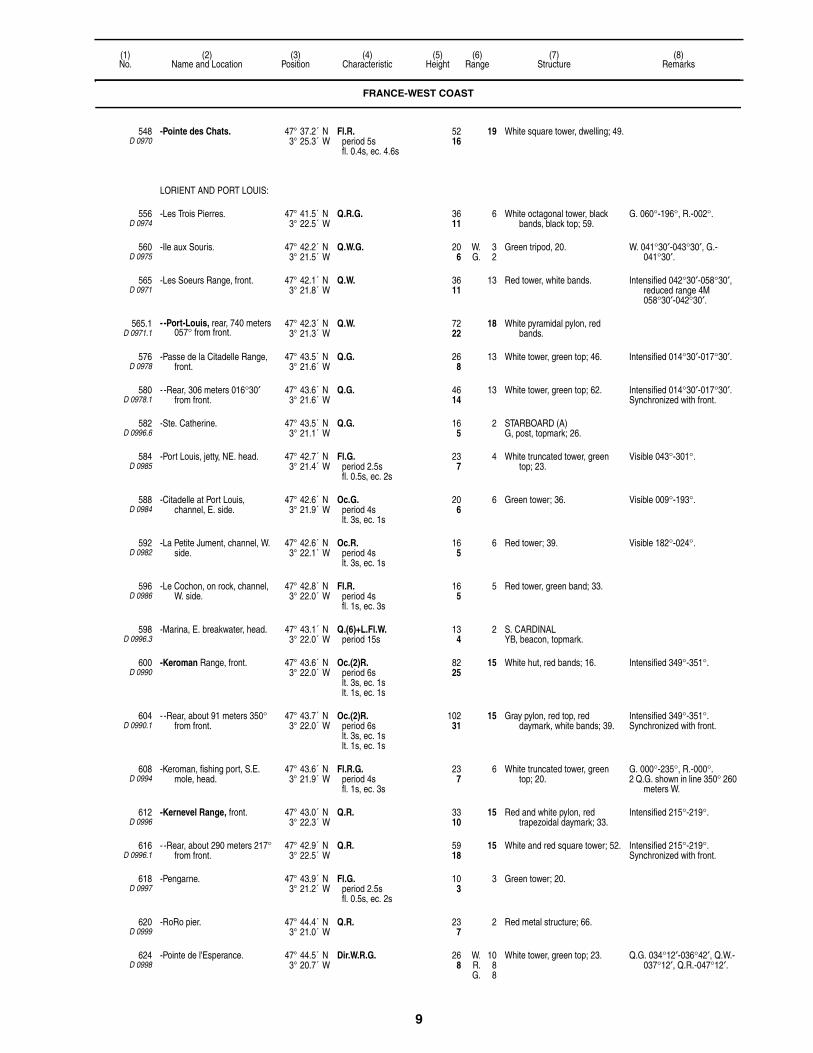
9
(1)No.
(2)Name and Location
(3)Position
(4)Characteristic
(5)Height
(6)Range
(7)Structure
(8)Remarks
548D 0970
-Pointe des Chats. 47° 37.2´ N3° 25.3´ W
Fl.R.period 5sfl. 0.4s, ec. 4.6s
5216
19 White square tower, dwelling; 49.
LORIENT AND PORT LOUIS:
556D 0974
-Les Trois Pierres. 47° 41.5´ N3° 22.5´ W
Q.R.G. 3611
6 White octagonal tower, black bands, black top; 59.
G. 060°-196°, R.-002°.
560D 0975
-Ile aux Souris. 47° 42.2´ N3° 21.5´ W
Q.W.G. 206
W. 3G. 2
Green tripod, 20. W. 041°30′-043°30′, G.-041°30′.
565D 0971
-Les Soeurs Range, front. 47° 42.1´ N3° 21.8´ W
Q.W. 3611
13 Red tower, white bands. Intensified 042°30′-058°30′, reduced range 4M 058°30′-042°30′.
565.1D 0971.1
- -Port-Louis, rear, 740 meters 057° from front.
47° 42.3´ N3° 21.3´ W
Q.W. 7222
18 White pyramidal pylon, red bands.
576D 0978
-Passe de la Citadelle Range, front.
47° 43.5´ N3° 21.6´ W
Q.G. 268
13 White tower, green top; 46. Intensified 014°30′-017°30′.
580D 0978.1
- -Rear, 306 meters 016°30′ from front.
47° 43.6´ N3° 21.6´ W
Q.G. 4614
13 White tower, green top; 62. Intensified 014°30′-017°30′.Synchronized with front.
582D 0996.6
-Ste. Catherine. 47° 43.5´ N3° 21.1´ W
Q.G. 165
2 STARBOARD (A)G, post, topmark; 26.
584D 0985
-Port Louis, jetty, NE. head. 47° 42.7´ N3° 21.4´ W
Fl.G.period 2.5sfl. 0.5s, ec. 2s
237
4 White truncated tower, green top; 23.
Visible 043°-301°.
588D 0984
-Citadelle at Port Louis, channel, E. side.
47° 42.6´ N3° 21.9´ W
Oc.G.period 4slt. 3s, ec. 1s
206
6 Green tower; 36. Visible 009°-193°.
592D 0982
-La Petite Jument, channel, W. side.
47° 42.6´ N3° 22.1´ W
Oc.R.period 4slt. 3s, ec. 1s
165
6 Red tower; 39. Visible 182°-024°.
596D 0986
-Le Cochon, on rock, channel, W. side.
47° 42.8´ N3° 22.0´ W
Fl.R.period 4sfl. 1s, ec. 3s
165
5 Red tower, green band; 33.
598D 0996.3
-Marina, E. breakwater, head. 47° 43.1´ N3° 22.0´ W
Q.(6)+L.Fl.W.period 15s
134
2 S. CARDINALYB, beacon, topmark.
600D 0990
-Keroman Range, front. 47° 43.6´ N3° 22.0´ W
Oc.(2)R.period 6slt. 3s, ec. 1slt. 1s, ec. 1s
8225
15 White hut, red bands; 16. Intensified 349°-351°.
604D 0990.1
- -Rear, about 91 meters 350° from front.
47° 43.7´ N3° 22.0´ W
Oc.(2)R.period 6slt. 3s, ec. 1slt. 1s, ec. 1s
10231
15 Gray pylon, red top, red daymark, white bands; 39.
Intensified 349°-351°.Synchronized with front.
608D 0994
-Keroman, fishing port, S.E. mole, head.
47° 43.6´ N3° 21.9´ W
Fl.R.G.period 4sfl. 1s, ec. 3s
237
6 White truncated tower, green top; 20.
G. 000°-235°, R.-000°.2 Q.G. shown in line 350° 260
meters W.
612D 0996
-Kernevel Range, front. 47° 43.0´ N3° 22.3´ W
Q.R. 3310
15 Red and white pylon, red trapezoidal daymark; 33.
Intensified 215°-219°.
616D 0996.1
- -Rear, about 290 meters 217° from front.
47° 42.9´ N3° 22.5´ W
Q.R. 5918
15 White and red square tower; 52. Intensified 215°-219°.Synchronized with front.
618D 0997
-Pengarne. 47° 43.9´ N3° 21.2´ W
Fl.G.period 2.5sfl. 0.5s, ec. 2s
103
3 Green tower; 20.
620D 0999
-RoRo pier. 47° 44.4´ N3° 21.0´ W
Q.R. 237
2 Red metal structure; 66.
624D 0998
-Pointe de l'Esperance. 47° 44.5´ N3° 20.7´ W
Dir.W.R.G. 268
W. 10R. 8G. 8
White tower, green top; 23. Q.G. 034°12′-036°42′, Q.W.-037°12′, Q.R.-047°12′.
FRANCE-WEST COAST

10
(1)No.
(2)Name and Location
(3)Position
(4)Characteristic
(5)Height
(6)Range
(7)Structure
(8)Remarks
629D 1003
-Citadelle of Port Louis. 47° 42.7´ N3° 21.8´ W
Dir.W.R.G. 4614
W. 7R. 5G. 5
Q.G.168°-169°30′, Q.W.-170°30′, Q.R.-173°30′.
632D 1012
Etel, W. side of river entrance. 47° 38.7´ N3° 12.8´ W
Oc.(2)W.R.G.period 6slt. 3s, ec. 1slt. 1s, ec. 1s
4313
W. 9R. 6G. 6
Red pylon; 36. W. 022°-064°, R.-123°, W.-330°, G.-022°.
636D 1014
Plateau de Birvideaux. 47° 29.2´ N3° 17.5´ W
Fl.(2)W.period 6sfl. 1s, ec. 1sfl. 1s, ec. 3s
7924
10 ISOLATED DANGERBRB, tower, topmark; 118.
AIS (MMSI No 992271028).
BELLE ILE:
640D 1032
-Anse de Goulphar. 47° 18.6´ N3° 13.6´ W
Fl.(2)W.period 10sfl. 0.1s, ec. 2.4sfl. 0.1s, ec. 7.4s
28587
27 Gray tower, red lantern; 171.
644D 1030
-Pointe des Poulains. 47° 23.3´ N3° 15.1´ W
Fl.W.period 5sfl. 0.4s, ec. 4.6s
11134
23 White square tower, dwelling, red lantern; 59.
Visible 023°-291°.
648D 1044
-Sauzon. 47° 22.4´ N3° 13.1´ W
Q.G. 309
5 White tower, green top; 30. Visible 194°-045°.
652D 1045
- -NW. jetty, head. 47° 22.5´ N3° 13.0´ W
Fl.G.period 4sfl. 1s, ec. 3s
268
4 White truncated conical tower, green top; 16.
Visible 190°-078°.
656D 1046
- -SE. jetty, head. 47° 22.5´ N3° 13.0´ W
Fl.R.period 4sfl. 1s, ec. 3s
268
4 White truncated conical tower, red top; 16.
Visible 315°-272°.
660D 1042
-Le Palais, N. jetty, head. 47° 20.8´ N3° 09.0´ W
Q.G. 3611
7 White tower, green top; 33.
664D 1040
- -S. jetty, head. 47° 20.8´ N3° 09.1´ W
Q.R. 3611
7 White tower, red lantern; 33.
668D 1036
-Pointe de Kerdonis. 47° 18.6´ N3° 03.6´ W
Fl.(3)R.period 15sfl. 0.4s, ec. 2.6sfl. 0.4s, ec. 2.6sfl. 0.4s, ec. 8.6s
16149
15 White square tower, dwelling, red top; 46.
Visible 155°-225° and 320°-004°.
672D 1016
S. side of Presqu'ile de Quiberon.
47° 28.8´ N3° 07.5´ W
Q.W.R.G. 9228
W. 14R. 10G. 10
White tower, green lantern; 82. R. 017°-051°, W.-081°, G.-098°, W.-143°, W. 246°-252°, W. 291°-297°, G.-340°, W.-017°.
676D 1015
-Entrance Range, front. 47° 28.6´ N3° 07.2´ W
Q.G. 165
16 White truncated conical tower, black band, black top; 43.
Intensified 005°-008°.AIS (MMSI No 992271029).
680D 1015.1
- -Rear, about 230 meters 006°30′ from front.
47° 28.8´ N3° 07.2´ W
Q.G. 4213
17 White truncated conical tower, black band, black top; 36.
Intensified 005°-008°.Synchronized with front.AIS (MMSI No 992271030).
684D 1017
-Breakwater, S. entrance. 47° 28.5´ N3° 07.3´ W
Oc.(2)R.period 6slt. 3s, ec. 1slt. 1s, ec. 1s
309
7 White tower, red lantern; 16.
686D 1015.5
- -S. 47° 28.3´ N3° 07.3´ W
Fl.R.period 2.5sfl. 0.5s, ec. 2s
206
2 Red beacon; 33. Visible 175°-047°.
688D 1018
-E. mole, near N. entrance. 47° 28.6´ N3° 07.4´ W
Iso.G.period 4s
309
7 White tower, green lantern; 23.
PASSAGE DE LA TEIGNOUSE:
692D 1022
-La Teignouse. 47° 27.4´ N3° 02.8´ W
Fl.W.R.period 4sfl. 1s, ec. 3s
6620
W. 15R. 11
White tower, red top; 66. W. 033°-039°, R.-033°.AIS (MMSI No 992271007).
FRANCE-WEST COAST

11
(1)No.
(2)Name and Location
(3)Position
(4)Characteristic
(5)Height
(6)Range
(7)Structure
(8)Remarks
720D 1082
Ile Houat, St. Gildas, on N. mole.
47° 23.6´ N2° 57.3´ W
Fl.(2)W.G.period 6sfl. 1s, ec. 1sfl. 1s, ec. 3s
268
W. 9G. 6
White truncated tower, green top; 16.
W. 168°-198°, G.-210°, W.-240°, G.-168°.
724D 1084
Ile de Hoedic, Port of l′Argol. 47° 20.7´ N2° 52.5´ W
Fl.W.G.period 4sfl. 1s, ec. 3s
3310
W. 9G. 6
White truncated tower, green top; 23.
W. 143°-163°, G.-183°, W.-194°, G.-143°.
728D 1086
Les Grands Cardinaux, on Groguegues Rock, SE. of Ile Hoedic.
47° 19.3´ N2° 50.1´ W
Fl.(4)W.period 15sfl. 1s, ec. 1.5sfl. 1s, ec. 1.5sfl. 1s, ec. 1.5sfl. 1s, ec. 6.5s
9228
11 Red round tower, white band; 89. AIS (MMSI No 992271025).
PORT HALIGUEN:
732D 1026.2
-New breakwater, head. 47° 29.4´ N3° 05.9´ W
Oc.(2)W.R.period 6slt. 1s, ec. 1slt. 3s, ec. 1s
3310
W. 11R. 8
White truncated tower, red top; 26.
W. 233°-240°30′, R.-299°, W.-306°, R.-233°.
736D 1026
-Old breakwater, head. 47° 29.3´ N3° 06.0´ W
Fl.R.period 4sfl. 1s, ec. 3s
3310
5 White truncated tower, red top; 23.
Visible 322°-206°.
740D 1026.4
-Pier, NW. side of entrance. 47° 29.3´ N3° 06.0´ W
Fl.G.period 2.5sfl. 0.5s, ec. 2s
309
6 White structure, green top; 30.
CRACH:
752D 1050
-Entrance. 47° 34.1´ N3° 00.4´ W
Q.W.R.G. 3611
W. 10R. 7G. 7
White truncated tower, green top; 20.
G. 321°-345°, W.-013°30′, R.-080°.
760D 1051
-812 meters 105° from La Trinite-sur-Mer.
47° 35.1´ N3° 01.0´ W
Dir.Oc.W.R.G.period 4slt. 3s, ec. 1s
309
W. 13R. 11G. 11
White tower; 20. G. 345°-346°, W.-348°, R.-349°.
764D 1052
La Trinite-sur-Mer, wharf, head. 47° 35.1´ N3° 01.5´ W
Q.W.R. 206
W. 9R. 6
White tower, red top; 20. R. 090°-293°30′, W.-300°30′, R.-329°.
Iso.R. 4s light shown from head of wharf 274 meters N.
768D 1054
Port Navalo. 47° 32.9´ N2° 55.1´ W
Oc.(3)W.R.G.period 12slt. 4.5s, ec. 1.5slt. 1.5s, ec. 1.5slt. 1.5s, ec. 1.5s
10432
W. 15R. 11G. 11
White tower, dwelling; 69. W. 155°-220°, G. 317°-359°, W.-015°, R.-105°.
769D 1054.5
-Riviere D'Auray, Gregan. 47° 33.9´ N2° 55.1´ W
Q.(6)+L.Fl.W.period 15s
103
7 S. CARDINALYB, tower, topmark; 23.
772 Plateau de la Recherche. 47° 25.6´ N2° 50.4´ W
Q.(9)W.period 15s
165
3 W. CARDINALYBY, pillar, topmark.
776D 1056
Saint Jacques en Sarzeau, mole, head.
47° 29.2´ N2° 47.4´ W
Oc.(2)R.period 6slt. 3s, ec. 1slt. 1s, ec. 1s
237
6 White octagonal tower, red top; 16.
780D 1062
Le Pignon, entrance of Riviere de Penerf.
47° 30.0´ N2° 38.9´ W
Fl.(3)W.R.period 12sfl. 1s, ec. 1.5sfl. 1s, ec. 1.5sfl. 1s, ec. 6s
206
W. 9R. 6
Red tower; 46. R. 028°30′-167°, W.-175°, R.-349°30′, W.-028°30′.
784D 1060
Ile Dumet. 47° 24.7´ N2° 37.2´ W
Fl.(3)W.R.G.period 12sfl. 1s, ec. 1.5sfl. 1s, ec. 1.5sfl. 1s, ec. 6s
4614
W. 7R. 4G. 4
White metal column, green top, fort; 20.
W. 335°-090°, G.-272°, W.-285°, R.-335°.
FRANCE-WEST COAST
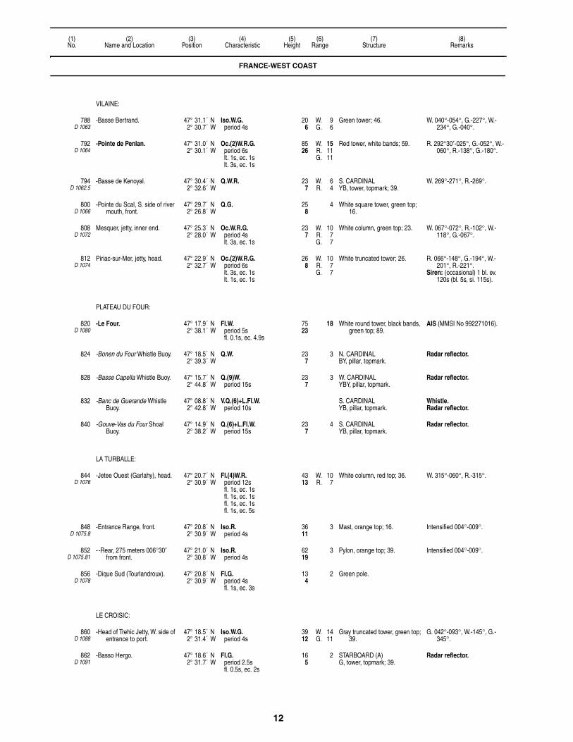
12
(1)No.
(2)Name and Location
(3)Position
(4)Characteristic
(5)Height
(6)Range
(7)Structure
(8)Remarks
VILAINE:
788D 1063
-Basse Bertrand. 47° 31.1´ N2° 30.7´ W
Iso.W.G.period 4s
206
W. 9G. 6
Green tower; 46. W. 040°-054°, G.-227°, W.-234°, G.-040°.
792D 1064
-Pointe de Penlan. 47° 31.0´ N2° 30.1´ W
Oc.(2)W.R.G.period 6slt. 1s, ec. 1slt. 3s, ec. 1s
8526
W. 15R. 11G. 11
Red tower, white bands; 59. R. 292°30′-025°, G.-052°, W.-060°, R.-138°, G.-180°.
794D 1062.5
-Basse de Kenoyal. 47° 30.4´ N2° 32.6´ W
Q.W.R. 237
W. 6R. 4
S. CARDINALYB, tower, topmark; 39.
W. 269°-271°, R.-269°.
800D 1066
-Pointe du Scal, S. side of river mouth, front.
47° 29.7´ N2° 26.8´ W
Q.G. 258
4 White square tower, green top; 16.
808D 1072
Mesquer, jetty, inner end. 47° 25.3´ N2° 28.0´ W
Oc.W.R.G.period 4slt. 3s, ec. 1s
237
W. 10R. 7G. 7
White column, green top; 23. W. 067°-072°, R.-102°, W.-118°, G.-067°.
812D 1074
Piriac-sur-Mer, jetty, head. 47° 22.9´ N2° 32.7´ W
Oc.(2)W.R.G.period 6slt. 3s, ec. 1slt. 1s, ec. 1s
268
W. 10R. 7G. 7
White truncated tower; 26. R. 066°-148°, G.-194°, W.-201°, R.-221°.
Siren: (occasional) 1 bl. ev. 120s (bl. 5s, si. 115s).
PLATEAU DU FOUR:
820D 1080
-Le Four. 47° 17.9´ N2° 38.1´ W
Fl.W.period 5sfl. 0.1s, ec. 4.9s
7523
18 White round tower, black bands, green top; 89.
AIS (MMSI No 992271016).
824 -Bonen du Four Whistle Buoy. 47° 18.5´ N2° 39.3´ W
Q.W. 237
3 N. CARDINALBY, pillar, topmark.
Radar reflector.
828 -Basse Capella Whistle Buoy. 47° 15.7´ N2° 44.8´ W
Q.(9)W.period 15s
237
3 W. CARDINALYBY, pillar, topmark.
Radar reflector.
832 -Banc de Guerande Whistle Buoy.
47° 08.8´ N2° 42.8´ W
V.Q.(6)+L.Fl.W.period 10s
S. CARDINALYB, pillar, topmark.
Whistle. Radar reflector.
840 -Gouve-Vas du Four Shoal Buoy.
47° 14.9´ N2° 38.2´ W
Q.(6)+L.Fl.W.period 15s
237
4 S. CARDINALYB, pillar, topmark.
Radar reflector.
LA TURBALLE:
844D 1076
-Jetee Ouest (Garlahy), head. 47° 20.7´ N2° 30.9´ W
Fl.(4)W.R.period 12sfl. 1s, ec. 1sfl. 1s, ec. 1sfl. 1s, ec. 1sfl. 1s, ec. 5s
4313
W. 10R. 7
White column, red top; 36. W. 315°-060°, R.-315°.
848D 1075.8
-Entrance Range, front. 47° 20.8´ N2° 30.9´ W
Iso.R.period 4s
3611
3 Mast, orange top; 16. Intensified 004°-009°.
852D 1075.81
- -Rear, 275 meters 006°30′ from front.
47° 21.0´ N2° 30.8´ W
Iso.R.period 4s
6219
3 Pylon, orange top; 39. Intensified 004°-009°.
856D 1078
-Dique Sud (Tourlandroux). 47° 20.8´ N2° 30.9´ W
Fl.G.period 4sfl. 1s, ec. 3s
134
2 Green pole.
LE CROISIC:
860D 1088
-Head of Trehic Jetty, W. side of entrance to port.
47° 18.5´ N2° 31.4´ W
Iso.W.G.period 4s
3912
W. 14G. 11
Gray truncated tower, green top; 39.
G. 042°-093°, W.-145°, G.-345°.
862D 1091
-Basso Hergo. 47° 18.6´ N2° 31.7´ W
Fl.G.period 2.5sfl. 0.5s, ec. 2s
165
2 STARBOARD (A)G, tower, topmark; 39.
Radar reflector.
FRANCE-WEST COAST
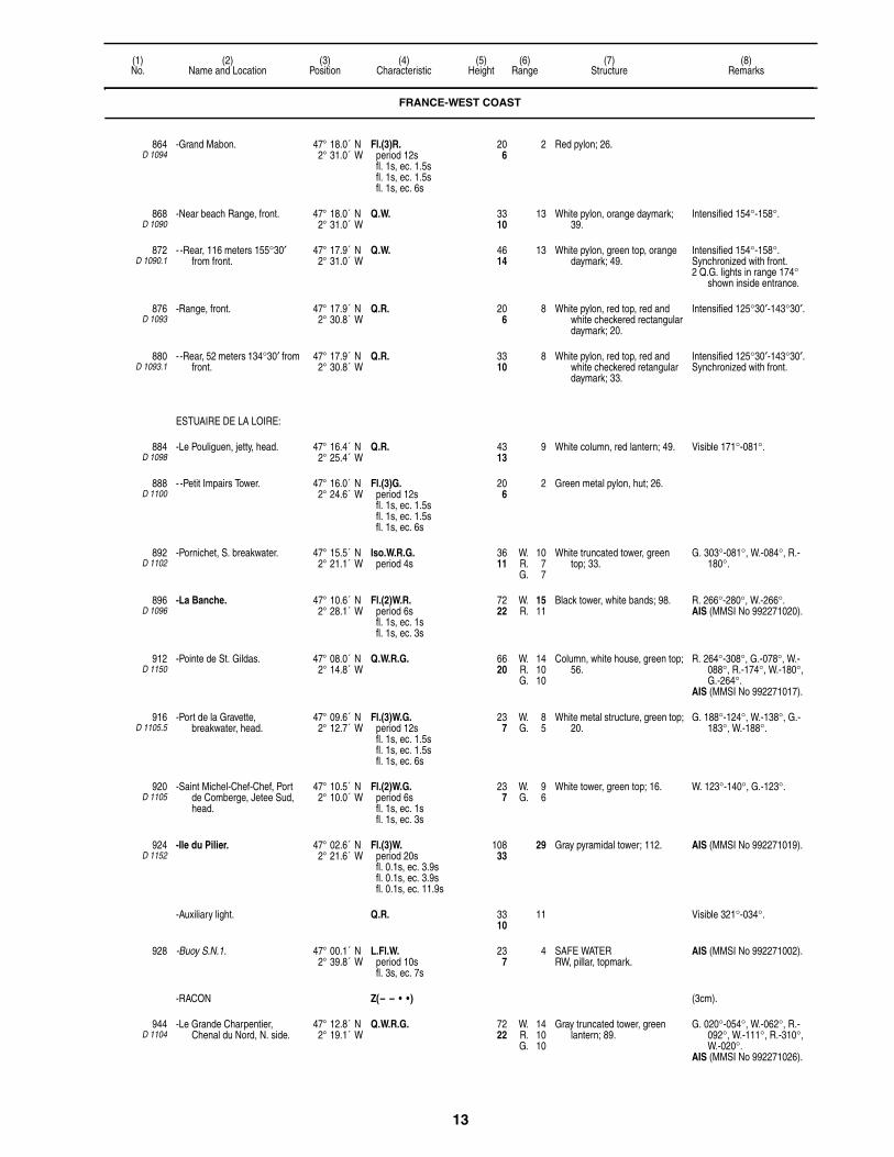
13
(1)No.
(2)Name and Location
(3)Position
(4)Characteristic
(5)Height
(6)Range
(7)Structure
(8)Remarks
864D 1094
-Grand Mabon. 47° 18.0´ N2° 31.0´ W
Fl.(3)R.period 12sfl. 1s, ec. 1.5sfl. 1s, ec. 1.5sfl. 1s, ec. 6s
206
2 Red pylon; 26.
868D 1090
-Near beach Range, front. 47° 18.0´ N2° 31.0´ W
Q.W. 3310
13 White pylon, orange daymark; 39.
Intensified 154°-158°.
872D 1090.1
- -Rear, 116 meters 155°30′ from front.
47° 17.9´ N2° 31.0´ W
Q.W. 4614
13 White pylon, green top, orange daymark; 49.
Intensified 154°-158°.Synchronized with front.2 Q.G. lights in range 174°
shown inside entrance.
876D 1093
-Range, front. 47° 17.9´ N2° 30.8´ W
Q.R. 206
8 White pylon, red top, red and white checkered rectangular daymark; 20.
Intensified 125°30′-143°30′.
880D 1093.1
- -Rear, 52 meters 134°30′ from front.
47° 17.9´ N2° 30.8´ W
Q.R. 3310
8 White pylon, red top, red and white checkered retangular daymark; 33.
Intensified 125°30′-143°30′.Synchronized with front.
ESTUAIRE DE LA LOIRE:
884D 1098
-Le Pouliguen, jetty, head. 47° 16.4´ N2° 25.4´ W
Q.R. 4313
9 White column, red lantern; 49. Visible 171°-081°.
888D 1100
- -Petit Impairs Tower. 47° 16.0´ N2° 24.6´ W
Fl.(3)G.period 12sfl. 1s, ec. 1.5sfl. 1s, ec. 1.5sfl. 1s, ec. 6s
206
2 Green metal pylon, hut; 26.
892D 1102
-Pornichet, S. breakwater. 47° 15.5´ N2° 21.1´ W
Iso.W.R.G.period 4s
3611
W. 10R. 7G. 7
White truncated tower, green top; 33.
G. 303°-081°, W.-084°, R.-180°.
896D 1096
-La Banche. 47° 10.6´ N2° 28.1´ W
Fl.(2)W.R.period 6sfl. 1s, ec. 1sfl. 1s, ec. 3s
7222
W. 15R. 11
Black tower, white bands; 98. R. 266°-280°, W.-266°.AIS (MMSI No 992271020).
912D 1150
-Pointe de St. Gildas. 47° 08.0´ N2° 14.8´ W
Q.W.R.G. 6620
W. 14R. 10G. 10
Column, white house, green top; 56.
R. 264°-308°, G.-078°, W.-088°, R.-174°, W.-180°, G.-264°.
AIS (MMSI No 992271017).
916D 1105.5
-Port de la Gravette, breakwater, head.
47° 09.6´ N2° 12.7´ W
Fl.(3)W.G.period 12sfl. 1s, ec. 1.5sfl. 1s, ec. 1.5sfl. 1s, ec. 6s
237
W. 8G. 5
White metal structure, green top; 20.
G. 188°-124°, W.-138°, G.-183°, W.-188°.
920D 1105
-Saint Michel-Chef-Chef, Port de Comberge, Jetee Sud, head.
47° 10.5´ N2° 10.0´ W
Fl.(2)W.G.period 6sfl. 1s, ec. 1sfl. 1s, ec. 3s
237
W. 9G. 6
White tower, green top; 16. W. 123°-140°, G.-123°.
924D 1152
-Ile du Pilier. 47° 02.6´ N2° 21.6´ W
Fl.(3)W.period 20sfl. 0.1s, ec. 3.9sfl. 0.1s, ec. 3.9sfl. 0.1s, ec. 11.9s
10833
29 Gray pyramidal tower; 112. AIS (MMSI No 992271019).
-Auxiliary light. Q.R. 3310
11 Visible 321°-034°.
928 -Buoy S.N.1. 47° 00.1´ N2° 39.8´ W
L.Fl.W.period 10sfl. 3s, ec. 7s
237
4 SAFE WATERRW, pillar, topmark.
AIS (MMSI No 992271002).
-RACON Z(– – • •) (3cm).
944D 1104
-Le Grande Charpentier, Chenal du Nord, N. side.
47° 12.8´ N2° 19.1´ W
Q.W.R.G. 7222
W. 14R. 10G. 10
Gray truncated tower, green lantern; 89.
G. 020°-054°, W.-062°, R.-092°, W.-111°, R.-310°, W.-020°.
AIS (MMSI No 992271026).
FRANCE-WEST COAST

14
(1)No.
(2)Name and Location
(3)Position
(4)Characteristic
(5)Height
(6)Range
(7)Structure
(8)Remarks
946 -La Couronnee Lightbuoy. 47° 07.6´ N2° 20.1´ W
Q.G. STARBOARD (A)G, pillar, topmark.
Radar reflector.
-RACON (• • • • • • •) 3
948D 1106
-Portce Range, front. 47° 14.6´ N2° 15.4´ W
Q.W. 206
22 White column; 75. Intensified 024°42′-026°12′.AIS (MMSI No 992271021).
952D 1106.1
- -Rear, 1,350 meters 025°30′ from front.
47° 15.2´ N2° 15.0´ W
Q.W. 11836
24 White tower, white rectangular daymark; 62.
Intensified 024°-027°.Shown 24 hours.Synchronized with front.AIS (MMSI No 992271023).
956D 1114
-Pointe d'Aiguillon. 47° 14.5´ N2° 15.8´ W
Oc.(3)W.R.period 12slt. 1.5s, ec. 1.5slt. 1.5s, ec. 1.5slt. 4.5s, ec. 1.5s
8927
W. 13R. 10
White tower; 62. R. 207°-233°, W.-293°, W. 297°-300°, R.-327°, W.-023°, R. 027°-069°.
AIS (MMSI No 992271018).
960D 1104.4
-Le Pointeau, Digue Sud, head. 47° 14.0´ N2° 11.0´ W
Fl.W.G.period 4sfl. 1s, ec. 3s
134
W. 10G. 7
White round tower, green top; 13.
G. 050°-074°, W.-149°, G.-030°, W.-050°.
962D 1104.2
-Pointe de Mindin. 47° 16.2´ N2° 10.2´ W
Fl.G.period 2.5sfl. 0.5s, ec. 2s
206
3 White pylon.
964D 1116
- -Villes-Martin, jetty, head. 47° 15.3´ N2° 13.7´ W
Fl.(2)W.period 6sfl. 1s, ec. 1sfl. 1s, ec. 3s
3310
10 White truncated tower, red top; 46.
968D 1118
-Les Morees, Banc des Morees, NE. point.
47° 15.0´ N2° 13.0´ W
Fl.(3)W.R.period 12s
3912
W. 6R. 4
Green truncated tower; 56. R. 300°-058°, W.-224°.
-Saint-Nazaire:
972D 1122
- -W. jetty, head. 47° 16.0´ N2° 12.2´ W
Oc.(4)R.period 12slt. 5s, ec. 1slt. 1s, ec. 1slt. 1s, ec. 1slt. 1s, ec. 1s
3611
8 White tower, red top; 33. Synchronized with 976.
976D 1124
- -E. jetty. 47° 16.0´ N2° 12.1´ W
Oc.(4)G.period 12slt. 5s, ec. 1slt. 1s, ec. 1slt. 1s, ec. 1slt. 1s, ec. 1s
3611
11 White tower, green top; 33. Synchronized with 972.Fl.R. and Fl.G. lights mark
lock entrance 500m N. and channels between basins.
980D 1126
- -Old mole, head. 47° 16.3´ N2° 11.8´ W
Q.(3)W.period 10s
5918
11 White turret, red top; 56. Visible 153°30′-063°30′.
982D 1127
- -Old ferry dock. 47° 16.4´ N2° 11.8´ W
Fl.(2)R.period 6sfl. 0.5s, ec. 1.5sfl. 0.5s, ec. 3.5s
165
1 Red pile; 30.
984D 1128
- -Old dock entrance. 47° 16.5´ N2° 11.9´ W
Fl.(3)R.period 12sfl. 1s, ec. 1.5sfl. 1s, ec. 1.5sfl. 1s, ec. 6s
309
9 Red pylon; 23.
985D 1128.7
- -Bassin de Pehoet Range, front.
47° 17.1´ N2° 12.0´ W
F.R. 6620
17 Red beacon, white bands. Visible 340°-345°.Occasional.
985.1D 1128.8
- - -Rear, 160 meters 344° from front.
47° 17.1´ N2° 12.1´ W
F.R. 6620
17 Red beacon, white bands. Visible 340°-345°Occasional.
986D 1129
- -Shipyard slipway. 47° 17.0´ N2° 10.9´ W
Fl.(2)R.period 6sfl. 0.5s, ec. 1.5sfl. 0.5s, ec. 3.5s
165
1 White pylon; 10.
988D 1130
- -Bridge. 47° 17.1´ N2° 10.2´ W
Iso.W.period 4s
18055
On upstream and downstream side marking center of channel.
FRANCE-WEST COAST

15
(1)No.
(2)Name and Location
(3)Position
(4)Characteristic
(5)Height
(6)Range
(7)Structure
(8)Remarks
992D 1130.4
- -Gron. 47° 17.4´ N2° 10.1´ W
Iso.R.period 4s
2 Red column; 10.
996D 1131
- -Le Village, No 1. 47° 17.9´ N2° 08.7´ W
Q.R. 237
8 Red and white structure; 13. Visible 225°-135°.
1008D 1137
-Arceau Oil Jetty. 47° 18.4´ N2° 05.5´ W
Fl.R.period 4sfl. 1s, ec. 3s
3310
9 White tower, red top; 26.
1015D 1138
- -SW. dolphin. 47° 18.1´ N2° 05.0´ W
Fl.(2)G.period 6sfl. 0.5s, ec. 1.5sfl. 0.5s, ec. 3.5s
237
2 Gray octagonal column, green top, hut; 13.
1016D 1139
- -NE. dolphin. 47° 18.1´ N2° 04.8´ W
Fl.(2)G.period 6sfl. 0.5s, ec. 1.5sfl. 0.5s, ec. 3.5s
237
2 Green octagonal column, hut; 13.
-Donges:
1024D 1140
- -Jetty, head. 47° 18.3´ N2° 04.2´ W
Fl.(2)R.period 6s
299
9 Red metal tower; 26. Visible 225°-135°.
1028D 1142
-Paimboeuf, mole, head. 47° 17.4´ N2° 01.9´ W
Oc.(3)W.G.period 12slt. 1.5s, ec. 1.5slt. 1.5s, ec. 1.5slt. 4.5s, ec. 1.5s
299
W. 10G. 7
White tower, green top; 30. G. 065°-123°, W.-297°.
BAIE DE BOURGNEUF:
1031D 1154.5
-Notre Dame. 47° 05.4´ N2° 08.3´ W
V.Q.(9)W.period 10s
237
3 W. CARDINALYBY, tower, topmark; 36.
1032D 1156
-Pornic, entrance, W. side. 47° 06.6´ N2° 06.9´ W
Oc.(4)W.R.G.period 12slt. 1s, ec. 1slt. 1s, ec. 1slt. 1s, ec. 1slt. 5s, ec. 1s
7523
W. 13R. 9G. 9
White square tower, green top, white dwelling; 49.
G. 238°-051°, W.-079°, R.-105°.
1036D 1156.7
-Port de Peche, N. 47° 06.9´ N2° 06.2´ W
Fl.(2)R.period 6s
62
7 White metal structure; 3.
1040D 1156.72
- -South. 47° 06.9´ N2° 06.2´ W
Fl.(2)G.period 6s
62
7 White metal structure; 3.
1044D 1155.2
- -Yacht basin, SW. jetty, head. 47° 06.5´ N2° 06.7´ W
Fl.(2)R.period 6sfl. 0.2s, ec. 1.4sfl. 0.2s, ec. 4.2s
134
2 Black column, red top; 30.
1048D 1155
- -SW. jetty, elbow. 47° 06.4´ N2° 07.0´ W
Fl.W.period 2.5sfl. 0.5s, ec. 2s
134
3 Gray post; 3.
1052D 1155.4
- -E. jetty, head. 47° 06.5´ N2° 06.7´ W
Fl.(2)G.period 6sfl. 0.2s, ec. 1.4sfl. 0.2s, ec. 4.2s
134
2 Black column, green top; 30.
1056D 1156.6
-Jetee de Gourmalon. 47° 06.5´ N2° 06.7´ W
Fl.(3)G.period 12sfl. 1s, ec. 1.5sfl. 1s, ec. 1.5sfl. 1s, ec. 6s
134
7 White metal post, green top; 16.
1060D 1156.8
-La Bernerie-en-Retz, jetty, head.
47° 04.6´ N2° 02.3´ W
Fl.R.period 2s
134
5 White post, red top; 10.
1064D 1157
-Le Collet. 47° 01.8´ N1° 58.9´ W
Oc.(2)W.R.period 6slt. 3s, ec. 1slt. 1s, ec. 1s
237
W. 7R. 5
White hut, red top; 20. W. 278°-093°, R.-156°.About 900 meters SW., 2 Q.G.
lights form range 118°.
FRANCE-WEST COAST

16
(1)No.
(2)Name and Location
(3)Position
(4)Characteristic
(5)Height
(6)Range
(7)Structure
(8)Remarks
1068D 1160
-Etier des Brochets. 46° 59.9´ N2° 01.8´ W
Oc.(3)W.R.G.period 12slt. 1.5s, ec. 1.5slt. 1.5s, ec. 1.5slt. 4.5s, ec. 1.5s
268
W. 10R. 7G. 7
White tower; 23. G. 071°-091°, W.-102°30′, R.-116°30′, W.-119°30′, R.-164°30′.
1072D 1161
-Bec de l'Epoids, bay, SE. shore.
46° 56.4´ N2° 04.5´ W
Iso.W.R.G.period 4s
268
W. 10R. 7G. 7
White square tower, red top; 23. G. 106°-113°30′, R.-122°, G.-157°30′, W.-158°30′, R.-171°30′, W.-176°.
ILE DE NOIRMOUTIER:
1080D 1162
-Pointe des Dames. 47° 00.7´ N2° 13.3´ W
Oc.(3)W.R.G.period 12slt. 4.5s, ec. 1.5slt. 1.5s, ec. 1.5slt. 1.5s, ec. 1.5s
11234
W. 19R. 15G. 15
White square tower; 62. R. 057°-124°, G.-165°, W.-191°, R.-267°, W.-357°, R.-016°30′, G.-057°.
1084D 1164
-Heaux Jetty, head. 46° 59.3´ N2° 13.1´ W
Oc.(2)R.period 6slt. 3s, ec. 1slt. 1s, ec. 1s
196
6 White column, red top; 23.
1088D 1154
-Pierre Moine Tower. 47° 03.4´ N2° 12.4´ W
Fl.(2)W.period 6sfl. 1s, ec. 1sfl. 1s, ec. 3s
4614
7 ISOLATED DANGERBRB, tower, topmark; 59.
1092D 1153
-Basse du Martroger. 47° 02.6´ N2° 17.1´ W
Q.W.R.G. 3611
W. 9R. 6G. 6
N. CARDINALBY, tower, topmark; 52.
G. 033°-055°, W.-060°, R.-095°, G.-124°, W.-153°, R.-201°, W.-240°, R.-033°.
1096D 1166
-L'Herbaudiere, jetty, head. 47° 01.6´ N2° 17.9´ W
Oc.(2+1)W.G.period 12slt. 4s, ec. 1slt. 4s, ec. 1slt. 1s, ec. 1s
299
W. 10G. 7
White hut, green mast; 23. W. 187°30′-190°, G.-187°30′.2 Q.W. 7M in line 187°30′
mark entrance to harbor.
1100D 1167
- -E. jetty, head. 47° 01.6´ N2° 17.9´ W
Fl.(2)R.period 6sfl. 1s, ec. 1sfl. 1s, ec. 3s
268
4 Red metal tripod mast; 20.
1102D 1165
- -Entrance Range, front. 47° 01.6´ N2° 17.8´ W
Q.W. 165
7 Gray post, red top; 13. Visible 098°-278°.
1102.1D 1165.1
- - -Rear, 310 meters 187°30′ from front.
47° 01.4´ N2° 17.9´ W
Q.W. 6921
7 Gray post; 49. Visible 098°-278°.
1104D 1168
-Pointe du Devin, W. side of island.
46° 59.2´ N2° 17.6´ W
Oc.(4)W.R.G.period 12slt. 5s, ec. 1slt. 1s, ec. 1slt. 1s, ec. 1slt. 1s, ec. 1s
3310
W. 11R. 8G. 8
White column, hut, green top; 23. G. 314°-028°, W.-035°, R.-134°.
GOULET DE FROMENTINE:
1108 -Approach Bell Buoy. 46° 53.1´ N2° 11.4´ W
L.Fl.W.period 10sfl. 3s, ec. 7s
103
6 SAFE WATERRW, spherical, topmark.
Radar reflector.
1112D 1170
-Middle Tower. 46° 53.6´ N2° 09.6´ W
Fl.(4)R.period 15sfl. 1s, ec. 1.5sfl. 1s, ec. 1.5sfl. 1s, ec. 1.5sfl. 1s, ec. 6.5s
206
5 Red truncated tower; 39.
1116D 1174
-Fromentine Bridge, W. head. 46° 53.5´ N2° 09.0´ W
Iso.W.period 4s
10532
18 On center span. Shown 24 hours.AIS (MMSI No 992271033).On upstream and downstream
sides marking the center of the channel.
FRANCE-WEST COAST
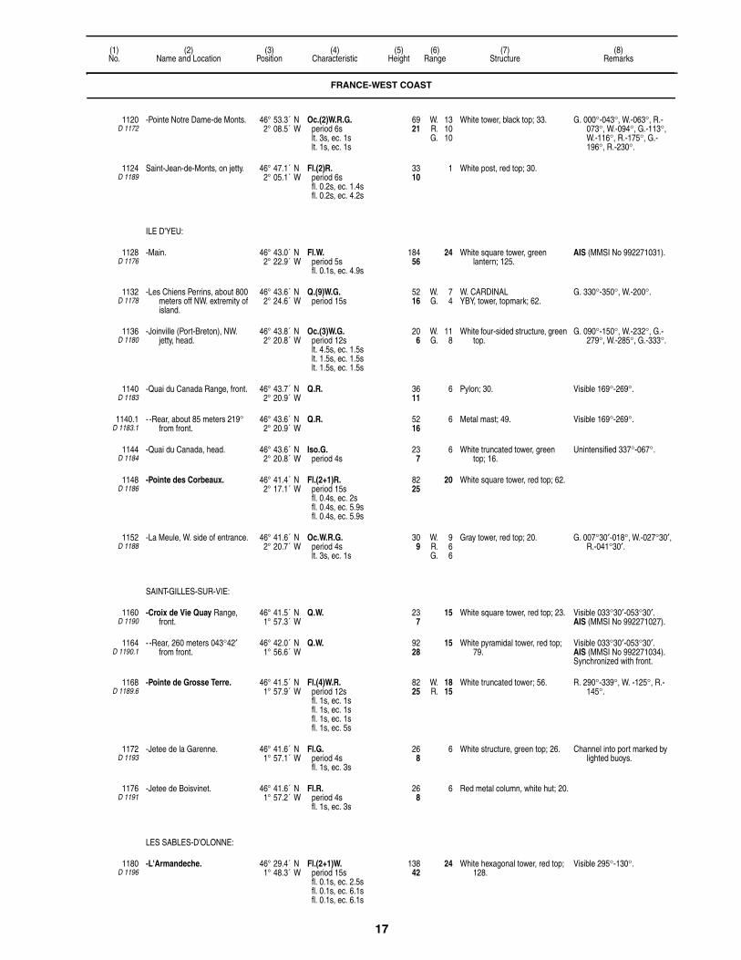
17
(1)No.
(2)Name and Location
(3)Position
(4)Characteristic
(5)Height
(6)Range
(7)Structure
(8)Remarks
1120D 1172
-Pointe Notre Dame-de Monts. 46° 53.3´ N2° 08.5´ W
Oc.(2)W.R.G.period 6slt. 3s, ec. 1slt. 1s, ec. 1s
6921
W. 13R. 10G. 10
White tower, black top; 33. G. 000°-043°, W.-063°, R.-073°, W.-094°, G.-113°, W.-116°, R.-175°, G.-196°, R.-230°.
1124D 1189
Saint-Jean-de-Monts, on jetty. 46° 47.1´ N2° 05.1´ W
Fl.(2)R.period 6sfl. 0.2s, ec. 1.4sfl. 0.2s, ec. 4.2s
3310
1 White post, red top; 30.
ILE D'YEU:
1128D 1176
-Main. 46° 43.0´ N2° 22.9´ W
Fl.W.period 5sfl. 0.1s, ec. 4.9s
18456
24 White square tower, green lantern; 125.
AIS (MMSI No 992271031).
1132D 1178
-Les Chiens Perrins, about 800 meters off NW. extremity of island.
46° 43.6´ N2° 24.6´ W
Q.(9)W.G.period 15s
5216
W. 7G. 4
W. CARDINALYBY, tower, topmark; 62.
G. 330°-350°, W.-200°.
1136D 1180
-Joinville (Port-Breton), NW. jetty, head.
46° 43.8´ N2° 20.8´ W
Oc.(3)W.G.period 12slt. 4.5s, ec. 1.5slt. 1.5s, ec. 1.5slt. 1.5s, ec. 1.5s
206
W. 11G. 8
White four-sided structure, green top.
G. 090°-150°, W.-232°, G.-279°, W.-285°, G.-333°.
1140D 1183
-Quai du Canada Range, front. 46° 43.7´ N2° 20.9´ W
Q.R. 3611
6 Pylon; 30. Visible 169°-269°.
1140.1D 1183.1
- -Rear, about 85 meters 219° from front.
46° 43.6´ N2° 20.9´ W
Q.R. 5216
6 Metal mast; 49. Visible 169°-269°.
1144D 1184
-Quai du Canada, head. 46° 43.6´ N2° 20.8´ W
Iso.G.period 4s
237
6 White truncated tower, green top; 16.
Unintensified 337°-067°.
1148D 1186
-Pointe des Corbeaux. 46° 41.4´ N2° 17.1´ W
Fl.(2+1)R.period 15sfl. 0.4s, ec. 2sfl. 0.4s, ec. 5.9sfl. 0.4s, ec. 5.9s
8225
20 White square tower, red top; 62.
1152D 1188
-La Meule, W. side of entrance. 46° 41.6´ N2° 20.7´ W
Oc.W.R.G.period 4slt. 3s, ec. 1s
309
W. 9R. 6G. 6
Gray tower, red top; 20. G. 007°30′-018°, W.-027°30′, R.-041°30′.
SAINT-GILLES-SUR-VIE:
1160D 1190
-Croix de Vie Quay Range, front.
46° 41.5´ N1° 57.3´ W
Q.W. 237
15 White square tower, red top; 23. Visible 033°30′-053°30′.AIS (MMSI No 992271027).
1164D 1190.1
- -Rear, 260 meters 043°42′ from front.
46° 42.0´ N1° 56.6´ W
Q.W. 9228
15 White pyramidal tower, red top; 79.
Visible 033°30′-053°30′.AIS (MMSI No 992271034).Synchronized with front.
1168D 1189.6
-Pointe de Grosse Terre. 46° 41.5´ N1° 57.9´ W
Fl.(4)W.R.period 12sfl. 1s, ec. 1sfl. 1s, ec. 1sfl. 1s, ec. 1sfl. 1s, ec. 5s
8225
W. 18R. 15
White truncated tower; 56. R. 290°-339°, W. -125°, R.-145°.
1172D 1193
-Jetee de la Garenne. 46° 41.6´ N1° 57.1´ W
Fl.G.period 4sfl. 1s, ec. 3s
268
6 White structure, green top; 26. Channel into port marked by lighted buoys.
1176D 1191
-Jetee de Boisvinet. 46° 41.6´ N1° 57.2´ W
Fl.R.period 4sfl. 1s, ec. 3s
268
6 Red metal column, white hut; 20.
LES SABLES-D'OLONNE:
1180D 1196
-L'Armandeche. 46° 29.4´ N1° 48.3´ W
Fl.(2+1)W.period 15sfl. 0.1s, ec. 2.5sfl. 0.1s, ec. 6.1sfl. 0.1s, ec. 6.1s
13842
24 White hexagonal tower, red top; 128.
Visible 295°-130°.
FRANCE-WEST COAST

18
(1)No.
(2)Name and Location
(3)Position
(4)Characteristic
(5)Height
(6)Range
(7)Structure
(8)Remarks
1184D 1198
-Les Barges. 46° 29.7´ N1° 50.5´ W
Fl.(2)R.period 10sfl. 0.1s, ec. 2.4sfl. 0.1s, ec. 7.4s
8225
13 Gray tower; 95.
1196D 1207
-L'Estacade Range, front. 46° 29.4´ N1° 46.4´ W
Iso.W.period 4s
3912
16 Metal post; 39.
1200D 1207.1
- -Rear, 330 meters 032°30′ from front.
46° 29.6´ N1° 46.2´ W
Iso.W.period 4s
10833
16 White square tower, white house; 66.
Shown 24 hours.AIS (MMSI No 992271024).
1204D 1210
-Entrance Range, front. 46° 29.7´ N1° 47.7´ W
Iso.R.period 4s
206
9 White hut, red top, red rectangular daymark; 20.
1208D 1210.1
- -Rear, 65 meters 328°06′ from front.
46° 29.8´ N1° 47.7´ W
Iso.R.period 4s
309
9 White tower, red lantern, red rectangular daymark; 30.
Visible 324°-330°.Synchronized with front.
1212D 1200
-Jetee St. Nicolas, head. 46° 29.2´ N1° 47.5´ W
Q.R. 5216
8 White tower, red top; 46. Visible 143°-094°.
1216D 1204
-Jetee des Sables, head, front. 46° 29.4´ N1° 47.5´ W
Q.G. 3611
8 White truncated tower, green top; 30.
AIS (MMSI No 992271032).
1220D 1204.1
-Tour de La Chaume, W. side of entrance, rear 465 meters 320° from front.
46° 29.6´ N1° 47.7´ W
Q.W. 10833
12 Gray square tower; 89. Synchronized with front.AIS (MMSI No 992271022).
1222D 1211
-Bourgenay Range, front. 46° 26.3´ N1° 40.6´ W
Q.G. 309
7 White tower, green rectangular daymark, white border; 26.
Visible 020°-060°.
1222.1D 1211.1
- -Rear, 162 meters 040° from front.
46° 26.4´ N1° 40.5´ W
Q.G. 6219
7 White pylon, green rectangular daymark, white border; 56.
Visible 010°-070°.
PERTUIS DU BRETON:
1240D 1214
-Pointe Grouin du Cou. 46° 20.7´ N1° 27.8´ W
Fl.W.R.G.period 5sfl. 0.4s, ec. 4.6s
9429
W. 20R. 16G. 16
White octagonal tower, black lantern; 52.
R. 034°-061°, W.-117°, G.-138°, W.-034°.
1244D 1215
-La Tranche-sur-Mer, Estacade, estremity.
46° 20.6´ N1° 25.6´ W
Fl.(2)R.period 6sfl. 1s, ec. 1sfl. 1s, ec. 3s
206
6 Red pole; 13.
1248 -Anse de l' Aiguillon Approach Buoy.
46° 15.8´ N1° 11.3´ W
L.Fl.W.period 10sfl. 3s, ec. 7s
103
5 SAFE WATERRW, pillar, topmark.
Radar reflector.
1256D 1242
-Port du Plomb, W. mole, head. 46° 12.1´ N1° 12.2´ W
Fl.R.period 4sfl. 1s, ec. 3s
309
7 White metal column, red top; 39.
1260D 1216
-Haut Banc du Nord. 46° 15.8´ N1° 35.2´ W
V.Q.W. 7523
7 Gray tower; 105.
ILE DE RE:
1268D 1218
-Les Baleines. 46° 14.7´ N1° 33.7´ W
Fl.(4)W.period 15sfl. 0.1s, ec. 2.4sfl. 0.1s, ec. 2.4sfl. 0.1s, ec. 2.4sfl. 0.1s, ec. 7.4s
17453
27 Gray octagonal tower, red lantern; 187.
3 F.R. lights shown on semaphore tower 0.1 miles SW.
1272D 1220
-Fier d'Ars. 46° 14.1´ N1° 28.6´ W
Oc.W.R.G.period 4slt. 3s, ec. 1s
W. 10R. 7G. 7
G. 257°30′-267°30′, W.-268°30′, R.-274°30′.
1280D 1223
-Ars-en-Re Range, front. 46° 12.8´ N1° 30.6´ W
Q.W. 165
9 White hut, red lantern; 20.
1284D 1223.1
- -Rear, 370 meters 232°30′ from front.
46° 12.6´ N1° 30.8´ W
Q.W. 4213
11 White pylon, green top, black rectangular daymark; 46.
Visible 142°-322°.
1286D 1224
-Les Islattes. 46° 14.0´ N1° 23.4´ W
Q.W. 4313
3 N. CARDINALBY, tower, topmark.
FRANCE-WEST COAST

19
(1)No.
(2)Name and Location
(3)Position
(4)Characteristic
(5)Height
(6)Range
(7)Structure
(8)Remarks
1292D 1226
-St. Martin, 100 meters SE. of entrance to port.
46° 12.4´ N1° 21.9´ W
Oc.(2)W.R.period 6slt. 3s, ec. 1slt. 1s, ec. 1s
5918
W. 10R. 7
White truncated tower, red top; 43.
W. 083°-245°, R.-281°, W.-300°.
1296D 1228
- -Mole, head. 46° 12.5´ N1° 21.9´ W
Fl.G.period 2.5sfl. 0.5s, ec. 2s
3310
5 White tripod, green top; 23.
1300D 1230
-La Flotte, mole, head. 46° 11.3´ N1° 19.3´ W
Fl.W.G.period 4sfl. 1s, ec. 3s
3310
W. 12G. 9
White tower, green top; 33. G. 130°-205°, W.-220°, G.-257°.
1304D 1232
-Rivedoux-Plage Range, front, jetty, head.
46° 09.8´ N1° 16.6´ W
Q.G. 206
6 White tower, green top; 16.
1308D 1232.1
- -Rear, 100 meters 194°30′ from front.
46° 09.7´ N1° 16.7´ W
Q.G. 309
6 White columns, green top, green and white checkered daymark; 26.
Synchronized with front.
1312D 1234
-Pointe de Sablanceaux, pier, head.
46° 09.8´ N1° 15.2´ W
V.Q.(3)W.period 5s
3310
5 E. CARDINALBYB, post, topmark; 23.
PERTUIS D'ANTIOCHE:
1316D 1240
-Pointe de Chanchardon, Ile de Re, reef, S. side.
46° 09.7´ N1° 28.4´ W
Fl.W.R.period 4sfl. 1s, ec. 3s
4915
W. 9R. 6
Black octagonal tower, white base; 66.
R. 110°-290°, W.-110°.
1324D 1238
-Pointe de Chauveau. 46° 08.0´ N1° 16.4´ W
Oc.(3)W.R.period 12slt. 4.5s, ec. 1.5slt. 1.5s, ec. 1.5slt. 1.5s, ec. 1.5s
8927
W. 15R. 11
White truncated tower, red top; 102.
W. 057°-094°, R.-104°, W.-342°, R.-057°.
-La Pallice:
1328 - -Mole d'Escale, (Maritime Station).
46° 09.5´ N1° 14.5´ W
Q.W.R.G. 10833
W. 15R. 11G. 11
Gray square metal tower; 75. G. 007°-012°45′, W.-015°15′, R.-029°.
Oc.W. 4s 3M by day.In line 014° with 1340.
1332D 1244.6
- - -NW. angle. 46° 09.8´ N1° 14.4´ W
Fl.G.period 4sfl. 1s, ec. 3s
165
6 Green round post; 3.
1336D 1244.4
- - -SE. angle, on caisson. 46° 09.5´ N1° 14.4´ W
Oc.R.period 4slt. 3s, ec. 1s
237
6 Red metal mast; 10.
1340D 1244
-Oil pier, extremity. 46° 09.4´ N1° 14.5´ W
Q.(6)+L.Fl.W.period 15s
206
8 S. CARDINALYB, tower, topmark; 10.
Oc.W. 4s 3M by day.In line 014° with 1328.
1344D 1245
-N. jetty, head. 46° 09.5´ N1° 13.9´ W
Oc.(2)R.period 6slt. 3s, ec. 1slt. 1s, ec. 1s
3310
7 Gray tower, red top; 30. R. 234°-144°, R.(unintensified)-184°.
1344.5D 1246
- -S. jetty, head. 46° 09.5´ N1° 13.5´ W
Oc.(3)G.period 12slt. 1.5s, ec. 1.5slt. 1.5s, ec. 1.5slt. 4.5s, ec. 1.5s
196
7 Gray masonry structure; 13.
1345D 1247
-Basin Range, front. 46° 09.5´ N1° 12.6´ W
Q.R. 6921
7 Red structure; 62.
1345.1D 1247.1
- -Rear, 154 meters 085° from front.
46° 09.6´ N1° 12.5´ W
Q.R. 8927
7 White column, red top, red rectangular daymark, white stripe; 95.
Synchronized with front.
1348D 1244.8
-W. jetty, head. 46° 09.3´ N1° 14.0´ W
Oc.(2)G.period 6slt. 1s, ec. 1slt. 3s, ec. 1s
4213
9 White structure, green top; 36.
FRANCE-WEST COAST

20
(1)No.
(2)Name and Location
(3)Position
(4)Characteristic
(5)Height
(6)Range
(7)Structure
(8)Remarks
LA PALLICE:
1351D 1247.5
-Chef de Baie Fishing Harbor. 46° 08.9´ N1° 13.3´ W
Oc.(3)W.R.G.period 12slt. 4.5s, ec. 1.5slt. 1.5s, ec. 1.5slt. 1.5s, ec. 1.5s
3310
W. 10R. 7G. 7
White round metal tower, red bands.
G. 096°-101°, W.-103°, R.-108°.
1351.5D 1248
- -W. jetty, head. 46° 08.9´ N1° 13.6´ W
Fl.R.period 2.5sfl. 0.5s, ec. 2s
237
4 White tower, red top.
1351.7D 1248.5
- -S. jetty, head. 46° 08.9´ N1° 13.6´ W
Fl.G.period 2.5sfl. 0.5s, ec. 2s
237
4 White tower, green top.
1352D 1243
-Le Lavardin, on reef. 46° 08.1´ N1° 14.5´ W
Fl.(2)W.period 6sfl. 1s, ec. 1sfl. 1s, ec. 3s
4614
7 ISOLATED DANGERBRB, tower, topmark; 69.
1360D 1253
- Pointe des Minimes. 46° 08.3´ N1° 10.8´ W
Fl.(3)W.G.period 12sfl. 1s, ec. 1.5sfl. 1s, ec. 1.5sfl. 1s, ec. 6s
268
W. 8G. 5
Octagonal tower, metal post; 49. G. 313°-059°, W.-213°.
1364D 1251
- -Entrance Range, front. 46° 09.4´ N1° 09.1´ W
Q.W. 4915
14 White tower, red top, white bands; 46.
Visible 056°-062°.Fl.W. 4s by day.
1368D 1251.1
- - -Rear, 235 meters 059° from front.
46° 09.4´ N1° 09.0´ W
Q.W. 8225
14 White octagonal tower, green top; 75.
Visible 044°-074°.Obscured 061°-065°Synchronized with front.Fl.W. 4s by day.
1380D 1250
- -Tourelle Richelieu. 46° 08.9´ N1° 10.3´ W
Fl.(2)R.period 6s
3310
6 Red octagonal tower; 56.
1381D 1254
-Port of Minimes, W. jetty, head. 46° 08.8´ N1° 10.2´ W
Fl.(2)G.period 6sfl. 1s, ec. 1sfl. 1s, ec. 3s
299
5 White tower, green top; 23.
1384D 1256
-Ile d'Aix. 46° 00.6´ N1° 10.7´ W
Fl.W.R.period 5sfl. 0.3s, ec. 4.7s
7924
W. 24R. 20
Two white towers, red tops; 56. W. 118°-103°, R.-118°.One tower for the light, the
other as a screen to make N. limit of red sector more pronounced.
1385D 1256.3
-Fort Boyard. 46° 00.0´ N1° 12.9´ W
Q.(9)W.period 15s
W. CARDINALYBY, tower, topmark.
Marks platform close W.Mussel racks marked by Fl.Y.
lights 1.4 and 1.9 miles W.
1388D 1258
-Fouras, jetty, head. 45° 59.8´ N1° 05.8´ W
Oc.(3+1)W.R.G.period 12slt. 1s, ec. 1slt. 1s, ec. 1slt. 3s, ec. 1slt. 3s, ec. 1s
309
W. 11R. 7G. 7
White pylon, green top; 23. G. 084°-127°, W.-137°, R.-180°, W.-084°.
1390D 1259
- -Range, front. 45° 59.0´ N1° 05.7´ W
Oc.(2)R.period 6slt. 3s, ec. 1slt. 1s, ec. 1s
268
6 White two column, platform, red top; 13.
Visible 315°-135°.
1391D 1259.1
- - -Rear, 75 meters 042°30′ from front.
45° 59.1´ N1° 05.6´ W
Oc.(2)R.period 6slt. 3s, ec. 1slt. 1s, ec. 1s
6219
6 White two column platform, red top; 20.
Visible 315°-135°.Synchronized with front.
1392D 1259.4
-Fourao (Port Sud), jetty, head. 45° 59.0´ N1° 05.7´ W
Fl.W.R.period 4sfl. 1s, ec. 3s
206
W. 9R. 6
White tripod, red top; 16. W. 177°-115°, R.-177°.
1396D 1258.5
-Jetee de la Fumee, head. 46° 00.3´ N1° 07.1´ W
Q.G. 165
5 Green post; 26.
FRANCE-WEST COAST

21
(1)No.
(2)Name and Location
(3)Position
(4)Characteristic
(5)Height
(6)Range
(7)Structure
(8)Remarks
-Charente:
1400D 1257
- -First Range, front. 45° 58.0´ N1° 04.4´ W
Q.R. 268
19 White square tower, red top; 30. Intensified 113°-117°.
1404D 1257.1
- - -Rear, about 600 meters 115° from front.
45° 57.8´ N1° 04.0´ W
Q.R. 6921
20 White square tower, red top; 75. Intensified 113°-117°.
Q.R. 6921
8 Visible 322°-067° from berth of Port des Barques.
1408D 1264
- -Port des Bargues, second Range, front.
45° 56.9´ N1° 04.2´ W
Iso.G.period 4s
165
9 White square tower; 20. Intensified 125°-145°.
1412D 1264.1
- - -Rear, 490 meters 134°18′ from front.
45° 56.8´ N1° 03.9´ W
Iso.G.period 4s
4313
11 White square tower, black band on W. side, black top; 52.
Intensified 125°-145°.Synchronized with front.
ILE D'OLERON:
1416D 1272
-Rocher d'Antioche, Ile D'Oleron, N. shore.
46° 03.9´ N1° 23.7´ W
Q.W. 6620
11 N. CARDINALBY, tower, topmark; 89.
1420D 1270
-Chaissiron. 46° 02.8´ N1° 24.6´ W
Fl.W.period 10sfl. 0.2s, ec. 9.8s
16450
28 White tower, black bands; 151.
1422D 1274
-Saint-Denis-d'Oleron. 46° 02.1´ N1° 22.1´ W
Fl.(2)W.G.period 6sfl. 1s, ec. 1sfl. 1s, ec. 3s
3611
W. 9G. 6
Square stone hut, post; 13. G. 205°-277°, W.-292°, G.-165°.
1422.5D 1274.6
- -S. pier, head. 46° 02.1´ N1° 22.2´ W
Fl.(2)R.period 6sfl. 1s, ec. 1sfl. 1s, ec. 3s
309
6 Square stone hut; 3.
1423D 1274.4
-Directional light. 46° 01.6´ N1° 21.9´ W
Iso.W.R.G.period 4s
4614
W. 11R. 8G. 8
White concrete post, gallery; 33. G. 190°-204°, W.-206°, R.-220°.
1424D 1276
-La Perotine, training wall, head.
45° 58.2´ N1° 13.8´ W
Fl.(2)R.period 6sfl. 1s, ec. 1sfl. 1s, ec. 3s
268
5 White tripod, hut, red top; 23.
1428D 1277
-Tourelle Juliar. 45° 54.1´ N1° 09.5´ W
Q.(3)W.G.period 10s
3912
W. 8G. 5
E. CARDINALBYB, tower, topmark; 69.
W. 147°-336°, G.-147°.
1432D 1278
-Chateau Range, front. 45° 53.0´ N1° 11.5´ W
Q.R. 3611
7 White tower, red top, red rectangular daymark; 10.
Visible 191°-087°.
1436D 1278.1
- -Rear, about 240 meters 319° from front.
45° 53.1´ N1° 11.6´ W
Q.R. 7924
7 White truncated tower, red top; 66.
Synchronized with front.
1440D 1287.5
-St. Trojan. 45° 50.8´ N1° 12.4´ W
Fl.G.period 2.5s
268
2 Gray electric post; 26. Viaduct d'Oleron marked by F.W. light 2 kilometers ENE.
-La Cotiniere:
1444D 1284
- -Approach. 45° 54.3´ N1° 18.6´ W
Oc.W.R.G.period 4slt. 3s, ec. 1s
4313
W. 11R. 9G. 9
White metal column, white rectangular daymark, black border; 20.
G. 033°-046°, W.-050°, R.- 063°.
1448D 1285
- -Entrance Range, front. 45° 54.7´ N1° 19.7´ W
Oc.(2)W.period 6slt. 3s, ec. 1slt. 1s, ec. 1s
206
13 White tower, red top; 16. Visible 329°-349°.
1452D 1285.1
- - -Rear, 425 meters 339°30′ from front.
45° 54.9´ N1° 19.8´ W
Oc.(2)W.period 6slt. 3s, ec. 1slt. 1s, ec. 1s
4614
12 White pylon, red bands; 33. Intensified 329°-349°.Synchronized with front.
1456D 1286
- -Jetty elbow. 45° 54.8´ N1° 19.7´ W
Fl.(2)R.period 6s
3611
8 White tower, red top; 36. Unintensified 133°-218°.
FRANCE-WEST COAST

22
(1)No.
(2)Name and Location
(3)Position
(4)Characteristic
(5)Height
(6)Range
(7)Structure
(8)Remarks
1460D 1286.4
- - -Head. 45° 54.6´ N1° 19.7´ W
Fl.R.period 4sfl. 1s, ec. 3s
3310
6 White tower, red top; 33.
1464D 1286.6
- -S. jetty, head. 45° 54.8´ N1° 19.6´ W
Fl.(2)G.period 6s
309
6 White tower, green top; 26.
1468D 1287
- -Epi du Colombier, E. side of entrance.
45° 54.8´ N1° 19.7´ W
Q.(6)+L.Fl.W.period 15s
206
2 White tower, two triangular daymarks points down; 16.
GIRONDE:
1476D 1290
-Pointe de la Coubre. 45° 41.8´ N1° 14.0´ W
Fl.(2)W.period 10sfl. 0.1s, ec. 2.4sfl. 0.1s, ec. 7.4s
21064
28 White truncated conical tower, red top; 213.
Q.R. 13842
10 Visible 030°-110°.
1480D 1300
-Plateau de Cordouan. 45° 35.2´ N1° 10.4´ W
Oc.(2+1)W.R.G.period 12slt. 3.6s, ec. 1.2slt. 3.6s, ec. 1.2slt. 1.2s, ec. 1.2s
19760
W. 19R. 16G. 15
White tower, gray top; 223. W. 014°-126°, G.-178°30′, W.-250°, W.(unintensified)-267°, R.(unintensified)-294°30′, R.-014°.
1488D 1293.9
- -Duc d'Albe. 45° 39.6´ N1° 08.8´ W
Fl.(2)W.period 6sfl. 0.5s, ec. 1.5sfl. 0.5s, ec. 3.5s
3310
2 White pylon, dolphin; 89.
1490D 1292
-La Palmyre. 45° 41.6´ N1° 10.3´ W
Dir.W.R.G. 17754
W. 25R. 20G. 20
Water tower. F.G. 054°55′-055°37′, Al.W.G.-056°14′, F.W.-057°05′, Al.W.R.-057°43′, F.R.-058°25′.
1492D 1294.1
- -Terre Negre Range, front. 45° 38.8´ N1° 06.4´ W
Oc.(3)W.R.G.period 12slt. 4.5s, ec. 1.5slt. 1.5s, ec. 1.5slt. 1.5s, ec. 1.5s
12839
W. 14R. 11G. 11
White tower, red top, 89. R. 304°-319°, W.-327°, G.-000°, W.-004°, G.-097°, W.-104°, R.-116°.
1496D 1294
- - -Rear, about 1 mile 327°18′ from front.
45° 39.7´ N1° 07.2´ W
Oc.(3)R.period 12slt. 4.5s, ec. 1.5slt. 1.5s, ec. 1.5slt. 1.5s, ec. 1.5s
18757
17 White tower, 118. Intensified 325°30′-328°30′.Radar station.
1500D 1310
- -Saint Nicolas Range, front. 45° 33.7´ N1° 05.0´ W
Q.G. 7222
16 White square tower; 43. Intensified 061°30′-064°30′.
1504D 1310.1
- - -Pointe de Grave, rear, about 1,550 meters 063° from front.
45° 34.1´ N1° 03.9´ W
Oc.W.R.G.period 4slt. 3s, ec. 1s
8526
W. 17R. 13G. 13
White square tower, black corners and top; 82.
W. 330°-341°, W.(unintensified)-054°, W.-233°, R.-303°, W.-312°, G.-330°.
1505D 1313
- - - -N. jetty. 45° 34.4´ N1° 03.7´ W
Q.W. 309
3 N. CARDINALBY, beacon, topmark; 23.
Radar reflector.
1506D 1313.2
- - - -E. Elbow. 45° 34.3´ N1° 03.6´ W
Iso.G.period 4s
268
2 STARBOARD (A)G, beacon, topmark; 23.
Visible 173°-020°.Radar reflector.
1508D 1312
- -Le Chay Range, front. 45° 37.3´ N1° 02.4´ W
Q.R. 10833
18 White tower, red top; 49. Intensified 039°30′-042°30′.
1512D 1312.1
- - -St. Pierre, rear, 1800 meters 041° from front.
45° 38.0´ N1° 01.5´ W
Q.R. 20061
18 Red water tower; 131. Intensified 039°-043°.Synchronized with front.
1516D 1314
-Port Bloc, N. mole, head. 45° 34.1´ N1° 03.7´ W
Fl.G.period 4sfl. 1s, ec. 3s
309
4 White pyramidal tower, green top; 59.
1520D 1316
- -S. mole, head. 45° 34.1´ N1° 03.7´ W
Fl.R.period 4sfl. 1s, ec. 3s
268
4 White pyramidal tower, red top; 56.
Shown by day in restricted visibility.
FRANCE-WEST COAST

23
(1)No.
(2)Name and Location
(3)Position
(4)Characteristic
(5)Height
(6)Range
(7)Structure
(8)Remarks
-Passe Sud:
1524D 1326
- -Oil pier. 45° 31.9´ N1° 02.1´ W
Dir.W.R.G.period 4s
134
W. 12R. 8G. 8
Dolphin, white rectangular daymark, black stripe; 36.
Iso.G. 165°-170°, Iso.W.-173°, Iso.R.-178°.
Fl.G.period 2.5sfl. 0.5s, ec. 2s
165
3
1532D 1327
-Pointe de la Chambrette, N. side.
45° 33.0´ N1° 02.5´ W
Fl.(3)G.period 12sfl. 1s, ec. 1.5sfl. 1s, ec. 1.5sfl. 1s, ec. 6s
4313
2 Green structure; 10.
1533D 1327.2
- -S. side. 45° 32.8´ N1° 02.4´ W
Fl.G.period 2.5sfl. 0.5s, ec. 2s
3912
4 Metal structure; 3. Visible 180°-020°.
-Royan:
1536D 1304
- -S. Jetty. 45° 37.0´ N1° 01.8´ W
Fl.(2)R.period 10sfl. 0.2s, ec. 2.3sfl. 0.2s, ec. 7.3s
3611
12 White tower, red base; 33.
1540D 1308
- -New Jetty, head. 45° 37.1´ N1° 01.5´ W
Fl.(3)R.period 12sfl. 0.5s, ec. 2sfl. 0.5s, ec. 2sfl. 0.5s, ec. 6.5s
268
6 White metal mast, red top; 23.
1544D 1307
- -E. Jetty. 45° 37.2´ N1° 01.6´ W
Fl.(3)G.period 12sfl. 0.5s, ec. 2sfl. 0.5s, ec. 2sfl. 0.5s, ec. 6.5s
72
6 White metal post, green top; 13. Visible 311°-151°.
1556D 1372
Hourtin. 45° 08.5´ N1° 09.7´ W
Fl.W.period 5sfl. 0.1s, ec. 4.9s
18055
21 Red square brick tower, gray top; 79.
1560D 1378
Cap Ferret. 44° 38.7´ N1° 15.0´ W
Fl.R.period 5sfl. 0.1s, ec. 4.9s
17553
22 White truncated tower, red top; 171.
Oc.(3)W.period 12slt. 1.5s, ec. 1.5slt. 1.5s, ec. 1.5slt. 4.5s, ec. 1.5s
15146
14 Visible 045°-135°.Reserve light.
1576D 1380
-La Salie, wharf, head. 44° 30.9´ N1° 15.7´ W
Q.(9)W.period 15s
5918
4 Metal post, two triangular daymarks points together.
1580D 1382
Contis-les-Bains. 44° 05.6´ N1° 19.1´ W
Fl.(4)W.period 25sfl. 0.1s, ec. 4.1sfl. 0.1s, ec. 4.1sfl. 0.1s, ec. 4.1sfl. 0.1s, ec. 12.3s
16450
23 White round tower, black diagonal stripes; 138.
F.R. light on radio mast 16.5 miles NNE.
L'ADOUR:
1584D 1384
-Capbreton-Dique Nord, head. 43° 39.4´ N1° 26.9´ W
Fl.(2)R.period 6sfl. 1s, ec. 1sfl. 1s, ec. 3s
4213
8 White tower, red top; 20.
1588D 1386
-Capbreton-Estacade Sud. 43° 39.3´ N1° 26.9´ W
Fl.(2)G.period 6sfl. 1s, ec. 1sfl. 1s, ec. 3s
309
8 White metal tower, green top; 26.
1596D 1387
-N. breakwater, head. 43° 31.9´ N1° 32.0´ W
Q.R. 3912
8 White square tower, red top; 30.
FRANCE-WEST COAST

24
(1)No.
(2)Name and Location
(3)Position
(4)Characteristic
(5)Height
(6)Range
(7)Structure
(8)Remarks
1600D 1387.2
-Entrance Range, front. 43° 31.8´ N1° 31.2´ W
Q.W. 237
19 White pylon, red top; 20. Intensified 086°30′-093°30′.
1604D 1387.21
- -Rear, 250 meters 090° from front.
43° 31.8´ N1° 31.0´ W
Q.W. 5216
19 White pylon, red top; 39. Intensified 086°30′-093°30′.Synchronized with front.
1608D 1387.3
-Jetee Nord, head. 43° 31.8´ N1° 31.4´ W
Iso.R.period 4s
3912
5 White pylon, red top; 33. Visible 296°-116°.Synchronized with 1612.
1612D 1387.4
-Jetee Sud, head. 43° 31.7´ N1° 31.5´ W
Iso.G.period 4s
309
5 White square tower, green top; 26.
Synchronized with 1608.
1616D 1387.5
-S. breakwater, head. 43° 31.5´ N1° 31.7´ W
Q.(9)W.period 15s
4915
7 W. CARDINALYBY, pylon, topmark; 46.
1620D 1388
-Inner Range, front. 43° 31.6´ N1° 30.9´ W
Q.G. 237
13 White metal hut, green bands; 13.
Intensified 109°-114°.
1624D 1388.1
- -Rear, 149 meters 111°30′ from front.
43° 31.6´ N1° 30.8´ W
Q.G. 3310
13 White square tower, green bands on NE. and NW. faces; 30.
Intensified 109°-114°.
1624.5D 1390
-Training wall, N. side. 43° 31.8´ N1° 31.2´ W
Fl.(2)R.period 6sfl. 1s, ec. 1sfl. 1s, ec. 3s
3310
8 White tower, red top; 16. Visible 296°-091°.Fl.(3)R. 12s 9m 3M and
Fl.(4)R. 15s 9m 3M mark N. bank.
1625D 1390.5
-S. side. 43° 31.6´ N1° 30.9´ W
Q.G. 237
8 White column, green top; 13. Visible 205°-295°.Fl.(3)G. 12s 9m 3M and
Fl.(4)G. 15s 9m 3M mark S. bank.
1628D 1394
-Des Forges Range, front. 43° 31.6´ N1° 29.9´ W
Q.R. 4915
8 White pylon, red top. Visible 188°-098°.
1632D 1394.1
- -Rear, about 150 meters 322°24′ from front.
43° 31.7´ N1° 30.0´ W
Q.R. 7222
10 Pylon. Intensified 312°24′-332°24′.
1633D 1391
-Marina entrance, W. side. 43° 31.6´ N1° 30.5´ W
Fl.G.period 2.5sfl. 0.4s, ec. 2.1s
206
2 White pylon, green top; 13.
1634D 1392
-Dique basse, E. end. 43° 31.5´ N1° 30.1´ W
Fl.(2)G.period 6sfl. 0.2s, ec. 1.4sfl. 0.2s, ec. 4.2s
134
4 White pylon, green top; 20.
1635D 1394.2
-Sait Gobain Range, front. 43° 31.1´ N1° 29.3´ W
Q.R. 237
2 White pylon, white daymark, red stripe; 20.
1635.5D 1394.3
- -Rear, 80 meters 141° from front.
43° 31.0´ N1° 29.3´ W
Q.R. 3310
2 White pylon, red daymark, white stripe; 26.
1636D 1395
-Pointe de Blancpignon. 43° 30.9´ N1° 29.6´ W
Fl.(2)G.period 6sfl. 0.2s, ec. 1.4sfl. 0.2s, ec. 4.2s
268
6 White metal column, green top; 23.
1648D 1396
-Forme de Radoub. 43° 30.5´ N1° 29.8´ W
V.Q.G. 4313
3 White pylon, green top and base; 39.
1656D 1400
-L'Aveugle Bridge. 43° 30.1´ N1° 29.5´ W
Q.W.R.G. W. 10R. 7G. 7
Metal column. G. 165°-170°, W.-175°, R.-195°.
1660D 1410
Pointe St. Martin. 43° 29.6´ N1° 33.2´ W
Fl.(2)W.period 10sfl. 0.1s, ec. 2.4sfl. 0.1s, ec. 7.4s
24073
27 White truncated tower, black top; 154.
1664D 1413
Guethary Range, front. 43° 25.6´ N1° 36.5´ W
Q.R. 3611
6 White post, red top, white rectangular daymark; 26.
1668D 1413.1
-Rear, about 66 meters 123° from front.
43° 25.6´ N1° 36.5´ W
Q.R. 10833
6 White tower; 23.
1672D 1412.4
-Port des Pecheurs entrance Range, front.
43° 29.0´ N1° 34.0´ W
Fl.R.period 2.5sfl. 0.4s, ec. 2.1s
237
3 White metal mast; 13.
FRANCE-WEST COAST

25
(1)No.
(2)Name and Location
(3)Position
(4)Characteristic
(5)Height
(6)Range
(7)Structure
(8)Remarks
1676D 1412.41
- -Rear, 83 meters 174° from front.
43° 29.0´ N1° 34.0´ W
Fl.R.period 2.5sfl. 0.4s, ec. 2.1s
6219
3 White metal mast; 13.
BAIE DE ST.-JEAN-DE-LUZ:
1680D 1414
-Pointe St. Barbe Range, front. 43° 24.0´ N1° 39.9´ W
Oc.(4)R.period 12slt. 5s, ec. 1slt. 1s, ec. 1slt. 1s, ec. 1slt. 1s, ec. 1s
9830
18 White square shelter, white triangular top; 23.
Intensified 095°-107°.
1684D 1416
- -Rear, 340 meters 101° from front.
43° 23.9´ N1° 39.6´ W
Oc.(4)R.period 12slt. 5s, ec. 1slt. 1s, ec. 1slt. 1s, ec. 1slt. 1s, ec. 1s
15447
18 White square tower, black triangular top; 49.
Intensified 095°-107°.Synchronized with front.
1688D 1418
-E. Jetty Range, front. 43° 23.3´ N1° 40.1´ W
Q.G. 5918
17 White pyramidal tower, red stripe; 46.
Intensified 149°30′-152°.
1692D 1420
- -Rear, 410 meters 150°36′ from front.
43° 23.1´ N1° 40.0´ W
Q.G. 8927
17 White pyramidal tower, green stripe; 89.
Intensified 149°42′-152°12′.
1696D 1422
-Digue des Criquas, head. 43° 23.8´ N1° 40.7´ W
Iso.G.period 4s
3611
6 Green square tower; 20.
1700D 1424
Le Socoa Range, front. 43° 23.7´ N1° 41.2´ W
Q.W.R. 11836
W. 12R. 8
White square tower, black stripe; 39.
R. 264°-282°, W.-264°.Siren: (300 meters E.).
1704D 1424.1
-Bordagain, rear, 1,430 meters 138°24′ from front.
43° 23.1´ N1° 40.5´ W
Q.W. 22067
20 White pylon, black bands, black rectangular daymark, white band; 39.
Intensified 134°30′-141°30′.
1708D 1425
Hendaye, jetty, head. 43° 22.7´ N1° 47.2´ W
L.Fl.R.period 10sfl. 3s, ec. 7s
268
5 White column, red top; 13.
FRANCE-WEST COAST

26
(1)No.
(2)Name and Location
(3)Position
(4)Characteristic
(5)Height
(6)Range
(7)Structure
(8)Remarks
Section 2North and West Coasts of Spain
SPAIN-NORTH COAST
1712D 1452
Cabo Higuer. 43° 23.5´ N1° 47.5´ W
Fl.(2)W.period 10sfl. 0.5s, ec. 1.5sfl. 0.5s, ec. 7.5s
21365
23 White square tower, red cupola; 69.
Visible 072°-340°.
1716D 1454.3
Puerto de Fuenterrabia, N. breakwater.
43° 23.2´ N1° 47.3´ W
Q.(3)W.period 5s
4915
3 E. CARDINALBYB, tower, topmark; 16.
1717D 1454
-Elbow. 43° 23.3´ N1° 47.4´ W
Fl.(3)G.period 9sfl. 0.5s, ec. 1.5sfl. 0.5s, ec. 1.5sfl. 0.5s, ec. 4.5s
309
1 Green mast; 23.
1720D 1454.6
-S. breakwater, head. 43° 23.3´ N1° 47.4´ W
Fl.(3)R.period 9sfl. 0.5s, ec. 1.5sfl. 0.5s, ec. 1.5sfl. 0.5s, ec. 4.5s
299
1 Red cylindrical column; 23.
1724D 1453
-Training wall. 43° 22.8´ N1° 47.3´ W
Fl.(3)G.period 9sfl. 0.5s, ec. 1.5sfl. 0.5s, ec. 1.5sfl. 0.5s, ec. 4.5s
3611
5 Green and white column, green platform; 16.
PUERTO DE PASAJES:
1728D 1456
-Pasajes Ancho. 43° 20.1´ N1° 56.0´ W
Oc.W.period 4slt. 3s, ec. 1s
502153
13 White and gray building; 43. Visible 285°-250°.6 F.R. mark radio tower 1.96
km. 254°.
1730D 1456.2
-East Bancha. 43° 20.2´ N1° 55.7´ W
Fl.R.period 5sfl. 0.5s, ec. 4.5s
5216
7 Red cylindrical metal tower; 52. AIS.
1731D 1456.4
-West Bancha. 43° 20.2´ N1° 55.9´ W
Fl.G.period 5sfl. 0.5s, ec. 4.5s
5216
7 Green cylindrical metal tower; 52.
AIS.
1732D 1457
-Arando Grande, on E. entrance point.
43° 20.1´ N1° 55.7´ W
Fl.(2)R.period 7sfl. 0.5s, ec. 1.5sfl. 0.5s, ec. 4.5s
3912
7 White tower, red bands; 26.
1734D 1457.5
-Atalaya Semaforo, Pilot lookout station.
43° 20.1´ N1° 55.5´ W
3 Fl.R. (vert.)period 2s
32298
5 Red and white structure; 30.
3 F.G. (vert.)
3 F.R. (vert.)
-RACON K(– • –)period 72s
20 (3 cm).
1736D 1458
-Senocozulua. 43° 19.9´ N1° 55.6´ W
Dir.Oc.(2)W.R.G.period 12slt. 7.5s, ec. 1.5slt. 1.5s, ec. 1.5s
17152
10 Triangular tower, house; 23. G. 152°50′-154°50′, W.-156°50′, R.-161°50′.
1740D 1459
- -Range, front. 43° 19.9´ N1° 55.6´ W
Q.W. 22669
18 White tower; 16.
1744D 1459.1
- - -Rear, about 40 meters 154°49′ from front.
43° 19.9´ N1° 55.6´ W
Oc.W.period 3slt. 2s, ec. 1s
28988
18 White tower; 16.

27
(1)No.
(2)Name and Location
(3)Position
(4)Characteristic
(5)Height
(6)Range
(7)Structure
(8)Remarks
1748D 1460
-Dique de Senocozulua, head. 43° 19.9´ N1° 55.6´ W
Fl.(2)G.period 7sfl. 0.5s, ec. 1.5sfl. 0.5s, ec. 4.5s
4614
7 White tower, green bands; 23.
1752D 1462
-Punta de las Cruces, in water, E. of point.
43° 19.9´ N1° 55.5´ W
Fl.(3)G.period 9sfl. 0.5s, ec. 1.5sfl. 0.5s, ec. 1.5sfl. 0.5s, ec. 4.5s
3611
7 Green and white cylindrical tower; 20.
1756D 1468
-Range, front, Punta del Mirador.
43° 19.7´ N1° 55.3´ W
Iso.W.period 4s
4313
5 White hexagonal column; 23.
1760D 1470
- -Rear, Ermita de Santa Ana. 43° 19.6´ N1° 55.2´ W
Q.W. 11234
5 Metal tower; 20. Visible 090°-180°.
1764D 1466
-Castilla de Santa Isabel, on point.
43° 19.8´ N1° 55.4´ W
Fl.(4)R.period 12sfl. 0.8s, ec. 1.2sfl. 0.8s, ec. 1.2sfl. 0.8s, ec. 1.2sfl. 0.8s, ec. 5.2s
4313
7 Red tower, white band; 26.
1768D 1472
-Punta Teodoro Arroca. 43° 19.9´ N1° 55.4´ W
Fl.(3)R.period 9sfl. 0.8s, ec. 1.2sfl. 0.8s, ec. 1.2sfl. 0.8s, ec. 4.2s
7021
7 Red and white metal cylindrical tower; 30.
1772D 1474
-Punta Calparra, W. side. 43° 19.7´ N1° 55.4´ W
Fl.(4)G.period 11sfl. 0.5s, ec. 1.5sfl. 0.5s, ec. 1.5sfl. 0.5s, ec. 1.5sfl. 0.5s, ec. 4.5s
3611
5 Green and white cylindrical metal tower, white hut; 23.
1776D 1475
-Punta de la Torre de San Pedro, pier, head.
43° 19.6´ N1° 55.3´ W
Fl.G.period 5sfl. 1s, ec. 4s
3310
5 White cylindrical column; 23.
1777D 1475.5
-Muelle Avanzado, corner. 43° 19.4´ N1° 55.4´ W
Fl.(2+1)G.period 14.5sfl. 0.5s, ec. 1sfl. 0.5s, ec. 3sfl. 0.5s, ec. 9s
268
3 Green tower, red band; 20.
1778D 1476.8
-Astilleros de Pasaia, W. corner. 43° 19.2´ N1° 54.7´ W
Fl.(2)R.period 6sfl. 0.5s, ec. 1.5sfl. 0.5s, ec. 3.5s
3310
1 Red and white tower; 20.
1778.5D 1476.85
- -E. corner. 43° 19.2´ N1° 54.6´ W
Fl.(3)R.period 10sfl. 0.5s, ec. 1.5sfl. 0.5s, ec. 1.5sfl. 0.5s, ec. 5.5s
3310
1 Red and white tower; 20.
SAN SEBASTIAN:
1788D 1483
-Igueldo. 43° 19.4´ N2° 00.6´ W
Fl.(2+1)W.period 15sfl. 0.4s, ec. 1.8sfl. 0.4s, ec. 6sfl. 0.4s, ec. 6s
440134
26 White cylindrical tower, dwelling; 42.
1792D 1482
-Isla de Santa Clara, inside entrance to port, W. side.
43° 19.3´ N1° 59.9´ W
Fl.W.period 5sfl. 1s, ec. 4s
17453
9 White cylindrical tower, dwelling; 33.
1796D 1484
-La Concha Range, front. 43° 18.9´ N1° 59.5´ W
Q.R. 3912
7 Gray post; 16.
1800D 1484.1
- -Rear, about 25 meters 158° from front.
43° 18.9´ N1° 59.4´ W
Oc.R.period 4slt. 3s, ec. 1s
5918
7 Gray post; 30.
SPAIN-NORTH COAST

28
(1)No.
(2)Name and Location
(3)Position
(4)Characteristic
(5)Height
(6)Range
(7)Structure
(8)Remarks
1802D 1488.2
-Puerto de Orio. 43° 17.5´ N2° 07.9´ W
Fl.(4)R.period 11sfl. 0.5s, ec. 1.5sfl. 0.5s, ec. 1.5sfl. 0.5s, ec. 1.5sfl. 0.5s, ec. 4.5s
4614
3 Red cylindrical column; 26.
1804D 1489
Guetaria. 43° 18.6´ N2° 12.1´ W
Fl.(4)W.period 15sfl. 0.4s, ec. 2.1sfl. 0.4s, ec. 2.1sfl. 0.4s, ec. 2.1sfl. 0.4s, ec. 7.1s
30593
21 White cylindrical tower, dwelling; 46.
1808D 1493
Zumaya, on Monte Atalaya. 43° 18.1´ N2° 15.1´ W
Oc.(1+3)W.period 12slt. 3s, ec. 1slt. 1s, ec. 1slt. 1s, ec. 1slt. 3s, ec. 1s
13541
12 White octagonal tower, blue cupola, dwelling; 39.
1812D 1494
-Breakwater, head. 43° 18.3´ N2° 14.8´ W
Fl.(2)G.period 7sfl. 0.5s, ec. 1.5sfl. 0.5s, ec. 4.5s
6520
5 Green truncated conical masonry tower; 23.
1816D 1494.2
-Head of jetty, about 0.2 km. ESE. of Zumaya.
43° 18.3´ N2° 14.9´ W
Fl.(2)R.period 7sfl. 0.5s, ec. 1.5sfl. 0.5s, ec. 4.5s
3310
3 Red truncated conical masonry tower; 10.
PUERTO DE MOTRICO:
1820D 1495
-W. mole, head. 43° 18.5´ N2° 22.9´ W
Fl.(3)G. 3912
1 Green four-sided post; 20.
ONDARROA:
1832D 1498
-N. breakwater. 43° 19.5´ N2° 24.9´ W
Fl.(3)G.period 8sfl. 0.5s, ec. 1sfl. 0.5s, ec. 1sfl. 0.5s, ec. 4.5s
4915
12 Green tripod; 10. Siren: Mo.(O) ev. 20s (bl.3s, si. 1s, bl.3s, si. 1s, bl.3s si. 9s).
-RACON G(– – • ) 12 (3 cm).
1836D 1499
-E. mole, head. 43° 19.5´ N2° 25.1´ W
Fl.(2)R.period 6sfl. 0.5s, ec. 1sfl. 0.5s, ec. 4s
309
6 Truncated conical masonry tower; 16.
LEQUEITIO:
1840D 1502
-Cabo de Santa Catalina. 43° 22.6´ N2° 30.6´ W
Fl.(1+3)W.period 20sfl. 0.3s, ec. 6.4sfl. 0.3s, ec. 3sfl. 0.3s, ec. 3sfl. 0.3s, ec. 6.4s
15146
17 Gray truncated conical tower, octagonal base; 42.
Nautophone: Mo.(L) ev. 20s.
1844D 1504
-Rompeolas de Amandarri. 43° 22.0´ N2° 29.9´ W
Fl.G.period 4sfl. 1s, ec. 3s
3310
5 Gray tower; 16.
1848D 1506
-Muelle del Tinglado, S. extremity.
43° 21.9´ N2° 30.1´ W
F.G. 237
2 Metal post; 13.
1852D 1508
-Muelle Sur, N. extremity. 43° 21.9´ N2° 30.0´ W
F.R. 206
2 Red post; 13.
1856D 1505
-Dique Aislado, extremity. 43° 21.9´ N2° 30.0´ W
Fl.(2)R.period 8sfl. 1s, ec. 1.5sfl. 1s, ec. 4.5s
237
4 Gray truncated conical tower; 16.
1860D 1510
Elanchove, W. breakwater, N. head.
43° 24.2´ N2° 38.2´ W
F.W.R. 309
W. 8R. 5
Red tripod; 19. W. 000°-315°, R.-000°.
SPAIN-NORTH COAST

29
(1)No.
(2)Name and Location
(3)Position
(4)Characteristic
(5)Height
(6)Range
(7)Structure
(8)Remarks
1864D 1510.4
-Dique Norte, head. 43° 24.2´ N2° 38.3´ W
Fl.G.period 3sfl. 1s, ec. 2s
3310
4 Green tripod; 16.
PUERTO DE BERMEO:
1868D 1512
-Rosape, Punta Lamiaren, S. side of harbor.
43° 25.0´ N2° 42.8´ W
Fl.(2)W.R.period 10sfl. 1s, ec. 1.5sfl. 1s, ec. 6.5s
12538
7 White building. R. 108°-204°, W.-232°.
1872D 1513
-Dique Rompeolas, head. 43° 25.3´ N2° 42.6´ W
Fl.G.period 4.5sfl. 1s, ec. 3.5s
5918
4 Gray truncated masonry tower.
1876D 1513.2
- -Spur normal to Dique Rompeolas, head.
43° 25.2´ N2° 43.0´ W
F.G. 237
2 Green tripod; 10.
1880D 1514
-Espigon Norte, head. 43° 25.1´ N2° 43.1´ W
F.G. 237
3 Green tower; 10.
1888D 1513.4
Breakwater, head. 43° 25.2´ N2° 42.8´ W
Fl.R.period 3sfl. 0.5s, ec. 2.5s
268
3 Red tripod; 10.
1891D 8100
Gaviota Platform. 43° 30.2´ N2° 41.4´ W
4 Mo.(U)W.period 15sfl. 1s, ec. 0.1sfl. 1s, ec. 0.1sfl. 2s, ec. 10.8s
8927
5 Platform. One on each corner.Nautophone (4): (one on
each corner) Mo.(U) ev. 30s.
1892D 1520
Cabo Machichaco. 43° 27.2´ N2° 45.2´ W
Fl.W.period 7sfl. 0.3s, ec. 6.7s
400122
24 Stone tower. Siren: 2 bl. ev. 60s.
1896D 1521
Arminza, N. end of training wall. 43° 26.0´ N2° 54.0´ W
Fl.(2)R.period 8sfl. 1s, ec. 1.5sfl. 1s, ec. 4.5s
309
4 Gray tower; 13.
1898D 1523
Gorliz. 43° 26.0´ N2° 56.6´ W
Fl.(1+2)W.period 16sfl. 1s, ec. 3sfl. 1s, ec. 1sfl. 1s, ec. 9s
541165
22 White tower; 69.
BILBAO:
1900D 1524
-Punta Galea. 43° 22.3´ N3° 02.1´ W
Fl.(3)W.period 8sfl. 0.2s, ec. 1.5sfl. 0.2s, ec. 1.5sfl. 0.2s, ec. 4.4s
27684
19 Stone tower, dwelling, gray cupola; 26.
Visible 011°-227°.
1904D 1524.2
- -Breakwater, head. 43° 22.8´ N3° 04.7´ W
Fl.R.period 5sfl. 0.5s, ec. 4.5s
6921
7 Red cylindrical column; 46.
1908D 1526.4
-Punta Lucero, breakwater, head.
43° 22.7´ N3° 05.0´ W
Fl.G.period 5sfl. 0.5s, ec. 4.5s
7523
10 Green cylindrical column; 13. Radar reflector.
-RACON X(– • • –)period 72s
20 (3 cm).
1910.2D 1526.64
-Punta Sollana, breakwater, head.
43° 21.8´ N3° 04.9´ W
Fl.Y.period 3sfl. 0.5s, ec. 2.5s
7523
1 Yellow cylindrical column; 20.
1910.5D 1526.65
-Ciervana, breakwater, elbow. 43° 21.7´ N3° 04.3´ W
Fl.(2+1)G.period 10sfl. 0.5s, ec. 0.8sfl. 0.5s, ec. 2sfl. 0.5s, ec. 5.7s
7222
5 Green cylindrical tower, red stripe; 16.
Visible 014°-275°.
SPAIN-NORTH COAST

30
(1)No.
(2)Name and Location
(3)Position
(4)Characteristic
(5)Height
(6)Range
(7)Structure
(8)Remarks
1910.6D 1524.4
- -Head. 43° 21.5´ N3° 02.7´ W
Fl.(2)G.period 8sfl. 0.5s, ec. 1sfl. 0.5s, ec. 6s
7222
5 Green cylindrical tower; 16.
1910.7D 1524.45
- -Wharf AZ-1, head. 43° 21.4´ N3° 03.0´ W
Fl.G.period 5sfl. 0.5s, ec. 4.5s
3912
1 Green cylindrical column; 13.
1911D 1524.6
-Santurce, breakwater, head. 43° 21.1´ N3° 02.7´ W
Fl.(2+1)G.period 10sfl. 0.5s, ec. 0.8sfl. 0.5s, ec. 2sfl. 0.5s, ec. 5.7s
4915
3 Green cylindrical tower, red band; 16.
1912D 1525
-E. breakwater, head. 43° 20.5´ N3° 01.7´ W
Fl.R.period 5sfl. 0.5s, ec. 4.5s
5918
3 White cylindrical tower; 49.
1912.5D 1525.05
- -S. corner, head. 43° 20.5´ N3° 01.6´ W
Fl.(2)R.period 10sfl. 0.5s, ec. 1.5sfl. 0.5s, ec. 7.5s
3611
1 Red cylindrical column; 13.
1913D 1525.1
-E. breakwater, middle. 43° 20.5´ N3° 01.2´ W
Oc.W.R.period 4slt. 3s, ec. 1s
3611
3 Gray column; 20. W. 134°-149°, R-174°.
1913.2D 1525.15
-Mulelle de Cruceros, head. 43° 20.3´ N3° 01.6´ W
Fl.(2+1)R.period 10sfl. 0.5s, ec. 0.7sfl. 0.5s, ec. 2.1sfl. 0.5s, ec. 5.7s
309
1 Red and green cylindrical post; 7.
1914D 1526.2
-Marina GETXO, breakwater, head.
43° 20.2´ N3° 01.0´ W
Q.R. 165
1 Red column; 13. Oc.G. 4s and Oc.R. 4s mark marina 0.4 mile SSW.
1920D 1527
-Breakwater, head. 43° 20.8´ N3° 01.9´ W
Fl.(3)G.period 10sfl. 0.5s, ec. 1.5sfl. 0.5s, ec. 1.5sfl. 0.5s, ec. 5.5s
6620
3 Green cylindrical column; 46.
1924D 1527.2
-Espigon No 1, N. corner, head. 43° 20.6´ N3° 01.9´ W
Fl.(4)G.period 12sfl. 0.5s, ec. 1.5sfl. 0.5s, ec. 1.5sfl. 0.5s, ec. 1.5sfl. 0.5s, ec. 5.5s
5216
1 Green tripod, dwelling; 30.
1928D 1527.22
- -S. corner, head. 43° 20.5´ N3° 02.0´ W
Fl.G.period 5sfl. 0.5s, ec. 4.5s
5216
1 Green framework tower; 30.
1932D 1527.4
-Espigon No 2, N. angle. 43° 20.4´ N3° 01.9´ W
Fl.(2+1)G.period 10sfl. 0.5s, ec. 0.7sfl. 0.5s, ec. 2.1sfl. 0.5s, ec. 5.7s
4313
1 Red and green framework tower; 20.
1936D 1527.42
- -S. extremity. 43° 20.2´ N3° 01.9´ W
Fl.(2)G.period 8sfl. 0.5s, ec. 1sfl. 0.5s, ec. 6s
5216
1 Green tripod, dwelling; 30.
1938D 1528
-Espigon No 3, N. corner, head. 43° 20.1´ N3° 01.7´ W
Fl.(2+1)G.period 10sfl. 0.5s, ec. 0.7sfl. 0.5s, ec. 2.1sfl. 0.5s, ec. 5.7s
3912
1 Red and green tripod, dwelling; 30.
1938.1D 1528.2
- -S. corner, head. 43° 20.0´ N3° 01.7´ W
Fl.G.period 5sfl. 0.5s, ec. 4.5s
3912
1 Green tripod, dwelling; 30.
1939D 1530
-Santurce Harbor. 43° 19.8´ N3° 01.8´ W
Fl.(3)G.period 10sfl. 0.5s, ec. 1.5sfl. 0.5s, ec. 1.5sfl. 0.5s, ec. 5.5s
237
1 Green post; 13.
SPAIN-NORTH COAST

31
(1)No.
(2)Name and Location
(3)Position
(4)Characteristic
(5)Height
(6)Range
(7)Structure
(8)Remarks
1940D 1529
-Portugalete, Churruca Mole No 3, head.
43° 19.9´ N3° 01.6´ W
Fl.(2+1)G.period 10sfl. 0.5s, ec. 0.7sfl. 0.5s, ec. 2.1sfl. 0.5s, ec. 5.7s
4614
1 Green cylindrical tower, red band; 26.
1944D 1531
-La Mojijonera, jetty No 4, head.
43° 19.7´ N3° 01.2´ W
Fl.(2)R.period 6sfl. 0.7s, ec. 0.7sfl. 0.7s, ec. 3.9s
3310
1 Red tripod, dwelling; 13.
1948D 1532
-Muelle de la Benedicta. 43° 19.1´ N3° 00.6´ W
Fl.(2+1)G.period 10sfl. 0.5s, ec. 0.7sfl. 0.5s, ec. 2.1sfl. 0.5s, ec. 5.7s
3912
1 Green metal tripod, red band, dwelling; 26.
1949D 1532.2
-Darsena de Udondo, jetty, head.
43° 18.9´ N2° 59.5´ W
Q.R. 237
1 Red post; 16.
1951D 1532.25
- -Breakwater, head. 43° 18.8´ N2° 59.5´ W
Fl.(2+1)R.period 10sfl. 0.5s, ec. 0.7sfl. 0.5s, ec. 2.1sfl. 0.5s, ec. 5.7s
309
1 Red post, green band; 16.
1952D 1532.6
-Darsena de Axpe, submerged mole.
43° 18.6´ N2° 59.0´ W
Fl.(2+1)R.period 10sfl. 0.5s, ec. 0.7sfl. 0.5s, ec. 2.1sfl. 0.5s, ec. 5.7s
4313
1 Red metal tripod, green band, dwelling; 26.
1956D 1532.4
- -Morro del Fraile. 43° 18.8´ N2° 59.2´ W
Fl.(3)R.period 10sfl. 0.5s, ec. 1.5sfl. 0.5s, ec. 1.5sfl. 0.5s, ec. 5.5s
3310
1 Red metal tripod, dwelling; 26.
CASTRO-URDIALES:
1964D 1536
-Castillo de Santa Ana. 43° 23.1´ N3° 12.9´ W
Fl.(4)W.period 24sfl. 0.6s, ec. 3.4sfl. 0.6s, ec. 3.4sfl. 0.6s, ec. 3.4sfl. 0.6s, ec. 11.4s
16149
20 Truncated conical masonry tower; 52.
1972D 1537
-N. breakwater, head. 43° 22.9´ N3° 12.5´ W
Fl.G.period 3sfl. 0.3s, ec. 2.7s
4614
6 Octagonal masonry tower; 23.
1976D 1537.2
-S. breakwater. 43° 22.7´ N3° 12.7´ W
Q.(2)R.period 6sfl. 0.5s, ec. 0.5sfl. 0.5s, ec. 4.5s
3310
5 Gray framework tower. F.G. light marks N. mole, F.R. light marks S. mole.
RIA DE SANTONA:
1984D 1542
-Punta del Pescador, Mount Santona.
43° 27.8´ N3° 26.1´ W
Fl.(3+1)W.period 18sfl. 1.5s, ec. 1.5sfl. 1.5s, ec. 1.5sfl. 1.5s, ec. 4.5sfl. 1.5s, ec. 4.5s
12839
17 White truncated conical tower, dwelling; 43.
1992D 1546
-SW. corner of passenger mole Range, front.
43° 26.3´ N3° 27.6´ W
Fl.W.period 2sfl. 0.5s, ec. 1.5s
237
8 Framework tower, black triangular daymark point down.
Visible 279°30′-287°30′.
1996D 1546.1
- -Rear, on bridge, 1,399 meters 283°30′ from front.
43° 26.5´ N3° 28.6´ W
Oc.(2)W.period 5slt. 2.3s, ec. 1slt. 0.7s, ec. 1s
4614
11 Framework tower, circular daymark.
Visible 279°30′-287°30′.
2000D 1547
-Darsena del Puerto. 43° 26.5´ N3° 27.8´ W
Fl.(3)R.period 9sfl. 0.5s, ec. 1.5sfl. 0.5s, ec. 1.5sfl. 0.5s, ec. 4.5s
268
1 Red and white truncated conical tower.
SPAIN-NORTH COAST

32
(1)No.
(2)Name and Location
(3)Position
(4)Characteristic
(5)Height
(6)Range
(7)Structure
(8)Remarks
2004D 1548
-Nueva Darsena del Puerto, Espigon Norte, head.
43° 26.6´ N3° 27.8´ W
Fl.(2)R.period 6sfl. 0.4s, ec. 1.2sfl. 0.4s, ec. 4s
268
4 White truncated conical tower, red bands; 16.
2008D 1548.2
- -Espigon Sur, head. 43° 26.4´ N3° 27.8´ W
Fl.G.period 5sfl. 0.5s, ec. 4.5s
268
3 White truncated conical tower, green band.
2012D 1549
-Canal de Colindres, Malecon N.
43° 24.6´ N3° 27.5´ W
Fl.(4)R.period 11sfl. 0.5s, ec. 1.5sfl. 0.5s, ec. 1.5sfl. 0.5s, ec. 1.5sfl. 0.5s, ec. 4.5s
309
5 Red truncated conical tower.
2016D 1552
Cabo de Ajo. 43° 30.7´ N3° 35.7´ W
Oc.(3)W.period 16slt. 6s, ec. 2slt. 2s, ec. 2slt. 2s, ec. 2s
23371
17 White cylindrical tower; 26.
SANTANDER:
2020D 1554
-Isla Mouro. 43° 28.4´ N3° 45.4´ W
Fl.(3)W.period 16sfl. 1s, ec. 2.5sfl. 1s, ec. 2.5sfl. 1s, ec. 8s
12839
11 Tower, dwelling; 59.
2026D 1556.5
-Puntal Range, front. 43° 27.5´ N3° 46.4´ W
Q.W. 309
6 Metal tower, red and white triangular point up.
Intensified 231°48′-239°48′.
-RACON K(– • –) 10 (3 & 10cm).Azimuth coverage 225°-240°.
2026.1D 1556.51
- -Rear, 100 meters 235°48′ from front.
43° 27.5´ N3° 46.5´ W
Iso.R.period 4s
3912
6 Metal tower, red and white triangular daymark point down.
Intensified 231°48′-239°48′.
2028D 1557
-Pena Horadada, channel, N. side.
43° 27.9´ N3° 46.1´ W
Fl.(2)W.period 7sfl. 0.5s, ec. 1.5sfl. 0.5s, ec. 4.5s
237
5 ISOLATED DANGERBRB, beacon, topmark; 16.
2032D 1558.2
-Darsena de Molnedo, E. mole, head.
43° 27.7´ N3° 47.5´ W
Q.G. 3912
5 Green and white cylindrical column; 20.
Visible over channel and about 2 km. E. and W. of basin entrance.
2036D 1558
- -W. mole, head. 43° 27.7´ N3° 47.5´ W
Q.R. 3912
5 Red and white cylindrical column; 20.
2041D 1557.3
-Muelle de Maliano, 259°30′. 43° 27.3´ N3° 48.6´ W
Dir.W.R.G. 6620
6 Metal column; 49. Fl.G. 257°48′-258°18′, F.G.-258°48′, Oc.G.-259°24′, F.W.-259°36′, Oc.R.-260°12′, F.R.-260°42′, Fl.R.-261°12′.
Range 4M by day.
2048D 1559.4
-Muelle de Maliano, SE. corner. 43° 27.0´ N3° 48.9´ W
Q.G. 3912
5 Green and white cylindrical column; 20.
2050D 1559.42
-W. corner. 43° 27.0´ N3° 49.3´ W
Oc.G.period 4slt. 3s, ec. 1s
268
5 Green and white cylindrical column; 7.
2052D 1559.45
-Darsena Maliano, S. breakwater, head.
43° 26.9´ N3° 48.9´ W
Fl.(2+1)G.period 10sfl. 0.5s, ec. 0.5sfl. 0.5s, ec. 4sfl. 0.5s, ec. 4s
3912
5 Green cylindrical column, red band; 20.
2053D 1559.83
-Darsena Norte de Raos, Muelle Raos 3, head.
43° 26.7´ N3° 48.9´ W
Q.G. 3912
5 Green and white cylindrical column, green triangular daymark point up; 20.
2055D 1559.84
-Cement Factory, dolphin. 43° 26.5´ N3° 48.9´ W
Fl.Y.period 2.5sfl. 0.5s, ec. 2s
309
1 SPECIALY, dolphin, 'X" topmark; 10.
E. and W. dolphins marked by Fl.Y. 2.5s.
SPAIN-NORTH COAST

33
(1)No.
(2)Name and Location
(3)Position
(4)Characteristic
(5)Height
(6)Range
(7)Structure
(8)Remarks
2057D 1559.87
-Terquisa Junction, dolphin. 43° 26.5´ N3° 48.8´ W
Fl.(2+1)G.period 10sfl. 0.5s, ec. 0.5sfl. 0.5s, ec. 4sfl. 0.5s, ec. 4s
3912
5 Green cylindrical post, red band, dolphin; 20.
2060D 1561
-Cabo Mayor. 43° 29.4´ N3° 47.4´ W
Fl.(2)W.period 10sfl. 0.4s, ec. 2.1sfl. 0.4s, ec. 7.1s
29991
21 White framework cylindrical tower, base; 98.
DGPS Station.
2064D 1562
Suances (San Martin de la Arena).
43° 26.5´ N4° 02.6´ W
Fl.(2+1)W.period 24sfl. 0.4s, ec. 5.6sfl. 0.4s, ec. 2.6sfl. 0.4s, ec. 14.6s
11535
22 Masonry tower, dwelling; 30. Visible 113°-091°.
2066D 1562.6
-Breakwater, head. 43° 26.3´ N4° 02.2´ W
Fl.(4)R.period 11sfl. 0.5s, ec. 1.5sfl. 0.5s, ec. 1.5sfl. 0.5s, ec. 1.5sfl. 0.5s, ec. 4.5s
3611
5 Red post; 30.
2068D 1563
Ria de Suances Range, front. 43° 26.2´ N4° 02.1´ W
Q.W.period 1s
3310
5 White truncated conical tower; 20.
2072D 1563.1
-Rear, on Punta Marzan about 210 meters 146° from front.
43° 26.1´ N4° 02.0´ W
Iso.W.period 4s
4614
5 White truncated conical tower; 33.
COMILLAS:
2076D 1566
-Outer Range, front. 43° 23.3´ N4° 17.2´ W
Iso.W.period 2s
11836
4 White truncated conical tower, black band; 13.
2080D 1566.1
- -Rear, 30 meters 194° from front.
43° 23.3´ N4° 17.2´ W
Oc.W.period 4slt. 3s, ec. 1s
13140
4 White truncated conical tower, black band; 13.
2084D 1568
-Inner Range, front. 43° 23.4´ N4° 17.4´ W
Iso.W.period 2s
5216
3 White truncated conical tower, black band; 13.
2088D 1568.1
- -Rear, 245° from front. 43° 23.4´ N4° 17.4´ W
Fl.W.period 3sfl. 1s, ec. 2s
6620
White truncated conical tower, black band; 13.
Range lights obscured S. of 231°.
2092D 1570
-Breakwater, head. 43° 23.5´ N4° 17.4´ W
Fl.(3)G.period 9sfl. 0.5s, ec. 1.5sfl. 0.5s, ec. 1.5sfl. 0.5s, ec. 4.5s
165
Green post; 20.
RIA DE SAN VICENTE DE LA BARQUERA:
2096D 1574
-Punta de la Silla. 43° 23.6´ N4° 23.5´ W
Oc.W.period 3.5slt. 2.5s, ec. 1s
14143
13 Four-sided masonry tower, dwelling; 30.
Visible 115°-250°.
2100D 1576
-Malecon del Oeste, head. 43° 23.7´ N4° 23.1´ W
Fl.W.G.period 2sfl. 0.5s, ec. 1.5s
268
W. 7G. 6
White truncated conical tower, green band; 10.
G. 175°-225°, W.-045°.
2104D 1577
-Escollera del Este, head. 43° 23.6´ N4° 23.1´ W
Fl.(2)R.period 8sfl. 0.5s, ec. 2sfl. 0.5s, ec. 5s
268
5 White truncated conical tower, red band; 20.
2108D 1578
-Punta de la Espina. 43° 23.4´ N4° 23.5´ W
Fl.(3)G. 268
2 White truncated conical tower, green band; 16.
2112D 1580
Punta San Emeterio. 43° 23.9´ N4° 32.1´ W
Fl.W.period 5sfl. 0.3s, ec. 4.7s
22368
20 Gray cylindrical tower, white building; 33.
SPAIN-NORTH COAST

34
(1)No.
(2)Name and Location
(3)Position
(4)Characteristic
(5)Height
(6)Range
(7)Structure
(8)Remarks
2116D 1582
Llanes. 43° 25.2´ N4° 44.9´ W
Oc.(4)W.period 30slt. 10s, ec. 2slt. 4s, ec. 2slt. 4s, ec. 2slt. 4s, ec. 2s
5918
15 White octagonal tower, gray cupola, dwelling; 26.
RIBADESELLA:
2120D 1586
-Somos. 43° 28.3´ N5° 05.0´ W
Fl.(2+1)W.period 12sfl. 0.4s, ec. 1.2sfl. 0.4s, ec. 4.8sfl. 0.4s, ec. 4.8s
377115
25 Tower, dwelling; 26.
2124D 1587
-Breakwater, head. 43° 28.0´ N5° 04.0´ W
Fl.(4)R.period 11sfl. 0.5s, ec. 1.5sfl. 0.5s, ec. 1.5sfl. 0.5s, ec. 1.5sfl. 0.5s, ec. 4.5s
3912
5 White cylindrical tower; 26.
2128D 1589
Puerto de Lastres, Malecon. 43° 30.9´ N5° 15.9´ W
Fl.(3)G.period 9sfl. 0.5s, ec. 1.5sfl. 0.5s, ec. 1.5sfl. 0.5s, ec. 4.5s
4915
5 Concrete tower, green post; 16.
2130D 1591
Cabo Lastres. 43° 32.0´ N5° 18.0´ W
Fl.(5)W.period 25sfl. 0.4s, ec. 3.2sfl. 0.4s, ec. 3.2sfl. 0.4s, ec. 3.2sfl. 0.4s, ec. 3.2sfl. 0.3s, ec. 10.3s
387118
23 White cylindrical tower, green cupola; 59.
2132D 1592
Punta de Tazones. 43° 32.9´ N5° 23.9´ W
Fl.W.period 7.5sfl. 0.3s, ec. 7.2s
417127
24 Octagonal masonry tower, white building; 36.
Fl.G. marks end of breakwater.
Nautophone: (about 150 meters N.) Mo.(V) ev. 30s (bl. 1.5s, si. 1.5s, bl. 1.5s, si. 1.5s, bl. 1.5s, si. 1.5s, bl. 4.5s, si. 16.5s).
CONCHA DE GIJON:
2136D 1608
-Piedra da Sacramento. 43° 32.8´ N5° 40.3´ W
Fl.(2)G.period 7sfl. 0.5s, ec. 1.5sfl. 0.5s, ec. 4.5s
3611
5 STARBOARD (A)G, beacon, topmark; 20.
Radar reflector.
2140D 1609
-Dique de Liquerica (Santa Catalina).
43° 32.8´ N5° 40.2´ W
Fl.(2)R.period 6sfl. 0.5s, ec. 1sfl. 0.5s, ec. 4s
309
3 Red post; 16.
2148D 1610
-Malecon de Fomento, head. 43° 32.7´ N5° 40.1´ W
Fl.(3)G.period 10sfl. 0.5s, ec. 1.5sfl. 0.5s, ec. 1.5sfl. 0.5s, ec. 5.5s
268
1 Green post; 13. Q.W. 4m 1M shown 550 meters W.
2149D 1598.45
Dique de la Osa, S. breakwater. 43° 33.0´ N5° 41.2´ W
Fl.(4)G.period 20sfl. 0.5s, ec. 1.5sfl. 0.5s, ec. 1.5sfl. 0.5s, ec. 1.5sfl. 0.5s, ec. 13.5s
3611
1 Green post; 7.
2150D 1598.42
-NE. corner. 43° 33.4´ N5° 40.8´ W
Q.(3)W.period 10s
4313
3 E. CARDINALBYB, post, topmark.
2151D 1598.1
-NW. 43° 33.6´ N5° 41.1´ W
Fl.(2)R.period 6sfl. 0.5s, ec. 1sfl. 0.5s, ec. 4s
4313
5 Red cylindrical column.
SPAIN-NORTH COAST

35
(1)No.
(2)Name and Location
(3)Position
(4)Characteristic
(5)Height
(6)Range
(7)Structure
(8)Remarks
-Zona de El Musel:
2152D 1598
- -Contradique de Levante, head.
43° 33.6´ N5° 41.2´ W
Fl.(2)R.period 6sfl. 0.5s, ec. 1sfl. 0.5s, ec. 4s
5216
3 Red four-sided column; 16.
2156D 1598.4
- -Nuevos Muelles de la Osa, NW. corner.
43° 33.4´ N5° 41.3´ W
Fl.(2+1)R.period 10sfl. 0.5s, ec. 0.5sfl. 0.5s, ec. 1.5sfl. 0.5s, ec. 6.5s
268
3 Red post, green band; 6.
2160D 1598.3
- - -S. corner. 43° 33.2´ N5° 41.5´ W
Fl.(4)R.period 15sfl. 0.5s, ec. 1.5sfl. 0.5s, ec. 1.5sfl. 0.5s, ec. 1.5sfl. 0.5s, ec. 8.5s
268
1 Red post; 13.
2166D 1606.5
- -Pantalan, head. 43° 33.6´ N5° 41.8´ W
Fl.Y.period 3sfl. 0.5s, ec. 2.5s
3310
1 SPECIALY, post, "X" topmark; 13.
2168D 1602
- -Espigon II, head. 43° 33.7´ N5° 41.8´ W
Fl.(2+1)R.period 12sfl. 0.5s, ec. 0.5sfl. 0.5s, ec. 2.5sfl. 0.5s, ec. 7.5s
206
1 Red post, green band; 13.
2172D 1603
- -Espigon, NW. corner. 43° 33.9´ N5° 41.9´ W
Fl.(4)R.period 12sfl. 0.5s, ec. 1.5sfl. 0.5s, ec. 1.5sfl. 0.5s, ec. 1.5sfl. 0.5s, ec. 5.5s
206
1 Red post; 16.
2173D 1603.2
- - -SE. corner. 43° 33.9´ N5° 41.8´ W
Fl.(2+1)G.period 10sfl. 0.5s, ec. 0.5sfl. 0.5s, ec. 1.5sfl. 0.5s, ec. 6.5s
268
1 Green post, red band; 20. Visible 345°-060°.
2184D 1598.7
- -Muelle del Rendiello, N. head. 43° 33.5´ N5° 41.8´ W
Fl.(2)R.period 6sfl. 0.5s, ec. 1sfl. 0.5s, ec. 4s
268
1 Red post; 13.
2186D 1598.8
- - -S. head. 43° 33.3´ N5° 41.6´ W
Fl.(4)G.period 15sfl. 0.5s, ec. 1.5sfl. 0.5s, ec. 1.5sfl. 0.5s, ec. 1.5sfl. 0.5s, ec. 8.5s
268
1 Green post; 13.
2187D 1598.5
-Darsena de El Musel, elbow. 43° 33.3´ N5° 41.8´ W
Fl.R.period 3sfl. 0.5s, ec. 2.5s
268
1 Red post; 13. Fl.G. 3s 8m 1M marks corner 600 meters NE.
2192D 1599
- -Dique Norte, head. 43° 33.7´ N5° 41.5´ W
Fl.(2)G.period 6sfl. 0.5s, ec. 1sfl. 0.5s, ec. 4s
3310
5 Green four-sided column; 16.
2196D 1597
- -Dique Exterior (Dique Oeste), head.
43° 34.3´ N5° 40.6´ W
Q.(2+1)G.period 10s
7924
7 Green and red cylindrical tower, green base, truncated conical top.
2200D 1597.4
- -Contradique del Oeste, head. 43° 33.9´ N5° 40.8´ W
Fl.G.period 6sfl. 1s, ec. 5s
5216
5 Green cylindrical column; 13. Radar reflector.
2204D 1596
Cabo de Torres. 43° 34.3´ N5° 42.0´ W
Fl.(2)W.period 10sfl. 0.4s, ec. 2.1sfl. 0.4s, ec. 7.1s
26982
18 White octagonal tower, dwelling; 39.
SPAIN-NORTH COAST

36
(1)No.
(2)Name and Location
(3)Position
(4)Characteristic
(5)Height
(6)Range
(7)Structure
(8)Remarks
CANDAS:
2208D 1614
-Cabo San Antonio. 43° 35.7´ N5° 45.6´ W
Oc.(2)W.period 10slt. 4s, ec. 2slt. 2s, ec. 2s
13140
15 Red tower, white building; 39.
2212D 1616
-Punta del Cuerno. 43° 35.7´ N5° 45.6´ W
Dir.W.R.G.period 4sfl. 1s, ec. 3s
7222
3 Red and white column; 13. Fl.R. 284°-286°, Fl.W-288°, Fl.G.-290°.
2220D 1618
-Nuevo Muelle, near extremity. 43° 35.4´ N5° 45.5´ W
Fl.(3)G.period 9sfl. 0.5s, ec. 1.5sfl. 0.5s, ec. 1.5sfl. 0.5s, ec. 4.5s
4313
3 Cylindrical tower, green top; 13.
LUANCO:
2224D 1624
-Punta del Gallo Breakwater, head.
43° 37.2´ N5° 47.0´ W
Fl.(2)R.period 7sfl. 0.5s, ec. 1.5sfl. 0.5s, ec. 4.5s
3912
3 Red cylindrical tower; 13.
2228D 1622
-Entrance Range, front. 43° 36.9´ N5° 47.4´ W
Fl.G.period 5sfl. 0.5s, ec. 4.5s
165
5 Green tower; 7.
2232D 1622.1
- -Rear, 200 meters 255° from front.
43° 36.9´ N5° 47.5´ W
Oc.G.period 4slt. 3s, ec. 1s
268
5 Green cylindrical tower; 13.
2236D 1628
Cabo Penas. 43° 39.3´ N5° 50.9´ W
Fl.(3)W.period 15sfl. 0.4s, ec. 2.1sfl. 0.4s, ec. 2.1sfl. 0.4s, ec. 9.6s
385117
35 Gray octagonal tower, building; 59.
2238D 1630.4
-Punta de la Forcada. 43° 35.8´ N5° 56.8´ W
Fl.R.period 5sfl. 0.5s, ec. 4.5s
8225
7 Red column, white truncated conical base; 13.
RIA DE AVILES:
2240D 1630
-Aviles, 274 meters SE. of Punta Forcada.
43° 35.7´ N5° 56.7´ W
Oc.W.R.period 5slt. 3.5s, ec. 1.5s
13140
W. 20R. 17
White four-sided tower; 46. R. 091°30′-113°, W.-091°30′.
2244D 1631
-Entrance, N. side. 43° 35.7´ N5° 56.7´ W
Fl.(2)R.period 7sfl. 0.5s, ec. 1.5sfl. 0.5s, ec. 4.5s
3310
5 Red truncated conical tower; 10. R. lights mark N. bank, G. lights mark S. bank of Ria Aviles.
2246D 1631.28
-Breakwater, head. 43° 35.6´ N5° 56.8´ W
Fl.G.period 5sfl. 0.5s, ec. 4.5s
4915
5 Metal framework post; 26. Visible 106°-280°.
2246.5D 1632.05
-Curva de Pachico, dock. 43° 35.5´ N5° 55.5´ W
Fl.(3)R.period 9sfl. 0.5s, ec. 1.5sfl. 0.5s, ec. 1.5sfl. 0.5s, ec. 4.5s
3 White truncated conical tower, red column.
2247D 1632.11
-Directional light. 43° 35.4´ N5° 54.6´ W
Dir.W.R.G.period 6sfl. 2s, ec. 4s
24374
W. 21R. 19G. 19
White cylindrical tower, tapered top; 46.
L.Fl.G.098°06′-098°54′, L.Fl.W.-099°15′, L.Fl.R.-100°06′.
SAN ESTEBAN:
2248D 1634.2
-W. breakwater. 43° 34.2´ N6° 04.6´ W
Fl.(2)W.period 12sfl. 1s, ec. 2sfl. 1s, ec. 8s
6620
15 Cylindrical masonry tower, dwelling; 33.
Siren: Mo.(N) ev. 30s (bl. 4s, si. 1s, bl. 1s, si. 24s).
SPAIN-NORTH COAST

37
(1)No.
(2)Name and Location
(3)Position
(4)Characteristic
(5)Height
(6)Range
(7)Structure
(8)Remarks
2264D 1636
-Training wall, W. side of entrance, head.
43° 34.0´ N6° 04.6´ W
Fl.(4)G.period 11sfl. 0.5s, ec. 1.5sfl. 0.5s, ec. 1.5sfl. 0.5s, ec. 1.5sfl. 0.5s, ec. 4.5s
237
3 Green rectangular tower; 10. Six F.G. lights mark the training wall on W. side of channel.
Two F.Or. in line 202°30′ mark entrance.
2268D 1638
-Basin entrance on fortification. 43° 33.3´ N6° 04.8´ W
Fl.(4)G.period 11sfl. 0.5s, ec. 1.5sfl. 0.5s, ec. 1.5sfl. 0.5s, ec. 1.5sfl. 0.5s, ec. 4.5s
237
1 Green rectangular tower; 10.
2272D 1638.4
- -Dividing wall, head. 43° 33.3´ N6° 04.4´ W
Fl.(3)R.period 9sfl. 0.5s, ec. 1.5sfl. 0.5s, ec. 1.5sfl. 0.5s, ec. 4.5s
237
1 Red rectangular tower; 10.
2276D 1640
Punta Rebollera. 43° 33.9´ N6° 08.7´ W
Oc.(4)W.period 16slt. 5s, ec. 2slt. 1s, ec. 2slt. 1s, ec. 2slt. 1s, ec. 2s
14444
16 White octagonal tower, dwelling; 33.
E. and W. breakwaters marked by F.R. and F.G. lights.
2280D 1641
Cabo Vidio. 43° 35.6´ N6° 14.6´ W
Fl.W.period 5sfl. 0.3s, ec. 4.7s
331101
25 Cylindrical masonry tower, dwelling; 30.
2284D 1642
Cabo Busto. 43° 34.1´ N6° 28.2´ W
Fl.(4)W.period 20sfl. 0.3s, ec. 2.9sfl. 0.3s, ec. 2.9sfl. 0.3s, ec. 2.9sfl. 0.3s, ec. 10.1s
28286
25 White four-sided tower, dwelling; 30.
Aeromarine.
LUARCA:
2288D 1646
-Punta La Blanca. 43° 33.0´ N6° 31.9´ W
Oc.(3)W.period 15slt. 7s, ec. 2slt. 1s, ec. 2slt. 1s, ec. 2s
21365
14 White four-sided tower; 30. Siren: Mo.(L) ev. 30s (bl. 1.5s, si. 1.5s, bl. 4.5s, si. 1.5s, bl. 1.5s, si. 1.5s, bl. 1.5s, si. 16.5s).
2292D 1647
-Dique de Canouco, head. 43° 33.0´ N6° 32.1´ W
Fl.(2)R.period 7sfl. 0.5s, ec. 1.5sfl. 0.5s, ec. 4.5s
6921
5 Red cylindrical tower; 43.
2296D 1649
-Rio Negro, entrance Range, front.
43° 32.8´ N6° 32.1´ W
Fl.W.period 5sfl. 0.5s, ec. 4.5s
6921
3 White four-sided column, red bands; 52.
2300D 1649.1
- -Rear, 46 meters 170° from front.
43° 32.8´ N6° 32.0´ W
Oc.W.period 4slt. 3s, ec. 1s
8927
2 White four-sided column, red bands; 13.
2304D 1650
-Dique W. 43° 33.0´ N6° 32.3´ W
Fl.(2)G.period 7sfl. 0.5s, ec. 1.5sfl. 0.5s, ec. 4.5s
268
3 Green post; 13.
PUERTO DE VEGA:
2308D 1652
-On Punta Lama, E. of entrance.
43° 34.0´ N6° 38.7´ W
Fl.R.period 5sfl. 0.5s, ec. 4.5s
309
3 Red column; 10.
2312D 1653
-W. mole, head. 43° 34.0´ N6° 38.8´ W
Fl.(2)G.period 7sfl. 0.5s, ec. 1.5sfl. 0.5s, ec. 4.5s
237
1 Green column; 10.
2316D 1657
Ria de Navia. 43° 33.8´ N6° 44.0´ W
Oc.(2)W.period 12slt. 6s, ec. 2slt. 2s, ec. 2s
23672
25 White cylindrical tower, black bands; 33.
SPAIN-NORTH COAST
38
(1)No.
(2)Name and Location
(3)Position
(4)Characteristic
(5)Height
(6)Range
(7)Structure
(8)Remarks
2320D 1657.5
Puerto de Viavelez, N. jetty, head.
43° 34.0´ N6° 50.4´ W
Fl.(3)R.period 9sfl. 0.5s, ec. 1.5sfl. 0.5s, ec. 1.5sfl. 0.5s, ec. 4.5s
3310
5 Red truncated conical tower; 16.
2324D 1657.6
-S. jetty, head. 43° 33.9´ N6° 50.4´ W
Fl.(3)G.period 9sfl. 0.5s, ec. 1.5sfl. 0.5s, ec. 1.5sfl. 0.5s, ec. 4.5s
3310
3 Green truncated conical tower; 16.
2328D 1658
Isla Tapia. 43° 34.4´ N6° 56.8´ W
Fl.(2+1)W.period 19sfl. 1s, ec. 2sfl. 1s, ec. 7sfl. 1s, ec. 7s
7924
18 White tower, building; 33.
2332D 1659
Puerto de Tapia de Casariego, N. mole, head.
43° 34.4´ N6° 56.9´ W
Fl.(2)R.period 7sfl. 0.5s, ec. 1.5sfl. 0.5s, ec. 4.5s
309
5 Red truncated conical tower; 16.
2336D 1659.2
-S. mole, head. 43° 34.4´ N6° 56.8´ W
Fl.(2)G.period 7sfl. 0.5s, ec. 1.5sfl. 0.5s, ec. 4.5s
3310
3 Green truncated conical tower; 20.
RIA DE RIBADEO:
2340D 1660
-Isla Poncha. 43° 33.4´ N7° 02.5´ W
Fl.(3+1)W.period 20sfl. 0.5s, ec. 2sfl. 0.5s, ec. 2sfl. 0.5s, ec. 7sfl. 0.5s, ec. 7s
9228
21 White cylindrical tower, black bands; 43.
2341D 1661
-Punta de la Cruz. 43° 33.4´ N7° 01.8´ W
Fl.(4)R.period 11sfl. 0.5s, ec. 1.5sfl. 0.5s, ec. 1.5sfl. 0.5s, ec. 1.5sfl. 0.5s, ec. 4.5s
5918
7 Red cylindrical tower, base.
2348D 1662
-Punta Aerojo, 1st Entrance Range, front.
43° 32.8´ N7° 01.5´ W
Iso.R. 6620
5 White cylindrical tower, white four-sided base; 20.
2352D 1662.1
- -Rear, 238 meters 140° from front.
43° 32.8´ N7° 01.3´ W
Oc.R.period 4slt. 3s, ec. 1s
7924
5 White tower, red diamond daymark; 20.
2356D 1664
-Muelle del Garcia, 2nd Range, front.
43° 32.5´ N7° 02.2´ W
V.Q.R. 3310
3 White truncated conical tower, two black triangular daymarks bases together; 23.
2360D 1664.1
- -Rear, about 178 meters 205° from front.
43° 32.5´ N7° 02.2´ W
Oc.R.period 2slt. 1.2s, ec. 0.8s
6520
3 Four-sided beacon, red and white structure, white diamond daymark; 7.
2368D 1673
Piedra Burela. 43° 39.8´ N7° 20.7´ W
Q.(3)W.period 10s
4313
10 E. CARDINALBYB, tower, topmark.
AIS (MMSI No 992240000).
PUERTO DE SAN CIPRIAN:
2376D 1676
-Punta Atalaya. 43° 42.0´ N7° 26.2´ W
Fl.(5)W.period 20sfl. 0.3s, ec. 2.2sfl. 0.3s, ec. 2.2sfl. 0.3s, ec. 2.2sfl. 0.3s, ec. 2.2sfl. 0.3s, ec. 9.7s
13541
20 White cylindrical tower, black stripe; 46.
2380D 1678.2
-New port, outer Range, front. 43° 42.1´ N7° 27.8´ W
Fl.(2)W.period 6sfl. 0.5s, ec. 1.5sfl. 0.5s, ec. 3.5s
8927
7 White cylindrical tower, red bands; 39.
SPAIN-NORTH COAST

39
(1)No.
(2)Name and Location
(3)Position
(4)Characteristic
(5)Height
(6)Range
(7)Structure
(8)Remarks
2384D 1678.21
- - -Rear, about 475 meters 203°55′ from front.
43° 42.0´ N7° 27.8´ W
Oc.W.period 6slt. 4s, ec. 2s
12137
7 White cylindrical tower, red bands; 72.
2388D 1678.3
- -Inner Range, front. 43° 42.8´ N7° 28.8´ W
Fl.(2)W.period 6sfl. 0.5s, ec. 1.5sfl. 0.5s, ec. 3.5s
13842
7 White cylindrical tower, red bands; 75.
2392D 1678.31
- - -Rear, about 275 meters 273°14′ from front.
43° 42.8´ N7° 28.9´ W
Oc.W.period 6slt. 4s, ec. 2s
14444
3 White cylindrical tower, red bands; 39.
2396D 1678.4
- -Breakwater, S. head. 43° 42.7´ N7° 27.6´ W
Fl.(3)R.period 8sfl. 0.5s, ec. 1sfl. 0.5s, ec. 1sfl. 0.5s, ec. 4.5s
8526
3 Metal framework tower, column; 20.
2400D 1678.6
- -N. head. 43° 43.0´ N7° 27.6´ W
Fl.(2)W.G.period 8sfl. 0.5s, ec. 1sfl. 0.5s, ec. 6s
5918
4 Framework tower, gray octagonal base; 33.
W. 110°-180°, G.-110°.
2404D 1678
-Fiqueras. 43° 41.8´ N7° 26.5´ W
Q.R.W. 299
5 White truncated pyramidal tower, red diamond daymark; 26.
Obscured by Farallones.R. 178°-194°, W.-198°
2410D 1678.8
Punta Roncadoira. 43° 44.1´ N7° 31.5´ W
Fl.W.period 7.5sfl. 0.8s, ec. 6.7s
30894
21 White cylindrical tower; 46.
RIA DE VIVERO:
2412D 1679
-Punta Faro. 43° 42.7´ N7° 35.0´ W
Fl.R.period 5sfl. 0.5s, ec. 4.5s
6620
7 Red four-sided column; 20.
2416D 1680
-Punta Socastro. 43° 43.1´ N7° 36.4´ W
Fl.G.period 5sfl. 0.5s, ec. 4.5s
6620
7 Green cylindrical tower, truncated conical base; 20.
-Rio Landrove:
2420D 1681
- -Cillero. 43° 40.9´ N7° 36.0´ W
Fl.(2)R.period 7sfl. 0.5s, ec. 1.5sfl. 0.5s, ec. 4.5s
3310
5 Red cylindrical column; 20.
RIA DEL BARQUERO:
2432D 1684
-Isla Coelleira. 43° 45.5´ N7° 37.8´ W
Fl.(4)W.period 16sfl. 1s, ec. 2sfl. 1s, ec. 2sfl. 1s, ec. 2sfl. 1s, ec. 6s
29289
7 Gray conical tower, white house; 23.
2436D 1685.2
-Punta de Barra. 43° 44.5´ N7° 41.3´ W
Fl.W.R.G.period 3sfl. 0.3s, ec. 2.7s
5617
5 White truncated conical tower; 30.
G. 198°-213°,W.-240°, R.-255°, G.-070°.
2440D 1685
-Punta del Castro. 43° 44.5´ N7° 40.5´ W
Fl.(2)W.period 7sfl. 0.5s, ec. 1.5sfl. 0.5s, ec. 4.5s
5216
5 White truncated conical tower; 30.
Visible 000°- 180°.
2441D 1685.11
-Breakwater, N. head. 43° 44.3´ N7° 40.7´ W
Fl.(4)R.period 11sfl. 0.5s, ec. 1.5sfl. 0.5s, ec. 1.5sfl. 0.5s, ec. 1.5sfl. 0.5s, ec. 4.5s
3611
5 Red cylindrical column, white building; 20.
SPAIN-NORTH COAST

40
(1)No.
(2)Name and Location
(3)Position
(4)Characteristic
(5)Height
(6)Range
(7)Structure
(8)Remarks
2442D 1685.12
- -S. head. 43° 44.2´ N7° 40.6´ W
Fl.(4)G.period 11sfl. 0.5s, ec. 1.5sfl. 0.5s, ec. 1.5sfl. 0.5s, ec. 1.5sfl. 0.5s, ec. 4.5s
3611
3 Green cylindrical column, white building; 20.
2444D 1686
Punta de la Estaca de Bares. 43° 47.2´ N7° 41.1´ W
Fl.(2)W.period 7.5sfl. 0.2s, ec. 1.5sfl. 0.2s, ec. 5.6s
331101
25 Octagonal tower, white dwelling, red roof; 33.
Obscured when bearing greater than 291°.
AIS (MMSI No 992242114).DGPS Station.
2446D 1686.1
Espasante, outer breakwater. 43° 43.2´ N7° 48.9´ W
Fl.R.period 5sfl. 0.5s, ec. 4.5s
4213
3 Red cylindrical tower; 33.
2447D 1686.2
-Inner breakwater. 43° 43.2´ N7° 48.7´ W
Fl.G.period 5sfl. 0.5s, ec. 4.5s
268
3 Green tower; 16.
2450D 1686.3
Cape Ortegal. 43° 46.2´ N7° 52.2´ W
Fl.(2+1)W.period 15sfl. 0.5s, ec. 2sfl. 0.5s, ec. 4.5sfl. 0.5s, ec. 7s
407124
18 White cylindrical tower, red band; 33.
AIS (MMSI No 992242133).
2452D 1687
Punta Candelaria. 43° 42.6´ N8° 02.8´ W
Fl.(3+1)W.period 24sfl. 0.6s, ec. 2.4sfl. 0.6s, ec. 2.4sfl. 0.6s, ec. 8.4sfl. 0.6s, ec. 8.4s
29289
21 White octagonal tower, dwelling; 30.
2454D 1687.6
Punta Sarridal. 43° 39.6´ N8° 04.5´ W
Oc.W.R.period 6slt. 4s, ec. 2s
13541
11 White cylindrical tower, trunicated conical base; 7.
W. 145°-172°, R.-145°.
2456D 1688
Cedeira, on Punta Promontorio. 43° 39.1´ N8° 04.2´ W
Oc.(4)W.period 10slt. 3s, ec. 1slt. 1s, ec. 1slt. 1s, ec. 1slt. 1s, ec. 1s
8526
11 White hexagonal tower, white building; 23.
2458D 1690
Punta de Frouxeira. 43° 37.1´ N8° 11.3´ W
Fl.(5)W.period 15s
24675
20 Pyramidal concrete tower, green cupola; 98.
2460D 1692
Cabo Prior. 43° 34.1´ N8° 18.9´ W
Fl.(1+2)W.period 15sfl. 0.3s, ec. 5.7sfl. 0.3s, ec. 2.7sfl. 0.3s, ec. 5.7s
351107
22 Hexagonal masonry tower, square dwelling; 23.
Visible 055°30′-310°.
RIA DE EL FERROL:
2464D 1694
-Cabo Priorino Chico. 43° 27.5´ N8° 20.4´ W
Fl.W.period 5sfl. 1s, ec. 4s
11836
23 White octagonal tower, dwelling; 16.
Visible 225°-129°30′.AIS (MMSI No 992242135).
2468D 1695
-San Cristobal. 43° 28.1´ N8° 18.4´ W
Dir.F.W.R.G. 11535
5 White quadrangular tower; 20. G. 038°12′-040°, Al.W.G.-041°30′, W-042°30′, Al.W.R.-044°, R-045°42′.
AIS (MMSI No 992241085).
2476D 1696
-San Martin Range, front. 43° 27.6´ N8° 17.1´ W
Q.W. 3912
3 White four-sided tower; 26. F.R. on antennas 0.5 and 1.1 miles S.
AIS (MMSI No 992241086).
2480D 1696.1
- -Rear, 701 meters 085°10′ from front.
43° 27.6´ N8° 16.6´ W
Oc.W.period 4slt. 3s, ec. 1s
3 Concrete tower, white tile facing; 42.
Range only usable between white sector of Bateria de S. Cristobal and N./S. of Punta Louridal.
AIS (MMSI No 992241087).
2484D 1697
-Near Castillo de La Palma. 43° 27.8´ N8° 16.4´ W
Oc.(1+2)W.period 7slt. 1.8s, ec. 1slt. 1.8s, ec. 1slt. 0.4s, ec. 1s
3611
5 Cylindrical tower, red house; 23.
SPAIN-NORTH COAST

41
(1)No.
(2)Name and Location
(3)Position
(4)Characteristic
(5)Height
(6)Range
(7)Structure
(8)Remarks
2511D 1698.5
- -SW. corner. 43° 28.7´ N8° 15.3´ W
Fl.(2+1)R.period 12sfl. 0.5s, ec. 1.5sfl. 0.5s, ec. 4.5sfl. 0.5s, ec. 4.5s
309
3 Red column, green band; 13.
2512D 1698.84
-Darsena de Curuxeiras, Muelle de Concepcion Arenal, head.
43° 28.5´ N8° 14.7´ W
Fl.(2)R.period 7sfl. 0.5s, ec. 1.5sfl. 0.5s, ec. 4.5s
237
3 Red and white post; 16.
2513D 1698.7
-Muelle Fernandez Ladreda. 43° 28.6´ N8° 14.9´ W
Fl.G.period 5sfl. 0.5s, ec. 4.5s
309
3 Green four-sided column.
2516D 1698.9
-Arsenal, Asta del parque. 43° 28.4´ N8° 14.4´ W
Fl.(2+1)R.period 12sfl. 0.5s, ec. 4.5sfl. 0.5s, ec. 4.5sfl. 0.5s, ec. 1.5s
3611
3 Red and green post, white building; 7.
2520D 1698.92
- -On the Punta del Martillo. 43° 28.5´ N8° 14.3´ W
Fl.R.period 5sfl. 0.5s, ec. 4.5s
309
1 Red post; 16.
2524D 1698.94
-Darsena No 1, pier, end. 43° 28.6´ N8° 14.2´ W
Oc.G.period 2.5slt. 2s, ec. 0.5s
309
1 Green four-sided post; 13.
2528D 1698.96
- -No 2, W. mole, head. 43° 28.3´ N8° 14.0´ W
Fl.(2+1)R.period 12sfl. 0.5s, ec. 1.5sfl. 0.5s, ec. 4.5sfl. 0.5s, ec. 4.5s
309
3 Green truncated conical tower, red band; 16.
2533D 1699.5
-Astilleros Astano, Muelle No 7. 43° 28.6´ N8° 11.3´ W
Fl.(2)G.period 7sfl. 0.5s, ec. 1.5sfl. 0.5s, ec. 4.5s
309
3 Concrete post, green lantern; 10.
2533.5D 1699.6
- -Muelle No 10. 43° 28.5´ N8° 11.6´ W
Fl.(2+1)G.period 12sfl. 0.5s, ec. 1.5sfl. 0.5s, ec. 4.5sfl. 0.5s, ec. 4.5s
309
3 Metal framework tower; 10.
2534D 1699.7
- -Muelle No 11. 43° 28.3´ N8° 11.6´ W
Fl.G.period 5sfl. 0.5s, ec. 4.5s
309
3 Metal lattice tower; 10.
2535D 1702.9
Ria de Betanzos, Perbes, breakwater, head.
43° 22.7´ N8° 13.0´ W
Fl.(2)W.R.period 7sfl. 0.5s, ec. 1.5sfl. 0.5s, ec. 4.5s
237
3 Red post. W. 350°30′-355°30′, R.-350°30′.
2537D 1703
Ria de Ares, breakwater. 43° 25.4´ N8° 14.3´ W
Fl.(4)R.period 11sfl. 0.5s, ec. 1.5sfl. 0.5s, ec. 1.5sfl. 0.5s, ec. 1.5sfl. 0.5s, ec. 4.5s
3912
5 PORT (A)R, tower, topmark; 20.
2537.5D 1703.5
-Playa de Cabanas, breakwater, head.
43° 24.8´ N8° 10.5´ W
Fl.(3)R.period 9sfl. 0.5s, ec. 1.5sfl. 0.5s, ec. 1.5sfl. 0.5s, ec. 4.5s
309
3 Red octagonal tower, white band; 23.
2538D 1702.6
Contradique, head. 43° 21.6´ N8° 14.7´ W
Fl.(4)R.period 11sfl. 0.5s, ec. 1.5sfl. 0.5s, ec. 1.5sfl. 0.5s, ec. 1.5sfl. 0.5s, ec. 4.5s
3611
3 Red cylindrical tower; 16.
2539D 1699.8
Puerto de Lorbe. 43° 23.4´ N8° 17.8´ W
Fl.(4)G.period 11sfl. 0.5s, ec. 1.5sfl. 0.5s, ec. 1.5sfl. 0.5s, ec. 1.5sfl. 0.5s, ec. 4.5s
3611
3 Green round tower; 20.
SPAIN-NORTH COAST

42
(1)No.
(2)Name and Location
(3)Position
(4)Characteristic
(5)Height
(6)Range
(7)Structure
(8)Remarks
2540D 1700
Puerto de Sada malecon, N. head.
43° 21.8´ N8° 14.5´ W
Fl.(4)G.period 11sfl. 0.5s, ec. 1.5sfl. 0.5s, ec. 1.5sfl. 0.5s, ec. 1.5sfl. 0.5s, ec. 4.5s
4915
5 Green cylindrical tower; 20.
2541D 1703
Puerto de Ares. 43° 25.4´ N8° 14.3´ W
Fl.(4)R.period 11sfl. 0.5s, ec. 1.5sfl. 0.5s, ec. 1.5sfl. 0.5s, ec. 1.5sfl. 0.5s, ec. 4.5s
3912
5 Red and white round tower; 20.
2544D 1702
-Malecon, S. head. 43° 21.6´ N8° 14.9´ W
Fl.R.period 5sfl. 0.5s, ec. 4.5s
268
1 Red post; 10.
LA CORUNA:
2548D 1704
-Torre de Hercules. 43° 23.2´ N8° 24.4´ W
Fl.(4)W.period 20sfl. 0.3s, ec. 3sfl. 0.3s, ec. 3sfl. 0.3s, ec. 3sfl. 0.3s, ec. 9.8s
348106
23 Four-sided tower, octagonal top; 161.
AIS (MMSI No 992242134).
2552D 1706
-Punta Mera Range, front. 43° 23.0´ N8° 21.3´ W
Oc.W.R.period 4slt. 3s, ec. 1s
18456
8 White octagonal tower; 36. R. 100°30′-105°30′, W.-114°30′, R.-153°.
AIS (MMSI No 992242136).
-RACON M(– –) 18 Azimuth coverage 020°-196°.(3 & 10).
2556D 1708
- -Rear, 300 meters 108°30′ from front.
43° 23.0´ N8° 21.1´ W
Fl.W.period 8sfl. 2s, ec. 6s
26681
8 White octagonal tower; 46. Visible 357°30′-177°30′.AIS (MMSI No 992242137).
2560D 1710
-Punta Fiaiteira Range, front. 43° 20.6´ N8° 22.2´ W
Iso.W.R.G.period 2s
9529
W. 10R. 7G. 7
White tower, red bands; 33. G. 146°24′-180°, W.-184°, R.-217°36′.
AIS (MMSI No 992242138).
-RACON X(– • • –) 18 (3 & 10cm).
2564D 1710.1
- -Rear, about 0.4 km. 182° from front.
43° 20.4´ N8° 22.3´ W
Oc.R.period 4slt. 3s, ec. 1s
17754
5 Red and white four-sided tower, red and white post; 49.
AIS (MMSI No 992242139).
2568D 1714
-Dique de Abrigo, head. 43° 21.9´ N8° 22.5´ W
Fl.G.period 5sfl. 1s, ec. 4s
5918
7 Truncated conical concrete tower; 16.
Radar reflector.
2572D 1716
-Castillo de San Anton. 43° 21.9´ N8° 23.2´ W
Fl.(2)G.period 7sfl. 0.5s, ec. 1.5sfl. 0.5s, ec. 4.5s
5617
5 Concrete hexagonal tower; 20. Visible 334°-096°42′.
2573D 1716.4
-Muelle de San Diego, NE. corner.
43° 21.6´ N8° 23.2´ W
Fl.(2)R.period 7sfl. 0.5s, ec. 1.5sfl. 0.5s, ec. 4.5s
309
5 Red post.
2574D 1716.6
- -SE. corner. 43° 21.6´ N8° 23.2´ W
Oc.(2)G.period 6slt. 1s, ec. 1slt. 3s, ec. 1s
309
5 Green post; 20.
2575D 1716.2
- -NW. corner. 43° 21.8´ N8° 23.7´ W
Fl.(3)R.period 9sfl. 0.5s, ec. 1.5sfl. 0.5s, ec. 1.5sfl. 0.5s, ec. 4.5s
3611
3 Red post; 20.
2576D 1717
-Muelle de Este, head. 43° 21.8´ N8° 23.8´ W
Fl.(4)R.period 11sfl. 0.5s, ec. 1.5sfl. 0.5s, ec. 1.5sfl. 0.5s, ec. 1.5sfl. 0.5s, ec. 4.5s
3912
1 Red cylindrical tower; 20.
SPAIN-NORTH COAST

43
(1)No.
(2)Name and Location
(3)Position
(4)Characteristic
(5)Height
(6)Range
(7)Structure
(8)Remarks
2580D 1722
-Espigon de Trasatlanticos, N. corner.
43° 21.9´ N8° 23.9´ W
Fl.R.period 5sfl. 0.5s, ec. 4.5s
309
1 Red cylindrical tower; 20.
2584D 1722.2
- -S. corner. 43° 21.8´ N8° 23.9´ W
Fl.G.period 5sfl. 0.5s, ec. 4.5s
309
2 Green cylindrical tower; 20.
2588D 1723
-Oil pier, head. 43° 21.4´ N8° 22.7´ W
Fl.(2+1)R.period 15sfl. 1s, ec. 2sfl. 1s, ec. 4sfl. 1s, ec. 6s
3310
3 Red cylindrical tower, green band; 16.
2592D 1718
-Parrote Spur, entrance to marina basin, E. side.
43° 22.1´ N8° 23.8´ W
Fl.(4)G.period 11sfl. 0.5s, ec. 1.5sfl. 0.5s, ec. 1.5sfl. 0.5s, ec. 1.5sfl. 0.5s, ec. 4.5s
3611
1 Green post; 23.
2596D 1720
-Marina basin entrance, W. side, W. mole.
43° 22.1´ N8° 23.8´ W
Q.R. 3611
2 Red post; 23.
2599D 1723.91
Puerto Langosteira, breakwater, head.
43° 20.8´ N8° 32.0´ W
Fl.(4)R.period 12sfl. 0.5s, ec. 1.5sfl. 0.5s, ec. 1.5sfl. 0.5s, ec. 1.5sfl. 0.5s, ec. 5.5s
7 Red structure. Radar reflector.
2599.1D 1723.9
- -Elbow. 43° 21.4´ N8° 30.9´ W
V.Q.W. 10231
7 N. CARDINALBY, beacon, topmark; 20.
2599.2D 1723.93
- -Inner arm. 43° 20.7´ N8° 31.6´ W
Fl.R.period 5sfl. 0.5s, ec. 4.5s
3 Red structure.
2599.3D 1723.95
-Mole, head. 43° 20.5´ N8° 30.3´ W
Fl.(4)G.period 12sfl. 0.3s, ec. 1.7sfl. 0.3s, ec. 1.7sfl. 0.3s, ec. 1.7sfl. 0.3s, ec. 5.7s
3 Green structure.
2600D 1724
Cayon, entrance Range, front. 43° 19.1´ N8° 36.0´ W
Fl.W.period 2sfl. 0.8s, ec. 1.2s
5617
4 White cylindrical tower; 13.
2604D 1724.1
- -Rear, 115 meters 147°10′ from front.
43° 19.0´ N8° 35.9´ W
Oc.W.period 4slt. 3s, ec. 1s
14845
4 White cylindrical tower; 13.
2605D 1723.99
Puerto Langosteira Range, front.
43° 19.6´ N8° 31.0´ W
Dir.Iso.W.R.G.period 2s
10 White tower. G.129°45′-134°45′, W.-136°15′, R.-136°15′.
2605.1D 1723.991
-Rear, 135.5° from front. 43° 19.5´ N8° 30.9´ W
Iso.W.period 2s
10 White tower. Synchronized with 2605.
2606D 1725
Dique de Abrigo. 43° 19.2´ N8° 36.1´ W
Fl.(3)G.period 9sfl. 0.5s, ec. 1.5sfl. 0.5s, ec. 1.5sfl. 0.5s, ec. 4.5s
237
3 Green cylindrical tower; 13.
2608D 1726
Malpica, jetty, head. 43° 19.3´ N8° 48.1´ W
Fl.G.period 3sfl. 0.5s, ec. 2.5s
6620
4 Green cylindrical tower; 13.
2612D 1728
Islas Sisargos. 43° 21.6´ N8° 50.7´ W
Fl.(3)W.period 15sfl. 0.6s, ec. 2.4sfl. 0.6s, ec. 2.4sfl. 0.6s, ec. 8.4s
361110
23 Octagonal masonry tower, white dwelling; 33.
AIS (MMSI No 992242125).Siren: (200 meters W.) Mo.(S)
ev. 30s (bl. 3s, si. 3s, bl. 3s, si. 3s, bl. 3s, si. 15s).
2613D 1729
Punta Nariga. 43° 19.2´ N8° 54.6´ W
Fl.(3+1)W.period 20sfl. 0.1s, ec. 2.4sfl. 0.1s, ec. 2.4sfl. 0.1s, ec. 7.4sfl. 0.1s, ec. 7.4s
18055
22 Cylindrical tower, building; 128.
SPAIN-NORTH COAST

44
(1)No.
(2)Name and Location
(3)Position
(4)Characteristic
(5)Height
(6)Range
(7)Structure
(8)Remarks
SPAIN-WEST COAST
RIA DE CORME Y LAGE:
2616D 1730
-Punta del Roncudo, N. side of bay.
43° 16.5´ N8° 59.4´ W
Fl.W.period 6s
12538
10 White cylindrical tower; 36.
2620D 1733
-Corme, breakwater, head. 43° 15.7´ N8° 57.9´ W
Fl.(2)R.period 5sfl. 0.5s, ec. 1sfl. 0.5s, ec. 3s
4614
3 Red cylindrical tower; 20.
2624D 1734
-Lage, breakwater, head. 43° 13.3´ N9° 00.0´ W
Fl.G.period 3sfl. 0.5s, ec. 2.5s
5617
4 Green cylindrical tower; 20.
2628D 1732
-Punta Lage. 43° 13.9´ N9° 00.7´ W
Fl.(5)W.period 20s
21766
20 White cylindrical tower; 36.
2632D 1736
Cabo Villano. 43° 09.6´ N9° 12.7´ W
Fl.(2)W.period 15sfl. 0.5s, ec. 3.5sfl. 0.5s, ec. 10.5s
341104
28 Octagonal tower, gray cupola; 82.
Visible 031°30′-228°30′.AIS (MMSI No 992242116).
RACON M(– –) 35 (3 & 10cm).
2636D 1738
-Punta de Lago. 43° 06.6´ N9° 10.0´ W
Oc.(2)W.R.G.period 6slt. 3s, ec. 1slt. 1s, ec. 1s
4915
W. 6R. 4G. 4
White truncated conical; 23. W. 029°30′-093°, G.-107°48′, W.-109°06′, R.-139°18′, W.-213°30′.
RIA DE CAMARINAS:
2640D 1739
-Camarinas, end of Malecon. 43° 07.6´ N9° 10.9´ W
Fl.(2+1)G.period 21sfl. 0.5s, ec. 1.5sfl. 0.5s, ec. 4.5sfl. 0.5s, ec. 13.5s
206
2 Green cylindrical tower, red band; 7.
2644D 1736.3
-Punta Villueira, Boca S. Range, front.
43° 07.4´ N9° 11.6´ W
Fl.W.period 5sfl. 1s, ec. 4s
4915
9 White truncated conical tower; 23.
Visible 079°30′-082°30′..
2648D 1736.4
- -Rear, 612 meters 081° from front.
43° 07.5´ N9° 11.1´ W
Iso.W.period 4s
8927
13 White truncated conical tower; 25.
Visible 079°30′-082°30′.
2656D 1737
-Punta de la Barca. 43° 06.8´ N9° 13.2´ W
Oc.W.period 4slt. 3s, ec. 1s
4313
10 Gray truncated conical tower; 36.
2660D 1740
Cabo Torinana. 43° 03.2´ N9° 17.9´ W
Fl.(2+1)W.period 15sfl. 0.2s, ec. 2.2sfl. 0.2s, ec. 6.1sfl. 0.2s, ec. 6.1s
21365
24 White cylindrical tower; 36. AIS (MMSI No 992242141).
2662 Torinana, Monte Xastas, RACON.
43° 01.8´ N9° 16.4´ W
T(–) 35 (3 & 10cm).
2664D 1742
Cabo Finisterre. 42° 52.9´ N9° 16.3´ W
Fl.W.period 5sfl. 0.3s, ec. 4.7s
469143
23 Octagonal concrete tower, white dwelling; 56.
Obscured when bearing greater than 149°.
Siren: 2 bl. ev. 60s (bl. 2s, si. 6s, bl. 2s, si. 50s).
RACON O(– – –) 35 (3 & 10cm).
2666D 1744
-Puerto de Finisterre, mole, head.
42° 54.6´ N9° 15.4´ W
Fl.(3)R.period 9sfl. 0.5s, ec. 1.5sfl. 0.5s, ec. 1.5sfl. 0.5s, ec. 4.5s
6620
5 Red and white cylindrical tower; 20.
RIA DE CORCUBION:
2668D 1760
-Cabo Cee, W side entrance to bay.
42° 55.0´ N9° 11.0´ W
Fl.(5)W.period 13s
8927
10 Octagonal concrete tower, white building; 26.

45
(1)No.
(2)Name and Location
(3)Position
(4)Characteristic
(5)Height
(6)Range
(7)Structure
(8)Remarks
2672D 1762
-Pier, head. 42° 56.7´ N9° 11.4´ W
Fl.(2)R.period 7sfl. 0.5s, ec. 1.5sfl. 0.5s, ec. 4.5s
1 Red and white post.
2676D 1758
-Carrumeiro Chico, Corcubion Inlet, shoal.
42° 54.4´ N9° 10.8´ W
Fl.(2)W.period 7sfl. 0.5s, ec. 1.5sfl. 0.5s, ec. 4.5s
268
10 ISOLATED DANGERBRB, tower, topmark.
RIA DE CAMARINAS:
2680D 1756
-Islote Lobeira Grande, center of island.
42° 52.8´ N9° 11.1´ W
Fl.(3)W.period 15sfl. 0.5s, ec. 1.5sfl. 0.5s, ec. 1.5sfl. 0.5s, ec. 10.5s
5918
9 White octagonal tower, hut; 33.
2682D 1775
-Porto Cubelo, dique exterior, head.
42° 48.4´ N9° 08.1´ W
Fl.G.period 2sfl. 0.5s, ec. 1.5s
5617
4 Green cylindrical tower; 20. Visible 169°-038°.
2684D 1782
Punta Insua. 42° 46.3´ N9° 07.5´ W
Fl.(3)W.R.period 9sfl. 0.5s, ec. 1.5sfl. 0.5s, ec. 1.5sfl. 0.5s, ec. 4.5s
8526
W. 15R. 14
Hexagonal tower, metal cupola, dwelling; 46.
R. 020°-045°, W.-070°, R.-090°, W.-125°, R.-152°, W.-020°.
RIA DE MUROS Y NOYA:
2688D 1784
-Punta Queixal, Monte Louro. 42° 44.3´ N9° 04.7´ W
Fl.(2+1)W.period 12sfl. 0.5s, ec. 1.5sfl. 0.5s, ec. 4.5sfl. 0.5s, ec. 4.5s
8927
10 Hexagonal masonry tower, white building; 23.
Visible 180°-081°.
2696D 1788
-Muros, Dique Exterior, head. 42° 46.6´ N9° 03.3´ W
Fl.(4)R.period 13sfl. 1s, ec. 1.5sfl. 1s, ec. 1.5sfl. 1s, ec. 1.5sfl. 1s, ec. 4.5s
268
4 White and green post; 20.
2700D 1792
-Punta Cabeiro. 42° 44.4´ N8° 59.4´ W
Oc.W.R.period 3slt. 2.2s, ec. 0.8s
12137
W. 9R. 6
Four-sided stone tower; 13. R. 050°-054°30′, W.-058°30′, R.-099°30′, W.-189°30′.
2712D 1790
- -Muelle del Este, head. 42° 46.6´ N9° 03.4´ W
Fl.(2+1)R.period 15sfl. 0.5s, ec. 1.5sfl. 0.5s, ec. 3sfl. 0.5s, ec. 9s
3310
1 Red post, green band; 20.
2716D 1794
Cabo Corrubedo. 42° 34.6´ N9° 05.4´ W
Fl.(2+3)W.R.period 20sfl. 0.4s, ec. 2sfl. 0.4s, ec. 6sfl. 0.4s, ec. 2sfl. 0.4s, ec. 2sfl. 0.4s, ec. 6s
10532
15 Cylindrical masonry tower, white cupola.
R.347°-040°-W.347°.AIS.
RACON K(– • –) 12 (3 & 10cm).Azimuth coverage 325°-200°.
2720D 1795
Corrubedo, mole, head. 42° 34.3´ N9° 04.2´ W
Fl.W.R.period 5sfl. 0.5s, ec. 4.5s
3912
5 Red and white truncated conical tower; 16.
R. 077°-352°, W.-000°.
SPAIN-WEST COAST

46
(1)No.
(2)Name and Location
(3)Position
(4)Characteristic
(5)Height
(6)Range
(7)Structure
(8)Remarks
RIA DE AROSA:
2724D 1796
-Isla de Salvora. 42° 28.0´ N9° 00.8´ W
Fl.(3+1)W.period 20sfl. 0.4s, ec. 2.3sfl. 0.4s, ec. 2.3sfl. 0.4s, ec. 6.9sfl. 0.4s, ec. 6.9s
12538
21 White octagonal tower, red band; 52.
W. 217°-126°.
Fl.(3)W.period 20sfl. 0.4s, ec. 2.3sfl. 0.4s, ec. 2.3sfl. 0.4s, ec. 14.2s
Visible 160°-126°.
2732D 1798
-Piedras del Sargo, on E. rock. 42° 30.3´ N9° 00.5´ W
Q.G. 4313
8 White truncated conical tower, green band; 39.
2738D 1799.5
-Islas de Sagres. 42° 30.5´ N9° 02.9´ W
Fl.(3)G.period 9sfl. 0.5s, ec. 1.5sfl. 0.5s, ec. 1.5sfl. 0.5s, ec. 4.5s
1 Green and white post.
2740D 1800
-Bajo Pomberirino, rock. 42° 28.9´ N8° 56.8´ W
Fl.G.period 5sfl. 0.5s, ec. 4.5s
4915
7 White truncated conical beacon, green band; 46.
2748D 1816
-Bajo La Loba, S. rock. 42° 31.8´ N8° 55.0´ W
Fl.(2)G.period 7sfl. 0.5s, ec. 1.5sfl. 0.5s, ec. 4.5s
3310
7 Green and white truncated conical beacon.
RIA DE ROSA:
2752D 1824
-Bajo Piedra Seca. 42° 32.9´ N8° 55.2´ W
Fl.(3)G.period 9sfl. 0.5s, ec. 1.5sfl. 0.5s, ec. 1.5sfl. 0.5s, ec. 4.5s
3912
7 White truncated conical beacon, green band.
2756D 1818
-Isla Rua, center of island. 42° 33.0´ N8° 56.4´ W
Fl.(2)W.R.period 7sfl. 0.5s, ec. 1.5sfl. 0.5s, ec. 4.5s
8526
12 Cylindrical masonry tower, dwelling; 46.
W. 211°30′-121°30′, R.-211°30′.
AIS (MMSI No 992242142).
-RACON G(– – • )
2760D 1822
-Bajo Llagareos de Tierra, on the shoal.
42° 33.4´ N8° 59.0´ W
Q.R. 268
4 Red and white truncated beacon; 23.
2764D 1820
-Santa Eugenia de Riveira, pier, head.
42° 33.6´ N8° 59.2´ W
Fl.(2)R.period 7sfl. 0.5s, ec. 1.5sfl. 0.5s, ec. 4.5s
309
4 Red and white cylindrical tower; 20.
2768D 1826
-Punta Caballo, Arosa Island, NW. side.
42° 34.3´ N8° 53.0´ W
Fl.(4)W.period 11sfl. 0.5s, ec. 1.5sfl. 0.5s, ec. 1.5sfl. 0.5s, ec. 1.5sfl. 0.5s, ec. 4.5s
4313
10 Masonry octagonal tower, white building; 16.
2772D 1827
-Isla de Arosa, mole, head. 42° 33.9´ N8° 52.1´ W
Fl.(2+1)G.period 15sfl. 0.5s, ec. 1.5sfl. 0.5s, ec. 3sfl. 0.5s, ec. 9s
309
3 Green cylindrical tower, red band; 20.
2776D 1828
-Bajo Sinal de Ostreira. 42° 35.7´ N8° 54.8´ W
Fl.R.period 5sfl. 0.5s, ec. 4.5s
3310
5 Red and white truncated conical tower; 33.
2780D 1830
-Puebla del Caraminal, mole, head.
42° 36.3´ N8° 56.0´ W
Fl.(2+1)R.period 15s
3 Red post, green band.
SPAIN-WEST COAST

47
(1)No.
(2)Name and Location
(3)Position
(4)Characteristic
(5)Height
(6)Range
(7)Structure
(8)Remarks
2781D 1830.4
- -Pier, head. 42° 36.3´ N8° 55.9´ W
Fl.(3)G.period 9sfl. 0.5s, ec. 1.5sfl. 0.5s, ec. 1.5sfl. 0.5s, ec. 4.5s
3310
5 Green and white round tower; 20.
2784D 1831
Puerto de Escarbote, mole, head.
42° 38.1´ N8° 54.6´ W
Fl.(2)W.R.period 7sfl. 0.5s, ec. 1.5sfl. 0.5s, ec. 4.5s
309
3 Red post. W. 340°-010°, R.-340°.
2796D 1838
-Villajuan, mole, head. 42° 35.4´ N8° 47.5´ W
Fl.(2)G.period 7sfl. 0.5s, ec. 1.5sfl. 0.5s, ec. 4.5s
206
3 Green column; 10.
2804D 1834
-Villanueva, Rio Curras entrance, N. side, mole, head.
42° 33.8´ N8° 49.9´ W
Fl.(2+1)G.period 15sfl. 0.5s, ec. 1.5sfl. 0.5s, ec. 3sfl. 0.5s, ec. 9s
309
1 Green and red structure.
2807D 1815
-Cambados, shelter dike. 42° 31.0´ N8° 49.7´ W
Fl.(3)R.period 9sfl. 0.5s, ec. 1.5sfl. 0.5s, ec. 1.5sfl. 0.5s, ec. 4.5s
3611
3 Red cylindrical tower, white four-sided base; 16.
2808D 1814
-Breakwater, S. head. 42° 30.8´ N8° 49.2´ W
Fl.(2)R.period 7sfl. 0.5s, ec. 1.5sfl. 0.5s, ec. 4.5s
309
5 Red tower; 20.
2812D 1808
- -Bajo Lobeira de Cambodas, off S. extremity.
42° 30.7´ N8° 51.9´ W
Fl.(3)R.period 9sfl. 0.5s, ec. 1.5sfl. 0.5s, ec. 1.5sfl. 0.5s, ec. 4.5s
3310
5 Red and white truncated conical tower; 33.
2820D 1806
-Bajo Praguero. 42° 31.0´ N8° 52.8´ W
Fl.(4)G.period 11sfl. 0.5s, ec. 1.5sfl. 0.5s, ec. 1.5sfl. 0.5s, ec. 1.5sfl. 0.5s, ec. 4.5s
309
5 Truncated conical beacon, green band.
2824D 1810
-Bajo Golfeira. 42° 30.3´ N8° 52.0´ W
Q.G. 3310
3 Green and white truncated conical tower; 33.
2828D 1812
-Puerto El Grove, W. breakwater, head.
42° 29.8´ N8° 51.5´ W
Fl.(2)G.period 7sfl. 0.5s, ec. 1.5sfl. 0.5s, ec. 4.5s
3611
3 Green cylindrical tower; 26.
RIA DE MARIN:
2840D 1848
-Bajo Camouco, on S. rock. 42° 23.8´ N8° 54.8´ W
Fl.(3)R.period 9sfl. 0.5s, ec. 1.5sfl. 0.5s, ec. 1.5sfl. 0.5s, ec. 4.5s
3912
8 Red and white beacon; 43. AIS.
2844D 1850
-Bajo Picamillo. 42° 24.3´ N8° 53.4´ W
Fl.G.period 5sfl. 0.5s, ec. 4.5s
3912
8 Green and white beacon; 43.
2848D 1855
-Portonovo, Dique-muelle, head.
42° 23.6´ N8° 49.2´ W
Fl.(2)R.period 7sfl. 0.5s, ec. 1.5sfl. 0.5s, ec. 4.5s
3310
5 Red and white tower; 20.
2852D 1856
-Sangenjo, N. side of bay, mole, head.
42° 23.9´ N8° 48.3´ W
Fl.R.period 5sfl. 0.5s, ec. 4.5s
237
5 Red cylindrical tower; 20.
SPAIN-WEST COAST

48
(1)No.
(2)Name and Location
(3)Position
(4)Characteristic
(5)Height
(6)Range
(7)Structure
(8)Remarks
2854D 1858
-Puerto de Rajo, mole, head. 42° 24.1´ N8° 45.3´ W
Fl.(4)R.period 11sfl. 0.5s, ec. 1.5sfl. 0.5s, ec. 1.5sfl. 0.5s, ec. 1.5sfl. 0.5s, ec. 4.5s
268
5 Red cylindrical tower; 26.
2856D 1860
-Punta Tenlo Chico, Isla Tambo. 42° 24.5´ N8° 42.5´ W
Fl.(3)W.period 8sfl. 1s, ec. 1sfl. 1s, ec. 1sfl. 1s, ec. 3s
11535
11 Cylindrical masonry tower, truncated conical base; 56.
-Pontevedra:
2860D 1862
- -N. jetty, head. 42° 24.9´ N8° 41.5´ W
Fl.R.period 5sfl. 0.5s, ec. 4.5s
237
5 White four-sided beacon, base. 2 Fl.R. 3s on training wall.
2864D 1864
- -S. Jetty, head. 42° 24.8´ N8° 41.2´ W
Fl.G.period 5sfl. 0.5s, ec. 4.5s
165
3 Green post. 2 Fl.G. on training wall.
2866D 1865.6
-Combarro, mole, head. 42° 25.8´ N8° 42.3´ W
Fl.R.period 5sfl. 0.5s, ec. 4.5s
237
1 Red and white post; 20.
2868D 1866
-Marin, W. mole, head. 42° 23.9´ N8° 42.3´ W
Fl.G.period 5sfl. 0.5s, ec. 4.5s
309
5 Green column, white base; 20.
2880D 1870
-Bueu, mole, head. 42° 19.7´ N8° 47.1´ W
Fl.R.period 5sfl. 0.5s, ec. 4.5s
237
3 Red tower; 10.
2888D 1872
-Bajo Mourisca. 42° 20.9´ N8° 49.2´ W
Fl.(2)G.period 7sfl. 0.5s, ec. 1.5sfl. 0.5s, ec. 4.5s
3912
5 Green and white beacon; 43.
2896D 1873
Punta Couso. 42° 18.6´ N8° 51.3´ W
Fl.(3)W.G.period 10.5sfl. 1s, ec. 1.5sfl. 1s, ec. 1.5sfl. 1s, ec. 4.5s
6620
W. 10G. 8
White and green truncated conical tower; 16.
G. 060°-096°, W.-190°, G.-000°.
2900D 1873.4
Aldan wharf. 42° 17.0´ N8° 49.4´ W
Fl.(3)R.period 9sfl. 0.5s, ec. 1.5sfl. 0.5s, ec. 1.5sfl. 0.5s, ec. 4.5s
268
5 Red cylindrical tower, red base; 23.
RIA DE VIGO:
2904D 1874
-Punta Robaleira, Cabo del Home, N. entrance to bay.
42° 15.0´ N8° 52.4´ W
Fl.(2)W.R.period 7.5sfl. 0.5s, ec. 1.5sfl. 0.5s, ec. 5s
8927
W. 11R. 9
Red cylindrical tower; 19. R. 115°30′-170°30′, W. 300°30′-321°30′, R.-090°.
-RACON C(– • – •) 22 (3 & 10cm).
2908D 1876
-Cabo del Home Range, front, on Cabo del Home.
42° 15.2´ N8° 52.4´ W
Fl.W.period 3sfl. 1s, ec. 2s
12438
9 White cylindrical tower; 59. Visible 090°-180°.AIS (MMSI No 992241104).
2912D 1876.1
- -Punta Subrido, rear, 815 meters 129° from front.
42° 14.9´ N8° 51.9´ W
Oc.W.period 6slt. 4.5s, ec. 1.5s
17453
11 White cylindrical tower; 43. Visible 090°-180°.
-Islas Cies:
2916D 1882
- -Monte Agudo, on Isla Cies del Norte, E. side.
42° 14.6´ N8° 54.2´ W
Fl.G.period 5sfl. 0.5s, ec. 4.5s
8225
10 White cylindrical tower, white wall; 16.
Visible 146°30′-334°.
2920D 1884
- -Monte Faro. 42° 12.8´ N8° 54.9´ W
Fl.(2)W.period 8sfl. 1s, ec. 1sfl. 1s, ec. 5s
614187
22 Cylindrical tower, white cupola, dwelling; 33.
Visible 016°30′-315°.
SPAIN-WEST COAST

49
(1)No.
(2)Name and Location
(3)Position
(4)Characteristic
(5)Height
(6)Range
(7)Structure
(8)Remarks
2924D 1886
- -Punta Canabal, S. end of Isla Faro.
42° 12.7´ N8° 54.8´ W
Fl.(3)W.period 20sfl. 0.5s, ec. 1.5sfl. 0.5s, ec. 1.5sfl. 0.5s, ec. 15.5s
21365
10 White cylindrical tower; 33.
2928D 1888
- -Cabo Vicos, Isla San Martin, SE. point, Ria de Vigo, S. entrance.
42° 11.5´ N8° 53.5´ W
Fl.(3)R.period 9s
30894
10 Red and white cylindrical tower; 23.
Visible 210°30′-108°.
2932D 1889
- -Isla Boeiro. 42° 10.8´ N8° 54.6´ W
Fl.(2)R.period 8sfl. 0.5s, ec. 1.5sfl. 0.5s, ec. 5.5s
7523
5 Red and white truncated conical tower; 20.
2936D 1891
-Punta Lameda, S. entrance point of bay, E. side.
42° 09.4´ N8° 51.0´ W
Fl.(2)G.period 8sfl. 0.5s, ec. 1.5sfl. 0.5s, ec. 5.5s
9529
5 White cylindrical tower; 13.
2938D 1907
-Las Serralleiras. 42° 08.8´ N8° 52.7´ W
Fl.G.period 4sfl. 0.4s, ec. 3.6s
3611
5 White and green truncated conical tower; 20.
2940D 1890
-Cabo Estay Range, front. 42° 11.1´ N8° 48.9´ W
Iso.W.period 2s
5918
18 Red four-sided tower, white bands; 26.
Visible 066°18′-072°18′.AIS (MMSI No 992241105).Nautophone: Mo.(V) ev. 60s
(bl. 1.5s, si. 1.5s, bl. 1.5s, si. 1.5s, bl. 1.5s, si. 1.5s, bl. 9s, si. 42s).
-RACON B(– • • •)period 72s
22 (3cm).
2944D 1890.1
- -Rear, 660 meters 069°20′ from front.
42° 11.2´ N8° 48.4´ W
Oc.W.period 4slt. 3s, ec. 1s
16450
18 White four-sided tower, red bands; 23.
Visible 066°18′-072°18′.
2948D 1893
-Canido (Toralla) Range, front, breakwater, head.
42° 11.7´ N8° 48.1´ W
Q.G. 3912
5 White and green truncated conical tower; 23.
2949D 1893.1
- -Rear, 356 meters 116°54′ from front.
42° 11.6´ N8° 47.8´ W
Oc.G.period 4slt. 3s, ec. 1s
4915
3 Metal tower, white square with black diamond daymark; 30.
2956D 1894
-Bajo Tofino No 3. 42° 13.7´ N8° 46.7´ W
Fl.(4)G.period 11sfl. 0.5s, ec. 1.5sfl. 0.5s, ec. 1.5sfl. 0.5s, ec. 1.5sfl. 0.5s, ec. 4.5s
3611
7 Green cylindrical beacon, white lower portion marked 3.
2957D 1895.55
-Al Cabre. 42° 13.5´ N8° 46.1´ W
Q.G. 206
1 Metal post; 10.
2960D 1892
-Piedra Borneira, No 6. 42° 14.5´ N8° 47.5´ W
Fl.(2)R.period 7sfl. 0.5s, ec. 1.5sfl. 0.5s, ec. 4.5s
4313
7 Red and white beacon; 36. Radar reflector.
2962D 1894.5
-Dique Frigorificos del Morrazo, head.
42° 15.3´ N8° 47.1´ W
Fl.(2)R.period 7s
237
3 Red cylindrical tower; 16. Visible 080°-360°.
2964D 1895
-Cangas, outer mole, head. 42° 15.6´ N8° 46.8´ W
Fl.R.period 5sfl. 0.5s, ec. 4.5s
3310
5 Red and white cylindrical tower; 20.
2968D 1895.4
- -Inner mole, head. 42° 15.6´ N8° 46.9´ W
Fl.(2+1)R.period 15sfl. 0.5s, ec. 1.5sfl. 0.5s, ec. 4.5sfl. 0.5s, ec. 7.5s
72
1 Red lantern.
2970D 1895.5
- -Passenger wharf, head. 42° 15.7´ N8° 47.0´ W
Fl.G.period 4sfl. 0.5s, ec. 3.5s
1 White and green post.
SPAIN-WEST COAST
50
(1)No.
(2)Name and Location
(3)Position
(4)Characteristic
(5)Height
(6)Range
(7)Structure
(8)Remarks
2971D 1895.94
-Bouzas, marina, NE head. 42° 14.1´ N8° 44.7´ W
Fl.(2+1)G.period 15sfl. 1s, ec. 2sfl. 1s, ec. 5sfl. 1s, ec. 5s
3310
5 Green cylindrical tower, red band; 20.
Visible 110°-061°.Radar reflector.
2971.2D 1895.97
- -Floating breakwater, elbow. 42° 14.1´ N8° 44.5´ W
Fl.(2)G.period 7sfl. 0.5s, ec. 1.5sfl. 0.5s, ec. 4.5s
103
1 Green post; 7. Synchronized with 2971.3.
2971.3D 1895.98
- - -Head. 42° 14.0´ N8° 44.4´ W
Fl.(2)G.period 7sfl. 0.5s, ec. 1.5sfl. 0.5s, ec. 4.5s
103
1 Green post; 7. Synchronized with 2971.2.
2972D 1896
- -Dique Muelle, head. 42° 14.0´ N8° 44.4´ W
Fl.(2+1)G.period 15sfl. 1s, ec. 1sfl. 1s, ec. 3sfl. 1s, ec. 8s
3310
5 Green tower, red band; 16. Visible 110°-061°.Radar reflector.
2976D 1895.8
-Ferry jetty, NE. corner. 42° 14.1´ N8° 45.1´ W
Fl.G.period 5sfl. 0.5s, ec. 4.5s
3310
5 Green tower; 13. Visible 072°-319°.
2978D 1895.7
- -NW. corner. 42° 13.8´ N8° 45.8´ W
Q.W. 268
7 N. CARDINALBY, beacon, topmark; 16.
Radar reflector.
2980D 1895.9
- -E. corner. 42° 14.1´ N8° 45.0´ W
Fl.G.period 5sfl. 0.5s, ec. 4.5s
3310
5 Green cylindrical tower; 13. Visible 156°30′-066°30′.
-Vigo:
2988D 1898
- -Muelle del Berbes, NE. head. 42° 14.4´ N8° 43.9´ W
Fl.(3)G.period 9sfl. 0.5s, ec. 1.5sfl. 0.5s, ec. 1.5sfl. 0.5s, ec. 4.5s
3310
5 Green tower; 19.
2992D 1900
- -Muelle Trasatlanticos, W. head.
42° 14.4´ N8° 43.9´ W
Fl.(2)R.period 7sfl. 0.5s, ec. 1.5sfl. 0.5s, ec. 4.5s
3310
5 Masonry truncated conical tower; 20.
Radar reflector.
2996D 1900.2
- - -E. end, dolphin. 42° 14.6´ N8° 43.5´ W
Fl.(4)G.period 11sfl. 0.5s, ec. 1.5sfl. 0.5s, ec. 1.5sfl. 0.5s, ec. 1.5sfl. 0.5s, ec. 4.5s
3310
5 Green post; 16. Q.R. 10m 5M and Q.G. 5M mark entrance to yacht harbor 220 meters SE.
Radar reflector.
3000D 1901
- -Muelle de Transveral. 42° 14.6´ N8° 42.9´ W
Fl.G.period 5sfl. 0.5s, ec. 4.5s
3310
5 Green tower; 16. Radar reflector.
3002D 1901.2
- -Muelle de Guixar, N. head. 42° 15.0´ N8° 42.6´ W
Fl.(2+1)R.period 15sfl. 1s, ec. 1sfl. 1s, ec. 3sfl. 1s, ec. 8s
3310
1 Red post, green band; 20. Radar reflector.
3004D 1897
- -Darsena No 4, breakwater, head.
42° 14.1´ N8° 44.2´ W
Fl.R.period 5sfl. 0.5s, ec. 4.5s
3310
5 Metal cylindrical tower; 20. Visible 300°-200°.Radar reflector.
3010D 1901.3
- -Lagoa Marina, breakwater, head.
42° 15.5´ N8° 42.5´ W
Q.G. 5 Green cylindrical column; 10.
3012D 1901.5
-La Guia. 42° 15.6´ N8° 42.1´ W
Oc.(2+1)W.period 20slt. 5.3s, ec. 2.4slt. 2.2s, ec. 2.4slt. 5.3s, ec. 2.4s
12137
15 White cylindrical tower; 69. A F.R. light is shown on pier about 915 meters and a F.G. light on pier about 640 meters E. of Punta Areino.
3013D 1904.4
- -E. breakwater, head. 42° 15.6´ N8° 41.5´ W
Fl.(4)R.period 11sfl. 0.5s, ec. 1.5sfl. 0.5s, ec. 1.5sfl. 0.5s, ec. 1.5sfl. 0.5s, ec. 4.5s
206
3 Red post; 16.
SPAIN-WEST COAST

51
(1)No.
(2)Name and Location
(3)Position
(4)Characteristic
(5)Height
(6)Range
(7)Structure
(8)Remarks
3014D 1904.6
-Domayo, pier, head. 42° 17.0´ N8° 41.0´ W
Fl.R.period 5sfl. 0.5s, ec. 4.5s
206
5 Red and white cylindrical tower. Visible 074°-341°.
3016D 1895.6
-El Pego bank. 42° 15.5´ N8° 44.9´ W
Fl.(4)R.period 11sfl. 0.5s, ec. 1.5sfl. 0.5s, ec. 1.5sfl. 0.5s, ec. 1.5sfl. 0.5s, ec. 4.5s
309
5 Red cylindrical beacon, white octaganol base; 13.
Radar reflector.
3020D 1901.6
-El Con, pier. 42° 16.3´ N8° 44.2´ W
Fl.(4)R.period 11sfl. 0.5s, ec. 1.5sfl. 0.5s, ec. 1.5sfl. 0.5s, ec. 1.5sfl. 0.5s, ec. 4.5s
3611
5 Red and white cylindrical tower; 20.
3024D 1902
-Moana, breakwater, head. 42° 16.5´ N8° 44.1´ W
Fl.(3)R.period 9sfl. 0.5s, ec. 1.5sfl. 0.5s, ec. 1.5sfl. 0.5s, ec. 4.5s
309
5 Red and white post; 20.
3029D 1902.6
- -Breakwater, head. 42° 16.9´ N8° 43.1´ W
Fl.(2)R.period 7sfl. 0.5s, ec. 1.5sfl. 0.5s, ec. 4.5s
237
5 Red cylindrical tower; 13.
3032D 1912
-Punta Tenaza, Bayona, mole, head.
42° 07.5´ N8° 50.7´ W
Q.G. 3912
5 White and green tower; 29.
3040D 1911
-Cabezo de San Juan (Pego Shoal) Range, front.
42° 08.2´ N8° 50.1´ W
Fl.W.period 6sfl. 0.5s, ec. 5.5s
309
10 White truncated conical beacon.
3044D 1911.1
- -Panjon, rear, 084° from front. 42° 08.3´ N8° 48.8´ W
Dir.W.R.G.period 4s
6219
W. 18R. 15G. 14
Gray masonry truncated conical tower, gray building; 30.
Oc.G. 079°-083°, Oc.W.-085°, Oc.R.-088°.
3048D 1914
-Panxon, mole, head. 42° 08.5´ N8° 49.5´ W
Fl.(3)R.period 9sfl. 0.5s, ec. 1.5sfl. 0.5s, ec. 1.5sfl. 0.5s, ec. 4.5s
3912
5 Red and white cylindrical tower; 23.
Visible 110°-060°.
3052D 1916
Cabo Silleiro. 42° 06.3´ N8° 53.8´ W
Fl.(2+1)W.period 15sfl. 0.4s, ec. 2.2sfl. 0.4s, ec. 5.8sfl. 0.4s, ec. 5.8s
27985
24 White octagonal tower, red bands, red structure; 98.
LA GUARDIA:
3066D 1920.5
-Breakwater, head. 41° 54.1´ N8° 52.9´ W
Fl.(2)R.period 7sfl. 0.5s, ec. 1.5sfl. 0.5s, ec. 4.5s
4313
5 Red cylindrical tower; 10.
3068D 1921
-Mole, head. 41° 54.0´ N8° 52.8´ W
Fl.(2)G.period 7sfl. 0.5s, ec. 1.5sfl. 0.5s, ec. 4.5s
4313
5 Green and white tower; 10.
3072D 1924
Camposancos, Rio Mino, N. bank, mole.
41° 53.3´ N8° 51.0´ W
Fl.R.period 5sfl. 0.5s, ec. 4.5s
268
5 Red cylindrical tower, white band; 20.
SPAIN-WEST COAST

52
(1)No.
(2)Name and Location
(3)Position
(4)Characteristic
(5)Height
(6)Range
(7)Structure
(8)Remarks
Section 3Portugal, Southwest Coast of Spain and Gibraltar
PORTUGAL
3076D 2002
Insua. 41° 51.5´ N8° 52.4´ W
Fl.W.R.G.period 4sfl. 1s, ec. 3s
5617
W. 12R. 9G. 8
White column, square base; 23. W. 357°-204°, G.-270°, R.-357°.
3080D 2003
Moledo Range, front. 41° 50.0´ N8° 52.0´ W
Oc.R.period 5slt. 3s, ec. 2s
4313
6 White post, red bands; 10.
3084D 2003.1
-Rear, 24 meters 099°18′ from front.
41° 50.9´ N8° 51.9´ W
Oc.R.period 5slt. 3s, ec. 2s
5617
6 White post, red bands; 26.
3090D 2006
Praia de Ancora. 41° 48.9´ N8° 52.0´ W
Fl.(2)R.period 5sfl. 0.5s, ec. 1sfl. 0.5s, ec. 3s
5216
9 White column, red bands; 26. Siren: 1 bl. ev. 60s (bl. 10s, si. 50s).
3096D 2008
Cabo Montedor. 41° 45.1´ N8° 52.4´ W
Fl.(2)W.period 9.5sfl. 0.2s, ec. 1.7sfl. 0.2s, ec. 7.4s
328100
22 Gray tower, red cupola, gray building; 92.
VIANA DO CASTELO:
3099D 2012.8
-Outer breakwater, head. 41° 40.4´ N8° 50.7´ W
Fl.R.period 3sfl. 1s, ec. 2s
9 White column, red bands.
3100D 2012
-Rio Lima, Barra Sul, entrance Range, front.
41° 40.4´ N8° 50.7´ W
Iso.R.period 4s
5617
5 Red tower, white stripes, white cupola; 20.
Visible 241°-151°.
3104D 2012.1
- -Senhora da Agonia, rear, 505 meters 012°30′ from front.
41° 41.6´ N8° 50.3´ W
Oc.R.period 6slt. 4s, ec. 2s
10833
5 Red tower, white stripes, white cupola; 30.
Visible 005°-020°.
3124D 2015.1
Rio Nieva. 41° 37.2´ N8° 48.7´ W
Dir.Oc.W.R.G.period 6slt. 4s, ec. 2s
7222
6 White post, red bands, two orange triangular daymarks points together.
G. 058°54′-063°54′, W.-065°54′, R.-070°54′.
3128D 2016
Esposende. 41° 32.6´ N8° 47.4´ W
Fl.W.period 5sfl. 0.1s, ec. 4.9s
6520
20 Red tower, yellow building; 49.
3132D 2016.2
Apulia Range, front. 41° 29.1´ N8° 46.8´ W
Fl.R.period 2sfl. 0.3s, ec. 1.7s
4614
6 White post, red bands; 23. Visible 340°24′-160°24′.Siren: 1 bl. ev. 75s (bl. 15s,
si. 60s).
3136D 2016.21
-Rear, 55 meters 070°18′ from front.
41° 29.0´ N8° 47.0´ W
L.Fl.R.period 6sfl. 2s, ec. 4s
6921
6 Lantern, red daymark, yellow stripes; 46.
Visible 340°24′-160°24′.
POVOA DE VARZIM:
3160D 2020.4
-Molhe Norte, head. 41° 22.2´ N8° 46.3´ W
Fl.R.period 3sfl. 1s, ec. 2s
4614
12 White tower, red bands; 16. Siren: 1 bl. ev. 40s (bl. 15s, si. 25s).
3164D 2020.6
-Molhe Sul, head. 41° 22.3´ N8° 46.1´ W
L.Fl.G.period 6sfl. 2s, ec. 4s
4614
4 White post, green bands; 13.
VILA DO CONDE:
3188D 2024
-Bar Range, front, N. side of entrance to Rio Ave.
41° 20.6´ N8° 44.9´ W
Oc.R.period 3slt. 2s, ec. 1s
237
6 White column, red bands; 13. Second entrance range.

53
(1)No.
(2)Name and Location
(3)Position
(4)Characteristic
(5)Height
(6)Range
(7)Structure
(8)Remarks
3192D 2024.1
- -Rear, about 35 meters 356° 42′ from front.
41° 20.6´ N8° 44.9´ W
Oc.R.period 3slt. 2s, ec. 1s
268
6 White column, red bands; 16.
3196D 2023
-Azurara, first Range, front. 41° 20.2´ N8° 44.4´ W
Iso.G.period 4s
3310
6 White post, red bands; 23.
3200D 2023.1
- -Rear, 260 meters 080°06′ from front.
41° 20.2´ N8° 44.0´ W
Iso.G.period 4s
8927
6 White building, red bands, triangular top; 20.
3204D 2023.7
-N. mole, head. 41° 20.2´ N8° 45.0´ W
Fl.R.period 4sfl. 1s, ec. 3s
309
9 White column, red bands; 26. Siren: 1 bl. ev. 30s (bl. 10s, si. 20s).
3208D 2027
Vila Cha Range, front. 41° 17.6´ N8° 44.1´ W
Fl.R.period 3sfl. 1s, ec. 2s
309
6 White column, red bands; 20.
3212D 2027.1
-Rear, 144 meters 046°06′ from front.
41° 17.5´ N8° 43.9´ W
Fl.R.period 3sfl. 1s, ec. 2s
4915
6 White column, red bands; 20.
3216D 2028.4
Angeiras, first entrance Range, front.
41° 15.9´ N8° 43.6´ W
Oc.R.period 6slt. 4s, ec. 2s
3912
6 White post, red bands; 16. Leads to shelter at sea south of Leixoes.
3220D 2028.5
-Rear, 24 meters 042° from front.
41° 15.8´ N8° 43.6´ W
Oc.R.period 6slt. 4s, ec. 2s
4915
6 White post, red bands; 16. Siren: 1 bl. ev. 60s (bl. 30s, si. 30s).
3224D 2029
Angeiras Range, front. 41° 15.8´ N8° 43.6´ W
Oc.G.period 5slt. 3s, ec. 2s
3611
5 White post, green bands; 16.
3228D 2029.1
- -Rear, 232 meters 062° from front.
41° 15.8´ N8° 43.4´ W
Oc.G.period 5slt. 4s, ec. 1s
6219
5 White post, green bands; 16.
3236D 2032
Leca. 41° 12.1´ N8° 42.7´ W
Fl.(3)W.period 14sfl. 0.2s, ec. 2.1sfl. 0.2s, ec. 2.1sfl. 0.2s, ec. 9.2s
19058
28 White tower, black bands, red cupola; 151.
F.R. lights are shown from radio masts at Boa Nova.
3240D 2034
-Quebra-mar, oil terminal, head.
41° 10.4´ N8° 42.5´ W
Fl.W.R.period 5sfl. 0.5s, ec. 4.5s
7924
W. 12R. 9
White tower, red lantern; 33. R. 001°-180°, W.-001°.Horn: 1 bl. ev. 20s (bl. 5s, si.
15s).
3244D 2036
-S. breakwater, head. 41° 10.7´ N8° 42.3´ W
Fl.G.period 4sfl. 1s, ec. 3s
5617
7 White tower, green lantern; 33. Visible 328°-285°.Horn: 1 bl. ev. 30s (bl. 10s, si.
20s).
3248D 2038
-N. breakwater spur, head. 41° 10.7´ N8° 42.5´ W
Fl.R.period 4sfl. 1s, ec. 3s
299
6 Red structure, red lantern; 13.
3249D 2037
-Cais Oeste. 41° 11.1´ N8° 42.3´ W
L.Fl.(2)R.period 12sfl. 2s, ec. 3sfl. 2s, ec. 5s
165
2 White post, red bands; 10.
RIO DOURO:
3253D 2045
-S. mole, pier, head. 41° 08.7´ N8° 40.5´ W
Fl.G.period 5sfl. 0.5s, ec. 4.5s
5918
6 White tower, green bands.
3254D 2045.5
-N. mole, pier, head. 41° 08.7´ N8° 40.8´ W
Fl.R.period 5sfl. 0.5s, ec. 4.5s
7222
9 White tower, red bands; 20.
3255D 2047
-Barra Foz Range, front. 41° 08.9´ N8° 40.3´ W
Oc.Y.period 5slt. 3s, ec. 2s
5617
6 Red column, white bands; 20. Daytime range 3M.
3255.5D 2047.1
- -Rear, about 275 meters 059°18′ from front.
41° 08.9´ N8° 40.1´ W
Oc.Y.period 5slt. 3s, ec. 2s
12538
6 Lantern.
PORTUGAL

54
(1)No.
(2)Name and Location
(3)Position
(4)Characteristic
(5)Height
(6)Range
(7)Structure
(8)Remarks
3264D 2052
Praia da Aguda Range, front. 41° 02.8´ N8° 39.2´ W
L.Fl.R.period 6sfl. 2s, ec. 4s
4614
6 White post, red bands; 26. Visible 002°06′-137°06′.Siren: 1 bl. ev. 30s (bl. 10s,
si. 20s).
3268D 2052.1
-Rear, about 49 meters 069°36′ from front.
41° 02.7´ N8° 39.1´ W
L.Fl.R.period 6sfl. 2s, ec. 4s
6620
6 White post, red bands; 39. Visible 002°06′-137°06′.
3269D 2052.5
-E. 40° 58.4´ N8° 38.9´ W
Fl.Y.period 5sfl. 1s, ec. 4s
3310
9 Tower, black structure, yellow bands; 13.
Marks outfall.
3270D 2059.59
-J, on beach. 40° 40.4´ N8° 44.5´ W
Fl.Y.period 5sfl. 1s, ec. 4s
3310
9 Tower, black structure, yellow bands; 13.
3271D 2057
-N. mole, head. 40° 38.5´ N8° 45.9´ W
Fl.R.period 3sfl. 0.5s, ec. 2.5s
5617
8 White tower, red bands; 33.
3272D 2056
Aveiro. 40° 38.6´ N8° 44.9´ W
Fl.(4)W.period 13sfl. 0.3s, ec. 2sfl. 0.3s, ec. 2sfl. 0.3s, ec. 2sfl. 0.3s, ec. 5.8s
21766
23 White tower, red bands, red cupola, building; 203.
Aeromarine light.
3284D 2060
Cabo Mondego. 40° 11.5´ N8° 54.3´ W
Fl.W.period 5sfl. 0.2s, ec. 4.8s
31897
28 White tower, red cupola, white building; 49.
FIGUEIRA DA FOZ:
3296D 2066
-N. mole, head. 40° 08.6´ N8° 52.7´ W
Fl.R.period 6sfl. 1.5s, ec. 4.5s
4614
9 White tower, red bands; 30. Horn: 1 bl. ev. 35s (bl. 10s, si. 25s).
3300D 2068
-S. mole, head. 40° 08.6´ N8° 52.4´ W
Fl.G.period 6sfl. 0.6s, ec. 5.4s
4614
7 White column, green bands; 23.
3304D 2069
-Bar Range, front. 40° 08.8´ N8° 51.9´ W
Iso.R.period 5s
237
4 White column, red bands; 13.
3308D 2069.1
- -Rear, 239 meters 081°30′ from front.
40° 08.8´ N8° 51.0´ W
Oc.R.period 6slt. 4s, ec. 2s
3611
4 White column, red bands; 23.
3312D 2072
Penedo da Saudade. 39° 45.8´ N9° 01.9´ W
Fl.(2)W.period 15sfl. 0.2s, ec. 3.5sfl. 0.2s, ec. 11.1s
17152
30 Brown tower, red cupola, red building; 105.
Aeromarine light.
3316D 2074
Nazare, fort (Morro de Nazare), SW. corner.
39° 36.3´ N9° 05.1´ W
Oc.W.period 3slt. 2s, ec. 1s
14 Red cupola, wall of fort; 13. Visible 282°-192°.
SAO MARTINHO DO PORTO:
3320D 2076
-Ponta de Santo Antonio. 39° 30.6´ N9° 08.6´ W
L.Fl.R.period 6sfl. 2s, ec. 4s
10833
9 White column, red bands, white structure.
Siren: 1 bl. ev. 60s (bl. 4s, si. 56s).
3324D 2078
-Range, front. 39° 30.1´ N9° 08.3´ W
Iso.R.period 1.5s
3310
9 White column, red bands.
3328D 2078.1
- -Rear, 129 meters 145°06′ from front.
39° 30.1´ N9° 08.2´ W
Oc.R.period 6slt. 5s, ec. 1s
3912
10 White column, red bands, white tower.
3332D 2084
Farilhaos. 39° 28.7´ N9° 32.7´ W
Fl.(2)W.period 5sfl. 0.5s, ec. 1sfl. 0.5s, ec. 3s
328100
13 White tower, red bands; 20.
3336D 2086
Berlenga. 39° 24.9´ N9° 30.6´ W
Fl.W.period 10sfl. 1s, ec. 9s
397121
16 White tower, red cupola, white building; 95.
Horn: 1 bl. ev. 28s (bl. 6s, si. 22s).
PORTUGAL

55
(1)No.
(2)Name and Location
(3)Position
(4)Characteristic
(5)Height
(6)Range
(7)Structure
(8)Remarks
3340D 2088
Cabo Carvoeiro. 39° 21.6´ N9° 24.5´ W
L.Fl.R.period 6sfl. 2s, ec. 4s
18757
15 White tower, red cupola, white building; 89.
Horn: 1 bl. ev. 35s (bl. 10s, si. 25s).
PENICHE:
3352D 2096
-E. mole, head. 39° 21.0´ N9° 22.4´ W
Fl.G.period 3sfl. 1s, ec. 2s
4614
9 White tower, green bands; 26.
3356D 2094
-W. mole, head. 39° 20.9´ N9° 22.5´ W
Fl.R.period 3sfl. 1s, ec. 2s
4614
9 White tower; red bands; 26. Siren: 1 bl. ev. 120s (bl. 25s, si. 95s).
3360D 2098
Porto das Barcas. 39° 13.8´ N9° 20.5´ W
L.Fl.R.period 6sfl. 2s, ec. 4s
9830
6 White post, red bands; 33.
3364D 2100
Porto Dinheiro. 39° 12.8´ N9° 20.6´ W
Oc.W.period 3slt. 2s, ec. 1s
6620
9 Red lantern; 16.
3368D 2102
Assenta, S. of Ponta da Lamparoeira.
39° 03.5´ N9° 24.9´ W
L.Fl.W.period 5sfl. 2s, ec. 3s
26280
13 White structure, red lantern; 13.
3372D 2106
Ericeira. 38° 57.8´ N9° 25.0´ W
Oc.R.period 3slt. 2s, ec. 1s
11535
6 White concrete sentry box, black square daymark; 26.
Siren: 1 bl. ev. 70s (bl. 16s, si. 54s).
3376D 2108
Cabo da Roca. 38° 46.9´ N9° 29.8´ W
Fl.(4)W.period 17sfl. 0.3s, ec. 2.5sfl. 0.3s, ec. 2.5sfl. 0.3s, ec. 2.5sfl. 0.3s, ec. 8.3s
541165
26 White tower, red cupola, buildings; 72.
3380D 2110
Cabo Raso. 38° 42.6´ N9° 29.1´ W
Fl.(3)W.period 9sfl. 0.8s, ec. 1.2sfl. 0.8s, ec. 1.2sfl. 0.8s, ec. 4.2s
7523
15 Red tower, white building; 43. Visible 324°-189°.
LISBOA:
3388D 2118
-Forte Santa Marta, Barra do Norte Range, front.
38° 41.4´ N9° 25.3´ W
Oc.W.R.period 6slt. 4.5s, ec. 1.5s
8225
W. 18R. 14
White tower, blue bands, red cupola; 66.
R. 233°-334°, W.-098°.
3389D 2114
-Guia, rear, 2287 meters 284°42′ from front.
38° 41.7´ N9° 26.8´ W
Iso.W.R.period 2s
19058
W. 19R. 16
White tower, red cupola, yellow building; 92.
W. 326°-092°, R. 278°-292°.
3390D 2119
-S. mole, head. 38° 41.6´ N9° 24.8´ W
Fl.(3)R.period 4sfl. 0.5s, ec. 0.5sfl. 0.5s, ec. 0.5sfl. 0.5s, ec. 1.5s
237
6 White column, red bands.
3390.5D 2119.1
-N. mole, head. 38° 41.6´ N9° 24.9´ W
Fl.(2)G.period 5sfl. 0.5s, ec. 0.5sfl. 0.5s, ec. 3.5s
165
3 White post, green bands; 16. Visible 315°-225°.
3398D 2123
-Carcavelos. 38° 40.9´ N9° 20.8´ W
Iso.W.R.period 3s
5918
9 Yellow tower; 39. R. 048°-058°, W.-068°.
3400D 2124
-Sao Julia da Barra, entrance, N. side.
38° 40.5´ N9° 19.5´ W
Oc.R.period 5slt. 3s, ec. 2s
13541
14 Stone tower, red cupola; 79.
3401D 2126.25
-Oeiras Marina, N. pier. 38° 40.6´ N9° 19.0´ W
Fl.G.period 3sfl. 1s, ec. 2s
3310
5 White tower, green bands; 13.
3402D 2126.2
- -S. pier. 38° 40.6´ N9° 19.0´ W
Fl.R.period 3sfl. 1s, ec. 2s
3310
5 White tower, red bands; 16.
PORTUGAL

56
(1)No.
(2)Name and Location
(3)Position
(4)Characteristic
(5)Height
(6)Range
(7)Structure
(8)Remarks
3404D 2126
-Fort Bugio. 38° 39.6´ N9° 17.9´ W
Fl.G.period 5sfl. 1s, ec. 4s
9228
12 White column, red lantern, white building; 46.
Horn: Mo.(B) ev. 30s (bl. 6s, si. 2s, bl. 2s, si. 2s, bl. 2s, si. 2s, bl. 2s, si. 12s).
3406D 2126.5
-Doca de Paco de Arcos, W. pier, head.
38° 41.4´ N9° 17.6´ W
Fl.R.period 5sfl. 0.5s, ec. 4.5s
3310
4 White stone tower, lantern; 16.
3406.2D 2126.55
- -E. pier, head. 38° 41.5´ N9° 17.6´ W
Fl.G.period 5sfl. 0.5s, ec. 4.5s
3310
4 White stone tower, lantern; 16.
3408D 2127
-Barra do Sul Range, front. 38° 41.9´ N9° 16.0´ W
Oc.R.period 6slt. 4s, ec. 2s
10231
21 White tower, red bands, red cupola; 69.
Visible 039°30′-054°30′.Daytime range 5M.
3410D 2127.1
- -Mama, rear, 762 meters 047°06′ from front.
38° 43.6´ N9° 13.6´ W
Oc.R.period 6slt. 4s, ec. 2s
25979
21 White tower, red bands, red cupola, white building; 49.
Visible 039°30′-054°30′.
RACON Q(– – • –)
3413D 2127.3
-VTS Alges Pier, head. 38° 41.6´ N9° 14.0´ W
Fl.(2)R.period 5sfl. 1s, ec. 1sfl. 1s, ec. 2s
237
7 White post, red bands; 7.
3413.3D 2127.31
-MR Pier, head. 38° 41.7´ N9° 14.0´ W
Fl.G.period 3sfl. 0.3s, ec. 2.7s
237
4 White column, green bands; 7.
3414D 2127.15
-Mama Sul. 38° 43.6´ N9° 13.6´ W
Oc.R.period 6slt. 4s, ec. 2s
505154
21 White tower, red bands, white structure.
Visible 045°30′-048°30′.In line 047°06′ and
synchronized with 3408 and 3410.
3416D 2127.4
-Doca de Pedroucos, W. mole, head.
38° 41.6´ N9° 13.5´ W
Fl.R.period 2sfl. 0.5s, ec. 1.5s
3310
5 White column, red bands; 16.
3420D 2127.6
- -E. mole, head. 38° 41.6´ N9° 13.5´ W
Fl.G.period 2sfl. 0.5s, ec. 1.5s
3310
5 White column, green bands; 16.
3424D 2129
-Doca do Bom Sucesso, entrance, W. side.
38° 41.5´ N9° 12.7´ W
F.R. 3611
White metal structure, red lantern.
5 groups of towers, each showing a F.R. light, are located at Alges de Cima.
3428D 2129.2
- -E. side. 38° 41.5´ N9° 12.7´ W
F.G. 3611
White metal structure, green lantern.
3432D 2128
-Portinho da Costa, NATO fuel pier, E. head.
38° 40.6´ N9° 13.4´ W
Fl.(3)G.period 15sfl. 0.5s, ec. 1.5sfl. 0.5s, ec. 1.5sfl. 0.5s, ec. 10.5s
134
2 Metal post.
3436D 2128.5
- - -W. head. 38° 40.5´ N9° 13.3´ W
Fl.(2)G.period 10sfl. 0.5s, ec. 1.5sfl. 0.5s, ec. 7.5s
134
2 Metal post.
3438D 2127.2
-EPAC pier, W. side. 38° 40.6´ N9° 14.3´ W
Q.W. 268
4 Post; 7.
3438.5D 2127.25
- -E. side. 38° 40.6´ N9° 14.0´ W
Q.W. 268
4 Post; 7.
3439D 2127.18
-NATO fuel pier, dolphin, W. side.
38° 40.3´ N9° 15.2´ W
Fl.G.period 4sfl. 1s, ec. 3s
3310
3 Green post; 13.
3439.2D 2127.181
- -T-head, W. side. 38° 40.3´ N9° 15.1´ W
Fl.(3)G.period 20sfl. 0.5s, ec. 3sfl. 0.5s, ec. 3sfl. 0.5s, ec. 12.5s
268
3 Green post; 13.
PORTUGAL

57
(1)No.
(2)Name and Location
(3)Position
(4)Characteristic
(5)Height
(6)Range
(7)Structure
(8)Remarks
3439.4D 2127.182
- - -E. side. 38° 40.4´ N9° 15.0´ W
Fl.(4)G.period 20sfl. 0.5s, ec. 1.5sfl. 0.5s, ec. 1.5sfl. 0.5s, ec. 1.5sfl. 0.5s, ec. 13.5s
268
3 Green post; 13.
3439.6D 2127.183
- -Dolphin, E. side. 38° 40.4´ N9° 14.9´ W
Fl.G.period 5sfl. 1.5s, ec. 3.5s
3310
3 Green post; 13.
3440D 2130
-Doca de Belem, entrance, W. side.
38° 41.6´ N9° 12.3´ W
F.R. 3611
White metal structure, red lantern.
3444D 2130.2
- -E. side. 38° 41.6´ N9° 12.2´ W
F.G. 3611
White metal structure, green lantern.
3448D 2130.4
-Bridge, N. tower. 38° 41.6´ N9° 10.7´ W
2 Fl.(3)G.period 9sfl. 0.5s, ec. 1sfl. 0.5s, ec. 1sfl. 0.5s, ec. 5.5s
268
6 On bridge tower; 7. Structure on each side of bridge.
Visible 180°-000°.Fl.R. 10s marks top of tower.Horn: 2 bl. ev. 25s (bl. 2.5s,
si. 5s, bl. 2.5s, si. 15s).
2 Fl.(3)R.period 9sfl. 0.5s, ec. 1sfl. 0.5s, ec. 1sfl. 0.5s, ec. 5.5s
268
6
3452D 2130.6
- -S. tower. 38° 41.1´ N9° 10.6´ W
2 Fl.(3)G.period 9sfl. 0.5s, ec. 1sfl. 0.5s, ec. 1sfl. 0.5s, ec. 5.5s
268
6 On bridge tower; 7. Structure on each side of bridge.
Visible 180°-000°. Iso.R. 2s marks top of tower.Horn: 1 bl. ev. 25s (bl. 5s, si.
20s).
2 Fl.(3)R.period 9sfl. 0.5s, ec. 1sfl. 0.5s, ec. 1sfl. 0.5s, ec. 5.5s
268
6
3453D 2132
-Doca da Marinha Entrance, W. side.
38° 42.5´ N9° 07.9´ W
F.R. 3611
2 White metal structure, red lantern.
3453.5D 2132.2
- -E. side. 38° 42.5´ N9° 07.8´ W
F.G. 3611
2 White metal structure, green lantern.
3462D 2133.4
-Lisnave. 38° 41.3´ N9° 08.6´ W
Fl.G.period 2sfl. 0.5s, ec. 1.5s
134
3 White post, green bands. Rio Tejo marked by buoys and beacons.
3463D 2134.46
Olivais, pier, elbow. 38° 45.6´ N9° 05.4´ W
Fl.(2)R.period 6sfl. 0.5s, ec. 1sfl. 0.5s, ec. 4s
206
3 White post, red bands; 10. Fl.R. and Fl.G. lights mark entrance 420 meters S.
-Canal do Alfeite:
3464D 2134.2
- -Entrance Range, front. 38° 40.0´ N9° 08.9´ W
Oc.G.period 3slt. 2s, ec. 1s
8927
7 Structure, white and red diagnol stripes, green lantern; 16.
Daytime range 3M.
3468D 2134.21
- - -Rear, 200 meters 223°24′ from front.
38° 39.9´ N9° 09.0´ W
Oc.G.period 6slt. 4s, ec. 2s
13541
7 White column, red bands; 16. Daytime range 3M.
3472 - -Buoy 2B. 38° 40.8´ N9° 08.2´ W
Q.R. 3 PORT (A)R, can, topmark; 10.
- -RACON B(– • • •)
3480D 2134.3
-Arsenal do Alfeite, E. mole. 38° 40.3´ N9° 08.5´ W
L.Fl.R.period 5sfl. 2s, ec. 3s
268
8 White column, red bands; 16.
3481D 2134.35
- -W. mole. 38° 40.4´ N9° 08.8´ W
L.Fl.G.period 5sfl. 2s, ec. 3s
237
7 White tower, green bands; 10.
PORTUGAL

58
(1)No.
(2)Name and Location
(3)Position
(4)Characteristic
(5)Height
(6)Range
(7)Structure
(8)Remarks
3488D 2135.8
-Rio Coina, bridge, S. tower. 38° 38.9´ N9° 04.7´ W
Fl.G.period 5sfl. 0.5s, ec. 4.5s
206
3 Green post; 10.
-Canal do Seixal:
3490 - -Buoy 13B-1S. 38° 39.3´ N9° 05.8´ W
Fl.G.period 3s
STARBOARD (A)G, conical, topmark.
- -RACON Q(– – • –)
3492D 2136
- -Pilar. 38° 38.9´ N9° 06.0´ W
Fl.R.period 3sfl. 0.5s, ec. 2.5s
206
6 Red and white column; 7.
3496D 2136.1
- -Seca. 38° 38.9´ N9° 06.0´ W
Fl.G.period 3sfl. 0.5s, ec. 2.5s
268
5 Green post; 16.
-Canal do Montijo:
3504D 2136.25
- -Central Electric, jetty, head. 38° 41.0´ N9° 03.5´ W
L.Fl.G.period 10.5sfl. 4s, ec. 6.5s
3 Tower, green lantern.
3505D 2136.5
- -Outfall, BA6. 38° 42.3´ N9° 03.1´ W
Fl.Y.period 6sfl. 1s, ec. 5s
134
3 SPECIALY, beacon, "X" topmark.
SESIMBRA:
3507D 2138.5
-ETAR Meco. 38° 29.6´ N9° 10.8´ W
Fl.Y.period 5sfl. 1s, ec. 4s
3 SPECIALY, post, topmark; 13.
Marks pipeline.
3508D 2139
-Cabo Espichel. 38° 24.9´ N9° 13.0´ W
Fl.W.period 4sfl. 0.3s, ec. 3.7s
551168
26 White tower, red cupola, white building; 102.
Aeromarine light.
3512D 2140
-Forte do Cavalo, bay, W. side. 38° 26.1´ N9° 07.0´ W
Oc.W.period 5slt. 3s, ec. 2s
11535
14 Red tower, cupola; 23.
3516D 2144
-New mole, head. 38° 26.4´ N9° 06.4´ W
Fl.R.period 3sfl. 1s, ec. 2s
8 White tower, red bands; 23.
3518D 2144.2
-E2N. 38° 26.6´ N9° 06.3´ W
Oc.Y.period 6slt. 5s, ec. 1s
3 SPECIALY, beacon, "X" topmark; 10.
3520D 2142
-Entrance Range, front. 38° 26.4´ N9° 05.9´ W
L.Fl.R.period 5sfl. 2s, ec. 3s
3310
7 Red lantern; 33.
3524D 2142.1
- -Rear, 34 meters 003°30′ from front.
38° 26.5´ N9° 06.0´ W
L.Fl.R.period 5sfl. 2s, ec. 3s
7222
6 Red lantern; 56.
3526D 2145
-Cables Range, W., front. 38° 26.4´ N9° 05.5´ W
Fl.R.period 2.5sfl. 0.3s, ec. 2.2s
268
2 White triangular daymark point up.
Marks W. limit of submarine cable area.
3526.1D 2145.1
- -Center, in line 030°. 38° 26.5´ N9° 05.4´ W
Fl.R.period 3sfl. 0.3s, ec. 2.7s
489149
2 White triangular daymark point up.
3526.2D 2145.2
- -Rear, 030° from front. 38° 26.6´ N9° 05.4´ W
Fl.R.period 3.5sfl. 0.4s, ec. 3.1s
640195
2 White triangular daymark point up.
3526.3D 2145.3
-Cables Central Range, front. 38° 26.3´ N9° 05.1´ W
Fl.W.period 2.5sfl. 0.3s, ec. 2.2s
443135
6 Orange triangular daymark point up.
Marks NW. limit of submarine cable area.
3526.4D 2145.31
- -Rear, 237° from front. 38° 26.5´ N9° 04.7´ W
Fl.W.period 3.5sfl. 0.4s, ec. 3.1s
886270
6 Orange triangular daymark point up.
PORTUGAL

59
(1)No.
(2)Name and Location
(3)Position
(4)Characteristic
(5)Height
(6)Range
(7)Structure
(8)Remarks
3527D 2146
-Serra de Achada Range, cables, front.
38° 26.1´ N9° 04.0´ W
Fl.W.period 2.5sfl. 0.3s, ec. 2.2s
482147
2 White triangular daymark point up.
Marks E. limit of submarine cable area.
3527.1D 2146.1
- -Center, in line 000°. 38° 26.2´ N9° 04.0´ W
Fl.W.period 3sfl. 0.3s, ec. 2.7s
853260
2 White triangular daymark point up.
3527.2D 2146.2
- -Rear, 000° from front. 38° 26.2´ N9° 04.0´ W
Fl.W.period 3.5sfl. 0.4s, ec. 3.1s
1027313
2 White triangular daymark point up.
SETUBAL:
3532D 2150.22
-Beacon No 2. 38° 27.2´ N8° 58.5´ W
Fl.(2)R.period 10sfl. 1s, ec. 1sfl. 1s, ec. 7s
4614
9 White column, red bands, red rectangular daymark.
-RACON B(– • • •)period 60s
15
3540D 2150.26
-Beacon No 4. 38° 27.9´ N8° 57.7´ W
Fl.R.period 4sfl. 0.5s, ec. 3.5s
4614
4 Red and white checkered column, red rectangular daymark.
Radar reflector.
3544D 2150.28
-Beacon No 5. 38° 29.2´ N8° 55.4´ W
Fl.G.period 4sfl. 0.5s, ec. 3.5s
4614
4 Black column, green rectangular daymark.
Radar reflector.
3548D 2152
-Canal da Sapie Range, front, Algarve Exportador.
38° 31.2´ N8° 53.7´ W
Oc.R.period 4slt. 3s, ec. 1s
4915
15 Red lantern.
3552D 2152.1
- -Anunciada, rear, 538 meters 296°30′ from front.
38° 31.3´ N8° 54.0´ W
Iso.R.period 4s
7924
15 Red lantern.
3556D 2150
-Fote d'Outao, Rio Sado, W. side entrance.
38° 29.2´ N8° 56.0´ W
Oc.R.period 6slt. 4s, ec. 2s
11234
12 Structure, red cupola; 36.
3560D 2150.4
-Albarquel. 38° 30.7´ N8° 54.8´ W
Iso.R.period 2s
5918
6 Red lantern.
3564D 2151
-Doca Pesca Range, E. pier, front.
38° 31.1´ N8° 54.0´ W
Iso.Y.period 6s
4614
22 White tower, red bands; 36.
3565D 2152.3
-Naval Club, W. pier. 38° 31.2´ N8° 53.6´ W
Fl.(2)R.period 4sfl. 0.5s, ec. 1sfl. 0.5s, ec. 2s
309
3 Post; 10.
3565.1D 2152.5
- -E. pier. 38° 31.2´ N8° 53.6´ W
Fl.(2)G.period 4sfl. 0.5s, ec. 1sfl. 0.5s, ec. 2s
309
3 Post; 10.
3565.2D 2152.7
-Fontainhas Marina, W. pier. 38° 31.2´ N8° 53.2´ W
Fl.(3)R.period 6sfl. 0.5s, ec. 1sfl. 0.5s, ec. 1sfl. 0.5s, ec. 2.5s
309
3 Post; 10.
3565.3D 2152.9
- -E. pier. 38° 31.2´ N8° 53.1´ W
Fl.(3)G.period 6sfl. 0.5s, ec. 1sfl. 0.5s, ec. 1sfl. 0.5s, ec. 2.5s
309
3 Post; 10.
3566D 2150.34
-Quebra Marina, breakwater, head.
38° 29.7´ N8° 54.2´ W
Q.(2)R.period 6sfl. 0.3s, ec. 0.7sfl. 0.3s, ec. 4.7s
134
3 Post; 10.
3566.1D 2150.37
-Molhe Oeste. 38° 29.6´ N8° 54.2´ W
Q.(2)G.period 6sfl. 0.3s, ec. 0.7sfl. 0.3s, ec. 4.7s
268
3 Post; 13.
PORTUGAL

60
(1)No.
(2)Name and Location
(3)Position
(4)Characteristic
(5)Height
(6)Range
(7)Structure
(8)Remarks
3566.2D 2156.5
-Troia N. 38° 28.6´ N8° 52.3´ W
Fl.G.period 5sfl. 0.5s, ec. 4.5s
237
5 Post; 13.
3566.3D 2156.6
-Troia S. 38° 28.4´ N8° 52.2´ W
Fl.(2)G.period 10sfl. 0.5s, ec. 1sfl. 0.5s, ec. 8s
237
5 Post; 13.
3566.4D 2156.8
-Troia Ferries, N. pier. 38° 28.1´ N8° 51.8´ W
Fl.(3)G.period 12sfl. 0.5s, ec. 2sfl. 0.5s, ec. 2sfl. 0.5s, ec. 6.5s
309
5 Post; 20.
3566.5D 2156.9
- -S. pier. 38° 28.0´ N8° 51.7´ W
Fl.(4)G.period 15sfl. 0.5s, ec. 2sfl. 0.5s, ec. 2sfl. 0.5s, ec. 2sfl. 0.5s, ec. 7s
309
5 Post; 20.
3568D 2151.1
- -Azeda, rear, 2.8 km. 039°42′ from front.
38° 32.3´ N8° 52.7´ W
Iso.Y.period 6s
20061
22 White tower, red bands, red cupola; 102.
Visible 038°18′-041°18′.
3569D 2157.4
-S. dolphin. 38° 28.3´ N8° 48.5´ W
Q.(5)W.period 8s
268
6 Gray post; 10. Q.(3)W. 5s 8m 6M light marks dolphin close N.
3569.5D 2157.3
- -SE. 38° 28.2´ N8° 47.9´ W
Q.(3)W.period 5s
268
6 Gray post; 10. Q.(3)W. 5s 8m 6M and Q.(5)W. 8s 8m 6M lights mark 3 dolphins close E.
3570D 2158
Pinheiro da Cruz. 38° 15.5´ N8° 46.3´ W
Fl.W.period 3sfl. 1s, ec. 2s
22067
9 White column, red bands.
SINES:
3572D 2160
-Cabo de Sines. 37° 57.6´ N8° 52.8´ W
Fl.(2)W.period 15sfl. 0.5s, ec. 4.5sfl. 0.5s, ec. 9.5s
18456
26 White tower, red cupola, white building; 92.
Reserve light range 21M. Obscured 001°-003° and
004°-007° within 17M.4 Iso.R. 3M lights on dolphins
SW.
3582D 2160.36
- -Mole. 37° 57.1´ N8° 52.2´ W
Fl.R.period 6sfl. 1.5s, ec. 4.5s
6 White tower, red bands, white balcony; 13.
3583D 2160.16
- -W. mole. 37° 56.5´ N8° 53.3´ W
Fl.W.period 3sfl. 1s, ec. 2s
6921
12 White tower, red bands; 26.
3587D 2160.5
Ponta da Gaivota. 37° 51.1´ N8° 47.8´ W
Fl.W.period 6sfl. 1.5s, ec. 4.5s
6620
13 Red column, white bands; 16.
3588D 2160.6
Porto Covo. 37° 51.0´ N8° 47.4´ W
Fl.R.period 4sfl. 1s, ec. 3s
10532
5 White post, red bands.
3592D 2161
Portinho do Canal Range, front. 37° 44.1´ N8° 48.0´ W
Fl.R.period 3sfl. 1s, ec. 2s
165
6 White post, red bands.
3596D 2161.1
-Rear, 58 meters 074°48′ from front.
37° 44.2´ N8° 47.9´ W
Fl.R.period 3sfl. 1s, ec. 2s
206
6 White post, red bands.
3600D 2162
Milfontes, Rio Mira, mouth. 37° 43.1´ N8° 47.4´ W
Fl.W.period 3sfl. 1s, ec. 2s
7523
10 Security booth, lantern; 16.
3604D 2164
Cabo Sardao. 37° 35.9´ N8° 49.0´ W
Fl.(3)W.period 15sfl. 0.2s, ec. 2.8sfl. 0.2s, ec. 2.8sfl. 0.2s, ec. 8.8s
22368
23 White tower, red cupola, white building; 56.
Reserve light range 22M.
PORTUGAL

61
(1)No.
(2)Name and Location
(3)Position
(4)Characteristic
(5)Height
(6)Range
(7)Structure
(8)Remarks
3608D 2165
Porto das Barcas Entrance Range, front.
37° 33.3´ N9° 47.5´ W
Fl.G.period 3sfl. 1s, ec. 2s
13140
7 White post, red bands; 26.
3612D 2165.1
-Rear, about 157 meters 082°24′ front.
37° 33.0´ N8° 47.3´ W
Oc.G.period 3slt. 2s, ec. 1s
17453
7 White post, red bands; 46.
3616D 2168
Cabo De Sao Vicente. 37° 01.4´ N8° 59.8´ W
Fl.W.period 5sfl. 0.1s, ec. 4.9s
28286
32 White tower, red cupola, white building; 92.
Aeromarine light.
3620D 2170
Ponta de Sagres. 36° 59.7´ N8° 56.9´ W
Iso.R.period 4s
17453
11 Tower, red cupola, dwelling; 42.
3622D 2171
Baleeira, on mole. 37° 00.7´ N8° 55.5´ W
Fl.R.period 4sfl. 1s, ec. 3s
4313
6 White post, red bands; 20.
3623D 2172.3
Posto. 37° 04.3´ N8° 46.5´ W
L.Fl.W.period 5sfl. 2s, ec. 3s
5216
11 Red lantern.
BAIA DE LAGOS:
3624D 2174
-Ponte da Piedade. 37° 04.8´ N8° 40.2´ W
Fl.W.period 7sfl. 1.5s, ec. 5.5s
18456
20 Yellow tower, red cupola, yellow building; 16.
3628D 2175
-Lagos, W. mole, head. 37° 05.8´ N8° 39.9´ W
Fl.(2)R.period 6sfl. 0.5s, ec. 1sfl. 0.5s, ec. 4s
6 White tower, red bands.
3632D 2176
- -E. mole, head. 37° 05.8´ N8° 39.9´ W
Fl.(2)G.period 6sfl. 0.5s, ec. 1sfl. 0.5s, ec. 4s
7 White tower, green bands.
RIBEIRA DE ARADE (PORTIMAO):
3644D 2178
-Ponta do Altar, entrance, E. side.
37° 06.3´ N8° 31.2´ W
L.Fl.W.period 5sfl. 2s, ec. 3s
10532
16 White tower, red cupola, building; 33.
3648D 2179
-W. mole, extremity. 37° 06.5´ N8° 31.8´ W
Fl.R.period 5sfl. 1s, ec. 4s
3310
7 White column, red bands; 23.
3652D 2179.2
-E. mole, extremity. 37° 06.5´ N8° 31.6´ W
Fl.G.period 5sfl. 1s, ec. 4s
3310
7 White column, green bands; 23.
3656D 2181
-Ferragudo, entrance Range, front.
37° 07.4´ N8° 31.3´ W
Iso.R.period 6s
6219
6 White column, red bands; 13.
3660D 2181.1
- -Rear, 54 meters 019°06′ from front.
37° 07.4´ N8° 31.3´ W
Iso.R.period 6s
10231
6 White column, red bands; 16.
3684D 2192
Alfanzina. 37° 05.2´ N8° 26.5´ W
Fl.(2)W.period 14sfl. 0.2s, ec. 3.3sfl. 0.2s, ec. 10.3s
19058
29 White tower, red cupola, white dwelling; 75.
3688D 2194
Armacao de Pera, fort, S. corner.
37° 06.0´ N8° 21.6´ W
Oc.R.period 5slt. 4s, ec. 1s
8225
6 Lantern.
3692D 2196
Albufeira, near Ponta da Baleeira.
37° 04.8´ N8° 15.7´ W
Oc.W.period 6slt. 4s, ec. 2s
10231
11 White column, red bands.
3700D 2197
Olhos de Agua. 37° 05.3´ N8° 11.3´ W
L.Fl.W.period 5sfl. 2s, ec. 3s
9830
7 White column, red bands.
PORTUGAL

62
(1)No.
(2)Name and Location
(3)Position
(4)Characteristic
(5)Height
(6)Range
(7)Structure
(8)Remarks
3708D 2197.3
Marina de Vilamoura, W. mole. 37° 04.1´ N8° 07.4´ W
Fl.R.period 4sfl. 1s, ec. 3s
4614
5 White tower, red bands; 20.
3712D 2197.4
-E. mole. 37° 04.1´ N8° 07.3´ W
Fl.G.period 4sfl. 1s, ec. 3s
4614
5 White tower, green bands; 23.
3716D 2197.2
Vilamoura. 37° 04.5´ N8° 07.4´ W
Fl.W.period 5sfl. 0.2s, ec. 4.8s
5918
19 Orange tower, lantern; 52.
3724D 2206
Cabo de Santa Maria. 36° 58.4´ N7° 51.9´ W
Fl.(4)W.period 17sfl. 0.2s, ec. 2.6sfl. 0.2s, ec. 2.6sfl. 0.2s, ec. 2.6sfl. 0.2s, ec. 8.4s
15447
25 White tower, red cupola, white building; 151.
Reserve light range 20M.In line 099° with 3752.In line 020°54′ with 3736.Aeromarine light.
CANAL DE OLHAO:
-Barra Faro-Olhao:
3728D 2208
- -W. mole, head. 36° 57.7´ N7° 52.2´ W
Fl.R.period 4sfl. 1s, ec. 3s
3210
6 White tower, red bands; 16.
3732D 2209
- -E. mole, head. 36° 57.7´ N7° 52.1´ W
Fl.G.period 4sfl. 1s, ec. 3s
3210
6 White tower, green bands.
3736D 2206.1
- -Barra Nova, E. mole. 36° 58.1´ N7° 51.9´ W
Oc.W.period 4slt. 3s, ec. 1s
299
6 White column, red bands. In line 020°54′ with 3724.
-Ilha da Barreta:
3740D 2221
- -Golada Range, front. 36° 58.1´ N7° 52.2´ W
L.Fl.R.period 5sfl. 2s, ec. 3s
237
7 White column, red bands, structure; 20.
3744D 2221.1
- - -Rear, 447 meters 219°30′ from front.
36° 57.9´ N7° 52.7´ W
Oc.R.period 5slt. 4s, ec. 1s
309
7 White column, red bands; 23.
3748D 2211
-Ilha da Culatra, breakwater. 36° 58.4´ N7° 52.0´ W
Oc.G.period 5slt. 4s, ec. 1s
237
3 Post, green lantern.
3752D 2212
-Mar Santo. 36° 58.4´ N7° 52.0´ W
Oc.R.period 5slt. 4s, ec. 1s
3310
5 White column, red bands. In line 099° with 3724.
3756D 2222
-Boneco. 36° 58.6´ N7° 51.9´ W
Fl.G.period 3sfl. 0.3s, ec. 2.7s
268
6 Post; 16.
3760D 2218
- -Ponte de Carvao, head. 36° 59.2´ N7° 51.2´ W
Fl.W.period 5.5sfl. 0.5s, ec. 5s
237
6 Post; 13.
3761D 2219
-Ponte-Cais. 36° 59.7´ N7° 50.6´ W
Oc.G.period 4slt. 3s, ec. 1s
237
5 Post; 20.
3772D 2230.1
-Igreja. 37° 03.3´ N7° 44.8´ W
Oc.R.period 3slt. 2.5s, ec. 0.5s
10231
5 Platform of bell tower; 56.
3778D 2232.8
Barra. 37° 03.2´ N7° 43.5´ W
Fl.W.period 8sfl. 1s, ec. 7s
237
7 White column, red bands; 20.
PORTUGAL

63
(1)No.
(2)Name and Location
(3)Position
(4)Characteristic
(5)Height
(6)Range
(7)Structure
(8)Remarks
TAVIRA:
3780D 2234
-Armacao Range, front. 37° 07.1´ N7° 37.3´ W
Fl.R.period 3sfl. 1s, ec. 2s
3310
4 White post, red bands; 16.
3784D 2234.1
- -Rear, 132 meters 325°54' from front.
37° 07.2´ N7° 37.3´ W
Iso.R.period 6s
3611
5 White post, red bands; 16.
3796D 2235
-W. mole, head. 37° 06.8´ N7° 36.8´ W
Fl.R.period 2.5sfl. 0.3s, ec. 2.2s
268
6 White tower, red bands; 13.
3797D 2235.2
-E. mole, head. 37° 06.9´ N7° 36.9´ W
Fl.G.period 2.5sfl. 0.5s, ec. 2s
206
6 White tower, green bands; 13.
RIO GUADIANA:
3800D 2249
-Mole, W. head. 37° 09.8´ N7° 24.0´ W
Fl.R.period 3sfl. 0.5s, ec. 2.5s
3310
4 White metal tower, red bands, lantern; 26.
3808 -Buoy 1. 37° 09.1´ N7° 23.4´ W
Fl.(3)G.period 6s
STARBOARD (A)G, conical.
3816D 2246
-Vila Real de Santo Antonio. 37° 11.2´ N7° 25.0´ W
Fl.W.period 6.5sfl. 0.2s, ec. 6.3s
15748
26 White tower, black bands, red cupola, white building; 151.
Reserve light range 20M.
SPAIN-SOUTHWEST COAST
RIO GUADIANA:
3820D 2305
-Baluarte. 37° 12.8´ N7° 24.6´ W
Fl.(2)G.period 5sfl. 0.5s, ec. 1sfl. 0.5s, ec. 3s
103
1 Green column; 13.
3828D 2312
-Rompido de Cartaya. 37° 13.1´ N7° 07.6´ W
Fl.(2)W.period 10sfl. 0.5s, ec. 2.8sfl. 0.5s, ec. 6.2s
14043
24 White cylindrical tower, red bands; 95.
3836D 2319
Huelva Terminal Buoy. 37° 04.8´ N6° 55.6´ W
Fl.(4)Y.period 20sfl. 0.5s, ec. 2.5sfl. 0.5s, ec. 2.5sfl. 0.5s, ec. 2.5sfl. 0.5s, ec. 10.5s
SPECIALY, superbuoy, "X" topmark.
Siren: Mo.(E) ev. 30s.
RIO ODIEL (HUELVA):
3840 -Approach buoy. 37° 05.6´ N6° 49.0´ W
Q.(9)W.period 15s
W. CARDINALYBY, topmark.
3844D 2320
-Punta del Picacho. 37° 08.1´ N6° 49.6´ W
Fl.(2+4)W.period 30sfl. 0.2s, ec. 2.9sfl. 0.2s, ec. 8.6sfl. 0.2s, ec. 2.9sfl. 0.2s, ec. 2.9sfl. 0.2s, ec. 2.9sfl. 0.2s, ec. 8.6s
17152
25 White masonry octagonal tower, white house; 82.
Reserve light range 10M. F.R. lights on 3 radio masts
4.8M ESE.AIS (MMSI No 992242121).
3845D 2324.05
-Padre Santo, 339°11′. 37° 08.6´ N6° 50.7´ W
Dir.W.R.G. 20061
8 White tower; 49. Fl.G. 337°30′-338°, F.G.-338°36′, Oc.G.-339°06′, F.W.-339°18′, Oc.R.-339°48′, F.R.-340°24′, Fl.R.-340°54′.
PORTUGAL

64
(1)No.
(2)Name and Location
(3)Position
(4)Characteristic
(5)Height
(6)Range
(7)Structure
(8)Remarks
3845.1D 2328.1
-S. pier, dolphin. 37° 08.8´ N6° 52.4´ W
Fl.(4)G.period 10sfl. 0.5s, ec. 1.5sfl. 0.5s, ec. 1.5sfl. 0.5s, ec. 1.5sfl. 0.5s, ec. 3.5s
309
3 Green post; 10. Synchronized with 3845.12 and 3845.13.
3845.11D 2328.05
- -S. end. 37° 08.8´ N6° 52.4´ W
Fl.Y.period 3sfl. 0.5s, ec. 2.5s
3 Yellow post; 30.
3845.12D 2328.15
- -Middle. 37° 09.0´ N6° 52.6´ W
Fl.(4)G.period 10sfl. 0.5s, ec. 1.5sfl. 0.5s, ec. 1.5sfl. 0.5s, ec. 1.5sfl. 0.5s, ec. 3.5s
3 Green post. Synchronized with 3845.1 and 3845.13.
3845.13D 2328.18
- -N. end. 37° 09.1´ N6° 52.9´ W
Fl.(4)G.period 10sfl. 0.5s, ec. 1.5sfl. 0.5s, ec. 1.5sfl. 0.5s, ec. 1.5sfl. 0.5s, ec. 3.5s
3 Green post. Synchronized with 3845.1 and 3845.12.
3846D 2328.2
-Capesa, SW. 37° 09.6´ N6° 53.9´ W
Fl.(2)G.period 6s
165
3 Green post; 7.
3846.1D 2328.3
- -NW. 37° 09.6´ N6° 53.8´ W
Fl.(2)G.period 6s
165
3 Green post; 7. Synchronized with 3846.
3846.5D 2328.7
-Pantalan Foret SA. 37° 10.4´ N6° 55.0´ W
Fl.G.period 3sfl. 0.5s, ec. 2.5s
3912
3 Green post; 20. Synchronized with 3846.51.
3846.51D 2328.75
- -N. corner. 37° 10.4´ N6° 55.0´ W
Fl.G.period 3sfl. 0.5s, ec. 2.5s
206
6 Metal post; 20. Synchronized with 3846.5.
3849D 2330
-Muelle Juan Gonzalo, S. end. 37° 10.8´ N6° 55.5´ W
Fl.(4)G.period 10sfl. 0.5s, ec. 1sfl. 0.5s, ec. 1sfl. 0.5s, ec. 1sfl. 0.5s, ec. 5s
103
3 Green post, 10.
3850D 2332.1
-Muelle de Saltes. 37° 11.6´ N6° 56.5´ W
Fl.R.period 5sfl. 0.5s, ec. 4.5s
237
3 Red cylindrical post; 16.
3851D 2335.2
-Real Club Nautico, head. 37° 12.9´ N6° 57.0´ W
Q.(4)G.period 23s
103
3 Green post; 7.
3851.5D 2335.3
-Pantalan UERT S.A., S. end. 37° 13.1´ N6° 57.1´ W
Fl.G.period 3sfl. 0.5s, ec. 2.5s
3611
3 Green post; 20.
3851.6D 2335.35
- -N. end. 37° 13.2´ N6° 57.2´ W
Fl.G.period 3sfl. 0.5s, ec. 2.5s
3611
3 Green post; 20. Synchronized with 3851.5.
3852.1D 2335.38
-Pantalan Fertiberia, S. dolphin. 37° 13.4´ N6° 57.3´ W
Fl.(2)G.period 5s
3 Synchronized with 3852.11.
3852.11D 2335.39
- -N. dolphin. 37° 13.5´ N6° 57.3´ W
Fl.(2)G.period 5s
3 Synchronized with 3852.1.
3852.5D 2335.42
-Pantalan Fosforico, S. end. 37° 13.7´ N6° 57.4´ W
Fl.(3)G.period 9sfl. 0.5s, ec. 1.5sfl. 0.5s, ec. 1.5sfl. 0.5s, ec. 4.5s
268
3 Green post; 10.
3852.6D 2335.4
- -N. end. 37° 13.8´ N6° 57.4´ W
Fl.(3)G.period 9sfl. 0.5s, ec. 1.5sfl. 0.5s, ec. 1.5sfl. 0.5s, ec. 4.5s
268
3 Green post; 10. Synchronized with 3852.5.
SPAIN-SOUTHWEST COAST
65
(1)No.
(2)Name and Location
(3)Position
(4)Characteristic
(5)Height
(6)Range
(7)Structure
(8)Remarks
3853D 2338.5
-Muelle de Rio Tinto, end. 37° 14.9´ N6° 57.5´ W
Fl.G.period 3sfl. 0.3s, ec. 2.7s
3912
3 Green post; 20.
3854D 2341
-Muelle de Levante. 37° 15.3´ N6° 57.6´ W
Fl.(3)G.period 10sfl. 0.5s, ec. 1.5sfl. 0.5s, ec. 1.5sfl. 0.5s, ec. 5.5s
3310
3 Green post; 16.
3861D 2321
-Breakwater, S. head. 37° 06.5´ N6° 49.9´ W
Fl.(3+1)W.R.period 20sfl. 0.8s, ec. 2.2sfl. 0.8s, ec. 2.2sfl. 0.8s, ec. 6.2sfl. 0.8s, ec. 6.2s
10231
W. 12R. 9
White cylindrical tower, red bands; 89.
R. 100°-125°, obsc.-165°, W.-100°.
AIS (MMSI No 992241107).
-RACON K(– • –)period 72s
12 (3 cm).
3862D 2315
-Punta Umbria, breakwater, head.
37° 09.8´ N6° 56.9´ W
V.Q.(6)+L.Fl.W.period 10s
3310
5 S. CARDINALYB, tower, topmark; 13.
3862.5D 2315.75
- -Canal. 37° 11.4´ N6° 57.9´ W
Fl.(2+1)R. 3 Red and green post.
3863D 2345
-La Higuera. 37° 00.5´ N6° 34.2´ W
Fl.(3)W.period 20sfl. 0.5s, ec. 2.8sfl. 0.5s, ec. 2.8sfl. 0.5s, ec. 12.9s
15447
20 White pyramidal tower, red band; 79.
RIO GUADALQUIVIR (SANLUCAR DE BARRAMEDA):
3864D 2348.5
-New Canal Range, front. 36° 47.8´ N6° 20.2´ W
Q.W. 9529
10 Yellow metal tower; 72.
3868D 2348.51
- -Rear, 108 meters 069° from front.
36° 48.1´ N6° 19.6´ W
Iso.W.period 4s
20362
10 Yellow metal tower; 98. Daytime range 4M.
3872D 2349
-Bonanza 1, breakwater, S. head.
36° 48.1´ N6° 20.3´ W
Fl.(2+1)G.period 14.5sfl. 0.5s, ec. 1sfl. 0.5s, ec. 3sfl. 0.5s, ec. 9s
237
3 Green column, red band; 6.
3876D 2349.1
- -Breakwater 3, N. head. 36° 48.3´ N6° 20.3´ W
Fl.G.period 5sfl. 0.5s, ec. 4.5s
237
3 Green post; 7.
Lights in Rio Guadalquivir not in List of Lights.
3877D 2346
-Bonanza. 36° 48.2´ N6° 20.2´ W
Iso.W.period 4s
7523
7 Red brick tower, white dome; 65. Visible 144°-148°.
3878 -Buoy 1. 36° 45.8´ N6° 27.0´ W
Fl.W.period 10s
SAFE WATERRW pillar, ball topmark.
-RACON M(– –) 10 (3 & 10cm).
3880D 2351
-Chipiona. 36° 44.3´ N6° 26.5´ W
Fl.W.period 10sfl. 0.3s, ec. 9.7s
22669
25 Cylindrical stone tower; 197. AIS (MMSI No 992242122).
3882D 2350.4
-Bajo Salmedina. 36° 44.4´ N6° 28.4´ W
Q.(9)W.period 15s
309
5 W. CARDINALYBY, round tower, topmark.
AIS (MMSI No 992242143).
3884D 2352
- -Breakwater, head. 36° 45.0´ N6° 25.7´ W
Fl.(2)G.period 7sfl. 0.5s, ec. 1.5sfl. 0.5s, ec. 4.5s
206
5 Green cylindrical tower; 16. Fl.(3)G. 9s 4m 1M and Fl.(4)R. 11s 4m 3M lights mark entrance to marina.
Obscured 039°-075°.
ROTA:
3900D 2355
-Rota AVIATION LIGHT. 36° 38.1´ N6° 20.8´ W
Al.Fl.W.G.period 9s
26280
17 Red and white checkered water tank; 162.
Tanks, control tower, radio masts marked by F.R. obstruction lights.
SPAIN-SOUTHWEST COAST

66
(1)No.
(2)Name and Location
(3)Position
(4)Characteristic
(5)Height
(6)Range
(7)Structure
(8)Remarks
3908D 2355.2
-Rota Faro. 36° 37.0´ N6° 21.4´ W
Oc.W.period 4s
11234
13 White cylindrical tower, red band; 92.
AIS (MMSI No 992242144).DGPS Station 1.3 miles
WNW.
-Rota Fishing Harbor:
3912D 2355.4
- -Mole, head. 36° 36.9´ N6° 21.0´ W
Fl.(3)R.period 10sfl. 0.5s, ec. 1.5sfl. 0.5s, ec. 1.5sfl. 0.5s, ec. 5.5s
3310
3 Red mast, red hut; 10.
3914D 2355.5
- - -Contradique. 36° 36.9´ N6° 21.1´ W
Q.(6)G.period 12s
3 Green post.
-Naval Base:
3920D 2359
- -Entrance Range, front. 36° 37.5´ N6° 19.7´ W
Q.W. 4915
9 Metal framework tower, red and white daymarks bases together; 30.
Visible 335°30′-355°30′.
3924D 2359.1
- - -Rear, about 285 meters 345°30′ from front.
36° 37.7´ N6° 19.8´ W
Oc.W.period 3s
8927
11 Metal framework tower, red and white circular daymark; 50.
Visible 335°30′-355°30′.
3928D 2357
- -SW. breakwater. 36° 36.6´ N6° 19.6´ W
Oc.(2)R.period 6slt. 3s, ec. 1slt. 1s, ec. 1s
5617
4 Metal framework column; 13.
3932D 2358
- -SE. breakwater. 36° 36.8´ N6° 19.4´ W
Q.(3)G.period 7sfl. 0.5s, ec. 0.5sfl. 0.5s, ec. 0.5sfl. 0.5s, ec. 4.5s
4514
6 Metal framework column; 13.
CADIZ:
3940D 2362
-Castillo de San Sebastian. 36° 31.7´ N6° 19.0´ W
Fl.(2)W.period 10sfl. 0.3s, ec. 2.2sfl. 0.3s, ec. 7.2s
12839
25 Metal cylindrical tower; 121. Obscured over harbor by buildings.
Unintensified 085°-121°.AIS (MMSI No 992242123).
3950D 2380
-Range, front. 36° 33.0´ N6° 15.0´ W
Q.G. 3310
7 White and red beacon, concrete post; 20.
3950.1D 2380.1
- -Rear, 379 meters 102° from front.
36° 32.9´ N6° 14.7´ W
Oc.Gperiod 3slt. 2s, ec. 1s
6921
7 White beacon, red square daymark, white bands, concrete post; 52.
3958D 2367.2
-Mole levante, head. 36° 32.7´ N6° 16.8´ W
Fl.(4)G.period 10sfl. 0.5s, ec. 1sfl. 0.5s, ec. 1sfl. 0.5s, ec. 1sfl. 0.5s, ec. 5s
3912
3 Green post suspended from semicircular structure.
3960D 2367
-Basin Malecon de San Felipe, head.
36° 32.6´ N6° 16.8´ W
Fl.G.period 3sfl. 0.3s, ec. 2.7s
3611
5 Green tower; 13.
3968D 2368
- -Malecon de Levante, head. 36° 32.4´ N6° 16.6´ W
Fl.R.period 2sfl. 0.3s, ec. 1.7s
3912
5 Red tower; 16.
3969D 2367.5
-Nueve Terminal de Contenedores.
36° 32.4´ N6° 16.4´ W
Q.G. 5 Green post; 33.
3970D 2367.7
- - S. Corner. 36° 32.1´ N6° 16.2´ W
Fl.G.period 4sfl. 0.3s, ec. 3.7s
5 Green and white column; 10.
-Malecon de San Felipe:
3977D 2371.3
- -Muelle Reina Sofia. 36° 32.4´ N6° 17.1´ W
Fl.(2+1)G.period 15sfl. 1s, ec. 2sfl. 1s, ec. 5sfl. 1s, ec. 5s
206
3 Green column, red band; 7.
SPAIN-SOUTHWEST COAST

67
(1)No.
(2)Name and Location
(3)Position
(4)Characteristic
(5)Height
(6)Range
(7)Structure
(8)Remarks
3980D 2373
- -Muelle Ciudad. 36° 32.0´ N6° 17.4´ W
Oc.W.period 5slt. 3s, ec. 2s
9228
3 Metal post, red triangular daymark point up; 82.
3984D 2372
- -Muelle No 2 Marques de Comillas, NW. corner.
36° 32.2´ N6° 16.9´ W
Fl.(2+1)R.period 10sfl. 0.5s, ec. 0.5sfl. 0.5s, ec. 0.5sfl. 1.5s, ec. 6.5s
206
3 Red tower, green strip; 13.
3984.1D 2373.7
- - -NE corner. 36° 32.1´ N6° 16.8´ W
Q.(4)G.period 12sfl. 0.5s, ec. 0.5sfl. 0.5s, ec. 0.5sfl. 0.5s, ec. 0.5sfl. 0.5s, ec. 8.5s
3 Green beacon.
3984.2D 2372.1
- - -Tacon Ro Ro, NE. 36° 32.0´ N6° 17.2´ W
Fl.(4)R.period 10sfl. 0.5s, ec. 1sfl. 0.5s, ec. 1sfl. 0.5s, ec. 1sfl. 0.5s, ec. 5s
237
1 Red structure; 7.
3984.4D 2372.15
- - - -SW. 36° 32.0´ N6° 17.2´ W
Fl.(4)R.period 10sfl. 0.5s, ec. 1sfl. 0.5s, ec. 1sfl. 0.5s, ec. 1sfl. 0.5s, ec. 5s
237
1 Red structure; 7.
3988D 2373.4
- -Muelle No 5. 36° 31.9´ N6° 16.1´ W
Fl.(2)G.period 7sfl. 0.5s, ec. 1.5sfl. 0.5s, ec. 4.5s
3 Green structure.
3992D 2374
- -Puerto Pesquero Muelle de Poniente, head.
36° 32.0´ N6° 16.9´ W
Fl.G.period 6sfl. 1s, ec. 5s
196
1 Green tower; 13.
3996D 2375
- - -Muelle de Levante, head. 36° 32.0´ N6° 16.9´ W
Fl.(2)R.period 6sfl. 0.5s, ec. 1sfl. 0.5s, ec. 4s
196
1 Red tower; 13.
3998D 2375.3
-Muelle de La Cabezuela. 36° 31.7´ N6° 15.5´ W
Fl.R.period 2.5sfl. 0.5s, ec. 2s
299
3 Red truncated pyramidal tower; 10.
3999D 2375.35
- -N. wharf corner. 36° 31.5´ N6° 15.5´ W
Fl.(2+1)R.period 15sfl. 1s, ec. 2sfl. 1s, ec. 4sfl. 1s, ec. 6s
237
1 Red tower, green stripe.
4000D 2375.36
- -S. wharf corner. 36° 31.2´ N6° 15.3´ W
Fl.(4)R.period 12sfl. 0.5s, ec. 1.5sfl. 0.5s, ec. 1.5sfl. 0.5s, ec. 1.5sfl. 0.5s, ec. 5.5s
1 Red beacon.
4001D 2375.37
- -RoRo terminal. 36° 31.1´ N6° 15.0´ W
Fl.R.period 5sfl. 0.5s, ec. 4.5s
237
1 Red post; 10.
4002D 2375.5
-Bajo de la Palma. 36° 31.0´ N6° 15.8´ W
Fl.(2)W.period 10sfl. 0.5s, ec. 1.5sfl. 0.5s, ec. 7.5s
ISOLATED DANGERBRB, beacon, topmark.
4008D 2376
-Base de Puntales, outer mole, head.
36° 30.5´ N6° 15.6´ W
Fl.(4)G.period 10sfl. 0.5s, ec. 1sfl. 0.5s, ec. 1sfl. 0.5s, ec. 1sfl. 0.5s, ec. 5s
237
3 Green post; 10.
-Zona Franca:
4012D 2377
- -Entrance Range, front. 36° 30.1´ N6° 15.8´ W
Iso.W.period 2s
3912
3 Metal post, black diamond daymark; 30.
Visible 180°-240°.
SPAIN-SOUTHWEST COAST

68
(1)No.
(2)Name and Location
(3)Position
(4)Characteristic
(5)Height
(6)Range
(7)Structure
(8)Remarks
4016D 2377.1
- - -Rear, 80 meters 210°30′ from front.
36° 30.1´ N6° 15.8´ W
Oc.W.period 4slt. 3s, ec. 1s
4915
3 Metal post, black diamond daymark; 39.
Visible 180°-240°.
4020D 2377.4
- -Muelle de Poniente, on NE. corner.
36° 30.4´ N6° 15.6´ W
Fl.G.period 2sfl. 0.3s, ec. 1.7s
165
2 Green post; 7.
4032D 2381
-La Clica, outer berth. 36° 30.0´ N6° 11.4´ W
Fl.(3)G.period 9sfl. 0.3s, ec. 1.7sfl. 0.3s, ec. 1.7sfl. 0.3s, ec. 4.7s
2 White tower, green top; 10.
4036D 2381.2
- -Inner berth. 36° 29.9´ N6° 11.3´ W
Q.(4)G.period 10s
2 White tower, green top; 10.
4037D 2382
-Puerto Deportivo Sherry, S. breakwater, head.
36° 34.6´ N6° 15.3´ W
Oc.R.period 4slt. 3s, ec. 1s
5 White truncated conical tower.
4038D 2382.3
- -N. entrance. 36° 34.7´ N6° 15.2´ W
Oc.G.period 5slt. 3.8s, ec. 1.2s
3 Green tower. Q.G. and Q.R. lights mark interior entrance.
4041D 2385.7
-El Puerto de Santa Maria. 36° 35.6´ N6° 13.5´ W
Dir.W.R.G.period 6sfl. 1.5s, ec. 4.5s
4614
5 Cylindrical metal tower. Fl.G. 038.7°-039.6°, Fl.W.-040.4°, Fl.R.-041.5°.
4048D 2383
- -Escollera de Levante, E. head.
36° 34.7´ N6° 14.4´ W
Fl.(2)G.period 7sfl. 0.5s, ec. 1.5sfl. 0.5s, ec. 4.5s
3310
3 Green metal tower; 13.
4049D 2385.2
- -W. head. 36° 34.3´ N6° 15.0´ W
Fl.R.period 5sfl. 0.5s, ec. 4.5s
3611
3 Red tower; 13.
4050D 2383.4
- -E. breakwater. 36° 34.5´ N6° 14.4´ W
Q.(9)W.period 15s
3 W. CARDINALYBY, tower, topmark; 13.
4056D 2385.6
- -Muelle Pesquero, SW. corner. 36° 35.6´ N6° 13.6´ W
Fl.(3)R.period 12sfl. 0.5s, ec. 1.5sfl. 0.5s, ec. 1.5sfl. 0.5s, ec. 7.5s
206
1 Red tower; 10.
SANCTI PETRI:
4060D 2388
-Castillo de Sancti Petri, Islet, N. head.
36° 22.8´ N6° 13.2´ W
Fl.W.period 3sfl. 0.7s, ec. 2.3s
6620
9 Tower.
-Punta de las Piedras:
4064D 2398
- -Coto San Jose Range, front. 36° 22.7´ N6° 12.2´ W
Fl.W.period 5sfl. 0.5s, ec. 4.5s
4614
6 Metal framework tower; 33.
4068D 2398.1
- - -Rear, 50 meters 050° from front.
36° 23.0´ N6° 12.1´ W
Oc.(2)W.period 6slt. 1s, ec. 1slt. 1s, ec. 3s
5918
6 Metal framework tower; 33.
4072D 2404
- -Batteria de Urrutia Range, front, about 1.5 km. 013° from Castillo de Sancti Petri light.
36° 23.4´ N6° 13.0´ W
Fl.W.period 5sfl. 0.5s, ec. 4.5s
4313
6 Metal framework tower; 20.
4076D 2404.1
- - -Rear, 60 meters 346°30′ from front.
36° 23.5´ N6° 13.0´ W
Oc.(2)W.period 6slt. 3s, ec. 1slt. 1s, ec. 1s
7523
6 Metal framework tower; 33.
SPAIN-SOUTHWEST COAST

69
(1)No.
(2)Name and Location
(3)Position
(4)Characteristic
(5)Height
(6)Range
(7)Structure
(8)Remarks
4077D 2405
Cabo Roche. 36° 17.7´ N6° 08.4´ W
Fl.(4)W.period 24sfl. 0.6s, ec. 3.4sfl. 0.6s, ec. 3.4sfl. 0.6s, ec. 3.4sfl. 0.6s, ec. 11.4s
14845
20 Four-sided tower; 66. AIS (MMSI No 992242145).
4078D 2405.4
Conil, breakwater, head. 36° 17.6´ N6° 08.1´ W
Fl.(2)R.period 8sfl. 0.5s, ec. 1sfl. 0.5s, ec. 6s
3611
5 Red cylindrical post; 20.
4080D 2406
Cabo Trafalgar, AVIATION LIGHT.
36° 11.0´ N6° 02.1´ W
Fl.(2+1)W.period 15sfl. 0.4s, ec. 1.8sfl. 0.4s, ec. 6sfl. 0.4s, ec. 6s
16751
22 White tower, dwelling; 112.
4084D 2408
Barbate, about 1.3 km. NW. of mouth of Barbate Rio.
36° 11.2´ N5° 55.4´ W
Fl.(2)W.R.period 7sfl. 0.5s, ec. 1.5sfl. 0.5s, ec. 4.5s
7523
W. 10R. 7
White cylindrical tower, red bands; 59.
W. 281°-015°, R.-095°.
4088D 2409
-Digue de Poniente, head. 36° 10.8´ N5° 55.5´ W
Fl.R.period 4sfl. 0.5s, ec. 3.5s
3912
5 Red truncated conical tower; 7.
4092D 2410
-Contradique, head. 36° 11.0´ N5° 55.8´ W
Fl.G.period 3sfl. 0.4s, ec. 2.6s
268
2 Green truncated conical tower; 7.
STRAIT OF GIBRALTAR-NORTH SIDE
4110D 2411.5
Punta de Gracia. 36° 05.4´ N5° 48.6´ W
Oc.(2)W.period 5slt. 0.5s, ec. 1slt. 0.5s, ec. 3s
24675
13 Cylindrical stone tower; 66. AIS (MMSI No 992242146).
4112D 2412
Punta Paloma. 36° 03.9´ N5° 43.2´ W
Oc.W.R.period 5slt. 4s, ec. 1s
14845
W. 10R. 7
White four-sided tower; 16. W. 010°-340°, R.-010°.
4116D 2414
Tarifa. 36° 00.1´ N5° 36.6´ W
Fl.(3)W.R.period 10sfl. 0.4s, ec. 1.8sfl. 0.4s, ec. 1.8sfl. 0.4s, ec. 5.2s
13441
W. 26R. 18
White cylindrical tower; 108. W. 113°-089°, R.-113°.AIS (MMSI No 992242147).DGPS Station.
RACON C(– • – •) 20 (3 & 10cm).
4118D 2415
-Lado East. 36° 00.2´ N5° 36.4´ W
Fl.R.period 5sfl. 0.5s, ec. 4.5s
3912
5 Red four-sided tower, red square daymark; 7.
Radar reflector.
4120D 2418
Puerto de Tarifa, No 1 mole. 36° 00.6´ N5° 36.1´ W
Fl.(2)R.period 7sfl. 0.5s, ec. 1sfl. 0.5s, ec. 5s
237
1 Red square daymark; 13.
4124D 2416
-E. mole, head. 36° 00.4´ N5° 36.2´ W
Fl.G.period 5sfl. 0.5s, ec. 4.5s
3611
5 STARBOARD (A)G, tower, topmark; 16.
Visible 249°-045°.
4128D 2420
Punta Carnero. 36° 04.6´ N5° 25.6´ W
Fl.(4)W.R.period 20sfl. 1.5s, ec. 2sfl. 1.5s, ec. 2sfl. 1.5s, ec. 2sfl. 1.5s, ec. 8s
13842
W. 16R. 13
Cylindrical masonry tower, white building; 62.
R. 325°-018°, W.-325°.AIS (MMSI No 992242148).
For lights on the south side of the Strait, see Ceuta, Morocco.
SPAIN-SOUTHWEST COAST

70
(1)No.
(2)Name and Location
(3)Position
(4)Characteristic
(5)Height
(6)Range
(7)Structure
(8)Remarks
ALGECIRAS
4132D 2423.2
- -N. breakwater, S. head. 36° 07.1´ N5° 26.2´ W
Fl.(4)G.period 11sfl. 0.5s, ec. 1.5sfl. 0.5s, ec. 1.5sfl. 0.5s, ec. 1.5sfl. 0.5s, ec. 4.5s
165
1 STARBOARD (A)G, structure, topmark; 3.
Radar reflector.
4136D 2425
-N. jetty, head. 36° 08.9´ N5° 25.7´ W
Fl.R.period 5sfl. 0.5s, ec. 4.5s
3611
7 Red cylindrical tower; 20. Radar reflector.
4138D 2424.94
- - -elbow. 36° 08.6´ N5° 25.8´ W
Fl.(2)R.period 7sfl. 0.5s, ec. 1sfl. 0.5s, ec. 5s
237
3 PORT (A)R, tower, topmark; 20.
Visible 003°-203°.
4138.5D 2425.2
-Pantalon VOPAK. 36° 08.3´ N5° 25.5´ W
Fl.Y.period 5sfl. 0.3s, ec. 4.7s
165
3 SPECIALY, post, "X" topmark; 10.
4139D 2424.8
-Breakwater, N. head. 36° 08.1´ N5° 25.1´ W
Oc.(2)R.period 6slt. 1s, ec. 0.5slt. 4s, ec. 0.5s
3611
5 Red cylindrical column; 10. Visible 014°-000°.
4139.5D 2424.9
- -S. head. 36° 07.0´ N5° 25.0´ W
Oc.G.period 6slt. 5s, ec. 1s
3611
5 Green cylindrical column; 10. Visible 180°-169°.
4140D 2424.7
-Isla Verde, N. head. 36° 08.0´ N5° 25.4´ W
Fl.(2+1)G.period 12sfl. 0.5s, ec. 0.7sfl. 0.5s, ec. 2.1sfl. 0.5s, ec. 7.7s
206
3 Green and red cylindrical column; 10.
Visible 094°-349°.
4140.5D 2423.5
- -S. head. 36° 07.2´ N5° 25.3´ W
Oc.R.period 6slt. 5s, ec. 1s
206
3 Red cylindrical column; 10. Visible 194°-090°.
4142D 2425.3
-Naval mole, N. head. 36° 08.9´ N5° 26.1´ W
Oc.G.period 5slt. 4s, ec. 1s
268
3 Green cylindrical tower; 16.
4143D 2425.4
- -SE. corner. 36° 08.1´ N5° 26.2´ W
Oc.(2)G.period 6slt. 3s, ec. 1slt. 1s, ec. 1s
206
1 STARBOARD (A)G, column, topmark; 7.
4145D 2425.66
-Darsena Pesquera. 36° 08.3´ N5° 26.6´ W
Fl.(4)G.period 11sfl. 0.5s, ec. 1.5sfl. 0.5s, ec. 1.5sfl. 0.5s, ec. 1.5sfl. 0.5s, ec. 4.5s
165
1 STARBOARD (A)G, column, topmark; 7.
4147D 2425.72
-Muelle de la Galera, pier No 2. 36° 07.9´ N5° 26.2´ W
Fl.Y.period 12sfl. 0.8s, ec. 1.2sfl. 0.8s, ec. 1.2sfl. 0.8s, ec. 1.2sfl. 0.8s, ec. 5.2s
165
1 SPECIALY, column, "X" topmark; 7.
4149D 2425.7
-Muelle de la Galerilla, pier No 1.
36° 07.9´ N5° 26.2´ W
Fl.(5)Y.period 20sfl. 0.8s, ec. 1.2sfl. 0.8s, ec. 1.2sfl. 0.8s, ec. 1.2sfl. 0.8s, ec. 1.2sfl. 0.8s, ec. 11.2s
165
1 SPECIALY, column, "X" topmark; 7.
4151D 2425.74
- -Pier No 3. 36° 08.0´ N5° 26.2´ W
Fl.Y.period 5sfl. 0.5s, ec. 4.5s
165
1 SPECIALY, column, &"X" topmark; 7.
4154D 2425.35
-Bridge. 36° 08.9´ N5° 26.5´ W
Iso.W.period 4s
1 White round panel, red bands.
STRAIT OF GIBRALTAR-NORTH SIDE

71
(1)No.
(2)Name and Location
(3)Position
(4)Characteristic
(5)Height
(6)Range
(7)Structure
(8)Remarks
4166D 2430
-Acerinox, W. jetty, head. 36° 10.6´ N5° 25.3´ W
Fl.R.period 5sfl. 0.5s, ec. 4.5s
237
3 Truncated pyramidal tower; 10.
4166.5D 2430.013
- -Range, common front. 36° 10.6´ N5° 25.3´ W
Q.R. 3 Red column; white stripe; 20.
4166.51D 2430.01
- - -Rear, 40 meters 015° from common front.
36° 10.6´ N5° 25.3´ W
Iso.G.period 2s
3 Green column, white stripe; 30. Marks approximate limit of safe depth.
4166.52D 2430.015
- - -Rear, 25 meters 350° from common front.
36° 10.6´ N5° 25.3´ W
Iso.R.period 2s
3 Red column, white stripe; 26. Marks 50 meters from Muelle de Levante.
4167D 2430.2
- -E. jetty, head. 36° 10.5´ N5° 25.1´ W
Fl.G.period 5sfl. 0.5s, ec. 4.5s
268
1 Green truncated pyramidal tower; 10.
4167.2D 2431
Coal Terminal, W. head. 36° 10.4´ N5° 25.2´ W
Fl.(4)G.period 11sfl. 0.5s, ec. 1.5sfl. 0.5s, ec. 1.5sfl. 0.5s, ec. 1.5sfl. 0.5s, ec. 4.5s
309
5 Green cylindrical tower; 16.
4167.3D 2431.2
-E. corner. 36° 10.5´ N5° 25.0´ W
V.Q.(6)+L.Fl.W.period 10s
309
1 S. CARDINALYB, tower, "X" topmark; 16.
4168D 2432
-Oil pipeline directional indicator.
36° 10.9´ N5° 24.5´ W
Fl.(4)Y.period 15s
4915
3 SPECIALY, post, "X" topmark; 36.
4172D 2431.6
-CEPSA TERMINAL LANBY. 36° 09.9´ N5° 24.9´ W
Fl.(4)Y.period 15s
5 SPECIALY, superbuoy, "X" topmark; 20.
Marks end of underwater pipeline. Floating hose extends to a radius of 70m.
Radar reflector.
4180D 2434.4
- -Extremity of W. arm. 36° 10.6´ N5° 24.2´ W
Fl.(3)G.period 10s
3912
5 Green cylindrical tower; 30.
4184D 2434.2
- -Extremity of E. arm. 36° 10.7´ N5° 23.6´ W
Fl.(2)R.period 10s
3912
5 Red column; 30.
4204D 2436.6
-Atragues de Aljibes, W. dolphin.
36° 10.7´ N5° 23.4´ W
Fl.G.period 5sfl. 0.4s, ec. 4.6s
196
3 Green Post; 3.
4208D 2436.7
- -E. dolphin. 36° 10.6´ N5° 23.1´ W
Fl.R.period 4sfl. 0.5s, ec. 3.5s
196
3 Metal post; 3.
GIBRALTAR (U.K.):
4214D 2436.81
-Muelle de San Felipe, spur. 36° 09.6´ N5° 21.7´ W
Fl.R.period 5sfl. 0.5s, ec. 4.5s
165
3 PORT (A)R, column, topmark; 10.
Synchronized with 4216.
4214.5D 2436.75
-Muelle de Crinavis. 36° 10.2´ N5° 22.9´ W
Q.(3)G.period 9s
206
3 STARBOARD (A)G, post, topmark; 10.
4214.6D 2436.74
- -N. 36° 10.2´ N5° 22.9´ W
Q.G. 134
3 Green post, green triangular topmark; 7.
4214.7D 2436.78
- -New esplanade, elbow. 36° 09.8´ N5° 22.5´ W
Q.G. 206
3 Green post; 10.
4215D 2437.05
-Puerto Deportivo de la Alcaidesa, N. corner.
36° 09.6´ N5° 21.5´ W
Fl.(2+1)R.period 14.5s
165
1 Red round column, green band; 10.
4215.1D 2437.055
- -S. corner. 36° 09.5´ N5° 21.5´ W
Fl.(2)R.period 7sfl. 0.5s, ec. 1.5sfl. 0.5s, ec. 4.5s
165
1 Red column; 10.
4215.2D 2437.075
-Central pier, head. 36° 09.5´ N5° 21.4´ W
Fl.(3)G.period 9sfl. 0.5s, ec. 1.5sfl. 0.5s, ec. 1.5sfl. 0.5s, ec. 4.5s
165
1 Green round column; 7.
STRAIT OF GIBRALTAR-NORTH SIDE

72
(1)No.
(2)Name and Location
(3)Position
(4)Characteristic
(5)Height
(6)Range
(7)Structure
(8)Remarks
4215.3D 2437.08
-Dique de Capitania, head. 36° 09.5´ N5° 21.6´ W
Fl.(2)G.period 7sfl. 0.5s, ec. 1.5sfl. 0.5s, ec. 4.5s
165
3 Green post; 10.
4216D 2436.8
-Mole de Abrigo de La Lines, head.
36° 09.5´ N5° 22.0´ W
Fl.G.period 5sfl. 0.5s, ec. 4.5s
268
5 STARBOARD (A)G, post, topmark; 10.
4220D 2438
-Europa Point. 36° 06.6´ N5° 20.7´ W
Iso.W.period 10s
16149
18 White round tower, red band; 62. Visible 197°-125°.
4224D 2442
-S. Mole, A head. 36° 08.0´ N5° 21.9´ W
Fl.W.period 2sfl. 0.1s, ec. 1.9s
3310
5 White column; 23. Horn: 1 bl. ev. 10s (bl. 2s, si. 8s).
4228D 2445
-Detached mole, B head. 36° 08.1´ N5° 21.8´ W
Q.R. 299
5 Metal structure, concrete building; 36.
4232D 2446
- -C head. 36° 08.5´ N5° 22.0´ W
Q.G. 3310
5 Metal structure, concrete building; 36.
4236D 2448
-N. mole, D head. 36° 08.6´ N5° 21.9´ W
Q.R. 6018
5 Black octagonal framework tower; 56.
4238D 2448.5
- -E Head. 36° 09.0´ N5° 22.0´ W
Q.G. 206
5
4241.4D 2449.3
-Airport runway, NW corner. 36° 09.1´ N5° 21.6´ W
V.Q.W. 9 Daytime range 1M.
4241.5D 2449.4
- -SW corner. 36° 09.0´ N5° 21.6´ W
V.Q.W. 9 Daytime range 1M.
4241.6D 2449.5
- -N. jetty. 36° 09.1´ N5° 21.4´ W
F.G. Private light.
4241.7D 2449.6
- -S. jetty. 36° 09.0´ N5° 21.4´ W
F.R. Private light.
4242D 2451.5
-New camp jetty. 36° 08.4´ N5° 21.5´ W
2 F.G. (vert.) Mast.
4244D 2450.7
-Coaling Island. 36° 08.2´ N5° 21.4´ W
2 F.R. (vert.) 165
1 meter apart.
4256D 2456
-AVIATION LIGHT. 36° 08.6´ N5° 20.6´ W
Mo.(GB)R.period 10s
1329405
30
STRAIT OF GIBRALTAR-NORTH SIDE

73
(1)No.
(2)Name and Location
(3)Position
(4)Characteristic
(5)Height
(6)Range
(7)Structure
(8)Remarks
Section 4Mediterranean Coast of Spain
Including Balearic Islands
SPAIN-MEDITERRANEAN SEA
4264E 0008
Dique de Abrigo, entrance. 36° 10.7´ N5° 19.9´ W
Fl.(3)G.period 9sfl. 0.3s, ec. 1.7sfl. 0.3s, ec. 1.7sfl. 0.3s, ec. 4.7s
3611
5 Green post; 16.
4264.1E 0008.2
- -Elbow. 36° 10.8´ N5° 19.9´ W
Q.(3)W.period 10s
309
3 E. CARDINALBYB, post, topmark; 10.
4264.2E 0008.57
- -Extremity. 36° 10.8´ N5° 20.0´ W
Fl.(3)R.period 9sfl. 0.3s, ec. 1.7sfl. 0.3s, ec. 1.7sfl. 0.3s, ec. 4.7s
134
3 Red post, red square topmark; 10.
4266E 0012
Punta Carbonera. 36° 14.7´ N5° 18.1´ W
Oc.W.period 4slt. 3s, ec. 1s
12839
14 White cylindrical tower; 46.
4268E 0018
La Duquesa, Marina de Manilva, E. dike, head.
36° 21.2´ N5° 13.7´ W
Fl.G.period 5sfl. 0.5s, ec. 4.5s
268
5 Green truncated conical tower; 10.
4272E 0018.3
-Dike, N. point. 36° 21.4´ N5° 13.6´ W
Q.(3)W.period 10s
227
5 E. CARDINALBYB, post, topmark; 20.
4276E 0018.41
-Breakwater, head. 36° 21.3´ N5° 13.8´ W
Fl.R.period 5s
237
3 Cylindrical post; 16.
4280E 0020
Punta de la Doncella. 36° 25.0´ N5° 09.3´ W
Fl.(1+2)W.period 15sfl. 0.4s, ec. 6sfl. 0.3s, ec. 2sfl. 0.3s, ec. 6s
10532
18 Octagonal masonry tower, white dwelling; 82.
4282E 0022
Estepona, Dique de Abrigo, extension, head.
36° 24.7´ N5° 09.4´ W
Q.(6)+L.Fl.W.period 15s
268
5 S. CARDINALYB, tower, topmark; 20.
4284E 0022.2
Estepona, Dique de Levante, 140 meters from head.
36° 24.7´ N5° 09.5´ W
Fl.G.period 5s
309
5 Green mast; 23.
4288E 0024
-Dique de Poniente. 36° 24.8´ N5° 09.5´ W
Fl.(2)R.period 7sfl. 0.5s, ec. 1.5sfl. 0.5s, ec. 4.5s
309
3 White truncated conical tower, red band; 20.
4292E 0031
-Dique de Benabola, elbow. 36° 29.1´ N4° 57.2´ W
Fl.(3)R.period 10sfl. 0.5s, ec. 1.5sfl. 0.5s, ec. 1.5sfl. 0.5s, ec. 5.5s
237
3 Truncated conical masonry tower, red lantern; 13.
4296E 0032
-Dique de Levante, S. head. 36° 29.0´ N4° 57.3´ W
Fl.(3)G.period 12sfl. 0.5s, ec. 1.5sfl. 0.5s, ec. 1.5sfl. 0.5s, ec. 7.5s
4213
5 Truncated conical masonry tower, green lantern; 30.
Siren: 1 bl. ev. 60s (bl. 5s, si. 55s).
4300E 0032.2
- -N. head. 36° 29.4´ N4° 56.9´ W
Q.(6)+L.Fl.W.period 15s
3310
4 S. CARDINALYB, post, topmark; 20.
4304E 0056
Marbella. 36° 30.5´ N4° 53.4´ W
Fl.(2)W.period 14.5sfl. 0.4s, ec. 3.2sfl. 0.4s, ec. 10.5s
11535
22 White cylindrical tower; 95.
4312E 0057.6
Cabo Pino, marina. 36° 29.0´ N4° 44.4´ W
3.F.R.(vert)period 10s
237
4 White cylindrical tower; 13.
4320E 0058
Punta Calaburras AVIATION LIGHT.
36° 30.4´ N4° 38.4´ W
Fl.W.period 5sfl. 0.2s, ec. 4.8s
15146
18 Truncated conical masonry tower; 83.

74
(1)No.
(2)Name and Location
(3)Position
(4)Characteristic
(5)Height
(6)Range
(7)Structure
(8)Remarks
PUERTO DE BENALMADENA:
4324E 0060.5
-S. breakwater, NE. head. 36° 35.9´ N4° 30.5´ W
Q.(3)W.period 10s
309
4 E. CARDINALBYB, tower, topmark; 16.
4328E 0060.4
- -SW. head. 36° 35.6´ N4° 30.8´ W
Fl.(2)G.period 5sfl. 0.5s, ec. 0.7sfl. 0.5s, ec. 3.3s
309
5 Conical masonry tower, green band; 16.
4332E 0060.6
-Inner harbor, end. 36° 35.6´ N4° 30.7´ W
Fl.(2)R.period 5sfl. 0.5s, ec. 0.7sfl. 0.5s, ec. 3.3s
134
3 White conical masonry tower, red band; 7.
4334E 0060.3
-Laja Bermeja. 36° 35.4´ N4° 30.9´ W
Q.(3)W.period 10s
237
5 E. CARDINALBYB, post, topmark; 23.
4336E 0060.7
-S. breakwater, N. end of T-head.
36° 35.6´ N4° 36.7´ W
Fl.(3)G.period 10s
134
4 White conical masonry tower, green band; 7.
FUENGIROLA:
4339E 0058.5
-Pier, head. 36° 32.7´ N4° 36.8´ W
Fl.(3)G. 165
3 Green post; 13.
4340E 0059
-Breakwater, head. 36° 32.6´ N4° 36.8´ W
Fl.(3)R. 3310
5 Red truncated pyramidal tower; 13.
4341E 0059.4
-End. 36° 32.5´ N4° 36.9´ W
Fl.G. 206
3 Green truncated pyramidal tower; 13.
4346E 0060.8
Offshore terminal. 36° 39.5´ N4° 26.6´ W
V.Q.(3)W.period 5s
6219
3 E. CARDINALBYB, tower, topmark; 39.
MALAGA:
4348E 0061
-Power station wharf. 36° 40.9´ N4° 26.5´ W
Q.(3)W.period 10s
3611
3 E. CARDINALBYB, post, topmark; 26.
4360E 0062
-Malaga. 36° 42.8´ N4° 24.9´ W
Fl.(3+1)W.period 20sfl. 0.2s, ec. 2.3sfl. 0.2s, ec. 2.3sfl. 0.2s, ec. 7.3sfl. 0.2s, ec. 7.3s
12538
25 White cylindrical tower, white dwelling; 120.
Visible 243°-047°. AIS (MMSI No 992242002).
4364E 0064
- -Head. 36° 42.4´ N4° 24.9´ W
Fl.(2)G.period 7sfl. 0.5s, ec. 1.5sfl. 0.5s, ec. 4.5s
4313
3 Truncated conical tower; 13. Visible 000°-200°.
4366E 0064.5
-NE. Marina. 36° 42.5´ N4° 24.7´ W
Q.R. 3912
3 Red cylindrical tower; 7. Q.R. & Q.G. mark entrance.
4366.5E 0065
-SE. breakwater, head. 36° 41.9´ N4° 24.9´ W
Fl. G.period 5sfl. 0.5s, ec. 4.5s
237
5 Green post; 13.
4367E 0065.3
-Rio Guadalmedina. 36° 42.1´ N4° 25.6´ W
Q.(6)+L.Fl.W.period 15s
3 Truncated conical masonry tower.
4367.2E 0065.7
- -E. end. 36° 42.1´ N4° 25.1´ W
Fl.R.period 5sfl. 0.5s, ec. 4.5s
5 Red truncated pyramidal tower; 16.
4368E 0066
-W. breakwater, head. 36° 42.5´ N4° 25.2´ W
Fl.(2)R.period 7sfl. 0.5s, ec. 1.5sfl. 0.5s, ec. 4.5s
4213
4 Truncated conical tower, red top; 26.
4370E 0069
-Small craft harbor, N. dike, head.
36° 42.9´ N4° 25.0´ W
Fl.(3)R.period 9sfl. 0.5s, ec. 1.5sfl. 0.5s, ec. 1.5sfl. 0.5s, ec. 4.5s
196
2 Red post; 13.
SPAIN-MEDITERRANEAN SEA
75
(1)No.
(2)Name and Location
(3)Position
(4)Characteristic
(5)Height
(6)Range
(7)Structure
(8)Remarks
4371E 0069.2
- -S. dike, head. 36° 42.8´ N4° 25.0´ W
Fl.(3)G.period 8sfl. 0.5s, ec. 1sfl. 0.5s, ec. 1sfl. 0.5s, ec. 4.5s
196
2 Green post; 13.
4371.5E 0069.4
-Muelle Canovas del Castillo. 36° 42.9´ N4° 25.1´ W
Fl.(2+1)G.period 12sfl. 0.5s, ec. 1.5sfl. 0.5s, ec. 4.5sfl. 0.5s, ec. 4.5s
206
2 Truncated conical masonry tower, green top; 13.
4372E 0067.5
-Fishing Basin in outer habor, N. spur mole, head.
36° 42.6´ N4° 25.2´ W
Q.G. 165
2 Truncated conical masonry tower; 13.
4376E 0067
- -S. spur mole, head. 36° 42.6´ N4° 25.2´ W
Q.R. 134
2 Truncated conical masonry tower; 10.
4380E 0068
-E. inner mole, head. 36° 42.7´ N4° 25.0´ W
Fl.(2)G.period 7sfl. 0.5s, ec. 1.5sfl. 0.5s, ec. 4.5s
206
2 Truncated conical masonry tower; 16.
4384E 0070
-W. transversal mole, SE. corner.
36° 42.7´ N4° 25.0´ W
Fl.(2+1)R.period 12sfl. 0.5s, ec. 1.5sfl. 0.5s, ec. 4.5sfl. 0.5s, ec. 4.5s
237
2 Truncated conical masonry tower, red top; 16.
4384.5E 0070.2
-Romero Robledo, mole, NE. corner.
36° 42.7´ N4° 25.0´ W
Fl.(4)R.period 11sfl. 0.5s, ec. 1.5sfl. 0.5s, ec. 1.5sfl. 0.5s, ec. 1.5sfl. 0.5s, ec. 4.5s
237
2 Truncated conical masonry tower, red top.
4390E 0071
Puerto de El Candado entrance, S.
36° 42.9´ N4° 20.8´ W
L.Fl.G.period 8sfl. 4s, ec. 4s
237
3 Truncated pyramidal masonry tower, green top; 16.
4390.2E 0071.2
-N. 36° 42.9´ N4° 20.8´ W
L.Fl.R.period 8sfl. 4s, ec. 4s
237
3 Truncated pyramidal masonry tower, red top; 16.
4392E 0072
Torre del Mar. 36° 44.1´ N4° 05.8´ W
Fl.(1+2)W.period 10sfl. 1s, ec. 3sfl. 1s, ec. 1sfl. 1s, ec. 3s
9830
13 White cylindrical tower; 92. Storm signals.
4396E 0073.2
-Outer breakwater, head. 36° 44.8´ N4° 04.3´ W
Fl.G.period 5s
299
5 White and green truncated conical tower; 13.
4402E 0073.7
-Silt retention dike, head. 36° 44.9´ N4° 04.4´ W
Fl.R.period 4s
268
3 Red truncated pyramidal tower; 13.
4404E 0073.6
-Inner breakwater, head. 36° 44.9´ N4° 04.1´ W
Fl.(2)R.period 7sfl. 0.5s, ec. 1.5sfl. 0.5s, ec. 4.5s
134
3 White and red cylindrical round tower; 7.
4408E 0074
Punta de Torrox. 36° 43.6´ N3° 57.4´ W
Fl.(4)W.period 15sfl. 0.3s, ec. 2.2sfl. 0.3s, ec. 2.2sfl. 0.3s, ec. 2.2sfl. 0.3s, ec. 7.2s
9529
20 White cylindrical tower, white building; 75.
4409E 0075
Puerto de la Mona. 36° 43.7´ N3° 43.5´ W
Fl.(2)R.period 5sfl. 0.5s, ec. 0.7sfl. 0.5s, ec. 3.3s
4313
4 Red truncated conical tower, red diamond daymark; 16.
4410E 0075.2
-Contradike. 36° 43.5´ N3° 43.5´ W
Fl.(2)G.period 6sfl. 0.5s, ec. 1sfl. 0.5s, ec. 4s
165
3 STARBOARD (A)G, tower, topmark; 10.
4411E 0074.8
Punta de la Mona. 36° 43.4´ N3° 43.9´ W
Fl.W.period 5sfl. 1s, ec. 4s
459140
15 Truncated conical masonry tower; 46.
SPAIN-MEDITERRANEAN SEA

76
(1)No.
(2)Name and Location
(3)Position
(4)Characteristic
(5)Height
(6)Range
(7)Structure
(8)Remarks
4411.5E 0077
Motril, Dique de Poniente, head.
36° 42.8´ N3° 31.0´ W
Fl.R.period 5sfl. 1s, ec. 4s
3611
7 Red truncated conical tower; 16.
4420E 0080
Cabo Sacratif. 36° 41.7´ N3° 28.2´ W
Fl.(2)W.period 10sfl. 0.2s, ec. 2.3sfl. 0.2s, ec. 7.3s
32098
25 White truncated conical tower, white dwelling; 56.
4422E 0082
Punta del Melonar. 36° 43.1´ N3° 22.1´ W
Fl.(3)W.period 13s
778237
14 Truncated conical masonry tower; 39.
4424E 0088
Adra. 36° 44.9´ N3° 01.9´ W
Oc.(3)W.period 10.5slt. 4.5s, ec. 1slt. 1.5s, ec. 1slt. 1.5s, ec. 1s
16149
16 White cylindrical tower, red bands; 85.
4428E 0088.4
-On W. mole, head. 36° 44.5´ N3° 01.2´ W
Fl.(2)R.period 6sfl. 0.5s, ec. 1sfl. 0.5s, ec. 4s
278
4 Red truncated conical tower. Fl.G. 5s shown on head of E. mole.
4430E 0089.5
Punta de los Bunos. 36° 41.8´ N2° 50.9´ W
Fl.(4)W.period 11s
7222
11 White rectangular tower; 69.
4432E 0091
Alerimar, S. breakwater, head. 36° 41.8´ N2° 47.8´ W
Fl.(4)G.period 21s
4313
5 Green four-sided tower.
4437E 0091.6
- -Jetty No 1, head. 36° 42.0´ N2° 47.9´ W
Fl.(4)R.period 11s
165
3 Red post; 10.
4440E 0090
Punta Sabinal. 36° 41.2´ N2° 42.1´ W
Fl.(1+2)W.period 10sfl. 0.4s, ec. 3.9sfl. 0.4s, ec. 1sfl. 0.4s, ec. 3.9s
11234
16 Cylindrical masonry tower, white dwelling; 105.
4444E 0092
Roquetas de Mar, S. mole, head.
36° 45.5´ N2° 36.2´ W
Fl.(3)R.period 9sfl. 0.5s, ec. 1.5sfl. 0.5s, ec. 1.5sfl. 0.5s, ec. 4.5s
3310
5 Red cylindrical tower; 13.
4448E 0092.4
-Dique Norte, head. 36° 45.4´ N2° 36.2´ W
Fl.(3)G.period 9sfl. 0.5s, ec. 1.5sfl. 0.5s, ec. 1.5sfl. 0.5s, ec. 4.5s
165
3 Green cylindrical tower, green four-sided base; 10.
4452E 0093
Almeria. 36° 49.7´ N2° 29.5´ W
Fl.(2)W.period 12sfl. 0.3s, ec. 1.7sfl. 0.3s, ec. 9.7s
25377
19 White four-sided tower, black stripe; 23.
Reserve light range 11M.
4460E 0094
- -Dique del Oeste, head. 36° 49.8´ N2° 29.1´ W
Fl.(2)R.period 6sfl. 0.5s, ec. 1sfl. 0.5s, ec. 4s
3310
3 Red truncated conical tower; 16.
4461E 0095.65
-Muelle de Pechina, SE. end. 36° 49.8´ N2° 28.7´ W
Q.G. 237
3 Green post; 10. Synchronized with 4461.1.
4461.1E 0095.6
- -NW. end. 36° 49.9´ N2° 28.9´ W
Q.G. 237
3 Green post; 10. Synchronized with 4461.
4464E 0096
-W. breakwater, head. 36° 49.6´ N2° 27.9´ W
Fl.R.period 5sfl. 1s, ec. 4s
6219
7 White octagonal tower, red top; 39.
F.R. shown adjacent to pilot house and on pier. Once inside, range marks middle of port.
4468E 0099
-Muelle de Poniente, SE. corner.
36° 49.8´ N2° 28.3´ W
Fl.(2)R.period 7sfl. 0.5s, ec. 1.5sfl. 0.5s, ec. 4.5s
165
1 Red column; 10.
4472E 0098
-E. breakwater, head. 36° 49.8´ N2° 28.0´ W
Fl.(2+1)G.period 14.5sfl. 0.5s, ec. 1sfl. 0.5s, ec. 3sfl. 0.5s, ec. 9s
134
2 Green column, red band; 3.
SPAIN-MEDITERRANEAN SEA

77
(1)No.
(2)Name and Location
(3)Position
(4)Characteristic
(5)Height
(6)Range
(7)Structure
(8)Remarks
4476E 0102
-Ore Wharf No 2, head. 36° 49.7´ N2° 27.6´ W
Fl.G.period 5sfl. 0.5s, ec. 4.5s
258
4 Metal framework tower; 10.
4484E 0103
-Power station wharf. 36° 49.2´ N2° 26.7´ W
V.Q.(9)W.period 10s
3511
5 W. CARDINALYBY, tower, topmark; 30.
4488 -Punta del Rio Buoy. 36° 48.4´ N2° 25.8´ W
Q.(6)+L.Fl.W.period 15s
S. CARDINALYB, buoy, topmark.
4492E 0106
Cabo de Gata. 36° 43.3´ N2° 11.6´ W
Fl.W.R.period 4sfl. 0.2s, ec. 3.8s
18055
W. 24R. 20
White cylindrical tower, dwelling; 62.
R. 316°-356°, W.-316°.Horn: Mo.(G) ev. 40s (bl.
4.5s, si. 2s, bl. 4.5s, si. 2s, bl. 1.5s, si. 25.5s).
4495E 0107.7
Punta de la Polacra. 36° 50.5´ N2° 00.2´ W
Fl.(3)W.period 14sfl. 0.5s, ec. 2.5sfl. 0.5s, ec. 2.5sfl. 0.5s, ec. 7.5s
922281
14 Masonry trunicated conical tower; 45.
4496E 0108
Mesa Roldan. 36° 56.5´ N1° 54.4´ W
Fl.(4)W.period 20sfl. 0.3s, ec. 3sfl. 0.3s, ec. 3sfl. 0.3s, ec. 3sfl. 0.3s, ec. 9.8s
728222
23 White octagonal tower, white building; 59.
4500E 0109
Puerto de Carboneras, Playa de la Torre Vieja, S. breakwater, head.
36° 57.8´ N1° 53.7´ W
Fl.(2)G.period 10sfl. 1s, ec. 2sfl. 1s, ec. 6s
3912
5 Green cylindrical tower; 10.
4504E 0109.2
- -S. breakwater, elbow. 36° 58.1´ N1° 53.8´ W
Q.(3)W.period 10s
3912
3 E. CARDINALBYB, tower, topmark; 10.
4506E 0109.4
- -N. breakwater, head. 36° 58.4´ N1° 53.6´ W
Fl.G.period 10sfl. 1s, ec. 9s
4614
5 Green post; 13.
4508E 0109.3
- -W. jetty. 36° 57.8´ N1° 53.9´ W
Fl.(2)R.period 10sfl. 0.5s, ec. 1.5sfl. 0.5s, ec. 7.5s
237
3 Red cylindrical tower; 10.
4510E 0109.6
-Puerto Pesquero. 36° 59.3´ N1° 53.8´ W
Fl.(3)G.period 12sfl. 1s, ec. 2sfl. 1s, ec. 2sfl. 1s, ec. 5s
3310
5 Green hexagonal tower; 20. Fl.R. 4s marks breakwater close N.
4511E 0109.7
- -W. jetty. 36° 59.4´ N1° 53.9´ W
Fl.(3)R.period 12sfl. 1s, ec. 2sfl. 1s, ec. 2sfl. 1s, ec. 5s
268
3 Red hexagonal tower; 20.
4512E 0110
Garrucha. 37° 10.4´ N1° 49.4´ W
Oc.(4)W.period 13slt. 4.5s, ec. 1slt. 1.5s, ec. 1slt. 1.5s, ec. 1slt. 1.5s, ec. 1s
6219
13 White cylindrical tower, white building; 33.
4516E 0111
-Dique de Levante. 37° 10.7´ N1° 49.0´ W
Fl.(3)G.period 9sfl. 0.5s, ec. 1.5sfl. 0.5s, ec. 1.5sfl. 0.5s, ec. 4.5s
4313
5 Green cylindrical tower; 36. E. cardinal beacon Q.(3)W. 10s 4m 4M marks submerged groin 300 meters WSW.
4520E 0112
-Dique de Poniente, 201 meters 336° from Dique de Lavante.
37° 11.0´ N1° 49.1´ W
Fl.(4)R. 216
1 Red truncated conical tower; 10.
4522E 0113
Esperanza Cove. 37° 15.0´ N1° 46.0´ W
Q.(2)G.period 6s
268
5 Green truncated pyramidal tower; 10.
4524E 0114
Aguilas, on Punta Negra, W. of the port.
37° 24.1´ N1° 34.7´ W
Fl.(2)W.period 5sfl. 0.5s, ec. 1sfl. 0.5s, ec. 3s
9930
13 White cylindrical tower, black bands; 75.
SPAIN-MEDITERRANEAN SEA

78
(1)No.
(2)Name and Location
(3)Position
(4)Characteristic
(5)Height
(6)Range
(7)Structure
(8)Remarks
4528E 0116
-Near mole, head. 37° 24.2´ N1° 34.4´ W
Fl.(3)R.period 9sfl. 0.5s, ec. 1.5sfl. 0.5s, ec. 1.5sfl. 0.5s, ec. 4.5s
309
3 Red post; 16.
4532E 0117.5
-Islote de la Aguilica. 37° 24.2´ N1° 34.0´ W
Fl.G.period 3sfl. 0.3s, ec. 2.7s
6219
3 White four-sided column.
4536E 0120
Mazarron. 37° 33.6´ N1° 15.3´ W
Oc.(1+2)W.period 13.5slt. 1.5s, ec. 1slt. 4.5s, ec. 1slt. 4.5s, ec. 1s
21365
15 White cylindrical tower, dwelling; 36.
Reserve light range 8M.
4540E 0120.6
-Breakwater, head. 37° 33.9´ N1° 15.3´ W
Fl.(4)R.period 11sfl. 0.5s, ec. 1.5sfl. 0.5s, ec. 1.5sfl. 0.5s, ec. 1.5sfl. 0.5s, ec. 4.5s
237
5 Red post; 10.
4541E 0120.7
-La Galerica Island. 37° 34.0´ N1° 15.3´ W
Fl.(4)G.period 11sfl. 0.5s, ec. 1.5sfl. 0.5s, ec. 1.5sfl. 0.5s, ec. 1.5sfl. 0.5s, ec. 4.5s
309
3 Metal framework tower, green square daymark, base; 23.
4548E 0124
Cabo Tinoso. 37° 32.1´ N1° 06.5´ W
Fl.(1+3)W.period 20sfl. 0.2s, ec. 6.4sfl. 0.2s, ec. 3.2sfl. 0.2s, ec. 3.2sfl. 0.2s, ec. 6.4s
479146
24 White cylindrical tower; 33.
ALGAMECA GRANDE:
4552E 0125
-Breakwater, head. 37° 35.0´ N1° 00.3´ W
Fl.(4)R.period 11sfl. 0.5s, ec. 1.5sfl. 0.5s, ec. 1.5sfl. 0.5s, ec. 1.5sfl. 0.5s, ec. 4.5s
3310
7 White and yellow truncated conical tower; 16.
4556E 0125.3
-On point, about 201 meters NE. of breakwater.
37° 35.1´ N1° 00.3´ W
Fl.(3)G.period 9sfl. 0.5s, ec. 1.5sfl. 0.5s, ec. 1.5sfl. 0.5s, ec. 4.5s
268
3 White and yellow truncated conical tower; 16.
4560E 0125.6
-Mole, about 284 meters NW. of breakwater.
37° 35.1´ N1° 00.5´ W
F.G. 237
2 Gray post; 13. Occasional.
CARTAGENA:
4564E 0126
-Islote Escombrera. 37° 33.5´ N0° 58.2´ W
Fl.W.period 5sfl. 0.2s, ec. 4.8s
21365
17 White cylindrical tower, white dwelling; 26.
4564.1E 0126.025
- -SW. canal breakwater, SE head.
37° 33.6´ N0° 58.0´ W
3 F.R. (vert.) 268
1 Red cylindrical post; 16.
4564.2E 0126.02
- - -SW. head. 37° 33.6´ N0° 58.3´ W
3 F.R. (vert.) 268
1 Red cylindrical post; 16.
-Puerto de Escombreras:
4566E 0126.1
- -Dique Suroeste, head. 37° 34.0´ N0° 58.8´ W
Fl.G.period 3sfl. 0.5s, ec. 2.5s
3310
10 Green and white tower; 23.
4567E 0126.15
- -Outer dock, dolphin, head. 37° 34.1´ N0° 58.4´ W
Fl.Y.period 3sfl. 0.5s, ec. 2.5s
237
5 SPECIALY, post, "X" topmark; 10.
SPAIN-MEDITERRANEAN SEA

79
(1)No.
(2)Name and Location
(3)Position
(4)Characteristic
(5)Height
(6)Range
(7)Structure
(8)Remarks
4568E 0126.2
- -Bastarreche, mole, head. 37° 34.2´ N0° 58.0´ W
Fl.(2)G.period 7sfl. 0.5s, ec. 1.5sfl. 0.5s, ec. 4.5s
3310
5 Green and white truncated pyramidal tower; 23.
Visible 075°-319°.Radar reflector.
4569E 0126.4
- -Pantalan Metaneros, E end. 37° 34.4´ N0° 57.8´ W
Fl.(3)R.period 10sfl. 0.5s, ec. 1.5sfl. 0.5s, ec. 1.5sfl. 0.5s, ec. 5.5s
268
1 Red post; 3.
4570E 0126.81
- -Muelle de Masse. 37° 33.8´ N0° 57.6´ W
Dir.W.R.G.period 4sfl. 3s, ec. 1s
4313
3 White tower; 33. Oc.G.129°-134°, Oc.W.-144°, Oc.R.-158°30'.
4571E 0127
- -Bajo de Las Losas. 37° 34.5´ N0° 58.5´ W
V.Q.(6)+L.Fl.W.period 10s
165
5 S. CARDINALYB, tower, topmark; 16.
Radar reflector.
4576.5E 0126.5
- -Muello Pantalou, on dolphin. 37° 34.1´ N0° 57.6´ W
Fl.(2+1)R.period 14.5sfl. 0.5s, ec. 1sfl. 0.5s, ec. 3sfl. 0.5s, ec. 9s
237
3 Red column, green band; 10.
4576.75E 0126.65
- -Punta de los Parales, SW. head.
37° 34.0´ N0° 57.2´ W
Fl.(3)G.period 9sfl. 0.5s, ec. 1.5sfl. 0.5s, ec. 1.5sfl. 0.5s, ec. 4.5s
237
1 Green column; 13.
4576.8E 0126.64
- -Muelle de Isaac Peral, SE. corner.
37° 34.1´ N0° 57.1´ W
Fl.R.period 3sfl. 0.5s, ec. 2.5s
237
1 Red column; 10.
4577E 0126.7
- -Muelle Principe Felipe. 37° 34.2´ N0° 57.5´ W
Fl.(4)R.period 12sfl. 0.5s, ec. 1.5sfl. 0.5s, ec. 1.5sfl. 0.5s, ec. 1.5sfl. 0.5s, ec. 5.5s
237
1 Red post; 10.
4577.4E 0126.8
- - -Atraque Oeste, NW. corner. 37° 34.3´ N0° 57.6´ W
Dir.W.R.G.period 4s
4614
5 White tower; 36. Iso.G.084°-087°, Iso.W. -089°, Iso.R.-094°.
4577.5E 0126.75
- - - -On dolphin. 37° 34.3´ N0° 57.6´ W
Fl.(2+1)G.period 16sfl. 1s, ec. 1sfl. 1s, ec. 3sfl. 1s, ec. 9s
237
1 Green post, red band; 10.
4588E 0128
-Dique de Navidad (Oestre), head.
37° 35.1´ N0° 59.1´ W
Fl.(2)R.period 10sfl. 1s, ec. 2sfl. 1s, ec. 6s
4915
10 White cylindrical tower, red top; 36.
4590E 0130.2
-Espalmador, floating breakwater, head.
37° 35.3´ N0° 59.2´ W
Q.R. 1 Red column.
4592E 0130
-Dique de la Curra (Este). 37° 35.3´ N0° 59.0´ W
Fl.(3)G.period 14sfl. 0.5s, ec. 2.5sfl. 0.5s, ec. 2.5sfl. 0.5s, ec. 7.5s
4514
5 White cylindrical tower, green band; 36.
4593E 0130.5
-Muelle del Carbon. 37° 35.4´ N0° 59.2´ W
Fl.(2+1)R.period 14.5sfl. 0.5s, ec. 1sfl. 0.5s, ec. 3sfl. 0.5s, ec. 9s
268
3 Red post, green band; 16.
4594E 0131
-Yacht club, W. end. 37° 35.8´ N0° 59.3´ W
Oc.G.period 3s
165
1 Green post; 16.
4594.2E 0131.2
-Marina, outer breakwater. 37° 35.8´ N0° 59.1´ W
Q.G. 165
1 Green column; 13.
4594.4E 0131.3
- -SE. corner. 37° 35.7´ N0° 58.7´ W
Fl.(3)R.period 9sfl. 0.5s, ec. 1.5sfl. 0.5s, ec. 1.5sfl. 0.5s, ec. 4.5s
103
3 Red cylindrical post.
SPAIN-MEDITERRANEAN SEA

80
(1)No.
(2)Name and Location
(3)Position
(4)Characteristic
(5)Height
(6)Range
(7)Structure
(8)Remarks
4595E 0132
-Dique-muelle de Santiago, head.
37° 35.8´ N0° 58.5´ W
Fl.(4)R.period 11sfl. 0.5s, ec. 1.5sfl. 0.5s, ec. 1.5sfl. 0.5s, ec. 1.5sfl. 0.5s, ec. 4.5s
165
1 Red post; 10.
4595.5E 0132.2
-Muelle de talleres, NW. corner. 37° 35.8´ N0° 58.5´ W
Fl.G.period 3sfl. 0.5s, ec. 2.5s
165
1 Green post; 10.
4595.75E 0132.5
-Dique de Alba. 37° 35.8´ N0° 58.5´ W
Fl.(2+1)G.period 16sfl. 1s, ec. 1sfl. 1s, ec. 3sfl. 1s, ec. 9s
165
1 Green column, red band; 10.
4596E 0134
Puerto de Portman, Punta de la Chapa.
37° 34.7´ N0° 50.5´ W
Oc.W.period 3.5slt. 2.5s, ec. 1s
16149
13 White cylindrical tower, aluminum cupola, dwelling; 26.
Visible over an arc of 270°.
4600E 0136.8
Cabo de Palos. 37° 38.1´ N0° 41.4´ W
Fl.(2)W.period 10sfl. 0.3s, ec. 2.2sfl. 0.3s, ec. 7.2s
26681
23 Cylindrical tower, building; 138.
PUERTO DE CABO DE PALOS:
4604E 0137
-Cala Auellan, mole. 37° 37.9´ N0° 42.0´ W
Fl.(2)G.period 7sfl. 0.5s, ec. 1.5sfl. 0.5s, ec. 4.5s
206
5 Green cylindrical post; 10.
4608E 0137.3
-Dique de Abrigo, off head. 37° 37.9´ N0° 42.0´ W
Fl.(2)R.period 7sfl. 0.5s, ec. 1.5sfl. 0.5s, ec. 4.5s
165
3 Red cylindrical post; 10.
4611E 0140.8
Mar Menor, pier, end. 37° 38.7´ N0° 45.7´ W
Fl.R.period 3sfl. 0.5s, ec. 2.5s
165
5 Red cylindrical column;10.
4611.5E 0140.851
-Yacht Club, breakwater. 37° 38.9´ N0° 46.1´ W
Fl.(4)R.period 11sfl. 0.5s, ec. 1.5sfl. 0.5s, ec. 1.5sfl. 0.5s, ec. 1.5sfl. 0.5s, ec. 4.5s
165
3 Red cylindrical column; 10.
4611.7E 0140.9
-Los Nietos, breakwater, end. 37° 39.2´ N0° 47.1´ W
Fl.(3)R.period 9sfl. 0.5s, ec. 1.5sfl. 0.5s, ec. 1.5sfl. 0.5s, ec. 4.5s
3 Red cylindrical column; 16.
4616E 0138
Isla Hormiga. 37° 39.3´ N0° 39.0´ W
Fl.(3)W.period 14sfl. 0.8s, ec. 2.2sfl. 0.8s, ec. 2.2sfl. 0.8s, ec. 7.2s
7924
8 White cylindrical tower, white building; 39.
4624E 0140
El Estacio. 37° 44.7´ N0° 43.6´ W
Fl.(4)W.period 20sfl. 1.2s, ec. 2.4sfl. 1.2s, ec. 2.4sfl. 1.2s, ec. 2.4sfl. 1.2s, ec. 8s
10532
14 White cylindrical tower, black bands; 95.
Fl.W. 2.5s light shown SSE.
4624.5E 0140.2
Puerto Tomas Maestre, head. 37° 44.4´ N0° 43.3´ W
V.Q.(3)W.period 5s
237
3 E. CARDINALBYB, column, topmark; 16.
4628E 0139
Isla Grosa, peak. 37° 43.6´ N0° 42.4´ W
Fl.W.period 3sfl. 0.5s, ec. 2.5s
31897
5 White cylindrical tower; 7.
4632E 0141
San Javier AVIATION LIGHT. 37° 47.2´ N0° 48.2´ W
Fl.W.period 6s
Control tower. Occasional.
SPAIN-MEDITERRANEAN SEA

81
(1)No.
(2)Name and Location
(3)Position
(4)Characteristic
(5)Height
(6)Range
(7)Structure
(8)Remarks
4636E 0141.5
San Pedro del Pinatar, N. dique, head.
37° 49.3´ N0° 45.0´ W
Fl.(4)G.period 12sfl. 0.5s, ec. 1.5sfl. 0.5s, ec. 1.5sfl. 0.5s, ec. 1.5sfl. 0.5s, ec. 5.5s
4313
5 Green cylindrical post; 10. Fl.(4)R. 12s 6m 3M marks head of S. dique.
ALICANTE:
4639E 0144
Campoamor Yacht Club, E. jetty, head.
37° 53.9´ N0° 44.8´ W
Fl.(2)G.period 5sfl. 0.5s, ec. 1sfl. 0.5s, ec. 3s
268
5 White post, green bands; 20.
4639.1E 0144.2
-W. jetty, head. 37° 54.0´ N0° 44.9´ W
Fl.(2)R.period 5sfl. 0.5s, ec. 1sfl. 0.5s, ec. 3s
268
3 White post, red bands; 20.
4640E 0146
Torrevieja, E. breakwater, head. 37° 57.9´ N0° 41.2´ W
Fl.G.period 4sfl. 0.5s, ec. 3.5s
4915
7 Octagonal concrete tower; 33.
4644E 0146.2
-W. breakwater, about 229 meters NW. of Torrevieja, head.
37° 58.0´ N0° 41.3´ W
Fl.(3)R.period 11.5sfl. 0.5s, ec. 2sfl. 0.5s, ec. 2sfl. 0.5s, ec. 6s
3611
3 Red and white octagonal tower; 20.
4645E 0146.4
-Fishing Port, breakwater, head.
37° 58.4´ N0° 40.9´ W
Fl.(2)G.period 7sfl. 0.5s, ec. 1.5sfl. 0.5s, ec. 4.5s
134
2 Green post; 10.
4646E 0146.6
-Yacht Club jetty, E. head. 37° 58.4´ N0° 40.9´ W
Fl.(4)R.period 11sfl. 0.5s, ec. 1.5sfl. 0.5s, ec. 1.5sfl. 0.5s, ec. 1.5sfl. 0.5s, ec. 4.5s
134
2 Red post; 10.
4648E 0147
Guardamar. 38° 04.3´ N0° 39.9´ W
Oc.R.period 1.5slt. 1s, ec. 3s
1453443
15 White radio tower, red bands. On the same tower 7 groups of F.R. horizontal lights, spaced 45 meters apart from top, are shown.
4650E 0147.5
Rio Segura, directional dam, S. end.
38° 06.7´ N0° 38.3´ W
Fl.(3)R.period 9sfl. 0.5s, ec. 1.5sfl. 0.5s, ec. 1.5sfl. 0.5s, ec. 4.5s
268
5 Red octogonal tower; 16. Fl.(3)G. 148 meters NW.
4652E 0148
Isla Tabarca (Plana). 38° 09.8´ N0° 28.3´ W
L.Fl.W.period 8sfl. 2s, ec. 6s
9529
15 Four-sided tower, white dwelling; 46.
4656E 0149
-Breakwater, NE. side of island, head.
38° 10.1´ N0° 28.7´ W
Fl.(2)R.period 6sfl. 0.5s, ec. 1sfl. 0.5s, ec. 4s
309
3 Red post; 13.
4664E 0152
Cabo Santa Pola. 38° 12.6´ N0° 30.8´ W
Fl.(2+1)W.period 20sfl. 0.2s, ec. 2.6sfl. 0.2s, ec. 8.4sfl. 0.2s, ec. 8.4s
498152
16 White four-sided tower, white building; 49.
4668E 0154
-Muelle de Santa Pola. 38° 11.1´ N0° 33.8´ W
Fl.G.period 5sfl. 0.5s, ec. 4.5s
309
5 White and green octagonal tower; 26.
4672E 0155
-Contradique, extremity. 38° 11.2´ N0° 33.8´ W
Q.(2)R.period 5.3s
268
3 Red and white octagonal tower; 16.
4676E 0157
-Alicante AVIATION LIGHT. 38° 17.2´ N0° 33.8´ W
Al.Fl.W.G.period 4.3s
19359
Metal framework tower.
4680E 0158
-Outer breakwater, head. 38° 19.7´ N0° 29.4´ W
Fl.G.period 5sfl. 1.5s, ec. 3.5s
4614
10 Green framework tower, green cupola; 30.
SPAIN-MEDITERRANEAN SEA

82
(1)No.
(2)Name and Location
(3)Position
(4)Characteristic
(5)Height
(6)Range
(7)Structure
(8)Remarks
4682.5E 0158.6
- -NE. corner. 38° 19.8´ N0° 29.5´ W
Fl.(2)R.period 7sfl. 0.5s, ec. 1.5sfl. 0.5s, ec. 4.5s
309
3 Red cylinderal tower, white base; 20.
4684E 0161
-E. mole, head. 38° 20.3´ N0° 28.9´ W
Fl.(3)G.period 9sfl. 0.5s, ec. 1.5sfl. 0.5s, ec. 1.5sfl. 0.5s, ec. 4.5s
309
3 Green cylindrical tower, white base; 20.
4688E 0162
-SE. corner of W. mole. 38° 20.3´ N0° 29.0´ W
Fl.R.period 3sfl. 0.5s, ec. 2.5s
268
3 Red cylindrical tower, white base; 20.
4692E 0159
-Fishing Harbor, mole, elbow. 38° 19.9´ N0° 29.4´ W
Fl.(2+1)R.period 14.5sfl. 0.5s, ec. 1sfl. 0.5s, ec. 3sfl. 0.5s, ec. 9s
268
3 Red cylindrical tower, green band; 20.
4696E 0159.3
- -Muelle II, mole, head. 38° 20.1´ N0° 29.2´ W
Fl.(4)R.period 11sfl. 0.5s, ec. 1.5sfl. 0.5s, ec. 1.5sfl. 0.5s, ec. 1.5sfl. 0.5s, ec. 4.5s
268
3 Red cylindrical tower, white base; 20.
4700E 0160
- -Muelle A, head. 38° 20.2´ N0° 29.1´ W
Fl.(2+1)R.period 14.5sfl. 0.5s, ec. 1sfl. 0.5s, ec. 3sfl. 0.5s, ec. 9s
268
3 Red cylindrical tower, green band, white base; 20.
4702E 0164
Costa Blanca, pier, end. 38° 21.7´ N0° 26.4´ W
Fl.G.period 5sfl. 0.5s, ec. 4.5s
206
3 Green and white cylindrical column; 10.
4704E 0166
Cabo de las Huertas. 38° 21.2´ N0° 24.3´ W
Fl.(5)W.period 19sfl. 1s, ec. 2sfl. 1s, ec. 2sfl. 1s, ec. 2sfl. 1s, ec. 2sfl. 1s, ec. 6s
12538
14 White cylindrical tower; 30.
VILLAJOYOSA:
4708E 0168
-Dique de Levante, head. 38° 30.3´ N0° 13.2´ W
Fl.G.period 3sfl. 0.5s, ec. 2.5s
4614
5 White octagonal tower, green top, green base; 23.
4713E 0168.5
-Breakwater, head. 38° 30.4´ N0° 13.3´ W
Fl.(2)R.period 6sfl. 0.5s, ec. 1sfl. 0.5s, ec. 4s
268
3 Red truncated conical tower, white base; 23.
4716E 0172
Islote de Benidorm. 38° 30.1´ N0° 07.8´ W
Fl.W.period 5sfl. 0.5s, ec. 4.5s
19760
6 Concrete truncated conical tower; 13.
4720E 0172.5
Puerto de Benidorm, Dique de Abrigo, head.
38° 32.0´ N0° 08.1´ W
Fl.G.period 3sfl. 0.5s, ec. 2.5s
268
5 Green and white truncated conical tower; 10.
Visible 316°-254°.
4724E 0173.6
Punta Bombarda (Albir). 38° 33.8´ N0° 03.0´ W
Fl.(3)W.period 27sfl. 1.5s, ec. 4.5sfl. 1.5s, ec. 4.5sfl. 1.5s, ec. 13.5s
367112
15 White cylindrical tower, dwelling; 26.
4728E 0174
Altea, E. breakwater. 38° 35.2´ N0° 03.2´ W
Fl.(3)G.period 9sfl. 0.5s, ec. 1.5sfl. 0.5s, ec. 1.5sfl. 0.5s, ec. 4.5s
3912
5 Green octagonal tower; 20.
SPAIN-MEDITERRANEAN SEA

83
(1)No.
(2)Name and Location
(3)Position
(4)Characteristic
(5)Height
(6)Range
(7)Structure
(8)Remarks
4732E 0174.2
-W. breakwater. 38° 35.3´ N0° 03.3´ W
Fl.(2)R.period 6sfl. 0.4s, ec. 1.6sfl. 0.4s, ec. 3.6s
309
3 Red octagonal tower; 20.
EL PORTET
4732.5E 0174.4
-Breakwater, head. 38° 36.8´ N0° 01.9´ W
Fl.(4)G.period 11sfl. 0.5s, ec. 1.5sfl. 0.5s, ec. 1.5sfl. 0.5s, ec. 1.5sfl. 0.5s, ec. 4.5s
237
1 Green cylindrical tower, white base; 13.
4732.75E 0174.6
-Contradique, head. 38° 36.8´ N0° 01.9´ W
Fl.(4)R.period 11sfl. 0.5s, ec. 1.5sfl. 0.5s, ec. 1.5sfl. 0.5s, ec. 1.5sfl. 0.5s, ec. 4.5s
237
3 Red cylindrical tower, white base; 13.
4733E 0174.92
Mascarat, S. breakwater, W. head.
38° 37.7´ N0° 00.3´ W
Fl.(2)G.period 7sfl. 0.5s, ec. 1.5sfl. 0.5s, ec. 4.5s
268
5 White and green cylindrical tower; 20.
4733.5E 0174.93
-Outer breakwater, head. 38° 37.8´ N0° 00.2´ W
Fl.(2)R.period 7sfl. 0.5s, ec. 1.5sfl. 0.5s, ec. 4.5s
268
1 Red and white cylindrical tower; 20.
4734E 0174.9
-E. head. 38° 37.7´ N0° 00.0´ E
Q.(6)+L.Fl.W.period 15s
3310
3 Black and yellow cylindrical tower; 20.
4736E 0175.4
Calpe, S. breakwater. 38° 38.2´ N0° 04.0´ E
Fl.G.period 4sfl. 0.5s, ec. 3.5s
4313
5 Green and white truncated conical tower; 20.
4740E 0175.2
-W. breakwater. 38° 38.2´ N0° 04.2´ E
Fl.(4)R.period 10sfl. 0.5s, ec. 1sfl. 0.5s, ec. 1sfl. 0.5s, ec. 1sfl. 0.5s, ec. 5s
268
3 Red truncated conical tower; 13.
4741E 0175.8
Cala Canaret. 38° 39.6´ N0° 05.1´ E
Fl.(3)R.period 9sfl. 0.5s, ec. 1.5sfl. 0.5s, ec. 1.5sfl. 0.5s, ec. 4.5s
206
3 Red truncated conical tower, white base; 10.
SPAIN-ISLAS BALEARES
ISLA DE FORMENTERA:
4744E 0250
-Formentera. 38° 39.8´ N1° 35.1´ E
Fl.W.period 5sfl. 0.4s, ec. 4.6s
466142
23 White cylindrical tower, white dwelling; 72.
Visible 150°-050°.
4748E 0251
-Cabo Berberia. 38° 38.5´ N1° 23.4´ E
Fl.(2)W.period 15sfl. 0.2s, ec. 1.8sfl. 0.2s, ec. 12.8s
25578
20 White cylindrical tower; 62. Visible 234°-171°.
4752E 0252
-Punta Cala Sabina. 38° 44.1´ N1° 24.9´ E
Fl.(4)W.period 16sfl. 1s, ec. 2sfl. 1s, ec. 2sfl. 1s, ec. 2sfl. 1s, ec. 6s
4313
7 White truncated conical tower; 36.
4756E 0253
-Puerto de La Sabina, breakwater, head.
38° 44.1´ N1° 25.1´ E
Fl.(2)G.period 6sfl. 0.5s, ec. 1.5sfl. 0.5s, ec. 3.5s
3611
3 STARBOARD (A)G, tower, topmark; 26.
SPAIN-MEDITERRANEAN SEA

84
(1)No.
(2)Name and Location
(3)Position
(4)Characteristic
(5)Height
(6)Range
(7)Structure
(8)Remarks
4768E 0256
Isla Espardell, N. point. 38° 48.3´ N1° 28.7´ E
Fl.(3)W.period 7.5sfl. 0.5s, ec. 1sfl. 0.5s, ec. 1sfl. 0.5s, ec. 4s
12137
8 Truncated conical tower, white cylindrical base; 52.
4772E 0254
Los Puercos (Pou), on islet, S. side of channel between Formentera and Ibiza.
38° 47.9´ N1° 25.3´ E
Fl.(3+1)W.period 20sfl. 0.8s, ec. 2.2sfl. 0.8s, ec. 2.2sfl. 0.8s, ec. 6.2sfl. 0.8s, ec. 6.2s
9228
10 White cylindrical tower, black bands; 82.
4774E 0253.5
Isla de Gastabi. 38° 46.5´ N1° 25.0´ E
Q.(9)W.period 15s
3912
4 W. CARDINALYBY, beacon, topmark; 26.
4776E 0258
Bajo den Pou. 38° 48.3´ N1° 25.2´ E
Q.W. 309
3 N. CARDINALBY, beacon, topmark; 30.
4780E 0260
Isla de Ahorcados, S. extremity. 38° 48.9´ N1° 24.7´ E
Oc.(1+2)W.period 14slt. 1s, ec. 2slt. 3.5s, ec. 2slt. 3.5s, ec. 2s
8927
10 White tower, black bands, white building; 56.
ISLA DE IBIZA:
4784E 0274
-Isla Conejera. 38° 59.6´ N1° 12.8´ E
Fl.(4)W.period 20sfl. 0.2s, ec. 1.5sfl. 0.2s, ec. 1.5sfl. 0.2s, ec. 1.5sfl. 0.2s, ec. 14.7s
27985
18 White cylindrical tower, white circular dwelling; 59.
4788E 0276
-Bleda Plana, on islet. 38° 58.8´ N1° 09.6´ E
Fl.(3)W.period 15sfl. 0.8s, ec. 2.4sfl. 0.8s, ec. 2.4sfl. 0.8s, ec. 7.8s
9228
10 White cylindrical tower, white base; 26.
Visible 349°-239°.
4796E 0273
- -Punta Xinxo. 38° 58.4´ N1° 17.0´ E
Fl.(2)G.period 7sfl. 0.5s, ec. 1.5sfl. 0.5s, ec. 4.5s
289
5 STARBOARD (A)G, column, topmark; 26.
Visible 075°-275°.
4796.4E 0273.3
- -Dique, head. 38° 58.6´ N1° 17.9´ E
Fl.(2)R.period 7sfl. 0.5s, ec. 1.5sfl. 0.5s, ec. 4.5s
3611
3 PORT (A)R, tower, topmark; 30.
4799E 0267.8
- -Marina, outer breakwater. 38° 58.9´ N1° 32.3´ E
Fl.(3)G.period 9sfl. 0.5s, ec. 1.5sfl. 0.5s, ec. 1.5sfl. 0.5s, ec. 4.5s
3611
5 Green truncated pyramidal tower; 19.
4800E 0268
-Isla de Tagomago. 39° 02.0´ N1° 39.0´ E
Fl.(1+2)W.period 30sfl. 0.3s, ec. 13.4sfl. 0.3s, ec. 2.2sfl. 0.3s, ec. 13.5s
28286
21 White octagonal tower, building; 75.
4804E 0270
-Punta Moscarte. 39° 06.8´ N1° 31.8´ E
Fl.W.period 5sfl. 0.3s, ec. 4.7s
30593
18 White cylindrical tower, black diagonal stripes; 171.
Visible 074°-294°.
-Puerto de Ibiza:
4808E 0264
- -Islote Botafoch, breakwater, root.
38° 54.2´ N1° 27.2´ E
Oc.W.R.period 7slt. 5s, ec. 2s
10231
14 White cylindrical tower, white dwelling; 52.
W. 045°-034°, R.-045°, obscured by Isla Grossa.
Siren: 2 bl. ev. 10s (bl. 2s, si. 2s, bl. 2s, si. 4s).
4809E 0263
- -Breakwater, head. 38° 54.2´ N1° 26.9´ E
Fl.G.period 3sfl. 0.5s, ec. 2.5s
4614
7 Green cylindrical column; 20.
SPAIN-ISLAS BALEARES

85
(1)No.
(2)Name and Location
(3)Position
(4)Characteristic
(5)Height
(6)Range
(7)Structure
(8)Remarks
4810.1E 0264.2
- -Muelle Botafoch, S. dock, dolphin.
38° 54.4´ N1° 27.0´ E
Fl.(4)Y.period 11sfl. 0.5s, ec. 1.5sfl. 0.5s, ec. 1.5sfl. 0.5s, ec. 1.5sfl. 0.5s, ec. 4.5s
134
1 SPECIALY, post, "X" topmark, 3.
4810.2E 0264.3
- - -N. pier, head. 38° 54.5´ N1° 27.0´ E
Fl.(4)Y.period 11sfl. 0.5s, ec. 1.5sfl. 0.5s, ec. 1.5sfl. 0.5s, ec. 1.5sfl. 0.5s, ec. 4.5s
134
1 SPECIALY, post, "X" topmark, 3.
4811E 0262.5
- -Isla Negra del Este. 38° 54.2´ N1° 26.5´ E
Fl.R.period 3sfl. 0.5s, ec. 2.5s
3912
5 Red cylindrical tower, conical base; 13.
4815E 0264.4
- -Marina d′es Botafoch. 38° 54.6´ N1° 27.0´ E
Fl.(2+1)G.period 11sfl. 0.4s, ec. 0.8sfl. 0.4s, ec. 3sfl. 0.4s, ec. 6s
206
3 STARBOARD (A)G, structure, topmark; 10.
4817E 0264.5
- -Breakwater, inner. 38° 54.6´ N1° 26.9´ E
Fl.(2)R.period 5sfl. 0.5s, ec. 1sfl. 0.5s, ec. 3s
72
1 Red post; 3.
4818E 0264.6
- -T-jetty, head. 38° 54.7´ N1° 26.9´ E
Fl.(2)G.period 5sfl. 0.5s, ec. 1sfl. 0.5s, ec. 3s
72
1 Green post; 3.
4820E 0265
- -Dique de Abrigo. 38° 54.6´ N1° 26.6´ E
Fl.(2)R.period 7sfl. 0.5s, ec. 1.5sfl. 0.5s, ec. 4.5s
3912
3 White truncated conical tower, red cupola; 36.
Obscured on bearings greater than 345°.
4821E 0265.6
- -Ibiza la Nueva, S. breakwater, head.
38° 54.8´ N1° 26.6´ E
Fl.(2)G.period 7sfl. 0.5s, ec. 1.5sfl. 0.5s, ec. 4.5s
165
1 Green and white truncated pyramidal tower; 10.
4821.5E 0265.8
- -W. breakwater, SE. pier, head.
38° 54.8´ N1° 26.6´ E
Fl.(3)R.period 9sfl. 0.5s, ec. 1.5sfl. 0.5s, ec. 1.5sfl. 0.5s, ec. 4.5s
134
1 Red and white post; 10.
4822E 0265.9
- - -Center. 38° 54.8´ N1° 26.6´ E
Fl.(2)R.period 7sfl. 0.5s, ec. 1.5sfl. 0.5s, ec. 4.5s
165
1 Red and white truncated pyramidal tower; 10.
4823E 0266.1
- -Ibiza Marina, entrance, E. side.
38° 54.8´ N1° 26.5´ E
Q.G. 134
1 Green post, white band; 10.
4823.1E 0266.3
- - - -W. side. 38° 54.8´ N1° 26.5´ E
Q.R. 134
1 Red post, white band; 10.
4824E 0266
- -Contramuelle, on SE. angle. 38° 54.7´ N1° 26.3´ E
Fl.(3)R.period 9sfl. 0.5s, ec. 1.5sfl. 0.5s, ec. 1.5sfl. 0.5s, ec. 4.5s
206
1 Red and white post, red square daymark; 13.
4828E 0266.2
- - -NW. angle. 38° 54.7´ N1° 26.3´ E
Fl.(4)R.period 11sfl. 0.5s, ec. 1.5sfl. 0.5s, ec. 1.5sfl. 0.5s, ec. 1.5sfl. 0.5s, ec. 4.5s
206
1 Red and white post, red square daymark; 13.
4840E 0267
- -Oil pier, near extremity. 38° 54.8´ N1° 26.4´ E
Fl.(2+1)G.period 8sfl. 0.5s, ec. 0.5sfl. 0.5s, ec. 2sfl. 0.5s, ec. 4s
206
1 Green metal post, red band; 13. Light is not at top of post.
SPAIN-ISLAS BALEARES

86
(1)No.
(2)Name and Location
(3)Position
(4)Characteristic
(5)Height
(6)Range
(7)Structure
(8)Remarks
4842E 0267.2
- - - SW. head. 38° 54.8´ N1° 26.3´ E
Fl.(4)G.period 11sfl. 0.5s, ec. 1.5sfl. 0.5s, ec. 1.5sfl. 0.5s, ec. 1.5sfl. 0.5s, ec. 4.5s
206
1 Green metal post; 13. Light is not at top of post.
4844E 0262
-Islote Dado Grande. 38° 53.4´ N1° 27.1´ E
Fl.(2)W.period 5sfl. 0.3s, ec. 1sfl. 0.3s, ec. 3.4s
4313
5 ISOLATED DANGERBRB, tower, topmark; 10.
4848E 0278
-Islote Vedra, W. head. 38° 51.8´ N1° 11.4´ E
Fl.W.period 5sfl. 1s, ec. 4s
6921
11 Truncated conical tower; 10. Visible 262°-134°.
ISLA DE CABRERA:
4852E 0338
-Punta Anciola. 39° 07.7´ N2° 55.3´ E
Fl.(3)W.period 15sfl. 0.2s, ec. 2.3sfl. 0.2s, ec. 2.3sfl. 0.2s, ec. 9.8s
396121
20 Red and white checkered tower, white dwelling; 69.
Visible 277°30′-169°.
4856E 0338.3
-Cabo Lebeche. 39° 09.7´ N2° 55.0´ E
Fl.(4)W.period 14.5sfl. 0.5s, ec. 2sfl. 0.5s, ec. 2sfl. 0.5s, ec. 2sfl. 0.5s, ec. 6.5s
24374
7 Black and white checkered octagonal stone tower; 23.
4860E 0338.6
-Punta Creveta. 39° 09.3´ N2° 55.7´ E
Fl.R.period 4sfl. 0.5s, ec. 3.5s
4313
5 White octagonal tower, red square daymark; 16.
4864E 0339
-Puerto de Cabrera, mole, head.
39° 09.0´ N2° 56.0´ E
Fl.(2)R.period 10.5sfl. 0.5s, ec. 2.2sfl. 0.5s, ec. 7.3s
155
5 Red cylindrical tower, white base; 13.
4868E 0340
Isla Horadada. 39° 12.4´ N2° 58.7´ E
Fl.(2)W.period 12sfl. 0.5s, ec. 3sfl. 0.5s, ec. 8s
13942
10 White cylindrical tower, black bands; 43.
ISLA DE MALLORCA:
4872E 0314
-Cabo de Salinas, Mallorca, S. point.
39° 15.9´ N3° 03.2´ E
Fl.(2+1)W.period 20sfl. 1s, ec. 2sfl. 1s, ec. 7.5sfl. 1s, ec. 7.5s
5617
11 White cylindrical tower, white building; 56.
Visible 265°-116°.
4876E 0314.4
-Puerto de Campos, pier, head. 39° 18.9´ N3° 00.0´ E
Fl.(4)R.period 10sfl. 0.5s, ec. 1sfl. 0.5s, ec. 1sfl. 0.5s, ec. 1sfl. 0.5s, ec. 5s
155
3 Red cylindrical tower, white base; 16.
4880E 0314.6
- -Contradique, head. 39° 19.0´ N2° 59.9´ E
Fl.G.period 4sfl. 1s, ec. 3s
144
1 Green cylindrical tower, white base; 10.
4884E 0315
-Punta Puntasa. 39° 18.7´ N2° 59.6´ E
Fl.(3)W.period 10.5sfl. 0.5s, ec. 1.5sfl. 0.5s, ec. 1.5sfl. 0.5s, ec. 6s
5918
7 White cylindrical tower, black bands; 39.
4885E 0314.2
-Isla de la Guardia. 39° 18.6´ N3° 00.0´ E
V.Q.(9)W.period 10s
237
3 W. CARDINALYBY, tower, topmark; 16.
4887E 0314.8
-Rapita, breakwater, head. 39° 21.6´ N2° 57.2´ E
Fl.R.period 2.5sfl. 0.5s, ec. 2s
237
5 Red cylindrical tower; 19.
SPAIN-ISLAS BALEARES

87
(1)No.
(2)Name and Location
(3)Position
(4)Characteristic
(5)Height
(6)Range
(7)Structure
(8)Remarks
4888E 0315.8
-Punta Plana. 39° 21.2´ N2° 54.8´ E
Fl.(1+3)W.period 12sfl. 0.5s, ec. 3sfl. 0.5s, ec. 1sfl. 0.5s, ec. 1sfl. 0.5s, ec. 5s
5216
7 White cylindrical tower, black bands; 39.
4892E 0316
-Cabo Blanco. 39° 21.8´ N2° 47.3´ E
L.Fl.W.period 10sfl. 2s, ec. 8s
31295
15 White cylindrical tower, white dwelling; 39.
Obscured beyond Archipielago de Cabrera 321°-336°.
AIS (MMSI No 992241066).
4895E 0316.3
-El Arenal, shelter dike, head. 39° 30.2´ N2° 44.8´ E
Fl.(3)G.period 9sfl. 0.5s, ec. 1.5sfl. 0.5s, ec. 1.5sfl. 0.5s, ec. 4.5s
268
5 White cylindrical tower, green band; 13.
4895.1E 0316.35
- - -Elbow. 39° 30.0´ N2° 44.8´ E
Q.(9)W.period 15s
206
3 W. CARDINALYBY, column, topmark; 7.
4895.2E 0316.55
- -Outer breakwater, head. 39° 30.1´ N2° 44.9´ E
Fl.(3)R.period 9sfl. 0.5s, ec. 1.5sfl. 0.5s, ec. 1.5sfl. 0.5s, ec. 4.5s
237
3 Red post; 13.
4895.5E 0316.6
- -Counterdike, head. 39° 30.7´ N2° 44.9´ E
Fl.(4)R.period 11sfl. 0.5s, ec. 1sfl. 0.5s, ec. 1sfl. 0.5s, ec. 1sfl. 0.5s, ec. 6s
268
1 Red column post; 10.
4896E 0316.4
-Inner pier, NE. corner. 39° 30.2´ N2° 44.9´ E
Fl.(2+1)R.period 11.5sfl. 0.5s, ec. 1sfl. 0.5s, ec. 4.5sfl. 0.5s, ec. 4.5s
165
1 Red column, green band; 23.
4896.5E 0316.5
- - -SW. corner. 39° 30.1´ N2° 44.8´ E
Fl.R.period 3sfl. 0.3s, ec. 2.7s
134
1 Red cylindrical tower; 10.
4900E 0316.7
-L'an Pastilla, outer breakwater, head.
39° 31.9´ N2° 43.0´ E
Fl.(4)R.period 13sfl. 0.5s, ec. 1.5sfl. 0.5s, ec. 1.5sfl. 0.5s, ec. 1.5sfl. 0.5s, ec. 6.5s
268
5 Red column, white base; 20.
4901E 0316.72
-E. breakwater, head. 39° 31.9´ N2° 43.0´ E
Fl.(4)G.period 13sfl. 0.5s, ec. 1.5sfl. 0.5s, ec. 1.5sfl. 0.5s, ec. 1.5sfl. 0.5s, ec. 6.5s
206
3 Green column; 16.
4902E 0316.74
-Cala Gamba, entrance. 39° 32.8´ N2° 41.7´ E
Fl.R.period 2sfl. 0.5s, ec. 1.5s
165
5 Red post; 10.
4904E 0317
-Cala d'en Rigo, 600 meters E. of Cala Portixol, E. jetty, head.
39° 33.5´ N2° 40.5´ E
Fl.(2)G.period 7sfl. 0.5s, ec. 1.5sfl. 0.5s, ec. 4.5s
237
3 Green three-sided tower; 13.
4908E 0317.2
- -W. jetty, head. 39° 33.5´ N2° 40.5´ E
Fl.(2)R.period 7sfl. 0.5s, ec. 1.5sfl. 0.5s, ec. 4.5s
237
5 Red three-sided tower; 16.
4912E 0316.8
-Portixol, Pier de Troneras, head.
39° 33.5´ N2° 40.1´ E
Fl.(3)R.period 9sfl. 0.5s, ec. 1.5sfl. 0.5s, ec. 1.5sfl. 0.5s, ec. 4.5s
237
5 PORT (A)R, tower, topmark; 20.
SPAIN-ISLAS BALEARES

88
(1)No.
(2)Name and Location
(3)Position
(4)Characteristic
(5)Height
(6)Range
(7)Structure
(8)Remarks
4916E 0316.82
- -Sa Raqueta Pier. 39° 33.5´ N2° 40.2´ E
Fl.(3)G.period 9sfl. 0.5s, ec. 1.5sfl. 0.5s, ec. 1.5sfl. 0.5s, ec. 4.5s
237
3 STARBOARD (A)G, tower, topmark; 20.
4920E 0316.83
- -Inner breakwater, W. side. 39° 33.6´ N2° 40.1´ E
Fl.(4)R.period 11sfl. 0.5s, ec. 1.5sfl. 0.5s, ec. 1.5sfl. 0.5s, ec. 1.5sfl. 0.5s, ec. 4.5s
237
1 PORT (A)R, tower, topmark; 13.
4924E 0316.84
- - -E. side. 39° 33.7´ N2° 40.2´ E
Fl.(4)G.period 11sfl. 0.5s, ec. 1.5sfl. 0.5s, ec. 1.5sfl. 0.5s, ec. 1.5sfl. 0.5s, ec. 4.5s
103
1 Green post; 7.
4932E 0318.8
-Porto Pi. 39° 32.9´ N2° 37.4´ E
Fl.(2)W.period 15sfl. 0.4s, ec. 3.3sfl. 0.4s, ec. 10.9s
13541
18 Quadrangular stone tower; 125.
4934E 0319
- -Muelle de Poniente, E. 39° 33.3´ N2° 38.2´ E
Fl.(2+1)R.period 14.5sfl. 0.5s, ec. 1sfl. 0.5s, ec. 3sfl. 0.5s, ec. 9s
165
3 Red cylindrical column, green band; 10.
AIS (MMSI No 992241068).
4934.5E 0318.9
- - -Elbow. 39° 33.2´ N2° 38.0´ E
Fl.G.period 3sfl. 0.5s, ec. 2.5s
134
1 Green and white truncated conical column; 7.
4935E 0320
- - -N. 39° 33.2´ N2° 37.8´ E
Fl.(2)R.period 10s
134
1 Red post; 7.
4936E 0318
- -Dique del Oueste, head. 39° 33.2´ N2° 38.3´ E
Fl.R.period 5sfl. 0.5s, ec. 4.5s
6219
7 Red cylindrical tower, white building, red square daymark, white base; 43.
AIS (MMSI No 992241067).
4940E 0318.3
- - -Outer elbow. 39° 33.0´ N2° 38.4´ E
V.Q.(3)W.period 5s
5216
5 E. CARDINALBYB, tower, topmark; 33.
Visible 180°-047°.Siren: Mo.(P) ev. 30s (bl. 2s,
si. 2s, bl. 6s, si. 2s, bl. 6s, si. 2s, bl. 2s, si. 8s).
Radar reflector.
4944E 0318.6
- - -Inner elbow. 39° 32.7´ N2° 37.9´ E
V.Q.(6)+L.Fl.W.period 10s
5216
5 S. CARDINALYB, tower, topmark; 26.
Visible 226°-090°.Obscured inside the harbor.
4946E 0328.08
- - -Muelle de Espera. 39° 33.9´ N2° 38.0´ E
Fl.(2+1)R.period 12sfl. 0.5s, ec. 1.5sfl. 0.5s, ec. 4.5sfl. 0.5s, ec. 4.5s
206
1 Red post, green bands; 16.
4948E 0328.3
- - -Muelle de Amarres, NW. head.
39° 33.9´ N2° 37.9´ E
Fl.(3)G.period 9sfl. 0.5s, ec. 1.5sfl. 0.5s, ec. 1.5sfl. 0.5s, ec. 4.5s
165
1 Green post; 13.
4949E 0328.31
- -Marina, pier, N. end. 39° 33.9´ N2° 37.8´ E
Fl.(2)R.period 7sfl. 0.5s, ec. 1.5sfl. 0.5s, ec. 4.5s
134
1 Red and white post; 10.
4950E 0328
- -Club Natico, No 3 spur, head. 39° 33.9´ N2° 38.1´ E
Fl.(2)R.period 14sfl. 1s, ec. 3sfl. 1s, ec. 9s
134
1 Red post; 10.
4951E 0326.2
- -Muelle de Armamento, head. 39° 34.0´ N2° 38.4´ E
Fl.(3)R.period 9sfl. 0.5s, ec. 1.5sfl. 0.5s, ec. 1.5sfl. 0.5s, ec. 4.5s
206
1 Red post; 13.
SPAIN-ISLAS BALEARES

89
(1)No.
(2)Name and Location
(3)Position
(4)Characteristic
(5)Height
(6)Range
(7)Structure
(8)Remarks
4951.5E 0326
- -Muelle Pascadores, head. 39° 34.0´ N2° 38.4´ E
Fl.(4)R.period 15sfl. 0.5s, ec. 1.5sfl. 0.5s, ec. 1.5sfl. 0.5s, ec. 1.5sfl. 0.5s, ec. 8.5s
206
1 Red post; 13. Visible 185°-085.5°.
4952E 0328.42
- - -S. head. 39° 33.3´ N2° 37.7´ E
Fl.Y.period 5sfl. 0.5s, ec. 4.5s
165
1 Yellow post; 13.
4960E 0328.38
- -Muelle de la Pedrera, N. head.
39° 33.6´ N2° 37.8´ E
Fl.(4)R.period 11sfl. 0.5s, ec. 1.5sfl. 0.5s, ec. 1.5sfl. 0.5s, ec. 1.5sfl. 0.5s, ec. 4.5s
175
3 Red post; 13.
4964E 0328.39
- - -S. head. 39° 33.4´ N2° 37.8´ E
Fl.(2+1)R.period 12sfl. 0.5s, ec. 1sfl. 0.5s, ec. 3sfl. 0.5s, ec. 6.5s
165
1 Red post, green band; 13.
4968E 0328.34
- -La Coarentena, T-head, N. end.
39° 33.7´ N2° 37.8´ E
Fl.R.period 3sfl. 0.5s, ec. 2.5s
175
1 Red post; 13.
4972E 0328.36
- - -S. end. 39° 33.7´ N2° 37.8´ E
Fl.(2+1)R.period 14.5sfl. 0.5s, ec. 1sfl. 0.5s, ec. 3sfl. 0.5s, ec. 9s
72
1 Red post, green band; 7.
4976E 0322
- -Dique de Levante, SW. corner.
39° 33.6´ N2° 38.1´ E
Fl.(2)G.period 10sfl. 0.5s, ec. 1.5sfl. 0.5s, ec. 7.5s
206
5 Green cylindrical tower; 10. Synchronized with 4980.AIS (MMSI No 992241069).
4980E 0322.2
- - -NW. corner. 39° 33.7´ N2° 38.0´ E
Fl.(2)G.period 10sfl. 0.5s, ec. 1.5sfl. 0.5s, ec. 7.5s
134
3 Green post; 7. Synchronized with 4976.Fl.(3)G. 9s 7m 1M and
Fl.(3)G. 9s 7m 1M mark ends of wharf 318 meters NE.
Fl.(4)G. 11s 7m 1M and Fl.(4)G. 11s 7m 1M mark ends of wharf 578 meters NE.
Fl.G. 3s 7m 1M and Fl.G. 3s 7m 1M mark ends of wharf 850 meters NE.
4996E 0328.32
- -Jonquet, jetty, head. 39° 34.0´ N2° 37.9´ E
Fl.(2+1)R.period 10sfl. 1s, ec. 1sfl. 1s, ec. 3sfl. 1s, ec. 3s
103
1 Red post, green band; 7.
5000E 0328.7
-Cala Nova, Yacht school, S. mole.
39° 32.9´ N2° 36.0´ E
Fl.(2)R.period 7sfl. 0.5s, ec. 1.5sfl. 0.5s, ec. 4.5s
237
3 Red column, white base; 10.
5002E 0328.8
-Portals Nous, entrance. 39° 31.7´ N2° 33.8´ E
Fl.(3)G.period 14sfl. 1s, ec. 2sfl. 1s, ec. 2sfl. 1s, ec. 7s
309
4 STARBOARD (A)G, tower, topmark; 20.
Fl.(3)R. 14s 4m 3M light marks outer breakwater.
5004E 0329.6
-Portals Vells, mole, head. 39° 28.5´ N2° 31.3´ E
Fl.G.period 3sfl. 0.5s, ec. 2.5s
165
5 STARBOARD (A)G, tower, topmark; 13.
5004.1E 0328.75
- -N. mole. 39° 33.0´ N2° 36.0´ E
Fl.(2)G.period 7sfl. 0.5s, ec. 1.5sfl. 0.5s, ec. 4.5s
237
3 Green post; 10.
SPAIN-ISLAS BALEARES

90
(1)No.
(2)Name and Location
(3)Position
(4)Characteristic
(5)Height
(6)Range
(7)Structure
(8)Remarks
5006E 0329
- -Yacht Harbor Pier, head. 39° 31.4´ N2° 32.5´ E
Fl.(4)G.period 11sfl. 0.5s, ec. 1.5sfl. 0.5s, ec. 1.5sfl. 0.5s, ec. 1.5sfl. 0.5s, ec. 4.5s
237
5 STARBOARD (A)G, tower, topmark; 20.
5008E 0330
-Cap de Cala Figuera. 39° 27.5´ N2° 31.3´ E
Fl.(4)W.period 20sfl. 0.3s, ec. 3sfl. 0.3s, ec. 3sfl. 0.3s, ec. 3sfl. 0.3s, ec. 9.8s
14845
22 White cylindrical tower, black diagonal stripes; 79.
AIS (MMSI No 992241070).Siren: 2 bl. ev. 12s (bl. 2s, si.
2s, bl. 2s, si. 6s).DGPS Station.
5012E 0332
-Isla del Toro, on islet. 39° 27.7´ N2° 28.3´ E
Fl.W.period 5sfl. 0.4s, ec. 4.6s
10231
7 White truncated conical tower; 23.
5012.3E 0332.3
-Port Adriano, breakwater, S. end.
39° 29.2´ N2° 28.5´ E
V.Q.(9)W.period 10s
4313
3 W. CARDINALYBY, tower, topmark; 10.
5012.4E 0332.65
- - -N. end. 39° 29.5´ N2° 28.5´ E
Fl.(2)G.period 5sfl. 0.5s, ec. 0.7sfl. 0.5s, ec. 3.3s
4313
5 Green post; 10.
5013E 0333
-Santa Ponza, breakwater, head.
39° 30.8´ N2° 27.9´ E
Fl.(3)G.period 9sfl. 0.5s, ec. 1.5sfl. 0.5s, ec. 1.5sfl. 0.5s, ec. 4.5s
3310
5 STARBOARD (A)G, tower, topmark; 16.
5014E 0333.2
- -Punta de Caleta. 39° 30.8´ N2° 28.0´ E
Fl.(3)R.period 9sfl. 0.5s, ec. 1.5sfl. 0.5s, ec. 1.5sfl. 0.5s, ec. 4.5s
3310
3 Red column, red four-sided base; 13.
Radar reflector.
5016E 0334
-Cabo de la Mola. 39° 31.9´ N2° 21.9´ E
Fl.(1+3)W.period 12sfl. 0.5s, ec. 3.5sfl. 0.5s, ec. 1.5sfl. 0.5s, ec. 1.5sfl. 0.5s, ec. 3.5s
420128
12 White cylindrical tower, black bands; 33.
Visible 304°24′-147°.
5020E 0336
-Puerto de Andraitx, mole, W. head.
39° 32.6´ N2° 22.8´ E
Fl.(4)R.period 12sfl. 0.5s, ec. 1.5sfl. 0.5s, ec. 1.5sfl. 0.5s, ec. 1.5sfl. 0.5s, ec. 5.5s
3912
5 Truncated conical stone tower, red top; 30.
5022E 0336.8
- -Breakwater, extremity. 39° 32.8´ N2° 23.2´ E
Fl.(4)R.period 12sfl. 0.5s, ec. 1.5sfl. 0.5s, ec. 1.5sfl. 0.5s, ec. 1.5sfl. 0.5s, ec. 5.5s
206
1 Red column; 10.
5024E 0336.6
- -New inner breakwater, head. 39° 32.8´ N2° 23.1´ E
Fl.(3)R.period 10sfl. 0.5s, ec. 1.5sfl. 0.5s, ec. 1.5sfl. 0.5s, ec. 5.5s
206
1 Red and white octagonal tower, white base, red square daymark; 13.
5028E 0337
- -Inner mole, head. 39° 32.8´ N2° 23.2´ E
Fl.(4)G.period 12sfl. 0.5s, ec. 1.5sfl. 0.5s, ec. 1.5sfl. 0.5s, ec. 1.5sfl. 0.5s, ec. 5.5s
227
1 Green and white octagonal tower.
-Isla Dragonera:
5030E 0286
- -Isla Mitjana. 39° 35.1´ N2° 20.5´ E
V.Q.(9)W.period 10s
3310
3 W. CARDINALYBY, post, topmark; 13.
AIS.
5032E 0282
- -Cabo Llebeitx. 39° 34.5´ N2° 18.3´ E
Fl.W.period 7.5sfl. 0.2s, ec. 7.3s
427130
20 Cylindrical tower, building; 48. Visible 313°-150°.
SPAIN-ISLAS BALEARES

91
(1)No.
(2)Name and Location
(3)Position
(4)Characteristic
(5)Height
(6)Range
(7)Structure
(8)Remarks
5036E 0284
- -Punta Tramontana. 39° 35.9´ N2° 20.3´ E
Fl.(2)W.period 12sfl. 0.3s, ec. 2.7sfl. 0.3s, ec. 8.7s
21967
14 Cylindrical tower, stone building; 49.
Visible 095°-230° and 346°-027°.
AIS (MMSI No 992241072).
-Puerto de Soller:
5040E 0289
- -Cap Gros. 39° 47.8´ N2° 40.9´ E
Fl.(3)W.period 15sfl. 0.2s, ec. 2.3sfl. 0.2s, ec. 2.3sfl. 0.2s, ec. 9.8s
394120
19 White cylindrical tower, house; 72.
Visible 054°-232°.
5044E 0288
- -Punta de la Creu, entrance, E. point.
39° 47.8´ N2° 41.4´ E
Fl.W.period 2.5sfl. 0.5s, ec. 2s
11535
10 White truncated conical tower, black bands; 43.
Visible 088°-160°.
5048E 0290
-Entrance Range, front. 39° 47.5´ N2° 41.8´ E
Dir.W.R.G.period 4s
16049
3 White cylindrical column, red square daymark, white band; 23.
Iso.G. 121°30′-123°30′, Iso.W.-124°30′, Iso. R.-126°.
5056E 0291
- -Dique D.E., head. 39° 47.7´ N2° 41.5´ E
Fl.R.period 4sfl. 1s, ec. 3s
227
5 Red post; 7.
5060E 0293
- -Muelle Comercial, elbow. 39° 47.8´ N2° 41.6´ E
Fl.(2+1)G.period 9sfl. 0.5s, ec. 0.5sfl. 0.5s, ec. 1.5sfl. 0.5s, ec. 5.5s
134
1 Green post, red band; 10.
5064E 0293.2
- - -Head. 39° 47.8´ N2° 41.7´ E
Fl.(3)R.period 9s
134
1 PORT (A)R, post topmark; 10.
5068E 0296
-Cabo de Formenter. 39° 57.7´ N3° 12.7´ E
Fl.(4)W.period 20sfl. 0.2s, ec. 3.1sfl. 0.2s, ec. 3.1sfl. 0.2s, ec. 3.1sfl. 0.2s, ec. 9.9s
689210
22 White cylindrical tower, white dwelling; 72.
Visible 085°-006°.
5072E 0298
-Punta de la Avanzada. 39° 54.0´ N3° 06.6´ E
Oc.(2)W.period 8slt. 4.5s, ec. 1slt. 1.5s, ec. 1s
9529
15 White octagonal tower, dwelling; 59.
Visible 234°-272°.
5076E 0301
- -Dique Norte, outer spur, head.
39° 54.1´ N3° 05.1´ E
Fl.(2)G.period 6sfl. 1s, ec. 1sfl. 1s, ec. 3s
196
5 Green truncated conical tower; 13.
Fl.(2)R. 8s 2m 3M light marks NW. breakwater entrance.
5077E 0299.5
- - -Corner. 39° 54.3´ N3° 05.3´ E
Q.(3)W.period 10s
103
3 E. CARDINALBYB, post, topmark, 7.
-El Puerto:
5080E 0300.2
- -N. breakwater, head. 39° 54.2´ N3° 05.1´ E
Fl.(3)R.period 9sfl. 0.5s, ec. 1.5sfl. 0.5s, ec. 1.5sfl. 0.5s, ec. 4.5s
72
1 Red cylindrical column, red house; 3.
Fl.(3)R. 9s 2m 1M light marks S. head.
5084E 0299
- -Inner mole, head. 39° 54.3´ N3° 05.1´ E
Fl.(3)G.period 12sfl. 0.5s, ec. 1.5sfl. 0.5s, ec. 1.5sfl. 0.5s, ec. 7.5s
165
1 Green cylindrical post, white band; 13.
5086E 0303.7
-Punta Sabate. 39° 53.6´ N3° 11.7´ E
Fl.(3)W.period 13sfl. 1s, ec. 2sfl. 1s, ec. 2sfl. 1s, ec. 6s
15447
5 White cylindrical tower, black band, white base; 39.
5090E 0303
-Puerto de Bonaire, dike, head. 39° 52.0´ N3° 08.6´ E
Fl.(3)R.period 10sfl. 0.5s, ec. 1.5sfl. 0.5s, ec. 1.5sfl. 0.5s, ec. 5.5s
165
5 Red column, white dwelling; 7.
SPAIN-ISLAS BALEARES

92
(1)No.
(2)Name and Location
(3)Position
(4)Characteristic
(5)Height
(6)Range
(7)Structure
(8)Remarks
5091E 0303.2
- -Muellede Ribera. 39° 52.0´ N3° 08.6´ E
Fl.(3)G.period 10sfl. 0.5s, ec. 1.5sfl. 0.5s, ec. 1.5sfl. 0.5s, ec. 5.5s
165
3 Green cylindrical post; 13.
PUERTO DE ALCUDIA
5096E 0306
-Muelle commercial, head. 39° 49.9´ N3° 08.5´ E
Fl.G.period 3sfl. 0.5s, ec. 2.5s
3410
5 Green tower; 16. AIS (MMSI No 992241064).
5097E 0306.5
-Meulle de Poniente. 39° 50.1´ N3° 08.3´ E
Fl.(2+1)R.period 14.5sfl. 0.5s, ec. 1sfl. 0.5s, ec. 3sfl. 0.5s, ec. 9s
134
1 Red truncated pyramidal tower, green band; 10.
NW. pier marked by 2 Fl.(2)G. 7s 4m 1M lights.
5098E 0307
- -Muelle Viejo, head. 38° 50.3´ N3° 08.1´ E
Fl.(4)G.period 11sfl. 0.5s, ec. 1.5sfl. 0.5s, ec. 1.5sfl. 0.5s, ec. 1.5sfl. 0.5s, ec. 4.5s
134
1 Green truncated pyramidal tower, white base; 10.
5099E 0306.6
- -Club de Amigos de Alcudia, dike, head.
39° 50.2´ N3° 08.1´ E
Fl.(3)R.period 9sfl. 0.5s, ec. 1.5sfl. 0.5s, ec. 1.5sfl. 0.5s, ec. 4.5s
165
3 Red truncated pyramidal tower, white base; 10.
5100E 0304
-Isla Aucanada, Bahia de Alcudia, N. side.
39° 50.1´ N3° 10.3´ E
Fl.W.period 5sfl. 1s, ec. 4s
8225
11 White cylindrical tower, dwelling; 49.
AIS (MMSI No 992241062).
5104E 0307.1
-Ca'n Picafort, pier, head. 39° 46.0´ N3° 09.5´ E
Fl.(2)R.period 7sfl. 0.5s, ec. 1.5sfl. 0.5s, ec. 4.5s
268
5 Red truncated pyramidal tower; 13.
Fl.(2)G. 6.5s marks head of contradike.
5105E 0307.16
-Escuy C'an Barret. 39° 46.1´ N3° 09.4´ E
V.Q.(3)W.period 5s
103
4 E. CARDINALBYB, beacon, topmark; 10.
5107E 0307.17
-Puerto Deportivo Serranova, breakwater, head.
39° 44.4´ N3° 13.2´ E
Fl.(3)R.period 10sfl. 0.5s, ec. 1.5sfl. 0.5s, ec. 1.5sfl. 0.5s, ec. 5.5s
206
5 Red and white cylindrical column; 7.
5107.5E 0307.19
-Inner breakwater. 39° 44.4´ N3° 13.2´ E
Oc.G.period 8slt. 5s, ec. 3s
103
1 Green structure, green base; 7.
5108E 0307.2
-Colonia de San Pedro, breakwater, head.
39° 44.3´ N3° 16.3´ E
Fl.(4)R.period 12sfl. 0.5s, ec. 1.5sfl. 0.5s, ec. 1.5sfl. 0.5s, ec. 1.5sfl. 0.5s, ec. 5.5s
206
5 Red cylindrical column, white base; 10.
5116E 0308
-Cabo de Pera. 39° 42.9´ N3° 28.7´ E
Fl.(2+3)W.period 20sfl. 0.2s, ec. 2.3sfl. 0.2s, ec. 6.5sfl. 0.2s, ec. 1.8sfl. 0.2s, ec. 1.8sfl. 0.2s, ec. 6.6s
24976
20 White cylindrical tower, white dwelling, red roof; 59.
Visible 148°-010°.
5120E 0308.2
-Cala Ratjada, mole, head. 39° 42.5´ N3° 27.8´ E
Fl.G.period 5sfl. 1s, ec. 4s
3912
5 Green cylindrical column, white building, green triangular daymark point up; 10.
5128E 0308.7
- -Dique Norte, head. 39° 36.9´ N3° 23.6´ E
Fl.(2)G.period 10sfl. 0.5s, ec. 2sfl. 0.5s, ec. 7s
165
3 Green cylindrical tower, white building, green triangular daymark point up.
SPAIN-ISLAS BALEARES

93
(1)No.
(2)Name and Location
(3)Position
(4)Characteristic
(5)Height
(6)Range
(7)Structure
(8)Remarks
5132E 0308.6
-Cala Bona, Dique Sur, head. 39° 36.9´ N3° 23.6´ E
Fl.(2)R.period 10sfl. 0.5s, ec. 2sfl. 0.5s, ec. 7s
165
5 Red cylindrical tower, white building, red square daymark; 7.
5136E 0309
-Cala Manacor (Porto Cristo), at entrance.
39° 32.1´ N3° 20.4´ E
Fl.W.period 5sfl. 0.5s, ec. 4.5s
6520
7 White cylindrical tower, black stripes; 20.
5140E 0309.4
- -Punta des Pelats, mole, head. 39° 32.5´ N3° 20.3´ E
Fl.(3)R.period 10sfl. 0.5s, ec. 1.5sfl. 0.5s, ec. 1.5sfl. 0.5s, ec. 5.5s
165
3 Red octagonal tower; 7.
5144E 0310
-Punta de ses Crestes o de la Farola.
39° 24.8´ N3° 16.2´ E
Fl.(2)W.period 10sfl. 0.3s, ec. 2.7sfl. 0.3s, ec. 6.7s
13742
20 White tower, black bands, white dwelling, red roof; 82.
Visible 207°-006°.
5148E 0310.4
-Punta de la Bateria. 39° 25.0´ N3° 16.2´ E
Fl.(4)R.period 11sfl. 0.5s, ec. 1.5sfl. 0.5s, ec. 1.5sfl. 0.5s, ec. 1.5sfl. 0.5s, ec. 4.5s
3912
5 Red cylindrical tower, white dwelling, red square daymark; 23.
5152E 0311
- -Mole, SE. corner. 39° 25.3´ N3° 15.8´ E
Fl.(3)R.period 10sfl. 0.5s, ec. 1.5sfl. 0.5s, ec. 1.5sfl. 0.5s, ec. 5.5s
155
1 Red octagonal tower, white base; 7.
5154E 0311.2
- -Punta de sa Sinia, breakwater, head.
39° 25.5´ N3° 15.8´ E
Fl.(4)R.period 11sfl. 0.5s, ec. 1.5sfl. 0.5s, ec. 1.5sfl. 0.5s, ec. 1.5sfl. 0.5s, ec. 4.5s
103
1 Red mast; 7.
5156E 0311.4
-Cala Llonga. 39° 22.0´ N3° 14.1´ E
Fl.(1+2)W.period 20sfl. 1s, ec. 4sfl. 1s, ec. 2sfl. 1s, ec. 11s
5617
7 White cylindrical tower, black stripes, dwelling; 20.
5160E 0311.8
-Puerto Petro, on Punta Sa Torre.
39° 21.3´ N3° 12.9´ E
Fl.(3+1)W.period 10sfl. 0.5s, ec. 1sfl. 0.5s, ec. 1sfl. 0.5s, ec. 3sfl. 0.5s, ec. 3s
7222
7 White cylindrical tower, black stripes, white building; 30.
5162E 0311.9
- -Dique Calo des Moix, head. 39° 21.7´ N3° 12.8´ E
Fl.(2)R.period 7sfl. 0.5s, ec. 1.5sfl. 0.5s, ec. 4.5s
237
5 Red tower; 10.
5164E 0312.2
- -Mole, head. 39° 21.8´ N3° 12.8´ E
Fl.(2+1)G.period 12sfl. 0.8s, ec. 1.2sfl. 0.8s, ec. 2.4sfl. 0.8s, ec. 6s
206
3 Green cylindrical tower, red band, white four-sided base; 16.
5172E 0312.6
-Torre d'en Beu, on Cala Figuera de Santany, entrance, N. side.
39° 19.8´ N3° 10.6´ E
Fl.W.period 5sfl. 1s, ec. 4s
10532
12 White octagonal tower, black bands; 20.
5176E 0313
-Jetty, head. 39° 20.0´ N3° 10.0´ E
Fl.(3)R.period 10sfl. 0.5s, ec. 1.5sfl. 0.5s, ec. 1.5sfl. 0.5s, ec. 5.5s
216
5 Red cylindrical column, red building; 16.
5180E 0366
Isla del Aire. 39° 48.0´ N4° 17.6´ E
Fl.W.period 5sfl. 0.2s, ec. 4.8s
17453
18 White cylindrical tower, black bands, white house; 125.
Visible 111°-197°.AIS (MMSI No 992241039).
5182E 0367
-Bajo es Caragol. 39° 48.6´ N4° 15.2´ E
V.Q.(6)+L.Fl.W.period 10s
3310
3 S. CARDINALYB, beacon, topmark; 33.
AIS (MMSI No 992241040).
SPAIN-ISLAS BALEARES

94
(1)No.
(2)Name and Location
(3)Position
(4)Characteristic
(5)Height
(6)Range
(7)Structure
(8)Remarks
ISLA DE MENORCA:
5184E 0342
-Cabo D'Artruitx. 39° 55.4´ N3° 49.4´ E
Fl.(3)W.period 10sfl. 0.2s, ec. 1.8sfl. 0.2s, ec. 1.8sfl. 0.2s, ec. 5.8s
14845
18 White cylindrical tower, black bands, white building; 111.
Visible 267°-158°.
5188E 0344
-Ciudadela, Calo Frares, W. side of entrance.
39° 59.8´ N3° 49.3´ E
Fl.W.period 6sfl. 0.3s, ec. 5.7s
6921
14 White tower, black bands, white building; 43.
Visible 004°-094°.
5192E 0345
- -Punta El Bancal, on N. bank about 173 meters 061° from Ciudadela.
39° 59.9´ N3° 49.5´ E
Fl.(3)R.period 9sfl. 0.5s, ec. 1.5sfl. 0.5s, ec. 1.5sfl. 0.5s, ec. 4.5s
3310
5 PORT (A)R, column, topmark; 13.
5196E 0345.4
- -San Nicolas, on S. bank 325 meters 067°36′ from Ciudadela.
39° 59.9´ N3° 49.5´ E
Fl.(3)G.period 9sfl. 0.5s, ec. 1.5sfl. 0.5s, ec. 1.5sfl. 0.5s, ec. 4.5s
3310
3 STARBOARD (A)G, tower, topmark; 13.
5200E 0345.6
- -Sa Trona, on S. bank 537 meters 062°06′ from Ciudadela.
40° 00.0´ N3° 49.8´ E
Fl.(4)G.period 11sfl. 0.5s, ec. 1.5sfl. 0.5s, ec. 1.5sfl. 0.5s, ec. 1.5sfl. 0.5s, ec. 4.5s
247
1 Green column, green triangular daymark point up; 13.
5204E 0345.9
- -Cala d'en Busquets, E. point, 600 meters 052° from Ciudadela.
40° 00.0´ N3° 49.8´ E
Dir.W.R.G.period 5sfl. 1s, ec. 4s
299
W. 5R. 3G. 3
White four-sided tower; 10. Fl.G. 042°-044°, Fl.W.-046°, Fl.R.-048°.
5208E 0345.8
- - -N. bank, 654 meters 057°24′ from Ciudadela.
40° 00.0´ N3° 49.8´ E
Fl.(4)R.period 12sfl. 0.7s, ec. 1sfl. 0.7s, ec. 1sfl. 0.7s, ec. 1sfl. 0.7s, ec. 6.2s
3511
1 PORT (A)R, column, topmark; 13.
5216E 0346.2
- -Varadero, on N. bank 832 meters 059°12′ from Ciudadela.
40° 00.1´ N3° 49.9´ E
Fl.R.period 5sfl. 0.5s, ec. 4.5s
206
2 PORT (A)R, tower, topmark; 16.
5220E 0348
-Punta Nati. 40° 03.0´ N3° 49.4´ E
Fl.(3+1)W.period 20sfl. 0.4s, ec. 2.1sfl. 0.4s, ec. 2.1sfl. 0.4s, ec. 7.1sfl. 0.4s, ec. 7.1s
13842
18 Hexagonal masonry tower, dwelling; 62.
Visible 039°-162°.
5224E 0350
-Cabo de Caballeria. 40° 05.3´ N4° 05.5´ E
Fl.(2)W.period 10sfl. 0.1s, ec. 1.9sfl. 0.1s, ec. 7.9s
31094
22 White cylindrical tower, white dwelling; 49.
Visible 074°-292°.
-RACON B(– • • • )period 72s
22 (3m).
5226E 0350.5
-Cap de sa Pared. 40° 03.8´ N4° 07.9´ E
Fl.W.period 2sfl. 0.5s, ec. 1.5s
9529
7 White cylindrical tower, white base; 20.
5228E 0351
-Puerto de Fornells Range, front.
40° 02.9´ N4° 08.2´ E
Q.R. 4514
7 White truncated conical tower; 20.
Fl.G. marks Dique de Levante head.
5232E 0351.1
- -Rear, 110 meters 178°30′ from front.
40° 02.9´ N4° 08.2´ E
Iso.R.period 4s
7623
3 White truncated conical tower; 30.
5236E 0352
-Cabo Favaritx. 39° 59.8´ N4° 16.0´ E
Fl.(1+2)W.period 15sfl. 0.2s, ec. 5.8sfl. 0.2s, ec. 2.8sfl. 0.2s, ec. 5.8s
15447
21 White cylindrical tower, white stripes, dwelling; 92.
SPAIN-ISLAS BALEARES

95
(1)No.
(2)Name and Location
(3)Position
(4)Characteristic
(5)Height
(6)Range
(7)Structure
(8)Remarks
5238E 0355
-Punta del Espero. 39° 52.6´ N4° 19.7´ E
Fl.(1+2)W.period 15sfl. 0.5s, ec. 2sfl. 0.5s, ec. 1.5sfl. 0.5s, ec. 10s
16751
7 White cylindrical tower, black bands; 36.
AIS (MMSI No 992241075).
-Puerto de Mahon:
5240E 0354
- -Punta San Carlos. 39° 51.9´ N4° 18.4´ E
Oc.(2)W.period 6slt. 3s, ec. 1slt. 1s, ec. 1s
7222
13 White cylindrical tower, black bands, white square base; 49.
Visible 183°-143°.AIS (MMSI No 992241076).DGPS Station.
5252E 0356
- -Punta Lazareto. 39° 52.6´ N4° 18.1´ E
Fl.(2)G.period 7sfl. 0.5s, ec. 1.5sfl. 0.5s, ec. 4.5s
4213
3 Green cylindrical tower, white base, green triangular daymark point up; 20.
AIS (MMSI No 992241038).
5256E 0358
- -Punta de Ne Cafayes (Cala Fonts) (Villacarlos).
39° 52.9´ N4° 17.6´ E
Fl.(3)R.period 9sfl. 0.5s, ec. 1.5sfl. 0.5s, ec. 1.5sfl. 0.5s, ec. 4.5s
278
3 PORT (A)R, column, topmark; 13.
5260E 0359
- -Isla Plana de Mahan. 39° 52.9´ N4° 17.9´ E
Fl.(3)G.period 9sfl. 0.5s, ec. 1.5sfl. 0.5s, ec. 1.5sfl. 0.5s, ec. 4.5s
309
3 Green cylindrical tower; 20.
5264E 0360
- -Punta de Villacarlas. 39° 53.0´ N4° 17.3´ E
Fl.(4)R.period 11s
3410
3 PORT (A)R, post, topmark; 13.
5268E 0361
- -Isla del Rey, S. coast. 39° 53.1´ N4° 17.2´ E
Fl.(4)G.period 11sfl. 0.5s, ec. 1.5sfl. 0.5s, ec. 1.5sfl. 0.5s, ec. 1.5sfl. 0.5s, ec. 4.5s
4313
3 STARBOARD (A)G, column, topmark; 43.
5272E 0361.4
- - -On Punta Sa Cova, N. part. 39° 53.3´ N4° 17.2´ E
Oc.R.period 4slt. 3s, ec. 1s
5216
3 Red cylindrical tower; 20.
5276E 0361.6
- -Punta de Sa Bassa. 39° 53.4´ N4° 17.3´ E
Oc.G.period 4s
319
1 STARBOARD (A)G, column, topmark; 10.
5277E 0363.67
- -Muelle de Cos Nou, RoRo, W. head.
39° 53.7´ N4° 15.5´ E
Fl.(2)G.period 7sfl. 0.5s, ec. 1.5sfl. 0.5s, ec. 4.5s
103
1 STARBOARD (A)G, column, topmark; 3.
5278E 0361.65
- -Dir. light 323°33′. 39° 53.4´ N4° 17.2´ E
Dir.Iso.W.R.G.period 4s
309
3 Light on white house; 26. G. 322°42′-323°18′, W.-323°48′, R.-324°24′.
AIS (MMSI No 992241077).
5280E 0362.4
- -Isla del Pinta, S. point. 39° 53.5´ N4° 16.2´ E
Fl.(2)G.period 7sfl. 0.5s, ec. 1.5sfl. 0.5s, ec. 4.5s
134
1 STARBOARD (A)G, metal post, topmark; 10.
5284E 0362
- -Punta de Cala Figuera. 39° 53.4´ N4° 16.6´ E
Fl.R.period 5sfl. 0.5s, ec. 4.5s
237
1 Post, red square daymark; 16.
5288E 0364
- -Cala Taulera, I. Lazaretto. 39° 52.6´ N4° 18.4´ E
Fl.(2)R.period 7sfl. 0.5s, ec. 1.5sfl. 0.5s, ec. 4.5s
237
1 Red cylindrical tower; 20.
5292E 0364.2
- -Canal de Alfonso XII, E. head.
39° 52.9´ N4° 18.3´ E
Fl.(3)R.period 9sfl. 0.5s, ec. 1.5sfl. 0.5s, ec. 1.5sfl. 0.5s, ec. 4.5s
237
1 Red cylindrical tower; 20.
5296E 0364.4
- - -W. head. 39° 52.9´ N4° 18.2´ E
Fl.(4)R.period 11sfl. 0.5s, ec. 1.5sfl. 0.5s, ec. 1.5sfl. 0.5s, ec. 1.5sfl. 0.5s, ec. 4.5s
237
1 Red cylindrical tower; 20.
SPAIN-ISLAS BALEARES

96
(1)No.
(2)Name and Location
(3)Position
(4)Characteristic
(5)Height
(6)Range
(7)Structure
(8)Remarks
SPAIN-MEDITERRANEAN SEA
5300E 0176
Cabo de la Nao. 38° 44.0´ N0° 13.8´ E
Fl.W.period 5sfl. 0.2s, ec. 4.8s
400122
23 White octagonal tower, dwelling; 66.
Visible 190°-049°.DGPS Station.
JAVEA:
5304E 0179
-Outer mole, head. 38° 47.7´ N0° 11.2´ E
Fl.G.period 3sfl. 0.5s, ec. 2.5s
3611
5 Green octagonal tower; 20.
5308E 0179.4
-Inner mole, head. 38° 47.7´ N0° 11.2´ E
Fl.(2)R.period 6sfl. 0.5s, ec. 1sfl. 0.5s, ec. 4s
309
4 Red octagonal tower; 20.
5312E 0180
Cabo de San Antonio. 38° 48.2´ N0° 11.8´ E
Fl.(4)W.period 20sfl. 0.2s, ec. 3.1sfl. 0.2s, ec. 3.1sfl. 0.2s, ec. 3.1sfl. 0.2s, ec. 9.9s
574175
26 White cylindrical tower, dwelling; 56.
Visible over an arc of 240°.
DENIA:
5316E 0186
-Range, pier, head, front. 38° 50.4´ N0° 06.9´ E
Dir.W.R.G.period 2.5sfl. 1s, ec. 1.5s
3310
7 White cylindrical column, black bands, platform; 26.
Fl.G. 227°-228°30′, Fl.W.-229°30′, Fl.R.-231°.
5324E 0184
-Dique Norte, head. 38° 50.9´ N0° 07.5´ E
Fl.(3)G.period 11sfl. 1s, ec. 1.5sfl. 1s, ec. 1.5sfl. 1s, ec. 5s
4313
5 Green octagonal tower; 23.
5328E 0187
- -Elbow. 38° 50.6´ N0° 07.6´ E
Fl.(4)G.period 11sfl. 0.5s, ec. 1.5sfl. 0.5s, ec. 1.5sfl. 0.5s, ec. 1.5sfl. 0.5s, ec. 4.5s
134
3 Green hexagonal column; 13.
5329E 0187.5
- -Inner jetty, head. 38° 50.5´ N0° 07.1´ E
Fl.(2+1)G.period 14.5sfl. 0.5s, ec. 1sfl. 0.5s, ec. 3sfl. 0.5s, ec. 9s
165
1 Green and red post; 10.
5332E 0185
-Dique Sur, head. 38° 50.7´ N0° 07.4´ E
Fl.(4)R.period 11sfl. 1s, ec. 1sfl. 1s, ec. 1sfl. 1s, ec. 1sfl. 1s, ec. 4s
309
3 Red octagonal tower; 23.
5333E 0188
- -Elbow of Dique Sur. 38° 50.5´ N0° 07.3´ E
Fl.R.period 5sfl. 0.5s, ec. 4.5s
103
1 Red hexagonal tower; 10.
5334E 0188.5
- - -Jetty, head. 38° 50.6´ N0° 07.2´ E
Fl.(2)R.period 7sfl. 0.5s, ec. 1.5sfl. 0.5s, ec. 4.5s
134
1 Red hexagonal column; 10.
5338E 0190
-Club Nautico de Oliva, shelter dique.
38° 56.0´ N0° 05.5´ W
Fl.(2)G.period 7sfl. 0.5s, ec. 1.5sfl. 0.5s, ec. 4.5s
237
5 White and green truncated pyramidal tower; 13.
5338.5E 0190.2
- -Contradique. 38° 56.0´ N0° 05.4´ W
Fl.(2)R.period 7sfl. 0.5s, ec. 1.5sfl. 0.5s, ec. 4.5s
237
3 White and red truncated pyramidal tower; 13.

97
(1)No.
(2)Name and Location
(3)Position
(4)Characteristic
(5)Height
(6)Range
(7)Structure
(8)Remarks
GANDIA:
5340E 0194
-N. mole, head. 38° 59.7´ N0° 08.7´ W
Fl.G.period 5sfl. 1s, ec. 4s
4915
7 Green triangular tower; 39. AIS.
5348E 0196
-S. mole, head. 38° 59.8´ N0° 09.1´ W
Fl.(2)R.period 7sfl. 0.5s, ec. 1.5sfl. 0.5s, ec. 4.5s
165
3 Red cylindrical tower, truncated conical base; 13.
5352E 0197
Cullera, N. jetty, head. 39° 09.1´ N0° 14.0´ W
Fl.(4)G.period 11sfl. 0.5s, ec. 1.5sfl. 0.5s, ec. 1.5sfl. 0.5s, ec. 1.5sfl. 0.5s, ec. 4.5s
3310
5 Green cylindrical tower, green base; 23.
5356E 0197.2
-S. jetty, head. 39° 09.0´ N0° 14.1´ W
Fl.(4)R.period 11sfl. 0.5s, ec. 1.5sfl. 0.5s, ec. 1.5sfl. 0.5s, ec. 1.5sfl. 0.5s, ec. 4.5s
3310
3 Red cylindrical tower, red four-sided base; 23.
5360E 0198
Cabo Cullera. 39° 11.2´ N0° 13.0´ W
Fl.(3)W.period 20sfl. 0.3s, ec. 3.7sfl. 0.3s, ec. 3.7sfl. 0.3s, ec. 11.7s
9228
19 White cylindrical tower, white circular dwelling; 52.
Aeromarine light.AIS.
5362E 0199
El Perello, E. jetty, head. 39° 16.7´ N0° 16.4´ W
Fl.(3)G.period 9sfl. 0.5s, ec. 1.5sfl. 0.5s, ec. 1.5sfl. 0.5s, ec. 4.5s
268
4 Green four-sided tower; 10.
5362.2E 0199.2
-W. jetty, head. 39° 16.7´ N0° 16.4´ W
Fl.(3)R.period 11sfl. 0.5s, ec. 1.5sfl. 0.5s, ec. 1.5sfl. 0.5s, ec. 6.5s
237
4 Red pyramidal column, red four-sided base; 16.
5364E 0209
-Manises AVIATION LIGHT. 39° 29.6´ N0° 28.2´ W
Al.Fl.W.G.period 4s
21365
15 Tower, control tower; 49. Occasional.
VALENCIA:
5365E 0199.9
-N. Entrance, breakwater, head. 39° 27.8´ N0° 18.5´ W
Q.R.period 1.2s
309
5 Red truncated pyramidal tower; 10.
5366E 0199.82
- - -Middle. 39° 27.5´ N0° 17.7´ W
V.Q.W. 5216
3 N. CARDINALBY, tower, topmark.
Visible 115°-295°.
5366.2E 0200.2
- - -Outer breakwater, head. 39° 26.7´ N0° 17.5´ W
Fl.(2)G.period 7sfl. 0.5s, ec. 1.5sfl. 0.5s, ec. 4.5s
5617
5 Green four-sided tower, white cylindrical base; 16.
5368E 0200
-Dique del Norte, breakwater, elbow.
39° 27.3´ N0° 17.2´ W
Fl.W.period 10sfl. 0.8s, ec. 9.2s
11535
24 Yellow and black octagonal tower, three white bands; 72.
AIS (MMSI No 992241055).
5368.5E 0200.5
- -Muelle Interior, S. corner, head.
39° 26.1´ N0° 18.4´ W
Fl.G.period 5sfl. 1s, ec. 4s
206
Greeen cylindrical tower, truncated conical base; 13.
5369E 0200.3
-Dique del Este, outer breakwater, elbow.
39° 26.7´ N0° 17.9´ W
Fl.(2)R.period 7sfl. 0.5s, ec. 1.5sfl. 0.5s, ec. 4.5s
3912
5 Red cylindrical tower, truncated conical base; 16.
5370E 0200.1
- - -Head. 39° 27.1´ N0° 17.7´ W
Fl.(3)R.period 9sfl. 0.5s, ec. 1.5sfl. 0.5s, ec. 1.5sfl. 0.5s, ec. 4.5s
309
3 Red cylindrical tower, truncated conical base; 10.
SPAIN-MEDITERRANEAN SEA

98
(1)No.
(2)Name and Location
(3)Position
(4)Characteristic
(5)Height
(6)Range
(7)Structure
(8)Remarks
5372E 0200.4
-Nuevo Dique del Este, head. 39° 26.0´ N0° 18.2´ W
Fl.G.period 5sfl. 1s, ec. 4s
6921
5 Green cylindrical tower; 30.
5374E 0201.15
-Muelle Darsena Sur, breakwater, head.
39° 26.1´ N0° 18.8´ W
Fl.(3)R.period 9sfl. 0.5s, ec. 1.5sfl. 0.5s, ec. 1.5sfl. 0.5s, ec. 4.5s
4313
3 Red cylindrical tower, truncated conical base; 13.
5376E 0201.5
-Nuevo Muelle Sur. 39° 26.2´ N0° 19.2´ W
Fl.(3)G.period 9sfl. 0.5s, ec. 1.5sfl. 0.5s, ec. 1.5sfl. 0.5s, ec. 4.5s
268
1 Green cylindrical tower, truncated conical base; 20.
5380E 0201.2
-Dique del Este, elbow. 39° 26.5´ N0° 18.6´ W
Fl.R.period 3sfl. 0.5s, ec. 2.5s
165
1 Red cylindrical tower, truncated conical base; 10.
5384E 0201.4
- -S. head. 39° 26.5´ N0° 18.8´ W
Fl.(2)G.period 7sfl. 0.5s, ec. 1.5sfl. 0.5s, ec. 4.5s
206
3 Green cylindrical tower, conical base; 16.
5388E 0202
-Dique Del Sur, E. head. 39° 26.6´ N0° 19.0´ W
Fl.(4)R.period 11sfl. 0.5s, ec. 1.5sfl. 0.5s, ec. 1.5sfl. 0.5s, ec. 1.5sfl. 0.5s, ec. 4.5s
3310
3 Red cylindrical tower, conical base; 16.
5400E 0203.4
-Mulle de Levante, head. 39° 26.8´ N0° 18.9´ W
Fl.(2+1)G.period 14.5sfl. 0.5s, ec. 1sfl. 0.5s, ec. 3sfl. 0.5s, ec. 9s
206
3 Green cylindrical tower, red band, truncated conical base.
5404E 0204
-Espigon No. 1, head, NE. corner.
39° 27.0´ N0° 19.2´ W
Fl.R.period 3sfl. 0.5s, ec. 2.5s
206
1 Red cylindrical tower, truncated conical base; 13.
5408E 0204.2
- -SE. corner. 39° 26.9´ N0° 19.3´ W
Fl.(4)G.period 11sfl. 0.5s, ec. 1.5sfl. 0.5s, ec. 1.5sfl. 0.5s, ec. 1.5sfl. 0.5s, ec. 4.5s
196
1 Green cylindrical tower, truncated conical base; 13.
5412E 0205
-Muelle de Poniente, head. 39° 27.2´ N0° 19.4´ W
Fl.(2+1)R.period 14.5sfl. 0.5s, ec. 1sfl. 0.5s, ec. 3sfl. 0.5s, ec. 9s
165
1 Red cylindrical tower, green band, truncated conical base; 10.
5421.6E 0201.11
- -E. head. 39° 25.8´ N0° 18.6´ W
Fl.(2)R.period 7sfl. 0.5s, ec. 1.5sfl. 0.5s, ec. 4.5s
6921
3 Red cylindrical, white base; 30.
5422E 0208.6
-Nautical Club, E. Dique. 39° 25.4´ N0° 19.4´ W
Fl.(2)G.period 7sfl. 0.5s, ec. 1.5sfl. 0.5s, ec. 4.5s
309
3 Green cylindrical tower, conical base; 13.
Fl.(3)G. shown on pier 200 meters WNW.
5423E 0208.65
- -Contradique. 39° 25.4´ N0° 19.4´ W
Fl.(2)R.period 7sfl. 0.5s, ec. 1.5sfl. 0.5s, ec. 4.5s
165
1 Red cylindrical column, conical base.
Fl.(4)G. and Fl.(3)R. mark pier heads in harbor.
5424E 0209.6
-Port Soplaya, S. head. 39° 30.6´ N0° 19.1´ W
Fl.(3)R.period 9sfl. 0.5s, ec. 1.5sfl. 0.5s, ec. 1.5sfl. 0.5s, ec. 4.5s
268
4 Red and white cylindrical tower; 16.
5424.5E 0209.7
- -NE. head. 39° 30.6´ N0° 19.1´ W
Fl.(3)G.period 9sfl. 0.5s, ec. 1.5sfl. 0.5s, ec. 1.5sfl. 0.5s, ec. 4.5s
309
4 Green and white cylindrical tower; 16.
SPAIN-MEDITERRANEAN SEA

99
(1)No.
(2)Name and Location
(3)Position
(4)Characteristic
(5)Height
(6)Range
(7)Structure
(8)Remarks
5425E 0210
-Puerto Deportivo Puebla de Farnals.
39° 33.5´ N0° 17.0´ W
Fl.(2)G.period 5sfl. 0.5s, ec. 0.7sfl. 0.5s, ec. 3.3s
309
5 Green cylindrical tower, concrete dwelling; 16.
Fl.R. 3.5s shown from S. head of contradique.
SAGUNTO:
5425.5E 0210.8
-Contradike, S. head. 39° 37.8´ N0° 12.9´ W
V.Q.(6)+L.Fl.W.period 10s
5617
3 S. CARDINALYB, tower, topmark; 13.
5425.6E 0211
- -Corner. 39° 38.0´ N0° 12.7´ W
Fl.R.period 5sfl. 0.5s, ec. 4.5s
5617
3 Red cylindrical conical tower; 13.
5425.7E 0212.1
- -N. head. 39° 38.3´ N0° 12.7´ W
Fl.(2)R.period 7sfl. 0.5s, ec. 1.5sfl. 0.5s, ec. 4.5s
3 Red truncated conical tower; 16.
5427E 0210.75
-Breakwater, head. 39° 37.8´ N0° 12.3´ W
Fl.G.period 5sfl. 0.5s, ec. 4.5s
6620
5 Green and white cylindrical column; 16.
AIS.
5429E 0210.9
- -W. side. 39° 38.0´ N0° 12.4´ W
Fl.(2)G.period 7sfl. 0.5s, ec. 1.5sfl. 0.5s, ec. 4.5s
237
3 Green truncated conical tower; 13.
5432E 0214
- -Corner. 39° 38.9´ N0° 12.8´ W
Fl.(4)R.period 11sfl. 0.5s, ec. 1.5sfl. 0.5s, ec. 1.5sfl. 0.5s, ec. 1.5sfl. 0.5s, ec. 4.5s
206
3 Red cylindrical tower, truncated conical base; 13.
5433E 0212.2
- -SE. head. 39° 38.6´ N0° 12.7´ W
Fl.(2+1)R.period 14.5sfl. 0.5s, ec. 1sfl. 0.5s, ec. 3sfl. 0.5s, ec. 9s
268
3 Red and green cylindrical tower, conical base.
5434E 0212.18
-Muelle Sur, N. pier 2. 39° 38.6´ N0° 12.8´ W
Q.G. 237
1 Green cylindrical tower, white truncated conical base; 13.
5440E 0214.6
-Darsena Pesquera, breakwater, head.
39° 39.1´ N0° 12.7´ W
Fl.G.period 3sfl. 0.5s, ec. 2.5s
206
1 Green cylindrical tower; 13.
5442E 0214.7
- -Contradike, head. 39° 39.2´ N0° 12.6´ W
Fl.R.period 3sfl. 0.5s, ec. 2.5s
206
1 Red cylindrical tower, truncated conical base; 13.
5448E 0212.6
- -Dolphin, 73 meters SE. 39° 38.8´ N0° 11.7´ W
Q.(3)W.period 10s
3912
5 E. CARDINALBYB, tower, topmark; 20.
-Puerto de Siles:
5449E 0217
- -Breakwater, head. 39° 40.3´ N0° 12.1´ W
Fl.(3)G.period 9sfl. 0.5s, ec. 1.5sfl. 0.5s, ec. 1.5sfl. 0.5s, ec. 4.5s
237
5 Green cylindrical column, white base; 10.
5449.5E 0217.2
- - -Corner of breakwater. 39° 40.4´ N0° 12.1´ W
Fl.(4)G.period 11sfl. 0.5s, ec. 1.5sfl. 0.5s, ec. 1.5sfl. 0.5s, ec. 1.5sfl. 0.5s, ec. 4.5s
134
1 Green cylindrical column; 7.
5450E 0217.4
- -Contradike, S. head. 39° 40.4´ N0° 12.1´ W
Fl.(3)R.period 9sfl. 0.5s, ec. 1.5sfl. 0.5s, ec. 1.5sfl. 0.5s, ec. 4.5s
165
3 Red cylindrical column; 10.
SPAIN-MEDITERRANEAN SEA
100
(1)No.
(2)Name and Location
(3)Position
(4)Characteristic
(5)Height
(6)Range
(7)Structure
(8)Remarks
5450.5E 0217.5
- - -N. head. 39° 40.4´ N0° 12.1´ W
Fl.(4)R.period 11sfl. 0.5s, ec. 1.5sfl. 0.5s, ec. 1.5sfl. 0.5s, ec. 1.5sfl. 0.5s, ec. 4.5s
134
1 Red cylindrical column; 7.
5452E 0216
Cabo Canet. 39° 40.5´ N0° 12.5´ W
Fl.(2)W.period 10sfl. 0.5s, ec. 2sfl. 0.5s, ec. 7s
10833
20 Cylindrical tower, red top; 98. AIS.
5454E 0218
Nules. 39° 49.6´ N0° 06.7´ W
Oc.(2)W.period 11s
12538
14 Gray four-sided tower; 118.
5456E 0219
-Dique de Levante, head. 39° 51.4´ N0° 04.0´ W
Fl.(2)G.period 8sfl. 1s, ec. 1.5sfl. 1s, ec. 4.5s
3912
5 Green hexagonal tower; 26. Q.(3)W. 3M marks end of sand retention jetty 0.3 mile NNE.
5460E 0220
- -Muelle Transversal, head. 39° 51.4´ N0° 04.2´ W
Fl.(3)G.period 10sfl. 1s, ec. 1sfl. 1s, ec. 1sfl. 1s, ec. 5s
268
3 Green truncated conical tower; 20.
5464E 0221
-Dique de Poniente, head. 39° 51.3´ N0° 04.2´ W
Fl.(2)R.period 8sfl. 1s, ec. 1.5sfl. 1s, ec. 4.5s
3310
3 Red structure, white dwelling; 26.
REFINERIA DE CASTELLON:
5476E 0224
-Terminal platform. 39° 56.6´ N0° 01.6´ E
Oc.(2)Y.period 14slt. 8s, ec. 2slt. 2s, ec. 2s
4213
4 Yellow post; 20. Siren: Mo.(U)
CASTELLON DE LA PLANA:
5480E 0226
-Faro de Castellon. 39° 58.1´ N0° 01.7´ E
Fl.W.period 8sfl. 0.3s, ec. 7.7s
10532
14 White cylindrical tower; 89.
5482E 0226.1
- -Dique de Levante, SW. head. 39° 57.6´ N0° 01.6´ E
Fl.(4)G.period 11sfl. 0.5s, ec. 1.5sfl. 0.5s, ec. 1.5sfl. 0.5s, ec. 1.5sfl. 0.5s, ec. 4.5s
4313
5 Green cylindrical tower, truncated conical base; 33.
5483E 0226.5
-E. breakwater, N. corner. 39° 58.1´ N0° 01.9´ E
Q.W. 237
5 N. CARDINALBY, tower, topmark.
5484E 0229.3
-S. head. 39° 58.1´ N0° 01.2´ E
Oc.G.period 5slt. 4s, ec. 1s
165
2 Green truncated pyramidal tower.
5486E 0229.4
-Slipway. 39° 58.1´ N0° 01.1´ E
Fl.(3)R. 134
3 Red post; 10.
5488E 0226.2
-Muelle Transversal, S. corner. 39° 58.2´ N0° 01.3´ E
Fl.G. 206
3 Green truncated pyramidal tower; 13.
5492E 0226.4
- -Center of S. face. 39° 58.2´ N0° 01.2´ E
Fl.(2)G. 165
3 Green hexagonal tower, white base; 10.
5496E 0229.2
-Darsen Pesquera, entrance, W. side.
39° 58.1´ N0° 01.2´ E
Fl.(2+1)R.period 12sfl. 0.5s, ec. 1sfl. 0.5s, ec. 3sfl. 0.5s, ec. 6.5s
155
3 Red truncated conical tower, green band; 10.
SPAIN-MEDITERRANEAN SEA

101
(1)No.
(2)Name and Location
(3)Position
(4)Characteristic
(5)Height
(6)Range
(7)Structure
(8)Remarks
5504E 0222
Islas Columbretes. 39° 54.0´ N0° 41.2´ E
Fl.(3+1)W.period 22sfl. 0.2s, ec. 2.5sfl. 0.2s, ec. 2.5sfl. 0.2s, ec. 8.1sfl. 0.2s, ec. 8.1s
27985
21 White cylindrical tower, dwelling; 66.
RACON C(– • – •)period 72s
22 (3m).
5508E 0222.2
-Punta Michorn. 39° 53.6´ N0° 41.2´ E
Fl.G.period 5sfl. 0.5s, ec. 4.5s
16049
4 White octagonal tower; 19.
5512E 0222.4
-Punta Norte. 39° 54.0´ N0° 41.2´ E
Fl.(2)R.period 9sfl. 0.5s, ec. 1.5sfl. 0.5s, ec. 6.5s
21967
4 White octagonal tower; 19.
5514E 0229.7
Puerto de Oropesa, breakwater, head.
40° 04.4´ N0° 08.1´ E
Fl.(2)G.period 7sfl. 0.5s, ec. 1.5sfl. 0.5s, ec. 4.5s
268
5 Green hexagonal tower; 10.
5516E 0230
Cabo de Oropesa. 40° 05.0´ N0° 08.8´ E
Fl.(3)W.period 15sfl. 0.3s, ec. 2.7sfl. 0.3s, ec. 2.7sfl. 0.3s, ec. 8.7s
7924
21 White cylindrical tower, white building; 43.
5518E 0231.6
Cabo de Irta. 40° 15.6´ N0° 18.1´ E
Fl.(4)W.period 18s
10833
14 White four-sided tower; 92. Visible 195°-057°.
5519E 0231
Puerto las Fuentes. 40° 14.9´ N0° 17.3´ E
Oc.G.period 4s
206
4 Green cylindrical column; 7.
5520E 0232
Peniscola. 40° 21.5´ N0° 24.5´ E
Fl.(2+1)W.period 15sfl. 0.4s, ec. 2.6sfl. 0.4s, ec. 5.6sfl. 0.4s, ec. 5.6s
18356
23 White octagonal tower, white dwelling; 36.
Visible 184°-040°. Reserve light range 12M.
5524E 0234.4
-Fish pier, head. 40° 21.3´ N0° 24.2´ E
Fl.(3)R.period 9sfl. 0.5s, ec. 1.5sfl. 0.5s, ec. 1.5sfl. 0.5s, ec. 4.5s
237
3 Red cylindrical column; 20.
5528E 0234
-E. breakwater. 40° 21.2´ N0° 24.1´ E
Fl.(3)G.period 9sfl. 0.5s, ec. 1.5sfl. 0.5s, ec. 1.5sfl. 0.5s, ec. 4.5s
4915
4 Green cylindrical column; 23.
5532E 0238
Benicarlo, on E. breakwater, head.
40° 21.2´ N0° 24.1´ E
Fl.(2)G.period 5sfl. 0.5s, ec. 1sfl. 0.5s, ec. 3s
4313
5 Green four-sided tower; 16.
5536E 0239
-On S. breakwater, head. 40° 24.8´ N0° 26.0´ E
Fl.(3)R.period 9sfl. 0.5s, ec. 1.5sfl. 0.5s, ec. 1.5sfl. 0.5s, ec. 4.5s
268
3 Red octagonal tower; 13. Fl.(2)R. 6s 3M shown from SE. corner.
5540E 0239.4
-Fish pier, head. 40° 24.9´ N0° 26.0´ E
Fl.(2+1)G.period 15s
247
3 Red cylindrical post, green band; 10.
5541E 0239.2
-Inner harbor entrance, E. side, esplanade pier.
40° 24.8´ N0° 26.1´ E
Fl.(3)G.period 9sfl. 0.5s, ec. 1.5sfl. 0.5s, ec. 1.5sfl. 0.5s, ec. 4.5s
165
1 White building, green triangular daymark point up.
5544E 0244
Vinaroz, E. mole, head. 40° 27.4´ N0° 28.6´ E
Fl.G.period 5sfl. 1s, ec. 4s
4614
8 Green cylindrical tower; 33.
5546E 0244.5
- -Inner T-jetty, head. 40° 27.7´ N0° 28.7´ E
Fl.(2)G.period 7sfl. 0.5s, ec. 1.5sfl. 0.5s, ec. 4.5s
206
3 Green octagonal tower; 10.
SPAIN-MEDITERRANEAN SEA

102
(1)No.
(2)Name and Location
(3)Position
(4)Characteristic
(5)Height
(6)Range
(7)Structure
(8)Remarks
5548E 0248
-Transverse mole, head. 40° 27.8´ N0° 28.6´ E
Fl.(3)G.period 9sfl. 0.5s, ec. 1.5sfl. 0.5s, ec. 1.5sfl. 0.5s, ec. 4.5s
268
3 Green cylindrical tower; 20.
5549E 0248.5
-N. pier, head. 40° 28.0´ N0° 28.5´ E
Fl.(2+1)R.period 14.5sfl. 0.5s, ec. 1sfl. 0.5s, ec. 3sfl. 0.5s, ec. 9s
103
1 Red structure, green band; 7.
5550E 0246.5
-W. mole, NW. head. 40° 27.7´ N0° 28.5´ E
Fl.(3)R.period 9sfl. 0.5s, ec. 1.5sfl. 0.5s, ec. 1.5sfl. 0.5s, ec. 4.5s
134
1 Red structure; 7.
5551E 0246.6
-W. mole, NE. head. 40° 27.7´ N0° 28.6´ E
Fl.(2)R.period 7sfl. 0.5s, ec. 1.5sfl. 0.5s, ec. 4.5s
165
1 Red structure; 7.
5552E 0246
-W. mole, head. 40° 27.6´ N0° 28.5´ E
Fl.R.period 3sfl. 0.5s, ec. 2.5s
165
3 Red post; 10.
5556E 0370.3
-Darsena Departivo, Dique Sur, head.
40° 33.1´ N0° 32.0´ E
Fl.(4)R.period 11sfl. 0.5s, ec. 1.5sfl. 0.5s, ec. 1.5sfl. 0.5s, ec. 1.5sfl. 0.5s, ec. 4.5s
268
5 Red truncated pyramidal tower; 13.
5560E 0370.35
- -Contradique de Levante, head.
40° 33.1´ N0° 31.9´ E
Fl.(4)G.period 11sfl. 0.5s, ec. 1.5sfl. 0.5s, ec. 1.5sfl. 0.5s, ec. 1.5sfl. 0.5s, ec. 4.5s
237
3 Green truncated pyramidal column; 10.
5564E 0370.6
Cement wharf. 40° 34.3´ N0° 33.4´ E
Fl.R.period 5sfl. 0.5s, ec. 4.5s
268
3 Red four-sided tower; 7.
5565E 0371
-Inner mole, head. 40° 34.4´ N0° 33.0´ E
Fl.(2+1)G.period 14.5sfl. 0.5s, ec. 1sfl. 0.5s, ec. 3sfl. 0.5s, ec. 9s
268
2 Green four-sided tower, red band; 10.
PUERTO DE LOS ALFAQUES:
5568E 0370
-Punta de la Bana. 40° 33.6´ N0° 39.7´ E
Fl.(2)W.period 12sfl. 1s, ec. 2sfl. 1s, ec. 8s
8927
12 White cylindrical tower, black band; 85.
AIS (MMSI No 992241370).
5572E 0371.2
-Punta Corballera. 40° 34.6´ N0° 35.8´ E
Fl.W.G.period 4sfl. 0.5s, ec. 3.5s
4313
W. 7G. 5
Cylindrical tower, black base, truncated cone; 39.
G. 000°-180°, W.-000°.AIS (MMSI No 992241374).
5576E 0373
San Carlos de la Rapita, Punta Sanieta.
40° 36.5´ N0° 35.1´ E
Oc.(4)R.period 10slt. 3s, ec. 1slt. 1s, ec. 1slt. 1s, ec. 1slt. 1s, ec. 1s
3310
11 Metal cupola, white building; 23. AIS (MMSI No 992241373).
5580E 0374
-Dique de Abrigo, head. 40° 36.5´ N0° 36.3´ E
Fl.(2)R.period 8sfl. 1s, ec. 1.5sfl. 1s, ec. 4.5s
268
3 Red truncated pyramidal column; 16.
Radar reflector.
5592E 0375
Muelle de hierro. 40° 36.1´ N0° 41.4´ E
Q.W. 268
3 N. CARDINALBY, tower, topmark.
Visible 082°-229°.
SPAIN-MEDITERRANEAN SEA
103
(1)No.
(2)Name and Location
(3)Position
(4)Characteristic
(5)Height
(6)Range
(7)Structure
(8)Remarks
5598E 0377
Cabo Tortosa. 40° 42.9´ N0° 55.7´ E
Fl.W.R.period 6sfl. 0.3s, ec. 5.7s
5918
W. 14R. 10
Metal framework tower, black tripod.
W. 127°-047°, R.-127°.AIS (MMSI No 992241377).Radar reflector.
RACON T(–)period 30s
15 (3 & 10cm).
5599E 0376
Rio Ebro. 40° 43.3´ N0° 51.6´ E
Fl.(5)Y.period 13sfl. 0.5s, ec. 1.5sfl. 0.5s, ec. 1.5sfl. 0.5s, ec. 1.5sfl. 0.5s, ec. 1.5sfl. 0.5s, ec. 4.5s
4313
3 SPECIALY, beacon, "X" topmark; 36.
5600E 0380
Punta del Fangar. 40° 47.4´ N0° 46.1´ E
Fl.(2+1)W.period 12sfl. 0.8s, ec. 1.2sfl. 0.8s, ec. 2.4sfl. 0.8s, ec. 6s
6620
12 White cylindrical tower, red band; 59.
AIS (MMSI No 992241380).
5604E 0380.55
-La Ampolla, breakwater, head. 40° 49.0´ N0° 43.0´ E
Fl.R.period 5sfl. 1s, ec. 4s
134
3 Red truncated pyramidal tower; 10.
5608E 0380.5
-Jetty, head. 40° 48.5´ N0° 42.6´ E
Fl.G.period 5sfl. 0.5s, ec. 4.5s
3310
5 Green truncated pyramidal tower; 16.
5610E 0381
Estany Gras, marina. 40° 52.2´ N0° 47.7´ E
Fl.(4)G.period 11sfl. 0.5s, ec. 1.5sfl. 0.5s, ec. 1.5sfl. 0.5s, ec. 1.5sfl. 0.5s, ec. 4.5s
4614
5 Green truncated pyramidal tower; 16.
5612E 0381.5
Ametlla del Mar, breakwater, head.
40° 52.7´ N0° 48.2´ E
Fl.(3)G.period 9sfl. 0.5s, ec. 1.5sfl. 0.5s, ec. 1.5sfl. 0.5s, ec. 4.5s
5517
5 Green four-sided metal tower, white building; 33.
5614E 0382.3
Puerto Deportive Calafat. 40° 55.6´ N0° 51.0´ E
Fl.G.period 5sfl. 0.5s, ec. 4.5s
309
5 Green truncated pyramidal tower; 20.
5614.5E 0382.4
-Contradique. 40° 55.8´ N0° 51.1´ E
Fl.(2)R.period 10sfl. 0.4s, ec. 1.6sfl. 0.4s, ec. 7.6s
165
4 Red truncated pyramidal tower; 13.
5615E 0382.5
Hospitalet del Infante, dique, SE. head.
40° 59.2´ N0° 55.6´ E
Fl.(4)G.period 11sfl. 0.5s, ec. 1.5sfl. 0.5s, ec. 1.5sfl. 0.5s, ec. 1.5sfl. 0.5s, ec. 4.5s
3310
5 Green truncated pyramid tower; 16.
5615.5E 0382.6
-Contradique, head. 40° 59.4´ N0° 56.0´ E
Fl.R.period 2sfl. 0.5s, ec. 1.5s
165
2 Red truncated pyramidal tower, 10.
5616E 0384
Cambrils, W. mole, head. 41° 03.7´ N1° 03.6´ E
Fl.(3)R.period 9sfl. 0.5s, ec. 1.5sfl. 0.5s, ec. 1.5sfl. 0.5s, ec. 4.5s
4313
3 Red cylindrical tower; 30.
5620E 0383
-E. mole, head. 41° 03.6´ N1° 03.7´ E
Fl.(3)G.period 9sfl. 0.5s, ec. 1.5sfl. 0.5s, ec. 1.5sfl. 0.5s, ec. 4.5s
5015
5 Green four-sided tower; 37.
5624E 0385
Embarcadero de Salou, dique de levante.
41° 04.4´ N1° 07.8´ E
Fl.(2)G.period 8sfl. 1s, ec. 1.5sfl. 1s, ec. 4.5s
309
5 Green column; 16.
SPAIN-MEDITERRANEAN SEA

104
(1)No.
(2)Name and Location
(3)Position
(4)Characteristic
(5)Height
(6)Range
(7)Structure
(8)Remarks
5628E 0385.5
-Dique de poniente, head. 41° 04.4´ N1° 07.8´ E
Fl.(2)R.period 8sfl. 1s, ec. 1.5sfl. 1s, ec. 4.5s
134
3 Red post; 7.
5632E 0386
Cabo de Salou. 41° 03.3´ N1° 10.3´ E
Fl.(4)W.period 20sfl. 0.2s, ec. 3.1sfl. 0.2s, ec. 3.1sfl. 0.2s, ec. 3.1sfl. 0.2s, ec. 9.9s
14143
23 White tower, red band, white building; 36.
AIS (MMSI No 992241386).DGPS Station.
5634E 0386.1
Playa del la Pineda, S. pier, head.
41° 04.0´ N1° 11.0´ E
V.Q.(3)W.period 5s
268
1 E. CARDINALBYB, post, topmark; 20.
5635E 0386.15
-NW. pier, head. 41° 05.0´ N1° 11.8´ E
V.Q.(3)W.period 5s
206
1 E. CARDINALBYB, beacon, topmark; 13.
5636 LANBY, Tanker. 41° 04.1´ N1° 13.2´ E
Fl.(4)Y.period 11sfl. 0.5s, ec. 1.5sfl. 0.5s, ec. 1.5sfl. 0.5s, ec. 1.5sfl. 0.5s, ec. 4.5s
5 SPECIALY, superbuoy, “X” topmark; 20.
4 Fl.Y. 2s 1M nearby.AIS.Radar reflector.
TARRAGONA:
5640E 0386.6
-Playa de le Canonja, oil pier. 41° 04.9´ N1° 12.5´ E
Fl.(2+1)R.period 14.5sfl. 0.5s, ec. 1sfl. 0.5s, ec. 3sfl. 0.5s, ec. 9s
4614
7 Red post, green bands; 20.
5641E 0386.7
-Muelle de Cantabria, elbow. 41° 05.2´ N1° 12.6´ E
Q.G. 206
1 Green post; 7.
5641.2E 0386.72
- -Head. 41° 05.3´ N1° 12.8´ E
Fl.(2+1)R.period 10sfl. 0.5s, ec. 0.7sfl. 0.5s, ec. 2.1sfl. 0.5s, ec. 5.7s
268
5 Red cylindrical post, green band; 7.
5641.5E 0386.71
- -SE. head. 41° 05.3´ N1° 12.7´ E
Fl.Y.period 5sfl. 0.5s, ec. 4.5s
206
3 SPECIALY, post, yellow "X" topmark; 7.
5652E 0388
-Dique de Levante. 41° 05.3´ N1° 13.6´ E
Oc.W.period 3slt. 2s, ec. 1s
8927
1 Gray cylindrical tower, metal piles; 59.
F.R. lights on silo 550 meters ENE. and chimney 1.8 km. WNW.
5660E 0388.4
-Muelle de Aragon. 41° 06.0´ N1° 14.0´ E
Fl.(4)G.period 12sfl. 0.5s, ec. 1.5sfl. 0.5s, ec. 1.5sfl. 0.5s, ec. 1.5sfl. 0.5s, ec. 5.5s
237
3 Green conical structure, white post; 13.
5662E 0388.2
-Muelle de Cataluna, NE. corner.
41° 05.8´ N1° 13.7´ E
Fl.(3)G.period 10sfl. 0.5s, ec. 1.5sfl. 0.5s, ec. 1.5sfl. 0.5s, ec. 5.5s
268
1 Green conical structure, white post; 13.
5664E 0393
-Contradique, E. corner. 41° 06.0´ N1° 13.7´ E
Fl.R.period 5sfl. 0.5s, ec. 4.5s
3 PORT (A)R, mast, topmark.
5665E 0393.2
- -W. corner. 41° 05.8´ N1° 13.4´ E
Fl.(2+1)R.period 14.5sfl. 0.5s, ec. 1sfl. 0.5s, ec. 3sfl. 0.5s, ec. 9s
206
1 Red cylindrical column, green band; 13.
5668E 0392.6
-Muelle de Castilla. 41° 06.1´ N1° 13.8´ E
Fl.(2+1)R.period 14.5sfl. 0.5s, ec. 1sfl. 0.5s, ec. 3sfl. 0.5s, ec. 9s
237
1 Red cylindrical structure, green band, white post; 13.
SPAIN-MEDITERRANEAN SEA

105
(1)No.
(2)Name and Location
(3)Position
(4)Characteristic
(5)Height
(6)Range
(7)Structure
(8)Remarks
5670E 0389
-Muelle de Rioja, head. 41° 06.2´ N1° 14.2´ E
Fl.(2)R.period 8sfl. 0.5s, ec. 1sfl. 0.5s, ec. 6s
237
1 Red cylindrical structure, white post; 13.
5676E 0392
- -SE. head. 41° 06.3´ N1° 14.5´ E
Fl.(2+1)R.period 14.5sfl. 0.5s, ec. 1sfl. 0.5s, ec. 3sfl. 0.5s, ec. 9s
237
1 Red cylindrical structure, white post; 13.
5678E 0392.1
-Lifting bridge, W. side, S. head. 41° 06.4´ N1° 14.6´ E
Fl.R.period 5sfl. 0.5s, ec. 4.5s
134
1 Red post; 7. Fl.R. 5s marks bridge N. side.
5679E 0392.12
- -E. side, S. head. 41° 06.3´ N1° 14.6´ E
Fl.G.period 5sfl. 0.5s, ec. 4.5s
134
1 Green conical structure; 7. Fl.G. 5s marks bridge N. side. Fl.(2)G. 5s marks breakwater
head NE.
5682E 0388.12
-Dique Rompeolas, W. head. 41° 04.7´ N1° 12.8´ E
Fl.G.period 5sfl. 1.5s, ec. 3.5s
7222
10 Green cylindrical tower; 36. Synchronized with 5682.2.AIS.
5682.2E 0388.16
- -NW. head. 41° 04.7´ N1° 12.8´ E
Fl.G.period 5sfl. 1.5s, ec. 3.5s
309
5 Green and white truncated conical tower; 10.
Synchronized with 5682.
5684E 0388.35
-E. breakwater, spur, head. 41° 05.4´ N1° 13.4´ E
Fl.(2)G.period 8sfl. 0.5s, ec. 1sfl. 0.5s, ec. 6s
309
3 Green conical structure, white post; 13.
5689E 0392.3
-Outer breakwater. 41° 06.3´ N1° 15.1´ E
Fl.(2)G.period 10sfl. 1s, ec. 2sfl. 1s, ec. 6s
237
5 Green post; 10.
5690E 0392.33
-Dique de Arigo. 41° 06.5´ N1° 15.2´ E
V.Q.(3)W.period 5s
268
3 E. CARDINALBYB, post, topmark; 10.
5690.5E 0392.37
-Martillo inner breakwater. 41° 06.4´ N1° 15.1´ E
Fl.(3)G.period 10sfl. 0.5s, ec. 1.5sfl. 0.5s, ec. 1.5sfl. 0.5s, ec. 5.5s
103
1 Green post; 3.
5691E 0392.4
-Inner breakwater. 41° 06.4´ N1° 15.1´ E
Fl.(2)R.period 10sfl. 1s, ec. 2sfl. 1s, ec. 6s
134
3 Red post; 3.
5691.5E 0393.7
Torredembarra. 41° 07.9´ N1° 23.7´ E
Fl.(5)W.period 30sfl. 0.2s, ec. 4.8sfl. 0.2s, ec. 4.8sfl. 0.2s, ec. 4.8sfl. 0.2s, ec. 4.8sfl. 0.2s, ec. 9.8s
19058
17 White octagonal tower, copper dome; 125.
AIS (MMSI No 992241393).
5691.6E 0393.8
Cabo Gros, breakwater, head. 41° 08.0´ N1° 24.1´ E
Fl.(4)G.period 11sfl. 0.5s, ec. 1.5sfl. 0.5s, ec. 1.5sfl. 0.5s, ec. 1.5sfl. 0.5s, ec. 4.5s
3310
5 Green post; 16.
5691.7E 0393.85
-Elbow. 41° 08.2´ N1° 24.3´ E
Q.(3)W.period 10s
309
3 E. CARDINALBYB, beacon, topmark; 10.
SAN SALVADOR:
5692E 0394
-W. jetty, head. 41° 10.7´ N1° 31.0´ E
Fl.(2)G.period 7sfl. 0.5s, ec. 1.5sfl. 0.5s, ec. 4.5s
237
5 Green post; 7.
5696E 0394.2
-Mole, W. elbow. 41° 10.6´ N1° 31.5´ E
Q.(6)+L.Fl.W.period 15s
309
3 S. CARDINALYB, tower, topmark; 13.
SPAIN-MEDITERRANEAN SEA

106
(1)No.
(2)Name and Location
(3)Position
(4)Characteristic
(5)Height
(6)Range
(7)Structure
(8)Remarks
5700E 0394.4
-Mole, E. elbow. 41° 10.6´ N1° 31.6´ E
V.Q.(6)+L.Fl.W.period 10s
309
3 S. CARDINALYB, post, topmark; 13.
5704E 0394.6
-E. jetty, head. 41° 10.4´ N1° 30.8´ E
Fl.R.period 5sfl. 0.5s, ec. 4.5s
237
5 Red post; 7.
5705E 0394.8
Puerto Segur de Calafell. 41° 11.0´ N1° 36.5´ E
Fl.(4)G.period 12sfl. 0.5s, ec. 1.5sfl. 0.5s, ec. 1.5sfl. 0.5s, ec. 1.5sfl. 0.5s, ec. 5.5s
268
5 STARBOARD (A)G, tower, topmark; 13.
5706E 0395
Cunit. 41° 11.6´ N1° 39.4´ E
Q.(6)+L.Fl.W.period 15s
165
5 S. CARDINALYB, beacon, topmark; 10.
5707E 0393.9
Roda de Bara, breakwater, head.
41° 10.0´ N1° 29.1´ E
Fl.(3)G.period 9sfl. 0.5s, ec. 1.5sfl. 0.5s, ec. 1.5sfl. 0.5s, ec. 4.5s
268
5 Green truncated pyramidal tower; 13.
5707.1E 0393.95
-Elbow. 41° 10.1´ N1° 29.3´ E
V.Q.(3)W.period 5s
268
3 E. CARDINALBYB, beacon, topmark; 20.
5708E 0396
Villanueva y Geltru. 41° 13.0´ N1° 44.2´ E
Fl.(3)W.period 8sfl. 0.2s, ec. 1.5sfl. 0.2s, ec. 1.5sfl. 0.2s, ec. 4.4s
8927
19 Tower, aluminum cupola, white dwelling; 69.
Visible 265°-070°.
5712E 0396.2
-Dique de levante, head. 41° 12.4´ N1° 43.8´ E
Fl.(2)G.period 7sfl. 0.5s, ec. 1.5sfl. 0.5s, ec. 4.5s
5918
5 Green cylindrical tower, white base; 36.
5716E 0396.3
-N. extremity. 41° 12.6´ N1° 44.0´ E
Fl.(3)G.period 10sfl. 0.5s, ec. 1.5sfl. 0.5s, ec. 1.5sfl. 0.5s, ec. 5.5s
165
1 Green cylindrical column; 10.
5718E 0396.12
-Nuevo contradique. 41° 12.5´ N1° 43.7´ E
Fl.(2)R.period 7sfl. 0.5s, ec. 2sfl. 0.5s, ec. 4s
4915
3 Red truncated pyramidal tower; 16.
5720E 0396.14
-Dique de poniente, head. 41° 12.6´ N1° 43.8´ E
Fl.(4)R.period 11sfl. 0.5s, ec. 1.5sfl. 0.5s, ec. 1.5sfl. 0.5s, ec. 1.5sfl. 0.5s, ec. 4.5s
165
1 Red post; 13.
5728E 0396.52
-Espigou de la Pesca. 41° 12.8´ N1° 44.0´ E
Fl.(4)R.period 11sfl. 0.5s, ec. 1.5sfl. 0.5s, ec. 1.5sfl. 0.5s, ec. 1.5sfl. 0.5s, ec. 4.5s
309
1 Red truncated pyramidal tower; 10.
5732E 0396.5
-Espigou Transversal, head. 41° 12.7´ N1° 44.0´ E
Fl.(2+1)R.period 15sfl. 0.5s, ec. 1.5sfl. 0.5s, ec. 3sfl. 0.5s, ec. 9s
299
1 Red truncated pyramidal tower, green band; 10.
5736E 0396.6
Puerto de Vallcarca. 41° 14.2´ N1° 52.0´ E
Fl.(4)G.period 13s
3310
4 Green truncated pyramidal tower, white base; 13.
5740E 0396.62
Garraf, E. mole, head. 41° 14.9´ N1° 54.0´ E
Fl.(3)G.period 9sfl. 0.5s, ec. 1.5sfl. 0.5s, ec. 1.5sfl. 0.5s, ec. 4.5s
227
5 Green truncated pyramidal tower; 10.
5744E 0396.64
-W. mole, head. 41° 15.0´ N1° 54.1´ E
Fl.(3)R.period 9s
134
3 Red truncated pyramidal tower; 10.
SPAIN-MEDITERRANEAN SEA

107
(1)No.
(2)Name and Location
(3)Position
(4)Characteristic
(5)Height
(6)Range
(7)Structure
(8)Remarks
5745E 0396.8
Puerto deportivo de Vallbona, shelter dike, head.
41° 15.3´ N1° 55.2´ E
Fl.(2)G.period 10sfl. 0.5s, ec. 1.5sfl. 0.5s, ec. 7.5s
268
5 Green truncated conical tower.
5746E 0396.85
-Contradike, head. 41° 15.4´ N1° 55.3´ E
Fl.(2)R.period 10sfl. 0.5s, ec. 1.5sfl. 0.5s, ec. 7.5s
165
3 Red truncated conical tower; 10.
5747E 0396.9
-E. jetty, head. 41° 15.6´ N1° 55.9´ E
Q.(6)+L.Fl.W.period 15s
165
4 S. CARDINALYB, tower, topmark; 10.
5748E 0397
Muntados AVIATION LIGHT. 41° 18.3´ N2° 04.8´ E
Fl.(2)W.period 4s
5617
Occasional.
5750 Barcelona Approach Buoy. 41° 16.9´ N2° 10.9´ E
Mo.(A)W.period 10s
7 SAFE WATERRW, pillar; 16.
RACON B(– • • •) 8 (3 & 10cm).
5752E 0398
Rio Llobregat. 41° 19.5´ N2° 09.1´ E
Fl.W.period 5sfl. 1s, ec. 4s
10532
23 Tower octagonal tower, white circular building; 102.
Visible 240°-030°.
BARCELONA:
5760E 0400
-Montjuich. 41° 21.7´ N2° 10.0´ E
Fl.(2)W.period 15sfl. 0.3s, ec. 3.4sfl. 0.3s, ec. 11s
354108
26 Cupola, white and red building; 43.
Visible 240°30′-066°36′.
5761E 0401.55
-Entrance Channel, E. breakwater, head.
41° 19.0´ N2° 10.4´ E
Fl.G.period 5sfl. 0.5s, ec. 4.5s
5216
10 White cylindrical tower, green bands; 43.
AIS (MMSI No 002242166).
5762E 0401.58
-S. breakwater, elbow. 41° 18.8´ N2° 10.0´ E
Fl.R.period 5s
4614
7 Red cylindrical tower, white base; 13.
5763E 0401.7
- -Head. 41° 19.1´ N2° 09.9´ E
Fl.(2)R.period 7sfl. 0.5s, ec. 1.5sfl. 0.5s, ec. 4.5s
268
5 Red cylindrical structure, white base; 13.
5763.5E 0401.59
- -SW. corner. 41° 17.8´ N2° 09.2´ E
V.Q.(3)W.period 5s
4614
3 E. CARDINALBYB, column, topmark.
5765E 0401.65
-Muelle del Prat, NE. corner. 41° 18.9´ N2° 09.3´ E
Fl.(2)G.period 7s
134
3 White and green column; 10.
5766 -E. breakwater, elbow. 41° 19.6´ N2° 10.2´ E
Fl.(2)G.period 7s
4915
5
-Dique del Este:
5767E 0401
- -Spur. 41° 20.0´ N2° 10.2´ E
Fl.(3)G.period 9sfl. 0.5s, ec. 1.5sfl. 0.5s, ec. 1.5sfl. 0.5s, ec. 4.5s
206
3 Green column, white pyramidal base.
5774E 0405
-Nuevo Contradique, head. 41° 20.5´ N2° 10.0´ E
Fl.R.period 5sfl. 0.5s, ec. 4.5s
309
3 Red cylindrical tower, white base; 16.
5777E 0404
-Quay, S. head. 41° 20.2´ N2° 09.9´ E
Q.R. 3 Red and white beacon.
5777.5E 0404.5
- -N. head. 41° 20.3´ N2° 09.9´ E
Q.R. 3 Red and white beacon.
5780E 0407.6
-Muelle Sur, S. corner. 41° 20.8´ N2° 10.0´ E
Fl.(2+1)R.period 14.5sfl. 0.5s, ec. 1sfl. 0.5s, ec. 3sfl. 0.5s, ec. 9s
206
3 Red column, concrete base; 10.
SPAIN-MEDITERRANEAN SEA

108
(1)No.
(2)Name and Location
(3)Position
(4)Characteristic
(5)Height
(6)Range
(7)Structure
(8)Remarks
5784E 0407.62
-Muelle Sur, N. corner. 41° 21.4´ N2° 10.4´ E
Fl.(2)R.period 7sfl. 0.5s, ec. 1.5sfl. 0.5s, ec. 4.5s
206
3 Red column, pyramidal concrete base; 10.
Port marked by numerous R. and G. lights.
5785E 0410.2
-Muelle de Poniente, NE. corner.
41° 21.9´ N2° 10.8´ E
Fl.R.period 5sfl. 0.5s, ec. 4.5s
206
3 Red column, concrete pyramid base; 10.
5786E 0434.591
-Dique de Abrigo, S. head. 41° 21.5´ N2° 11.1´ E
Fl.(2)G.period 7sfl. 0.5s, ec. 1.5sfl. 0.5s, ec. 4.5s
5216
10 White cylindrical tower, green spiral bands; 43.
AIS (MMSI No 992242165).
5788E 0434.592
- -W. end. 41° 21.5´ N2° 11.1´ E
Fl.(3)G.period 9sfl. 0.5s, ec. 1.5sfl. 0.5s, ec. 1.5sfl. 0.5s, ec. 4.5s
134
5 Green lantern; 13.
5792E 0424
-Muelle de Espana, S. corner. 41° 22.5´ N2° 11.0´ E
Fl.(2+1)R.period 14.5sfl. 0.5s, ec. 1sfl. 0.5s, ec. 3sfl. 0.5s, ec. 9s
206
3 Red column, green band, pyramidal concrete base; 10.
5793E 0418.62
-Muelle de Cataluna, N. corner. 41° 22.3´ N2° 11.1´ E
Fl.G.period 5sfl. 0.5s, ec. 4.5s
206
3 Green column, pyramidal concrete base; 10.
5793.1E 0418.6
- -S. corner. 41° 22.2´ N2° 11.1´ E
Fl.(4)G.period 11sfl. 0.5s, ec. 1.5sfl. 0.5s, ec. 1.5sfl. 0.5s, ec. 1.5sfl. 0.5s, ec. 4.5s
206
3 Green column, pyramidal concrete base; 10.
5794E 0418.5
-Muelle Occidental. 41° 22.1´ N2° 11.1´ E
Fl.(2+1)G.period 14.5sfl. 0.5s, ec. 1sfl. 0.5s, ec. 3sfl. 0.5s, ec. 9s
206
3 Green column, red stripe, pyramidal concrete base; 10.
5795E 0434.4
-Industrial Dock, jetty, head. 41° 22.4´ N2° 11.2´ E
Fl.G.period 5sfl. 0.5s, ec. 4.5s
165
2 Green column; 10.
5796E 0434.45
- -W. head. 41° 22.4´ N2° 11.2´ E
Fl.(2+1)G.period 14.5sfl. 0.5s, ec. 1sfl. 0.5s, ec. 3sfl. 0.5s, ec. 9s
165
2 Green and red column.
5800E 0434.71
Puerto Olimpico, S. entrance. 41° 22.9´ N2° 11.9´ E
Fl.(3)R.period 8sfl. 0.5s, ec. 1sfl. 0.5s, ec. 1sfl. 0.5s, ec. 4.5s
206
3 Red cylindrical column.
5801E 0434.705
-Breakwater, head. 41° 23.0´ N2° 12.0´ E
Fl.(4)G.period 12sfl. 0.5s, ec. 1.5sfl. 0.5s, ec. 1.5sfl. 0.5s, ec. 1.5sfl. 0.5s, ec. 5.5s
165
2 Green post; 10.
5802E 0434.72
-Submerged breakwater. 41° 23.0´ N2° 12.0´ E
Fl.(3)G.period 8sfl. 0.5s, ec. 1sfl. 0.5s, ec. 1sfl. 0.5s, ec. 4.5s
206
5 Green cylindrical column.
5804E 0434.73
-NE. 41° 23.2´ N2° 12.3´ E
Q.(3)W.period 10s
206
5 E. CARDINALBYB, beacon, topmark.
5864E 0437
-San Adrian de Besos, pier. 41° 26.4´ N2° 14.9´ E
Fl.(4)Y.period 11sfl. 0.5s, ec. 1.5sfl. 0.5s, ec. 1.5sfl. 0.5s, ec. 1.5sfl. 0.5s, ec. 4.5s
3310
3 SPECIALY, post, "X" topmark; 13.
SPAIN-MEDITERRANEAN SEA

109
(1)No.
(2)Name and Location
(3)Position
(4)Characteristic
(5)Height
(6)Range
(7)Structure
(8)Remarks
5866 -Power station, pier, head. 41° 25.5´ N2° 14.3´ E
V.Q.(3)W.period 5s
3 E. CARDINALBYB, beacon, topmark.
5870E 0439.3
Dique de Levante. 41° 28.4´ N2° 18.7´ E
Fl.(2)G.period 12sfl. 1s, ec. 2sfl. 1s, ec. 8s
3310
5 Green cylindrical tower; 23.
5872E 0439.35
-Dique de Poniente, head. 41° 28.5´ N2° 18.7´ E
Fl.(2)R.period 12sfl. 1s, ec. 2sfl. 1s, ec. 8s
103
3 Red cylinderal tower; 10.
5874E 0439
Masnou. 41° 28.5´ N2° 18.8´ E
Fl.(3)G.period 10s
31
2 Green rectangular structure; 3.
5874.5E 0439.2
-Darsena, E. head. 41° 28.6´ N2° 18.8´ E
Fl.(3)R.period 10s
31
2 Red rectangular structure; 3.
5875E 0439.5
Premia de mar. 41° 29.3´ N2° 21.9´ E
Fl.G.period 3sfl. 0.5s, ec. 2.5s
206
5 Green post, green building; 10. Fl.R. 3s 3m 3M marks opposite breakwater.
5875.4E 0439.8
Mataro harbor. 41° 31.6´ N2° 26.7´ E
Fl.(4)G.period 16sfl. 1s, ec. 2sfl. 1s, ec. 2sfl. 1s, ec. 2sfl. 1s, ec. 6s
4915
5 Green truncated pyramidal tower.
5876E 0440
El Balis, yacht basin. 41° 33.4´ N2° 30.4´ E
Fl.(4)G.period 12sfl. 0.5s, ec. 1.5sfl. 0.5s, ec. 1.5sfl. 0.5s, ec. 1.5sfl. 0.5s, ec. 5.5s
134
2 Green cylindrical tower; 7.
5880E 0446
-Dique de Colvario, head. 41° 34.6´ N2° 33.5´ E
Fl.(2+1)R.period 21sfl. 0.5s, ec. 1.5sfl. 0.5s, ec. 4.5sfl. 0.5s, ec. 13.5s
165
2 Red truncated pyramidal tower, green band; 10.
5884E 0446.5
-Dique de Portinol, head. 41° 34.5´ N2° 33.5´ E
Fl.(2)G.period 7sfl. 0.5s, ec. 1.5sfl. 0.5s, ec. 4.5s
309
5 Green four-sided tower, white house; 16.
5888E 0448
Calella. 41° 36.5´ N2° 38.7´ E
Fl.(3+2)W.period 20sfl. 0.3s, ec. 1.4sfl. 0.3s, ec. 1.4sfl. 0.3s, ec. 7.1sfl. 0.3s, ec. 1.4sfl. 0.3s, ec. 7.2s
16450
18 White cylindrical tower, white building; 33.
Aeromarine light.
5891E 0452
Puerto de Blanes, Dique de Abrigo, head.
41° 40.4´ N2° 47.8´ E
Fl.G.period 3s
237
5 White and green cylindrical column, white triangular daymark point up; 10.
5892E 0452.2
Blanes, breakwater, head. 41° 40.3´ N2° 47.8´ E
Fl.(2)G. 1 Green conical structure, white post; 10.
5893E 0452.08
-Contradique, head. 41° 40.3´ N2° 47.8´ E
Fl.R.period 3sfl. 1s, ec. 2s
237
3 Red and white post, white four-sided base; 13.
5894E 0452.1
-Breakwater, head. 41° 40.5´ N2° 48.0´ E
Fl.(2)R.period 6sfl. 0.5s, ec. 1sfl. 0.5s, ec. 4s
206
2 White four-sided base; 13.
5895E 0452.7
Canelles, Dique de Abrigo. 41° 42.2´ N2° 52.8´ E
Fl.(4)G.period 11sfl. 0.3s, ec. 1.5sfl. 0.3s, ec. 1.5sfl. 0.3s, ec. 1.5sfl. 0.3s, ec. 5.3s
165
5 Green cylindrical column, green base; 10.
SPAIN-MEDITERRANEAN SEA

110
(1)No.
(2)Name and Location
(3)Position
(4)Characteristic
(5)Height
(6)Range
(7)Structure
(8)Remarks
5896E 0453
Cabo Tossa. 41° 43.1´ N2° 56.0´ E
Fl.(3+1)W.period 20sfl. 0.2s, ec. 2.3sfl. 0.2s, ec. 2.3sfl. 0.2s, ec. 7.3sfl. 0.2s, ec. 7.3s
19760
21 White four-sided tower, white dwelling; 36.
Visible 229°42′-064°12′.
SAN FELIU DE GUIXOLS:
5900E 0456
-Mole, head. 41° 46.6´ N3° 02.0´ E
Fl.(3)G.period 9sfl. 1s, ec. 1.5sfl. 1s, ec. 1.5sfl. 1s, ec. 3s
3310
5 Green and white four-sided tower; 20.
Iso.W. 3s 4M and Oc.W. 3s 4M in line 343°, marks anchorage.
5912E 0459
Playa de Aro. 41° 48.2´ N3° 04.0´ E
Fl.(2)G.period 9sfl. 1.5s, ec. 2sfl. 1.5s, ec. 4s
206
5 Green and white round tower; 10.
PALAMOS:
5916E 0462
-Punta del Molino. 41° 50.5´ N3° 07.7´ E
Oc.(1+4)W.period 18slt. 1.4s, ec. 1slt. 1.4s, ec. 1slt. 1.4s, ec. 1slt. 4.4s, ec. 1slt. 4.4s, ec. 1s
7222
18 White cylindrical tower, gray cupola; 26.
5920E 0460
-Bajo Pereira (Llosa) on Palanos Reef.
41° 50.2´ N3° 07.3´ E
Fl.(2)W.period 7sfl. 0.5s, ec. 1.5sfl. 0.5s, ec. 4.5s
3310
5 ISOLATED DANGERBRB, beacon, topmark.
5924E 0464
-Dique de Abrigo, head. 41° 50.5´ N3° 07.2´ E
Fl.G.period 3sfl. 1s, ec. 2s
309
5 Green structure spherical; 20.
5926E 0466.6
-Darsena Pesquera, S. jetty, head.
41° 50.6´ N3° 07.5´ E
Fl.(2)G.period 6sfl. 0.5s, ec. 1sfl. 0.5s, ec. 4s
206
3 White conical column, white four-sided base; 13.
5927E 0466.4
- -N. jetty, head. 41° 50.6´ N3° 07.5´ E
Fl.(2)R.period 6sfl. 0.5s, ec. 1sfl. 0.5s, ec. 4s
206
3 Red cylindrical structure, white four-sided base; 13.
5928E 0466.7
-Puerto Deportivo, breakweater.
41° 50.6´ N3° 08.1´ E
Fl.(4)G.period 10sfl. 0.5s, ec. 1.5sfl. 0.5s, ec. 1.5sfl. 0.5s, ec. 1.5sfl. 0.5s, ec. 3.5s
3611
5 Green cylindrical tower; 26.
5929E 0466.75
- -N. breakwater. 41° 50.7´ N3° 08.1´ E
Fl.(4)R.period 10sfl. 0.5s, ec. 1.5sfl. 0.5s, ec. 1.5sfl. 0.5s, ec. 1.5sfl. 0.5s, ec. 3.5s
134
3 Red post; 7.
5930E 0466.8
- -Inner breakwater. 41° 50.7´ N3° 08.2´ E
Fl.G.period 5sfl. 0.5s, ec. 4.5s
72
3 Green post; 3.
5932E 0467
-Hormiga Grande, N. coast. 41° 51.8´ N3° 11.1´ E
Fl.(3)W.period 9sfl. 0.5s, ec. 1.5sfl. 0.5s, ec. 1.5sfl. 0.5s, ec. 4.5s
4614
6 White cylindrical tower, white building; 20.
5936E 0468
-Llanfranch, shelter mole, head. 41° 53.6´ N3° 11.7´ E
Fl.(3)G.period 11sfl. 0.5s, ec. 1sfl. 0.5s, ec. 1sfl. 0.5s, ec. 7.5s
206
5 Green and white truncated conical; 7.
SPAIN-MEDITERRANEAN SEA

111
(1)No.
(2)Name and Location
(3)Position
(4)Characteristic
(5)Height
(6)Range
(7)Structure
(8)Remarks
5940E 0470
Cabo de San Sebastian. 41° 53.8´ N3° 12.1´ E
Fl.W.period 5sfl. 0.3s, ec. 4.7s
548167
32 White cylindrical tower, white dwelling, red roof; 39.
Visible 197°-165°.DGPS Station.
5942E 0471.2
Punta del Mut. 41° 56.4´ N3° 13.0´ E
Fl.(2)G.period 10sfl. 1s, ec. 2sfl. 1s, ec. 6s
134
5 Green post, white base; 10.
5944E 0472
Islas Medas, summit of Meda Grande.
42° 02.9´ N3° 13.3´ E
Fl.(4)W.period 24sfl. 1s, ec. 3sfl. 1s, ec. 3sfl. 1s, ec. 3sfl. 1s, ec. 11s
28587
14 Tower, white building; 36.
5948E 0474
Estartit, mole, head. 42° 03.0´ N3° 12.4´ E
Fl.(2)G.period 13sfl. 0.5s, ec. 3sfl. 0.5s, ec. 9s
134
3 Green lantern; 13.
5952E 0474.4
-Contradique, head. 42° 07.2´ N3° 08.7´ E
Fl.(2)R.period 13sfl. 0.5s, ec. 3sfl. 0.5s, ec. 9s
103
3 Red and white post.
5956E 0475.4
La Escala, la Clota, breakwater. 42° 07.1´ N3° 08.7´ E
Fl.(4)G.period 9sfl. 0.5s, ec. 1.5sfl. 0.5s, ec. 1.5sfl. 0.5s, ec. 1.5sfl. 0.5s, ec. 2.5s
165
3 Green cylindrical structure, white column; 10.
Visible 097°-008°.
5956.5E 0475.42
-Espigon de Defensa, head. 42° 07.0´ N3° 08.6´ E
Fl.(3)G.period 9sfl. 0.5s, ec. 1.5sfl. 0.5s, ec. 1.5sfl. 0.5s, ec. 4.5s
206
6 Green conical structure, cement base; 10.
5960E 0475.5
Ampuriabrava, Dique de Poniente.
42° 14.7´ N3° 08.2´ E
Fl.(3)G.period 7sfl. 0.5s, ec. 1sfl. 0.5s, ec. 1sfl. 0.5s, ec. 3.5s
268
5 Green and white truncated conical column; 13.
5960.5E 0475.52
-W. dike, head. 42° 14.7´ N3° 08.1´ E
Fl.(3)R.period 7sfl. 0.5s, ec. 1sfl. 0.5s, ec. 1sfl. 0.5s, ec. 3.5s
268
4 Red and white truncated pyramidal tower; 13.
5961E 0475.53
-Transverse dike, head. 42° 14.8´ N3° 08.1´ E
Fl.(4)R.period 8sfl. 0.5s, ec. 1sfl. 0.5s, ec. 1sfl. 0.5s, ec. 1sfl. 0.5s, ec. 3s
103
3 White and red truncated conical column; 3.
5961.5E 0475.54
-Parallel dike. 42° 14.8´ N3° 08.1´ E
Fl.(4)G.period 8sfl. 0.5s, ec. 1sfl. 0.5s, ec. 1sfl. 0.5s, ec. 1sfl. 0.5s, ec. 3s
134
3 Green and white truncated pyramidal tower; 3.
SANTA MARGARITA:
5964E 0475.6
-Dique de Abrigo. 42° 15.4´ N3° 09.0´ E
Q.(2)G.period 4s
268
5 White and green cylindrical column; 20.
5968E 0475.7
-Contradique. 42° 15.5´ N3° 09.0´ E
Q.(2)R.period 4s
206
3 White and red cylindrical column; 10.
SPAIN-MEDITERRANEAN SEA

112
(1)No.
(2)Name and Location
(3)Position
(4)Characteristic
(5)Height
(6)Range
(7)Structure
(8)Remarks
BAHIA DE ROSAS:
5972E 0476
-Punta de la Batteria. 42° 14.8´ N3° 11.0´ E
Oc.(4)W.period 15slt. 1s, ec. 1.5slt. 1s, ec. 1.5slt. 1s, ec. 1.5slt. 6s, ec. 1.5s
7924
12 White cylindrical tower, white dwelling; 36.
5976E 0479
-Muelle de Abrigo, head. 42° 15.1´ N3° 10.6´ E
Fl.G.period 4sfl. 1s, ec. 3s
268
5 Green cylindrical structure, white building; 13.
5980E 0480
-Muelle comercial, head. 42° 15.2´ N3° 10.7´ E
Fl.(2)R.period 7sfl. 0.5s, ec. 1.5sfl. 0.5s, ec. 4.5s
206
1 Red post, red building; 13. Visible 170°-125°.
5984E 0484
Punta de Cala Nans, Cadaques, entrance, S. side.
42° 16.2´ N3° 17.2´ E
Fl.(4+1)W.period 25sfl. 0.5s, ec. 2.5sfl. 0.5s, ec. 2.5sfl. 0.5s, ec. 2.5sfl. 0.5s, ec. 7.5sfl. 0.5s, ec. 7.5s
10833
8 Cylindrical tower, white dwelling; 23.
5988E 0486
Cabo de Creus. 42° 19.1´ N3° 18.9´ E
Fl.(2)W.period 10sfl. 0.3s, ec. 2.2sfl. 0.3s, ec. 7.2s
28587
20 White cylindrical tower, white dwelling, red roof; 36.
5992E 0488
Puerto de la Selva Punta Sernella.
42° 21.1´ N3° 11.2´ E
Fl.W.period 5sfl. 1s, ec. 4s
7222
13 White four-sided tower, dwelling.
5996E 0489
-Punta Trench, mole, head. 42° 20.4´ N3° 12.0´ E
Fl.(4)R.period 10sfl. 1s, ec. 1sfl. 1s, ec. 1sfl. 1s, ec. 1sfl. 1s, ec. 3s
206
5 Red and white column, dwelling; 16.
6000E 0490
Embarcadero de Culera, Dique de Levante, head.
42° 24.3´ N3° 09.5´ E
Fl.(2)R.period 6sfl. 0.8s, ec. 0.8sfl. 0.8s, ec. 3.6s
237
5 Red and white four-sided post; 10.
6004E 0490.4
-Contradique, head. 42° 24.3´ N3° 09.5´ E
Fl.(2)G.period 6sfl. 0.8s, ec. 0.8sfl. 0.8s, ec. 3.6s
165
3 Green four-sided column, white base; 10.
SPAIN-MEDITERRANEAN SEA

113
(1)No.
(2)Name and Location
(3)Position
(4)Characteristic
(5)Height
(6)Range
(7)Structure
(8)Remarks
Section 5Mediterranean Coast of France and Monaco
FRANCE-MEDITERRANEAN SEA
6008E 0492
Cap Cerbere. 42° 26.4´ N3° 10.5´ E
Fl.W.period 4sfl. 0.1s, ec. 3.9s
18055
15 Gray pyramidal tower, red top; 33.
6009E 0492.2
-Sector. 42° 26.5´ N3° 10.2´ E
Fl.(2)W.R.period 6sfl. 1s, ec. 1sfl. 1s, ec. 3s
3912
W. 9R. 6
Red structure; 3. W. 210°-237°, R.-210°.
6012E 0495
Banyuls, Ile Petite, NE. jetty. 42° 29.0´ N3° 07.9´ E
Q.W.R. 309
W. 10R. 7
White column, red top; 23. R. 283°-194° W. -231°, R.-246°.
6020E 0496
Cap Bear. 42° 30.9´ N3° 08.2´ E
Fl.(3)W.period 15sfl. 0.1s, ec. 2.9sfl. 0.1s, ec. 2.9sfl. 0.1s, ec. 8.9s
26280
30 Gray pyramidal tower, red top; 88.
Visible 146°-056°.
PORT VENDRES:
6024E 0498
-Fort Fanal, entrance, W. side. 42° 31.3´ N3° 06.8´ E
Oc.G.period 4slt. 3s, ec. 1s
9529
8 White square tower, dark green house; 59.
Visible 147°-264°.
6028E 0498.5
-Fort Fanal beacon, about 50 meters ESE of fort.
42° 31.3´ N3° 06.9´ E
Q.G. 299
7 White tower, dark green top; 30.
6032E 0506
-Anse Gerbal, jetty, head. 42° 31.2´ N3° 06.8´ E
Iso.G.period 4s
134
6 White pylon, green top; 10.
6036E 0508
-Pointe des Pilotes. 42° 31.2´ N3° 06.7´ E
Fl.G.period 4sfl. 1s, ec. 3s
134
7 White column, dark green top; 10.
6040E 0509
-Pointe de la Presquile. 42° 31.1´ N3° 06.6´ E
Fl.R.period 4sfl. 1s, ec. 3s
103
6 Red metal structure; 7.
6044E 0504
-Entrance, E. side, mole, head. 42° 31.4´ N3° 07.1´ E
Oc.(3)R.period 12slt. 1.5s, ec. 1.5slt. 1.5s, ec. 1.5slt. 4.5s, ec. 1.5s
6520
11 White hexagonal hut, red top; 56. Visible 110°-287°.
6048E 0497
-Entrance Range, front. 42° 31.1´ N3° 06.9´ E
Q.W. 3912
10 Red structure, white hut, gray base; 20.
6052E 0497.1
- -Rear, about 200 meters 198°30′ from front.
42° 31.0´ N3° 06.8´ E
Q.W. 7523
18 White tower, red top, red and white checkered stripe; 36.
Intensified 196°-199°.Synchronized with front.
6056E 0512
Collioure, jetty, head. 42° 31.7´ N3° 05.3´ E
Iso.G.period 4s
4614
8 Dark green structure, cylindrical hut; 23.
Visible 135°-278°.
6060E 0512.5
-Argeles-sur-Mer, jetty, NE. head.
42° 32.6´ N3° 03.2´ E
Fl.G.period 4sfl. 1s, ec. 3s
165
5 Green metal column; 7.
6064E 0512.6
- -Jetty, SW. head. 42° 32.7´ N3° 03.0´ E
Fl.R.period 4sfl. 1s, ec. 3s
309
4 White metal column, red top, gallery; 16.
6068E 0513
Saint Cyprien, S. jetty, head. 42° 37.3´ N3° 02.4´ E
Fl.(4)R.period 15sfl. 1s, ec. 1.5sfl. 1s, ec. 1.5sfl. 1s, ec. 1.5sfl. 1s, ec. 6.5s
3912
9 Gray metal column, red gallery; 23.
North jetty pierhead marked by F.W. lights.

114
(1)No.
(2)Name and Location
(3)Position
(4)Characteristic
(5)Height
(6)Range
(7)Structure
(8)Remarks
6072E 0514.5
Canet-Plage. 42° 42.4´ N3° 02.2´ E
Fl.(4)W.period 15sfl. 1s, ec. 1.5sfl. 1s, ec. 1.5sfl. 1s, ec. 1.5sfl. 1s, ec. 6.5s
8927
15 White structure; 79.
6076E 0515
-S. jetty, head. 42° 42.2´ N3° 02.5´ E
Fl.(3)R.period 12sfl. 1s, ec. 1.5sfl. 1s, ec. 1.5sfl. 1s, ec. 6s
309
9 White column, red top; 20.
6077E 0515.2
-N. jetty, head. 42° 42.2´ N3° 02.4´ E
Fl.(3)G.period 12sfl. 1s, ec. 1.5sfl. 1s, ec. 1.5sfl. 1s, ec. 6s
165
5 White pylon, green top; 10.
6078E 0516
Sainte-Marie-la-Mer, N. breakwater, head.
42° 43.4´ N3° 02.4´ E
Fl.(5)G.period 20sfl. 0.5s, ec. 2sfl. 0.5s, ec. 2sfl. 0.5s, ec. 2sfl. 0.5s, ec. 2sfl. 0.5s, ec. 9.5s
165
4 Gray post, green top; 10.
6078.5E 0516.1
-S. breakwater, head. 42° 43.4´ N3° 02.4´ E
Fl.R.period 4sfl. 1s, ec. 3s
206
6 Gray post, red top; 10.
6080E 0514
Perpignan-Riversaltes, AVIATION LIGHT.
42° 43.9´ N2° 52.5´ E
Mo.(X)W.period 8.5s
19058
33 Pylon; 46.
6084E 0517
Grau S. Ange, S. jetty, head. 42° 47.9´ N3° 02.4´ E
Fl.(2)R.period 10sfl. 0.1s, ec. 2.4sfl. 0.1s, ec. 7.4s
3310
10 White column, red top; 23. Fl.G. 2.5s marks N. jetty.
6088E 0518
Cap Leucate. 42° 54.6´ N3° 03.3´ E
Fl.(2)W.period 10sfl. 0.1s, ec. 2.4sfl. 0.1s, ec. 7.4s
21666
20 White pyramidal tower, red top; 62.
6092E 0517.6
Leucate, E. jetty. 42° 52.4´ N3° 03.2´ E
Fl.R.period 4s
268
6 White column, red top; 20.
6096E 0517.7
-W. jetty, head. 42° 52.5´ N3° 03.1´ E
Fl.G.period 4s
268
6 White column, dark green top; 20.
6097E 0517.8
-Pleasure harbor, entrance, S. coast.
42° 52.3´ N3° 03.1´ E
Fl.R.period 2.5sfl. 0.5s, ec. 2s
103
2 Red tower; 7.
6098E 0517.9
- -N. coast. 42° 52.3´ N3° 03.3´ E
Fl.G.period 2.5sfl. 0.5s, ec. 2s
103
2 Green tower; 7.
PORT-LA-NOUVELLE:
6100E 0522
-S. jetty, head, Range, front. 43° 00.8´ N3° 04.2´ E
Q.W. 7523
14 White tower, red top; 59.
6100.1E 0522.1
- -Rear, 3500 meters 292°24′ from front.
43° 01.5´ N3° 01.8´ E
Q.W. 17453
17 Tower.
6104E 0524
-N. jetty, head. 43° 00.8´ N3° 04.2´ E
Iso.G.period 4s
4915
6 White truncated tower, green top; 39.
CANAL DU GRAZEL:
6106E 0525
-S. jetty, head. 43° 05.7´ N3° 06.7´ E
Oc.R.period 4slt. 3s, ec. 1s
206
4 White post, red top; 13.
FRANCE-MEDITERRANEAN SEA

115
(1)No.
(2)Name and Location
(3)Position
(4)Characteristic
(5)Height
(6)Range
(7)Structure
(8)Remarks
6106.5E 0525.2
-N. jetty, head. 43° 05.7´ N3° 06.7´ E
Oc.(2)G.period 6slt. 1s, ec. 1slt. 3s, ec. 1s
206
3 White metal post, green top; 13.
6107E 0526
Gruissan. 43° 06.6´ N3° 07.9´ E
Fl.(2)R.period 6sfl. 1s, ec. 1sfl. 1s, ec. 3s
3912
6 Gray structure, red top; 26.
PORT L'ORB:
6108E 0529
-Port de Valras, SW. jetty, head. 43° 14.7´ N3° 18.0´ E
Fl.(4)W.period 15sfl. 1s, ec. 1.5sfl. 1s, ec. 1.5sfl. 1s, ec. 1.5sfl. 1s, ec. 6.5s
309
9 Aluminum structure, red top; 20.
6112E 0528
-NE. jetty, head. 43° 14.7´ N3° 18.0´ E
Fl.G.period 4sfl. 1s, ec. 3s
309
6 White metal column, green top, square gallery; 16.
6113E 0527.2
Bassin des Exals. 43° 10.4´ N3° 10.8´ E
Fl.(3)W.period 12sfl. 1s, ec. 1.5sfl. 1s, ec. 1.5sfl. 1s, ec. 6s
7924
15 Gray metal tower; 33. Visible 220°-040°.
6114E 0527.5
Port of Narbonne-Plage, N. jetty.
43° 10.4´ N3° 11.0´ E
Fl.G.period 4sfl. 1s, ec. 3s
237
1 Green metal post; 13.
6115E 0527.52
-S. jetty. 43° 10.1´ N3° 11.2´ E
Fl.(3)R.period 12sfl. 1s, ec. 1.5sfl. 1s, ec. 1.5sfl. 1s, ec. 6s
237
6 Red metal post; 13.
6120E 0526.2
-N. jetty, head. 43° 06.7´ N3° 07.9´ E
Fl.G.period 4sfl. 1s, ec. 3s
3611
6 White pylon, green top; 30.
6122E 0527.7
Embouchure de l'Aude, E. dike, head.
43° 12.6´ N3° 14.5´ E
Fl.(2)G.period 6sfl. 1s, ec. 1sfl. 1s, ec. 3s
3310
8 Round aluminum structure, green top; 23.
6122.5E 0527.8
-W. dike, head. 43° 12.7´ N3° 14.4´ E
Fl.R.period 4sfl. 1s, ec. 3s
237
5 Aluminum tripod, red top; 13.
6123E 0527.65
Mimosa. 43° 13.2´ N3° 15.6´ E
Q.(3)W.period 10s
4 E. CARDINALBYB, beacon, topmark.
HERAULT:
6124E 0535
-E. jetty, head. 43° 16.8´ N3° 26.6´ E
Oc.G.period 4slt. 3s, ec. 1s
4614
7 White truncated tower, green top; 36.
F.R. lights are shown from 2 radio masts about 3 km. ENE.
Horn: 1 bl. ev. 10s (bl. 5s, si. 5s).
6128E 0534
-W. jetty, head. 43° 16.8´ N3° 26.6´ E
Oc.(2)R.period 6slt. 3s, ec. 1slt. 1s, ec. 1s
4614
7 White truncated tower, red top; 36.
6132E 0535.4
-La Lauze Beacon, Cap d′Agde.
43° 16.0´ N3° 30.5´ E
Fl.G.period 4sfl. 1s, ec. 3s
3310
5 White truncated tower, green top; 33.
6136E 0538
Ile de Brescou, S. of Fort Brescou.
43° 15.8´ N3° 30.1´ E
Fl.(2)W.R.period 6sfl. 1s, ec. 1sfl. 1s, ec. 3s
7222
W. 13R. 10
White tower, red top; 46. R. 113°-190°, W.-113°.2 F.R. on radio masts 1.9M
NW.
FRANCE-MEDITERRANEAN SEA

116
(1)No.
(2)Name and Location
(3)Position
(4)Characteristic
(5)Height
(6)Range
(7)Structure
(8)Remarks
6140E 0536
Rade de Brescou, Agde, E. jetty.
43° 16.1´ N3° 30.4´ E
Fl.(3)G.period 12s
268
6 White column, dark green top; 16.
Synchronized with 6144.
6144E 0536.2
-W. jetty. 43° 16.1´ N3° 30.3´ E
Fl.(3)R.period 12s
268
6 White column, red top; 16. Synchronized with 6140.
PORT AMBONNE:
6148E 0540
-NE. jetty, head. 43° 17.5´ N3° 31.8´ E
Fl.(2)G.period 6sfl. 1s, ec. 1sfl. 1s, ec. 3s
4 Mast, green top; 3. Synchronized with 6152.
6152E 0539
-SW. jetty, head. 43° 17.4´ N3° 31.8´ E
Fl.(2)R.period 6sfl. 1s, ec. 1sfl. 1s, ec. 3s
309
6 White column, red top; 23. Synchronized with 6148.
6154E 0542
-W. jetty, head. 43° 19.0´ N3° 33.7´ E
Fl.R.period 4sfl. 1s, ec. 3s
237
8 White column, red top; 20.
6162E 0545
Port des Quilles. 43° 23.5´ N3° 39.8´ E
Fl.(3)G.period 12sfl. 1s, ec. 1.5sfl. 1s, ec. 1.5sfl. 1s, ec. 6s
268
5 Gray metal posts, rectangular structure, green top; 13.
Fl.(3)R. 12s 4M and Fl.G. 2.5s 1M mark head of jetties.
SETE:
6164E 0544
-Mont de Sete (Mont St. Clair).
43° 23.7´ N3° 41.4´ E
Fl.W.period 5sfl. 0.5s, ec. 4.5s
30593
27 White octagonal tower, dark green lantern; 75.
Visible 215°-105°.
6168 -Approach buoy. 43° 15.0´ N3° 54.0´ E
Iso.W.period 4s
SAFE WATERRW, pillar, topmark.
Whistle. Radar reflector.
6180E 0546
-Mole Saint-Louis. 43° 23.8´ N3° 42.1´ E
Fl.(4)R.period 15sfl. 1s, ec. 1.5sfl. 1s, ec. 1.5sfl. 1s, ec. 1.5sfl. 1s, ec. 6.5s
11234
7 White truncated tower, red lantern; 98.
6184E 0552
- -S. jetty. 43° 23.7´ N3° 42.1´ E
Fl.R.period 4s
3310
7 Three-sided hut, red and white square daymark; 23.
Synchronized with 6188.
6188E 0551
-Epi Dellon, W. jetty, head. 43° 23.6´ N3° 42.1´ E
Fl.G.period 4s
3310
6 Tower, green top; 23. Synchronized with 6184.
6192E 0550
- -E. breakwater, center. 43° 23.8´ N3° 42.5´ E
Fl.(3)R.period 12sfl. 1s, ec. 1.5sfl. 1s, ec. 1.5sfl. 1s, ec. 6s
4915
3 White octagonal tower, red top, red base, 26.
Visible 063°-253°.
6196E 0547
-E. breakwater, center. 43° 23.8´ N3° 43.1´ E
Fl.(2)R.period 6sfl. 1s, ec. 1sfl. 1s, ec. 3s
6921
3 White truncated tower, red top; 69.
Visible 080°-268°.
6200E 0547.5
- -E. extremity. 43° 23.9´ N3° 43.9´ E
Iso.R.period 4s
6620
11 White sails; 49.
6204E 0547.7
-Digue E. 43° 24.1´ N3° 43.6´ E
Iso.G.period 4s
3310
White pylon, green top; 23.
6212E 0548
- -W. jetty, head. 43° 23.9´ N3° 42.8´ E
Fl.(3)G.period 12s
103
3 White tower, green top; 10.
6214E 0547.77
-Dique Sud, W. breakwater. 43° 24.4´ N3° 43.6´ E
Fl.G.period 2.5s
Not visible from seaward.
6214.1E 0557.6
- -Canal Fluvio. 43° 25.1´ N3° 44.6´ E
Fl.(2)W.G.period 6sfl. 1s, ec. 1sfl. 1s, ec. 3s
268
W. 6G. 4
Gray mast; 13. W.242°-062°, G.-242°.
FRANCE-MEDITERRANEAN SEA

117
(1)No.
(2)Name and Location
(3)Position
(4)Characteristic
(5)Height
(6)Range
(7)Structure
(8)Remarks
6214.2E 0557.4
- -E. breakwater, head. 43° 25.2´ N3° 44.9´ E
Fl.(3)R.period 12sfl. 1s, ec. 1.5sfl. 1s, ec. 1.5sfl. 1s, ec. 6s
309
6 Concrete column; 10.
6216E 0557.2
Frontignan, E. dike, head. 43° 25.1´ N3° 44.9´ E
Fl.(3)G.period 12sfl. 1s, ec. 1.5sfl. 1s, ec. 1.5sfl. 1s, ec. 6s
4915
7 Concrete structure; 26. S. dike marked by Fl.(3)R. 12s 6M (head) and Fl.(2)W.G. 6s 6-4M (W. side).
6221E 0558
- -W. dike, head. 43° 25.8´ N3° 46.6´ E
Fl.R.period 4sfl. 1s, ec. 3s
309
6 Metal column, red top; 23.
6222E 0558.2
- -E. dike, head. 43° 25.8´ N3° 46.7´ E
Fl.G.period 4sfl. 1s, ec. 3s
309
8 Metal column, green top; 23.
6224E 0556
- -W. mole, head. 43° 24.0´ N3° 42.1´ E
Q.R. 237
6 White column, red top; 16. Visible within Frontignan Jetty.
6228E 0557
- -E. mole, head. 43° 24.0´ N3° 42.2´ E
Q.G. 206
8 White column, green top; 13. Visible within Frontignan Jetty.
6232E 0555
- -Mole Masselin. 43° 23.9´ N3° 42.2´ E
Fl.(4)G.period 15sfl. 1s, ec. 1.5sfl. 1s, ec. 1.5sfl. 1s, ec. 1.5sfl. 1s, ec. 6.5s
268
4 White column, green top; 23.
ETANG DE THAU:
6236E 0560
-Canal de Sete, N. entrance, E. side.
43° 24.9´ N3° 41.4´ E
Q.G. 268
3 White column, green top; 23. Synchronized with 6240.
6240E 0561
- - -W. side. 43° 24.9´ N3° 41.3´ E
Q.R. 268
3 White column, red top; 23. Synchronized with 6236.
6241E 0561.5
-Pointe du Barrou. 43° 25.5´ N3° 40.4´ E
Q.W. 206
N. CARDINALBY, tower, topmark; 26.
6244E 0562
-Rocher de Roquerols. 43° 25.8´ N3° 40.3´ E
Q.(6)+L.Fl.W.period 15s
237
4 S. CARDINALYB, tower, topmark; 20.
SETE:
6248E 0566
-Meze, E. jetty, head. 43° 25.3´ N3° 36.4´ E
Fl.G.period 4sfl. 1s, ec. 3s
268
6 White octagonal pyramidal structure, green top; 23.
GOLFE D'AIGUES-MORTES:
6260E 0579
-Montpellier Frejorge, AVIATION LIGHT.
43° 34.6´ N3° 57.7´ E
Mo.(Y)W.period 12.5s
5216
Control tower. Occasional.
6264E 0577
-Palavas les Flots, E. jetty. 43° 31.6´ N3° 56.1´ E
Fl.(2)G.period 6sfl. 1s, ec. 1sfl. 1s, ec. 3s
237
6 Metal mast; 13. Synchronized with 6268.
6268E 0576
- -W. jetty. 43° 31.6´ N3° 56.1´ E
Fl.(2)R.period 6sfl. 1s, ec. 1sfl. 1s, ec. 3s
4313
6 Metal mast; 26. Synchronized with 6264.
6269E 0577.4
- -Le Lez. 43° 31.7´ N3° 56.1´ E
Fl.R.period 2.5sfl. 0.5s, ec. 2s
206
4 White tower, red top; 3. Visible 045°-315°.Synchronized with 6270.
6270E 0577.5
- - -Breakwater, head. 43° 31.6´ N3° 56.1´ E
Fl.G.period 2.5sfl. 0.5s, ec. 2s
268
5 White tower, green top; 20. Synchronized with 6269.
FRANCE-MEDITERRANEAN SEA

118
(1)No.
(2)Name and Location
(3)Position
(4)Characteristic
(5)Height
(6)Range
(7)Structure
(8)Remarks
6272E 0578
-Carnon, SW. jetty. 43° 32.4´ N3° 58.6´ E
Fl.(4)R.period 15sfl. 1s, ec. 1.5sfl. 1s, ec. 1.5sfl. 1s, ec. 1.5sfl. 1s, ec. 6.5s
299
7 White column, red top; 20. Fl.G. 4s on E. jetty.
6276E 0580
-La Grande Motte, Digue Ouest.
43° 33.1´ N4° 04.9´ E
Fl.(2)R.period 6sfl. 1s, ec. 1sfl. 1s, ec. 3s
3912
7 Pediment, red lantern; 39.
6280E 0578.2
- -Dique Est. 43° 32.5´ N3° 58.6´ E
Fl.G.period 4sfl. 1s, ec. 3s
268
5 White tower, green top; 20.
6284E 0582
- -E. jetty, head. 43° 32.1´ N4° 07.9´ E
Fl.(3)G.period 15sfl. 0.1s, ec. 2.9sfl. 0.1s, ec. 2.9sfl. 0.1s, ec. 8.9s
3310
10 White column, green top; 30.
-Port Camargue (Espiguette):
6288E 0582.2
- -W. jetty, head. 43° 32.1´ N4° 07.9´ E
Oc.(2)R.period 6slt. 3s, ec. 1slt. 1s, ec. 1s
309
7 White column, red top; 30.
6292E 0583
- -Dique d'arret, (spur of S. jetty), head.
43° 31.2´ N4° 07.3´ E
V.Q.(9)W.period 10s
309
9 W. CARDINALYBY, beacon, topmark; 23.
6296E 0583.2
- -W. jetty, head. 43° 31.3´ N4° 07.3´ E
Fl.G.period 4sfl. 1s, ec. 3s
309
9 White column, green top; 23.
6300E 0583.4
- -E. jetty, head. 43° 31.3´ N4° 07.4´ E
Fl.R.period 4sfl. 1s, ec. 3s
268
6 White column, red top; 20.
6304E 0584.2
- -Entrance, W. head. 43° 30.6´ N4° 06.9´ E
Oc.G.period 4slt. 3s, ec. 1s
237
4 White structure, green top; 10. Visible 059°-345°.
6308E 0584.4
- -E. head. 43° 30.6´ N4° 07.0´ E
Oc.R.period 4slt. 3s, ec. 1s
237
4 White structure, red top; 10. Visible 063°-345°.
6312 -SW. Whistle Buoy. 43° 29.1´ N4° 06.5´ E
V.Q.(9)W.period 10s
134
8 W. CARDINALYBY, pillar, topmark.
Whistle. Radar reflector.
6320E 0586
Pointe de L'Espiguette. 43° 29.3´ N4° 08.5´ E
Fl.(3)W.period 15sfl. 0.1s, ec. 2.9sfl. 0.1s, ec. 2.9sfl. 0.1s, ec. 8.9s
8927
24 White square tower, black top; 89.
6330E 0590
Port Gardian W. levee, head. 43° 26.8´ N4° 25.3´ E
Fl.R.period 4sfl. 1s, ec. 3s
299
7 White structure, red top; 16. Visible 117°-075°.
6331E 0590.2
-E. levee, head. 43° 26.8´ N4° 25.4´ E
Fl.G.period 2.5sfl. 0.5s, ec. 2s
268
2 Green structure; 13. Visible 140°-326°.
6340 Approach Buoy, Saintes Maries-de-la-Mer.
43° 23.0´ N4° 26.0´ E
Iso.W.period 4s
SAFE WATERRW, pillar, topmark.
Radar reflector.
GOLFE DES SAINTES-MARIES:
6344E 0594
-Pointe du Sablom. 43° 21.9´ N4° 35.1´ E
Fl.(2)R.period 10sfl. 0.1s, ec. 2.4sfl. 0.1s, ec. 7.4s
8526
18 White truncated tower, dwelling, black cupola; 89.
6348E 0592
-La Gacholle, gulf, N. side. 43° 27.3´ N4° 34.2´ E
Fl.W.R.G.period 4sfl. 1s, ec. 3s
5717
W. 12R. 9G. 9
White square tower, black top, house, white lantern; 59.
G. 300°-019°, W.-065°, R.-085°.
FRANCE-MEDITERRANEAN SEA
119
(1)No.
(2)Name and Location
(3)Position
(4)Characteristic
(5)Height
(6)Range
(7)Structure
(8)Remarks
6352E 0597
-Beauduc. 43° 20.7´ N4° 33.7´ E
V.Q.(9)W.period 10s
237
4 W. CARDINALYBY, beacon, topmark.
Radar reflector.
6356E 0600
Etang de Faraman. 43° 21.3´ N4° 41.2´ E
Fl.(2)W.period 10sfl. 0.1s, ec. 2.4sfl. 0.1s, ec. 7.4s
13541
23 White truncated tower, black bands; 141.
GOLFE DE FOS:
6393E 0600.5
-Roustan East. 43° 19.1´ N4° 52.0´ E
Q.(3)W.period 10s
237
E. CARDINALBYB, beacon, topmark.
6394E 0601.05
-Balancelle. 43° 20.4´ N4° 55.5´ E
V.Q.(3)W.period 5s
134
4 E. CARDINALBYB, beacon, topmark.
6395 -Annibal Est. 43° 21.8´ N4° 55.5´ E
Q.(3)W.period 10s
237
3 E. CARDINALBYB, beacon, topmark; 26.
6396E 0604
-Port de Fos, Entrance Range, front.
43° 24.4´ N4° 52.1´ E
Q.W. 3611
11 Gray pylon, two red square daymarks; 33.
Intensified 285°30′-288°30′.
- - - -Auxiliary light. V.Q.G. 4 Visible 266°-281°.Covers tank wharf.
6400E 0604.1
- - -Rear, 500 meters 287° from front.
43° 24.5´ N4° 51.7´ E
Q.W. 9529
11 Gray pylon, two red square daymarks; 92.
Intensified 285°30′-288°30′.Synchronized with front.
6401E 0603.7
- -Mole Graveleau Range, front. 43° 24.1´ N4° 51.5´ E
Q.R. 4915
11 White framework pylon, two orange horizontal square daymarks.
Visible 270°-280°.
6402E 0603.71
- - -Rear, 340 meters 275° from front.
43° 24.1´ N4° 51.3´ E
Q.R. 7222
White framework pylon, blue top, orange square daymark.
Visible 270°-280°.
6404E 0603
-Port-St.-Louis-du-Rhone. 43° 23.1´ N4° 48.3´ E
Q.W. 4915
10 Gray square tower, gray lantern; 69.
Intensified 262°-265°.
6408E 0602
-Canal de St. Louis, S. jetty. 43° 23.4´ N4° 52.3´ E
Q.W.R. 4714
W. 11R. 8
White tower, red top; 39. W. 072°-267°30′, R.-072°.
6450E 0605
-Post 1. 43° 24.9´ N4° 53.0´ E
Fl.G.period 4sfl. 1s, ec. 3s
206
5 Dark green pylon; 16.
6452E 0605.2
-Basin No 1, 340°. 43° 26.0´ N4° 52.3´ E
Dir.W.R.G.period 4sfl. 3s, ec. 1s
8225
W. 15R. 12G. 12
Column; 72. Oc.G. 333°-339°, Oc.W.-341°, Oc.R.-344°.
6453E 0605.4
- -LNG pier, head. 43° 26.9´ N4° 51.3´ E
Iso.R.period 4s
3310
7
6454E 0604.5
-Basin No 4, NE. corner. 43° 25.0´ N4° 53.8´ E
Q.(6)+L.Fl.W.period 15s
268
3 S. CARDINALYB, beacon, topmark.
6456E 0606.8
-Pointe de S. Gervais. 43° 25.7´ N4° 56.4´ E
Dir.Q.(7)W.R.G.period 12s
14845
W. 18R. 14G. 14
Gray tower, green top; 154. G. 323°-340°, W.-348°, R.-007°.
6460E 0606.9
- -Yacht Harbor, S. breakwater, head.
43° 25.6´ N4° 56.4´ E
Fl.G.period 4sfl. 1s, ec. 3s
227
5 White pylon, green top; 16.
6464E 0606.2
-Istres, Le Tube AVIATION LIGHT.
43° 31.0´ N4° 56.8´ E
Mo.(F)W.period 4s
19359
23 Water tower; 112.
6465E 0606.95
-Lavera. 43° 22.5´ N4° 58.2´ E
V.Q.(9)W.period 10s
237
8 W. CARDINALYBY, beacon, topmark.
Radar reflector.
6466E 0606.98
-Tasques. 43° 23.4´ N4° 58.8´ E
Iso.R.period 4s
237
3 PORT (A)R, beacon, topmark.
6468E 0607
-Port de Bouc, tower fort. 43° 23.6´ N4° 59.1´ E
Oc.(2)W.R.G.period 6slt. 1s, ec. 1slt. 3s, ec. 1s
9830
W. 12R. 9G. 9
White square tower, gray turret, red gallery; 92.
G. 321°-343°, W.-040°, R.-087°, W.-112°, R.-140°, R.(unintensified)-230°.
FRANCE-MEDITERRANEAN SEA

120
(1)No.
(2)Name and Location
(3)Position
(4)Characteristic
(5)Height
(6)Range
(7)Structure
(8)Remarks
6472E 0607.2
-Saint Antoine. 43° 23.6´ N4° 59.1´ E
V.Q.(2)G. 268
10 White tower, dark green top; 20. Synchronized with 6480.
6480E 0608
-N. jetty, head. 43° 23.8´ N4° 59.1´ E
V.Q.(2)R. 4614
6 White tower, red top; 30. Synchronized with 6472.
6484E 0609.5
-Bassin des Caboteurs, mole, head.
43° 23.7´ N4° 59.3´ E
Fl.(2)G.period 6sfl. 1s, ec. 1sfl. 1s, ec. 3s
165
6 White pylon, dark green top; 13.
6485E 0609.6
-Fishing Port, breakwater, head.
43° 23.9´ N4° 59.0´ E
Fl.(2)R.period 6sfl. 1s, ec. 1sfl. 1s, ec. 3s
103
8 White hut, red top; 10.
6486E 0609.8
-Marina, E. jetty, head. 43° 24.1´ N4° 59.1´ E
Iso.G.period 4s
206
6 Metal post; 13.
6488E 0609
-Entrance Range, front. 43° 24.2´ N4° 59.6´ E
Q.R. 3611
11 Red pylon, white rectangular daymark, red stripe; 36.
Intensified 027°-047°.
6492E 0609.1
- -Rear, about 167 meters 036°42′ from front.
43° 24.3´ N4° 59.7´ E
Q.R. 5216
15 Red pylon, white rectangular daymark, orange stripe; 43.
Intensified 026°-048°.Synchronized with front.
6496E 0609.4
-Entrance Range, front. 43° 24.2´ N4° 59.5´ E
Oc.R.period 4slt. 3s, ec. 1s
3611
10 White pylon, red top, black rectangular daymark, yellow stripe; 36.
Intensified 020°-040°.
6500E 0609.41
- -Rear, about 184 meters 029°48′ from front.
43° 24.3´ N4° 59.6´ E
Oc.R.period 4slt. 3s, ec. 1s
5617
10 White pylon, red top, black rectangular daymark, yellow stripe; 36.
Intensified 019°-041°.Synchronized with front.
- Channel from Port de Bouc to Martigues:
6504E 0610
- -Entrance, N. side. 43° 24.2´ N5° 00.0´ E
Q.R. 309
3 Red metal post; 33. Canal marked by R. and G. lights.
6508E 0610.2
- - -S. side. 43° 24.2´ N5° 00.0´ E
Q.G. 165
4 Gray dolphin, white tank, dark green lantern; 13.
6509E 0610.3
- -La Gafette, N. side. 43° 24.2´ N5° 00.6´ E
Fl.R.period 4sfl. 1s, ec. 3s
309
7 Red post; 30.
6510E 0610.4
- - -S. side. 43° 24.1´ N5° 00.6´ E
Fl.G.period 4sfl. 1s, ec. 3s
165
4 Dolphin, white tank, dark green lantern; 13.
6512E 0610.5
- -Turning basin, SW. corner. 43° 24.1´ N5° 01.2´ E
Q.W. 165
6 N. CARDINALBY, water tower, topmark; 13.
6516E 0610.6
- - -SE. corner. 43° 24.1´ N5° 01.5´ E
Q.(9)W.period 15s
165
6 W. CARDINALYBY, water tower, topmark; 13.
Central and southern viaduct piles are illuminated.
6517.1E 0610.65
- -Labillon, N. 43° 24.1´ N5° 02.3´ E
Fl.R.period 4sfl. 1s, ec. 3s
3 PORT (A)R, beacon, topmark.
6517.2E 0610.68
- - -E. 43° 24.1´ N5° 02.4´ E
Iso.G.period 4s
2 STARBOARD (A)G, beacon, topmark.
6518.1E 0610.7
- -Martigues, N. side. 43° 24.2´ N5° 03.0´ E
Q.R. 268
3 White pylon, red top; 20. Visible 198°-078°.
6518.2E 0610.8
- - -S. side. 43° 24.2´ N5° 03.0´ E
Q.G. 309
3 White pylon, green top; 23.
6519E 0610.9
-Port Petrolier. 43° 24.3´ N5° 05.5´ E
V.Q.W. N. CARDINALBY, platform, topmark.
6520E 0611
-Port de la Mede, Trois Freres. 43° 24.3´ N5° 07.1´ E
Fl.G.period 4s
6620
5 White tower, dark green top; 7. F.R. and F.G. lights along embankment.
6522E 0616.8
-Les Heures Claires, breakwater, head.
43° 29.8´ N5° 00.0´ E
Iso.G.period 4s
5
6523E 0616.5
-Saint Chamas, S. breakwater, head.
43° 32.6´ N5° 01.9´ E
Fl.G.period 4s
103
2 Metal mast; 16.
FRANCE-MEDITERRANEAN SEA

121
(1)No.
(2)Name and Location
(3)Position
(4)Characteristic
(5)Height
(6)Range
(7)Structure
(8)Remarks
6524E 0615
-Pointe de Berre, jetty, head. 43° 27.6´ N5° 08.5´ E
Fl.(4)W.R.period 15sfl. 1s, ec. 1.5sfl. 1s, ec. 1.5sfl. 1s, ec. 1.5sfl. 1s, ec. 6.5s
3912
W. 9R. 6
White column, red lantern; 33. W. 012°-057°, R.-012°.
6526E 0615.4
-Port de Berre-l'Etange, W. dike.
43° 28.2´ N5° 10.1´ E
Fl.R.period 4s
134
4 Hut; 7.
6540E 0620
Carro, jetty, head. 43° 19.8´ N5° 02.6´ E
Q.W.R. 268
W. 9R. 6
White column, red top; 13. W. 322°-355°, R.-322°.
6544E 0622
Cap Couronne. 43° 19.5´ N5° 03.2´ E
Fl.R.period 5sfl. 0.2s, ec. 4.8s
11134
20 White tower, red top; 102. Reserve light range 13M.
6548E 0624
Sausset-Les-Pins, on SW. jetty. 43° 19.7´ N5° 06.5´ E
Fl.(3)R.period 12sfl. 1s, ec. 1.5sfl. 1s, ec. 1.5sfl. 1s, ec. 6s
3310
5 Truncated tower; 23.
6548.5E 0623.5
-E. jetty. 43° 19.7´ N5° 06.5´ E
Fl.(3)G.period 12sfl. 1s, ec. 1.5sfl. 1s, ec. 1.5sfl. 1s, ec. 6s
3310
2 Truncated tower.
6549E 0624.7
Carry-Le-Rouet, E. mole, head. 43° 19.7´ N5° 09.2´ E
V.Q.G. 309
5 Green mast; 20.
6550E 0624.8
-Pain de Sucre. 43° 19.6´ N5° 09.1´ E
Fl.R.period 2.5sfl. 0.5s, ec. 2s
237
5 White truncated tower, red top; 16.
6551E 0624.9
-Esteo. 43° 19.6´ N5° 09.4´ E
Fl.G.period 2.5sfl. 0.5s, ec. 2s
134
4 STARBOARD (A)G, beacon, topmark.
6552E 0625.3
Ilot Eveline, E. of Cap Mejean. 43° 19.8´ N5° 14.1´ E
Q.(6)+L.Fl.W.period 15s
9228
10 S. CARDINALYB, tower, topmark; 16.
6556E 0625.6
Pointe Esquilladou. 43° 21.0´ N5° 16.7´ E
Fl.(4)W.R.period 15sfl. 1s, ec. 1.5sfl. 1s, ec. 1.5sfl. 1s, ec. 1.5sfl. 1s, ec. 6.5s
14444
W. 10R. 7
White column, red top; 13. R. 233°-263°, W.-041°.
MARSEILLE, NORTH ENTRANCE:
6560E 0628
-Port de la Lave, outer mole, head.
43° 21.5´ N5° 18.2´ E
Fl.R.period 4sfl. 1s, ec. 3s
3611
4 White tower, red top; 36.
6564E 0630
-Passe de l'Estaque, entrance to Marseille Rhone Canal, mole, head.
43° 21.5´ N5° 18.8´ E
Q.R. 3611
3 White column, red top; 26.
6568E 0631
-Drydock No 10, NW. breakwater, head.
43° 21.3´ N5° 18.8´ E
V.Q.(2)W. 6620
17 White pylon, red top; 56.
6569.1E 0630.01
-Port Abri, Passe des Chalutiers, W.
43° 21.4´ N5° 19.0´ E
Fl.(3)R.period 12sfl. 1s, ec. 1.5sfl. 1s, ec. 1.5sfl. 1s, ec. 6s
268
4 White tank, red top; 13.
6569.2E 0630.02
- - -E. 43° 21.4´ N5° 19.0´ E
Fl.G.period 4sfl. 1s, ec. 3s
268
6 White column, green top; 20.
6570.1E 0630.04
- -Detached breakwater, W. end.
43° 21.4´ N5° 19.0´ E
Q.(9)W.period 15s
165
3 W. CARDINALYBY, structure, topmark; 7.
FRANCE-MEDITERRANEAN SEA

122
(1)No.
(2)Name and Location
(3)Position
(4)Characteristic
(5)Height
(6)Range
(7)Structure
(8)Remarks
6570.2E 0630.06
- - -E. end. 43° 21.4´ N5° 19.1´ E
Fl.(2)R.period 6sfl. 0.5s, ec. 1.5sfl. 0.5s, ec. 3.5s
134
2 Red lantern; 7.
6571E 0630.2
-Port de Peche Entrance, E. side.
43° 21.3´ N5° 19.4´ E
Iso.G.period 4s
268
7 White column, green top; 23. Visible 030°-210°.
6572E 0634
-Dique Exterieure, N. head. 43° 20.8´ N5° 19.1´ E
Fl.G.period 5sfl. 0.3s, ec. 4.7s
4915
17 White tripod, dark green top; 39. Unintensified 187°-307°.
6580E 0635
-Dique de Saumaty, head. 43° 20.9´ N5° 19.2´ E
Fl.(2)R.period 6sfl. 1s, ec. 1sfl. 1s, ec. 3s
3912
8 White tower, red top; 26.
6584E 0635.4
-Passe de Saumaty, jetty, head. 43° 21.2´ N5° 19.5´ E
Fl.(3)G.period 12sfl. 1s, ec. 1.5sfl. 1s, ec. 1.5sfl. 1s, ec. 6s
237
6 Green column, dolphin; 16.
6588E 0637
-Passe Leon Gourret, E. side. 43° 20.7´ N5° 19.7´ E
Iso.R.period 4s
237
4 White mast, red top; 13. Synchronized with 6592.
6592E 0636
- -Jetty, head, SW. side. 43° 20.6´ N5° 19.5´ E
Iso.G.period 4s
237
3 White mast, green top; 13. Visible 125°-308°.Synchronized with 6588.
6596E 0637.6
-Passe de Mourepiane, N. side on jetty, head.
43° 20.9´ N5° 19.8´ E
Fl.(2)R.period 6sfl. 1s, ec. 1sfl. 1s, ec. 3s
268
2 White column, red top; 20.
6600E 0637.2
- -S. side, on jetty, head. 43° 20.8´ N5° 19.8´ E
Fl.(2)G.period 6sfl. 1s, ec. 1sfl. 1s, ec. 3s
268
6 Green pylon, hut; 20. Visible 103°-300°.
6604E 0642
-Passe du Cap Janet, Mole Est. 43° 20.2´ N5° 20.5´ E
Fl.R.period 4sfl. 1s, ec. 3s
268
6 White column, red top; 20.
6608E 0643
- -Mole Ouest. 43° 20.1´ N5° 20.5´ E
Fl.G.period 4sfl. 1s, ec. 3s
268
6 White column, dark green top; 20.
Visible 136°-327°.
6612E 0646
-Passe de la Madrague, E. side. 43° 19.8´ N5° 20.8´ E
Fl.(2)R.period 6sfl. 1s, ec. 1sfl. 1s, ec. 3s
268
7 White column, red top; 23. Synchronized with 6616.
6616E 0644
- -W. side. 43° 19.7´ N5° 20.8´ E
Fl.(2)G.period 6sfl. 1s, ec. 1sfl. 1s, ec. 3s
268
6 White column, dark green top; 23.
Visible 149°-322°.Synchronized with 6612.
MARSEILLE, SOUTH ENTRANCE:
6620E 0654
-Dique des Catalans, NW. head.
43° 17.5´ N5° 20.7´ E
Fl.(3)G.period 12sfl. 1s, ec. 1.5sfl. 1s, ec. 1.5sfl. 1s, ec. 6s
237
6 White pylon, dark green top; 30. Radar reflector.
6624E 0656
-Dique Saint Marie, SW. head. 43° 17.8´ N5° 21.2´ E
V.Q.(2)R. 6520
12 White pylon, red top; 66.
6628E 0660
-Pointe de la Desirade (Le Pharo).
43° 17.7´ N5° 21.2´ E
Fl.G.period 4sfl. 1s, ec. 3s
4313
7 White tower, green lantern; 49. Visible 003°-271°.
6632E 0657
-Passe de la Joilette, Dique Sainte Marie, root.
43° 18.0´ N5° 21.5´ E
Oc.(3)R.period 12slt. 4.5s, ec. 1.5slt. 1.5s, ec. 1.5slt. 1.5s, ec. 1.5s
237
3 Red metal tower; 23. Visible 195°-060°30′.Synchronized with 6636.
FRANCE-MEDITERRANEAN SEA

123
(1)No.
(2)Name and Location
(3)Position
(4)Characteristic
(5)Height
(6)Range
(7)Structure
(8)Remarks
6633E 0655
-Dique du Large, S. 43° 18.3´ N5° 21.6´ E
Fl.R.period 2.5sfl. 0.5s, ec. 2s
Buoyant beacon.
6634E 0655.5
- -N. 43° 18.5´ N5° 21.7´ E
Fl.(2)R.period 6sfl. 1s, ec. 1sfl. 1s, ec. 3s
Buoyant beacon.
6636E 0662
-Dique du Fort Saint-Jean, head.
43° 17.9´ N5° 21.5´ E
Oc.(3)G.period 12slt. 4.5s, ec. 1.5slt. 1.5s, ec. 1.5slt. 1.5s, ec. 1.5s
237
6 Dark green tower; 23. Visible 001°30′-299°.Unintensified 001°30′- 009°
and 277°-299°.Synchronized with 6632.
6644E 0666
-Fort St. Nicolas, Vieux Port, entrance, S. side.
43° 17.6´ N5° 21.8´ E
Iso.G.period 4s
268
1 White column, dark green top; 20.
6648E 0667
-Tunnel, W. 43° 17.6´ N5° 21.8´ E
Fl.G.period 4sfl. 1s, ec. 3s
165
3 White tank, dark green top; 13.
6652E 0668
- -E. 43° 17.6´ N5° 21.9´ E
Fl.(3)G.period 12sfl. 1s, ec. 1.5sfl. 1s, ec. 1.5sfl. 1s, ec. 6s
165
3 White tank, dark green top; 13.
6656E 0674
Banc de Sourdaras, ENE. of Ile d′If.
43° 17.0´ N5° 20.3´ E
Q.(9)W.period 15s
4614
7 W. CARDINALYBY, tower, topmark; 56.
6660E 0676
Chateau d'If, S. approach to Marseille, E. point.
43° 16.8´ N5° 19.7´ E
Fl.(2)W.period 6sfl. 1s, ec. 1sfl. 1s, ec. 3s
8927
11 White tower, red top; 56. Visible 152°-054°.
6662E 0678.5
Basse Saint Esteve. 43° 16.8´ N5° 19.1´ E
Q.(6)+L.Fl.W.period 15s
103
4 S. CARDINALYB, buoyant beacon, topmark.
6664E 0678
Port du Frioul, mole, head. 43° 16.6´ N5° 18.6´ E
Iso.G.period 4s
237
4 White metal pylon; 16.
6668E 0677
Ile Ratonneau. 43° 16.8´ N5° 17.2´ E
Fl.(3)G.period 12sfl. 1s, ec. 1.5sfl. 1s, ec. 1.5sfl. 1s, ec. 6s
11234
7 White column, dark green top; 13.
Visible 002°-242° and 276°-279°.
6672E 0679
Cap Caveaux, Ile Pomegues. 43° 15.6´ N5° 17.4´ E
Iso.W.period 4s
9228
7 White structure, black top; 7. Visible 228°-144°.
6674E 0681
Port du Prado. 43° 16.0´ N5° 22.1´ E
Fl.(2)R.period 6sfl. 1s, ec. 1sfl. 1s, ec. 3s
237
4 Pylon; 20.
6676E 0682
Pointe Rouge, breakwater, head.
43° 14.8´ N5° 21.8´ E
Fl.(2)G.period 6sfl. 1s, ec. 1sfl. 1s, ec. 3s
3310
6 White tower, dark green top; 23.
6678E 0682.5
Port de la Madrague. 43° 14.0´ N5° 21.2´ E
Fl.(3)G.period 12s
3 White metal pylon, green top; 13.
6680E 0684
Ile Tiboulen. 43° 12.8´ N5° 19.6´ E
Fl.W.G.period 4sfl. 1s, ec. 3s
19058
W. 11G. 8
White column, black top; 26. G. 316°-327°, W.-142°, G.-276°.
6684E 0683
Les Goudes, W. jetty, head. 43° 13.0´ N5° 20.7´ E
Iso.G.period 4s
268
2 White metal pyramidal support, green top; 16.
6688E 0680
Ile du Planier. 43° 11.9´ N5° 13.8´ E
Fl.W.period 5sfl. 0.1s, ec. 4.9s
22368
23 White tower; 217. Visible 284°-268°.
6692E 0685
Ilot Les Empereurs. 43° 10.1´ N5° 23.6´ E
Q.(6)+L.Fl.W.R.period 15s
5918
7 White mast; 7. R. 222°-236°, W. 097°, R.-112°.
6696E 0687
Cassis, S. of Fort des Leques, entrance, W. side.
43° 12.8´ N5° 31.9´ E
Fl.R.period 4sfl. 1s, ec. 3s
3611
6 White truncated column, red top; 26.
Visible 248°-068°.
FRANCE-MEDITERRANEAN SEA

124
(1)No.
(2)Name and Location
(3)Position
(4)Characteristic
(5)Height
(6)Range
(7)Structure
(8)Remarks
6700E 0686
-Mole, head. 43° 12.8´ N5° 32.0´ E
Oc.(2)G.period 6slt. 1s, ec. 1slt. 3s, ec. 1s
5617
6 White tower, green top; 56. F.R. marks head of breakwater in Port du Prado 1.2 miles NNE.
6704E 0690
Banc de la Cassidaigne. 43° 08.7´ N5° 32.8´ E
Fl.(2)W.period 6sfl. 1s, ec. 1sfl. 1s, ec. 3s
5918
7 ISOLATED DANGERBRB, tower, topmark; 79.
6708E 0694
Ciotat, Mole Berouard, entrance, W. side.
43° 10.3´ N5° 36.7´ E
Iso.G.period 4s
4915
11 White truncated tower, dark green top; 49.
Unintensified 134°30′- 228°30′.
6712E 0693.3
-Pier, head. 43° 10.2´ N5° 36.9´ E
Fl.(3)R.period 12sfl. 1s, ec. 1.5sfl. 1s, ec. 1.5sfl. 1s, ec. 6s
6921
6 White support, red top; 59.
6716E 0693
-La Ciotat, jetty, head. 43° 10.3´ N5° 36.9´ E
Fl.R.period 4sfl. 1s, ec. 3s
5918
5 White support, red top; 49.
6720E 0695
-Yacht basin, S. breakwater, head.
43° 10.5´ N5° 36.8´ E
Fl.G.period 4sfl. 1s, ec. 3s
268
7 White support, green top; 16.
6724E 0697
-Bassin de Capucins, entrance, E. side.
43° 10.7´ N5° 36.8´ E
Fl.(2)R.period 6sfl. 1s, ec. 1sfl. 1s, ec. 3s
237
8 White tower, red top; 13.
6732E 0698.2
Les Leques, S. breakwater, SW. head.
43° 10.7´ N5° 40.8´ E
Iso.G.period 4s
3310
9 White pylon, green top; 23.
6736E 0698
-Elbow. 43° 10.7´ N5° 41.1´ E
Fl.(2)R.period 6sfl. 1s, ec. 1sfl. 1s, ec. 3s
268
7 White structure, red top, gray base; 16.
6740E 0698.4
-Contra jetty, head. 43° 10.8´ N5° 40.9´ E
Q.R. 103
6 Red support; 7.
6742E 0699
Les Beaumelles, E. jetty, head. 43° 10.0´ N5° 41.6´ E
Fl.(4)G.period 15sfl. 0.5s, ec. 2sfl. 0.5s, ec. 2sfl. 0.5s, ec. 2sfl. 0.5s, ec. 7s
268
4 White metal pylon, green top; 20.
6744E 0700
Port Bandol. 43° 08.0´ N5° 45.4´ E
Oc.(4)W.R.period 12slt. 5s, ec. 1slt. 1s, ec. 1slt. 1s, ec. 1slt. 1s, ec. 1s
309
W. 13R. 10
White pylon, red top; 26. R. 003°-351°, W.-003°.
6748E 0701
-Jetee Est, head. 43° 08.1´ N5° 45.5´ E
Fl.G.period 4sfl. 1s, ec. 3s
72
6 Green metal mast; 3.
6752E 0702
Ile de Bandol, Port Abri, E. jetty, head.
43° 07.8´ N5° 45.2´ E
Oc.R.period 4slt. 3s, ec. 1s
165
7 White tower, red top; 16.
6756E 0702.4
-W. jetty, head. 43° 07.8´ N5° 45.2´ E
Fl.(2)G.period 6sfl. 1s, ec. 1sfl. 1s, ec. 3s
103
6 Green column; 7.
6760E 0710
Ile de Grand Rouveau. 43° 04.8´ N5° 46.1´ E
Oc.(2)W.period 6slt. 1s, ec. 1slt. 3s, ec. 1s
14845
15 White square tower, black lantern; 56.
Visible 297°-225°.Unintensified 225°-297°.
6764E 0704
Sanary-sur-Mer, W. jetty, head. 43° 06.9´ N5° 48.0´ E
Fl.R.period 4sfl. 1s, ec. 3s
299
10 White truncated tower, red top; 30.
Obscured on bearings N. of 69°.
FRANCE-MEDITERRANEAN SEA

125
(1)No.
(2)Name and Location
(3)Position
(4)Characteristic
(5)Height
(6)Range
(7)Structure
(8)Remarks
6766E 0704.5
-Jetty, head. 43° 06.9´ N5° 48.1´ E
Fl.(2)G.period 6sfl. 1s, ec. 1sfl. 1s, ec. 3s
72
2 White concrete block, green top; 7.
6768E 0706
Port de la Couduriere, W. mole, head.
43° 05.7´ N5° 48.6´ E
Fl.(3)R.period 12sfl. 1s, ec. 1.5sfl. 1s, ec. 1.5sfl. 1s, ec. 6s
268
6 Red structure; 16.
6772E 0708
Le Brusq, NE. jetty, head. 43° 04.6´ N5° 48.1´ E
Iso.G.period 4s
103
6 Green pylon; 10.
6776E 0709
-Jetty, head. 43° 04.6´ N5° 48.2´ E
Oc.(3)W.R.period 12slt. 1.5s, ec. 1.5slt. 1.5s, ec. 1.5slt. 4.5s, ec. 1.5s
3310
W. 9R. 6
Red pylon; 26. W. 156°-166°, R.-156°.
6776.5E 0709.65
-Entrance. 43° 04.7´ N5° 47.1´ E
Oc.W.R.G.period 4s
103
W. 9R. 7G. 7
Lantern, gray base; 10. G. 198°30′-207°, W.-213°, R.-221°30′.
6778E 0709.75
- -Port des Jeunes. 43° 04.7´ N5° 47.2´ E
Fl.R.period 4s
72
4 Red lantern, gray base; 3.
6780E 0709.4
Ile de la Tour Fondue, N. extremity.
43° 04.8´ N5° 47.4´ E
Fl.(4)W.R.period 15sfl. 1s, ec. 1.5sfl. 1s, ec. 1.5sfl. 1s, ec. 1.5sfl. 1s, ec. 6.5s
206
W. 8R. 6
White square tower, red top; 13. W. 132°-275°, R.-132°.
6784E 0709.6
Ile des Embiez, port, N. side of entrance, jetty, head.
43° 04.8´ N5° 47.1´ E
Fl.G.period 4sfl. 1s, ec. 3s
165
6 Green pylon; 13.
6788E 0713
Cap Sicie. 43° 02.8´ N5° 51.5´ E
Fl.(2)W.period 6sfl. 1s, ec. 1sfl. 1s, ec. 3s
15447
9 White mast; 10. Visible 147°-094°.2 F.R. lights on radio tower 1.3
km. NW.
6792E 0712
-Port St. Elme, jetty, head. 43° 04.6´ N5° 53.9´ E
Fl.G.period 4sfl. 1s, ec. 3s
309
7 Dark green pylon; 23.
6796E 0714
-Cap Cepet, (Pointe Rascas). 43° 04.1´ N5° 56.8´ E
Fl.(3)W.period 15sfl. 0.2s, ec. 2.8sfl. 0.2s, ec. 2.8sfl. 0.2s, ec. 8.8s
24976
20 White square tower, dwelling, red roof, black lantern; 46.
TOULON:
6820E 0716
-St. Mandrier, jetty, head. 43° 05.2´ N5° 56.0´ E
Fl.(2)R.period 6sfl. 1s, ec. 1sfl. 1s, ec. 3s
5617
9 White tower, red top, black base; 46.
Visible 080°-301°.
6822E 0717.8
-Ecole de mecaniciens, N. dike, head.
43° 05.0´ N5° 55.8´ E
Fl.(2)G.period 6sfl. 1s, ec. 1sfl. 1s, ec. 3s
134
5 Metal mast; 16. Visible 298°-225°.
6822.1E 0717.6
-Naval Training Center North, jetty, head.
43° 05.0´ N5° 55.9´ E
Fl.R.period 2.5sfl. 0.5s, ec. 2s
103
3 Red and white concrete pile.
6824E 0719.5
-Anse du Creux-Saint Georges, W. jetty, head.
43° 04.8´ N5° 55.5´ E
Fl.G.period 4sfl. 1s, ec. 3s
165
5 White structure, green top; 13.
6828E 0719
-Pointe de la Vieille, pier, head. 43° 05.1´ N5° 55.3´ E
Q.R. 4313
5 White column, red top; 16.
6832E 0717
-Grand Jetty, S. head. 43° 05.3´ N5° 55.5´ E
Fl.G.period 2.5s
4213
11 White tower, black top; 30. Visible 186°-165°.
FRANCE-MEDITERRANEAN SEA

126
(1)No.
(2)Name and Location
(3)Position
(4)Characteristic
(5)Height
(6)Range
(7)Structure
(8)Remarks
6834E 0741.8
-Appontement de Tamaris. 43° 05.5´ N5° 54.1´ E
Oc.(4)W.R.G.period 12slt. 1s, ec. 1slt. 1s, ec. 1slt. 1s, ec. 1slt. 5s, ec. 1s
103
8 Metal post; 10. G. 338°30′-351°30′, W.-353°30′, R.-006°30′.
6835E 0741.6
-Terre-Plein. 43° 05.0´ N5° 54.0´ E
Fl.(3)R.period 12sfl. 0.5s, ec. 2sfl. 0.5s, ec. 2sfl. 0.5s, ec. 6.5s
134
2 White structure, red top; 13.
6835.1E 0741.7
-Embarcadere des Sablettes. 43° 04.8´ N5° 53.8´ E
Q.W. 103
8 N. CARDINALBY, beacon tower, topmark; 13.
6835.5E 0741.2
-Pontoon, head. 43° 04.9´ N5° 54.4´ E
Fl.R.period 2.5sfl. 0.5s, ec. 2s
2 Red box, white support; 7.
6836E 0720
-Petite Passe, jetty, S. head. 43° 06.1´ N5° 55.6´ E
Iso.R.G.period 4s
6921
R. 10G. 10
White square building; 72. G. 266°-275°, R.-294°, G.-145°.
4 F.R. (vert.) lights are shown from a radar tower about 350 meters NE.
6837E 0721
-Ecueil. 43° 06.2´ N5° 55.4´ E
V.Q.(9)W.period 10s
103
3 W. CARDINALYBY, beacon, topmark; 13.
6840E 0742
-Port du Mourillon, breakwater. 43° 06.4´ N5° 56.2´ E
Oc.(2)G.period 6slt. 3s, ec. 1slt. 1s, ec. 1s
3310
7 Green column, white hut; 30.
6844E 0729
-Darse Vielle, entrance, W. side.
43° 07.1´ N5° 55.7´ E
Q.R. 237
7 Red pylon; 30.
6848E 0730
- -Entrance, E. side. 43° 07.1´ N5° 55.8´ E
Q.G. 268
7 White pylon, green lantern; 30. Visible 000°-280°.
6849E 0732
- - -S. 43° 07.0´ N5° 55.7´ E
Q.G. 72
2 Green three-sided structure, white wall.
6852E 0726
-Port du Commerce, N. side of entrance, S. angle of pier.
42° 06.9´ N5° 55.8´ E
Oc.(2)R.period 6slt. 3s, ec. 1slt. 1s, ec. 1s
237
6 Red mast; 20.
6856E 0727
- -Entrance, S. side. 43° 06.9´ N5° 55.9´ E
Iso.G.period 4s
237
7 Dark green structure; 23.
6860E 0734
-Graving dock, SW. corner. 43° 06.9´ N5° 55.4´ E
Fl.(4)G.period 15sfl. 1s, ec. 1.5sfl. 1s, ec. 1.5sfl. 1s, ec. 1.5sfl. 1s, ec. 6.5s
72
6 Green structure; 3.
6864E 0739
-Darse de Missiessy Range, front.
43° 07.2´ N5° 54.7´ E
F.Vi. 309
3 White pylon, purple bands, white topmark; 30.
Intensified 349°-354°.
6868E 0739.1
- -Rear, about 210 meters 351°36′ from front.
43° 07.3´ N5° 54.6´ E
F.Vi. 5216
3 White pylon, purple bands, white topmark; 52.
Intensified 349°-354°.
6872E 0740
- -Entrance, W. side. 43° 07.0´ N5° 54.7´ E
Iso.R.period 4s
134
5 Red pylon; 20.
6876E 0740.2
- -Entrance, E. side. 43° 07.0´ N5° 54.7´ E
Iso.G.period 4s
134
5 Dark green pylon; 20.
6880E 0740.4
-Bregaillon. 43° 06.5´ N5° 53.6´ E
Fl.(3)G.period 12sfl. 1s, ec. 1.5sfl. 1s, ec. 1.5sfl. 1s, ec. 6s
72
1 Green structure, dolphin; 39.
6884E 0741
-La Seyne, N. side of entrance to basin.
43° 06.2´ N5° 53.0´ E
Fl.G.period 4sfl. 1s, ec. 3s
206
10 Green column; 20.
FRANCE-MEDITERRANEAN SEA

127
(1)No.
(2)Name and Location
(3)Position
(4)Characteristic
(5)Height
(6)Range
(7)Structure
(8)Remarks
6888E 0744
Les Salettes, jetty, head. 43° 05.2´ N6° 04.7´ E
Oc.(4)W.R.period 12slt. 1s, ec. 1slt. 1s, ec. 1slt. 1s, ec. 1slt. 5s, ec. 1s
4213
W. 10R. 7
Red pylon; 26. R. 005°-356°, W.-005°.
6889E 0744.2
- -Spur. 43° 05.2´ N6° 04.8´ E
Fl.R.period 2.5s
72
1 White structure, red top; 3. Visible inside the port.
6890E 0744.3
-E. breakwater, head. 43° 05.2´ N6° 04.7´ E
Fl.G.period 2.5s
72
1 White structure, green top; 3. Visible inside the port.
6892E 0746
Port du Niel, breakwater, head. 43° 02.1´ N6° 07.7´ E
Fl.R.period 4sfl. 1s, ec. 3s
165
6 White structure, red top; 7. Visible 298°-028°.
6896E 0748
Ile Grand Ribaud. 43° 01.0´ N6° 08.6´ E
Fl.(4)W.period 15sfl. 1s, ec. 1.5sfl. 1s, ec. 1.5sfl. 1s, ec. 1.5sfl. 1s, ec. 6.5s
11535
15 White truncated tower, dwelling, black lantern; 66.
6898E 0748.5
Port Auguier, jetty, head. 43° 01.6´ N6° 08.8´ E
Fl.(2)R.period 6s
206
2 White structure, red top.
6900E 0749
La Tour Fondue, jetty, head. 43° 01.6´ N6° 09.2´ E
Iso.G.period 4s
237
8 Gray structure, green top; 16.
ILE DE PORQUEROLLES:
6904E 0750
-Ecuels de la Jeaune Gard. 43° 00.4´ N6° 09.6´ E
Q.W.R. 5216
W. 6R. 4
N. CARDINALBY, beacon, topmark; 59.
W. 011°-253°, R.-282°, W.-316°, R.-011°.
6908E 0751
Cap-d'Arme. 42° 59.0´ N6° 12.4´ E
Fl.(2)W.period 10sfl. 0.2s, ec. 2.3sfl. 0.2s, ec. 7.3s
26280
29 White square tower, black top; 66.
Visible 142°-204°, 243°-252° and 266°-119°.
6912E 0752
-Port de Porquerolles, new jetty, head.
43° 00.2´ N6° 11.9´ E
Oc.(2)W.R.period 6slt. 3s, ec. 1slt. 1s, ec. 1s
268
W. 13R. 10
White column, red top; 20. W. 150°-230°, R.-150°.
6916E 0753
Le Capte, E. jetty, head. 43° 03.9´ N6° 09.1´ E
Fl.G.period 2sfl. 0.4s, ec. 1.6s
72
1 Green structure; 7.
LA PLAGE:
6920E 0754
-NE. jetty, entrance, E. side. 43° 04.7´ N6° 09.5´ E
Q.G. 299
10 Green tower; 23.
6928E 0754.6
-New basin, E. jetty, head. 43° 05.0´ N6° 09.7´ E
Fl.G.period 4sfl. 1s, ec. 3s
268
4 Gray column, green top; 16.
6940E 0755.6
Ceinturon, jetty, head. 43° 06.0´ N6° 10.4´ E
Fl.(2)G.period 6sfl. 1s, ec. 1sfl. 1s, ec. 3s
196
6 Green structure; 13.
6944E 0756
Les Salins (Port Pothuau), E. jetty, head.
43° 06.9´ N6° 12.1´ E
Oc.(3)W.G.period 12slt. 4.5s, ec. 1.5slt. 1.5s, ec. 1.5slt. 1.5s, ec. 1.5s
309
W. 13G. 10
Dark green pylon; 26. G. 260°-285°, W.-012°, G.-060°.
6948E 0757
-W. jetty. 43° 06.9´ N6° 12.1´ E
Fl.(2)R.period 6sfl. 1s, ec. 1sfl. 1s, ec. 3s
206
6 Red structure; 20.
6952E 0759
Miramar, jetty, S. head. 43° 06.9´ N6° 14.8´ E
Fl.(2)G.period 6s
268
8 White pylon, green top; 20.
FRANCE-MEDITERRANEAN SEA

128
(1)No.
(2)Name and Location
(3)Position
(4)Characteristic
(5)Height
(6)Range
(7)Structure
(8)Remarks
6953E 0761
-Maravenne River, E. breakwater, head.
43° 07.0´ N6° 15.0´ E
Q.(9)W.period 15s
206
6 W. CARDINALYBY, column, topmark; 13.
6954E 0760
-SW. jetty, head. 43° 06.9´ N6° 14.8´ E
Fl.(2)R.period 6s
206
4 White pylon, red top; 13.
6955E 0762
Batterie des Maures. 43° 06.6´ N6° 17.1´ E
Q.(9)W.period 10s
268
5 W. CARDINALYBY, beacon, topmark; 16.
6956E 0764
Cap Benat. 43° 05.3´ N6° 21.8´ E
Fl.R.period 5sfl. 0.2s, ec. 4.8s
19860
21 White tower, red lantern; 52. Visible 207°-288°, 327°-330°, 001°-042° and 060°-096°.
Reserve light visible 176°-118°.
6960E 0765.4
Le Pradet, jetty, head. 43° 05.5´ N6° 22.0´ E
Fl.R.period 2sfl. 0.4s, ec. 1.6s
134
1 Red pylon; 7. Occasional.
6964E 0765
Bormes-Pes-Mimosas, E. jetty, head.
43° 07.5´ N6° 22.0´ E
Fl.(2)R.period 6sfl. 1s, ec. 1sfl. 1s, ec. 3s
3310
10 White pylon, red top; 23. Fl.R. 2s shown at N. end of wharf of Capitainerie.
6968E 0766
Le Lavandouj, E. jetty. 43° 08.1´ N6° 22.3´ E
Iso.W.G.period 4s
268
W. 13G. 10
Tripod; 26. W. 266°-317°, G.-332°, W.-358°, G.-266°.
6972E 0765.3
La Fourmique, rock. 43° 06.3´ N6° 24.2´ E
Fl.(2)W.period 6sfl. 1s, ec. 1sfl. 1s, ec. 3s
268
8 Black mast, red bands; 23.
6974E 0769
Ile du Levant, Port de l'Avis. 43° 01.7´ N6° 27.2´ E
Fl.G.period 4sfl. 1s, ec. 3s
268
6 Dark green pylon; 36.
6975E 0769.5
- -Breakwater, head. 43° 01.7´ N6° 27.4´ E
Q.(3)W.R.G.period 5s
4614
W. 8R. 7G. 7
G.112°-123°, W.-131°, R.-142°.
6976E 0770
Le Titan. 43° 02.8´ N6° 30.6´ E
Fl.W.period 5s
23070
28 White tower, black top, dwelling; 33.
Visible 154°-044°.
6984E 0771
Cavalaire, new jetty, head. 43° 10.4´ N6° 32.3´ E
Fl.(2)R.period 6sfl. 1s, ec. 1sfl. 1s, ec. 3s
309
10 White column, red top; 30. Fl.G. 2.5s light shown about 130 meters SW.
6988E 0772
Cap Camarat. 43° 12.1´ N6° 40.5´ E
Fl.(4)W.period 15sfl. 0.1s, ec. 2.4sfl. 0.1s, ec. 2.4sfl. 0.1s, ec. 2.4sfl. 0.1s, ec. 7.4s
426130
26 White square tower, black top; 82.
Visible 190°-049°.
6992E 0774
Basse de La Moutte. 43° 16.4´ N6° 42.6´ E
Q.(3)W.R.period 10s
3611
W. 9R. 6
E. CARDINALBYB, tower, topmark; 39.
R. 009°-121°, W.-009°.
GOLFE DE ST. TROPEZ:
7000E 0778
-Sainte Tropez, jetty, head. 43° 16.4´ N6° 38.0´ E
Oc.(2)W.R.period 6slt. 3s, ec. 1slt. 1s, ec. 1s
4915
W. 14R. 11
Tower, red top; 52. W. 228°-245°, R.-228°.
7004E 0779
- -S. jetty. 43° 16.3´ N6° 38.0´ E
Fl.G.period 4sfl. 1s, ec. 3s
6 Green structure.
7008E 0784
-Port de Cogolin, E. jetty, head. 43° 16.1´ N6° 35.4´ E
Fl.(2)R.period 6sfl. 1s, ec. 1sfl. 1s, ec. 3s
237
10 White structure, red top; 16.
7012E 0784.2
- -Groyne. 43° 16.0´ N6° 35.4´ E
Fl.G.period 2sfl. 0.4s, ec. 1.6s
72
1 Dark green metal structure; 7.
FRANCE-MEDITERRANEAN SEA
129
(1)No.
(2)Name and Location
(3)Position
(4)Characteristic
(5)Height
(6)Range
(7)Structure
(8)Remarks
7014E 0784.6
- -N. head. 43° 16.2´ N6° 35.3´ E
Q.W. 196
9 N. CARDINALBY, beacon, topmark; 16.
7016E 0786
-Port Grimaud, N. jetty, head. 43° 16.3´ N6° 35.3´ E
Fl.G.period 4sfl. 1s, ec. 3s
237
10 White structure, green top; 20.
7018E 0786.2
- -S. spur, head. 43° 16.3´ N6° 35.2´ E
Fl.R.period 4sfl. 1s, ec. 3s
237
6 White mast, red top; 20.
7020E 0790
-Seche a l'Huile. 43° 18.6´ N6° 41.1´ E
Q.(6)+L.Fl.W.R.period 15s
309
W. 9R. 6
S. CARDINALYB, tower, topmark; 52.
R. 075°-216°, W.-075°.
7024E 0788
-Sainte Maxime-sur-Mer, S. Jetty, head.
43° 18.3´ N6° 38.3´ E
Q.G. 268
8 White metal structure, dark green lantern; 16.
7028E 0788.4
- -W. Jetty, head. 43° 18.4´ N6° 38.3´ E
Fl.R.period 2sfl. 0.4s, ec. 1.6s
72
1 Red structure; 3.
7032E 0791
Les Issambres, S. breakwater, head.
43° 20.4´ N6° 41.1´ E
Fl.(2)W.G.period 6sfl. 1s, ec. 1sfl. 1s, ec. 3s
268
W. 11G. 8
Green column, white base; 16. W. 289°-349°, G.-289°.
7036E 0791.4
-W. jetty, head. 43° 20.4´ N6° 41.1´ E
Fl.(2)R.period 6sfl. 1s, ec. 1sfl. 1s, ec. 3s
72
4 Red structure; 3.
7038E 0791.7
Port Ferreol, mole, head. 43° 21.6´ N6° 43.1´ E
Fl.W.R.period 4sfl. 1s, ec. 3s
165
W. 7R. 5
White metal structure, red top; 13.
W. 250°-310°, R.-250°.
7039E 0792.4
Saint Aygulf, E. jetty, head. 43° 23.6´ N6° 43.9´ E
Q.R. 6
7039.5E 0792.5
Port-Frejus, S. jetty, head. 43° 25.2´ N6° 45.0´ E
Fl.(2)R.period 6sfl. 1s, ec. 1sfl. 1s, ec. 3s
237
6 White metal post, red top; 20. V.Q.W. Aero Control Tower (occasional), 700 meters W.
7041E 0792.01
- - -S. head. 43° 25.3´ N6° 45.8´ E
Q.G. 165
2 STARBOARD (A)G, structure, topmark.
7048E 0793.4
-Santa Lucia, Bassin Nord, W. jetty, head.
43° 25.0´ N6° 46.4´ E
Fl.G.period 4sfl. 1s, ec. 3s
268
9 Green structure; 20.
7052E 0793
- -Bassin Sud, W. jetty, head. 43° 24.5´ N6° 46.9´ E
Oc.(2)W.R.period 6slt. 1s, ec. 1slt. 3s, ec. 1s
3310
W. 10R. 7
White pylon, red top; 16. W. 040°-057°, R.-084°, W.-122°, R.-040°.
7056E 0794
- -Ilot Lion de Mer. 43° 24.4´ N6° 46.4´ E
Q.W.R. 5216
W. 11R. 8
White structure; 33. W. 275°-249°, R.-275°.
7060E 0795
Rade d'Agay. 43° 25.6´ N6° 52.2´ E
Oc.W.R.period 4slt. 3s, ec. 1s
9228
W. 15R. 12
White tower, red top; 52. R. 260°-294°, W.-032°.
7064E 0795.5
La Chretienne. 43° 25.3´ N6° 53.7´ E
Q.(6)+L.Fl.W.period 15s
3310
8 S. CARDINALYB, tower, topmark; 43.
7068E 0796
La Figueirette, jetty, head. 43° 29.0´ N6° 56.0´ E
Fl.(3)W.G.period 12sfl. 1s, ec. 1.5sfl. 1s, ec. 1.5sfl. 1s, ec. 6s
3912
W. 13G. 10
White column, green top; 30. W. 275°-348°, G.-275°.
7070E 0796.8
La Grande Vaquette. 43° 28.9´ N6° 57.2´ E
Q.(3)W.period 10s
237
2 E. CARDINALBYB, buoyant beacon, topmark.
Radar reflector.
7072E 0797
Port de la Galere, jetty, head. 43° 30.0´ N6° 57.4´ E
Q.R. 309
7 White tower, red top; 23.
FRANCE-MEDITERRANEAN SEA

130
(1)No.
(2)Name and Location
(3)Position
(4)Characteristic
(5)Height
(6)Range
(7)Structure
(8)Remarks
7074E 0797.8
Pointe Saint Marc. 43° 30.0´ N6° 57.5´ E
Fl.(2)G.period 6sfl. 1s, ec. 1sfl. 1s, ec. 3s
237
5 Buoyant beacon, triangular daymark point up.
Radar reflector.
7076E 0798
Theoule-sur-mer, E. jetty. 43° 30.6´ N6° 56.4´ E
Iso.W.R.period 4s
268
W. 9R. 6
Red tower; 20. W. 198°-265°, R.-198°.
7080E 0798.4
La Rague, E. breakwater, head. 43° 30.9´ N6° 56.4´ E
Fl.(4)G.period 15s
3611
8 White tower, green lantern; 23.
7082E 0798.6
-W. breakwater, head. 43° 30.9´ N6° 56.3´ E
Fl.R.period 2.5sfl. 0.5s, ec. 2s
134
2 Red column, white top; 16.
7084E 0799
Mandelieu-La Napuole, outer breakwater, head.
43° 31.3´ N6° 56.7´ E
Fl.(3)G.period 12sfl. 1s, ec. 1.5sfl. 1s, ec. 1.5sfl. 1s, ec. 6s
309
10 White tower, green top; 23. Q.G. shown at head of spur, inner side.
Private light.
7088E 0799.4
-Inner breakwater, head. 43° 31.4´ N6° 56.7´ E
Q.R. 2 Red metal post; 7.
CANNES:
7092E 0801
-LeSecant, SW. point. 43° 32.8´ N7° 01.0´ E
Fl.(2)G.period 6sfl. 1s, ec. 1sfl. 1s, ec. 3s
3310
4 White tower, green top; 46. Visible 276°-178°.
7096E 0800
-W. mole, head. 43° 32.7´ N7° 01.1´ E
V.Q.(3)R.period 2s
7924
8 White hexagonal tower, red top; 72.
Obscured by Iles de Lerins on bearings less than 340°.
7100E 0803
-Porto-Canto, Jetee Sud. 43° 32.5´ N7° 01.8´ E
Fl.G.period 4sfl. 1s, ec. 3s
3511
11 Yellow tower, dark green top; 30.
7104E 0804
- -Jetee Ouest. 43° 32.4´ N7° 01.9´ E
Fl.R.period 4sfl. 1s, ec. 3s
82
3 Red column; 13. Obscured by Jetee Sud on bearing less than 123°.
7106E 0809
Port de Moure Rouge. 43° 32.5´ N7° 02.5´ E
Fl.(4)W.G.period 15sfl. 1s, ec. 1.5sfl. 1s, ec. 1.5sfl. 1s, ec. 1.5sfl. 1s, ec. 6.5s
268
W. 9G. 6
White tower, green top; 20. G. 312°-282°, W.-312°.
7108E 0805
Iles de Lerins, Les Moines. 43° 30.0´ N7° 03.1´ E
Q.(6)+L.Fl.W.period 15s
3912
9 S. CARDINALYB, tower, topmark; 46.
GOLFE-JUAN:
7112E 0806
-La Fourmigue, Gulf, entrance. 43° 32.4´ N7° 05.0´ E
Fl.(2)W.period 10sfl. 1s, ec. 2sfl. 1s, ec. 6s
5216
7 ISOLATED DANGERBRB, tower, topmark; 56.
7116E 0808
-Vallauris. 43° 34.1´ N7° 03.7´ E
Oc.(2)W.R.G.period 6slt. 1s, ec. 1slt. 3s, ec. 1s
548167
W. 16R. 12G. 11
White pryamidal tower, black top; 62.
G. 265°-305°, W.-309°, R.-336°, W.-342°, G.-009°.
7120E 0810
- -Jetee Ouest, head. 43° 33.8´ N7° 04.7´ E
Iso.R.period 4s
206
9 White column, red top; 20. Visible 050°-250°.
7122E 0810.4
- -Jetee du Large, head. 43° 33.8´ N7° 04.6´ E
Fl.(2)G.period 6sfl. 1s, ec. 1sfl. 1s, ec. 3s
3310
10 White tower, green top; 20.
7124E 0811
-Port-Gallice. 43° 33.8´ N7° 06.8´ E
V.Q.(3)G.period 2s
3310
9 White column, dark green top; 26.
FRANCE-MEDITERRANEAN SEA

131
(1)No.
(2)Name and Location
(3)Position
(4)Characteristic
(5)Height
(6)Range
(7)Structure
(8)Remarks
7128E 0812.2
-Le Crouton, S. breakwater, E. head.
43° 33.6´ N7° 07.2´ E
Fl.(2)R.period 6sfl. 1s, ec. 1sfl. 1s, ec. 3s
206
5 Red tower, white base; 13. Visible 138°-091°.
7132E 0814
-Pointe d'Ilette. 43° 32.6´ N7° 07.3´ E
Oc.(3)W.R.G.period 12slt. 1.5s, ec. 1.5slt. 1.5s, ec. 1.5slt. 4.5s, ec. 1.5s
5918
W. 13R. 9G. 9
White tower, black top; 49. W.(unintensified) 185°-235°, W.- 045°, R.-056°, G.-070°, R.- 090°, W.-135°.
7136E 0818
La Garoupe. 43° 33.9´ N7° 08.0´ E
Fl.(2)W.period 10sfl. 0.1s, ec. 2.4sfl. 0.1s, ec. 7.4s
341104
31 White square tower; 95.
7140E 0819
Dique du Large, head. 43° 35.4´ N7° 07.9´ E
Fl.R.period 4s
4915
11 White and yellow tower, red lantern; 43.
7144E 0819.6
-Du Fort Carre, entrance, W. side, head.
43° 35.3´ N7° 07.8´ E
Fl.G.period 4s
3310
5 Yellow tower, green lantern; 23. Unintensified 218°-003°.
BAIE DES ANGES:
7160E 0818.6
-Marina, S. breakwater, head. 43° 37.9´ N7° 08.3´ E
Fl.(2)R.period 6sfl. 0.5s, ec. 1.5sfl. 0.5s, ec. 3.5s
206
7 White tower, red top; 16.
7164E 0818.7
- -E. breakwater, head. 43° 37.9´ N7° 08.4´ E
Fl.(2)G.period 6sfl. 0.5s, ec. 1.5sfl. 0.5s, ec. 3.5s
4213
9 White truncated conical tower, green top; 33.
7168E 0821
-St. Laurent-du-Var, breakwater, head.
43° 39.3´ N7° 10.7´ E
Fl.(3)G.period 12sfl. 1s, ec. 1.5sfl. 1s, ec. 1.5sfl. 1s, ec. 6s
3310
8 White tower, green top; 26.
NICE:
7184E 0822
-Outer jetty, head. 43° 41.4´ N7° 17.3´ E
Fl.R.period 5sfl. 0.1s, ec. 4.9s
6921
20 White pyramidal tower, white cupola, red lantern; 72.
7188E 0823
-Breakwater, E. side, head. 43° 41.5´ N7° 17.4´ E
Fl.G.period 4sfl. 1s, ec. 3s
165
7 White column, dark green top; 16.
7192E 0824
-Bassin du Commerce, entrance, W. side.
43° 41.5´ N7° 17.2´ E
Fl.(2)R.period 6sfl. 1s, ec. 1sfl. 1s, ec. 3s
206
7 White column, red top; 16.
7196E 0824.2
- -E. side, on jetty, head. 43° 41.5´ N7° 17.3´ E
Fl.(2)G.period 6sfl. 1s, ec. 1sfl. 1s, ec. 3s
206
7 White column, dark green top; 13.
7200E 0825
-Bassin des Amiraux, entrance, W. side.
43° 41.6´ N7° 17.1´ E
Fl.(3)R.period 12sfl. 1s, ec. 1.5sfl. 1s, ec. 1.5sfl. 1s, ec. 6s
206
6 White column, red top; 16.
7204E 0826
- -E. side, on jetty, head. 43° 41.6´ N7° 17.1´ E
Fl.(3)G.period 12sfl. 1s, ec. 1.5sfl. 1s, ec. 1.5sfl. 1s, ec. 6s
206
7 White column, dark green top; 16.
7208E 0830
Villefranche. 43° 42.0´ N7° 18.6´ E
Q.W.R. 278
W. 12R. 8
White square building, white cupola, red lantern; 30.
R. (unintensified) 148°-238°, R.-286°, W.-311°, R.-335°, W.-009°, R.-148°.
7210E 0831
-Jetty, head. 43° 42.0´ N7° 18.6´ E
Q.G. 103
2
FRANCE-MEDITERRANEAN SEA

132
(1)No.
(2)Name and Location
(3)Position
(4)Characteristic
(5)Height
(6)Range
(7)Structure
(8)Remarks
7212E 0832
-Mole de la Sante. 43° 42.2´ N7° 18.8´ E
Fl.(4)R.period 15sfl. 1s, ec. 1.5sfl. 1s, ec. 1.5sfl. 1s, ec. 1.5sfl. 1s, ec. 6.5s
3310
7 White column, red top, red base; 20.
7216E 0828
Cap Ferrat. 43° 40.5´ N7° 19.6´ E
Fl.W.period 3sfl. 0.1s, ec. 2.9s
22569
25 White octagonal pyramidal tower, green lantern, green base; 112.
Floodlit.
Visible 226°-167°.
7220E 0833
Saint Jean-Cap Ferrat, Jetee Abri, head.
43° 41.5´ N7° 20.1´ E
Fl.(4)R.period 15sfl. 1s, ec. 1.5sfl. 1s, ec. 1.5sfl. 1s, ec. 1.5sfl. 1s, ec. 6.5s
3310
8 White truncated tower, red top; 26.
BEAULIEU-SUR-MER:
7224E 0836
-Detached breakwater, NE. head.
43° 42.5´ N7° 20.4´ E
Q.R. 237
10 White truncated tower, red top; 16.
7226E 0835
-E. jetty, center. 43° 42.5´ N7° 20.3´ E
Q.G. 206
7 White post, green top; 10.
7228E 0836.2
- -SW. head. 43° 42.4´ N7° 20.3´ E
Fl.(3)G.period 12sfl. 1s, ec. 1.5sfl. 1s, ec. 1.5sfl. 1s, ec. 6s
237
3 White truncated tower, dark green top; 13.
7232E 0838
Eze-sur-Mer. 43° 43.0´ N7° 21.1´ E
Fl.(2)R.period 6sfl. 1s, ec. 1sfl. 1s, ec. 3s
206
9 White column, red base, lantern; 20.
MONACO
7236E 0844
-Monte Carlo, N. breakwater, head.
43° 44.2´ N7° 25.8´ E
Fl.(3)G.period 15s
5 Green post; 6.
7240E 0843
- -S. breakwater, head. 43° 44.2´ N7° 25.9´ E
Fl.(3)R.period 15s
8 Red post; 6.
7244E 0839
-Fontvielle, S. jetty, head. 43° 43.7´ N7° 25.4´ E
Fl.(2)R.period 6sfl. 1s, ec. 1sfl. 1s, ec. 3s
3310
10 White metal column, red top; 16. AERO Mo.(MC)W. 30s 10m (occasional), lighted in low visibility 460 meters SW.
7248E 0839.2
- -Buffer jetty, head. 43° 43.7´ N7° 25.4´ E
Fl.(2)G.period 6sfl. 1s, ec. 3sfl. 1s, ec. 1s
165
7 Green lantern; 3.
7256E 0838.4
Cap d′Ail, S. breakwater, SW. extremity.
43° 43.4´ N7° 24.9´ E
Fl.G.period 4sfl. 1s, ec. 3s
3611
10 Gray concrete building, green base; 29.
Visible 262°-172°.Synchronized with 7260.
7260E 0838.42
- -NW. extremity. 43° 43.4´ N7° 24.9´ E
Fl.G.period 4sfl. 1s, ec. 3s
237
6 Green metal structure; 16. Visible 172°-262°.Synchronized with 7256.
7264E 0838.44
-W. jetty, head. 43° 43.4´ N7° 24.9´ E
Fl.R.period 4sfl. 1s, ec. 3s
165
Red metal tower; 13.
FRANCE-MEDITERRANEAN SEA
7268E 0848
Menton, jetty, head. 43° 46.6´ N7° 30.7´ E
V.Q.(4)R.period 3s
5617
10 White metal tower, red top; 52. Obscured by Cap Martin when bearing more than 036°.
FRANCE-MEDITERRANEAN SEA

133
(1)No.
(2)Name and Location
(3)Position
(4)Characteristic
(5)Height
(6)Range
(7)Structure
(8)Remarks
7272E 0849
Menton-Garavan, breakwater, head.
43° 47.0´ N7° 31.3´ E
Fl.R.period 4sfl. 1s, ec. 3s
3611
10 White tower, red top; 33.
7276E 0850
-N. mole, head. 43° 47.0´ N7° 31.3´ E
Fl.G.period 4sfl. 1s, ec. 3s
103
2 White post, dark green top; 7.
FRANCE-MEDITERRANEAN SEA

134
(1)No.
(2)Name and Location
(3)Position
(4)Characteristic
(5)Height
(6)Range
(7)Structure
(8)Remarks
Section 6Corsica, Sardinia and Northwest Coast of Italy
ITALY-WEST COAST
7280E 1147
Bordighera, mole, head. 43° 46.8´ N7° 40.7´ E
2 F.R. (vert.) 3611
3 Red post; 26. 2 meters apart.Safety distance 100m.Private light.
7284E 1147.4
Capo Pino, outer breakwater, head.
43° 47.8´ N7° 44.4´ E
F.R. 237
3 White post; 16. Private light.
7288E 1147.6
-Inner mole, head. 43° 47.8´ N7° 44.4´ E
F.G. 237
3 White post; 16. Private light.
SAN REMO:
7292E 1149
-Molo Sud, head. 43° 48.9´ N7° 47.2´ E
L.Fl.R.period 5sfl. 2s, ec. 3s
3611
8 Red column, pedestal; 16. Safety distance 25 meters.
7294E 1149.05
- -Finger, mole, head. 43° 48.9´ N7° 47.2´ E
F.R. 165
2 Red post; 10. Safety distance 20 meters.
7296E 1149.2
-Molo Foraneo, head. 43° 49.0´ N7° 47.3´ E
L.Fl.G.period 5sfl. 2s, ec. 3s
3611
4 Green post; 23. Safety distance 60 meters.Private light.
7300E 1149.08
-Inner breakwater, head. 43° 48.9´ N7° 47.1´ E
F.G. 206
4 Green post; 6.
7304E 1150.4
-Porto Sole. 43° 49.0´ N7° 47.3´ E
F.R. 103
2 Red post; 6. Private light.
7308E 1150.6
- -Entrance, S. side. 43° 49.0´ N7° 47.0´ E
F.G. 103
2 Green post; 6. Private light.
7312 San Martino, radio tower. 43° 49.2´ N7° 47.7´ E
2 Fl.R.period 2.5sfl. 1s, ec. 1.5s
25678
Radio tower. Two lights at top.
7316E 1152
Capo Verde. 43° 49.1´ N7° 49.9´ E
Fl.(2)W.period 15sfl. 0.3s, ec. 3.4sfl. 0.3s, ec. 11s
16450
24 White round tower, white building, black bands; 49.
Reserve light range 18M.AIS (MMSI No 992471011).
IMPERIA:
7320E 1156
-Imperia Ponente. 43° 52.5´ N8° 01.6´ E
Iso.W.period 4s
3611
16 White tower; 26. Visible 210°-090°.Reserve light range 11M.AIS (MMSI No 992471012).
7328E 1157
- -S. mole, head. 43° 52.5´ N8° 01.8´ E
Fl.R.period 3sfl. 1s, ec. 2s
319
8 Red column; 26.
7332E 1158
- -N. mole, head. 43° 52.6´ N8° 01.4´ E
F.G. 237
2 Green post; 20.
7336E 1160
- -S. mole, root. 43° 52.6´ N8° 01.3´ E
F.R. 3611
2 Red post; 23.
7340E 1162
-Imperia Levante (Oneglia), E. mole, S. head.
43° 53.0´ N8° 02.4´ E
Fl.(2)G.period 6sfl. 1s, ec. 1sfl. 1s, ec. 3s
4614
8 Green truncated conical tower; 26.
Safety distance 30m.
7344E 1164
- -W. mole, head. 43° 53.1´ N8° 02.5´ E
F.R. 268
3 Red truncated conical tower; 20. Safety distance 25m.
7348E 1166
Diana Marina, outer mole, head.
43° 54.5´ N8° 05.2´ E
F.G. 309
3 Green post; 16. Private light.

135
(1)No.
(2)Name and Location
(3)Position
(4)Characteristic
(5)Height
(6)Range
(7)Structure
(8)Remarks
7352E 1166.2
-Mole, head. 43° 54.5´ N8° 05.1´ E
F.R. 309
3 Red post; 16. Private light.
7356E 1168
Capo Mele. 43° 57.3´ N8° 10.3´ E
Fl.(3)W.period 15sfl. 0.2s, ec. 2.8sfl. 0.2s, ec. 2.8sfl. 0.2s, ec. 8.8s
30894
24 White octagonal tower, two galleries, red three-story dwelling; 82.
Visible 196°-056°.Aeromarine light.Reserve light range 18M.AIS (MMSI No 992471013).
7360E 1169
Laigueglia, on pier. 43° 58.8´ N8° 09.6´ E
F.R. 309
3 Red post; 23. Safety distance 10m.Fishing light.Private light.
7364E 1170
Alassio, T-head pier. 44° 00.3´ N8° 10.4´ E
F.R. 268
2 Red post; 13. Private light.
7368E 1171
-Molo Foraneo, head. 44° 01.1´ N8° 11.7´ E
Fl.R.period 3sfl. 1s, ec. 2s
5 Red post; 26. Private light.
7380E 1171.4
Loano. 44° 08.0´ N8° 16.0´ E
Fl.R.period 3sfl. 1s, ec. 2s
3 Red post; 23. Private light.
7384E 1171.5
-Inner breakwater, head. 44° 08.0´ N8° 15.9´ E
Fl.G.period 3sfl. 1s, ec. 2s
3 Green post; 26. Private light.
7388E 1171.6
Pietra Ligure. 44° 08.9´ N8° 17.2´ E
2 F.R.G. (vert.) 3310
3 Red post, green bands; 16. 2 meters apart.Private light.
7392E 1171.7
Finale Ligure, harbor mole, head.
44° 10.0´ N8° 22.0´ E
2 F.R. (vert.) 299
3 Red post; 19. 2 meters apart.Safety distance 60m.Private light.
7395E 1171.8
-Submerged mole, head. 44° 10.5´ N8° 22.3´ E
2 F.G. (vert.) 309
3 Green post; 20. 2 meters apart.Private light.
7396E 1172
Capo di Vado. 44° 15.5´ N8° 27.2´ E
Fl.(4)W.period 15sfl. 0.5s, ec. 1.5sfl. 0.5s, ec. 1.5sfl. 0.5s, ec. 1.5sfl. 0.5s, ec. 8.5s
14143
14 White tower, dwelling; 112. Reserve light range 7M.
7400E 1172.8
-Molo do Sopraflutto, head. 44° 16.1´ N8° 27.2´ E
Fl.R.period 4sfl. 1s, ec. 3s
3310
8 Red column; 16.
RADA DI VADO:
7408E 1175.1
-Vado Ligure. 44° 15.8´ N8° 26.7´ E
Iso.G.period 2s
6520
2 Red post, black bands; 66. Occasional. Private light.
2 F.R. (vert.) 5818
7416E 1182.3
-Oil terminal. 44° 16.7´ N8° 27.6´ E
Fl.Y.period 3sfl. 0.5s, ec. 2.5s
165
2 Yellow mast; 13. Private light.
7440E 1180
-Pontile Esso. 44° 16.2´ N8° 26.7´ E
3 F.G. (vert.) 319
268
216
3 Green post; 20. Private light.
7448E 1185
-Pontile Enel. 44° 16.5´ N8° 26.8´ E
2 F.G. (horiz.) 3310
3 Green post; 23. Private light.
7452E 1185.2
- -N. corner. 44° 16.6´ N8° 26.8´ E
Oc.Y.period 5slt. 3s, ec. 2s
3310
3 Yellow post; 23. Private light.
ITALY-WEST COAST
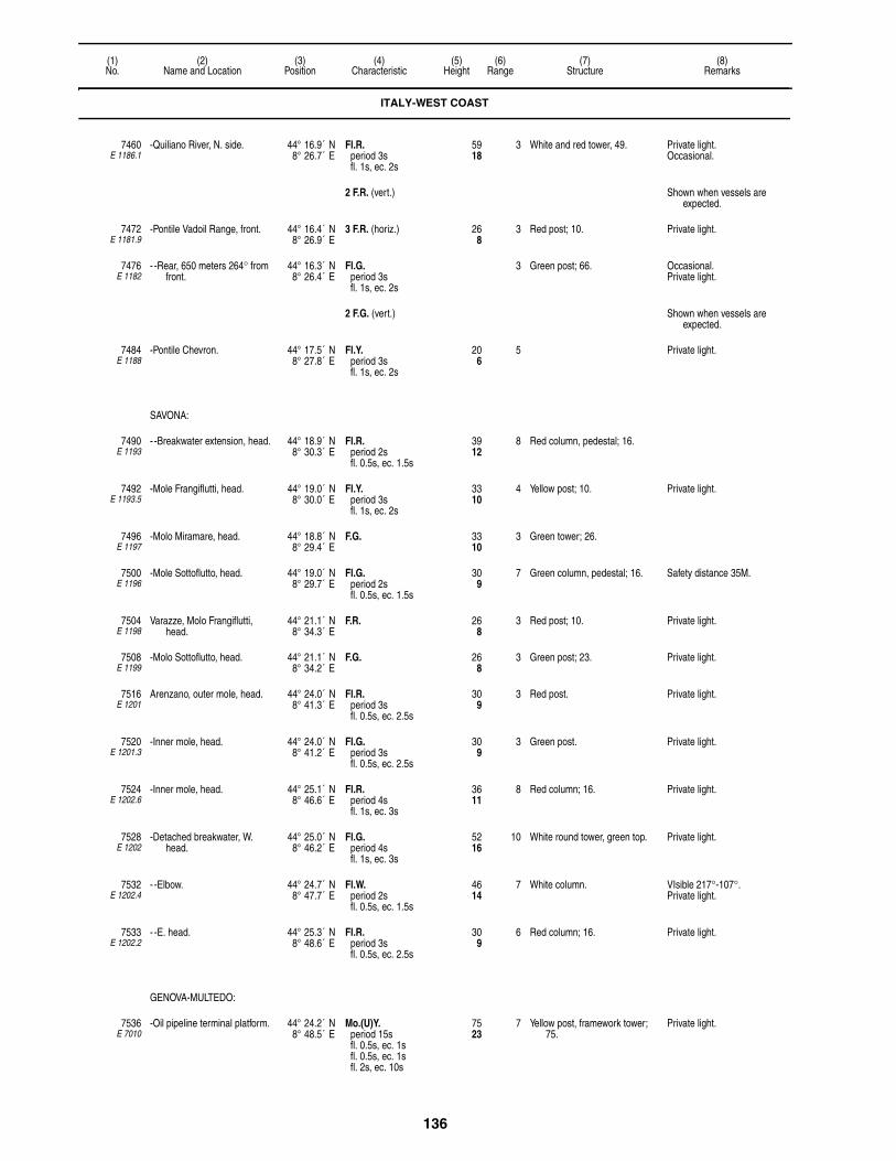
136
(1)No.
(2)Name and Location
(3)Position
(4)Characteristic
(5)Height
(6)Range
(7)Structure
(8)Remarks
7460E 1186.1
-Quiliano River, N. side. 44° 16.9´ N8° 26.7´ E
Fl.R.period 3sfl. 1s, ec. 2s
5918
3 White and red tower, 49. Private light.Occasional.
2 F.R. (vert.) Shown when vessels are expected.
7472E 1181.9
-Pontile Vadoil Range, front. 44° 16.4´ N8° 26.9´ E
3 F.R. (horiz.) 268
3 Red post; 10. Private light.
7476E 1182
- -Rear, 650 meters 264° from front.
44° 16.3´ N8° 26.4´ E
Fl.G.period 3sfl. 1s, ec. 2s
3 Green post; 66. Occasional. Private light.
2 F.G. (vert.) Shown when vessels are expected.
7484E 1188
-Pontile Chevron. 44° 17.5´ N8° 27.8´ E
Fl.Y.period 3sfl. 1s, ec. 2s
206
5 Private light.
SAVONA:
7490E 1193
- -Breakwater extension, head. 44° 18.9´ N8° 30.3´ E
Fl.R.period 2sfl. 0.5s, ec. 1.5s
3912
8 Red column, pedestal; 16.
7492E 1193.5
-Mole Frangiflutti, head. 44° 19.0´ N8° 30.0´ E
Fl.Y.period 3sfl. 1s, ec. 2s
3310
4 Yellow post; 10. Private light.
7496E 1197
-Molo Miramare, head. 44° 18.8´ N8° 29.4´ E
F.G. 3310
3 Green tower; 26.
7500E 1196
-Mole Sottoflutto, head. 44° 19.0´ N8° 29.7´ E
Fl.G.period 2sfl. 0.5s, ec. 1.5s
309
7 Green column, pedestal; 16. Safety distance 35M.
7504E 1198
Varazze, Molo Frangiflutti, head.
44° 21.1´ N8° 34.3´ E
F.R. 268
3 Red post; 10. Private light.
7508E 1199
-Molo Sottoflutto, head. 44° 21.1´ N8° 34.2´ E
F.G. 268
3 Green post; 23. Private light.
7516E 1201
Arenzano, outer mole, head. 44° 24.0´ N8° 41.3´ E
Fl.R.period 3sfl. 0.5s, ec. 2.5s
309
3 Red post. Private light.
7520E 1201.3
-Inner mole, head. 44° 24.0´ N8° 41.2´ E
Fl.G.period 3sfl. 0.5s, ec. 2.5s
309
3 Green post. Private light.
7524E 1202.6
-Inner mole, head. 44° 25.1´ N8° 46.6´ E
Fl.R.period 4sfl. 1s, ec. 3s
3611
8 Red column; 16. Private light.
7528E 1202
-Detached breakwater, W. head.
44° 25.0´ N8° 46.2´ E
Fl.G.period 4sfl. 1s, ec. 3s
5216
10 White round tower, green top. Private light.
7532E 1202.4
- -Elbow. 44° 24.7´ N8° 47.7´ E
Fl.W.period 2sfl. 0.5s, ec. 1.5s
4614
7 White column. VIsible 217°-107°.Private light.
7533E 1202.2
- -E. head. 44° 25.3´ N8° 48.6´ E
Fl.R.period 3sfl. 0.5s, ec. 2.5s
309
6 Red column; 16. Private light.
GENOVA-MULTEDO:
7536E 7010
-Oil pipeline terminal platform. 44° 24.2´ N8° 48.5´ E
Mo.(U)Y.period 15sfl. 0.5s, ec. 1sfl. 0.5s, ec. 1sfl. 2s, ec. 10s
7523
7 Yellow post, framework tower; 75.
Private light.
ITALY-WEST COAST

137
(1)No.
(2)Name and Location
(3)Position
(4)Characteristic
(5)Height
(6)Range
(7)Structure
(8)Remarks
7538E 7010.5
- -SE. oil terminal. 44° 23.6´ N8° 50.0´ E
Fl.Y.period 4sfl. 1s, ec. 3s
3611
6 SPECIALY, post, "X" topmark; 26.
Private light.
7540E 1212
-Molo di Multedo. 44° 25.1´ N8° 49.7´ E
Q.R. 3310
7 Red column;16. Private light.
7544E 1208
-Diga Foranea dell Aeroporto, W. head.
44° 24.8´ N8° 49.0´ E
Oc.W.period 3slt. 2s, ec. 1s
3310
12 White column; 16. Private light.
GENOVA:
7556E 1208.2
-Diga di Cornigliano. 44° 24.0´ N8° 52.8´ E
Fl.R.period 2sfl. 0.5s, ec. 1.5s
4413
7 Red column, pedestal; 16. Private light.
7560E 1208.6
-Diga Foranea. 44° 24.2´ N8° 52.6´ E
Q.G. 3310
5 Green column, pedestal; 16. Private light.
7564E 1208.8
- -Spur projecting, N. head. 44° 24.2´ N8° 52.6´ E
Fl.G.period 1.5sfl. 0.5s, ec. 1s
237
4 Green column. Private light.
7568E 1206
-Lanterna. 44° 24.3´ N8° 54.3´ E
Fl.(2)W.period 20sfl. 0.2s, ec. 4.8sfl. 0.2s, ec. 14.8s
384117
25 Tower, terrace; 249. Reserve light range 18M.AIS (MMSI No 992471014).Occasional. Private light.
Oc.R.period 1.5slt. 1s, ec. 0.5s
390119
10
7576E 1218
-Duca di Galliera Mole, old head.
44° 23.5´ N8° 55.9´ E
F.R. 4313
4 Red column, hut; 20. Visible 115°-303°.Private light.
7580E 1219
- -New head. 44° 23.3´ N8° 56.3´ E
Fl.R.period 3sfl. 1s, ec. 2s
5918
15 Red framework tower; 49. AIS (MMSI No 992471016).Private light.
7584E 1220
- -New mole, S. head. 44° 23.6´ N8° 56.1´ E
F.G. 268
2 Green column, tower. Private light.
7585E 1221
- -Molo Umberto Cagni, W. head.
44° 23.8´ N8° 55.6´ E
Fl.G.period 3sfl. 1s, ec. 2s
3310
8 Green column; 16. Private light.
7592E 1217
-Spur, E. entrance, head. 44° 23.6´ N8° 55.6´ E
Fl.R.period 3sfl. 1s, ec. 2s
3611
7 Red column; 16. Visible 123°-287°.Private light.
7596E 1216
-Bacino della Lanterna, NE. corner.
44° 23.8´ N8° 55.0´ E
Fl.(3)R.period 7sfl. 0.5s, ec. 1sfl. 0.5s, ec. 1sfl. 0.5s, ec. 3.5s
3310
7 Red column; 16. Obscured from seaward.Private light.
7600E 1225
-Calata dolla Sanita, on E. angle.
44° 24.2´ N8° 55.1´ E
Fl.R.period 3sfl. 1s, ec. 2s
268
7 Red column; 16. Private light.
7604E 1226
-Molo Vecchio. 44° 24.4´ N8° 55.1´ E
Fl.G.period 3sfl. 1s, ec. 2s
268
7 Green truncated conical tower; 16.
Private light.
7608E 1215
-Calata Olii Minerali. 44° 23.9´ N8° 55.0´ E
Fl.(3)G.period 7sfl. 0.5s, ec. 1sfl. 0.5s, ec. 1sfl. 0.5s, ec. 3.5s
3310
7 Green column; 23. Private light.
7612E 1230
-Punta Vagno. 44° 23.5´ N8° 57.2´ E
L.Fl.(3)W.period 15sfl. 2s, ec. 1sfl. 2s, ec. 1sfl. 2s, ec. 7s
8526
16 White truncated conical tower; 26.
Reserve light range 11M.AIS (MMSI No 992471015).Private light.
7620E 1233
-Nervi, jetty, head. 44° 22.9´ N9° 01.9´ E
2 F.R. (vert.) 237
3 Red post; 16. 1 meter apart.Private light.
ITALY-WEST COAST

138
(1)No.
(2)Name and Location
(3)Position
(4)Characteristic
(5)Height
(6)Range
(7)Structure
(8)Remarks
7624E 1236
Camogli, outer breakwater, head.
44° 21.1´ N9° 09.0´ E
Fl.W.period 3sfl. 1s, ec. 2s
3611
9 White round tower; 16.
7628E 1238
-On spur, breakwater, inner side.
44° 21.1´ N9° 09.1´ E
Fl.G.period 5sfl. 1s, ec. 4s
216
3 Green post; 13.
7632E 1237
-Jetty, at root. 44° 21.1´ N9° 09.1´ E
Fl.R.period 5sfl. 1s, ec. 4s
216
3 Red post; 16.
PORTOFINO:
7636E 1244
-Punta di Portofino. 44° 17.9´ N9° 13.1´ E
Fl.W.period 5sfl. 1s, ec. 4s
13140
16 Tower, two-story white building; 39.
Visible 155°-098°.Fl.R. lights are shown from
several radio masts.Reserve light range 11M.AIS (MMSI No 992471017).Private light.
7640E 1246
-Entrance, N. side. 44° 18.2´ N9° 12.7´ E
Fl.G.period 3sfl. 0.5s, ec. 2.5s
237
7 Bracket on building.
7644E 1248
-Punta del Coppo. 44° 18.2´ N9° 12.8´ E
Fl.R.period 3sfl. 0.5s, ec. 2.5s
3310
7 Red column, pedestal; 16.
7646E 1240.7
-Punta del Pedale. 44° 19.2´ N9° 12.8´ E
Fl.Y.period 3sfl. 0.5s, ec. 2.5s
134
2 SPECIALY, post, "X" topmark.
Private light.
7648E 1254
Santa Margherita Ligure, mole, head.
44° 19.9´ N9° 13.1´ E
Fl.R.period 4sfl. 1s, ec. 3s
3310
8 Red column, pedestal; 16.
7652E 1255.5
Rapallo, Molo Langano, head. 44° 20.7´ N9° 13.9´ E
F.R.G 206
3 Red post, green bands; 20. G. 220°-040°, R.-220°.Private light.
7656E 1256.2
Molo di Levante. 44° 20.7´ N9° 14.0´ E
2 F.R. (vert.) 237
3 Red post. 1 meter apart.Private light.
7657E 1256
Pennello Boate. 44° 20.8´ N9° 13.9´ E
2 F.G. (vert.) 237
3 Green post; 23. 1 meter apart.Private light.
7660E 1255
-Outer breakwater, elbow. 44° 20.6´ N9° 14.1´ E
Fl.W.period 3sfl. 1s, ec. 2s
299
9 White tower; 16. Private light.
7664E 1257
-Molo Foraneo, head. 44° 18.8´ N9° 19.0´ E
Fl.G.period 3sfl. 1s, ec. 2s
268
5 Green column; 16. Safety distance 40m.Private light.
7668E 1257.2
- -Spur. 44° 18.7´ N9° 19.2´ E
F.G. 134
3 Green post; 10. Safety distance 10m.Private light.
7672E 1257.4
-Molo Sottofluto, head. 44° 18.7´ N9° 19.3´ E
F.R. 134
3 Red post; 10. Safety distance 10m.Private light.
LAVAGNA:
7676E 1257.7
-Molo Foraneo. 44° 18.2´ N9° 20.6´ E
L.Fl.R.period 6sfl. 2s, ec. 4s
3912
6 Red column, pedestal; 16. Safety distance 60m.Private light.
7680E 1257.8
- -T-head. 44° 18.2´ N9° 20.5´ E
F.R. 165
2 Red post; 13. Private light.
7684E 1257.9
-Molo Sottofluto. 44° 18.3´ N9° 20.5´ E
F.G. 165
2 Green post; 13. Private light.
7692E 1258
Sestri Levante. 44° 16.3´ N9° 23.1´ E
F.G. 4413
3 Green post; 26. Private light.
ITALY-WEST COAST

139
(1)No.
(2)Name and Location
(3)Position
(4)Characteristic
(5)Height
(6)Range
(7)Structure
(8)Remarks
GOLFO DELLA SPEZIA:
7696E 1262
-Isola del Tino. 44° 01.6´ N9° 51.0´ E
Fl.(3)W.period 15sfl. 0.2s, ec. 2.8sfl. 0.2s, ec. 2.8sfl. 0.2s, ec. 8.8s
384117
25 White round tower; 79. Reserve light range 18M.AIS (MMSI No 992471018).
-RACON T(–) 18 (3 & 10cm).Azimuth 256°-150°.
7700E 1265
-Portovenere. 44° 03.0´ N9° 50.2´ E
F.R. 206
3 Red column; 13. Visible 085°-025°.Safety distance 10m.Private light.
7704E 1265.4
-Molo Olivo, head. 44° 03.1´ N9° 50.2´ E
F.G. 206
3 Green column; 13. Safety distance 10m.Private light.
7708E 1263
-Scoglio Torre della Scuola. 44° 03.1´ N9° 51.5´ E
Fl.(2)W.period 6sfl. 1s, ec. 1sfl. 1s, ec. 3s
5216
10 White metal framework tower; 7. AIS (MMSI No 992471004).
7709E 1267.2
-Punta della Castagna. 44° 03.7´ N9° 51.1´ E
Fl.Y.period 3sfl. 0.5s, ec. 2.5s
103
4 Yellow post.
-La Spezia:
7720E 1268
- -Punta Santa Maria. 44° 04.0´ N9° 51.1´ E
Fl.R.period 4sfl. 1s, ec. 3s
3611
9 Red tower; 23. Partially obscured 335°-347°Safety distance 30m.AIS (MMSI No 992471005).
7721E 1267.5
- - -S. 44° 04.0´ N9° 51.1´ E
Fl.Y.period 3sfl. 0.5s, ec. 2.5s
103
4 Yellow post.
7724E 1269
- -Detached breakwater, SW. head.
44° 04.1´ N9° 51.4´ E
Fl.G.period 4sfl. 1s, ec. 3s
3611
9 Green tower; 30. AIS (MMSI No 992471008).
7728E 1323
- -Seno di Panigaglia. 44° 04.7´ N9° 50.2´ E
2 F.G. (vert.) 268
3 Green post; 16. 1 meter apart.Private light.
7732E 1300
- - -Cadimare Mole. 44° 05.3´ N9° 49.9´ E
Fl.R.period 3sfl. 0.5s, ec. 2.5s
216
5 Red column, pedestal; 16.
7736E 1302
- - -S. entrance to port, inner detatched breakwater, S. head.
44° 05.3´ N9° 50.0´ E
Fl.G.period 3sfl. 0.5s, ec. 2.5s
216
7 Green column, pedestal; 16.
7740E 1304
- - -Inner detached breakwater, N. angle.
44° 05.6´ N9° 50.1´ E
Fl.W.period 3sfl. 0.5s, ec. 2.5s
237
11 White column, pedestal; 16.
7744E 1312
- - -Entrance Range, front. 44° 05.9´ N9° 48.9´ E
Fl.W.R.G.period 3sfl. 1s, ec. 2s
6921
W. 8R. 6G. 6
White truncated pyramidal tower, black stripe; 20.
G. 297°-305°18′, W.-306°48′, R.-315°.
7748E 1312.1
- - - -Pegazzano, rear, 1.02 km. 306° from front.
44° 06.2´ N9° 48.3´ E
Iso.W.period 4s
15748
16 Red and white checkered tower; 43.
Visible 302°-310°.AIS (MMSI No 992471019).
7752E 1319
- - -Basin No 1, entrance, S. side.
44° 05.7´ N9° 49.2´ E
F.R. 3711
3 Red tower; 33. Private light.
7756E 1318
- - - -N. side. 44° 05.7´ N9° 49.3´ E
F.G. 5717
3 Green post; 52. Private light.
2 F.R. (vert.) Occasional.
7760E 1292
- -Mirabello Molo, N. head. 44° 06.1´ N9° 49.7´ E
Iso.R.period 2s
216
4 Red tower; 13.
7760.2E 1292.6
- - -Helicopter pad. 44° 05.9´ N9° 50.0´ E
Fl.R.period 2sfl. 0.5s, ec. 1.5s
134
3 Red post. Private light.
ITALY-WEST COAST

140
(1)No.
(2)Name and Location
(3)Position
(4)Characteristic
(5)Height
(6)Range
(7)Structure
(8)Remarks
7760.4E 1292.7
- - -Fuel dock, head. 44° 05.9´ N9° 50.0´ E
Fl.Y.period 2sfl. 0.5s, ec. 1.5s
134
5 SPECIALY, beacon, "X" topmark.
Private light.
7760.6E 1292.8
- - -E. side of entrance. 44° 05.8´ N9° 50.0´ E
Fl.R.period 3sfl. 1s, ec. 2s
206
5 Red post. Private light.
7760.8E 1292.75
- - -W. side of entrance. 44° 05.8´ N9° 49.9´ E
Fl.G.period 3sfl. 1s, ec. 2s
206
5 Green post. Obscured 265°-015°.Private light.
7764E 1290
- -Italia Molo, head. 44° 06.3´ N9° 50.0´ E
Fl.R.period 4sfl. 1s, ec. 3s
268
8 Red tower; 23. Safety distance 10m.
7772E 1285.2
- -Verzocchi Quay, N. corner. 44° 06.5´ N9° 51.1´ E
2 F.R. (vert.) 3611
3 Red tower; 30. 2 meters apart.Private light.
7776E 1285.4
- - -S. corner. 44° 06.5´ N9° 51.2´ E
2 F.G. (vert.) 3611
3 Green tower; 30. 2 meters apart.Private light.
7780E 1285
- -Pontile ENEL. 44° 06.2´ N9° 51.2´ E
2 F.G.R. (vert.) 206
3 Green post, red bands; 16. 2 meters apart.Private light.
7784E 1284
- -Molo dei Pagliari. 44° 06.1´ N9° 51.4´ E
2 F.R.G. (vert.) 268
3 Red mast, green bands; 20. 2 meters apart.Private light.
7788E 1283
- -Pontile INMA, head. 44° 06.0´ N9° 51.4´ E
2 F.G. (horiz.) 268
3 Red mast, green bands; 20. Fl.G. 3s 5M and Fl.R. 3s 5M shown from breakwater heads about 330 meters S.
Private light.
2 F.R. (horiz.) 216
7789E 1282.2
- -Porto Lotti entrance, S. 44° 05.8´ N9° 51.4´ E
Fl.G.period 3sfl. 1s, ec. 2s
237
5 Green post; 16. Private light.
7790E 1282.4
- - -N. 44° 05.8´ N9° 51.5´ E
Fl.R.period 3sfl. 1s, ec. 2s
237
5 Red post; 16. Private light.
7792E 1281.2
- -Beacon. 44° 05.7´ N9° 51.8´ E
F.R. 237
3 Red post; 16. Private light.
7796E 1281
- -Beacon. 44° 05.7´ N9° 51.8´ E
F.G. 237
3 Green post; 16. Private light.
7800E 1280.2
- -Porticiollo San Bartolomeo. 44° 05.7´ N9° 51.8´ E
F.R. 206
3 Red post; 16. Fl.R. shown from radio mast about 412 meters N.
Private light.
7804E 1280
- - -S. side of entrance. 44° 05.7´ N9° 51.8´ E
F.G. 206
3 Green post; 16. Private light.
7808E 1278
- -Mole del Muggiano, head. 44° 05.3´ N9° 52.1´ E
F.G. 268
3 Green post; 20. Private light.
7812E 1270
- -Outer detached breakwater, E. head.
44° 04.8´ N9° 52.7´ E
Fl.(2)R.period 6sfl. 1s, ec. 1sfl. 1s, ec. 3s
3310
8 Red tower; 26. AIS (MMSI No 992471006).Safety distance 40m.
7816E 1270.2
- - -Spur, ESE. from extremity. 44° 04.8´ N9° 52.8´ E
Iso.R.period 2s
299
4 Red metal post; 16.
7820E 1274
- -Punta Santa Teresa. 44° 04.9´ N9° 52.9´ E
Fl.(2)G.period 6sfl. 1s, ec. 1sfl. 1s, ec. 3s
3310
8 Green tower; 13. AIS (MMSI No 992471007).Safety distance 40m.
7824E 1324
Lerici. 44° 04.4´ N9° 54.3´ E
2 F.G. (vert.) 247
3 Green post; 20. 1 meter apart.Private light.
7832E 1328
Marina di Carrera. 44° 02.2´ N10° 02.2´ E
Fl.W.period 3sfl. 1s, ec. 2s
7222
17 White four-sided tower; 72. Reserve light range 12M.AIS (MMSI No 992471020).
ITALY-WEST COAST

141
(1)No.
(2)Name and Location
(3)Position
(4)Characteristic
(5)Height
(6)Range
(7)Structure
(8)Remarks
7833E 1328.5
-W. breakwater, elbow. 44° 02.0´ N10° 02.1´ E
Dir.W.R.G. 10532
W. 12R. 10G. 10
Post; 98. F.G.-312°48′-315°18′, Al.W.G.-317°18′, F.W.-318°18′, Al.W.R.-320°18′, F.R.-322°48′.
Private light.
7836E 1329
-Diga Foranea, head. 44° 01.6´ N10° 02.5´ E
Iso.R.period 2s
4313
7 Red column, pedestal; 16. Safety distance 30m.
7840E 1330
-Molo di Levante. 44° 01.8´ N10° 02.5´ E
Iso.G.period 2s
3310
7 Green column, pedestal; 16. Safety distance 35m.
7844E 1330.4
Marina di Massa. 44° 00.3´ N10° 05.8´ E
2 F.G.R. (vert.) 3310
3 Red post, green bands; 20. 2 meters apart.Private light.
7848E 1331
Fiume Cinquale. 43° 58.7´ N10° 08.6´ E
Fl.Y.period 3sfl. 0.5s, ec. 2.5s
237
5 SPECIALY, post, "X" topmark; 16
Private light.
7852E 1334
Forte dei Marmi. 43° 57.3´ N10° 09.9´ E
F.R. 196
3 Red post; 10. Private light.
7856E 1340
Viareggio. 43° 51.5´ N10° 14.2´ E
Fl.W.period 5sfl. 0.2s, ec. 4.8s
9830
24 White round tower; 104. Reserve light range 18M.AIS (MMSI No 992471021).Private light.
7860E 1342
-Nuevo Diga Foranea, head. 43° 51.7´ N10° 14.1´ E
Iso.G.period 3s
309
9 Green column, pedestal; 16. Safety distance 20m.
7864E 1341
- N. mole, head. 43° 51.7´ N10° 14.2´ E
Iso.R.period 3s
309
7 Red column, pedestal; 16. Private light.
FIUME ARNO:
7868E 1347.25
-S. breakwater, head. 43° 40.6´ N10° 16.1´ E
Fl.G.period 3sfl. 1s, ec. 2s
268
8 Green post. Private light.
7870E 1347.6
FSRU Toscana. 43° 38.7´ N9° 59.3´ E
4 Fl.(2)+L.Fl.W.period 10sfl. 0.5s, ec. 1sfl. 0.5s, ec. 1sfl. 2s, ec. 5s
6620
5 Platform. 1 on each corner of platform.Private light.
RACON U(• • –) 5918
(3 & 10cm).
SECCHE DELLA MELORIA:
7872E 1347.8
-Shoal, N., NW. extremity. 43° 35.5´ N10° 12.7´ E
Fl.(2)W.period 10sfl. 0.5s, ec. 2sfl. 0.5s, ec. 7s
5918
10 White round concrete tower, truncated conical base; 66.
7874E 1348.5
-Shoal, NE. extremity. 43° 35.3´ N10° 15.5´ E
Q.(3)W.period 10s
165
7 E. CARDINALBYB, articulated beacon,
topmark.
7876E 1348
-Bank, S. edge. 43° 32.8´ N10° 13.1´ E
Q.(6)+L.Fl.W.period 15s
5918
12 S. CARDINALYB, tower, topmark; 56.
LIVORNO (LEGHORN):
7880E 1358
-Diga Meloria, head. 43° 33.5´ N10° 17.2´ E
Fl.(3)W.G.period 10sfl. 0.5s, ec. 1.5sfl. 0.5s, ec. 1.5sfl. 0.5s, ec. 5.5s
3912
W. 8G. 6
Green column, pedestal; 16. W. 064°-138°, G.-341°.
7882E 1359
- -520 meters SSE. 43° 33.2´ N10° 17.3´ E
Fl.W.period 3sfl. 1s, ec. 2s
3310
5 White post; 23. Visible 222°-229°.
7884E 1370
-Diga Curvilinea, N. head. 43° 33.1´ N10° 17.4´ E
Fl.R.G.period 3sfl. 1s, ec. 2s
237
5 Red column, pedestal, green bands; 16.
G. 160°-288°, R.-048°.
ITALY-WEST COAST

142
(1)No.
(2)Name and Location
(3)Position
(4)Characteristic
(5)Height
(6)Range
(7)Structure
(8)Remarks
7888E 1368
- -S. head. 43° 32.6´ N10° 17.4´ E
Fl.W.R.period 3sfl. 0.5s, ec. 2.5s
7222
W. 10R. 11
Octagonal tower; 66. R. 180°-078°, W.-139°.Reserve light Fl.R. 3s 6M.
7892E 1356
-Livorno. 43° 32.6´ N10° 17.7´ E
Fl.(4)W.period 20sfl. 0.2s, ec. 3.1sfl. 0.2s, ec. 3.1sfl. 0.2s, ec. 3.1sfl. 0.2s, ec. 9.9s
17152
24 Round masonry tower; 171. Reserve light range 18M.AIS (MMSI No 992471022).
-RACON LI(• – • • • •) 19 (3 & 10cm).
7896E 1360
-Diga Marzocco, head. 43° 33.5´ N10° 17.4´ E
Fl.(3)R.period 10sfl. 0.5s, ec. 1.5sfl. 0.5s, ec. 1.5sfl. 0.5s, ec. 5.5s
3912
7 Red column, pedestal; 16.
7912E 1376.2
- -Head. 43° 33.1´ N10° 17.7´ E
Fl.(2)R.period 6sfl. 0.5s, ec. 1sfl. 0.5s, ec. 4s
268
6 Red column, pedestal; 16. Visible 281°-135°.
7920E 1380
-Molo Mediceo, head. 43° 33.0´ N10° 17.7´ E
Fl.(2)G.period 6sfl. 0.5s, ec. 1sfl. 0.5s, ec. 4s
237
6 Green column, pedestal; 16. Visible only within the harbor.
7924E 1374
-Diga della Vegliaia, W. head. 43° 32.3´ N10° 17.2´ E
Fl.G.period 3sfl. 0.5s, ec. 2.5s
5918
12 Green round tower; 46. Visible 330°-240°.Reserve light range 6M.
7928E 1380.2
-Porticciolo San Lacopo. 43° 31.7´ N10° 18.3´ E
Fl.G.period 5sfl. 0.5s, ec. 4.5s
268
3 Green post; 13.
7932E 1380.4
-Porticciolo San Leopoldo. 43° 31.5´ N10° 18.5´ E
Fl.G.period 6sfl. 1s, ec. 5s
268
4 Green post; 16.
7936E 1381
-Antignano. 43° 29.8´ N10° 19.3´ E
Fl.G.period 3sfl. 0.5s, ec. 2.5s
237
4 Green column; 13.
7940E 1382
-Quercianella. 43° 27.5´ N10° 21.8´ E
F.R. 237
3 Red post; 16. Private light.
CORSE (CORSICA) (F.)
STRAIT OF BONIFACIO:
7944E 0876
-Cap Pertusato. 41° 22.0´ N9° 11.1´ E
Fl.(2)W.period 10sfl. 0.1s, ec. 2.4sfl. 0.1s, ec. 7.4s
328100
25 White square tower, black top with corners; 69.
Visible 239°-113°.
7948E 0872
-Ile Lavezzi. 41° 20.1´ N9° 15.5´ E
Iso.W.R.period 4sfl. 2s, ec. 2s
8927
W. 18R. 14
White square tower, red bands, white dwelling; 39.
W. 243°-351°, R.-243°.Partially obscured 138°-218°.
Oc.(2)W.R.period 6s
W. 10R. 7
Reserve light.
7950E 0874.5
-Ile Cavallo. 41° 21.7´ N9° 15.9´ E
Q.W.R.G.period 1.2s
237
W. 6R. 4G. 4
White masonry tower; 10. G. 328°-337°, W.-344°, R.-353°.
Fl.(3)G.period 12s
165
2
ITALY-WEST COAST
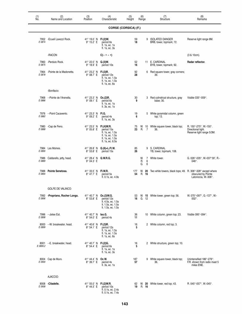
143
(1)No.
(2)Name and Location
(3)Position
(4)Characteristic
(5)Height
(6)Range
(7)Structure
(8)Remarks
7952E 0874
-Ecueil Lavezzi Rock. 41° 19.0´ N9° 15.2´ E
Fl.(2)W.period 6sfl. 1s, ec. 1sfl. 1s, ec. 3s
5918
9 ISOLATED DANGERBRB, tower, topmark; 72.
Reserve light range 8M.
-RACON C(– • – •) (3 & 10cm).
7960E 0875
-Perduto Rock. 41° 22.0´ N9° 18.9´ E
Q.(3)W.period 10s
5216
11 E. CARDINALBYB, tower, topmark; 92.
Radar reflector.
7964E 0878
-Pointe de la Madonetta. 41° 23.2´ N9° 08.7´ E
Fl.(3)R.period 12sfl. 1s, ec. 1.5sfl. 1s, ec. 1.5sfl. 1s, ec. 6s
9228
6 Red square tower, gray corners; 39.
-Bonifacio:
7968E 0886
- -Pointe de l'Arenella. 41° 23.3´ N9° 09.1´ E
Oc.(2)R.period 6slt. 1s, ec. 1slt. 3s, ec. 1s
309
3 Red cylindrical structure, gray base; 30.
Visible 035°-059°.
7976E 0882
- -Point Cacavento. 41° 23.3´ N9° 09.2´ E
Fl.G.period 4sfl. 1s, ec. 3s
196
5 White pyramidal column, green top; 13.
7980E 0888
-Cap de Feno. 41° 23.5´ N9° 05.8´ E
Fl.(4)W.R.period 15sfl. 1s, ec. 1.5sfl. 1s, ec. 1.5sfl. 1s, ec. 1.5sfl. 1s, ec. 6.5s
7523
W. 10R. 7
White square tower, black top; 36.
R. 150°-270°, W.-150°.Directional light.Reserve light range 5/3M.
7984E 0890
Les Moines. 41° 26.8´ N8° 53.8´ E
Q.(6)+L.Fl.W.period 15s
8526
9 S. CARDINALYB, tower, topmark; 108.
7986E 0889
Caldarello, jetty, head. 41° 28.4´ N9° 04.3´ E
Q.W.R.G. W. 7R. 6G. 6
White tower. G. 026°-035°, W.-037°30′, R.-046°.
7988E 0894
Pointe Senetosa. 41° 33.5´ N8° 47.7´ E
Fl.W.R.period 5sfl. 0.1s, ec. 4.9s
17754
W. 20R. 16
Two white towers, black tops; 49. R. 306°-328° except where obscured by Pointe Latoniccia, W.-306°.
GOLFE DE VALINCO:
7992E 0896
-Propriano, Rocher Longo. 41° 40.7´ N8° 53.8´ E
Oc.(3)W.G.period 12slt. 4.5s, ec. 1.5slt. 1.5s, ec. 1.5slt. 1.5s, ec. 1.5s
5316
W. 15G. 12
White tower, green top; 56. W. 070°-097°, G.-137°, W.-002°.
7996E 0898
- -Jetee Est. 41° 40.7´ N8° 54.0´ E
Iso.G.period 4s
3611
10 White column, green top; 23. Visible 095°-094°.
8000E 0899
- -W. breakwater, head. 41° 40.6´ N8° 54.1´ E
Fl.(3)R.period 12sfl. 1s, ec. 1.5sfl. 1s, ec. 1.5sfl. 1s, ec. 6s
165
2 White column, red top; 3.
8001E 0899.2
- -E. breakwater, head. 41° 40.7´ N8° 54.4´ E
Fl.(2)G.period 6sfl. 1s, ec. 1sfl. 1s, ec. 3s
165
2 White structure, green top; 10.
8004E 0900
Cap de Muro. 41° 44.4´ N8° 39.7´ E
Oc.W.period 4slt. 3s, ec. 1s
18757
9 White square tower, black top; 36.
Unintensified 186°-276°.F.R. shown from radio mast 5
miles ENE.
AJACCIO:
8008E 0908
-Citadelle. 41° 55.0´ N8° 44.5´ E
Fl.(2)W.R.period 10sfl. 0.1s, ec. 2.4sfl. 0.1s, ec. 7.4s
6219
W. 20R. 16
White tower, red top; 43. R. 045°-057°, W.-045°.
CORSE (CORSICA) (F.)

144
(1)No.
(2)Name and Location
(3)Position
(4)Characteristic
(5)Height
(6)Range
(7)Structure
(8)Remarks
8012E 0910
-Jetee de la Citadelle. 41° 55.2´ N8° 44.6´ E
Q.R. 4313
6 White column, red top; 43.
8020E 0913
-Jetee de Margonajo. 41° 55.7´ N8° 44.6´ E
Fl.R.period 4s
227
3 White column; 20. F.W. and F.R. (occasional) shown 1 mile E.
8021E 0912
-Port des Cannes. 41° 55.8´ N8° 44.6´ E
Fl.(2)R.period 6sfl. 0.5s, ec. 1.5sfl. 0.5s, ec. 3.5s
165
3 White tower, red top; 10.
8024E 0914
-Aspretto, outer jetty, head. 41° 55.3´ N8° 45.7´ E
Q.R.G. 268
7 White column, green top; 16. G. 035°-300°, R.-035°.Occasional.
8028E 0915
- -Inner jetty, head. 41° 55.3´ N8° 45.8´ E
Fl.R.period 4sfl. 1s, ec. 3s
237
8 White column, red top; 10. Occasional.
8032E 0906
- -L′Ecueil de la Citadelle. 41° 54.8´ N8° 44.4´ E
Fl.(4)R.period 15sfl. 1s, ec. 1.5sfl. 1s, ec. 1.5sfl. 1s, ec. 1.5sfl. 1s, ec. 6.5s
3310
6 Red truncated tower; 43.
8034E 0905
-La Guardiola. 41° 54.3´ N8° 43.2´ E
Fl.R.period 2.5sfl. 0.5s, ec. 2s
206
2 Red tower; 33.
8036E 0902
Iles Sanguinaires. 41° 52.7´ N8° 35.7´ E
Fl.(3)W.period 15sfl. 0.1s, ec. 3.9sfl. 0.1s, ec. 3.9sfl. 0.1s, ec. 6.9s
32198
24 White square tower, black top, white masonry building; 59.
8038E 0915.2
Cargese, S. jetty, head. 42° 07.8´ N8° 35.8´ E
Oc.(3)W.R.period 12slt. 4.5s, ec. 1.5slt. 1.5s, ec. 1.5slt. 1.5s, ec. 1.5s
237
W. 9R. 6
White truncated tower, red top; 10.
R. 025°-325°, W.-025°.
8038.5E 0915.4
-N. jetty, head. 42° 07.9´ N8° 35.8´ E
Fl.(3)G.period 12sfl. 0.5s, ec. 2sfl. 0.5s, ec. 2sfl. 0.5s, ec. 6.5s
134
3 White cylindrical structure, green top; 13.
8040E 0916
Ile Gargalu, NW. point. 42° 22.3´ N8° 32.1´ E
Fl.W.R.period 4sfl. 1s, ec. 3s
12137
W. 8R. 5
White column, black top; 23. R. 345°-348°, W.-214°, R.-221°.
8044E 0918
Pointe Revellata. 42° 35.0´ N8° 43.5´ E
Fl.(2)W.period 10sfl. 0.1s, ec. 2.4sfl. 0.1s, ec. 7.4s
31897
21 White square tower, black top; 62.
Visible 060°-002°.Reserve light.
8048E 0919
-Cala Revellata. 42° 34.8´ N8° 43.5´ E
Fl.G.period 4sfl. 1s, ec. 3s
165
6 White tower, green top; 13.
8052E 0920
Calvi, foot of citadel. 42° 34.2´ N8° 45.7´ E
Oc.(2)G.period 6slt. 3s, ec. 1slt. 1s, ec. 1s
9830
8 White hexagonal tower, green lantern; 20.
Visible 095°-005°.
8056E 0922
-Pier, head. 42° 34.0´ N8° 45.7´ E
Q.G. 3310
8 White square tower, dark green top; 33.
8060E 0923
-Breakwater, head. 42° 33.9´ N8° 45.6´ E
Fl.R.period 4s
196
7 White structure, red top; 13.
8064E 0924
Sant-Ambrogio. 42° 36.2´ N8° 49.7´ E
Fl.(2)G.period 6sfl. 1s, ec. 1sfl. 1s, ec. 3s
237
3 White metal post, dark green top; 20.
Fl.(2)R. marks head of SW. jetty.
8068E 0926
Ile-Rousse-La Pietra. 42° 38.7´ N8° 55.9´ E
Fl.(3)W.G.period 12sfl. 1s, ec. 1.5sfl. 1s, ec. 1.5sfl. 1s, ec. 6s
20964
W. 14G. 11
White square tower, green top, white house; 43.
G. 300°-079°, W.-234°, G.-275°.
CORSE (CORSICA) (F.)

145
(1)No.
(2)Name and Location
(3)Position
(4)Characteristic
(5)Height
(6)Range
(7)Structure
(8)Remarks
8072E 0928
-Shelter wall of jetty, head. 42° 38.5´ N8° 56.4´ E
Iso.G.period 4s
3912
8 White tower, green top; 39. Visible 143°-111°.
GOLFE DE SAINT-FLORENT:
8076E 0930
-Punta Mortella. 42° 42.9´ N9° 15.3´ E
Oc.G.period 4slt. 3s, ec. 1s
14043
8 White square tower, green top; 46.
8080E 0935
-Pointe Vecchiaia. 42° 42.8´ N9° 19.6´ E
Fl.(3)W.R.period 12sfl. 1s, ec. 1.5sfl. 1s, ec. 1.5sfl. 1s, ec. 6s
11535
W. 10R. 7
White truncated tower, red top; 16.
W. 035°-174°, R.-035°.
8084E 0932
-Cap Fornali. 42° 41.2´ N9° 16.8´ E
Fl.G.period 4sfl. 1s, ec. 3s
4614
6 White square tower, green top; 36.
Unintensified 000°-090°.
8088E 0934
-Tourelle Tignoso. 42° 40.9´ N9° 17.7´ E
Fl.R.period 4sfl. 1s, ec. 3s
196
3 Red tower; 30.
8092E 0933
-Saint Florent. 42° 40.8´ N9° 17.9´ E
Fl.(2)W.R.period 6sfl. 1s, ec. 1sfl. 1s, ec. 3s
206
W. 9R. 6
White truncated column, red upper portion; 16.
R. 116°-080°, W.-116°.
8096E 0933.2
- -S. jetty, head. 42° 40.7´ N9° 18.0´ E
Fl.(2)G.period 6sfl. 1s, ec. 1sfl. 1s, ec. 3s
134
3 White tower, green upper portion; 10.
8098E 0853
Centuri. 42° 58.0´ N9° 21.0´ E
Fl.G.period 4s
237
6 Fl.R. 2m 2M close SE.
8100E 0852
Cap Corse. 43° 01.3´ N9° 24.4´ E
Fl.W.period 5sfl. 0.1s, ec. 4.9s
27885
28 White tower, black upper portion; 85.
Visible 057°-314°.
8104E 0854
Macinaggio. 42° 57.5´ N9° 27.3´ E
Fl.(2)W.R.period 6sfl. 1s, ec. 1sfl. 1s, ec. 3s
268
W. 11R. 8
White tower, red upper portion; 26.
R. 120°-218°, W.-331°, R.-000°, R.(unintensified)-120°.
Fl.(2)G. 2M marks N. spur head.
8108E 0855
Capo Sagro. 42° 47.7´ N9° 29.5´ E
Fl.(3)W.period 12sfl. 1s, ec. 1.5sfl. 1s, ec. 1.5sfl. 1s, ec. 6s
10 White tower, green upper portion; 13.
8110E 0862
Toga. 42° 42.6´ N9° 27.4´ E
Q.R. 3310
4 White tower, red upper portion; 20.
8110.5E 0862.6
-N. breakwater, head. 42° 42.6´ N9° 27.4´ E
Q.G. 2 White masonry structure; 13.
BASTIA:
8112E 0856
-Jetee du Dragon, N. head. 42° 41.7´ N9° 27.2´ E
Fl.W.R.period 4sfl. 1s, ec. 3s
5216
W. 15R. 12
Gray tower, red lantern; 43. R.(unintensified) 040°-130°, R.-215°, W.-325°, R.-040°.
8116E 0861
-Mole, head. 42° 42.0´ N9° 27.2´ E
Fl.(2)R.period 6sfl. 1s, ec. 1sfl. 1s, ec. 3s
62
4 White column, red top; 3. Visible 153°-026°.
8120E 0858
-Genois Mole, head. 42° 41.7´ N9° 27.2´ E
Fl.(2)G.period 6sfl. 1s, ec. 1sfl. 1s, ec. 3s
4313
4 Gray tower, green top; 30.
8124E 0860
-Jetee St. Nicoles. 42° 41.9´ N9° 27.4´ E
Fl.G.period 4sfl. 1s, ec. 3s
299
11 Stone tower, green top; 16.
CORSE (CORSICA) (F.)

146
(1)No.
(2)Name and Location
(3)Position
(4)Characteristic
(5)Height
(6)Range
(7)Structure
(8)Remarks
8132E 0863
Campoloro. 42° 20.2´ N9° 32.4´ E
Fl.R.period 4sfl. 1s, ec. 3s
237
6 White column, red top; 16.
8136E 0864
Ruisseau d′Alistro. 42° 15.4´ N9° 32.4´ E
Fl.(2)W.period 10sfl. 0.1s, ec. 2.4sfl. 0.1s, ec. 7.4s
30593
22 Gray octagonal tower, black top, red dwelling; 89.
8137E 0865
Solenzara. 41° 51.4´ N9° 24.3´ E
Iso.G.period 4s
3
8138E 0865.2
-Quay. 41° 51.5´ N9° 24.3´ E
Oc.(2)R.period 6s
3
GOLFE DE PORTO VECCHIO:
8148E 0866
-Pointe de Chiappa. 41° 35.7´ N9° 21.9´ E
Fl.(3+1)W.period 15sfl. 0.1s, ec. 2.4sfl. 0.1s, ec. 2.4sfl. 0.1s, ec. 4.9sfl. 0.1s, ec. 4.9s
21365
23 White square tower, red lantern; 69.
Visible 90°-067°.
8152E 0866.4
-Tourelle Pecorella. 41° 36.8´ N9° 22.2´ E
Fl.(3)G.period 12sfl. 1s, ec. 1.5sfl. 1s, ec. 1.5sfl. 1s, ec. 6s
3912
6 White truncated tower, green top; 46.
8156E 0867
-Pointe St. Cyprien. 41° 37.1´ N9° 21.3´ E
Fl.W.G.period 4sfl. 1s, ec. 3s
8526
W. 11G. 8
White square tower, black lantern; 43.
W. 220°-281°, G.-299°, W.-072°, G.-084°.
8160E 0869
-Pointe Sud de Pozzoli. 41° 36.5´ N9° 17.3´ E
Iso.W.R.G.period 4s
3310
W. 15R. 13G. 13
White truncated tower, black top; 16.
G. 258°42′-271°42′ W.- 275°12′, R.-288°12′.
8164E 0870.3
-La Ciocca, tower. 41° 35.5´ N9° 17.4´ E
Fl.R.period 2sfl. 0.4s, ec. 1.6s
103
2 Red truncated tower; 16.
8168E 0870
-Porto Vecchio. 41° 35.2´ N9° 17.4´ E
Oc.W.R.G.period 4s
299
W. 11R. 9G. 9
Rectangular stone tower; 39. G. 208°30′-223°30′, W.-225°30′, R.-240°30′.
8172E 0870.6
-S. jetty. 41° 35.4´ N9° 17.1´ E
Fl.(2)R.period 6sfl. 1s, ec. 1sfl. 1s, ec. 3s
165
6 White tower, red top; 13. Visible 212°-302°.
8176E 0870.8
-N. jetty. 41° 35.4´ N9° 17.2´ E
Fl.(2)G.period 6sfl. 1s, ec. 1sfl. 1s, ec. 3s
134
5 White tower, green top; 7. Visible 200°-290°.
8180E 0871.5
Iles Cerbicales La Vacca, 2 Buoy.
41° 32.7´ N9° 24.0´ E
Q.(3)W.period 10s
134
6 E. CARDINALBYB, pillar, topmark.
Radar reflector.
SARDEGNA (SARDINIA) (I.)
STRAIT OF BONIFACIO:
8188E 0942
-Isola Santa Maria. 41° 17.9´ N9° 23.0´ E
Fl.(4)W.period 20sfl. 1.5s, ec. 1.5sfl. 1.5s, ec. 1.5sfl. 1.5s, ec. 1.5sfl. 1.5s, ec. 9.5s
5617
10 White two-story dwelling; 39. Visible 173°-016°.
8192E 0946
-Isola Corcelli. 41° 18.1´ N9° 24.0´ E
Fl.(2)W.period 10sfl. 1s, ec. 1.5sfl. 1s, ec. 6.5s
7222
11 ISOLATED DANGERBRB, tower, topmark; 39.
CORSE (CORSICA) (F.)

147
(1)No.
(2)Name and Location
(3)Position
(4)Characteristic
(5)Height
(6)Range
(7)Structure
(8)Remarks
8196E 0940
-Isola Razzoli. 41° 18.4´ N9° 20.4´ E
Fl.W.R.period 2.5sfl. 0.1s, ec. 2.4s
25377
W. 19R. 15
Stone tower; 39. W. 022°-092°, R.-137°, W.-237°, R.-320°.
AIS (MMSI No 992471125).Reserve light range 19/15M.
-RACON M(– –)period 30s
6 (3 & 10cm).
8200E 0936
-Longonsardo (Santa Teresa de Gallura).
41° 14.7´ N9° 11.9´ E
Fl.W.R.period 3sfl. 1s, ec. 2s
3711
W. 10R. 8
White hut; 23. R. 030°-164°, W.-184°, R.-210°.
8204E 0937
-Entrance Range, front. 41° 14.3´ N9° 11.7´ E
Oc.R.period 4slt. 3s, ec. 1s
3912
3 White and green post, white rectangular daymark, black stripe; 33.
Visible 181°30′-211°30′.
F.G. 206
3
For other lights in Bonifacio Strait, see Cap Pertusato.
8204.1E 0937.1
- -Rear, 1280 meters 196°30′ from front.
41° 13.6´ N9° 11.4´ E
Fl.R.period 4sfl. 1s, ec. 3s
14845
7 White post, white rectangular daymark, black stripe; 16.
Visible 151°30′-241°30′.
8208E 0938
-Capo Testa. 41° 14.6´ N9° 08.7´ E
Fl.(3)W.period 12sfl. 0.2s, ec. 2.3sfl. 0.2s, ec. 2.3sfl. 0.2s, ec. 6.8s
22067
22 White tower, two-story building; 75.
Visible 017°-256°.Reserve light range 17M.
8212E 1130
Isola Asinara. 41° 07.1´ N8° 19.1´ E
Fl.(4)W.period 20sfl. 1.5s, ec. 1.5sfl. 1.5s, ec. 1.5sfl. 1.5s, ec. 1.5sfl. 1.5s, ec. 9.5s
26280
16 White round tower, three-story building; 115.
GOLFO DELL'ASINARA:
-Porto Torres:
8216E 1138
- -Porto Torres. 40° 50.2´ N8° 23.8´ E
L.Fl.(2)W.period 10sfl. 2s, ec. 2sfl. 2s, ec. 4s
14745
16 White tower, two-story building; 66.
AIS (MMSI No 992471136).Reserve light range 12M.
8220E 1140
- -E. breakwater, head. 40° 50.7´ N8° 23.9´ E
L.Fl.R.period 6sfl. 2s, ec. 4s
3611
8 Red column, hut; 16. F.R. and F.G. light is shown at entrance to basin near root of breakwater.
8224E 1139
- -W. breakwater, head. 40° 50.9´ N8° 24.0´ E
L.Fl.G.period 6sfl. 2s, ec. 4s
3711
11 Green column on hut; 30. Reserve light range 8M.
- -RACON P(• – – •) 6 (3 & 10cm).
8236E 1136.8
- -Pontile de Levante. 40° 50.9´ N8° 22.8´ E
Fl.(3)R.period 10sfl. 1s, ec. 1sfl. 1s, ec. 1sfl. 1s, ec. 5s
3310
4 Red column; 23. Private light.
8244E 1136.32
- - -E. head. 40° 51.1´ N8° 23.1´ E
Fl.(3)G.period 10sfl. 1s, ec. 1sfl. 1s, ec. 1sfl. 1s, ec. 5s
319
4 Green column; 23. Private light.
8248E 1136.6
-Pier No 1, S.I.R. terminal. 40° 50.9´ N8° 22.4´ E
2 F.G.R. (vert.) 237
206
3 Red post, green bands. 1 meter apart.Private light.
8249E 1136.4
- -W. Range, front. 40° 50.2´ N8° 22.2´ E
Iso.G.period 2s
8927
2 Metal post, white rectangular daymark, black stripe; 98.
Visible 135°-225°.Private light.
2 F.G. (vert.) 7924
SARDEGNA (SARDINIA) (I.)

148
(1)No.
(2)Name and Location
(3)Position
(4)Characteristic
(5)Height
(6)Range
(7)Structure
(8)Remarks
8249.1E 1136.41
- - -Rear, 120 meters 180° from front.
40° 50.1´ N8° 22.2´ E
F.G. 11535
2 Metal post, black rectangular daymark, white stripe; 92.
Visible 135°-225°.Private light.
Oc.G. (vert.)period 4slt. 3s, ec. 1s
10532
8250E 1136.5
- -E. Range, front. 40° 50.2´ N8° 22.5´ E
Iso.R.period 2s
5216
2 Pylon, white square daymark, black stripe; 56.
Visible 135°-225°Private light.
F.R. (vert.) 4313
8250.1E 1136.51
- - -Rear, 120 meters 180° from front.
40° 50.1´ N8° 22.5´ E
F.R. 7523
2 Pylon, black square daymark, white stripe; 49.
Visible 135°-225°.Private light.
Oc.R. (vert.)period 4s
6620
8252E 1136.55
-Pier No 2, S.I.R. Terminal. 40° 50.9´ N8° 21.3´ E
2 F.G. (vert.) 3310
3 Green post; 16. Private light.
8262E 1135
-Fiumo Santo Power Plant. 40° 51.5´ N8° 18.3´ E
Fl.Y.period 3sfl. 0.5s, ec. 2.5s
134
3 Yellow tower. Marks watering place.Private light.
8264E 1134
-Stintino. 40° 56.2´ N8° 13.9´ E
Fl.R.period 4sfl. 1s, ec. 3s
196
4 Red post. Private light.
8264.5E 1134.4
-Mole, head. 40° 56.1´ N8° 13.9´ E
Fl.G.period 4sfl. 1s, ec. 3s
206
8 Green post. Private light.
8265E 1133.5
-Punta Salippi. 40° 59.3´ N8° 12.7´ E
Fl.W.R.G.period 3sfl. 1s, ec. 2s
206
W. 5R. 4G. 4
White pillar, black stripes; 16. G. 293°18′-297°, W.-305°, R.-308°42′.
8266E 1133
- -Passagio dei Fornelli. 40° 59.2´ N8° 13.5´ E
Fl.W.R.G.period 3sfl. 1s, ec. 2s
206
W. 6R. 4G. 4
White pillar, black stripes; 13. G. 065°12′-068°12′, W.-076°12′, R.-079°12′.
8268E 1132
-Rada della Reale. 41° 03.2´ N8° 17.6´ E
Fl.W.R.period 5sfl. 0.5s, ec. 4.5s
3611
W. 7R. 5
White round tower; 36. R. 297°-320°, W.-297°.
PORTO CONTE:
8276E 1124
-Capo Caccia. 40° 33.6´ N8° 09.8´ E
Fl.W.period 5sfl. 0.2s, ec. 4.8s
610186
24 White tower, three-story building; 79.
AIS (MMSI No 992471128).Reserve light range 18M.
8280E 1126
-Porto Conte. 40° 35.6´ N8° 12.2´ E
Fl.W.period 3sfl. 1s, ec. 2s
5717
10 White tower; 26.
8284E 1122
Isolotto della Maddalena. 40° 34.3´ N8° 18.0´ E
Fl.R.period 5sfl. 1s, ec. 4s
3310
4 White truncated conical tower, red bands; 20.
8285E 1122.6
- -Inner breakwater, head. 40° 35.5´ N8° 17.3´ E
F.G. 237
3 Green post; 16. Private light.
PORTO ALGHERO:
8286E 1117
-S. mole, head. 40° 33.9´ N8° 18.3´ E
Fl.G.period 3sfl. 1s, ec. 2s
3310
8 Green column; 20.
8288E 1117.2
- -Molo di Sottoflutto, head. 40° 33.9´ N8° 18.5´ E
Fl.R.period 3sfl. 1s, ec. 2s
3310
8 Red column; 20.
8296E 1119
-N. breakwater, head. 40° 33.7´ N8° 18.7´ E
F.R. 237
3 Red post; 20.
SARDEGNA (SARDINIA) (I.)

149
(1)No.
(2)Name and Location
(3)Position
(4)Characteristic
(5)Height
(6)Range
(7)Structure
(8)Remarks
8300E 1120
Alghero AVIATION LIGHT. 40° 38.0´ N8° 17.0´ E
Al.Fl.W.G. Occasional. Private light.
8308E 1116.4
-E. side, mole, head. 40° 17.2´ N8° 28.6´ E
F.R. 268
3 Red post; 23.
8309E 1116.5
-Outer mole, head. 40° 17.1´ N8° 28.5´ E
Fl.R.period 3sfl. 0.5s, ec. 2.5s
3611
11 Red post; 20. Reserve light range 8M.
8312E 1112
Capo Mannu. 40° 02.1´ N8° 22.7´ E
Fl.(3)W.period 12sfl. 0.8s, ec. 1.2sfl. 0.8s, ec. 1.2sfl. 0.8s, ec. 7.2s
19559
15 White tower, building; 36.
8316E 1111
Isolotto di Mal di Ventre, highest point.
39° 59.6´ N8° 18.2´ E
Fl.W.R.period 6sfl. 1s, ec. 5s
8526
W. 11R. 8
White round tower, hut; 26. R. 004°-020°, W.-004°.
8320E 1108
-Capo San Marco. 39° 51.6´ N8° 26.0´ E
Fl.(2)W.period 10sfl. 0.2s, ec. 2sfl. 0.2s, ec. 7.6s
18757
22 Round tower, two-story building; 49.
Visible 215°-155°.Reserve light range 18M.
L.Fl.R.period 5sfl. 2s, ec. 3s
18055
12 Visible 097°30′-102°30′.Over Scoglio il Catalano
8324E 1106
-Torre Grande. 39° 54.4´ N8° 31.0´ E
Fl.R.period 5sfl. 1s, ec. 4s
6018
8 Round tower; 52.
8332E 1107.2
- -Pontile Sipsa, head. 39° 53.5´ N8° 32.1´ E
2 F.R.G. (vert.) 309
268
3 Red and green post; 20. Private light.
8336E 1107.6
- -Pontile Perlite, head. 39° 53.6´ N8° 32.0´ E
2 F.G.R. (vert.) 42133912
3 Green and red post; 36. Private light.
8344E 1105.2
- -Oristano. 39° 51.9´ N8° 32.6´ E
Fl.R.period 5sfl. 1.5s, ec. 3.5s
3310
7 Red column; 16.
8353E 1104.2
- -Mole, head. 39° 49.8´ N8° 33.1´ E
Fl.Y.period 3sfl. 0.5s, ec. 2.5s
165
3 Yellow post; 7. Private light.
8356E 1104
-Capo Fresca. 39° 46.2´ N8° 27.3´ E
Fl.W.period 6sfl. 1s, ec. 5s
21866
11 White round tower, hut; 23.
8358E 1103.24
Buggerru. 39° 24.2´ N8° 23.9´ E
Fl.R.period 3sfl. 1s, ec. 2s
4 Red structure; 23. Fl.G. 3s 4M marks W. mole.Private light.
CANALE DI SAN PIETRO:
8360E 1103
-Isola Piana, N. extremity. 39° 11.6´ N8° 19.2´ E
Fl.(2)W.R.period 8sfl. 0.5s, ec. 1.5sfl. 0.5s, ec. 5.5s
5918
7 White round tower; 26. R. 209°-231° Over Secca Grande, W.-209°,
F.G. 3M marks head of breakwater about 625 meters SE.
Radar reflector.
8362E 1103.2
-Secca Grande. 39° 12.8´ N8° 20.3´ E
Q.W. 206
3 N. CARDINALBY, beacon, topmark.
Radar reflector.
-Portoscuso:
8363E 1099.5
- -N. mole. 39° 12.0´ N8° 22.8´ E
F.G. 4 Post. Private light.
8363.5E 1099.2
- -S. mole. 39° 12.0´ N8° 22.8´ E
2 F.R. (vert.) 4 Post. Private light.
SARDEGNA (SARDINIA) (I.)

150
(1)No.
(2)Name and Location
(3)Position
(4)Characteristic
(5)Height
(6)Range
(7)Structure
(8)Remarks
8364E 1099
-Scolglio la Ghinghetta. 39° 12.0´ N8° 22.2´ E
Fl.(2)W.R.period 10sfl. 1s, ec. 2sfl. 1s, ec. 6s
3912
W. 11R. 8
Black truncated tower, red bands.
W. 116°-153°, R.-165°, W.-100°, R.-116°.
-Portovesme:
8370E 1100
- -No 1. 39° 11.5´ N8° 22.4´ E
Fl.G.period 3sfl. 0.5s, ec. 2.5s
165
4 STARBOARD (A)G, beacon, topmark; 20.
Radar reflector.
8371E 1100.04
- -No 2. 39° 11.6´ N8° 22.4´ E
Fl.R.period 3sfl. 0.5s, ec. 2.5s
165
4 PORT (A)R, beacon, topmark; 20.
Channel marked by lighted beacons.
Radar reflector.
8374E 1100.6
- -Extension of Molo di Ponente. 39° 11.6´ N8° 23.2´ E
Fl.R.period 3sfl. 1s, ec. 2s
3611
7 Red column.
8376E 1100.8
- -Elbow. 39° 11.7´ N8° 23.4´ E
F.R. 268
3 Red post; 20. Visible 195°-063°.Safety distance 30m.
8380E 1101
- -Nuovo Diga di Levante. 39° 11.6´ N8° 23.5´ E
Fl.G.period 3sfl. 0.5s, ec. 2.5s
3711
7 Green column, hut; 23. Safety distance 20m.
-Carloforte:
8388E 1093
- -Entrance Range, front, Duono.
39° 08.7´ N8° 18.3´ E
F.R. 7523
3 White bell tower; 72.
8392E 1093.1
- - -Rear, about 380 meters 273°27′ from front.
39° 08.7´ N8° 18.1´ E
F.R. 13140
3 Black and white checkered beacon; 16.
8396E 1096
- -Molo della Sanita, head. 39° 08.7´ N8° 19.0´ E
Fl.G.period 3sfl. 1s, ec. 2s
268
6 Green column; 20.
8400E 1095
- -Molo Central, at head. 39° 08.7´ N8° 18.5´ E
Fl.Y.period 3sfl. 1s, ec. 2s
237
3 Yellow post; 16.
8412E 1094
- -Leading beacon Range, front. 39° 08.4´ N8° 18.6´ E
F.R. 3611
6 White building, black bands; 26.
8414E 1094.1
- - -Rear, 1650 meters 241°55′ from front.
39° 08.0´ N8° 17.6´ E
Fl.R.period 3sfl. 1s, ec. 2s
24675
9 White beacon; 13. Visible 221°-251°.
8416E 1092
- -Molo San Vittorio (Molo S.), head.
39° 08.7´ N8° 19.0´ E
Fl.R.period 3sfl. 1s, ec. 2s
247
8 Red column; 16.
8418E 1093.5
- -Secca dei Marmi. 39° 09.0´ N8° 20.0´ E
Fl.Y.period 3sfl. 0.5s, ec. 2.5s
206
4 SPECIALY, beacon, "X" topmark.
Radar reflector.
8419E 1093.6
- -Approach beacon. 39° 08.7´ N8° 20.1´ E
L.Fl.W.period 10sfl. 2s, ec. 8s
206
6 SAFE WATERRW, articulated beacon,
topmark.
Radar reflector.
8419.5E 1096.5
- -Fishing harbor, S. pier, head. 39° 08.9´ N8° 18.7´ E
2 F.R. (vert.) 237
165
2 Red mast; 13. Private light.
8419.75E 1096.6
- - -N. pier, head. 39° 08.9´ N8° 18.7´ E
2 F.G. (vert.) 237
165
2 Green mast; 13. Private light.
-Calasetta:
8420E 1098
- -Isola di Sant′ Antioco, N. side, outer mole, head.
39° 06.8´ N8° 22.5´ E
2 F.G. (vert.) 206
165
3 Green mast; 16. Private light.
SARDEGNA (SARDINIA) (I.)

151
(1)No.
(2)Name and Location
(3)Position
(4)Characteristic
(5)Height
(6)Range
(7)Structure
(8)Remarks
8424E 1098.4
- - -Inner mole, head. 39° 06.8´ N8° 22.4´ E
2 F.R. (vert.) 196
165
3 Red mast; 16. Private light.
8426E 1098.6
- - -Shoal, N. edge. 39° 07.0´ N8° 22.2´ E
Q.W. 165
5 N. CARDINALBY, beacon, topmark.
Private light.
8428E 1086
Scoglio Mangiabarche. 39° 04.6´ N8° 20.7´ E
Fl.W.period 6sfl. 1s, ec. 5s
4012
11 White truncated conical tower; 33.
8432E 1090
Capo Sandalo. 39° 08.8´ N8° 13.4´ E
Fl.(4)W.period 20sfl. 0.2s, ec. 2.3sfl. 0.2s, ec. 2.3sfl. 0.2s, ec. 2.3sfl. 0.2s, ec. 12.3s
438134
24 White round tower, two-story stone dwelling; 98.
Aeromarine light.Visible 322°-191° and in
Canale di Pietro 311°-322°.
AIS (MMSI No 992471135).Reserve light range 19M.
GOLFO DI PALMAS:
8436E 1074
-Isolotta Il Toro. 38° 51.7´ N8° 24.6´ E
Fl.(2)W.R.period 6sfl. 1s, ec. 1sfl. 1s, ec. 3s
387118
W. 11R. 8
Round tower, white hut; 26. W. 205°-199°, R.-205°.
-Porto Di Saint Antioco (Porto Romano):
8438E 1081
- -Entrance channel, outer, E. 39° 02.7´ N8° 29.0´ E
Fl.G.period 3sfl. 0.5s, ec. 2.5s
165
4 STARBOARD (A)G, beacon, topmark; 20.
Radar reflector.
8438.5E 1081.5
- - - -W. 39° 02.7´ N8° 28.9´ E
Fl.R.period 3sfl. 0.5s, ec. 2.5s
165
4 PORT (A)R, beacon, topmark; 20.
Radar reflector.
8439E 1082
- -Inner, E. 39° 03.1´ N8° 28.5´ E
Fl.G.period 3sfl. 0.5s, ec. 2.5s
165
4 STARBOARD (A)G, beacon, topmark; 20.
Radar reflector.
8439.5E 1082.2
- - -W. 39° 03.1´ N8° 28.5´ E
Fl.R.period 3sfl. 0.5s, ec. 2.5s
165
4 PORT (A)R, beacon, topmark; 20.
Radar reflector.
8440E 1080
- -Saint Antioco Ponti. 39° 03.5´ N8° 28.4´ E
Fl.W.period 5sfl. 1s, ec. 4s
7523
15 White tower, two-story building; 72.
AIS (MMSI No 992471134).Reserve light range 11M.
8444E 1084
- -Banchina del Carbone, SE. head.
39° 03.3´ N8° 28.3´ E
F.R. 268
4 Red post; 20.
8444.5E 1085
- - -SW. head. 39° 03.2´ N8° 28.2´ E
F.G. 268
4 Green post; 20.
PORTO DI TEULADA
8445E 1073
-Outer mole, head. 38° 55.6´ N8° 43.3´ E
Fl.R.period 4sfl. 1s, ec. 3s
268
6 Red post; 7. Private light.
8446E 1073.1
-Inner mole, head. 38° 55.7´ N8° 43.2´ E
Fl.G.period 4sfl. 1s, ec. 3s
268
6 Green post; 16. Private light.
8448E 1072
Capo Spartivento. 38° 52.7´ N8° 50.7´ E
Fl.(3)W.period 15sfl. 0.2s, ec. 3.5sfl. 0.2s, ec. 3.5sfl. 0.2s, ec. 7.4s
26581
22 Red tower, two-story building; 62.
Visible 240°-085°, and 093°-094°.
AIS (MMSI No 992471133).Reserve light range 18M.
8449E 1071.2
-Cala Verde, right mole, head. 38° 59.1´ N9° 00.2´ E
Fl.G.period 5sfl. 0.5s, ec. 4.5s
268
3 Green post; 16. Tourist port.Private light.
8449.1E 1071
- -Left mole, head. 38° 58.7´ N8° 59.9´ E
Fl.R.period 5sfl. 0.5s, ec. 4.5s
268
3 Red post; 16. Tourist port.Private light.
SARDEGNA (SARDINIA) (I.)

152
(1)No.
(2)Name and Location
(3)Position
(4)Characteristic
(5)Height
(6)Range
(7)Structure
(8)Remarks
8452E 1070
Capo di Pula. 38° 59.2´ N9° 01.3´ E
Fl.(4)W.period 15sfl. 1s, ec. 1sfl. 1s, ec. 1sfl. 1s, ec. 1sfl. 1s, ec. 8s
15748
11 Round tower, hut; 52.
GOLFO DI CAGLIARI:
-Sarroch:
8456E 1067
- -Oil Terminal Platform. 39° 05.2´ N9° 03.1´ E
Fl.W.period 3sfl. 0.5s, ec. 2.5s
8927
6 Column, red platform. Approach channel marked by articulated beacons.
Private light.
8464E 1066.7
- -Pontile SARAS, Chimica, No 2 head. Approach Range, front.
39° 06.0´ N9° 01.7´ E
2 Iso.R. (vert.)period 2s
3611
3 Red pole, white triangular daymark point up, red stripe; 16.
2 F.G. (vert.) light is shown at head of inner spur.
Private light.
8468E 1066.71
- -Pontile SARAS, No 2, rear, about 1240 meters 291° from front.
39° 06.2´ N9° 00.9´ E
2 Oc.R. (vert.)period 4slt. 3s, ec. 1s
92288927
3 Red pole, white triangular daymark point up, red stripe; 33.
Visible 287°-295°.Private light.
8476E 1066.24
-Pontile Rumianca Sud, head. 39° 09.4´ N9° 02.9´ E
2 F.R.G. (vert.) 299
268
3 Red and green poles; 10. Private light.
8480E 1066.26
- -Pontile Rumianca Sud, 240 meters 306° from head.
39° 09.5´ N9° 02.8´ E
Q.W. 299
3 White mast; 10. Private light.
8484E 1066.28
- -Pontile Rumianca Sud, 960 meters 306° from head.
39° 09.7´ N9° 02.3´ E
Iso.R.G.period 2s
299
3 Red and green post; 10. G. 126°-306°, R.-126°.Private light.
8488E 1066
-About 160 meters 000° from Pontile Rumianca Sud Root.
39° 10.1´ N9° 02.0´ E
Oc.G.period 6slt. 5s, ec. 1s
7021
4 Green pole; 49. Visible 126°-306°.Private light.
8492E 1066.2
-About 206 meters 247° from Pontile Rumianca Sud Root.
39° 09.9´ N9° 01.9´ E
Oc.R.period 4slt. 3s, ec. 1s
7021
4 Red pole; 49. Visible 306°-126°.Private light.
-Cagliari:
8500E 1056.2
- -W. breakwater, head. 39° 12.1´ N9° 06.6´ E
Fl.R.period 3sfl. 1s, ec. 2s
4313
9 White truncated conical tower, red band; 36.
Visible 120°-060°.
8501E 1056
- - -Elbow. 39° 12.2´ N9° 06.6´ E
F.R. 237
4 Red post. Visible 110°-330°.
8502E 1057
- -E. breakwater, head. 39° 11.7´ N9° 06.6´ E
Fl.G.period 3sfl. 1s, ec. 2s
4313
9 White truncated conical tower, green band; 36.
- - -RACON C(– • – •) 6 (3 & 10cm).
8503E 1057.4
- -Approach. 39° 11.0´ N9° 06.4´ E
Fl.(2+1)G.period 5sfl. 0.5s, ec. 0.5sfl. 0.5s, ec. 1sfl. 0.5s, ec. 2s
206
3 Green beacon, red band, green triangular daymark point up.
Fl.(2+1)G. 7s 6m 3M and Fl.(2+1)R. 7s 6m 3M beacons close S.
8503.2E 1065.62
- -Molo Settentrionale, head. 39° 11.7´ N9° 05.8´ E
Fl.(2)G.period 6sfl. 1s, ec. 1sfl. 1s, ec. 3s
5 Green column. Private light.
8503.25E 1065.61
- -Molo Meridionale, head. 39° 11.5´ N9° 05.6´ E
Fl.(2)R.period 6sfl. 1s, ec. 1sfl. 1s, ec. 3s
5 Red column. Private light.
8503.4E 1065.625
- -Entrance, NE. side. 39° 11.6´ N9° 05.8´ E
Fl.G.period 3sfl. 0.5s, ec. 2.5s
165
4 Green beacon, green triangular daymark, point up.
Visible 268°-183°.Private light.
SARDEGNA (SARDINIA) (I.)

153
(1)No.
(2)Name and Location
(3)Position
(4)Characteristic
(5)Height
(6)Range
(7)Structure
(8)Remarks
8503.45E 1065.615
- - -SW. side. 39° 11.6´ N9° 05.7´ E
Fl.R.period 3sfl. 0.5s, ec. 2.5s
165
4 Red beacon, red square daymark.
Visible 101°-006°.Private light.
8503.6E 1065.64
- -Dock approach, NE. side. 39° 12.2´ N9° 05.0´ E
Fl.(2)G.period 6sfl. 0.5s, ec. 1sfl. 0.5s, ec. 4s
165
4 Green beacon, green triangular daymark, point up.
Private light.
8503.65E 1065.63
- - -SW. side. 39° 12.2´ N9° 04.9´ E
Fl.(2)R.period 6sfl. 0.5s, ec. 1sfl. 0.5s, ec. 4s
165
4 Red beacon, red square daymark.
Private light.
8503.8E 1065.68
- -Dock entrance, SE. side. 39° 12.5´ N9° 04.8´ E
2 F.G. (vert.) 3 Green post. Private light.
8503.85E 1065.67
- - -NW. side. 39° 12.5´ N9° 04.7´ E
2 F.R. (vert.) 3 Red post. Private light.
8505E 1065.6
- -Basin. 39° 13.3´ N9° 03.6´ E
Dir.W.R.G. 5918
W. 5R. 3G. 3
White post; 20. F.G. 313°06′-315°00′, Al.W.G.-315°24′, F.W.-315°48′, Al.W.R.-316°12′, F.R.-318°06′.
Private light.
8508E 1064
- -Molo della Capitaneria, NW. corner.
39° 12.6´ N9° 06.8´ E
Fl.G.period 4sfl. 1s, ec. 3s
206
3 Green mast; 16.
8512E 1063
- -Pontile della Dogana, SE. corner.
39° 12.7´ N9° 06.8´ E
Fl.R.period 4sfl. 1s, ec. 3s
237
3 Red mast; 16.
8516E 1059.2
- -Molo Su Siccu, NW. arm. 39° 12.3´ N9° 07.2´ E
Fl.G.period 3sfl. 0.5s, ec. 2.5s
196
3 Green pole; 16.
8520E 1059
- - -SE. arm. 39° 12.2´ N9° 07.4´ E
F.R. 196
3 Red mast; 16.
8524E 1058
- -Pontile Sant Elmo, head. 39° 12.1´ N9° 07.4´ E
Fl.Y.period 5sfl. 1s, ec. 4s
206
4 SPECIALY, beacon, "X" topmark.
8528E 1065
- -Elmas AVIATION LIGHT. 39° 14.9´ N9° 04.0´ E
Al.Fl.W.G. Occasional.
8532E 1054
-Capo Sant' Elia. 39° 11.1´ N9° 08.8´ E
Fl.(2)W.period 10sfl. 0.2s, ec. 3.1sfl. 0.2s, ec. 6.5s
23070
21 White round tower, black bands, two-story dwelling; 69.
AIS (MMSI No 992471132).Reserve light range 18M.
8536E 1053
Marina Piccola del Poetto, breakwater, head.
39° 11.6´ N9° 09.8´ E
Fl.R.period 5sfl. 0.5s, ec. 4.5s
196
1 Red mast; 13. Private light.
8540E 1053.2
-Entrance, E. side, pier, head. 39° 11.6´ N9° 09.8´ E
Fl.G.period 5sfl. 0.5s, ec. 4.5s
196
1 Green mast; 16. Private light.
8544E 1042.1
Baia dei Carbonara. 39° 07.9´ N9° 29.9´ E
Fl.W.period 5sfl. 0.5s, ec. 4.5s
4614
6 White tower, hut; 16. Visible 009°-058°.
8548E 1043
Capo Carbonara. 39° 06.3´ N9° 30.8´ E
Fl.W.period 7.5sfl. 0.3s, ec. 7.2s
394120
23 White round tower; 16. Visible 217°-109°.Reserve light range 18M.
8550E 1049
Seccadi San Caterina beacon. 39° 05.0´ N9° 29.7´ E
Q.(9)W.period 15s
165
5 W. CARDINALYBY, beacon, topmark.
Radar reflector.
8552E 1048
Isola dei Cavoli. 39° 05.4´ N9° 32.1´ E
Fl.(2)W.R.period 10sfl. 1s, ec. 1.5sfl. 1s, ec. 6.5s
24274
W. 11R. 8
White tower, black bands, two-story building; 121.
W. 162°-073°, R.-093°, W.-128°.
SARDEGNA (SARDINIA) (I.)

154
(1)No.
(2)Name and Location
(3)Position
(4)Characteristic
(5)Height
(6)Range
(7)Structure
(8)Remarks
8556E 1044
Secca dei Berni, near Porto Giunco.
39° 06.8´ N9° 33.1´ E
Fl.(2)W.period 6sfl. 0.5s, ec. 1sfl. 0.5s, ec. 4s
309
4 ISOLATED DANGERBRB, tower, topmark; 26.
8560E 1042
Capo Ferrato. 39° 18.0´ N9° 37.9´ E
Fl.(3)W.period 10sfl. 1s, ec. 1sfl. 1s, ec. 1sfl. 1s, ec. 5s
16751
11 White tower, white building; 36.
8564E 1032
Capo Bellavista. 39° 55.9´ N9° 43.0´ E
Fl.(2)W.period 10sfl. 0.2s, ec. 2.3sfl. 0.2s, ec. 7.3s
541165
26 White building, black bands; 62.Secondary structure: Concrete
pylon.
AIS (MMSI No 992471131).Reserve light range 18M.
F.R. 476145
6 Visible 164°-177°30′.
8568E 1034
Arbatax, Mole di Levante, head. 39° 56.0´ N9° 42.0´ E
F.R. 4514
5 White truncated conical tower, red top; 20.
Visible 295°-150°.
8569E 1033
-Mole, head. 39° 56.6´ N9° 42.2´ E
Fl.R.period 3sfl. 1s, ec. 2s
309
9 White tower, red band; 26.
8572E 1036
-Molo di Ponente. 39° 56.4´ N9° 42.2´ E
Fl.R.G.period 3sfl. 1s, ec. 2s
4213
8 Green column, stone tower; 33. R. 107°-147°, G.-107°.
8580E 1031
Cala Gonone, outer mole. 40° 17.0´ N9° 38.0´ E
F.G. 237
3 Green post. Private light.
8584E 1031.2
-Inner mole. 40° 16.8´ N9° 38.4´ E
F.R. 237
3 Red post. Private light.
8588E 1030
Capo Comino. 40° 31.6´ N9° 49.6´ E
Fl.W.period 5sfl. 1s, ec. 4s
8526
15 White tower, building; 66. Visible 148°-010°.AIS (MMSI No 992471130).Reserve light range 11M.
8592E 1029
La Caletta, outer mole. 40° 36.0´ N9° 45.0´ E
Fl.G.period 3sfl. 1s, ec. 2s
268
2 Post, truncated pyramidal base; 7.
Private light.
8596E 1029.2
-Inner mole. 40° 36.6´ N9° 45.3´ E
Fl.R.period 3sfl. 1s, ec. 2s
165
2 Red post, truncated pyramidal base; 23.
Private light.
8598 Isolotto d′Ottiolo. 40° 44.3´ N9° 43.5´ E
Q.(3)W.period 10s
165
5 E. CARDINALBYB, beacon, topmark.
GOLFO DI OLBIA:
8600E 1028
-Isola Tavolara. 40° 55.6´ N9° 44.1´ E
L.Fl.(2)W.period 10sfl. 2s, ec. 2sfl. 2s, ec. 4s
23672
15 White polygonal tower; 23. Visible 050°-341°.AIS (MMSI No 992471129).Reserve light range 12M.
8604E 1028.4
- -Porticciolo, outer mole. 40° 55.2´ N9° 43.6´ E
F.R. 237
3 Red column; 13.
8608E 1028.6
- - -Inner mole. 40° 55.2´ N9° 43.6´ E
F.G. 237
3 Green column; 13.
8612E 1013.8
-Capo Ceraso Beacon. 40° 55.6´ N9° 38.1´ E
Q.W. 216
5 N. CARDINALBY, articulated beacon, topmark.
Radar reflector.
8616E 1014
- -Isola della Bacon. 40° 55.2´ N9° 34.0´ E
L.Fl.W.period 5sfl. 2s, ec. 3s
8024
15 White tower, two-story building; 72.
Visible 180°-264°.AIS (MMSI No 992471127).Reserve light range 11M.
8624E 1019
- -Isola di Mezzo, on S. extremity.
40° 55.2´ N9° 30.7´ E
Fl.G.period 3sfl. 0.5s, ec. 2.5s
237
4 Green column, pedestal; 16.
8632E 1020
- -Pontile Benedetto Brin, S. corner, head.
40° 55.3´ N9° 30.6´ E
F.G. 206
3 Green post; 16.
SARDEGNA (SARDINIA) (I.)

155
(1)No.
(2)Name and Location
(3)Position
(4)Characteristic
(5)Height
(6)Range
(7)Structure
(8)Remarks
8640E 1025
- -Su Arrasolu Pier, E. corner of T-head.
40° 55.7´ N9° 30.9´ E
F.R. 237
3 Red post, white hut; 16. Private light.
8648E 1012.2
-Golf of Aranci, head of mole, S. side.
40° 59.6´ N9° 37.3´ E
Oc.Y.period 3slt. 2s, ec. 1s
3611
3 Yellow post; 26. Oc.R. shown from head of commerical quay.
F.R. 4M and F.G. 4M mark head of fishing harbor breakwaters.
8649E 1012.4
- -Head of mole, near launching cradle.
40° 59.6´ N9° 37.3´ E
Oc.G.period 3slt. 2s, ec. 1s
3 Green post, hut; 26.
8656E 1013.5
-Bais Caddinas Marina, outer mole, head.
40° 59.0´ N9° 36.0´ E
Fl.G.period 2sfl. 0.5s, ec. 1.5s
165
2 Green post; 16. Private light.
8660E 1013.6
- -Inner mole, head. 40° 59.7´ N9° 36.2´ E
Fl.R.period 2sfl. 0.5s, ec. 1.5s
165
2 Red post; 16. 2 F.R.G. (vert.) light 1M is shown from T-mole head.
Private light.
8664E 1010
-Isolotto Figarolo, Golfo di Olbia, entrance, N. side.
40° 58.7´ N9° 38.7´ E
Fl.W.period 5sfl. 1s, ec. 4s
23371
11 Black column, white bands; 19. Visible 225°-076°.
8665E 1009.65
Punta Cala Volpe. 41° 02.4´ N9° 33.6´ E
Q.W. 165
4 N. CARDINALBY, beacon, topmark.
Private light.
8666E 1009.8
Punta Canigione. 41° 01.5´ N9° 35.7´ E
Q.W. 165
5 N. CARDINALBY, beacon, topmark.
Private light.
8668E 1009.7
Golfo di Marinella, jetty, head. 41° 00.3´ N9° 33.7´ E
Iso.R.period 6s
196
3 Red post; 13. Private light.
8669E 1009.56
Porto Rotondo, shelter mole. 41° 01.8´ N9° 32.6´ E
Fl.W.R.period 5sfl. 1s, ec. 4s
237
W. 7R. 5
White post; 20. R. 215°-240°, W.-215°.Private light.
8669.5E 1009.6
-N. breakwater. 41° 01.8´ N9° 32.6´ E
Fl.R.period 2sfl. 0.5s, ec. 1.5s
165
3 Red post; 10. Private light.
8670E 1009.62
-S. breakwater. 41° 01.8´ N9° 32.6´ E
Fl.G.period 2sfl. 0.5s, ec. 1.5s
165
3 Green post; 10. Private light.
8671E 1009.5
-Portisco, Marina di Sa Petra, E. mole.
41° 02.0´ N9° 31.6´ E
Fl.G.period 4sfl. 1s, ec. 3s
206
3 Green truncated conical tower, post; 16.
Fl.R. 4s 6m 4M marks W. mole.
Private light.
8672E 1009
Punta Ligata. 41° 03.9´ N9° 32.5´ E
Fl.W.period 3sfl. 0.5s, ec. 2.5s
3611
3 White truncated conical tower; 10.
Private light.
8676E 1009.2
Cala di Volpe, N. cove, E. entrance point.
41° 04.9´ N9° 32.5´ E
Fl.G.period 4sfl. 0.5s, ec. 3.5s
196
1 STARBOARD (A)G, post, topmark; 20.
Private light.
8680E 1009.4
-W. entrance point. 41° 05.0´ N9° 32.2´ E
Fl.R.period 4sfl. 0.5s, ec. 3.5s
237
1 PORT (A)R, post, topmark; 20.
Private light.
8684E 1008.4
Isole Poveri, S. islet. 41° 05.2´ N9° 34.8´ E
Fl.(2)W.period 6sfl. 0.5s, ec. 1sfl. 0.5s, ec. 4s
206
4 ISOLATED DANGERBRB, post, topmark; 13.
Private light.
8686E 1008.5
- -NE. shoal. 41° 05.7´ N9° 35.3´ E
Q.(3)W.period 10s
206
4 E. CARDINALBYB, beacon, topmark.
Private light.
8688E 1008.7
Isolotti Mortoriotto, NE. islet. 41° 05.2´ N9° 37.1´ E
Fl.(2)W.period 6sfl. 0.5s, ec. 1sfl. 0.5s, ec. 4s
3310
4 ISOLATED DANGERBRB, tower, topmark; 10.
Private light.
8692E 1005.4
Porto Cervo, S. entrance point. 41° 08.2´ N9° 32.3´ E
Fl.R.period 4sfl. 0.5s, ec. 3.5s
237
6 Red truncated conical tower; 16. Private light.
SARDEGNA (SARDINIA) (I.)

156
(1)No.
(2)Name and Location
(3)Position
(4)Characteristic
(5)Height
(6)Range
(7)Structure
(8)Remarks
8696E 1005
-N. entrance, point. 41° 08.3´ N9° 32.3´ E
Fl.G.period 4sfl. 0.5s, ec. 3.5s
237
6 Green truncated conical tower; 16.
Private light.
8700E 1006
-Head of bay, range, front. 41° 08.0´ N9° 31.4´ E
Iso.R.period 2s
8927
3 White post, white square tower, black stripe; 26.
Visible 247°24′-252°24′.Private light.
8704E 1006.1
- -Rear, 270 meters 252°22′ from front.
41° 08.0´ N9° 31.2´ E
Oc.R.period 4slt. 3s, ec. 1s
15447
3 White square tower, black stripe; 10.
Visible 247°24′-252°24′.Private light.
8708E 1007
-Inner N. breakwater. 41° 08.1´ N9° 31.9´ E
F.G. 237
3 Green post; 16. Private light.
8712E 1007.3
-Inner reef, S. 41° 08.0´ N9° 32.0´ E
F.R. 237
3 Red post; 16. Private light.
8716E 1008
Isole di li Nibani, on N. islet. 41° 07.9´ N9° 34.0´ E
Q.W. 6821
4 N CARDINAL BY, tower, topmark; 10.
Private light.
8720E 1004
Secche del Cervo. 41° 08.7´ N9° 32.7´ E
Q.(3)W.period 10s
206
4 E. CARDINALBYB, beacon, topmark; 7.
Private light.
8724E 1002
Capo Ferro. 41° 09.3´ N9° 31.4´ E
Fl.(3)W.period 15sfl. 0.3s, ec. 2.7sfl. 0.3s, ec. 2.7sfl. 0.3s, ec. 8.7s
17052
24 White round tower, two-story building; 59.
Aeromarine light.AIS (MMSI No 992471126).Reserve light range 18M.
Oc.R.period 5slt. 4s, ec. 1s
13742
8 Visible 189°-203° over Secca delle Bisce and dei Monaci.
8728E 1003
-320 meters 053° from main light.
41° 09.4´ N9° 31.6´ E
Fl.R.period 3sfl. 1s, ec. 2s
4614
8 White truncated conical tower, red band; 33.
8732E 1000
Isola delle Bisce, S. side. 41° 09.7´ N9° 31.5´ E
Fl.G.period 3sfl. 1s, ec. 2s
3611
8 White tower, green band; 30. Visible 255°-110°.
8736E 0998
Isolotti Monaci. 41° 13.0´ N9° 31.0´ E
Fl.W.R.period 5sfl. 1s, ec. 4s
7924
W. 11R. 8
White truncated conical tower; 52.
R. 246°-268°, W.-317°, R.-357°, W.-246°.
8736.5E 0998.6
-Secca dei Monaci. 41° 13.3´ N9° 32.6´ E
Q.W. 206
3 N. CARDINALBY, beacon, topmark.
8737E 0995.4
Porticciolo di Poltu Quatu, E. breakwater.
41° 08.5´ N9° 29.7´ E
Fl.R.period 5sfl. 0.5s, ec. 4.5s
237
4 Red post; 13. Private light.
8738E 0995.42
-W. breakwater. 41° 08.5´ N9° 29.7´ E
Fl.G.period 5sfl. 0.5s, ec. 4.5s
237
4 Green post; 13. Private light.
8740E 0994
Secca di Tre Monti Beacon. 41° 09.4´ N9° 27.7´ E
Fl.(2)W.period 8sfl. 0.5s, ec. 1sfl. 0.5s, ec. 6s
165
5 ISOLATED DANGERBRB, beacon, topmark.
Radar reflector.
8742E 0995
Porticciolo di Cannigione. 41° 06.4´ N9° 26.7´ E
Fl.G.period 4sfl. 1s, ec. 3s
237
3 Green post. Private light.
8744E 0996
Isola Caprera, on Punta Rossa. 41° 10.1´ N9° 28.2´ E
Fl.G.period 5sfl. 0.5s, ec. 4.5s
309
5 Green post, green truncated pyramidal building; 13.
Visible 275°-110°.
8748E 0992
Capo d'Orso, NE. extremity. 41° 10.7´ N9° 25.4´ E
Fl.W.period 3sfl. 1s, ec. 2s
3912
10 White truncated conical tower; 33.
LA MADDALENA:
8752E 0991
-Punta Villamarina, Isola S. Stefano.
41° 11.2´ N9° 24.6´ E
Fl.G.period 4sfl. 1s, ec. 3s
4614
4 Green column, pedestal; 20.
SARDEGNA (SARDINIA) (I.)

157
(1)No.
(2)Name and Location
(3)Position
(4)Characteristic
(5)Height
(6)Range
(7)Structure
(8)Remarks
8753E 0993
-Cala Capra, N. mole, head. 41° 10.1´ N9° 25.3´ E
F.G. 206
4 Green post, platform; 16. Private light.
8756E 0966
-Isola Chiesa, S. extremity, mole, head.
41° 12.6´ N9° 25.0´ E
F.R. 268
3 Red column, hut; 23.
8760E 0960
- -La Maddalena Range, front. 41° 12.8´ N9° 25.1´ E
F.G. 5617
3 White beacon tower, black band; 13.
8761E 0960.1
- - -Rear, 680 meters 066° from front.
41° 12.9´ N9° 25.3´ E
F.G. 12137
3 White beacon tower, black stripe; 23.
8764E 0968
- -Beacon, 174 meters SW. of mole at S. extremity of island.
41° 12.5´ N9° 24.9´ E
F.G. 196
3 Green beacon; 16.
8766E 0955
-Punta Tegge. 41° 12.6´ N9° 22.7´ E
Fl.R.period 4sfl. 0.5s, ec. 3.5s
134
3 Red truncated pyramidal beacon.
8768E 0957
-Guardia Vecchia Range, front. 41° 12.9´ N9° 23.8´ E
Iso.G.period 2s
16450
8 White hut, black stripe; 3. Visible 008°12′-019°48′ between Secche del Paulau and Roma.
8772E 0957.1
- -Rear, about 869 meters 014° from front.
41° 13.3´ N9° 24.0´ E
Oc.G.period 4slt. 3s, ec. 1s
492150
8 White hut, black stripe; 3.
8776E 0962.4
-Via G. Amendola, E. extremity. 41° 12.8´ N9° 24.5´ E
Fl.R.period 3sfl. 0.5s, ec. 2.5s
237
3 Red post; 16.
8780E 0962
- -W. extremity, E. side of Cala Gavetta entrance.
41° 12.6´ N9° 24.3´ E
Fl.G.period 3sfl. 1s, ec. 2s
237
3 Green column; 20.
8784E 0961
- -Mole, new head. 41° 12.6´ N9° 24.3´ E
Fl.R.period 3sfl. 1s, ec. 2s
206
3 Red column; 16.
8788E 0963
-Cala Mangiavolpe, pier, head. 41° 12.8´ N9° 24.6´ E
Fl.Y.period 3sfl. 1s, ec. 2s
237
3 Yellow post; 16.
8792E 0964
-W. side of bay, breakwater, head.
41° 12.8´ N9° 24.7´ E
Fl.R.period 3sfl. 1s, ec. 2s
165
3 Red post; 7.
8796E 0972
-Hospital Wharf, head. 41° 12.8´ N9° 25.5´ E
F.R. 237
3 Red post; 20.
8804E 0974
-Cala Camiciotto, W. side of entrance, mole, head.
41° 12.8´ N9° 25.6´ E
Fl.R.period 3sfl. 0.5s, ec. 2.5s
237
3 Red post; 16.
8805E 0975
- -E. side of entrance, mole, head.
41° 12.8´ N9° 25.7´ E
Fl.G.period 3sfl. 0.5s, ec. 2.5s
237
3 Green post; 16.
8816E 0980
-Cala Stagnali Range, front. 41° 12.0´ N9° 27.1´ E
F.G. 309
3 White post, white pylon, black bands; 16.
8820E 0980.1
- -Rear, about 87 meters 139° from front.
41° 11.9´ N9° 27.1´ E
F.G. 4614
3 White post, white pylon, black bands; 16.
8824E 0953
Secca di Mezzo Passo, Isola Maddalena, off SE. head.
41° 12.3´ N9° 22.8´ E
Fl.(2)W.period 6sfl. 0.5s, ec. 1sfl. 0.5s, ec. 4s
237
5 ISOLATED DANGERBRB, beacon, topmark; 23.
8828E 0958
Secca del Palau. 41° 11.8´ N9° 23.2´ E
V.Q.(6)+L.Fl.W.period 10s
268
5 S. CARDINALYB, beacon, topmark; 29.
8829E 0958.2
-Shoal, E. limit. 41° 11.9´ N9° 23.4´ E
Fl.Y.period 5sfl. 0.5s, ec. 4.5s
206
4 SPECIALY, beacon, "X" topmark.
SARDEGNA (SARDINIA) (I.)

158
(1)No.
(2)Name and Location
(3)Position
(4)Characteristic
(5)Height
(6)Range
(7)Structure
(8)Remarks
8832E 0988
Punta Palau. 41° 11.3´ N9° 22.9´ E
Fl.(2)G.period 10sfl. 1s, ec. 2sfl. 1s, ec. 6s
4915
4 White round truncated tower, green band; 33.
8833E 0990
-Palau, pier, head. 41° 10.9´ N9° 23.2´ E
Fl.Y.period 3sfl. 1s, ec. 2s
206
3 SPECIALY, post, "X" topmark; 16.
8834E 0990.2
-Beacon. 41° 10.9´ N9° 23.3´ E
V.Q.(9)W.period 10s
165
5 W. CARDINALYBY, beacon, topmark.
Radar reflector.
8835E 0990.6
-Shelter mole. 41° 10.8´ N9° 23.2´ E
F.G. 206
3 Green post; 16. Private light.
8835.5E 0990.4
Marina, breakwater, head. 41° 10.8´ N9° 23.2´ E
F.R. 206
3 Red post; 16. Private light.
8836E 0950
Punta Coda Sardegna, island, N. coast.
41° 12.4´ N9° 21.8´ E
Fl.W.period 5sfl. 1s, ec. 4s
12538
11 White two-story dwelling; 49.
8840E 0984
Porto Massimo (Lungo), dike, head.
41° 15.5´ N9° 25.7´ E
F.G. 165
3 Green post; 13. Private light.
SARDEGNA (SARDINIA) (I.)

159
(1)No.
(2)Name and Location
(3)Position
(4)Characteristic
(5)Height
(6)Range
(7)Structure
(8)Remarks
Section 7West Coast of Italy and Sicily
ITALY-WEST COAST AND ADJACENT ISLANDS
8848E 0951
Secca Corsara Beacon. 41° 13.4´ N9° 20.1´ E
Q.(6)+L.Fl.W.period 15s
206
5 S. CARDINALYB, buoyant beacon, topmark.
Radar reflector.
8852E 1392
-Punta Paratella, island, N. point.
43° 26.4´ N9° 54.1´ E
Fl.W.period 5sfl. 1s, ec. 4s
346105
9 White tower; 16. Signal station, on summit.
8856E 1394
-Cala Dello Scalo, mole, head. 43° 25.7´ N9° 54.6´ E
Fl.R.period 3sfl. 0.3s, ec. 2.7s
268
4 Red lamppost; 13.
8860E 1396
-Punta Cala Scirocco, island, SE. point.
43° 25.3´ N9° 54.0´ E
Fl.(2)W.period 10sfl. 1s, ec. 2sfl. 1s, ec. 6s
14745
9 White tower; 16.
ISOLA CAPRAIA:
8864E 1400
-Punta del Ferraione. 43° 03.0´ N9° 50.7´ E
L.Fl.W.period 6sfl. 2s, ec. 4s
9830
16 White tower, dwelling; 39. AIS (MMSI No 992471023).Reserve light range 11M.
8872E 1401
- -NE. mole, elbow. 43° 03.0´ N9° 51.0´ E
Fl.G.period 3sfl. 0.5s, ec. 2.5s
206
4 Green post; 13. Visible 195°-074°.
8876E 1403
- -Inner mole, head. 43° 02.7´ N9° 50.3´ E
Fl.R.period 3sfl. 0.5s, ec. 2.5s
237
4 Red post;13.
ISOLA D'ELBA:
8884E 1444
-Punta Polveraia. 42° 47.6´ N10° 06.7´ E
L.Fl.(3)W.period 15sfl. 2s, ec. 2sfl. 2s, ec. 2sfl. 2s, ec. 5s
17052
16 White tower, building; 33. Visible 036°-000°.Reserve light range 11M.AIS (MMSI No 992471027).
8888E 1408
-Marciana Marina, mole, head. 42° 48.4´ N10° 11.9´ E
Fl.G.period 4sfl. 1s, ec. 3s
3611
7 Green column, pedestal; 18.
8890E 1409
-Secca di Capo Bianco. 42° 49.5´ N10° 19.1´ E
Q.W. 165
3 N. CARDINALBY, buoyant beacon, topmark.
8892E 1410
-Scoglietto, Portoferraio approach.
42° 49.7´ N10° 19.8´ E
Fl.(2)W.period 6sfl. 1s, ec. 1sfl. 1s, ec. 3s
7924
7 Castellated tower, hut; 26.
-Portoferraio:
8896E 1412
- -Forte Stella. 42° 49.0´ N10° 20.0´ E
Fl.(3)W.period 14sfl. 1s, ec. 2sfl. 1s, ec. 2sfl. 1s, ec. 7s
20763
16 Tower; 82. Visible 104°-014°.Reserve light range 11M.AIS (MMSI No 992471028).
F.R. 19760
6 Visible 100°-131°.
8900E 1415
- -Mole, head. 42° 48.7´ N10° 19.8´ E
Fl.R.period 4sfl. 1s, ec. 3s
237
3 Metal bracket, wall tower; 23. Visible 320°-068°
8904E 1416.5
- -Pontile G. Massima, head. 42° 48.7´ N10° 19.4´ E
Fl.Y.period 3sfl. 1s, ec. 2s
206
4 Yellow post; 10.
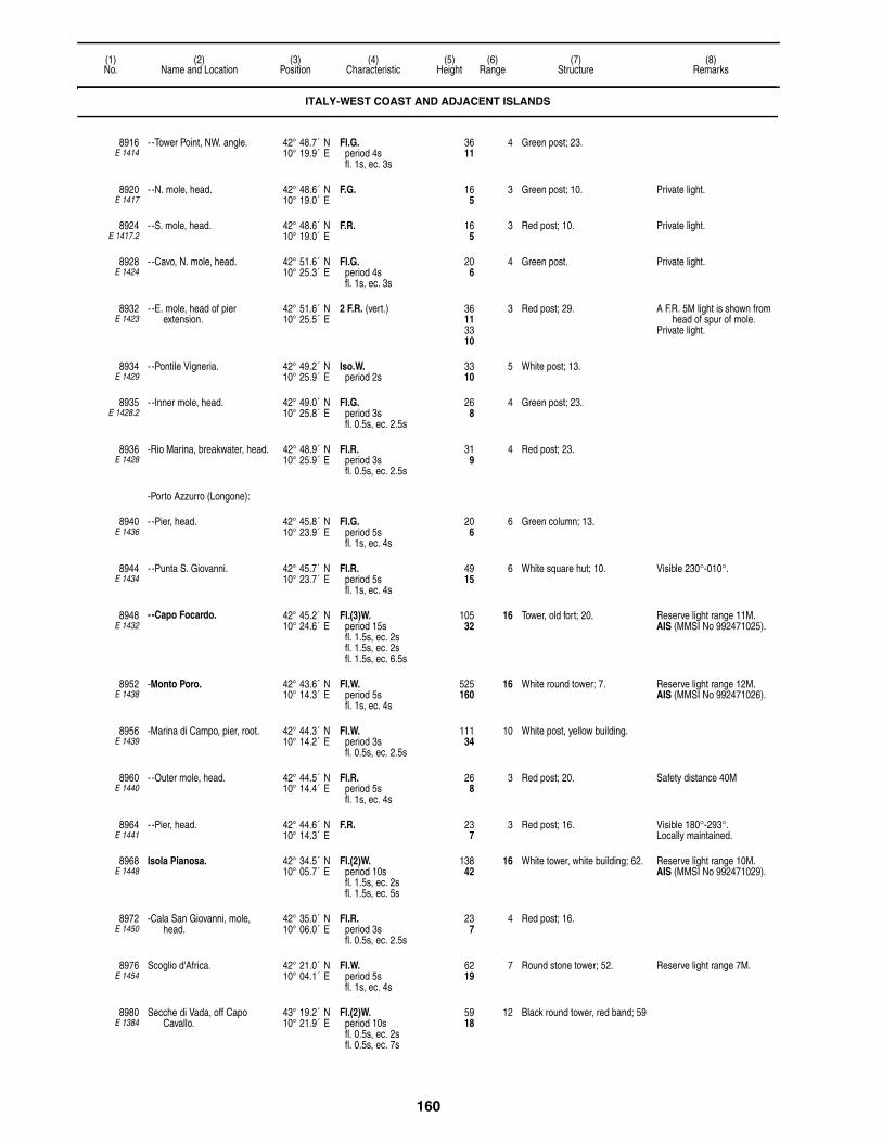
160
(1)No.
(2)Name and Location
(3)Position
(4)Characteristic
(5)Height
(6)Range
(7)Structure
(8)Remarks
8916E 1414
- -Tower Point, NW. angle. 42° 48.7´ N10° 19.9´ E
Fl.G.period 4sfl. 1s, ec. 3s
3611
4 Green post; 23.
8920E 1417
- -N. mole, head. 42° 48.6´ N10° 19.0´ E
F.G. 165
3 Green post; 10. Private light.
8924E 1417.2
- -S. mole, head. 42° 48.6´ N10° 19.0´ E
F.R. 165
3 Red post; 10. Private light.
8928E 1424
- -Cavo, N. mole, head. 42° 51.6´ N10° 25.3´ E
Fl.G.period 4sfl. 1s, ec. 3s
206
4 Green post. Private light.
8932E 1423
- -E. mole, head of pier extension.
42° 51.6´ N10° 25.5´ E
2 F.R. (vert.) 36113310
3 Red post; 29. A F.R. 5M light is shown from head of spur of mole.
Private light.
8934E 1429
- -Pontile Vigneria. 42° 49.2´ N10° 25.9´ E
Iso.W.period 2s
3310
5 White post; 13.
8935E 1428.2
- -Inner mole, head. 42° 49.0´ N10° 25.8´ E
Fl.G.period 3sfl. 0.5s, ec. 2.5s
268
4 Green post; 23.
8936E 1428
-Rio Marina, breakwater, head. 42° 48.9´ N10° 25.9´ E
Fl.R.period 3sfl. 0.5s, ec. 2.5s
319
4 Red post; 23.
-Porto Azzurro (Longone):
8940E 1436
- -Pier, head. 42° 45.8´ N10° 23.9´ E
Fl.G.period 5sfl. 1s, ec. 4s
206
6 Green column; 13.
8944E 1434
- -Punta S. Giovanni. 42° 45.7´ N10° 23.7´ E
Fl.R.period 5sfl. 1s, ec. 4s
4915
6 White square hut; 10. Visible 230°-010°.
8948E 1432
- -Capo Focardo. 42° 45.2´ N10° 24.6´ E
Fl.(3)W.period 15sfl. 1.5s, ec. 2sfl. 1.5s, ec. 2sfl. 1.5s, ec. 6.5s
10532
16 Tower, old fort; 20. Reserve light range 11M.AIS (MMSI No 992471025).
8952E 1438
-Monto Poro. 42° 43.6´ N10° 14.3´ E
Fl.W.period 5sfl. 1s, ec. 4s
525160
16 White round tower; 7. Reserve light range 12M.AIS (MMSI No 992471026).
8956E 1439
-Marina di Campo, pier, root. 42° 44.3´ N10° 14.2´ E
Fl.W.period 3sfl. 0.5s, ec. 2.5s
11134
10 White post, yellow building.
8960E 1440
- -Outer mole, head. 42° 44.5´ N10° 14.4´ E
Fl.R.period 5sfl. 1s, ec. 4s
268
3 Red post; 20. Safety distance 40M
8964E 1441
- -Pier, head. 42° 44.6´ N10° 14.3´ E
F.R. 237
3 Red post; 16. Visible 180°-293°.Locally maintained.
8968E 1448
Isola Pianosa. 42° 34.5´ N10° 05.7´ E
Fl.(2)W.period 10sfl. 1.5s, ec. 2sfl. 1.5s, ec. 5s
13842
16 White tower, white building; 62. Reserve light range 10M.AIS (MMSI No 992471029).
8972E 1450
-Cala San Giovanni, mole, head.
42° 35.0´ N10° 06.0´ E
Fl.R.period 3sfl. 0.5s, ec. 2.5s
237
4 Red post; 16.
8976E 1454
Scoglio d'Africa. 42° 21.0´ N10° 04.1´ E
Fl.W.period 5sfl. 1s, ec. 4s
6219
7 Round stone tower; 52. Reserve light range 7M.
8980E 1384
Secche di Vada, off Capo Cavallo.
43° 19.2´ N10° 21.9´ E
Fl.(2)W.period 10sfl. 0.5s, ec. 2sfl. 0.5s, ec. 7s
5918
12 Black round tower, red band; 59
ITALY-WEST COAST AND ADJACENT ISLANDS

161
(1)No.
(2)Name and Location
(3)Position
(4)Characteristic
(5)Height
(6)Range
(7)Structure
(8)Remarks
8984E 1388.4
-Head of pier 0.8 km. WNW. of village.
43° 21.1´ N10° 26.6´ E
F.G., F.R. (vert.) 237
165
G. 3R. 3
Red post, green bands.
8988E 1390
Porto Baratti. 42° 59.6´ N10° 29.8´ E
Fl.W.period 3sfl. 1s, ec. 2s
24675
9 White framework post, hut; 13.
8992E 1446
Isola Palmaiola. 42° 52.0´ N10° 28.5´ E
Fl.W.period 5sfl. 1s, ec. 4s
344105
10 White building; 46. AIS (MMSI No 992471024).
8996E 1455
-Rocchetta. 42° 55.2´ N10° 31.5´ E
Fl.(3)W.period 15sfl. 1s, ec. 2sfl. 1s, ec. 2sfl. 1s, ec. 8s
5918
11 Square tower; 16.
PORTOVECCHIO DI PIOMBINO:
9000E 1456
-Molo Batteria (Mole Foraneo). 42° 55.9´ N10° 33.3´ E
Fl.R.period 5sfl. 1s, ec. 4s
3310
8 Red column, pedestal; 16.
9004E 1458
-Molo Magona d'italia, at center of head.
42° 55.9´ N10° 32.7´ E
F.R. 206
3 Red post.
9008E 1457
-Pontile Italsider, head. 42° 56.0´ N10° 32.9´ E
4 F.G. (horiz.) 237
3 Green posts; 10. Private light.
9012E 1459
-Darsena Italsider. 42° 56.1´ N10° 32.6´ E
2 F.R. (vert.) 361131
9
3 Red tower; 28. Private light.
9014E 1456.3
-Beacon No 3. 42° 55.9´ N10° 35.2´ E
Fl.Y.period 3sfl. 0.5s, ec. 2.5s
165
4 SPECIALY, articulated beacon, "X"
topmark.
Beacon No 2 2.9 miles NE. and No 1 3.9 miles NE. show same characteristics.
Radar reflector.
9016E 1460
Torre del Sale, floating pier, root.
42° 57.1´ N10° 36.1´ E
Oc.W.period 3slt. 2s, ec. 1s
299
5 White post; 26. Entrance is marked by Oc.G. and Oc.R. lights.
Two small towers, each with Fl.Y. lights, mark the sea- shore installation.
9020E 1461
Follonica, pier head, N. corner. 42° 54.0´ N10° 46.0´ E
3 F.R.G.R. (vert.) 4915
3 Red post, green bands; 30. A similar light is shown from S. corner of the head, and a F.G. light from middle of pier.
1.5 meters apart.Private light.
9024E 1462
Portiglione. 42° 53.0´ N10° 47.0´ E
Fl.G.period 3sfl. 0.5s, ec. 2.5s
206
5 Green support. Private light.
9032E 1466
Punta Ala, outer mole, elbow. 42° 48.0´ N10° 44.0´ E
Fl.W.period 2sfl. 0.5s, ec. 1.5s
3912
7 White multi-sided tower; 24. Obscured inside the port.
9036E 1466.2
-Inner mole, head. 42° 48.5´ N10° 44.2´ E
Fl.R.period 2sfl. 0.5s, ec. 1.5s
3912
5 White multi-sided tower, red bands; 22.
Private light.
9040E 1466.4
-Mole, head. 42° 48.2´ N10° 44.0´ E
Fl.G.period 2sfl. 0.5s, ec. 1.5s
3912
5 White multi-sided tower, green bands; 22.
Private light.
9044E 1468
Castiglione della Pescaia, S. mole, head.
42° 46.0´ N10° 53.0´ E
Fl.G.period 3sfl. 0.5s, ec. 2.5s
268
8
9048E 1470
-N. mole, head. 42° 45.6´ N10° 52.2´ E
Fl.R.period 3sfl. 0.5s, ec. 2.5s
268
8 White tower, red bands; 20. Safety distance 30M
ITALY-WEST COAST AND ADJACENT ISLANDS

162
(1)No.
(2)Name and Location
(3)Position
(4)Characteristic
(5)Height
(6)Range
(7)Structure
(8)Remarks
9056E 1474
Formiche di Grosseto, (Maggiore), N. rock.
42° 34.6´ N10° 52.9´ E
Fl.W.period 6sfl. 1s, ec. 5s
7723
11 White round tower, building; 39.
9060E 1476
Talamone. 42° 33.1´ N11° 08.0´ E
Fl.(2)W.period 10sfl. 1s, ec. 2sfl. 1s, ec. 6s
9830
15 White square tower; 59. Reserve light range 11M.
9068E 1477.5
-Outer mole, head. 42° 33.2´ N11° 08.2´ E
Fl.(2)R.period 6sfl. 1s, ec. 1sfl. 1s, ec. 3s
3310
7 Red column, pedestal; 16. Safety distance 15M
9076E 1480
Punta Lividonia. 42° 26.8´ N11° 06.2´ E
Fl.W.period 5sfl. 1s, ec. 4s
15447
16 White round tower, two-story building; 39.
Visible 035°-228°.Reserve light range 11M.
9080E 1483
-Sanita, mole, head. 42° 26.5´ N11° 07.0´ E
2 F.G. (vert.) 237
185
3 Green post; 23. Safety distance 30m.
PORTO SANTO STEFANO:
9084E 1482
-Porto del Valle, E. mole, head. 42° 26.2´ N11° 07.5´ E
Fl.R.period 3sfl. 0.5s, ec. 2.5s
237
4 Red column, pedestal; 16.
9088E 1481
-Molo Giuseppe Garibaldi, SE. of port, head.
42° 26.3´ N11° 07.5´ E
Fl.G.period 3sfl. 0.5s, ec. 2.5s
237
3 Green post.
ISOLA DEL GIGLIO:
9092E 1486
-Punta Fenaio, N. point. 42° 23.3´ N10° 52.8´ E
Fl.(3)W.period 15sfl. 1s, ec. 2sfl. 1s, ec. 2sfl. 1s, ec. 8s
12939
16 White octagonal tower, red band, red building, white stripe.
Visible 026°-249°.Reserve light range 12M.AIS (MMSI No 992471030).
9096E 1488
-Giglio Castello Marina, E. mole, head.
42° 21.7´ N10° 55.3´ E
Fl.R.period 3sfl. 0.5s, ec. 2.5s
299
7 Red tower; 20. Safety distance 20m.
9100E 1490
- -W. mole, head. 42° 21.7´ N10° 55.2´ E
Fl.G.period 3sfl. 0.5s, ec. 2.5s
299
7 Green tower; 20. Safety distance 10m.
9104E 1492
-Punta del Capel Rosso. 42° 19.2´ N10° 55.2´ E
Fl.(4)W.period 30sfl. 0.2s, ec. 3.6sfl. 0.2s, ec. 3.6sfl. 0.2s, ec. 3.6sfl. 0.2s, ec. 18.4s
29590
23 White tower, white building, red bands; 66.
AIS (MMSI No 992471031).Visible 232°-134°.Reserve light range 18M.Obscured by Isola di Giannutri
over an arc of 008°.
9108E 1496
Isola di Giannutri, Punta Rosso. 42° 14.4´ N11° 06.5´ E
Fl.W.period 5sfl. 1s, ec. 4s
20061
13 White tower, red band, red building, white band.
Visible 195°-106°.
PORT ERCOLE:
9112E 1500
-Fort La Rocca. 42° 23.4´ N11° 12.7´ E
L.Fl.W.R.period 7sfl. 2s, ec. 5s
30091
W. 16R. 13
White round tower, parapet; 62. R. 177°-285°, W.-010°.Reserve light range 11/8M.AIS (MMSI No 992471032).
9116E 1502
-Punta Santa Barbara, mole, head.
42° 23.6´ N11° 12.7´ E
Fl.R.period 3sfl. 1s, ec. 2s
309
8 Red column; 16.
9120E 1503
-Punta Scoglione, N. side of entrance.
42° 23.7´ N11° 12.6´ E
Fl.G.period 3sfl. 1s, ec. 2s
309
4 Green column, pedestal; 13. Safety distance 35m.
9124E 1504
-Cala Galera, protective mole, head.
42° 24.2´ N11° 12.8´ E
Iso.W.R.period 2s
3410
W. 10R. 7
White column, pedestal, red band; 16.
R. 017°-197°, W.-017°.Private light.
ITALY-WEST COAST AND ADJACENT ISLANDS

163
(1)No.
(2)Name and Location
(3)Position
(4)Characteristic
(5)Height
(6)Range
(7)Structure
(8)Remarks
9128E 1504.4
- -Lee mole, head. 42° 24.2´ N11° 12.7´ E
Iso.G.period 2s
3410
6 Green column, pedestal; 16. Visible 085°-275°.Private light.
9132E 1508
Monte Cappuccini. 42° 05.9´ N11° 49.0´ E
Fl.(2)W.period 10sfl. 0.3s, ec. 3sfl. 0.3s, ec. 6.4s
410125
24 White tower. two-story building; 98.
Visible 344°-180°.Reserve light range 18M.AIS (MMSI No 992471033).
9136E 1506
Torre Valdaliga, W. pier, head. 42° 07.3´ N11° 45.8´ E
Fl.Y.period 3sfl. 1s, ec. 2s
3310
4 Yellow post; 23. F.R. light on chimney about 800 meters NW.
Private light.
9137E 1505.2
-Torrino esterno. 42° 07.4´ N11° 45.1´ E
Fl.(3)Y.period 10sfl. 1s, ec. 1sfl. 1s, ec. 1sfl. 1s, ec. 5s
3310
5 Yellow post. Private light.
9137.5E 1505
-Torrino intermedio. 42° 07.5´ N11° 45.3´ E
Fl.Y.period 3sfl. 1s, ec. 2s
206
5 Yellow post. Private light.
9138E 1506.2
-E. pier, head. 42° 07.2´ N11° 45.9´ E
Fl.Y.period 2sfl. 0.5s, ec. 1.5s
3310
4 Yellow post; 23. Private light.
9138.5E 1506.5
Darsena Energetica Grandi masse, inner quay.
42° 07.1´ N11° 45.9´ E
Fl.G.period 3sfl. 0.3s, ec. 2.7s
134
3 Green post. Private light.
CIVITAVECCHIA:
9140E 1510
-Entrance, W. 42° 06.5´ N11° 45.5´ E
Fl.G.period 3sfl. 1s, ec. 2s
4614
7 Green pile. Private light.
9140.1E 1509.8
- -E. 42° 06.6´ N11° 45.7´ E
Fl.R.period 3sfl. 1s, ec. 2s
4614
8 Red pile.
9140.2E 1509.55
-Secche della Mattonara. 42° 06.6´ N11° 45.7´ E
Fl.Y.period 3sfl. 1s, ec. 2s
4614
3 Yellow pile.
9141E 1509.5
-Container Terminal. 42° 06.4´ N11° 46.1´ E
Fl R.period 3sfl. 0.5s, ec. 2.5s
3611
3 Post. Private light.
9148E 1514
-Banchina Campagnia Rona, NW. of Molo Amerigo Vespucci, head.
42° 05.7´ N11° 46.9´ E
Fl.R.period 3sfl. 1s, ec. 2s
309
8 Red column, pedestal.
9152E 1513
-Banchina XIV Maggio, mole, head.
42° 05.9´ N11° 46.8´ E
F.R. 268
3 Red post.
9153E 1518.2
-Molo Cialdi. 42° 05.5´ N11° 47.2´ E
F.R. 268
3 Red post.
9154E 1518.5
Riva di Traiano, outer mole, head.
42° 04.0´ N11° 48.6´ E
Fl.G.period 5sfl. 1.5s, ec. 3.5s
3310
6 Green post; 16. 2 F.R. (vert.) shown on inner mole.
Private light.
9154.5E 1518.7
-Beacon. 42° 04.0´ N11° 48.7´ E
Fl.R.period 5sfl. 1.5s, ec. 3.5s
268
5 Red beacon. Private light.
9156E 1518
-Molo Lazaretto, head. 42° 05.6´ N11° 47.1´ E
F.R. 268
3 Red post.
9160E 1519
Santa Marinella, on the outer mole.
42° 02.1´ N11° 52.4´ E
2 F.R. (vert.) 237
196
3 Red post; 13. Private light.
9164E 1519.4
-On the inner mole. 42° 02.0´ N11° 52.4´ E
2 F.G. (vert.) 165
134
3 Green post; 13. Private light.
ITALY-WEST COAST AND ADJACENT ISLANDS
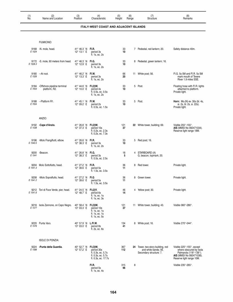
164
(1)No.
(2)Name and Location
(3)Position
(4)Characteristic
(5)Height
(6)Range
(7)Structure
(8)Remarks
FIUMICINO:
9168E 1524
-N. mole, head. 41° 46.3´ N12° 13.1´ E
Fl.R.period 3sfl. 1s, ec. 2s
3310
7 Pedestal, red lantern; 20. Safety distance 40m.
9172E 1526.3
-S. mole, 60 meters from head. 41° 46.3´ N12° 12.9´ E
Fl.G.period 3sfl. 1s, ec. 2s
3310
8 Pedestal, green lantern; 16.
9180E 1526
- -At root. 41° 46.2´ N12° 13.3´ E
Fl.W.period 3sfl. 1s, ec. 2s
6620
11 White post; 56. Fl.G. 5s 5M and Fl.R. 5s 5M mark mouth of Tevere River 1.9 miles SSE.
9184E 7053
-Offshore pipeline terminal platform, R2.
41° 44.6´ N12° 10.0´ E
Fl.(2)W.period 4sfl. 0.5s, ec. 0.5sfl. 1s, ec. 2s
3310
5 Post. Floating hose with Fl.R. lights attached to platform.
Private light.
9188E 7054
- -Platform R1. 41° 45.1´ N12° 09.2´ E
Fl.W.period 2sfl. 0.5s, ec. 1.5s
3310
5 Post. Horn: Mo.(N) ev. 30s (bl. 4s, si. 2s, bl. 2s, si. 22s).
Private light.
ANZIO:
9192E 1538
-Cape d'Anzio. 41° 26.8´ N12° 37.3´ E
Fl.(2)W.period 10sfl. 0.2s, ec. 2.3sfl. 0.2s, ec. 7.3s
12137
22 White tower, building; 69. Visible 255°-155°.AIS (MMSI No 992471034).Reserve light range 18M.
9196E 1540.5
-Molo Frangiflutti, elbow. 41° 26.6´ N12° 38.3´ E
Fl.R.period 3sfl. 1s, ec. 2s
3310
5 Red post; 16.
9200E 1541
-Beacon. 41° 26.8´ N12° 38.3´ E
Fl.G.period 3sfl. 0.5s, ec. 2.5s
185
4 STARBOARD (A)G, beacon, topmark; 20.
9204E 1541.3
Molo Sottoflutto, head. 41° 27.2´ N12° 39.6´ E
Fl.R.period 5sfl. 1.5s, ec. 3.5s
3611
8 Red tower. Private light.
9208E 1541.2
-Molo Sopraflutto, head. 41° 27.2´ N12° 39.6´ E
Fl.Gperiod 5sfl. 1.5s, ec. 3.5s
3611
8 Green tower. Private light.
9212E 1541.6
Tori di Foce Verde, pier, head. 41° 24.5´ N12° 48.7´ E
Fl.(2)Y.period 6sfl. 1s, ec. 1sfl. 1s, ec. 3s
4614
4 Yellow post; 30. Private light.
9216E 1577
Isola Zannone, on Capo Negro. 40° 58.4´ N13° 03.3´ E
Fl.(3)W.period 10sfl. 1s, ec. 1sfl. 1s, ec. 1sfl. 1s, ec. 5s
12137
11 White tower, building; 43. Visible 060°-280°.
9220E 1576
Punta Varo. 40° 57.9´ N13° 03.0´ E
L.Fl.W.period 8sfl. 2s, ec. 6s
13441
8 White post; 16. Visible 270°-044°.
ISOLE DI PONZIA:
9224E 1588
-Punta della Guardia. 40° 52.7´ N12° 57.2´ E
Fl.(3)W.period 30sfl. 0.3s, ec. 5.7sfl. 0.3s, ec. 5.7sfl. 0.3s, ec. 17.7s
367112
24 Tower, two-story building, red and white bands; 56.
Secondary structure: 7.
Visible 225°-155°, except where obscured by Isola Palmarola (118°-136°).
AIS (MMSI No 992471036).Reserve light range 10M.
Fl.R.period 5sfl. 1s, ec. 4s
31596
8 Visible 235°-265°.
ITALY-WEST COAST AND ADJACENT ISLANDS

165
(1)No.
(2)Name and Location
(3)Position
(4)Characteristic
(5)Height
(6)Range
(7)Structure
(8)Remarks
9228E 1580
Rotonda della Madonna, Porto di Ponza, entrance, S. side.
40° 53.7´ N12° 58.2´ E
Fl.(4)W.period 15sfl. 1s, ec. 1sfl. 1s, ec. 1sfl. 1s, ec. 1sfl. 1s, ec. 8s
20061
15 White truncated conical tower, three-story dwelling; 59.
Visible 206°-023° and 070°-080° to aid anchoring at Chiaia di Luna.
Reserve light range 11M.F.R. on radio antenna 1.2
miles NNW.
F.R. 18055
9 Visible 301°-341°.
9232E 1584
-Porto di Ponza, mole, head. 40° 53.7´ N12° 57.9´ E
Fl.Y.period 3sfl. 1s, ec. 2s
3912
9 Red tower; 39.
9236E 1583
-Breakwater, head. 40° 53.8´ N12° 57.9´ E
Fl.R.period 3sfl. 1s, ec. 2s
268
8 Red post; 23. Safety distance 25m.
9240E 1582
Scoglio Ravia. 40° 54.0´ N12° 57.9´ E
Fl.G.period 3sfl. 1s, ec. 2s
8526
6 Green square hut; 10.
9244E 1542
Capo Circeo. 41° 13.3´ N13° 04.1´ E
Fl.W.period 5sfl. 0.2s, ec. 4.8s
12538
23 White round tower, red two-story building; 59.
Visible 263°-107°.AIS (MMSI No 992471035).Reserve light range 18M.
TERRACINA:
9248E 1550
-Mole Gregoriano, head. 41° 17.0´ N13° 15.6´ E
Fl.R.period 5sfl. 1s, ec. 4s
3912
9 Red lantern, base; 30. Safety distance 50m.
9252E 1551
-Outer mole, head. 41° 17.0´ N13° 15.5´ E
Fl.G.period 5sfl. 1s, ec. 4s
268
6 Green post; 20. Safety distance 25m.
9256E 1552
-Canal entrance, S. side. 41° 17.0´ N13° 16.0´ E
F.R. 268
3 Red post; 20.
9260E 1554
- -N. side. 41° 17.0´ N13° 16.0´ E
F.G. 268
3 Green post; 20.
GAETA:
9264E 1558
-Monte Orlando. 41° 12.4´ N13° 34.7´ E
Fl.(3)W.period 15sfl. 0.2s, ec. 2.8sfl. 0.2s, ec. 2.8sfl. 0.2s, ec. 8.8s
607185
23 Round tower; 46. AIS (MMSI No 992471038).Reserve light range 18M.
9268E 1560
-Punta dello Stenardo, S. entrance of port.
41° 12.6´ N13° 35.4´ E
Fl.(2)R.period 10sfl. 1s, ec. 1.5sfl. 1s, ec. 6.5s
6620
7 Red round tower; 20.
9272E 1562
-Punta S. Antonio, mole, head. 41° 13.0´ N13° 34.7´ E
Fl.R.period 3sfl. 0.5s, ec. 2.5s
3310
6 Pedestal, red lantern; 16. 2 F.R. (vert.) and 2 F.G. (vert.) shown inside Porto San Antonio.
PORTO SALVO:
9276E 1564
-Mole, head. 41° 13.2´ N13° 34.4´ E
Fl.G.period 3sfl. 0.5s, ec. 2.5s
278
7 Pedestal, green lantern; 16.
9280E 1565
-Front range, about 307 meters 269° from head of mole.
41° 13.4´ N13° 34.3´ E
Q.R. Private light.
9284E 1565.1
- -Rear, 190 meters 269° from front.
41° 13.4´ N13° 34.2´ E
F.R. Private light.
9288E 1566
-Oil pier, head. 41° 13.4´ N13° 34.5´ E
2 F.R. (vert.) 3611
1 Post; 23. 1 meter apart.Private light.
ITALY-WEST COAST AND ADJACENT ISLANDS

166
(1)No.
(2)Name and Location
(3)Position
(4)Characteristic
(5)Height
(6)Range
(7)Structure
(8)Remarks
9294E 1568
-Banchino Salvo d′Acquisto, mole, head.
41° 13.9´ N13° 34.4´ E
Fl.(2)G.period 10sfl. 1s, ec. 1.5sfl. 1s, ec. 6.5s
3310
7 Green lantern, base; 23. Safety distance 30m.
9296E 1570
Porticciolo di Capossele, entrance, W. side.
41° 15.0´ N13° 36.0´ E
F.R. 134
2 Red post; 7. Private light.
9300E 1570.2
-Entrance, E. side. 41° 15.0´ N13° 35.9´ E
F.G. 134
2 Green post; 7. Private light.
9304E 1573
Formia, breakwater, near outer head.
41° 15.2´ N13° 36.9´ E
Fl.W.R.period 3sfl. 1s, ec. 2s
3611
W. 11R. 8
Red lantern, base; 23. W. 252°-072°, R.-252°.Safety distance 30m.
9308E 1572
-E. breakwater, head. 41° 15.3´ N13° 36.8´ E
Fl.G.period 3sfl. 1s, ec. 2s
309
7 Pedestal, green lantern; 16. Safety distance 30m.
9310E 1574
Scauri, breakwater, head. 41° 15.1´ N13° 42.1´ E
Fl.G.period 5sfl. 1s, ec. 4s
165
4 Green post; 10. Private light.
9312E 1575.5
Coppola Pinetamare Marina. 40° 58.4´ N13° 58.4´ E
Fl.R.period 5sfl. 0.5s, ec. 4.5s
6 Red post. Fl.Y. light marks harbor entrance. Fl.G. 5s 6M light marks south breakwater close SE.Fl.G. 5s 2M light marks inner breakwater.
Private light.
ISOLA VENTOTENE:
9320E 1592
-Porto Nicolo. 40° 47.8´ N13° 26.1´ E
Fl.W.period 5sfl. 1s, ec. 4s
6921
15 White round tower, building; 52. Visible 158°-022°, obscured 286°-305° over Isola Santo Stefano.
AIS (MMSI No 992471037).Reserve light range 11M.
9324E 1594
-Cala Rossano, outer breakwater, head.
40° 48.0´ N13° 26.0´ E
Fl.R.period 5sfl. 1s, ec. 4s
268
5 Pedestal, red lantern; 16. Private light.
9326E 1595
- -Inner breakwater, 15 meters from head.
40° 48.0´ N13° 26.1´ E
Fl.G.period 5sfl. 1s, ec. 4s
4 STARBOARD (A)G, post, topmark; 16.
Private light.
ISOLA D'ISCHIA:
9328E 1598
-Punta Imperatore. 40° 42.7´ N13° 51.2´ E
Fl.(2)W.period 15sfl. 0.2s, ec. 3.6sfl. 0.2s, ec. 11s
538164
22 White tower, two-story building; 43.
Visible 316°-190°.AIS (MMSI No 992471040).Reserve light range 18M.
9332E 1600
-Forio, W. mole, head. 40° 44.5´ N13° 51.5´ E
Fl.R.G.period 3sfl. 0.5s, ec. 2.5s
206
5 Pedestal, green lantern. G. 110°-005°, R.-110°.Safety distance 30m.Private light.
9333E 1600.5
- -E. mole, head. 40° 44.5´ N13° 51.5´ E
Fl.R.period 3sfl. 0.5s, ec. 2.5s
206
2 Red post; 13. Safety distance 50m.Private light.
9340E 1606
-Casamiccola, 20 meters from head of outer mole.
40° 45.1´ N13° 54.6´ E
Fl.G.period 4s
237
5 Green post. Private light.
9341E 1606.2
- -Inner mole. 40° 45.1´ N13° 54.6´ E
F.R. 237
2 Red post. Safety distance 20m.Private light.
-Ischia Porto:
9344E 1608
- -Bagno, mole, head. 40° 44.9´ N13° 56.5´ E
Fl.W.R.period 3sfl. 1s, ec. 2s
4313
W. 15R. 12
Red round tower; 36. R. 127°-197°, W.-127°.Reserve light range W. 11M,
R. 9M.
9348E 1610
- -Harbor, W. side of entrance. 40° 44.8´ N13° 56.5´ E
Fl.G.period 3sfl. 1s, ec. 2s
144
8 Green tower; 10.
ITALY-WEST COAST AND ADJACENT ISLANDS

167
(1)No.
(2)Name and Location
(3)Position
(4)Characteristic
(5)Height
(6)Range
(7)Structure
(8)Remarks
9352E 1612
- - -E. side of entrance. 40° 44.8´ N13° 56.5´ E
Fl.R.period 3sfl. 1s, ec. 2s
144
8 Red tower; 10. Visible 196°-217°.
9356E 1614
-Castello d′ Ischia. 40° 43.9´ N13° 57.9´ E
L.Fl.W.period 6sfl. 2s, ec. 4s
26982
16 Terrace, castle; 10. Visible 119°-001°.AIS (MMSI No 992471039).Reserve light range 12M.
ISOLA DI PROCIDA:
9360E 1614.3
-Secche Formiche di Vivara. 40° 44.6´ N13° 58.6´ E
Q.(9)W.period 15s
165
5 W. CARDINALYBY, articulated beacon,
topmark; 20.
Radar reflector.
9362E 1615
-Porticciolo della Chiaiolella, outer mole.
40° 44.8´ N14° 00.4´ E
2 F.G. (vert.) 309
4 Green post; 23. 2 meters apart.Private light.
9363E 1615.2
- Molo Ponente, head. 40° 44.9´ N14° 00.3´ E
2 F.R. (vert.) 309
4 Red post; 23. Safety distance 20M.2 meters apart.Private light.
9364E 1618
-Punta Pioppeto. 40° 46.2´ N14° 01.0´ E
Fl.(3)W.period 10sfl. 1s, ec. 1sfl. 1s, ec. 1sfl. 1s, ec. 5s
6921
11 White pylon, hut; 10. Visible 076°-287°.
9368E 1616
-Procida, mole, head. 40° 46.2´ N14° 01.7´ E
Fl.G.period 3sfl. 1s, ec. 2s
3310
8 Green lantern, base; 23. Safety distance 30m.
9372E 1617
-E. breakwater, head. 40° 46.1´ N14° 01.7´ E
Fl.R.period 3sfl. 1s, ec. 2s
3310
8 Red lantern, base; 23.
9376E 1619
-Secca del Torrione, S. extremity of shoal.
40° 46.6´ N14° 02.6´ E
Q.(6)+L.Fl.W.period 15s
165
5 S. CARDINALYB, articulated beacon, topmark;
16.
Radar reflector.
GOLFO DI POZZUOLI:
9380E 1620
-Capo Miseno. 40° 46.7´ N14° 05.3´ E
Fl.(2)W.period 10sfl. 1s, ec. 2sfl. 1s, ec. 6s
26280
16 White tower on two-story building; 39.
Visible 199°-112°.AIS (MMSI No 992471041).Reserve light range 12M.
9384E 1622
-Baia, Fortino Tenaglia. 40° 48.7´ N14° 04.9´ E
Iso.R.period 4s
4313
8 Red tower; 26.
9388E 1623
-Arco Felice, Pontile Pirelli, W. corner.
40° 49.7´ N14° 06.2´ E
F.Y. 268
4 Yellow post; 20. F.Y. 4M light marks E. corner.Private light.
9390E 1625
-Molo Caligoliano, breakwater, head.
40° 49.4´ N14° 06.6´ E
Iso.G.period 4s
4313
6 Green tower, white building; 32.
9400E 1628.4
-Isola de Nisida, Molo Dandolo, spur.
40° 48.0´ N14° 09.8´ E
Fl.G.period 3sfl. 1s, ec. 2s
4614
7 Green post; 16.
9404E 1626
- -Pontile Ilva Nord, outer corner.
40° 48.5´ N14° 09.5´ E
F.R. 268
3 A F.R. light is shown from the opposite corner.
Private light.
-Bagnoli:
9408E 1626.2
- -Mole. 40° 48.5´ N14° 09.9´ E
F.G. 206
3 A F.G. is shown from the opposite corner.
Private light.
9412E 1626.4
- -Pontile Ilva Sud, outer corner. 40° 48.3´ N14° 10.0´ E
F.R. 134
3 A F.R. light is shown from the opposite corner.
Private light.
9416E 1626.6
- -Pontile Montecantini, N. corner.
40° 48.3´ N14° 10.2´ E
F.R. 103
3 Red and green post. A F.G. light is shown from the S. corner.
Private light.
ITALY-WEST COAST AND ADJACENT ISLANDS

168
(1)No.
(2)Name and Location
(3)Position
(4)Characteristic
(5)Height
(6)Range
(7)Structure
(8)Remarks
9417E 1628.5
-La Gaiola. 40° 47.7´ N14° 11.0´ E
Iso.Y.period 1s
3310
4 SPECIALY, post, "X" topmark; 16.
Private light.
9418E 1628.6
-Scoglio Traverso. 40° 47.5´ N14° 11.3´ E
Fl.(2)Y.period 10sfl. 0.5s, ec. 1sfl. 0.5s, ec. 8s
3310
4 SPECIALY, post, "X" topmark; 16.
Private light.
9420E 1628.7
-Secca della Cavallara, shoal, S. extremity.
40° 47.1´ N14° 11.3´ E
Q.(6)+L.Fl.W.period 15s
185
5 S. CARDINALYB, articulated beacon, topmark;
16.
Radar reflector.
NAPOLI:
9424E 1629
-Porticciolo Sannazzaro, W. side of entrance, mole, head.
40° 49.6´ N14° 13.6´ E
Fl.R.period 5sfl. 1s, ec. 4s
299
8 Pedestal, red lantern; 16. Safety distance 20m.
9428E 1629.4
- -E. breakwater, head. 40° 49.7´ N14° 13.4´ E
Fl.G.period 5sfl. 1s, ec. 4s
268
7 Pedestal, green lantern; 16.
9432E 1631
-Porticciolo di Santa Lucia (Santa Lucia Harbor), N. side of entrance, angle of quay.
40° 49.8´ N14° 15.0´ E
Fl.G.period 3sfl. 1s, ec. 2s
237
4 Green lantern, base; 16.
9436E 1632
- -S. side of entrance, head of detached breakwater.
40° 49.8´ N14° 15.1´ E
Fl.R.period 3sfl. 1s, ec. 2s
309
5 Red lantern, base; 16.
9440E 1636
-Porticciolo del Molosiglio, S. side of entrance, mole, head.
40° 50.0´ N14° 15.3´ E
Fl.R.period 5sfl. 1s, ec. 4s
3310
8 Red lantern, base; 20.
9444E 1634
- -N. mole, head. 40° 50.1´ N14° 15.3´ E
Fl.G.period 5sfl. 1s, ec. 4s
309
3 Pedestal, green lantern; 20.
9452E 1652
-Diga Foranea Emanuele Filiberto Duca D′Aosta, E. head.
40° 49.6´ N14° 18.0´ E
Fl.R.period 4sfl. 1s, ec. 3s
3912
5 Pedestal, red lantern; 16. Channel marked by 2 Fl.G. and 2 Fl.R. articulated lights.
Safety distance 20m.
9456E 1653
- -Bend, near E. head. 40° 50.0´ N14° 17.4´ E
Fl.(2)R.period 10sfl. 1s, ec. 2sfl. 1s, ec. 6s
237
4 Pedestal, red lantern; 16. Visible 122°-308°.
9460E 1654
- -(Angle), W. head. 40° 50.2´ N14° 16.8´ E
Fl.R.G.period 4sfl. 1s, ec. 3s
237
5 Green pedestal, red lantern; 16. G. 032°-175°, R.-298°.
9464E 1648
-Antemurale Thaon de Revel, S. head.
40° 50.0´ N14° 16.6´ E
Fl.G.period 4sfl. 1s, ec. 3s
5918
9 Green round tower; 39.
9465E 1647.5
-Breakwater extension, head. 40° 49.8´ N14° 16.6´ E
Fl.R.period 3sfl. 1s, ec. 2s
4915
4 Red tower; 33.
-RACON N (– •)period 30s
10 (3cm).
9475E 1646
-Molo San Vincenzo, head. 40° 50.0´ N14° 16.3´ E
Fl.(3)W.period 15sfl. 0.2s, ec. 2.3sfl. 0.2s, ec. 2.3sfl. 0.2s, ec. 9.8s
8225
22 Red round tower; 79. Obscured inside the port 102°-233°.
AIS (MMSI No 992471042).
9476E 1650
- -Spur, entrance, W. side. 40° 50.0´ N14° 16.3´ E
F.R. 206
2 Stone structure; 26.
9480E 1658
-Molo Martello, head. 40° 50.4´ N14° 16.0´ E
Fl.G.period 4sfl. 0.5s, ec. 3.5s
237
2 Green post; 16.
ITALY-WEST COAST AND ADJACENT ISLANDS

169
(1)No.
(2)Name and Location
(3)Position
(4)Characteristic
(5)Height
(6)Range
(7)Structure
(8)Remarks
9484E 1662
-Drydock No 3, S. corner. 40° 50.3´ N14° 16.3´ E
2 F.R. (vert.) 309
3 Post; 26. Safety distance 100m.F.R. on centre of caisson at S.
entrance.1 meter apart.
9488E 1664
Darsena Armando Diaz, spur, head.
40° 50.4´ N14° 16.5´ E
F.G. 237
2 Green post; 16.
9492E 1663
-Calata della Marinella Pier, head.
40° 50.5´ N14° 16.5´ E
2 F.R.G. (vert.) 3 1 meter apart.
9500E 1667
-Pontile Vigliena, SE. corner. 40° 50.1´ N14° 17.4´ E
F.G. 206
2 Green post; 13.
9516E 1678
Portici, head of the quay, inner side of breakwater.
40° 48.6´ N14° 20.0´ E
Fl.W.period 3sfl. 1s, ec. 2s
5216
11 White tower; 46.
9520E 1679
-NW. spur of breakwater, mole, head.
40° 48.6´ N14° 20.0´ E
Fl.G.period 3sfl. 1s, ec. 2s
3 Green post, base; 20.
9524E 1680
Torre del Greco, at foot of Mt. Vesuvius, mole, head.
40° 47.0´ N14° 21.7´ E
Fl.R.period 5sfl. 1s, ec. 4s
3912
9 Pedestal, red lantern; 16.
9528E 1681
-Inner mole, head. 40° 47.1´ N14° 21.7´ E
Fl.G.period 5sfl. 1s, ec. 4s
268
3 Green post; 20.
9532E 1685
Torre Annunziata, Molo di Levante, marks shoal.
40° 44.9´ N14° 26.9´ E
Fl.(2)G.period 6sfl. 0.5s, ec. 1sfl. 0.5s, ec. 4s
134
5 STARBOARD (A)G, articulated beacon, topmark.
Radar reflector.
9536E 1684
-W. mole, head. 40° 44.7´ N14° 27.0´ E
Fl.(2)R.period 6sfl. 1s, ec. 1sfl. 1s, ec. 3s
4313
4 Pedestal, red lantern; 20. Safety distance 50m.
9537E 1683.8
-Port entry. 40° 44.6´ N14° 27.3´ E
Fl.(2)G.period 6sfl. 0.5s, ec. 1sfl. 0.5s, ec. 4s
134
5 STARBOARD (A)G, beacon, topmark; 13.
Private light.
9538E 1687
-Fishing harbor, mole, head. 40° 45.2´ N14° 26.8´ E
F.R. 165
4 Red post; 13. Safety distance 15m.
9539E 1683.5
-Marina di Aprea, W. breakwater, head.
40° 44.5´ N14° 27.6´ E
F.R. Red post. Private light.
9539.1E 1683
- -E. breakwater, head. 40° 44.5´ N14° 27.5´ E
F.G. Green post. Private light.
CASTELLAMMARE DI STABIA:
9539.2E 1688.5
-Scoglio Rovigliano. 40° 43.7´ N14° 27.9´ E
Fl.(5)Y.period 20s
3611
4 SPECIALY, beacon, "X" topmark.
Private light.
9539.5E 1688
-Marina di Stabia. 40° 43.0´ N14° 27.0´ E
Fl.(2)Y.period 4sfl. 0.5s, ec. 0.5sfl. 0.5s, ec. 2.5s
103
4 SPECIALY, beacon, "X" topmark.
Marks end of submarine pipeline.
Private light.
9540E 1692
-Main, 1 km. 187° from head of mole.
40° 41.3´ N14° 28.2´ E
Fl.(2)W.period 10sfl. 1s, ec. 2sfl. 1s, ec. 6s
374114
16 White tower, white three-story building; 52.
Visible 095°-223°.AIS (MMSI No 992471043).Reserve light range 12M.
9544E 1693
-W. mole, head. 40° 42.0´ N14° 28.4´ E
Fl.G.period 5sfl. 1s, ec. 4s
3912
8 Pedestal, green lantern; 16. Safety distance 50m.
9546E 1693.9
-Molo Quartuccio, head. 40° 41.8´ N14° 28.5´ E
Fl.R.period 5sfl. 1s, ec. 4s
268
3 Red post; 20. Private light.
ITALY-WEST COAST AND ADJACENT ISLANDS

170
(1)No.
(2)Name and Location
(3)Position
(4)Characteristic
(5)Height
(6)Range
(7)Structure
(8)Remarks
9548E 1694
-Molo di Sottoflutto, head. 40° 41.8´ N14° 28.5´ E
Fl.(2)Y.period 6sfl. 1s, ec. 5s
268
3 Red post; 20.
9550E 1692.5
-Pozzano. 40° 41.3´ N14° 27.1´ E
2 F.R.G. (vert.) 237
3 Green post, red bands. 2 meters apart.Private light.
9552E 1695
Marine di Equa, 30 meters from breakwater, head.
40° 39.7´ N14° 25.0´ E
2 F.G. (vert.) 268
4 Green post; 20. 2 F.R. (vert.) marks opposite breakwater head.
2 meters apart.Private light.
9554E 1695.6
Marina di Meta, mole, head. 40° 38.9´ N14° 24.3´ E
Fl.G.period 3sfl. 1s, ec. 2s
268
5 Green post; 20. Private light.
9556E 1696
Marina di Cassano, mole, head. 40° 38.4´ N14° 24.0´ E
F.G. 237
3 Green post; 20. Safety distance 20m.
9560E 1698
Sorrento, breakwater, head. 40° 37.9´ N14° 22.7´ E
Fl.G.period 3sfl. 1s, ec. 2s
319
5 Pedestal, green lantern; 16. Private light.
9564E 1700
Scoglio Vervece. 40° 37.1´ N14° 19.5´ E
Fl.(2)W.period 6sfl. 1s, ec. 1sfl. 1s, ec. 3s
4915
7 ISOLATED DANGERBRB, structure, topmark.
9568E 1702
Punta Campanella. 40° 34.2´ N14° 19.5´ E
Fl.W.period 5sfl. 1s, ec. 4s
21365
10 Black tower, white bands; 59. Visible 270°-166°, obscured by Isola di Capri 066°-089°.
ISOLA DI CAPRI:
9572E 1706
-Punta Carena. 40° 32.2´ N14° 11.9´ E
Fl.W.period 3sfl. 0.2s, ec. 2.8s
24073
25 White tower, two-story building; 92.
Visible 265°-175°.AIS (MMSI No 992471044).Reserve light range 18M.
9576E 1708
-Il Capo, island, NE. point. 40° 33.6´ N14° 15.8´ E
Fl.(2)W.period 10sfl. 1s, ec. 1.5sfl. 1s, ec. 6.5s
3912
7 Pedestal, white lantern; 16. Visible 110°-335°.
9580E 1710
-Marina Grande, breakwater, head.
40° 33.5´ N14° 14.6´ E
Fl.G.period 3sfl. 1s, ec. 2s
3611
8 Pedestal, green lantern; 16.
9584E 1711
- -Molo di Sopraflutto, head. 40° 33.4´ N14° 14.7´ E
Fl.R.period 3sfl. 1s, ec. 2s
309
8 Pedestal, red lantern; 16. Safety distance 50m.
9588E 1716
Isolotti Li Galli, N. extremity. 40° 35.0´ N14° 26.0´ E
Fl.W.period 5sfl. 1s, ec. 4s
22067
6 White square tower; 39.
AMALFI:
9592E 1718
-W. mole, head. 40° 37.9´ N14° 36.0´ E
Fl.R.period 5sfl. 1s, ec. 4s
4313
8 Pedestal, red lantern; 16.
9596E 1720
-Stone jetty, harbor, N. side. 40° 37.9´ N14° 36.1´ E
F.G. 268
3 Green post; 20.
9600E 1722
Capo d'Orso. 40° 38.0´ N14° 40.8´ E
Fl.(3)W.period 15sfl. 1s, ec. 2sfl. 1s, ec. 2sfl. 1s, ec. 8s
21766
16 White terrace, white two-story building, red bands; 16.
Visible 263°-093°.AIS (MMSI No 992471045).Reserve light range 12M.
SALERNO:
9604E 1730
-Outer elbow. 40° 40.3´ N14° 45.3´ E
Fl.W.period 3sfl. 1s, ec. 2s
4313
11 Pedestal, white lantern; 16.
ITALY-WEST COAST AND ADJACENT ISLANDS

171
(1)No.
(2)Name and Location
(3)Position
(4)Characteristic
(5)Height
(6)Range
(7)Structure
(8)Remarks
9612E 1730.2
-Molo di Levante, head. 40° 39.8´ N14° 44.6´ E
Fl.G.period 5sfl. 1s, ec. 4s
4213
9 Hut, green lantern; 30. Safety distance 50m.
RACON C(– • – •)period 30s
6 (3 & 10cm).
9616E 1730.4
-Molo di Ponente, head. 40° 40.0´ N14° 44.8´ E
Fl.R.period 5sfl. 1s, ec. 4s
4313
8 Hut, red lantern; 30. Safety distance 25m.
9620E 1733
-Old port, Banchina Manfredi, S. corner.
40° 40.3´ N14° 45.2´ E
2 F.G. (vert.) 268
3 Green post; 16. 2 meters apart.
9624E 1733.5
-Secca Manfredi. 40° 40.5´ N14° 45.3´ E
Fl.G.period 6sfl. 1s, ec. 5s
237
2 Green post; 13. Private light.
9626E 1734
-Port Masuccio Salernitano, outer mole, head.
40° 40.3´ N14° 45.9´ E
2 F.G. (vert.) 206
3 Green post; 13. 1 meter apart.Private light.
9627E 1734.3
- -Inner mole, head. 40° 40.4´ N14° 46.0´ E
2 F.R. (vert.) 206
3 Red post; 13. Safety distance 30m.1 meter apart.Private light.
9628E 1737
San Marco di Castellabate, W. mole.
40° 16.2´ N14° 56.1´ E
Fl.G.period 4sfl. 1s, ec. 3s
237
2 Green post, base; 20. Private light.
9632E 1735
Agropoli. 40° 21.3´ N14° 59.2´ E
Fl.(2)W.period 6sfl. 1s, ec. 1sfl. 1s, ec. 3s
13842
16 Tower, hut; 33. AIS (MMSI No 992471046).Reserve light range 12M.
9636E 1738
Isolotto Licosa, near Punta Licosa.
40° 15.1´ N14° 54.0´ E
Fl.(2)W.period 10sfl. 1s, ec. 2sfl. 1s, ec. 6s
4313
11 White round tower; 30.
9640E 1739
Acciaroli, outer mole, head. 40° 10.5´ N15° 01.7´ E
Fl.R.period 3sfl. 0.5s, ec. 2.5s
268
4 Red post; 20. Private light.
9644E 1739.2
-Inner mole, head. 40° 10.5´ N15° 01.6´ E
2 F.G. (vert.) 165
3 Green post. 1 meter apart.Private light.
9648E 1739.4
-500 meters E. of outer mole, head.
40° 10.5´ N15° 01.7´ E
Iso.R.G.period 2s
4 Red post. R. 294°-062°, G.-083°.Private light.
9650E 1739.7
Casalvelino Marina, outer mole, head.
40° 10.5´ N15° 06.5´ E
Fl.G.period 3s
268
5 Green post. Private light.
9650.1E 1739.8
-Inner Mole, outer arm. 40° 10.5´ N15° 06.5´ E
Fl.R.period 3s
268
5 Red post. Private light.
9652E 1740
Capo Palinuro. 40° 01.4´ N15° 16.6´ E
Fl.(3)W.period 15sfl. 0.2s, ec. 2.8sfl. 0.2s, ec. 2.8sfl. 0.2s, ec. 8.8s
675206
25 White tower, two-story building; 46.
Visible 286°-132°.AIS (MMSI No 992471047).Reserve light range 18M.
9656E 1741
Camerota marina. 40° 00.0´ N15° 23.0´ E
Fl.R.period 4sfl. 1s, ec. 3s
268
3 Red post; 16. Private light.
9660E 1742
Scario. 40° 02.8´ N15° 29.5´ E
Fl.(4)W.period 12sfl. 1s, ec. 1sfl. 1s, ec. 1sfl. 1s, ec. 1sfl. 1s, ec. 5s
7924
15 White tower, two-story building; 39.
Obscured when bearing more than 025°.
AIS (MMSI No 992471048).Reserve light range 12M.
9661E 1743
-Outer mole, head. 40° 03.0´ N15° 30.0´ E
Fl.R.period 3sfl. 1s, ec. 2s
237
4 Red post; 16. Safety distance 15m.Private light.
9662E 1743.2
-Inner mole, head. 40° 02.9´ N15° 29.5´ E
F.G. 165
3 Green post. Safety distance 40m.Private light.
ITALY-WEST COAST AND ADJACENT ISLANDS

172
(1)No.
(2)Name and Location
(3)Position
(4)Characteristic
(5)Height
(6)Range
(7)Structure
(8)Remarks
9664E 1746
Sapri (Pisacane), on Punta del Fortino.
40° 04.1´ N15° 37.3´ E
Fl.(2)W.period 7sfl. 0.5s, ec. 1sfl. 0.5s, ec. 5s
4313
7 Red tower; 13. Visible 223°-083°.
9668E 1747
Maratea, outer mole, head. 39° 59.2´ N15° 42.7´ E
Fl.R.period 3sfl. 1s, ec. 2s
268
6 Red post; 10. Safety distance 30m.Private light.
9672E 1747.3
-Lee mole, head. 39° 59.2´ N15° 42.6´ E
F.G. 247
4 Green post; 13. Private light.
9674E 1747.2
-S. breakwater, head. 39° 59.2´ N15° 42.6´ E
Fl.G.period 3sfl. 1s, ec. 2s
268
6 Green post; 16. Safety distance 30m.Private light.
9676E 1750
Capo Bonifati. 39° 32.6´ N15° 53.0´ E
Fl.(2)W.period 10sfl. 1s, ec. 2sfl. 1s, ec. 6s
20763
15 White tower, hut; 23. AIS (MMSI No 992471049).Reserve light range 11M.
9680E 1752
Paola. 39° 21.6´ N16° 02.0´ E
Fl.(3)W.period 15sfl. 1s, ec. 2sfl. 1s, ec. 2sfl. 1s, ec. 8s
17553
15 Tower; 56. Visible 315°-160°.AIS (MMSI No 992471050).Reserve light range 11M.
GOLFO DI SANT EUFEMIA:
9684E 1756
-Capo Suvero. 38° 57.1´ N16° 09.5´ E
Fl.(2)W.period 10sfl. 1s, ec. 2sfl. 1s, ec. 6s
19058
16 White tower, building; 82. Visible 280°-155°.AIS (MMSI No 992471051).Reserve light range 12M.
9688E 1756.5
-Turina, pier, head. 38° 51.1´ N16° 13.6´ E
2 F.R.G. (vert.) 3611
4 Red post, green bands. 1 meter apart.Private light.
9692E 1757
-Vibo Valentia Marina, N. mole, head.
38° 43.4´ N16° 07.7´ E
Fl.W.G.period 5sfl. 1s, ec. 4s
5617
W. 15G. 12
Green tower; 49. W. 068°-230°, G.-068°.Reserve light range W. 10M,
G. 8M.
9696E 1758
- -S. mole, head. 38° 43.2´ N16° 07.7´ E
Fl.R.period 5sfl. 1s, ec. 4s
237
7 Pedestal, red lantern; 16.
9700E 1760
-Tropea, mole, head. 38° 40.8´ N15° 54.2´ E
Fl.G.period 3sfl. 1s, ec. 2s
4614
5 Safety distance 30m.Private light.
STRETTO DI MESSINA:
9704E 1762
-Capo Vaticano. 38° 37.1´ N15° 49.7´ E
Fl.(4)W.period 20sfl. 0.2s, ec. 3.1sfl. 0.2s, ec. 3.1sfl. 0.2s, ec. 3.1sfl. 0.2s, ec. 9.9s
354108
24 White tower, building; 26. Obscured in the Golfo di Santa Eufemia when bearing E. of 205°.
Partially visible 208°-215°.AIS (MMSI No 992471052).Reserve light range 18M.
9704.5E 1763
Gioia Tauro, N. breakwater. 38° 26.7´ N15° 53.5´ E
Fl.R.period 4sfl. 1s, ec. 3s
4614
8 Red tower; 33. Private light.
RACON G(– – • )
9704.6E 1763.35
-Port entry. 38° 26.5´ N15° 54.3´ E
Dir.W.R.G. 7222
6 White tower. Fl.G. 097°18'-098°18', F.G.-099°18′, Oc.G.-100°18′, Iso.G.-101°18', F.W.-102°18′, Iso.R.-103°18′, Oc.R.-104°18', F.R.-105°18', Fl.R.-107°18'.
Private light.
9704.7E 1763.2
-S. breakwater. 38° 26.6´ N15° 53.4´ E
Fl.G.period 4sfl. 1s, ec. 3s
4614
8 Green tower; 33. Private light.
ITALY-WEST COAST AND ADJACENT ISLANDS

173
(1)No.
(2)Name and Location
(3)Position
(4)Characteristic
(5)Height
(6)Range
(7)Structure
(8)Remarks
9705E 1764
-Condoleo di Scilla Range, front.
38° 15.0´ N15° 45.0´ E
Fl.(2)Y.period 4sfl. 0.5s, ec. 1sfl. 0.5s, ec. 2s
2 SPECIALY, beacon, "X" topmark.
Marks SW. limit of prohibited area.
Private light.
9705.1E 1764.1
- -Rear, 20 meters 175° from front.
38° 15.2´ N15° 44.6´ E
Fl.(2)Y.period 4sfl. 0.5s, ec. 1sfl. 0.5s, ec. 2s
2 SPECIALY, beacon, "X" topmark.
Private light.
9706E 1764.3
-Farazzina Range, front. 38° 15.6´ N15° 45.7´ E
Fl.(2)Y.period 4sfl. 0.5s, ec. 1sfl. 0.5s, ec. 2s
2 SPECIALY, beacon, "X" topmark.
Marks NE. limit of prohibited area.
Private light.
9706.7E 1764.31
- -Rear, 142° from front. 38° 15.6´ N15° 45.7´ E
Fl.(2)Y.period 4sfl. 0.5s, ec. 1sfl. 0.5s, ec. 2s
2 SPECIALY, beacon, "X" topmark.
Private light.
9708E 1766
-Scilla. 38° 15.4´ N15° 42.9´ E
Fl.W.period 5sfl. 0.3s, ec. 4.7s
23672
22 Round tower; 20. AIS (MMSI No 992471053).Reserve light range 18M.
9716E 1769
-AVIATION LIGHT, cable tower, ESE. of Torre Cavallo.
38° 14.7´ N15° 41.1´ E
F.R.Or. (vert.) 1188362
Pylon, tower; 656. 5 F.R. lights arranged vertically along tower.
Private light.
9720E 1770
-Punta Pezzo. 38° 13.9´ N15° 38.2´ E
Fl.(3)R.period 15sfl. 0.2s, ec. 2.3sfl. 0.2s, ec. 2.3sfl. 0.2s, ec. 9.8s
8526
15 White round tower, red bands; 75.
Visible 010°-246°.AIS (MMSI No 992471054).Reserve light range 13M.
9724E 1772
-Villa San Giovanni, mole, head.
38° 13.1´ N15° 37.8´ E
Fl.G.period 3sfl. 1s, ec. 2s
4514
7 Green tower, pedestal; 33.
9728E 1773
- -Molo Sottoflutto, head. 38° 13.2´ N15° 38.0´ E
Fl.R.period 3sfl. 1s, ec. 2s
309
6 Red post; 16.
9732E 1773.6
- -Ferryboat, mole, head. 38° 13.4´ N15° 37.9´ E
Fl.G.period 4sfl. 1s, ec. 3s
268
4 Green post; 20. Private light.
9736E 1776
-Reggio di Calabria, breakwater, head.
38° 07.7´ N15° 39.0´ E
Iso.G.period 2s
4614
7 Pedestal, green lantern; 33.
9740E 1777
-Molo di Sottoflutto, head. 38° 07.6´ N15° 39.1´ E
Iso.R.period 2s
3611
6 Red lantern.
9744E 1780
-Capo dell'Armi. 37° 57.4´ N15° 40.8´ E
Fl.(2)W.period 10sfl. 0.3s, ec. 1.9sfl. 0.3s, ec. 7.5s
31295
22 White tower, building; 39. Visible 295°-148°.AIS (MMSI No 992471086).Reserve light range 18M.
9748E 1780.5
Saline de Montebello. 37° 56.0´ N15° 43.0´ E
Fl.G.period 4sfl. 1s, ec. 3s
237
4 Green post; 16. Private light.
9752E 1780.6
-Inner mole, head. 37° 56.0´ N15° 43.0´ E
Fl.R.period 4sfl. 1s, ec. 3s
237
4 Red post; 16. Private light.
9756E 1780.7
-Pier, head. 37° 56.0´ N15° 43.0´ E
2 F.R.G. (vert.) 1 Green post; 16. Private light.
9760E 1780.8
-Sea water intake platform. 37° 56.0´ N15° 43.0´ E
Fl.Y.period 3sfl. 0.5s, ec. 2.5s
237
3 Tower, platform; 20. Private light.
9764E 1781
-Saline Joniche, pier No 2. 37° 56.0´ N15° 44.0´ E
2 F.R. (vert.) 3611
3 Red post; 16. Private light.
ITALY-WEST COAST AND ADJACENT ISLANDS

174
(1)No.
(2)Name and Location
(3)Position
(4)Characteristic
(5)Height
(6)Range
(7)Structure
(8)Remarks
SICILIA (SICILY) AND ADJACENT ISLANDS (I.)
PORTO DE MESSINA:
9766E 1813
-Marina del Nettuno. 38° 12.0´ N15° 33.6´ E
Fl.R.period 3sfl. 1s, ec. 2s
103
3 Red post. Private light.
9768E 1814
-Punta San Raineri. 38° 11.6´ N15° 34.5´ E
Fl.(3)W.period 15sfl. 0.2s, ec. 2.8sfl. 0.2s, ec. 2.8sfl. 0.2s, ec. 8.8s
13641
22 White tower, black bands; 138. AIS (MMSI No 992471056).Reserve light range 17M.
9772E 1816
-Punta Secca, peninsula, NE. corner.
38° 11.8´ N15° 34.4´ E
Oc.Y.period 3slt. 2s, ec. 1s
4313
10 Yellow tower; 39. Visible 097°-335°.
9776E 1817
-Punta San Salvatore, entrance.
38° 11.8´ N15° 33.8´ E
Fl.(2)R.period 5sfl. 1s, ec. 1sfl. 1s, ec. 2s
5216
8 Red lantern; 39. Visible 340°-250°.The Statue of the Madonna
della Lettera, 53m high, located close E., is illuminated.
9780E 1818
-Port Office. 38° 11.8´ N15° 33.5´ E
Fl.(2)G.period 5sfl. 1s, ec. 1sfl. 1s, ec. 2s
5216
8 Green tower; 39. F.G. and F.R. lights are shown from the heads of the westernmost and easternmost jetties of the ferry slips, respectively. Jetty heads between the above are marked by vertically disposed R. and G. lights.
9782E 1820.5
-Inner mole, head. 38° 08.0´ N15° 31.5´ E
Fl.G.period 4sfl. 1s, ec. 3s
165
8 Green post; 16. Private light.
9784E 1806
Capo Peloro. 38° 16.1´ N15° 39.0´ E
Fl.(2)G.period 10sfl. 0.2s, ec. 2.3sfl. 0.2s, ec. 7.3s
12137
19 White octagonal tower, black bands, white building; 121.
Visible 112°30′-069°.AIS (MMSI No 992471055).Reserve light range 13M.
Iso.R.period 2s
7222
9 Visible 100°-127° over Rascolmo Bank.
RACON M(– –) 10 (3 & 10cm).
9785E 1810
-Mortelle Range, front. 38° 16.3´ N15° 36.9´ E
Fl.(2)Y.period 4sfl. 0.5s, ec. 1sfl. 0.5s, ec. 2s
2 SPECIALY, beacon, "X" topmark.
Marks E. limit of prohibited area.
Private light.
9785.1E 1810.1
- -Rear, 30 meters 256° from front.
38° 16.3´ N15° 36.9´ E
Fl.(2)Y.period 4sfl. 0.5s, ec. 1sfl. 0.5s, ec. 2s
2 SPECIALY, beacon, "X" topmark.
Private light.
9786E 1810.2
-Casabianca Range, front. 38° 16.6´ N15° 35.5´ E
Fl.(2)Y.period 4sfl. 0.5s, ec. 1sfl. 0.5s, ec. 2s
2 SPECIALY, beacon, "X" topmark.
Marks W. limit of prohibited area.
Private light.
9786.1E 1810.21
- -Rear, 30 meters 232° from front.
38° 16.7´ N15° 35.5´ E
Fl.(2)Y.period 4sfl. 0.5s, ec. 1sfl. 0.5s, ec. 2s
2 SPECIALY, beacon, "X" topmark.
Private light.
9788E 1809
-AVIATION LIGHT, cable tower, S. of Capo Peloro.
38° 15.9´ N15° 39.1´ E
2 F.G.Or. (vert.) 764233
Pylon, tower; 656. 5 F.R. lights arranged vertically along tower.
Private light.
9792E 2046
Capo Rasocolmo. 38° 17.7´ N15° 31.1´ E
Fl.(3)W.period 10sfl. 1s, ec. 1sfl. 1s, ec. 1sfl. 1s, ec. 5s
27985
15 White building; 43. Visible 280°-255°.Reserve light range 9M.AIS (MMSI No 992471084).
9796E 2042
Capo di Milazzo. 38° 16.2´ N15° 13.8´ E
L.Fl.W.period 6sfl. 2s, ec. 4s
29590
16 White tower; 33. Reserve light range 12M.AIS (MMSI No 992471083).
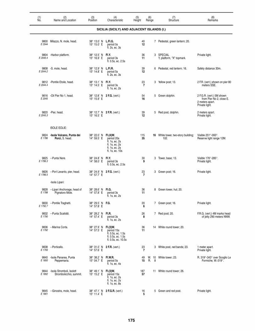
175
(1)No.
(2)Name and Location
(3)Position
(4)Characteristic
(5)Height
(6)Range
(7)Structure
(8)Remarks
9800E 2044
Milazzo, N. mole, head. 38° 13.0´ N15° 15.0´ E
L.Fl.G.period 5sfl. 2s, ec. 3s
4012
7 Pedestal, green lantern; 20.
9804E 2045.4
-Harbor platform. 38° 12.5´ N15° 16.9´ E
Fl.Y.period 3sfl. 0.5s, ec. 2.5s
3611
3 SPECIALY, platform, "X" topmark.
Private light.
9808E 2044.2
-S. mole, head. 38° 12.9´ N15° 14.8´ E
L.Fl.R.period 5sfl. 2s, ec. 3s
3912
6 Pedestal, red lantern; 16. Safety distance 30m.
9812E 2044.4
-Pontile Etoile, head. 38° 13.1´ N15° 14.5´ E
Fl.Y.period 3sfl. 1s, ec. 2s
237
3 Yellow post; 13. 2 F.R. (vert.) shown on pier 80 meters SSE.
9816E 2045
-Oil Pier No 1, head. 38° 12.8´ N15° 15.9´ E
2 F.G. (vert.) 5416
5 Green dolphin. 2 F.G.R. (vert.) 5M shown from Pier No 2, close E.
2 meters apart.Private light.
9820E 2045.3
-Pier, head. 38° 12.7´ N15° 16.5´ E
2 F.R. (vert.) 3912
5 Red post, dolphin. 2 meters apart.Private light.
ISOLE EOLIE:
9824E 1786
-Isola Vulcano, Punta dei Porci, S. head.
38° 22.0´ N14° 59.5´ E
Fl.(4)W.period 20sfl. 1s, ec. 2sfl. 1s, ec. 2sfl. 1s, ec. 2sfl. 1s, ec. 10s
11535
16 White tower, two-story building; 102.
Visible 251°-093°.Reserve light range 12M.
9825E 1786.3
- -Punta Nere. 38° 24.8´ N14° 58.0´ E
Fl.Y.period 3sfl. 0.5s, ec. 2.5s
309
3 Tower, base; 13. Visible 176°-285°.Private light.
9826E 1786.5
- -Port Levanto, pier, head. 38° 24.9´ N14° 57.7´ E
2 F.G. (vert.) 237
3 Green post; 16. Private light.
-Isola Lipari:
9828E 1788
- -Lipari Anchorage, head of Pignatoro Mole.
38° 28.6´ N14° 57.8´ E
Fl.G.period 3sfl. 1s, ec. 2s
3611
8 Green tower, hut; 20.
9830E 1792.7
- -Pontile Traghetti. 38° 29.5´ N14° 57.8´ E
F.G. 206
7 Green post; 16. Private light.
9832E 1790
- -Punta Scaliddi. 38° 28.2´ N14° 57.4´ E
Fl.R.period 3sfl. 1s, ec. 2s
268
7 Red post; 20. F.R.G. (vert.) 4M marks head of jetty 290 meters NNW.
9836E 1792
- -Marina Corta. 38° 27.9´ N14° 57.5´ E
Fl.(3)W.period 15sfl. 0.5s, ec. 1.5sfl. 0.5s, ec. 1.5sfl. 0.5s, ec. 10.5s
3611
14 White round tower; 20.
9838E 1793
- -Porticello. 38° 31.0´ N14° 57.6´ E
2 F.R. (vert.) 237
3 White post, red bands; 23. 1 meter apart.Private light.
9840E 1800
-Isola Panarea, Punta Peppemaria.
38° 38.2´ N15° 04.7´ E
Fl.W.R.period 5sfl. 1s, ec. 4s
4915
W. 10R. 8
White tower; 23. R. 319°-343° over Scoglio Le Formiche, W.-319°.
9844E 1802
-Isola Stromboli, Isolott Strombolicchio, summit.
38° 49.1´ N15° 15.2´ E
Fl.(3)W.period 15sfl. 1s, ec. 2sfl. 1s, ec. 2sfl. 1s, ec. 8s
18757
11 White round tower; 26.
9845E 1801
- -Ginostra, mole, head. 38° 47.1´ N15° 11.4´ E
2 F.G.R. (vert.) 165
5 Green and red post. Private light.
SICILIA (SICILY) AND ADJACENT ISLANDS (I.)

176
(1)No.
(2)Name and Location
(3)Position
(4)Characteristic
(5)Height
(6)Range
(7)Structure
(8)Remarks
9846E 1785
-Isola Filicudi. 38° 34.9´ N14° 31.6´ E
Fl.(6)W.period 15sfl. 0.5s, ec. 1sfl. 0.5s, ec. 1sfl. 0.5s, ec. 1sfl. 0.5s, ec. 1sfl. 0.5s, ec. 1sfl. 0.5s, ec. 7s
6620
11 Post; 20. Visible 317°-090° and 095°-255°.
Reserve light range 8M.
9847E 1784
-Isola Alicudi. 38° 32.0´ N14° 21.7´ E
Fl.W.period 3sfl. 1s, ec. 2s
3611
10 White post; 26. Private light.
-Isola Salina:
9848E 1798
- -Capo Faro (Salina). 38° 34.8´ N14° 52.3´ E
L.Fl.W.period 6sfl. 2s, ec. 4s
18456
18 Tower, building; 39. Visible 123°-357°, light faint 123°-137°.
AIS (MMSI No 992471085).Reserve light range 11M.
9852E 1796
- -Punta Lingua. 38° 32.2´ N14° 52.3´ E
Fl.W.period 3sfl. 1s, ec. 2s
4313
11 White tower, building; 36. Visible 186°-076°.
9856E 2038
Capo d'Orlando. 38° 09.9´ N14° 45.0´ E
L.Fl.(2)W.period 12sfl. 2s, ec. 2sfl. 2s, ec. 6s
8927
16 Tower, building; 33. Reserve light range 12M.AIS (MMSI No 992471082).
9860E 2036
Capo Cefalu. 38° 02.3´ N14° 01.8´ E
Fl.W.period 5sfl. 0.2s, ec. 4.8s
26280
25 White tower, building; 85. Reserve light range 18M.AIS (MMSI No 992471081).
TERMINI IMERESE:
9868E 2035
-Pontile della Societa Tifeo. 37° 59.3´ N13° 45.1´ E
Q.R. 6620
5 White post. Private light.
9870E 2035.2
-Water intake. 37° 58.7´ N13° 45.1´ E
Fl.R.period 5sfl. 0.5s, ec. 4.5s
3310
3 Red post, white bands. Private light.
9876E 2030
-Inner mole. 37° 59.1´ N13° 42.7´ E
Fl.R.period 3sfl. 1s, ec. 2s
237
5 Pedestal, red lantern; 16.
9890E 2024
Scoglio Formica. 38° 05.4´ N13° 33.6´ E
Fl.(2)W.period 6sfl. 1s, ec. 1sfl. 1s, ec. 3s
72
3 ISOLATED DANGERBRB, beacon, topmark.
9892E 2025
Punta Porticello, outer breakwater, head.
38° 05.3´ N13° 32.5´ E
Fl.G.period 3sfl. 1s, ec. 2s
206
5 Pylon, hut; 13. Private light.
9896E 2026
-Transverse mole, head. 38° 05.3´ N13° 32.5´ E
Fl.R.period 3sfl. 1s, ec. 2s
3310
4 Red framework tower, pedestal; 20.
Safety distance 35m.Private light.
9900E 2023
Capo Zafferano. 38° 06.7´ N13° 32.3´ E
Fl.(3)W.R.period 10sfl. 1s, ec. 1sfl. 1s, ec. 1sfl. 1s, ec. 5s
11134
W. 16R. 12
White tower, building; 36. W. 105°-298°, R.-344°, W.-355°.
Reserve light range W. 12M, R. 9M.
AIS (MMSI No 992471080).
PALERMO:
9908E 2008
-Diga Foranea, elbow. 38° 07.6´ N13° 22.5´ E
Fl.(4)W.period 15sfl. 1s, ec. 1sfl. 1s, ec. 1sfl. 1s, ec. 1sfl. 1s, ec. 8s
4915
15 White round tower; 36.
-RACON P(• – – •) 10 (3 & 10cm).
SICILIA (SICILY) AND ADJACENT ISLANDS (I.)

177
(1)No.
(2)Name and Location
(3)Position
(4)Characteristic
(5)Height
(6)Range
(7)Structure
(8)Remarks
9910E 2013
- -Head. 38° 07.3´ N13° 22.8´ E
L.Fl.G.period 5sfl. 2s, ec. 3s
3310
5 Green post; 23.
9912E 2014
-S. mole, head. 38° 07.6´ N13° 22.3´ E
L.Fl.R.period 5sfl. 2s, ec. 3s
319
8 Red tower; 20. Safety distance 35m.
9914E 2010
-Industrial Port, breakwater, head.
38° 08.0´ N13° 22.7´ E
F.G.
9916E 2019
-Pontile Vittorio Veneto, head. 38° 07.6´ N13° 22.1´ E
2 F.G. (vert.) 268
3 Post; 20. 1 meter apart.Private light.
9917E 2011
-Aquasanta, outer mole, head. 38° 08.7´ N13° 22.4´ E
2 F.G. (vert.) 3611
3 Green post; 30. Private light.
9917.5E 2012
- -Inner mole, head. 38° 08.6´ N13° 22.3´ E
2 F.R. (vert.) 3611
3 Red post; 16. Private light.
9918E 2012.3
-Molo di Sopraflutto. 38° 08.5´ N13° 22.4´ E
Fl.Y.period 5sfl. 1s, ec. 4s
206
4 Yellow post; 13. Private light.
9924E 2005
Mondello Valdesi, mole, head. 38° 11.9´ N13° 20.1´ E
2 F.R. (vert.) 247
3 Red post; 16. 2 F.G. (vert.) on mole 0.6 miles NNW.
1 meter apart.Private light.
9936E 2004
Capo Gallo. 38° 13.4´ N13° 19.0´ E
L.Fl.(2)W.period 15sfl. 2s, ec. 3sfl. 2s, ec. 8s
13140
16 White round tower, building; 23. Visible 077°-297°.AIS (MMSI No 992471079).Reserve light range 13M.
9940E 1994
Punta Raisi, AVIATION LIGHT. 38° 11.4´ N13° 06.5´ E
Al.Fl.W.G. 35 AIS (MMSI No 992471076).Private light.
9948 -AVIATION LIGHT, near point. 38° 11.1´ N13° 06.1´ E
Mo.(Q)G.period 8s
12 Private light.
9952E 1993.54
Terrasini, E. mole, head. 38° 09.0´ N13° 04.6´ E
2 F.R. (vert.) 268
1 Red round post; 16. Private light.
ISOLA D'USTICA:
9956E 1996
-Punta Omo-Morto. 38° 42.8´ N13° 11.9´ E
Fl.(3)W.period 15sfl. 0.1s, ec. 2.9sfl. 0.1s, ec. 2.9sfl. 0.1s, ec. 8.9s
328100
25 White tower, building; 33. Visible 087°-356°.AIS (MMSI No 992471077).Reserve light range 11M.
Oc.R.period 5slt. 4s, ec. 1s
31295
9 Visible 135°-145° over Secca Colombara.
9960E 1997
-Cala Santa Maria, mole, head. 38° 42.5´ N13° 11.8´ E
2 F.R. (vert.) 319
3 Red post; 13. 1 meter apart.Private light.
9964E 2000
-Punta Cavazzi. 38° 41.6´ N13° 09.3´ E
Fl.(4)W.period 12sfl. 1s, ec. 1sfl. 1s, ec. 1sfl. 1s, ec. 1sfl. 1s, ec. 5s
13140
16 White cylindrical tower; 92. Visible 297°-194°.AIS (MMSI No 992471078).Reserve light range 12M.
9968E 1992
Castellammare del Golfo. 38° 01.8´ N12° 52.9´ E
Fl.(2)W.period 10sfl. 1s, ec. 2sfl. 1s, ec. 6s
6219
10 White square hut; 13. Visible 093°-263°.
9972E 1993.5
Terrasini, outer mole, head. 38° 09.6´ N13° 04.8´ E
Fl.G.period 3sfl. 0.5s, ec. 2.5s
237
4 White post, black bands; 13. Private light.
9976E 1993.6
-Inner mole, head. 38° 09.4´ N13° 04.6´ E
Fl.R.period 3sfl. 0.5s, ec. 2.5s
237
4 White post, red bands; 13. Private light.
SICILIA (SICILY) AND ADJACENT ISLANDS (I.)

178
(1)No.
(2)Name and Location
(3)Position
(4)Characteristic
(5)Height
(6)Range
(7)Structure
(8)Remarks
9980E 1993
-N. mole, head. 38° 02.1´ N12° 52.9´ E
Fl.G.period 8sfl. 1s, ec. 7s
196
3 Green post; 16.
9984E 1990
-Punta Solanto, close N. of Torre dell′Usciere.
38° 10.5´ N12° 46.2´ E
Fl.W.R.period 3sfl. 1s, ec. 2s
8225
W. 10R. 8
White square hut; 16. R. 122°-144°, W.-122°.
9988E 1986
Capo San Vito. 38° 11.1´ N12° 44.3´ E
Fl.W.period 5sfl. 0.2s, ec. 4.8s
14845
25 White cylindrical tower, building; 131.
Visible 036°-000°.AIS (MMSI No 992471075).Reserve light range 18M.
Iso.R.period 4s
3912
8 Visible 165°-225°.
9992E 1987
-Breakwater, head. 38° 10.7´ N12° 44.0´ E
Fl.G.period 5sfl. 0.5s, ec. 4.5s
237
5 Green post; 16. Private light.
9996E 1988
-Lee breakwater, head. 38° 10.7´ N12° 44.0´ E
2 F.R. (vert.) 319
3 Red post; 20. 2 meters apart.Private light.
ISOLE EGADI:
10000E 1962
Isola de Levanzo, Capo Grosso, island, N. head.
38° 01.0´ N12° 20.0´ E
Fl.(3)W.period 15sfl. 1s, ec. 2sfl. 1s, ec. 2sfl. 1s, ec. 8s
22368
11 White round tower, building; 39. Visible 032°-331°.Reserve light range 10M.
10004E 1956
- -Punta Libeccio. 37° 57.3´ N12° 03.0´ E
Fl.(2)W.period 15sfl. 0.3s, ec. 3.5sfl. 0.3s, ec. 10.9s
24073
24 White tower, two-story white building, black bands; 79.
Visible 298°-151°.AIS (MMSI No 992471074).Reserve light range 15M.
-Isola Marettimo:
10008E 1960
- -Punta San Simone, island, E. side.
37° 57.9´ N12° 04.6´ E
F.G. 237
3 Green post; 16. Safety distance 30m.Private light.
10012E 1958
- -Landing pier, head. 37° 58.1´ N12° 04.4´ E
Fl.R.period 3sfl. 1s, ec. 2s
268
5 Pedestal, red lantern; 20.
10016E 1948
Isola Favignana, Punta Marsala.
37° 54.2´ N12° 21.9´ E
Fl.(4)W.period 15sfl. 1s, ec. 1.5sfl. 1s, ec. 1.5sfl. 1s, ec. 1.5sfl. 1s, ec. 6.5s
6520
15 White cylindrical tower, two-story building; 46.
Visible 202°-095°.AIS (MMSI No 992471072).Reserve light range 11M.
10018E 1947.5
Punta Scario Beacon. 37° 54.1´ N12° 24.5´ E
Q.(9)W.period 15s
165
5 W. CARDINALYBY, articulated beacon,
topmark.
Radar reflector.
10020E 1952
Punta Sottile. 37° 56.0´ N12° 16.2´ E
Fl.W.period 8sfl. 0.3s, ec. 7.7s
14143
25 White cylindrical tower, building; 125.
Visible 316°-237°.Aeromarine light.AIS (MMSI No 992471073).Reserve light range 18M.
10024E 1949
Favignana, outer mole, head. 37° 55.9´ N12° 20.8´ E
Fl.R.period 4sfl. 0.5s, ec. 3.5s
237
7 Pedestal, red lantern; 16. Safety distance 35m.
10028E 1950
-Inner mole, head. 37° 55.8´ N12° 19.6´ E
2 F.R.G. (vert.) 237
196
4 Red post, green bands; 20. 1 meter apart.Private light.
10032E 1966
Isolotto Formica, on the castle. 37° 59.3´ N12° 25.4´ E
Fl.W.period 4sfl. 1s, ec. 3s
9228
11 White cylindrical tower, building; 66.
10036E 1968
Scogli Porcelli, in approach to Trapani.
38° 02.4´ N12° 26.3´ E
Fl.(2)W.period 10sfl. 1s, ec. 2sfl. 1s, ec. 6s
7523
11 Cylindrical tower; 82.
SICILIA (SICILY) AND ADJACENT ISLANDS (I.)

179
(1)No.
(2)Name and Location
(3)Position
(4)Characteristic
(5)Height
(6)Range
(7)Structure
(8)Remarks
10040E 1982
Isolotto Asinelli, in approach to Trapani.
38° 03.9´ N12° 31.9´ E
Fl.(2)W.period 6sfl. 1s, ec. 1sfl. 1s, ec. 3s
4313
7 ISOLATED DANGERBRB, tower, topmark; 36.
10044E 1970
Scoglio Palumbo, N. side of entrance.
38° 00.8´ N12° 29.3´ E
Fl.W.period 5sfl. 1s, ec. 4s
5416
11 White cylindrical tower, building; 39.
Iso.R.period 2s
309
8 Visible 131°-176°.
10052E 1978
-Molo del Ronciglio, head. 38° 00.7´ N12° 30.3´ E
F.G. 3310
3 Green pylon, hut; 7. Safety distance 25m.
10060E 1979.2
-Detached breakwater, E. head. 38° 00.8´ N12° 30.0´ E
Fl.R.period 6sfl. 1s, ec. 5s
237
4 Red post, base; 20. Visible 073°-023°.
MARSALA:
10064E 1940
-W. mole, inner head. 37° 47.0´ N12° 26.2´ E
Fl.(2)W.period 10sfl. 1s, ec. 2sfl. 1s, ec. 6s
6219
15 White cylindrical tower, dwelling; 62.
AIS (MMSI No 992471071).Reserve light range 12M.
10068E 1942
- -Outer head. 37° 46.9´ N12° 26.2´ E
Fl.R.period 3sfl. 1s, ec. 2s
3611
8 Pedestal, red lantern; 20.
10072E 1944
-E. mole, head. 37° 47.1´ N12° 26.4´ E
Fl.G.period 3sfl. 1s, ec. 2s
309
8 Pedestal, green lantern; 20.
10076E 1938
Capo Feto. 37° 39.7´ N12° 31.2´ E
L.Fl.W.period 10sfl. 2s, ec. 8s
4614
11 White cylindrical tower, square hut; 39.
10078E 1938.3
-Gas pipeline beacon. 37° 39.5´ N12° 32.3´ E
Fl.(3)Y.period 10sfl. 1s, ec. 1sfl. 1s, ec. 1sfl. 1s, ec. 5s
268
4 SPECIALY, post, "X" topmark.
Private light.
10080E 1932
Mazara del Vallo, W. mole, head.
37° 38.5´ N12° 35.2´ E
Fl.R.period 4sfl. 1s, ec. 3s
4313
5 Pedestal, red lantern; 16.
10082E 1932.5
-SE. corner. 37° 38.8´ N12° 35.0´ E
Iso.Y.period 2s
3310
3 Pedestal, yellow lantern; 16.
10084E 1933
-E. mole, head. 37° 38.7´ N12° 35.0´ E
Fl.G.period 4sfl. 1s, ec. 3s
4313
8 Pedestal, green lantern; 16.
10092E 1930
Capo Granitola. 37° 33.9´ N12° 39.7´ E
L.Fl.W.period 10sfl. 3s, ec. 7s
12337
18 White cylindrical tower; 115. AIS (MMSI No 992471066).Reserve light range 13M.
10094E 1928.5
Capo San Marco. 37° 29.8´ N13° 01.2´ E
Fl.(3)W.period 15sfl. 0.2s, ec. 3.7sfl. 0.2s, ec. 3.7sfl. 0.2s, ec. 7s
8225
18 White tower, hut; 36. AIS (MMSI No 992471065).
SCIACCA:
10096E 1926
-Molo di Levante, old head. 37° 30.1´ N13° 04.9´ E
Fl.G.period 5sfl. 1s, ec. 4s
2 Green post; 10. Visible inside the harbor only.
10100E 1926.2
- -Head. 37° 30.0´ N13° 04.8´ E
Fl.G.period 4sfl. 1s, ec. 3s
2 Green lantern. Visible inside the harbor only.Safety distance 30m.
10104E 1927
-Molo di Ponete, about 7 meters from head.
37° 30.1´ N13° 04.6´ E
L.Fl.R.period 6sfl. 2s, ec. 4s
309
8 Pedestal, red lantern; 16. Safety distance 40m.
SICILIA (SICILY) AND ADJACENT ISLANDS (I.)

180
(1)No.
(2)Name and Location
(3)Position
(4)Characteristic
(5)Height
(6)Range
(7)Structure
(8)Remarks
10108E 1928
-Diga di Levante. 37° 30.0´ N13° 04.6´ E
L.Fl.G.period 6sfl. 2s, ec. 4s
3611
8 Pedestal, green lantern; 20.
10112E 1922
Capo Rosello. 37° 17.7´ N13° 26.9´ E
Fl.(2)W.period 10sfl. 0.2s, ec. 2.3sfl. 0.2s, ec. 7.3s
31295
22 Tower, building; 26. AIS (MMSI No 992471064).Reserve light range 18M.
PORTO EMPEDOCLE:
10116E 1918
-E. mole, head. 37° 16.8´ N13° 31.7´ E
Fl.G.period 3sfl. 1s, ec. 2s
309
8 Green tower; 23. Fl.R. 2.5s 178m and 2 Fl.R. 2.5s 147m on radio antenna 2 miles NE.
10120E 1916
-W. mole, head. 37° 16.5´ N13° 31.6´ E
Fl.R.period 3sfl. 1s, ec. 2s
3912
8 Pedestal, red lantern; 16. 4 F.R. lights are shown from each of 2 chimneys, 269 feet high, about 275 yards west of root of W. mole.
10124E 1920
-Molo Francesco Crispi, old port, W. side.
37° 17.1´ N13° 31.8´ E
F.R. 196
3 Red post; 13. Visible 172°-050°.
LICATA:
10128E 1904
-Mole di Levante. 37° 05.8´ N13° 56.5´ E
Fl.W.period 5sfl. 0.3s, ec. 4.7s
13140
21 White cylindrical tower; 123. Visible 180°-095°.AIS (MMSI No 992471063).Reserve light range 18M.
10132E 1908
-Diga di Levante, head. 37° 05.1´ N13° 56.6´ E
Fl.G.period 5sfl. 1s, ec. 4s
3310
8 Green round tower; 26.
10136E 1906
- -E. head. 37° 05.3´ N13° 56.3´ E
Fl.R.period 3sfl. 1s, ec. 2s
309
4 Red tower; 3.
10137E 1907
-Darsena Marianello entrance, W.
37° 05.5´ N13° 56.0´ E
2 F.R. (vert.) 206
3 Red post; 16. F.Y. 2m 1M is shown on two piers inside the harbor.
Visible inside the harbor only.2 meters apart.Private light.
10138E 1912.5
- -E. head. 37° 05.5´ N13° 56.1´ E
2 F.G. (vert.) 206
3 Green post; 16. Visible inside the harbor only.2 meters apart.Private light.
10140E 1912
-Molo di Ponente, head. 37° 05.6´ N13° 56.1´ E
Fl.R.period 3sfl. 0.3s, ec. 2.7s
3912
4 Pedestal, red lantern; 16. Visible 160°-325°.
10144E 1905
-Molo di Levante, head. 37° 05.5´ N13° 56.3´ E
Fl.G.period 3sfl. 1s, ec. 2s
3912
4 Pedestal, green lantern; 16.
GELA:
10152E 1902
-Porto Refugio, Molo di Levante, head.
37° 03.9´ N14° 13.9´ E
Fl.G.period 3sfl. 1s, ec. 2s
165
8 Pedestal, green lantern; 26. Safety distance 25m.
10156E 1902.2
- -Molo di Ponente, head. 37° 03.8´ N14° 13.7´ E
Fl.R.period 3sfl. 0.5s, ec. 2.5s
268
8 Pedestal, red lantern; 16. Safety distance 25m.
10160E 1900.6
-Jetty, head. 37° 02.7´ N14° 15.5´ E
2 F.R. (vert.) 3210
3 Red post; 16. 1 meter apart.Private light.
10164E 1900.4
-Porto Isola, pier, head. 37° 01.9´ N14° 15.1´ E
2 F.R.G. (vert.) 7523
3 Black post, red bands. 2 meters apart.Private light.
10168E 1900.2
- -Breakwater, W. head. 37° 02.1´ N14° 14.8´ E
Oc.G.period 4slt. 3s, ec. 1s
4012
3 Green post, sentry box; 16. Private light.
SICILIA (SICILY) AND ADJACENT ISLANDS (I.)

181
(1)No.
(2)Name and Location
(3)Position
(4)Characteristic
(5)Height
(6)Range
(7)Structure
(8)Remarks
10172E 1900
- -Breakwater, E. head. 37° 01.8´ N14° 15.4´ E
Oc.R.period 4slt. 3s, ec. 1s
4012
3 Red post, sentry box; 17. Private light.
10180E 1898
Scoglitti. 36° 53.5´ N14° 25.6´ E
Fl.(3)W.period 10sfl. 1s, ec. 1sfl. 1s, ec. 1sfl. 1s, ec. 5s
4915
8 White tower, building; 43.
10184E 1896
Scaramia. 36° 47.2´ N14° 29.6´ E
Fl.(2)W.period 8sfl. 1.5s, ec. 1sfl. 1.5s, ec. 4s
12137
16 White cylindrical tower; 112. AIS (MMSI No 992471062).Reserve light range 12M.
10188E 1894
Marina de Ragusa (Mazzarelle), on beach.
36° 46.9´ N14° 33.1´ E
Fl.W.period 5sfl. 1s, ec. 4s
4012
8 Yellow tower, building; 39.
10190E 7120
Platform VEGA. 36° 32.3´ N14° 37.5´ E
4 Mo.(U)W.period 15s
6219
10 Red framework tower, white bands, yellow platform; 226.
Aero lights 10 F.R. 3M.Horn: Mo.(U) ev. 30s.Private light.
3 Mo.(U)R.period 15s
19760
5
RACON V(• • • –)period 30s
10 (3 & 10cm).
10196E 1889.05
Pozzallo, on beach. 36° 42.6´ N14° 49.8´ E
Fl.(4)W.period 12sfl. 1s, ec. 1sfl. 1s, ec. 1sfl. 1s, ec. 1sfl. 1s, ec. 5s
5918
15 White masonry tower; 49. Reserve light range 11M.
10208E 1888
Scogli Porri, on largest rock. 36° 41.1´ N14° 55.9´ E
Fl.(2)W.period 6sfl. 1s, ec. 1sfl. 1s, ec. 3s
237
7 Black post, red bands; 20.
10212E 1886
Isola delle Correnti, S. point. 36° 38.7´ N15° 04.6´ E
Fl.W.period 4sfl. 1s, ec. 3s
5216
11 Tower, building; 36.
10216E 1885
Porto Palo, mole, head. 36° 41.0´ N15° 09.0´ E
Fl.G.period 3sfl. 1s, ec. 2s
196
3 Green lantern; 13. Visible 130°-060°.Safety distance 25m.Private light.
10224E 1882
Cozzo Spadaro. 36° 41.1´ N15° 07.9´ E
Fl.(3)W.period 15sfl. 0.2s, ec. 2.8sfl. 0.2s, ec. 2.8sfl. 0.2s, ec. 8.8s
27082
24 White tower, building; 118. Visible 170°-095°.Aeromarine light.AIS (MMSI No 992471061).Reserve light range 18M.
10228E 1884
Capo Passero. 36° 41.2´ N15° 09.1´ E
Fl.(2)W.period 10sfl. 1s, ec. 2sfl. 1s, ec. 6s
12839
11 White tower, castle; 62. Visible 151°-063°.
10230E 1880
ACQUA AZZURA, LIGHTSHIP. 36° 42.9´ N15° 09.2´ E
F.R. F.W. on bow and stern.Vessel 50 meters in length.Private.Private light.
10232E 1879
Marzamemi, mole, head. 36° 44.0´ N15° 07.3´ E
Fl.R.period 5sfl. 0.5s, ec. 4.5s
3410
3 Pedestal, red lantern; 20. 2 F.R.W. (vert.) are shown from N. breakwater.
Safety distance 30m.Private light.
10236E 1878
-N. breakwater, head. 36° 43.9´ N15° 07.3´ E
Fl.G.period 5sfl. 0.5s, ec. 4.5s
268
4 Pedestal, green lantern; 16. Safety distance 25m.Private light.
10238E 1877.8
Ognina. 36° 58.8´ N15° 15.8´ E
Iso.W.period 2s
165
2 White post. Private light.
10240E 1876
Capo Murro di Porco. 37° 00.2´ N15° 20.1´ E
Fl.W.period 5sfl. 1s, ec. 4s
11234
17 White tower; 66. Visible 160°-090°.AIS (MMSI No 992471060).Reserve light range 10M.
SICILIA (SICILY) AND ADJACENT ISLANDS (I.)

182
(1)No.
(2)Name and Location
(3)Position
(4)Characteristic
(5)Height
(6)Range
(7)Structure
(8)Remarks
10241E 1877
-Plemmirio, N. 37° 00.5´ N15° 20.2´ E
Fl.Y.period 4sfl. 1s, ec. 3s
165
3 SPECIALY, beacon, "X" topmark.
Private light.
10242E 1877.5
- -S. 37° 00.1´ N15° 19.8´ E
Fl.Y.period 4sfl. 1s, ec. 3s
165
3 SPECIALY, beacon, "X" topmark.
Private light.
SIRACUSA:
10244E 1867
-Punta Castelluccio, entrance, S. side.
37° 02.6´ N15° 18.2´ E
Fl.R.period 3sfl. 1s, ec. 2s
6921
9 Red tower, building; 26.
10248E 1866
-Castello Maniace, entrance, N. side.
37° 03.2´ N15° 17.7´ E
Fl.G.period 3sfl. 1s, ec. 2s
9027
9 Green tower, building; 23. Visible 188°-330°.
10250E 1865.5
-Isola dei Cani. 37° 03.6´ N15° 18.1´ E
Fl.(2)W.period 6sfl. 0.5s, ec. 1sfl. 0.5s, ec. 4s
206
3 ISOLATED DANGERBRB, post, topmark.
Private light.
10252E 1868
-Caderini, W. shore of Porto Grande, entrance Range, front.
37° 02.9´ N15° 16.4´ E
Iso.R.period 2s
3912
17 Red and white checkered tower; 26.
Visible 224°-274°.Reserve light range 12M.
10256E 1868.1
- -Carroziere, rear, about 969 meters 267°12′ from front.
37° 02.8´ N15° 15.7´ E
Oc.W.period 5slt. 4s, ec. 1s
8225
17 Red and white checkered tower; 49.
Visible 261°-272°. Reserve light range 10M.
10260E 1870
-La Darsena, S. entrance, E. side.
37° 03.8´ N15° 17.4´ E
F.G. 185
3 Black post, white bands; 10. F.R. marks W. side of entrance.
Private light.
10268E 1864
-Porto Marmorea, N. breakwater, head.
37° 04.1´ N15° 17.6´ E
2 F.G. (vert.) 331026
8
3 Green post, hut; 16. Safety distance 15m.2 meters apart.Private light.
10272E 1865
- -S. breakwater, head. 37° 04.1´ N15° 17.6´ E
2 F.R. (vert.) 331026
8
3 Red post, hut; 16. 2 meters apart.Private light.
10276E 1862
Baia dis Panagia, pier, head. 37° 07.1´ N15° 16.2´ E
2 F.G.R. (vert.) 5 White post, black bands. Private light.
10280E 1862.4
-Pier, head. 37° 06.6´ N15° 15.7´ E
F.G. 2 White post, black bands; 16. Private light.
10282E 1861.8
-Dockyard pier, head. 37° 06.9´ N15° 15.1´ E
Q.R. 237
4 Post. Private light.
10284E 1862.5
-A1 Range, front. 37° 06.6´ N15° 15.3´ E
Q.G. 4213
4 Green post. Visible 211°-244°.Private light.
10288E 1862.51
- -Rear, 229° 340 meters from front.
37° 06.5´ N15° 15.1´ E
Oc.G.period 3slt. 2s, ec. 1s
6520
4 Green post. Visible 196°-239°.Private light.
10292E 1862.59
-A2 Range, front. 37° 06.4´ N15° 15.6´ E
Q.R. 4313
4 Red post. Visible 214°-247°.Private light.
10296E 1862.6
- -Common rear, 340 meters 229° from A2 front, 380 meters 245° from A3 front.
37° 06.3´ N15° 15.5´ E
Oc.R.period 3slt. 2s, ec. 1s
6520
4 Red post. Visible 219°-251°30′.Private light.
10300E 1862.61
-A3 Range, front. 37° 06.4´ N15° 15.7´ E
Q.W. 4213
5 White post. Visible 218°-251°.Private light.
10304E 1862.8
- -Beacon. 37° 06.8´ N15° 15.5´ E
Fl.Y.period 3sfl. 0.5s, ec. 2.5s
103
4 Yellow beacon. Private light.
10304.5E 1862.9
-Terminal. 37° 06.6´ N15° 15.5´ E
Fl.Y.period 5sfl. 1s, ec. 4s
206
3 SPECIALY, articulated beacon, "X"
topmark.
Marks pipeline terminal.Private light.
SICILIA (SICILY) AND ADJACENT ISLANDS (I.)

183
(1)No.
(2)Name and Location
(3)Position
(4)Characteristic
(5)Height
(6)Range
(7)Structure
(8)Remarks
10305E 1861.5
-Seawater intake. 37° 08.4´ N15° 13.4´ E
2 F.R. (vert.) 268
4 Red post; 16. 2 meters apart.Private light.
10306E 1861
-Pontile Gulf, head. 37° 08.7´ N15° 14.3´ E
2 F.G. (vert.) 5617
3 Green post, castle; 56. 1 meter apart.Private light.
10308E 1860
Pensola Magnisi, on point, N. side.
37° 09.5´ N15° 14.1´ E
Fl.(4)W.period 12sfl. 1s, ec. 1sfl. 1s, ec. 1sfl. 1s, ec. 1sfl. 1s, ec. 5s
3310
11 Black truncated conical tower, white bands, black base; 20.
Visible 090°-320°.
10316E 1859
Seno del Priolo, oil pier, head. 37° 09.9´ N15° 12.6´ E
Iso.R.period 2s
3310
3 Post; 20. Private light.
AUGUSTA:
10320E 1847
-Diga Settentrionele, off head. 37° 11.9´ N15° 13.9´ E
Fl.(2)G.period 10sfl. 1s, ec. 2sfl. 1s, ec. 6s
3912
8 STARBOARD (A)G, beacon, topmark; 39.
Radar reflector.
-RACON G(– – • ) 10 (3 & 10cm).
10324E 1848
-Diga Centrale, off N. head. 37° 11.7´ N15° 13.9´ E
Fl.(2)R.period 10sfl. 1s, ec. 2sfl. 1s, ec. 6s
4614
8 PORT (A)R, beacon, topmark; 46.
2 F.R. mark floodlit chimney 3.1 miles WNW.
Radar reflector.
10328E 1846
-Punta Gennalena, entrance Range, front.
37° 12.0´ N15° 11.0´ E
Iso.W.period 4s
5416
12 White tower, black bands, white building; 30.
Visible 247°-299°.F.R. marks chimney 1.2 miles
NW.
10332E 1846.1
- -Dromo Giggia, rear, 3 km. 273°51′ from front.
37° 12.1´ N15° 09.2´ E
Oc.W.period 5slt. 3s, ec. 2s
25979
17 White tower, black bands, white building; 30.
Visible 245°-301°.Reserve light range 13M.
10336E 1849
-Porticciolo di Terre Vecchie, breakwater, head.
37° 13.0´ N15° 13.4´ E
F.R. 268
3 Red post; 20.
10337E 1849.4
-Augusta. 37° 13.2´ N15° 12.7´ E
Q.(9)W.period 15s
165
5 W. CARDINALYBY, articulated beacon,
topmark.
Radar reflector.
10338E 1849.6
- -Darsena Servizi, W. mole, head.
37° 13.5´ N15° 13.0´ E
Fl.G.period 5sfl. 1s, ec. 4s
206
4 Green post; 16. Fl.R. 5s 4M marks E. mole.Private light.
10340E 1850
-Cala dei Molo, entrance, S. side.
37° 13.9´ N15° 12.9´ E
Fl.G.period 3sfl. 0.5s, ec. 2.5s
237
4 Green post, hut; 20. A F.R. light is located at Porto di Augusta on the Cathedral Belfry.
10352E 1852
-Pontile Shell, head. 37° 14.3´ N15° 12.9´ E
2 F.G. (vert.) 216
3 Post; 16. 1 meter apart.Private light.
10354E 1852.5
-Commercial Pier, head. 37° 14.1´ N15° 11.9´ E
F.G. 206
4 Green post; 16. Private light.
10355E 1852.6
-Pontile Ro-Ro, head. 37° 14.1´ N15° 11.7´ E
3 F.R.G.R. (vert.) 268
4 Red structure, green bands; 20. Private light.
10364E 1854
-Pontile Esso No 1, 150 meters from head.
37° 12.7´ N15° 11.6´ E
2 F.R.G. (vert.) 299
3 Gray post. 2 meters apart.Private light.
10368E 1855
- -No 2. 37° 12.5´ N15° 11.6´ E
3 F.R.R.G. (vert.) 268
3 Yellow post; 79. 2 meters apart.Private light.
10372E 1855.2
- -Water hydrant. 37° 12.6´ N15° 11.1´ E
Fl.Y.period 3sfl. 0.5s, ec. 2.5s
3 SPECIALY, structure, "X" topmark.
Private light.
10376E 1856
-Cement pier, head. 37° 11.7´ N15° 11.6´ E
2 F.G. (vert.) 4012
3 Green post; 36. 1 meter apart.Private light.
10378E 1856.5
-Pier, head. 37° 11.5´ N15° 11.4´ E
F.R. 237
3 Yellow post. Private light.
SICILIA (SICILY) AND ADJACENT ISLANDS (I.)
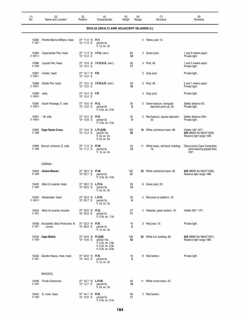
184
(1)No.
(2)Name and Location
(3)Position
(4)Characteristic
(5)Height
(6)Range
(7)Structure
(8)Remarks
10380E 1857
-Pontile Marina Militare, head. 37° 11.5´ N15° 11.9´ E
Fl.Y.period 4sfl. 1s, ec. 3s
5 Yellow post; 13.
10384E 1857.4
-Supertanker Pier, head. 37° 11.3´ N15° 12.4´ E
3 F.G. (vert.) 6018
3 Green post. 1 and 2 meters apart.Private light.
10386E 1858
-Liquids Pier, head. 37° 10.9´ N15° 12.4´ E
3 F.G.R.G. (vert.) 5617
3 Post; 46. 1 and 2 meters apart.Private light.
10387E 1858.1
-Center, head. 37° 10.7´ N15° 12.2´ E
F.R. 3 Gray post. Private light.
10388E 1858.2
-Solids Pier, head. 37° 10.5´ N15° 12.5´ E
3 F.R.G.R. (vert.) 5918
3 Post; 46. 2 and 1 meters apart.Private light.
10389E 1858.3
-Jetty. 37° 10.4´ N15° 12.4´ E
F.R. 3 Gray post. Private light.
10390E 1858.4
-South Passage, E. side. 37° 10.6´ N15° 13.0´ E
Fl.G.period 3sfl. 0.5s, ec. 2.5s
309
5 Green beacon, triangular daymark point up; 33.
Safety distance 50.Private light.
10391E 1858.6
- -W. side. 37° 10.5´ N15° 12.8´ E
Fl.R.period 3sfl. 0.5s, ec. 2.5s
309
5 Red beacon, square daymark; 33.
Safety distance 30m.Private light.
10392E 1838
Capo Santa Croce. 37° 14.6´ N15° 15.4´ E
L.Fl.(2)W.period 12sfl. 2s, ec. 2sfl. 2s, ec. 6s
12839
16 White cylindrical tower; 89. Visible 146°-021°.AIS (MMSI No 992471059).Reserve light range 10M.
10396E 1836
Brucoli, entrance, E. side. 37° 17.0´ N15° 11.2´ E
Fl.W.period 5sfl. 1s, ec. 4s
4313
11 White tower, red band, building; 16.
Obscured by Capo Campolato when bearing greater than 230°.
CATANIA:
10400E 1828
-Sciara Biscari. 37° 29.3´ N15° 05.1´ E
Fl.W.period 5sfl. 0.4s, ec. 4.6s
10231
22 White cylindrical tower; 92. AIS (MMSI No 992471058).Reserve light range 18M.
10420E 1830
-Molo di Levante, head. 37° 29.0´ N15° 06.0´ E
L.Fl.G.period 5sfl. 2s, ec. 3s
3912
8 Green post; 20.
10422E 1832.5
-Breakwater, head. 37° 29.3´ N15° 05.7´ E
L.Fl.R.period 5sfl. 2s, ec. 3s
206
5 Red post on platform; 16.
10424E 1831
-Molo di Levante, knuckle. 37° 29.5´ N15° 05.9´ E
Fl.G.period 2sfl. 0.5s, ec. 1.5s
3711
5 Pedestal, green lantern; 16. Visible 355°-175°.
10428E 1827
Acicastello, Molo Porticciolo, N. corner.
37° 33.3´ N15° 08.9´ E
Fl.R.period 4sfl. 1s, ec. 3s
196
3 Red post; 10. Private light.
10432E 1826
Capo Molini. 37° 34.6´ N15° 10.6´ E
Fl.(3)W.period 15sfl. 0.2s, ec. 2.8sfl. 0.2s, ec. 2.8sfl. 0.2s, ec. 8.8s
13842
22 White hut, building; 66. AIS (MMSI No 992471057).Reserve light range 18M.
10434E 1821
Giardini Naxos, mole, head. 37° 49.6´ N15° 16.6´ E
Fl.R.period 4sfl. 1s, ec. 3s
165
8 Red lantern. Private light.
RIPOSTO:
10436E 1822
-Punta Chiancona. 37° 43.7´ N15° 12.7´ E
L.Fl.W.period 5sfl. 2s, ec. 3s
4915
11 White round tower; 20.
10440E 1823
-E. mole, head. 37° 44.1´ N15° 12.6´ E
Fl.R.period 3sfl. 0.5s, ec. 2.5s
3611
5 Red lantern.
SICILIA (SICILY) AND ADJACENT ISLANDS (I.)

185
(1)No.
(2)Name and Location
(3)Position
(4)Characteristic
(5)Height
(6)Range
(7)Structure
(8)Remarks
10442E 1824
-W. mole, head. 37° 44.0´ N15° 12.5´ E
Fl.G.period 3sfl. 0.5s, ec. 2.5s
206
4 Green post; 16.
ISOLE PELAGIE:
-Isola di Lampedusa:
10444E 2088
- -Capo Grecale. 35° 31.0´ N12° 38.0´ E
Fl.W.period 5sfl. 0.3s, ec. 4.7s
26982
22 Multi-sided tower, building; 62. Visible 112°-075°. Reserve light range 18M.AIS (MMSI No 992471069).
10448E 2089
- -Lampedusa, on Punta Maccaferri, entrance, E. side.
35° 29.6´ N12° 36.3´ E
Fl.G.period 3sfl. 1s, ec. 2s
5717
8 Pedestal, green lantern; 16.
10452E 2092
- - -Health office, mole, head. 35° 29.8´ N12° 36.3´ E
F.R. 237
3 Red post; 13.
10456E 2091
- -Punta Favaloro, breakwater, head.
35° 29.8´ N12° 36.2´ E
Fl.R.period 5sfl. 1s, ec. 4s
237
7 Pedestal, red lantern; 16. Safety distance 15m.
10460E 2090
- -Punta Guitgia, entrance, W. side.
35° 29.8´ N12° 35.9´ E
Fl.R.period 3sfl. 1s, ec. 2s
4714
8 Pedestal, red lantern; 16.
10464E 2086
- -Capo Ponente, island, W. head.
35° 31.2´ N12° 31.3´ E
Fl.(3)W.period 15sfl. 1s, ec. 2sfl. 1s, ec. 2sfl. 1s, ec. 8s
360110
8 Pedestal, white lantern; 20. Visible 290°-222°.
-Isola di Linosa:
10468E 2082
- -Punta Beppe Tuccio. 35° 52.4´ N12° 52.6´ E
Fl.(4)W.period 20sfl. 1s, ec. 3sfl. 1s, ec. 3sfl. 1s, ec. 3sfl. 1s, ec. 7s
10532
16 White cylindrical tower, building; 56.
Visible 107°-345°, at distance less than 6 miles 103°-346°.
AIS (MMSI No 992471070).Reserve light range 12M.Reserve light range 12M.
10472E 2080
- -Punta Arena Bianca, island, SW. side.
35° 51.6´ N12° 51.4´ E
Fl.W.period 5sfl. 1s, ec. 4s
319
9 Pylon, white hut; 20. Visible 276°30′-150°.
10476E 2084
-Isolotto Lampione. 35° 33.0´ N12° 19.2´ E
Fl.(2)W.period 10sfl. 1s, ec. 2sfl. 1s, ec. 6s
13140
7 Square hut; 20.
ISOLA DI PANTELLARIA:
10480E 2094
-Punta Spadillo. 36° 49.4´ N12° 00.7´ E
Fl.(2)W.period 10sfl. 0.2s, ec. 2.3sfl. 0.2s, ec. 7.3s
16450
24 White round tower, building; 69. Reserve light range 18M.AIS (MMSI No 992471067).
10484E 2107
-Punta Tracino. 36° 47.9´ N12° 03.0´ E
Fl.(2)W.period 10sfl. 1s, ec. 2sfl. 1s, ec. 6s
16149
10 White round tower; 10.
10492E 2106
-Punta Limarsi. 36° 44.3´ N12° 02.0´ E
Fl.(3)W.period 15sfl. 0.5s, ec. 2sfl. 0.5s, ec. 2sfl. 0.5s, ec. 9.5s
11535
7 Pedestal, white lantern; 16.
10496E 2096
-Scauri. 36° 46.1´ N11° 57.7´ E
Fl.W.period 5sfl. 1s, ec. 4s
6018
10 Pedestal, white lantern; 16. Fl.R. 3s shown from head of W. mole, Fl.G. 3s shown from head of E. mole.
10500E 2098
-Punta San Leonardo. 36° 50.1´ N11° 56.7´ E
Fl.W.period 3sfl. 1s, ec. 2s
6921
15 Red building, white lantern; 10. Reserve light range 8M.AIS (MMSI No 992471068).
SICILIA (SICILY) AND ADJACENT ISLANDS (I.)
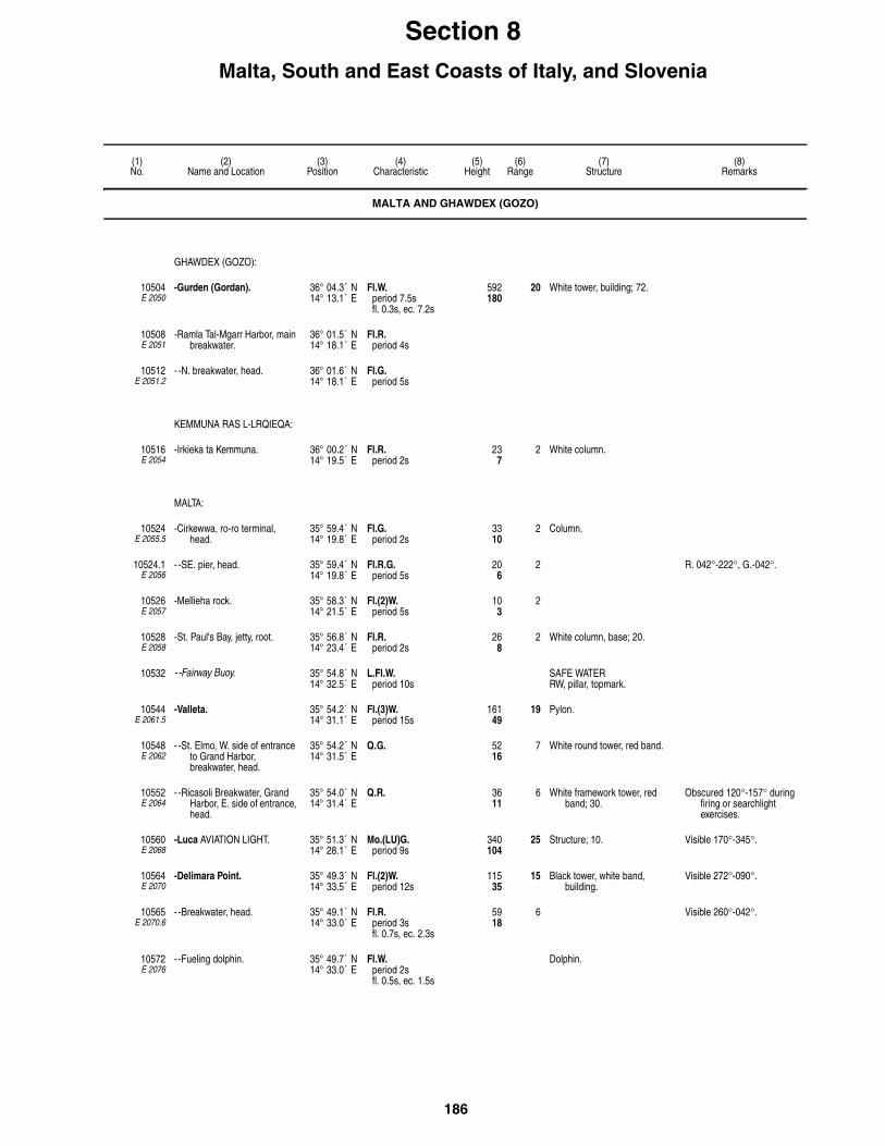
186
(1)No.
(2)Name and Location
(3)Position
(4)Characteristic
(5)Height
(6)Range
(7)Structure
(8)Remarks
Section 8Malta, South and East Coasts of Italy, and Slovenia
MALTA AND GHAWDEX (GOZO)
GHAWDEX (GOZO):
10504E 2050
-Gurden (Gordan). 36° 04.3´ N14° 13.1´ E
Fl.W.period 7.5sfl. 0.3s, ec. 7.2s
592180
20 White tower, building; 72.
10508E 2051
-Ramla Tal-Mgarr Harbor, main breakwater.
36° 01.5´ N14° 18.1´ E
Fl.R.period 4s
10512E 2051.2
- -N. breakwater, head. 36° 01.6´ N14° 18.1´ E
Fl.G.period 5s
KEMMUNA RAS L-LRQIEQA:
10516E 2054
-Irkieka ta Kemmuna. 36° 00.2´ N14° 19.5´ E
Fl.R.period 2s
237
2 White column.
MALTA:
10524E 2055.5
-Cirkewwa, ro-ro terminal, head.
35° 59.4´ N14° 19.8´ E
Fl.G.period 2s
3310
2 Column.
10524.1E 2056
- -SE. pier, head. 35° 59.4´ N14° 19.8´ E
Fl.R.G.period 5s
206
2 R. 042°-222°, G.-042°.
10526E 2057
-Mellieha rock. 35° 58.3´ N14° 21.5´ E
Fl.(2)W.period 5s
103
2
10528E 2058
-St. Paul's Bay, jetty, root. 35° 56.8´ N14° 23.4´ E
Fl.R.period 2s
268
2 White column, base; 20.
10532 - -Fairway Buoy. 35° 54.8´ N14° 32.5´ E
L.Fl.W.period 10s
SAFE WATERRW, pillar, topmark.
10544E 2061.5
-Valleta. 35° 54.2´ N14° 31.1´ E
Fl.(3)W.period 15s
16149
19 Pylon.
10548E 2062
- -St. Elmo, W. side of entrance to Grand Harbor, breakwater, head.
35° 54.2´ N14° 31.5´ E
Q.G. 5216
7 White round tower, red band.
10552E 2064
- -Ricasoli Breakwater, Grand Harbor, E. side of entrance, head.
35° 54.0´ N14° 31.4´ E
Q.R. 3611
6 White framework tower, red band; 30.
Obscured 120°-157° during firing or searchlight exercises.
10560E 2068
-Luca AVIATION LIGHT. 35° 51.3´ N14° 28.1´ E
Mo.(LU)G.period 9s
340104
25 Structure; 10. Visible 170°-345°.
10564E 2070
-Delimara Point. 35° 49.3´ N14° 33.5´ E
Fl.(2)W.period 12s
11535
15 Black tower, white band, building.
Visible 272°-090°.
10565E 2070.6
- -Breakwater, head. 35° 49.1´ N14° 33.0´ E
Fl.R.period 3sfl. 0.7s, ec. 2.3s
5918
6 Visible 260°-042°.
10572E 2076
- -Fueling dolphin. 35° 49.7´ N14° 33.0´ E
Fl.W.period 2sfl. 0.5s, ec. 1.5s
Dolphin.

187
(1)No.
(2)Name and Location
(3)Position
(4)Characteristic
(5)Height
(6)Range
(7)Structure
(8)Remarks
ITALY-SOUTHEAST COAST
10580E 1782
Capo Spartivento. 37° 55.6´ N16° 03.6´ E
Fl.W.period 8sfl. 0.3s, ec. 7.7s
20863
24 White tower, building; 49. Visible 222°-082°.AIS (MMSI No 992471087).Reserve light range 18M.
10584E 2108
Punta Stilo. 38° 27.0´ N16° 34.7´ E
Fl.(3)W.period 15sfl. 0.2s, ec. 2.8sfl. 0.2s, ec. 2.8sfl. 0.2s, ec. 8.8s
17754
22 White octagonal tower, black bands; 49.
Reserve light range 11M.AIS (MMSI No 992471088).
10588E 2109
Siderno Marina. 38° 27.0´ N16° 35.0´ E
2 F.R.G. (vert.) 4313
3 Black post, red bands. 1 meter apart.Private light.
10596E 2112
Capo Rizzuto. 38° 53.8´ N17° 05.5´ E
L.Fl.(2)W.R.period 10sfl. 2s, ec. 1sfl. 2s, ec. 5s
12137
W. 17R. 13
White tower, building; 56. R. 227°-270°, W.-084°, R.-133°.
Reserve light range 11/8M.AIS (MMSI No 992471089).
10600E 2118
Capo Colonne. 39° 01.6´ N17° 12.2´ E
Fl.W.period 5sfl. 0.5s, ec. 4.5s
13140
24 White tower, two-story building; 72.
Visible 127°-020°.Reserve light range 18M.AIS (MMSI No 992471090).
CROTONE:
10604E 2122
-Porto Vecchio, 38 meters from breakwater, head.
39° 04.7´ N17° 08.2´ E
Fl.(2)G.period 5sfl. 1s, ec. 1sfl. 1s, ec. 2s
3611
8 Green hut, lantern; 30. Safety distance 60m.
10608E 2123
-Molo Sanita, head. 39° 04.7´ N17° 08.2´ E
Fl.(2)R.period 5sfl. 1s, ec. 1sfl. 1s, ec. 2s
309
8 Red hut, lantern; 26.
10612E 2121.5
-Porto Nuevo, head of Molo Giunti.
39° 05.2´ N17° 07.9´ E
F.G. 309
4 Green post; 23.
10616E 2121
-Molo Sottoflutto, head. 39° 05.5´ N17° 07.6´ E
Fl.G.period 5sfl. 1s, ec. 4s
4313
8 Green framework tower; 23. Safety distance 50m.
10620E 2120
-Foraneo, mole, head. 39° 05.8´ N17° 07.6´ E
Fl.R.period 5sfl. 1s, ec. 4s
3611
8 Red framework tower; 30. Safety distance 100m.
10624E 2128
Punta Alice. 39° 23.9´ N17° 09.1´ E
Fl.(2)W.period 10sfl. 1s, ec. 2sfl. 1s, ec. 6s
10231
16 White tower, building; 89. Reserve light range 12M.AIS (MMSI No 992471091).
10630E 2130.5
Punta Coscio. 39° 43.9´ N16° 30.0´ E
Fl.(4)W.period 20sfl. 0.5s, ec. 2sfl. 0.5s, ec. 2sfl. 0.5s, ec. 2sfl. 0.5s, ec. 12s
7523
12 Tower, three-story building; 66. Private light.
10631E 2130.6
Laghi di Sibari Range, front. 39° 44.0´ N16° 30.6´ E
Iso.W.period 2s
4 White tower, black bands; 13. Visible 124°-154°.Private light.
10631.1E 2130.61
-Rear, 60 meters 139° from front.
39° 44.1´ N16° 30.6´ E
Iso.W.period 2s
237
4 Red framework tower, white bands; 20.
Visible 136°-246°.Synchronized with front.Private light.
10632E 2131
Laghi di Sibari, marina, head of S. mole.
39° 44.0´ N16° 31.0´ E
F.R. 206
6 Red post; 20. Private light.
10636E 2131.2
-N. mole, head. 39° 44.0´ N16° 31.0´ E
F.G. 206
6 Green post; 20. Private light.
TARANTO:
10640E 2132
-Capo San Vito. 40° 24.7´ N17° 12.2´ E
Fl.(3)W.period 15sfl. 0.2s, ec. 2.8sfl. 0.2s, ec. 2.8sfl. 0.2s, ec. 8.8s
15146
22 White tower, two-story building; 141.
AIS (MMSI No 992471092).Reserve light range 18M.

188
(1)No.
(2)Name and Location
(3)Position
(4)Characteristic
(5)Height
(6)Range
(7)Structure
(8)Remarks
10642E 2133
-Mar Grande. 40° 25.3´ N17° 10.4´ E
Q.(9)W.period 15s
165
5 W. CARDINALYBY, articulated beacon,
topmark.
Radar reflector.
10644E 2134
-Diga di San Vito, W. head. 40° 25.8´ N17° 11.7´ E
Fl.(2)G.period 7sfl. 1s, ec. 1sfl. 1s, ec. 4s
7222
9 Green framework tower; 62. When near Capo San Vito, partially obscured by the lights of Taranto.
10646E 2137
-Isola San Pietro, jetty, head. 40° 27.3´ N17° 09.7´ E
Fl.Y.period 4sfl. 1s, ec. 3s
268
4 Yellow post; 23.
10648E 2138
-Isolotto San Paolo, breakwater, head.
40° 26.2´ N17° 10.8´ E
Fl.(2)R.period 7sfl. 1s, ec. 1sfl. 1s, ec. 4s
3812
7 Red round tower; 33. Safety distance 50 meters.
10650E 2142.3
-Secca della Sirena, S. 40° 27.6´ N17° 12.4´ E
Q.(6)+L.Fl.W.period 15s
165
5 S. CARDINALYB, articulated beacon, topmark.
Q.R. and Q.G. articulated lights mark channel to E.
Radar reflector.
10656E 2142.4
-Secca della Sirena, W. 40° 27.7´ N17° 12.7´ E
Q.R. 196
6 Red buoyant beacon, square daymark.
Private light.Radar reflector.
10660E 2142.5
-Mar Grande, close SW. Secca della Sirena.
40° 27.6´ N17° 13.0´ E
Q.G. 206
7 Green buoyant beacon, triangular daymark point up.
Private light. Radar reflector.
10664E 2142.6
-Detached breakwater, SE. head.
40° 27.9´ N17° 12.5´ E
Q.R. 3310
4 Red post; 26. Private light.
10672E 2143
-Pontile Chiapparo, W. extremity.
40° 26.3´ N17° 14.6´ E
Fl.G.period 3sfl. 1s, ec. 2s
268
3 Green post; 19.
10676E 2143.2
- -N. extremity. 40° 26.4´ N17° 14.7´ E
Fl.Y.period 2sfl. 0.5s, ec. 1.5s
268
3 Yellow post; 19.
10677E 2144
- -Jetty, head. 40° 26.8´ N17° 14.8´ E
Fl.R.period 3sfl. 1s, ec. 2s
268
3 Pedestal, red lantern.
-Passagio Piccolo:
10680E 2150
- -Mar Grande Range, Secca della Tarantola, front.
40° 26.9´ N17° 13.7´ E
Fl.W.G.period 3sfl. 1s, ec. 2s
3912
W. 9G. 7
Green cylindrical tower; 36. G. 057°-187°30′, W.(over range line)-198°30′, G.-025°.
Safety distance 150m.
10684E 2150.1
- - -Rear, near Casa Gigante, about 3 km. 193° from front.
40° 25.4´ N17° 13.2´ E
Iso.W.period 3s
6921
14 White tower, black stripes; 66. Visible 189°45′-196°25′.F.R. on masthead.Reserve light range 10M.
10688E 2152
- -Mar Piccolo, N. Range, front. 40° 29.3´ N17° 14.4´ E
Q.R. 3912
6 Black pyramidal structure, white stripes; 33.
10689E 2152.1
- - -Rear, 013° from front, near Casa Troilo.
40° 30.0´ N17° 15.0´ E
Fl.W.period 3sfl. 1s, ec. 2s
6620
8 White tower, black stripes; 33.
10690E 2158.6
- -Fanale. 40° 29.7´ N17° 15.9´ E
Fl.Y.period 3sfl. 1s, ec. 2s
4313
3 Platform; 43. Private light.
10694E 2158.4
- -Water intake. 40° 29.5´ N17° 14.2´ E
F.Y. 3310
3 Yellow post. A F.Y. light is shown at head of three structures.
Private light.
10695E 2156
- -Molo Sauro. 40° 28.6´ N17° 14.9´ E
Fl.Y.period 4sfl. 0.5s, ec. 3.5s
206
2 Yellow post; 16. A Fl.Y. light is shown at head of three piers.
10695.5E 2156.6
- -Molo Lavori, jetty, head. 40° 28.6´ N17° 15.1´ E
Fl.Y.period 4sfl. 0.5s, ec. 3.5s
206
2 Yellow post; 16.
10696E 2153
- -Canale Navigabile. 40° 28.3´ N17° 14.1´ E
F.R. 268
4 Wall, lantern.
ITALY-SOUTHEAST COAST

189
(1)No.
(2)Name and Location
(3)Position
(4)Characteristic
(5)Height
(6)Range
(7)Structure
(8)Remarks
10700E 2145
- -Commercial port, W. mole, head.
40° 28.6´ N17° 13.3´ E
Fl.R.period 5sfl. 1s, ec. 4s
3310
4 Red post; 26. Private light.
10702E 2145.2
- - -W. side. 40° 28.6´ N17° 13.2´ E
F.G. 3310
4 Green post; 23. Private light.
10704E 2146
- - -E. mole, head. 40° 28.5´ N17° 13.4´ E
Fl.G.period 5sfl. 1s, ec. 4s
3912
8 Green column, hut, pedestal; 33. Private light.
-Porto Industriale:
10708E 2144.4
- -Italsider, pier 2, SE. corner, head.
40° 28.4´ N17° 13.0´ E
F.R. 3310
5 Red post; 20. Private light.
10710E 2144.42
- - -SW corner. 40° 28.5´ N17° 12.9´ E
F.G. 3310
5 Green post; 20. Private light.
10712E 2144.43
- - -Pier 3, SE. corner, head. 40° 28.4´ N17° 12.7´ E
F.R. 3310
3 Red post; 20. Private light.
10716E 2144.44
- - -SW. corner, head. 40° 28.4´ N17° 12.6´ E
F.G. 3310
3 Green post; 20. Private light.
10718E 2144.47
- - -Pier 4 Range, front. 40° 28.7´ N17° 12.3´ E
Q.R. 6620
6 Post, white square daymark, black stripe; 59.
Occasional. Private light.
10719E 2144.48
- - - -Rear, 690 meters 341° from front.
40° 28.7´ N17° 12.1´ E
Oc.W.period 3slt. 1s, ec. 2s
13742
20 Post, white square daymark, black stripe; 69.
Occasional. Private light.
10720E 2144.45
- - -Pier 4, SE. corner, head. 40° 28.4´ N17° 12.4´ E
F.R. 3310
3 Red post; 20. Private light.
10722E 2142.8
- -Pontile AGIP, 150 meters SSE from breakwater, head.
40° 28.2´ N17° 11.7´ E
Fl.Y.period 2sfl. 0.5s, ec. 1.5s
3310
3 Yellow post; 20. Marks fixed mooring caisson.Private light.
10724E 2144.5
- -E. breakwater, E. head. 40° 28.2´ N17° 13.2´ E
Fl.R.period 5sfl. 1s, ec. 4s
3912
6 Red column, hut, pedestal; 30. Private light.
-Punta Rondinella:
10728E 2162
- -Detached breakwater, N. head.
40° 29.5´ N17° 08.3´ E
Fl.G.period 5sfl. 1s, ec. 4s
4614
8 Green post; 20. Private light.Ponta Rondinella Passage
marked by Fl.R. 3s, Fl.G. 3s 1.35 miles ESE.
10732E 2162.2
- - -S. head. 40° 28.9´ N17° 08.7´ E
Q.R. 4714
4 Red post; 20. Harbor approach marked by articulated beacons Q.(6)+L.Fl.W. 15s 2.8 miles SSW., Q.(9)W. 15s 2.4 miles SW., 2.5 miles WSW., 1.5 miles W.
Private light.
10736E 2162.4
- -Lee mole, head. 40° 29.7´ N17° 08.7´ E
Fl.R.period 5sfl. 1s, ec. 4s
4714
8 Red post; 20. Articulated beacons Q.Y. 5M 650 meters 315°, Q.Y. 6M 840 meters 167°, Q.G. 3M 620 meters 114° from light.
Private light.
10740E 2162.6
- -Passaggi scogliera Punta Rondinella, N. side.
40° 29.8´ N17° 09.3´ E
F.G. 3310
3 Green post; 20. Private light.
10744E 2142.92
- -W. side. 40° 28.6´ N17° 10.4´ E
Q.G. 3310
3 Green post; 26. Private light.
10748E 2142.9
- - -breakwater, E. side. 40° 28.6´ N17° 10.4´ E
Q.R. 3310
3 Red post; 26. Private light.
10752E 2164
Porto Cesareo, entrance Range, front.
40° 15.5´ N17° 54.0´ E
Iso.W.period 2s
4213
7 Framework tower, black and white checkered hut; 39.
Visible 350°-068°.Private light.
ITALY-SOUTHEAST COAST

190
(1)No.
(2)Name and Location
(3)Position
(4)Characteristic
(5)Height
(6)Range
(7)Structure
(8)Remarks
10756E 2164.1
-Rear, 765 meters 034° from front.
40° 15.8´ N17° 54.3´ E
Oc.W.period 3slt. 2s, ec. 1s
8727
10 Black and white checkered tower; 49.
Private light.
GALLIPOLI:
10760E 2168
-Isola Sant' Andrea. 40° 02.8´ N17° 56.7´ E
Fl.(2)W.period 10sfl. 0.2s, ec. 2.3sfl. 0.2s, ec. 7.3s
14845
19 White tower, two-story building; 141.
Reserve light range 15M.
10764E 2172
-Molo di Tramontana. 40° 03.7´ N17° 59.0´ E
Fl.G.period 5sfl. 1s, ec. 4s
3611
9 Green round tower; 29. Safety distance 70m.F.R. 51m on antenna 880
meters ESE.
10765E 2172.2
- -Molo di Sottoflutto. 40° 03.5´ N17° 59.0´ E
Fl.R.period 5sfl. 1s, ec. 4s
3611
9 Red round tower; 29. Safety distance 50m.
10768E 2170
-Secca del Rafo. 40° 03.8´ N17° 58.7´ E
Q.W. 165
5 N. CARDINALBY, articulated beacon, topmark.
Radar reflector.
10772E 2173
-Seno del Canneto, breakwater, head.
40° 03.2´ N17° 58.8´ E
Fl.R.period 5sfl. 1s, ec. 4s
206
3 Red post; 13. Fl.G. shown on mole.
10776E 2174
Torre San Giovanni. 39° 53.1´ N18° 06.8´ E
Iso.W.R.period 4s
7924
W. 15R. 11
Black and white checkered tower; 72.
R. 311°-013°, W.-133°.AIS (MMSI No 992471093).Reserve light range W. 11M,
R. 9M.
10778E 2174.4
-Secche di Ugento. 39° 49.8´ N18° 08.3´ E
Q.(9)W.period 15s
196
5 W. CARDINALYBY, beacon, topmark.
Radar reflector.
10780E 2176
Capo Santa Maria di Leuca. 39° 47.7´ N18° 22.1´ E
Fl.(3)W.period 15sfl. 0.5s, ec. 2.5sfl. 0.5s, ec. 2.5sfl. 0.5s, ec. 8.5s
334102
24 White tower, two-story building; 157.
Visible 220°-068°.Aeromarine light.AIS (MMSI No 992471094).Reserve light range 10M.
Oc.R.period 4slt. 3s, ec. 1s
328100
11 Visible 094°-106°.Reserve light range 9M.
10784E 2177
Tricase, outer mole, head. 39° 55.9´ N18° 23.7´ E
Iso.G.period 2s
3310
4 Green post; 20.
10786E 2177.5
Castro, outer mole, head. 40° 00.0´ N18° 25.7´ E
Fl.R.period 3sfl. 1s, ec. 2s
206
7 Red post; 16. Private light.
ITALY-EAST COAST
10788E 2178
Capo d'Otranto. 40° 06.3´ N18° 31.2´ E
Fl.W.period 5sfl. 1s, ec. 4s
19760
18 White four-sided tower, building; 105.
AIS (MMSI No 992471095).Reserve light range 12M.
10792E 2182
Otranto, Punta Craul, N. of port. 40° 09.2´ N18° 29.5´ E
Fl.(3)W.R.period 10sfl. 1s, ec. 1sfl. 1s, ec. 1sfl. 1s, ec. 5s
3912
W. 13R. 8
Round tower, white lantern; 30. R. 165°-183°, W.-165°. Reserve light range 11/7M.
10796E 2186
-Punta San Nicola, mole, head. 40° 09.0´ N18° 29.6´ E
Fl.R.period 3sfl. 1s, ec. 2s
3611
8 Pedestal, red lantern; 20. Safety distance 60m.
10800E 2188
Torre Sant' Andrea. 40° 15.4´ N18° 26.7´ E
Fl.(2)W.R.period 7sfl. 1s, ec. 1sfl. 1s, ec. 4s
7924
W. 15R. 12
Black and white checkered tower; 52.
R. 300°-343°, W.-300°.AIS (MMSI No 992471096).Reserve light range W. 11M,
R. 8M.
10804E 2190.5
San Foca di Melendugno. 40° 18.3´ N18° 24.3´ E
Fl.G.period 3sfl. 0.5s, ec. 2.5s
5 Green post. Private light.
ITALY-SOUTHEAST COAST

191
(1)No.
(2)Name and Location
(3)Position
(4)Characteristic
(5)Height
(6)Range
(7)Structure
(8)Remarks
10808E 2192
Punta San Cataldo di Lecce. 40° 23.5´ N18° 18.4´ E
L.Fl.W.period 5sfl. 2s, ec. 3s
8225
16 White tower, building; 75. Visible 140°-315°.AIS (MMSI No 992471097).Reserve light range 12M.
BRINDISI:
10812E 2194
-Capo di Torre Cavallo. 40° 39.7´ N18° 02.2´ E
Q.(3)W. 165
5 E. CARDINALBYB, articulated beacon,
topmark.
Radar reflector.
10816E 2196
-Le Pedagne, on Isolotto Traverso, E. side.
40° 39.5´ N17° 59.4´ E
Fl.(2)R.period 6sfl. 0.5s, ec. 1sfl. 0.5s, ec. 4s
6921
8 White tower, red lantern, white building.
Visible 349°-252°.
10822E 2208
-Brindisi-Casale AVIATION LIGHT.
40° 39.5´ N17° 56.5´ E
Al.Fl.W.G.period 17sW. fl. 1s, ec. 3sG. fl. 1s, ec. 3sW. fl. 1s, ec. 8s
5918
W. 24G. 18
Framework tower; 33. Private light.
10822.5E 2198
-Main breakwater, head. 40° 39.8´ N17° 59.8´ E
Fl.(2)G.period 10sfl. 1s, ec. 2sfl. 1s, ec. 6s
4012
8 Green pole. Private light.
RACON B(– • • •)
10823E 2200
-Isola Sant' Andrea. 40° 39.5´ N17° 58.2´ E
Dir.W.R.G. 9830
20 Post; 82. F.G. 258°58′-260°16′, Al.W.G.-261°10′, F.W.-261°46′, Al.W.R.-262°40′, F.R.-263°58′.
Private light.
10823.5E 2202
-Forte a Mare. 40° 39.3´ N17° 58.1´ E
Fl.(4)W.period 20sfl. 0.2s, ec. 2.4sfl. 0.2s, ec. 2.4sfl. 0.2s, ec. 2.4sfl. 0.2s, ec. 12s
9228
21 Balcony, castle; 82. AIS (MMSI No 992471098).Reserve light range 18M.
10824E 2204
- -S., N. breakwater, head. 40° 39.2´ N17° 58.1´ E
Fl.G.period 3sfl. 0.5s, ec. 2.5s
3912
7 Steel pole; 23.
10828E 2203.5
-Diga di Costa Morena, N. breakwater, head.
40° 39.1´ N17° 58.4´ E
F.R. 237
5 Red post. Private light.
10830E 2203
-Molo Montecatini Edison, head.
40° 39.0´ N17° 58.9´ E
2 F.R. (vert.) 3611
5 Red post; 16. 1 meter apart.Private light.
-Canale Pigonati:
10832E 2212
- -Inner harbor entrance, E. side.
40° 38.7´ N17° 57.2´ E
Iso.R.period 2s
309
5 Hut, red lantern; 20.
10836E 2210
- - -W. side. 40° 38.7´ N17° 57.1´ E
Iso.G.period 2s
309
5 Hut, green lantern; 20.
10840E 2216
- -Inner end of entrance to canal, on E. side.
40° 38.6´ N17° 57.1´ E
F.R. 3310
4 Red post; 26. Visible 018°-227°.
10844E 2214
- - -On W. side. 40° 38.7´ N17° 57.0´ E
F.G. 3310
4 Green post; 26. Visible 227°-070°.
10848E 2217
- -Galleggianti, E. pier, head. 40° 38.5´ N17° 56.3´ E
F.R. 268
2 Post; 23.
10852E 2217.5
- - -W. pier, head. 40° 38.5´ N17° 56.2´ E
F.R. 268
2 Post; 23.
10856E 2222
Torre Canne. 40° 50.5´ N17° 28.1´ E
Fl.(2)W.period 10sfl. 1s, ec. 2sfl. 1s, ec. 6s
11535
16 White tower, building; 104. AIS (MMSI No 992471099).Reserve light range 12M.
ITALY-EAST COAST

192
(1)No.
(2)Name and Location
(3)Position
(4)Characteristic
(5)Height
(6)Range
(7)Structure
(8)Remarks
10860E 2223
Savelletri. 40° 52.4´ N17° 24.8´ E
Fl.G.period 5sfl. 1s, ec. 4s
268
3 Green post; 13. Private light.
10864E 2223.4
-S. mole, head. 40° 52.5´ N17° 24.8´ E
Fl.R.period 5sfl. 1s, ec. 4s
268
3 Red post; 16. Private light.
10868E 2224
Monopoli, Molo Margherita, head.
40° 57.3´ N17° 18.3´ E
Fl.R.period 3sfl. 1s, ec. 2s
4815
8 Red tower, white bands; 49.
10872E 2226
-N. mole, head. 40° 57.4´ N17° 18.4´ E
Fl.G.period 3sfl. 1s, ec. 2s
4313
8 Green framework tower; 33.
10876E 2228
Mola di Bari, breakwater, head. 41° 03.6´ N17° 06.0´ E
Fl.G.period 3sfl. 0.5s, ec. 2.5s
4614
7 Green framework tower, white hut; 36.
Safety distance 35m.
10880E 2228.5
-E. mole, head. 41° 03.7´ N17° 06.1´ E
Fl.R.period 3sfl. 0.5s, ec. 2.5s
4614
7 Red column, pedestal; 20.
10884E 2230
Cala Portecchia, outer mole, head.
41° 03.7´ N17° 06.0´ E
F.R. 268
5 Red post; 20. Private light.
10886E 2230.4
-N. mole, head. 41° 03.8´ N17° 05.3´ E
F.G. 268
5 Green post; 20. Private light.
10888E 2231
Torra Mare (Torre Pelosa). 41° 05.4´ N16° 59.9´ E
F.R. 319
3 Red post; 26. F.G. shown from inner breakwater.
Private light.
10892E 2232
Punta San Cataldo. 41° 08.3´ N16° 50.7´ E
Fl.(3)W.period 20sfl. 0.2s, ec. 3.8sfl. 0.2s, ec. 3.8sfl. 0.2s, ec. 11.8s
21866
24 White tower, two-story building; 203.
Oc.R. shown about 0.7 km. WSW.
2 Fl.R. 2.5s 57m on radio antennas 2.2 miles ESE.
Reserve light range 18M.
10896E 2233
Nuovo Molo Foraneo, 5th arm, head.
41° 08.9´ N16° 50.9´ E
Fl.R.period 3sfl. 1s, ec. 2s
3912
7 Pedestal, red lantern; 20.
10900E 2236
Nuovo Molo Foraneo, 3rd arm, head.
41° 08.6´ N16° 51.3´ E
Fl.R.period 5sfl. 1s, ec. 4s
165
4 Pedestal, red lantern; 13. Visible 273°-129°.
10904E 2241
-Inner spur, head. 41° 08.5´ N16° 52.0´ E
Fl.R.period 5sfl. 1s, ec. 4s
237
3 Red post; 16.
10908E 2234
Molo San Cataldo, head. 41° 08.5´ N16° 51.2´ E
Fl.G.period 3sfl. 1s, ec. 2s
3611
7 Green metal framework tower, square base; 26.
10916E 2240
Molo di Ridosso, head. 41° 08.4´ N16° 52.0´ E
Fl.G.period 5sfl. 1s, ec. 4s
268
3 Green post; 20.
10920E 2238
Vecchio Molo Foraneo, head. 41° 08.2´ N16° 51.7´ E
F.R. 3611
4 Red post; 13.
10924E 2243
Molo S. Vito, head. 41° 08.0´ N16° 51.9´ E
Fl.Y.period 2sfl. 0.5s, ec. 1.5s
268
3 Yellow post; 20.
10928E 2242
Molo Pizzoli, head. 41° 08.0´ N16° 51.7´ E
F.G. 3611
4 Green post; 13.
10932E 2244
Molo San Antonio. 41° 07.6´ N16° 52.8´ E
Fl.G.period 5sfl. 1s, ec. 4s
5617
9 White round tower, green bands; 46.
Visible 190°-130°.
10936E 2246
Santo Spirito, entrance, N. side. 41° 10.0´ N16° 45.0´ E
2 F.G. (vert.) 331026
8
3 Green post; 26. 2 meters apart.Private light.
ITALY-EAST COAST

193
(1)No.
(2)Name and Location
(3)Position
(4)Characteristic
(5)Height
(6)Range
(7)Structure
(8)Remarks
10940E 2246.2
-Entrance, S. side. 41° 09.9´ N16° 45.0´ E
2 F.R. (vert.) 331026
8
3 Red post; 26. 2 meters apart.Private light.
10944E 2247
Giovinazzo, W. breakwater. 41° 11.5´ N16° 40.4´ E
F.G. 268
4 Green post; 20. Private light.
10948E 2247.3
-E. breakwater. 41° 11.4´ N16° 40.4´ E
F.R. 268
4 Red post; 20. Private light.
10952E 2248
Molfetta. 41° 12.5´ N16° 35.7´ E
Iso.W.period 6s
7222
16 White octagonal tower; 59. Reserve light range 12M.
10956E 2252
-Molo Foraneo, head. 41° 12.7´ N16° 35.5´ E
Fl.R.period 5sfl. 0.5s, ec. 4.5s
3912
7 Red round tower; 33. Safety distance 30m.
10960E 2250
-Detached breakwater, head. 41° 12.8´ N16° 35.4´ E
Fl.G.period 5sfl. 0.5s, ec. 4.5s
4313
7 Pedestal, green lantern; 20. Safety distance 30m.
10964E 2254
-Molo Pennello, head. 41° 12.5´ N16° 35.5´ E
F.G. 165
4 Green pylon, hut; 10.
10968E 2258
Bisceglie, W. mole, head. 41° 14.7´ N16° 30.4´ E
F.R. 3310
1 Red tower; 20. Visible 280°-230°.Private light.
TRANI:
10972E 2261
-Molo San Antonio, 20 meters from head of extension.
41° 16.9´ N16° 25.2´ E
L.Fl.R.period 5sfl. 2s, ec. 3s
3310
8 Tower; 26.
10976E 2260
-Molo San Antonio, head. 41° 16.9´ N16° 25.3´ E
Fl.W.period 5sfl. 1s, ec. 4s
319
14 Round tower; 16. Reserve light range 11M.
10980E 2262
-Braccio di San Nicola. 41° 16.9´ N16° 25.2´ E
L.Fl.G.period 5sfl. 2s, ec. 3s
3310
8 Tower; 26.
BARLETTA:
10984E 2264
-Molo di Tramontana. 41° 19.8´ N16° 17.4´ E
L.Fl.(2)W.period 12sfl. 2s, ec. 2sfl. 2s, ec. 6s
11836
17 Octagonal tower; 102. AIS (MMSI No 992471100).Reserve light range 12M.
10988E 2266
- -At head. 41° 19.8´ N16° 17.5´ E
Fl.G.period 4sfl. 1s, ec. 3s
3912
8 Pedestal, green lantern; 23. Visible 160°-080°.F.G. marks head of
breakwater 280 meters NNW.
10992E 2263.5
-Church. 41° 19.0´ N16° 16.4´ E
F.W. 10 Cupola.
10996E 2268
-Diga di Levante, head. 41° 20.0´ N16° 17.7´ E
Fl.R.period 4sfl. 1s, ec. 3s
3912
8 Pedestal, red lantern; 20.
11000E 2274.4
Margherita de Savoia, outer mole, head.
41° 23.4´ N16° 08.0´ E
Fl.R.period 5sfl. 1s, ec. 4s
268
4 Red post; 20. Private light.
11004E 2274.6
-Inner mole, head. 41° 23.3´ N16° 07.9´ E
Fl.G.period 5sfl. 1s, ec. 4s
268
4 Green post; 20. Private light.
11008E 2275
Foce Aloisa, pier, head. 41° 26.0´ N16° 00.6´ E
F.R. 5216
3 Red post, white hut. Private light.
11012E 2276
Manfredonia. 41° 37.7´ N15° 55.4´ E
Fl.W.period 5sfl. 0.2s, ec. 4.8s
6620
23 Tower, two-story building; 59. May be lost in background lights at 11 miles or less.
AIS (MMSI No 992471103).Reserve light range 18M.
ITALY-EAST COAST

194
(1)No.
(2)Name and Location
(3)Position
(4)Characteristic
(5)Height
(6)Range
(7)Structure
(8)Remarks
11016E 2277
-Molo di Levante, head. 41° 37.2´ N15° 55.5´ E
Fl.G.period 3sfl. 0.5s, ec. 2.5s
4614
7 White cylindrical tower, green bands, green triangular daymark point up; 39.
11020E 2278
-Molo di Mezzogiorno, head. 41° 37.3´ N15° 55.3´ E
Fl.R.period 3sfl. 0.5s, ec. 2.5s
3912
7 White cylindrical tower, red bands, red square daymark; 33.
11024E 2281
-Industrial Port, outer mole, head.
41° 36.8´ N15° 57.0´ E
Oc.G.period 3slt. 2s, ec. 1s
3310
7 Pedestal, green lantern; 16. Private light.
11028E 2282
- -Inner mole, head. 41° 37.0´ N15° 56.9´ E
Oc.R.period 3slt. 2s, ec. 1s
3310
7 Pedestal, red lantern; 16. Private light.
11032E 2284
Mattinata, on Punta Agnuli. 41° 42.6´ N16° 04.8´ E
F.G. 268
3 Green post; 20. Private light.
11036E 2286
Torre Preposti. 41° 46.9´ N16° 11.6´ E
Fl.W.period 5sfl. 1s, ec. 4s
20362
15 Red tower, white house; 72. Visible 186°-020°.AIS (MMSI No 992471102).Reserve light range 12M.
11040E 2288
Vieste. 41° 53.2´ N16° 11.1´ E
Fl.(3)W.period 15sfl. 0.2s, ec. 2.8sfl. 0.2s, ec. 2.8sfl. 0.2s, ec. 8.8s
13140
25 Tower, two-story building; 89. Visible 124°-348°.AIS (MMSI No 992471101).Reserve light range 18M.
11044E 2288.4
-Cala San Lorenzo, head. 41° 53.2´ N16° 10.7´ E
F.R. 237
4 Red post; 16.
11052E 3586
Otok Palagruza (Cr.). 42° 23.5´ N16° 15.3´ E
Fl.W.period 17.5sfl. 0.8s, ec. 16.7s
361110
26 Stone tower, building; 72. Reserve light range 12M.AIS (MMSI No 992381030).
11056E 3588
-Near main light (Cr.). 42° 23.5´ N16° 15.3´ E
Iso.R.period 2s
31596
5 White column; 26. Visible 264°-304°.AIS (MMSI No 238645810).
11060E 2300
Isola Pianosa. 42° 13.5´ N15° 44.8´ E
Fl.(2)W.period 10sfl. 1s, ec. 1.5sfl. 1s, ec. 6.5s
8225
10 White framework tower, 56.
ISOLE DI TREMITI:
11064E 2296
-Isola Caprara. 42° 08.3´ N15° 31.2´ E
Fl.W.period 5sfl. 1s, ec. 4s
7523
4 White framework tower; 33.
11068E 2298
-Isola San Nicola, Tremiti, mole, head.
42° 07.1´ N15° 30.1´ E
Fl.G.period 3sfl. 0.5s, ec. 2.5s
309
3 Green post; 23.
11072E 2297
-Isola San Nicola. 42° 07.4´ N15° 30.5´ E
Fl.(4)W.period 15sfl. 1s, ec. 1sfl. 1s, ec. 1sfl. 1s, ec. 1sfl. 1s, ec. 8s
28587
12 White framework tower, red bands; 49.
Reserve light range 7M.
11076E 2294
-Punta del Diavolo, Isola San Domino, SW. head.
42° 06.4´ N15° 28.6´ E
Fl.(3)W.period 10sfl. 1s, ec. 1sfl. 1s, ec. 1sfl. 1s, ec. 5s
15748
11 White tower; 52. Visible 300°-175°.
TERMOLI:
11080E 2303
-Termoli. 42° 00.4´ N14° 59.9´ E
Fl.(2)W.period 10sfl. 1s, ec. 2sfl. 1s, ec. 6s
13541
15 White four-sided structure; 56. Reserve light range 11M.
11084E 2304
-Molo Nord, outer head. 42° 00.4´ N15° 00.7´ E
Fl.G.period 3sfl. 1s, ec. 2s
3611
8 Pedestal, green lantern; 33.
ITALY-EAST COAST

195
(1)No.
(2)Name and Location
(3)Position
(4)Characteristic
(5)Height
(6)Range
(7)Structure
(8)Remarks
11088E 2304.2
- -Inner head. 42° 00.2´ N15° 00.1´ E
F.G. 268
3 Green lantern; 20. Visible 290°-135°.
11092E 2305
-Molo Sud, head. 42° 00.1´ N15° 00.1´ E
Fl.(2)Y.period 6sfl. 0.5s, ec. 1.5sfl. 0.5s, ec. 3.5s
309
8 Platform, yellow lantern; 23. Safety distance 40m.
11100E 2306
Punta della Penna. 42° 10.2´ N14° 42.9´ E
Fl.W.period 5sfl. 0.2s, ec. 4.8s
27784
25 Tower, two-story building; 230. AIS (MMSI No 992471104).Reserve light range 18M.
11104E 2307
-Porto Vasto, Molo di Levante, head.
42° 10.6´ N14° 42.7´ E
Fl.R.period 3sfl. 1s, ec. 2s
299
4 Red lantern; 23.
11108E 2307.2
- -Spur. 42° 10.4´ N14° 42.6´ E
Fl.R.period 6sfl. 1s, ec. 5s
299
4 Beacon; 20. Visible 309°-203°.
11112E 2307.5
- -Molo di Ponente, head. 42° 10.6´ N14° 42.6´ E
Fl.G.period 3sfl. 1s, ec. 2s
299
7 Green lantern; 23.
11120E 2307.7
- - -Spur. 42° 10.6´ N14° 42.7´ E
Fl.G.period 6sfl. 1s, ec. 5s
299
4 Beacon; 20. Visible 169°-015°.
11124E 2308
San Vito Chietino, pier, head. 42° 19.0´ N14° 27.0´ E
F.R. 268
1 Red post; 20. Private light.
ORTONA:
11128E 2312
-Molo Nord. 42° 21.5´ N14° 24.5´ E
Fl.(2)W.period 6sfl. 1s, ec. 1sfl. 1s, ec. 3s
7523
15 White tower, building; 78. AIS (MMSI No 992471105).Reserve light range 11M.
11132E 2313
- -Near head. 42° 21.1´ N14° 25.4´ E
F.G. 309
5 Green tower; 16. Visible 210°-140°.
11136E 2315
-Molo a Martello, E. corner, head.
42° 21.3´ N14° 24.9´ E
F.G. 268
3 Pedestal, green lantern; 20.
11138E 2315.1
-Mandracchio, head. 42° 21.4´ N14° 24.6´ E
F.R. Private light.
11140E 2314
-Molo Sud, head. 42° 20.9´ N14° 25.4´ E
Fl.R.period 3sfl. 1s, ec. 2s
309
9 Red tower; 16.
11142E 2315.6
-Tower. 42° 27.9´ N14° 19.3´ E
Oc.(2)Y.period 10slt. 2s, ec. 1slt. 6s, ec. 1s
6620
5 Framework tower, dwelling; 75. Horn: Mo.(R) ev. 45s.Private light.
PESCARA:
11143E 2315.7
-Detached breakwater, W. head.
42° 28.4´ N14° 13.6´ E
Fl.R.period 6sfl. 1s, ec. 5s
3310
5 Pedestal, red lantern; 20.
11143.5E 2315.72
- -E. head. 42° 28.3´ N14° 14.1´ E
Fl.(2)G.period 10sfl. 1s, ec. 2sfl. 1s, ec. 6s
3310
5 Pedestal, green lantern; 20.
11145E 2316
-Marina, breakwater, head. 42° 28.2´ N14° 13.9´ E
Fl.G.period 5sfl. 0.5s, ec. 4.5s
309
4 Green post. Private light.
11146E 2316.35
-Lighthouse. 42° 28.0´ N14° 13.7´ E
Fl.(3)W.period 20sfl. 0.2s, ec. 3.8sfl. 0.2s, ec. 3.8sfl. 0.2s, ec. 11.8s
3912
17 White two-story building; 33.
ITALY-EAST COAST

196
(1)No.
(2)Name and Location
(3)Position
(4)Characteristic
(5)Height
(6)Range
(7)Structure
(8)Remarks
11151E 2319
-Molo di Scirocco. 42° 28.1´ N14° 13.8´ E
Fl.R.period 4sfl. 1s, ec. 3s
3611
1 Red column, pedestal; 30.
11152E 2320
-Molo di Maestro. 42° 28.0´ N14° 13.0´ E
Fl.G.period 4sfl. 1s, ec. 3s
4313
8 Pedestal, green lantern; 36.
GIULIANOVA:
11156E 2324
-Molo Sud, head. 42° 45.3´ N13° 58.8´ E
Fl.R.period 5sfl. 0.5s, ec. 4.5s
268
4 Pedestal, red lantern; 23. Private light.
11164E 2326
-Molo Nord, head. 42° 45.2´ N13° 58.7´ E
Fl.G.period 5sfl. 0.5s, ec. 4.5s
268
4 Pedestal, green lantern; 23. Private light.
11168E 2326.2
- -Spur, head. 42° 45.2´ N13° 58.6´ E
F.G. 2 Horn: Mo.(G) ev. 45s.Private light.
11172E 2335
Fiume Tronto, S. side. 42° 53.6´ N13° 55.3´ E
2 F.R. (vert.) 3912
3 Red post; 26. 2 meters apart.Private light.
11176E 2332
San Benedetto del Tronto. 42° 57.2´ N13° 53.2´ E
Fl.(2)W.period 10sfl. 0.2s, ec. 2sfl. 0.2s, ec. 7.6s
10231
22 White cylindrical tower, building; 102.
Visible 135°-045°.AIS (MMSI No 992471106).Reserve light range 18M.
11180E 2333
-N. mole, head. 42° 57.2´ N13° 53.2´ E
Fl.G.period 3sfl. 1s, ec. 2s
268
8 Pedestal, green lantern; 23.
11184E 2334
-S. mole, head. 42° 57.2´ N13° 53.5´ E
Fl.R.period 3sfl. 1s, ec. 2s
268
8 Pedestal, red lantern; 20. Horn: Mo.(W) ev. 45s.
11188E 2336
Pedaso, about 1 km. S. of village.
43° 05.5´ N13° 50.7´ E
Fl.(3)W.period 15sfl. 1s, ec. 2sfl. 1s, ec. 2sfl. 1s, ec. 8s
16751
16 White tower, building; 69. AIS (MMSI No 992471107).Reserve light range 12M.
11190E 2337
Porto San Giorgio, outer mole. 43° 10.3´ N13° 48.7´ E
Fl.(2)R.period 6sfl. 0.5s, ec. 1sfl. 0.5s, ec. 4s
268
5 Red post; 20. Horn: Mo.(U) ev. 45s.Private light.
11192E 2337.2
-Inner mole. 43° 10.0´ N13° 48.8´ E
Fl.(2)G.period 6sfl. 0.5s, ec. 1sfl. 0.5s, ec. 4s
268
5 Green post; 20. Private light.
11196E 2339
Porto Civitanova, N. mole, head.
43° 18.8´ N13° 44.1´ E
Fl.G.period 5sfl. 1s, ec. 4s
319
8 Green tower; 26.
11200E 2338
-E. mole, head. 43° 18.9´ N13° 43.9´ E
Fl.R.period 5sfl. 1s, ec. 4s
3310
8 Pedestal, red lantern; 20.
11204E 2338.2
- -On spur, extending W. from head.
43° 18.7´ N13° 44.0´ E
Fl.R.period 3sfl. 0.5s, ec. 2.5s
237
4 Red post, 16.
11208E 2337.6
-Chiesa di Cristo Re. 43° 18.7´ N13° 43.6´ E
Fl.(4)W.period 20sfl. 1.5s, ec. 1.5sfl. 1.5s, ec. 1.5sfl. 1.5s, ec. 1.5sfl. 1.5s, ec. 9.5s
13842
11 Church tower; 151.
ANCONA:
11214E 2343
-Scogliera I Travi. 43° 34.8´ N13° 34.7´ E
Fl.Y.period 5sfl. 0.5s, ec. 4.5s
103
2 SPECIALY, beacon, "X" topmark.
Private light.
ITALY-EAST COAST

197
(1)No.
(2)Name and Location
(3)Position
(4)Characteristic
(5)Height
(6)Range
(7)Structure
(8)Remarks
11216E 2344
-Colle Cappuccini. 43° 37.4´ N13° 31.0´ E
Fl.(4)W.period 30sfl. 0.3s, ec. 4.7sfl. 0.3s, ec. 4.7sfl. 0.3s, ec. 4.7sfl. 0.3s, ec. 14.7s
387118
25 Gray tower, white stripe; 49. Obscured S. of bearing 306°.Visible 121°30′-120°.AIS (MMSI No 992471108).Reserve light range 18M.
11220E 2349
-Molo Foraneo Sud, NW. extension, head.
43° 37.3´ N13° 29.7´ E
Fl.G.period 4sfl. 1s, ec. 3s
3611
5 Green tower; 33.
11224E 2346
-Molo Foraneo Nord, head. 43° 37.5´ N13° 29.6´ E
Fl.R.period 4sfl. 1s, ec. 3s
3611
5 Red tower; 20. Visible 334°-224°.
-RACON A(• –) 6 (3 & 10cm).
11225E 2346.5
-Detached Breakwater, S. Head.
43° 37.3´ N13° 29.1´ E
Fl.(2)R.period 6sfl. 0.5s, ec. 1sfl. 0.5s, ec. 4s
3310
7 Pedestal, red lantern; 20.
11226E 2346.7
- -N. head. 43° 37.7´ N13° 29.4´ E
Fl.(2)G.period 6sfl. 0.5s, ec. 1sfl. 0.5s, ec. 4s
3310
7 Pedestal, green lantern; 20.
11228E 2347
-Molo Nord, spur, W. head. 43° 37.5´ N13° 29.9´ E
F.R. 237
3 Red post; 23.
11232E 2348
- -E. end. 43° 37.4´ N13° 30.0´ E
Fl.R.period 3sfl. 1s, ec. 2s
268
3 Pedestal, red lantern; 23.
11236E 2350
-Molo Sud. 43° 37.4´ N13° 29.9´ E
Fl.G.period 3sfl. 1s, ec. 2s
3611
3 Pedestal, green lantern; 23.
11248E 2352
-Naval shipyard breakwater, W. head.
43° 37.7´ N13° 29.9´ E
Q.R. 237
4 Red post. Private light.
FALCONARA MARITTIMA:
11256E 7471
-Pipeline terminal AP 1. 43° 44.7´ N13° 31.3´ E
Mo.(U)W.period 15sfl. 0.5s, ec. 1sfl. 0.5s, ec. 1sfl. 2s, ec. 10s
6 Revolving platform; 23. Horn: Mo.(U) ev. 30s.Private light.
11260E 7470
-Pipeline terminal. 43° 40.1´ N13° 24.4´ E
Fl.Y.period 3sfl. 1s, ec. 2s
9830
6 Platform; 98. Horn: Mo(M) ev. 45s (bl. 5s, si. 2s, bl. 5s, si. 33s).
Private light.
11264E 2354
-Mole, head. 43° 38.9´ N13° 23.6´ E
3 F.Y. (vert.) 331026
823
7
2 SPECIALY, mast, "X" topmark; 33.
Private light.
SENIGALLIA:
11268E 2359
-E. mole, head. 43° 43.3´ N13° 13.4´ E
Fl.R.period 3sfl. 1s, ec. 2s
268
8 Platform, yellow lantern; 23.
11276E 2358
-Molo Di Levante. 43° 43.3´ N13° 13.4´ E
L.Fl.(2)W.period 15sfl. 3s, ec. 2sfl. 3s, ec. 7s
5717
15 White tower, white building, black band; 56.
AIS (MMSI No 992471109).Reserve light range 11M.
FANO:
11280E 2362
-Inner part of channel. 43° 51.1´ N13° 00.9´ E
Fl.W.period 5sfl. 1s, ec. 4s
6921
15 White tower, two-story building; 66.
AIS (MMSI No 992471110).Reserve light range 11M.
ITALY-EAST COAST
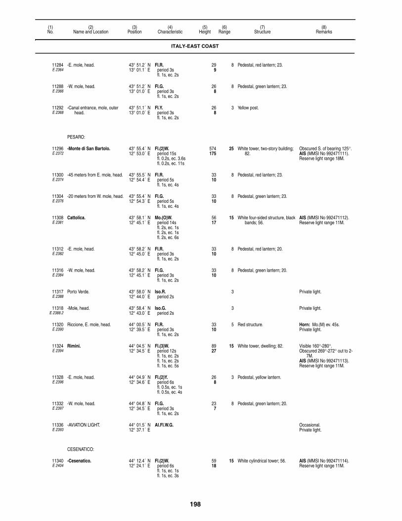
198
(1)No.
(2)Name and Location
(3)Position
(4)Characteristic
(5)Height
(6)Range
(7)Structure
(8)Remarks
11284E 2364
-E. mole, head. 43° 51.2´ N13° 01.1´ E
Fl.R.period 3sfl. 1s, ec. 2s
299
8 Pedestal, red lantern; 23.
11288E 2366
-W. mole, head. 43° 51.2´ N13° 01.0´ E
Fl.G.period 3sfl. 1s, ec. 2s
268
8 Pedestal, green lantern; 23.
11292E 2368
-Canal entrance, mole, outer head.
43° 51.1´ N13° 01.0´ E
Fl.Y.period 3sfl. 1s, ec. 2s
268
3 Yellow post.
PESARO:
11296E 2372
-Monte di San Bartolo. 43° 55.4´ N12° 53.0´ E
Fl.(2)W.period 15sfl. 0.2s, ec. 3.6sfl. 0.2s, ec. 11s
574175
25 White tower, two-story building; 82.
Obscured S. of bearing 125°.AIS (MMSI No 992471111).Reserve light range 18M.
11300E 2374
-45 meters from E. mole, head. 43° 55.5´ N12° 54.4´ E
Fl.R.period 5sfl. 1s, ec. 4s
3310
8 Pedestal, red lantern; 23.
11304E 2376
-20 meters from W. mole, head. 43° 55.4´ N12° 54.3´ E
Fl.G.period 5sfl. 1s, ec. 4s
3310
8 Pedestal, green lantern; 23.
11308E 2381
Cattolica. 43° 58.1´ N12° 45.1´ E
Mo.(O)W.period 14sfl. 2s, ec. 1sfl. 2s, ec. 1sfl. 2s, ec. 6s
5617
15 White four-sided structure, black bands; 56.
AIS (MMSI No 992471112).Reserve light range 11M.
11312E 2382
-E. mole, head. 43° 58.2´ N12° 45.0´ E
Fl.R.period 3sfl. 1s, ec. 2s
3310
8 Pedestal, red lantern; 20.
11316E 2384
-W. mole, head. 43° 58.2´ N12° 45.1´ E
Fl.G.period 3sfl. 1s, ec. 2s
3310
8 Pedestal, green lantern; 20.
11317E 2388
Porto Verde. 43° 58.0´ N12° 44.0´ E
Iso.R.period 2s
3 Private light.
11318E 2388.2
-Mole, head. 43° 58.4´ N12° 43.0´ E
Iso.G.period 2s
3 Private light.
11320E 2390
Riccione, E. mole, head. 44° 00.5´ N12° 39.5´ E
Fl.R.period 3sfl. 1s, ec. 2s
3310
5 Red structure. Horn: Mo.(M) ev. 45s.Private light.
11324E 2394
Rimini. 44° 04.5´ N12° 34.5´ E
Fl.(3)W.period 12sfl. 1s, ec. 2sfl. 1s, ec. 2sfl. 1s, ec. 5s
8927
15 White tower, dwelling; 82. Visible 160°-280°. Obscured 269°-272° out to 2-
7M.AIS (MMSI No 992471113).Reserve light range 11M.
11328E 2396
-E. mole, head. 44° 04.9´ N12° 34.6´ E
Fl.(2)Y.period 6sfl. 0.5s, ec. 1sfl. 0.5s, ec. 4s
268
3 Pedestal, yellow lantern.
11332E 2397
-W. mole, head. 44° 04.8´ N12° 34.5´ E
Fl.G.period 3sfl. 1s, ec. 2s
237
8 Pedestal, green lantern; 20.
11336E 2393
-AVIATION LIGHT. 44° 01.5´ N12° 37.1´ E
Al.Fl.W.G. Occasional. Private light.
CESENATICO:
11340E 2404
-Cesenatico. 44° 12.4´ N12° 24.1´ E
Fl.(2)W.period 6sfl. 1s, ec. 1sfl. 1s, ec. 3s
5918
15 White cylindrical tower; 56. AIS (MMSI No 992471114).Reserve light range 11M.
ITALY-EAST COAST

199
(1)No.
(2)Name and Location
(3)Position
(4)Characteristic
(5)Height
(6)Range
(7)Structure
(8)Remarks
11344E 2405
-E. mole, head. 44° 12.5´ N12° 24.2´ E
Fl.R.period 5sfl. 1s, ec. 4s
268
8 Red column, pedestal; 20. Fl.Y. 5m 4M signals the opening and closing of the Porte Vinciane.
Horn: Mo.(R) ev. 45s (bl. 2s, si. 2s, bl. 4s, si. 2s, bl. 2s, si. 33s).
11348E 2406
-W. mole, head. 44° 12.5´ N12° 24.3´ E
Fl.G.period 5sfl. 1s, ec. 4s
268
8 Green column, pedestal; 20. Fl.Y. 5m 4M signals the opening and closing of the Porte Vinciane.
11352E 2411
Cervia. 44° 15.9´ N12° 21.2´ E
Iso.W.period 2s
5416
11 Multi-sided tower; 52. Obscured outside of channel by high buildings.
Private light.
11356E 2413
-N. mole, head. 44° 16.1´ N12° 21.5´ E
Fl.G.period 3sfl. 0.5s, ec. 2.5s
268
4 Green post; 23. Private light.
11360E 2412
-S. mole, head. 44° 16.2´ N12° 21.8´ E
Fl.R.period 3sfl. 0.5s, ec. 2.5s
268
4 Red column, pedestal; 23. Horn: Mo.(U) ev. 45s (bl. 2s, si. 2s, bl. 2s, si. 2s, bl. 4s, si. 33s).
Private light.
ITALY-NORTHEAST COAST
PORTO CORSINI (MARINA DI RAVENNA):
11368E 7520
-AGIP 1. 44° 28.4´ N12° 21.2´ E
Fl.(2)W.period 5sfl. 0.5s, ec. 1sfl. 0.5s, ec. 3s
3310
8 White post, red bands; 52. Private light.
11374E 7522
-AGIP 4. 44° 27.6´ N12° 31.4´ E
Mo.(U)W.period 15s
6 White platform, red stripes; 20. Horn: Mo.(U) ev. 30s.Private light.
-RACON U(• • –)period 120s
(3cm).
11375E 2417.9
-Baiona. 44° 29.4´ N12° 15.9´ E
Dir.F.W.R.G. 3912
6 Metal tower; 39. G. 256°15′-259°36′, W.-260°24′, R.-263°45′.
11376E 2418
-Corsini. 44° 29.5´ N12° 17.0´ E
Fl.W.period 5sfl. 0.2s, ec. 4.8s
11535
20 White tower, three-story building; 108.
AIS (MMSI No 992471115).Reserve light range 18M.Traffic signals.Current signals.
11380E 2417.8
-Approach beacon. 44° 30.0´ N12° 20.7´ E
L.Fl.W.period 10sfl. 2s, ec. 8s
165
6 SAFE WATERRW, articulated beacon,
topmark.
Radar reflector.
11384E 2419
-S. breakwater, head. 44° 29.7´ N12° 18.8´ E
Fl.(2)R.period 6sfl. 1s, ec. 1sfl. 1s, ec. 3s
3310
8 Red column, pedestal; 26.
11388E 2420
-N. breakwater, head. 44° 29.9´ N12° 18.8´ E
Fl.(2)G.period 6sfl. 1s, ec. 1sfl. 1s, ec. 3s
3310
8 Green column, pedestal; 26.
11392E 2421
-S. mole, head. 44° 29.6´ N12° 17.5´ E
Fl.R.period 4sfl. 1.5s, ec. 2.5s
247
8 Red column, pedestal; 20.
11396E 2422
-N. mole, head. 44° 29.7´ N12° 17.4´ E
Fl.G.period 4sfl. 1.5s, ec. 2.5s
247
8 Green column, pedestal; 20.
ITALY-EAST COAST

200
(1)No.
(2)Name and Location
(3)Position
(4)Characteristic
(5)Height
(6)Range
(7)Structure
(8)Remarks
PORTO GARIBALDI:
11400E 2426
-Molo Nord, near root. 44° 40.6´ N12° 14.7´ E
Fl.(4)W.period 15sfl. 1s, ec. 2sfl. 1s, ec. 2sfl. 1s, ec. 2sfl. 1s, ec. 5s
4614
15 White cylindrical tower, two-story building; 39.
AIS (MMSI No 992471116).Reserve light range 11M.
11404E 2428
- -Near head. 44° 40.6´ N12° 15.0´ E
Fl.G.period 5sfl. 1s, ec. 4s
309
8 Green column, pedestal; 23.
11408E 2430
-Molo Sud, head. 44° 40.6´ N12° 15.2´ E
Fl.R.period 5sfl. 1s, ec. 4s
309
8 Red column, pedestal; 23.
11420E 2433
- -Entrance, E. side. 44° 50.4´ N12° 17.4´ E
Fl.G.period 3sfl. 1s, ec. 2s
268
6 Green post. Private light.
11424E 2432
- - -W. side. 44° 47.0´ N12° 14.0´ E
Fl.R.period 3sfl. 1s, ec. 2s
268
6 Red post. Private light.
11428E 2434
-Porto di Goro. 44° 47.5´ N12° 23.8´ E
Fl.(2)W.period 10sfl. 1s, ec. 2sfl. 1s, ec. 6s
7222
17 White tower; 79. AIS (MMSI No 992471117).Reserve light range 13M.
11436E 2440
-Punta della Maestra. 44° 58.1´ N12° 31.8´ E
Fl.(3)W.period 20sfl. 0.2s, ec. 3.8sfl. 0.2s, ec. 3.8sfl. 0.2s, ec. 11.8s
15447
25 White round tower; 148. Aeromarine light.Reserve light range 18M.F.R. lights on chimney stacks
2m WSW.AIS (MMSI No 992471120).
11438E 2441
-Beacon, 2.5 miles ESE of Punta della Maestra.
44° 57.8´ N12° 35.4´ E
Q.(3)W.period 10s
134
6 E. CARDINALBYB, articulated beacon,
topmark.
Radar reflector.
11448E 2443
-Porto Levante, NW. of entrance range.
45° 04.2´ N12° 20.7´ E
L.Fl.W.period 6sfl. 2s, ec. 4s
18055
15 Water tower; 171. Visible 200°-290°.Reserve light range 12M.
11449E 2443.3
- -E. of Porto Levante. 45° 04.6´ N12° 23.3´ E
Iso.Y.period 2s
165
6 SPECIALY, articulated beacon, "X"
topmark.
Private light.
11451E 2444.7
- -Off shore, E. 45° 05.1´ N12° 35.3´ E
Fl.(5)Y.period 20sfl. 1s, ec. 1sfl. 1s, ec. 1sfl. 1s, ec. 1sfl. 1s, ec. 1sfl. 1s, ec. 11s
206
5 Yellow beacon. Private light.
CHIOGGIA:
11452E 2450
-Forte San Felice. 45° 13.8´ N12° 17.8´ E
L.Fl.(2)W.period 10sfl. 2s, ec. 2sfl. 2s, ec. 4s
6620
15 White framework tower; 59. AIS (MMSI No 992471118).Reserve light range 11M.
11456E 2451
- -120 meters NNW. on NW. extremity of fort.
43° 13.9´ N12° 17.4´ E
Fl.(2)R.period 7sfl. 1s, ec. 1sfl. 1s, ec. 4s
196
8 Red hut; 13. Horn: Mo.(N) ev. 30s.
11460E 2452
-N. breakwater, head. 45° 14.0´ N12° 18.8´ E
Fl.G.period 3sfl. 1s, ec. 2s
3611
8 Green column, pedestal; 26. Visible 302°-342°.Horn: Mo.(K) ev. 45s.
F.G. 206
6 Visible 302°-342°.
-RACON K(– • –)period 30s
6 (3cm).
ITALY-NORTHEAST COAST

201
(1)No.
(2)Name and Location
(3)Position
(4)Characteristic
(5)Height
(6)Range
(7)Structure
(8)Remarks
11464E 2453
-S. breakwater, head. 45° 13.7´ N12° 18.8´ E
Fl.(2)R.period 10sfl. 1s, ec. 2sfl. 1s, ec. 6s
3611
8 Red column, pedestal; 26. Visible 313°-257°.
F.R. 206
6 Visible 257°-313°.
11476E 2458
-Canale San Domenico. 45° 13.4´ N12° 17.0´ E
F.R. 309
3 Red post; 26.
11480E 2462
Oceanographic platform. 45° 18.8´ N12° 30.8´ E
Mo.(U)W.period 15s
8 Platform. Horn: Mo.(U) 30s (bl. 1s, si. 2s, bl. 1s, si. 2s, bl. 2s, si. 22s).
Private light.
11484E 2465
Malamocco Approach Beacon. 45° 19.5´ N12° 23.0´ E
L.Fl.W.period 10sfl. 2s, ec. 8s
237
6 SAFE WATERRW, articulated beacon,
topmark; 20.
Channel marked by articulated beacons.
Radar reflector.
11488E 2464
-Rochetta. 45° 20.4´ N12° 18.7´ E
Fl.(3)W.period 12sfl. 1s, ec. 2sfl. 1s, ec. 2sfl. 1s, ec. 5s
8225
16 White round tower, black stripe, platform; 75.
Reserve light range 11M.AIS (MMSI No 992471119).
11490E 2463
-Fort Rocchetta. pilot tower. 45° 20.4´ N12° 18.7´ E
Dir.W.R.G. 9830
6 White tower; 115. F.G. 285°-287°, F.W.-288°, F.R.-290°.
11492E 2464.4
-Beacon. 45° 20.3´ N12° 18.7´ E
Fl.(3)G.period 10sfl. 1s, ec. 1sfl. 1s, ec. 1sfl. 1s, ec. 5s
206
7 Green hut, platform.
11496E 2467
-S. mole, head. 45° 19.9´ N12° 20.2´ E
Fl.R.period 3sfl. 0.5s, ec. 2.5s
5216
8 Red round tower; 46. Visible 060°-290°.
F.R. 206
6 Visible 290°-060°.
11500E 2466
-N. mole, head. 45° 20.0´ N12° 20.6´ E
Fl.G.period 5sfl. 1s, ec. 4s
5918
8 Green tower, white two-story building, green top; 62.
11504E 2468
Palata delle Ceppe, entrance, S. side.
45° 20.1´ N12° 19.0´ E
Fl.(3)R.period 10sfl. 1s, ec. 1sfl. 1s, ec. 1sfl. 1s, ec. 5s
3611
5 Red column, pedestal; 33.
PORTO DI LIDO:
11508E 2481
-Approach Beacon. 45° 23.9´ N12° 28.8´ E
L.Fl.W.period 10sfl. 2s, ec. 8s
237
6 SAFE WATERRW, articulated beacon; 20.
Fl.G. 2s and Fl.R. 2s articulated beacons mark entrance to approach channel.
Radar reflector.
11516E 2480
-N. breakwater, head. 45° 25.4´ N12° 26.2´ E
L.Fl.(2)W.period 12sfl. 2s, ec. 2sfl. 2s, ec. 6s
8526
15 White and black checkered pagoda; 82.
Reserve light range 11M.Fl.R. 2.5s 96m lights on two
antennas 7M WNW.Horn: Mo.(N) ev. 45s (bl. 4s,
si. 2s, bl. 2s, si. 37s).
Fl.(2)G.period 8sfl. 1s, ec. 1sfl. 1s, ec. 5s
4614
7
F.G. 165
6 Visible 348°-040°.
-RACON V(• • • –) 6 (3 & 10cm).
ITALY-NORTHEAST COAST
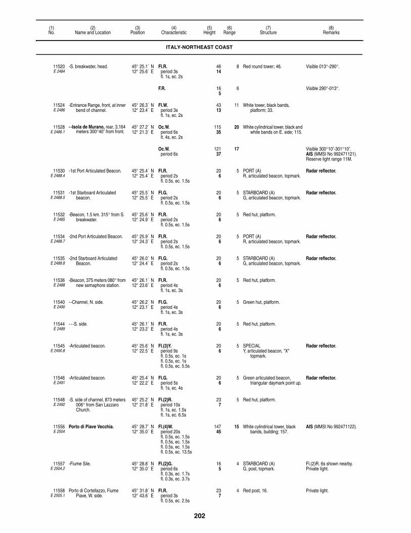
202
(1)No.
(2)Name and Location
(3)Position
(4)Characteristic
(5)Height
(6)Range
(7)Structure
(8)Remarks
11520E 2484
-S. breakwater, head. 45° 25.1´ N12° 25.6´ E
Fl.R.period 3sfl. 1s, ec. 2s
4614
8 Red round tower; 46. Visible 013°-290°.
F.R. 165
6 Visible 290°-013°.
11524E 2486
-Entrance Range, front, at inner bend of channel.
45° 26.3´ N12° 23.4´ E
Fl.W.period 3sfl. 1s, ec. 2s
4313
11 White tower, black bands, platform; 33.
11528E 2486.1
- -Isola de Murano, rear, 3,164 meters 300°40′ from front.
45° 27.2´ N12° 21.3´ E
Oc.W.period 6slt. 4s, ec. 2s
11535
20 White cylindrical tower, black and white bands on E. side; 115.
Oc.W.period 6s
12137
17 Visible 300°10′-301°10′.AIS (MMSI No 992471121).Reserve light range 11M.
11530E 2488.4
-1st Port Articulated Beacon. 45° 25.4´ N12° 25.4´ E
Fl.R.period 2sfl. 0.5s, ec. 1.5s
206
5 PORT (A)R, articulated beacon, topmark.
Radar reflector.
11531E 2488.5
-1st Starboard Articulated beacon.
45° 25.5´ N12° 25.5´ E
Fl.G.period 2sfl. 0.5s, ec. 1.5s
206
5 STARBOARD (A)G, articulated beacon, topmark.
Radar reflector.
11532E 2485
-Beacon, 1.5 km. 315° from S. breakwater.
45° 25.6´ N12° 24.9´ E
Fl.R.period 2sfl. 0.5s, ec. 1.5s
206
5 Red hut, platform.
11534E 2488.7
-2nd Port Articulated Beacon. 45° 25.9´ N12° 24.3´ E
Fl.R.period 2sfl. 0.5s, ec. 1.5s
206
5 PORT (A)R, articulated beacon, topmark.
Radar reflector.
11535E 2488.8
-2nd Starboard Articulated Beacon.
45° 26.0´ N12° 24.4´ E
Fl.G.period 2sfl. 0.5s, ec. 1.5s
206
5 STARBOARD (A)G, articulated beacon, topmark.
Radar reflector.
11536E 2488
-Beacon, 375 meters 080° from new semaphore station.
45° 26.1´ N12° 23.6´ E
Fl.R.period 4sfl. 1s, ec. 3s
206
5 Red hut, platform.
11540E 2490
- -Channel, N. side. 45° 26.2´ N12° 23.1´ E
Fl.G.period 4sfl. 1s, ec. 3s
206
5 Green hut, platform.
11544E 2489
- - -S. side. 45° 26.1´ N12° 23.2´ E
Fl.R.period 4sfl. 1s, ec. 3s
206
5 Red hut, platform.
11545E 2490.8
-Articulated beacon. 45° 25.6´ N12° 22.5´ E
Fl.(3)Y.period 9sfl. 0.5s, ec. 1sfl. 0.5s, ec. 1sfl. 0.5s, ec. 5.5s
206
5 SPECIALY, articulated beacon, "X"
topmark.
Radar reflector.
11546E 2491
-Articulated beacon. 45° 25.4´ N12° 22.2´ E
Fl.G.period 5sfl. 1s, ec. 4s
206
5 Green articulated beacon, triangular daymark point up.
Radar reflector.
11548E 2492
-S. side of channel, 873 meters 006° from San Lazzaro Church.
45° 25.2´ N12° 21.8´ E
Fl.(2)R.period 10sfl. 1s, ec. 1.5sfl. 1s, ec. 6.5s
237
5 Red hut, platform.
11556E 2504
Porto di Piave Vecchia. 45° 28.7´ N12° 35.0´ E
Fl.(4)W.period 20sfl. 0.5s, ec. 1.5sfl. 0.5s, ec. 1.5sfl. 0.5s, ec. 1.5sfl. 0.5s, ec. 13.5s
14745
15 White cylindrical tower, black bands, building; 157.
AIS (MMSI No 992471122).
11557E 2504.2
-Fiume Sile. 45° 28.8´ N12° 35.0´ E
Fl.(2)G.period 6sfl. 0.3s, ec. 1.7sfl. 0.3s, ec. 3.7s
165
4 STARBOARD (A)G, post, topmark.
Fl.(2)R. 6s shown nearby.Private light.
11558E 2505.1
Porto di Cortellazzo, Fiume Piave, W. side.
45° 31.8´ N12° 43.6´ E
Fl.R.period 3sfl. 0.5s, ec. 2.5s
237
4 Red post, 16. Private light.
ITALY-NORTHEAST COAST
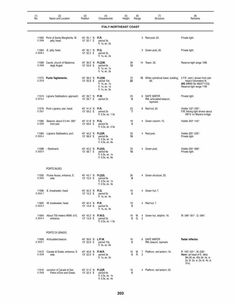
203
(1)No.
(2)Name and Location
(3)Position
(4)Characteristic
(5)Height
(6)Range
(7)Structure
(8)Remarks
11560E 2506
Porto di Santa Margherita, W. jetty, head.
45° 35.1´ N12° 52.1´ E
Fl.R.period 3sfl. 1s, ec. 2s
3 Red post; 20. Private light.
11564E 2506.4
-E. jetty, head. 45° 35.1´ N12° 52.2´ E
Fl.G.period 3sfl. 1s, ec. 2s
3 Green post; 20. Private light.
11568E 2508
Caorle, church of Madonna degli Angeli.
45° 36.0´ N12° 53.6´ E
Fl.(2)W.period 6sfl. 1s, ec. 1sfl. 1s, ec. 3s
3912
14 Tower; 30. Reserve light range 10M.
11572E 2518
Punta Tagliamento. 45° 38.2´ N13° 05.8´ E
Fl.(3)W.period 10sfl. 1s, ec. 1sfl. 1s, ec. 1sfl. 1s, ec. 5s
7222
15 White cylindrical tower, building; 69.
2 F.R. (vert.) shown from pier head 4 kilometers N.
AIS (MMSI No 992471123).Reserve light range 11M.
11574E 2519.5
Lignano Sabbiadoro, approach. 45° 39.7´ N13° 09.7´ E
Fl.W.period 2s
206
6 SAFE WATERRW, articulated beacon,
topmark.
Private light.
11576E 2521
Porto Lignano, pier, head. 45° 41.9´ N13° 09.2´ E
Fl.R.period 2sfl. 0.5s, ec. 1.5s
237
8 Red hut; 20. Visible 152°-330°.F.W. fishing light shown about
5M N. on Marano bridge.
11580E 2520
-Beacon, about 0.5 km. 092° from pier.
45° 41.8´ N13° 09.6´ E
Fl.G.period 5sfl. 0.5s, ec. 4.5s
185
4 Green column; 10. Visible 343°-142°.
11584E 2520.4
-Lignano Sabbiadoro, port. 45° 42.2´ N13° 08.9´ E
Fl.(2)R.period 8sfl. 0.5s, ec. 1sfl. 0.5s, ec. 6s
3310
4 Red post. Visible 325°-235°.Private light.
11588E 2520.5
- -Starboard. 45° 42.2´ N13° 08.7´ E
Fl.(2)G.period 8sfl. 0.5s, ec. 1sfl. 0.5s, ec. 6s
3310
4 Green post. Visible 200°-068°.Private light.
PORTO BUSO:
11592E 2524
-Fiume Aussa, entrance, E. side.
45° 43.1´ N13° 15.0´ E
Fl.(2)G.period 6sfl. 0.5s, ec. 1sfl. 0.5s, ec. 4s
268
4 Green structure; 20.
11596E 2524.7
-E. breakwater, head. 45° 42.3´ N13° 15.2´ E
Fl.G.period 5sfl. 1s, ec. 4s
165
4 Green hut; 7.
11600E 2524.5
-W. breakwater, head. 45° 42.4´ N13° 14.8´ E
Fl.R.period 5sfl. 1s, ec. 4s
165
4 Red hut; 7.
11604E 2524.3
-About 750 meters NNW. of E. entrance.
45° 43.3´ N13° 14.8´ E
Fl.W.G.period 2sfl. 0.5s, ec. 1.5s
165
W. 4G. 2
Green hut, dolphin; 16. W. 346°-351°, G.-346°.
PORTO DI GRADO:
11608E 2525.7
-Articulated beacon. 45° 39.6´ N13° 20.9´ E
L.Fl.W.period 10sfl. 2s, ec. 8s
165
6 SAFE WATERRW, beacon, topmark.
Radar reflector.
11612E 2526
-Canale di Grado, entrance, S. side.
45° 40.8´ N13° 22.0´ E
Fl.W.R.period 3sfl. 1s, ec. 2s
165
W. 7R. 5
Platform, red lantern; 16. R. 193°-031°, W.-036°.Horn: (at head of E. dike)
Mo.(K) ev. 45s (bl. 4s, si. 2s, bl. 2s, si. 2s, bl. 4s, si. 31s).
11616E 2528
-Junction of Canale di San Pietro d'Orio and Grado.
45° 41.0´ N13° 22.4´ E
Fl.(2)R.period 6sfl. 0.5s, ec. 1sfl. 0.5s, ec. 4s
165
4 Platform, red lantern; 20.
ITALY-NORTHEAST COAST

204
(1)No.
(2)Name and Location
(3)Position
(4)Characteristic
(5)Height
(6)Range
(7)Structure
(8)Remarks
11620E 2530
-Canale di Grado, S. side. 45° 41.0´ N13° 22.6´ E
Fl.G.period 3sfl. 1s, ec. 2s
165
3 Platform, green post; 16.
11624E 2534
-Head of pier, close W. of entrance to Canale della Darsena.
45° 40.9´ N13° 23.1´ E
F.R. 237
3 Red post; 16.
11628E 2536
-Canale di Belvedene, E. side. 45° 41.0´ N13° 23.2´ E
F.G. 237
3 Green lantern; 16.
11630E 2537.5
-End of pipeline. 45° 40.3´ N13° 23.7´ E
Fl.Y.period 3sfl. 0.3s, ec. 2.7s
206
4 Post. Private light. Radar reflector.
11632E 2538
Branco Molo di Muggia, beacon, near bank, S. head.
45° 39.3´ N13° 26.3´ E
Q.(6)+L.Fl.W.period 15s
237
6 S. CARDINALYB, beacon, topmark; 26.
Radar reflector.
11634E 2540
Punta Sdobba, shoal. 45° 43.3´ N13° 34.3´ E
Fl.R.period 5sfl. 1s, ec. 4s
237
4 Red truncated conical tower; 23.
11635E 2543
-Articulated beacon. 45° 44.6´ N13° 36.4´ E
Fl.W.period 10sfl. 1s, ec. 9s
165
6 SAFE WATERRW, beacon, topmark.
Radar reflector.
11636E 2544
-Channel, W. side. 45° 45.3´ N13° 35.2´ E
Fl.(2)R.period 6sfl. 0.5s, ec. 1sfl. 0.5s, ec. 4s
206
4 Concrete tower; 20. W. side of channel marked by 2 lights Fl.R. 5s 5M, Fl.(2)R. 10s 5M.
Radar reflector.
11644E 2548
Duino, mole, head. 45° 46.4´ N13° 35.9´ E
F.G. 237
3 Green post; 20. Private light.
11648E 2547
-Canale San Giovanni, about 0.5 mile NW. of Duino.
45° 46.5´ N13° 35.5´ E
Fl.(2)G.period 10sfl. 1s, ec. 2sfl. 1s, ec. 6s
165
4 Platform, green hut; 7.
11652E 2550
Sistiana, head of W. breakwater.
45° 46.1´ N13° 37.6´ E
F.R. 268
3 Red post; 23. Safety distance 15m.Private light.
11656E 2551
-E. breakwater, head. 45° 46.0´ N13° 38.0´ E
F.G. 247
3 Green post; 23. F.G. 3M marks head of mole 2.4 miles SE.
Safety distance 15m.Private light.
11660E 2553
Santa Croce di Trieste, boat basin mole, head.
45° 43.6´ N13° 41.4´ E
F.G. 247
3 Green lantern; 16. Private light.
11664E 2554
Valle Grignano, pier, head. 45° 42.4´ N13° 42.7´ E
F.G. 206
3 Green post. Private light.
11668E 2555
Cedas breakwater, head. 45° 41.6´ N13° 44.2´ E
F.G. 206
4 Pedestal, green lantern; 16. Private light.
11670E 2556
Barcola. 45° 40.9´ N13° 45.0´ E
F.G. 268
4 Green post; 23. Private light.
PORTO DI TRIESTE:
11676E 2558
-Vittoria. 45° 40.5´ N13° 45.4´ E
Fl.(2)W.period 10sfl. 0.2s, ec. 1.8sfl. 0.2s, ec. 7.8s
378115
22 White round stone tower, bronze figure on top; 223.
Reserve light range 18M.Fl.R. 2.5s 87m on radio
antenna 0.4M E.Oc.R. 110m on radio antenna
1.8M E.AIS (MMSI No 992471124).
-Porto Franco Vecchio:
11680E 2560
- -Detached breakwater, S. head.
45° 39.3´ N13° 45.7´ E
Fl.R.period 3sfl. 1s, ec. 2s
237
6 Red lantern; 23.
11684E 2561
- -Spur, head. 45° 39.8´ N13° 45.5´ E
F.G. 237
3 Green hut, lantern; 16. Visible 130°-040°.
ITALY-NORTHEAST COAST
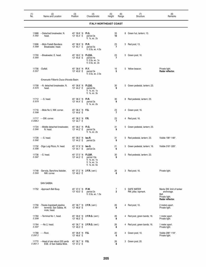
205
(1)No.
(2)Name and Location
(3)Position
(4)Characteristic
(5)Height
(6)Range
(7)Structure
(8)Remarks
11688E 2562
- -Detached breakwater, N. head.
45° 39.8´ N13° 45.4´ E
Fl.G.period 3sfl. 1s, ec. 2s
3310
8 Green hut, lantern; 13.
11696E 2568
- -Molo Fratelli Bandiera Breakwater, head.
45° 38.9´ N13° 45.1´ E
Fl.R.period 5sfl. 0.5s, ec. 4.5s
237
5 Red post; 13.
11700E 2565
- -Breakwater, E. head. 45° 39.0´ N13° 45.6´ E
Fl.(2)G.period 4sfl. 0.5s, ec. 1sfl. 0.5s, ec. 2s
237
5 Green post; 16.
11706E 2557
-Outfall. 45° 38.6´ N13° 40.9´ E
Fl.Y.period 3sfl. 0.5s, ec. 2.5s
165
5 Yellow beacon. Private light. Radar reflector.
-Emanuele Filiberto Duca d'Acosta Basin:
11708E 2576
- -N. detached breakwater, N. head.
45° 38.8´ N13° 44.2´ E
Fl.(2)G.period 6sfl. 1s, ec. 1sfl. 1s, ec. 3s
309
5 Green pedestal, lantern; 23.
11712E 2578
- - -S. head. 45° 38.3´ N13° 44.4´ E
Fl.R.period 3sfl. 1s, ec. 2s
309
8 Red pedestal, lantern; 23.
11716E 2588
- -Mole No 5, NW. corner. 45° 38.4´ N13° 44.6´ E
F.G. 237
4 Green post; 16.
11717E 2588.2
- - -SW. corner. 45° 38.3´ N13° 44.7´ E
F.R. 237
4 Red post; 16.
11724E 2580
- -Middle detached breakwater, N. head.
45° 38.2´ N13° 44.2´ E
Fl.G.period 3sfl. 1s, ec. 2s
319
5 Green pedestal, lantern; 23.
11728E 2582
- - -S. head. 45° 38.0´ N13° 44.3´ E
Iso.R.period 2s
319
5 Red pedestal, lantern; 23. Visible 198°-148°.
11732E 2586
-Diga Luigi Rizzo, N. head. 45° 37.9´ N13° 44.1´ E
Iso.G.period 2s
216
5 Green pedestal, lantern; 16. Visible 018°-328°.
11736E 2587
- -S. head. 45° 37.0´ N13° 44.3´ E
Fl.(3)R.period 10sfl. 1s, ec. 1sfl. 1s, ec. 1sfl. 1s, ec. 5s
309
5 Red pedestal, lantern; 23.
11748E 2593
-Servola, Banchina Italsider, NW. corner.
45° 37.2´ N13° 46.5´ E
2 F.R. (vert.) 268
3 Red post; 16. Private light.
SAN SABBA:
11752 -Approach Bell Buoy. 45° 37.0´ N13° 43.0´ E
Fl.W.period 2sfl. 0.5s, ec. 1.5s
72
5 SAFE WATERRW, pillar, topmark.
Marks SW. limit of tanker anchorage.
Bell.Private light. Radar reflector.
11756E 2601
-Trieste-Ingolstadt pipeline terminal, San Sabba, W. mole, head.
45° 36.7´ N13° 46.9´ E
2 F.R. (vert.) 268
4 Red post; 10. 2 meters apart.Private light.
11760E 2598
- -Terminal No 1, head. 45° 36.6´ N13° 46.5´ E
2 F.R.G. (vert.) 268
4 Red post, green bands; 16. 1 meter apart.Private light.
11764E 2597
- - -No 2, head. 45° 36.7´ N13° 46.3´ E
2 F.R.G. (vert.) 268
4 Red post, green bands; 16. 1 meter apart.Private light.
11768E 2597.2
- - - -Root. 45° 36.8´ N13° 46.6´ E
F.G. 206
4 Green post; 10. Visible 298°-118°.Private light.
11772E 2601.4
- -Head of pier about 220 yards ESE. of San Sabba Mole.
45° 36.7´ N13° 47.2´ E
F.G. 268
3 Green post; 20.
ITALY-NORTHEAST COAST

206
(1)No.
(2)Name and Location
(3)Position
(4)Characteristic
(5)Height
(6)Range
(7)Structure
(8)Remarks
BAIA DI MUGGIA:
11776E 2603
-Porto Industriale. 45° 36.8´ N13° 48.8´ E
F.W.R.G. 3410
10 Aluminum post; 30. G. 059.3°-063.3°, W.-064.3°, R.-069.3°.
11784E 2602.2
-Petroli Aquila Pier, head. 45° 36.3´ N13° 47.6´ E
F.R. 206
3 Red post; 13. Private light.
11788E 2602
- -E. arm, head. 45° 36.3´ N13° 47.6´ E
F.G. 216
3 Green post; 13. Private light.
11792E 2595
-Muggia, E. mole, head. 45° 36.4´ N13° 46.0´ E
F.R. 237
3 Red post; 16. Private light.
11796E 2596
- -W. mole, head. 45° 36.4´ N13° 46.0´ E
F.G. 237
3 Green post; 16. Private light.
11800E 2604
-Zaule, pier. 45° 36.5´ N13° 48.1´ E
2 F.G. (vert.) 206
3 Green post; 16. Private light.
11808E 2605
-Jetty, head. 45° 35.8´ N13° 43.3´ E
Fl.R.period 3sfl. 0.3s, ec. 2.7s
216
3 Red lantern; 16. Private light.
SLOVENIA
KOPERSKI ZALIV:
11812E 2607
-Plicinia Debeli, 0.5 km. W. of Rt Debeli.
45° 35.5´ N13° 42.0´ E
Q.(9)W.period 15s
268
8 W. CARDINALYBY, tower, topmark; 13.
-Koper:
11814E 2608
- -Zaliv Valdoltra. 45° 34.8´ N13° 43.6´ E
Fl.(2)R.period 6sfl. 0.5s, ec. 1sfl. 0.5s, ec. 4s
165
4 Red tower; 13.
11816E 2611.5
- -Basin 3, E. side. 45° 34.0´ N13° 44.8´ E
Fl.R.period 5sfl. 0.5s, ec. 4.5s
165
4 Red tower; 13.
11817E 2611.7
- -Basin 3 Range, front. 45° 33.9´ N13° 44.8´ E
Q.Y. 268
10 Red column, white bands, "X" topmark; 20.
AIS (MMSI No 992783030).
11817.5E 2611.71
- - -Rear, 089° from front. 45° 33.9´ N13° 44.9´ E
Q.Y. 3912
10 Red column, white bands, "X" topmark; 41.
11820E 2613
- -Marina, W. breakwater. 45° 33.0´ N13° 43.5´ E
Fl.R.period 5sfl. 0.5s, ec. 4.5s
237
3 Red metal tower, column, gallery; 16.
Visible 270°-115°.
11820.3E 2613.3
- -Basin 1. 45° 33.2´ N13° 44.3´ E
F.Bu. 8225
15 Visible 088°06′-092°36′.AIS (MMSI No 992783011).
11820.5E 2613.5
- - -E. breakwater. 45° 33.0´ N13° 43.6´ E
Fl.(2)G.period 5sfl. 0.5s, ec. 1sfl. 0.5s, ec. 3s
237
3 Green metal tower, column, gallery; 16.
11828E 2612.2
- -Stara Luka, N. mole, head. 45° 32.9´ N13° 43.3´ E
Fl.(2)R.period 10sfl. 0.5s, ec. 2.5sfl. 0.5s, ec. 6.5s
227
4 Red metal tower, column, gallery; 20.
11832E 2612
- - -S. pier, head. 45° 32.9´ N13° 43.4´ E
Fl.G.period 5sfl. 0.5s, ec. 4.5s
237
3 White metal tower, column, gallery; 20.
ITALY-NORTHEAST COAST

207
(1)No.
(2)Name and Location
(3)Position
(4)Characteristic
(5)Height
(6)Range
(7)Structure
(8)Remarks
-Izola:
11836E 2618
- -Rt Petelin. 45° 32.5´ N13° 39.4´ E
Fl.W.period 5sfl. 0.5s, ec. 4.5s
237
6 White metal tower, column, gallery; 20.
11840E 2620
- -N. mole, head. 45° 32.4´ N13° 39.3´ E
Fl.R.period 3sfl. 1s, ec. 2s
206
4 White metal tower, column, gallery; 16.
11844E 2622
- -S. mole, head. 45° 32.2´ N13° 39.1´ E
Fl.(2)R.period 10sfl. 0.5s, ec. 2sfl. 0.5s, ec. 7s
206
4 Red metal tower, column, gallery; 16.
PIRANSKI ZALIV:
-Piran:
11848E 2624
- -Rt Madona, bay, N. entrance. 45° 31.8´ N13° 33.8´ E
Iso.W.period 4s
4313
15 Gray octagonal tower; 30. Visible 351°-253°.Reserve light range 8M.
11852E 2630
- -Head of transverse mole, S. side of entrance.
45° 31.5´ N13° 34.0´ E
Fl.G.period 3sfl. 0.5s, ec. 2.5s
237
4 Green four-sided stone hut; 23.
11856E 2628
- -Entrance, N. side, mole, head.
45° 31.5´ N13° 34.0´ E
Fl.R.period 3sfl. 0.5s, ec. 2.5s
237
4 Red four-sided stone hut; 23.
-Uvala Portoroz:
11860E 2632
- -Rt Sveti Bernard, mole, head. 45° 30.8´ N13° 34.4´ E
Fl.R.period 5sfl. 0.5s, ec. 4.5s
309
3 Red conical metal tower; 26.
11864E 2634
- -Mole, head. 45° 30.7´ N13° 35.4´ E
Fl.G.period 2sfl. 0.3s, ec. 1.7s
206
6 White metal tower, column, gallery; 16.
SLOVENIA
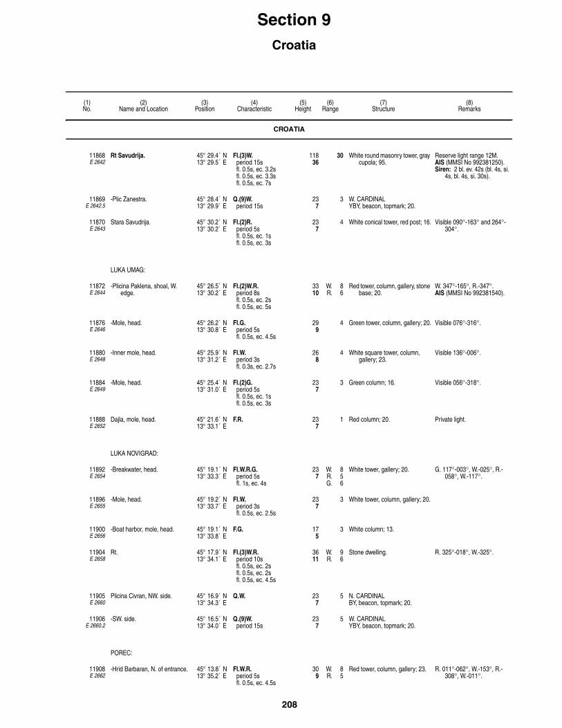
208
(1)No.
(2)Name and Location
(3)Position
(4)Characteristic
(5)Height
(6)Range
(7)Structure
(8)Remarks
Section 9Croatia
CROATIA
11868E 2642
Rt Savudrija. 45° 29.4´ N13° 29.5´ E
Fl.(3)W.period 15sfl. 0.5s, ec. 3.2sfl. 0.5s, ec. 3.3sfl. 0.5s, ec. 7s
11836
30 White round masonry tower, gray cupola; 95.
Reserve light range 12M.AIS (MMSI No 992381250).Siren: 2 bl. ev. 42s (bl. 4s, si.
4s, bl. 4s, si. 30s).
11869E 2642.5
-Plic Zanestra. 45° 28.4´ N13° 29.9´ E
Q.(9)W.period 15s
237
3 W. CARDINALYBY, beacon, topmark; 20.
11870E 2643
Stara Savudrija. 45° 30.2´ N13° 30.2´ E
Fl.(2)R.period 5sfl. 0.5s, ec. 1sfl. 0.5s, ec. 3s
237
4 White conical tower, red post; 16. Visible 090°-163° and 264°-304°.
LUKA UMAG:
11872E 2644
-Plicina Paklena, shoal, W. edge.
45° 26.5´ N13° 30.2´ E
Fl.(2)W.R.period 8sfl. 0.5s, ec. 2sfl. 0.5s, ec. 5s
3310
W. 8R. 6
Red tower, column, gallery, stone base; 20.
W. 347°-165°, R.-347°.AIS (MMSI No 992381540).
11876E 2646
-Mole, head. 45° 26.2´ N13° 30.8´ E
Fl.G.period 5sfl. 0.5s, ec. 4.5s
299
4 Green tower, column, gallery; 20. Visible 076°-316°.
11880E 2648
-Inner mole, head. 45° 25.9´ N13° 31.2´ E
Fl.W.period 3sfl. 0.3s, ec. 2.7s
268
4 White square tower, column, gallery; 23.
Visible 136°-006°.
11884E 2649
-Mole, head. 45° 25.4´ N13° 31.0´ E
Fl.(2)G.period 5sfl. 0.5s, ec. 1sfl. 0.5s, ec. 3s
237
3 Green column; 16. Visible 056°-318°.
11888E 2652
Dajla, mole, head. 45° 21.6´ N13° 33.1´ E
F.R. 237
1 Red column; 20. Private light.
LUKA NOVIGRAD:
11892E 2654
-Breakwater, head. 45° 19.1´ N13° 33.3´ E
Fl.W.R.G.period 5sfl. 1s, ec. 4s
237
W. 8R. 5G. 6
White tower, gallery; 20. G. 117°-003°, W.-025°, R.-058°, W.-117°.
11896E 2655
-Mole, head. 45° 19.2´ N13° 33.7´ E
Fl.W.period 3sfl. 0.5s, ec. 2.5s
237
3 White tower, column, gallery; 20.
11900E 2656
-Boat harbor, mole, head. 45° 19.1´ N13° 33.8´ E
F.G. 175
3 White column; 13.
11904E 2658
Rt. 45° 17.9´ N13° 34.1´ E
Fl.(3)W.R.period 10sfl. 0.5s, ec. 2sfl. 0.5s, ec. 2sfl. 0.5s, ec. 4.5s
3611
W. 9R. 6
Stone dwelling. R. 325°-018°, W.-325°.
11905E 2660
Plicina Civran, NW. side. 45° 16.9´ N13° 34.3´ E
Q.W. 237
5 N. CARDINALBY, beacon, topmark; 20.
11906E 2660.2
-SW. side. 45° 16.5´ N13° 34.0´ E
Q.(9)W.period 15s
237
5 W. CARDINALYBY, beacon, topmark; 20.
POREC:
11908E 2662
-Hrid Barbaran, N. of entrance. 45° 13.8´ N13° 35.2´ E
Fl.W.R.period 5sfl. 0.5s, ec. 4.5s
309
W. 8R. 5
Red tower, column, gallery; 23. R. 011°-062°, W.-153°, R.-308°, W.-011°.

209
(1)No.
(2)Name and Location
(3)Position
(4)Characteristic
(5)Height
(6)Range
(7)Structure
(8)Remarks
11912E 2663
-N. point of Otocic Sv. Nikola, mole, head.
45° 13.7´ N13° 35.1´ E
Fl.G.period 5sfl. 0.5s, ec. 4.5s
237
5 White tower, green cupola; 20. Visible 074°-023°.
11914E 2664
-Athletic field, SW. head. 45° 13.7´ N13° 35.4´ E
Fl.(2)R.period 5sfl. 0.5s, ec. 1sfl. 0.5s, ec. 3s
206
4 Red tower, column, gallery; 16. Visible 314°-130°.
11920E 2665
-Mole, head. 45° 13.6´ N13° 35.5´ E
Fl.W.period 2sfl. 0.5s, ec. 1.5s
206
4 White tower, column, gallery; 16.
11924E 2670
Crlenazemja, mole, head. 45° 10.6´ N13° 36.0´ E
F.R. 165
3 Red column. Shown on request.
11925E 2670.2
-Funtana Marina. 45° 10.7´ N13° 35.6´ E
Fl.(2)G.period 5sfl. 0.5s, ec. 1sfl. 0.5s, ec. 3s
206
4 Green tower, platform; 16. Visible 100°-122° and 147°-068°.
11926E 2669
- -NW. 45° 11.4´ N13° 34.4´ E
Q.(9)W.period 15s
237
5 W. CARDINALYBY, beacon, topmark.
11928E 2668
Otocic Visoki (Altijez), on summit of islet.
45° 11.9´ N13° 34.1´ E
Fl.(3)W.period 10sfl. 0.5s, ec. 1.5sfl. 0.5s, ec. 1.5sfl. 0.5s, ec. 5.5s
299
8 White tower, column, gallery; 20. AIS (MMSI No 992381450).
11932E 2672
Plicina Mramori, on the S. shoal.
45° 08.8´ N13° 34.2´ E
Fl.(2)R.period 8sfl. 0.5s, ec. 1sfl. 0.5s, ec. 6s
4313
7 Red tower, column, gallery; 20. AIS (MMSI No 992381480).
11936E 2674
Otocic Galiner, Vrsar, entrance. 45° 09.2´ N13° 35.6´ E
Fl.W.period 2sfl. 0.3s, ec. 1.7s
6720
5 Red framework tower; 33. Visible 049°-064°, 099°-116° and 185°-025°.
11940E 2676
Vrsar, mole, head. 45° 08.9´ N13° 36.1´ E
Fl.(2)W.period 5sfl. 0.5s, ec. 1sfl. 0.5s, ec. 3s
216
4 White round tower, column, gallery; 16.
Visible 072°-000°.
ROVINJ:
11944E 2680
-Rt Sveta Eufemija. 45° 05.0´ N13° 37.8´ E
Fl.W.period 4sfl. 0.5s, ec. 3.5s
6219
7 Square stone tower, gallery; 23.
11948E 2684
-Juzna Luka, breakwater, head. 45° 04.8´ N13° 38.1´ E
Fl.R.period 3sfl. 0.3s, ec. 2.7s
237
3 Red tower, column, gallery; 20.
11956E 2682
-Sjeverna Luka, quay. 45° 05.1´ N13° 38.2´ E
Fl.G.period 3sfl. 0.3s, ec. 2.7s
237
3 Green tower, column, gallery; 20.
11960E 2690
Hrid Sveti Ivan na Pucini. 45° 02.6´ N13° 36.8´ E
Fl.(2)W.period 10sfl. 0.5s, ec. 2.5sfl. 0.5s, ec. 6.5s
7523
24 Stone tower, dwelling; 49. Reserve light range 12M.AIS (MMSI No 992381110).Siren: 1 bl. ev. 30s (bl. 4s, si.
26s).
11968E 2712
-Fazana, N. mole, head. 44° 55.7´ N13° 48.1´ E
Fl.R.period 2sfl. 0.5s, ec. 1.5s
258
2 Red tower, column, gallery; 16.
11972E 2692
-Kabula, Brioniski Otoci, rock, N. side.
44° 56.7´ N13° 42.6´ E
Q.W. 3210
9 N. CARDINALBY, beacon, topmark; 16.
11976E 2696
-Saluga, Otok Veliki Brioni, shoal, NE. side.
44° 55.2´ N13° 46.8´ E
Fl.(2)W.R.period 8sfl. 0.5s, ec. 2sfl. 0.5s, ec. 5s
268
6 Red tower, column, gallery, stone base; 20.
R. 130°-142°, W.-130°.
11980E 2694
-Brioni (Brijuni), N. mole, head. 44° 55.1´ N13° 46.2´ E
Fl.G.period 5sfl. 0.5s, ec. 4.5s
237
4 Green tower, column, gallery; 20.
CROATIA
210
(1)No.
(2)Name and Location
(3)Position
(4)Characteristic
(5)Height
(6)Range
(7)Structure
(8)Remarks
11988E 2700
-Kotez, on shoal, S. side of channel.
44° 54.4´ N13° 47.6´ E
Fl.G.period 3sfl. 0.3s, ec. 2.7s
227
6 Green tower, column, gallery; 20.
11992E 2706
-Otok Sveti Jerolim, W, point. 44° 53.9´ N13° 47.0´ E
Fl.W.period 2sfl. 0.3s, ec. 1.7s
3310
5 White tower, column, gallery; 16. Visible 349°-221°.
11996E 2710
-Rt Pinida, Brionski Otoci, S. point.
44° 53.3´ N13° 45.2´ E
Iso.W.period 4s
6620
11 Square tower, dwelling; 49. Visible 238°-114°. Reserve light range 7M.AIS (MMSI No 992381300).
LUKA PULA:
12000E 2718
-Rt Kristo, entrance, NE. side. 44° 53.4´ N13° 47.6´ E
Fl.R.period 3sfl. 0.3s, ec. 2.7s
309
5 Square stone tower, red top; 16.
12004E 2720
-Rt Kumpare, breakwater, head.
44° 53.2´ N13° 47.4´ E
Fl.G.period 3sfl. 0.3s, ec. 2.7s
309
6 Green tower, column, gallery; 16. AIS (MMSI No 992381220).
12008E 2721
-Otocic Sveta Katerina, S. side. 44° 52.5´ N13° 49.5´ E
Fl.R.period 2sfl. 0.3s, ec. 1.7s
206
1 Red tower, column, gallery; 16.
12012E 2721.2
- -About 80 meters ENE. 44° 52.4´ N13° 49.8´ E
Fl.R.period 2sfl. 0.3s, ec. 1.7s
206
1 Red tower, gallery; 16.
12016E 2724
-Otocic Sveti Andrija, N. side. 44° 52.4´ N13° 49.5´ E
Fl.G.period 2sfl. 0.3s, ec. 1.7s
237
1 Green tower, gallery; 16.
12020E 2726
-Otocic Sveti Andrija, S. side. 44° 52.2´ N13° 49.5´ E
Fl.R.period 5sfl. 0.5s, ec. 4.5s
175
4 Red square hut, gallery, white pedestal; 16.
12024E 2728
-Commercial port, Gat Rijeka. 44° 52.5´ N13° 50.8´ E
Fl.W.period 5sfl. 0.5s, ec. 4.5s
237
3 White metal tower, column, gallery; 20.
12032E 2727
-Otocic Uljanik. 44° 52.6´ N13° 50.4´ E
Fl.G.period 2sfl. 0.3s, ec. 1.7s
237
3 Green tower; 16.
12036E 2734
Rt Verudica, Luka Veruda, entrance, N. side.
44° 50.0´ N13° 50.0´ E
Fl.R.period 3sfl. 0.3s, ec. 2.7s
3611
6 White tower, red top, gallery, dwelling; 26.
12037E 2735
-Rt Rakovica. 44° 48.6´ N13° 51.7´ E
Fl.(2)G.period 5s
309
4 Visible 323°-198°.
12040E 2738
Hrid Porer. 44° 45.5´ N13° 53.4´ E
Fl.(3)W.period 15sfl. 0.3s, ec. 2.7sfl. 0.3s, ec. 2.7sfl. 0.3s, ec. 8.7s
11535
25 Stone tower, dwelling; 102. Visible 255°-147°.Reserve light range 12M.AIS (MMSI No 992381100).Siren: 2 bl. ev. 42s (bl. 4s, si.
4s, bl. 4s, si. 30s).
RACON M(– –) 20 (3 & 10cm).
KVARNER WEST:
12048E 2742
-Plicina Albanez. 44° 44.1´ N13° 54.1´ E
Fl.(2)W.R.period 8sfl. 0.5s, ec. 2sfl. 0.5s, ec. 5s
4915
W. 10R. 6
White tower, gallery; 46. R. 172°-227°, W.-172°.AIS (MMSI No 992381050).
12052E 2738.2
-Hrid Porer, rock, S. head. 44° 45.0´ N13° 54.0´ E
Iso.W.R.G.period 6s
3912
W. 11R. 7G. 7
Column, gallery, dwelling, red lantern; 7.
W. 258°-326°, R.-352°, G.-163°.
Lighted when Plicina Albanez is extinguished.
CROATIA
211
(1)No.
(2)Name and Location
(3)Position
(4)Characteristic
(5)Height
(6)Range
(7)Structure
(8)Remarks
12054E 7580
Platform Ivana A. 44° 44.7´ N13° 17.6´ E
Mo.(U)W.period 15sfl. 0.4s, ec. 0.5sfl. 0.4s, ec. 0.5sfl. 1.2s, ec. 12s
7523
10
Horn: Mo.(U) ev. 30s (bl. 0.75s, si. 1s, bl. 0.75s, si. 1s, bl. 2.5s, si. 24s).
Mo.(U)R.period 15sfl. 0.4s, ec. 0.5sfl. 0.4s, ec. 0.5sfl. 1.2s, ec. 12s
7924
5
12054.2E 7583
-Ivana B. 44° 41.2´ N13° 12.8´ E
Mo.(U)W.period 15s
10 Platform. Horn: Mo.(U) ev. 30s.
12054.5E 7581
-Ivana D. 44° 47.0´ N13° 15.5´ E
Mo.(U)W.period 15s
10 Platform. Horn: Mo.(U) ev. 30s.
12054.6E 7582
-Ivana E. 44° 44.7´ N13° 14.5´ E
Mo.(U)W.period 15s
10 Platform. Horn: Mo.(U) ev. 30s.
12055E 7584
-IDA-C. 44° 27.7´ N13° 30.0´ E
Mo.(U)W.period 15sfl. 0.4s, ec. 0.5sfl. 0.4s, ec. 0.5sfl. 1.2s, ec. 12s
10 Platform. Horn: Mo.(U) ev. 30s. (bl. 0.75s, si. 1s, bl. 0.75s, si. 1s, bl. 2.5s, si. 24s).
-Medulinski Zaliv:
12056E 2748
- -Rt Munat Skrajni. 44° 48.2´ N13° 55.4´ E
Fl.W.R.period 2sfl. 0.3s, ec. 1.7s
299
W. 7R. 4
Red tower, column, gallery; 16. W. 312°-327°, R.-312°.
12058E 2749
- -Bodulas, islet, SW. 44° 47.4´ N13° 56.6´ E
Fl.(2)G.period 5sfl. 0.5s, ec. 1sfl. 0.5s, ec. 3s
268
5 Green tower; 23. Visible 278°-142°.
12060E 2750
- -Rt Marlera. 44° 48.2´ N14° 00.1´ E
Fl.W.period 8sfl. 0.5s, ec. 7.5s
6921
9 White tower, gallery, concrete base; 30.
Visible 186°-038°.
12064E 2751
-Rt Seka, on shoal. 44° 53.7´ N14° 01.0´ E
Fl.G.period 2sfl. 0.3s, ec. 1.7s
268
3 Green tower, gallery; 16.
-Zaliv Rasa:
12068E 2768
- -Rt Ubas (Ubac), entrance, E. side.
44° 56.7´ N14° 03.9´ E
Fl.W.period 4sfl. 0.5s, ec. 3.5s
5216
8 White tower, column, gallery; 16. AIS (MMSI No 992381320).
12072E 2769
- -Rt Mulac, entrance, W. side. 44° 57.0´ N14° 03.3´ E
Fl.R.period 2sfl. 0.3s, ec. 1.7s
6921
3 Red tower, column, gallery; 26.
12076E 2770
- -Rt Kucica. 44° 58.1´ N14° 04.3´ E
Fl.G.period 2sfl. 0.3s, ec. 1.7s
268
3 Green tower, column, gallery; 16.
12080E 2772
- -Rt Sveti Mikula. 44° 58.7´ N14° 04.6´ E
Fl.R.period 2sfl. 0.3s, ec. 1.7s
299
1 Red tower, gallery, white base; 20.
12084E 2773
- -Uvala Tunarica. 44° 58.4´ N14° 05.8´ E
Fl.R.period 2sfl. 0.3s, ec. 1.7s
237
1 Red tower, column, gallery; 16.
12088E 2774
- -Rt Prascarica. 44° 59.5´ N14° 04.2´ E
Fl.R.period 2sfl. 0.3s, ec. 1.7s
268
1 Red tower, column, gallery; 16.
12092E 2776
- -Uvala Teplica, W. point. 45° 00.2´ N14° 03.3´ E
Fl.G.period 2sfl. 0.3s, ec. 1.7s
309
1 Green tower, gallery, white base, 20.
12096E 2780
- -Trget, inlet, W. point. 45° 01.3´ N14° 03.2´ E
Fl.G.period 2sfl. 0.3s, ec. 1.7s
237
1 Green tower, column, gallery; 16. Visible 326°-170°.
CROATIA

212
(1)No.
(2)Name and Location
(3)Position
(4)Characteristic
(5)Height
(6)Range
(7)Structure
(8)Remarks
12099E 2781
-Koromacno, wharf, head. 44° 57.9´ N14° 07.1´ E
Fl.G.period 3sfl. 0.5s, ec. 2.5s
268
3 Green tower, column, gallery; 20. Visible 002°-253°.
12100E 2782
-Rt Crna Punta. 44° 57.4´ N14° 08.7´ E
Fl.(2)W.period 10sfl. 0.5s, ec. 2sfl. 0.5s, ec. 7s
4915
10 White octagonal tower, gallery; 16.
Visible 245°-104°.AIS (MMSI No 992381310).
12102E 2783
- -Skvaranska. 44° 59.2´ N14° 10.3´ E
Fl.W.period 5sfl. 0.5s, ec. 4.5s
268
10 White tower, column, gallery; 16.
-Luka Rabac:
12104E 2794
- -Rt Sveti Andrija. 45° 04.4´ N14° 09.9´ E
Fl.(3)W.period 8sfl. 0.5s, ec. 1sfl. 0.5s, ec. 1sfl. 0.5s, ec. 4.5s
309
5 Square stone tower; 13.
12108E 2798
- -Quay. 45° 04.7´ N14° 09.5´ E
Fl.(2)G.period 5sfl. 0.5s, ec. 1sfl. 0.5s, ec. 3s
206
2 Green tower, column, gallery; 16. Visible 350°-270°.
12110E 2798.2
Rt Masnjak. 45° 07.0´ N14° 12.3´ E
Fl.(2)W.period 8sfl. 1s, ec. 2sfl. 1s, ec. 4s
5216
8 White tower, gallery; 20. Visible 286°-127°.
12112E 2799
Uvala Brestova, cove, head. 45° 08.7´ N14° 13.4´ E
Fl.G.period 2sfl. 0.5s, ec. 1.5s
237
4 Green tower, column, gallery; 16.
KVARNER EAST:
12116E 2744
-Hrid Galiola. 44° 43.7´ N14° 10.5´ E
Fl.W.period 5sfl. 0.5s, ec. 4.5s
6921
12 Octagonal stone tower, gallery; 59.
AIS (MMSI No 992381040).
-RACON K(– • –) 20 (3 & 10cm).
-Otok Unije:
12120E 2752
- -Rt Vnetak. 44° 37.2´ N14° 14.1´ E
Fl.(3)W.R.period 10sfl. 0.5s, ec. 1sfl. 0.5s, ec. 1sfl. 0.5s, ec. 6.5s
5617
W. 10R. 7
Stone tower, dwelling; 43. W. 270°-158°, R.-176°.AIS (MMSI No 992381260).
12124E 2754
- -Luka Unije, mole, head. 44° 38.2´ N14° 14.8´ E
Fl.R.period 3sfl. 0.3s, ec. 2.7s
206
3 Red tower, column, gallery; 20. Visible 093°-146°.
12128E 2756
- -Rt Lakunji. 44° 41.3´ N14° 16.8´ E
Fl.(4)W.period 15sfl. 0.5s, ec. 2sfl. 0.5s, ec. 2sfl. 0.5s, ec. 2sfl. 0.5s, ec. 7s
268
8 White tower, column, gallery; 20.
12132E 2760
-Otocic Zecevo, SW. point. 44° 45.9´ N14° 18.1´ E
Fl.(2)W.R.period 10sfl. 0.5s, ec. 2sfl. 0.5s, ec. 7s
4313
W. 8R. 6
Square stone tower; 26. W. 194°-176°, R.-194°.
12136E 2761
-Otocic Visoki, NW. side. 44° 46.6´ N14° 20.9´ E
Fl.W.period 3sfl. 0.3s, ec. 2.7s
4313
6 Stone tower; 26.
-Otok Cres:
12140E 2758
- -Uvala Bijar. 44° 41.9´ N14° 23.6´ E
Fl.R.period 3sfl. 0.3s, ec. 2.7s
206
4 Red tower, column, gallery; 16. Visible 116°-106°.
CROATIA
213
(1)No.
(2)Name and Location
(3)Position
(4)Characteristic
(5)Height
(6)Range
(7)Structure
(8)Remarks
12144E 2759
- -Osor, mole. 44° 41.6´ N14° 23.5´ E
Fl.R.period 1.5sfl. 0.3s, ec. 1.2s
206
3 Red tower, column, gallery; 16.
12148E 2762
- -Martinscica, mole, head. 44° 49.1´ N14° 21.0´ E
Fl.G.period 3sfl. 0.5s, ec. 2.5s
237
3 Green tower, column, gallery; 16.
12152E 2764
- -Hrid Zaglav. 44° 55.3´ N14° 17.3´ E
Fl.(3)W.period 15sfl. 0.5s, ec. 2sfl. 0.5s, ec. 2sfl. 0.5s, ec. 9.5s
6520
10 Square tower, gallery, dwelling; 49.
AIS (MMSI No 992381120).
12154E 2750.3
- -Sika, rock. 44° 49.1´ N13° 59.9´ E
Fl.(2)R.period 5sfl. 0.5s, ec. 1sfl. 0.5s, ec. 3s
268
4 Red tower; 23. Visible 112°-340°.
--Luka Cres:
12156E 2784
- - -Rt Kovacine, entrance, N. side.
44° 57.6´ N14° 23.4´ E
Fl.(2)R.period 6sfl. 0.5s, ec. 1sfl. 0.5s, ec. 4s
299
8 Red tower; 20. Visible 297°-185°.
12160E 2792
- - -Luka Cres, on Rt Krizice. 44° 57.3´ N14° 23.5´ E
Fl.G.period 3sfl. 0.3s, ec. 2.7s
299
4 Green tower; 20.
12164E 2788
- - -Rt Melin. 44° 57.4´ N14° 24.3´ E
Fl.R.period 3sfl. 0.3s, ec. 2.7s
196
3 Red tower, column, gallery; 16.
12172E 2802
- -Rt Prestenice, Kanal Vela Vrata, E. entrance point.
45° 07.2´ N14° 16.4´ E
L.Fl.W.period 10sfl. 2s, ec. 8s
5617
10 Square tower, dwelling; 43. Visible 350°-205°.AIS (MMSI No 992381410).
12176E 2799.4
- -Rt Sip. 45° 10.8´ N14° 14.5´ E
Fl.R.period 5sfl. 0.5s, ec. 4.5s
7523
8 Red tower, gallery; 16.
12180E 2799.2
C. Brestova. 45° 08.2´ N14° 13.4´ E
Fl.(2)R.period 12sfl. 1s, ec. 2.5sfl. 1s, ec. 7.5s
13140
13 Red tower, gallery; 16. AIS (MMSI No 992381580).
12184E 2799.6
- -Banja, Kanal Vela Vrata, NE. entrance point.
45° 09.9´ N14° 18.1´ E
Fl.G.period 4sfl. 0.5s, ec. 3.5s
237
8 Green tower, gallery; 16.
12188E 2801
- -Livala Porozina, mole, head. 45° 07.9´ N14° 17.1´ E
Fl.R.period 3sfl. 0.3s, ec. 2.7s
237
3 Red tower, column, gallery; 16.
KANAL SREDNJA VRATA:
-Otok Cres:
12194E 2871
- -Merag. 44° 58.8´ N14° 26.8´ E
Fl.(3)G.period 8sfl. 0.5s, ec. 1sfl. 0.5s, ec. 1sfl. 0.5s, ec. 4.5s
268
4 White tower; 16.
12196E 2873
- -Rt Tarej. 44° 57.3´ N14° 29.2´ E
Fl.R.period 5sfl. 0.5s, ec. 4.5s
268
6 Red tower, column, gallery, white pedestal; 16.
RIJECKI ZALIV:
12200E 2804
-Moscenice, quay, SE. corner. 45° 14.3´ N14° 15.4´ E
F.G. 237
3 Green tower, column, gallery; 16.
12204E 2810
-Lovran, S. breakwater, head. 45° 17.4´ N14° 16.7´ E
Fl.G.period 2sfl. 0.3s, ec. 1.7s
268
4 Green square tower, column, gallery; 23.
CROATIA

214
(1)No.
(2)Name and Location
(3)Position
(4)Characteristic
(5)Height
(6)Range
(7)Structure
(8)Remarks
12212E 2816
-Opatija, mole, head. 45° 20.2´ N14° 18.7´ E
Fl.R.period 5sfl. 0.5s, ec. 4.5s
237
6 Red tower, column, gallery; 20. Visible 137°-354°.
12216E 2817
- -Marina, breakwater, head. 45° 19.7´ N14° 18.1´ E
Fl.(2)R.period 5sfl. 0.5s, ec. 1sfl. 0.5s, ec. 3s
237
4 Red tower, column, gallery; 16.
12220E 2818
-Volosko, S. mole, head. 45° 20.9´ N14° 19.3´ E
Fl.R.period 3sfl. 0.5s, ec. 2.5s
237
3 Red tower, column, gallery; 16.
12224E 2820
- -N. mole, head. 45° 20.9´ N14° 19.3´ E
Fl.G.period 3sfl. 0.5s, ec. 2.5s
237
3 Green tower, column, gallery; 16.
12226E 2829
-Petrolejska. 45° 20.0´ N14° 24.6´ E
Fl.G.period 5sfl. 0.5s, ec. 4.5s
268
4 Green tower, column, gallery; 20.
12228E 2822
-Mlaka. 45° 20.0´ N14° 25.2´ E
Fl.W.period 10sfl. 0.7s, ec. 9.3s
12839
15 Black tower, white bands, cupola, gallery; 125.
Reserve light range 12M.
-Luka Rijecka:
12232E 2830
- -Brgud, S. breakwater, head. 45° 20.1´ N14° 23.5´ E
Fl.G.period 2sfl. 0.3s, ec. 1.7s
3310
4 Green tower, column, building; 10.
12234E 2830.5
- - -Marina breakwater, head. 45° 20.2´ N14° 23.2´ E
Fl.(2)G.period 4sfl. 0.5s, ec. 1sfl. 0.5s, ec. 2s
237
2 Green tower; 23.
12240E 2824
- -Generala Petra Drapsina, breakwater, head.
45° 19.6´ N14° 25.2´ E
Fl.(3)G.period 5sfl. 0.5s, ec. 0.5sfl. 0.5s, ec. 0.5sfl. 0.5s, ec. 2.5s
4915
8 Green tower, gallery; 46. Reserve light range 3M.
12244E 2828
- -Mole Lole Ribara, head. 45° 19.8´ N14° 25.3´ E
Fl.(3)R.period 6sfl. 0.5s, ec. 1sfl. 0.5s, ec. 1sfl. 0.5s, ec. 2.5s
309
3 Red square tower, column, gallery; 23.
-Susak:
12248E 2842
- -Detached breakwater, S. side. 45° 19.4´ N14° 26.3´ E
Fl.G.period 2sfl. 0.3s, ec. 1.7s
299
3 Green tower, column, gallery; 23.
12252E 2840
- - -N. side. 45° 19.4´ N14° 26.3´ E
Fl.R.period 2sfl. 0.3s, ec. 1.7s
237
2 Red tower, column, gallery; 16.
12254E 2843
-RoRo berth. 45° 19.2´ N14° 27.0´ E
Fl.W.period 3sfl. 1s, ec. 2s
237
4 White tower; 20.
12256E 2844
-Luka Marinscica, E. breakwater, head.
45° 18.7´ N14° 28.6´ E
Fl.G.period 3sfl. 0.3s, ec. 2.7s
3812
3 Green tower, column, gallery; 16.
12256.2E 2844.5
- -W. pier. 45° 18.7´ N14° 28.5´ E
Fl.(2)R.period 5sfl. 0.5s, ec. 1sfl. 0.5s, ec. 3s
268
4 Red column; 13.
KVARNER:
12260E 3036
-Otok Susak. 44° 30.9´ N14° 18.1´ E
L.Fl.(2)W.period 10sfl. 2s, ec. 2sfl. 2s, ec. 4s
328100
19 Square tower, dwelling; 39. Reserve light range 8M.AIS (MMSI No 992381190).
CROATIA

215
(1)No.
(2)Name and Location
(3)Position
(4)Characteristic
(5)Height
(6)Range
(7)Structure
(8)Remarks
12264E 3038
-Uvala Dragoca, N. breakwater, head.
44° 30.8´ N14° 18.7´ E
Fl.G.period 3sfl. 0.5s, ec. 2.5s
237
3 Green tower, column, gallery; 16.
12268E 3034
-Hrid Silo, Otok Srakane Male, SE.
44° 33.5´ N14° 20.6´ E
Fl.R.period 5sfl. 0.5s, ec. 4.5s
3611
5 Stone tower, red gallery, white concrete base; 20.
12270E 3035
-Otocic Vele Srakane. 44° 34.5´ N14° 19.2´ E
Fl.(2)W.period 5sfl. 0.5s, ec. 1sfl. 0.5s, ec. 3s
206
4 White tower; 13.
12272E 3042
-Otocic Sveti Petar, Otok Losinj, SW.
44° 27.6´ N14° 33.4´ E
Fl.W.period 3sfl. 0.3s, ec. 2.7s
237
5 White tower, column, gallery; 16. Visible 115°-124° and 285°-320°.
12273E 3043
-Otok Ilovik. 44° 27.8´ N14° 32.9´ E
Fl.(3)W.period 8sfl. 0.5s, ec. 1sfl. 0.5s, ec. 1sfl. 0.5s, ec. 4.5s
237
3 White tower, column, gallery; 16.
-Otok Losinj:
12276E 3032
- -Rt Kurila. 44° 33.7´ N14° 22.1´ E
Fl.W.R.period 5sfl. 0.5s, ec. 4.5s
3611
W. 8R. 6
Stone tower, white pedestal; 26. W. 189°-175°, R.-189°.
--Luka Mali Losinj:
12280E 3022
- - -Otocic Murtar, SW. point. 44° 33.0´ N14° 25.3´ E
L.Fl.W.period 8sfl. 2s, ec. 6s
309
8 White tower, gallery, pedestal, dwelling; 30.
12284E 3023
- - -Otocic Zabodaski, W. side. 44° 33.1´ N14° 24.2´ E
Fl.(2)R.period 6sfl. 0.5s, ec. 1sfl. 0.5s, ec. 4s
3912
4 Square stone tower, red top; 20.
12288E 3024
- - -Otocic Koldurac (Koludarc), on Rt Kriz, entrance, S. side.
44° 33.5´ N14° 25.8´ E
Fl.G.period 3sfl. 0.3s, ec. 2.7s
3310
3 Green tower, white pedestal; 23.
12292E 3026
- - -Rt Torunza, entrance, N. side.
44° 33.6´ N14° 25.6´ E
Fl.W.R.period 3sfl. 0.3s, ec. 2.7s
3310
W. 6R. 4
Red tower, white concrete base; 23.
W. 065°-072°, R.-065°.
12296E 3028
- - -Rt Poljana. 44° 33.2´ N14° 26.5´ E
Fl.R.period 3sfl. 0.3s, ec. 2.7s
309
5 Red framework tower, white pedestal; 26.
12300E 3029
- - -Mole, NW. corner. 44° 32.1´ N14° 28.0´ E
Fl.R.period 4sfl. 0.5s, ec. 3.5s
237
4 Red tower, column, gallery; 16.
12304E 3019
- -Luka Cikat, on Rt Madona. 44° 31.5´ N14° 26.9´ E
Fl.G.period 3sfl. 0.3s, ec. 2.7s
3912
3 Stone tower, green gallery; 23.
12308E 3016
- -Veli Losinj, on E. entrance point.
44° 31.4´ N14° 30.1´ E
Fl.R.period 3sfl. 0.3s, ec. 2.7s
3310
3 Red tower, column, gallery; 16. Visible 170°-270°.
12310E 3015
- -Luka Rovenska, breakwater, head.
44° 31.4´ N14° 30.5´ E
Fl.(2)R.period 4sfl. 0.5s, ec. 1sfl. 0.5s, ec. 2s
165
3 Red tower; 13.
12312E 3014
- -Luka Sveta Martin, mole, head.
44° 32.0´ N14° 28.7´ E
Fl.(3)R.period 9sfl. 0.3s, ec. 1sfl. 0.3s, ec. 1sfl. 0.3s, ec. 6.1s
165
2 Red column; 13.
12316E 3012
- -Nerezine, S. mole, head. 44° 39.8´ N14° 24.2´ E
Fl.(2)R.period 5sfl. 0.5s, ec. 1sfl. 0.5s, ec. 3s
165
3 Red column; 13.
CROATIA
216
(1)No.
(2)Name and Location
(3)Position
(4)Characteristic
(5)Height
(6)Range
(7)Structure
(8)Remarks
12320E 3008
- -Otocic Palacol. 44° 32.4´ N14° 37.2´ E
Fl.(2)W.R.period 6sfl. 0.5s, ec. 1sfl. 0.5s, ec. 4s
3611
W. 8R. 5
White tower, gallery, white concrete pedestal; 23.
R. 078°-150°, W.-078°.
-Otok Cres:
12324E 3006
- -Rt Suha. 44° 36.2´ N14° 29.9´ E
Fl.W.R.period 5sfl. 0.5s, ec. 4.5s
206
W. 9R. 6
White tower, column, gallery; 16. R. 285°-319°, W.-285°.
12328E 3004
- -Luka Jadresnica. 44° 36.9´ N14° 30.3´ E
F.G. 165
3 Green column; 16.
12332E 3002
-Otocic Trstenik. 44° 40.1´ N14° 34.7´ E
L.Fl.W.R.period 10sfl. 2s, ec. 8s
8526
W. 11R. 8
Stone tower, dwelling; 39. W. 042°-346°, R.-018°, W.-032°.
AIS (MMSI No 992381170).
RIJECKI ZALIV:
12336E 2850
-Podurinj (Urinj), mole, head. 45° 17.0´ N14° 31.5´ E
Fl.G.period 3sfl. 0.3s, ec. 2.7s
196
3 Green tower, column, gallery; 16.
12340E 2855
- -Rt Sridnji, entrance, N. point. 45° 16.8´ N14° 33.4´ E
Fl.(2)W.period 5sfl. 0.5s, ec. 1sfl. 0.5s, ec. 3s
3912
6 White round tower, column, gallery; 16.
Visible 212°30′-053°.
12342E 2845.1
-Rt Ostro, Kraljevica. 45° 16.4´ N14° 33.6´ E
Iso.W.period 4s
4915
8 Red tower, white bands; 49.
-Bakarski Zaliv:
12348E 2854
- - -NE. corner. 45° 16.4´ N14° 34.1´ E
Fl.W.period 3sfl. 0.5s, ec. 2.5s
206
3 White tower; 16.
12352E 2856
- -Kavranic, entrance, NE. point. 45° 16.9´ N14° 33.9´ E
Fl.W.period 5sfl. 0.5s, ec. 4.5s
4915
6 Pyramidal stone tower; 20.
12356E 2857
- -Rt Babno. 45° 17.1´ N14° 33.6´ E
Fl.R.period 2sfl. 0.3s, ec. 1.7s
4112
4 Red round tower, column, gallery; 16.
12360E 2862
- -Bakarac, mole, head. 45° 16.8´ N14° 34.9´ E
F.R. 206
3 Red tower, column; 16.
VELEBITSKI KANAL:
-Tihi Kanal:
12364E 2890
- -Otocic Sv. Marko. 45° 15.2´ N14° 34.0´ E
Fl.R.period 3sfl. 0.3s, ec. 2.7s
4915
6 Red tower, column, gallery; 20.
12368E 2892
- -Rt Glavina. 45° 14.5´ N14° 34.6´ E
Fl.R.period 5sfl. 0.5s, ec. 4.5s
237
3 Red tower, column, gallery; 16.
12376E 2894
- -Rt Voscica, on Otok Krk. 45° 14.3´ N14° 35.5´ E
Fl.R.period 3sfl. 0.3s, ec. 2.7s
3912
3 Masonry tower, red square daymark, dwelling; 26.
Visible 106°-346°.
12380E 2895
- -Rt Turnac, W. side. 45° 13.5´ N14° 36.2´ E
Fl.R.period 2sfl. 0.3s, ec. 1.7s
299
3 White tower, red daymark; 20.
12384E 2896
- -Rt Ertak, E. side. 45° 13.2´ N14° 36.6´ E
Fl.W.period 2sfl. 0.3s, ec. 1.7s
299
5 White tower, column, gallery, dwelling; 20.
12388E 2906
-Crikvenica, E. side of channel, S. mole, head.
45° 10.3´ N14° 41.3´ E
Fl.G.period 2sfl. 0.3s, ec. 1.7s
268
3 Green square tower, column, gallery; 23.
CROATIA

217
(1)No.
(2)Name and Location
(3)Position
(4)Characteristic
(5)Height
(6)Range
(7)Structure
(8)Remarks
-Otok Krk:
12392E 2898
- -Soline, near Cape Glavati. 45° 09.7´ N14° 38.1´ E
Fl.R.period 5sfl. 0.5s, ec. 4.5s
309
4 Stone tower, red daymark; 20. Visible 090°-248°.
12396E 2899
- - -Hrid Crni, about 0.5 km. SW. of Soline.
45° 09.6´ N14° 37.6´ E
Fl.R.period 2sfl. 0.3s, ec. 1.7s
134
3 Red tower, column; 10. Visible 051°-256°.
12400E 2900
- - -Klimno, mole, head. 45° 09.4´ N14° 37.2´ E
Fl.R.period 5sfl. 0.5s, ec. 4.5s
237
3 Red tower, column, gallery; 16.
12404E 2902
- -Uvala Stipnanja, Silo, breakwater.
45° 08.9´ N14° 39.9´ E
Fl.G.period 3sfl. 0.5s, ec. 2.5s
206
3 Green tower, column, gallery; 16.
12408E 2901
- - -Rt Silo. 45° 09.4´ N14° 40.2´ E
Fl.W.period 3sfl. 0.3s, ec. 2.7s
4614
7 Stone tower; 30.
12412E 2908
-Selce, pier, head. 45° 09.4´ N14° 43.1´ E
Fl.(2)W.period 5sfl. 0.5s, ec. 1sfl. 0.5s, ec. 3s
237
3 White tower, column, gallery; 20. Visible 036°-306°.
12416E 2910
-Rt Tokal. 45° 08.3´ N14° 44.4´ E
Fl.W.period 6sfl. 1s, ec. 5s
6620
9 White tower, column; 23.
12424E 2913
- -Breakwater, head. 45° 07.6´ N14° 47.1´ E
Fl.(2)R.period 4sfl. 0.5s, ec. 1sfl. 0.5s, ec. 2s
165
3 Red column. Visible 040°-324°.
12428E 2903.3
-Vrbnik, mole, head. 45° 04.7´ N14° 40.4´ E
Fl.R.period 2sfl. 0.3s, ec. 1.7s
206
3 Red tower, column, gallery; 16.
12432E 2916
-Hrid Sv. Anton, on SW. extremity.
45° 05.8´ N14° 50.4´ E
Fl.W.period 3sfl. 0.3s, ec. 2.7s
299
6 Square stone tower; 13.
12436E 2923
-Senj, Sv. Ambroz mole, head. 44° 59.5´ N14° 53.9´ E
Fl.R.period 3sfl. 0.5s, ec. 2.5s
3310
5 Stone tower, red top; 30.
12444E 2922
-Marija Art breakwater, head. 44° 59.4´ N14° 53.8´ E
Fl.(3)W.period 10sfl. 0.5s, ec. 1.5sfl. 0.5s, ec. 1.5sfl. 0.5s, ec. 5.5s
3410
8 Stone tower; 30.
12448E 2926
-Jurjevo, mole, head. 44° 55.8´ N14° 55.2´ E
Fl.R.period 2sfl. 0.3s, ec. 1.7s
206
3 Stone tower, red column; 16. Visible 093°-183°.
12452E 2928
-Lukovo Otocko, Rt Malta. 44° 51.5´ N14° 53.1´ E
Fl.W.period 5sfl. 0.5s, ec. 4.5s
299
8 Square stone tower; 13.
12458E 2931
-Starigard. 44° 47.8´ N14° 52.9´ E
Fl.(2)W.period 5sfl. 0.5s, ec. 1sfl. 0.5s, ec. 3s
237
4 White tower; 23.
KVARNERIC:
12460E 2887
-Rt Strazica, Otok Prvic, NW. extremity.
44° 56.0´ N14° 46.1´ E
Fl.W.period 6sfl. 1s, ec. 5s
7523
9 Square stone tower; 16.
12464E 2886.4
-Rt Skuljica, Otok Krk, SE. extremity.
44° 56.5´ N14° 45.7´ E
Fl.R.period 3sfl. 0.5s, ec. 2.5s
5918
6 Red tower; 16.
CROATIA

218
(1)No.
(2)Name and Location
(3)Position
(4)Characteristic
(5)Height
(6)Range
(7)Structure
(8)Remarks
12468E 2886
-Otocic Galun, NE. extremity. 44° 56.5´ N14° 40.6´ E
Fl.(3)W.period 10sfl. 0.5s, ec. 2sfl. 0.5s, ec. 2sfl. 0.5s, ec. 4.5s
3912
8 Square stone tower, white pedestal; 26.
KANAL SREDNJA VRATA:
12472E 2872
-Rt Veli Pin, Otok Plavnik, W. extremity.
44° 58.9´ N14° 29.1´ E
Fl.W.period 6sfl. 1s, ec. 5s
6620
10 Stone tower, white pedestal; 39. AIS (MMSI No 992381430).
12473E 2885
-Otok Plavnik, S. 44° 57.4´ N14° 33.4´ E
Fl.(2)R.period 5sfl. 0.5s, ec. 1sfl. 0.5s, ec. 3s
206
4 Red post. Visible 320°-308°.
VELEBITSKI KANAL:
12476E 2904
- -Baska, mole, head. 44° 58.1´ N14° 45.6´ E
Fl.G.period 2sfl. 0.3s, ec. 1.7s
3310
4 Square tower, green daymark; 26.
12480E 2905
- - -W. mole, head. 44° 58.1´ N14° 45.5´ E
Fl.R.period 3sfl. 0.3s, ec. 2.7s
237
3 Red tower, column, gallery; 16.
KVARNERIC:
12484E 2884
- -Rt Negrit. 44° 58.8´ N14° 37.0´ E
Fl.G.period 3sfl. 0.3s, ec. 2.7s
4614
5 Green tower, column, gallery, dwelling; 16.
12488E 2880
- -Puntarska Draga, on Rt Pod Strazica.
45° 00.7´ N14° 37.4´ E
Fl.W.period 2sfl. 0.3s, ec. 1.7s
299
5 White tower, column, gallery, pedestal; 16.
12492E 2882
- - -Punat, breakwater, head. 45° 01.3´ N14° 37.7´ E
Fl.G.period 4sfl. 0.5s, ec. 3.5s
206
3 Green tower, column, gallery, dwelling; 16.
Visible 082°-294°.
12496E 2874
- -Krk, mole, head. 45° 01.4´ N14° 34.6´ E
Fl.R.period 4sfl. 0.5s, ec. 3.5s
268
3 Red square tower; 26.
12500E 2876
- - -E. mole, head. 45° 01.5´ N14° 34.6´ E
Fl.G.period 3sfl. 0.3s, ec. 2.7s
206
3 Green tower, column; 16.
KANAL SREDNJA VRATA:
12504E 2870.4
- -Rt Sv. Mikula. 45° 01.3´ N14° 29.9´ E
Fl.G.period 5sfl. 0.5s, ec. 4.5s
268
4 Green tower, column, gallery; 16.
12508E 2870
- -Rt Manganel. 45° 04.4´ N14° 26.0´ E
Fl.W.period 5sfl. 0.5s, ec. 4.5s
4313
8 Square stone tower, pedestal; 26.
12512E 2869
- -Rt Glavotok. 45° 05.4´ N14° 26.1´ E
Fl.R.period 4sfl. 0.5s, ec. 3.5s
237
3 Red tower, column; 20.
RIJECKI ZALIV:
12524E 2867
- -Njivice, mole, head. 45° 09.9´ N14° 32.5´ E
Fl.W.period 4sfl. 0.3s, ec. 3.7s
237
3 White tower, column, gallery; 23.
CROATIA

219
(1)No.
(2)Name and Location
(3)Position
(4)Characteristic
(5)Height
(6)Range
(7)Structure
(8)Remarks
12528E 2866
- -Tenka Punta. 45° 13.7´ N14° 31.8´ E
Fl.(3)W.period 10sfl. 0.5s, ec. 2sfl. 0.5s, ec. 2sfl. 0.5s, ec. 4.5s
309
7 Square stone tower, pedestal; 23.
AIS (MMSI No 992381520).
12532E 2863
- -Kijac. 45° 14.2´ N14° 32.2´ E
Fl.(2)R.period 8sfl. 0.5s, ec. 1sfl. 0.5s, ec. 6s
4614
8 Red round tower; 16. Visible 331°-224°.
12536E 2864
- - -Range, front. 45° 12.7´ N14° 33.1´ E
Iso.G.period 2s
7523
11 White column, red top.
12540E 2864.1
- - - -Rear, 490 meters 151° from front.
45° 12.5´ N14° 33.2´ E
Oc.G.period 5slt. 3s, ec. 2s
10532
11 White column, red top.
VELEBITSKI KANAL:
12544E 2888
-Rt Sajalo, Otok Goli, NW. point.
44° 51.1´ N14° 48.0´ E
Fl.R.period 5sfl. 0.5s, ec. 4.5s
268
5 Stone tower; 16.
12547E 2937
-Stinica. 44° 43.2´ N14° 53.4´ E
Fl.(3)W.period 8sfl. 0.5s, ec. 1sfl. 0.5s, ec. 1sfl. 0.5s, ec. 4.5s
268
4 White tower; 26. Visible 052°-012°.
12548E 2940
-Jablanac, on Rt Gradic, entrance, N. side.
44° 42.3´ N14° 53.7´ E
Fl.R.period 3sfl. 0.3s, ec. 2.7s
103
4 Red square tower, column; 16.
12552E 2941
- -Entrance, S. side. 44° 42.3´ N14° 54.2´ E
Fl.G.period 2sfl. 0.3s, ec. 1.7s
237
3 Green tower, column, gallery; 16.
12556E 2942
-Plicina Glavina. 44° 42.0´ N14° 52.2´ E
Fl.(2)W.period 10sfl. 0.5s, ec. 2sfl. 0.5s, ec. 7s
237
4 ISOLATED DANGERBRB, tower, topmark; 13.
12558E 2942.3
-Rt Glavina. 44° 42.3´ N14° 52.0´ E
Fl.(2)G.period 4sfl. 0.5s, ec. 1sfl. 0.5s, ec. 2s
268
4 Green tower, gallery, pedestal; 20.
12560E 2942.4
-Misnjak. 44° 42.3´ N14° 51.8´ E
Fl.R.period 3sfl. 0.3s, ec. 2.7s
206
3 Red tower; 16. Visible 132°-288°.
12564E 2942.5
-Luka Misnjak. 44° 42.4´ N14° 51.6´ E
Fl.W.period 4sfl. 0.5s, ec. 3.5s
206
3 White tower, column, gallery; 16. Visible 254°-016°.
12568E 2938
- -Rt Stokic, N. of port. 44° 42.5´ N14° 53.5´ E
Fl.W.period 6sfl. 1s, ec. 5s
16450
8 White tower, concrete base; 20. Visible 346°-174°.
12576E 2943
-Hrid Pohlib. 44° 41.9´ N14° 50.5´ E
Fl.W.period 2sfl. 0.3s, ec. 1.7s
237
5 Square stone tower; 16. Visible 275°-168°.
12578E 2943.9
-Plicina Prizna. 44° 36.2´ N14° 57.9´ E
Q.(2)W.period 5s
268
8 ISOLATED DANGERBRB, tower, topmark; 26.
12580E 2944
-Rt Jurisnica. 44° 34.4´ N14° 59.3´ E
Fl.(3)W.period 12sfl. 0.5s, ec. 2sfl. 0.5s, ec. 2sfl. 0.5s, ec. 6.5s
3310
9 White tower; 23.
12584E 2948
-Karlobag, S. mole, head. 44° 31.4´ N15° 04.4´ E
Fl.G.period 3sfl. 0.3s, ec. 2.7s
268
4 Green square tower, column, gallery; 23.
CROATIA

220
(1)No.
(2)Name and Location
(3)Position
(4)Characteristic
(5)Height
(6)Range
(7)Structure
(8)Remarks
KVARNERIC:
-Otok Rab:
12588E 2975
- -Lopar, mole, head. 44° 50.2´ N14° 43.3´ E
Fl.(2)W.period 5sfl. 0.5s, ec. 1sfl. 0.5s, ec. 3s
268
3 White tower, post, gallery; 23.
12592E 2976
- -Rt Sorinj. 44° 50.7´ N14° 40.7´ E
Fl.W.period 3sfl. 0.3s, ec. 2.7s
3310
6 White tower; 23.
12594E 2977
- -Supetarska, breakwater, head.
44° 48.2´ N14° 43.3´ E
Fl.R.period 5sfl. 0.5s, ec. 4.5s
237
4 Red tower, column, gallery.
12596E 2978
- -Rt Kalifront. 44° 47.4´ N14° 39.3´ E
Fl.(3)W.period 10sfl. 0.5s, ec. 1sfl. 0.5s, ec. 1sfl. 0.5s, ec. 6.5s
3611
8 White tower, gallery, pedestal; 16.
12600E 2982
- -Uvala Kristofor, entrance, W. side.
44° 45.5´ N14° 41.7´ E
Fl.W.period 5sfl. 0.5s, ec. 4.5s
3310
8 White tower, gallery, pedestal; 16.
12604E 2995
-Otok Dolin, on Donji Rt. 44° 44.6´ N14° 46.2´ E
Fl.(3)W.period 10sfl. 0.5s, ec. 2sfl. 0.5s, ec. 2sfl. 0.5s, ec. 4.5s
309
7 White metal tower, column, gallery; 20.
12608E 2984
- -Luka Rab, Plicina Frkanj. 44° 44.9´ N14° 45.5´ E
Fl.G.period 2sfl. 0.3s, ec. 1.7s
206
4 Green tower, gallery, white concrete pedestal; 13.
12612E 2986
- - -Rt Frkanj. 44° 45.1´ N14° 45.3´ E
Fl.R.period 2sfl. 0.3s, ec. 1.7s
165
4 Square stone tower, red topmark; 13.
12616E 2994
- - -Otocic Tunera, N. extremity. 44° 45.1´ N14° 46.0´ E
Fl.G.period 2sfl. 0.3s, ec. 1.7s
4614
4 Stone tower, green top; 23. Visible 349°-194°.
12620E 2992
- -Luka Rab, on Rt Sveti Ante, extremity of shoal.
44° 45.2´ N14° 45.7´ E
Fl.R.period 1.5sfl. 0.3s, ec. 1.2s
237
3 Red tower, column, gallery; 20.
12624E 2988
- - -Mole, head. 44° 45.2´ N14° 45.8´ E
Fl.G.period 2sfl. 0.5s, ec. 1.5s
237
3 Green tower, column, gallery; 20.
12632E 2998
-Otocic Dolfin. 44° 41.5´ N14° 41.2´ E
Fl.(2)W.R.period 10sfl. 0.5s, ec. 2sfl. 0.5s, ec. 7s
9830
W. 10R. 7
White square tower, column, gallery; 16.
R. 138°-153°, W.-138°.
12640E 2995.6
-Uvala Stara Novallja, Rt Deda. 44° 36.3´ N14° 52.3´ E
Fl.W.period 5sfl. 0.5s, ec. 4.5s
309
5 Square stone tower, white pedestal; 20.
12644E 2997
- -Luka Novalja, pier, S. head. 44° 33.3´ N14° 53.0´ E
Fl.W.period 3sfl. 0.5s, ec. 2.5s
237
3 White tower, column, gallery; 16. Visible 085°-096°.
12646E 2946
-Zigljen. 44° 34.9´ N14° 57.1´ E
Fl.G.period 2sfl. 0.3s, ec. 1.7s
237
3 Green tower, column, gallery; 16. Visible 157°-219°.
12646.5E 2945
- -NW. point. 44° 34.9´ N14° 57.1´ E
Fl.R.period 2sfl. 0.3s, ec. 1.7s
3912
6 Red round tower, gallery, red concrete base; 23.
Visible 019°-270°.
12647E 2995.8
-Rt Zali. 44° 36.7´ N14° 54.6´ E
Fl.W.period 3sfl. 0.5s, ec. 2.5s
309
8 White round tower, concrete pedestal; 26.
Visible 091°-308°.
CROATIA

221
(1)No.
(2)Name and Location
(3)Position
(4)Characteristic
(5)Height
(6)Range
(7)Structure
(8)Remarks
VIRSKO MORE:
-Otok Pag:
12648E 3075
- -Uvala Mandre. 44° 29.0´ N14° 54.4´ E
Fl.W.period 3sfl. 0.3s, ec. 2.7s
237
7 White tower, column, gallery; 16.
12656E 3077
- -Rt Zaglav. 44° 23.6´ N15° 02.3´ E
Fl.(3)W.period 10sfl. 0.5s, ec. 2sfl. 0.5s, ec. 2sfl. 0.5s, ec. 4.5s
309
7 White tower, column, gallery; 16.
12660E 3078
- -Luka Kosljun, mole, root. 44° 23.9´ N15° 04.6´ E
Fl.R.G.period 5sfl. 0.5s, ec. 4.5s
237
R. 3G. 2
Green tower, column, gallery; 16. G. 353°-027°, R.-353°.
12664E 3080
- -Luka Nova Povljana. 44° 21.0´ N15° 05.8´ E
Fl.R.period 3sfl. 0.3s, ec. 2.7s
309
5 Red tower, column, gallery; 20.
12668E 3082
- -Bitve. 44° 19.0´ N15° 06.7´ E
Fl.(2)R.period 5sfl. 0.5s, ec. 1sfl. 0.5s, ec. 3s
237
5 Square stone tower, red daymark; 20.
12672E 3084
- -Rt Prutna. 44° 17.5´ N15° 10.8´ E
Fl.R.period 3sfl. 0.3s, ec. 2.7s
268
3 Pyramidal stone tower, red gallery; 20.
Visible 121°-031°.
12676E 3083
- -Plicina Prutna, shoal, SW. edge.
44° 17.6´ N15° 09.1´ E
Fl.R.period 3sfl. 0.3s, ec. 2.7s
237
3 Square stone tower, red daymark; 20.
Visible 296°-180°.
12680E 3087
-Otocic Sikavic Mali, on SE. point.
44° 17.7´ N15° 14.3´ E
Fl.R.period 3sfl. 0.3s, ec. 2.7s
237
3 Red tower, column, gallery; 16.
12684E 3086
-Otocic Misjak, on NW. point. 44° 18.2´ N15° 11.1´ E
Fl.G.period 3sfl. 0.3s, ec. 2.7s
268
3 Pyramidal stone tower, green gallery; 20.
12688E 2953
- -Pag Luka, near Rt Golija. 44° 26.8´ N15° 03.1´ E
Fl.(2)R.period 5sfl. 0.5s, ec. 1sfl. 0.5s, ec. 3s
237
7 Red tower, column, gallery; 16.
12692E 2954
- - -S. mole. 44° 26.6´ N15° 03.4´ E
Fl.R.period 3sfl. 0.3s, ec. 2.7s
237
2 Red tower, column, gallery; 16.
12696E 2951
- -Rt Zaglav. 44° 30.0´ N15° 00.4´ E
Fl.G.period 5sfl. 0.5s, ec. 4.5s
299
4 Green tower, column, gallery; 20.
12700E 2952
- -Rt Sveti Nikola. 44° 28.8´ N15° 02.6´ E
Fl.R.period 3sfl. 0.3s, ec. 2.7s
3310
4 Red tower; 16.
12704E 2950
- -Rt Kristofor. 44° 28.6´ N15° 04.8´ E
Fl.W.period 5sfl. 5s, ec. 4.5s
20362
7 White octagonal tower; 20.
12708E 2960
-Hrid Konj. 44° 25.3´ N15° 12.8´ E
Fl.(3)W.period 12sfl. 0.5s, ec. 2sfl. 0.5s, ec. 2sfl. 0.5s, ec. 6.5s
237
6 White tower, column, gallery; 20.
12712E 2962
-Kruscica Dukoba, on Rt Duga. 44° 21.0´ N15° 18.5´ E
Fl.R.period 3sfl. 0.3s, ec. 2.7s
206
5 Red tower, column, gallery; 16.
12716E 3088
-Ljubacka Vrata, on Rt Ostrljak, entrance, E. side.
44° 19.4´ N15° 15.5´ E
Fl.G.period 3sfl. 0.3s, ec. 2.7s
309
4 Square stone tower, green daymark; 20.
Visible 335°-213°.
CROATIA

222
(1)No.
(2)Name and Location
(3)Position
(4)Characteristic
(5)Height
(6)Range
(7)Structure
(8)Remarks
12720E 3087.4
- -Rt Fortica, entrance, W. side. 44° 19.3´ N15° 15.4´ E
Fl.R.period 2sfl. 0.3s, ec. 1.7s
216
3 Square stone tower, red daymark; 13.
12724E 2961
-Rt Debela Nozica. 44° 19.9´ N15° 16.0´ E
Fl.W.period 3sfl. 0.3s, ec. 2.7s
268
6 Pyramidal stone tower, gallery; 20.
12728E 2964
-Otocic Razanac Veli. 44° 19.0´ N15° 21.3´ E
Fl.W.period 5sfl. 0.5s, ec. 4.5s
5216
9 White tower, column, gallery; 20.
12732E 2966
-Razanac, breakwater, head. 44° 17.1´ N15° 20.9´ E
Fl.R.period 3sfl. 0.5s, ec. 2.5s
237
4 Red tower, column, gallery; 16.
12736E 2970
-Starigrad, breakwater, head. 44° 17.7´ N15° 26.2´ E
Fl.R.period 3sfl. 0.3s, ec. 2.7s
237
3 Red tower, column, gallery; 16.
12740E 2972
-Vinjerac, mole, head. 44° 15.5´ N15° 27.8´ E
Fl.R.period 3sfl. 0.5s, ec. 2.5s
237
3 Red tower, column, gallery; 16. Visible 151°-135°.
12744E 2971
-Rt Pisak. 44° 16.1´ N15° 28.7´ E
Fl.R.period 3sfl. 0.3s, ec. 2.7s
237
3 Red tower, column, gallery; 16.
NOVSKO ZDRILO:
12748E 2973
-Rt Baljenica. 44° 14.8´ N15° 31.4´ E
Fl.(2)R.period 5sfl. 0.5s, ec. 1sfl. 0.5s, ec. 3s
3310
5 Red square tower; 13.
12749E 2972.5
-Rovanjska. 44° 15.0´ N15° 32.2´ E
Fl.R.period 2sfl. 0.3s, ec. 1.7s
237
2 Red tower; 20.
12752E 2973.1
-Rt Korotanja. 44° 14.6´ N15° 31.3´ E
Fl.G.period 2sfl. 0.3s, ec. 1.7s
299
2 Green tower, column, gallery, pedestal; 16.
12756E 2973.3
-Rt Vranine, W. shore. 44° 14.3´ N15° 31.2´ E
Fl.G.period 2sfl. 0.3s, ec. 1.7s
237
2 Green tower, column, gallery, pedestal; 16.
12760E 2973.4
-Rt Brzac, E. shore. 44° 14.0´ N15° 31.0´ E
Fl.R.period 2sfl. 0.3s, ec. 1.7s
206
2 Red tower, column, gallery, pedestal; 16.
12764E 2973.6
-Rt Zdrijac, W. shore. 44° 13.2´ N15° 32.5´ E
Fl.G.period 2sfl. 0.3s, ec. 1.7s
268
3 Green tower, column, gallery; 16.
NOVIGRADSKO MORE:
12767E 2974.3
-Posedarje. 44° 12.4´ N15° 28.5´ E
Fl.G.period 3sfl. 0.5s, ec. 2.5s
237
3 Green tower, gallery; 20. Visible 263°-189°.
12768E 2974
-Luka Novigrad, on Rt Sveti Nikola.
44° 11.3´ N15° 33.2´ E
Fl.R.period 3sfl. 0.3s, ec. 2.7s
3310
4 Stone tower, concrete dwelling; 20.
KVARNER:
12772E 3044
-Otocic Grujica. 44° 24.6´ N14° 34.1´ E
Fl.(3)W.period 15sfl. 0.5s, ec. 2sfl. 0.5s, ec. 2sfl. 0.5s, ec. 9.5s
5617
10 Square tower, dwelling; 49. Reserve light F.W. 8M.AIS (MMSI No 992381010).
-RACON O(– – –) 20 (3 & 10cm).
CROATIA

223
(1)No.
(2)Name and Location
(3)Position
(4)Characteristic
(5)Height
(6)Range
(7)Structure
(8)Remarks
OTOK PREMUDA:
12780E 3046
-Otocic Kamenjak, N. head. 44° 21.4´ N14° 34.8´ E
Fl.W.period 5sfl. 0.5s, ec. 4.5s
3912
7 White tower, gallery, pedestal; 26.
12784E 3048
-Luka Krijal, N. mole, head. 44° 20.2´ N14° 35.6´ E
Fl.W.period 3sfl. 0.3s, ec. 2.7s
206
4 White tower, column, gallery; 16.
12788E 3050
-Uvala Loza. 44° 20.8´ N14° 36.1´ E
Fl.R.period 3sfl. 0.5s, ec. 2.5s
237
4 Red tower, column, gallery; 16.
VIRSKO MORE:
-Sibanski Kanal:
--Otok Silba:
12792E 3054
- - -Zalic, mole, head. 44° 22.4´ N14° 41.5´ E
Fl.W.period 3sfl. 0.5s, ec. 2.5s
206
3 White tower, column, gallery; 16.
12796E 3058
- - -Rt Arat. 44° 20.8´ N14° 43.2´ E
Q.(6)+L.Fl.W.period 15s
309
8 S. CARDINALYB, tower, topmark; 30.
12800E 3052
- -Otocic Grebeni. 44° 19.9´ N14° 41.5´ E
Fl.R.period 5sfl. 0.5s, ec. 4.5s
6921
6 Square stone tower; 13. AIS (MMSI No 992381340).
-Olipski Kanal:
12804E 3060
- -Silbinski Kanal, breakwater, head.
44° 22.5´ N14° 42.1´ E
Fl.R.period 3sfl. 0.3s, ec. 2.7s
268
4 Red square tower, column, gallery; 23.
12808E 3064
- -Otocic Morovnik. 44° 25.9´ N14° 43.9´ E
Fl.G.period 5sfl. 0.5s, ec. 4.5s
268
5 Square stone tower; 26.
12812E 3066
- -Luka Olib, breakwater, head. 44° 22.8´ N14° 46.5´ E
Fl.W.R.period 3sfl. 0.5s, ec. 2.5s
237
4 White tower, column, gallery; 20. R. 144°-165°, W.-144°.
-Pohlibski Kanal:
12816E 3072
- -Ostrov Skrda, NW. point. 44° 28.8´ N14° 50.9´ E
Fl.(3)W.period 15sfl. 0.5s, ec. 2sfl. 0.5s, ec. 2sfl. 0.5s, ec. 9.5s
4915
10 Square stone tower, pedestal; 39.
12820E 3068
- -Otocic Pohlib. 44° 23.7´ N14° 53.6´ E
Fl.W.period 5sfl. 5s, ec. 4.5s
5216
9 White tower, column, gallery, stone base; 26.
12824E 3081
-Otok Vir, on W. side. 44° 18.2´ N15° 01.6´ E
Fl.W.period 10sfl. 1s, ec. 9s
6921
11 Stone tower, gallery, dwelling; 69.
Visible 315°-163°.AIS (MMSI No 992381200).
OTOK IST:
12825E 3065
-Plic Krizica. 44° 17.6´ N14° 43.8´ E
Fl.(2+1)R.period 6sfl. 0.3s, ec. 0.4sfl. 0.3s, ec. 1.2sfl. 0.3s, ec. 3.5s
206
4 Red tower, green band; 20. Visible 215°-138°.
12826E 3089
-Uvala Kosiraca, head. 44° 16.8´ N14° 45.4´ E
Fl.(2)W.period 5sfl. 0.5s, ec. 1sfl. 0.5s, ec. 3s
237
4 White tower, column, gallery; 20.
CROATIA

224
(1)No.
(2)Name and Location
(3)Position
(4)Characteristic
(5)Height
(6)Range
(7)Structure
(8)Remarks
12828E 3090
-Uvala Siroka, mole, head. 44° 16.2´ N14° 46.0´ E
Fl.G.period 3sfl. 0.5s, ec. 2.5s
237
4 Green tower, column, gallery; 16.
OTOK MOLAT:
12832E 3092
-Rt Vranac. 44° 16.0´ N14° 48.2´ E
Fl.W.period 2sfl. 0.3s, ec. 1.7s
4313
5 White conical tower, gallery, pedestal; 26.
12835E 3090.5
-Rt Tureta. 44° 15.8´ N14° 47.3´ E
Fl.(2)W.R.period 4sfl. 0.5s, ec. 1sfl. 0.5s, ec. 2s
268
4 Red tower, gallery, concrete base; 16.
R. 242°-024°, W.-041°, R.-082°.
12836E 3093
-Rt Bonaster, Otok Molat, SW. point.
44° 12.0´ N14° 50.3´ E
Fl.(4)W.period 15sfl. 0.5s, ec. 2sfl. 0.5s, ec. 2sfl. 0.5s, ec. 2sfl. 0.5s, ec. 7s
3912
9 Pyramidal stone tower; 20.
12844E 3094.4
-Otocic Golac, on N. shore. 44° 11.3´ N14° 50.7´ E
Fl.W.period 3sfl. 0.3s, ec. 2.7s
3912
6 White tower, column, gallery; 16. Visible 066°-280°.
12848E 3097.4
-Otocic Trata. 44° 12.7´ N14° 55.2´ E
Fl.R.period 3sfl. 0.3s, ec. 2.7s
3310
6 Red tower, column, gallery; 20.
12852E 3096
-Otocic Vrtlac. 44° 12.1´ N14° 55.5´ E
Fl.W.period 3sfl. 0.3s, ec. 2.7s
237
5 White tower, column, gallery; 16.
12856E 3095
-Otocic Tun Mali. 44° 11.5´ N14° 53.9´ E
Fl.R.period 3sfl. 0.3s, ec. 2.7s
278
3 Red tower, column, gallery; 16.
12860E 3097
-Otok Tun Veli. 44° 11.3´ N14° 54.2´ E
Fl.W.G.period 5sfl. 0.5s, ec. 4.5s
8827
W. 7G. 4
White conical tower, gallery; 23. W. 092°-099°30′, G.-213°, W.-223°, G.-092°.
DUGI OTOK:
12864E 3098
-Rt Veli Rat. 44° 09.1´ N14° 49.1´ E
Fl.(2)W.period 20sfl. 0.8s, ec. 4.4sfl. 0.8s, ec. 14s
13441
22 Brown tower, gallery, dwelling; 118.
Reserve light range 10M.AIS (MMSI No 992381060).
12868E 3099
-Zaliv Pantera, Rt Tanki. 44° 09.1´ N14° 50.7´ E
Fl.R.period 3sfl. 0.5s, ec. 2.5s
237
3 Red tower, column, gallery; 20. Visible 189°-120°.Fl.G. 3s 6m 3M beacon marks
entrance NE.
12870E 3099.5
-Zverinacki Kanal. 44° 10.3´ N14° 52.5´ E
Fl.(2)W.period 6sfl. 0.5s, ec. 1sfl. 0.5s, ec. 4s
216
4 White tower, gallery; 118. Visible 132°-318°.
12872E 3134
-Otocic Sestrice. 43° 51.2´ N15° 12.3´ E
Fl.W.period 8sfl. 1s, ec. 7s
15447
20 White tower, red diagonal stripes, dwelling; 85.
AIS (MMSI No 92381150).Reserve light range 12M.
12874E 3133.5
-Rt Vidilica. 43° 52.0´ N15° 12.0´ E
Fl.R.period 5sfl. 0.5s, ec. 4.5s
3310
3 Red tower; 20. Visible 180°-355°.
12874.5E 3133
-Hrid Skoljic. 43° 53.0´ N15° 12.5´ E
Fl.G.period 3sfl. 0.3s, ec. 2.7s
206
3 Green tower, column, gallery; 16. Visible 014°-216°.
12875E 3132.8
-Rt Proversa. 43° 53.3´ N15° 12.6´ E
Fl.R.period 3sfl. 0.3s, ec. 2.7s
309
3 Red tower; 20.
12875.5E 3132.5
-Rt Cuska. 43° 53.8´ N15° 13.5´ E
Fl.R.period 5sfl. 0.5s, ec. 4.5s
309
3 Red tower; 20. Visible 180°-028°.
CROATIA

225
(1)No.
(2)Name and Location
(3)Position
(4)Characteristic
(5)Height
(6)Range
(7)Structure
(8)Remarks
SREDNJI KANAL:
-Dugi Otok:
12876E 3100
- -Bozava, on Rt Sv. Nedjela. 44° 08.5´ N14° 54.7´ E
Fl.G.period 3sfl. 0.3s, ec. 2.7s
268
4 White tower, column, gallery; 16.
12877E 3121.3
- -Otocic Utra. 44° 05.4´ N14° 59.4´ E
Fl.(2)G.period 5sfl. 0.5s, ec. 1sfl. 0.5s, ec. 3s
237
4 Green tower, column, gallery; 20.
12878E 3121.5
- -Rt Kamik. 44° 05.3´ N14° 59.6´ E
Fl.R.period 5sfl. 0.5s, ec. 4.5s
268
3 Red tower, gallery; 16.
12879E 3121.7
- -Lucina. 44° 05.0´ N14° 59.9´ E
Fl.R.period 3sfl. 0.3s, ec. 2.7s
237
3 Red tower, column, gallery; 16.
12880E 3122
- -Brbinj, on Rt Koromasnjak. 44° 04.4´ N15° 00.5´ E
Fl.W.period 3sfl. 0.3s, ec. 2.7s
288
4 White tower, column, gallery; 20.
12884E 3120
-Otok Rava, on Rt Garmina. 44° 01.4´ N15° 03.2´ E
Fl.G.period 3sfl. 0.3s, ec. 2.7s
206
4 Green tower, gallery; 16.
12888E 3119
-Otocic Maslinovac. 44° 00.1´ N15° 05.4´ E
Fl.W.period 3sfl. 0.3s, ec. 2.7s
9529
4 White tower, gallery; 16.
12892E 3124
- -Uvala Zmanscica. 43° 58.3´ N15° 07.0´ E
Fl.G.period 3sfl. 0.5s, ec. 2.5s
206
4 Green round tower, column, gallery; 16.
12897E 3127
- - -Harbor, E. head. 43° 56.2´ N15° 10.2´ E
Fl.G.period 3sfl. 0.3s, ec. 2.7s
237
3 Green tower, column, gallery; 16.
12898E 3127.4
- - -N. side of reef. 43° 57.0´ N15° 08.7´ E
Fl.R.period 3sfl. 0.3s, ec. 2.7s
3310
4 Red tower; 16.
12902E 3131
- -S. breakwater, head. 43° 56.1´ N15° 10.0´ E
Fl.R.period 3sfl. 0.5s, ec. 2.5s
237
4 Red tower, column, gallery.
12904E 3132
-Otok Lavdara. 43° 56.7´ N15° 11.6´ E
Fl.W.period 3sfl. 0.3s, ec. 2.7s
268
5 White tower, column, gallery; 23. Visible 005°-276°.
12906E 3132.3
-Otocic Lavdara. 43° 54.9´ N15° 13.8´ E
Fl.W.period 5sfl. 0.5s, ec. 4.5s
3310
8 White tower, gallery; 20.
12908E 3106
- -Otocic Tri Sestrice, on SE. islet.
44° 10.3´ N15° 00.6´ E
Fl.(2)W.R.period 5sfl. 0.5s, ec. 1sfl. 0.5s, ec. 3s
5216
W. 8R. 6
Square stone tower, dwelling; 52. R. 225°-234°, W.-225°.AIS (MMSI No 992381330).
12912E 3107
- -Otok Rivanj, on Rt Zanavin. 44° 10.0´ N15° 01.2´ E
Fl.G.period 3sfl. 0.3s, ec. 2.7s
268
4 White tower, column, gallery; 16. Visible 349°-209°.
12916E 3107.2
- - -Harbor, mole, head. 44° 09.1´ N15° 01.8´ E
Fl.(2)R.period 4sfl. 0.5s, ec. 1sfl. 0.5s, ec. 2s
237
4 Red tower, column, gallery; 16.
12918E 3107.5
-Rt Rivanjski. 44° 08.5´ N15° 03.3´ E
Fl.R.period 3sfl. 0.5s, ec. 2.5s
268
4 Red tower, column, gallery; 20. Visible 172°-091°.
CROATIA

226
(1)No.
(2)Name and Location
(3)Position
(4)Characteristic
(5)Height
(6)Range
(7)Structure
(8)Remarks
12920E 3108
- -Otok Sestrunj, on Rt Trska. 44° 08.8´ N15° 01.5´ E
Fl.(4)W.period 15sfl. 0.5s, ec. 2sfl. 0.5s, ec. 2sfl. 0.5s, ec. 2sfl. 0.5s, ec. 7s
3310
10 Square stone tower; 26. Obscured from 323° by Otocica Parenak.
12922E 3121
- -Plicina Beli. 44° 05.3´ N15° 02.5´ E
Fl.(2)W.period 8sfl. 0.5s, ec. 1sfl. 0.5s, ec. 6s
237
6 ISOLATED DANGERBRB, column, gallery, topmark;
20.
AIS (MMSI No 992381550).
12924E 3110
- -Iz Veli. 44° 03.1´ N15° 06.7´ E
Fl.R.period 2sfl. 0.3s, ec. 1.7s
206
4 Red tower, column, gallery; 16.
12928E 3112
- -Uvala Komaseva, mole, head. 44° 01.7´ N15° 08.4´ E
Fl.R.period 3sfl. 0.5s, ec. 2.5s
206
4 Red tower, column, gallery; 16.
12932E 3115
-Otocic Mrtovnjak. 44° 00.6´ N15° 10.5´ E
Fl.(2)R.period 10sfl. 0.5s, ec. 2sfl. 0.5s, ec. 7s
8927
7 White tower, column, gallery; 16.
12936E 3116
-Otocic Karantunic. 44° 00.5´ N15° 14.3´ E
Fl.(3)W.period 10sfl. 0.5s, ec. 2sfl. 0.5s, ec. 2sfl. 0.5s, ec. 4.5s
9830
9 White tower; 16.
12938E 3116.3
-Shoal beacon. 43° 56.7´ N15° 15.2´ E
Fl.(2)W.period 10sfl. 0.5s, ec. 2sfl. 0.5s, ec. 7s
206
3 ISOLATED DANGERBRB, column, topmark; 16.
12940E 3116.2
-Otocic Balabra Vela. 43° 56.8´ N15° 16.7´ E
Fl.R.period 3sfl. 0.3s, ec. 2.7s
3310
5 Square stone tower; 13. Visible 090°-313°.
12944E 3116.4
-Hrid Galigolica. 43° 52.6´ N15° 22.2´ E
Fl.(2)R.period 10sfl. 0.5s, ec. 2sfl. 0.5s, ec. 7s
3611
7 Square stone tower, pedestal; 26.
Visible 155°-325°.
12948E 3117
-Otocic Kosara, W. head. 43° 53.0´ N15° 24.3´ E
Fl.W.period 5sfl. 0.5s, ec. 4.5s
3611
11 White tower, column, gallery, pedestal; 23.
12950E 3118
-Otocic Zizanj. 43° 52.8´ N15° 26.3´ E
Q.(3)W.period 10s
206
3 E. CARDINALBYB, beacon, topmark; 16.
12952E 3106.4
-Plicina Sajda. 44° 11.2´ N15° 02.0´ E
Fl.(2)W.period 10sfl. 0.5s, ec. 2sfl. 0.5s, ec. 7s
206
5 ISOLATED DANGERBRB, tower, topmark; 13.
AIS (MMSI No 992381560).
12954E 3150
-Rt Sveti Petar. 44° 09.5´ N15° 03.8´ E
Fl.(2)G.period 5sfl. 0.5s, ec. 1sfl. 0.5s, ec. 3s
237
4 Green tower, column, gallery; 20. Visible 020°-302°.
12954.5E 3151
- -Rt Sveti Petar, SW. 44° 09.2´ N15° 03.5´ E
Fl.G.period 3sfl. 0.5s, ec. 2.5s
237
3 Green tower, column, gallery; 20. Visible 344°-200°.
12956E 3152
-Ugljan. 44° 07.8´ N15° 06.4´ E
Fl.(2)R.period 5sfl. 0.5s, ec. 1sfl. 0.5s, ec. 3s
206
4 Red tower, column, gallery; 16. Visible 220°-286° and 352°-090°.
12960E 3154
- -Lukoran, quay, N. head. 44° 06.3´ N15° 09.1´ E
Fl.R.period 2sfl. 0.3s, ec. 1.7s
206
3 Red tower, column, gallery; 16. Visible 018°-168°.
12964E 3156
- -Sutomiscica, on Rt Sveti Grgur.
44° 06.0´ N15° 10.2´ E
Fl.(2)R.period 5sfl. 0.5s, ec. 1sfl. 0.5s, ec. 3s
237
4 Red tower; 20.
CROATIA

227
(1)No.
(2)Name and Location
(3)Position
(4)Characteristic
(5)Height
(6)Range
(7)Structure
(8)Remarks
12968E 3157
- -Poljana, on the shoal. 44° 05.5´ N15° 11.3´ E
Fl.G.period 2sfl. 0.3s, ec. 1.7s
237
3 Green tower, column, gallery; 16.
12972E 3158
- -Preko, breakwater, head. 44° 04.9´ N15° 11.3´ E
Fl.R.period 3sfl. 0.3s, ec. 2.7s
237
3 Red tower, column, gallery; 16. Visible 205°-125°.
12976E 3160
- -Otocic Osljak, NE. point. 44° 04.7´ N15° 12.6´ E
Fl.(4)W.period 15sfl. 0.5s, ec. 2sfl. 0.5s, ec. 2sfl. 0.5s, ec. 2sfl. 0.5s, ec. 7s
3611
8 White tower; 30.
12980E 3164
- -Kali, E. mole, head. 44° 04.0´ N15° 12.2´ E
Fl.R.period 3sfl. 0.5s, ec. 2.5s
237
3 Red tower, column, gallery; 16.
12984E 3165
- -Gazemica. 44° 05.2´ N15° 15.8´ E
Fl.G.period 3sfl. 0.3s, ec. 2.7s
237
4 Green tower, column, gallery.
12985E 3166
- -Kukljica. 44° 02.1´ N15° 15.1´ E
Fl.G.period 3sfl. 0.5s, ec. 2.5s
237
4 Green tower, column, gallery; 16.
12986E 3167
- - -Mole, head. 44° 02.0´ N15° 15.0´ E
Fl.R.period 3sfl. 0.5s, ec. 2.5s
237
4 Red tower, column, gallery; 20.
12988E 3140
-Luka Petrcane, on Rt Radman. 44° 10.8´ N15° 09.3´ E
Fl.W.R.period 3sfl. 0.3s, ec. 2.7s
206
W. 7R. 4
Square masonry tower; 16. R. 141°-262°, W.-141°.
12992E 3142
-Ostri Rat. 44° 07.8´ N15° 12.3´ E
Fl.(3)W.period 10sfl. 0.5s, ec. 1sfl. 0.5s, ec. 1sfl. 0.5s, ec. 6.5s
4614
15 Stone tower, spiral staircase; 46. Reserve light range 7M.
12996E 3144
-Zadar, breakwater, head. 44° 07.1´ N15° 13.5´ E
Fl.R.period 3sfl. 0.3s, ec. 2.7s
206
4 White tower, red bands, red cupola; 16.
13000E 3148
- -Istarske Obala, NW. side. 44° 07.1´ N15° 13.3´ E
Fl.G.period 2sfl. 0.3s, ec. 1.7s
206
4 White tower, green bands, green cupola; 16.
13003E 3167.5
-Otocic Misnjak. 44° 01.6´ N15° 15.8´ E
Fl.(2)W.period 5sfl. 0.5s, ec. 1sfl. 0.5s, ec. 3s
237
8 White tower, gallery; 20.
13004E 3168
-Sukosan, on Rt Podvara. 44° 02.6´ N15° 17.8´ E
Fl.W.R.period 5sfl. 0.5s, ec. 4.5s
206
W. 8R. 5
White square tower; 16. R. 207°-318°, W.-207°.
PASMANSKI KANAL:
-Otok Pasman:
13010E 3172
- -Nevidane. 43° 58.9´ N15° 20.6´ E
Fl.R.period 3sfl. 0.3s, ec. 2.7s
237
4 Red tower, column, gallery; 16.
13016E 3174
-Otocic Galesnjak, shoal on S. side.
43° 58.5´ N15° 23.0´ E
Fl.G.period 3sfl. 0.6s, ec. 2.4s
237
2 Green tower, column, gallery; 16.
13032E 3180
-Otocic Babac, W. point. 43° 57.4´ N15° 23.6´ E
Fl.(2)W.period 5sfl. 0.5s, ec. 1sfl. 0.5s, ec. 3s
237
10 Stone tower, dwelling; 20. Reserve light range 7M.
13044E 3184
-Otocic Planac, N. point. 43° 56.4´ N15° 25.7´ E
Fl.R.period 3sfl. 0.3s, ec. 2.7s
237
3 Red tower, column, gallery; 16. Visible 051°-321°.
CROATIA

228
(1)No.
(2)Name and Location
(3)Position
(4)Characteristic
(5)Height
(6)Range
(7)Structure
(8)Remarks
13048E 3186
-Otocic Cavatul, off NE. extremity.
43° 56.3´ N15° 24.8´ E
Fl.G.period 3sfl. 0.6s, ec. 2.4s
206
3 Green tower, gallery; 20.
13052E 3185
-Biograd, NW. mole, head. 43° 56.2´ N15° 26.3´ E
Fl.(2)G.period 4sfl. 0.5s, ec. 1sfl. 0.5s, ec. 2s
237
3 White tower, column, gallery; 16.
13056E 3188
-Otocic Sv. Katarina, SW. point. 43° 55.9´ N15° 25.7´ E
Fl.(2)W.period 8sfl. 0.5s, ec. 2sfl. 0.5s, ec. 5s
289
8 White tower, concrete base, dwelling; 16.
Visible 309°-142°.
13058E 3191
-Tkon. 43° 55.4´ N15° 25.1´ E
Fl.(2)R.period 5sfl. 0.3s, ec. 1sfl. 0.3s, ec. 3.4s
237
4 Red tower, column, gallery; 16.
13060E 3193
-Otocic Ostarije, island, S. side. 43° 54.7´ N15° 28.0´ E
Fl.W.period 3sfl. 0.3s, ec. 2.7s
237
7 White tower, column, gallery; 16. Visible 292°-140°.
13062E 3194
-Pakostane. 43° 54.3´ N15° 30.5´ E
Fl.G.period 5sfl. 0.5s, ec. 4.5s
237
4 Green tower, column, gallery; 16.
13063E 3197
Vrgada. 43° 51.5´ N15° 30.2´ E
Fl.(2)R.period 5sfl. 0.5s, ec. 1sfl. 0.5s, ec. 3s
237
3 Red tower, column, gallery; 20. Visible 183°-290° and 343°-155°.
13064E 3196
Otocici Artice. 43° 51.9´ N15° 31.5´ E
Fl.W.period 5sfl. 0.5s, ec. 4.5s
247
7 White tower, column, gallery, pedestal; 20.
Visible 302°-228°.
PIROVACKI ZALIV:
13068E 3205
-Plicina Kusija. 43° 51.6´ N15° 33.3´ E
Q.(6)+L.Fl.W.period 15s
206
5 S. CARDINALYB, tower, topmark; 13.
13072E 3214
-Pirovac, quay, S. head. 43° 48.9´ N15° 40.0´ E
Fl.(2)G.period 5sfl. 0.5s, ec. 1sfl. 0.5s, ec. 3s
206
3 Green tower, column, gallery; 16. Visible 140°-070°.
13076E 3202
Otocic Prisnjak, near W. extremity.
43° 49.5´ N15° 33.5´ E
Fl.(3)W.period 10sfl. 0.5s, ec. 2sfl. 0.5s, ec. 2sfl. 0.5s, ec. 4.5s
6219
9 Stone tower, dwelling; 49. Visible 249°-146°.AIS (MMSI No 992381140).
13080E 3200
Hrid Misine (Kamicac). 43° 48.7´ N15° 33.8´ E
Fl.R.period 3sfl. 0.5s, ec. 2.5s
299
5 Red tower, column, gallery, pedestal; 16.
13084E 3206
-Hramina, head of mole, N. side of Otok Murter.
43° 49.4´ N15° 35.4´ E
Fl.R.period 3sfl. 0.5s, ec. 2.5s
237
2 Red tower, column, gallery; 16.
13088E 3204
-Otocic Tegina, NE. point. 43° 50.2´ N15° 35.4´ E
Fl.W.period 2sfl. 0.3s, ec. 1.7s
237
4 White round tower, metal column, gallery, pedestal; 16.
MURTERSKI KANAL:
13092E 3208
-Betina, landing mole, head. 43° 49.3´ N15° 36.3´ E
Fl.G.period 5sfl. 0.5s, ec. 4.5s
237
3 Green round tower, column, gallery; 16.
13096E 3212
-Rt Rat. 43° 49.4´ N15° 36.9´ E
Fl.W.period 5sfl. 0.5s, ec. 4.5s
3210
5 White tower; 30.
13104E 3218
- -Mole, head. 43° 47.8´ N15° 38.7´ E
Fl.R.period 5sfl. 0.5s, ec. 4.5s
237
4 Red tower, column, gallery; 16.
CROATIA

229
(1)No.
(2)Name and Location
(3)Position
(4)Characteristic
(5)Height
(6)Range
(7)Structure
(8)Remarks
13112E 3234
-Greben Bacvica. 43° 44.9´ N15° 42.1´ E
Fl.(2)W.period 10sfl. 0.5s, ec. 2sfl. 0.5s, ec. 7s
268
3 ISOLATED DANGERBRB, tower, topmark; 16.
13116 -Plicina Mijoka Buoy. 43° 45.3´ N15° 39.9´ E
Fl.(2)W.period 10sfl. 0.5s, ec. 2sfl. 0.5s, ec. 7s
5 ISOLATED DANGERBRB, pillar, topmark.
13120E 3220
-Otocic Maslinjak. 43° 46.1´ N15° 40.7´ E
Fl.G.period 3sfl. 0.3s, ec. 2.7s
5717
3 Green conical tower, gallery; 23. Visible 282°-195°.
13124E 3219
Rt Murteric, SW. side of Otok Murter.
43° 46.5´ N15° 37.2´ E
Fl.G.period 3sfl. 0.5s, ec. 2.5s
6219
3 Green tower, column, gallery; 20.
13128E 3224
Otocic Kukuljari, E. islet. 43° 45.6´ N15° 38.0´ E
Fl.W.period 5sfl. 0.5s, ec. 4.5s
3611
10 White tower, column, gallery, concrete base; 16.
13132E 3222
Sv. Nikola, head of mole (Otok Murter).
43° 46.6´ N15° 37.8´ E
Fl.G.period 5sfl. 0.3s, ec. 4.7s
165
4 Green tower, column, gallery; 13.
13136E 3225
Otok Smokvica Vela, island, N. point.
43° 44.0´ N15° 28.3´ E
Fl.R.period 3sfl. 0.5s, ec. 2.5s
4313
5 Square stone tower; 26.
13138E 3225.1
Otocic Babina Guzica. 43° 42.6´ N15° 29.3´ E
Fl.(2)G.period 5sfl. 0.5s, ec. 1sfl. 0.5s, ec. 3s
237
5 Green tower; 20. Visible 215°-140°.
13140E 3225.2
Otocic Mrtovnjak. 43° 42.5´ N15° 32.1´ E
Fl.(2)W.period 10sfl. 0.5s, ec. 2sfl. 0.5s, ec. 7s
3912
10 Square stone tower; 26.
13142E 3225.3
Cavlin Shoal. 43° 44.5´ N15° 33.4´ E
Fl.(2)W.period 5sfl. 0.5s, ec. 1sfl. 0.5s, ec. 3s
237
6 ISOLATED DANGERBRB, beacon, topmark; 20.
AIS (MMSI No 992381470).
13143E 3229.75
Hrid Mala Mare. 43° 42.8´ N15° 38.0´ E
Fl.(2)W.period 8sfl. 0.5s, ec. 2sfl. 0.5s, ec. 5s
268
5 ISOLATED DANGERBRB, beacon, topmark; 20.
APPROACHES TO SIBENIK:
13144E 3231
-Otok Tijat, on Rt Tijascica. 43° 42.4´ N15° 46.4´ E
Fl.(3)W.period 10sfl. 0.5s, ec. 2sfl. 0.5s, ec. 2sfl. 0.5s, ec. 4.5s
4213
7 Square stone tower; 26. Visible 265°-128°.
13148E 3230.5
Obonjon. 43° 40.8´ N15° 47.3´ E
Fl.(3)R.period 7sfl. 0.5s, ec. 1sfl. 0.5s, ec. 1sfl. 0.5s, ec. 3.5s
206
4 Red tower, column, gallery; 16.
13152E 3230
Plicina Sestre, in Zlarinski Kanal.
43° 41.1´ N15° 48.7´ E
Fl.(2)W.period 10sfl. 0.5s, ec. 2sfl. 0.5s, ec. 7s
268
4 ISOLATED DANGERBRB, tower, topmark; 16.
13156E 3240
-Otok Prvic, Uvala Prvicluka, mole, head.
43° 43.4´ N15° 47.2´ E
Fl.G.period 3sfl. 0.5s, ec. 2.5s
237
3 Green tower, column, gallery; 16.
13160E 3238
- -Prvic Sepuriue, mole, head. 43° 43.9´ N15° 47.2´ E
Fl.G.period 3sfl. 0.5s, ec. 2.5s
206
3 Green tower, column, gallery; 16. Visible 337°-129°.
CROATIA

230
(1)No.
(2)Name and Location
(3)Position
(4)Characteristic
(5)Height
(6)Range
(7)Structure
(8)Remarks
LUKA SIBENIK:
-Sibenski Kanal:
13164E 3232
- -Tribunj. 43° 45.2´ N15° 44.6´ E
Fl.G.period 5sfl. 0.5s, ec. 4.5s
237
3 Green tower, column, gallery; 16.
13164.4E 3232.5
- - -Breakwater, head. 43° 45.0´ N15° 44.9´ E
Fl.(2)G.period 5sfl. 0.5s, ec. 1sfl. 0.5s, ec. 3s
206
4 Green tower, column, gallery; 16. Visible 273°-136°.
13168E 3236
- -Vodice, S. mole, head. 43° 45.3´ N15° 46.6´ E
Fl.R.period 5sfl. 0.5s, ec. 4.5s
237
3 Red tower, column, gallery; 16. Visible 096°-033°.
-Sibenska Vrata:
13172E 3244
- -Luka Zlarin, mole, head. 43° 42.0´ N15° 50.0´ E
Fl.W.period 3sfl. 0.5s, ec. 2.5s
268
2 White square tower, column, gallery; 23.
13176E 3243
- -Rt Konj, Otok Lupac, SE. point.
43° 42.9´ N15° 48.9´ E
Fl.R.period 3sfl. 0.5s, ec. 2.5s
268
2 Red tower, column, gallery; 16.
13180E 3242
- -Plicina Rozenik. 43° 42.8´ N15° 49.6´ E
Fl.G.period 5sfl. 0.5s, ec. 4.5s
237
6 Green tower, column, gallery; 16. AIS (MMSI No 992381360).
13184E 3248
- -Rt Jadrija, entrance, N. side. 43° 43.3´ N15° 51.0´ E
Fl.(2)R.period 6sfl. 0.5s, ec. 1sfl. 0.5s, ec. 4s
3611
9 Stone tower, gallery, dwelling; 39.
Visible 160°-098°.AIS (MMSI No 992381210).Reserve light range 6M.Horn: 2 bl. ev. 20s (bl. 4s, si.
2s, bl. 4s, si. 10s).
-Kanal Sv Ante:
13188E 3250
- -Hrid Rocni, entrance, S. side. 43° 43.2´ N15° 51.1´ E
Fl.G.period 3sfl. 0.5s, ec. 2.5s
237
3 Green tower, column, gallery; 16.
13192E 3251
- -Fort Sv. Nikola, NW. side. 43° 43.3´ N15° 51.3´ E
Fl.G.period 2sfl. 0.3s, ec. 1.7s
196
4 Green tower; 16. Visible 045°-234°.
13196E 3256
- -Rt Debeli, N. side. 43° 43.5´ N15° 51.3´ E
Fl.R.period 2sfl. 0.3s, ec. 1.7s
216
1 Red tower, column, gallery; 16. Visible 240°-050°.
13200E 3252
- -Rt Senisna, S. shore. 43° 43.5´ N15° 51.5´ E
Fl.G.period 2sfl. 0.3s, ec. 1.7s
206
4 Green round tower, gallery; 23.
13204E 3260
- -Rt Svet Ante, S. shore. 43° 43.6´ N15° 52.3´ E
Fl.G.period 2sfl. 0.3s, ec. 1.7s
299
4 Green round tower, gallery, pedestal; 23.
13208E 3262
- -Rt Svet Kriz, N. shore. 43° 43.7´ N15° 52.6´ E
Fl.R.period 2sfl. 0.3s, ec. 1.7s
237
1 Red round tower, gallery, pedestal; 16.
Visible 243°-027°.
13212E 3258
- -Rt Baba, N. shore. 43° 43.7´ N15° 52.1´ E
Fl.R.period 2sfl. 0.3s, ec. 1.7s
206
1 Red tower, column, gallery; 16.
13216E 3263
- -Rt Juzni Turan, S. shore. 43° 43.7´ N15° 53.1´ E
Fl.(2)G.period 5sfl. 0.5s, ec. 1sfl. 0.5s, ec. 3s
268
3 Green tower, column, gallery; 16.
13220E 3264
- -Plicini Paklena. 43° 43.7´ N15° 53.2´ E
Fl.G.period 2sfl. 0.3s, ec. 1.7s
196
3 Green tower, column, gallery; 16.
13224E 3266
-Sibenik, on Gata Krk. 43° 45.0´ N15° 53.5´ E
Fl.W.period 3sfl. 0.5s, ec. 2.5s
237
4 White tower, column, gallery; 16.
CROATIA
231
(1)No.
(2)Name and Location
(3)Position
(4)Characteristic
(5)Height
(6)Range
(7)Structure
(8)Remarks
13231E 3265.8
-Gat Vrulje. 43° 43.7´ N15° 53.7´ E
Fl.(3)W.period 9sfl. 0.3s, ec. 1sfl. 0.3s, ec. 1sfl. 0.3s, ec. 6.1s
309
2 White tower, column and gallery.
13232E 3267
-Gata Martinska, S. corner. 43° 44.3´ N15° 52.6´ E
Fl.R.period 3sfl. 0.3s, ec. 2.7s
206
2 Red tower, column, gallery; 16. Rijecka Krka is marked by lights shown from shore points.
13234E 3267.5
-Rt. Vela Kapela. 43° 45.7´ N15° 51.0´ E
Fl.G.period 2sfl. 0.3s, ec. 2.7s
237
3 Green round tower, column; 10.
SIBENSKI KANAL:
13236E 3277
-Plicina Krapanj. 43° 41.2´ N15° 54.0´ E
Fl.R.period 2sfl. 0.3s, ec. 1.7s
237
2 Red tower, column, gallery; 16. Visible 080°-313°.
13240E 3278
-Otok Kraprnj, mole, head. 43° 40.3´ N15° 55.1´ E
Fl.R.period 3sfl. 0.3s, ec. 2.7s
216
2 Red tower, column, gallery; 16. Visible 134°-356°.
13248E 3279
-Otok Krbela Vela, SE. point. 43° 39.3´ N15° 54.8´ E
Fl.R.period 2sfl. 0.5s, ec. 1.5s
237
4 Red tower, column, gallery; 16. Visible 147°-057°.
13252E 3280
-Rt Ostrica Vela. 43° 38.9´ N15° 54.1´ E
Fl.G.period 2sfl. 0.5s, ec. 1.5s
309
3 Green tower, column, gallery; 16.
13256E 3276
-Otocic Dvainka, NW. point. 43° 39.3´ N15° 52.7´ E
Fl.W.period 5sfl. 0.5s, ec. 4.5s
258
8 Square stone tower; 16. Visible 326°-172°.
13258E 3276.6
-Zablace, breakwater, head. 43° 42.3´ N15° 52.0´ E
Fl.G.period 3sfl. 0.5s, ec. 2.5s
206
4 Green tower, column, gallery; 16.
13259E 3276.7
- -Solaris Marina. 43° 41.9´ N15° 52.6´ E
Fl.(2)G.period 5sfl. 0.5s, ec. 1sfl. 0.5s, ec. 3s
206
3 Green column, pedestal; 16.
13260E 3275
-Rt Rat, Otok Zlarin, SE. extremity.
43° 39.7´ N15° 52.2´ E
Fl.(2)W.period 5sfl. 0.5s, ec. 1sfl. 0.5s, ec. 3s
3912
6 Square stone tower; 26. Visible 180°-045°.AIS (MMSI No 992381230).
13264E 3275.5
-Otocic Drvenik. 43° 40.1´ N15° 52.9´ E
Fl.G.period 3sfl. 0.5s, ec. 2.5s
206
4 Green tower, column, gallery; 16.
13268E 3274
Otocic Komorica, S. entrance to Zlarinski Kanal.
43° 39.0´ N15° 50.4´ E
Fl.(2)R.period 8sfl. 0.5s, ec. 2sfl. 0.5s, ec. 5s
3611
5 Red tower, gallery; 23. Visible 080°-328°.AIS (MMSI No 992381440).
13272E 3229.5
Otok Zmajan, on Rt Sir. 43° 40.8´ N15° 46.4´ E
Fl.R.period 3sfl. 0.5s, ec. 2.5s
3310
2 Red square tower, pedestal; 16.
13276E 3228.5
Otok Kaprije, on Rt Lemes. 43° 40.2´ N15° 43.3´ E
Fl.G.period 3sfl. 0.5s, ec. 2.5s
268
3 Green square tower, pedestral; 13.
13280E 3229
-Luka Kaprije, quay, head. 43° 41.3´ N15° 42.5´ E
Fl.W.period 3sfl. 0.5s, ec. 2.5s
216
3 White tower, column, gallery; 20.
13284E 3229.7
Otok Kakan, SE. extremity. 43° 40.7´ N15° 41.5´ E
Fl.(2)R.period 5sfl. 0.5s, ec. 1sfl. 0.5s, ec. 3s
268
4 Red square tower, pedestral; 13.
13286E 3226.5
Otocic Raparasnjak. 43° 40.9´ N15° 35.2´ E
Fl.W.period 4sfl. 0.5s, ec. 3.5s
6921
7 White tower; 16. Visible 350°-334°.
CROATIA

232
(1)No.
(2)Name and Location
(3)Position
(4)Characteristic
(5)Height
(6)Range
(7)Structure
(8)Remarks
13288E 3229.8
Brak Prascica. 43° 40.5´ N15° 38.6´ E
Fl.(2)W.period 10sfl. 0.5s, ec. 2sfl. 0.5s, ec. 7s
206
7 ISOLATED DANGERBRB, tower, topmark; 13.
13292E 3227
Otok Zirje, on Rt Muna. 43° 39.9´ N15° 39.4´ E
Fl.R.period 3sfl. 0.5s, ec. 2.5s
309
2 Red tower, column, gallery; 16. Fl.G. 3s 4M shown 300 meters S.
13296E 3229.2
Otocic Ravan. 43° 39.6´ N15° 44.2´ E
Fl.W.period 5sfl. 0.5s, ec. 4.5s
3912
10 Square stone tower, pedestal; 26.
13298E 3227.7
-Rasohe. 43° 37.6´ N15° 43.8´ E
Fl.(2)R.period 5sfl. 0.5s, ec. 1sfl. 0.5s, ec. 3s
237
5 Red tower; 20. Visible 188°-061°.
13300E 3228
Otocic Hrbosnjak. 43° 38.8´ N15° 44.3´ E
Fl.R.period 5sfl. 0.5s, ec. 4.5s
8125
5 Red tower, gallery; 16.
13304E 3226
Otocic Blitvenica. 43° 37.5´ N15° 34.5´ E
Fl.(2)W.period 30sfl. 1.2s, ec. 6.6sfl. 1.2s, ec. 21s
12538
24 Stone tower, dwelling; 69. AIS (MMSI No 992381020).Reserve light range 12M.
13308E 3283
Primosten, mole, head. 43° 35.1´ N15° 55.4´ E
Fl.R.period 5sfl. 0.5s, ec. 4.5s
268
3 Red square tower, column, gallery; 23.
13312E 3284
-Vojske, on W. mole, head. 43° 35.1´ N15° 55.7´ E
Fl.R.period 3sfl. 0.5s, ec. 2.5s
237
3 Red tower, column, gallery; 16. Visible 259°-154°.
13316E 3282
-Rt Kremik. 43° 34.5´ N15° 55.0´ E
Fl.W.period 3sfl. 0.5s, ec. 2.5s
3310
8 White tower; 26. Visible 339°-205°.
13318E 3285.5
- -SE. point. 43° 33.9´ N15° 56.0´ E
Fl.(2)R.period 5sfl. 0.5s, ec. 1sfl. 0.5s, ec. 3s
3912
3 Red tower, pedestal; 16. Visible 220°-110°.
13319E 3285.51
Rt Zecevo. 43° 33.5´ N15° 55.5´ E
Fl.(2)G.period 5sfl. 0.5s, ec. 1sfl. 0.5s, ec. 3s
206
3 Green tower, pedestal; 16. Visible 357°-248°.
13320E 3285
Plicina Peles, on reef. 43° 33.9´ N15° 54.6´ E
Fl.R.period 2sfl. 0.3s, ec. 1.7s
268
5 Red tower, column, gallery; 23.
13322E 3286.5
Greban Grbavac. 43° 33.6´ N15° 53.0´ E
Fl.(2)W.period 5sfl. 0.5s, ec. 1sfl. 0.5s, ec. 3s
237
7 ISOLATED DANGERBRB, tower, topmark; 20.
13324E 3286
Hrid Mulo. 43° 30.9´ N15° 55.1´ E
Fl.W.period 5sfl. 0.5s, ec. 4.5s
7523
21 Stone tower, dwelling; 58. Reserve light range 12M.AIS (MMSI No 992381090).
LUKA ROGOZNICA:
13328E 3288
-Rt Gradina. 43° 31.3´ N15° 57.7´ E
Fl.R.period 5sfl. 0.5s, ec. 4.5s
5015
4 Red square tower; 13. Visible 248°-173°.
13332E 3290
-Uvala Razanj, entrance, E. side.
43° 30.7´ N15° 58.5´ E
Fl.R.period 3sfl. 0.3s, ec. 2.7s
227
3 Red tower, column, gallery; 20. Visible 214°-144°.
13333E 3289
-Hrid Razanjski Skoljic, N. of Razanj.
43° 30.9´ N15° 58.3´ E
Q.(9)W.period 15s
237
3 W. CARDINALYBY, column, topmark.
13334E 3291.5
-Cape Kopara. 43° 31.2´ N15° 58.3´ E
Fl.(2)R.period 5sfl. 0.5s, ec. 1sfl. 0.5s, ec. 3s
309
3 Red square tower, gallery, pedestal.
CROATIA

233
(1)No.
(2)Name and Location
(3)Position
(4)Characteristic
(5)Height
(6)Range
(7)Structure
(8)Remarks
13336E 3287
-Hrid Kalebinjak, E. of Otocic Smokvica.
43° 30.8´ N15° 56.8´ E
Fl.(2)W.period 10sfl. 0.5s, ec. 2sfl. 0.5s, ec. 7s
237
3 ISOLATED DANGERBRB, tower, topmark; 13.
13340E 3292
-Pier, outer head. 43° 31.6´ N15° 58.1´ E
Fl.G.period 3sfl. 0.5s, ec. 2.5s
237
3 Green tower, column, gallery; 16.
13344E 3293
Otocic Muljica. 43° 28.4´ N16° 00.7´ E
Fl.W.period 3sfl. 0.3s, ec. 2.7s
4915
5 White tower, column, gallery; 16.
13346E 3292.5
Rt Ploca. 43° 29.6´ N15° 58.1´ E
Fl.G.period 5sfl. 0.5s, ec. 4.5s
309
5 Green tower, gallery, pedestal; 26.
Visible 288°-198°.
DRVENICKI KANAL:
13348E 3294
-Otocic Velika Murvica. 43° 28.0´ N16° 03.4´ E
L.Fl.R.period 8sfl. 2s, ec. 6s
4915
7 Square stone tower, dwelling; 23. Reserve light range 6M.AIS (MMSI No 992381130).Siren: 1 bl. ev. 30s (bl. 4s, si.
26s).
13352E 3295
-Otok Drvenik Mali, on Rt Pasika.
43° 27.3´ N16° 04.4´ E
Fl.(4)W.period 15sfl. 0.5s, ec. 2sfl. 0.5s, ec. 2sfl. 0.5s, ec. 2sfl. 0.5s, ec. 7s
3611
7 Square stone tower, pedestal; 33.
-Otok Drvenik Mali:
13356E 3295.4
- -Uvala Borak, pier. 43° 27.0´ N16° 05.5´ E
Fl.W.R.period 3sfl. 0.3s, ec. 2.7s
206
W. 4R. 2
White tower, column, gallery; 16. W. 028°-252°, R.-258°, W.-298°.
13358E 3295.7
-Otocic Malta. 43° 27.2´ N16° 06.7´ E
Fl.(2)W.period 8sfl. 0.5s, ec. 1sfl. 0.5s, ec. 6s
3611
5 White tower, gallery; 23.
13360E 3296
-Luka Drvenik, E. shore. 43° 27.0´ N16° 08.7´ E
Fl.R.period 3sfl. 0.5s, ec. 2.5s
206
4 Red tower, column, gallery; 16.
13364E 3297
-Rt Artatur. 43° 28.7´ N16° 07.7´ E
Fl.R.period 3sfl. 0.3s, ec. 2.7s
268
4 Square stone tower, pedestal; 13.
TROGIRSKI ZALIV:
13368E 3298
-Hrid Galera. 43° 28.3´ N16° 11.2´ E
Fl.W.period 5sfl. 0.5s, ec. 4.5s
268
10 White tower, pedestal; 16. AIS (MMSI No 992381390).
13370E 3331.5
-Plicina Mlin. 43° 27.0´ N16° 14.4´ E
Fl.(2)W.period 10sfl. 0.5s, ec. 2sfl. 0.5s, ec. 7s
237
8 ISOLATED DANGERBRB, column, topmark; 20.
AIS (MMSI No 992381270).
13372E 3299
-Balkun, rock, entrance. 43° 28.4´ N16° 11.9´ E
Fl.R.period 3sfl. 0.3s, ec. 2.7s
268
3 Red tower, pedestal; 16.
13376E 3299.4
-Zaporinovac, islet, entrance. 43° 28.7´ N16° 12.5´ E
Fl.G.period 3sfl. 0.3s, ec. 2.7s
237
3 Green tower, pedestal; 16.
13384E 3302
-Hrid Celice. 43° 30.0´ N16° 11.6´ E
Fl.(3)W.period 10sfl. 0.5s, ec. 2sfl. 0.5s, ec. 2sfl. 0.5s, ec. 4.5s
4915
6 White conical tower, gallery, pedestal; 23.
13388E 3304
-Zaliv Marina, Rt Pasji Rat. 43° 30.6´ N16° 07.8´ E
Fl.R.period 5sfl. 0.5s, ec. 4.5s
258
4 Red conical tower, gallery, pedestal; 23.
CROATIA

234
(1)No.
(2)Name and Location
(3)Position
(4)Characteristic
(5)Height
(6)Range
(7)Structure
(8)Remarks
13392E 3306
-Pier. 43° 30.8´ N16° 06.9´ E
Fl.(2)G.period 5sfl. 0.5s, ec. 1sfl. 0.5s, ec. 3s
237
4 Green tower, column, gallery; 16.
13400E 3314
-Slatine, mole, head. 43° 30.0´ N16° 20.4´ E
Fl.R.period 3sfl. 0.3s, ec. 2.7s
206
3 Red tower, column, gallery; 13.
LUKA SPLIT:
13408E 3349
-Breakwater, head. 43° 30.1´ N16° 26.2´ E
L.Fl.G.period 6sfl. 2s, ec. 4s
3611
10 Green tower, gallery, house; 33. Visible 285°-252°.2 F.R. in line 334° mark
pipeline 0.4 mile E. Reserve light range 5M.Siren: 1 bl. ev. 30s (bl. 4s, si.
26s).
13416E 3350
-W. breakwater, head. 43° 30.1´ N16° 26.1´ E
Fl.R.period 6sfl. 0.5s, ec. 5.5s
299
5 Red tower, column, gallery; 20. Visible 139°-020°.
13418E 3351
-Inner breakwater. 43° 30.2´ N16° 25.8´ E
Fl.R.period 2sfl. 0.3s, ec. 1.7s
206
3 Red structure, column, glass control building; 16.
Visible 016°-312°.
13420E 3354
-Gat Sv Petra. 43° 30.3´ N16° 26.3´ E
Fl.(3)W.period 8sfl. 0.5s, ec. 1sfl. 0.5s, ec. 1sfl. 0.5s, ec. 4.5s
309
3 White tower; 26.
13424E 3356
-Gat Listopada, SW. corner. 43° 30.4´ N16° 26.3´ E
Fl.W.period 3sfl. 0.3s, ec. 2.7s
268
4 White square tower, column, gallery; 16.
13425E 3348.2
-Pomorac. 43° 30.1´ N16° 26.6´ E
Fl.(2)W.period 20sfl. 0.8s, ec. 4.6sfl. 0.8s, ec. 13.8s
17754
10 Square tower.
13426E 3348
-Zenta, E. mole, head. 43° 29.9´ N16° 27.5´ E
Fl.(2)G.period 4.5sfl. 0.3s, ec. 1sfl. 0.3s, ec. 2.9s
309
4 Green tower, concrete base; 23. Visible 263°-165°.
13427E 3331.2
-Rt Ciova. 43° 29.3´ N16° 23.5´ E
Fl.(3)W.period 8sfl. 0.5s, ec. 1sfl. 0.5s, ec. 1sfl. 0.5s, ec. 4.5s
309
7 White tower, gallery, concrete base; 23.
KASTELANSKI ZALIV:
13428E 3331
-Rt Marjan, E. entrance point, mole, head.
43° 30.5´ N16° 23.3´ E
Fl.G.period 3sfl. 0.3s, ec. 2.7s
258
5 Green square stone tower, column, gallery; 20.
Visible 290°-210°.
13433E 3316.5
-Breakwater, head. 43° 31.7´ N16° 18.1´ E
Fl.G.period 3sfl. 0.5s, ec. 2.5s
206
4 Green tower, column, gallery; 16.
13434E 3318
Kastel Stari. 43° 33.0´ N16° 20.7´ E
Fl.(2)G.period 4sfl. 0.5s, ec. 1sfl. 0.5s, ec. 2s
206
4 Green tower, gallery; 16.
13436E 3327
-Lora, N. breakwater, head. 43° 31.6´ N16° 25.4´ E
Fl.R.period 2sfl. 0.3s, ec. 1.7s
237
3 Stone tower, red gallery; 16.
13440E 3328
- -W. breakwater, head. 43° 31.6´ N16° 25.4´ E
Fl.G.period 2sfl. 0.3s, ec. 1.7s
237
3 Stone tower, green gallery; 16.
CROATIA

235
(1)No.
(2)Name and Location
(3)Position
(4)Characteristic
(5)Height
(6)Range
(7)Structure
(8)Remarks
13444E 3328.4
-Hrid Skoljic. 43° 31.3´ N16° 24.9´ E
Fl.(2)G.period 5sfl. 0.5s, ec. 1sfl. 0.5s, ec. 3s
247
4 Green tower; 7.
13446E 3328.6
-Poljud, N. pier. 43° 31.2´ N16° 25.5´ E
Fl.W.period 4sfl. 0.5s, ec. 3.5s
206
3 White tower, gallery; 16.
13448E 3323
-Hridi Galija. 43° 31.9´ N16° 25.1´ E
Fl.R.G.period 3sfl. 0.3s, ec. 2.7s
268
R. 4G. 3
Round structure; 26. G. 061°-103°, R.-061°.
13452E 3324
-Plicina Silo, NE. of Rt Rat. 43° 31.9´ N16° 25.8´ E
Fl.(2)W.period 10sfl. 0.5s, ec. 2sfl. 0.5s, ec. 7s
237
7 ISOLATED DANGERBRB, tower, topmark; 16.
13463 -Rt Grmovac. 43° 32.3´ N16° 26.4´ E
Fl.(2)W.period 5s
3912
4
13464E 3325
-On rock SW. of Otocic Barbarinac.
43° 32.1´ N16° 26.7´ E
Fl.R.period 3sfl. 0.3s, ec. 2.7s
3310
5 Red tower, column, gallery; 20.
13466 -Kastilac. 43° 32.8´ N16° 23.7´ E
F.G. 206
3
13467E 3320.1
-Kastel marina, breakwater. 43° 32.7´ N16° 23.9´ E
Fl.(2)G.period 5sfl. 0.5s, ec. 1sfl. 0.5s, ec. 3s
206
3 Green column; 16. Visible 359°-318°.
13468E 3326
-Vranjic, landing place, W. corner.
43° 31.8´ N16° 27.9´ E
Fl.R.period 3sfl. 0.5s, ec. 2.5s
247
4 Red tower, column, gallery; 16.
13472E 3325.4
-Uvala Supaval, point, E. entrance.
43° 31.8´ N16° 26.8´ E
Fl.G.period 3sfl. 0.3s, ec. 2.7s
165
4 Green tower; 3.
13476E 3330
-Luka Poljud, pier. 43° 31.0´ N16° 25.2´ E
F.G. 134
3 Green column; 10. F.R. light shown from head of pier about 0.2 km. eastward.
BRACKI KANAL:
13478E 3357
Uvala Stobrec, Strozanac. 43° 30.0´ N16° 32.0´ E
Fl.G.period 3sfl. 0.5s, ec. 2.5s
206
4 Green tower; 13. Visible 356°-063°.
13480E 3356.5
-Stobrec Bay, W. side. 43° 30.0´ N16° 31.6´ E
Fl.(3)R.period 9sfl. 0.5s, ec. 1.5sfl. 0.5s, ec. 1.5sfl. 0.5s, ec. 4.5s
206
3 Red column. Visible 133°-033°.
13492E 3376
- -Mole, head. 43° 26.5´ N16° 41.7´ E
Fl.W.G.period 3sfl. 0.3s, ec. 2.7s
216
W. 4G. 2
White tower, column, gallery; 16. G. 334°-038°, W.-334°.
13496E 3378
-Kutlesa, mole, head. 43° 24.2´ N16° 48.5´ E
Fl.G.period 3sfl. 0.3s, ec. 2.7s
196
4 Green tower, column, gallery; 16.
13502E 3386
-Soline-Brela, breakwater, head.
43° 21.9´ N16° 55.9´ E
Fl.W.period 3sfl. 0.3s, ec. 2.7s
216
4 White tower, column, gallery; 16.
13504E 3387
-Baska Voda, breakwater, head.
43° 21.4´ N16° 56.7´ E
Fl.R.period 5sfl. 0.5s, ec. 4.5s
237
5 Red tower, column, gallery; 16.
CROATIA
236
(1)No.
(2)Name and Location
(3)Position
(4)Characteristic
(5)Height
(6)Range
(7)Structure
(8)Remarks
SPLITSKI KANAL:
-Otok Solta:
13508E 3332
- -Luka Maslinica (Novsko Zdrilo), on Rt Sv. Nicola.
43° 23.7´ N16° 12.1´ E
Fl.W.R.period 3sfl. 0.5s, ec. 2.5s
3410
W. 7R. 4
Square stone tower, cupola; 23. R. 011°-056°, W.-011°.
13509E 3331.9
- -Otocic Stipanska. 43° 24.4´ N16° 10.1´ E
Fl.(2)G.period 5sfl. 0.5s, ec. 1sfl. 0.5s, ec. 3s
268
6 Green column; 16. Visible 355°-255°.AIS (MMSI No 9922381460).
13510E 3333
- -Rogac. 43° 23.8´ N16° 18.0´ E
Fl.(2)W.period 5sfl. 0.5s, ec. 1sfl. 0.5s, ec. 3s
268
3 White tower, column, gallery; 16.
13512E 3334
- - -Rt Bad. 43° 24.0´ N16° 18.4´ E
Fl.R.period 3sfl. 0.3s, ec. 2.7s
268
4 Red tower, gallery; 20. Visible 018°-288°.
13514E 3334.5
- -Necujam. 43° 23.7´ N16° 19.6´ E
Fl.W.period 4sfl. 0.5s, ec. 3.5s
309
5 White tower, gallery, concrete base; 23.
Visible 026°-305°.
13516E 3336
- -Uvala Stomorska, entrance, E. side.
43° 22.4´ N16° 21.2´ E
Fl.(2)R.period 5sfl. 0.3s, ec. 1sfl. 0.3s, ec. 3.4s
3611
3 Red tower, column, gallery; 16.
13520E 3338
-Rt Livka. 43° 19.8´ N16° 23.9´ E
Fl.(2)W.period 5sfl. 0.5s, ec. 1sfl. 0.5s, ec. 3s
3711
8 Red tower, structure, white hut; 33.
Visible 168°-058°.AIS (MMSI No 992381420).
13524E 3340
-Otok Mrduja. 43° 20.3´ N16° 24.6´ E
Fl.G.period 3sfl. 0.3s, ec. 2.7s
4614
4 White tower, column, gallery; 20.
13528E 3342
-Rt Razanj, Otok Brac, W. head.
43° 19.2´ N16° 24.5´ E
Fl.W.period 5sfl. 1s, ec. 4s
5617
13 Hexagonal stone tower, dwelling; 46.
Visible 340°-175°.Reserve light range 8M.AIS (MMSI No 992381240).Siren: 2 bl. ev. 42s (bl. 4s, si.
4s, bl. 4s, si. 30s).
13532E 3344
-Milna, on Rt Bijaka. 43° 19.8´ N16° 26.1´ E
Fl.R.period 3sfl. 0.3s, ec. 2.7s
268
3 White square tower, gallery; 26.
13536E 3346
- -Inner port, entrance. 43° 19.6´ N16° 26.9´ E
Fl.(2)R.period 5sfl. 0.5s, ec. 1sfl. 0.5s, ec. 3s
237
4 Red tower, column, gallery; 16.
BRACKI KANAL (OTOK BRAC):
13540E 3364
-Sutivan, SW. angle of mole, head.
43° 23.2´ N16° 28.8´ E
Fl.R.period 3sfl. 0.3s, ec. 2.7s
216
2 Red tower, column, gallery; 16.
13544E 3366.2
-Supetar, mole, head. 43° 23.2´ N16° 33.3´ E
Fl.R.period 3sfl. 0.3s, ec. 2.7s
237
5 Red tower, column, gallery; 16.
13545E 3366
- -Old mole, head. 43° 23.1´ N16° 33.3´ E
Fl.W.period 3sfl. 0.3s, ec. 2.7s
237
4 White tower; 20. Visible 307°-207°.
13548E 3368
-Uvala Splitska, entrance, E. side.
43° 22.8´ N16° 36.4´ E
Fl.R.period 2sfl. 0.3s, ec. 1.7s
216
2 Red tower, column, gallery, pedestal; 16.
13552E 3370
-Postire, mole, head. 43° 22.7´ N16° 37.6´ E
Fl.R.period 2sfl. 0.3s, ec. 1.7s
237
3 Square stone tower, red cupola; 20.
Visible 326°-259°.
CROATIA
237
(1)No.
(2)Name and Location
(3)Position
(4)Characteristic
(5)Height
(6)Range
(7)Structure
(8)Remarks
13556E 3380
-Luka Pucisca, on Rt Sv. Nikola.
43° 21.7´ N16° 44.1´ E
Fl.W.period 5sfl. 0.5s, ec. 4.5s
6620
8 Square stone tower, gallery, building; 36.
13560E 3384
-Rt Povlja. 43° 20.4´ N16° 49.9´ E
Fl.W.period 3sfl. 0.3s, ec. 2.7s
247
7 Square stone tower; 16.
13564E 3392
-Rt Rascatna. 43° 18.8´ N16° 53.9´ E
Fl.(4)W.period 15sfl. 0.5s, ec. 2sfl. 0.5s, ec. 2sfl. 0.5s, ec. 2sfl. 0.5s, ec. 7s
4112
8 Square stone tower; 26.
HVARSKI KANAL (OTOK BRAC):
13568E 3396
-Luka Sumartin, entrance, E. side.
43° 16.8´ N16° 52.4´ E
Fl.W.period 3sfl. 0.3s, ec. 2.7s
268
7 White square stone tower, cupola, hut; 20.
13572E 3398
- -W. side of entrance, breakwater, head.
43° 17.1´ N16° 52.3´ E
Fl.(3)W.period 8sfl. 0.5s, ec. 1sfl. 0.5s, ec. 1sfl. 0.5s, ec. 4.5s
309
3 White tower, column, gallery; 26.
13576E 3400
-Bol, mole, head. 43° 15.6´ N16° 39.4´ E
Fl.G.period 3sfl. 0.3s, ec. 2.7s
247
3 Square stone tower, green cupola; 23.
13580E 3388
-Makarska, Poluotocica Sveta Petar, W. head.
43° 17.7´ N17° 00.5´ E
Fl.W.period 5sfl. 1s, ec. 4s
5216
11 Square masonry tower, dwelling; 46.
Visible 321°-141°.Reserve light range 7M.
13584E 3390
- -Mole, head. 43° 17.6´ N17° 01.2´ E
Fl.W.period 3sfl. 0.5s, ec. 2.5s
237
4 White tower, column, gallery; 16.
13586E 3393
-Tucepi. 43° 15.7´ N17° 03.5´ E
Fl.R.period 5sfl. 0.5s, ec. 4.5s
237
4 Red tower, column, gallery; 16.
13588E 3394
-Uvala Podgora, mole, head. 43° 14.6´ N17° 04.4´ E
Fl.R.period 3sfl. 0.3s, ec. 2.7s
237
4 Red tower, column, gallery; 16.
13590E 3395
-Drvenik. 43° 09.2´ N17° 15.0´ E
Fl.G.period 2sfl. 0.3s, ec. 1.7s
165
3 Green round tower; 13.
13591E 3493
-Gradac, breakwater, head. 43° 06.2´ N17° 20.5´ E
Fl.R.period 3sfl. 0.5s, ec. 2.5s
206
4 Red tower; 16. Visible 133°-098°.
PAKLENI KANAL:
13592E 3431.5
-Pakleni Otoci, on Otocic Vodnjak Veli, islet, SW. part.
43° 10.2´ N16° 18.7´ E
Fl.W.period 6sfl. 0.5s, ec. 5.5s
10231
9 Stone tower; 26.
-Otok Hvar:
13596E 3404
- -Rt Pelegrin. 43° 11.7´ N16° 22.0´ E
Fl.(3)W.period 10sfl. 0.5s, ec. 2sfl. 0.5s, ec. 2sfl. 0.5s, ec. 4.5s
6921
8 Stone tower, pedestal; 26.
13598E 3405
- -Hrid Baba. 43° 10.1´ N16° 23.7´ E
Fl.(2)W.period 10sfl. 0.5s, ec. 2sfl. 0.5s, ec. 7s
237
4 ISOLATED DANGERBRB, tower, topmark; 16.
13600E 3406
- -Otocic Galisnik. 43° 09.9´ N16° 26.3´ E
Fl.G.period 3sfl. 0.3s, ec. 2.7s
3611
5 Square stone tower, gallery; 20.
CROATIA

238
(1)No.
(2)Name and Location
(3)Position
(4)Characteristic
(5)Height
(6)Range
(7)Structure
(8)Remarks
13604E 3408
- -Luka Hvar, quay, S. corner. 43° 10.2´ N16° 26.5´ E
Fl.(2)G.period 5sfl. 0.5s, ec. 1sfl. 0.5s, ec. 3s
196
4 Green tower, column, gallery; 16.
13608E 3409
- -Sv. Jerolim. 43° 09.6´ N16° 26.3´ E
Fl.R.period 3sfl. 0.3s, ec. 2.7s
3912
4 Red tower, column, gallery; 16.
13612E 3410
- -Otocic Pokonji Dol. 43° 09.4´ N16° 27.1´ E
Fl.W.period 4sfl. 0.5s, ec. 3.5s
6620
10 Square stone tower, dwelling; 49. Reserve light range 5M.AIS (MMSI No 992381400).
HVARSKI KANAL:
13616E 3412
- -Uvala Pribinja, Rt Galijola, W. entrance point.
43° 11.9´ N16° 25.5´ E
Fl.W.period 2sfl. 0.3s, ec. 1.7s
268
6 White column; 16.
13620E 3412.4
- - -Nezadovoljan, peninsula, head.
43° 11.6´ N16° 25.8´ E
Fl.R.period 2sfl. 0.3s, ec. 1.7s
268
3 Red tower, column, gallery, pedestal; 16.
13624E 3412.6
- - -Vira, mole, head. 43° 11.4´ N16° 25.6´ E
Fl.G.period 2sfl. 0.3s, ec. 1.7s
124
3 White tower; 7.
13628E 3418
- -Rt Kabal. 43° 13.5´ N16° 31.2´ E
Fl.(2)W.period 5sfl. 0.5s, ec. 1sfl. 0.5s, ec. 3s
5216
7 White tower, column, gallery; 20. Visible 324°-227°.
13632E 3414
- -Stari Grad, on Rt Fortin. 43° 11.1´ N16° 35.5´ E
Fl.G.period 2sfl. 0.3s, ec. 1.7s
299
4 Green tower, column, gallery, white pedestal; 23.
13636E 3413
- -Stari Grad, ferry landing. 43° 10.9´ N16° 34.6´ E
Fl.(2)G.period 5sfl. 0.5s, ec. 1sfl. 0.5s, ec. 3s
237
4 Green tower, column, gallery; 16. Visible 109°-020°.
13638E 3413.1
- - -W. pier. 43° 10.9´ N16° 34.5´ E
Fl.W.period 3sfl. 0.5s, ec. 2.5s
206
4 White tower, column, gallery; 16.
13642E 3419
- -Rt Travna. 43° 14.1´ N16° 33.7´ E
Fl.W.period 3sfl. 0.5s, ec. 2.5s
268
7 White tower, gallery, concrete base; 23.
Visible 082°-276°.
13644E 3426
- -Otocic Zecevo, E. point. 43° 11.4´ N16° 41.8´ E
Fl.W.period 5sfl. 0.5s, ec. 4.5s
3611
5 Square stone tower, pedestal; 20.
13648E 3420
- -Vrboska, on Rt Kriz. 43° 10.6´ N16° 41.2´ E
Fl.W.period 2sfl. 0.3s, ec. 1.7s
185
5 White tower, column, gallery; 16.
13652E 3422
- - -Quay. 43° 10.8´ N16° 40.4´ E
Fl.R.period 3sfl. 0.5s, ec. 2.5s
165
3 Red column, stone fort; 13.
13656E 3428
- -Jelsa, N. mole, head. 43° 09.8´ N16° 41.8´ E
Fl.G.period 3sfl. 0.3s, ec. 2.7s
237
4 Stone tower, cupola; 20.
13660E 3431
- - -S. mole. 43° 10.0´ N16° 42.1´ E
Fl.R.period 3sfl. 0.3s, ec. 2.7s
206
5 Red tower; 16.
13664E 3490
- -Rt Sucuraj. 43° 07.5´ N17° 11.8´ E
Iso.W.period 4s
4614
11 Square stone tower, dwelling; 46. Reserve light range 7M.
OTOK VIS:
13668E 3492
- -Luka Sucuraj, mole, head. 43° 07.5´ N17° 11.3´ E
Fl.R.period 2sfl. 0.3s, ec. 1.7s
206
3 Red tower; 16.
CROATIA

239
(1)No.
(2)Name and Location
(3)Position
(4)Characteristic
(5)Height
(6)Range
(7)Structure
(8)Remarks
13672E 3432
-Rt Stoncica. 43° 04.4´ N16° 15.3´ E
Fl.W.period 15sfl. 0.7s, ec. 14.3s
12538
30 Stone tower, dwelling; 92. Visible 110°-357°.Reserve light range 12M.AIS (MMSI No 992381380).
13676E 3434
-Hrid Krava. 43° 04.7´ N16° 13.1´ E
Fl.R.period 2sfl. 0.3s, ec. 1.7s
237
4 White tower with gallery, pedestal; 16.
13680E 3436
-Viska Luka, on Otocic Host. 43° 04.6´ N16° 12.3´ E
Fl.W.period 4sfl. 0.5s, ec. 3.5s
7021
8 Stone tower, dwelling; 36.
HVARSKI KANAL:
13684E 3438
-Prirovo. 43° 03.7´ N16° 11.4´ E
Fl.G.period 3sfl. 0.3s, ec. 2.7s
216
3 Green tower, column, gallery; 16.
13688E 3439
-Hridi Volici. 43° 05.2´ N16° 11.6´ E
Fl.W.period 2sfl. 0.3s, ec. 1.7s
268
6 White tower, gallery, pedestal; 16.
13692E 3440
-Otocic Mali Barjak. 43° 03.2´ N16° 02.4´ E
Fl.W.period 3sfl. 0.3s, ec. 2.7s
4313
8 White square stone tower; 26.
13696E 3442
-Komiza, breakwater, head. 43° 02.7´ N16° 05.2´ E
Fl.G.period 3sfl. 0.3s, ec. 2.7s
206
4 Green tower, gallery, column; 16.
13700E 3443
-Rt Stupisce. 43° 00.4´ N16° 04.0´ E
Fl.(3)W.period 12sfl. 0.5s, ec. 2sfl. 0.5s, ec. 2sfl. 0.5s, ec. 6.5s
5918
10 Square stone tower; 26. Reserve light range 7M.
13704E 3444
-Otok Bisevo Kobila. 42° 59.3´ N16° 01.2´ E
Fl.(2)R.period 10sfl. 1s, ec. 3sfl. 1s, ec. 5s
5918
11 Red tower, gallery; 16. Reserve light range 7M.AIS (MMSI No 992381590).
13708E 3445
-Hridi Lukavci. 43° 06.0´ N16° 34.9´ E
Fl.R.period 3sfl. 0.3s, ec. 2.7s
4614
5 Stone tower; 26. AIS (MMSI No 992381530).
13712E 3446
-Otok Scedro. 43° 05.1´ N16° 39.9´ E
Fl.W.R.period 6sfl. 0.5s, ec. 5.5s
6821
W. 10R. 6
Square stone tower, pedestal; 26.
R. 087°-094.5°, W.-087°.
13716E 3448
-Luka Lovisce, entrance, E. side.
43° 05.9´ N16° 42.1´ E
Fl.R.period 3sfl. 0.3s, ec. 2.7s
3310
3 Red tower, column, gallery; 16.
13720E 3450
-Otocic Plocica, NW. extremity. 43° 01.9´ N16° 49.0´ E
Fl.(2)W.period 10sfl. 0.5s, ec. 2sfl. 0.5s, ec. 7s
8225
10 Square stone tower, dwelling; 43. AIS (MMSI No 992381350).
13724E 3451
-Prigradica, mole, head. 42° 58.0´ N16° 48.6´ E
Fl.R.period 3sfl. 0.3s, ec. 2.7s
216
3 Red tower, column, gallery; 16.
NERETVANSKI KANAL:
13732E 3500.5
-Rt. Visnjica, S. side. 43° 02.4´ N17° 25.0´ E
Fl.(2)W.period 5sfl. 0.5s, ec. 1sfl. 0.5s, ec. 3s
4313
7 White tower, column, gallery; 16. AIS (MMSI No 992381510).
13736E 3501
- -NE. side. 43° 02.5´ N17° 25.1´ E
Fl.R.period 2sfl. 0.3s, ec. 1.7s
3912
2 Red tower, column, gallery; 16.
-Luka Kardeljevo:
13740E 3501.2
- -Rt Bad. 43° 02.8´ N17° 25.3´ E
Fl.R.period 2sfl. 0.3s, ec. 1.7s
309
2 Red square tower, pyramidal structure; 13.
CROATIA

240
(1)No.
(2)Name and Location
(3)Position
(4)Characteristic
(5)Height
(6)Range
(7)Structure
(8)Remarks
13744E 3501.4
- -Gata Oslobodenja, W. head. 43° 02.9´ N17° 25.4´ E
Fl.G.period 3sfl. 0.3s, ec. 2.7s
206
3 Green tower, column, gallery; 16.
13746E 3501.6
- -Rt. Zminjac. 43° 03.1´ N17° 25.8´ E
Fl.(2)R.period 5sfl. 0.5s, ec. 1sfl. 0.5s, ec. 3s
165
3 Red tower, pedestal; 13. Visible 250°-138°.
13748.5E 3499.5
- -Oil terminal. 43° 02.0´ N17° 25.9´ E
Fl.R.period 3sfl. 0.5s, ec. 2.5s
206
3 Red tower, pedestal; 13. Visible 238°-055°.
13750E 3499.2
-Kanal Vlaska, S. side. 43° 01.7´ N17° 25.5´ E
Fl.Y.period 3sfl. 0.5s, ec. 2.5s
3 Yellow post; 13.
-Neretva:
13752E 3502
- -N. mole, head. 43° 01.2´ N17° 26.7´ E
Fl.R.period 2sfl. 0.3s, ec. 1.7s
206
4 Red column, dwelling; 16. River to Metkovic marked by Fl.G. 3s lights to starboard and Fl.R. 3s lights to port.
13756E 3502.2
- -S. mole, head. 43° 01.1´ N17° 26.7´ E
Fl.G.period 2sfl. 0.5s, ec. 1.5s
165
4 Green hut, column; 16. Visible 122°-235°.
-Uvala Blaca:
13764E 3516
- -Otocic Mali Skojic. 42° 59.9´ N17° 28.6´ E
Fl.R.period 2sfl. 0.3s, ec. 1.7s
206
3 Red tower, column, gallery; 16. Visible 178°-088°.
KANAL MALOG STONA:
13772E 3526
-Rt Celjen. 42° 52.1´ N17° 40.8´ E
Fl.W.period 3sfl. 0.3s, ec. 2.7s
3310
6 White tower, column, gallery, pedestal; 16.
13776E 3528
-Rt Mirina (Mirna). 42° 51.5´ N17° 41.3´ E
Fl.G.period 2sfl. 0.3s, ec. 1.7s
237
3 White tower, column, gallery; 16.
13780E 3530
-Plicina Vranjak (Greda), shoal, N. side.
42° 51.4´ N17° 41.9´ E
Fl.R.period 2sfl. 0.3s, ec. 1.7s
216
1 Red tower, column, gallery; 16.
13784E 3531
-Otocic Skoljic. 42° 51.2´ N17° 42.5´ E
Fl.G.period 2sfl. 0.3s, ec. 1.7s
216
1 Green tower, column, gallery, concrete base; 16.
13788E 3532
-Rt Mali Voz. 42° 51.1´ N17° 42.7´ E
Fl.R.period 2sfl. 0.3s, ec. 1.7s
216
1 Red tower, column, gallery; 16.
13792E 3521
-Rt Rep Kieka. 42° 56.1´ N17° 33.2´ E
Fl.W.period 3sfl. 0.3s, ec. 2.7s
268
5 White tower, gallery; 16.
13796E 3521.3
-Hrid Lopata. 42° 56.1´ N17° 33.9´ E
Fl.G.period 3sfl. 0.3s, ec. 2.7s
206
4 Green tower, gallery; 16.
13800E 3521.5
-Luka Neum. 42° 55.1´ N17° 37.0´ E
Fl.R.period 3sfl. 0.3s, ec. 2.7s
206
4 Red tower, column, gallery; 16.
13804E 3522
-Rt Blaca. 42° 55.5´ N17° 31.1´ E
Fl.W.period 5sfl. 0.5s, ec. 4.5s
309
8 White tower, column, gallery, pedestal; 23.
Visible 127°-285°.
NERETVANSKI KANAL (POLUOTOK PELJESAC):
13808E 3520
-Luka Drace, NE. mole, head. 42° 55.5´ N17° 31.1´ E
Fl.W.R.period 3sfl. 0.5s, ec. 2.5s
237
W. 4R. 2
White tower, column; 16. R. 197°-243°, W.-197°.
CROATIA

241
(1)No.
(2)Name and Location
(3)Position
(4)Characteristic
(5)Height
(6)Range
(7)Structure
(8)Remarks
13810 -Crkvice. 42° 58.5´ N17° 22.4´ E
Fl.G.period 3sfl. 0.5s, ec. 2.5s
237
3 Green tower; 23.
13812E 3496
-Trpanj, E. breakwater, head. 43° 00.7´ N17° 16.0´ E
Fl.R.period 3sfl. 0.5s, ec. 2.5s
165
4 Red tower; 16.
13813E 3498
- -Floodgate, head. 43° 00.6´ N17° 16.1´ E
Fl.W.period 3sfl. 0.5s, ec. 2.5s
268
2 White tower, column, gallery; 23. Visible 103°-135°.
13814E 3488.5
-Duba. 43° 01.5´ N17° 10.3´ E
Fl.(2)R.period 5sfl. 0.5s, ec. 1sfl. 0.5s, ec. 3s
206
4 Red tower; 16.
KORCULANSKI KANAL:
13820E 3488
-Rt Lovisce, Poluotok Peljesac, NW. point.
43° 02.8´ N17° 00.1´ E
Fl.(3)W.period 10sfl. 0.5s, ec. 1sfl. 0.5s, ec. 1sfl. 0.5s, ec. 6.5s
3310
10 White square stone tower, gallery, pedestal; 30.
Visible 357°-258°.AIS (MMSI No 992381500).
13824E 3487
-Uvala Luka (Lovisce). 43° 01.5´ N17° 01.4´ E
Fl.R.period 3sfl. 0.3s, ec. 2.7s
309
3 Red tower, column, gallery; 16. Visible 243°-113°.
13828E 3486.5
-Rt Osicac, Poluotok Peljesac, SW. point.
43° 00.6´ N17° 00.3´ E
Fl.W.period 3sfl. 0.3s, ec. 2.7s
309
8 White octagonal concrete tower; 26.
Visible 322°-270°.
PELJESKI KANAL:
13832E 3470
-Otocic Kneza Vela, NE. side. 42° 58.9´ N17° 03.2´ E
Fl.(2)W.period 6sfl. 0.5s, ec. 1sfl. 0.5s, ec. 4s
4313
8 Stone tower; 20.
13834E 3470.5
-Kucisce. 42° 58.8´ N17° 07.0´ E
Fl.W.period 3sfl. 0.5s, ec. 2.5s
165
3 White tower; 16.
13836E 3471
-Rt Sv. Ivan. 42° 59.1´ N17° 04.2´ E
Fl.G.period 3sfl. 0.3s, ec. 2.7s
3912
4 Green tower, column, gallery; 16.
13840E 3476
-Luka Korcula, mole, head. 42° 57.8´ N17° 08.2´ E
Fl.R.period 2sfl. 0.3s, ec. 1.7s
237
4 Red square tower, column, gallery; 23.
13844E 3477
-Wharf, NE. corner, E. of harbor.
42° 57.6´ N17° 08.2´ E
Fl.G.period 3sfl. 0.3s, ec. 2.7s
237
2 Green tower, column, gallery; 16.
13848E 3478
-Badija. 42° 57.3´ N17° 09.1´ E
Fl.(2)G.period 5sfl. 0.5s, ec. 1sfl. 0.5s, ec. 3s
237
4 Green tower, pedestal; 16.
13852E 3479
-Korcula. 42° 57.2´ N17° 09.0´ E
Fl.(2)R.period 5sfl. 0.5s, ec. 1sfl. 0.5s, ec. 3s
237
3 Red tower; 16.
13856E 3480
-Luka Orebic, mole, head. 42° 58.3´ N17° 10.5´ E
Fl.G.period 3sfl. 0.3s, ec. 2.7s
258
3 Green square tower, column, gallery; 23.
13860E 3481
-Otocic Stupe Velike, W. head. 42° 57.8´ N17° 11.2´ E
Fl.R.period 3sfl. 0.3s, ec. 2.7s
299
3 Red tower, column, gallery; 16. Visible 085°-261°.
CROATIA

242
(1)No.
(2)Name and Location
(3)Position
(4)Characteristic
(5)Height
(6)Range
(7)Structure
(8)Remarks
13864E 3482
-Otocici Sestrice, NW. islet. 42° 57.7´ N17° 12.5´ E
Fl.(4)W.period 15sfl. 0.5s, ec. 2sfl. 0.5s, ec. 2sfl. 0.5s, ec. 2sfl. 0.5s, ec. 7s
5818
11 Square stone tower, dwelling; 43. AIS (MMSI No 992381290).
LASTOVSKI KANAL:
13872E 3486
-Rt Rasnjic, Otok Korcula, SE. point.
42° 55.0´ N17° 12.1´ E
Fl.W.period 6sfl. 1s, ec. 5s
4313
9 White square tower; 26.
13876E 3463
-Rt Veli Zaglav. 42° 53.8´ N16° 50.9´ E
Fl.W.period 3sfl. 0.3s, ec. 2.7s
4313
7 White tower, column, gallery; 16.
13878E 3464
-Brna. 42° 54.3´ N16° 51.5´ E
Fl.R.period 3sfl. 0.3s, ec. 2.7s
237
3 Red tower, column, gallery; 16. Visible 224°-025°.
ZALIV VELA LUKA:
13884E 3461
-Rt Velo Dance, Otok Korcula, SW. point.
42° 55.6´ N16° 38.3´ E
Fl.(3)W.period 10sfl. 0.5s, ec. 1sfl. 0.5s, ec. 1sfl. 0.5s, ec. 6.5s
3912
11 Stone tower; 26. AIS (MMSI No 992381490).
13888E 3454
-Otocic Kamenjak, S. side. 42° 58.2´ N16° 39.5´ E
Fl.(2)R.period 6sfl. 0.5s, ec. 1sfl. 0.5s, ec. 4s
3210
4 Stone tower; 20. Visible 233°-163°.
13892E 3458
-Rt Vranac. 42° 57.7´ N16° 42.4´ E
Fl.R.period 2sfl. 0.3s, ec. 1.7s
247
2 Stone pyramidal tower, red gallery; 20.
Visible 011°-101°.
13896E 3460
-Vela Luka, pier, W. head. 42° 57.7´ N16° 42.9´ E
Fl.G.period 3sfl. 0.3s, ec. 2.7s
216
2 Green tower, column, gallery; 16.
13900E 3452
-Otocic Proizd, island, off W. head.
42° 59.0´ N16° 36.4´ E
Fl.W.period 3sfl. 0.5s, ec. 2.5s
3611
11 Stone tower; 26. Visible 290°-229°.AIS (MMSI No 992381280).
13904E 3538
Otok Susac. 42° 45.0´ N16° 29.4´ E
Fl.(2)W.period 15sfl. 0.5s, ec. 2sfl. 0.5s, ec. 12s
30894
24 Square stone tower, dwelling; 56. Visible 253°-213°.Reserve light range 12M.AIS (MMSI No 992381180).
OTOK LASTOVO:
13908E 3545
-Skrivena Luka, on Rt Strazica. 42° 43.9´ N16° 53.0´ E
Fl.R.period 3sfl. 0.3s, ec. 2.7s
268
3 Red tower, column, gallery, pedestal; 20.
13912E 3544
-Rt Struga. 42° 43.4´ N16° 53.0´ E
Fl.W.period 10sfl. 0.6s, ec. 9.4s
344105
27 Stone tower, dwelling; 66. Visible 259°-095°.Reserve light range 12M.
13920E 3548
-Luka Velji Lago, Otocic Prezba, SE. point.
42° 45.2´ N16° 48.8´ E
Fl.W.R.period 5sfl. 0.5s, ec. 4.5s
5918
W. 8R. 5
White tower, column, gallery, pedestal; 26.
W. 067°-084°, R.235°-023°, W.-045°.
13932E 3546
-Ubli (Sv. Petar), port, SE. extremity.
42° 44.7´ N16° 49.5´ E
Fl.R.period 2sfl. 0.3s, ec. 1.7s
268
2 Red tower, column, gallery; 16.
13936E 3552
-Hrid Pod Mrcaru, islet, center. 42° 46.8´ N16° 46.5´ E
Fl.(2)W.period 6sfl. 0.5s, ec. 1sfl. 0.5s, ec. 4s
7523
9 White tower, column, gallery, pedestal; 23.
CROATIA

243
(1)No.
(2)Name and Location
(3)Position
(4)Characteristic
(5)Height
(6)Range
(7)Structure
(8)Remarks
13938E 3553
-Entrance. 42° 46.5´ N16° 52.7´ E
Fl.R.period 3sfl. 0.5s, ec. 2.5s
309
5 Red tower, column, gallery; 16. Visible 350°-243°.
13939E 3554.5
Petrovac Rock. 42° 45.3´ N16° 57.1´ E
Fl.(2)G.period 5sfl. 0.5s, ec. 1sfl. 0.5s, ec. 3s
237
4 Green tower. Visible 288°-201°.
13940E 3551
Otocic Tajan Velji. 42° 49.0´ N16° 59.4´ E
Fl.W.period 5sfl. 0.5s, ec. 4.5s
6620
8 Square stone tower; 23.
13944E 3554
Otocic Glavat. 42° 45.9´ N17° 08.8´ E
Fl.(5)W.period 30sfl. 0.4s, ec. 3.4sfl. 0.4s, ec. 3.4sfl. 0.4s, ec. 3.4sfl. 0.4s, ec. 3.4sfl. 0.4s, ec. 14.4s
14845
22 Stone tower, dwelling; 62. Visible 120°-070°.Reserve light range 12M.AIS (MMSI No 992381070).
MLJETSKI KANAL:
-Otok Mljet:
13947E 3535.5
- -Rt Goli. 42° 47.7´ N17° 19.9´ E
Fl.(3)W.R.period 10sfl. 0.5s, ec. 1sfl. 0.5s, ec. 1sfl. 0.5s, ec. 6.5s
3912
W. 8R. 5
White tower, pedestal; 36. W. 060°-237°, R.-060°.
13947.5 - -Maslinovac rock. 42° 48.3´ N17° 22.8´ E
Fl.(2)W.period 5s
206
3 ISOLATED DANGERBRB, beacon, topmark; 16.
13948E 3536
- -Luka Polace, on Hrid Kula. 42° 47.2´ N17° 26.1´ E
Fl.W.period 2sfl. 0.3s, ec. 1.7s
3611
6 White tower, pedestal; 16.
13952E 3537
- -Luka Sovra, Rt Pusti. 42° 44.7´ N17° 36.6´ E
Fl.W.period 3sfl. 0.3s, ec. 2.7s
4714
7 White tower; 33. Visible 156°-043°.Fl.R. 3s marks head of ferry
jetty.
13956E 3537.4
- -Luka Okuklje, Rt Stoba. 42° 43.8´ N17° 40.8´ E
Fl.(2)W.period 5sfl. 0.5s, ec. 1sfl. 0.5s, ec. 3s
3210
6 White tower, column, gallery, pedestal; 16.
13960E 3537.5
- - -Point of land in harbor. 42° 43.6´ N17° 40.3´ E
Fl.G.period 2sfl. 0.3s, ec. 1.7s
247
1 Green tower, column, gallery; 16.
13964E 3537.6
- - -Harbor, head. 42° 43.7´ N17° 40.5´ E
Fl.G.period 2sfl. 0.3s, ec. 1.7s
134
1 Green tower; 6.
-Poluotok Peljesac:
13968E 3556
- -Trstenik, mole, head. 42° 54.9´ N17° 24.1´ E
Fl.R.period 3sfl. 0.3s, ec. 2.7s
206
3 Red tower, column, gallery; 16.
13975E 3558
- -Zuljana, mole, head. 42° 53.4´ N17° 27.2´ E
Fl.G.period 3sfl. 0.3s, ec. 2.7s
206
4 Green tower, column, gallery; 16. Visible 078°-015°.
13980E 3560
-Otocic Lirica. 42° 52.4´ N17° 25.6´ E
L.Fl.W.period 10sfl. 2s, ec. 8s
11234
9 White tower, pedestal; 45. Visible 293°-210°.
13982E 3560.5
-Prapratno, head. 42° 48.7´ N17° 40.6´ E
Fl.G.period 3sfl. 0.5s, ec. 2.5s
268
4 Green tower, gallery; 20.
CROATIA

244
(1)No.
(2)Name and Location
(3)Position
(4)Characteristic
(5)Height
(6)Range
(7)Structure
(8)Remarks
KOLOCEPSKI KANAL:
13984E 3561
-Otocic Olipa. 42° 45.5´ N17° 46.6´ E
Fl.(3)W.period 10sfl. 0.5s, ec. 2sfl. 0.5s, ec. 2sfl. 0.5s, ec. 4.5s
10231
10 Square stone tower; 36. Visible 253°-104°.
13988E 3562
-Otocic Tajan, island, NW. extremity.
42° 45.5´ N17° 47.8´ E
Fl.R.period 3sfl. 0.3s, ec. 2.7s
309
4 Red tower, column, gallery; 16. Visible 061°-268°.
13990E 3564
-Rt. Grbljava (Pologrin). 42° 47.2´ N17° 46.9´ E
Fl.W.period 3sfl. 0.3s, ec. 2.7s
3611
7 White tower, column, gallery, pedestal; 16.
-Stonski Kanal:
13992E 3566
- -Broce, mole, head. 42° 49.3´ N17° 43.0´ E
Fl.R.period 3sfl. 0.3s, ec. 2.7s
206
4 Red tower; 16. Channel to Ston lighted by beacons and buoys.
13996E 3570
- -Ston, mole, head. 42° 50.0´ N17° 41.8´ E
Fl.R.period 3sfl. 0.3s, ec. 2.7s
206
2 Red tower; 16.
MLJETSKI KANAL:
14000E 3575
-Doli, mole, head. 42° 48.4´ N17° 47.7´ E
Fl.R.period 3sfl. 0.5s, ec. 2.5s
165
3 Red tower, column, gallery; 16.
14004E 3580
-Slano, on Rt Donji. 42° 46.5´ N17° 52.3´ E
Fl.R.period 3sfl. 0.3s, ec. 2.7s
5216
4 Stone tower, column, gallery, dwelling; 13.
14008E 3582
- -On quay. 42° 47.1´ N17° 53.3´ E
Fl.G.period 5sfl. 0.5s, ec. 4.5s
237
3 Green tower, column, gallery; 16.
14012E 3584
-Trsteno. 42° 42.7´ N17° 58.1´ E
Fl.(3)W.period 10sfl. 0.5s, ec. 2sfl. 0.5s, ec. 2sfl. 0.5s, ec. 4.5s
3310
6 White tower, column, gallery, pedestal; 20.
-Otok Sipan:
14016E 3576
- -Rt Tiha. 42° 45.3´ N17° 51.1´ E
Fl.(2)W.period 8sfl. 0.5s, ec. 2sfl. 0.5s, ec. 5s
4614
9 Metal pyramidal framework structure, white tower, gallery, pedestal; 36.
Visible 117°-305°.
14020E 3578
- -Luka, mole, head. 42° 43.7´ N17° 51.6´ E
Fl.R.period 5sfl. 0.5s, ec. 4.5s
237
3 Red tower, column, gallery; 16.
14024E 3590
-Otocic Sv. Andrija. 42° 38.8´ N17° 57.1´ E
Fl.W.period 15sfl. 0.8s, ec. 14.2s
22669
24 Square stone tower, dwelling; 56. Reserve light range 12M.AIS (MMSI No 992381160).
14028E 3592
-Otok Lopud, mole, head. 42° 41.4´ N17° 56.5´ E
Fl.R.period 3sfl. 0.3s, ec. 2.7s
237
3 Red tower, column, gallery; 16.
14030E 3579
-Sudurad, S. mole, head. 42° 42.6´ N17° 54.7´ E
Fl.(2)W.R.period 5sfl. 0.5s, ec. 1sfl. 0.5s, ec. 3s
237
W. 4R. 2
White tower, column, gallery; 16. R. 235°-275°, W.-235°.
14031E 3595.5
-Donje Cove. 42° 40.8´ N18° 00.3´ E
Fl.W.period 3sfl. 0.5s, ec. 2.5s
206
4 White tower, column, gallery; 23. Visible 262°-142°.
14032E 3595
-Otok Kalocep, on Rt Gornji. 42° 39.7´ N18° 01.2´ E
Fl.(2)W.period 8sfl. 0.5s, ec. 2sfl. 0.5s, ec. 5s
5918
4 Conical stone tower, gallery; 20.
CROATIA

245
(1)No.
(2)Name and Location
(3)Position
(4)Characteristic
(5)Height
(6)Range
(7)Structure
(8)Remarks
14036E 3596
-Vuka Zaton, on Rt Bat. 42° 41.1´ N18° 02.7´ E
Fl.R.period 3sfl. 0.3s, ec. 2.7s
6219
4 Red tower, column, gallery; 20.
14040E 3598
Hridi Grebeni, W. rock. 42° 39.1´ N18° 02.9´ E
Fl.(3)W.period 10sfl. 0.5s, ec. 2sfl. 0.5s, ec. 2sfl. 0.5s, ec. 4.5s
8727
10 Square stone tower, dwelling; 43. AIS (MMSI No 992381370).
14042E 3599
Hrid Seka velika. 42° 39.1´ N18° 03.5´ E
Q.(9)W.period 15s
165
3 W. CARDINALYBY, beacon, topmark; 13.
14044E 3600
Otocic Daska, N. head. 42° 40.2´ N18° 03.4´ E
Fl.W.period 6sfl. 0.5s, ec. 5.5s
237
5 White tower, gallery, pedestal; 13.
Visible 023°-295°.
14048E 3604
Rijeka Dubrovacka, at Mokosica.
42° 40.3´ N18° 05.6´ E
Fl.R.period 3sfl. 0.3s, ec. 2.7s
206
4 Red square tower, red column, base; 20.
14050E 3601
-Bridge, N. head. 42° 40.1´ N18° 04.7´ E
Fl.(2)R.period 5sfl. 0.5s, ec. 1sfl. 0.5s, ec. 3s
309
4 Red tower, column, gallery; 16.
14050.5E 3601.7
- -Center. 42° 40.1´ N18° 04.8´ E
Iso.W.period 2s
16450
5 Green construction.
14051E 3601.5
- -S. head. 42° 40.0´ N18° 04.9´ E
Fl.(2)G.period 5sfl. 0.5s, ec. 1sfl. 0.5s, ec. 3s
237
4 Green tower, column, gallery; 20.
14052E 3602
Gruz, on Rt Kantafig. 42° 40.0´ N18° 04.7´ E
Fl.W.period 2sfl. 0.3s, ec. 1.7s
237
5 White tower, column, gallery; 16. Visible 325°-247°.
14056E 3602.1
-Gat Petka. 42° 39.5´ N18° 05.1´ E
Fl.(2)R.period 4sfl. 0.5s, ec. 1sfl. 0.5s, ec. 2s
258
3 Red square tower, column, gallery; 23.
14060E 3610
Dubrovnik, mole, head. 42° 38.4´ N18° 06.8´ E
Fl.R.period 3sfl. 0.3s, ec. 2.7s
268
4 Red square tower, column, gallery; 23.
KOLOCEPSKI KANAL:
14068E 3613
-Srebreno, breakwater. 42° 37.2´ N18° 11.9´ E
Fl.R.period 3sfl. 0.3s, ec. 2.7s
206
2 Red tower, column, gallery; 16.
14076E 3613.7
-Zupski Zaliv, Plat, on pier, head.
42° 36.0´ N18° 13.7´ E
F.G. 237
4 Green tower, column, gallery; 16.
14084E 3614.5
-About 366 meters S. of extremity of Rt Sveti Roko.
42° 35.2´ N18° 12.3´ E
Fl.(2)W.period 10sfl. 0.5s, ec. 2sfl. 0.5s, ec. 7s
268
8 ISOLATED DANGERBRB, tower, topmark; 20.
14088E 3614
Cavtat. 42° 35.1´ N18° 12.7´ E
Fl.W.R.G.period 2sfl. 0.3s, ec. 1.7s
3310
W. 6R. 4G. 3
White tower, column, gallery; 16. W. 053°-083°, R.-110°, W.-129°, G.-158°.
14092E 3616
Luka Mali Molunat. 42° 27.0´ N18° 26.3´ E
Fl.W.period 3sfl. 0.3s, ec. 2.7s
268
6 White tower, column, gallery; 16.
BOKA KOTORSKA:
14096E 3615
-Otocic Molunst. 42° 26.7´ N18° 25.8´ E
Fl.(3)W.period 15sfl. 0.5s, ec. 2sfl. 0.5s, ec. 2sfl. 0.5s, ec. 9.5s
11234
8 White tower, gallery; 13.
CROATIA

246
(1)No.
(2)Name and Location
(3)Position
(4)Characteristic
(5)Height
(6)Range
(7)Structure
(8)Remarks
14100E 3620
-Ostri Rt. 42° 23.7´ N18° 31.9´ E
L.Fl.(2)W.period 10sfl. 2s, ec. 2sfl. 2s, ec. 4s
24073
15 Red tower, house; 7. Reserve light range 10M.
14104E 3622
-Otocic Mamula. 42° 23.8´ N18° 33.5´ E
Fl.W.period 3sfl. 0.3s, ec. 2.7s
11234
6 White round tower, platform.
14108E 3623
- -Luka Rose, quay, W. head. 42° 25.8´ N18° 33.4´ E
F.G. 165
2 Green column; 13.
-Hercegnovski Zaliv:
14112E 3624
- -Herceg Novi, S. mole, head. 42° 27.1´ N18° 31.9´ E
Q.(2)G.period 5s
319
5 Square stone obelisk; 23.
14116E 3628
- -Zelenika, quay, NW. corner. 42° 27.1´ N18° 34.3´ E
Fl.(2)R.period 3s
309
4 White tower, column, gallery, pedestal; 16.
Visible 315°-135°.
14120E 3630
- -Pristan. 42° 25.6´ N18° 36.1´ E
Fl.G.period 3sfl. 0.3s, ec. 2.7s
227
5 White round tower, black stripes, platform; 20.
-Kumborski Tjesnac:
14124E 3632
- -Denovici, breakwater, head. 42° 26.0´ N18° 36.2´ E
Fl.R.period 3sfl. 0.3s, ec. 2.7s
4514
6 Red metal tripod; 7.
-Tivatski Zaliv:
14128E 3648
- -Donji Krasici, on mole. 42° 24.6´ N18° 39.2´ E
F.G. 165
2 White column; 16.
14132E 3647
- -Bejelila (Oko), pier, NW. corner.
42° 24.5´ N18° 40.0´ E
Fl.G.period 2sfl. 0.3s, ec. 1.7s
196
4 White tower, black bands; 16. Visible 245°-216°, obscured over Plicina Tunja.
14136E 3646
-Zucovac, quay, S. corner. 42° 24.3´ N18° 41.2´ E
Fl.G.period 3sfl. 0.3s, ec. 2.7s
237
2 Green tower, column; 16.
14140E 3645
- -Plicina Tunja (Jezicac). 42° 25.0´ N18° 40.7´ E
Fl.(2)W.R.period 5sfl. 0.5s, ec. 1sfl. 0.5s, ec. 3s
268
W. 6R. 4
Pyramidal stone tower; 23. W. 014°-274°, W.-014°.
14142E 3644.5
-Plicina Kalimanj. 42° 25.5´ N18° 42.0´ E
Fl.R.period 4s
206
3 White round tower, red stripes, platform; 16.
14144E 3644
-Luka Kaliman. 42° 25.6´ N18° 42.0´ E
F.R. 206
4 Red column; 16.
14152E 3643
- -Stanicic, mole. 42° 25.8´ N18° 41.7´ E
Fl.(2)R.period 6sfl. 0.5s, ec. 0.5sfl. 0.5s, ec. 4.5s
216
3 White round tower, red diagonal stripe; 16.
14156E 3638
- -Rt Seljanovo. 42° 26.4´ N18° 41.1´ E
Fl.R.period 3sfl. 0.3s, ec. 2.7s
237
5 White tower, red stripes, pedestal; 20.
-Tjesnac Verige:
14164E 3652
- -Rt Sveti Nedlja. 42° 27.7´ N18° 40.6´ E
Fl.R.period 2sfl. 0.3s, ec. 1.7s
247
5 White round tower, red stripes, gallery; 23.
14168E 3654
- -Rt Opatovo. 42° 27.7´ N18° 40.9´ E
Fl.G.period 2sfl. 0.3s, ec. 1.7s
309
4 Square stone tower; 26.
14172E 3656
- -Kamenari, mole, head. 42° 28.1´ N18° 40.5´ E
F.R. 196
4 Red column; 13.
14180E 3658
- -Rt Turski. 42° 28.8´ N18° 41.2´ E
Fl.(2)W.period 5sfl. 0.5s, ec. 1sfl. 0.5s, ec. 3s
289
6 White conical tower, gallery.
CROATIA

247
(1)No.
(2)Name and Location
(3)Position
(4)Characteristic
(5)Height
(6)Range
(7)Structure
(8)Remarks
-Tivatski Zaliv:
14184E 3660
- -Rt Gospa. 42° 28.7´ N18° 41.4´ E
Fl.G.period 3sfl. 0.5s, ec. 2.5s
3310
4 White round tower, black stripes.
-Risanski (Morinjski) Zaliv:
14188E 3661
- -Kostanjica, breakwater, head. 42° 29.3´ N18° 39.9´ E
F.R. 134
3 White metal pyramidal framework tower; 13.
Private light.
14192E 3662
- -Morinj. 42° 29.5´ N18° 39.0´ E
F.G. 134
4 Green column; 10.
14196E 3664
- -Perast, on quay. 42° 29.2´ N18° 41.9´ E
Fl.(3)R.period 7sfl. 0.5s, ec. 0.5sfl. 0.5s, ec. 0.5sfl. 0.5s, ec. 4.5s
206
3 White round tower, red diagonal stripe; 16.
Visible 304°-124°.
14200E 3663
- -Risan, mole, head. 42° 30.9´ N18° 41.6´ E
Fl.(3)G.period 6sfl. 0.5s, ec. 1sfl. 0.5s, ec. 1sfl. 0.5s, ec. 2.5s
165
2 White round tower, column, gallery; 16.
-Kotorski Zaliv:
14204E 3666
- -Donji Stoliv, mole, head. 42° 28.4´ N18° 42.7´ E
F.G. 165
2 White column; 13.
14212E 3674
- -Quay, N. 42° 27.3´ N18° 44.9´ E
Fl.G.period 3sfl. 0.3s, ec. 2.7s
206
3 White round tower, black bands, platform; 13.
14216E 3676
- - -Rt Rdakova. 42° 27.0´ N18° 45.3´ E
Fl.G.period 5sfl. 0.5s, ec. 4.5s
268
6 White square tower, column, gallery; 23.
14220E 3678
- -Muo, mole, head. 42° 26.2´ N18° 45.5´ E
Fl.(2)G.period 5sfl. 0.5s, ec. 0.5sfl. 0.5s, ec. 3.5s
165
5 White round tower, platform; 13.
14224E 3682
- -Kotor. 42° 25.7´ N18° 46.0´ E
Fl.R.period 3sfl. 1s, ec. 2s
268
5 Stone obelisk; 23.
CROATIA

248
(1)No.
(2)Name and Location
(3)Position
(4)Characteristic
(5)Height
(6)Range
(7)Structure
(8)Remarks
Section 10Montenegro, Albania, and South and West Coasts of Greece
Including Peleponnisos
MONTENEGRO
14236E 3684
Zaliv Traste, Rt Traste. 42° 21.5´ N18° 41.3´ E
Fl.W.period 3sfl. 0.3s, ec. 2.7s
309
5 White round tower, gallery, pedestal; 20.
Visible 010°-278°.
14240E 3685
Rt Platamon. 42° 16.1´ N18° 46.7´ E
Fl.W.period 6sfl. 1s, ec. 5s
10532
9 Stone tower, column, gallery; 33.
14244E 3686
Otocic Sveti Nikola, SE. point. 42° 15.6´ N18° 51.5´ E
Fl.(3)W.period 10sfl. 0.5s, ec. 1sfl. 0.5s, ec. 1sfl. 0.5s, ec. 6.5s
7523
8 White tower, dwelling; 10. Visible 248°-113°.
14248E 3688
Budva, mole, head. 42° 16.8´ N18° 50.4´ E
Fl.R.period 3sfl. 0.5s, ec. 2.5s
216
3 Red tower, column, gallery; 16. Visible 090°-270°.
14251E 3688.5
Katici. 42° 11.7´ N18° 56.2´ E
Fl.R.period 4sfl. 0.5s, ec. 3.5s
8225
6 White round tower, concrete base; 16.
BARSKO SIDRISTA:
14256E 3689
-Crni Rt. 42° 08.1´ N19° 00.7´ E
Fl.W.period 4sfl. 1s, ec. 3s
466142
25 White round tower, concrete base; 13.
14260E 3690
-Rt Volovica. 42° 05.3´ N19° 04.2´ E
Fl.(2)W.period 10s
9830
20 White hexagonal tower, black stripes; 20.
Reserve light range 16M.
14268E 3691
- -W. breakwater, head. 42° 05.9´ N19° 04.7´ E
Fl.G.period 3sfl. 1s, ec. 2s
6219
6 White round tower, gallery; 43.
14269E 3693
- -Mole, N. head. 42° 05.8´ N19° 04.9´ E
Fl.(2)R.period 5sfl. 0.5s, ec. 1sfl. 0.5s, ec. 3s
206
3 White round tower, red band, platform; 16.
14272E 3696
Rt Mendre. 41° 57.2´ N19° 09.0´ E
Fl.(3)W.period 10s
11535
22 White tower, house; 26.
14276E 3698
Ulcinj, on old fort. 41° 55.3´ N19° 12.1´ E
Fl.W.period 3sfl. 0.3s, ec. 2.7s
8827
8 White square tower; 13.
ALBANIA
SHENGJIN:
14280E 3702
-Kep i Shengjinit. 41° 48.6´ N19° 35.1´ E
Fl.R.period 5sfl. 0.5s, ec. 4.5s
7924
10 Square black tower.
14282E 3702.5
-Mali Renzit. 41° 49.2´ N19° 34.0´ E
Fl.W.period 5sfl. 1s, ec. 4s
15146
10 Building, pole; 52.
14284E 3703
-Entrance Range, front, center of jetty.
41° 48.9´ N19° 35.3´ E
Fl.R.period 6sfl. 0.5s, ec. 5.5s
5 White square column, white rectangular daymark, black stripes; 39.

249
(1)No.
(2)Name and Location
(3)Position
(4)Characteristic
(5)Height
(6)Range
(7)Structure
(8)Remarks
14288E 3703.1
- -Rear, 75 meters 002° from front, base of jetty.
41° 48.9´ N19° 35.3´ E
Fl.R.period 5sfl. 0.8s, ec. 4.2s
4915
5 White square column, white rectangular daymark, black stripes; 39.
14292E 3704
Talej. 41° 42.6´ N19° 35.2´ E
Fl.W.period 6s
4915
7 On roof of hydroelectric station.
14296E 3705
Kep i Rodonit. 41° 35.3´ N19° 26.9´ E
Fl.(2)W.period 10sfl. 1s, ec. 2sfl. 1s, ec. 6s
13140
8 White framework bunker.
14300E 3708
Kep i Palit. 41° 24.8´ N19° 23.6´ E
Fl.W.period 10sfl. 1s, ec. 9s
10532
10 Square tower; 46.
DURRES:
14304E 3711
-Kepi i Durresit. 41° 18.9´ N19° 26.1´ E
Fl.(2)W.period 10sfl. 1s, ec. 2sfl. 1s, ec. 6s
413126
11 White octagonal tower; 46.
14310E 3714.1
-E. 41° 18.8´ N19° 28.0´ E
Dir.W.R.G.period 2s
237
W. 7R. 5G. 5
White post. Iso.G.015°-016°30′, Iso.W.-017°30′, Iso.R.-019°.
14312E 3712
-S. mole, head. 41° 18.1´ N19° 27.3´ E
Fl.R.period 4s
268
6 Red tower; 16.
14316E 3714
-E. breakwater, head. 41° 18.3´ N19° 27.4´ E
Fl.G.period 6s
268
6 Green tower; 16.
14320E 3719
Kep i Lagit. 41° 08.8´ N19° 26.3´ E
L.Fl.W.period 6sfl. 2s, ec. 4s
6620
11 White tower; 10.
14322E 3720
Karavastase. 40° 52.9´ N19° 25.5´ E
Fl.W.period 8sfl. 0.8s, ec. 7.2s
6219
10
14324E 3721
Vijose, at entrance. 40° 38.8´ N19° 18.9´ E
Fl.W.period 3sfl. 0.5s, ec. 2.5s
3912
7 Square support, white bands; 33.
ISHULL I SAZANIT
14328E 3723
-Ishull i Sazanit, on N. point. 40° 30.7´ N19° 16.2´ E
Fl.(4)W.period 15sfl. 1s, ec. 1sfl. 1s, ec. 1sfl. 1s, ec. 1sfl. 1s, ec. 8s
515157
14 Tower, building; 39. Visible 065°-318°.
14332E 3725
-Shen Nokole, N. mole. 40° 30.2´ N19° 17.1´ E
Fl.G.period 4sfl. 1s, ec. 3s
268
3 Green tower; 20.
14336E 3726
- -S. mole. 40° 30.1´ N19° 17.1´ E
Fl.R.period 4sfl. 1s, ec. 3s
268
3 Red tower; 20.
14337E 3726.5
-Kepi I Jugor. 40° 28.5´ N19° 17.2´ E
Fl.R.period 3sfl. 0.5s, ec. 2.5s
5918
3 Tower; 33.
14338E 3732.5
-Kepi Gjuhezes. 40° 25.3´ N19° 17.6´ E
Fl.W.period 6sfl. 1s, ec. 5s
19058
11 White post, bunker.
GJI I VLORES:
14340E 3728
-Kep i Gallovecit, entrance, S. side.
40° 26.3´ N19° 19.2´ E
Fl.G.period 3sfl. 0.5s, ec. 2.5s
5918
3 Framework structure; 20. Visible 095°-290°.
ALBANIA

250
(1)No.
(2)Name and Location
(3)Position
(4)Characteristic
(5)Height
(6)Range
(7)Structure
(8)Remarks
14344E 3727
-Kep i Treporteve, E. shore. 40° 30.7´ N19° 23.8´ E
Fl.(2)W.period 8sfl. 1s, ec. 1sfl. 1s, ec. 5s
23070
9 White octagonal tower; 33.
14346E 3727.6
-W. Breakwater. 40° 29.0´ N19° 26.0´ E
Fl.(2)R.period 6sfl. 0.5s, ec. 1sfl. 0.5s, ec. 4s
268
7 Tower, red gallery; 20.
14347E 3727.7
-E. Breakwater. 40° 28.9´ N19° 26.0´ E
Fl.(2)G.period 6sfl. 0.5s, ec. 1sfl. 0.5s, ec. 4s
268
7 Tower, green gallery; 20.
14348E 3729
-Vlore, mole, head. 40° 26.9´ N19° 29.1´ E
Fl.G.period 3sfl. 0.5s, ec. 2.5s
268
5 Tower; 20.
14350E 3729.1
-W. mole. 40° 27.0´ N19° 28.8´ E
Fl.R.period 3sfl. 0.5s, ec. 2.5s
3310
5 Tower; 20.
14351E 3729.5
-Kepi i Kalase. 40° 24.9´ N19° 28.9´ E
L.Fl.W.period 10sfl. 2s, ec. 8s
14444
11 Tower; 26.
14352E 3732
-Shen Vasilit. 40° 22.6´ N19° 24.3´ E
Fl.(3)W.period 8sfl. 0.5s, ec. 1sfl. 0.5s, ec. 1sfl. 0.5s, ec. 4.5s
24675
8 White octagonal tower; 20.
14360E 3731
-Gji Dukatit, on Kep i Pasha Liman.
40° 19.7´ N19° 25.2´ E
Fl.(2)W.period 5sfl. 0.5s, ec. 1sfl. 0.5s, ec. 3s
6921
8 Tower; 26.
14364E 3733
Grames. 40° 13.0´ N19° 28.5´ E
Fl.W.period 6sfl. 1s, ec. 5s
17152
8
PORT' E PALERMOS:
14368E 3734
-Kep i Palermos. 40° 02.9´ N19° 47.8´ E
Fl.W.period 8sfl. 0.5s, ec. 7.5s
371113
8 White octagonal tower; 33.
14370E 3734.5
-Pier, head. 40° 00.3´ N19° 53.4´ E
Fl.R.period 3s
237
4
14372E 3741
Kep i Qefalit. 39° 54.5´ N19° 54.8´ E
Fl.(2)W.period 15sfl. 1s, ec. 2sfl. 1s, ec. 11s
482147
12 Post, building; 10.
14374E 3742.5
-SE. side. 39° 50.7´ N20° 01.3´ E
Fl.(4)W.period 12sfl. 0.5s, ec. 1.5sfl. 0.5s, ec. 1.5sfl. 0.5s, ec. 1.5sfl. 0.5s, ec. 5.5s
5617
9 Framework structure, cylindrical base; 20.
GREECE-WEST COAST-IONIOI NISOI (IONIAN ISLANDS)
14380N 3747
Nisos Othonoi. 39° 51.8´ N19° 25.7´ E
Fl.W.period 10sfl. 0.7s, ec. 9.3s
338103
18 Round tower, dwelling; 33.
14384N 3747.5
-SW. point. 39° 50.2´ N19° 23.2´ E
Fl.(2)W.period 6sfl. 0.3s, ec. 1.4sfl. 0.3s, ec. 4s
6921
6 White round hut, column; 20.
ALBANIA
251
(1)No.
(2)Name and Location
(3)Position
(4)Characteristic
(5)Height
(6)Range
(7)Structure
(8)Remarks
14385N 3747.7
-Avlaki Port. 39° 50.4´ N19° 24.8´ E
Fl.R.period 3sfl. 0.3s, ec. 2.7s
237
3 Metal framework structure, gallery, metal column, red band.
14388N 3748
Nisis Errikousa, on Akra Potamopoulo.
39° 53.5´ N19° 35.9´ E
Fl.(3)W.period 15sfl. 0.5s, ec. 1.5sfl. 0.5s, ec. 1.5sfl. 0.5s, ec. 10.5s
16149
6 Metal framework structure; 13.
KERKIRA (CORFU):
14390N 3749
-Cape Aikaterini. 39° 49.2´ N19° 50.9´ E
Fl.W.period 10sfl. 1s, ec. 9s
4614
6 Metal framework structure; 15.
14392N 3750
- -Nisis Peristerai. 39° 47.5´ N19° 57.6´ E
Fl.R.period 5sfl. 0.4s, ec. 4.6s
7523
8 Round tower, dwelling; 30. Radar reflector.
-North Channel:
14396N 3754
- -Akra Psaromita. 39° 47.1´ N19° 56.9´ E
Fl.G.period 3sfl. 0.3s, ec. 2.7s
309
4 Metal framework structure, green band; 16.
14398N 3754.5
- -Serpa Bank, E. head. 39° 46.2´ N19° 57.6´ E
Q.(3)W.period 10s
3912
7 E. CARDINALBYB, beacon, topmark; 33.
14400N 3774
-Nisis Vidhon, S. point. 39° 38.3´ N19° 55.7´ E
Fl.G.period 3sfl. 0.3s, ec. 2.7s
3912
4 White pyramidal structure, metal framework structure, green band; 26.
14414N 3755
-Ormos Gouvion. 39° 39.0´ N19° 51.0´ E
2 F.R. (vert.) 206
3 Red metal column; 16. 1 meter apart.Private light.
14416N 3760
- -Breakwater, W. head. 39° 37.7´ N19° 54.7´ E
Q.R. 237
3 White hexagonal hut, column, red band; 26.
14417N 3761.7
- - -N. 39° 38.0´ N19° 54.6´ E
Fl.G.period 2sfl. 0.5s, ec. 1.5s
237
7
14428N 3757
-Limeniskos Mandraki, breakwater, W. head.
39° 37.5´ N19° 55.7´ E
Fl.R.period 3sfl. 0.3s, ec. 2.7s
237
4 Metal framework structure, red band; 13.
14430N 3756
-Akra Sidhero, on citadel. 39° 37.4´ N19° 55.8´ E
Fl.(2)W.period 6sfl. 1s, ec. 1sfl. 1s, ec. 3s
25678
13 Round tower, dwelling; 26.
14432N 3773
-Akra Anemomilos. 39° 36.7´ N19° 55.7´ E
Fl.(2)R.period 10sfl. 0.3s, ec. 1.2sfl. 0.3s, ec. 8.2s
268
4 White hexagonal hut, gallery, column, red band; 23.
14436N 3776
-Akra Levkimnis. 39° 27.6´ N20° 04.3´ E
Fl.W.period 6sfl. 0.5s, ec. 5.5s
268
7 Metal framework structure; 16.
14440N 3778
-Port Levkimnis, river, S. side, pier.
39° 26.2´ N20° 05.2´ E
Fl.R.period 2sfl. 0.2s, ec. 1.8s
268
3 White metal framework structure, red band; 13.
-West coast:
14444N 3779
- -Vrakhoi Lagoudhia. 39° 25.1´ N19° 54.3´ E
Fl.(3)W.period 14sfl. 0.3s, ec. 1.3sfl. 0.3s, ec. 1.3sfl. 0.3s, ec. 10.5s
5617
7 Metal framework structure; 7.
14448N 3780
- -Akra Kosteri. 39° 40.3´ N19° 42.8´ E
Fl.W.period 3sfl. 0.3s, ec. 2.7s
7924
5 Metal framework structure; 13.
14449N 3781
- - -Palaiokastritsas, pier, head. 39° 40.4´ N19° 42.6´ E
F.R. 237
3 Metal column, red band; 20.
GREECE-WEST COAST-IONIOI NISOI (IONIAN ISLANDS)

252
(1)No.
(2)Name and Location
(3)Position
(4)Characteristic
(5)Height
(6)Range
(7)Structure
(8)Remarks
14452N 3781.5
- -Akra Arilla. 39° 42.6´ N19° 39.4´ E
L.Fl.W.period 7.5sfl. 2s, ec. 5.5s
9529
4 Metal framework structure; 13.
14456N 3782
Sayiadhiaa, on the peninsula. 39° 37.5´ N20° 10.9´ E
Fl.W.period 3sfl. 0.3s, ec. 2.7s
196
5 White metal pyramidal framework structure; 23.
14460N 3783
Nisis Prasoudhi. 39° 30.5´ N20° 09.3´ E
Fl.(2)W.period 9sfl. 0.7s, ec. 1.3sfl. 0.7s, ec. 6.3s
9830
8 White pyramidal metal structure; 10.
14464N 3784
Ormos Igoumenitsis, on Akra Kondramourt.
39° 29.8´ N20° 13.7´ E
Fl.W.period 3sfl. 0.3s, ec. 2.7s
3611
5 White pyramidal metal framework structure, hut; 20.
14468N 3784.2
-Pier, head. 39° 30.0´ N20° 15.6´ E
2 F.R. (vert.) 309
5 White metal column; 23. 1 meter apart.
14472N 3785
Ormos Mourtou, pier, head. 39° 24.5´ N20° 14.4´ E
Fl.R.period 1.5sfl. 0.3s, ec. 1.2s
206
3 Metal framework structure, white round hut, red band; 13.
14476N 3786
Nisis Mavro Oros. 39° 24.3´ N20° 12.6´ E
Fl.(3)W.period 20sfl. 1s, ec. 3sfl. 1s, ec. 3sfl. 1s, ec. 11s
28687
12 Round tower, dwelling; 46.
14480N 3788
Ormos Pargas. 39° 17.0´ N20° 23.9´ E
Fl.(2)W.period 6sfl. 0.3s, ec. 1.4sfl. 0.3s, ec. 4s
8225
6 White pyramidal metal structure, framework structure; 23.
14484N 3792
-Lakka. 39° 14.0´ N20° 07.7´ E
Fl.(3)W.period 24sfl. 0.8s, ec. 3.2sfl. 0.8s, ec. 3.2sfl. 0.8s, ec. 15.2s
21064
20 Square tower, dwelling; 30.
NISOS PAXOI:
14488N 3794
-Nisis Panayia. 39° 12.2´ N20° 11.7´ E
Fl.W.R.period 5sfl. 1s, ec. 4s
8526
W. 10R. 8
Square tower, dwelling; 36. W. 135°-250°, R.-283°, W.-325°.
14489N 3794.7
- -Point Kiavari. 39° 12.3´ N20° 11.6´ E
Fl.G.period 3sfl. 0.3s, ec. 2.7s
309
3 White metal framework structure, gallery, green band; 20.
14490N 3795.6
- -Akra Nikolaos, NW. point. 39° 12.1´ N20° 11.3´ E
Fl.R.period 2sfl. 0.2s, ec. 1.8s
268
3 White metal framework structure, gallery, red band; 20.
14491N 3795
- -Limin Paxon, N. breakwater, head.
39° 11.9´ N20° 11.4´ E
Fl.G.period 2sfl. 0.2s, ec. 1.8s
268
3 White metal framework structure, gallery, green band; 20.
14491.5N 3795.7
- -N. entrance, on quay. 39° 12.0´ N20° 11.3´ E
F.G. 237
3 White metal column, green band; 20.
14492N 3794.5
- -Island, NW. point. 39° 12.4´ N20° 11.7´ E
Fl.R.period 3sfl. 0.3s, ec. 2.7s
3611
3 White square hut, red band; 10.
14494N 3791.2
-Longos, breakwater, head. 39° 13.8´ N20° 09.9´ E
Fl.G.period 2sfl. 0.3s, ec. 1.7s
237
3 Metal framework structure, white round hut, green band.
14496N 3796
Nisis Andipaxoi, Akra Ovorou (Novarra).
39° 08.4´ N20° 14.9´ E
Fl.W.R.period 5sfl. 0.3s, ec. 4.7s
13541
W. 20R. 15
Square tower, dwelling; 36. W. 136°-167°, R.-185°, W.-307°, R.-037°, W.-060°.
Reserve light F.W.R.
14500N 3800
Ormos Nikopoleos, Akra Mitikas.
39° 00.0´ N20° 41.9´ E
Fl.W.R.period 3sfl. 0.5s, ec. 2.5s
3912
W. 7R. 5
Metal framework structure, white square hut, pedestal; 26.
W. 347°-078°, R.-135°, W.-147°.
GREECE-WEST COAST-IONIOI NISOI (IONIAN ISLANDS)

253
(1)No.
(2)Name and Location
(3)Position
(4)Characteristic
(5)Height
(6)Range
(7)Structure
(8)Remarks
STENON PREVEZIS:
14504N 3804
-Entrance Range, near Fort Aktion, front.
38° 56.7´ N20° 45.7´ E
Q.Y. 165
7 House, yellow triangular daymark point up.
14508N 3804.1
- -Rear, about 740 meters 066° from front.
38° 56.8´ N20° 46.0´ E
L.Fl.Y.period 6sfl. 2.5s, ec. 3.5s
319
7 Metal framework structure, white square hut, yellow triangular daymark point down; 16.
14512N 3806
-Akra Akra. 38° 57.5´ N20° 45.9´ E
L.Fl.W.period 7.5sfl. 2s, ec. 5.5s
134
5 White lantern; 13.
14518N 3809
-Limin Preveza, W. mole, head. 38° 57.6´ N20° 45.4´ E
Fl.R.period 2sfl. 0.3s, ec. 1.7s
237
3 Metal framework structure, gallery, red band.
14520N 3808
- -E. mole, head. 38° 57.5´ N20° 45.5´ E
Fl.G.period 3sfl. 0.5s, ec. 2.5s
206
4 Metal framework structure, white round hut, green band; 16.
14522N 3810
-Agios Thomas. 38° 57.8´ N20° 48.0´ E
Fl.R.period 2sfl. 0.3s, ec. 1.7s
237
3 Metal framework structure, gallery, metal column, red band; 19.
AMVRAKIKOS KOLPOS:
14524N 3811
-Akra Laskara. 38° 57.3´ N20° 49.3´ E
Fl.(2)R.period 6sfl. 0.4s, ec. 1.4sfl. 0.4s, ec. 3.8s
3912
5 Metal framework structure, white square hut, red band; 16.
14532N 3824
-Ormos Salaoras, mole, head. 39° 01.9´ N20° 52.3´ E
Fl.G.period 8sfl. 0.8s, ec. 7.2s
196
5 White round hut, column, green band; 13.
14536N 3820
-Akra Koprainis. 39° 01.8´ N21° 04.5´ E
Fl.(2)W.R.period 16sfl. 1s, ec. 2sfl. 1s, ec. 12s
299
W. 5R. 3
Round tower, dwelling; 30. W. 169°-349°, R.-169°.Reserve light F.W.R.
14540N 3817
-Ormos Ampilokhias, Ayios Yeoryios, on point.
38° 53.6´ N21° 09.0´ E
Fl.G.period 3sfl. 0.4s, ec. 2.6s
206
4 White metal framework structure, green band; 16.
14542N 3818
Amfilochia. 38° 52.1´ N21° 09.8´ E
Fl.G.period 2sfl. 0.3s, ec. 1.7s
165
3 Metal framework structure, gallery, metal column, green band; 13.
14544N 3816
-Akra Khondri Miti. 38° 54.8´ N21° 06.8´ E
Fl.W.period 5sfl. 1s, ec. 4s
3611
4 Metal framework structure, white square hut; 16.
14548N 3814
-Vonitsa, jetty, head. 38° 55.3´ N20° 53.3´ E
Fl.G.period 1.5sfl. 0.3s, ec. 1.2s
237
4 White round hut, column, green band; 16.
14556N 3812
-Akra Panayia. 38° 57.4´ N20° 51.8´ E
L.Fl.G.period 7.5sfl. 2.5s, ec. 5s
196
3 White lantern, green band; 15.
NISOS LEVKAS:
14560N 3832
-Citadel, N. battlement. 38° 50.8´ N20° 43.2´ E
Fl.(2)W.R.period 12sfl. 1s, ec. 2sfl. 1s, ec. 8s
5717
W. 8R. 5
Square tower, dwelling; 20. R. 075°-120°, W.-255°.
14568N 3835
-Nisis Sesoula. 38° 41.7´ N20° 32.3´ E
Fl.W.period 4.5sfl. 0.5s, ec. 4s
12137
8 Column, white round hut; 13.
14572N 3836
-Akra Dhoukaton. 38° 33.8´ N20° 32.6´ E
Fl.W.period 10sfl. 0.2s, ec. 9.8s
22970
20 Round tower, dwelling; 49.
GREECE-WEST COAST-IONIOI NISOI (IONIAN ISLANDS)

254
(1)No.
(2)Name and Location
(3)Position
(4)Characteristic
(5)Height
(6)Range
(7)Structure
(8)Remarks
14576 -Ormos Vasilikis, pier, head. 38° 37.7´ N20° 36.4´ E
F.G. 165
3 White metal column; 13.
14580N 3840
Akra Eliar. 38° 40.0´ N20° 48.5´ E
Fl.W.R.period 8sfl. 1s, ec. 7s
3912
W. 10R. 7
White round hut, column; 13. R. 070°-165°, W.-019°.
14581N 3939.5
Vathy, N. mole, head. 38° 39.9´ N20° 46.9´ E
Fl.G.period 3sfl. 0.3s, ec. 2.7s
206
3 Metal framework structure, gallery, metal column, green band; 16.
14584N 3842
-Nisis Volios, Ormos Dhrepanov, NE. side.
38° 47.8´ N20° 43.7´ E
Fl.W.R.period 1.5sfl. 0.3s, ec. 1.2s
268
W. 5R. 3
Dwelling; 13. R. 293°-335°, W.-181°.
14588N 3844
- -Akra Kefali. 38° 45.5´ N20° 45.9´ E
Fl.W.period 4sfl. 0.4s, ec. 3.6s
3611
5 Metal framework structure; 13.
14592N 3850
Palairos (Zaverdha), mole, head.
38° 46.9´ N20° 52.6´ E
Fl.G.period 1.5sfl. 0.3s, ec. 1.2s
237
3 Metal framework structure, white round hut, green band; 19.
14596N 3852
Akra Kamilafka. 38° 40.3´ N20° 55.2´ E
Fl.(3)W.period 10sfl. 0.3s, ec. 1.2sfl. 0.3s, ec. 1.2sfl. 0.3s, ec. 6.7s
7924
7 Metal framework structure, white square hut; 20.
14600N 3853
Akra Mitika. 38° 40.0´ N20° 56.7´ E
Fl.W.period 1.5sfl. 0.3s, ec. 1.2s
206
4 Metal framework structure, white round hut; 18.
Visible 278°-149°.
14604N 3854
Nisos Kalamos, Akra Astroyiali. 38° 39.1´ N20° 57.5´ E
Fl.W.period 10sfl. 1s, ec. 9s
4313
5 Metal framework structure, white square hut; 20.
14608N 3855
-Limeniskos Kalamos. 38° 37.3´ N20° 55.9´ E
Fl.R.period 3sfl. 0.4s, ec. 2.6s
237
3 Metal framework structure, white square hut, red band; 20.
14609N 3853.5
-Episkopi Kalamou. 38° 38.9´ N20° 55.6´ E
Fl.R.period 3sfl. 0.6s, ec. 2.4s
237
8 Metal framework structure, gallery, metal column, red band; 20.
14610N 3857
Nisis Kastos, W. side. 38° 33.9´ N20° 54.1´ E
Fl.G.period 4sfl. 0.5s, ec. 3.5s
237
3 Metal framework structure, gallery, metal column, green band; 20.
14611N 3856
-E. side. 38° 34.1´ N20° 54.7´ E
Fl.R.period 4sfl. 1s, ec. 3s
206
5 Metal framework structure, gallery, metal column, red band.
14612N 3846
Nisis Formikoula. 38° 33.9´ N20° 51.2´ E
Fl.W.R.period 3sfl. 0.5s, ec. 2.5s
5617
W. 8R. 5
Dwelling, white lantern; 13. W. 180°-000°, R.-180°.
14614N 3848
Nisidha Atokos. 38° 28.4´ N20° 48.4´ E
Fl.W.period 6sfl. 0.6s, ec. 5.4s
8225
10 White metal framework structure, gallery, metal column; 20.
14616N 3896
Nisis Kaloyeros, NE. peak. 38° 29.6´ N21° 01.9´ E
Fl.W.period 4sfl. 0.4s, ec. 3.6s
10231
8 White lantern; 13.
14620N 3898
Ormos Astakou, pier, head. 38° 31.9´ N21° 04.9´ E
Fl.R.period 4sfl. 0.5s, ec. 3.5s
206
3 Metal framework structure, red band; 18.
14624N 3900
Ormos Platiyiali, Akra Karloglossa.
38° 28.4´ N21° 05.0´ E
Q.R. 268
3 Metal framework structure, red band; 16.
14625N 3901
-Platygiali Bay, N. entrance. 38° 28.5´ N21° 05.5´ E
Fl.R.period 2sfl. 0.3s, ec. 1.7s
268
3 Metal framework structure, gallery, metal column, red band; 23.
14626N 3901.2
- -S. entrance. 38° 28.2´ N21° 05.7´ E
Fl.G.period 2sfl. 0.3s, ec. 1.7s
237
3 Metal framework structure, gallery, metal column, green band; 16.
GREECE-WEST COAST-IONIOI NISOI (IONIAN ISLANDS)
255
(1)No.
(2)Name and Location
(3)Position
(4)Characteristic
(5)Height
(6)Range
(7)Structure
(8)Remarks
14627N 3901.5
Nisidha Provati. 38° 27.3´ N21° 02.6´ E
Fl.W.period 5sfl. 0.4s, ec. 4.6s
3310
6 White metal framework structure, gallery, metal column.
14628N 3902
Nisis Pondikos. 38° 27.6´ N21° 03.6´ E
Fl.G.period 3sfl. 0.3s, ec. 2.7s
268
3 Metal framework structure, gallery, metal column, green band.
14630N 3903
Vrakhos Navalion. 38° 26.6´ N21° 02.8´ E
Fl.(2)W.period 10sfl. 0.4s, ec. 1sfl. 0.4s, ec. 8.2s
268
6 ISOLATED DANGERBRB, beacon, topmark.
14632N 3904
Nisis Petalas, Akra Aspro. 38° 23.6´ N21° 06.0´ E
Fl.W.period 2sfl. 0.3s, ec. 1.7s
3912
4 White round hut, column; 19.
14634N 3905
Vrakhonisidha Makri. 38° 22.4´ N21° 01.5´ E
Fl.W.period 4sfl. 0.4s, ec. 3.6s
309
6 White metal framework structure, gallery, metal column; 20.
14636N 3906
Nisis Makropoula (Kouneli). 38° 21.1´ N21° 03.3´ E
Fl.W.period 8sfl. 1s, ec. 7s
9228
6 White round hut; 13.
14640N 3908
Akra Oxia. 38° 17.0´ N21° 06.0´ E
Fl.(2)W.period 15sfl. 0.1s, ec. 4.9sfl. 0.1s, ec. 9.9s
23070
17 Round tower, dwelling; 26.
NISOS ITHAKI:
14644N 3866
-Akra Pisaetou. 38° 21.8´ N20° 40.0´ E
Fl.W.period 5sfl. 0.3s, ec. 4.7s
6219
6 White lantern; 10.
14648N 3858
-Akra Ayiou Nikolaou. 38° 29.4´ N20° 40.7´ E
Fl.(3)W.period 15sfl. 0.3s, ec. 1.2sfl. 0.3s, ec. 1.2sfl. 0.3s, ec. 11.7s
4915
7 Metal framework structure; 20.
14652N 3859
-Ormos Frikas, S. mole, head. 38° 27.6´ N20° 39.9´ E
Fl.R.period 2sfl. 0.3s, ec. 1.7s
196
3 Metal framework structure; 20.
14654N 3859.5
-Ormos Kioni, mole, head. 38° 27.0´ N20° 41.6´ E
F.G. 268
3 Green metal column.
14656N 3860
-Limin Vathi. 38° 23.0´ N20° 42.2´ E
Fl.W.period 3sfl. 0.3s, ec. 2.7s
6620
5 Round hut; 13.
14660N 3861
- -Skartsoumbonisi. 38° 22.6´ N20° 42.0´ E
Fl.G.period 4sfl. 0.3s, ec. 3.7s
268
3 Metal framework structure; 16.
14664N 3862
- -Nisis Loimokathartirion. 38° 22.2´ N20° 42.8´ E
Q.G. 268
2 White hexagonal hut, column, green band; 26.
14668N 3864
-Akra Ayiou Ioannou. 38° 19.2´ N20° 45.9´ E
Fl.W.period 10sfl. 1s, ec. 9s
3310
10 Metal framework structure; 16.
NISOS KEFALLINIA:
14672N 3876
-Akra Fiskardhon. 38° 27.8´ N20° 34.9´ E
Fl.W.period 3sfl. 0.3s, ec. 2.7s
9228
7 Square tower, dwelling; 46. Obscured by shore on bearings E. of 155°.
14676N 3874
-Ormos Ayios Evfemias, mole, head.
38° 18.2´ N20° 36.1´ E
Q.G. 206
3 Metal framework structure, gallery, green band; 18.
14680N 3872
-Sami, mole, head. 38° 15.3´ N20° 38.8´ E
Fl.R.period 2sfl. 0.5s, ec. 1.5s
309
4 Metal framework structure, gallery, metal column, red band; 20.
GREECE-WEST COAST-IONIOI NISOI (IONIAN ISLANDS)
256
(1)No.
(2)Name and Location
(3)Position
(4)Characteristic
(5)Height
(6)Range
(7)Structure
(8)Remarks
14684N 3870
-Akra Dhik Halia. 38° 16.9´ N20° 40.5´ E
Fl.(2)R.period 8sfl. 0.5s, ec. 1.5sfl. 0.5s, ec. 5.5s
5617
5 Metal framework structure, white round hut, red band; 18.
14688N 3869.4
-Ormos Porou, pier, head. 38° 08.9´ N20° 46.9´ E
Q.G. 237
3 Metal framework structure, white round hut, green band; 18.
14690N 3869.42
- -NE. mole, head. 38° 08.9´ N20° 46.9´ E
Fl.R.period 4sfl. 0.4s, ec. 3.6s
268
5 Metal framework structure, gallery, metal column, red band.
14692N 3869.7
-Akra Sarakini. 38° 09.0´ N20° 47.2´ E
Fl.W.period 4sfl. 0.3s, ec. 3.7s
5216
5 Metal framework structure; 13.
14696N 3869
-Akra Kapri. 38° 06.4´ N20° 48.8´ E
Fl.(3)W.R.period 9sfl. 0.8s, ec. 1.5sfl. 0.8s, ec. 1.5sfl. 0.8s, ec. 3.6s
6620
W. 6R. 4
Metal framework structure; 13. W. 190°-354°, R.-017°.
14700N 3868
-Akra Katelios. 38° 03.7´ N20° 44.6´ E
Fl.(2)W.R.period 15sfl. 0.6s, ec. 2.4sfl. 0.6s, ec. 11.4s
351107
W. 11R. 8
Metal framework structure, white round hut; 19.
R. 262°-302°, W.-100°.
14704N 3882
-Nisis Vardhianoi, Kolpos Argostolin, entrance.
38° 08.0´ N20° 25.5´ E
Fl.W.R.period 7.5sfl. 0.7s, ec. 6.8s
3611
W. 6R. 4
Round tower; 26. R. 200°-222°, W.-080°, R.-107°.
14708N 3890
- -Akra Ayious Theodhoros. 38° 11.5´ N20° 28.1´ E
Fl.W.period 3sfl. 0.3s, ec. 2.7s
3611
5 White round building, columns.
-Kolpos Argostoliou:
14712N 3892
- -Argostolion, shoal, E. head. 38° 11.2´ N20° 29.5´ E
Fl.G.period 3sfl. 0.3s, ec. 2.7s
134
3 Metal framework structure; 10.
14716N 3884
- -Lixourion, S. mole, head. 38° 12.0´ N20° 26.6´ E
Fl.R.period 1.5sfl. 0.3s, ec. 1.2s
237
3 White hexagonal hut, column, red band; 22.
Visible 009°-345°.Fl.G. 1.5s marks head of N.
mole.
14720N 3880
-Akra Yerogombos. 38° 10.8´ N20° 20.5´ E
L.Fl.(2)W.period 15sfl. 3s, ec. 2sfl. 3s, ec. 7s
19058
24 Round tower; 43. Obscured when bearing more than 151°.
NISOS ZAKINTHOS:
14724N 3984
-Akra Skinari. 37° 55.9´ N20° 42.1´ E
Fl.W.period 5sfl. 0.3s, ec. 4.7s
21666
20 Round tower, dwelling; 30.
14726N 3985
-Ayios Nikolaos. 37° 54.3´ N20° 42.8´ E
Fl.W.period 2sfl. 0.3s, ec. 1.7s
4915
7 Metal framework structure, white round hut; 16.
14728N 3986
-Akra Krioneri. 37° 48.3´ N20° 54.3´ E
Fl.(2)W.period 16sfl. 0.5s, ec. 2.5sfl. 0.5s, ec. 12.5s
6921
6 White square concrete hut; 26.
14736N 3989
-Zakinthou, S. breakwater, head.
37° 46.9´ N20° 54.2´ E
Fl.R.period 1.5sfl. 0.3s, ec. 1.2s
268
4 White hexagonal hut, gallery, column, red band; 23.
14737N 3988
- -N. breakwater, head. 37° 46.9´ N20° 54.3´ E
Fl.G.period 1.5sfl. 0.3s, ec. 1.2s
3611
5 Square hut, gallery, column, green band; 30.
14740N 3990
-Akra Kerion. 37° 39.3´ N20° 48.5´ E
Fl.W.period 10sfl. 0.4s, ec. 9.6s
636194
17 Round tower, dwelling; 23.
GREECE-WEST COAST-IONIOI NISOI (IONIAN ISLANDS)

257
(1)No.
(2)Name and Location
(3)Position
(4)Characteristic
(5)Height
(6)Range
(7)Structure
(8)Remarks
PATRAIKOS KOLPOS:
14744N 3910
-Akra Araxos. 38° 12.9´ N21° 22.4´ E
L.Fl.(2)W.period 20sfl. 2s, ec. 6sfl. 2s, ec. 10s
237
10 Metal framework structure; 16.
14750N 3916.5
-Lakkopetra. 38° 10.8´ N21° 29.5´ E
Fl.Y.period 3sfl. 0.3s, ec. 2.7s
206
3 Metal framework structure, gallery, yellow metal column.
14752N 3918
-Liminiskos Alikon, Kato Akhaia, pier, head.
38° 09.5´ N21° 32.3´ E
Fl.W.R.period 3sfl. 0.3s, ec. 2.7s
268
W. 5R. 3
Metal framework structure, gallery, metal column; 20.
W. 120°-269°, R.-120°.
14756N 3912
-Nisis Ayios Sostis. 38° 19.3´ N21° 22.5´ E
Fl.W.R.period 5sfl. 0.1s, ec. 4.9s
3912
W. 17R. 14
Round tower, dwelling; 37. R. 293°-010°, W.-059°, obsc.-198°, W.-203°.
Reserve light F.W.Visibility may be considerably
reduced during the summer.
14761.5N 3928.2
- -Breakwater, S. head. 38° 15.6´ N21° 44.2´ E
F.R. 165
1 Hexagonal hut, column; 13.
14763N 3919
- -Breakwater, head. 38° 15.6´ N21° 44.0´ E
Fl.G.period 5sfl. 1s, ec. 4s
3912
8 Metal framework structure; 13.
14763.5N 3919.2
- -Provlita Astingos, head. 38° 15.5´ N21° 44.1´ E
Fl.R.period 5sfl. 1s, ec. 4s
237
8 White metal framework structure, red band; 20.
14764N 3926
- -Molos Kalavritas, head. 38° 14.9´ N21° 43.7´ E
Fl.G.period 1.5sfl. 0.3s, ec. 1.2s
237
3 Metal framework structure, green band; 16.
14768N 3927
- -Ayios Andreas, mole, head. 38° 14.8´ N21° 43.6´ E
Fl.G.period 6sfl. 1s, ec. 5s
268
10 Metal framework structure, gallery, metal column, green band; 26.
14769N 3921.5
- -Glavkos, breakwater, N. head.
38° 14.0´ N21° 43.0´ E
Fl.G.period 5sfl. 1s, ec. 4s
237
9 Metal framework structure, gallery, metal column, green band; 23.
14769.1N 3921
- - - -S. head. 38° 13.4´ N21° 42.7´ E
Fl.R.period 5sfl. 1s, ec. 4s
268
9 Metal framework structure, gallery, metal column, red band; 23.
14776N 3920
- -Detached breakwater, elbow. 38° 15.3´ N21° 44.0´ E
Fl.G.period 1.5sfl. 0.3s, ec. 1.2s
103
3 White metal framework structure, green band; 7.
Visible 180°-035°.
14780N 3936
-Akra Ayia. 38° 16.9´ N21° 44.8´ E
Fl.(2)G.period 6sfl. 0.5s, ec. 1.2sfl. 0.5s, ec. 3.8s
237
4 Metal framework structure; 13.
14781N 3939.5
-Rio, pier, head. 38° 18.0´ N21° 46.3´ E
2 F.G. (vert.) 237
3 White metal column; 20. 1 meter apart.Private light.
KORINTHIAKOS KOLPOS:
14784N 3938
-Akra Andirrion, entrance, N. side.
38° 19.6´ N21° 45.9´ E
Fl.(2)W.period 10sfl. 0.8s, ec. 2.2sfl. 0.8s, ec. 6.2s
5216
10 Round tower, dwelling; 30.
14786N 3938.5
-Rio-Antirrio Bridge, center. 38° 19.2´ N21° 46.4´ E
Iso.W.period 4s
19058
8 Circular daymark, red and white vertical stripes.
-RACON T(–)
14788N 3940
-Akra Rion. 38° 18.8´ N21° 46.8´ E
Fl.W.period 6sfl. 1s, ec. 5s
5216
6 Metal framework structure, white round hut.
GREECE-WEST COAST-IONIOI NISOI (IONIAN ISLANDS)

258
(1)No.
(2)Name and Location
(3)Position
(4)Characteristic
(5)Height
(6)Range
(7)Structure
(8)Remarks
14792N 3942
-Navpaktos. 38° 23.5´ N21° 49.8´ E
Fl.G.period 2sfl. 0.3s, ec. 1.7s
4313
3 Metal column; 23.
14796N 3946
-Akra Mornos. 38° 22.2´ N21° 52.5´ E
Fl.(3)W.period 15sfl. 0.3s, ec. 1.2sfl. 0.3s, ec. 1.2sfl. 0.3s, ec. 11.7s
237
7 Metal framework structure, white square hut; 20.
14798N 3954.2
-Akra Marathias, W. mole, head.
38° 23.4´ N22° 00.0´ E
Fl.R.period 3sfl. 0.3s, ec. 2.7s
206
3 Metal framework structure, gallery, metal column, red band; 16.
14798.5N 3954.22
- -E. mole, head. 38° 23.4´ N22° 00.0´ E
Fl.G.period 3sfl. 0.3s, ec. 2.7s
206
3 Metal framework structure, gallery, metal column, green band; 16.
14800N 3952
-Nisis Trizonia, E. side. 38° 22.1´ N22° 04.7´ E
Fl.W.period 4sfl. 0.8s, ec. 3.2s
309
4 Metal framework structure; 16.
14804N 3956
-Akra Psaromita. 38° 19.3´ N22° 11.0´ E
Fl.(2)W.period 15sfl. 0.1s, ec. 4.9sfl. 0.1s, ec. 9.9s
21365
21 Round tower, dwelling; 30. Visible 226°-143°.
14808N 3957
-Eratini, W. pier, head. 38° 21.5´ N22° 13.6´ E
2 F.R. (vert.) 237
3 Metal column, red band. 1 meter apart.
14808.5N 3957.5
-Ormos Panormou, N. mole head.
38° 21.6´ N22° 15.1´ E
Fl.R.period 3sfl. 0.5s, ec. 2.5s
268
4 Metal framework structure, gallery, metal column, red band; 20.
14812N 3958
-Akra Andromakhi. 38° 20.0´ N22° 22.7´ E
Fl.(3)W.period 15sfl. 1s, ec. 2sfl. 1s, ec. 2sfl. 1s, ec. 8s
4614
10 Metal framework structure; 16.
14816N 3960
-Ormos Galaxidhiou, Nisis Apsifia.
38° 22.7´ N22° 24.2´ E
Fl.W.period 7sfl. 0.6s, ec. 6.4s
4313
5 Metal framework structure, white round hut; 20.
14820N 3962
-Ormos Galaxidhiou. 38° 22.8´ N22° 23.3´ E
Fl.R.G.period 1.5sfl. 0.3s, ec. 1.2s
3611
3 Metal framework structure, white round hut; 20.
R. 080°-216°, G.-347°.
14822N 3963.2
-Itea, pier, (T head). 38° 25.9´ N22° 25.5´ E
Q.R. 237
5 Metal framework structure, gallery, metal column, red band.
14824N 3963
- - -Head. 38° 25.8´ N22° 25.4´ E
Fl.R.G.period 3sfl. 0.4s, ec. 2.6s
299
4 White hexagonal hut, column, gallery; 26.
G. 295°-355°, R.-030°, G.-111°.
14828N 3964
-Akra Makri-Nicolaos. 38° 17.0´ N22° 32.9´ E
Fl.W.period 4.5sfl. 0.4s, ec. 4.1s
5918
5 Metal framework structure; 10.
14832N 3970
-Ormos Andikiron, entrance, W. side.
38° 21.5´ N22° 38.8´ E
Fl.W.period 3sfl. 0.3s, ec. 2.7s
6219
4 Metal framework structure, white round hut; 20.
14833N 3970.5
- -Andikira Harbor, mole, head. 38° 22.5´ N22° 37.9´ E
Fl.G.period 4sfl. 0.5s, ec. 3.5s
3310
7 Round tower, dwelling.
14834N 3965
-Saranti Bay. 38° 14.0´ N22° 53.2´ E
Fl.R.period 3sfl. 0.3s, ec. 2.7s
268
3 Metal framework structure, gallery, red band; 18.
14834.3N 3965.03
-Fonas, W. head. 38° 10.4´ N22° 56.7´ E
Fl.(2)W.period 10sfl. 0.5s, ec. 1.5sfl. 0.5s, ec. 7.5s
5216
7 Metal framework structure.
14834.7N 3965.07
- -E. head. 38° 10.6´ N22° 58.3´ E
Fl.R.period 4sfl. 0.4s, ec. 3.6s
3310
4 Metal framework structure, red band; 10.
GREECE-WEST COAST-IONIOI NISOI (IONIAN ISLANDS)

259
(1)No.
(2)Name and Location
(3)Position
(4)Characteristic
(5)Height
(6)Range
(7)Structure
(8)Remarks
14835N 3965.1
-Grompoloura. 38° 10.9´ N22° 58.9´ E
Fl.G.period 4sfl. 0.3s, ec. 3.7s
237
4 Metal framework structure, green band; 10.
14835.3N 3965.13
-Cape Tsarla. 38° 11.4´ N22° 58.1´ E
Fl.R.period 3sfl. 0.3s, ec. 2.7s
206
4 Metal framework structure, red band; 10.
14835.7N 3965.16
-Cape Ioannis. 38° 12.7´ N22° 57.3´ E
Fl.G.period 3sfl. 0.3s, ec. 2.7s
237
4 Metal framework structure, green band; 10.
14835.8N 3965.18
-Nikolaos, mole, head. 38° 12.8´ N23° 01.2´ E
Fl.R.period 3sfl. 0.3s, ec. 2.7s
237
3 Metal framework structure, gallery, metal column, red band; 18.
14836N 3965.2
-Alyki Bay. 38° 11.8´ N23° 02.8´ E
Fl.R.period 3sfl. 0.3s, ec. 2.7s
237
3 Metal framework structure, gallery, red band; 18.
14838N 3965.4
-Vasileios Bay. 38° 10.9´ N23° 08.5´ E
Fl.G.period 3sfl. 0.3s, ec. 2.7s
237
3 Metal framework structure, gallery, green band; 18.
14840N 3971
-Germaino, W. mole, head. 38° 09.5´ N23° 13.2´ E
Fl.R.period 2sfl. 0.3s, ec. 1.7s
237
3 Metal framework structure, gallery, metal column, red band; 18.
Fl.G. 2s marks E. mole head.
14844N 3972
-Akra Melangavi. 38° 01.7´ N22° 51.1´ E
Fl.W.period 10sfl. 0.3s, ec. 9.7s
19760
19 Square tower, dwelling; 39.
-Korinthos:
14852N 3976
- -Posidhonia, Dhiorix Korinthou, entrance, N. mole, head.
37° 57.2´ N22° 57.5´ E
Iso.R.period 2s
3310
10 White metal framework structure, gallery; 26.
Dhiorix Korinthou is lighted by electric lights. A W. light shown from flagstaff indicates that vessels can enter, 2 W. lights prohibit entry.
14856N 3977
- - -S. mole, head. 37° 57.2´ N22° 57.5´ E
Iso.G.period 2s
3310
10 White metal framework structure, gallery; 26.
14857N 3978.9
- -S. mole, head. 37° 56.4´ N22° 56.2´ E
F.R. 206
3 White concrete column, red band; 13.
14857.1N 3978.91
- -N. mole, head. 37° 56.5´ N22° 56.2´ E
F.G. 237
3 White concrete column, green band; 13.
14860N 3979
- -Pierhead, about 2.4 km. 250° from Posedhonia, S. mole.
37° 56.7´ N22° 56.2´ E
Fl.G.period 3sfl. 0.4s, ec. 2.6s
3310
3 White column, white hexagonal hut, gallery, green band; 30.
14864N 3973
-Kiaton, jetty, head. 38° 00.8´ N22° 45.0´ E
Fl.G.period 3sfl. 1s, ec. 2s
309
6 Metal framework structure, gallery, metal column, green band; 20.
14864.1N 3973.3
- -N. mole, head. 38° 00.7´ N22° 45.2´ E
Fl.R.period 3sfl. 0.3s, ec. 2.7s
268
3 Metal framework structure, gallery, metal column, red band.
14864.2N 3973.5
- -W. mole, head. 37° 57.9´ N22° 48.6´ E
Fl.G.period 3sfl. 0.3s, ec. 2.7s
268
3 Metal framework structure, gallery, metal column, green band.
14865N 3973.6
-Kato Assos. Fishing Harbour, outer S. mole.
37° 57.2´ N22° 50.1´ E
Fl.R.period 3sfl. 0.3s, ec. 2.7s
268
3 Metal framework structure, gallery, metal column, red band; 20.
14866N 3968.2
-Xylokastro, S. mole. 38° 04.9´ N22° 37.5´ E
F.R. 268
3 Metal column, red band.
14868N 3967
-Akra Likoporia. 38° 08.2´ N22° 29.2´ E
Fl.(2)W.period 16sfl. 1s, ec. 2sfl. 1s, ec. 12s
5617
10 White metal framework tower, gallery; 56.
GREECE-WEST COAST-IONIOI NISOI (IONIAN ISLANDS)

260
(1)No.
(2)Name and Location
(3)Position
(4)Characteristic
(5)Height
(6)Range
(7)Structure
(8)Remarks
14872N 3950
-Ormos Aiyou, S. side of gulf, pier, head.
38° 15.2´ N22° 04.9´ E
Fl.R.period 1.5sfl. 0.3s, ec. 1.2s
206
3 Metal framework structure, white round hut, red band; 18.
14876N 3948
-Akra Dhrepanon. 38° 20.3´ N21° 51.0´ E
Fl.W.period 10sfl. 0.3s, ec. 9.7s
3310
10 Round tower, dwelling; 29.
14876.1N 3995.85
Lechena, fishing harbor, N mole, head.
37° 58.0´ N21° 14.2´ E
Fl.G.period 3sfl. 0.3s, ec. 2.7s
237
3 Metal framework structure, gallery, metal column, green band.
14876.2N 3995.8
- -S. mole, head. 37° 58.0´ N21° 14.2´ E
Fl.R.period 3sfl. 0.3s, ec. 2.7s
237
3 Metal framework structure, gallery, metal column, red band.
14877N 3948.5
-Arakhovitika, fishing harbor, mole, head.
38° 19.9´ N21° 50.6´ E
Fl.G.period 4sfl. 1s, ec. 3s
206
5 Metal framework structure, gallery, metal column, green band; 16.
14878N 3995.5
Kyllini, Fishing Harbor, S. Mole, head.
37° 56.1´ N21° 09.0´ E
Fl.R.period 3sfl. 0.3s, ec. 2.7s
237
3 Metal framework structure, gallery, red band.
14879N 3995.6
- -N. Mole, head. 37° 56.2´ N21° 09.0´ E
Fl.G.period 3s
237
3 Metal framework structure, gallery, green band.
14879.5N 3995.7
- -N. breakwater. 37° 56.2´ N21° 09.2´ E
Fl.G.period 1.3s
268
3
14880N 3996
Nisis Kavkalidha. 37° 56.4´ N21° 07.2´ E
L.Fl.W.R.period 10sfl. 2s, ec. 8s
6921
W. 12R. 9
Square tower, dwelling; 49. W. 016°-059°, R.-092°, W.-211°.
Reserve light F.W.R.
14884N 3997
Akra Tripiti. 37° 50.5´ N21° 06.7´ E
Fl.(3)W.period 15sfl. 0.5s, ec. 1.5sfl. 0.5s, ec. 1.5sfl. 0.5s, ec. 10.5s
237
7 Metal framework structure, white round hut; 17.
14888 Gastouni, LIGHTFLOAT. 37° 47.1´ N21° 14.0´ E
Fl.Y.period 2s
268
3 Black float, framework tower; 26.
14892N 3998
Akra Katakolon. 37° 38.2´ N21° 18.9´ E
Fl.W.period 4sfl. 1s, ec. 3s
16149
15 Octagonal tower, dwelling; 30.
14896 Ormos Katakolou, pier, head. 37° 38.7´ N21° 19.6´ E
Fl.R.period 5sfl. 0.8s, ec. 4.2s
3310
10 White round hut, red band; 29.
NISOI STROFADHES:
14900N 4004
-Nisis Stamfani. 37° 14.7´ N21° 00.2´ E
Fl.(2)W.period 15sfl. 0.1s, ec. 4.9sfl. 0.1s, ec. 9.9s
12739
17 Square tower, dwelling; 36.
14904N 4006
Nisis Proti, S. point. 37° 02.0´ N21° 33.0´ E
Fl.W.period 1.5sfl. 0.3s, ec. 1.2s
4313
6 Metal framework structure, white round hut; 18.
ORMOS NAVARINOU:
14908N 4008
-Nisis Pilos, SE. point, N. side of entrance to bay.
36° 54.3´ N21° 40.4´ E
Fl.(2)W.period 10sfl. 0.5s, ec. 1sfl. 0.5s, ec. 8s
10532
9 Metal framework structure; 20.
14912N 4009
-Akra Neokastron. 36° 54.7´ N21° 41.3´ E
Fl.G.period 3sfl. 0.4s, ec. 2.6s
4915
6 White hexagonal hut, gallery, column, green band; 26.
14916N 4010
-Pilos, pier, head. 36° 54.9´ N21° 41.8´ E
F.G. 237
3 White metal column, green band; 16.
Fl.G. 3s 3M and Fl.R. 3s 3M mark marina 600 meters ENE.
GREECE-WEST COAST-IONIOI NISOI (IONIAN ISLANDS)

261
(1)No.
(2)Name and Location
(3)Position
(4)Characteristic
(5)Height
(6)Range
(7)Structure
(8)Remarks
14917N 4010.2
- -Mole, head. 36° 55.0´ N21° 41.8´ E
F.G. 206
3 Metal framework structure.
14920N 4011
-Nisis Helonisi. 36° 56.5´ N21° 41.3´ E
Fl.W.R.period 3sfl. 0.3s, ec. 2.7s
3611
W. 4R. 3
White hexagonal hut, gallery, column; 26.
W. 113°-095°, R.-113°.
14924N 4014
Methoni, pier, head. 36° 48.8´ N21° 42.5´ E
Fl.R.period 3sfl. 0.3s, ec. 2.7s
206
3 White metal framework structure, red band; 13.
NISIS SAPIENTZA:
14928N 4015
-N. point (Akra Karsi). 36° 47.7´ N21° 42.2´ E
Fl.W.period 3sfl. 0.3s, ec. 2.7s
7222
5 White pyramidal structure; 13.
14932N 4016
-S. summit. 36° 44.3´ N21° 41.9´ E
Fl.(3)W.period 20sfl. 0.2s, ec. 3.1sfl. 0.2s, ec. 3.1sfl. 0.2s, ec. 13.2s
381116
18 Octagonal tower, dwelling; 31.
14940N 4017
Nisis Venetiko, N. point. 36° 42.2´ N21° 53.2´ E
Fl.W.period 9sfl. 0.5s, ec. 8.5s
268
7 Metal framework structure, white round hut; 18.
MESSINIAKOS KOLPOS:
14944N 4018
-Koroni, mole, head. 36° 48.0´ N21° 57.6´ E
Fl.R.period 1.5sfl. 0.3s, ec. 1.2s
268
3 Metal framework structure; 13.
14948N 4020
-Akra Livadhia. 36° 47.6´ N21° 58.0´ E
Fl.W.period 1.5sfl. 0.4s, ec. 1.1s
6219
5 Metal framework structure; 13.
14952N 4022
-Akra Petalidhi. 36° 57.5´ N21° 56.1´ E
Fl.W.period 4sfl. 0.4s, ec. 3.6s
237
5 Metal framework structure, white round hut; 18.
14954N 4031
-Marina. S. breakwater, head. 37° 01.3´ N22° 06.3´ E
Fl.G.period 3sfl. 0.3s, ec. 2.7s
3310
3 Metal framework structure, gallery, green band.
14955N 4031.2
- -N. breakwater, head. 37° 01.4´ N22° 06.3´ E
Fl.R.period 3sfl. 0.3s, ec. 2.7s
3310
3 Metal framework structure, gallery, red band.
14956N 4026
-Kalamai, S. jetty, head. 37° 01.1´ N22° 07.1´ E
Fl.R.period 1.5sfl. 0.3s, ec. 1.2s
3310
3 White hexagonal hut, column, red band; 23.
14960N 4030
- -Inner mole, head. 37° 01.3´ N22° 06.9´ E
Q.G. 206
3 White round hut, column, green band; 13.
14964N 4028
- -New E. mole, head. 37° 01.2´ N22° 07.2´ E
Fl.G.period 3s
309
3 White hexagonal hut, column, green band; 13.
14968N 4032
-Akra Kitries. 36° 54.9´ N22° 07.7´ E
Fl.(2)W.period 12sfl. 0.8s, ec. 1.4sfl. 0.8s, ec. 9s
10532
7 Square tower, dwelling; 36.
14972N 4036
-Kardhamili, jetty, N. 36° 53.0´ N22° 14.0´ E
Fl.W.period 3sfl. 0.3s, ec. 2.7s
3310
5 White round hut, column; 16.
14976N 4038
-Selenitsa. 36° 49.4´ N22° 16.7´ E
Fl.W.period 3sfl. 0.3s, ec. 2.7s
3310
5 White round hut, column; 16.
14980N 4040
-Ormos Limeniou, entrance, S. side.
36° 40.6´ N22° 22.1´ E
Fl.W.period 1.5sfl. 0.4s, ec. 1.1s
5617
6 White metal column, dwelling; 7.
GREECE-WEST COAST-IONIOI NISOI (IONIAN ISLANDS)

262
(1)No.
(2)Name and Location
(3)Position
(4)Characteristic
(5)Height
(6)Range
(7)Structure
(8)Remarks
14984N 4042
-Mezapos. 36° 32.6´ N22° 23.3´ E
Fl.W.period 3sfl. 0.3s, ec. 2.7s
5216
5 White pyramidal structure; 12.
LAKONIKOS KOLPOS:
14988N 4044
-Gerolimena. 36° 28.6´ N22° 23.8´ E
Fl.W.period 3sfl. 0.5s, ec. 2.5s
5918
6 Metal framework structure; 13.
14992N 4048
-Akra Tainaron. 36° 23.1´ N22° 28.9´ E
Fl.(2)W.period 20sfl. 0.2s, ec. 2.3sfl. 0.2s, ec. 17.3s
13541
22 Square tower, dwelling; 52.
15000N 4050
-Porto Kayio, Akra Tainaron, E. side.
36° 25.8´ N22° 29.3´ E
Fl.W.period 5sfl. 0.5s, ec. 4.5s
6420
8 Metal framework structure; 10.
15004N 4051
-Ormos Melingani. 36° 30.6´ N22° 29.3´ E
Fl.G.period 3sfl. 0.3s, ec. 2.7s
4915
4 Metal framework structure, green band; 13.
15008N 4052
-Limin Yithion, Nisis Kranai, E. head.
36° 45.1´ N22° 34.5´ E
Fl.(3)W.period 18sfl. 1s, ec. 3sfl. 1s, ec. 3sfl. 1s, ec. 9s
8225
14 Octagonal tower, dwelling; 75.
15012N 4054
- -Jetty, head. 36° 45.4´ N22° 34.1´ E
Fl.R.period 3sfl. 0.3s, ec. 2.7s
268
3 Metal framework structure, gallery, red band.
15016N 4058
-Molaon, E. side of gulf, mole, head.
36° 45.0´ N22° 47.8´ E
Fl.G.period 1.5sfl. 0.3s, ec. 1.2s
3310
3 Metal framework structure, white round hut, green band; 16.
15020N 4060
-Akra Xilis. 36° 39.3´ N22° 49.2´ E
Fl.W.period 3sfl. 0.3s, ec. 2.7s
3611
5 Metal framework structure, white round hut; 16.
15024N 4062
-Ormos Xilis, Plitra, mole, head. 36° 41.0´ N22° 50.0´ E
Q.G. 268
3 Metal framework structure; 7.
15028N 4073
Vrakhos Stavros. 36° 30.7´ N22° 58.8´ E
Fl.R.G.period 1.5sfl. 0.3s, ec. 1.2s
206
3 Metal framework structure; 13. R. 000°-180°, G.-000°.
15030N 4073.6
Neapoli, mole, NW head. 36° 30.5´ N23° 03.5´ E
Fl.G.period 3sfl. 0.3s, ec. 2.7s
268
3 Metal framework structure, gallery, metal column, green band; 20.
15036N 4074
Ormos Vatika. 36° 29.4´ N23° 03.9´ E
Fl.W.period 3sfl. 0.3s, ec. 2.7s
5216
7 Metal framework structure; 10.
15040N 4076
Akra Zovollo. 36° 25.8´ N23° 07.7´ E
Fl.W.period 7sfl. 1s, ec. 6s
4313
12 White lantern; 13.
15044N 4078
Akra Maleas. 36° 27.1´ N23° 12.0´ E
Fl.W.period 10sfl. 0.3s, ec. 9.7s
13140
17 Square tower, dwelling; 49. Visible 175°-345°.
NISOS KITHIRA:
15048N 4066
-Akra Spathi. 36° 22.8´ N22° 56.8´ E
Fl.(3)W.period 30sfl. 0.1s, ec. 4.9sfl. 0.1s, ec. 4.9sfl. 0.1s, ec. 19.9s
374114
20 Round tower, dwelling; 82. Visible 062°-319°.
15050N 4071
-Ayia Pelayia. 36° 19.6´ N22° 58.9´ E
Fl.R.period 1.5sfl. 0.3s, ec. 1.2s
196
3 Metal framework structure, white round hut, red band; 18.
15051N 4067
-Kapsali, pier, head. 36° 08.3´ N22° 59.9´ E
F.G. 3310
3 White metal column, green band; 33.
GREECE-WEST COAST-IONIOI NISOI (IONIAN ISLANDS)

263
(1)No.
(2)Name and Location
(3)Position
(4)Characteristic
(5)Height
(6)Range
(7)Structure
(8)Remarks
15052N 4068
-Ormos Kapsaliou, E. side. 36° 08.5´ N23° 00.1´ E
Fl.W.period 3sfl. 0.5s, ec. 2.5s
7924
10 Tower, dwelling; 26.
15060N 4070
-Ormos Ayiou Nikolaou, entrance, SE. side.
36° 13.4´ N23° 04.9´ E
Fl.G.period 1.5sfl. 0.3s, ec. 1.2s
268
3 White round hut, column, green band; 20.
15062N 4070.3
-Diakofti, mole, head. 36° 16.2´ N23° 04.6´ E
Fl.R.period 3sfl. 0.3s, ec. 2.7s
309
3 Metal framework structure, gallery, red band.
15064N 4065
-Vrakhonisis Andidhragonera. 36° 14.1´ N23° 07.0´ E
Fl.(3)W.period 15sfl. 0.5s, ec. 1.5sfl. 0.5s, ec. 1.5sfl. 0.5s, ec. 10.5s
4614
7 Metal framework structure; 13.
15068N 4070.6
-Diakofti Kithiron, on Vrachonisis Makronisos.
36° 16.4´ N23° 04.8´ E
Fl.W.period 10sfl. 1s, ec. 9s
5918
7 Metal framework structure; 13.
NISOS ANDIKITHIRA:
15076N 4072
-Akra Apolitares. 35° 49.6´ N23° 19.6´ E
Fl.(2)W.period 15sfl. 0.1s, ec. 4.9sfl. 0.1s, ec. 9.9s
13140
17 Round tower, dwelling; 26.
15080N 4072.4
-Akra Kastron. 35° 53.4´ N23° 17.8´ E
Fl.W.period 5sfl. 0.5s, ec. 4.5s
10231
6 White metal framework structure; 13.
15082N 4072.6
- -Entrance, W. limit. 35° 53.1´ N23° 17.4´ E
Fl.G.period 3sfl. 0.3s, ec. 2.7s
5918
3 White metal framework structure, green band; 13.
15084N 4088
Nisis Falkonera. 36° 50.2´ N23° 53.3´ E
Fl.W.period 5sfl. 1s, ec. 4s
499152
17 White lantern; 13. Visible 169°-120°.
15088N 4090
Nisis Velopoula. 36° 55.7´ N23° 27.2´ E
Fl.(2)W.period 20sfl. 0.2s, ec. 3sfl. 0.2s, ec. 16.6s
367112
22 Octagonal tower, dwelling; 26.
GREECE
15092N 4080
Akra Monemvasia, Khers Elos, E. side.
36° 41.3´ N23° 03.5´ E
Fl.W.period 5sfl. 0.6s, ec. 4.4s
4915
11 Metal framework structure, white square hut; 23.
15096N 4081
-Mole, head. 36° 41.3´ N23° 02.5´ E
Fl.R.period 2sfl. 0.3s, ec. 1.7s
268
3 Metal framework structure, gallery, metal column, red band.
15100N 4082
Angirovoliou Palaia Monemvasia.
36° 43.9´ N23° 02.5´ E
Fl.G.period 1.5sfl. 0.3s, ec. 1.2s
268
3 Metal framework structure, white round hut, green band; 23.
15104N 4086
Ormos Ierakos, Akra Kastro. 36° 47.1´ N23° 05.4´ E
Fl.G.period 3sfl. 0.4s, ec. 2.6s
6921
5 White round hut, column, green band; 20.
15108N 4092
Ormos Kiparissiou, entrance, S. side.
36° 58.1´ N23° 00.2´ E
Fl.R.period 1.5sfl. 0.3s, ec. 1.2s
268
3 Metal framework structure, red band; 10.
15112N 4094
-Akra Aspro Khorti. 36° 59.0´ N23° 00.3´ E
Fl.W.period 4sfl. 0.3s, ec. 3.7s
13842
7 White round hut, column; 12.
GREECE-WEST COAST-IONIOI NISOI (IONIAN ISLANDS)

264
(1)No.
(2)Name and Location
(3)Position
(4)Characteristic
(5)Height
(6)Range
(7)Structure
(8)Remarks
ARGOLIKOS KOLPOS:
15116N 4096
-Leonidhion, W. side of entrance to gulf.
37° 08.7´ N22° 53.6´ E
Fl.G.period 1.5sfl. 0.3s, ec. 1.2s
237
3 Metal column, green band; 13.
15117N 4095
-Poulithra, mole, head. 37° 07.0´ N22° 54.2´ E
F.R. 268
3 White concrete column, red band; 23.
15120N 4098
-Akra Sambatikis. 37° 11.4´ N22° 54.7´ E
L.Fl.W.period 7.5sfl. 2s, ec. 5.5s
7222
6 Metal framework structure; 13.
15124N 4104
-Akra Astros. 37° 25.4´ N22° 46.1´ E
Fl.W.period 5sfl. 0.8s, ec. 4.2s
25377
7 Metal framework structure; 13.
15132N 4107
-Ormos Navpliou, pier, head. 37° 33.3´ N22° 43.2´ E
Fl.R.period 3sfl. 0.3s, ec. 2.7s
268
4 White hexagonal hut, column, red band; 23.
15134N 4106.2
-Kiveri, N. breakwater, head. 37° 31.5´ N22° 43.9´ E
Fl.Y.period 1.5sfl. 0.2s, ec. 1.3s
237
3 Metal framework structure, gallery, metal column; 16.
15134.5N 4106
- -S. mole, head. 37° 31.5´ N22° 44.1´ E
F.R. 206
3 White metal column, red band; 13.
15135N 4107.5
Nea Kios. 37° 35.0´ N22° 44.9´ E
Fl.R.period 2sfl. 0.3s, ec. 1.7s
206
3 Metal framework structure, gallery, metal column, red band.
15136N 4108
- -Akra Panayias. 37° 33.7´ N22° 47.5´ E
Fl.W.period 1.5sfl. 0.3s, ec. 1.2s
3611
5 Metal framework structure, white round hut; 16.
15140N 4109
- -Breakwater, head. 37° 34.0´ N22° 47.5´ E
Fl.G.period 3sfl. 0.3s, ec. 2.7s
3310
3 White hexagonal hut, gallery, column, green band; 26.
15143N 4110.6
-Tolo Bay, pier, head. 37° 30.9´ N22° 51.5´ E
2 F.R. (vert.) 206
3 White metal column, red band; 16.
1 meter apart.
15144N 4110.4
-Akra Skala. 37° 30.2´ N22° 52.5´ E
Fl.(2)W.R.period 10sfl. 0.5s, ec. 1sfl. 0.5s, ec. 8s
7523
W. 6R. 4
Metal framework structure, white round hut; 23.
W. 207°-315°, R.-343°, W.-075°.
15148N 4110
- -Nisis Tolo, Akra Megali. 37° 30.6´ N22° 51.3´ E
Fl.W.period 2sfl. 0.3s, ec. 1.7s
8225
3 Metal framework structure, white round hut; 20.
15152N 4111
-Limin Khaidhari. 37° 31.3´ N22° 56.1´ E
Fl.(3)W.R.period 15sfl. 0.5s, ec. 1.5sfl. 0.5s, ec. 1.5sfl. 0.5s, ec. 10.5s
3912
W. 5R. 3
Metal framework structure, white round hut; 20.
W. 301°-046°, R.-058°, W.-220°.
15154N 4111.5
-Iria, fishing harbor, S. mole, head.
37° 28.7´ N22° 59.9´ E
F.G. 206
3 Metal column, green band.
15156N 4112
-Nisis Ipsili. 37° 25.8´ N22° 58.1´ E
Fl.W.period 5sfl. 0.5s, ec. 4.5s
5216
9 Metal framework structure; 13. Visible 301°-157°.
15160N 4113
-Ormos Koiladhos, Akra Kokkina.
37° 25.3´ N23° 06.8´ E
Fl.W.period 3sfl. 0.3s, ec. 2.7s
206
4 White pyramidal structure; 13.
15161N 4113.5
- -Pier, head. 37° 25.1´ N23° 07.7´ E
2 F.G. (vert.) 268
3 White metal column; 23. 1 meter apart.
15164N 4114
-Akra Korakas. 37° 21.1´ N23° 04.0´ E
Fl.W.period 7sfl. 1s, ec. 6s
3912
11 White lantern; 10. Visible 311°-131°.
GREECE

265
(1)No.
(2)Name and Location
(3)Position
(4)Characteristic
(5)Height
(6)Range
(7)Structure
(8)Remarks
15168N 4103
-Nisis Petrokaravo, N. extremity. 37° 17.1´ N23° 04.8´ E
Fl.(2)W.period 9sfl. 0.3s, ec. 1.2sfl. 0.3s, ec. 7.2s
7222
7 Metal framework structure; 10.
15172N 4118
-Limin Kheliou, entrance, N. side.
37° 18.9´ N23° 07.6´ E
Fl.W.period 1.5sfl. 0.3s, ec. 1.2s
7222
5 White square hut, two pilasters; 23.
15174N 4118.3
-Cheli, SE. entrance. 37° 18.5´ N23° 08.1´ E
Fl.G.period 3sfl. 0.3s, ec. 2.7s
268
3 White hexagonal hut, gallery, column, green band.
15176N 4100
-Nisos Spetsai. 37° 15.8´ N23° 10.0´ E
Fl.W.R.period 5sfl. 0.2s, ec. 4.8s
8927
W. 18R. 14
White round tower, dwelling; 36. W. 124°-254°, R.-278°, W.-330°.
15180N 4101
- -Ormos Balitza, entrance, E. side.
37° 15.8´ N23° 10.0´ E
Q.R. 165
3 White metal framework structure, red band; 13.
15184N 4102
- -Limin Dipias, E. pier, head. 37° 16.2´ N23° 09.4´ E
F.R. 206
3 White metal column, red band. F.G. 3M marks W. pier head.
15188N 4099
- -Akra Mavrokavos. 37° 14.8´ N23° 09.9´ E
Fl.W.R.period 2sfl. 0.4s, ec. 1.6s
237
W. 5R. 3
Metal framework structure, white round hut; 16.
W. 199°-314°, R.-333°, W.-019°.
15192N 4120
-Akra Mouzaki. 37° 20.9´ N23° 16.7´ E
L.Fl.W.period 7.5sfl. 2.5s, ec. 5s
7523
4 Metal framework structure; 13. Visible 127°-037°.
15196N 4124
-Nisos Dhokos, Stenon Petasi, N. side.
37° 19.9´ N23° 21.3´ E
Fl.(2)W.R.period 12sfl. 0.5s, ec. 1.5sfl. 0.5s, ec. 9.5s
7523
W. 6R. 4
Round tower, dwelling; 30. W. 219°-341°, R.-026°, W.-063°.
15200N 4126
-Limin Idhras, E. jetty. 37° 21.2´ N23° 28.0´ E
Fl.R.period 1.5sfl. 0.3s, ec. 1.2s
3410
3 Metal framework structure, white round hut, red band; 16.
15204N 4130
- -W. jetty, head. 37° 21.1´ N23° 28.0´ E
F.G. 165
2 White stone column, green band.
15208N 4127
- -E. breakwater, head. 37° 21.1´ N23° 28.0´ E
F.R. 206
2 White stone column, red band.
15210N 4119
-Akra Aimilianos. 37° 17.4´ N23° 12.0´ E
Fl.W.R.period 10sfl. 0.5s, ec. 9.5s
237
W. 8R. 6
Hexagonal hut, gallery, column; 16.
W. 193°-314°, R.-357°, W.-070°.
15212N 4122
-Akra Kastri. 37° 23.1´ N23° 15.6´ E
Fl.W.period 1.5sfl. 0.3s, ec. 1.2s
7222
4 White square hut, two pilasters; 13.
15216N 4134
Akra Zourvas. 37° 21.9´ N23° 34.8´ E
Fl.(3)W.period 20sfl. 0.1s, ec. 3.2sfl. 0.1s, ec. 3.2sfl. 0.1s, ec. 13.3s
11936
17 Square tower, dwelling; 33. Visible 128°-023°.
15218N 4134.5
Fourkari, Soupia Installation, W. groyne, head.
37° 25.4´ N23° 29.1´ E
Fl.R.period 3sfl. 0.3s, ec. 2.7s
206
3 Metal framework structure, gallery, metal column, red band; 18.
15219N 4134.6
- -E. groyne, head. 37° 25.4´ N23° 29.1´ E
Fl.G.period 3sfl. 0.3s, ec. 2.7s
206
3 Metal framework structure, gallery, metal column, green band; 18.
15220N 4135
Nisoi Tselevinia, Nisis Skilli. 37° 26.7´ N23° 32.7´ E
Fl.W.period 3sfl. 0.6s, ec. 2.4s
10231
8 White round hut; 10. Visible 078°-010°.
15224N 4136
-Nisis Ayios Yeoryios. 37° 27.8´ N23° 56.2´ E
Fl.(2)W.period 15sfl. 0.1s, ec. 4.9sfl. 0.1s, ec. 9.9s
476145
17 White lantern; 33. Visible 169°-116°.
GREECE

266
(1)No.
(2)Name and Location
(3)Position
(4)Characteristic
(5)Height
(6)Range
(7)Structure
(8)Remarks
SARONIKOS KOLPOS:
-Nisos Poros:
15228N 4140
- -Akra Dana. 37° 31.7´ N23° 25.5´ E
Fl.W.R.period 5sfl. 1s, ec. 4s
10231
W. 8R. 5
Square tower, dwelling; 30. W. 026°-200°, R.-209°, W.-266°.
15232N 4140.3
- -Akra Nedha. 37° 31.1´ N23° 25.3´ E
Fl.R.period 2sfl. 0.3s, ec. 1.7s
206
3 White round hut, metal column, red band; 16.
Visible 299°-214°.
15236N 4141
- -Akra Stavros, island, S. point. 37° 29.6´ N23° 27.7´ E
Fl.G.R.period 3sfl. 0.3s, ec. 2.7s
237
4 White metal framework structure, dwelling; 10.
G. 253°-284°, R.-309°, G.-110°.
15240N 4141.2
-Methana, S. point. 37° 34.5´ N23° 23.4´ E
Fl.G.period 3sfl. 0.3s, ec. 2.7s
237
3 White square concrete column, gallery, green band; 16.
Q.G. 7m 3M and Q.R. 7m 3M mark marina entrance.
15244N 4141.37
- -Pier, head. 37° 34.8´ N23° 23.6´ E
Fl.G.period 3sfl. 0.3s, ec. 2.7s
237
3 Metal framework structure, gallery, metal column, green band; 18.
15248N 4154
-Nisis Moni, W. point. 37° 41.2´ N23° 25.4´ E
Fl.(2)W.R.G.period 10sfl. 1s, ec. 2sfl. 1s, ec. 6s
8526
W. 11R. 8G. 8
White lantern, square masonry base; 16.
W. 296°-322°, R.-336°, W.-075°, G.-165°, W.-173°, R.-187°, W.-223°.
15252N 4144
- -Akra Plakakia. 37° 45.7´ N23° 25.1´ E
Fl.(2)W.period 15sfl. 0.5s, ec. 1.5sfl. 0.5s, ec. 12.5s
3611
7 Round tower, dwelling; 30.
-Nisos Aiyina:
15256N 4148
- -Aiyina, N. mole, head. 37° 44.7´ N23° 25.5´ E
Fl.W.period 5sfl. 0.5s, ec. 4.5s
237
7 Metal framework structure, white round hut; 16.
15260N 4149
- - -Near root. 37° 44.7´ N23° 25.6´ E
F.R. 237
4 Metal framework structure, white round hut; 16.
15264N 4150
- -SE. mole, head. 37° 44.7´ N23° 25.6´ E
F.G. 237
3 Metal framework structure, green round hut; 20.
15266N 4153
-Ayia Marina, pier, head. 37° 44.6´ N23° 32.3´ E
Fl.G.period 2sfl. 0.3s, ec. 1.7s
165
3 Metal framework structure, gallery, metal column, green band.
15268N 4152
-Akra Tourlos. 37° 45.8´ N23° 33.9´ E
Fl.W.period 3.6sfl. 0.5s, ec. 3.1s
9228
5 Metal framework structure; 16.
15270N 4151
-Leonti, mole, head. 37° 46.4´ N23° 28.1´ E
Fl.G.period 3sfl. 0.3s, ec. 2.7s
237
3 Metal framework structure, gallery; 20.
15272N 4158
-Nisos Lagousa, E. point. 37° 48.8´ N23° 28.4´ E
L.Fl.W.period 7.5sfl. 2s, ec. 5.5s
3912
5 Metal framework structure, white round hut; 16.
15276N 4141.5
- -Vathi, W. side of Khersonisos Methanon.
37° 35.6´ N23° 20.2´ E
F.R. 3912
3 White concrete column, red band; 33.
15280N 4141.6
-Limin Palaias Ediphavron, Akra Yiannouzaina (Kalamaki).
37° 38.5´ N23° 10.1´ E
Fl.W.period 2sfl. 0.4s, ec. 1.6s
3310
6 White round hut; 13. Visible 185°-095°.
15284N 4141.64
- -N. side of channel. 37° 38.3´ N23° 09.7´ E
Q.G. 165
3 White hexagonal hut, pedestal, green band; 10.
15288N 4141.66
- -S. side. 37° 38.3´ N23° 09.7´ E
Q.R. 165
3 White hexagonal hut, pedestal, red band; 16.
15292N 4141.7
- -Pier, head. 37° 38.3´ N23° 09.5´ E
Fl.R.period 3sfl. 0.3s, ec. 2.7s
268
3 White hexagonal hut, column, red band; 23.
Visible 253°-280°.
GREECE

267
(1)No.
(2)Name and Location
(3)Position
(4)Characteristic
(5)Height
(6)Range
(7)Structure
(8)Remarks
15296N 4141.8
-Ormos Neas Epidhavrou. 37° 40.7´ N23° 09.1´ E
Fl.R.period 3sfl. 0.3s, ec. 2.7s
237
3 White hexagnoal hut, column, red band; 20.
Visible 257°-331°.
15300N 4141.9
-Spalathronisi. 37° 42.1´ N23° 14.1´ E
Fl.W.period 8sfl. 0.4s, ec. 7.6s
12137
6 White metal column; 7.
15304N 4142
-Ormos Sofikou. 37° 45.6´ N23° 07.8´ E
Fl.W.period 4sfl. 0.4s, ec. 3.6s
3611
5 White square hut, two pilasters; 13.
15308N 4143
-Nisis Euraios, NE. point. 37° 51.6´ N23° 08.6´ E
Fl.W.period 10sfl. 0.5s, ec. 9.5s
15748
7 White metal column; 13.
15312N 4160
- -Kalamaki, mole, W. side. 37° 55.0´ N23° 00.5´ E
Iso.R.period 2s
3310
10 White metal mast, red band; 26.
-Dhiorix Korinthou Entrance:
15316N 4160.4
- -Breakwater, N. side, NE. head.
37° 54.9´ N23° 00.7´ E
Iso.G.period 2s
268
10 White metal framework structure, green band; 23.
15320N 4162
-Akra Sousaki. 37° 54.7´ N23° 03.4´ E
Fl.G.period 10sfl. 0.2s, ec. 9.8s
309
12 Round tower, dwelling; 26. Visibility may be reduced by bright shore lights.
15324N 4168
-Akra Kokhi. 37° 52.4´ N23° 26.9´ E
Fl.W.period 4sfl. 0.5s, ec. 3.5s
11234
9 Round tower, dwelling; 39.
15328N 4167
-Nisidhes Kanakia. 37° 54.2´ N23° 23.5´ E
Fl.W.period 6sfl. 0.3s, ec. 5.7s
5617
5 Metal framework structure, white round hut; 16.
15336N 4164
-Akra Karas. 37° 57.4´ N23° 25.0´ E
Fl.W.period 4sfl. 0.4s, ec. 3.6s
268
8 Metal framework structure, white round hut; 16.
15340N 4164.4
-Nisis Revithousa. 37° 57.6´ N23° 24.4´ E
Fl.W.period 1.5sfl. 0.2s, ec. 1.3s
309
6 White hexagonal hut, column; 23.
15344N 4163.3
-Nisis Pakhi, E. head. 37° 57.9´ N23° 22.1´ E
Fl.W.R.period 3sfl. 0.4s, ec. 2.6s
4313
W. 5R. 3
White hexagonal hut, gallery, column; 26.
W. 145°-030°, R.-054°, W.-078°.
15346N 4163
-Ormos Pakhi. 37° 58.3´ N23° 21.7´ E
Fl.R.period 3sfl. 0.3s, ec. 2.7s
165
3 Metal framework structure; 10.
15347N 4163.2
-E. mole, head. 37° 58.4´ N23° 21.7´ E
Fl.G.period 3sfl. 0.3s, ec. 2.7s
237
3 Metal framework structure, gallery, column, green band.
15348N 4163.5
-Drmos Paches, W. pier, head. 37° 58.3´ N23° 22.8´ E
2 F.R. (vert.) 3912
3 White metal column. Private light.
15352N 4163.6
- -E. pier, head. 37° 58.3´ N23° 22.9´ E
2 F.R. (vert.) 206
3 White metal column. Private light.
15356N 4165
-Makronisos, W. head. 37° 58.0´ N23° 24.6´ E
Fl.G.period 3sfl. 0.4s, ec. 2.6s
4614
3 Metal framework structure; 16.
15370N 4169.5
-Selinia, pier, head. 37° 56.0´ N23° 32.2´ E
2 F.R. (vert.) 237
3 White metal column.
15372N 4169
-Nisis Atalandi. 37° 56.1´ N23° 34.4´ E
Fl.W.R.period 1.5sfl. 0.3s, ec. 1.2s
268
W. 4R. 2
Metal framework structure, white round hut; 16.
W. 095°-065°, R.-095°.
15376N 4170
-Nisis Psittalia. 37° 56.6´ N23° 35.7´ E
Fl.(2)W.period 15sfl. 0.3s, ec. 3.4sfl. 0.3s, ec. 11s
15447
25 Round tower, dwelling; 46.
GREECE

268
(1)No.
(2)Name and Location
(3)Position
(4)Characteristic
(5)Height
(6)Range
(7)Structure
(8)Remarks
15378N 4170.1
- -Pier, head. 37° 56.6´ N23° 35.3´ E
Fl.R.period 3sfl. 0.3s, ec. 2.7s
309
3 Metal framework structure, gallery, metal column, red band; 23.
15380N 4170.2
- -SW. head. 37° 56.2´ N23° 34.9´ E
Fl.G.period 1.5sfl. 0.2s, ec. 1.3s
4614
3 Metal framework structure; 16.
15384N 4171.5
-Akra Keos, mole, head. 37° 56.9´ N23° 35.9´ E
Fl.(2)G.period 10sfl. 1s, ec. 2sfl. 1s, ec. 6s
4614
9 White round tower, gallery, green band.
15388N 4170.4
-Akra Kinosoura. 37° 56.8´ N23° 34.7´ E
Fl.R.period 3sfl. 0.3s, ec. 2.7s
3912
4 Metal framework structure, white square hut, red band; 23.
15390N 4170.5
-Kinosoura Shipyard, jetty, head.
37° 56.9´ N23° 33.2´ E
F.R. 165
2 White metal column, red band; 23.
Private light.
15392N 4170.6
-Ormos Ambelakia, Khandris, pier.
37° 57.0´ N23° 32.9´ E
2 F.G. (vert.) 165
3 White metal column, green band; 9.
1 meter apart.Private light.
15402N 4170.82
- -SE. jetty. 37° 57.6´ N23° 32.6´ E
Fl.G.period 3sfl. 0.3s, ec. 2.7s
237
3 Metal framework structure, green band; 16.
Visible 181°-090°.
15404N 4174.86
- -Titan Pier, head. 38° 01.9´ N23° 32.5´ E
2 F.R. (vert.) 3310
2 White metal column, red band; 30.
1 meter apart.F.R. 3M and F.G. 3M mark
mole heads of fishing harbor 0.5 mile ENE.
15408N 4175.7
- -Tourkolimano, pier, head. 38° 01.9´ N23° 30.6´ E
Iso.R.period 2s
3611
9 White hexagonal hut, gallery, column, red band; 26.
-Kolpos Elevsinos:
15412N 4175.54
- -Cement factory pier, NW. corner.
38° 02.6´ N23° 31.7´ E
3 F.R. 3310
3 White metal column; 26. Private light.
15420N 4175
- -E. breakwater, head. 38° 02.1´ N23° 32.2´ E
Fl.(2)G.period 12sfl. 0.3s, ec. 1.4sfl. 0.3s, ec. 10s
196
3 Metal framework structure, green band; 13.
15424N 4175.52
- - -Main pier. 38° 02.4´ N23° 32.0´ E
2 F.R. (vert.) 3912
2 White metal column, red band; 33.
Private light.
15428N 4175.5
- -Naval pier, head. 38° 02.2´ N23° 32.0´ E
3 F.R. (vert.) 3912
2 White metal column; 33. 1 meter apart.
15432N 4174.84
- -Kalimpaki, pier, head. 38° 02.3´ N23° 33.6´ E
2 F.R. (vert.) 206
3 Metal framework structure, gallery, metal column.
1 meter apart.Private light.
15436N 4174.83
- -Airport, pier head, about 460 meters NW. of Texaco pier.
38° 02.1´ N23° 35.2´ E
F.R. 165
3 White metal column, red band; 13.
15440N 4174.82
- -Sidenor, pier, head. 38° 02.1´ N23° 35.4´ E
3 F.G. (vert.) 309
3 White metal column, green band. 1 meter apart.Private light.
15444N 4174.8
- -Texaco, pier, head. 38° 02.0´ N23° 35.4´ E
2 F.G. (vert.) 309
6 White metal mast, green band; 23.
Private light.
15448N 4174.78
- -Koumondoros, pier, head. 38° 01.7´ N23° 35.7´ E
3 F.G. (horiz.) 268
3 Metal mast, green band; 20. Private light.
15449N 4174.79
- -Pier, head. 38° 01.5´ N23° 35.5´ E
2 F.G. (horiz.) 268
3 Metal mast, green band; 16. Private light.
15450N 4174.73
- -Mobil oil pier, head. 38° 01.3´ N23° 35.6´ E
3 F.G. (vert.) 4313
5 White metal column, green band; 30.
1 meter apart.Private light.
15450.1N 4174.74
- - -110 meters from pier, head. 38° 01.3´ N23° 35.7´ E
F.R. 9228
3 White metal column, red band; 69.
Private light.
15452N 4174.77
- -Shipyard, jetty, head. 38° 00.2´ N23° 35.4´ E
2 F.G. (vert.) 206
3 White metal column, green band; 10.
1 meter apart.Private light.
GREECE

269
(1)No.
(2)Name and Location
(3)Position
(4)Characteristic
(5)Height
(6)Range
(7)Structure
(8)Remarks
15456N 4174.7
- -Ormos Palaska, mole, head. 37° 59.9´ N23° 34.9´ E
Q.G. 206
4 White round hut, metal column, green band; 13.
15460N 4174.6
- -Megali Kira. 38° 00.0´ N23° 33.4´ E
Fl.W.period 2.5sfl. 0.3s, ec. 2.2s
237
5 Metal framework structure; 13.
15462N 4176.3
- -Nea Peramos. 37° 59.9´ N23° 25.2´ E
Fl.G.period 2sfl. 0.3s, ec. 1.7s
268
3 Metal framework structure, gallery, metal column, green band; 20.
15464N 4176
- -Nisos Salamis, NE. point. 38° 00.2´ N23° 29.1´ E
Fl.W.R.period 3sfl. 0.3s, ec. 2.7s
237
W. 4R. 3
Metal framework structure; 13. W. 072°-093°, R.-164°, W.-277°.
15466N 4176.5
- -Nisis Leros. 37° 59.7´ N23° 32.1´ E
2 F.R. (vert.) 268
3 White metal column; 23. 1 meter apart.
15468N 4174.4
- -Akra Amfiali (Ormos Skaramanga), W. breakwater.
37° 59.5´ N23° 34.0´ E
Q.R. 268
3 Metal framework structure; 13.
15472N 4174.2
- -Nisis Arpidhoni, W. extremity. 37° 59.3´ N23° 33.5´ E
Fl.W.period 1.5sfl. 0.1s, ec. 1.4s
237
5 Metal framework structure, white round hut; 18.
15476N 4174
- -Akra Filatouri. 37° 58.8´ N23° 33.1´ E
Fl.(2)W.period 14sfl. 0.5s, ec. 1.2sfl. 0.5s, ec. 11.8s
4413
5 White square metal hut, column, dwelling; 13.
-Perama:
15480N 4173
- -Limeniskos Neon, breakwater, head.
37° 58.3´ N23° 33.2´ E
F.R. 206
2 White metal column, red band; 10.
15489N 4172.8
- -Limeniskos Alieon, pier, head. 37° 57.8´ N23° 33.2´ E
Fl.R.period 3s
206
3
15496N 4172.6
- -W. pier, head. 37° 57.6´ N23° 34.5´ E
2 F.R. (vert.) 206
3 White metal column, red band; 16.
15516N 4177.2
- -Ormos Foron, T-jetty, S. head. 37° 56.7´ N23° 36.8´ E
2 F.G. (vert.) 309
3 White metal column, green band; 16.
1 meter apart.3 F.R. (vert.) on chimney 950
meters NNE.Private light.
15520N 4177.4
- -Loading pier, head. 37° 56.7´ N23° 36.9´ E
F.G. 309
3 White metal mast, green band; 23.
Private light.
15524N 4178
- -Molos Themistokleus, head. 37° 56.2´ N23° 37.3´ E
L.Fl.G.period 6sfl. 2s, ec. 4s
4313
9 Concrete tower, green band; 33.
15528N 4180
- -Molos Vasileus Yeoryios, head.
37° 56.3´ N23° 37.3´ E
L.Fl.R.period 6sfl. 2s, ec. 4s
4614
9 Concrete tower, red band; 33.
15536N 4182
- -Limin Zeas, S. breakwater, head.
37° 55.9´ N23° 39.2´ E
Fl.(2)R.period 6sfl. 1s, ec. 1sfl. 1s, ec. 3s
3310
7 White hexagonal hut, gallery, column, red band; 16.
4 F.W. 52m (occasional) lights mark stadium 1800 meters NE.
Fl.G. 3M and Fl.R. 3M lights shown inside marina.
15540N 4182.4
- - -N. breakwater, head. 37° 56.0´ N23° 39.1´ E
Fl.(2)G.period 6sfl. 1s, ec. 1sfl. 1s, ec. 3s
268
4 Metal framework structure; 16.
15544N 4186
- -Limin Mounikhias, N. breakwater, head.
37° 56.2´ N23° 39.7´ E
Fl.G.period 3sfl. 0.5s, ec. 2.5s
309
6 Metal framework structure, white round hut, green band; 16.
Visible 205°-145°.
15548N 4186.2
- - -S. breakwater, head. 37° 56.2´ N23° 39.7´ E
Iso.R.period 2s
3310
8 Metal framework structure, red band; 13.
Visible 109°-049°.
15550N 4187.4
- - -SE. jetty, head. 37° 56.2´ N23° 39.7´ E
Fl.R.period 3sfl. 0.5s, ec. 2.5s
134
2 Metal framework structure, red band; 7.
GREECE
270
(1)No.
(2)Name and Location
(3)Position
(4)Characteristic
(5)Height
(6)Range
(7)Structure
(8)Remarks
-Ormos Falirou:
15551N 4187.5
- -Neo Falirou Marina, Outer N. mole, head.
37° 56.4´ N23° 40.1´ E
Fl.R.period 3sfl. 0.3s, ec. 2.7s
268
3 White metal framework structure, gallery, metal column, red band.
15551.1N 4187.51
- - -Inner N. mole, head. 37° 56.4´ N23° 40.2´ E
Q.R. 309
3 Metal framework structure, gallery, metal column, red band.
15551.2N 4187.52
- - -Inner S. mole, head. 37° 56.4´ N23° 40.1´ E
Q.G. 268
3 Metal framework structure, gallery, metal column, green band.
15551.5N 4187.53
- - -Outer S. mole, head. 37° 56.3´ N23° 40.0´ E
Fl.G.period 3sfl. 0.5s, ec. 2.5s
3310
6 Metal framework structure, gallery, metal column, green band.
15552N 4186.5
- -Detached breakwater, W. end.
37° 56.1´ N23° 40.0´ E
Fl.G.period 5sfl. 0.5s, ec. 4.5s
309
3 White metal framework structure, green band; 10.
15552.5N 4186.6
- - -E. end. 37° 56.1´ N23° 40.3´ E
Fl.R.period 5sfl. 0.5s, ec. 4.5s
309
3 White metal framework structure, red band; 10.
15553N 4187.54
- -River llissos. Mouth, center. 37° 56.4´ N23° 40.8´ E
Fl.Y.period 3sfl. 0.3s, ec. 2.7s
206
3 Metal framework structure, gallery, metal column, yellow band.
15560N 4188.2
- -Submerged breakwater. 37° 56.1´ N23° 41.1´ E
Q.G. 206
4 White hexagonal hut, pedestal, green band; 10.
15562N 4187.56
- -S. breakwater, head. 37° 56.2´ N23° 41.2´ E
Fl.R.period 3sfl. 0.3s, ec. 2.7s
165
3 White metal framework structure, gallery, metal column, red band.
15562.2N 4187.57
- -N. breakwater, head. 37° 56.2´ N23° 41.2´ E
Fl.G.period 3sfl. 0.3s, ec. 2.7s
134
3 White metal framework structure, gallery, metal column, green band.
15568N 4189.556
-Flisvos, N. mole, head. 37° 56.0´ N23° 40.9´ E
Q.R. 268
3 Metal framework structure, gallery, metal column, red band; 20.
15568.5N 4189.55
- -Breakwater, W. end. 37° 56.1´ N23° 40.8´ E
Fl.R.period 4sfl. 0.5s, ec. 3.5s
237
7 Metal framework structure, gallery, metal column, red band; 20.
15569N 4189.5
- -S. mole, head. 37° 56.1´ N23° 40.7´ E
Fl.G.period 4sfl. 0.5s, ec. 3.5s
3611
9 Metal framework structure, gallery, metal column, green band; 20.
15569.1N 4189.552
- - -Elbow. 37° 56.1´ N23° 40.8´ E
Fl.G.period 2sfl. 0.3s, ec. 1.7s
3611
3 White metal framework structure, gallery, metal column, green band; 20.
Visible 105°-322°.
15569.2N 4189.554
- - -Entrance. 37° 56.1´ N23° 40.8´ E
Q.G. 3310
3 White metal framework structure, gallery, metal column, green band; 16.
Visible 142°-345°.
15572N 4189.6
-Limin Alimos Marina, SW. breakwater, head.
37° 54.7´ N23° 42.0´ E
Fl.G.period 3sfl. 1s, ec. 2s
3310
9 White hexagonal hut, column, gallery, green band; 26.
15576N 4189.8
- -NE. breakwater, head. 37° 54.7´ N23° 42.1´ E
Fl.R.period 3sfl. 1s, ec. 2s
3310
9 White hexagonal hut, column, gallery, red band; 26.
15578N 4190
-Akra Agios Kosma. 37° 53.5´ N23° 42.7´ E
Q.(9)W.period 15s
237
5 W. CARDINALYBY, beacon, topmark; 23.
15582N 4190.6
-Olympic Sailing Center, entrance.
37° 52.9´ N23° 43.5´ E
Fl.G.period 4sfl. 0.5s, ec. 3.5s
3611
3 Metal framework structure, gallery, metal column, green band; 16.
15584N 4192
-Vrakhoi Mermingia. 37° 50.4´ N23° 43.9´ E
Fl.W.period 3sfl. 0.3s, ec. 2.7s
237
4 Metal framework structure; 20.
GREECE

271
(1)No.
(2)Name and Location
(3)Position
(4)Characteristic
(5)Height
(6)Range
(7)Structure
(8)Remarks
15586N 4192.3
-Voula, mole, head. 37° 50.3´ N23° 45.7´ E
F.R. 268
3 White metal column, red band.
15588N 4194
-Ormos Vouliagmenis, on islet. 37° 48.2´ N23° 46.5´ E
Fl.(3)R.period 12sfl. 1s, ec. 1sfl. 1s, ec. 1sfl. 1s, ec. 7s
319
7 Metal framework structure, gallery, column, red band; 13.
15592N 4193
Nisis Fleves, summit. 37° 45.9´ N23° 45.5´ E
Fl.(3)W.period 10sfl. 0.3s, ec. 1.7sfl. 0.3s, ec. 1.7sfl. 0.3s, ec. 5.7s
13441
8 White pyramidal structure, gallery; 10.
Visible 285°-161°.
15596N 4198
-Ormos Anavissou. 37° 43.1´ N23° 56.0´ E
Q.W.R. 268
W. 3R. 2
White metal framework structure; 16.
W. 219°-036°, R.-047°.
15598N 4199
-Limin Anavissou, mole, head. 37° 43.2´ N23° 56.7´ E
F.G. 268
3 White metal column, green band; 23.
15600N 4200
-Akra Katafiyi. 37° 40.3´ N23° 56.3´ E
Fl.W.period 3sfl. 0.5s, ec. 2.5s
5617
4 White round hut, column; 10.
15604N 4202
-Nisis Patroklou Gaidouronisis, N. side.
37° 39.4´ N23° 57.4´ E
L.Fl.W.period 10sfl. 2s, ec. 8s
237
6 White round hut, column; 13.
DHIAVLOS MAKRONISOU:
15608N 4204
-Makronisos, Akra Angalistros. 37° 38.7´ N24° 06.3´ E
Fl.(2)W.period 14sfl. 1s, ec. 2sfl. 1s, ec. 10s
10532
12 Lantern; 13. Visible 207°-168°.
15612N 4208
-Akra Fonias, channel, W. side. 37° 41.1´ N24° 04.3´ E
Fl.W.period 2.5sfl. 0.5s, ec. 2s
4313
6 Metal framework structure, white round hut; 18.
15614N 4208.5
-Ormos Gaidhouromandra. 37° 41.7´ N24° 03.7´ E
Fl.R.period 3sfl. 0.5s, ec. 2.5s
237
12 Metal framework structure, gallery, metal column, red band.
15616N 4209
-Akra Ergastiria. 37° 42.8´ N24° 03.9´ E
Fl.W.period 1.5sfl. 0.3s, ec. 1.2s
237
4 Metal framework structure, white round hut; 20.
Visible 148°-081°.
15616.1N 4209.1
-Lavrio, N. mole, head. 37° 42.5´ N24° 04.1´ E
Fl.G.period 3sfl. 0.5s, ec. 2.5s
268
5 Metal framework structure, gallery, metal column, green band; 18.
15617N 4209.5
-Ormos Thorikos, S. entrance. 37° 44.0´ N24° 03.2´ E
F.R. 206
3 White metal column, red band; 13.
15618N 4209.51
- -N. entrance. 37° 44.0´ N24° 03.3´ E
F.G. 206
3 White metal column, green band; 13.
15620N 4210
-Akra Vrisaki. 37° 44.6´ N24° 04.8´ E
Fl.W.period 5sfl. 0.1s, ec. 4.9s
6921
16 Tower, dwelling; 26. Visible 186°-006°.
GREECE

272
(1)No.
(2)Name and Location
(3)Position
(4)Characteristic
(5)Height
(6)Range
(7)Structure
(8)Remarks
Section 11Kikladhes Islands, Crete and East Coast of Greece
GREECE-KIKLADHES
NISOS KEA:
15624N 4218
-Akra Tamelos. 37° 31.3´ N24° 16.5´ E
Fl.(2)W.period 15sfl. 0.1s, ec. 4.9sfl. 0.1s, ec. 9.9s
19760
17 Round tower, dwelling; 33.
15628N 4212
-Ormos Ayiou Nikolaou. 37° 40.2´ N24° 18.9´ E
Fl.(2)W.period 10sfl. 1s, ec. 2sfl. 1s, ec. 6s
10532
15 Square tower, dwelling; 23.
15632N 4214
- -Akra Ayiou Savva, entrance, S. side.
37° 39.9´ N24° 18.7´ E
Fl.W.period 1.5sfl. 0.3s, ec. 1.2s
6921
5 Metal framework structure; 13.
15636N 4215
- -Ormos Livadhi, pier, head. 37° 39.8´ N24° 18.9´ E
Fl.G.period 3sfl. 0.3s, ec. 2.7s
268
3 Metal framework structure, gallery, metal column; 22.
NISOS KITHNOS:
15640N 4223
-Akra Ayios Dhimitris. 37° 18.0´ N24° 21.8´ E
Fl.W.period 10sfl. 1.5s, ec. 8.5s
7523
12 Metal framework structure; 13.
15642N 4225
-Ormos Merikha. 37° 23.4´ N24° 23.7´ E
Fl.R.period 3sfl. 0.3s, ec. 2.7s
237
3 Metal framework structure, gallery, metal column; 10.
15644N 4224
-Ormos Merikhas. 37° 23.9´ N24° 23.4´ E
Fl.W.R.period 5sfl. 0.5s, ec. 4.5s
7523
W. 5R. 3
Metal framework structure, white square hut; 23.
W. 315°-340°, R.-030°, W.-173°.
15648N 4220
-Akra Kefalos. 37° 28.9´ N24° 26.2´ E
Fl.W.period 4sfl. 0.2s, ec. 3.8s
17754
9 Metal framework structure; 18.
15652N 4222
-Ormos Loutron. 37° 26.5´ N24° 26.0´ E
Fl.W.period 1.5sfl. 0.3s, ec. 1.2s
4614
5 Metal framework structure; 13.
15653N 4222.5
- -Breakwater, head. 37° 26.6´ N24° 25.6´ E
Fl.G.period 3sfl. 0.3s, ec. 2.7s
268
3 Metal framework structure, gallery, metal column.
NISOS ANDROS:
15656N 4332
-Akra Kastri. 37° 52.5´ N24° 43.6´ E
Fl.W.period 6sfl. 1s, ec. 5s
22368
8 Metal framework structure, gallery; 36.
15659N 4332.3
- -Mole, head. 37° 53.0´ N24° 44.0´ E
Q.G. 268
3 White metal framework structure, gallery, green band; 20.
15660N 4332.5
-Ormos Gavriou, Akra Marmara.
37° 52.7´ N24° 44.0´ E
Fl.R.G.period 2sfl. 0.3s, ec. 1.7s
5015
3 White hexagonal hut, column; 20.
R. 248°-005°, G.-178°.
15664N 4333
-Akra Kolona. 37° 51.2´ N24° 46.7´ E
Fl.W.period 3sfl. 0.3s, ec. 2.7s
6921
5 Metal framework structure, white round hut; 18.
15672N 4330
-Akra Fassa. 37° 58.0´ N24° 42.1´ E
L.Fl.W.period 10sfl. 2s, ec. 8s
659201
22 Round tower, dwelling; 59.

273
(1)No.
(2)Name and Location
(3)Position
(4)Characteristic
(5)Height
(6)Range
(7)Structure
(8)Remarks
15676N 4338
-Akra Gria. 37° 53.8´ N24° 57.2´ E
Fl.W.period 10sfl. 0.5s, ec. 9.5s
28286
25 Round tower, dwelling; 36.
15680N 4334
-Ormos Kastrou, Nisis Tourlitis, entrance to port.
37° 50.4´ N24° 56.5´ E
Fl.(2)W.period 15sfl. 0.5s, ec. 2sfl. 0.5s, ec. 12s
6219
6 Round stone tower; 23.
15684N 4336
- -Mole, head. 37° 50.0´ N24° 56.0´ E
Fl.G.period 2sfl. 0.3s, ec. 1.7s
268
3 Metal framework structure; 20.
15688N 4337.5
-Akra Ayiou Kosma. 37° 46.3´ N24° 59.7´ E
Fl.W.period 3sfl. 0.3s, ec. 2.7s
22368
7 Metal framework structure; 10.
-Ormos Korthiou:
15692N 4336.5
- -Ayias Aikaterinis. 37° 46.7´ N24° 57.6´ E
Fl.W.period 2sfl. 0.3s, ec. 1.7s
4614
3 White pyramidal structure; 10.
15700N 4342
Vrakhoi Kaloyerai. 38° 09.5´ N25° 17.5´ E
Fl.(2)W.period 15sfl. 0.1s, ec. 4.9sfl. 0.1s, ec. 9.9s
12438
17 White pyramidal structure, gallery; 10.
NISOS SIROS:
15704N 4312
-Akra Trimeson. 37° 30.8´ N24° 53.0´ E
Fl.(2)W.period 14sfl. 0.6s, ec. 1.4sfl. 0.6s, ec. 11.4s
20362
12 White lantern; 13.
15708N 4308
-Nisis Dhidhimi, W. summit. 37° 25.6´ N24° 58.3´ E
Fl.W.period 6sfl. 1s, ec. 5s
22368
12 Round tower, dwelling; 96.
15712N 4306
-Nisis Aspro. 37° 23.5´ N24° 59.7´ E
Fl.(2)W.period 12sfl. 0.5s, ec. 1.2sfl. 0.5s, ec. 9.8s
17152
7 Metal framework structure; 13.
15714N 4307
-Akhladhi, Varis Bay, mole, head.
37° 23.2´ N24° 56.5´ E
Fl.R.period 4sfl. 0.3s, ec. 3.7s
268
3 Metal framework structure, gallery, metal column, red band; 20.
15716N 4316
-Akra Vinglostasi. 37° 21.8´ N24° 52.6´ E
Fl.(3)W.period 12sfl. 1s, ec. 2sfl. 1s, ec. 2sfl. 1s, ec. 5s
24675
6 Metal framework structure, white round hut; 16.
Visible 251°-151°.
15720N 4314
-Dhimitra, Foinikes Bay. 37° 23.5´ N24° 52.4´ E
Fl.R.period 1.5sfl. 0.3s, ec. 1.2s
237
4 Metal framework structure; 13. Visible 198°-085°.
15721N 4315
-Finikas Bay, S. mole, head. 37° 23.3´ N24° 52.8´ E
F.G. 268
3 White metal column, green band.
15722N 4313
-Psathonisi. 37° 23.3´ N24° 51.7´ E
Fl.W.period 2sfl. 0.3s, ec. 1.7s
237
5 Metal framework structure, round hut; 16.
15723N 4312.5
-Kinion Bay, mole, head. 37° 26.8´ N24° 53.9´ E
Fl.R.period 3sfl. 0.3s, ec. 2.7s
237
3 Metal framework structure, gallery, metal column; 16.
15724N 4310
-Akra Kondoyiannis. 37° 25.9´ N24° 57.2´ E
Fl.W.period 3sfl. 0.3s, ec. 2.7s
5617
5 Metal framework structure; 13.
15728N 4311
-Limin Ermoupolis, N. breakwater, head.
37° 26.2´ N24° 56.8´ E
Fl.G.period 3sfl. 1s, ec. 2s
268
9 Metal framework structure, gallery, metal column, green band; 26.
GREECE-KIKLADHES

274
(1)No.
(2)Name and Location
(3)Position
(4)Characteristic
(5)Height
(6)Range
(7)Structure
(8)Remarks
15732N 4311.2
- -S. breakwater, head. 37° 26.0´ N24° 56.9´ E
Fl.R.period 3sfl. 1s, ec. 2s
3611
9 White hexagonal hut, gallery, column, red band; 30.
15733N 4311.7
- -Oil supply platform. 37° 26.0´ N24° 55.0´ E
F.Y. 3912
3 Metal column; 33.
NISOS TINOS:
15736N 4318
-Nisis Dhisvato. 37° 40.3´ N24° 58.0´ E
Fl.W.period 10sfl. 0.3s, ec. 9.7s
10833
16 Square tower, dwelling.
15738N 4320
-Nisis Planitis. 37° 39.7´ N25° 04.1´ E
Fl.(2)W.period 14sfl. 0.6s, ec. 1.4sfl. 0.6s, ec. 11.4s
26280
10 White metal framework structure, square hut; 20.
15744N 4322
-Akra Livadha. 37° 36.5´ N25° 15.2´ E
Fl.W.period 15sfl. 1.5s, ec. 13.5s
13541
7 White square tower, dwelling.
15752N 4326
- -N. jetty, head. 37° 32.2´ N25° 09.6´ E
Fl.R.period 2sfl. 0.3s, ec. 1.7s
309
3 White hexagonal hut, column, red band; 26.
15756N 4327
- -N. mole, head. 37° 32.2´ N25° 09.3´ E
Fl.R.period 3sfl. 1s, ec. 2s
3310
7 White hexagonal hut, gallery, column, red band; 28.
15758N 4328
-Agios Romanos, fishing harbor, breakwater, head.
37° 34.2´ N25° 06.7´ E
Fl.G.period 3sfl. 0.3s, ec. 2.7s
268
3 Metal framework structure, gallery, metal column, green band.
NISOS SERIFOS:
15760N 4230
-Akra Kiklops. 37° 07.3´ N24° 24.9´ E
Fl.(2)W.period 14sfl. 0.3s, ec. 1.2sfl. 0.3s, ec. 12.2s
22067
9 White lantern; 16.
15764N 4228
-Akra Spathi. 37° 06.7´ N24° 30.3´ E
Fl.(3)W.period 30sfl. 0.3s, ec. 4.7sfl. 0.3s, ec. 4.7sfl. 0.3s, ec. 19.7s
21967
19 Square tower, dwelling; 39.
15768N 4232
-Akra Pounda, mole, head. 37° 08.5´ N24° 31.1´ E
Fl.R.period 2sfl. 0.3s, ec. 1.7s
237
3 Metal framework structure; 13.
15769N 4233
-Livadhion, pier, head. 37° 08.6´ N24° 31.0´ E
2 F.R. (vert.) 206
3 White metal column, red band; 16.
1 meter apart.
NISOS SIFNOS:
15772N 4234
-Akra Fillippos, on rock. 37° 02.3´ N24° 38.6´ E
Fl.W.period 5sfl. 0.5s, ec. 4.5s
13842
9 Metal framework structure; 10.
15776N 4234.5
-Akra Kokkala. 36° 59.9´ N24° 39.3´ E
Fl.(2)W.period 10sfl. 0.6s, ec. 1sfl. 0.6s, ec. 7.8s
15447
9 Metal framework structure, white square hut; 23.
15784N 4235.4
- -Limin Kamaron. 36° 59.4´ N24° 40.5´ E
Fl.G.period 1.5sfl. 0.2s, ec. 1.3s
268
3 White metal framework structure, gallery, metal column, green band; 23.
15788N 4236.4
-Akra Maistros. 36° 55.6´ N24° 41.1´ E
Fl.W.period 2sfl. 0.5s, ec. 1.5s
10833
7 Metal framework structure; 13.
15789N 4236.6
-Platis Yialos, mole, head. 36° 55.8´ N24° 44.0´ E
Fl.G.period 3sfl. 0.3s, ec. 2.7s
268
3 Metal framework structure, gallery, metal column, green band.
GREECE-KIKLADHES

275
(1)No.
(2)Name and Location
(3)Position
(4)Characteristic
(5)Height
(6)Range
(7)Structure
(8)Remarks
15789.1N 4236.5
- -Mole, head. 36° 55.8´ N24° 44.0´ E
Fl.R.period 3sfl. 0.3s, ec. 2.7s
268
3 Metal framework structure, gallery, metal column, red band.
15792N 4237
-Akra Stavros. 36° 56.3´ N24° 45.1´ E
Fl.W.period 1.5sfl. 0.3s, ec. 1.2s
8526
5 White hexagonal hut, column; 13.
15796N 4304
Nisis Nata, W. summit, SE. of Nisos Siros.
37° 22.0´ N25° 03.6´ E
Fl.W.period 3sfl. 0.3s, ec. 2.7s
5617
6 Metal framework structure; 20.
NISOS MIKONOS:
15800N 4303
-Nisidhes Prassonisia. 37° 23.4´ N25° 17.9´ E
Fl.W.period 3sfl. 0.4s, ec. 2.6s
8225
6 Metal framework structure, white round hut; 12.
15804N 4302
-Akra Armenistis. 37° 29.5´ N25° 18.8´ E
Fl.W.period 10sfl. 1s, ec. 9s
604184
22 Octagonal tower, dwelling; 62.
15805N 4300.31
-Tourlos, NW. quay, head. 37° 28.0´ N25° 19.2´ E
Fl.G.period 3sfl. 0.3s, ec. 2.7s
268
3 Metal framework structure, gallery, metal column, green band.
15805.2N 4300.32
- -SE. quay, head. 37° 27.8´ N25° 19.5´ E
Fl.R.period 3sfl. 0.3s, ec. 2.7s
268
3 Metal framework structure, gallery, metal column, red band.
15806N 4300.2
-Limeras Mikonos, N. mole, head.
37° 27.0´ N25° 19.5´ E
Fl.R.period 3sfl. 0.3s, ec. 2.7s
309
3 White hexagonal hut, gallery, column, red band; 26.
15808N 4300
-Limin Mikonou, S. breakwater, head.
37° 27.0´ N25° 19.6´ E
Fl.G.period 3sfl. 0.3s, ec. 2.7s
309
3 White hexagonal hut, column, green band; 25.
15812N 4299
-Nisis Khatapodhia. 37° 24.5´ N25° 33.9´ E
Fl.(2)W.period 10sfl. 1s, ec. 2sfl. 1s, ec. 6s
427130
10 White pyramidal structure, gallery; 14.
NISOS PAROS:
15816N 4284
-Nisidhes Portes, islet, NE. head.
37° 05.7´ N25° 05.9´ E
Fl.(2)W.period 10sfl. 0.8s, ec. 2sfl. 0.8s, ec. 6.4s
7222
7 White metal framework structure; 16.
15820N 4289
-Salange Islet. 37° 02.7´ N25° 05.6´ E
Fl.W.R.period 4sfl. 0.3s, ec. 3.7s
3711
W. 5R. 3
Metal framework structure; 13. R. 341°-016°, W.-135°, R.-161°, W.-341°.
15821N 4289.4
Andiparos, pier, head. 37° 02.0´ N25° 05.0´ E
Fl.R.period 2sfl. 0.3s, ec. 1.7s
237
3 White metal framework structure, gallery, red band; 20.
15824N 4286
-Agios Fokas. 37° 05.2´ N25° 07.8´ E
Fl.W.period 4sfl. 0.6s, ec. 3.4s
3611
6 Metal framework structure; 20.
15832N 4298
-Nisis Mirmingas. 37° 11.5´ N25° 03.5´ E
Fl.W.period 5sfl. 1s, ec. 4s
5617
8 White metal column; 7.
15836N 4290
-Akra Korakas, W. side of entrance to Ormos Naousis.
37° 09.3´ N25° 13.5´ E
L.Fl.W.period 12sfl. 2s, ec. 10s
19760
14 Square tower, dwelling; 33.
15840N 4291
-Naoussa harbor, N. breakwater, head.
37° 07.5´ N25° 14.2´ E
Fl.R.period 1.5sfl. 0.3s, ec. 1.2s
3611
3 White hexagonal hut, gallery, column, red band; 26.
15844N 4293
-Vrakhos Amaridhes, off E. coast.
37° 02.9´ N25° 18.7´ E
Fl.W.R.period 4sfl. 0.4s, ec. 3.6s
3410
W. 5R. 3
White hexagonal hut, column; 23.
W. 015°-185°, R.-015°.
GREECE-KIKLADHES
276
(1)No.
(2)Name and Location
(3)Position
(4)Characteristic
(5)Height
(6)Range
(7)Structure
(8)Remarks
15848N 4292
-Akra Kratzi, Ormos Marmara, entrance, S. side.
37° 02.8´ N25° 16.2´ E
Fl.(3)W.G.period 15sfl. 0.5s, ec. 1.5sfl. 0.5s, ec. 1.5sfl. 0.5s, ec. 10.5s
7623
W. 12G. 10
Metal framework structure; 10. G. 250°-260°, W.-250°.
15852N 4282
Nisis Strongilo, SW. of Nisos Paros.
36° 56.5´ N24° 57.1´ E
Fl.(2)W.period 14sfl. 0.5s, ec. 1.5sfl. 0.5s, ec. 11.5s
16450
5 Metal framework structure; 13.
15856N 4283
Nisis Dhespotiko, Akra Koutsouras.
36° 57.7´ N25° 01.8´ E
Fl.W.period 4sfl. 0.4s, ec. 3.6s
12839
5 Metal framework structure; 13.
15860N 4294
Nisos Irakleia, Ormos Ayios Georgios.
36° 52.2´ N25° 28.1´ E
Fl.W.period 1.5sfl. 0.3s, ec. 1.2s
6921
5 Metal framework structure; 16.
15864N 4294.1
Nisos Skhoinousa, Ormiskos Mersinia.
36° 51.9´ N25° 30.3´ E
Fl.W.period 4sfl. 0.4s, ec. 3.6s
3310
6 Metal framework structure; 20.
15865N 4294.15
-N. rock. 36° 53.3´ N25° 32.6´ E
Fl.W.period 7sfl. 0.8s, ec. 6.2s
6 Metal framework structure, gallery, metal column.
15866N 4294.4
-Vrakhonisidha Plaki. 36° 51.6´ N25° 37.3´ E
Fl.(2)W.period 8sfl. 0.8s, ec. 1.5sfl. 0.8s, ec. 4.9s
8 Metal framework structure, gallery, metal column.
15868N 4294.2
Koufonisia. 36° 55.9´ N25° 35.4´ E
Fl.R.period 3sfl. 0.3s, ec. 2.7s
309
3 Metal framework structure; 13.
15869N 4294.3
Pargianos, W. mole, head. 36° 55.8´ N25° 36.0´ E
Fl.R.period 3sfl. 0.3s, ec. 2.7s
268
3 Metal framework structure, gallery, metal column, red band; 20.
15870N 4294.35
-E.mole, head. 36° 55.8´ N25° 35.9´ E
Fl.G.period 3sfl. 0.3s, ec. 2.7s
237
3 Metal framework structure, gallery, metal column, green band; 20.
15872N 4294.5
Kopria. 36° 59.1´ N25° 38.2´ E
Fl.(2)W.period 12sfl. 0.5s, ec. 1.5sfl. 0.5s, ec. 9.5s
24675
10 Metal framework structure; 10.
NISOS NAXOS:
15876N 4295
-Akra Stavros. 37° 12.2´ N25° 32.2´ E
Fl.(2)W.period 16sfl. 1s, ec. 2sfl. 1s, ec. 12s
16450
13 Metal framework structure; 10.
15880N 4293.6
-Ormos Naxou, N. breakwater, head.
37° 06.4´ N25° 22.0´ E
Fl.R.period 4sfl. 0.5s, ec. 3.5s
268
7 Metal framework structure; 16.
15881 -Vrakhos Frouos. 37° 05.9´ N25° 20.7´ E
Fl.W.R.period 5sfl. 0.5s, ec. 4.5s
3310
W. 6R. 3
White hexagonal hut with column and gallery; 33.
R. 138°-171°, W.-138°.
15884N 4295.5
Akra Kaloterousa. 37° 08.1´ N25° 49.7´ E
Fl.(3)W.period 15sfl. 0.4s, ec. 1.5sfl. 0.4s, ec. 1.5sfl. 0.4s, ec. 10.8s
482147
10 White lantern; 14.
NISOS MILOS:
15888N 4246
-Nisis Paximadhi, N. Milos, off SW. point.
36° 37.8´ N24° 19.0´ E
Fl.(2)W.period 15sfl. 1s, ec. 2sfl. 1s, ec. 11s
9529
12 White lantern; 13.
GREECE-KIKLADHES

277
(1)No.
(2)Name and Location
(3)Position
(4)Characteristic
(5)Height
(6)Range
(7)Structure
(8)Remarks
15892N 4248
-Nisidhes Ananes. 36° 33.1´ N24° 08.9´ E
Fl.(3)W.period 12sfl. 0.3s, ec. 1.3sfl. 0.3s, ec. 1.3sfl. 0.3s, ec. 8.5s
27985
9 Metal framework structure; 10.
15896N 4244
-Nisos Andimilos, Akra Kokhlidi. 36° 47.1´ N24° 13.2´ E
Fl.W.period 2sfl. 0.3s, ec. 1.7s
19760
8 Metal framework structure; 13.
15900N 4240
-Nisidhes Akradhia, NW. point of W. islet.
36° 46.8´ N24° 23.4´ E
Fl.W.period 10sfl. 1s, ec. 9s
28988
10 Square tower, dwelling; 23.
15904N 4242
-Ormos Milou, Akra Bombardha.
36° 43.2´ N24° 26.1´ E
Fl.W.period 5sfl. 1s, ec. 4s
11836
12 White lantern; 13.
15906N 4242.2
- -Adhamas marina, mole, head.
36° 43.5´ N24° 26.9´ E
Fl.R.period 3sfl. 0.3s, ec. 2.7s
237
3 Metal framework structure; 13.
15908N 4242.4
- -Mikobar, jetty, head. 36° 42.5´ N24° 27.9´ E
F.R. 5918
3 Metal column, loading gantry.
15912N 4239
-Akra Pelekoudha. 36° 46.1´ N24° 31.7´ E
Fl.W.period 2sfl. 0.3s, ec. 1.7s
5617
5 Metal framework structure, white round hut; 16.
15916N 4249
-Voudhia, jetty, head. 36° 45.0´ N24° 32.0´ E
F.R. 6921
3 Metal column, loading gantry.
15920N 4252
-Nisis Poliaigos. 36° 46.5´ N24° 39.3´ E
Fl.W.period 5sfl. 0.2s, ec. 4.8s
453138
19 Round tower, dwelling; 30.
15924N 4250
-Nisis Ayios Evstathios, N. head.
36° 46.6´ N24° 35.0´ E
Fl.(3)W.period 15sfl. 0.5s, ec. 1.5sfl. 0.5s, ec. 1.5sfl. 0.5s, ec. 10.5s
8526
6 Metal framework structure; 13. Visible 033°-000°.
15926 Nisos Kimolos, S. 36° 46.4´ N24° 34.0´ E
Q.(6)+L.Fl.W.period 15s
206
5 S. CARDINALYB, beacon, topmark.
15928N 4238
-Ormos Semina. 36° 48.3´ N24° 35.6´ E
Fl.G.period 5sfl. 1s, ec. 4s
3611
5 Metal framework structure; 16.
15932N 4256
Nisos Folegandros. 36° 38.0´ N24° 51.6´ E
Fl.(3)W.period 30sfl. 0.1s, ec. 4.9sfl. 0.1s, ec. 4.9sfl. 0.1s, ec. 19.9s
22970
17 Round tower, dwelling; 36.
15936N 4258
-Ormos Karavostasi, N. entrance point.
36° 37.0´ N24° 57.2´ E
Fl.W.R.period 6sfl. 0.5s, ec. 5.5s
4915
W. 10R. 7
Metal framework structure; 13. R. 202°-248°, W.-322°, R.-344°, W.-096°.
15937N 4259
- -Mole, head. 36° 37.0´ N24° 57.0´ E
Q.G. 268
3 Metal framework structure, gallery, metal column, green band; 16.
15940N 4260
Nisos Sikinos, Ormos Skala, E. entrance point.
36° 40.5´ N25° 09.0´ E
Fl.W.period 5sfl. 1s, ec. 4s
5918
8 Metal framework structure; 13.
15941N 4261
-Skala, mole, head. 36° 40.5´ N25° 08.4´ E
Fl.R.period 3sfl. 0.5s, ec. 2.5s
268
5 Metal framework structure, gallery, metal column; 20.
15944N 4262
Nisos Ios, Ormos Iou, Akra Fanari.
36° 43.2´ N25° 15.5´ E
Fl.W.period 5sfl. 0.8s, ec. 4.2s
10833
9 Square tower, dwelling; 30.
15945N 4263
-Agia Eirini, breakwater, head. 36° 43.6´ N25° 16.2´ E
Fl.G.period 2sfl. 0.3s, ec. 1.7s
268
3 Metal framework structure, gallery; 20.
GREECE-KIKLADHES

278
(1)No.
(2)Name and Location
(3)Position
(4)Characteristic
(5)Height
(6)Range
(7)Structure
(8)Remarks
15948N 4296
Nisis Mikros Avelos. 36° 49.5´ N25° 23.6´ E
Fl.(3)W.period 10sfl. 0.5s, ec. 1.2sfl. 0.5s, ec. 1.2sfl. 0.5s, ec. 6.1s
13140
7 Metal framework structure; 10.
15950N 4266.3
Nisos Thira, Vlikhadhes, marina, W. mole, head.
36° 20.1´ N25° 26.1´ E
Fl.R.period 3sfl. 0.3s, ec. 2.7s
268
4 Metal framework structure, gallery, metal column, red band; 20.
15950.2N 4266.31
- -E. mole, head. 36° 20.2´ N25° 26.1´ E
Fl.G.period 3sfl. 0.3s, ec. 2.7s
268
4 Metal framework structure, gallery, column, green band; 20.
15952N 4266
-Akra Akrotiri. 36° 21.5´ N25° 21.3´ E
Fl.W.period 5sfl. 1.8s, ec. 3.2s
328100
24 Square tower, dwelling; 33.
15954N 4266.5
-Katsouni, breakwater, head. 36° 23.2´ N25° 25.7´ E
Fl.G.period 3sfl. 0.4s, ec. 2.6s
268
5 Metal framework structure, gallery, metal column, green band; 18.
15956N 4267
-Nisis Nea Kaimeni. 36° 24.0´ N25° 24.3´ E
Fl.W.period 3sfl. 0.3s, ec. 2.7s
268
5 Metal framework structure, white round hut; 16.
15960N 4268
-Thira Skala. 36° 25.0´ N25° 25.7´ E
Q.R. 237
3 Metal framework structure; 16.
15964N 4269
-Nikolaos Point. 36° 27.5´ N25° 22.3´ E
Fl.G.period 2sfl. 0.3s, ec. 1.7s
268
4 Metal framework structure, gallery; 16.
15968N 4270
-Ammoudi Point. 36° 27.9´ N25° 22.1´ E
Fl.W.period 4sfl. 0.6s, ec. 3.4s
23371
10 Metal framework structure; 16.
15969N 4275
Anafi, mole, head. 36° 20.5´ N25° 46.2´ E
Fl.R.period 3sfl. 0.5s, ec. 2.5s
3611
5 Metal framework structure, gallery, metal column, red band; 23.
15976N 4276
Nisidhes Kristiana, Nisis Eskhati.
36° 13.2´ N25° 13.7´ E
Fl.(3)W.period 9sfl. 0.5s, ec. 1.5sfl. 0.5s, ec. 1.5sfl. 0.5s, ec. 4.5s
7924
10 Metal framework structure; 10.
15980N 4295.7
Nisidhes Bouvais, about 37 km. N. of Nisos Amorgos.
37° 14.3´ N25° 55.7´ E
Fl.W.period 8sfl. 1s, ec. 7s
18456
12 Metal framework structure; 13.
NISOS AMORGOS:
15984N 4278.4
-Akra Langadhia. 36° 54.6´ N25° 57.3´ E
Fl.W.period 5sfl. 0.5s, ec. 4.5s
31295
8 Metal framework structure; 10.
15985N 4278.5
-Aigial, mole, head. 36° 54.1´ N25° 58.5´ E
Fl.G.period 3sfl. 0.4s, ec. 2.6s
206
5 Metal framework structure, gallery, metal column.
15988N 4278
-Ormos Katapola, Akra Ayios Ilias.
36° 50.2´ N25° 50.5´ E
Fl.(2)W.period 10sfl. 0.5s, ec. 1.5sfl. 0.5s, ec. 7.5s
15146
12 Metal framework structure, white round hut; 18.
15992N 4277.5
-Nisis Grabousa. 36° 49.1´ N25° 44.7´ E
Fl.W.period 1.5sfl. 0.3s, ec. 1.2s
4514
5 Metal framework structure; 13.
15996N 4277
-Akra Korax. 36° 46.0´ N25° 48.0´ E
Fl.W.period 8sfl. 1s, ec. 7s
24976
11 Metal framework structure; 10.
16000N 4279
Nisidhes Liadhi, northernmost islet.
36° 54.4´ N26° 09.9´ E
Fl.(2)W.period 20sfl. 1s, ec. 2sfl. 1s, ec. 16s
21465
9 Metal framework structure; 13.
GREECE-KIKLADHES
279
(1)No.
(2)Name and Location
(3)Position
(4)Characteristic
(5)Height
(6)Range
(7)Structure
(8)Remarks
16004N 4280
Nisis Levitha, Akra Spano. 36° 59.9´ N26° 29.8´ E
L.Fl.W.period 10sfl. 2s, ec. 8s
8827
11 Metal framework structure; 16.
GREECE-KRITI (CRETE)
16008N 4780
Nisis Agria Gramvousa. 35° 38.9´ N23° 34.7´ E
Fl.W.R.period 10sfl. 0.3s, ec. 9.7s
354108
W. 17R. 13
White lantern; 13. W. 330°-239°, R.-255°, W.-319°.
16010N 4780.4
Kavonisi, NE. mole, head. 35° 30.9´ N23° 38.4´ E
Fl.G.period 2sfl. 0.3s, ec. 1.7s
237
3 Metal framework tower, gallery, column, green band; 16.
16010.5N 4780.5
-SW. mole, head. 35° 30.9´ N23° 38.3´ E
Fl.R.period 2sfl. 0.3s, ec. 1.7s
309
3 Metal framework tower, gallery, column, red band; 20.
16011N 4780.6
-Kolimvarion, N. mole, head. 35° 33.0´ N23° 46.9´ E
Fl.G.period 4sfl. 0.4s, ec. 3.6s
268
4 Metal framework structure, gallery, metal column, green band.
16011.5N 4780.7
- -S. mole, head. 35° 32.9´ N23° 46.9´ E
Fl.R.period 4sfl. 0.4s, ec. 3.6s
268
4 Metal framework structure, gallery, metal column, red band.
16012N 4781
Kolpos Khanion, Limin Khanion, entrance, E. side.
35° 31.2´ N24° 01.0´ E
Fl.R.period 2.5sfl. 0.1s, ec. 2.4s
8526
7 Masonry tower; 59. F.R. and F.G. mark inner mole heads.
16024N 4783
Akra Maleka. 35° 35.2´ N24° 10.4´ E
Fl.(2)W.period 12sfl. 1s, ec. 2sfl. 1s, ec. 8s
15648
10 Metal framework tower; 20.
16036N 4784
Akra Dhrapanon. 35° 28.4´ N24° 14.4´ E
Fl.(3)W.period 15sfl. 0.8s, ec. 1.2sfl. 0.8s, ec. 1.2sfl. 0.8s, ec. 10.2s
18456
20 White octagonal tower, dwelling; 33.
Visible 066°-324°.
ORMOS SOUDHAS:
16040N 4786
-Nisis Soudhas, fortress, S. part.
35° 29.2´ N24° 09.1´ E
Fl.G.period 4.8sfl. 0.8s, ec. 4s
6620
6 White pyramidal structure, green band; 16.
Visible 245°-120°.
16041N 4787.1
-Soudha, pier, head. 35° 29.5´ N24° 04.7´ E
F.R. 206
4 White metal column, red band; 16.
16056N 4788
-Vlite Pier. 35° 30.3´ N24° 05.5´ E
3 F.G. (vert.) 3912
3 White metal column; 33. 1 meter apart.
16060N 4788.5
-Jetty head, 0.9 mile W. of Vlite pier.
35° 30.2´ N24° 04.4´ E
2 F.G. (vert.) 268
3 White metal column, green band; 26.
1 meter apart.
16064N 4790
Limin Rethimnis, N. mole, head.
35° 22.4´ N24° 29.0´ E
Fl.G.period 3sfl. 1s, ec. 2s
3310
10 White hexagonal hut, gallery, column, green band; 26.
16068N 4791.4
-S. mole, head. 35° 22.3´ N24° 29.0´ E
Fl.R.period 4sfl. 1s, ec. 3s
3912
10 White hexagonal hut, gallery, column, red band; 26.
16072N 4782.4
-Harbor mole, head. 35° 31.1´ N24° 01.1´ E
F.G. 237
3 White metal column, green band; 26.
16074N 4791.8
Panormos Bay, N. mole, head. 35° 25.3´ N24° 41.5´ E
Fl.G.period 3sfl. 0.3s, ec. 2.7s
237
3 Metal framework tower, gallery, column, green band; 20.
Fl.R. 3s 7m 3M light marks E. mole head.
16075N 4793
Bali Bay, mole, head. 35° 24.9´ N24° 47.1´ E
Fl.G.period 3sfl. 0.3s, ec. 2.7s
237
3 Metal framework structure, gallery, column, green band; 20.
GREECE-KIKLADHES

280
(1)No.
(2)Name and Location
(3)Position
(4)Characteristic
(5)Height
(6)Range
(7)Structure
(8)Remarks
16076N 4792
Khondros Kavos. 35° 25.6´ N24° 42.1´ E
Fl.W.R.period 6sfl. 1s, ec. 5s
18757
W. 12R. 8
White lantern; 16. R. 050°-097°, W.-270°.
16080N 4794
Akra Stavros. 35° 25.8´ N24° 58.3´ E
Fl.(2)W.period 15sfl. 1s, ec. 2sfl. 1s, ec. 11s
6720
11 Metal framework structure, gallery; 20.
16084N 4796
Titan cement, loading pier, head.
35° 20.9´ N25° 02.8´ E
3 F.R. (vert.) 4614
3 White metal tower; 33. 1 meter apart.
16085N 4795
Tsimeda, pier, head. 35° 21.1´ N25° 02.8´ E
2 F.R. (vert.) 4313
3 White metal mast, red band; 26. 1 meter apart.
16088N 4810
Nisis Dia, N. point. 35° 27.9´ N25° 12.9´ E
L.Fl.W.period 12sfl. 2s, ec. 10s
10231
9 Metal framework structure; 13.
16092N 4812
-Akra Stavros (Apiri). 35° 25.6´ N25° 14.3´ E
Fl.W.period 6sfl. 1s, ec. 5s
423129
12 White lantern; 13.
16096N 4813
Nisis Avgo. 35° 36.1´ N25° 34.4´ E
Fl.W.period 5sfl. 1s, ec. 4s
18857
9 Metal framework tower; 13. Visible 288°-275°.
LIMIN IRAKLIOU:
16098N 4797.4
-Boat Harbor, N. mole, head. 35° 21.3´ N25° 02.6´ E
Fl.G.period 3sfl. 0.3s, ec. 2.7s
237
4 Metal framework structure, gallery, metal column, green band.
16098.1N 4797.6
- -S. mole, head. 35° 21.3´ N25° 02.6´ E
Fl.R.period 3sfl. 0.3s, ec. 2.7s
237
4 Metal framework structure, gallery, metal column, red band.
16100N 4798
-N. breakwater, head. 35° 21.1´ N25° 09.4´ E
L.Fl.G.period 6sfl. 2s, ec. 4s
4614
9 White hexagonal hut, gallery, column, green band; 36.
F.R. on radio tower 0.85 mile SE.
16104N 4800
-S. breakwater, head. 35° 20.9´ N25° 09.2´ E
L.Fl.R.period 6sfl. 2s, ec. 4s
4313
9 White round tower, building; 33.
16120N 4808
-AVIATION LIGHT. 35° 20.2´ N25° 10.6´ E
Al.W.G.period 4s
18757
15 Control tower.
16121N 4813.3
Ayios Konstandinos, N. mole, head.
35° 20.2´ N25° 17.8´ E
Fl.G.period 4sfl. 1s, ec. 3s
309
6 Framework tower, gallery, metal column, green band.
16121.5N 4813.31
-S. mole, head. 35° 20.2´ N25° 17.8´ E
Fl.R.period 4sfl. 1s, ec. 3s
309
6 Framework tower, gallery, metal column, red band.
16122N 4813.5
Chersonisos, mole, head. 35° 19.2´ N25° 23.6´ E
Fl.G.period 2sfl. 0.5s, ec. 1.5s
3310
5 Metal hexagonal hut, gallery, column, green band; 28.
16123N 4813.7
Milatos, N. mole. 35° 19.2´ N25° 33.7´ E
Fl.G.period 3sfl. 0.3s, ec. 2.7s
206
3 Metal framework structure; 13. Fl.R. 3s 3M marks S. mole.
16124N 4814
Akra Ayios Ioannis. 35° 20.4´ N25° 46.3´ E
Fl.(2)W.period 12.8sfl. 0.8s, ec. 3sfl. 0.8s, ec. 8.2s
16049
11 Structure, lantern; 30.
KOLPOS MERABELLOU:
16127N 4815
-Mirampello, W. mole. 35° 12.6´ N25° 42.9´ E
Fl.G.period 3sfl. 0.3s, ec. 2.7s
268
3 Metal framework structure, gallery, metal column, green band.
GREECE-KRITI (CRETE)

281
(1)No.
(2)Name and Location
(3)Position
(4)Characteristic
(5)Height
(6)Range
(7)Structure
(8)Remarks
16127.1N 4815.1
- -E. mole. 35° 12.6´ N25° 42.9´ E
Fl.R.period 3sfl. 0.3s, ec. 2.7s
268
3 Metal framework structure, gallery, metal column, red band.
16128N 4816
-Nisis Ayioi Pandes. 35° 12.2´ N25° 43.9´ E
Fl.W.period 3sfl. 0.3s, ec. 2.7s
7924
4 White metal framework structure, dwelling; 23.
16132N 4818
- -Pier, jetty, head. 35° 11.6´ N25° 43.2´ E
Fl.R.period 2sfl. 0.8s, ec. 1.2s
3310
7 White hexagonal hut, gallery, column, red band; 26.
16136N 4819
-Nisis Konidha. 35° 07.5´ N25° 48.6´ E
L.Fl.W.period 10sfl. 2s, ec. 8s
8225
4 Metal framework structure, white round hut; 16.
16138N 4819.5
-Ormos Altsi, pier, head. 35° 11.0´ N25° 54.0´ E
F.R. 4313
3 Metal mast, red band. Private light.
ORMOS SITIAS:
16140N 4820
-Akra Vamvakia. 35° 13.5´ N26° 06.8´ E
Fl.(3)W.period 18sfl. 0.8s, ec. 2sfl. 0.8s, ec. 2sfl. 0.8s, ec. 11.6s
7924
10 Metal framework structure; 16.
16143N 4821
-N. mole, head. 35° 12.7´ N26° 06.8´ E
Fl.G.period 3sfl. 0.6s, ec. 2.4s
309
8 Metal framework structure, gallery, metal column, green band; 23.
16145N 4822
-Marina, N. mole, head. 35° 12.5´ N26° 06.6´ E
F.G. 268
3 White metal column, green band.
16146N 4822.5
- -S. mole, head. 35° 12.5´ N26° 06.6´ E
F.R. 165
3 White metal column, red band; 10.
16152N 4824
Nisis Paximadha, Kriti, off E. point.
35° 23.0´ N26° 10.4´ E
Fl.W.R.period 6sfl. 1s, ec. 5s
11836
W. 12R. 8
Metal framework structure; 10. W. 019°-284°, R.-314°.
16156N 4824.5
Nisis Yianisadha, islet, SE. point.
35° 19.5´ N26° 11.2´ E
Fl.W.R.period 10sfl. 0.5s, ec. 9.5s
4614
W. 7R. 5
Metal framework structure; 10. W. 213°-275°, R.-280°, W.-304°, R.-310°, W.-052°.
16160N 4826
Akra Sidheros. 35° 18.9´ N26° 18.7´ E
Fl.W.period 10sfl. 1s, ec. 9s
14845
18 Round tower, dwelling; 52.
16164N 4825
Kiriamadi, on rock. 35° 18.0´ N26° 15.8´ E
Fl.W.R.period 3sfl. 0.3s, ec. 2.7s
3912
W. 4R. 3
Metal framework structure; 13. R. 149°-156°, W.-308°, R.-357°, W.-149°.
16168N 4825.5
- -Pier, head. 35° 18.0´ N26° 18.0´ E
2 F.R. (vert.) 299
3 White metal framework structure, red band; 26.
1 meter apart.
16170N 4827
Kouremenos Bay. 35° 13.0´ N26° 16.3´ E
Fl.G.period 3sfl. 0.3s, ec. 2.7s
268
3 Metal framework structure, square hut, gallery, green band; 26.
16172N 4828
Akra Plaka. 35° 11.7´ N26° 19.0´ E
Fl.(2)W.period 12sfl. 0.5s, ec. 2.5sfl. 0.5s, ec. 8.5s
7222
10 Metal framework structure; 13.
16176N 4830
Koufonisi. 34° 56.0´ N26° 08.5´ E
Fl.(2)W.period 16sfl. 1s, ec. 2sfl. 1s, ec. 12s
23973
10 Metal framework structure; 16.
16180N 4829
Nisidhes Kavalloi. 35° 01.6´ N26° 13.7´ E
Fl.(3)W.period 12sfl. 0.3s, ec. 1.5sfl. 0.3s, ec. 1.5sfl. 0.3s, ec. 8.1s
9529
6 Metal framework structure; 13.
16182N 4830.5
Makrys Gyalos Bay. 35° 02.2´ N25° 58.2´ E
Fl.R.period 3sfl. 0.3s, ec. 2.7s
206
3 Metal framework structure, round hut, red band.
GREECE-KRITI (CRETE)
282
(1)No.
(2)Name and Location
(3)Position
(4)Characteristic
(5)Height
(6)Range
(7)Structure
(8)Remarks
16184N 4831
Ierapetra, breakwater, head. 35° 00.3´ N25° 44.1´ E
Fl.R.period 3sfl. 0.3s, ec. 2.7s
309
4 White hexagonal hut, gallery, column, red band.
16188N 4833
Akra Theofalos. 34° 59.1´ N25° 30.3´ E
Fl.(2)W.period 12sfl. 0.5s, ec. 2.5sfl. 0.5s, ec. 8.5s
24675
10 Metal framework structure, white round hut; 16.
16192N 4832
Nisis Khrisi. 34° 52.8´ N25° 41.6´ E
Fl.(2)W.period 12sfl. 0.5s, ec. 2.5sfl. 0.5s, ec. 8.5s
3912
10 Metal framework structure, white round hut; 16.
16196N 4833.6
Nisis Megalonis. 34° 55.4´ N24° 47.9´ E
Fl.(3)W.period 20sfl. 0.5s, ec. 3sfl. 0.5s, ec. 3sfl. 0.5s, ec. 12.5s
22067
11 White pyramidal structure, gallery; 20.
16202N 4833.7
-Kokkinos Pyrgos. 35° 04.8´ N24° 44.2´ E
Fl.R.period 3sfl. 0.3s, ec. 2.7s
268
3 Metal framework structure, gallery, red band.
16204N 4836
Ayios Galinis, on mole. 35° 05.7´ N24° 41.4´ E
Fl.R.period 3sfl. 0.3s, ec. 2.7s
3310
3 Metal framework structure, gallery, red band; 20.
16208N 4840
Nisos Gavdos, Akra Tripiti. 34° 48.1´ N24° 07.3´ E
Fl.(2)W.period 16sfl. 1s, ec. 2sfl. 1s, ec. 12s
12137
12 Metal framework structure; 20.
16212N 4838
Nisis Gavodhopoula, NW. point. 34° 56.3´ N23° 59.3´ E
Fl.W.period 8sfl. 1s, ec. 7s
18356
12 Metal framework structure; 13.
16213N 4840.8
Mavros Limnionas, W. mole, head.
35° 11.9´ N24° 08.2´ E
Fl.G.period 3sfl. 0.3s, ec. 2.7s
237
3 Metal framework structure, gallery, metal column, green band.
16213.1N 4840.7
-E. mole, head. 35° 11.9´ N24° 08.3´ E
Fl.R.period 3sfl. 0.3s, ec. 2.7s
309
3 Metal framework structure, gallery, metal column, red band.
16216N 4842
Nisis Loutron. 35° 11.7´ N24° 05.1´ E
L.Fl.W.period 10sfl. 2s, ec. 8s
5617
6 Metal framework structure; 13.
16220N 4844
Nisis Palaiokhoras. 35° 13.2´ N23° 40.3´ E
Fl.W.period 8sfl. 1s, ec. 7s
5216
8 White pyramidal structure, gallery; 18.
16224N 4778
Elafonisi, Kriti, off SW. coast. 35° 16.0´ N23° 31.4´ E
Fl.(3)W.period 20sfl. 0.5s, ec. 3sfl. 0.5s, ec. 3sfl. 0.5s, ec. 12.5s
14143
12 White metal framework tower, gallery; 49.
16226N 4779
Tousoula Point. 35° 28.8´ N23° 34.1´ E
Fl.G.period 3sfl. 0.3s, ec. 2.7s
237
3 Metal framework structure, gallery, metal column, green band.
GREECE
KOLPOS PETALION:
16228N 4451
-Nisis Mandili. 37° 55.8´ N24° 31.7´ E
Fl.(3)W.period 20sfl. 1s, ec. 3sfl. 1s, ec. 3sfl. 1s, ec. 11s
27283
15 Round tower, dwelling; 36.
16236N 4345.2
- -Inner pier, head. 38° 00.8´ N24° 25.1´ E
2 F.R. (vert.) 268
3 White metal column; 20. 1 meter apart.
GREECE-KRITI (CRETE)

283
(1)No.
(2)Name and Location
(3)Position
(4)Characteristic
(5)Height
(6)Range
(7)Structure
(8)Remarks
16240N 4346
-Nisis Paximadhi. 37° 57.4´ N24° 23.2´ E
Fl.W.period 5sfl. 0.4s, ec. 4.6s
8927
4 Metal framework structure, white square hut; 18.
16244N 4348
-Nisis Foundion, islet, S. head. 38° 01.8´ N24° 14.9´ E
Fl.W.period 3.6sfl. 0.3s, ec. 3.3s
268
5 Metal framework structure; 18.
16252N 4346.4
Raftis. 37° 52.9´ N24° 02.6´ E
Fl.W.period 2sfl. 0.5s, ec. 1.5s
328100
9 Metal framework structure; 23.
16256N 4347
-Akra Velani. 37° 59.3´ N24° 02.2´ E
Fl.W.period 1.5sfl. 0.2s, ec. 1.3s
237
4 Column, white round hut; 20.
16263N 4347.3
Rafina, S. mole, head. 38° 01.3´ N24° 00.7´ E
Fl.R.period 3sfl. 0.3s, ec. 2.7s
237
3 Metal framework structure, gallery, metal column, red band.
16264N 4347.6
-N. Inner, mole, head. 38° 01.4´ N24° 00.7´ E
Fl.G.period 3sfl. 0.3s, ec. 2.7s
309
3 White hexagonal hut, gallery, column, green band; 26.
16265N 4347.8
-Limin Rafinas, N. outer mole, head.
38° 01.5´ N24° 00.8´ E
Fl.G.period 5sfl. 0.5s, ec. 4.5s
206
10 Metal framework structure, gallery, metal column, green band; 16.
16266N 4349.5
-Agios Andreas. 38° 04.3´ N24° 00.1´ E
Fl.W.period 3sfl. 0.5s, ec. 2.5s
206
3 White round hut.
16268N 4350
-Nisis Dhipsa. 38° 06.7´ N24° 07.0´ E
Fl.W.period 4sfl. 0.5s, ec. 3.5s
5617
6 White round hut; 20.
16269N 4351
-Nea Stira, pier, head. 38° 10.8´ N24° 12.3´ E
Fl.G.period 3sfl. 0.3s, ec. 2.7s
237
3 Metal framework structure, gallery, metal column, green band.
16270N 4351.3
-Rozani, mole, head. 38° 10.5´ N24° 12.4´ E
Fl.G.period 3sfl. 0.3s, ec. 2.7s
237
3 Metal framework structure, gallery, metal column, green band.
NOTIOS EVVOIKOS KOLPOS:
16272N 4354
-Nisidhes Verdhouyi, NW. islet. 38° 11.4´ N24° 05.6´ E
Fl.W.period 3sfl. 0.3s, ec. 2.7s
5617
6 White metal framework structure; 10.
Obscured by Pathenopi Islet.
16276N 4350.3
-Kouneli Islet. 38° 11.3´ N24° 10.2´ E
Fl.W.R.period 1.5sfl. 0.3s, ec. 1.2s
3310
W. 5R. 3
Metal framework structure, white square hut; 20.
W. 100°-290°, R.-317°.
16280N 4352
- -SE. islet. 38° 11.0´ N24° 06.5´ E
Fl.(2)W.period 16sfl. 0.3s, ec. 1.2sfl. 0.3s, ec. 14.2s
3310
6 Metal framework structure; 18.
16284N 4355
-Akra Ayios Marina. 38° 12.0´ N24° 04.4´ E
Fl.(3)W.period 15sfl. 0.5s, ec. 1.3sfl. 0.5s, ec. 1.3sfl. 0.5s, ec. 10.9s
5617
7 Metal framework structure; 23.
16285N 4356
- -Pier, head. 38° 11.4´ N24° 04.0´ E
Fl.G.period 3sfl. 0.5s, ec. 2.5s
268
4 White metal column, gallery, round hut, green band; 23.
16286N 4356.4
-Ormos Almiropotamos, pier, head.
38° 16.0´ N24° 09.4´ E
2 F.G. (vert.) 237
3 White metal column, green band; 23.
16287N 4359.3
-Ormos Boufalo. 38° 18.1´ N24° 07.1´ E
Fl.G.period 3sfl. 0.3s, ec. 2.7s
237
3 Metal framework structure, gallery, metal column, green band.
16288N 4358
-Ormos Aliveriou, breakwater, head.
38° 23.7´ N24° 02.1´ E
Fl.R.period 1.5sfl. 0.2s, ec. 1.3s
247
3 Black post; 16.
GREECE

284
(1)No.
(2)Name and Location
(3)Position
(4)Characteristic
(5)Height
(6)Range
(7)Structure
(8)Remarks
16289N 4357
- -Power station, mole, head. 38° 23.4´ N24° 02.8´ E
Fl.G.period 4sfl. 1s, ec. 3s
3310
7 Hexagonal concrete hut, gallery, column, green band; 26.
16292N 4359
-Milaki, pier, head. 38° 22.5´ N24° 03.1´ E
2 F.R. (vert.) 299
5 White metal column, red band; 18.
Private light.
16294N 4359.5
-Ormos Ayios Apostoloi, mole, head.
38° 17.7´ N23° 53.9´ E
F.R. 268
2 White metal column, red band; 20.
16295N 4359.75
-Amarinthos, mole, head. 38° 23.4´ N23° 52.6´ E
Fl.G.period 3sfl. 0.3s, ec. 2.7s
237
3 Metal framework structure, gallery, metal column, green band; 20.
16296N 4360
-Ormos Oropou, Skala Oropou. 38° 19.7´ N23° 48.4´ E
Fl.W.period 4sfl. 0.5s, ec. 3.5s
165
7 Lantern; 13.
16300N 4361
- -Oropos, pier, head. 38° 19.3´ N23° 47.5´ E
3 F.Or. 237
1 White metal column; 20. Lights in shape of triangle point down.
16304N 4362
-Limin Eretrias (Nea Psara), on rock near head of mole, NW. side of entrance.
38° 23.0´ N23° 47.5´ E
Fl.W.R.period 1.5sfl. 0.3s, ec. 1.2s
237
W. 5R. 3
Metal framework structure, white round hut; 16.
W. 342°-061°, R.-342°.
16308N 4366
-Stenon Avlidhos, Akra Avlis. 38° 24.6´ N23° 37.9´ E
Fl.(2)W.period 12sfl. 1s, ec. 1sfl. 1s, ec. 9s
309
6 Stone tower, dwelling.
16310N 4369
-Ormos Megalo Vathi, pier, head.
38° 25.1´ N23° 35.7´ E
2 F.R. (vert.) 206
Column; 13. Private light.
16311N 4369.4
-Khalkidha Shipyard, pier, head.
38° 25.4´ N23° 36.2´ E
3 F.R. (vert.) 237
3 White metal mast, red band; 16. 1 meter apart.Private light.
16312N 4368
-Nisis Passas. 38° 25.7´ N23° 37.0´ E
Fl.W.period 3sfl. 0.5s, ec. 2.5s
309
5 Metal framework structure; 20. Visible 313°-168°.
16316N 4370
-Akra Perama. 38° 26.6´ N23° 35.9´ E
Fl.R.period 3sfl. 0.5s, ec. 2.5s
3611
5 Metal framework structure, white square hut, red band; 20.
16317N 4372
-Dhiavlos Steno, pier, head. 38° 27.0´ N23° 36.0´ E
2 F.G. (vert.) 206
3 White metal column; 13. 1 meter apart.
16320N 4371
-Porthmos Evripou, Khalkis. 38° 26.6´ N23° 35.6´ E
2 F.R. (vert.) 3310
3 White metal column, red band; 26.
1 meter apart.
16324N 4375
-Ikhinos Scala, strait, N. entrance, W. side.
38° 28.3´ N23° 35.6´ E
Fl.G.period 2sfl. 0.3s, ec. 1.7s
268
3 White hexagonal hut, column, green band; 23.
16328N 4378
-Kakokefali. 38° 28.6´ N23° 36.2´ E
Fl.(2)W.period 18sfl. 0.2s, ec. 5.8sfl. 0.2s, ec. 11.8s
6821
12 Square tower, dwelling; 36.
16332N 4380
-Nea Artaki. 38° 30.8´ N23° 37.7´ E
Fl.W.period 1.5sfl. 0.3s, ec. 1.2s
309
5 White hexagonal hut, column; 23.
16336N 4382
-Akra Mnima. 38° 34.6´ N23° 31.9´ E
Fl.W.period 3.5sfl. 0.3s, ec. 3.2s
3310
6 Hexagonal hut, gallery, column, pedestal; 36.
16340N 4408
-Larimna. 38° 34.0´ N23° 17.4´ E
Fl.W.period 5sfl. 0.5s, ec. 4.5s
268
5 Metal framework structure, white round hut; 20.
16341N 4408.5
- -Quay, W. head. 38° 34.1´ N23° 17.8´ E
Fl.R.period 5sfl. 1s, ec. 4s
3912
9 Pyramidal structure, red band; 33.
16344N 4409
-Akra Stalamata. 38° 38.5´ N23° 18.6´ E
Fl.(2)W.period 8sfl. 0.5s, ec. 1.5sfl. 0.5s, ec. 5.5s
5015
7 Metal framework structure, white square hut; 26.
GREECE

285
(1)No.
(2)Name and Location
(3)Position
(4)Characteristic
(5)Height
(6)Range
(7)Structure
(8)Remarks
16348N 4409.4
-Ormos Limnis, W. point. 38° 45.8´ N23° 18.7´ E
Fl.W.period 1.5sfl. 0.3s, ec. 1.2s
8526
5 White round hut, column; 13.
16352N 4412
-Nisis Atalandi, N. point. 38° 41.0´ N23° 05.5´ E
Fl.W.period 1.5sfl. 0.3s, ec. 1.2s
3310
5 Metal framework structure; 13.
16353N 4413.4
- -Mole, head. 38° 40.4´ N23° 04.6´ E
Fl.G.period 2sfl. 0.3s, ec. 1.7s
237
3 Metal framework structure, gallery, metal column, green band; 20.
16356N 4413
-Skala Livanates. 38° 42.4´ N23° 03.8´ E
Fl.G.period 3sfl. 0.3s, ec. 2.7s
268
3 Metal framework structure, gallery, green band.
16360N 4416
-Akra Arkitsa. 38° 45.3´ N23° 02.0´ E
Fl.(2)W.period 5sfl. 0.2s, ec. 1.5sfl. 0.2s, ec. 3.1s
4915
19 Square tower, dwelling; 49.
16372N 4417
- -Ormos Yialtrou. 38° 52.4´ N22° 58.8´ E
Fl.W.period 3sfl. 0.3s, ec. 2.7s
237
5 Metal framework structure, white round hut; 16.
16374N 4416.5
-Loutra Aidhipsou, on center of ramp.
38° 51.3´ N23° 02.5´ E
3 F.Or. 206
3 White metal column. Lights form triangle point down.
DHIAVLOS KNIMIDHOS:
16375N 4423
-Kammena Vourla Marina, NE mole, head.
38° 46.9´ N22° 47.1´ E
Fl.R.period 4sfl. 0.8s, ec. 3.2s
237
6 Metal framework structure, gallery, metal column, red band; 18.
16375.2N 4423.1
- -SW mole, head. 38° 46.9´ N22° 47.1´ E
Fl.G.period 4sfl. 0.8s, ec. 3.2s
309
6 Metal framework structure, gallery, metal column, green band; 18.
16376N 4422
-Akra Knimis. 38° 47.3´ N22° 49.5´ E
Fl.W.R.period 2sfl. 0.4s, ec. 1.6s
206
W. 6R. 3
Metal framework structure, white round hut; 18.
W. 098°-140°, R.-230°, W.-278°.
16377N 4418
- -S. breakwater, head. 38° 45.0´ N22° 51.0´ E
F.G. 237
7 Concrete column, green band.
16378N 4418.5
- -Quay, N. head. 38° 45.6´ N22° 51.6´ E
3 F.G. 206
3 Concrete column, green band. Lights form inverted L.
16379N 4418.7
- -Motel Levedi, mole, head. 38° 26.0´ N22° 51.0´ E
F.G. 165
3 White concrete column, green band; 10.
Private light.
16380N 4420
-Nisoi Likhadnes, Nisis Strongili, summit.
38° 48.5´ N22° 49.3´ E
Fl.(2)W.R.period 10sfl. 1s, ec. 2sfl. 1s, ec. 6s
13441
W. 12R. 9
Round tower, dwelling; 33. R. 113°-293°, W.-113°.
16382N 4423.5
-Agios Serafeim, fishing harbour, SE end.
38° 49.7´ N22° 42.8´ E
Fl.G.period 3sfl. 0.3s, ec. 2.7s
268
3 Metal framework structure, gallery, metal column, green band; 20.
16382.2N 4423.52
- - -NW end. 38° 49.7´ N22° 42.7´ E
Q.G. 268
3 Metal framework structure, gallery, metal column, green band; 20.
MALIAKOS KOLPOS:
16384N 4430
-Akra Dhrepanon. 38° 52.1´ N22° 45.5´ E
Fl.W.period 6sfl. 1s, ec. 5s
237
5 Metal framework structure; 16.
16388N 4424
-Akra Khiliomili. 38° 51.1´ N22° 41.8´ E
Fl.(3)W.period 15sfl. 0.4s, ec. 1.5sfl. 0.4s, ec. 1.5sfl. 0.4s, ec. 10.8s
3310
10 Round metal tower, dwelling; 28.
GREECE

286
(1)No.
(2)Name and Location
(3)Position
(4)Characteristic
(5)Height
(6)Range
(7)Structure
(8)Remarks
16392N 4427
-Ormos Stilidhas, on quay. 38° 54.7´ N22° 37.0´ E
L.Fl.Or.period 10sfl. 2s, ec. 8s
3611
8 White metal tower, gallery, orange triangular daymark point down; 33.
Visible 300°-330°.
16396N 4428.2
- -1 km., 137° from light on pier. 38° 54.3´ N22° 37.4´ E
Fl.R.period 2sfl. 0.3s, ec. 1.7s
237
3 Metal framework structure; 10.
16400N 4428
- -1 km. 134° from light on pier. 38° 54.3´ N22° 37.5´ E
Fl.G.period 2sfl. 0.3s, ec. 1.7s
237
3 Metal framework structure; 10.
16404N 4425
-Ormos Ayios Marinas, pier, head.
38° 53.4´ N22° 34.8´ E
F.R. 8526
3 White metal mast, red band; 7. Private light.
16406N 4433
Agronivest Quay, SE. head. 38° 53.3´ N22° 49.5´ E
3 F.G. 3611
3 White metal column, green band; 26.
Lights form inverted L.
16407N 4433.2
- -NW. head. 38° 53.0´ N22° 49.0´ E
3 F.R. 3611
3 White metal column, red band; 26.
Lights form inverted L.
16408N 4432
-Akra Vasilinas, channel, S. entrance.
38° 52.2´ N22° 51.0´ E
Oc.W.G.period 5slt. 4s, ec. 1s
309
W. 14G. 11
Square tower, dwelling; 33. G. 025°-041°, W.-252°.
16410N 4433.5
-St. Sostis Point. 38° 56.7´ N22° 59.2´ E
Fl.W.period 8sfl. 1s, ec. 7s
5216
6 White round hut; 10.
16412N 4434
-Ifalos Oreon. 38° 57.1´ N23° 02.9´ E
Fl.(2)W.period 12sfl. 0.5s, ec. 1.5sfl. 0.5s, ec. 9.5s
165
9 ISOLATED DANGERBRB, beacon, topmark; 18.
16416N 4436
-Skala Oreon, N. pier, head. 38° 56.9´ N23° 05.3´ E
Fl.R.period 1.5sfl. 0.3s, ec. 1.2s
237
3 White round hut, column, red band; 17.
16417N 4435
-Neos Pyrgos, mole, head. 38° 56.4´ N23° 04.1´ E
Fl.G.period 3sfl. 0.3s, ec. 2.7s
237
3 Metal framework structure, gallery, metal column, green band; 20.
16420N 4440
-Aryironisos. 39° 00.5´ N23° 04.6´ E
Fl.W.period 5sfl. 0.1s, ec. 4.9s
10532
16 Round tower, dwelling; 23.
16421N 4441.8
-Pegadi, mole, head. 39° 02.1´ N22° 58.7´ E
Fl.R.period 3sfl. 0.3s, ec. 2.7s
206
3 Metal framework structure, gallery, metal column, red band.
16422N 4441
-Pefki, mole, head. 39° 00.5´ N23° 12.1´ E
Fl.R.period 2sfl. 0.3s, ec. 1.7s
237
3 Metal framework structure, gallery, metal column, red band; 20.
NISOS EVVOIA:
16424N 4451.3
-Akra Kafirevs, Nisis Arapis. 38° 09.6´ N24° 36.0´ E
Fl.(2)W.period 15sfl. 1s, ec. 3sfl. 1s, ec. 10s
11234
10 Metal framework structure; 7.
16428N 4451.6
-Ormos Petrion, entrance, N. side.
38° 24.4´ N24° 12.4´ E
Fl.W.period 5sfl. 1s, ec. 4s
13140
4 Metal framework structure; 13.
16432N 4453
Nisis Prasoudha. 38° 39.9´ N24° 15.0´ E
Fl.W.period 5sfl. 1s, ec. 4s
13842
13 Round tower, dwelling; 59.
16436N 4452
-Ormos Kimis, S. breakwater. 38° 37.0´ N24° 08.0´ E
Fl.R.period 1.5sfl. 0.2s, ec. 1.3s
268
3 White hexagonal hut, column, red band; 20.
16437N 4452.2
- -E. mole, head. 38° 37.6´ N24° 07.6´ E
Fl.G.period 1.5sfl. 0.3s, ec. 1.2s
165
2 White round hut, pedestal, green band; 10.
Visible 353°-183°.
GREECE

287
(1)No.
(2)Name and Location
(3)Position
(4)Characteristic
(5)Height
(6)Range
(7)Structure
(8)Remarks
16438N 4452.08
- - -S. head. 38° 37.1´ N24° 07.8´ E
Fl.G.period 3sfl. 0.3s, ec. 2.7s
268
6 Metal framework structure, gallery, metal column, green band; 20.
16441N 4452.3
-Ag. Grigorios, Khillis harbor. 38° 39.8´ N24° 07.7´ E
Fl.W.period 2sfl. 0.3s, ec. 1.7s
309
5 Metal framework structure; 10.
16442N 4453.2
Akra Sarakiniko. 38° 46.0´ N23° 42.2´ E
Fl.W.period 8sfl. 1s, ec. 7s
8526
8 White metal column; 7.
NISOI VORIAI SPORADHES:
16443.1N 4453.91
- -S. mole, head. 38° 52.4´ N24° 34.6´ E
Fl.R.period 3sfl. 0.3s, ec. 2.7s
237
3 Metal framework structure, gallery, metal column, red band.
16444N 4454
-Akra Lithari. 38° 46.6´ N24° 40.9´ E
Fl.(3)W.period 30sfl. 0.1s, ec. 4.9sfl. 0.1s, ec. 4.9sfl. 0.1s, ec. 19.9s
31596
16 Round tower, dwelling; 40.
16445N 4454.1
-Treis Boukes. 38° 45.9´ N24° 37.0´ E
Fl.G.period 3sfl. 0.5s, ec. 2.5s
268
6 Metal framework structure, green band.
16446N 4454.2
-Sarakino Island. 38° 45.5´ N24° 37.5´ E
Fl.W.period 4sfl. 0.4s, ec. 3.6s
20763
7 Metal framework structure; 13. Visible 140°-313°.
16447N 4454.5
-Marmara Point. 38° 45.6´ N24° 34.2´ E
Fl.(2)W.period 10sfl. 0.5s, ec. 2sfl. 0.5s, ec. 7s
309
7 Metal framework structure; 13.
16448N 4455
- -Akra Latomion. 38° 48.0´ N24° 29.6´ E
Fl.W.period 3.3sfl. 0.4s, ec. 2.9s
5918
5 Lantern; 13.
16452N 4455.3
- -Ormos Linaria. 38° 50.7´ N24° 32.2´ E
Fl.W.R.G.period 2.5sfl. 0.3s, ec. 2.2s
237
W. 6R. 4G. 4
Metal framework structure, round hut; 20.
R. 353°-021°, W.-120°, G.-300°.
16456N 4455.7
- -Podhi, Vrakhonisis Notio. 39° 00.4´ N24° 29.2´ E
Fl.W.period 3sfl. 0.4s, ec. 2.6s
23371
6 White round hut; 10.
16460N 4455.5
- -Nisis Vorio Podhi. 39° 01.2´ N24° 28.1´ E
Fl.W.period 10sfl. 1s, ec. 9s
13842
6 Metal framework structure, white round hut; 20.
16464N 4482
-Nisis Psathoua. 39° 30.2´ N24° 11.1´ E
Fl.W.period 10sfl. 0.3s, ec. 9.7s
13140
17 Round tower, dwelling; 82.
16468N 4480
-Nisis Pelerissa, SW. of Nisos Pelagos.
39° 18.7´ N24° 02.4´ E
Fl.W.period 3sfl. 0.5s, ec. 2.5s
8225
7 Metal framework structure, white round hut; 18.
16468.1N 4478.6
-Alonnisos, N. end. 39° 16.3´ N23° 56.7´ E
Fl.R.period 3sfl. 0.3s, ec. 2.7s
268
3 Metal framework structure, gallery, metal column, red band.
16469N 4479
-Nisis Peristera. 39° 10.9´ N23° 56.4´ E
Fl.W.period 3sfl. 0.3s, ec. 2.7s
3310
5 White round hut; 11.
16470N 4478.52
-Ormos Patitiri, breakwater, head.
39° 08.7´ N23° 52.0´ E
Fl.G.period 1.5sfl. 0.3s, ec. 1.2s
268
3 White metal framework structure, gallery, green band; 16.
16471N 4478.5
- -Bay, W. side. 39° 09.0´ N23° 52.0´ E
Fl.R.period 1.5sfl. 0.3s, ec. 1.2s
3310
3 White metal framework structure, gallery, red band; 16.
GREECE

288
(1)No.
(2)Name and Location
(3)Position
(4)Characteristic
(5)Height
(6)Range
(7)Structure
(8)Remarks
16472N 4478
-Akra Telion, Alonnisos, SW. point.
39° 08.5´ N23° 49.8´ E
Fl.(3)W.period 12sfl. 0.8s, ec. 1.2sfl. 0.8s, ec. 1.2sfl. 0.8s, ec. 7.2s
6921
12 White lantern; 13. Visible 293°-171°.
16476N 4476
-Nisis Mikro. 39° 08.7´ N23° 48.8´ E
Fl.W.period 4sfl. 0.4s, ec. 3.6s
6921
6 White lantern; 13.
16477N 4475.2
-Agnonta Bay, W. side. 39° 05.0´ N23° 42.4´ E
Fl.R.period 2sfl. 0.2s, ec. 1.8s
237
3 White framework structure, gallery, metal column, red band.
16478N 4475.22
- -E. side. 39° 04.8´ N23° 42.5´ E
Fl.G.period 2sfl. 0.2s, ec. 1.8s
3310
3 White hexagonal hut, gallery, column, green band; 29.
-Nisos Skopelos:
16480N 4474
- -Akra Gourouni. 39° 12.3´ N23° 35.5´ E
Fl.(3)W.period 30sfl. 1.5s, ec. 3sfl. 1.5s, ec. 3sfl. 1.5s, ec. 19.5s
22970
20 Square tower, dwelling; 47.
16484N 4475
- -Glossa, N. mole, head. 39° 09.9´ N23° 36.8´ E
Fl.R.period 3sfl. 0.3s, ec. 2.7s
206
3 Metal framework structure; 14.
16484.5N 4475.1
- - -S. mole, head. 39° 09.8´ N23° 36.9´ E
Fl.G.period 3sfl. 0.3s, ec. 2.7s
206
3 Metal framework structure, gallery, metal column; 11.
16486N 4475.15
- -Neo Klima, W. mole, head. 39° 08.2´ N23° 38.6´ E
Fl.R.period 3sfl. 0.3s, ec. 2.7s
268
3 Metal framework structure, gallery, metal column, red band.
16486.5N 4475.16
- - -E. mole, head. 39° 08.3´ N23° 38.6´ E
Fl.G.period 3sfl. 0.3s, ec. 2.7s
237
3 Metal framework structure, gallery, metal column, green band.
16492N 4475.4
- - -N. breakwater. 39° 07.5´ N23° 44.1´ E
Fl.G.period 2sfl. 0.3s, ec. 1.7s
237
6 Metal framework structure, gallery, metal column, green band.
16496N 4472
-Dhiavlos Skopelou, Nisis Repion.
39° 08.8´ N23° 31.7´ E
Fl.(2)W.R.period 10sfl. 1s, ec. 2sfl. 1s, ec. 6s
13140
W. 12R. 8
Round tower, dwelling; 43. W. 183°-261°, R.-313°, W.-020°.
16500N 4466
-Nisos Skiathos, Prasoniso. 39° 08.3´ N23° 28.1´ E
Fl.W.period 6sfl. 0.5s, ec. 5.5s
4313
6 Metal framework structure; 23.
16504N 4468
- -Dhaskalonisi. 39° 09.6´ N23° 29.8´ E
Fl.W.period 3sfl. 0.3s, ec. 2.7s
3310
5 Metal framework structure; 15.
16505N 4467
- -Mole, head. 39° 09.7´ N23° 29.6´ E
Fl.R.period 1.5sfl. 0.3s, ec. 1.2s
237
3 White metal framework structure, gallery, red band; 20.
NISOS EUVOIA:
16508N 4453.5
-Mandoudi, loading pier, head. 38° 48.5´ N23° 31.6´ E
2 F.R. (horiz.) 11836
3 White metal column. Private light.
16512N 4456
-Levkonisia. 38° 57.5´ N23° 27.2´ E
Fl.(3)W.period 15sfl. 0.8s, ec. 1.2sfl. 0.8s, ec. 1.2sfl. 0.8s, ec. 10.2s
6921
10 Metal framework structure, white round hut; 18.
Visible 138°-018°.
16516N 4458
-Akra Artemision. 39° 03.0´ N23° 20.3´ E
Fl.(2)W.R.period 15sfl. 0.1s, ec. 4.9sfl. 0.1s, ec. 9.9s
20362
W. 15R. 12
Round tower, dwelling; 62. W. 077°-178°, W. 187°-194°, R.-234°, W.-317°.
GREECE

289
(1)No.
(2)Name and Location
(3)Position
(4)Characteristic
(5)Height
(6)Range
(7)Structure
(8)Remarks
DHIAVLOS SKIATHOU:
16520N 4464
-Akra Sipias. 39° 11.2´ N23° 21.1´ E
L.Fl.W.period 10sfl. 2s, ec. 8s
344105
10 Lantern; 13.
16524N 4462
-Ifalos Levkari. 39° 08.6´ N23° 20.5´ E
Fl.(2)W.period 8sfl. 0.5s, ec. 1.5sfl. 0.5s, ec. 5.5s
3611
9 ISOLATED DANGERBRB, beacon, topmark; 39.
16526N 4461
Ormos Plantanias. 39° 08.4´ N23° 16.5´ E
Fl.G.period 3sfl. 0.3s, ec. 2.7s
309
3 Metal framework structure, gallery, metal column, green band.
PAGASITIKOS KOLPOS:
16528N 4442
-Akra Kavoulia. 39° 05.7´ N23° 03.1´ E
L.Fl.(3)W.period 20sfl. 2s, ec. 3sfl. 2s, ec. 3sfl. 2s, ec. 8s
7222
20 Square tower, dwelling; 46.
16528.1N 4442.5
-Kottai, fishing harbor, pier, head.
39° 06.8´ N23° 05.9´ E
Fl.G.period 3sfl. 0.3s, ec. 2.7s
237
3 Metal framework structure, gallery, metal column, green band.
16529N 4443
-Ormos Sourpis, Myloi, pier, head.
39° 09.9´ N22° 52.1´ E
Fl.R.period 4sfl. 0.6s, ec. 3.4s
237
3 Metal framework structure, gallery, metal column, red band; 16.
16530N 4444
-Ormos Sourpis, pier, head. 39° 10.3´ N22° 51.1´ E
Fl.G.period 3sfl. 0.3s, ec. 2.7s
268
5 White metal framework structure, gallery, green band; 20.
16532N 4445.5
-Mamidhakis, pier, head. 39° 17.5´ N22° 52.6´ E
2 F.R. (vert.) 165
3 White metal column, red band; 16.
1 meter apart.Private light.
-Kolpos Volos:
16544N 4446
- -Akra Sesklo. 39° 20.6´ N22° 56.6´ E
Fl.W.period 1.5sfl. 0.3s, ec. 1.2s
6921
7 Metal framework structure, white square hut; 26.
16548N 4449
-Limin Volou, oil installation pier, head.
39° 21.0´ N22° 59.4´ E
3 F.G. (vert.) 309
3 White metal column, green band; 22.
1 meter apart.Private light.
16552N 4449.4
- -Tsimenta, pier, head. 39° 21.0´ N22° 59.2´ E
Fl.(2)W.period 10sfl. 1s, ec. 1sfl. 1s, ec. 7s
5918
12 White hexagonal hut, gallery, column; 26.
16553N 4449.5
-Kato Gatzea, pier, head. 39° 18.5´ N23° 06.1´ E
Fl.R.period 3sfl. 0.3s, ec. 2.7s
237
3 Metal framework structure, gallery, metal column, red band.
16554N 4448
-Anavros River. 39° 20.9´ N22° 57.8´ E
Fl.Y.period 2sfl. 0.3s, ec. 1.7s
237
4 Metal column; 10.
16556N 4447
- -Limin Volou, breakwater, head.
39° 21.1´ N22° 56.5´ E
Fl.G.period 3sfl. 0.5s, ec. 2.5s
278
4 Metal framework structure, white square hut, green band; 20.
16557N 4447.1
- -Detached breakwater, NE. head.
39° 20.9´ N22° 56.7´ E
Fl.R.period 3sfl. 0.3s, ec. 2.7s
268
7 Metal framework structure, gallery, red band.
16559N 4485.1
Ioannis, W. mole, head. 39° 25.1´ N23° 09.6´ E
Fl.R.period 3sfl. 0.3s, ec. 2.7s
3310
3 Metal framework structure, gallery, metal column, red band.
GREECE

290
(1)No.
(2)Name and Location
(3)Position
(4)Characteristic
(5)Height
(6)Range
(7)Structure
(8)Remarks
THERMAIKOS KOLPOS:
16559.1N 4486
-Kermadi, S. mole, head. 39° 34.8´ N22° 56.0´ E
Fl.R.period 3sfl. 0.3s, ec. 2.7s
237
3 Metal framework structure, gallery, metal column, red band.
16560N 4489
-Akra Dhermatas. 39° 48.0´ N22° 51.1´ E
Fl.(2)W.period 10sfl. 1s, ec. 2sfl. 1s, ec. 6s
24675
11 White metal framework structure, gallery; 13.
16564N 4492
-Stomion, Tsayezi, reef. 39° 52.0´ N22° 44.2´ E
Fl.W.period 3sfl. 0.3s, ec. 2.7s
268
5 Metal framework structure; 10.
16565N 4492.2
- -S. mole, head. 39° 51.1´ N22° 44.1´ E
Fl.G.period 2sfl. 0.2s, ec. 1.8s
237
3 Metal framework structure, gallery, metal column, green band.
16565.5N 4492.3
- -N. mole, head. 39° 51.2´ N22° 44.1´ E
Fl.R.period 2sfl. 0.2s, ec. 1.8s
237
3 Metal framework structure, gallery, metal column.
16568N 4494
-Akra Epanomi. 40° 22.5´ N22° 53.4´ E
Fl.(3)W.period 18sfl. 0.3s, ec. 1.3sfl. 0.3s, ec. 1.3sfl. 0.3s, ec. 14.5s
3611
12 Metal framework structure; 29.
16572N 4496
-Akra Akheradha. 40° 21.8´ N22° 39.7´ E
Fl.W.period 5sfl. 1s, ec. 4s
3912
10 Metal framework structure, gallery, white pyramidal structure; 30.
16576N 4498
-Akra Megalo Emvolon. 40° 30.1´ N22° 49.0´ E
Fl.W.period 10sfl. 0.2s, ec. 9.8s
10231
15 Round tower, dwelling; 33.
16580N 4496.5
- -Nea Mikhaniona, pier, head. 40° 28.2´ N22° 50.8´ E
F.G. 206
3 White metal column, green band; 16.
16580.5N 4496.57
- - -Ichthyoskala, N. mole, head. 40° 27.5´ N22° 51.4´ E
Fl.R.period 3sfl. 0.3s, ec. 2.7s
309
3 Metal framework structure, gallery, metal column, red band; 20.
16580.6N 4496.58
- - - -S. mole, head. 40° 27.5´ N22° 51.4´ E
Fl.G.period 3sfl. 0.3s, ec. 2.7s
268
3 Metal framework structure, gallery, metal column, green band; 20.
16581N 4496.6
- - -W. breakwater, head. 40° 27.7´ N22° 51.2´ E
Fl.G.period 2sfl. 0.2s, ec. 1.8s
309
3 Hexagonal hut, gallery, column; 26.
16581.5N 4496.7
- - -E. breakwater, head. 40° 27.7´ N22° 51.3´ E
Fl.R.period 2sfl. 0.2s, ec. 1.8s
3310
3 Metal framework structure, gallery, metal column; 26.
16584N 4497
-Nisis Axios (Kavoura). 40° 30.7´ N22° 44.9´ E
Fl.(2)W.period 15sfl. 0.2s, ec. 4.8sfl. 0.2s, ec. 9.8s
268
16 White metal framework structure, building.
-RACON X(– • • –) 7 (3 & 10cm).
16588N 4500
-AVIATION LIGHT. 40° 31.5´ N22° 58.6´ E
Al.W.G.period 6s
3310
13 Control tower.
16592N 4501
-Mooring island. 40° 32.4´ N22° 57.9´ E
F.R. 134
3 Metal column, platform, piles. F.Y. mark overhead cable.
16596N 4502
-Akra Mikro Emvolon. 40° 35.0´ N22° 56.1´ E
Fl.(3)G.period 15sfl. 0.9s, ec. 1.4sfl. 0.9s, ec. 1.4sfl. 0.9s, ec. 9.5s
5216
5 Metal framework structure, white square hut, green band; 20.
16598N 4502.41
- -Outer pier, head. 40° 34.6´ N22° 56.2´ E
F.W.
GREECE

291
(1)No.
(2)Name and Location
(3)Position
(4)Characteristic
(5)Height
(6)Range
(7)Structure
(8)Remarks
16599N 4502.7
- -Scout's jetty. 40° 34.7´ N22° 56.3´ E
F.G. 134
3 White metal column, green band; 13.
16600N 4502.3
- -W. breakwater, head. 40° 34.5´ N22° 56.5´ E
Fl.G.period 2sfl. 0.5s, ec. 1.5s
268
5 White hexagonal hut, gallery, column, green band; 23.
16604N 4502.4
- -E. breakwater, head. 40° 34.3´ N22° 56.9´ E
Fl.R.period 2sfl. 0.5s, ec. 1.5s
299
5 White hexagonal hut, gallery, column, red band; 26.
16608N 4503
-Ormos Thessalonikis, 050°. 40° 36.6´ N22° 57.0´ E
Fl.(3)W.period 20sfl. 0.1s, ec. 3.2sfl. 0.1s, ec. 3.2sfl. 0.1s, ec. 13.3s
309
19 White metal framework structure, building.
-RACON A(• –) 7
16612N 4503.2
- -Off Yacht Club. 40° 36.5´ N22° 57.0´ E
Fl.R.period 5sfl. 0.5s, ec. 4.5s
206
4 Metal framework structure, white round hut, red band; 18.
16620N 4506
- -Breakwater, SE. head. 40° 37.8´ N22° 56.0´ E
Fl.R.period 4sfl. 1.6s, ec. 2.4s
3912
7 White concrete column, gallery, red band; 39.
16624N 4505
- - -W. head. 40° 37.9´ N22° 55.3´ E
Fl.G.period 4sfl. 1.6s, ec. 2.4s
4313
7 White concrete column, gallery, green band; 36.
16628N 4504
- -Pier I, harbor office building, SW. corner.
40° 37.9´ N22° 56.1´ E
Fl.G.period 4sfl. 1.5s, ec. 2.5s
5617
10 White metal framework structure, green band, building; 49.
Traffic Signals.
16636N 4509
- -Oil terminal, pier, head. 40° 38.2´ N22° 53.7´ E
Fl.(3)W.period 12sfl. 1s, ec. 1sfl. 1s, ec. 1sfl. 1s, ec. 7s
3310
10 White hexagonal hut, gallery, column; 26.
16639N 4492.9
-Sani Marina. 40° 05.8´ N23° 18.3´ E
Q.G. 237
3 Metal framework structure, gallery, metal column, green band.
Q.R. 7m 3M, Fl.G. 3s 7m 3M, Fl.R. 3s 7m 3M mark nearby moles.
16640N 4488
-Akra Kassandra. 39° 57.5´ N23° 21.7´ E
Fl.(2)W.period 15sfl. 0.4s, ec. 3.4sfl. 0.4s, ec. 10.8s
6219
24 Octagonal tower, dwelling; 59.
KOLPOS KASSANDRAS:
16644N 4511
-Akra Paliourian, W. entrance, point.
39° 54.9´ N23° 44.9´ E
Fl.W.period 4sfl. 0.5s, ec. 3.5s
6620
7 Metal framework structure; 13.
16646N 4518
-Pallini. 40° 03.7´ N23° 27.9´ E
F.R. 206
3 White metal column, red band; 20.
Private light.
-Limin Koufo:
16648N 4512
- -Akra Pagona. 39° 57.5´ N23° 55.1´ E
Fl.G.period 3sfl. 0.4s, ec. 2.6s
4313
5 Metal framework structure; 20.
16652N 4512.5
- -Spilia. 39° 57.8´ N23° 55.1´ E
Fl.R.period 3sfl. 0.4s, ec. 2.6s
5216
4 White square hut, two pillars, red band; 20.
16656N 4516
-Skaha Gerakini, pier, head. 40° 16.2´ N23° 26.5´ E
2 F.R. (vert.) 268
3 White metal column. 1 meter apart.Private light.
16660N 4513
-Akra Papadhia. 40° 00.3´ N23° 49.4´ E
Fl.W.R.period 3sfl. 0.3s, ec. 2.7s
299
W. 5R. 3
Metal framework structure; 13. W. 269°-138°, R.-168°.
16664N 4515
-Neos Marmaras. 40° 05.5´ N23° 46.7´ E
Fl.R.period 1.5sfl. 0.2s, ec. 1.3s
3611
3 White square hut, two pillars, red band; 13.
GREECE

292
(1)No.
(2)Name and Location
(3)Position
(4)Characteristic
(5)Height
(6)Range
(7)Structure
(8)Remarks
16666N 4515.4
-Nikiti, inner mole, head. 40° 13.1´ N23° 39.7´ E
Fl.R.period 3sfl. 0.3s, ec. 2.7s
237
3 Metal framework structure, gallery, metal column, red band.
16667N 4515.5
- -Outer mole, head. 40° 13.1´ N23° 39.7´ E
Fl.G.period 3sfl. 0.3s, ec. 2.7s
237
3 Metal framework structure, gallery, metal column, green band.
SINGITIKOS KOLPOS:
16668N 4520
-Akra (Dhrepanon), Psevdhokavos.
39° 57.0´ N23° 59.4´ E
Fl.(2)W.period 10sfl. 1s, ec. 2sfl. 1s, ec. 6s
17152
10 White metal framework structure; 16.
16670N 4522.4
-Sykia, pier, head. 40° 02.2´ N23° 59.8´ E
Fl.R.period 3sfl. 0.3s, ec. 2.7s
237
3 Metal framework structure, gallery, metal column.
16672N 4522
-Ormos Sikias, Akra Adholo. 40° 02.3´ N24° 00.8´ E
Fl.W.period 1.5sfl. 0.5s, ec. 1s
3611
4 Metal framework structure, white round hut; 13.
16676N 4523
-Ormos Dhimitri. 40° 13.7´ N23° 46.1´ E
Fl.G.period 1.5sfl. 0.3s, ec. 1.2s
3410
3 Metal framework structure; 13.
16677N 4523.2
-Panagia, mole, head. 40° 14.1´ N23° 44.0´ E
Fl.G.period 3sfl. 0.3s, ec. 2.7s
206
3 Metal framework structure, gallery, metal column, green band.
16680N 4523.4
-Ormos Pyrgadikia. 40° 20.1´ N23° 43.2´ E
Q.R. 206
3 Metal framework structure; 13.
16682N 4523.9
-Ammoyliani, mole, head. 40° 20.2´ N23° 55.3´ E
Fl.R.period 3sfl. 0.3s, ec. 2.7s
268
3 Metal framework structure, gallery, metal column; 20.
16684N 4524
-Nisoi Dhrenia. 40° 19.1´ N23° 57.8´ E
Fl.W.R.period 2.5sfl. 0.3s, ec. 2.2s
3611
W. 4R. 3
Metal framework structure; 13. W. 103°-323°, R.-103°.
16685N 4525
-Limenas Ouranoupolis, mole, head.
40° 19.6´ N23° 58.7´ E
Fl.G.period 2sfl. 0.3s, ec. 1.7s
237
3 Metal framework structure, gallery, green band; 20.
16688N 4526
-Dhafni. 40° 13.1´ N24° 13.3´ E
Fl.W.period 2.5sfl. 0.3s, ec. 2.2s
5617
5 Metal framework structure, white round hut; 16.
Obscured when bearing less than 008°.
16689N 4527.5
-Moni Agiou Pavlou, N. mole, head.
40° 09.4´ N24° 17.0´ E
Fl.G.period 3sfl. 0.3s, ec. 2.7s
237
3 Metal framework structure, gallery, metal column, green band.
16689.1N 4527
- -S. mole, head. 40° 09.4´ N24° 17.0´ E
Fl.R.period 3sfl. 0.3s, ec. 2.7s
237
3 Metal framework structure, gallery, metal column, red band.
16692N 4528
-Akra Pinnes. 40° 07.0´ N24° 18.3´ E
Fl.(3)W.period 15sfl. 0.3s, ec. 1.2sfl. 0.3s, ec. 1.2sfl. 0.3s, ec. 11.7s
8526
9 Metal framework structure, white square hut; 18.
16696N 4530
Akra Akrathos. 40° 08.5´ N24° 24.0´ E
L.Fl.W.period 10sfl. 2s, ec. 8s
15447
11 Metal framework structure, gallery, white square hut.
16697N 4525.5
Ormos Vatopedhiou, Monastery, mole, head.
40° 19.0´ N24° 12.7´ E
Fl.R.period 3sfl. 0.3s, ec. 2.7s
237
3 White metal framework structure, gallery, red band; 16.
16698N 4525.3
Athos Peninsula, Esfigmenos Monastery, mole, head.
40° 21.3´ N24° 08.3´ E
Fl.G.period 3sfl. 0.3s, ec. 2.7s
268
3 White metal framework structure, gallery, green band; 16.
16698.1N 4525.4
- -Jetty, head. 40° 21.3´ N24° 08.3´ E
Fl.R.period 3sfl. 0.3s, ec. 2.7s
237
3 White metal framework structure, gallery, red band; 16.
GREECE

293
(1)No.
(2)Name and Location
(3)Position
(4)Characteristic
(5)Height
(6)Range
(7)Structure
(8)Remarks
16700N 4533
Ormos Plati, NW. point. 40° 26.2´ N23° 59.7´ E
Q.W. 7222
4 Metal framework structure; 13.
16704N 4532
Nisidhes Stilaria, Akra Arapis. 40° 27.3´ N24° 00.5´ E
Fl.W.period 2.5sfl. 0.3s, ec. 2.2s
9830
6 Metal framework structure; 7.
16706N 4533.6
Limenas Neon Rodhon. 40° 23.0´ N23° 55.9´ E
Fl.R.period 2sfl. 0.3s, ec. 1.7s
309
3 Metal framework structure, gallery, red band; 20.
16707N 4533.7
Ierissos, E. mole, head. 40° 23.7´ N23° 53.6´ E
Fl.R.period 3sfl. 0.3s, ec. 2.7s
237
3 Metal framework structure, gallery, red band.
16707.5N 4533.8
-W. mole, head. 40° 23.7´ N23° 53.5´ E
Fl.G.period 3sfl. 0.3s, ec. 2.7s
237
3 Metal framework structure, gallery, green band; 17.
16708N 4534
Ormos Stratoni, E. mole. 40° 31.0´ N23° 50.0´ E
F.R. 7623
5 Metal column. Private light.
16710N 4535
Olimbias. 40° 35.6´ N23° 47.3´ E
Fl.R.period 3sfl. 0.3s, ec. 2.7s
268
3 Metal framework structure, gallery, red column.
16712N 4536
Nisis Kavkanas, E. head. 40° 36.9´ N23° 48.5´ E
Fl.(3)W.period 18sfl. 0.3s, ec. 1.3sfl. 0.3s, ec. 1.3sfl. 0.3s, ec. 14.5s
7523
7 Metal framework structure, white round hut; 18.
16716N 4537
Ormos Stavros, mole, head. 40° 40.1´ N23° 42.1´ E
Fl.R.period 3sfl. 0.3s, ec. 2.7s
237
3 Metal framework structure, gallery, metal column, red band.
16716.1N 4537.5
Ormos Stomion. 40° 46.7´ N23° 51.4´ E
Fl.G.period 2s
165
3
16720N 4538
Ormos Elevrhteron, N. side. 40° 50.6´ N24° 19.6´ E
Fl.W.period 3sfl. 0.4s, ec. 2.6s
6620
5 Metal framework structure; 16.
16728N 4539.5
Nea Iraklitsa, E. mole, head. 40° 52.1´ N24° 19.1´ E
Fl.R.period 3sfl. 0.3s, ec. 2.7s
237
3 Metal framework structure, gallery, red band.
16732N 4539.6
-W. mole, head. 40° 52.0´ N24° 19.1´ E
Fl.G.period 3sfl. 0.3s, ec. 2.7s
237
3 Metal framework structure, gallery, green band.
LIMIN KAVALAS:
16736N 4540
-Akra Kara Orman. 40° 55.8´ N24° 24.8´ E
Fl.W.period 5sfl. 0.1s, ec. 4.9s
10833
15 White lantern; 10.
16744N 4542
-N. breakwater, head. 40° 56.0´ N24° 24.4´ E
Fl.R.period 2sfl. 0.3s, ec. 1.7s
3611
4 White hexagonal hut, column, red band; 30.
16748N 4544
-W. breakwater, head. 40° 55.7´ N24° 23.7´ E
Fl.(2)R.period 8sfl. 0.5s, ec. 1.5sfl. 0.5s, ec. 5.5s
3611
7 White hexagonal hut, gallery, column, red band; 23.
16749N 4544.6
Ormos Perigiali, S. mole, head. 40° 56.5´ N24° 25.7´ E
Fl.R.period 3sfl. 0.3s, ec. 2.7s
268
3 Metal framework structure, gallery, red band; 18.
16749.5N 4544.4
-N. mole, head. 40° 56.5´ N24° 25.6´ E
Fl.G.period 3sfl. 0.3s, ec. 2.7s
268
3 Metal framework structure, gallery, green band; 18.
16752N 4545
Nea Karvali, breakwater. 40° 57.0´ N24° 28.9´ E
Fl.G.period 4sfl. 1s, ec. 3s
4313
7 Metal framework structure, gallery, metal column, green band.
GREECE

294
(1)No.
(2)Name and Location
(3)Position
(4)Characteristic
(5)Height
(6)Range
(7)Structure
(8)Remarks
16756N 4545.3
-Nea Karrali, pier, head. 40° 57.3´ N24° 32.5´ E
3 F.R. 3310
3 White metal framework structure, round hut, red band; 30.
Lights form inverted L.
16760N 4546
Akra Ammodhis. 40° 51.6´ N24° 37.7´ E
Fl.(2)W.period 10sfl. 0.3s, ec. 1.4sfl. 0.3s, ec. 8s
309
7 Metal framework structure, white square hut; 23.
Visible 265°-134°.
ORMOS KERAMOTIS:
16764N 4546.3
-Akra Keramotis. 40° 51.4´ N24° 41.2´ E
Fl.W.R.period 4sfl. 0.4s, ec. 3.6s
206
W. 6R. 4
Metal framework structure, white round hut; 20.
W. 095°-081°, R.-095°.
16768N 4546.6
-Pier, head. 40° 51.5´ N24° 42.1´ E
Q.R.G. 237
2 White round hut, column; 16. R. 107°-151°, G.-107°.
16772N 4548
Nisis Thasopoula. 40° 49.5´ N24° 43.0´ E
Fl.W.R.period 4.5sfl. 0.6s, ec. 3.9s
8526
W. 6R. 4
Metal framework structure, white round hut; 20.
R. 237°-260°, W.-102°.
NISOS THASOS:
16775N 7601
-Prinos, A, B, D, F. 40° 47.8´ N24° 29.7´ E
Mo.(U)W.period 15sfl. 0.5s, ec. 0.5sfl. 0.5s, ec. 0.5sfl. 1.5s, ec. 11.5s
5918
10 Platform. W. lights are synchronized and located on the corners of the platforms.
Siren: Mo.(U) 30s (bl. 0.75s, si. 1s, bl. 0.75s, si. 1s, bl. 2.5s, si. 24s).
Mo.(U)R.period 15sfl. 0.5s, ec. 0.5sfl. 0.5s, ec. 0.5sfl. 1.5s, ec. 11.5s
R. lights are synchronized and located in the middle of the bridges which connect platforms A, B, D, and F.
16776N 4547.8
-Thasos, W. breakwater, head. 40° 46.9´ N24° 42.7´ E
Fl.G.period 2sfl. 0.3s, ec. 1.7s
268
4 White hexagonal hut, column, green band; 23.
16780N 4547.9
- -E. breakwater, head. 40° 46.9´ N24° 42.7´ E
Fl.R.period 2sfl. 0.3s, ec. 1.7s
268
4 White hexagonal hut, column, red band; 23.
16781N 4547.93
-Panagia Marina, N. breakwater, head.
40° 46.9´ N24° 42.3´ E
Fl.R.period 3sfl. 0.3s, ec. 2.7s
237
3 Metal framework tower, gallery, red band.
16781.1N 4547.95
- -S. breakwater, head. 40° 46.8´ N24° 42.3´ E
Fl.G.period 3sfl. 0.3s, ec. 2.7s
237
3 Metal framework tower, gallery, green band.
16782N 4546.8
-Rachoni, fishing harbor, mole, head.
40° 47.0´ N24° 36.8´ E
Fl.G.period 3sfl. 0.3s, ec. 2.7s
268
3 Metal framework structure, gallery, green band.
16782.5N 4546.9
- -Pier, head. 40° 47.0´ N24° 36.8´ E
Fl.R.period 3sfl. 0.3s, ec. 2.7s
268
3 Metal framework structure, gallery, metal column, red band.
16784N 4547
-Akra Prinos. 40° 45.7´ N24° 33.8´ E
Fl.W.period 5sfl. 0.5s, ec. 4.5s
165
7 Metal framework structure; 13.
16785N 4547.1
-Sotiras, S. mole, head. 40° 43.8´ N24° 32.7´ E
Fl.G.period 3sfl. 0.3s, ec. 2.7s
268
3 Metal framework structure, gallery, metal column, green band.
16785.5N 4547.15
- -N. mole, head. 40° 43.8´ N24° 32.8´ E
Fl.R.period 3sfl. 0.3s, ec. 2.7s
268
3 Metal framework structure, gallery, metal column, red band.
16786N 4547.2
-Kallirachi, S. mole, head. 40° 42.6´ N24° 31.8´ E
Fl.G.period 3sfl. 0.3s, ec. 2.7s
237
3 Metal framework structure, gallery, metal column, green band.
GREECE

295
(1)No.
(2)Name and Location
(3)Position
(4)Characteristic
(5)Height
(6)Range
(7)Structure
(8)Remarks
16786.5N 4547.25
- -N. mole, head. 40° 42.6´ N24° 31.9´ E
Fl.R.period 3sfl. 0.3s, ec. 2.7s
268
3 Metal framework structure, gallery, metal column, red band.
16787N 7601.5
-Notia Kavala, K. 40° 42.0´ N24° 26.4´ E
Mo.(U)W.period 15sfl. 0.6s, ec. 0.3sfl. 0.6s, ec. 0.3sfl. 1.5s, ec. 11.7s
5918
10 Platform. W. lights are synchronized and located on the corners of the platform.
Siren: Mo.(U) 24s (bl. 0.75s, si. 1s, bl. 0.75s, si. 1s, bl. 2.5s, si. 18s).
16788N 4547.5
-Akra Achpas. 40° 38.3´ N24° 30.8´ E
Fl.(2)W.period 10sfl. 0.5s, ec. 1.5sfl. 0.5s, ec. 7.5s
4614
7 Metal framework structure; 13.
16789N 4547.4
- -Mole, head. 40° 38.7´ N24° 30.9´ E
Fl.G.period 3sfl. 0.3s, ec. 2.7s
237
3 Metal framework structure, gallery, metal column, green band.
16792N 4547.7
-Akra Stavros Babouras. 40° 36.4´ N24° 46.4´ E
Fl.W.period 3sfl. 0.3s, ec. 2.7s
11535
7 Metal framework structure; 10.
16793N 4549.2
Akra Baloustra, fishing harbor, E. breakwater, head.
40° 55.7´ N24° 58.1´ E
Fl.G.period 3sfl. 0.3s, ec. 2.7s
206
3 White metal framework structure, green band; 20.
16794N 4549.22
-W. breakwater, head. 40° 55.8´ N24° 58.1´ E
Fl.R.period 3sfl. 0.3s, ec. 2.7s
206
3 White metal framework structure, red band; 20.
ORMOS VISTONIAS:
16796N 4550
-Akra Fanari. 40° 57.4´ N25° 07.8´ E
Fl.W.period 8sfl. 1.5s, ec. 6.5s
13140
6 Metal framework structure, water tower.
16800N 4550.5
-Fanarion, S. breakwater, head. 40° 57.8´ N25° 07.4´ E
Fl.G.period 2sfl. 0.3s, ec. 1.7s
237
3 Metal framework structure, gallery, green band; 16.
16808 -Lagos Entrance Range, front. 41° 00.3´ N25° 07.7´ E
F.Or. 165
3 White metal column, orange triangular daymark point up.
16812 - -Rear, 180 meters 023°30′ from front.
41° 00.4´ N25° 07.7´ E
F.Or. 237
3 White metal column, orange triangular daymark point down.
16824N 4552.5
- -Inner E. side. 41° 00.1´ N25° 07.6´ E
Fl.G.period 1.5sfl. 0.2s, ec. 1.3s
134
3 Metal column, gallery, pedestal, green band.
16830N 4550.9
Imeros, N. breakwater. 40° 56.0´ N25° 21.5´ E
Fl.G.period 5sfl. 0.5s, ec. 4.5s
309
3 Metal framework structure, gallery, metal column, green band.
16830.1N 4550.8
-W. mole, head. 40° 56.0´ N25° 21.5´ E
Fl.G.period 2sfl. 0.3s, ec. 1.7s
237
3 Metal framework structure, gallery, green band.
Fl.R. 2s 7m 3M marks inner E. mole.
16832N 4552.8
Ayios Kharalambos, mole, head.
40° 52.6´ N25° 30.4´ E
Fl.G.period 3sfl. 0.3s, ec. 2.7s
3310
3 White metal framework structure, gallery, green band; 13.
16834N 4553
Limeniskos Makris, W. mole, head.
40° 50.8´ N25° 45.1´ E
Fl.R.period 4sfl. 0.6s, ec. 3.4s
237
3 Metal framework structure, gallery, metal column, red band.
16835N 4553.2
-E. mole, head. 40° 50.8´ N25° 45.1´ E
Fl.G.period 4sfl. 0.6s, ec. 3.4s
237
3 Metal framework structure, gallery, metal column, green band.
16836N 4554
Alexandroupolis. 40° 50.6´ N25° 52.5´ E
Fl.(3)W.period 15sfl. 0.4s, ec. 2.1sfl. 0.4s, ec. 2.1sfl. 0.4s, ec. 9.6s
10231
24 Cylindrical tower, dwelling; 89.
GREECE

296
(1)No.
(2)Name and Location
(3)Position
(4)Characteristic
(5)Height
(6)Range
(7)Structure
(8)Remarks
16840N 4555.2
-N. breakwater, head. 40° 50.5´ N25° 53.1´ E
Fl.G.period 3sfl. 0.4s, ec. 2.6s
309
3 White hexagonal hut, column, green band; 23.
Q.G. 0.8 mile ESE. marks end of breakwater under construction.
16844N 4555
-S. breakwater. 40° 50.0´ N25° 53.9´ E
Fl.R.period 3sfl. 0.3s, ec. 2.7s
3310
6 Metal framework structure, gallery, red band.
NISOS SAMOTHRAKI:
16846N 4555.9
-Limenisko Therma, N. mole, head.
40° 30.3´ N25° 36.1´ E
Fl.R.period 3sfl. 0.3s, ec. 2.7s
268
3 Metal framework structure, gallery, metal column, red band; 20.
16848N 4556
-Akra Akrotiri. 40° 28.5´ N25° 26.8´ E
Fl.W.period 5sfl. 1s, ec. 4s
3912
10 Metal framework structure, gallery, metal column.
16852N 4556.4
-Ormos Kamariotissa, breakwater, head.
40° 28.4´ N25° 28.1´ E
Fl.R.period 3sfl. 0.4s, ec. 2.6s
237
3 Metal framework structure, gallery, metal column; 21.
16860N 4556.8
-Zourafa Islet. 40° 28.6´ N25° 50.2´ E
Fl.(2)W.period 10sfl. 0.5s, ec. 1.5sfl. 0.5s, ec. 7.5s
309
8 ISOLATED DANGERBRB, beacon, topmark; 26.
GREECE

297
(1)No.
(2)Name and Location
(3)Position
(4)Characteristic
(5)Height
(6)Range
(7)Structure
(8)Remarks
Section 12
Northeastern Aegean Sea, Sea of Marmara, Bulgaria, Romania and Ukraine
Including Dardanelles and Bosporus
GREECE-TURKEY
16861N 4568.3
Gulpinar (T.), main breakwater, head.
39° 33.8´ N26° 05.7´ E
Fl.G.period 5sfl. 1s, ec. 4s
3310
7 White concrete tower; 26. AIS (MMSI No 992711120).
16861.1N 4568.31
-Auxillary breakwater, head. 39° 33.9´ N26° 05.8´ E
Fl.R.period 5sfl. 1s, ec. 4s
3310
7 White concrete tower; 26. AIS (MMSI No 992711121).
16863N 4568.35
Yukyeri Limani (T.), jetty, head. 39° 49.1´ N26° 09.6´ E
Fl.R.period 5sfl. 1s, ec. 4s
309
5 White metal tower; 23. AIS (MMSI No 992711117).
BOZCA ADA (T.):
16864N 4568
-Mermer Burnu. 39° 48.0´ N26° 04.9´ E
Fl.W.period 5sfl. 0.5s, ec. 4.5s
11535
10 White metal tower; 23.
16868N 4566
-Bozcaada, breakwater, entrance, S. side, head..
39° 50.0´ N26° 04.5´ E
Fl.R.period 3sfl. 0.3s, ec. 2.7s
3912
3 White metal framework tower; 33.
16869N 4565.5
- -Inner harbor, pier, head. 39° 50.1´ N26° 04.4´ E
Fl.(4)Y.period 10s
268
5 Yellow metal tower; 20.
16870N 4564
-Bati Burnu. 39° 50.2´ N25° 57.8´ E
Fl.(2)W.period 15sfl. 1s, ec. 3sfl. 1s, ec. 10s
10532
10 White metal pylon, dwelling; 66.
16876N 4565
Ortafener Adasi (T.). 39° 50.5´ N26° 05.6´ E
Fl.W.period 3sfl. 0.3s, ec. 2.7s
268
8 White metal tower; 10. AIS (MMSI No 992711140).
16878N 4568.5
Besige Limani (T.), cement factory, jetty, head.
39° 52.7´ N26° 09.1´ E
F.R. 237
3
16878.1N 4568.6
- -Number 1 jetty, head. 39° 52.8´ N26° 09.2´ E
Fl.W.period 5sfl. 1s, ec. 4s
237
5 Metal mast; 16.
16878.3N 4568.7
- -Number 2 jetty, head. 39° 52.7´ N26° 09.2´ E
Fl.Y.period 5sfl. 1s, ec. 4s
206
5 Metal mast; 16.
16882N 4569
Besige Burnu. 39° 54.9´ N26° 09.0´ E
Fl.W.period 3sfl. 0.3s, ec. 2.7s
8225
7 White metal framework tower; 26.
16884N 4560
Tavsan Adasi (T.). 39° 56.1´ N26° 03.6´ E
Fl.W.period 5sfl. 1s, ec. 4s
14845
10 Frame pylon; 33.
NISOS LIMNOS (GR.):
16888N 4578
-Ormos Moudhrou, Nisis Kombi.
39° 47.8´ N25° 14.2´ E
Fl.(2)W.period 6sfl. 0.4s, ec. 0.8sfl. 0.4s, ec. 4.4s
20061
10 Metal framework structure; 13.
16892N 4580
- -Aspros Kavos. 39° 51.0´ N25° 14.2´ E
Fl.W.period 3sfl. 0.3s, ec. 2.7s
4313
5 Metal framework structure, white round hut; 16.
16900N 4577
-Ormos Kondias, on Akra Lena. 39° 50.7´ N25° 09.8´ E
Fl.W.period 3.3sfl. 0.4s, ec. 2.9s
206
5 White metal framework structure; 16.

298
(1)No.
(2)Name and Location
(3)Position
(4)Characteristic
(5)Height
(6)Range
(7)Structure
(8)Remarks
16904N 4575
-Mirina. 39° 52.6´ N25° 03.2´ E
Fl.W.period 6sfl. 1s, ec. 5s
27283
11 Masonry structure; 13.
16907N 4576.4
- -N. breakwater, head. 39° 52.4´ N25° 03.0´ E
Fl.R.period 3sfl. 0.5s, ec. 2.5s
3912
6 Square hut, gallery, column, red band; 30.
16908N 4576.2
- -E. breakwater, head. 39° 52.4´ N25° 03.5´ E
Q.R. 3310
3 White hexagonal hut, gallery, column, red band; 26.
16912N 4576.6
- -S. breakwater, head. 39° 52.3´ N25° 03.0´ E
Fl.G.period 3sfl. 0.5s, ec. 2.5s
3310
5 White hexagonal hut, gallery, column, green band; 26.
16916N 4574
-Akra Mourtzeflos. 39° 59.1´ N25° 02.0´ E
Fl.(2)W.period 14sfl. 0.6s, ec. 1.4sfl. 0.6s, ec. 11.4s
19459
13 Metal pyramidal structure, gallery; 10.
16920N 4572
-Akra Plaka. 40° 02.1´ N25° 26.7´ E
Fl.(3)W.period 30sfl. 0.1s, ec. 4.9sfl. 0.1s, ec. 4.9sfl. 0.1s, ec. 19.9s
18155
22 Cylindrical tower, dwelling; 69.Secondary structure: White
lantern; 10.
F.R. 11836
13 Visible 301°-346°.
16921N 4571.1
- -S. mole, head. 40° 01.1´ N25° 26.1´ E
Fl.G.period 3sfl. 0.3s, ec. 2.7s
268
3 Metal framework structure, gallery, metal column, green band.
16921.1N 4571.2
- -N. mole, head. 40° 01.1´ N25° 26.1´ E
Fl.R.period 3sfl. 0.3s, ec. 2.7s
268
3 Metal framework structure, gallery, metal column, red band.
NISOS AYIOS EVSTRATOS (GR.):
16924N 4585
-Nisis Ay. Apostoloi. 39° 33.9´ N25° 00.2´ E
Fl.W.R.period 5sfl. 0.5s, ec. 4.5s
11234
W. 10R. 7
White square hut; 13. W. 039°-294°, R.-312°.
16925N 4584.5
-Evstratios, mole, head. 39° 32.4´ N24° 59.1´ E
Fl.R.period 2sfl. 0.2s, ec. 1.8s
268
3 Metal framework structure, gallery, metal column; 23.
16928N 4584
-Akra Tripiti. 39° 27.8´ N24° 59.2´ E
Fl.(2)W.period 10sfl. 0.4s, ec. 1.2sfl. 0.4s, ec. 8s
13541
8 Metal framework structure, white round hut; 16.
IMROZ ADASI (T.):
16932N 4559.4
-Kalekoy. 40° 14.0´ N25° 54.1´ E
Fl.W.period 3sfl. 0.3s, ec. 2.7s
16149
7 White metal framework tower; 30.
AIS (MMSI No 992711122).
16936N 4559.7
- -S. breakwater, head. 40° 13.9´ N25° 56.9´ E
Fl.R.period 3sfl. 0.3s, ec. 2.7s
3310
5 White metal tower; 23. AIS (MMSI No 992711125).
16936.5N 4559.6
- -N. breakwater. 40° 13.8´ N25° 57.4´ E
Fl.G.period 3sfl. 0.3s, ec. 2.7s
3310
5 White metal tower; 23. AIS (MMSI No 992711124).
16940N 4559
-Aydinicik Burnu. 40° 09.7´ N26° 00.7´ E
Fl.(3)W.period 20sfl. 0.5s, ec. 3sfl. 0.5s, ec. 3sfl. 0.5s, ec. 12.5s
7523
10 White metal framework tower; 10.
AIS (MMSI No 992711123).
16940.5N 4559.2
-Ugurlu Iskelesi, breakwater. 40° 06.9´ N25° 41.9´ E
Fl.R.period 3sfl. 0.3s, ec. 2.7s
3611
5 White metal framework tower; 30.
AIS (MMSI No 992711126).
GREECE-TURKEY

299
(1)No.
(2)Name and Location
(3)Position
(4)Characteristic
(5)Height
(6)Range
(7)Structure
(8)Remarks
16941N 4558.5
-Kabatepe Limani, N. breakwater, head.
40° 12.2´ N26° 16.0´ E
Fl.R.period 5sfl. 1s, ec. 4s
3310
6 White concrete tower; 23. AIS (MMSI No 992711113).
16942N 4558.6
- -S. breakwater, head. 40° 12.2´ N26° 16.0´ E
Fl.G.period 5sfl. 1s, ec. 4s
309
6 White concrete tower; 20. AIS (MMSI No 992711115).
16943N 4557.1
Enez Harbor (T.), W. breakwater, head.
40° 42.0´ N26° 03.1´ E
Fl.G.period 5sfl. 1s, ec. 4s
134
7 White concrete tower; 20. AIS (MMSI No 992711110).
16943.1N 4557.12
-N. breakwater, head. 40° 42.0´ N26° 03.1´ E
Fl.R.period 5sfl. 1s, ec. 4s
134
7 White concrete tower; 20. AIS (MMSI No 992711111).
16943.2N 4557.14
-Inner breakwater, head. 40° 41.9´ N26° 03.2´ E
F.R. 268
2 White concrete tower; 20.
SAROS KORFEZI:
16944N 4558
-Buyuk Kemikli Burnu. 40° 19.0´ N26° 13.2´ E
Fl.W.period 5sfl. 0.5s, ec. 4.5s
4614
10 White metal framework tower; 23.
AIS (MMSI No 992711116).
16948N 4557.6
Bakla Burnu, Saros Korfezi. 40° 33.4´ N26° 44.8´ E
Fl.W.period 3sfl. 0.3s, ec. 2.7s
5216
12 White round metal tower; 26. AIS (MMSI No 992711109).
TURKEY
DARDANELLES (CANAKKALE BOGAZI):
16956N 4850
-Mehmetcik Burnu. 40° 02.6´ N26° 10.5´ E
Fl.W.R.period 5sfl. 0.5s, ec. 4.5s
16450
W. 19R. 12
White stone tower, dwelling; 82. R. 350°-010°, W.-350°.Radar reflector.
-RACON C(– • – •) 20 (3 & 10cm).
16960N 4852.4
-Seddulbahir, entrance, N. side. 40° 02.5´ N26° 11.4´ E
Fl.G.period 3sfl. 1s, ec. 2s
165
5 Metal framework tower.
16964N 4852.8
- -Entrance, S. side. 40° 02.5´ N26° 11.4´ E
Fl.R.period 3sfl. 1s, ec. 2s
165
5 Metal framework tower. AIS (MMSI No 992711387).
16968N 4852.3
- -Seddulbahir. 40° 02.5´ N26° 11.5´ E
Fl.R.period 5sfl. 0.3s, ec. 4.7s
268
3 Concrete tower; 13. AIS (MMSI No 992711351).
16972N 4852.6
- -N. mole. 40° 02.5´ N26° 11.5´ E
Fl.G.period 5sfl. 0.3s, ec. 4.7s
268
5 Concrete tower; 13. AIS (MMSI No 992711352).
16976N 4852
-Anit (Morto) Limani. 40° 02.6´ N26° 12.1´ E
Fl.(4)R.period 15sfl. 0.5s, ec. 1.5sfl. 0.5s, ec. 1.5sfl. 0.5s, ec. 1.5sfl. 0.5s, ec. 8.5s
268
5 White metal tower; 16. Radar reflector.
16980N 4848
-Kumkale Burnu, entrance, S. side.
40° 00.5´ N26° 11.9´ E
Fl.(2)W.period 10sfl. 0.5s, ec. 2sfl. 0.5s, ec. 7s
5216
18 White metal tower; 20.
16984N 4853
-Karanfil Burnu. 40° 06.4´ N26° 19.7´ E
Fl.(2)R.period 12sfl. 1s, ec. 2sfl. 1s, ec. 8s
4614
10 White metal tower; 43.
GREECE-TURKEY

300
(1)No.
(2)Name and Location
(3)Position
(4)Characteristic
(5)Height
(6)Range
(7)Structure
(8)Remarks
16988N 4854
-Kanlidere Burnu. 40° 05.6´ N26° 21.8´ E
Fl.W.period 5sfl. 0.5s, ec. 4.5s
3310
10 White metal tower, dwelling; 33.
16989N 4854.5
-Kepez Burnu, jetty, head. 40° 06.3´ N26° 22.7´ E
Fl.R.period 5sfl. 1s, ec. 4s
16990N 4855
-Sarisiglar. 40° 08.1´ N26° 23.8´ E
V.Q.(9)W.period 10s
309
9 W. CARDINALYBY, beacon, topmark; 26.
16992N 4856
-Kilitbahir. 40° 08.6´ N26° 22.9´ E
Fl.R.period 3sfl. 0.3s, ec. 2.7s
237
15 White metal framework tower; 13.
16993N 4856.5
- -N breakwater, head. 40° 09.2´ N26° 22.8´ E
Fl.G.period 5sfl. 1s, ec. 4s
237
5 Round metal tower, green bands.
16994N 4856.3
- -S. breakwater, head. 40° 09.0´ N26° 22.7´ E
Fl.R.period 5sfl. 1s, ec. 4s
237
5 Round metal tower, red bands.
16996N 4857
-Canakkale Kalesi (Cimenlik). 40° 08.8´ N26° 23.9´ E
Fl.R.G.period 5sfl. 1s, ec. 4s
5216
10 White metal tower; 46. R. 341°-027°, G.-341°.R. lights on mast 1.5 miles
NNE.
16997N 4857.2
- -Ferry Terminal. 40° 09.0´ N26° 24.0´ E
Fl.(2)G.period 5sfl. 0.4s, ec. 0.6sfl. 0.4s, ec. 3.6s
237
3 White concrete tower, green bands; 13.
AIS (MMSI No 992711114).
16997.05N 4857.22
- - -N. breakwater, head. 40° 09.0´ N26° 24.0´ E
Fl.(2)R.period 5s
268
3
16997.1N 4857.25
- -Breakwater, head. 40° 09.1´ N26° 24.1´ E
Fl.(3)Y.period 8s
268
5
16998N 4857.3
- -Marina, breakwater, head. 40° 09.2´ N26° 24.3´ E
Fl.G.period 3s
206
3 Metal pylon; 13.
17000N 4862
-Nara Burnu. 40° 11.8´ N26° 24.0´ E
Fl.(2)G.period 10sfl. 1s, ec. 2sfl. 1s, ec. 6s
3310
7 White metal tower, concrete base; 30.
F.R. on jetty 600 meters SE.
17012N 4859
-Eceabat, S. breakwater, head. 40° 11.1´ N26° 21.6´ E
Fl.R.period 5sfl. 1s, ec. 4s
268
5 White metal tower; 20.
17016N 4859.2
- -N. breakwater, head. 40° 11.1´ N26° 21.7´ E
Fl.G.period 5sfl. 1s, ec. 4s
268
5 White metal tower; 20.
17020N 4860
-Poyraz Burnu. 40° 12.2´ N26° 22.6´ E
Fl.(2)R.period 5sfl. 1s, ec. 1sfl. 1s, ec. 2s
237
10 White concrete tower; 20.
17024N 4866
-Kavakalti Deresi, shoal, head. 40° 13.2´ N26° 25.4´ E
Fl.(3)R.period 15sfl. 1s, ec. 2sfl. 1s, ec. 2sfl. 1s, ec. 8s
206
12 White metal tower; 16.
17025N 4867
-Akbas Limani. 40° 13.6´ N26° 25.6´ E
Fl.G.period 3s
237
5 White round tower, green band.
17028N 4868
-Uzun Burnu. 40° 16.0´ N26° 29.5´ E
Fl.(2)R.period 10sfl. 1s, ec. 2sfl. 1s, ec. 6s
3611
8 White metal tower; 33. AIS (MMSI No 992711112).
17032N 4870
-Gocuk Burnu, strait, E. side. 40° 16.7´ N26° 34.3´ E
Fl.W.period 3sfl. 1s, ec. 2s
3912
10 White concrete tower; 33. F.R. marks head of jetty 1.3 miles SSW.
17036N 4872
-Karakova Burnu. 40° 19.2´ N26° 35.2´ E
Fl.R.period 6sfl. 1s, ec. 5s
3310
10 Metal tower; 33.
TURKEY

301
(1)No.
(2)Name and Location
(3)Position
(4)Characteristic
(5)Height
(6)Range
(7)Structure
(8)Remarks
17038N 4875
-Lapseki Limani. 40° 20.0´ N26° 41.0´ E
Fl.(3)Y.period 8sfl. 0.5s, ec. 1sfl. 0.5s, ec. 1sfl. 0.5s, ec. 4.5s
268
5 SPECIALY, tower, "X" topmark; 20.
17040N 4874
-Galata Burnu, on shoal. 40° 21.4´ N26° 37.7´ E
Fl.(2)R.period 10sfl. 0.5s, ec. 2sfl. 0.5s, ec. 7s
165
12 White metal tower; 13.
17044N 4876
-Cardak Burnu, on low sandy point.
40° 23.1´ N26° 42.5´ E
Fl.G.period 3sfl. 0.3s, ec. 2.7s
3812
5 White concrete tower; 36.
17046N 4876.5
-Cardak Banki. 40° 23.5´ N26° 42.5´ E
V.Q.(9)W.period 10s
268
5 W. CARDINALYBY, beacon, topmark; 16.
17048N 4878
-Gelibolu. 40° 24.6´ N26° 40.9´ E
Fl.W.period 5sfl. 0.5s, ec. 4.5s
11134
15 White masonry tower, dwelling; 30.
Siren: 2 bl. ev. 30s (bl. 2s, si. 2s, bl. 2s, si. 24s).
-RACON G(– – • ) 20 (3 & 10cm).
17049N 4877
- -Fishing Harbor, breakwater, head.
40° 24.3´ N26° 40.1´ E
Fl.(2)Y.period 6sfl. 1s, ec. 1sfl. 1s, ec. 3s
268
3 SPECIALY, tower, "X" topmark; 20.
17049.1N 4877.1
- - -Elbow. 40° 24.3´ N26° 40.2´ E
Fl.(2)Y.period 6sfl. 1s, ec. 1sfl. 1s, ec. 3s
268
3 SPECIALY, tower, "X" topmark; 20.
SEA OF MARMARA (MARMARA DENIZI):
17052N 4879
-Zincirbozan Banki, Sea of Marmara, W. entrance.
40° 25.2´ N26° 45.2´ E
Fl.W.period 10sfl. 1s, ec. 9s
3310
7 Tower, concrete base; 36. AIS (MMSI No 992711355).Radar reflector.
17054N 4879.5
-Doganaslan Bank. 40° 29.8´ N26° 51.4´ E
Q.(6)+L.Fl.W.period 15s
309
7 S. CARDINALYB, beacon, topmark.
17056N 4880
-Ince Burnu. 40° 33.4´ N26° 59.8´ E
Fl.(3)W.period 10sfl. 0.5s, ec. 1.5sfl. 0.5s, ec. 1.5sfl. 0.5s, ec. 5.5s
10532
16 White concrete tower; 33. AIS (MMSI No 992711087).
17058N 4880.2
-Kemer Limani, SW. breakwater, head.
40° 24.7´ N27° 02.3´ E
Fl.R.period 5s
309
5 F.R. lights on breakwater.
17058.5N 4880.25
- -Pier, head. 40° 24.4´ N27° 02.6´ E
Fl.G.period 5s
309
5
17060N 4896
-Hoskoy. 40° 42.2´ N27° 18.3´ E
Fl.(2)W.period 10sfl. 0.5s, ec. 2sfl. 0.5s, ec. 7s
16450
19 White metal tower, dwelling; 72. AIS (MMSI No 992711086).
17061N 4896.2
-Kumbag, fishing harbor, breakwater, head.
40° 51.9´ N27° 27.7´ E
F.R. 237
8 Concrete tower; 7.
17064N 4896.5
-Tekirdag, on pier. 40° 58.4´ N27° 31.0´ E
Fl.(4)Y.period 10sfl. 0.5s, ec. 1sfl. 0.5s, ec. 1sfl. 0.5s, ec. 1sfl. 0.5s, ec. 5s
309
4 Yellow round tower.
17064.4N 4896.74
- -E. breakwater, head. 40° 58.4´ N27° 31.4´ E
Fl.G.period 4s
3
17064.6N 4896.72
- -W. breakwater, head. 40° 58.5´ N27° 31.4´ E
Fl.R.period 4s
3
17065N 4896.58
- -W. quay, entrance, W. corner. 40° 57.9´ N27° 30.5´ E
Fl.(2)G.period 6s
309
4
TURKEY

302
(1)No.
(2)Name and Location
(3)Position
(4)Characteristic
(5)Height
(6)Range
(7)Structure
(8)Remarks
17065.1N 4896.56
- - - -E. corner. 40° 57.9´ N27° 30.6´ E
Fl.(2)R.period 6s
309
4
17065.2N 4896.54
- - -Outer, NE. corner. 40° 57.9´ N27° 30.6´ E
Fl.(3)Y.period 9s
309
4
17065.3N 4896.52
- - - -SW. corner. 40° 57.7´ N27° 30.5´ E
Fl.G.period 4s
309
4
17066N 4896.85
- -SW. pier, dolphin. 40° 57.7´ N27° 30.3´ E
Fl.R.period 4s
309
4
17066.1N 4896.8
- - -Head. 40° 57.7´ N27° 30.2´ E
F.R.
17067N 4896.42
- -SW. jetty, head. 40° 57.6´ N27° 30.3´ E
Iso.Y.period 2s
309
4
17067.5N 4896.9
-Kargaburun AVIATION LIGHT. 40° 58.4´ N27° 52.2´ E
Oc.R.period 3s
643196
20 Mast.
Oc.R.period 3s
26982
16
17068N 4897
-Orencik, Venedik Tasi. 40° 57.7´ N27° 53.8´ E
Fl.W.period 6sfl. 1s, ec. 5s
309
10 White tower, concrete base; 16. AIS (MMSI No 992711101).
17069N 4897.5
-Marta, jetty. 40° 57.7´ N27° 55.9´ E
Fl.(2)Y.period 6sfl. 1s, ec. 1sfl. 1s, ec. 3s
3912
5 SPECIALY, post, "X" topmark.
17072N 4898
-Marmaraereglisi. 40° 58.0´ N27° 57.7´ E
Fl.W.period 10sfl. 0.4s, ec. 9.6s
17152
16 White metal tower, dwelling; 85. AIS (MMSI No 992711100).
17076N 4899
- -On shoal spit, about 0.65 km. 034° from Marmaraereglisi.
40° 58.4´ N27° 57.9´ E
Q.(3)W.period 10sfl. 0.3s, ec. 0.7sfl. 0.3s, ec. 0.7sfl. 0.3s, ec. 7.7s
268
8 E. CARDINALBYB, beacon, topmark; 20.
AIS (MMSI No 992711102).
17076.1N 4899.02
-Opet Terminal, SW. jetty, SW. head.
40° 58.9´ N27° 59.0´ E
Fl.Y.period 3s
3611
3
17076.2N 4899.04
- - -NE. head. 40° 58.9´ N27° 58.8´ E
Fl.Y.period 3s
3310
3
17077N 4899.05
-Opet Terminal, N. jetty, SW. head.
40° 59.1´ N27° 59.0´ E
Fl.(2)Y.period 6s
3310
5
17077.1N 4899.06
- - -NE. head. 40° 59.1´ N27° 58.9´ E
Fl.(2)Y.period 6s
3310
5
17078N 4899.1
-Botas Dogalgaz Terminal. 40° 59.7´ N27° 59.2´ E
Fl.(4)Y.period 10sfl. 0.5s, ec. 1sfl. 0.5s, ec. 1sfl. 0.5s, ec. 1sfl. 0.5s, ec. 5s
268
5 Round post, "X" topmark. F.R. mark terminal jetties.
17078.1N 4899.104
- -Jetty, middle. 40° 59.5´ N27° 59.2´ E
Mo.(U)R.period 10s
268
5 Yellow tower, yellow "X" topmark; 10.
17078.2N 4899.107
- - -S. end. 40° 59.4´ N27° 59.1´ E
Fl.(4)Y.period 10sfl. 0.5s, ec. 1sfl. 0.5s, ec. 1sfl. 0.5s, ec. 1sfl. 0.5s, ec. 5s
268
5 Yellow tower, yellow "X" topmark; 10.
17080N 4899.3
-Silivri, center breakwater. 41° 04.4´ N28° 14.3´ E
Fl.G.period 5sfl. 1s, ec. 4s
206
5 White concrete tower; 16. AIS (MMSI No 992711045).
17081N 4899.4
- -Auxiliary breakwater. 41° 04.4´ N28° 14.4´ E
Fl.R.period 5sfl. 1s, ec. 4s
206
5 White concrete tower; 16. AIS (MMSI No 992711046).
TURKEY

303
(1)No.
(2)Name and Location
(3)Position
(4)Characteristic
(5)Height
(6)Range
(7)Structure
(8)Remarks
17081.5N 4899.52
-Mimarsinan, pier. 41° 00.9´ N28° 33.9´ E
Fl.(3)R.period 10sfl. 0.5s, ec. 1.5sfl. 0.5s, ec. 1.5sfl. 0.5s, ec. 5.5s
20672
5 White tower, red bands.
17082N 4899.53
–Mimarsinan. N. breakwater, head.
41° 00.9´ N28° 33.9´ E
Fl.G.period 5s
5
17083N 4899.535
- -S. breakwater, head. 41° 00.9´ N28° 34.0´ E
Fl.R.period 5s
5
17092N 4899.6
-Buyukcekmece Koyu, Degirmen Burnu.
40° 57.6´ N28° 37.3´ E
Fl.W.period 5sfl. 0.5s, ec. 4.5s
6520
10 White concrete tower; 26. AIS (MMSI No 992711044).
17092.1N 4900.797
-Westward, N. side. 40° 57.7´ N28° 39.5´ E
Fl.R.period 5s
3611
3
17092.2N 4900.798
- -S. side. 40° 57.7´ N28° 39.6´ E
Fl.G.period 5s
3611
3
17093N 4900.79
-Soyak, wharf, head. 40° 57.5´ N28° 40.3´ E
Fl.R.period 3sfl. 1s, ec. 2s
268
5 Red round tower, white band; 20.
17093.1N 4900.9
- -E. pier, head. 40° 57.8´ N28° 41.1´ E
Fl.G.period 3sfl. 1s, ec. 2s
268
5 Green round tower, white band; 20.
17096N 4901.7
-Outfall pipe. 40° 58.8´ N28° 45.4´ E
Fl.Y.period 5sfl. 1s, ec. 4s
268
5 Yellow metal framework tower; 19.
17100N 4901
-Yesilkoy, AVIATION LIGHT. 40° 58.7´ N28° 49.3´ E
Al.Fl.W.G.period 8s
16049
10 Tower; 69.
17104N 4902
-Yesilkoy Burnu. 40° 57.5´ N28° 50.3´ E
Fl.(2)W.period 10sfl. 0.5s, ec. 2sfl. 0.5s, ec. 7s
7523
15 White stone tower, dwelling; 33.
17105N 4902.5
-Atakoy Marina, jetty. 40° 58.3´ N28° 52.8´ E
Fl.R.period 3sfl. 1s, ec. 2s
4313
5 White mast, tower.
17105.1N 4902.6
- -Wharf. 40° 58.3´ N28° 52.7´ E
Fl.G.period 3sfl. 1s, ec. 2s
3310
5 White round tower.
17105.2N 4902.71
-Zeyport. 40° 58.8´ N28° 53.6´ E
Fl.R.period 3s
309
5 White metal tower; 23. Synchronized with 17105.21.
17105.21N 4902.75
- -S. pier, head. 40° 58.7´ N28° 53.8´ E
Fl.G.period 3s
309
5 White metal tower; 23. Synchronized with 17105.2.
17106N 4903.45
-Yenikapi, breakwater, head. 40° 59.9´ N28° 57.6´ E
Fl.(2)R.period 5sfl. 0.5s, ec. 1sfl. 0.5s, ec. 3s
309
8 White metal framework tower; 19.
17107N 4903.6
- -E. pier, head. 41° 00.1´ N28° 57.4´ E
Fl.(4)Y.period 15s
237
3
17108N 4903.4
-Kumkapi Barinak, pier, head. 41° 00.1´ N28° 57.9´ E
Fl.R.period 3sfl. 0.3s, ec. 2.7s
3310
5 White concrete tower, red band; 30.
AIS (MMSI No 992711039).
17110N 4880.3
-Adasi, breakwater, head. 40° 27.3´ N27° 08.4´ E
Fl.(2)R.period 4sfl. 0.5s, ec. 1sfl. 0.5s, ec. 2s
309
7 Metal column; 33.
17111N 4880.4
- -W. jetty, head. 40° 27.1´ N27° 08.2´ E
Fl.Y.period 4s
4614
7 Metal column.
17111.1N 4880.5
- -E. jetty, head. 40° 27.2´ N27° 08.5´ E
Fl.(2)G.period 4s
4614
7 Metal column.
TURKEY

304
(1)No.
(2)Name and Location
(3)Position
(4)Characteristic
(5)Height
(6)Range
(7)Structure
(8)Remarks
17112N 4880.6
-Ince Burun, W. entrance point. 40° 28.5´ N27° 17.1´ E
Fl.(3)W.period 10sfl. 1s, ec. 1sfl. 1s, ec. 1sfl. 1s, ec. 5s
16450
10 White metal tower; 23. AIS (MMSI No 992711105).
17116N 4881.6
- -Tavsan Adasi. 40° 22.6´ N27° 47.3´ E
Fl.W.period 10sfl. 1s, ec. 9s
18155
12 White metal framework tower; 19.
AIS (MMSI No 992711088).
17120N 4881.7
-Erdek, breakwater, head. 40° 23.2´ N27° 48.3´ E
Fl.R.period 5sfl. 1s, ec. 4s
268
6 White concrete tower; 10.
17124N 4881.72
- -N. pier, head. 40° 24.0´ N27° 48.0´ E
F.R.
17128N 4881.71
- -SW. pier, head. 40° 23.2´ N27° 48.3´ E
F.R. AIS (MMSI No 992711094).
17129N 4881.74
- -NW. pier, head. 40° 23.6´ N27° 47.5´ E
Iso.Y.period 2s
309
7 23.
17130N 4880.8
-Kule Burnu, pier, head. 40° 25.4´ N27° 19.9´ E
Fl.Y.period 3sfl. 1s, ec. 2s
3310
5 Yellow metal tower; 20.
17132N 4881
-Kale Burnu. 40° 24.7´ N27° 20.0´ E
Fl.W.period 5sfl. 0.5s, ec. 4.5s
7523
8 White metal framework tower; 26.
AIS (MMSI No 992711106).
17134N 4881.3
-Karabiga, N. breakwater, head.
40° 24.2´ N27° 18.5´ E
Fl.G.period 5sfl. 1s, ec. 4s
237
5 White concrete tower; 10. AIS (MMSI No 992711107).
17135N 4881.4
- -Inner harbor. 40° 24.1´ N27° 18.4´ E
Fl.Y.period 3sfl. 1s, ec. 2s
268
7 20.
17135.5N 4881.5
- -S. breakwater, head. 40° 24.0´ N27° 18.3´ E
Fl.R.period 5sfl. 1s, ec. 4s
237
5 White concrete tower; 10. AIS (MMSI No 992711108).
17136N 4894
-Hayirsiz Ada, N. summit. 40° 38.7´ N27° 29.1´ E
Fl.W.period 3sfl. 0.3s, ec. 2.7s
366112
12 White metal framework tower, dwelling; 26.
AIS (MMSI No 992711078).
17144N 4892.4
- -Domuz Burnu. 40° 40.0´ N27° 38.0´ E
Fl.W.period 10sfl. 1s, ec. 9s
8225
9 White metal framework tower; 13.
AIS (MMSI No 992711083).
-Marmara Adasi:
17148N 4892.6
- -Saraylar, shelter mole, head. 40° 39.4´ N27° 39.7´ E
Fl.G.period 3sfl. 0.3s, ec. 2.7s
3611
10 White metal tower; 30. AIS (MMSI No 992711079).
17152N 4892
- -Asmali (Fener Adasi). 40° 38.0´ N27° 45.5´ E
Fl.(3)W.period 15sfl. 0.5s, ec. 2sfl. 0.5s, ec. 2sfl. 0.5s, ec. 9.5s
13140
12 White metal framework tower, dwelling; 29.
AIS (MMSI No 992711089).
17152.5N 4892.7
- -Cinarli, Adatas (Pacanoz) Rock.
40° 36.6´ N27° 31.6´ E
Fl.(2)W.period 10sfl. 0.5s, ec. 1sfl. 0.5s, ec. 8s
309
2 ISOLATED DANGERBRB, tower, topmark;10.
17152.6N 4892.78
- -Marmara, steamboat jetty, head.
40° 35.1´ N27° 33.3´ E
Fl.(3)Y.period 12s
268
5
17153N 4892.8
- -Marmara, breakwater, head. 40° 35.0´ N27° 33.6´ E
Fl.R.period 3sfl. 1s, ec. 2s
3310
8 White concrete tower; 26. AIS (MMSI No 992711080).
17153.5N 4892.9
- - -Mole, head. 40° 35.0´ N27° 33.7´ E
Fl.G.period 3sfl. 1s, ec. 2s
3310
8 White metal mast; 26. AIS (MMSI No 992711081).
TURKEY

305
(1)No.
(2)Name and Location
(3)Position
(4)Characteristic
(5)Height
(6)Range
(7)Structure
(8)Remarks
17154N 4893.5
- -Balikci Limani. 40° 36.8´ N27° 42.4´ E
F.G. 165
3 Metal mast; 10.
17156N 4893
- -Ada Burnu. 40° 34.5´ N27° 34.5´ E
Fl.(3)W.period 15s
13140
12 White metal tower; 20. AIS (MMSI No 992711082).
17159N 4881.9
-Yigitler, breakwater, head. 40° 29.9´ N27° 31.6´ E
Fl.G.period 5sfl. 1s, ec. 4s
3310
5 White concrete tower; 20.
17159.1N 4881.95
- -W. side. 40° 29.9´ N27° 31.5´ E
Fl.R.period 5s
5
17160N 4882
- -Ekinlik, Avsar Adasi, off W. side.
40° 30.8´ N27° 28.7´ E
Fl.W.period 5sfl. 1s, ec. 4s
6018
8 White metal tower; 33. AIS (MMSI No 992711084).
17161N 4883
- -Avsa Adasi, Ince Br. 40° 28.2´ N27° 29.3´ E
Fl.(2)W.period 10sfl. 1s, ec. 1.5sfl. 1s, ec. 6.5s
13140
10 White round galvanized metal tower; 23.
17164N 4884
- -Balyos Burnu, Kapidagi Yarimadasi, W. point.
40° 29.7´ N27° 41.0´ E
Fl.(2)W.period 10sfl. 0.5s, ec. 2sfl. 0.5s, ec. 7s
12538
10 White iron tower; 39. AIS (MMSI No 992711093).
17168N 4885
- -Tuzla Burnu, E. point. 40° 27.7´ N27° 40.1´ E
Fl.W.period 3sfl. 0.3s, ec. 2.7s
7222
12 White metal tower; 23. AIS (MMSI No 992711095).
-Bandirma Korfezi:
17172N 4890
- -Kapsul Burnu. 40° 28.6´ N28° 02.1´ E
Fl.(2)R.period 10sfl. 0.5s, ec. 2sfl. 0.5s, ec. 7s
6620
12 White concrete tower, dwelling; 31.
AIS (MMSI No 992711091).
17176N 4888
- - -W. mole, head. 40° 21.4´ N27° 57.5´ E
Fl.G.period 5sfl. 1s, ec. 4s
3310
6 White concrete tower; 26. AIS (MMSI No 992711097).
17180N 4887
- - -E. breakwater, head. 40° 21.5´ N27° 57.5´ E
Fl.R.period 5sfl. 1s, ec. 4s
3310
10 White concrete tower; 26. AIS (MMSI No 992711098).
17184N 4889
- - -S. mole, head. 40° 21.3´ N27° 58.0´ E
2 F.G. (vert.) 216
2 White metal mast; 10.
17184.1N 4889.3
- -Entrance. 40° 21.6´ N27° 58.4´ E
Fl.G.period 4s
3
17184.2N 4889.4
- - -N. 40° 21.7´ N27° 58.4´ E
Fl.R.period 4s
3
17188N 4886
- -Mola Adalari, Fener Adasi. 40° 27.7´ N28° 04.0´ E
Fl.W.period 5sfl. 0.5s, ec. 4.5s
14143
10 White metal mast, dwelling; 39. Visible 259°-296°, 303°-312° and 028°-256°.
AIS (MMSI No 992711092).
17192N 4899.8
-Imrali Adasi, Marti Burnu, NW. 40° 33.9´ N28° 31.2´ E
Fl.W.period 10sfl. 1s, ec. 9s
361110
10 White concrete tower; 20. AIS (MMSI No 992711054).
17196N 4899.9
- -Degirmen Burnu. 40° 33.4´ N28° 33.0´ E
Fl.R.period 3sfl. 0.3s, ec. 2.7s
8225
6 White metal framework tower; 16.
AIS (MMSI No 992711053).
17200N 4900.8
-Karabacey (Sazli Kohve Burnu).
40° 23.4´ N28° 31.1´ E
Fl.(3)W.period 15sfl. 1s, ec. 1sfl. 1s, ec. 1sfl. 1s, ec. 10s
4213
10 White metal framework tower; 39.
AIS (MMSI No 992711099).
17208N 4900.2
-Gemlik Korfezi, Arnavut Burnu. 40° 23.1´ N28° 51.9´ E
Fl.(2)W.period 10sfl. 0.5s, ec. 2sfl. 0.5s, ec. 7s
9830
12 White metal tower; 20. AIS (MMSI No 992711063).
TURKEY

306
(1)No.
(2)Name and Location
(3)Position
(4)Characteristic
(5)Height
(6)Range
(7)Structure
(8)Remarks
17212N 4900.4
- -Mudanya, mole. 40° 22.5´ N28° 53.3´ E
Fl.(3)Y.period 9sfl. 0.5s, ec. 1sfl. 0.5s, ec. 1sfl. 0.5s, ec. 5.5s
7222
4 Mast; 66.
17213N 4900.5
- -Roda, jetty. 40° 24.8´ N29° 04.5´ E
Fl.(3)Y.period 10s
5
17216N 4900.6
- -Tuzla Burnu. 40° 25.1´ N29° 05.7´ E
Fl.W.period 10sfl. 1s, ec. 9s
4614
12 White metal framework tower; 39.
AIS (MMSI No 992711062).
17220N 4900.7
- -Gemlik, wharf, head. 40° 25.9´ N29° 09.1´ E
Fl.(3)Y.period 8s
3 Gray framework tower.
17224.1N 4900.73
-Kucukkumla Port. 40° 28.0´ N29° 06.0´ E
Fl.(4)Y.period 15sfl. 0.5s, ec. 1.5sfl. 0.5s, ec. 1.5sfl. 0.5s, ec. 1.5sfl. 0.5s, ec. 8.5s
237
5 Yellow tower; 16.
17225N 4900
-Boz Burnu, W. extremity. 40° 32.0´ N28° 47.1´ E
Fl.W.period 5sfl. 0.5s, ec. 4.5s
25377
10 White metal tower, dwelling; 29. AIS (MMSI No 992711064).Siren: 2 bl. ev. 30s (bl. 2s, si.
2s, bl. 2s, si. 24s).
17236N 4899.96
-Sivrikaya Burnu, entrance, S. side.
40° 38.7´ N29° 00.5´ E
Fl.W.period 10sfl. 1s, ec. 9s
6520
12 White metal framework tower; 33.
AIS (MMSI No 992711065).
17238N 4899.94
-Cinarcik, on mole. 40° 38.9´ N29° 07.7´ E
Fl.(2)G.period 6sfl. 0.5s, ec. 1sfl. 0.5s, ec. 4s
268
2 White concrete tower, green bands; 20.
17240N 4931
-Yalova (Samanli), W. mole, head.
40° 39.7´ N29° 14.7´ E
Fl.G.period 3sfl. 1s, ec. 2s
309
8 Metal framework tower; 23. AIS (MMSI No 992711060).
17244N 4931.2
- -E. mole, head. 40° 39.6´ N29° 14.8´ E
Fl.R.period 3sfl. 1s, ec. 2s
309
8 Metal framework tower; 23. AIS (MMSI No 992711061).
17248N 4931.4
- -Quay, head. 40° 39.6´ N29° 16.2´ E
F.R.
17249N 4931.6
- -E. Quay, head. 40° 39.7´ N29° 16.8´ E
F.R.
-Izmit Korfezi:
17252N 4930.2
- -Aksa, Dolphin. 40° 41.9´ N29° 24.6´ E
Fl.(3)G.period 10s
3 Platform.
17253N 4930.11
- -Cavusciftligi. 40° 41.7´ N29° 27.4´ E
Fl.Y.period 5s
268
5
17254.5N 4924.66
- -Osman Gazi Bridge, E. side. 40° 44.6´ N29° 30.8´ E
Iso.W.period 4s
23672
5 Red and white round panel.Tertiary structure: Red round
panel.
Oc.G. 3s 5M and Oc.R. 3s 5M mark width of navigable span.
Oc.Y. 3s 7M mark bridge span.
- -RACON B(– • • • )
- - -W. side. Iso.W.period 3s
Oc.G. 3s 5M and Oc.R. 3s 5M mark width of navigable span.
Oc.Y. 3s 7M mark bridge span.
- - -RACON T(-) (3 & 10cm).
17257N 4926.1
- -Dilovasi, jetty. 40° 45.8´ N29° 31.7´ E
Fl.R.period 5s
7222
3
17258N 4926.2
- -Diliskelesi, jetty, head. 40° 45.9´ N29° 32.0´ E
Fl.R.period 5sfl. 0.5s, ec. 4.5s
6219
3 Concrete column.
TURKEY

307
(1)No.
(2)Name and Location
(3)Position
(4)Characteristic
(5)Height
(6)Range
(7)Structure
(8)Remarks
17258.1N 4926.25
- -Likidgaz Fueling Facility, E. pier.
40° 46.2´ N29° 33.0´ E
Fl.(3)R.period 8sfl. 0.5s, ec. 1sfl. 0.5s, ec. 1sfl. 0.5s, ec. 4.5s
4313
3 Metal tower, red band; 36.
17258.15N 4926.26
- -Tavancil, pier, head. 40° 46.0´ N29° 34.4´ E
Fl.Y.period 3sfl. 1s, ec. 2s
165
3 Yellow round metal tower; 10.
17258.2N 4926.23
- - -W. pier. 40° 46.1´ N29° 32.8´ E
Fl.Y.period 3sfl. 1s, ec. 2s
5617
3 Round tower, yellow "X" daymark; 49.
17258.3N 4926.21
- -Kaba Cape. 40° 46.0´ N29° 32.4´ E
Fl.G.period 5s
3310
3
17259N 4926.3
- -Kirazliyali, pier, head. 40° 46.3´ N29° 43.1´ E
Fl.Y.period 4s
309
5 Yellow round metal tower; 23.
17259.5N 4926.33
- -Shipyard, jetty. 40° 46.1´ N29° 43.5´ E
Fl.W.period 5s
268
3
17261N 4926.8
- - -Jetty, head. 40° 45.0´ N29° 45.3´ E
Fl.(2)R.period 8sfl. 1s, ec. 1sfl. 1s, ec. 5s
268
5 Round tower, two white bands, yellow "X" daymark; 20.
17262N 4926.9
- - -S. jetty, dolphin. 40° 44.8´ N29° 45.4´ E
Fl.Y.period 3sfl. 1s, ec. 2s
3310
5 Mast, "X" daymark; 23.
17263N 4927
- -Kiler Burnu, oil terminal platform, W. dolphin.
40° 44.5´ N29° 45.3´ E
Mo.(U)R.period 15sfl. 0.6s, ec. 0.3sfl. 0.6s, ec. 0.3sfl. 1.5s, ec. 11.7s
3310
5 Mast; 23. Synchronized with 17264.Siren: Mo.(U) ev. 30s (bl.
0.8s, si. 1s, bl. 0.8s, si. 1s, bl. 2.4s, si. 24s).
17264N 4927.4
- - -E. dolphin. 40° 44.5´ N29° 45.6´ E
Mo.(U)R.period 15sfl. 0.6s, ec. 0.3sfl. 0.6s, ec. 0.3sfl. 1.5s, ec. 11.7s
3310
5 Mast; 23. Synchronized with 17263.
17265N 4927.7
- - -W. jetty. 40° 44.6´ N29° 45.9´ E
Fl.Y.period 4sfl. 1s, ec. 3s
3310
5 Mast, "X" daymark; 23. Synchronized with 17265.1.
17265.1N 4927.8
- - -E. jetty. 40° 44.5´ N29° 46.1´ E
Fl.Y.period 4sfl. 1s, ec. 3s
3310
5 Mast, "X" daymark; 23. Synchronized with 17265.
17266N 7640.5
- -Platform. 40° 44.4´ N29° 46.6´ E
Fl.R.period 4s
268
5 Platform.
17272N 4928
- -Zeytun Burnu, extremity of point.
40° 44.5´ N29° 47.0´ E
Fl.(2)R.period 5sfl. 0.3s, ec. 1sfl. 0.3s, ec. 3.4s
3310
8 White metal tower; 26. F.R. on water tower 1M N.AIS (MMSI No 992711057).
17274N 7641
- -Platform. 40° 44.3´ N29° 47.0´ E
Fl.W.period 4s
268
5 Platform.
17274.5N 7642
- -Platform. 40° 44.4´ N29° 47.4´ E
F.R. 10 Platform.
17274.51N 4930.04
- -Safi Derince, No 3 Quay, dolphin.
40° 44.8´ N29° 49.5´ E
Fl.Y.period 3sfl. 0.5s, ec. 2.5s
309
5 Round tower; 16.
17274.52N 4930.045
- -Derince, ferry pier, head. 40° 44.9´ N29° 48.5´ E
Fl.Y.period 3sfl. 1s, ec. 2s
237
5 Yellow round metal tower.
17274.6N 4930
- -Derince Burnu, W. head. 40° 44.8´ N29° 49.6´ E
Fl.(5)R.period 20sfl. 1s, ec. 1sfl. 1s, ec. 1sfl. 1s, ec. 1sfl. 1s, ec. 1sfl. 1s, ec. 11s
3310
4 Round tower.
TURKEY

308
(1)No.
(2)Name and Location
(3)Position
(4)Characteristic
(5)Height
(6)Range
(7)Structure
(8)Remarks
17274.7N 4930.05
- - -E. head. 40° 44.8´ N29° 49.9´ E
Fl.(3)R.period 9sfl. 0.5s, ec. 1sfl. 0.5s, ec. 1sfl. 0.5s, ec. 5.5s
3310
7 Round tower, three white bands.
17275N 4930.1
- -Hacibayram Burnu. 40° 45.0´ N29° 51.3´ E
Fl.R.period 3sfl. 1s, ec. 2s
268
5 White tower, red band.
17278N 4929.9
- -Batak Burun, pier, head. 40° 43.9´ N29° 51.3´ E
Fl.(4)G.period 10s
3310
3 Round tower; 23.
17278.1N 4929.993
- -Yacht harbor, pier, head. 40° 45.5´ N29° 55.3´ E
Fl.R.period 3sfl. 1s, ec. 2s
237
5 White round metal tower, red band.
17278.2N 4929.992
-Izmit Vapur, ferry pier, head. 40° 45.6´ N29° 55.4´ E
Fl.G.period 3sfl. 1s, ec. 2s
237
5 White round metal tower, green band.
17279N 4930.15
- -Sirintepe, jetty, head. 40° 45.3´ N29° 51.9´ E
Fl.(3)Y.period 8s
268
3
17279.1N 4929.8
- -Kavakli, pier, head. 40° 43.4´ N29° 50.0´ E
Fl.Y.period 3sfl. 1s, ec. 2s
237
5 Yellow round metal tower.
17280N 4929
- -Golcuk Burnu. 40° 43.8´ N29° 48.8´ E
Fl.W.period 3sfl. 1s, ec. 2s
299
8 White concrete tower; 16. F.R. lights shown on pier 700 meters W.
AIS (MMSI No 992711059).
17280.2N 4928.5
-Degirmendere, ferry pier, head.
40° 43.4´ N29° 47.1´ E
Fl.Y.period 3sfl. 1s, ec. 2s
237
5 Yellow round metal tower.
17280.3N 4928.3
- -Halidere, pier, head. 40° 43.1´ N29° 45.2´ E
Fl.(2)Y.period 8sfl. 0.5s, ec. 1sfl. 0.5s, ec. 6s
237
5 Yellow round metal tower.
17280.4N 4924.57
- -Ulasli. 40° 42.4´ N29° 41.5´ E
Iso.Y.period 3s
237
5 Yellow round metal tower.
17280.5N 4924.55
- -Karamursel. 40° 41.7´ N29° 36.9´ E
Fl.Y.period 3sfl. 1s, ec. 2s
237
5 Yellow round metal tower.
17281N 4924.1
-Eskinhisar, Fisherman's Refuge, main breakwater.
40° 46.1´ N29° 25.7´ E
Fl.(2)R.period 10sfl. 0.5s, ec. 2sfl. 0.5s, ec. 7s
268
10 White round sheet-iron tower, two red bands; 20.
17282N 4923.3
- -Darica. 40° 45.4´ N29° 22.3´ E
Fl.(4)Y.period 10sfl. 0.5s, ec. 1sfl. 0.5s, ec. 1sfl. 0.5s, ec. 1sfl. 0.5s, ec. 5s
3912
3 Yellow mast.
17283N 4922.5
- -Tas Liman. 40° 45.4´ N29° 21.9´ E
Fl.(2)Y.period 6sfl. 0.5s, ec. 1sfl. 0.5s, ec. 4s
268
3 Round tower, yellow "X" topmark; 20.
17284N 4922
- -Yelkenkaya Burnu. 40° 45.4´ N29° 21.3´ E
Fl.W.period 15sfl. 1.5s, ec. 13.5s
6620
18 White concrete tower, building; 49.
AIS (MMSI No 992711056).
17285N 4921
- -Cayirova, pier. 40° 48.1´ N29° 20.6´ E
Fl.Y.period 3s
268
3 SPECIALY, post, "X" topmark; 20.
17286N 4920
-Hayirsizada. 40° 47.3´ N29° 15.7´ E
Fl.W.period 3sfl. 0.3s, ec. 2.7s
5617
10 White metal framework tower, concrete base; 23.
AIS (MMSI No 992711052).
17287N 4920.5
-Tuzla Korfezi, breakwater, head.
40° 48.7´ N29° 17.8´ E
Fl.R.period 5s
3912
5 Metal tower, black band; 30. AIS (MMSI No 992711049).
17288N 4919
- -Inner harbor, N. breakwater, head.
40° 52.4´ N29° 06.2´ E
Fl.G.period 5s
165
5 White metal framework tower; 10.
TURKEY

309
(1)No.
(2)Name and Location
(3)Position
(4)Characteristic
(5)Height
(6)Range
(7)Structure
(8)Remarks
17288.1N 4919.2
- - -S. breakwater, head. 40° 48.5´ N29° 15.9´ E
Fl.R.period 5s
165
5 White metal framework tower; 10.
17289N 4918.8
-Tuzla, Outer harbor, N. breakwater, head.
40° 49.1´ N29° 16.0´ E
Fl.G.period 5s
165
5 White metal framework tower; 10.
AIS (MMSI No 992711350).
17289.1N 4918.9
- - -S. breakwater, head. 40° 49.0´ N29° 16.1´ E
Fl.R.period 5s
165
5 White metal framework tower; 10.
AIS (MMSI No 992711349).
17290N 4916.39
-Aydinli Limani, breakwater, head.
40° 50.2´ N29° 15.9´ E
Fl.G.period 3sfl. 0.5s, ec. 2.5s
206
9 White concrete tower; 13.
17291N 4916.393
- -Inner breakwater, S. head. 40° 50.2´ N29° 15.9´ E
Fl.(2)G.period 8sfl. 0.5s, ec. 1sfl. 0.5s, ec. 6s
206
5 White round metal tower; 13.
17292.1N 4916.395
- - -N. head. 40° 50.3´ N29° 16.0´ E
Fl.(2)R.period 8sfl. 0.5s, ec. 1sfl. 0.5s, ec. 6s
206
5 White round metal tower; 13.
17294N 4916.4
-Aydinli Limani. 40° 51.6´ N29° 15.4´ E
Fl.(2)G.period 5sfl. 0.3s, ec. 1sfl. 0.3s, ec. 3.4s
268
5 White concrete tower, green band; 20.
AIS (MMSI No 992711047).
17294.1N 4916.41
- -N. breakwater, head. 40° 51.3´ N29° 16.2´ E
Fl.(2)R.period 5s
309
3
17294.5N 4916.46
-Kumcular Pier, head. 40° 51.2´ N29° 16.0´ E
Fl.(3)R.period 12sfl. 0.8s, ec. 1.2sfl. 0.8s, ec. 1.2sfl. 0.8s, ec. 7.2s
268
5 Round metal tower, red bands; 20.
17295N 4916.3
-Aydinbey Yarimadasi, S. head. 40° 51.0´ N29° 16.3´ E
Fl.R.period 5sfl. 1s, ec. 4s
237
8 White metal framework tower; 19.
AIS (MMSI No 992711050).
17296N 4916.2
-Pendik, breakwater, head. 40° 52.8´ N29° 06.0´ E
Fl.G.period 5sfl. 1s, ec. 4s
3611
8 White concrete tower; 26. AIS (MMSI No 992711051).
17297N 4916.1
-Pendik Burnu, breakwater, head.
40° 52.1´ N29° 14.4´ E
Fl.(3)W.period 10sfl. 1s, ec. 1sfl. 1s, ec. 1sfl. 1s, ec. 5s
165
7 7.
17300N 4916.6
-Balikci Adasi. 40° 49.2´ N29° 06.8´ E
Fl.(2)W.period 10sfl. 0.5s, ec. 2sfl. 0.5s, ec. 7s
10231
9 White metal framework tower; 20.
17300.5N 4916.9
-Buyukada. 40° 52.5´ N29° 07.5´ E
Fl.(4)Y.period 10s
237
3
17300.6N 4916.85
-Ferry Pier. 40° 52.6´ N29° 07.7´ E
Iso.Y.period 3s
237
3
17300.65N 4916.8
-Bank, N. side. 40° 52.5´ N29° 07.9´ E
Fl.(3)Y.period 8s
237
5
17301N 4917.4
-Heybeli, S. mole, head. 40° 52.4´ N29° 06.3´ E
Fl.R.period 3s
206
3 Metal framework tower; 16.
17301.5N 4917.2
- -N. mole, head. 40° 52.4´ N29° 06.3´ E
Fl.G.period 3s
206
3 White round tower; 7.
17302N 4917.5
- -Boat harbor, mole, head. 40° 52.9´ N29° 06.1´ E
Fl.G.period 3sfl. 1s, ec. 2s
206
7 White metal framework tower; 10.
17303N 4917.6
-Burgaz Adasi. 40° 52.8´ N29° 04.3´ E
Fl.R.period 3sfl. 0.3s, ec. 2.7s
134
3 White concrete tower; 10.
TURKEY

310
(1)No.
(2)Name and Location
(3)Position
(4)Characteristic
(5)Height
(6)Range
(7)Structure
(8)Remarks
17303.5N 4917.8
- -Pier, head. 40° 52.9´ N29° 04.2´ E
Fl.(4)Y.period 15s
237
3
17304N 4915
-Dilek Kayaligi. 40° 54.9´ N29° 05.3´ E
Q.(6)+L.Fl.W.period 15s
309
10 S. CARDINALYB, beacon, topmark; 20.
Electric lights mark power cable between Chamasir Burnu, Prinkipo, and Halki.
-RACON B(– • • • ) 20 AIS (MMSI No 992711390).
17316N 4918
-Sivriada. 40° 52.5´ N28° 58.2´ E
Fl.W.period 3sfl. 0.3s, ec. 2.7s
31295
13 White column, building; 10.
-RACON O(– – –)
17317N 4917.9
Kinaliada, ferry pier. 40° 54.6´ N29° 03.4´ E
Iso.Y.period 2s
237
3
17320N 4914
-Yildiz Kayaligi. 40° 56.2´ N29° 05.2´ E
V.Q.(9)W.period 10s
165
10 W. CARDINALYBY, beacon, topmark; 13.
AIS (MMSI No 992711391).
17324N 4913
-S. breakwater, head. 40° 57.0´ N29° 05.7´ E
Fl.R.period 2sfl. 0.3s, ec. 1.7s
206
7 White concrete tower; 16. AIS (MMSI No 992711135).
17324.5N 4912.5
-Bostanci, pier, head. 40° 57.1´ N29° 05.6´ E
Fl.G.period 3s
237
3
17328N 4910
-Fener Burnu. 40° 58.1´ N29° 01.9´ E
Fl.(2)W.period 12sfl. 1.5s, ec. 2sfl. 1.5s, ec. 7s
8225
15 White concrete tower, dwelling; 65.
AIS (MMSI No 992711104).
17336N 4912
Oreke tasi. 40° 58.0´ N29° 01.8´ E
Q.(2)W.period 5s
165
3 White concrete tower; 13.
17337N 4909.4
Fenerbahce, W. breakwater, head.
40° 58.4´ N29° 02.1´ E
Fl.(2)G.period 10sfl. 1s, ec. 1sfl. 1s, ec. 7s
6
17337.5N 4909.6
-E. breakwater, head. 40° 58.4´ N29° 02.1´ E
Fl.(2)R.period 10sfl. 1s, ec. 1sfl. 1s, ec. 7s
6
17338N 4909
-Marina, W. breakwater, head. 40° 58.6´ N29° 02.1´ E
Fl.G.period 10sfl. 1s, ec. 9s
3
17339N 4909.2
- -E. breakwater, head. 40° 58.6´ N29° 02.2´ E
Fl.R.period 10sfl. 1s, ec. 9s
3
17339.1N 4908
-Moda Burnunda, jetty, head. 40° 58.7´ N29° 01.4´ E
F.R.
BOSPORUS:
17340N 4903
-Ahirkapi Burnu (Istanbul). 41° 00.4´ N28° 59.1´ E
Fl.W.period 6sfl. 0.5s, ec. 5.5s
11836
16 Black and white tower, building; 95.
Horn: 1 bl. ev. 20s (bl. 4s, si. 16s).
17344N 4906
-Haydarpasa, inner detached breakwater, NW. extremity.
40° 59.9´ N29° 00.8´ E
Fl.(2)G.period 6sfl. 1s, ec. 1sfl. 1s, ec. 3s
237
3 White concrete tower; 11. F.R. shown from NW. corner of passenger quay.
17348N 4906.2
- -SE. extremity. 40° 59.7´ N29° 01.1´ E
Fl.R.period 2sfl. 0.5s, ec. 1.5s
4915
8 White concrete tower; 39. Bell: 1 stroke ev. 6s.
17352N 4904
- -Outer detached breakwater, NW. extremity.
41° 00.6´ N29° 00.1´ E
Fl.G.period 3sfl. 1s, ec. 2s
4915
8 White concrete tower; 26.
- -RACON G(– – • ) (3 & 10cm).
TURKEY

311
(1)No.
(2)Name and Location
(3)Position
(4)Characteristic
(5)Height
(6)Range
(7)Structure
(8)Remarks
17356N 4904.2
- - -SE. extremity. 40° 59.8´ N29° 00.8´ E
Fl.(2)R.period 6sfl. 1s, ec. 1sfl. 1s, ec. 3s
268
3 White concrete tower; 13.
- - -RACON C(– • – •)
17360N 4904.6
Kadikoy, breakwater, head. 40° 59.6´ N29° 00.9´ E
Iso.W.period 4s
4614
13 White concrete tower; 36.
17360.1N 4904.7
- -Pier, head. 40° 59.5´ N29° 01.0´ E
Fl.(4)Y.period 15sfl. 1s, ec. 1sfl. 1s, ec. 1sfl. 1s, ec. 1sfl. 1s, ec. 8s
237
3 Yellow tower; 16.
17361N 4904.8
-SE. pier, head. 40° 59.5´ N29° 01.1´ E
Fl.(4)Y.period 15s
237
3
17361.1N 4906.4
- Kadikoy, ferry pier. 40° 59.5´ N29° 01.3´ E
Iso.Y.period 4s
237
3
17361.2N 4906.6
- -Pier, head. 40° 59.6´ N29° 01.3´ E
Fl.(4)Y.period 12s
237
3
17362N 4906.8
-Haydarpasa, jetty. 40° 59.8´ N29° 01.1´ E
Fl.(4)Y.period 16s
237
3
17364N 4907
- -Harem Vapur Iskele, S. breakwater, head.
41° 00.6´ N29° 00.4´ E
Fl.(2)G.period 5sfl. 0.4s, ec. 0.6sfl. 0.4s, ec. 3.6s
237
6 White concrete tower; 10.
17365N 4907.1
- - -E. breakwater, head. 41° 00.7´ N29° 00.5´ E
Iso.Y.period 3s
237
3
17368N 4907.2
- - -N. breakwater, head. 41° 00.8´ N29° 00.6´ E
Fl.(2)R.period 5sfl. 0.4s, ec. 0.6sfl. 0.4s, ec. 3.6s
237
6 White concrete tower; 10.
17369N 4907.3
- - -Elbow. 41° 00.8´ N29° 00.6´ E
Fl.W.period 5s
309
5 Metal tower.
17371 -Pasalimani, wharf. 41° 01.7´ N29° 00.9´ E
Iso.Y.period 2s
237
3
17372N 4903.8
-Leander Tower (Kizkulezi), strait, E. side.
41° 01.3´ N29° 00.2´ E
Fl.W.R.period 3sfl. 0.3s, ec. 2.7s
3611
W. 14R. 11
White metal tower, red band, building; 30.
W. 000°-030°, R.-000°.Lights mark power cable
between Kizkulezi and Saray Burnu.
Navigation control station.
17376N 4936.4
-Bridge center. 41° 02.8´ N29° 02.1´ E
Q.W. 21064
R. lights mark shore towers.
17380N 4936.5
-Channel, NW. side. 41° 02.7´ N29° 01.9´ E
Q.Y. 21064
17384N 4936.55
- -SE. side. 41° 02.6´ N29° 02.1´ E
Q.Y. 21064
17388N 4903.7
-Salipazari Rihtimi. 41° 01.7´ N28° 59.3´ E
Fl.(3)G.period 10sfl. 1s, ec. 1.5sfl. 1s, ec. 1.5sfl. 1s, ec. 4s
4213
10 White metal tower, green bands; 33.
17389N 4903.75
-Kabatas. 41° 02.0´ N28° 59.6´ E
Fl.(4)Y.period 12s
237
3
17390 -SE. side. 41° 02.2´ N29° 01.8´ E
Iso.Y.period 5s
237
3
17392N 4937
-Beylerbeyi. 41° 02.6´ N29° 02.5´ E
Fl.(2)R.period 10sfl. 0.5s, ec. 2sfl. 0.5s, ec. 7s
3310
9 White metal pylon; 32.
TURKEY

312
(1)No.
(2)Name and Location
(3)Position
(4)Characteristic
(5)Height
(6)Range
(7)Structure
(8)Remarks
17393 -SE. side. 41° 02.7´ N29° 02.7´ E
Iso.Y.period 4s
237
3
17396N 4937.4
-Defterdar Burnu. 41° 03.0´ N29° 02.0´ E
Fl.(2)G.period 12sfl. 0.5s, ec. 2sfl. 0.5s, ec. 9s
3310
7 White metal framework tower; 39.
17400N 4938.3
-Cengelkoy. 41° 03.2´ N29° 03.1´ E
Fl.(3)R.period 15sfl. 1s, ec. 2sfl. 1s, ec. 2sfl. 1s, ec. 8s
4313
9 White metal tower, red bands; 33.
17404N 4938
-Kurucesme. 41° 03.4´ N29° 02.2´ E
Fl.(3)G.period 16sfl. 1s, ec. 2sfl. 1s, ec. 2sfl. 1s, ec. 9s
237
10 White metal tower, green band; 16.
17408N 4940
-Arnavutkoy. 41° 04.1´ N29° 02.8´ E
Fl.G.period 3sfl. 0.3s, ec. 2.7s
3611
10 White metal tower, green band; 30.
17412N 4944
-Kandilli Burnu, strait, E. side. 41° 04.4´ N29° 03.4´ E
Fl.R.period 3sfl. 0.3s, ec. 2.7s
8927
12 White metal column; 33. Navigation control station.2 Fl.R. on radio mast 3.3 miles
SE.AIS (MMSI No 992711024).
17414N 4945
-Pier. 41° 04.5´ N29° 03.5´ E
Fl.(4)Y.period 20s
237
3
17416N 4941
-Bebek, bank. N. extremity. 41° 04.6´ N29° 02.8´ E
Fl.(2)G.period 10sfl. 0.5s, ec. 2sfl. 0.5s, ec. 7s
165
5 White concrete tower; 16. Fl.R. 3s and Fl.G. 3s mark boat channel into Bebek.
17420N 4946
-Rumelihisari, on wall of fortress, strait, W. side.
41° 05.0´ N29° 03.4´ E
Fl.(3)G.period 15sfl. 1s, ec. 2sfl. 1s, ec. 2sfl. 1s, ec. 8s
237
8 White round metal tower, green bands; 16.
Reserve light range 4M.
17421N 4946.1
-Anadolu Hisari. 41° 05.0´ N29° 04.0´ E
Fl.(4)Y.period 10s
237
3
17422N 4946.2
-Fatih Sultan Mehmet Bridge, center.
41° 05.5´ N29° 03.7´ E
Oc.W.period 3slt. 2s, ec. 1s
22268
Fl.R. lights mark shore towers.
17422.4N 4946.4
- -Channel, W. side. 41° 05.5´ N29° 03.5´ E
Oc.R.period 6slt. 5s, ec. 1s
22067
17422.6N 4946.6
- - -E. side. 41° 05.5´ N29° 03.8´ E
Oc.Y.period 6slt. 5s, ec. 1s
22067
17424N 4947
-Balta Limani. 41° 06.0´ N29° 03.2´ E
Fl.G.period 3sfl. 1s, ec. 2s
3912
5 White metal tower, green band; 33.
17426N 4947.8
-Kanlica. 41° 06.0´ N29° 03.9´ E
Fl.(4)Y.period 12s
237
3
17428N 4948
-Kanlica Burnu, strait, E. side. 41° 06.1´ N29° 04.0´ E
Fl.(2)R.period 10sfl. 0.5s, ec. 2sfl. 0.5s, ec. 7s
3912
8 White metal framework tower; 36.
Reserve light range 6M.
17429.1N 4949.2
-S. pier. 41° 06.5´ N29° 04.8´ E
Fl.(4)Y.period 12s
237
3
17429.2N 4949.3
-Cubuklu, pier. 41° 06.5´ N29° 04.9´ E
Iso.Y.period 5s
237
5 Yellow tower; 16.
17432N 4949.4
-Pasabahce, near factory. 41° 06.9´ N29° 05.4´ E
Fl.(3)R.period 15sfl. 1s, ec. 2sfl. 1s, ec. 2sfl. 1s, ec. 8s
4614
9 White round metal tower; 39.
TURKEY

313
(1)No.
(2)Name and Location
(3)Position
(4)Characteristic
(5)Height
(6)Range
(7)Structure
(8)Remarks
17436N 4949
-Istinye. 41° 06.8´ N29° 03.7´ E
Fl.(2)G.period 10sfl. 0.5s, ec. 2sfl. 0.5s, ec. 7s
4614
9 White metal tower, green bands; 33.
17438N 4949.6
-Yenikoy. 41° 07.4´ N29° 04.4´ E
Q.(3)W.period 10s
206
6 E. CARDINALBYB, column, topmark; 20.
17444N 4949.5
-Incirkoy. 41° 07.6´ N29° 05.8´ E
Fl.R.period 3sfl. 0.3s, ec. 2.7s
5216
8 Metal framework tower; 39.
17444.1 -Beykoz, breakwater, head. 41° 07.8´ N29° 05.6´ E
Fl.(3)R.period 10s
5
17445N 4949.55
-Beykoz. 41° 08.1´ N29° 05.4´ E
Fl.(4)Y.period 12s
237
3
17452N 4950
-Kirec Burnu. 41° 08.9´ N29° 02.8´ E
Fl.(3)G.period 15sfl. 1s, ec. 2sfl. 1s, ec. 2sfl. 1s, ec. 8s
3611
11 White metal tower, green bands; 30.
17456N 4949.7
-Selvi Burnu, breakwater, head. 41° 08.6´ N29° 04.3´ E
Fl.(2)R.period 10sfl. 0.5s, ec. 2sfl. 0.5s, ec. 7s
4313
8 White metal tower; 33.
17457N 4949.9
-Umur Banklari, S end. 41° 08.7´ N29° 04.1´ E
Q.(6)+L.Fl.W.period 15s
S. CARDINALYB, beacon, topmark.
AIS (MMSI No 992711021).
17460N 4949.8
- -Jetty extension. 41° 08.9´ N28° 04.4´ E
F.G. 237
White concrete tower, concrete base.
17467N 4950.5
-Buyukdere Harbor. 41° 09.5´ N29° 02.3´ E
Fl.(2)G.period 8sfl. 0.5s, ec. 1sfl. 0.5s, ec. 6s
3310
5 White metal framework tower; 26.
17468N 4952
-Buyukdere. 41° 09.8´ N29° 02.9´ E
Fl.G.period 3sfl. 1s, ec. 2s
3310
9 White metal tower, green band; 30.
17472N 4953.2
-Overhead cable, E. head. 41° 10.0´ N29° 05.2´ E
2 Fl.R.period 2s
817249
11 Red and white framework pylon; 407.
F.R.
17476N 4953
- -W. head. 41° 10.6´ N29° 04.2´ E
2 Fl.R.period 2s
797243
11 Red and white framework pylon; 407.
F.R.
17480N 4954
-Kavak Burnu, in fort. 41° 10.7´ N29° 05.2´ E
Fl.(3)R.period 15sfl. 1s, ec. 2sfl. 1s, ec. 2sfl. 1s, ec. 8s
5216
8 White concrete tower; 16.
17484N 4955
-Dikili Tas. 41° 10.9´ N29° 04.7´ E
Fl.(2)G.period 10sfl. 0.5s, ec. 2sfl. 0.5s, ec. 7s
309
12 White metal tower, green band, concrete base; 26.
-RACON B(– • • •) (3 & 10cm).
17488N 4955.4
-Cali Burnu. 41° 12.4´ N29° 06.3´ E
Fl.(3)G.period 15sfl. 1s, ec. 2sfl. 1s, ec. 2sfl. 1s, ec. 8s
10833
5 White metal framework tower; 20.
17490N 4955.3
-Poyraz Burnu, W. breakwater, head.
41° 12.3´ N29° 07.5´ E
Fl.R.period 4s
5216
5
17496N 4956
-Rumeli Burnu. 41° 14.1´ N29° 06.7´ E
Fl.(2)W.period 12sfl. 1s, ec. 3sfl. 1s, ec. 7s
19058
18 White concrete tower, building; 98.
Horn: 1 bl. ev. 20s (bl. 4s, si. 16s).
TURKEY

314
(1)No.
(2)Name and Location
(3)Position
(4)Characteristic
(5)Height
(6)Range
(7)Structure
(8)Remarks
17500N 4956.2
- -E. breakwater, head. 41° 13.7´ N29° 06.9´ E
Fl.G.period 3sfl. 0.3s, ec. 2.7s
3310
7 White concrete tower; 23. AIS (MMSI No 992711393).
17504N 4956.4
- -W. breakwater, head. 41° 13.8´ N29° 06.8´ E
Fl.R.period 5sfl. 1s, ec. 4s
237
5 White concrete tower; 16. AIS (MMSI No 992711389).
17508N 4958
-Anadolu. 41° 13.0´ N29° 09.1´ E
L.Fl.W.period 20sfl. 2s, ec. 18s
24675
20 White concrete tower, dwelling; 66.
-RACON C(– • – •) (3 & 10cm).
17512N 4960
-Yom Burnu FOG SIGNAL. 41° 13.3´ N29° 10.2´ E
Siren: 2 bl. ev. 20s.
17516N 4962
Dalyan Burnu, at extremity. 41° 15.3´ N29° 02.4´ E
Fl.(2)W.R.period 4.5sfl. 0.5s, ec. 1sfl. 0.5s, ec. 2.5s
8225
W. 10R. 7
White metal framework tower; 20.
W. 105°-162°, R.-175°, W.-346°, R.-105°.
AIS (MMSI No 992711036).
TURKEY-BLACK SEA
17520N 4964
Karaburnu. 41° 20.9´ N28° 40.9´ E
Fl.W.period 5sfl. 0.5s, ec. 4.5s
17754
15 White metal framework tower; 39.
AIS (MMSI No 992711077).
17524N 4965
Kiyikoy. 41° 38.0´ N28° 06.0´ E
Fl.W.period 10sfl. 1s, ec. 9s
12137
12 White metal tower, black band; 49.
AIS (MMSI No 992711076).
17525N 4965.1
-Main breakwater, head. 41° 37.9´ N28° 06.1´ E
Fl.G.period 5sfl. 1s, ec. 4s
237
5 White concrete tower, green band, metal framework pylon; 16.
AIS (MMSI No 992711074).
17525.5N 4965.2
-Secondary breakwater, head. 41° 37.9´ N28° 06.1´ E
Fl.R.period 5sfl. 1s, ec. 4s
237
5 White concrete tower, red band; 13.
AIS (MMSI No 992711075).
17528N 4966
Igneada Burnu. 41° 53.2´ N28° 03.4´ E
Fl.(2)W.period 15sfl. 0.3s, ec. 4.7sfl. 0.3s, ec. 9.7s
14444
20 White concrete tower, dwelling; 26.
AIS (MMSI No 992711070).
17532N 4966.4
-E. breakwater, head. 41° 53.2´ N28° 01.2´ E
Fl.G.period 3sfl. 0.3s, ec. 2.7s
3310
5 White concrete tower, green band; 26.
AIS (MMSI No 992711071).
17536N 4966.6
-W. breakwater, head. 41° 53.2´ N28° 01.2´ E
Fl.R.period 5sfl. 1s, ec. 4s
3310
5 White concrete tower, red band; 26.
AIS (MMSI No 992711072).
BULGARIA
17540N 4968
Akhtopol. 42° 05.9´ N27° 56.9´ E
Q.(6)+L.Fl.W.period 15s
4915
5 Black concrete tower, framework structure, yellow top; 36.
17544N 4969
Michurin (Tzarevo), on rock. 42° 09.5´ N27° 52.3´ E
Fl.W.period 3.5s
4
17548N 4971
-Breakwater, head. 42° 10.0´ N27° 52.0´ E
Iso.G.period 4s
3912
2 White round stone tower, trapezoidal base; 30.
17552N 4972
Primorsko, pier, head. 42° 16.0´ N27° 45.5´ E
Iso.W.period 6s
268
6 White round tower, pedestal; 20.
17556N 4974
Maslen Nos. 42° 18.5´ N27° 47.3´ E
Fl.(3)W.period 17.2sfl. 0.4s, ec. 4sfl. 0.4s, ec. 4sfl. 0.4s, ec. 8s
12337
20 White stone tower; 23.
TURKEY

315
(1)No.
(2)Name and Location
(3)Position
(4)Characteristic
(5)Height
(6)Range
(7)Structure
(8)Remarks
BURGASKI ZALIV:
17564N 4976
-Sveti Ivan. 42° 26.3´ N27° 41.5´ E
Fl.(2)W.period 10sfl. 0.5s, ec. 2sfl. 0.5s, ec. 7s
14444
20 White round concrete tower, building; 43.
17572N 4980
-Ostrov Bolshevik. 42° 28.1´ N27° 33.2´ E
L.Fl.W.R.period 8sfl. 2s, ec. 6s
7122
W. 20R. 20
White round concrete tower; 39. R. 272°-312°, W.-272°.
17577N 4981.3
-Rossentz, pier, head. 42° 27.3´ N27° 32.0´ E
L.Fl.R.period 20sfl. 4s, ec. 16s
237
5 White concrete platform; 16.
-Burgas:
17580N 4984
- -E. breakwater, head. 42° 28.9´ N27° 29.0´ E
Fl.W.period 3sfl. 1s, ec. 2s
7924
14 White round concrete tower, red bands; 46.
Visible 253°-153°.Horn: Mo.(B) ev. 30s (bl. 5s,
si. 3s, bl. 1.5s, si. 3s, bl. 1.5s, si. 3s, bl. 1.5s, si. 11.5s).
17581N 4983
- -Terminal 2A. 42° 28.7´ N27° 28.0´ E
Fl.W.period 11sfl. 0.5s, ec. 10.5s
309
4
17582N 4983.5
- -Breakwater, head. 42° 28.4´ N27° 28.6´ E
Fl.W.period 4sfl. 1s, ec. 3s
3611
11
17583N 4983.8
- - -Spur. 42° 28.9´ N27° 28.8´ E
Fl.R.period 4sfl. 1s, ec. 3s
309
4
17584N 4986
- -Arm extending W. from E. breakwater.
42° 29.0´ N27° 28.9´ E
Iso.G.period 4s
3310
2 White round metal tower; 20. Visible 333°-213°.
17588N 4988
- -W. breakwater, E. head. 42° 29.0´ N27° 28.8´ E
Iso.R.period 4s
3310
2 White round metal tower; 20.
17589N 4988.5
- -Pobeda, pier, head. 42° 28.7´ N27° 27.0´ E
L.Fl.W.period 4.5sfl. 2.5s, ec. 2s
309
4 Red beacon, yellow band; 20.
17604N 4990
Pomorie, SE. reef. 42° 33.1´ N27° 39.7´ E
Q.(3)W.period 10s
3912
10 Black round stone tower, yellow band, pedestal; 26.
17608N 4994
Nesebur. 42° 39.1´ N27° 43.7´ E
Fl.R.G.period 8s
3310
R. 7G. 5
Metal framework tower; 20. R. 240°-285°, G.-240°.
17612N 4996
Nos Emine. 42° 42.0´ N27° 54.0´ E
Fl.W.period 6sfl. 1.5s, ec. 4.5s
21064
20 White round tower, dwelling; 30.
VARNENSKI ZALIV:
17624N 5000
-Nos Galata. 43° 10.3´ N27° 56.7´ E
Fl.(3)W.period 15sfl. 0.5s, ec. 1.5sfl. 0.5s, ec. 2sfl. 0.5s, ec. 10s
24976
26 White octagonal tower, beige stripes, dwelling; 72.
Nautophone: Mo.(W) ev. 30s (bl. 2s, si. 1s, bl. 4s, si. 1s, bl. 4s, si. 18s).
17628N 5004
-Port Varna. 43° 11.2´ N27° 55.3´ E
Fl.W.period 10sfl. 1s, ec. 9s
5617
10 White round metal tower; 39.
17630N 5005.5
- -Outer breakwater, head. 43° 11.3´ N27° 54.9´ E
Mo.(M)Y.period 5s
206
2 Red metal column; 13.
17632N 5006
- -S. breakwater, head. 43° 11.5´ N27° 55.1´ E
Iso.R.period 4s
3310
2 White round metal tower; 20.
17633N 5005
- -E. breakwater, head. 43° 11.5´ N27° 55.2´ E
Iso.G.period 4s
3310
2 White round metal tower; 20.
BULGARIA
316
(1)No.
(2)Name and Location
(3)Position
(4)Characteristic
(5)Height
(6)Range
(7)Structure
(8)Remarks
17640N 5008.5
-Yevksinogradskiy, mole, head. 43° 13.0´ N27° 59.2´ E
F.R. 6219
6 White round stone tower; 52.
17642N 5008.6
Nos Kavaklar. 43° 14.6´ N28° 01.4´ E
Fl.W. 4915
2 White metal column, platform; 43.
Shown May 15 to Oct. 10.
17648N 5010
Bukhta Balchik, breakwater, head.
43° 24.1´ N28° 09.9´ E
L.Fl.R.period 6.5sfl. 2.5s, ec. 4s
3310
8 Red metal column, platform; 26.
17652N 5011
-Pier, root. 43° 25.0´ N28° 21.3´ E
Fl.W.period 5sfl. 1.5s, ec. 3.5s
3912
5 White metal column, black band, platform; 30.
17656N 5012
Nos Kaliakra. 43° 22.2´ N28° 27.7´ E
Fl.W.period 5sfl. 0.5s, ec. 4.5s
22368
21 White stone tower, dwelling; 33.
17660N 5016
Nos Shabla. 43° 32.5´ N28° 36.5´ E
Fl.(3)W.period 20sfl. 0.5s, ec. 0.5sfl. 0.5s, ec. 2.5sfl. 1s, ec. 15s
11836
17 White octagonal stone tower, red bands, pedestal; 105.
ROMANIA
17664N 5018
Mangalia, about 4 km. 282° from breakwater light.
43° 48.7´ N28° 33.6´ E
Fl.(2)W.period 5.5sfl. 0.1s, ec. 1.3sfl. 0.1s, ec. 4s
23672
22 Four-sided stone tower; 138.
17668N 5019
-NE. breakwater. 43° 48.0´ N28° 36.1´ E
Fl.W.period 4sfl. 1.5s, ec. 2.5s
7523
10 Metal framework tower; 69. Horn: Mo.(U) ev. 40s (bl. 1.5s, si. 1s, bl. 1.5s, si. 1s, bl. 5s, si. 30s).
17672N 5019.5
- -Spur. 43° 48.1´ N28° 35.8´ E
Fl.G.period 3sfl. 1s, ec. 2s
4915
5 Gray stone building; 42.
17684N 5020
-SE. breakwater, head. 43° 48.0´ N28° 46.0´ E
Fl.R.period 3sfl. 1s, ec. 2s
4915
5 Gray stone building; 42.
17688N 5022
Capul Tuzla. 43° 59.4´ N28° 40.0´ E
Fl.(2)W.period 9.7sfl. 0.2s, ec. 2.3sfl. 0.2s, ec. 7s
20362
20 White round metal tower, black bands; 144.
Visible 191°-014°.Horn: Mo.(U) 1 bl. ev. 40s (bl.
1.5s, si. 1s, bl. 1.5s, si. 1s, bl. 5s, si. 30s).
F.R. 18757
6 Visible 162°-192°.
CONSTANTA:
17690N 5027.2
-Constanta Sud. 44° 06.5´ N28° 39.9´ E
Fl.R.period 3.5s
165
Red rectangular daymark; 7. Radar reflector.
17692N 5025
-Constanta. 44° 09.5´ N28° 37.8´ E
Fl.(2)W.period 29.8sfl. 0.4s, ec. 6.6sfl. 0.4s, ec. 22.4s
28587
24 White pyramidal concrete tower; 190.
17700N 5026
-Outer Harbor, E. breakwater, head.
44° 08.6´ N28° 40.4´ E
Fl.W.period 4.5sfl. 1.5s, ec. 3s
7924
10 Gray granite tower; 59. Horn: Mo.(U) ev. 40s (bl. 1.5s, si. 1s, bl. 1.5s, si. 1s, bl. 5s, si. 30s).
17704N 5026.2
- -E. breakwater, traverse arm. 44° 08.9´ N28° 40.3´ E
Fl.G.period 3sfl. 1s, ec. 2s
4614
5 Gray stone tower; 32.
17708N 5026.4
- -S. breakwater, head. 44° 08.8´ N28° 40.1´ E
Fl.R.period 3sfl. 1s, ec. 2s
4614
5 Gray stone tower; 32.
17720N 5028.2
-Tomas Portul, E. 44° 10.7´ N28° 39.7´ E
Fl.R.period 3sfl. 0.5s, ec. 2.5s
165
1 Red metal mast; 26. Radar reflector.
BULGARIA

317
(1)No.
(2)Name and Location
(3)Position
(4)Characteristic
(5)Height
(6)Range
(7)Structure
(8)Remarks
17728N 5028
-Marina, NE. side. 44° 10.7´ N28° 39.8´ E
Fl.G.period 3.5sfl. 0.5s, ec. 3s
165
3 Green metal mast; 26. Radar reflector.
17732N 5030
Cape Midia. 44° 20.9´ N28° 40.9´ E
Fl.W.period 5sfl. 1.5s, ec. 3.5s
11836
17 White metal framework tower, red bands; 72.
17733N 5030.2
-Entrance. 44° 19.3´ N28° 41.7´ E
Fl.W.period 5sfl. 1.5s, ec. 3.5s
8225
10 White concrete tower; 59. Horn: Mo.(U) ev. 40s (bl. 1.5s, si. 1s, bl. 1.5s, si. 1s, bl. 5s, si. 30s).
17736N 5031
Gura Portita, fairway, S. side. 44° 40.6´ N28° 59.3´ E
Fl.W.period 9sfl. 1s, ec. 8s
7222
10 White metal framework tower, black bands; 75.
DANUBE RIVER ENTRANCES:
17740N 5032
-Gura Sfintu Gheorghe. 44° 53.9´ N29° 36.1´ E
Fl.(2)W.period 7.2sfl. 0.1s, ec. 1.7sfl. 0.1s, ec. 5.3s
15748
19 Three-sided tower; 164.
17744N 5034
-Sulina. 45° 08.9´ N29° 45.6´ E
Fl.(3)W.period 16.2sfl. 0.4s, ec. 1.5sfl. 0.4s, ec. 1.5sfl. 0.4s, ec. 12s
16149
19 Round concrete tower; 157. Visible 165°-045°.Horn: Mo.(U) 40s (bl. 1.5s, si.
1s, bl. 1.5s, si. 1s, bl. 5s, si. 30s).
Radar reflector.
-RACON 5 (3 & 10cm).
17745N 5034.2
- -S. breakwater, head. 45° 08.8´ N29° 45.9´ E
Fl.R.period 5.5sfl. 0.7s, ec. 4.8s
309
7 Metal tower; 13.
17745.5N 5034.4
- -N. breakwater, head. 45° 08.9´ N29° 45.9´ E
Fl.G.period 5.5sfl. 0.7s, ec. 4.8s
309
7 Metal tower; 13.
UKRAINE
17772N 5036
Ostrov Zmeinyy. 45° 15.3´ N30° 12.1´ E
Fl.W.period 4.5sfl. 1.5s, ec. 3s
19459
17 White hexagonal tower; 59.Floodlit.
Reserve light range 15M.
17772.3N 5036.3
-Breakwater. 45° 19.7´ N29° 47.5´ E
Fl.(2)G.period 5sfl. 0.5s, ec. 0.5sfl. 0.5s, ec. 3.5s
206
8 Green column, white band; 17.
17790N 5038
-Bystroye Girlo Range, front. 45° 20.5´ N29° 45.9´ E
Iso.R.period 4s
8 Metal framework tower, black rectangular daymark; 39.
Visible 180°-350°.
17790.1N 5038.01
- -Rear, 216 meters 308° from front.
45° 20.5´ N29° 45.7´ E
Oc.W.period 5slt. 3s, ec. 2s
9 Metal framework tower, black stripe, white rectangular daymark; 49.
Visible on range line only.
17808N 5053
Primorskoye. 45° 31.8´ N29° 38.9´ E
Fl.W.period 5sfl. 1s, ec. 4s
5918
12 Black metal framework tower; 49.
Radar reflector.
17820N 5053.6
Ozero Shagany. 45° 40.4´ N29° 53.2´ E
Fl.W.period 5sfl. 0.5s, ec. 4.5s
6520
14 Red concrete tower, black trapezoidal daymarks; 52.
Reserve light range 7M.
17824N 5054
Burnas. 45° 49.8´ N30° 09.3´ E
Iso.R.period 2s
8225
8 White stone structure, orange building; 43.
17828N 5056
Budaki. 45° 55.2´ N30° 17.1´ E
Fl.W.period 5sfl. 1s, ec. 4s
12538
17 Red four-sided metal tower, black square daymark, white stripe; 49.
Reserve light range 7M.
ROMANIA

318
(1)No.
(2)Name and Location
(3)Position
(4)Characteristic
(5)Height
(6)Range
(7)Structure
(8)Remarks
DNESTROVSKIY LIMAN:
17844N 5060.1
-Tsaregradskoye Girlo. 46° 04.5´ N30° 28.2´ E
L.Fl.W.period 7.5sfl. 3s, ec. 4.5s
11234
16 Red metal framework tower, red rectangular daymark, white stripe, two white bands; 105.
Reserve light range 10M.
17848N 5068
Sanzheyskiy. 46° 13.5´ N30° 36.6´ E
Fl.(2)G.period 15sfl. 0.4s, ec. 3.2sfl. 0.4s, ec. 11s
13541
17 White octagonal stone tower; 62.Floodlit.
Visible 215°-035°.Reserve light range 10M.
ODESSKIY ZALIV TRAFFIC SEPARATION SCHEME:
17852 -Buoy 1. 46° 08.0´ N31° 06.0´ E
Q.(3)W.period 10s
E. CARDINALBYB, pillar, topmark.
Radar reflector.
-RACON R(• – • )period 30s
15
IL'ICHEVSKIY:
17860N 5071
-S. mole, head. 46° 18.9´ N30° 40.8´ E
Oc.(2)R.period 12slt. 4.5s, ec. 4.5slt. 1.5s, ec. 1.5s
6620
15 White round concrete tower, red bands; 62.
Reserve light range 7M.
17864N 5071.4
-N. mole, head. 46° 19.1´ N30° 41.0´ E
Fl.G.period 3sfl. 0.5s, ec. 2.5s
3912
4 Green round metal column, white band; 33.
17868N 5072
-Aleksandrouka, entrance Range, front.
46° 19.5´ N30° 39.0´ E
F.G. (neon) 15146
10 Black four-sided metal framework tower, white rectangular daymark, black stripe; 92.
Visible on range line only.
17872N 5072.1
- -Rear, about 0.7 km. 288°30′ from front.
46° 19.6´ N30° 38.5´ E
F.R. (neon) 23672
11 Black four-sided metal framework tower, white rectangular daymark, white lantern, black stripe; 95.
Visible on range line only.
IL'ICHEVSK:
17876N 5073
-Severnyy Portovyy, inner N. mole, head.
46° 19.2´ N30° 40.6´ E
L.Fl.G.period 6sfl. 2s, ec. 4s
3310
4 White round metal column, black bands; 26.
17878N 5072.6
- -S. inner mole. 46° 19.1´ N30° 40.5´ E
L.Fl.R.period 6sfl. 2s, ec. 4s
3310
4 White round metal column, red bands; 26.
17884N 5075
-W. entrance, W. side. 46° 19.9´ N30° 39.3´ E
L.Fl.R.period 6sfl. 2s, ec. 4s
206
4 Red metal column, white band; 26.
17885N 5072.3
- -E. side. 46° 19.4´ N30° 40.1´ E
L.Fl.G.period 6sfl. 2s, ec. 4s
268
2 Black metal column, white band; 20.
17886N 5076.3
-Ostrova Dambovyy, E. entrance, W. side.
46° 20.0´ N30° 39.5´ E
L.Fl.R.period 6sfl. 2s, ec. 4s
3912
4 White round metal column, red bands; 26.
17888N 5076.4
- -E. side. 46° 20.0´ N30° 39.7´ E
L.Fl.G.period 6sfl. 2s, ec. 4s
3912
4 White round metal column, black bands; 26.
17889N 5076.35
- -W. entrance, E. side. 46° 19.9´ N30° 39.5´ E
L.Fl.G.period 6s
309
2 White round metal column, black bands; 20.
17892N 5076
-Sukhoy Liman Range, front. 46° 20.8´ N30° 39.3´ E
F.G. 13140
2 Metal framework tower, white trapezoidal daymark, black stripe; 52.
Visible 340°42′-350°42′.
UKRAINE

319
(1)No.
(2)Name and Location
(3)Position
(4)Characteristic
(5)Height
(6)Range
(7)Structure
(8)Remarks
17896N 5076.1
- -Rear, 247 meters 345°42′ from front.
46° 20.9´ N30° 39.2´ E
F.W. 16751
3 Metal framework tower, white rectangular daymark, black stripe; 92.
Visible 340°42′-350°42′.
17898N 5076.8
-Berth No 23. 46° 20.3´ N30° 39.0´ E
L.Fl.R.period 6sfl. 2s, ec. 4s
237
4 Red round metal column, white bands; 16.
17899N 5077.5
-Ferry Pier. 46° 20.6´ N30° 39.1´ E
Fl.G.period 2sfl. 0.5s, ec. 1.5s
3611
2 Black round metal column, white bands; 20.
17899.1N 5077.3
-RoRo berth. 46° 20.6´ N30° 39.3´ E
L.Fl.G.period 6sfl. 2s, ec. 4s
268
4 White round metal column, black bands; 16.
17899.5N 5077.55
-Beacon. 46° 20.8´ N30° 38.8´ E
L.Fl.G.period 6s
268
2 White round metal tower, concrete base; 16.
17904N 5078
Odesskiy Zaliv. 46° 22.7´ N30° 44.8´ E
Fl.(3)W.period 12sfl. 1.5s, ec. 1.5sfl. 1.5s, ec. 1.5sfl. 1.5s, ec. 4.5s
27584
22 White metal four-sided framework tower, red bands; 138.
Visible 197°-047°.Reserve light Fl.W. 5s 9M.Nautophone: (370 meters
SE.) 3 bl. ev. 30s. (bl. 2s, si. 4s, bl. 6s, si. 4s, bl. 2s, si. 12s).
Reserve Bell: 2 strokes ev. 120s.
ODESSA:
17912N 5082
-Reydovyy, approach Range, front.
46° 29.8´ N30° 45.6´ E
Fl.(3)R.period 12sfl. 0.3s, ec. 2.1sfl. 0.4s, ec. 2.1sfl. 0.3s, ec. 6.8s
8827
15 White round metal tower; 85. Reserve light range 12M.Nautophone: 5 bl. ev. 60s
(bl. 2s, si. 4s, bl. 7s, si. 4s, bl. 6s, si. 2s, bl. 4s, si. 8s, bl. 8s, si. 15s).
Reserve Bell: 2 strokes ev. 120s.
17916N 5084
- -Odesskiy Stvornyy, rear, 1.93 km. 250°24′ from front.
46° 29.4´ N30° 44.0´ E
F.R. 18055
18 White four-sided wooden hut, building; 66.
F.W. 8M by day.Reserve light range 15M.
17920N 5086
-Detached breakwater, E. head. 46° 29.7´ N30° 45.4´ E
Fl.G.period 3sfl. 1s, ec. 2s
3611
3 White metal framework tower; 30.
17924N 5088
- -W. head. 46° 29.9´ N30° 44.5´ E
Fl.R.period 3sfl. 1s, ec. 2s
3611
3 White metal framework tower; 30.
17928N 5090
-Dredged channel Range, front. 46° 30.0´ N30° 44.3´ E
Fl.G.period 3s
3310
2 Metal framework tower, red diamond and red rectangular daymarks; 33.
Visible on range line only.
17932N 5090.1
- -Rear, 695 meters 274°36′ from front.
46° 30.0´ N30° 43.8´ E
F.G. (neon) 8225
3 Red pentagonal daymark; 72. Visible on range line only.
17936N 5103
-Neftyanaya Gavan', entrance Range, front.
46° 30.8´ N30° 43.8´ E
F.G. (neon) 7222
3 Metal framework tower, red rectangular daymark; 72.
Visible on range line only.
17940N 5103.1
- -Rear, 200 meters 327°36′ from front.
46° 30.9´ N30° 43.8´ E
F.R. (neon) 9529
3 Metal framework tower, red rectangular daymark; 85.
Visible on range line only.
17944N 5102
- -Auxiliary Range, front. 46° 29.9´ N30° 44.7´ E
Fl.G.period 1.5sfl. 0.5s, ec. 1s
3310
3 Concrete post, red pentagonal daymark; 33.
Visible on range line only.
17948N 5102.1
- - -Rear, about 2.2 km. 147°36′ from front.
46° 28.8´ N30° 45.7´ E
F.R. (neon) 13140
4 Three-sided column, red pentagonal daymark; 49.
Visible on range line only.
17952N 5091
-W. breakwater, S. head. 46° 29.9´ N30° 44.4´ E
L.Fl.G.period 6sfl. 2s, ec. 4s
3912
2 White round concrete column; 33.
17956N 5092
- -N. head. 46° 30.3´ N30° 44.1´ E
L.Fl.R.period 6sfl. 2s, ec. 4s
3912
3 White round concrete column; 33.
UKRAINE

320
(1)No.
(2)Name and Location
(3)Position
(4)Characteristic
(5)Height
(6)Range
(7)Structure
(8)Remarks
17958N 5089
-Potapovskiy, mole, head. 46° 29.8´ N30° 44.4´ E
Fl.G.period 3sfl. 0.5s, ec. 2.5s
237
2 Green metal column; 16.
17959.1N 5081.8
-Mooring post. 46° 29.6´ N30° 45.7´ E
Iso.W.period 2sfl. 1s, ec. 1s
237
1 Black metal column, white band; 16.
17959.2N 5081.7
-Berth 1K, N. edge. 46° 29.5´ N30° 45.8´ E
L.Fl.R.period 6sfl. 2s, ec. 4s
237
1 Red metal column, white band; 16.
17959.21N 5081.6
-Berth 2K, S. edge. 46° 29.2´ N30° 45.9´ E
L.Fl.G.period 6sfl. 2s, ec. 4s
237
1 Green metal column, white band; 16.
17960N 5088
- -W. head. 46° 29.8´ N30° 44.4´ E
Fl.R.period 3sfl. 1s, ec. 2s
3611
3 White metal framework tower; 30.
17964N 5100
-Mole T-head, SE. head. 46° 30.6´ N30° 44.2´ E
Fl.Bu.period 3sfl. 1s, ec. 2s
3310
1 Silver round metal column; 26.
17984N 5106
Mys Severnyy Odesskiy. 46° 33.1´ N30° 49.6´ E
Fl.W.period 5sfl. 1.5s, ec. 3.5s
18456
16 White round concrete tower, orange column; 33.
Reserve light range 8M.
17988N 5107
Grigoryevskiy. 46° 36.0´ N31° 00.0´ E
Fl.W.period 3sfl. 0.5s, ec. 2.5s
19760
18 White round concrete tower, black square daymark, black triangular daymark point down; 49.
Visible 272°-060°.Reserve light range 8M.
PORT YUZHNYY:
17988.5N 5107.3
-Range, front. 46° 38.7´ N31° 01.8´ E
F.G. 15447
7 Metal framework tower, white rectangular daymark, orange stripe; 56.
Visible on leading line only. AIS (MMSI No 992721200).
17988.6N 5107.31
- -Rear, 0.6 mile 013° from front.
46° 39.3´ N31° 02.0´ E
Dir.Q.R.G.period 1s
26982
7 Metal framework tower, white rectangular daymark, orange stripe; 138.
Q.G. 012°06′-012°48′, F.G.-013°12′, Q.R.-013°54′.
F.G. Strip light.
17992N 5108
Sychavskiy. 46° 37.0´ N31° 07.2´ E
Fl.W.period 4sfl. 1.5s, ec. 2.5s
14444
15 Gray metal framework tower, white building; 33.
Reserve light range 8M.
18000N 5110
Mys Karabush. 46° 36.9´ N31° 15.5´ E
Fl.(2)W.period 10sfl. 1s, ec. 2sfl. 1s, ec. 6s
18055
14 White round concrete tower, black column; 52.
Reserve light range 5M.
18008N 5116
Ostrov Berezan'. 46° 35.9´ N31° 24.7´ E
Fl.G.period 3.5sfl. 0.5s, ec. 3s
9228
4 Black four-sided framework tower; 23.
DNEPROVSKIY LIMAN:
18016N 5118
-Berezan'-Ochakov Range, front.
46° 36.5´ N31° 32.4´ E
Iso.R.period 3s
12638
14 White round masonry tower, black stripe, round daymark; 63.
Visible on range line only. Visible 339°-159°.Reserve light Iso.W. 3s 3M.Wind generator.
18020N 5118.1
- -Rear, 820 meters 068°54′ from front.
46° 36.7´ N31° 33.0´ E
Oc.R.period 6slt. 4.5s, ec. 1.5s
16149
14 White round stone tower, black stripe; 66.
Visible 339°-159°.Reserve light Oc.W. 6s 4M.Wind generator.Storm signal.
18024N 5126
-Viktorovka Range, front. 46° 37.6´ N31° 26.9´ E
F.R. 6219
12 White round concrete tower, orange rectangular daymark; 56.
Visible on range line only. Shown on request by day or in
poor visibility.
18028N 5126.1
- -Rear, 4.6 km. 314°42′ from front.
46° 39.3´ N31° 24.4´ E
F.W. 13541
18 White metal four-sided framework tower, orange rectangular daymark, white hut; 52.
Visible 255°-015°. Shown on request by day or in poor visibility.
UKRAINE

321
(1)No.
(2)Name and Location
(3)Position
(4)Characteristic
(5)Height
(6)Range
(7)Structure
(8)Remarks
18044N 5128
-Fort Nicolaev Range, front. 46° 34.4´ N31° 33.5´ E
F.R. 4514
5 White round tower; 40. Visible 060°-140°.Shown by day in poor visibility.
18048N 5128.1
- -Rear, 73 meters 092°36′ from front.
46° 34.5´ N31° 33.5´ E
F.W.R.G. 7924
5 Black metal framework tower, concrete base, black rectangular daymark, white stripe; 85.
G. 060°-140°, R. 171°- 187°, W. 190°-262°.
Shown by day in poor visibility.
18056N 5136.1
-Fifth Reach, W. 46° 35.4´ N31° 32.8´ E
Iso.W.period 3s
9228
3 Gray metal framework tower, concrete base, red rectangular daymark, black stripe; 92.
Intensified on bearing 268°18′.
18058N 5124
-Kinburnskaya Kosa. 46° 34.5´ N31° 30.8´ E
Fl.W.period 3sfl. 1s, ec. 2s
299
7 Black three-sided framework tower, black rectangular daymark; 26.
Radar reflector.
18060N 5137
-Vostochnyy Range, front. 46° 35.7´ N31° 49.2´ E
Q.W. 3611
10 Gray metal framework tower, concrete base, orange rectangular daymark, black stripe; 52.
Reserve light range 3M.
18064N 5137.1
- -Rear, 3.5 km. 088°18′ from front.
46° 35.8´ N31° 52.0´ E
Iso.W.period 3s
8827
10 Gray metal framework tower, concrete base, orange rectangular daymark, black stripe; 92.
Reserve light range 3M.
18068N 5130
-Adzhigol'skiy Range, front. 46° 36.0´ N31° 38.7´ E
Q.R. 3611
3 Gray four-sided concrete tower, red rectangular daymark; 33.
Intensified on bearing 069°06′.
Shown 24 hours in autumn and winter.
18072N 5130.1
- -Middle, 5.17 km., 069°06′ from front.
46° 37.0´ N31° 42.5´ E
Iso.W.period 4s
9830
17 Red metal framework tower, concrete base, red rectangular daymark; 98.
Visible on range line only. Shown 24 hours in autumn
and winter.
18076N 5130.2
- -Rear, 9.95 km. 069°06′ from front.
46° 37.9´ N31° 46.0´ E
F.W. 22067
23 Red framework tower, red rectangular daymark; 79.
Visible on range line only. Shown on request by day or in
poor visibility.
18080N 5146
-Adzhigiol'skay Kosy Range, front.
46° 36.7´ N31° 47.8´ E
Fl.R.period 2.5sfl. 0.5s, ec. 2s
268
2 Four-sided stone tower, black rectangular daymark, white stripe; 23.
Visible 280°-050°Shown when lighted buoys
are withdrawn.
18084N 5146.1
- -Rear, 160 meters 350° from front.
46° 36.8´ N31° 47.8´ E
Iso.W.period 4s
3310
4 White four-sided stone tower, black rectangular daymark, white stripe; 30.
Visible 280°-050°.
18088N 5149
-Stanislav Range, front. 46° 30.7´ N32° 09.1´ E
F.R. 7924
16 Red metal framework tower; 79. Visible on range line only. Shown by day in poor visibility.
-Auxiliary. Dir.R.period 1.5s
13 Fl.R. 106°45′-108°15′, F.R.-109°45′, Oc.R.-111°15′.
Shown on request.
18092N 5149.1
- -Rear, 6.49 km. 109° from front.
46° 30.0´ N32° 14.0´ E
F.G. 22167
19 Red round metal framework tower, concrete base; 210.
Visible on range line only. Shown by day in poor visibility.
REKA BUG:
18095N 5181.9
-Limanoozharskiy Range, front. 46° 38.3´ N31° 55.7´ E
Q.W. 3611
8 White concrete tower, red stripe; 36.
18096N 5182
- -Mys Khablovskiy, middle, 4.8 km. 064°06′ from front.
46° 39.4´ N31° 59.1´ E
Iso.R.period 6s
11134
10 White four-sided stone tower, red stripe; 36.
Floodlit.
Visible on range line only.
Dir.R.period 1.5s
10 Oc.R. 061°51′-063°21′, F.R.-064°51′, Fl.R.-066°21′.
Shown on request.
18100N 5182.1
- -Rear, 8.6 km. 064°06′ from front.
46° 40.3´ N32° 01.8´ E
F.W. 19058
20 Black four-sided stone tower, white stripe; 79.
Visible on range line only.Shown by day in poor visibility.
18110N 5192
-Bugskiy Range, front. 46° 46.0´ N31° 56.7´ E
Iso.R.period 3s
4614
5 Metal pipe, black diamond on white rectangular daymark, black stripe; 43.
Visible 090° each side of range line.
UKRAINE

322
(1)No.
(2)Name and Location
(3)Position
(4)Characteristic
(5)Height
(6)Range
(7)Structure
(8)Remarks
18110.1N 5192.1
- -Rear, 259 meters 045°30′ from front.
46° 46.1´ N31° 56.8´ E
Oc.R.period 6slt. 4.5s, ec. 1.5s
5617
5 Metal pipe, black diamond on white rectangular daymark, black stripe; 43.
REKA DNEPR:
18164N 5152
-Kizomys Range, front. 46° 33.8´ N32° 18.7´ E
F.R. (neon) 4915
12 White four-sided structure, orange rectangular daymark; 20.
Visible on range line only.
18168N 5152.1
- -Rear, 1630 meters 075°54′ from front.
46° 34.0´ N32° 20.0´ E
F.W. (neon) 11435
12 Four-sided metal framework tower, red trapezoidal daymark; 89.
Visible on range line only.
REKA RVACH
18172N 5156
-Malyy Kasperdvskiy Entrance Range, front.
46° 33.3´ N32° 19.2´ E
F.G. (neon) 3711
2 Post, black diamond daymark, white stripe, black daymark, white stripe; 36.
Visible on range line only.
18176N 5156.1
- -Rear, 500 meters 096°12′ from front.
46° 33.3´ N32° 19.5´ E
F.G. (neon) 6219
2 Post, black diamond daymark, white stripe, black daymark, white stripe; 62.
Visible on range line only.
18177N 5195
-Silversov Range, front. 46° 47.4´ N31° 52.4´ E
Fl.R.period 3sfl. 1.2s, ec. 1.8s
10532
5 Red four-sided metal tower, white rectangular daymark, black stripe; 59.
Visible on range line only. Shown 24 hours in winter.
18177.1N 5195.1
- -Rear, 560 meters 222°30' from front.
46° 47.2´ N31° 52.1´ E
L.Fl.W.period 5sfl. 4s, ec. 1s
21766
5 Red four-sided metal tower, red rectangular daymark, black stripe; 72.
Visible on range line only.
18178N 5203.1
-Rear, 480 meters 023°24' from front.
46° 55.6´ N32° 01.6´ E
F.R. 13140
10 Red four-sided framework tower, red rectangular daymark, white stripe; 43.
Visible 329°30′-315°30′.Shown by day in poor visibility.
F.R. 10 Visible 022°39′-024°09′.
Fl.R.period 5s
10 Visible 021°09′-022°39′ and 024°09′-025°39′.
18179N 5206
-Pier, E. side. 46° 56.5´ N31° 59.0´ E
Fl.G.period 1.5sfl. 0.5s, ec. 1s
3611
1 Green round metal column; 16.
18179.1N 5207
- -W. side. 46° 56.5´ N31° 58.7´ E
Fl.R.period 1.5sfl. 0.5s, ec. 1s
3611
1 Red round metal column; 16.
18179.5N 5210
Korenikhskiy Range, front. 46° 57.1´ N31° 54.4´ E
Q.G. 11836
4 Red four-sided metal tower, black rectangular daymark, white stripe; 36.
Visible on range line only.
18179.6N 5210.1
-Rear, 197 meters 231°48′ from front.
46° 57.1´ N31° 54.3´ E
Iso.G.period 4s
14143
4 Red four-sided metal tower, black daymark, white stripe; 43.
Visible on range line only.
TENDEROVSKAYA KOSA:
18180N 5244
-N. head. 46° 21.9´ N31° 31.8´ E
Fl.W.period 3sfl. 0.5s, ec. 2.5s
8927
8 Red four-sided metal framework tower, black rectangular daymark; 66.
18184N 5247
-Tendrovskiy, S. side. 46° 15.8´ N31° 34.1´ E
Fl.W.period 5sfl. 0.5s, ec. 4.5s
3611
7 Gray four-sided metal framework tower; 33.
18188N 5246
-Tendrovskiy. 46° 19.3´ N31° 30.8´ E
Oc.W.period 12slt. 9s, ec. 3s
9529
16 White round tower, black bands; 102.
Horn: 2 bl. ev. 20.5s (bl. 1.8s, si. 1.8s, bl. 4.4s, si. 12.5s).
-RACON TD(– – • •)period 30s
20 (3cm).
UKRAINE

323
(1)No.
(2)Name and Location
(3)Position
(4)Characteristic
(5)Height
(6)Range
(7)Structure
(8)Remarks
18192N 5242
-Kosa Belyye Kuchugury. 46° 14.8´ N31° 39.8´ E
Fl.R.period 3sfl. 0.5s, ec. 2.5s
4915
5 Red four-sided framework tower, black daymark, white stripe; 39.
18200N 5248
-Tendrovskiy-Zheleznyy. 46° 09.9´ N32° 04.3´ E
Fl.W.period 5sfl. 0.5s, ec. 4.5s
4313
9 White framework tower; 39. Radar reflector.
18205N 5250
Zheleznyy Port. 46° 06.7´ N32° 19.1´ E
Iso.R.period 6s
6921
11 White building, lantern; 39. Visible 285°-105°.
18210N 5255
Ostrov Dzharylhach. 46° 01.3´ N33° 04.2´ E
Fl.R.period 5sfl. 0.5s, ec. 4.5s
8526
11 White round metal tower; 85.
18220N 5272
Isaychava. 45° 41.6´ N33° 02.4´ E
L.Fl.W.period 5s
4915
11 Orange column, white band; 36. Reserve light range 8M.Radar reflector.
18244N 5278
Mys Tarkhankut. 45° 20.9´ N32° 29.8´ E
Fl.(2)W.period 7.5sfl. 1.5s, ec. 1.5sfl. 1.5s, ec. 3s
11736
17 White round stone tower; 108. Visible 168°-287°.Reserve light range 10M.Horn: 3 bl. ev. 30s.
18245N 7669
Karkinitska Zatoka Gasfield Light.
45° 15.0´ N31° 42.8´ E
Fl.W.period 5s
5 Platform.
18248N 5280
Popovka. 45° 17.7´ N33° 02.2´ E
L.Fl.W.period 6sfl. 2s, ec. 4s
7322
14 Four-sided framework tower, white rectangular daymark, black stripe; 46.
Reserve light range 7M.Radar reflector.
18249N 5279.5
Donuzlev Range, front. 45° 22.2´ N33° 04.0´ E
Iso.W.period 2s
5617
13 Black four-sided framework tower, orange rectangular daymark; 39.
Reserve light range 10M.
18249.1N 5279.51
-Rear, 1.5 miles 052°30′ from front.
45° 23.2´ N33° 05.8´ E
Oc.W.period 5s
12839
15 Black four-sided framework tower, orange rectangular daymark; 121.
Reserve light range 10M.
18250N 5281
Vitino. 45° 12.6´ N33° 09.3´ E
Fl.W.period 4sfl. 1s, ec. 3s
6921
13 Black four-sided metal framework tower; 52.
Reserve light range 8M.
YEVPATORIYSKIY:
18252N 5282
-Mys Yevpatoriyskiy. 45° 09.1´ N33° 16.1´ E
Fl.(2)W.period 10sfl. 0.2s, ec. 2.4sfl. 0.2s, ec. 7.2s
17453
20 White octagonal concrete tower; 171.
Visible 247°30′-123°48′.Reserve light Oc.(2)W. 12s
15M.Radiobeacon.
18255N 5284
- -Mys Karantinnyy. 45° 11.1´ N33° 22.5´ E
Iso.R.period 1.6s
7523
12 Red four-sided metal framework tower, white rectangular daymark, black stripe; 69.
Visible 280°-020°.
18258N 5285
Solodunova. 45° 07.7´ N33° 31.4´ E
Fl.(2)R.period 12s
8927
15 Round metal tower, red and white bands; 72.
Visible 310°-150°.Reserve light range 6M.
18260N 5287
Nikolayevka. 44° 58.5´ N33° 36.0´ E
Fl.R.period 3sfl. 1s, ec. 2s
7222
11 White four-sided stone tower; 36. Visible 357°-167°.
18268N 5288
Mys Lukull. 44° 50.0´ N33° 33.4´ E
Fl.W.period 3sfl. 0.3s, ec. 2.7s
13441
16 Red four-sided framework tower, white rectangular daymark, black stripe; 52.
Reserve light range 12M.
18269N 5293
Mys Marhopulo. 44° 47.5´ N33° 32.1´ E
Fl.R.period 3s
9529
9 Red round metal column, white band; 30.
Radar reflector.
18270N 5300
Lyubimovka. 44° 42.4´ N33° 33.0´ E
Fl.W.period 5sfl. 0.5s, ec. 4.5s
21365
18 Red four-sided metal framework tower, white rectangular daymark, black stripe; 46.
Reserve light range 12M.
18272N 5302
Sevastopol, S. Range, front. 44° 37.1´ N33° 35.3´ E
F.R. 29891
18 White square stone building; 33. Forms range 100°54′ with Sevastopol N., front.
18273N 5302.1
-Rear, 1.75 miles 094°30′ from front.
44° 37.0´ N33° 37.8´ E
F.W. 643196
24 White square stone building; 33. Visible on range line only. Reserve light range 21M.
UKRAINE

324
(1)No.
(2)Name and Location
(3)Position
(4)Characteristic
(5)Height
(6)Range
(7)Structure
(8)Remarks
18276N 5302.5
-N. Range, front. 44° 37.7´ N33° 30.8´ E
Oc.R.period 6slt. 4s, ec. 2s
6219
14 Red metal column, white rectangular daymark, red stripe; 26.
Visible on range line only. Reserve light range 11M.
18278N 5303.5
-Karantinnaya Bukhta Range, front.
44° 36.6´ N33° 30.1´ E
Oc.G.period 2.3s
3310
6 Orange rectangular daymark, white stripe; 23.
Other leading lights are shown in this bay.
18279N 5303.51
- -Rear, 100 meters158°48′ from front.
44° 36.5´ N33° 30.1´ E
Oc.G.period 2.3s
5918
6 Conical metal tower, white and orange bands; 20.
Visible on range line only. Radar reflector.
18280N 5304.7
-Fishing Harbor Range, front. 44° 34.4´ N33° 25.7´ E
F.R. 13541
12 White round concrete tower, red stripe; 115.
Visible 128°-188°.Reserve light range 6M.
18281N 5304.71
- -Rear, 275 meters 158° from front.
44° 34.3´ N33° 25.8´ E
F.R. 17152
12 White round concrete tower, red stripe; 102.
Visible 128°-188°.Reserve light range 6M.
18285N 5302.53
-Inner habor range, front. 44° 37.0´ N33° 35.3´ E
Q.Y. 6620
1 White metal framework tower, white rectangular daymark, black stripe; 16.
Visible on range line only. On request.
18286N 5302.535
- -Rear, 073°12′ from front. 44° 37.0´ N33° 35.4´ E
Q.Y. 7523
2 White metal framework tower, white rectangular daymark, black stripe; 16.
On request.
18316N 5305.5
Manganari. 44° 35.5´ N33° 25.0´ E
Fl.G.period 3sfl. 0.5s, ec. 2.5s
4614
3 Green round metal column, concrete base; 26.
18320N 5308
Mys Khersonesskiy. 44° 35.0´ N33° 22.7´ E
Mo.(SW)W.period 60sfl. 3s, ec. 3sfl. 3s, ec. 3sfl. 3s, ec. 6sfl. 3s, ec. 3sfl. 3s, ec. 6sfl. 6s, ec. 18s
11134
16 White round stone tower; 118. Nautophone: 2 bl. ev. 15s (bl. 3s, si. 4s, bl. 6s, si. 2s).
18324N 5309
Mys Feilent. 44° 30.0´ N33° 29.3´ E
Fl.R.period 3sfl. 0.5s, ec. 2.5s
551168
12 Red four-sided metal framework tower; 13.
Visible 282°-148°.
18326N 5310
Kayabashi. 44° 29.4´ N33° 33.3´ E
Fl.W.period 4sfl. 1s, ec. 3s
978298
8 Three-sided black framework tower, white rectangular daymark, black stripe; 36.
Visible 120°-087°.
18336N 5314
Mys Sarych. 44° 23.3´ N33° 44.3´ E
Iso.W.period 6s
12538
17 White round metal tower; 39. Visible 276°-120°.Reserve light range 16M.
18340N 5316
Mys Aytodor. 44° 25.8´ N34° 07.4´ E
Fl.(2)G.period 6sfl. 0.2s, ec. 1.3sfl. 0.2s, ec. 4.3s
28587
24 White octagonal stone tower; 30. Visible 232°-071°.Reserve light F.G. 10M.Radiobeacon.
18344N 5320
Yalta, mole, head. 44° 29.4´ N34° 10.3´ E
L.Fl.R.period 7.5sfl. 3s, ec. 4.5s
4815
13 White octagonal stone tower; 39. Reserve light range 4M.Visible 076°-205° (13M),-
076° (4M).
18350N 5323
Artek. 44° 33.5´ N34° 18.2´ E
Fl.(3)W.period 7.5sfl. 0.5s, ec. 1sfl. 0.5s, ec. 1sfl. 0.5s, ec. 4s
410125
13 White round metal tower, four-sided metal framework, red bands; 30.
Reserve light range 4M.
18356N 5326
Alushta. 44° 40.2´ N34° 24.7´ E
Fl.R.period 4sfl. 1s, ec. 3s
268
4 Red metal tower, white bands; 13.
Radar reflector.
18360N 5328
Rybachiy. 44° 45.7´ N34° 35.0´ E
Fl.W.period 7.5sfl. 1.5s, ec. 6s
425130
18 White round stone tower, red bands; 69.
18362N 5328.5
Mys Bashennyy. 44° 48.8´ N34° 45.2´ E
Fl.W.period 6sfl. 1.5s, ec. 4.5s
5617
8 Red round metal column, white top; 20.
18364N 5329
Sudakskiy. 44° 50.4´ N34° 58.4´ E
Fl.R.period 5sfl. 1.5s, ec. 3.5s
7523
15 Red four-sided metal tower, white rectangular daymark, black stripe; 43.
Reserve light range 10M.
UKRAINE

325
(1)No.
(2)Name and Location
(3)Position
(4)Characteristic
(5)Height
(6)Range
(7)Structure
(8)Remarks
18368N 5330
Mys Meganom. 44° 47.8´ N35° 04.8´ E
Fl.(3)W.period 14sfl. 1s, ec. 1sfl. 1s, ec. 1sfl. 1s, ec. 9s
32499
25 White octagonal stone tower; 39. Visible 289°-058°.Reserve light range 16M.
18380N 5341
Mys Kiik-Atlama. 44° 57.2´ N35° 23.0´ E
Fl.R.period 5sfl. 1s, ec. 4s
525160
4 White concrete tower, red bands; 20.
FEODOSIYSKIY ZALIV:
18384N 5340
-Mys Il'inskiy. 45° 00.8´ N35° 25.2´ E
L.Fl.(2)W.period 15sfl. 3s, ec. 3sfl. 3s, ec. 6s
21666
21 White round stone tower; 49. Visible 212°-016°.
18396N 5353
Hora Dyurmen. 45° 02.7´ N35° 56.9´ E
Fl.G.period 3s
387118
12 Black four-sided framework pyramid, lantern, gray building; 52.
Occasional.
18404N 5352
Mys Chauda. 45° 00.3´ N35° 50.2´ E
L.Fl.W.period 24sfl. 6s, ec. 18s
12137
17 White octagonal tower, dwelling; 52.
18408N 5358
Mys Kyz-Aul. 45° 03.6´ N36° 22.4´ E
Fl.G.period 6sfl. 1.5s, ec. 4.5s
14 White octagonal stone tower, black stripes; 102.
Visible 253°-070°.
18412N 5361
Mys Takil. 45° 06.3´ N36° 26.7´ E
Fl.W.period 4sfl. 1s, ec. 3s
331101
15 Black four-sided metal framework tower; 36.
KERCHENSKIY PROLIV:
18436N 5616
-Mys Zheleznyy Rog (R.). 45° 06.7´ N36° 44.4´ E
Iso.W.period 3s
24675
22 Four-sided metal framework tower, two black rectangular daymark; 52.
Reserve light range 18M.
18440N 5615
-Mys Panagiya (R.). 45° 08.4´ N36° 38.5´ E
Fl.R.period 5sfl. 0.5s, ec. 4.5s
23672
7 Red metal column; 26.
18448N 5370
-Nijni Pavlovski Range, front. 45° 18.3´ N36° 27.2´ E
F.R. 21365
15 White octagonal stone tower, red stripe; 56.
Visible on range line only.
18452N 5370.1
- -Verkhni Pavkobski, rear, 640 meters 356°36′ from front.
45° 18.6´ N36° 27.2´ E
F.R. 344105
15 Metal framework tower, black rectangular daymark; 49.
Visible on range line only.
18476N 5372
-Bukhta Kamysh-Burunskaya Range, front, W. side entrance.
45° 14.3´ N36° 24.9´ E
F.G. 9830
8 White octagonal stone tower; 53. Visible on range line only.
18480N 5372.1
- -Rear, 1,481 meters 217°30′ from front.
45° 13.7´ N36° 24.2´ E
F.G. 15748
8 White octagonal stone tower; 36. Visible on range line only.
-Dir Lt 329°. F.R. 15748
10 Visible on range line only.
18492N 5374
-Kamysh Burunskiy Range, front.
45° 16.8´ N36° 24.6´ E
F.R. 10532
10 White octagonal concrete tower, building; 39.
Visible on range line only.
18496N 5374.1
- -Churubashskiy, rear, 9.3 km. 246°48′from front.
45° 14.8´ N36° 18.0´ E
F.W. 410125
17 Four-sided metal framework tower, black rectangular daymark, red stripe; 102.
Visible 240°48′-252°48′.Reserve light F.W.
18499.1N 5374-4
-Port Kerch range, front. 45° 21.5´ N36° 29.0´ E
Fl.R.period 2sfl. 0.3s, ec. 1.7s
3912
5 Metal framework tower, white rectangular daymark, red stripe; 33.
Visible on range line only.
18499.2N 5374.41
- -Middle, 300 meters 331°18′ from front.
45° 21.6´ N36° 28.9´ E
F.R. 5918
5 Metal framework tower, white rectangular daymark, red stripe; 53.
Visible on range line only.
18499.3N 5374.42
- -Rear, 1852 meters 331°18′ from front.
45° 22.4´ N36° 28.3´ E
F.R. 16450
6 Metal framework tower, white rectangular daymark, red stripe; 99.
Visible on range line only.
UKRAINE

326
(1)No.
(2)Name and Location
(3)Position
(4)Characteristic
(5)Height
(6)Range
(7)Structure
(8)Remarks
18520N 5375
Kerch-Yenikalskiy. 45° 21.3´ N36° 29.0´ E
Fl.R.period 2.5sfl. 0.5s, ec. 2s
237
2 Red metal column, gray hexagonal concrete base; 14.
18552N 5376
-Tamanskiy Range (R.), front. 45° 22.5´ N36° 43.7´ E
Fl.W.period 3sfl. 1s, ec. 2s
7222
15 Metal framework tower, white rectangular daymark, red stripe; 69.
Visible 180°30′-187°30′.Reserve light range 11M.
F.R. 18 Visible on range line only. Reserve light range 11M.
18556N 5376.1
- -Rear, 7.0 km. 066°48′ from front.
45° 24.0´ N36° 48.6´ E
F.W. 19760
25 Four-sided metal framework tower, black rectangular daymark, red stripe; 141.
Visible on range line only. Reserve light range 8M.
18558N 5378
-Chushkinskiy Range, front. 45° 19.2´ N36° 38.6´ E
F.R. 4313
12 White four-sided tower; 59. Visible on range line only.
18559N 5378.1
- -Rear, 370 meters 194°18′ from front.
45° 18.6´ N36° 38.4´ E
F.R. 7523
12 White four-sided tower; 79. Visible on range line only. Shown 24 hours in autumn
and winter.
18560N 5422
-Yenikal'skiy. 45° 23.1´ N36° 38.4´ E
Fl.(3)W.period 14sfl. 0.3s, ec. 2.6sfl. 0.3s, ec. 2.6sfl. 0.3s, ec. 7.9s
404123
27 White round stone tower; 88. Visible 159°30′-039°30′.
18570N 5423.5
-N. mole, head. 45° 21.8´ N36° 37.9´ E
Fl.(2)G.period 5sfl. 0.5s, ec. 1sfl. 0.5s, ec. 3s
268
2 Green round metal column, concrete base; 16.
18570.1N 5423.6
-S. mole, head. 45° 21.7´ N36° 37.8´ E
Fl.(2)R.period 5sfl. 0.5s, ec. 1sfl. 0.5s, ec. 3s
309
2 Red round metal column, concrete base; 16.
AZOVSKOYE MORE (SEA OF AZOV)
18608N 5436
Ostrov Biryuchiy. 46° 05.4´ N34° 59.6´ E
Fl.(2)W.period 7.5sfl. 1.5s, ec. 1.5sfl. 1.5s, ec. 3s
8827
15 White octagonal stone tower; 82.
18628N 5448
Novokonstantinovskiy. 46° 34.8´ N35° 43.0´ E
Fl.W.period 6s
16 Red four-sided metal framework tower, concrete base; 72.
Seasonal.
18632N 5452
Obitochnaya Kosa. 46° 29.6´ N36° 06.7´ E
Fl.W.period 8sfl. 1.5s, ec. 6.5s
4313
10 Red rectangular daymark; 39.
18640N 5454
Nizhniy Berdyanskiy. 46° 38.1´ N36° 45.7´ E
Oc.W.period 7.5slt. 4.5s, ec. 3s
7824
15 White octagonal tower, red band; 62.
RACON N(– • )period 30s
17 (3cm).
18648N 5458
Berdyanski Verkhniy. 46° 46.0´ N36° 46.0´ E
Fl.(3)R.period 14sfl. 1s, ec. 1sfl. 1s, ec. 1sfl. 1s, ec. 9s
23672
19 White octagonal tower, red bands; 108.
Visible 280°-070°.
18652N 5460
-Detached breakwater, NW. head.
46° 44.5´ N36° 45.9´ E
Fl.(2)G.period 5sfl. 0.5s, ec. 1sfl. 0.5s, ec. 3s
3912
5 Green round metal column, white band; 36.
Seasonal.
18656N 5462
-Detached breakwater, SE. head.
46° 44.3´ N36° 46.3´ E
Fl.R.period 3sfl. 1s, ec. 2s
319
3 Red metal column; 20.
UKRAINE

327
(1)No.
(2)Name and Location
(3)Position
(4)Characteristic
(5)Height
(6)Range
(7)Structure
(8)Remarks
18660N 5464
-Range, front. 46° 45.2´ N36° 46.8´ E
F.R. 9529
12 Metal framework tower, white four-sided hut; 95.
Visible on range line only. Fl.R. 2s visible W. of range
line, Oc.R. 2s visible E. of range line.
F.R. 11 Visible on range line only. Occasional.
18664N 5464.1
- -Rear, 1.3 km. 040°48′ from front.
46° 45.7´ N36° 47.4´ E
F.R. 20763
12 White diamond and white square daymarks, black stripe; 66.
Visible on range line only.
TAGANROGSKIY ZALIV:
18680N 5472
-Belosarayskiy Zaliv. 46° 52.9´ N37° 19.4´ E
Oc.(2)W.period 12slt. 3s, ec. 1.5slt. 3s, ec. 4.5s
7021
14 White octagonal tower; 69.
-RACON B(– • • •)period 30s
17 (3cm).
18716N 5492
- -S. mole, head. 47° 03.0´ N37° 31.3´ E
Fl.R.period 3sfl. 0.5s, ec. 2.5s
299
4 Hexagonal tower, red round daymark; 30.
-Port Mariupol:
18720N 5490
- -N. mole, head. 47° 03.1´ N37° 31.4´ E
Fl.G.period 3s
309
5 Green hexagonal tower; 19.
18724N 5484
- -E. Entrance, 331°36′. 47° 03.8´ N37° 30.7´ E
Iso.R.period 2s
6620
10 Metal framework tower, white round daymark, white trapezoidal daymark; 62.
Visible on range line only. Seasonal.
-Mariupol:
18732N 5478
- -W. Entrance Range, front. 47° 03.3´ N37° 30.3´ E
F.G. 8927
14 Black framework structure, white square daymark; 92.
Visible on range line only.
Iso.G.period 2s
8927
14 White reflector.
18736N 5478.1
- - -Middle, 0.92 mile 012°18′ from front.
47° 04.2´ N37° 30.6´ E
F.R. 18757
14 White four-sided tower, white two-story building; 77.
May be obscured within 4M. F.R. 5M (vertical strip) also
visible (occasional).
Oc.R.period 4.5s
14 Occasional.
Fl.R.period 4.5s
Occasional.
18740N 5478.2
- - -Rear, 1.55 miles 012°18′ from front.
47° 04.8´ N37° 30.8´ E
F.R. 28286
15 Black metal framework tower; 69.
Visible on range line only.
18744N 5482
- -Elbow of Vostochnyy Mole. 47° 02.9´ N37° 30.2´ E
Fl.(2)G.period 5sfl. 0.5s, ec. 1sfl. 0.5s, ec. 3s
3912
3 Green round metal column, white band, black square daymark; 36.
18745N 5483
- -Zapadnyy mole, NE. head. 47° 02.9´ N37° 30.1´ E
Fl.(2)R.period 5sfl. 0.5s, ec. 1sfl. 0.5s, ec. 3s
268
1 Red round metal column, white band; 20.
18746N 5483.2
- - -SW. head. 47° 02.7´ N37° 29.9´ E
F.R. 206
1 Red round metal column; 13.
18748N 5500
- -Razdelitel'nogo Pirsa. 47° 03.3´ N37° 30.4´ E
Fl.R.period 1.5sfl. 0.5s, ec. 1s
309
1 Red metal column; 23.
18749N 5501
- -Khlebnaya Havan. 47° 03.4´ N37° 30.6´ E
Fl.R.period 3sfl. 0.5s, ec. 2.5s
268
1 Red metal column; 23.
AZOVSKOYE MORE (SEA OF AZOV)

328
(1)No.
(2)Name and Location
(3)Position
(4)Characteristic
(5)Height
(6)Range
(7)Structure
(8)Remarks
18750N 5502
- -Remontnyy Basseyn, entrance, E. side.
47° 03.7´ N37° 31.0´ E
Fl.(2)G.period 5sfl. 0.5s, ec. 1sfl. 0.5s, ec. 3s
309
1 Green round metal column, white band; 23.
18751N 5504
- - -W. side. 47° 03.7´ N37° 30.9´ E
Fl.(2)R.period 5sfl. 0.5s, ec. 1sfl. 0.5s, ec. 3s
268
1 Red round metal column, white band; 23.
18752N 5516
- -E. breakwater, elbow. 47° 04.9´ N37° 34.8´ E
Fl.(2)G.period 5sfl. 0.5s, ec. 1sfl. 0.5s, ec. 3s
237
2 Green conical tower, white band; 10.
Seasonal.
-Port Azovstal:
18756N 5510
- -Approach Channel Range, front.
47° 05.1´ N37° 35.1´ E
F.G. 7222
8 Four-sided metal framework tower, white trapezoidal daymark; 72.
Visible on range line only. Seasonal.
18760N 5510.1
- - -Middle, 0.84 mile 044° from front.
47° 05.8´ N37° 36.0´ E
F.G. 17453
8 Four-sided metal framework tower, white trapezoidal daymark; 121.
Visible on range line only.
18764N 5510.2
- - -Rear, 1.7 miles 044° from front.
47° 06.4´ N37° 36.8´ E
F.G. 21766
8 Four-sided metal framework tower, white trapezoidal daymark; 112.
Visible on range line only.
18880N 5578
Kamyshevatskaya. 46° 24.1´ N37° 55.5´ E
Fl.W.period 13sfl. 1s, ec. 12s
9529
16 White concrete tower, white rectangular daymark, red band; 49.
18896N 5586
Akhtarskiy. 46° 06.3´ N38° 10.9´ E
Fl.W.period 6sfl. 1.5s, ec. 4.5s
6219
15 Silver rectangular panel; 39. Visible 080°-170°.
18904N 5594
Achuyev, Reka Sladkoye, entrance, S. side.
45° 41.0´ N37° 38.9´ E
Fl.R.period 3sfl. 0.3s, ec. 2.7s
4614
8 Black rectangular panel; 39. Seasonal.
18928N 5606
Tyemryuk. 45° 19.7´ N37° 13.9´ E
Fl.W.R.period 7.5sfl. 1.5s, ec. 6s
22669
W. 20R. 13
White octagonal tower; 46. W. 105°-134°, R.-170°, W.-270°.
Seasonal.
AZOVSKOYE MORE (SEA OF AZOV)

329
(1)No.
(2)Name and Location
(3)Position
(4)Characteristic
(5)Height
(6)Range
(7)Structure
(8)Remarks
Section 13Russia, Georgia, Turkey and Islands of the Eastern Aegean Sea
Including Dhodhekanisos
RUSSIA
18936N 5428
Mys Akhilleon. 45° 26.4´ N36° 47.2´ E
Iso.R.period 6s
20763
17 Four-sided framework tower, two black rectangular daymarks; 66.
18940N 5616.5
Yantarny. 45° 06.8´ N36° 52.5´ E
Fl.W.period 10s
9930
16 Red four-sided metal framework tower; 20.
Reserve light range 9M.
18941N 5617.2
Kubanskiy. 45° 03.5´ N37° 04.0´ E
Fl.W.period 6sfl. 1s, ec. 5s
9830
12 Red round metal column; 23. Reserve light range 7M.
18942N 5617.5
Blagoveshchenskiy. 44° 59.4´ N37° 14.2´ E
Fl.W.period 5sfl. 0.5s, ec. 4.5s
3310
8 Red round column, white band 23.
Radar reflector.
ANAPA:
18944N 5618
-Mys Anapskiy. 44° 53.2´ N37° 18.0´ E
L.Fl.(2)R.period 15sfl. 3s, ec. 3sfl. 3s, ec. 6s
14143
17 White octagonal tower, black bands; 69.
Reserve light Iso.R. 6s 6M.
18964N 5632
Ostrov Utrish. 44° 45.5´ N37° 22.7´ E
Iso.W.period 3s
8426
15 White round tower; 56. Reserve light range 10M.
18972N 5632.5
Mys Vtrishenok. 44° 42.5´ N37° 27.3´ E
L.Fl.W.period 7s
4614
12 White four-sided framework tower, white rectangular daymark; 33.
Reserve light range 8M.
18976N 5633
Ozereyevskiy, river mouth, E. 44° 40.2´ N37° 38.3´ E
Fl.(2)W.R.period 6sfl. 1s, ec. 1sfl. 1s, ec. 3s
7924
W. 14R. 9
Four-sided framework tower, white rectangular daymark; 33.
W. 291°-320°, R.-048°, W.-072°.
Reserve light range W. 6M, R. 3M.
18978N 5634
Mole, head. 44° 40.1´ N37° 39.4´ E
Fl.(2)R.period 3sfl. 0.5s, ec. 0.5sfl. 0.5s, ec. 1.5s
3611
2 Red round metal column; 26.
NOVOROSSISYKAYA BUKHTA:
18980N 5639
-Kosa Sudzhukskaya, SE. of shoal.
44° 39.8´ N37° 49.4´ E
Fl.(2)R.period 10sfl. 1s, ec. 2sfl. 1s, ec. 6s
3812
9 White round concrete tower, gray base; 33.
Radar reflector.
18984N 5636
-Mys Doobskiy. 44° 37.6´ N37° 54.6´ E
Fl.(3)W.period 16.5s
328100
21 White octagonal stone tower; 75. Visible 325°-152°.Reserve light Oc.W. 7.5s 6M.Nautophone: 3 bl. ev. 20s
(bl. 2s, si. 1s, bl. 4s, si. 2s, bl. 5s, si. 6s).
18988N 5640
-Kabardinskiy Range, front. 44° 38.5´ N37° 55.5´ E
Iso.R.period 4s
5918
7 Four-sided metal framework tower, white rectangular daymark; 30.
Visible on range line only. Reserve light range 5M.
18992N 5640.1
- -Middle, 305 meters 130° from front.
44° 38.4´ N37° 55.7´ E
Iso.R.period 4s
12538
7 Four-side metal framework tower, white rectangular daymark; 33.
Visible on range line only. Reserve light range 5M.
18996N 5640.2
- -Rear, 0.65 km. 130° from front.
44° 38.3´ N37° 55.9´ E
Iso.R.period 4s
29590
7 Four-sided metal framework tower, white rectangular daymark; 30.
Visible on range line only.
19000N 5638
-Mys Penay Range, front. 44° 40.8´ N37° 52.9´ E
Iso.G.period 3s
10833
9 Metal framework tower, white rectangular daymark, red stripe; 66.
Visible 305°-128°.Reserve light range 4M.

330
(1)No.
(2)Name and Location
(3)Position
(4)Characteristic
(5)Height
(6)Range
(7)Structure
(8)Remarks
19004N 5638.1
- -Rear, 425 meters 001°54′ from front.
44° 41.0´ N37° 52.9´ E
Iso.G.period 3s
19359
9 Four-sided metal framework tower, white rectangular daymark, red stripe; 33.
Visible on range line only. Reserve light range 7M.
19016N 5643
-Mys Lyubvi. 44° 42.4´ N37° 47.3´ E
F.R. 6620
2 Yellow building, lantern; 49. Visible 244°-296°.F.G. 1M on jetties 0.7 mile
SSE.
19020N 5643.5
-Mole, head. 44° 43.3´ N37° 49.3´ E
F.G. 3611
2 White round metal column; 16.
19020.1N 5643.55
- -Elbow. 44° 43.3´ N37° 49.4´ E
Fl.R.period 3sfl. 0.5s, ec. 2.5s
3912
1 White round metal column; 17.
19021N 5642.3
-Pier, head. 44° 43.4´ N37° 48.6´ E
F.R. 1 Red round column, white band; 13.
19022N 5642.4
-Wharf, SE. corner. 44° 43.4´ N37° 48.8´ E
Fl.R.period 3s
1
19023N 5642.5
- -S. corner. 44° 43.4´ N37° 48.9´ E
Fl.G.period 3sfl. 0.5s, ec. 2.5s
268
1 White round column; 16.
19024N 5642
-Vostochnyy Mol Range, front. 44° 43.3´ N37° 48.1´ E
2 Iso.G.(vert.)period 6s
7924
10 White round concrete tower, red bands; 69.
Visible on range line only. 7 meters apart.Reserve light range 2M.Horn: 5 bl. ev. 60s (bl. 3s, si.
4s, bl. 8s, si. 4s, bl. 8s, si. 4s, bl. 8s, si. 4s, bl. 2s, si. 15s).
19028N 5642.1
- -Rear, 2.85 km. 334°12′ from front.
44° 44.7´ N37° 47.1´ E
Oc.G.period 6slt. 4.5s, ec. 1.5s
24374
16 White four-sided stone tower, red stripe; 46.
Visible 321°42′-346°42′.Reserve light range 5M.Visible during day in poor
visibility on leading line only.
19030N 5642.2
-New Mole, head. 44° 43.1´ N37° 48.3´ E
Fl.G.period 3sfl. 0.5s, ec. 2.5s
309
2 White round column; 13.
19032N 5644
-W. mole, head. 44° 43.4´ N37° 47.8´ E
Fl.R.period 3sfl. 0.5s, ec. 2.5s
4614
3 Red concrete tower, white band; 36.
19034 -Cabotage Mol, NE. corner. 44° 43.3´ N37° 47.1´ E
F.G. 1
19036N 5653.3
- -Spur. 44° 43.3´ N37° 47.1´ E
F.G. 237
1 White round metal column; 16.
19040N 5644.7
-Head of pier, N. of E. mole. 44° 43.7´ N37° 48.2´ E
Fl.G.period 3s
2
19044N 5645
-SRZ Pier, NW. corner. 44° 43.8´ N37° 48.3´ E
F.G. 237
2 White round metal column; 20.
19048N 5646
-Importnyy Pir, SE. corner, head.
44° 43.7´ N37° 48.1´ E
F.G. 309
1 White round metal column; 20.
19048.1N 5646.2
- -NW. corner. 44° 43.7´ N37° 48.1´ E
F.G. 309
1 White round metal column; 20.
19048.5N 5646.6
-Shirokiy Pier No 2, NE. corner. 44° 43.8´ N37° 47.9´ E
F.G. 237
2 White round metal column; 13.
19048.6N 5646.62
- -SW. corner. 44° 43.7´ N37° 47.8´ E
F.G. 237
2 White round metal column; 13.
19049N 5647
-Pier No 1, NE. corner. 44° 43.8´ N37° 47.5´ E
F.G. 237
2 White round metal column; 13.
19051N 5647.2
- -SW. corner. 44° 43.7´ N37° 47.4´ E
F.G. 237
2 White round metal column; 13.
19051.6 -Pier No 5, head. 44° 43.6´ N37° 46.9´ E
F.G. 2
RUSSIA

331
(1)No.
(2)Name and Location
(3)Position
(4)Characteristic
(5)Height
(6)Range
(7)Structure
(8)Remarks
19052N 5652.6
-Cold storage wharf, NE corner. 44° 43.5´ N37° 46.7´ E
F.G. 206
1 White metal column, concrete base; 13.
19056N 5652.62
- -SW. corner. 44° 43.4´ N37° 46.7´ E
F.G. 206
1 White metal column, concrete base; 13.
19058N 5653.75
-Pier, N. side. 44° 43.0´ N37° 49.8´ E
F.G. 5216
4 Metal stand structure, stone structure; 7.
19058.2N 5653.8
- -NW. side. 44° 43.0´ N37° 49.9´ E
F.R. 268
2 White metal column, red bands; 13.
19059N 5653.7
- -SW. elbow. 44° 42.9´ N37° 49.9´ E
F.W. 3611
3 White round metal column; 26.
19068N 5654
-Sheskharik Gavan', N. pier. 44° 42.1´ N38° 49.9´ E
F.G. 7222
1 Four-sided framework tower, lantern; 72.
A light is shown at each of N. and S. corners of head of pier and at root.
19070N 5654.42
- -Pier No 1, N. corner. 44° 42.3´ N37° 50.2´ E
Fl.R.period 3sfl. 0.5s, ec. 2.5s
5617
2 White metal column; 23.
19072N 5654.44
- -Pier No. 1, head. 44° 42.1´ N37° 50.1´ E
Fl.G.period 6sfl. 1s, ec. 5s
4614
2 White metal column; 16.
19075N 5655.8
Levvy Vkhodnoy. 44° 33.9´ N37° 59.7´ E
Fl.(2)R.period 5sfl. 1s, ec. 1sfl. 1s, ec. 2s
3611
3 Red metal column, white band; 26.
Radar reflector.
GELENDZHIKSHKAYA BUKHTA:
19076N 5656
-Gelendzhikskiy Vkhodnoy. 44° 33.0´ N38° 03.0´ E
Fl.(2)W.period 15sfl. 0.5s, ec. 3.2sfl. 0.5s, ec. 10.8s
20362
21 White octagonal concrete tower, red bands; 138.
Visible 321°-220°.Reserve light Fl.W. 3.5s 15M.
19080N 5660
Mezyb. 44° 30.4´ N38° 07.0´ E
Fl.R.period 5sfl. 1s, ec. 4s
6219
7 Red round metal column, white band; 33.
19090N 5664.8
Arkhipo-Osipovka. 44° 21.4´ N38° 31.2´ E
Fl.W.period 3sfl. 1s, ec. 2s
15 Visible 292°-098°.
19100N 5666
Dzhubga. 44° 18.4´ N38° 42.4´ E
L.Fl.R.period 6s
9830
15 Red tower, red rectangular daymark, white building; 39.
Visible 332°-098°.Reserve light Fl.R. 3s 5M.
TUAPSE:
19108N 5668
-Mys Kodosh. 44° 05.9´ N39° 02.2´ E
Fl.(3)W.period 14.2sfl. 0.4s, ec. 2.5sfl. 0.4s, ec. 2.5sfl. 0.4s, ec. 8s
20362
21 White octagonal tower, dwelling; 46.
Visible 313°-129°.Reserve light L.Fl.W. 12s 7M.
19110N 5671
-Prichal. 44° 05.0´ N39° 04.1´ E
Iso.R.G.period 6s
4614
2 26. R. 249°-006.5°, G.-249°.
19112N 5670
-Yuzhnyy Mol, head. 44° 05.2´ N39° 04.1´ E
Fl.G.period 3sfl. 0.5s, ec. 2.5s
3912
2 Green four-sided truncated metal framework tower, white band; 23.
19116N 5672
-Yugozapadnyy Volnolom, SE. end.
44° 05.2´ N39° 04.0´ E
Fl.R.period 3sfl. 0.5s, ec. 2.5s
3611
2 Red four-sided tower, truncated framework structure, white band; 20.
19120N 5674
-Novyy Port Entrance Range, front.
44° 05.7´ N39° 04.1´ E
F.Bu.G. (vert.) 6319
3 Four-sided metal truncated framework tower, white trapezoidal daymark; 56.
Visible on range line only. Auxiliary light Dir. 2 Fl.R. (hor.)
3.3s 3M.Reserve light F.Bu. 3M.
F.G. (vert.)
RUSSIA
332
(1)No.
(2)Name and Location
(3)Position
(4)Characteristic
(5)Height
(6)Range
(7)Structure
(8)Remarks
19124N 5674.1
- -Rear, about 274 meters 006°30′ from front.
44° 05.8´ N39° 04.1´ E
F.R. (vert.) 12137
4 Four-sided metal truncated framework tower, white trapezoidal daymark; 36.
Visible on range line only. Auxiliary light F.R. 4M.
F.Bu. (vert.) 3
F.G. (vert.) 3
19126N 5682
Ashe. 43° 58.3´ N39° 15.0´ E
Fl.W.period 3sfl. 1s, ec. 2s
16149
10 Building; 141. Visible 325°-120°.
19128N 5684
Lazarevskoye. 43° 54.3´ N39° 20.8´ E
Fl.W.period 6sfl. 1.5s, ec. 4.5s
31596
20 Four-sided metal framework tower, white rectangular daymark, red stripe; 49.
Visible 323°-130°.Reserve light Fl. 3s 12M.
19129N 5684.5
Loo. 43° 41.8´ N39° 35.1´ E
L.Fl.G.period 6sfl. 2s, ec. 4s
268
3 Orange round metal column; 16.
19130N 5685
Mys Uche-Dere. 43° 40.1´ N39° 36.5´ E
Fl.W.period 2sfl. 0.2s, ec. 1.8s
10532
9 Red framework tower, white building; 82.
19131N 5685.5
Dagomys. 43° 39.1´ N39° 38.8´ E
Fl.R.period 4s
268
3 White round metal column, red band; 16.
SOCHI:
19132N 5686
-Sochi Range, front. 43° 34.7´ N39° 43.2´ E
Iso.G.period 3s
12037
20 White stone tower, dwelling; 49. Visible 296°-161°, partially obscured 149°-161°.
19136N 5688
- -Rear, 540 meters 356°48′ from front.
43° 35.2´ N39° 42.8´ E
F.G. 8927
10 Black four-sided metal framework tower, white triangular daymark point down, white rectangular daymark,black stripe; 56.
Visible 299°-054°.Shown on request.
19140N 5689
-Severnyy, N. mole, head. 43° 34.6´ N39° 42.8´ E
Fl.(2)R.G.period 6sfl. 1s, ec. 1sfl. 1s, ec. 3s
6921
1 Red round concrete tower, white band, gallery; 52.
R.170°-035°, G.-170°.
19148N 5690
-Yuzhnyy, S. mole, head. 43° 34.7´ N39° 42.9´ E
Fl.G.period 2sfl. 0.5s, ec. 1.5s
6921
1 Gray metal framework tower; 56.
19162N 5694
Khosta. 43° 30.6´ N39° 51.7´ E
Iso.R.period 2s
268
4 White round metal column, red band; 16.
19163N 5696
Kurortynyy Gorodok. 43° 28.2´ N39° 53.5´ E
Fl.G.period 4s
268
3 White round metal column; 16.
REYD ADLER:
19164N 5698
-Mys Adlerskiy. 43° 25.5´ N39° 54.9´ E
Fl.(2)Y.period 8sfl. 1s, ec. 2sfl. 1s, ec. 4s
13 White round metal tower, red bands; 39.
Visible 330°-130°.Reserve light range 11M.Radar reflector.
19165N 5699.5
Imeretinsky Severnyy. 43° 24.9´ N39° 55.5´ E
Fl.G.period 1.5sfl. 0.5s, ec. 1s
8225
5 Red 4-sided metal framework tower, white band; 98.
Visible 295°-140°.
19166N 5699.53
Imeretinsky Range, E. front, 344.6° from common rear.
43° 24.3´ N39° 56.3´ E
Iso.G.period 3s
6219
5 Green round metal column, white band, reinforced concrete base; 23.
19166.1N 5699.51
-Common Rear. 43° 24.6´ N39° 56.1´ E
Iso.Y.period 3s
6921
6 White rectangular panel, red stripe; 49.
Visible 325°-120°.
19166.2N 5699.52
- W. front, 344.6° from common rear.
43° 24.3´ N39° 56.2´ E
Iso.R.period 3s
6219
5 Red round metal column, white band, reinforced concrete base; 23.
RUSSIA

333
(1)No.
(2)Name and Location
(3)Position
(4)Characteristic
(5)Height
(6)Range
(7)Structure
(8)Remarks
GEORGIA
19168N 5700
Leselidze. 43° 23.1´ N40° 01.1´ E
Fl.R.period 4.5sfl. 1.5s, ec. 3s
9529
10 White metal pole; 79. Visible 285°-094°.Radar reflector.
GAGRINSKIY REYD:
19172N 5706
-Gagrinskiy. 43° 19.8´ N40° 12.9´ E
Fl.(2)W.period 5sfl. 1s, ec. 1sfl. 1s, ec. 2s
28587
18 Building, lantern; 69. Visible 341°-105°.
19176N 5708
-Range, front. 43° 19.6´ N40° 13.5´ E
F.R. 3
19180N 5708.1
- -Rear, 026° from front. 43° 19.5´ N40° 13.6´ E
F.R. 3
19192N 5718
Mys Pitsunda. 43° 08.8´ N40° 20.5´ E
Fl.(2)W.period 10.2sfl. 0.2s, ec. 2.1sfl. 0.2s, ec. 7.7s
11836
19 White framework tower, central column; 102.
Visible 269°-150°.
19200N 5721
Bambora. 43° 05.6´ N40° 36.3´ E
Fl.W.period 3sfl. 1s, ec. 2s
12538
16 Building, lantern; 115. Visible 275°-085°.
19204N 5724
Gudauty, W. end of village. 43° 05.9´ N40° 38.0´ E
Fl.(2)R.period 10sfl. 0.5s, ec. 1.5sfl. 0.5s, ec. 7.5s
5316
6 Framework tower, hut, red rectangular daymark, white stripe; 13.
Visible 308°-041°.
19206N 5724.5
Novyy Afon. 43° 05.1´ N40° 49.0´ E
Oc.W.period 6slt. 4s, ec. 2s
10833
10 Building; 72. Visible 282°-093°.
19208 Novo Afonskogo, monastery, pier, head.
43° 05.0´ N40° 51.0´ E
2 F.W. 3511
Shown when regular steamships are due.
19209N 5725
Eshera. 43° 00.9´ N40° 56.1´ E
L.Fl.W.period 6sfl. 2s, ec. 4s
10833
14 Building; 89. Visible 332°-130°.
SUKHUMI:
19212N 5726
-Mys Sukhumskiy. 42° 58.9´ N40° 58.3´ E
L.Fl.(2)W.period 15s
12137
17 White round metal tower; 112. Visible 236°42′-115°42′, faintly 116°-127°.
19214N 5727
-Middle pier Range, front. 42° 59.7´ N41° 01.4´ E
F.G. 4614
3 Building white triangular daymark point up, trapezoidal daymark; 20.
Visible on range line only.
19214.1N 5727.1
- -Rear, 120 meters 352°48′ from front.
42° 59.8´ N41° 01.4´ E
F.G. 5617
3 Mast, white trapezoidal daymark; 49.
Visible on range line only.
19216N 5728
-Range, front, SE. extremity of facade of fort, front.
42° 59.7´ N41° 01.1´ E
F.R. 4313
4 Metal post, concrete base, red triangular daymark point up, red rectangular daymark, white stripe; 36.
Visible on range line only. Storm signal.
19220N 5728.1
- -Rear, 95 meters 285°36′ from front.
42° 59.7´ N41° 01.0´ E
F.R. 5216
4 Metal post, red triangular daymark point down, rectangular daymark, white stripe; 33.
Visible on range line only.
19228N 5734
Mys Kodori. 42° 50.8´ N41° 06.3´ E
Fl.R.period 5sfl. 0.5s, ec. 4.5s
7523
13 Black metal framework tower, white rectangular daymark, black stripe; 66.
Visible 330°-170°.Radar reflector.
19232N 5736
Akhail Kindgi. 42° 47.2´ N41° 17.4´ E
Oc.W.period 12s
12 Visible 325°-090°.
OCHAMCHIRE:
19234N 5738
- Point Range, front. 42° 44.7´ N41° 25.4´ E
Iso.W.period 3s
3611
5 White round metal tower, red stripe; 26.

334
(1)No.
(2)Name and Location
(3)Position
(4)Characteristic
(5)Height
(6)Range
(7)Structure
(8)Remarks
19234.1N 5738.1
- -Rear, 260 meters 359°24′ from front.
42° 44.8´ N41° 25.4´ E
Iso.W.period 3s
6620
5 White round metal tower, red stripe; 49.
19236N 5742
-Ochamchire. 42° 40.5´ N41° 28.8´ E
Fl.W.period 3sfl. 1s, ec. 2s
6520
13 White framework tower; 59. Visible 344°-157°.
19252N 5744
Gagida. 42° 31.0´ N41° 31.9´ E
Fl.W.period 2sfl. 0.5s, ec. 1.5s
4915
10 Framework tower, white rectangular daymark; 39.
Visible 354°-172°.
19256N 5746
Anaklia, Reka Ingur, entrance. 42° 23.6´ N41° 33.7´ E
L.Fl.W.R.G.period 15s
18055
20 Building; 148. Visible 330°-161°.Reserve light Iso.W. 3s 10M.
19257N 5748
Qulevi. 42° 16.3´ N41° 38.6´ E
F.W.R.G. 8225
W. 22R. 13G. 10
G. 115°27′-119°15′, W.-120°51′, R.-124°39′.
POTI:
19277N 5762
-Entrance Range, front. 42° 09.6´ N41° 38.9´ E
Fl.R.period 6s
5617
5 Four-sided metal framework tower, white rectangular daymark, red stripe.
19277.1N 5762.1
- -Rear, 300 meters 129° from front.
42° 09.5´ N41° 39.1´ E
Fl.R.period 6s
6620
5 Four-sided framework tower, balcony, white rectangular daymark, red stripe.
Fl.W.period 5s
237
1
19280N 5749
-Inner Range, front, S. mole, root.
42° 09.0´ N41° 39.2´ E
F.G. 3611
6 Orange rectangular daymark, black stripe; 49.
19284N 5749.1
- -Potiyskiy, rear, 1.93 km. 158°54′ from front.
42° 08.0´ N41° 39.7´ E
Al.Fl.W.R.period 7.5sW. fl. 0.2s, ec. 1.6sR. fl. 0.2s, ec. 5.5s
11836
W. 17R. 16
White round metal tower, red bands; 121.
Floodlit.
Visible 268°-167° and 170°-207°.
19288N 5760
-Outer breakwater, head. 42° 09.6´ N41° 38.7´ E
Fl.W.G.period 3sfl. 0.5s, ec. 2.5s
4313
W. 7G. 4
White metal framework tower; 26.
W. 012°30′-116°, G.-012°30′.
-RACON G(– – • )
19304N 5761
-Elbow of breakwater, entrance, W. side.
42° 09.3´ N41° 38.9´ E
Fl.Bu.period 4sfl. 0.5s, ec. 3.5s
237
3 White tower; 16. Visible 163°12′-003°12′.
19313N 5763.6
Supsa SPM. 42° 01.8´ N41° 42.4´ E
Mo.(U)W.period 15s
10 Horn: Mo.(U) ev. 30s.
RACON
19314N 5764
Natanebi. 41° 57.6´ N41° 45.8´ E
Fl.(2)R.period 4s
13140
7 Visible 355°-176°.
19320N 5765
Kobuleti. 41° 51.1´ N41° 46.7´ E
Fl.G.period 3s
12137
11 Building, lantern; 98. Visible 018°-185°.
BATUMI:
19322N 5767
-Batumi Small Port. 41° 39.8´ N41° 40.7´ E
Q.W.R.G. 3310
12 White round metal structure, red stripes; 23.
G.188°30′-193°30′, W.-198°30′, R.-203°30′.
19322.1N 5766.1
- -NW. mole. 41° 39.9´ N41° 40.7´ E
Fl.G.period 5s
206
4 Green round structure; 7.
19322.2N 5766.2
- -SE. mole. 41° 39.9´ N41° 40.8´ E
Fl.R.period 5s
206
4 Red round structure; 13.
19324N 5768
-Bukhta Batumiyskaya, on Mys Burun Tabiya.
41° 39.3´ N41° 38.5´ E
Fl.R.period 6s
6520
14 White octagonal stone tower, dwelling; 66.
Visible 065°-310°.Horn: 5 bl. ev. 60s (bl. 7s, si.
4s, bl. 7s, si. 4s, bl. 6s, si. 2s, bl. 4s, si. 8s, bl. 8s, si. 10s).
GEORGIA

335
(1)No.
(2)Name and Location
(3)Position
(4)Characteristic
(5)Height
(6)Range
(7)Structure
(8)Remarks
19328N 5772
-Petroleum Harbor. 41° 39.0´ N41° 38.9´ E
F.W.R.G. 4213
11 White round metal tower, balcony, red bands; 36.
W. 020°-149°, G.-176°, R.-260°.
-RACON B(– • • •)
19330N 5773.4
-Harbor Range, front, 858 meters 338°42′ from common rear.
41° 39.0´ N41° 39.0´ E
Fl.R.period 2s
7222
4 White quadrangular metal tower, black vertical stripe; 62.
19330.1N 5773.1
- -Common rear. 41° 40.1´ N41° 38.1´ E
Fl.R.period 2.5s
8526
4 White quadrangular metal tower, black vertical stripe; 79.
Visible on range line only.
19333N 5773.5
-Petroleum Harbor, mole, head. 41° 39.0´ N41° 38.9´ E
F.R. 31
3
19334N 5773
-Range, front, 385 meters 345°18′ from common rear.
41° 39.0´ N41° 39.0´ E
Fl.Bu.period 4s
7222
5 White metal framework tower, black rectangular daymark, white stripe; 62.
Visible on range line only.
19335N 5773.6
-Range, front. 41° 39.2´ N41° 38.6´ E
F.R. 7523
4 White metal framework structure, two black trapezoidal daymarks, white stripe; 66.
Visible on range line only.
19335.1N 5773.61
- -Rear, 260 meters 261°24′ from front.
41° 39.1´ N41° 38.5´ E
F.R. 10532
4 White metal framework structure, black triangular daymark point up, white stripe; 95.
Visible on range line only.
19336N 5770
-Near root of Mys Burun Tabiya Mole, 210 meters 320° from Bukhta Batumyskaya.
41° 39.4´ N41° 38.4´ E
Fl.G.period 5sfl. 1.5s, ec. 3.5s
8225
2 Gray metal framework tower; 39. Visible 108°-294°.
19338N 5774
-Coaster Harbor, entrance. 41° 39.1´ N41° 39.7´ E
F.R. 268
3 Brown metal framework tower; 20.
19340N 5776
Chorokh, entrance. 41° 36.7´ N41° 34.9´ E
Fl.R.period 9sfl. 1.5s, ec. 7.5s
4313
6 Red metal framework tower, white rectangular daymark, black stripe; 33.
Visible 015°-205°.
19344N 5779
Boundary Range, front. 41° 31.3´ N41° 33.0´ E
Q.W.R.G. 11234
W. 14R. 12G. 12
Black metal pylon, orange rectangular daymark, white stripe; 89.
W. 027°-095°, R.-105°, W.-115°, G.-125°, W.-190°.
Reserve light range W. 12M, R. 8M, G. 7M.
AIS (MMSI No 992711300).
19348N 5779.1
- -Rear, about 288 meters 110° from front.
41° 31.2´ N41° 33.2´ E
Oc.W.period 4slt. 3s, ec. 1s
19760
14 Black metal pylon, white rectangular daymark, orange stripe; 102.
Visible 108°30′-111°30′.
TURKEY-BLACK SEA
19352N 5780
Hopa. 41° 22.4´ N41° 20.9´ E
Fl.(2)W.period 15sfl. 0.4s, ec. 4.6sfl. 0.4s, ec. 9.6s
7523
19 Concrete tower, dwelling; 39. AIS (MMSI No 992711299).
19357N 5780.5
-Outer breakwater, head. 41° 25.2´ N41° 25.8´ E
Fl.G.period 3sfl. 0.3s, ec. 2.7s
4614
10 White concrete tower; 29. AIS (MMSI No 992711298).
19360N 5780.6
-Lee, breakwater. 41° 24.9´ N41° 25.8´ E
Fl.R.period 3sfl. 0.3s, ec. 2.7s
4614
2 White concrete tower, red band; 30.
AIS (MMSI No 992711301).
19361N 5779.5
Arhavi, Fishermans Shelter, main breakwater, head.
41° 21.1´ N41° 17.6´ E
Fl.G.period 5sfl. 1s, ec. 4s
309
7 White concrete tower; 20. AIS (MMSI No 992711296).
19361.5N 5779.51
- -Secondary breakwater, head. 41° 21.1´ N41° 17.6´ E
Fl.R.period 5sfl. 1s, ec. 4s
309
7 White concrete tower; 20. AIS (MMSI No 992711297).
19362N 5781.1
Ardesen, breakwater, head. 41° 12.0´ N40° 59.6´ E
Fl.G.period 5sfl. 1s, ec. 4s
268
6 White concrete tower; 20. AIS (MMSI No 992711321).
GEORGIA

336
(1)No.
(2)Name and Location
(3)Position
(4)Characteristic
(5)Height
(6)Range
(7)Structure
(8)Remarks
19362.5N 5781.2
-Inner breakwater, head. 41° 11.8´ N40° 59.5´ E
Fl.R.period 5sfl. 1s, ec. 4s
268
6 White concrete tower; 20. AIS (MMSI No 992711322).
19364N 5781
Pazar. 41° 11.1´ N40° 52.5´ E
Fl.W.period 5sfl. 1s, ec. 4s
5216
10 White metal pylon, castle; 13. AIS (MMSI No 992711326).
19365N 5780.7
-N. breakwater, head. 41° 10.9´ N40° 54.7´ E
Fl.G.period 3sfl. 1s, ec. 2s
3912
5 White concrete tower; 26. AIS (MMSI No 992711328).
19365.5N 5780.8
-S. breakwater, head. 41° 10.9´ N40° 54.6´ E
Fl.R.period 3sfl. 1s, ec. 2s
3912
5 White concrete tower; 26. AIS (MMSI No 992711327).
19366N 5781.51
Cayeli, S. breakwater, head. 41° 05.4´ N40° 43.3´ E
Fl.R.period 5sfl. 1s, ec. 4s
3310
6 White concrete tower, tripod; 26. AIS (MMSI No 992711323).
RIZE:
19368N 5782
-Piryos Burna. 41° 02.5´ N40° 30.4´ E
Fl.W.period 5sfl. 0.5s, ec. 4.5s
7222
18 White metal framework tower, four-sided concrete base; 59.
AIS (MMSI No 992711325).
19369N 5782.5
Mitikayasi Br, breakwater, head. 41° 00.9´ N40° 21.7´ E
Fl.R.period 5s
268
3 Concrete tower; 3.
19370N 5782.6
-S. breakwater. 41° 01.0´ N40° 21.7´ E
Fl.G.period 5s
268
5 Concrete tower; 3.
19384N 5783
Arakli Burnu. 40° 57.4´ N40° 02.7´ E
Fl.W.period 5sfl. 0.4s, ec. 4.6s
11535
8 White metal pylon; 39. AIS (MMSI No 992711342).
19385N 5782.9
-N. breakwater, head. 40° 56.9´ N40° 03.3´ E
Fl.G.period 5sfl. 1s, ec. 4s
3310
5 White metal pylon; 26. AIS (MMSI No 992711343).
19385.5N 5782.95
-S. breakwater, head. 40° 57.0´ N40° 03.1´ E
Fl.R.period 5sfl. 1s, ec. 4s
3310
5 White metal pylon; 30. AIS (MMSI No 992711344).
19388N 5784
Trabzon. 41° 00.5´ N39° 43.9´ E
Fl.(2)W.period 15sfl. 1s, ec. 2sfl. 1s, ec. 11s
10231
17 Metal pylon, white concrete tower; 20.
AIS (MMSI No 992711345).
19392N 5785
-Main breakwater, head. 41° 00.5´ N39° 44.8´ E
Fl.G.period 3sfl. 0.3s, ec. 2.7s
3310
7 White tower, green band; 23. AIS (MMSI No 992711346).
19400N 5785.6
-Secondary breakwater, head. 41° 00.2´ N39° 44.9´ E
Fl.R.period 3sfl. 0.3s, ec. 2.7s
237
7 White tower, red band; 23. AIS (MMSI No 992711347).
19404N 5787
Incir Limani, pier, head. 41° 06.4´ N39° 25.4´ E
Fl.G.period 3sfl. 0.3s, ec. 2.7s
3611
4 Metal tower.
19408N 5786
Isikli Burnu. 41° 06.5´ N39° 25.1´ E
Fl.W.period 10sfl. 0.4s, ec. 9.6s
8225
18 White concrete tower, dwelling; 26.
AIS (MMSI No 992711348).
19412N 5787.5
Eynesil. 41° 04.5´ N39° 10.0´ E
Fl.W.period 10sfl. 1s, ec. 9s
9529
10 White tower, black band; 20. AIS (MMSI No 992711303).
19416N 5787.8
Gorele, mole, head. 41° 02.1´ N39° 00.6´ E
Fl.G.period 5s
White metal pylon; 19. Fishing light.
19420N 5788
Tirebolu. 41° 00.4´ N38° 49.4´ E
Fl.R.period 3sfl. 0.3s, ec. 2.7s
10231
7 White pylon, red bands; 26. AIS (MMSI No 992711309).
TURKEY-BLACK SEA

337
(1)No.
(2)Name and Location
(3)Position
(4)Characteristic
(5)Height
(6)Range
(7)Structure
(8)Remarks
19424N 5789
Cam Burnu. 40° 58.4´ N38° 38.8´ E
Fl.(2)W.period 10sfl. 0.5s, ec. 1.5sfl. 0.5s, ec. 7.5s
5216
10 White tower, black bands; 20. AIS (MMSI No 992711304).
19428N 5790
Giresun, NW. side of promontory.
40° 55.4´ N38° 23.5´ E
Fl.W.period 15sfl. 1.5s, ec. 13.5s
364111
18 White metal tower; 39. AIS (MMSI No 992711305).
19432N 5791
-N. breakwater. 40° 55.2´ N38° 22.7´ E
Fl.R.period 5sfl. 1s, ec. 4s
4313
7 White concrete tower; 33. AIS (MMSI No 992711307).
19436N 5792
-S. breakwater. 40° 55.0´ N38° 22.7´ E
Fl.G.period 5sfl. 1s, ec. 4s
309
7 White concrete tower; 20. AIS (MMSI No 992711306).
19440N 5789.4
Piraziz Burnu. 40° 57.1´ N38° 09.2´ E
Fl.W.period 3sfl. 0.3s, ec. 2.7s
9830
10 White metal tower; 33. AIS (MMSI No 992711308).
19443N 5792.9
Ordu, Yeni Iskele, head. 40° 59.8´ N37° 52.8´ E
Iso.Y.period 2s
268
5 Metal framework structure; 20.
19444N 5793
Ordu (Piramet). 41° 00.9´ N37° 52.0´ E
Fl.W.period 5sfl. 0.5s, ec. 4.5s
4313
10 White tower, black band; 20. AIS (MMSI No 992711315).
19445N 5793.21
-Yalikoy (Efirli), main breakwater.
41° 01.2´ N37° 51.4´ E
F.G. 3912
5 Concrete tower; 26.
19445.1N 5793.3
- -Secondary breakwater. 41° 01.1´ N37° 51.3´ E
F.R. 3611
5 Concrete tower; 26.
19446N 5793.5
Persembe. 41° 04.8´ N37° 46.8´ E
F.G. 3912
3 Concrete tower; 20.
19447N 5793.7
- -S. breakwater, head. 41° 04.9´ N37° 46.6´ E
F.R. 3611
3 Concrete tower; 26.
19448N 5794
Cam Burnu. 41° 06.9´ N37° 47.2´ E
Fl.W.period 10sfl. 1s, ec. 9s
12739
18 White concrete tower; 26. AIS (MMSI No 992711316).
19450N 5794.5
Mersin, breakwater. 41° 06.9´ N37° 45.9´ E
F.R. 3611
3 F.G. 3M shown on opposing breakwater.
19452N 5795
Yasun Burnu. 41° 08.1´ N37° 41.1´ E
Fl.(3)W.period 15sfl. 0.5s, ec. 1.5sfl. 0.5s, ec. 1.5sfl. 0.5s, ec. 10.5s
3611
8 White metal tower; 23. AIS (MMSI No 992711317).
19453N 5795.3
Yalikoy Fishermans Shelter, N. breakwater, head.
41° 03.1´ N37° 36.5´ E
F.R. 4313
3 Metal framework tower; 36. AIS (MMSI No 992711313).
19453.1N 5795.35
-S. breakwater, head. 41° 03.1´ N37° 36.5´ E
Fl.G.period 5sfl. 1s, ec. 4s
4313
3 White metal framework tower; 36.
AIS (MMSI No 992711314).
19454N 5795.4
Bolaman Fishermans Shelter, N. breakwater, head.
41° 02.2´ N37° 35.2´ E
F.R. 4313
3 Metal framework tower; 26.
19454.1N 5795.45
-S. breakwater, head. 41° 02.2´ N37° 35.2´ E
F.G. 3611
3 Metal framework tower; 26.
19456N 5796
Fatsa Limani, on Fatsa Banki. 41° 03.6´ N37° 30.7´ E
Fl.W.period 3sfl. 0.3s, ec. 2.7s
3310
10 White metal framework tower; 16.
AIS (MMSI No 992711310).
19457N 5796.2
-Shelter mole, head. 41° 02.7´ N37° 29.8´ E
Fl.G.period 5sfl. 1s, ec. 4s
309
7 White concrete tower; 16. AIS (MMSI No 992711311).
19457.5N 5796.4
-Secondary mole, head. 41° 02.5´ N37° 29.6´ E
Fl.R.period 5sfl. 1s, ec. 4s
309
7 White concrete tower; 16. AIS (MMSI No 992711312).
TURKEY-BLACK SEA

338
(1)No.
(2)Name and Location
(3)Position
(4)Characteristic
(5)Height
(6)Range
(7)Structure
(8)Remarks
19458N 5797
Unye, breakwater, head. 41° 07.0´ N37° 21.0´ E
Fl.G.period 5sfl. 1s, ec. 4s
3912
7 White concrete tower; 23. AIS (MMSI No 992711319).
19458.5N 5797.1
-Secondary breakwater, head. 41° 07.0´ N37° 20.7´ E
Fl.R.period 5sfl. 1s, ec. 4s
237
7 White concrete tower; 23. AIS (MMSI No 992711320).
19460N 5798
Unye, on Tashane Burun. 41° 08.5´ N37° 17.6´ E
Fl.(2)W.period 6sfl. 0.5s, ec. 1sfl. 0.5s, ec. 4s
6219
10 Metal tower, white concrete base; 26.
AIS (MMSI No 992711318).
19464N 5799
Calti Burnu. 41° 15.7´ N37° 01.4´ E
Fl.W.period 5sfl. 0.5s, ec. 4.5s
5617
10 White metal framework tower, dwelling; 49.
AIS (MMSI No 992711334).
19468N 5800
Civa Burnu. 41° 21.8´ N36° 41.1´ E
Fl.(2)W.period 10sfl. 0.5s, ec. 2sfl. 0.5s, ec. 7s
7623
10 White concrete tower; 59. AIS (MMSI No 992711330).
19470N 5800.5
-E. 41° 21.6´ N36° 42.5´ E
2 Fl.Y.period 3sfl. 1s, ec. 2s
4313
7 Yellow metal column; 39. Marks pipeline.
19472N 5801
Azot Sanayi. 41° 14.8´ N36° 27.5´ E
Fl.W.period 5sfl. 1s, ec. 4s
268
3 White round tower, black band; 20.
19473N 5801.1
-W. jetty, N. head. 41° 15.1´ N36° 26.7´ E
Fl.(4)Y.period 10s
3310
5
19473.1N 5801.2
- -S. head. 41° 14.8´ N36° 26.8´ E
Fl.(4)G.period 10s
3310
5
19473.2N 5801.3
-E. jetty, head. 41° 14.8´ N36° 26.7´ E
Fl.(4)R.period 10s
3310
5
SAMSUN:
19476N 5803
-E. mole, head. 41° 18.5´ N36° 21.0´ E
Fl.R.period 5sfl. 1s, ec. 4s
4313
7 Concrete tower; 39. AIS (MMSI No 992711332).
19480N 5802
-N. mole. 41° 18.6´ N36° 21.3´ E
Fl.G.period 2sfl. 0.5s, ec. 1.5s
4915
7 Concrete tower; 36. AIS (MMSI No 992711333).Horn: Mo.(A) 30s (bl. 0.75s,
si. 1s, bl. 2.5s, si. 25.75s).
19484N 5802.2
- -Mole. 41° 18.6´ N36° 21.1´ E
F.G. 237
5 White concrete tower; 10. Visible 291°-111°.
19485N 5802.3
-Fishermans Shelter. 41° 18.6´ N36° 20.6´ E
F.G. 309
3 Concrete tower; 23.
19488N 5803.4
-Jetty, head. 41° 18.2´ N36° 20.5´ E
F.R. 206
5 White metal tower; 10.
19492N 5805
Incir Burnu. 41° 37.4´ N36° 06.8´ E
Fl.(3)W.period 12sfl. 0.8s, ec. 1.2sfl. 0.8s, ec. 1.2sfl. 0.8s, ec. 7.2s
4915
13 White metal framework tower; 39.
AIS (MMSI No 992711331).
19496N 5806
Bafra Burnu. 41° 43.8´ N35° 56.8´ E
Fl.W.period 5sfl. 0.5s, ec. 4.5s
8225
20 White round metal framework tower, building; 82.
AIS (MMSI No 992711329).
19500N 5806.5
Yakakent, E. mole. 41° 38.6´ N35° 30.2´ E
Fl.G. 3611
19504N 5806.6
-W. mole. 41° 38.4´ N35° 30.3´ E
Fl.R. 268
19508N 5807
Gerze. Kosk Burnu. 41° 48.0´ N35° 12.4´ E
Fl.(2)W.period 3sfl. 0.3s, ec. 1sfl. 0.3s, ec. 1.4s
4915
10 White concrete tower, black bands; 20.
AIS (MMSI No 992711338).
TURKEY-BLACK SEA
339
(1)No.
(2)Name and Location
(3)Position
(4)Characteristic
(5)Height
(6)Range
(7)Structure
(8)Remarks
19509N 5807.1
-E. breakwater, head. 41° 47.9´ N35° 12.2´ E
F.G. 3611
3
19510N 5807.2
-W. breakwater, head. 41° 47.9´ N35° 12.1´ E
F.R. 3310
3
19512N 5808
Sinop, on Boztepe Burnu. 42° 01.1´ N35° 12.5´ E
Fl.(2)W.period 15sfl. 1s, ec. 3sfl. 1s, ec. 10s
351107
10 White stone tower, dwelling; 13. AIS (MMSI No 992711340).Siren: 3 bl. ev. 32s (bl. 1s, si.
1s, bl. 1s, si. 1s, bl. 2.5s, si. 25.5s).
19516N 5808.5
-On mole. 42° 01.3´ N35° 08.7´ E
Fl.G.period 3sfl. 0.3s, ec. 2.7s
237
2 Concrete tower; 16.
19520N 5808.4
-Fishing harbor. 42° 01.3´ N35° 09.1´ E
Iso.Y.period 2s
268
5 Round metal mast. F.R. on tower 480 meters N.
19528N 5809
Ak-Liman. 42° 03.1´ N35° 02.9´ E
Fl.R.period 5sfl. 1s, ec. 4s
6620
6 White concrete tower; 16. AIS (MMSI No 992711339).
19532N 5810
Ince Burun. 42° 05.6´ N34° 57.0´ E
Fl.(4)W.period 20sfl. 0.5s, ec. 2sfl. 0.5s, ec. 2sfl. 0.5s, ec. 2sfl. 0.5s, ec. 12s
8526
18 White stone tower, dwelling; 39. AIS (MMSI No 992711341).
19534N 5810.5
Cayhoglu harbor, N. breakwater, head.
41° 58.0´ N34° 30.5´ E
Fl.G.period 5sfl. 1s, ec. 4s
237
7 White concrete tower; 16. AIS (MMSI No 992711336).
19534.5N 5810.6
-S. breakwater, head. 41° 58.0´ N34° 30.4´ E
Fl.R.period 5sfl. 1s, ec. 4s
237
7 White concrete tower; 16. AIS (MMSI No 992711337).
19536N 5811
Ayancik, on Usta Burun. 41° 58.4´ N34° 30.0´ E
Fl.W.period 5sfl. 0.5s, ec. 4.5s
8927
10 White framework tower, concrete base; 20.
AIS (MMSI No 992711335).
19544N 5812
Inebolu, on point. 41° 58.6´ N33° 46.0´ E
Fl.W.period 10sfl. 1s, ec. 9s
12538
12 White concrete tower, dwelling; 30.
AIS (MMSI No 992711008).
19548N 5813
-N. breakwater, head. 41° 58.9´ N33° 46.7´ E
Fl.G.period 3sfl. 1s, ec. 2s
4614
5 White concrete tower; 46. AIS (MMSI No 992711009).
19556N 5816
Kerempe Burnu. 42° 01.1´ N33° 20.7´ E
Fl.W.period 20s
26982
20 White round tower, dwelling; 26. AIS (MMSI No 992711011).Siren: 3 bl. ev. 32s (bl. 1s, si.
1s, bl. 1s, si. 1s, bl. 2.5s, si. 25.5s).
19560N 5816.5
Kopekkayasi Burnu. 41° 54.3´ N32° 59.4´ E
Fl.(2)W.period 5sfl. 0.5s, ec. 1sfl. 0.5s, ec. 3s
666203
10 White concrete tower; 23. AIS (MMSI No 992711012).
19564N 5816.55
-N. breakwater, head. 41° 54.1´ N32° 58.4´ E
F.R. 309
3 White concrete tower; 30. AIS (MMSI No 992711013).
19568N 5816.6
-Sheltered breakwater, head. 41° 54.1´ N32° 59.0´ E
Fl.G.period 5sfl. 1s, ec. 4s
309
8 White concrete tower; 30. AIS (MMSI No 992711014).
19572N 5816.7
Kurucasile, on Kapt Suyu. 41° 50.7´ N32° 43.1´ E
Fl.W.period 3sfl. 0.3s, ec. 2.7s
13541
8 White concrete tower; 26. AIS (MMSI No 992711015).
19576N 5817
Amasra. 41° 45.2´ N32° 23.0´ E
Fl.W.period 10sfl. 1s, ec. 9s
25277
20 White stone tower, dwelling; 13. AIS (MMSI No 992711016).
19580N 5818
-S. breakwater, head. 41° 44.7´ N32° 23.7´ E
Fl.R.period 6sfl. 1s, ec. 5s
3912
10 White metal tower; 20. AIS (MMSI No 992711018).
19584N 5817.5
-N. mole, head. 41° 44.9´ N32° 23.9´ E
Fl.G.period 6sfl. 1s, ec. 5s
4614
10 White metal tower; 33. AIS (MMSI No 992711017).
TURKEY-BLACK SEA

340
(1)No.
(2)Name and Location
(3)Position
(4)Characteristic
(5)Height
(6)Range
(7)Structure
(8)Remarks
19585N 5818.3
Tarlaagzi, N. breakwater, head. 41° 43.5´ N32° 20.3´ E
F.G. 3
19585.1N 5818.31
-S. breakwater, head. 41° 43.4´ N32° 20.3´ E
F.R. 3
BARTIN LIMANI:
19588N 5818.4
-Demirli Burnu. 41° 40.8´ N32° 13.8´ E
Fl.(2)W.period 6sfl. 0.8s, ec. 0.8sfl. 0.8s, ec. 3.6s
23070
10 White concrete tower; 33. AIS (MMSI No 992711023).
19591N 5818.51
-Kapakli Burnu, N. breakwater. 41° 41.3´ N32° 14.0´ E
Fl.W.period 3sfl. 1s, ec. 2s
3310
10 White metal pylon; 26. Visible 068°-073°.AIS (MMSI No 992711302).
19592N 5818.5
-N. breakwater, head. 41° 41.2´ N32° 13.4´ E
Fl.(2)R.period 5sfl. 0.3s, ec. 1sfl. 0.3s, ec. 3.4s
3310
10 White concrete tower, concrete base; 23.
AIS (MMSI No 992711020).
19596N 5818.6
-S. breakwater, head. 41° 41.2´ N32° 13.6´ E
Fl.(3)G.period 10sfl. 0.6s, ec. 0.6sfl. 0.6s, ec. 0.6sfl. 0.6s, ec. 7s
3310
8 White concrete tower; 26. AIS (MMSI No 992711019).
19598N 5818.62
- -W. head. 41° 41.1´ N32° 13.5´ E
Q.G. 3611
8 White concrete tower; 26. AIS (MMSI No 992711022).
19604N 5819
Hisaronu, pier, head. 41° 33.7´ N32° 00.6´ E
F.R. 268
4 White column; 20.
19606N 5819.4
Mancar Agzi. 41° 31.4´ N31° 53.7´ E
Fl.R.period 3s
3 Fl.G. marks pier close SE.
19607 Eren Limani. 41° 31.0´ N31° 54.2´ E
Fl.R.period 5s
3310
5
19607.5 -S. breakwater, head. 41° 31.3´ N31° 54.2´ E
Fl.G.period 5s
309
5
ZONGULDAK LIMANI:
19608N 5820
-Zonguldak Burun. 41° 27.8´ N31° 47.4´ E
Fl.W.period 5sfl. 0.5s, ec. 4.5s
17353
20 White concrete tower, dwelling; 30.
AIS (MMSI No 992711025).
19612N 5823
-Range, front. 41° 27.6´ N31° 47.3´ E
F.Bu. 1 Platform; 46.
19616N 5823.1
- -Rear, 25 meters 080°15′ from front.
41° 27.6´ N31° 47.3´ E
F.Bu. 1 Pole; 125.
19620N 5823.6
-W. breakwater, head. 41° 27.4´ N31° 47.0´ E
Fl.G.period 5sfl. 1s, ec. 4s
5216
10 Metal framework tower, white concrete base; 33.
AIS (MMSI No 992711027).
19624N 5823.5
-N. breakwater, head. 41° 27.4´ N31° 46.7´ E
Fl.R.period 5sfl. 1s, ec. 4s
6219
10 Metal framework tower, white concrete base; 39.
AIS (MMSI No 992711026).
19625N 5825.5
-Kozlu, outer breakwater, head. 41° 26.4´ N31° 44.7´ E
Fl.R. 3611
5
19625.1N 5825.6
- -Inner breakwater, head. 41° 26.4´ N31° 44.8´ E
Fl.G. 3310
5
19632N 5826
Oluce Burnu. 41° 18.6´ N31° 23.9´ E
Fl.(2)W.period 10sfl. 0.5s, ec. 2sfl. 0.5s, ec. 7s
25678
15 White stone tower, dwelling; 30. AIS (MMSI No 992711028).
TURKEY-BLACK SEA
341
(1)No.
(2)Name and Location
(3)Position
(4)Characteristic
(5)Height
(6)Range
(7)Structure
(8)Remarks
EREGLI LIMANI:
19640N 5827
-Old Port, W. breakwater, head. 41° 16.7´ N31° 24.0´ E
Fl.R.period 3sfl. 0.3s, ec. 2.7s
309
8 White concrete tower; 16. AIS (MMSI No 992711029).Siren: 1 bl. ev. 10s (bl. 2s, si.
8s).
19644N 5827.2
- -E. breakwater, W. head. 41° 17.0´ N31° 24.6´ E
Fl.G.period 3sfl. 0.3s, ec. 2.7s
165
5 Cylindrical metal tower; 13. AIS (MMSI No 992711030).
19648N 5827.4
- - -E. head. 41° 16.9´ N31° 24.8´ E
Fl.R.period 3sfl. 0.3s, ec. 2.7s
165
8 Cylindrical metal tower; 13. AIS (MMSI No 992711031).
19652N 5828
-New port (Uzun Kum), outer breakwater, head.
41° 16.1´ N31° 24.7´ E
Fl.(2)G.period 5sfl. 0.3s, ec. 1sfl. 0.3s, ec. 3.4s
3611
7 Concrete tower, white hexagonal building; 20.
Radar reflector.
19656N 5828.2
- -Inner breakwater, head. 41° 16.1´ N31° 25.1´ E
Fl.(2)R.period 5sfl. 0.3s, ec. 1sfl. 0.3s, ec. 3.4s
237
3 Concrete tower, white hexagonal building; 10.
19658N 5829.3
Akckoca. Kale. 41° 05.3´ N31° 05.9´ E
Fl.W.period 5sfl. 0.5s, ec. 4.5s
4915
10 Metal tower, white concrete base; 30.
19658.5N 5829
-Breakwater, head. 41° 05.7´ N31° 07.9´ E
Fl.R.period 5sfl. 1s, ec. 4s
4313
10 White concrete tower; 30. AIS (MMSI No 992711032).
19659N 5829.4
Karasu Harbor, breakwater, head.
41° 07.4´ N30° 41.0´ E
Fl.(2)G.period 8sfl. 0.5s, ec. 1sfl. 0.5s, ec. 6s
3310
5 White tower, green bands; 23.
19660N 5829.5
Sakarya, W. side of river entrance.
41° 07.6´ N30° 39.2´ E
Fl.W.period 3sfl. 0.3s, ec. 2.7s
309
6 Metal framework tower, white concrete base; 26.
AIS (MMSI No 992711035).
19664N 5830
Kefken Adasi, near W. extremity.
41° 12.9´ N30° 15.1´ E
Fl.W.period 10sfl. 1.5s, ec. 8.5s
7924
14 Observation tower; 33. AIS (MMSI No 992711068).Horn (2): 2 bl. ev. 20s (bl. 3s,
si. 3s, bl. 3s, si. 11s).
RACON K(– • –)
19666N 5830.7
Asagi Kovanagzi, breakwater, head.
41° 10.8´ N30° 13.7´ E
Fl.G.period 5sfl. 1s, ec. 4s
206
5 White concrete tower; 16. AIS (MMSI No 992711069).
19668N 5830.4
-W. mole, head. 41° 12.8´ N30° 15.4´ E
Fl.R.period 5sfl. 1s, ec. 4s
268
5 White metal framework tower; 16.
Visible 177°-125°.AIS (MMSI No 992711066).
19672N 5830.2
-E. mole, head. 41° 12.8´ N30° 15.7´ E
Fl.G.period 5sfl. 1s, ec. 4s
268
5 White concrete tower; 16. AIS (MMSI No 992711067).
19677N 5831.4
-Shelter, N. breakwater, head. 41° 08.4´ N29° 51.3´ E
Fl.R.period 5sfl. 1s, ec. 4s
237
3 White concrete tower; 16. AIS (MMSI No 992711041).
19678N 5831.42
- -S. breakwater, head. 41° 08.0´ N29° 51.0´ E
Fl.G.period 5sfl. 1s, ec. 4s
237
3 White concrete tower; 16. AIS (MMSI No 992711042).
19680N 5832
Sile Burnu. 41° 10.5´ N29° 37.0´ E
Fl.W.period 15sfl. 1.5s, ec. 13.5s
19760
21 White stone tower, black bands, building; 62.
AIS (MMSI No 992711038).
19684N 5832.4
Sile Limani, N. mole, head. 41° 10.7´ N29° 35.8´ E
Fl.R.period 5sfl. 1s, ec. 4s
4313
8 White concrete tower; 20.
19688N 5833
Anadolu Karaburun. 41° 12.9´ N29° 23.3´ E
Fl.W.period 5sfl. 0.5s, ec. 4.5s
14143
10 White metal tripod, observation tower; 26.
AIS (MMSI No 992711037).
TURKEY-BLACK SEA
342
(1)No.
(2)Name and Location
(3)Position
(4)Characteristic
(5)Height
(6)Range
(7)Structure
(8)Remarks
19692N 5834
Esek Adasi. 41° 14.0´ N29° 13.6´ E
Fl.W.period 5sfl. 1s, ec. 4s
9830
10 White metal framework tower; 26.
AIS (MMSI No 992711189).
TURKEY-GREECE
19696N 4588
Baba Burnu (T.). 39° 28.8´ N26° 03.9´ E
Fl.(4)W.period 20sfl. 0.5s, ec. 2sfl. 0.5s, ec. 2sfl. 0.5s, ec. 2sfl. 0.5s, ec. 12s
10532
18 White metal framework tower; 33.
AIS (MMSI No 992711128).
RACON K(– • –)
19697N 4589
-Outer breakwater, head. 39° 28.4´ N26° 04.0´ E
Fl.R.period 4s
3912
5
19697.5N 4589.5
-Inner breakwater, head. 39° 28.6´ N26° 04.0´ E
Fl.G.period 4sfl. 1s, ec. 3s
3310
5 White concrete tower, green band; 30.
19700N 4590
Sivrice Burnu (T.). 39° 27.9´ N26° 14.5´ E
Fl.(2)W.period 10sfl. 0.5s, ec. 2sfl. 0.5s, ec. 7s
5918
10 White concrete tower, dwelling; 39.
AIS (MMSI No 992711129).
19702N 4590.2
Kucukkuyu, W. breakwater. 39° 32.7´ N26° 36.3´ E
Fl.R.period 4sfl. 1s, ec. 3s
309
3 White tower, red band; 20.
19703N 4590.4
Altinoluk, breakwater. 39° 33.9´ N26° 44.6´ E
F.R. 3310
3 Concrete tower; 23.
19704N 4591
Edremit Korfezi (T.), Kara Burnu.
39° 33.5´ N26° 50.1´ E
Fl.(3)W.period 10sfl. 0.5s, ec. 1.5sfl. 0.5s, ec. 1.5sfl. 0.5s, ec. 5.5s
4614
12 White concrete tower; 43.
RACON N(– • )
19705N 4591.2
-Akeay. 39° 34.9´ N26° 55.3´ E
Fl.(4)Y.period 10sfl. 0.5s, ec. 1sfl. 0.5s, ec. 1sfl. 0.5s, ec. 1sfl. 0.5s, ec. 5s
268
5 Yellow round tower; 20.
19706N 4591.5
-Burhaniye Oren, W. breakwater, head.
39° 29.2´ N26° 55.6´ E
Fl.G.period 3s
19708N 4592
-Boz Burun. 39° 26.3´ N26° 48.8´ E
Fl.W.period 5sfl. 0.5s, ec. 4.5s
11535
10 White metal tower; 33. Visible 080°-292°.AIS (MMSI No 992711130).
NISOS LESVOS (GR.):
19712N 4603
-Plomarion, E. breakwater, head.
38° 58.4´ N26° 22.2´ E
Fl.G.period 3sfl. 0.3s, ec. 2.7s
268
3 Metal framework structure, gallery, metal column, green band; 20.
19716N 4602
- -W. breakwater, head. 38° 58.3´ N26° 22.2´ E
Fl.R.period 3sfl. 0.3s, ec. 2.7s
237
3 Metal framework structure, gallery, metal column, red band; 18.
19720N 4599
-Nisos Garbia, N. end of island. 39° 04.6´ N26° 04.8´ E
Fl.W.period 3sfl. 0.3s, ec. 2.7s
7623
6 White round hut, column; 20.
19724N 4600
-Kolpos Kallonis, Skala Polikhniton.
39° 06.1´ N26° 10.1´ E
F.R. 237
3 White metal column, red band; 20.
19725N 4600.4
- -S. mole, head. 39° 06.1´ N26° 10.1´ E
F.G. 237
3 White metal column, green band; 20.
TURKEY-BLACK SEA
343
(1)No.
(2)Name and Location
(3)Position
(4)Characteristic
(5)Height
(6)Range
(7)Structure
(8)Remarks
19732N 4598
-Nisis Sigri. 39° 12.7´ N25° 49.8´ E
Fl.(2)W.period 15sfl. 0.1s, ec. 4.9sfl. 0.1s, ec. 9.9s
17453
21 Round tower, dwelling; 43.
19736N 4598.2
-Akra Saratsina. 39° 11.3´ N25° 50.1´ E
Fl.W.R.period 3sfl. 0.3s, ec. 2.7s
7523
W. 5R. 3
Metal framework structure; 16. W. 000°-122°, R.-160°, W.-219°, R.-270°.
19740N 4595
-Akra Molivos. 39° 22.8´ N26° 11.2´ E
L.Fl.W.G.period 10sfl. 2.5s, ec. 7.5s
8927
W. 12G. 8
White lantern; 16. W. 068°-219°, G.-239°, W.-263°.
19744N 4596.1
-Mithimna Molivos, bay, head. 39° 22.1´ N26° 10.3´ E
Fl.R.period 3sfl. 0.3s, ec. 2.7s
237
3 Metal framework structure, gallery, red band.
19748N 4597
- -Nisis Gavadhes. 39° 18.1´ N26° 01.5´ E
Fl.W.period 2sfl. 0.2s, ec. 1.8s
4915
4 White metal framework structure; 26.
19752N 4594
-Akra Korakas. 39° 23.3´ N26° 20.5´ E
Fl.W.R.period 5sfl. 1s, ec. 4s
4614
W. 11R. 8
White lantern; 16. W. 087°-104°, R.-119°, W.-299°.
19754N 4609
-Nisis Panagia. 39° 18.8´ N26° 26.9´ E
Fl.W.period 10sfl. 0.5s, ec. 9.5s
7222
7 White metal column; 7.
19756N 4607
-Mitilini, Limin Alri Kastro, promontory.
39° 06.7´ N26° 34.0´ E
Fl.(3)W.period 14sfl. 0.4s, ec. 1.6sfl. 0.4s, ec. 1.6sfl. 0.4s, ec. 9.6s
6921
6 White metal framework structure, dwelling; 20.
Visible 122°-027°.
19760N 4607.6
- -Breakwater, head. 39° 05.9´ N26° 33.7´ E
Fl.G.period 3sfl. 1s, ec. 2s
4614
7 White hexagonal hut, gallery, column, green band; 26.
19761N 4607.8
- -Breakwater, NE. head. 39° 05.9´ N26° 33.7´ E
Fl.R.period 3sfl. 0.4s, ec. 2.6s
3611
5 Metal framework structure, gallery, metal column, red band; 25.
19762N 4607.9
- - -SW. head. 39° 05.8´ N26° 33.6´ E
Q.G. 3611
4 Metal framework structure, gallery, metal column, green band; 26.
19764N 4608.4
- -N. side entrance to S. port. 39° 06.3´ N26° 33.6´ E
Fl.G.period 1.5sfl. 0.2s, ec. 1.3s
299
3 White hexagonal hut, gallery, column, green band; 23.
19768N 4608
- -Notio Limin, side entrance. 39° 06.3´ N26° 33.6´ E
Fl.R.period 1.5sfl. 0.3s, ec. 1.2s
299
3 White hexagonal hut, column, red band; 20.
19770N 4607.7
- -S. mole, head. 39° 05.7´ N26° 33.5´ E
Q.R. 165
4 Metal framework structure, gallery, metal column, red band.
19772N 4605
-Akra Malea (Aghrilios). 39° 00.6´ N26° 36.4´ E
Fl.(2)W.period 12sfl. 1s, ec. 2sfl. 1s, ec. 8s
17052
9 White pyramidal structure, gallery; 13.
Visible 210°-102°.
19776N 4606
-Perama, pier, head. 39° 02.6´ N26° 30.4´ E
2 F.R. (vert.) 165
2 White metal column; 23. 1 meter apart.
MITILINI STRAIT (T.):
19780N 4610
-Gunes Adasi, N. end of strait. 39° 19.6´ N26° 32.5´ E
Fl.W.period 3sfl. 0.3s, ec. 2.7s
21666
8 White concrete tower; 16. AIS (MMSI No 992711146).
19784N 4611
-Yumurta Adasi. 39° 19.2´ N26° 31.6´ E
Iso.R.period 2s
6219
5 White metal framework tower; 13.
AIS (MMSI No 992711145).
19788N 4612
-Ciplakada. Fener Burna. 39° 17.0´ N26° 36.1´ E
Fl.R.period 3sfl. 0.3s, ec. 2.7s
5918
8 White metal tower; 13. AIS (MMSI No 992711144).
TURKEY-GREECE

344
(1)No.
(2)Name and Location
(3)Position
(4)Characteristic
(5)Height
(6)Range
(7)Structure
(8)Remarks
19792N 4613
-Ayvalik, on Korkut Burnu. 39° 18.8´ N26° 37.8´ E
Fl.W.period 3sfl. 0.3s, ec. 2.7s
5918
7 White metal framework tower; 30.
AIS (MMSI No 992711143).
19796N 4614
-Ayvalik Limani, Dalyan Bogazi, Alibey Adazi, off S. point.
39° 19.3´ N26° 38.1´ E
V.Q.(6)+L.Fl.W.period 15s
165
7 S. CARDINALYB, beacon, topmark; 13.
Maintained by local authorities.
Channel into Aybalik marked by 3 Fl.R. lights on N. side and 3 Fl.G. on S. side.
AIS (MMSI No 992711183).
19798N 4615.3
-Dolap Adasi. 39° 20.8´ N26° 40.8´ E
Fl.W.period 5sfl. 0.5s, ec. 4.5s
165
8 White metal post; 10. AIS (MMSI No 992711142).
19799N 4615.22
-Alibey Adasi. 39° 19.8´ N26° 39.4´ E
F.R. 3310
3 Concrete tower; 23.
19799.3N 4615.24
-Yat Limani. 39° 19.0´ N26° 41.3´ E
Fl.G.period 5sfl. 0.3s, ec. 4.7s
3310
5 Concrete tower; 23.
19799.5N 4615.26
- -Tower. 39° 18.8´ N26° 41.3´ E
Fl.R.period 5sfl. 0.3s, ec. 4.7s
3310
5 Concrete tower; 23.
19799.6N 4615.35
-Kurbaga Burnu, breakwater, head.
39° 13.6´ N26° 43.2´ E
Fl.W.period 5sfl. 1s, ec. 4s
103
3 Metal pylon; 20.
19800N 4615.4
-Madra Cayi. 39° 10.3´ N26° 46.0´ E
Fl.(4)W.period 15sfl. 0.5s, ec. 1.5sfl. 0.5s, ec. 1.5sfl. 0.5s, ec. 1.5sfl. 0.5s, ec. 8.5s
3611
10 White metal framework tower; 33.
AIS (MMSI No 992711185).
19804N 4615.5
Dikili, breakwater, SW arm. 39° 04.3´ N26° 53.1´ E
F.R. 309
4 White metal mast; 16. F.R. marks NW arm.
19804.5N 4615.51
-Jetty, head. 39° 04.3´ N26° 53.1´ E
Fl.Y.period 4sfl. 1s, ec. 3s
3310
3 SPECIALY, post, "X" topmark; 26.
19808N 4615.6
Adatepe Burnu. 39° 01.2´ N26° 48.2´ E
Fl.W.R.period 5sfl. 1s, ec. 4s
10231
W. 7R. 4
White metal tower; 23. W. 240°-102°, R.-120°, W.-140°, R.-156°, W.-175°.
AIS (MMSI No 992711134).
19810N 4604
Nisis Profilaki. 38° 58.4´ N26° 32.5´ E
Fl.W.period 3sfl. 0.3s, ec. 2.7s
8927
6 White round hut; 13. Visible 200°-075°.
CANDARLI KORFEZI (T.):
19812N 4616.2
-Pirasa Adasi, summit. 38° 51.9´ N26° 53.6´ E
Fl.W.period 5sfl. 1s, ec. 4s
14444
12 White metal framework tower; 20.
AIS (MMSI No 992711169).
19816N 4616
-Tavson Adasi. 38° 51.1´ N26° 53.2´ E
Fl.(3)W.period 10sfl. 1s, ec. 1sfl. 1s, ec. 1sfl. 1s, ec. 5s
20061
10 White metal framework tower; 20.
AIS (MMSI No 992711168).
19822N 4616.3
-Ilica Burnu. 38° 49.5´ N26° 53.7´ E
Fl.W.period 5sfl. 0.5s, ec. 4.5s
16450
9 White concrete tower; 26. AIS (MMSI No 992711170).
19822.01N 4616.32
-Aegean Gas Pier, SW head. 38° 49.4´ N26° 54.9´ E
Fl.(3)Y.period 8sfl. 0.5s, ec. 1sfl. 0.5s, ec. 1sfl. 0.5s, ec. 4.5s
309
5 Yellow metal post; 16.
19822.02N 4616.33
- -NE. head. 38° 49.2´ N26° 54.8´ E
Fl.(3)Y.period 8sfl. 0.5s, ec. 1sfl. 0.5s, ec. 1sfl. 0.5s, ec. 4.5s
309
5 Yellow metal post; 16.
TURKEY-GREECE

345
(1)No.
(2)Name and Location
(3)Position
(4)Characteristic
(5)Height
(6)Range
(7)Structure
(8)Remarks
19822.1N 4616.35
- -E. jetty, head. 38° 49.7´ N26° 55.1´ E
Fl.Y.period 4s
3
19823N 4616.7
- -Fuel jetty, NE. end. 38° 49.6´ N26° 56.9´ E
Fl.(3)Y.period 6s
5
19823.1N 4616.72
- - -SW. end. 38° 49.3´ N26° 56.8´ E
Fl.(4)Y.period 10s
5
19824N 4616.4
-Aliaga Limani, W. entrance point, Tasli Burnu.
38° 50.1´ N26° 56.7´ E
Q.G. 3611
5 White metal framework tower; 20.
AIS (MMSI No 992711171).
19824.1N 4616.6
- -E. entrance point, Tuzla Burnu.
38° 49.9´ N26° 58.0´ E
Q.R. 268
5 White round metal tower; 20. AIS (MMSI No 992711172).
19825N 4616.9
-Nemrut Bay, Habas, jetty, head.
38° 45.9´ N26° 54.8´ E
Fl.R.
19825.1N 4616.92
- -Aegean Steel, jetty, head. 38° 45.9´ N26° 55.2´ E
Fl.(3)Y.period 10sfl. 1s, ec. 1sfl. 1s, ec. 1sfl. 1s, ec. 5s
6219
5 Post; 49.
19826N 4616.95
- -Baticim, jetty, head. 38° 45.9´ N26° 55.0´ E
F.R.
19827N 4617
- -W. pier, head. 38° 45.4´ N26° 55.7´ E
Fl.(2+1)R.period 12sfl. 1s, ec. 1sfl. 1s, ec. 4sfl. 1s, ec. 4s
3310
3 Red post, white bands; 23.
19828.1N 4617.1
- -Cakmakli. 38° 45.4´ N26° 55.7´ E
F.R. 9830
3 Tank.
19829N 4617.45
- -Nemport Terminal. 38° 46.1´ N26° 55.8´ E
Mo.(U)Y.period 15.75s
268
5 AIS (MMSI No 992711409).
19830N 4617.6
-Breakwater, W. head. 38° 46.5´ N26° 55.8´ E
F.R. 237
2
19832N 4617.5
-Petkim Refinery, breakwater, head.
38° 46.7´ N26° 55.4´ E
F.R. 237
2 Metal framework tower; 20.
IZMIR KORFEZI (T.):
19836N 4621
-Eski Saip, on Buyukada. 38° 39.7´ N26° 31.1´ E
Fl.(2)W.period 10sfl. 0.5s, ec. 2sfl. 0.5s, ec. 7s
8225
10 Metal framework pylon; 33. AIS (MMSI No 992711179).
19837N 4621.2
-Mordogan, W. breakwater, head.
38° 31.1´ N26° 37.7´ E
Fl.G.period 5sfl. 1s, ec. 4s
268
5 White metal tower; 20. AIS (MMSI No 992711177).
19837.1N 4621.3
- -E. breakwater, head. 38° 31.1´ N26° 37.7´ E
Fl.R.period 5sfl. 1s, ec. 4s
268
5 White metal framework tower; 20.
AIS (MMSI No 992711178).
19837.2N 4621.4
-Fisherman's Harbor, W. breakwater, head.
38° 30.8´ N26° 38.0´ E
F.R. 3310
3 White concrete tower; 23.
19837.3N 4621.45
- -E. breakwater, head. 38° 30.7´ N26° 38.1´ E
F.G. 3310
3 White concrete tower; 26.
19838N 4617.9
-Aslan Burnu. 38° 44.4´ N26° 44.4´ E
Fl.(2)W.period 10sfl. 0.5s, ec. 2sfl. 0.5s, ec. 7s
13140
10 White metal tower; 26. AIS (MMSI No 992711176).
19840N 4618
-Foca, Oglak Adasi. 38° 40.5´ N26° 42.8´ E
Fl.W.period 5sfl. 0.5s, ec. 4.5s
8225
10 White concrete tower; 20. AIS (MMSI No 992711175).
19844N 4620
- -Degirmen Burnu. 38° 40.0´ N26° 44.7´ E
Fl.W.period 5sfl. 1s, ec. 4s
5617
10 White metal tower; 36. AIS (MMSI No 992711174).
TURKEY-GREECE

346
(1)No.
(2)Name and Location
(3)Position
(4)Characteristic
(5)Height
(6)Range
(7)Structure
(8)Remarks
19848N 4621.6
-Leventler Limani. 38° 38.1´ N26° 45.2´ E
F.R. 268
2 Red tower, concrete pedestal.
19852N 4621.62
- -Tower. 38° 38.0´ N26° 45.6´ E
F.G. 268
2
19856N 4621.5
-Azaplar Kayalari. 38° 37.1´ N26° 44.7´ E
Fl.R.period 3sfl. 1s, ec. 2s
3310
12 White metal tower; 23. AIS (MMSI No 992711173).
19860N 4623
-Cigli Airfield. 38° 31.0´ N27° 00.4´ E
Al.Fl.W.G.period 10s
16149
10 Control tower; 85.
19864N 4622
-Uzun Ada, NE. point. 38° 32.4´ N26° 42.9´ E
Fl.(3)W.period 15sfl. 0.5s, ec. 2sfl. 0.5s, ec. 2sfl. 0.5s, ec. 9.5s
16450
12 White metal framework tower; 20.
Q.R. shown from radio masts, 2.8 km. 150° and 7.4 km. 168° respectively.
AIS (MMSI No 992711191).
19866N 4622.1
Nergis Island. 38° 28.5´ N26° 41.8´ E
Fl.(2)W.period 10sfl. 0.5s, ec. 2sfl. 0.5s, ec. 7s
3912
10 White metal framework tower; 16.
AIS (MMSI No 992711160).
19867N 4622.8
-Camalti, pier, head. 38° 25.7´ N26° 56.6´ E
F.R. 206
Metal mast; 13.
19868N 4622.3
Kortas Island. 38° 25.2´ N26° 47.7´ E
Fl.W.period 5sfl. 0.5s, ec. 4.5s
237
10 White metal framework pylon; 16.
AIS (MMSI No 992711158).
19870N 4622.4
-Urla. 38° 21.9´ N26° 46.3´ E
F.G. 237
3 White metal framework tower; 16.
AIS (MMSI No 992711157).
19870.1N 4622.66
-Waterside Fisherman's Refuge, main mole.
38° 22.7´ N26° 52.6´ E
Fl.(2)R.period 6sfl. 0.5s, ec. 1sfl. 0.5s, ec. 4s
309
5 Galvanized metal tower; 23.
19870.2N 4622.67
- -Secondary mole. 38° 22.7´ N26° 52.7´ E
Fl.(2)G.period 6sfl. 0.5s, ec. 1sfl. 0.5s, ec. 4s
268
5 Galvanized metal tower; 20.
19871N 4622.7
-Guzelbahce. 38° 22.7´ N26° 53.1´ E
Fl.(2)W.period 10sfl. 0.5s, ec. 2sfl. 0.5s, ec. 7s
4614
18 White framework tower; 33. AIS (MMSI No 992711156).
19871.1N 4622.75
- -Sehitlik Isk. 38° 22.8´ N26° 53.6´ E
Fl.(3)G.period 6sfl. 0.3s, ec. 0.7sfl. 0.3s, ec. 0.7sfl. 0.3s, ec. 3.7s
237
5 White round tower, 3 green bands.
19873N 4625
-Goztepe, marina, W. wall. 38° 24.4´ N27° 04.1´ E
Fl.(2)G.period 5sfl. 0.2s, ec. 0.8sfl. 0.2s, ec. 3.8s
309
3 White iron tower; 23.
19873.1N 4625.1
- - -E. wall. 38° 24.4´ N27° 04.2´ E
Fl.(2)R.period 5sfl. 0.2s, ec. 0.8sfl. 0.2s, ec. 3.8s
268
3 White iron tower; 23.
19874N 4625.4
- -E. pier. 38° 24.4´ N27° 04.2´ E
Fl.(2)G.period 5s
3310
5
19874.1N 4625.6
- -SE. pier. 38° 24.3´ N27° 04.3´ E
Fl.(2)R.period 5s
4313
5
19875N 4627.3
-Konak, pier, head. 38° 25.1´ N27° 07.5´ E
Fl.(2)Y.period 5s
3912
5
19876N 4626
-Izmir, breakwater, N. head. 38° 25.8´ N27° 07.8´ E
Fl.G.period 3sfl. 0.5s, ec. 2.5s
237
10 White concrete tower; 20. AIS (MMSI No 992711148).
TURKEY-GREECE

347
(1)No.
(2)Name and Location
(3)Position
(4)Characteristic
(5)Height
(6)Range
(7)Structure
(8)Remarks
19880N 4627
- - -S. head. 38° 25.3´ N27° 07.5´ E
Fl.(2)R.period 6sfl. 0.5s, ec. 1sfl. 0.5s, ec. 4s
237
10 White concrete tower; 20. AIS (MMSI No 992711147).
19884N 4628
- -Pier, head. 38° 25.8´ N27° 07.9´ E
Fl.R.period 3sfl. 0.5s, ec. 2.5s
237
5 White concrete tower; 20. AIS (MMSI No 992711149).
19884.1N 4628.55
-Daragac Burnu, S. pier, head. 38° 26.3´ N27° 08.5´ E
Fl.(2)Y.period 5s
237
5
19885N 4628.6
-Alsancak Limani. 38° 26.8´ N27° 08.9´ E
Fl.(2+1)G.period 12s
309
5 White round tower.
19885.1N 4628.65
-Umrubey, W. head. 38° 26.8´ N27° 09.3´ E
Fl.(2+1)R.period 12s
309
5 White round tower.
19885.2N 4628.68
- -E. head. 38° 26.7´ N27° 09.6´ E
Fl.G.period 4sfl. 1s, ec. 3s
309
5 White round tower.
19892N 4628.7
-Turan, pier, head. 38° 27.8´ N27° 09.0´ E
F.R. 2
19893N 4628.58
-Karsiyaka, Donanmaci, pier, head.
38° 27.3´ N27° 07.2´ E
Fl.(2)Y.period 5s
3310
5
19894N 4628.575
- -Aksoy, NE. pier, head. 38° 27.1´ N27° 05.9´ E
Fl.(2)G.period 5s
3310
5
19894.1N 4628.57
- - -E. pier, head. 38° 27.1´ N27° 05.9´ E
Fl.(2)R.period 5s
6921
5
19896N 4630
Kara Burnu. 38° 39.6´ N26° 21.8´ E
Fl.(4)W.period 20sfl. 0.5s, ec. 2sfl. 0.5s, ec. 2sfl. 0.5s, ec. 2sfl. 0.5s, ec. 12s
31897
12 White concrete tower, dwelling; 43.
Visible 045°-225°.AIS (MMSI No 992711180).
RACON N(– • ) 20 (3 & 10cm).
NISOS PSARA (GR.):
19900N 4632
-Akra Ayios Yeoryiou. 38° 32.2´ N25° 36.6´ E
Fl.W.period 10sfl. 0.3s, ec. 9.7s
25578
18 Round tower, dwelling; 49.
19904N 4634
-Ormar Psaron, E. mole, head. 38° 32.4´ N25° 34.1´ E
Fl.R.period 1.5sfl. 0.2s, ec. 1.3s
237
3 White hexagonal hut, gallery, column, red band; 23.
19905N 4634.5
-Limena Psaron, inner mole, head.
38° 32.4´ N25° 33.9´ E
Fl.R.period 3sfl. 0.3s, ec. 2.7s
237
3 Metal framework structure, gallery, metal column, red band.
NISOS KHIOS (GR.):
19908N 4638
-Nisis Gevtis. 38° 36.3´ N26° 01.8´ E
Fl.(3)W.period 12sfl. 1s, ec. 1.5sfl. 1s, ec. 1.5sfl. 1s, ec. 6s
10833
11 White lantern; 13.
19911N 4650.2
-Ormos Volissos, outer mole, head.
38° 28.0´ N25° 55.1´ E
Fl.R.period 3sfl. 0.3s, ec. 2.7s
237
3 Metal framework structure, gallery, metal column, red band; 20.
19911.5N 4650.1
- -Inner mole, head. 38° 28.1´ N25° 55.1´ E
Fl.R.period 1.5sfl. 0.2s, ec. 1.3s
237
3 Metal framework structure, gallery, metal column, red band; 20.
19912N 4650
- -E. mole, head. 38° 28.1´ N25° 55.3´ E
Fl.G.period 3sfl. 0.3s, ec. 2.7s
268
3 Metal framework structure, gallery, metal column, green band; 20.
TURKEY-GREECE

348
(1)No.
(2)Name and Location
(3)Position
(4)Characteristic
(5)Height
(6)Range
(7)Structure
(8)Remarks
19916N 4649
-Mesta, on Akra Oura. 38° 18.0´ N25° 55.4´ E
Fl.W.period 3sfl. 0.3s, ec. 2.7s
4313
7 White metal framework structure; 18.
19918N 4649.4
- -Inner harbor, starboard hand. 38° 17.8´ N25° 55.6´ E
Q.G. 3310
2 White round hut, green band; 33.
19918.1N 4649.6
- - -Port hand. 38° 17.7´ N25° 55.7´ E
Q.R. 3310
3 White hexagonal hut, gallery, column, red band; 26.
19924N 4648
Nisis Venetiko (Gr.), Nisos Khios, S. coast.
38° 07.6´ N26° 00.8´ E
Fl.(2)W.period 15sfl. 1s, ec. 2sfl. 1s, ec. 11s
25678
12 White lantern; 13. Visible 217°-132°.
19928N 4647.86
-Vokarias. S. mole, head. 38° 33.7´ N26° 06.9´ E
Fl.G.period 3sfl. 0.3s, ec. 2.7s
237
3 Metal framework structure, gallery, metal column, green band.
19930N 4647.8
-Kataraktis. S. mole, head. 38° 32.7´ N26° 06.6´ E
Fl.R.period 3sfl. 0.3s, ec. 2.7s
309
3 Metal framework structure, gallery, metal column, red band.
19932N 4647.71
- -S. mole, head. 38° 33.2´ N26° 09.8´ E
Fl.R.period 3sfl. 0.3s, ec. 2.7s
309
3 Metal framework structure, gallery, metal column, red band.
19932.1N 4647.7
-Ayia Ermioni, N. mole, head. 38° 18.0´ N26° 09.0´ E
Fl.G.period 3sfl. 0.3s, ec. 2.7s
268
3 Metal framework structure, gallery, metal column, green band.
19934N 4647.5
-Akra Ayia Eleni, mole, head. 38° 19.9´ N26° 09.6´ E
Fl.R.period 3sfl. 0.3s, ec. 2.7s
237
3 Metal framework structure, gallery, metal column, red band.
19938N 4643.5
- -N. breakwater, head. 38° 22.2´ N26° 08.7´ E
Fl.G.period 3sfl. 1s, ec. 2s
3310
12 White hexagonal hut, gallery, column, green band; 23.
19938.1N 4646
- -S. breakwater, head. 38° 22.1´ N26° 08.5´ E
Fl.R.period 3sfl. 1s, ec. 2s
3310
12 White hexagonal hut, gallery, column, red band; 26.
19942N 4643.25
-Khios Marina. E. mole, head (Chios).
38° 23.4´ N26° 08.4´ E
Fl.G.period 3sfl. 0.3s, ec. 2.7s
237
3 Metal framework structure, gallery, metal column, green band; 20.
19944N 4643
-Ormos Kolokithias, Langadha, on point.
38° 30.7´ N26° 13.1´ E
Fl.G.period 3sfl. 0.3s, ec. 2.7s
237
3 Metal framework structure, gallery, metal column, green band; 20.
19946N 4642
-Vrakhonisis Strovilo. 38° 33.1´ N26° 09.8´ E
Fl.W.period 5sfl. 1s, ec. 4s
23973
10 White lantern; 13.
19948N 4640
-Vrakonisi Margariti, Ormos Marmaro, entrance.
38° 30.5´ N26° 13.1´ E
Fl.W.period 3sfl. 0.5s, ec. 2.5s
10231
5 Metal framework structure; 13.
19950N 4640.5
- -Kardamyla, pier, head. 38° 32.7´ N26° 06.6´ E
Fl.G.period 2sfl. 0.3s, ec. 1.7s
237
3 Metal framework structure, gallery, metal column; 13.
NISOS OINOUSSA:
19952N 4652
- -Prasso, summit. 38° 28.8´ N26° 07.6´ E
Fl.(2)W.R.period 10sfl. 1s, ec. 2sfl. 1s, ec. 6s
5517
W. 6R. 4
White lantern; 13. W. 323°-301°, R.-323°.
19956N 4653
- -Mandhraki. 38° 22.3´ N26° 08.5´ E
Fl.W.period 2sfl. 0.3s, ec. 1.7s
6219
4 Metal framework structure; 16.
19958N 4653.2
- -Breakwater, head. 38° 30.8´ N26° 13.1´ E
Q.G. 309
3 White metal framework structure, gallery, green band; 20.
19959N 4653.3
- -S. mole, head. 38° 30.6´ N26° 13.2´ E
Q.R. 268
3 White hexagonal hut, gallery, column, red band; 20.
TURKEY-GREECE

349
(1)No.
(2)Name and Location
(3)Position
(4)Characteristic
(5)Height
(6)Range
(7)Structure
(8)Remarks
19960N 4653.5
- -Inner mole, head. 38° 22.2´ N26° 08.7´ E
F.G. 165
3 White concrete column, green band; 13.
19968N 4654
Nisidha Pasas 38° 30.1´ N26° 17.5´ E
Fl.(2)W.period 20sfl. 1s, ec. 3sfl. 1s, ec. 15s
22669
11 Round tower, dwelling; 23.
ILDIR KORFEZI:
19970N 4655.5
-Ufak Island (T.), N. point. 38° 23.5´ N26° 25.8´ E
Fl.(2)W.period 10sfl. 0.5s, ec. 2sfl. 0.5s, ec. 7s
4614
8 White metal framework tower; 33.
AIS (MMSI No 992711181).
19972N 4656.4
-Altin Yunus, yacht harbor, breakwater, head.
38° 19.5´ N26° 20.8´ E
Fl.R.period 5s
5
19972.1N 4656.6
- -Breakwater, head. 38° 19.5´ N26° 20.8´ E
Fl.G.period 5s
5
19973N 4655.2
-Dalyan. 38° 21.5´ N26° 19.1´ E
Fl.W.period 5sfl. 1s, ec. 4s
3310
7 White metal tower; 26. AIS (MMSI No 992711161).
19974N 4655
-Toprak Ada (T.), summit. 38° 19.3´ N26° 20.9´ E
Q.(9)W.period 15s
7924
7 White metal framework tower; 20.
AIS (MMSI No 992711162).
19976N 4657
Cesme Korfezi (T.), Fener Burnu.
38° 19.4´ N26° 17.0´ E
Fl.W.period 3sfl. 0.3s, ec. 2.7s
3310
8 White concrete tower; 13. Fl.W. on TV tower 0.86 mile NE.
AIS (MMSI No 992711167).
19977N 4656.24
- -Ferry Terminal, jetty, head. 38° 19.5´ N26° 17.7´ E
Fl.(2)Y.period 4s
268
5
19978N 4656.22
- -Jetty, head. 38° 19.4´ N26° 17.9´ E
Iso.Y.period 3s
268
3
19980N 4656
-Kaloyeri (T.), on reef. 38° 19.7´ N26° 16.1´ E
Fl.W.period 5sfl. 0.5s, ec. 4.5s
309
5 Black and white concrete building, yellow hexagonal top; 30.
AIS (MMSI No 992711163).
19984N 4658
Fener Adasi (T.), summit. 38° 17.6´ N26° 11.7´ E
Fl.W.R.period 5sfl. 0.5s, ec. 4.5s
14143
W. 12R. 7
Metal framework tower; 30. R. 234°-282°, W.-234°.AIS (MMSI No 992711164).
19987N 4658.5
Alacati Korfezi (T.), W. of entrance.
38° 13.8´ N26° 21.4´ E
Fl.Y.period 5sfl. 1s, ec. 4s
268
5 Yellow metal column; 23.
19988N 4659
Bozalan Burnu (T.) 38° 13.4´ N26° 23.5´ E
Fl.(2)W.period 5sfl. 0.3s, ec. 1sfl. 0.3s, ec. 3.4s
10833
7 White metal framework pylon; 26.
AIS (MMSI No 992711182).
19996N 4661
Teke Burnu (T.), Sigacik Korfezi, W. entrance point.
38° 06.2´ N26° 35.6´ E
Fl.(3)W.period 15sfl. 0.5s, ec. 2sfl. 0.5s, ec. 2sfl. 0.5s, ec. 9.5s
12538
8 White metal framework tower; 26.
AIS (MMSI No 992711154).
19998N 4661.5
Esek Adasi. 38° 12.1´ N26° 46.2´ E
Fl.W.period 10sfl. 1s, ec. 9s
309
5 White metal framework tower; 20.
AIS (MMSI No 992711155).
19998.5N 4661.6
-Sigacik Limani, N. breakwater, head.
38° 11.7´ N26° 46.9´ E
Fl.R.period 4sfl. 1s, ec. 3s
309
3 White concrete tower.
20000N 4662
Doganbey Adasi. 38° 01.4´ N26° 52.9´ E
Fl.(2)W.period 5sfl. 0.3s, ec. 1sfl. 0.3s, ec. 3.4s
16751
8 White metal framework tower; 26.
AIS (MMSI No 992711184).
20004N 4664
Kusadasi (T.), Guvercin Adasi, NW. point.
37° 51.8´ N27° 14.8´ E
Fl.(2)W.period 10sfl. 0.5s, ec. 2sfl. 0.5s, ec. 7s
6520
8 White concrete tower, dwelling; 39.
AIS (MMSI No 992711188).
TURKEY-GREECE
350
(1)No.
(2)Name and Location
(3)Position
(4)Characteristic
(5)Height
(6)Range
(7)Structure
(8)Remarks
20008N 4664.4
-Yacht harbor, W. breakwater, head.
37° 52.1´ N27° 15.6´ E
Fl.(2)R.period 4sfl. 0.5s, ec. 1sfl. 0.5s, ec. 2s
3912
5 Concrete tower.
20012N 4664.3
- -E. breakwater, head. 37° 52.1´ N27° 15.7´ E
Fl.(2)G.period 4sfl. 0.5s, ec. 1sfl. 0.5s, ec. 2s
268
5 Concrete tower.
20013N 4664.5
-Jetty No 1, head. 37° 51.9´ N27° 15.2´ E
Fl.Y.period 5sfl. 1s, ec. 4s
268
3 SPECIALY, tower, “X” topmark; 20.
20014N 4664.6
-Jetty No 2, head. 37° 51.8´ N27° 15.2´ E
Fl.Y.period 5sfl. 1s, ec. 4s
268
3 SPECIALY, tower, “X” topmark; 20.
20016N 4665
Baytak Adasi (T.). 37° 41.5´ N27° 01.0´ E
Fl.W.period 5sfl. 0.5s, ec. 4.5s
7523
8 White metal framework tower; 23.
AIS (MMSI No 992711187).
20018N 4665.05
Tarsan Adasi. 37° 39.0´ N27° 00.1´ E
Fl.(2)W.period 10sfl. 0.5s, ec. 2sfl. 0.5s, ec. 7s
9830
9 White metal framework tower; 26.
AIS (MMSI No 992711186).
NISOS SAMOS (GR.):
20019N 4682
-Limin Karlovasi, N. breakwater, head.
37° 47.9´ N26° 41.1´ E
Fl.G.period 3sfl. 0.3s, ec. 2.7s
309
3 Metal framework structure, gallery, metal column, green band; 23.
20021 - -E. breakwater, head. 37° 47.8´ N26° 41.2´ E
Fl.R.period 3s
237
3
20021.1 - -W. breakwater, head. 37° 47.8´ N26° 41.0´ E
Fl.R.period 3s
237
3
20028N 4680
- -Akra Pangosi, W. side of entrance.
37° 47.8´ N26° 40.5´ E
Fl.W.period 5sfl. 1s, ec. 4s
9228
11 White metal column, gallery, round hut; 20.
20030N 4665.9
-Akra Kokkari. 37° 46.9´ N26° 53.6´ E
Fl.G.period 3sfl. 0.3s, ec. 2.7s
237
3 Metal framework, gallery, metal column, green band.
20031N 4667
-Vathi, mole, head. 37° 45.3´ N26° 58.2´ E
Fl.R.period 3sfl. 0.4s, ec. 2.6s
3310
4 White hexagonal hut, gallery, column, red band; 26.
20031.5N 4667.07
-Limenas Samou, E. breakwater, head.
37° 45.3´ N26° 58.6´ E
F.R. 206
3 White metal column, red band.
20031.6N 4667.05
- -W. breakwater, head. 37° 45.3´ N26° 58.5´ E
F.G. 206
3 White metal column, green band.
20032.1N 4666
-Akra Kotzikas. 37° 47.0´ N26° 56.9´ E
Fl.R.period 3sfl. 0.3s, ec. 2.7s
4614
4 Metal framework structure, gallery, metal column, red band; 13.
20033N 4666.2
-Vrak Prasonisi. 37° 47.8´ N26° 57.7´ E
Fl.(2)W.period 7sfl. 0.5s, ec. 1.5sfl. 0.5s, ec. 4.5s
5216
7 White metal framework structure, gallery, metal column; 10.
20036N 4669
-Akra Gatos. 37° 43.5´ N27° 04.0´ E
Fl.(3)W.period 14sfl. 5s, ec. 1.5sfl. 0.5s, ec. 1.5sfl. 0.5s, ec. 9.5s
5216
7 Metal framework structure; 13.
20037N 4669.3
-Pythagoreio Marina, N. mole, head.
37° 41.5´ N26° 57.5´ E
Fl.G.period 3sfl. 0.3s, ec. 2.7s
268
3 Metal framework structure, gallery, metal column, green band; 16.
20038N 4669.5
- -S. mole, head. 37° 41.4´ N26° 57.5´ E
Fl.R.period 3sfl. 0.3s, ec. 2.7s
206
3 Metal framework structure, gallery, metal column, red band; 16.
TURKEY-GREECE

351
(1)No.
(2)Name and Location
(3)Position
(4)Characteristic
(5)Height
(6)Range
(7)Structure
(8)Remarks
20040N 4670
- -Akra Fonias. 37° 41.3´ N26° 57.2´ E
Fl.W.period 4sfl. 0.4s, ec. 3.6s
4915
5 Metal framework structure; 13.
20044N 4674
- -S. breakwater, head. 37° 41.2´ N26° 56.9´ E
Fl.R.period 2sfl. 0.3s, ec. 1.7s
237
3 Metal framework structure; 13.
20048N 4676
- -Inner Harbor, mole, head. 37° 41.4´ N26° 56.7´ E
Fl.G.period 2sfl. 0.3s, ec. 1.7s
206
3 White hexagonal hut, column, green band; 13.
20050N 4677
-Limnonaki Bay. 37° 39.6´ N26° 46.7´ E
Fl.G.period 2sfl. 0.3s, ec. 1.7s
309
3 White round hut, green band; 9.
20051N 4677.8
-Kolpos Marathokambou, Ormos Koumaiikon, mole, head.
37° 42.0´ N26° 44.6´ E
Fl.R.period 3sfl. 0.3s, ec. 2.7s
268
3 Metal framework structure, gallery, metal column, red band; 19.
20051.1N 4677.5
-Maratokapmos Harbor, N. mole, head.
37° 42.5´ N26° 42.2´ E
Fl.G.period 5s
3
20051.2N 4677.6
- -S. mole, head. 37° 42.5´ N26° 42.2´ E
Fl.R.period 5s
3
20052N 4678
-Akra Ayios Dhomenikos. 37° 40.5´ N26° 35.5´ E
Fl.W.period 3.6sfl. 0.5s, ec. 3.1s
5216
5 Metal framework structure; 16.
NISIDHES FOURNOI (GR.):
20056N 4689
-Ormos Fournoi, Akra Sbistokamiyos.
37° 34.4´ N26° 28.3´ E
Fl.W.R.period 3.5sfl. 0.5s, ec. 3s
5918
W. 4R. 3
Metal framework structure, white round hut; 20.
R. 034°-138°, W.-172°, R.-243°.
20058N 4688.5
-Khrisomilia, mole, head. 37° 37.6´ N26° 30.3´ E
Fl.G.period 3sfl. 0.3s, ec. 2.7s
237
3 Metal framework structure, gallery, metal column, green band.
20058.1N 4688.51
- -Mole, head. 37° 37.6´ N26° 30.4´ E
Fl.R.period 3sfl. 0.3s, ec. 2.7s
237
3 Metal framework structure, gallery, metal column, red band.
20060N 4688
-Akra Malaki. 37° 39.1´ N26° 30.7´ E
Fl.(2)W.period 12sfl. 0.5s, ec. 1.5sfl. 0.5s, ec. 9.5s
13140
8 Metal framework structure; 16.
20064N 4687
-Akra Trakhilas. 37° 34.6´ N26° 23.6´ E
Fl.(2)W.period 15sfl. 0.5s, ec. 1.5sfl. 0.5s, ec. 12.5s
12137
7 White round hut, column; 16.
NISOS IKARIA (GR.):
20068N 4690
-Akra Pappas. 37° 30.7´ N25° 58.7´ E
Fl.W.period 20sfl. 1.3s, ec. 18.7s
24675
25 Round tower, dwelling; 36.
20070N 4695
-Limin Kirikou, mole, head. 37° 36.7´ N26° 17.9´ E
Fl.R.period 3sfl. 0.5s, ec. 2.5s
299
4 Metal framework structure, white round hut, red band; 16.
20072N 4694
-Akra Dhrapanon, E. point. 37° 41.4´ N26° 21.8´ E
Fl.(3)W.period 24sfl. 1s, ec. 3sfl. 1s, ec. 3sfl. 1s, ec. 15s
11836
12 Metal framework structure, white square hut; 20.
20076N 4693
-Vrakhonisis Evdhilos. 37° 38.0´ N26° 10.7´ E
Fl.W.period 7.5sfl. 0.6s, ec. 6.9s
6219
11 Metal framework structure; 16. Visible 100°-314°.
20078 -Ormos Evdhilou. 37° 38.0´ N26° 11.0´ E
Fl.G.period 2sfl. 0.3s, ec. 1.7s
3611
3 Metal framework structure, square hut, gallery; 23.
TURKEY-GREECE

352
(1)No.
(2)Name and Location
(3)Position
(4)Characteristic
(5)Height
(6)Range
(7)Structure
(8)Remarks
20080N 4692
-Akra Armenistis (Strephoni). 37° 38.4´ N26° 04.2´ E
Fl.(3)W.period 12sfl. 0.5s, ec. 1.5sfl. 0.5s, ec. 1.5sfl. 0.5s, ec. 7.5s
9529
11 White lantern; 13.
NISOS GAIDHAROS (GR.):
20084N 4776
-S. point of island. 37° 26.8´ N26° 57.5´ E
Fl.W.period 2sfl. 0.3s, ec. 1.7s
5918
6 Metal framework structure; 13. Visible 186°-033°.Obscured 308°-329° by Nisis
Kounelei.
NISOS PATMOS (GR.):
20088N 4771
-Limin Skala, breakwater, head. 37° 19.3´ N26° 32.7´ E
Fl.R.period 1.5sfl. 0.2s, ec. 1.3s
237
3 Metal framework structure, white round hut, red band; 20.
20092N 4770.6
-Akra Aspri. 37° 19.6´ N26° 33.6´ E
Fl.W.R.period 2sfl. 0.3s, ec. 1.7s
4614
W. 7R. 5
White round hut; 10. W. 133°-272°, R.-320°, W.-048°.
20096N 4772
-Akra Ilias. 37° 16.2´ N26° 34.3´ E
Fl.(3)W.period 9sfl. 0.3s, ec. 1.5sfl. 0.3s, ec. 1.5sfl. 0.3s, ec. 5.1s
16450
9 Metal framework structure; 13. Visible 182°-086°.
20100N 4771.4
-Skopeloi Tragos. 37° 17.4´ N26° 34.7´ E
Fl.(2)W.R.period 12sfl. 0.3s, ec. 1.4sfl. 0.3s, ec. 10s
309
W. 5R. 3
Metal framework structure, white round hut; 18.
R. 087°-232°, W.-087°.
20104N 4770
-Akra Geranos, on point. 37° 20.4´ N26° 36.8´ E
Fl.W.period 3sfl. 0.3s, ec. 2.7s
11836
7 Metal framework structure; 13.
20108N 4768.5
Nisis Anidhro (Gr.). 37° 24.6´ N26° 29.5´ E
Fl.W.R.period 6sfl. 0.4s, ec. 5.6s
351107
W. 9R. 6
White square hut; 10. R. 090°-100°, W.-090°.
20112N 4772.6
Nisos Akri (Gr.), on Punta Cisterna.
37° 22.8´ N26° 43.8´ E
Fl.W.period 3sfl. 0.3s, ec. 2.7s
4614
5 Metal framework structure, white round hut; 16.
Visible 291°-129°.
20117N 4774.2
-Pier, SW. head. 37° 17.7´ N26° 45.8´ E
F.R. 206
3 White metal framework structure, gallery, metal column; 16.
20120N 4773
-Akra Gatto. 37° 17.6´ N26° 44.9´ E
Fl.W.period 3sfl. 0.3s, ec. 2.7s
8827
6 Metal framework structure, white round hut; 16.
Visible 243°30′-088°30′.
20124N 4775
Nisidhes Kalapodhia (Gr.). 37° 15.3´ N26° 48.7´ E
Fl.W.period 4sfl. 0.4s, ec. 3.6s
10532
7 White metal framework structure; 13.
20128N 4775.5
Nisis Sarakina (Gr.). 37° 13.7´ N26° 42.0´ E
Fl.(2)W.period 8sfl. 0.5s, ec. 1.6sfl. 0.5s, ec. 5.4s
7523
8 Metal framework structure, white round hut; 18.
NISOS LEROS (GR.):
20132N 4698
-Ormos Alindhas. 37° 09.6´ N26° 51.2´ E
Fl.W.period 3sfl. 0.3s, ec. 2.7s
5316
5 White hexagonal hut, gallery, column; 30.
-Limin Lakki:
20136N 4702
- -Akra Katsouni. 37° 06.8´ N26° 49.4´ E
Fl.(2)W.period 14sfl. 1s, ec. 2sfl. 1s, ec. 10s
22368
9 White pyramidal structure, gallery; 10.
TURKEY-GREECE

353
(1)No.
(2)Name and Location
(3)Position
(4)Characteristic
(5)Height
(6)Range
(7)Structure
(8)Remarks
20140N 4703
- -Akra Angistro. 37° 06.6´ N26° 49.9´ E
Fl.W.period 2.5sfl. 0.2s, ec. 2.3s
15146
5 White round hut; 10.
20144N 4704
- -Lakkion, pier, head, S. end. 37° 07.6´ N26° 50.9´ E
Fl.R.period 3sfl. 0.3s, ec. 2.7s
237
4 Metal framework structure, white round hut, red band; 20.
20146N 4704.5
-Ormos Xirokambos mole, head.
37° 06.4´ N26° 52.2´ E
Fl.R.period 3sfl. 0.3s, ec. 2.7s
237
3 Metal framework structure, gallery, metal column, red band.
20148N 4705
-Glaronisia. 37° 05.5´ N26° 53.1´ E
Fl.W.period 2sfl. 0.3s, ec. 1.7s
4614
4 Metal framework structure, white round hut; 16.
20152N 4700
-Ayios Kiriake. 37° 08.7´ N26° 53.3´ E
Fl.(3)W.period 15sfl. 0.5s, ec. 1.5sfl. 0.5s, ec. 1.5sfl. 0.5s, ec. 10.5s
6921
5 Metal framework structure; 16.
20156N 4777
Farmakonisi (Gr.). 37° 16.8´ N27° 05.3´ E
Fl.(2)W.period 14sfl. 1s, ec. 2sfl. 1s, ec. 10s
388118
12 White pyramidal structure, gallery; 10.
MANDALYA KORFEZI (T.):
20160N 4665.8
-Tekagac Burnu. 37° 21.4´ N27° 11.7´ E
Fl.W.period 15sfl. 1s, ec. 14s
4915
10 White metal tower; 39. AIS (MMSI No 992711190).
20162N 4665.7
-Akbuk-Panayir Adasi. 37° 19.6´ N27° 19.7´ E
Fl.(3)W.period 15sfl. 0.5s, ec. 2sfl. 0.5s, ec. 2sfl. 0.5s, ec. 9.5s
11535
12 White concrete tower; 26. AIS (MMSI No 992711192).
20164N 4665.4
-Gulluk. 37° 14.2´ N27° 35.3´ E
Fl.(2)W.period 5sfl. 0.3s, ec. 1sfl. 0.3s, ec. 3.4s
4614
18 White concrete tower; 23. AIS (MMSI No 992711280).
20164.1N 4665.35
- -NE. mole, head. 37° 14.3´ N27° 35.7´ E
Fl.(2)Y.period 8sfl. 1s, ec. 1sfl. 1s, ec. 5s
309
5 Yellow round tower; 23.
20165N 4665.3
-Yilan Ada. 37° 11.9´ N27° 33.0´ E
Fl.G.period 5sfl. 1s, ec. 4s
4614
7 White metal framework tower; 26.
AIS (MMSI No 992711291).
20166N 4665.5
-Karaburun Feneri. 37° 13.5´ N27° 31.5´ E
Fl.R.period 5sfl. 1s, ec. 4s
5918
5 White metal framework tower; 20.
AIS (MMSI No 992711288).
20168N 4665.6
-Incegol Burnu. 37° 13.8´ N27° 30.3´ E
Fl.W.period 3sfl. 0.3s, ec. 2.7s
4313
12 White metal tower; 30. AIS (MMSI No 992711286).
20172N 4665.2
-Kara Ada, NW. point. 37° 10.5´ N27° 21.3´ E
Fl.W.period 5sfl. 0.5s, ec. 4.5s
5617
10 White concrete tower; 20. AIS (MMSI No 992711276).
20174N 4665.25
Gundogan, breakwater. 37° 07.6´ N27° 20.7´ E
Fl.G.period 5sfl. 1s, ec. 4s
3310
5 White metal framework tower; 16.
AIS (MMSI No 992711283).
20175N 4665.18
-Gemitasi. 37° 09.1´ N27° 15.8´ E
Iso.W.period 3s
3912
7 AIS (MMSI No 992711392).
20176N 4708.5
Buyukkiremit Adasi (T.). 37° 05.2´ N27° 12.6´ E
Fl.(2)W.period 10sfl. 0.5s, ec. 2sfl. 0.5s, ec. 7s
29289
10 White concrete tower; 20. AIS (MMSI No 992711279).
TURKEY-GREECE
354
(1)No.
(2)Name and Location
(3)Position
(4)Characteristic
(5)Height
(6)Range
(7)Structure
(8)Remarks
20180N 4708
Kalolimnos (Gr.). 37° 03.5´ N27° 06.4´ E
Fl.W.period 3sfl. 0.4s, ec. 2.6s
9529
7 Metal framework structure; 16. Visible 122°-055°.
20186N 4710
Limin Kalimnou, S. mole, head. 36° 56.9´ N26° 59.6´ E
Fl.R.period 3sfl. 0.5s, ec. 2.5s
3310
6 Metal framework structure, gallery; 10.
20187N 4710.4
-Vouvali fishing harbor, N. mole, head.
36° 57.0´ N26° 59.5´ E
Fl.G.period 3sfl. 0.5s, ec. 2.5s
237
6 Metal framework tower, green card, column, gallery.
NISIS PSERIMOS (GR.):
20192N 4711.3
-Nisis Nekrothikes, W. side of island.
36° 57.2´ N27° 05.7´ E
Fl.W.R.period 5sfl. 0.5s, ec. 4.5s
7523
W. 6R. 4
Metal framework structure, white round hut; 16.
W. 049°-349°, R.-049°.
20196N 4711
-Akra Rousa, E. point of island. 36° 55.3´ N27° 10.6´ E
Fl.(2)W.R.period 10sfl. 1s, ec. 2sfl. 1s, ec. 6s
14143
W. 12R. 9
White lantern; 13. W. 182°-262°, R.-281°, W.-086°.
20200N 4711.5
Nisis Safonidhi (Gr.). 36° 53.1´ N26° 55.3´ E
L.Fl.W.period 10sfl. 2s, ec. 8s
21064
9 White metal framework structure; 26.
20204N 4708.7
-Catal Ada (T.). 37° 00.6´ N27° 13.4´ E
Fl.(4)W.period 20sfl. 0.5s, ec. 2sfl. 0.5s, ec. 2sfl. 0.5s, ec. 2sfl. 0.5s, ec. 12s
15748
6 White metal framework pylon; 26.
AIS (MMSI No 992711281).
20205N 4709
Topan (T.). 37° 00.4´ N27° 10.9´ E
Fl.W.period 5sfl. 0.5s, ec. 4.5s
17754
7 White metal framework tower; 26.
AIS (MMSI No 992711277).
KOS CHANNEL (T.):
20208N 4712
-Fener Burnu. 36° 57.9´ N27° 15.9´ E
Fl.(2)W.period 15sfl. 0.5s, ec. 5sfl. 0.5s, ec. 9s
4915
14 White concrete tower, dwelling; 30.
AIS (MMSI No 992711285).
BODRUM LIMANI:
20212N 4714
-Kargi Ada, on islet. 36° 57.1´ N27° 18.4´ E
Fl.W.period 5sfl. 0.5s, ec. 4.5s
10833
8 White metal framework pylon; 26.
AIS (MMSI No 992711290).
20216N 4730
-Bodrum, W. breakwater. 37° 01.9´ N27° 25.5´ E
Fl.R.period 5sfl. 0.5s, ec. 4.5s
268
8 White concrete tower, dwelling; 23.
AIS (MMSI No 992711278).
20220N 4730.4
-E. breakwater, head. 37° 01.9´ N27° 25.5´ E
Fl.G.period 5sfl. 0.5s, ec. 4.5s
268
8 White concrete tower; 20. AIS (MMSI No 992711282).
20221N 4730.7
-Outer Harbor, pier, head. 37° 01.4´ N27° 26.1´ E
Fl.(3)Y.period 8s
3611
3
20222N 4729
-Haremten. 37° 00.9´ N27° 24.9´ E
Q.(6)+L.Fl.W.period 15s
206
6 S. CARDINALYB, pile, topmark; 13.
AIS (MMSI No 992711284).
20224N 4728
-Kara Ada, Karaada Feneri. 36° 59.8´ N27° 25.5´ E
Fl.(2)W.period 5sfl. 0.3s, ec. 1sfl. 0.3s, ec. 3.4s
237
5 White metal tower; 26. AIS (MMSI No 992711287).
TURKEY-GREECE

355
(1)No.
(2)Name and Location
(3)Position
(4)Characteristic
(5)Height
(6)Range
(7)Structure
(8)Remarks
GOKOVA KORFEZI (T.):
20227N 4730.75
-Kerme Korfezi, Oren Marina. 37° 01.9´ N27° 58.8´ E
Fl.(2)G.period 8sfl. 0.5s, ec. 1sfl. 0.5s, ec. 6s
309
5 White metal tower, two green bands; 20.
20228N 4731.2
Orak Adasi. 36° 58.1´ N27° 36.1´ E
Fl.W.period 10sfl. 1s, ec. 9s
5617
7 White framework tower; 20. AIS (MMSI No 992711289).
20230N 4731
-Sanacak Burnu. 37° 01.3´ N27° 58.1´ E
Fl.W.period 3sfl. 0.3s, ec. 2.7s
268
8 White metal framework tower; 16.
AIS (MMSI No 992711295).
20230.1N 4731.3
-Akyaka, Gokova Limani. 37° 03.0´ N28° 19.4´ E
Fl.(2)R.period 6s
268
5
20232N 4731.4
-Sehir Adalari, Orta Ada. 36° 59.9´ N28° 12.3´ E
Fl.W.R.period 10sfl. 0.5s, ec. 9.5s
4915
W. 9R. 6
White metal framework tower; 33.
R. 024°-056°, W.-024°.AIS (MMSI No 992711273).
20234N 4731.5
-Kara Adasi. 36° 56.7´ N28° 09.3´ E
Fl.W.period 6sfl. 1s, ec. 5s
10231
10 White metal tower, black bands; 23.
AIS (MMSI No 992711272).
20236N 4731.6
-Koyun Burnu. 36° 55.5´ N28° 01.2´ E
Fl.(3)W.period 10sfl. 0.5s, ec. 1.5sfl. 0.5s, ec. 1.5sfl. 0.5s, ec. 5.5s
4313
7 White metal framework tower; 26.
AIS (MMSI No 992711275).
20237N 4731.55
-Korem Adalari, W. mole, head. 36° 56.4´ N28° 07.5´ E
Fl.(2)W.period 8s
268
5
20237.1N 4731.53
- -E. mole, head. 36° 56.4´ N28° 07.6´ E
Q.W. 165
2 N. CARDINALBY, column, topmark; 10.
20238N 4731.65
-Mersincik Burnu. 36° 50.1´ N28° 00.2´ E
Fl.W.R.period 3sfl. 0.3s, ec. 2.7s
9830
W. 7R. 5
White framework tower; 16. W. 270°-154°, R.-270°.AIS (MMSI No 992711294).
20240N 4731.7
-Ince Burnu. 36° 48.8´ N27° 38.5´ E
Fl.(2)W.period 5sfl. 0.2s, ec. 1.2sfl. 0.2s, ec. 3.4s
15748
10 White metal framework pylon; 26.
AIS (MMSI No 992711274).
NISOS KOS (GR.):
20244N 4722
-Akra Ammoglossa. 36° 54.9´ N27° 16.8´ E
Fl.R.period 4sfl. 0.8s, ec. 3.2s
237
9 White metal framework structure, red band; 16.
Visible 080°-320°.
20255N 4725.9
-Limin Kos, N. pier, head. 36° 54.0´ N27° 17.3´ E
Fl.G.period 3sfl. 0.5s, ec. 2.5s
309
4 Metal framework structure, column, gallery, green band.
20256N 4726
- -W. mole, head. 36° 53.9´ N27° 17.3´ E
Q.G. 309
3 White hexagonal hut, column, gallery, green band; 26.
20257N 4726.3
- -E. mole, head. 36° 53.9´ N27° 17.4´ E
Fl.R.period 3sfl. 0.3s, ec. 2.7s
3310
3 White hexagonal hut, column, gallery, red band; 26.
20258N 4726.4
-Kos Marina, W. mole, head. 36° 53.6´ N27° 18.1´ E
Fl.G.period 4sfl. 0.3s, ec. 3.7s
206
3 Metal framework structure, gallery, metal column, green band; 20.
20258.5N 4726.5
- -E. mole, head. 36° 53.6´ N27° 18.0´ E
Fl.R.period 4sfl. 0.3s, ec. 3.7s
206
3 Metal framework structure, gallery, metal column, red band; 20.
20260N 4726.6
-Akra Louros. 36° 53.4´ N27° 20.3´ E
Fl.(3)W.R.period 15sfl. 0.3s, ec. 1.2sfl. 0.3s, ec. 1.2sfl. 0.3s, ec. 11.7s
3310
W. 6R. 4
Metal framework structure, white square hut; 23.
W. 130°-060°, R.-130°.
TURKEY-GREECE

356
(1)No.
(2)Name and Location
(3)Position
(4)Characteristic
(5)Height
(6)Range
(7)Structure
(8)Remarks
20261N 4726.8
-Okeanis, mole. 36° 52.5´ N27° 21.1´ E
Fl.R.period 3sfl. 0.3s, ec. 2.7s
237
3 White metal column, red band; 16.
20264N 4727
-Akra Ayios Fokas. 36° 51.5´ N27° 21.3´ E
Fl.W.period 4sfl. 0.4s, ec. 3.6s
7523
6 Metal framework structure; 23.
20265N 4727.5
-Porto Bello Hotel, S. breakwater, head.
36° 45.8´ N27° 07.1´ E
Fl.R.period 3sfl. 0.3s, ec. 2.7s
237
3 Metal framework structure, gallery, metal column, red band; 20.
20266N 4727.55
- -N. breakwater, head. 36° 45.8´ N27° 07.1´ E
Fl.G.period 3sfl. 0.3s, ec. 2.7s
237
3 Metal framework structure, gallery, metal column, green band; 20.
20268N 4727.6
-Ormos Kamari. 36° 44.2´ N26° 58.3´ E
Fl.R.period 2sfl. 0.3s, ec. 1.7s
237
4 Metal framework structure, red band; 13.
20269N 4727.65
-Limnionas, mole, head. 36° 46.4´ N26° 57.9´ E
Fl.G.period 3sfl. 0.3s, ec. 2.7s
237
3 Metal framework structure, gallery, metal column, green band; 20.
20270N 4727.7
-Mastikhari, mole, head. 36° 51.1´ N27° 04.6´ E
Fl.G.period 3sfl. 1s, ec. 2s
3310
6 White hexagonal hut, gallery, column, green band; 30.
NISIS YIALI (GR.):
20272N 4716
-Ayios Andonios. 36° 39.7´ N27° 08.3´ E
Fl.W.period 2sfl. 0.3s, ec. 1.7s
4614
5 Metal framework structure, white round hut; 16.
NISOS NISIROS (GR.):
20276N 4718
-Mandrakion, small mole, head. 36° 36.9´ N27° 08.4´ E
Q.G. 206
3 Metal framework structure, white round hut; 16.
20280N 4720
-Akra Palos. 36° 37.2´ N27° 11.3´ E
Fl.(2)W.period 9sfl. 0.8s, ec. 1.2sfl. 0.8s, ec. 6.2s
9228
12 Metal framework structure; 16.
GREECE-DHODHEKANISOI
NISOS TILOS (GR.):
20284N 4721
-Vrakhonisis Gaidharos. 36° 29.1´ N27° 17.1´ E
Fl.(2)W.period 16sfl. 1s, ec. 2sfl. 1s, ec. 12s
23371
10 Metal framework structure; 13.
20285N 4721.1
-Agios Antonios, N. mole, head. 36° 27.6´ N27° 20.1´ E
Fl.R.period 3sfl. 0.3s, ec. 2.7s
268
3 Metal framework structure, gallery, metal column, red band.
20285.1N 4721.2
- -S. mole, head. 36° 27.6´ N27° 20.1´ E
Fl.G.period 3sfl. 0.3s, ec. 2.7s
268
3 Metal framework structure, gallery, metal column, green band.
20288N 4721.4
-Ormos Livadhia. 36° 24.9´ N27° 24.2´ E
Fl.R.period 3sfl. 0.3s, ec. 2.7s
8526
3 Metal framework structure, red band; 16.
20292N 4764
Nisis Kandhelousa (Gr.). 36° 29.9´ N26° 57.6´ E
Fl.W.period 10sfl. 0.3s, ec. 9.7s
18155
17 Round tower, dwelling; 33.
20300N 4766.2
-Limin Maltezana, pier, head. 36° 34.6´ N26° 23.3´ E
Fl.G.period 2sfl. 0.3s, ec. 1.7s
206
4 Metal framework structure, white round hut, green band; 16.
TURKEY-GREECE

357
(1)No.
(2)Name and Location
(3)Position
(4)Characteristic
(5)Height
(6)Range
(7)Structure
(8)Remarks
20304N 4767
-Akra Palli. 36° 34.8´ N26° 20.1´ E
Fl.W.R.period 3sfl. 0.3s, ec. 2.7s
3912
W. 5R. 3
Metal framework structure, white round hut; 17.
W. 138°-172°, R.-237°, W.-354°.
20308N 4765
-Akra Floudha. 36° 38.6´ N26° 22.7´ E
Fl.(2)W.period 14sfl. 1s, ec. 2sfl. 1s, ec. 10s
338103
12 Metal framework structure; 16.
20312N 4766
-Limin Skala, N. side of entrance.
36° 33.1´ N26° 21.4´ E
Fl.W.R.period 3sfl. 0.4s, ec. 2.6s
5216
W. 5R. 3
White metal framework structure; 10.
W. 193°-261°, R.-293°, W.-080°.
20313N 4765.8
-Skala Astipalaia, SE. quay. 36° 32.9´ N26° 21.4´ E
3 F.R. (vert.) 237
3 White metal column, red band. Lights form inverted L.
20314N 4765.82
- -NW. Quay. 36° 32.9´ N26° 21.3´ E
3 F.G. (vert.) 237
3 White metal column, green band; 23.
Lights form inverted L.
20316N 4765.7
-Nisis Khondro, E. side. 36° 33.9´ N26° 24.2´ E
Fl.W.period 4.5sfl. 0.3s, ec. 4.2s
4915
4 Metal framework structure; 10. Visible 121°-323°.
20320N 4765.5
-Akra Poulari. 36° 34.9´ N26° 28.4´ E
Fl.(2)W.period 9sfl. 0.3s, ec. 1.2sfl. 0.3s, ec. 7.2s
10231
7 White metal framework structure; 12.
20324N 4764.5
Nisis Plakhida. 36° 17.0´ N26° 44.4´ E
Fl.W.R.period 3sfl. 0.3s, ec. 2.7s
27684
W. 9R. 6
White metal framework structure; 13.
R. 068°-248°, W.-068°.
20328N 4760.3
Nisis Astakidha. 35° 52.4´ N26° 49.4´ E
Fl.W.period 3sfl. 0.5s, ec. 2.5s
19058
8 Metal framework structure; 8. Visible 199°30′-148°30′.
20332N 4761
Nisidhes Sofrana. 36° 04.9´ N26° 23.5´ E
Fl.W.period 10sfl. 0.5s, ec. 9.5s
12137
10 Metal framework structure; 26.
20336N 4760.7
Ounianisia. 35° 49.6´ N26° 27.7´ E
Fl.(2)W.period 16sfl. 1s, ec. 2sfl. 1s, ec. 12s
345105
7 Metal framework structure, white round hut; 18.
20340N 4761.3
Kamilonisi. 35° 51.9´ N26° 13.6´ E
Fl.W.period 3sfl. 0.3s, ec. 2.7s
13541
5 Metal framework structure; 23.
NISIS KASOS (GR.):
20344N 4761.8
-Emborios. 35° 25.0´ N26° 56.0´ E
Fl.G.period 1.5sfl. 0.2s, ec. 1.3s
3611
3 Metal framework structure, gallery, column, green band; 26.
20348N 4762
-Bouka. 35° 25.1´ N26° 55.4´ E
Fl.R.period 3sfl. 0.3s, ec. 2.7s
268
3 Metal framework structure, white round hut, red band; 18.
20352N 4763
- -Akra Ayios Yeoryios. 35° 25.1´ N26° 55.2´ E
Fl.W.R.period 3sfl. 0.3s, ec. 2.7s
9830
W. 5R. 3
White metal framework structure; 10.
R. 083°-175°, W.-241°, R.-251°, W.-257°.
20356N 4763.5
-Nisis Plati, summit. 35° 21.7´ N26° 49.5´ E
Fl.(2)W.period 16sfl. 1s, ec. 2sfl. 1s, ec. 12s
11836
18 White round hut.
20360N 4763.2
-Akra Aviaki. 35° 20.9´ N26° 50.9´ E
Fl.W.period 4sfl. 0.6s, ec. 3.4s
3310
6 Metal framework structure, white round hut; 18.
20364N 4761.5
-Nisis Strongili. 35° 26.4´ N27° 00.9´ E
Fl.(2)W.R.period 10sfl. 0.5s, ec. 1.5sfl. 0.5s, ec. 7.5s
7523
W. 7R. 5
Metal framework structure; 18. W. 091°-243°, R.-258°, W.-006°.
GREECE-DHODHEKANISOI

358
(1)No.
(2)Name and Location
(3)Position
(4)Characteristic
(5)Height
(6)Range
(7)Structure
(8)Remarks
NISOS KARPATHOS (GR.):
20366N 4757
-Akra Kastellos. 35° 23.9´ N27° 08.1´ E
Fl.W.R.period 3sfl. 0.5s, ec. 2.5s
3912
W. 7R. 4
White metal framework structure. R. 225°-252°, W.-134°.
20368N 4757.5
-Foiniki. 35° 29.4´ N27° 06.9´ E
Fl.R.period 3sfl. 0.3s, ec. 2.7s
309
3 Metal framework structure, gallery, red band.
20372N 4758.4
-Dhiafani. 35° 45.2´ N27° 12.8´ E
Fl.W.period 3sfl. 0.3s, ec. 2.7s
5918
4 Metal framework structure; 20.
20374N 4758.45
- -Mole, head. 35° 45.4´ N27° 12.8´ E
Fl.R.period 3sfl. 0.3s, ec. 2.7s
237
3 Metal framework structure, gallery, red band.
20376N 4760
-Nisis Saria, Akra Paraspori. 35° 54.1´ N27° 13.7´ E
Fl.(2)W.period 16sfl. 1s, ec. 2sfl. 1s, ec. 12s
16149
12 Metal framework structure; 20.
20380N 4759
-Ormos Tristoma, S. islet. 35° 49.3´ N27° 12.1´ E
Fl.R.period 5sfl. 0.7s, ec. 4.3s
3912
4 Metal framework structure, white round hut, red band.
20381N 4758.1
-Limenas Pigadhia, mole, head. 35° 30.6´ N27° 12.9´ E
Fl.R.period 4sfl. 0.4s, ec. 3.6s
237
3 Metal framework structure, gallery, metal column, red band.
20382N 4758.2
-Nisidha Dhespotiko. 35° 30.8´ N27° 12.7´ E
Fl.W.period 5sfl. 0.5s, ec. 4.5s
3912
6 Metal framework structure; 13.
NISOS NISAKI (GR.):
20384N 4739
-Summit of island. 36° 13.2´ N27° 37.7´ E
Fl.W.R.period 6sfl. 1s, ec. 5s
24675
W. 8R. 6
White metal framework structure, gallery, metal column; 10.
R. 232°-244°, W.-280°, R.-297°, W.-232°.
NISOS RODHOS (GR.):
20388N 4756
-Akra Prasonisi. 35° 52.7´ N27° 45.0´ E
Fl.(4)W.period 30sfl. 0.1s, ec. 4.9sfl. 0.1s, ec. 4.9sfl. 0.1s, ec. 4.9sfl. 0.1s, ec. 14.9s
20061
17 Round tower, dwelling; 46. Visible 273°-179°.
20392N 4740
-Nisis Tragousa, summit of island.
36° 13.3´ N27° 42.3´ E
Fl.(2)W.R.period 14sfl. 0.5s, ec. 1.5sfl. 0.5s, ec. 11.5s
19760
W. 8R. 6
White metal framework structure, gallery; 13.
R. 112°-125°, W.-112°.
20394N 4738
- -Emporeio Bay. 36° 13.5´ N27° 37.4´ E
Fl.W.period 3sfl. 0.3s, ec. 2.7s
3912
6 White metal framework structure, gallery, metal column; 13.
Visible 175°-045°.
20396N 4741
-Skala Kamiros. 36° 16.3´ N27° 49.5´ E
Fl.W.period 3sfl. 0.4s, ec. 2.6s
6620
8 Metal framework structure, white round hut; 16.
20398N 4741.5
-Fanai, W. mole, head. 36° 21.9´ N27° 58.6´ E
Fl.G.period 3sfl. 0.3s, ec. 2.7s
206
3 Metal framework structure, gallery, green band.
20398.1N 4741.6
- -E. mole, head. 36° 22.0´ N27° 58.7´ E
Fl.R.period 3sfl. 0.3s, ec. 2.7s
206
3 Metal framework structure, gallery, red band.
20400N 4742.5
-Rodhos AVIATION LIGHT. 36° 24.3´ N28° 05.3´ E
Al.Fl.W.G.period 6s
Control tower.
GREECE-DHODHEKANISOI

359
(1)No.
(2)Name and Location
(3)Position
(4)Characteristic
(5)Height
(6)Range
(7)Structure
(8)Remarks
20408N 4743
-Akra Milon (Koum), NE. extremity of island.
36° 27.5´ N28° 13.2´ E
Fl.W.R.period 4sfl. 0.4s, ec. 3.6s
3310
W. 6R. 4
Metal framework structure, gallery, metal column; 16.
W. 037°-286°, R.-314°.
-Limin Rodhos:
20412N 4745
- -Akra Aoimbakadhartiriou. 36° 27.2´ N28° 13.6´ E
Fl.R.G.period 3sfl. 0.3s, ec. 2.7s
268
3 Metal framework structure, gallery, metal column.
G. 206°-111°, R.-206°.
20416N 4744
- -Ayios Nikolaos. 36° 27.1´ N28° 13.7´ E
Fl.(2)W.period 12sfl. 1.2s, ec. 3sfl. 1.2s, ec. 6.6s
7924
11 Masonry tower, lantern; 20.
20428N 4749
- -Limin Emborikos (Porto Mercantile), E. breakwater.
36° 26.9´ N28° 13.9´ E
Fl.R.period 2sfl. 0.2s, ec. 1.8s
268
4 Metal framework structure, red band; 20.
20432N 4750
- - -Breakwater, head. 36° 26.8´ N28° 13.8´ E
Fl.G.period 2sfl. 0.2s, ec. 1.8s
3912
4 Metal framework structure, green band.
20434N 4752
- -Akantia, E. mole, head. 36° 26.9´ N28° 14.2´ E
Fl.R.period 5sfl. 0.8s, ec. 4.2s
3310
6 Metal framework structure, gallery, red band; 20.
20435N 4751.5
-Kanamati, Repair Centre, N. mole, elbow.
36° 25.2´ N28° 14.0´ E
Fl.G.period 3sfl. 0.3s, ec. 2.7s
268
3 Metal framework structure, gallery, metal column, green band; 20.
20435.5N 4751.7
- -S. mole. 36° 25.2´ N28° 14.0´ E
Fl.R.period 3sfl. 0.3s, ec. 2.7s
3611
3 Metal framework structure, gallery, metal column, red band; 26.
20435.6N 4752.5
-Ormos Kalithion, inner mole, head.
36° 20.2´ N28° 12.5´ E
Fl.G.period 3sfl. 0.3s, ec. 2.7s
268
3 Metal framework structure, gallery, metal column, green band; 20.
20435.7N 4752.4
- -Outer mole, head. 36° 20.2´ N28° 12.5´ E
Fl.R.period 3sfl. 0.3s, ec. 2.7s
268
3 Metal framework structure, gallery, metal column, red band; 23.
20436N 4755.5
-Ormos Lardhos. 36° 04.0´ N28° 00.2´ E
Fl.G.period 3sfl. 0.3s, ec. 2.7s
309
3 Metal framework structure, gallery, metal column, green band; 23.
20440N 4755
-Vakros Paximadha. 36° 01.3´ N28° 05.6´ E
Fl.W.R.period 4sfl. 0.4s, ec. 3.6s
7924
W. 9R. 6
Metal framework structure, white round hut; 20.
W. 184°-139°, R.-184°.
TURKEY-SOUTH COAST
20452N 4732
Deveboynu Burnu. 36° 41.2´ N27° 21.8´ E
Fl.(2)W.period 10sfl. 0.5s, ec. 2sfl. 0.5s, ec. 7s
340104
12 White concrete tower, dwelling; 30.
Visible 315°-183°.AIS (MMSI No 992711292).
RACON V(• • • –) 20 (3 & 10cm).
20456N 4732.5
Ince Burun. 36° 39.5´ N27° 40.8´ E
Fl.(3)W.period 15sfl. 0.5s, ec. 1.5sfl. 0.5s, ec. 1.5sfl. 0.5s, ec. 10.5s
4614
8 White concrete tower; 26. AIS (MMSI No 992711293).
20460N 4733
Uzunca Adasi. 36° 43.5´ N27° 42.9´ E
Fl.W.period 3sfl. 0.3s, ec. 2.7s
3410
3 White concrete tower; 16. AIS (MMSI No 992711248).
NISOS SIMI (GR.):
20464N 4734
-Vrakhonisis Khondros. 36° 39.2´ N27° 49.1´ E
Fl.W.period 3sfl. 0.3s, ec. 2.7s
8225
5 Metal framework structure, white round hut; 20.
GREECE-DHODHEKANISOI

360
(1)No.
(2)Name and Location
(3)Position
(4)Characteristic
(5)Height
(6)Range
(7)Structure
(8)Remarks
20466N 4734.2
-Akra Makria, Nisos Nimos, N. point.
36° 40.0´ N27° 51.4´ E
Fl.W.period 4sfl. 0.5s, ec. 3.5s
5216
6 White metal framework structure; 20.
20468N 4735.1
-Akra Pedhi (Filonika). 36° 37.0´ N27° 52.6´ E
Fl.W.period 6sfl. 0.4s, ec. 5.6s
6620
4 Metal framework structure, white round hut; 16.
20472N 4735
-Akra Koutsoumba. 36° 37.8´ N27° 52.2´ E
Fl.W.period 3sfl. 0.5s, ec. 2.5s
6921
5 House; 16.
20476N 4734.4
-Porto Simis. 36° 37.0´ N27° 50.2´ E
Fl.G.period 3sfl. 0.3s, ec. 2.7s
268
3 Metal framework structure, gallery, green band.
20480N 4735.2
-Limin Panormitou. 36° 33.1´ N27° 50.6´ E
Fl.R.period 2sfl. 0.2s, ec. 1.8s
4614
3 White round hut, column, red band; 13.
20484N 4735.5
-Nisis Koulohdros. 36° 30.8´ N27° 52.2´ E
Fl.(3)W.period 15sfl. 0.7s, ec. 2.4sfl. 0.7s, ec. 2.4sfl. 0.7s, ec. 8.1s
9830
15 Metal framework structure, gallery, white round hut; 20.
20488N 4736
-Marmara Islet. 36° 33.6´ N27° 44.8´ E
Fl.W.period 3sfl. 0.3s, ec. 2.7s
12538
6 Metal framework structure; 13.
20492N 4737
Karaburun. 36° 33.2´ N27° 58.7´ E
Fl.(2)W.period 10sfl. 0.5s, ec. 2sfl. 0.5s, ec. 7s
11836
10 White metal framework tower; 20.
AIS (MMSI No 992711251).
20496N 5836
Kadirga Burnu, near extremity. 36° 43.8´ N28° 18.1´ E
Fl.(3)W.period 15sfl. 0.5s, ec. 1.5sfl. 0.5s, ec. 1.5sfl. 0.5s, ec. 10.5s
12839
10 White metal column, dwelling; 39.
AIS (MMSI No 992711167).
20499N 5837
Kargatasi Adasi. 36° 45.9´ N28° 16.4´ E
Fl.(2)W.period 5sfl. 0.5s, ec. 1sfl. 0.5s, ec. 3s
6620
2 ISOLATED DANGERBRB, tower, topmark; 13.
20500N 5838
Kec Adasi, S. point of islet. 36° 47.9´ N28° 15.6´ E
Fl.W.period 2sfl. 0.2s, ec. 1.8s
9830
7 White metal column, dwelling; 39.
AIS (MMSI No 992711269).
20500.5N 5838.1
Icmeler. 36° 48.1´ N28° 14.4´ E
Fl.Y.period 5s
268
3
20501N 5838.2
Yildiz Adasi, NW. corner of island, near extremity.
36° 48.9´ N28° 15.8´ E
Fl.W.period 3sfl. 0.3s, ec. 2.7s
299
5 White metal tower; 20. AIS (MMSI No 992711266).
20501.1N 5838.27
Marmaris, town, W. side. 36° 51.1´ N28° 16.3´ E
Fl.(4)Y.period 12s
237
3
20501.2N 5838.28
- -E.side. 36° 51.0´ N28° 16.5´ E
Fl.(4)Y.period 10s
268
3
20501.3N 5838.29
-W. breakwater, head. 36° 51.1´ N28° 16.6´ E
Fl.R.period 4s
268
3
20502N 5838.3
-S. breakwater. 36° 51.0´ N28° 16.6´ E
Fl.G.period 4s
237
3 White metal structure; 10.
20502.1N 5838.35
-N. breakwater. 36° 51.1´ N28° 16.7´ E
Fl.(2)R.period 6s
134
2 White metal structure; 10.
20503.1N 5838.36
-Jetty, head. 36° 50.9´ N28° 17.0´ E
Q.R. 206
2 Floodlit structure; 13.
20503.2N 5838.375
Delihurma, outer breakwater. 36° 50.6´ N28° 17.1´ E
Fl.(2)G.period 4s
206
3
20503.21N 5838.378
-Inner breakwater. 36° 50.6´ N28° 17.2´ E
Fl.(2)R.period 4s
206
3
TURKEY-SOUTH COAST

361
(1)No.
(2)Name and Location
(3)Position
(4)Characteristic
(5)Height
(6)Range
(7)Structure
(8)Remarks
20503.3N 5838.379
Karayar. 36° 49.3´ N28° 18.6´ E
Fl.G.period 5s
3912
3
20504N 5838.4
Yilancik Adasi. 36° 46.3´ N28° 26.3´ E
Fl.W.R.period 5sfl. 1s, ec. 4s
335102
W. 10R. 7
White metal framework tower; 23.
W. 098°-086°, R.-098°.AIS (MMSI No 992711271).
20506N 5838.5
Delikkaya Burnu. 36° 49.7´ N28° 25.4´ E
Fl.R.period 3sfl. 0.5s, ec. 2.5s
328100
7 White metal framework tower; 20.
AIS (MMSI No 992711270).
20508N 5838.6
Bugluca. 36° 50.2´ N28° 27.1´ E
Fl.G.period 3sfl. 0.5s, ec. 2.5s
22067
7 White metal framework tower; 33.
AIS (MMSI No 992711268).
20509N 5838.65
Aksaz. 36° 50.5´ N28° 23.1´ E
Fl.R.period 5sfl. 0.5s, ec. 4.5s
8225
3 White metal framework tower; 20.
20510N 5838.7
Kargili Burnu. 36° 51.6´ N28° 26.0´ E
Q.W. 19760
10 White metal framework tower; 20.
20512N 5839.4
Karacay. 36° 49.3´ N28° 33.0´ E
Fl.W.period 5sfl. 0.5s, ec. 4.5s
13140
5 White metal framework tower; 23.
AIS (MMSI No 992711265).
20516N 5839
Dalyan, on the islet. 36° 47.8´ N28° 35.8´ E
Fl.(2)W.period 5sfl. 0.3s, ec. 1sfl. 0.3s, ec. 3.4s
11535
10 White metal tower; 20. AIS (MMSI No 992711250).
20520N 5839.45
Baba Adasi, on islet. 36° 41.6´ N28° 41.7´ E
Fl.(2)W.period 5sfl. 0.3s, ec. 1sfl. 0.3s, ec. 3.4s
19058
10 White metal framework pylon; 26.
AIS (MMSI No 992711264).
20528N 5844.2
Ilbiz Burnu. 36° 32.6´ N29° 00.5´ E
Fl.(2)W.period 5sfl. 0.3s, ec. 1sfl. 0.3s, ec. 3.4s
7523
10 White metal framework pylon; 26.
AIS (MMSI No 992711257).
20529N 5844.22
-Gemiler Adasi. 36° 33.2´ N29° 04.1´ E
Fl.W.R.period 4sfl. 1s, ec. 3s
31897
10 Reinforced concrete brick structure; 13.
W. 117°-016°, R.-100°.AIS (MMSI No 992711259).
20532N 5839.5
Peksimet Adasi. 36° 34.0´ N28° 49.5´ E
Fl.W.period 10sfl. 1s, ec. 9s
11535
12 Metal framework tower; 26. AIS (MMSI No 992711262).
FETHIYE KORFEZI:
20536N 5841
-Kizil Adalar. 36° 39.2´ N29° 02.6´ E
Fl.W.period 5sfl. 0.5s, ec. 4.5s
10532
15 White concrete tower, dwelling; 43.
AIS (MMSI No 992711247).
-RACON O(– – –) 20 (3 & 10cm).
20538N 5843.5
-Pacariz Burnu. 36° 38.5´ N29° 06.1´ E
Fl.G.period 3sfl. 0.3s, ec. 2.7s
4614
4 White hexagonal concrete tower, green top; 26.
AIS (MMSI No 992711261).
20540N 5842
-Megri Adasi, S. point. 36° 38.8´ N29° 05.9´ E
Fl.R.period 3sfl. 0.3s, ec. 2.7s
5617
7 White metal column; 20. AIS (MMSI No 992711253).
20550N 5843.7
-Breakwater, head. 36° 37.5´ N29° 06.0´ E
Fl.R.period 5sfl. 1s, ec. 4s
206
4 Red framework tower; 13.
20551N 5843.8
- -S. breakwater, head. 36° 37.5´ N29° 06.0´ E
Fl.G.period 5sfl. 1s, ec. 4s
206
4 Green framework tower; 13.
20551.1N 5843.6
-Fethiye Limani. 36° 37.4´ N29° 06.3´ E
Iso.Y.period 3s
309
5 Yellow cylindrical tower; 16.
TURKEY-SOUTH COAST
362
(1)No.
(2)Name and Location
(3)Position
(4)Characteristic
(5)Height
(6)Range
(7)Structure
(8)Remarks
20551.5N 5839.6
-Gocek Island. 36° 42.7´ N28° 55.1´ E
Fl.(2)W.period 10sfl. 0.5s, ec. 2sfl. 0.5s, ec. 7s
237
5 ISOLATED DANGERBRB, tower, topmark; 10.
AIS (MMSI No 992711255).
20552N 5840
-Gocek Adasi (Kizlan Ada). 36° 43.6´ N28° 57.0´ E
Fl.(2)W.period 10sfl. 0.4s, ec. 1.6sfl. 0.4s, ec. 7.6s
3912
10 White metal framework tower; 20.
AIS (MMSI No 992711254).
20556N 5840.4
-Gocek Limani, 1,152 meters 255°30′ from pier.
36° 44.9´ N28° 55.7´ E
Fl.W.R.period 3sfl. 0.3s, ec. 2.7s
4915
W. 7R. 4
White metal framework tower; 20.
W. 314°-326°, R.-314°.AIS (MMSI No 992711256).
20557N 5840.48
- -Breakwater, head. 36° 45.2´ N28° 56.4´ E
Fl.(2)Y.period 6s
268
5
20557.1N 5840.49
- -S. breakwater, head. 36° 45.1´ N28° 56.4´ E
Fl.Y.period 3s
268
5
20558N 5844.21
Karacaoren Rock. 36° 32.3´ N29° 03.4´ E
V.Q.(6)+L.Fl.W.period 10s
3310
5 S. CARDINALYB, beacon, topmark; 16.
20560N 5844.4
Kutuburun. 36° 23.3´ N29° 06.2´ E
Fl.(2)W.period 10sfl. 0.5s, ec. 2sfl. 0.5s, ec. 7s
9228
10 White metal framework tower; 20.
AIS (MMSI No 992711263).
20564N 5844.6
Catal Adasi, SW. point. 36° 12.6´ N29° 20.8´ E
Fl.W.period 5sfl. 0.5s, ec. 4.5s
24976
9 White metal framework tower; 20.
AIS (MMSI No 992711206).
20565N 5844.8
Kalkan Limani, S. breakwater. 36° 15.7´ N29° 24.9´ E
Fl.R.period 5sfl. 1s, ec. 4s
3310
5 Concrete tower; 23. AIS (MMSI No 992711207).
20566N 5844.83
-Entrance, W. side. 36° 15.8´ N29° 24.9´ E
Fl.G.period 5sfl. 1s, ec. 4s
3310
5 White concrete tower; 23. AIS (MMSI No 992711208).
20568N 5847.6
Bucak Roads, Kas Mevkil. 36° 12.4´ N29° 37.0´ E
Fl.(2)W.R.G.period 10sfl. 0.5s, ec. 2sfl. 0.5s, ec. 7s
5216
W. 5R. 4G. 4
Galvanized sheet iron tower; 33. G. 297°-065°, W.-071°, R.-093°.
AIS (MMSI No 992711213).
NISOS MEYISTI (GR.):
20572N 5845
-Akra Agios Stefanes. 36° 09.9´ N29° 35.3´ E
Fl.W.R.period 4.5sfl. 0.3s, ec. 4.2s
5918
W. 5R. 3
White metal framework; 16. W. 060°-086°, R.-125°, W.-254°.
20576N 5846
-Meyisti, E. side of entrance. 36° 09.1´ N29° 35.6´ E
Fl.R.period 2.4sfl. 0.2s, ec. 2.2s
309
3 Metal framework structure, white square hut, red band; 20.
20580N 5847
Bayindir Limani, Kas. 36° 11.0´ N29° 38.5´ E
Fl.W.period 3sfl. 0.3s, ec. 2.7s
3310
5 White metal framework tower; 20.
AIS (MMSI No 992711205).
20580.1 -Kas Kayalik. 36° 11.7´ N29° 35.1´ E
Fl.(2)W.period 5s
268
5
20580.5N 5847.5
-Bucak Denizi. mole, head. 36° 12.3´ N29° 37.5´ E
Fl.Y.period 10s
3
20584N 5848
Nisos Ipsili (Strongili). 36° 06.6´ N29° 37.9´ E
Fl.W.period 5sfl. 0.1s, ec. 4.9s
351107
17 Round tower, dwelling; 23.
20588N 5848.4
Kekova Olu Deniz. 36° 10.8´ N29° 49.8´ E
Fl.W.G.period 3sfl. 0.3s, ec. 2.7s
8526
W. 7G. 4
White metal framework tower; 20.
W. 355°-358°, G.-355°.AIS (MMSI No 992711211).
20592N 5848.2
Kekova Adasi, SW. point. 36° 10.2´ N29° 50.6´ E
Fl.(2)W.period 5sfl. 0.3s, ec. 1sfl. 0.3s, ec. 3.4s
18055
8 Framework tower; 33. AIS (MMSI No 992711212).
TURKEY-SOUTH COAST

363
(1)No.
(2)Name and Location
(3)Position
(4)Characteristic
(5)Height
(6)Range
(7)Structure
(8)Remarks
20596N 5848.5
-E. point. 36° 11.8´ N29° 54.8´ E
Fl.W.period 5sfl. 0.5s, ec. 4.5s
11535
9 White metal framework tower; 20.
AIS (MMSI No 992711210).
FINIKE KORFEZI:
20604N 5849
-Finike. 36° 16.8´ N30° 09.0´ E
Fl.(2)W.period 7sfl. 1s, ec. 1sfl. 1s, ec. 4s
9830
12 White round metal tower, black bands; 20.
AIS (MMSI No 992711201).
20608N 5849.4
- -E. breakwater, head. 36° 17.7´ N30° 09.1´ E
Fl.R.period 5sfl. 0.4s, ec. 4.6s
4213
6 White concrete tower; 43. AIS (MMSI No 992711202).
20612N 5849.6
- -W. breakwater, head. 36° 17.7´ N30° 09.0´ E
Fl.G.period 3sfl. 0.3s, ec. 2.7s
4313
6 White concrete tower; 43. AIS (MMSI No 992711203).
20616N 5850
-Gelidonya Burnu. 36° 12.6´ N30° 26.3´ E
Fl.(3)W.period 10sfl. 0.5s, ec. 1.5sfl. 0.5s, ec. 1.5sfl. 0.5s, ec. 5.5s
744227
15 White concrete tower, dwelling; 30.
AIS (MMSI No 992711218).
20620N 5852
-Yardamci, cape, outer head. 36° 12.7´ N30° 24.2´ E
Fl.R.period 5sfl. 0.5s, ec. 4.5s
11836
8 White metal framework tower; 16.
AIS (MMSI No 992711217).
20624N 5854
Adrasan Limani, S. side of entrance.
36° 17.9´ N30° 29.2´ E
Mo.(A)W.period 15sfl. 0.5s, ec. 1.5sfl. 2s, ec. 11s
14745
8 White metal framework tower; 33.
AIS (MMSI No 992711216).
20628N 5854.4
Av Burnu. 36° 35.7´ N30° 35.3´ E
Fl.W.period 10sfl. 1s, ec. 9s
460140
12 Metal framework tower; 20. AIS (MMSI No 992711214).
20630N 5854.8
-Kemer Harbor, N. rock.. 36° 36.7´ N30° 34.5´ E
Fl.(2)W.period 10sfl. 0.5s, ec. 2sfl. 0.5s, ec. 7s
237
8 Framework tower, concrete platform; 16.
AIS (MMSI No 992711215).
20631N 5855.5
Antalya Limani, inner basin, W. pier, head.
36° 50.0´ N30° 36.4´ E
Fl.(2)R.period 4sfl. 0.5s, ec. 1sfl. 0.5s, ec. 2s
165
3 Cylindrical metal tower.
20631.1N 5855.51
- -E. pier, head. 36° 50.0´ N30° 36.5´ E
Fl.(2)G.period 4sfl. 0.5s, ec. 1sfl. 0.5s, ec. 2s
165
3 Cylindrical metal tower.
20632N 5855
Antalya (New Harbor), main breakwater.
36° 50.0´ N30° 37.0´ E
Fl.R.period 3sfl. 0.3s, ec. 2.7s
3912
6 White metal tower; 33. AIS (MMSI No 992711221).
20636N 5855.4
-Lee breakwater. 36° 50.1´ N30° 36.8´ E
Fl.G.period 3sfl. 0.3s, ec. 2.7s
4915
6 White concrete tower; 33. AIS (MMSI No 992711222).
20640N 5857
Antalya, N. mole. 36° 53.1´ N30° 42.1´ E
Fl.R.period 3sfl. 0.4s, ec. 2.6s
237
4 White metal tower; 16. AIS (MMSI No 992711220).
20644N 5856
-S. mole. 36° 53.0´ N30° 42.1´ E
Fl.G.period 3sfl. 0.4s, ec. 2.6s
237
4 White metal tower; 16. AIS (MMSI No 992711219).
20648N 5858
Baba Burnu. 36° 50.7´ N30° 45.5´ E
Fl.W.period 5sfl. 0.5s, ec. 4.5s
11435
14 White stone tower, dwelling; 20. AIS (MMSI No 992711223).
20652N 5859
Selimiye, on extremity of point. 36° 45.8´ N31° 23.3´ E
Fl.W.period 3sfl. 0.3s, ec. 2.7s
4614
10 Metal tower; 39. AIS (MMSI No 992711224).
20652.1N 5858.5
-W. rock. 36° 46.1´ N31° 22.9´ E
Q.(9)W.period 15s
5 W. CARDINALYBY, pile, topmark.
TURKEY-SOUTH COAST

364
(1)No.
(2)Name and Location
(3)Position
(4)Characteristic
(5)Height
(6)Range
(7)Structure
(8)Remarks
20652.2 -E. rock. 36° 45.3´ N31° 24.4´ E
Q.(6)+L.Fl.W.period 15s
5 S. CARDINALYB, pile, topmark.
20656N 5860
Alanya. 36° 31.8´ N31° 59.5´ E
Fl.W.period 20sfl. 0.2s, ec. 19.8s
686209
20 White stone tower, dwelling; 20. Visible 249°-108°.AIS (MMSI No 992711200).
20660N 5861
Selinti Burnu. 36° 14.1´ N32° 17.7´ E
Fl.W.period 3sfl. 0.3s, ec. 2.7s
10833
10 White metal framework pylon; 26.
AIS (MMSI No 992711204).
20664N 5862
Anamur Burnu. 36° 01.0´ N32° 48.2´ E
Fl.(2)W.period 5sfl. 0.3s, ec. 1sfl. 0.3s, ec. 3.4s
22368
20 White stone tower, dwelling; 33. AIS (MMSI No 992711233).
20668N 5866
Soguksu Limani, Aydincik, E. side of entrance.
36° 08.6´ N33° 19.4´ E
Fl.W.period 5sfl. 1s, ec. 4s
7523
10 White metal framework tower; 13.
AIS (MMSI No 992711235).
20668.1N 5866.2
Sancak Burnu. 36° 07.5´ N33° 23.6´ E
Fl.(3)W.period 10s
3912
5 AIS (MMSI No 992711353).
20669N 5866.5
Ovacik, W. breakwater, head. 36° 11.2´ N33° 39.2´ E
Fl.G.period 5sfl. 0.5s, ec. 4.5s
3912
5 Concrete tower; 30.
20669.1N 5866.51
-E. breakwater, head. 36° 11.2´ N33° 39.4´ E
Fl.R.period 5sfl. 0.5s, ec. 4.5s
3912
5 Concrete tower; 30.
20670N 5867
Ovacik Yarimadasi. 36° 08.0´ N33° 40.9´ E
Fl.(2)W.period 6s
14143
18 White metal column; 33. AIS (MMSI No 992711246).
20672N 5868
Dana Adasi, NE. point. 36° 11.8´ N33° 46.9´ E
Fl.(2)W.period 10sfl. 0.5s, ec. 2sfl. 0.5s, ec. 7s
22970
10 Metal framework tower, concrete base; 13.
Visible 131°-022°.AIS (MMSI No 992711234).
20673N 5867.5
-SW. point. 36° 10.9´ N33° 45.5´ E
Fl.W.period 5sfl. 1s, ec. 4s
309
3 White mast; 10.
20676N 5871
Limankalesi, Aghaliman Burnu. 36° 16.6´ N33° 50.5´ E
Fl.W.period 3sfl. 0.3s, ec. 2.7s
7523
7 Metal framework tower; 26. AIS (MMSI No 992711238).
20680N 5871.3
Tasucu, breakwater, head. 36° 18.9´ N33° 52.9´ E
Fl.(2)R.period 10sfl. 0.5s, ec. 2sfl. 0.5s, ec. 7s
3912
6 White metal framework tower; 20.
AIS (MMSI No 992711239).
20684N 5871.32
-Inner breakwater, head. 36° 19.0´ N33° 52.9´ E
Fl.(2)G.period 10sfl. 0.5s, ec. 2sfl. 0.5s, ec. 7s
3912
6 White metal framework tower; 20.
AIS (MMSI No 992711240).
20688N 5871.4
Seka, main breakwater. 36° 18.6´ N33° 53.4´ E
Fl.G.period 3sfl. 1s, ec. 2s
237
5 Green concrete tower, white band; 13.
AIS (MMSI No 992711242).
20692N 5871.42
Kucuk, breakwater. 36° 18.7´ N33° 53.6´ E
Fl.R.period 3sfl. 1s, ec. 2s
237
5 Red concrete tower, white band; 13.
AIS (MMSI No 992711243).
20697N 5871.59
-Tirtar Marina. 36° 31.8´ N34° 13.8´ E
Fl.G.period 4s
7
20698N 5871.6
- -. 36° 31.9´ N34° 13.9´ E
Fl.R.period 4s
309
7
MERSIN LIMANI:
20708N 5872
-Mersin. 36° 47.1´ N34° 37.1´ E
Fl.(3)W.period 10sfl. 0.5s, ec. 1.5sfl. 0.5s, ec. 1.5sfl. 0.5s, ec. 5.5s
4614
15 White stone tower, dwelling; 39. AIS (MMSI No 992711244).
TURKEY-SOUTH COAST

365
(1)No.
(2)Name and Location
(3)Position
(4)Characteristic
(5)Height
(6)Range
(7)Structure
(8)Remarks
20712N 5872.2
-S. breakwater, head. 36° 47.1´ N34° 38.5´ E
Fl.R.period 3sfl. 1s, ec. 2s
309
10 White concrete tower; 16. AIS (MMSI No 992711236).
20716N 5872.4
- -Elbow. 36° 47.0´ N34° 38.1´ E
Fl.W.R.period 5sfl. 0.5s, ec. 4.5s
3310
W. 5R. 3
White metal tripod; 10. W. 219°-221°30′, R.-219°.
20720N 5873
-N. breakwater, head. 36° 47.2´ N34° 38.6´ E
Fl.G.period 3sfl. 1s, ec. 2s
309
10 White concrete tower; 16. F.R. on silos 1 mile NNE.AIS (MMSI No 992711237).
20721.1N 5873.4
-Commericial Quay, head. 36° 47.7´ N34° 38.3´ E
Fl.(3)Y.period 8sfl. 0.5s, ec. 1sfl. 0.5s, ec. 1sfl. 0.5s, ec. 4.5s
309
3 Yellow round tower; 20.
20721.2N 5873.5
-Container Quay, head. 36° 48.0´ N34° 38.9´ E
Fl.(2)Y.period 10sfl. 1s, ec. 1.5sfl. 1s, ec. 6.5s
309
3 Yellow round tower; 20.
20722N 5873.1
-Coal and Ore Quay. 36° 48.2´ N34° 39.3´ E
Fl.(2+1)R.period 12sfl. 1s, ec. 1sfl. 1s, ec. 4sfl. 1s, ec. 4s
309
3 White metal tower.
20723N 5873.55
-Ferry Quay, head. 36° 48.3´ N34° 39.1´ E
Fl.(2+1)G.period 12sfl. 1s, ec. 1sfl. 1s, ec. 4sfl. 1s, ec. 4s
309
3 White round tower; 20.
20724N 5873.2
-Harbor Range, front. 36° 48.4´ N34° 39.6´ E
Oc.G.period 3slt. 2s, ec. 1s
6219
7 Metal framework tower, concrete base; 56.
Fairway marked by lighted buoys showing Q.W.
20728N 5873.3
- -Rear, about 189 meters 40°30′ from front.
36° 48.5´ N34° 39.7´ E
Oc.G.period 3slt. 2s, ec. 1s
7924
7 Metal framework tower, concrete base; 66.
20729N 5873.05
-Liquid Bulk Jetty, head. 36° 48.1´ N34° 39.4´ E
Oc.Y. 309
3 Yellow post; 10.
20730N 5873.03
-Poas Isk jetty. 36° 48.1´ N34° 39.5´ E
F.R.
20744N 5873.6
-Karaduvar, main breakwater, head.
36° 48.3´ N34° 41.8´ E
Fl.R.period 4s
4313
5 White metal framework tower; 13.
20748N 5873.7
- -Small breakwater, head. 36° 48.3´ N34° 41.8´ E
Fl.G.period 4s
4313
5 Concrete tower; 13.
20752N 5873.8
Deli Burnu. 36° 43.8´ N34° 54.7´ E
Fl.(2)W.period 5sfl. 0.5s, ec. 1sfl. 0.5s, ec. 3s
3912
8 Round metal tower; 33. AIS (MMSI No 992711404).
20756N 5874
Fener Burnu. 36° 32.4´ N35° 20.4´ E
Fl.W.period 10sfl. 1s, ec. 9s
12438
20 White concrete tower, dwelling; 39.
AIS (MMSI No 992711194).
20760N 5874.4
Karatas, main breakwater, head.
36° 33.4´ N35° 23.0´ E
Fl.R.period 5sfl. 1s, ec. 4s
3310
8 White concrete tower; 16. AIS (MMSI No 992711196).
20764N 5874.5
-Small breakwater, head. 36° 33.5´ N35° 23.0´ E
Fl.G.period 5sfl. 1s, ec. 4s
309
7 White concrete tower; 16. AIS (MMSI No 992711193).
20766N 5874.6
- -On Island. 36° 33.5´ N35° 23.8´ E
Fl.(2)R.period 10sfl. 1s, ec. 1sfl. 1s, ec. 7s
3310
9 White metal framework tower; 19.
AIS (MMSI No 992711195).
20768N 5875
Yumurtalik. 36° 46.7´ N35° 48.0´ E
Fl.(2)W.period 10sfl. 0.5s, ec. 2sfl. 0.5s, ec. 7s
9830
10 White metal framework tower; 33.
AIS (MMSI No 992711197).
TURKEY-SOUTH COAST

366
(1)No.
(2)Name and Location
(3)Position
(4)Characteristic
(5)Height
(6)Range
(7)Structure
(8)Remarks
20772N 5875.2
-Breakwater, head. 36° 46.0´ N35° 47.7´ E
Fl.R.period 5sfl. 1s, ec. 4s
268
5 White metal framework tower; 20.
AIS (MMSI No 992711198).
20776N 5875.5
-Devegecegi. 36° 43.0´ N35° 42.9´ E
Fl.W.period 3sfl. 0.3s, ec. 2.7s
237
7 White metal framework tower; 20.
AIS (MMSI No 992711199).
-RACON Y(– • – –) (3 & 10cm).
20780N 5910
Sugozu Termik Santrali. 36° 50.1´ N35° 53.0´ E
Fl.(3)R.period 10s
206
5 Galvanised metal tower.
20781N 5910.1
-Jetty, elbow. 36° 50.0´ N35° 53.5´ E
Fl.(4)R.period 10sfl. 0.5s, ec. 1sfl. 0.5s, ec. 1sfl. 0.5s, ec. 1sfl. 0.5s, ec. 5s
309
5 Galvanised metal tower.
20782N 5910.2
- -Head. 36° 50.0´ N35° 53.4´ E
Fl.(4)R.period 10sfl. 0.5s, ec. 1sfl. 0.5s, ec. 1sfl. 0.5s, ec. 1sfl. 0.5s, ec. 5s
309
5 Galvanized metal tower.
20786N 5911
Kamisli Burun, jetty, head. 36° 51.0´ N35° 55.9´ E
Mo.(U)R.period 16s
4313
5 AIS (MMSI No 992711408).
20788N 5912
Botas Liman, pier, head. 36° 51.9´ N35° 56.7´ E
Mo.(U)R.period 16s
3310
5 Red mast, white bands; 20.
20792N 5912.02
-Close N. of pier, head. 36° 51.9´ N35° 56.7´ E
F.R. 3310
3 Mast.
20804N 5912.5
Toros Gubre, W. pier, head. 36° 54.4´ N35° 59.0´ E
Fl.W.period 5sfl. 1s, ec. 4s
3310
5 White framework tower, black band; 20.
20805N 5912.6
-E. pier, head. 36° 54.4´ N35° 59.5´ E
Fl.W.period 5sfl. 1.5s, ec. 3.5s
3310
5 White framework tower, black band; 20.
20806N 5912.7
Sonmez Cimento, pier, head. 36° 55.1´ N36° 00.7´ E
Iso.Y.period 4s
3310
5 Yellow metal tower; 16.
20808N 5913
Dortyol, T-head jetty, N. head. 36° 51.3´ N36° 07.8´ E
Mo.(U).Y.period 16sfl. 0.6s, ec. 0.4sfl. 0.6s, ec. 0.4sfl. 1.5s, ec. 12.5s
134
5 Round tower, white bands.
20812N 5913.02
-S. head. 36° 51.2´ N36° 07.9´ E
Mo.(U).Y.period 16sfl. 0.6s, ec. 0.4sfl. 0.6s, ec. 0.4sfl. 1.5s, ec. 12.5s
134
5 Round tower, white bands.
20812.5N 5913.5
-Yesilkoy. 36° 50.1´ N36° 09.9´ E
Fl.(3)Y.period 10s
3310
5
20812.6N 5913.8
-Yakacik. 36° 47.0´ N36° 12.0´ E
Fl.(2)W.period 5s
206
5
20812.7N 5913.85
- -Pier, head. 36° 46.8´ N36° 11.4´ E
Fl.Y.period 3s
206
3
20813N 5914
-S. Mole. 36° 43.4´ N36° 11.0´ E
Fl.G.period 3sfl. 0.3s, ec. 2.7s
3310
10 White concrete tower; 20. AIS (MMSI No 992711227).
20813.5N 5914.4
-N. Mole. 36° 43.6´ N36° 11.2´ E
Fl.R.period 3sfl. 0.3s, ec. 2.7s
3310
9 White concrete tower; 26. AIS (MMSI No 992711226).
20813.6N 5914.1
-Tanker berth, dolphin No 1. 36° 43.8´ N36° 11.3´ E
Fl.(2)Y.period 8sfl. 1s, ec. 1sfl. 1s, ec. 5s
309
5 Yellow round tower; 20.
TURKEY-SOUTH COAST

367
(1)No.
(2)Name and Location
(3)Position
(4)Characteristic
(5)Height
(6)Range
(7)Structure
(8)Remarks
20813.61N 5914.2
- -Dolphin No 2. 36° 43.7´ N36° 11.2´ E
Fl.(2)Y.period 8sfl. 1s, ec. 1sfl. 1s, ec. 5s
309
5 Yellow round tower; 20.
ISKENDERUN:
20813.7N 5914.65
-Pirs Ekindzhiler. 36° 41.2´ N36° 11.6´ E
Fl.(4)G.period 10sfl. 0.5s, ec. 1sfl. 0.5s, ec. 1sfl. 0.5s, ec. 1sfl. 0.5s, ec. 5s
4915
5 Green round tower; 33.
20813.8N 5914.66
-Assan, jetty, head. 36° 41.0´ N36° 11.7´ E
Fl.(4)G.period 15s
206
5
20813.9N 5914.67
-Yazici, jetty, head. 36° 40.8´ N36° 11.7´ E
Fl.(3)G.period 6.1sfl. 0.4s, ec. 1sfl. 0.4s, ec. 1sfl. 0.4s, ec. 2.9s
3310
3 Green framework tower, three white bands; 23.
20814N 5914.7
-Iskenderun Gubre Fab. 36° 39.9´ N36° 12.2´ E
Fl.(4)G.period 10s
4915
3 Mast on dolphin.
20816N 5916
-Roadstead, W. point. 36° 32.3´ N36° 03.1´ E
Fl.W.period 3sfl. 1s, ec. 2s
14845
20 White concrete tower; 33. Visible 044°-234°.AIS (MMSI No 992711231).
20817N 5914.9
-Kurtulus, jetty, head. 36° 37.3´ N36° 11.7´ E
Fl.G.period 4s
268
5 Metal tower; 20.
20820N 5915
-Iskenderun Limani, W. breakwater, head.
36° 36.2´ N36° 11.2´ E
Oc.G.period 3slt. 2s, ec. 1s
4313
6 White concrete tower; 33. AIS (MMSI No 992711230).
20822N 5915.1
- -E. breakwater, head. 36° 36.0´ N36° 11.3´ E
Fl.(2)R.period 5sfl. 1s, ec. 1sfl. 1s, ec. 2s
4614
3 White metal mast; 39. AIS (MMSI No 992711232).
20824N 5915.22
- -Inner Harbor, E. breakwater, head.
36° 35.7´ N36° 11.1´ E
Oc.R.period 3slt. 2s, ec. 1s
309
4 White metal mast; 20.
20824.5N 5915.02
- - -W. breakwater, head. 36° 35.7´ N36° 11.0´ E
Fl.(2)G.period 5sfl. 1s, ec. 1sfl. 1s, ec. 2s
206
2 White concrete tower; 16.
20825N 5915.4
- -Fishing Harbor, N. breakwater.
36° 35.7´ N36° 10.7´ E
Fl.G.period 3sfl. 0.5s, ec. 2.5s
268
3 White concrete tower; 16. AIS (MMSI No 992711229).
20826N 5915.5
- - -S. breakwater. 36° 35.7´ N36° 10.7´ E
Fl.R.period 3sfl. 0.5s, ec. 2.5s
268
3 Concrete tower; 20. AIS (MMSI No 992711228).
20827N 5915.6
- -W. jetty, head. 36° 35.6´ N36° 10.4´ E
Fl.(2)Y.period 6s
3310
5
20832N 5917
Resulhinzir. 36° 19.2´ N35° 46.9´ E
Fl.(2)W.period 5sfl. 0.3s, ec. 1sfl. 0.3s, ec. 3.4s
357109
22 White tower, building; 16. AIS (MMSI No 992711225).
20833N 5918
-Antakya Korfezi, outer breakwater, head.
36° 07.6´ N35° 54.7´ E
Fl.G.period 3s
5
20834N 5918.02
- -Inner breakwater, head. 36° 07.6´ N35° 54.8´ E
Fl.R.period 3s
5
TURKEY-SOUTH COAST

368
(1)No.
(2)Name and Location
(3)Position
(4)Characteristic
(5)Height
(6)Range
(7)Structure
(8)Remarks
Section 14Cyprus, Syria, Lebanon, Israel, Egypt, Libya and Tunisia
CYPRUS
20836N 5908
Paphos Point. 34° 45.6´ N32° 24.4´ E
Fl.W.period 15sfl. 1.5s, ec. 13.5s
11836
17 White round stone tower; 66. Visible 277°-141°.
20850N 5908.6
Port entrance. 34° 45.2´ N32° 24.5´ E
Q.R. 165
4
20852N 5876.4
-Akrotiri AVIATION LIGHT. 34° 35.3´ N32° 59.5´ E
Mo.(AK)R. 12137
Beacon. Difficult to identify.
20856N 5876
Cape Gata. 34° 33.8´ N33° 01.5´ E
Fl.W.period 5sfl. 0.5s, ec. 4.5s
19058
15 White stone tower. Visible 189°-130°.
20860N 5876.2
Akrotiri, breakwater, head. 34° 34.3´ N33° 02.0´ E
Fl.R.period 10s
3611
5 Framework tower.
20864N 5876.3
-Harbor entrance, W. side. 34° 34.3´ N33° 01.9´ E
Fl.G.period 10s
3611
3 Framework tower.
20868N 5876.6
-Ro Ro Berth, NE. dolphin. 34° 34.3´ N33° 02.1´ E
Fl.(2)R.period 10sfl. 0.7s, ec. 1.3sfl. 0.7s, ec. 7.3s
309
3 Dolphin; 33.
20872N 5876.8
- -SW. dolphin. 34° 34.3´ N33° 02.1´ E
Fl.R.period 10sfl. 0.7s, ec. 9.3s
237
3 Dolphin; 26.
20876N 5880
Limassol, NW. corner of S. quay.
34° 40.1´ N33° 02.5´ E
Fl.G.period 3sfl. 0.3s, ec. 2.7s
3
20880N 5880.2
-W. breakwater, head. 34° 40.2´ N33° 02.5´ E
Fl.R.period 3s
3
20882N 5880.7
Pyrgos Marina. 34° 42.5´ N33° 10.1´ E
Fl.(2)W.period 10s
309
10 Metal mast; 13.
LIMASSOL:
20884N 5877.4
-New port, N. breakwater, head.
34° 39.1´ N33° 01.5´ E
Oc.G.period 7s
4313
10 Metal column; 30.
20888N 5877
- -S. breakwater, head. 34° 39.0´ N33° 02.0´ E
Q.(6)R.period 10s
309
12 Metal post; 30.
20892N 5878
-Range, front. 34° 38.6´ N33° 00.5´ E
F.G. 196
2 Metal framework tower, orange diamond daymark.
20896N 5878.1
- -Rear, 380 meters 248° from front.
34° 38.6´ N33° 00.3´ E
Oc.G.period 5slt. 4s, ec. 1s
3912
2 Metal framework tower, orange diamond daymark.
20901N 5881.1
-S. breakwater, head. 34° 42.9´ N33° 19.1´ E
Fl.R.period 5s
20901.5N 5881.2
-N. breakwater, head. 34° 43.0´ N33° 19.1´ E
Oc.G.period 5s
20902N 5881.3
-Zygi Harbor, N. breakwater. 34° 43.6´ N33° 20.5´ E
Fl.(2)G.period 8s
3611
3 White concrete tower.
20902.5N 5881.31
- -S. breakwater. 33° 43.6´ N33° 20.5´ E
Fl.(2)R.period 8s
3611
3 White concrete tower.

369
(1)No.
(2)Name and Location
(3)Position
(4)Characteristic
(5)Height
(6)Range
(7)Structure
(8)Remarks
20904N 5882
Cape Kiti, near extremity. 34° 49.0´ N33° 36.2´ E
Fl.(3)W.period 15sfl. 0.5s, ec. 1.5sfl. 0.5s, ec. 1.5sfl. 0.5s, ec. 10.5s
6720
13 White stone tower.
20908N 5882.5
-Fishing harbor, E. breakwater. 34° 54.0´ N33° 38.4´ E
Fl.(2)R.period 10s
206
3 White stone tower; 13.
20912N 5882.6
- -W. breakwater. 34° 54.0´ N33° 38.4´ E
Fl.(2)G.period 10s
206
3 White stone tower; 13.
LARNACA:
20916N 5884
-Main harbor, S. breakwater, head.
34° 55.6´ N33° 38.9´ E
Fl.W.R.period 5sfl. 0.5s, ec. 4.5s
268
W. 10R. 5
R. 075°-270°, W.-005°.
20920N 5884.4
- -N. breakwater, head. 34° 55.7´ N33° 38.7´ E
F.G. 165
3
20924N 5883.1
-Yacht Harbor. 34° 55.1´ N33° 38.6´ E
F.R. 206
1 Orange mast.
20928N 5883.6
- -N. pier. 34° 55.0´ N33° 38.0´ E
F.G. 103
1 Metal post.
20932N 5885
-Fishing Harbor. 34° 58.8´ N33° 44.2´ E
Fl.(2)G.period 8s
206
3 White stone tower; 13.
20940N 5888
Cape Greco. 34° 57.5´ N34° 05.1´ E
Fl.W.period 15sfl. 1.5s, ec. 13.5s
5216
12 White stone tower; 49.
FAMAGUSTA:
20944N 5892
-SE. Bastion. 35° 07.4´ N33° 56.8´ E
Fl.(2)W.period 15s
7523
16 Stone tower; 36. Visible 150°-290°.
20948N 5893
-NW. of town. 35° 08.5´ N33° 55.6´ E
Fl.W.R.period 7sfl. 0.8s, ec. 6.2s
6018
W. 15R. 11
White concrete tower, black stripes; 36.
W. 178°-216°, R.-313°.
20952N 5894
-Outer breakwater, head. 35° 08.1´ N33° 56.6´ E
Fl.(5)R.period 5s
3310
4 White metal framework tower, concrete base; 20.
20956N 5895
-Inshore breakwater, head. 35° 08.0´ N33° 56.5´ E
Fl.G.period 3sfl. 0.3s, ec. 2.7s
3210
4 White metal framework tower, concrete base; 20.
20960N 5896
-E. mole, head. 35° 07.8´ N33° 56.7´ E
Q.R. 309
2 Black metal column; 26.
20961N 5897
-Boghaz, Fisherman's shelter. 35° 18.8´ N33° 57.3´ E
Fl.R.period 3sfl. 0.3s, ec. 2.7s
309
4 White round tower, red top; 10.
20965N 5898
Cape Elea. 35° 19.8´ N34° 03.0´ E
Fl.W.period 10sfl. 1s, ec. 9s
10231
5 White concrete tower, black bands; 36.
20968N 5900
Klidhes Islands, Cape Andreas, off head.
35° 42.5´ N34° 36.3´ E
Fl.(4)W.period 20sfl. 0.5s, ec. 0.5sfl. 0.5s, ec. 0.5sfl. 0.5s, ec. 0.5sfl. 0.5s, ec. 16.5s
6620
14 White metal tower; 33.
RACON Z(– – • •)
20970N 5901
Yeni Erenkoy, fishing harbor. 35° 33.6´ N34° 12.6´ E
Fl.(2)W.period 15s
7222
15 White concrete tower; 10.
CYPRUS

370
(1)No.
(2)Name and Location
(3)Position
(4)Characteristic
(5)Height
(6)Range
(7)Structure
(8)Remarks
20971N 5901.6
Kyrenia. 35° 20.4´ N33° 19.8´ E
Fl.(3)W.period 20sfl. 0.5s, ec. 2.5sfl. 0.5s, ec. 2.5sfl. 0.5s, ec. 13.5s
5918
20 White metal framework structure; 23.
20972N 5902
-Marina breakwater. 35° 20.6´ N33° 19.5´ E
Fl.G.period 5s
3310
4 White metal framework tower; 26.
20973N 5902.6
-Ferry harbor, N. breakwater, head.
35° 20.5´ N33° 20.3´ E
Fl.G.period 3s
3912
4 White concrete tower; 26.
20973.5N 5902.4
- -S. breakwater, head. 35° 20.5´ N33° 20.1´ E
Fl.R.period 3sfl. 0.3s, ec. 2.7s
3912
4 White concrete tower; 26.
20976N 5904
Cape Kormakiti. 35° 24.2´ N32° 55.2´ E
Fl.(2)W.period 20sfl. 1s, ec. 2sfl. 1s, ec. 16s
10030
15 White metal framework tower; 72.
KARAVOSTASI:
20980N 5906
-Xeros Pier, root. 35° 08.5´ N32° 50.3´ E
Fl.R.period 3sfl. 0.2s, ec. 2.8s
6219
7 Gray metal tripod, building; 23.
20984N 5907
-W. pier, head. 35° 09.0´ N32° 49.0´ E
Fl.W.period 5s
6018
5
20985N 5907.5
Moulia Rocks. 34° 43.4´ N32° 26.1´ E
Fl.(2)W.period 10s
206
6
20986N 5907.6
Cape Akamas. 35° 05.5´ N32° 16.9´ E
Fl.(2)W.period 15s
692211
17 Post; 10.
SYRIA
20988N 5919
Ra's al Basit. 35° 51.1´ N35° 48.3´ E
Fl.W.period 4sfl. 1s, ec. 3s
24675
14 White tower; 39.
20992N 5919.4
Ra's al Fasuri. 35° 40.4´ N35° 46.4´ E
Q.(3)W.period 5s
24374
5 White tower, black bands.
20996N 5920
Ra's Iban Hani. 35° 35.2´ N35° 43.0´ E
Fl.W.period 5sfl. 0.5s, ec. 4.5s
5918
12 White tower.
21004N 5921.6
Al Ladhiqiyah, breakwater, head.
35° 31.9´ N35° 45.3´ E
L.Fl.G.period 4s
134
5 Green pylon.
21005N 5921.5
-Range, front. 35° 31.8´ N35° 46.1´ E
Fl.(2)R.period 5s
6
21005.1N 5921.51
- -Rear, 115°36′ from front. 35° 31.7´ N35° 46.4´ E
Fl.(2)R.period 5s
6
21006N 5921.4
-El Burj. 35° 30.9´ N35° 46.1´ E
Fl.(2)W.period 9s
7222
10 White tower; 16.
21007N 5921.71
-Marina, S. breakwater, head. 35° 32.5´ N35° 45.7´ E
Fl.G.period 5s
21007.1N 5921.7
- -N. breakwater, head. 35° 32.5´ N35° 45.8´ E
Fl.R.period 3s
JABLAH (DJEBLE):
21012N 5922
-W. breakwater, head. 35° 21.6´ N35° 55.0´ E
Q.G. 237
4 Black pylon. Fishing light.
CYPRUS

371
(1)No.
(2)Name and Location
(3)Position
(4)Characteristic
(5)Height
(6)Range
(7)Structure
(8)Remarks
21016N 5922.2
-E. breakwater, head. 35° 21.6´ N35° 55.1´ E
Q.R. 206
5 Black pylon. Fishing light.
BANIYAS:
21020N 5923
-Boat harbor, W. breakwater, head.
35° 13.4´ N35° 56.7´ E
Fl.W.period 5s
196
4 Black pylon.
21024N 5923.2
- -E. breakwater, head. 35° 13.4´ N35° 56.8´ E
Fl.R.period 10s
196
3 Black pylon.
21032N 5923.5
Baniyas. 35° 08.8´ N35° 55.3´ E
Fl.(3)W.R.period 17sfl. 0.4s, ec. 2sfl. 0.4s, ec. 2sfl. 0.4s, ec. 11.8s
32198
W. 16R. 12
White concrete tower; 36. W. 015°-175°, R.-195°.
TARTUS:
21039N 5923.7
-W. breakwater, head. 34° 54.6´ N35° 51.3´ E
Fl.G.period 4s
Green tower, white bands.
21040N 5923.8
-E. breakwater, head. 34° 54.6´ N35° 51.6´ E
Fl.R.period 4s
237
5 Black metal framework tower.
21044N 5924
Jazirat Arwad. 34° 51.4´ N35° 51.4´ E
Fl.W.period 5sfl. 1s, ec. 4s
6620
12 White tower, fort; 13.
21045N 5924.2
-E. jetty, head. 34° 51.4´ N35° 51.7´ E
Q.G. 103
1 Black pylon.
21045.5N 5924.3
-S. jetty, head. 34° 51.4´ N35° 51.7´ E
Q.R. 103
1 Black pylon.
LEBANON
TARABULUS (TRIPOLI):
21048N 5926
-Jazirat Ramkin. 34° 29.8´ N35° 45.6´ E
Fl.W.period 3.3sfl. 0.8s, ec. 2.5s
7222
18 White tower; 16.
21052N 5927
- -NE. head. 34° 28.3´ N35° 49.9´ E
Fl.G.period 4.5sfl. 0.3s, ec. 4.2s
3310
5
21054N 5927.2
- -E. breakwater, head. 34° 28.0´ N35° 50.0´ E
Fl.R.
21060N 5927.6
-Tower of Lions. 34° 27.0´ N35° 49.8´ E
F.R. 3 Tower; 69. Occasional.
21064N 5929
Kalmoun. 34° 23.2´ N35° 47.1´ E
Fl.W.period 3sfl. 0.3s, ec. 2.7s
165
3 White pylon, black bands.
21068N 5929.2
Anfan. 34° 21.6´ N35° 44.0´ E
Fl.G.period 3sfl. 0.3s, ec. 2.7s
165
3 White pylon, black bands.
21072N 5929.4
Ra's ash Shaq'ah. 34° 19.5´ N35° 43.4´ E
Fl.R.period 3sfl. 0.3s, ec. 2.7s
103
3 White pylon, black bands.
21076N 5929.6
Al Batrun. 34° 15.1´ N35° 39.5´ E
Fl.G.period 2sfl. 0.3s, ec. 1.7s
165
3 White pylon, black bands.
21080N 5929.8
Fad'us. 34° 14.3´ N35° 39.4´ E
Fl.R.period 2sfl. 0.3s, ec. 1.7s
237
3 White pylon, black bands.
SYRIA

372
(1)No.
(2)Name and Location
(3)Position
(4)Characteristic
(5)Height
(6)Range
(7)Structure
(8)Remarks
21084N 5930
Ra's Amshit. 34° 09.1´ N35° 37.6´ E
Fl.W.period 2sfl. 0.3s, ec. 1.7s
206
3 White pylon, black bands.
21088N 5931.2
Jubayl, E. side of entrance. 34° 06.4´ N35° 38.9´ E
Fl.G.period 3sfl. 0.3s, ec. 2.7s
237
5 Pylon. A light, Fl.R. 3s, is shown from side of old wall.
21092N 5932
Tabarja. 34° 01.7´ N35° 37.4´ E
Fl.W.period 3sfl. 0.3s, ec. 2.7s
3310
5 White tower, black bands.
PORT DE JOUNI'E:
21094N 5933
-Yacht Basin, mole, head. 33° 59.2´ N35° 37.4´ E
Fl.(2)G.period 3sfl. 0.4s, ec. 0.6sfl. 0.4s, ec. 1.6s
3310
8 White pylon, black bands.
21096N 5933.1
- -Quay at entrance. 33° 59.2´ N35° 37.4´ E
Fl.R.period 3sfl. 0.4s, ec. 2.6s
268
5 White pylon, black bands.
21104N 5933.3
-Naval basin, jetty, head. 33° 59.2´ N35° 37.6´ E
Fl.G.period 3sfl. 0.4s, ec. 2.6s
3310
8 White pylon, black bands.
21116N 5934
-Ra's Bayrut. 33° 54.0´ N35° 28.2´ E
Fl.(2)W.period 10sfl. 0.1s, ec. 2.4sfl. 0.1s, ec. 7.4s
17152
22 Stone tower, metallic dome; 89. F.R., F.W. lights on radio mast 0.6 miles ENE.
BAYRUT (BEIRUT):
21120N 5935
-N. mole. 33° 54.6´ N35° 31.5´ E
Fl.G.period 5sfl. 0.5s, ec. 4.5s
4614
8 White pylon, black bands.
21121N 5935.5
- -NE end. 33° 54.9´ N35° 32.0´ E
Fl.(2)G. Metal tower.
21122N 5935.8
-Breakwater, W. head. 33° 54.7´ N35° 32.0´ E
Fl.(3)R.period 3s
Red metal tower.
21122.2N 5935.9
- -Elbow. 33° 54.7´ N35° 32.1´ E
Mo.(D)Y. Metal tower.
21122.4N 5935.95
- -E. head. 33° 54.7´ N35° 32.3´ E
Fl.G.period 2s
Green metal tower.
21128N 5938.1
-Airport AVIATION LIGHT. 33° 49.4´ N35° 29.3´ E
Mo.(BL)G.period 12s
14143
17 Hangar.
21132N 5938
- -AVIATION LIGHT. 33° 49.4´ N35° 29.3´ E
Al.Fl.W.G.period 4s
13842
17 Control tower.
SAYDA (SIDON):
21140N 5940
-Az Zirah. 33° 34.3´ N35° 22.1´ E
Fl.R.period 3sfl. 0.3s, ec. 2.7s
3310
6 White pylon; 13.
21148N 5940.5
-Port entrance, S. side. 33° 34.1´ N35° 22.2´ E
Lit
AZ ZAHRANI:
21152N 5941
-Oil Terminal. 33° 30.0´ N35° 20.6´ E
Fl.R.period 2s
18456
Red and white pylon. F.R. lights shown 14 and 27 meters below this light on same structure.
21156 -Range No 1, front. 33° 30.0´ N35° 20.0´ E
F.G. 4614
4 floodlights are shown NE. while ships are mooring.
LEBANON

373
(1)No.
(2)Name and Location
(3)Position
(4)Characteristic
(5)Height
(6)Range
(7)Structure
(8)Remarks
21160 - -Rear, about 544 meters 179° from front.
33° 00.1´ N35° 20.4´ E
F.G. 6420
Shown on approach to No 1 berth.
21164 -Range No 2, front. 33° 30.0´ N35° 20.0´ E
F.R. 5116
21168 - -Rear, about 466 meters 180°30′ from front.
32° 29.9´ N35° 20.5´ E
F.R. 8225
Shown on approach to No 2 berth.
21172 -Range No 3, front. 33° 31.0´ N35° 21.0´ E
F.G. 4213
21176 - -Rear, about 430 meters 180° from front.
33° 00.1´ N35° 20.7´ E
F.G. 4714
Shown on approach to No 3 berth.
21180 -Range No 4, front. 33° 30.0´ N35° 21.0´ E
F.R. 5416
21184 - -Rear, about 576 meters 180° from front.
33° 00.1´ N35° 20.8´ E
F.R. 15046
Shown on approach to No 4 berth.
21188N 5941.8
As Sarafand. 33° 26.1´ N35° 15.7´ E
Fl.W.period 3sfl. 0.3s, ec. 2.7s
165
3 White pylon, black bands.
SUR (TYRE):
21192N 5942
-On old fort NW. of town. 33° 16.6´ N35° 11.6´ E
Fl.(3)W.period 12sfl. 0.3s, ec. 1.8sfl. 0.3s, ec. 1.8sfl. 0.3s, ec. 7.5s
4915
12 White tower; 20.
21196N 5943.2
-Port entrance, N. side. 33° 17.0´ N35° 11.0´ E
Fl.G.period 2sfl. 0.5s, ec. 1.5s
216
3
21200N 5943
-Port entrance, S. side. 33° 16.5´ N33° 11.5´ E
Fl.R.period 2sfl. 0.5s, ec. 1.5s
216
3
ISRAEL
21202N 5943.7
Tekhelet Island. 33° 04.8´ N35° 05.7´ E
Fl.R.period 10s
2 White pillar.
21204N 5944
Akko (Acre), S. of town. 32° 55.2´ N35° 04.0´ E
Fl.(2)W.period 7s
5116
10 Black and white checkered tower; 33.
21208N 5944.2
-Akko Harbor, breakwater, head.
32° 55.2´ N35° 04.2´ E
Q.(3)R.period 5s
1 Red tower, white bands, gallery.
21209N 5944.3
- -Manara Rock. 32° 55.1´ N35° 04.3´ E
Q.(3)G.period 5s
3 Green tower, white bands, gallery.
21212N 5945
Har Karmel (Mount Carmel). 32° 49.7´ N34° 58.1´ E
Fl.W.period 5sfl. 0.3s, ec. 4.7s
587179
30 White round tower, building; 66. Visible 289°-263°.Partially obscured 235°-236°.
HAIFA:
21217N 5946.05
-Main breakwater, middle. 32° 49.6´ N35° 00.7´ E
Fl.(3)W.period 10s
3611
Green metal pole, concrete base; 16.
21218N 5946.1
- -Elbow. 32° 49.5´ N35° 00.5´ E
Iso.W.period 5s
3611
Green metal pole, concrete base; 23.
2 Q.G. lights mark dolphins 485 meters and 765 meters W.
21220N 5947
-Lee breakwater, head. 32° 49.4´ N35° 00.6´ E
Fl.R.period 3sfl. 0.5s, ec. 2.5s
4614
5 White concrete tower; 30.
LEBANON

374
(1)No.
(2)Name and Location
(3)Position
(4)Characteristic
(5)Height
(6)Range
(7)Structure
(8)Remarks
21221N 5949.3
-Karmel Container Terminal, Basin.
32° 48.9´ N35° 00.8´ E
Q.Bu. 3611
Green metal pole, concrete base; 23.
21221.4N 5949
- -W. corner. 32° 49.2´ N35° 00.8´ E
Fl.(2)R.period 5s
206
Red and white metal pole; 10.
21221.6N 5949.5
- -E. corner. 32° 49.3´ N35° 00.9´ E
Fl.(3)G.period 10s
206
Green and white metal pole; 10.
-Qishon (Kishon):
21232N 5953
- -S. breakwater, head. 32° 49.0´ N35° 01.4´ E
Q.(2)G.period 5s
206
4 Gray metal framework tower.
21232.5N 5952.5
- - -NE. 32° 49.0´ N35° 01.4´ E
Fl.G. 103
1 White metal post; 10.
21233N 5953.1
- -RoRo pier. 32° 48.5´ N35° 01.7´ E
Q.G. Blue post.
21234N 5954
Port of Hadera, jetty, head. 32° 28.2´ N34° 51.8´ E
F.R. 6219
2 Lights of port difficult to distinguish against shore lights.
21234.2N 5954.5
-W. breakwater, head. 32° 28.4´ N34° 52.8´ E
Fl.G.period 2s
309
3
21234.4N 5954.6
-E. breakwater, head. 32° 28.4´ N34° 52.8´ E
Fl.R.period 5s
309
2
21236N 5956
Mikhmoret, at Nautical School. 32° 24.2´ N34° 52.0´ E
Al.Fl.W.R.period 15sfl. 0.5s, ec. 4.5sfl. 0.5s, ec. 9.5s
4614
10 Concrete building.
21238N 5957
Herzlia Marina, breakwater. 32° 09.9´ N34° 47.6´ E
Fl.G.period 5s
4915
12 Fl.R. 5s marks lee breakwater.
TEL AVIV:
21240N 5958.4
-Power station, breakwater. 32° 06.5´ N34° 46.4´ E
Fl.(2)R.period 5sfl. 0.4s, ec. 1sfl. 0.4s, ec. 3.2s
299
2 White metal column; 13.
21252N 5959.4
-Marina, breakwater. 32° 05.3´ N34° 46.0´ E
Fl.(5)G.period 20s
3310
Red pole, white bands.
JAFFA:
21256N 5963
-Breakwater, head. 32° 03.3´ N34° 45.0´ E
Fl.G.period 4sfl. 0.5s, ec. 3.5s
7
21257N 5962.4
-Range, front. 32° 03.3´ N34° 45.1´ E
F.R. Occasional.
21258N 5962.5
- -Rear, 129° from front. 32° 03.3´ N34° 45.1´ E
F.R. Occasional.
21259N 5964
-Sela Andromeda, SE. 32° 03.4´ N34° 45.1´ E
Q.Y. 2 Orange pillar.
21259.5N 5965
Kefar HaNagid AVIATION LIGHT.
31° 53.6´ N34° 45.4´ E
Fl.R.period 1.5s
614187
Radio mast; 384.
2 F.R.
21260N 5967
Ashdod. 31° 48.8´ N34° 38.8´ E
Fl.(3)W.period 20sfl. 0.3s, ec. 3.7sfl. 0.3s, ec. 3.7sfl. 0.3s, ec. 11.7s
24976
22 Red and white checkered concrete tower; 138.
21264N 5968
-Main breakwater. 31° 50.6´ N34° 38.3´ E
Fl.G.period 2s
7
ISRAEL

375
(1)No.
(2)Name and Location
(3)Position
(4)Characteristic
(5)Height
(6)Range
(7)Structure
(8)Remarks
21268N 5969
-Lee breakwater. 31° 49.9´ N34° 38.4´ E
Fl.R.period 2s
7
21269N 5969.5
-Central jetty. 31° 50.6´ N34° 39.1´ E
Fl.W.period 5s
103
2
21272N 5970
Tel Ashqelon. 31° 38.2´ N34° 32.5´ E
Fl.(2)W.period 10sfl. 0.2s, ec. 1.4sfl. 0.2s, ec. 8.2s
15
21272.1N 5970.5
-Marina, outer breakwater. 31° 41.1´ N34° 33.4´ E
Fl.(2)G.period 5s
7 White round column.
21272.15N 5970.6
- -Inner breakwater. 31° 41.0´ N34° 33.4´ E
Fl.R. White round column.
21272.2N 5971
-Harbor, outer breakwater. 31° 38.4´ N34° 31.2´ E
Fl.(2)G.period 6s
4
21272.3N 5971.1
- -Inner breakwater. 31° 38.4´ N34° 31.3´ E
Fl.(2)R.period 10s
21272.35N 5971.15
- - -S. end. 31° 38.3´ N34° 31.3´ E
Fl.R.period 4s
21272.4N 5971.3
- -S. breakwater. 31° 38.2´ N34° 31.3´ E
Fl.G.period 4s
21272.5N 5971.5
-Coal Jetty, head. 31° 38.1´ N34° 29.6´ E
F.G.
21273N 7700
Mari-B. 31° 44.1´ N34° 17.8´ E
Mo.(U)W. 10 Platform. Horn: Mo.(U).
EGYPT
21274N 5973
El Arish. 31° 09.0´ N33° 50.0´ E
Fl.W.period 5s
12839
18 White concrete tower, black bands.
RACON G(– – • ) (3 & 10cm).
BUR SA'ID (PORT SAID):
21276N 5978.2
-Port Said. 31° 16.4´ N32° 17.5´ E
Fl.W.period 10s
15447
20 Framework tower, white daymark.
Radiobeacon. DGPS Station.
-RACON TS(– • • •) (3 & 10cm).
21284N 5980
-Entrance Range, front. 31° 15.0´ N32° 18.2´ E
F.R. 11836
6 Gray metal framework tower, triangular daymark point up; 131.
Visible 207°-229°.
Aero F.R.
21288N 5980.1
- -Rear, 1100 meters 217°40′ from front.
31° 14.5´ N32° 17.8´ E
Oc.(2)R.period 10slt. 1.5s, ec. 1slt. 6.5s, ec. 1s
15146
7 Gray metal framework tower, round daymark; 177.
Visible 207°-229°.
Aero F.R.
21292N 5979
-E. breakwater, head. 31° 16.5´ N32° 19.8´ E
Oc.R.period 6s
Metal framework tower.
21292.5N 5978.6
-El Bahar Tower. 31° 18.1´ N32° 21.6´ E
Iso.W.period 2s
13842
15 White framework tower, red bands; 138.
Horn: 1 bl. ev. 2s.
Visibilities (ranges) of lights in Egypt are undependable.
ISRAEL

376
(1)No.
(2)Name and Location
(3)Position
(4)Characteristic
(5)Height
(6)Range
(7)Structure
(8)Remarks
SUEZ CANAL:
The Suez Canal is marked by articulated beacons.
21293N 5983
-Breakwater, E. side. 31° 15.0´ N32° 21.6´ E
F.W. Red metal tower, white bands.
21294N 5983.2
- -W. side. 31° 14.6´ N32° 20.5´ E
F.W. Green metal tower, white bands.
21300N 5985
-Bur Sa'id Bypass, E. side. 31° 13.4´ N32° 20.8´ E
Fl.(2)R.period 10s
8225
Gray metal tower, black top; 33.
21304N 5985.2
- -W. side. 31° 13.5´ N32° 20.5´ E
Fl.(2)G.period 10s
8225
Gray metal tower, black band, lantern; 131.
MASABB DUMYAT:
21308N 6156
-Dumyat (Damietta). 31° 31.4´ N31° 50.8´ E
Fl.(2)W.period 30s
15447
20 Framework tower, white dwelling, white daymark.
Radiobeacon.
-RACON DA(– • • • –) 20 (3 & 10cm).
21312N 6158
- -W. side of entrance. 31° 31.7´ N31° 50.6´ E
Fl.G.period 10s
4614
8 Green concrete tower; 33.
21316N 6158.5
-El Ghirby. 31° 30.2´ N31° 50.0´ E
Fl.G.period 3s
124
5 White pyramidal tower, black bands, concrete base; 13.
21317N 6159
Damietta Port Range, front. 31° 27.7´ N31° 45.1´ E
F.R. 10833
10 Round metal tower, rectangular daymark.
21317.1N 6159.1
-Rear, 170 meters 191°30′ from front.
31° 27.6´ N31° 45.1´ E
F.R. 13541
10 Metal framework tower, rectangular daymark.
21318N 6159.3
-W. breakwater. 31° 29.6´ N31° 45.4´ E
Fl.G.period 5s
3310
6 Green metal tower; 33.
21318.5N 6159.4
-E. breakwater. 31° 29.4´ N31° 45.7´ E
Fl.(2)R.period 10sfl. 1s, ec. 1sfl. 1s, ec. 7s
3310
6 Red metal tower; 33.
21319N 6159.6
- -No 37. 31° 28.1´ N31° 45.7´ E
Fl.Bu.period 2.5sfl. 0.5s, ec. 2s
7 Tower; 10.
21320N 6162
Burullus. 31° 35.9´ N31° 04.9´ E
Fl.(3)W.period 20s
15447
20 Framework tower, white dwelling, white daymark.
Radiobeacon.
RACON BR(– • • • • – •)
21322 Rashid Gas Platform RACON. 31° 50.8´ N30° 38.1´ E
G(– – • ) (3 & 10cm).
21324N 6166
Raschid (Rosetta). 31° 26.6´ N30° 25.9´ E
Fl.(4)W.period 20sfl. 0.2s, ec. 2.8sfl. 0.2s, ec. 2.8sfl. 0.2s, ec. 2.8sfl. 0.2s, ec. 10.8s
15447
20 Framework tower, white dwelling, white daymark.
Aeromarine light.Radiobeacon.
RACON TA(– • –) (3 & 10cm).
21324.5N 6167.5
Idku LNG Port Range, front. 31° 22.2´ N30° 18.4´ E
F.R. 3912
6 Red tower, red triangular daymark point up.
21324.6N 6167.501
-Rear, 200 meters 135° from front.
31° 22.1´ N30° 18.5´ E
F.R. 7523
6 Red tower, red rectangular daymark.
21325N 6167
Idku LNG Port, detached breakwater, NE.
31° 22.5´ N30° 17.7´ E
Q.G. 3611
5 STARBOARD (A)G, post, topmark.
EGYPT
Visibilities (ranges) of lights in Egypt are undependable.

377
(1)No.
(2)Name and Location
(3)Position
(4)Characteristic
(5)Height
(6)Range
(7)Structure
(8)Remarks
21325.1N 6167.1
-Detached breakwater, SW. 31° 22.1´ N30° 17.5´ E
Q.(6)+L.Fl.W.period 15s
3611
4 S. CARDINALYB, post, topmark.
21326N 7761
-N. Abu Qir Gas Field Platform, NAQ P-1D.
31° 35.8´ N30° 06.7´ E
Mo.(U)W.period 15s
-RACON Q(– – • –) (3 & 10cm).
21328N 6168
Geziret Disuqi, summit. 31° 21.5´ N30° 06.3´ E
Fl.W.period 5s
7222
12 White metal mast, red top; 33.
RACON D(– • • ) (3 & 10cm).
21330N 6168.2
Abu Qir, breakwater, head. 31° 19.9´ N30° 05.0´ E
Oc.W.period 3slt. 2s, ec. 1s
5617
5
21331N 6168.3
-Entrance Range, front. 31° 18.6´ N30° 04.9´ E
F.R.W. (vert.) 6620
5 Red and white metal tower, black bands, white triangular daymark point up; 49.
21331.1N 6168.31
- -Rear, 195° from front. 31° 18.5´ N30° 04.8´ E
F.G.W. (vert.) 7523
5 Red and white metal tower, black bands, white triangular daymark point down; 59.
21331.5N 6168.4
-S. building. 31° 17.7´ N30° 04.6´ E
Fl.R.period 2s
8526
2 Column.
21331.7N 6168.75
El-Ma'addiya Port. 31° 16.2´ N30° 08.4´ E
Fl.(2)Y.period 5s
134
3 Beacon.
AL ISKANDARIYAH (ALEXANDRIA):
21332N 6171
-Eastern Harbor, W. breakwater, head.
31° 12.9´ N29° 53.5´ E
Fl.G.period 5s
6921
8 Green metal mast; 33.
21336N 6170
- -Al Silsila breakwater, W. head.
31° 12.9´ N29° 53.7´ E
Fl.R.period 5s
4614
5 Red concrete tower; 20.
21340N 6171.4
-Qaitbai Fort. 31° 12.8´ N29° 53.1´ E
F.Y.
21344N 6173
-Ra's at Tin. 31° 11.7´ N29° 51.7´ E
Fl.(2+1)W.period 30sfl. 0.2s, ec. 4sfl. 0.2s, ec. 12.7sfl. 0.2s, ec. 12.7s
17152
21 White round tower, black bands; 180.
F.R. 27m on radio masts 0.2 and 0.3 mile NE.
Storm signals.
-RACON X(– • • –) (3 & 10cm).
21356N 6176
-Great Pass, entrance Range, front.
31° 09.3´ N29° 50.8´ E
2 F.R. (vert.) 5818
5 White round tower, red stripe; 66. 10 meters apart.Visible 050°-150°.DGPS Station.
F.W. 4313
Visible 150°-050°.
21360N 6176.1
- -Al Maks, rear, 740 meters 113° from front.
31° 09.1´ N29° 51.2´ E
2 F.W. (vert.) 12438
10 White round tower, black top with ball and spike.
9 meters apart.Visible 095°30′-169°30′.
21370N 6174
-Great Pass. 31° 10.0´ N29° 48.5´ E
Fl.W.period 4sfl. 1s, ec. 3s
6921
16 White round concrete tower, red and green bands.
RACON M(– –) 25 (3 & 10cm).
21376N 6176.5
- -N. shoal, beacon. 31° 10.0´ N29° 49.2´ E
Fl.R.period 5s
5 Red square metal tower, white bands; 23.
21380N 6180
-Outer Harbor, outer breakwater, head.
31° 09.9´ N29° 50.8´ E
Fl.R.period 3s
6620
10 Red metal framework tower, white stripes.
21384N 6182
- -Quarantine breakwater, head. 31° 09.9´ N29° 51.1´ E
Fl.G.period 3s
6620
10 Green metal framework tower.
EGYPT
Visibilities (ranges) of lights in Egypt are undependable.

378
(1)No.
(2)Name and Location
(3)Position
(4)Characteristic
(5)Height
(6)Range
(7)Structure
(8)Remarks
21388N 6183
- -Petroleum harbor, W. head. 31° 10.0´ N29° 51.2´ E
Fl.G.period 5s
185
2
21390N 6183.3
- - -E. head. 31° 10.0´ N29° 51.3´ E
Fl.R.period 5s
165
2
21400N 6186.5
-Inner harbor, coal quay, S. head.
31° 10.9´ N29° 52.2´ E
Fl.(2)R.period 10s
237
White and red framework tower; 13.
21408N 6189
- -Arsenal Basin, W. mole, head.
31° 11.8´ N29° 52.6´ E
Fl.R.period 3s
5918
White and red metal framework tower.
21412N 6190
- - -Arsenal Quay. 31° 11.8´ N29° 52.7´ E
Fl.G.
21412.5N 6173.5
-El Agamy. 31° 08.9´ N29° 47.2´ E
Fl.(2)W.period 15s
5617
15 White stone tower, black stripes; 46.
RACON O(– – –) (3 & 10cm).
21413N 6191
-El Dikhelia Range, front. 31° 08.4´ N29° 48.6´ E
Fl.W.period 3sfl. 1s, ec. 2s
4514
14 White round metal beacon, black bands.
21413.5N 6191.1
- -Rear, 650 meters 173° from front.
31° 08.0´ N29° 48.7´ E
Iso.W.period 2s
10231
17 Yellow concrete tower, red bands.
21413.7N 6191.2
- -Breakwater, head. 31° 09.3´ N29° 48.3´ E
Fl.(1+3)G.period 4s
309
5
21414N 6191.3
- -Jetty, head. 31° 08.4´ N29° 48.6´ E
Fl.R.period 4sfl. 1s, ec. 3s
3310
2 Metal beacon; 16.
21416N 6179
-Al Dukhaylah AVIATION LIGHT.
31° 07.7´ N29° 48.1´ E
Al.Fl.W.G. 309
21418N 6193
Ra's el Shaqiq. 30° 57.2´ N28° 49.7´ E
Fl.(3)W.period 15s
15447
20 Framework tower, white daymark.
Radiobeacon.
RACON Q(– – • –) (3 & 10cm).
21420N 6194
Ra's Alam ar Rum. 31° 21.8´ N27° 20.5´ E
Fl.W.period 5s
15748
12 White metal mast, red band; 33.
RACON Z(– – • •) (3 & 10cm).
21422N 6198
-Mersa Matruh, entrance, W. side.
31° 22.2´ N27° 13.7´ E
Q.G. 206
5 Green round fiberglass tower.
21422.1N 6198.1
- -E. side. 31° 22.1´ N27° 13.8´ E
Q.R. 206
5 Red round fiberglass tower.
21424N 6204
Sidi Barrani (Ras Haleima). 31° 37.4´ N25° 54.3´ E
Fl.(2)W.period 15s
6620
12 White steel post, red top, concrete base; 33.
RACON K(– • –)
21428N 6206
As Sallum, pier, head. 31° 33.6´ N25° 09.9´ E
Fl.(3)W.period 20s
4614
12 White steel post, black top, concrete base; 33.
RACON M(– –)
LIBYA
21432N 6210
Bardiyah (Bardia). 31° 45.0´ N25° 06.2´ E
Fl.W.period 5sfl. 0.5s, ec. 4.5s
32298
12 Metal framework tower, black and white concrete base.
21436N 6214
Ra's Azzaz, on point. 31° 57.8´ N24° 58.8´ E
Fl.W.period 3s
5216
10 White framework tower; 36.
EGYPT
Visibilities (ranges) of lights in Egypt are undependable.

379
(1)No.
(2)Name and Location
(3)Position
(4)Characteristic
(5)Height
(6)Range
(7)Structure
(8)Remarks
MARSA TUBRUQ (TOBRUK):
21440N 6221
-On the point. 32° 04.3´ N24° 00.5´ E
Fl.G.period 5sfl. 1s, ec. 4s
206
6 White pyramidal tower, black stripes; 16.
21444N 6224
-Range, front. 32° 03.2´ N24° 00.8´ E
Q.W. 6921
7 Metal framework tower, white diamond daymark.
Occasional.
21448N 6224.1
- -Rear, 314 meters 224°48′ from front.
32° 03.0´ N24° 00.6´ E
Iso.W.period 2s
8526
7 Metal framework tower, white diamond daymark.
Occasional.
21450N 6226
-Marsa El Hariga, oil terminal, E. end.
32° 03.6´ N24° 00.1´ E
F.R. 309
2 Dolphin.
21450.1N 6226.2
- -Berth No 2, E. end. 32° 03.6´ N24° 00.0´ E
2 F.G. (vert.) 3310
2 2 meters apart.
21450.2N 6226.4
- - -W. end. 32° 03.6´ N24° 00.0´ E
2 F.G. (vert.) 3310
2 2 meters apart.
21451N 6227
- -T-head pier, center. 32° 03.9´ N23° 59.2´ E
2 F.G. 2 2 F.R. mark E. and W. ends of jetty head.
21452N 6220
-Main light. 32° 05.2´ N23° 59.2´ E
Fl.(3)W.period 15sfl. 0.5s, ec. 2sfl. 0.5s, ec. 2sfl. 0.5s, ec. 9.5s
17453
15 Metal framework tower, black and white checkered building.
21456N 6228
-Quay No 4, extension. 32° 04.5´ N23° 58.8´ E
Q.R.
21464N 6230
-Quay No 1, W. end. 32° 04.7´ N23° 58.4´ E
Oc.R.G.period 15slt. 10s, ec. 5s
G. 301°-026°, R.-181°.
21468N 6234
Ra's at Tin. 32° 37.7´ N23° 06.8´ E
Fl.W.period 5sfl. 0.5s, ec. 4.5s
11034
10 Black metal framework tower; 23.
DARNAH (DERNA):
21472N 6236
-Derna. 32° 44.5´ N22° 40.6´ E
Fl.(4)W.period 20sfl. 0.5s, ec. 1sfl. 0.5s, ec. 1sfl. 0.5s, ec. 1sfl. 0.5s, ec. 15s
19760
20 White tower, black stripes; 39.
21476N 6239
-N. mole, head. 32° 45.8´ N22° 39.6´ E
Q.G. 4614
8
21480N 6238
-S. mole, head. 32° 45.9´ N22° 39.7´ E
Q.R. 4614
8
21484N 6242
Ra's al Hilal. 32° 55.3´ N22° 10.8´ E
Fl.(3)W.period 17.5sfl. 0.5s, ec. 3sfl. 0.5s, ec. 3sfl. 0.5s, ec. 10s
7222
10 Black and white checkered pyramid; 39.
Obscured on bearings less than 100°.
21488N 6244
Apollonia. 32° 54.1´ N21° 58.0´ E
Fl.W.period 6sfl. 1s, ec. 5s
8225
11 White concrete tower; 23.
21492N 6246
Ra's Amir. 32° 56.3´ N21° 42.4´ E
Fl.(2)W.period 6sfl. 0.5s, ec. 1sfl. 0.5s, ec. 4s
9529
11 White concrete tower, black bands; 36.
21496N 6248
Tulmaythah, summit of point. 32° 43.0´ N20° 56.5´ E
Fl.(3)W.period 10sfl. 1s, ec. 1sfl. 1s, ec. 1sfl. 1s, ec. 5s
6921
12 Black metal framework tower, black bands, white concrete base; 52.
Reserve light of low power, F.W., F.R. and Fl.R. lights on radio tower exist 20M. SW.
LIBYA

380
(1)No.
(2)Name and Location
(3)Position
(4)Characteristic
(5)Height
(6)Range
(7)Structure
(8)Remarks
21500N 6250
Sidi Suwaykir. 32° 19.7´ N20° 17.5´ E
Fl.(4)W.period 15sfl. 0.5s, ec. 1sfl. 0.5s, ec. 1sfl. 0.5s, ec. 1sfl. 0.5s, ec. 10s
6921
13 White square tower; 49.
21504N 6251.5
-Ras el Mingar, jetty extension. 32° 11.1´ N20° 05.3´ E
Fl.W.period 3s
4213
5 Dolphin.
21508N 6251.8
Banghazi. 32° 07.5´ N20° 03.8´ E
Fl.W.period 3s
13341
17 Brown water tower; 73. F.R. and Fl.R. lights on radio mast 2.5 km. 130°30′.
F.R. light on radio mast 4.54 km 203°.
21509N 6252
-Main harbor, N. breakwater, head.
32° 06.9´ N20° 01.8´ E
Fl.R.period 3sfl. 1s, ec. 2s
4313
6 Red and white structure.
21509.1N 6252.2
- -W. breakwater, N. head. 32° 06.9´ N20° 02.1´ E
Fl.G.period 3sfl. 1s, ec. 2s
4313
6 White tower, black bands.
21510N 6252.4
- - 32° 07.2´ N20° 02.6´ E
Dir.W.R.G. 4313
W. 14R. 9G. 9
Red and white structure. F.G. 062°30′-064°42′, F.W.-067°12′, F.R.-069°30′.
21511N 6252.6
- -No 4 Berth. 32° 06.9´ N20° 02.5´ E
Q.R. 165
1
21511.5N 6252.7
- -No 3 Berth. 32° 07.0´ N20° 02.7´ E
Q.W. 165
3
21512N 6253
- -Central Mole, head. 32° 07.2´ N20° 02.8´ E
Q.G. 165
1
21516N 6253.2
-Inner Harbor, Italia Mole, head. 32° 07.0´ N20° 03.1´ E
Fl.R.period 3sfl. 0.8s, ec. 2.2s
165
2
21517N 6253.3
- -No 1/18 Berth. 32° 06.9´ N20° 03.0´ E
Fl.W.period 3sfl. 1s, ec. 2s
165
4
21518N 6253.4
- -No 19/M8 Berth. 32° 06.8´ N20° 03.2´ E
Q.W. 165
3
21519N 6253.5
- -MB Berth. 32° 06.5´ N20° 03.2´ E
Fl.(3)W.period 10sfl. 0.5s, ec. 1sfl. 0.5s, ec. 1sfl. 0.5s, ec. 6.5s
165
3
21520N 6253.6
- -No B22 Berth. 32° 06.9´ N20° 03.3´ E
Q.R. 165
1
21521N 6253.7
- -No B22A Berth. 32° 07.0´ N20° 03.3´ E
Fl.(3)R.period 10sfl. 0.5s, ec. 1sfl. 0.5s, ec. 1sfl. 0.5s, ec. 6.5s
165
2
21524N 6254.5
-Outer harbor, W. breakwater, S. head.
32° 05.9´ N20° 02.5´ E
Q.R. 4313
4
21526N 6254.6
- -Breakwater, head. 32° 05.7´ N20° 02.5´ E
Iso.W.period 5s
3310
6
21528N 6254.7
- -Breakwater, head. 32° 05.9´ N20° 02.6´ E
Fl.(3)G.period 10sfl. 0.3s, ec. 1sfl. 0.3s, ec. 1sfl. 0.3s, ec. 7.1s
4313
4
21534N 6255.4
-Radio mast. 30° 53.8´ N20° 03.9´ E
Q.R. 449137
15 Radio mast. F.R. 97m and F.R. 56m on same structure.
21540N 6255.5
-Range, front. 30° 53.2´ N20° 03.7´ E
Fl.Y.period 1.5sfl. 0.5s, ec. 1s
237
10 Mast, tripod, black and red rectangular daymark.
LIBYA

381
(1)No.
(2)Name and Location
(3)Position
(4)Characteristic
(5)Height
(6)Range
(7)Structure
(8)Remarks
21544N 6255.51
- -Rear, 750 meters 135° from front.
30° 52.9´ N20° 04.0´ E
Oc.Y.period 10slt. 6s, ec. 4s
4313
10 Mast, tripod, black and red rectangular daymark.
21545N 6255.6
-Wayfeya. 30° 54.0´ N20° 03.4´ E
Fl.(6)W.period 10s
5 White mast.
21546N 6255.7
Small craft harbor, pier, head. 30° 53.9´ N20° 04.1´ E
Fl.(2)W.period 13s
10231
16 Q.R. marks dolphin 370 meters WSW.
MARSA AL BURAYQAH:
21556N 6256.4
-East Channel Range, front. 30° 25.2´ N19° 37.4´ E
Q.R. Black, white and red beacon.
21560N 6256.41
- -Rear, 660 meters 143°41′ from front.
30° 24.9´ N19° 37.7´ E
Fl.R. Black, white and red beacon.
21562N 6256.2
-E. breakwater, head. 30° 25.1´ N19° 35.7´ E
Q.R. 3912
15
21564N 6256
-W. breakwater, head. 30° 25.1´ N19° 35.4´ E
Fl.G.period 3s
3912
15 Black structure.
21568N 6257
-Common Range, front. 30° 25.0´ N19° 34.3´ E
Oc.R. Black, white and red beacon.
21572N 6256.9
- -Berth Nos 1 and 2 approach, rear, 1,408 meters 236°05′ from front.
30° 24.6´ N19° 33.5´ E
F.R. Black, white and red mast.
21576N 6257.1
- -Approach rear, 1,445 meters 239°06′ from front.
30° 24.6´ N19° 33.6´ E
F.R. Black, white and red mast.
21580N 6258
-Berth No 1 Range, front. 30° 24.2´ N19° 35.9´ E
I.Q.W.period 8s
Black, white and red beacon.
21584N 6258.1
- -Rear, 770 meters 167° 38′ from front.
30° 24.2´ N19° 35.8´ E
I.Q.W.period 15s
Black, white and red beacon.
21588N 6259
-Berth No 2 Range, front, 660 meters 145°48′ from common rear.
30° 24.8´ N19° 36.6´ E
Oc.R. Black, white and red beacon.
21590N 6259.2
-Front, 660 meters 147°20′ from common rear.
30° 24.8´ N19° 36.6´ E
Oc.R. Black, white and red beacon.
21592N 6259.1
- -Common rear. 30° 24.5´ N19° 36.9´ E
Q.R. Black, white and red beacon.
21596N 6260
-Berth No 3, mooring island. 30° 26.0´ N19° 33.9´ E
F.R. 9228
Metal tower; 69.
21598N 6264
-Gas jetty, SE. head. 30° 24.7´ N19° 35.2´ E
F.G.
21600N 6264.4
- -NE. head. 30° 24.9´ N19° 35.0´ E
F.R.
21602N 6264.5
-Intake. 30° 25.2´ N19° 36.4´ E
Fl.G. Black pile structure.
21604N 6263
-Inner Harbor approach Range, front.
30° 24.6´ N19° 35.1´ E
F.Y. Beacon.
21608N 6263.1
- -Rear, 370 meters 223°58′ from front.
30° 24.5´ N19° 34.9´ E
F.Y. Beacon.
21612N 6266
Ra's al Unuf. 30° 30.6´ N18° 32.3´ E
Q.(2)W.period 5s
16450
15 White water tower; 171.
F.R. 17152
Obstruction.
21613N 6266.3
-Breakwater, N. head. 30° 30.5´ N18° 35.7´ E
Fl.(2)G.period 10s
5918
5 White and green structure.
LIBYA

382
(1)No.
(2)Name and Location
(3)Position
(4)Characteristic
(5)Height
(6)Range
(7)Structure
(8)Remarks
21614N 6266.4
-Breakwater, E. head. 30° 30.3´ N18° 35.4´ E
Fl.(2)R.period 10s
5918
5 White and red structure.
21615N 6266.5
-Range, Front. 30° 30.8´ N18° 34.2´ E
F.W. 3912
9 Framework tower, white triangular daymark point up, black stripe.
21615.1N 6266.51
- -Rear, 287°30′, 220 meters from front.
30° 30.8´ N18° 34.1´ E
F.W. 5617
4 Framework tower, white triangular daymark point down, black stripe.
21615.2N 6266.6
-Jetty, head, berth No 1. 30° 29.9´ N18° 35.3´ E
2F.W. (vert.) 309
4 Dolphin.
21615.3N 6266.7
- -Berth No 2. 30° 29.8´ N18° 35.1´ E
3F.W. (vert.) 309
4 Dolphin.
21615.4N 6266.8
- -Berth No 3. 30° 29.7´ N18° 36.0´ E
4F.W. 309
4 Lights form square shape.
21615.5N 6267
As Sidrah. 30° 36.9´ N18° 16.8´ E
Oc.R.period 3slt. 2s, ec. 1s
394120
8 Radio tower; 164.
F.R. 30894
21616N 6267.2
-SPM No 5 Approach. 30° 37.3´ N18° 22.5´ E
F.W.R.G. Beacon, white daymark, black cross.
G. 213°24′-218°24′, R.-228°24′, W.-233°24′.
Beacons in line 223°25′.
21621N 6267.6
Rigl Matratin, jetty, head. 30° 38.2´ N18° 22.1´ E
Fl.G. 5
MISRATAH:
21621.5N 6267.7
-S. breakwater, head. 30° 38.1´ N18° 22.1´ E
Fl.R.
21624N 6268
Sirte. 31° 12.5´ N16° 35.6´ E
Fl.W.period 5sfl. 1s, ec. 4s
11535
15 White water tower.
21628N 6274
-Ra's al Bara Barq. 32° 22.5´ N15° 12.6´ E
Fl.W.period 5sfl. 0.5s, ec. 4.5s
7924
8 White metal framework tower, square tower, black stripes; 26.
F. and Fl.R. obstruction lights exist 14.1 km 285°.
21628.5N 6275
-Qasr Ahmad, N. breakwater, head.
32° 22.2´ N15° 13.7´ E
Fl.G.period 10sfl. 0.5s, ec. 9.5s
Gray beacon.
21628.6N 6276
- -S. breakwater, head. 32° 22.1´ N15° 13.6´ E
Fl.R.period 5sfl. 0.5s, ec. 4.5s
Gray beacon.
21629.5N 6277
- -Range, front. 32° 22.1´ N15° 12.8´ E
Fl.G.period 5s
White triangular daymark point up, red band.
21629.51N 6277.1
- - -Rear, 500 meters 270° from front.
32° 22.1´ N15° 12.3´ E
Fl.G.period 12s
White triangular daymark point down, red band.
21630N 6278
-Steelworks Range, front. 32° 20.4´ N15° 14.1´ E
Q.Bu. 165
7
21630.1N 6278.1
- -Rear, 430 meters 263° from front.
32° 20.4´ N15° 14.2´ E
Iso.Bu.period 6s
5216
7
21631N 6278.4
- -Outer breakwater, head. 32° 20.7´ N15° 15.2´ E
Oc.G.period 4slt. 3s, ec. 1s
3912
5 Horn: 1 bl. ev. 20s (bl. 2s, si. 18s).
21631.1N 6278.6
- -Bulk Berth. 32° 20.7´ N15° 14.8´ E
2 F.G. (vert.) 237
1 2 meters apart.
21631.5N 6278.5
- -Inner breakwater, head. 32° 20.5´ N15° 14.4´ E
Fl.R.period 5sfl. 1s, ec. 4s
3310
1
LIBYA

383
(1)No.
(2)Name and Location
(3)Position
(4)Characteristic
(5)Height
(6)Range
(7)Structure
(8)Remarks
21632N 6280
Al Qalb. 32° 29.8´ N14° 33.7´ E
Fl.W.period 3sfl. 0.5s, ec. 2.5s
11535
10 Black metal framework tower, white stripes, black building; 16.
F.R. and Fl.R. obstruction lights on mast 1 mile SSE.
21636N 6284
Al Khums. 32° 39.4´ N14° 16.1´ E
Fl.W.period 3s
8526
12 White round tower, black bands; 61.
F.R. and Fl.R. lights on radio mast about 1.5 miles SW.
21640N 6288
Ra's al Hallab. 32° 48.0´ N13° 48.1´ E
Fl.(3)W.period 15sfl. 0.5s, ec. 2sfl. 0.5s, ec. 2sfl. 0.5s, ec. 9.5s
11535
12 Metal framework tower, white round tower; 72.
21644N 6290
Ra's Tajura. 32° 53.7´ N13° 23.2´ E
Fl.W.period 5sfl. 0.5s, ec. 4.5s
11234
14 Black and white checkered square masonry tower.
Obscured 097°-109°.F.R. light on radio mast 2.25
miles SW.
21648N 6292
Sidi Otman (Wheelus Airfield), AVIATION LIGHT.
32° 54.2´ N13° 16.4´ E
Al.Fl.W.G.period 10s
18556
W. 29G. 24
Red and white checkered water tower.
Occasional.
TARABULUS (TRIPOLI):
21652N 6294
-Spanish Fort, Spanish Mole, N. root.
32° 54.3´ N13° 10.6´ E
Fl.(2)W.period 10sfl. 0.5s, ec. 1sfl. 0.5s, ec. 8s
19760
12 White round tower, black bands; 89.
F.R. and Fl.R. on radio masts 0.83 mile SSE. and 13.4 miles S.
2 F.R. on 2 masts 5.6 miles SW.
F.R. on water towers 0.4 mile SW.
21664N 6296.4
-Entrance, No 1. 32° 56.0´ N13° 13.2´ E
Fl.G.period 3s
4213
10 Green pile beacon, base.
21672N 6296.6
- -No 4. 32° 55.4´ N13° 13.7´ E
Fl.(2)R.period 6s
4313
10 Beacon.
21676N 6299
-NE. breakwater, head. 32° 55.2´ N13° 13.0´ E
L.Fl.G.period 8sfl. 2s, ec. 6s
3310
Black and white concrete column.
21680N 6299.5
-NW. breakwater, head. 32° 55.0´ N13° 13.0´ E
L.Fl.R.period 8sfl. 2s, ec. 6s
3310
Red and white concrete column.
21692N 6304
-Spanish Mole, head. 32° 54.5´ N13° 11.8´ E
Iso.G.period 4s
3410
4 Green concrete column, black and white daymark; 33.
21696N 6305
-Karamanli mole, head. 32° 54.3´ N13° 11.9´ E
Fl.(2)R.period 6s
3310
4 Red concrete column, red and white daymark.
21700N 7860
Bouri Oilfield, SPM. 33° 54.6´ N12° 39.2´ E
Mo.(U)W.period 15s
Superbuoy.
RACON A(• –)
21701 -E. platform RACON. 33° 54.8´ N12° 41.9´ E
U(• • –)
21702 -W. platform RACON. 33° 53.8´ N12° 38.3´ E
M(– –)
21708N 6316
Marsa Dilah. 32° 47.5´ N12° 44.8´ E
Fl.W.period 4sfl. 0.5s, ec. 3.5s
7924
Red metal column, red and white checkered building.
21712N 6318
Marsa Zuwaghah. 32° 48.8´ N12° 25.8´ E
Iso.W.period 2s
6620
11 Red metal framework tower, black band, white base; 20.
21716N 6322
Zuwarah, N. breakwater, root. 32° 55.6´ N12° 07.2´ E
Fl.W.period 5sfl. 1s, ec. 4s
4915
12 Metal framework tower, black bands, white hut.
21720N 6323
-N. breakwater, head. 32° 55.4´ N12° 07.2´ E
V.Q.G. 3611
8 Metal framework tower, white hut.
21722N 6324
-S. breakwater, head. 32° 55.4´ N12° 07.2´ E
V.Q.R. 3611
8 Red metal framework tower; 10.
LIBYA
384
(1)No.
(2)Name and Location
(3)Position
(4)Characteristic
(5)Height
(6)Range
(7)Structure
(8)Remarks
21724N 6325
Abukamash, industrial complex, jetty, E. head.
33° 05.0´ N11° 49.7´ E
V.Q.R. V.Q.G. marks W. head.
21728N 6326
Farwah. 33° 06.3´ N11° 44.8´ E
L.Fl.W.period 5sfl. 2s, ec. 3s
5617
12 Red tower, black and white building.
TUNISIA
21738E 6327
Ras El Keft. 33° 10.9´ N11° 29.0´ E
Iso.G.period 6s
309
5
ZARZIS:
21740E 6328
-Main light. 33° 29.8´ N11° 07.2´ E
Oc.(2+1)W.period 12slt. 4s, ec. 1slt. 4s, ec. 1slt. 1s, ec. 1s
4915
15 White octagonal tower, black top; 46.
Visible 180°-090°.Reserve light F.R. 10M.
21741E 6328.2
- -Breakwater, head. 33° 28.8´ N11° 07.9´ E
Fl.(2+1)W.period 15sfl. 1s, ec. 5.2sfl. 1s, ec. 5.2sfl. 1s, ec. 1.6s
3611
12 Red and white tower; 30. F.R. and F.G. mark entrance to fishing harbor.
21744.1E 6327.4
-El Bibene, S. 33° 26.3´ N11° 18.1´ E
Mo.(U)W.R.period 6s
4915
W. 10R. 8
Wellhead.
21744.2E 6327.41
- -W. 33° 26.9´ N11° 17.8´ E
Mo.(U)W.R.period 6s
4915
W. 10R. 8
Wellhead.
21744.3E 6327.42
- -E. 33° 26.8´ N11° 18.4´ E
Mo.(U)W.R.period 6s
4915
W. 10R. 8
Wellhead.
21744.4E 6327.43
- -N. 33° 27.1´ N11° 18.2´ E
Mo.(U)W.period 6s
4915
10 Wellhead.
ILE DE DJERBA:
21758E 6340
-El Kantara. 33° 40.9´ N10° 55.1´ E
F.W. 165
8
21760E 6330.2
-Arghir. 33° 45.2´ N11° 00.7´ E
Fl.W.period 4.5sfl. 0.5s, ec. 4s
227
9 White round tower, red bands. Visible 258°-010°.
21764E 6332
-Ra's Taguermess. 33° 49.4´ N11° 02.6´ E
Fl.W.period 5sfl. 0.3s, ec. 4.7s
21064
24 White tower, red bands; 161.
21772E 6339
-Djerba-Mellita, AVIATION LIGHT.
33° 52.4´ N10° 47.1´ E
Al.Fl.W.G.period 10s
12137
W. 29G. 26
Structure; 85.
21776E 6334
-Hawmat as Sug (Djerba), on wharf.
33° 53.2´ N10° 51.4´ E
Oc.(2)W.period 7slt. 4s, ec. 1slt. 1s, ec. 1s
309
14 White pylon, red bands, yellow base; 26.
Channel is marked by lighted beacons.
Visible 080°-320°.F.R. on radio mast 0.5M SE.
21780E 6338
-Burj Jillij, NW. point of island. 33° 53.2´ N10° 44.8´ E
Fl.R.period 5sfl. 0.3s, ec. 4.7s
5216
9 White octagonal tower, black top; 39.
21784E 6344
- -N. side of W. channel entrance.
33° 42.2´ N10° 36.5´ E
Fl.(2)W.period 9sfl. 1.5s, ec. 1.5sfl. 1.5s, ec. 4.5s
165
7 Visible 340°-250°.
21804E 6342.4
-Bordj Adjim, beacon No 1. 33° 41.9´ N10° 44.2´ E
Fl.(3)G.period 15sfl. 1s, ec. 1.5sfl. 1s, ec. 5sfl. 1s, ec. 5.5s
165
5 Green metal tripod. Dredged channel marked by lighted beacons.
LIBYA

385
(1)No.
(2)Name and Location
(3)Position
(4)Characteristic
(5)Height
(6)Range
(7)Structure
(8)Remarks
21805E 6340.5
Bou Grara. 33° 32.4´ N10° 41.3´ E
Iso.W.period 2s
237
8
21806E 6345
Zarat. 33° 42.1´ N10° 21.7´ E
Fl.(3)G.period 10sfl. 0.6s, ec. 0.6sfl. 0.6s, ec. 0.6sfl. 0.6s, ec. 7s
206
5 L.Fl.R. 10s 5M shown close S.
QABIS (GABES):
21812E 6352
-N. jetty, head. 33° 55.5´ N10° 06.7´ E
Fl.G.period 4sfl. 1s, ec. 3s
3912
8 Black conical tower; 16.
21816E 6352.4
-S. jetty, head. 33° 55.3´ N10° 06.5´ E
Fl.R.period 5sfl. 1s, ec. 4s
3912
10 Red conical tower; 16.
21820E 6348
-Main light. 33° 53.6´ N10° 06.8´ E
Fl.(2)W.period 6sfl. 1s, ec. 1sfl. 1s, ec. 3s
4213
20 White octagonal tower, black top; 36.
Visible 124°-304°.Red lights on pylon 0.9 mile
SW.
21821E 6349
-Fishing harbor, N. jetty, head.
33° 53.7´ N10° 07.2´ E
Fl.(2)G.period 9sfl. 0.5s, ec. 2sfl. 0.5s, ec. 6s
3310
6 Hexagonal tower.
21822E 6350
- -S. jetty, head. 33° 53.7´ N10° 07.1´ E
Fl.R.period 6.5sfl. 0.5s, ec. 6s
3310
6 Hexagonal tower.
AL SKHIRRA:
21826E 6353
-Fishing Harbor, S. jetty. 34° 16.1´ N10° 05.1´ E
Fl.(2)G.period 10s
206
6
21827E 6353.1
- -SW. of entrance. 34° 17.1´ N10° 05.7´ E
Fl.R.period 5sfl. 0.5s, ec. 4.5s
206
6
21828E 6354
-Approach, oil terminal. 34° 19.8´ N10° 07.9´ E
Fl.G.period 3sfl. 1s, ec. 2s
10532
20 Dark green metal framework tower.
21832E 6356
-Oil pier, head. 34° 18.3´ N10° 09.3´ E
F.R. 10532
5 Gantry.
21834E 6358
Mahares. 34° 30.9´ N10° 29.9´ E
Dir.F.W.R.G. 299
3 White pylon.
21836E 6359
Ra's Thinah. 34° 39.1´ N10° 41.1´ E
Fl.(2)W.period 10sfl. 0.3s, ec. 2.2sfl. 0.3s, ec. 7.2s
18255
24 White tower, red bands, white dwelling; 144.
SFAX:
21845E 6362.5
-S. breakwater, head. 34° 42.8´ N10° 46.1´ E
Fl.R.period 5sfl. 1s, ec. 4s
134
10 Red tower.
21846E 6362.6
-N. breakwater, head. 34° 42.8´ N10° 46.1´ E
Fl.G.period 4sfl. 1s, ec. 3s
134
10 Green tower.
21847E 6362.7
-Detached breakwater, N. extremity.
34° 42.8´ N10° 46.3´ E
Iso.R.period 6s
134
10 Red tower.
21848E 6362
-Port Light, on Quai du Commerce.
34° 43.9´ N10° 46.1´ E
Oc.(2)W.period 8slt. 4.5s, ec. 1slt. 1.5s, ec. 1s
5818
13 Grey metal framework tower, black top, white band, hut; 56.
Intensified 319°-325°.
TUNISIA

386
(1)No.
(2)Name and Location
(3)Position
(4)Characteristic
(5)Height
(6)Range
(7)Structure
(8)Remarks
21852E 6366.6
-Balise de Ras Djlija, Ile Sherki, N. extremity..
34° 49.8´ N11° 14.8´ E
Fl.(2)W.period 10sfl. 0.5s, ec. 2sfl. 0.5s, ec. 7s
3310
6 Black pedestal, white top; 30.
21897E 6364
Port de Loueta, W. coast. 35° 02.4´ N11° 02.0´ E
Fl.R.period 5sfl. 1s, ec. 4s
237
6 Red tower.
21897.2E 6364.2
-E. coast. 35° 02.5´ N11° 02.1´ E
Fl.G.period 4sfl. 1s, ec. 3s
237
6 Green tower.
21898E 6369
Chebba, N. jetty. 35° 13.1´ N11° 10.0´ E
Fl.(2)G.period 9sfl. 0.5s, ec. 2sfl. 0.5s, ec. 6s
268
6 Green tower.
21899E 6369.2
-S. jetty. 35° 13.4´ N11° 09.5´ E
Fl.(2)R.period 6.5s
268
6 Red tower.
21900E 6368
Ras Kapudia (La Chebba). 35° 13.9´ N11° 09.4´ E
Fl.(2)W.R.period 9sfl. 1.5s, ec. 1.5sfl. 1.5s, ec. 4.5s
9228
W. 19R. 14
White octagonal tower, red bands, triangular daymark point down; 59.
W. 135°-325°, R.-135°.
21904E 6370
Al Mahdiyah. 35° 30.6´ N11° 05.0´ E
Fl.R.period 5sfl. 0.3s, ec. 4.7s
8626
17 White hexagonal tower, red top, dwelling; 49.
21908E 6371
-S. jetty, head. 35° 29.8´ N11° 04.1´ E
Fl.W.period 2sfl. 0.5s, ec. 1.5s
309
4 Aluminum pylon.
21912E 6371.2
- -Spur, head. 35° 30.0´ N11° 04.2´ E
F.G. 196
3
21913E 6371.4
- -Outer spur, head. 35° 29.8´ N11° 04.1´ E
Fl.(2)G.period 10sfl. 1s, ec. 1sfl. 2s, ec. 6s
206
6
21916E 6372
-W. spur, head. 35° 30.0´ N11° 04.1´ E
F.R. 165
3
21917E 6372.6
-Breakwater, SE. head. 35° 30.0´ N11° 04.3´ E
Fl.(2)R.period 10sfl. 0.5s, ec. 2sfl. 0.5s, ec. 7s
134
6
21919E 6372.8
Bekalta, E. jetty. 35° 37.5´ N11° 03.0´ E
Fl.G.period 4sfl. 1s, ec. 3s
309
7 Fl.R. 5s 9m 7M marks W. jetty.
21920E 6380
Jazirat Qurayyat. 35° 48.0´ N11° 02.0´ E
Fl.W.R.period 5sfl. 1s, ec. 4s
9830
W. 18R. 14
White square tower, red top, white dwelling; 85.
R. 348°-053°, W.-348°.
21921E 6373.6
Teboulba, NW. 35° 39.8´ N10° 57.5´ E
L.Fl.G.period 10s
237
5 Green tower; 20.
21922E 6373.8
-NE. 35° 39.5´ N10° 57.6´ E
Fl.R.period 5sfl. 1s, ec. 4s
237
5 Red tower; 20.
21924E 6373.22
Saiadah (Sayada), outer jetty. 35° 40.8´ N10° 53.7´ E
L.Fl.(2)W.period 15sfl. 2.5s, ec. 2.5sfl. 2.5s, ec. 7.5s
268
9 White tower.
21925E 6373
-NW. jetty. 35° 40.5´ N10° 53.6´ E
Fl.G.period 4sfl. 1s, ec. 3s
206
6 Green tower; 20.
21926E 6373.2
-SE. jetty. 35° 40.5´ N10° 53.7´ E
Fl.R.period 5sfl. 1s, ec. 4s
206
6 Red tower; 20.
TUNISIA

387
(1)No.
(2)Name and Location
(3)Position
(4)Characteristic
(5)Height
(6)Range
(7)Structure
(8)Remarks
21932E 6374
Al Munastir, Burj el Kelb. 35° 45.6´ N10° 50.3´ E
Fl.(2)R.period 6sfl. 1s, ec. 1sfl. 1s, ec. 3s
8526
10 White minaret, black bands; 20. Visible 197°-355°.
21933E 6376
-Fishing Port, covered mole, extremity.
35° 45.5´ N10° 50.0´ E
Fl.R.period 5sfl. 1s, ec. 4s
3912
5 Tripod.
21935E 6377.2
-Breakwater, S. extremity. 35° 47.0´ N10° 50.0´ E
Fl.R.period 5sfl. 1s, ec. 4s
268
6 Red tower.
21936E 6377
-Marina, E. side. 35° 46.7´ N10° 50.1´ E
Fl.G.period 4sfl. 1s, ec. 3s
268
6 Green tower.
21940E 6381
Main jetty. 35° 47.5´ N10° 41.0´ E
Oc.G.period 5slt. 4.5s, ec. 0.5s
268
5
21944E 6381.5
-Secondary jetty. 35° 47.3´ N10° 41.2´ E
Oc.(2)W.period 10slt. 8s, ec. 0.5slt. 1s, ec. 0.5s
268
5
SUSAH:
21952E 6384
-Jetee Abri. 35° 49.6´ N10° 39.1´ E
Oc.W.R.period 4s
3912
W. 10R. 6
Red truncated conical tower, white base; 30.
R. 135°-180°, W.-045°.Reserve light range 6M.
21956E 6382
-Susah. 35° 49.3´ N10° 38.1´ E
Fl.W.period 4sfl. 0.3s, ec. 3.7s
23070
22 White square tower, pylon; 72.
21960E 6385
-Epi Nord, head. 35° 49.5´ N10° 38.9´ E
Fl.G.period 4sfl. 1s, ec. 3s
3310
8 Green truncated conical tower; 26.
Visible 258°-112°.Reserve light range 6M.
21964E 6385.5
-Epi Sud, head. 35° 49.5´ N10° 38.9´ E
Fl.R.period 5sfl. 1s, ec. 4s
3310
8 Red truncated conical tower; 26. Reserve light range 6M.
21972E 6387
El Kantaoui, marina, E. jetty, head.
35° 53.6´ N10° 36.1´ E
Fl.G.period 6sfl. 1s, ec. 5s
309
6 Green tower; 20.
21976E 6387.3
- -W. jetty, head. 35° 53.5´ N10° 36.0´ E
Fl.R.period 6sfl. 1s, ec. 5s
299
6 Red tower; 20.
21976.3E 6388
Hargalah, large jetty, head. 36° 02.0´ N10° 30.8´ E
Fl.(2)G.period 10sfl. 0.5s, ec. 2sfl. 0.5s, ec. 7s
165
6
21976.4E 6388.2
-S. jetty, head. 36° 01.9´ N10° 30.6´ E
Fl.R.period 5sfl. 1s, ec. 4s
309
6
21976.5E 6386
Hammamet. 36° 23.7´ N10° 36.7´ E
Fl.(2)W.period 6sfl. 1s, ec. 1sfl. 1s, ec. 3s
5617
15 Pylon, casbah wall; 46. Visible 255°-165°.Reserve light F.W. 7M.
21976.51E 6386.1
-Port Yasmine Yacht Harbor, Hammamet.
36° 22.3´ N10° 32.8´ E
L.Fl.(2)W.period 15sfl. 2.5s, ec. 2.5sfl. 2.5s, ec. 7.5s
5617
12 Tower on harbor master's office. Visible 030°-210°.
21976.6E 6389.5
Ra's al Ma'murah, large jetty, head.
36° 27.1´ N10° 47.8´ E
Fl.(2)G.period 10sfl. 0.5s, ec. 2sfl. 0.5s, ec. 7s
165
6
21976.7E 6389.6
-S. jetty, head. 36° 27.0´ N10° 47.8´ E
Fl.R.period 5sfl. 0.5s, ec. 4.5s
165
6
TUNISIA

388
(1)No.
(2)Name and Location
(3)Position
(4)Characteristic
(5)Height
(6)Range
(7)Structure
(8)Remarks
KELIBIA:
21977E 6390.4
-S. jetty, head. 36° 49.7´ N11° 06.8´ E
Fl.(2)W.period 8sfl. 1s, ec. 1.5sfl. 1s, ec. 4.5s
165
5 White pylon; 16.
21978E 6390.42
- -Spur. 36° 50.0´ N11° 06.6´ E
Fl.G.period 4sfl. 0.5s, ec. 3.5s
165
2 Green pylon.
21979E 6390.6
-W. jetty, head. 36° 50.1´ N11° 06.6´ E
Fl.R.period 2sfl. 0.5s, ec. 1.5s
165
2 Red pylon.
21980E 6390
-Rass Mostefa. 36° 50.1´ N11° 07.4´ E
Fl.(4)W.period 20sfl. 0.3s, ec. 2.2sfl. 0.3s, ec. 2.2sfl. 0.3s, ec. 2.2sfl. 0.3s, ec. 12.2s
26982
23 White platform, black lantern; 59.
21982E 6391
Ras el Melah. 36° 52.3´ N11° 08.1´ E
Fl.R.period 5s
237
4
21984E 6392
Cap Bon (Ra's at Tib). 37° 04.9´ N11° 02.7´ E
Fl.(3)W.period 20sfl. 0.2s, ec. 3.8sfl. 0.2s, ec. 3.8sfl. 0.2s, ec. 11.8s
412126
30 White tower, red top; 66. Visible 068°-310°, except when obscured by Zembra Island 100°-108°.
21985E 6392.3
-Pipeline zone, S. end. 37° 00.4´ N11° 03.5´ E
Fl.(3)Y.period 10sfl. 0.2s, ec. 0.8sfl. 0.2s, ec. 0.8sfl. 0.6s, ec. 7.4s
5216
9 SPECIALY, beacon, "X" topmark.
21985.1E 6392.4
-Pipeline zone, N. limit. 37° 01.5´ N11° 03.4´ E
Fl.(3)Y.period 10sfl. 0.2s, ec. 0.8sfl. 0.2s, ec. 0.8sfl. 0.6s, ec. 7.4s
5216
9 SPECIALY, beacon, "X" topmark.
KHALIS TUNIS:
-La Goulette:
21988E 6394
- -Zembretta Isle. 37° 06.3´ N10° 52.6´ E
Fl.W.period 4sfl. 1s, ec. 3s
19459
6 Black pylon; 39. Visible 124°-099°.
21989E 6394.2
-Ile Zembra, E. entrance. 37° 06.9´ N10° 48.1´ E
Fl.G.period 4s
165
5
21989.1E 6394.4
- -W. entrance. 37° 06.9´ N10° 48.4´ E
Fl.R.period 5sfl. 1s, ec. 4s
114
5
21990E 6394.5
Sidi Daoud, fishing harbor, N. jetty, head.
37° 01.2´ N10° 54.9´ E
Fl.(2)R.period 10sfl. 0.5s, ec. 2sfl. 0.5s, ec. 7s
103
6
21991E 6394.61
-S. jetty, head. 37° 01.1´ N10° 54.4´ E
Fl.(2)G.period 10sfl. 0.5s, ec. 2sfl. 0.5s, ec. 7s
103
6
21995E 6401
-Power station. 36° 47.8´ N10° 17.0´ E
Fl.R.period 1.5s
335102
8 Chimney; 328.
21996E 6396
- -Jetee Nord, No 9, head. 36° 48.4´ N10° 18.5´ E
Fl.(3)W.period 12sfl. 1s, ec. 1.5sfl. 1s, ec. 1.5sfl. 1s, ec. 6s
4313
11 Gray pylon, green top; 26. Visible 215°-035° and 090°-121°.
Reserve light F.W. 8M.
TUNISIA

389
(1)No.
(2)Name and Location
(3)Position
(4)Characteristic
(5)Height
(6)Range
(7)Structure
(8)Remarks
22000E 6397.5
- -Port side. 36° 48.4´ N10° 18.6´ E
Fl.R.period 5sfl. 1s, ec. 4s
4313
8 Red turret.
22002E 6397
-Dique Nord, head. 36° 48.4´ N10° 18.6´ E
Fl.G.period 4sfl. 1s, ec. 3s
309
7 Green turret.
22004E 6399
- -Dique Sud No 10. 36° 48.3´ N10° 18.4´ E
Fl.R.period 5sfl. 1s, ec. 4s
309
8 Red truncated conical tower; 23.
22008E 6396.5
- -Ro Ro Berth. 36° 48.4´ N10° 18.3´ E
Fl.G.period 4sfl. 1s, ec. 3s
237
6
22032E 6410
-Tunis. 36° 47.7´ N10° 11.5´ E
Fl.(2)W.period 6s
3711
11 Intensified 256°-260°.
22040E 6412
Ras Qartajamah. 36° 52.4´ N10° 20.9´ E
Fl.W.period 5sfl. 0.3s, ec. 4.7s
480146
22 White tower, black top; 39.
22044E 6413
-Jetty, SE. extremity. 36° 51.9´ N10° 21.1´ E
Fl.G.period 4sfl. 1s, ec. 3s
206
8 Pylon; 13.
22048E 6413.2
-Jetty, NW. extremity. 36° 52.0´ N10° 21.0´ E
Fl.R.period 5sfl. 1s, ec. 4s
134
4 Pedestal; 10.
22056E 6414
Al Jazirah al Mussattahah. 37° 11.0´ N10° 19.9´ E
Fl.(2)W.R.period 10sfl. 1.5s, ec. 1.5sfl. 1.5s, ec. 5.5s
6520
W. 15R. 11
White square tower, red bands; 39.
R. 067°-107°, W.-067°.
22060E 6415
Lac de Porto-Farina, N. jetty, head.
37° 08.6´ N10° 12.6´ E
Fl.Gperiod 4sfl. 1s, ec. 3s
165
6 Tower; 13.
22062E 6415.2
-S. jetty, head. 37° 08.5´ N10° 12.6´ E
Fl.R.period 5sfl. 1s, ec. 4s
165
4
22064E 6416
Iles Cani. 37° 21.3´ N10° 07.4´ E
Fl.(2)W.R.period 10sfl. 0.3s, ec. 2.2sfl. 0.3s, ec. 7.2s
12939
W. 19R. 16
White round tower, black bands, dwelling; 69.
W. 237°-177°, R.-237°.
22065E 6418
Ras as Zabib, fishing harbor, jetty, head.
37° 16.0´ N10° 04.2´ E
Fl.G.period 4sfl. 1s, ec. 3s
3310
6 Green tower.
22066E 6418.1
- -Jetty, head. 37° 16.0´ N10° 04.1´ E
Fl.R.period 5sfl. 1s, ec. 4s
3310
7 Red tower.
BANZART (BIZERTE):
22068E 6420
-Detached breakwater, S. head. 37° 16.6´ N9° 53.9´ E
Fl.G.period 4sfl. 1s, ec. 3s
4915
9 White pylon, black top; 26.
22076E 6422
- -N. head. 37° 16.8´ N9° 53.6´ E
Fl.R.period 5sfl. 1s, ec. 4s
3310
8 Red conical tower; 26.
22078E 6423
-Zarzouna, fishing harbor, N. breakwater.
37° 16.1´ N9° 53.7´ E
Fl.G.period 4sfl. 1s, ec. 3s
206
7
22078.5E 6423.4
- -E. breakwater. 37° 16.1´ N9° 53.7´ E
Fl.R.period 5sfl. 1s, ec. 4s
206
6
22080E 6426
-Jetee Nord, head. 37° 16.7´ N9° 53.4´ E
Fl.G.period 4sfl. 1s, ec. 3s
4915
8 Green conical tower; 26.
TUNISIA

390
(1)No.
(2)Name and Location
(3)Position
(4)Characteristic
(5)Height
(6)Range
(7)Structure
(8)Remarks
22084E 6428
-East Jetty, N. head. 37° 16.5´ N9° 53.4´ E
Fl.R.period 5sfl. 1s, ec. 4s
7924
10 Red tower; 56.
22096E 6436
-Goulet, Quai Nord. 37° 15.9´ N9° 52.1´ E
Fl.G.period 4sfl. 1s, ec. 3s
165
4 Beacon.
22100E 6438
- -Quai Sud. 37° 15.8´ N9° 52.2´ E
Fl.R.period 5sfl. 1s, ec. 4s
165
4 Beacon.
22104E 6440
- -Pointe de Sebra. 37° 15.5´ N9° 51.6´ E
Fl.W.R.G.period 6sfl. 0.3s, ec. 5.7s
5216
8 White tower, black bands; 49. G.134°-234°, W.-235°, R.-355°.
22106E 6454
-Menzel Abderrahman. 37° 13.9´ N9° 51.7´ E
Fl.R.period 5sfl. 1s, ec. 4s
309
8
MANZIL BU RUQAYBAH:
22120E 6446
-Digue Est, N. head. 37° 09.5´ N9° 48.9´ E
Fl.G.period 4sfl. 1s, ec. 3s
103
3
22124E 6445
-Jetee Nord, E. head. 37° 09.6´ N9° 48.9´ E
Fl.G.period 4sfl. 1s, ec. 3s
103
4
22132E 6456
Ras Engela. 37° 20.7´ N9° 44.3´ E
Fl.W.R.period 2.5sfl. 0.5s, ec. 2s
12538
W. 28R. 25
Black square tower, white band, dwelling; 49.
R. 060°-085° W.-305°.
22136E 6458
Cap Serrat. 37° 14.0´ N9° 12.7´ E
Fl.(2)W.R.period 10sfl. 0.3s, ec. 2.2sfl. 0.3s, ec. 7.2s
653199
W. 24R. 22
Black tower, white band, dwelling; 43.
W. 261°-238°, R.-261°.
22138E 6459
Sidi Mechrig, W. jetty. 37° 10.1´ N9° 07.5´ E
Fl.R.period 5sfl. 1s, ec. 4s
3310
6
22139E 6459.1
- -Outer. 37° 10.1´ N9° 07.5´ E
Fl.G.period 4sfl. 1s, ec. 3s
3310
6
22140E 6459.2
- -Inner. 37° 10.1´ N9° 07.6´ E
Fl.G.period 4sfl. 1s, ec. 3s
134
3
22144E 6464
Galiton de l'Ouest. 37° 29.9´ N8° 52.5´ E
Fl.(4)W.period 20sfl. 0.4s, ec. 2.9sfl. 0.4s, ec. 2.9sfl. 0.4s, ec. 2.9sfl. 0.4s, ec. 9.7s
551168
24 Black tower, cupola, gray building; 46.
Visible 250°-227°.May appear as Fl.(2)W. 20s at
a distance.
-Auxiliary light. F.R. 524160
23 Visible 064°-069°.
22145E 6465
Ile de La Galite, jetty, head. 37° 31.5´ N8° 56.3´ E
Fl.R.period 5sfl. 0.5s, ec. 4.5s
22146E 6465.2
-Jetty, NE. corner. 37° 31.5´ N8° 56.4´ E
Fl.(2)G.period 10sfl. 0.5s, ec. 2sfl. 0.5s, ec. 7s
6
22148E 6460
Jazirat Tabargah. 36° 57.8´ N8° 45.5´ E
Fl.W.period 5sfl. 1s, ec. 4s
23672
17 White tower.
22152E 6462
-Fishing harbor, N. mole, head. 36° 57.4´ N8° 45.9´ E
Fl.G.period 4sfl. 1s, ec. 3s
3310
8 Green tower.
TUNISIA

391
(1)No.
(2)Name and Location
(3)Position
(4)Characteristic
(5)Height
(6)Range
(7)Structure
(8)Remarks
22156E 6462.4
- -Digue, E. elbow. 36° 57.5´ N8° 45.9´ E
Fl.R.period 5sfl. 1s, ec. 4s
3310
6 Red tower.
TUNISIA

392
(1)No.
(2)Name and Location
(3)Position
(4)Characteristic
(5)Height
(6)Range
(7)Structure
(8)Remarks
Section 15Algeria and Morocco
ALGERIA
22164E 6482
El Kala (La Calle), E. side of entrance.
36° 54.0´ N8° 26.3´ E
Iso.R.period 4s
5617
9 White tower, red lantern; 26. Obscured by Pointe Noire southward of 091°.
22166E 6483
-Pointe du Cimetiere, jetty, head.
36° 54.1´ N8° 27.5´ E
Fl.G.period 4sfl. 1s, ec. 3s
3310
2 White tower; 13.
22168E 6484
Cap Rosa. 36° 56.8´ N8° 14.3´ E
Fl.(2)W.period 6sfl. 1s, ec. 1sfl. 1s, ec. 3s
427130
19 White round tower; 43.
ANNABA (BONE):
22176E 6486
-Jetee du Lion, head. 36° 54.2´ N7° 46.9´ E
Fl.G.period 4sfl. 1s, ec. 3s
6219
13 White round tower; 56.
22180E 6490
-Jetee Sud, head. 36° 54.1´ N7° 46.8´ E
Oc.(2)R.period 6slt. 3s, ec. 1slt. 1s, ec. 1s
4915
14 White round tower; 46.
22184E 6492.4
-Jetee Sud, N. side. 36° 54.2´ N7° 46.7´ E
F.R. 237
2 White column.
22188E 6495.2
-Grand Basin, entrance, N. side.
36° 54.3´ N7° 46.5´ E
F.G. 103
2 White square structure; 7.
22192E 6495
-Darse de la Grenouillere, S. side of entrance.
36° 54.3´ N7° 46.5´ E
F.R. 103
2 White square structure; 6. A F.G. light is shown on N. side of entrance.
22204E 6504
-Fort Genois. 36° 57.0´ N7° 46.5´ E
Oc.(2)W.period 6slt. 3s, ec. 1slt. 1s, ec. 1s
20061
12 White tower, dwelling; 26. Obscured 240°-263° within 0.5M.
22208E 6506
Cap de Garde. 36° 58.0´ N7° 47.0´ E
Fl.W.period 5sfl. 0.4s, ec. 4.6s
469143
29 Gray square tower, white dwelling; 46.
Signal station.
22212E 6508
Roche Akcine (Axin). 37° 03.1´ N7° 30.6´ E
Fl.(2)W.period 6sfl. 1s, ec. 1sfl. 1s, ec. 3s
5216
8 ISOLATED DANGERBRB, tower, topmark.
Visible 054°-324°.
BAIE DE TAKOUCH:
22216E 6510
-Cap Takouch, N. side of entrance.
37° 04.6´ N7° 23.5´ E
Oc.W.R.period 4slt. 3s, ec. 1s
420128
W. 8R. 5
White tower, black lantern; 33. W. 140°-278°, R.-290°, W.-320°.
22220E 6512
-E. jetty, head. 37° 04.0´ N7° 23.1´ E
F.G. 309
2 White column; 16.
22224E 6514
-W. jetty, head. 37° 04.0´ N7° 23.0´ E
F.R. 268
White column; 20.
GOLFE DE STORA:
22228E 6516
-Cap de Fer. 37° 05.0´ N7° 10.6´ E
Fl.(3)W.period 15sfl. 0.4s, ec. 2.6sfl. 0.4s, ec. 2.6sfl. 0.4s, ec. 8.6s
21365
22 White tower, yellow lantern; 56. Visible 312°-254°.

393
(1)No.
(2)Name and Location
(3)Position
(4)Characteristic
(5)Height
(6)Range
(7)Structure
(8)Remarks
22232E 6518
-El Mersa. 37° 01.7´ N7° 15.3´ E
Iso.W.period 4s
3310
10 White pylon; 13.
22240E 6522
-Skikda, N. jetty, head. 36° 53.6´ N6° 54.1´ E
Oc.(2)W.R.period 6slt. 3s, ec. 1slt. 1s, ec. 1s
6921
W. 12R. 9
White round tower; 46. W. 160°-288°, R.-160°.
22244E 6524
- -Jetee Ouest (du Chateau-Vert).
36° 53.4´ N6° 54.1´ E
Fl.(2)G.period 5sfl. 0.5s, ec. 2sfl. 0.5s, ec. 2s
3310
5 White round tower; 26. Visible 109°-011°.
22248E 6523
- -Traverse Nord, about 46 meters NNE. of head.
36° 53.5´ N6° 54.2´ E
Fl.(2)R.period 5sfl. 0.5s, ec. 1.5sfl. 0.5s, ec. 2.5s
3310
6 White round tower. Visible 296°-126°.
22252E 6520
- -Port Methanier, main breakwater, head.
36° 53.6´ N6° 56.8´ E
Fl.G.period 4sfl. 1s, ec. 3s
5216
10 White tripod tower; 43.
22256E 6520.2
- - -Lee breakwater, head. 36° 53.2´ N6° 56.6´ E
Fl.R.period 4sfl. 1s, ec. 3s
3310
10 White pyramid tower; 23.
22264E 6530
-Ilot des Singes, gulf, W. side. 36° 54.3´ N6° 53.0´ E
Iso.W.G.period 4s
5517
W. 15G. 9
White square tower, green lantern; 30.
G. 193°30′-216°, W.-023°, G.-080°.
22268E 6533
-Ile du Lion. 36° 55.2´ N6° 53.4´ E
Fl.G.period 5s
White square tower.
22272E 6534
-Ile Sridina. 36° 56.3´ N6° 53.2´ E
Fl.R.period 5sfl. 0.6s, ec. 4.4s
17654
20 White square tower; 39. Obscured by Point Esrah when bearing less than 122°.
22276E 6538
-Collo, jetty, head. 37° 00.5´ N6° 34.7´ E
F.G. 4313
5 White column; 26. Obscured when bearing less than 221°.
22280E 6540
Pointe Djerda. 37° 01.1´ N6° 35.3´ E
Fl.G.period 5sfl. 0.6s, ec. 4.4s
8526
12 White octagonal tower; 36. Visible 146°-323°.
22284E 6542
Cap Bougaroun. 37° 05.4´ N6° 28.4´ E
Fl.(2)W.period 10sfl. 0.4s, ec. 2.1sfl. 0.4s, ec. 7.1s
29891
29 White octagonal tower; 33. Visible 087°-280°.
22288E 6544
Ras el Moghreb. 37° 01.4´ N6° 15.8´ E
Fl.W.period 5sfl. 0.5s, ec. 4.5s
9830
7 White round tower, dwelling; 49.
JIJEL (DJIDJELLI):
22292E 6550
-Jetee Nord, main light, groyne, root.
36° 49.6´ N5° 46.8´ E
Fl.(2+1)W.R.period 12sfl. 1s, ec. 1sfl. 1s, ec. 3sfl. 1s, ec. 5s
6119
W. 12R. 9
Yellow square tower; 26. R. 096°-101°, W.-096°.Obscured by heights of
Picouleau when bearing less than 094°.
22296E 6551
- -head. 36° 49.6´ N5° 47.0´ E
Iso.G.period 4s
309
6 Red column; 13. F.R. and F.G. lights mark the heads of the jetties in the inner harbor.
22300E 6552
-Jetee Sud. 36° 49.5´ N5° 46.8´ E
F.R. 165
3 Red round column. Fl.R. 4s light marks mole close E.
22308E 6558
Ras Afia. 36° 49.0´ N5° 41.4´ E
Fl.R.period 5sfl. 0.5s, ec. 4.5s
14043
23 Yellow octagonal tower, dwelling; 46.
Visible 027°-255°, obscured by Cap Cavallo southward of 064°.
Reserve light F.W.
22312E 6560
Hadjret Tafalkout. 36° 46.4´ N5° 34.4´ E
Fl.(9)W.period 15s
6921
5 White metal pylon; 16.
22316E 6562
Ile Mansouria. 36° 40.7´ N5° 28.8´ E
Fl.W.period 2.5sfl. 0.5s, ec. 2s
6921
5 White column; 20.
ALGERIA

394
(1)No.
(2)Name and Location
(3)Position
(4)Characteristic
(5)Height
(6)Range
(7)Structure
(8)Remarks
BOUGIE (BEJAIA):
22320E 6567
-Jetee Sud. 36° 45.1´ N5° 05.9´ E
Oc.(2)R.period 6slt. 3s, ec. 1slt. 1s, ec. 1s
3611
10 White round column, hut; 26. Passes Abd-el-Kadar and Kasbah are marked on N. side by a F.G. light and S. side by a F.R. light.
22324E 6566
-E. jetty. 36° 45.2´ N5° 06.1´ E
Oc.W.period 4slt. 3s, ec. 1s
5216
12 Black metal framework tower, hut; 49.
Obscured by Ras Bouak on bearings less than 205°.
22328E 6572
-Cap Carbon. 36° 46.5´ N5° 06.2´ E
Fl.(3)W.period 20sfl. 0.1s, ec. 3.9sfl. 0.1s, ec. 3.9sfl. 0.1s, ec. 11.9s
722220
28 White round tower, dwelling; 33. Visible 090°-022°, obscured by Cap Noir to westward of 333°.
22332E 6573
- -Auxiliary light, 150 meters 056° from main light, at foot of cliff.
36° 46.6´ N5° 06.3´ E
Fl.W.R.period 1.5s
10532
W. 13R. 10
White round tower; 26. R. 114°-126°, W.-295°. Obscured 094°-114° and 295°-316°.
22336E 6578
Cap Sigli AVIATION LIGHT. 36° 53.8´ N4° 45.6´ E
Fl.W.period 5sfl. 0.6s, ec. 4.4s
18757
22 White octagonal tower, black hut; 82.
DELLYS:
22340E 6580
-Cap Corbelin. 36° 54.5´ N4° 25.5´ E
Fl.(2+1)W.R.period 15sfl. 0.1s, ec. 2.4sfl. 0.1s, ec. 6.1sfl. 0.1s, ec. 6.2s
13742
W. 17R. 14
Round tower; 43. R. 001°30′-104°30′, W.-001°30′.
Obscured when bearing less than 266°.
22344E 6582
-Azeffoun, jetty, head. 36° 54.1´ N4° 25.3´ E
Fl.R.period 2sfl. 0.5s, ec. 1.5s
206
White round structure; 13. Fl.G. 2s light marks E. side.
22348E 6584
-Pointe de Dellys. 36° 55.3´ N3° 55.3´ E
Fl.(2)R.period 8sfl. 1s, ec. 2sfl. 1s, ec. 4s
13541
8 Yellow tower, red lantern; 26. Visible 066°-336°, obscured by Cap Bengut when bearing less than 094°.
22352E 6588
-Breakwater, head. 36° 54.8´ N3° 55.3´ E
Oc.W.period 4slt. 3s, ec. 1s
3912
9 White tower, green top; 26. Obscured by Pointe de Dellys when bearing less than 193°.
22356E 6590
-S. wharf, SE. angle. 36° 54.8´ N3° 55.0´ E
Oc.(2)R.period 8slt. 1.5s, ec. 1slt. 4.5s, ec. 1s
3912
5 White tower; 33. Obscured by Pointe de Dellys when bearing less than 203°.
22360E 6592
Cap Bengut. 36° 55.3´ N3° 53.6´ E
Fl.(4)W.period 15s
20863
30 White square tower, green top, brown dwelling; 95.
Visible 079°-287°.
22362E 6593
Cape Djenet. 36° 52.5´ N3° 43.0´ E
Fl.(3)R.period 12s
10
22362.2E 6593.2
-Jetty. 36° 52.4´ N3° 42.8´ E
Fl.(3)G.period 12s
8
22364E 6593.4
Courbet-Marine, NE. pier, head.
36° 48.2´ N3° 33.7´ E
Fl.(3)W.period 10sfl. 0.5s, ec. 1.5sfl. 0.5s, ec. 1.5sfl. 0.5s, ec. 5.5s
5216
8
22368E 6594
Cap Matifou AVIATION LIGHT. 36° 48.7´ N3° 14.8´ E
Fl.(3)W.period 15sfl. 0.2s, ec. 2.8sfl. 0.2s, ec. 2.8sfl. 0.2s, ec. 8.8s
24274
23 White square tower; 36. Visible 040°-310°.
22372E 6596
Tamentfoust (La Perouse), jetty, head.
36° 48.3´ N3° 13.7´ E
Iso.R.period 2s
3310
7 White column; 23. Obscured by Cap Matifou when bearing more than 145°.
ALGERIA

395
(1)No.
(2)Name and Location
(3)Position
(4)Characteristic
(5)Height
(6)Range
(7)Structure
(8)Remarks
ALGER (ALGIERS):
22376E 6620
-Ecueil M'Tahem. 36° 47.7´ N3° 03.9´ E
Q.(3)W.period 10s
4012
8 E. CARDINALBYB, tower, topmark.
Radar reflector.
22380E 6602
-Passe Nord. 36° 46.6´ N3° 04.7´ E
Fl.(2)W.period 3s
7523
20 White tower; 53. Visible 154°-055°.Horn: Mo.(N) ev. 30s
22384E 6604
- -Jetee Waiter, spur. 36° 46.8´ N3° 04.3´ E
Fl.G.period 4sfl. 1s, ec. 3s
3310
11 White tower, green top. Visible 309°-133°.
22388E 6606
- -Jetee d l'Est, N. head. 36° 46.7´ N3° 04.2´ E
Fl.R.period 4sfl. 1s, ec. 3s
3310
12 White tower, red top; 23. Visible 059°-014°.
22400E 6611
- -Jetee Mustapha, spur. 36° 45.8´ N3° 04.6´ E
Iso.G.period 4s
3912
12 White tower, green top; 23. Visible 295°-104°.
22404E 6610
- -Brise-lames Est. 36° 45.7´ N3° 04.5´ E
Oc.R.period 4slt. 3s, ec. 1s
3912
13 White tower, red top; 23. Visible 005°-312°.
22408E 6612
-Bassin de l'Agha, S. entrance, W. side.
36° 45.9´ N3° 04.1´ E
Fl.R.period 2.5s
3310
8 White round tower; 26. Visible 065°-319°.
22412E 6613
- - -E. side. 36° 45.9´ N3° 04.1´ E
Fl.G.period 2.5s
3611
7 White round tower; 26. Visible 285°-160°.
22416E 6616
- -(Amiral Mouchez Mole), N. entrance, W. side.
36° 46.3´ N3° 03.9´ E
F.R. 3310
9 White round column; 26. Visible 145°-025°.
22420E 6617
- - -E. side. 36° 46.3´ N3° 04.0´ E
Fl.(2)G.period 5sfl. 2s, ec. 3s
3611
4 White round column; 26. Visible 340°-196°.
22424E 6621
Cap Caxine. 36° 48.8´ N2° 57.2´ E
Fl.W.period 5sfl. 0.2s, ec. 4.8s
21064
29 Yellow square tower, green top; 102.
Visible 075°-300°.
22432E 6624
Sidi Ferruch. 36° 45.9´ N2° 50.7´ E
Fl.(3)W.period 12sfl. 1s, ec. 2sfl. 1s, ec. 2sfl. 1s, ec. 5s
13842
13 White building; 79. Various lights in port.
22434E 6624.6
-Jetee Principale, head. 36° 45.8´ N2° 51.0´ E
Iso.W.G.period 4s
4614
W. 12G. 9
White metal column; 36. W. 190°-129°, G.-190°.
22438E 6629
Bou Haroun, E. jetty, head. 36° 37.6´ N2° 39.3´ E
F.R. 268
5 White post; 20.
22440E 6628
Chera, AVIATION LIGHT. 36° 25.0´ N2° 52.1´ E
Fl.(3+1)W.period 7s
52491600
50 Control tower.
TIPASA:
22444E 6630
-Ras el Kalia. 36° 35.8´ N2° 26.9´ E
Oc.W.period 4slt. 3s, ec. 1s
10532
12 Yellow square tower, green top; 36.
Unintensified 341°-073°.Red lights on radio masts
about 2 miles SE.
22448E 6631
-New mole, N. head. 36° 35.7´ N2° 27.1´ E
Fl.G.period 2.5sfl. 0.5s, ec. 2s
268
Obscured when bearing more than 154°.
22452E 6632
-E. mole, NW. head. 36° 35.7´ N2° 27.2´ E
F.R. 3611
3 White post; 33. Partially obscured by Ras el Kalia.
CHERCHELL:
22468E 6636
-Fort Joinville. 36° 36.7´ N2° 11.3´ E
Fl.(2+1)W.period 15sfl. 0.1s, ec. 6.1sfl. 0.1s, ec. 6.2sfl. 0.1s, ec. 2.4s
12137
21 Gray truncated conical tower; 85. Unintensified 326°-037°30′.
ALGERIA

396
(1)No.
(2)Name and Location
(3)Position
(4)Characteristic
(5)Height
(6)Range
(7)Structure
(8)Remarks
22472E 6638
-Jetee Joinville, head. 36° 36.8´ N2° 11.5´ E
Iso.G.period 4s
3310
7 White column, black lantern; 16.
22480E 6642
-Quai Est, N. head. 36° 36.7´ N2° 11.4´ E
F.R. 237
6 White column, red lantern; 23.
22484E 6637
-Grand Hamman Shelf. 36° 36.9´ N2° 11.7´ E
Q.W. 4213
7 N. CARDINALBY, tower, topmark; 23.
22486E 6644
Ilot Tokikt. 36° 35.7´ N1° 50.5´ E
Fl.(2)W.period 6s
22488E 6646
Cap Tenes. 36° 33.0´ N1° 20.4´ E
Fl.(2)W.period 10sfl. 0.1s, ec. 2.4sfl. 0.1s, ec. 7.4s
29289
31 White square tower, green lantern; 85.
TENES:
22492E 6651
-Jetee, NE. head. 36° 31.7´ N1° 19.2´ E
Oc.(2)R.period 6slt. 1s, ec. 1slt. 3s, ec. 1s
3310
8 White tower, red lantern; 30. Visible 193°-096°.
22496E 6650
-Jetee, NW. head. 36° 31.6´ N1° 19.1´ E
Oc.(2)G.period 6slt. 1s, ec. 1slt. 3s, ec. 1s
3310
7 White tower, green lantern; 26. Visible 226°-116°.
22500E 6648
-Detached breakwater, W. head.
36° 31.6´ N1° 18.9´ E
Q.W. 3310
10 White tower; 13.
22504E 6649
- -E. head. 36° 31.8´ N1° 19.2´ E
Iso.G.period 4s
3310
10 White tower; 13.
22508E 6652
36° 31.7´ N1° 19.6´ E
F.W.G. 268
Hut. W. sector 1°.
22512E 6656
Pointe Colombi. 36° 26.6´ N0° 56.4´ E
Fl.(3)W.period 15sfl. 0.2s, ec. 2.8sfl. 0.2s, ec. 2.8sfl. 0.2s, ec. 8.8s
19760
25 Red square tower; 95.
22516E 6656.5
-Ile Colombi. 36° 26.3´ N0° 55.2´ E
Oc.(2)G.period 6slt. 3s, ec. 1slt. 1s, ec. 1s
9529
5 White pylon; 10.
22520E 6658
Cap Ivi. 36° 06.8´ N0° 13.6´ E
Fl.W.period 5sfl. 0.4s, ec. 4.6s
387118
31 Yellow octagonal tower, red dwelling.
Visible 064°-244°.
GOLFE D'ARZEW:
22524E 6660
- -N. jetty, head. 35° 56.0´ N0° 04.1´ E
Fl.(4)W.R.period 12sfl. 1s, ec. 1sfl. 1s, ec. 1sfl. 1s, ec. 1sfl. 1s, ec. 5s
5617
W. 13R. 10
White tower; 33. W. 234°-197°, R.-234°.
-Mostaganem:
22528E 6664
- -Mole de la Liberation. 35° 56.2´ N0° 04.5´ E
Fl.G.period 4sfl. 1s, ec. 3s
3611
6 White round column; 33.
22532E 6662
- -Traverse SW., head. 35° 56.0´ N0° 04.3´ E
Oc.(2)G.period 6slt. 3s, ec. 1slt. 1s, ec. 1s
4213
5 White column, green top; 23.
22536E 6661
- -Jetee Nord, spur, head. 35° 56.2´ N0° 04.4´ E
Oc.(2)R.period 6slt. 1s, ec. 1slt. 3s, ec. 1s
3611
7 White round tower; 26. Visible 248°-073°.
ALGERIA

397
(1)No.
(2)Name and Location
(3)Position
(4)Characteristic
(5)Height
(6)Range
(7)Structure
(8)Remarks
22540E 6672
- -Ilot d'Arzew. 35° 52.4´ N0° 17.4´ W
Fl.R.period 5sfl. 0.6s, ec. 4.4s
6219
13 White tower; 49. Obscured by Cap Carbon when bearing less than 132°.
22548E 6669
- -Jetee Abri, head. 35° 51.5´ N0° 17.6´ W
Oc.G.period 4slt. 3s, ec. 1s
309
9 White column; 30.
22552E 6670
- -Jetee du Large, head. 35° 50.9´ N0° 17.5´ W
Fl.(4)W.period 6s
4915
12 White tower, black top; 46.
22556E 6671.2
- -Jetee Sud, head. 35° 51.2´ N0° 18.0´ W
Iso.R.period 2s
134
2 Red metal pylon; 10.
22560E 6671
- -Jetee secondaire, on dolphin 30 meters E. of head.
35° 51.0´ N0° 17.9´ W
Fl.R.period 4sfl. 1s, ec. 3s
206
2 Red pylon, dolphin; 7.
-Bettioua:
22572E 6665.4
- -W. breakwater, head. 35° 49.3´ N0° 15.5´ W
Fl.G.period 2sfl. 0.5s, ec. 1.5s
White column, green top.
22576E 6665.3
- -E. breakwater, head. 35° 49.1´ N0° 14.6´ W
Fl.R.period 2sfl. 0.5s, ec. 1.5s
White column, red top.
22577E 6665.5
- -Port de Servitude, E. breakwater.
35° 49.0´ N0° 15.7´ W
Fl.(2)R.period 6s
22578E 6665.6
- - -W. breakwater. 35° 49.0´ N0° 15.8´ W
Fl.(2)G.period 6s
22580E 6674
Cap de l'Aiguille. 35° 52.6´ N0° 29.4´ W
Fl.(3)W.period 12sfl. 1s, ec. 2sfl. 1s, ec. 2sfl. 1s, ec. 5s
20362
26 White tower, black top; 43. Partially obscured 000°-010°.
ORAN:
22584E 6678
-Jetee du Large. 35° 43.2´ N0° 37.7´ W
Fl.(2+1)W.period 15s
6921
22 White pylon; 49. Visible 062°-332°.Horn.
22588E 6679
- -Epi du Large. 35° 43.1´ N0° 37.7´ W
Iso.G.period 7s
278
7 Black column; 23.
22592E 6680
- -Spur N. of Ravin Blanc Mole. 35° 42.9´ N0° 38.1´ W
Oc.(2+1)G.period 12slt. 4s, ec. 1slt. 4s, ec. 1slt. 1s, ec. 1s
289
6 Black round column; 23.
22596E 6682
- -Spur opposite Mole Millerand. 35° 42.8´ N0° 38.5´ W
Oc.(3)G.period 12slt. 4.5s, ec. 1.5slt. 1.5s, ec. 1.5slt. 1.5s, ec. 1.5s
289
6 Black round column; 23. Visible 213°-123°.
22600E 6679.4
-Traverse du Large. 35° 43.0´ N0° 37.6´ W
Iso.R.period 4s
299
8 Red column; 26.
22604E 6684
-Mole du Ravin Blanc, NE. corner.
35° 42.8´ N0° 37.9´ W
Oc.(2)R.period 6slt. 3s, ec. 1slt. 1s, ec. 1s
299
7 Red round column; 23. Visible 079°-338°.
22608E 6684.2
- -NW. corner. 35° 42.8´ N0° 38.0´ W
F.R. 299
7 Red round column; 23. Visible 342°30′-243°30′.
22610E 6685
-Mole Oblique, NE. corner. 35° 42.8´ N0° 38.1´ W
F.R. 299
3 Red round column; 23.
22612E 6685.2
- -NW. corner. 35° 42.1´ N0° 38.2´ W
Iso.R.period 2s
268
6 White hut; 20.
ALGERIA

398
(1)No.
(2)Name and Location
(3)Position
(4)Characteristic
(5)Height
(6)Range
(7)Structure
(8)Remarks
22616E 6687
-Mole Millerand, NW. corner. 35° 42.7´ N0° 38.5´ W
F.R. 299
7 Red round column; 23. Visible 359°-332°.
22620E 6694.2
-Mole Jules Giraud, NW. corner.
35° 42.7´ N0° 38.9´ W
F.R. 299
7 Red round column; 23. Visible 000°-255°.
22624E 6694
- -NE. corner. 35° 42.7´ N0° 38.8´ W
Oc.(4)R.period 12slt. 5s, ec. 1slt. 1s, ec. 1slt. 1s, ec. 1slt. 1s, ec. 1s
299
7 Red round column; 23.
22628E 6695
-Ibn-Tofail, NE. corner. 35° 42.5´ N0° 39.1´ W
Oc.W.period 4slt. 3s, ec. 1s
309
10 Red round column; 23. Visible 063°-333°.
22632E 6695.2
- -NW. corner. 35° 42.6´ N0° 39.2´ W
Oc.R.period 4slt. 3s, ec. 1s
309
7 Red round column; 23.
22636E 6696
-Mole du Centre, inner port, NE.
35° 42.7´ N0° 39.2´ W
F.R. 299
7 Red round column; 23. Visible 109°-019°.
22640E 6696.2
- -SE. corner. 35° 42.6´ N0° 39.2´ W
Iso.G.period 4s
299
6 Black round column; 23. Visible 200°-019°.
22644E 6700
-Vieux Port, E. mole, head. 35° 42.6´ N0° 39.3´ W
F.R. 196
7 Red round column; 23. Visible 063°-333°.
MERS EL-KEBIR:
22648E 6704
-Entrance Range, front. 35° 43.2´ N0° 42.3´ W
Oc.(2+1)R.period 12slt. 4s, ec. 1slt. 4s, ec. 1slt. 1s, ec. 1s
17353
9 Pylon, black triangle point up in white square daymark; 59.
Visible 244°-274°.
22652E 6704.1
- -Rear, 329 meters 259° from front.
35° 43.2´ N0° 42.5´ W
Oc.(2+1)R.period 12slt. 4s, ec. 1slt. 4s, ec. 1slt. 1s, ec. 1s
22067
16 Pylon, white triangle point down in black square daymark; 23.
Intensified 256°30′-261°30′.
22656E 6704.4
-N. jetty, head. 35° 43.6´ N0° 40.7´ W
V.Q.(4)W.period 2s
4313
9 White column; 36.
22660E 6704.42
- -Spur, head. 35° 43.5´ N0° 41.0´ W
Fl.G.period 4sfl. 1s, ec. 3s
165
White pylon, green top; 10.
22664E 6704.5
-E. jetty, head. 35° 43.4´ N0° 40.7´ W
Fl.R.period 4sfl. 1s, ec. 3s
4614
12 White mast, red top; 39.
22668E 6706.4
-E. corner Mole Triangulaire. 35° 43.5´ N0° 42.1´ W
Q.W. 4614
13 White pyramidal tower, red bands.
Lights only visible within the harbor are shown from quays in northern part of harbor.
22672E 6708
Cap Falcon. 35° 46.3´ N0° 48.1´ W
Fl.(4)W.period 25sfl. 0.2s, ec. 2.9sfl. 0.2s, ec. 2.9sfl. 0.2s, ec. 2.9sfl. 0.2s, ec. 15.5s
341104
29 White octagonal tower with house; 89.
F.R. lights over radio antennae 5.2M to the S.
22676E 6712
Ile Plane. 35° 46.3´ N0° 54.1´ W
Fl.(2)W.period 6s
7924
9 ISOLATED DANGERBRB, tower, topmark; 20.
22684E 6714
Iles Habibas. 35° 43.3´ N1° 08.1´ W
Fl.W.period 5sfl. 0.6s, ec. 4.4s
367112
26 Brown square tower, dwelling, green top; 46.
22688E 6716
Beni Saf, outer breakwater, head.
35° 18.5´ N1° 23.4´ W
Iso.G.period 4s
3611
7 Black column, hut; 30. Visible 072°-342°.
ALGERIA

399
(1)No.
(2)Name and Location
(3)Position
(4)Characteristic
(5)Height
(6)Range
(7)Structure
(8)Remarks
22692E 6717
-E. breakwater, head. 35° 18.4´ N1° 23.4´ W
Oc.(2)R.period 6slt. 3s, ec. 1slt. 1s, ec. 1s
309
8 Red column; 23.
22696E 6718
Ile Rachgoun. 35° 19.4´ N1° 28.5´ W
Fl.(2)R.period 10sfl. 0.5s, ec. 2sfl. 0.5s, ec. 7s
26681
16 Yellow square tower, red top; 62.
22700E 6720
-Nemours. 35° 05.7´ N1° 52.4´ W
Fl.(3)W.period 15sfl. 0.5s, ec. 2.5sfl. 0.5s, ec. 2.5sfl. 0.5s, ec. 8.5s
30593
26 Tower, dwelling; 49. Visible 058°-248°.
GHAZAOUET (NEMOURS):
22704E 6732
-Rocher Les Duex Freres. 35° 06.1´ N1° 52.3´ W
Fl.(2)G.period 6sfl. 1s, ec. 1sfl. 1s, ec. 3s
8526
9 White turret; 13. Turret not visible from offshore.
22708E 6722
-Jetee Nord, head. 35° 06.2´ N1° 52.2´ W
Oc.R.period 4slt. 3s, ec. 1s
5617
8 Red column, tower; 52.
22712E 6722.2
-Head of spur, 0.4 km. ESE. of N. breakwater head.
35° 06.2´ N1° 52.0´ W
Fl.R.period 3.5sfl. 1.5s, ec. 2s
268
9 Red round metal column; 20. Visible 262°-097°.
22716E 6726
-Mole E. 35° 06.1´ N1° 52.0´ W
F.G. 268
5 Black round metal column; 20. F.G. shown from head of Mole D 076° about 357 meters.
MOROCCO
22720E 6757
Cap de l'Eau. 35° 08.8´ N2° 25.5´ W
Fl.(2)W.period 6sfl. 1s, ec. 1sfl. 1s, ec. 3s
13842
8 White tower, octagonal building; 26.
22721E 6757.2
Ras Kebdana, N. breakwater. 35° 08.8´ N2° 25.1´ W
Iso.G.period 6s
3912
10 White tower; 23.
22722E 6757.25
-E. breakwater. 35° 08.8´ N2° 25.2´ W
Iso.R.period 6s
4313
10 White tower; 23.
ISLAS CHAFARINAS (S.):
22724E 6754
-Isla Isabel II, near NW. extremity of island.
35° 11.0´ N2° 25.9´ W
Fl.W.period 7sfl. 1s, ec. 6s
17052
8 White round tower, cupola, brown dwelling; 59.
Visible 080°-045°.
22728E 6756
- -Mole, head. 35° 10.8´ N2° 25.7´ W
Fl.(2)R.period 8sfl. 0.5s, ec. 1.5sfl. 0.5s, ec. 5.5s
268
4 Metal pyramidal tower; 20.
22732E 6752
-Isla del Congreso. S. extremity. 35° 10.5´ N2° 26.3´ W
Fl.R.period 4sfl. 0.5s, ec. 3.5s
11836
5 Gray round tower; 10. Obscured when bearing less than 110°.
MELILLA (S.):
22736E 6758
-Melilla. 35° 17.7´ N2° 55.9´ W
Oc.(2)W.period 6slt. 3s, ec. 1slt. 1s, ec. 1s
13140
14 Brown round tower, annex building; 39.
22740E 6762
-Muelle Nordeste, SE. head. 35° 17.3´ N2° 55.4´ W
Fl.G.period 4sfl. 1s, ec. 3s
10532
7 Gray tower, green lantern, gray dwelling; 92.
ALGERIA

400
(1)No.
(2)Name and Location
(3)Position
(4)Characteristic
(5)Height
(6)Range
(7)Structure
(8)Remarks
22742E 6763
-Muelle Nordeste 3, SW. head. 35° 17.3´ N2° 55.5´ W
Fl.G.period 4sfl. 1s, ec. 3s
237
5 Green round tower; 16.
22744E 6757.6
-Puerto do Nador, de Beni Enzar, head.
35° 17.1´ N2° 55.1´ W
Fl(2)R.period 6s
268
5 Gray post. Q.R. marks corner of Pier A and Fl.R. 1.5s marks corner of Pier B close SSW.
22748E 6764
-Muelle Nordeste 2, W. end. 35° 17.4´ N2° 55.7´ W
Fl.(2)G.period 7sfl. 0.5s, ec. 1.5sfl. 0.5s, ec. 4.5s
237
3 Green round tower; 16.
22749E 6770
-Muelle de Ribera II, corner. 35° 17.5´ N2° 55.9´ W
Fl.(2+1)G.period 12sfl. 0.5s, ec. 0.5sfl. 0.5s, ec. 2.5sfl. 0.5s, ec. 7.5s
237
1 Green round tower, red band; 16.
22752E 6768
-Ore dock, head. 35° 17.4´ N2° 56.0´ W
Fl.(2+1)R.period 12sfl. 0.5s, ec. 0.5sfl. 0.5s, ec. 2.5sfl. 0.5s, ec. 7.5s
268
3 Red round tower, green band; 16.
22754E 6765
-Minor Embarkation Dock, breakwater, head.
35° 17.3´ N2° 55.9´ W
Fl.R.period 5sfl. 0.5s, ec. 4.5s
134
5 Red post; 7. Fl.G. 4s 3m 1M marks interior breakwater 120 meters SW. and Q.(3)W. 10s 4m 3M marks opposite end of breakwater.
22756E 6773
-Muelle de Ribera I, W. jetty, head.
35° 17.5´ N2° 56.1´ W
Fl.(4)G.period 11sfl. 0.5s, ec. 1.5sfl. 0.5s, ec. 1.5sfl. 0.5s, ec. 1.5sfl. 0.5s, ec. 4.5s
268
1 Green round tower; 7. Fl.G. 5s 3m 1M marks E. entrance 60 meters NE.
22760E 6774
-Pesquera Darsena, W. entrance, head.
35° 17.5´ N2° 56.1´ W
Fl.(4)R.period 11sfl. 0.5s, ec. 1.5sfl. 0.5s, ec. 1.5sfl. 0.5s, ec. 1.5sfl. 0.5s, ec. 4.5s
268
1 Red structure; 13. Fl.(2)G. 7s 1m 1M and Fl.R. 2.5s 1m 1M mark interior piers.
22768E 6776
Los Farallones, on largest islet. 35° 25.7´ N2° 56.4´ W
Iso.Y.period 2s
6921
6 White and gray tower; 16.
22772E 6778
Cap des Trois Fourches. 35° 26.3´ N2° 57.8´ W
Fl.(3+1)W.period 20sfl. 0.3s, ec. 2.2sfl. 0.3s, ec. 2.2sfl. 0.3s, ec. 7.2sfl. 0.3s, ec. 7.2s
367112
19 Gray four-sided tower, dwelling; 59.
Visible 083°-307°.Siren: 4 bl. (3+1) ev. 60s (bl.
2s, si. 3s, bl. 2s, si. 3s, bl. 2s, si. 23s, bl. 2s, si. 23s).
22776E 6780
Anse Tramontana, Ras Baraket, N. side of entrance.
35° 24.1´ N3° 00.5´ W
Oc.(2+1)W.period 12slt. 1s, ec. 1slt. 4s, ec. 1slt. 4s, ec. 1s
16049
9 White round tower; 13.
22780E 0086
Isla de Alboran, summit, about 54 km. N. of cape.
35° 56.3´ N3° 02.1´ W
Fl.(4)W.period 20sfl. 1s, ec. 2sfl. 1s, ec. 2sfl. 1s, ec. 2sfl. 1s, ec. 10s
13140
10 Round tower, building; 66.
22784E 6784
Cap Quilates (Ras Tarf), Punta Barbazun, cape, NE. side.
35° 17.0´ N3° 40.8´ W
Fl.(3)W.period 12sfl. 1s, ec. 1.5sfl. 1s, ec. 1.5sfl. 1s, ec. 6s
20362
8 Yellow octagonal tower, building; 105.
Aeromarine light.
BAIE D'AI HOCEIMA:
22788E 6786
-Morro Nuevo. 35° 15.7´ N3° 55.8´ W
Fl.(2)W.period 10sfl. 0.2s, ec. 2.3sfl. 0.2s, ec. 7.3s
495151
20 White tower, black cupola; 52. Visible 082°-275°.
MOROCCO

401
(1)No.
(2)Name and Location
(3)Position
(4)Characteristic
(5)Height
(6)Range
(7)Structure
(8)Remarks
22792E 6784.4
-Al Hoceima Range No 1, front. 35° 14.7´ N3° 55.6´ W
F.R. 8225
3 White tower, post, red diamond daymark; 16.
22796E 6784.41
- -Rear, about 90 meters 274° from front.
35° 14.7´ N3° 55.7´ W
F.R. 15547
3 White tower, post, red diamond daymark; 16.
22800E 6784.6
- -Range No 2, front. 35° 15.1´ N3° 55.3´ W
Oc.G.period 6s
9027
10 White tower, post, green diamond daymark; 16.
22804E 6784.61
- - -Rear, 140 meters 330° from front.
35° 15.1´ N3° 55.3´ W
Oc.G.period 6s
15046
10 White tower, post, green diamond daymark; 16.
22808E 6785.2
-E. breakwater. 35° 14.9´ N3° 55.1´ W
Iso.G.period 4s
3912
10 Green and white tower; 23.
22816E 6788
Penon de Velez de la Gomera (S.), on islet.
35° 10.7´ N4° 17.8´ W
Fl.(3)W.period 20sfl. 1s, ec. 3sfl. 1s, ec. 3sfl. 1s, ec. 11s
15447
12 Gray tower, dwelling; 20.
22820E 6789
Jebha. 35° 13.0´ N4° 40.8´ W
Fl.(2)W.period 10s
12538
18 White hut, black lantern; 13. Visible 090°-270°.
22822E 6789.5
Oued Laou. 35° 28.5´ N5° 06.7´ W
Oc.(2)W.period 6slt. 2.4s, ec. 1.6slt. 0.4s, ec. 1.6s
492150
18 White tower.
22828E 6820
Tetouan, AVIATION LIGHT (Sania Ramel).
35° 35.4´ N5° 20.0´ W
Fl.W.period 5s
11535
54 Tower; 52. Occasional.
22832E 6824
Cabo Negro. 35° 41.1´ N5° 16.5´ W
Fl.(2+1)W.period 12s
443135
20 White tower; 43.
22836E 6825
Port de Mediq, E. jetty, head. 35° 41.0´ N5° 18.7´ W
Q.W. 3912
13 White tower; 13. Visible 090°-270°.Southwestward a F.G. and
F.R. light, respectively, on heads of W. jetty and spur of E. jetty.
Horn: 1 bl. ev. 60s (bl. 3s, si. 57s).
22838E 6830
Marina Smir, breakwater, head. 35° 45.1´ N5° 20.3´ W
Iso.G.period 4s
3611
4 White conical tower.
CEUTA (S.):
22840D 2482
-Punta Almina. 35° 53.9´ N5° 16.8´ W
Fl.(2)W.period 10sfl. 0.4s, ec. 2.1sfl. 0.4s, ec. 7.1s
484148
22 White round tower, white building; 52.
AIS (MMSI No 992241093).
22844D 2486
-(Dique de Poniente), W. breakwater, head.
35° 53.8´ N5° 18.7´ W
Fl.G.period 5sfl. 1s, ec. 4s
4313
5 Green column, trapezoidal daymark; 20.
AIS (MMSI No 992241092).
22848D 2484
-Dique de Levante), E. breakwater, head.
35° 53.7´ N5° 18.5´ W
Fl.R.period 5sfl. 1s, ec. 4s
4313
5 Red column, trapezoidal daymark; 23.
Visible 245°-210°.
22852D 2487
-Dique de Poniente Spur, SE. corner.
35° 53.7´ N5° 18.7´ W
Fl.(2)G.period 8sfl. 1s, ec. 1sfl. 1s, ec. 5s
237
1 Green truncated pyramidal tower; 13.
22856D 2488
-Muelle de Espana, NW. corner. 35° 53.6´ N5° 18.9´ W
Fl.(2+1)R.period 12sfl. 1s, ec. 1sfl. 1s, ec. 3sfl. 1s, ec. 5s
237
3 Red truncated pyramidal tower, green band; 13.
22858D 2490.5
- -Breakwater. 35° 53.4´ N5° 19.0´ W
Fl.(4)G.period 11sfl. 0.5s, ec. 1.5sfl. 0.5s, ec. 1.5sfl. 0.5s, ec. 1.5sfl. 0.5s, ec. 4.5s
206
1 Green truncated pyramidal tower; 13.
MOROCCO

402
(1)No.
(2)Name and Location
(3)Position
(4)Characteristic
(5)Height
(6)Range
(7)Structure
(8)Remarks
22860D 2490
-Darsena de Pescadores, extremity of breakwater.
35° 53.5´ N5° 18.9´ W
Fl.(4)R.period 11sfl. 0.5s, ec. 1.5sfl. 0.5s, ec. 1.5sfl. 0.5s, ec. 1.5sfl. 0.5s, ec. 4.5s
268
1 White truncated conical tower, red lantern; 20.
22862D 2492
-Muelle de Ribera. 35° 53.5´ N5° 18.6´ W
Fl.G.period 4sfl. 1s, ec. 3s
237
1 Green truncated pyramidal tower; 10.
Fl.(2+1)G. 21s 7m 1M shown 190 meters ENE.
Fl.(3)G. 9s 7m 1M shown 400 meters ENE.
22863D 2492.5
-Fishing harbor, breakwater, head.
35° 53.6´ N5° 18.2´ W
Fl.(3)G.period 9sfl. 0.5s, ec. 1.5sfl. 0.5s, ec. 1.5sfl. 0.5s, ec. 4.5s
165
1 Green truncated pyramidal tower; 10.
22864D 2493
Punta Cires. 35° 54.4´ N5° 28.9´ W
Fl.(3)W.period 12s
14444
18 Brown truncated conical tower; 26.
Visible 060°-330°.Tall radar tower with white and red stripes nearby.
22868D 2496
Ksar es Srhir, mole, head. 35° 50.9´ N5° 33.6´ W
Fl.(4)W.period 12sfl. 1s, ec. 1sfl. 1s, ec. 1sfl. 1s, ec. 1sfl. 1s, ec. 5s
5216
8 Column, metal tower; 36.
BAIE DE TANGER:
22872D 2498
-Pointe Malabato. 35° 49.0´ N5° 44.9´ W
Fl.W.period 5sfl. 0.7s, ec. 4.3s
24976
22 White square tower, house; 59.
22880D 2500
-Le Charf (Mount Direction). 35° 46.0´ N5° 47.3´ W
Oc.(3)W.R.G.period 12slt. 4.5s, ec. 1.5slt. 1.5s, ec. 1.5slt. 1.5s, ec. 1.5s
28988
W. 16R. 12G. 11
Brown building, metal cupola; 23. G. 140°-174°30′, W.-200°, R.-225°, obsc.-140°.
F.R. light on radio mast 1.1 miles SW.
22884D 2504
-Yacht Quay, head. 35° 47.2´ N5° 48.1´ W
Iso.G.period 4s
206
6 Green and white column; 13.
22885D 2506
-Inner harbor entrance, N. mole, head.
35° 47.2´ N5° 48.3´ W
F.G. 134
6 Green and white column.
22886D 2507
- -S. mole, head. 35° 47.2´ N5° 48.3´ W
F.R. 134
6 Red and white column.
22888D 2502
-Outer breakwater,head. 35° 47.5´ N5° 47.6´ W
Fl.(3)W.period 12sfl. 1s, ec. 1.5sfl. 1s, ec. 1.5sfl. 1s, ec. 6s
14 Metal framework tower.
22892D 2503
-South Mole (Quay 2), head. 35° 47.3´ N5° 47.9´ W
Oc.R.period 4s
237
6 Red and white column; 20.
22896D 2510
Cap Spartel. 35° 47.5´ N5° 55.4´ W
Fl.(4)W.period 20sfl. 0.2s, ec. 2.3sfl. 0.2s, ec. 2.3sfl. 0.2s, ec. 2.3sfl. 0.2s, ec. 12.3s
31295
30 Yellow square tower; 79. Aeromarine light.
22900D 2512
Tanger Boukhalf AVIATION LIGHT.
35° 43.4´ N5° 54.7´ W
Fl.W.period 12s
8526
25 Control tower; 39. Visible 067°-115°.A Mo.(TG)G. light may also be
shown.Occasional.
ASILAH (ARZILA):
22904D 2514
-Entrance, front. 35° 28.0´ N6° 02.0´ W
F.R. 237
Post.
22908D 2514.1
- -Rear, 140° from front. 35° 28.0´ N6° 01.9´ W
F.R. 3310
Iron tower.
MOROCCO

403
(1)No.
(2)Name and Location
(3)Position
(4)Characteristic
(5)Height
(6)Range
(7)Structure
(8)Remarks
LARACHE:
22912D 2532
-Punta Nadar. 35° 11.6´ N6° 10.1´ W
Fl.(2)W.period 15sfl. 0.3s, ec. 3.4sfl. 0.3s, ec. 11s
25678
26 White octagonal tower, building; 144.
22916D 2522
-Jetty, W. head, N. side of entrance.
35° 12.2´ N6° 09.3´ W
Oc.(4)W.period 15slt. 2s, ec. 5.5slt. 2s, ec. 0.5slt. 2s, ec. 0.5slt. 2s, ec. 0.5s
4915
17 Horn: 4 bl. ev. 60s.
22920D 2524
-Outer Bar Range, front. 35° 12.0´ N6° 08.3´ W
Iso.W.period 2s
3310
4 Red post, white triangular daymark point up; 29.
Visible 352°-212°.
22924D 2524.1
- -Rear, 200 meters 102° from front.
35° 12.0´ N6° 08.3´ W
Iso.W.period 2s
4915
4 Red post, white triangular daymark point down; 42.
Visible 352°-212°.
22928D 2526
-Inner Bar Range, front. 35° 11.9´ N6° 08.9´ W
F.R. 6620
2 White dwelling; 39. Visible 015°30′-275°.
22932D 2526.1
- -Rear, on church 70 meters 145°30′ from front.
35° 11.9´ N6° 08.9´ W
F.R. 9529
2 Church tower; 62. Visible 055°30′-235°30′.
22934D 2528
-Training wall, head. 35° 12.0´ N6° 08.8´ W
F.G.
22938D 2537
-Sidi al Hachmi al Bahraoui. 34° 39.2´ N6° 24.7´ W
Fl.(2)W.period 10s
22368
12 Tower; 26
MEHDIYA:
22940D 2540
-Mehdia, Oued Sebu Range, front.
34° 15.6´ N6° 40.1´ W
Oc.(3)W.period 12s
3912
5 Black pylon, white triangular daymark point up; 33.
22944D 2540.1
- -Rear, about 800 meters 102°30′ from front.
34° 15.5´ N6° 39.6´ W
Oc.(3)W.period 12slt. 4.5s, ec. 1.5slt. 1.5s, ec. 1.5slt. 1.5s, ec. 1.5s
24374
16 Red octagonal tower, white cupola; 29.
Signal station.
22948D 2542
-N. jetty, head. 34° 16.0´ N6° 41.0´ W
Iso.R.period 4s
5617
6 Red tower, white band; 20. River marked by beacons up to Kenitra.
22952D 2543
-S. jetty, head. 34° 15.8´ N6° 41.1´ W
Iso.G.period 4s
4614
6 White and green mast; 33.
22956D 2543.2
-Oued Sebou, S. jetty, root. 34° 15.7´ N6° 40.6´ W
F.W.
22960D 2544
-Range No 2, front. 34° 16.0´ N6° 39.9´ W
F.R. 82
7 Tide gauge. Intensified 57°30'-62°30'.
22964D 2544.1
- -Rear, about 213 meters 060° from front.
34° 16.1´ N6° 39.7´ W
F.R. 155
8 Black and white beacon. Intensified 57°30'-62°30'.
22968D 2544.5
-Range No 3, front. 34° 16.3´ N6° 38.6´ W
F.G. 165
7 White beacon. Intensified 66°30' - 71°30'
22972D 2544.6
- -Rear, about 320 meters 069° from front.
34° 16.4´ N6° 38.4´ W
F.G. 10933
16 White beacon. Intensified 66°30'-71°30'
22976D 2545
-Range No 4, front (downstream).
34° 16.2´ N6° 38.9´ W
F.G. 155
7 Black and white beacon. Intensified 213°30'-218°30'.
22980D 2545.1
- -Rear, about 274 meters 216° from front.
34° 16.1´ N6° 39.0´ W
F.G. 13541
16 White beacon. Intensified 213°30'-218°30'.
22984D 2545.3
-Range No 4, front (upstream). 34° 18.5´ N6° 36.8´ W
F.R. 3912
Red and white beacon. Intensified 213°30'-218°30'.Oc.(2)R. shown on pier about
2.4 km. 221°.
22988D 2545.4
- -Rear, about 350 meters 036° from front.
34° 18.7´ N6° 36.7´ W
F.R. 8827
Red and white beacon. Intensified 033°30'-038°30'.
MOROCCO

404
(1)No.
(2)Name and Location
(3)Position
(4)Characteristic
(5)Height
(6)Range
(7)Structure
(8)Remarks
22992D 2541
-Kenitra AVIATION LIGHT. 34° 17.5´ N6° 36.1´ W
Al.Fl.(2+1)W.G.period 10sW. fl. 0.5s, ec. 1sW. fl. 0.5s, ec. 3.5sG. fl. 1s, ec. 3.5s
18055
15 Yellow tower, bulbous top. A F.R. light is shown from a radio tower, about 15.6 km. 194°.
Occasional.
22996D 2546
-Range No 5, front. 34° 18.7´ N6° 36.0´ W
Oc.(2)W.period 9s
103
White beacon.
23000D 2546.1
- -Rear, about 162 meters 071° from front.
34° 18.8´ N6° 35.9´ W
F.R. 6520
Red and white beacon.
23004D 2546.6
-Beacon. 34° 18.7´ N6° 35.7´ W
F.R.
23008D 2546.3
-Range No 6, front. 34° 18.7´ N6° 35.1´ W
F.R. 206
23012D 2546.4
- -Rear, about 268 meters 087° from front.
34° 18.7´ N6° 34.9´ W
F.R. 237
White beacon.
23016D 2547
-Range No 7, front (downstream).
34° 48.4´ N6° 34.6´ W
F.R. Oc.(2)R. 9s about 2 km. SSW.
23020D 2547.1
- -Rear, about 366 meters 018° from front.
34° 18.6´ N6° 34.5´ W
F.R. 103
White beacon.
23024D 2547.4
-Range No 7, front (upstream). 34° 16.3´ N6° 35.5´ W
F.G.
23028D 2547.5
- -Rear, about 244 meters 198° from front.
34° 16.2´ N6° 35.5´ W
F.G. 3912
Black and white beacon.
23032D 2548.4
- -Beacon. 34° 16.0´ N6° 35.1´ W
Oc.G.period 4.9s
23036D 2554
Rabat. 34° 01.9´ N6° 50.7´ W
Oc.(2)W.period 6slt. 1s, ec. 1slt. 3s, ec. 1s
10231
16 Yellow tower; 79. F.R. on radio mast 12 miles NE.
Unintensified 290°-020°.
23048D 2557
-Rabat Sale, AVIATION LIGHT. 34° 02.6´ N6° 45.6´ W
Fl.W.period 10sfl. 1s, ec. 9s
Control tower. Occasional.
MOHAMMEDIA:
23054D 2558.4
-Breakwater, head. 33° 44.0´ N7° 23.2´ W
Fl.(2)W.period 10s
6921
10 Green column.
23056D 2559
-Ben Chergui, first Range, front. 33° 43.7´ N7° 20.6´ W
Fl.W.G.period 3s
3310
W. 10G. 10
Black and white checkered post; 10.
W. 040°-076°, G.-126°, W.-220°.
23060D 2559.1
- -Rear, about 255 meters 130° from front.
33° 43.6´ N7° 20.4´ W
Fl.W.period 3s
7924
10 White rectangular hut, dwelling; 26.
Intensified 119°30′-140°30′.Synchronized with front.
23068D 2563
-S. jetty, range, front. 33° 42.8´ N7° 23.6´ W
Oc.(2)R.period 6slt. 3s, ec. 1slt. 1s, ec. 1s
268
8 White tower, red bands; 20.
23069D 2563.1
- - -Rear, about 715m 247.5° from front.
33° 42.7´ N7° 24.0´ W
Fl.R.period 5s
8
23072D 2562
-N. jetty, head. 33° 42.9´ N7° 23.5´ W
Iso.G.period 4s
268
8 White tower, green bands; 16.
23076D 2561
-Entrance Range, front. 33° 42.8´ N7° 24.0´ W
Dir.Oc.(3)W.period 12slt. 4.5s, ec. 1.5slt. 1.5s, ec. 1.5slt. 1.5s, ec. 1.5s
3611
18 White post, black bands; 43. Intensified 262°30'-267°30'.
23080D 2561.1
- -Rear, about 110 meters 265° from front.
33° 42.8´ N7° 24.0´ W
Dir.Fl.(3)W.period 13s
4614
10 White post, black bands; 43. Intensified 262°30'-267°30'.Synchronized with front.
MOROCCO
405
(1)No.
(2)Name and Location
(3)Position
(4)Characteristic
(5)Height
(6)Range
(7)Structure
(8)Remarks
CASABLANCA:
23096D 2566
-Pointe d'Oukacha. 33° 36.9´ N7° 33.8´ W
V.Q.(2)W.period 2s
9529
18 White square tower, red lantern; 66.
Visible 110°-255°.
- -Auxiliary light. F.R. 7924
8 Visible 055°-110°.
23100D 2567
-Roches-Noires. 33° 36.3´ N7° 34.8´ W
Oc.W.R.period 4slt. 3s, ec. 1s
6921
W. 16R. 12
White tower, red lantern; 62. W. 080°-090°, R.-162°, W.-237°.
23104D 2570
-Jetee Delure (Moulay Youssef), NE. spur.
33° 37.1´ N7° 35.6´ W
Oc.G.period 6s
165
5 White hut, green bands; 10. Visible 230°-070°.
23108D 2569
-SW. jetty. 33° 36.8´ N7° 35.4´ W
Oc.(2)R.period 6slt. 3s, ec. 1slt. 1s, ec. 1s
4313
7 Red column, white square hut, red bands; 13.
23112D 2570.2
- -S. spur. 33° 36.8´ N7° 36.3´ W
Oc.G.period 4s
206
5 Green column, white square hut, green bands; 13.
Visible 238°-070°.Horn: 2 bl. ev. 60s (bl. 2s, si.
2s, bl. 6s, si. 50s).
23114D 2569.2
-Container Terminal , NE. corner.
33° 36.7´ N7° 35.6´ W
Fl.(3)R.period 12s
23116D 2572
-Jetee Transversale, outer head.
33° 36.6´ N7° 36.3´ W
Oc.(2)R.period 4s
237
6 Red column, white square hut, red bands; 13.
Visible 026°-257°.
23128D 2568.1
-Harbor. 33° 36.2´ N7° 36.6´ W
Oc.(4)W.R.period 12slt. 5s, ec. 1slt. 1s, ec. 1slt. 1s, ec. 1slt. 1s, ec. 1s
15748
W. 16R. 8
White square silo, red stripes; 151.
Obscured by silo 138°-153°.W. 110°°-245°, R.-285°.
23132D 2574
El Hank. 33° 36.6´ N7° 39.3´ W
Fl.(3)W.period 15sfl. 0.1s, ec. 2.9sfl. 0.1s, ec. 2.9sfl. 0.1s, ec. 8.9s
21365
30 White round tower; 161.
23140D 2582
Pointe d'Azemmour. 33° 20.3´ N8° 18.2´ W
Fl.(2)W.R.period 6sfl. 1s, ec. 1sfl. 1s, ec. 3s
14845
W. 15R. 11
White tower; 46. W. 075°-100°, R.-245°.
EL JADIDA (MAZAGAN):
23144D 2588
-Sidi Bou Afi. 33° 15.0´ N8° 31.0´ W
Fl.W.period 5sfl. 0.2s, ec. 4.8s
21365
30 White tower, black top; 167.
23148D 2584
-Sidi Mesbah, about 6.5 km. E. of town.
33° 14.6´ N8° 26.2´ W
Oc.(2)W.R.period 6slt. 3s, ec. 1slt. 1s, ec. 1s
16450
W. 14R. 11
White square tower, green top; 59.
R. 094°-151°, W.-188°.
23150D 2587.5
-Sidi Daoui. 33° 15.8´ N8° 30.6´ W
Fl.(2)W.period 10s
4614
10 White tower, black bands; 33.
23152D 2586
-N. jetty, head. 33° 15.4´ N8° 29.7´ W
Iso.W.G.period 4s
206
W. 13G. 9
Black post, white hut, green top; 13.
G. 115°-245°, W.-115°.
23156D 2587
-S. jetty, head. 33° 15.4´ N8° 29.9´ W
V.Q.R. 3310
7 Column, white hut, red top; 16.
23160D 2590
El Jorf Lasfar. 33° 09.7´ N8° 37.7´ W
Oc.W.R.period 6s
10231
W. 10R. 7
White square tower, black top.
23162D 2590.5
-Entrance. 33° 09.0´ N8° 36.9´ W
Dir.Fl.(3)W.R.G.period 6s
6 Column. G. 041°-042°, W.-044°, R.-045°.
23164D 2591
-W. jetty, head. 33° 07.4´ N8° 38.8´ W
Fl.(2)R.period 10s
5918
8 Round concrete tower; 33.
MOROCCO
406
(1)No.
(2)Name and Location
(3)Position
(4)Characteristic
(5)Height
(6)Range
(7)Structure
(8)Remarks
23168D 2591.2
-Breakwater, extremity. 33° 07.6´ N8° 38.5´ W
F.R. 4915
8 Round concrete tower; 33.
23172D 2591.4
-E. jetty, head. 33° 07.6´ N8° 38.4´ W
Fl.G.period 4sfl. 1s, ec. 3s
4614
8 Tower; 33
23173D 2591.8
Lalla Fatna. 32° 48.0´ N8° 57.8´ W
Fl.(2+1)W.period 12s
20 Pylon.
23176D 2592
Beddouza. 32° 32.4´ N9° 16.9´ W
Fl.(2)W.period 10sfl. 0.4s, ec. 1.6sfl. 0.4s, ec. 7.6s
21365
22 Yellow square tower, green band, flanked by four towers; 62.
SAFI:
23180D 2595
-Pointe de la Tour, about 2.4 km. 293° from Sidi Bou Zid Mosque.
32° 19.8´ N9° 16.7´ W
Fl.(4)W.period 12s
29590
18 White four-sided tower, building; 39.
Visible 302°-164°.F.R. lights on radio mast 0.9
km. NNE.
23184D 2595.4
-0.4 km. ENE. from jetee Transversale, Nord.
32° 18.9´ N9° 15.0´ W
Fl.(2)W.R.G.period 6sfl. 1s, ec. 1sfl. 1s, ec. 3s
3611
W. 14R. 13G. 13
Red beacon, red square daymark; 26.
G. 085°-097°, W.-103°, R.-113°.
23188D 2599
-Inner entrance, directional light 150°.
32° 18.4´ N9° 14.9´ W
Oc.W.period 4s
3310
2 White column; 30. Visible 147°30′-152°30′.
23196D 2596
-Grande Jetee, head. 32° 18.8´ N9° 15.4´ W
Iso.G.period 4s
4915
8 Green tower; 33. Radar reflector.
23200D 2596.2
- -Elbow. 32° 18.7´ N9° 15.2´ W
F.G. 196
3 White and green support; 16. Visible 133°-335°.
23201D 2596.6
- -Spur, W. side of entrance. 32° 18.5´ N9° 15.1´ W
F.G. 3310
6
23204D 2598
-Jetee Transversale, N. 32° 18.8´ N9° 15.1´ W
Oc.R.period 4slt. 3s, ec. 1s
237
6 Gray hut, red top; 13.
23208D 2600
-Muelle de Fosfatos, head. 32° 18.6´ N9° 15.0´ W
F.R. 237
6 White pillar, red top; 16.
23214D 2601
Cap Hadid. 31° 41.9´ N9° 39.8´ W
Fl.(2)W.period 15s
15748
20 Framework tower; 98.
ESSAOUIRA:
23216D 2602
-Sidi Magdul. 31° 29.6´ N9° 45.8´ W
Oc.W.R.G.period 4s
6219
W. 14R. 11G. 9
White square tower; 49. G. 034°-124°, W.-136°, R.-214°, W.-260°, W. (unint.)-350°, W.-034°.
23220D 2602.1
-Jetee, SW. head. 31° 30.4´ N9° 46.6´ W
Q.W. 268
12 White column, black band; 29. Visible 208°-108°.Horn: 1 bl. ev. 60s (bl. 3s, si.
57s).
23224D 2602.2
-Lighter basin, W. side of entrance, (Jetee SW.).
31° 30.6´ N9° 46.6´ W
Oc.(2)R.period 6slt. 3s, ec. 1slt. 1s, ec. 1s
103
6 White hut; 6. Visible 187°-360°.
23228D 2602.4
-E. side of entrance, (Jetee E.) 31° 30.6´ N9° 46.5´ W
Fl.G.period 4sfl. 1s, ec. 3s
103
5 White hut; 6.
23232D 2604
Cap Sim. 31° 23.8´ N9° 49.8´ W
Fl.(3)W.period 15sfl. 0.6s, ec. 2.4sfl. 0.6s, ec. 2.4sfl. 0.6s, ec. 8.4s
338103
21 Fort, turret, white towers, green bands; 66.
Reserve light Fl.(3)W. 12s.
23236D 2608
Cap Rhir. 30° 38.0´ N9° 52.9´ W
Fl.W.period 5sfl. 0.4s, ec. 4.6s
27985
22 White tower; 135.
MOROCCO

407
(1)No.
(2)Name and Location
(3)Position
(4)Characteristic
(5)Height
(6)Range
(7)Structure
(8)Remarks
AGADIR:
23244D 2611
-W. jetty, head. 30° 25.0´ N9° 37.9´ W
Oc.(2)R.period 6slt. 3s, ec. 1slt. 1s, ec. 1s
268
8 Square tower, red band; 23. Horn: 2 bl. ev. 30s (bl. 2s, si. 3s, bl. 2s, si. 23s).
23248D 2612
-SE. breakwater, head. 30° 25.1´ N9° 37.8´ W
Fl.(2)G.period 6s
165
4 White post, green and white hut; 16.
23253D 2613
-Port Anza, W. breakwater, head.
30° 25.1´ N9° 38.5´ W
Fl.R.period 4sfl. 1.5s, ec. 2.5s
5 White round tower, red band; 28.
23254D 2613.2
- -NW. jetty, head. 30° 25.3´ N9° 38.4´ W
Fl.(4)R.period 15s
3611
5 Red post; 20.
ESSAOUIRA:
23254.5D 2613.6
- -S. breakwater, head. 30° 25.2´ N9° 38.3´ W
Fl.G.period 4s
3611
5 Green post; 20.
23255D 2614
Inezgane AVIATION LIGHT. 30° 22.7´ N9° 33.3´ W
Fl.W.period 3s
11836
17 Support; 56
23255.5D 2615
Cap d'Aglou. 29° 40.0´ N9° 58.0´ W
Fl.(2+1)W.period 12sfl. 1s, ec. 1sfl. 1s, ec. 3sfl. 1s, ec. 5s
17453
20 Metal pylon; 66.
IFNI:
23256D 2616
-Sidi Ifni. 29° 22.5´ N10° 10.7´ W
Fl.(1+3)W.period 30sfl. 0.3s, ec. 11sfl. 0.3s, ec. 3.4sfl. 0.3s, ec. 3.4sfl. 0.3s, ec. 11s
18757
25 Square yellow tower, building; 43.
23257D 2616.2
- -Overhead transporter, head. 29° 21.9´ N10° 12.1´ W
Fl.W.period 4sfl. 1s, ec. 3s
3310
5
23258D 2616.4
- -Jetty, head. 29° 21.5´ N10° 12.1´ W
Iso.R.period 4s
3611
5 Fl.R. 3s marks inner jetty head.
23260D 2616.6
Cap Draa. 28° 40.5´ N11° 07.5´ W
Fl.(2)W.period 10s
28587
25 White tower, black bands; 98. Reserve light range 16M.
23264D 2617
Cabo Nachtigal (Tan Tan). 28° 29.8´ N11° 20.2´ W
Fl.W.period 5s
11836
15 White square tower, red bands; 23.
Visible 305°-215°.
23270D 2619
Tarfaya. 27° 54.8´ N12° 56.5´ W
Fl.(2)W.period 10s
25 Masonry tower; 43. 3 F.R. (vert.) on radio mast 1.5 miles NNE.
23272 -Tarfaya, channel, port side. 27° 57.0´ N12° 55.0´ W
Fl.R.period 2s
2
MOROCCO

408
(1)No.
(2)Name and Location
(3)Position
(4)Characteristic
(5)Height
(6)Range
(7)Structure
(8)Remarks
Section 16Islands of the Eastern North Atlantic
ACORES (AZORES) (P.)
ILHA DO CORVO:
23280D 2712
-Ponta Negra, S. point of island. 39° 40.2´ N31° 06.9´ W
Fl.W.period 5sfl. 1s, ec. 4s
7222
6 White structure, red lantern; 10.
23282D 2713
-Porto da Casa, pier, head. 39° 40.3´ N31° 06.6´ W
Fl.R.period 4sfl. 1s, ec. 3s
268
3 White column, red bands; 13.
23284D 2714
-Canto de Carneira, NE. point. 39° 43.0´ N31° 05.3´ W
Fl.W.period 6sfl. 0.5s, ec. 5.5s
781238
9 White column, red bands; 13.
ILHA DAS FLORES:
23288D 2704
-Ponta das Lajes. 39° 22.5´ N31° 10.6´ W
Fl.(3)W.period 28sfl. 0.3s, ec. 4sfl. 0.3s, ec. 4sfl. 0.3s, ec. 19.1s
28988
26 White tower, red cupola, dwelling; 52.
Visible 263°-054°.
23289D 2705
- -Porto das Lajes. 39° 22.7´ N31° 09.9´ W
Fl.(2)R.period 12sfl. 0.5s, ec. 1sfl. 0.5s, ec. 10s
4915
9 White column, red bands.
23292D 2706
-Faja Grande, W. side of island. 39° 27.5´ N31° 15.8´ W
Fl.W.period 5sfl. 1s, ec. 4s
5216
4 White column, red bands; 20. F.R. lights are shown at the tops of radio masts at Lajes.
23296D 2703
-Porto das Pocas Range, front. 39° 27.1´ N31° 07.6´ W
Fl.R.period 3sfl. 1s, ec. 2s
309
5 White post, red bands; 16.
23300D 2703.1
- -Rear, 40 meters 284°36′ from front.
39° 27.1´ N31° 07.7´ W
Fl.R.period 3sfl. 1s, ec. 2s
5918
5 White post, red bands; 16.
23304D 2702
-Ponta Santa Cruz, E. side of island.
39° 27.3´ N31° 07.5´ W
Fl.R.period 5sfl. 1s, ec. 4s
4614
4 White column, red bands; 20. Visible 156°-308°.
23308D 2702.4
-Porto Velho Range, front. 39° 27.3´ N31° 07.5´ W
L.Fl.G.period 5sfl. 2s, ec. 3s
5216
4 White post, red bands, wall.
23312D 2702.41
- -Rear, 17 meters 261°36′ from front.
39° 27.2´ N31° 07.3´ W
L.Fl.G.period 5sfl. 2s, ec. 3s
6219
4 White post, red bands, dwelling.
23316D 2708
-Ponta do Albarnaz. 39° 31.2´ N31° 14.1´ W
Fl.W.period 5sfl. 0.2s, ec. 4.8s
331101
22 White tower, red cupola, structure; 49.
Visible 035°-258°.
ILHA DO FAIAL:
23318D 2693
-Almoxarife cables, beach. 38° 33.1´ N28° 36.6´ W
Fl.(2)R.period 8sfl. 1s, ec. 1sfl. 1s, ec. 5s
3310
9 White column, red bands; 13. Marks submarine cable area.Range by day 5M.
23320D 2694
-Horta, breakwater, head. 38° 32.0´ N28° 37.3´ W
Fl.R.period 3sfl. 1s, ec. 2s
6921
11 White metal structure, red cupola; 49.

409
(1)No.
(2)Name and Location
(3)Position
(4)Characteristic
(5)Height
(6)Range
(7)Structure
(8)Remarks
23324D 2696
- -Sea wall, Boa Viagem. 38° 32.3´ N28° 37.5´ W
Iso.W.R.G.period 6s
4313
W. 9R. 6G. 6
White post, red bands, red diamond daymark; 20.
G. 276°-282°, W.-288°, R.-294°.
23328D 2697
-Harbor Range, front. 38° 31.7´ N28° 37.5´ W
Iso.G.period 2s
4614
2 White post, red bands, red "X" daymark; 26.
23332D 2697.1
- -Rear, 12 meters 195°18′ from front.
38° 31.7´ N28° 37.5´ W
Iso.G.period 2s
5216
2 White post, red bands, red "X" daymark: 30.
23336D 2698
-Feteira Range, front. 38° 31.0´ N28° 41.0´ W
Oc.G.period 6slt. 4s, ec. 2s
268
5 White column, red bands; 10.
23340D 2698.1
- -Rear, 340°42′ from front. 38° 31.0´ N28° 41.0´ W
Oc.G.period 6slt. 4s, ec. 2s
309
5 White column, red bands; 16.
23342D 2697.5
-Pim cables, Porto Pim. 38° 31.5´ N28° 38.4´ W
Fl.(2)R.period 8sfl. 1s, ec. 1sfl. 1s, ec. 5s
5918
9 White column, red bands; 13. Visible 345°-013°.Marks submarine cable area.Range by day 2M.
23344D 2692
-Ponta da Ribeirnha. 38° 35.7´ N28° 36.2´ W
Fl.(3)W.period 20sfl. 0.5s, ec. 3sfl. 0.5s, ec. 3sfl. 0.5s, ec. 12.5s
446136
12 White column; 20.
23346D 2700
-Ponta dos Cedros. 38° 38.3´ N28° 43.3´ W
Fl.W.period 7sfl. 1s, ec. 6s
489149
12 White structure, lantern; 13.
23348D 2699
-Vale Formoso, SW. side of island.
38° 34.9´ N28° 48.6´ W
L.Fl.(2)W.period 10sfl. 2s, ec. 2sfl. 2s, ec. 4s
367112
13 White tower, red lantern; 46.
ILHA DO PICO:
23360D 2687.2
-Madalena, N. mole. 38° 32.2´ N28° 32.0´ W
Oc.R.period 3slt. 2s, ec. 1s
3912
10 Red tower, white bands; 26.
23364D 2687.5
-Approach Range, front. 38° 32.0´ N28° 31.9´ W
Fl.G.period 6sfl. 1.5s, ec. 4.5s
5617
5 White post, red bands; 26.
23368D 2687.51
- -Rear, 128 meters 138°54′ from front.
38° 31.9´ N28° 31.8´ W
Fl.G.period 6sfl. 1.5s, ec. 4.5s
6821
5 White post, red bands; 26.
23372D 2684
-Areia Larga Anchorage Range, front.
38° 31.6´ N28° 32.2´ W
Iso.R.period 4s
309
7 White post, red bands, red lantern.
23376D 2684.1
- -Rear, 20 meters 082°12′ from front.
38° 31.6´ N28° 32.1´ W
Iso.R.period 4s
4313
6 White post, red bands, red lantern; 13.
23377D 2691.4
Calhau Range, front. 38° 29.2´ N28° 32.4´ W
Oc.R.period 3slt. 2s, ec. 1s
3611
6 White post, red bands, red lantern; 20.
23377.1D 2691.41
-Rear, 46 meters 121°54′ from front.
38° 29.2´ N28° 32.3´ W
Oc.R.period 3slt. 2s, ec. 1s
4915
6 Post, red lantern.
23380D 2691
-Ponta do Sao Mateus. 38° 25.3´ N28° 26.9´ W
Fl.W.period 5sfl. 1s, ec. 4s
10833
13 White tower, lantern; 43. Visible 284°-118°.
23385D 2690.9
-Cabos Galeao. 38° 25.5´ N28° 25.4´ W
Fl.(2)R.period 8sfl. 1s, ec. 1sfl. 1s, ec. 5s
309
9 White column, red bands; 13. Visible 315°-010°.Marks submarine cable area.
23400D 2690.15
-Santa Cruz das Ribeiras, pier, head.
38° 24.3´ N28° 11.2´ W
Fl.R.period 3sfl. 1s, ec. 2s
268
3 White post, red bands; 10.
ACORES (AZORES) (P.)
410
(1)No.
(2)Name and Location
(3)Position
(4)Characteristic
(5)Height
(6)Range
(7)Structure
(8)Remarks
23404D 2690
-Ponta da Ilha. 38° 24.8´ N28° 01.8´ W
Fl.(3)W.period 15sfl. 0.3s, ec. 6sfl. 0.3s, ec. 2sfl. 0.3s, ec. 6.1s
9529
24 White tower, green cupola, dwelling; 62.
Visible 166°-070°.
23408D 2688
-Cais do Pico, N. side of island. 38° 31.7´ N28° 19.2´ W
Oc.R.period 6slt. 4s, ec. 2s
3611
6 White structure, red lantern; 16.
23420D 2690.02
-Manhenha Range, front. 38° 24.6´ N28° 02.2´ W
Fl.R.period 5sfl. 1s, ec. 4s
3310
6 Red post; 7.
23424D 2690.03
- -Rear, 19 meters 298°54′ from front.
38° 24.6´ N28° 02.2´ W
Fl.R.period 5sfl. 1s, ec. 4s
5216
3 Red post, building; 13.
23428D 2689
-Prainha. 38° 28.5´ N28° 12.0´ W
Fl.R.period 4sfl. 1s, ec. 3s
3912
7 Red column, white bands; 10. Visible 128°-287°.
23432D 2689.4
-Santo Amaro Range, front. 38° 27.3´ N28° 10.0´ W
Oc.R.period 6slt. 4s, ec. 2s
237
7 Red post, white bands, red lantern; 20.
23436D 2689.41
- -Rear, 30 meters 198°48′ from front.
38° 27.4´ N28° 10.1´ W
Oc.R.period 6slt. 4s, ec. 2s
3912
7 Red post, white bands, red lantern; 20.
23440D 2690.1
-Calheta de Nesquim Range, front.
38° 24.2´ N28° 04.5´ W
Fl.R.period 5sfl. 1.5s, ec. 3.5s
4213
7 White structure, red lantern; 3.
23444D 2690.11
- -Rear, 30 meters 329°48′ from front.
38° 24.2´ N28° 04.7´ W
Fl.R.period 5sfl. 1.5s, ec. 3.5s
5918
7 Metal structure, red lantern; 20.
ILHA DE SAO JORGE:
23448D 2683
-Ponta Rosais. 38° 45.2´ N28° 18.7´ W
Fl.(2)W.period 10sfl. 1s, ec. 1.5sfl. 1s, ec. 6.5s
928283
8 Gray tower, dwelling; 89.
23457D 2682.3
- -Cabos Velas. 38° 40.7´ N28° 12.3´ W
Fl.(2)R.period 8sfl. 1s, ec. 1sfl. 1s, ec. 5s
4313
9 White column, red bands; 16. Visible 033°-061°.Marks submarine cable area.Range by day 2M.
23460D 2682.4
- -Central anchorage. 38° 40.7´ N28° 12.5´ W
Iso.R.period 5s
4313
6 White column, red bands; 30.
23466D 2681.8
-Quimada. 38° 40.2´ N28° 11.5´ W
Fl.W.period 5sfl. 1.5s, ec. 3.5s
12538
10 White column, red bands; 20.
23468D 2681.5
-Urzelina. 38° 38.6´ N28° 07.7´ W
Fl.R.period 6sfl. 1.5s, ec. 4.5s
3310
6 Yellow metal structure, white bands, red lantern; 13.
23472D 2680.2
-Ponta da Forcada. 38° 35.7´ N27° 58.9´ W
Fl.W.period 3sfl. 1s, ec. 2s
21365
6 White column, red bands; 16.
23477D 2681.2
- -Mole. 38° 36.1´ N28° 00.6´ W
Fl.R.period 3sfl. 1s, ec. 2s
4313
10 White column, red bands; 20.
23480D 2680
-Ponta do Topo. 38° 32.9´ N27° 45.2´ W
Fl.(3)W.period 20sfl. 0.1s, ec. 3.2sfl. 0.1s, ec. 3.2sfl. 0.1s, ec. 13.3s
20061
20 White tower, red cupola, dwellings; 52.
Visible 133°-033°.
23482D 2683.5
-Norte Grande. 38° 40.8´ N28° 03.0´ W
Fl.W.period 6sfl. 1s, ec. 5s
11535
12 White column, red bands; 16.
ACORES (AZORES) (P.)

411
(1)No.
(2)Name and Location
(3)Position
(4)Characteristic
(5)Height
(6)Range
(7)Structure
(8)Remarks
23484D 2670
-Ponta do Carapacho. 39° 00.8´ N27° 57.3´ W
Fl.(2)W.period 10sfl. 1s, ec. 1sfl. 1s, ec. 7s
620189
15 Gray tower, red cupola, dwelling; 46.
Visible 165°-098°.
ILHA GRACIOSA:
23488D 2674
-Fort do Santo, N. side of island.
39° 05.3´ N28° 00.5´ W
Fl.R.period 4sfl. 1s, ec. 3s
237
6 Red metal structure, red lantern; 20.
23489D 2672.3
-Vila da Praia Range, front. 39° 03.2´ N27° 58.2´ W
Fl.R.period 2sfl. 0.5s, ec. 1.5s
309
6 White column, red bands; 13. Visible 292°54′-320°54′.
23489.1D 2672.35
- -Rear, 306°54′ from front. 39° 03.2´ N27° 58.2´ W
Iso.R.period 4s
4915
6 White column, red bands; 30. Visible 292°54′-320°54′.
23490D 2672.5
-Ponta da Rochela. 39° 03.1´ N27° 58.0´ W
Fl.G.period 3sfl. 1s, ec. 2s
4614
9 White tower, green bands; 13.
23491D 2672.7
-Praia. 39° 03.1´ N27° 58.3´ W
Fl.(2)R.period 8sfl. 1s, ec. 1sfl. 1s, ec. 5s
206
9 Red lantern. Visible 264°-292°.Marks submarine cable area.Range by day 2M.
23496D 2677
-Folga, on headland. 39° 01.1´ N28° 00.1´ W
L.Fl.W.period 5sfl. 2s, ec. 3s
10231
4 White post, red bands, dwelling; 16.
23500D 2676
-Ponta da Barca. 39° 05.6´ N28° 03.0´ W
Fl.W.period 7sfl. 0.4s, ec. 6.6s
23672
20 White tower, black bands, red cupola; 75.
Visible 029°-031°, 035°-251° and 267°-287°.
ILHA TERCEIRA:
23504D 2668
-Ponta da Serreta. 38° 45.9´ N27° 22.4´ W
Fl.W.period 6sfl. 1s, ec. 5s
328100
12 White tower, red bands; 46.
23508D 2669
-Biscoitos. 38° 48.0´ N27° 15.5´ W
Oc.W.period 6slt. 4s, ec. 2s
4313
9 White structure, red bands, red lantern; 10.
23512D 2660
-Vila Nova. 38° 46.9´ N27° 08.5´ W
Iso.W.period 6s
3611
9 Structure, red lantern; 7.
23516D 2661
-Lajes AVIATION LIGHT. 38° 45.5´ N27° 04.7´ W
Al.Fl.W.G.period 10s
436133
W. 28G. 23
23524D 2662
-Praia da Vitoria, N. mole, head.
38° 43.6´ N27° 03.1´ W
Fl.W.period 5sfl. 1s, ec. 4s
6620
10 White tower, black bands; 30.
23525D 2662.5
- -S. mole, head. 38° 43.2´ N27° 02.9´ W
Fl.R.period 3sfl. 1s, ec. 2s
7523
8 White tower, red bands, red lantern; 52.
23528D 2663.5
-Ponta de Sao Fernando, at Rivera Seca.
38° 40.6´ N27° 03.9´ W
Oc.R.period 3slt. 2s, ec. 1s
206
6 Black structure, red lantern; 10.
23532D 2664
-Ponta das Contendas. 38° 38.6´ N27° 05.1´ W
Fl.(4)W.R.period 15sfl. 0.3s, ec. 2.2sfl. 0.3s, ec. 2.2sfl. 0.3s, ec. 2.2sfl. 0.3s, ec. 7.2s
17754
23 White tower, red cupola, dwelling; 43.
W. 220°-020°, R.-044°, W.-072°, R.-093°, obscured 073°-079°.
23536D 2665
-Porto Judeu. 38° 38.9´ N27° 07.0´ W
Fl.R.period 3sfl. 0.5s, ec. 2.5s
309
3 White column, red bands; 20.
23540D 2666
-Bahia Angra, Ponte de Sto. Antonio (Monte Brasil).
38° 38.6´ N27° 13.0´ W
Oc.W.R.period 10slt. 6s, ec. 4s
9228
12 White column, red bands; 16. R. 191°-295°, W.-057°.2 Oc.R. 2s and 2 F.R. on radio
mast 1.5 miles 350°.
ACORES (AZORES) (P.)

412
(1)No.
(2)Name and Location
(3)Position
(4)Characteristic
(5)Height
(6)Range
(7)Structure
(8)Remarks
23544D 2666.2
- -Angra do Heroismo entrance Range, front.
38° 39.2´ N27° 13.1´ W
Fl.R.period 4sfl. 1s, ec. 3s
6921
7 Red post; 7.
23548D 2666.21
- - -Rear, 505 meters 340°54′ from front.
38° 39.5´ N27° 13.2´ W
Oc.R.period 6slt. 4s, ec. 2s
20362
7 Yellow structure, red lantern; 7.
23556D 2666.5
- -Porto Pipas, mole, head. 38° 39.0´ N27° 12.9´ W
Fl.G.period 3sfl. 1s, ec. 2s
4614
6 Green column, white bands; 16. Fl.(2)R. 6s 9m 3M light marks marina entrance 150 meters NW.
23558D 2666.1
-Cabos Silveira. 38° 39.4´ N27° 14.0´ W
Fl.(2)R.period 8sfl. 1s, ec. 1sfl. 1s, ec. 5s
7222
9 White post, red bands; 13. Visible 024°-052°.Marks submarine cable area.Range by day 2M.
23560D 2666.7
-Sao Mateus. 38° 39.3´ N27° 16.1´ W
Iso.W.R.period 6s
3912
W. 10R. 7
White column, red bands; 10. R. 270°-296°, W.-067°.
23564D 2667
-Cinco Ribeiras. 38° 40.5´ N27° 19.7´ W
L.Fl.W.period 6sfl. 2s, ec. 4s
7523
10 White structure, red bands, red lantern; 7.
ILHA DE SAO MIGUEL:
23568D 2655
-Ponta da Ferraria. 37° 51.2´ N25° 51.0´ W
Fl.(3)W.period 20sfl. 0.4s, ec. 3.6sfl. 0.4s, ec. 3.6sfl. 0.4s, ec. 11.6s
351107
27 White tower, red cupola, dwelling; 59.
Visible 339°-174°.Signal station.
23570D 2654.6
-Ponta das Feteiras. 37° 46.6´ N25° 45.6´ W
Fl.(2)R.period 10sfl. 0.3s, ec. 1.5sfl. 0.3s, ec. 7.9s
853260
6 White post, red bands; 18.
23572D 2655.4
-Mosteiros. 37° 53.5´ N25° 49.3´ W
Oc.R.period 3slt. 2s, ec. 1s
3310
6 White structure, red bands, red latern.
Visible 090°-155°.
23576D 2655.6
-Pilar da Bretanha. 37° 54.3´ N25° 47.1´ W
L.Fl.W.period 6sfl. 2s, ec. 4s
479146
6 White column, red bands; 20.
23580D 2654
-Santa Clara. 37° 44.0´ N25° 41.2´ W
L.Fl.W.period 5sfl. 2s, ec. 3s
8827
15 Red metal structure, red cupola; 26.
Visible 282°-102°.
-Ponta Delgada Harbor:
23584D 2647
- -Breakwater, E. extremity. 37° 44.2´ N25° 39.4´ W
L.Fl.R.period 6sfl. 2s, ec. 4s
5617
10 White tower, red bands; 23.
23593D 2648.5
- -Naval Club. 37° 44.5´ N25° 39.4´ W
Fl.(2)W.R.G.period 5sfl. 0.5s, ec. 1sfl. 0.5s, ec. 3s
8225
10 On terrace; 49. G. 301°30′-306°30′, W.-311°30′, R.-316°30′.
Range by day 1M.
23594D 2648
- -Marina. 37° 44.4´ N25° 39.5´ W
Fl.G.period 3sfl. 1s, ec. 2s
4313
10 White column, green bands; 20.
23595.1D 2648.7
- -Portas Mar, E. 37° 44.3´ N25° 39.6´ W
Fl.(2)R.period 5sfl. 0.5s, ec. 1sfl. 0.5s, ec. 3s
3 White column, red bands; 10.
23595.2D 2648.72
- - -W. 33° 44.2´ N25° 39.8´ W
Fl.(3)G.period 15sfl. 0.5s, ec. 1.5sfl. 0.5s, ec. 1.5sfl. 0.5s, ec. 10.5s
3 White column, green bands; 10.
ACORES (AZORES) (P.)

413
(1)No.
(2)Name and Location
(3)Position
(4)Characteristic
(5)Height
(6)Range
(7)Structure
(8)Remarks
23598D 2652
- -S. Bras Fort. 37° 44.1´ N25° 40.4´ W
Fl.(4)W.R.G.period 8sfl. 0.5s, ec. 1sfl. 0.5s, ec. 1sfl. 0.5s, ec. 1sfl. 0.5s, ec. 3s
4614
10 Lantern; 46. G. 259°-261°, W.-263°, R.-265°.
Range by day 1M.
23599D 2649.5
- -Quebra-mar, floating breakwater, S. end.
37° 44.3´ N25° 40.0´ W
Q.(6)+L.Fl.W.period 15s
3 S. CARDINALYB, beacon, topmark; 16.
23601D 2649.7
- -Pescas, fishing harbor. 37° 44.2´ N25° 40.1´ W
Fl.(4)R.period 15sfl. 0.5s, ec. 1.5sfl. 0.5s, ec. 1.5sfl. 0.5s, ec. 1.5sfl. 0.5s, ec. 8.5s
3 White column, red bands; 10.
23604D 2654.2
-AVIATION LIGHT, at airport. 37° 44.6´ N25° 42.5´ W
Al.Fl.W.G.period 10s
27684
W. 28G. 23
Control tower. Visible 282°-124°.
23606D 2645.5
-Cabos Populo, Populo Beach. 37° 45.0´ N25° 37.0´ W
Fl.(2)R.period 8sfl. 1s, ec. 1sfl. 1s, ec. 5s
309
9 White column, red bands; 13. Visible 349°-031°.Marks submarine cable area.Range by day 2M.
23608D 2646
-Lagoa. 37° 44.6´ N25° 34.5´ W
Fl.R.period 3sfl. 1s, ec. 2s
309
6 White column, red bands; 13.
23609D 2645.45
-Cabos Lagoa. 37° 44.6´ N25° 34.2´ W
Fl.(2)R.period 8sfl. 1s, ec. 1sfl. 1s, ec. 5s
237
9 White column, red bands; 13. Visible 339°-007°.Marks submarine cable area.Range by day 2M.
23612D 2645
-Porto da Caloura, mole, S. extremity.
37° 42.9´ N25° 29.7´ W
Fl.W.period 4s
9 White structure, red bands, white lantern; 7.
2 Oc. G. 3s lights in line 332°24′ lead into port.
-Vila Franca do Campo:
23626D 2642.5
- -Marina, pier, N. head. 37° 42.8´ N25° 25.8´ W
Fl.G.period 4sfl. 1s, ec. 3s
3912
9 White column, green bands; 23.
23627D 2642.4
- - - -S. head. 37° 42.9´ N25° 25.7´ W
Fl.R.period 4sfl. 1s, ec. 3s
3912
9 White column, red bands; 23.
23628D 2642
-Ponta da Garca. 37° 42.9´ N25° 22.2´ W
Oc.W.R.period 5slt. 3s, ec. 2s
331101
W. 16R. 13
Gray tower, red cupola, dwelling; 46.
W. 240°-080°, R.-100°.
23630D 2641
-Ribeira Quente, mole. 37° 44.0´ N25° 17.9´ W
Fl.G.period 4sfl. 1s, ec. 3s
206
5 White tower, green bands; 10.
23636D 2640
-Ponta do Arnel AVIATION LIGHT, E. side of island.
37° 49.4´ N25° 08.1´ W
Fl.(2)W.period 10sfl. 2s, ec. 2sfl. 2s, ec. 4s
21766
19 White tower, red cupola, dwelling; 49.
Visible 157°-355°.
23638D 2659.8
-Ponta dos Fenais. 37° 52.0´ N25° 19.0´ W
Fl.(3)R.period 10sfl. 0.3s, ec. 1.5sfl. 0.3s, ec. 1.5sfl. 0.3s, ec. 6.1s
19058
12 White post, red bands; 23.
23640D 2659
-Ponta do Cintrao. 37° 50.7´ N25° 29.3´ W
Fl.(4)W.period 10sfl. 0.8s, ec. 1.2sfl. 0.8s, ec. 1.2sfl. 0.8s, ec. 1.2sfl. 0.8s, ec. 3.2s
387118
14 Gray tower, red cupola, dwelling; 46.
23644D 2659.4
-Port Formoso. 37° 49.3´ N25° 25.6´ W
Fl.W.period 4sfl. 1.5s, ec. 2.5s
6 White structure, red bands, red lantern; 10.
23648D 2656
-Porto de Capelas, N. side of island.
37° 50.5´ N25° 41.2´ W
Fl.(2)R.period 12sfl. 1.5s, ec. 2sfl. 1.5s, ec. 7s
377115
8 White tower, red bands; 23. Visible 153°-281°.
ACORES (AZORES) (P.)

414
(1)No.
(2)Name and Location
(3)Position
(4)Characteristic
(5)Height
(6)Range
(7)Structure
(8)Remarks
23650D 2656.9
-Rabo de Peixe, mole. 37° 49.0´ N25° 35.2´ W
Fl.R.period 5sfl. 1s, ec. 4s
3611
6 White tower, red bands; 9. Visible 338°-252°.
ILHA DE SANTA MARIA:
23664D 2632
-Goncalo Velho. 36° 55.8´ N25° 01.0´ W
Fl.(3)W.period 13.5sfl. 0.4s, ec. 2.5sfl. 0.4s, ec. 2.2sfl. 0.4s, ec. 7.6s
374114
25 White tower, red cupola, dwelling; 46.
Visible 181°-089°.Aeromarine light.
23666D 2632.1
-Cabos Formosa. 36° 57.0´ N25° 05.6´ W
Fl.(2)Y.period 8sfl. 1s, ec. 1sfl. 1s, ec. 5s
3611
9 Wall, white lantern. Visible 000°-040°.Marks submarine cable area.Daytime range 2M.
23668D 2636
-Ponta do Malmerendo, to Vila do Porto, entrance, W. side.
36° 56.4´ N25° 09.4´ W
Fl.(2)W.period 10sfl. 1s, ec. 1sfl. 1s, ec. 7s
16450
12 White structure, red bands, lantern; 20.
Visible 282°-091°.
23669D 2635
-Recreio. 36° 56.6´ N25° 08.9´ W
Fl.G.period 3sfl. 0.3s, ec. 2.7s
309
3 White post, red bands; 10.
23670D 2635.3
-Mole, head. 36° 56.5´ N25° 08.9´ W
L.Fl.R.period 5sfl. 2s, ec. 3s
4915
5 White tower, red bands; 26.
23680D 2634
-AVIATION LIGHT, about 3.7 km. 349° from Ponta do Malmerendo.
36° 58.4´ N25° 09.9´ W
Al.Fl.W.G.period 10s
384117
25 Control tower. Visible 021°-121°.Shown during low visibility in
daytime.Occasional. Aero Radiobeacon about 1.5
miles NNW.
23684D 2633.7
-Baia dos Anjos Range, front. 37° 00.2´ N25° 09.5´ W
Fl.W.period 3sfl. 1s, ec. 2s
4313
10 White post, red bands; 16.
23688D 2633.71
- -Rear, 25 meters 173°24′ from front.
37° 00.2´ N25° 09.5´ W
L.Fl.W.period 6sfl. 2s, ec. 4s
6921
10 White post, red bands; 16.
23692D 2633
-Ponta do Norte. 37° 00.8´ N25° 03.6´ W
Fl.(4)W.period 15sfl. 1s, ec. 2sfl. 1s, ec. 2sfl. 1s, ec. 2sfl. 1s, ec. 5s
456139
12 White structure, red bands, lantern; 10.
F.R. 6M on radio tower 0.2 miles 131°.
23696D 2632.3
-Sao Lourenco Range, front. 36° 59.5´ N25° 03.4´ W
Iso.R.period 6s
8526
7 White post, red bands, white house, blue arches, red lantern; 20.
23700D 2632.4
- -Rear, about 64 meters 273°18′ from front.
36° 59.5´ N25° 03.4´ W
Oc.R.period 7.5slt. 4s, ec. 3.5s
12137
6 Dwelling, red lantern; 7.
23702D 2632.2
-Espigao. 36° 58.9´ N25° 02.9´ W
Fl.W.period 6sfl. 1s, ec. 5s
679207
12 White column, red bands; 20.
ILHEUS FORMIGAS:
23704D 2638
-Formigas, on a rock about 0.5 km. S. of islet.
37° 16.1´ N24° 46.6´ W
Fl.(2)W.period 12sfl. 0.5s, ec. 1sfl. 0.5s, ec. 10s
7222
12 White tower, lantern; 62.
ACORES (AZORES) (P.)

415
(1)No.
(2)Name and Location
(3)Position
(4)Characteristic
(5)Height
(6)Range
(7)Structure
(8)Remarks
ARQUIPELAGO DA MADEIRA (MADEIRA ISLANDS) (P.)
ILHA DA MADEIRA:
23708D 2754
-Ilheu Mole. 32° 52.2´ N17° 09.8´ W
Fl.W.R.period 5sfl. 1s, ec. 4s
21365
W. 10R. 8
Dwelling, lantern; 10. R. 116°-127° over Baixas do Moniz, W.-116°.
23712D 2752
-Ponta do Pargo. 32° 48.8´ N17° 15.7´ W
Fl.(3)W.period 20sfl. 0.5s, ec. 2.8sfl. 0.5s, ec. 2.8sfl. 0.5s, ec. 12.9s
1024312
26 White tower, red cupola, dwelling; 46.
23716D 2750
-Paul do Mar. 32° 45.1´ N17° 13.4´ W
Oc.R.period 3slt. 2s, ec. 1s
5617
6 Post, red lantern; 10.
23720D 2746
-Ribeira Brava, S. side of island.
32° 40.2´ N17° 03.8´ W
Fl.R.period 5sfl. 1.5s, ec. 3.5s
11234
9 Red hut.
23724D 2744
-Camara de Lobos, W. side of bay.
32° 38.8´ N16° 58.5´ W
Oc.R.period 6slt. 4s, ec. 2s
7523
9 White tower, white column, red bands; 7.
Visible 304°-099°.
23726D 2743
-Vitoria. 32° 38.5´ N16° 58.1´ W
Q.(6)+L.Fl.W.period 15s
4313
9 White structure, lantern; 7. Fl.R. 2.4s marks dolphin E.
23727.6D 2741.5
-Cabos Formosa, Formosa Beach.
32° 38.3´ N16° 57.0´ W
Fl.(2)R.period 8sfl. 1s, ec. 1sfl. 1s, ec. 5s
206
9 White post, red bands; 13. Visible 027°-055°.Marks submarine cable area.Range by day 2M.
23727.9D 2741.3
-Cabos Gorgulho, Gorgulho Beach.
32° 38.2´ N16° 56.1´ W
Fl.(2)R.period 8sfl. 1s, ec. 1sfl. 1s, ec. 5s
7523
9 Wall, red bands, lantern. isible 330°-025°.Marks submarine cable area.Range by day 2M.
-Funchal:
23728D 2738
- -Breakwater, head. 32° 38.5´ N16° 54.4´ W
Fl.R.period 5sfl. 1s, ec. 4s
5216
8 White tower, red bands; 16. Visible 275°-075°.F.R. 3M and F.G. 2M mark
heads of breakwaters in Marina to NW.
Radar reflector.
23732D 2728
Sao Roque. 32° 42.9´ N16° 45.8´ W
L.Fl.W.R.period 5sfl. 2s, ec. 3s
3912
W. 9R. 7
White column, red bands, red structure; 13.
R. 230°-265°, W.-230°.
23736D 2730
- -Cais Machico. 32° 43.1´ N16° 45.5´ W
Fl.(3)G.period 8sfl. 0.5s, ec. 1sfl. 0.5s, ec. 1sfl. 0.5s, ec. 4.5s
237
6 Green tower; 7.
23740D 2726
-Ponta de Sao Lourenco. 32° 43.8´ N16° 39.4´ W
Fl.W.period 10sfl. 1s, ec. 9s
338103
20 White tower, red cupola, white dwelling; 33.
23744D 2755
-Sao Jorge. 32° 50.1´ N16° 54.3´ W
L.Fl.W.period 5sfl. 2s, ec. 3s
889271
15 Tower, red cupola, dwelling; 46.
23746D 2755.5
-Cabos Lagoa, Lagoa Beach. 32° 46.5´ N16° 49.7´ W
Fl.(2)R.period 8sfl. 1s, ec. 1sfl. 1s, ec. 5s
3310
9 White post, red bands; 13. Visible 188°-216°.Marks submarine cable area.Range by day 2M.
ILHAS DESERTAS:
23748D 2720
-Ilheu Chao, on N. extremity. 32° 35.4´ N16° 32.7´ W
L.Fl.(2)W.period 15sfl. 2s, ec. 2sfl. 2s, ec. 9s
367112
13 White tower, dwelling, red lantern; 46.
23752D 2722
-Ilheu de Bugio, (Ponta da Agulha), S. head.
32° 24.3´ N16° 27.8´ W
Fl.W.period 4sfl. 1s, ec. 3s
23672
13 White tower, red bands; 16. Visible 163°-100°.

416
(1)No.
(2)Name and Location
(3)Position
(4)Characteristic
(5)Height
(6)Range
(7)Structure
(8)Remarks
ILHA DE PORTO SANTO:
23756D 2756
-Ilheu de Cima. 33° 03.2´ N16° 16.7´ W
Fl.(3)W.period 15sfl. 0.2s, ec. 2.3sfl. 0.2s, ec. 2.3sfl. 0.2s, ec. 9.8s
407124
21 White tower, red cupola, white dwelling; 49.
Aeromarine light.
23765D 2757.2
New Port, N. mole, head. 33° 03.5´ N16° 18.8´ W
Fl.R.period 4sfl. 1s, ec. 3s
4313
7 White column, red bands; 13.
23766D 2757
-S. mole, head. 33° 03.5´ N16° 18.8´ W
Fl.G.period 4sfl. 1s, ec. 3s
5617
6 White column, green bands; 13.
23767D 2763
-N. Coast Ilha de Porto Santo. 33° 05.8´ N16° 20.4´ W
Fl.(2)W.period 10sfl. 0.8s, ec. 1.2sfl. 0.8s, ec. 7.2s
479146
12 White tower, red bands; 16. Visible 064°-243°.
23767.5D 2757.3
-Cabeco cables, beach. 33° 02.2´ N16° 21.7´ W
Fl.(2)R.period 8sfl. 1s, ec. 1sfl. 1s, ec. 5s
3310
9 White post, red bands; 13. Visible 308°-328°.Marks submarine cable area.Range by day 3M.
23768D 2762
Ilheu de Ferro. 33° 02.3´ N16° 24.3´ W
L.Fl.W.period 15sfl. 3s, ec. 12s
394120
13 White tower, red cupola, white dwelling; 46.
23772D 2769
Selvagem Pequena. 30° 02.2´ N16° 01.7´ W
Fl.(2)W.period 6sfl. 0.5s, ec. 1sfl. 0.5s, ec. 4s
16450
12 Structure, white lantern; 3.
23776D 2768
-Selvagem Grande. 30° 08.7´ N15° 52.3´ W
Fl.W.period 4sfl. 1s, ec. 3s
13 White tower, red bands; 33.
ISLAS CANARIAS (CANARY ISLANDS) (S.)
ISLA DE LA PALMA:
23780D 2846
-Punta Cumplida. 28° 50.2´ N17° 46.7´ W
Fl.W.period 5sfl. 0.5s, ec. 4.5s
20763
23 Truncated conical masonry tower, white top; 112.
Visible 104°30′-337°.
23784D 2848.45
-Santa Cruz de la Palma, breakwater, head.
28° 40.3´ N17° 05.8´ W
Fl.G.period 5sfl. 1s, ec. 4s
5617
5 Green round tower, truncated conical top, base; 26.
23785D 2849.3
- -Marina Entrance, breakwater, head.
28° 40.7´ N17° 46.1´ W
Fl.(2)G.period 7sfl. 0.5s, ec. 1.5sfl. 0.5s, ec. 4.5s
165
3 Green pyramidal tower; 16.
23785.1D 2849.35
- - -W. side. 28° 40.7´ N17° 46.1´ W
Fl.(2)R.period 7s
Red pyramidal tower; 16.
23794D 2848.4
- -Darsena Pesquera breakwater, elbow.
28° 40.3´ N17° 46.1´ W
Fl.(4)R.period 11sfl. 0.5s, ec. 1.5sfl. 0.5s, ec. 1.5sfl. 0.5s, ec. 1.5sfl. 0.5s, ec. 4.5s
309
3 Red post, square topmark; 13.
23796D 2848.5
- -Head. 28° 40.4´ N17° 46.1´ W
Fl.R.period 5sfl. 0.5s, ec. 4.5s
309
3 Red post; 13.
All lights under Spanish control are lighted a quarter of an hour after sunset and extinguished a quarter of an hour before sunrise, except as noted under ‘‘Remarks.''
ARQUIPELAGO DA MADEIRA (MADEIRA ISLANDS) (P.)

417
(1)No.
(2)Name and Location
(3)Position
(4)Characteristic
(5)Height
(6)Range
(7)Structure
(8)Remarks
23797D 2849
-Muelle Polivalente, head. 28° 40.4´ N17° 46.1´ W
Fl.(2+1)R.period 21sfl. 0.5s, ec. 1.5sfl. 0.5s, ec. 4.5sfl. 0.5s, ec. 13.5s
309
3 Red truncated tower, green band; 13.
23797.2D 2847.2
-Playa de Santa Cruz, breakwater, N. head.
28° 41.3´ N17° 45.5´ W
Fl.Y.period 5sfl. 0.5s, ec. 4.5s
268
3 SPECIALY, column, topmark; 13.
23797.3D 2847.5
- -S. head. 28° 41.1´ N17° 45.5´ W
V.Q.(3)W.period 5s
268
3 E. CARDINALBYB, column, topmark; 13.
23798D 2849.51
-Punta de Arenas Blancas. 28° 34.2´ N17° 45.6´ W
Oc.(3)W.period 8slt. 3s, ec. 1slt. 1s, ec. 1slt. 1s, ec. 1s
15146
20 White round tower; 125.
23800D 2850
-Punta de Fuencaliente, S. end of island.
28° 27.3´ N17° 50.5´ W
Fl.(3)W.period 18sfl. 1s, ec. 3sfl. 1s, ec. 3sfl. 1s, ec. 9s
11836
14 White round tower, red bands; 79.
23801D 2851
-Punta Lava. 28° 35.8´ N17° 55.5´ W
Fl.(1+2)W.period 20s
16751
20 White octagonal tower.
23802D 2852
-Tazacorte Harbor, shelter dike. 28° 38.5´ N17° 56.5´ W
Fl.(2)R.period 7sfl. 0.8s, ec. 0.8sfl. 0.8s, ec. 4.6s
5617
5 Red metal tower; 3.
HIERRO:
23804D 2838
-Puerto de Hierro, mole, head. 27° 46.9´ N17° 53.9´ W
Fl.G.period 5sfl. 0.5s, ec. 4.5s
4614
5 Green round tower, conical top, round base; 23.
23808D 2836
-Punta Orchilla. 27° 42.4´ N18° 08.8´ W
Fl.W.period 5sfl. 0.3s, ec. 4.7s
433132
24 Gray octagonal masonry tower, square base; 82.
23810D 2837
-Puerto de Restinga. 27° 38.3´ N17° 58.9´ W
Fl.(2)G.period 7sfl. 0.5s, ec. 1.5sfl. 0.5s, ec. 4.5s
4915
1 Green conical pyramidal tower; 3.
ISLA DE LA GOMERA:
23812D 2842
-Punta de San Cristobal. 28° 05.7´ N17° 05.9´ W
Fl.(2)W.period 10sfl. 0.2s, ec. 2.3sfl. 0.2s, ec. 7.3s
27784
21 White round tower, red band; 49.
23816D 2844.75
-Puerto de Sebastian, corner of breakwater.
28° 05.0´ N17° 06.4´ W
Fl.(2)G.period 7sfl. 0.5s, ec. 1.5sfl. 0.5s, ec. 4.5s
237
3 Green post; 10.
23825D 2845
-Playade Santiago. 28° 01.5´ N17° 11.7´ W
Fl.(2)R.period 7sfl. 0.5s, ec. 1.5sfl. 0.5s, ec. 4.5s
4313
3 Red pillar, red column; 16.
23825.5D 2844.9
- -Breakwater. 28° 01.7´ N17° 11.8´ W
Fl.(2)G.period 7sfl. 0.5s, ec. 1.5sfl. 0.5s, ec. 4.5s
309
5 Green column; 10.
23826D 2845.5
-Vueltas Valle Gran Rey. 28° 04.7´ N17° 19.8´ W
Fl.(2+1)G.period 21sfl. 0.5s, ec. 1.5sfl. 0.5s, ec. 4.5sfl. 0.5s, ec. 13.5s
5216
3 Green post, red band; 7.
ISLAS CANARIAS (CANARY ISLANDS) (S.)
All lights under Spanish control are lighted a quarter of an hour after sunset and extinguished a quarter of an hour before sunrise, except as noted under ‘‘Remarks.''

418
(1)No.
(2)Name and Location
(3)Position
(4)Characteristic
(5)Height
(6)Range
(7)Structure
(8)Remarks
ISLA DE TENERIFE:
23828D 2829
-Punta de Abona. 28° 08.9´ N16° 25.7´ W
Fl.(3)W.period 20sfl. 0.3s, ec. 3.6sfl. 0.3s, ec. 3.6sfl. 0.3s, ec. 11.9s
17754
17 White round tower, red bands, two galleries, dwelling; 128.
Visible 213°36′-040°18′.
23832D 2830
-Punta Rasca. 28° 00.1´ N16° 41.6´ W
Fl.(3)W.period 12s
16751
17 Round white tower, red bands; 105.
23836D 2831
-Puerto de los Cristianos, breakwater, head.
28° 02.7´ N16° 42.9´ W
Fl.R.period 5sfl. 0.5s, ec. 4.5s
4313
5 Round tower, red conical top, base; 20.
23838D 2831.8
-Punta de Buenavista. 28° 23.4´ N16° 50.1´ W
Fl.(4)W.period 11sfl. 0.5s, ec. 1.5sfl. 0.5s, ec. 1.5sfl. 0.5s, ec. 1.5sfl. 0.5s, ec. 4.5s
24976
20 White square tower; 131.
23840D 2832
-Punta de Teno. 28° 20.5´ N16° 55.2´ W
Fl.(1+2)W.period 20sfl. 0.3s, ec. 8.3sfl. 0.3s, ec. 2.5sfl. 0.3s, ec. 8.3s
19660
18 White round tower, red bands, two galleries; 65.
23842D 2833
-Puerto de la Cruz. 28° 25.1´ N16° 33.3´ W
Fl.(2)W.period 7s
10231
16 Square tower; 89.
23844D 2834
- -N. mole, head. 28° 25.2´ N16° 33.0´ W
Fl.(3)G.period 9sfl. 0.5s, ec. 1.5sfl. 0.5s, ec. 1.5sfl. 0.5s, ec. 4.5s
268
4 Green column; 10.
23848D 2835
- -S. mole, head. 28° 25.1´ N16° 33.0´ W
Fl.(3)R.period 9sfl. 0.5s, ec. 1.5sfl. 0.5s, ec. 1.5sfl. 0.5s, ec. 4.5s
237
3 Red column; 10.
23852D 2820
-Punta de Anaga. 28° 34.9´ N16° 08.4´ W
Fl.(2+4)W.period 30sfl. 0.4s, ec. 2.5sfl. 0.4s, ec. 8.8sfl. 0.4s, ec. 2.5sfl. 0.4s, ec. 2.5sfl. 0.4s, ec. 2.5sfl. 0.4s, ec. 8.8s
810247
21 Round masonry tower, white top, white building; 39.
23854D 2818
-Punta del Hidalgo. 28° 34.6´ N16° 19.7´ W
Fl.(3)W.period 16sfl. 1.5s, ec. 2sfl. 1.5s, ec. 2sfl. 1.5s, ec. 7.5s
17152
16 Masonry tower; 164.
23856D 2821
-Los Rodeos, AVIATION LIGHT.
28° 29.3´ N16° 18.4´ W
Fl.W.period 5s
2136651
37 Iron tower; 46. Shown from sunset to sunrise.
-Santa Cruz de Tenerife:
23859D 2822.8
- -Digue del Este, head. 28° 29.0´ N16° 13.7´ W
Fl.(2)G.period 7sfl. 0.5s, ec. 1.5sfl. 0.5s, ec. 4.5s
4313
9 Green round tower, truncated conical base; 20.
23860D 2822.6
- - -First elbow. 28° 29.3´ N16° 13.1´ W
Q.(6)+L.Fl.W.period 15s
3611
5 S. CARDINALYB, post, topmark; 10.
23864D 2822.7
- - -Second elbow. 28° 29.0´ N16° 13.5´ W
Q.(6)+L.Fl.W.period 15s
3611
5 S. CARDINALYB, tower, topmark; 10.
ISLAS CANARIAS (CANARY ISLANDS) (S.)
All lights under Spanish control are lighted a quarter of an hour after sunset and extinguished a quarter of an hour before sunrise, except as noted under ‘‘Remarks.''

419
(1)No.
(2)Name and Location
(3)Position
(4)Characteristic
(5)Height
(6)Range
(7)Structure
(8)Remarks
23868D 2822
- -Muelle- Dique de Sur, head. 28° 28.7´ N16° 14.1´ W
Fl.(2)R.period 7sfl. 0.5s, ec. 1.5sfl. 0.5s, ec. 4.5s
6219
10 Red round tower, truncated conical top; 16.
23872D 2822.4
- -N. mole, head. 28° 28.6´ N16° 14.5´ W
Fl.(2)G.period 7sfl. 0.5s, ec. 1.5sfl. 0.5s, ec. 4.5s
206
1 Green truncated pyramidal tower; 7.
23873D 2822.45
- -Darsena de Anaga, NE. corner.
28° 28.3´ N16° 14.7´ W
Fl.(4)Y.period 11sfl. 0.5s, ec. 1.5sfl. 0.5s, ec. 1.5sfl. 0.5s, ec. 1.5sfl. 0.5s, ec. 4.5s
309
1 SPECIALY, tower, "X" topmark; 13.
Synchronized with 23874.
23874D 2822.46
- - -NW. corner. 28° 28.3´ N16° 01.6´ W
Fl.(4)Y.period 11sfl. 0.5s, ec. 1.5sfl. 0.5s, ec. 1.5sfl. 0.5s, ec. 1.5sfl. 0.5s, ec. 4.5s
309
1 SPECIALY, tower, "X" topmark; 13.
Synchronized with 23873.
23876D 2826
- -Darsena Pesquera, Dique de Abrigo, on angle, head.
28° 29.6´ N16° 12.7´ W
Fl.G.period 5sfl. 0.5s, ec. 4.5s
3611
3 Green round tower; 16.
23880D 2826.2
- - -At 95 meters 332°24′ (in water).
28° 29.6´ N16° 12.7´ W
Fl.(2)G.period 7sfl. 0.5s, ec. 1.5sfl. 0.5s, ec. 4.5s
165
1 Round green metal column.
23884D 2826.4
- - -At 201 meters 343° (in water).
28° 29.7´ N16° 12.7´ W
Fl.(2)R.period 7sfl. 0.5s, ec. 1.5sfl. 0.5s, ec. 4.5s
165
1 Round red metal column.
23886D 2826.5
- -Breakwater, head. 28° 29.5´ N16° 12.8´ W
Fl.R.period 5s
4313
3 Red column; 20.
23888D 2831.6
- -Dock, NE. head. 28° 14.8´ N16° 50.4´ W
Fl.G.period 5sfl. 0.5s, ec. 4.5s
3611
3 Red tripod, white base, red diagonal stripes; 16.
23892D 2831.5
-Santiago, SW. dock, head. 28° 15.0´ N16° 50.0´ W
Fl.G.period 6sfl. 1.5s, ec. 4.5s
3611
3 Green tripod; 10.
23896 - -Dock, SW. 28° 15.0´ N16° 50.0´ W
Fl.W.period 1.6s
4
23900D 2827.2
-Puerto de la Hondura (Puerto Caballo), range, front, oil pier, E. angle.
28° 26.9´ N16° 15.9´ W
Q.R. 289
3 Yellow post, black diagonal stripes; 7.
Lighted ranges are established for anchorage, lights are shown from group of dolphins close northeastward.
ISLA DE TENERIFE:
23900.1D 2827.21
- - -Rear, 335 meters 270°36′ from front.
28° 26.9´ N16° 16.1´ W
9 F.R.(vert.) 5617
2 White post, red diagonal stripes, white diamond daymark; 33.
4 F.R. form diamond on top of post, 5 F.R.(vert.).
-Santa Cruz de Tenerife:
23904D 2827
- -W. angle. 28° 26.9´ N16° 15.9´ W
Iso.G.period 3.4s
3310
5 Green post, white wall, black diagonal bands; 20.
F.W. lights are shown from loading platform about 229 meters 058°.
Lighted mooring buoy, Q.Y., about 78 meters 121°.
ISLAS CANARIAS (CANARY ISLANDS) (S.)
All lights under Spanish control are lighted a quarter of an hour after sunset and extinguished a quarter of an hour before sunrise, except as noted under ‘‘Remarks.''

420
(1)No.
(2)Name and Location
(3)Position
(4)Characteristic
(5)Height
(6)Range
(7)Structure
(8)Remarks
ISLA DE TENERIFE:
23905D 2827.4
- -Range, front, dolphin. 28° 27.0´ N16° 15.7´ W
Q.R. 4313
3 White post, red diagonal bands, "X" daymark; 20.
4 F.R.(vert.)
23905.1D 2827.41
- - -Rear, 109 meters 327° from front.
28° 27.1´ N16° 15.7´ W
5 F.R.(vert.) 4614
2 White post, red diagonal bands, red and white "X" daymark; 23.
-Santa Cruz de Tenerife:
23908D 2826.86
-Muelle de Ribera. 28° 27.4´ N16° 14.9´ W
Fl.(4).R.period 11sfl. 0.5s, ec. 1.5sfl. 0.5s, ec. 1.5sfl. 0.5s, ec. 1.5sfl. 0.5s, ec. 4.5s
268
3 Red post.
23909D 2826.78
- -Inside mole, head. 28° 27.6´ N16° 14.8´ W
Fl.G.period 5sfl. 0.5s, ec. 4.5s
206
1 Green truncated pyramidal tower; 10.
23910D 2826.9
-Entrance Range, front. 28° 27.5´ N16° 14.9´ W
Iso.W.period 1s
268
3 White framework tower, red bands; 16.
23910.5D 2826.91
- -Rear, 71 meters 002° from front.
28° 27.5´ N16° 14.9´ W
Q.W. 4313
3 White framework tower, red bands; 33.
23911D 2826.87
-Ro Ro Terminal. 28° 27.5´ N16° 14.9´ W
Fl.R.period 5sfl. 0.5s, ec. 4.5s
206
1 Red truncated pyramidal tower; 7.
23912D 2826.72
-Dique de los Llanos, E. extremity.
28° 27.3´ N16° 14.8´ W
Fl.(3)G.period 9sfl. 0.5s, ec. 1.5sfl. 0.5s, ec. 1.5sfl. 0.5s, ec. 4.5s
4313
9 Green round tower; 20.
23913D 2826.74
- -W. extremity. 28° 27.4´ N16° 14.9´ W
Fl.(4)G.period 11sfl. 0.5s, ec. 1.5sfl. 0.5s, ec. 1.5sfl. 0.5s, ec. 1.5sfl. 0.5s, ec. 4.5s
206
3 Green metal post; 7.
23916D 2826.7
- -Elbow. 28° 28.0´ N16° 14.5´ W
Q.(3)W.period 10s
299
5 E. CARDINALBYB, post, topmark.
23917D 2826.82
- -W. breakwater, head. 28° 27.3´ N16° 14.9´ W
Fl.(3)R.period 10sfl. 1s, ec. 1sfl. 1s, ec. 1sfl. 1s, ec. 5s
268
9 Red beacon, red square daymark.
Q.(6)+L.Fl.W. 15s 15m 3M light 600 meters SW.
Radar reflector.
23918D 2827.9
-Puerto Radazul, breakwater, head.
28° 24.0´ N16° 19.4´ W
Fl.(2)G.period 10sfl. 1s, ec. 2sfl. 1s, ec. 6s
3310
5 Green post; 20.
ISLA DE TENERIFE:
23919D 2827.93
-Punta Larga. 28° 21.6´ N16° 21.9´ W
Fl.(3)G.period 9sfl. 0.5s, ec. 1.5sfl. 0.5s, ec. 1.5sfl. 0.5s, ec. 4.5s
206
5 Green cylindrical post; 7.
ISLAS CANARIAS (CANARY ISLANDS) (S.)
All lights under Spanish control are lighted a quarter of an hour after sunset and extinguished a quarter of an hour before sunrise, except as noted under ‘‘Remarks.''

421
(1)No.
(2)Name and Location
(3)Position
(4)Characteristic
(5)Height
(6)Range
(7)Structure
(8)Remarks
-Santa Cruz de Tenerife:
23920D 2827.94
-Puerto de Candelaria, jetty, head.
28° 21.4´ N16° 22.1´ W
Fl.(4)G.period 11sfl. 0.5s, ec. 1.5sfl. 0.5s, ec. 1.5sfl. 0.5s, ec. 1.5sfl. 0.5s, ec. 4.5s
299
5 Green round column; 10.
23924D 2827.98
- -Contradique. 28° 21.4´ N16° 22.2´ W
Fl.(4)R.period 11sfl. 0.5s, ec. 1.5sfl. 0.5s, ec. 1.5sfl. 0.5s, ec. 1.5sfl. 0.5s, ec. 4.5s
237
3 Red round column; 10.
ISLA DE GRAN CANARIA:
23928D 2816
-Punta Sardinia, NW. 28° 09.9´ N15° 42.5´ W
Fl.(4)W.period 20sfl. 0.3s, ec. 3sfl. 0.3s, ec. 3sfl. 0.3s, ec. 3sfl. 0.3s, ec. 9.8s
15748
20 White round tower, red bands; 79.
23932D 2798
-La Isleta. 28° 10.4´ N15° 25.1´ W
Fl.(3+1)W.period 20sfl. 0.3s, ec. 2.5sfl. 0.3s, ec. 2.5sfl. 0.3s, ec. 6.9sfl. 0.3s, ec. 6.9s
817249
21 White conical tower, yellow band, dwelling; 32.
Aeromarine light.
23934D 2799.2
-El Roque del Palo. 28° 09.9´ N15° 23.9´ W
Q.(3)W.period 10sfl. 0.5s, ec. 0.5sfl. 0.5s, ec. 0.5sfl. 0.5s, ec. 7.5s
3912
6 Black post, yellow band, concrete base; 20.
23935D 2799.3
-Dique de la Esfinge, head. 28° 09.1´ N15° 23.9´ W
Q.(4)G.period 10sfl. 0.5s, ec. 0.5sfl. 0.5s, ec. 0.5sfl. 0.5s, ec. 0.5sfl. 0.5s, ec. 6.5s
5216
5 Green and white cylindrical tower; 13.
23936D 2799
-Radio Atlantico, AVIATION LIGHT.
28° 01.1´ N15° 35.2´ W
Oc.R.period 3slt. 2s, ec. 1s
52661605
40 Radio mast; 180.
23938D 2799.4
-Puerto de la Luz, breakwater, head.
28° 07.3´ N15° 24.3´ W
Fl.G.period 5sfl. 0.3s, ec. 4.7s
6620
10 Green and white tower; 26.
23939D 2799.5
- -First elbow. 28° 07.8´ N15° 24.3´ W
Q.(3)W.period 5s
4313
8 Black post, yellow band; 3. Visible 150°-000°.
23940D 2799.6
- -Second elbow. 28° 08.0´ N15° 24.5´ W
Q.(2)G.period 6sfl. 0.5s, ec. 0.5sfl. 0.5s, ec. 4.5s
268
4 Green round tower; 13. Visible 335°30′-181°30′.
23942D 2799.66
- -Entrance Range, front. 28° 09.3´ N15° 24.6´ W
Iso.W.period 4s
4915
6 Post; 3.
23942.1D 2799.67
- - -Rear, 609 meters 000° from front.
28° 09.7´ N15° 24.6´ W
Q.W. 10231
6 Post; 33.
23943D 2800.5
- -Astican, SE. corner. 28° 09.0´ N15° 24.6´ W
Fl.(2+1)R.period 12sfl. 0.5s, ec. 0.5sfl. 0.5s, ec. 2.5sfl. 0.5s, ec. 7.5s
206
3 Red round post, green band; 10.
ISLAS CANARIAS (CANARY ISLANDS) (S.)
All lights under Spanish control are lighted a quarter of an hour after sunset and extinguished a quarter of an hour before sunrise, except as noted under ‘‘Remarks.''

422
(1)No.
(2)Name and Location
(3)Position
(4)Characteristic
(5)Height
(6)Range
(7)Structure
(8)Remarks
23945D 2803.2
- -Muelle Grande, SW. corner. 28° 08.5´ N15° 25.3´ W
Fl.G.period 3sfl. 0.5s, ec. 2.5s
268
2 Round green masonry tower; 20.
23945.1D 2803
- - -SE. corner. 28° 08.5´ N15° 25.2´ W
Fl.R.period 5sfl. 0.5s, ec. 4.5s
268
2 Red cylindrical tower; 20.
23948D 2800.42
- -Muelle Virgen del Pino. 28° 08.6´ N15° 24.7´ W
Fl.(4)R.period 10sfl. 0.5s, ec. 1sfl. 0.5s, ec. 1sfl. 0.5s, ec. 1sfl. 0.5s, ec. 5s
237
3 Red post; 13.
23953D 2803.3
- -Pantalan de Fransari, SW. corner.
28° 08.6´ N15° 25.4´ W
Q.G. 309
3 Round green post; 13.
23954D 2803.35
- - -SE. corner. 28° 08.6´ N15° 25.3´ W
Q.R. 309
3 Red post; 13.
23955D 2803.37
- -Muelle Pesquero, SE. end. 28° 08.6´ N15° 25.5´ W
Fl.(2+1)G.period 12sfl. 0.5s, ec. 0.5sfl. 0.5s, ec. 2.5sfl. 0.5s, ec. 7.5s
268
2 Green cylindrical tower, red band; 16.
23956D 2801.2
- -Muelle Leon y Castillo, W. head.
28° 07.7´ N15° 25.1´ W
Fl.(3)G.period 12sfl. 1s, ec. 2sfl. 1s, ec. 2sfl. 1s, ec. 5s
6620
7 White octagonal stone tower, brown bands; 30.
Visible 291°-182°.
23956.5D 2800.2
- - -E. end. 28° 07.7´ N15° 24.7´ W
Fl.R.period 5sfl. 0.5s, ec. 4.5s
268
5 Red round tower; 13.
23956.8D 2801.3
- - -RoRo. 28° 08.2´ N15° 25.1´ W
Fl.(4)G.period 12sfl. 0.3s, ec. 1.7sfl. 0.3s, ec. 1.7sfl. 0.3s, ec. 1.7sfl. 0.3s, ec. 5.7s
206
3 Green post; 13.
23960D 2799.7
- -Contradique, interior, head. 28° 08.4´ N15° 24.7´ W
Fl.(2+1)R.period 12sfl. 0.5s, ec. 0.5sfl. 0.5s, ec. 2.5sfl. 0.5s, ec. 7.5s
299
4 Red round tower, green band; 20.
Fl.(2)R. 7s 3M light 430 meters S.
23964D 2800.1
- -Muelle de los Cambulloneros, SE. corner.
28° 07.7´ N15° 24.7´ W
Fl.(2)R.period 7sfl. 0.5s, ec. 1.5sfl. 0.5s, ec. 4.5s
3 Red post; 13.
23968D 2801
- -Puerto Interior. 28° 08.8´ N15° 25.1´ W
Dir.W.R.G.period 3sfl. 2s, ec. 1s
7222
3 White post, building; 62. Oc.G. 357°-359°, Oc.W.-002°, Oc.R.-004°.
23976D 2804
- -Muelle de Santa Catalina, N. head.
28° 08.5´ N15° 25.4´ W
Fl.R.period 5sfl. 0.5s, ec. 4.5s
3611
2 Truncated conical masonry tower; 20.
Fl.(2)R. 7s 1M and Fl.(2+1)G. 14.5s 1M mark Muelle del Arsenal.
23980D 2806
- - -SE. head. 28° 08.4´ N15° 25.3´ W
Q.(4)R.period 10s
268
3 Red post, round red tower; 16.
23984D 2807
- - -SW. head. 28° 08.2´ N15° 25.2´ W
Fl.(2+1)R.period 11sfl. 0.5s, ec. 0.5sfl. 0.5s, ec. 1.5sfl. 0.5s, ec. 7.5s
268
3 Red cylindrical tower, green band; 16.
23987D 2801.9
- -Real Club Nautico, breakwater, N. end.
28° 08.0´ N15° 25.5´ W
Q.(4)R.period 10s
268
3 Red truncated pyramidal tower; 13.
ISLAS CANARIAS (CANARY ISLANDS) (S.)
All lights under Spanish control are lighted a quarter of an hour after sunset and extinguished a quarter of an hour before sunrise, except as noted under ‘‘Remarks.''
423
(1)No.
(2)Name and Location
(3)Position
(4)Characteristic
(5)Height
(6)Range
(7)Structure
(8)Remarks
23988D 2807.37
- -Small craft basin, E. breakwater, head.
28° 07.7´ N15° 25.4´ W
Fl.(2)R.period 7sfl. 0.5s, ec. 1.5sfl. 0.5s, ec. 4.5s
268
3 Red post; 16.
23989D 2807.36
- - -W. breakwater, head. 28° 07.7´ N15° 25.4´ W
Fl.(2+1)R.period 15sfl. 1s, ec. 2sfl. 1s, ec. 5sfl. 1s, ec. 5s
3310
3 Red post, green bands; 20.
23989.5D 2807.35
- - - -Elbow. 28° 07.8´ N15° 25.5´ W
Fl.(3) W.period 10s
165
3 E. CARDINALBYB, post, topmark; 13.
Visible 160°-320°.
23990D 2807.5
-Punta Melenara. 27° 59.5´ N15° 22.0´ W
Fl.(2)W.R.period 12sfl. 0.5s, ec. 2.5sfl. 0.5s, ec. 8.5s
10833
12 White round tower; 56. W. 270°-152°, R.-270°.
23996D 2809
- -Bahia de Melenara anchorage range N-S.
27° 58.5´ N15° 22.5´ W
F.W.R.G. 3310
1 Mast; 23. G. 330°-358°, W.-002°, R.-030°.Two Oc.W. lights spaced 50 meters apart, in N./S. direction establish a range with above light.
Occasional.
24000D 2809.4
- -Punta de la Hullera anchorage range E-W.
27° 58.4´ N15° 22.8´ W
Iso.W.R.G.period 2s
309
1 Metal mast; 23. G. 240°-268°, W.-272°, R.-300°.Two Oc.W. lights spaced 32 meters apart in E./W. direction establish a range with above light.
24008D 2812
-Punta Arinaga. 27° 51.8´ N15° 23.1´ W
Fl.(3)W.R.period 10sfl. 1s, ec. 1sfl. 1s, ec. 1sfl. 1s, ec. 5s
15447
W. 12R. 9
White round tower, red bands; 46.
W. 052°-172°, R.-212°, W.-012°, R.-052°.
8 Oc.R. 5s lights (quadrangle) are shown from summit of Monte Arinaga, about 1.1 km. 306°.
24012D 2814
-Maspalomas. 27° 44.1´ N15° 35.9´ W
Oc.(2)W.period 10slt. 1.5s, ec. 1.5slt. 5.5s, ec. 1.5s
19760
18 Brown truncated conical tower; 184.
Visible 251°30′-093°.
24014D 2815
-Pasito Blanco, dike, head. 27° 45.0´ N15° 37.0´ W
F.R. 309
3 Red metal post.
24014.2D 2815.2
- -Spur. 27° 44.7´ N15° 37.2´ W
Q.(2)R.period 4sfl. 0.5s, ec. 0.5sfl. 0.5s, ec. 2.5s
134
3 Red metal post; 10.
24014.4D 2815.22
- -End of slipway jetty. 27° 44.7´ N15° 37.2´ W
Fl.G.period 3sfl. 0.5s, ec. 2.5s
134
3 Green metal post; 10.
24016D 2815.4
-Puerto Cementero, Dique Rompeolas, head.
27° 45.0´ N15° 40.3´ W
Q.(2)R.period 6sfl. 0.5s, ec. 0.5sfl. 0.5s, ec. 4.5s
3912
6 Red round post, white bands; 16.
24020D 2815.45
- -Mulle No 2. 27° 44.9´ N15° 40.2´ W
Fl.(4)G.period 10sfl. 1s, ec. 1sfl. 1s, ec. 1sfl. 1s, ec. 1sfl. 1s, ec. 3s
3310
4 Metal platform; 13.
24022D 2815.7
-Puerto Rico, end of W. dike. 27° 46.8´ N15° 42.6´ W
Q.(2)R.period 4sfl. 0.5s, ec. 0.5sfl. 0.5s, ec. 2.5s
3611
4 Red round masonry tower; 13.
24022.2D 2815.6
- - -Breakwater. 27° 46.8´ N15° 42.5´ W
F.G. 3611
4 Green column; 10.
ISLAS CANARIAS (CANARY ISLANDS) (S.)
All lights under Spanish control are lighted a quarter of an hour after sunset and extinguished a quarter of an hour before sunrise, except as noted under ‘‘Remarks.''

424
(1)No.
(2)Name and Location
(3)Position
(4)Characteristic
(5)Height
(6)Range
(7)Structure
(8)Remarks
24022.4D 2815.82
- -Puerto de Escala, W. dike. 27° 46.9´ N15° 42.7´ W
F.R. 3611
5 Red round masonry tower; 13.
24022.6D 2815.8
- - -End of protection jetty. 27° 46.9´ N15° 42.7´ W
Fl.G.period 3sfl. 0.4s, ec. 2.6s
206
4 Green round masonry tower; 13.
24023D 2815.96
-Puerto de Mogan, S. dique, head.
27° 48.9´ N15° 45.7´ W
Fl.(3)R.period 8.5sfl. 0.5s, ec. 1sfl. 0.5s, ec. 1sfl. 0.5s, ec. 5s
4313
3 Red trapezoidal tower, white bands; 20.
24023.5D 2815.98
- -Muelle No 2, head. 27° 48.9´ N15° 45.7´ W
Fl.(2)G.period 7sfl. 0.5s, ec. 1sfl. 0.5s, ec. 5s
103
4 Green trapezoidal tower, white bands; 7.
24023.7D 2815.94
-Punta del Castillete. 27° 49.2´ N15° 46.1´ W
Fl.W.period 5sfl. 1s, ec. 4s
374114
17 Square tower.
ISLA DE FUERTEVENTURA:
24024D 2790
-Punta Jandia. 28° 03.9´ N14° 30.4´ W
Fl.W.period 4sfl. 0.5s, ec. 3.5s
10833
22 Gray conical tower, dwelling; 62. Visible 276°-190°.
24026D 2791
-Punta Pesebre. 28° 06.6´ N14° 29.4´ W
Oc.(2)W.period 6slt. 3s, ec. 1slt. 1s, ec. 1s
3611
10 White and gray tower; 16.
24027D 2796.5
-Puerto de Morro Jable. 28° 02.7´ N14° 20.0´ W
Fl.(2)W.period 10sfl. 0.3s, ec. 1.7sfl. 0.3s, ec. 7.7s
20362
20 White round tower; 194.
24028 -Muelle extremity. 28° 12.0´ N14° 01.0´ W
Fl.R.period 3sfl. 0.3s, ec. 2.7s
299
3 Red metallic tower; 19.
24032D 2795
-Punta Lantailla. 28° 13.8´ N13° 56.9´ W
Fl.(2+1)W.period 18sfl. 0.4s, ec. 1.2sfl. 0.4s, ec. 7.8sfl. 0.4s, ec. 7.8s
643196
21 Tower, building; 39. Aeromarine light.
24033D 2796.1
-Punto Gran Tarajal, W. side. 28° 12.4´ N14° 01.5´ W
Fl.(3)R.period 7sfl. 0.5s, ec. 1sfl. 0.5s, ec. 1sfl. 0.5s, ec. 3.5s
309
5 Red tower; 23.
24033.5D 2796
- -E. side. 28° 12.4´ N14° 01.4´ W
Fl.(4)G.period 11sfl. 0.5s, ec. 1sfl. 0.5s, ec. 1sfl. 0.5s, ec. 1sfl. 0.5s, ec. 6s
309
5 White and green tower; 23.
24034D 2793.5
-Punta Gaviota. 28° 30.3´ N13° 50.6´ W
Fl.W.period 5sfl. 0.5s, ec. 4.5s
15748
20 White round tower; 141. Reserve light 9M.
24036D 2794
-Puerto del Rosario, pier, head. 28° 29.6´ N13° 51.3´ W
Fl.G.period 5sfl. 0.5s, ec. 4.5s
4614
5 Green round column; 33.
24037D 2794.2
- -Contradique, head. 28° 29.7´ N13° 51.5´ W
Fl.(2)R.period 7sfl. 0.5s, ec. 1sfl. 0.5s, ec. 5s
237
1 Red round masonry tower; 13.
ISLAS CANARIAS (CANARY ISLANDS) (S.)
All lights under Spanish control are lighted a quarter of an hour after sunset and extinguished a quarter of an hour before sunrise, except as noted under ‘‘Remarks.''

425
(1)No.
(2)Name and Location
(3)Position
(4)Characteristic
(5)Height
(6)Range
(7)Structure
(8)Remarks
24040D 2792
-Toston, on Punta del Toston, NW. side of island.
28° 42.9´ N14° 00.8´ W
Fl.W.period 8sfl. 1s, ec. 7s
11535
14 White tower, red bands; 98.
24042D 2793
Puerto de Corralejo. 28° 44.4´ N13° 51.6´ W
Fl.G.period 3sfl. 0.3s, ec. 2.7s
309
4 Green round tower; 16.
24044D 2786
Isla de Lobos, Punta Martino, Isla de Fuerteventura, NE. side.
28° 45.8´ N13° 48.9´ W
Fl.(2)W.period 15sfl. 1s, ec. 3sfl. 1s, ec. 10s
9529
14 Yellow conical tower, white octagonal lantern; 21.
Visible 083°-353°.
ISLA DE LANZAROTE:
24048D 2782
-Punta Pechiguera. 28° 51.3´ N13° 52.3´ W
Fl.(3)W.period 30sfl. 0.2s, ec. 3.5sfl. 0.2s, ec. 3.5sfl. 0.2s, ec. 22.4s
18055
17 White round tower; 164.
24049D 2781.5
-Marina Rubicon, mole, head. 28° 51.4´ N13° 49.1´ W
Fl.(4)G.period 15sfl. 0.5s, ec. 1.5sfl. 0.5s, ec. 1.5sfl. 0.5s, ec. 1.5sfl. 0.5s, ec. 8.5s
134
5 Green metal tower.
24050D 2781
-Puerto Calero, S. mole, head. 28° 54.9´ N13° 42.3´ W
Fl.(3)G.period 14sfl. 1s, ec. 2sfl. 1s, ec. 2sfl. 1s, ec. 7s
4313
8 Gray octagonal tower; 13. Fl.(4)R. 11s 5M marks N. mole head.
24052D 2780
-Puerto de Arrecife. 28° 57.1´ N13° 33.0´ W
Q.(6)+L.Fl.W.period 15s
3310
3 S. CARDINALYB, tower, topmark; 20.
24053.2D 2778
- -Muelle Pesquero, NE. end. 28° 58.0´ N13° 32.1´ W
Fl.(2)G.period 7sfl. 0.5s, ec. 1sfl. 0.5s, ec. 5s
309
1 Green round tower; 13.
24053.4D 2778.2
- -Arrecife de la Raya. 28° 58.0´ N13° 32.1´ W
Fl.(3)G.period 9sfl. 0.5s, ec. 1sfl. 0.5s, ec. 1sfl. 0.5s, ec. 5.5s
309
1 Green round tower; 13.
24053.6D 2778.4
- - -S. end. 28° 57.8´ N13° 32.3´ W
Fl.(4)G.period 11sfl. 0.5s, ec. 1sfl. 0.5s, ec. 1sfl. 0.5s, ec. 1sfl. 0.5s, ec. 6s
309
1 Green round tower; 13.
24053.8D 2778.6
- -Muelle de Reparacianes, N. corner.
28° 57.7´ N13° 32.2´ W
Fl.(3)R.period 9sfl. 0.5s, ec. 1sfl. 0.5s, ec. 1sfl. 0.5s, ec. 5.5s
309
1 Red round tower; 13.
24054D 2773.8
-Punta de Mujeres. 29° 08.5´ N13° 26.7´ W
Fl.(2+1)R.period 8.5sfl. 0.5s, ec. 1sfl. 0.5s, ec. 4sfl. 0.5s, ec. 2s
3310
5 White round tower, blue bands; 20.
24055D 2773.6
-Punta Fariones. 29° 14.5´ N13° 28.2´ W
Q.W. 4915
4 White round tower, black top, truncated base; 26.
24056D 2775
-Puerto de Los Marmoles, Punta Chica, pier, head.
28° 57.8´ N13° 31.6´ W
V.Q.(3)W.period 5s
4313
5 E. CARDINALBYB, tower, topmark; 10.
Visible 195°-030°.
24064 - -NE. elbow. 28° 57.8´ N13° 31.6´ W
Iso.R.period 7s
165
4 Red and white banded structure; 10.
ISLAS CANARIAS (CANARY ISLANDS) (S.)
All lights under Spanish control are lighted a quarter of an hour after sunset and extinguished a quarter of an hour before sunrise, except as noted under ‘‘Remarks.''
426
(1)No.
(2)Name and Location
(3)Position
(4)Characteristic
(5)Height
(6)Range
(7)Structure
(8)Remarks
24076D 2772
Isla de Aleganza, Punta Delgada.
29° 24.2´ N13° 29.4´ W
Fl.W.period 3sfl. 0.3s, ec. 2.7s
5617
12 Dark gray conical tower, white lantern; 49.
Visible 135°-045°.
ARQUIPELAGO DE CABO VERDE (CAPE VERDE ISLANDS)
ILHA DE SANTO ANTAO:
24080D 2950
-Ponta de Tumbo. 17° 06.9´ N24° 58.2´ W
Fl.(4)W.period 20s
531162
17 White octagonal masonry tower, dwelling; 52.
Visible 141°-321°.
24084D 2956
Porto Navo, N. pier, head. 17° 00.9´ N25° 03.6´ W
Iso.G.period 4s
4313
6 Metal mast; 20.
24088D 2952
-Ponta do Sol, N. point of island.
17° 12.2´ N25° 05.4´ W
Fl.W.period 4s
4915
9 Metal mast, lantern; 33.
24092D 2954
-Ponta de Mangrade (Ponta Oeste).
17° 03.3´ N25° 21.5´ W
Fl.(2)W.period 10s
367112
13 White column, red lantern; 10. Visible 005°-200°.
ILHA DE SAO VICENTE:
24096D 2946
-Ponta Machado. 16° 49.6´ N25° 05.2´ W
Fl.W.period 5sfl. 0.2s, ec. 4.8s
18456
17 White square masonry tower, dwelling; 46.
Visible 302°-172°.
24100D 2942
-Ilheu do Passaros (D. Luiz), Porto Grande, entrance.
16° 54.7´ N25° 00.7´ W
Fl.(3)W.period 12sfl. 1s, ec. 2sfl. 1s, ec. 2sfl. 1s, ec. 5s
28286
14 White truncated hexagonal pyramid, red lantern; 16.
Obscured 258°-057° and 091°-196°.
Signal station.
24104D 2943
-Cabnave. 16° 54.0´ N24° 59.9´ W
Fl.R.period 2s
268
5 Metal mast, square balcony; 13.
24108D 2944
- -Molhe 2, head. 16° 53.3´ N25° 00.0´ W
Fl.R.period 3s
3310
6 White column, gallery; 26.
-Porto Grande:
24116D 2943.4
- -Gale Range, front. 16° 52.5´ N25° 00.3´ W
F.G. 4213
5 Occasional.
24120D 2943.41
- - -Rear, 980 meters 147° from front.
16° 52.0´ N25° 00.0´ W
F.G. 6219
5 Occasional.
24122D 2944.35
- -Fishing port, detached breakwater, NE. end.
16° 52.7´ N24° 59.8´ W
Fl.G.period 5sfl. 0.5s, ec. 4.5s
165
4 White concrete tower; 7.
24122.5D 2944.38
- - -SW. end. 16° 52.7´ N24° 59.8´ W
Fl.R.period 5sfl. 0.5s, ec. 4.5s
165
4 White concrete tower; 7.
24123D 2944.3
- -Cais de Cabotagem mole, head.
16° 53.2´ N24° 59.6´ W
Iso.Y.period 4s
206
5
ILHA DE SANTA LUZIA
24130D 2939.5
-Ponta dos Tarrafes. 16° 44.4´ N24° 41.4´ W
Fl.(2+1)W.period 15s
268
Metal tower; 16.
ILHA DE SAO NICOLAU:
24132D 2934
-Ponta do Barril. 16° 36.2´ N24° 25.7´ W
Fl.(3)W.period 12s
4313
15 White quadrangular tower, dwelling; 30.
ISLAS CANARIAS (CANARY ISLANDS) (S.)
All lights under Spanish control are lighted a quarter of an hour after sunset and extinguished a quarter of an hour before sunrise, except as noted under ‘‘Remarks.''

427
(1)No.
(2)Name and Location
(3)Position
(4)Characteristic
(5)Height
(6)Range
(7)Structure
(8)Remarks
24134D 2933.2
-Ponta Espechim. 16° 40.5´ N24° 20.0´ W
Fl.(3)W.period 5s
14143
8 Metal tower; 16.
24135D 2933.1
-Ponta Vermelharia. 16° 29.2´ N24° 18.4´ W
Fl.(5)W.period 20s
5918
8 Metal tower; 16.
24136D 2936
-Preguica (Porto Velho). 16° 33.7´ N24° 17.1´ W
Fl.(2+1)R.period 15s
8225
5 White hut; 23. Visible 285°-016°.
24144D 2930
-Ponta Leste. 16° 34.0´ N24° 00.7´ W
Fl.(4)W.period 10sfl. 0.3s, ec. 1.2sfl. 0.3s, ec. 1.2sfl. 0.3s, ec. 1.2sfl. 0.3s, ec. 5.2s
23973
11 White column, red lantern; 10. Visible 140°-030°.
ILHA DO SAL:
24147D 2919.75
-Ponta Norte. 16° 50.1´ N22° 55.0´ W
Fl.(3)W.period 12s
5216
8 Metal tower; 16.
24148D 2921
-Baia da Palmeira Range, front. 16° 45.0´ N22° 59.0´ W
Fl.W.period 3.5sfl. 1s, ec. 2.5s
309
5 Red post; 23. Marks oil pipeline.
24152D 2921.1
- -Rear, 95 meters 044° from front.
16° 45.0´ N22° 59.0´ W
Fl.W.period 3.5sfl. 1s, ec. 2.5s
4915
3 Red post; 36.
24156D 2920
-Casa Valente Range, front. 16° 45.0´ N22° 59.0´ W
F.R. 278
5 Shown on request of tankers anchoring at night.
24160D 2920.1
- -Rear, 435 meters 064° from front.
16° 45.2´ N22° 58.5´ W
F.R. 4313
5
24164D 2922
-Ponta do Sino, 300 meters within extremity.
16° 35.0´ N22° 55.0´ W
Fl.(2+1)W.period 15s
3511
8 Gray square tower; 30. Visible 300°-142°.
24168D 2922.5
-Ponta da Vera Cruz, Porto de Santa Maria.
16° 36.0´ N22° 54.0´ W
F.R. 175
3 White framework tower; 13. Visible 300°-049°.
24172D 2925
-Monte Curral AVIATION LIGHT, N. of Runway.
16° 44.0´ N22° 57.0´ W
Al.Fl.W.G.period 7.5s
27283
26 Range lights are shown in Porto Pedro de Luna.
Occasional. Aero Radiobeacon about 2
miles S.
24176D 2923
-Porto da Pedra de Lume Range, front.
16° 46.0´ N22° 54.0´ W
F.R. 299
1 Black chimney, white bands; 23. Occasional. Private light.
24180D 2923.1
- -Rear, 115 meters 349° from front.
16° 45.8´ N22° 53.9´ W
F.R. 4213
1 White chapel, black bands on E. side; 26.
Occasional. Private light.
24184D 2923.2
-Range, front. 16° 45.5´ N22° 54.1´ W
F.G. 4614
2 Truncated pyramid; 10. Occasional. Private light.
24188D 2923.3
- -Rear, 215 meters 306° from front.
16° 45.6´ N22° 54.2´ W
2 F.W. (vert) 6921
2 Framework tower, house; 23. Occasional. Private light.
ILHA DA BOA VISTA:
24192D 2918
-Velho, on Ponta da Escuma. 16° 10.3´ N22° 56.0´ W
Fl.(5)W.R.period 20s
9228
11 Metal mast, lantern; 26. W. 220°-355°, R.-220°.
24193D 2919
- -Ponte Cais. 16° 10.4´ N22° 57.2´ W
Fl.(3)R.period 12s
268
5 Red tower; 20.
24196D 2914
-Morro Negro. 16° 06.1´ N22° 40.9´ W
Fl.W.period 20s
535163
31 Small white quadrangular concrete tower, dwelling; 39.
Visible 163°-035°.
24197D 2916
-Ponte Varandinha. 16° 02.6´ N22° 58.2´ W
Fl.(2)W.period 6s
7222
10 Structure, lantern; 23. Visible 310°-194°.Radar reflector.
-RACON V(• • • –)period 30s
24
ARQUIPELAGO DE CABO VERDE (CAPE VERDE ISLANDS)

428
(1)No.
(2)Name and Location
(3)Position
(4)Characteristic
(5)Height
(6)Range
(7)Structure
(8)Remarks
24198D 2919.5
Ponta do Sol. 16° 13.7´ N22° 55.1´ W
Fl.(4)W.period 15s
384117
12 Metal tower; 23. Visible 017°-272°.
ILHA DE MAIO:
24200D 2872
-Forte de S. Jose, Porto do Maio.
15° 08.0´ N23° 13.0´ W
Fl.(3)R.period 12s
7222
9 Tower, wooden platform. Visible 349°-090°.
24201D 2875.5
-Ponta dos Flamengos. 15° 10.7´ N23° 05.3´ W
Fl.(3)W.period 12s
3912
10 Metal tower; 16. Visible 038°-292°.
24202D 2874
-Ponta Cais. 15° 20.0´ N23° 11.0´ W
Fl.W.period 7sfl. 0.3s, ec. 6.7s
4614
10 Metal tower, lantern; 23. Visible 038°-292°.Radar reflector.
-RACON M(– –)
24203D 2875
-Calheta. 15° 13.5´ N23° 13.1´ W
Fl.W.R.G.period 4s
237
8 Metal tower; 16.
ILHA DE SAO TIAGO:
24204D 2876
-Maria Pia Ponta Temerosa, SE. side.
14° 54.0´ N23° 30.5´ W
Fl.(2)W.period 6s
8225
5 White octagonal masonry tower; 69.
Visible 258°-095°.
24209D 2881.5
-Cais de Pesca, pier, head. 14° 54.8´ N23° 30.1´ W
Iso.Y.period 4s
4 Yellow metal tower, lantern.
24210D 2882
Ponta do Lobo, island, near E. extremity.
14° 59.0´ N23° 26.0´ W
Fl.(4)W.period 15s
5617
10 Trapezoidal tower, dwelling; 30. Visible 190°-335°.
24211D 2883.5
-Praia Baixo. 15° 03.8´ N23° 28.3´ W
Fl.(3)G.period 12s
3310
6 Metal tower; 16.
24212D 2883.7
-Pedra Badejo. 15° 08.4´ N23° 31.7´ W
Fl.G.period 4s
268
6 Metal tower; 16.
24213D 2883.8
-Calheta de Sao Miguel. 15° 11.5´ N23° 35.5´ W
Fl.(4)R.period 15s
3310
5 Metal tower; 16.
24214D 2888
-Ponta Moreia, N. end of island. 15° 20.1´ N23° 45.2´ W
Fl.(5)W.period 20s
31897
10 White iron quadrangular hut, red lantern; 13.
Visible 055°-275°.
24215D 2890
-Ponta Preta, Baia do Tarrafal, entrance, NW. side.
15° 17.0´ N23° 47.0´ W
Fl.(3)W.period 12s
11234
8 White hut, support, masonry base; 20.
F.R. 2M shown from Tarrafal Pier head.
24216D 2885
-Chao Bom. 15° 15.5´ N23° 44.9´ W
Fl.(2+1)W.R.G.period 15s
237
5 Metal tower; 16.
24217D 2884
-Ribeira de Barca. 15° 07.0´ N23° 46.0´ W
Fl.(3)W.R.G.period 12s
196
5 Red iron structure; 10. Visible 080°-121°.
24218D 2883.6
-Porto Rincao. 15° 03.1´ N23° 45.7´ W
Fl.(5)W.R.period 20s
309
W. 8R. 5
Metal tower; 16.
24222 Mosquito. 14° 56.9´ N23° 41.8´ W
Fl.(2)W.R.G.period 6s
4313
8 Gray tower; 23.
ILHA BRAVA:
24236D 2908
-Ponta Jalunga, Porto da Furna, entrance.
14° 53.0´ N24° 41.0´ W
Fl.(2+1)W.period 15s
7723
5 White masonry column, gray lantern; 26.
Visible 187°-007°.F.R. shown at Furna.
24240D 2910
-Ponta Nho Martinho. 14° 48.0´ N24° 43.0´ W
Fl.(4)W.period 15s
9529
9 White square tower, red lantern; 13.
Visible 237°-106°30′.
ILHA DO FOGO:
24244D 2901
-Mosteiros. 15° 02.0´ N24° 20.0´ W
Fl.(3)W.R.period 12s
3611
5 Column, quadrangular white truncated pyramid; 10.
ARQUIPELAGO DE CABO VERDE (CAPE VERDE ISLANDS)
429
(1)No.
(2)Name and Location
(3)Position
(4)Characteristic
(5)Height
(6)Range
(7)Structure
(8)Remarks
24252D 2900
-Fortim Carlota, Puerto de Sao Felipe.
14° 54.0´ N24° 31.0´ W
Fl.(5)R.period 20s
11936
8 Red iron post, fort; 13.
24256D 2898
-Ponta do Alcatraz. 14° 50.0´ N24° 19.0´ W
Fl.W.period 4sfl. 0.5s, ec. 4.5s
443135
10 Column, red lantern; 10. Visible 225°-045°.
24260D 2904
Ilheu de Cima. 14° 57.0´ N24° 38.0´ W
Fl.(3)W.period 12s
26280
9 White quadrangular hut, white lantern; 13.
Visible 304°-010° and 047°-252°.
ARQUIPELAGO DE CABO VERDE (CAPE VERDE ISLANDS)

430
(1)No.
(2)Name and Location
(3)Position
(4)Characteristic
(5)Height
(6)Range
(7)Structure
(8)Remarks
Section 17West Coast of Africa and Islands of The Eastern North Atlantic
WESTERN SAHARA
24264D 2621
El Aaiun AVIATION LIGHT. 27° 10.0´ N13° 13.0´ W
Al.Fl.W.G.period 12s
EL AAIUN ANCHORAGE:
24268D 2622
-Jetty, head. 27° 05.7´ N13° 26.2´ W
Fl.W.
24276D 2623
-Ore loader, on silo. 27° 04.0´ N13° 28.0´ W
Fl.W.period 5sfl. 1s, ec. 4s
15146
18 Silo. Nautophone.
24280D 2623.2
- -At T-head. 27° 04.0´ N13° 28.0´ W
F.W. Secondary structure: Green and white banded pole.
Tertiary structure: Red and white banded pole.
F.Or. lights mark length of pier.
F.G. 5918
3 N. end of pier.
F.R. 5918
3 S. end of pier.
24288D 2626
El Cabino. 26° 26.0´ N14° 11.0´ W
Fl.(3)W.period 12sfl. 0.4s, ec. 2.6sfl. 0.4s, ec. 2.6sfl. 0.4s, ec. 5.6s
11836
9 Black and white tower; 105.
24292D 2628
Cabo Bojador. 26° 07.0´ N14° 29.0´ W
Fl.(3)W.period 15s
23371
24 Tower, black stripe; 148. Aeromarine light.
24296D 2628.2
-W. extremity. 26° 07.0´ N14° 30.0´ W
Fl.R.period 5sfl. 1s, ec. 4s
309
5 Triangular stone pyramid; 20.
24300D 2630
Punta del Corral. 25° 35.0´ N14° 41.0´ W
Fl.(2)W.period 9sfl. 0.4s, ec. 2.6sfl. 0.4s, ec. 5.6s
23371
9 Black and white tower; 36.
24304D 2631
Pena Grande. 25° 06.0´ N14° 50.0´ W
Fl.(4)W.period 15sfl. 0.4s, ec. 2.6sfl. 0.4s, ec. 2.6sfl. 0.4s, ec. 2.6sfl. 0.4s, ec. 5.6s
568173
9 Black and white tower; 36.
RIO DE ORO PENINSULA:
24308D 2972
-Arcipres Grande. 23° 43.0´ N15° 57.0´ W
Fl.W.period 5sfl. 0.4s, ec. 4.6s
24976
20 Black round tower, white bands; 164.
24312D 2974.2
-Villa Cisneros, Muelle Transversal No 3, head.
23° 41.8´ N15° 55.2´ W
Fl.(2)W.period 10s
268
8 Gray truncated conical tower; 16.
24314D 2973.5
-New Port, breakwater, head. 23° 39.6´ N15° 56.7´ W
Q.(3)W.period 10s
3611
8 E. CARDINALBYB, beacon, topmark.
24316D 2973
-Punta Galera, Punta Durnford, SE. point.
23° 38.0´ N16° 00.0´ W
Fl.(2)W.period 6s
268
8 White square castellated tower; 20.

431
(1)No.
(2)Name and Location
(3)Position
(4)Characteristic
(5)Height
(6)Range
(7)Structure
(8)Remarks
BAHIA DE ANGRA DE CINTRA:
24320D 2975
-(Puntilla Raimes), entrance, N. point.
23° 05.0´ N16° 12.0´ W
Fl.(4)W.period 10sfl. 0.3s, ec. 1sfl. 0.3s, ec. 1sfl. 0.3s, ec. 1sfl. 0.3s, ec. 5.8s
4614
8 Hexagonal masonry tower; 33.
24324D 2975.2
-Entrance Range, front. 23° 02.3´ N16° 06.5´ W
Fl.W.period 5sfl. 0.3s, ec. 4.7s
3912
8 Square masonry tower; 20.
24328D 2975.3
- -Rear, 686 meters 090° from front.
23° 02.2´ N16° 05.9´ W
Iso.W.period 4s
17152
9 Square masonry tower; 20. Visible on range line.
24332D 2975.6
Cap Bardas. 22° 18.0´ N16° 41.0´ W
Fl.(3)W.period 12sfl. 0.4s, ec. 2.6sfl. 0.4s, ec. 2.6sfl. 0.4s, ec. 5.6s
18456
9 Black round tower, white bands; 131.
24336D 2976
Punta Guera, Peninsula de Cabo Blanco, S. extremity.
20° 50.0´ N17° 06.0´ W
Fl.R.period 5sfl. 0.3s, ec. 4.7s
4614
8 White quadrangular tower; 19. Visible 267°-177°.
MAURITANIA
24340D 2977
Cap Blanc. 20° 46.0´ N17° 03.0´ W
Fl.W.period 4sfl. 0.2s, ec. 3.8s
14143
18 White octagonal tower, black bands; 66.
BAIE DU LEVRIER:
24344D 2977.5
-Entrance Whistle O. 20° 39.2´ N17° 04.5´ W
L.Fl.W.period 7sfl. 3s, ec. 4s
SAFE WATERRW, pillar, topmark.
Whistle. Radar reflector.
-RACON B(– • • •)
24348D 2978
-Point Central, wharf. 20° 49.0´ N17° 02.0´ W
F.R.
24352D 2978.4
- -Wharf, N. extremity. 20° 50.0´ N17° 02.0´ W
F.R. F.Vi. on dolphins N. and S. of wharf.
24356D 2978.5
- -Wharf, S. extremity. 20° 50.0´ N17° 02.0´ W
F.R.
24360D 2979
-Pointe de Cansado. 20° 51.0´ N17° 02.0´ W
Q.W.R. 6620
W. 11R. 8
Red building. R. 300°-358°, W.-300°.
24364D 2980
-Nouadhibou, close to Pointe Chacal.
20° 54.0´ N17° 04.0´ W
Iso.W.R.G.period 4s
6620
W. 11R. 8G. 8
White octagonal tower, black stripes; 39.
G. 212°-286°, W.-292°, R.-360°.
24368D 2982
- -AVIATION LIGHT. 20° 55.0´ N17° 03.0´ W
Fl.(2)W.period 15sfl. 0.3s, ec. 2sfl. 0.3s, ec. 12.4s
206
White blockhouse.
24373D 2986
Approach light. 17° 59.6´ N16° 01.0´ W
Fl.W.period 4s
12137
16 White tower, black bands, red top.
24373.1D 2986.3
-Port de l'Amitie Range, front. 17° 59.2´ N16° 01.5´ W
Iso.G.period 1s
4915
5 Green and gray diamond, mast.
24373.2D 2986.31
- -Rear, 320 meters 085° from front.
17° 59.3´ N16° 01.3´ W
Iso.G.period 1s
7222
5 Green and gray diamond, mast.
24373.3D 2986.4
-Port de l'Amitie, quay. 17° 59.2´ N16° 01.9´ W
Fl.R.period 3s
White tower, red bands.
WESTERN SAHARA

432
(1)No.
(2)Name and Location
(3)Position
(4)Characteristic
(5)Height
(6)Range
(7)Structure
(8)Remarks
24374D 2986.5
-S. mole, head. 17° 59.2´ N16° 02.3´ W
Oc.R.period 3s
4915
5 White pylon; 33.
24374.1 -Jetty, head. 17° 59.5´ N16° 02.4´ W
Fl.R.period 3s
SENEGAL
24380D 2996
Saint-Louis, Guet N'Dar. 16° 01.5´ N16° 30.7´ W
Fl.(2)W.period 6sfl. 1s, ec. 1sfl. 1s, ec. 3s
4915
12 White pylon, red top; 46. Horn: 2 bl. ev. 20s.Aero Radiobeacon 3.5 miles
ENE.
24384D 2998
St. Louis Grandiole, near pilot station.
15° 54.0´ N16° 31.0´ W
Oc.(3)W.period 12slt. 4.5s, ec. 1.5slt. 1.5s, ec. 1.5slt. 1.5s, ec. 1.5s
8526
10 White tower, black bands. The Senegal River is marked by several R. and G. lights.
PRESQU'ILE DU CAP VERT:
24388D 3002
-Chausse des Almadies, E. of Pte. da Almadies, reef.
14° 44.6´ N17° 32.6´ W
Fl.(2)W.period 6sfl. 1s, ec. 1sfl. 1s, ec. 3s
4614
9 Black tower, white bands; 56.
24392D 3004
-Cap Vert. 14° 43.4´ N17° 30.2´ W
Fl.W.period 5sfl. 0.2s, ec. 4.8s
394120
31 White tower, house; 52. May be confused with Cap Manuel Light in hazy weather.
Signal station. Aero Radiobeacon 1.5 miles
ESE.
24396D 3008
-Cap Manuel. 14° 39.0´ N17° 26.0´ W
Fl.R.period 5sfl. 0.3s, ec. 4.7s
16450
19 White square tower, dwelling, red pillars; 55.
Partially obscured by Iles de la Madeleine and de la Goree, respectively, 096°-102° and 242°-246°30′.
24400D 3008.2
- -Close SE. 14° 39.0´ N17° 26.0´ W
F.W.R. 15748
W. 11R. 8
Square white tower; 39. R. 204°-254°, W.-083°, R.-128°.
Partially obscured in same sectors as Cap Manuel Light.
DAKAR:
24404D 3010
-Ile de Goree, S. end. 14° 39.8´ N17° 23.9´ W
Oc.(2)W.R.period 6slt. 3s, ec. 1slt. 1s, ec. 1s
6921
W. 12R. 8
White square tower, red top; 13. W. 207°-062°, R.-087°.
24408D 3012
-Jetee Nord, head. 14° 40.7´ N17° 25.2´ W
Iso.G.period 4s
309
12 White octagonal tower, green top; 23.
AIS.
24412D 3013
-Jetee Sud, head. 14° 40.6´ N17° 25.2´ W
Oc.(4)R.period 12slt. 1s, ec. 1slt. 1s, ec. 1slt. 1s, ec. 1slt. 5s, ec. 1s
3611
12 White octagonal tower, red top; 23.
AIS.
24420 -Minaret, Grand Mosque. 14° 40.7´ N17° 26.5´ W
Fl.W. 28988
10
24440D 3018
Rufisque, Baie de Goree, N. side.
14° 42.6´ N17° 17.0´ W
Iso.G.period 2s
3912
11 Black metal framework tower; 39.
F.R. lights on radio masts 2.7 miles N.
24444D 3019
Joal. 14° 09.0´ N16° 50.0´ W
Oc.W.period 4slt. 3s, ec. 1s
4614
11 Red and white banded pylon; 43.
24448 Riviere Saloum, Entrance Whistle Buoy.
13° 50.0´ N16° 50.0´ W
Fl.W.period 4sfl. 1s, ec. 3s
Red buoy, white stripes. Radar reflector.
MAURITANIA

433
(1)No.
(2)Name and Location
(3)Position
(4)Characteristic
(5)Height
(6)Range
(7)Structure
(8)Remarks
THE GAMBIA
24452D 3021
Cape St. Mary. 13° 28.0´ N16° 42.0´ W
Fl.(2)W.period 10s
14043
15 Water tower.
RACON B(– • • •)
24464D 3027
Barra Point, NW. corner of fort. 13° 29.0´ N16° 34.0´ W
Fl.(3)R.period 15s
5918
10 Metal framework tower. Visible 315°-215°.3 F.R. on radio tower 4.6 km.
SSW., 2 F.R. on radio masts 4.58 km. SW.
RACON Q(– – • –)
24465D 3027.5
Banjul Point. 13° 27.3´ N16° 34.4´ W
Iso.W.period 8s
8927
10 Metal framework tower. Visible 125°-003°.
RACON B(– • • •)
24468D 3030
-Fort James Island. 13° 19.0´ N16° 22.0´ W
Fl.W.period 14.5s
268
White steel framework structure; 21.
SENEGAL
RIO CACHEU:
24484D 3042
-Cabo Mata. 12° 09.9´ N16° 19.4´ W
Fl.(3)W.period 15sfl. 1s, ec. 1sfl. 1s, ec. 1sfl. 1s, ec. 10s
3310
9 White tower, pyramid; 43.
24492D 3044
-Cacheu (Baluarte de San Fernando).
12° 16.7´ N16° 10.0´ W
Fl.(2)W.period 10sfl. 1s, ec. 1sfl. 1s, ec. 7s
309
9 White tower, pyramid; 30.
RIO GEBA:
24500D 3050
-Caio. 11° 50.2´ N16° 19.3´ W
Fl.(2)W.period 10sfl. 0.7s, ec. 0.3sfl. 0.7s, ec. 8.3s
13541
16 White tower, black bands. Reserve light 10M.
-RACON. B(– • • •)period 60s
24504D 3052
-Ilha de Jeta, SE. extremity. 11° 50.3´ N16° 13.9´ W
Fl.W.period 5sfl. 1s, ec. 4s
309
9 White tower.
24506D 3053
-Baixos de Rio Grande. 11° 38.2´ N16° 35.0´ W
Fl.(3)W.period 15sfl. 1s, ec. 1sfl. 1s, ec. 1sfl. 1s, ec. 10s
3310
12 White metal column.
24508D 3054
-Ponta Arlete, N. side of channel.
11° 45.5´ N16° 05.5´ W
Fl.(3)W.period 15sfl. 1s, ec. 1sfl. 1s, ec. 1sfl. 1s, ec. 10s
4313
9 White tower; 30.
24512D 3056
-Ponta Biombo, N. side of channel.
11° 44.1´ N15° 57.0´ W
Fl.W.period 5sfl. 1s, ec. 4s
4313
9 White round tower; 33.
24520D 3057
-Ponta Bernafel. 11° 47.5´ N15° 39.0´ W
Fl.(3)W.period 15sfl. 1s, ec. 1sfl. 1s, ec. 1sfl. 1s, ec. 10s
268
9 White tower; 26.
24524D 3058
-Ilheu dos Passaros, near Canal do Geba.
11° 49.2´ N15° 35.5´ W
Fl.W.period 5sfl. 1s, ec. 4s
5617
9 White tower; 43.

434
(1)No.
(2)Name and Location
(3)Position
(4)Characteristic
(5)Height
(6)Range
(7)Structure
(8)Remarks
24532D 3062
-Ilheu do Rei. 11° 51.3´ N15° 34.0´ W
Fl.(2)G.period 10sfl. 1s, ec. 1sfl. 1s, ec. 7s
4313
6 Round metal tower, white pyramid; 20.
24540D 3060
- -Entrance Range, front. 11° 51.4´ N15° 34.9´ W
L.Fl.G.period 7sfl. 2s, ec. 5s
4313
4 White tower.
24544D 3060.1
- - -Rear, about 320 meters 346° from front.
11° 51.6´ N15° 35.0´ W
L.Fl.G.period 7sfl. 2s, ec. 5s
11836
4 N. tower of cathedral.
24545D 3059
-Dicol Oil Jetty. 11° 50.2´ N15° 35.4´ W
2 Iso.R.period 4s
1 on each corner.
24552D 3064
-Pedro Alvarez, Canal de Pedro Alvarez, W. side.
11° 37.9´ N15° 41.6´ W
Fl.W.period 5sfl. 1s, ec. 4s
309
9 White square tower. Radar reflector.
ARQUIPELAGO DOS BIJAGOS:
24556D 3065
-Ilha Galinhas, on NE. extremity.
11° 30.3´ N15° 39.4´ W
Fl.(3)W.period 15sfl. 1s, ec. 1sfl. 1s, ec. 1sfl. 1s, ec. 10s
237
9 White square tower; 26.
-Porto do Bolama:
24564D 3070
- -Porto Preco Leve. 11° 33.1´ N15° 27.7´ W
Fl.W.period 5sfl. 1s, ec. 4s
206
9 White round tower, square base.
24565D 3071
- -Bolama, N. pier. 11° 34.5´ N15° 28.5´ W
Fl.W.period 3s
196
24568D 3072
- -Ponta Colonia. 11° 32.3´ N15° 25.6´ W
Fl.(2)W.period 10sfl. 1s, ec. 1sfl. 1s, ec. 7s
5617
9 White square tower; 39. Radar reflector.
24576D 3074
-Ilha das Cobras, N. point. 11° 38.5´ N15° 28.5´ W
Fl.W.period 5sfl. 1s, ec. 4s
3310
9 White tower; 33.
24580D 3078
-Bubaque. 11° 18.1´ N15° 50.1´ W
Fl.R.period 5sfl. 1s, ec. 4s
268
7 Black column.
24588D 3081
-Ilha Roxa, Ponta Barel. 11° 13.9´ N15° 39.7´ W
Fl.(3)W.period 15sfl. 1s, ec. 1sfl. 1s, ec. 1sfl. 1s, ec. 10s
7924
9 White square masonry tower, red cross on E. side; 46.
24596D 3080
-Ilheu do Poilao. 10° 51.9´ N15° 43.1´ W
Fl.(3)W.period 15sfl. 1s, ec. 1sfl. 1s, ec. 1sfl. 1s, ec. 10s
8225
9 Metal framework tower, white triangular daymark point up.
GUINEA
RIO NUNEZ:
24600D 3084
-Victoria. 10° 49.0´ N14° 34.0´ W
Fl.W.period 6sfl. 1.5s, ec. 4.5s
4614
6 White pillar, platform.
24604D 3086
-Port Kamsar Range, front. 10° 39.0´ N14° 37.0´ W
F.R.
SENEGAL

435
(1)No.
(2)Name and Location
(3)Position
(4)Characteristic
(5)Height
(6)Range
(7)Structure
(8)Remarks
24608D 3086.1
- -Rear, 097° from front. 10° 39.1´ N14° 37.0´ W
F.R.
24612D 3087
Cap Gonzalez. 10° 24.3´ N14° 41.5´ W
Fl.(3)W.period 15s
3310
15 Sheltered pillar.
RACON G(– – • ) 15
24616D 3088
Cap Verga. 10° 15.0´ N14° 26.0´ W
Fl.(2)W.period 10sfl. 0.2s, ec. 2.3sfl. 0.2s, ec. 7.3s
394120
20 Metal mast; 33. Reserve light range 18M.Radiobeacon.
24618 Rio Nunez Approach Buoy 3. 10° 09.5´ N15° 12.0´ W
Fl.(4)W.period 15s
Red buoy.
RACON K(– • –) 10
24620D 3090
Ile Tamara. 9° 27.5´ N13° 50.0´ W
Fl.W.period 5s
31195
26 White round tower; 20. Visible 220°-235° and 283°-161°.
CONAKRY:
24636D 3093
-Boulbinet, on reef, SW. side of city.
9° 30.1´ N13° 43.2´ W
Oc.(2)W.R.period 12s
4313
W. 13R. 10
White tower, red lantern; 39. W. 108°-112°, R.-315°, W.-015°, R.-108°.
24638D 3094.5
-Berth No 12, SW. corner. 9° 30.5´ N13° 43.4´ W
Fl.G.period 3s
7 Green tower; 20.
24640D 3094
-Dique de la Prudente. 9° 30.5´ N13° 43.7´ W
V.Q.(6)+L.Fl.W.period 10s
4313
7 S. CARDINALYB, tower, topmark.
24648D 3096
Ile Matakong, Riviere Florikaria entrance, N. side.
9° 16.0´ N13° 26.0´ W
Iso.W.period 4s
6921
6 White tower; 39.
SIERRA LEONE
FREETOWN:
24664D 3098.5
-Ferry Terminal. 8° 29.0´ N13° 14.0´ W
F.G. 2
24672D 3100.2
-Queen Elizabeth II quay, E. end.
8° 29.6´ N13° 12.6´ W
Fl.(3)G. 9228
2 Building. Iso.R. 3s 2M marks W. end of quay.
24676D 3101
-Cline Point Range, front. 8° 30.0´ N13° 12.0´ W
F.R. 237
1 Metal tripod; 16.
24680D 3101.1
- -Rear, about 42 meters 127° from front.
8° 29.5´ N13° 12.2´ W
F.W. 4915
1 Metal framework tower, building; 39.
24684D 3101.4
-Fura, ferry terminal. 8° 29.0´ N13° 12.0´ W
Fl.(2)G.period 7sfl. 1s, ec. 2sfl. 1s, ec. 3s
144
2 Red metal post, white bands; 8.
24688D 3101.6
-Tagrin Point, ferry terminal. 8° 31.0´ N13° 09.0´ W
Fl.(2)G.period 7sfl. 1s, ec. 2sfl. 1s, ec. 3s
144
2 Red metal posts, white bands; 8.
BANANA ISLANDS:
24692D 3102
-Meheux Island, SW. extremity. 8° 05.0´ N13° 15.0´ W
L.Fl.W.period 20sfl. 2.4s, ec. 17.6s
10030
8 White tower; 12. Visible 298°-180°.
GUINEA

436
(1)No.
(2)Name and Location
(3)Position
(4)Characteristic
(5)Height
(6)Range
(7)Structure
(8)Remarks
LIBERIA
MONROVIA:
24696D 3105
-Cape Mesurado. 6° 19.0´ N10° 49.0´ W
Fl.W.period 6s
27985
21 White conical masonry tower; 20.
24700D 3107
-S. breakwater. 6° 20.8´ N10° 48.9´ W
L.Fl.G.period 10sfl. 3s, ec. 7s
3611
4 White framework tower.
24704D 3106
-N. breakwater. 6° 21.0´ N10° 48.7´ W
Fl.R.period 4s
3310
7 White pylon.
24708D 3108
-Entrance Range, front. 6° 20.4´ N10° 47.8´ W
F.R. 5517
11 Metal framework tower.
24712D 3108.1
- -Rear, 340 meters 120°45′ from front.
6° 20.3´ N10° 47.7´ W
F.R. 7021
11 Red and white checkered water tank.
24716D 3110.5
King Gray. 6° 15.1´ N10° 41.7´ W
F.R. 12
24720D 3111
Junk River. 6° 08.5´ N10° 23.1´ W
Oc.W.period 5s
15
24724D 3112
-Grand Bassa Pt. 5° 52.1´ N10° 03.7´ W
Iso.W.R.period 4s
9529
15 Yellow and orange metal framework tower; 79.
Aeromarine light. R. 297°-342°, W.-104°, R.-149°.
BUCHANAN:
24728D 3112.9
-Range, front. 5° 51.3´ N10° 02.8´ W
3 F.Y. (vert.) Mast, trapezoidal daymark. Temporarily extinguished (2009). Defines north limit of fairway.
Occasional.
24730D 3113
- -Common rear. 5° 51.3´ N10° 02.6´ W
3 F.Y. (vert.) Mast. Temporarily extinguished (2009). On request.
Occasional.
24732D 3113.1
-Range, front, 103° to common rear.
5° 51.4´ N10° 02.9´ W
3 F.Y. (vert.) Framework tower, dolphin. Temporarily extinguished (2009). On request.
Occasional.
24734D 3113.3
-Range, front. 5° 51.3´ N10° 02.7´ W
3 F.Y. (vert.) Mast, trapezoidal daymark. Temporarily extinguished (2009). Defines south limit of fairway.
Occasional.
24736D 3113.31
- -Rear. 5° 51.3´ N10° 02.6´ W
3 F.Y. (vert.) Mast. Temporarily extinguished (2009).
Occasional.
24740D 3112.4
-Main breakwater, head. 5° 51.4´ N10° 03.6´ W
Fl.G.period 3sfl. 0.3s, ec. 2.7s
319
3 White square concrete tower.Floodlit.
Temporarily extinguished (2009).
Occasional.
24744D 3112.6
-N. breakwater, head. 5° 52.0´ N10° 04.0´ W
Fl.R.period 3sfl. 0.3s, ec. 2.7s
268
3 White square concrete tower.Floodlit.
Temporarily extinguised (2009).
24748D 3113.8
Bafu Bay. 5° 11.0´ N9° 17.0´ W
Fl.W.period 4sfl. 1s, ec. 3s
12 Obscured on bearings less than 030°.
SINO BAY:
24752D 3114
-South Point. 4° 59.0´ N9° 02.0´ W
Fl.(4)W.period 20s
10632
23 White square tower; 26. Reported unreliable.
24756D 3115.5
- -Breakwater, head. 4° 59.4´ N9° 02.7´ W
Fl.G.period 3s
165
White building.
24758D 3115
-N. Point. 4° 59.6´ N9° 02.6´ W
Fl.(2)W.R.period 11s
3611
Tower; 36. R. 310°-040°, W.-080°, R.-130°.

437
(1)No.
(2)Name and Location
(3)Position
(4)Characteristic
(5)Height
(6)Range
(7)Structure
(8)Remarks
24760D 3116
Cape Palmas. 4° 22.0´ N7° 44.0´ W
Fl.(2)W.period 16sfl. 0.3s, ec. 3.7sfl. 0.3s, ec. 11.7s
10432
24 White conical tower; 72.
IVORY COAST
24764D 3118
Pointe Tafou. 4° 25.0´ N7° 22.0´ W
Fl.(3)W.period 15sfl. 1s, ec. 2sfl. 1s, ec. 2sfl. 1s, ec. 8s
8225
20 White tower, black band, black top; 46.
Visible 110°-200°.
24768D 3120
San Pedro. 4° 45.0´ N6° 36.0´ W
Fl.W.period 4s
348106
13 Red metal tower, white bands. F.R. Aero obstruction lights on 4 corners at top.
24776D 3120.4
-Entrance Range, front. 4° 44.0´ N6° 37.0´ W
Oc.(2)G.period 6slt. 1s, ec. 1slt. 3s, ec. 1s
10231
9 Red metal pylon, white bands; 82.
Intensified 281°30′-301°30′.
24780D 3120.41
- -Rear, 620 meters 291°30′ from front.
4° 44.5´ N6° 37.6´ W
Q.G. 18456
9 Red metal pylon, white bands; 49.
Intensified 281°30′-301°30′.
24784D 3120.2
-Jetee Ouest, head. 4° 44.0´ N6° 37.0´ W
Fl.(2)W.period 3s
4915
11 Red metal support, white tower. V.Q.(3)R. 5s and V.Q.(3)G. 5s 3M mark sides of entrance.
24788D 3122
Sassandra. 4° 57.0´ N6° 05.0´ W
Oc.W.period 4slt. 3s, ec. 1s
19760
16 Tower; 23. Visible over sector 250°.
24792D 3123
-Mole, head. 4° 57.0´ N6° 04.9´ W
Q.W. 3310
2 White pylon, red band; 13. A Q.R. light is shown from wharf about 805 meters 045°.
24796D 3125
Grand Lahau. 5° 08.2´ N5° 01.2´ W
Fl.(2+1)W.period 15s
4313
15 White and red tower.
RACON G(– – • ) 15
24798D 3126
Adjue. 5° 11.6´ N4° 32.5´ W
Fl.W.period 4s
15 White tower; 49.
ABIDJAN:
-Vridi Channel:
24802 - -Buoy R. 5° 12.9´ N4° 00.1´ W
Mo.(A)W. SAFE WATERRW, pillar, topmark.
- -RACON R(• – • )
24804D 3128
- -S. jetty, head. 5° 14.3´ N4° 00.2´ W
Oc.(2)R.period 6slt. 3s, ec. 1slt. 1s, ec. 1s
5216
11 Gray tower, red top; 43.
24812D 3129
- -N. jetty, head. 5° 14.5´ N4° 00.2´ W
Iso.G.period 4s
5216
11 Gray tower, black top; 43. Horn: 3 bl. ev. 30s (bl. 3s, si. 3s, bl. 3s, si. 3s, bl. 3s, si. 15s).
24816D 3130
- -Entrance Range, front. 5° 14.6´ N4° 00.7´ W
Dir.Oc.R.period 4slt. 3s, ec. 1s
4614
18 Red tower, white rectangular daymark, framed by two white triangular beacons, white rectangular daymark; 39.
Intensified 294°30′-299°30′.Several F.R. and F.G. lights
mark the channel.
24820D 3130.1
- - -Rear, about 430 meters 297° from front.
5° 14.5´ N4° 00.9´ W
Dir.Oc.R.period 4slt. 3s, ec. 1s
5918
18 White tower, white rectangular daymark, red V, framed by two white triangular beacons, red and white striped rectangular daymark; 52.
Intensified 294°30′-299°30′.Synchronized with front.
LIBERIA

438
(1)No.
(2)Name and Location
(3)Position
(4)Characteristic
(5)Height
(6)Range
(7)Structure
(8)Remarks
24824D 3131
- -Second Range, front. 5° 14.8´ N4° 00.9´ W
Q.W. 5617
22 White and black pylon.
24828D 3131.1
- - -Rear, 1.2 km. 304° from front.
5° 15.2´ N4° 01.5´ W
Oc.(2)W.period 6s
9830
23 White and black metal pylon.
24832D 3134
-Treitchville, quay. 5° 17.7´ N4° 01.7´ W
Q.G. 7523
8
24836D 3135
-Treitchville. 5° 17.8´ N4° 01.0´ W
Fl.(2+1)G.period 12s
13541
10 Water tower.
24840D 3127
-Port Bouet. 5° 14.5´ N3° 57.5´ W
Fl.(3)W.period 14s
11234
28 Square white tower, black top; 98.
Radiobeacon.
24842D 8542.2
- -Terminal. 5° 15.1´ N3° 57.8´ W
F.R. 2 Visible 013°-019°.
24843D 3137.5
-Grand Bassam. 5° 12.0´ N3° 43.9´ W
Fl.W.period 5s
10532
18
GHANA
24844D 3138
Bobwasi Island. 4° 51.0´ N2° 15.0´ W
Oc.W.R.period 17slt. 14s, ec. 3s
7924
19 White tower, red dome. W. on bearing S. of 083°, R. elsewhere.
24848D 3140
Cape Three Points. 4° 45.0´ N2° 06.0´ W
Fl.W.period 5sfl. 0.3s, ec. 4.7s
12638
27 White round tower, red lantern; 61.
Visible 268°-120°.
TAKORADI BAY:
24852D 3145
-Takoradi. 4° 53.2´ N1° 45.1´ W
Fl.(2)W.period 3s
16350
19 White water tower, red lantern. Visible 220°-070°.AIS.
24856D 3146
-Main breakwater, head. 4° 53.2´ N1° 44.0´ W
Q.R. 3511
9 Pylon; 25. F.R. lights shown from 3 masts 2.8 km. NW.
24860D 3148
-N. breakwater, head. 4° 53.1´ N1° 44.2´ W
F.G. 3210
9 Bell: 1 stroke ev. 5s.
24864D 3151
-Cement clinker jetty. 4° 53.0´ N1° 44.0´ W
Iso.G.period 4s
3511
1
SEKONDI:
24868D 3155.1
-Fort Orange. 4° 56.0´ N1° 42.0´ W
Oc.(2)W.R.period 30slt. 21s, ec. 3slt. 3s, ec. 3s
12839
19 White tower, red lantern; 46. W. 181°-000°, R.-046°.
-Naval harbor:
24872D 3155
- -Main breakwater, head. 4° 56.0´ N1° 42.0´ W
Fl.R.period 3s
309
7 Red and white checkered tower. In line with fort orange light 262°30′.
24876D 3155.4
- - -Elbow. 4° 55.8´ N1° 41.9´ W
Fl.W.period 3s
309
7 White square tower.
24880D 3156
- -Lee, breakwater, head. 4° 56.1´ N1° 41.8´ W
Fl.G.period 3s
309
7 Green and white checkered square tower.
24884D 3162
Accra (Akkra). 5° 32.0´ N0° 12.7´ W
Fl.(4)W.period 25sfl. 0.3s, ec. 2.9sfl. 0.3s, ec. 2.9sfl. 0.3s, ec. 2.9sfl. 0.3s, ec. 15.1s
11034
16 Gray round tower, red top; 92. Visible 245°-077°.
24892D 3166
-AVIATION LIGHT. 5° 36.0´ N0° 10.0´ W
Al.W.G.period 5s
24976
Hangar; 61. Occasional.
IVORY COAST

439
(1)No.
(2)Name and Location
(3)Position
(4)Characteristic
(5)Height
(6)Range
(7)Structure
(8)Remarks
TEMA:
24896D 3167
-Chemu Point. 5° 38.8´ N0° 01.5´ E
Fl.W.period 7.5s
15447
18 Black structure, white stripes. AIS.
24904D 3167.2
-Main breakwater. 5° 37.6´ N0° 01.2´ E
Mo.(U)R.period 10s
14 Red tower; 49.
-RACON Q(– – • –) 20 (3 & 10cm).
24908D 3167.4
-Lee breakwater. 5° 37.7´ N0° 01.0´ E
Iso.G.period 10s
237
14 Green tower; 49.
24910.5D 3167.46
-No. 2 Quay, NW corner. 5° 37.6´ N0° 00.6´ E
Fl.R. White post; 13.
24915D 3167.5
-Outer Fishing Harbor, S. breakwater, head.
5° 38.1´ N0° 01.3´ E
Q.R. 7 Red tower; 20.
24916D 3167.52
- -Outer E. breakwater, head. 5° 38.1´ N0° 01.2´ E
Q.G. 7 Green fiberglass tower; 20.
24920D 3167.6
- - -NE. corner. 5° 38.3´ N0° 01.1´ E
Q.R. 7 Red fiberglass tower; 20.
24921D 3167.8
-Inner Fishing Harbor, E. breakwater.
5° 38.3´ N0° 01.1´ E
Q.G. 7 Green fiberglass tower; 20.
24924D 3168
Cape St. Paul. 5° 50.0´ N0° 58.0´ E
Fl.W.period 15sfl. 1.7s, ec. 13.3s
7523
26 White pile structure, red bands; 83.
TOGO
RADE DE LOME:
24928D 3171
-Lome. 6° 08.0´ N1° 15.0´ E
Fl.(2)W.period 10sfl. 0.3s, ec. 2.2sfl. 0.3s, ec. 7.2s
12538
20 Gray water tower, red and white supports.
24932D 3174
-Port of Lome, Jetee Ouest, head.
6° 08.0´ N1° 18.0´ E
Oc.R.period 6slt. 5s, ec. 1s
4313
5 Red tower; 26.
24936D 3174.2
- -Jetee Est, head. 6° 08.0´ N1° 17.4´ E
Oc.G.period 6slt. 5s, ec. 1s
5 Green tower. Siren: Mo.(L) ev. 25s.
24944D 3173
-Baguida. 6° 10.0´ N1° 19.0´ E
Oc.W.R.period 3slt. 2.5s, ec. 0.5s
12538
W. 17R. 13
Aluminum-colored pylon, black top; 112.
W. 251°-042°, R.-072°.Reserve light Q.R.
24948D 3176
Kpeme, pier, extremity. 6° 11.0´ N1° 31.0´ E
Oc.(2)W.period 6slt. 3s, ec. 1slt. 1s, ec. 1s
8225
11 Metal framework tower.
BENIN
24952D 3178
Cotonou. 6° 21.1´ N2° 26.4´ E
Fl.W.period 5sfl. 0.2s, ec. 4.8s
10231
20 Gray metal framework tower; 85. F.R. lights on radio mast 1.6 miles NE., 1.7 and 2.4 miles W., and 750 meters NW.
Reserve light range 19M.
24956D 3179
-Dique Ouest, head. 6° 20.6´ N2° 26.0´ E
Oc.(2)R.period 6slt. 3s, ec. 1slt. 1s, ec. 1s
3310
8 Red round, white pylon.
GHANA

440
(1)No.
(2)Name and Location
(3)Position
(4)Characteristic
(5)Height
(6)Range
(7)Structure
(8)Remarks
24960D 3180
-Spur, head. 6° 20.4´ N2° 25.7´ E
Fl.(4)R.period 15s
3 Metal column. Oc.(3)Y., V.Q.R., F.Y. mark extensive changes to port area to NW.
24964D 3181
-N. breakwater, head. 6° 20.7´ N2° 25.9´ E
Iso.G.period 4s
268
4 Green column.
NIGERIA
LAGOS HARBOR:
24968D 3870
-Beecroff Point. 6° 24.2´ N3° 23.0´ E
Fl.(2)W.period 15sfl. 0.5s, ec. 3.2sfl. 0.5s, ec. 10.8s
8626
15 Black round tower, white band, lantern; 89.
24976D 3873
-E. mole, head. 6° 23.8´ N3° 24.2´ E
Fl.G.period 3sfl. 0.6s, ec. 2.4s
309
5 White mast; 30. Radar reflector.
24992D 3878
- -Middle. 6° 24.6´ N3° 24.2´ E
Fl.R. Storm signals.
24996D 3881
-Wilmot Point S. Jetty, head. 6° 24.3´ N3° 24.4´ E
Oc.(2)W.R.G.period 10slt. 2s, ec. 1slt. 6s, ec. 1s
6 Tower; 30. G. 009°42′-015°42′, W.-021°42′, R.-029°42′.
Q.G. 5 Visible 029°-189°.
25004D 3884
-Marina, 351°. 6° 26.4´ N3° 24.1´ E
Oc.(3)W.R.G.period 12slt. 2s, ec. 1slt. 2s, ec. 1slt. 5s, ec. 1s
6 G. 341°30′-348°30′, W.-353°30′, R.-001°30′.
25008D 3885
-Apapa Wharf, NE. corner. 6° 26.3´ N3° 23.7´ E
Fl.R.period 8s
4
25012D 3885.5
- -SE. corner. 6° 26.1´ N3° 23.6´ E
Fl.G.period 5sfl. 0.5s, ec. 4.5s
4
25016D 3886
-Tin Can Island, E. 6° 25.9´ N3° 21.6´ E
Q.G. 5 Dolphin; 23.
25018D 3886.3
-Sea School Point. 6° 25.8´ N3° 21.0´ E
Q.R. 5 Radar reflector.
25032D 3888
-Carter Bridge, about 1430 meters 073°30′ from Bluff Point Beacon.
6° 28.0´ N3° 23.1´ E
F.G. 185
2
ESCRAVOS RIVER:
25036D 3900
-Oidigbe. 5° 33.6´ N5° 10.9´ E
Fl.(3)W.period 20s
13040
17 Metal framework tower, black band.
Obscured on bearings of less than 008°.
25038D 8580.6
-Berthing operations platform. 5° 30.5´ N5° 00.3´ E
Mo.(U)W.period 15s
8526
Metal structure; 85.
25040 -Fairway buoy. 5° 29.0´ N5° 00.0´ E
Fl.W.period 5sfl. 0.5s, ec. 4.5s
Red spherical buoy, ball topmark. Bell. Radar reflector.
25044D 3904
-Main mole, head. 5° 31.0´ N5° 06.0´ E
Fl.W.period 10s
3310
10 Metal framework tower; 26. Radar reflector.
25048D 3906
-Island mole, S. head. 5° 31.3´ N5° 07.1´ E
Fl.W.period 5s
237
8 Metal framework pylon, hut; 20. Radar reflector.
BENIN

441
(1)No.
(2)Name and Location
(3)Position
(4)Characteristic
(5)Height
(6)Range
(7)Structure
(8)Remarks
25049D 8581.7
Loading Berth. 5° 10.2´ N5° 10.7´ E
Mo.(U)W.period 15s
6620
7 Horn: Mo.(U) 30s.
RACON D(– • • )
25052 Middleton River Bell Buoy. 4° 30.0´ N5° 30.0´ E
Fl.W.period 5sfl. 0.5s, ec. 4.5s
Red and white striped buoy, ball topmark.
Bell. Radar reflector.
25056D 3930
Palm Point. 4° 16.2´ N6° 04.8´ E
Fl.W.period 10sfl. 1.2s, ec. 8.8s
10030
15 White metal pile structure. The navigable spans of Benue Bridge are marked by F.G. lights when bridge is open and F.R. lights when closed. Not shown from Dec. 1 to May 31.
25058D 8584.4
Brass Oil Terminal Berth Operating Platform.
4° 04.0´ N6° 17.2´ E
Mo.(U)W.period 15s
Horn: Mo.(U).
Mo.(U)R.period 15s
RACON T(–)
25064D 3940
-Bonny. 4° 24.2´ N7° 08.2´ E
Fl.(2)W.period 20sfl. 0.3s, ec. 4.7sfl. 0.3s, ec. 14.7s
13040
17 Gray skeleton framework tower. Visible 214°-180°.F.R. lights on radio mast 2.4
miles NE.
-RACON B(– • • •)
25068D 3944
- -Boler's Pier, near root. 4° 27.3´ N7° 10.3´ E
Oc.G.period 2.5s
299
Signal station.
25070D 8588.2
Qua Iboe. 4° 14.2´ N8° 02.7´ E
Mo.(U)W.period 15s
Horn.
RACON K(– • –) 20 Azimuth coverage 180°-090°.
CAMEROON
25084D 3990
Debundscha Point. 4° 06.3´ N8° 58.7´ E
Fl.W.R.period 5s
13441
16 White tower; 26. R. 130°-161°, W.-130°.
AMBAS BAY:
25088D 4008
-Limbe Range, front. 4° 00.8´ N9° 12.1´ E
F.R. White beacon, black bands.
25092D 4008.1
- -Rear, 50 meters 032° from front.
4° 00.8´ N9° 12.1´ E
F.R. White beacon, black bands.
25096D 4006
-Bota Pier, on flagstaff. 4° 00.9´ N9° 11.6´ E
2 F.G. (vert.) 5 Flagstaff. 2 F.R. lights on a bearing 9°, marking the approach to Morton Bay, are located about 0.6 mile west from Bota flagstaff light.
25100D 4000
Cape Nachitgal. 3° 57.1´ N9° 12.8´ E
Iso.W.period 2s
14444
14 White masonry tower; 42. Visible 285°-133°.
BIMBIA RIVER:
25104D 4018
-Entrance Point. 3° 58.5´ N9° 17.1´ E
Fl.W.R.period 7sfl. 0.5s, ec. 6.5s
144
8 Red and white checkered masonry hut; 13.
W. 228°-033°, R.-228°.
NIGERIA

442
(1)No.
(2)Name and Location
(3)Position
(4)Characteristic
(5)Height
(6)Range
(7)Structure
(8)Remarks
OFFSHORE ISLANDS
EQUATORIAL GUINEA ISLA DE BIOKO:
25112D 4040
-Punta Europa (Los Frailes). 3° 46.9´ N8° 43.0´ E
Fl.(3)W.period 20sfl. 1s, ec. 4sfl. 1s, ec. 4sfl. 1s, ec. 9s
23371
25 White framework tower, red bands.
Obscured by trees S. of 073°.
25116D 4039
-Matabo (Santa Isabel) Airport. 3° 45.2´ N8° 42.9´ E
Al.Fl.W.G.period 6s
14143
Control tower. Occasional.
25120D 4032
-Punta la de Unidad Africana(Punta Fernanda).
3° 45.7´ N8° 47.0´ E
Oc.(4)R.period 12slt. 5s, ec. 1slt. 1s, ec. 1slt. 1s, ec. 1slt. 1s, ec. 1s
11234
5 Column, pyramid; 26.
25124D 4036
-Malabo (Santa Isabel) Range, front.
3° 45.3´ N8° 47.1´ E
Oc.(2)W.period 6slt. 3s, ec. 1slt. 1s, ec. 1s
309
8 White column; 26.
25128D 4036.1
- -Rear, 40 meters 120° from front.
3° 45.3´ N8° 47.1´ E
Oc.(2)W.period 6slt. 3s, ec. 1slt. 1s, ec. 1s
13842
10 White pillar; 10.
25136D 4028
-Islote Horacio. 3° 45.5´ N8° 54.4´ E
Fl.W.period 4sfl. 1s, ec. 3s
6921
10 White pylon; 52.
25140D 4043
-Islote Loros, NW. side. 3° 32.4´ N8° 34.1´ E
Q.W. 3310
7 White metal tower; 13.
25144D 4046
- -Punta Barcelonesa. 3° 27.9´ N8° 32.7´ E
Fl.(4)W.R.period 15sfl. 1s, ec. 1.5sfl. 1s, ec. 1.5sfl. 1s, ec. 1.5sfl. 1s, ec. 6.5s
14444
W. 12R. 10
White hexagonal tower, red bands; 52.
W. 090°-186°, R.-270°.
25146D 4051
- -Puerto Luba. 3° 27.5´ N8° 33.5´ E
Oc.(2)W.R.G.period 6slt. 1s, ec. 1slt. 3s, ec. 1s
9830
W. 8R. 5G. 5
White metal mast; 16. R. 090°-150°, W.-180°, G.-270°.
F.G. 3M 071.5° range inside Puerto Luba.
25156D 4056
-Cabo Agudo, Punta Santiago. 3° 12.4´ N8° 40.6´ E
Fl.(2+1)W.period 20sfl. 1s, ec. 7.5sfl. 1s, ec. 2sfl. 1s, ec. 7.5s
26280
12 Metal framework tower; 82. Visible 238°42′-104°42′.Aeromarine light.
25160D 4064
-Fronton de Caracas. 3° 25.4´ N8° 48.5´ E
Fl.(3)W.R.period 12sfl. 1s, ec. 1.5sfl. 1s, ec. 1.5sfl. 1s, ec. 6s
5918
W. 8R. 5
White pyramidal tower; 26. R. 200°-215°, W.-018°, R.-040°.
25164D 4060
-Bahia de Riaba. 3° 22.9´ N8° 45.8´ E
Fl.W.R.G.period 5sfl. 1s, ec. 4s
5 White tower; 20. G. 090°-247°, W.-297°, R.-090°.
ILHA DO PRINCIPE:
25172D 4154
-Ponta da Mina. 1° 39.0´ N7° 26.4´ E
Fl.(2)W.period 6sfl. 0.5s, ec. 1sfl. 0.5s, ec. 4s
17754
9 Red tower, white bands; 16. Visible 230°-292°.
25174D 4158.5
-Focinho de Cao. 1° 36.3´ N7° 19.8´ E
Fl.W.period 12s
4915
12
25174.5D 4159
-Ilheu Caroco, Bone do Joquei. 1° 30.7´ N7° 25.8´ E
Fl.(3)W.period 12sfl. 0.5s, ec. 1.5sfl. 0.5s, ec. 1.5sfl. 0.5s, ec. 7.5s
9529
12 White square tower, red bands; 16.
Obscured northwards.
443
(1)No.
(2)Name and Location
(3)Position
(4)Characteristic
(5)Height
(6)Range
(7)Structure
(8)Remarks
25175D 4149
-Ponta Chindela. 1° 37.7´ N7° 27.8´ E
Fl.(4)W.period 15sfl. 0.5s, ec. 1.5sfl. 0.5s, ec. 1.5sfl. 0.5s, ec. 1.5sfl. 0.5s, ec. 8.5s
11535
9 White square tower, red bands; 16.
25176D 4155
-Santo Antonio do Principe. 1° 38.7´ N7° 25.4´ E
Fl.(3)W.R.G.period 10sfl. 0.5s, ec. 1.5sfl. 0.5s, ec. 1.5sfl. 0.5s, ec. 5.5s
4313
W. 9R. 6G. 6
Red building, white stripes, lantern; 39.
G. 220°-239°, W.-245°, R.-007°.
25177D 4154.2
-Mosteiros. 1° 41.2´ N7° 28.3´ E
Fl.W.period 7sfl. 1s, ec. 6s
8225
12 White square tower, red bands; 16.
25180D 4158
-Ilheu Bombom, summit. 1° 42.0´ N7° 24.6´ E
Fl.(2)W.R.period 10s
20964
W. 12R. 9
White square tower; 12. W. 149°-124°, R.-149°.
25182D 4160
Tinhosa Grande, summit. 1° 20.7´ N7° 17.6´ E
Fl.(2)W.R.period 15sfl. 1s, ec. 2sfl. 1s, ec. 11s
19760
W 12R 9
White square tower, red bands; 16.
W. 180°-155°, R.-180°.
ILHA DE SAO TOME.
25183D 4243
-Lagoa Azul. 0° 24.5´ N6° 37.0´ E
Fl.(2)W.period 15sfl. 1s, ec. 2sfl. 1s, ec. 11s
11234
12 White rectangular tower, red bands; 16.
25184D 4230
-Ilheu das Cabras, summit. 0° 24.6´ N6° 43.3´ E
Fl.(2+1)W.period 15sfl. 1s, ec. 2sfl. 1s, ec. 5sfl. 1s, ec. 5s
32298
12 White round tower, red lantern; 16.
25192D 4237
-Sao Sebastiao. 0° 20.7´ N6° 44.4´ E
Fl.(4)W.R.period 12sfl. 0.5s, ec. 1.5sfl. 0.5s, ec. 1.5sfl. 0.5s, ec. 1.5sfl. 0.5s, ec. 5.5s
4614
W. 12R. 9
White round tower, red lantern, fortress; 20.
R. 332°-171°, W.-332°.
-Porto de Ana Chaves:
25196D 4234
- -Punta de San Jose Range, front.
0° 21.4´ N6° 43.5´ E
Fl.G.period 4sfl. 1.5s, ec. 2.5s
309
6 White square tower, red bands; 16.
25200D 4234.1
- - -Rear, about 80 meters 285° from front.
0° 21.4´ N6° 43.6´ E
Fl.G.period 4sfl. 1.5s, ec. 2.5s
309
6 White square tower, red bands; 16.
25201D 4238
-Ilheu Santana. 0° 14.5´ N6° 46.0´ E
Fl.W.period 7sfl. 0.8s, ec. 6.2s
14444
12 Rectangular tower; 16.
25202D 4239
-Ponta do Io, Angolares. 0° 06.6´ N6° 39.5´ E
Fl.(3)W.R.period 20sfl. 0.8s, ec. 1.2sfl. 0.8s, ec. 1.2sfl. 0.8s, ec. 15.2s
12839
W. 12R. 9
Tower; 16. W. 035°-015°, R.-035°.
25204D 4241
-Ilheu Gago Coutinho. 0° 00.3´ N6° 31.6´ E
Fl.(2)W.period 10sfl. 1s, ec. 1.5sfl. 1s, ec. 6.5s
349106
12 Yellow square tower, red lantern, dwelling; 30.
25205D 4242
-Ponta Furada. 0° 14.6´ N6° 28.0´ E
Fl.W.period 8sfl. 1s, ec. 7s
16149
12 Rectangular tower; 16.
OFFSHORE ISLANDS

444
(1)No.
(2)Name and Location
(3)Position
(4)Characteristic
(5)Height
(6)Range
(7)Structure
(8)Remarks
ISLA DE PAGALU
25208D 4248
-Mission de Santo Antonio. 1° 24.2´ S5° 36.9´ E
Fl.W.period 4sfl. 1s, ec. 3s
15146
10 Masonry tower; 23.
25210D 4249
-Pointe San Antonio. 1° 27.6´ S5° 36.9´ E
Oc.(4)R.period 12slt. 1s, ec. 1slt. 1s, ec. 1slt. 1s, ec. 1slt. 5s, ec. 1s
6
CAMEROON
KOLE:
25212D 3980
-SBM KLB1. 4° 14.5´ N8° 33.5´ E
Mo.(U)W.period 30s
6 Yellow superbuoy. Floating hose marked by Fl.W. lights.
Horn: Mo.(U) 30sRadar reflector.
25213D 3981
-SBM KLB2. 4° 12.7´ N8° 33.5´ E
Mo.(U)W.period 30s
6 Yellow superbuoy. Horn: Mo.(U) 30sRadar reflector.
ANTAN:
25226D 8588.6
-Antan oil terminal FPSO6. 4° 13.3´ N8° 20.1´ E
Mo.(U)W.period 15s
10 Storage tanker, piled platform. Horn: Mo.(U).
DOUALA:
25232 -Approach buoy Wouri, entrance to Riviere Cameroun.
3° 45.0´ N9° 23.0´ E
L.Fl.W.period 10sfl. 3s, ec. 7s
SAFE WATERRW, pillar, topmark.
Buoys of unreliable position and characteristic mark channel northeastward.
25233 -Cap Cameroun, RACON. 3° 54.7´ N9° 28.7´ E
C(– • – •)period 30s
16
25234 -Pointe Souellaba, RACON. 3° 49.1´ N9° 33.1´ E
D(– • • )period 30s
16
KRIBI:
25236D 4134
-Margaret Point, entrance Range, front.
2° 56.0´ N9° 54.5´ E
Fl.(3)W.period 12sfl. 1s, ec. 1.5sfl. 1s, ec. 1.5sfl. 1s, ec. 6s
5918
14 White tower, red top; 49. Visible over an arc of 225°.
25240D 4134.1
- -Rear, about 555 meters 115° from front.
2° 55.9´ N9° 54.6´ E
Dir.F.G. 9830
8 Belfry; 43. Visible on range line only. Light on radio mast 1 mile
SSE.
EQUATORIAL GUINEA
25248D 4170
Punta Mbonda. 2° 05.6´ N9° 46.0´ E
Fl.(3+1)W.period 20sfl. 0.1s, ec. 3.3sfl. 0.1s, ec. 3.3sfl. 0.1s, ec. 6.5sfl. 0.1s, ec. 6.5s
11936
20 Octagonal brick tower; 115. Aeromarine light.
25252D 4175
Puerto Macias Nguema, jetty, head.
1° 49.6´ N9° 44.4´ E
Iso.W.R.period 4s
93
W. 11R. 7
Metal mast; 16. R. 159°-204°, W.-159°.
OFFSHORE ISLANDS

445
(1)No.
(2)Name and Location
(3)Position
(4)Characteristic
(5)Height
(6)Range
(7)Structure
(8)Remarks
25256D 4174
Bata, wharf, SW corner 1° 52.4´ N9° 46.3´ E
Iso.W.R.period 4s
4213
W. 8R. 5
Aluminum mast; 26. R. 000°-159°, W.-204°.F.R. lights on radio towers 2.4
miles NE. and 1 mile ENE.
25260D 4175.5
Punta Ngaba. 1° 44.7´ N9° 40.9´ E
Fl.W.period 5sfl. 0.1s, ec. 4.9s
6219
18 Metal tower, concrete base; 78.
RIO BENITO:
25264D 4176
-Punta Mbode. 1° 37.4´ N9° 36.4´ E
Q.(4)W.period 9sfl. 0.2s, ec. 0.8sfl. 0.2s, ec. 0.8sfl. 0.2s, ec. 0.8sfl. 0.2s, ec. 5.8s
4614
6 Light gray metal framework; 39.
25268D 4180
-Punta Negra Pier. 1° 35.3´ N9° 37.8´ E
F.R. 113
1 Concrete column; 7. F.G. 4m 1M light marks Villa de Benito pier head 0.5 mile WSW.
25272D 4177
-Forestry Service, S. side of entrance.
1° 34.8´ N9° 36.4´ E
Q.(3)W.period 6sfl. 0.3s, ec. 0.7sfl. 0.3s, ec. 0.7sfl. 0.3s, ec. 3.7s
5617
7 Light gray metal framework tower; 23.
25276D 4190
Cabo San Juan. 1° 10.4´ N9° 20.5´ E
Fl.(2)W.period 10sfl. 0.1s, ec. 2.4sfl. 0.1s, ec. 7.4s
7924
15 Red pylon; 59. F.W. 167 meters NW.
BAHIA DE CORISCO:
25288D 4210
-Rio Muni. Port de Cogo, Dir. Lt 058°.
1° 05.0´ N9° 41.7´ E
Iso.W.R.G.period 4s
10532
W. 9R. 7G. 7
Red tower; 52. G. 043-057°, W.-059°, R.-073°.
25300D 4200
-Isla de Corisco, N. end. 0° 56.0´ N9° 19.0´ E
Fl.W.period 4sfl. 1s, ec. 3s
9228
8 Red square tower; 10.
GABON
25304D 4260
Pointe N′Dombo. 0° 56.3´ N9° 33.1´ E
Fl.W.period 4s
247
10 White square tower; 26.
25312D 4272
Cap Esterias. 0° 37.2´ N9° 19.6´ E
Fl.(2+1)W.period 15s
5918
10 White beacon; 59.
ESTUAIRE DU GABON:
25314D 4274
-Cap Santa Clara. 0° 30.3´ N9° 19.1´ E
Fl.W.period 10s
9830
12 White pylon; 59.
25316D 4276
-Pointe Gombe. 0° 18.3´ N9° 18.3´ E
Fl.W.period 10sfl. 0.7s, ec. 9.3s
18757
22 White tower, black band; 39.
25344D 4284.2
-Port Libreville, breakwater, NW. head.
0° 24.1´ N9° 26.1´ E
Iso.G.period 4s
134
4
25348D 4284
- -Breakwater, SE. head. 0° 23.9´ N9° 26.2´ E
Iso.R.period 4s
134
4 White square tower, red top.
25356D 4286
-Pointe Owendo. 0° 17.2´ N9° 30.5´ E
Fl.(2)W.period 6sfl. 1s, ec. 1sfl. 1s, ec. 3s
15046
8 White square tower, red top; 33.
EQUATORIAL GUINEA

446
(1)No.
(2)Name and Location
(3)Position
(4)Characteristic
(5)Height
(6)Range
(7)Structure
(8)Remarks
25364D 4287.5
- -Pier. 0° 17.5´ N9° 30.9´ E
Fl.G.period 5sfl. 0.5s, ec. 4.5s
165
3 Black and white tower; 13.
PORT GENTIL:
25372D 4290
-Capitaines Beacon. 0° 37.6´ S8° 43.1´ E
Fl.R.period 2s
3611
8 Yellow beacon.
25372.3D 4291
-Fisherman's Quay, corner. 0° 41.2´ S8° 46.5´ E
Fl.W.period 4s
25373D 4290.1
Cap Lopez. 0° 37.8´ S8° 42.4´ E
Fl.W.period 5sfl. 0.7s, ec. 4.3s
11836
20 White tower, red top, 98.
OIL WELL AREA S. OF CAP LOPEZ:
25388D 8605
-N. corner. 0° 47.0´ S8° 44.2´ E
Mo.(U)W. 4213
7 Platform. Horn: Mo.(U).
Some unlit oil structures are found in this area.
25404 - -Wells DRM-1. 1° 01.0´ S8° 46.0´ E
Fl.(3)W.period 10s
3310
3 Black pipe, black ball daymark.
25408 - -Wells 1. 1° 04.0´ S8° 43.0´ E
Fl.(3)W.period 10s
3310
3 Black pipe, black ball daymark.
25420D 8605.2
- -W. angle. 1° 09.0´ S8° 29.0´ E
Mo.(U)W.R.period 10s
237
9 Oil well platform Girelle. W. 341°-203°, R.-341°.Horn: Mo.(U).
25424D 8605.3
- -Grondin, SW corner. 1° 26.7´ S8° 39.9´ E
Mo.(U)W. 9 Platform. Horn: Mo.(U).
25428 - -Wells BRM-1. 1° 29.0´ S9° 06.0´ E
Q.W. 3310
3 Black pipe, black ball daymark.
25440D 8605.4
- -SE. angle. 1° 36.0´ S9° 12.6´ E
Mo.(U)W.period 12s
3912
7 Pylon.
25444D 8610
Gamba. 2° 47.0´ S10° 01.1´ E
Fl.(2)W.period 10s
15447
18 White metal framework tower; 131.
Q.R. light at Nyranga anchorage reported approximately 16 miles SE.
CONGO
BAIE DE POINTE NOIRE:
25452D 4311
-Pointe Noire. 4° 47.4´ S11° 50.2´ E
Fl.W.period 5sfl. 0.3s, ec. 4.7s
8927
24 Black and white tower; 66. Visible 329°-194°.
25460D 4315
-Detached breakwater, N. head.
4° 46.7´ S11° 50.1´ E
F.R. 7523
9 White tower; 82.
25464D 4315.1
-Cathedral. 4° 47.7´ S11° 50.7´ E
2 F.R. (horiz.) 13140
9 Cathedral. Visible 124°-174°.
25476D 4314
-Inner breakwater, W. side of entrance.
4° 46.7´ S11° 50.0´ E
F.G. 3310
9 White tower; 82.
25484D 4319
Djeno. 4° 55.0´ S11° 55.8´ E
Oc.W.R.period 4slt. 3s, ec. 1s
9529
W. 18R. 15
W. 073°-003°, R.-073°.
GABON

447
(1)No.
(2)Name and Location
(3)Position
(4)Characteristic
(5)Height
(6)Range
(7)Structure
(8)Remarks
CABINDA
25492D 4326
Punta de Landana. 5° 14.4´ S12° 08.0´ E
Oc.W.period 5slt. 3s, ec. 2s
19860
9 White square tower; 29.
25496D 4332
Malongo Range, front. 5° 23.6´ S12° 11.8´ E
Iso.R.period 2s
309
8 White triangular tower; 33.
25500D 4332.1
-Rear, about 0.4 km. 070° from front.
5° 23.6´ S12° 11.8´ E
Iso.R.period 4s
397121
8 White triangular tower; 33.
25502D 8625
Malongo Oil Terminal Platform. 5° 24.8´ S11° 59.5´ E
Mo.(U)W.period 10s
5 Horn: Mo.(U) 20s.
RACON G(– – • )
25503 Platform Lima. 5° 14.7´ S11° 49.8´ E
Mo.(U)W. Horn: 1 bl. ev. 20s.
RACON
25504D 4340
Cabinda. 5° 32.9´ S12° 11.0´ E
Fl.(2)W.period 10sfl. 0.3s, ec. 3.5sfl. 0.3s, ec. 5.9s
8927
20 White square framework tower, white hut; 65.
25506D 4342.5
-Cabinda Airport AVIATION LIGHT.
5° 35.2´ S12° 11.7´ E
Al.Fl.W.G. 9830
Occasional.
25508D 4343
-Simulambuco Range, front. 5° 33.2´ S12° 13.3´ E
Iso.R.period 2s
309
4 White quadrangular masonry tower.
25512D 4343.1
- -Rear, 302 meters 110° from front.
5° 33.2´ S12° 13.5´ E
Iso.R.period 4s
15046
4 White quadrangular masonry tower.
ZAIRE
25516D 4370
Pointe Kupundji. 5° 53.4´ S12° 17.7´ E
Fl.W.period 5s
10231
15 White metal tower; 31.
25524D 4390
Pointe Bulabemba. 6° 03.0´ S12° 27.0´ E
Iso.W.R.period 6s
5617
13 White metal tripod. W. 286°-106°, R.-143°.
ANGOLA
CONGO RIVER ENTRANCE SOUTH SIDE:
25528D 4380
-Moita Seca. 6° 06.7´ S12° 16.5´ E
Fl.(3)W.period 10sfl. 0.3s, ec. 1.5sfl. 0.3s, ec. 1.5sfl. 0.3s, ec. 6.1s
6620
12 White hexagonal iron skeleton tower; 69.
Visible 008°-202°.Destroyed (T) 2010.
25532D 4382
-Ponta do Padrao. 6° 04.7´ S12° 19.7´ E
Fl.G.period 4sfl. 1s, ec. 3s
4915
11 White pylon, red bands.
25536D 4384
-Santo Antonio Entrance Range, front.
6° 07.4´ S12° 21.9´ E
F.R. 134
6 Metal lantern, white triangular mark point up.
25540D 4384.1
- -Rear, about 150 meters 152°18′ from front.
6° 07.5´ S12° 22.0´ E
F.R. 309
6 Metal lantern, white triangular mark point down.
Aero Radiobeacon about 0.8 mile SSE.
25544D 8629
-Sazaire Oil Terminal. 6° 05.8´ S12° 23.0´ E
Iso.W.period 4s
Platform.
25552D 8633
Oil loading terminal tower. 6° 30.3´ S12° 27.6´ E
L.Fl.W.period 7sfl. 2s, ec. 5s
237
5 Metal column. Horn: Mo.(U) ev. 30s.

448
(1)No.
(2)Name and Location
(3)Position
(4)Characteristic
(5)Height
(6)Range
(7)Structure
(8)Remarks
25556D 5003
Cabeca de Cobra. 6° 32.8´ S12° 30.0´ E
Fl.W.period 4sfl. 0.3s, ec. 3.7s
13842
19 White square tower, small white house on N. side; 43.
25560D 5006
Ponta do Quinzau. 6° 53.3´ S12° 45.4´ E
Mo.(V)W.period 12sfl. 0.8s, ec. 1sfl. 0.8s, ec. 1sfl. 0.8s, ec. 1sfl. 2.6s, ec. 4s
18055
20 Yellow square tower, black bands, white dwellings; 49.
25564D 5040
Ambrizete. 7° 15.7´ S12° 51.2´ E
Fl.(3)W.period 10sfl. 0.3s, ec. 1.7sfl. 0.3s, ec. 1.7sfl. 0.3s, ec. 5.7s
11034
17 White square tower, cross daymark; 65.
25568D 5060
Ambriz. 7° 50.1´ S13° 06.0´ E
Fl.(4)W.period 12sfl. 0.3s, ec. 1.7sfl. 0.3s, ec. 1.7sfl. 0.3s, ec. 1.7sfl. 0.3s, ec. 5.7s
10833
16 White square tower; 45.
25572D 5080
Ponta do Dande. 8° 28.1´ S13° 20.8´ E
Fl.(2)W.period 10sfl. 0.3s, ec. 1.4sfl. 0.3s, ec. 8s
20763
16 White square masonry tower, red bands.
BAIA DE LUANDA:
25576D 5100
-Ponta das Lagostas. 8° 45.4´ S13° 18.4´ E
Oc.(2)R.period 6slt. 3s, ec. 1slt. 1s, ec. 1s
26681
7 White quadrangular tower, two dwellings; 46.
Radar reflector.
25584D 5101
-Ilha do Cabo, Ponta da Ilha. 8° 45.6´ S13° 15.9´ E
Fl.(3)W.period 8sfl. 2s, ec. 1.4sfl. 0.9s, ec. 1.4sfl. 0.9s, ec. 1.4s
3611
9 White square metal framework tower, building; 36.
25596D 5104
-Pedras de Mae-Isabel. 8° 47.9´ S13° 14.5´ E
F.W. 155
1 Black tower, white bands, gallery, stone base.
25600D 5150
Ponta das Palmeirinhas. 9° 04.2´ S12° 59.3´ E
Fl.W.period 4.5sfl. 0.3s, ec. 4.2s
13140
21 White square tower; 36. Aeromarine light.
25604D 5180
Cabo Ledo. 9° 41.0´ S13° 12.0´ E
Fl.(3)W.period 15sfl. 0.5s, ec. 2.5sfl. 0.5s, ec. 2.5sfl. 0.5s, ec. 8.5s
335102
17 White hexagonal masonry tower, galleries, two small buildings; 39.
25608D 5200
Cabo das Tres Pontas. 10° 23.0´ S13° 32.0´ E
Fl.(2)W.period 7sfl. 0.5s, ec. 1.5sfl. 0.5s, ec. 4.5s
16851
12 White square masonry tower, small building; 46.
25612D 5226
Cambiri. 10° 43.8´ S13° 45.0´ E
Fl.R.period 4sfl. 1s, ec. 3s
21164
3 White hut; 13.
25616D 5228
- -Pier, NW. corner. 10° 43.7´ S13° 45.1´ E
F.R. 93
3 Column.
25620D 5228.2
- -SW. corner. 10° 43.7´ S13° 45.1´ E
F.G. 155
3 Column.
25624D 5224
Porto Amboim. 10° 45.4´ S13° 43.2´ E
Oc.(2)W.period 6slt. 3s, ec. 1slt. 1s, ec. 1s
361110
9 White square tower, dwellings; 39.
25628D 5240
Novo Redondo, NE. corner of fort.
11° 11.5´ S13° 50.2´ E
Fl.W.period 3sfl. 0.3s, ec. 2.7s
11234
8 Black column, house; 23.
ANGOLA

449
(1)No.
(2)Name and Location
(3)Position
(4)Characteristic
(5)Height
(6)Range
(7)Structure
(8)Remarks
25632D 5250
Quicombo. 11° 21.0´ S13° 48.0´ E
Fl.(4)W.period 12sfl. 0.3s, ec. 1.7sfl. 0.3s, ec. 1.7sfl. 0.3s, ec. 1.7sfl. 0.3s, ec. 5.7s
450137
16 White square tower; 46. Aeromarine light.
25636D 5270
Punta do Egito. 11° 59.9´ S13° 43.5´ E
Fl.W.period 4sfl. 0.3s, ec. 3.7s
450137
19 White round tower, red stripes. Temporarily extinguished.
BAIA DO LOBITO:
25640D 5280
-Lobito. 12° 19.2´ S13° 35.7´ E
Fl.(2)W.period 12s
348106
20 White round tower, red bands, dwellings; 30.
25644D 5288
-Restinga. 12° 18.9´ S13° 35.0´ E
Fl.W.period 6s
4614
7 Red metal framework, white bands; 36.
Radar reflector.
BAIA DE BENGUELA:
25648D 5312
-Ponta de Sombreiro, W. point of bay.
12° 35.0´ S13° 17.9´ E
Oc.(3)W.period 9slt. 3.6s, ec. 1slt. 1.2s, ec. 1slt. 1.2s, ec. 1s
424129
8 Red column, white dwelling; 23.
25652D 5300
-Old fort, N. face Range front. 12° 34.4´ S13° 23.9´ E
Iso.W.R.G.period 2s
3611
W. 10R. 8G. 7
Square tower; 23. R. 053°-090°, W.-190°, G.-233°.
25656D 5300.1
- -Rear 490 meters 118° from front.
12° 34.5´ S13° 24.1´ E
F.R. 5316
3 Tower; 39.
25660D 5304
- -Pier, NE. corner, head. 12° 35.1´ S13° 23.2´ E
Fl.R.period 2sfl. 0.2s, ec. 1.8s
155
2 Metal column; 10.
25662D 5304.2
- -SW. corner. 12° 35.1´ S13° 23.2´ E
Fl.G.period 2s
155
2 Column.
25664D 5324
Ponta das Salinos. 12° 50.0´ S12° 56.0´ E
Fl.W.period 4sfl. 0.3s, ec. 3.7s
12839
21 Square tower; 124. Aeromarine light.
25668D 5328
Ponta dos Frades. 13° 12.9´ S12° 42.8´ E
Oc.(2)W.period 7.5slt. 2s, ec. 0.5slt. 2s, ec. 3s
463141
19 White round tower, two dwellings; 30.
25672D 5336
Cabo de Santa Maria. 13° 25.2´ S12° 31.9´ E
Fl.(3)W.period 13sfl. 0.3s, ec. 1.9sfl. 0.3s, ec. 1.9sfl. 0.3s, ec. 8.3s
335102
17 White square masonry tower, house; 39.
Temporarily extinguished (2011).
25676D 5346
Cabo de Santa Marta. 13° 52.6´ S12° 25.4´ E
Fl.(2)W.period 6sfl. 0.3s, ec. 1.2sfl. 0.3s, ec. 4.2s
15948
12 White hexagonal masonry tower; 46.
25680D 5356
Ponta Grossa. 14° 13.0´ S12° 20.0´ E
Fl.(4)W.period 12sfl. 0.3s, ec. 1.7sfl. 0.3s, ec. 1.7sfl. 0.3s, ec. 1.7sfl. 0.3s, ec. 5.7s
16450
16 White square masonry tower; 46.
Aeromarine light.
25684D 5370
Ponta Piambo. 14° 41.3´ S12° 16.8´ E
Fl.(3)W.period 10sfl. 0.2s, ec. 1.5sfl. 0.2s, ec. 1.5sfl. 0.2s, ec. 6.4s
17754
17 Black and white striped square tower; 38.
ANGOLA

450
(1)No.
(2)Name and Location
(3)Position
(4)Characteristic
(5)Height
(6)Range
(7)Structure
(8)Remarks
BAIA DE MOCAMEDES:
25688D 5400
-Ponta do Giraul. 15° 08.2´ S12° 06.7´ E
Fl.W.period 5sfl. 0.7s, ec. 4.3s
9930
18 White square tower; 78. Temporarily extinguished (2001).
25692D 5404
-Porto Salazar, entrance Range, front.
15° 07.8´ S12° 08.5´ E
Iso.R.period 2s
3310
3 White column, tower.
25696D 5404.1
- -Rear, about 2.7 km. 037°30′ from front.
15° 06.7´ S12° 09.4´ E
Iso.R.period 4s
15848
3 White column, tower.
25700D 5418
-Fortaleza de S. Fernando. 15° 11.8´ S12° 08.6´ E
Oc.(2)R.period 6slt. 3s, ec. 1slt. 1s, ec. 1s
9429
6 White structure; 13. Visible 083°-197°.
25704D 5420
- -Quay, N. end. 15° 11.5´ S12° 07.8´ E
Fl.G.period 2sfl. 0.2s, ec. 1.8s
155
2 Column; 10.
25708D 5414
-Ponta Nornonha. 15° 11.3´ S12° 07.5´ E
Fl.W.G.period 3sfl. 0.3s, ec. 2.7s
12839
W. 7G. 6
White masonry tower, black band.
G. 055°-115°, W.-055°.Aero Radiobeacon 3.4 miles
ESE.
25712D 5430
Rio dos Flamengos. 15° 33.8´ S12° 01.9´ E
Fl.(3)W.period 15sfl. 0.5s, ec. 2.5sfl. 0.5s, ec. 2.5sfl. 0.5s, ec. 8.5s
361110
26 White round tower, yellow stripes, two white houses; 36.
25716D 5436
Porto Alexandre, on Ponta do Port.
15° 47.1´ S11° 51.0´ E
Oc.(3)W.G.period 9slt. 3.6s, ec. 1slt. 1.2s, ec. 1slt. 1.2s, ec. 1s
3611
W. 9G. 7
Tripod, white hut, orange diagonal stripes; 26.
W. 215°-185°, G.-215°.Radar reflector.
25720D 5442
Ponta Albina. 15° 53.0´ S11° 44.0´ E
Fl.(2)W.period 10sfl. 0.3s, ec. 2.2sfl. 0.3s, ec. 7.2s
11535
21 White square tower; 124. Aeromarine light.Siren: 1 bl. ev. 15s.
BAIA DOS TIGRES:
25724D 5460
- Ponta da Marca. 16° 30.9´ S11° 42.8´ E
Fl.(3)W.period 11sfl. 0.5s, ec. 1.7sfl. 0.5s, ec. 1.7sfl. 0.5s, ec. 6.1s
4915
18 White conical tower, piles; 42. Radar reflector.
25728D 5464
-Leao. 16° 35.9´ S11° 43.4´ E
Oc.(2)G.period 6slt. 3s, ec. 1slt. 1s, ec. 1s
3611
6 Gray square metal tower; 33.
NAMIBIA
25752D 5510
Swakopmund. 22° 40.7´ S14° 31.5´ E
Fl.(2)W.period 10sfl. 0.2s, ec. 2.3sfl. 0.2s, ec. 7.3s
11535
18 Red tower, white band; 92.
WALVIS BAY:
25756D 5520
-Pelican Point. 22° 53.5´ S14° 26.1´ E
Fl.(3)W.period 20sfl. 0.3s, ec. 3.6sfl. 0.3s, ec. 3.6sfl. 0.3s, ec. 11.9s
11535
22 Black round tower, white bands; 112.
Radiotelephone.Horn: (about 200 yards N.)
Mo.(P) ev. 30s (bl. 1.5s, si. 2s, bl. 4s, si. 2s, bl. 4s, si. 2s, bl. 1.5s, si. 13s).
-RACON D(– • • )period 72s
12
ANGOLA
451
(1)No.
(2)Name and Location
(3)Position
(4)Characteristic
(5)Height
(6)Range
(7)Structure
(8)Remarks
25760 -Approach Bell Spit Bell, 4 km. 020° from Pelican Point.
22° 52.0´ S14° 27.0´ E
Q.W. N. CARDINALBY, spar, topmark.
Bell. Radar reflector.
25768D 5522
-Channel Range, front. 22° 57.1´ S14° 29.8´ E
F.R. 6520
15 Warehouse. Visible 178°-188°.
25772D 5522.1
- -Rear, 675 meters 183° from front.
22° 57.5´ S14° 29.7´ E
F.G. 10532
12 Framework tower. Visible 178°-188°.
25784D 5528
-Tanker berth, N. end. 22° 56.6´ S14° 30.0´ E
Fl.(2)R.period 5sfl. 0.5s, ec. 1sfl. 0.5s, ec. 3s
206
3 Pole. Fl.(3) R. 15s shown from S. end.
25785D 5531
Hofmeyer Wharf, NE. corner. 22° 56.9´ S14° 29.9´ E
F.G. 165
Q.R. and F.R. light are shown on small craft harbor pier to NNE.
25788D 5600
-Diaz Point. 26° 38.2´ S15° 05.6´ E
Fl.W.period 10sfl. 0.3s, ec. 9.7s
17453
22 White round tower, red band; 92. Horn: (450 meters NNW.) 1 bl. ev. 20s (bl. 2s, si. 18s).
F.W.R. 16450
W. 5R. 3
W. 200°-230°, R.-290°.
25792D 5607
-Robert Harbor, entrance Range, front.
26° 37.9´ S15° 09.9´ E
Q.W. 5617
25796D 5607.1
- -Rear, 250 meters 120° from front.
26° 38.0´ S15° 10.0´ E
Fl.R.period 2s
7623
25808D 5606
-Shark Island. 26° 38.1´ S15° 09.2´ E
L.Fl.W.R.G.period 10sfl. 2.5s, ec. 7.5s
11134
8 Metal framework tower; 10. G. 039°-136°, W.-161°, R.-180°.
25812D 5608
-Menai Creek, main pier. 26° 38.5´ S15° 09.3´ E
F.G. F.R. shown from head of timber jetty.
SOUTH AFRICA
PORT NOLLOTH:
25824D 5660
-Range, front. 29° 15.0´ S16° 52.1´ E
F.W. or R. 31
5 Port signals, R. when bar is closed.
On request.Horn: 1 bl. ev. 15s.
25828D 5660.1
-Carl von Schlick, rear, 50 meters 066° from front.
29° 14.9´ S16° 52.0´ E
Fl.(3+1)W.period 24s
5617
19 Black metal framework tower, white bands, triangular daymark point down; 36.
Bar signals.Signal station.
-RACON Z(– – • •)period 72s
12
25832D 5704
Hondeklip Bay. 30° 18.5´ S17° 16.3´ E
Fl.(3)W.period 15sfl. 0.1s, ec. 2.3sfl. 0.1s, ec. 2.3sfl. 0.1s, ec. 10.1s
10833
16 White round concrete tower; 43.
25836D 5705
-Hondeklip Bay. 30° 18.9´ S17° 16.6´ E
Fl.W.period 3sfl. 0.3s, ec. 2.7s
237
9 Iron column, white square concrete structure; 9.
Visible 093°-099°.
25838D 5720
Groenriviermond. 30° 51.9´ S17° 34.8´ E
Fl.W.period 5sfl. 0.3s, ec. 4.7s
8927
26 Yellow round concrete tower, black band; 56.
25840D 5734
Doringbaai. 31° 49.0´ S18° 13.9´ E
Fl.(2)W.period 10sfl. 0.5s, ec. 2sfl. 0.5s, ec. 7s
11836
25 Round concrete tower, black band; 79.
25844D 5770
Lambert's Bay, E. breakwater. head.
32° 05.1´ S18° 18.3´ E
Fl.W.period 2s
4313
13 White concrete tower.
NAMIBIA

452
(1)No.
(2)Name and Location
(3)Position
(4)Characteristic
(5)Height
(6)Range
(7)Structure
(8)Remarks
25848D 5773
-Random Mole, inner breakwater, head.
32° 05.3´ S18° 18.4´ E
L.Fl.R.period 10s
206
10
25852D 5772
-Dir. Lt. 186°. 32° 05.4´ S18° 18.3´ E
Dir.F.W.R.G. 165
3 White tower.
25860D 5774
-Channel, on concrete pier about 389 meters 175° from breakwater.
32° 05.4´ S18° 18.3´ E
Q.R. 4 White concrete tower.
GROOTBERGRIVIER:
25864D 5790
-Berg River, entrance, W. breakwater, head.
32° 46.1´ S18° 08.6´ E
Fl.W.period 2s
309
7
25868D 5791
- -S. head. 32° 46.3´ S18° 08.7´ E
Fl.G.period 2s
3
25872D 5792
-E. breakwater, head. 32° 46.1´ S18° 08.7´ E
Fl.R.period 2s
3
25874D 5792.2
- -Inner E. breakwater, head. 32° 46.2´ S18° 08.7´ E
F.R. 3
- -RACON B(– • • • ) 12
25876D 5794
St. Helenabaai, Sandy Point, jetty, head.
32° 44.5´ S18° 01.3´ E
Fl.W.period 5sfl. 0.5s, ec. 4.5s
206
5
25880D 5798
Stompneus Punte, Cape St. Martin, N. side.
32° 42.2´ S17° 59.0´ E
Fl.W.period 3sfl. 0.3s, ec. 2.7s
3611
10 Square white brick structure, green dome, white lantern; 26.
25884D 5801
Cape St. Martin. 32° 42.9´ S17° 55.3´ E
Fl.W.R.period 10s
5617
W. 22R. 19
Lattice mast, triangular daymark point down.
R. 095°-130° (over Brittania Reef), W.-095°.
25888D 5803
Seal Island. 32° 44.3´ S17° 52.3´ E
Fl.(2)W.period 5sfl. 0.3s, ec. 1sfl. 0.3s, ec. 3.4s
3310
6 Mast topped by crow's nest; 20.
RACON X(– • • –)
25892D 5810
Cape Columbine. 32° 49.6´ S17° 51.5´ E
Fl.W.period 15sfl. 0.2s, ec. 14.8s
26280
30 White square concrete tower; 50. Nautophone: 1 bl. ev. 60s.
25896D 5830
Saldanhabaai. 33° 03.0´ S17° 54.7´ E
Fl.(3)W.period 20sfl. 0.3s, ec. 3sfl. 0.3s, ec. 3sfl. 0.3s, ec. 13.1s
11234
23 Aluminum lattice tower, rectangular daymark; 70.
25900D 5834
-Marcus Island, S. side. 33° 02.7´ S17° 58.2´ E
Fl.(2)W.period 10s
5617
10 Framework tower. F.R. marks radio mast 8 miles NE.
25902D 5836
-Small craft harbor, breakwater, head.
33° 01.4´ S17° 57.6´ E
Fl.W.period 2s
25904D 5838
-Jetty, head. 33° 01.2´ S17° 57.2´ E
Q.W. 165
3 F.R. on mast 750 meters W.
25908D 5840
-Slipway jetty, head. 33° 01.2´ S17° 57.0´ E
Q.R. 206
3
25916D 5847
-Ore jetty Range, front. 33° 02.4´ S17° 58.4´ E
F.W. 12 Pole. Occasional.
25920D 5847.1
- -Rear, about 1060 meters 056° from front, jetty, head.
33° 02.1´ S17° 59.0´ E
F.W. 4614
12 Framework tower, green strip; 36.
Horn: 1 bl. ev. 20s.
F.G. 4313
12
25925D 5843
-Multipurpose quay, head. 33° 00.1´ S17° 59.6´ E
Fl.(2)G.period 6s
165
3
SOUTH AFRICA
453
(1)No.
(2)Name and Location
(3)Position
(4)Characteristic
(5)Height
(6)Range
(7)Structure
(8)Remarks
25932D 5841.1
-Ore Concentrates, pier, NW. corner.
33° 00.7´ S17° 59.4´ E
F.G.
25936D 5833
-Elandspunt. 33° 04.1´ S17° 58.5´ E
Fl.W.period 5s
11234
9 Metal framework tower.
25940D 5832
-Entrance Range, front. 33° 02.8´ S18° 02.6´ E
Q.W. 8927
9 Lattice tower; 39. Also shown by day.
25944D 5832.1
- -Rear, 800 meters 080° from front.
33° 02.8´ S18° 03.2´ E
Iso.W.period 6s
15146
12 Latttice tower; 116. Also shown by day.
25945D 5848
-Club Mykonos, W. breakwater, head.
33° 02.9´ S18° 02.4´ E
Fl.R.period 2s
237
6 White concrete structure; 10.
25945.5D 5849
- -E. breakwater, head. 33° 02.8´ S18° 02.4´ E
Fl.G.period 2s
206
6 White concrete structure; 10.
25948D 5831
-S. head. 33° 06.3´ S17° 57.3´ E
Fl.(4)W.period 30sfl. 0.5s, ec. 4.5sfl. 0.5s, ec. 4.5sfl. 0.5s, ec. 4.5sfl. 0.5s, ec. 14.5s
11535
24 Yellow and white round concrete tower, yellow lantern; 75.
Radar reflector.
25956D 5860
Dassen Island. 33° 25.8´ S18° 05.5´ E
Fl.(2)W.period 30sfl. 0.3s, ec. 9.7sfl. 0.3s, ec. 19.7s
15447
26 White round metal tower, red bands, dwelling; 92.
Radiotelephone.Horn: 1 bl. ev. 15s (bl. 5s, si.
10s). Sounded only when fog approaches within 3 miles of island or on request by radio to Port Captain, Cape Town.
25960D 5867
Koeberg, N. breakwater. 33° 40.6´ S18° 25.4´ E
Fl.Y.period 4sfl. 0.3s, ec. 3.7s
3310
5 Mast. Private.
25964D 5867.1
-S. breakwater. 33° 40.8´ S18° 25.2´ E
Fl.Y.period 3sfl. 0.3s, ec. 2.7s
3912
5 Mast. Private.
25968D 5870
Robben Island. 33° 48.9´ S18° 22.5´ E
Oc.W.R.period 7slt. 5s, ec. 2s
15447
W. 24R. 12
White round tower, black stripe on E. side; 59.
R. 340°-351°, W.-340°.Horn: (W. extremity of island)
2 bl. ev. 30s. Sounded only when fog approaches within 3 miles, otherwise on request by radio to Port Captain, Cape Town.
MURRAY'S BAY HARBOR:
25970D 5884
-Entrance Range, front. 33° 47.8´ S18° 22.6´ E
Q.R. 2 Grey pole; 33.
25970.5D 5884.1
- -Rear, 447 meters 309° from front.
33° 47.6´ S18° 22.3´ E
Q.W. 3 Grey pole; 66.
25972D 5880
-Murrays Bay, S. breakwater, head.
33° 47.9´ S18° 22.7´ E
Q.(2)R.period 5sfl. 0.3s, ec. 0.7sfl. 0.3s, ec. 3.7s
237
5 Red pole; 10.
25973D 5880.5
- -N. breakwater, head. 33° 47.9´ S18° 22.7´ E
Q.(2)G.period 5sfl. 0.3s, ec. 0.7sfl. 0.3s, ec. 3.7s
237
5 Green pole; 10.
25974 Fairway buoy. 33° 51.9´ S18° 25.7´ E
Iso.W. SAFE WATERRW, pillar, topmark.
RACON NW(– • • – –) 12
SOUTH AFRICA

454
(1)No.
(2)Name and Location
(3)Position
(4)Characteristic
(5)Height
(6)Range
(7)Structure
(8)Remarks
TABLE BAY:
25976D 5910
-Milnerton. 33° 52.9´ S18° 29.3´ E
Fl.(3)W.period 20sfl. 0.3s, ec. 3.7sfl. 0.3s, ec. 3.7sfl. 0.3s, ec. 11.7s
8927
25 White concrete tower; 70. F.R. light on chimney 4.0 miles SSE.
F.R. lights on radio masts 1.2 miles ENE.
F.R. 7924
11 Visible 114°-139°.
25980D 5900
-Green Point. 33° 54.1´ S18° 24.0´ E
Fl.W.period 10s
6219
25 White square tower, red diagonal bands, red dome; 52.
Visible 045°-255°.Horn: 1 bl. ev. 30s.
25984D 5903
-Granger Bay, Mouille Point, jetty, head.
33° 53.9´ S18° 24.9´ E
Q.G. 268
5 White pole, green bands.
25986D 5905
- -S. breakwater, head. 33° 54.0´ S18° 24.9´ E
Q.R. 206
5 White pole, red bands.
CAPE TOWN:
25988D 5930
-Breakwater, head. 33° 53.9´ S18° 26.1´ E
Fl.G.period 2sfl. 0.5s, ec. 1.5s
5216
5 Green metal framework tower. Horn: Mo.(G) ev. 30s (bl. 5s, si. 2s, bl. 5s, si. 2s, bl. 2s, si. 14s).
-Victoria Basin:
25992D 5934
- -N. side of entrance. 33° 54.1´ S18° 25.6´ E
F.G. (neon) 206
Framework tower, concrete column.
25996D 5934.2
- -S. side of entrance. 33° 54.2´ S18° 25.7´ E
F.R. (neon) 206
6 Framework tower, concrete column.
-Ben Shoeman Dock:
26000D 5935
- -Entrance Range, front. 33° 55.1´ S18° 27.3´ E
Fl.R.period 4sfl. 1s, ec. 3s
11836
Framework tower.
26004D 5935.1
- - -Rear, 285 meters 131°30′ from front.
33° 55.2´ S18° 27.5´ E
Iso.W.period 4s
15447
Framework tower.
26008D 5936
- -Channel Range, front. 33° 55.1´ S18° 27.3´ E
F.R. 11836
Framework tower.
26012D 5936.1
- - -Rear, 315 meters 131°30′ from front.
33° 55.2´ S18° 27.5´ E
F.W. 15447
Framework tower.
-Schoeman Dock:
26016D 5937
- -N. wall, head. 33° 54.2´ S18° 26.4´ E
Fl.R.period 2s
26020D 5938
-N. side of entrance. 33° 54.2´ S18° 26.4´ E
F.R. Mast, concrete column. F.R. neon strip, over F.R. horizontal strip directional along entrance channel.
26024D 5938.4
-S. side of entrance. 33° 54.4´ S18° 26.3´ E
F.G. Mast, concrete column. F.G. neon strip, over F.G. horizontal strip directional along entrance channel.
26028D 5939
-Ro-Ro Jetty, head. 33° 55.0´ S18° 27.0´ E
Q.Y. 309
5
-Duncan Dock:
26032D 5940
- -N. mole, spur jetty, head. 33° 54.3´ S18° 26.2´ E
Fl.G. (neon)period 2s
26036D 5942
- -N. Mole, head. 33° 54.4´ S18° 26.2´ E
F.G. (neon) 237
11
26040D 5943
- -E. mole, head. 33° 54.5´ S18° 26.0´ E
F.R. (neon) 237
9
SOUTH AFRICA

455
(1)No.
(2)Name and Location
(3)Position
(4)Characteristic
(5)Height
(6)Range
(7)Structure
(8)Remarks
26044D 5953
-Lay-Up Basin, W. mole, head. 33° 55.0´ S18° 27.0´ E
F.G. (neon) 165
5 Concrete column.
26048D 5954
- -E. mole, head. 33° 55.1´ S18° 27.0´ E
F.R. (neon) 165
5 Concrete column.
26049D 5929
- -Entrance Range, front. 33° 54.9´ S18° 25.9´ E
Q.R. 19760
18 Gray metal framework tower, red and white bands.
26049.1D 5929.1
- - -Rear, 710 meters 198°30′ from front.
33° 55.3´ S18° 25.7´ E
Oc.W.period 3slt. 2.8s, ec. 0.2s
341104
20 On building.
26050D 5958
- -Landing wharf. 33° 54.8´ S18° 26.5´ E
Q.Y.
26051D 5960
- -Repair pier, head. 33° 54.9´ S18° 26.4´ E
F.Y.
26056D 6000
Houtbaai, S. breakwater, head. 34° 03.1´ S18° 21.1´ E
Fl.W.period 3s
165
4 Orange hut. Q.R. lights are shown near summit of Constantiaberg 1.8 miles 097°.
26060D 6002
-N. breakwater. 34° 03.0´ S18° 21.0´ E
Fl.G.period 2s
206
2 Orange hut.
26064D 6110
Siangkoppunt. 34° 09.0´ S18° 19.2´ E
Fl.(4)W.period 30sfl. 0.6s, ec. 3.9sfl. 0.6s, ec. 3.9sfl. 0.6s, ec. 3.9sfl. 0.6s, ec. 15.9s
13140
30 White round tower; 108.
SOUTH ATLANTIC ISLANDS
ASCENSION ISLAND (U.K.):
-Clarence Bay
26072D 4800
- -Entrance Range, front. 7° 55.7´ S14° 24.7´ W
F.G. 9027
5 White concrete pillar, two black bands; 15.
Shown only when vessels are seen approaching the bay.
Q.R., 2 F.R. (vert.) on white radio mast 1.1M S.
26076D 4800.1
- - -Rear, 61 meters 140° from front.
7° 55.6´ S14° 24.5´ W
F.G. 11535
5 White concrete pillar, two black bands; 15.
Shown when vessels are approaching the bay.
26080D 4804
- -Harbor Range, front. 7° 54.6´ S14° 24.3´ W
F.W. 15246
White mast, red bands; 60. F.R. on radio mast 930 meters NNE.
26084D 4804.1
- - -Rear, about 37 meters 050° from front.
7° 54.4´ S12° 24.2´ W
F.W. 18255
White mast, red bands; 90. Radar building marked by W.R. lights 45 meters NE.
26092D 4812
- -Near Zymotic Hopsital. 7° 55.9´ S14° 25.1´ W
F.R. 7021
4 White concrete pillar, red diagonal stripe; 16.
ST. HELENA (U.K.):
-James Bay:
26100D 4904
- -Entrance Range, front. 15° 55.5´ S5° 43.2´ W
Fl.G.period 3s
469143
3 White triangular beacon; 6.
26104D 4904.1
- - -Rear, about 98 meters 172° from front.
15° 55.6´ S5° 43.2´ W
Iso.G.period 8s
558170
3 White triangular beacon; 6.
26108D 4906
-Beacon. 15° 55.0´ S5° 43.0´ W
Fl.(2)R.period 10sfl. 0.5s, ec. 1sfl. 0.5s, ec. 8s
8225
3 Visible 097°-241°.
26112D 4908
-Buttermilk Point. 15° 54.2´ S5° 42.4´ W
Fl.(2)W.period 10s
12037
10 Visible 053°-233° (180°).
SOUTH AFRICA

457
(1)No.
(2)Name
(3)Position
(4)Characteristic
(5)Range
(6)Sequence
(7)Frequency
(8)Remarks
Section 18Radiobeacons
CROATIA
760 Rijeka Calibration Radiobeacon
43° 56.0´ N14° 32.0´ E
312.6A1A.
Transmits on request to Rijeka (9AR) Coast Radio Station.
790 Split Calibration Radiobeacon 43° 30.0´ N16° 27.6´ E
312.6A1A.
Transmits on request to Split (9AS) Coast Radio Station.
800 Dubrovnik 42° 40.0´ N18° 02.0´ E
KLP(– • – • – • • • – – •).
25 318A2A.
AERO.
810 Dubrovnik Calibration Radiobeacon
42° 38.0´ N18° 06.0´ E
410A1A.
Transmits on request to Dubrovnik (9AD) Coast Radio Station.
840 Bar Calibration Radiobeacon 42° 04.0´ N19° 10.0´ E
410.5A1A.
Transmits on request to Bar (YUW) on VHF Ch 16.
MALTA
850 Valletta Calibration Radiobeacon
35° 53.9´ N14° 31.7´ E
310N0N.
Transmits on request to Commercial and Sales Manager, Malta Drydocks. 4 hour notice required. Yellow light shown during transmission.
860 Gozo 36° 02.2´ N14° 12.4´ E
GZO(– – • – – • • – – –).
92 320N0N, A2A.
AERO.
GREECE
880 Kos 36° 47.8´ N27° 05.5´ E
KOS(– • – – – – • • •).
50 311.5A2A.
AERO.
890 Thira 36° 23.9´ N25° 28.8´ E
THR(– • • • • • – •).
80 307A2A.
AERO.
900 Sounion 37° 40.1´ N24° 02.7´ E
SUN(• • • • • – – •).
50 319A2A.
AERO.
UKRAINE
1010 Mys Yevpatoriyskiy Light Station
45° 09.0´ N33° 16.2´ E
EYa(• • – • –).
150 I 309.5A1A.
1070 Mys Aytodorskiy Light Station 44° 25.6´ N34° 07.5´ E
AT(• – –).
150 I 312.5A1A.
TURKEY
1250 Finike 36° 16.7´ N30° 09.2´ E
FR(• • – • • – •).
300 303.4A2A.
Transmits continuously during periods of low visibility. During periods of clear weather transmits on the hour and half-hour.

458
(1)No.
(2)Name
(3)Position
(4)Characteristic
(5)Range
(6)Sequence
(7)Frequency
(8)Remarks
SYRIA - ISRAEL
1270 Banias, Syria 35° 13.7´ N35° 57.6´ E
BAN(– • • • • – – •).
130 304A2A.
Aeromarine.
EGYPT
1300 Port Said Light Station 31° 16.3´ N32° 17.2´ E
PS(• – – • • • •).
50 310.5
1310 Damietta Mouth East Light Station
31° 31.4´ N31° 50.8´ E
DA(– • • • –).
150 310.5
1320 Burullus Light Station 31° 35.9´ N31° 04.7´ E
BR(– • • • • – •).
50 310.5
1330 Rosetta 31° 26.5´ N30° 25.8´ E
RO(• – • – – –).
50 303.5
1350 Ras el Shaqiq Light Station 30° 57.2´ N28° 49.7´ E
HQ(• • • • – – • –).
50 303.5
LIBYA
1360 Es Sider 30° 37.6´ N18° 21.1´ E
OJ(– – – • – – –).
80 300N0N, A2A.
AERO.
1370 Tarabulus 32° 54.0´ N13° 12.4´ E
TRI(– • – • • •).
20 288A2A.
TUNISIA
1380 El Attaia 34° 44.3´ N11° 17.8´ E
KR(– • – • – •).
100 298.5A1A.
1390 Cap Bon 37° 04.4´ N11° 03.0´ E
BN(– • • • – •).
200 296.5A1A.
AZORES
1540 Flores 39° 27.0´ N31° 10.0´ W
FLO(• • – • • – • • – – –).
250 270N0N, A2A.
AERO.
1550 Graciosa 39° 05.8´ N28° 00.9´ W
GRA(– – • • – • • –).
100 283N0N, A2A.
AERO.
1570 Santa Maria 37° 00.0´ N25° 11.0´ W
SMA(• • • – – • –).
300 323N0N, A2A.
AERO.
CAPE VERDE
1640 Monte Verde, Ilha de Sao Vicente
16° 52.0´ N24° 56.0´ W
VE(• • • – •).
100 308A2A.
1650 Sal 16° 42.0´ N22° 57.0´ W
SAL(• • • • – • – • •).
350 274A1A.
AERO.
AFRICA - WEST COAST
1680 Nouakchott, Mauritania 18° 05.0´ N15° 58.0´ W
KC(– • – – • – • ).
100 297A1A.
AERO.

459
(1)No.
(2)Name
(3)Position
(4)Characteristic
(5)Range
(6)Sequence
(7)Frequency
(8)Remarks
1690 Saint Louis, Senegal 16° 03.0´ N16° 27.3´ W
SLO(• • • • – • • – – –).
45 355A1A.
AERO.
1700 Dakar, Senegal 14° 42.9´ N17° 28.6´ W
SDS(• • • – • • • • •).
170 323A1A.
AERO.
1710 Kamsar, Guinea 10° 40.0´ N14° 36.0´ W
KAM(– • – • – – –).
150 308A1A.
AERO.
1720 Koundinde Light Station, Guinea
10° 15.0´ N14° 26.0´ W
KD(– • – – • •).
100 305A1A.
1730 Freetown (Aberdeen Hill), Sierra Leone
8° 29.9´ N13° 17.3´ W
FF(• • – • • • – •).
100 296.5
1750 Sassandra, Ivory Coast 4° 56.0´ N6° 08.2´ W
SS(• • • • • •).
100 290A1A.
AERO.
1760 Port Bouet Light Station, Ivory Coast
5° 14.7´ N3° 57.4´ W
PB(• – – • – • • • ).
100 294.2A2A.
Aeromarine.
1770 Takoradi, Ghana 4° 54.1´ N1° 45.0´ W
TI(– • •).
90 375N0N, A2A.
AERO.
1780 Cotonou, Benin 6° 22.2´ N2° 24.5´ E
CO(– • – • – – –).
155 284A1A.
AERO.
1790 Escravos, Nigeria 5° 36.6´ N5° 11.2´ E
ES(• • • •).
305A1A.
AERO.
1800 Malabo, Bioko, Equatorial Guinea
3° 46.2´ N8° 43.5´ E
BL(– • • • • – • •).
50 310A1A.
AERO.
1810 Bata, Equatorial Guinea 1° 51.6´ N9° 46.2´ E
BT(– • • • –).
325A1A.
AERO.
1830 Port Gentil, Gabon 0° 41.6´ S8° 45.7´ E
PG(• – – • – – • ).
100 367A1A.
AERO.
1835 Gamba Oil Terminal, Gabon 2° 48.4´ S10° 04.8´ E
GZ(– – • – – • • ).
100 359A1A.
AERO.
1840 Pointe Noire, Congo 4° 50.0´ S11° 53.0´ E
PNR(• – – • – • • – •).
80 323A1A.
AERO.
1850 Ascension Island 7° 56.7´ S14° 24.8´ W
ASN(• – • • • – •).
360N0N, A2A.
AERO.
ANGOLA
1860 Cabinda 5° 37.0´ S12° 12.0´ E
CA(– • – • • –).
100 280N0N, A2A.
AERO.
1870 Soyo 6° 08.3´ S12° 22.4´ E
SZ(• • • – – • •).
75 310N0N, A1A.
AERO.
1880 N'gunza 11° 10.3´ S13° 51.0´ E
NR(– • • – •).
50 320N0N, A2A.
AERO.
1890 Mocamedes 15° 11.0´ S12° 11.0´ E
MO(– – – – –).
50 358A2A.
AERO.
AFRICA - WEST COAST

461
(1)No.
(2)Name
(3)Position
(4)Station ID
(5)Range
(6)Frequency
(7)Transfer Rate
(8)Remarks
Section 19Differential GPS Stations
EGYPT
1300 Alexandria 31° 09.2´ N29° 50.8´ E
T 320R 440R 441
150 284
1310 Port Said 31° 16.4´ N32° 17.5´ E
T 321R 442R 443
126 290
1320 Mersa Matrouh 31° 21.5´ N27° 14.8´ E
T 324R 448R 449
150 307
INDEX – LIGHTS
463
AAber Ildut . . . . . . . . . . . . . . . . . . . . . . . . . . . . . . 52ABIDJAN . . . . . . . . . . . . . . . . . . . . . . . . . . . . 24802Abu Qir . . . . . . . . . . . . . . . . . . . . . . . . . . . . . 21330Acciaroli . . . . . . . . . . . . . . . . . . . . . . . . . . . . . 9640Achuyev . . . . . . . . . . . . . . . . . . . . . . . . . . . . 18904Acicastello . . . . . . . . . . . . . . . . . . . . . . . . . . . 10428Ada Burnu . . . . . . . . . . . . . . . . . . . . . . . . . . . 17156Adasi . . . . . . . . . . . . . . . . . . . . . . . . . . . . . . . 20592Adatepe Burnu-Bademli . . . . . . . . . . . . . . . . 19808Adra . . . . . . . . . . . . . . . . . . . . . . . . . . . . . . . . 4424Adrasan Limani . . . . . . . . . . . . . . . . . . . . . . . 20624Adzhigiol'skay Kosy . . . . . . . . . . . . . . . . . . . 18080Adzhigol'skiy . . . . . . . . . . . . . . . . . . . . . . . . . 18068Ag. Ermioni . . . . . . . . . . . . . . . . . . . . . . . . . . 19932AGADIR . . . . . . . . . . . . . . . . . . . . . . . . . . . . 23244Agios Andreas . . . . . . . . . . . . . . . . . . . . . . . 16266Agios Fokas . . . . . . . . . . . . . . . . . . . . . . . . . 15824AGIP . . . . . . . . . . . . . . . . . . . . . . . . . . . . . . . 11368Agronivest . . . . . . . . . . . . . . . . . . . . . . . . . . . 16406Agropoli . . . . . . . . . . . . . . . . . . . . . . . . . . . . . . 9632Aguilas . . . . . . . . . . . . . . . . . . . . . . . . . . . . . . 4524Ahirkapi Burnu (Istanbul) . . . . . . . . . . . . . . . 17340Aigial . . . . . . . . . . . . . . . . . . . . . . . . . . . . . . . 15985Aiyina . . . . . . . . . . . . . . . . . . . . . . . . . . . . . . 15256AJACCIO . . . . . . . . . . . . . . . . . . . . . . . . . . . . 8008Ajim . . . . . . . . . . . . . . . . . . . . . . . . . . . . . . . . 21784Akantia . . . . . . . . . . . . . . . . . . . . . . . . . . . . . 20434Akbuk-Panayir Adasi . . . . . . . . . . . . . . . . . . 20162Akhail Kindgi . . . . . . . . . . . . . . . . . . . . . . . . . 19232Akhladhi . . . . . . . . . . . . . . . . . . . . . . . . . . . . 15714Akhtopol . . . . . . . . . . . . . . . . . . . . . . . . . . . . 17540Akko (Acre) . . . . . . . . . . . . . . . . . . . . . . . . . . 21204Ak-Liman . . . . . . . . . . . . . . . . . . . . . . . . . . . . 19528Akra (Dhrepanon) . . . . . . . . . . . . . . . . . . . . . 16668Akra Achpas . . . . . . . . . . . . . . . . . . . . . . . . . 16788Akra Agios Stefanes . . . . . . . . . . . . . . . . . . . 20572Akra Akheradha . . . . . . . . . . . . . . . . . . . . . . 16572Akra Akra . . . . . . . . . . . . . . . . . . . . . . . . . . . 14512Akra Akrathos . . . . . . . . . . . . . . . . . . . . . . . . 16696Akra Akrotiri . . . . . . . . . . . . . . . . . . . . . . . . . 16848Akra Amfiali (Ormos Skaramanga) . . . . . . . . 15468Akra Ammodhis . . . . . . . . . . . . . . . . . . . . . . 16760Akra Ammoglossa . . . . . . . . . . . . . . . . . . . . . 20244Akra Andirrion . . . . . . . . . . . . . . . . . . . . . . . . 14784Akra Andromakhi . . . . . . . . . . . . . . . . . . . . . 14812Akra Anemomilos . . . . . . . . . . . . . . . . . . . . . 14432Akra Angistro . . . . . . . . . . . . . . . . . . . . . . . . 20140Akra Apolitares . . . . . . . . . . . . . . . . . . . . . . . 15076Akra Araxos . . . . . . . . . . . . . . . . . . . . . . . . . 14744Akra Arilla . . . . . . . . . . . . . . . . . . . . . . . . . . . 14452Akra Arkitsa . . . . . . . . . . . . . . . . . . . . . . . . . 16360Akra Armenistis . . . . . . . . . . . . . . . . . . . . . . . 15804Akra Armenistis (Strephoni) . . . . . . . . . . . . . 20080Akra Artemision . . . . . . . . . . . . . . . . . . . . . . 16516Akra Aspri . . . . . . . . . . . . . . . . . . . . . . . . . . . 20092Akra Aspro Khorti . . . . . . . . . . . . . . . . . . . . . 15112Akra Astros . . . . . . . . . . . . . . . . . . . . . . . . . . 15124Akra Aviaki . . . . . . . . . . . . . . . . . . . . . . . . . . 20360Akra Ayios Dhomenikos . . . . . . . . . . . . . . . . 20052Akra Ayios Fokas . . . . . . . . . . . . . . . . . . . . . 20264Akra Ayios Ioannis . . . . . . . . . . . . . . . . . . . . 16124Akra Ayios Yeoryios . . . . . . . . . . . . . . . . . . . 20352Akra Ayios Yeoryiou . . . . . . . . . . . . . . . . . . . 19900Akra Ayiou Ioannou . . . . . . . . . . . . . . . . . . . 14668Akra Ayiou Nikolaou . . . . . . . . . . . . . . . . . . . 14648
Akra Dana . . . . . . . . . . . . . . . . . . . . . . . . . . . 15228Akra Dhermatas . . . . . . . . . . . . . . . . . . . . . . 16560Akra Dhik Halia . . . . . . . . . . . . . . . . . . . . . . . 14684Akra Dhoukaton . . . . . . . . . . . . . . . . . . . . . . 14572Akra Dhrapanon . . . . . . . . . . . . . . . . 16036, 20072Akra Dhrepanon . . . . . . . . . . . . . . . . 14876, 16384Akra Eliar . . . . . . . . . . . . . . . . . . . . . . . . . . . 14580Akra Epanomi . . . . . . . . . . . . . . . . . . . . . . . . 16568Akra Ergastiria . . . . . . . . . . . . . . . . . . . . . . . 15616Akra Fassa . . . . . . . . . . . . . . . . . . . . . . . . . . 15672Akra Filatouri . . . . . . . . . . . . . . . . . . . . . . . . . 15476Akra Fiskardhon . . . . . . . . . . . . . . . . . . . . . . 14672Akra Floudha . . . . . . . . . . . . . . . . . . . . . . . . 20308Akra Fonias . . . . . . . . . . . . . . . . . . . . 15612, 20040Akra Gatos . . . . . . . . . . . . . . . . . . . . . . . . . . 20036Akra Gatto . . . . . . . . . . . . . . . . . . . . . . . . . . . 20120Akra Geranos . . . . . . . . . . . . . . . . . . . . . . . . 20104Akra Gourouni . . . . . . . . . . . . . . . . . . . . . . . . 16480Akra Gria . . . . . . . . . . . . . . . . . . . . . . . . . . . . 15676Akra Ilias . . . . . . . . . . . . . . . . . . . . . . . . . . . . 20096Akra Kafirevs . . . . . . . . . . . . . . . . . . . . . . . . 16424Akra Kaloterousa . . . . . . . . . . . . . . . . . . . . . 15884Akra Kapri . . . . . . . . . . . . . . . . . . . . . . . . . . . 14696Akra Kassandra . . . . . . . . . . . . . . . . . . . . . . 16640Akra Kastellos . . . . . . . . . . . . . . . . . . . . . . . . 20366Akra Kastri . . . . . . . . . . . . . . . . . . . . . . . . . . 15212Akra Kastron . . . . . . . . . . . . . . . . . . . . . . . . . 15080Akra Katakolon . . . . . . . . . . . . . . . . . . . . . . . 14892Akra Katelios . . . . . . . . . . . . . . . . . . . . . . . . . 14700Akra Katsouni . . . . . . . . . . . . . . . . . . . . . . . . 20136Akra Kavoulia (Trikeri) . . . . . . . . . . . . . . . . . 16528Akra Kefali . . . . . . . . . . . . . . . . . . . . . . . . . . 14588Akra Kefalos . . . . . . . . . . . . . . . . . . . . . . . . . 15648Akra Keos . . . . . . . . . . . . . . . . . . . . . . . . . . . 15384Akra Keramotis . . . . . . . . . . . . . . . . . . . . . . . 16764Akra Kerion . . . . . . . . . . . . . . . . . . . . . . . . . . 14740Akra Khiliomili . . . . . . . . . . . . . . . . . . . . . . . . 16388Akra Khondri Miti . . . . . . . . . . . . . . . . . . . . . 14544Akra Kinosoura . . . . . . . . . . . . . . . . . . . . . . . 15388Akra Kitries . . . . . . . . . . . . . . . . . . . . . . . . . . 14968Akra Knimis . . . . . . . . . . . . . . . . . . . . . . . . . . 16376Akra Kokhi . . . . . . . . . . . . . . . . . . . . . . . . . . 15324Akra Kokkala . . . . . . . . . . . . . . . . . . . . . . . . . 15776Akra Kolona . . . . . . . . . . . . . . . . . . . . . . . . . 15664Akra Kondoyiannis . . . . . . . . . . . . . . . . . . . . 15724Akra Koprainis . . . . . . . . . . . . . . . . . . . . . . . 14536Akra Korakas . . . . . . . . . . . . 15164, 15836, 19752Akra Korax . . . . . . . . . . . . . . . . . . . . . . . . . . 15996Akra Kosma . . . . . . . . . . . . . . . . . . . . . . . . . 15578Akra Kosteri . . . . . . . . . . . . . . . . . . . . . . . . . 14448Akra Koutsoumba . . . . . . . . . . . . . . . . . . . . . 20472Akra Kratzi . . . . . . . . . . . . . . . . . . . . . . . . . . 15848Akra Krioneri . . . . . . . . . . . . . . . . . . . . . . . . . 14728Akra Langadhia . . . . . . . . . . . . . . . . . . . . . . . 15984Akra Laskara . . . . . . . . . . . . . . . . . . . . . . . . . 14524Akra Latomion . . . . . . . . . . . . . . . . . . . . . . . . 16448Akra Levkimnis . . . . . . . . . . . . . . . . . . . . . . . 14436Akra Likoporia . . . . . . . . . . . . . . . . . . . . . . . . 14868Akra Livadha . . . . . . . . . . . . . . . . . . . . . . . . . 15744Akra Livadhies . . . . . . . . . . . . . . . . . . . . . . . 14948Akra Louros . . . . . . . . . . . . . . . . . . . . . . . . . 20260Akra Maistros . . . . . . . . . . . . . . . . . . . . . . . . 15788Akra Makria . . . . . . . . . . . . . . . . . . . . . . . . . . 20466Akra Makri-Nicolaos . . . . . . . . . . . . . . . . . . . 14828Akra Malaki . . . . . . . . . . . . . . . . . . . . . . . . . . 20060Akra Malea (Aghrilios) . . . . . . . . . . . . . . . . . 19772Akra Maleas . . . . . . . . . . . . . . . . . . . . . . . . . 15044
Akra Mavrokavos . . . . . . . . . . . . . . . . . . . . . 15188Akra Melangavi . . . . . . . . . . . . . . . . . . . . . . . 14844Akra Mikro Emvolon . . . . . . . . . . . . . . . . . . . 16596Akra Milon (Koum) . . . . . . . . . . . . . . . . . . . . 20408Akra Mitika . . . . . . . . . . . . . . . . . . . . . . . . . . 14600Akra Mnima . . . . . . . . . . . . . . . . . . . . . . . . . 16336Akra Molivos . . . . . . . . . . . . . . . . . . . . . . . . . 19740Akra Monemvasia . . . . . . . . . . . . . . . . . . . . . 15092Akra Mornos . . . . . . . . . . . . . . . . . . . . . . . . . 14796Akra Mourtzeflos . . . . . . . . . . . . . . . . . . . . . . 16916Akra Mouzaki . . . . . . . . . . . . . . . . . . . . . . . . 15192Akra Neokastron . . . . . . . . . . . . . . . . . . . . . . 14912Akra Pagona . . . . . . . . . . . . . . . . . . . . . . . . . 16648Akra Paliourian . . . . . . . . . . . . . . . . . . . . . . . 16644Akra Palli . . . . . . . . . . . . . . . . . . . . . . . . . . . 20304Akra Palos . . . . . . . . . . . . . . . . . . . . . . . . . . 20280Akra Panayia . . . . . . . . . . . . . . . . . . . . . . . . 14556Akra Panayias . . . . . . . . . . . . . . . . . . . . . . . 15136Akra Pangosi . . . . . . . . . . . . . . . . . . . . . . . . 20028Akra Papadhia . . . . . . . . . . . . . . . . . . . . . . . 16660Akra Pappas . . . . . . . . . . . . . . . . . . . . . . . . . 20068Akra Pedhi (Filonika) . . . . . . . . . . . . . . . . . . 20468Akra Pelekoudha . . . . . . . . . . . . . . . . . . . . . 15912Akra Perama . . . . . . . . . . . . . . . . . . . . . . . . . 16316Akra Petalidhi . . . . . . . . . . . . . . . . . . . . . . . . 14952Akra Pinnes . . . . . . . . . . . . . . . . . . . . . . . . . 16692Akra Pisaetou . . . . . . . . . . . . . . . . . . . . . . . . 14644Akra Plaka . . . . . . . . . . . . . . . . . . . . . . . . . . 16172Akra Plakakia . . . . . . . . . . . . . . . . . . . . . . . . 15252Akra Poulari . . . . . . . . . . . . . . . . . . . . . . . . . 20320Akra Prasonisi . . . . . . . . . . . . . . . . . . . . . . . 20388Akra Prinos . . . . . . . . . . . . . . . . . . . . . . . . . . 16784Akra Psaromita . . . . . . . . . . . . . . . . . . . . . . . 14396Akra Rion . . . . . . . . . . . . . . . . . . . . . . . . . . . 14788Akra Rousa . . . . . . . . . . . . . . . . . . . . . . . . . . 20196Akra Sambatikis . . . . . . . . . . . . . . . . . . . . . . 15120Akra Sarakini . . . . . . . . . . . . . . . . . . . . . . . . 14692Akra Sarakiniko . . . . . . . . . . . . . . . . . . . . . . 16442Akra Saratsina . . . . . . . . . . . . . . . . . . . . . . . 19736Akra Sesklo . . . . . . . . . . . . . . . . . . . . . . . . . 16544Akra Sidhero . . . . . . . . . . . . . . . . . . . . . . . . . 14430Akra Sidheros . . . . . . . . . . . . . . . . . . . . . . . . 16160Akra Sipias . . . . . . . . . . . . . . . . . . . . . . . . . . 16520Akra Sousaki . . . . . . . . . . . . . . . . . . . . . . . . 15320Akra Stalamata . . . . . . . . . . . . . . . . . . . . . . . 16344Akra Stavros . . . . . . . . . . . . . . . . . . . . . . . . . 15236Akra Stavros Babouras . . . . . . . . . . . . . . . . . 16792Akra Tainaron . . . . . . . . . . . . . . . . . . . . . . . . 14992Akra Tamelos . . . . . . . . . . . . . . . . . . . . . . . . 15624Akra Telion . . . . . . . . . . . . . . . . . . . . . . . . . . 16472Akra Theofalos . . . . . . . . . . . . . . . . . . . . . . . 16188Akra Tourlos . . . . . . . . . . . . . . . . . . . . . . . . . 15268Akra Trakhilas . . . . . . . . . . . . . . . . . . . . . . . . 20064Akra Trimeson . . . . . . . . . . . . . . . . . . . . . . . 15704Akra Tripiti . . . . . . . . . . . . . . . . . . . . 14884, 16928Akra Vamvakia . . . . . . . . . . . . . . . . . . . . . . . 16140Akra Vasilinas . . . . . . . . . . . . . . . . . . . . . . . . 16408Akra Velani . . . . . . . . . . . . . . . . . . . . . . . . . . 16256Akra Vinglostasi . . . . . . . . . . . . . . . . . . . . . . 15716Akra Vrisaki . . . . . . . . . . . . . . . . . . . . . . . . . 15620Akra Xilis . . . . . . . . . . . . . . . . . . . . . . . . . . . . 15020Akra Yerogombos . . . . . . . . . . . . . . . . . . . . . 14720Akra Zourvas . . . . . . . . . . . . . . . . . . . . . . . . 15216Akra Zovollo . . . . . . . . . . . . . . . . . . . . . . . . . 15040Akras Karas . . . . . . . . . . . . . . . . . . . . . . . . . 15336Akrotiri . . . . . . . . . . . . . . . . . . . . . . . . . . . . . 20860Aksaz . . . . . . . . . . . . . . . . . . . . . . . . . . . . . . 20509

464
INDEX – LIGHTS
Al Batrun . . . . . . . . . . . . . . . . . . . . . . . . . . . . 21076Al Dukhaylah . . . . . . . . . . . . . . . . . . . . . . . . . 21416AL ISKANDARIYAH (ALEXANDRIA) . . . . . . 21332Al Jazirah al Mussattahah . . . . . . . . . . . . . . . 22056Al Khums . . . . . . . . . . . . . . . . . . . . . . . . . . . 21636Al Ladhiqiyah . . . . . . . . . . . . . . . . . . . . . . . . 21004Al Mahdiyah . . . . . . . . . . . . . . . . . . . . . . . . . 21904Al Maks . . . . . . . . . . . . . . . . . . . . . . . . . . . . . 21360Al Munastir . . . . . . . . . . . . . . . . . . . . . . . . . . 21932Al Qalb . . . . . . . . . . . . . . . . . . . . . . . . . . . . . 21632AL SKHIRRA . . . . . . . . . . . . . . . . . . . . . . . . 21828Alanya . . . . . . . . . . . . . . . . . . . . . . . . . . . . . . 20656Alassio . . . . . . . . . . . . . . . . . . . . . . . . . . . . . . 7364Albufeira . . . . . . . . . . . . . . . . . . . . . . . . . . . . . 3692Aldan . . . . . . . . . . . . . . . . . . . . . . . . . . . . . . . . 2900Alerimar . . . . . . . . . . . . . . . . . . . . . . . . . . . . . 4432Alexandroupolis . . . . . . . . . . . . . . . . . . . . . . 16836Alfanzina . . . . . . . . . . . . . . . . . . . . . . . . . . . . . 3684ALGAMECA GRANDE . . . . . . . . . . . . . . . . . . 4552ALGER (ALGIERS) . . . . . . . . . . . . . . . . . . . . 22376Alghero . . . . . . . . . . . . . . . . . . . . . . . . . . . . . . 8300Aliaga Limani Burun . . . . . . . . . . . . . . . . . . . 19824ALICANTE . . . . . . . . . . . . . . . . . . . . . . . . . . . 4676Altea . . . . . . . . . . . . . . . . . . . . . . . . . . . . . . . . 4728Altin Yunus . . . . . . . . . . . . . . . . . . . . . . . . . . 19972Alushta . . . . . . . . . . . . . . . . . . . . . . . . . . . . . 18356Alyki . . . . . . . . . . . . . . . . . . . . . . . . . . . . . . . 14836AMALFI . . . . . . . . . . . . . . . . . . . . . . . . . . . . . . 9592Amasra . . . . . . . . . . . . . . . . . . . . . . . . . . . . . 19576AMBAS BAY . . . . . . . . . . . . . . . . . . . . . . . . . 25088Ambrizete . . . . . . . . . . . . . . . . . . . . . . . . . . . 25564Ametlla del Mar . . . . . . . . . . . . . . . . . . . . . . . . 5612Amfilochia . . . . . . . . . . . . . . . . . . . . . . . . . . . 14542Ampuriabrava . . . . . . . . . . . . . . . . . . . . . . . . . 5960AMVRAKIKOS KOLPOS . . . . . . . . . . . . . . . 14524Anadolu . . . . . . . . . . . . . . . . . . . . . . . . . . . . . 17508Anadolu Hisari . . . . . . . . . . . . . . . . . . . . . . . 17421Anadolu Karaburun . . . . . . . . . . . . . . . . . . . . 19688Anaklia . . . . . . . . . . . . . . . . . . . . . . . . . . . . . 19256Anamur Burnu . . . . . . . . . . . . . . . . . . . . . . . . 20664ANAPA . . . . . . . . . . . . . . . . . . . . . . . . . . . . . 18944Anavros . . . . . . . . . . . . . . . . . . . . . . . . . . . . . 16554ANCONA . . . . . . . . . . . . . . . . . . . . . . . . . . . 11216Andiparos . . . . . . . . . . . . . . . . . . . . . . . . . . . 15821Anfan . . . . . . . . . . . . . . . . . . . . . . . . . . . . . . 21068Angeiras . . . . . . . . . . . . . . . . . . . . . . . . . . . . . 3224Angra do Heroismo . . . . . . . . . . . . . . . . . . . . 23544Anit (Morto) Limani . . . . . . . . . . . . . . . . . . . . 16976ANNABA (BONE) . . . . . . . . . . . . . . . . . . . . . 22176Antalya . . . . . . . . . . . . . . . . . . . . . . . . . . . . . 20640Antan . . . . . . . . . . . . . . . . . . . . . . . . . . . . . . 25226Antemurale Colombo . . . . . . . . . . . . . . . . . . . 9140Antemurale Thaon de Revel . . . . . . . . . . . . . . 9464ANZIO . . . . . . . . . . . . . . . . . . . . . . . . . . . . . . . 9192Aoimbakadhartiriou . . . . . . . . . . . . . . . . . . . . 20412Apollonia . . . . . . . . . . . . . . . . . . . . . . . . . . . . 21488APPROACHES TO SIBENIK . . . . . . . . . . . . 13144Apulia . . . . . . . . . . . . . . . . . . . . . . . . . . . . . . . 3132Arakli Burnu . . . . . . . . . . . . . . . . . . . . . . . . . 19384Arceau . . . . . . . . . . . . . . . . . . . . . . . . . . . . . . 1008Arco Felice . . . . . . . . . . . . . . . . . . . . . . . . . . . 9388Arenzano . . . . . . . . . . . . . . . . . . . . . . . . . . . . 7516Argeles-sur-Mer . . . . . . . . . . . . . . . . . . . . . . . 6060Arghir . . . . . . . . . . . . . . . . . . . . . . . . . . . . . . 21760ARGOLIKOS KOLPOS . . . . . . . . . . . . . . . . . 15116Argostolion . . . . . . . . . . . . . . . . . . . . . . . . . . 14712Arkhipo-Osipovka . . . . . . . . . . . . . . . . . . . . . 19090
Ar-Men . . . . . . . . . . . . . . . . . . . . . . . . . . . . . . . 248Arminza . . . . . . . . . . . . . . . . . . . . . . . . . . . . . . 1896Arnavut Burnu . . . . . . . . . . . . . . . . . . . . . . . . 17208Arnavutkoy . . . . . . . . . . . . . . . . . . . . . . . . . . 17408ARQUIPELAGO DOS BIJAGOS . . . . . . . . . 24556Arsenal do Alfeite . . . . . . . . . . . . . . . . . . . . . . 3480Ars-en-Re . . . . . . . . . . . . . . . . . . . . . . . . . . . . 1280Aryironisos . . . . . . . . . . . . . . . . . . . . . . . . . . 16420As Sarafand . . . . . . . . . . . . . . . . . . . . . . . . . 21188As Sidrah . . . . . . . . . . . . . . . . . . . . . . . . . .21615.5ASCENSION ISLAND (U.K.) . . . . . . . . . . . . 26072Ashdod . . . . . . . . . . . . . . . . . . . . . . . . . . . . . 21260ASILAH (ARZILA) . . . . . . . . . . . . . . . . . . . . . 22904Aslan Burnu . . . . . . . . . . . . . . . . . . . . . . . . . 19838Asmali (Fener Adasi) . . . . . . . . . . . . . . . . . . 17152Aspretto . . . . . . . . . . . . . . . . . . . . . . . . . . . . . 8024Aspros Kavos . . . . . . . . . . . . . . . . . . . . . . . . 16892Atragues de Aljibes . . . . . . . . . . . . . . . . . . . . . 4204AUDIERNE . . . . . . . . . . . . . . . . . . . . . . . . . . . . 288AUGUSTA . . . . . . . . . . . . . . . . . . . . . . . . . . 10320Aviles . . . . . . . . . . . . . . . . . . . . . . . . . . . . . . . 2240Ayancik . . . . . . . . . . . . . . . . . . . . . . . . . . . . . 19536Aydinbey Yarimadasi . . . . . . . . . . . . . . . . . . 17295Aydinicik Burnu . . . . . . . . . . . . . . . . . . . . . . . 16940Aydinli Limani . . . . . . . . . . . . . . . . . . . . . . . . 17294Ayia Ermioni . . . . . . . . . . . . . . . . . . . . . . . .19932.1Ayias Aikaterinis . . . . . . . . . . . . . . . . . . . . . . 15692Ayios Andonios . . . . . . . . . . . . . . . . . . . . . . . 20272Ayios Andreas. . . . . . . . . . . . . . . . . . . . . . . . 14768Ayios Galinis . . . . . . . . . . . . . . . . . . . . . . . . . 16204Ayios Kharalambos . . . . . . . . . . . . . . . . . . . . 16832Ayios Kiriake . . . . . . . . . . . . . . . . . . . . . . . . . 20152Ayios Nikolaos . . . . . . . . . . . . . . . . . 14726, 20416Ayvalik . . . . . . . . . . . . . . . . . . . . . . . . . . . . . 19792AZ ZAHRANI . . . . . . . . . . . . . . . . . . . . . . . . 21152Az Zirah . . . . . . . . . . . . . . . . . . . . . . . . . . . . 21140Azeffoun . . . . . . . . . . . . . . . . . . . . . . . . . . . . 22344Azot Sanayi . . . . . . . . . . . . . . . . . . . . . . . . . . 19472Azurara . . . . . . . . . . . . . . . . . . . . . . . . . . . . . . 3196
BBaba Adasi . . . . . . . . . . . . . . . . . . . . . . . . . . 20520Baba Burnu . . . . . . . . . . . . . . . . . . . . 19696, 20648Badija . . . . . . . . . . . . . . . . . . . . . . . . . . . . . . 13848Bafra Burnu . . . . . . . . . . . . . . . . . . . . . . . . . . 19496Bafu Bay . . . . . . . . . . . . . . . . . . . . . . . . . . . . 24748Bagnoli . . . . . . . . . . . . . . . . . . . . . . . . . . . . . . 9404Bahia Angra . . . . . . . . . . . . . . . . . . . . . . . . . 23540BAHIA DE ANGRA DE CINTRA . . . . . . . . . . 24320BAHIA DE CORISCO . . . . . . . . . . . . . . . . . . 25288Bahia De Luba . . . . . . . . . . . . . . . . . . . . . . . 25144Bahia de Riaba . . . . . . . . . . . . . . . . . . . . . . . 25164BAHIA DE ROSAS . . . . . . . . . . . . . . . . . . . . . 5972Baia . . . . . . . . . . . . . . . . . . . . . . . . . . . . . . . . . 9384Baia da Palmeira . . . . . . . . . . . . . . . . . . . . . 24148BAIA DE BENGUELA . . . . . . . . . . . . . . . . . . 25648BAIA DE LAGOS . . . . . . . . . . . . . . . . . . . . . . 3624BAIA DE LUANDA . . . . . . . . . . . . . . . . . . . . 25576BAIA DE MOCAMEDES . . . . . . . . . . . . . . . . 25688Baia dei Carbonara . . . . . . . . . . . . . . . . . . . . . 8544BAIA DI MUGGIA . . . . . . . . . . . . . . . . . . . . . 11776Baia dis Panagia . . . . . . . . . . . . . . . . . . . . . . 10276BAIA DO LOBITO . . . . . . . . . . . . . . . . . . . . . 25640BAIA DOS TIGRES . . . . . . . . . . . . . . . . . . . 25724BAIE D'AI HOCEIMA . . . . . . . . . . . . . . . . . . 22788BAIE DE BOURGNEUF . . . . . . . . . . . . . . . . . 1032
BAIE DE DOUARNENEZ . . . . . . . . . . . . . . . . . 208BAIE DE POINTE NOIRE . . . . . . . . . . . . . . . 25452Baie de Pouldohan . . . . . . . . . . . . . . . . . . . . . . 496BAIE DE ST.-JEAN-DE-LUZ . . . . . . . . . . . . . 1680BAIE DE TAKOUCH . . . . . . . . . . . . . . . . . . . 22216BAIE DE TANGER . . . . . . . . . . . . . . . . . . . . 22872BAIE DES ANGES . . . . . . . . . . . . . . . . . . . . . 7160BAIE DU LEVRIER . . . . . . . . . . . . . . . . . . . . 24344Bais Caddinas . . . . . . . . . . . . . . . . . . . . . . . . 8656Baixos de Rio Grande . . . . . . . . . . . . . . . . . 24506Bajo Camouco . . . . . . . . . . . . . . . . . . . . . . . . 2840Bajo den Pou . . . . . . . . . . . . . . . . . . . . . . . . . 4776Bajo Golfeira . . . . . . . . . . . . . . . . . . . . . . . . . . 2824Bajo La Loba . . . . . . . . . . . . . . . . . . . . . . . . . 2748Bajo Llagareos de Tierra . . . . . . . . . . . . . . . . 2760Bajo Lobeira de Cambodas . . . . . . . . . . . . . . 2812Bajo Pereira (Llosa) . . . . . . . . . . . . . . . . . . . . 5920Bajo Picamillo . . . . . . . . . . . . . . . . . . . . . . . . . 2844Bajo Piedra Seca . . . . . . . . . . . . . . . . . . . . . . 2752Bajo Pomberirino . . . . . . . . . . . . . . . . . . . . . . 2740Bajo Praguero . . . . . . . . . . . . . . . . . . . . . . . . . 2820Bajo Salmedina . . . . . . . . . . . . . . . . . . . . . . . 3882Bajo Sinal de Ostreira . . . . . . . . . . . . . . . . . . . 2776Bajo Tofino . . . . . . . . . . . . . . . . . . . . . . . . . . . 2956Bakarac . . . . . . . . . . . . . . . . . . . . . . . . . . . . 12360Bakla Burnu . . . . . . . . . . . . . . . . . . . . . . . . . 16948Baleeira . . . . . . . . . . . . . . . . . . . . . . . . . . . . . 3622Balikci Adasi . . . . . . . . . . . . . . . . . . . . . . . . . 17300Balise de Ras Djlija . . . . . . . . . . . . . . . . . . . . 21852Balkun . . . . . . . . . . . . . . . . . . . . . . . . . . . . . . 13372Balta Limani . . . . . . . . . . . . . . . . . . . . . . . . . 17424Baluarte . . . . . . . . . . . . . . . . . . . . . . . . . . . . . 3820Balyos Burnu . . . . . . . . . . . . . . . . . . . . . . . . 17164Bambora . . . . . . . . . . . . . . . . . . . . . . . . . . . . 19200BANANA ISLANDS . . . . . . . . . . . . . . . . . . . 24692Banc de la Cassidaigne . . . . . . . . . . . . . . . . . 6704Banc de Sourdaras . . . . . . . . . . . . . . . . . . . . . 6656Banchina Campagnia Rona . . . . . . . . . . . . . . 9148Banchina del Carbone . . . . . . . . . . . . . . . . . . 8444Bandirma Korfezi . . . . . . . . . . . . . . . . . . . . . 17172Banghazi . . . . . . . . . . . . . . . . . . . . . . . . . . . . 21508BANIYAS . . . . . . . . . . . . . . . . . . . . . . . . . . . 21020Banja . . . . . . . . . . . . . . . . . . . . . . . . . . . . . . 12184Banjul Point . . . . . . . . . . . . . . . . . . . . . . . . . 24465Banyuls . . . . . . . . . . . . . . . . . . . . . . . . . . . . . . 6012BANZART (BIZERTE) . . . . . . . . . . . . . . . . . 22068Barbate . . . . . . . . . . . . . . . . . . . . . . . . . . . . . . 4084BARCELONA . . . . . . . . . . . . . . . . . . . . . . . . . 5760Bardiyah (Bardia) . . . . . . . . . . . . . . . . . . . . . 21432BARLETTA . . . . . . . . . . . . . . . . . . . . . . . . . . 10984Barra Faro-Olhao . . . . . . . . . . . . . . . . . . . . . . 3728Barra Point . . . . . . . . . . . . . . . . . . . . . . . . . . 24464BARSKO SIDRISTA . . . . . . . . . . . . . . . . . . . 14260Base de Puntales . . . . . . . . . . . . . . . . . . . . . . 4008Basin Malecon de San Felipe . . . . . . . . . . . . . 3960Baska . . . . . . . . . . . . . . . . . . . . . . . . . . . . . . 12476Basse Bertrand . . . . . . . . . . . . . . . . . . . . . . . . . 788Basse du Martroger . . . . . . . . . . . . . . . . . . . . 1092Basse Vielle . . . . . . . . . . . . . . . . . . . . . . . . . . . 208Bassin de Capucins . . . . . . . . . . . . . . . . . . . . 6724Bassin de l'Agha . . . . . . . . . . . . . . . . . . . . . . 22408Bassin des Caboteurs . . . . . . . . . . . . . . . . . . 6484BASTIA . . . . . . . . . . . . . . . . . . . . . . . . . . . . . . 8112Bata . . . . . . . . . . . . . . . . . . . . . . . . . . . . . . . 25256Bateria de S. Cristobal . . . . . . . . . . . . . . . . . . 2468Bati Burnu . . . . . . . . . . . . . . . . . . . . . . . . . . . 16870Batteria de Urrutia . . . . . . . . . . . . . . . . . . . . . 4072

INDEX – LIGHTS
465
BATUMI . . . . . . . . . . . . . . . . . . . . . . . . . . . . 19324Bayindir Limani . . . . . . . . . . . . . . . . . . . . . . . 20580BAYRUT (BEIRUT) . . . . . . . . . . . . . . . . . . . . 21120Baytak Adasi . . . . . . . . . . . . . . . . . . . . . . . . . 20016BEAULIEU-SUR-MER . . . . . . . . . . . . . . . . . . 7224Bebek . . . . . . . . . . . . . . . . . . . . . . . . . . . . . . 17416Bec de l'Epoids . . . . . . . . . . . . . . . . . . . . . . . . 1072Beddouza . . . . . . . . . . . . . . . . . . . . . . . . . . . 23176Bejelila (Oko) . . . . . . . . . . . . . . . . . . . . . . . . 14132Bekalta . . . . . . . . . . . . . . . . . . . . . . . . . . . . . 21919BELLE ILE . . . . . . . . . . . . . . . . . . . . . . . . . . . . 640Belosarayskiy Zaliv . . . . . . . . . . . . . . . . . . . . 18680Ben Chergui . . . . . . . . . . . . . . . . . . . . . . . . . 23056Ben Shoeman . . . . . . . . . . . . . . . . . . . . . . . . 26000Beni Saf . . . . . . . . . . . . . . . . . . . . . . . . . . . . 22688Benicarlo . . . . . . . . . . . . . . . . . . . . . . . . . . . . . 5532BENODET . . . . . . . . . . . . . . . . . . . . . . . . . . . . 420Berdyanski Verkhniy . . . . . . . . . . . . . . . . . . . 18648Berezan'-Ochakov . . . . . . . . . . . . . . . . . . . . 18016Berlenga . . . . . . . . . . . . . . . . . . . . . . . . . . . . . 3336Besige Burnu . . . . . . . . . . . . . . . . . . . . . . . . 16882Betina . . . . . . . . . . . . . . . . . . . . . . . . . . . . . . 13092Bettioua . . . . . . . . . . . . . . . . . . . . . . . . . . . . . 22572Beuzec . . . . . . . . . . . . . . . . . . . . . . . . . . . . . . . 476Beylerbeyi . . . . . . . . . . . . . . . . . . . . . . . . . . . 17392BILBAO . . . . . . . . . . . . . . . . . . . . . . . . . . . . . . 1900BIMBIA RIVER . . . . . . . . . . . . . . . . . . . . . . . 25104Biograd . . . . . . . . . . . . . . . . . . . . . . . . . . . . . 13052Bisceglie . . . . . . . . . . . . . . . . . . . . . . . . . . . . 10968Biscoitos . . . . . . . . . . . . . . . . . . . . . . . . . . . . 23508Bitve . . . . . . . . . . . . . . . . . . . . . . . . . . . . . . . 12668Blagoveshchenskiy . . . . . . . . . . . . . . . . . . . . 18942Blancas . . . . . . . . . . . . . . . . . . . . . . . . . . . . . 23798Blanes . . . . . . . . . . . . . . . . . . . . . . . . . . . . . . . 5892Bleda Plana . . . . . . . . . . . . . . . . . . . . . . . . . . 4788Bobwasi Island . . . . . . . . . . . . . . . . . . . . . . . 24844Boca . . . . . . . . . . . . . . . . . . . . . . . . . . . . . . . . 2644Bodrum . . . . . . . . . . . . . . . . . . . . . . . . . . . . . 20216BODRUM LIMANI . . . . . . . . . . . . . . . . . . . . . 20212BOKA KOTORSKA . . . . . . . . . . . . . . . . . . . . 14096Bol . . . . . . . . . . . . . . . . . . . . . . . . . . . . . . . . . 13576Bonete . . . . . . . . . . . . . . . . . . . . . . . . . . . . . 22736Bonifacio . . . . . . . . . . . . . . . . . . . . . . . . . . . . . 7968Bordagain . . . . . . . . . . . . . . . . . . . . . . . . . . . . 1704Bordighera . . . . . . . . . . . . . . . . . . . . . . . . . . . 7280Bordj Adjim . . . . . . . . . . . . . . . . . . . . . . . . . . 21804Bormes-Pes-Mimosas . . . . . . . . . . . . . . . . . . . 6964BOSPORUS . . . . . . . . . . . . . . . . . . . . . . . . . 17340Bostanci . . . . . . . . . . . . . . . . . . . . . . . . . . . . 17324Botas Liman . . . . . . . . . . . . . . . . . . . . . . . . . 20788BOUGIE (BEJAIA) . . . . . . . . . . . . . . . . . . . . 22320Bouka . . . . . . . . . . . . . . . . . . . . . . . . . . . . . . 20348Boulbinet . . . . . . . . . . . . . . . . . . . . . . . . . . . . 24636Bouri . . . . . . . . . . . . . . . . . . . . . . . . . . . . . . . 21700Bouzas . . . . . . . . . . . . . . . . . . . . . . . . . . . . . . 2971Boz Burnu . . . . . . . . . . . . . . . . . . . . . . . . . . . 17225Boz Burun . . . . . . . . . . . . . . . . . . . . . . . . . . . 19708Bozava . . . . . . . . . . . . . . . . . . . . . . . . . . . . . 12876BOZCA ADA (T.) . . . . . . . . . . . . . . . . . . . . . . 16864Bozcaada . . . . . . . . . . . . . . . . . . . . . . . . . . . 16868Braccio di San Nicola . . . . . . . . . . . . . . . . . . 10980BRACKI KANAL (OTOK BRAC) . . . . . . . . . . 13540Brak Prascica . . . . . . . . . . . . . . . . . . . . . . . . 13288BREST . . . . . . . . . . . . . . . . . . . . . . . . . . . . . . . 176Bretanha . . . . . . . . . . . . . . . . . . . . . . . . . . . . 23576Brgud . . . . . . . . . . . . . . . . . . . . . . . . . . . . . . 12232Brigneau . . . . . . . . . . . . . . . . . . . . . . . . . . . . . . 512
BRINDISI . . . . . . . . . . . . . . . . . . . . . . . . . . . 10812Brioni (Brijuni) . . . . . . . . . . . . . . . . . . . . . . . . 11980Brna . . . . . . . . . . . . . . . . . . . . . . . . . . . . . . . 13878Broce . . . . . . . . . . . . . . . . . . . . . . . . . . . . . . 13992Brucoli . . . . . . . . . . . . . . . . . . . . . . . . . . . . . . 10396Bubaque . . . . . . . . . . . . . . . . . . . . . . . . . . . . 24580Bucak Roads . . . . . . . . . . . . . . . . . . . . . . . . 20568BUCHANAN . . . . . . . . . . . . . . . . . . . . . . . . . 24728Budaki . . . . . . . . . . . . . . . . . . . . . . . . . . . . . . 17828Budva . . . . . . . . . . . . . . . . . . . . . . . . . . . . . . 14248Bueu . . . . . . . . . . . . . . . . . . . . . . . . . . . . . . . . 2880Bugluca . . . . . . . . . . . . . . . . . . . . . . . . . . . . . 20508Bukhta Balchik . . . . . . . . . . . . . . . . . . . . . . . 17648Bukhta Batumiyskaya . . . . . . . . . . . . . . . . . . 19324BUR SA'ID (PORT SAID) . . . . . . . . . . . . . . . 21276Burgas . . . . . . . . . . . . . . . . . . . . . . . . . . . . . 17580BURGASKI ZALIV . . . . . . . . . . . . . . . . . . . . 17564Burgaz Adasi . . . . . . . . . . . . . . . . . . . . . . . . 17303Burullus . . . . . . . . . . . . . . . . . . . . . . . . . . . . . 21320Buttermilk Point . . . . . . . . . . . . . . . . . . . . . . . 26112Buyuk Kemikli Burnu . . . . . . . . . . . . . . . . . . . 16944Buyukcekmece Koyu . . . . . . . . . . . . . . . . . . 17092Buyukdere . . . . . . . . . . . . . . . . . . . . . . . . . . . 17468Buyukkiremit Adasi . . . . . . . . . . . . . . . . . . . . 20176
CCa'n Picafort . . . . . . . . . . . . . . . . . . . . . . . . . . 5104Cabeca de Cobra . . . . . . . . . . . . . . . . . . . . . 25556Cabezo de San Juan (Pego Shoal) . . . . . . . . 3040Cabinda . . . . . . . . . . . . . . . . . . . . . . . . . . . . 25504Cabo Agudo, Punta Santiago . . . . . . . . . . . . 25156Cabo Berberia . . . . . . . . . . . . . . . . . . . . . . . . . 4748Cabo Blanco . . . . . . . . . . . . . . . . . . . . . . . . . . 4892Cabo Bojador . . . . . . . . . . . . . . . . . . . . . . . . 24292Cabo Cee . . . . . . . . . . . . . . . . . . . . . . . . . . . . 2668Cabo Corrubedo . . . . . . . . . . . . . . . . . . . . . . . 2716Cabo D'Artruitx . . . . . . . . . . . . . . . . . . . . . . . . 5184Cabo das Tres Pontas . . . . . . . . . . . . . . . . . 25608Cabo de Ajo . . . . . . . . . . . . . . . . . . . . . . . . . . 2016Cabo de Creus . . . . . . . . . . . . . . . . . . . . . . . . 5988Cabo de Formenter . . . . . . . . . . . . . . . . . . . . . 5068Cabo de Gata . . . . . . . . . . . . . . . . . . . . . . . . . 4492Cabo de Irta . . . . . . . . . . . . . . . . . . . . . . . . . . 5518Cabo de la Mola . . . . . . . . . . . . . . . . . . . . . . . 5016Cabo de la Nao . . . . . . . . . . . . . . . . . . . . . . . . 5300Cabo de Oropesa . . . . . . . . . . . . . . . . . . . . . . 5516Cabo de Palos . . . . . . . . . . . . . . . . . . . . . . . . 4600Cabo de Pera . . . . . . . . . . . . . . . . . . . . . . . . . 5116Cabo de Salinas . . . . . . . . . . . . . . . . . . . . . . . 4872Cabo de Salou . . . . . . . . . . . . . . . . . . . . . . . . 5632Cabo de San Antonio . . . . . . . . . . . . . . . . . . . 5312Cabo de San Sebastian . . . . . . . . . . . . . . . . . 5940Cabo de Santa Catalina . . . . . . . . . . . . . . . . . 1840Cabo de Santa Maria . . . . . . . . . . . . . . . . . . 25672Cabo de Santa Marta . . . . . . . . . . . . . . . . . . 25676Cabo de Torres . . . . . . . . . . . . . . . . . . . . . . . . 2204Cabo del Home . . . . . . . . . . . . . . . . . . . . . . . . 2908Cabo Estay . . . . . . . . . . . . . . . . . . . . . . . . . . . 2940Cabo Favaritx . . . . . . . . . . . . . . . . . . . . . . . . . 5236Cabo Finisterre . . . . . . . . . . . . . . . . . . . . . . . . 2664Cabo Higuer . . . . . . . . . . . . . . . . . . . . . . . . . . 1712Cabo Lebeche . . . . . . . . . . . . . . . . . . . . . . . . 4856Cabo Ledo . . . . . . . . . . . . . . . . . . . . . . . . . . 25604Cabo Llebeitx . . . . . . . . . . . . . . . . . . . . . . . . . 5032Cabo Mata . . . . . . . . . . . . . . . . . . . . . . . . . . 24484Cabo Mondego . . . . . . . . . . . . . . . . . . . . . . . . 3284
Cabo Montedor . . . . . . . . . . . . . . . . . . . . . . . . 3096Cabo Nachtigal (Tan Tan) . . . . . . . . . . . . . . 23264Cabo Negro . . . . . . . . . . . . . . . . . . . . . . . . . 22832Cabo Penas . . . . . . . . . . . . . . . . . . . . . . . . . . 2236Cabo Pino . . . . . . . . . . . . . . . . . . . . . . . . . . . . 4312Cabo Priorino Chico . . . . . . . . . . . . . . . . . . . . 2464Cabo Roche . . . . . . . . . . . . . . . . . . . . . . . . . . 4077Cabo Sacratif . . . . . . . . . . . . . . . . . . . . . . . . . 4420Cabo San Antonio . . . . . . . . . . . . . . . . . . . . . 2208Cabo San Juan . . . . . . . . . . . . . . . . . . . . . . . 25276Cabo Santa Pola . . . . . . . . . . . . . . . . . . . . . . 4664Cabo Silleiro . . . . . . . . . . . . . . . . . . . . . . . . . . 3052Cabo Tinoso . . . . . . . . . . . . . . . . . . . . . . . . . . 4548Cabo Torinana . . . . . . . . . . . . . . . . . . . . . . . . 2660Cabo Tortosa . . . . . . . . . . . . . . . . . . . . . . . . . 5598Cabo Tossa . . . . . . . . . . . . . . . . . . . . . . . . . . 5896Cabo Trafalgar . . . . . . . . . . . . . . . . . . . . . . . . 4080Cabo Villano . . . . . . . . . . . . . . . . . . . . . . . . . . 2632Cabos Velas . . . . . . . . . . . . . . . . . . . . . . . . . 23457Cacheu (Baluarte de San Fernando) . . . . . . 24492Cadimare . . . . . . . . . . . . . . . . . . . . . . . . . . . . 7732CADIZ . . . . . . . . . . . . . . . . . . . . . . . . . . . . . . . 3940Cagliari . . . . . . . . . . . . . . . . . . . . . . . . . . . . . . 8500Caio . . . . . . . . . . . . . . . . . . . . . . . . . . . . . . . 24500Cais do Pico . . . . . . . . . . . . . . . . . . . . . . . . . 23408Cais Machico . . . . . . . . . . . . . . . . . . . . . . . . 23736Cais Oeste . . . . . . . . . . . . . . . . . . . . . . . . . . . 3249Cala Auellan . . . . . . . . . . . . . . . . . . . . . . . . . . 4604Cala Camiciotto . . . . . . . . . . . . . . . . . . . . . . . 8804Cala d'en Busquets . . . . . . . . . . . . . . . . . . . . 5204Cala d'en Rigo . . . . . . . . . . . . . . . . . . . . . . . . 4904Cala dei Molo . . . . . . . . . . . . . . . . . . . . . . . . 10340Cala Dello Scalo . . . . . . . . . . . . . . . . . . . . . . . 8856Cala di Volpe . . . . . . . . . . . . . . . . . . . . . . . . . 8676Cala Llonga . . . . . . . . . . . . . . . . . . . . . . . . . . 5156Cala Manacor (Porto Cristo) . . . . . . . . . . . . . . 5136Cala Mangiavolpe . . . . . . . . . . . . . . . . . . . . . . 8788Cala Nova . . . . . . . . . . . . . . . . . . . . . . . . . . . . 5000Cala Ratjada . . . . . . . . . . . . . . . . . . . . . . . . . . 5120Cala Revellata . . . . . . . . . . . . . . . . . . . . . . . . 8048Cala Rossano . . . . . . . . . . . . . . . . . . . . . . . . . 9324Cala San Giovanni . . . . . . . . . . . . . . . . . . . . . 8972Cala San Lorenzo . . . . . . . . . . . . . . . . . . . . . 11044Cala Santa Maria . . . . . . . . . . . . . . . . . . . . . . 9960Cala Taulera . . . . . . . . . . . . . . . . . . . . . . . . . . 5288Cala Verde . . . . . . . . . . . . . . . . . . . . . . . . . . . 8449Calasetta . . . . . . . . . . . . . . . . . . . . . . . . . . . . 8420Calata della Marinella . . . . . . . . . . . . . . . . . . . 9492Calata dolla Sanita . . . . . . . . . . . . . . . . . . . . . 7600Caldarello . . . . . . . . . . . . . . . . . . . . . . . . . . . . 7986Calella . . . . . . . . . . . . . . . . . . . . . . . . . . . . . . . 5888Calheta de Nesquim . . . . . . . . . . . . . . . . . . . 23440Calpe . . . . . . . . . . . . . . . . . . . . . . . . . . . . . . . 4736Calti Burnu . . . . . . . . . . . . . . . . . . . . . . . . . . 19464Cam Burnu . . . . . . . . . . . . . . . . . . . . . . . . . . 19424Camara de Lobos . . . . . . . . . . . . . . . . . . . . . 23724Camaret-Sur-Mer . . . . . . . . . . . . . . . . . . . . . . . 144Camarinas . . . . . . . . . . . . . . . . . . . . . . . . . . . 2640Cambiri . . . . . . . . . . . . . . . . . . . . . . . . . . . . . 25612Cambrils . . . . . . . . . . . . . . . . . . . . . . . . . . . . . 5616Camerota . . . . . . . . . . . . . . . . . . . . . . . . . . . . 9656Camogli . . . . . . . . . . . . . . . . . . . . . . . . . . . . . 7624Camposancos . . . . . . . . . . . . . . . . . . . . . . . . . 3072Canakkale Kalesi (Cimenlik) . . . . . . . . . . . . . 16996Canal de Alfonso XII . . . . . . . . . . . . . . . . . . . . 5292Canal de Colindres . . . . . . . . . . . . . . . . . . . . . 2012CANAL DE OLHAO . . . . . . . . . . . . . . . . . . . . 3728
466
INDEX – LIGHTS
Canal de Sete . . . . . . . . . . . . . . . . . . . . . . . . . 6236Canal do Alfeite . . . . . . . . . . . . . . . . . . . . . . . 3464Canal do Montijo . . . . . . . . . . . . . . . . . . . . . . . 3504Canal do Seixal . . . . . . . . . . . . . . . . . . . . . . . . 3492CANAL DU GRAZEL . . . . . . . . . . . . . . . . . . . 6106Canale di Belvedene . . . . . . . . . . . . . . . . . . . 11628Canale di San Marco . . . . . . . . . . . . . . . . . . 11548CANALE DI SAN PIETRO . . . . . . . . . . . . . . . 8360Canale Pigonati . . . . . . . . . . . . . . . . . . . . . . 10832Canale San Domenico . . . . . . . . . . . . . . . . . 11476Canale San Giovanni . . . . . . . . . . . . . . . . . . 11648CANDARLI KORFEZI (T.) . . . . . . . . . . . . . . . 19812CANDAS . . . . . . . . . . . . . . . . . . . . . . . . . . . . . 2208Cangas . . . . . . . . . . . . . . . . . . . . . . . . . . . . . . 2964Canido (Toralla) . . . . . . . . . . . . . . . . . . . . . . . 2948CANNES . . . . . . . . . . . . . . . . . . . . . . . . . . . . . 7092Caorle . . . . . . . . . . . . . . . . . . . . . . . . . . . . . . 11568Cap Bardas . . . . . . . . . . . . . . . . . . . . . . . . . . 24332Cap Bear . . . . . . . . . . . . . . . . . . . . . . . . . . . . . 6020Cap Benat . . . . . . . . . . . . . . . . . . . . . . . . . . . . 6956Cap Blanc . . . . . . . . . . . . . . . . . . . . . . . . . . . 24340Cap Bon (Ra's at Tib) . . . . . . . . . . . . . . . . . . 21984Cap Bougaroun . . . . . . . . . . . . . . . . . . . . . . . 22284Cap Camarat . . . . . . . . . . . . . . . . . . . . . . . . . 6988Cap Cameroun . . . . . . . . . . . . . . . . . . . . . . . 25233Cap Carbon . . . . . . . . . . . . . . . . . . . . . . . . . 22328Cap Cepet . . . . . . . . . . . . . . . . . . . . . . . . . . . . 6796Cap Cerbere . . . . . . . . . . . . . . . . . . . . . . . . . . 6008Cap Couronne . . . . . . . . . . . . . . . . . . . . . . . . 6544Cap Coz . . . . . . . . . . . . . . . . . . . . . . . . . . . . . . 460Cap de Cala Figuera . . . . . . . . . . . . . . . . . . . . 5008Cap de Feno . . . . . . . . . . . . . . . . . . . . . . . . . . 7980Cap de Fer . . . . . . . . . . . . . . . . . . . . . . . . . . 22228Cap de l'Aiguille . . . . . . . . . . . . . . . . . . . . . . 22580Cap de l'Eau . . . . . . . . . . . . . . . . . . . . . . . . . 22720Cap de Muro . . . . . . . . . . . . . . . . . . . . . . . . . . 8004Cap des Trois Fourches . . . . . . . . . . . . . . . . 22772Cap Esteiras . . . . . . . . . . . . . . . . . . . . . . . . . 25312Cap Falcon . . . . . . . . . . . . . . . . . . . . . . . . . . 22672Cap Ferret . . . . . . . . . . . . . . . . . . . . . . . . . . . . 1560Cap Fornali . . . . . . . . . . . . . . . . . . . . . . . . . . . 8084Cap Gonzalez . . . . . . . . . . . . . . . . . . . . . . . . 24612Cap Gros . . . . . . . . . . . . . . . . . . . . . . . . . . . . 5040Cap Hadid . . . . . . . . . . . . . . . . . . . . . . . . . . . 23214Cap Ivi . . . . . . . . . . . . . . . . . . . . . . . . . . . . . . 22520Cap Leucate . . . . . . . . . . . . . . . . . . . . . . . . . . 6088Cap Manuel . . . . . . . . . . . . . . . . . . . . . . . . . 24396Cap Pertusato . . . . . . . . . . . . . . . . . . . . . . . . . 7944Cap Quilates (Ras Tarf) . . . . . . . . . . . . . . . . 22784Cap Rhir . . . . . . . . . . . . . . . . . . . . . . . . . . . . 23236Cap Rosa . . . . . . . . . . . . . . . . . . . . . . . . . . . 22168Cap Serrat . . . . . . . . . . . . . . . . . . . . . . . . . . 22136Cap Sim . . . . . . . . . . . . . . . . . . . . . . . . . . . . 23232Cap Spartel . . . . . . . . . . . . . . . . . . . . . . . . . . 22896Cap Takouch . . . . . . . . . . . . . . . . . . . . . . . . 22216Cap Verga . . . . . . . . . . . . . . . . . . . . . . . . . . . 24616Cap Vert . . . . . . . . . . . . . . . . . . . . . . . . . . . . 24392Cap-d'Arme . . . . . . . . . . . . . . . . . . . . . . . . . . . 6908Cape Aikaterini . . . . . . . . . . . . . . . . . . . . . . . 14390Cape Cavallo . . . . . . . . . . . . . . . . . . . . . . . . 10812Cape Columbine . . . . . . . . . . . . . . . . . . . . . . 25892Cape Elea . . . . . . . . . . . . . . . . . . . . . . . . . . . 20965Cape Gata . . . . . . . . . . . . . . . . . . . . . . . . . . 20856Cape Greco . . . . . . . . . . . . . . . . . . . . . . . . . 20940Cape Kiti . . . . . . . . . . . . . . . . . . . . . . . . . . . . 20904Cape Kormakiti . . . . . . . . . . . . . . . . . . . . . . . 20976Cape Mesurado . . . . . . . . . . . . . . . . . . . . . . 24696
Cape Midia . . . . . . . . . . . . . . . . . . . . . . . . . . 17732Cape Nachitgal . . . . . . . . . . . . . . . . . . . . . . . 25100Cape St. Martin . . . . . . . . . . . . . . . . . . . . . . . 25884Cape St. Mary . . . . . . . . . . . . . . . . . . . . . . . . 24452Cape St. Paul . . . . . . . . . . . . . . . . . . . . . . . . 24924Cape Three Points . . . . . . . . . . . . . . . . . . . . 24848CAPE TOWN . . . . . . . . . . . . . . . . . . . . . . . . 25988Capitaines . . . . . . . . . . . . . . . . . . . . . . . . . . . 25372Capo Bonifati . . . . . . . . . . . . . . . . . . . . . . . . . 9676Capo Caccia . . . . . . . . . . . . . . . . . . . . . . . . . . 8276Capo Carbonara . . . . . . . . . . . . . . . . . . . . . . . 8548Capo Cefalu . . . . . . . . . . . . . . . . . . . . . . . . . . 9860Capo Circeo . . . . . . . . . . . . . . . . . . . . . . . . . . 9244Capo Colonne . . . . . . . . . . . . . . . . . . . . . . . . 10600Capo Comino . . . . . . . . . . . . . . . . . . . . . . . . . 8588Capo d'Orlando . . . . . . . . . . . . . . . . . . . . . . . . 9856Capo d'Orso . . . . . . . . . . . . . . . . . . . . . 8748, 9600Capo dell'Armi . . . . . . . . . . . . . . . . . . . . . . . . 9744Capo di Milazzo . . . . . . . . . . . . . . . . . . . . . . . 9796Capo di Pula . . . . . . . . . . . . . . . . . . . . . . . . . . 8452Capo di Vado . . . . . . . . . . . . . . . . . . . . . . . . . 7396Capo Faro (Salina) . . . . . . . . . . . . . . . . . . . . . 9848Capo Ferro . . . . . . . . . . . . . . . . . . . . . . . . . . . 8724Capo Feto . . . . . . . . . . . . . . . . . . . . . . . . . . . 10076Capo Focardo . . . . . . . . . . . . . . . . . . . . . . . . . 8948Capo Fresca . . . . . . . . . . . . . . . . . . . . . . . . . . 8356Capo Gallo . . . . . . . . . . . . . . . . . . . . . . . . . . . 9936Capo Granitola . . . . . . . . . . . . . . . . . . . . . . . 10092Capo Grecale . . . . . . . . . . . . . . . . . . . . . . . . 10444Capo Mannu . . . . . . . . . . . . . . . . . . . . . . . . . . 8312Capo Mele . . . . . . . . . . . . . . . . . . . . . . . . . . . 7356Capo Miseno . . . . . . . . . . . . . . . . . . . . . . . . . . 9380Capo Molini . . . . . . . . . . . . . . . . . . . . . . . . . . 10432Capo Murro di Porco . . . . . . . . . . . . . . . . . . . 10240Capo Palinuro . . . . . . . . . . . . . . . . . . . . . . . . . 9652Capo Passero . . . . . . . . . . . . . . . . . . . . . . . . 10228Capo Peloro . . . . . . . . . . . . . . . . . . . . . . . . . . 9784Capo Pino . . . . . . . . . . . . . . . . . . . . . . . . . . . . 7284Capo Rasocolmo . . . . . . . . . . . . . . . . . . . . . . 9792Capo Rizzuto . . . . . . . . . . . . . . . . . . . . . . . . 10596Capo Rosello . . . . . . . . . . . . . . . . . . . . . . . . 10112Capo San Vito . . . . . . . . . . . . . . . . . . . 9988, 10640Capo Sandalo . . . . . . . . . . . . . . . . . . . . . . . . . 8432Capo Sant' Elia . . . . . . . . . . . . . . . . . . . . . . . . 8532Capo Santa Croce . . . . . . . . . . . . . . . . . . . . 10392Capo Santa Maria di Leuca . . . . . . . . . . . . . 10780Capo Spartivento . . . . . . . . . . . . . . . . 8448, 10580Capo Suvero . . . . . . . . . . . . . . . . . . . . . . . . . . 9684Capo Testa . . . . . . . . . . . . . . . . . . . . . . . . . . . 8208Capo Vaticano . . . . . . . . . . . . . . . . . . . . . . . . 9704Capo Zafferano . . . . . . . . . . . . . . . . . . . . . . . . 9900Capul Tuzla . . . . . . . . . . . . . . . . . . . . . . . . . . 17688Cardak Burnu . . . . . . . . . . . . . . . . . . . . . . . . 17044Carl von Schlick . . . . . . . . . . . . . . . . . . . . . . 25828Carloforte . . . . . . . . . . . . . . . . . . . . . . . . . . . . 8388Carnon . . . . . . . . . . . . . . . . . . . . . . . . . . . . . . 6272Carroziere . . . . . . . . . . . . . . . . . . . . . . . . . . . 10256Carrumeiro Chico . . . . . . . . . . . . . . . . . . . . . . 2676CARTAGENA . . . . . . . . . . . . . . . . . . . . . . . . . 4564Casa Valente . . . . . . . . . . . . . . . . . . . . . . . . 24156Casabianca . . . . . . . . . . . . . . . . . . . . . . . . . . . 9786Casamiccola . . . . . . . . . . . . . . . . . . . . . . . . . . 9340Cassis . . . . . . . . . . . . . . . . . . . . . . . . . . . . . . . 6696Castellammare del Golfo . . . . . . . . . . . . . . . . 9968CASTELLAMMARE DI STABIA . . . . . . . . . . . 9540Castello Maniace . . . . . . . . . . . . . . . . . . . . . 10248CASTELLON DE LA PLANA . . . . . . . . . . . . . 5480
Castiglione della Pescaia . . . . . . . . . . . . . . . . 9044Castillo de San Anton . . . . . . . . . . . . . . . . . . . 2572Castillo de San Sebastion . . . . . . . . . . . . . . . 3940CASTRO-URDIALES . . . . . . . . . . . . . . . . . . . 1964Catal Ada . . . . . . . . . . . . . . . . . . . . . . . . . . . 20204Catal Adasi . . . . . . . . . . . . . . . . . . . . . . . . . . 20564CATANIA . . . . . . . . . . . . . . . . . . . . . . . . . . . 10400Cattolica . . . . . . . . . . . . . . . . . . . . . . . . . . . . 11308Cavalaire . . . . . . . . . . . . . . . . . . . . . . . . . . . . 6984Cavlin Shoal . . . . . . . . . . . . . . . . . . . . . . . . . 13142Cavo . . . . . . . . . . . . . . . . . . . . . . . . . . . . . . . . 8928Cavtat . . . . . . . . . . . . . . . . . . . . . . . . . . . . . . 14088Cayirova . . . . . . . . . . . . . . . . . . . . . . . . . . . . 17285Cayon . . . . . . . . . . . . . . . . . . . . . . . . . . . . . . . 2600Cedas . . . . . . . . . . . . . . . . . . . . . . . . . . . . . . 11668Cedeira . . . . . . . . . . . . . . . . . . . . . . . . . . . . . . 2456Ceinturon . . . . . . . . . . . . . . . . . . . . . . . . . . . . 6940Cengelkoy . . . . . . . . . . . . . . . . . . . . . . . . . . . 17400Cervia . . . . . . . . . . . . . . . . . . . . . . . . . . . . . . 11352CESENATICO . . . . . . . . . . . . . . . . . . . . . . . 11340Cesme Korfezi . . . . . . . . . . . . . . . . . . . . . . . 19976CEUTA (S.) . . . . . . . . . . . . . . . . . . . . . . . . . . 22840Chaissiron . . . . . . . . . . . . . . . . . . . . . . . . . . . . 1420Charente . . . . . . . . . . . . . . . . . . . . . . . . . . . . . 1400CHAUSEE DE SEIN . . . . . . . . . . . . . . . . . . . . . 248Chausse des Almadies . . . . . . . . . . . . . . . . . 24388Chaussee de Sein . . . . . . . . . . . . . . . . . . . . . . 274Chebba . . . . . . . . . . . . . . . . . . . . . . . . . . . . . 21898Chef de Baie . . . . . . . . . . . . . . . . . . . . . . . . . . 1351Cheli . . . . . . . . . . . . . . . . . . . . . . . . . . . . . . . 15174Chemu Point . . . . . . . . . . . . . . . . . . . . . . . . . 24896Chera . . . . . . . . . . . . . . . . . . . . . . . . . . . . . . 22440CHERCHELL . . . . . . . . . . . . . . . . . . . . . . . . 22468Chiesa di Cristo Re . . . . . . . . . . . . . . . . . . . . 11208CHIOGGIA . . . . . . . . . . . . . . . . . . . . . . . . . . 11452Chipiona . . . . . . . . . . . . . . . . . . . . . . . . . . . . . 3880Chorokh . . . . . . . . . . . . . . . . . . . . . . . . . . . . 19340Churubashskiy . . . . . . . . . . . . . . . . . . . . . . . 18496Cillero . . . . . . . . . . . . . . . . . . . . . . . . . . . . . . . 2420Cinarcik . . . . . . . . . . . . . . . . . . . . . . . . . . . . . 17238Cinco Ribeiras . . . . . . . . . . . . . . . . . . . . . . . 23564Ciotat . . . . . . . . . . . . . . . . . . . . . . . . . . . . . . . 6708Ciplakada . . . . . . . . . . . . . . . . . . . . . . . . . . . 19788Ciudadela . . . . . . . . . . . . . . . . . . . . . . . . . . . . 5188Civa Burnu . . . . . . . . . . . . . . . . . . . . . . . . . . 19468CIVITAVECCHIA . . . . . . . . . . . . . . . . . . . . . . 9140Clarence Bay . . . . . . . . . . . . . . . . . . . . . . . . 26072Cline Point . . . . . . . . . . . . . . . . . . . . . . . . . . 24676Colle Cappuccini . . . . . . . . . . . . . . . . . . . . . . 11216Collioure . . . . . . . . . . . . . . . . . . . . . . . . . . . . . 6056Collo . . . . . . . . . . . . . . . . . . . . . . . . . . . . . . . 22276Colonia de San Pedro . . . . . . . . . . . . . . . . . . 5108COMILLAS . . . . . . . . . . . . . . . . . . . . . . . . . . . 2076CONAKRY . . . . . . . . . . . . . . . . . . . . . . . . . . 24636CONCARNEAU . . . . . . . . . . . . . . . . . . . . . . . . 468CONCHA DE GIJON . . . . . . . . . . . . . . . . . . . 2136Condoleo di Scilla . . . . . . . . . . . . . . . . . . . . . . 9705CONGO RIVER . . . . . . . . . . . . . . . . . . . . . . 25528CONSTANTA . . . . . . . . . . . . . . . . . . . . . . . . 17692Contis-les-Bains . . . . . . . . . . . . . . . . . . . . . . . 1580Contradique . . . . . . . . . . . . . . . . . . . . . . . . . . 5952Contradique de Levante . . . . . . . . . . . . . . . . . 2152Coppola Pinetemane . . . . . . . . . . . . . . . . . . . 9312Corme . . . . . . . . . . . . . . . . . . . . . . . . . . . . . . . 2620Corrubedo . . . . . . . . . . . . . . . . . . . . . . . . . . . . 2720Corsini . . . . . . . . . . . . . . . . . . . . . . . . . . . . . 11376Coto San Jose . . . . . . . . . . . . . . . . . . . . . . . . 4064

INDEX – LIGHTS
467
Cotonou . . . . . . . . . . . . . . . . . . . . . . . . . . . . 24952Coutinho . . . . . . . . . . . . . . . . . . . . . . . . . . . . 25204Cozzo Spadaro . . . . . . . . . . . . . . . . . . . . . . . 10224CRACH . . . . . . . . . . . . . . . . . . . . . . . . . . . . . . . 752Crikvenica . . . . . . . . . . . . . . . . . . . . . . . . . . . 12388Crlenazemja . . . . . . . . . . . . . . . . . . . . . . . . . 11924Croix de Vie . . . . . . . . . . . . . . . . . . . . . . . . . . 1160CROTONE . . . . . . . . . . . . . . . . . . . . . . . . . . 10604
DDajla . . . . . . . . . . . . . . . . . . . . . . . . . . . . . . . 11888DAKAR . . . . . . . . . . . . . . . . . . . . . . . . . . . . . 24404Dalyan . . . . . . . . . . . . . . . . . . . . . . . . . . . . . . 20516Dalyan Burnu . . . . . . . . . . . . . . . . . . . . . . . . 17516Dana Adasi . . . . . . . . . . . . . . . . . . . . . . . . . . 20672DANUBE RIVER ENTRANCES . . . . . . . . . . 17740DARDANELLES (CANAKKALE BOGAZI) . . 16882DARNAH (DERNA) . . . . . . . . . . . . . . . . . . . . 21472Darse de la Grenouillere . . . . . . . . . . . . . . . . 22192Darse de Missiessy . . . . . . . . . . . . . . . . . . . . . 6864Darsena Armando Diaz . . . . . . . . . . . . . . . . . . 9488Darsena de Axpe . . . . . . . . . . . . . . . . . . . . . . 1952Darsena de Curuxeiras . . . . . . . . . . . . . . . . . . 2512Darsena de Molnedo . . . . . . . . . . . . . . . . . . . 2032Darsena del Puerto . . . . . . . . . . . . . . . . . . . . . 2000Darsena Departivo . . . . . . . . . . . . . . . . . . . . . 5556Darsena Pesquera . . . . . . . . . . . . . . . 5926, 23876Dassen Island . . . . . . . . . . . . . . . . . . . . . . . . 25956Debundscha Point . . . . . . . . . . . . . . . . . . . . 25084Defterdar Burnu . . . . . . . . . . . . . . . . . . . . . . 17396Degirmen Burnu . . . . . . . . . . . . . . . . 17196, 19844Deli Burnu . . . . . . . . . . . . . . . . . . . . . . . . . . . 20752Delikkaya Burnu . . . . . . . . . . . . . . . . . . . . . . 20506Delimara Point . . . . . . . . . . . . . . . . . . . . . . . 10564DELLYS . . . . . . . . . . . . . . . . . . . . . . . . . . . . 22340DENIA . . . . . . . . . . . . . . . . . . . . . . . . . . . . . . . 5316Denovici . . . . . . . . . . . . . . . . . . . . . . . . . . . . 14124Des Forges . . . . . . . . . . . . . . . . . . . . . . . . . . . 1628Deveboynu Burnu . . . . . . . . . . . . . . . . . . . . . 20452Dhafni . . . . . . . . . . . . . . . . . . . . . . . . . . . . . . 16688Dhaskalonisi . . . . . . . . . . . . . . . . . . . . . . . . . 16504Dhiafani . . . . . . . . . . . . . . . . . . . . . . . . . . . . . 20372DHIAVLOS KNIMIDHOS . . . . . . . . . . . . . . . 16376DHIAVLOS MAKRONISOU . . . . . . . . . . . . . 15608DHIAVLOS SKIATHOU . . . . . . . . . . . . . . . . 16520Dhiavlos Skopelou . . . . . . . . . . . . . . . . . . . . 16496Dhiavlos Steno . . . . . . . . . . . . . . . . . . . . . . . 16317Dhiorix Korinthou Entrance . . . . . . . . . . . . . . 15312Dia Kofti Kithiron . . . . . . . . . . . . . . . . . . . . . . 15068Diana Marina . . . . . . . . . . . . . . . . . . . . . . . . . 7348Dias Point . . . . . . . . . . . . . . . . . . . . . . . . . . . 25788Diga Centrale . . . . . . . . . . . . . . . . . . . . . . . . 10324Diga della Vegliaia . . . . . . . . . . . . . . . . . . . . . 7924Diga di Cornigliano . . . . . . . . . . . . . . . . . . . . . 7556Diga di San Vito . . . . . . . . . . . . . . . . . . . . . . 10644Diga Foranea . . . . . . . . . . . . . . . . . . . . . . . . . 7836Diga Luigi Rizzo . . . . . . . . . . . . . . . . . . . . . . 11732Diga Marzocco . . . . . . . . . . . . . . . . . . . . . . . . 7896Diga Meloria . . . . . . . . . . . . . . . . . . . . . . . . . . 7880Dikili Tas . . . . . . . . . . . . . . . . . . . . . . . . . . . . 17484Dilek Kayaligi . . . . . . . . . . . . . . . . . . . . . . . . 17304Dique Aislado . . . . . . . . . . . . . . . . . . . . . . . . . 1856Dique de Abrigo . . . . . . . . . . . . . . . . . . . . . . . 5924Dique de Benabola . . . . . . . . . . . . . . . . . . . . . 4292Dique de Canouco . . . . . . . . . . . . . . . . . . . . . 2292Dique de Colvario . . . . . . . . . . . . . . . . . . . . . . 5880
Dique de la Curra (Este) . . . . . . . . . . . . . . . . . 4592Dique de Navidad . . . . . . . . . . . . . . . . . . . . . . 4588Dique de Portinol . . . . . . . . . . . . . . . . . . . . . . 5884Dique de Saumaty . . . . . . . . . . . . . . . . . . . . . 6580Dique des Catalans . . . . . . . . . . . . . . . . . . . . 6620Dique du Fort Saint-Jean . . . . . . . . . . . . . . . . 6636Dique Rompeolas . . . . . . . . . . . . . . . . . . . . . . 1872Dique Saint Marie . . . . . . . . . . . . . . . . . . . . . . 6624Djeno . . . . . . . . . . . . . . . . . . . . . . . . . . . . . . 25484Djerba-Mellita . . . . . . . . . . . . . . . . . . . . . . . . 21772DNEPROVSKIY LIMAN . . . . . . . . . . . . . . . . 18016Doganbey Adasi . . . . . . . . . . . . . . . . . . . . . . 20000Dolap Adasi . . . . . . . . . . . . . . . . . . . . . . . . . 19798Doli . . . . . . . . . . . . . . . . . . . . . . . . . . . . . . . . 14000Domayo . . . . . . . . . . . . . . . . . . . . . . . . . . . . . 3014Domuz Burnu . . . . . . . . . . . . . . . . . . . . . . . . 17144Donges . . . . . . . . . . . . . . . . . . . . . . . . . . . . . . 1016Donji Krasici . . . . . . . . . . . . . . . . . . . . . . . . . 14128Donji Stoliv . . . . . . . . . . . . . . . . . . . . . . . . . . 14204Donuzlev . . . . . . . . . . . . . . . . . . . . . . . . . . . . 18249Doringbaai . . . . . . . . . . . . . . . . . . . . . . . . . . 25840Dortyol . . . . . . . . . . . . . . . . . . . . . . . . . . . . . 20808DOUALA . . . . . . . . . . . . . . . . . . . . . . . . . . . . 25232Douarnenez . . . . . . . . . . . . . . . . . . . . . . . . . . . 220Drmos Paches . . . . . . . . . . . . . . . . . . . . . . . 15348Dromo Giggia . . . . . . . . . . . . . . . . . . . . . . . . 10332DRVENICKI KANAL . . . . . . . . . . . . . . . . . . . 13348Drvenik . . . . . . . . . . . . . . . . . . . . . . . . . . . . . 13590Du Fort Carre . . . . . . . . . . . . . . . . . . . . . . . . . 7144DUGI OTOK . . . . . . . . . . . . . . . . . . . . . . . . . 12864Dugi Otok . . . . . . . . . . . . . . . . . . . . . . . . . . . 12876Dumyat (Damietta) . . . . . . . . . . . . . . . . . . . . 21308Duncan Dock . . . . . . . . . . . . . . . . . . . . . . . . 26032DURRES . . . . . . . . . . . . . . . . . . . . . . . . . . . . 14304Dzhubga . . . . . . . . . . . . . . . . . . . . . . . . . . . . 19100
EEcueil Lavezzi . . . . . . . . . . . . . . . . . . . . . . . . . 7952Ecueil M'Tahem . . . . . . . . . . . . . . . . . . . . . . 22376Edremit Korfezi . . . . . . . . . . . . . . . . . . . . . . . 19704Ekinlik . . . . . . . . . . . . . . . . . . . . . . . . . . . . . . 17160EL AAIUN ANCHORAGE . . . . . . . . . . . . . . . 24268El Agamy . . . . . . . . . . . . . . . . . . . . . . . . . .21412.5El Arenal . . . . . . . . . . . . . . . . . . . . . . . . . . . . . 4895El Arish . . . . . . . . . . . . . . . . . . . . . . . . . . . . . 21274El Bahar . . . . . . . . . . . . . . . . . . . . . . . . . . .21292.5El Balis . . . . . . . . . . . . . . . . . . . . . . . . . . . . . . 5876El Cabino . . . . . . . . . . . . . . . . . . . . . . . . . . . 24288El Con . . . . . . . . . . . . . . . . . . . . . . . . . . . . . . . 3020El Estacio . . . . . . . . . . . . . . . . . . . . . . . . . . . . 4624El Ghirby . . . . . . . . . . . . . . . . . . . . . . . . . . . . 21316EL JADIDA (MAZAGAN) . . . . . . . . . . . . . . . 23144El Jorf Lasfar . . . . . . . . . . . . . . . . . . . . . . . . . 23160El Kala . . . . . . . . . . . . . . . . . . . . . . . . . . . . . 22164El Kantaoui . . . . . . . . . . . . . . . . . . . . . . . . . . 21972El Mersa . . . . . . . . . . . . . . . . . . . . . . . . . . . . 22232El Pego . . . . . . . . . . . . . . . . . . . . . . . . . . . . . . 3016El Puerto . . . . . . . . . . . . . . . . . . . . . . . . . . . . . 5076El Puerto de Santa Maria . . . . . . . . . . . . . . . . 4041Elafonisi . . . . . . . . . . . . . . . . . . . . . . . . . . . . 16224Elanchove . . . . . . . . . . . . . . . . . . . . . . . . . . . . 1860Emanuele Filiberto Duca d'Acosta Basin . . . 11708Embarcadero de Culera . . . . . . . . . . . . . . . . . 6000Embarcadero de Salou . . . . . . . . . . . . . . . . . . 5624Emborios . . . . . . . . . . . . . . . . . . . . . . . . . . . . 20344Epi Dellon . . . . . . . . . . . . . . . . . . . . . . . . . . . . 6188
Epi du Colombier . . . . . . . . . . . . . . . . . . . . . . 1468Episkopi Kalamou . . . . . . . . . . . . . . . . . . . . . 14609Eratini . . . . . . . . . . . . . . . . . . . . . . . . . . . . . . 14808Erdek . . . . . . . . . . . . . . . . . . . . . . . . . . . . . . 17120EREGLI LIMANI . . . . . . . . . . . . . . . . . . . . . . 19640Escollera del Este . . . . . . . . . . . . . . . . . . . . . . 2104ESCRAVOS RIVER . . . . . . . . . . . . . . . . . . . 25036Esek Adalari . . . . . . . . . . . . . . . . . . . . . . . . . 16876Esek Adasi . . . . . . . . . . . . . . . . . . . . . . . . . . 19692Eshera . . . . . . . . . . . . . . . . . . . . . . . . . . . . . 19209Eski Saip . . . . . . . . . . . . . . . . . . . . . . . . . . . . 19836Espasante . . . . . . . . . . . . . . . . . . . . . . . . . . . . 2446Espigon de Trasatlanticos . . . . . . . . . . . . . . . 2580Espigon II . . . . . . . . . . . . . . . . . . . . . . . . . . . . 2168Espigon Norte . . . . . . . . . . . . . . . . . . . . . . . . . 1880Espigon Sur . . . . . . . . . . . . . . . . . . . . . . . . . . 2008Espigou Transversal . . . . . . . . . . . . . . . . . . . . 5732Esposende . . . . . . . . . . . . . . . . . . . . . . . . . . . 3128ESSAOUIRA . . . . . . . . . . . . . . . . . . . . . . . . . 23216Estartit . . . . . . . . . . . . . . . . . . . . . . . . . . . . . . 5948ESTUAIRE DE LA LOIRE . . . . . . . . . . . . . . . . 884ESTUAIRE DU GABON . . . . . . . . . . . . . . . . 25316Etang de Faraman . . . . . . . . . . . . . . . . . . . . . 6356ETANG DE THAU . . . . . . . . . . . . . . . . . . . . . 6236Etel . . . . . . . . . . . . . . . . . . . . . . . . . . . . . . . . . . 632Etier des Brochets . . . . . . . . . . . . . . . . . . . . . 1068Europa Point . . . . . . . . . . . . . . . . . . . . . . . . . . 4220Eynesil . . . . . . . . . . . . . . . . . . . . . . . . . . . . . 19412Eze-sur-Mer . . . . . . . . . . . . . . . . . . . . . . . . . . 7232
FFad'us . . . . . . . . . . . . . . . . . . . . . . . . . . . . . . 21080Faja Grande . . . . . . . . . . . . . . . . . . . . . . . . . 23292FALCONARA MARITTIMA . . . . . . . . . . . . . . 11256FAMAGUSTA . . . . . . . . . . . . . . . . . . . . . . . . 20944Fanarion . . . . . . . . . . . . . . . . . . . . . . . . . . . . 16800FANO . . . . . . . . . . . . . . . . . . . . . . . . . . . . . . 11280Farazzina . . . . . . . . . . . . . . . . . . . . . . . . . . . . 9706Farilhaos . . . . . . . . . . . . . . . . . . . . . . . . . . . . . 3332Farwah . . . . . . . . . . . . . . . . . . . . . . . . . . . . . 21728Fatsa Limani . . . . . . . . . . . . . . . . . . . . . . . . . 19456Favignana . . . . . . . . . . . . . . . . . . . . . . . . . . . 10024Fazana . . . . . . . . . . . . . . . . . . . . . . . . . . . . . 11968Fener Adasi . . . . . . . . . . . . . . . . . . . . . . . . . 19984Fener Burnu . . . . . . . . . . . . . 17328, 20208, 20756FEODOSIYSKIY ZALIV . . . . . . . . . . . . . . . . 18384Feteira . . . . . . . . . . . . . . . . . . . . . . . . . . . . . 23336FETHIYE KORFEZI . . . . . . . . . . . . . . . . . . . 20536Fier d'Ars . . . . . . . . . . . . . . . . . . . . . . . . . . . . 1272FIGUEIRA DA FOZ . . . . . . . . . . . . . . . . . . . . 3296Finale Ligure . . . . . . . . . . . . . . . . . . . . . . . . . . 7392Fiqueras . . . . . . . . . . . . . . . . . . . . . . . . . . . . . 2404FIUME ARNO . . . . . . . . . . . . . . . . . . . . . . . . . 7868Fiume Aussa . . . . . . . . . . . . . . . . . . . . . . . . . 11592Fiume Cinquale . . . . . . . . . . . . . . . . . . . . . . . 7848Fiume Tronto . . . . . . . . . . . . . . . . . . . . . . . . 11172FIUMICINO . . . . . . . . . . . . . . . . . . . . . . . . . . . 9168Flisvos . . . . . . . . . . . . . . . . . . . . . . . . . . . . . 15568Foca . . . . . . . . . . . . . . . . . . . . . . . . . . . . . . . 19840Foce Aloisa . . . . . . . . . . . . . . . . . . . . . . . . . . 11008Foiniki . . . . . . . . . . . . . . . . . . . . . . . . . . . . . . 20368Folga . . . . . . . . . . . . . . . . . . . . . . . . . . . . . . . 23496Follonica . . . . . . . . . . . . . . . . . . . . . . . . . . . . . 9020Fontvielle . . . . . . . . . . . . . . . . . . . . . . . . . . . . 7244Foraneo . . . . . . . . . . . . . . . . . . . . . . . . . . . . 10620Forme de Radoub . . . . . . . . . . . . . . . . . . . . . . 1648

468
INDEX – LIGHTS
Formentera . . . . . . . . . . . . . . . . . . . . . . . . . . . 4744Formiche di Grosseto . . . . . . . . . . . . . . . . . . . 9056Fort Bugio . . . . . . . . . . . . . . . . . . . . . . . . . . . . 3404Fort Fanal . . . . . . . . . . . . . . . . . . . . . . . . . . . . 6024Fort Genois . . . . . . . . . . . . . . . . . . . . . . . . . . 22204Fort James Island . . . . . . . . . . . . . . . . . . . . . 24468Fort La Rocca . . . . . . . . . . . . . . . . . . . . . . . . . 9112Fort Nicolaev . . . . . . . . . . . . . . . . . . . . . . . . . 18044Fort St. Nicolas . . . . . . . . . . . . . . . . . . . . . . . . 6644Forte Camicio . . . . . . . . . . . . . . . . . . . . . . . . . 8761Forte de S. Jose . . . . . . . . . . . . . . . . . . . . . . 24200Forte San Felice . . . . . . . . . . . . . . . . . . . . . . 11452Forte Stella . . . . . . . . . . . . . . . . . . . . . . . . . . . 8896Fortim Carlota . . . . . . . . . . . . . . . . . . . . . . . . 24252Fourao (Port Sud) . . . . . . . . . . . . . . . . . . . . . . 1392Fouras . . . . . . . . . . . . . . . . . . . . . . . . . . . . . . . 1388FREETOWN . . . . . . . . . . . . . . . . . . . . . . . . . 24664Fronton de Caracas . . . . . . . . . . . . . . . . . . . 25160FUENGIROLA . . . . . . . . . . . . . . . . . . . . . . . . 4340Funchal . . . . . . . . . . . . . . . . . . . . . . . . . . . . . 23728Fura . . . . . . . . . . . . . . . . . . . . . . . . . . . . . . . 24684
GGAETA . . . . . . . . . . . . . . . . . . . . . . . . . . . . . . 9264Gagida . . . . . . . . . . . . . . . . . . . . . . . . . . . . . 19252GAGRINSKIY REYD . . . . . . . . . . . . . . . . . . . 19172Galata Burnu . . . . . . . . . . . . . . . . . . . . . . . . . 17040Galiton . . . . . . . . . . . . . . . . . . . . . . . . . . . . . 22144Galleggianti . . . . . . . . . . . . . . . . . . . . . . . . . . 10848GALLIPOLI . . . . . . . . . . . . . . . . . . . . . . . . . . 10760Gamba . . . . . . . . . . . . . . . . . . . . . . . . . . . . . 25444GANDIA . . . . . . . . . . . . . . . . . . . . . . . . . . . . . 5340Garraf . . . . . . . . . . . . . . . . . . . . . . . . . . . . . . . 5740Garrucha . . . . . . . . . . . . . . . . . . . . . . . . . . . . . 4512Gastouni . . . . . . . . . . . . . . . . . . . . . . . . . . . . 14888Gat Listopada . . . . . . . . . . . . . . . . . . . . . . . . 13424Gat Petka . . . . . . . . . . . . . . . . . . . . . . . . . . . 14056Gat Sv Petra . . . . . . . . . . . . . . . . . . . . . . . . . 13420Gata Martinska . . . . . . . . . . . . . . . . . . . . . . . 13232Gata Oslobodenja . . . . . . . . . . . . . . . . . . . . . 13744Gazemica . . . . . . . . . . . . . . . . . . . . . . . . . . . 12984GELA . . . . . . . . . . . . . . . . . . . . . . . . . . . . . . 10152GELENDZHIKSHKAYA BUKHTA . . . . . . . . . 19076Gelibolu . . . . . . . . . . . . . . . . . . . . . . . . . . . . . 17048Gelidonya Burnu . . . . . . . . . . . . . . . . . . . . . . 20616Gemiler Adasi . . . . . . . . . . . . . . . . . . . . . . . . 20529Gemlik . . . . . . . . . . . . . . . . . . . . . . . . . . . . . . 17220GENOVA . . . . . . . . . . . . . . . . . . . . . . . . . . . . 7556GENOVA-MULTEDO . . . . . . . . . . . . . . . . . . . 7536Gerolimena . . . . . . . . . . . . . . . . . . . . . . . . . . 14988Gerze . . . . . . . . . . . . . . . . . . . . . . . . . . . . . . 19508Geziret Disuqi . . . . . . . . . . . . . . . . . . . . . . . . 21328GHAWDEX (GOZO) . . . . . . . . . . . . . . . . . . . 10504GHAZAOUET (NEMOURS) . . . . . . . . . . . . . 22704GIBRALTAR (U.K.) . . . . . . . . . . . . . . . . . . . . . 4220Giglio Castello . . . . . . . . . . . . . . . . . . . . . . . . . 9096Giovinazzo . . . . . . . . . . . . . . . . . . . . . . . . . . 10944Giresun . . . . . . . . . . . . . . . . . . . . . . . . . . . . . 19428GIULIANOVA . . . . . . . . . . . . . . . . . . . . . . . . 11156Gji Dukatit . . . . . . . . . . . . . . . . . . . . . . . . . . . 14360GJI I VLORES . . . . . . . . . . . . . . . . . . . . . . . . 14340Glaronisia . . . . . . . . . . . . . . . . . . . . . . . . . . . 20148Gocek Adasi (Kizlan Ada) . . . . . . . . . . . . . . . 20552Gocek Limani . . . . . . . . . . . . . . . . . . . . . . . . 20556Gocuk Burnu . . . . . . . . . . . . . . . . . . . . . . . . . 17032Golcuk Burnu . . . . . . . . . . . . . . . . . . . . . . . . 17280
GOLFE D'AIGUES-MORTES . . . . . . . . . . . . . 6260GOLFE D'ARZEW . . . . . . . . . . . . . . . . . . . . 22524GOLFE DE PORTO VECCHIO . . . . . . . . . . . 8148GOLFE DE SAINT-FLORENT . . . . . . . . . . . . 8076GOLFE DE STORA . . . . . . . . . . . . . . . . . . . 22228GOLFE DE VALINCO . . . . . . . . . . . . . . . . . . . 7992GOLFE DES SAINTES-MARIES . . . . . . . . . . 6344GOLFE-JUAN . . . . . . . . . . . . . . . . . . . . . . . . . 7112GOLFO DELL'ASINARA . . . . . . . . . . . . . . . . . 8216GOLFO DELLA SPEZIA . . . . . . . . . . . . . . . . . 7696GOLFO DI CAGLIARI . . . . . . . . . . . . . . . . . . . 8456Golfo di Marinella . . . . . . . . . . . . . . . . . . . . . . 8668GOLFO DI OLBIA . . . . . . . . . . . . . . . . . . . . . . 8600GOLFO DI PALMAS . . . . . . . . . . . . . . . . . . . . 8436GOLFO DI POZZUOLI . . . . . . . . . . . . . . . . . . 9380GOLFO DI SANT EUFEMIA . . . . . . . . . . . . . . 9684Goncalo Velho . . . . . . . . . . . . . . . . . . . . . . . 23664Gorele . . . . . . . . . . . . . . . . . . . . . . . . . . . . . . 19416Gorliz. . . . . . . . . . . . . . . . . . . . . . . . . . . . . . . . 1898Goulet . . . . . . . . . . . . . . . . . . . . . . . . . . . . . . 22096GOULET DE FROMENTINE . . . . . . . . . . . . . 1108Grames . . . . . . . . . . . . . . . . . . . . . . . . . . . . . 14364Grand Bassa Pt. . . . . . . . . . . . . . . . . . . . . . . 24724Grand Lahau . . . . . . . . . . . . . . . . . . . . . . . . . 24796Granger Bay . . . . . . . . . . . . . . . . . . . . . . . . . 25984Grau du Roi (Aigues-Mortes) . . . . . . . . . . . . . 6284Grau S. Ange . . . . . . . . . . . . . . . . . . . . . . . . . 6084Great Pass . . . . . . . . . . . . . . . . . . . . . . . . . . 21356Greben Bacvica . . . . . . . . . . . . . . . . . . . . . . 13112Green Point . . . . . . . . . . . . . . . . . . . . . . . . . . 25980Grigoryevskiy . . . . . . . . . . . . . . . . . . . . . . . . 17988GROOTBERGRIVIER . . . . . . . . . . . . . . . . . 25864Groumilli . . . . . . . . . . . . . . . . . . . . . . . . . . . . . . 312Gruz . . . . . . . . . . . . . . . . . . . . . . . . . . . . . . . 14052Guardamar . . . . . . . . . . . . . . . . . . . . . . . . . . . 4648Gudauty . . . . . . . . . . . . . . . . . . . . . . . . . . . . 19204Guethary . . . . . . . . . . . . . . . . . . . . . . . . . . . . . 1664Guia . . . . . . . . . . . . . . . . . . . . . . . . . . . . . . . . 3389GUILVINEC . . . . . . . . . . . . . . . . . . . . . . . . . . . 364Gulluk . . . . . . . . . . . . . . . . . . . . . . . . . . . . . . 20164Gunes Adasi . . . . . . . . . . . . . . . . . . . . . . . . . 19780Gura Portita . . . . . . . . . . . . . . . . . . . . . . . . . 17736Gura Sfintu Gheorghe . . . . . . . . . . . . . . . . . . 17740Gurden (Gordan) . . . . . . . . . . . . . . . . . . . . . 10504
HHadjret Tafalkout . . . . . . . . . . . . . . . . . . . . . 22312Hammamet . . . . . . . . . . . . . . . . . . . . . . . . .21976.5Har Karmel (Mount Carmel) . . . . . . . . . . . . . 21212Harem Vapur Iskele . . . . . . . . . . . . . . . . . . . 17364Haremten . . . . . . . . . . . . . . . . . . . . . . . . . . . 20222Hargalah . . . . . . . . . . . . . . . . . . . . . . . . . . .21976.3Hawmat as Sug (Djerba) . . . . . . . . . . . . . . . 21776Haydarpasa . . . . . . . . . . . . . . . . . . . . . . . . . 17344Hayirsiz Ada . . . . . . . . . . . . . . . . . . . . . . . . . 17136Hendaye . . . . . . . . . . . . . . . . . . . . . . . . . . . . . 1708HERAULT . . . . . . . . . . . . . . . . . . . . . . . . . . . . 6124Hercegnovski Zaliv . . . . . . . . . . . . . . . . . . . . 14112Heybeli . . . . . . . . . . . . . . . . . . . . . . . . . . . . . 17301HIERRO . . . . . . . . . . . . . . . . . . . . . . . . . . . . 23804Hisaronu . . . . . . . . . . . . . . . . . . . . . . . . . . . . 19604Hondeklip Bay . . . . . . . . . . . . . . . . . . . . . . . . 25832Hopa . . . . . . . . . . . . . . . . . . . . . . . . . . . . . . . 19352Hormiga Grande . . . . . . . . . . . . . . . . . . . . . . . 5932Horta . . . . . . . . . . . . . . . . . . . . . . . . . . . . . . . 23320Hoskoy . . . . . . . . . . . . . . . . . . . . . . . . . . . . . 17060
Hourtin . . . . . . . . . . . . . . . . . . . . . . . . . . . . . . 1556Houtbaai . . . . . . . . . . . . . . . . . . . . . . . . . . . . 26056Hramina . . . . . . . . . . . . . . . . . . . . . . . . . . . . 13084Hrid Barbaran . . . . . . . . . . . . . . . . . . . . . . . . 11908Hrid Celice . . . . . . . . . . . . . . . . . . . . . . . . . . 13384Hrid Crni . . . . . . . . . . . . . . . . . . . . . . . . . . . . 12396Hrid Galera . . . . . . . . . . . . . . . . . . . . . . . . . . 13368Hrid Galigolica . . . . . . . . . . . . . . . . . . . . . . . 12944Hrid Galiola . . . . . . . . . . . . . . . . . . . . . . . . . . 12116Hrid Kalebinjak . . . . . . . . . . . . . . . . . . . . . . . 13336Hrid Krava . . . . . . . . . . . . . . . . . . . . . . . . . . . 13676Hrid Misine (Kamicac) . . . . . . . . . . . . . . . . . 13080Hrid Mulo . . . . . . . . . . . . . . . . . . . . . . . . . . . 13324Hrid Pod Mrcaru . . . . . . . . . . . . . . . . . . . . . . 13936Hrid Pohlib . . . . . . . . . . . . . . . . . . . . . . . . . . 12576Hrid Rocni . . . . . . . . . . . . . . . . . . . . . . . . . . . 13188Hrid Seka velika . . . . . . . . . . . . . . . . . . . . . . 14042Hrid Silo . . . . . . . . . . . . . . . . . . . . . . . . . . . . 12268Hrid Skoljic . . . . . . . . . . . . . . . . . . .12874.5, 13444Hrid Sv. Anton . . . . . . . . . . . . . . . . . . . . . . . 12432Hrid Sveti Ivan na Pucini . . . . . . . . . . . . . . . 11960Hrid Zaglav . . . . . . . . . . . . . . . . . . . . . . . . . . 12152Hridi Galija . . . . . . . . . . . . . . . . . . . . . . . . . . 13448Hridi Grebeni . . . . . . . . . . . . . . . . . . . . . . . . 14040Hridi Lukavci . . . . . . . . . . . . . . . . . . . . . . . . . 13708Hridi Volici . . . . . . . . . . . . . . . . . . . . . . . . . . . 13688Huelva . . . . . . . . . . . . . . . . . . . . . . . . . . . . . . 3836HVARSKI KANAL . . . . . . . . . . . . . . . 13616, 13684HVARSKI KANAL (OTOK BRAC) . . . . . . . . 13568
IIbn-Tofail . . . . . . . . . . . . . . . . . . . . . . . . . . . . 22628Ifalos Levkari . . . . . . . . . . . . . . . . . . . . . . . . 16524Ifalos Oreon . . . . . . . . . . . . . . . . . . . . . . . . . 16412IFNI . . . . . . . . . . . . . . . . . . . . . . . . . . . . . . . . 23256Igneada Burnu . . . . . . . . . . . . . . . . . . . . . . . 17528Ikhinos Scala . . . . . . . . . . . . . . . . . . . . . . . . 16324Il Capo . . . . . . . . . . . . . . . . . . . . . . . . . . . . . . 9576IL'ICHEVSK . . . . . . . . . . . . . . . . . . . . . . . . . 17876IL'ICHEVSKIY . . . . . . . . . . . . . . . . . . . . . . . . 17860Ilbiz Burnu . . . . . . . . . . . . . . . . . . . . . . . . . . . 20528Ile aux Moutons . . . . . . . . . . . . . . . . . . . . . . . . 436Ile aux Souris . . . . . . . . . . . . . . . . . . . . . . . . . . 560Ile Cavallo . . . . . . . . . . . . . . . . . . . . . . . . . . . . 7950Ile Colombi . . . . . . . . . . . . . . . . . . . . . . . . . . 22516Ile d'Aix . . . . . . . . . . . . . . . . . . . . . . . . . . . . . . 1384ILE D'OLERON . . . . . . . . . . . . . . . . . . . . . . . . 1416ILE D'OUESSANT . . . . . . . . . . . . . . . . . . . . . . . . 4ILE D'YEU . . . . . . . . . . . . . . . . . . . . . . . . . . . 1128Ile de Bandol . . . . . . . . . . . . . . . . . . . . . . . . . . 6752ILE DE DJERBA . . . . . . . . . . . . . . . . . . . . . . 21804Ile de Grand Rouveau . . . . . . . . . . . . . . . . . . 6760ILE DE GROIX . . . . . . . . . . . . . . . . . . . . . . . . . 532Ile de Hoedic . . . . . . . . . . . . . . . . . . . . . . . . . . . 724Ile de la Tour Fondue . . . . . . . . . . . . . . . . . . . 6780ILE DE NOIRMOUTIER . . . . . . . . . . . . . . . . . 1080Ile de Penfret . . . . . . . . . . . . . . . . . . . . . . . . . . 444ILE DE PORQUEROLLES . . . . . . . . . . . . . . . 6904ILE DE RE . . . . . . . . . . . . . . . . . . . . . . . . . . . 1268Ile des Embiez . . . . . . . . . . . . . . . . . . . . . . . . 6784Ile du Lion . . . . . . . . . . . . . . . . . . . . . . . . . . . 22268Ile du Pilier . . . . . . . . . . . . . . . . . . . . . . . . . . . . 924Ile Dumet . . . . . . . . . . . . . . . . . . . . . . . . . . . . . 784Ile Gargalu . . . . . . . . . . . . . . . . . . . . . . . . . . . 8040Ile Grand Ribaud . . . . . . . . . . . . . . . . . . . . . . 6896Ile Houat . . . . . . . . . . . . . . . . . . . . . . . . . . . . . . 720

INDEX – LIGHTS
469
Ile Mansouria . . . . . . . . . . . . . . . . . . . . . . . . 22316Ile Matakong . . . . . . . . . . . . . . . . . . . . . . . . . 24648Ile Molene . . . . . . . . . . . . . . . . . . . . . . . . . . . . . . 44Ile Plane . . . . . . . . . . . . . . . . . . . . . . . . . . . . 22676Ile Rachgoun . . . . . . . . . . . . . . . . . . . . . . . . . 22696Ile Ratonneau . . . . . . . . . . . . . . . . . . . . . . . . . 6668Ile Tristan . . . . . . . . . . . . . . . . . . . . . . . . . . . . . 220Ile Zembra . . . . . . . . . . . . . . . . . . . . . . . . . . . 21989Iles Cani . . . . . . . . . . . . . . . . . . . . . . . . . . . . 22064Iles Cerbicales La Vacca . . . . . . . . . . . . . . . . 8180Iles de Lerins . . . . . . . . . . . . . . . . . . . . . . . . . 7108Iles Habibas . . . . . . . . . . . . . . . . . . . . . . . . . 22684Iles Sanguinaires . . . . . . . . . . . . . . . . . . . . . . 8036ILHA BRAVA . . . . . . . . . . . . . . . . . . . . . . . . . 24236Ilha da Barreta . . . . . . . . . . . . . . . . . . . . . . . . 3740ILHA DA BOA VISTA . . . . . . . . . . . . . . . . . . 24192ILHA DA MADEIRA . . . . . . . . . . . . . . . . . . . . 23708Ilha das Cobras . . . . . . . . . . . . . . . . . . . . . . . 24576ILHA DAS FLORES . . . . . . . . . . . . . . . . . . . 23288Ilha de Jeta . . . . . . . . . . . . . . . . . . . . . . . . . . 24504ILHA DE MAIO . . . . . . . . . . . . . . . . . . . . . . . 24200ILHA DE PORTO SANTO . . . . . . . . . . . . . . . 23756ILHA DE SANTA MARIA . . . . . . . . . . . . . . . . 23664ILHA DE SANTO ANTAO . . . . . . . . . . . . . . . 24080ILHA DE SAO JORGE . . . . . . . . . . . . . . . . . 23448ILHA DE SAO MIGUEL . . . . . . . . . . . . . . . . . 23568ILHA DE SAO NICOLAU . . . . . . . . . . . . . . . 24132ILHA DE SAO TIAGO . . . . . . . . . . . . . . . . . . 24204ILHA DE SAO TOME. . . . . . . . . . . . . . . . . . . 25184ILHA DE SAO VICENTE . . . . . . . . . . . . . . . . 24096Ilha do Cabo . . . . . . . . . . . . . . . . . . . . . . . . . 25584ILHA DO CORVO . . . . . . . . . . . . . . . . . . . . . 23280ILHA DO FAIAL . . . . . . . . . . . . . . . . . . . . . . 23320ILHA DO FOGO . . . . . . . . . . . . . . . . . . . . . . 24244ILHA DO PRINCIPE . . . . . . . . . . . . . . . . . . . 25172ILHA DO SAL . . . . . . . . . . . . . . . . . . . . . . . . 24148Ilha Galinhas . . . . . . . . . . . . . . . . . . . . . . . . . 24556ILHA GRACIOSA . . . . . . . . . . . . . . . . . . . . . 23488Ilha Roxa . . . . . . . . . . . . . . . . . . . . . . . . . . . . 24588ILHA TERCEIRA . . . . . . . . . . . . . . . . . . . . . . 23504ILHAS DESERTAS . . . . . . . . . . . . . . . . . . . . 23748Ilheu . . . . . . . . . . . . . . . . . . . . . . . . . . . . . . . 23708Ilheu Bombom . . . . . . . . . . . . . . . . . . . . . . . . 25180Ilheu Chao . . . . . . . . . . . . . . . . . . . . . . . . . . 23748Ilheu das Cabras . . . . . . . . . . . . . . . . . . . . . . 25184Ilheu de Bugio . . . . . . . . . . . . . . . . . . . . . . . . 23752Ilheu de Cima . . . . . . . . . . . . . . . . . . . . . . . . 23756Ilheu de Ferro . . . . . . . . . . . . . . . . . . . . . . . . 23768Ilheu do Poilao . . . . . . . . . . . . . . . . . . . . . . . 24596Ilheu do Rei . . . . . . . . . . . . . . . . . . . . . . . . . . 24532Ilheu dos Passaros . . . . . . . . . . . . . . . . . . . . 24524ILHEUS FORMIGAS . . . . . . . . . . . . . . . . . . . 23704Ilica Burnu . . . . . . . . . . . . . . . . . . . . . . . . . . . 19822Ilot d'Arzew . . . . . . . . . . . . . . . . . . . . . . . . . . 22540Ilot des Singes . . . . . . . . . . . . . . . . . . . . . . . 22264Ilot Eveline . . . . . . . . . . . . . . . . . . . . . . . . . . . 6552Ilot Les Empereurs . . . . . . . . . . . . . . . . . . . . . 6692Ilot Lion de Mer . . . . . . . . . . . . . . . . . . . . . . . . 7056IMPERIA . . . . . . . . . . . . . . . . . . . . . . . . . . . . . 7320Imperia Levante (Oneglia) . . . . . . . . . . . . . . . 7340Importnyy Pir . . . . . . . . . . . . . . . . . . . . . . . . . 19048IMROZ ADASI (T.) . . . . . . . . . . . . . . . . . . . . 16932Ince Burnu . . . . . . . . . . . . . . . . . . . . 17056, 20240Ince Burun . . . . . . . . . . . . . . 17112, 19532, 20456Incegol Burnu . . . . . . . . . . . . . . . . . . . . . . . . 20168Incir Burnu . . . . . . . . . . . . . . . . . . . . . . . . . . 19492Incir Limani . . . . . . . . . . . . . . . . . . . . . . . . . . 19404
Incirkoy . . . . . . . . . . . . . . . . . . . . . . . . . . . . . 17444Inebolu . . . . . . . . . . . . . . . . . . . . . . . . . . . . . 19544Inezgane . . . . . . . . . . . . . . . . . . . . . . . . . . . . 23255Insua . . . . . . . . . . . . . . . . . . . . . . . . . . . . . . . . 3076Iria . . . . . . . . . . . . . . . . . . . . . . . . . . . . . . . . . 15154Irkieka ta Kemmuna . . . . . . . . . . . . . . . . . . . 10516Ischia Porto . . . . . . . . . . . . . . . . . . . . . . . . . . . 9344Ishull i Sazanit . . . . . . . . . . . . . . . . . . . . . . . . 14328Isikli Burnu . . . . . . . . . . . . . . . . . . . . . . . . . . 19408ISKENDERUN . . . . . . . . . . . . . . . . . . . . . . . 20816Isla Aucanada . . . . . . . . . . . . . . . . . . . . . . . . . 5100Isla Boeiro . . . . . . . . . . . . . . . . . . . . . . . . . . . . 2932Isla Coelleira . . . . . . . . . . . . . . . . . . . . . . . . . . 2432Isla Conejera . . . . . . . . . . . . . . . . . . . . . . . . . . 4784Isla de Ahorcados . . . . . . . . . . . . . . . . . . . . . . 4780Isla de Alboran . . . . . . . . . . . . . . . . . . . . . . . 22780Isla de Arosa . . . . . . . . . . . . . . . . . . . . . . . . . . 2772ISLA DE CABRERA . . . . . . . . . . . . . . . . . . . . 4852Isla de Corisco . . . . . . . . . . . . . . . . . . . . . . . 25300ISLA DE FORMENTERA . . . . . . . . . . . . . . . . 4744ISLA DE FUERTEVENTURA . . . . . . . . . . . . 24024ISLA DE GRAN CANARIA . . . . . . . . . . . . . . 23928ISLA DE IBIZA . . . . . . . . . . . . . . . . . . . . . . . . 4784ISLA DE LA GOMERA . . . . . . . . . . . . . . . . . 23812ISLA DE LA PALMA . . . . . . . . . . . . . . . . . . . 23780ISLA DE LANZAROTE . . . . . . . . . . . . . . . . . 24048Isla de Lobos . . . . . . . . . . . . . . . . . . . . . . . . 24044ISLA DE MALLORCA . . . . . . . . . . . . . . . . . . . 4872ISLA DE MENORCA . . . . . . . . . . . . . . . . . . . . 5184ISLA DE PAGALU . . . . . . . . . . . . . . . . . . . . 25208Isla de Salvora . . . . . . . . . . . . . . . . . . . . . . . . 2724Isla de Santa Clara . . . . . . . . . . . . . . . . . . . . . 1792Isla de Tagomago . . . . . . . . . . . . . . . . . . . . . . 4800ISLA DE TENERIFE . . . . . . . . . . . . . . . . . . . 23828Isla del Aire . . . . . . . . . . . . . . . . . . . . . . . . . . . 5180Isla del Congreso . . . . . . . . . . . . . . . . . . . . . 22732Isla del Hospital . . . . . . . . . . . . . . . . . . . . . . . 5268Isla del Pinta . . . . . . . . . . . . . . . . . . . . . . . . . . 5280Isla del Toro . . . . . . . . . . . . . . . . . . . . . . . . . . 5012Isla Dragonera . . . . . . . . . . . . . . . . . . . . . . . . 5032Isla Espardell . . . . . . . . . . . . . . . . . . . . . . . . . 4768Isla Grosa . . . . . . . . . . . . . . . . . . . . . . . . . . . . 4628Isla Horadada . . . . . . . . . . . . . . . . . . . . . . . . . 4868Isla Hormiga . . . . . . . . . . . . . . . . . . . . . . . . . . 4616Isla Isabel II . . . . . . . . . . . . . . . . . . . . . . . . . . 22724Isla Mouro . . . . . . . . . . . . . . . . . . . . . . . . . . . . 2020Isla Plana de Mahan . . . . . . . . . . . . . . . . . . . . 5260Isla Poncha . . . . . . . . . . . . . . . . . . . . . . . . . . . 2340Isla Rua . . . . . . . . . . . . . . . . . . . . . . . . . . . . . . 2756Isla Tabarca (Plana) . . . . . . . . . . . . . . . . . . . . 4652Isla Tapia . . . . . . . . . . . . . . . . . . . . . . . . . . . . 2328ISLAS CHAFARINAS (S.) . . . . . . . . . . . . . . . 22724Islas Cies . . . . . . . . . . . . . . . . . . . . . . . . . . . . 2916Islas Columbretes . . . . . . . . . . . . . . . . . . . . . . 5504Islas Medas . . . . . . . . . . . . . . . . . . . . . . . . . . . 5944Islas Sisargos . . . . . . . . . . . . . . . . . . . . . . . . . 2612Islote Botafoch . . . . . . . . . . . . . . . . . . . . . . . . 4808Islote Dado Grande . . . . . . . . . . . . . . . . . . . . . 4844Islote de Benidorm . . . . . . . . . . . . . . . . . . . . . 4716Islote de la Aguilica . . . . . . . . . . . . . . . . . . . . . 4532Islote Escombrera . . . . . . . . . . . . . . . . . . . . . . 4564Islote Horacio . . . . . . . . . . . . . . . . . . . . . . . . 25136Islote Lobeira Grande . . . . . . . . . . . . . . . . . . . 2680Islote Vedra . . . . . . . . . . . . . . . . . . . . . . . . . . . 4848Isola Asinara . . . . . . . . . . . . . . . . . . . . . . . . . . 8212ISOLA CAPRAIA . . . . . . . . . . . . . . . . . . . . . . 8864Isola Caprara . . . . . . . . . . . . . . . . . . . . . . . . 11064
Isola Caprera . . . . . . . . . . . . . . . . . . . . . . . . . 8744Isola Chiesa . . . . . . . . . . . . . . . . . . . . . . . . . . 8756Isola Corcelli . . . . . . . . . . . . . . . . . . . . . . . . . . 8192ISOLA D'ELBA . . . . . . . . . . . . . . . . . . . . . . . . 8884ISOLA D'ISCHIA . . . . . . . . . . . . . . . . . . . . . . . 9328ISOLA D'USTICA . . . . . . . . . . . . . . . . . . . . . . 9956Isola de Levanzo . . . . . . . . . . . . . . . . . . . . . 10000Isola de Murano . . . . . . . . . . . . . . . . . . . . . . 11528Isola de Nisida . . . . . . . . . . . . . . . . . . . . . . . . 9400Isola dei Cavoli . . . . . . . . . . . . . . . . . . . . . . . . 8552ISOLA DEL GIGLIO . . . . . . . . . . . . . . . . . . . . 9092Isola delle Bisce . . . . . . . . . . . . . . . . . . . . . . . 8732Isola delle Correnti . . . . . . . . . . . . . . . . . . . . 10212ISOLA DI CAPRI . . . . . . . . . . . . . . . . . . . . . . 9572Isola di Lampedusa . . . . . . . . . . . . . . . . . . . 10444Isola di Linosa . . . . . . . . . . . . . . . . . . . . . . . . 10468Isola di Mezzo . . . . . . . . . . . . . . . . . . . . . . . . . 8624ISOLA DI PANTELLARIA . . . . . . . . . . . . . . . 10480ISOLA DI PROCIDA . . . . . . . . . . . . . . . . . . . . 9360Isola Filicudi . . . . . . . . . . . . . . . . . . . . . . . . . . 9846Isola Lipari . . . . . . . . . . . . . . . . . . . . . . . . . . . 9828Isola Marettimo . . . . . . . . . . . . . . . . . . . . . . . 10004Isola Palmaiola . . . . . . . . . . . . . . . . . . . . . . . . 8992Isola Panarea . . . . . . . . . . . . . . . . . . . . . . . . . 9840Isola Pianosa . . . . . . . . . . . . . . . . . . . . . . . . 11060Isola Razzoli . . . . . . . . . . . . . . . . . . . . . . . . . . 8196Isola Salina . . . . . . . . . . . . . . . . . . . . . . . . . . . 9848Isola San Nicola . . . . . . . . . . . . . . . . . . . . . . 11068Isola Sant' Andrea . . . . . . . . . . . . . . . . . . . . 10760Isola Stromboli . . . . . . . . . . . . . . . . . . . . . . . . 9844Isola Tavolara . . . . . . . . . . . . . . . . . . . . . . . . . 8600ISOLA VENTOTENE . . . . . . . . . . . . . . . . . . . 9320Isola Vulcano . . . . . . . . . . . . . . . . . . . . . . . . . 9824Isola Zannone . . . . . . . . . . . . . . . . . . . . . . . . . 9216Isole di li Nibani . . . . . . . . . . . . . . . . . . . . . . . 8716ISOLE DI PONZIA . . . . . . . . . . . . . . . . . . . . . 9224ISOLE DI TREMITI . . . . . . . . . . . . . . . . . . . . 11064ISOLE EGADI . . . . . . . . . . . . . . . . . . . . . . . . 10000ISOLE EOLIE . . . . . . . . . . . . . . . . . . . . . . . . . 9824ISOLE PELAGIE . . . . . . . . . . . . . . . . . . . . . . 10444Isole Poveri . . . . . . . . . . . . . . . . . . . . . . . . . . . 8684Isolotta Il Toro . . . . . . . . . . . . . . . . . . . . . . . . . 8436Isolotti Li Galli . . . . . . . . . . . . . . . . . . . . . . . . . 9588Isolotti Monaci . . . . . . . . . . . . . . . . . . . . . . . . . 8736Isolotti Mortoriotto . . . . . . . . . . . . . . . . . . . . . . 8688Isolotto di Mal di Ventre . . . . . . . . . . . . . . . . . 8316Isolotto Figarolo . . . . . . . . . . . . . . . . . . . . . . . 8664Isolotto Formica . . . . . . . . . . . . . . . . . . . . . . 10032Isolotto Lampione . . . . . . . . . . . . . . . . . . . . . 10476Isolotto Licosa . . . . . . . . . . . . . . . . . . . . . . . . . 9636Isolotto San Paolo . . . . . . . . . . . . . . . . . . . . 10648Istarske Obala . . . . . . . . . . . . . . . . . . . . . . . 13000Istinye . . . . . . . . . . . . . . . . . . . . . . . . . . . . . . 17436Istres . . . . . . . . . . . . . . . . . . . . . . . . . . . . . . . . 6464Italia Molo . . . . . . . . . . . . . . . . . . . . . . . . . . . . 7764Itea . . . . . . . . . . . . . . . . . . . . . . . . . . . . . . . . 14824Iz Veli . . . . . . . . . . . . . . . . . . . . . . . . . . . . . . 12924IZMIR KORFEZI (T.) . . . . . . . . . . . . . . . . . . . 19836Izmit Korfezi . . . . . . . . . . . . . . . . . . . . . . . . . 17284Izola . . . . . . . . . . . . . . . . . . . . . . . . . . . . . . . 11836
JJABLAH (DJEBLE) . . . . . . . . . . . . . . 21012, 21032Jablanac . . . . . . . . . . . . . . . . . . . . . . . . . . . . 12548JAFFA . . . . . . . . . . . . . . . . . . . . . . . . . . . . . . 21256James Bay . . . . . . . . . . . . . . . . . . . . . . . . . . 26100
470
INDEX – LIGHTS
JAVEA . . . . . . . . . . . . . . . . . . . . . . . . . . . . . . 5304Jazirat Arwad . . . . . . . . . . . . . . . . . . . . . . . . 21044Jazirat Qurayyat . . . . . . . . . . . . . . . . . . . . . . 21920Jazirat Ramkin . . . . . . . . . . . . . . . . . . . . . . . 21048Jebha . . . . . . . . . . . . . . . . . . . . . . . . . . . . . . 22820Jelsa . . . . . . . . . . . . . . . . . . . . . . . . . . . . . . . 13656JIJEL (DJIDJELLI) . . . . . . . . . . . . . . . . . . . . 22292Joal . . . . . . . . . . . . . . . . . . . . . . . . . . . . . . . . 24444Joinville (Port-Breton) . . . . . . . . . . . . . . . . . . . 1136Jonquet . . . . . . . . . . . . . . . . . . . . . . . . . . . . . . 4996Jubayl . . . . . . . . . . . . . . . . . . . . . . . . . . . . . . 21088Jurjevo . . . . . . . . . . . . . . . . . . . . . . . . . . . . . 12448Juzna Luka . . . . . . . . . . . . . . . . . . . . . . . . . . 11948
KKabardinskiy . . . . . . . . . . . . . . . . . . . . . . . . . 18988Kabula . . . . . . . . . . . . . . . . . . . . . . . . . . . . . . 11972Kadikoy . . . . . . . . . . . . . . . . . . . . . . . . . . . . . 17360Kadirga Burnu . . . . . . . . . . . . . . . . . . . . . . . . 20496Kakokefali . . . . . . . . . . . . . . . . . . . . . . . . . . . 16328Kalamai . . . . . . . . . . . . . . . . . . . . . . . . . . . . . 14956Kalamaki . . . . . . . . . . . . . . . . . . . . . . . . . . . . 15312Kale Burnu . . . . . . . . . . . . . . . . . . . . . . . . . . 17132Kalekoy . . . . . . . . . . . . . . . . . . . . . . . . . . . . . 16932Kali . . . . . . . . . . . . . . . . . . . . . . . . . . . . . . . . 12980Kalimpaki . . . . . . . . . . . . . . . . . . . . . . . . . . . 15432Kalmoun . . . . . . . . . . . . . . . . . . . . . . . . . . . . 21064Kalolimnos . . . . . . . . . . . . . . . . . . . . . . . . . . 20180Kaloyeri . . . . . . . . . . . . . . . . . . . . . . . . . . . . . 19980Kamenari . . . . . . . . . . . . . . . . . . . . . . . . . . . 14172Kamilonisi . . . . . . . . . . . . . . . . . . . . . . . . . . . 20340Kamyshevatskaya . . . . . . . . . . . . . . . . . . . . . 18880KANAL MALOG STONA . . . . . . . . . . . . . . . . 13772KANAL SREDNJA VRATA . . . . . . . . . . . . . . 12472Kanal Sv Ante . . . . . . . . . . . . . . . . . . . . . . . . 13184Kandilli Burnu . . . . . . . . . . . . . . . . . . . . . . . . 17412Kanlica Burnu . . . . . . . . . . . . . . . . . . . . . . . . 17428Kanlidere Burnu . . . . . . . . . . . . . . . . . . . . . . 16988Kapsul Burnu . . . . . . . . . . . . . . . . . . . . . . . . 17172Kara Ada . . . . . . . . . . . . . . . . . . . . . . . . . . . . 20172Karabiga . . . . . . . . . . . . . . . . . . . . . . . . . . . . 17134Karaburnu . . . . . . . . . . . . . . . . . . . . . . . . . . . 17520Karaburun Feneri . . . . . . . . . . . . . . . . . . . . . 20166Karacay . . . . . . . . . . . . . . . . . . . . . . . . . . . . . 20512Karakova Burnu . . . . . . . . . . . . . . . . . . . . . . 17036Karanfil Burnu . . . . . . . . . . . . . . . . . . . . . . . . 16984Karatas . . . . . . . . . . . . . . . . . . . . . . . . . . . . . 20760Karavastase . . . . . . . . . . . . . . . . . . . . . . . . . 14322KARAVOSTASI . . . . . . . . . . . . . . . . . . . . . . 20980Kardhamili . . . . . . . . . . . . . . . . . . . . . . . . . . . 14972Karek-Saoz . . . . . . . . . . . . . . . . . . . . . . . . . . . . 408Kargi Ada . . . . . . . . . . . . . . . . . . . . . . . . . . . 20212Kargili Burnu . . . . . . . . . . . . . . . . . . . . . . . . . 20510Karlobag . . . . . . . . . . . . . . . . . . . . . . . . . . . . 12584KASTELANSKI ZALIV . . . . . . . . . . . . . . . . . 13428Kataraktis . . . . . . . . . . . . . . . . . . . . . . . . . . . 19930Kavak Burnu . . . . . . . . . . . . . . . . . . . . . . . . . 17480Kavakalti Deresi . . . . . . . . . . . . . . . . . . . . . . 17024Kavranic . . . . . . . . . . . . . . . . . . . . . . . . . . . . 12352Kec Adasi . . . . . . . . . . . . . . . . . . . . . . . . . . . 20500Kekova Adasi . . . . . . . . . . . . . . . . . . . . . . . . 20596Kekova Olu Deniz . . . . . . . . . . . . . . . . . . . . . 20588Kelibia . . . . . . . . . . . . . . . . . . . . . . . . . . . . . . 21980KEMMUNA RAS L-LRQIEQA . . . . . . . . . . . . 10516Kenitra . . . . . . . . . . . . . . . . . . . . . . . . . . . . . 22992Kep i Gallovecit . . . . . . . . . . . . . . . . . . . . . . . 14340
Kep i Lagit . . . . . . . . . . . . . . . . . . . . . . . . . . . 14320Kep i Palermos . . . . . . . . . . . . . . . . . . . . . . . 14368Kep i Palit . . . . . . . . . . . . . . . . . . . . . . . . . . . 14300Kep i Qefalit . . . . . . . . . . . . . . . . . . . . . . . . . 14372Kep i Rodonit . . . . . . . . . . . . . . . . . . . . . . . . 14296Kep i Shengjinit . . . . . . . . . . . . . . . . . . . . . . . 14280Kep i Treporteve . . . . . . . . . . . . . . . . . . . . . . 14344Kepi Gjuhezes . . . . . . . . . . . . . . . . . . . . . . . 14338Kepi i Durresit . . . . . . . . . . . . . . . . . . . . . . . . 14304Kepi I Jugor . . . . . . . . . . . . . . . . . . . . . . . . . . 14337Kerempe Burnu . . . . . . . . . . . . . . . . . . . . . . . 19556Kergadec . . . . . . . . . . . . . . . . . . . . . . . . . . . . . 288KERKIRA (CORFU) . . . . . . . . . . . . . . . . . . . 14390KERME KORFEZI (T.) . . . . . . . . . . . . . . . . . 20230Kermovan . . . . . . . . . . . . . . . . . . . . . . . . . . . . . . 84Kernevel . . . . . . . . . . . . . . . . . . . . . . . . . . . . . . 612Keroman . . . . . . . . . . . . . . . . . . . . . . . . . . . . . . 600Kerroch . . . . . . . . . . . . . . . . . . . . . . . . . . . . . . . 528KHALIS TUNIS . . . . . . . . . . . . . . . . . . . . . . . 21988Khios Marina . . . . . . . . . . . . . . . . . . . . . . . . . 19942Kiaton . . . . . . . . . . . . . . . . . . . . . . . . . . . . . . 14864Kijac . . . . . . . . . . . . . . . . . . . . . . . . . . . . . . . 12532Kiler Burnu . . . . . . . . . . . . . . . . . . . . . . . . . . 17263Kilitbahir . . . . . . . . . . . . . . . . . . . . . . . . . . . . 16992Kinaliada . . . . . . . . . . . . . . . . . . . . . . . . . . . . 17317King Gray . . . . . . . . . . . . . . . . . . . . . . . . . . . 24716Kinosoura . . . . . . . . . . . . . . . . . . . . . . . . . . . 15390Kirec Burnu . . . . . . . . . . . . . . . . . . . . . . . . . . 17452Kiyikoy . . . . . . . . . . . . . . . . . . . . . . . . . . . . . 17524Kizil Adalar . . . . . . . . . . . . . . . . . . . . . . . . . . 20536Kizomys . . . . . . . . . . . . . . . . . . . . . . . . . . . . 18164Klidhes Islands . . . . . . . . . . . . . . . . . . . . . . . 20968Kobuleti . . . . . . . . . . . . . . . . . . . . . . . . . . . . . 19320Koeberg . . . . . . . . . . . . . . . . . . . . . . . . . . . . 25960Kokkinos Pyrgos . . . . . . . . . . . . . . . . . . . . . . 16202KOLE . . . . . . . . . . . . . . . . . . . . . . . . . . . . . . 25212KOLOCEPSKI KANAL . . . . . . . . . . . . . . . . . 13984Kolpos Argostoliou . . . . . . . . . . . . . . . . . . . . 14708Kolpos Elevsinos . . . . . . . . . . . . . . . . . . . . . 15404Kolpos Epidhavrou . . . . . . . . . . . . . . . . . . . . 15276Kolpos Kallonis . . . . . . . . . . . . . . . . . . . . . . . 19724KOLPOS KASSANDRAS . . . . . . . . . . . . . . . 16644KOLPOS MERABELLOU . . . . . . . . . . . . . . . 16128KOLPOS PETALION . . . . . . . . . . . . . . . . . . 16228Kolpos Volos . . . . . . . . . . . . . . . . . . . . . . . . . 16544Komiza . . . . . . . . . . . . . . . . . . . . . . . . . . . . . 13696Kopekkayasi Burnu . . . . . . . . . . . . . . . . . . . . 19560Koper . . . . . . . . . . . . . . . . . . . . . . . . . . . . . . 11828KOPERSKI ZALIV . . . . . . . . . . . . . . . . . . . . 11812Kopria . . . . . . . . . . . . . . . . . . . . . . . . . . . . . . 15872Korcula . . . . . . . . . . . . . . . . . . . . . . . . . . . . . 13852KORCULANSKI KANAL . . . . . . . . . . . . . . . . 13820KORINTHIAKOS KOLPOS . . . . . . . . . . . . . . 14784Koroni . . . . . . . . . . . . . . . . . . . . . . . . . . . . . . 14944Kortas Island . . . . . . . . . . . . . . . . . . . . . . . . . 19868KOS CHANNEL (T.) . . . . . . . . . . . . . . . . . . . 20208Kosa Belyye Kuchugury . . . . . . . . . . . . . . . . 18192Kosa Sudzhukskaya . . . . . . . . . . . . . . . . . . . 18980Kostanjica . . . . . . . . . . . . . . . . . . . . . . . . . . . 14188Kotez . . . . . . . . . . . . . . . . . . . . . . . . . . . . . . . 11988Kotor . . . . . . . . . . . . . . . . . . . . . . . . . . . . . . . 14224Kotorski Zaliv . . . . . . . . . . . . . . . . . . . . . . . . 14204Koufonisi . . . . . . . . . . . . . . . . . . . . . . . . . . . . 16176Koufonisia . . . . . . . . . . . . . . . . . . . . . . . . . . . 15868Koumondoros . . . . . . . . . . . . . . . . . . . . . . . . 15448Kouneli Islet . . . . . . . . . . . . . . . . . . . . . . . . . 16276Kouremenos . . . . . . . . . . . . . . . . . . . . . . . . . 16170
Koyun Burnu . . . . . . . . . . . . . . . . . . . . . . . . . 20236Kpeme . . . . . . . . . . . . . . . . . . . . . . . . . . . . . 24948KRIBI . . . . . . . . . . . . . . . . . . . . . . . . . . . . . . 25236Krk . . . . . . . . . . . . . . . . . . . . . . . . . . . . . . . . 12496Kruscica Dukoba . . . . . . . . . . . . . . . . . . . . . 12712Ksar es Srhir . . . . . . . . . . . . . . . . . . . . . . . . . 22868Kubanskiy . . . . . . . . . . . . . . . . . . . . . . . . . . . 18941Kucisce . . . . . . . . . . . . . . . . . . . . . . . . . . . . . 13834Kucuk . . . . . . . . . . . . . . . . . . . . . . . . . . . . . . 20692Kumborski Tjesnac . . . . . . . . . . . . . . . . . . . . 14124Kumkale Burnu . . . . . . . . . . . . . . . . . . . . . . . 16980Kumkapi Barinak . . . . . . . . . . . . . . . . . . . . . 17108Kurucasile . . . . . . . . . . . . . . . . . . . . . . . . . . . 19572Kurucesme . . . . . . . . . . . . . . . . . . . . . . . . . . 17404Kusadasi . . . . . . . . . . . . . . . . . . . . . . . . . . . . 20004Kutlesa . . . . . . . . . . . . . . . . . . . . . . . . . . . . . 13496Kutuburun . . . . . . . . . . . . . . . . . . . . . . . . . . . 20560KVARNER . . . . . . . . . . . . . . . . . . . . . . . . . . 12260KVARNER EAST . . . . . . . . . . . . . . . . . . . . . 12116KVARNER WEST . . . . . . . . . . . . . . . . . . . . . 12048KVARNERIC . . . . . . . . . . . . . . . . . . . . . . . . . 12460Kyllini . . . . . . . . . . . . . . . . . . . . . . . . . . . . . . 14878
LL'ADOUR . . . . . . . . . . . . . . . . . . . . . . . . . . . . 1584L'Armandeche . . . . . . . . . . . . . . . . . . . . . . . . 1180L'Aveugle . . . . . . . . . . . . . . . . . . . . . . . . . . . . 1656L'Estacade . . . . . . . . . . . . . . . . . . . . . . . . . . . 1196L'Herbaudiere . . . . . . . . . . . . . . . . . . . . . . . . . 1096La Banche . . . . . . . . . . . . . . . . . . . . . . . . . . . . 896La Bernerie-en-Retz . . . . . . . . . . . . . . . . . . . . 1060La Caletta . . . . . . . . . . . . . . . . . . . . . . . . . . . . 8592La Chretienne . . . . . . . . . . . . . . . . . . . . . . . . . 7064La Ciocca . . . . . . . . . . . . . . . . . . . . . . . . . . . . 8164La Ciotat . . . . . . . . . . . . . . . . . . . . . . . . . . . . . 6716La Clica . . . . . . . . . . . . . . . . . . . . . . . . . . . . . . 4032La Coarentena . . . . . . . . . . . . . . . . . . . . . . . . 4968La Concha . . . . . . . . . . . . . . . . . . . . . . . . . . . 1796LA CORUNA . . . . . . . . . . . . . . . . . . . . . . . . . . 2548La Cotiniere . . . . . . . . . . . . . . . . . . . . . . . . . . 1444La Couronnee . . . . . . . . . . . . . . . . . . . . . . . . . . 946La Duquesa . . . . . . . . . . . . . . . . . . . . . . . . . . 4268La Escala . . . . . . . . . . . . . . . . . . . . . . . . . . . . 5956La Figueirette . . . . . . . . . . . . . . . . . . . . . . . . . 7068La Fourmique . . . . . . . . . . . . . . . . . . . . . . . . . 6972La Gacholle . . . . . . . . . . . . . . . . . . . . . . . . . . 6348La Galerica . . . . . . . . . . . . . . . . . . . . . . . . . . . 4541La Garoupe . . . . . . . . . . . . . . . . . . . . . . . . . . . 7136La Goulette . . . . . . . . . . . . . . . . . . . . . . . . . . 21988La Grande Motte . . . . . . . . . . . . . . . . . . . . . . . 6276La Grande Vaquette . . . . . . . . . . . . . . . . . . . . 7070La Grande Vinotiere . . . . . . . . . . . . . . . . . . . . . . 92La Guia . . . . . . . . . . . . . . . . . . . . . . . . . . . . . . 3012La Isleta . . . . . . . . . . . . . . . . . . . . . . . . . . . . 23932La Jument . . . . . . . . . . . . . . . . . . . . . . . . . . . . . . 24La Lauze . . . . . . . . . . . . . . . . . . . . . . . . . . . . . 6132LA MADDALENA . . . . . . . . . . . . . . . . . . . . . . 8752La Medee . . . . . . . . . . . . . . . . . . . . . . . . . . . . . 488La Meule . . . . . . . . . . . . . . . . . . . . . . . . . . . . . 1152La Mojijonera . . . . . . . . . . . . . . . . . . . . . . . . . 1944LA PALLICE . . . . . . . . . . . . . . . . . . . . . . . . . . 1351La Pallice . . . . . . . . . . . . . . . . . . . . . . . . . . . . 1328La Parquette . . . . . . . . . . . . . . . . . . . . . . . . . . . 136La Perotine . . . . . . . . . . . . . . . . . . . . . . . . . . . 1424La Petite Jument . . . . . . . . . . . . . . . . . . . . . . . . 592LA PLAGE . . . . . . . . . . . . . . . . . . . . . . . . . . . 6920

INDEX – LIGHTS
471
La Plate . . . . . . . . . . . . . . . . . . . . . . . . . . . . . . . 284La Pyramide . . . . . . . . . . . . . . . . . . . . . . . . . . . 428La Rague . . . . . . . . . . . . . . . . . . . . . . . . . . . . 7080La Salie . . . . . . . . . . . . . . . . . . . . . . . . . . . . . . 1576La Spezia . . . . . . . . . . . . . . . . . . . . . . . . . . . . 7720La Teignouse . . . . . . . . . . . . . . . . . . . . . . . . . . 692La Tour Fondue . . . . . . . . . . . . . . . . . . . . . . . 6900La Tranche-sur-Mer . . . . . . . . . . . . . . . . . . . . 1244LA TURBALLE . . . . . . . . . . . . . . . . . . . . . . . . . 844La Vielle . . . . . . . . . . . . . . . . . . . . . . . . . . . . . . 272Lac de Porto-Farina . . . . . . . . . . . . . . . . . . . 22060Lage . . . . . . . . . . . . . . . . . . . . . . . . . . . . . . . . 2624Laghi di Sibari . . . . . . . . . . . . . . . . . . . . . . . . 10631Lagoa . . . . . . . . . . . . . . . . . . . . . . . . . . . . . . 23608Lagos . . . . . . . . . . . . . . . . . . . . . . . . . . . . . . . 3628LAGOS HARBOR . . . . . . . . . . . . . . . . . . . . . 24968Laigueglia . . . . . . . . . . . . . . . . . . . . . . . . . . . . 7360Laja Bermeja . . . . . . . . . . . . . . . . . . . . . . . . . . 4334Lajes . . . . . . . . . . . . . . . . . . . . . . . . . . . . . . . 23516Lakka . . . . . . . . . . . . . . . . . . . . . . . . . . . . . . 14484Lakkion . . . . . . . . . . . . . . . . . . . . . . . . . . . . . 20144LAKONIKOS KOLPOS . . . . . . . . . . . . . . . . . 14988Lalla Fatna . . . . . . . . . . . . . . . . . . . . . . . . . . 23173Lampedusa . . . . . . . . . . . . . . . . . . . . . . . . . . 10448Lanterna (Capo del Faro) . . . . . . . . . . . . . . . . 7568LARACHE . . . . . . . . . . . . . . . . . . . . . . . . . . . 22912Larimna . . . . . . . . . . . . . . . . . . . . . . . . . . . . . 16340LARNACA . . . . . . . . . . . . . . . . . . . . . . . . . . . 20916Las Serralleiras . . . . . . . . . . . . . . . . . . . . . . . . 2938LASTOVSKI KANAL . . . . . . . . . . . . . . . . . . . 13872LAVAGNA . . . . . . . . . . . . . . . . . . . . . . . . . . . . 7676Lazarevskoye . . . . . . . . . . . . . . . . . . . . . . . . 19128Le Brusq . . . . . . . . . . . . . . . . . . . . . . . . . . . . . 6772Le Capte . . . . . . . . . . . . . . . . . . . . . . . . . . . . . 6916Le Charf (Mount Direction) . . . . . . . . . . . . . . 22880Le Chat . . . . . . . . . . . . . . . . . . . . . . . . . . . . . . . 268Le Chay . . . . . . . . . . . . . . . . . . . . . . . . . . . . . 1508Le Cochon . . . . . . . . . . . . . . . . . . . . . . . . . . . . 468Le Collet . . . . . . . . . . . . . . . . . . . . . . . . . . . . . 1064LE CROISIC . . . . . . . . . . . . . . . . . . . . . . . . . . . 860Le Crouton . . . . . . . . . . . . . . . . . . . . . . . . . . . 7128Le Faix . . . . . . . . . . . . . . . . . . . . . . . . . . . . . . . . 56Le Four . . . . . . . . . . . . . . . . . . . . . . . . . . . . . . . 820Le Grande Charpentier . . . . . . . . . . . . . . . . . . . 944Le Lavandouj . . . . . . . . . . . . . . . . . . . . . . . . . 6968Le Lavardin . . . . . . . . . . . . . . . . . . . . . . . . . . . 1352Le Lez . . . . . . . . . . . . . . . . . . . . . . . . . . . . . . . 6269Le Palais . . . . . . . . . . . . . . . . . . . . . . . . . . . . . . 660Le Pedagne . . . . . . . . . . . . . . . . . . . . . . . . . 10816Le Pignon . . . . . . . . . . . . . . . . . . . . . . . . . . . . . 780Le Pointeau . . . . . . . . . . . . . . . . . . . . . . . . . . . . 960Le Pouliguen . . . . . . . . . . . . . . . . . . . . . . . . . . . 884Le Pradet . . . . . . . . . . . . . . . . . . . . . . . . . . . . 6960Le Socoa . . . . . . . . . . . . . . . . . . . . . . . . . . . . . 1700Le Stiff . . . . . . . . . . . . . . . . . . . . . . . . . . . . . . . . . 16Le Village . . . . . . . . . . . . . . . . . . . . . . . . . . . . . 996Leander Tower (Kizkulezi) . . . . . . . . . . . . . . 17372Leca . . . . . . . . . . . . . . . . . . . . . . . . . . . . . . . . 3236Leonidhion . . . . . . . . . . . . . . . . . . . . . . . . . . 15116Leonti . . . . . . . . . . . . . . . . . . . . . . . . . . . . . . 15270LEQUEITIO . . . . . . . . . . . . . . . . . . . . . . . . . . . 1840Lerici . . . . . . . . . . . . . . . . . . . . . . . . . . . . . . . . 7824Les Baleines . . . . . . . . . . . . . . . . . . . . . . . . . . 1268Les Barges . . . . . . . . . . . . . . . . . . . . . . . . . . . 1184Les Chiens Perrins . . . . . . . . . . . . . . . . . . . . . 1132Les Goudes . . . . . . . . . . . . . . . . . . . . . . . . . . 6684Les Grands Cardinaux . . . . . . . . . . . . . . . . . . . 728
Les Issambres . . . . . . . . . . . . . . . . . . . . . . . . 7032Les Leques . . . . . . . . . . . . . . . . . . . . . . . . . . . 6732Les Pierres Noires . . . . . . . . . . . . . . . . . . . . . . 116LES SABLES-D'OLONNE . . . . . . . . . . . . . . . 1180Les Salettes . . . . . . . . . . . . . . . . . . . . . . . . . . 6888Les Salins (Port Pothuau) . . . . . . . . . . . . . . . . 6944Les Trois Pierres . . . . . . . . . . . . . . . . . . . . . 40, 556Lesconil . . . . . . . . . . . . . . . . . . . . . . . . . . . . . . . 388Leselidze . . . . . . . . . . . . . . . . . . . . . . . . . . . . 19168Leucate . . . . . . . . . . . . . . . . . . . . . . . . . . . . . . 6092Leventler Limani . . . . . . . . . . . . . . . . . . . . . . 19848Levkonisia . . . . . . . . . . . . . . . . . . . . . . . . . . . 16512LICATA . . . . . . . . . . . . . . . . . . . . . . . . . . . . . 10128Limankalesi . . . . . . . . . . . . . . . . . . . . . . . . . . 20676Limanoozharskiy . . . . . . . . . . . . . . . . . . . . . . 18095LIMASSOL . . . . . . . . . . . . . . . . . . . . . . . . . . 20884Limenas Ouranoupolis . . . . . . . . . . . . . . . . . 16685Limeniskos Kalamos . . . . . . . . . . . . . . . . . . . 14608Limeniskos Mandraki . . . . . . . . . . . . . . . . . . 14428Limin Alimos . . . . . . . . . . . . . . . . . . . . . . . . . 15572Limin Dipias . . . . . . . . . . . . . . . . . . . . . . . . . 15184Limin Emborikos (Porto Mercantile) . . . . . . . 20428Limin Eretrias (Nea Psara) . . . . . . . . . . . . . . 16304Limin Ermoupolis . . . . . . . . . . . . . . . . . . . . . 15728Limin Idhras . . . . . . . . . . . . . . . . . . . . . . . . . 15200LIMIN IRAKLIOU . . . . . . . . . . . . . . . . . . . . . 16100Limin Kamaron . . . . . . . . . . . . . . . . . . . . . . . 15784LIMIN KAVALAS . . . . . . . . . . . . . . . . . . . . . . 16736Limin Khaidhari . . . . . . . . . . . . . . . . . . . . . . . 15152Limin Kheliou . . . . . . . . . . . . . . . . . . . . . . . . 15172Limin Koufo . . . . . . . . . . . . . . . . . . . . . . . . . . 16648Limin Lakki . . . . . . . . . . . . . . . . . . . . . . . . . . 20136Limin Maltezana . . . . . . . . . . . . . . . . . . . . . . 20300Limin Mikonou . . . . . . . . . . . . . . . . . . . . . . . . 15808Limin Mounikhias . . . . . . . . . . . . . . . . . . . . . 15544Limin Palaias Ediphavron . . . . . . . . . . . . . . . 15280Limin Panormitou . . . . . . . . . . . . . . . . . . . . . 20480Limin Preveza . . . . . . . . . . . . . . . . . . . . . . . . 14520Limin Rodhos . . . . . . . . . . . . . . . . . . . . . . . . 20412Limin Skala . . . . . . . . . . . . . . . . . . . . . . . . . . 20088Limin Vathi . . . . . . . . . . . . . . . . . . . . . . . . . . 14656Limin Volou . . . . . . . . . . . . . . . . . . . . . . . . . . 16556Limin Yithion . . . . . . . . . . . . . . . . . . . . . . . . . 15008Limin Zeas . . . . . . . . . . . . . . . . . . . . . . . . . . 15536Liminiskos Alikon . . . . . . . . . . . . . . . . . . . . . 14752LISBOA . . . . . . . . . . . . . . . . . . . . . . . . . . . . . . 3388Lisnave . . . . . . . . . . . . . . . . . . . . . . . . . . . . . . 3462Livala Porozina . . . . . . . . . . . . . . . . . . . . . . . 12188LIVORNO (LEGHORN) . . . . . . . . . . . . . . . . . 7880Ljubacka Vrata . . . . . . . . . . . . . . . . . . . . . . . 12716Llanes . . . . . . . . . . . . . . . . . . . . . . . . . . . . . . . 2116Llanfranch . . . . . . . . . . . . . . . . . . . . . . . . . . . . 5936Loano . . . . . . . . . . . . . . . . . . . . . . . . . . . . . . . 7380Lobito . . . . . . . . . . . . . . . . . . . . . . . . . . . . . . 25640Locarec . . . . . . . . . . . . . . . . . . . . . . . . . . . . . . . 348Loctudy . . . . . . . . . . . . . . . . . . . . . . . . . . . . . . . 400Lome . . . . . . . . . . . . . . . . . . . . . . . . . . . . . . . 24928Longonsardo (Santa Teresa de Gallura) . . . . 8200Lora . . . . . . . . . . . . . . . . . . . . . . . . . . . . . . . . 13436LORIENT AND PORT LOUIS . . . . . . . . . . . . . . 556Los Farallones . . . . . . . . . . . . . . . . . . . . . . . 22768Los Puercos . . . . . . . . . . . . . . . . . . . . . . . . . . 4772Los Rodeos . . . . . . . . . . . . . . . . . . . . . . . . . . 23856Lost-Moan . . . . . . . . . . . . . . . . . . . . . . . . . . . . . 380Lovran . . . . . . . . . . . . . . . . . . . . . . . . . . . . . . 12204LUANCO . . . . . . . . . . . . . . . . . . . . . . . . . . . . . 2224LUARCA . . . . . . . . . . . . . . . . . . . . . . . . . . . . . 2288
Luka Cikat . . . . . . . . . . . . . . . . . . . . . . . . . . . 12304Luka Cres . . . . . . . . . . . . . . . . . . . . . . . . . . . 12156Luka Drace . . . . . . . . . . . . . . . . . . . . . . . . . . 13808Luka Hvar . . . . . . . . . . . . . . . . . . . . . . . . . . . 13604Luka Jadresnica . . . . . . . . . . . . . . . . . . . . . . 12328Luka Kaliman . . . . . . . . . . . . . . . . . . . . . . . . 14144Luka Kaprije . . . . . . . . . . . . . . . . . . . . . . . . . 13280Luka Kardeljevo . . . . . . . . . . . . . . . . . . . . . . 13740Luka Korcula . . . . . . . . . . . . . . . . . . . . . . . . . 13840Luka Kosljun . . . . . . . . . . . . . . . . . . . . . . . . . 12660Luka Krijal . . . . . . . . . . . . . . . . . . . . . . . . . . . 12784Luka Lovisce . . . . . . . . . . . . . . . . . . . . . . . . . 13716Luka Mali Losinj . . . . . . . . . . . . . . . . . . . . . . 12280Luka Mali Molunat . . . . . . . . . . . . . . . . . . . . 14092Luka Neum . . . . . . . . . . . . . . . . . . . . . . . . . . 13800Luka Nova Povljana . . . . . . . . . . . . . . . . . . . 12664Luka Novalja . . . . . . . . . . . . . . . . . . . . . . . . . 12644LUKA NOVIGRAD . . . . . . . . . . . . . . . . . . . . 11892Luka Novigrad . . . . . . . . . . . . . . . . . . . . . . . 12768Luka Okuklje . . . . . . . . . . . . . . . . . . . . . . . . . 13956Luka Olib . . . . . . . . . . . . . . . . . . . . . . . . . . . 12812Luka Orebic . . . . . . . . . . . . . . . . . . . . . . . . . 13856Luka Petrcane . . . . . . . . . . . . . . . . . . . . . . . 12988Luka Polace . . . . . . . . . . . . . . . . . . . . . . . . . 13948Luka Poljud . . . . . . . . . . . . . . . . . . . . . . . . . . 13476Luka Pucisca . . . . . . . . . . . . . . . . . . . . . . . . 13556LUKA PULA . . . . . . . . . . . . . . . . . . . . . . . . . 12000Luka Rab . . . . . . . . . . . . . . . . . . . . . . . . . . . 12608Luka Rabac . . . . . . . . . . . . . . . . . . . . . . . . . 12104Luka Rijecka . . . . . . . . . . . . . . . . . . . . . . . . . 12232LUKA ROGOZNICA . . . . . . . . . . . . . . . . . . . 13328Luka Rose . . . . . . . . . . . . . . . . . . . . . . . . . . 14108LUKA SIBENIK . . . . . . . . . . . . . . . . . . . . . . . 13164Luka Sovra . . . . . . . . . . . . . . . . . . . . . . . . . . 13952LUKA SPLIT . . . . . . . . . . . . . . . . . . . . . . . . . 13408Luka Sucuraj . . . . . . . . . . . . . . . . . . . . . . . . . 13668Luka Sumartin . . . . . . . . . . . . . . . . . . . . . . . 13568Luka Sveta Martin . . . . . . . . . . . . . . . . . . . . . 12312LUKA UMAG . . . . . . . . . . . . . . . . . . . . . . . . 11872Luka Unije . . . . . . . . . . . . . . . . . . . . . . . . . . . 12124Luka Velji Lago . . . . . . . . . . . . . . . . . . . . . . . 13920Lukoran . . . . . . . . . . . . . . . . . . . . . . . . . . . . . 12960Lukovo Otocko . . . . . . . . . . . . . . . . . . . . . . . 12452Lyubimovka . . . . . . . . . . . . . . . . . . . . . . . . . 18270
MMadra Cayi . . . . . . . . . . . . . . . . . . . . . . . . . . 19800Makarska . . . . . . . . . . . . . . . . . . . . . . . . . . . 13580Makronisos . . . . . . . . . . . . . . . . . . . . . . . . . . 15356Malabo (Santa Isabel) . . . . . . . . . . . . . . . . . 25124MALAGA . . . . . . . . . . . . . . . . . . . . . . . . . . . . . 4348Malaga . . . . . . . . . . . . . . . . . . . . . . . . . . . . . . 4360Malecon de Fomento . . . . . . . . . . . . . . . . . . . 2148Malecon de San Felipe . . . . . . . . . . . . . . . . . . 3968Malecon del Oeste . . . . . . . . . . . . . . . . . . . . . 2100Mali Renzit . . . . . . . . . . . . . . . . . . . . . . . . . . 14282MALIAKOS KOLPOS . . . . . . . . . . . . . . . . . . 16384Malongo . . . . . . . . . . . . . . . . . . . . . . . . . . . . 25496Malpica . . . . . . . . . . . . . . . . . . . . . . . . . . . . . . 2608MALTA . . . . . . . . . . . . . . . . . . . . . . . . . . . . . 10524Malyy Kasperdvskiy . . . . . . . . . . . . . . . . . . . 18172Mamidhakis . . . . . . . . . . . . . . . . . . . . . . . . . 16532Mancar Agzi . . . . . . . . . . . . . . . . . . . . . . . . . 19606MANDALYA KORFEZI (T.) . . . . . . . . . . . . . . 20160Mandelieu-La Napuole . . . . . . . . . . . . . . . . . . 7084Mandhraki . . . . . . . . . . . . . . . . . . . . . . . . . . . 19956

472
INDEX – LIGHTS
Mandoudi . . . . . . . . . . . . . . . . . . . . . . . . . . . 16508Mandrakion . . . . . . . . . . . . . . . . . . . . . . . . . . 20276Manfredonia . . . . . . . . . . . . . . . . . . . . . . . . . 11012Mangalia . . . . . . . . . . . . . . . . . . . . . . . . . . . . 17664Manganari . . . . . . . . . . . . . . . . . . . . . . . . . . . 18316Manises . . . . . . . . . . . . . . . . . . . . . . . . . . . . . 5364Mar Grande . . . . . . . . . . . . . . . . . . . . . . . . . . 10680Maratea . . . . . . . . . . . . . . . . . . . . . . . . . . . . . . 9668Marbella . . . . . . . . . . . . . . . . . . . . . . . . . . . . . 4304Marciana . . . . . . . . . . . . . . . . . . . . . . . . . . . . . 8888Marcus Island . . . . . . . . . . . . . . . . . . . . . . . . 25900Margaret Point . . . . . . . . . . . . . . . . . . . . . . . 25236Margherita de Savoia . . . . . . . . . . . . . . . . . . 11000Marin . . . . . . . . . . . . . . . . . . . . . . . . . . . . . . . . 2868Marina de Ragusa . . . . . . . . . . . . . . . . . . . . 10188Marina di Campo . . . . . . . . . . . . . . . . . . . . . . 8956Marina di Carrera . . . . . . . . . . . . . . . . . . . . . . 7832Marina di Cassano . . . . . . . . . . . . . . . . . . . . . 9556Marina Piccola del Poetto . . . . . . . . . . . . . . . . 8536Marine di Equa . . . . . . . . . . . . . . . . . . . . . . . . 9552Mariupol . . . . . . . . . . . . . . . . . . . . . . . . . . . . 18732Marmara Islet . . . . . . . . . . . . . . . . . . . . . . . . 20488Marmaraereglisi . . . . . . . . . . . . . . . . . . . . . . 17072MARSA AL BURAYQAH . . . . . . . . . . . . . . . . 21556MARSA TUBRUQ (TOBRUK) . . . . . . . . . . . . 21440Marsa Zuwaghah . . . . . . . . . . . . . . . . . . . . . 21712MARSALA . . . . . . . . . . . . . . . . . . . . . . . . . . . 10064MARSEILLE . . . . . . . . . . . . . . . . . . . . . . . . . . 6572Marti Burnu . . . . . . . . . . . . . . . . . . . . . . . . . . 17192Martinscica . . . . . . . . . . . . . . . . . . . . . . . . . . 12148Marzamemi . . . . . . . . . . . . . . . . . . . . . . . . . . 10232MASABB DUMYAT . . . . . . . . . . . . . . . . . . . . 21308Maslen Nos . . . . . . . . . . . . . . . . . . . . . . . . . . 17556Masnou . . . . . . . . . . . . . . . . . . . . . . . . . . . . . . 5874Maspalomas . . . . . . . . . . . . . . . . . . . . . . . . . 24012Mastikhari . . . . . . . . . . . . . . . . . . . . . . . . . . . 20270Mattinata . . . . . . . . . . . . . . . . . . . . . . . . . . . . 11032Mazarron . . . . . . . . . . . . . . . . . . . . . . . . . . . . . 4536Medulinski Zaliv . . . . . . . . . . . . . . . . . . . . . . 12056Megali Kira . . . . . . . . . . . . . . . . . . . . . . . . . . 15460Megri Adasi . . . . . . . . . . . . . . . . . . . . . . . . . . 20540Mehdia . . . . . . . . . . . . . . . . . . . . . . . . . . . . . 22940MEHDIYA . . . . . . . . . . . . . . . . . . . . . . . . . . . 22940Meheux Island . . . . . . . . . . . . . . . . . . . . . . . 24692Mehmetcik Burnu . . . . . . . . . . . . . . . . . . . . . 16956MELILLA (S.) . . . . . . . . . . . . . . . . . . . . . . . . 22736Menai Creek . . . . . . . . . . . . . . . . . . . . . . . . . 25812Men-Brial . . . . . . . . . . . . . . . . . . . . . . . . . . . . . 256Men-Korn . . . . . . . . . . . . . . . . . . . . . . . . . . . . . . 28Men-Tensel (Kereon) . . . . . . . . . . . . . . . . . . . . . 38Menton . . . . . . . . . . . . . . . . . . . . . . . . . . . . . . 7268Menton-Garavan . . . . . . . . . . . . . . . . . . . . . . . 7272Menzel Abderrahman. . . . . . . . . . . . . . . . . . 22106Merrien . . . . . . . . . . . . . . . . . . . . . . . . . . . . . . . 516MERS EL-KEBIR . . . . . . . . . . . . . . . . . . . . . 22648MERSIN LIMANI . . . . . . . . . . . . . . . . . . . . . . 20708Mesa Roldan . . . . . . . . . . . . . . . . . . . . . . . . . . 4496Mesquer . . . . . . . . . . . . . . . . . . . . . . . . . . . . . . 808MESSINIAKOS KOLPOS . . . . . . . . . . . . . . . 14944Mesta . . . . . . . . . . . . . . . . . . . . . . . . . . . . . . 19916Methana . . . . . . . . . . . . . . . . . . . . . . . . . . . . 15240Methoni . . . . . . . . . . . . . . . . . . . . . . . . . . . . . 14924Meyisti . . . . . . . . . . . . . . . . . . . . . . . . . . . . . . 20576Mezapos . . . . . . . . . . . . . . . . . . . . . . . . . . . . 14984Meze . . . . . . . . . . . . . . . . . . . . . . . . . . . . . . . . 6248Michurin (Tzarevo) . . . . . . . . . . . . . . . . . . . . 17544Mikhmoret . . . . . . . . . . . . . . . . . . . . . . . . . . . 21236
Milaki . . . . . . . . . . . . . . . . . . . . . . . . . . . . . . . 16292Milatos . . . . . . . . . . . . . . . . . . . . . . . . . . . . . 16123Milna . . . . . . . . . . . . . . . . . . . . . . . . . . . . . . . 13532Milnerton . . . . . . . . . . . . . . . . . . . . . . . . . . . . 25976Mirabello . . . . . . . . . . . . . . . . . . . . . . . . . . . . . 7760Miramar . . . . . . . . . . . . . . . . . . . . . . . . . . . . . . 6952Mirina . . . . . . . . . . . . . . . . . . . . . . . . . . . . . . 16904Mithimna Molivos . . . . . . . . . . . . . . . . . . . . . 19744Mitilini . . . . . . . . . . . . . . . . . . . . . . . . . . . . . . 19756MITILINI STRAIT (T.) . . . . . . . . . . . . . . . . . . 19780Mlaka . . . . . . . . . . . . . . . . . . . . . . . . . . . . . . 12228MLJETSKI KANAL . . . . . . . . . . . . . . . . . . . . 13948Moana . . . . . . . . . . . . . . . . . . . . . . . . . . . . . . . 3024MOHAMMEDIA . . . . . . . . . . . . . . . . . . . . . . . 23054Moita Seca . . . . . . . . . . . . . . . . . . . . . . . . . . 25528Mola Adalari . . . . . . . . . . . . . . . . . . . . . . . . . 17188Mola di Bari . . . . . . . . . . . . . . . . . . . . . . . . . . 10876Molaon . . . . . . . . . . . . . . . . . . . . . . . . . . . . . 15016Mole d'Escale . . . . . . . . . . . . . . . . . . . . . . . . . 1328Mole de Guilvinec . . . . . . . . . . . . . . . . . . . . . . . 376Mole de Lechiagat . . . . . . . . . . . . . . . . . . . . . . 372Mole Gregoriano . . . . . . . . . . . . . . . . . . . . . . . 9248Mole Jules Giraud . . . . . . . . . . . . . . . . . . . . . 22620Mole Masselin . . . . . . . . . . . . . . . . . . . . . . . . . 6232Mole Saint-Louis . . . . . . . . . . . . . . . . . . . . . . . 6180Moledo . . . . . . . . . . . . . . . . . . . . . . . . . . . . . . 3080Molfetta . . . . . . . . . . . . . . . . . . . . . . . . . . . . . 10952Mondello Valdesi . . . . . . . . . . . . . . . . . . . . . . 9924Monopoli . . . . . . . . . . . . . . . . . . . . . . . . . . . . 10868MONROVIA . . . . . . . . . . . . . . . . . . . . . . . . . 24696Mont de Sete (Mont St. Clair) . . . . . . . . . . . . . 6164Monte Agudo . . . . . . . . . . . . . . . . . . . . . . . . . 2916Monte Cappuccini . . . . . . . . . . . . . . . . . . . . . . 9132Monte Carlo . . . . . . . . . . . . . . . . . . . . . . . . . . 7236Monte di San Bartolo . . . . . . . . . . . . . . . . . . 11296Monte Faro . . . . . . . . . . . . . . . . . . . . . . . . . . . 2920Monte Orlando . . . . . . . . . . . . . . . . . . . . . . . . 9264Montjuich . . . . . . . . . . . . . . . . . . . . . . . . . . . . 5760Montpellier Frejorge . . . . . . . . . . . . . . . . . . . . 6260Morinj . . . . . . . . . . . . . . . . . . . . . . . . . . . . . . 14192Morro Negro . . . . . . . . . . . . . . . . . . . . . . . . . 24196Morro Nuevo . . . . . . . . . . . . . . . . . . . . . . . . . 22788Mortelle . . . . . . . . . . . . . . . . . . . . . . . . . . . . . . 9785Moscenice . . . . . . . . . . . . . . . . . . . . . . . . . . . 12200Mostaganem . . . . . . . . . . . . . . . . . . . . . . . . . 22524Mosteiros . . . . . . . . . . . . . . . . . . . . . 23572, 24244Motel Levedi . . . . . . . . . . . . . . . . . . . . . . . . . 16379Motril . . . . . . . . . . . . . . . . . . . . . . . . . . . . . . .4411.5Mourayia . . . . . . . . . . . . . . . . . . . . . . . . . . . . 14416Mudanya . . . . . . . . . . . . . . . . . . . . . . . . . . . . 17212Muntados . . . . . . . . . . . . . . . . . . . . . . . . . . . . 5748Muo . . . . . . . . . . . . . . . . . . . . . . . . . . . . . . . . 14220Muros . . . . . . . . . . . . . . . . . . . . . . . . . . . . . . . 2696Murrays Bay . . . . . . . . . . . . . . . . . . . . . . . . . 25972MURTERSKI KANAL . . . . . . . . . . . . . . . . . . 13092Mys Adlerskiy . . . . . . . . . . . . . . . . . . . . . . . . 19164Mys Akhilleon . . . . . . . . . . . . . . . . . . . . . . . . 18936Mys Aytodor . . . . . . . . . . . . . . . . . . . . . . . . . 18340Mys Chauda . . . . . . . . . . . . . . . . . . . . . . . . . 18404Mys Doobskiy . . . . . . . . . . . . . . . . . . . . . . . . 18984Mys Feilent . . . . . . . . . . . . . . . . . . . . . . . . . . 18324Mys Il'inskiy . . . . . . . . . . . . . . . . . . . . . . . . . . 18384Mys Karabush . . . . . . . . . . . . . . . . . . . . . . . . 18000Mys Khablovskiy . . . . . . . . . . . . . . . . . . . . . . 18096Mys Khersonesskiy . . . . . . . . . . . . . . . . . . . . 18320Mys Kiik-Atlama . . . . . . . . . . . . . . . . . . . . . . 18380Mys Kodori . . . . . . . . . . . . . . . . . . . . . . . . . . 19228
Mys Kodosh . . . . . . . . . . . . . . . . . . . . . . . . . 19108Mys Kyz-Aul . . . . . . . . . . . . . . . . . . . . . . . . . 18408Mys Lukull . . . . . . . . . . . . . . . . . . . . . . . . . . . 18268Mys Marhopulo . . . . . . . . . . . . . . . . . . . . . . . 18269Mys Meganom . . . . . . . . . . . . . . . . . . . . . . . 18368Mys Panagiya . . . . . . . . . . . . . . . . . . . . . . . . 18440Mys Pitsunda . . . . . . . . . . . . . . . . . . . . . . . . 19192Mys Sarych . . . . . . . . . . . . . . . . . . . . . . . . . . 18336Mys Severnyy Odesskiy . . . . . . . . . . . . . . . . 17984Mys Sukhumskiy . . . . . . . . . . . . . . . . . . . . . . 19212Mys Takil . . . . . . . . . . . . . . . . . . . . . . . . . . . 18412Mys Tarkhankut . . . . . . . . . . . . . . . . . . . . . . 18244Mys Yevpatoriyskiy . . . . . . . . . . . . . . . . . . . . 18252Mys Zheleznyy Rog . . . . . . . . . . . . . . . . . . . 18436
NNAPOLI . . . . . . . . . . . . . . . . . . . . . . . . . . . . . 9424Nara Burnu . . . . . . . . . . . . . . . . . . . . . . . . . . 17000Natanebi . . . . . . . . . . . . . . . . . . . . . . . . . . . . 19314Navpaktos . . . . . . . . . . . . . . . . . . . . . . . . . . . 14792Nazare . . . . . . . . . . . . . . . . . . . . . . . . . . . . . . 3316Nea Artaki . . . . . . . . . . . . . . . . . . . . . . . . . . . 16332Nea Karvali . . . . . . . . . . . . . . . . . . . . . . . . . . 16752Nea Mikhaniona . . . . . . . . . . . . . . . . . . . . . . 16580Neapoli . . . . . . . . . . . . . . . . . . . . . . . . . . . . . 15030Neftyanaya Gavan' . . . . . . . . . . . . . . . . . . . . 17936Nemours . . . . . . . . . . . . . . . . . . . . . . . . . . . . 22700Neos Marmaras . . . . . . . . . . . . . . . . . . . . . . 16664Neretva . . . . . . . . . . . . . . . . . . . . . . . . . . . . . 13752NERETVANSKI KANAL . . . . . . . . . . . . . . . . 13732NERETVANSKI KANAL (POLUOTOK PELJESAC) 13808Nerezine . . . . . . . . . . . . . . . . . . . . . . . . . . . . 12316Nergis Island . . . . . . . . . . . . . . . . . . . . . . . . . 19866Nervi . . . . . . . . . . . . . . . . . . . . . . . . . . . . . . . . 7620Nesebur . . . . . . . . . . . . . . . . . . . . . . . . . . . . 17608Nezadovoljan . . . . . . . . . . . . . . . . . . . . . . . . 13620NICE . . . . . . . . . . . . . . . . . . . . . . . . . . . . . . . . 7184Nijni Pavlovski . . . . . . . . . . . . . . . . . . . . . . . 18448Nikolayevka . . . . . . . . . . . . . . . . . . . . . . . . . 18260Nisidha Atokos . . . . . . . . . . . . . . . . . . . . . . . 14614Nisidha Dhespotiko . . . . . . . . . . . . . . . . . . . . 20382Nisidha Provati . . . . . . . . . . . . . . . . . . . . . . . 14627Nisidhes Akradhia . . . . . . . . . . . . . . . . . . . . . 15900NISIDHES FOURNOI (GR.) . . . . . . . . . . . . . 20060Nisidhes Kalapodhia . . . . . . . . . . . . . . . . . . . 20124Nisidhes Kanakia . . . . . . . . . . . . . . . . . . . . . 15328Nisidhes Kavalloi . . . . . . . . . . . . . . . . . . . . . 16180Nisidhes Liadhi . . . . . . . . . . . . . . . . . . . . . . . 16000Nisidhes Portes . . . . . . . . . . . . . . . . . . . . . . 15816Nisidhes Sofrana . . . . . . . . . . . . . . . . . . . . . 20332Nisidhes Stilaria . . . . . . . . . . . . . . . . . . . . . . 16704Nisidhes Verdhouyi . . . . . . . . . . . . . . . . . . . . 16272Nisis Agria Gramvousa . . . . . . . . . . . . . . . . . 16008Nisis Andipaxoi . . . . . . . . . . . . . . . . . . . . . . . 14496Nisis Anidhro . . . . . . . . . . . . . . . . . . . . . . . . 20108Nisis Arpidhoni . . . . . . . . . . . . . . . . . . . . . . . 15472Nisis Aspro . . . . . . . . . . . . . . . . . . . . . . . . . . 15712Nisis Astakidha . . . . . . . . . . . . . . . . . . . . . . . 20328Nisis Atalandi . . . . . . . . . . . . . . . . . . 15372, 16352Nisis Avgo . . . . . . . . . . . . . . . . . . . . . . . . . . . 16096Nisis Axios (Kavoura) . . . . . . . . . . . . . . . . . . 16584Nisis Ay. Apostoloi . . . . . . . . . . . . . . . . . . . . 16924Nisis Ayioi Pandes . . . . . . . . . . . . . . . . . . . . 16128Nisis Ayios Evstathios . . . . . . . . . . . . . . . . . 15924Nisis Dhespotiko . . . . . . . . . . . . . . . . . . . . . . 15856

INDEX – LIGHTS
473
Nisis Dhidhimi . . . . . . . . . . . . . . . . . . . . . . . . 15708Nisis Dhipsa . . . . . . . . . . . . . . . . . . . . . . . . . 16268Nisis Dia . . . . . . . . . . . . . . . . . . . . . . . . . . . . 16088Nisis Errikousa . . . . . . . . . . . . . . . . . . . . . . . 14388Nisis Euraios . . . . . . . . . . . . . . . . . . . . . . . . . 15308Nisis Falkonera . . . . . . . . . . . . . . . . . . . . . . . 15084Nisis Fleves . . . . . . . . . . . . . . . . . . . . . . . . . 15592Nisis Formikoula . . . . . . . . . . . . . . . . . . . . . . 14612Nisis Gavadhes . . . . . . . . . . . . . . . . . . . . . . . 19748Nisis Gavodhopoula . . . . . . . . . . . . . . . . . . . 16212Nisis Gevtis . . . . . . . . . . . . . . . . . . . . . . . . . . 19908Nisis Helonisi . . . . . . . . . . . . . . . . . . . . . . . . 14920Nisis Ipsili . . . . . . . . . . . . . . . . . . . . . . . . . . . 15156Nisis Kaloyeros . . . . . . . . . . . . . . . . . . . . . . . 14616Nisis Kandhelousa . . . . . . . . . . . . . . . . . . . . 20292NISIS KASOS (GR.) . . . . . . . . . . . . . . . . . . . 20344Nisis Kavkalidha . . . . . . . . . . . . . . . . . . . . . . 14880Nisis Kavkanas . . . . . . . . . . . . . . . . . . . . . . . 16712Nisis Khatapodhia . . . . . . . . . . . . . . . . . . . . . 15812Nisis Khondro . . . . . . . . . . . . . . . . . . . . . . . . 20316Nisis Khrisi . . . . . . . . . . . . . . . . . . . . . . . . . . 16192Nisis Konidha . . . . . . . . . . . . . . . . . . . . . . . . 16136Nisis Koulohdros . . . . . . . . . . . . . . . . . . . . . . 20484Nisis Leros . . . . . . . . . . . . . . . . . . . . . . . . . . 15466Nisis Levitha . . . . . . . . . . . . . . . . . . . . . . . . . 16004Nisis Loimokathartirion . . . . . . . . . . . . . . . . . 14664Nisis Loutron . . . . . . . . . . . . . . . . . . . . . . . . . 16216Nisis Mavro Oros . . . . . . . . . . . . . . . . . . . . . 14476Nisis Mikro . . . . . . . . . . . . . . . . . . . . . . . . . . 16476Nisis Mirmingas . . . . . . . . . . . . . . . . . . . . . . . 15832Nisis Moni . . . . . . . . . . . . . . . . . . . . . . . . . . . 15248Nisis Nata . . . . . . . . . . . . . . . . . . . . . . . . . . . 15796Nisis Nea Kaimeni . . . . . . . . . . . . . . . . . . . . . 15956Nisis Nekrothikes . . . . . . . . . . . . . . . . . . . . . 20192Nisis Pakhi . . . . . . . . . . . . . . . . . . . . . . . . . . 15344Nisis Palaiokhoras . . . . . . . . . . . . . . . . . . . . 16220Nisis Panagia . . . . . . . . . . . . . . . . . . . . . . . . 19754Nisis Panayia . . . . . . . . . . . . . . . . . . . . . . . . 14488Nisis Pasha . . . . . . . . . . . . . . . . . . . . . . . . . . 19968Nisis Passas . . . . . . . . . . . . . . . . . . . . . . . . . 16312Nisis Patroklou Gaidouronisis . . . . . . . . . . . . 15604Nisis Paximadhi . . . . . . . . . . . . . . . . . . . . . . 16240Nisis Pelerissa . . . . . . . . . . . . . . . . . . . . . . . 16468Nisis Peristera . . . . . . . . . . . . . . . . . . . . . . . . 16469Nisis Peristerai . . . . . . . . . . . . . . . . . . . . . . . 14392Nisis Petalas . . . . . . . . . . . . . . . . . . . . . . . . . 14632Nisis Petrokaravo . . . . . . . . . . . . . . . . . . . . . 15168Nisis Pilos . . . . . . . . . . . . . . . . . . . . . . . . . . . 14908Nisis Plakhida . . . . . . . . . . . . . . . . . . . . . . . . 20324Nisis Planitis . . . . . . . . . . . . . . . . . . . . . . . . . 15738Nisis Plati . . . . . . . . . . . . . . . . . . . . . . . . . . . 20356Nisis Pondikos . . . . . . . . . . . . . . . . . . . . . . . 14628Nisis Prasoudha . . . . . . . . . . . . . . . . . . . . . . 16432Nisis Prasoudhi . . . . . . . . . . . . . . . . . . . . . . . 14460Nisis Profilaki . . . . . . . . . . . . . . . . . . . . . . . . 19810NISIS PSERIMOS (GR.) . . . . . . . . . . . . . . . . 20192Nisis Psittalia . . . . . . . . . . . . . . . . . . . . . . . . 15376Nisis Revithousa . . . . . . . . . . . . . . . . . . . . . . 15340Nisis Safonidhi . . . . . . . . . . . . . . . . . . . . . . . 20200NISIS SAPIENTZA . . . . . . . . . . . . . . . . . . . . 14928Nisis Sarakina . . . . . . . . . . . . . . . . . . . . . . . . 20128Nisis Saria . . . . . . . . . . . . . . . . . . . . . . . . . . . 20376Nisis Sesoula . . . . . . . . . . . . . . . . . . . . . . . . 14568Nisis Sigri . . . . . . . . . . . . . . . . . . . . . . . . . . . 19732Nisis Strongili . . . . . . . . . . . . . . . . . . . . . . . . 20364Nisis Thasopoula . . . . . . . . . . . . . . . . . . . . . 16772Nisis Tolo . . . . . . . . . . . . . . . . . . . . . . . . . . . 15148
Nisis Tragousa . . . . . . . . . . . . . . . . . . . . . . . 20392Nisis Trizonia . . . . . . . . . . . . . . . . . . . . . . . . 14800Nisis Vardhianoi . . . . . . . . . . . . . . . . . . . . . . 14704Nisis Velopoula . . . . . . . . . . . . . . . . . . . . . . . 15088Nisis Venetiko . . . . . . . . . . . . . . . . . . 14940, 19924Nisis Vidhon . . . . . . . . . . . . . . . . . . . . . . . . . 14400Nisis Volios . . . . . . . . . . . . . . . . . . . . . . . . . . 14584Nisis Vorio Podhi . . . . . . . . . . . . . . . . . . . . . 16460NISIS YIALI (GR.) . . . . . . . . . . . . . . . . . . . . . 20272Nisoi Likhadnes . . . . . . . . . . . . . . . . . . . . . . 16380Nisoi Oinousai . . . . . . . . . . . . . . . . . . . . . . . . 19952NISOI STROFADHES . . . . . . . . . . . . . . . . . 14900Nisoi Tselevinia . . . . . . . . . . . . . . . . . . . . . . . 15220NISOI VORIAI SPORADHES . . . . . . . . . . . . 16444Nisos Aiyina . . . . . . . . . . . . . . . . . . . . . . . . . 15252Nisos Akri . . . . . . . . . . . . . . . . . . . . . . . . . . . 20112NISOS AMORGOS . . . . . . . . . . . . . . . . . . . . 15984NISOS ANDIKITHIRA . . . . . . . . . . . . . . . . . . 15076Nisos Andimilos . . . . . . . . . . . . . . . . . . . . . . 15896NISOS ANDROS . . . . . . . . . . . . . . . . . . . . . 15656NISOS AYIOS EVSTRATOS (GR.) . . . . . . . 16924Nisos Dhokos . . . . . . . . . . . . . . . . . . . . . . . . 15196NISOS EUVOIA . . . . . . . . . . . . . . . . . . . . . . 16508NISOS EVVOIA . . . . . . . . . . . . . . . . . . . . . . 16424NISOS GAIDHAROS (GR.) . . . . . . . . . . . . . 20084Nisos Garbia . . . . . . . . . . . . . . . . . . . . . . . . . 19720Nisos Gavdos . . . . . . . . . . . . . . . . . . . . . . . . 16208NISOS IKARIA (GR.) . . . . . . . . . . . . . . . . . . 20072Nisos Ios . . . . . . . . . . . . . . . . . . . . . . . . . . . . 15944Nisos Ipsili (Strongili) . . . . . . . . . . . . . . . . . . 20584Nisos Irakleia . . . . . . . . . . . . . . . . . . . . . . . . 15860NISOS ITHAKI . . . . . . . . . . . . . . . . . . . . . . . 14644Nisos Kalamos . . . . . . . . . . . . . . . . . . . . . . . 14604NISOS KARPATHOS (GR.) . . . . . . . . . . . . . 20366NISOS KEA . . . . . . . . . . . . . . . . . . . . . . . . . 15624NISOS KEFALLINIA . . . . . . . . . . . . . . . . . . . 14672NISOS KHIOS (GR.) . . . . . . . . . . . . . . . . . . . 19908Nisos Kimolos . . . . . . . . . . . . . . . . . . . . . . . . 15926NISOS KITHIRA . . . . . . . . . . . . . . . . . . . . . . 15048NISOS KITHNOS . . . . . . . . . . . . . . . . . . . . . 15640Nisos Lagousa . . . . . . . . . . . . . . . . . . . . . . . 15272NISOS LEROS (GR.) . . . . . . . . . . . . . . . . . . 20132NISOS LESVOS (GR.) . . . . . . . . . . . . . . . . . 19712NISOS LEVKAS . . . . . . . . . . . . . . . . . . . . . . 14560NISOS LIMNOS (GR.) . . . . . . . . . . . . . . . . . 16888NISOS MEYISTI (GR.) . . . . . . . . . . . . . . . . . 20572NISOS MIKONOS . . . . . . . . . . . . . . . . . . . . . 15800NISOS MILOS . . . . . . . . . . . . . . . . . . . . . . . 15888NISOS NAXOS . . . . . . . . . . . . . . . . . . . . . . . 15876NISOS NISAKI (GR.) . . . . . . . . . . . . . . . . . . 20384NISOS NISIROS (GR.) . . . . . . . . . . . . . . . . . 20276Nisos Othonoi . . . . . . . . . . . . . . . . . . . . . . . . 14380NISOS PAROS . . . . . . . . . . . . . . . . . . . . . . . 15816NISOS PATMOS (GR.) . . . . . . . . . . . . . . . . . 20088NISOS PAXOI . . . . . . . . . . . . . . . . . . . . . . . . 14488Nisos Poros . . . . . . . . . . . . . . . . . . . . . . . . . 15228NISOS PSARA (GR.) . . . . . . . . . . . . . . . . . . 19900NISOS RODHOS (GR.) . . . . . . . . . . . . . . . . 20388Nisos Salamis . . . . . . . . . . . . . . . . . . . . . . . . 15464NISOS SAMOTHRAKI . . . . . . . . . . . . . . . . . 16848NISOS SERIFOS . . . . . . . . . . . . . . . . . . . . . 15760NISOS SIFNOS . . . . . . . . . . . . . . . . . . . . . . 15772NISOS SIMI (GR.) . . . . . . . . . . . . . . . . . . . . 20464NISOS SIROS . . . . . . . . . . . . . . . . . . . . . . . 15704Nisos Skiathos . . . . . . . . . . . . . . . . . . . . . . . 16500Nisos Skopelos . . . . . . . . . . . . . . . . . . . . . . . 16480Nisos Spetsai . . . . . . . . . . . . . . . . . . . . . . . . 15176
NISOS THASOS . . . . . . . . . . . . . . . . . . . . . . 16776Nisos Thira . . . . . . . . . . . . . . . . . . . . . . . . . . 15950NISOS TILOS (GR.) . . . . . . . . . . . . . . . . . . . 20284NISOS TINOS . . . . . . . . . . . . . . . . . . . . . . . 15736NISOS ZAKINTHOS . . . . . . . . . . . . . . . . . . . 14724Nividic . . . . . . . . . . . . . . . . . . . . . . . . . . . . . . . . . 20Nizhniy Berdyanskiy . . . . . . . . . . . . . . . . . . . 18640Njivice . . . . . . . . . . . . . . . . . . . . . . . . . . . . . . 12524Nos Emine . . . . . . . . . . . . . . . . . . . . . . . . . . 17612Nos Galata . . . . . . . . . . . . . . . . . . . . . . . . . . 17624Nos Kaliakra . . . . . . . . . . . . . . . . . . . . . . . . . 17656Nos Kavaklar . . . . . . . . . . . . . . . . . . . . . . . . 17642Nos Shabla . . . . . . . . . . . . . . . . . . . . . . . . . . 17660Notio Limin . . . . . . . . . . . . . . . . . . . . . . . . . . 19768NOTIOS EVVOIKOS KOLPOS . . . . . . . . . . 16272Nouadhibou . . . . . . . . . . . . . . . . . . . . . . . . . 24364NOVIGRADSKO MORE . . . . . . . . . . . . . . . . 12768Novo Afonskogo . . . . . . . . . . . . . . . . . . . . . . 19208Novo Redondo . . . . . . . . . . . . . . . . . . . . . . . 25628Novokonstantinovskiy . . . . . . . . . . . . . . . . . . 18628NOVOROSSISYKAYA BUKHTA . . . . . . . . . 18980NOVSKO ZDRILO . . . . . . . . . . . . . . . . . . . . 12748Novsko Zdrilo . . . . . . . . . . . . . . . . . . . . . . . . 13508Novyy Afon . . . . . . . . . . . . . . . . . . . . . . . . . . 19206Novyy Port . . . . . . . . . . . . . . . . . . . . . . . . . . 19120Nueva Darsena del Puerto . . . . . . . . . . . . . . . 2004Nuevo Diga Foranea . . . . . . . . . . . . . . . . . . . 7860Nuevo Muelle . . . . . . . . . . . . . . . . . . . . . . . . . 2220Nuevos Muelles de la Osa . . . . . . . . . . . . . . . 2156Nules . . . . . . . . . . . . . . . . . . . . . . . . . . . . . . . 5454
OObitochnaya Kosa . . . . . . . . . . . . . . . . . . . . 18632Obonjon . . . . . . . . . . . . . . . . . . . . . . . . . . . . 13148OCHAMCHIRE . . . . . . . . . . . . . . . . . . . . . . . 19236Ochamchire . . . . . . . . . . . . . . . . . . . . . . . . . 19236ODESSA . . . . . . . . . . . . . . . . . . . . . . . . . . . . 17912Odesskiy Zaliv . . . . . . . . . . . . . . . . . . . . . . . 17904Oidigbe . . . . . . . . . . . . . . . . . . . . . . . . . . . . . 25036Olbia . . . . . . . . . . . . . . . . . . . . . . . . . . . . . . . . 8616Old port, Banchina Manfredi . . . . . . . . . . . . . . 9620Olimbias . . . . . . . . . . . . . . . . . . . . . . . . . . . . 16710Olipski Kanal . . . . . . . . . . . . . . . . . . . . . . . . . 12804Oluce Burnu . . . . . . . . . . . . . . . . . . . . . . . . . 19632ONDARROA . . . . . . . . . . . . . . . . . . . . . . . . . . 1832Opatija . . . . . . . . . . . . . . . . . . . . . . . . . . . . . 12212ORAN . . . . . . . . . . . . . . . . . . . . . . . . . . . . . . 22584Ordu (Piramet) . . . . . . . . . . . . . . . . . . . . . . . 19444Oreke tasi . . . . . . . . . . . . . . . . . . . . . . . . . . . 17336Orencik . . . . . . . . . . . . . . . . . . . . . . . . . . . . . 17068Ormoa Rafinas . . . . . . . . . . . . . . . . . . . . . . . 16263Ormos Aiyou . . . . . . . . . . . . . . . . . . . . . . . . . 14872Ormos Alindhas . . . . . . . . . . . . . . . . . . . . . . 20132Ormos Aliveriou . . . . . . . . . . . . . . . . . . . . . . 16288Ormos Altsi . . . . . . . . . . . . . . . . . . . . . . . . . . 16138Ormos Ambelakia . . . . . . . . . . . . . . . . . . . . . 15392Ormos Ammoudhi . . . . . . . . . . . . . . . . . . . . . 15964Ormos Ampilokhias . . . . . . . . . . . . . . . . . . . 14540Ormos Anavissou . . . . . . . . . . . . . . . . . . . . . 15596Ormos Andikiron . . . . . . . . . . . . . . . . . . . . . . 14832Ormos Astakou . . . . . . . . . . . . . . . . . . . . . . . 14620Ormos Ayios Evfemias . . . . . . . . . . . . . . . . . 14676Ormos Ayiou Nikolaou . . . . . . . . . . . 15060, 15628Ormos Balitza . . . . . . . . . . . . . . . . . . . . . . . . 15180Ormos Dhimitri . . . . . . . . . . . . . . . . . . . . . . . 16676Ormos Elevrhteron . . . . . . . . . . . . . . . . . . . . 16720

474
INDEX – LIGHTS
Ormos Falirou . . . . . . . . . . . . . . . . . . . . . . . . 15544Ormos Fournoi . . . . . . . . . . . . . . . . . . . . . . . 20056Ormos Gaidhourmandra . . . . . . . . . . . . . . . . 15614Ormos Galaxidhiou . . . . . . . . . . . . . . . . . . . . 14816Ormos Gavriou . . . . . . . . . . . . . . . . . . . . . . . 15660Ormos Gouvion . . . . . . . . . . . . . . . . . . . . . . . 14414Ormos Ierakos . . . . . . . . . . . . . . . . . . . . . . . 15104Ormos Igoumenitsis . . . . . . . . . . . . . . . . . . . 14464Ormos Kamari . . . . . . . . . . . . . . . . . . . . . . . . 20268Ormos Kamariotissa . . . . . . . . . . . . . . . . . . . 16852Ormos Kapsaliou . . . . . . . . . . . . . . . . . . . . . 15052Ormos Karavostasi . . . . . . . . . . . . . . . . . . . . 15936Ormos Kastrou . . . . . . . . . . . . . . . . . . . . . . . 15680Ormos Katakolou . . . . . . . . . . . . . . . . . . . . . 14896ORMOS KERAMOTIS . . . . . . . . . . . . . . . . . 16764Ormos Kimis . . . . . . . . . . . . . . . . . . . . . . . . . 16436Ormos Kioni . . . . . . . . . . . . . . . . . . . . . . . . . 14654Ormos Kiparissiou . . . . . . . . . . . . . . . . . . . . . 15108Ormos Koiladhos . . . . . . . . . . . . . . . . . . . . . 15160Ormos Kolokithias . . . . . . . . . . . . . . . . . . . . . 19944Ormos Kondias . . . . . . . . . . . . . . . . . . . . . . . 16900Ormos Korthiou . . . . . . . . . . . . . . . . . . . . . . . 15692Ormos Koumaiikon . . . . . . . . . . . . . . . . . . . . 20051Ormos Lardhos . . . . . . . . . . . . . . . . . . . . . . . 20436Ormos Limeniou . . . . . . . . . . . . . . . . . . . . . . 14980Ormos Limnis . . . . . . . . . . . . . . . . . . . . . . . . 16348Ormos Linaria . . . . . . . . . . . . . . . . . . . . . . . . 16452Ormos Livadhia . . . . . . . . . . . . . . . . . . . . . . . 20288Ormos Loutron . . . . . . . . . . . . . . . . . . . . . . . 15652Ormos Melingani . . . . . . . . . . . . . . . . . . . . . . 15004Ormos Merikhas . . . . . . . . . . . . . . . . . . . . . . 15644Ormos Milou . . . . . . . . . . . . . . . . . . . . . . . . . 15904Ormos Moudhrou . . . . . . . . . . . . . . . . . . . . . 16888Ormos Mourtou . . . . . . . . . . . . . . . . . . . . . . . 14472ORMOS NAVARINOU . . . . . . . . . . . . . . . . . 14908Ormos Navpliou . . . . . . . . . . . . . . . . . . . . . . 15132Ormos Naxou . . . . . . . . . . . . . . . . . . . . . . . . 15880Ormos Neas Epidhavrou . . . . . . . . . . . . . . . . 15296Ormos Nikopoleos . . . . . . . . . . . . . . . . . . . . 14500Ormos Oropou . . . . . . . . . . . . . . . . . . . . . . . 16296Ormos Palaska . . . . . . . . . . . . . . . . . . . . . . . 15456Ormos Pargas . . . . . . . . . . . . . . . . . . . . . . . . 14480Ormos Petrion . . . . . . . . . . . . . . . . . . . . . . . . 16428Ormos Plantanias . . . . . . . . . . . . . . . . . . . . . 16526Ormos Plati . . . . . . . . . . . . . . . . . . . . . . . . . . 16700Ormos Platiyiali . . . . . . . . . . . . . . . . . . . . . . . 14624Ormos Porou . . . . . . . . . . . . . . . . . . . . . . . . 14688Ormos Salaoras . . . . . . . . . . . . . . . . . . . . . . 14532Ormos Semina . . . . . . . . . . . . . . . . . . . . . . . 15928Ormos Sikias . . . . . . . . . . . . . . . . . . . . . . . . 16672ORMOS SITIAS . . . . . . . . . . . . . . . . . . . . . . 16140Ormos Sofikou . . . . . . . . . . . . . . . . . . . . . . . 15304ORMOS SOUDHAS . . . . . . . . . . . . . . . . . . . 16040Ormos Stilidhas . . . . . . . . . . . . . . . . . . . . . . 16392Ormos Stratoni . . . . . . . . . . . . . . . . . . . . . . . 16708Ormos Thessalonikis . . . . . . . . . . . . . . . . . . 16608Ormos Thorikos . . . . . . . . . . . . . . . . . . . . . . 15617Ormos Tristoma . . . . . . . . . . . . . . . . . . . . . . 20380Ormos Vasilikis . . . . . . . . . . . . . . . . . . . . . . . 14576Ormos Vatika . . . . . . . . . . . . . . . . . . . . . . . . 15036ORMOS VISTONIAS . . . . . . . . . . . . . . . . . . 16796Ormos Volissou . . . . . . . . . . . . . . . . . . . . . . 19912Ormos Vouliagmenis . . . . . . . . . . . . . . . . . . . 15588Ormos Xilis . . . . . . . . . . . . . . . . . . . . . . . . . . 15024Ormos Yialtrou . . . . . . . . . . . . . . . . . . . . . . . 16372ORTONA . . . . . . . . . . . . . . . . . . . . . . . . . . . 11128Osor . . . . . . . . . . . . . . . . . . . . . . . . . . . . . . . 12144
Ostri Rat . . . . . . . . . . . . . . . . . . . . . . . . . . . . 12992Ostri Rt . . . . . . . . . . . . . . . . . . . . . . . . . . . . . 14100Ostrov Berezan' . . . . . . . . . . . . . . . . . . . . . . 18008Ostrov Biryuchiy . . . . . . . . . . . . . . . . . . . . . . 18608Ostrov Bolshevik . . . . . . . . . . . . . . . . . . . . . . 17572Ostrov Dzharylhach . . . . . . . . . . . . . . . . . . . 18210Ostrov Skrda . . . . . . . . . . . . . . . . . . . . . . . . . 12816Ostrov Utrish . . . . . . . . . . . . . . . . . . . . . . . . . 18964Ostrov Zmeinyy . . . . . . . . . . . . . . . . . . . . . . . 17772Ostrova Dambovyy . . . . . . . . . . . . . . . . . . . . 17886Otocic Babac . . . . . . . . . . . . . . . . . . . . . . . . 13032Otocic Balabra Vela . . . . . . . . . . . . . . . . . . . 12940Otocic Blitvenica . . . . . . . . . . . . . . . . . . . . . . 13304Otocic Cavatul . . . . . . . . . . . . . . . . . . . . . . . 13048Otocic Daska . . . . . . . . . . . . . . . . . . . . . . . . 14044Otocic Dolfin . . . . . . . . . . . . . . . . . . . . . . . . . 12632Otocic Drvenik . . . . . . . . . . . . . . . . . . . . . . . 13264Otocic Dvainka . . . . . . . . . . . . . . . . . . . . . . . 13256Otocic Galesnjak . . . . . . . . . . . . . . . . . . . . . . 13016Otocic Galiner . . . . . . . . . . . . . . . . . . . . . . . . 11936Otocic Galisnik . . . . . . . . . . . . . . . . . . . . . . . 13600Otocic Galun . . . . . . . . . . . . . . . . . . . . . . . . . 12468Otocic Glavat . . . . . . . . . . . . . . . . . . . . . . . . 13944Otocic Golac . . . . . . . . . . . . . . . . . . . . . . . . . 12844Otocic Grebeni . . . . . . . . . . . . . . . . . . . . . . . 12800Otocic Grujica . . . . . . . . . . . . . . . . . . . . . . . . 12772Otocic Hrbosnjak . . . . . . . . . . . . . . . . . . . . . 13300Otocic Kamenjak . . . . . . . . . . . . . . . . 12780, 13888Otocic Karantunic . . . . . . . . . . . . . . . . . . . . . 12936Otocic Kneza Vela . . . . . . . . . . . . . . . . . . . . 13832Otocic Koldurac (Koludarc) . . . . . . . . . . . . . . 12288Otocic Komorica . . . . . . . . . . . . . . . . . . . . . . 13268Otocic Kosara . . . . . . . . . . . . . . . . . . . . . . . . 12948Otocic Kukuljari . . . . . . . . . . . . . . . . . . . . . . . 13128Otocic Lirica . . . . . . . . . . . . . . . . . . . . . . . . . 13980Otocic Mali Barjak . . . . . . . . . . . . . . . . . . . . . 13692Otocic Mali Skojic . . . . . . . . . . . . . . . . . . . . . 13764Otocic Maslinjak . . . . . . . . . . . . . . . . . . . . . . 13120Otocic Maslinovac . . . . . . . . . . . . . . . . . . . . . 12888Otocic Misjak . . . . . . . . . . . . . . . . . . . . . . . . 12684Otocic Molunst . . . . . . . . . . . . . . . . . . . . . . . 14096Otocic Morovnik . . . . . . . . . . . . . . . . . . . . . . 12808Otocic Mrtovnjak . . . . . . . . . . . . . . . . 12932, 13140Otocic Muljica . . . . . . . . . . . . . . . . . . . . . . . . 13344Otocic Murtar . . . . . . . . . . . . . . . . . . . . . . . . 12280Otocic Osljak . . . . . . . . . . . . . . . . . . . . . . . . . 12976Otocic Ostarije . . . . . . . . . . . . . . . . . . . . . . . 13060Otocic Palacol . . . . . . . . . . . . . . . . . . . . . . . . 12320Otocic Planac . . . . . . . . . . . . . . . . . . . . . . . . 13044Otocic Pohlib . . . . . . . . . . . . . . . . . . . . . . . . . 12820Otocic Prisnjak . . . . . . . . . . . . . . . . . . . . . . . 13076Otocic Proizd . . . . . . . . . . . . . . . . . . . . . . . . 13900Otocic Ravan . . . . . . . . . . . . . . . . . . . . . . . . 13296Otocic Razanac Veli . . . . . . . . . . . . . . . . . . . 12728Otocic Sestrice . . . . . . . . . . . . . . . . . . . . . . . 12872Otocic Sikavic Mali . . . . . . . . . . . . . . . . . . . . 12680Otocic Skoljic . . . . . . . . . . . . . . . . . . . . . . . . 13784Otocic Stupe Velike . . . . . . . . . . . . . . . . . . . 13860Otocic Sv. Katarina . . . . . . . . . . . . . . . . . . . . 13056Otocic Sv. Marko . . . . . . . . . . . . . . . . . . . . . 12364Otocic Sveta Katerina . . . . . . . . . . . . . . . . . . 12008Otocic Sveti Andrija . . . . . . . . . . . . . . . . . . . 12016Otocic Sveti Nikola . . . . . . . . . . . . . . . . . . . . 14244Otocic Sveti Petar . . . . . . . . . . . . . . . . . . . . . 12272Otocic Tajan Velji . . . . . . . . . . . . . . . . . . . . . 13940Otocic Tegina . . . . . . . . . . . . . . . . . . . . . . . . 13088Otocic Trata . . . . . . . . . . . . . . . . . . . . . . . . . 12848
Otocic Tri Sestrice . . . . . . . . . . . . . . . . . . . . 12908Otocic Trstenik . . . . . . . . . . . . . . . . . . . . . . . 12332Otocic Tun Mali . . . . . . . . . . . . . . . . . . . . . . . 12856Otocic Tunera . . . . . . . . . . . . . . . . . . . . . . . . 12616Otocic Uljanik . . . . . . . . . . . . . . . . . . . . . . . . 12032Otocic Velika Murvica . . . . . . . . . . . . . . . . . . 13348Otocic Visoki . . . . . . . . . . . . . . . . . . . . . . . . . 12136Otocic Visoki (Altijez) . . . . . . . . . . . . . . . . . . 11928Otocic Vrtlac . . . . . . . . . . . . . . . . . . . . . . . . . 12852Otocic Zabodaski . . . . . . . . . . . . . . . . . . . . . 12284Otocic Zecevo . . . . . . . . . . . . . . . . . . 12132, 13644Otocic Zizanj . . . . . . . . . . . . . . . . . . . . . . . . . 12950Otocici Artice . . . . . . . . . . . . . . . . . . . . . . . . 13064Otocici Sestrice . . . . . . . . . . . . . . . . . . . . . . . 13864Otok Bisevo Kobila . . . . . . . . . . . . . . . . . . . . 13704Otok Cres . . . . . . . . . . . . . . . . . . . . . 12140, 12324Otok Dolin . . . . . . . . . . . . . . . . . . . . . . . . . . . 12604Otok Drvenik Mali . . . . . . . . . . . . . . . . . . . . . 13352Otok Hvar . . . . . . . . . . . . . . . . . . . . . . . . . . . 13596OTOK IST . . . . . . . . . . . . . . . . . . . . . . . . . . . 12828Otok Kakan . . . . . . . . . . . . . . . . . . . . . . . . . . 13284Otok Kalocep . . . . . . . . . . . . . . . . . . . . . . . . 14032Otok Kaprije . . . . . . . . . . . . . . . . . . . . . . . . . 13276Otok Kraprnj . . . . . . . . . . . . . . . . . . . . . . . . . 13240Otok Krbela Vela . . . . . . . . . . . . . . . . . . . . . 13248Otok Krk . . . . . . . . . . . . . . . . . . . . . . . . . . . . 12392OTOK LASTOVO . . . . . . . . . . . . . . . . . . . . . 13908Otok Lavdara . . . . . . . . . . . . . . . . . . . . . . . . 12904Otok Lopud . . . . . . . . . . . . . . . . . . . . . . . . . . 14028Otok Losinj . . . . . . . . . . . . . . . . . . . . . . . . . . 12276Otok Mljet . . . . . . . . . . . . . . . . . . . . . . . . . . . 13948OTOK MOLAT . . . . . . . . . . . . . . . . . . . . . . . 12836Otok Mrduja . . . . . . . . . . . . . . . . . . . . . . . . . 13524Otok Pag . . . . . . . . . . . . . . . . . . . . . . . . . . . . 12648Otok Palagruza . . . . . . . . . . . . . . . . . . . . . . . 11052Otok Pasman . . . . . . . . . . . . . . . . . . . . . . . . 13010OTOK PREMUDA . . . . . . . . . . . . . . . . . . . . 12780Otok Prvic . . . . . . . . . . . . . . . . . . . . . . . . . . . 13156Otok Rab . . . . . . . . . . . . . . . . . . . . . . . . . . . 12588Otok Rava . . . . . . . . . . . . . . . . . . . . . . . . . . . 12884Otok Rivanj . . . . . . . . . . . . . . . . . . . . . . . . . . 12912Otok Scedro . . . . . . . . . . . . . . . . . . . . . . . . . 13712Otok Sestrunj . . . . . . . . . . . . . . . . . . . . . . . . 12920Otok Silba . . . . . . . . . . . . . . . . . . . . . . . . . . . 12792Otok Sipan . . . . . . . . . . . . . . . . . . . . . . . . . . 14016Otok Smokvica Vela . . . . . . . . . . . . . . . . . . . 13136Otok Solta . . . . . . . . . . . . . . . . . . . . . . . . . . . 13508Otok Susac . . . . . . . . . . . . . . . . . . . . . . . . . . 13904Otok Susak . . . . . . . . . . . . . . . . . . . . . . . . . . 12260Otok Sveti Jerolim . . . . . . . . . . . . . . . . . . . . 11992Otok Tijat . . . . . . . . . . . . . . . . . . . . . . . . . . . 13144Otok Tun Veli . . . . . . . . . . . . . . . . . . . . . . . . 12860Otok Unije . . . . . . . . . . . . . . . . . . . . . . . . . . . 12120Otok Vir . . . . . . . . . . . . . . . . . . . . . . . . . . . . . 12824OTOK VIS . . . . . . . . . . . . . . . . . . . . . . . . . . . 13668Otok Zirje . . . . . . . . . . . . . . . . . . . . . . . . . . . 13292Otok Zmajan . . . . . . . . . . . . . . . . . . . . . . . . . 13272Otranto . . . . . . . . . . . . . . . . . . . . . . . . . . . . . 10792Oued Sebou . . . . . . . . . . . . . . . . . . . . . . . . . 22956Ounianisia . . . . . . . . . . . . . . . . . . . . . . . . . . . 20336Ozereevskiy . . . . . . . . . . . . . . . . . . . . . . . . . 18976Ozero Shagany . . . . . . . . . . . . . . . . . . . . . . . 17820
PPag Luka . . . . . . . . . . . . . . . . . . . . . . . . . . . 12688PAGASITIKOS KOLPOS . . . . . . . . . . . . . . . 16528

INDEX – LIGHTS
475
Paimboeuf . . . . . . . . . . . . . . . . . . . . . . . . . . . . 1028PAKLENI KANAL . . . . . . . . . . . . . . . . . . . . . 13592Pakleni Otoci . . . . . . . . . . . . . . . . . . . . . . . . . 13592PALAMOS . . . . . . . . . . . . . . . . . . . . . . . . . . . 5916Palata delle Ceppe . . . . . . . . . . . . . . . . . . . . 11504Palavas les Flots . . . . . . . . . . . . . . . . . . . . . . . 6264PALERMO . . . . . . . . . . . . . . . . . . . . . . . . . . . 9908Palm Point . . . . . . . . . . . . . . . . . . . . . . . . . . 25056Panxon . . . . . . . . . . . . . . . . . . . . . . . . . . . . . . 3048Paola . . . . . . . . . . . . . . . . . . . . . . . . . . . . . . . . 9680Paphos Point . . . . . . . . . . . . . . . . . . . . . . . . 20836Parrote Spur . . . . . . . . . . . . . . . . . . . . . . . . . . 2592Pasabahce . . . . . . . . . . . . . . . . . . . . . . . . . . 17432Pasajes Ancho . . . . . . . . . . . . . . . . . . . . . . . . 1728Pasalimani Adasi . . . . . . . . . . . . . . . . . . . . . 17160Pasalimani. . . . . . . . . . . . . . . . . . . . . . . . . . . 17371PASMANSKI KANAL . . . . . . . . . . . . . . . . . . 13010Pass Mirabeau . . . . . . . . . . . . . . . . . . . . . . . . 6596PASSAGE DE LA TEIGNOUSE . . . . . . . . . . . . 692Passagio dei Fornelli . . . . . . . . . . . . . . . . . . . 8266Passagio Piccolo . . . . . . . . . . . . . . . . . . . . . 10680Passe de l'Estaque . . . . . . . . . . . . . . . . . . . . . 6564Passe de la Citadelle . . . . . . . . . . . . . . . . . . . . 576Passe de la Joilette . . . . . . . . . . . . . . . . . . . . . 6632Passe de la Madrague . . . . . . . . . . . . . . . . . . 6612Passe de Saumaty . . . . . . . . . . . . . . . . . . . . . 6584Passe du Cap Janet . . . . . . . . . . . . . . . . . . . . 6604Passe Leon Gourret . . . . . . . . . . . . . . . . . . . . 6588Passe Sud . . . . . . . . . . . . . . . . . . . . . . . . . . . 1524PATRAIKOS KOLPOS . . . . . . . . . . . . . . . . . 14744Paul do Mar . . . . . . . . . . . . . . . . . . . . . . . . . 23716Pazar . . . . . . . . . . . . . . . . . . . . . . . . . . . . . . 19364Pedaso . . . . . . . . . . . . . . . . . . . . . . . . . . . . . 11188Pedras de Mae-Isabel . . . . . . . . . . . . . . . . . . 25596Pedro Alvarez . . . . . . . . . . . . . . . . . . . . . . . . 24552Peksimet Adasi . . . . . . . . . . . . . . . . . . . . . . . 20532Pelican Point . . . . . . . . . . . . . . . . . . . . . . . . . 25756PELJESKI KANAL . . . . . . . . . . . . . . . . . . . . 13832Pena Grande . . . . . . . . . . . . . . . . . . . . . . . . 24304Pena Horadada . . . . . . . . . . . . . . . . . . . . . . . . 2028Pendik . . . . . . . . . . . . . . . . . . . . . . . . . . . . . . 17296Penedo da Saudade . . . . . . . . . . . . . . . . . . . . 3312Pengarne . . . . . . . . . . . . . . . . . . . . . . . . . . . . . 618Peniscola . . . . . . . . . . . . . . . . . . . . . . . . . . . . 5520Pensola Magnisi . . . . . . . . . . . . . . . . . . . . . . 10308Perama . . . . . . . . . . . . . . . . . . . . . . . 15480, 19776Perast . . . . . . . . . . . . . . . . . . . . . . . . . . . . . . 14196Perduto . . . . . . . . . . . . . . . . . . . . . . . . . . . . . . 7960PERTUIS D'ANTIOCHE . . . . . . . . . . . . . . . . . 1316PERTUIS DU BRETON . . . . . . . . . . . . . . . . . 1240PESARO . . . . . . . . . . . . . . . . . . . . . . . . . . . . 11296PESCARA . . . . . . . . . . . . . . . . . . . . . . . . . . . 11151Petit Impairs . . . . . . . . . . . . . . . . . . . . . . . . . . . 888Petite Passe . . . . . . . . . . . . . . . . . . . . . . . . . . 6836Petrolejska . . . . . . . . . . . . . . . . . . . . . . . . . . 12226Piedra Burela . . . . . . . . . . . . . . . . . . . . . . . . . 2368Piedra da Sacramento . . . . . . . . . . . . . . . . . . 2136Piedras del Sargo . . . . . . . . . . . . . . . . . . . . . . 2732Pierre Moine . . . . . . . . . . . . . . . . . . . . . . . . . . 1088Pilar. . . . . . . . . . . . . . . . . . . . . . . . . . . . . . . . . 3492Pilos . . . . . . . . . . . . . . . . . . . . . . . . . . . . . . . 14916Pinheiro da Cruz . . . . . . . . . . . . . . . . . . . . . . . 3570Piraievs . . . . . . . . . . . . . . . . . . . . . . . . . . . . . 15524Piran . . . . . . . . . . . . . . . . . . . . . . . . . . . . . . . 11848PIRANSKI ZALIV . . . . . . . . . . . . . . . . . . . . . 11848Pirasa Adasi . . . . . . . . . . . . . . . . . . . . . . . . . 19812Piraziz Burnu . . . . . . . . . . . . . . . . . . . . . . . . 19440
Pirovac . . . . . . . . . . . . . . . . . . . . . . . . . . . . . 13072PIROVACKI ZALIV . . . . . . . . . . . . . . . . . . . . 13068Piryos Burna . . . . . . . . . . . . . . . . . . . . . . . . . 19368Plateau de Birvideaux . . . . . . . . . . . . . . . . . . . . 636Plateau de Cordouan . . . . . . . . . . . . . . . . . . . 1480PLATEAU DU FOUR . . . . . . . . . . . . . . . . . . . . 820Playa de Aro . . . . . . . . . . . . . . . . . . . . . . . . . . 5912Playade Santiago . . . . . . . . . . . . . . . . . . . . . 23825Plicina Albanez . . . . . . . . . . . . . . . . . . . . . . . 12048Plicina Glavina . . . . . . . . . . . . . . . . . . . . . . . 12556Plicina Kalimanj . . . . . . . . . . . . . . . . . . . . . . 14142Plicina Krapanj . . . . . . . . . . . . . . . . . . . . . . . 13236Plicina Kusija . . . . . . . . . . . . . . . . . . . . . . . . 13068Plicina Mramori . . . . . . . . . . . . . . . . . . . . . . . 11932Plicina Peles . . . . . . . . . . . . . . . . . . . . . . . . . 13320Plicina Prizna . . . . . . . . . . . . . . . . . . . . . . . . 12578Plicina Prutna . . . . . . . . . . . . . . . . . . . . . . . . 12676Plicina Rozenik . . . . . . . . . . . . . . . . . . . . . . . 13180Plicina Sajda . . . . . . . . . . . . . . . . . . . . . . . . . 12952Plicina Sestre . . . . . . . . . . . . . . . . . . . . . . . . 13152Plicina Silo . . . . . . . . . . . . . . . . . . . . . . . . . . 13452Plicina Tunja (Jezicac) . . . . . . . . . . . . . . . . . 14140Plicina Vranjak (Greda) . . . . . . . . . . . . . . . . . 13780Plicini Paklena . . . . . . . . . . . . . . . . . . . . . . . 13220Plicinia Debeli . . . . . . . . . . . . . . . . . . . . . . . . 11812Plomarion . . . . . . . . . . . . . . . . . . . . . . . . . . . 19712Po di Goro . . . . . . . . . . . . . . . . . . . . . . . . . . . 11428Podhi . . . . . . . . . . . . . . . . . . . . . . . . . . . . . . . 16456Podurinj (Urinj) . . . . . . . . . . . . . . . . . . . . . . . 12336Pohlibski Kanal . . . . . . . . . . . . . . . . . . . . . . . 12816Point Cacavento . . . . . . . . . . . . . . . . . . . . . . . 7976Point du Millier . . . . . . . . . . . . . . . . . . . . . . . . . 240Pointe Bulabemba . . . . . . . . . . . . . . . . . . . . 25524Pointe Colombi . . . . . . . . . . . . . . . . . . . . . . . 22512Pointe d'Azemmour . . . . . . . . . . . . . . . . . . . 23140Pointe d'Oukacha . . . . . . . . . . . . . . . . . . . . . 23096Pointe de Blancpignon . . . . . . . . . . . . . . . . . . 1636Pointe de Cansado . . . . . . . . . . . . . . . . . . . . 24360Pointe de Chanchardon . . . . . . . . . . . . . . . . . 1316Pointe de Chauveau . . . . . . . . . . . . . . . . . . . . 1324Pointe de Combrit . . . . . . . . . . . . . . . . . . . . . . . 420Pointe de Corsen . . . . . . . . . . . . . . . . . . . . . . . . 80Pointe de Dellys . . . . . . . . . . . . . . . . . . . . . . 22348Pointe de Grave . . . . . . . . . . . . . . . . . . . . . . . 1504Pointe de Grosse Terre . . . . . . . . . . . . . . . . . 1168Pointe de Kerdonis . . . . . . . . . . . . . . . . . . . . . . 668Pointe de l'Arenella . . . . . . . . . . . . . . . . . . . . . 7968Pointe de l'Esperance . . . . . . . . . . . . . . . . . . . . 624Pointe de L'Espiguette . . . . . . . . . . . . . . . . . . 6320Pointe de la Coubre . . . . . . . . . . . . . . . . . . . . 1476Pointe de la Croix . . . . . . . . . . . . . . . . . . . . . . . 544Pointe de la Desirade (Le Pharo) . . . . . . . . . . 6628Pointe de la Madonetta . . . . . . . . . . . . . . . . . . 7964Pointe de la Presquile . . . . . . . . . . . . . . . . . . . 6040Pointe de la Tour . . . . . . . . . . . . . . . . . . . . . 23180Pointe de la Vieille . . . . . . . . . . . . . . . . . . . . . 6828Pointe de Mindin. . . . . . . . . . . . . . . . . . . . . . . . 962Pointe de Morgat . . . . . . . . . . . . . . . . . . . . . . . 212Pointe de Penlan . . . . . . . . . . . . . . . . . . . . . . . 792Pointe de Sablanceaux . . . . . . . . . . . . . . . . . . 1312Pointe de Sebra . . . . . . . . . . . . . . . . . . . . . . 22104Pointe de St. Gildas . . . . . . . . . . . . . . . . . . . . . 912Pointe des Chats . . . . . . . . . . . . . . . . . . . . . . . 548Pointe des Corbeaux . . . . . . . . . . . . . . . . . . . 1148Pointe des Dames . . . . . . . . . . . . . . . . . . . . . 1080Pointe des Pilotes . . . . . . . . . . . . . . . . . . . . . . 6036Pointe des Poulains . . . . . . . . . . . . . . . . . . . . . 644
Pointe Djerda . . . . . . . . . . . . . . . . . . . . . . . . 22280Pointe du Coq . . . . . . . . . . . . . . . . . . . . . . . . . . 424Pointe du Devin . . . . . . . . . . . . . . . . . . . . . . . 1104Pointe du Sablom . . . . . . . . . . . . . . . . . . . . . . 6344Pointe du Scal . . . . . . . . . . . . . . . . . . . . . . . . . 800Pointe du Toulgoet . . . . . . . . . . . . . . . . . . . . . . 416Pointe du Toulinguet . . . . . . . . . . . . . . . . . . . . . 140Pointe Gombe . . . . . . . . . . . . . . . . . . . . . . . . 25316Pointe Grouin du Cou . . . . . . . . . . . . . . . . . . . 1240Pointe Kupundji . . . . . . . . . . . . . . . . . . . . . . 25516Pointe Notre Dame-de Monts . . . . . . . . . . . . . 1120Pointe Owendo . . . . . . . . . . . . . . . . . . . . . . . 25356Pointe Revellata . . . . . . . . . . . . . . . . . . . . . . . 8044Pointe Rouge . . . . . . . . . . . . . . . . . . . . . . . . . 6676Pointe Saint Marc . . . . . . . . . . . . . . . . . . . . . . 7074Pointe San Antonio . . . . . . . . . . . . . . . . . . . . 25210Pointe Souellaba . . . . . . . . . . . . . . . . . . . . . 25234Pointe St. Barbe . . . . . . . . . . . . . . . . . . . . . . . 1680Pointe St. Cyprien . . . . . . . . . . . . . . . . . . . . . . 8156Pointe St. Martin . . . . . . . . . . . . . . . . . . . . . . . 1660Pointe Sud de Pozzoli . . . . . . . . . . . . . . . . . . 8160Pointe Vecchiaia . . . . . . . . . . . . . . . . . . . . . . . 8080Poljud . . . . . . . . . . . . . . . . . . . . . . . . . . . . . . 13446Poluotok Peljesac . . . . . . . . . . . . . . . . . . . . . 13968Pomorie . . . . . . . . . . . . . . . . . . . . . . . . . . . . 17604Ponta Albina . . . . . . . . . . . . . . . . . . . . . . . . . 25720Ponta Arlete . . . . . . . . . . . . . . . . . . . . . . . . . 24508Ponta Bernafel . . . . . . . . . . . . . . . . . . . . . . . 24520Ponta Biombo . . . . . . . . . . . . . . . . . . . . . . . . 24512Ponta Colonia . . . . . . . . . . . . . . . . . . . . . . . . 24568Ponta da Barca . . . . . . . . . . . . . . . . . . . . . . . 23500Ponta da Ferraria . . . . . . . . . . . . . . . . . . . . . 23568Ponta da Forcada . . . . . . . . . . . . . . . . . . . . . 23472Ponta da Gaivota . . . . . . . . . . . . . . . . . . . . . . 3587Ponta da Garca . . . . . . . . . . . . . . . . . . . . . . 23628Ponta da Ilha . . . . . . . . . . . . . . . . . . . . . . . . 23404Ponta da Marca . . . . . . . . . . . . . . . . . . . . . . 25724Ponta da Mina . . . . . . . . . . . . . . . . . . . . . . . 25172Ponta da Ribeirnha . . . . . . . . . . . . . . . . . . . . 23344Ponta da Serreta . . . . . . . . . . . . . . . . . . . . . 23504Ponta da Vera Cruz . . . . . . . . . . . . . . . . . . . 24168Ponta das Lagostas . . . . . . . . . . . . . . . . . . . 25576Ponta das Palmeirinhas . . . . . . . . . . . . . . . . 25600Ponta das Salinos . . . . . . . . . . . . . . . . . . . . . 25664Ponta de Santo Antonio . . . . . . . . . . . . . . . . . 3320Ponta de Sao Lourenco . . . . . . . . . . . . . . . . 23740Ponta de Sombreiro . . . . . . . . . . . . . . . . . . . 25648Ponta de Tumbo . . . . . . . . . . . . . . . . . . . . . . 24080Ponta do Altar . . . . . . . . . . . . . . . . . . . . . . . . . 3644Ponta do Arnel . . . . . . . . . . . . . . . . . . . . . . . 23636Ponta do Barril . . . . . . . . . . . . . . . . . . . . . . . 24132Ponta do Cintrao . . . . . . . . . . . . . . . . . . . . . . 23640Ponta do Dande . . . . . . . . . . . . . . . . . . . . . . 25572Ponta do Giraul . . . . . . . . . . . . . . . . . . . . . . . 25688PONTA DO LOBO . . . . . . . . . . . . . . . . . . . . 24214Ponta do Lobo . . . . . . . . . . . . . . . . . . . . . . . 24210Ponta do Malmerendo . . . . . . . . . . . . . . . . . 23668Ponta do Padrao . . . . . . . . . . . . . . . . . . . . . . 25532Ponta do Pargo . . . . . . . . . . . . . . . . . . . . . . . 23712Ponta do Sao Mateus . . . . . . . . . . . . . . . . . . 23380Ponta do Sino . . . . . . . . . . . . . . . . . . . . . . . . 24164Ponta do Sol . . . . . . . . . . . . . . . . . . . . . . . . . 24088Ponta do Topo . . . . . . . . . . . . . . . . . . . . . . . 23480Ponta dos Frades . . . . . . . . . . . . . . . . . . . . . 25668Ponta Grossa . . . . . . . . . . . . . . . . . . . . . . . . 25680Ponta Jalunga . . . . . . . . . . . . . . . . . . . . . . . . 24236Ponta Machado . . . . . . . . . . . . . . . . . . . . . . 24096
476
INDEX – LIGHTS
Ponta Moreia . . . . . . . . . . . . . . . . . . . . . . . . 24214Ponta Nho Martinho . . . . . . . . . . . . . . . . . . . 24240Ponta Nornonha . . . . . . . . . . . . . . . . . . . . . . 25708Ponta Piambo . . . . . . . . . . . . . . . . . . . . . . . . 25684Ponta Preta . . . . . . . . . . . . . . . . . . . . . . . . . . 24215Ponta Rosais . . . . . . . . . . . . . . . . . . . . . . . . 23448Ponte da Piedade . . . . . . . . . . . . . . . . . . . . . . 3624Ponte de Carvao . . . . . . . . . . . . . . . . . . . . . . . 3760Pontevedra . . . . . . . . . . . . . . . . . . . . . . . . . . . 2860Pontile Chevron . . . . . . . . . . . . . . . . . . . . . . . 7484Pontile Chiapparo . . . . . . . . . . . . . . . . . . . . . 10672Pontile ENEL . . . . . . . . . . . . . . . . . . . . . . . . . 7780Pontile Esso . . . . . . . . . . . . . . . . . . . . . . . . . . 7440Pontile Etoile . . . . . . . . . . . . . . . . . . . . . . . . . . 9812Pontile G. Massima . . . . . . . . . . . . . . . . . . . . . 8904Pontile Ilva Nord . . . . . . . . . . . . . . . . . . . . . . . 9404Pontile Ilva Sud . . . . . . . . . . . . . . . . . . . . . . . . 9412Pontile INMA . . . . . . . . . . . . . . . . . . . . . . . . . . 7788Pontile Montecantini . . . . . . . . . . . . . . . . . . . . 9416Pontile Sant Elmo . . . . . . . . . . . . . . . . . . . . . . 8524Pontile Vadoil . . . . . . . . . . . . . . . . . . . . . . . . . 7472Pontile Vigliena . . . . . . . . . . . . . . . . . . . . . . . . 9500Pontile Vittorio Veneto . . . . . . . . . . . . . . . . . . 9916Popovka . . . . . . . . . . . . . . . . . . . . . . . . . . . . 18248POREC . . . . . . . . . . . . . . . . . . . . . . . . . . . . . 11908Pornic . . . . . . . . . . . . . . . . . . . . . . . . . . . . . . . 1032Pors-Poulhan . . . . . . . . . . . . . . . . . . . . . . . . . . 304PORT AMBONNE . . . . . . . . . . . . . . . . . . . . . . 6148Port Azovstal . . . . . . . . . . . . . . . . . . . . . . . . . 18752Port Bandol . . . . . . . . . . . . . . . . . . . . . . . . . . . 6744Port Bloc . . . . . . . . . . . . . . . . . . . . . . . . . . . . . 1516Port Bouet . . . . . . . . . . . . . . . . . . . . . . . . . . . 24840Port Camargue (Espiguette) . . . . . . . . . . . . . . 6288Port de Bouc . . . . . . . . . . . . . . . . . . . . . . . . . . 6468Port de Cogolin . . . . . . . . . . . . . . . . . . . . . . . . 7008Port de Fos . . . . . . . . . . . . . . . . . . . . . . . . . . . 6396PORT DE JOUNI'E . . . . . . . . . . . . . . . . . . . . 21094Port de la Couduriere . . . . . . . . . . . . . . . . . . . 6768Port de la Galere . . . . . . . . . . . . . . . . . . . . . . . 7072Port de la Gravette . . . . . . . . . . . . . . . . . . . . . . 916Port de la Lave . . . . . . . . . . . . . . . . . . . . . . . . 6560Port de la Madrague . . . . . . . . . . . . . . . . . . . . 6678Port de la Mede . . . . . . . . . . . . . . . . . . . . . . . 6520Port de Mediq . . . . . . . . . . . . . . . . . . . . . . . . 22836Port de Peche . . . . . . . . . . . . . . . . . . . . . . . . . 1036Port de Valras . . . . . . . . . . . . . . . . . . . . . . . . . 6108Port des Pecheurs . . . . . . . . . . . . . . . . . . . . . 1672Port du Frioul . . . . . . . . . . . . . . . . . . . . . . . . . 6664Port du Mourillon . . . . . . . . . . . . . . . . . . . . . . . 6840Port du Niel . . . . . . . . . . . . . . . . . . . . . . . . . . . 6892Port du Plomb . . . . . . . . . . . . . . . . . . . . . . . . . 1256PORT ERCOLE . . . . . . . . . . . . . . . . . . . . . . . 9112Port Formoso . . . . . . . . . . . . . . . . . . . . . . . . 23644PORT GENTIL . . . . . . . . . . . . . . . . . . . . . . . 25372Port Grimaud . . . . . . . . . . . . . . . . . . . . . . . . . 7016PORT HALIGUEN . . . . . . . . . . . . . . . . . . . . . . . 732Port Levkimnis . . . . . . . . . . . . . . . . . . . . . . . 14440Port Louis . . . . . . . . . . . . . . . . . . . . . . . . . 584, 588Port Mariupol . . . . . . . . . . . . . . . . . . . . . . . . 18716Port Methanier . . . . . . . . . . . . . . . . . . . . . . . 22252PORT NOLLOTH . . . . . . . . . . . . . . . . . . . . . 25824Port of Lome . . . . . . . . . . . . . . . . . . . . . . . . . 24932Port Soplaya . . . . . . . . . . . . . . . . . . . . . . . . . . 5424Port Trudy . . . . . . . . . . . . . . . . . . . . . . . . . . . . . 536PORT VENDRES . . . . . . . . . . . . . . . . . . . . . . 6024PORT' E PALERMOS . . . . . . . . . . . . . . . . . . 14368Port-Frejus . . . . . . . . . . . . . . . . . . . . . . . . . 7039.5
Port-Gallice . . . . . . . . . . . . . . . . . . . . . . . . . . . 7124Porthmos Evripou . . . . . . . . . . . . . . . . . . . . . 16320Porticciolo . . . . . . . . . . . . . . . . . . . . . . . . . . . . 8604Porticciolo del Molosiglio . . . . . . . . . . . . . . . . 9440Porticciolo di Cannigione . . . . . . . . . . . . . . . . 8742Porticciolo di Capossele . . . . . . . . . . . . . . . . . 9296Porticciolo di Santa Lucia . . . . . . . . . . . . . . . . 9432Porticciolo di Terre Vecchie . . . . . . . . . . . . . 10336Porticciolo San Lacopo . . . . . . . . . . . . . . . . . . 7928Porticciolo Sannazzaro . . . . . . . . . . . . . . . . . . 9424Portici . . . . . . . . . . . . . . . . . . . . . . . . . . . . . . . 9516Porticiollo San Bartolomeo . . . . . . . . . . . . . . . 7800Portiglione . . . . . . . . . . . . . . . . . . . . . . . . . . . . 9024Portinho do Canal . . . . . . . . . . . . . . . . . . . . . . 3592Portisco . . . . . . . . . . . . . . . . . . . . . . . . . . . . . . 8671Portixol . . . . . . . . . . . . . . . . . . . . . . . . . . . . . . 4912PORT-LA-NOUVELLE . . . . . . . . . . . . . . . . . . 6100Port-Manech . . . . . . . . . . . . . . . . . . . . . . . . . . . 508Porto Alexandre . . . . . . . . . . . . . . . . . . . . . . 25716PORTO ALGHERO . . . . . . . . . . . . . . . . . . . . 8286Porto Azzurro (Longone) . . . . . . . . . . . . . . . . 8940PORTO BUSO . . . . . . . . . . . . . . . . . . . . . . . 11592Porto Cesareo . . . . . . . . . . . . . . . . . . . . . . . . 10752Porto Civitanova . . . . . . . . . . . . . . . . . . . . . . 11196PORTO CONTE . . . . . . . . . . . . . . . . . . . . . . . 8276PORTO CORSINI (MARINA DI RAVENNA) . 11368Porto Covo . . . . . . . . . . . . . . . . . . . . . . . . . . . 3588Porto da Caloura . . . . . . . . . . . . . . . . . . . . . . 23612Porto da Pedra de Lume . . . . . . . . . . . . . . . . 24176Porto das Barcas . . . . . . . . . . . . . . . . . 3360, 3608Porto das Pocas . . . . . . . . . . . . . . . . . . . . . . 23296Porto de Ana Chaves . . . . . . . . . . . . . . . . . . 25192Porto de Capelas . . . . . . . . . . . . . . . . . . . . . 23648PORTO DE MESSINA . . . . . . . . . . . . . . . . . . 9768Porto del Valle . . . . . . . . . . . . . . . . . . . . . . . . 9084Porto di Cortellazzo . . . . . . . . . . . . . . . . . . . 11558Porto di Goro . . . . . . . . . . . . . . . . . . . . . . . . 11424PORTO DI GRADO . . . . . . . . . . . . . . . . . . . 11608PORTO DI LIDO . . . . . . . . . . . . . . . . . . . . . . 11508Porto di Piave Vecchia . . . . . . . . . . . . . . . . . 11556Porto di Ponza . . . . . . . . . . . . . . . . . . . . . . . . 9232PORTO DI TRIESTE . . . . . . . . . . . . . . . . . . 11676Porto Dinheiro . . . . . . . . . . . . . . . . . . . . . . . . . 3364Porto do Bolama . . . . . . . . . . . . . . . . . . . . . . 24564PORTO EMPEDOCLE . . . . . . . . . . . . . . . . . 10116Porto Franco Vecchio . . . . . . . . . . . . . . . . . . 11680PORTO GARIBALDI . . . . . . . . . . . . . . . . . . . 11400Porto Grande . . . . . . . . . . . . . . . . . . . . . . . . 24116Porto Industriale . . . . . . . . . . . . . . . . . . . . . . 10708Porto Judeu . . . . . . . . . . . . . . . . . . . . . . . . . 23536Porto Kayio . . . . . . . . . . . . . . . . . . . . . . . . . . 15000Porto Levante . . . . . . . . . . . . . . . . . . . . . . . . 11448Porto Lignano . . . . . . . . . . . . . . . . . . . . . . . . 11576Porto Marmorea . . . . . . . . . . . . . . . . . . . . . . 10268Porto Massimo . . . . . . . . . . . . . . . . . . . . . . . . 8840Porto Navo . . . . . . . . . . . . . . . . . . . . . . . . . . 24084Porto Nuevo . . . . . . . . . . . . . . . . . . . . . . . . . 10612Porto Palo . . . . . . . . . . . . . . . . . . . . . . . . . . . 10216Porto Preco Leve . . . . . . . . . . . . . . . . . . . . . 24564Porto Refugio . . . . . . . . . . . . . . . . . . . . . . . . 10152Porto Rotondo . . . . . . . . . . . . . . . . . . . . . . . . . 8669Porto Salazar . . . . . . . . . . . . . . . . . . . . . . . . 25692PORTO SALVO . . . . . . . . . . . . . . . . . . . . . . . 9276Porto San Giorgio . . . . . . . . . . . . . . . . . . . . . 11190PORTO SANTO STEFANO . . . . . . . . . . . . . . 9084Porto Simis . . . . . . . . . . . . . . . . . . . . . . . . . . 20476Porto Sole . . . . . . . . . . . . . . . . . . . . . . . . . . . . 7304
Porto Torres . . . . . . . . . . . . . . . . . . . . . . . . . . 8216Porto Vasto . . . . . . . . . . . . . . . . . . . . . . . . . . 11104Porto Vecchio . . . . . . . . . . . . . . . . . . . 8168, 10604Porto Verde . . . . . . . . . . . . . . . . . . . . . . . . . 11317Porto-Canto . . . . . . . . . . . . . . . . . . . . . . . . . . 7100Portoferraio . . . . . . . . . . . . . . . . . . . . . . . . . . . 8896PORTOFINO . . . . . . . . . . . . . . . . . . . . . . . . . 7636Portonovo . . . . . . . . . . . . . . . . . . . . . . . . . . . . 2848PORTOVECCHIO DI PIOMBINO . . . . . . . . . . 9000Portovenere . . . . . . . . . . . . . . . . . . . . . . . . . . 7700Port-St.-Louis-du-Rhone . . . . . . . . . . . . . . . . . 6404Posidhonia . . . . . . . . . . . . . . . . . . . . . . . . . . 14852Postire . . . . . . . . . . . . . . . . . . . . . . . . . . . . . 13552Potiyskiy . . . . . . . . . . . . . . . . . . . . . . . . . . . . 19284Poyraz Burnu . . . . . . . . . . . . . . . . . . . . . . . . 17020Pozzallo . . . . . . . . . . . . . . . . . . . . . . . . . . . . 10196Praia da Aguda . . . . . . . . . . . . . . . . . . . . . . . . 3264Prainha . . . . . . . . . . . . . . . . . . . . . . . . . . . . . 23428Prasonisi . . . . . . . . . . . . . . . . . . . . . . . . . . . . 20033Prasso . . . . . . . . . . . . . . . . . . . . . . . . . . . . . 19952Prcanj . . . . . . . . . . . . . . . . . . . . . . . . . . . . . . 14212Preguica (Porto Velho) . . . . . . . . . . . . . . . . . 24136Preko . . . . . . . . . . . . . . . . . . . . . . . . . . . . . . 12972PRESQU'ILE DU CAP VERT . . . . . . . . . . . . 24388Prigradica . . . . . . . . . . . . . . . . . . . . . . . . . . . 13724Primosten . . . . . . . . . . . . . . . . . . . . . . . . . . . 13308Prirovo . . . . . . . . . . . . . . . . . . . . . . . . . . . . . 13684Pristan . . . . . . . . . . . . . . . . . . . . . . . . . . . . . 14120Procida . . . . . . . . . . . . . . . . . . . . . . . . . . . . . . 9368Propriano . . . . . . . . . . . . . . . . . . . . . . . . . . . . 7992Prvic Sepuriue . . . . . . . . . . . . . . . . . . . . . . . 13160Puebla del Caraminal . . . . . . . . . . . . . . . . . . . 2780Puerto Cementero . . . . . . . . . . . . . . . . . . . . 24016PUERTO DE ALCUDIA . . . . . . . . . . . . . . . . . 5096Puerto de Andraitx . . . . . . . . . . . . . . . . . . . . . 5020Puerto de Arrecife . . . . . . . . . . . . . . . . . . . . . 24052PUERTO DE BENALMADENA . . . . . . . . . . . 4324Puerto de Benidoom . . . . . . . . . . . . . . . . . . . . 4720PUERTO DE BERMEO . . . . . . . . . . . . . . . . . 1868PUERTO DE CABO DE PALOS . . . . . . . . . . 4604Puerto de Cabrera . . . . . . . . . . . . . . . . . . . . . 4864Puerto de Campos . . . . . . . . . . . . . . . . . . . . . 4876Puerto de Candelaria . . . . . . . . . . . . . . . . . . 23920Puerto de Carboneras . . . . . . . . . . . . . . . . . . 4500Puerto de Corralejo . . . . . . . . . . . . . . . . . . . 24042Puerto de El Candado . . . . . . . . . . . . . . . . . . 4390Puerto de Escarbote . . . . . . . . . . . . . . . . . . . . 2784Puerto de Escombreras . . . . . . . . . . . . . . . . . 4568Puerto de Fornells . . . . . . . . . . . . . . . . . . . . . 5228Puerto de Hierro . . . . . . . . . . . . . . . . . . . . . . 23804Puerto de Ibiza . . . . . . . . . . . . . . . . . . . . . . . . 4808Puerto de la Cruz . . . . . . . . . . . . . . . . . . . . . 23842Puerto de La Sabina . . . . . . . . . . . . . . . . . . . . 4756Puerto de la Selva Punta Sernella . . . . . . . . . 5992Puerto de Lastres . . . . . . . . . . . . . . . . . . . . . . 2128PUERTO DE LOS ALFAQUES . . . . . . . . . . . 5568Puerto de los Cristianos . . . . . . . . . . . . . . . . 23836Puerto de Mahon . . . . . . . . . . . . . . . . . . . . . . 5240Puerto de Morro Jable . . . . . . . . . . . . . . . . . 24027PUERTO DE MOTRICO . . . . . . . . . . . . . . . . . 1820Puerto de Orio . . . . . . . . . . . . . . . . . . . . . . . . 1802Puerto de Oropesa . . . . . . . . . . . . . . . . . . . . . 5514PUERTO DE PASAJES . . . . . . . . . . . . . . . . . 1728Puerto de Portman . . . . . . . . . . . . . . . . . . . . . 4596Puerto de Restinga . . . . . . . . . . . . . . . . . . . . 23810Puerto de Sada . . . . . . . . . . . . . . . . . . . . . . . . 2540PUERTO DE SAN CIPRIAN . . . . . . . . . . . . . . 2376

INDEX – LIGHTS
477
Puerto de Sebastian . . . . . . . . . . . . . . . . . . . 23816Puerto de Siles . . . . . . . . . . . . . . . . . . . . . . . . 5449Puerto de Soller . . . . . . . . . . . . . . . . . . . . . . . 5040Puerto de Tapia de Casariego . . . . . . . . . . . . 2332Puerto de Tarifa . . . . . . . . . . . . . . . . . . . . . . . 4120Puerto de Vallcarca . . . . . . . . . . . . . . . . . . . . 5736PUERTO DE VEGA . . . . . . . . . . . . . . . . . . . . 2308Puerto de Viavelez . . . . . . . . . . . . . . . . . . . . . 2320Puerto del Rosario . . . . . . . . . . . . . . . . . . . . 24036Puerto Deportivo . . . . . . . . . . . . . . . . . . . . . . . 5928Puerto El Grove . . . . . . . . . . . . . . . . . . . . . . . 2828Puerto las Fuentes . . . . . . . . . . . . . . . . . . . . . 5519Puerto Luba . . . . . . . . . . . . . . . . . . . . . . . . . 25146Puerto Pesquero Muelle de Poniente . . . . . . . 3992Puerto Petro . . . . . . . . . . . . . . . . . . . . . . . . . . 5160Puerto Rico . . . . . . . . . . . . . . . . . . . . . . . . . . 24022Punat . . . . . . . . . . . . . . . . . . . . . . . . . . . . . . 12492Punta Ala . . . . . . . . . . . . . . . . . . . . . . . . . . . . 9032Punta Alice . . . . . . . . . . . . . . . . . . . . . . . . . . 10624Punta Almina . . . . . . . . . . . . . . . . . . . . . . . . 22840Punta Anciola . . . . . . . . . . . . . . . . . . . . . . . . . 4852Punta Arena Bianca . . . . . . . . . . . . . . . . . . . 10472Punta Arinaga . . . . . . . . . . . . . . . . . . . . . . . . 24008Punta Barcelonesa . . . . . . . . . . . . . . . . . . . . 25144Punta Bombarda . . . . . . . . . . . . . . . . . . . . . . . 4724Punta Borneira . . . . . . . . . . . . . . . . . . . . . . . . 2960Punta Caballo . . . . . . . . . . . . . . . . . . . . . . . . . 2768Punta Cabeiro . . . . . . . . . . . . . . . . . . . . . . . . . 2700Punta Cala Sabina . . . . . . . . . . . . . . . . . . . . . 4752Punta Cala Scirocco . . . . . . . . . . . . . . . . . . . . 8860Punta Campanella . . . . . . . . . . . . . . . . . . . . . 9568Punta Canabal . . . . . . . . . . . . . . . . . . . . . . . . 2924Punta Carena . . . . . . . . . . . . . . . . . . . . . . . . . 9572Punta Carnero . . . . . . . . . . . . . . . . . . . . . . . . 4128Punta Castelluccio . . . . . . . . . . . . . . . . . . . . 10244Punta Chincho . . . . . . . . . . . . . . . . . . . . . . . . 4796Punta Coda Sardegna . . . . . . . . . . . . . . . . . . 8836Punta Corballera . . . . . . . . . . . . . . . . . . . . . . . 5572Punta Coscio . . . . . . . . . . . . . . . . . . . . . . . . 10630Punta Couso . . . . . . . . . . . . . . . . . . . . . . . . . . 2896Punta Creveta . . . . . . . . . . . . . . . . . . . . . . . . . 4860Punta Cumplida . . . . . . . . . . . . . . . . . . . . . . 23780Punta de Abona . . . . . . . . . . . . . . . . . . . . . . 23828Punta de Anaga . . . . . . . . . . . . . . . . . . . . . . 23852Punta de Buenavista . . . . . . . . . . . . . . . . . . . 23838Punta de Cala Nans . . . . . . . . . . . . . . . . . . . . 5984Punta de Frouxeira . . . . . . . . . . . . . . . . . . . . . 2458Punta de Fuencaliente . . . . . . . . . . . . . . . . . 23800Punta de la Avanzada . . . . . . . . . . . . . . . . . . . 5072Punta de la Bana . . . . . . . . . . . . . . . . . . . . . . 5568Punta de la Barca . . . . . . . . . . . . . . . . . . . . . . 2656Punta de la Bateria . . . . . . . . . . . . . . . . . . . . . 5148Punta de la Batteria . . . . . . . . . . . . . . . . . . . . 5972Punta de la Creu . . . . . . . . . . . . . . . . . . . . . . . 5044Punta de la Doncella . . . . . . . . . . . . . . . . . . . . 4280Punta de la Espina . . . . . . . . . . . . . . . . . . . . . 2108Punta de la Mona . . . . . . . . . . . . . . . . . . . . . . 4411Punta de la Polacra . . . . . . . . . . . . . . . . . . . . 4495Punta de la Silla . . . . . . . . . . . . . . . . . . . . . . . 2096Punta de la Torre de San Pedro . . . . . . . . . . . 1776Punta de Lago . . . . . . . . . . . . . . . . . . . . . . . . 2636Punta de Landana . . . . . . . . . . . . . . . . . . . . 25492Punta de las Piedras . . . . . . . . . . . . . . . . . . . . 4064Punta de Ne Cafayes . . . . . . . . . . . . . . . . . . . 5256Punta de San Cristobal . . . . . . . . . . . . . . . . . 23812Punta de San Jose . . . . . . . . . . . . . . . . . . . . 25196Punta de Tazones . . . . . . . . . . . . . . . . . . . . . . 2132
Punta de Teno . . . . . . . . . . . . . . . . . . . . . . . 23840Punta de Torrox . . . . . . . . . . . . . . . . . . . . . . . 4408Punta de Villacarlas . . . . . . . . . . . . . . . . . . . . 5264Punta del Capel Rosso . . . . . . . . . . . . . . . . . . 9104Punta del Castillete . . . . . . . . . . . . . . . . . . .24023.7Punta del Coppo . . . . . . . . . . . . . . . . . . . . . . . 7644Punta del Diavolo . . . . . . . . . . . . . . . . . . . . . 11076Punta del Espero . . . . . . . . . . . . . . . . . . . . . . 5238Punta del Fangal . . . . . . . . . . . . . . . . . . . . . . . 5600Punta del Ferraione . . . . . . . . . . . . . . . . . . . . 8864Punta del Hidalgo . . . . . . . . . . . . . . . . . . . . . 23854Punta del Molino . . . . . . . . . . . . . . . . . . . . . . . 5916Punta del Pescador . . . . . . . . . . . . . . . . . . . . 1984Punta del Picacho . . . . . . . . . . . . . . . . . . . . . . 3844Punta del Roncudo . . . . . . . . . . . . . . . . . . . . . 2616Punta della Guardia . . . . . . . . . . . . . . . . . . . . 9224Punta della Maestra . . . . . . . . . . . . . . . . . . . 11436Punta della Penna . . . . . . . . . . . . . . . . . . . . 11100Punta di Portofino . . . . . . . . . . . . . . . . . . . . . . 7636Punta do Egito . . . . . . . . . . . . . . . . . . . . . . . 25636Punta El Bancal . . . . . . . . . . . . . . . . . . . . . . . 5192Punta Europa (Los Frailes) . . . . . . . . . . . . . . 25112Punta Faro . . . . . . . . . . . . . . . . . . . . . . . . . . . 2412Punta Favaloro . . . . . . . . . . . . . . . . . . . . . . . 10456Punta Fenaio (Fienaio) . . . . . . . . . . . . . . . . . . 9092Punta Gaviota . . . . . . . . . . . . . . . . . . . . . . . . 24034Punta Gennalena . . . . . . . . . . . . . . . . . . . . . 10328Punta Guera . . . . . . . . . . . . . . . . . . . . . . . . . 24336Punta Guitgia . . . . . . . . . . . . . . . . . . . . . . . . 10460Punta Imperatore . . . . . . . . . . . . . . . . . . . . . . 9328Punta Insua . . . . . . . . . . . . . . . . . . . . . . . . . . . 2684Punta Jandia . . . . . . . . . . . . . . . . . . . . . . . . . 24024Punta La Blanca . . . . . . . . . . . . . . . . . . . . . . . 2288Punta la de Unidad Africana(Punta Fernanda) . . . . 25120Punta Lage . . . . . . . . . . . . . . . . . . . . . . . . . . . 2628Punta Lameda . . . . . . . . . . . . . . . . . . . . . . . . 2936Punta Lantailla . . . . . . . . . . . . . . . . . . . . . . . 24032Punta Lava . . . . . . . . . . . . . . . . . . . . . . . . . . 23801Punta Lazareto . . . . . . . . . . . . . . . . . . . . . . . . 5252Punta Libeccio . . . . . . . . . . . . . . . . . . . . . . . 10004Punta Ligata . . . . . . . . . . . . . . . . . . . . . . . . . . 8672Punta Limarsi . . . . . . . . . . . . . . . . . . . . . . . . 10492Punta Lingua . . . . . . . . . . . . . . . . . . . . . . . . . . 9852Punta Lucero . . . . . . . . . . . . . . . . . . . . . . . . . 1908Punta Marsala . . . . . . . . . . . . . . . . . . . . . . . . 10016Punta Mbode . . . . . . . . . . . . . . . . . . . . . . . . 25264Punta Mbonda . . . . . . . . . . . . . . . . . . . . . . . 25248Punta Michorn . . . . . . . . . . . . . . . . . . . . . . . . . 5508Punta Mortella . . . . . . . . . . . . . . . . . . . . . . . . . 8076Punta Moscarte . . . . . . . . . . . . . . . . . . . . . . . . 4804Punta Nadar . . . . . . . . . . . . . . . . . . . . . . . . . 22912Punta Nariga . . . . . . . . . . . . . . . . . . . . . . . . . . 2613Punta Nati . . . . . . . . . . . . . . . . . . . . . . . . . . . . 5220Punta Omo-Morto . . . . . . . . . . . . . . . . . . . . . . 9956Punta Orchilla . . . . . . . . . . . . . . . . . . . . . . . . 23808Punta Palau . . . . . . . . . . . . . . . . . . . . . . . . . . 8832Punta Paloma . . . . . . . . . . . . . . . . . . . . . . . . . 4112Punta Paratella . . . . . . . . . . . . . . . . . . . . . . . . 8852Punta Pechiguera . . . . . . . . . . . . . . . . . . . . . 24048Punta Pezzo . . . . . . . . . . . . . . . . . . . . . . . . . . 9720Punta Piopetto . . . . . . . . . . . . . . . . . . . . . . . . 9364Punta Plana . . . . . . . . . . . . . . . . . . . . . . . . . . 4888Punta Polveraia . . . . . . . . . . . . . . . . . . . . . . . 8884Punta Porticello . . . . . . . . . . . . . . . . . . . . . . . . 9892Punta Puntasa . . . . . . . . . . . . . . . . . . . . . . . . 4884Punta Queixal . . . . . . . . . . . . . . . . . . . . . . . . . 2688
Punta Raisi . . . . . . . . . . . . . . . . . . . . . . . . . . . 9940Punta Rasca . . . . . . . . . . . . . . . . . . . . . . . . . 23832Punta Rebollera . . . . . . . . . . . . . . . . . . . . . . . 2276Punta Robaleira . . . . . . . . . . . . . . . . . . . . . . . 2904Punta Roncadoira . . . . . . . . . . . . . . . . . . . . . . 2410Punta Rondinella . . . . . . . . . . . . . . . . . . . . . 10728Punta S. Antonio . . . . . . . . . . . . . . . . . . . . . . . 9272Punta S. Giovanni . . . . . . . . . . . . . . . . . . . . . . 8944Punta Sabinal . . . . . . . . . . . . . . . . . . . . . . . . . 4440Punta Salippi . . . . . . . . . . . . . . . . . . . . . . . . . 8265Punta San Carlos . . . . . . . . . . . . . . . . . . . . . . 5240Punta San Cataldo . . . . . . . . . . . . . . . . . . . . 10892Punta San Cataldo di Lecce . . . . . . . . . . . . . 10808Punta San Emeterio . . . . . . . . . . . . . . . . . . . . 2112Punta San Leonardo . . . . . . . . . . . . . . . . . . . 10500Punta San Nicola . . . . . . . . . . . . . . . . . . . . . 10796Punta San Raineri . . . . . . . . . . . . . . . . . . . . . 9768Punta San Salvatore . . . . . . . . . . . . . . . . . . . . 9776Punta San Simone . . . . . . . . . . . . . . . . . . . . 10008Punta Santa Barbara . . . . . . . . . . . . . . . . . . . 9116Punta Santa Maria . . . . . . . . . . . . . . . . . . . . . 7720Punta Santa Teresa . . . . . . . . . . . . . . . . . . . . 7820Punta Sardinia . . . . . . . . . . . . . . . . . . . . . . . 23928Punta Sdobba . . . . . . . . . . . . . . . . . . . . . . . . 11634Punta Secca . . . . . . . . . . . . . . . . . . . . . . . . . . 9772Punta Socastro . . . . . . . . . . . . . . . . . . . . . . . . 2416Punta Sottile . . . . . . . . . . . . . . . . . . . . . . . . . 10020Punta Spadilo . . . . . . . . . . . . . . . . . . . . . . . . 10480Punta Stilo . . . . . . . . . . . . . . . . . . . . . . . . . . 10584Punta Subrido . . . . . . . . . . . . . . . . . . . . . . . . . 2912Punta Tagliamento . . . . . . . . . . . . . . . . . . . . 11572Punta Tenaza . . . . . . . . . . . . . . . . . . . . . . . . . 3032Punta Tenlo Chico . . . . . . . . . . . . . . . . . . . . . 2856Punta Tracino . . . . . . . . . . . . . . . . . . . . . . . . 10484Punta Tramontana . . . . . . . . . . . . . . . . . . . . . 5036Punta Trench . . . . . . . . . . . . . . . . . . . . . . . . . 5996Punta Vagno . . . . . . . . . . . . . . . . . . . . . . . . . . 7612Punta Varo . . . . . . . . . . . . . . . . . . . . . . . . . . . 9220Puntarska Draga . . . . . . . . . . . . . . . . . . . . . . 12488
QQaitbai . . . . . . . . . . . . . . . . . . . . . . . . . . . . . 21340Qua Iboe . . . . . . . . . . . . . . . . . . . . . . . . . . . . 25070Quai du Canada . . . . . . . . . . . . . . . . . . . . . . . 1144Quicombo . . . . . . . . . . . . . . . . . . . . . . . . . . . 25632
RRa's al Bara Barq . . . . . . . . . . . . . . . . . . . . . 21628Ra's al Basit . . . . . . . . . . . . . . . . . . . . . . . . . 20988Ra's al Fasuri . . . . . . . . . . . . . . . . . . . . . . . . 20992Ra's al Hallab . . . . . . . . . . . . . . . . . . . . . . . . 21640Ra's al Hilal . . . . . . . . . . . . . . . . . . . . . . . . . . 21484Ra's al Ma'murah . . . . . . . . . . . . . . . . . . . .21976.6Ra's Alam ar Rum . . . . . . . . . . . . . . . . . . . . . 21420Ra's Amir . . . . . . . . . . . . . . . . . . . . . . . . . . . 21492Ra's Amshit . . . . . . . . . . . . . . . . . . . . . . . . . 21084Ra's ash Shaq'ah . . . . . . . . . . . . . . . . . . . . . 21072Ra's at Tin . . . . . . . . . . . . . . . . . . . . 21344, 21468Ra's Azzaz . . . . . . . . . . . . . . . . . . . . . . . . . . 21436Ra's Bayrut . . . . . . . . . . . . . . . . . . . . . . . . . . 21116Ra's el Shaqiq . . . . . . . . . . . . . . . . . . . . . . . 21418Ra's Iban Hani . . . . . . . . . . . . . . . . . . . . . . . 20996Ra's Taguermess . . . . . . . . . . . . . . . . . . . . . 21764Ra's Tajura . . . . . . . . . . . . . . . . . . . . . . . . . . 21644Ra's Thinah . . . . . . . . . . . . . . . . . . . . . . . . . 21836
478
INDEX – LIGHTS
Rabat . . . . . . . . . . . . . . . . . . . . . . . . . . . . . . 23036Rada della Reale (Reale Roadstead) . . . . . . . 8268RADA DI VADO . . . . . . . . . . . . . . . . . . . . . . . 7408Rade d'Agay . . . . . . . . . . . . . . . . . . . . . . . . . . 7060Rade de Brescou . . . . . . . . . . . . . . . . . . . . . . 6140RADE DE LOME . . . . . . . . . . . . . . . . . . . . . . 24928Rade-Abri . . . . . . . . . . . . . . . . . . . . . . . . . . . . . 176Radio Atlantico . . . . . . . . . . . . . . . . . . . . . . . 23936Raftis . . . . . . . . . . . . . . . . . . . . . . . . . . . . . . . 16252Ramla Tal-Mgarr . . . . . . . . . . . . . . . . . . . . . . 10508Rapallo . . . . . . . . . . . . . . . . . . . . . . . . . . . . . . 7652Rapita . . . . . . . . . . . . . . . . . . . . . . . . . . . . . . . 4887Ras Afia . . . . . . . . . . . . . . . . . . . . . . . . . . . . 22308Ras el Kalia . . . . . . . . . . . . . . . . . . . . . . . . . . 22444Ras el Mingar . . . . . . . . . . . . . . . . . . . . . . . . 21504Ras el Moghreb . . . . . . . . . . . . . . . . . . . . . . 22288Ras Engela . . . . . . . . . . . . . . . . . . . . . . . . . . 22132Ras Kapudia (La Chebba) . . . . . . . . . . . . . . 21900Ras Qartajamah . . . . . . . . . . . . . . . . . . . . . . 22040Raschid . . . . . . . . . . . . . . . . . . . . . . . . . . . . . 21324Rasohe . . . . . . . . . . . . . . . . . . . . . . . . . . . . . 13298RAZ DE SEIN . . . . . . . . . . . . . . . . . . . . . . . . . . 268Razanac . . . . . . . . . . . . . . . . . . . . . . . . . . . . 12732REFINERIA DE CASTELLON . . . . . . . . . . . . 5476Reggio di Calabria . . . . . . . . . . . . . . . . . . . . . 9736REKA BUG . . . . . . . . . . . . . . . . . . . . . . . . . . 18095REKA DNEPR . . . . . . . . . . . . . . . . . . . . . . . 18164REKA RVACH . . . . . . . . . . . . . . . . . . . . . . . 18172Restinga . . . . . . . . . . . . . . . . . . . . . . . . . . . . 25644Resulhinzir . . . . . . . . . . . . . . . . . . . . . . . . . . 20832REYD ADLER . . . . . . . . . . . . . . . . . . . . . . . . 19164Reydovyy . . . . . . . . . . . . . . . . . . . . . . . . . . . 17912RIA DE AROSA . . . . . . . . . . . . . . . . . . . . . . . 2724RIA DE AVILES . . . . . . . . . . . . . . . . . . . . . . . 2240RIA DE CAMARINAS . . . . . . . . . . . . . . . . . . . 2640RIA DE CORCUBION . . . . . . . . . . . . . . . . . . . 2668RIA DE CORME Y LAGE . . . . . . . . . . . . . . . . 2616RIA DE EL FERROL . . . . . . . . . . . . . . . . . . . . 2464RIA DE MARIN . . . . . . . . . . . . . . . . . . . . . . . . 2840RIA DE MUROS Y NOYA . . . . . . . . . . . . . . . . 2688Ria de Navia . . . . . . . . . . . . . . . . . . . . . . . . . . 2316RIA DE RIBADEO . . . . . . . . . . . . . . . . . . . . . . 2340RIA DE ROSA . . . . . . . . . . . . . . . . . . . . . . . . . 2752RIA DE SAN VICENTE DE LA BARQUERA . 2096RIA DE SANTONA . . . . . . . . . . . . . . . . . . . . . 1984Ria de Suances . . . . . . . . . . . . . . . . . . . . . . . 2068RIA DE VIGO . . . . . . . . . . . . . . . . . . . . . . . . . 2904RIA DE VIVERO . . . . . . . . . . . . . . . . . . . . . . . 2412RIA DEL BARQUERO . . . . . . . . . . . . . . . . . . 2432RIBADESELLA . . . . . . . . . . . . . . . . . . . . . . . . 2120Ribeira Brava . . . . . . . . . . . . . . . . . . . . . . . . 23720RIBEIRA DE ARADE (PORTIMAO) . . . . . . . . 3644Ribeira de Barca . . . . . . . . . . . . . . . . . . . . . . 24217Riccione . . . . . . . . . . . . . . . . . . . . . . . . . . . . 11320RIJECKI ZALIV . . . . . . . . . . . . . . . . . 12200, 12336Rijeka Dubrovacka . . . . . . . . . . . . . . . . . . . . 14048Rimini . . . . . . . . . . . . . . . . . . . . . . . . . . . . . . 11324RIO CACHEU . . . . . . . . . . . . . . . . . . . . . . . . 24484RIO DE ORO PENINSULA . . . . . . . . . . . . . . 24308Rio dos Flamengos . . . . . . . . . . . . . . . . . . . . 25712Rio Ebro . . . . . . . . . . . . . . . . . . . . . . . . . . . . . 5599RIO GEBA . . . . . . . . . . . . . . . . . . . . . . . . . . 24500RIO GUADALQUIVIR (SANLUCAR DEBARRAMEDA) . . . . . . . . . . . . . . . . . . . . . . . . 3864RIO GUADIANA . . . . . . . . . . . . . . . . . . 3800, 3820Rio Landrove . . . . . . . . . . . . . . . . . . . . . . . . . 2420Rio Lima . . . . . . . . . . . . . . . . . . . . . . . . . . . . . 3100
Rio Marina . . . . . . . . . . . . . . . . . . . . . . . . . . . 8936RIO NUNEZ . . . . . . . . . . . . . . . . . . . . . . . . . 24600RIO ODIEL (HUELVA) . . . . . . . . . . . . . . . . . . 3840RIPOSTO . . . . . . . . . . . . . . . . . . . . . . . . . . . 10436Risan . . . . . . . . . . . . . . . . . . . . . . . . . . . . . . . 14200Risanski (Morinjski) Zaliv . . . . . . . . . . . . . . . 14188Rivedoux-Plage . . . . . . . . . . . . . . . . . . . . . . . 1304RIZE . . . . . . . . . . . . . . . . . . . . . . . . . . . . . . . 19368Robbeneiland . . . . . . . . . . . . . . . . . . . . . . . . 25968Roche Akcine (Axin) . . . . . . . . . . . . . . . . . . . 22212Roche Mengam . . . . . . . . . . . . . . . . . . . . . . . . 154Rocher d'Antioche . . . . . . . . . . . . . . . . . . . . . 1416Rocher de Roquerols . . . . . . . . . . . . . . . . . . . 6244Rocher Les Duex Freres . . . . . . . . . . . . . . . . 22704Roches-Noires . . . . . . . . . . . . . . . . . . . . . . . 23100Rochetta . . . . . . . . . . . . . . . . . . . . . . . . . . . . 11488Rompeolas de Amandarri . . . . . . . . . . . . . . . . 1844Rompido de Cartaya . . . . . . . . . . . . . . . . . . . . 3828Roquetas de Mar . . . . . . . . . . . . . . . . . . . . . . 4444Rosape . . . . . . . . . . . . . . . . . . . . . . . . . . . . . . 1868Rosmeur . . . . . . . . . . . . . . . . . . . . . . . . . . . . . . 232Rossentz . . . . . . . . . . . . . . . . . . . . . . . . . . . . 17577ROTA . . . . . . . . . . . . . . . . . . . . . . . . . . . . . . . 3900ROVINJ . . . . . . . . . . . . . . . . . . . . . . . . . . . . . 11944Royan . . . . . . . . . . . . . . . . . . . . . . . . . . . . . . . 1536Rt Arat . . . . . . . . . . . . . . . . . . . . . . . . . . . . . . 12796Rt Artatur . . . . . . . . . . . . . . . . . . . . . . . . . . . 13364Rt Baba . . . . . . . . . . . . . . . . . . . . . . . . . . . . . 13212Rt Babno . . . . . . . . . . . . . . . . . . . . . . . . . . . . 12356Rt Bad . . . . . . . . . . . . . . . . . . . . . . . . . . . . . . 13740Rt Baljenica . . . . . . . . . . . . . . . . . . . . . . . . . . 12748Rt Blaca . . . . . . . . . . . . . . . . . . . . . . . . . . . . 13804Rt Bonaster . . . . . . . . . . . . . . . . . . . . . . . . . . 12836Rt Brzac . . . . . . . . . . . . . . . . . . . . . . . . . . . . 12760Rt Celjen . . . . . . . . . . . . . . . . . . . . . . . . . . . . 13772Rt Cuska . . . . . . . . . . . . . . . . . . . . . . . . . . .12875.5Rt Debela Nozica . . . . . . . . . . . . . . . . . . . . . 12724Rt Debeli . . . . . . . . . . . . . . . . . . . . . . . . . . . . 13196Rt Fortica . . . . . . . . . . . . . . . . . . . . . . . . . . . 12720Rt Frkanj . . . . . . . . . . . . . . . . . . . . . . . . . . . . 12612Rt Glavina . . . . . . . . . . . . . . . . . . . . . . . . . . . 12368Rt Glavotok . . . . . . . . . . . . . . . . . . . . . . . . . . 12512Rt Gospa . . . . . . . . . . . . . . . . . . . . . . . . . . . . 14184Rt Gradina . . . . . . . . . . . . . . . . . . . . . . . . . . 13328Rt Jadrija . . . . . . . . . . . . . . . . . . . . . . . . . . . . 13184Rt Jurisnica . . . . . . . . . . . . . . . . . . . . . . . . . . 12580Rt Juzni Turan . . . . . . . . . . . . . . . . . . . . . . . 13216Rt Kabal . . . . . . . . . . . . . . . . . . . . . . . . . . . . 13628Rt Kalifront . . . . . . . . . . . . . . . . . . . . . . . . . . 12596Rt Kamik . . . . . . . . . . . . . . . . . . . . . . . . . . . . 12878Rt Konj . . . . . . . . . . . . . . . . . . . . . . . . . . . . . 13176Rt Korotanja . . . . . . . . . . . . . . . . . . . . . . . . . 12752Rt Kovacine . . . . . . . . . . . . . . . . . . . . . . . . . 12156Rt Kremik . . . . . . . . . . . . . . . . . . . . . . . . . . . 13316Rt Kristo . . . . . . . . . . . . . . . . . . . . . . . . . . . . 12000Rt Kristofor . . . . . . . . . . . . . . . . . . . . . . . . . . 12704Rt Kucica . . . . . . . . . . . . . . . . . . . . . . . . . . . 12076Rt Kumpare . . . . . . . . . . . . . . . . . . . . . . . . . . 12004Rt Kurila . . . . . . . . . . . . . . . . . . . . . . . . . . . . 12276Rt Lakunji . . . . . . . . . . . . . . . . . . . . . . . . . . . 12128Rt Lovisce . . . . . . . . . . . . . . . . . . . . . . . . . . . 13820Rt Madona . . . . . . . . . . . . . . . . . . . . . . . . . . 11848Rt Mali Voz . . . . . . . . . . . . . . . . . . . . . . . . . . 13788Rt Manganel . . . . . . . . . . . . . . . . . . . . . . . . . 12508Rt Marjan . . . . . . . . . . . . . . . . . . . . . . . . . . . 13428Rt Marlera . . . . . . . . . . . . . . . . . . . . . . . . . . . 12060Rt Melin . . . . . . . . . . . . . . . . . . . . . . . . . . . . . 12164
Rt Mendre . . . . . . . . . . . . . . . . . . . . . . . . . . . 14272Rt Mirina (Mirna) . . . . . . . . . . . . . . . . . . . . . . 13776Rt Mulac . . . . . . . . . . . . . . . . . . . . . . . . . . . . 12072Rt Munat Skrajni . . . . . . . . . . . . . . . . . . . . . . 12056Rt Murteric . . . . . . . . . . . . . . . . . . . . . . . . . . 13124Rt Negrit . . . . . . . . . . . . . . . . . . . . . . . . . . . . 12484Rt Opatovo . . . . . . . . . . . . . . . . . . . . . . . . . . 14168Rt Ostrica Vela . . . . . . . . . . . . . . . . . . . . . . . 13252Rt Pelegrin . . . . . . . . . . . . . . . . . . . . . . . . . . 13596Rt Petelin . . . . . . . . . . . . . . . . . . . . . . . . . . . 11836Rt Pinida . . . . . . . . . . . . . . . . . . . . . . . . . . . . 11996Rt Pisak . . . . . . . . . . . . . . . . . . . . . . . . . . . . 12744Rt Platamon . . . . . . . . . . . . . . . . . . . . . . . . . 14240Rt Poljana . . . . . . . . . . . . . . . . . . . . . . . . . . . 12296Rt Povlja . . . . . . . . . . . . . . . . . . . . . . . . . . . . 13560Rt Prascarica . . . . . . . . . . . . . . . . . . . . . . . . 12088Rt Prestenice . . . . . . . . . . . . . . . . . . . . . . . . 12172Rt Proversa . . . . . . . . . . . . . . . . . . . . . . . . . . 12875Rt Prutna . . . . . . . . . . . . . . . . . . . . . . . . . . . 12672Rt Rascatna . . . . . . . . . . . . . . . . . . . . . . . . . 13564Rt Rasnjic . . . . . . . . . . . . . . . . . . . . . . . . . . . 13872Rt Rat . . . . . . . . . . . . . . . . . . . . . . . . 13096, 13260Rt Razanj . . . . . . . . . . . . . . . . . . . . . . . . . . . 13528Rt Rdakova . . . . . . . . . . . . . . . . . . . . . . . . . . 14216Rt Rep Kieka . . . . . . . . . . . . . . . . . . . . . . . . 13792Rt Sajalo . . . . . . . . . . . . . . . . . . . . . . . . . . . . 12544Rt Seka . . . . . . . . . . . . . . . . . . . . . . . . . . . . . 12064Rt Seljanovo . . . . . . . . . . . . . . . . . . . . . . . . . 14156Rt Senisna . . . . . . . . . . . . . . . . . . . . . . . . . . 13200Rt Sip . . . . . . . . . . . . . . . . . . . . . . . . . . . . . . 12176Rt Skuljica . . . . . . . . . . . . . . . . . . . . . . . . . . . 12464Rt Sorinj . . . . . . . . . . . . . . . . . . . . . . . . . . . . 12592Rt Sridnji . . . . . . . . . . . . . . . . . . . . . . . . . . . . 12340Rt Stoncica . . . . . . . . . . . . . . . . . . . . . . . . . . 13672Rt Strazica . . . . . . . . . . . . . . . . . . . . . . . . . . 12460Rt Struga . . . . . . . . . . . . . . . . . . . . . . . . . . . 13912Rt Stupisce . . . . . . . . . . . . . . . . . . . . . . . . . . 13700Rt Suha . . . . . . . . . . . . . . . . . . . . . . . . . . . . . 12324Rt Sv. Ivan . . . . . . . . . . . . . . . . . . . . . . . . . . 13836Rt Sv. Mikula . . . . . . . . . . . . . . . . . . . . . . . . 12504Rt Svet Ante . . . . . . . . . . . . . . . . . . . . . . . . . 13204Rt Sveta Eufemija . . . . . . . . . . . . . . . . . . . . . 11944Rt Sveti Andrija . . . . . . . . . . . . . . . . . . . . . . . 12104Rt Sveti Mikula . . . . . . . . . . . . . . . . . . . . . . . 12080Rt Sveti Nedlja . . . . . . . . . . . . . . . . . . . . . . . 14164Rt Sveti Nikola . . . . . . . . . . . . . . . . . . . . . . . 12700Rt Tarej . . . . . . . . . . . . . . . . . . . . . . . . . . . . . 12196Rt Tokal . . . . . . . . . . . . . . . . . . . . . . . . . . . . 12416Rt Torunza . . . . . . . . . . . . . . . . . . . . . . . . . . 12292Rt Turnac . . . . . . . . . . . . . . . . . . . . . . . . . . . 12380Rt Turski . . . . . . . . . . . . . . . . . . . . . . . . . . . . 14180Rt Ubas (Ubac) . . . . . . . . . . . . . . . . . . . . . . . 12068Rt Veli Pin . . . . . . . . . . . . . . . . . . . . . . . . . . . 12472Rt Veli Rat . . . . . . . . . . . . . . . . . . . . . . . . . . 12864Rt Veli Zaglav . . . . . . . . . . . . . . . . . . . . . . . . 13876Rt Velo Dance . . . . . . . . . . . . . . . . . . . . . . . 13884Rt Verudica . . . . . . . . . . . . . . . . . . . . . . . . . . 12036Rt Vidilica . . . . . . . . . . . . . . . . . . . . . . . . . . . 12874Rt Vnetak . . . . . . . . . . . . . . . . . . . . . . . . . . . 12120Rt Volovica . . . . . . . . . . . . . . . . . . . . . . . . . . 14260Rt Voscica . . . . . . . . . . . . . . . . . . . . . . . . . . 12376Rt Vranac . . . . . . . . . . . . . . . . . . . . . 12832, 13892Rt Vranine . . . . . . . . . . . . . . . . . . . . . . . . . . . 12756Rt Zali . . . . . . . . . . . . . . . . . . . . . . . . . . . . . . 12647Rt Zdrijac . . . . . . . . . . . . . . . . . . . . . . . . . . . 12764Rt Zub . . . . . . . . . . . . . . . . . . . . . . . . . . . . . . 11904Rufisque . . . . . . . . . . . . . . . . . . . . . . . . . . . . 24440

INDEX – LIGHTS
479
Rumeli Burnu . . . . . . . . . . . . . . . . . . . . . . . . 17496Rumelihisari . . . . . . . . . . . . . . . . . . . . . . . . . 17420Rybachiy . . . . . . . . . . . . . . . . . . . . . . . . . . . . 18360
SSa Raqueta . . . . . . . . . . . . . . . . . . . . . . . . . . . 4916Sa Trona . . . . . . . . . . . . . . . . . . . . . . . . . . . . . 5200SAFI . . . . . . . . . . . . . . . . . . . . . . . . . . . . . . . 23180Saiadah (Sayada) . . . . . . . . . . . . . . . . . . . . . 21924Saint Antioco Ponti . . . . . . . . . . . . . . . . . . . . . 8440Saint Antoine . . . . . . . . . . . . . . . . . . . . . . . . . 6472SAINT GUENOLE . . . . . . . . . . . . . . . . . . . . . . . 312Saint Jacques en Sarzeau . . . . . . . . . . . . . . . . 776Saint Jean-Cap Ferrat . . . . . . . . . . . . . . . . . . 7220Saint Nicolas . . . . . . . . . . . . . . . . . . . . . . . . . . 1500Sainte Maxime-sur-Mer . . . . . . . . . . . . . . . . . . 7024SAINT-GILLES-SUR-VIE . . . . . . . . . . . . . . . . 1160Saint-Jean-de-Monts . . . . . . . . . . . . . . . . . . . 1124Saint-Louis . . . . . . . . . . . . . . . . . . . . . . . . . . 24380Saint-Nazaire . . . . . . . . . . . . . . . . . . . . . . . . . . 972Sakarya . . . . . . . . . . . . . . . . . . . . . . . . . . . . . 19660Salange . . . . . . . . . . . . . . . . . . . . . . . . . . . . . 15820Saldanhabaai . . . . . . . . . . . . . . . . . . . . . . . . 25896SALERNO . . . . . . . . . . . . . . . . . . . . . . . . . . . . 9604Saline de Montebello . . . . . . . . . . . . . . . . . . . 9748Salipazari Rihtimi . . . . . . . . . . . . . . . . . . . . . 17388Saluga . . . . . . . . . . . . . . . . . . . . . . . . . . . . . . 11976Sami . . . . . . . . . . . . . . . . . . . . . . . . . . . . . . . 14680SAMSUN . . . . . . . . . . . . . . . . . . . . . . . . . . . 19476San Adrian de Besos . . . . . . . . . . . . . . . . . . . 5864San Benedetto del Tronto . . . . . . . . . . . . . . . 11176San Carlos de la Rapita . . . . . . . . . . . . . . . . . 5576SAN ESTEBAN . . . . . . . . . . . . . . . . . . . . . . . . 2248SAN FELIU DE GUIXOLS . . . . . . . . . . . . . . . 5900San Foca di Melendugno . . . . . . . . . . . . . . . 10804San Marco di Castellabate . . . . . . . . . . . . . . . 9628San Martin . . . . . . . . . . . . . . . . . . . . . . . . . . . 2476San Nicolas . . . . . . . . . . . . . . . . . . . . . . . . . . . 5196San Pedro . . . . . . . . . . . . . . . . . . . . . . . . . . . 24768San Pedro del Pinatar . . . . . . . . . . . . . . . . . . . 4636SAN REMO . . . . . . . . . . . . . . . . . . . . . . . . . . . 7292SAN SABBA . . . . . . . . . . . . . . . . . . . . . . . . . 11752SAN SALVADOR . . . . . . . . . . . . . . . . . . . . . . 5692SAN SEBASTIAN . . . . . . . . . . . . . . . . . . . . . . 1788San Vito Chietino . . . . . . . . . . . . . . . . . . . . . 11124Sanacak Burnu . . . . . . . . . . . . . . . . . . . . . . . 20230Sanary-sur-Mer . . . . . . . . . . . . . . . . . . . . . . . . 6764SANCTI PETRI . . . . . . . . . . . . . . . . . . . . . . . . 4060Sangenjo . . . . . . . . . . . . . . . . . . . . . . . . . . . . . 2852Santa Clara . . . . . . . . . . . . . . . . . . . . . . . . . . 23580Santa Croce di Trieste . . . . . . . . . . . . . . . . . 11660Santa Cruz de la Palma . . . . . . . . . . . . . . . . 23784Santa Cruz de Tenerife . . . . . . . . . . . . . . . . . 23859Santa Eugenia de Riveira . . . . . . . . . . . . . . . . 2764Santa Lucia . . . . . . . . . . . . . . . . . . . . . . . . . . . 7048SANTA MARGARITA . . . . . . . . . . . . . . . . . . . 5964Santa Margherita Ligure . . . . . . . . . . . . . . . . . 7648Santa Ponza . . . . . . . . . . . . . . . . . . . . . . . . . . 5013Sant-Ambrogio . . . . . . . . . . . . . . . . . . . . . . . . 8064SANTANDER . . . . . . . . . . . . . . . . . . . . . . . . . 2020Santiago . . . . . . . . . . . . . . . . . . . . . . . . . . . . 23892Santo Amaro . . . . . . . . . . . . . . . . . . . . . . . . . 23432Santo Antonio . . . . . . . . . . . . . . . . . . . . . . . . 25536Santo Antonio do Principe . . . . . . . . . . . . . . 25176Santurce . . . . . . . . . . . . . . . . . . . . . . . . . . . . . 1939Sanzheyskiy . . . . . . . . . . . . . . . . . . . . . . . . . 17848
Sao Jorge . . . . . . . . . . . . . . . . . . . . . . . . . . . 23744SAO MARTINHO DO PORTO . . . . . . . . . . . . 3320Sao Mateus . . . . . . . . . . . . . . . . . . . . . . . . . . 23560Sao Sebastiao . . . . . . . . . . . . . . . . . . . . . . . 25192Sapri (Pisacane) . . . . . . . . . . . . . . . . . . . . . . . 9664Saranti . . . . . . . . . . . . . . . . . . . . . . . . . . . . . 14834Saraylar . . . . . . . . . . . . . . . . . . . . . . . . . . . . 17148SARONIKOS KOLPOS . . . . . . . . . . . 15228, 15328SAROS KORFEZI . . . . . . . . . . . . . . . . . . . . . 16944Sarroch . . . . . . . . . . . . . . . . . . . . . . . . . . . . . . 8456Sassandra . . . . . . . . . . . . . . . . . . . . . . . . . . . 24788Sauzon . . . . . . . . . . . . . . . . . . . . . . . . . . . . . . . 648Savelletri . . . . . . . . . . . . . . . . . . . . . . . . . . . . 10860SAVONA . . . . . . . . . . . . . . . . . . . . . . . . . . . . . 7490SAYDA (SIDON) . . . . . . . . . . . . . . . . . . . . . . 21140Sayiadhiaa . . . . . . . . . . . . . . . . . . . . . . . . . . 14456Scaramia . . . . . . . . . . . . . . . . . . . . . . . . . . . . 10184Scario . . . . . . . . . . . . . . . . . . . . . . . . . . . . . . . 9660Scauri . . . . . . . . . . . . . . . . . . . . . . . . . 9310, 10496SCIACCA . . . . . . . . . . . . . . . . . . . . . . . . . . . 10096Sciara Biscari . . . . . . . . . . . . . . . . . . . . . . . . 10400Scilla . . . . . . . . . . . . . . . . . . . . . . . . . . . . . . . . 9708Scoedec . . . . . . . . . . . . . . . . . . . . . . . . . . . . . . 336Scogli Porcelli . . . . . . . . . . . . . . . . . . . . . . . . 10036Scogli Porri . . . . . . . . . . . . . . . . . . . . . . . . . . 10208Scoglietto . . . . . . . . . . . . . . . . . . . . . . . . . . . . 8892Scoglio d'Africa . . . . . . . . . . . . . . . . . . . . . . . . 8976Scoglio Mangiabarche . . . . . . . . . . . . . . . . . . 8428Scoglio Ravia . . . . . . . . . . . . . . . . . . . . . . . . . 9240Scoglio Vervece . . . . . . . . . . . . . . . . . . . . . . . 9564Scoglitti . . . . . . . . . . . . . . . . . . . . . . . . . . . . . 10180SEA OF MARMARA (MARMARA DENIZI) . . 17052Secca Corsara . . . . . . . . . . . . . . . . . . . . . . . . 8848Secca dei Berni . . . . . . . . . . . . . . . . . . . . . . . . 8556Secche del Cervo . . . . . . . . . . . . . . . . . . . . . . 8720SECCHE DELLA MELORIA . . . . . . . . . . . . . . 7872Secche di Ugento . . . . . . . . . . . . . . . . . . . . . 10778Secche di Vada . . . . . . . . . . . . . . . . . . . . . . . . 8980Seddulbahir . . . . . . . . . . . . . . . . . . . . . . . . . . 16960Sehir Adalari . . . . . . . . . . . . . . . . . . . . . . . . . 20232Seka . . . . . . . . . . . . . . . . . . . . . . . . . . . . . . . 20688SEKONDI . . . . . . . . . . . . . . . . . . . . . . . . . . . 24868Selce . . . . . . . . . . . . . . . . . . . . . . . . . . . . . . . 12412Selenitsa . . . . . . . . . . . . . . . . . . . . . . . . . . . . 14976Selimiye . . . . . . . . . . . . . . . . . . . . . . . . . . . . 20652Selinti Burnu . . . . . . . . . . . . . . . . . . . . . . . . . 20660Selvi Burnu . . . . . . . . . . . . . . . . . . . . . . . . . . 17456SENIGALLIA . . . . . . . . . . . . . . . . . . . . . . . . . 11268Senj . . . . . . . . . . . . . . . . . . . . . . . . . . . . . . . . 12436Seno del Canneto . . . . . . . . . . . . . . . . . . . . . 10772Seno del Priolo . . . . . . . . . . . . . . . . . . . . . . . 10316Seno di Panigaglia . . . . . . . . . . . . . . . . . . . . . 7728Senocozulua . . . . . . . . . . . . . . . . . . . . . . . . . . 1736Serpa Bank . . . . . . . . . . . . . . . . . . . . . . . . . . 14398Servola . . . . . . . . . . . . . . . . . . . . . . . . . . . . . 11748SESIMBRA . . . . . . . . . . . . . . . . . . . . . . . . . . . 3508Sestri Levante . . . . . . . . . . . . . . . . . . . . . . . . . 7692SETE . . . . . . . . . . . . . . . . . . . . . . . . . . 6164, 6248Sevastopol . . . . . . . . . . . . . . . . . . . . . . . . . . 18272Severnyy Portovyy . . . . . . . . . . . . . . . . . . . . 17876SFAX . . . . . . . . . . . . . . . . . . . . . . . . . . . . . . 21845Shen Nokole . . . . . . . . . . . . . . . . . . . . . . . . . 14332Shen Vasilit . . . . . . . . . . . . . . . . . . . . . . . . . . 14352SHENGJIN . . . . . . . . . . . . . . . . . . . . 14280, 14328Siangkoppunt . . . . . . . . . . . . . . . . . . . . . . . . 26064Sibanski Kanal . . . . . . . . . . . . . . . . . . . . . . . 12792Sibenska Vrata . . . . . . . . . . . . . . . . . . . . . . . 13172
SIBENSKI KANAL . . . . . . . . . . . . . . . . . . . . 13236Sidi al Hachmi . . . . . . . . . . . . . . . . . . . . . . . . 22938Sidi Barrani (Ras Haleima) . . . . . . . . . . . . . . 21424Sidi Bou Afi . . . . . . . . . . . . . . . . . . . . . . . . . . 23144Sidi Daoud . . . . . . . . . . . . . . . . . . . . . . . . . . 21990Sidi Ferruch . . . . . . . . . . . . . . . . . . . . . . . . . 22432Sidi Magdul . . . . . . . . . . . . . . . . . . . . . . . . . . 23216Sidi Mechrig . . . . . . . . . . . . . . . . . . . . . . . . . 22138Sidi Mesbah . . . . . . . . . . . . . . . . . . . . . . . . . 23148Sidi Otman . . . . . . . . . . . . . . . . . . . . . . . . . . 21648Sidi Suwaykir . . . . . . . . . . . . . . . . . . . . . . . . 21500Silbinski Kanal . . . . . . . . . . . . . . . . . . . . . . . 12804Sile Burnu . . . . . . . . . . . . . . . . . . . . . . . . . . . 19680Sile Limani . . . . . . . . . . . . . . . . . . . . . . . . . . 19684Silivri . . . . . . . . . . . . . . . . . . . . . . . . . . . . . . . 17080Simulambuco . . . . . . . . . . . . . . . . . . . . . . . . 25508SINES . . . . . . . . . . . . . . . . . . . . . . . . . . . . . . . 3572SINGITIKOS KOLPOS . . . . . . . . . . . . . . . . . 16668SINO BAY . . . . . . . . . . . . . . . . . . . . . . . . . . . 24752Sinop . . . . . . . . . . . . . . . . . . . . . . . . . . . . . . 19512SIRACUSA . . . . . . . . . . . . . . . . . . . . . . . . . . 10244Sirte . . . . . . . . . . . . . . . . . . . . . . . . . . . . . . . 21624Sivriada . . . . . . . . . . . . . . . . . . . . . . . . . . . . . 17316Sivrice Burnu . . . . . . . . . . . . . . . . . . . . . . . . 19700Sivrikaya Burnu . . . . . . . . . . . . . . . . . . . . . . 17236Sjeverna Luka . . . . . . . . . . . . . . . . . . . . . . . . 11956Skaha Gerakini . . . . . . . . . . . . . . . . . . . . . . . 16656Skala . . . . . . . . . . . . . . . . . . . . . . . . . . . . . . . 15941Skala Kamiros . . . . . . . . . . . . . . . . . . . . . . . 20396Skala Livanates . . . . . . . . . . . . . . . . . . . . . . 16356Skala Oreon . . . . . . . . . . . . . . . . . . . . . . . . . 16416Skartsoumbonisi . . . . . . . . . . . . . . . . . . . . . . 14660Skikda . . . . . . . . . . . . . . . . . . . . . . . . . . . . . . 22240Skopeloi Tragos . . . . . . . . . . . . . . . . . . . . . . 20100Skrivena Luka . . . . . . . . . . . . . . . . . . . . . . . . 13908Slano . . . . . . . . . . . . . . . . . . . . . . . . . . . . . . 14004Slatine . . . . . . . . . . . . . . . . . . . . . . . . . . . . . . 13400SOCHI . . . . . . . . . . . . . . . . . . . . . . . . . . . . . 19132Soguksu Limani . . . . . . . . . . . . . . . . . . . . . . 20668Solenzara . . . . . . . . . . . . . . . . . . . . . . . . . . . . 8137Soline . . . . . . . . . . . . . . . . . . . . . . . . . . . . . . 12392Soline-Brela . . . . . . . . . . . . . . . . . . . . . . . . . 13502Solodunova . . . . . . . . . . . . . . . . . . . . . . . . . . 18258Som Adasi . . . . . . . . . . . . . . . . . . . . . . . . . . 20460Somos . . . . . . . . . . . . . . . . . . . . . . . . . . . . . . 2120Sorrento . . . . . . . . . . . . . . . . . . . . . . . . . . . . . 9560Spalathronisi . . . . . . . . . . . . . . . . . . . . . . . . . 15300SPLITSKI KANAL . . . . . . . . . . . . . . . . . . . . . 13508Srebreno . . . . . . . . . . . . . . . . . . . . . . . . . . . . 14068SREDNJI KANAL . . . . . . . . . . . . . . . . . . . . . 12876St. Elmo . . . . . . . . . . . . . . . . . . . . . . . . . . . . 10548ST. HELENA (U.K.) . . . . . . . . . . . . . . . . . . . 26100St. Helenabaai . . . . . . . . . . . . . . . . . . . . . . . 25876St. Laurent-du-Var . . . . . . . . . . . . . . . . . . . . . 7168St. Louis Grandiole . . . . . . . . . . . . . . . . . . . . 24384St. Martin . . . . . . . . . . . . . . . . . . . . . . . . . . . . 1292St. Mathieu . . . . . . . . . . . . . . . . . . . . . . . . . . . . 104St. Paul's Bay . . . . . . . . . . . . . . . . . . . . . . . . 10528St. Pierre . . . . . . . . . . . . . . . . . . . . . . . . . . . . . 1512St. Sostis Point . . . . . . . . . . . . . . . . . . . . . . . 16410St. Trojan . . . . . . . . . . . . . . . . . . . . . . . . . . . . 1440Stanicic . . . . . . . . . . . . . . . . . . . . . . . . . . . . . 14152Stanislav . . . . . . . . . . . . . . . . . . . . . . . . . . . . 18088Stara Savudrija . . . . . . . . . . . . . . . . . . . . . . . 11870Starigrad . . . . . . . . . . . . . . . . . . . . . . . . . . . . 12736Stenon Avlidhos . . . . . . . . . . . . . . . . . . . . . . 16308STENON PREVEZIS . . . . . . . . . . . . . . . . . . 14504

480
INDEX – LIGHTS
Stintino . . . . . . . . . . . . . . . . . . . . . . . . . . . . . . 8264Stompneus Punte . . . . . . . . . . . . . . . . . . . . . 25880Ston . . . . . . . . . . . . . . . . . . . . . . . . . . . . . . . 13996Stonski Kanal . . . . . . . . . . . . . . . . . . . . . . . . 13992STRAIT OF BONIFACIO . . . . . . . . . . . 7944, 8188STRETTO DI MESSINA . . . . . . . . . . . . . . . . . 9704Su Arrasolu . . . . . . . . . . . . . . . . . . . . . . . . . . . 8640Sudurad . . . . . . . . . . . . . . . . . . . . . . . . . . . . 14030SUEZ CANAL . . . . . . . . . . . . . . . . . . . . . . . . 21293SUKHUMI . . . . . . . . . . . . . . . . . . . . . . . . . . . 19212Supetar . . . . . . . . . . . . . . . . . . . . . . . . . . . . . 13544SUR (TYRE) . . . . . . . . . . . . . . . . . . . . . . . . . 21192Susak . . . . . . . . . . . . . . . . . . . . . . . . . . . . . . 12248Sutivan . . . . . . . . . . . . . . . . . . . . . . . . . . . . . 13540Sutomiscica . . . . . . . . . . . . . . . . . . . . . . . . . 12964Sv. Jerolim . . . . . . . . . . . . . . . . . . . . . . . . . . 13608Sveti Ivan . . . . . . . . . . . . . . . . . . . . . . . . . . . 17564Swakopmund . . . . . . . . . . . . . . . . . . . . . . . . 25752Sychavskiy . . . . . . . . . . . . . . . . . . . . . . . . . . 17992
TTabarja . . . . . . . . . . . . . . . . . . . . . . . . . . . . . 21092TABLE BAY . . . . . . . . . . . . . . . . . . . . . . . . . 25976TAGANROGSKIY ZALIV . . . . . . . . . . . . . . . 18680Tagrin Point . . . . . . . . . . . . . . . . . . . . . . . . . 24688TAKORADI BAY . . . . . . . . . . . . . . . . . . . . . . 24852Talej . . . . . . . . . . . . . . . . . . . . . . . . . . . . . . . 14292Tamanskiy . . . . . . . . . . . . . . . . . . . . . . . . . . 18552Tamentfoust (La Perouse) . . . . . . . . . . . . . . 22372Tanger Boukhalf . . . . . . . . . . . . . . . . . . . . . . 22900TARABULUS (TRIPOLI) . . . . . . . . . . 21048, 21652TARANTO . . . . . . . . . . . . . . . . . . . . . . . . . . . 10640Tarfaya . . . . . . . . . . . . . . . . . . . . . . . . . . . . . 23270Tarifa . . . . . . . . . . . . . . . . . . . . . . . . . . . . . . . . 4116TARRAGONA . . . . . . . . . . . . . . . . . . . . . . . . . 5652Tarsan Adasi . . . . . . . . . . . . . . . . . . . . . . . . . 20018Tasucu . . . . . . . . . . . . . . . . . . . . . . . . . . . . . 20680TAVIRA . . . . . . . . . . . . . . . . . . . . . . . . . . . . . . 3780Tavsan Adasi . . . . . . . . . . . . . . . . . . . . . . . . 17116Tazacorte Harbor . . . . . . . . . . . . . . . . . . . . . 23802Teboulba . . . . . . . . . . . . . . . . . . . . . . . . . . . . 21921Tekagac Burnu . . . . . . . . . . . . . . . . . . . . . . . 20160Teke Burnu . . . . . . . . . . . . . . . . . . . . . . . . . . 19996Tekhelet Island . . . . . . . . . . . . . . . . . . . . . . . 21202Tekirdag . . . . . . . . . . . . . . . . . . . . . . . . . . . . 17064Tel Ashqelon . . . . . . . . . . . . . . . . . . . . . . . . . 21272TEL AVIV . . . . . . . . . . . . . . . . . . . . . . . . . . . 21240TEMA . . . . . . . . . . . . . . . . . . . . . . . . . . . . . . 24896Temerosa . . . . . . . . . . . . . . . . . . . . . . . . . . . 24204TENDEROVSKAYA KOSA . . . . . . . . . . . . . . 18180Tendrovskiy . . . . . . . . . . . . . . . . . . . . . . . . . 18184TENES . . . . . . . . . . . . . . . . . . . . . . . . . . . . . 22492TERMINI IMERESE . . . . . . . . . . . . . . . . . . . . 9868TERMOLI . . . . . . . . . . . . . . . . . . . . . . . . . . . 11080TERRACINA . . . . . . . . . . . . . . . . . . . . . . . . . . 9248Terrasini . . . . . . . . . . . . . . . . . . . . . . . . . . . . . 9952Tetouan . . . . . . . . . . . . . . . . . . . . . . . . . . . . . 22828Tevennec . . . . . . . . . . . . . . . . . . . . . . . . . . . . . 276Thasos . . . . . . . . . . . . . . . . . . . . . . . . . . . . . 16776Theodhoros . . . . . . . . . . . . . . . . . . . . . . . . . . 14708Theoule-sur-mer . . . . . . . . . . . . . . . . . . . . . . . 7076THERMAIKOS KOLPOS . . . . . . . . . . . . . . . 16564Thira Skala . . . . . . . . . . . . . . . . . . . . . . . . . . 15960Tihi Kanal . . . . . . . . . . . . . . . . . . . . . . . . . . . 12364Tin Can Island . . . . . . . . . . . . . . . . . . . . . . . . 25016TIPASA . . . . . . . . . . . . . . . . . . . . . . . . . . . . . 22444
Tirebolu . . . . . . . . . . . . . . . . . . . . . . . . . . . . . 19420Tivatski Zaliv . . . . . . . . . . . . . . . . . . . . . . . . . 14128Tjesnac Verige . . . . . . . . . . . . . . . . . . . . . . . 14164Topan . . . . . . . . . . . . . . . . . . . . . . . . . . . . . . 20205Toprak Ada . . . . . . . . . . . . . . . . . . . . . . . . . . 19974Tori di Foce Verde . . . . . . . . . . . . . . . . . . . . . 9212Torra Mare (Torre Pelosa) . . . . . . . . . . . . . . 10888Torre Canne . . . . . . . . . . . . . . . . . . . . . . . . . 10856Torre d'en Beu . . . . . . . . . . . . . . . . . . . . . . . . 5172Torre de Hercules . . . . . . . . . . . . . . . . . . . . . . 2548Torre del Greco . . . . . . . . . . . . . . . . . . . . . . . . 9524Torre Grande . . . . . . . . . . . . . . . . . . . . . . . . . 8324Torre Preposti . . . . . . . . . . . . . . . . . . . . . . . . 11036Torre San Giovanni . . . . . . . . . . . . . . . . . . . . 10776Torre Sant' Andrea . . . . . . . . . . . . . . . . . . . . 10800Torre Valdaliga . . . . . . . . . . . . . . . . . . . . . . . . 9136Torrevieja . . . . . . . . . . . . . . . . . . . . . . . . . . . . 4640Tour de La Chaume . . . . . . . . . . . . . . . . . . . . 1220Tourelle Juliar . . . . . . . . . . . . . . . . . . . . . . . . . 1428Tourelle Pecorella . . . . . . . . . . . . . . . . . . . . . . 8152Tourelle Richelieu . . . . . . . . . . . . . . . . . . . . . . 1380Tourelle Tignoso . . . . . . . . . . . . . . . . . . . . . . . 8088Tourkolimano . . . . . . . . . . . . . . . . . . . . . . . . 15408Tower of Lions . . . . . . . . . . . . . . . . . . . . . . . 21060Trabzon . . . . . . . . . . . . . . . . . . . . . . . . . . . . . 19388TRANI . . . . . . . . . . . . . . . . . . . . . . . . . . . . . . 10972Treboul . . . . . . . . . . . . . . . . . . . . . . . . . . . . . . . 236Treis Boukes . . . . . . . . . . . . . . . . . . . . . . . . . 16445Treitchville . . . . . . . . . . . . . . . . . . . . . . . . . . . 24836TREVIGNON . . . . . . . . . . . . . . . . . . . . . . . . . . 504Trezien . . . . . . . . . . . . . . . . . . . . . . . . . . . . . . . . 76Tricase . . . . . . . . . . . . . . . . . . . . . . . . . . . . . 10784TROGIRSKI ZALIV . . . . . . . . . . . . . . . . . . . . 13368Tropea . . . . . . . . . . . . . . . . . . . . . . . . . . . . . . 9700Trstenik . . . . . . . . . . . . . . . . . . . . . . . . . . . . . 13968Trsteno . . . . . . . . . . . . . . . . . . . . . . . . . . . . . 14012Tsimeda . . . . . . . . . . . . . . . . . . . . . . . . . . . . 16085TUAPSE . . . . . . . . . . . . . . . . . . . . . . . . . . . . 19108Tulmaythah . . . . . . . . . . . . . . . . . . . . . . . . . . 21496Turina . . . . . . . . . . . . . . . . . . . . . . . . . . . . . . . 9688Tuzla Korfezi . . . . . . . . . . . . . . . . . . . . . . . . . 17286Tyemryuk . . . . . . . . . . . . . . . . . . . . . . . . . . . 18928
UUbli (Sv. Petar) . . . . . . . . . . . . . . . . . . . . . . . 13932Ugljan . . . . . . . . . . . . . . . . . . . . . . . . . . . . . . 12956Ugurlu Iskelesi . . . . . . . . . . . . . . . . . . . . . .16940.5Ulcinj . . . . . . . . . . . . . . . . . . . . . . . . . . . . . . . 14276Unye . . . . . . . . . . . . . . . . . . . . . . . . . . . . . . . 19460Urzelina . . . . . . . . . . . . . . . . . . . . . . . . . . . . . 23468Uvala Bijar . . . . . . . . . . . . . . . . . . . . . . . . . . 12140Uvala Blaca . . . . . . . . . . . . . . . . . . . . . . . . . . 13764Uvala Brestova . . . . . . . . . . . . . . . . . . . . . . . 12112Uvala Dragoca . . . . . . . . . . . . . . . . . . . . . . . 12264Uvala Komaseva . . . . . . . . . . . . . . . . . . . . . . 12928Uvala Kristofor . . . . . . . . . . . . . . . . . . . . . . . 12600Uvala Luka (Lovisce) . . . . . . . . . . . . . . . . . . 13824Uvala Mandre . . . . . . . . . . . . . . . . . . . . . . . . 12648Uvala Podgora . . . . . . . . . . . . . . . . . . . . . . . 13588Uvala Portoroz . . . . . . . . . . . . . . . . . . . . . . . 11860Uvala Pribinja . . . . . . . . . . . . . . . . . . . . . . . . 13616Uvala Siroka . . . . . . . . . . . . . . . . . . . . . . . . . 12828Uvala Splitska . . . . . . . . . . . . . . . . . . . . . . . . 13548Uvala Stara Novallja . . . . . . . . . . . . . . . . . . . 12640Uvala Stomorska . . . . . . . . . . . . . . . . . . . . . 13516Uvala Teplica . . . . . . . . . . . . . . . . . . . . . . . . 12092
Uvala Tunarica . . . . . . . . . . . . . . . . . . . . . . . 12084Uvala Zmanscica . . . . . . . . . . . . . . . . . . . . . 12892Uzun Ada . . . . . . . . . . . . . . . . . . . . . . . . . . . 19864Uzun Burnu . . . . . . . . . . . . . . . . . . . . . . . . . . 17028
VVado Ligure . . . . . . . . . . . . . . . . . . . . . . . . . . 7408Vakros Paximadha . . . . . . . . . . . . . . . . . . . . 20440Vale Formoso . . . . . . . . . . . . . . . . . . . . . . . . 23348VALENCIA . . . . . . . . . . . . . . . . . . . . . . . . . . . 5368Vallauris . . . . . . . . . . . . . . . . . . . . . . . . . . . . . 7116Valle Grignano . . . . . . . . . . . . . . . . . . . . . . . 11664Valleta . . . . . . . . . . . . . . . . . . . . . . . . . . . . . . 10544Varadero . . . . . . . . . . . . . . . . . . . . . . . . . . . . . 5216VARNENSKI ZALIV . . . . . . . . . . . . . . . . . . . 17624Vasileios . . . . . . . . . . . . . . . . . . . . . . . . . . . . 14838Vathi . . . . . . . . . . . . . . . . . . . . . . . . . . . . . . . 15276Vela Luka . . . . . . . . . . . . . . . . . . . . . . . . . . . 13896VELEBITSKI KANAL . . . . . . . . . . . . . . . . . . 12364Velho . . . . . . . . . . . . . . . . . . . . . . . . . . . . . . 24192Veli Losinj . . . . . . . . . . . . . . . . . . . . . . . . . . . 12308Verkhni Pavkobski . . . . . . . . . . . . . . . . . . . . 18452Verzocchi . . . . . . . . . . . . . . . . . . . . . . . . . . . . 7772Via G. Amendola . . . . . . . . . . . . . . . . . . . . . . 8776VIANA DO CASTELO . . . . . . . . . . . . . . . . . . . 3099Viareggio . . . . . . . . . . . . . . . . . . . . . . . . . . . . 7856Vibo Valentia . . . . . . . . . . . . . . . . . . . . . . . . . 9692Victoria . . . . . . . . . . . . . . . . . . . . . . . . . . . . . 24600Victoria Basin . . . . . . . . . . . . . . . . . . . . . . . . 25992Vieste . . . . . . . . . . . . . . . . . . . . . . . . . . . . . . 11040Vijose . . . . . . . . . . . . . . . . . . . . . . . . . . . . . . 14324Viktorovka . . . . . . . . . . . . . . . . . . . . . . . . . . . 18024Vila Cha . . . . . . . . . . . . . . . . . . . . . . . . . . . . . 3208VILA DO CONDE . . . . . . . . . . . . . . . . . . . . . . 3188Vila Real de Santo Antonio . . . . . . . . . . . . . . . 3816VILAINE . . . . . . . . . . . . . . . . . . . . . . . . . . . . . . 788Vilamoura . . . . . . . . . . . . . . . . . . . . . . . . . . . . 3716Villa Cisneros . . . . . . . . . . . . . . . . . . . . . . . . 24312Villa San Giovanni . . . . . . . . . . . . . . . . . . . . . 9724VILLAJOYOSA . . . . . . . . . . . . . . . . . . . . . . . . 4708Villajuan . . . . . . . . . . . . . . . . . . . . . . . . . . . . . 2796Villanueva . . . . . . . . . . . . . . . . . . . . . . . . . . . . 2804Villanueva y Geltru . . . . . . . . . . . . . . . . . . . . . 5708Villefranche . . . . . . . . . . . . . . . . . . . . . . . . . . . 7208Villes-Martin . . . . . . . . . . . . . . . . . . . . . . . . . . . 964Vinaroz . . . . . . . . . . . . . . . . . . . . . . . . . . . . . . 5544Vira . . . . . . . . . . . . . . . . . . . . . . . . . . . . . . . . 13624VIRSKO MORE . . . . . . . . . . . . . . . . 12648, 12792Viska Luka . . . . . . . . . . . . . . . . . . . . . . . . . . 13680Vitino . . . . . . . . . . . . . . . . . . . . . . . . . . . . . . . 18250Vitoria . . . . . . . . . . . . . . . . . . . . . . . . . . . . . . 23726Vittoria . . . . . . . . . . . . . . . . . . . . . . . . . . . . . 11676Vlore . . . . . . . . . . . . . . . . . . . . . . . . . . . . . . . 14348Vojske . . . . . . . . . . . . . . . . . . . . . . . . . . . . . . 13312Vokarias . . . . . . . . . . . . . . . . . . . . . . . . . . . . 19928Volosko . . . . . . . . . . . . . . . . . . . . . . . . . . . . . 12220Vonitsa . . . . . . . . . . . . . . . . . . . . . . . . . . . . . 14548Vostochnyy . . . . . . . . . . . . . . . . . . . . . . . . . . 18060Voudhia . . . . . . . . . . . . . . . . . . . . . . . . . . . . 15916Vrakhoi Kaloyerai . . . . . . . . . . . . . . . . . . . . . 15700Vrakhoi Lagoudhia . . . . . . . . . . . . . . . . . . . . 14444Vrakhoi Mermingia . . . . . . . . . . . . . . . . . . . . 15584Vrakhonisidha Makri . . . . . . . . . . . . . . . . . . . 14634Vrakhonisidha Plaki . . . . . . . . . . . . . . . . . . . 15866Vrakhonisis Andidhragonera . . . . . . . . . . . . 15064Vrakhonisis Evdhilos . . . . . . . . . . . . . . . . . . 20076

INDEX – LIGHTS
481
Vrakhonisis Gaidharos . . . . . . . . . . . . . . . . . 20284Vrakhonisis Khondros . . . . . . . . . . . . . . . . . . 20464Vrakhonisis Strovilo . . . . . . . . . . . . . . . . . . . 19946Vrakhos Amaridhes . . . . . . . . . . . . . . . . . . . 15844Vrakhos Navalion . . . . . . . . . . . . . . . . . . . . . 14630Vrakhos Stavros . . . . . . . . . . . . . . . . . . . . . . 15028Vrakonisi Margariti . . . . . . . . . . . . . . . . . . . . 19948Vrbnik . . . . . . . . . . . . . . . . . . . . . . . . . . . . . . 12428Vrboska . . . . . . . . . . . . . . . . . . . . . . . . . . . . . 13648Vridi Channel . . . . . . . . . . . . . . . . . . . . . . . . 24802Vrsar . . . . . . . . . . . . . . . . . . . . . . . . . . . . . . . 11940Vueltas Valle Gran Rey . . . . . . . . . . . . . . . . 23826Vuka Zaton . . . . . . . . . . . . . . . . . . . . . . . . . . 14036
WWALVIS BAY . . . . . . . . . . . . . . . . . . . . . . . . 25756Wayfeya . . . . . . . . . . . . . . . . . . . . . . . . . . . . 21545West coast . . . . . . . . . . . . . . . . . . . . . . . . . . 14444
XXeros . . . . . . . . . . . . . . . . . . . . . . . . . . . . . . 20980
YYakakent . . . . . . . . . . . . . . . . . . . . . . . . . . . . 19500Yalova (Samanli) . . . . . . . . . . . . . . . . . . . . . 17240Yantarny . . . . . . . . . . . . . . . . . . . . . . . . . . . . 18940Yardamci . . . . . . . . . . . . . . . . . . . . . . . . . . . . 20620Yasun Burnu . . . . . . . . . . . . . . . . . . . . . . . . . 19452Yelkenkaya Burnu . . . . . . . . . . . . . . . . . . . . . 17284Yenikal'skiy . . . . . . . . . . . . . . . . . . . . . . . . . . 18560Yesilkoy . . . . . . . . . . . . . . . . . . . . . . . . . . . . 17100Yevksinogradskiy . . . . . . . . . . . . . . . . . . . . . 17640YEVPATORIYSKIY . . . . . . . . . . . . . . . . . . . . 18252Yilan Ada . . . . . . . . . . . . . . . . . . . . . . . . . . . 20165Yilancik Adasi . . . . . . . . . . . . . . . . . . . . . . . . 20504Yildiz Kayaligi . . . . . . . . . . . . . . . . . . . . . . . . 17320Yugozapadnyy Volnolom . . . . . . . . . . . . . . . 19116Yumurta Adasi . . . . . . . . . . . . . . . . . . . . . . . 19784
ZZablace . . . . . . . . . . . . . . . . . . . . . . . . . . . . . 13258Zadar . . . . . . . . . . . . . . . . . . . . . . . . . . . . . . 12996Zakinthou . . . . . . . . . . . . . . . . . . . . . . . . . . . 14736
Zalic . . . . . . . . . . . . . . . . . . . . . . . . . . . . . . . 12792Zaliv Marina . . . . . . . . . . . . . . . . . . . . . . . . . 13388Zaliv Pantera . . . . . . . . . . . . . . . . . . . . . . . . 12868Zaliv Rasa . . . . . . . . . . . . . . . . . . . . . . . . . . . 12068Zaliv Traste . . . . . . . . . . . . . . . . . . . . . . . . . . 14236ZALIV VELA LUKA . . . . . . . . . . . . . . . . . . . . 13884Zaporinovac . . . . . . . . . . . . . . . . . . . . . . . . . 13376ZARZIS . . . . . . . . . . . . . . . . . . . . . . . . . . . . . 21740Zarzouna. . . . . . . . . . . . . . . . . . . . . . . . . . . . 22078Zelenika . . . . . . . . . . . . . . . . . . . . . . . . . . . . 14116Zembretta Isle . . . . . . . . . . . . . . . . . . . . . . . . 21988Zeytun Burnu . . . . . . . . . . . . . . . . . . . . . . . . 17272Zigljen . . . . . . . . . . . . . . . . . . . . . . . . . . . . . . 12646Zincirbozan Banki . . . . . . . . . . . . . . . . . . . . . 17052Zona de El Musel . . . . . . . . . . . . . . . . . . . . . . 2152Zona Franca . . . . . . . . . . . . . . . . . . . . . . . . . . 4012Zonguldak Burun . . . . . . . . . . . . . . . . . . . . . 19608ZONGULDAK LIMANI . . . . . . . . . . . . . . . . . 19608Zourafa Islet . . . . . . . . . . . . . . . . . . . . . . . . . 16860Zucovac . . . . . . . . . . . . . . . . . . . . . . . . . . . . 14136Zumaya . . . . . . . . . . . . . . . . . . . . . . . . . . . . . . 1808Zuwarah . . . . . . . . . . . . . . . . . . . . . . . . . . . . 21716Zverinacki Kanal . . . . . . . . . . . . . . . . . . . . . . 12870

INDEX – RADIOBEACONS
483
AAscension Island . . . . . . . . . . . . . . . . . . . . . . 1850
BBanias . . . . . . . . . . . . . . . . . . . . . . . . . . . . . . 1270Bar . . . . . . . . . . . . . . . . . . . . . . . . . . . . . . . . . . 840Bata . . . . . . . . . . . . . . . . . . . . . . . . . . . . . . . . 1810Burullus . . . . . . . . . . . . . . . . . . . . . . . . . . . . . 1320
CCabinda . . . . . . . . . . . . . . . . . . . . . . . . . . . . . 1860Cap Bon . . . . . . . . . . . . . . . . . . . . . . . . . . . . . 1390Cotonou . . . . . . . . . . . . . . . . . . . . . . . . . . . . . 1780
DDakar . . . . . . . . . . . . . . . . . . . . . . . . . . . . . . . 1700Damietta . . . . . . . . . . . . . . . . . . . . . . . . . . . . . 1310Dubrovnik . . . . . . . . . . . . . . . . . . . . . . . . . . . . . 800
EEl Attaia . . . . . . . . . . . . . . . . . . . . . . . . . . . . . 1380Es Sider . . . . . . . . . . . . . . . . . . . . . . . . . . . . . 1360Escravos . . . . . . . . . . . . . . . . . . . . . . . . . . . . 1790
FFinike . . . . . . . . . . . . . . . . . . . . . . . . . . . . . . . 1250
Flores . . . . . . . . . . . . . . . . . . . . . . . . . . . . . . . 1540Freetown . . . . . . . . . . . . . . . . . . . . . . . . . . . . 1730
GGozo . . . . . . . . . . . . . . . . . . . . . . . . . . . . . . . . 860Graciosa . . . . . . . . . . . . . . . . . . . . . . . . . . . . . 1550
KKamsar . . . . . . . . . . . . . . . . . . . . . . . . . . . . . . 1710Kos . . . . . . . . . . . . . . . . . . . . . . . . . . . . . . . . . . 880Koundinde . . . . . . . . . . . . . . . . . . . . . . . . . . . 1720
MMalabo . . . . . . . . . . . . . . . . . . . . . . . . . . . . . . 1800Mocamedes . . . . . . . . . . . . . . . . . . . . . . . . . . 1890Monte Verde . . . . . . . . . . . . . . . . . . . . . . . . . 1640Mys Aytodorskiy . . . . . . . . . . . . . . . . . . . . . . . 1070Mys Yevpatoriyskiy . . . . . . . . . . . . . . . . . . . . 1010
NN'gunza . . . . . . . . . . . . . . . . . . . . . . . . . . . . . 1880Nouakchott . . . . . . . . . . . . . . . . . . . . . . . . . . . 1680
PPointe Noire . . . . . . . . . . . . . . . . . . . . . . . . . . 1840Port Bouet . . . . . . . . . . . . . . . . . . . . . . . . . . . 1760Port Gentil . . . . . . . . . . . . . . . . . . . . . . . . . . . 1830
Port Said . . . . . . . . . . . . . . . . . . . . . . . . . . . . 1300
RRas el Shaqiq . . . . . . . . . . . . . . . . . . . . . . . . . 1350Rijeka . . . . . . . . . . . . . . . . . . . . . . . . . . . . . . . . 760Rosetta . . . . . . . . . . . . . . . . . . . . . . . . . . . . . . 1330
SSaint Louis . . . . . . . . . . . . . . . . . . . . . . . . . . . 1690Sal . . . . . . . . . . . . . . . . . . . . . . . . . . . . . . . . . 1650Santa Maria . . . . . . . . . . . . . . . . . . . . . . . . . . 1570Sassandra . . . . . . . . . . . . . . . . . . . . . . . . . . . 1750Sounion . . . . . . . . . . . . . . . . . . . . . . . . . . . . . . 900Soyo . . . . . . . . . . . . . . . . . . . . . . . . . . . . . . . . 1870Split . . . . . . . . . . . . . . . . . . . . . . . . . . . . . . . . . 790
TTakoradi . . . . . . . . . . . . . . . . . . . . . . . . . . . . . 1770Tarabulus . . . . . . . . . . . . . . . . . . . . . . . . . . . . 1370Thira . . . . . . . . . . . . . . . . . . . . . . . . . . . . . . . . . 890
VValletta . . . . . . . . . . . . . . . . . . . . . . . . . . . . . . . 850

INDEX – DIFFERENTIAL GPS BEACONS
485
AAlexandria . . . . . . . . . . . . . . . . . . . . . . . . 1300
MMersa Matrouh. . . . . . . . . . . . . . . . . . . . . 1320
PPort Said . . . . . . . . . . . . . . . . . . . . . . . . . 1310

CROSS REFERENCE - INTERNATIONAL vs. U.S. LIGHT NUMBER
487
Inter. — U.S. Inter. — U.S. Inter. — U.S. Inter. — U.S.
A1842 . . . . . . . . . . . . . . . . . . . 16A1843 . . . . . . . . . . . . . . . . . . . 18A1844 . . . . . . . . . . . . . . . . . . . . 4A1846 . . . . . . . . . . . . . . . . . . . 20A1848 . . . . . . . . . . . . . . . . . . . 24A1850 . . . . . . . . . . . . . . . . . . . 38A1852 . . . . . . . . . . . . . . . . . . . 28A1854 . . . . . . . . . . . . . . . . . . . 48A1856 . . . . . . . . . . . . . . . . . . . 52A1862 . . . . . . . . . . . . . . . . . . . 56A1870 . . . . . . . . . . . . . . . . . . . 40A1871 . . . . . . . . . . . . . . . . . . . 44A1872 . . . . . . . . . . . . . . . . . . . 92A1873 . . . . . . . . . . . . . . . . . . . 84.1A1873.9 . . . . . . . . . . . . . . . . . 76A1874 . . . . . . . . . . . . . . . . . . . 84A1874.1 . . . . . . . . . . . . . . . . 104A1875 . . . . . . . . . . . . . . . . . . 108A1876 . . . . . . . . . . . . . . . . . . . 80A1880 . . . . . . . . . . . . . . . . . . . 88A1884 . . . . . . . . . . . . . . . . . . 112A1886 . . . . . . . . . . . . . . . . . . 116D0790 . . . . . . . . . . . . . . . . . . 152D0790.1 . . . . . . . . . . . . . . . . 160D0792 . . . . . . . . . . . . . . . . . . 154D0794 . . . . . . . . . . . . . . . . . . 156D0796 . . . . . . . . . . . . . . . . . . 178D0798 . . . . . . . . . . . . . . . . . . 176D0799 . . . . . . . . . . . . . . . . . . 180D0799.1 . . . . . . . . . . . . . . . . 180.1D0801 . . . . . . . . . . . . . . . . . . 182D0801.1 . . . . . . . . . . . . . . . . 182.1D0802 . . . . . . . . . . . . . . . . . . 192D0803 . . . . . . . . . . . . . . . . . . 196D0804 . . . . . . . . . . . . . . . . . . 188D0806 . . . . . . . . . . . . . . . . . . 184D0814.5 . . . . . . . . . . . . . . . . 200D0814.51 . . . . . . . . . . . . . . . 200.1D0816 . . . . . . . . . . . . . . . . . . 144D0817 . . . . . . . . . . . . . . . . . . 148D0818 . . . . . . . . . . . . . . . . . . 140D0820 . . . . . . . . . . . . . . . . . . 136D0826 . . . . . . . . . . . . . . . . . . 212D0829 . . . . . . . . . . . . . . . . . . 208D0830 . . . . . . . . . . . . . . . . . . 220D0831 . . . . . . . . . . . . . . . . . . 224D0831.2 . . . . . . . . . . . . . . . . 228D0832 . . . . . . . . . . . . . . . . . . 232D0834 . . . . . . . . . . . . . . . . . . 236D0836 . . . . . . . . . . . . . . . . . . 240D0852 . . . . . . . . . . . . . . . . . . 248D0856 . . . . . . . . . . . . . . . . . . 252D0860 . . . . . . . . . . . . . . . . . . 256D0862 . . . . . . . . . . . . . . . . . . 268D0866 . . . . . . . . . . . . . . . . . . 276D0870 . . . . . . . . . . . . . . . . . . 272D0872 . . . . . . . . . . . . . . . . . . 284D0874 . . . . . . . . . . . . . . . . . . 300D0875 . . . . . . . . . . . . . . . . . . 292D0877 . . . . . . . . . . . . . . . . . . 296D0877.1 . . . . . . . . . . . . . . . . 288D0884 . . . . . . . . . . . . . . . . . . 304D0886 . . . . . . . . . . . . . . . . . . 312D0886.1 . . . . . . . . . . . . . . . . 316D0887 . . . . . . . . . . . . . . . . . . 328
D0887.1 . . . . . . . . . . . . . . . . 332D0890 . . . . . . . . . . . . . . . . . 308D0892 . . . . . . . . . . . . . . . . . 344D0893 . . . . . . . . . . . . . . . . . 336D0894 . . . . . . . . . . . . . . . . . 348D0896 . . . . . . . . . . . . . . . . . 364D0896.05 . . . . . . . . . . . . . . . 366D0896.1 . . . . . . . . . . . . . . . . 368D0898 . . . . . . . . . . . . . . . . . 380D0899 . . . . . . . . . . . . . . . . . 372D0899.2 . . . . . . . . . . . . . . . . 384D0900 . . . . . . . . . . . . . . . . . 376D0901 . . . . . . . . . . . . . . . . . 377D0902 . . . . . . . . . . . . . . . . . 388D0904 . . . . . . . . . . . . . . . . . 392D0904.5 . . . . . . . . . . . . . . . . 393D0906 . . . . . . . . . . . . . . . . . 400D0909 . . . . . . . . . . . . . . . . . 408D0910 . . . . . . . . . . . . . . . . . 412D0913.9 . . . . . . . . . . . . . . . . 424D0914 . . . . . . . . . . . . . . . . . 428D0914.1 . . . . . . . . . . . . . . . . 420D0915 . . . . . . . . . . . . . . . . . 416D0918 . . . . . . . . . . . . . . . . . 436D0922 . . . . . . . . . . . . . . . . . 444D0923.2 . . . . . . . . . . . . . . . . 442D0925 . . . . . . . . . . . . . . . . . 460D0925.4 . . . . . . . . . . . . . . . . 464D0928 . . . . . . . . . . . . . . . . . 472D0930 . . . . . . . . . . . . . . . . . 476D0932 . . . . . . . . . . . . . . . . . 492D0933 . . . . . . . . . . . . . . . . . 488D0934 . . . . . . . . . . . . . . . . . 484D0935 . . . . . . . . . . . . . . . . . 486D0936 . . . . . . . . . . . . . . . . . 468D0940 . . . . . . . . . . . . . . . . . 496D0942 . . . . . . . . . . . . . . . . . 498D0944 . . . . . . . . . . . . . . . . . 500D0945 . . . . . . . . . . . . . . . . . 504D0946 . . . . . . . . . . . . . . . . . 508D0950 . . . . . . . . . . . . . . . . . 512D0952 . . . . . . . . . . . . . . . . . 516D0954 . . . . . . . . . . . . . . . . . 520D0954.1 . . . . . . . . . . . . . . . . 524D0960 . . . . . . . . . . . . . . . . . 528D0961 . . . . . . . . . . . . . . . . . 526D0962 . . . . . . . . . . . . . . . . . 532D0964 . . . . . . . . . . . . . . . . . 536D0966 . . . . . . . . . . . . . . . . . 540D0968 . . . . . . . . . . . . . . . . . 544D0970 . . . . . . . . . . . . . . . . . 548D0971 . . . . . . . . . . . . . . . . . 565D0971.1 . . . . . . . . . . . . . . . . 565.1D0974 . . . . . . . . . . . . . . . . . 556D0975 . . . . . . . . . . . . . . . . . 560D0978 . . . . . . . . . . . . . . . . . 576D0978.1 . . . . . . . . . . . . . . . . 580D0982 . . . . . . . . . . . . . . . . . 592D0984 . . . . . . . . . . . . . . . . . 588D0985 . . . . . . . . . . . . . . . . . 584D0986 . . . . . . . . . . . . . . . . . 596D0990 . . . . . . . . . . . . . . . . . 600D0990.1 . . . . . . . . . . . . . . . . 604D0994 . . . . . . . . . . . . . . . . . 608D0996 . . . . . . . . . . . . . . . . . 612
D0996.1 . . . . . . . . . . . . . . . . 616D0996.3 . . . . . . . . . . . . . . . . 598D0996.6 . . . . . . . . . . . . . . . . 582D0997 . . . . . . . . . . . . . . . . . . 618D0998 . . . . . . . . . . . . . . . . . . 624D0999 . . . . . . . . . . . . . . . . . . 620D1003 . . . . . . . . . . . . . . . . . . 629D1012 . . . . . . . . . . . . . . . . . . 632D1014 . . . . . . . . . . . . . . . . . . 636D1015 . . . . . . . . . . . . . . . . . . 676D1015.1 . . . . . . . . . . . . . . . . 680D1015.5 . . . . . . . . . . . . . . . . 686D1016 . . . . . . . . . . . . . . . . . . 672D1017 . . . . . . . . . . . . . . . . . . 684D1018 . . . . . . . . . . . . . . . . . . 688D1022 . . . . . . . . . . . . . . . . . . 692D1026 . . . . . . . . . . . . . . . . . . 736D1026.2 . . . . . . . . . . . . . . . . 732D1026.4 . . . . . . . . . . . . . . . . 740D1030 . . . . . . . . . . . . . . . . . . 644D1032 . . . . . . . . . . . . . . . . . . 640D1036 . . . . . . . . . . . . . . . . . . 668D1040 . . . . . . . . . . . . . . . . . . 664D1042 . . . . . . . . . . . . . . . . . . 660D1044 . . . . . . . . . . . . . . . . . . 648D1045 . . . . . . . . . . . . . . . . . . 652D1046 . . . . . . . . . . . . . . . . . . 656D1050 . . . . . . . . . . . . . . . . . . 752D1051 . . . . . . . . . . . . . . . . . . 760D1052 . . . . . . . . . . . . . . . . . . 764D1054 . . . . . . . . . . . . . . . . . . 768D1054.5 . . . . . . . . . . . . . . . . 769D1056 . . . . . . . . . . . . . . . . . . 776D1060 . . . . . . . . . . . . . . . . . . 784D1062 . . . . . . . . . . . . . . . . . . 780D1062.5 . . . . . . . . . . . . . . . . 794D1063 . . . . . . . . . . . . . . . . . . 788D1064 . . . . . . . . . . . . . . . . . . 792D1066 . . . . . . . . . . . . . . . . . . 800D1072 . . . . . . . . . . . . . . . . . . 808D1074 . . . . . . . . . . . . . . . . . . 812D1075.8 . . . . . . . . . . . . . . . . 848D1075.81 . . . . . . . . . . . . . . . 852D1076 . . . . . . . . . . . . . . . . . . 844D1078 . . . . . . . . . . . . . . . . . . 856D1080 . . . . . . . . . . . . . . . . . . 820D1082 . . . . . . . . . . . . . . . . . . 720D1084 . . . . . . . . . . . . . . . . . . 724D1086 . . . . . . . . . . . . . . . . . . 728D1088 . . . . . . . . . . . . . . . . . . 860D1090 . . . . . . . . . . . . . . . . . . 868D1090.1 . . . . . . . . . . . . . . . . 872D1091 . . . . . . . . . . . . . . . . . . 862D1093 . . . . . . . . . . . . . . . . . . 876D1093.1 . . . . . . . . . . . . . . . . 880D1094 . . . . . . . . . . . . . . . . . . 864D1096 . . . . . . . . . . . . . . . . . . 896D1098 . . . . . . . . . . . . . . . . . . 884D1100 . . . . . . . . . . . . . . . . . . 888D1102 . . . . . . . . . . . . . . . . . . 892D1104 . . . . . . . . . . . . . . . . . . 944D1104.2 . . . . . . . . . . . . . . . . 962D1104.4 . . . . . . . . . . . . . . . . 960D1105 . . . . . . . . . . . . . . . . . . 920D1105.5 . . . . . . . . . . . . . . . . 916
D1106 . . . . . . . . . . . . . . . . . .948D1106.1 . . . . . . . . . . . . . . . .952D1114 . . . . . . . . . . . . . . . . . .956D1116 . . . . . . . . . . . . . . . . . .964D1118 . . . . . . . . . . . . . . . . . .968D1122 . . . . . . . . . . . . . . . . . .972D1124 . . . . . . . . . . . . . . . . . .976D1126 . . . . . . . . . . . . . . . . . .980D1127 . . . . . . . . . . . . . . . . . .982D1128 . . . . . . . . . . . . . . . . . .984D1128.7 . . . . . . . . . . . . . . . .985D1128.8 . . . . . . . . . . . . . . . .985.1D1129 . . . . . . . . . . . . . . . . . .986D1130 . . . . . . . . . . . . . . . . . .988D1130.4 . . . . . . . . . . . . . . . .992D1131 . . . . . . . . . . . . . . . . . .996D1137 . . . . . . . . . . . . . . . . .1008D1138 . . . . . . . . . . . . . . . . .1015D1139 . . . . . . . . . . . . . . . . .1016D1140 . . . . . . . . . . . . . . . . .1024D1142 . . . . . . . . . . . . . . . . .1028D1150 . . . . . . . . . . . . . . . . . .912D1152 . . . . . . . . . . . . . . . . . .924D1153 . . . . . . . . . . . . . . . . .1092D1154 . . . . . . . . . . . . . . . . .1088D1154.5 . . . . . . . . . . . . . . .1031D1155 . . . . . . . . . . . . . . . . .1048D1155.2 . . . . . . . . . . . . . . .1044D1155.4 . . . . . . . . . . . . . . .1052D1156 . . . . . . . . . . . . . . . . .1032D1156.6 . . . . . . . . . . . . . . .1056D1156.7 . . . . . . . . . . . . . . .1036D1156.72 . . . . . . . . . . . . . .1040D1156.8 . . . . . . . . . . . . . . .1060D1157 . . . . . . . . . . . . . . . . .1064D1160 . . . . . . . . . . . . . . . . .1068D1161 . . . . . . . . . . . . . . . . .1072D1162 . . . . . . . . . . . . . . . . .1080D1164 . . . . . . . . . . . . . . . . .1084D1165 . . . . . . . . . . . . . . . . .1102D1165.1 . . . . . . . . . . . . . . .1102.1D1166 . . . . . . . . . . . . . . . . .1096D1167 . . . . . . . . . . . . . . . . .1100D1168 . . . . . . . . . . . . . . . . .1104D1170 . . . . . . . . . . . . . . . . .1112D1172 . . . . . . . . . . . . . . . . .1120D1174 . . . . . . . . . . . . . . . . .1116D1176 . . . . . . . . . . . . . . . . .1128D1178 . . . . . . . . . . . . . . . . .1132D1180 . . . . . . . . . . . . . . . . .1136D1183 . . . . . . . . . . . . . . . . .1140D1183.1 . . . . . . . . . . . . . . .1140.1D1184 . . . . . . . . . . . . . . . . .1144D1186 . . . . . . . . . . . . . . . . .1148D1188 . . . . . . . . . . . . . . . . .1152D1189 . . . . . . . . . . . . . . . . .1124D1189.6 . . . . . . . . . . . . . . .1168D1190 . . . . . . . . . . . . . . . . .1160D1190.1 . . . . . . . . . . . . . . .1164D1191 . . . . . . . . . . . . . . . . .1176D1193 . . . . . . . . . . . . . . . . .1172D1196 . . . . . . . . . . . . . . . . .1180D1198 . . . . . . . . . . . . . . . . .1184D1200 . . . . . . . . . . . . . . . . .1212D1204 . . . . . . . . . . . . . . . . .1216

CROSS REFERENCE - INTERNATIONAL vs. U.S. LIGHT NUMBER
488
Inter. — U.S. Inter. — U.S. Inter. — U.S. Inter. — U.S.
D1204.1 . . . . . . . . . . . . . . . 1220D1207 . . . . . . . . . . . . . . . . . 1196D1207.1 . . . . . . . . . . . . . . . 1200D1210 . . . . . . . . . . . . . . . . . 1204D1210.1 . . . . . . . . . . . . . . . 1208D1211 . . . . . . . . . . . . . . . . . 1222D1211.1 . . . . . . . . . . . . . . . 1222.1D1214 . . . . . . . . . . . . . . . . . 1240D1215 . . . . . . . . . . . . . . . . . 1244D1216 . . . . . . . . . . . . . . . . . 1260D1218 . . . . . . . . . . . . . . . . . 1268D1220 . . . . . . . . . . . . . . . . . 1272D1223 . . . . . . . . . . . . . . . . . 1280D1223.1 . . . . . . . . . . . . . . . 1284D1224 . . . . . . . . . . . . . . . . . 1286D1226 . . . . . . . . . . . . . . . . . 1292D1228 . . . . . . . . . . . . . . . . . 1296D1230 . . . . . . . . . . . . . . . . . 1300D1232 . . . . . . . . . . . . . . . . . 1304D1232.1 . . . . . . . . . . . . . . . 1308D1234 . . . . . . . . . . . . . . . . . 1312D1238 . . . . . . . . . . . . . . . . . 1324D1240 . . . . . . . . . . . . . . . . . 1316D1242 . . . . . . . . . . . . . . . . . 1256D1243 . . . . . . . . . . . . . . . . . 1352D1244 . . . . . . . . . . . . . . . . . 1340D1244.4 . . . . . . . . . . . . . . . 1336D1244.6 . . . . . . . . . . . . . . . 1332D1244.8 . . . . . . . . . . . . . . . 1348D1245 . . . . . . . . . . . . . . . . . 1344D1246 . . . . . . . . . . . . . . . . . 1344.5D1247 . . . . . . . . . . . . . . . . . 1345D1247.1 . . . . . . . . . . . . . . . 1345.1D1247.5 . . . . . . . . . . . . . . . 1351D1248 . . . . . . . . . . . . . . . . . 1351.5D1248.5 . . . . . . . . . . . . . . . 1351.7D1250 . . . . . . . . . . . . . . . . . 1380D1251 . . . . . . . . . . . . . . . . . 1364D1251.1 . . . . . . . . . . . . . . . 1368D1253 . . . . . . . . . . . . . . . . . 1360D1254 . . . . . . . . . . . . . . . . . 1381D1256 . . . . . . . . . . . . . . . . . 1384D1256.3 . . . . . . . . . . . . . . . 1385D1257 . . . . . . . . . . . . . . . . . 1400D1257.1 . . . . . . . . . . . . . . . 1404D1258 . . . . . . . . . . . . . . . . . 1388D1258.5 . . . . . . . . . . . . . . . 1396D1259 . . . . . . . . . . . . . . . . . 1390D1259.1 . . . . . . . . . . . . . . . 1391D1259.4 . . . . . . . . . . . . . . . 1392D1264 . . . . . . . . . . . . . . . . . 1408D1264.1 . . . . . . . . . . . . . . . 1412D1270 . . . . . . . . . . . . . . . . . 1420D1272 . . . . . . . . . . . . . . . . . 1416D1274 . . . . . . . . . . . . . . . . . 1422D1274.4 . . . . . . . . . . . . . . . 1423D1274.6 . . . . . . . . . . . . . . . 1422.5D1276 . . . . . . . . . . . . . . . . . 1424D1277 . . . . . . . . . . . . . . . . . 1428D1278 . . . . . . . . . . . . . . . . . 1432D1278.1 . . . . . . . . . . . . . . . 1436D1284 . . . . . . . . . . . . . . . . . 1444D1285 . . . . . . . . . . . . . . . . . 1448D1285.1 . . . . . . . . . . . . . . . 1452D1286 . . . . . . . . . . . . . . . . . 1456
D1286.4 . . . . . . . . . . . . . . . 1460D1286.6 . . . . . . . . . . . . . . . 1464D1287 . . . . . . . . . . . . . . . . 1468D1287.5 . . . . . . . . . . . . . . . 1440D1290 . . . . . . . . . . . . . . . . 1476D1292 . . . . . . . . . . . . . . . . 1490D1293.9 . . . . . . . . . . . . . . . 1488D1294 . . . . . . . . . . . . . . . . 1496D1294.1 . . . . . . . . . . . . . . . 1492D1300 . . . . . . . . . . . . . . . . 1480D1304 . . . . . . . . . . . . . . . . 1536D1307 . . . . . . . . . . . . . . . . 1544D1308 . . . . . . . . . . . . . . . . 1540D1310 . . . . . . . . . . . . . . . . 1500D1310.1 . . . . . . . . . . . . . . . 1504D1312 . . . . . . . . . . . . . . . . 1508D1312.1 . . . . . . . . . . . . . . . 1512D1313 . . . . . . . . . . . . . . . . 1505D1313.2 . . . . . . . . . . . . . . . 1506D1314 . . . . . . . . . . . . . . . . 1516D1316 . . . . . . . . . . . . . . . . 1520D1326 . . . . . . . . . . . . . . . . 1524D1327 . . . . . . . . . . . . . . . . 1532D1327.2 . . . . . . . . . . . . . . . 1533D1372 . . . . . . . . . . . . . . . . 1556D1378 . . . . . . . . . . . . . . . . 1560D1380 . . . . . . . . . . . . . . . . 1576D1382 . . . . . . . . . . . . . . . . 1580D1384 . . . . . . . . . . . . . . . . 1584D1386 . . . . . . . . . . . . . . . . 1588D1387 . . . . . . . . . . . . . . . . 1596D1387.2 . . . . . . . . . . . . . . . 1600D1387.21 . . . . . . . . . . . . . . 1604D1387.3 . . . . . . . . . . . . . . . 1608D1387.4 . . . . . . . . . . . . . . . 1612D1387.5 . . . . . . . . . . . . . . . 1616D1388 . . . . . . . . . . . . . . . . 1620D1388.1 . . . . . . . . . . . . . . . 1624D1390 . . . . . . . . . . . . . . . . 1624.5D1390.5 . . . . . . . . . . . . . . . 1625D1391 . . . . . . . . . . . . . . . . 1633D1392 . . . . . . . . . . . . . . . . 1634D1394 . . . . . . . . . . . . . . . . 1628D1394.1 . . . . . . . . . . . . . . . 1632D1394.2 . . . . . . . . . . . . . . . 1635D1394.3 . . . . . . . . . . . . . . . 1635.5D1395 . . . . . . . . . . . . . . . . 1636D1396 . . . . . . . . . . . . . . . . 1648D1400 . . . . . . . . . . . . . . . . 1656D1410 . . . . . . . . . . . . . . . . 1660D1412.4 . . . . . . . . . . . . . . . 1672D1412.41 . . . . . . . . . . . . . . 1676D1413 . . . . . . . . . . . . . . . . 1664D1413.1 . . . . . . . . . . . . . . . 1668D1414 . . . . . . . . . . . . . . . . 1680D1416 . . . . . . . . . . . . . . . . 1684D1418 . . . . . . . . . . . . . . . . 1688D1420 . . . . . . . . . . . . . . . . 1692D1422 . . . . . . . . . . . . . . . . 1696D1424 . . . . . . . . . . . . . . . . 1700D1424.1 . . . . . . . . . . . . . . . 1704D1425 . . . . . . . . . . . . . . . . 1708D1452 . . . . . . . . . . . . . . . . 1712D1453 . . . . . . . . . . . . . . . . 1724D1454 . . . . . . . . . . . . . . . . 1717
D1454.3 . . . . . . . . . . . . . . . 1716D1454.6 . . . . . . . . . . . . . . . 1720D1456 . . . . . . . . . . . . . . . . . 1728D1456.2 . . . . . . . . . . . . . . . 1730D1456.4 . . . . . . . . . . . . . . . 1731D1457 . . . . . . . . . . . . . . . . . 1732D1457.5 . . . . . . . . . . . . . . . 1734D1458 . . . . . . . . . . . . . . . . . 1736D1459 . . . . . . . . . . . . . . . . . 1740D1459.1 . . . . . . . . . . . . . . . 1744D1460 . . . . . . . . . . . . . . . . . 1748D1462 . . . . . . . . . . . . . . . . . 1752D1466 . . . . . . . . . . . . . . . . . 1764D1468 . . . . . . . . . . . . . . . . . 1756D1470 . . . . . . . . . . . . . . . . . 1760D1472 . . . . . . . . . . . . . . . . . 1768D1474 . . . . . . . . . . . . . . . . . 1772D1475 . . . . . . . . . . . . . . . . . 1776D1475.5 . . . . . . . . . . . . . . . 1777D1476.8 . . . . . . . . . . . . . . . 1778D1476.85 . . . . . . . . . . . . . . 1778.5D1482 . . . . . . . . . . . . . . . . . 1792D1483 . . . . . . . . . . . . . . . . . 1788D1484 . . . . . . . . . . . . . . . . . 1796D1484.1 . . . . . . . . . . . . . . . 1800D1488.2 . . . . . . . . . . . . . . . 1802D1489 . . . . . . . . . . . . . . . . . 1804D1493 . . . . . . . . . . . . . . . . . 1808D1494 . . . . . . . . . . . . . . . . . 1812D1494.2 . . . . . . . . . . . . . . . 1816D1495 . . . . . . . . . . . . . . . . . 1820D1498 . . . . . . . . . . . . . . . . . 1832D1499 . . . . . . . . . . . . . . . . . 1836D1502 . . . . . . . . . . . . . . . . . 1840D1504 . . . . . . . . . . . . . . . . . 1844D1505 . . . . . . . . . . . . . . . . . 1856D1506 . . . . . . . . . . . . . . . . . 1848D1508 . . . . . . . . . . . . . . . . . 1852D1510 . . . . . . . . . . . . . . . . . 1860D1510.4 . . . . . . . . . . . . . . . 1864D1512 . . . . . . . . . . . . . . . . . 1868D1513 . . . . . . . . . . . . . . . . . 1872D1513.2 . . . . . . . . . . . . . . . 1876D1513.4 . . . . . . . . . . . . . . . 1888D1514 . . . . . . . . . . . . . . . . . 1880D1520 . . . . . . . . . . . . . . . . . 1892D1521 . . . . . . . . . . . . . . . . . 1896D1523 . . . . . . . . . . . . . . . . . 1898D1524 . . . . . . . . . . . . . . . . . 1900D1524.2 . . . . . . . . . . . . . . . 1904D1524.4 . . . . . . . . . . . . . . . 1910.6D1524.45 . . . . . . . . . . . . . . 1910.7D1524.6 . . . . . . . . . . . . . . . 1911D1525 . . . . . . . . . . . . . . . . . 1912D1525.05 . . . . . . . . . . . . . . 1912.5D1525.1 . . . . . . . . . . . . . . . 1913D1525.15 . . . . . . . . . . . . . . 1913.2D1526.2 . . . . . . . . . . . . . . . 1914D1526.4 . . . . . . . . . . . . . . . 1908D1526.64 . . . . . . . . . . . . . . 1910.2D1526.65 . . . . . . . . . . . . . . 1910.5D1527 . . . . . . . . . . . . . . . . . 1920D1527.2 . . . . . . . . . . . . . . . 1924D1527.22 . . . . . . . . . . . . . . 1928D1527.4 . . . . . . . . . . . . . . . 1932
D1527.42 . . . . . . . . . . . . . .1936D1528 . . . . . . . . . . . . . . . . .1938D1528.2 . . . . . . . . . . . . . . .1938.1D1529 . . . . . . . . . . . . . . . . .1940D1530 . . . . . . . . . . . . . . . . .1939D1531 . . . . . . . . . . . . . . . . .1944D1532 . . . . . . . . . . . . . . . . .1948D1532.2 . . . . . . . . . . . . . . .1949D1532.25 . . . . . . . . . . . . . .1951D1532.4 . . . . . . . . . . . . . . .1956D1532.6 . . . . . . . . . . . . . . .1952D1536 . . . . . . . . . . . . . . . . .1964D1537 . . . . . . . . . . . . . . . . .1972D1537.2 . . . . . . . . . . . . . . .1976D1542 . . . . . . . . . . . . . . . . .1984D1546 . . . . . . . . . . . . . . . . .1992D1546.1 . . . . . . . . . . . . . . .1996D1547 . . . . . . . . . . . . . . . . .2000D1548 . . . . . . . . . . . . . . . . .2004D1548.2 . . . . . . . . . . . . . . .2008D1549 . . . . . . . . . . . . . . . . .2012D1552 . . . . . . . . . . . . . . . . .2016D1554 . . . . . . . . . . . . . . . . .2020D1556.5 . . . . . . . . . . . . . . .2026D1556.51 . . . . . . . . . . . . . .2026.1D1557 . . . . . . . . . . . . . . . . .2028D1557.3 . . . . . . . . . . . . . . .2041D1558 . . . . . . . . . . . . . . . . .2036D1558.2 . . . . . . . . . . . . . . .2032D1559.4 . . . . . . . . . . . . . . .2048D1559.42 . . . . . . . . . . . . . .2050D1559.45 . . . . . . . . . . . . . .2052D1559.83 . . . . . . . . . . . . . .2053D1559.84 . . . . . . . . . . . . . .2055D1559.87 . . . . . . . . . . . . . .2057D1561 . . . . . . . . . . . . . . . . .2060D1562 . . . . . . . . . . . . . . . . .2064D1562.6 . . . . . . . . . . . . . . .2066D1563 . . . . . . . . . . . . . . . . .2068D1563.1 . . . . . . . . . . . . . . .2072D1566 . . . . . . . . . . . . . . . . .2076D1566.1 . . . . . . . . . . . . . . .2080D1568 . . . . . . . . . . . . . . . . .2084D1568.1 . . . . . . . . . . . . . . .2088D1570 . . . . . . . . . . . . . . . . .2092D1574 . . . . . . . . . . . . . . . . .2096D1576 . . . . . . . . . . . . . . . . .2100D1577 . . . . . . . . . . . . . . . . .2104D1578 . . . . . . . . . . . . . . . . .2108D1580 . . . . . . . . . . . . . . . . .2112D1582 . . . . . . . . . . . . . . . . .2116D1586 . . . . . . . . . . . . . . . . .2120D1587 . . . . . . . . . . . . . . . . .2124D1589 . . . . . . . . . . . . . . . . .2128D1591 . . . . . . . . . . . . . . . . .2130D1592 . . . . . . . . . . . . . . . . .2132D1596 . . . . . . . . . . . . . . . . .2204D1597 . . . . . . . . . . . . . . . . .2196D1597.4 . . . . . . . . . . . . . . .2200D1598 . . . . . . . . . . . . . . . . .2152D1598.1 . . . . . . . . . . . . . . .2151D1598.3 . . . . . . . . . . . . . . .2160D1598.4 . . . . . . . . . . . . . . .2156D1598.42 . . . . . . . . . . . . . .2150D1598.45 . . . . . . . . . . . . . .2149

CROSS REFERENCE - INTERNATIONAL vs. U.S. LIGHT NUMBER
489
Inter. — U.S. Inter. — U.S. Inter. — U.S. Inter. — U.S.
D1598.5 . . . . . . . . . . . . . . . 2187D1598.7 . . . . . . . . . . . . . . . 2184D1598.8 . . . . . . . . . . . . . . . 2186D1599 . . . . . . . . . . . . . . . . . 2192D1602 . . . . . . . . . . . . . . . . . 2168D1603 . . . . . . . . . . . . . . . . . 2172D1603.2 . . . . . . . . . . . . . . . 2173D1606.5 . . . . . . . . . . . . . . . 2166D1608 . . . . . . . . . . . . . . . . . 2136D1609 . . . . . . . . . . . . . . . . . 2140D1610 . . . . . . . . . . . . . . . . . 2148D1614 . . . . . . . . . . . . . . . . . 2208D1616 . . . . . . . . . . . . . . . . . 2212D1618 . . . . . . . . . . . . . . . . . 2220D1622 . . . . . . . . . . . . . . . . . 2228D1622.1 . . . . . . . . . . . . . . . 2232D1624 . . . . . . . . . . . . . . . . . 2224D1628 . . . . . . . . . . . . . . . . . 2236D1630 . . . . . . . . . . . . . . . . . 2240D1630.4 . . . . . . . . . . . . . . . 2238D1631 . . . . . . . . . . . . . . . . . 2244D1631.28 . . . . . . . . . . . . . . 2246D1632.05 . . . . . . . . . . . . . . 2246.5D1632.11 . . . . . . . . . . . . . . 2247D1634.2 . . . . . . . . . . . . . . . 2248D1636 . . . . . . . . . . . . . . . . . 2264D1638 . . . . . . . . . . . . . . . . . 2268D1638.4 . . . . . . . . . . . . . . . 2272D1640 . . . . . . . . . . . . . . . . . 2276D1641 . . . . . . . . . . . . . . . . . 2280D1642 . . . . . . . . . . . . . . . . . 2284D1646 . . . . . . . . . . . . . . . . . 2288D1647 . . . . . . . . . . . . . . . . . 2292D1649 . . . . . . . . . . . . . . . . . 2296D1649.1 . . . . . . . . . . . . . . . 2300D1650 . . . . . . . . . . . . . . . . . 2304D1652 . . . . . . . . . . . . . . . . . 2308D1653 . . . . . . . . . . . . . . . . . 2312D1657 . . . . . . . . . . . . . . . . . 2316D1657.5 . . . . . . . . . . . . . . . 2320D1657.6 . . . . . . . . . . . . . . . 2324D1658 . . . . . . . . . . . . . . . . . 2328D1659 . . . . . . . . . . . . . . . . . 2332D1659.2 . . . . . . . . . . . . . . . 2336D1660 . . . . . . . . . . . . . . . . . 2340D1661 . . . . . . . . . . . . . . . . . 2341D1662 . . . . . . . . . . . . . . . . . 2348D1662.1 . . . . . . . . . . . . . . . 2352D1664 . . . . . . . . . . . . . . . . . 2356D1664.1 . . . . . . . . . . . . . . . 2360D1673 . . . . . . . . . . . . . . . . . 2368D1676 . . . . . . . . . . . . . . . . . 2376D1678 . . . . . . . . . . . . . . . . . 2404D1678.2 . . . . . . . . . . . . . . . 2380D1678.21 . . . . . . . . . . . . . . 2384D1678.3 . . . . . . . . . . . . . . . 2388D1678.31 . . . . . . . . . . . . . . 2392D1678.4 . . . . . . . . . . . . . . . 2396D1678.6 . . . . . . . . . . . . . . . 2400D1678.8 . . . . . . . . . . . . . . . 2410D1679 . . . . . . . . . . . . . . . . . 2412D1680 . . . . . . . . . . . . . . . . . 2416D1681 . . . . . . . . . . . . . . . . . 2420D1684 . . . . . . . . . . . . . . . . . 2432D1685 . . . . . . . . . . . . . . . . . 2440
D1685.11 . . . . . . . . . . . . . . 2441D1685.12 . . . . . . . . . . . . . . 2442D1685.2 . . . . . . . . . . . . . . . 2436D1686 . . . . . . . . . . . . . . . . 2444D1686.1 . . . . . . . . . . . . . . . 2446D1686.2 . . . . . . . . . . . . . . . 2447D1686.3 . . . . . . . . . . . . . . . 2450D1687 . . . . . . . . . . . . . . . . 2452D1687.6 . . . . . . . . . . . . . . . 2454D1688 . . . . . . . . . . . . . . . . 2456D1690 . . . . . . . . . . . . . . . . 2458D1692 . . . . . . . . . . . . . . . . 2460D1694 . . . . . . . . . . . . . . . . 2464D1695 . . . . . . . . . . . . . . . . 2468D1696 . . . . . . . . . . . . . . . . 2476D1696.1 . . . . . . . . . . . . . . . 2480D1697 . . . . . . . . . . . . . . . . 2484D1698.5 . . . . . . . . . . . . . . . 2511D1698.7 . . . . . . . . . . . . . . . 2513D1698.84 . . . . . . . . . . . . . . 2512D1698.9 . . . . . . . . . . . . . . . 2516D1698.92 . . . . . . . . . . . . . . 2520D1698.94 . . . . . . . . . . . . . . 2524D1698.96 . . . . . . . . . . . . . . 2528D1699.5 . . . . . . . . . . . . . . . 2533D1699.6 . . . . . . . . . . . . . . . 2533.5D1699.7 . . . . . . . . . . . . . . . 2534D1699.8 . . . . . . . . . . . . . . . 2539D1700 . . . . . . . . . . . . . . . . 2540D1702 . . . . . . . . . . . . . . . . 2544D1702.6 . . . . . . . . . . . . . . . 2538D1702.9 . . . . . . . . . . . . . . . 2535D1703 . . . . . . . . . . . 2537, 2541D1703.5 . . . . . . . . . . . . . . . 2537.5D1704 . . . . . . . . . . . . . . . . 2548D1706 . . . . . . . . . . . . . . . . 2552D1708 . . . . . . . . . . . . . . . . 2556D1710 . . . . . . . . . . . . . . . . 2560D1710.1 . . . . . . . . . . . . . . . 2564D1714 . . . . . . . . . . . . . . . . 2568D1716 . . . . . . . . . . . . . . . . 2572D1716.2 . . . . . . . . . . . . . . . 2575D1716.4 . . . . . . . . . . . . . . . 2573D1716.6 . . . . . . . . . . . . . . . 2574D1717 . . . . . . . . . . . . . . . . 2576D1718 . . . . . . . . . . . . . . . . 2592D1720 . . . . . . . . . . . . . . . . 2596D1722 . . . . . . . . . . . . . . . . 2580D1722.2 . . . . . . . . . . . . . . . 2584D1723 . . . . . . . . . . . . . . . . 2588D1723.9 . . . . . . . . . . . . . . . 2599.1D1723.91 . . . . . . . . . . . . . . 2599D1723.93 . . . . . . . . . . . . . . 2599.2D1723.95 . . . . . . . . . . . . . . 2599.3D1723.99 . . . . . . . . . . . . . . 2605D1723.991 . . . . . . . . . . . . . 2605.1D1724 . . . . . . . . . . . . . . . . 2600D1724.1 . . . . . . . . . . . . . . . 2604D1725 . . . . . . . . . . . . . . . . 2606D1726 . . . . . . . . . . . . . . . . 2608D1728 . . . . . . . . . . . . . . . . 2612D1729 . . . . . . . . . . . . . . . . 2613D1730 . . . . . . . . . . . . . . . . 2616D1732 . . . . . . . . . . . . . . . . 2628D1733 . . . . . . . . . . . . . . . . 2620
D1734 . . . . . . . . . . . . . . . . . 2624D1736 . . . . . . . . . . . . . . . . . 2632D1736.3 . . . . . . . . . . . . . . . 2644D1736.4 . . . . . . . . . . . . . . . 2648D1737 . . . . . . . . . . . . . . . . . 2656D1738 . . . . . . . . . . . . . . . . . 2636D1739 . . . . . . . . . . . . . . . . . 2640D1740 . . . . . . . . . . . . . . . . . 2660D1742 . . . . . . . . . . . . . . . . . 2664D1744 . . . . . . . . . . . . . . . . . 2666D1756 . . . . . . . . . . . . . . . . . 2680D1758 . . . . . . . . . . . . . . . . . 2676D1760 . . . . . . . . . . . . . . . . . 2668D1762 . . . . . . . . . . . . . . . . . 2672D1775 . . . . . . . . . . . . . . . . . 2682D1782 . . . . . . . . . . . . . . . . . 2684D1784 . . . . . . . . . . . . . . . . . 2688D1788 . . . . . . . . . . . . . . . . . 2696D1790 . . . . . . . . . . . . . . . . . 2712D1792 . . . . . . . . . . . . . . . . . 2700D1794 . . . . . . . . . . . . . . . . . 2716D1795 . . . . . . . . . . . . . . . . . 2720D1796 . . . . . . . . . . . . . . . . . 2724D1798 . . . . . . . . . . . . . . . . . 2732D1799.5 . . . . . . . . . . . . . . . 2738D1800 . . . . . . . . . . . . . . . . . 2740D1806 . . . . . . . . . . . . . . . . . 2820D1808 . . . . . . . . . . . . . . . . . 2812D1810 . . . . . . . . . . . . . . . . . 2824D1812 . . . . . . . . . . . . . . . . . 2828D1814 . . . . . . . . . . . . . . . . . 2808D1815 . . . . . . . . . . . . . . . . . 2807D1816 . . . . . . . . . . . . . . . . . 2748D1818 . . . . . . . . . . . . . . . . . 2756D1820 . . . . . . . . . . . . . . . . . 2764D1822 . . . . . . . . . . . . . . . . . 2760D1824 . . . . . . . . . . . . . . . . . 2752D1826 . . . . . . . . . . . . . . . . . 2768D1827 . . . . . . . . . . . . . . . . . 2772D1828 . . . . . . . . . . . . . . . . . 2776D1830 . . . . . . . . . . . . . . . . . 2780D1830.4 . . . . . . . . . . . . . . . 2781D1831 . . . . . . . . . . . . . . . . . 2784D1834 . . . . . . . . . . . . . . . . . 2804D1838 . . . . . . . . . . . . . . . . . 2796D1848 . . . . . . . . . . . . . . . . . 2840D1850 . . . . . . . . . . . . . . . . . 2844D1855 . . . . . . . . . . . . . . . . . 2848D1856 . . . . . . . . . . . . . . . . . 2852D1858 . . . . . . . . . . . . . . . . . 2854D1860 . . . . . . . . . . . . . . . . . 2856D1862 . . . . . . . . . . . . . . . . . 2860D1864 . . . . . . . . . . . . . . . . . 2864D1865.6 . . . . . . . . . . . . . . . 2866D1866 . . . . . . . . . . . . . . . . . 2868D1870 . . . . . . . . . . . . . . . . . 2880D1872 . . . . . . . . . . . . . . . . . 2888D1873 . . . . . . . . . . . . . . . . . 2896D1873.4 . . . . . . . . . . . . . . . 2900D1874 . . . . . . . . . . . . . . . . . 2904D1876 . . . . . . . . . . . . . . . . . 2908D1876.1 . . . . . . . . . . . . . . . 2912D1882 . . . . . . . . . . . . . . . . . 2916D1884 . . . . . . . . . . . . . . . . . 2920D1886 . . . . . . . . . . . . . . . . . 2924
D1888 . . . . . . . . . . . . . . . . .2928D1889 . . . . . . . . . . . . . . . . .2932D1890 . . . . . . . . . . . . . . . . .2940D1890.1 . . . . . . . . . . . . . . .2944D1891 . . . . . . . . . . . . . . . . .2936D1892 . . . . . . . . . . . . . . . . .2960D1893 . . . . . . . . . . . . . . . . .2948D1893.1 . . . . . . . . . . . . . . .2949D1894 . . . . . . . . . . . . . . . . .2956D1894.5 . . . . . . . . . . . . . . .2962D1895 . . . . . . . . . . . . . . . . .2964D1895.4 . . . . . . . . . . . . . . .2968D1895.5 . . . . . . . . . . . . . . .2970D1895.55 . . . . . . . . . . . . . .2957D1895.6 . . . . . . . . . . . . . . .3016D1895.7 . . . . . . . . . . . . . . .2978D1895.8 . . . . . . . . . . . . . . .2976D1895.9 . . . . . . . . . . . . . . .2980D1895.94 . . . . . . . . . . . . . .2971D1895.97 . . . . . . . . . . . . . .2971.2D1895.98 . . . . . . . . . . . . . .2971.3D1896 . . . . . . . . . . . . . . . . .2972D1897 . . . . . . . . . . . . . . . . .3004D1898 . . . . . . . . . . . . . . . . .2988D1900 . . . . . . . . . . . . . . . . .2992D1900.2 . . . . . . . . . . . . . . .2996D1901 . . . . . . . . . . . . . . . . .3000D1901.2 . . . . . . . . . . . . . . .3002D1901.3 . . . . . . . . . . . . . . .3010D1901.5 . . . . . . . . . . . . . . .3012D1901.6 . . . . . . . . . . . . . . .3020D1902 . . . . . . . . . . . . . . . . .3024D1902.6 . . . . . . . . . . . . . . .3029D1904.4 . . . . . . . . . . . . . . .3013D1904.6 . . . . . . . . . . . . . . .3014D1907 . . . . . . . . . . . . . . . . .2938D1911 . . . . . . . . . . . . . . . . .3040D1911.1 . . . . . . . . . . . . . . .3044D1912 . . . . . . . . . . . . . . . . .3032D1914 . . . . . . . . . . . . . . . . .3048D1916 . . . . . . . . . . . . . . . . .3052D1920.5 . . . . . . . . . . . . . . .3066D1921 . . . . . . . . . . . . . . . . .3068D1924 . . . . . . . . . . . . . . . . .3072D2002 . . . . . . . . . . . . . . . . .3076D2003 . . . . . . . . . . . . . . . . .3080D2003.1 . . . . . . . . . . . . . . .3084D2006 . . . . . . . . . . . . . . . . .3090D2008 . . . . . . . . . . . . . . . . .3096D2012 . . . . . . . . . . . . . . . . .3100D2012.1 . . . . . . . . . . . . . . .3104D2012.8 . . . . . . . . . . . . . . .3099D2015.1 . . . . . . . . . . . . . . .3124D2016 . . . . . . . . . . . . . . . . .3128D2016.2 . . . . . . . . . . . . . . .3132D2016.21 . . . . . . . . . . . . . .3136D2020.4 . . . . . . . . . . . . . . .3160D2020.6 . . . . . . . . . . . . . . .3164D2023 . . . . . . . . . . . . . . . . .3196D2023.1 . . . . . . . . . . . . . . .3200D2023.7 . . . . . . . . . . . . . . .3204D2024 . . . . . . . . . . . . . . . . .3188D2024.1 . . . . . . . . . . . . . . .3192D2027 . . . . . . . . . . . . . . . . .3208D2027.1 . . . . . . . . . . . . . . .3212

CROSS REFERENCE - INTERNATIONAL vs. U.S. LIGHT NUMBER
490
Inter. — U.S. Inter. — U.S. Inter. — U.S. Inter. — U.S.
D2028.4 . . . . . . . . . . . . . . . 3216D2028.5 . . . . . . . . . . . . . . . 3220D2029 . . . . . . . . . . . . . . . . . 3224D2029.1 . . . . . . . . . . . . . . . 3228D2032 . . . . . . . . . . . . . . . . . 3236D2034 . . . . . . . . . . . . . . . . . 3240D2036 . . . . . . . . . . . . . . . . . 3244D2037 . . . . . . . . . . . . . . . . . 3249D2038 . . . . . . . . . . . . . . . . . 3248D2045 . . . . . . . . . . . . . . . . . 3253D2045.5 . . . . . . . . . . . . . . . 3254D2047 . . . . . . . . . . . . . . . . . 3255D2047.1 . . . . . . . . . . . . . . . 3255.5D2052 . . . . . . . . . . . . . . . . . 3264D2052.1 . . . . . . . . . . . . . . . 3268D2052.5 . . . . . . . . . . . . . . . 3269D2056 . . . . . . . . . . . . . . . . . 3272D2057 . . . . . . . . . . . . . . . . . 3271D2059.59 . . . . . . . . . . . . . . 3270D2060 . . . . . . . . . . . . . . . . . 3284D2066 . . . . . . . . . . . . . . . . . 3296D2068 . . . . . . . . . . . . . . . . . 3300D2069 . . . . . . . . . . . . . . . . . 3304D2069.1 . . . . . . . . . . . . . . . 3308D2072 . . . . . . . . . . . . . . . . . 3312D2074 . . . . . . . . . . . . . . . . . 3316D2076 . . . . . . . . . . . . . . . . . 3320D2078 . . . . . . . . . . . . . . . . . 3324D2078.1 . . . . . . . . . . . . . . . 3328D2084 . . . . . . . . . . . . . . . . . 3332D2086 . . . . . . . . . . . . . . . . . 3336D2088 . . . . . . . . . . . . . . . . . 3340D2094 . . . . . . . . . . . . . . . . . 3356D2096 . . . . . . . . . . . . . . . . . 3352D2098 . . . . . . . . . . . . . . . . . 3360D2100 . . . . . . . . . . . . . . . . . 3364D2102 . . . . . . . . . . . . . . . . . 3368D2106 . . . . . . . . . . . . . . . . . 3372D2108 . . . . . . . . . . . . . . . . . 3376D2110 . . . . . . . . . . . . . . . . . 3380D2114 . . . . . . . . . . . . . . . . . 3389D2118 . . . . . . . . . . . . . . . . . 3388D2119 . . . . . . . . . . . . . . . . . 3390D2119.1 . . . . . . . . . . . . . . . 3390.5D2123 . . . . . . . . . . . . . . . . . 3398D2124 . . . . . . . . . . . . . . . . . 3400D2126 . . . . . . . . . . . . . . . . . 3404D2126.2 . . . . . . . . . . . . . . . 3402D2126.25 . . . . . . . . . . . . . . 3401D2126.5 . . . . . . . . . . . . . . . 3406D2126.55 . . . . . . . . . . . . . . 3406.2D2127 . . . . . . . . . . . . . . . . . 3408D2127.1 . . . . . . . . . . . . . . . 3410D2127.15 . . . . . . . . . . . . . . 3414D2127.18 . . . . . . . . . . . . . . 3439D2127.181 . . . . . . . . . . . . . 3439.2D2127.182 . . . . . . . . . . . . . 3439.4D2127.183 . . . . . . . . . . . . . 3439.6D2127.2 . . . . . . . . . . . . . . . 3438D2127.25 . . . . . . . . . . . . . . 3438.5D2127.3 . . . . . . . . . . . . . . . 3413D2127.31 . . . . . . . . . . . . . . 3413.3D2127.4 . . . . . . . . . . . . . . . 3416D2127.6 . . . . . . . . . . . . . . . 3420D2128 . . . . . . . . . . . . . . . . . 3432
D2128.5 . . . . . . . . . . . . . . . 3436D2129 . . . . . . . . . . . . . . . . 3424D2129.2 . . . . . . . . . . . . . . . 3428D2130 . . . . . . . . . . . . . . . . 3440D2130.2 . . . . . . . . . . . . . . . 3444D2130.4 . . . . . . . . . . . . . . . 3448D2130.6 . . . . . . . . . . . . . . . 3452D2132 . . . . . . . . . . . . . . . . 3453D2132.2 . . . . . . . . . . . . . . . 3453.5D2133.4 . . . . . . . . . . . . . . . 3462D2134.2 . . . . . . . . . . . . . . . 3464D2134.21 . . . . . . . . . . . . . . 3468D2134.3 . . . . . . . . . . . . . . . 3480D2134.35 . . . . . . . . . . . . . . 3481D2134.46 . . . . . . . . . . . . . . 3463D2135.8 . . . . . . . . . . . . . . . 3488D2136 . . . . . . . . . . . . . . . . 3492D2136.1 . . . . . . . . . . . . . . . 3496D2136.25 . . . . . . . . . . . . . . 3504D2136.5 . . . . . . . . . . . . . . . 3505D2138.5 . . . . . . . . . . . . . . . 3507D2139 . . . . . . . . . . . . . . . . 3508D2140 . . . . . . . . . . . . . . . . 3512D2142 . . . . . . . . . . . . . . . . 3520D2142.1 . . . . . . . . . . . . . . . 3524D2144 . . . . . . . . . . . . . . . . 3516D2144.2 . . . . . . . . . . . . . . . 3518D2145 . . . . . . . . . . . . . . . . 3526D2145.1 . . . . . . . . . . . . . . . 3526.1D2145.2 . . . . . . . . . . . . . . . 3526.2D2145.3 . . . . . . . . . . . . . . . 3526.3D2145.31 . . . . . . . . . . . . . . 3526.4D2146 . . . . . . . . . . . . . . . . 3527D2146.1 . . . . . . . . . . . . . . . 3527.1D2146.2 . . . . . . . . . . . . . . . 3527.2D2150 . . . . . . . . . . . . . . . . 3556D2150.22 . . . . . . . . . . . . . . 3532D2150.26 . . . . . . . . . . . . . . 3540D2150.28 . . . . . . . . . . . . . . 3544D2150.34 . . . . . . . . . . . . . . 3566D2150.37 . . . . . . . . . . . . . . 3566.1D2150.4 . . . . . . . . . . . . . . . 3560D2151 . . . . . . . . . . . . . . . . 3564D2151.1 . . . . . . . . . . . . . . . 3568D2152 . . . . . . . . . . . . . . . . 3548D2152.1 . . . . . . . . . . . . . . . 3552D2152.3 . . . . . . . . . . . . . . . 3565D2152.5 . . . . . . . . . . . . . . . 3565.1D2152.7 . . . . . . . . . . . . . . . 3565.2D2152.9 . . . . . . . . . . . . . . . 3565.3D2156.5 . . . . . . . . . . . . . . . 3566.2D2156.6 . . . . . . . . . . . . . . . 3566.3D2156.8 . . . . . . . . . . . . . . . 3566.4D2156.9 . . . . . . . . . . . . . . . 3566.5D2157.3 . . . . . . . . . . . . . . . 3569.5D2157.4 . . . . . . . . . . . . . . . 3569D2158 . . . . . . . . . . . . . . . . 3570D2160 . . . . . . . . . . . . . . . . 3572D2160.16 . . . . . . . . . . . . . . 3583D2160.36 . . . . . . . . . . . . . . 3582D2160.5 . . . . . . . . . . . . . . . 3587D2160.6 . . . . . . . . . . . . . . . 3588D2161 . . . . . . . . . . . . . . . . 3592D2161.1 . . . . . . . . . . . . . . . 3596D2162 . . . . . . . . . . . . . . . . 3600
D2164 . . . . . . . . . . . . . . . . . 3604D2165 . . . . . . . . . . . . . . . . . 3608D2165.1 . . . . . . . . . . . . . . . 3612D2168 . . . . . . . . . . . . . . . . . 3616D2170 . . . . . . . . . . . . . . . . . 3620D2171 . . . . . . . . . . . . . . . . . 3622D2172.3 . . . . . . . . . . . . . . . 3623D2174 . . . . . . . . . . . . . . . . . 3624D2175 . . . . . . . . . . . . . . . . . 3628D2176 . . . . . . . . . . . . . . . . . 3632D2178 . . . . . . . . . . . . . . . . . 3644D2179 . . . . . . . . . . . . . . . . . 3648D2179.2 . . . . . . . . . . . . . . . 3652D2181 . . . . . . . . . . . . . . . . . 3656D2181.1 . . . . . . . . . . . . . . . 3660D2192 . . . . . . . . . . . . . . . . . 3684D2194 . . . . . . . . . . . . . . . . . 3688D2196 . . . . . . . . . . . . . . . . . 3692D2197 . . . . . . . . . . . . . . . . . 3700D2197.2 . . . . . . . . . . . . . . . 3716D2197.3 . . . . . . . . . . . . . . . 3708D2197.4 . . . . . . . . . . . . . . . 3712D2206 . . . . . . . . . . . . . . . . . 3724D2206.1 . . . . . . . . . . . . . . . 3736D2208 . . . . . . . . . . . . . . . . . 3728D2209 . . . . . . . . . . . . . . . . . 3732D2211 . . . . . . . . . . . . . . . . . 3748D2212 . . . . . . . . . . . . . . . . . 3752D2218 . . . . . . . . . . . . . . . . . 3760D2219 . . . . . . . . . . . . . . . . . 3761D2221 . . . . . . . . . . . . . . . . . 3740D2221.1 . . . . . . . . . . . . . . . 3744D2222 . . . . . . . . . . . . . . . . . 3756D2230.1 . . . . . . . . . . . . . . . 3772D2232.8 . . . . . . . . . . . . . . . 3778D2234 . . . . . . . . . . . . . . . . . 3780D2234.1 . . . . . . . . . . . . . . . 3784D2235 . . . . . . . . . . . . . . . . . 3796D2235.2 . . . . . . . . . . . . . . . 3797D2246 . . . . . . . . . . . . . . . . . 3816D2249 . . . . . . . . . . . . . . . . . 3800D2305 . . . . . . . . . . . . . . . . . 3820D2312 . . . . . . . . . . . . . . . . . 3828D2315 . . . . . . . . . . . . . . . . . 3862D2315.75 . . . . . . . . . . . . . . 3862.5D2319 . . . . . . . . . . . . . . . . . 3836D2320 . . . . . . . . . . . . . . . . . 3844D2321 . . . . . . . . . . . . . . . . . 3861D2324.05 . . . . . . . . . . . . . . 3845D2328.05 . . . . . . . . . . . . . . 3845.11D2328.1 . . . . . . . . . . . . . . . 3845.1D2328.15 . . . . . . . . . . . . . . 3845.12D2328.18 . . . . . . . . . . . . . . 3845.13D2328.2 . . . . . . . . . . . . . . . 3846D2328.3 . . . . . . . . . . . . . . . 3846.1D2328.7 . . . . . . . . . . . . . . . 3846.5D2328.75 . . . . . . . . . . . . . . 3846.51D2330 . . . . . . . . . . . . . . . . . 3849D2332.1 . . . . . . . . . . . . . . . 3850D2335.2 . . . . . . . . . . . . . . . 3851D2335.3 . . . . . . . . . . . . . . . 3851.5D2335.35 . . . . . . . . . . . . . . 3851.6D2335.38 . . . . . . . . . . . . . . 3852.1D2335.39 . . . . . . . . . . . . . . 3852.11D2335.4 . . . . . . . . . . . . . . . 3852.6
D2335.42 . . . . . . . . . . . . . .3852.5D2338.5 . . . . . . . . . . . . . . .3853D2341 . . . . . . . . . . . . . . . . .3854D2345 . . . . . . . . . . . . . . . . .3863D2346 . . . . . . . . . . . . . . . . .3877D2348.5 . . . . . . . . . . . . . . .3864D2348.51 . . . . . . . . . . . . . .3868D2349 . . . . . . . . . . . . . . . . .3872D2349.1 . . . . . . . . . . . . . . .3876D2350.4 . . . . . . . . . . . . . . .3882D2351 . . . . . . . . . . . . . . . . .3880D2352 . . . . . . . . . . . . . . . . .3884D2355 . . . . . . . . . . . . . . . . .3900D2355.2 . . . . . . . . . . . . . . .3908D2355.4 . . . . . . . . . . . . . . .3912D2355.5 . . . . . . . . . . . . . . .3914D2357 . . . . . . . . . . . . . . . . .3928D2358 . . . . . . . . . . . . . . . . .3932D2359 . . . . . . . . . . . . . . . . .3920D2359.1 . . . . . . . . . . . . . . .3924D2362 . . . . . . . . . . . . . . . . .3940D2367 . . . . . . . . . . . . . . . . .3960D2367.2 . . . . . . . . . . . . . . .3958D2367.5 . . . . . . . . . . . . . . .3969D2367.7 . . . . . . . . . . . . . . .3970D2368 . . . . . . . . . . . . . . . . .3968D2371.3 . . . . . . . . . . . . . . .3977D2372 . . . . . . . . . . . . . . . . .3984D2372.1 . . . . . . . . . . . . . . .3984.2D2372.15 . . . . . . . . . . . . . .3984.4D2373 . . . . . . . . . . . . . . . . .3980D2373.4 . . . . . . . . . . . . . . .3988D2373.7 . . . . . . . . . . . . . . .3984.1D2374 . . . . . . . . . . . . . . . . .3992D2375 . . . . . . . . . . . . . . . . .3996D2375.3 . . . . . . . . . . . . . . .3998D2375.35 . . . . . . . . . . . . . .3999D2375.36 . . . . . . . . . . . . . .4000D2375.37 . . . . . . . . . . . . . .4001D2375.5 . . . . . . . . . . . . . . .4002D2376 . . . . . . . . . . . . . . . . .4008D2377 . . . . . . . . . . . . . . . . .4012D2377.1 . . . . . . . . . . . . . . .4016D2377.4 . . . . . . . . . . . . . . .4020D2380 . . . . . . . . . . . . . . . . .3950D2380.1 . . . . . . . . . . . . . . .3950.1D2381 . . . . . . . . . . . . . . . . .4032D2381.2 . . . . . . . . . . . . . . .4036D2382 . . . . . . . . . . . . . . . . .4037D2382.3 . . . . . . . . . . . . . . .4038D2383 . . . . . . . . . . . . . . . . .4048D2383.4 . . . . . . . . . . . . . . .4050D2385.2 . . . . . . . . . . . . . . .4049D2385.6 . . . . . . . . . . . . . . .4056D2385.7 . . . . . . . . . . . . . . .4041D2388 . . . . . . . . . . . . . . . . .4060D2398 . . . . . . . . . . . . . . . . .4064D2398.1 . . . . . . . . . . . . . . .4068D2404 . . . . . . . . . . . . . . . . .4072D2404.1 . . . . . . . . . . . . . . .4076D2405 . . . . . . . . . . . . . . . . .4077D2405.4 . . . . . . . . . . . . . . .4078D2406 . . . . . . . . . . . . . . . . .4080D2408 . . . . . . . . . . . . . . . . .4084D2409 . . . . . . . . . . . . . . . . .4088

CROSS REFERENCE - INTERNATIONAL vs. U.S. LIGHT NUMBER
491
Inter. — U.S. Inter. — U.S. Inter. — U.S. Inter. — U.S.
D2410 . . . . . . . . . . . . . . . . . 4092D2411.5 . . . . . . . . . . . . . . . 4110D2412 . . . . . . . . . . . . . . . . . 4112D2414 . . . . . . . . . . . . . . . . . 4116D2415 . . . . . . . . . . . . . . . . . 4118D2416 . . . . . . . . . . . . . . . . . 4124D2418 . . . . . . . . . . . . . . . . . 4120D2420 . . . . . . . . . . . . . . . . . 4128D2423.2 . . . . . . . . . . . . . . . 4132D2423.5 . . . . . . . . . . . . . . . 4140.5D2424.7 . . . . . . . . . . . . . . . 4140D2424.8 . . . . . . . . . . . . . . . 4139D2424.9 . . . . . . . . . . . . . . . 4139.5D2424.94 . . . . . . . . . . . . . . 4138D2425 . . . . . . . . . . . . . . . . . 4136D2425.2 . . . . . . . . . . . . . . . 4138.5D2425.3 . . . . . . . . . . . . . . . 4142D2425.35 . . . . . . . . . . . . . . 4154D2425.4 . . . . . . . . . . . . . . . 4143D2425.66 . . . . . . . . . . . . . . 4145D2425.7 . . . . . . . . . . . . . . . 4149D2425.72 . . . . . . . . . . . . . . 4147D2425.74 . . . . . . . . . . . . . . 4151D2430 . . . . . . . . . . . . . . . . . 4166D2430.01 . . . . . . . . . . . . . . 4166.51D2430.013 . . . . . . . . . . . . . 4166.5D2430.015 . . . . . . . . . . . . . 4166.52D2430.2 . . . . . . . . . . . . . . . 4167D2431 . . . . . . . . . . . . . . . . . 4167.2D2431.2 . . . . . . . . . . . . . . . 4167.3D2431.6 . . . . . . . . . . . . . . . 4172D2432 . . . . . . . . . . . . . . . . . 4168D2434.2 . . . . . . . . . . . . . . . 4184D2434.4 . . . . . . . . . . . . . . . 4180D2436.6 . . . . . . . . . . . . . . . 4204D2436.7 . . . . . . . . . . . . . . . 4208D2436.74 . . . . . . . . . . . . . . 4214.6D2436.75 . . . . . . . . . . . . . . 4214.5D2436.78 . . . . . . . . . . . . . . 4214.7D2436.8 . . . . . . . . . . . . . . . 4216D2436.81 . . . . . . . . . . . . . . 4214D2437.05 . . . . . . . . . . . . . . 4215D2437.055 . . . . . . . . . . . . . 4215.1D2437.075 . . . . . . . . . . . . . 4215.2D2437.08 . . . . . . . . . . . . . . 4215.3D2438 . . . . . . . . . . . . . . . . . 4220D2442 . . . . . . . . . . . . . . . . . 4224D2445 . . . . . . . . . . . . . . . . . 4228D2446 . . . . . . . . . . . . . . . . . 4232D2448 . . . . . . . . . . . . . . . . . 4236D2448.5 . . . . . . . . . . . . . . . 4238D2449.3 . . . . . . . . . . . . . . . 4241.4D2449.4 . . . . . . . . . . . . . . . 4241.5D2449.5 . . . . . . . . . . . . . . . 4241.6D2449.6 . . . . . . . . . . . . . . . 4241.7D2450.7 . . . . . . . . . . . . . . . 4244D2451.5 . . . . . . . . . . . . . . . 4242D2456 . . . . . . . . . . . . . . . . . 4256D2482 . . . . . . . . . . . . . . . . 22840D2484 . . . . . . . . . . . . . . . . 22848D2486 . . . . . . . . . . . . . . . . 22844D2487 . . . . . . . . . . . . . . . . 22852D2488 . . . . . . . . . . . . . . . . 22856D2490 . . . . . . . . . . . . . . . . 22860D2490.5 . . . . . . . . . . . . . . 22858
D2492 . . . . . . . . . . . . . . . 22862D2492.5 . . . . . . . . . . . . . . 22863D2493 . . . . . . . . . . . . . . . 22864D2496 . . . . . . . . . . . . . . . 22868D2498 . . . . . . . . . . . . . . . 22872D2500 . . . . . . . . . . . . . . . 22880D2502 . . . . . . . . . . . . . . . 22888D2503 . . . . . . . . . . . . . . . 22892D2504 . . . . . . . . . . . . . . . 22884D2506 . . . . . . . . . . . . . . . 22885D2507 . . . . . . . . . . . . . . . 22886D2510 . . . . . . . . . . . . . . . 22896D2512 . . . . . . . . . . . . . . . 22900D2514 . . . . . . . . . . . . . . . 22904D2514.1 . . . . . . . . . . . . . . 22908D2522 . . . . . . . . . . . . . . . 22916D2524 . . . . . . . . . . . . . . . 22920D2524.1 . . . . . . . . . . . . . . 22924D2526 . . . . . . . . . . . . . . . 22928D2526.1 . . . . . . . . . . . . . . 22932D2528 . . . . . . . . . . . . . . . 22934D2532 . . . . . . . . . . . . . . . 22912D2537 . . . . . . . . . . . . . . . 22938D2540 . . . . . . . . . . . . . . . 22940D2540.1 . . . . . . . . . . . . . . 22944D2541 . . . . . . . . . . . . . . . 22992D2542 . . . . . . . . . . . . . . . 22948D2543 . . . . . . . . . . . . . . . 22952D2543.2 . . . . . . . . . . . . . . 22956D2544 . . . . . . . . . . . . . . . 22960D2544.1 . . . . . . . . . . . . . . 22964D2544.5 . . . . . . . . . . . . . . 22968D2544.6 . . . . . . . . . . . . . . 22972D2545 . . . . . . . . . . . . . . . 22976D2545.1 . . . . . . . . . . . . . . 22980D2545.3 . . . . . . . . . . . . . . 22984D2545.4 . . . . . . . . . . . . . . 22988D2546 . . . . . . . . . . . . . . . 22996D2546.1 . . . . . . . . . . . . . . 23000D2546.3 . . . . . . . . . . . . . . 23008D2546.4 . . . . . . . . . . . . . . 23012D2546.6 . . . . . . . . . . . . . . 23004D2547 . . . . . . . . . . . . . . . 23016D2547.1 . . . . . . . . . . . . . . 23020D2547.4 . . . . . . . . . . . . . . 23024D2547.5 . . . . . . . . . . . . . . 23028D2548.4 . . . . . . . . . . . . . . 23032D2554 . . . . . . . . . . . . . . . 23036D2557 . . . . . . . . . . . . . . . 23048D2558.4 . . . . . . . . . . . . . . 23054D2559 . . . . . . . . . . . . . . . 23056D2559.1 . . . . . . . . . . . . . . 23060D2561 . . . . . . . . . . . . . . . 23076D2561.1 . . . . . . . . . . . . . . 23080D2562 . . . . . . . . . . . . . . . 23072D2563 . . . . . . . . . . . . . . . 23068D2563.1 . . . . . . . . . . . . . . 23069D2566 . . . . . . . . . . . . . . . 23096D2567 . . . . . . . . . . . . . . . 23100D2568.1 . . . . . . . . . . . . . . 23128D2569 . . . . . . . . . . . . . . . 23108D2569.2 . . . . . . . . . . . . . . 23114D2570 . . . . . . . . . . . . . . . 23104D2570.2 . . . . . . . . . . . . . . 23112D2572 . . . . . . . . . . . . . . . 23116
D2574 . . . . . . . . . . . . . . . . 23132D2582 . . . . . . . . . . . . . . . . 23140D2584 . . . . . . . . . . . . . . . . 23148D2586 . . . . . . . . . . . . . . . . 23152D2587 . . . . . . . . . . . . . . . . 23156D2587.5 . . . . . . . . . . . . . . 23150D2588 . . . . . . . . . . . . . . . . 23144D2590 . . . . . . . . . . . . . . . . 23160D2590.5 . . . . . . . . . . . . . . 23162D2591 . . . . . . . . . . . . . . . . 23164D2591.2 . . . . . . . . . . . . . . 23168D2591.4 . . . . . . . . . . . . . . 23172D2591.8 . . . . . . . . . . . . . . 23173D2592 . . . . . . . . . . . . . . . . 23176D2595 . . . . . . . . . . . . . . . . 23180D2595.4 . . . . . . . . . . . . . . 23184D2596 . . . . . . . . . . . . . . . . 23196D2596.2 . . . . . . . . . . . . . . 23200D2596.6 . . . . . . . . . . . . . . 23201D2598 . . . . . . . . . . . . . . . . 23204D2599 . . . . . . . . . . . . . . . . 23188D2600 . . . . . . . . . . . . . . . . 23208D2601 . . . . . . . . . . . . . . . . 23214D2602 . . . . . . . . . . . . . . . . 23216D2602.1 . . . . . . . . . . . . . . 23220D2602.2 . . . . . . . . . . . . . . 23224D2602.4 . . . . . . . . . . . . . . 23228D2604 . . . . . . . . . . . . . . . . 23232D2608 . . . . . . . . . . . . . . . . 23236D2611 . . . . . . . . . . . . . . . . 23244D2612 . . . . . . . . . . . . . . . . 23248D2613 . . . . . . . . . . . . . . . . 23253D2613.2 . . . . . . . . . . . . . . 23254D2613.6 . . . . . . . . . . . . . . 23254.5D2614 . . . . . . . . . . . . . . . . 23255D2615 . . . . . . . . . . . . . . . . 23255.5D2616 . . . . . . . . . . . . . . . . 23256D2616.2 . . . . . . . . . . . . . . 23257D2616.4 . . . . . . . . . . . . . . 23258D2616.6 . . . . . . . . . . . . . . 23260D2617 . . . . . . . . . . . . . . . . 23264D2619 . . . . . . . . . . . . . . . . 23270D2621 . . . . . . . . . . . . . . . . 24264D2622 . . . . . . . . . . . . . . . . 24268D2623 . . . . . . . . . . . . . . . . 24276D2623.2 . . . . . . . . . . . . . . 24280D2626 . . . . . . . . . . . . . . . . 24288D2628 . . . . . . . . . . . . . . . . 24292D2628.2 . . . . . . . . . . . . . . 24296D2630 . . . . . . . . . . . . . . . . 24300D2631 . . . . . . . . . . . . . . . . 24304D2632 . . . . . . . . . . . . . . . . 23664D2632.1 . . . . . . . . . . . . . . 23666D2632.2 . . . . . . . . . . . . . . 23702D2632.3 . . . . . . . . . . . . . . 23696D2632.4 . . . . . . . . . . . . . . 23700D2633 . . . . . . . . . . . . . . . . 23692D2633.7 . . . . . . . . . . . . . . 23684D2633.71 . . . . . . . . . . . . . 23688D2634 . . . . . . . . . . . . . . . . 23680D2635 . . . . . . . . . . . . . . . . 23669D2635.3 . . . . . . . . . . . . . . 23670D2636 . . . . . . . . . . . . . . . . 23668D2638 . . . . . . . . . . . . . . . . 23704D2640 . . . . . . . . . . . . . . . . 23636
D2641 . . . . . . . . . . . . . . . .23630D2642 . . . . . . . . . . . . . . . .23628D2642.4 . . . . . . . . . . . . . .23627D2642.5 . . . . . . . . . . . . . .23626D2645 . . . . . . . . . . . . . . . .23612D2645.45 . . . . . . . . . . . . .23609D2645.5 . . . . . . . . . . . . . .23606D2646 . . . . . . . . . . . . . . . .23608D2647 . . . . . . . . . . . . . . . .23584D2648 . . . . . . . . . . . . . . . .23594D2648.5 . . . . . . . . . . . . . .23593D2648.7 . . . . . . . . . . . . . .23595.1D2648.72 . . . . . . . . . . . . .23595.2D2649.5 . . . . . . . . . . . . . .23599D2649.7 . . . . . . . . . . . . . .23601D2652 . . . . . . . . . . . . . . . .23598D2654 . . . . . . . . . . . . . . . .23580D2654.2 . . . . . . . . . . . . . .23604D2654.6 . . . . . . . . . . . . . .23570D2655 . . . . . . . . . . . . . . . .23568D2655.4 . . . . . . . . . . . . . .23572D2655.6 . . . . . . . . . . . . . .23576D2656 . . . . . . . . . . . . . . . .23648D2656.9 . . . . . . . . . . . . . .23650D2659 . . . . . . . . . . . . . . . .23640D2659.4 . . . . . . . . . . . . . .23644D2659.8 . . . . . . . . . . . . . .23638D2660 . . . . . . . . . . . . . . . .23512D2661 . . . . . . . . . . . . . . . .23516D2662 . . . . . . . . . . . . . . . .23524D2662.5 . . . . . . . . . . . . . .23525D2663.5 . . . . . . . . . . . . . .23528D2664 . . . . . . . . . . . . . . . .23532D2665 . . . . . . . . . . . . . . . .23536D2666 . . . . . . . . . . . . . . . .23540D2666.1 . . . . . . . . . . . . . .23558D2666.2 . . . . . . . . . . . . . .23544D2666.21 . . . . . . . . . . . . .23548D2666.5 . . . . . . . . . . . . . .23556D2666.7 . . . . . . . . . . . . . .23560D2667 . . . . . . . . . . . . . . . .23564D2668 . . . . . . . . . . . . . . . .23504D2669 . . . . . . . . . . . . . . . .23508D2670 . . . . . . . . . . . . . . . .23484D2672.3 . . . . . . . . . . . . . .23489D2672.35 . . . . . . . . . . . . .23489.1D2672.5 . . . . . . . . . . . . . .23490D2672.7 . . . . . . . . . . . . . .23491D2674 . . . . . . . . . . . . . . . .23488D2676 . . . . . . . . . . . . . . . .23500D2677 . . . . . . . . . . . . . . . .23496D2680 . . . . . . . . . . . . . . . .23480D2680.2 . . . . . . . . . . . . . .23472D2681.2 . . . . . . . . . . . . . .23477D2681.5 . . . . . . . . . . . . . .23468D2681.8 . . . . . . . . . . . . . .23466D2682.3 . . . . . . . . . . . . . .23457D2682.4 . . . . . . . . . . . . . .23460D2683 . . . . . . . . . . . . . . . .23448D2683.5 . . . . . . . . . . . . . .23482D2684 . . . . . . . . . . . . . . . .23372D2684.1 . . . . . . . . . . . . . .23376D2687.2 . . . . . . . . . . . . . .23360D2687.5 . . . . . . . . . . . . . .23364D2687.51 . . . . . . . . . . . . .23368

CROSS REFERENCE - INTERNATIONAL vs. U.S. LIGHT NUMBER
492
Inter. — U.S. Inter. — U.S. Inter. — U.S. Inter. — U.S.
D2688 . . . . . . . . . . . . . . . . 23408D2689 . . . . . . . . . . . . . . . . 23428D2689.4 . . . . . . . . . . . . . . 23432D2689.41 . . . . . . . . . . . . . 23436D2690 . . . . . . . . . . . . . . . . 23404D2690.02 . . . . . . . . . . . . . 23420D2690.03 . . . . . . . . . . . . . 23424D2690.1 . . . . . . . . . . . . . . 23440D2690.11 . . . . . . . . . . . . . 23444D2690.15 . . . . . . . . . . . . . 23400D2690.9 . . . . . . . . . . . . . . 23385D2691 . . . . . . . . . . . . . . . . 23380D2691.4 . . . . . . . . . . . . . . 23377D2691.41 . . . . . . . . . . . . . 23377.1D2692 . . . . . . . . . . . . . . . . 23344D2693 . . . . . . . . . . . . . . . . 23318D2694 . . . . . . . . . . . . . . . . 23320D2696 . . . . . . . . . . . . . . . . 23324D2697 . . . . . . . . . . . . . . . . 23328D2697.1 . . . . . . . . . . . . . . 23332D2697.5 . . . . . . . . . . . . . . 23342D2698 . . . . . . . . . . . . . . . . 23336D2698.1 . . . . . . . . . . . . . . 23340D2699 . . . . . . . . . . . . . . . . 23348D2700 . . . . . . . . . . . . . . . . 23346D2702 . . . . . . . . . . . . . . . . 23304D2702.4 . . . . . . . . . . . . . . 23308D2702.41 . . . . . . . . . . . . . 23312D2703 . . . . . . . . . . . . . . . . 23296D2703.1 . . . . . . . . . . . . . . 23300D2704 . . . . . . . . . . . . . . . . 23288D2705 . . . . . . . . . . . . . . . . 23289D2706 . . . . . . . . . . . . . . . . 23292D2708 . . . . . . . . . . . . . . . . 23316D2712 . . . . . . . . . . . . . . . . 23280D2713 . . . . . . . . . . . . . . . . 23282D2714 . . . . . . . . . . . . . . . . 23284D2720 . . . . . . . . . . . . . . . . 23748D2722 . . . . . . . . . . . . . . . . 23752D2726 . . . . . . . . . . . . . . . . 23740D2728 . . . . . . . . . . . . . . . . 23732D2730 . . . . . . . . . . . . . . . . 23736D2738 . . . . . . . . . . . . . . . . 23728D2741.3 . . . . . . . . . . . . . . 23727.9D2741.5 . . . . . . . . . . . . . . 23727.6D2743 . . . . . . . . . . . . . . . . 23726D2744 . . . . . . . . . . . . . . . . 23724D2746 . . . . . . . . . . . . . . . . 23720D2750 . . . . . . . . . . . . . . . . 23716D2752 . . . . . . . . . . . . . . . . 23712D2754 . . . . . . . . . . . . . . . . 23708D2755 . . . . . . . . . . . . . . . . 23744D2755.5 . . . . . . . . . . . . . . 23746D2756 . . . . . . . . . . . . . . . . 23756D2757 . . . . . . . . . . . . . . . . 23766D2757.2 . . . . . . . . . . . . . . 23765D2757.3 . . . . . . . . . . . . . . 23767.5D2762 . . . . . . . . . . . . . . . . 23768D2763 . . . . . . . . . . . . . . . . 23767D2768 . . . . . . . . . . . . . . . . 23776D2769 . . . . . . . . . . . . . . . . 23772D2772 . . . . . . . . . . . . . . . . 24076D2773.6 . . . . . . . . . . . . . . 24055D2773.8 . . . . . . . . . . . . . . 24054D2775 . . . . . . . . . . . . . . . . 24056
D2777 . . . . . . . . . . . . . . . 24053D2778 . . . . . . . . . . . . . . . 24053.2D2778.2 . . . . . . . . . . . . . . 24053.4D2778.4 . . . . . . . . . . . . . . 24053.6D2778.6 . . . . . . . . . . . . . . 24053.8D2780 . . . . . . . . . . . . . . . 24052D2781 . . . . . . . . . . . . . . . 24050D2781.5 . . . . . . . . . . . . . . 24049D2782 . . . . . . . . . . . . . . . 24048D2786 . . . . . . . . . . . . . . . 24044D2790 . . . . . . . . . . . . . . . 24024D2791 . . . . . . . . . . . . . . . 24026D2792 . . . . . . . . . . . . . . . 24040D2793 . . . . . . . . . . . . . . . 24042D2793.5 . . . . . . . . . . . . . . 24034D2794 . . . . . . . . . . . . . . . 24036D2794.2 . . . . . . . . . . . . . . 24037D2795 . . . . . . . . . . . . . . . 24032D2796 . . . . . . . . . . . . . . . 24033.5D2796.1 . . . . . . . . . . . . . . 24033D2796.5 . . . . . . . . . . . . . . 24027D2798 . . . . . . . . . . . . . . . 23932D2799 . . . . . . . . . . . . . . . 23936D2799.2 . . . . . . . . . . . . . . 23934D2799.3 . . . . . . . . . . . . . . 23935D2799.4 . . . . . . . . . . . . . . 23938D2799.5 . . . . . . . . . . . . . . 23939D2799.6 . . . . . . . . . . . . . . 23940D2799.66 . . . . . . . . . . . . . 23942D2799.67 . . . . . . . . . . . . . 23942.1D2799.7 . . . . . . . . . . . . . . 23960D2800.1 . . . . . . . . . . . . . . 23964D2800.2 . . . . . . . . . . . . . . 23956.5D2800.42 . . . . . . . . . . . . . 23948D2800.5 . . . . . . . . . . . . . . 23943D2801 . . . . . . . . . . . . . . . 23968D2801.2 . . . . . . . . . . . . . . 23956D2801.3 . . . . . . . . . . . . . . 23956.8D2801.9 . . . . . . . . . . . . . . 23987D2803 . . . . . . . . . . . . . . . 23945.1D2803.2 . . . . . . . . . . . . . . 23945D2803.3 . . . . . . . . . . . . . . 23953D2803.35 . . . . . . . . . . . . . 23954D2803.37 . . . . . . . . . . . . . 23955D2804 . . . . . . . . . . . . . . . 23976D2806 . . . . . . . . . . . . . . . 23980D2807 . . . . . . . . . . . . . . . 23984D2807.35 . . . . . . . . . . . . . 23989.5D2807.36 . . . . . . . . . . . . . 23989D2807.37 . . . . . . . . . . . . . 23988D2807.5 . . . . . . . . . . . . . . 23990D2809 . . . . . . . . . . . . . . . 23996D2809.4 . . . . . . . . . . . . . . 24000D2812 . . . . . . . . . . . . . . . 24008D2814 . . . . . . . . . . . . . . . 24012D2815 . . . . . . . . . . . . . . . 24014D2815.2 . . . . . . . . . . . . . . 24014.2D2815.22 . . . . . . . . . . . . . 24014.4D2815.4 . . . . . . . . . . . . . . 24016D2815.45 . . . . . . . . . . . . . 24020D2815.6 . . . . . . . . . . . . . . 24022.2D2815.7 . . . . . . . . . . . . . . 24022D2815.8 . . . . . . . . . . . . . . 24022.6D2815.82 . . . . . . . . . . . . . 24022.4D2815.94 . . . . . . . . . . . . . 24023.7
D2815.96 . . . . . . . . . . . . . 24023D2815.98 . . . . . . . . . . . . . 24023.5D2816 . . . . . . . . . . . . . . . . 23928D2818 . . . . . . . . . . . . . . . . 23854D2820 . . . . . . . . . . . . . . . . 23852D2821 . . . . . . . . . . . . . . . . 23856D2822 . . . . . . . . . . . . . . . . 23868D2822.4 . . . . . . . . . . . . . . 23872D2822.45 . . . . . . . . . . . . . 23873D2822.46 . . . . . . . . . . . . . 23874D2822.6 . . . . . . . . . . . . . . 23860D2822.7 . . . . . . . . . . . . . . 23864D2822.8 . . . . . . . . . . . . . . 23859D2826 . . . . . . . . . . . . . . . . 23876D2826.2 . . . . . . . . . . . . . . 23880D2826.4 . . . . . . . . . . . . . . 23884D2826.5 . . . . . . . . . . . . . . 23886D2826.7 . . . . . . . . . . . . . . 23916D2826.72 . . . . . . . . . . . . . 23912D2826.74 . . . . . . . . . . . . . 23913D2826.78 . . . . . . . . . . . . . 23909D2826.82 . . . . . . . . . . . . . 23917D2826.86 . . . . . . . . . . . . . 23908D2826.87 . . . . . . . . . . . . . 23911D2826.9 . . . . . . . . . . . . . . 23910D2826.91 . . . . . . . . . . . . . 23910.5D2827 . . . . . . . . . . . . . . . . 23904D2827.2 . . . . . . . . . . . . . . 23900D2827.21 . . . . . . . . . . . . . 23900.1D2827.4 . . . . . . . . . . . . . . 23905D2827.41 . . . . . . . . . . . . . 23905.1D2827.9 . . . . . . . . . . . . . . 23918D2827.93 . . . . . . . . . . . . . 23919D2827.94 . . . . . . . . . . . . . 23920D2827.98 . . . . . . . . . . . . . 23924D2829 . . . . . . . . . . . . . . . . 23828D2830 . . . . . . . . . . . . . . . . 23832D2831 . . . . . . . . . . . . . . . . 23836D2831.5 . . . . . . . . . . . . . . 23892D2831.6 . . . . . . . . . . . . . . 23888D2831.8 . . . . . . . . . . . . . . 23838D2832 . . . . . . . . . . . . . . . . 23840D2833 . . . . . . . . . . . . . . . . 23842D2834 . . . . . . . . . . . . . . . . 23844D2835 . . . . . . . . . . . . . . . . 23848D2836 . . . . . . . . . . . . . . . . 23808D2837 . . . . . . . . . . . . . . . . 23810D2838 . . . . . . . . . . . . . . . . 23804D2842 . . . . . . . . . . . . . . . . 23812D2844.75 . . . . . . . . . . . . . 23816D2844.9 . . . . . . . . . . . . . . 23825.5D2845 . . . . . . . . . . . . . . . . 23825D2845.5 . . . . . . . . . . . . . . 23826D2846 . . . . . . . . . . . . . . . . 23780D2847.2 . . . . . . . . . . . . . . 23797.2D2847.5 . . . . . . . . . . . . . . 23797.3D2848.4 . . . . . . . . . . . . . . 23794D2848.45 . . . . . . . . . . . . . 23784D2848.5 . . . . . . . . . . . . . . 23796D2849 . . . . . . . . . . . . . . . . 23797D2849.3 . . . . . . . . . . . . . . 23785D2849.35 . . . . . . . . . . . . . 23785.1D2849.51 . . . . . . . . . . . . . 23798D2850 . . . . . . . . . . . . . . . . 23800D2851 . . . . . . . . . . . . . . . . 23801
D2852 . . . . . . . . . . . . . . . .23802D2872 . . . . . . . . . . . . . . . .24200D2874 . . . . . . . . . . . . . . . .24202D2875 . . . . . . . . . . . . . . . .24203D2875.5 . . . . . . . . . . . . . .24201D2876 . . . . . . . . . . . . . . . .24204D2881.5 . . . . . . . . . . . . . .24209D2882 . . . . . . . . . . . . . . . .24210D2883.5 . . . . . . . . . . . . . .24211D2883.6 . . . . . . . . . . . . . .24218D2883.7 . . . . . . . . . . . . . .24212D2883.8 . . . . . . . . . . . . . .24213D2884 . . . . . . . . . . . . . . . .24217D2885 . . . . . . . . . . . . . . . .24216D2888 . . . . . . . . . . . . . . . .24214D2890 . . . . . . . . . . . . . . . .24215D2898 . . . . . . . . . . . . . . . .24256D2900 . . . . . . . . . . . . . . . .24252D2901 . . . . . . . . . . . . . . . .24244D2904 . . . . . . . . . . . . . . . .24260D2908 . . . . . . . . . . . . . . . .24236D2910 . . . . . . . . . . . . . . . .24240D2914 . . . . . . . . . . . . . . . .24196D2916 . . . . . . . . . . . . . . . .24197D2918 . . . . . . . . . . . . . . . .24192D2919 . . . . . . . . . . . . . . . .24193D2919.5 . . . . . . . . . . . . . .24198D2919.75 . . . . . . . . . . . . .24147D2920 . . . . . . . . . . . . . . . .24156D2920.1 . . . . . . . . . . . . . .24160D2921 . . . . . . . . . . . . . . . .24148D2921.1 . . . . . . . . . . . . . .24152D2922 . . . . . . . . . . . . . . . .24164D2922.5 . . . . . . . . . . . . . .24168D2923 . . . . . . . . . . . . . . . .24176D2923.1 . . . . . . . . . . . . . .24180D2923.2 . . . . . . . . . . . . . .24184D2923.3 . . . . . . . . . . . . . .24188D2925 . . . . . . . . . . . . . . . .24172D2930 . . . . . . . . . . . . . . . .24144D2933.1 . . . . . . . . . . . . . .24135D2933.2 . . . . . . . . . . . . . .24134D2934 . . . . . . . . . . . . . . . .24132D2936 . . . . . . . . . . . . . . . .24136D2939.5 . . . . . . . . . . . . . .24130D2942 . . . . . . . . . . . . . . . .24100D2943 . . . . . . . . . . . . . . . .24104D2943.4 . . . . . . . . . . . . . .24116D2943.41 . . . . . . . . . . . . .24120D2944 . . . . . . . . . . . . . . . .24108D2944.3 . . . . . . . . . . . . . .24123D2944.35 . . . . . . . . . . . . .24122D2944.38 . . . . . . . . . . . . .24122.5D2946 . . . . . . . . . . . . . . . .24096D2950 . . . . . . . . . . . . . . . .24080D2952 . . . . . . . . . . . . . . . .24088D2954 . . . . . . . . . . . . . . . .24092D2956 . . . . . . . . . . . . . . . .24084D2972 . . . . . . . . . . . . . . . .24308D2973 . . . . . . . . . . . . . . . .24316D2973.5 . . . . . . . . . . . . . .24314D2974.2 . . . . . . . . . . . . . .24312D2975 . . . . . . . . . . . . . . . .24320D2975.2 . . . . . . . . . . . . . .24324D2975.3 . . . . . . . . . . . . . .24328

CROSS REFERENCE - INTERNATIONAL vs. U.S. LIGHT NUMBER
493
Inter. — U.S. Inter. — U.S. Inter. — U.S. Inter. — U.S.
D2975.6 . . . . . . . . . . . . . . 24332D2976 . . . . . . . . . . . . . . . . 24336D2977 . . . . . . . . . . . . . . . . 24340D2977.5 . . . . . . . . . . . . . . 24344D2978 . . . . . . . . . . . . . . . . 24348D2978.4 . . . . . . . . . . . . . . 24352D2978.5 . . . . . . . . . . . . . . 24356D2979 . . . . . . . . . . . . . . . . 24360D2980 . . . . . . . . . . . . . . . . 24364D2982 . . . . . . . . . . . . . . . . 24368D2986 . . . . . . . . . . . . . . . . 24373D2986.3 . . . . . . . . . . . . . . 24373.1D2986.31 . . . . . . . . . . . . . 24373.2D2986.4 . . . . . . . . . . . . . . 24373.3D2986.5 . . . . . . . . . . . . . . 24374D2996 . . . . . . . . . . . . . . . . 24380D2998 . . . . . . . . . . . . . . . . 24384D3002 . . . . . . . . . . . . . . . . 24388D3004 . . . . . . . . . . . . . . . . 24392D3008 . . . . . . . . . . . . . . . . 24396D3008.2 . . . . . . . . . . . . . . 24400D3010 . . . . . . . . . . . . . . . . 24404D3012 . . . . . . . . . . . . . . . . 24408D3013 . . . . . . . . . . . . . . . . 24412D3018 . . . . . . . . . . . . . . . . 24440D3019 . . . . . . . . . . . . . . . . 24444D3021 . . . . . . . . . . . . . . . . 24452D3027 . . . . . . . . . . . . . . . . 24464D3027.5 . . . . . . . . . . . . . . 24465D3030 . . . . . . . . . . . . . . . . 24468D3042 . . . . . . . . . . . . . . . . 24484D3044 . . . . . . . . . . . . . . . . 24492D3050 . . . . . . . . . . . . . . . . 24500D3052 . . . . . . . . . . . . . . . . 24504D3053 . . . . . . . . . . . . . . . . 24506D3054 . . . . . . . . . . . . . . . . 24508D3056 . . . . . . . . . . . . . . . . 24512D3057 . . . . . . . . . . . . . . . . 24520D3058 . . . . . . . . . . . . . . . . 24524D3059 . . . . . . . . . . . . . . . . 24545D3060 . . . . . . . . . . . . . . . . 24540D3060.1 . . . . . . . . . . . . . . 24544D3062 . . . . . . . . . . . . . . . . 24532D3064 . . . . . . . . . . . . . . . . 24552D3065 . . . . . . . . . . . . . . . . 24556D3070 . . . . . . . . . . . . . . . . 24564D3071 . . . . . . . . . . . . . . . . 24565D3072 . . . . . . . . . . . . . . . . 24568D3074 . . . . . . . . . . . . . . . . 24576D3078 . . . . . . . . . . . . . . . . 24580D3080 . . . . . . . . . . . . . . . . 24596D3081 . . . . . . . . . . . . . . . . 24588D3084 . . . . . . . . . . . . . . . . 24600D3086 . . . . . . . . . . . . . . . . 24604D3086.1 . . . . . . . . . . . . . . 24608D3087 . . . . . . . . . . . . . . . . 24612D3088 . . . . . . . . . . . . . . . . 24616D3090 . . . . . . . . . . . . . . . . 24620D3093 . . . . . . . . . . . . . . . . 24636D3094 . . . . . . . . . . . . . . . . 24640D3094.5 . . . . . . . . . . . . . . 24638D3096 . . . . . . . . . . . . . . . . 24648D3098.5 . . . . . . . . . . . . . . 24664D3100.2 . . . . . . . . . . . . . . 24672D3101 . . . . . . . . . . . . . . . . 24676
D3101.1 . . . . . . . . . . . . . . 24680D3101.4 . . . . . . . . . . . . . . 24684D3101.6 . . . . . . . . . . . . . . 24688D3102 . . . . . . . . . . . . . . . 24692D3105 . . . . . . . . . . . . . . . 24696D3106 . . . . . . . . . . . . . . . 24704D3107 . . . . . . . . . . . . . . . 24700D3108 . . . . . . . . . . . . . . . 24708D3108.1 . . . . . . . . . . . . . . 24712D3110.5 . . . . . . . . . . . . . . 24716D3111 . . . . . . . . . . . . . . . 24720D3112 . . . . . . . . . . . . . . . 24724D3112.4 . . . . . . . . . . . . . . 24740D3112.6 . . . . . . . . . . . . . . 24744D3112.9 . . . . . . . . . . . . . . 24728D3113 . . . . . . . . . . . . . . . 24730D3113.1 . . . . . . . . . . . . . . 24732D3113.3 . . . . . . . . . . . . . . 24734D3113.31 . . . . . . . . . . . . . 24736D3113.8 . . . . . . . . . . . . . . 24748D3114 . . . . . . . . . . . . . . . 24752D3115 . . . . . . . . . . . . . . . 24758D3115.5 . . . . . . . . . . . . . . 24756D3116 . . . . . . . . . . . . . . . 24760D3118 . . . . . . . . . . . . . . . 24764D3120 . . . . . . . . . . . . . . . 24768D3120.2 . . . . . . . . . . . . . . 24784D3120.4 . . . . . . . . . . . . . . 24776D3120.41 . . . . . . . . . . . . . 24780D3122 . . . . . . . . . . . . . . . 24788D3123 . . . . . . . . . . . . . . . 24792D3125 . . . . . . . . . . . . . . . 24796D3126 . . . . . . . . . . . . . . . 24798D3127 . . . . . . . . . . . . . . . 24840D3128 . . . . . . . . . . . . . . . 24804D3129 . . . . . . . . . . . . . . . 24812D3130 . . . . . . . . . . . . . . . 24816D3130.1 . . . . . . . . . . . . . . 24820D3131 . . . . . . . . . . . . . . . 24824D3131.1 . . . . . . . . . . . . . . 24828D3134 . . . . . . . . . . . . . . . 24832D3135 . . . . . . . . . . . . . . . 24836D3137.5 . . . . . . . . . . . . . . 24843D3138 . . . . . . . . . . . . . . . 24844D3140 . . . . . . . . . . . . . . . 24848D3145 . . . . . . . . . . . . . . . 24852D3146 . . . . . . . . . . . . . . . 24856D3148 . . . . . . . . . . . . . . . 24860D3151 . . . . . . . . . . . . . . . 24864D3155 . . . . . . . . . . . . . . . 24872D3155.1 . . . . . . . . . . . . . . 24868D3155.4 . . . . . . . . . . . . . . 24876D3156 . . . . . . . . . . . . . . . 24880D3162 . . . . . . . . . . . . . . . 24884D3166 . . . . . . . . . . . . . . . 24892D3167 . . . . . . . . . . . . . . . 24896D3167.2 . . . . . . . . . . . . . . 24904D3167.4 . . . . . . . . . . . . . . 24908D3167.46 . . . . . . . . . . . . . 24910.5D3167.5 . . . . . . . . . . . . . . 24915D3167.52 . . . . . . . . . . . . . 24916D3167.6 . . . . . . . . . . . . . . 24920D3167.8 . . . . . . . . . . . . . . 24921D3168 . . . . . . . . . . . . . . . 24924D3171 . . . . . . . . . . . . . . . 24928
D3173 . . . . . . . . . . . . . . . . 24944D3174 . . . . . . . . . . . . . . . . 24932D3174.2 . . . . . . . . . . . . . . 24936D3176 . . . . . . . . . . . . . . . . 24948D3178 . . . . . . . . . . . . . . . . 24952D3179 . . . . . . . . . . . . . . . . 24956D3180 . . . . . . . . . . . . . . . . 24960D3181 . . . . . . . . . . . . . . . . 24964D3870 . . . . . . . . . . . . . . . . 24968D3873 . . . . . . . . . . . . . . . . 24976D3878 . . . . . . . . . . . . . . . . 24992D3881 . . . . . . . . . . . . . . . . 24996D3884 . . . . . . . . . . . . . . . . 25004D3885 . . . . . . . . . . . . . . . . 25008D3885.5 . . . . . . . . . . . . . . 25012D3886 . . . . . . . . . . . . . . . . 25016D3886.3 . . . . . . . . . . . . . . 25018D3888 . . . . . . . . . . . . . . . . 25032D3900 . . . . . . . . . . . . . . . . 25036D3904 . . . . . . . . . . . . . . . . 25044D3906 . . . . . . . . . . . . . . . . 25048D3930 . . . . . . . . . . . . . . . . 25056D3940 . . . . . . . . . . . . . . . . 25064D3944 . . . . . . . . . . . . . . . . 25068D3980 . . . . . . . . . . . . . . . . 25212D3981 . . . . . . . . . . . . . . . . 25213D3990 . . . . . . . . . . . . . . . . 25084D4000 . . . . . . . . . . . . . . . . 25100D4006 . . . . . . . . . . . . . . . . 25096D4008 . . . . . . . . . . . . . . . . 25088D4008.1 . . . . . . . . . . . . . . 25092D4018 . . . . . . . . . . . . . . . . 25104D4028 . . . . . . . . . . . . . . . . 25136D4032 . . . . . . . . . . . . . . . . 25120D4036 . . . . . . . . . . . . . . . . 25124D4036.1 . . . . . . . . . . . . . . 25128D4039 . . . . . . . . . . . . . . . . 25116D4040 . . . . . . . . . . . . . . . . 25112D4043 . . . . . . . . . . . . . . . . 25140D4046 . . . . . . . . . . . . . . . . 25144D4051 . . . . . . . . . . . . . . . . 25146D4056 . . . . . . . . . . . . . . . . 25156D4060 . . . . . . . . . . . . . . . . 25164D4064 . . . . . . . . . . . . . . . . 25160D4134 . . . . . . . . . . . . . . . . 25236D4134.1 . . . . . . . . . . . . . . 25240D4149 . . . . . . . . . . . . . . . . 25175D4154 . . . . . . . . . . . . . . . . 25172D4154.2 . . . . . . . . . . . . . . 25177D4155 . . . . . . . . . . . . . . . . 25176D4158 . . . . . . . . . . . . . . . . 25180D4158.5 . . . . . . . . . . . . . . 25174D4159 . . . . . . . . . . . . . . . . 25174.5D4160 . . . . . . . . . . . . . . . . 25182D4170 . . . . . . . . . . . . . . . . 25248D4174 . . . . . . . . . . . . . . . . 25256D4175 . . . . . . . . . . . . . . . . 25252D4175.5 . . . . . . . . . . . . . . 25260D4176 . . . . . . . . . . . . . . . . 25264D4177 . . . . . . . . . . . . . . . . 25272D4180 . . . . . . . . . . . . . . . . 25268D4190 . . . . . . . . . . . . . . . . 25276D4200 . . . . . . . . . . . . . . . . 25300D4210 . . . . . . . . . . . . . . . . 25288D4230 . . . . . . . . . . . . . . . . 25184
D4234 . . . . . . . . . . . . . . . .25196D4234.1 . . . . . . . . . . . . . .25200D4237 . . . . . . . . . . . . . . . .25192D4238 . . . . . . . . . . . . . . . .25201D4239 . . . . . . . . . . . . . . . .25202D4241 . . . . . . . . . . . . . . . .25204D4242 . . . . . . . . . . . . . . . .25205D4243 . . . . . . . . . . . . . . . .25183D4248 . . . . . . . . . . . . . . . .25208D4249 . . . . . . . . . . . . . . . .25210D4260 . . . . . . . . . . . . . . . .25304D4272 . . . . . . . . . . . . . . . .25312D4274 . . . . . . . . . . . . . . . .25314D4276 . . . . . . . . . . . . . . . .25316D4284 . . . . . . . . . . . . . . . .25348D4284.2 . . . . . . . . . . . . . .25344D4286 . . . . . . . . . . . . . . . .25356D4287.5 . . . . . . . . . . . . . .25364D4290 . . . . . . . . . . . . . . . .25372D4290.1 . . . . . . . . . . . . . .25373D4291 . . . . . . . . . . . . . . . .25372.3D4311 . . . . . . . . . . . . . . . .25452D4314 . . . . . . . . . . . . . . . .25476D4315 . . . . . . . . . . . . . . . .25460D4315.1 . . . . . . . . . . . . . .25464D4319 . . . . . . . . . . . . . . . .25484D4326 . . . . . . . . . . . . . . . .25492D4332 . . . . . . . . . . . . . . . .25496D4332.1 . . . . . . . . . . . . . .25500D4340 . . . . . . . . . . . . . . . .25504D4342.5 . . . . . . . . . . . . . .25506D4343 . . . . . . . . . . . . . . . .25508D4343.1 . . . . . . . . . . . . . .25512D4370 . . . . . . . . . . . . . . . .25516D4380 . . . . . . . . . . . . . . . .25528D4382 . . . . . . . . . . . . . . . .25532D4384 . . . . . . . . . . . . . . . .25536D4384.1 . . . . . . . . . . . . . .25540D4390 . . . . . . . . . . . . . . . .25524D4800 . . . . . . . . . . . . . . . .26072D4800.1 . . . . . . . . . . . . . .26076D4804 . . . . . . . . . . . . . . . .26080D4804.1 . . . . . . . . . . . . . .26084D4812 . . . . . . . . . . . . . . . .26092D4904 . . . . . . . . . . . . . . . .26100D4904.1 . . . . . . . . . . . . . .26104D4906 . . . . . . . . . . . . . . . .26108D4908 . . . . . . . . . . . . . . . .26112D5003 . . . . . . . . . . . . . . . .25556D5006 . . . . . . . . . . . . . . . .25560D5040 . . . . . . . . . . . . . . . .25564D5060 . . . . . . . . . . . . . . . .25568D5080 . . . . . . . . . . . . . . . .25572D5100 . . . . . . . . . . . . . . . .25576D5101 . . . . . . . . . . . . . . . .25584D5104 . . . . . . . . . . . . . . . .25596D5150 . . . . . . . . . . . . . . . .25600D5180 . . . . . . . . . . . . . . . .25604D5200 . . . . . . . . . . . . . . . .25608D5224 . . . . . . . . . . . . . . . .25624D5226 . . . . . . . . . . . . . . . .25612D5228 . . . . . . . . . . . . . . . .25616D5228.2 . . . . . . . . . . . . . .25620D5240 . . . . . . . . . . . . . . . .25628D5250 . . . . . . . . . . . . . . . .25632
CROSS REFERENCE - INTERNATIONAL vs. U.S. LIGHT NUMBER
494
Inter. — U.S. Inter. — U.S. Inter. — U.S. Inter. — U.S.
D5270 . . . . . . . . . . . . . . . . 25636D5280 . . . . . . . . . . . . . . . . 25640D5288 . . . . . . . . . . . . . . . . 25644D5300 . . . . . . . . . . . . . . . . 25652D5300.1 . . . . . . . . . . . . . . 25656D5304 . . . . . . . . . . . . . . . . 25660D5304.2 . . . . . . . . . . . . . . 25662D5312 . . . . . . . . . . . . . . . . 25648D5324 . . . . . . . . . . . . . . . . 25664D5328 . . . . . . . . . . . . . . . . 25668D5336 . . . . . . . . . . . . . . . . 25672D5346 . . . . . . . . . . . . . . . . 25676D5356 . . . . . . . . . . . . . . . . 25680D5370 . . . . . . . . . . . . . . . . 25684D5400 . . . . . . . . . . . . . . . . 25688D5404 . . . . . . . . . . . . . . . . 25692D5404.1 . . . . . . . . . . . . . . 25696D5414 . . . . . . . . . . . . . . . . 25708D5418 . . . . . . . . . . . . . . . . 25700D5420 . . . . . . . . . . . . . . . . 25704D5430 . . . . . . . . . . . . . . . . 25712D5436 . . . . . . . . . . . . . . . . 25716D5442 . . . . . . . . . . . . . . . . 25720D5460 . . . . . . . . . . . . . . . . 25724D5464 . . . . . . . . . . . . . . . . 25728D5510 . . . . . . . . . . . . . . . . 25752D5520 . . . . . . . . . . . . . . . . 25756D5522 . . . . . . . . . . . . . . . . 25768D5522.1 . . . . . . . . . . . . . . 25772D5528 . . . . . . . . . . . . . . . . 25784D5531 . . . . . . . . . . . . . . . . 25785D5600 . . . . . . . . . . . . . . . . 25788D5606 . . . . . . . . . . . . . . . . 25808D5607 . . . . . . . . . . . . . . . . 25792D5607.1 . . . . . . . . . . . . . . 25796D5608 . . . . . . . . . . . . . . . . 25812D5660 . . . . . . . . . . . . . . . . 25824D5660.1 . . . . . . . . . . . . . . 25828D5704 . . . . . . . . . . . . . . . . 25832D5705 . . . . . . . . . . . . . . . . 25836D5720 . . . . . . . . . . . . . . . . 25838D5734 . . . . . . . . . . . . . . . . 25840D5770 . . . . . . . . . . . . . . . . 25844D5772 . . . . . . . . . . . . . . . . 25852D5773 . . . . . . . . . . . . . . . . 25848D5774 . . . . . . . . . . . . . . . . 25860D5790 . . . . . . . . . . . . . . . . 25864D5791 . . . . . . . . . . . . . . . . 25868D5792 . . . . . . . . . . . . . . . . 25872D5792.2 . . . . . . . . . . . . . . 25874D5794 . . . . . . . . . . . . . . . . 25876D5798 . . . . . . . . . . . . . . . . 25880D5801 . . . . . . . . . . . . . . . . 25884D5803 . . . . . . . . . . . . . . . . 25888D5810 . . . . . . . . . . . . . . . . 25892D5830 . . . . . . . . . . . . . . . . 25896D5831 . . . . . . . . . . . . . . . . 25948D5832 . . . . . . . . . . . . . . . . 25940D5832.1 . . . . . . . . . . . . . . 25944D5833 . . . . . . . . . . . . . . . . 25936D5834 . . . . . . . . . . . . . . . . 25900D5836 . . . . . . . . . . . . . . . . 25902D5838 . . . . . . . . . . . . . . . . 25904D5840 . . . . . . . . . . . . . . . . 25908D5841.1 . . . . . . . . . . . . . . 25932
D5843 . . . . . . . . . . . . . . . 25925D5847 . . . . . . . . . . . . . . . 25916D5847.1 . . . . . . . . . . . . . . 25920D5848 . . . . . . . . . . . . . . . 25945D5849 . . . . . . . . . . . . . . . 25945.5D5860 . . . . . . . . . . . . . . . 25956D5867 . . . . . . . . . . . . . . . 25960D5867.1 . . . . . . . . . . . . . . 25964D5870 . . . . . . . . . . . . . . . 25968D5880 . . . . . . . . . . . . . . . 25972D5880.5 . . . . . . . . . . . . . . 25973D5884 . . . . . . . . . . . . . . . 25970D5884.1 . . . . . . . . . . . . . . 25970.5D5900 . . . . . . . . . . . . . . . 25980D5903 . . . . . . . . . . . . . . . 25984D5905 . . . . . . . . . . . . . . . 25986D5910 . . . . . . . . . . . . . . . 25976D5929 . . . . . . . . . . . . . . . 26049D5929.1 . . . . . . . . . . . . . . 26049.1D5930 . . . . . . . . . . . . . . . 25988D5934 . . . . . . . . . . . . . . . 25992D5934.2 . . . . . . . . . . . . . . 25996D5935 . . . . . . . . . . . . . . . 26000D5935.1 . . . . . . . . . . . . . . 26004D5936 . . . . . . . . . . . . . . . 26008D5936.1 . . . . . . . . . . . . . . 26012D5937 . . . . . . . . . . . . . . . 26016D5938 . . . . . . . . . . . . . . . 26020D5938.4 . . . . . . . . . . . . . . 26024D5939 . . . . . . . . . . . . . . . 26028D5940 . . . . . . . . . . . . . . . 26032D5942 . . . . . . . . . . . . . . . 26036D5943 . . . . . . . . . . . . . . . 26040D5953 . . . . . . . . . . . . . . . 26044D5954 . . . . . . . . . . . . . . . 26048D5958 . . . . . . . . . . . . . . . 26050D5960 . . . . . . . . . . . . . . . 26051D6000 . . . . . . . . . . . . . . . 26056D6002 . . . . . . . . . . . . . . . 26060D6110 . . . . . . . . . . . . . . . 26064D8100 . . . . . . . . . . . . . . . . 1891D8542.2 . . . . . . . . . . . . . . 24842D8580.6 . . . . . . . . . . . . . . 25038D8581.7 . . . . . . . . . . . . . . 25049D8584.4 . . . . . . . . . . . . . . 25058D8588.2 . . . . . . . . . . . . . . 25070D8588.6 . . . . . . . . . . . . . . 25226D8605 . . . . . . . . . . . . . . . 25388D8605.2 . . . . . . . . . . . . . . 25420D8605.3 . . . . . . . . . . . . . . 25424D8605.4 . . . . . . . . . . . . . . 25440D8610 . . . . . . . . . . . . . . . 25444D8625 . . . . . . . . . . . . . . . 25502D8629 . . . . . . . . . . . . . . . 25544D8633 . . . . . . . . . . . . . . . 25552E0008 . . . . . . . . . . . . . . . . 4264E0008.2 . . . . . . . . . . . . . . . 4264.1E0008.57 . . . . . . . . . . . . . . 4264.2E0012 . . . . . . . . . . . . . . . . 4266E0018 . . . . . . . . . . . . . . . . 4268E0018.3 . . . . . . . . . . . . . . . 4272E0018.41 . . . . . . . . . . . . . . 4276E0020 . . . . . . . . . . . . . . . . 4280E0022 . . . . . . . . . . . . . . . . 4282E0022.2 . . . . . . . . . . . . . . . 4284
E0024 . . . . . . . . . . . . . . . . . 4288E0031 . . . . . . . . . . . . . . . . . 4292E0032 . . . . . . . . . . . . . . . . . 4296E0032.2 . . . . . . . . . . . . . . . 4300E0056 . . . . . . . . . . . . . . . . . 4304E0057.6 . . . . . . . . . . . . . . . 4312E0058 . . . . . . . . . . . . . . . . . 4320E0058.5 . . . . . . . . . . . . . . . 4339E0059 . . . . . . . . . . . . . . . . . 4340E0059.4 . . . . . . . . . . . . . . . 4341E0060.3 . . . . . . . . . . . . . . . 4334E0060.4 . . . . . . . . . . . . . . . 4328E0060.5 . . . . . . . . . . . . . . . 4324E0060.6 . . . . . . . . . . . . . . . 4332E0060.7 . . . . . . . . . . . . . . . 4336E0060.8 . . . . . . . . . . . . . . . 4346E0061 . . . . . . . . . . . . . . . . . 4348E0062 . . . . . . . . . . . . . . . . . 4360E0064 . . . . . . . . . . . . . . . . . 4364E0064.5 . . . . . . . . . . . . . . . 4366E0065 . . . . . . . . . . . . . . . . . 4366.5E0065.3 . . . . . . . . . . . . . . . 4367E0065.7 . . . . . . . . . . . . . . . 4367.2E0066 . . . . . . . . . . . . . . . . . 4368E0067 . . . . . . . . . . . . . . . . . 4376E0067.5 . . . . . . . . . . . . . . . 4372E0068 . . . . . . . . . . . . . . . . . 4380E0069 . . . . . . . . . . . . . . . . . 4370E0069.2 . . . . . . . . . . . . . . . 4371E0069.4 . . . . . . . . . . . . . . . 4371.5E0070 . . . . . . . . . . . . . . . . . 4384E0070.2 . . . . . . . . . . . . . . . 4384.5E0071 . . . . . . . . . . . . . . . . . 4390E0071.2 . . . . . . . . . . . . . . . 4390.2E0072 . . . . . . . . . . . . . . . . . 4392E0073.2 . . . . . . . . . . . . . . . 4396E0073.6 . . . . . . . . . . . . . . . 4404E0073.7 . . . . . . . . . . . . . . . 4402E0074 . . . . . . . . . . . . . . . . . 4408E0074.8 . . . . . . . . . . . . . . . 4411E0075 . . . . . . . . . . . . . . . . . 4409E0075.2 . . . . . . . . . . . . . . . 4410E0077 . . . . . . . . . . . . . . . . . 4411.5E0080 . . . . . . . . . . . . . . . . . 4420E0082 . . . . . . . . . . . . . . . . . 4422E0086 . . . . . . . . . . . . . . . . 22780E0088 . . . . . . . . . . . . . . . . . 4424E0088.4 . . . . . . . . . . . . . . . 4428E0089.5 . . . . . . . . . . . . . . . 4430E0090 . . . . . . . . . . . . . . . . . 4440E0091 . . . . . . . . . . . . . . . . . 4432E0091.6 . . . . . . . . . . . . . . . 4437E0092 . . . . . . . . . . . . . . . . . 4444E0092.4 . . . . . . . . . . . . . . . 4448E0093 . . . . . . . . . . . . . . . . . 4452E0094 . . . . . . . . . . . . . . . . . 4460E0095.6 . . . . . . . . . . . . . . . 4461.1E0095.65 . . . . . . . . . . . . . . 4461E0096 . . . . . . . . . . . . . . . . . 4464E0098 . . . . . . . . . . . . . . . . . 4472E0099 . . . . . . . . . . . . . . . . . 4468E0102 . . . . . . . . . . . . . . . . . 4476E0103 . . . . . . . . . . . . . . . . . 4484E0106 . . . . . . . . . . . . . . . . . 4492E0107.7 . . . . . . . . . . . . . . . 4495
E0108 . . . . . . . . . . . . . . . . .4496E0109 . . . . . . . . . . . . . . . . .4500E0109.2 . . . . . . . . . . . . . . . .4504E0109.3 . . . . . . . . . . . . . . . .4508E0109.4 . . . . . . . . . . . . . . . .4506E0109.6 . . . . . . . . . . . . . . . .4510E0109.7 . . . . . . . . . . . . . . . .4511E0110 . . . . . . . . . . . . . . . . .4512E0111 . . . . . . . . . . . . . . . . .4516E0112 . . . . . . . . . . . . . . . . .4520E0113 . . . . . . . . . . . . . . . . .4522E0114 . . . . . . . . . . . . . . . . .4524E0116 . . . . . . . . . . . . . . . . .4528E0117.5 . . . . . . . . . . . . . . . .4532E0120 . . . . . . . . . . . . . . . . .4536E0120.6 . . . . . . . . . . . . . . . .4540E0120.7 . . . . . . . . . . . . . . . .4541E0124 . . . . . . . . . . . . . . . . .4548E0125 . . . . . . . . . . . . . . . . .4552E0125.3 . . . . . . . . . . . . . . . .4556E0125.6 . . . . . . . . . . . . . . . .4560E0126 . . . . . . . . . . . . . . . . .4564E0126.02 . . . . . . . . . . . . . . .4564.2E0126.025 . . . . . . . . . . . . . .4564.1E0126.1 . . . . . . . . . . . . . . . .4566E0126.15 . . . . . . . . . . . . . . .4567E0126.2 . . . . . . . . . . . . . . . .4568E0126.4 . . . . . . . . . . . . . . . .4569E0126.5 . . . . . . . . . . . . . . . .4576.5E0126.64 . . . . . . . . . . . . . . .4576.8E0126.65 . . . . . . . . . . . . . . .4576.75E0126.7 . . . . . . . . . . . . . . . .4577E0126.75 . . . . . . . . . . . . . . .4577.5E0126.8 . . . . . . . . . . . . . . . .4577.4E0126.81 . . . . . . . . . . . . . . .4570E0127 . . . . . . . . . . . . . . . . .4571E0128 . . . . . . . . . . . . . . . . .4588E0130 . . . . . . . . . . . . . . . . .4592E0130.2 . . . . . . . . . . . . . . . .4590E0130.5 . . . . . . . . . . . . . . . .4593E0131 . . . . . . . . . . . . . . . . .4594E0131.2 . . . . . . . . . . . . . . . .4594.2E0131.3 . . . . . . . . . . . . . . . .4594.4E0132 . . . . . . . . . . . . . . . . .4595E0132.2 . . . . . . . . . . . . . . . .4595.5E0132.5 . . . . . . . . . . . . . . . .4595.75E0134 . . . . . . . . . . . . . . . . .4596E0136.8 . . . . . . . . . . . . . . . .4600E0137 . . . . . . . . . . . . . . . . .4604E0137.3 . . . . . . . . . . . . . . . .4608E0138 . . . . . . . . . . . . . . . . .4616E0139 . . . . . . . . . . . . . . . . .4628E0140 . . . . . . . . . . . . . . . . .4624E0140.2 . . . . . . . . . . . . . . . .4624.5E0140.8 . . . . . . . . . . . . . . . .4611E0140.851 . . . . . . . . . . . . . .4611.5E0140.9 . . . . . . . . . . . . . . . .4611.7E0141 . . . . . . . . . . . . . . . . .4632E0141.5 . . . . . . . . . . . . . . . .4636E0144 . . . . . . . . . . . . . . . . .4639E0144.2 . . . . . . . . . . . . . . . .4639.1E0146 . . . . . . . . . . . . . . . . .4640E0146.2 . . . . . . . . . . . . . . . .4644E0146.4 . . . . . . . . . . . . . . . .4645E0146.6 . . . . . . . . . . . . . . . .4646

CROSS REFERENCE - INTERNATIONAL vs. U.S. LIGHT NUMBER
495
Inter. — U.S. Inter. — U.S. Inter. — U.S. Inter. — U.S.
E0147 . . . . . . . . . . . . . . . . . 4648E0147.5 . . . . . . . . . . . . . . . 4650E0148 . . . . . . . . . . . . . . . . . 4652E0149 . . . . . . . . . . . . . . . . . 4656E0152 . . . . . . . . . . . . . . . . . 4664E0154 . . . . . . . . . . . . . . . . . 4668E0155 . . . . . . . . . . . . . . . . . 4672E0157 . . . . . . . . . . . . . . . . . 4676E0158 . . . . . . . . . . . . . . . . . 4680E0158.6 . . . . . . . . . . . . . . . 4682.5E0159 . . . . . . . . . . . . . . . . . 4692E0159.3 . . . . . . . . . . . . . . . 4696E0160 . . . . . . . . . . . . . . . . . 4700E0161 . . . . . . . . . . . . . . . . . 4684E0162 . . . . . . . . . . . . . . . . . 4688E0164 . . . . . . . . . . . . . . . . . 4702E0166 . . . . . . . . . . . . . . . . . 4704E0168 . . . . . . . . . . . . . . . . . 4708E0168.5 . . . . . . . . . . . . . . . 4713E0172 . . . . . . . . . . . . . . . . . 4716E0172.5 . . . . . . . . . . . . . . . 4720E0173.6 . . . . . . . . . . . . . . . 4724E0174 . . . . . . . . . . . . . . . . . 4728E0174.2 . . . . . . . . . . . . . . . 4732E0174.4 . . . . . . . . . . . . . . . 4732.5E0174.6 . . . . . . . . . . . . . . . 4732.75E0174.9 . . . . . . . . . . . . . . . 4734E0174.92 . . . . . . . . . . . . . . 4733E0174.93 . . . . . . . . . . . . . . 4733.5E0175.2 . . . . . . . . . . . . . . . 4740E0175.4 . . . . . . . . . . . . . . . 4736E0175.8 . . . . . . . . . . . . . . . 4741E0176 . . . . . . . . . . . . . . . . . 5300E0179 . . . . . . . . . . . . . . . . . 5304E0179.4 . . . . . . . . . . . . . . . 5308E0180 . . . . . . . . . . . . . . . . . 5312E0184 . . . . . . . . . . . . . . . . . 5324E0185 . . . . . . . . . . . . . . . . . 5332E0186 . . . . . . . . . . . . . . . . . 5316E0187 . . . . . . . . . . . . . . . . . 5328E0187.5 . . . . . . . . . . . . . . . 5329E0188 . . . . . . . . . . . . . . . . . 5333E0188.5 . . . . . . . . . . . . . . . 5334E0190 . . . . . . . . . . . . . . . . . 5338E0190.2 . . . . . . . . . . . . . . . 5338.5E0194 . . . . . . . . . . . . . . . . . 5340E0196 . . . . . . . . . . . . . . . . . 5348E0197 . . . . . . . . . . . . . . . . . 5352E0197.2 . . . . . . . . . . . . . . . 5356E0198 . . . . . . . . . . . . . . . . . 5360E0199 . . . . . . . . . . . . . . . . . 5362E0199.2 . . . . . . . . . . . . . . . 5362.2E0199.82 . . . . . . . . . . . . . . 5366E0199.9 . . . . . . . . . . . . . . . 5365E0200 . . . . . . . . . . . . . . . . . 5368E0200.1 . . . . . . . . . . . . . . . 5370E0200.2 . . . . . . . . . . . . . . . 5366.2E0200.3 . . . . . . . . . . . . . . . 5369E0200.4 . . . . . . . . . . . . . . . 5372E0200.5 . . . . . . . . . . . . . . . 5368.5E0201.11 . . . . . . . . . . . . . . 5421.6E0201.15 . . . . . . . . . . . . . . 5374E0201.2 . . . . . . . . . . . . . . . 5380E0201.4 . . . . . . . . . . . . . . . 5384E0201.5 . . . . . . . . . . . . . . . 5376
E0202 . . . . . . . . . . . . . . . . 5388E0203.4 . . . . . . . . . . . . . . . 5400E0204 . . . . . . . . . . . . . . . . 5404E0204.2 . . . . . . . . . . . . . . . 5408E0205 . . . . . . . . . . . . . . . . 5412E0208.6 . . . . . . . . . . . . . . . 5422E0208.65 . . . . . . . . . . . . . . 5423E0209 . . . . . . . . . . . . . . . . 5364E0209.6 . . . . . . . . . . . . . . . 5424E0209.7 . . . . . . . . . . . . . . . 5424.5E0210 . . . . . . . . . . . . . . . . 5425E0210.75 . . . . . . . . . . . . . . 5427E0210.8 . . . . . . . . . . . . . . . 5425.5E0210.9 . . . . . . . . . . . . . . . 5429E0211 . . . . . . . . . . . . . . . . 5425.6E0212.1 . . . . . . . . . . . . . . . 5425.7E0212.18 . . . . . . . . . . . . . . 5434E0212.2 . . . . . . . . . . . . . . . 5433E0212.6 . . . . . . . . . . . . . . . 5448E0214 . . . . . . . . . . . . . . . . 5432E0214.6 . . . . . . . . . . . . . . . 5440E0214.7 . . . . . . . . . . . . . . . 5442E0216 . . . . . . . . . . . . . . . . 5452E0217 . . . . . . . . . . . . . . . . 5449E0217.2 . . . . . . . . . . . . . . . 5449.5E0217.4 . . . . . . . . . . . . . . . 5450E0217.5 . . . . . . . . . . . . . . . 5450.5E0218 . . . . . . . . . . . . . . . . 5454E0219 . . . . . . . . . . . . . . . . 5456E0220 . . . . . . . . . . . . . . . . 5460E0221 . . . . . . . . . . . . . . . . 5464E0222 . . . . . . . . . . . . . . . . 5504E0222.2 . . . . . . . . . . . . . . . 5508E0222.4 . . . . . . . . . . . . . . . 5512E0224 . . . . . . . . . . . . . . . . 5476E0226 . . . . . . . . . . . . . . . . 5480E0226.1 . . . . . . . . . . . . . . . 5482E0226.2 . . . . . . . . . . . . . . . 5488E0226.4 . . . . . . . . . . . . . . . 5492E0226.5 . . . . . . . . . . . . . . . 5483E0229.2 . . . . . . . . . . . . . . . 5496E0229.3 . . . . . . . . . . . . . . . 5484E0229.4 . . . . . . . . . . . . . . . 5486E0229.7 . . . . . . . . . . . . . . . 5514E0230 . . . . . . . . . . . . . . . . 5516E0231 . . . . . . . . . . . . . . . . 5519E0231.6 . . . . . . . . . . . . . . . 5518E0232 . . . . . . . . . . . . . . . . 5520E0234 . . . . . . . . . . . . . . . . 5528E0234.4 . . . . . . . . . . . . . . . 5524E0238 . . . . . . . . . . . . . . . . 5532E0239 . . . . . . . . . . . . . . . . 5536E0239.2 . . . . . . . . . . . . . . . 5541E0239.4 . . . . . . . . . . . . . . . 5540E0244 . . . . . . . . . . . . . . . . 5544E0244.5 . . . . . . . . . . . . . . . 5546E0246 . . . . . . . . . . . . . . . . 5552E0246.5 . . . . . . . . . . . . . . . 5550E0246.6 . . . . . . . . . . . . . . . 5551E0248 . . . . . . . . . . . . . . . . 5548E0248.5 . . . . . . . . . . . . . . . 5549E0250 . . . . . . . . . . . . . . . . 4744E0251 . . . . . . . . . . . . . . . . 4748E0252 . . . . . . . . . . . . . . . . 4752E0253 . . . . . . . . . . . . . . . . 4756
E0253.5 . . . . . . . . . . . . . . . 4774E0254 . . . . . . . . . . . . . . . . . 4772E0256 . . . . . . . . . . . . . . . . . 4768E0258 . . . . . . . . . . . . . . . . . 4776E0260 . . . . . . . . . . . . . . . . . 4780E0262 . . . . . . . . . . . . . . . . . 4844E0262.5 . . . . . . . . . . . . . . . 4811E0263 . . . . . . . . . . . . . . . . . 4809E0264 . . . . . . . . . . . . . . . . . 4808E0264.2 . . . . . . . . . . . . . . . 4810.1E0264.3 . . . . . . . . . . . . . . . 4810.2E0264.4 . . . . . . . . . . . . . . . 4815E0264.5 . . . . . . . . . . . . . . . 4817E0264.6 . . . . . . . . . . . . . . . 4818E0265 . . . . . . . . . . . . . . . . . 4820E0265.6 . . . . . . . . . . . . . . . 4821E0265.8 . . . . . . . . . . . . . . . 4821.5E0265.9 . . . . . . . . . . . . . . . 4822E0266 . . . . . . . . . . . . . . . . . 4824E0266.1 . . . . . . . . . . . . . . . 4823E0266.2 . . . . . . . . . . . . . . . 4828E0266.3 . . . . . . . . . . . . . . . 4823.1E0267 . . . . . . . . . . . . . . . . . 4840E0267.2 . . . . . . . . . . . . . . . 4842E0267.8 . . . . . . . . . . . . . . . 4799E0268 . . . . . . . . . . . . . . . . . 4800E0270 . . . . . . . . . . . . . . . . . 4804E0273 . . . . . . . . . . . . . . . . . 4796E0273.3 . . . . . . . . . . . . . . . 4796.4E0274 . . . . . . . . . . . . . . . . . 4784E0276 . . . . . . . . . . . . . . . . . 4788E0278 . . . . . . . . . . . . . . . . . 4848E0282 . . . . . . . . . . . . . . . . . 5032E0284 . . . . . . . . . . . . . . . . . 5036E0286 . . . . . . . . . . . . . . . . . 5030E0288 . . . . . . . . . . . . . . . . . 5044E0289 . . . . . . . . . . . . . . . . . 5040E0290 . . . . . . . . . . . . . . . . . 5048E0291 . . . . . . . . . . . . . . . . . 5056E0293 . . . . . . . . . . . . . . . . . 5060E0293.2 . . . . . . . . . . . . . . . 5064E0296 . . . . . . . . . . . . . . . . . 5068E0298 . . . . . . . . . . . . . . . . . 5072E0299 . . . . . . . . . . . . . . . . . 5084E0299.5 . . . . . . . . . . . . . . . 5077E0300.2 . . . . . . . . . . . . . . . 5080E0301 . . . . . . . . . . . . . . . . . 5076E0303 . . . . . . . . . . . . . . . . . 5090E0303.2 . . . . . . . . . . . . . . . 5091E0303.7 . . . . . . . . . . . . . . . 5086E0304 . . . . . . . . . . . . . . . . . 5100E0306 . . . . . . . . . . . . . . . . . 5096E0306.5 . . . . . . . . . . . . . . . 5097E0306.6 . . . . . . . . . . . . . . . 5099E0307 . . . . . . . . . . . . . . . . . 5098E0307.1 . . . . . . . . . . . . . . . 5104E0307.16 . . . . . . . . . . . . . . 5105E0307.17 . . . . . . . . . . . . . . 5107E0307.19 . . . . . . . . . . . . . . 5107.5E0307.2 . . . . . . . . . . . . . . . 5108E0308 . . . . . . . . . . . . . . . . . 5116E0308.2 . . . . . . . . . . . . . . . 5120E0308.6 . . . . . . . . . . . . . . . 5132E0308.7 . . . . . . . . . . . . . . . 5128E0309 . . . . . . . . . . . . . . . . . 5136
E0309.4 . . . . . . . . . . . . . . . .5140E0310 . . . . . . . . . . . . . . . . .5144E0310.4 . . . . . . . . . . . . . . . .5148E0311 . . . . . . . . . . . . . . . . .5152E0311.2 . . . . . . . . . . . . . . . .5154E0311.4 . . . . . . . . . . . . . . . .5156E0311.8 . . . . . . . . . . . . . . . .5160E0311.9 . . . . . . . . . . . . . . . .5162E0312.2 . . . . . . . . . . . . . . . .5164E0312.6 . . . . . . . . . . . . . . . .5172E0313 . . . . . . . . . . . . . . . . .5176E0314 . . . . . . . . . . . . . . . . .4872E0314.2 . . . . . . . . . . . . . . . .4885E0314.4 . . . . . . . . . . . . . . . .4876E0314.6 . . . . . . . . . . . . . . . .4880E0314.8 . . . . . . . . . . . . . . . .4887E0315 . . . . . . . . . . . . . . . . .4884E0315.8 . . . . . . . . . . . . . . . .4888E0316 . . . . . . . . . . . . . . . . .4892E0316.3 . . . . . . . . . . . . . . . .4895E0316.35 . . . . . . . . . . . . . . .4895.1E0316.4 . . . . . . . . . . . . . . . .4896E0316.5 . . . . . . . . . . . . . . . .4896.5E0316.55 . . . . . . . . . . . . . . .4895.2E0316.6 . . . . . . . . . . . . . . . .4895.5E0316.7 . . . . . . . . . . . . . . . .4900E0316.72 . . . . . . . . . . . . . . .4901E0316.74 . . . . . . . . . . . . . . .4902E0316.8 . . . . . . . . . . . . . . . .4912E0316.82 . . . . . . . . . . . . . . .4916E0316.83 . . . . . . . . . . . . . . .4920E0316.84 . . . . . . . . . . . . . . .4924E0317 . . . . . . . . . . . . . . . . .4904E0317.2 . . . . . . . . . . . . . . . .4908E0318 . . . . . . . . . . . . . . . . .4936E0318.3 . . . . . . . . . . . . . . . .4940E0318.6 . . . . . . . . . . . . . . . .4944E0318.8 . . . . . . . . . . . . . . . .4932E0318.9 . . . . . . . . . . . . . . . .4934.5E0319 . . . . . . . . . . . . . . . . .4934E0320 . . . . . . . . . . . . . . . . .4935E0322 . . . . . . . . . . . . . . . . .4976E0322.2 . . . . . . . . . . . . . . . .4980E0326 . . . . . . . . . . . . . . . . .4951.5E0326.2 . . . . . . . . . . . . . . . .4951E0328 . . . . . . . . . . . . . . . . .4950E0328.08 . . . . . . . . . . . . . . .4946E0328.3 . . . . . . . . . . . . . . . .4948E0328.31 . . . . . . . . . . . . . . .4949E0328.32 . . . . . . . . . . . . . . .4996E0328.34 . . . . . . . . . . . . . . .4968E0328.36 . . . . . . . . . . . . . . .4972E0328.38 . . . . . . . . . . . . . . .4960E0328.39 . . . . . . . . . . . . . . .4964E0328.42 . . . . . . . . . . . . . . .4952E0328.7 . . . . . . . . . . . . . . . .5000E0328.75 . . . . . . . . . . . . . . .5004.1E0328.8 . . . . . . . . . . . . . . . .5002E0329 . . . . . . . . . . . . . . . . .5006E0329.6 . . . . . . . . . . . . . . . .5004E0330 . . . . . . . . . . . . . . . . .5008E0332 . . . . . . . . . . . . . . . . .5012E0332.3 . . . . . . . . . . . . . . . .5012.3E0332.65 . . . . . . . . . . . . . . .5012.4E0333 . . . . . . . . . . . . . . . . .5013

CROSS REFERENCE - INTERNATIONAL vs. U.S. LIGHT NUMBER
496
Inter. — U.S. Inter. — U.S. Inter. — U.S. Inter. — U.S.
E0333.2 . . . . . . . . . . . . . . . 5014E0334 . . . . . . . . . . . . . . . . . 5016E0336 . . . . . . . . . . . . . . . . . 5020E0336.6 . . . . . . . . . . . . . . . 5024E0336.8 . . . . . . . . . . . . . . . 5022E0337 . . . . . . . . . . . . . . . . . 5028E0338 . . . . . . . . . . . . . . . . . 4852E0338.3 . . . . . . . . . . . . . . . 4856E0338.6 . . . . . . . . . . . . . . . 4860E0339 . . . . . . . . . . . . . . . . . 4864E0340 . . . . . . . . . . . . . . . . . 4868E0342 . . . . . . . . . . . . . . . . . 5184E0344 . . . . . . . . . . . . . . . . . 5188E0345 . . . . . . . . . . . . . . . . . 5192E0345.4 . . . . . . . . . . . . . . . 5196E0345.6 . . . . . . . . . . . . . . . 5200E0345.8 . . . . . . . . . . . . . . . 5208E0345.9 . . . . . . . . . . . . . . . 5204E0346.2 . . . . . . . . . . . . . . . 5216E0348 . . . . . . . . . . . . . . . . . 5220E0350 . . . . . . . . . . . . . . . . . 5224E0350.5 . . . . . . . . . . . . . . . 5226E0351 . . . . . . . . . . . . . . . . . 5228E0351.1 . . . . . . . . . . . . . . . 5232E0352 . . . . . . . . . . . . . . . . . 5236E0354 . . . . . . . . . . . . . . . . . 5240E0355 . . . . . . . . . . . . . . . . . 5238E0356 . . . . . . . . . . . . . . . . . 5252E0358 . . . . . . . . . . . . . . . . . 5256E0359 . . . . . . . . . . . . . . . . . 5260E0360 . . . . . . . . . . . . . . . . . 5264E0361 . . . . . . . . . . . . . . . . . 5268E0361.4 . . . . . . . . . . . . . . . 5272E0361.6 . . . . . . . . . . . . . . . 5276E0361.65 . . . . . . . . . . . . . . 5278E0362 . . . . . . . . . . . . . . . . . 5284E0362.4 . . . . . . . . . . . . . . . 5280E0363.67 . . . . . . . . . . . . . . 5277E0364 . . . . . . . . . . . . . . . . . 5288E0364.2 . . . . . . . . . . . . . . . 5292E0364.4 . . . . . . . . . . . . . . . 5296E0366 . . . . . . . . . . . . . . . . . 5180E0367 . . . . . . . . . . . . . . . . . 5182E0370 . . . . . . . . . . . . . . . . . 5568E0370.3 . . . . . . . . . . . . . . . 5556E0370.35 . . . . . . . . . . . . . . 5560E0370.6 . . . . . . . . . . . . . . . 5564E0371 . . . . . . . . . . . . . . . . . 5565E0371.2 . . . . . . . . . . . . . . . 5572E0373 . . . . . . . . . . . . . . . . . 5576E0374 . . . . . . . . . . . . . . . . . 5580E0375 . . . . . . . . . . . . . . . . . 5592E0376 . . . . . . . . . . . . . . . . . 5599E0377 . . . . . . . . . . . . . . . . . 5598E0380 . . . . . . . . . . . . . . . . . 5600E0380.5 . . . . . . . . . . . . . . . 5608E0380.55 . . . . . . . . . . . . . . 5604E0381 . . . . . . . . . . . . . . . . . 5610E0381.5 . . . . . . . . . . . . . . . 5612E0382.3 . . . . . . . . . . . . . . . 5614E0382.4 . . . . . . . . . . . . . . . 5614.5E0382.5 . . . . . . . . . . . . . . . 5615E0382.6 . . . . . . . . . . . . . . . 5615.5E0383 . . . . . . . . . . . . . . . . . 5620E0384 . . . . . . . . . . . . . . . . . 5616
E0385 . . . . . . . . . . . . . . . . 5624E0385.5 . . . . . . . . . . . . . . . 5628E0386 . . . . . . . . . . . . . . . . 5632E0386.1 . . . . . . . . . . . . . . . 5634E0386.15 . . . . . . . . . . . . . . 5635E0386.6 . . . . . . . . . . . . . . . 5640E0386.7 . . . . . . . . . . . . . . . 5641E0386.71 . . . . . . . . . . . . . . 5641.5E0386.72 . . . . . . . . . . . . . . 5641.2E0388 . . . . . . . . . . . . . . . . 5652E0388.12 . . . . . . . . . . . . . . 5682E0388.16 . . . . . . . . . . . . . . 5682.2E0388.2 . . . . . . . . . . . . . . . 5662E0388.35 . . . . . . . . . . . . . . 5684E0388.4 . . . . . . . . . . . . . . . 5660E0389 . . . . . . . . . . . . . . . . 5670E0392 . . . . . . . . . . . . . . . . 5676E0392.1 . . . . . . . . . . . . . . . 5678E0392.12 . . . . . . . . . . . . . . 5679E0392.3 . . . . . . . . . . . . . . . 5689E0392.33 . . . . . . . . . . . . . . 5690E0392.37 . . . . . . . . . . . . . . 5690.5E0392.4 . . . . . . . . . . . . . . . 5691E0392.6 . . . . . . . . . . . . . . . 5668E0393 . . . . . . . . . . . . . . . . 5664E0393.2 . . . . . . . . . . . . . . . 5665E0393.7 . . . . . . . . . . . . . . . 5691.5E0393.8 . . . . . . . . . . . . . . . 5691.6E0393.85 . . . . . . . . . . . . . . 5691.7E0393.9 . . . . . . . . . . . . . . . 5707E0393.95 . . . . . . . . . . . . . . 5707.1E0394 . . . . . . . . . . . . . . . . 5692E0394.2 . . . . . . . . . . . . . . . 5696E0394.4 . . . . . . . . . . . . . . . 5700E0394.6 . . . . . . . . . . . . . . . 5704E0394.8 . . . . . . . . . . . . . . . 5705E0395 . . . . . . . . . . . . . . . . 5706E0396 . . . . . . . . . . . . . . . . 5708E0396.12 . . . . . . . . . . . . . . 5718E0396.14 . . . . . . . . . . . . . . 5720E0396.2 . . . . . . . . . . . . . . . 5712E0396.3 . . . . . . . . . . . . . . . 5716E0396.5 . . . . . . . . . . . . . . . 5732E0396.52 . . . . . . . . . . . . . . 5728E0396.6 . . . . . . . . . . . . . . . 5736E0396.62 . . . . . . . . . . . . . . 5740E0396.64 . . . . . . . . . . . . . . 5744E0396.8 . . . . . . . . . . . . . . . 5745E0396.85 . . . . . . . . . . . . . . 5746E0396.9 . . . . . . . . . . . . . . . 5747E0397 . . . . . . . . . . . . . . . . 5748E0398 . . . . . . . . . . . . . . . . 5752E0400 . . . . . . . . . . . . . . . . 5760E0401 . . . . . . . . . . . . . . . . 5767E0401.55 . . . . . . . . . . . . . . 5761E0401.58 . . . . . . . . . . . . . . 5762E0401.59 . . . . . . . . . . . . . . 5763.5E0401.65 . . . . . . . . . . . . . . 5765E0401.7 . . . . . . . . . . . . . . . 5763E0404 . . . . . . . . . . . . . . . . 5777E0404.5 . . . . . . . . . . . . . . . 5777.5E0405 . . . . . . . . . . . . . . . . 5774E0407.6 . . . . . . . . . . . . . . . 5780E0407.62 . . . . . . . . . . . . . . 5784E0410.2 . . . . . . . . . . . . . . . 5785
E0418.5 . . . . . . . . . . . . . . . 5794E0418.6 . . . . . . . . . . . . . . . 5793.1E0418.62 . . . . . . . . . . . . . . 5793E0424 . . . . . . . . . . . . . . . . . 5792E0434.4 . . . . . . . . . . . . . . . 5795E0434.45 . . . . . . . . . . . . . . 5796E0434.591 . . . . . . . . . . . . . 5786E0434.592 . . . . . . . . . . . . . 5788E0434.705 . . . . . . . . . . . . . 5801E0434.71 . . . . . . . . . . . . . . 5800E0434.72 . . . . . . . . . . . . . . 5802E0434.73 . . . . . . . . . . . . . . 5804E0437 . . . . . . . . . . . . . . . . . 5864E0439 . . . . . . . . . . . . . . . . . 5874E0439.2 . . . . . . . . . . . . . . . 5874.5E0439.3 . . . . . . . . . . . . . . . 5870E0439.35 . . . . . . . . . . . . . . 5872E0439.5 . . . . . . . . . . . . . . . 5875E0439.8 . . . . . . . . . . . . . . . 5875.4E0440 . . . . . . . . . . . . . . . . . 5876E0446 . . . . . . . . . . . . . . . . . 5880E0446.5 . . . . . . . . . . . . . . . 5884E0448 . . . . . . . . . . . . . . . . . 5888E0452 . . . . . . . . . . . . . . . . . 5891E0452.08 . . . . . . . . . . . . . . 5893E0452.1 . . . . . . . . . . . . . . . 5894E0452.2 . . . . . . . . . . . . . . . 5892E0452.7 . . . . . . . . . . . . . . . 5895E0453 . . . . . . . . . . . . . . . . . 5896E0456 . . . . . . . . . . . . . . . . . 5900E0459 . . . . . . . . . . . . . . . . . 5912E0460 . . . . . . . . . . . . . . . . . 5920E0462 . . . . . . . . . . . . . . . . . 5916E0464 . . . . . . . . . . . . . . . . . 5924E0466.4 . . . . . . . . . . . . . . . 5927E0466.6 . . . . . . . . . . . . . . . 5926E0466.7 . . . . . . . . . . . . . . . 5928E0466.75 . . . . . . . . . . . . . . 5929E0466.8 . . . . . . . . . . . . . . . 5930E0467 . . . . . . . . . . . . . . . . . 5932E0468 . . . . . . . . . . . . . . . . . 5936E0470 . . . . . . . . . . . . . . . . . 5940E0471.2 . . . . . . . . . . . . . . . 5942E0472 . . . . . . . . . . . . . . . . . 5944E0474 . . . . . . . . . . . . . . . . . 5948E0474.4 . . . . . . . . . . . . . . . 5952E0475.4 . . . . . . . . . . . . . . . 5956E0475.42 . . . . . . . . . . . . . . 5956.5E0475.5 . . . . . . . . . . . . . . . 5960E0475.52 . . . . . . . . . . . . . . 5960.5E0475.53 . . . . . . . . . . . . . . 5961E0475.54 . . . . . . . . . . . . . . 5961.5E0475.6 . . . . . . . . . . . . . . . 5964E0475.7 . . . . . . . . . . . . . . . 5968E0476 . . . . . . . . . . . . . . . . . 5972E0479 . . . . . . . . . . . . . . . . . 5976E0480 . . . . . . . . . . . . . . . . . 5980E0484 . . . . . . . . . . . . . . . . . 5984E0486 . . . . . . . . . . . . . . . . . 5988E0488 . . . . . . . . . . . . . . . . . 5992E0489 . . . . . . . . . . . . . . . . . 5996E0490 . . . . . . . . . . . . . . . . . 6000E0490.4 . . . . . . . . . . . . . . . 6004E0492 . . . . . . . . . . . . . . . . . 6008E0492.2 . . . . . . . . . . . . . . . 6009
E0495 . . . . . . . . . . . . . . . . .6012E0496 . . . . . . . . . . . . . . . . .6020E0497 . . . . . . . . . . . . . . . . .6048E0497.1 . . . . . . . . . . . . . . . .6052E0498 . . . . . . . . . . . . . . . . .6024E0498.5 . . . . . . . . . . . . . . . .6028E0504 . . . . . . . . . . . . . . . . .6044E0506 . . . . . . . . . . . . . . . . .6032E0508 . . . . . . . . . . . . . . . . .6036E0509 . . . . . . . . . . . . . . . . .6040E0512 . . . . . . . . . . . . . . . . .6056E0512.5 . . . . . . . . . . . . . . . .6060E0512.6 . . . . . . . . . . . . . . . .6064E0513 . . . . . . . . . . . . . . . . .6068E0514 . . . . . . . . . . . . . . . . .6080E0514.5 . . . . . . . . . . . . . . . .6072E0515 . . . . . . . . . . . . . . . . .6076E0515.2 . . . . . . . . . . . . . . . .6077E0516 . . . . . . . . . . . . . . . . .6078E0516.1 . . . . . . . . . . . . . . . .6078.5E0517 . . . . . . . . . . . . . . . . .6084E0517.6 . . . . . . . . . . . . . . . .6092E0517.7 . . . . . . . . . . . . . . . .6096E0517.8 . . . . . . . . . . . . . . . .6097E0517.9 . . . . . . . . . . . . . . . .6098E0518 . . . . . . . . . . . . . . . . .6088E0522 . . . . . . . . . . . . . . . . .6100E0522.1 . . . . . . . . . . . . . . . .6100.1E0524 . . . . . . . . . . . . . . . . .6104E0525 . . . . . . . . . . . . . . . . .6106E0525.2 . . . . . . . . . . . . . . . .6106.5E0526 . . . . . . . . . . . . . . . . .6107E0526.2 . . . . . . . . . . . . . . . .6120E0527.2 . . . . . . . . . . . . . . . .6113E0527.5 . . . . . . . . . . . . . . . .6114E0527.52 . . . . . . . . . . . . . . .6115E0527.65 . . . . . . . . . . . . . . .6123E0527.7 . . . . . . . . . . . . . . . .6122E0527.8 . . . . . . . . . . . . . . . .6122.5E0528 . . . . . . . . . . . . . . . . .6112E0529 . . . . . . . . . . . . . . . . .6108E0534 . . . . . . . . . . . . . . . . .6128E0535 . . . . . . . . . . . . . . . . .6124E0535.4 . . . . . . . . . . . . . . . .6132E0536 . . . . . . . . . . . . . . . . .6140E0536.2 . . . . . . . . . . . . . . . .6144E0538 . . . . . . . . . . . . . . . . .6136E0539 . . . . . . . . . . . . . . . . .6152E0540 . . . . . . . . . . . . . . . . .6148E0542 . . . . . . . . . . . . . . . . .6154E0544 . . . . . . . . . . . . . . . . .6164E0545 . . . . . . . . . . . . . . . . .6162E0546 . . . . . . . . . . . . . . . . .6180E0547 . . . . . . . . . . . . . . . . .6196E0547.5 . . . . . . . . . . . . . . . .6200E0547.7 . . . . . . . . . . . . . . . .6204E0547.77 . . . . . . . . . . . . . . .6214E0548 . . . . . . . . . . . . . . . . .6212E0550 . . . . . . . . . . . . . . . . .6192E0551 . . . . . . . . . . . . . . . . .6188E0552 . . . . . . . . . . . . . . . . .6184E0555 . . . . . . . . . . . . . . . . .6232E0556 . . . . . . . . . . . . . . . . .6224E0557 . . . . . . . . . . . . . . . . .6228E0557.2 . . . . . . . . . . . . . . . .6216
CROSS REFERENCE - INTERNATIONAL vs. U.S. LIGHT NUMBER
497
Inter. — U.S. Inter. — U.S. Inter. — U.S. Inter. — U.S.
E0557.4 . . . . . . . . . . . . . . . 6214.2E0557.6 . . . . . . . . . . . . . . . 6214.1E0558 . . . . . . . . . . . . . . . . . 6221E0558.2 . . . . . . . . . . . . . . . 6222E0560 . . . . . . . . . . . . . . . . . 6236E0561 . . . . . . . . . . . . . . . . . 6240E0561.5 . . . . . . . . . . . . . . . 6241E0562 . . . . . . . . . . . . . . . . . 6244E0566 . . . . . . . . . . . . . . . . . 6248E0576 . . . . . . . . . . . . . . . . . 6268E0577 . . . . . . . . . . . . . . . . . 6264E0577.4 . . . . . . . . . . . . . . . 6269E0577.5 . . . . . . . . . . . . . . . 6270E0578 . . . . . . . . . . . . . . . . . 6272E0578.2 . . . . . . . . . . . . . . . 6280E0579 . . . . . . . . . . . . . . . . . 6260E0580 . . . . . . . . . . . . . . . . . 6276E0582 . . . . . . . . . . . . . . . . . 6284E0582.2 . . . . . . . . . . . . . . . 6288E0583 . . . . . . . . . . . . . . . . . 6292E0583.2 . . . . . . . . . . . . . . . 6296E0583.4 . . . . . . . . . . . . . . . 6300E0584.2 . . . . . . . . . . . . . . . 6304E0584.4 . . . . . . . . . . . . . . . 6308E0586 . . . . . . . . . . . . . . . . . 6320E0590 . . . . . . . . . . . . . . . . . 6330E0590.2 . . . . . . . . . . . . . . . 6331E0592 . . . . . . . . . . . . . . . . . 6348E0594 . . . . . . . . . . . . . . . . . 6344E0597 . . . . . . . . . . . . . . . . . 6352E0600 . . . . . . . . . . . . . . . . . 6356E0600.5 . . . . . . . . . . . . . . . 6393E0601.05 . . . . . . . . . . . . . . 6394E0602 . . . . . . . . . . . . . . . . . 6408E0603 . . . . . . . . . . . . . . . . . 6404E0603.7 . . . . . . . . . . . . . . . 6401E0603.71 . . . . . . . . . . . . . . 6402E0604 . . . . . . . . . . . . . . . . . 6396E0604.1 . . . . . . . . . . . . . . . 6400E0604.5 . . . . . . . . . . . . . . . 6454E0605 . . . . . . . . . . . . . . . . . 6450E0605.2 . . . . . . . . . . . . . . . 6452E0605.4 . . . . . . . . . . . . . . . 6453E0606.2 . . . . . . . . . . . . . . . 6464E0606.8 . . . . . . . . . . . . . . . 6456E0606.9 . . . . . . . . . . . . . . . 6460E0606.95 . . . . . . . . . . . . . . 6465E0606.98 . . . . . . . . . . . . . . 6466E0607 . . . . . . . . . . . . . . . . . 6468E0607.2 . . . . . . . . . . . . . . . 6472E0608 . . . . . . . . . . . . . . . . . 6480E0609 . . . . . . . . . . . . . . . . . 6488E0609.1 . . . . . . . . . . . . . . . 6492E0609.4 . . . . . . . . . . . . . . . 6496E0609.41 . . . . . . . . . . . . . . 6500E0609.5 . . . . . . . . . . . . . . . 6484E0609.6 . . . . . . . . . . . . . . . 6485E0609.8 . . . . . . . . . . . . . . . 6486E0610 . . . . . . . . . . . . . . . . . 6504E0610.2 . . . . . . . . . . . . . . . 6508E0610.3 . . . . . . . . . . . . . . . 6509E0610.4 . . . . . . . . . . . . . . . 6510E0610.5 . . . . . . . . . . . . . . . 6512E0610.6 . . . . . . . . . . . . . . . 6516E0610.65 . . . . . . . . . . . . . . 6517.1
E0610.68 . . . . . . . . . . . . . . 6517.2E0610.7 . . . . . . . . . . . . . . . 6518.1E0610.8 . . . . . . . . . . . . . . . 6518.2E0610.9 . . . . . . . . . . . . . . . 6519E0611 . . . . . . . . . . . . . . . . 6520E0615 . . . . . . . . . . . . . . . . 6524E0615.4 . . . . . . . . . . . . . . . 6526E0616.5 . . . . . . . . . . . . . . . 6523E0616.8 . . . . . . . . . . . . . . . 6522E0620 . . . . . . . . . . . . . . . . 6540E0622 . . . . . . . . . . . . . . . . 6544E0623.5 . . . . . . . . . . . . . . . 6548.5E0624 . . . . . . . . . . . . . . . . 6548E0624.7 . . . . . . . . . . . . . . . 6549E0624.8 . . . . . . . . . . . . . . . 6550E0624.9 . . . . . . . . . . . . . . . 6551E0625.3 . . . . . . . . . . . . . . . 6552E0625.6 . . . . . . . . . . . . . . . 6556E0628 . . . . . . . . . . . . . . . . 6560E0630 . . . . . . . . . . . . . . . . 6564E0630.01 . . . . . . . . . . . . . . 6569.1E0630.02 . . . . . . . . . . . . . . 6569.2E0630.04 . . . . . . . . . . . . . . 6570.1E0630.06 . . . . . . . . . . . . . . 6570.2E0630.2 . . . . . . . . . . . . . . . 6571E0631 . . . . . . . . . . . . . . . . 6568E0634 . . . . . . . . . . . . . . . . 6572E0635 . . . . . . . . . . . . . . . . 6580E0635.4 . . . . . . . . . . . . . . . 6584E0636 . . . . . . . . . . . . . . . . 6592E0637 . . . . . . . . . . . . . . . . 6588E0637.2 . . . . . . . . . . . . . . . 6600E0637.6 . . . . . . . . . . . . . . . 6596E0642 . . . . . . . . . . . . . . . . 6604E0643 . . . . . . . . . . . . . . . . 6608E0644 . . . . . . . . . . . . . . . . 6616E0646 . . . . . . . . . . . . . . . . 6612E0654 . . . . . . . . . . . . . . . . 6620E0655 . . . . . . . . . . . . . . . . 6633E0655.5 . . . . . . . . . . . . . . . 6634E0656 . . . . . . . . . . . . . . . . 6624E0657 . . . . . . . . . . . . . . . . 6632E0660 . . . . . . . . . . . . . . . . 6628E0662 . . . . . . . . . . . . . . . . 6636E0666 . . . . . . . . . . . . . . . . 6644E0667 . . . . . . . . . . . . . . . . 6648E0668 . . . . . . . . . . . . . . . . 6652E0674 . . . . . . . . . . . . . . . . 6656E0676 . . . . . . . . . . . . . . . . 6660E0677 . . . . . . . . . . . . . . . . 6668E0678 . . . . . . . . . . . . . . . . 6664E0678.5 . . . . . . . . . . . . . . . 6662E0679 . . . . . . . . . . . . . . . . 6672E0680 . . . . . . . . . . . . . . . . 6688E0681 . . . . . . . . . . . . . . . . 6674E0682 . . . . . . . . . . . . . . . . 6676E0682.5 . . . . . . . . . . . . . . . 6678E0683 . . . . . . . . . . . . . . . . 6684E0684 . . . . . . . . . . . . . . . . 6680E0685 . . . . . . . . . . . . . . . . 6692E0686 . . . . . . . . . . . . . . . . 6700E0687 . . . . . . . . . . . . . . . . 6696E0690 . . . . . . . . . . . . . . . . 6704E0693 . . . . . . . . . . . . . . . . 6716E0693.3 . . . . . . . . . . . . . . . 6712
E0694 . . . . . . . . . . . . . . . . . 6708E0695 . . . . . . . . . . . . . . . . . 6720E0697 . . . . . . . . . . . . . . . . . 6724E0698 . . . . . . . . . . . . . . . . . 6736E0698.2 . . . . . . . . . . . . . . . 6732E0698.4 . . . . . . . . . . . . . . . 6740E0699 . . . . . . . . . . . . . . . . . 6742E0700 . . . . . . . . . . . . . . . . . 6744E0701 . . . . . . . . . . . . . . . . . 6748E0702 . . . . . . . . . . . . . . . . . 6752E0702.4 . . . . . . . . . . . . . . . 6756E0704 . . . . . . . . . . . . . . . . . 6764E0704.5 . . . . . . . . . . . . . . . 6766E0706 . . . . . . . . . . . . . . . . . 6768E0708 . . . . . . . . . . . . . . . . . 6772E0709 . . . . . . . . . . . . . . . . . 6776E0709.4 . . . . . . . . . . . . . . . 6780E0709.6 . . . . . . . . . . . . . . . 6784E0709.65 . . . . . . . . . . . . . . 6776.5E0709.75 . . . . . . . . . . . . . . 6778E0710 . . . . . . . . . . . . . . . . . 6760E0712 . . . . . . . . . . . . . . . . . 6792E0713 . . . . . . . . . . . . . . . . . 6788E0714 . . . . . . . . . . . . . . . . . 6796E0716 . . . . . . . . . . . . . . . . . 6820E0717 . . . . . . . . . . . . . . . . . 6832E0717.6 . . . . . . . . . . . . . . . 6822.1E0717.8 . . . . . . . . . . . . . . . 6822E0719 . . . . . . . . . . . . . . . . . 6828E0719.5 . . . . . . . . . . . . . . . 6824E0720 . . . . . . . . . . . . . . . . . 6836E0721 . . . . . . . . . . . . . . . . . 6837E0726 . . . . . . . . . . . . . . . . . 6852E0727 . . . . . . . . . . . . . . . . . 6856E0729 . . . . . . . . . . . . . . . . . 6844E0730 . . . . . . . . . . . . . . . . . 6848E0732 . . . . . . . . . . . . . . . . . 6849E0734 . . . . . . . . . . . . . . . . . 6860E0739 . . . . . . . . . . . . . . . . . 6864E0739.1 . . . . . . . . . . . . . . . 6868E0740 . . . . . . . . . . . . . . . . . 6872E0740.2 . . . . . . . . . . . . . . . 6876E0740.4 . . . . . . . . . . . . . . . 6880E0741 . . . . . . . . . . . . . . . . . 6884E0741.2 . . . . . . . . . . . . . . . 6835.5E0741.6 . . . . . . . . . . . . . . . 6835E0741.7 . . . . . . . . . . . . . . . 6835.1E0741.8 . . . . . . . . . . . . . . . 6834E0742 . . . . . . . . . . . . . . . . . 6840E0744 . . . . . . . . . . . . . . . . . 6888E0744.2 . . . . . . . . . . . . . . . 6889E0744.3 . . . . . . . . . . . . . . . 6890E0746 . . . . . . . . . . . . . . . . . 6892E0748 . . . . . . . . . . . . . . . . . 6896E0748.5 . . . . . . . . . . . . . . . 6898E0749 . . . . . . . . . . . . . . . . . 6900E0750 . . . . . . . . . . . . . . . . . 6904E0751 . . . . . . . . . . . . . . . . . 6908E0752 . . . . . . . . . . . . . . . . . 6912E0753 . . . . . . . . . . . . . . . . . 6916E0754 . . . . . . . . . . . . . . . . . 6920E0754.6 . . . . . . . . . . . . . . . 6928E0755.6 . . . . . . . . . . . . . . . 6940E0756 . . . . . . . . . . . . . . . . . 6944E0757 . . . . . . . . . . . . . . . . . 6948
E0759 . . . . . . . . . . . . . . . . .6952E0760 . . . . . . . . . . . . . . . . .6954E0761 . . . . . . . . . . . . . . . . .6953E0762 . . . . . . . . . . . . . . . . .6955E0764 . . . . . . . . . . . . . . . . .6956E0765 . . . . . . . . . . . . . . . . .6964E0765.3 . . . . . . . . . . . . . . . .6972E0765.4 . . . . . . . . . . . . . . . .6960E0766 . . . . . . . . . . . . . . . . .6968E0769 . . . . . . . . . . . . . . . . .6974E0769.5 . . . . . . . . . . . . . . . .6975E0770 . . . . . . . . . . . . . . . . .6976E0771 . . . . . . . . . . . . . . . . .6984E0772 . . . . . . . . . . . . . . . . .6988E0774 . . . . . . . . . . . . . . . . .6992E0778 . . . . . . . . . . . . . . . . .7000E0779 . . . . . . . . . . . . . . . . .7004E0784 . . . . . . . . . . . . . . . . .7008E0784.2 . . . . . . . . . . . . . . . .7012E0784.6 . . . . . . . . . . . . . . . .7014E0786 . . . . . . . . . . . . . . . . .7016E0786.2 . . . . . . . . . . . . . . . .7018E0788 . . . . . . . . . . . . . . . . .7024E0788.4 . . . . . . . . . . . . . . . .7028E0790 . . . . . . . . . . . . . . . . .7020E0791 . . . . . . . . . . . . . . . . .7032E0791.4 . . . . . . . . . . . . . . . .7036E0791.7 . . . . . . . . . . . . . . . .7038E0792.01 . . . . . . . . . . . . . . .7041E0792.4 . . . . . . . . . . . . . . . .7039E0792.5 . . . . . . . . . . . . . . . .7039.5E0793 . . . . . . . . . . . . . . . . .7052E0793.4 . . . . . . . . . . . . . . . .7048E0794 . . . . . . . . . . . . . . . . .7056E0795 . . . . . . . . . . . . . . . . .7060E0795.5 . . . . . . . . . . . . . . . .7064E0796 . . . . . . . . . . . . . . . . .7068E0796.8 . . . . . . . . . . . . . . . .7070E0797 . . . . . . . . . . . . . . . . .7072E0797.8 . . . . . . . . . . . . . . . .7074E0798 . . . . . . . . . . . . . . . . .7076E0798.4 . . . . . . . . . . . . . . . .7080E0798.6 . . . . . . . . . . . . . . . .7082E0799 . . . . . . . . . . . . . . . . .7084E0799.4 . . . . . . . . . . . . . . . .7088E0800 . . . . . . . . . . . . . . . . .7096E0801 . . . . . . . . . . . . . . . . .7092E0803 . . . . . . . . . . . . . . . . .7100E0804 . . . . . . . . . . . . . . . . .7104E0805 . . . . . . . . . . . . . . . . .7108E0806 . . . . . . . . . . . . . . . . .7112E0808 . . . . . . . . . . . . . . . . .7116E0809 . . . . . . . . . . . . . . . . .7106E0810 . . . . . . . . . . . . . . . . .7120E0810.4 . . . . . . . . . . . . . . . .7122E0811 . . . . . . . . . . . . . . . . .7124E0812.2 . . . . . . . . . . . . . . . .7128E0814 . . . . . . . . . . . . . . . . .7132E0818 . . . . . . . . . . . . . . . . .7136E0818.6 . . . . . . . . . . . . . . . .7160E0818.7 . . . . . . . . . . . . . . . .7164E0819 . . . . . . . . . . . . . . . . .7140E0819.6 . . . . . . . . . . . . . . . .7144E0821 . . . . . . . . . . . . . . . . .7168E0822 . . . . . . . . . . . . . . . . .7184

CROSS REFERENCE - INTERNATIONAL vs. U.S. LIGHT NUMBER
498
Inter. — U.S. Inter. — U.S. Inter. — U.S. Inter. — U.S.
E0823 . . . . . . . . . . . . . . . . . 7188E0824 . . . . . . . . . . . . . . . . . 7192E0824.2 . . . . . . . . . . . . . . . 7196E0825 . . . . . . . . . . . . . . . . . 7200E0826 . . . . . . . . . . . . . . . . . 7204E0828 . . . . . . . . . . . . . . . . . 7216E0830 . . . . . . . . . . . . . . . . . 7208E0831 . . . . . . . . . . . . . . . . . 7210E0832 . . . . . . . . . . . . . . . . . 7212E0833 . . . . . . . . . . . . . . . . . 7220E0835 . . . . . . . . . . . . . . . . . 7226E0836 . . . . . . . . . . . . . . . . . 7224E0836.2 . . . . . . . . . . . . . . . 7228E0838 . . . . . . . . . . . . . . . . . 7232E0838.4 . . . . . . . . . . . . . . . 7256E0838.42 . . . . . . . . . . . . . . 7260E0838.44 . . . . . . . . . . . . . . 7264E0839 . . . . . . . . . . . . . . . . . 7244E0839.2 . . . . . . . . . . . . . . . 7248E0843 . . . . . . . . . . . . . . . . . 7240E0844 . . . . . . . . . . . . . . . . . 7236E0848 . . . . . . . . . . . . . . . . . 7268E0849 . . . . . . . . . . . . . . . . . 7272E0850 . . . . . . . . . . . . . . . . . 7276E0852 . . . . . . . . . . . . . . . . . 8100E0853 . . . . . . . . . . . . . . . . . 8098E0854 . . . . . . . . . . . . . . . . . 8104E0855 . . . . . . . . . . . . . . . . . 8108E0856 . . . . . . . . . . . . . . . . . 8112E0858 . . . . . . . . . . . . . . . . . 8120E0860 . . . . . . . . . . . . . . . . . 8124E0861 . . . . . . . . . . . . . . . . . 8116E0862 . . . . . . . . . . . . . . . . . 8110E0862.6 . . . . . . . . . . . . . . . 8110.5E0863 . . . . . . . . . . . . . . . . . 8132E0864 . . . . . . . . . . . . . . . . . 8136E0865 . . . . . . . . . . . . . . . . . 8137E0865.2 . . . . . . . . . . . . . . . 8138E0866 . . . . . . . . . . . . . . . . . 8148E0866.4 . . . . . . . . . . . . . . . 8152E0867 . . . . . . . . . . . . . . . . . 8156E0869 . . . . . . . . . . . . . . . . . 8160E0870 . . . . . . . . . . . . . . . . . 8168E0870.3 . . . . . . . . . . . . . . . 8164E0870.6 . . . . . . . . . . . . . . . 8172E0870.8 . . . . . . . . . . . . . . . 8176E0871.5 . . . . . . . . . . . . . . . 8180E0872 . . . . . . . . . . . . . . . . . 7948E0874 . . . . . . . . . . . . . . . . . 7952E0874.5 . . . . . . . . . . . . . . . 7950E0875 . . . . . . . . . . . . . . . . . 7960E0876 . . . . . . . . . . . . . . . . . 7944E0878 . . . . . . . . . . . . . . . . . 7964E0882 . . . . . . . . . . . . . . . . . 7976E0886 . . . . . . . . . . . . . . . . . 7968E0888 . . . . . . . . . . . . . . . . . 7980E0889 . . . . . . . . . . . . . . . . . 7986E0890 . . . . . . . . . . . . . . . . . 7984E0894 . . . . . . . . . . . . . . . . . 7988E0896 . . . . . . . . . . . . . . . . . 7992E0898 . . . . . . . . . . . . . . . . . 7996E0899 . . . . . . . . . . . . . . . . . 8000E0899.2 . . . . . . . . . . . . . . . 8001E0900 . . . . . . . . . . . . . . . . . 8004E0902 . . . . . . . . . . . . . . . . . 8036
E0905 . . . . . . . . . . . . . . . . 8034E0906 . . . . . . . . . . . . . . . . 8032E0908 . . . . . . . . . . . . . . . . 8008E0910 . . . . . . . . . . . . . . . . 8012E0912 . . . . . . . . . . . . . . . . 8021E0913 . . . . . . . . . . . . . . . . 8020E0914 . . . . . . . . . . . . . . . . 8024E0915 . . . . . . . . . . . . . . . . 8028E0915.2 . . . . . . . . . . . . . . . 8038E0915.4 . . . . . . . . . . . . . . . 8038.5E0916 . . . . . . . . . . . . . . . . 8040E0918 . . . . . . . . . . . . . . . . 8044E0919 . . . . . . . . . . . . . . . . 8048E0920 . . . . . . . . . . . . . . . . 8052E0922 . . . . . . . . . . . . . . . . 8056E0923 . . . . . . . . . . . . . . . . 8060E0924 . . . . . . . . . . . . . . . . 8064E0926 . . . . . . . . . . . . . . . . 8068E0928 . . . . . . . . . . . . . . . . 8072E0930 . . . . . . . . . . . . . . . . 8076E0932 . . . . . . . . . . . . . . . . 8084E0933 . . . . . . . . . . . . . . . . 8092E0933.2 . . . . . . . . . . . . . . . 8096E0934 . . . . . . . . . . . . . . . . 8088E0935 . . . . . . . . . . . . . . . . 8080E0936 . . . . . . . . . . . . . . . . 8200E0937 . . . . . . . . . . . . . . . . 8204E0937.1 . . . . . . . . . . . . . . . 8204.1E0938 . . . . . . . . . . . . . . . . 8208E0940 . . . . . . . . . . . . . . . . 8196E0942 . . . . . . . . . . . . . . . . 8188E0946 . . . . . . . . . . . . . . . . 8192E0950 . . . . . . . . . . . . . . . . 8836E0951 . . . . . . . . . . . . . . . . 8848E0953 . . . . . . . . . . . . . . . . 8824E0955 . . . . . . . . . . . . . . . . 8766E0957 . . . . . . . . . . . . . . . . 8768E0957.1 . . . . . . . . . . . . . . . 8772E0958 . . . . . . . . . . . . . . . . 8828E0958.2 . . . . . . . . . . . . . . . 8829E0960 . . . . . . . . . . . . . . . . 8760E0960.1 . . . . . . . . . . . . . . . 8761E0961 . . . . . . . . . . . . . . . . 8784E0962 . . . . . . . . . . . . . . . . 8780E0962.4 . . . . . . . . . . . . . . . 8776E0963 . . . . . . . . . . . . . . . . 8788E0964 . . . . . . . . . . . . . . . . 8792E0966 . . . . . . . . . . . . . . . . 8756E0968 . . . . . . . . . . . . . . . . 8764E0972 . . . . . . . . . . . . . . . . 8796E0974 . . . . . . . . . . . . . . . . 8804E0975 . . . . . . . . . . . . . . . . 8805E0980 . . . . . . . . . . . . . . . . 8816E0980.1 . . . . . . . . . . . . . . . 8820E0984 . . . . . . . . . . . . . . . . 8840E0988 . . . . . . . . . . . . . . . . 8832E0990 . . . . . . . . . . . . . . . . 8833E0990.2 . . . . . . . . . . . . . . . 8834E0990.4 . . . . . . . . . . . . . . . 8835.5E0990.6 . . . . . . . . . . . . . . . 8835E0991 . . . . . . . . . . . . . . . . 8752E0992 . . . . . . . . . . . . . . . . 8748E0993 . . . . . . . . . . . . . . . . 8753E0994 . . . . . . . . . . . . . . . . 8740E0995 . . . . . . . . . . . . . . . . 8742
E0995.4 . . . . . . . . . . . . . . . 8737E0995.42 . . . . . . . . . . . . . . 8738E0996 . . . . . . . . . . . . . . . . . 8744E0998 . . . . . . . . . . . . . . . . . 8736E0998.6 . . . . . . . . . . . . . . . 8736.5E1000 . . . . . . . . . . . . . . . . . 8732E1002 . . . . . . . . . . . . . . . . . 8724E1003 . . . . . . . . . . . . . . . . . 8728E1004 . . . . . . . . . . . . . . . . . 8720E1005 . . . . . . . . . . . . . . . . . 8696E1005.4 . . . . . . . . . . . . . . . 8692E1006 . . . . . . . . . . . . . . . . . 8700E1006.1 . . . . . . . . . . . . . . . 8704E1007 . . . . . . . . . . . . . . . . . 8708E1007.3 . . . . . . . . . . . . . . . 8712E1008 . . . . . . . . . . . . . . . . . 8716E1008.4 . . . . . . . . . . . . . . . 8684E1008.5 . . . . . . . . . . . . . . . 8686E1008.7 . . . . . . . . . . . . . . . 8688E1009 . . . . . . . . . . . . . . . . . 8672E1009.2 . . . . . . . . . . . . . . . 8676E1009.4 . . . . . . . . . . . . . . . 8680E1009.5 . . . . . . . . . . . . . . . 8671E1009.56 . . . . . . . . . . . . . . 8669E1009.6 . . . . . . . . . . . . . . . 8669.5E1009.62 . . . . . . . . . . . . . . 8670E1009.65 . . . . . . . . . . . . . . 8665E1009.7 . . . . . . . . . . . . . . . 8668E1009.8 . . . . . . . . . . . . . . . 8666E1010 . . . . . . . . . . . . . . . . . 8664E1012.2 . . . . . . . . . . . . . . . 8648E1012.4 . . . . . . . . . . . . . . . 8649E1013.5 . . . . . . . . . . . . . . . 8656E1013.6 . . . . . . . . . . . . . . . 8660E1013.8 . . . . . . . . . . . . . . . 8612E1014 . . . . . . . . . . . . . . . . . 8616E1019 . . . . . . . . . . . . . . . . . 8624E1020 . . . . . . . . . . . . . . . . . 8632E1025 . . . . . . . . . . . . . . . . . 8640E1028 . . . . . . . . . . . . . . . . . 8600E1028.4 . . . . . . . . . . . . . . . 8604E1028.6 . . . . . . . . . . . . . . . 8608E1029 . . . . . . . . . . . . . . . . . 8592E1029.2 . . . . . . . . . . . . . . . 8596E1030 . . . . . . . . . . . . . . . . . 8588E1031 . . . . . . . . . . . . . . . . . 8580E1031.2 . . . . . . . . . . . . . . . 8584E1032 . . . . . . . . . . . . . . . . . 8564E1033 . . . . . . . . . . . . . . . . . 8569E1034 . . . . . . . . . . . . . . . . . 8568E1036 . . . . . . . . . . . . . . . . . 8572E1042 . . . . . . . . . . . . . . . . . 8560E1042.1 . . . . . . . . . . . . . . . 8544E1043 . . . . . . . . . . . . . . . . . 8548E1044 . . . . . . . . . . . . . . . . . 8556E1048 . . . . . . . . . . . . . . . . . 8552E1049 . . . . . . . . . . . . . . . . . 8550E1053 . . . . . . . . . . . . . . . . . 8536E1053.2 . . . . . . . . . . . . . . . 8540E1054 . . . . . . . . . . . . . . . . . 8532E1056 . . . . . . . . . . . . . . . . . 8501E1056.2 . . . . . . . . . . . . . . . 8500E1057 . . . . . . . . . . . . . . . . . 8502E1057.4 . . . . . . . . . . . . . . . 8503E1058 . . . . . . . . . . . . . . . . . 8524
E1059 . . . . . . . . . . . . . . . . .8520E1059.2 . . . . . . . . . . . . . . . .8516E1063 . . . . . . . . . . . . . . . . .8512E1064 . . . . . . . . . . . . . . . . .8508E1065 . . . . . . . . . . . . . . . . .8528E1065.6 . . . . . . . . . . . . . . . .8505E1065.61 . . . . . . . . . . . . . . .8503.25E1065.615 . . . . . . . . . . . . . .8503.45E1065.62 . . . . . . . . . . . . . . .8503.2E1065.625 . . . . . . . . . . . . . .8503.4E1065.63 . . . . . . . . . . . . . . .8503.65E1065.64 . . . . . . . . . . . . . . .8503.6E1065.67 . . . . . . . . . . . . . . .8503.85E1065.68 . . . . . . . . . . . . . . .8503.8E1066 . . . . . . . . . . . . . . . . .8488E1066.2 . . . . . . . . . . . . . . . .8492E1066.24 . . . . . . . . . . . . . . .8476E1066.26 . . . . . . . . . . . . . . .8480E1066.28 . . . . . . . . . . . . . . .8484E1066.7 . . . . . . . . . . . . . . . .8464E1066.71 . . . . . . . . . . . . . . .8468E1067 . . . . . . . . . . . . . . . . .8456E1070 . . . . . . . . . . . . . . . . .8452E1071 . . . . . . . . . . . . . . . . .8449.1E1071.2 . . . . . . . . . . . . . . . .8449E1072 . . . . . . . . . . . . . . . . .8448E1073 . . . . . . . . . . . . . . . . .8445E1073.1 . . . . . . . . . . . . . . . .8446E1074 . . . . . . . . . . . . . . . . .8436E1080 . . . . . . . . . . . . . . . . .8440E1081 . . . . . . . . . . . . . . . . .8438E1081.5 . . . . . . . . . . . . . . . .8438.5E1082 . . . . . . . . . . . . . . . . .8439E1082.2 . . . . . . . . . . . . . . . .8439.5E1084 . . . . . . . . . . . . . . . . .8444E1085 . . . . . . . . . . . . . . . . .8444.5E1086 . . . . . . . . . . . . . . . . .8428E1090 . . . . . . . . . . . . . . . . .8432E1092 . . . . . . . . . . . . . . . . .8416E1093 . . . . . . . . . . . . . . . . .8388E1093.1 . . . . . . . . . . . . . . . .8392E1093.5 . . . . . . . . . . . . . . . .8418E1093.6 . . . . . . . . . . . . . . . .8419E1094 . . . . . . . . . . . . . . . . .8412E1094.1 . . . . . . . . . . . . . . . .8414E1095 . . . . . . . . . . . . . . . . .8400E1096 . . . . . . . . . . . . . . . . .8396E1096.5 . . . . . . . . . . . . . . . .8419.5E1096.6 . . . . . . . . . . . . . . . .8419.75E1098 . . . . . . . . . . . . . . . . .8420E1098.4 . . . . . . . . . . . . . . . .8424E1098.6 . . . . . . . . . . . . . . . .8426E1099 . . . . . . . . . . . . . . . . .8364E1099.2 . . . . . . . . . . . . . . . .8363.5E1099.5 . . . . . . . . . . . . . . . .8363E1100 . . . . . . . . . . . . . . . . .8370E1100.04 . . . . . . . . . . . . . . .8371E1100.6 . . . . . . . . . . . . . . . .8374E1100.8 . . . . . . . . . . . . . . . .8376E1101 . . . . . . . . . . . . . . . . .8380E1103 . . . . . . . . . . . . . . . . .8360E1103.2 . . . . . . . . . . . . . . . .8362E1103.24 . . . . . . . . . . . . . . .8358E1104 . . . . . . . . . . . . . . . . .8356E1104.2 . . . . . . . . . . . . . . . .8353