ptcl ngn rwp team travel to musa ka musalla in 2013
TRANSCRIPT
Journey to Musa ka Musalla
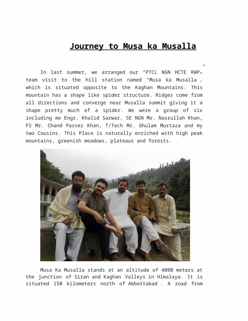
In last summer, we arranged our “PTCL NGN HCTE RWP” team visit to the hill station named “Musa ka Musalla”, which is situated opposite to the Kaghan Mountains. This mountain has a shape like spider structure. Ridges come from all directions and converge near Musalla summit giving it a shape pretty much of a spider. We were a group of six including me Engr. Khalid Sarwar, SE NGN Mr. Nasrullah Khan, FS Mr. Chand Parvez Khan, T/Tech Mr. Ghulam Murtaza and my two Cousins. This Place is naturally enriched with high peak mountains, greenish meadows, plateaus and forests.
Musa Ka Musalla stands at an altitude of 4080 meters at the junction
of Siran and Kaghan Valleys in Himalaya. It is situated 150 kilometers north
of Abbottabad . A road from Mansehra/Shinkiari, leads up to Mandakucha the
most frequently used track is Mandakucha, Jacha, Bikhi, Jabbar, Khorri (Gali) and
Choti ZiaraGali.

The mountain is 13,400 ft above sea level and can be seen from places
many kilometers away. The mount has the appearance of a prayer mat is and is
thus named Musa Ka Musala. The mountain is icescaped all year long. The
mountain top is considered a ziarat {Islamic shrine} by the localities, used to offer
their daily prayers at the peak.
There are many possible options to reach Musa ka Musalla top. It can be accessed from both Kaghan and Siran valleys. We have chosen the route from Manshera. We decided to gather up near Taxila, where our colleague Mr. Murtaza picked us on his car and we left near 5pm in evening for Mansehra which is 140km from Islamabad and takes roughly 3hours by road. In Mansehra we stayed at one of our relatives, Mr Zahid, who had arranged Dinner and Night stay in Mansehra.

From Mansehra we left for Mandakucha via Shinkiari which is 25km from Mansehra. In Shinkiari, we spent our time in enjoying beautiful sceneries and Different Local Product Shops. After that, we had our lunch, Special Kabab-Roti and than we left for Mandakucha, which is located in the base of Musa ka Musalla Mountain. It was around 20km travel but it was a dirt/kachi road on height, which took around 1-2 hrs by Car.

Here we took some rest at our guider house because he was our relative from Mandakucha village. We hired a donkey as carrier on Rs. 3000/day with a guide named Waqas. He had good information about the route and his father also joined us later to help us in route. There are two resturants in the path with river view where you can afford lunch in Rs.100/person. From the starting point, the trek to the top of Musalla takes approx 12 hours as we started by 09:00 hrs and reached at our last mile that was called Galli at 2100 Hrs. we have camp at Bikhi for our lunch and we cooked here on forest wood by our self and took some rest at that point.
At next we took rest at Khori and eat some fruits which we bought from Mandakucha. In the way we did not found any shop to buy so whenever anyone visit this place, its better to take all necessary items from Mandakucha respectively. At Galli we stayed in a small room called “maseet” on top of the Galli Peak.

In early morning we returned guide and his donkey as it was not possible to climb with luggage and donkey, so we started hiking towards top of the Mountain “Musa ka Musala” without our luggage. We had few difficulties in form of rain and windy condition with thunder storms. The track was very steep and gave us a real tough time for hiking. We reached at top of the Mountain approximately after 4 hours near 12pm.

Top of Peak was covered with ice and it is a flat peak around 1km cover area. We were excited to witness Clouds at same level. We spent 2 hours at peak, where we enjoyed our meal on ice carpet and also used ice as water as our drinking water bottles were finished, after that we enjoyed the beautiful scenery on top like kaghan and naran mountains, we can also see balakot from mountain and captured some memories in form of video/photos.
After 2 hours stay at top we decided to return back and It took 2 hours to reach down to Galli Point and we decided to keep going for Mandakucha and we reached at 8pm without any rest because of night time. Next Morning we directly returned back to Rawalpindi without any further stay.

It was an unforgettable experience with my ptcl colleagues because this was completely another world, with its climate, greenery, traditions, and customs that charm and dip you in the extraordinary atmosphere of calmness and composure. I remember it now with freshness and understand that it was the best journey of my life.