provided for non-commercial research and educational use...
TRANSCRIPT

r-Provided for non-commercial research and educational use.
Not for reproduction, distribution or commercial use.
This article was originally published in the Encyclopedia ofArchaeology, pUblished by Elsevier, and the attached copy is provided by Elsevier for the
autl'\or's benefit and for the benefit of the author's institution, for noncommercial research and educational use including use in instruction at your institution, posting on a secure network (not accessible to the public) within
your institution, and providing a copy to your institution's administrator.
All other uses, reproduction and distribution, including without limitation commercial reprints, selling or licensing copies or a"ccess, or posting on open
internet sites are prohibited. For exceptions, permission may be sought for such use through Elsevier's permissions site at:
http://www.elsevier.comllocate/permisslonusematerial
Kenoyer Jonathan Mark, Indus Civilization. In: Encyclopedia of Archaeology, ed. by Deborah M. Pearsall. @ 2008, Academic Press, New York.

Author's personal copy
ASIA, WESTnndus Civili~tion 715
Further Reading
Allchin B (1997) The "fuse of Civilization in India and Pakistan. Cambridge: Cambridge University Press.
Mishra S (1995) Chronology of the Indian stone age: the impact of recent absolute and relative dating attempts. Man and Environment XX(2): 11-16.
Misra VN (1989) Stone age India: An ecological perspective. Man and Environment 14: 17-64.
Murty MLK (1979) Recent research on the Upper Palaeolithic Phase in India. journal of Field Archaeology 6(3): 301-320.
Murty MLK (1985) Ethnoarchaeology of the Kumool cave are~.
World Prehistory 17(2): 192-205. . Paddayya K (1982) The Acheulian Culture of the Hunsgi Valley
(peninsular India): A Settlement System Persp~aive. Poona: . Deccan College Postgraduate and Research Institute.
PaddayYa K (1984) India: old stone age. In: Bar-Yosef 0 (00.) Neue Forschungen zur Altsteinze;t. Sonderdruck, pp. 345-403. Munich: Verlag C.H Beck.
Pappu RS (2001) Acheulian Culture in Penittsular India. New Delhi: D.K. Printworld. .
PappuRS and Deo SG (1994) Man-Land Relationships During Palaeolithic Times in the Kaladgi Basin, Karnataka. Pune: Deccan College.
Pappu S (1999) A study of natural site formation processes in the Kortallaiyar Basin, Tamil Nadu, South II:ldia. Geoarchaeology, An International journal 14(2): 127-150.
Pappu S (2001) BAR-International Series 1003:. A Re-examination of the Palaeolithic Archaeological Record of Northern Tamil Nadu, South India. Oxford: BAR. . .
Pappu S (2001) Middle Palaeolithic stone tool technology in the KortallaiyarBasin, South India. Antiquity 75: 107-117.
Pappu S, Gunnell Y, Taieb M, Brugalj-P, and Touchard Y (2003) Ongoing excavations at the Palaeolithic site of Anirampakkam, South India: Preliminary findings. Current Anthropology 44(4): 591-597. .
Pappu 5, Gunnell Y, Taieb M, and Kumar A (2004) Preliminary report on excavations at the Palaeolithic site of Attirampakkam, Tamil Nadu (1999-2004). Man and Environment XXIX(2): 1-17.
Petraglia MD (1998) The Lower Palaeolithic of India and its bearing on the Asian record. In: PetragliaMD and Korisettar R (eds.) Early Human' Behaviour in Global Context. The Rise and Diversity of the Lower Palaeolithic. Recor.d, pp. 343-390. London: Routledge.
Petraglia MD, LaPorta P, and Paddayya K (1999) The first Acheulian quarry in India: Stone tool manufacture, biface morphology and behavior. journal ofAnthropological Research 55: 39-70.
Indus Civilization Jonathan Mark Kenoyer, University of Wisconsin, Madison, WI, USA
© ·2008 Elsevier Inc. All rights reserved.
Glossary
Dholavira One of the largest and most prominent archaeological sites in India, belonging to the In~us civilization. It is located on the Khadir island in the Kutch district of Gujarat.
Mehrgarh One of the most important Neolithic (7000-3200 BCE) sites in archaeology, lies on the Kachi plain of Baluchistan,
Pakistan, and is one of the earliest sites with evidence of farming (wheat and barley) and herding (cattle, sheep and goats) in South Asia.
Great Bath The earliest public water tank in ancient South Asia is one of the most spectacular features of Mohenjo-daro.
lridus script (Harappan script) Refers to the undeciphered . writing system consisting of short strings of symbols found on pottery and seals. Used between 260~1900 BC and associated with the Harappan period settlements of the Indus civilization.
Indus Civilization
Introduction
The Indus civilization is a general tenn that refers to the first urban society that emerged in the· greater Indus valley of Pakistan and northwestern India, between 2600 and 1900 BC. This urban society wastirst discovered in' the 1920s and has also been called the Harappa culture after the type site of Harappa, Pakistan wheteit was first discovered.
Other common names that are found in the literature include the Indus valley' civilization and the Indus-Saraswati civilization.
Another common terminology that will be used in . this essay uses the framework of long-term cultural
traditions to examipe the origin, character, and eventual decline of a civilization. The Indus tradition (also called the Indus valley tradition) refers to the wide range of human adaptations in the greater Indus region over a long span of history; approximately 10000 to 1000 BC. The Indus tradition encompasses all adaptive strategies that contributed to the emergence' and decline of the first phase of urbanism, including hunting-foraging the origins of agriculture
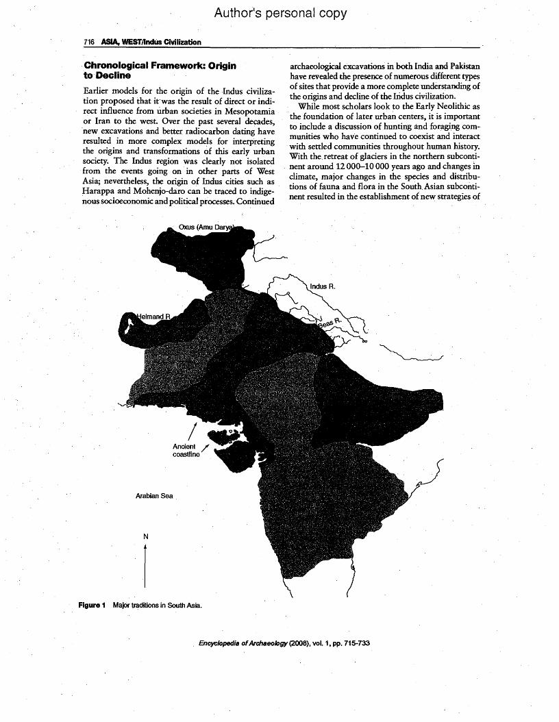
.and specialized crafts, the emergence of cities and state-level society, and finally the transformation and decline of the Indus cities (Figure 1)..
In addition to the Indus, three other major cultural traditions relating to the initial emergence of urbanism can be identified for the northwestern subcontinent: the Baluchistan, Helmand, and the Bactro-Margiana Traditions. These cultural traditions. are linked in different· ways to processes of socioeconomic and political developments in the subcontinent, beginning as early as the Palaeolithic and continuing through the Early Histori<;: period.
The Indus' tradition .can be subdivided into 'eras' and 'phases' that are roughly corr~lated to major adaptive strategies and regional material cultural styles (Table 1). A brief summary of each-major era is provided below in order to provide a larger context in which to discuss the urban Harappa phase, of the Integration era, which is the main focus of this essay.
Encyclopedia ofArchaeology (2008), vol. 1, pp. 715-733
Author's personal copy
716 ASIA, WESTJlndlis Civilization
Chronological Framework: Originto· Decline .
Earlier models for the origin of the Indus civilization proposed that it"was the result of direct or indirect influence from urban societies in Mesopotamia .or Iran to the west. Over the past several decades, new exca:ations and better radiocarbon dating have resulte~ .In more complex models for interpreting the. ongms and transformations of this early urban socIety. The Indus region was clearly not isolated fro.m the events going on· in other parts of West ASIa; nevertheless, the origin of Indus cities such as Harapp~ and Mohenjo-daro· can be traced to indigenons socIoeconomic and political processes. Continued
Figure 1 Major traditions in South Asia.
archaeological excavations in both India and Pakistan have revealed the presence of numerous different types of sites that provide a more complete understanding of the origins and decline of the Iridus civilization.
.. While most scholars look to the Early Neolithic as the foundation of later urban centers, it is important to include a discussion of hunting and foragi.ng communities who have continued to coexist a:nd interaet
.wi~ settled communities throughout human history. WIth the retreat of glaciers in the northern subconti
. nent around 12000-10000 years ago and changes In climate, major changes in the species and distributions of fauna and flora in the South. Asian subconti. nent resulted in the establishment ofnew strategies of
Arabian Sea
N
Encyclopedia ofArchaeology (2008), vol. 1, pp. 715-733

Author's persona/copy
ASIA, WESTnndus Civilization 717
Table 1 Indus Tradition
Foraging era 10000-2000BeE Mesolithic and Microlithic
Early Food Producing era 7000-5500 BCE Mehrgarh Phase
Regionalization era 5500-2600 BCE Ear1y Harappa phases , Ravi, Hakra, Sheri Khan Tarakai, Balakot"Amri, Kot Diji, Sothi
Integration era Harappan phase 2600-t900 BCE
Subdivided at the site of Harappa into Period 3A 2600-2450BC Period 3B 2450-2200 BC
, Period 3C 2200-1900 BC
Localization era Late Harappan phases 1900-13OOBCE
Punjab, Jhukar, Rangpur
foraging and hunting. The 'Foraging era' represents a relatively long period of time and broad geographical , area where mobile and semisedentary foraging and hunting 'communities began focusing on intensive exploitation of specific plants and animals. In parts of Afghanistan and the edges of the Indus valley these adaptive strategies eventually contributed to the domestication. of humped ,zebu cattle and possibly other species of animals and plants.
During the Neolithic or 'Early Food Producing era', which dates to around· 7000-5500 BCE at sites such as Mehrgarh, Pakistan, there is evidence for the emergence of wheat and barley agriculture and the herding of domestic cattle, along with sheep and goat. ' These plants and animals became the primary subsistence base for the development of larger towns' and eventually cities in the Indus region. Major trade networks were also established during this period, connecting small agro-pastoral communities with distant resource areas. These networks extended from the Arabian Sea along the Makran coast to the highlands of northern Mghanistan, and from the Baluchistan hills to the deserts of Sindh and Rajasthan.
In the subsequent Chalcolithic or 'Regionalization era', 5500-2600 BCE, distinctive regional cultures bee.ame established in the northern and southern alluvial plain, as well as in surrounding regions. Small villages became established in agriculturally rich areas and larger villages grew up along the major trade routes linking each geographical region and resource area. S<?me settlements, such as Mehrgarh, which is situated at the base of the Bolan Pass, became important craft production and trade centers. At Mehrgarh a wide suite of specialized crafts were developed for local use as well as for regional trade: pottery making, stone bead making, shell ornament production, copper
,working, and eventrially bronze working, as well as . glazed steatite and faience bead making. Distinctive pottery styles and painted designs, along with regional human and animal figurine styles can be seen in other regions at sites such as Rehman Dheri (Gomal Plain), Sheri Khan Tarakai and Tarakai Qila (Bannu Basin), S~ai Khola (Taxila Valley), Harappa and Jalilpur (central Punjab), Siswal (Haryana), Kot Diji (Sindh), Amri and Ghazi Shah' (southern Sindh), NaVSohr Damb (southern Baluchistan), and Balakot (Makran coast). Different regional cultures of phases have been named after the regions or sites where they were first discovered, such as Hakra, Ravi, Sothi, Amri, and Kot Diji phases. These cultures are collectively referred to as Early Harappan, because they set the foundation for the development of major urban centers in the core agricultural regions and at important crossroads.
In addition to the developments in the core areas of the Indus and. Saraswati-Ghaggar-Hakra valleys, recent excavations in Gujarat, India reveal the establishment of Early Harappan cultur~ traditions in ~utch
and Saurashtra. The sites of Dholavira, Loteshwar, and Nagwada appear to have links to Amri and Kot Diji phase cultures inSindh, but also reflect a local tradition from Gujarat, sometimes referred to as the Anarta culture. Many of the raw materials tradedduring the Early Harappan period derive from Gujarat, but the degree to which local cultures in Gujarat contributed to the Early Harappan and subsequent Harappan cultural traditions is still under investigation. ' ,
At the end of the Regionalization era, during the 'Kot Diji phase', the first urban centers began to emerge in the Indus and Saraswati-Ghaggar-Hakra plain. At the site of Harappa, which is the bestdocumented settlement, the early urban phase dates from around 2800 to 2600 BCE (Figure 2). This settlement grew to more than 25 ha in area and was divided into two walled sectors. Smaller villages dat- ' ing to the same time period have been discovered in the hinterland around Harappaand reveal that the site was a central place in an urban network and also had links to distant resource areas.
At Harappa there is evidence for the first use of the 'EarlY Indus script', standardized weights, writing, and square stamp seals that were used to stamp clay sealings on bundles of goods or store rooms. Other small and large sites dating to this period reveal local developments in artifact styles, stamp seal styles, graffiti on pottery, and settlement planning. Standardized mud bricks used for building city walls and 'domestic architecture also appear at this time. The use of Car- ' dinal directions for orienting streets and buildings, and the use of bullock carts for transport of heavy commodities into the settlement .begins during the Kot Diji phase at Harappa and numerous other sites
Encyclopedia ofArchaeology (2008), vol. 1, pp. 715-733

Author's personal copy
718 ASIA, WESTt1nc1us Civilization
50 60 70 eo
36
34
32
Key· • Palaeolithic/foraging era sites y Early fOOd producing era. sites • Regionalization era sites
N I
-Of
USSR + + 38
.+ 36
34
18 .
Figure 2 Major geographical regions and prehistoric sites.
throughout the greater Indus region. Together these developments confirm the emergence of hierarchical social, economic, and political systems associated with early urbanism. . Kot Diji phase sites have been found in the Gomal
plain (Rehman Dheri), Kacchi plain (Nausharo), Taxila valley (Sarai Khola),along the bed of the Ghaggar:-:-Hakra river Ualiwali, Gamanwala, etc.), in the southern Indus region (Mohenjo-daro; Kot Diji,
. a,nd Ghazi Shah), as well as in Kutch (Dholavira). The precise nature of regional interaction and chronology of local cultural developments is stilJ unclear, but taken as a whole, these sites set the stage for the rise of large urban centers. that came to dominate the greater Indus valley region. .
The Integration era, Harappa phase, dates· from around 2600 to 1900BCE, and it is during this long time span that cities such as Harappa, Mohenjo-daro, Rakhigarhi, Dholavira, and Ganweriwala grew to their largest extent (Figure 3). This 700-year period
. c~n now be divided into three subphases on the basis
of changes· in pottery, use of seals, and architecture as seen at the site of Harappa and other major settlements. Although the precise dates may differ from one· site to another, at Harappa, these subphases are referred to as period 3A(260o-2450 BeE), 3D (245.o-2200DCE), and 3C (220o-1900BCE). Some scholars stilJ refer", to this long time span as the. (mature' Harappan period (or Mature Harappan), but excavations and radiocarbon dating at· the site of Harappa .indicate that· the artifact types generally associated with the so-calJed (mature' Harappan period actually only occur during the last half of this 700-year time span.
During the Harappa phase, the largest urban centers may have directly controlled their surrounding hinterland, but there is no evidence for hereditary monarchies or the establishment of centralized territorial states that controlled the entire Indus region~ Cities, such as Mohenjo-daro, Harappa, and Dholavira were dearly ·being ruled by influential elites; probably a combination of merchants, landowners, and religious
Encyclopedia ofArchaeology (2008), vol. 1, pp. 71~733

Author's personal copy
ASIA, WESTlindus Civl1izatiOn 719
50 60 70 80 + 38
+
+36
34
N I Himalayan MIs 32
22
Key: Integration era sitese Other important sites' • Major traete/exchange routes _ 100 0
ARABIAN
100 200 300 400· 500
Kilometers
Figure 3 Integration era. Harappa phase sites.
leaders~ Smaller towns and villages may have been run by corporate groups such as town councils or individual charismatiC leaders; but there is a conspic-· uous absence of central temples, palaces and elaborate elite burials that are characteristic of elites in other early urban societies in'Mesopocamia, Egypt, and China. Hierarchical social order and stratified society is re£le<:ted in architecture and settlement patterns, as well as artifact styles and the organization of technological production. A vast network of internal trade and exchange and a shared ideology united the greater Indus valley. There was widespread use of, similar styles of pottery, figurines, ornaments, the distinctive Indus script, seals, and standardized weights. Massive mud-brick walls surrounded mostlarge settlements, and appear to have ftmetio~ed primarily for control of trade access into the cities. These walls also would have served as formidable defenses, but there is no evidence for major conflict or warfare at any major center. A more detailed discussion of the Harappa phase will be presented below.
During the cLocalization era', CLate Harappan phases', from 1900 to 1300BCE or even as late at 1000BCE, the ,major cities and their supporting settlements began to lose power due a number of factors. Shifting river patterns and the eventual drying up of the Saraswati-Ghaggar-Hakra River resulted in the abandonment of many sites and ,migration into the Indus valley, Gujarat or to the Ganga-Yamuna valley. The disruption of agriculture and the eventual breakdown of trade and political networks led to the decline of urbanism and the disappearance of many distinctive features· of the Indus culture. The Indus script and inscribed seals were no longer 'used, and· writing' disappeared along with the use of cubical stone weights and many fonns of symbolic objects. Other social and religious factors also contributed to the gradual reorganization of trade and technology and the emergence of new cultural, political and religious traditions.
Although changes in materi~l culture and socioritual traditions are well documented, there are also
Encyclopedis ofArchseology (2008), vol. 1. pp. 715-733

Author's personal copy
720 ASIA, WESTlindus Civilization
significant continuities. Even though cubical stone weights disappeared, the weight system used during the Early. Harappan and Harappan periods continued in use in later periods.and is still used in South Asia today. Other continuities are seen in pottery styles and technology, some s~bolic obje~, overall site layout, the use of standardized bricks, etc. These continuities justify the use of the term Late Harappan to characterize many of these traditions. The Punjab phase, Cemetery H culture spread throughout the Punjab·and Ganga-Yamuna region, the Jhukar phase and related cultures were found in Sindh and Baluchistan, and the Rangpur phase. includes the Lustrous Red Ware and associated Black-and-Red ware cultures that were present in Gujarat, Rajasthan, and the Malwa Plateau.
In the northern Indus valley and parts of Baluchistan some sites show an overlap between Late Harappan and Baetro-Margiana material culture. In the Gangetic region there is overlap with the Copper Hoards culture, the Ochre Colored ~ottery, and Painted Gray Ware culture. Some of thes~ cultures may be associated ·with mdo-Aryan speaking Vedic communities mentioned in the sacred hymns of the Rig Veda and later Brahmimical texts, but there is little consensus among scholars on this point. Considerable research still remains to be done on this transitional period, but some answers should be forthcoming from the many new sites that have been discovered in northern Pakistan and India.
Geographical Setting
The greater Indus valley refers to a vast area drained by the various tributaries of the Indus River and a parallel (now dry) river that is variously referred to as the Saraswati~Ghaggar-Hakra-Nara River. The Indus tributaries emerge from the Kirthar and· Suleiman mountains of Baluchistan on the west, the Hindu-Kush and Karakorum to. the northwest, the Pamir and the· Himalaya to the north and east.. All of these mountainous regions have played an important role. in providing minerals, timber, and trade routes to adjacent cultural centers in Baluchistan, Afghanistan, and Central Asia. The second major river has different names along its length. m the north are· several tributaries, one of which is today
. called the Saraswati. Some scholars suggest that this was the sacred Saraswati River mentioned in the Rig.
.Veda and other Brahmanical texts, but so far it has not been possible to confirm this identification. In the midsection it is called Ghaggar or Hakra and the depression where it appears to have flowed in the south is called the Nara. This ancient river, which will be referred to as the Ghaggar-Hakra,flowed
to the east and generally parallel to the Indus River. The Sutlej (ancient Satadru), which now flows into the Indus, appears to have been a tributary of the Ghaggar~Hakra system. The Ghaggar-Hakra appears to have reached the Rann of Kutch during the Regionalization era, but began drying up and eventually disappeared in the middle of the Cholistan desert toward the end of the Harappa phase or during the Late Harappan period.
To the east, the greater mdus valley is bordered by the Thar I)esert and the Aravalli mountains, both of . which are rich in mineral resources used by cominunities of the Indus region. On the southe~st lie the . islands of Kutch, the peninsula of Saurashtra, and the mainland of Gujarat. The co~bined deltas of the Indus and the Ghaggar-Hakra Rivers extend from the Greater Rann of Kutch in the east to the rocky coast of Baluchistan near modem Karachi in the west. The coastal settlements in the Makran, Kutch, and Saurashtra appear to have had connections across the Arabian Sea to the coasts of modem Oman and the Persian Gulf. Although no purely Harappan site has been found on the Arabian Peninsula, many Indus artifacts have been found in coastal and some inland settlements.
Climate of the Greater Indus Region
The Indus valley and adjacent regions.ar~ dominated by two major weather systems, the winter cyclonic system of the western highlands and the summer monsoon system of the peninsular subcontinent. The winter cyclonic system produces snowfall in Baluchistan and rainfall in parts of .the Indus valley. The .summer monsoon brings scattered rainfall to Sindh and Guja,rat and heavy rainfall to the northern Indus plain, with rain and snow in the high mountains in the north. These two systems overlap in the Indus valley and if one system fails the other usually provides sufficient precipitation to support large populations throughout the region. The main crop cycles in the Indus valley region are aligned with the winter rains and the summer monsoo·n rains.
Recent ·models of global climate indicate that, at 18 000-9000 B~ southern Asia would have been cooler and drier than today, with a weak summer monsoon. From 9000 to 7000BP, there appears to have been a stronger summer monsoon, warmer summers, and cooler winters. Although these models work at the maclolevel, they cannot be confirmed through detailed analysis of specific sites or regions. Generally speaking, there is no evidence for major· changes in climate or rainfall since at least 9.000 BP. Specific regional environmental changes that directly impacted human settlement in the greater Indus region can .
Encyclopedia ofArchaeology (2008). vol. 1. pp. 715-733
Authorls personal copy
ASIA, WESTllnduS Civilization 721
generally be attributed to changing river-flow patterns and humanly induced erosion or soil degradation.
Subsistence Strategies
Indus cities and villages were provisioned through a combination of intensive and extensive agriculture, .combined with animal husbandry, and supplemented by fishing and hunting. During the. Harappa phase, two major crops could have been harvested in some regions provided there was sufficient winter rain and summer flooding or rains. Agricultural fields were watered primarily by annual rainfall and seasonal flooding, but water-diversion channels, and dams for trapping soil and, moisture are common along the Baluchistan piedmont and in parts of Kutch. Irrigation canals have been found at the site of Shortughai along the Amu Darya or Oxus River in Afghanistan, but there is no evidence for the construction of large-scale irrigation channels as Was common in Mesopotamia at the time. Smaller fields and vegetable plots would have been watered by wells, which are found at most Harappa ,phase sites, and reservoirs like those found at Lothal and Dholavira. The brick-lined tank at Lothal was filled with river overflow during the monsoons, and at Dholavira a series of, interconnected stone~lined reservoirs were filled bya combination of river run-off, and rainfall collected from rooftops and the city wall by an elaborate system of drains'within the city itself..
The main winter or rabi season crops in the core regions of the Indus were wheat and b~rley, supplemented by pulses, sesame, peas, and vegetables.
.Perennial cotton could have been grown during the winter season and harvested in the spring. The kharif crops, including rice, sorghum, and various millets, would have been sown during or at the end of the summer monsoon and harvested in the fall. Rice was not common in the Indus valley itself and is found only in Gujarat during the H.arappa phase. Cotton, mustard, sesame, dates, melon, and peas were also cultivated, possibly as kharifcrops.
The most important domestic animals were cattle (humped Bos indicus and nonhumped Bas taurus) and water buffalo (Bubalt# bubalis), followed in importance by sheep and goat. Although domestic pig is found in the cities, it was not a major source of meat.
. The domestic dog is well attested from animal bones as well as figurines, some of which depict small, house . pets, while others show mastiffs used in hunting. Many different types of wild animals were hunted and brought to the cities. Large game, such as elephant, rhinoceros, wild· water buffalo, and various types of elk, deer, antelope and wild ass were hunted for food or for other products such· as horns, antlers,
tusks and possibly their hides. Smaller animal may also have been hunted, and numerous' terracotta
.figurines suggest that some of these small animals, such as Macaque monkeys, squirrels, and a variety of birds, were also captured for use as pets. Fishing and shellfish collection was important along the coasts and at the many settlements located along riv
. ers and oxbow lakes. Marine shells were used for making ornaments and some riverine shells were used as tools. At the site of Harappa, which is more than 800 km from the coast, there is evidence for the trade of dried marine catfish, even though local riverine catfish were also being consumed. This trade in salted fish underscores the importance of preserved foods in the subsistence strategies of large urban centers (see Asia, South: India, Deccan and. Central Plateau).
Settlement Patterns
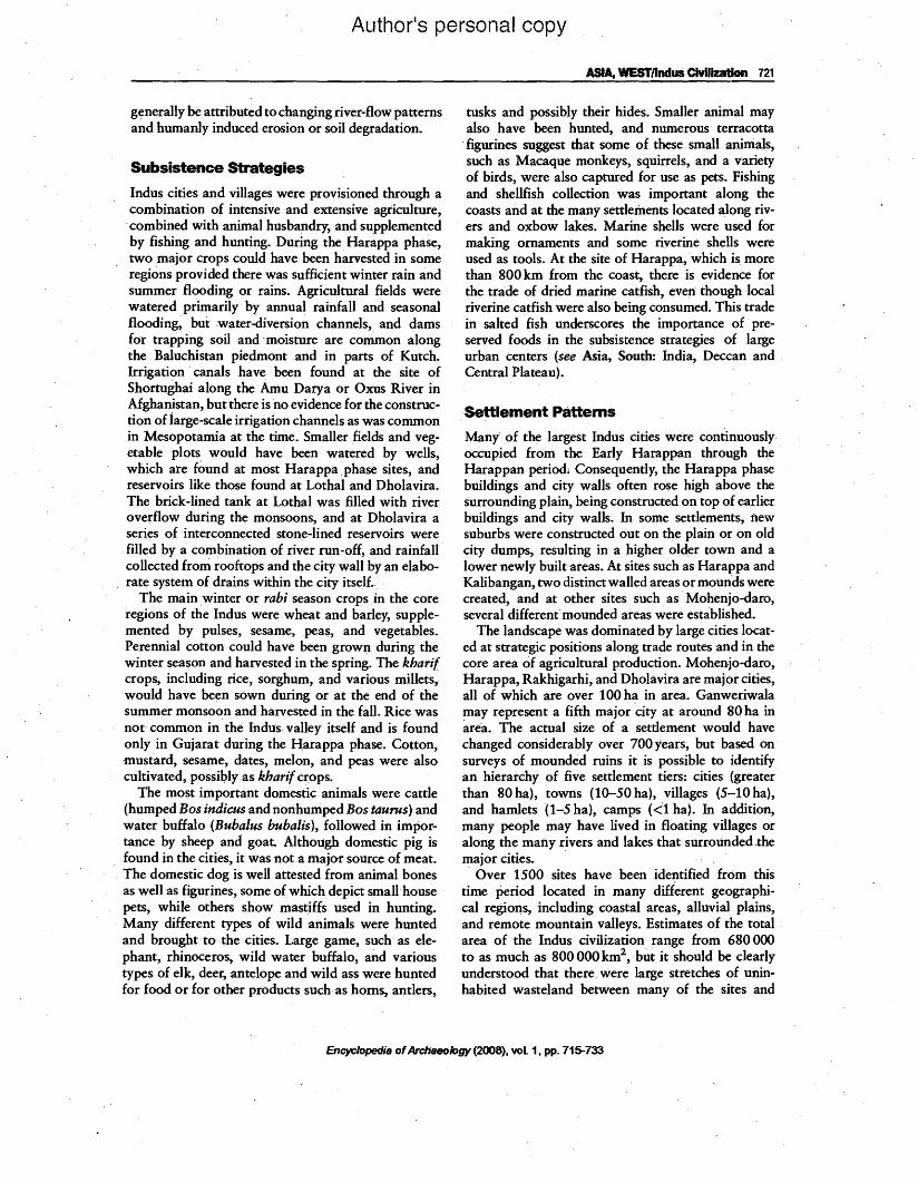
Many" of the largest Indus cities were continuously occupied from the Early Harappan through the Harappan perio& Consequently, the Harappa phase buildings and city walls often rose high abov~ the surrounding plain, being constructed on top of earlier buildings and city walls. In some settlements, new suburbs were constructed out on the plain· or on old city dumps, resulting in a higher older town and a lower newly built areas. At sites such as Harappa and Kalibangan, two distinetwalled areas or moun'ds were created, and at other sites such. as' Mohenjo-daro, several different mounded areas were established.
The landscape was dominated by large cities located at strategic positions along trade routes and in the core area of agricultural production. Mohenjo-daro, Harappa, Rakhigarhi, and Dholavira are major cities, all of which are over 100 ha in area. Ganweriwala may represent a fifth major 'city at around 80 ha in area. The actual size of a settlement would have changed considerably over 700 years, but based on' surveys of mounded ruins it is possible to identify an hierarchy of five settlement tiers: cities (greater than 80 ha), towns (10-50 hal, villages (5-10 hal, and hamlets (1-5 hal, camps «'1ha). In addition, many people may have lived in floating villages or along the many rivers and lakes that surrounded the major cities. , Over 1500 sites have been identified from this
time periOd located in many different geographical regions, including coastal areas, alluvial plains, and remote mountain valleys. Estimates of the total area of the Indus civilization range from 680 000 to as much as 800000 km2
,' but it should be clearly understood that there. were large stretches of uninhabited wasteland between many of the sites and
Encyclopedia ofArchaeology (2008), vol. 1, pp. 715-733

Author's personal copy
122 ASIA; WESTllndus Civilization
the total area does not represent a territory. of centralized political control or one that has distinct boundaries.
. Population estimates for the Indus period are diffi~
cult to detennine, because it is not possible to accurately define how much of a city was occupied at any given time or which settlements were inhabited during the 700-year time span of the Harappa phase. The site of Harappa, which covers around.150ha, could have held between 60000 and 80000 people at the height of the urban phase, but th~ total urban population may have fluctuated seasonally. Nomads and merchants may. have c()me to the city during trading seasons, and many urban dwellers may have left to help in the fields during the agricultural or herding s~asons.
City Planning
One of the hallmarks of Harappan or Indus culture is the highly developed city planning that is seen in
E1400 E1600 E1800 1:2000
? =Walls not excavated
N2000
N1600
N1400
N1200
N1000
N800
o
N
t
100
N1400 N1600 N1800 N2000
Figure 4 Harappa site plan.
major urban centers as well as smaller settlements. Most settlements were laid out on an irregular gridoriented. nortHouth and east.;...west. The 'use of cardinai directions for settlement planning began in the Early Harappan period and continued through the Late Harappan period. Massive perimeter ~alls
. were constructed of mud brick, sometimes faced with fired brick, or stone. Gateways located near the coro: ners or in the middle of the city walls provided controlled access into the settlements. The city walls and gateways were regularly maintained and modified over time, indicating that they had aD important function throughout the life of each settlement. This function may have changed·over time, but they would have provided defense fr:om attacks from enemies or bandit raids; they allowed for the control. of trade, and they protected the city from flooding. While some smaller sites have evidence for localized fire and conflagration, there is no evidence that any major settlement was attacked or destroyed by warfare (Figures 4-6).
E2200 E2400 E2600 E2800
N2000
N1800
N1600
N1400
N1200
N1000
N800
N2200 N2400 N2600 N2600
Encyclopedia ofArchseology(2008), vol. 1, pp.715-733

Author's personal copy
ASIA, WESTllndus Civilization 723
Siddiqui Vats Wheeler
N
1 o (UMP) Dales (University Museum, PAl
Dikshit . Hargreaves
MohenJo-daro~ Sindh. Pakistan
Site continues
o 100 200m
Key
DH HR L M SO VS W
Site continues
Figure 5 Mohenjo-daro site plan.
Within the settlements, Streets and buildings were oriented on· a north-south arid east-west grid. The layout of streets and the placement of houses were often maintained for. hundreds of years, either as the result of city ordinances or simply for functional purposes. Major north-south and east-west streets were between 4.5 and as much as 9 m wide allowing fqrtwt>-way traffic using ox carts. Smaller streets were around 2-3 m wide, allowing only one-way cart traffic. Gateways were generally only 2.5 m wide that would allow only one-way cart traffic and more control of movement into and out of the city. Wide streets were constructed to allow ox carts carrying goods to access each·major neighborhood and also to cross through the entire settlement. In Mesopotamian cities, the main streets went from the city gate to the temple or palace, but did not provide equal access to aU parts of the settlement.
Fired brick-lined drains were located along the edges ofthe street, and some streets had large covered drains down the center of the street. Corbelled arches were used to carry drains under buildings or streets. The streets were not paved, but the accumulation of crushed pottery and nodules compacted· by use resulted in hard surfaces similar to modem gravel roads. Large potholes and ox cart ruts were periodically filled with additional debris to levei the streets out. Even with periodic maintenance, the accumulation of debris on the streets resulted in dogged drains that were eventuaUy filled in and new streets and
.drains were built at a higher level to aUow proper drainage. Streets in neighborhoods where there was less. maintenance rose faster than the main streets, resulting in an uneven topography. Eventually, the highest parts of the cities were 18-20 m above the surrounding plain.
Encyclopedia ofArchaeology (2008), vol. 1, pp. 715-733
Author's personal copy
724 ASIA, WESTlindus Clvil~n
Dholavira, Kutch, India
G.. :::== ::
::== ::=
===:. ==::
"" ,. II " I' ..
!~ ~ ~~~
" - It
"
Middletown
Bailey
~~ " " " " "
Lower town
150m,
N
Dam
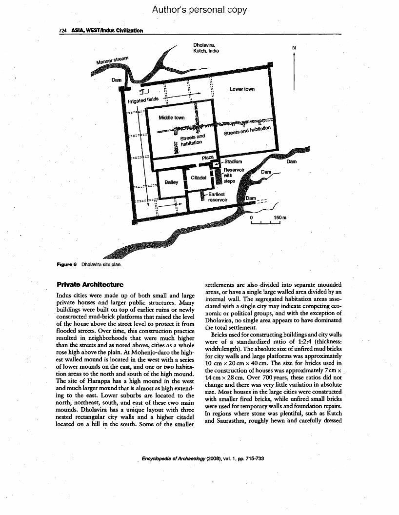
Figure 6 Dholavira site plan.
Private Architecture
ln~us cities were made up of both small and large pn~a~e houses a~d larger public structures. Many buIldmgs were bwl~ on top of earlier ruins or newly constructed mud-bnck platforms that raised the level of the house above the street level to protect it from flooded s~eets: Over time, this construction practice resulted In neIghborhoods that were much higher than the streets and as noted above, cities as a whole rose high above t~e plain. Ai Mohenjo-daro the highest walled mound is located in the west with a series
.of lower mounds on the east, and one or two habitation ~eas to the north and south of the high mound. The sIte of Harappa has a high mound in the west and much larger mound that is almost as high extending to the east. Lower suburbs are located to the north, .northeast, south, and east of these· two main mounds. Dholavira has a unique layout with three nested rectangular city· walls and.a higher citadel located on a hill in the south. Some of the smaller
settlements are also divided into separate mounded ~reas, or have a single large walled area divfded by an mtemal wall. The segregated habitation areas associated with a single city may indicate competing economic or political groups, and with the exception of Dholavira, no single area appears to have dominated the total settlement. .
Bricks used for constructing buildings and citywalls were of a standardized ratio of 1:2:4 (thickness: width:length). The absolute size of unfired mud bricks for city walls and large platforms was approximately 10 cm x 20 cm x 40 cm. The size for bricks used in the construction of houses was approximately 7 cm x 14 cm x 28 cm. Over 700 years, these ratios did not· change and there was very little variation in absolute size. Most houses in the large cities were constructed. with smaller fired bricks, while unfired small bricks' were used for temporary walls and foundation repairs. In regions where stone was plentiful, such as Kutch and Saurasthra, roughly hewn and carefully dressed
Encyclopedia ofArchaeology (2008), vol. 1, pp. 715-733

Author's personal copy
ASIA, WESTllndus Civil~tion 725
stone blocks were also used in architecture. While some effort was made to maintain the 1:2:4 ratio~
this was not rigorously imPosed in stone construction. There is no standardization in the layout of"
Harappan "houses, but private houses were generally laid out with a central space surrounded by living and storage rooms. Many houses had entryways from a side alleyway rather than frOIP the main street, and" usually windows were maintained only on the second storey. The roof imd second floor were made with
"wooden beams and covered with reeds and plaster to create a sturdy floOl: Doors and windows were made "with wood and some windows had wood or stone latticework to allow airflow, and at the same time a degree of privacy.
Although there are numerous "large building complexes in the larger cities, most appear to be the result of growth and remodeling over time. The core building may have belonged to a wealthy merchant or landowner, with numerous smaller units inhabited by relatives or servants. None of these structures appear to have been used as a central palace or tem-" pIe. Many smaller private buildings as well as some of the larger structures are associated with"manufacturing debris from specialized crafts, and smaIl craft workshops are often found in association with domestiC architecture. At sites such as Chanhudaro and Lothal,some buildings and open areas may have served as "specialized factories for bead maldng or copper working, but most crafts associated with kilns were located at the edges of the sites (see the section on 'specializedcrafts') or in whatappear to be abandoned structures.
Monumental or Public Architecture
"Large buildings that do "not appear to be domestic in nature have been identified ;at "Mohenjo-daro as well as at Harappa. The famous Great Bath of Mqhenjo-daromay have been used for public rituals and consists of a specially constructed water tank (12 m "nonh-south and 7 m wide, with a maximum depth of 2.4 m), surrounded by a colonnade with entries at both ends. Smaller rooms, one of which contains a well, are located on the eastern side of the tank, and may have been used for visitors or for storage. Just to the north of this tank are eight small rooms with bathing platforms, where people may have cleansed themselves"before coming to the main tank for special rituals.
To the southwest of the Great-Bath is the so-called Granary, which consists of a monumental brick foundation (50 m east-west and 27 m north-s6uth) with narrow passageways' and sockets for holding what
may have been a wooden superstructure. Although it is referred to as a granary, there is no archaeological evidence for the storage of grain in this building. Its precise function may never be known, but it was dearly an impressive monumental building or public hall in a prominent area of the city.
At Harappa a monumental building complex, also mistakenly called a 'granary', has been the focus of recent excavations in an attempt to determine its precise function. This structure was originally con.. structed on a massive mud-brick platform with fired brick facing (50 m north-south and 40 m east-west). Two rows of six long rectangular rooms were separated by a central passageway~ These rooms had brick foundations and narrow hollow floors," and were thought to have been used for storage of grain. Careful analysis of several unexcavated portions of this structure in 1997 eJid not reveal any evidence of st~rage vessels, or grain and the precise function is still unknown~ "When it was first excavated in the 19305, it was thought to be associated with equally enigmatic circular working platforms interpreted" as grainprocessing areas"and located to the north of the 'granary' New' excavations and radiocarbon dating have shown that the circular working platforms were not used for processing grain and that they date some 200 years after the so-called 'granary' was constructed. The precise function of these circular"platforms is still being investigated.
Recent excavations at the site of Dholavira have found large buildings in the highest citadel area of the site, but once again there is no conclusive evidence for their function during the Harappan period. The excavators suggest that they may have beenadministrative or ritual structures that were eventually abandoned and reused by later inhabitants.
Wells and Latrines
The construction of wells made with speciaHy designed wedge-shaped bricks reflects the high level of technical "expertise achieved by Indus architects and the overriding need for reliable sources of water in large urban centers. Wedge-shaped well bricks" were the same lengt;h as normal rectangular bricks (28 cm) but one edge was" constricted to create a tight fitting tubular construction. As wells were sWlk into the ground, the surrounding pressure of the soil made the construction even strongeI: Wells range in size from around 1 m internal diameter to over 2 m in diameter and were excavated below the water table to provide freshwater in the heart of the cities. Many houses, particularly at sites such as Mohenjo-daro, hadprivate wells, but in other sites a single well was used for a
Encyclopedia ofArchaeology (2008), vol. 1, pp. 715-733

Author's personal copy
726 ASIA, WESTJlndus Clvil~
larger neighborhood. Public wells were located along major streets or in public courtyard areas.
Most houses in larger cities had separate bathing areas with paved floors made with bricks set on edge and closely fitted to make them water tight. A separate latrine area was usually located next to the bathing .platform. The latrines were iIi the fOnD of a commode made from an old storage jar, which usually
. had a hole punched into the base and was buried up to the rim in the floor. These commodes would have been regularly emptied and the Waste taken outside of the city. Small drains discharged wastewater from the bathing area and latrine overflow into a sump pot in the street or into a neighborhood drain. When houses were remodeled', a new jar would be placed on top of the old commOde and the surrounding floor was raised with rubble or debris.
:The. larger city drains were generally not used for . removal of human waste,. but .rather to take away
water from bathing areas.and wells, andexcess rainwater. Major drains emptied the wastewater onto the plains outside the city~ Many streets in the larger cities had garbage. bins for the accumulation of nonliquid waste that would have been collected and .dumped outside the settlement.
Although the Indus cities were equipped with the most sophisticated drainage system qf any contemporaneous ancient city, these drains and garbage collection areas and latrines had .to be maintained continuously to function effectively. Excavations at Harappa have shown that while some areas of the city were being maintained, streets and drains in other neighborhoods became filled with refuse, and even rotting animai carcasses. Eventually, the city or more' likely neighborhood· committees. refurbished these streets and new drains. were constructed above. the old ones, indicating a fluctuating and. possibly decentralized process of civic order and maintenance.
Specialized Crafts
The emergence of urban centers is closely linked to .the development of specialized technologies. Due to the fact that the Indus script has not yet been deci
. phered, the study of specialized crafts provides one of the most important sources of information on the nature of Indus trade, technology, and socioeconomic and political organization. Cities were located at crossroads of interaction and trade that stimulated . the development. of distinctive technologies. Withthe increase in urban populations, many crafts were developed to create status items to differentiate specific
. communities and meet the demands of increasingly complex urban needs. While many crafts practiced in
the large urban centers can be traced back to earlier village communities in distant resource areas, others were the result of innovative urban craft specialists. For example, chipped stone tools, shell working, stone bead making and even copper metallurgy began long before the emergence of cities. In contrast, complex metal casting and joining, drilling of ·hard stone beads with specialized drills, finely Carved steatite seals, the production of compact glassy faience, and the manufacture of stoneware bangles, are technologies that were invented or developed in the cities. The techtiology of writing.itself can also be seen as a specialized craft that was refined and standardized during the urban phase. Some. of theSe technologies were exclusively developed for creating status items for elites, in order to communicate and reinforce social, ritual, and probably political hierarchy.
Many of the crafts practiced in the cities were not directly controlled by elites, but any craft located within the city walls could have been indirectly controlled through taxation of raw materials coming into the city or finished goods leaving the city. Stone tool making, shell working, the production of grinding stone, and steatite and agate bead making were carried out in many different .parts of the citY. These crafts involved local as well as nonlocal materials and relatively simple extractive or reductive technol- : ogies, that involve processes such as chipping, grinding, carving, spinning and twisting, etc., to· process raw materials into finished objects. Transformative technologies were generally more important for the creation of trade and status items and involved pyrotechnological or chemical processes using either local or nonlocal materials. Copperlbronze working, some· pottery firing, and the manufacture of faience and steatite seals are transformative crafts and were often practiced in isolated or sometimes highly controlled areas of the city. . .
During the Harappa phase, pottery was generally made on the fast wheel, though molds and handbuilding techniques were used for some vessels. Most of the pottery was either undecorated or simply ornamented with red slip and black bands.· Around 10% of the pottery was elaborately decorated with black-painted motifs on red slip or occasionally· with polychrome decorations. Stoneware bangles were finely crafted high-fired ceramic ornaments whose production was restricted to the largest cities of Mohenjo-daro, Harappa, and possibly Dholavira (Figure 7).
The faience produced in the Indus cities was extremely strong and made from reground frit or melted silica. It was colored with copper or other minerals to create a range of colors and was used
Encyclopedls ofArchseology (2008). vol. 1. pp. 715-733

Author's personal copy
ASIA, wesrnndus CivIlization 7'0
Figure 7 Mohenjo-daro pottery types. From Dales GF and KenQyer JM (1986). Excavations at Mohenjo Daro, Pakistan: The Pottery. PhUadelphia, University Museum Press, fig. 102.
to make bangles,beacls, pendants, and also seals and inscribed tablets. Fired steatite or soapstone was used to make· beads as well as square inscribed seals. While bead making and seal production were usually undertaken in different areas, recent excavations at Harappa found a highly restricted faience and steatite seal workshop where beads were also being manufactured.
Indus ornaments were made·in similar styles but from different qualities of materials that would have had different relative value. For example, bangles were made in terracotta, faience, shell, ivory, alabaster and a high-fired stoneware, as well as copperI bronze and gold (Figure 8). Beads and pendants were made out of stone, shell, ivory, terracotta, faience, and precious metals (Figure 9). The similarity in ornament style is thought to reflect shared ideologies, but the hierarchy in material quality may have been used to define different social or economic groups. SimHar patterns. can be seen in the manufacture of identical shaped containers made of terracotta, copper, or silver.
Copper metallurgy was highly developed, and included the use of pure copper, tin bronze, and arsenical bronze to make tools, weapons, mirrors,
ornaments, figurines, and a variety of vessels. The different compositions and alloys resulted in objects with different colors as well as functional capabilities such as hardness or flexibilitY. Silver was used to make ~rnamerits and vessels, while gold was used primarily for ornaments.
Textiles were also an important industry in the Indus cities and though the preservation of fabrics is. rare, it is possible to identify the use of cotton and different qualities of wool to make cords and weave both coarse and fine fabrics. These fibers were being spun on hand-turned spinning wheels as well as drop spindle whorls. The most important recent discovery from Harappa is evidence for the earliest use of wild silk at around 2450 BC, to manufacture threads used· in beaded ornaments. On the basis of decorated textiles depicted on figurines, such as the famous PriestKing sculpture from Mohenjo-daro (Figure ttd) and one sample offabric with traces of dye, fabrics were probably dyed or stamped with different colors, such
. as red (from madder) and blue (from indigo) or bleached to create contrasting white patterns.
All of these crafts would have been important for both everyday existence as well as for trade and the creation of status items to differentiate the many
Encyclopedia ofArchaeology (2008), vol. 1, pp.715-733

. Author1s personal copy
728 ASIA, WESTJlndus Civilization
Tenacotta Faience . Gold
Figure 8 Harappan bangle styles.
Carnelian @)({1) dUD @O @c:J @ C ::l
~tD ®m ®CD ® c: J
Bleached and pciinted ®.0_• 00 0c:=J 0. 0~ ~I @O @)CJ B~ ~aJ GIl· ~& @0 @o e_
~. ~ Get ~ o0 I c:J -Gold and copperlbronzee0 ~o t.e8 •• 00 ~O I)a i~e0 ~O
Spacers _ '.:.D9~': Segmented Coix Q·ea:xD
~[) rn~ .: ~ : (ft. Selected .phase beads from Harappa: 2~1900 BC
Figure 9 Harappan bead styles.
Encyclopedia ofArchaeology (2008), vol. 1, pp. 715-733
Terracotta, soft and hard stone Natural stone and faience
@)~ 0 c::: @I ..::::;:J

Authqr's personal copy
ASIA, WESTllndus CIvilization 729
different communities and social classes. Specialized crahs were also used to create distinctive ritual objects such as figrirines, ornaments, and narrative seals.
Trade ~nd Economy
The overall economic organization of the Indus cities .can be reconstructed through a study of the distribution of resource 'areas, sites with specialized production of semifinished goods, and the presence of raw materials, workshops, and finished goods in major settlements. These data reveal a' highly stratified economic interaction system. Many of the larger towns and cities were directly connected with external regions and to each other by inter-regional networks. The long-term stability of this system would have been essential for merchants to make profits (rom raw materials and goods after traveling hundreds of kilometers to the major cities. Cities were connected to towns and villages through regional networks of exchange, and more local networks were used to redistribute food items and essential commodities between a city and its immediate hinterland.
Although no coinage system has been discovered, a highly standardized system of stone weights was used throughout the entire area of the Indus civilization. The base weight may have been two seeds ofbarley or moong bean, or possibly the wild licorice seed (Abrus precator;uS or 'gunja'), which is red and black and weighs approximately 0.109 g. Indus weights use a combination of both a binary system (doubling in size. from 1:2:4:8:16:32:64) and a decimal system of 160,200, 320, 640, etc. The smallest weight is equal
. to 8 'gunja' or 0.871 g, and the largest weight at Mohenjo-daro is .10865 g. Cubical stone weights were probably not used for everyday exchange, but are found primarily in the gateway areas of large cities and may have been used for taxation. Another possible form of accounting or credit may have been the use of inscribed tablets or molded faience tablets that begins around 2450BC (period 3B) at Harappa and continues through the end of the Harappa phase. Stamp seals with Indus script and distinctive animal motifs were used to mark bundles of goods with clay sealings, and provide conclusive evidence for elite control of trade within the Indus region as well as in long-distance trade. Indus weights, seals, and sealings have been found in the Arabian Gulf and distant Mesopotamia, as well as in Central Asia. Special trade goods produced in the Indus, such as beads, shell objects and figurines have been recorded from Mesopotamian sites, but so far there is no evidence for Mesopotamian produced items in the Indus sites. Trade goods from Mesopotamia may have been perishable materials such as textiles or consumables, or
raw materials that were reworked into new forms. The only exotic finished goods found in Indus cities originate' in Baluchistan or Mghanistan and include copper and· stone tools, cylinder seals, carved stone figurines, stone vessels and ornaments, and possibly some pottery vessels.
Indus Script
During the Harappa phase, the Indus script appears to have been standardized throughout the Indus region and used in a wide variety of contexts and forms. This script emerged out of earlier forms of
.writing found during the Kot Dijiphase at Harappa and other sites throughout the greater Indus valley' region (Figure 10). Beginning around 2600-2450 Be, the most widespread context for writing. is seen in cursive .graffiti incised onto pottery that was used for ~torage and trade, as well as for personal or r.itual use. Other forms ofcursive script are seen on personal ornaments used to indicate ownership or dedication. The most formal type of writing is seen inscribed on square steatite seals that were also carved with animal
.motifs. The various iconographic motifs include the mythical uriicorn, multiple headed animals, as well as the bull, elephant, bison, goat, tiger, and rhinoceros. The inscriptions were made in reverse and stamped into clay sealings to create a positive text indicating ownership or destination. Beginning around 24502200 BC, a complex system of inscribed tablets or tokens was developed for keeping accounts and maintaining trade contacts throughout the .Indus valley.
.Toward the end of the Harappa phase, c. 22001900 BC, distinctive copper tablets with incised script and animal motifs were produced at Mohenjo-daro, and a different style of copper tablet with raised script on both sides Was produced at Harappa. These copper tablets were 'relatively standardized in terms of shape, weight, and inscriptions, and may have been used for special accounting or rituals. During this same time period, rectangular se3.Is with writing, but no animal motif began to be used, and writing came to be used in conjunction with elaborate narrative depictions of myths and religious ceremonies found on seals, tablets, or pendants.
The Indus script has not yet been deciphered, due to the absence of bilingual tablets and the lack of long inscriptions. More than one language may have been spoken in the Indus settlements' and therefore the Indus script was probably used to write words or short sentenceS in more than one language. The major language families that may have coexisted in the greater Indus region include Dravidian, AustroAsiatic, Sino-Tibetan, and Indo-Aryan. While some individuals have proposed that the Indus script was
Encyclopedia ofArchaeology (2008), vol. 1, pp. 715-733

-----o em 3Intaglio steatite seals
Author's personal copy
730 ASIA, WESTllndus Civilization
Molded terracotta Inscribed steatite tablet
/
Figure 10 Indus script and seal types.
not a writing system and was not used to encode a language, this opinion is not widely supported.
Most inscriptions are made up of orily a few sIgns, with the average being five signs. The contexts of its use allow archaeologists to reconstruct the function and importance of writing in the economy, politics, and ideology of the Indus cities. The script was quite
.versatile and could be used to encode a range of messages. The general function of the inscriptions would ·have been to identify ownership of goods or economic transactions, accounting, the recording of sociopolitical OJ: ritual events and less fonn.a1 graffiti. Approximately 400-450 dif(erent signs have been identified, but not all were used at the same time. The number of signs and the sequences in which they occur has led many scholars to suggest that the writing system is log<rsyllabic, though some signs appear to have served as pictographs or even as ide<r graphs. Most inscriptions were written from right to left, though some longer inscriptions were written in both directions, alternating from right to left on each succeeding line..
As noted above, the use of the Indus script and the types of ~bjects being inscribed can now be divided
o Inscribed stoneware bangle
/hI f II~Ii II.'\)
Inscribed terracotta cone
. Molded faience tablet
Oem. 3
into three phases corresponding to the major chronological developments at Harappa. Although there
. may have been some use of graffiti on pottery during the Late Harappa phase (1900-1300 BC), inscribed Indus seals were no longer made or used after around 1900 BC. The relatively abrupt disappearance of a writing system that had existed. for over 700 years suggests that theIndus script itself was closely linked to the ruling elites of the Indus cities and that the writing system had· economic, religious, and political s~gnificance. .
Religion
Given the large geographic area of the Indus cities and the hierarchy of settlements, it is surprising that distinctive shared symbols and dis.tiJ;1ctive ritual objects are found in all major settlements. These symbols are thought to reflect a shared ideology that in' conjunction with economic strategies helped to integrate the many different communities living in the major cities
. and surrounding settlements. Some of the more common artifacts and symbols are similar styles of terracotta figurines of animals that may have been used for
Encyclopedia ofArchaeology (2008), vol. 1, pp. 715-733
Terracotta sealings
Inscribed pottery
Author's personal copy
ASIA, WESTllnclus Civilization 731
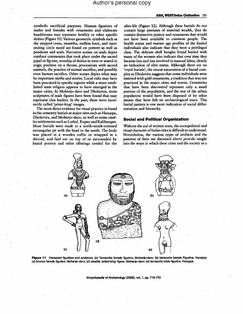
symbolic sacrificial purposes. Human figurines of males and females with ornaments and elaborate headdresses may represent fertility or other specific deities (Figure 11).Various geometric symbols such as the stepped cross, swastika, endless knot, and intersecting circle motif are found· on pottery as well as pendants and seals. Narrative scenes on seals depict outdoor ceremonies that took place under the sacred pipal or fig tree, worship of deities in trees or seated in yogic position on a throne, processions with sacred aniinals, the practice of animal sacrifice, and possibly even human sacrifice. Other 'scenes depict what may be important myths and stories. Local cults may have been practiced in specific regions ·while a moreestabJished' state religion appears to· have emerged in the major cities. At Mohenjo-daro and Dholavira, stone ·sculptures of male figures have been found that may represent clan leaders. In the past, these were incorrectly called 'priest-king' images.
The most direct evidence for ritual practiCe is found in the cemetery burials at major sites such as Harappa, Dholavira, and Mohenjo-daro, as well as some smaller settlements such as Lothal, Rupar, and Kalibangan. Most 'burials were made in a north-south-oriented rectangular pit with· the head to the north. The body was placed in a wooden coffin or wrapped in a shroud, and laid out on top of or surrounded by burial pottery and other offerings needed for the
after-life (Figure 12). Although these burials do not contain large amounts of material· wealth, they do contain distinctive pottery and ornaments that would not have been available to common people. The health status and mature age profiles of the buried
, individuals also indicate that they were a privileged class. The delicate shell bangles found buried with many of the women also indicate that over time they became less and less involved in manual labor, clearly an indication of elite status. Although there are no 'royal burials', the recent excavation of a burial complex at Dholavira suggests that some individuals were interred with gold ornaments, a tradition that was not practiced in the major cities and towns. Cemeteries that have been discovered represent only a, small portion of the population, and the rest of the urban population would have been disposed of by other means that have left no archaeological trace. This burial pattern is one more indication of social differentiation and hierarchy.
Social and Political Organization
Without the aid of written texts, the sociopolitical and ritual character ofIn:dus cities is difficult to understand. Nevertheless, the various types of artifacts and the patterns, of their use· discussed above provide insight into the ways in which these cities and thesociety as a
(d)
(a) (b)
(e)
Figure 11 Harappan figurines and sculpture. (a) Terracotta female figUrine, Mohenjo-daro; (b) terracotta female Figurine, Harappa; (c) bronze fe.male figurine, Mohenjo-daro; (d) steatite 'priest-king' figure, Mohenjo-daro; (e) terracotta male figurine, Harappa.
Encyclopedia ofArchaeology (2008), vol. 1, pp. 715-733

Author's personal copy
732 ASIA, WESTlindus Civilization
Harappa: Female burial, 127a Harappa: Male burial196a
+ + + + + + + + + +
+ N987 + N987
+ +
GrlMlpl+N986 + N986
i ~
+ + 0
i w
+N985 +N98S
N +
t+
Grave pi + N984+ N984'
+ + + + + E1998 EI999 E2000
1mel~
, Figure 12 Harappa burials with pottery and ornaments.
whole was organized. Urban populations would have included adnlinistrative and service classes such as sweepers and garbage, collectors. Wealthy landlords ,and merchants along with their service groups and craftsmen may have occupied the large multiroomed houses. Numerous specialized craftspeople would have been employed by the merchants or worked as entrepreneurs in the urban market places and craft workshops. The' gateways would have been staffed with gatekeepers and tax collectors, while guards would have kept watch at the gateways and on the city walls. Many farmers may have lived inside the city walls in addition to maintaining hamlets close to their fields~
Herders, fisher folk, and hunters may have lived in the city periodically in order to participate in urban markets and to provision the large urban popula'tion. Rural populations would have been'made, up of .farmers and herders, fisher folk, and hunters. Miners an4 specialized craftspeople would have lived near
+ + + + + EI996 E 1997
1meter
major resource areas, and long-distance traders would have moved betweencitiesand resource 'areas to market their goods. '
It is not difficult to reconstruct the many different occupations that are necessary to run a city; but the actUal pol~tical organization is more difficult to define. The lack of palaces, temples, and extravagant burials of hereditary monarchs has'led some scholars to argue that this urban society was not organized as a state, but rather as a complex chiefdom or some other form of nonstate society. Without the aid of written texis, it would be quite difficult to differentiate a complex chiefdom and an early state-level society. Nevertheless, other scholars, including this author, argue that these cities were organized as state-level societies with highly stratified and. hierarchical social organization.
The support for this model is seen in the hierarchy of settlement patterns, the relatively limited use of
Encyclopedia ofArchaeology (2008), vol. 1, pp. 715-733
Author's personal copy
ASIA, WESTlKashmir and the-Northwest Frontier 733
seals, weights and writing by some cO.l11.Qlu:nities living in the city, and the presence of relatively small and intensively used cemeteries that contain individuals "who represent elites.
Instead ofa single dominant gro~p, the rulers of the various cities would have controlled through a corporate structure, similar to that seen in the republics and confederacies of the subsequent Early Historic period. The major ruling communities would have been made up of landlords, merchants, or ritual specialists who shared a common ideology and economic system
"as represented by seals, ornaments, ceramics, and other artifacts. The cities were probably more rigidly
"stratified and segregated than the rural settlements, "but the social organization of the soc~ety as a whole would have been loosely stratified. While the largest cities may have been relatively independent, they were integrated with other settlements though political and economic interaction based on the trade and exchange of important subsistence goods as well as socioritual status items. "
See also: Asia, South: Baluchistan and the Borderlands; Ganges Valley; India~ DecCan and Central Plateau; Kashmir and the Northwest Frontier; Sri Lanka; Cities, " Ancient," and Dally Life; Civilization and Urbanism, Rise of; Craft Specialization; Exchange Systems; Writing Systems.
Further Reading
Allchin R and Allchin B (1997) Origins of a Civilization: The Prehistory and Early Archaeology ofSouth Asia. Delhi: Viking.
Bisht RS (2005) The water structures and engineering of the Harappans at Dholavita (India). In: Jarrige C and Lefevre V (eds.) South Asian Archaeology 2001, voL 1, p. 11-26. Paris: CNRS.
Dales GF and Kenoyer JM (1986) Excavations at Mohenjo Daro, Pakisttm: The Pottery. Philadelphia: Uiliversity Mu~um Press.
Kenoyer JM (1998) Ancient Cities ofthe Indus Valley Civilization. Karachi: Oxford University Press.
Kenoyer JM (2003) Uncovering the keys to the Lost Indus Cities. Scientific American Jul.2003: 67-75.
Kenoyer JM (2006) The origin, context and function of the Indus Script: Recent insights from Harappa. In: Osada T and Hase N (eds.) Proceedings of the Pre-symposium and the 7th ESCA" Harvard-Kyoto Roundtable, pp. 9-27. Kyoto: Research Institute for Humanity and Nature, RIHN.
Lal BB (1997) The Earliest Civilization of South Asia (Rise, Maturity and Decline). New Delhi: Aryan Books International.
Law RW (2005) Regional interaction in the Prehistoric Indus Valley: Initial results of Rock and Mineral Sourcing Studies at Harappa. In: Jarrige C and Lef~reV (eds.) South Asian Archaeo/ogy 2001, vol. 1, p. 179-190. Paris: cNRS.
"Meadow RH and Patel AI< (2003) Prehistoric pastoralism in Northwestern South Asia from the Neolithic through the Harappan Period. In: Weber S and Belcher WR (eds.) Ethnobio/ogy and the Indus Civilization, pp. 65-94. Lanham, ML: Lexington Books.
Mughal MR (1997) Ancient Cholistan: Archaeology and ArChitecture. Lahore: Ferozsons. "
Parpola. A (1994) Deciphering the Indus Script. Cambridge: Cambridge University Press. "
Possehl GL (1999) Indus Age: The Beginnings. New Delhi: Oxford and mH Publishing Co. Pvt. Ltd. "
Possehl GL (2002) The Indus Civilization: A Contemporary Perspective. Walnut Creek: AltaMira Press.
Weber S~ (2003) Archaeobotany atHarappa: IndicationsforChange. In: Weber S and Belcher WR (eds.) Ethnobiology and the Indus Civilization, pp. 175-198. Lanham, ML: Lexington Books.
Wright RP, Schuldenrein J, Khan A, and Mughal MR (2005) The emergence of satellite communities along the Beas Drainage: Preliminary Results from Lahoma Lallibba and Chak Purbane SyaL In: Jarrige C and Lefevre V (ed~.) South Asian Archaeology 2001, voL 1, p. 327-336. Paris:CNRS~
"Kash"mir and "the Northwest Frontier Robin Coningham and Mark Manuel, Durham University. Durham, UK
© 2008 Elsevier Inc. All rights reserved.
GlossarY Early Historic Refer~ to the second emergence of urbanization
in South Asia, dating to the early part of the first millenium BeE through to the mid-first millenium AD. Its historic references are derived from Vedic texts such as the lUg Veda and Mahabharata, texts. The period ends with the e~tablishmentof the Gupta Empire, which witnesses massive chang~s in both political and administrative structures.
Gandhara The name of one of the early Historic Mahajanapadas, situated in northern Pakistan and Afghanistan. Gandhara"was located primarily within the Kabul River valley, the Vale of Peshawar, Potwar Plateau, but had strong links to the Swat Valley. The main citi~ are Charsadda and Taxila. The name has been utilized throughout history to refer to this region and its inhabitants.
Janapada (and Mahajanapada) ]anapada or 'territory' refers to the"emergence of a number of settlements and their hinterlands during the first milleniUril BCE. Competition and internecine fighting between these settlements, resulted in individual centers expanding their control oveJ: neighboringjanapada - resulting in the establishment of the classic sixteen Mahajanapadas or 'Great Territories'.
philhellene Someone who was an admirer of Greek culture, but not necessarily of Greek origin. In this sense, refers to a series of communities within Central and Southern Asia who adopted Greek architecture, coinage, religion, and script or language, but were not of Greek descent.
"satrapy A territory or province that was governed by a governor or client-king. Originating in the Persian Empire, conquered lands were"run as politically and economically, semi-autonomous states, whilst military aspects were centrally controlled and . annual tributes/taXes were paid to the Fmpire. Satrapies were used by later philhellene empires in Central, Southern, and Western Asia. " "
Encyclopedia ofArchaeology (2008), vol. 1, pp. 715-733