protocols for hydrologic classification and a review...
TRANSCRIPT

Appendix 2 Protocols for hydrologic classification and a review of Australian applications JD Olden1 CA Reidy Liermann1 BJ Pusey2 and MJ Kennard2
1 School of Aquatic and Fishery Sciences University of Washington Seattle Washington USA 2 Australian Rivers Institute Griffith University Nathan Queensland Australia
1
Summary Hydrologic classification is the process of systematically arranging streams rivers or catchments into groups that are most similar with respect to characteristics of their flow regime Previous classification efforts have relied on a plethora of hydrologic metrics that account for characteristics of flow variability that are hypothesised to be important in shaping ecological and physical processes in lotic ecosystems We review the process of hydrologic classification by (i) exploring its past application in the ecological sciences (ii) reviewing existing statistical approaches to identify and characterise hydrologic classes and (iii) providing a methodological framework for hydrologic classification that depicts critical components of the classification process Ecologists have used hydrologic classification to place individual streams and rivers into a broader spatial context with the goal of maximising the transferability of knowledge among rivers of the same hydrologic class Regionalisation analyses to predict streamflow behaviour in ungauged catchments often comprise a set of regression models based on several different classes of certain hydrological information at gauged sites Consequently by dividing a study area into homogeneous groups that are considered to exhibit similar hydrologic characteristics records may be extrapolated with more precision and regionalisation models based on catchment characteristics may be used with greater confidence Hydrologic classification plays a central role in environmental flow assessments aimed at the development of ecologically sustainable practices for water management Holistic methods to assess environmental flows either implicitly or explicitly involve the hydrologic classification of rivers as they can help establish the expected ecological condition of river basins by class which alleviates the burden of developing ecological standards on a river-by-river basis Recent interest has focused on the conservation planning of freshwater ecosystems for regional-scale biodiversity and hydrologic classification may be a useful tool for the targeted management of streams rivers or entire catchments with representative flow regimes and therefore representative biological communities A variety of classification techniques have been used in the past to derive hydrological classifications and regionalisations These include hierarchical and flat clustering algorithms self-organising maps multivariate ordination and hard and soft classification algorithms such as fuzzy clustering and Bayesian classification We reviewed the different methods available and the information needs and processes required to satisfy several statistical assumptions and requirements We used a protocol for classification that addresses issues about data quality and comparability choice of classification method and assessment of results We also reviewed previous applications of hydrological classification in Australia covering Australian examples of both hydrological and ecohydrological classifications but coverage of the former is not exhaustive These prior classifications provided a means of comparing the outcomes of the classification developed in the present project
2
21 Introduction Hydrologic classification is the process of systematically arranging streams rivers or catchments into groups that are most similar with respect to characteristics of their flow regime This process has frequently been applied by hydrologists seeking to extend insights gained from well-gauged regions to ungauged or sparsely gauged regions or rivers (Bates 1994) Typically only specific components of the flow regime are included (eg flood series) (Nathan and McMahon 1990 Bower et al 2004) Hydrologic classification is playing an increasing role in the ecological sciences for understanding riverine flow variability (Mosley 1981 Haines et al 1988 Poff 1996 Harris et al 2000) exploring the influence of streamflow on biological communities and ecological processes (Jowett and Duncan 1990 Poff and Allan 1995 Pusey et al 2000 Snelder et al 2004 Monk et al 2006 2007) aiding hydrologic modeling in regionalisation analyses (Nathan and McMahon 1990) providing an inventory of hydrologic types for water resource management (Snelder and Biggs 2002 Wolock et al 2004 Arthington et al 2006) and prioritising conservation efforts for freshwater ecosystems (Nel et al 2007 Snelder et al 2007) Consequently hydrologic classification has practical use as an organising framework for both river research and management purposes Three broad categories of hydrologic classification exist that serve to describe flow regime similarities among rivers those according to geographic proximity environmental attributes or hydrologic characteristics Geographical regions have been identified based upon political administrative river basin and climatic boundaries (Arnell et al 1990) The delineated regions are located in close geographic proximity to one another however this often does not guaranteed that the regions will be hydrological homogenous An alternative approach is to define classes based on the environmental factors that are assumed to broadly produce similar hydrological responses This represents a deductive approach to hydrologic classification that is often geographically-independent and depicted by a mosaic pattern of hydrologic types across the landscape (Detenbeck et al 2000) Numerous physical-based or geomorphic classifications of rivers have been conducted including those based on geology topography and climate (eg Kondolf 1995) as well as combined hydrogeomorphic typologies (eg Snelder and Biggs 2002 Snelder et al 2005 Dollar et al 2007 Schmitt et al 2007 reviewed in Kondolf et al 2003) These classifications are common but do not reflect only hydrological variation because they encompass more general principles concerning the causes of spatial variation in ecological characteristics of streams and rivers To overcome these difficulties delineating patterns in hydrologic character have also been identified directly through empirically-based methods that use hydrologic metrics describing different components of the multi-facet riverine flow regime In this application hydrologic classification schemes attempt to provide order to inherently complex flow data by identifying and characterising similarities among rivers according to a set of diagnostic hydrologic attributes that vary spatially across the landscape (Mosley 1981 Jowett and Duncan 1990 Poff 1996 Harris et al 2000) This approach to hydrologic classification is the focus of this section A number of hydrologic characteristics comprise the natural flow regime including the seasonal patterning of flows timing of extreme flows the frequency predictability and duration of floods droughts and intermittent flows daily seasonal and annual flow variability and rates of change (Poff et al 1997) Accordingly previous classification efforts have relied on a plethora of hydrologic metrics that account for characteristics of flow variability that are hypothesised to be important in shaping ecological and physical processes in lotic ecosystems (Hughes 1987 Poff and Ward 1989 Hughes and James 1989 Pusey and Arthington 1996 Richter et al 1996 Poff et al 1997 Puckridge et al 1998 Clausen and Biggs 2000 Harris et al 2000 Bunn and Arthington 2002 reviewed by Olden and Poff 2003 Bower et al 2004 Monk et al 2006) Many of these metrics have proven to be highly suitable for hydrologic classification Moreover these aspects of the hydrologic regime are likely to be most frequently altered
3
by human activities such as river regulation by dams (Poff et al 2007) and are predicted to be sensitive to global climate change (Milly et al 2005) Researchers have applied a number of statistical approaches and used a variety of hydrologic metrics in attempts to develop hydrologic classifications at catchment regional national continental and global scales (Table 21) For example efforts at global or continental scales have primarily focused on certain aspects of the hydrograph such as seasonality flood behaviour or low flow characteristics whereas regional classifications have utilised a larger suite of hydrologic metrics Challenged by the need to quantify flow similarities among rivers and map their distribution across hydrologic landscapes (sensu Winter 2001) ecologists have turned to a bewildering array of statistical approaches using an equally diverse set of protocols to conduct their hydrologic classification (Table 21) During the last two decades considerable effort has gone into analysis and development of methodological approaches to hydrologic classification As a result several groups of methods are in use and to-date no single approach has been demonstrated to yield universally acceptable results Consequently most researchers reach into their same statistical toolbox when required to tackle a classification problem and are unaware of important considerations and new techniques available to them Herein we review the process of hydrologic classification by (i) exploring its past application in the ecological sciences (ii) reviewing existing statistical approaches to identify and characterise hydrologic classes and (iii) providing a methodological framework for hydrologic classification that depicts critical components of the process in order that researchers will be better informed regarding the selection and proper implementation of methods for hydrologic classification To close we also review the outcomes of prior attempts to classify Australian rivers and suggest an appropriate way to proceed with a classification of Australian flow regime types
22 Ecological applications of hydrologic classification
Hydrologic classification has been conducted for a number of purposes in ecology Below we briefly highlight some of the more common applications of hydrologic classification in the literature 221 Increasing our understanding of flow variability among streams and rivers
by identifying hydrologic classes Ecologists have used hydrologic classification to place individual streams and rivers into a broader spatial context with the goal of maximising the transferability of knowledge among rivers of the same hydrologic class and to show broader application of intensely studied sites to unstudied sites (Table 21) Hydrologic classes are expected to have similar biological responses to both natural and human-induced variability in patterns of magnitude frequency duration timing and rate of change in flow conditions Consequently systems that show commonalities in their hydrologic characteristics have provided a basis for testing whether hydrology influences the structure and function of biological communities in a similar fashion (eg Poff and Ward 1989 Jowett and Duncan 1990 Poff and Allan 1995 Snelder et al 2004) Recent efforts have also focused on how rivers in different classes vary with respect to the degree of human influence (eg land use river regulation) thus providing a benchmark against which the response of biological communities to these factors can be assessed
4
222 Hydrologic classification for the purposes of guiding regionalisation analyses Classification has a long history of use in the regionalisation of hydrologic models that attempt to achieve continuous streamflow predictions in ungauged basins (eg Tasker 1982 Nathan and McMahon 1990 Abdulla and Lettenmaier 1997 Merz and Bloeschl 2004 Wagener et al 2007 Yadav et al 2007) Regionalisation analyses often comprise a set of regression models based on several different classes of certain hydrological information at gauged sites Consequently by dividing a study area into homogeneous groups that are considered to exhibit similar hydrologic characteristics records may be extrapolated with more precision and regionalisation models based on catchment characteristics may be used with greater confidence 223 Developing environmental flow recommendations for water resource
management Hydrologic classification plays a central role in environmental flow assessments (Tharme 2003) aimed at the development of ecologically sustainable practices for water management (Richter et al 2006) Holistic methodologies to environmental flow assessments such as the application of the benchmarking methodology (Brizga et al 2002) Downstream Response to Imposed Transformations (DRIFT King et al 2003) and the Ecological Limits of Hydrologic Alteration (ELOHA Poff et al in review) either implicitly or explicitly involve the hydrologic classification of rivers to varying extents Arthington et al (2006) describe how the classification of undeveloped rivers can help establish the expected ecological condition of river basins by class which alleviates the burden of developing ecological standards on a river-by-river basis As a result environmental flow rules for rivers with detailed data can provide interim recommendations for rivers in the same class where data are sparse and the response of biota to hydrological patterns is unknown but may be assumed to be similar to those occurring in hydrologically similar rivers for which flow ecology relationships are known 224 Identifying and prioritising conservation efforts for freshwater ecosystems Recent interest has focused on the conservation planning of freshwater ecosystems for regional-scale biodiversity (eg Saunders et al 2002 Moilanen et al 2008) Hydrologic classification may be a useful tool for the selection of streams rivers or entire catchments with representative flow regimes and therefore representative biological communities (Nel et al 2007 Poff et al 2007)
23 Methodological approaches to hydrologic
classification The strategy of hydrologic classification is to ascribe objects (ie streams rivers catchments) to empirically-based groupings or classes so as to maximise the similarity between the members of each group and minimise the similarity between groups Because of the many ways that magnitude and variability of flow can be characterised (Olden and Poff 2003) analysing hydrologic metrics using a multivariate approach is an effective means to determine similarities or differences among andor within rivers The multivariate techniques for identifying classes of river and organising them into a hydrologic topology are numerous and vary in output properties such as whether the classes are hierarchical or flat whether boundaries between classes are hard (ie defined) or soft (ie fuzzy) andor whether rivers can belong to one or more classes (described in detail below) As Nathan and McMahon (1990) point out a major problem encountered when using cluster analysis for hydrologic classification is the
5
plethora of different linkage algorithms and distance measures available Unfortunately different clustering techniques applied to the same set of data will often produce structures that are substantially different This is because the choice of a clustering method implicitly imposes a structure on the population and is often tantamount to defining a structure Therefore the choice of statistical approach used in hydrologic classification is critical Below we provide a preliminary review of different methodologies that have been used to develop hydrologic classifications in the past and finish by describing differences between hard versus soft classifications 231 Hierarchical and flat clustering algorithms Both hierarchical and flat clustering algorithms have been used to develop hydrologic classifications (Table 21) Hierarchical clustering proceeds iteratively by either combining smaller clusters into larger ones (agglomerative) or by splitting larger clusters to smaller ones (divisive) to produce a classification of objects typically presented as a dendrogram of clusters Flat clustering techniques identify clusters of equal distinction and thus are not represented in a hierarchy Certain algorithms can be adapted to provide either hierarchical or flat classifications Gordon (1987) provides a good overview from a statistical perspective Rao and Srinivas (2006) outline eight common algorithms for agglomerative hierarchical clustering of rivers according to their flow regimes 1) single linkage or nearest neighbor 2) complete linkage or furthest neighbor 3) average linkage (UPGMA) 4) weighted average linkage 5) centroid 6) median or weighted pair-group centroid 7) density or k-linkage and 8) Wardrsquos algorithm The k-means algorithm is a commonly employed divisive clustering technique for non-hierarchical classification The algorithm groups cases according to Euclidian distance from initial randomly chosen cluster centers of a predetermined number Then it iteratively redefines cluster centers as the means of the cases in the latest cluster until cases no longer change membership The method is efficient for large datasets and results are often sufficient although subjectivity of the initial cluster centroids must be considered Hierarchical and flat clustering methods can be used in tandem to optimise hydrologic classification (called hybrid clustering) For example Rao and Srinivas (2006) used a partitional clustering procedure to identify groups of similar catchments by refining the clusters derived from agglomerative hierarchical clustering algorithms using the k-means algorithm Similarly Kahya et al (2007) considered results of a hierarchical average-linkage algorithm to help identify an optimal number of clusters for subsequent flat classification using k-means Determining the number of clusters is a problem inherent to most if not all conventional clustering techniques For flat algorithms the number of clusters must be predetermined before the patterns of input data have even been analysed For hierarchical algorithms selection of the degree of cluster distinction between tiers is subjective Several approaches for optimising the number of clusters have been discussed in the literature 232 Self-organising maps Machine learning approaches provide a powerful set of tools for analysing complex ecological data (Olden et al 2008) Self-organising maps (SOM Kohonen 1982 2000) provide a means of representing high-dimensional data in a low-dimensional view typically a two-dimensional map The goal is for the map to retain topological properties of the input data in contrast to information losses common to other data-reduction techniques such as principal component analysis Using SOM as a framework for performing cluster analysis and discrimination analysis of hydrological factors in one step has been presented by Lin and Wang (2006) as a novel and efficient method for hydrologic classification Their
6
SOM-based cluster and discrimination analysis (SOMCD) produces three maps in a single step for use in classification The feature density and discrimination maps can be used to assign unknown catchments to classes at one time eliminating the step of post-clustering discriminant analysis for each unknown catchment As well the ability to define the number of clusters at multiple resolutions from the feature and density maps is argued as a top advantage of the method 233 Multivariate ordination Multivariate ordination techniques including principal components analysis (PCA) and principal coordinate analysis have been used to develop (or aid in) hydrologic classification (Table 21) PCA involves a mathematical procedure that transforms a number of (possibly) correlated variables into a (smaller) number of uncorrelated variables called principal components The first principal component accounts for as much of the variability in the data as possible and each succeeding component accounts for as much of the remaining variability as possible (Legendre and Legendre 1998) In many applications the composition scores from a small number of principal components are retained and then clustered to identify rivers with similar flow regimes (Table 21) 234 Hard versus soft classification Clustering algorithms can lead to either hard or soft (ie fuzzy) classifications A hard clustering method is based on the assumption that feature vectors can be divided into non-overlapping clusters with well-defined boundaries between them Each feature vector is assigned to one of the clusters with a degree of membership equal to unity In other words a catchment is classified as belonging to a cluster on the basis of distance (or dissimilarity) between the catchment and the cluster centroid in the multi-dimensional space of attributes depicting the flood response of catchments A brief review of hard clustering algorithms in regionalisation is found in Srinivas et al (2002) and Rao and Srinivas (2003) It is reasonable to suppose however that most catchments partially resemble several catchments and therefore assigning a catchment to one region (cluster) or another may not be justified Consequently identification of regions with vague boundaries between them is preferable compared to crisp regions with well-defined boundaries as in the case of hard clustering The fuzzy set theory (Zadeh 1965) which straddles ordination classification and clustering analysis (Roberts 1986) is a natural way to represent such a situation Fuzzy partitional clustering allows a catchment to belong to all the regions simultaneously with a certain degree of membership The distribution of membership of a catchment among the fuzzy clusters specifies the strength with which the catchment belongs to each region The knowledge of this distribution is particularly useful to identify ambiguous catchments A threshold to maximum membership values can be applied to derive crisp vector-based representations from raster fuzzy classifications Rao and Srinivas (2006) argue that given the intricate process interactions controlling channel morphology and the inadequacies of conventional stream classification methods fuzzy representations of in-stream habitat present an appealing alternative Another fuzzy partitional method available is Bayesian mixture modeling (Gelman et al 2004) In this approach the observed distribution of data is modeled as a mixture of a finite number of component distributions in order to determine the number of distributions their parameters and object memberships (Webb et al 2007) The approach is fully probabilistic and uncertainty can be explicitly reported in terms of data specification class specification and the final classification chosen (Cheeseman and Stutz 1996 Webb et al 2007) Multiple plausible classifications are produced which are then ranked on their estimated marginal likelihoods to select the most parsimonious classification that is guaranteed to have the highest posterior probability the probability of the model being correct given the data (Cheeseman and Stutz 1996 Gelman et al 2004 Webb et al 2007)
7
Table 21 Examples of hydrologic classifications of riverine flow regimes Flow regime attributes Magnitude (M) Frequency (F) Duration (D) Timing (T) Rate of Change (R) Temporal scale (of the flow regime attributes analysed) Daily (D) Monthly (M) Annual (A) NOTE This table presents the results from a preliminary review of the literature Spatial Scale
Location Flow attributes
Temporal scale
Classification methodology Reference(s)
Basin
Burdekin River north-eastern Australia
M F D T D M A Principal components analysis and discriminant functions analysis
Pusey and Arthington (1996)
CondaminendashBalonne River Australia
M F D T R D M A Flexible-unweighted pair-groups using arithmetic averages (UPGMA) fusion strategy
Thoms and Parsons (2003)
Missouri and
lower Yellowstone Rivers USA
M T M A Hierarchical agglomerative cluster analysis using group centroid method
Pegg and Pierce (2002)
Tagus River Spain
M F D T D M A Method not stated Baeza Sanz and Garcia del Jalon (2005)
Regional
Victoria Australia
D PCA amp average linkage clustering Hughes and James (1989)
Tasmania Australia
D PCA amp complete linkage clustering Hughes (1987)
South-eastern Australia
M D R DM Ordination Growns and Marsh (2000)
Quebec Canada
M D T R M PCA amp heuristic classification method (based on rules and signs of loadings on PCrsquos)
Assani and Tardif (2005)
Alabama Georgia amp Mississippi USA
M T M Hierarchical agglomerative cluster analysis using average linkage method
Chiang et al (2002a) (see also Chiang et al (2002b))
Indiana USA M T D M A Hierarchical clustering algorithms based on single linkage complete linkage and Wardrsquos algorithms while the partitional clustering algorithm used is the K-means algorithm
Rao and Srinivas (2006)
Arizona USA M F D A Hierarchical agglomerative cluster analysis using complete linkage method
Tasker (1982)
Southern Taiwan
M T F Cluster analysis and discrimination analysis in one step using self-organising maps
Lin and Wang (2006)
South-eastern Australia
NA Physical catchment variables identified as important predictors of low flow characteristics were classified using cluster analyses
Nathan and McMahon (1990)
8
Spatial Scale
Location Flow attributes
Temporal scale
Classification methodology Reference(s)
NationalContinental
Australia M T M Hierarchical agglomerative cluster analysis using within-group average method with cosine similarity measure
Finlayson and McMahon (1988)
United Kingdom
M T M Two-stage procedure (i) hierarchical agglomerative cluster analysis using Wardrsquos method followed by (ii) non-hierarchical k-means cluster analysis
Bower et al (2004) (see also Harris et al (2000) Hannah et al (2000))
Austria M T D PCA amp partitive cluster analysis (partitioning around medoids (PAM)
Laaha and Bloumlschl (2006a) (see also Laaha and Bloumlschl (2006b))
Australia F T D An orthogonal Haar wavelet transform was used to describe the temporal multi-scale variability of the streamflow The spatial organisation of this spectral multi-scale variability was organised using k-means analysis
Zoppou et al (2002)
United Kingdom
M T M Hierarchical agglomerative cluster analysis using Wardrsquos method
Monk et al (2006 2007) (see also Harris et al (2000) Hannah et al (2000) Bower et al (2004))
United Kingdom
M T M Hierarchical agglomerative cluster analysis using average linkage
Harris et al (2000) (see also Hannah et al 2000))
Nepal M T M Hierarchical agglomerative cluster analysis using Wardrsquos method
Hannah et al (2005) (see also Harris et al (2000) Hannah et al (2000) Bower et al (2004))
Sweden M T M Pairwise group arithmetic average amp PCA
Gottschalk (1985)
United States M T Y PCA amp visual assessment Lins (1985) USA M F D T D M A Non-hierarchical cluster analysis
using k-means Poff and Ward (1989)
USA M F D T D M A A priori (permanent vs intermittent) amp density linkage (based on all flow metrics)
Poff (1996)
USA (five river basins)
M F D T D M A UPGMA agglomerative clustering (Euclidean distances) (also PCA)
Poff et al (2006)
New Zealand M D Hierarchical cluster analysis (using BMDP2M cluster analysis program)
Mosley (1981)
New Zealand M F D A Two-way indicator species analysis (TWINSPAN)
Jowett and Duncan 91990)
9
Spatial Scale
Location Flow attributes
Temporal scale
Classification methodology Reference(s)
Tanzania M F A Three-step process (1) Geographic information was used to identify likely homogeneous regions that are geographically continuous (2) Each region that was identified in the previous step was checked for similarity in the statistics of observed flood data Based on this step regions obtained in step (1) were modified (3) A test of homogeneity was applied to confirm that the delineated regions were statistically homogeneous
Kachroo and Mkhandi (2000)
Turkey M A Non-hierarchical k-means cluster analysis
Kahya et al (2007)
South Africa Lesotho and Swaziland
T M M Index of variability (CVB = CVBFI) divided into 8 statistically derived classes (using cumulative deviations from homogeneity plots)
Hughes and Hannart (2003) Nel et al (2007)
Scandinavia M T M Flow regime class discriminating criteria based on the time of occurrence of the highest (3 classes) and lowest (2 classes) of mean monthly flow
Gottschalk et al (1979) Krasovskaia and Gottschalk (1992 2002)
Scandinavia and western Europe
M T M Flow regime class discriminating criteria based on the time of occurrence of the highest (3 classes) and lowest (2 classes) of mean monthly flow
Krasovskaia et al (1994) (see also Krasovskaia (1995))
Scandinavia M T M A Two-step approach (1) Flow regime class discriminating criteria based on the time of occurrence of the highest (3 classes) and lowest (2 classes) of monthly flow (2) entropy based groupings based on interannual variation in monthly flows (allows quantification spatial variation in the temporal regularity of seasonal flow patterns defined in step 1)
Krasovskaia (1997) (see also Krasovskaia et al (1999))
Southern Africa
M A Delineated flexible homogeneous regions based on available information on topography mean annual rainfall drainage pattern and maximum flood peak regions
Mkandi and Kachroo (1996)
Europe amp UK M T F D Hierarchical agglomerative cluster analysis using Wardrsquos method
Stahl (2001)
France M T M Proportion of flow within each of four seasons together with estimation of the genetic origin of flow (ie snow melt glacier melt rainfall)
Parde (1955) (see Sauquet et al (2000) for application)
10
11
Spatial Scale
Location Flow attributes
Temporal scale
Classification methodology Reference(s)
Russia M T M Proportion of flow within each of four seasons together with estimation of the genetic origin of flow (ie snow melt glacier melt rainfall and groundwater) The mean average monthly flow pattern satisfying the discriminating criteria is assigned a certain regime type
Lvovich (1973) (see Krasovskaia (1997))
Global
M T M A Hierarchical agglomerative cluster analysis using within-group average method with cosine similarity measure Simplified version using decision tree with empirical rulesalgorithms
Haines et al (1988)
M A Two-step approach (1) initial groupings based on regions of similar climatic conditions (based largely on Koppens Climate Classification) A hierarchical agglomerative cluster analysis using the within-group average method was subsequently used to create a smaller number of groups based on similarity in annual maximum discharge
Burn and Arnell (1993)
M F A Examined regional variation in mean annual flood magnitudes and flood frequency curves where regions were defined using an empirical approach based firstly on physical and climatic characteristics and second by evaluation of the homogeneity of flood frequency curves within the defined regions
Meigh et al (1997)
M F D T R D M A Agglomerative hierarchical fusion (flexible UPGMA) on the BrayndashCurtis matrix
Puckridge et al (1998)
M T M Hierarchical agglomerative cluster analysis using within-group average method with cosine similarity measure
Finlayson and McMahon (1988)
M T M Non-hierarchical k-means cluster analysis
Dettinger and Diaz (2000)
24 A framework and protocol for hydrologic classification
Hydrologic classification should be an objective process transparent readily interpretable explicitly account for uncertainty and for variability at multiple temporal and spatial scales explicitly regard methodological biases and robustness and provide definable class boundaries objective group membership and information on the diagnostic hydrologic characteristics of each class We believe that for a hydrologic classification system to be widely adopted it must be founded on a defensible scientific framework (Figure 21) Below we provide specific guidelines for achieving this goal 1 Define purpose of the study geographic region of interest and objectives of the hydrologic
classification 2 Acquire and assess hydrologic data
a) What discharge data are available (gauged versus modeled data temporal grain ndash daily monthly or annual time period geographic coverage)
b) Select candidate set of gauges (if using gauged discharge data) c) If your purpose is to classify lsquonaturalrsquo flow regimes then select gauges that are not
likely to be affected by anthropogenic factors (eg dams water extraction land use) using best available information (eg spatial patterns of land use dam location and attributes expert knowledge and input from water managers etc)
d) Evaluate quality of discharge data (ie missing data poor quality measurement recordings as indicated by quality codes) and eliminate gauges with missing data and unsatisfactory gauge recordings
e) Ensure consistency of discharge measurement units among gauges (eg m3sec-1 versus MLday-1)
f) Evaluate temporal period (eg 1965ndash2000) and duration (ie 35 years) of available discharge data for each gauge
g) Decide on criteria for acceptance of gauges (ie minimum versus fixed record length completely overlapping versus partially overlapping period of record period of record to include particular years such as years including significant changes in climate)
h) Evaluate geographic locations of gauges to ensure adequate spatial coverage (ie representing climate regions of interest)
i) If the spatial coverage is not adequate then evaluate potential for including additional gauges by
i relaxing the acceptance criteria (step 2g) andor ii estimating missing data in the discharge time series (step 2d) by using linear
interpolation for short periods general linear regression for longer periods or some other appropriate technique
Note that relaxing the acceptance criteria will decrease the comparability of gauges and estimating missing data will increase the measurement uncertainty of flow data Both options will compromise accuracy and precision of classification results (although some hydrologic metrics are more sensitive to record length and period overlap than others)
12
3 Choose hydrologic metrics to include in the hydrologic classification
a) The selection of metrics depends primarily on purpose of the study (step 1) One might be interested in selecting a large number of metrics to characterise all facets of the flow regimes or individual metrics of knownhypothesised ecological importance (see Olden and Poff 2003)
i General ecological rationale set of metrics to characterise the totality of the flow regime
ii Specific ecological rationale individual metrics of knownhypothesised ecological importance for specific species community or ecosystem properties
iii Driver rationale metrics that are sensitive to an environmental or anthropogenic driver of interest (eg urbanisation river regulation climate change)
b) Selection depends on temporal grain of flow data c) Selection depends on intended software used to calculate metrics and practical
capability of the researcher Software options include dedicated hydrologic software (Indicators of Hydrologic Alteration (IHA) Richter et al 1996 Hydrologic Assessment Tool (HAT) Henriksen et al 2006 River Analysis Package (wwwtoolkitnetaurap) versus statisticalmathematical software
d) Selection based on quantifying statistical redundancy among metrics using univariate and multivariate approaches The results will inform variable selection and dimensionality reduction (eg indirect ordination approaches to produce composite variables) if multicollinearity among metrics is a concern (see Olden and Poff 2003)
e) No choice Hydrologic classification will proceed using the raw discharge time series
4 Compute hydrologic metrics
a) Calculate the hydrologic metrics for each flow record according to decisions made in step 3
b) Screen datasets for outliers andor gauges potentially affected by anthropogenic activity by
i Examining diagnostic plots and descriptive statistics ii Conducting indirect ordination (eg principal components analysis) plotting
ordination scores of gauges in 2-dimensional space and looking for outliers that might be suggestive of modified flows unique natural flows or measurementdata entry errors
iii Plotting mean daily flow (or similar hydrologic metric) against catchment area (gauges with obviously lower discharge than expected for a given catchment size may be effected by water extraction)
c) Eliminate gauges if necessary d) Remove scale-dependence of flow magnitude metrics (if required depending on
objectives of the study) by standardising metrics by catchment area or mean daily flow
5 Conduct the hydrologic classification
a) Choose statistical approach depending on objective of classification software and capability of the researcher (see review below)
b) Decide which hydrologic metrics to include in classification analysis i All flow metrics
13
ii Subset(s) of metrics describing separate components of flow regime (this decision depends on the reason for classification see step 1)
iii Prune the total number of flow metrics to a smaller set of high-information non-redundant flow metrics (see Olden and Poff 2003)
iv Choice of metrics might also be dependent on statistical assumptionsrequirements (data type normality etc) of classification approach
c) Decide whether metric transformationsstandardisations are required d) Choose appropriate distancesimilarity measure (if required) e) Conduct classification analysis f) Delineate clusters and decide on the number of hydrologic classes (ie clusters) class
membership and probabilities of class membership (see below) g) Examine classification results for outliers and eliminate gauges if necessary repeat
steps 5dndashf 6 Interpret the hydrologic classification
a) Describe hydrologic characteristics of hydrologic classes numerically statistically
graphically and verbally b) Examine geographic distribution of gauge class membership (eg using a Geographic
Information System) c) Optionally validate the classification model using an independent dataset containing
gauges not included in the classification or based on a set of environmental variables describing each gauge that are considered the most important for shaping flow regime characteristics (ie the results of a physical-based classification)
14
4 Calculate hydrologic metricsa) Calculate metricsb) Screen datasets for outliers andor unnatural flow regimes by
i Examining diagnostic plots and descriptive statisticsii Conducting indirect ordination and plotting ordination scores in 2-dimensional space iii Plotting hydrologic metrics against catchment area
c) Eliminate gauges if necessaryd) Remove scale-dependence of flow magnitude metrics (if required)
1 Define study purpose of the study geographic region of interest and objectives of classification
2 Acquire and assess hydrologic dataa) What discharge data is availableb) Select candidate set of gauges c) Eliminate gauges with modified flow regimes d) Eliminate gauges with poor quality datae) Ensure consistency of discharge measurement unitsf) Evaluate temporal period and duration of record g) Decide on criteria for acceptance of gauges with respect to 2f h) Evaluate geographic coverage of gauges i) Evaluate potential for including additional gauges by
i relaxing acceptance criteria (Step 2g) andorii estimating missing data in time series (Step 2d)
3 Choose hydrologic metrics to characterize flow regimesa) Depends on purpose of the study
i General ecological rationale (all facets of the flow regime)ii Specific ecological rationale individual metrics of ecological importanceiii Driver rationale metrics that are sensitive to environmental drivers
b) Depends on temporal grain of flow data c) Depends on software used to calculate metrics and researcher capabilityd) Removal of statistical redundancye) No choice (time series)
5 Conduct the hydrologic classificationa) Choose statistical approachb) Decide which hydrologic metrics to include in classification analysis
i All flow metrics ii Subset(s) of metrics for separate components of flow regime iii Small set of high information non-redundant flow indices iv Dependent on statistical assumptionsrequirements of classification approach
c) Decide whether metric transformationsstandardisations are requiredd) Choose appropriate distancesimilarity measure (if required)e) Conduct classification analysisf) Delineate clusters
g) Examine for outliers eliminate gauges if necessary repeat step 5d
6 Interpret the hydrologic classificationa) Describe hydrologic characteristics of clusters b) Examine geographic distribution of gauge cluster membership c) External validation using independent environmental data
Figure 21 A protocol for the process of hydrologic classification
15
25 The development and application of hydrological classifications in Australia
Hydrological classification of Australian rivers has been previously undertaken at a variety of spatial scales (Bates 1994) Typically these undertakings have been primarily motivated by the need to extend known relationships about hydrological data to poorly gauged areas to assist in water management and civil engineering projects (ie bridge construction) In addition some of the studies reviewed here do not consider actual daily flow data but consider environmental data that act as proxies for flow and frequently model a limited subset of hydrological parameters (ie flood series or low flows) using hydrological parameters that are not commonly used by biologists or that are not immediately perceived to have ecological relevance (McMahon and Finlayson 2003) Rarely are such studies undertaken with any ecological applicability in mind Typically also such endeavors are referred to as regionalisations rather than classifications as the primary intent is the derivation of mathematical relationships describing hydrological behaviour for a given region (eg Nathan and McMahon 1990) It is not our intent to review these studies here but to focus on ecologically-oriented classifications (although strictly hydrological studies do reveal some noteworthy insights into the nature of Australian flow regimes and such studies are discussed) 251 Classification at the basin scale Studies that have examined ecohydrological variation within a single river or a basin (ie catchment) that consists of several rivers are considered first Thoms and Parson (2003) undertook a classification of flow data from 43 locations within the Condamine-Balonne River which with the Maranoa River forms a major headwater source of the Darling River They used 73 years of modeled daily flow data for two water resource development scenarios (no development scenario and current water resource development scenario) to calculate many summary flow statistics (227 and 230 for the two scenarios respectively) addressing most key facets of the flow regime (Poff et al 1997) across three temporal scales (pulse history and regime) The similarity matrix upon which classification (UPGMA) and ordination (Semi Strong Hybrid Multidimensional Scaling) analyses were based was estimated using the Gower Index which standardises units across each variable Prior standardisation of magnitude variables (ie by reference to catchment area or median daily flow) was not employed No redundancy analysis was conducted prior to multivariate analyses and all variables were allowed into each analysis Significant redundancy is evident in the pictorial representations of significant correlation (as determined by the principal axis correlation analysis) between objects and attributes in ordination space Six groups of locations (modeled gauges) were formed by the classification aligned down the river in a sequence corresponding to spatial variation in a previously described geomorphicriver classification sequence for the study area Although this sequential alignment of flow regime and geomorphology may have arisen because magnitude variables were not scaled to become essentially dimensionless prior to inclusion in the multivariate analyses Thoms and Parsons (2003) argue the interaction between flow and channel morphology determines the regime state particularly with respect to spatial variation in temporal facets of the regime These authors demonstrated that different sets of temporal parameters equating to the time scales described above became dominant contributors to the regime signature within various geomorphic zones
16
Pusey and Arthington (1996) examined the spatial variation in the hydrologic regime of the Burdekin River in central Queensland A common 19 year period of daily flow records for 26 gauges arrayed throughout the catchment was examined Gauges were grouped a priori based on landscape attributes (geographic position subdrainage membership and river type) and a moderately concordant pattern of spatial variation in freshwater fish structure (Pusey et al 1998) The investigation was primarily focused on describing spatial variation in hydrological variability and the choice of metrics used was consequently limited (n = 15) to statistics describing the variability of flows across different time periods (CV of daily monthly and yearly flows) metrics quantifying predictability (Colwellrsquos P) of monthly minimum monthly maximum monthly totals and ratio of maximum to minimum daily flows and an annual exceedance frequency of a low flow threshold Average annual and daily flows were also included but these metrics were not standardised (made dimensionless) prior to analysis A formal examination of redundancy was not performed but an analysis of the relationship between catchment area and hydrological metrics demonstrated that across all gauges only mean annual and daily flow were related to catchment area However within some of the a priori formed groups catchment area was correlated with up to six parameters in addition to mean annual flow Discriminant functions analysis (stepwise) was used to test whether discharge regime varied predictably throughout the catchment Eleven of the 15 parameters including mean annual flow varied significantly between groups and consequently highly significant concordance between flow regime and position in the catchment was detected (100 successful classification) Spatial variation in flow regime was largely due to gradients in perenniality and the variability of minimum maximum and mean daily flows and was related to spatial variation in rainfall and underlying geology The resultant classification was discussed with respect to the difficulty of setting environmental flow limits in systems of contrasting variability and origins of that variability Ransley et al (2007) used a GIS map-based approach to classify and spatially model stream-aquifer connectivity in the Border Rivers catchment of the Murray-Darling Stream-aquifer connectivity was identified as being both economically (ie with respect to water allocation) as well as ecologically important (ie environmental flow and water quality management) The authors building on similar approaches developed for the rivers of inland NSW (Braaten and Gates 2002) identified four key determinants of connectivity These were bull depth to the water table (DWT ndash estimated from existing bore hole data from state
agencies) bull stream bed sediments (SBS ndash derived from Layer 2 gridded (11 km2 grain) NLWRA
(1999) soil saturated hydraulic conductivity national data set) bull geology (G ndash existing maps and state water agency lithological logs for low-lying areas
classed as undifferentiated alluvium) bull geomorphology (GM ndash Multi resolution Valley Bottom Flatness Index derived from the 9
inch DEM) Values were scaled and combined according to the formula connectivity index = 3DWT + 5SBS + 5G + 2GM qualitatively classified as low medium and high and mapped The relevance of the resultant classification to ecological management was not developed although the authors suggest that the method has value as a lsquofirst cutrsquo approach to identifying areas where groundwatersurface water interactions may be important The extent to which this method can be extended elsewhere relies on the availability of spatial information and the resolution (grain) of that information and to this effect may be limited in its application to much of northern Australia where geology is coarsely mapped
17
Map-based GIS information gauged and modeled flow data and waterhole characteristics (eg size persistence etc) were combined in a very comprehensive analysis of the hydrology of the Lake Eyre basin (McMahon et al 2005) Although the various data elements were not combined to produce a formal classification of flow regimes in the basin the development of a model to explain spatial variation in water balance flows clearly identifies major hydrological differences across the basin Laut et al (1985) undertook a hydrological classification of the sub-basins of the Macleay Valley in New South Wales with the main intent being the development of relationships between catchment characteristics and streamflow with a view to extension to other catchments Readily available landscape information was used to provide an explicitly derived classification of sub-basins based on the assumption that hydrologic similarity is a function of landscape similarity and rainfall similarity The authors used a combination of analyses developed for numerical taxonomy (classification and ordination) the first time such approaches had been used in hydrological investigations in Australia Landscape attributes were grouped into five classes topography (5 attributes) aspect (3) wetland type (7) landcover (9) and lithology (9) Similarity was estimated using a combination of the Gower and Bray Curtis measures and the NEWCLAS algorithm This study found significant relationships between the combined landscape and rainfall functions and various aspects of hydrology for nine gauged stations throughout the catchment demonstrating the link between these functions and streamflow 252 Classification at the regional scale Several classification exercises have been undertaken for various parts or regions of south-eastern Australia Spatial distribution of flow regime variation in Tasmanian rivers was undertaken by Hughes (1987) in the first Australian study to use multivariate techniques to spatially model streamflow at the regional scale Hughes (1987) used daily flow data varying in length from 15ndash81 years to compute 13 flow metrics (mostly at the monthly and annual time scales) from 77 gauges distributed across 69 basins Magnitude variables were not made dimensionless prior to analysis and no formal analysis of redundancy was undertaken It is clear from the Principal Componentrsquos analysis and regression analyses however that many variables were correlated with mean annual runoff Four distinctive and spatially significant groups were recognised by classification Spatial arrangement was largely determined by topography and climate (Figure 22) bull Group 1 streams were typically located on the north-western coastal zone of Tasmania
and were distinguished by intermediate runoff values (mean = 410 mm) moderate CV of annual flows (052) moderate skewness of annual flows (075) comparatively high CVs of monthly (075) maximum (066) and minimum (119) flows lows low variability of peak flows (029) but high variability of low flows (066)
bull Group 2 streams were located in the south-east corner of the island and were characterised by low runoff (142 mm) high CV of annual flow (087) high skewness of annual flows (104) and high CVs of annual (087) monthly (070) maximum (067) and minimum flows (114)
bull Group 3 streams were located in the southwestern portion of the island and were characterised by high runoff (1347 mm) very low CV of annual flow (023) and low skewness (046) and low CVs of monthly (049) maximum (044) and minimum (067) flows
18
bull Group 4 streams were located inland from Tasmaniarsquos northern coast and were characterised by moderately high runoff (762 mm) low CV annual flow and skewness (036 and 015 respectively) low to moderate CVs of monthly and monthly maximum flows (065 and 054 respectively) but high variability in low flows (CV = 091)
Figure 22 Distribution of flow regime types in Tasmania (Hughes 1987) Hughes and James (1989) extended this type of examination in a study aimed at providing an objective classification of streamflow types in Victoria based on quantitative streamflow records for the purposes of informing stream ecology research and providing a predictive capacity for ungauged locations Streamflow data were obtained from 138 gauges distributed across 117 basins A total of 16 hydrologic metrics (no standardisation for variation in magnitude) were computed for each location from daily time series spanning at least 15 years No flow data prior to 1950 were used so as to exclude the influence of a major climate shift occurring around this time Two separate classifications (average linkage cluster) were conducted one based on the entire flow record (13 metrics) and the other limited to the low flow period (7 metrics) The low flow classification produced four distinct classes with a spatially heterogeneous distribution across the state The entire classification (5 groups) exhibited significant spatial clustering (see Figure 23) and spatial distribution of flow types was largely determined by topography and coincided with a previously described climatic regionalisation (Whetton 1988) Hughes and James (1989) described the major hydrologic differences between classification groups and attempted to ascribe ecological importance to these differences
19
Figure 23 The distribution of flow regime classification groups across Victoria (Hughes
and James 1989) In a hydrologic regionalisation study Nathan and McMahon (1990) applied a range of multivariate techniques in an investigation of the relationship between catchment and discharge characteristics for streams of south-eastern Australia (including eastern Victoria and south-eastern NSW) The focus of the study was on methods to determine the applicability of derived relationships for extension to ungauged catchments and was further focused on the low flow character of the hydrograph Catchments examined were typically small (1ndash250 km2) and discharge record length averaged only 17 years A total of 19 catchment-related variables were estimated and included catchment area and basin morphometry rainfall vegetative cover and underlying geology The study examined the outcome of using different clustering techniques and similarity measures and different variable weighting on regional groups The authors further examined the utility of Andrewrsquos curves for identifying group outliers and tightening within-group cohesiveness The spatial arrangement of the various groups derived from each classification was not displayed and the study focused more on identifying problems and biases associated with different analytical approaches Nonetheless this study did identify the utility of using catchment-related variables to predict hydrology across a large area Growns and Marsh (2000) undertook an analysis of flow regime variation across 107 gauging locations (including 10 simulated time series) in south eastern Australian (Victoria to southern Queensland) using a common 20 year daily flow series Data from both regulated and unregulated streams were used A total of 333 metrics were calculated and subsequently reduced to 91 variables after cross correlation redundancy analysis The resultant attributes were then subjected to ordination (Semi Strong Hybrid Multidimensional Scaling) based on the
20
Gower metric of similarity The analysis clearly identified differences in the flow regimes of regulated and unregulated streams Unregulated streams were differentiated principally on the basis of a gradient in intermittencypermanency Leigh and Sheldon (2008) undertook an analysis of spatial variation in hydrology in rivers of the Gulf of Carpentaria Queensland with a definite focus on ecological relevance A total of 15 gauges spread across seven major catchments (Nicholson Leichardt Flinders Gilbert Mitchell Coleman and Wenlock rivers) were examined Daily discharge data were standardised by catchment area (ie converted to runoff) Partial removal of the effect of differing catchment size was achieved by inclusion of gauges from catchments only in excess of 1000 km2 Twenty years of records were used and although time periods for each gauge were not common across all gauges substantial temporal overlap was present as many records commenced in either 1967 or 1968 or 1970 1972 or 1973 A total of 29 metrics was computed for each gauge covering the magnitude duration and variability facets of the discharge regime No formal examination of redundancy was undertaken prior to multivariate analyses and all variables were range standardised prior to analysis The sample by sample (gauge) association matrix was estimated using the Euclidean distance measure and the resultant ordination and classification based on this matrix were achieved by Non Metric Multidimensional Scaling and group average clustering respectively Classification resulted in the formation of two groups differentiated by permanence and lsquoflashinessrsquo of discharge A second classification based solely on variables relating to seasonal differences in wet and dry season discharge resulted in the formation of three groups of which one group essentially related to one of the groups formed in the earlier classification The two types of regimes were described as a lsquotropical regimersquo (Nicholson Gregory Mitchell and Wenlock rivers) characterised by permanent regular discharge with major differences in nature and predictability of dry and wet season behaviour and a lsquodryland regimersquo (Flinders Leichardt Gilbert rivers and large tributaries of the Mitchell River) characterised by ephemerality flash flooding and extended periods of zero discharge Comparison of discharge metrics under natural and potentially modified regimes for the Flinders and Leichardt Rivers was achieved by reference to the water resource development conditions in the Darling River The Flinders River was also included in a comparison of discharge regimes in three rivers across northern Australia (Moliere 2006 Moliere et al 2006) Daily discharge series (but not continuous data as whole years with missing data were excluded Moliere 2006) covering at least 20 years of data were analysed for 13 gauges within the Daly River catchment in the Northern Territory six within the Fitzroy River in the Kimberley region Western Australia and nine within the Flinders River drainage of the Gulf of Carpentaria Queensland Eight discharge metrics were calculated for each catchment (in addition to catchment area) Mean annual discharge was not made dimensionless prior to analysis but a formal redundancy analysis was conducted and this variable and two others were removed prior to analysis Comparison between classification solutions (based on Euclidean distance and group average linkage cluster) revealed that only two variables CV of annual discharge (CV) and the proportion of zero flow days (ZFD) drove most of the spatial variation and the final classification presented was based on these variables alone Four hydrologic groups were identified and described as 1 perennial (mean CV = 080 mean frequency of zero flow days = 006) 2 seasonal (CV = 082 ZFD = 046) 3 dry seasonal (CV=124 ZFD = 068) 4 seasonal intermittent (CV = 174 ZFD = 086)
21
Substantial geographic congruence was identified with eight of the Daly river gauges being allocated to the perennial group (plus one Fitzroy River gauge) five Fitzroy River gauges (plus one Daly River and one Flinders River) being allocated to the seasonal group and seven Flinders River gauges (plus one Daly River) being allocated to the dry seasonal group The fourth group seasonal intermittent contained two Daly River gauges and one Flinders River gauge In those cases where gauges from one river were allocated to a group different from other gauges within that river Moliere et al (2006) demonstrated that these anomalous gauges were located in specific subcatchments with a dissimilar climate and geology The authors noted that flood related parameters were not useful discriminators between groups perhaps because flood generation processes were associated with large scale meteorological processes common across the entire region Moliere et al (2006) went on to determine that four landscape variables drainage density mean catchment slope mean average rainfall and elevation were able to significantly predict spatial variation in CV and ZFD and suggested that these parameters were useful in predicting classification group membership in ungauged rivers 253 Classification at the continental scale Not surprisingly given the size of the task efforts at providing a continent wide classification of Australian riverine discharge regimes have been limited Comparison of certain aspects of the hydrologic regime of Australian rivers with elsewhere in the world has occurred (see Finlayson and McMahon 1988 Puckridge et al 1998 McMahon et al 2007 a b c) but has not been extended to a similar comprehensive analysis within Australia Nevertheless some large-scale studies have been undertaken within Australia For example McMahon and Finlayson (2003) provided a map of the continent divided into the various seasonality regimes identified by Haines et al (1988) (Figure 24)
Figure 24 Application of the Haines et al (1988) discharge regime seasonality
classification to Australia (from McMahon and Finlayson 2003)
22
Zoppou et al (2002) used modeled daily discharge data at 286 gauges distributed throughout the continent but heavily concentrated in south-eastern Australia (only four gauges in the Northern Territory 10 in south-western Western Australia and domination of Queensland gauges by those from the Burdekin River) to examine discharge regime signatures across a range of time scales They employed wavelet transformations to decompose the discharge regime into variation at different time scales (124 dayshellip64 dayshellip~1 year 2 years 3 yearshellip90 years) and then employed k-means clustering to group gauges according to the energy spectrum of the wavelets Twelve classification types were identified and in which random variations were the dominant signal One group (3) was characterised by a dominant annual signature and many stations within this group were located in south-western WA or Victoria (ie a Mediterranean signal) Another group with a dominant annual signature (10) was distributed across Victoria NSW and Queensland The outcomes of this classification whilst apparently mathematically elegant are difficult to interpret and harder still to attribute ecological significance
26 Conclusion A number of conclusions may be drawn from the Australian examples of hydrological classification described in this short review bull First despite a comparatively long history during which some basin-wide and regional
classifications have been produced an interpretable ecologically relevant and quantitatively objective continent-wide classification of hydrologic regimes has not been produced
bull Second a variety of techniques have been employed in regional and basin-centred classifications of stream discharge but all have had drawbacks associated with metric redundancy comprehensiveness of hydrologic metrics used standardisation of metrics and methodological approaches In part this reflects the original intent of the studies and the period in which they were undertaken
bull Third no Australian studies have formally addressed the implications of record length and period of record overlap for estimation of hydrologic metrics
bull Fourth hydrologists have not surprisingly and until recently tended to be more interested in classification as a means of extending insights gained into ungauged catchments than they are in the ecological relevance of the spatial variation in regime However regionalisation exercises for the purposes of extension into ungauged catchments have revealed that a relatively small group of landscape and climatic attributes are capable of predicting many individual aspects of hydrology and by extension may be used to model or predict hydrologic regime (Laut et al 1985 McMahon et al 2005 Ransley et al 2007)
Clearly the most effective way in which a continent wide classification incorporating hydrologic rigor and ecological relevance can be progressed is by the production of a classification based on similarities in hydrologic metrics (an empirical approach) following the protocol outlined above in tandem with the development of regionalisations based on landscape and climatic attributes (a deductive approach)
23
27 References Abdulla FA and Lettenmaier DP (1997) Development of regional parameter estimation equations for a
macroscale hydrologic model Journal of Hydrology 197 203ndash257 Arnell NW Brown RPC and Reynard NS (1990) Impact of Climatic Variability and Change on River
Flow Regimes in the UK Institute of Hydrology Report 107 Wallingford Arthington AH Bunn SE Poff NL and Naiman RJ (2006) The challenge of providing environmental
flow rules to sustain river ecosystems Ecological Applications 16 1311ndash1318 Assani AA and Tardif S (2005) Classification and characterization of natural flow regimes in Quebec
(Canada) Factors of spatial variability ndash an eco-geographical approach Revue Des Sciences De LrsquoEua 18 247ndash266
Baeza Sanz D and Garcia del Jalon D (2005) Characterisation of streamflow regimes in central Spain based on relevant hydrobiological parameters Journal of Hydrology 310 266ndash279
Bates BC (1994) Regionalisation of hydrological data a review Report as part of Project D2 regionalisation and scaling of hydrologic data Cooperative Research Centre for Catchment Hydrology Monash University Melbourne 61 pp
Bower D Hannah DM and McGregor GR (2004) Techniques for assessing the climatic sensitivity of river flow regimes Hydrological Processes 18 2515ndash2543
Braaten R and Gates G (2002) Groundwater-surface water interaction in inland NSW a scoping study Water Science and Technology 48 215ndash224
Brizga SO Arthington AH Pusey BJ Kennard MJ Mackay SJ Werren GL Craigie NM and Choy SJ (2002) Benchmarking a top-down methodology for assessing environmental flows in Australian rivers In Proceedings of International Conference on Environmental Flows for Rivers Cape Town SA
Bunn SE and Arthington AH (2002) Basic principles and ecological consequences of altered flow regimes for aquatic biodiversity Environmental Management 30 492ndash507
Burn DH and Arnell NW (1993) Synchronicity in global flood responses Journal of Hydrology 144 381ndash404
Cheeseman P and Stutz J (1996) Bayesian classification (Autoclass) theory and results Pp 153ndash180 In Fayyad U et al (eds) Advances in knowledge discovery and data mining AAAI Press and MIT Press
Chiang S-M Tsay T-K and Nix SJ (2002a) Hydrologic Regionalisation of Watersheds I Methodology Development Journal of Water Resource Planning and Management 128 3ndash11
Chiang S-M Tsay T-K and Nix SJ (2002b) Hydrologic Regionalisation of Watersheds II Applications Journal of Water Resource Planning and Management 128 12ndash20
Clausen B and Biggs BJF (2000) Flow variables for ecological studies in temperate streams groupings based on covariance Journal of Hydrology 237 184ndash197
Detenbeck NE Batterman SL Brady VL et al (2000) A test of watershed classification systems for ecological risk assessment Environmental Toxicology and Chemistry 19 1174ndash1181
Dettinger MD and Diaz HF (2000) Global characteristics of stream flow seasonality and variability Journal of Hydrometeorology 1 289ndash310
Dollar ESJ James CS Rogers KH and Thoms MC (2007) A framework for interdisciplinary understanding of rivers as ecosystems Geomorphology 89 147ndash162
Finlayson BL and McMahon TA (1988) Australia vs the World A comparative analysis of streamflow characteristics Pp 17ndash40 In Robin F Werner (ed) Fluvial Geomorphology of Australia Academic Press Sydney
Gelman A Carlin JB Stern HS and Rubin DB (2004) Bayesian Data Analysis 2nd edition Chapman and HallCRC Press Boca Raton Florida
Gordon A (1987) A review of hierarchical classification Journal of the Royal Statistical Society Series A (General) 150119ndash137
Gottschalk L Lundager J Lundquist D Solantie R and Tollan A (1979) Hydrologic regions in the Nordic countries Nordic Hydrology 10 273ndash286
Gottschalk L (1985) Hydrological regionalisation of Sweden Hydrological Science 30 65ndash83
24
Growns J and Marsh N (2000) Characterisation of flow in regulated and unregulated streams in eastern Australia Technical Report Cooperative Research Centre for Freshwater Ecology 66 pp
Haines AT Findlayson BL and McMahon TA (1988) A global classification of river regimes Applied Geography 8 255ndash272
Hannah DM Smith BPG Gurnell AM and McGregor GR (2000) An approach to hydrograph classification Hydrological Processes 14 317ndash338
Hannah DM Kansakar SR Gerrard AJ and Rees G (2005) Flow regimes of Himalayan rivers of Nepal nature and spatial patterns Journal of Hydrology 308 18ndash32
Harris NM Gurnell AM Hannah DM and Petts GE (2000) Classification of river regimes a context for hydroecology Hydrological Processes 14 2831ndash2848
Henriksen JA Heasley J Kennen JG and Nieswand S (2006) Users Manual for the hydroecological Integrity Assessment Process Software (including the New Jersey Assessment Tools) Open-File Report 2006ndash1093 US Geological Survey Fort Collins Science Center Colorado USA
Hughes JMR (1987) Hydrological characteristics and classification of Tasmanian rivers Australian Geographical Studies 25 61ndash82
Hughes J M R and James B (1989) A hydrological regionalization of streams in Victoria Australia with implications for stream ecology Australian Journal of Marine and Freshwater Resources 40303ndash326
Hughes DA and Hannart P (2003) A desktop model used to provide an initial estimate of the ecological instream flow requirements of rivers in South Africa Journal of Hydrology 270 167ndash181
Jowett IG and Duncan MJ (1990) Flow variability in New Zealand rivers and its relationship to in-stream habitat and biota New Zealand Journal of Marine and Freshwater Research 24 305ndash317
Kachroo RK and Mkhandi SH (2000) Flood frequency analysis of southern Africa I Delineation of homogeneous regions Hydrological Science 45 437ndash447
Kahya E Demirel MC and Piechota TC (2007) Spatial grouping of annual streamflow patterns in Turkey Paper presented at Hydrology Days Colorado State Univ (Available at httphydrologydayscolostateeduPapers_2007Demirel_Kahya_paperpdf)
King JM Brown CA and Sabet H (2003) A scenario-based holistic approach to environmental flow assessments for rivers River Research and Applications 19 619ndash640
Kohonen T (1982) Self-organized formation of topologically correct feature maps Biological Cybernetics 43 59ndash63
Kohonen T (2000) Self organizing maps 3rd edition Springer-Verlag Berlin 521 pp Kondolf GM (1995) Cases studies and reviews Geomorphological stream channel classification in
aquatic habitat restoration uses and limitations Aquatic Conservation Marine and Freshwater Ecosystems 5 127ndash141
Kondolf GM Montgomery DR Pieacutegay H and Schmitt L (2003) Geomorphic classification of rivers and streams Pp 169ndash202 In Kondolf GM and Pieacutegay H (eds) Tools in Fluvial Geomorphology Wiley New York
Krasovskaia I and Gottschalk L (1992) Stability of river flow regimes Nordic Hydrology 23 137ndash154 Krasovskaia I Arnell N W and Gottschalk L (1994) Flow regimes in northern and western Europe
development and application of procedures for classifying flow regimes Pp 185ndash193 In Seuna P Gustard A Arnell NW and Cole GA (eds) FRIEND Flow Regimes from International Experimental and Network Data (Proc 2nd Int FRIEND Conf UNESCO Braunschweig Germany October 1993) IAHS Publ no 221
Krasovskaia I (1995) Quantification of the stability of river flow regimes Hydrological Science 40 587ndash598
Krasovskaia I Gottschalk L and Kundzewicz ZW (1999) Dimensionality of Scandinavian river flow regimes Hydrological Science 44 705ndash723
Krasovskaia I (1997) Entropy-based grouping of river flow regimes Journal of Hydrology 202 173ndash191 Krasovskaia I and Gottschalk L (2002) River flow regimes in a changing climate Hydrological Science 47
597ndash609 Laaha G and Bloumlschl G (2006a) Seasonality indices for regionalising low flows Hydrological Process 20
3851ndash3878 Laaha G and Bloumlschl G (2006b) A comparison of low flow regionalisation methodsmdashcatchment
grouping Journal of Hydrology 323 193ndash214
25
Laut P Austin MP Body DN Faith DP Goodspeed MJ and Paine T (1985) Hydrologic classification of sub-basins in the Macelay Valley New South Wales Division of Water and Land Resources Technical Paper No 45 CSIRO Melbourne 64 pp
Legendre P and Legendre L (1998) Numerical Ecology 2nd edition Elsevier Scientific Amsterdam The Netherlands 870 pp
Leigh C and Sheldon F (2008) Hydrological changes and ecological impacts associated with water resource development in large floodplain rivers in the Australian tropics River Research and Applications 24 1251ndash1270
Lin G-F and Wang C-M (2006) Performing cluster analysis and discrimination analysis of hydrological factors in one step Advances Water Research 29 1573ndash1585
Lins H (1985) Streamflow variability in the United States 1931ndash78 Journal of Climate Applications and Meteorology 24 463ndash471
Lvovich MI 1973 The Worldrsquos Water Mir Moscow 213 pp McMahon TA and Finlayson BC (2003) Droughts and anti-droughts the low flow hydrology of
Australian rivers Freshwater Biology 48 1147ndash1160 McMahon T Murphy R Little P Costelloe JF Peel MC Chiew FH Hayes S Nathan R and
Kandel DD (2005) Hydrology of Lake Eyre Basin Report prepared by the Department of Civil and Environmental Engineering Melbourne University and SKM for the Natural Heritage Trust 131 pp
McMahon TA Vogel RM Peel MC and Pegram GGS (2007a) Global streamflows ndash Part 1 Characteristics of annual stream flows Journal of Hydrology 347 243ndash259
McMahon TA Vogel RM Pegram GGS Peel MC and Etkin D (2007b) Global streamflows ndash Part 2 Reservoir storage-yield performance Journal of Hydrology 347 260ndash271
McMahon TA Vogel RM Peel MC and Pegram GGS (2007c) Global streamflows ndash Part 3 Country and climate zone characteristics Journal of Hydrology 347 272ndash291
Meigh JR Farquharson FAK and Sutcliffe JV (1997) A worldwide comparison of regional flood estimation methods and climate Hydrology Science 42 225ndash244
Merz B and Bloeschl G (2004) Regionalisation of catchment model parameters Journal of Hydrology 287 95ndash123
Mkhandi SH and Kachroo RK (1996) Regional flood frequency analysis for southern Africa Xiiegravemes Journeacutees Hydrologiques De Lrsquoorstom Montpellier 10ndash11 October 1996
Milly PCD Dunne KA and Vecchia AV (2005) Global patterns of trends in streamflow and water availability in a changing climate Nature 438 347ndash350
Moilanen A Leathwick J R and Elith J (2008) A method for spatial freshwater conservation prioritization Freshwater Biology 53 577ndash592
Moliere DR (2006) Preliminary analysis of streamflow characteristics of the Tropical Rivers Region Internal Report 5 June Supervising Scientist Darwin Unpublished paper
Moliere D Lowry J Staben G and Humphrey C (2006) Flow characteristics of streams in the tropical rivers region In Proceedings of the 30th Hydrology and Water Resources Symposium 4ndash7 December 2006 Launceston Tasmania
Monk WA Wood PJ Hannah DM Wilson DA Extence CA and Chadd RP (2006) Flow variability and macroinvertebrate community response within riverine systems River Research and Applications 22 595ndash615
Monk WA Wood PJ Hannah DM and Wilson DA (2007) Selection of river flow indices for the assessment of hydroecological change River Research and Applications 23 113ndash122
Mosley MP (1981) Delimitation of New Zealand hydrologic regions Journal of Hydrology 49 179ndash192 Nathan RJ and McMahon TA (1990) Idenification of homogeneous regions for the purposes of
regionalisation Journal of Hydrology 121 217ndash238 Nel JL Roux DJ Maree G Kleynhans CJ Moolman J Reyers B Rouget M and Cowling RM
(2007) Rivers in peril inside and outside protected areas a systematic approach to conservation assessment of river ecosystems Diversity and Distributions 13 341ndash352
Olden JD and Poff NL (2003) Redundancy and the choice of hydrologic indices for characterizing streamflow regimes River Research and Applications 19 101ndash121
Olden JD Lawler JJ and Poff NL (2008) Machine learning methods without tears a primer for ecologists The Quarterly Review in Biology 83 171ndash193
Parde M (1955) Fleuves et rivieres Collection Armand Colin Paris 224 pp
26
Pegg MA and CL Pierce (2002) Classification of reaches in the Missouri and lower Yellowstone rivers based on flow characteristics River Research and Applications 18 31ndash42
Poff N (1996) A hydrogeography of unregulated streams in the United States and an examination of scale-dependence in some hydrological descriptors Freshwater Biology 36 71ndash91
Poff NL and Ward JV (1989) Implications of streamflow variability and predictability for lotic community structure a regional analysis of streamflow patterns Canadian Journal of Fisheries and Aquatic Sciences 46 1805ndash1818
Poff NL Allan D Bain MB Karr JR Prestegaard KL Richter BD Sparks RE and Stromberg JC (1997) The natural flow regime a paradigm for river conservation and restoration Bioscience 47 769ndash784
Poff NL and Allan JD (1995) Functional organization of stream fish assemblages in relation to hydrological variability Ecology 76 606ndash627
Poff NL Olden JD Merritt DM and Pepin DM (2007) Homogenization of regional river dynamics by dams and global biodiversity implications Proceedings of the National Academy of Sciences USA 104 5732ndash5737
Poff NL Olden JD Pepin DM and Bledsoe BP (2006) Placing global stream flow variability in geographic and geomorphic contexts River Research and Applications 22 149ndash166
Poff NL Richter BD Arthington AH Bunn SE Naiman RJ Kendy E Acreman M Apse C Bledsoe BP Freeman M Henriksen J Jacobson RB Kennen K Merritt DM OKeeffe J Olden JD Rogers KH Tharme RE and Warner AT (In review) Ecological limits of hydrologic alteration a new framework for developing regional environmental flow standards Freshwater Biology
Puckridge JT Sheldon F Walker KF and Boulton AJ (1998) Flow variability and the ecology of large rivers Marine and Freshwater Research 49 55ndash72
Pusey BJ and Arthington AH (1996) Streamflow variability within the Burdekin River Proceedings of the 23rd Hydrology and Water Resources Symposium Pp 213ndash220 Australian Institute of Engineers Barton
PuseyBJ ArthingtonAH and ReadMG (1998) Freshwater fishes of the Burdekin River Australia bigeography history and spatial variation in community structure Environmental Biology of Fishes 53 303-318
Pusey BJ Kennard MJ and Arthington H (2000) Discharge variability and the development of predictive models relating stream fish assemblage structure to habitat in northeastern Australia Ecology of Freshwater Fishes 9 30ndash50
Ransley T Tottenham R Sundaram B and Brodie R (2007) Development of a method to map potential stream-aquifer connectivity a case study in the Border Rivers catchment Bureau of Rural Sciences Canberra 27 pp
Rao AR and Srinivas VV (2003) Some problems in regionalisation of watersheds Pp301ndash308 In FranksS Bloschl G Kumagai M Musiake K and Rosbjerg D (eds) Water Resources Systems ndash Water Availability and Global Change Proceedings of XXIII General Assembly of the International Union of Geodesy and Geophysics (IUGG) June 30ndashJuly 11 Sapporo Japan IAHS Publ 280
Rao AR and Srinivas VV (2006) Regionalisation of watersheds by hybrid-cluster analysis Journal of Hydrology 318 37ndash56
Richter BD Baumgartner JV Powell J and Braun DP (1996) A method for assessing hydrologic alteration within ecosystems Conservation Biology 10 1163ndash1174
Richter BD Warner AT Meyer JL and Lutz K (2006) A collaborative and adaptive process for developing environmental flow recommendations River Research and Applications 22 297ndash318
Roberts DW (1986) Ordination on the basis of fuzzy set theory Vegetatio 66 123ndash131 Sauquet E Krasovskaia I and Leblois E (2000) Mapping mean monthly runoff pattern using EOF
analysis Hydrology and Earth System Sciences 4 79ndash93 Saunders DL Meeuwig JJ and Vincent ACJ (2002) Freshwater protected areas strategies for
conservation Conservation Biology 16 30ndash41 Schmitt L Maire G Nobelis P and Humbert J (2007) Quantitative morphodynamic typology of rivers
a methodological study based on the French Upper Rhine basin Earth Surface Processes and Landforms 32 1726ndash1746
Snelder TH and Biggs BJF (2002) Multi-scale river environment classification for water resources management Journal of the American Water Resources Association 38 1225ndash1240
27
28
Snelder TH Biggs BJF and Woods RA (2005) Improved eco-hydrological classification of rivers River Research and Applications 21 609ndash628
Snelder TH Dey K and Leathwick JR (2007) A procedure for making optimal selection of input variables for multivariate environmental classifications Conservation Biology 21 365ndash375
Snelder TH Weatherhead M and Biggs BJF (2004) Nutrient concentration criteria and characterization of patterns in trophic state for rivers in heterogeneous landscape Journal of the American Water Resources Association 40 1ndash13
Srinivas VV Rao AR and Govindaraju RS (2002) A Hybrid Cluster Analysis for Regionalisation Proceedings of ASCE Environmental and Water Resources Institute (EWRI) Conference on Water Resources Planning and Management (CDROM) May 19ndash22 Roanoke Virginia USA
Stahl K (2001) Hydrological drought a study across Europe PhD Dissertation Albert Ludwig University Freiburg Germany
Tasker GD (1982) Comparing methods of hydrologic regionalisation Water Resources Bulletin 18 965ndash970
Tharme RE (2003) A global perspective on environmental flow assessment emerging trends in the development and application of environmental flow methodologies for rivers River Research and Applications 19 397ndash441
Thoms MC and Parsons M (2003) Identifying spatial and temporal patterns in the hydrological character of the Conadmine-Balonne river Australia using multivariate statistics River Research and Applications 19 443ndash457
Wagener T Sivapalan M Troch P and Woods R (2007) Catchment classification and hydrologic similarity Geography Compass 1 1ndash31
Webb JA Bond NR Wealands SR Mac Nally R Quinn GP Vesk PA and Grace MR (2007) Bayesian clustering with AutoClass explicitly recognises uncertainties in landscape classification Ecography 30 526ndash536
Whetton PH (1988) A synoptic climatological analysis of rainfall variability in south-eastern Australia Journal of Climatology 8 155ndash177
Winter TC (2001) The concept of hydrologic landscapes Journal of the American Water Resources Association 37 335ndash349
Wolock DM Winter TC and McMahon G (2004) Delineation and evaluation of hydrologic-landscape regions in the United States using geographic information system tools and multivariate statistical analyses Environmental Management 34 (Suppl 1) S71ndashS88
Yadav M Wagener T and Gupta H (2007) Regionalisation of constraints on expected watershed response behavior for improved predictions in ungauged basins Advances in Water Resources 30 1756ndash1774
Zadeh LA (1965) Fuzzy Sets Information and Control 8 338 Zoppou C Nielsen OM and Zhang L (2002) Regionalisation of daily stream flow in Australia using wavelets
and k-means analysis CMA Research Report MRR02-003 Australian National University Canberra Available at httpwwwmathsanueduauresearchreportsmrr02003

Spatial Scale
Location Flow attributes
Temporal scale
Classification methodology Reference(s)
Tanzania M F A Three-step process (1) Geographic information was used to identify likely homogeneous regions that are geographically continuous (2) Each region that was identified in the previous step was checked for similarity in the statistics of observed flood data Based on this step regions obtained in step (1) were modified (3) A test of homogeneity was applied to confirm that the delineated regions were statistically homogeneous
Kachroo and Mkhandi (2000)
Turkey M A Non-hierarchical k-means cluster analysis
Kahya et al (2007)
South Africa Lesotho and Swaziland
T M M Index of variability (CVB = CVBFI) divided into 8 statistically derived classes (using cumulative deviations from homogeneity plots)
Hughes and Hannart (2003) Nel et al (2007)
Scandinavia M T M Flow regime class discriminating criteria based on the time of occurrence of the highest (3 classes) and lowest (2 classes) of mean monthly flow
Gottschalk et al (1979) Krasovskaia and Gottschalk (1992 2002)
Scandinavia and western Europe
M T M Flow regime class discriminating criteria based on the time of occurrence of the highest (3 classes) and lowest (2 classes) of mean monthly flow
Krasovskaia et al (1994) (see also Krasovskaia (1995))
Scandinavia M T M A Two-step approach (1) Flow regime class discriminating criteria based on the time of occurrence of the highest (3 classes) and lowest (2 classes) of monthly flow (2) entropy based groupings based on interannual variation in monthly flows (allows quantification spatial variation in the temporal regularity of seasonal flow patterns defined in step 1)
Krasovskaia (1997) (see also Krasovskaia et al (1999))
Southern Africa
M A Delineated flexible homogeneous regions based on available information on topography mean annual rainfall drainage pattern and maximum flood peak regions
Mkandi and Kachroo (1996)
Europe amp UK M T F D Hierarchical agglomerative cluster analysis using Wardrsquos method
Stahl (2001)
France M T M Proportion of flow within each of four seasons together with estimation of the genetic origin of flow (ie snow melt glacier melt rainfall)
Parde (1955) (see Sauquet et al (2000) for application)
10
11
Spatial Scale
Location Flow attributes
Temporal scale
Classification methodology Reference(s)
Russia M T M Proportion of flow within each of four seasons together with estimation of the genetic origin of flow (ie snow melt glacier melt rainfall and groundwater) The mean average monthly flow pattern satisfying the discriminating criteria is assigned a certain regime type
Lvovich (1973) (see Krasovskaia (1997))
Global
M T M A Hierarchical agglomerative cluster analysis using within-group average method with cosine similarity measure Simplified version using decision tree with empirical rulesalgorithms
Haines et al (1988)
M A Two-step approach (1) initial groupings based on regions of similar climatic conditions (based largely on Koppens Climate Classification) A hierarchical agglomerative cluster analysis using the within-group average method was subsequently used to create a smaller number of groups based on similarity in annual maximum discharge
Burn and Arnell (1993)
M F A Examined regional variation in mean annual flood magnitudes and flood frequency curves where regions were defined using an empirical approach based firstly on physical and climatic characteristics and second by evaluation of the homogeneity of flood frequency curves within the defined regions
Meigh et al (1997)
M F D T R D M A Agglomerative hierarchical fusion (flexible UPGMA) on the BrayndashCurtis matrix
Puckridge et al (1998)
M T M Hierarchical agglomerative cluster analysis using within-group average method with cosine similarity measure
Finlayson and McMahon (1988)
M T M Non-hierarchical k-means cluster analysis
Dettinger and Diaz (2000)
24 A framework and protocol for hydrologic classification
Hydrologic classification should be an objective process transparent readily interpretable explicitly account for uncertainty and for variability at multiple temporal and spatial scales explicitly regard methodological biases and robustness and provide definable class boundaries objective group membership and information on the diagnostic hydrologic characteristics of each class We believe that for a hydrologic classification system to be widely adopted it must be founded on a defensible scientific framework (Figure 21) Below we provide specific guidelines for achieving this goal 1 Define purpose of the study geographic region of interest and objectives of the hydrologic
classification 2 Acquire and assess hydrologic data
a) What discharge data are available (gauged versus modeled data temporal grain ndash daily monthly or annual time period geographic coverage)
b) Select candidate set of gauges (if using gauged discharge data) c) If your purpose is to classify lsquonaturalrsquo flow regimes then select gauges that are not
likely to be affected by anthropogenic factors (eg dams water extraction land use) using best available information (eg spatial patterns of land use dam location and attributes expert knowledge and input from water managers etc)
d) Evaluate quality of discharge data (ie missing data poor quality measurement recordings as indicated by quality codes) and eliminate gauges with missing data and unsatisfactory gauge recordings
e) Ensure consistency of discharge measurement units among gauges (eg m3sec-1 versus MLday-1)
f) Evaluate temporal period (eg 1965ndash2000) and duration (ie 35 years) of available discharge data for each gauge
g) Decide on criteria for acceptance of gauges (ie minimum versus fixed record length completely overlapping versus partially overlapping period of record period of record to include particular years such as years including significant changes in climate)
h) Evaluate geographic locations of gauges to ensure adequate spatial coverage (ie representing climate regions of interest)
i) If the spatial coverage is not adequate then evaluate potential for including additional gauges by
i relaxing the acceptance criteria (step 2g) andor ii estimating missing data in the discharge time series (step 2d) by using linear
interpolation for short periods general linear regression for longer periods or some other appropriate technique
Note that relaxing the acceptance criteria will decrease the comparability of gauges and estimating missing data will increase the measurement uncertainty of flow data Both options will compromise accuracy and precision of classification results (although some hydrologic metrics are more sensitive to record length and period overlap than others)
12
3 Choose hydrologic metrics to include in the hydrologic classification
a) The selection of metrics depends primarily on purpose of the study (step 1) One might be interested in selecting a large number of metrics to characterise all facets of the flow regimes or individual metrics of knownhypothesised ecological importance (see Olden and Poff 2003)
i General ecological rationale set of metrics to characterise the totality of the flow regime
ii Specific ecological rationale individual metrics of knownhypothesised ecological importance for specific species community or ecosystem properties
iii Driver rationale metrics that are sensitive to an environmental or anthropogenic driver of interest (eg urbanisation river regulation climate change)
b) Selection depends on temporal grain of flow data c) Selection depends on intended software used to calculate metrics and practical
capability of the researcher Software options include dedicated hydrologic software (Indicators of Hydrologic Alteration (IHA) Richter et al 1996 Hydrologic Assessment Tool (HAT) Henriksen et al 2006 River Analysis Package (wwwtoolkitnetaurap) versus statisticalmathematical software
d) Selection based on quantifying statistical redundancy among metrics using univariate and multivariate approaches The results will inform variable selection and dimensionality reduction (eg indirect ordination approaches to produce composite variables) if multicollinearity among metrics is a concern (see Olden and Poff 2003)
e) No choice Hydrologic classification will proceed using the raw discharge time series
4 Compute hydrologic metrics
a) Calculate the hydrologic metrics for each flow record according to decisions made in step 3
b) Screen datasets for outliers andor gauges potentially affected by anthropogenic activity by
i Examining diagnostic plots and descriptive statistics ii Conducting indirect ordination (eg principal components analysis) plotting
ordination scores of gauges in 2-dimensional space and looking for outliers that might be suggestive of modified flows unique natural flows or measurementdata entry errors
iii Plotting mean daily flow (or similar hydrologic metric) against catchment area (gauges with obviously lower discharge than expected for a given catchment size may be effected by water extraction)
c) Eliminate gauges if necessary d) Remove scale-dependence of flow magnitude metrics (if required depending on
objectives of the study) by standardising metrics by catchment area or mean daily flow
5 Conduct the hydrologic classification
a) Choose statistical approach depending on objective of classification software and capability of the researcher (see review below)
b) Decide which hydrologic metrics to include in classification analysis i All flow metrics
13
ii Subset(s) of metrics describing separate components of flow regime (this decision depends on the reason for classification see step 1)
iii Prune the total number of flow metrics to a smaller set of high-information non-redundant flow metrics (see Olden and Poff 2003)
iv Choice of metrics might also be dependent on statistical assumptionsrequirements (data type normality etc) of classification approach
c) Decide whether metric transformationsstandardisations are required d) Choose appropriate distancesimilarity measure (if required) e) Conduct classification analysis f) Delineate clusters and decide on the number of hydrologic classes (ie clusters) class
membership and probabilities of class membership (see below) g) Examine classification results for outliers and eliminate gauges if necessary repeat
steps 5dndashf 6 Interpret the hydrologic classification
a) Describe hydrologic characteristics of hydrologic classes numerically statistically
graphically and verbally b) Examine geographic distribution of gauge class membership (eg using a Geographic
Information System) c) Optionally validate the classification model using an independent dataset containing
gauges not included in the classification or based on a set of environmental variables describing each gauge that are considered the most important for shaping flow regime characteristics (ie the results of a physical-based classification)
14
4 Calculate hydrologic metricsa) Calculate metricsb) Screen datasets for outliers andor unnatural flow regimes by
i Examining diagnostic plots and descriptive statisticsii Conducting indirect ordination and plotting ordination scores in 2-dimensional space iii Plotting hydrologic metrics against catchment area
c) Eliminate gauges if necessaryd) Remove scale-dependence of flow magnitude metrics (if required)
1 Define study purpose of the study geographic region of interest and objectives of classification
2 Acquire and assess hydrologic dataa) What discharge data is availableb) Select candidate set of gauges c) Eliminate gauges with modified flow regimes d) Eliminate gauges with poor quality datae) Ensure consistency of discharge measurement unitsf) Evaluate temporal period and duration of record g) Decide on criteria for acceptance of gauges with respect to 2f h) Evaluate geographic coverage of gauges i) Evaluate potential for including additional gauges by
i relaxing acceptance criteria (Step 2g) andorii estimating missing data in time series (Step 2d)
3 Choose hydrologic metrics to characterize flow regimesa) Depends on purpose of the study
i General ecological rationale (all facets of the flow regime)ii Specific ecological rationale individual metrics of ecological importanceiii Driver rationale metrics that are sensitive to environmental drivers
b) Depends on temporal grain of flow data c) Depends on software used to calculate metrics and researcher capabilityd) Removal of statistical redundancye) No choice (time series)
5 Conduct the hydrologic classificationa) Choose statistical approachb) Decide which hydrologic metrics to include in classification analysis
i All flow metrics ii Subset(s) of metrics for separate components of flow regime iii Small set of high information non-redundant flow indices iv Dependent on statistical assumptionsrequirements of classification approach
c) Decide whether metric transformationsstandardisations are requiredd) Choose appropriate distancesimilarity measure (if required)e) Conduct classification analysisf) Delineate clusters
g) Examine for outliers eliminate gauges if necessary repeat step 5d
6 Interpret the hydrologic classificationa) Describe hydrologic characteristics of clusters b) Examine geographic distribution of gauge cluster membership c) External validation using independent environmental data
Figure 21 A protocol for the process of hydrologic classification
15
25 The development and application of hydrological classifications in Australia
Hydrological classification of Australian rivers has been previously undertaken at a variety of spatial scales (Bates 1994) Typically these undertakings have been primarily motivated by the need to extend known relationships about hydrological data to poorly gauged areas to assist in water management and civil engineering projects (ie bridge construction) In addition some of the studies reviewed here do not consider actual daily flow data but consider environmental data that act as proxies for flow and frequently model a limited subset of hydrological parameters (ie flood series or low flows) using hydrological parameters that are not commonly used by biologists or that are not immediately perceived to have ecological relevance (McMahon and Finlayson 2003) Rarely are such studies undertaken with any ecological applicability in mind Typically also such endeavors are referred to as regionalisations rather than classifications as the primary intent is the derivation of mathematical relationships describing hydrological behaviour for a given region (eg Nathan and McMahon 1990) It is not our intent to review these studies here but to focus on ecologically-oriented classifications (although strictly hydrological studies do reveal some noteworthy insights into the nature of Australian flow regimes and such studies are discussed) 251 Classification at the basin scale Studies that have examined ecohydrological variation within a single river or a basin (ie catchment) that consists of several rivers are considered first Thoms and Parson (2003) undertook a classification of flow data from 43 locations within the Condamine-Balonne River which with the Maranoa River forms a major headwater source of the Darling River They used 73 years of modeled daily flow data for two water resource development scenarios (no development scenario and current water resource development scenario) to calculate many summary flow statistics (227 and 230 for the two scenarios respectively) addressing most key facets of the flow regime (Poff et al 1997) across three temporal scales (pulse history and regime) The similarity matrix upon which classification (UPGMA) and ordination (Semi Strong Hybrid Multidimensional Scaling) analyses were based was estimated using the Gower Index which standardises units across each variable Prior standardisation of magnitude variables (ie by reference to catchment area or median daily flow) was not employed No redundancy analysis was conducted prior to multivariate analyses and all variables were allowed into each analysis Significant redundancy is evident in the pictorial representations of significant correlation (as determined by the principal axis correlation analysis) between objects and attributes in ordination space Six groups of locations (modeled gauges) were formed by the classification aligned down the river in a sequence corresponding to spatial variation in a previously described geomorphicriver classification sequence for the study area Although this sequential alignment of flow regime and geomorphology may have arisen because magnitude variables were not scaled to become essentially dimensionless prior to inclusion in the multivariate analyses Thoms and Parsons (2003) argue the interaction between flow and channel morphology determines the regime state particularly with respect to spatial variation in temporal facets of the regime These authors demonstrated that different sets of temporal parameters equating to the time scales described above became dominant contributors to the regime signature within various geomorphic zones
16
Pusey and Arthington (1996) examined the spatial variation in the hydrologic regime of the Burdekin River in central Queensland A common 19 year period of daily flow records for 26 gauges arrayed throughout the catchment was examined Gauges were grouped a priori based on landscape attributes (geographic position subdrainage membership and river type) and a moderately concordant pattern of spatial variation in freshwater fish structure (Pusey et al 1998) The investigation was primarily focused on describing spatial variation in hydrological variability and the choice of metrics used was consequently limited (n = 15) to statistics describing the variability of flows across different time periods (CV of daily monthly and yearly flows) metrics quantifying predictability (Colwellrsquos P) of monthly minimum monthly maximum monthly totals and ratio of maximum to minimum daily flows and an annual exceedance frequency of a low flow threshold Average annual and daily flows were also included but these metrics were not standardised (made dimensionless) prior to analysis A formal examination of redundancy was not performed but an analysis of the relationship between catchment area and hydrological metrics demonstrated that across all gauges only mean annual and daily flow were related to catchment area However within some of the a priori formed groups catchment area was correlated with up to six parameters in addition to mean annual flow Discriminant functions analysis (stepwise) was used to test whether discharge regime varied predictably throughout the catchment Eleven of the 15 parameters including mean annual flow varied significantly between groups and consequently highly significant concordance between flow regime and position in the catchment was detected (100 successful classification) Spatial variation in flow regime was largely due to gradients in perenniality and the variability of minimum maximum and mean daily flows and was related to spatial variation in rainfall and underlying geology The resultant classification was discussed with respect to the difficulty of setting environmental flow limits in systems of contrasting variability and origins of that variability Ransley et al (2007) used a GIS map-based approach to classify and spatially model stream-aquifer connectivity in the Border Rivers catchment of the Murray-Darling Stream-aquifer connectivity was identified as being both economically (ie with respect to water allocation) as well as ecologically important (ie environmental flow and water quality management) The authors building on similar approaches developed for the rivers of inland NSW (Braaten and Gates 2002) identified four key determinants of connectivity These were bull depth to the water table (DWT ndash estimated from existing bore hole data from state
agencies) bull stream bed sediments (SBS ndash derived from Layer 2 gridded (11 km2 grain) NLWRA
(1999) soil saturated hydraulic conductivity national data set) bull geology (G ndash existing maps and state water agency lithological logs for low-lying areas
classed as undifferentiated alluvium) bull geomorphology (GM ndash Multi resolution Valley Bottom Flatness Index derived from the 9
inch DEM) Values were scaled and combined according to the formula connectivity index = 3DWT + 5SBS + 5G + 2GM qualitatively classified as low medium and high and mapped The relevance of the resultant classification to ecological management was not developed although the authors suggest that the method has value as a lsquofirst cutrsquo approach to identifying areas where groundwatersurface water interactions may be important The extent to which this method can be extended elsewhere relies on the availability of spatial information and the resolution (grain) of that information and to this effect may be limited in its application to much of northern Australia where geology is coarsely mapped
17
Map-based GIS information gauged and modeled flow data and waterhole characteristics (eg size persistence etc) were combined in a very comprehensive analysis of the hydrology of the Lake Eyre basin (McMahon et al 2005) Although the various data elements were not combined to produce a formal classification of flow regimes in the basin the development of a model to explain spatial variation in water balance flows clearly identifies major hydrological differences across the basin Laut et al (1985) undertook a hydrological classification of the sub-basins of the Macleay Valley in New South Wales with the main intent being the development of relationships between catchment characteristics and streamflow with a view to extension to other catchments Readily available landscape information was used to provide an explicitly derived classification of sub-basins based on the assumption that hydrologic similarity is a function of landscape similarity and rainfall similarity The authors used a combination of analyses developed for numerical taxonomy (classification and ordination) the first time such approaches had been used in hydrological investigations in Australia Landscape attributes were grouped into five classes topography (5 attributes) aspect (3) wetland type (7) landcover (9) and lithology (9) Similarity was estimated using a combination of the Gower and Bray Curtis measures and the NEWCLAS algorithm This study found significant relationships between the combined landscape and rainfall functions and various aspects of hydrology for nine gauged stations throughout the catchment demonstrating the link between these functions and streamflow 252 Classification at the regional scale Several classification exercises have been undertaken for various parts or regions of south-eastern Australia Spatial distribution of flow regime variation in Tasmanian rivers was undertaken by Hughes (1987) in the first Australian study to use multivariate techniques to spatially model streamflow at the regional scale Hughes (1987) used daily flow data varying in length from 15ndash81 years to compute 13 flow metrics (mostly at the monthly and annual time scales) from 77 gauges distributed across 69 basins Magnitude variables were not made dimensionless prior to analysis and no formal analysis of redundancy was undertaken It is clear from the Principal Componentrsquos analysis and regression analyses however that many variables were correlated with mean annual runoff Four distinctive and spatially significant groups were recognised by classification Spatial arrangement was largely determined by topography and climate (Figure 22) bull Group 1 streams were typically located on the north-western coastal zone of Tasmania
and were distinguished by intermediate runoff values (mean = 410 mm) moderate CV of annual flows (052) moderate skewness of annual flows (075) comparatively high CVs of monthly (075) maximum (066) and minimum (119) flows lows low variability of peak flows (029) but high variability of low flows (066)
bull Group 2 streams were located in the south-east corner of the island and were characterised by low runoff (142 mm) high CV of annual flow (087) high skewness of annual flows (104) and high CVs of annual (087) monthly (070) maximum (067) and minimum flows (114)
bull Group 3 streams were located in the southwestern portion of the island and were characterised by high runoff (1347 mm) very low CV of annual flow (023) and low skewness (046) and low CVs of monthly (049) maximum (044) and minimum (067) flows
18
bull Group 4 streams were located inland from Tasmaniarsquos northern coast and were characterised by moderately high runoff (762 mm) low CV annual flow and skewness (036 and 015 respectively) low to moderate CVs of monthly and monthly maximum flows (065 and 054 respectively) but high variability in low flows (CV = 091)
Figure 22 Distribution of flow regime types in Tasmania (Hughes 1987) Hughes and James (1989) extended this type of examination in a study aimed at providing an objective classification of streamflow types in Victoria based on quantitative streamflow records for the purposes of informing stream ecology research and providing a predictive capacity for ungauged locations Streamflow data were obtained from 138 gauges distributed across 117 basins A total of 16 hydrologic metrics (no standardisation for variation in magnitude) were computed for each location from daily time series spanning at least 15 years No flow data prior to 1950 were used so as to exclude the influence of a major climate shift occurring around this time Two separate classifications (average linkage cluster) were conducted one based on the entire flow record (13 metrics) and the other limited to the low flow period (7 metrics) The low flow classification produced four distinct classes with a spatially heterogeneous distribution across the state The entire classification (5 groups) exhibited significant spatial clustering (see Figure 23) and spatial distribution of flow types was largely determined by topography and coincided with a previously described climatic regionalisation (Whetton 1988) Hughes and James (1989) described the major hydrologic differences between classification groups and attempted to ascribe ecological importance to these differences
19
Figure 23 The distribution of flow regime classification groups across Victoria (Hughes
and James 1989) In a hydrologic regionalisation study Nathan and McMahon (1990) applied a range of multivariate techniques in an investigation of the relationship between catchment and discharge characteristics for streams of south-eastern Australia (including eastern Victoria and south-eastern NSW) The focus of the study was on methods to determine the applicability of derived relationships for extension to ungauged catchments and was further focused on the low flow character of the hydrograph Catchments examined were typically small (1ndash250 km2) and discharge record length averaged only 17 years A total of 19 catchment-related variables were estimated and included catchment area and basin morphometry rainfall vegetative cover and underlying geology The study examined the outcome of using different clustering techniques and similarity measures and different variable weighting on regional groups The authors further examined the utility of Andrewrsquos curves for identifying group outliers and tightening within-group cohesiveness The spatial arrangement of the various groups derived from each classification was not displayed and the study focused more on identifying problems and biases associated with different analytical approaches Nonetheless this study did identify the utility of using catchment-related variables to predict hydrology across a large area Growns and Marsh (2000) undertook an analysis of flow regime variation across 107 gauging locations (including 10 simulated time series) in south eastern Australian (Victoria to southern Queensland) using a common 20 year daily flow series Data from both regulated and unregulated streams were used A total of 333 metrics were calculated and subsequently reduced to 91 variables after cross correlation redundancy analysis The resultant attributes were then subjected to ordination (Semi Strong Hybrid Multidimensional Scaling) based on the
20
Gower metric of similarity The analysis clearly identified differences in the flow regimes of regulated and unregulated streams Unregulated streams were differentiated principally on the basis of a gradient in intermittencypermanency Leigh and Sheldon (2008) undertook an analysis of spatial variation in hydrology in rivers of the Gulf of Carpentaria Queensland with a definite focus on ecological relevance A total of 15 gauges spread across seven major catchments (Nicholson Leichardt Flinders Gilbert Mitchell Coleman and Wenlock rivers) were examined Daily discharge data were standardised by catchment area (ie converted to runoff) Partial removal of the effect of differing catchment size was achieved by inclusion of gauges from catchments only in excess of 1000 km2 Twenty years of records were used and although time periods for each gauge were not common across all gauges substantial temporal overlap was present as many records commenced in either 1967 or 1968 or 1970 1972 or 1973 A total of 29 metrics was computed for each gauge covering the magnitude duration and variability facets of the discharge regime No formal examination of redundancy was undertaken prior to multivariate analyses and all variables were range standardised prior to analysis The sample by sample (gauge) association matrix was estimated using the Euclidean distance measure and the resultant ordination and classification based on this matrix were achieved by Non Metric Multidimensional Scaling and group average clustering respectively Classification resulted in the formation of two groups differentiated by permanence and lsquoflashinessrsquo of discharge A second classification based solely on variables relating to seasonal differences in wet and dry season discharge resulted in the formation of three groups of which one group essentially related to one of the groups formed in the earlier classification The two types of regimes were described as a lsquotropical regimersquo (Nicholson Gregory Mitchell and Wenlock rivers) characterised by permanent regular discharge with major differences in nature and predictability of dry and wet season behaviour and a lsquodryland regimersquo (Flinders Leichardt Gilbert rivers and large tributaries of the Mitchell River) characterised by ephemerality flash flooding and extended periods of zero discharge Comparison of discharge metrics under natural and potentially modified regimes for the Flinders and Leichardt Rivers was achieved by reference to the water resource development conditions in the Darling River The Flinders River was also included in a comparison of discharge regimes in three rivers across northern Australia (Moliere 2006 Moliere et al 2006) Daily discharge series (but not continuous data as whole years with missing data were excluded Moliere 2006) covering at least 20 years of data were analysed for 13 gauges within the Daly River catchment in the Northern Territory six within the Fitzroy River in the Kimberley region Western Australia and nine within the Flinders River drainage of the Gulf of Carpentaria Queensland Eight discharge metrics were calculated for each catchment (in addition to catchment area) Mean annual discharge was not made dimensionless prior to analysis but a formal redundancy analysis was conducted and this variable and two others were removed prior to analysis Comparison between classification solutions (based on Euclidean distance and group average linkage cluster) revealed that only two variables CV of annual discharge (CV) and the proportion of zero flow days (ZFD) drove most of the spatial variation and the final classification presented was based on these variables alone Four hydrologic groups were identified and described as 1 perennial (mean CV = 080 mean frequency of zero flow days = 006) 2 seasonal (CV = 082 ZFD = 046) 3 dry seasonal (CV=124 ZFD = 068) 4 seasonal intermittent (CV = 174 ZFD = 086)
21
Substantial geographic congruence was identified with eight of the Daly river gauges being allocated to the perennial group (plus one Fitzroy River gauge) five Fitzroy River gauges (plus one Daly River and one Flinders River) being allocated to the seasonal group and seven Flinders River gauges (plus one Daly River) being allocated to the dry seasonal group The fourth group seasonal intermittent contained two Daly River gauges and one Flinders River gauge In those cases where gauges from one river were allocated to a group different from other gauges within that river Moliere et al (2006) demonstrated that these anomalous gauges were located in specific subcatchments with a dissimilar climate and geology The authors noted that flood related parameters were not useful discriminators between groups perhaps because flood generation processes were associated with large scale meteorological processes common across the entire region Moliere et al (2006) went on to determine that four landscape variables drainage density mean catchment slope mean average rainfall and elevation were able to significantly predict spatial variation in CV and ZFD and suggested that these parameters were useful in predicting classification group membership in ungauged rivers 253 Classification at the continental scale Not surprisingly given the size of the task efforts at providing a continent wide classification of Australian riverine discharge regimes have been limited Comparison of certain aspects of the hydrologic regime of Australian rivers with elsewhere in the world has occurred (see Finlayson and McMahon 1988 Puckridge et al 1998 McMahon et al 2007 a b c) but has not been extended to a similar comprehensive analysis within Australia Nevertheless some large-scale studies have been undertaken within Australia For example McMahon and Finlayson (2003) provided a map of the continent divided into the various seasonality regimes identified by Haines et al (1988) (Figure 24)
Figure 24 Application of the Haines et al (1988) discharge regime seasonality
classification to Australia (from McMahon and Finlayson 2003)
22
Zoppou et al (2002) used modeled daily discharge data at 286 gauges distributed throughout the continent but heavily concentrated in south-eastern Australia (only four gauges in the Northern Territory 10 in south-western Western Australia and domination of Queensland gauges by those from the Burdekin River) to examine discharge regime signatures across a range of time scales They employed wavelet transformations to decompose the discharge regime into variation at different time scales (124 dayshellip64 dayshellip~1 year 2 years 3 yearshellip90 years) and then employed k-means clustering to group gauges according to the energy spectrum of the wavelets Twelve classification types were identified and in which random variations were the dominant signal One group (3) was characterised by a dominant annual signature and many stations within this group were located in south-western WA or Victoria (ie a Mediterranean signal) Another group with a dominant annual signature (10) was distributed across Victoria NSW and Queensland The outcomes of this classification whilst apparently mathematically elegant are difficult to interpret and harder still to attribute ecological significance
26 Conclusion A number of conclusions may be drawn from the Australian examples of hydrological classification described in this short review bull First despite a comparatively long history during which some basin-wide and regional
classifications have been produced an interpretable ecologically relevant and quantitatively objective continent-wide classification of hydrologic regimes has not been produced
bull Second a variety of techniques have been employed in regional and basin-centred classifications of stream discharge but all have had drawbacks associated with metric redundancy comprehensiveness of hydrologic metrics used standardisation of metrics and methodological approaches In part this reflects the original intent of the studies and the period in which they were undertaken
bull Third no Australian studies have formally addressed the implications of record length and period of record overlap for estimation of hydrologic metrics
bull Fourth hydrologists have not surprisingly and until recently tended to be more interested in classification as a means of extending insights gained into ungauged catchments than they are in the ecological relevance of the spatial variation in regime However regionalisation exercises for the purposes of extension into ungauged catchments have revealed that a relatively small group of landscape and climatic attributes are capable of predicting many individual aspects of hydrology and by extension may be used to model or predict hydrologic regime (Laut et al 1985 McMahon et al 2005 Ransley et al 2007)
Clearly the most effective way in which a continent wide classification incorporating hydrologic rigor and ecological relevance can be progressed is by the production of a classification based on similarities in hydrologic metrics (an empirical approach) following the protocol outlined above in tandem with the development of regionalisations based on landscape and climatic attributes (a deductive approach)
23
27 References Abdulla FA and Lettenmaier DP (1997) Development of regional parameter estimation equations for a
macroscale hydrologic model Journal of Hydrology 197 203ndash257 Arnell NW Brown RPC and Reynard NS (1990) Impact of Climatic Variability and Change on River
Flow Regimes in the UK Institute of Hydrology Report 107 Wallingford Arthington AH Bunn SE Poff NL and Naiman RJ (2006) The challenge of providing environmental
flow rules to sustain river ecosystems Ecological Applications 16 1311ndash1318 Assani AA and Tardif S (2005) Classification and characterization of natural flow regimes in Quebec
(Canada) Factors of spatial variability ndash an eco-geographical approach Revue Des Sciences De LrsquoEua 18 247ndash266
Baeza Sanz D and Garcia del Jalon D (2005) Characterisation of streamflow regimes in central Spain based on relevant hydrobiological parameters Journal of Hydrology 310 266ndash279
Bates BC (1994) Regionalisation of hydrological data a review Report as part of Project D2 regionalisation and scaling of hydrologic data Cooperative Research Centre for Catchment Hydrology Monash University Melbourne 61 pp
Bower D Hannah DM and McGregor GR (2004) Techniques for assessing the climatic sensitivity of river flow regimes Hydrological Processes 18 2515ndash2543
Braaten R and Gates G (2002) Groundwater-surface water interaction in inland NSW a scoping study Water Science and Technology 48 215ndash224
Brizga SO Arthington AH Pusey BJ Kennard MJ Mackay SJ Werren GL Craigie NM and Choy SJ (2002) Benchmarking a top-down methodology for assessing environmental flows in Australian rivers In Proceedings of International Conference on Environmental Flows for Rivers Cape Town SA
Bunn SE and Arthington AH (2002) Basic principles and ecological consequences of altered flow regimes for aquatic biodiversity Environmental Management 30 492ndash507
Burn DH and Arnell NW (1993) Synchronicity in global flood responses Journal of Hydrology 144 381ndash404
Cheeseman P and Stutz J (1996) Bayesian classification (Autoclass) theory and results Pp 153ndash180 In Fayyad U et al (eds) Advances in knowledge discovery and data mining AAAI Press and MIT Press
Chiang S-M Tsay T-K and Nix SJ (2002a) Hydrologic Regionalisation of Watersheds I Methodology Development Journal of Water Resource Planning and Management 128 3ndash11
Chiang S-M Tsay T-K and Nix SJ (2002b) Hydrologic Regionalisation of Watersheds II Applications Journal of Water Resource Planning and Management 128 12ndash20
Clausen B and Biggs BJF (2000) Flow variables for ecological studies in temperate streams groupings based on covariance Journal of Hydrology 237 184ndash197
Detenbeck NE Batterman SL Brady VL et al (2000) A test of watershed classification systems for ecological risk assessment Environmental Toxicology and Chemistry 19 1174ndash1181
Dettinger MD and Diaz HF (2000) Global characteristics of stream flow seasonality and variability Journal of Hydrometeorology 1 289ndash310
Dollar ESJ James CS Rogers KH and Thoms MC (2007) A framework for interdisciplinary understanding of rivers as ecosystems Geomorphology 89 147ndash162
Finlayson BL and McMahon TA (1988) Australia vs the World A comparative analysis of streamflow characteristics Pp 17ndash40 In Robin F Werner (ed) Fluvial Geomorphology of Australia Academic Press Sydney
Gelman A Carlin JB Stern HS and Rubin DB (2004) Bayesian Data Analysis 2nd edition Chapman and HallCRC Press Boca Raton Florida
Gordon A (1987) A review of hierarchical classification Journal of the Royal Statistical Society Series A (General) 150119ndash137
Gottschalk L Lundager J Lundquist D Solantie R and Tollan A (1979) Hydrologic regions in the Nordic countries Nordic Hydrology 10 273ndash286
Gottschalk L (1985) Hydrological regionalisation of Sweden Hydrological Science 30 65ndash83
24
Growns J and Marsh N (2000) Characterisation of flow in regulated and unregulated streams in eastern Australia Technical Report Cooperative Research Centre for Freshwater Ecology 66 pp
Haines AT Findlayson BL and McMahon TA (1988) A global classification of river regimes Applied Geography 8 255ndash272
Hannah DM Smith BPG Gurnell AM and McGregor GR (2000) An approach to hydrograph classification Hydrological Processes 14 317ndash338
Hannah DM Kansakar SR Gerrard AJ and Rees G (2005) Flow regimes of Himalayan rivers of Nepal nature and spatial patterns Journal of Hydrology 308 18ndash32
Harris NM Gurnell AM Hannah DM and Petts GE (2000) Classification of river regimes a context for hydroecology Hydrological Processes 14 2831ndash2848
Henriksen JA Heasley J Kennen JG and Nieswand S (2006) Users Manual for the hydroecological Integrity Assessment Process Software (including the New Jersey Assessment Tools) Open-File Report 2006ndash1093 US Geological Survey Fort Collins Science Center Colorado USA
Hughes JMR (1987) Hydrological characteristics and classification of Tasmanian rivers Australian Geographical Studies 25 61ndash82
Hughes J M R and James B (1989) A hydrological regionalization of streams in Victoria Australia with implications for stream ecology Australian Journal of Marine and Freshwater Resources 40303ndash326
Hughes DA and Hannart P (2003) A desktop model used to provide an initial estimate of the ecological instream flow requirements of rivers in South Africa Journal of Hydrology 270 167ndash181
Jowett IG and Duncan MJ (1990) Flow variability in New Zealand rivers and its relationship to in-stream habitat and biota New Zealand Journal of Marine and Freshwater Research 24 305ndash317
Kachroo RK and Mkhandi SH (2000) Flood frequency analysis of southern Africa I Delineation of homogeneous regions Hydrological Science 45 437ndash447
Kahya E Demirel MC and Piechota TC (2007) Spatial grouping of annual streamflow patterns in Turkey Paper presented at Hydrology Days Colorado State Univ (Available at httphydrologydayscolostateeduPapers_2007Demirel_Kahya_paperpdf)
King JM Brown CA and Sabet H (2003) A scenario-based holistic approach to environmental flow assessments for rivers River Research and Applications 19 619ndash640
Kohonen T (1982) Self-organized formation of topologically correct feature maps Biological Cybernetics 43 59ndash63
Kohonen T (2000) Self organizing maps 3rd edition Springer-Verlag Berlin 521 pp Kondolf GM (1995) Cases studies and reviews Geomorphological stream channel classification in
aquatic habitat restoration uses and limitations Aquatic Conservation Marine and Freshwater Ecosystems 5 127ndash141
Kondolf GM Montgomery DR Pieacutegay H and Schmitt L (2003) Geomorphic classification of rivers and streams Pp 169ndash202 In Kondolf GM and Pieacutegay H (eds) Tools in Fluvial Geomorphology Wiley New York
Krasovskaia I and Gottschalk L (1992) Stability of river flow regimes Nordic Hydrology 23 137ndash154 Krasovskaia I Arnell N W and Gottschalk L (1994) Flow regimes in northern and western Europe
development and application of procedures for classifying flow regimes Pp 185ndash193 In Seuna P Gustard A Arnell NW and Cole GA (eds) FRIEND Flow Regimes from International Experimental and Network Data (Proc 2nd Int FRIEND Conf UNESCO Braunschweig Germany October 1993) IAHS Publ no 221
Krasovskaia I (1995) Quantification of the stability of river flow regimes Hydrological Science 40 587ndash598
Krasovskaia I Gottschalk L and Kundzewicz ZW (1999) Dimensionality of Scandinavian river flow regimes Hydrological Science 44 705ndash723
Krasovskaia I (1997) Entropy-based grouping of river flow regimes Journal of Hydrology 202 173ndash191 Krasovskaia I and Gottschalk L (2002) River flow regimes in a changing climate Hydrological Science 47
597ndash609 Laaha G and Bloumlschl G (2006a) Seasonality indices for regionalising low flows Hydrological Process 20
3851ndash3878 Laaha G and Bloumlschl G (2006b) A comparison of low flow regionalisation methodsmdashcatchment
grouping Journal of Hydrology 323 193ndash214
25
Laut P Austin MP Body DN Faith DP Goodspeed MJ and Paine T (1985) Hydrologic classification of sub-basins in the Macelay Valley New South Wales Division of Water and Land Resources Technical Paper No 45 CSIRO Melbourne 64 pp
Legendre P and Legendre L (1998) Numerical Ecology 2nd edition Elsevier Scientific Amsterdam The Netherlands 870 pp
Leigh C and Sheldon F (2008) Hydrological changes and ecological impacts associated with water resource development in large floodplain rivers in the Australian tropics River Research and Applications 24 1251ndash1270
Lin G-F and Wang C-M (2006) Performing cluster analysis and discrimination analysis of hydrological factors in one step Advances Water Research 29 1573ndash1585
Lins H (1985) Streamflow variability in the United States 1931ndash78 Journal of Climate Applications and Meteorology 24 463ndash471
Lvovich MI 1973 The Worldrsquos Water Mir Moscow 213 pp McMahon TA and Finlayson BC (2003) Droughts and anti-droughts the low flow hydrology of
Australian rivers Freshwater Biology 48 1147ndash1160 McMahon T Murphy R Little P Costelloe JF Peel MC Chiew FH Hayes S Nathan R and
Kandel DD (2005) Hydrology of Lake Eyre Basin Report prepared by the Department of Civil and Environmental Engineering Melbourne University and SKM for the Natural Heritage Trust 131 pp
McMahon TA Vogel RM Peel MC and Pegram GGS (2007a) Global streamflows ndash Part 1 Characteristics of annual stream flows Journal of Hydrology 347 243ndash259
McMahon TA Vogel RM Pegram GGS Peel MC and Etkin D (2007b) Global streamflows ndash Part 2 Reservoir storage-yield performance Journal of Hydrology 347 260ndash271
McMahon TA Vogel RM Peel MC and Pegram GGS (2007c) Global streamflows ndash Part 3 Country and climate zone characteristics Journal of Hydrology 347 272ndash291
Meigh JR Farquharson FAK and Sutcliffe JV (1997) A worldwide comparison of regional flood estimation methods and climate Hydrology Science 42 225ndash244
Merz B and Bloeschl G (2004) Regionalisation of catchment model parameters Journal of Hydrology 287 95ndash123
Mkhandi SH and Kachroo RK (1996) Regional flood frequency analysis for southern Africa Xiiegravemes Journeacutees Hydrologiques De Lrsquoorstom Montpellier 10ndash11 October 1996
Milly PCD Dunne KA and Vecchia AV (2005) Global patterns of trends in streamflow and water availability in a changing climate Nature 438 347ndash350
Moilanen A Leathwick J R and Elith J (2008) A method for spatial freshwater conservation prioritization Freshwater Biology 53 577ndash592
Moliere DR (2006) Preliminary analysis of streamflow characteristics of the Tropical Rivers Region Internal Report 5 June Supervising Scientist Darwin Unpublished paper
Moliere D Lowry J Staben G and Humphrey C (2006) Flow characteristics of streams in the tropical rivers region In Proceedings of the 30th Hydrology and Water Resources Symposium 4ndash7 December 2006 Launceston Tasmania
Monk WA Wood PJ Hannah DM Wilson DA Extence CA and Chadd RP (2006) Flow variability and macroinvertebrate community response within riverine systems River Research and Applications 22 595ndash615
Monk WA Wood PJ Hannah DM and Wilson DA (2007) Selection of river flow indices for the assessment of hydroecological change River Research and Applications 23 113ndash122
Mosley MP (1981) Delimitation of New Zealand hydrologic regions Journal of Hydrology 49 179ndash192 Nathan RJ and McMahon TA (1990) Idenification of homogeneous regions for the purposes of
regionalisation Journal of Hydrology 121 217ndash238 Nel JL Roux DJ Maree G Kleynhans CJ Moolman J Reyers B Rouget M and Cowling RM
(2007) Rivers in peril inside and outside protected areas a systematic approach to conservation assessment of river ecosystems Diversity and Distributions 13 341ndash352
Olden JD and Poff NL (2003) Redundancy and the choice of hydrologic indices for characterizing streamflow regimes River Research and Applications 19 101ndash121
Olden JD Lawler JJ and Poff NL (2008) Machine learning methods without tears a primer for ecologists The Quarterly Review in Biology 83 171ndash193
Parde M (1955) Fleuves et rivieres Collection Armand Colin Paris 224 pp
26
Pegg MA and CL Pierce (2002) Classification of reaches in the Missouri and lower Yellowstone rivers based on flow characteristics River Research and Applications 18 31ndash42
Poff N (1996) A hydrogeography of unregulated streams in the United States and an examination of scale-dependence in some hydrological descriptors Freshwater Biology 36 71ndash91
Poff NL and Ward JV (1989) Implications of streamflow variability and predictability for lotic community structure a regional analysis of streamflow patterns Canadian Journal of Fisheries and Aquatic Sciences 46 1805ndash1818
Poff NL Allan D Bain MB Karr JR Prestegaard KL Richter BD Sparks RE and Stromberg JC (1997) The natural flow regime a paradigm for river conservation and restoration Bioscience 47 769ndash784
Poff NL and Allan JD (1995) Functional organization of stream fish assemblages in relation to hydrological variability Ecology 76 606ndash627
Poff NL Olden JD Merritt DM and Pepin DM (2007) Homogenization of regional river dynamics by dams and global biodiversity implications Proceedings of the National Academy of Sciences USA 104 5732ndash5737
Poff NL Olden JD Pepin DM and Bledsoe BP (2006) Placing global stream flow variability in geographic and geomorphic contexts River Research and Applications 22 149ndash166
Poff NL Richter BD Arthington AH Bunn SE Naiman RJ Kendy E Acreman M Apse C Bledsoe BP Freeman M Henriksen J Jacobson RB Kennen K Merritt DM OKeeffe J Olden JD Rogers KH Tharme RE and Warner AT (In review) Ecological limits of hydrologic alteration a new framework for developing regional environmental flow standards Freshwater Biology
Puckridge JT Sheldon F Walker KF and Boulton AJ (1998) Flow variability and the ecology of large rivers Marine and Freshwater Research 49 55ndash72
Pusey BJ and Arthington AH (1996) Streamflow variability within the Burdekin River Proceedings of the 23rd Hydrology and Water Resources Symposium Pp 213ndash220 Australian Institute of Engineers Barton
PuseyBJ ArthingtonAH and ReadMG (1998) Freshwater fishes of the Burdekin River Australia bigeography history and spatial variation in community structure Environmental Biology of Fishes 53 303-318
Pusey BJ Kennard MJ and Arthington H (2000) Discharge variability and the development of predictive models relating stream fish assemblage structure to habitat in northeastern Australia Ecology of Freshwater Fishes 9 30ndash50
Ransley T Tottenham R Sundaram B and Brodie R (2007) Development of a method to map potential stream-aquifer connectivity a case study in the Border Rivers catchment Bureau of Rural Sciences Canberra 27 pp
Rao AR and Srinivas VV (2003) Some problems in regionalisation of watersheds Pp301ndash308 In FranksS Bloschl G Kumagai M Musiake K and Rosbjerg D (eds) Water Resources Systems ndash Water Availability and Global Change Proceedings of XXIII General Assembly of the International Union of Geodesy and Geophysics (IUGG) June 30ndashJuly 11 Sapporo Japan IAHS Publ 280
Rao AR and Srinivas VV (2006) Regionalisation of watersheds by hybrid-cluster analysis Journal of Hydrology 318 37ndash56
Richter BD Baumgartner JV Powell J and Braun DP (1996) A method for assessing hydrologic alteration within ecosystems Conservation Biology 10 1163ndash1174
Richter BD Warner AT Meyer JL and Lutz K (2006) A collaborative and adaptive process for developing environmental flow recommendations River Research and Applications 22 297ndash318
Roberts DW (1986) Ordination on the basis of fuzzy set theory Vegetatio 66 123ndash131 Sauquet E Krasovskaia I and Leblois E (2000) Mapping mean monthly runoff pattern using EOF
analysis Hydrology and Earth System Sciences 4 79ndash93 Saunders DL Meeuwig JJ and Vincent ACJ (2002) Freshwater protected areas strategies for
conservation Conservation Biology 16 30ndash41 Schmitt L Maire G Nobelis P and Humbert J (2007) Quantitative morphodynamic typology of rivers
a methodological study based on the French Upper Rhine basin Earth Surface Processes and Landforms 32 1726ndash1746
Snelder TH and Biggs BJF (2002) Multi-scale river environment classification for water resources management Journal of the American Water Resources Association 38 1225ndash1240
27
28
Snelder TH Biggs BJF and Woods RA (2005) Improved eco-hydrological classification of rivers River Research and Applications 21 609ndash628
Snelder TH Dey K and Leathwick JR (2007) A procedure for making optimal selection of input variables for multivariate environmental classifications Conservation Biology 21 365ndash375
Snelder TH Weatherhead M and Biggs BJF (2004) Nutrient concentration criteria and characterization of patterns in trophic state for rivers in heterogeneous landscape Journal of the American Water Resources Association 40 1ndash13
Srinivas VV Rao AR and Govindaraju RS (2002) A Hybrid Cluster Analysis for Regionalisation Proceedings of ASCE Environmental and Water Resources Institute (EWRI) Conference on Water Resources Planning and Management (CDROM) May 19ndash22 Roanoke Virginia USA
Stahl K (2001) Hydrological drought a study across Europe PhD Dissertation Albert Ludwig University Freiburg Germany
Tasker GD (1982) Comparing methods of hydrologic regionalisation Water Resources Bulletin 18 965ndash970
Tharme RE (2003) A global perspective on environmental flow assessment emerging trends in the development and application of environmental flow methodologies for rivers River Research and Applications 19 397ndash441
Thoms MC and Parsons M (2003) Identifying spatial and temporal patterns in the hydrological character of the Conadmine-Balonne river Australia using multivariate statistics River Research and Applications 19 443ndash457
Wagener T Sivapalan M Troch P and Woods R (2007) Catchment classification and hydrologic similarity Geography Compass 1 1ndash31
Webb JA Bond NR Wealands SR Mac Nally R Quinn GP Vesk PA and Grace MR (2007) Bayesian clustering with AutoClass explicitly recognises uncertainties in landscape classification Ecography 30 526ndash536
Whetton PH (1988) A synoptic climatological analysis of rainfall variability in south-eastern Australia Journal of Climatology 8 155ndash177
Winter TC (2001) The concept of hydrologic landscapes Journal of the American Water Resources Association 37 335ndash349
Wolock DM Winter TC and McMahon G (2004) Delineation and evaluation of hydrologic-landscape regions in the United States using geographic information system tools and multivariate statistical analyses Environmental Management 34 (Suppl 1) S71ndashS88
Yadav M Wagener T and Gupta H (2007) Regionalisation of constraints on expected watershed response behavior for improved predictions in ungauged basins Advances in Water Resources 30 1756ndash1774
Zadeh LA (1965) Fuzzy Sets Information and Control 8 338 Zoppou C Nielsen OM and Zhang L (2002) Regionalisation of daily stream flow in Australia using wavelets
and k-means analysis CMA Research Report MRR02-003 Australian National University Canberra Available at httpwwwmathsanueduauresearchreportsmrr02003
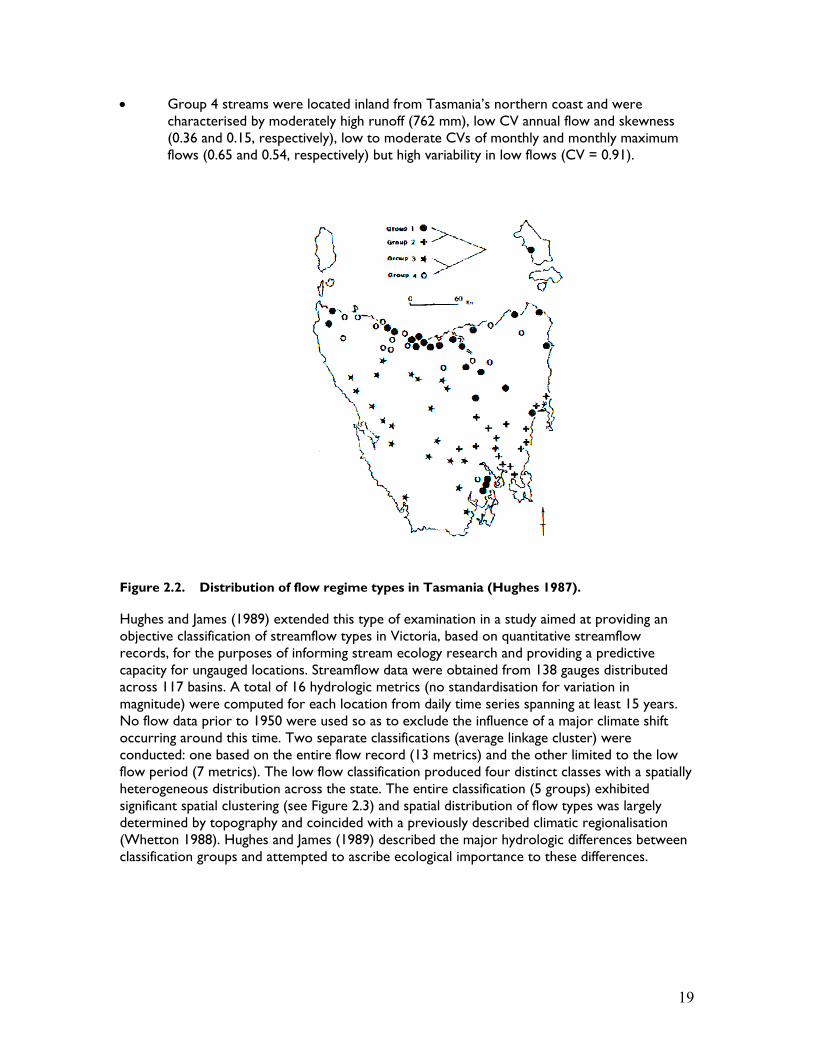