proposed remediation approach and alternatives at toxic hot spots
TRANSCRIPT

143
PROPOSED REMEDIATION APPROACH AND ALTERNATIVES AT TOXIC HOT SPOTS
The RWQCBs and their staff have developed Regional Toxic Hot Spots Cleanup Plans that present preliminary lists of actions necessary to begin improvement of the identified toxic hot spots. The remediation alternatives for each proposed known toxic hot spot is formatted consistently to provide the SWRCB with a summary of the actions proposed by the RWQCBs as well as alternatives for their action on the sites. A complete listing of the preliminary actions is listed in Appendix B.
For each high priority known toxic hot spot the following information is provided:
Site: The name of the Region where the proposed toxic hot spot is
located and the name of the site as used in the list of known toxic hot spots.
Site Description: A brief description of the site including the actions initiated by the
RWQCB and descriptions of any related programs. Approach/Alternatives: For each site, the approach proposed by the RWQCB is presented.
For sites where a discharger has been identified, the RWQCB approach for addressing the site using its existing Water Code authorities is presented. Where no discharger is identified, alternatives for addressing the site are presented.
In each case, the costs of remediation, costs recoverable from potential dischargers and an expenditure plan are presented.
Staff Recommendation: A suggestion is made for combination of alternatives or
approaches that should be adopted by the SWRCB.

144
Site 1.1: North Coast region, G&R Metals at the foot of “H” Street between First street and the Humboldt Bay shore
Site Description: The North Coast RWQCB identified one high priority toxic hot
spot in their Regional Toxic Hot Spots Cleanup Plan. The RWQCB has identified several actions that are underway at the site.
Description of the Site The candidate toxic hot spot site is located on the shore of Humboldt Bay and has been used for industrial activities since the early part of the century. It has been operated as a scrap metal facility since the early 1950s. All industrial activities have ceased at the site but the historic uses have resulted in an area polluted with PCBs, PAHs, lead, arsenic, chromium, cadmium, cobalt, copper, mercury, zinc and Methoxychlor. The areal extent of the toxic hot spot has been estimated to be 3.5 acres with an average depth of pollution of 2 feet. The total polluted soil quantity is about 10,000 cubic yards.
Summary of actions initiated by the RWQCB The site has not been used since 1980. On-going activity is limited to site assessment work to determine the extent of the pollution and the appropriate remediation needed to clean up the site. The RWQCB issued a draft Cleanup and Abatement Order on June 4, 1998 requiring cleanup of the site. The final order will be issued sometime in fiscal year 1998-99.
Approach/Alternatives: The cleanup alternatives are limited to the removal of highly
polluted soils and capping of the site to prevent migration of metals to ground and surface waters. Dredging of the offshore area may be necessary for a complete cleanup.
Estimate of the total cost to implement the Cleanup Plan. It is estimated that the cost to implement the chosen cleanup plan will be between $500,000 and $5 million dollars. These costs are based on a $500 per ton cost for hauling and tipping fees at a hazardous waste disposal site. The exact amount of material that will be removed from the site will be determined at a later date when the assessment work is completed.

145
Estimate of recoverable costs from potential Dischargers. The responsible parties will be required to pay for the cleanup. It appears that the responsible parties have the ability to pay for the entire cleanup effort.
Recommendation: Adopt the cleanup action as presented.

146
Site 2.1: San Francisco Bay Region, San Francisco Bay Site Description: The San Francisco Bay RWQCB identified several high priority
toxic hot spots in their Regional Toxic Hot Spots Cleanup Plan.
Description of the Site San Francisco Bay is part of an estuarine system which conveys the waters of the Sacramento and San Joaquin rivers to the Pacific Ocean. This is a highly complex system that includes large brackish marshes, tidal lagoons and freshwater rivers and creeks. The diversity of these ecosystems support a wide variety of organisms. While the upper part of the estuary has been widely used for mining and agricultural activities the San Francisco Bay region has been heavily urbanized and is the site of many industrial activities and ports. The San Francisco estuary has high concentrations of metals due to contributions from numerous sources, both natural and anthropogenic. Natural sources include drainage of water from formations that are naturally enriched in some metals, such as the Franciscan Formation that is exposed throughout the Bay area, and the rocks that make up the Sierra Nevada Mountains. This drainage flows into the streams that empty into the Bay. Localized concentrations of these metals were exploited in a great wave of mining activity from the 1820’s continuing, in some cases, into the 1970s. Mercury was mined at numerous locations in the Coastal Range and then transported to the Sierra Nevada foothills to be used in the amalgamation of gold in placer and hydraulic mining. Drainage from natural mercury deposits, mine tailings, and directly from mining activities have had a major impact on the San Francisco Bay and estuary. San Francisco Bay is an extremely dynamic depositional environment. Sediments flow from the major river systems and are deposited in the Bay. Strong winds and tidal currents resuspend and redeposit these sediments resulting in a system where sediments are well mixed. Bioaccumulative contaminants attach to sediments and are distributed and mixed by the same physical processes. Therefore, the sediment acts as a sink for contaminants. The sediment, however, is also a source of contaminants to organisms in the aquatic food chain and ultimately to humans.

147
Although the San Francisco estuary extends from the ocean up through the river systems, the jurisdiction of the San Francisco Bay RWQCB only extends to the area just west of Antioch. The Central Valley RWQCB includes the Delta and extends through the river systems. Since the health advisory on fish consumption effects both Regions, it is important that a coordinated strategy is developed, especially in regard to mercury contamination.
Actions Initiated at the Site
Mercury The RWQCB has developed a draft regulatory policy and program for mercury in the Region. The proposed strategy would, in the long term, reduce mercury concentrations in the estuary. It is not feasible to clean up the diffuse, historic sink of mercury in Bay sediments. Natural processes such as outflow through the Golden Gate and capping by the natural deposition of cleaner sediments may effectively isolate this mercury. Therefore, the proposed mercury strategy emphasizes the need to control all controllable sources. The two goals of the strategy are to: (1) reduce the inflow of controllable sources so that natural cleanup rates will be maximized and (2) identify human activities that may increase the rate of mercury methylation in the system and to prevent the creation of environments that may increase that rate. To ensure that controllable sources are controlled, the strategy sets up a process to focus on the most cost-effective measures first. A preliminary evaluation indicates that the most cost-effective measures are to: (1) remediate abandoned mine sites on the western side of the Central Valley and the New Almaden district in the South Bay, (2) step up recycling programs for mercury users such as miners on the east side of the Central Valley, dentists and hospitals, (3) improve household product substitution such as products produced by the mercury caustic cell process and (4) verify the status of the use of scrubber systems on sludge incinerators. Many permitted entities in the San Francisco and Sacramento Regions have already implemented these measures. In addition, as part of the mercury strategy dischargers are implementing clean sampling and analytical techniques. This will result in improved loading estimates and improve the evaluation of the most cost-effective remedial alternatives. The RWQCB has worked with dischargers to set up programs for pollution prevention and source control of mercury and other

148
chemicals of concern. The Palo Alto Regional Water Quality Control Plant and the City and County of San Francisco have devoted significant resources in their service areas into identifying sources of these contaminants and determining methods of decreasing loads to their facilities. In addition to these control measures, the draft strategy includes a provision for a pilot offset program for point source dischargers. If successful, the pilot offset program would create an administrative tool that can help direct regulatory efforts toward cost-effective measures first. The initial step has been taken to begin implementation of this strategy with the formation of watershed council for mercury. This council includes broad representation from dischargers and public interest groups. The first phase has been the establishment of three workgroups. One work group is focused on pollution prevention and the identification of opportunities to remove or replace products or practices that may contain or generate mercury. A second group is reviewing a separate workplan developed by Regional Board staff for the completion of a total maximum daily load for mercury for San Francisco Bay. The third group is investigating the possibility of including pollution credit trading as part of the overall control strategy. The second goal of the proposed mercury strategy, to minimize the environmental risk associated with existing levels of mercury in the Bay system, requires a better understanding of the processes that control mercury methylation and the subsequent bioavailability of mercury to the food chain. This understanding is necessary in order to determine whether methylation can be managed. The proposed regional pollutant policy includes provisions for defining water quality based effluent limits for point source discharges, and a series of actions to be taken by nonpoint source control agencies and entities. These provisions may serve as a TMDL for all segments of San Francisco Bay except possibly the extreme South Bay where a separate TMDL may be developed. Adequate funding to complete both the TMDL Basin Planning process and the methylation research and management efforts has not been identified. However, a grant from CALFED that has been awarded with the Department of Fish and Game as the principal investigator will provide significant information to assist in resolving these questions. In order to identify and cleanup mercury sources under the jurisdiction of the Central Valley RWQCB, interregional

149
coordination is necessary. Because these sources contribute such a high proportion of the load to the estuary, control of these sources as part of the San Francisco Bay Region’s mercury strategy is essential. However, due to liability issues the State and interested private parties are limited in their ability to clean up mines in which there are no responsible parties. An amendment to the Federal Clean Water Act is needed in order to resolve this issue. In April 1998, the RWQCB completed a survey of all of the region’s abandoned mines. In total, 41 mines were surveyed and mines that had actual or potential impacts to water quality were identified. The survey documented conditions at the mines through field inspections, photographs and chemical analyses. Five mercury mines with drainages to the San Francisco estuary were identified as having actual or potential impacts to water quality. The New Almaden mine was one of these mines and was by far the largest with the highest water quality impact. Recommendations were made for monitoring or controlling waste in these mines. The RWQCB is currently monitoring all of the North Bay tributaries to the Bay to identify areas with elevated mercury concentrations. The New Almaden mercury mine was the second largest mercury mine in the world during its operation. The mine consists of several mines: those located within Santa Clara Almaden Quicksilver Park and those located outside the Park. Those mines located within Santa Clara County Almaden Quicksilver Park are currently being remediated under CERCLA. The Department of Toxic Substances Control is the lead agency, while the RWQCB provides input on water quality issues on this project. Remediation of the mines within Santa Clara Almaden Quicksilver Park was divided into two phases: Phase 1: remediation of Hacienda Furnace Yard, and Phase 2: remediation of the rest of the Park. The Hacienda Furnace Yard was identified as the highest priority area, from a water quality perspective, of six areas in need of cleanup. In this location mine tailings were eroding directly into Los Alamitos Creek, a tributary to San Francisco Bay. Cleanup of this area began in the spring of 1996 and was completed in December 1997. Phase 2 of the project, which includes remediation of Mine Hill, San Francisco Open Cut, Enriquita Mine, San Mateo Mine, and Senator Mine was started in August 1998 and is scheduled to be completed January 1999. Mine Hill, San Francisco Open Cut and Enriquita Mine were identified as potential sources of mercury laden sediment that flow directly to Guadalupe and Almaden Reservoirs with surface runoff.

150
Because mercury strongly binds to particulates, these reservoirs may be serving as a sink for mercury, therefore minimizing fluxes to the Bay. However, these reservoirs are currently posted with a health advisory on consuming fish because of mercury contamination. With the completion of Phase 2 of the project, all known mine waste piles located within Santa Clara County Almaden Quicksilver Park will be either capped in place or moved to somewhere else in the Park and capped. However, other remaining sources of potential mercury contamination, i.e. those mines located outside the Park and mercury laden sediment from the overburden natural formations within the greater watershed areas of Guadalupe and Almaden Reservoirs, are yet to be addressed.
PCBs PCBs are ubiquitous and diffuse in the sediments throughout San Francisco Bay. Although several areas have been identified that have elevated sediment concentrations (see Sites of Concern and Candidate Toxic Hot Spots in Appendix B), these levels do not approach sediment concentrations that have been measured in the Great Lakes or many East Coast harbors. Yet, the mass of PCBs in the estuary’s sediment and possible ongoing sources have contributed to levels in fish that are a potential threat to human health. Sites with historically elevated levels of PCBs should be evaluated for cleanup, however, identification and cleanup of ongoing sources is extremely important. The RWQCB has been working with dischargers, both point and nonpoint, and the RMP to identify sources of PCBs to the estuary. An article in the 1996 RMP annual report (SFEI, 1997) indicates that ongoing sources of PCBs are discharging to the Bay. To further this evaluation a RMP workgroup has been set up to evaluate PCB data from the Bay, perform a preliminary model of loadings and come up with conclusions and recommendations for future monitoring and studies. Preliminary results indicate that there may be significant ongoing sources. Results of a 1997 RMP fish pilot study indicate that fish from Oakland Harbor have distinctly higher levels of contaminants than at other areas monitored in the Bay. This was particularly true for mercury, PCBs, DDTs and dieldrin. Additional monitoring needs to be conducted in Oakland Harbor, particularly of stormwater runoff, to identify sources of these contaminants. A study was recently conducted by SFEI, with funds from an ACL from the Port of Oakland, in San Leandro Bay, a toxic hot spot just south of Oakland Harbor. Contaminants from San Leandro Bay may
151
accumulate in the fish from Oakland Harbor that were sampled. The purpose of the study was to identify the extent and general sources of contamination. The results of this study are not yet available.
Chlorinated Pesticides Lauritzen Canal is an area in Richmond Harbor that had extremely elevated levels of DDT. This site was recently cleaned up under CERCLA. Although U.S. EPA was the lead agency, the RWQCB coordinated with U.S. EPA and other agencies to implement the cleanup.
As with the other chemicals previously discussed, it is important to monitor discharges (both point and nonpoint) to the estuary for the identification and cleanup of sources of chlorinated pesticides. The Regional Board is working with dischargers and the RMP to identify sources of these contaminants. However, as was discussed under Future Needs, increased resources for watershed monitoring and assessment are needed to address this issue in a significant manner.
Dioxins The RWQCB has requested the assistance of the California Environmental Protection Agency in addressing the problem of dioxin contamination, due to the cross-media issues that are involved in identifying and controlling any ongoing dioxin sources. Coordination with the Bay Area Air Quality Management District and the State Air Resources Board is essential in addressing this issue since the predominant source of this contaminant is through aerial deposition. A meeting was held in 1997 for scientists to present information on dioxin to the RWQCB. Since the majority of dioxins in the Bay Area is likely generated by fixed and mobile combustion of diesel fuel and emission into the air, regulation of point source discharges into the Bay is unlikely to have an impact on the concentration of dioxin in sediment or organisms. Since even areas removed from sources contain background levels of dioxins that are potentially harmful to humans and other organisms, and since this group of contaminants are very persistent and can be spread great distances through aerial deposition, a global strategy is truly needed. This will probably require that the U.S. EPA take the lead in cooperation with the California Environmental Protection Agency in addressing this problem including instituting any additional control measures.

152
Summary of actions by government agencies in response to health advisory
Due to the large reservoir of mercury and PCBs in the estuary it may take decades for contaminant levels in fish to reach acceptable levels, even with full implementation of the cleanup plan. Therefore, interim measures should be taken to: (1) determine the rate of change in chemical concentrations in fish to determine if natural processes and required cleanup measures are having an effect, and over what time scale, (2) determine the risk of consuming fish from the Bay and identify high risk populations and (3) conduct public outreach and education programs, especially to high risk populations, in order to minimize their risk. The RWQCB has been leading an effort through the RMP to conduct studies to address the first two issues. Several committees have been put together with representatives from State and Federal agencies, environmental groups and dischargers (who fund the program). A five year plan has been developed to: (1) measure contaminant levels in fish throughout the Bay every three years, (2) conduct special studies on specific species, organs or chemicals of concern and (3) conduct a consumption study to quantify the parameters that would go into a risk assessment for San Francisco Bay and to identify high risk populations for public outreach and education. The second monitoring study of contaminant levels in fish tissue in the Bay, after the BPTCP study, was carried out through the RMP in the summer of 1997 by the Department of Fish and Game. Results will be published in the RMP’s 1997 Annual Report. A special study was conducted in the spring of 1998 to measure contaminant levels in resident clams that are collected by clammers. A special study will be conducted in the spring of 1999 to measure contaminant levels in crabs. The State Department of Health Services has been hired to conduct the consumption study and this study is currently underway. The Department of Health Services has been chairing a committee for Public Outreach and Education on Fish Contamination. As a result, County Health Departments and the East Bay Regional Parks District have posted signs at public fishing areas in six different languages describing the advisory. Currently, the committee is developing a strategy to more effectively educate the public on this issue. This strategy, however, is limited due to the lack of funding for this effort and the fact that there is no legal mandate that requires any agency to address this issue.

153
Environmental groups have been using various forums to educate people who eat Bay fish on how to decrease their risk, but their funding is also very limited.
Approach/Alternatives: 1. Finish the cleanup of the New Almaden Mine. 2. Clean up sediment at Point Potrero that is high in PCBs (see Issue 5.2.2). 3. Finalize the Basin Plan amendment process to add the
proposed TMDL, pilot permit offset program, and regional requirements for ongoing mercury sources.
Once adopted, implement the two main components of the Region-wide Mercury Strategy. The first component is controlling ongoing, controllable sources, thereby enhancing the natural cleanup process and accelerating mine remediation work. The second component involves developing new technical information about mercury methylation and sediment fate and transport within different zones of the estuary. This information is needed to enable the Regional Board to manage methylation and bioaccumulation to the greatest extent possible. 4. Increase investigations into ongoing sources of mercury and
PCBs and develop remediation plans for those sources. This action would require an increase in watershed monitoring and assessment (see Future Needs) and in the case of mercury would require coordination with the Central Valley RWQCB. PCBs should be fingerprinted to distinguish the difference between historic and ongoing sources. Biomarker methods could be used to more inexpensively screen for PCBs. The highest priority for monitoring should be in areas where fish contain higher levels of contaminants (Oakland Harbor), areas where sources of PCBs or mercury have been identified, and areas where these chemicals are or were used or produced.
5. Continue RMP studies on fish contamination issues. 6. Increase public education to:
a. Inform people who consume San Francisco Bay fish,
especially high risk populations, about the health advisory and ways to decrease their risk and,

154
b. Inform the public on product use and replacement in order to decrease concentrations of chemicals of concern. This could include the use of dioxin free paper, the substitution or conservation of diesel fuel, limiting the use of fireplaces and wood stoves and the substitution of mercury containing products.
Endangered species consultations will take place for any part of this plan for which it is required.
Estimate of the total cost to implement the cleanup plan 1. Cleanup of New Almaden Mine - $10 million (includes the
amount already spent for cleanup, $5 million, and the additional amount expected to be needed to complete the cleanup).
2. Point Potrero cleanup - $800,000 - $3,000,000 3. Implement Mercury Strategy - $10-20 million a. Finalize and implement Basin Plan amendment b. Technical studies including: Fate and transport of particle-bound mercury in Bay system Mercury methylation studies 4. Ongoing sources a. Watershed investigations to identify ongoing sources of the chemicals of concern in the San Francisco Bay and Central
Valley Regions - $4 million over 5 years b. Costs of cleanup once sources are identified - Unknown 5. RMP studies (including monitoring of contaminant levels in
fish every three years and special studies) - Average $75,000/year (1998-99 special studies and consumption study are already funded)
6. Public Education
a. Outreach and education to people consuming fish from the Bay to reduce their health risk (including DHS staff, translations, training and educational materials) - $150,000 for first two years then $50,000/year

155
b. Educational efforts on source control and product
substitution - $50,000
Total to Implement Plan--Approximately $25 to $45 million (not including cleanup of ongoing sources that have not yet been identified)
Although there are costs to implementing this plan there are also benefits. Currently, beneficial uses are being impacted by high concentrations of mercury and PCBs in San Francisco Bay that are accumulating in fish. These concentrations have lead to a human health advisory on consuming fish but probably also impact other higher trophic organisms, such as marine mammals and birds that have a much higher consumption rate than humans, as well as possibly the fish themselves. The beneficial uses that are impacted are OCEAN, COMMERCIAL AND SPORTFISHING (COMM), MARINE HABITAT (MAR), ESTUARINE HABITAT (EST), WATER CONTACT RECREATION (REC1), NONCONTACT WATER RECREATION (REC2) and probably WILDLIFE (WILD) and SHELLFISH HARVESTING (SHELL). Implementation of this plan is intended to lower concentrations of these chemicals in fish and minimize or eliminate the impacts on beneficial uses.
Estimate of recoverable costs from potential dischargers Ongoing RMP studies are currently funded by dischargers at approximately $75,000/year. Cleanup of the New Almaden Mine in Santa Clara Almaden Quicksilver Park ($5 million) and Point Potrero ($0.8 - $3.0 million) will be paid for in full by the responsible parties. The total equals approximately $5.8 million to $8 million plus $75,000/year for RMP studies.
Two-year expenditure schedule identifying funds to implement the plans that are not recoverable from potential dischargers
Although funding is available for continuation of the RMP studies and the cleanup of Point Potrero and the part of New Almaden Mine in Santa Clara Almaden Quicksilver Park there is little or no funding for the other parts of the cleanup plan.
Recommendations: Adopt each alternative, cost estimates and expenditure plans into the cleanup plan.

156
Site 2.2: San Francisco Bay Region, Peyton Slough Site Description: The San Francisco Bay RWQCB identified several high priority
toxic hot spots in their Regional Toxic Hot Spots Cleanup Plan. The RWQCB has identified several actions that are underway at Peyton Slough. A potential discharger has been identified as being responsible for this site.
Description of site Peyton Slough is located in Martinez, northern Contra Costa County, California. The slough discharges into the San Francisco estuary at the confluence of Suisun Bay and the Carquinez strait, near Bull Head Point, just east of the Benicia Bridge. Sediments in Peyton Slough are comprised of firm clays that do not appear to erode easily (CH2MHILL, 1986). Sediments from Peyton Slough appear to have been dredged in the past with the dredge spoils deposited on the east and west shore forming levees. There are openings in the east levee downstream of the tidal gate that provide exchange between Peyton Slough and a large brackish wetland to the east of the slough. During the winter, Peyton Slough receives fresh water discharge from the Contra Costa Canal and stormwater runoff from the surrounding area. During the dry weather months, Peyton Slough receives fresh water treated discharge primarily from a waste water treatment plant (Mountain View Sanitary District) through a tidal gate. Some minor flow from the Contra Costa Canal may also occur during the dry months. A tidal gate had been configured such that fresh water from upstream can be released when the water level is greater on the upstream side of the gate. In 1998, this tidal gate was replaced with a newer gate which will allow water to flow from the bay into a wetland area situated upstream from Peyton Slough. Two major historical industrial activities have taken place in the vicinity of Peyton Slough on a site currently owned and operated by Rhodia: sulfuric acid production and the smelting of copper. Historically, the first recorded industrial use near Peyton Slough was by the Mountain Copper Company (MOCOCO). This company used the site for a copper smelting operation from the early 1900s until 1966 at which time it was purchased by Stauffer Chemical Company. During the smelting of copper, a fused silicate slag was generated which was discharged over the north and south sides of the hillside housing the smelter. MOCOCO also

157
roasted pyrite ore to recover its sulfur. Resulting cinders remain on site. Cinder and slag, classified as Class B Mining Waste, from the smelting operations were stored in large piles on the site. The north cinder/slag area covers 8.3 acres, while the south cinder/slag covers 7.1 acres. Due to their weights, the cinder and slag piles subsided 30 to 35 feet into the softer bay mud below the existing ground surface. Stauffer Chemical Company bought the site from MOCOCO and removed the cinder/slag piles to the depth of the water table, but it is estimated that over 500,000 tons of waste material remains below the surface. The remaining north and south cinder/slag piles have been capped with a minimum of two feet of low permeability soil in 1978 and 1980 respectively. In 1972, a leachate removal and containment system (LRCS) was installed in response to a cease and desist order No. 71-21 issued by the RWQCB (The MARK Group, 1988b). The LRCS prevented leachate from moving to Carquinez Strait and Peyton Slough by a cut-off wall consisting of compacted bay mud along the bay shoreline. Prior to 1988, the leachate from the north cinder/slag area was pumped to a north solar evaporation pond. Leachate from the south cinder/slag piles was pumped from two deep sumps to the south solar evaporation pond. Starting in 1988, the Process Effluent Purification (PEP) system was installed and began treating this leachate prior to discharge to a deep water outfall. Cutoff walls were not constructed along Peyton Slough. However, to date there is no evidence that leachate is being discharged into the slough. Currently, the Contra Costa Mosquito Vector Control District (CCMVCD) is planning a restoration project in Shell marsh. This project intends to restore the marsh south of Peyton Slough back to a brackish marsh with regular inputs of salt water from San Francisco Bay. As part of this project, the CCMVCD has replaced the tidal gate in Peyton Slough and is proposing to dredge Peyton Slough to allow for higher flows of saline water up the slough into Shell marsh. This project is partially funded by Caltrans to mitigate for discharge from Route 680 and to prevent flooding of the highway. Rhodia is also working with CCMVCD to coordinate the dredging of Peyton Slough. Regional Board staff has been helping to coordinate completion of the marsh restoration project in order to remediate the toxic hot spot, restore Shell marsh and alleviate flooding on Route 680.

158
Summary of actions initiated at the site In 1972, a leachate removal and containment system (LRCS) was installed in response to a cease and desist order No. 71-21 issued by the RWQCB (The MARK Group, 1988b). The LRCS prevented leachate from moving to Carquinez Strait and Peyton Slough by a cut-off wall consisting of compacted bay mud along the bay shoreline. Prior to 1988, the leachate from the north cinder/slag area was pumped to a north solar evaporation pond. Leachate from the south cinder/slag piles was pumped from two deep sumps to the south solar evaporation pond. Starting in 1988, the Process Effluent Purification (PEP) system was installed and began treating this leachate prior to discharge to a deep water outfall. Cut-off walls were not constructed along Peyton Slough, however, to date there is no evidence that leachate is being discharged into the slough. Waste Discharge Requirements for Rhodia have been regulated under the National Pollution Discharge Elimination System (NPDES) Permit No. CA 0006165 and Order 93-060 in June 1993, which was amended by order 96-033 in March 1996. Recently, the SFB-RWQCB reissued Waste Discharge Requirements, under Order No. 97-121, which rescinded previous Orders. Leachate from the onsite cinder and slag piles are mixed with the treated process waste water. Until recently, this discharge was located in the tidal section of Peyton Slough about 800 yards upstream of its confluence with Carquinez Strait and 200 feet downstream of the tidal gate. Currently, this discharge goes to a deepwater outfall located in the Carquinez Strait. Another source of discharge from the Rhodia site originates from storm water runoff from the Caltrans I-680 and Benecia bridge, and from the western highlands drain collection system located on this property. This runoff flows via a pipeline into a usually submerged discharge point in Peyton Slough. As part of the reissuance of Waste Discharge Requirements in Order No. 97-121, Rhone Poulenc, now Rhodia, was asked to submit a workplan, including a detailed schedule, for investigation of metal contamination in Peyton Slough sediments. The workplan has been submitted, and a site investigation is being completed. Results of this site investigation are provided in a previous section (Reason for Listing). The RWQCB has asked Rhodia to provide a remedial workplan based on these results. Mountain View Sanitary District (MVSD) discharges an average of 1.47 million gallons per day MGD to 21 acres of intensively

159
managed marsh ponds at a location 1,000 yards upstream of the tidal gate under NPDES Permit No. CA 0037770, Order 93-001. Wet weather flows have been approximately 3.5 MGD, with wet weather peaks of 11.1 MGD allowed. Effluent in Peyton Slough backs up onto 68 acres of wetland also managed by the discharger.
Approach/Alternatives: The CCMVCD Shell marsh restoration project needs to deepen
Peyton Slough in order to enhance salt water flow into Shell marsh. Rhodia is currently coordinating their remediation plan for Peyton Slough with this project, and is studying the feasibility of various other activities. Dredging of contaminated sediments to three feet below needed depth and back filling with clean materials has been proposed for Peyton Slough since contamination has been shown to extend to at least 8 feet below the sediment surface. Dredging and capping with clean compatible fill seem to be the most feasible alternative since contamination is so deep and the slough is so narrow removal of all contaminated sediment would cause instability of the sidewalls. Follow-up monitoring would be required to make sure that the cap stays in place and is effective. Contaminated sediments to be dredged are estimated at 12,000 cubic yards and will be disposed at a regulated off site landfill. An endangered species consultation with all appropriate agencies is currently in progress.
Estimate of the total cost to implement the cleanup plan Based on the proposed remediation, the estimated cost is for 12,000 cubic yards of sediments to be dredged and disposed, and for a three-foot cap to be put in place in the entire slough. The range of costs are approximately $400,000 to $1,200,000 depending on the methodology followed for the cleanup, and other potential activities such as building a subsurface cut-off wall or a cap on the sidewall along the slough to control groundwater discharge. Follow-up monitoring would cost approximately $5,000-$10,000/year. RWQCB staff costs are estimated at $10,000 to $50,000 over the entire course of the project. Although there are costs to implementing this plan there are also benefits. Currently, beneficial uses are being impacted by high concentrations of chemicals at this site. The beneficial use that is impacted is ESTUARINE HABITAT (EST). Sediments from this site cause toxicity to test organisms and may have an impact on the benthos. Since Peyton Slough will be the main conduit of water from Carquinez Strait to the restored Shell marsh, cleanup of this site will prevent other marsh organisms from being exposed to

160
chemicals from the slough. Implementation of this plan will minimize or eliminate this impact on the beneficial use.
Estimate of recoverable costs from potential dischargers The responsible party or parties are accountable for all costs incurred as a result of site cleanup at Peyton Slough as well as the cost for RWQCB and other regulatory staff oversight. However, Caltrans has budgeted $300,000 toward the CCMVCD restoration project which can be partially used to defray the cost of dredging.
Two-year expenditure schedule identifying funds to implement the plans that are not recoverable from potential dischargers
The responsible party or parties are accountable for all costs incurred as a result of site investigations and cleanup at Peyton Slough as well as the cost for RWQCB and other regulatory staff oversight.
Recommendation: Adopt the alternative as presented.
161
Site 2.3: San Francisco Bay Region, Castro Cove Site Description: The San Francisco Bay RWQCB identified several high priority
toxic hot spots in their Regional Toxic Hot Spots Cleanup Plan. The RWQCB has identified several actions that are underway at Castro Cove. A potential discharger has been identified as being responsible for this site.
Description of site Castro Cove is a protected embayment located in the southern portion of San Pablo Bay in Richmond, CA. Castro Cove is defined as the cove enclosed by a line drawn from the Point San Pablo Yacht Club breakwater to the northwest corner of the West Contra Costa Sanitary Landfill. The embayment is protected by diked margins on the west, south and most of its eastern margin. The southeastern portion, where Castro Creek enters the cove, is a salt marsh. Castro Cove is shallow with extensive mudflats and marshlands that are subject to tidal action. Castro Creek empties into a channel that is about 30 to 75 feet wide and about three to six feet deep at mean lower low water.
Summary of actions initiated at the site RWQCB actions regarding Castro Cove have been to control the sources of contamination through NPDES permitting and ACLs. All municipal and industrial point source discharges to Castro Cove were eliminated by 1987. Process effluent discharge from the Chevron refinery into Castro Cove was prohibited after July 1, 1987 under NPDES permit CA0005134, thereby eliminating the source of contaminated effluent into Castro Cove. This NPDES permit regulates discharges from the deep-water outfall. Discharges regulated by this NPDES permit include: thermal waste, cooling tower blowdown, gas scrubber blowdown from an incinerator, treated process wastewater, cooling water, and storm water. As stated previously, the San Pablo Sanitary District discharge was relocated to an offshore deep-water site which is also under permit. The City of Richmond is required by its municipal stormwater permit to implement and document the effectiveness of best management practices to reduce or prevent pollutant discharge through the city’s stormwater runoff collection system. The RWQCB has also conducted sampling and analysis of sediments in Castro Cove as discussed in the previous section.

162
State Order 86-4 required Chevron to evaluate the quality of the sediments in Castro Cove resulting in the Entrix and EVS studies. In June 1998, RWQCB staff requested, under Section 13267 of the California Water Code, that Chevron submit a workplan and schedule for characterization of sediment contamination in Castro Cove due to sources from the refinery. Specific items that RWQCB staff requested the workplan to address included: (1) a delineation of sediment contamination gradients originating from refinery-related source areas, (2) an evaluation of the effects of the bioavailable layer of sediment on aquatic organisms by means of concurrent toxicity and chemistry testing, (3) a characterization of the vertical extent of sediment contamination in conjunction with an estimation of sediment deposition and erosion rates, and (4) an evaluation of the bioaccumulation/biomagnification potential for contaminants in the sediment. Chevron submitted a workplan in August 1998 that proposed a tiered ecological risk assessment consisting of a new round of surficial sediment sampling and chemical analysis with subsequent comparison of the resulting chemical concentrations to established ecological benchmarks. If chemicals likely associated with refinery releases exceed the proposed benchmarks and complete exposure pathways exist, Chevron proposed conducting a second tier risk assessment to address specific ecological concerns. This second tier may contain bioassays and a bioaccumulation/ biomagnification evaluation in addition to a refined predictive risk assessment. The workplan also proposed conducting a bathymetric survey and comparing the results to a previous survey made in 1989 to evaluate sediment accretion or erosion rates in Castro Cove. RWQCB staff conditionally approved the workplan in September 1998 with the provision that additions would be made to the plan. RWQCB staff collected five core samples in Castro Cove in November 1998 to begin characterization of the vertical contaminant profile. In December 1998 Chevron took deep core samples in Castro Cove.
Approach/Alternatives: Corrective actions for Castro Cove sediments will require the following phases:
1. Preparation of a Sampling and Analysis Plan (SAP) in order to delineate vertical and horizontal extent of contamination, 2. Completion of a Site Investigation to complete goals of SAP,

163
3. Preparation of a Feasibility Study (FS) based on the findings of the Site Investigation (at a minimum the following cleanup options will be considered: natural recovery, in-place containment, dredging with various disposal options and dredging and capping),
4. Sediment clean up following option(s) selected from the FS
and, 5. Follow-up monitoring to make sure that the site has been
cleaned up.
An endangered species consultation with all appropriate agencies will be conducted before remediation plans are finalized.
Estimate of the total cost to implement the cleanup plan The uncertainty regarding the horizontal and vertical extent of sediment contamination results in a range of potential cleanup costs. All options including natural recovery, dredging, dredging with upland disposal and capping will be considered for remediation. The cost is estimated based on a contaminated area ranging from a minimum of 10 acres to a maximum of 100 acres. Sediments will be assumed to be contaminated to a depth of at least three feet below the sediment surface. The cost of performing a full site investigation and feasibility study is estimated at $2,000,000. The cost of remediating Castro Cove, depending on the chosen remedial alternative, and follow-up monitoring is estimated at $1,000,000 to $20,000,000. Follow-up monitoring will be required regardless of the chosen remedial alternative. RWQCB staff costs are estimated at $200,000 over the entire course of the project. Although there are costs to implementing this plan there are also benefits. Currently, beneficial uses are being impacted by high concentrations of chemicals at this site. The beneficial use that is impacted is ESTUARINE HABITAT (EST). Implementation of this plan will minimize or eliminate this impact on the beneficial use.
Estimate of recoverable costs from potential dischargers The responsible party or parties are accountable for all costs incurred as a result of site investigation and cleanup at Castro Cove as well as the cost for RWQCB and other regulatory staff oversight.
164
Two-year expenditure schedule identifying funds to implement the plans that are nor recoverable from potential dischargers
The responsible party or parties are accountable for all costs incurred as a result of site investigation and cleanup at Castro Cove as well as the cost for RWQCB and other regulatory staff oversight.
Recommendation: Adopt the approach, estimated costs and expenditure plan as
presented.

165
Site 2.4: San Francisco Bay Region, Stege Marsh Site Description: The San Francisco Bay RWQCB identified several high
priority toxic hot spots in their Regional Toxic Hot Spots Cleanup Plan. The RWQCB has identified several actions that are underway at Stege Marsh. A potential discharger has been identified as being responsible for this site.
Description of site Stege marsh occupies approximately 23 acres on the western margin of San Francisco Bay in the City of Richmond, California. Eastern Stege marsh is located on property currently owned by Zeneca Agricultural Products. Western Stege marsh is currently owned by the University of California Field Station. The cinder landfill separates east and west Stege marsh. The East Bay Parks District currently owns the land south of the historic railroad track which is now a hiking trail. Eastern Stege marsh rests directly on the alluvial fan-deltaic deposits of Carlson Creek interspersed with Bay mud. Bedrock at the site is likely to be Franciscan Formation rocks, cretaceous and younger in age, consisting of an assemblage of marine sedimentary and volcanic, and some metamorphic rocks (The Mark Group, 1988). Western Stege Marsh is fed by Meeker Creek. Between 1947 and 1969, a railroad track was constructed just south of Stege marsh resulting in siltation and thus the extension of the tidal marsh into a previously subtidal area (May, 1995).
Stauffer Chemical Company is the prior owner of the Zeneca industrial facility and associated marsh. Stauffer Chemical Company utilized the industrial portion of the site to roast pyrite ores for the production of sulfuric acid from about 1919 until 1963. This industrial process resulted in the production of cinders, which were placed on the site surface. Elevation at the bottom of the cinders is at mean sea level throughout the facility, which indicates past placement of cinders at ground level. The presence of a layer of peaty silt under the base of the cinders also supports that cinders were disposed of on the site surface. The cinder pile extends along the north and east

166
sides of eastern Stege marsh. The cinders were covered with a one-foot clay layer, with a permeability of 10-7 cm/sec or less, that was itself covered by a one-foot layer of topsoil to comply with RWQCB Order No. 73-12 and its 1974 amendment. Besides pyrite cinders, other products that have been generated or utilized on the site include fuels, sulfuric acid, ferric sulfate, proprietary pesticides, solvents and alum. Until recently Zeneca produced proprietary agricultural chemicals on the industrial portion of the site.
Summary of actions initiated at the site RWQCB actions regarding Stege marsh have been to control the sources of contamination through NPDES permitting. NPDES permit No. CA0006157 (Order No. 95-008) requires that wastewater from the evaporation ponds be discharged into the City of Richmond sanitary sewer. Discharge to Stege marsh is only allowed during storm events when the sanitary sewer capacity and on-site storage capacity have been exhausted. A prior NPDES permit requested that the cinders be capped and that an interceptor trench be built to limit discharges from the pyrite cinders. Other actions by the RWQCB have included a request to Zeneca Agricultural products for sampling and analyses of sediments. In December 1996, the RWQCB requested, under section 13267 of the California Water Code, that Zeneca Agricultural Products perform sediment studies in order to propose a conceptual site model to evaluate potential impacts of contaminants including ecological and human health impacts. The studies by ICF Kaiser and Pacific Eco-Risk Laboratories were in response to this request. However, these studies are just the beginning of studies that will be required to develop a full conceptual site model.
Approach/Alternatives: 1. Completion of a Sampling and Analysis Plan (SAP) in order to finish delineating vertical and horizontal extent of contamination (in progress);
2. Completion of a Site Investigation to complete goals of
SAP including development of a conceptual site model
167
and ecological and human health risk assessments (in progress);
3. Preparation of a Feasibility Study (FS) based on the
findings of the Site Investigation (at a minimum the following cleanup options will be considered: natural recovery, in-place containment, dredging with various disposal options, and dredging and capping);
4. Sediment clean up following option(s) selected from the
FS and, 5. Follow-up monitoring to ensure that the site has been
cleaned up to agreed levels. An endangered species consultation with all appropriate agencies will be conducted before remediation plans are finalized.
Estimate of the total cost to implement the cleanup plan The uncertainty regarding the horizontal and vertical extent of sediment contamination, the potentially varied nature of the sources of contamination and the cleanup options results in a range of potential clean-up costs. The cost is estimated based on a minimum of 10 acres and a maximum of 23 acres being remediated. The range of costs are $1,500,000 to $10,000,000 depending on the range of clean-up options selected and the areal extent remediated. RWQCB staff costs are estimated at $100,000 to $200,000 over the entire course of the project. Although there are costs to implementing this plan there are also benefits. Currently, beneficial uses are being impacted by high concentrations of chemicals at this site. The beneficial use that is impacted is ESTUARINE HABITAT (EST) at a minimum. Due to high concentrations of bioaccumulative compounds, such as selenium, WILDLIFE HABITAT (WILD) and PRESERVATION OF RARE AND ENDANGERED SPECIES (RARE) may also be impacted. Implementation of this plan will minimize or eliminate these impacts on beneficial uses.

168
Estimate of recoverable costs from potential dischargers The responsible party or parties are accountable for all costs incurred as a result of site investigation and site cleanup at Stege marsh as well as the cost for RWQCB and other regulatory staff oversight.
Two-year expenditure schedule identifying funds to implement the plans that are not recoverable from potential dischargers
The responsible party or parties are accountable for all costs incurred as a result of site investigation and cleanup at Stege marsh as well as the cost for RWQCB and other regulatory staff oversight.
Recommendation: Adopt the approaches, cost estimates and expenditure plan as presented.
169
Site 2.5: San Francisco Bay Region, Point Potrero/Richmond Harbor Site Description: The San Francisco Bay RWQCB identified several high
priority toxic hot spots in their Regional Toxic Hot Spots Cleanup Plan. The RWQCB has identified several actions that are underway at Point Potrero/Richmond Harbor. A potential discharger has been identified as being responsible for this site.
Description of site The site designated Point Potrero/Richmond Harbor is a 400 foot long intertidal embayment, the Graving Inlet, on the western side of the Shipyard #3 Scrap Area at the Port of Richmond. Shipyard #3 is currently used as a parking lot, but in the past the site has been used for shipbuilding, ship scrapping, sand blasting and metal recycling. The geographic feature identified with the site is Point Potrero, although the original configuration of the point has been modified by quarrying of a bedrock hillside and filling of intertidal mudflats. The embayment known as the Graving Inlet (Inlet) was excavated in 1969 to allow ships to be beached in shallow water for final scrapping operations. Site investigations have shown that the sediments in the Inlet have the same levels and types of contaminants found on the adjacent Shipyard #3, including heavy metals, PCBs and PAHs. While the most heavily contaminated sediments are in the intertidal zone and shallow subtidal zone within the inlet, elevated levels of PCBs and metals are also found in the subtidal zone outside of the inlet.
Summary of actions initiated at the site RWQCB staff, in cooperation with staff of the Department of Toxic Substances Control, have overseen the design and implementation of a Remedial Investigation (Hart Crowser, 1993) and a Feasibility Study (Hart Crowser, 1994) for the onshore area that recommended capping of the upland source of the contaminated sediments. Placement of dredged material on the site was completed in December 1997 and the dredged

170
material will be capped with asphalt when it has completed drying (projected for the summer of 1999). RWQCB staff have written Waste Discharge Requirements (WDRs) for the onshore portion of the site. The WDRs serve to regulate the placement of dredged material on top of the upland source material to isolate it from human contact and provide a base for an asphalt surface.
Staff approved Supplemental Sediment Characterization in January 1997 and the preliminary results were made available in December 1997. The results provided better documentation of the horizontal and vertical extent of contamination at the mouth of the Graving Inlet. The data indicates that the areas of greatest contamination are limited to the Inlet and a smaller area at the southern extent of the property. Regional Board staff have provided comments on a draft Remedial Action Workplan (Terra Verde, 1998) that described five remedial action alternatives and participated in meetings with the Port of Richmond, Bay Conservation and Development Commission, and Department of Toxic Substances Control.
Approach/Alternatives: Actions at this site to date have defined the horizontal and
vertical extent of contaminants and shown that beneficial uses of waters of the state are impaired by the levels of contaminants in the Graving Inlet. A draft Remedial Action Workplan (RAP) has been submitted and is being finalized by the Port. Remedial action alternatives described in the RAP include: (1) No action, (2) Sheetpile Bulkhead, Capping and Institutional Controls, (3) Rock Dike Bulkhead, Capping and Institutional Controls, (4) Excavation and Off-Site Disposal, and (5) Excavation and Reuse or Disposal Onsite. Excavation or capping would require restoration of the site or restoration of an offsite location to mitigate for the loss of intertidal habitat. The Sheetpile Bulkhead, Capping and Institutional Controls alternative is preferred by the Port, since it has a relatively low cost and would provide additional flat property that can be used by the Port. While this would provide a financial benefit to the landowner, it would require mitigation for loss of habitat and for filling of the Bay. This mitigation would

171
probably require more than one acre of habitat restoration and/or public access improvements to be acceptable to the San Francisco Bay RWQCB and the San Francisco Bay Conservation and Development Commission. Any requirement for endangered species consultation will be completed before finalization of the remediation plan.
Estimate of the total cost to implement the cleanup plan Preliminary cost estimates for the remedial action alternatives described in the RAP include: (1) No action ($0), (2) Sheetpile Bulkhead, Capping and Institutional Controls ($792,000), (3) Rock Dike Bulkhead, Capping and Institutional Controls ($1,344,000), (4) Excavation and Off-Site Disposal ($3,010,000), and (5) Excavation and Reuse or Disposal Onsite ($881,000). RWQCB staff costs are estimated at $30,000 ($10,000/yr for 3 years). There may be additional costs for mitigation of wetlands. Although there are costs to implementing this plan there are also benefits. Currently, beneficial uses are being impacted by high concentrations of mercury and PCBs in San Francisco Bay that are accumulating in fish. These concentrations have lead to a human health advisory on consuming fish but probably also impact other higher trophic organisms, that have a much higher consumption rate than humans, as well as possibly the fish themselves. The beneficial uses that are impacted are OCEAN COMMERCIAL AND SPORTFISHING (COMM), MARINE HABITAT (MAR), ESTUARINE HABITAT (EST), NONCONTACT WATER RECREATION (REC 1), WATER CONTACT RECREATION and possibly WILDLIFE HABITAT (WILD). Point Potrero has the highest concentrations of mercury and PCBs in over 600 samples collected statewide in the BPTCP. Implementation of this plan would contribute to lowering concentrations of these chemicals in fish and minimize the impacts on beneficial uses.
Estimate of recoverable costs from potential dischargers The responsible party or parties are accountable for all costs incurred as a result of site investigation and cleanup at Point Potrero, as well as costs for RWQCB staff oversight.
172
Two-year expenditure schedule identifying funds to implement the plans that are not recoverable from potential dischargers
The responsible party or parties are accountable for all costs incurred as a result of site investigation and cleanup at Point Potrero, as well as costs for RWQCB staff oversight.
Recommendation: Adopt the approaches, cost estimates, and expenditure plan as presented.

173
Site 2.6: San Francisco Bay Region, Mission Creek Site Description: The San Francisco Bay RWQCB identified several high priority
toxic hot spots in their Regional Toxic Hot Spots Cleanup Plan. The RWQCB has identified several actions that are underway at Mission Creek. A potential discharger has been identified as being responsible for this site.
Description of site Mission Creek is a 0.75 mile long arm of the Bay in the eastern side of the San Francisco waterfront. Formerly, the estuary of Mission Creek reached back a couple of miles. It was filled to roughly its present dimension before the turn of the century. Currently, the creek is 100 to 200 feet wide in most sections and narrower at the two bridges at 3rd and 4th Streets. Concrete rip rap and isolated bands of vegetation line Mission Creek’s banks. Ten to fifteen houseboats are docked at the Mission Creek Harbor located between 5th and 6th Streets along the south shore of the creek. Many of the houseboats have year round on-board residents. The City and County of San Francisco operates seven combined sewer overflow structures in Mission Creek from 3rd Street to the upper end at 7th Street. Light industrial and urban development line the shores of Mission Creek. A new baseball stadium will soon open on the north shore at the mouth of Mission Creek near 2nd Street in China Basin. Currently, demolition debris cover the remainder of the north shore. According to City plans, new retail development will occupy this area in the near future. Along the south shore, there is a golf driving range near 6th Street, warehouse facilities, and a sand and gravel operation near the mouth of the Creek. Finally, Interstate Freeway 280 crosses over Mission Creek between 6th and 7th Streets.
Summary of actions initiated at the site Since 1967, the RWQCB has issued resolutions and orders prescribing requirements on the discharges from the CSO structures. One of the more significant ones is Cease and Desist Order No. 79-119 in 1979 requiring San Francisco to construct overflow consolidation structures to reduce wet weather overflow frequencies to allowable levels. San Francisco completed the consolidation structures for the CSOs into Mission Creek around

174
1988. These consolidation structures also provided settleable and floatable solids removal treatment for the overflows. More recently in June 1998, the RWQCB issued a draft Water Code Section 13267 letter requiring San Francisco to define the extent of the sediment contamination, and determine if the CSOs are continuing to cause the contamination or acting to resuspend contaminated sediments already there. Section 13267 is a legal administrative tool with enforcement powers for the RWQCB to require collection of technical information. The RWQCB followed up with three more letters in August and September 1998 and march 1999 to further define and formalize the requirements of the investigation. San Francisco submitted a Sampling and Analysis Plan, and in October 1998 started the investigation. Results of the October sampling have been submitted to the Regional board staff and are being reviewed.
Approach/Alternatives: Corrective actions for Mission Creek sediments will require the following phases:
1. Completion of a site investigation that delineates the vertical
and horizontal extent of contamination. 2. Complete a source investigation to determine the sources and
relative magnitude of contribution of possible sources. 3. Preparation of a Feasibility Study based on the findings of the
Site Investigation. At a minimum the following cleanup options will be considered, if the CSOs are not contributing pollutants:
a. natural recovery, b. dredging with disposal and capping, and c. dredging with disposal of sediments. If the CSOs are a significant ongoing source of the identified
pollutants, the cleanup options will include those listed above plus, at a minimum, the following:
d. evaluation of reduction or elimination of the number of
overflows by changing the operation or the storage and treatment capacity of the current system, and/or
e. implement upstream measures that reduce the volume or intensity of runoff. An example of this would be a program to encourage increasing permeable cover.

175
4. Implement the remediation option(s) selected from the
Feasibility Study. 5. Follow-up monitoring to make sure that the site has been
cleaned up and remains clean. An endangered species consultation with all appropriate agencies will be conducted before remediation plans are finalized.
Estimate of the total cost to implement the cleanup plan We estimate that the cost of performing a full site investigation and feasibility study will be $1 million; the cost of remediation and follow-up monitoring will be $800,000 to $1,800,000 with dredging options; if option (d) is added and significant structural changes are needed the cost could increase to approximately $75 million. Regional Board staff costs will be $100,000 to $200,000 over the entire course of the project. In estimating the remediation cost, we used an areal extent of 5 acres as a minimum and 12 acres as a maximum, and contamination to a depth of at least 3 feet below the sediment surface. Furthermore, we used dredging as the preferred option for cleanup, with sediment disposal in an upland facility, either a Class I landfill or a reuse site based on the degree of contamination. Following dredging, we also assume that the area would be backfilled with clean sediment.
Although there are costs to implementing this plan there are also benefits. Currently, beneficial uses are being impacted by high concentrations of chemicals at this site. The beneficial uses that are impacted are ESTUARINE HABITAT (EST), WATER CONTACT RECREATION (REC 1) AND NONCONTACT WATER RECREATION (REC 2). Implementation of this plan will minimize or eliminate these impacts on beneficial uses.
Estimate of recoverable costs from potential dischargers The responsible party or parties are accountable for all costs for the site cleanup. Costs for Regional Board and other regulatory staff oversight are recoverable from the responsible party after the RWQCB issues a Cleanup and Abatement Order to that party.

176
Two-year expenditure schedule identifying funds to implement the plans that are not recoverable from potential dischargers
In the next two years, we estimate the expenditure will be $1,100,000. This includes the completion of the site investigation and feasibility study with RWQCB staff oversight. Currently, the City and County of San Francisco is funding the site investigation. The plan is for the RWQCB to issue a Cleanup and Abatement Order to the responsible party or parties subsequent to completion of the site investigation, at which point, staff oversight costs and the feasibility study will be recoverable from that party.
Recommendation: Adopt the approaches, cost estimates and expenditure schedule as presented.

177
Site 2.7: San Francisco Bay Region, Islais Creek Site Description: The San Francisco Bay RWQCB identified several high priority
toxic hot spots in their Regional Toxic Hot Spots Cleanup Plan. The RWQCB has identified several actions that are underway at Islais Creek. A potential discharger has been identified as being responsible for this site.
Description of site Islais Creek is a one mile long channel of the Bay running east-west on the San Francisco waterfront near the foot of Potrero Hill and Caesar Chavez Street. Formerly, the estuary of Islais Creek reached back a couple of miles as far as Bayshore Boulevard, and was fed by a creek that ran down what is now Alamany Boulevard. Before the turn of the century, the area was filled to roughly its present size. A bridge at Third Street forms a narrow 100-foot wide constriction that physically divides the channel into two segments. The eastern segment is approximately 400 to 500 feet wide; the western, 250 to 300 feet wide. The City and County of San Francisco operates four wet weather overflow structures that discharge into the western segment. San Francisco also operates a sewage treatment plant effluent outfall that discharges into the western segment at Quint Street. The banks of Islais Creek are covered with concrete rip-rap with narrow bands of vegetation in small isolated areas. Long stretches of creek bank in the eastern segment are under pier structures. Old pier pilings dot the southern shore of the western segment. Light industrial and urban development surround Islais Creek. On the shores of the eastern segment are a sand and gravel facility, grain terminal, oil and grease rendering facility, warehouse, and container cargo terminal. Auto dismantlers and auto parts dealers, scrap metal recyclers, and warehouses make up the bulk of the current activities surrounding the western segment. Interstate 280 passes over the western end of Islais Creek.
Summary of actions initiated at the site Since 1967, the RWQCB has issued numerous resolutions and orders prescribing requirements on the discharges from the CSO structures. One of the more significant ones is Cease and Desist

178
Order No. 79-119 in 1979 requiring San Francisco to construct overflow consolidation structures to reduce wet weather overflow frequencies to allowable levels throughout the city. For Islais Creek, San Francisco completed the consolidation structures in 1996. These consolidation structures also provided settleable and floatable solids removal treatment for the overflows. Order No. 79-119 also required the City to develop alternatives to address the discharge from the Quint Street outfall. The outcome of this order was improvement in the quality of the discharge to the outfall. Starting in 1997, the Quint Street outfall received only secondary treated wastewater. San Francisco accomplished this by a major re-piping project and increasing the secondary treatment capacity of their Southeast Treatment Plant. More recently in June 1998, the RWQCB issued a draft Water Code Section 13267 letter requiring San Francisco to define the extent of the sediment contamination, and determine if the CSOs and Quint Street outfall are continuing to cause the contamination or may act to resuspend contaminated sediments already there. Section 13267 is a legal administrative tool with enforcement powers for the RWQCB to require collection of technical information. The RWQCB followed up with three more letters in August and September 1998 and march 1999 to further define and formalize the requirements of the investigation. San Francisco submitted a Sampling and Analysis Plan, and in October 1998 started the investigation. The results of the October 1998 investigation have been submitted and are being reviewed by the Regional Board staff.
Approach/Alternatives: Corrective actions for Islais Creek sediments will require the following phases:
1. Completion of a Site Investigation that delineates the vertical
and horizontal extent of contamination. 2. Complete a source investigation to determine the sources and
relative magnitude of contribution of possible sources. 3. Preparation of a Feasibility Study based on the findings of the
Site Investigation. At a minimum the following cleanup options will be considered, if the CSOs and Quint Street outfall are not contributing pollutants:
a. natural recovery, b. partial dredging with disposal and capping, and c. dredging with disposal of sediments.
179
If the CSOs and Quint Street outfall are identified as a significant ongoing source of the chemicals of concern, the cleanup options will include those listed above plus at a minimum the following: d. evaluation of reduction or elimination of the number of
overflows by changing the operation or increasing the storage and treatment capacity of the current system, and/or
e. implement upstream measures that reduce the volume or intensity of runoff. An example of this would be a program to encourage increasing permeable cover.
4. Implement the remediation option(s) selected from the
Feasibility Study. 5. Follow-up monitoring to make sure that the site has been
cleaned up and remains clean.
An endangered species consultation with all appropriate agencies will be conducted before remediation plans are finalized.
Estimate of the total cost to implement the cleanup plan We estimate that the cost of performing a full site investigation and feasibility study will be $1 million; the cost of remediation and follow-up monitoring will be $800,000 to $5,200,000 with dredging options; if option (d) is added and significant structural changes are needed the cost could increase to approximately $75 million. Regional Board staff costs will be $100,000 to $200,000 over the entire course of the project. In estimating the remediation cost, we used an areal extent of 5 acres as a minimum and 35 acres as a maximum, and contamination to a depth of at least 3 feet below the sediment surface. Furthermore, we used dredging as the preferred option for cleanup, with sediment disposal in an upland facility, either a Class I landfill or a reuse site based on the degree of contamination. Following dredging, we also assume that the area would be backfilled with clean sediment.
Although there are costs to implementing this plan there are also benefits. Currently, beneficial uses are being impacted by high concentrations of chemicals at this site. The beneficial use that is impacted is ESTUARINE HABITAT(EST) and NONCONTACT

180
WATER RECREATION (REC 2). Implementation of this plan will minimize or eliminate these impacts on beneficial uses.
Estimate of recoverable costs from potential dischargers The responsible party or parties are accountable for all costs for the site cleanup. Costs for RWQCB and other regulatory staff oversight are recoverable from the responsible party after the RWQCB issues a Cleanup and Abatement Order to that party.
Two-year expenditure schedule identifying funds to implement the plans that are not recoverable from potential dischargers
In the next two years, we estimate the expenditure will be $1,100,000. This includes the completion of the site investigation and feasibility study with RWQCB staff oversight. Currently, the City and County of San Francisco is funding the site investigation. The plan is for the RWQCB to issue a Cleanup and Abatement Order to the responsible party or parties subsequent to completion of the site investigation, at which point staff oversight costs and the feasibility study will be recoverable from that party.
Recommendation: Adopt the approaches, cost estimates and expenditure plan as
presented.

181
Site 3.1: Central Coast Region, Moss Landing Harbor and Tributaries Site Description: The Central Coast RWQCB identified two high priority toxic hot
spots in their Regional Toxic Hot Spots Cleanup Plan. The RWQCB has identified several actions that are underway at Moss Landing Harbor and its tributaries. A potential discharger has been identified as being responsible for some of the actions at this site.
Description of the site Moss Landing Harbor receives drainage water from Elkhorn Slough watershed, Moro Cojo Slough watershed, Tembladero Slough watershed, the Old Salinas River, and the Salinas River. The watershed areas include only the lower portions of the Salinas watershed. Other watercourses such as the Blanco Drain and the Salinas Reclamation Canal also drain either directly or indirectly to Moss Landing Harbor. Sediments from Moss Landing Harbor have been shown for a number of years to contain high levels of pesticides. Concentrations of a number of pesticides in fish and shellfish tissue have exceeded National Academy of Sciences (NAS) Guidelines, USEPA Screening Values, and Food and Drug Administration (FDA) Action Levels.
PCBs and tributyltin have also been identified as a pollutant of concern in the Harbor and its watershed. The Harbor’s watershed supports substantial agricultural and urban activities, which are also sources of pesticides and other chemicals. Some of which have been banned for many years.
Summary of actions initiated at the site The RWQCB has long been involved in activities to address water quality issues in the Moss Landing area. The following are some of the Regional Board activities which either directly or indirectly address pollution at Moss Landing Harbor and its tributaries:
Issuance of Discharge Permits and CWA 401 Certifications Existing RWQCB Waste Discharge Requirements for the Moss Landing Harbor District, U.S. Army of Corps of Engineers, National Refractories, and Pacific Gas and Electric Co. (now Duke Energy), contain prohibitions and limitations on the quality of effluent discharges to the ocean. These limitations are for the protection of beneficial uses. RWQCB staff also review Army

182
Corps permitted activity, pursuant to the Clean Water Act Section 401 Water Quality Certification Program.
Harbor Dredging Activities The Moss Landing Harbor has suffered from severe sedimentation for a number of years; this has been exacerbated by high flows during the winter of 1997/98 which have made the Harbor nearly unusable for many vessels and landlocked some at their moorings. The Harbor District requested an increase of up to 150,000 cubic yards for 1998 and 1999 to address the current sedimentation problems. Recent results of sediment sampling and analysis (Harding, Lawson, & Assoc., July 7, 1998 Draft) indicate that sediment quality in Moss Landing Harbor varies with depth and location, with some sediments showing significant toxicity and high chemical concentrations, and others suitable for unconfined aquatic disposal. Suitable dredge material has been used for beach replenishment, or is disposed offshore at one of two areas. The disposal areas are located within the Monterey Bay National Marine Sanctuary and authorization to dispose of material at these sites is allowed under a grandfather clause. Dredging activities have occurred since the early 1950’s, but there have been no focused studies of unconfined aquatic disposal of inner harbor material, and ultimate impacts are unknown. Because of the long history of monitoring data indicating elevated levels of pesticides in inner harbor sediments, several regulatory agencies, including the U.S. Environmental Protection Agency and the Monterey Bay National Marine Sanctuary, expressed concerns in recent years regarding the suitability of the material for unconfined aquatic disposal. Dredging of inner harbor fine grain sediments has been limited during the past five years as a result of these concerns. Dredged materials which do not meet certain quality standards must be disposed of using sites located on land. The cost of upland disposal is considerably more expensive than unconfined aquatic disposal (Jim Stillwell, pers. comm., 1997). The RWQCB has worked with other regulatory agencies in an effort to develop a sediment sampling and disposal suitability plan for the Monterey area. The basis of RWQCB approval is a determination of beneficial use protection. The RWQCB is currently involved in a dialog with the U.S. EPA, U.S. Army Corps of Engineers, California Dept. of Fish and Game, the

183
California Coastal Commission, and Monterey Bay National Marine Sanctuary, regarding sampling and disposal of dredge spoils in the Moss Landing area. Moss Landing Harbor District has recently obtained several million dollars in Federal Emergency Management Act funding for dredging the Harbor, securing an upland disposal site, and possibly conducting an ecological risk assessment on contaminated sediments in the Harbor.
303(d) Listings of Water Quality Limited Water Bodies Currently, the RWQCB has listed Moss Landing Harbor, Elkhorn Slough, Espinosa Slough, Moro Cojo Slough, Old Salinas River Estuary, Salinas River Lagoon, Salinas River Reclamation Canal, and Tembladero Slough on the 303(d) list of water quality limited water bodies. All of these water bodies are listed for pesticides and other problems. A Total Maximum Daily Load analysis for pesticides, which assesses sources and allocates loadings appropriately, must be developed for all of these waters. Once developed, management activities will be prioritized to best address various sources. The Regional Board will coordinate development of Total Maximum Daily Loads for pesticides with interested and responsible landowners, organizations and agencies. Coordination will occur through meetings, workshops, preparation and review of written documentation and implementation of existing memorandums of understanding or management agency agreements. For example, in the case of currently registered pesticides, the Regional Board will coordinate with DPR through the State Water Resources Control Board’s Management Agency Agreement.
Watershed Management Initiative In order to more effectively utilize limited resources, the Regional Board is implementing the Watershed Management Initiative (WMI), the purpose of which is to direct State and federal funds to the highest priority activities needed to protect water quality. The WMI is attempting to achieve water quality goals in all of California's watersheds by supporting development of local solutions to problems with full participation of all affected parties (this constitutes a “watershed management approach”). One objective of the RWQCB’s WMI effort is to integrate and coordinate permitting, enforcement, implementation of the Coastal Zone Act Reauthorization Amendments (CZARA), basin planning, monitoring and assessment, total maximum daily load (TMDL) analysis, groundwater protection and nonpoint source (NPS) pollution control activities within watersheds.

184
As part of the WMI effort, the RWQCB has identified several target watersheds in the region, based on severity of water quality impacts. The Salinas River Watershed is currently the Region’s top priority watershed.
Salinas River Watershed Strategy In 1996, the Central Coast Regional Board established the Salinas River Watershed Team to develop a pilot watershed management approach to address water resource issues in the Salinas River watershed. The Team has outlined a two-year Salinas River Watershed Team Strategy (1996) to develop a Watershed Management Action Plan, which is scheduled to be completed by December 1998. The Team's goal is to promote integrated/coordinated water resource protection, enhancement, and restoration in the Salinas River Watershed. The general steps to accomplish this goal include the following:
1. Implement Existing Regulatory Responsibilities within the
Watershed 2. Implement Watershed Activities 3. Characterize the Watershed 4. Identify and Evaluate Water Resource Issues/Areas 5. Develop a Watershed Management Action Plan 6. Implement the Plan 7. Evaluate Progress
Staff is currently implementing watershed activities by facilitating grant funding, supporting and participating in activities of the Water Quality Protection Program of the Monterey Bay National Marine Sanctuary, coordinating with the Central Coast Regional Monitoring Program, participating and supporting education and outreach efforts, and coordinating with other agencies on permit streamlining and resource protection activities. The RWQCB has committed staff time and resources towards watershed management in the Salinas River watershed. The RWQCB has also given the Salinas River Watershed priority for receipt of grant funding under Sections 205(j) and 319(h) of the Clean Water Act.
Nonpoint Source Program The RWQCB has been implementing its nonpoint source program in the tributaries to Moss Landing for a number of years and is continuing to do so as part of its WMI effort. The RWQCB’s nonpoint source program incorporates a tiered strategy for obtaining control of nonpoint source pollution. Consistent with the

185
1988 SWRCB Nonpoint Source Management Plan, Region 3 advocates three approaches for addressing nonpoint source management in the tributaries to Moss Landing Harbor (from the Central Coast Basin Plan, 1996).
1. Voluntary implementation of Best Management Practices Property owners or managers may volunteer to implement Best
Management Practices. 2. Regulatory Encouragement of Best Management Practices Although the California Porter-Cologne Water Quality Control
Act constrains RWQCBs from specifying the manner of compliance with water quality standards, there are two ways in which RWQCBs can use their regulatory authorities to encourage implementation of Best Management Practices.
First, the RWQCB may encourage Best Management Practices
by waiving adoption of waste discharge requirements on condition that dischargers utilize Best Management Practices. Alternatively, the RWQCB may encourage the use of Best Management Practices indirectly by entering into management agreements with other agencies which have the authority to enforce the use of Best Management Practices.
3. Adoption of Effluent Limitations The RWQCB can adopt and enforce requirements on the nature
of any proposed or existing waste discharge, including discharges from nonpoint sources. Although the RWQCB is constrained from specifying the manner of compliance with waste discharge limitations, in appropriate cases, limitations may be set at a level which, in practice, requires the implementation of Best Management Practices.
In general, the RWQCB’s approach to addressing sediment and
its associated pollutants follows this three tiered approach. The voluntary approach is predominantly utilized, with resources committed to planning, educational outreach, technical assistance, cost-sharing and BMP implementation.
Urban Runoff Management The RWQCB has been reviewing phases of the application for an NPDES Municipal Storm Water Permit from the city of Salinas. The city of Salinas is developing and implementing management

186
practices and will be conducting monitoring of urban discharges as part of that permit. RWQCB staff participated in development of “The Model Urban Runoff Guide with the Cities of Monterey and Santa Cruz and the Monterey Bay National Marine Sanctuary”. This project was funded under a 319(h) grant. Implementation of strategies contained in the MBNMS Action Plan for Implementing Solutions to Urban Runoff (1996) are currently in progress. Seven strategies are identified in this plan: Public Education and Outreach Technical Training Regional Urban Runoff Management Structural and Nonstructural Controls Sedimentation and Erosion Storm Drain Inspection CEQA Additions
Clean Water Act Section 319(h) and 205(j) Grants A number of projects have been undertaken in the affected area using Clean Water Act (CWA) funding, provided by the United States Environmental Protection Agency and administered by the SWRCB and RWQCBs. Some of these projects are described in more detail below. The Elkhorn Slough Agricultural Watershed Demonstration Program was developed by the State Coastal Conservancy and the Elkhorn Slough Foundation. This project included implementation of a series of BMPs on agricultural lands in Elkhorn Slough watershed, including filter strips, sediment basins, farm road revegetation and realignment, and riparian corridor restoration. The project also included developing a characterization of agricultural activities in the watershed in cooperation with U.C. Santa Cruz, the Elkhorn Slough Foundation and the Nature Conservancy, developing a demonstration project and associated agricultural/environmental education outreach program, and coordinating with activities of various agencies. A 205(j) grant was obtained by the Association of Monterey Bay Area Governments (AMBAG) to develop the "Northern Salinas Valley Watershed Restoration Plan”. The Watershed Restoration Plan discusses pesticide pollution entering Moss Landing Harbor through its southern tributaries, including the Salinas River, Tembladero Slough, and Moro Cojo Slough, and recommends Best

187
Management Practices to help alleviate this problem. The program emphasizes the use of "wet corridors" as a means of reducing sediment delivery to waterways. A number of Best Management Practices have been implemented associated with this plan. Several wet corridors have been installed by the Watershed Institute (California State University at Monterey Bay). Several other project sites for wet corridors have been identified to be in need of funding. The Moro Cojo Slough Management and Enhancement Plan, prepared for the State Coastal Conservancy and Monterey County, was funded by a number of agencies, including the SWQRCB. This document examines several alternative plans for management of the lower slough and recommends Best Management Practices for implementation in the entire watershed. As part of plan implementation, two hundred acres in the lower slough have recently been acquired through Coastal Conservancy funds for restoration as wetland and floodplain. The Elkhorn Slough Uplands Water Quality Management Plan, developed for AMBAG, examined the effectiveness of Best Management Practices at reducing pesticide runoff from strawberry fields on study sites in the Elkhorn Slough watershed, and makes recommendations for Land Use Policies and implementation of Best Management Practices. The Model Urban Runoff Program, developed under a 319(h) contract, is a pilot project by the cities of Monterey and Santa Cruz which has produced a user’s guide for small municipalities to help them develop effective storm water management programs. There are currently five new 319(h) contracts awarded in the Salinas River Watershed. These projects will demonstrate the use of restored wetlands as filters for pollutants and as ground water recharge areas; reduce nitrate loading to ground water through demonstrating and promoting agricultural best management practices; promote citizen monitoring in the watersheds of the Monterey Bay National Marine Sanctuary; reduce erosion and sedimentation on the east side of the Salinas Valley; and develop an expedited permitting process to encourage implementation of agricultural best management practices for reduction of erosion and sedimentation.
Coordination with Existing Resource Protection Efforts A number of other programs have been initiated in the past decade to address erosion and pesticide problems impacting Moss Landing

188
Harbor and its watershed. The Regional Board has been involved in funding or providing technical support for many of these programs. Numerous land management plans have been developed for the various watersheds and tributaries within the Moss Landing watershed, and extensive effort has been dedicated to education, outreach, and technical assistance to agricultural landowners and operators.
The Water Quality Protection Program (WQPP) for the Monterey Bay National Marine Sanctuary is a cooperative effort of many agencies and entities working in the watersheds of the Sanctuary to protect the water quality of the Sanctuary. The RWQCB is a signatory of a Memorandum of Agreement between agencies which deals with water quality activities within the Sanctuary and its watersheds. The RWQCB participates in a number of programs related to Sanctuary efforts, including the WQPP. RWQCB staff are members of the WQPP Water Quality Council. Staff attend meetings and have worked with other Council members in developing and reviewing strategies to address problems facing the Sanctuary. The WQPP has developed Action Plans to address water quality needs related to Urban Runoff and Boating and Marinas within the Sanctuary. These documents contain information pertinent to problems identified at Moss Landing Harbor. Full implementation of these plans will help address problems related to tributyltin, PCBs, PAHs, and other pollutants found in the Harbor and downstream of the City of Salinas. The WQPP is currently involved in work with the agricultural community to develop an Agricultural Action Plan to better protect water quality. A number of meetings have been held with the agricultural community to acquire its input during the plan development process. The RWQCB has been an active participant in these meetings. The Action Plan focuses on a variety of ways to encourage the adoption of management measures to reduce sedimentation, pesticide and nitrate runoff through improvements in technical training, education, demonstration projects, economic incentives, regulatory coordination, etc. The plan will be linked with the State Farm Bureau Federation’s new Nonpoint Source Initiative which proposes that Farm Bureaus take a leadership role in establishing landowner committees and active projects to address nonpoint pollution. Six county Farm Bureaus on the Central Coast have developed an intercounty agreement to work together as an agricultural implementation arm

189
of the WQPP, and to establish Farm Bureau-led pilot projects which will evaluate and implement management measures and track success over time. The local and state Farm Bureaus will work with the various WQPP members, particularly with the RWQCB as a key player, to ensure that their nonpoint efforts can help meet the water quality goals of a variety of agencies and sustain the agricultural economy. The Natural Resources Conservation Service (NRCS) and Monterey County Resource Conservation District have been involved in technical assistance and bilingual educational outreach to the growers in the Elkhorn and Moro Cojo Slough watersheds, through the Elkhorn Slough Watershed Project (1994). This project focuses particularly on outreach to ethnic minority farmers and strawberry growers. Its goal is to produce a fifty percent reduction in erosion, sediment, and sediment-borne pesticides. It strives to reconcile some of the socio-economic factors hindering adoption of BMPs, including high land rental and production costs, leasing arrangements and unfamiliarity with technical services and opportunities. Funding has been provided to this program through the SWRCB Cleanup and Abatement Fund. The U.S. Army Corps of Engineers has issued a regional, watershed permit to the NRCS and the Resource Conservation District for activities in and around streams associated with restoration efforts in the Elkhorn Slough area. This is a pilot permit streamlining effort to encourage landowners to implement management practices which protect water quality. Landowners working with the NRCS on approved management practices and meeting specific design conditions can be included in a regional watershed permit held by NRCS and the Resource Conservation District rather than applying for individual permits or agency approvals. The Farm Services Agency and the Natural Resources Conservation Service of the U.S. Department of Agriculture have designated Elkhorn Slough and the Old Stage Road area on the East Side of the Salinas Valley as priority areas for cost sharing under the Environmental Quality Incentive Program (EQIP). Decisions on priority areas and other aspects of the EQIP program are made by local work groups, whose members include landowners, and staff from NRCS, resource conservation districts, RWQCBs, county planning departments and UC Cooperative Extension.
190
The State Coastal Conservancy and the County of Monterey funded the Elkhorn Slough Wetlands Management Plan (1989). This document describes problems in Elkhorn Slough resulting from erosion, pesticides, bacteria and sea water intrusion, describes enhancement plans for five major wetlands in the Slough, plans for public access, and proposed implementation for management problem areas. It includes a lengthy discussion of pesticide use in Elkhorn Slough and the Salinas River area. Monterey County Water Resources Agency and the Salinas River Lagoon Task Force, with funding provided by a number of agencies, developed the Salinas River Lagoon Management and Enhancement Plan (MCWRA, 1997). This document describes natural resources of the area, as well as some land management issues of concern associated with this lagoon. The document encourages the participation of Task Force members in the WQPP planning process, and recommends that an Interagency/Property Owners Management Committee be formed to ensure implementation of the Management Plan. Funds have recently been obtained to begin implementation of portions of this plan related to bank revegetation. Monterey County Water Resources Agency has also developed a Nitrate Management Program as part of the Salinas Valley Water Project (formerly the Basin Management Plan). This long-term program will address reduction of the transport of toxic pollutants, specifically nitrate, through implementation of “on-farm management” outreach and education programs, as recommended by the Salinas Valley Nitrate Technical Advisory Committee in October 1997. Additionally, the Water Conservation Section of the Agency has promoted and fostered water conservation and fertilizer management programs since the early 1990s. These efforts have been focused on reducing the transport of toxic pollutants, specifically nitrate to ground water. Simultaneously, they have resulted in reducing the transport of toxic pollutants to surface waters as well.
Approach/Alternatives: Actions necessary to restore Moss Landing Harbor to an
unpolluted condition include both removal of contaminated sediments through dredging and control of the sources of pollutants in the watersheds tributary to the harbor. A detailed description of each remedial action follows:
1. Dredging

191
It is not the intent of this cleanup plan to originate new requirements or actions associated with the dredging of the Harbor. The problems associated with dredging projects are well known and are the topic of continuing interagency discourse. The gravity of the problems facing the Moss Landing Harbor caused the United States Congress to seek funding specifically for this purpose. In addition, several million dollars in Federal Emergency Management Act money have been acquired by the Harbor District to address dredging issues. Sediment originating in upland watershed areas will continue to be deposited in the harbor and disrupt navigation. This material will continue to present a dredging and disposal problem, as long as it contains pesticides and other pollutants. An upland site for drying and processing dredge spoils has been established in the North Harbor area, but upland disposal is significantly more expensive and labor intensive than offshore disposal. The sedimentation itself, and the financial burden of dredge spoil disposal, create adverse impacts to the Harbor District, marine research community, fishing industry and other harbor interests. The best long term solution is source control of sediment within the watershed. The current dredging activities are expected to deal with much of the excess sediment in the Harbor area itself. However, dredging will provide only a partial solution to an ongoing problem of sediment and pollutants entering the harbor from the watershed. This plan focuses cleanup efforts at the sources of sediment and associated pollutants.
Control of Harbor Pollutants A number of activities are generated at harbors as a result of boat maintenance and other activities. Tributyltin, one of the chemicals of major concern, has long since been banned. However, other problem chemicals, including PAHs, copper, zinc, and other metals, can still create pollution problems in poorly flushed Harbor areas. Implementation of the Boating and Marinas Action Plan Developed by the WQPP will contribute to reduction of pollutants resulting from harbor activities. Seven strategies are identified in this plan: • Public Education and Outreach • Technical Training

192
• Bilge Waste Disposal and Waste Oil Recovery • Hazardous and Toxic Materials Management • Topside and Haul-out Vessel Maintenance • Underwater Hull Maintenance • Harbor Pollution Reduction Progress Review A position has recently been created to address the various water quality issues in the Harbors and Marinas of the Sanctuary. 1. Control of Urban Runoff
Urban runoff from the city of Salinas is a probable source of some of the contamination in the Moss Landing Harbor watershed. The city of Salinas is in the process of obtaining an NPDES Municipal Storm Water Permit through the RWQCB, and will implement management practices and conduct monitoring of urban discharges as part of that permit. Other smaller cities will soon be required to develop municipal storm water programs as well. The Model Urban Runoff Guide developed by the Cities of Monterey and Santa Cruz and the Monterey Bay National Marine Sanctuary under a 319(h) grant will be promoted for use by small municipalities throughout the area. Continued and increased implementation of strategies contained in the MBNMS Action Plan for Implementing Solutions to Urban Runoff (1996) will also reduce urban pollution discharges. Seven strategies are identified in this plan: • Public Education and Outreach • Technical Training • Regional Urban Runoff Management • Structural and Nonstructural Controls • Sedimentation and Erosion • Storm Drain Inspection • CEQA Additions The SWRCB’s management agency agreement with the Department of Pesticide Regulation (DPR) provides another mechanism for developing strategies for reducing problems associated with runoff of pesticides into urban waters. The RWQCB will coordinate with DPR in developing and implementing such strategies.

193
3. Implementation of Management Practices to Reduce Nonpoint Source Pollution from Agriculture
There are currently many activities taking place within upland areas which can potentially reduce the movement of sediments containing pesticides from agricultural lands. In order to ensure increased implementation of management practices, the following actions are recommended:
4. Implement the Regional Board’s Watershed Management
Initiative.
To further the restoration process in the tributaries to Moss Landing Harbor the Regional Board will continue with implementation of the Salinas River Watershed Team Strategy and development of a watershed management action plan for the Salinas River Watershed. The scope of this effort should be expanded to include all tributaries to Moss Landing Harbor. This expansion will not be feasible without the addition of another staff person. Funding for this person is included in the estimates of cleanup costs.
5. Increase support for education and outreach. Many activities and planning efforts are already underway by other agencies in the tributaries to Moss Landing Harbor, and have been described in this report. The RWQCB supports many of these activities through funding, technical support, or other means. It is important that implementation activities be continued and whenever possible, accelerated. The importance of education and outreach can not be overemphasized. Providing and facilitating funding for these efforts is a priority action of this cleanup plan. 6. Develop and promote a variety of tools to control agricultural
nonpoint source pollution.
Agricultural nonpoint source pollution is diffuse by nature and is generated from a variety of crop types and land use configurations. Landowner attitudes towards government involvement in private property management vary considerably. It is important that a number of tools be available for implementing solutions and that a wide variety of approaches be applied by various agencies. These may include development of land management plans, cost sharing programs, educational programs, technical support programs,

194
demonstration projects, land easement acquisition programs, purchase of critical areas for floodplain restoration and wetland buffer development, and so on. The RWQCB will work with state and local Farm Bureaus and the WQPP to develop effective strategies.
7. Coordinate implementation of existing land management plans.
A number of agencies and landowners have developed land management plans and are already actively involved in erosion control activities in the tributaries to Moss Landing. Many of these documents list Best Management Practices and make recommendations for site specific implementation projects. To ensure that the numerous management plans developed for this area are implemented in a coordinated and effective fashion, it is recommended that an agency and landowner task force or other coordinating body be designated to assume a lead role in prioritizing and implementing actions.
8. Build on existing plans and programs.
Work with the Natural Resources Conservation Service and other agricultural extension agencies to develop resource management plans which address both economic and environmental concerns.
9. Increase effective use of land use policies and local ordinances.
Local agencies can utilize land use policies and ordinances to provide incentives for retirement of marginal or highly erodible agricultural lands which are sources of sediment and pollutants, such as those on steep slopes. Local agencies should utilize erosion control policies and ordinances to discourage activities which create excessive soil erosion. Local agencies, however, are often underfunded. Investigation of means of increasing the ability of local agencies to effectively enforce ordinances would be of benefit.
10. Increase technical assistance and outreach to landowners.
Most private landowners are concerned with soil loss and pesticide use, for both environmental and economic reasons. Excessive or inappropriate use of pesticides can increase operating costs. Excessive soil erosion can increase land maintenance costs and
195
result in irreversible impacts to land productivity. It has been estimated that strawberry farmers in the Elkhorn Slough watershed lose $1.7 million per year as a result of soil erosion (NRCS, 1994). Many landowners are familiar with Integrated Pest Management and basic erosion control practices and have worked with the Natural Resources Conservation Service and other technical agencies on land management issues. However, many farmers are uncomfortable or unfamiliar with the use of government assistance, and are unsure how to obtain such assistance (NRCS, 1994). This effort could be facilitated through development of short courses for row crops and vineyards, similar to the Ranch Water Quality Planning courses being offered Statewide by the University of California Cooperative Extension. 11. Support joint efforts of the California Farm Bureau
Federation’s Nonpoint Source Initiative and the Water Quality Protection Program.
The California Farm Bureau Federation has developed a statewide nonpoint source initiative to address water quality concerns. The initiative is based on a voluntary watershed planning process to be developed by landowners and coordinated through local farm bureaus. Farm bureaus in three watersheds tributary to Monterey Bay National Marine Sanctuary, including the Salinas River Watershed, will be working with the Water Quality Protection Program of the Sanctuary to develop pilot projects. Work with the WQPP and the Farm Bureau to ensure that the action plans developed for protection of water quality in the Sanctuary reflect agricultural needs and issues as well as regulatory requirements. 12. Encourage broad implementation of management practices to
solve multiple problems. Many practices exist which can reduce the delivery of pesticides to waterways. It is not the intent of this document to present a comprehensive list of practices that should be implemented. Many sources of guidance are available which address this issue. Also, these practices must be selected and tailored to the specific conditions at each site, combining the expertise of the grower/rancher and technical outreach by agencies as necessary. Some of the major approaches which can be utilized by the agricultural community are summarized below: Maintain a vegetative buffer area between creek drainages and agricultural activities. Wider buffer areas should be utilized adjacent to larger creeks.

196
Revegetate drainage ways with grass or suitable wetland vegetation. If levees are utilized, set them back from creek channels to provide a flood plain within the area of channelized flow. Restore channelized areas wherever possible to a more natural flood plain condition. Seek funding for riparian enhancement and easement development to offset financial losses from land conversion immediately adjacent to creek areas. Utilize cover crops and grassed field roads during winter months to reduce soil erosion and pesticide runoff during rain events. Utilize low till and no till farming practices wherever feasible. Monitor land for evidence of soil loss; implement control measures as needed. Use sediment basins and other detention or retention devices to help capture sediment before it leaves the property. Reduce overall use of pesticides; utilize integrated pest management practices. Time application of pesticides to minimize runoff. Avoid overspraying and spraying when wind can transport chemicals. Make use of cost sharing programs and available technical assistance to address erosion control problems and pesticide application issues. Wherever possible, retire steeply sloped farmland to grazing or other, less erosive uses. Utilize irrigation/runoff management such as underground outlets and irrigation tailwater return systems. 13. Coordinate with the Department of Pesticide Regulation. The SWRCB’s management agency agreement with DPR establishes a unified and cooperative program to protect water

197
quality related to the use of pesticides. The SWRCB and DPR have produced the California Pesticide Management Plan which provides for outreach programs, compliance with water quality standards, ground and surface water protection programs, self-regulatory and regulatory compliance, and interagency communication. The RWQCB will coordinate with DPR and implementation efforts of the California Pesticide Management Plan.
An estimate of the total costs to implement the cleanup plan Cost estimates for implementation of this Cleanup Plan are partitioned into four general categories as follows: 1. RWQCB Program costs The Watershed Management Initiative Chapter (1997) for
Region 3 states “Although the state has had a Nonpoint Source (NPS) Program for many years, funding has been extremely limited and inadequate to address NPS problems in the Region, and in the Salinas River watershed in particular, which has relatively few point source discharges.” In the WMI, for FY 99/00, a staffing deficit of 1.6 Personnel Years (PYs) has been identified related to implementation of the Watershed Management Action Plan, Nonpoint Source activities, and this Cleanup Plan in the Salinas and Elkhorn watersheds. Because only a portion of the Salinas Watershed is considered in this cleanup plan, 1.0 PY is recommended for funding to implement this cleanup effort.
In addition to an allocation for this PY, an allocation has been
made to cover other expenses expected to be incurred by the Regional Board in connection with its administration of the plan and in connection with water and habitat monitoring in support of the implementation of this plan. First year expenses include provisions for a monitoring program and equipment to aid in selection of implementation sites and for collecting baseline data to be used during subsequent years in the performance evaluation phase of monitoring the BMP installations.
2. Harbor implementation costs Cost estimates for this aspect of the Cleanup Plan were
developed using Action Plan III, Marinas and Boating, Water Quality Protection Program for Monterey Bay National Marine Sanctuary, May 1996. This plan dealt with the entire

198
Sanctuary area and involved a broad range of agency and private sector stakeholder involvement in its development. Cost estimates included in the document were prorated to provide estimates for use in this Cleanup Plan in Moss Landing Harbor only (Table 7).
TABLE 7: HARBOR IMPLEMENTATION COSTS
Strategy First Year Second Year Low
Estimate High
Estimate Low
Estimate High
EstimatePublic Education and Outreach 5,000 6,667 10,000 15,000Technical Training 4,000 5,000 6,667 11,667Bilge Waste Disposal and Waste Oil Recovery
5,000 8,333 18,333 21,667
Hazardous and Toxic Materials Management
1,667 3,000 11,667 16,667
Topside and Haulout Maintenance 1,667 1,667 13,333 16,333Underwater Hull Maintenance 1,667 3,000 4,000 6,333Harbor Pollution Reduction Review 1,667 1,667 3,333 6,667
Overall Harbor Costs 20,667 29,334 67,333 94,333
3. Urban implementation costs Cost estimates for this aspect of the Cleanup Plan were
developed using Action Plan I, Implementing Solutions to Urban Runoff, Water Quality Protection Program for Monterey Bay National Marine Sanctuary, May 1996. This plan dealt primarily with the coastal urban areas of the Sanctuary and involved a broad range of agency and private sector stakeholder involvement in its development. Cost estimates included in the document were used as guidelines to provide estimates for use in this Cleanup Plan (Table 8).
TABLE 8: URBAN IMPLEMENTATION COSTS
Strategy First Year Second Year Low Estimate
High Estimate
Low Estimate
High Estimate
Education and Outreach 22,500 22,500 10,000 10,000Technical Training 10,500 10,500 6,500 6,500Regional Urban Runoff Mgmt Program
134,000 134,000 75,500 85,500
Structural/Non-Structural Controls
30,000 40,000 30,500 67,500
Sedimentation / Erosion 7,500 12,500 15,000 32,500

199
Stormdrain Inspection 17,500 20,000 27,500 35,000CEQA additions 3,500 4,500 3,500 3,500
Overall Urban Costs 225,500 244,000 168,500 240,500
4. Agricultural implementation costs The overall area of the Moss Landing watershed used for this
cost estimate is approximately 210,000 acres. The cost estimates were derived by evaluating several local land improvement plans and prorating costs contained in those plans to the area under consideration in this plan. Some elements of these plans are already being implemented, and recalculations based on these activities will reduce overall clean up cost estimates.
Primary source documents evaluated to provide a basis for the
estimates contained in this document are:
A. Elkhorn Slough Uplands Water Quality Management Plan
(Kleinfelder, 1993) This plan estimates that implementation of Best Management
Practices in the area will cost between $1,000 and $1,500 per acre of land treated.
B. Elkhorn Slough Watershed Project (SCS, 1994) This plan includes the Elkhorn Slough and Moro Cojo Slough
watersheds. It estimates implementation costs at about $650 per acre. It proposes to reduce erosion and the resulting transport of sediment and sediment borne pesticides by 50%. The plan encompasses a 44,900 acre portion of the Moss Landing watershed, of which approximately 10,000 acres are agricultural land and 5,450 acres are proposed for treatment. The plan emphasizes agricultural land treatment measures, and gives special attention to strawberry growing operations in the area.
In addition to providing remediation for some of the problems
in Moss Landing, this plan estimates that its implementation would reduce the cost of erosion damage on strawberry lands by an average of $1,100,000 per year, public road cleanup costs by $64,000 per year and traffic delay costs by $9,000 per year.

200
C. Guidance Specifying Management Measures For Sources of
Nonpoint Pollution in Coastal Waters (USEPA, Jan 1993) While this guidance document is general in nature, it provides
cost estimates for a wide variety of land treatment measures and offers a framework for comparison of the cost benefit ratios for various management measures.
For the purposes of the Cleanup Plan, the acreage of irrigated agricultural land being considered for treatment was roughly estimated at 100,000 acres, using Association of Monterey Bay Area Governments (AMBAG) Geographic Information System data layers which employed satellite imagery as a basis for land cover classification. Only a portion of this total acreage is targeted for implementation efforts. Documented cost estimates for the types of treatment deemed suitable and feasible range from $650/acre (NRCS 1994) to $1,500/acre (Kleinfelder 1993). Though Kleinfelder cites a higher treatment cost per acre than NRCS, the variability appears to be based on the topography and actual cropping practices in their respective study areas. Further inquiry into cost estimates indicates that because of the flatter overall topography of the Tembladero and lower Salinas area the costs will actually be lower. NRCS indicates that estimates of $500/acre are reasonable (D. Mountjoy, pers. comm. 1997). The use of a focused, results-oriented implementation management approach, which gives high priority to projects at sites which produce maximum benefits, will have a significant impact on overall costs. The cost estimates below (Table 9) are based on implementation of Best Management Practices on 10 to 15% of the estimated 100,000 acres of agricultural land addressed by this Cleanup Plan.
TABLE 9: OVERALL AGRICULTURAL IMPLEMENTATION COST ESTIMATE Strategy First Year Second Year
Low Estimate
High Estimate
Low Estimate
High Estimate
Education and Outreach 75,000 100,000 40,000 50,000Technical Training 50,000 75,000 40,000 40,000Sedimentation / Erosion Control Projects
100,000 500,000 1,300,000 1,400,000
Land Use Practice BMP Assistance
100,000 300,000 100,000 100,000
Overall Agricultural Costs 325,000 975,000 1,480,000 1,590,000

201
An estimate of recoverable costs from potential dischargers
Harbor Moss Landing Harbor District currently bears the financial burden of dredging sediment from the Harbor. Providing funding for regular maintenance dredging of the harbor will continue to be the responsibility of the harbor department. Federal funding for the large dredging project required by recent extreme sedimentation has been appropriated through the Federal Emergency Management Act (FEMA).
Urban Urban stormwater control activities by municipalities in the area are currently underway and the cost of administering and implementing these activities is being borne by municipalities, the State, and federal government. The majority of funding for the urban stormwater component of this plan will be borne by the cities as part of their implementation of stormwater management plans.
Agricultural Implementation of management measures to control erosion is most frequently carried out by a combination of public and private sector funds. A variety of cost sharing programs exist which will be employed as a part of the overall funding strategy. These cost sharing programs generally require a project proponent share of 25% to 50% of the overall project cost. Many of the needed management measures produce continuing economic benefits to landowners and land users in general. Accordingly, a portion of the land treatment cost is expected to be absorbed by individuals and organizations which receive direct benefit from the land treatment measures.
The cleanup plan implementation program will incorporate inducements for private and public sector investment, and will include a spectrum of grants, fees, tax incentives, and public-private partnerships. In the case of management measures which produce a predictable return on investment, State Revolving Funds may be considered as temporary financing to encourage private and public sector investment by amortizing implementation costs. Other mechanisms, such as conservation banking and mitigation banking, can combine many small sources of funding into an asset pool capable of supporting larger scale projects.
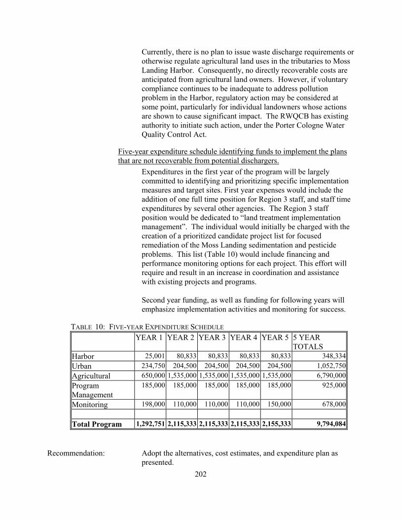
202
Currently, there is no plan to issue waste discharge requirements or otherwise regulate agricultural land uses in the tributaries to Moss Landing Harbor. Consequently, no directly recoverable costs are anticipated from agricultural land owners. However, if voluntary compliance continues to be inadequate to address pollution problem in the Harbor, regulatory action may be considered at some point, particularly for individual landowners whose actions are shown to cause significant impact. The RWQCB has existing authority to initiate such action, under the Porter Cologne Water Quality Control Act.
Five-year expenditure schedule identifying funds to implement the plans that are not recoverable from potential dischargers.
Expenditures in the first year of the program will be largely committed to identifying and prioritizing specific implementation measures and target sites. First year expenses would include the addition of one full time position for Region 3 staff, and staff time expenditures by several other agencies. The Region 3 staff position would be dedicated to “land treatment implementation management”. The individual would initially be charged with the creation of a prioritized candidate project list for focused remediation of the Moss Landing sedimentation and pesticide problems. This list (Table 10) would include financing and performance monitoring options for each project. This effort will require and result in an increase in coordination and assistance with existing projects and programs. Second year funding, as well as funding for following years will emphasize implementation activities and monitoring for success.
TABLE 10: FIVE-YEAR EXPENDITURE SCHEDULE
YEAR 1 YEAR 2 YEAR 3 YEAR 4 YEAR 5 5 YEAR TOTALS
Harbor 25,001 80,833 80,833 80,833 80,833 348,334Urban 234,750 204,500 204,500 204,500 204,500 1,052,750Agricultural 650,000 1,535,000 1,535,000 1,535,000 1,535,000 6,790,000Program Management
185,000 185,000 185,000 185,000 185,000 925,000
Monitoring 198,000 110,000 110,000 110,000 150,000 678,000
Total Program 1,292,751 2,115,333 2,115,333 2,115,333 2,155,333 9,794,084 Recommendation: Adopt the alternatives, cost estimates, and expenditure plan as
presented.

203

204
Site 3.2: Central Coast Region, Canada de la Huerta Site Description: The Central Coast RWQCB identified two high priority toxic hot
spots in their Regional Toxic Hot Spots Cleanup Plan. The RWQCB has identified several actions that are underway at the Canada del la Huerta site. A potential discharger has been identified as being responsible for this site.
Description of the site The Shell Western/Hercules Gas Plant site (now owned by Aera Energy LLC (Aera)) is located adjacent to Canada de la Huerta, approximately 18 miles west of Goleta in Santa Barbara County. In 1986 soils at the site were discovered to contain PCBs and other chemicals, as a result of operation and maintenance of the plant, and storage of a heat transfer fluid onsite. In 1988, a remedial investigation was initiated, as a result of a Consent Agreement between Shell Western and the Department of Toxic Substances Control. As a result of that investigation, soil containing PCBs in concentrations exceeding 50 parts per million (ppm) was excavated from the site and removed to a landfill for disposal. A Human Risk Assessment comprised a large part of the analysis associated with the Remedial Action Plan. The analysis only considered individuals in direct contact with the site. Cleanup at 50 ppm was deemed appropriate to protect Human Health given a “Reasonable Maximum Exposed “ individual. This corresponds to the Toxic Substances Control Act Protection Level for PCBs, but is considerably less protective than other suggested protection levels as published in the National Sediment Quality Survey (U.S. EPA, 1997). Data collected as part of the post-remediation monitoring program in 1997- 98 indicate that PCB levels at the site still violate EPA, Ocean Plan, and Basin Plan standards in both surface and ground water by orders of magnitude. Toxicity has been documented in both water and sediment. Sediment PCB levels from post-remediation sampling have ranged at some sites between 3,000 and 20,000 ppb (wet weight). These values are orders of magnitude higher than numerous protective levels referenced in the 1997 U.S. EPA document which are intended to provide protection for various beneficial uses.

205
Summary of Actions Initiated at the Site During the Fall of 1996 and Winter of 1997, the site was excavated and capped, per a remedial action plan (RAP) approved by the Department of Toxic Substances Control (DTSC). The excavation was based on removing PCB contaminated soils to 50 ppm, to a depth of five feet and a site average concentration of 10-ppm. This Regional Board and other local and state agencies, prior to RAP approval, advised DTSC that water quality and the environment were not adequately assessed by the plan. Further, Regional Board staff indicated that the 50-ppm standard would not sufficiently protect water quality or the environment. DTSC disagreed with the other agencies and the Regional Board and approved the RAP on June 15, 1994. The time period between June of 1994 and the summer of 1997 was spent negotiating with DTSC and Aera over the inclusion and details of a post-remediation monitoring program. It was agreed that the post-remediation monitoring plan would continue for a minimum of five years. Also included is a time-line of events, along with a rainfall record. A few post-remediation monitoring results are described as follows: Mean PCB-Arochlors and Benzene concentrations have been found at 100 times and 1300 times drinking water and ground water standards, respectively. PCB-Arochlors concentrations in surface waters are 300 times higher than U.S. EPA’s guidelines for protecting fresh water aquatic organisms. Total PCB-congeners, at 23 parts per million (mg/kg), in the Lower Canyon sediments, exceed the 10-ppm remediation cleanup criteria described above. Some invertebrate marine organisms are bioaccumulating PCBs at 11,000 times the U.S. EPA’s guideline for protection of saltwater organisms and 30 times the U.S. EPA’s recommended toxicity limit. Laboratory bioaccumulation studies using worm tissue show toxic levels of total PCBs at 43 ppm. Laboratory toxicity tests show PCBs are at toxic levels for water and sediment dwelling organisms located in the lower riparian area.
Approach/Alternatives: The following actions are planned for this site. The success of implementing these actions depends on the cooperation of Aera, the DTSC, DFG, Santa Barbara County Planning and Protection Services, and this RWQCB.

206
1. Continue the post-remediation monitoring program for minimum of five years after remediation (one year has already past). Aera has taken the position time is needed to allow the site to stabilize, and that once stable, there will be a significant reduction in releases of constituents of concern to the environment. The above agencies have generally agreed with this position provided there is a substantial reduction in concentrations for constituents of concern within a very short period of one or two years.
2. Within this five-year monitoring period, particularly during the
period of site stabilization, the implemented remedial action plan’s effectiveness at protecting water quality and the environment will be evaluated.
3. If it is determined that water quality or the environment are not
being protected, the monitoring program will be modified to assess the source of the contamination and the RAP will be amended to eliminate the source of contamination.
4. An ecological risk assessment may be appropriate to determine
to what extent this site is impacting the environment. 5. Deed restriction on groundwater use should remain in place on
the property until monitoring data demonstrate beneficial uses are being protected
Environmental Benefits A number of environmental benefits will result from action taken to fully remediate the Shell Hercules site. Benefits of cleanup, in terms of existing and foreseeable Beneficial Uses designated in the Region 3 Basin Plan, include the following:
Commercial and Sport Fishing Reduction of elevated levels of pollutants found in finfish and the benthic invertebrates which serve as food for a number of species.
Aquaculture Reduction of elevated levels of pollutants found in shellfish.
Wildlife Habitat Reduction of elevated levels of pollutants found in the food chain evidenced by bioaccumulation in various species.

207
Cold/Warm Freshwater Habitat Reduction of elevated levels of pollutants found in the food chain evidenced by bioaccumulation in various species.
Rare, Threatened, and Endangered Species Reduction of elevated levels of pollutants found in the food chain and evidenced by bioaccumulation in various species which may serve as prey for rare, threatened or endangered species.
Estimate of the total costs to implement the cleanup plan At this time the amount of excavation and/or groundwater extraction needed to fully protect beneficial uses is unknown. Assuming additional excavation is required to remedy the contamination problem once the site has stabilized, estimates of cost can be estimated from past remediation efforts. The Remedial Action Plan for the first cleanup effort estimated that 6,600 cubic yards of material would need to be excavated and disposed of properly. The plan determined that offsite disposal would be the most cost effective alternative. The total preliminary estimate for offsite disposal was $2,945,200. This estimate included clearing and grubbing, excavating, transportation, disposal, filling, grading and revegetating the site. Assuming that as much material must be removed and disposed of as was in the initial project, the total cost would probably be similar to the cost of the initial remediation effort. Obviously, this estimate will be highly dependent on the outcome of monitoring efforts directed at determining the areal extent and specific nature of the remaining problems. Costs may be approximated as follows:
Monitoring ($30,000/yr for 10 years) $300,000 Additional Site Assessment $250,000 Amended Remedial Action Plan $50,000 Implement Remediation Alternative $2,000,000 Total $2,600,000
Estimate of recoverable costs from potential dischargers The Remediation Action Plan provides a non-binding preliminary allocation of financial responsibility. The document states that Shell Western E & P, Inc. (Aera) is allocated 100 percent financial responsibility for cleanup of this site.

208
Two-year expenditure schedule identifying funds to implement the plans that are not recoverable from potential dischargers.
This schedule assumes that continued monitoring shows insufficient improvement in water, sediment and biological measures. Year 1 – Continued Monitoring and Assessment $30,000 Regional Board staff time (160 hrs @ $70/hr) $11,200 Year 2 – Continued Monitoring and Assessment $30,000 Detailed assessment and RAP revision to address Cleanup needs $250,000 RWQCB staff time (160 hrs @ $70/hr) $11,200 Estimated costs for first two years $332,400 All funds to be recovered from discharger.

209
Site 4.1: Los Angeles Region, Santa Monica Bay/Palos Verdes Shelf Site Description: The Los Angeles RWQCB identified five high priority toxic hot
spots in their Regional Toxic Hot Spots Cleanup Plan. The RWQCB has identified several actions that are underway in Santa Monica Bay and the Palos Verdes Shelf. Potential dischargers have been identified as being responsible for this site.
Description of the site The contaminated sediments on the Palos Verdes Shelf appear to significantly impact the marine community and may pose a serious risk to individuals who regularly consume fish from the area. Currently, elevated levels of DDT and PCBs are found in the organisms that live in the area of the contaminated sediments, including bottom feeding fish such as white croaker, and water column feeders such as kelp bass. Marine mammals and birds may be affected through the consumption of contaminated fish [Ecological Risk Evaluation Report for the Palos Verdes Shelf, Draft report prepared by SAIC for United States Environmental Protection Agency, September 1998]. The ongoing release of these hazardous substances from the sediment into the environment and the resulting accumulation of DDT and PCB in food chain organisms may persist if no action is taken. Commercial fishing and recreational fishing have been affected by the contamination. The State of California has published recreational fishing advisories for most areas offshore of Los Angeles and Orange Counties and has closed commercial fishing for white croaker on the Palos Verdes Shelf.
Summary of actions initiated at the site The Los Angeles RWQCB's Water Quality Assessment identifies the Palos Verdes Shelf as an impaired waterbody. The aquatic life beneficial use is impaired due to sediment toxicity, tissue bioaccumulation of pollutants (DDT, PCBs, silver, chromium, lead), sediment contamination (DDT, PCBs, cadmium, copper, lead, mercury, nickel, zinc, PAHs, chlordane), and a health advisory warning against consumption of fish (white croaker). The RWQCB believes that the impairment is due to the effects of historical discharges of these pollutants, since the concentrations presently discharged are very low. The Santa Monica Bay Restoration Project (SMBRP) was formed in 1988 under the National Estuary Program in response to the critical problems facing Santa Monica Bay. The Los Angeles

210
RWQCB has been an active participant in this program. The SMBRP was charged with the responsibility for assessing the Bay's problems, developing solutions and putting them into action. The scientific characterization of the Bay is described in the SMBRP's "State of the Bay, 1993" report and other technical investigations. This report, along with the Project's recommendations for action, comprises the Bay Restoration Plan which was approved in 1995. With over 200 recommended actions (74 identified as priorities), the plan addresses the need for pollution prevention, public health protection, habitat restoration and comprehensive resource management. The Los Angeles RWQCB is the lead agency responsible for implementation of several recommended actions.
The Los Angeles RWQCB has adopted a watershed management approach, which is expected to regulate pollutant loads from point sources through permits that better focus on issues relevant to each watershed. The RWQCB also expects that pollutant loads from nonpoint sources can be better controlled through the participation of the public in the management of their watersheds. During the 1996-97 Fiscal Year, the watershed management approach was used to renew selected NPDES permits within the Santa Monica Bay Watershed. The NPDES permit for the Los Angeles County Sanitation District's Joint Water Pollution Control Plant, which discharges a mixture of advanced primary and secondary effluent through an ocean outfall onto the Palos Verdes Shelf, was renewed with appropriate limits, performance goals and mass emission caps to limit the discharge of pollutants of concern.
Approach/Alternatives: In July 1996, the U.S. Environmental Protection Agency decided
to undertake a Superfund response (under the Comprehensive Environmental Response, Compensation and Liability Act) called a removal action to address the contaminated sediment problem on the Palos Verdes Shelf. EPA initiated the preparation of an Engineering Evaluation/Cost Analysis (EE/CA) of possible response actions. The EE/CA will evaluate the need for Superfund action and will use the three broad criteria of effectiveness, implementability and cost to evaluate the alternatives for addressing hazardous substances being released into the environment.
As an initial step in the EE/CA process, EPA has prepared the "Screening Evaluation of Response Actions for Contaminated Sediments on the Palos Verdes Shelf". The Screening Evaluation describes the range of potential cleanup and disposal technologies

211
for contaminated sediments and makes an initial determination about which technologies will be incorporated into the alternatives evaluated in detail in the EE/CA. General response actions which were evaluated included: • removal (i.e., dredging) and treatment or disposal; • institutional controls; and • in situ (or in-place) capping. 1. Sediment removal (dredging) While sediment removal (i.e., dredging) is technically feasible, it could possibly result in the dispersal of contaminated sediment, thereby increasing short-term risks. Once dredged, the sediment would require disposal, possibly preceded by treatment, which could be both expensive and very difficult to implement. Upland disposal facilities are very limited, and disposal options along the coastline or in the open ocean would likely violate Federal and State environmental laws. For these reasons, EPA has decided not to consider dredging and treatment or disposal options further in the EE/CA. 2. Institutional Controls Institutional control measures, such as warning notices or fishing restrictions, intended to protect human health already have been established for certain coastal areas including the Palos Verdes Shelf by the State of California, although their effectiveness is uncertain. Additional institutional controls could include measures to (1) expand the scope of existing State controls by increasing the area affected; (2) increase the awareness of and effectiveness of existing controls through additional public outreach efforts; and (3) enhance State enforcement of the commercial fishing closure. 3. In-place capping In situ, or in-place, capping can be used to prevent or reduce direct human or ecological exposure to contaminants and to prevent migration of contaminants into the water. The cap could reduce or eliminate adverse impacts through (1) physical isolation of the contaminated sediment from the benthic environment, reducing the exposure of organisms to contaminants and limiting the potential for bioaccumulation and movement of contaminants into the food chain; (2) physical stabilization of the contaminated layer to retard resuspension and transport of contaminated sediment; and

212
(3) reducing the flux of dissolved contaminants from the sediments into the water column due to waves and currents. Large caps for areas like the Palos Verdes Shelf typically would consist of clean dredged material (i.e., sand or silt) that is placed over the contaminated area using dredge or platform barges. Caps can be constructed to various sizes or thicknesses and may be augmented after initial construction to increase effectiveness. For a large site like the Palos Verdes Shelf, a phased approach to capping would likely be desirable in order to maximize cost-effectiveness. Any cap design would need to consider the engineering characteristics of the cap material and the effluent-affected sediment in order to address potential erosion by currents and waves, mixing of the cap material and underlying sediment by bottom-dwelling organisms or other disturbances. In situ capping has the potential to isolate the contaminated marine sediments, thereby providing long-term protection for the majority of the mass of contaminants on the Palos Verdes Shelf. Approximately 25% of the mass of contaminants is on the Palos Verdes slope, which is likely to be too steep for capping. Over the short term, capping would have some adverse impact on the existing benthic communities in the capped area, although it is expected that they would rapidly recolonize. If the cap were composed of suitable dredged material generated by local navigation projects (e.g., maintenance dredging), there would be no additional excavation beyond that already required for those projects, and reuse of the material for capping would reduce short-term impacts at traditional disposal sites. Carefully controlled placement of the cap material would minimize the resuspension of contaminated sediment. In situ caps have been used successfully at numerous sites, although not as deep as the deeper parts of the Palos Verdes Shelf. In general, existing caps have stabilized after initial reworking and consolidation of the contaminated sediment. Capping could be accomplished reasonably quickly, depending on the availability of capping material. A draft report (September 1998) prepared by the United States Army Corps of Engineers for EPA evaluates “Options for In-Situ Capping of Palos Verdes Shelf Contaminated Sediment”. The report considers two options: (1) capping an area of approximately 4.9 square kilometers centered over the area with the highest DDT contamination; (2) capping a secondary area of contamination comprising approximately 2.7 square kilometers located northwest of the first area. Bioturbation, consolidation and cap effectiveness

213
evaluations indicated that a thickness of 15 centimeters would be appropriate for a thin capping approach, designed to isolate contaminated material from shallow burrowing benthic organisms, while a 45 centimeter cap would be adequate for a thick cap design, effectively isolating the contaminated material from benthic organisms. Capping both areas with a thick cap (45 cm) would result in a reduction of potential exposures to contaminants over the total shelf area on the order of 70%, while a thin cap (15 cm) over both areas reduces the potential exposures on the order of 60%. Capping only the most contaminated area (4.9 square kilometers) with a thin cap would reduce potential exposures on the order of 40%.
Cost Estimate to Implement Cleanup Plan Cost estimates have been developed for three capping options:
Option 1 - capping of both areas (4.9 + 2.7 square kilometers) with a thick (45 cm) isolation cap = approximate cost would be $44 million to $67 million. Option 2 - capping of both areas (4.9 + 2.7 square kilometers) with a thin (15 cm) cap = approximate cost would be $18 million to $30 million. Option 3 - capping of only the most contaminated area (4.9 square kilometers) with a thin (15 cm) cap approximate cost would be $13 million to $19 million. Option 1 would require on the order of 7 million cubic meters of capping material for implementation, while options 2 and 3 would require proportionally less material.
Estimate of Recoverable Costs from Dischargers The United States National Oceanic and Atmospheric Administration (NOAA), via its Natural Resource Damage Assessment, and the United States Environmental Protection Agency (EPA), via Superfund, are attempting to recover financial damages from parties responsible for DDT-related damages to the environment on the Palos Verdes Shelf. EPA estimates that approximately $20-25 million may be recovered from municipalities through settlement agreements. NOAA is seeking to recover approximately $100 million from Montrose Chemical Corporation, Westinghouse Electric Corporation and other industrial dischargers.

214
Two-year Expenditure Schedule EPA should complete its evaluation of alternatives (including the "no-action" alternative) and issue the EE/CA report during 1999. At the end of the EE/CA process, EPA will solicit public comment on the EE/CA report, including the recommended removal alternative. If EPA decides to move ahead, EPA would issue an Action Memorandum formally selecting the response action. Option 1 would require approximately 5 years to construct with a single hopper dredge. However, to take advantage of the availability of clean dredged material from the Queensway Bay dredging project for use in the cap, it may be necessary to use three hopper dredges, reducing the time for completion of the project to less than 2 years. Options 2 and 3 would require proportionally less material and less time for completion. If $20-25 million becomes available from settlement agreements or other means, Options 2 and 3 potentially could be implemented within two years. Although Option 1 could be completed with 2 years with the use of multiple hopper dredges, $20-25 million would only allow completion of approximately one-third to one-half of the capping project, unless additional funds are available.
Benefits of Remediation Capping of the DDT and PCB contamination on the Palos Verdes Shelf would isolate this material from the benthic environment and reduce bioaccumulation and movement of contaminants into the food chain. This would improve the ecological health of the marine environment and should lead to elimination of the health advisory warning against human consumption of fish caught in this area.
Recommendation: Adopt the alternatives, cost estimates and expenditure plan as
presented.

215
Site 4.2: Los Angeles Region, Mugu Lagoon/Calleguas Creek Tidal Prism Site Description: The Los Angeles RWQCB identified five high priority toxic hot
spots in their Regional Toxic Hot Spots Cleanup Plan. The RWQCB has identified several actions that are underway at Mugu Lagoon and the Calleguas Creek tidal prism.
Description of site Monitoring of Mugu Lagoon and the lower Calleguas Creek watershed has identified the following problems: (1) impaired reproduction in the light-footed clapper rail, a resident endangered species inhabiting the lagoon, due to elevated levels of DDT and PCBs; (2) fish and shellfish tissue levels exceeded National Academy of Sciences guidelines for several pesticides; (3) possible exceedances of U.S. Environmental Protection Agency water quality criteria for the protection of saltwater biota for nickel, copper and zinc at some locations; (4) possible impacts to sediment and water quality, as well as aquatic community health, from operations at the Naval Air Base over many years. Several pesticides whose use has been discontinued still are found at high concentrations in the sediment and biota; (5) excessive sediment loading. The Point Mugu Naval Air Base is located in the immediate vicinity of Mugu Lagoon. The surrounding Oxnard Plain supports a large variety of agricultural crops. These fields drain into ditches which either enter the lagoon directly or through Calleguas Creek and its tributaries. The lagoon borders on an Area of Special Biological Significance and supports a great diversity of wildlife, including several endangered birds and one endangered plant species. Except for the military base, the Oxnard Plain portion of the watershed is relatively undeveloped. Calleguas Creek and its major tributaries (Revolon Slough, Conejo Creek, Arroyo Conejo, Arroyo Santa Rosa and Arroyo Simi) drain an area of 343 square miles in southern Ventura County and a small portion of western Los Angeles County. This watershed is about 30 miles long and 14 miles wide. The Calleguas Creek watershed exhibits some of the most active and severe erosion rates in the country. Although erosion rates are naturally high in this tectonically active area, land use also is a factor in erosion and sedimentation problems. Channelization of Calleguas Creek was initiated by local farmers in Somis and

216
downstream areas beginning about 1884, and around Revolon Slough in 1924. Following complete channelization, eroded sediment generated in the higher reaches of the Calleguas Creek watershed has begun to reach Mugu Lagoon even during minor flood events. At current rates of erosion, it is estimated that the lagoon habitat could be filled with sediment within 50 years. Urban developments generally are restricted to the city limits of Simi Valley, Moorpark, Thousand Oaks and Camarillo. Although some residential development has occurred along the slopes of the watershed, most upland areas still are open space. Agricultural activities (primarily cultivation of orchard and row crops) are spread out along valleys and on the Oxnard Plain. The U.S. Navy maintains a Naval Air Base on much of the area around Mugu Lagoon. The main surface water system drains from the mountains and toward the southwest, where it flows through the flat, expansive Oxnard Plain before emptying into the Pacific Ocean through Mugu Lagoon. Mugu Lagoon, situated at the mouth of the Calleguas Creek system, is one of the few remaining salt marshes in southern California along the Pacific Flyway. Threatened and endangered species that are supported by valuable habitats in Mugu Lagoon include the peregrine falcon, least tern, light-footed clapper rail and brown pelican. In addition to providing one of the last remaining habitats on the mainland for harbor seals to pup, Mugu Lagoon is a nursery ground for many marine fish and mammals. The Eastern Arm of Mugu Lagoon is somewhat removed from the rest of the lagoon and tends to receive water from and drain directly into the lagoon mouth. The arm empties and fills rather quickly, leaving a considerable amount of sand near its western end, but moving towards finer sediments further east. The water tends to be marine in character the majority of the time. The Main Lagoon and Western Arm are the areas most heavily used by birds (including endangered species). The Western Arm, with its slight gradient and slow water flow, has the most widespread freshwater influence during dry weather, receiving water from several drains. The Main Lagoon is affected primarily by Calleguas Creek, which may carry a considerable amount of fresh water during storms, although this flow generally is funneled into a channel which leads to the lagoon mouth.

217
Summary of actions initiated at the site The Los Angeles RWQCB’s Water Quality Assessment identifies the following problems in Mugu Lagoon: aquatic life beneficial use is impaired based on water column exceedances of criteria for copper, mercury, nickel, and zinc, bird reproductivity affected (DDT), tissue accumulation (arsenic, cadmium, silver; chlordane, DDT, endosulfan, dacthal, toxaphene, PCBs); sediment concentrations (DDT, toxaphene), sediment toxicity and excessive sediment. Fish consumption beneficial use is impaired based on tissue accumulation of DDT, PCBs and toxaphene. For Calleguas Creek (Estuary to Arroyo Los Posas), the Water Quality Assessment lists the following problems: aquatic life beneficial use is impaired based on water column toxicity, sediment contamination (DDT, toxaphene), tissue bioaccumulation (chlordane, toxaphene, PCBs, DDT, dacthal, endosulfan) and sediment toxicity. Fish consumption beneficial use is impaired based on tissue bioaccumulation (DDT, toxaphene, chlordane). The first large-scale stakeholder effort in the watershed was Mugu Lagoon Task Force, formed in September 1990. The purpose of the Task Force is to improve communication between agencies with various interests and specific projects in Ventura County that may impact water quality in Mugu Lagoon. All of the members share a common goal - to preserve and enhance Mugu Lagoon. The Task Force currently meets infrequently, since many of its members belong to the Calleguas Creek Watershed Management Committee. Active members of the Mugu Lagoon Task Force include the U.S. Army Corps of Engineers, University of California Cooperative Extension Service Farm Advisor, Ventura County Public Works Agency, Ventura County Planning Department, California DFG, California Coastal Conservancy, U.S. Navy Point Mugu Naval Air Station, Ventura County Resource Conservation District, U.S. Natural Resources Conservation Service and Los Angeles RWQCB. The Los Angeles RWQCB's Watershed Management Initiative began in late 1994 with the Calleguas Creek (and Ventura River) watersheds. Through watershed management, the Regional Board expects to regulate pollutant loads from point sources through permits that better focus on issues relevant to each watershed. The RWQCB also expects that pollutant loads from nonpoint sources can be better controlled through the participation of the public in the management of their watersheds.
218
The Los Angeles RWQCB renewed NPDES permits for discharges within the Calleguas Creek Watershed in June 1996. However, the RWQCB was unable to fully assess cumulative impacts to beneficial uses from all pollutant sources, particularly from nonpoint sources, during the first eighteen months of application of the Watershed Management Initiative. The Regional Board was able to develop a regional monitoring program for the inland waters of the watershed which is currently being implemented and should provide additional information needed to assess cumulative impacts. Thanks to the formation of the Calleguas Creek Watershed Management Committee in 1996, stakeholders will have the opportunity to structure and implement measures that will address pollutants from nonpoint sources through the development of a Watershed Management Plan. The Committee intends to hire a facilitator to help prepare a plan to develop a strategy for the preservation, enhancement and management of the watershed’s resources, including identification and control of sources of pollution. The Committee has outlined a three-phased plan to accomplish this goal over a 2.5 year period, beginning in January 1998. The RWQCB plans to reassess cumulative impacts to the beneficial uses of waters in the watershed by fiscal year 2002-2003. Using this information, the RWQCB is scheduled to revise NPDES permits by June 2003. The RWQCB is working with the Naval Air Weapons Station at Point Mugu to develop a cleanup plan for contamination at this Department of Defense site. This effort still is at the stage of characterizing historical sources of pollution and the extent of existing contamination levels. In the near future, decisions will be made concerning possible remediation and restoration activities in and around Mugu Lagoon.
Approach/Alternatives: Effects-based data has established that Mugu Lagoon sediment is more toxic than sediment from other lagoons in the region. Current agricultural and erosion control practices are likely moving soils heavily polluted with residuals of banned pesticides to drainages and subsequently into Mugu Lagoon.
Under the direction of the California Coastal Conservancy, Ventura County Resource Conservation District and other members of the Mugu Lagoon Task Force, the U.S. Natural Resources Conservation Service completed a report entitled: "Calleguas Creek Watershed Erosion and Sediment Control Plan

219
for Mugu Lagoon (May 1995)". The primary focus of this study was to address erosion and sedimentation impacts and solutions for the watershed. The U.S. Environmental Protection Agency, State Water Resources Control Board and the Los Angeles Regional Water Quality Control Board recently have granted additional 319(h) funds to implement specific erosion control measures for Grimes Canyon, a critical area targeted for remediation in the plan. Existing contaminated sediments within Mugu Lagoon and the Calleguas Creek Tidal Prism are unlikely to remediate naturally within a reasonable time frame. Removal of the contaminated sediments (i.e., dredging) or treatment appear to be the most appropriate remediation alternatives, although in situ capping might be the best solution for historical deposits, particularly within the lagoon.
Cost Estimate to Implement Cleanup Plan Given the sensitive nature of Mugu Lagoon as a habitat for endangered species, the most likely remediation alternatives would be no action or in situ treatment. The no action alternative would not have a financial cost, but the contaminated sediment could remain in the environment and continue to cause problems for several more decades. In situ treatment would be very expensive and may pose technical problems for remediation in an estuarine environment. No reliable cost estimate exists at this time for this treatment method, but it would probably exceed $100 per cubic yard. Dredging could be used to remove the contaminated sediments from the Calleguas Creek Tidal Prism. However, identifying a suitable and legal disposal site for contaminated sediments may be difficult. Application of this technique would cost an estimated $1 million to $5 million, based on a cost estimate of $20-100 per cubic yard (disposal costs are likely to be high, so the cost estimate probably would approach or even exceed the upper limit of the cost estimate range).
Estimate of Recoverable Costs From Dischargers Contamination of the Mugu Lagoon sediments probably associated with historical use of the now-banned pesticide DDT. Although the United States Navy could be liable for any remediation activities required as a result of historical discharges of pollutants due to operations at the Naval Air Weapons Station at Point Mugu, there is no evidence that the Navy is responsible for the elevated

220
concentrations of DDT in the sediments. It is unlikely that costs can be recovered from any other dischargers in this watershed.
Two-Year Expenditure Schedule The RWQCB plans to work with the Calleguas Creek Watershed Management Committee, which already has begun development of a watershed management plan, to select the appropriate remediation alternative for Mugu Lagoon and the Calleguas Creek Tidal Prism. In addition, watershed management measures may be required to control sources of contaminants and prevent recontamination of these areas. During Year One, the focus would be on selection of the appropriate remediation alternative for Mugu Lagoon and Calleguas Creek Tidal Prism. Additional sediment sampling may be required, particularly for Calleguas Creek Tidal Prism, to fully characterize the areal extent of the sediment contamination and prepare a plan for capping, dredging or treatment of the contaminated sediments. This sampling program probably will require approximately $100,000 - $250,000 for implementation. A source for this funding has not been determined. During Year Two, the focus would be on implementation of the remediation alternative(s) selected for Mugu Lagoon and Calleguas Creek Tidal Prism, as well as watershed management measures to control sources of contamination and prevent recontamination of the existing hot spots. Remediation of the Calleguas Creek Tidal Prism probably could be completed within Year Two, if funding is available. However, remediation of Mugu Lagoon could require additional time, depending upon the alternative selected. A monitoring program will be required to measure the success of the remediation plans that are implemented; although a monitoring program has not yet been designed, the estimated cost would be $50,000 - $100,000 per year, and may be required for at least three to five years following completion of the remediation activities.
Benefits of Remediation Successful remediation of the contamination in Mugu Lagoon and the Calleguas Creek Tidal Prism would eliminate the source of impairment of the beneficial uses of these waters.
Recommendation: Adopt the alternative approaches, cost estimates and expenditure
plan as presented.

221
Site 4.3: Los Angeles Region, Los Angeles/Long Beach Harbors, Los Angeles Outer Harbor, Cabrillo Pier
Site Description: The Los Angeles RWQCB identified five high priority toxic hot
spots in their Regional Toxic Hot Spots Cleanup Plan. The RWQCB has identified several actions that are underway in
Los Angeles Outer Harbor at Cabrillo Pier.
Description of the Site The Los Angeles and Long Beach Harbors are located in the southeastern portion of the Los Angeles Basin. Along the northern portion of San Pedro Bay, there is a natural embayment formed by a westerly extension of the coastline which contains both harbors, with the Palos Verdes Hills as the dominant onshore feature. Offshore, a generally low topographic ridge is associated with the eastern flank of the Palos Verdes uplift and adjacent Palos Verdes fault zone, and extends northwest across the San Pedro shelf nearly to the breakwater of the Los Angeles Harbor. The port and harbor areas have been modified over the course of more than one hundred years to include construction of breakwaters, landfills, slips and wharves, along with channelization of drainages, dredging of navigation channels and reclamation of marshland. The inner harbor includes the Main Channel, the East and West Basins, and the East Channel Basin. The outer harbor is the basin area located between Terminal Island and the San Pedro and Middle Breakwaters. Los Angeles and Long Beach Harbor are considered to be a single oceanographic unit, and share a common breakwater across the mouth of San Pedro Bay. The outer harbor areas reflect the conditions of the coastal marine waters of the Southern California Bight, while the inner harbor areas typically have lower salinities. In the presence of the strong currents and rocky habitat of the outer harbor, aquatic life communities are similar to those of the nearby coast, while the inner harbor supports biota generally found in bays and estuaries. The inner harbor has a mostly soft bottom character. The major surface drainages in the area include the Los Angeles River, which flows in a channel and drains parts of the San Fernando Valley, as well as downtown and south Los Angeles, into eastern San Pedro Bay at Long Beach. The Dominguez Channel drains the intensely urbanized area west of the
222
Los Angeles River into the Consolidated Slip of the Los Angeles Inner Harbor, carrying with it mostly urban runoff and non-process industrial waste discharges. A major source of both freshwater and waste in the outer harbor is secondary effluent from the Terminal Island Treatment Plant. Waste discharges to the inner harbor area of Los Angeles Harbor consist of both contact and non-contact industrial cooling wastewater and stormwater runoff. Fuel spills and oil spills from marine vessel traffic or docking facilities also contribute pollutants to the inner harbor.
Summary of Actions Initiated at the Site The Los Angeles RWQCB’s Water Quality Assessment lists the following problems in the Cabrillo area of Los Angeles Outer Harbor: aquatic life beneficial use is impaired due to tissue accumulation (DDT), sediment toxicity, sediment contamination (PAHs, DDT, zinc, copper, chromium). The Los Angeles RWQCB has adopted a watershed management approach, which is expected to regulate pollutant loads from point sources through permits that better focus on issues relevant to each watershed. The RWQCB also expects that pollutant loads from nonpoint sources can be better controlled through the participation of the public in the management of their watersheds. During the 2001-02 Fiscal Year, the watershed management approach will be used to renew NPDES permits within the Los Angeles/Long Beach Harbors Watershed. The Los Angeles RWQCB’s Site Cleanup Unit has developed cleanup and remediation plans for many contaminated sites, including refineries and old oil fields. The RWQCB has issued waste discharge requirements for some of the boatyards and stormwater runoff sources within the port. The Los Angeles RWQCB and the California Coastal Commission will begin work during fiscal year 1997-98 to prepare a long-term management plan for the dredging and disposal of contaminated sediments in the coastal waters adjacent to Los Angeles County. The goals of this plan will be to develop unified multi-agency policies for the management of contaminated dredged material, promote multi-user disposal facilities and reuse, to the extent practicable, and support efforts to control contaminants at their source using a watershed management approach.

223
Approach/Alternatives: Given the protected nature of the Cabrillo Pier area within the Los Angeles Outer Harbor, in situ capping might be a feasible
method for containment of contaminated sediments. Dredging would be a proven method to remove the contaminated sediments, but identification of a suitable and legal disposal site is often a problem. Treatment of contaminated sediments may be feasible, but is likely to be expensive and difficult to accomplish with marine sediments.
Cost Estimate to Implement the Cleanup Plan In situ capping would probably be the least expensive remediation option. However, a stable cap must be designed to prevent reexposure of the contaminated sediments. Application of this technique to contain contaminated sediments from the Cabrillo Pier area would cost an estimated $0.5 million to $1 million, based on a cost estimate of up to $20 per cubic yard (this is a rough estimate, since the unit cost could be higher). Dredging could be used to remove the contaminated sediments from the Cabrillo Pier area. However, identifying a suitable and legal disposal site for a large volume of contaminated sediments can be difficult. Application of this technique would cost an estimated $0.5 million to $5 million, based on a cost estimate of $20-100 per cubic yard (if a disposal site, such as a confined aquatic disposal or land disposal site, is available within or close to the Los Angeles/Long Beach Harbors complex, the cost estimate probably would approach the lower limit of the cost estimate range). Treatment of the contaminated sediments is likely to be expensive. Application of this technique would cost an estimated $2.5 million to $50 million, based on a cost estimate of $100-$1,000 per cubic yard (due to limited experience in treating marine sediments, costs are likely to be in the upper part of the cost estimate range).
Estimate of Recoverable Costs from Dischargers In July 1996, the U.S. Environmental Protection Agency decided to undertake a Superfund response (under the Comprehensive Environmental Response, Compensation and Liability Act) to address the contaminated sediment problem on the Palos Verdes Shelf. However, the Los Angeles Harbor area was not included within the scope of the Superfund action. Since it will be difficult or impossible to prove that the contamination of the harbor is due to stormwater runoff from the Montrose Chemical Corporation’s historical manufacturing site in Torrance, which appears to be a

224
likely source for this contamination, we do not anticipate recovering any remediation costs from dischargers.
Two-year Expenditure Schedule The RWQCB plans to work with the Los Angeles Basin Contaminated Sediments Task Force to select a remediation alternative and implement the cleanup plan for the Cabrillo Pier hot spot. Additional sediment sampling will be required to better define the areal extent of the sediment contamination, prior to selection of an appropriate remediation alternative. This sampling program could be conducted during Year One, if funding becomes available (estimated cost approximately $250,000 - $500,000). However, the RWQCB would recommend implementing the cleanup of the Consolidated Slip/Dominguez Channel hot spot prior to initiating any remediation activities at the Cabrillo Pier site, since the Consolidated Slip/Dominguez Channel area may represent a source of contamination to the Cabrillo Pier area. A monitoring program would be required upon completion of any remediation activities; it is estimated that monitoring would cost $50,000 to $100,000 per year, and may be required for three to five years.
Benefits of Remediation Remediation of the contamination would eliminate the source of impairment of beneficial uses of the receiving waters.
Recommendation: Adopt the alternatives, cost estimates and expenditure plan as
presented.

225
Site 4.4: Los Angeles Region, Los Angeles Inner Harbor/Dominguez Channel, Consolidated Slip
Site Description: The Los Angeles RWQCB identified five high priority toxic hot
spots in their Regional Toxic Hot Spots Cleanup Plan. The RWQCB has identified several actions that are underway in the Los Angeles Inner Harbor at Dominguez Channel and Consolidated Slip.
Summary of Actions Initiated at the Site The Los Angeles RWQCB’s Water Quality Assessment lists the following problems in Dominguez Channel: aquatic life beneficial use is impaired due to sediment contamination (chromium, zinc, DDT, PAHs) and benthic community impairment. The Water Quality Assessment identifies the following problems in Consolidated Slip: aquatic life beneficial use is impaired due to tissue accumulation (DDT, chlordane, PCBs, tributyltin, zinc), sediment toxicity, benthic community effects, sediment contamination (PAHs, zinc, chromium, lead, DDT, chlordane, PCBs); and a fish consumption advisory. The Los Angeles RWQCB’s Site Cleanup Unit has developed cleanup and remediation plans for many contaminated sites, including refineries and old oil fields. The RWQCB has issued waste discharge requirements for some of the boatyards and stormwater runoff sources within the port. The Los Angeles RWQCB has adopted a watershed management approach, which is expected to regulate pollutant loads from point sources through permits that better focus on issues relevant to each watershed. The RWQCB also expects that pollutant loads from nonpoint sources can be better controlled through the participation of the public in the management of their watersheds. During the 2001-02 Fiscal Year, the watershed management approach will be used to renew NPDES permits within the Los Angeles/Long Beach Harbors Watershed and the Dominguez Channel Watershed. The Los Angeles RWQCB and the California Coastal Commission will begin work during fiscal year 1997-98 to prepare a long-term management plan for the dredging and disposal of contaminated sediments in the coastal waters adjacent to Los Angeles County. The goals of this plan will be to develop unified multi-agency policies for the management of contaminated dredged material, promote multi-user disposal facilities and reuse, to the extent

226
practicable, and support efforts to control contaminants at their source using a watershed management approach.
Approach/Alternatives: Dredging would be a proven method to remove the contaminated sediments, but identification of a suitable and legal disposal site often can be a problem. Treatment of contaminated sediments may be feasible, but is likely to be expensive and difficult to accomplish with marine sediments. In situ capping is not likely to be chosen as an alternative, due to the high flows that can occur in this area and the potential for reexposure and transport of contaminated material.
Cost Estimate to Implement Cleanup Plan Dredging could be used to remove the contaminated sediments from the Dominguez Channel/Consolidated Slip area. However, identifying a suitable and legal disposal site for a large volume of contaminated sediments can be difficult. Application of this technique would cost an estimated $1 million to $5 million, based on a cost estimate of $20-100 per cubic yard (if a disposal site, such as a confined aquatic disposal or land disposal site, is available within or close to the Los Angeles/Long Beach Harbors complex, the cost estimate probably would approach the lower limit of the cost estimate range). Treatment of the contaminated sediments is likely to be expensive. Application of this technique would cost an estimated $5 million to $50 million, based on a cost estimate of $100-$1,000 per cubic yard (due to limited experience in treating marine sediments, costs are likely to be in the upper part of the cost estimate range).
Estimate of Recoverable Costs from Dischargers No responsible parties have been identified from which costs could be recovered.
Two-year Expenditure Schedule The RWQCB plans to work with the Los Angeles Basin Contaminated Sediments Task Force to select a remediation alternative and implement the cleanup plan for the Consolidated Slip/Dominguez Channel hot spot. Additional sediment sampling will be required to precisely define the areal extent of the sediment contamination, prior to selection of an appropriate remediation alternative. This sampling program could be conducted during Year One, if funding becomes available (estimated cost approximately $250,000 - $500,000). If dredging is selected as the desired remediation method, the RWQCB will work with the Task

227
Force to identify a suitable disposal alternative (e.g., constructed fill site, confined aquatic disposal site). A monitoring program would be required upon completion of any remediation activities; it is estimated that monitoring would cost $50,000 to $100,000 per year, and may be required for three to five years.
Benefits of Remediation Remediation of the contamination would eliminate the source of impairment of beneficial uses of the receiving waters.
Recommendation: Adopt the approaches, cost estimates and expenditure plan as presented.

228
Site 4. 5: McGrath Lake Site Description: The Los Angeles RWQCB identified five high priority toxic hot
spots in their Regional Toxic Hot Spots Cleanup Plan. The RWQCB has identified several actions that are underway in McGrath Lake.
Description of the Site McGrath Lake is a 40-acre lake within McGrath State Beach Park managed by the California Department of Parks and Recreation. for low intensity uses, such as hiking and nature observation. The lake surface is approximately 3000 feet in length and approximately 450 feet at its widest point. It is a shallow lake, with an average depth of approximately 2 feet. The southern portion of the lake generally is deeper than the northern portion, with a maximum depth of approximately 5 feet. The lake contains brackish water, with salinities varying from 2.5 to 5 parts per thousand throughout much of the lake, with higher salinities (up to 24 parts per thousand) in some of the deeper areas.
The lake does not have an ocean connection, but waves occasionally overtop the beach berm. Water is pumped from the lake to the ocean throughout most of the year to maintain a lowered lake level and avoid flooding of upstream agricultural fields. In addition, the lake is breached intermittently at the southern edge during the wet season to prevent flooding of nearby agricultural fields.
Water sources to the lake include seawater intrusion from the ocean through the coastal dunes, groundwater seepage, and irrigation and stormwater runoff. McGrath Lake was included on the Los Angeles Regional Water Quality Control Board’s 1996 list of 303(d) impaired water bodies due to sediment pollution (elevated pesticides and other contaminants) and sediment toxicity. The lake was impacted in 1993 when a ruptured pipeline released nearly 80,000 gallons of crude oil into an agricultural ditch draining into the lake. However, PAH levels in the sediments are relatively low, suggesting little long-term effect on sediment contamination due to the oil spill.
The lake historically was part of the Santa Clara River Estuary. The backdune coastal lake is unique in Southern California and plays a key role in the avian migratory flyway. It is fronted by a

229
coastal dune which is rare because of the undisturbed natural processes, which allow the dunes to continue to grow and build.
McGrath Lake is an important coastal resource that has been impaired by high levels of trace metals, pesticides, and other organic contaminants. Elevated levels of several chemical contaminants in the lake sediments and the demonstrated toxicity of these sediments appear to have limited productivity within the lake and threatens the health of wildlife, such as birds, associated with the habitats provided by the lake.
Summary of actions initiated at the site The Los Angeles Regional Board’s Water Quality Assessment lists the following problems in McGrath Lake: aquatic life beneficial use is impaired due to sediment contamination (DDT, chlordane, dieldrin) and sediment toxicity. The Regional Board has adopted a watershed management approach, which is expected to regulate pollutant loads from point and non-point sources through permits that better focus on issues relevant to each watershed. During the 2003-2004 Fiscal Year, the watershed management approach will be used to renew NPDES permits within the Ventura Coastal Watershed.
Preliminary Assessment of Remediation Actions Dredging would be a proven method to remove the contaminated sediments, but identification of a suitable and legal disposal site often can be a problem. Treatment of contaminated sediments may be feasible, but is likely to be expensive. In situ capping is not likely to be chosen as an alternative, due to the shallow nature of the lake and the high flows that can occur in this area, which could lead to reexposure and transport of contaminated material.
Source control measures appear necessary to prevent recontamination of the lake sediments. Flows from adjacent agricultural fields, which apparently continue to introduce pesticides and other contaminants into the lake, could be redirected away from the lake or treated to remove the contamination (e.g., settling basins could be used to remove particulates, which may remove much of the contaminant load).
Cost Estimate to Implement Cleanup Plan Dredging could be used to remove the contaminated sediments from McGrath Lake. However, identifying a suitable and legal disposal site for a large volume of contaminated sediments can be difficult. Application of this technique would cost an estimated $3

230
million to $30 million, based on a cost estimate of $20-100 per cubic yard to remove 150,000 to 300,000 cubic yards of contaminated sediments.
Treatment of the contaminated sediments is likely to be expensive. Application of this technique would cost an estimated $15 million to $300 million, based on a cost estimate of $100-1000 per cubic yard (due to limited experience in treating dredged material, costs are likely to be in the upper part of the cost estimate range).
Estimate of Recoverable Costs from Dischargers No responsible parties have been identified from which costs could be recovered.
Two-year Expenditure Schedule The RWQCB plans to work with the McGrath State Beach Area Trustee Council, which is composed of representatives from the California Department of Fish and Game, California Department of Parks and Recreation and United States Fish and Wildlife Service. The Trustee Council was formed as a condition of settlement with Berry Petroleum following the 1993 oil spill. The Council is working with local stakeholders to develop a plan to remediate and restore the habitat values and maximize beneficial uses of McGrath Lake. The Council plans to address any residual problems related to the oil spill, as well as those caused by other sources (e.g., agricultural runoff).
Additional sediment sampling will be required to precisely define the areal extent and total volume of the sediment contamination problem, prior to selection of an appropriate remediation alternative. This sampling program could be conducted during Year One, if funding becomes available (estimated cost approximately $250,000 - $500,000). Source control measures to eliminate or reduce recontamination of the lake’s sediments should be undertaken during Year Two prior to initiation of remediation of the existing sediment contamination. Although no specific funds have been secured for this source control effort, several potential sources are available, such as United States Environmental Protection Agency grants, Wetlands Restoration Program grants, Mitigation Project funds and enforcement action settlements.

231
Benefits of Remediation Remediation of the sediment contamination and source control measures would eliminate the source of impairment of beneficial uses of the receiving waters of McGrath Lake and adjacent areas.
Recommendation: Adopt the approaches, cost estimates and expenditure plan as
presented.

232
Site 5.1: Central Valley Region, Mercury Cleanup Plan Site Description: The Central Valley RWQCB identified several high priority toxic
hot spots in their Regional Toxic Hot Spots Cleanup Plan. The RWQCB has identified several actions that are underway to cleanup and remediate toxic hot spots associated with mercury.
Description of the Site Mercury has been identified as the pollutant responsible for creating a candidate toxic hot spot in the Sacramento-San Joaquin Delta Estuary. In January 1998 the Central Valley Regional Water Quality Control Board adopted a revised 303(d) list, ranked mercury impairments in the lower Sacramento River, Cache Creek, Sulfur Creek , Lake Berryessa, Clear Lake and the Sacramento-San Joaquin Delta Estuary as high priority because of elevated concentrations in fish tissue and committed to the development of a load reduction program by the year 200515. The widespread distribution of mercury contamination emphasizes the regional nature of the problem and the need for regional solutions. There is a human health advisory in effect in the Delta and in San Francisco Bay because of elevated mercury levels in striped bass and other long lived fish. The entire area of the Delta is therefore considered a hot spot. The Delta is a maze of river channels and diked islands covering roughly 78 square miles of open water and about 1,000 linear miles of channel. Cache Creek is a 1100 square mile watershed in the Coast Range with about 150 linear miles of mercury impacted waterways. The watershed also contains Clear Lake, the largest natural lake in California at 43,000 acres. A human health advisory has also been posted in Clear Lake because of elevated mercury concentrations in fish tissue. The source of the mercury is Sulphur Bank Mine, a U.S. EPA Superfund site.
Summary of Actions Initiated at the Site Three actions have been taken in the Central Valley to begin addressing the human health problems posed by mercury. Each is summarized below.
15The lower American River, lower Feather River, Harley Gulch, Sacramento Slough, March Creek and Reservoir, San Carlos Creek, James Creek, and Panoche Creeks were also placed on the 303(d) list as impaired because of excess mercury but were given a lower priority for cleanup.

233
Loading studies Bulk mercury loading studies conducted by the Central Valley RWQCB (Foe and Croyle, 1998) and by Larry Walker and Associates (1997) on the Sacramento River have determined that new loads of metal enter the estuary each year during high flows. Coast Range inputs appear more important than Sierra Nevada ones as a significant fraction of the inputs from the latter are intercepted and trapped by foothill reservoirs. Cache Creek has been identified as an important Coast Range mercury source. Other sources on the Sacramento River upstream of the confluence of the Feather River may also be important but remain unidentified.
Bioavailability Studies by Slotton et al. have determined that fish tissue concentrations can be predicted from changes in mercury concentration in invertebrate trophic levels. This relationship has been used to standardize mercury food chain bioaccumulation in the Central Valley and identify local areas where fish may or may not be present but elevated concentrations of bioavailable mercury are accumulating in the food chain. The studies have identified areas with apparent high methylation potential in the Sierra Nevadas and Coast Range. All are associated with past intensive gold, silver and mercury mining. The process has also suggested that some sites with large bulk mercury loads, such as the Cache Creek drainage, might not be as vulnerable to methyl mercury production as their loads would suggest. Similar food chain studies need to be completed for all mercury rich areas in the Central Valley.
CALFED The CALFED has made mercury remediation a designated action and requested that the RWQCB, in cooperation with California Department of Fish and Game submit a proposal. CALFED recently informed the RWQCB that it has funded the proposal for 3.8 million dollars. Work should begin in the fall of 1999. The CALFED grant includes funding for all the work outlined in the BPTCP. The CALFED Category III Ecosystem Restoration Program has proposed to purchase large tracts of farmland in the Estuary, break levees, and convert the fields to shallow water intertidal habitat. Newly flooded wetlands are known to have elevated rates of methyl mercury production and concern has been expressed that CALFED restoration activities might increase methyl mercury

234
concentrations in estuarine fish. The CALFED Category III program announced in December 1997 that they would fund a grant entitled "The effects of wetland restoration on the production of methyl mercury in the San Francisco Bay Delta System" by Drs. Suchanek and Slotton. Purpose of the three year project is to quantify changes in methyl mercury production caused by restoration practices and evaluate the bioavailability and impact of the mercury on the Bay Delta Ecosystem. The ultimate intent of the Authors is to provide recommendations to managers for potentially modifying restoration approaches to minimize methyl mercury production.
Approach/Alternatives: In January 1998 the Central Valley RWQCB adopted a revised
303(d) list, ranked mercury in fish tissue as a high priority impairment in several Central Valley water bodies and committed to adopting a TMDL to control mercury bioaccumulation by the year 2005. The purpose of the Bay Protection mercury clean up plan is to lay out a strategy for collecting the information needed to develop a phased TMDL with the initial emphasis in Cache Creek.
According to the U.S. EPA (1998), “The goal of a TMDL is the attainment of water quality standards. A TMDL is a written quantitative assessment of water quality problems and the contributing pollutant sources. It specifies the amount of reduction needed to meet water quality standards, allocates load reductions among sources... and provides the basis for taking actions to restore a water body.” It will be challenging to successfully implement a TMDL for mercury in the Central Valley as there are fundamental unresolved scientific questions about mercury bioaccumulation in aquatic food chains. Principal among these is a lack of knowledge about the primary chemical forms of mercury most efficiently methylated and the locations and processes which most stimulate the conversion. Therefore, RWQCB staff propose a phased mercury TMDL. Staff propose to commence pilot mercury control work in Cache Creek, a major source of mercury to the Estuary. As the necessary scientific information is obtained and success demonstrated in the control of bioavailable mercury in this watershed, then similar control efforts will be undertaken in other mercury enriched water courses and in the estuary itself. The working hypothesis for the estuary is that as all bioavailable sources of mercury to the estuary are identified and their discharge reduced to the maximum extent possible, material already present in the system will gradually become buried and less bioavailable. The result will be a slow reduction in mercury fish tissue levels.

235
The U.S. EPA (1998) suggests that the successful development of a TMDL requires information in six general areas: identification of a target, location of sources, quantification of the amount of reduction needed, allocation of loads among sources, an implementation plan, and monitoring and evaluation to track results and demonstrate compliance. RWQCB staff also believe that a seventh element, formation of a regional mercury task force, is needed to help guide the control effort. Each element, including the associated scientific uncertainties and resources needed to resolve these, is briefly described below.
1. Task force.
A regional mercury control strategy task force should be formed. The Task Force should be composed of scientists, watershed stakeholder groups, and resource managers from both the Central Valley and San Francisco Bay area. The nucleus of the Task Force could be the Cache Creek Mercury Group. Purpose of the Task Force would be to advise RWQCB staff on the definition of an appropriate target, on the identification of sources and the allocation of loads, on developing the regional mercury control strategy, and on acting as a clearing house for mercury information. RWQCB staff will take the Task Force’s recommendations in a timely fashion, the staff will develop the TMDL considering all information and advice available. Finally, the Task Force should make recommendations to the RWQCB, CALFED, and other entities on funding priorities.
2. Target.
Purpose of the Cache Creek mercury TMDL is to reduce fish tissue mercury concentrations to levels that are safe for ingestion by humans and wildlife. Several possible fish tissue mercury targets should be evaluated and one selected for incorporation into the TMDL. Possible options are the identification of a fish tissue concentration that would fully protect both wildlife and human health. An alternate target is the identification of a background Cache Creek fish tissue concentration in areas of the watershed uninfluenced by mining or other anthropogenic activities which enhance mercury bioavailability. Wildlife The U.S. Fish and Wildlife Service has identified Mergus merganser, the common merganser, as the wildlife species most likely at risk from elevated fish tissue mercury concentrations in Cache Creek (personal communication, Schwarzbach). The bird

236
is known to breed in the Cache Creek basin and elevated mercury levels in its diet may cause reproductive impairment. Principal merganser prey items are small (3-7 inch) fish. The U.S. Fish and Wildlife Service estimate that the provisional “no and low effect dietary concentrations” for the common merganser range between 0.1 and 0.3 ppm mercury fish wet weight (personal communication, Schwarzbach). Limited data exist in the basin for mercury concentrations in small fish. Values collected in the lower basin range between 0.1 and 0.3 ppm (Davis, 1998) and in Bear Creek in late summer between 0.3 and 1.75 ppm whole body wet weight (personal communication, Schwarzbach). These values suggest that mergansers may presently experience reproductive impairment at some locations in the basin. The safe concentration estimate of 0.1 ppm wet weight is based upon a three generation mallard feeding study (Heinz, 1979). The safe value was calculated by dividing the lowest effect concentration by a factor of three. The U.S. EPA (1997) in their Report to Congress used a similar safety factor to estimate no effect concentrations. The Cache Creek wildlife target could be improved by completion of a mercury dietary study for a fish eating bird, such as a merganser, to verify the proposed no and low effect levels. The study should also evaluate seasonal changes in mercury concentrations in feathers. The risk posed by mercury to wildlife could be further strengthened by conducting an egg-feather survey in Cache Creek and elsewhere around the Estuary to ascertain how mercury concentrations in eggs and feathers of fish eating birds compare to those documented to be toxic in the merganser feeding study. Human Health The U.S. EPA (1995) presently recommends a mercury screening value of 0.6 ppm wet weight in fish fillet to protect human health. International studies of the human health effects of mercury exposure via fish consumption are underway in the Seychelles and Faroes Islands. The reference level protective of human health may change as a result of these studies which are expected to be completed and analyzed within the next several years. A better estimate of a safe mercury concentration to protect human health should be available upon completion of this work. Limited mercury fish tissue data is available for Cache Creek. Most of the data has been collected in the lower basin between the City of Woodland and the Settling Basin. As noted previously, average mercury concentrations in predacious fish of a size consumed by people range between 0.2 and 0.9 ppm wet weight. Staff of the California Office of Environmental Health Hazard Assessment (OEHHA) have evaluated this data and concluded that, while more information is needed, some of the concentrations

237
appear elevated for human consumption (personal communication, Brodberg). A follow-up fish tissue study is needed. The purpose of the study is two fold. The first objective is to determine mercury concentrations in fish caught throughout the basin to better characterize the threat posed to human health and wildlife by the consumption of fish from Cache Creek. The second objective is to establish statistically reliable baseline data to evaluate the effect of mercury remediation activity in the Basin. The study should emphasize the seasonal collection of a variety of fish species at locations most likely used by people and wildlife. The study should be coordinated with OEHHA, local offices of County Public Health, Fish and Game and U.S. Fish and Wildlife Service. Resources are requested in to collect the fish tissue data. Funds are also requested for OEHHA to help organize the study and evaluate the data. Baseline No baseline fish tissue data is available for Cache Creek. Efforts should be undertaken to establish such data at locations in the watershed unaffected by mining activity. Possible locations for evaluation include Rayhouse, Fiske, Cole, Kelsey, Adobe, Scott and Middle Creeks. One or more of these locations should be included in the fish tissue studies described above. The data would be evaluated to ascertain whether the baseline concentrations are lower than the concentrations necessary to protect human health and wildlife. If so, the value might be considered an “anti-degradation” type of target.
3. Sources
Two mercury source studies were conducted in the Cache Creek Basin. The first was a loading study to determine the amount of total recoverable mercury exported from the watershed and the principal seasonal sources within the basin (Foe and Croyle, 1998). The second was an invertebrate bioavailability study to determine the major locations in the basin where mercury was bioaccumulating in the aquatic food chain (Slotton et al., 1997b). Both are briefly reviewed below to help identify the major mercury sources needing remediation. Loading Studies conducted between 1996-98 determined that Cache Creek was a major source of estuarine mercury (Foe and Croyle, 1998). Most of the mercury appeared to be transported on sediment particles. A correlation was noted between total mercury concentration at Road 102 and flow immediately upstream at the

238
Town of Yolo. The relationship was employed to estimate bulk mercury loads. The basin was estimated to have exported 980 kg of mercury during the wet 1995 water year. Half of the metal appears to have been trapped by the Cache Creek Settling Basin while the remainder was exported to the Estuary. In contrast, little to no mercury was predicted to be transported out of the Basin during dry years emphasizing the importance of winter runoff in the off site transport of mercury. Seasonal studies demonstrate three general loading patterns: summer irrigation season, winter non-storm runoff periods, and winter storm runoff events. The irrigation season occurs during the six month period between April and October. Mercury transport rates in the upper basin were on the order of 10-50 g/day with most of the metal coming from Clear Lake. Probable source of the Clear Lake mercury is from the Sulfur Bank Mine, an EPA Superfund site. The winter non-storm period is the next most common event and occurs between November and March. The only observations to date have been made during wet winters. Mercury export rates were on the order of 100-1,000 g/day. Much of the mercury appears to have originated from Benmore and Grizzly Creeks which are tributaries to the North Fork of Cache Creek. Finally, storm runoff events were least common and occurred about 4-10 times per wet year. All subbasins of Cache Creek exported significant amounts of mercury but the majority of the metal appeared to come from the Cache Creek canyon between the confluence of the North and South Forks but above Bear Creek. The precise source(s) of the metal in the inaccessible canyon was not identified. Sulfur Creek and Harley Gulch, sites with extensive abandoned mining activity, also exported large amounts of mercury. Storm export rates were on the order of 5,000-100,000 g/day. Resuspension of mercury contaminated sediment appears to be a major source of mercury during all three time periods. Little dissolved and no methyl mercury data was collected. These two forms of mercury may provide a better correlation with in situ bioavailability than the bulk mercury mineral loads measured in this study. Additional loading information is needed. Emphasis should be on collecting seasonal information on dissolved and methyl mercury loads at key locations throughout the basin including several background sites and all major mercury mining sources. Bioavailability studies In the spring of 1996 a one time benthic invertebrate survey was conducted in the upper Cache Creek basin to determine local mercury bioavailability (Slotton et al., 1997).

239
Representative benthic invertebrates were collected with a kick screen, sorted to taxa, grouped according to trophic level, and analyzed for total mercury body burden. All elevated invertebrate tissue burden samples were associated with drainage from known mercury mines or geothermal hot springs. These include Sulfur and Davis Creeks, Harley Gulch, and Clear Lake. No elevated mercury signal was observed in the North Fork of Cache Creek downstream of Benmore and Grizzly Creeks suggesting that these two non-mine impacted mercury enriched drainages might not be major sources of locally bioavailable mercury. The conclusions of the bioavailability study also differ from the loading one in that Clear Lake is identified as a major source of bioavailable mercury in the upper watershed. The loading study suggested that Clear Lake was only a major source of mercury during summer and on an annual basis did not account for much of the mercury transported in the basin. The bioavailability data collected downstream of Clear Lake emphasize the need to better understand the forms and processes which mediate methyl mercury production and cycling in the Cache Creek aquatic food chain. Additional information is needed on the correlation of mercury concentrations in water, sediment and invertebrate body burden levels. Invertebrates are emphasized as they are more ubiquitous than fish and, being closer to the bottom of the food chain, should respond more rapidly to changes in bioavailable mercury than any other life form. Also, in the Coast Range invertebrates often exhibit mercury concentrations very similar to small fish (personal communication, Slotton). More data is needed to establish the relationship between invertebrate body burden levels and mercury concentration in larger fish. Intensive seasonal monitoring of water and sediment coupled with changes in invertebrate body burden levels should be conducted at key locations in the watershed. The sediment sampling should determine flux rates of dissolved inorganic and methyl mercury from the sediment. The water, sediment and invertebrate studies should be closely coordinated with the fish tissue sampling effort. The purpose is twofold. First, establish baseline seasonal invertebrate bioavailability data for the watershed so that changes in mercury cycling may be more readily determined once remediation is undertaken. Second, by intensively sampling water/sediment and invertebrates, better identify the times, locations and mercury forms most important in the formation and movement of methyl mercury up the aquatic food chain. This information will be essential to quantify the amount of load reduction needed at different sources.

240
Site Remediation studies As noted above, Sulfur Creek, Harley Gulch, and Clear Lake have been identified as major sources of total and bioavailable mercury. All three watersheds have abandoned mercury mines. In addition, Sulfur Creek has active geothermal activity which may also contribute mercury. Site remediation feasibility studies should be undertaken in Sulfur Creek and Harley Gulch to identify the major sources of the bioavailable mercury and the most practical, cost effective control methods which will insure that the TMDL goals for the site are met. Control efforts for evaluation may include runoff and waste material isolation studies, natural revegetation, waste rock removal and infiltration evaluations. Sulphur Bank Mine is the likely source of the mercury in Clear Lake. The mine is an active U.S. EPA Superfund site. Downstream load reduction requirements should be coordinated with the Superfund cleanup activities to ensure that the beneficial uses of both Clear Lake and the downstream watershed are protected. No funding is suggested for Sulphur Bank Mine as the site has been selected as a U.S. EPA Superfund site and the cost of remediation will be paid for by the Federal Government.
4. Quantification of the Amount of Load Reduction Needed
The key weakness in the development of this TMDL is our present lack of understanding about the relationship between inorganic mercury concentrations in water/sediment and methyl mercury concentrations in invertebrate and fish tissue. However, it is anticipated that detailed information about mercury concentrations in the water column from upstream transport and from in situ sediment fluxing coupled with changes in invertebrate and fish tissue concentration will help establish such a relationship. This information will be used to determine how much reduction in the various forms of mercury are needed downstream of each source. No implementation plan should be incorporated into the Regional Board’s Basin Plan until these relationships are established.
5. Implementation
The RWQCB committed to adoption of a mercury TMDL implementation plan by the year 2005. While discussion of the contents of the implementation plan are premature, several factors are worth noting. First, as noted throughout the discussion, the development of the plan will require significant directed research. All research results should be reviewed by the Mercury Task Force and recommendations made to Regional Board staff prior to

241
commencing implementation. The recommendations should include an evaluation of the scientific defensibility of the research conclusions and the likelihood of success should the implementation plan be incorporated into the Basin Plan and remediation control activity undertaken. Second, the plan will include a time schedule and recommendations on how to fund implementation. This may include a discussion of developing “Pollution Trading” opportunities whereby Central Valley and Bay Area Dischargers are allowed to fund more cost effective nonpoint source cleanup projects in Cache Creek and elsewhere in lieu of less effective abatement actions at their own facilities. Third, while the mine remediation feasibility studies have not yet been undertaken, it is likely that one of the conclusions will be that some of the principal sources of bioavailable mercury are from sites where the owners have insufficient resources to carry out the cleanup. So, in the interim, the State of California should pursue federal “Good Samaritan” legislation or identify some other legally defensible mechanism to minimize State liability and insure that public funds can be used for mercury control efforts wherever they are most cost effective. Finally, it is estimated that all the studies outlined above can be completed within 2.5 years of their being initiated. The mercury Task Force should be allowed an additional six months to evaluate the study results and make recommendations to RWQCB staff on load allocations and an implementation plan. It should take an additional half a year for Regional Board staff to evaluate the data, all recommendations and develop a TMDL for insertion into the Basin Plan.
6. Monitoring and Evaluation
Significant monitoring will be required once the TMDL is implemented and site remediation is undertaken. It is predicted that methyl mercury concentrations in invertebrates close to the sources should decrease most rapidly (within a year or so of the completion of remediation). Concentrations in large fish and higher trophic level invertebrates more distant from the source will change more slowly. If significant reduction in invertebrate body burden levels are not measured in a timely fashion close to the sources then further remediation or other adaptive management measures should be considered. The TMDL will be considered successful and will be terminated only when mean small and large fish tissue concentrations in the Basin reach the adopted target level.
7. Other Studies Needed

242
As previously mentioned, there are other major sources of mercury to the Sacramento-San Joaquin Delta Estuary besides Cache Creek. These include runoff from the historic placer gold fields in the Sierra Nevadas and runoff from other mercury producing areas in the Coast Range. Off site movement of this material has contributed to elevated mercury levels in sediment and biota in the Estuary and to the posting of health advisories warning the public to limit consumption of large striped bass and shark. The strategic plan described above is a pilot TMDL with the initial emphasis being on determining mercury bioavailability and mine remediation feasibility studies in Cache Creek. The anticipation is that the information gained by intensively studying one watershed will result in the identification of cost effective solutions which can be employed elsewhere. However, in the interim, some directed studies will be needed outside of Cache Creek. Each area is briefly described below.
A. Source identification Mercury mass load studies (total
recoverable, dissolved and methyl mercury) should continue in the Central Valley with an emphasis on watersheds where no data are available. These should include the San Joaquin, Mokelumne, and Cosumnes Rivers. Detailed follow up studies should be undertaken in watersheds where the initial studies demonstrate that major sources of mercury come from. Follow up studies should include an assessment of inter-annual variability and the precise locations of all the major mercury sources within each watershed. The studies should also include assessments of the load contributions from major NPDES and storm water discharges. The mass load work should be accompanied by biological surveys to identify locations with enhanced food chain mercury bioavailability. Funding for the loading studies are requested in Table 11.
B. Public Health Mercury fish tissue studies should continue in
the Delta. Studies should be designed and carried out in coordination with the Office of Environmental Health Hazard Assessment, Department of Health Services, and Fish and Game. The primary purpose is to establish the range of mercury in fish tissue in the Estuary to assess the public risk posed by their consumption. A secondary objective is to establish baseline conditions to evaluate the future success of upstream remediation activities.
C. Bioavailability Studies Directed research should be
undertaken to better understand mercury cycling in the Central Valley and Estuary. Research emphasis should be on

243
evaluating the relative bioavailability of the different sources of mercuric material moving into the Estuary in comparison with concentrations already present and available in sediment porewater. At a minimum these should include an evaluation of inputs from the Cache Creek drainage in the Coast Range, Sierra Nevada Mountains and municipal, industrial, and storm water discharges. The studies should also include an evaluation of the importance of the remobilization of mercury from sediment by natural fluxing and release during dredging, disposal of dredge material on island levees, and creation of shallow water habitat. The ultimate objective of this directed research is to provide resource managers with recommendations on how to minimize mercury bioaccumulation in the Central Valley, Delta and San Francisco Bay.
Estimate of Costs An estimate of the costs to develop the information necessary to implement the TMDL are provided in Table 11 below. It is impossible until this information is obtained to estimate the actual cost of implementing the mercury TMDL.

244
TABLE 11: ESTIMATE OF COST TO COLLECT INFORMATION TO DEVELOP A MERCURY CONTROL STRATEGY. Task Cost TARGET
Fish eating bird (Merganser) study $200,000 Egg study $60,000 Coordination with OEHHA $75,000
Total $335,000 MERCURY MONITORING IN CACHE CREEK (per year)
Methyl mercury sediment flux studies $200,000 Water, invertebrate and fish tissue work $200,000 Mercury mass loading studies $160,000
Multi-year total $1,120,000 MINE REMEDIATION FEASIBILITY STUDIES $150,000 ESTUARINE MERCURY MONITORING STUDIES (per year)
Source identification $100,000 Fish tissue studies (wildlife and human health) $150,000 Bioavailability $500,000
Multi-year Total $1,500,000
Grand Total $3,105,000
Estimate of recoverable costs from potential dischargers No cost recovery possible.
Two-year expenditure schedule Several potential sources of funding may be available. First, CWA Sections 104(b)(3), 106(g), and 319(h) grants have been used in the past by the RWQCBs to address such issues. Second, the Sacramento River Toxic Pollutant Control Program may have fiscal year 1998 and 1999 appropriation money available for mercury work. Finally, CALFED has indicated an interest in funding mercury work and asked the RWQCB in cooperation with DFG to develop a mercury proposal. CALFED has not yet decided whether to fund the work.
Recommendation: Adopt the alternatives and cost estimates as presented.
245
Site 5.2: San Joaquin River Dissolved Oxygen Cleanup Plan Site Description: The Central Valley RWQCB identified several high priority toxic
hot spots in their Regional Toxic Hot Spots Cleanup Plan. The RWQCB has identified several actions that are underway to cleanup and remediate toxic hot spots associated with oxygen depression in the San Joaquin River. Should the RWQCB approaches for remediating the toxic hot spot be adopted?
Description of the Site Low dissolved oxygen concentrations in the San Joaquin River in the vicinity of the City of Stockton has been identified as constituting a candidate BPTCP hot spot. In January 1998 the Central Valley Regional Water Quality Control Board (Regional Board) adopted a revised 303(d) list which identified low dissolved oxygen levels in the lower San Joaquin River as a high priority problem and committed to developing a waste load allocation (TMDL) by the year 2011. The San Joaquin River in the vicinity of the Stockton RWCF annually experiences violations of the 5.0 and 6.0 mg/l dissolved oxygen standard16. Violations are variable in time but usually occur over a ten mile River reach between June and November. Dissolved oxygen concentrations in the mainstem River are often less than 2.5 mg/l. The areal extent of the water quality exceedance is variable but may in some years be as much as 10 miles of mainstem River. The temporal extent is also variable but can be for as long as 4 months. Dissolved oxygen concentrations are often less than 2.5 mg/l in the mainstem River.
Summary of Actions Initiated at the Site Low dissolved oxygen levels near the City of Stockton in late summer and fall are a well known problem. In 1978 the Board adopted more stringent BOD and TSS effluent limits for the Stockton RWCF with the intent of reducing or eliminating the low dissolved oxygen conditions in the San Joaquin River. The plant has constructed the necessary additional treatment facilities and has complied with the more stringent effluent limitations. Despite the Cities best efforts, the low dissolved oxygen conditions persist.
16The 5.0 mg/l standard applies between 1 December and 30 August while the 6.0 mg/l standard is for the period of 1 September through 30 November.

246
A model developed for the Stockton RWCF suggested that further decreases in effluent BOD and ammonia would improve in-stream dissolved oxygen concentrations during critical periods but would not completely correct the problem. In 1994 the RWQCB further tightened BOD and ammonia permit limits to protect water quality. The permit was appealed to the SWRCB because River hydrology had changed since the permit was adopted. State Board remanded the permit back to the RWQCB to reevaluate the modeling based upon new Delta flow conditions. In the interim, the Stockton RWCF installed a gauge at their discharge point to measure River flow and refined their computer model. The model concluded that the primary factors controlling dissolved oxygen concentration in the critical late summer and fall period were River flow and temperature, upstream algal blooms, SOD, and discharge from the Stockton RWCF. The model also made a preliminary evaluation of placing aerators in the River during critical periods. The results appeared promising. Finally, simulations coupling the dissolved oxygen and the San Joaquin River daily input-output model should be run. It may be possible by coupling the two models to predict exceedances of the Basin Plan dissolved oxygen standard about two weeks in advance. This could be valuable in that it raises the possibility of being able to conduct “real time management” to aid in correcting the problem.
Approach/Alternatives: In January 1998 the Central Valley RWQCB adopted a revised
303(d) list which identified low dissolved oxygen levels in Delta Waterways near Stockton as a high priority impairment. The goal of the TMDL is to ensure that the San Joaquin River achieves full compliance with the Basin Plan Water Quality Objective for dissolved oxygen. To meet this objective, the Central Valley RWQCB intends to develop a strategy for collecting the information necessary to develop a TMDL.
According to the U.S. EPA (1998), “the goal of the TMDL is the attainment of water quality standards. A TMDL is a written quantitative assessment of water quality problems and the contributing pollutant sources. It specifies the amount of reduction needed to meet water quality standards, allocates load reductions among sources... and provides the basis for taking actions to restore a waterbody”. The U.S. EPA (1998) suggests that the successful development of a TMDL requires information in six general areas: identification of a target, location of sources, quantification of the amount of reduction needed, allocation of loads among sources, an implementation plan and monitoring and evaluation to track results

247
and compliance. RWQCB staff also believe that a seventh element, the formation of a Steering Committee, is needed to help guide the control effort. Each of the elements are described briefly below.
1. Steering Committee.
The Steering Committee shall be composed of representatives from the Stockton RWCF, upstream and adjacent NPDES dischargers, the dairy industry, irrigated agriculture, the environmental community, and state and federal resource agencies. A facilitator/coordinator will be needed to conduct the Steering Committee meetings. The primary role of the Steering Committee will be to establish a Technical Advisory Committee, determine other stakeholders who should be participants on the Steering Committee, review recommendations of the Technical Advisory Committee on what special studies should be performed, how the load reductions should be allocated, and the time schedule and strategy for implementing the TMDL. The Steering Committee will also be responsible for developing a financial plan to secure the funding for collecting the information needed to implement the TMDL.
The responsibilities of the Technical Advisory Committee will be to identify information needs, determine and prioritize special funding needs, recommend load allocations, direct and assist in the review of the Stockton RWCF model, collate and analyze existing data, conduct special studies, critique special study and data analysis results, establish a common data bank, develop cost estimates, draft implementation and monitoring plans, review monitoring data and advise on effectiveness of the implementation plan. RWQCB staff will make final recommendations to the Board about load allocations and the TMDL implementation. If it appears likely that the Steering and Technical Advisory Committees will be unable to make recommendations in a timely fashion, then staff will develop the load allocation and TMDL implementation plan in the absence of this information.
2. Target.
The target of the TMDL is attainment of the Basin Plan dissolved oxygen water quality objective in the lower San Joaquin River. The dissolved oxygen objective for the time period of 1 September through 30 November is 6.0 mg/l and at all other times is 5.0 mg/l.
3. Sources and Causes.

248
The Stockton RWCF dissolved oxygen model identified the following factors as the cause of the low dissolved oxygen levels: upstream and adjacent algal blooms, SOD, river flow, discharge from the Stockton RWCF and temperature. It is felt that there is a need for independent validation of the Stockton RWCF dissolved oxygen model. U.S. EPA has committed resources through Tetra Tech to do so. Model evaluation should occur after input has been obtained from both the Steering and Technical Advisory Committees. If validation shows that the model is reliable and that its initial findings are accurate, then the actions listed below are recommended.
4. Summarize and Compile Data.
Collate all pertinent background data on the principle factors which contribute to the dissolved oxygen problem. These include information on all upstream and adjacent point and non-point source BOD and nutrient loads as well as all information on historical dissolved oxygen patterns in the San Joaquin River and changes in fisheries resources that may have been caused by the problem. All information gaps should be identified. Funds necessary for this task are shown in Table 12.
5. Determine BOD and Nutrient Sources.
Collect all additional nutrient and BOD data needed to fill information gaps identified above. This will probably include additional studies on loadings from both local and upstream point and non-point source discharges. In addition, feasibility studies should be undertaken to evaluate the cost and efficacy of load reductions at the most important sources. Funding for this task is identified in Table 12.
6. Determine Sources and Causes of SOD.
The Steering and Technical Advisory Committees will conduct investigations to determine the sources and causes of SOD. Also, feasibility studies will be undertaken to identify the most effective solutions for controlling SOD. Funds necessary for this task are shown in Table 11.
7. Evaluate Engineered Solutions.
The TMDL strategy should include evaluations of creative engineered solutions. At a minimum, the Steering and Technical

249
Advisory Committees should evaluate the feasibility of river aeration and changes in San Joaquin River hydrology. Evaluations of river hydrology may include several options. One is real time management of flows at the head of Old River during critical periods. A second option might be pumping water south through the Delta Mendota Canal for release down Newman Wasteway to augment base flows in the lower San Joaquin River during critical periods. Either option might be significantly enhanced by linking the continuous monitoring data (flow, salinity, temperature, dissolved oxygen and pH) presently collected in the San Joaquin River with measurements of nutrients, and chlorophyll to determine sources and timing of high organic loads so that the head of Old River barrier can be operated in an adaptive management framework (Jones and Stokes Associates, 1998). A cost estimate for evaluating these options is shown in Table 12.
8. Amount of Load Reduction Needed.
The load reduction needed is the difference between the load that would fulfill the Basin Plan Water Quality Objective for dissolved oxygen and the load that causes the dissolved oxygen concentrations presently measured in the main channel of the River.
9. Allocation of Loads Among Sources.
The Steering and Technical Advisory Committees will make recommendations on load allocations to Regional Board staff after considering the following: importance of source, cost of correction per unit of dissolved oxygen increase obtained and probability of success of the action. The Steering and Technical Advisory Committees may also consider creative solutions such as funding aeration or hydrologic changes or the development of nonpoint source management practices. These are suggested as methods for assuring a contribution from other responsible parties who can make no load reductions. Finally, the load allocation process will include a safety factor to account for population growth in the Basin during the next 30 years.
10. Implementation Plan.
While a full discussion of the implementation plan is premature, several facts are worth noting. First, the Steering and Technical Advisory Committees will make recommendations on load reduction allocations and the schedule and funding for implementing the TMDL. Regional Board staff will review these

250
recommendations and propose a dissolved oxygen TMDL to the Board. It is anticipated that Regional Board staff will need about 6 months to review the recommendations and prepare the paperwork for the Basin Plan amendment. Second, the Basin Plan amendment will include load reduction allocations and a time schedule for meeting them. The reductions may necessitate revisions of NPDES permits and development and enforcement of management practices in the agriculture community. It is anticipated that the TMDL will take three years to develop once funding has been secured. In the interim, the Regional Board will be drafting new and revising existing NPDES permits for discharge to the lower San Joaquin River and South Delta. The Clean Water Act requires that NPDES permits contain effluent limits fully protective of receiving water quality, so any permits for discharge to impaired water bodies must contain stringent effluent limits. Where dischargers are a significant contributor to the River’s dissolved oxygen problem, improvements in effluent quality may be required prior to completion of the TMDL. For new and expanded discharges, staff will recommend on a case-by-case basis stringent effluent limits to ensure no increase in oxygen demand to the South Delta. The time schedules for implementation of any stricter effluent limits may take into account the TMDL process. However, load reductions from existing dischargers will not be required if satisfactory progress is being made on TMDL development unless it is clear before the process has been completed that the specific load reduction would be required even under the TMDL. It will be assumed that satisfactory progress is being made if the majority of studies to determine load reductions are underway by December 1999 and it appears likely, that the Steering Committee will recommend a TMDL implementation plan, including load allocation to Regional Board staff by the year 2002.
11. Monitoring and Reevaluation.
The implementation plan will include monitoring. The purpose of monitoring is to verify compliance with the Basin Plan Dissolved Oxygen Objective. If monitoring demonstrates that the Water Quality Objective is not being met, then additional load reductions will be required. These new load reductions will be implemented after consultation with the Steering and Technical Advisory Committees.

251
Estimate of Costs Table 12 provides cost estimates for developing a dissolved oxygen TMDL in the lower San Joaquin River and an estimate of the time required to complete each task.
TABLE 12: COST ESTIMATES FOR DEVELOPING A DISSOLVED OXYGEN TMDL IN THE LOWER SAN JOAQUIN RIVER Task Cost Years from date funds
available Steering Committee Facilitator/Coordinator
$ 12,0001
as long as required
Problem Statement Summarize and compile data
$ 50,000
0.5
Source Analysis Validate D.O. Model Determine BOD and nutrient sources Evaluate feasibility of control options Determine sediment contribution Evaluate feasibility of control options Evaluate engineered solutions
$ 30,000 $ 200,000 $ 50,000 $ 200,000 $ 50,000 $ 80,000
0.5 2.0
2.0
2.0
Implementation Plan TMDL for Regional Board consideration
--
2.5
Monitoring/Reevaluation Monitoring to evaluate load reductions
$ 20,0001
annually after TMDL adopted
1 per year
An Estimate of Recoverable Costs from Potential Dischargers No immediate funds are available from the discharge community to develop the TMDL. However, once the load reductions are allocated, then the responsible parties will be required to assume the costs of implementation.
Two Year Expenditure Schedule CWA Sections 104(b)(3), 106(g), and 319(h) grants are potential sources of funding and have been used in the past by RWQCBs to address such issues. CALFED may also be a source of funding.

252
Recommendation: Adopt the alternative actions and cost estimates as presented.
253
Site 5.3: Diazinon Orchard Dormant Spray Cleanup Plan Site Description: The Central Valley RWQCB identified several high priority toxic
hot spots in their Regional Toxic Hot Spots Cleanup Plan. The RWQCB has identified several actions that are underway in the vicinity of toxic hot spots associated with pesticides in the Delta. The RWQCB has requested that the cleanup planning portion of the document be deferred to the TMDL process under way at the RWQCB. Should the SWRCB approve a variance for addressing pesticides in the Delta? Should the RWQCB approaches for remediating the toxic hot spot be adopted?
Summary of Actions Initiated at the Site The Department of Pesticide Regulation (DPR) and the State Water Resources Control Board (SWRCB) both have statutory responsibilities for protecting water quality from adverse effects of pesticides. In 1997, DPR and the SWRCB signed a management agency agreement (MAA), clarifying these responsibilities. In a companion document, the Pesticide Management Plan for Water Quality (Pesticide Management Plan), a process was outlined for protecting beneficial uses of surface water from the potential adverse effects of pesticides. The process relies on a four-stage approach: Stage 1 relies on education and outreach efforts to communicative pollution prevention strategies. Stage 2 efforts involve self-regulating or cooperative efforts to identify and implement the most appropriate site-specific reduced-risk practices. In stage 3, mandatory compliance is achieved through restricted use pesticide permit requirements, implementation of regulations, or other DPR regulatory authority. In stage 4, compliance is achieved through the SWRCB and RWQCB water quality control plans or other appropriate regulatory measures consistent with applicable authorities. Stages 1 through 4 are listed in a sequence that should generally apply. However, these stages need not be implemented in sequential order, but rather as necessary to assure protection of beneficial uses. Currently, DPR is coordinating a stage 2 effort to address effects of dormant sprays on surface water. DPR’s stated goal is to eliminate toxicity associated with dormant spray insecticides (i.e., chlorpyrifos, diazinon, and methidathion) in the Sacramento and San Joaquin River Basins and Delta. As long as progress continues toward compliance with appropriate water quality objectives, stage 3 activities will be unnecessary.

254
The U.S. EPA requires Regional Boards under the Clean Water Act to maintain 303(d) lists of impaired water bodies. In January 1998 the Central Valley Regional Board approved a revised 303(d) list of impaired water bodies and provided a schedule for the development of Total Maximum Daily Loads. The Sacramento and San Joaquin Rivers and Delta-Estuary were listed, in part, because of diazinon impairments from orchards to water quality. The Regional Board ranked the impairment in all three locations as a high priority and committed to the development of a TMDL by the year 2005. Components of a TMDL include problem description, numeric targets, monitoring and source analysis, implementation plan, load allocations, performance measures and feedback, margin of safety and seasonal variation and public participation. If compliance monitoring demonstrates that the problem has not been corrected by 2005, then a TMDL waste load allocation, including an implementation schedule, must be adopted as a Basin Plan amendment by the Regional Board. Several activities are underway in the Basin to develop agricultural BMPs to control orchard dormant spray runoff. These are summarized below by the Agency conducting the study. Department of Pesticide Regulation In addition to the activities already discussed, DPR is investigating orchard floor management as a means to reduce discharges of dormant sprays into surface waterways (Ross et al., 1997). At an experimental plot at UCD, DPR staff measured discharges of chlorpyrifos, diazinon, and methidathion from a peach orchard with three orchard floor treatments. Investigations are continuing in a commercial orchard. At California State University at Fresno, DPR is investigating the effects of microbial augmentation and postapplication tillage on runoff of dormant sprays. Results will be highlighted in DPR’s own outreach activities and will be made available to other groups interested in the identification and promotion of reduced-risk management practices. DPR is also monitoring water quality at four sites--two each within the Sacramento and San Joaquin river watersheds. During the dormant spray use season, approximately January through mid-March, water samples will be collected five times each week from each site. Chemical analyses are performed on each sample; one chronic and two acute toxicity tests, using Ceriodaphnia dubia, are performed each week.

255
Novartis The Registrant of diazinon distributed over ten thousand brochures last winter through U.C. Extension, County Agricultural Commissioner's Offices, and Pesticide distributors. The brochure described the water quality problems associated with dormant spray insecticides and recommended a voluntary set of BMPs to help protect surface waters. Novartis intends to repeat the education and outreach program this winter. DowElanco and Novartis The Registrants of chlorpyrifos and diazinon have undertaken a multiyear study in Orestimba Creek in the San Joaquin Basin with the primary objective of identifying specific agricultural use patterns and practices which contribute the bulk of the off-site chemical movement into surface water. The study involves an evaluation of pesticide movement in both winter storms and in summer irrigation return flows. Objectives in subsequent years are to use the data to develop and field test BMPs to reduce off site chemical movement. The first year of work is complete and a report may be released soon. Biologically Integrated Prune Systems (BIPS) The BIPS program is a community-based project that supports implementation of reduced-risk pest management strategies in prune orchards. The reduction or elimination of organophosphate dormant sprays is a goal. The project has a strong outreach component that includes demonstration sites and “hand-on” training for growers and pest control advisors (PCAs). BIPS is a recipient of one of DPR’s pest management grants. Biologically Integrated Orchard Systems (BIOS) The BIOS program pioneered community-based efforts to implement economically viable, nonconventional, pest management practices. It emphasizes management of almond orchards in Merced and Stanislaus counties in ways that minimize or eliminate the use of dormant spray insecticides. BIOS was a recipient of a DPR pest management grant and a federal Clean Water Act (CWA) section 319(h) nonpoint source implementation grant. Biorational Cling Peach Orchard Systems (BCPOS) This project has the same goals as the BIPS program, except that it focuses on primary pests in cling peach orchards. The University of California Cooperative Extension is acting as project leader, with Sacramento and San Joaquin valley coordinators. BCPOS is another recipient of a DPR pest management grant. Colusa County Resource Conservation District The Colusa County Resource Conservation District (RCD) is leading a runoff

256
management project within the watershed of Hahn Creek. Project participants are trying to identify management practices that reduce runoff from almond orchards within the watershed, thereby reducing pesticide loads in the creek. Outreach and demonstration sites are part of this project. This project was the recipient of a CWA section 319(h) grant. Glenn County Department of Agriculture The Glenn County Department of Agriculture is organizing local growers and PCAs to address the use of dormant spray insecticides in the county. The local RCD is also involved; they are applying for grants to facilitate the implementation of reduced-risk pest management practices. Natural Resources Conservation Service-Colusa Office The Colusa County office of the Natural Resources Conservation Service (NRCS) was recently awarded over $100,000 from the Environmental Quality Incentives Program (EQIP), one of the conservation programs administered by the U.S. Department of Agriculture. EQIP offers contracts that provide incentive payments and cost sharing for conservation practices needed at each site. Most of these funds should be available to help implement reduced-risk pest management practices in almond orchards in the area. Natural Resources Conservation Service--Stanislaus Office The Stanislaus County office of NRCS was recently awarded $700,000 from EQIP. Half of the funds are allocated to address livestock production practices, but most of the remaining funds should be available to address dormant sprays and the implementation of reduced-risk pest management practices. Local work groups, comprised of Reds, NRCS, the Farm Services Agency, county agricultural commissioners, Farm Bureau, and others will determine how EQIP funds will be distributed. Applicants for EQIP funds will be evaluated on their ability to provide the most environmental benefits. Nature Conservancy The Nature Conservancy is enrolling more prune growers in the BIPS project as it proceeds with its Felon Island restoration project in the Sacramento Valley. This project is supported by a CWA section 319(h) grant. U.C. Statewide Integrated Pest Management Project In late 1997 the U.C. Statewide Integrated Pest Management Project was awarded a two year grant by the SWRCB to: (1) identify alternate orchard management practices to prevent or reduce off site

257
movement of dormant sprays, (2) provide outreach and education on these new practices to the agricultural community, and (3) design and initiate a monitoring program to assess the success of the new practices. A Steering Committee composed of representatives from Commodity groups, State Agencies including RWQCB staff, and U.C. Academics was formed to serve as a peer review body for the study. The Regional Board has been involved in activities to address water quality problems associated with diazinon in the Delta and tributaries to the Delta for more than 15 years. The Regional Board’s involvement has included implementation of comprehensive monitoring programs, revision of CWA 303(d) listings of impaired waterbodies, revisions to NPDES permit specifications, and coordination with DPR, watershed groups and stakeholders.
Regional Board Monitoring
Comprehensive monitoring program identified diazinon as a basin wide water quality problem, 1986-1994. Since 1994, the Regional Board has participated in cooperative
monitoring efforts with DPR and others.
303(d) Listings of Impaired Water Bodies The Delta, Sacramento River, Feather River and San Joaquin
River and several tributaries have been placed on the 303(d) list of impaired waterbodies for elevated concentrations of diazinon. Total Maximum Daily Loads (TMDLs) are required for all
listed waterbodies The Regional Board has established time schedules to develop
TMDLs for the rivers and Delta and has initiated meeting with stakeholders and interested parties.
NPDES Permit Revisions
A letter was sent in 2002 to all significant NPDES Permittees requiring monitoring of effluent discharges and receiving waters for diazinon and chlorpyrifos. Waste discharge requirements for municipal wastewater
discharges have been re-evaluated as the permits reach the five-year expiration date. Where monitoring data indicate that there is reasonable potential for diazinon or chlorpyrifos to cause receiving water toxicity, effluent limitation are included in the NPDES Permit. (For example, the April 2002 NPDES Permit

258
renewal for the City of Stockton wastewater treatment plant included an effluent limitation for diazinon.) Stormwater permits for Sacramento and Stockton urban areas
have been re-evaluated and strengthened to require monitoring and diazinon control programs to insure that urban sources do not contribute to the hot spot.
Watershed Management Initiative The Watershed Management Initiative (WMI) directs state
and federal funds to the highest priority activities and to assure coordination with other agencies and parties. The Regional Board has identified diazinon as high priority
water quality problem in the WMI.
CALFED and other Grant Programs The Regional Board has successfully obtained state and
federal grant funding for management practice development projects. The Regional Board has also worked with CALFED to
ensure that the Record of Decision included diazinon as a high priority problem that needs to be addressed.
Department of Pesticide Regulation Coordination In 1997, the Department of Pesticide Regulation (DPR) and the State Board signed a management agency agreement (MAA) and a companion document, the Pesticide Management Plan for Water Quality (Pesticide Management Plan), These documents were developed, in part, to provide the framework for using each agency’s authorities to effectively address water quality problems associated with pesticides. The Regional Board has worked with DPR to implement monitoring programs and to support programs that evaluate management practice effectiveness. In February 2003 DPR placed dormant agricultural use pesticides containing diazinon in to formal reevaluation. In this reevaluation, registrants are required to identify (1) the processes by which dormant spray diazinon products are contributing to detections of diazinon in surface water that exceed water quality criteria recommended by the Department of Fish and Game, and

259
(2) mitigation strategies that will reduce or eliminate diazinon in surface water. As it administers this reevaluation, DPR will coordinate with the Regional Board.
Watershed and Stakeholder Groups The Regional Board has been working with DPR, interest groups and stakeholders to collect the information needed for development of the components of the TMDLs. The State’s Nonpoint Source Program also funds active participation in many watershed groups working on pesticide issues, and state and federal grant projects that staff manage also allows staff to keep abreast with watershed/stakeholder activities. Staff has also partnered with other agencies and programs to maximize available resources for monitoring programs, computer models, workshops, and education and outreach efforts. The Regional Board has participated in the following stakeholder activities (by attending meetings or providing grant or technical assistance) that are related to the dormant spray problem. • DPR has investigated several management practice alternatives. A study on orchard floor management as a means to reduce discharges of dormant sprays into surface waterways has been completed (Ross et al., 1997) and investigations are continuing in a commercial orchard. For example, the University of California Statewide Integrated Pest Management Program is investigating orchard management practices and their effects on diazinon runoff in the dormant season. • DPR partnered with the USGS and the Regional Board in 1999 to perform two years of intensive dormant spray season monitoring in the Sacramento River Watershed as part of their dormant spray program. • Novartis (now Syngenta), the registrant of diazinon, distributed over ten thousand brochures over the past several years describing the water quality problems associated with dormant spray insecticides and recommending a voluntary set of best management practices (BMPs) to help protect surface waters. • Novartis (now Syngenta) and Makhteshim-Agan of North America, Inc. ("MANA"), diazinon registrants, distributed over ten thousand brochures over the past several years describing the water quality problems associated with dormant spray

260
insecticides and recommending a voluntary set of best management practices (BMPs) to help protect surface waters. • Dow AgroSciences and MANA are conducting a study to characterize the benthic communities and physical habitat in Arcade Creek and Orestimba Creek. In addition to monitoring, Dow AgroSciences and MANA are developing a pesticide transport model integrating pesticide inputs with stream transport and fate. • DowAgro Sciences LLC and Novartis, the registrants of chlorpyrifos and diazinon, have undertaken a study in Orestimba Creek to identify specific agricultural use patterns and practices which contribute the majority of off-site chemical movement into surface water. • DowAgroSciences is also conducting a study to characterize the benthic communities and physical habitat in Arcade Creek and Orestimba Creek. In addition to monitoring, Dow Agro Sciences is developing a pesticide transport model integrating pesticide inputs with stream transport and fate. • In 1997 the U.C. Statewide Integrated Pest Management Project (IPM) was awarded a two year grant by the State Water Resource Control Board to identify alternate orchard management practices, provide outreach and education on these practices to the agricultural community, and design and initiate a monitoring program to assess the success of the new practices. CALFED has funded a multi-year follow-up study with the same general objectives and the formation of a Steering Committee. • The California Dried Plum Board (CDPB) has several programs that will lead to reduced pesticide use including the Biologically Integrated Prune Systems (BIPS) program, which hopes to achieve the reduction or elimination of organophosphate dormant sprays deriving from a strong outreach component that includes demonstration sites and “hand-on” training for growers and pest control advisors (PCAs). Funds were also acquired from the NRCS Environmental Quality Incentives Program (EQIP) to study management practices reducing the offsite movement of pesticides from orchards. • The Biorational Cling Peach Orchard Systems (BCPOS) project has the same goals as the BIPS program, except that it focuses on primarily on pests in cling peach orchards.

261
• The Almond Board of California has conducted research on BMPs to minimize the movement of pesticides off-site, softer insecticides, and almond varieties with greater pest resistance. In addition, the Almond Board has participated in a survey to set a baseline measurement of IPM practices in use and assess pest control practices among almond growers and Pest Control Advisors. The Almond Board has also produced a Pest Management Strategic Plan developed with almond growers, pest control advisors and UC Extension representatives to plan for the transition away from at-risk pesticides, particularly OPs. • Biologically Integrated Orchard Systems (BIOS) program pioneered community-based efforts to implement economically viable, non-conventional pest management practices. It emphasizes management of almond orchards in Colusa, Merced, Madera, and San Joaquin and Stanislaus counties in ways that minimize or eliminate the use of dormant spray insecticides. • The Colusa County Resource Conservation District (RCD) is leading a runoff management project in the Hahn Creek watershed targeting management practices that reduce runoff from almond orchards, thereby reducing pesticide loads in the creek. Outreach and demonstration sites are part of this project. • The Glenn County Resource Conservation District (RCD) has an EQIP funded program that educate producers in Glenn County about existing water quality regulations, wetland determinations, and ground water quality monitoring. • The Glenn County Resource and Planning Department leads the Glenn County Surface Water Stewardship Project which is a voluntary program promoting management measures to address the off-site movement of pesticides, nutrients and sediment from agricultural sources. • The Natural Resources Conservation Service-Colusa Office was recently awarded over $100,000 of EQIP funds for cost sharing and incentive payments for conservation practices. • The Natural Resources Conservation Service, Stanislaus Office, has obtained $700,000 of EQIP funds to address livestock production practices and implementation of reduced-risk pest management practices.

262
• The Coalition for Urban/Rural Environmental Stewardship (CURES) has provided grower and agricultural consultant education and outreach on pesticide runoff problems in surface water and BMPs to mitigate these problems. • The Nature Conservancy initiated a voluntary program of reducing OP pesticides and is enrolling more prune growers in the BIPS project as it proceeds with its Phelan Island restoration project in the Sacramento Valley. • Ducks Unlimited has conservation easements for agricultural land and provides information to local communities on how key habitat areas such as wetlands and riparian systems can assist them in dealing with water management issues, both water quality and flood protection. • The University of California at Berkeley has received CALFED funds to assess the effect of pesticides on fish and their food sources in the Sacramento/San Joaquin Delta. • The OP Focus Group, a subgroup of the Sacramento River Watershed Program, has developed the “Water Quality Management Strategy for Diazinon.” The OP Focus Group has successfully applied for and been awarded four grants totaling over $1 million to implement the strategy. Demonstration farms and a grower outreach campaign are key elements of the projects targeting almond, dried plum and peach growers who farm in the Sacramento and Feather River watersheds.
Approach/Alternatives: In January 1998 the Central Valley RWQCB adopted a revised 303(d) list, ranked diazinon impairments in the Sacramento and San Joaquin Rivers and in the Delta Estuary as high priority and committed to the development of a load reduction program by the year 2005. In October 1998 staff briefed the RWQCB on pesticide detection patterns in the Central Valley and requested guidance on whether these should be considered “frequent” as required by the Bay Protection Program in order to be considered as a candidate high priority hot spot. In addition, guidance was sought on whether to prepare cleanup plans under BPTCP or seek a variance and prepare a control program under Section 303(d) of the Clean Water Act. The RWQCB unanimously decided that the pattern of pesticide detections observed in the Sacramento and San Joaquin Rivers and in the Bay-Delta from dormant spray

263
applications was frequent and merited consideration as a high priority candidate Bay Protection Hot Spot. The RWQCB also directed staff to seek a variance and begin pesticide regulation under section 303(d) of the Clean Water Act. The entire Delta was determined to be a hot spot from inputs of diazinon resulting from dormant orchard spray runoff. The impairment is seasonal water column toxicity that occurs during periods of winter stormwater runoff. Diazinon is applied in the winter, usually December through February, as a dormant spray to orchards to control various insect pests. The pesticide reaches surface waters when subsequent storms wash pesticides off the fields into the rivers. Another potential source is direct deposits to surface waters during the pesticide application. Also, some of the pesticides that are applied to fields volatilizes and are deposited in surface water in subsequent rainfall events. This cleanup plan is designed to address the seasonal water column toxicity problem that occurs as a result of applications of diazinon as a dormant spray. This cleanup plan, and the two cleanup plans that follow, are different than cleanup plans developed in other parts of the state to remediate toxic sediment, a problem that can be addressed by traditional cleanup activities such as burying, dredging and hauling to remedy the problems. This seasonal water column hot spot cannot be addressed by hauling away the water or the underlying sediment. The cleanup plan must rely on controlling the amounts of the chemicals that reach surface waters entering the Delta. Therefore, this cleanup plan and the two cleanup plans that follow, focuses on source control, either by reduction of the use of the chemicals or by implementation management practices that reduce or eliminate the discharge of diazinon into surface waters. This cleanup plan identifies actions the Regional Board may take to establish a regulatory framework that will require implementation of a suite of management practices or measures to assure dormant orchard spray discharges do not continue to cause or contribute significantly to the hot spot. The regulatory frameworks and associated costs outlined in this cleanup plan are included here for informational purposes. These are examples of potential actions the Board may take when implementing TMDLs and Basin Plan Amendments and should not be construed as initiating or dictating action at this time. This cleanup plan does

264
set a time schedule for the Regional Board to make important regulatory revisions to the Basin Plan17. This cleanup plan establishes a time schedule for the Regional Board to adopt TMDLs, and to adopt Basin Plan amendments to implement the TMDLs. This cleanup plan requires that the Regional Board approve the TMDLs and consider amendments to the Basin Plan by September 2003 for the Sacramento River and San Joaquin River and by September 2004 for the Delta and adopt amendments to the Basin Plan no later than December 2003 and December 2004 respectively.
17 The time schedules set forth herein express the Board’s intent and may need to be revised depending on future funding levels and developments that occur in the separate public proceedings for considering adoption of TMDLs and Basin Plan amendments.

265
Basin Plan Amendment Schedule Waterway Schedule Date Sacramento/ San Joaquin Rivers
Technical reports circulated for peer review, includes preliminary staff analysis on water quality objectives and implementation alternatives
March 2003
Sacramento/ San Joaquin Rivers
Proposed basin plan amendments given to the Regional Board for consideration. Amendments will include:
− water quality objectives for diazinon;
− an implementation program and framework;
− a compliance time schedule;
− a monitoring program; and
− other required TMDL elements.
September 2003
Sacramento/ San Joaquin Rivers
Adopt Basin Plan Amendments December 2003
Delta Technical reports prepared that includes preliminary staff analysis on water quality objectives and implementation alternatives
September 2003
Delta Proposed Basin Plan amendments given to the Regional Board for consideration. Amendments will include:
− water quality objectives for diazinon;
− an implementation program and framework;
− a compliance time schedule;
− a monitoring program; and − other required TMDL
elements.
September 2004
Delta Adopt Basin Plan Amendments December 2004 Delta and Upstream Monitor diazinon concentrations in surface
waters in the Delta and upstream inputs. Annually
TMDLs will be developed for the diazinon in the Sacramento River, San Joaquin River and Delta. The TMDLs will include a TMDL staff report that describes the impairment, identifies an appropriate water quality target, determines the loading capacity and allocates loads (including a margin of safety). The TMDL

266
load allocations are implemented by amending the basin plan to include the regulatory provisions of the TMDL (water quality objective, load allocations and margin of safety) and an implementation program and time schedule. The TMDLs are adopted when the Regional Board adopts the basin plan amendments that implement the load allocations. The cleanup plan requires that these amendments contain:
• numeric water quality objectives for diazinon for the Sacramento River, the San Joaquin River and the Delta • load allocations including a margin of safety • a time schedule for compliance with the objectives and allocations • a program of implementation that is based on the regulatory options contained in Porter-Cologne (i.e., individual WDRs, areawide or group WDRs, conditional prohibitions, conditional waivers) • monitoring requirements to evaluate program effectiveness
Basin Plan amendments and TMDLs typically take two to three years to develop. The reason that the proposed time schedule can be met is that development of the TMDL and Basin Plan amendments are already underway (they started two years ago). However, the time schedule set forth above cannot be shortened further, because of requirements for public review and response to comments and CEQA. The Basin Plan amendments that are required by the cleanup plans will implement actions previously missing (BMPs and other source control options) in order to correct the hot spots. The Regional Board cannot specify what specific practices should be implemented. The Regional Board can specify through a Basin Plan amendment what water quality conditions need to be met, by when they must be met, and what type of information must be submitted to determine compliance. The implementation framework that will be included in the Basin Plan will be based on Regional Board regulatory authorities that are included in Porter-Cologne. Porter-Cologne describes three primary mechanisms to regulate the discharge of waste:
1. prohibiting the discharge of waste (a “prohibition” under § 13243 of Porter-Cologne) 2. issuance of requirements for the discharge of waste (waste discharge requirements (WDRs) under § 13263 of Porter-Cologne)

267
3. waiver of waste discharge requirements (a “waiver” under § 13269 of Porter-Cologne) Prohibitions and waivers of waste discharge requirements can be developed that specify conditions under which discharges may be allowed. The conditions can include a wide array of provisions geared toward assuring that waste discharges do not cause water quality problems.
An estimate of the total costs to develop the plan. Not Applicable. The primary costs of implementing this program are 1) costs to the Regional Board to develop and process the Basin Plan amendments, including monitoring and preparation of staff reports, 2) costs to the Regional Board to implement the regulatory program that is developed through the Basin Planning process, 3) costs to other entities (DPR, agricultural commissioners, watershed groups, irrigation districts, etc.) that would be part of the regulatory framework, 4) cost to growers to implement practices to reduce pesticide runoff and to submit information required as part of the regulatory program, 5) costs associated with the continuing need to develop and evaluate management practices, and 6) monitoring costs to evaluate program effectiveness. In the following table, costs are estimated for these 6 elements. More detailed information on the costs is presented following the table for each of the elements.
Task Cost Regional Board staff costs to develop
Basin Plan proposal $400,000 FY 2002-2003* $200,000 FY 2003-2004* Regional Board costs to oversee (Depends on regulatory framework) $180,000-$600,000 annually Costs to other entities to oversee $0-$300,000 annually Costs to Growers Implementation of practices $3-$164 per acre additional cost (Depends on alternatives selected) Regulatory Compliance $1,000-$4,060 per grower annually Continued practices development $100,000 to $1,000,000 per year

268
Monitoring for program effectiveness $100,000/yr in Delta only
*Costs included in present budget
Regional Board Staff Costs to Develop Basin Plan Amendment Although the Regional Board has worked on this pesticide problem for many years, it was not until 1998 that resources were specifically designated for this program. The cost estimates presented here are for FY 2002-2003 and FY 2003-2004. Basin Plan amendments are scheduled for consideration in September 2003 for the Sacramento River and San Joaquin River and September 2004 for the Delta. It is estimated that the costs for FY 2002-2003 would be about $400,000 and the costs for FY 2003-2004 would be about $200,000. The information is excerpted from program workplans. The cost estimates include staff time to develop the amendment package, including evaluating alternative water quality objectives and implementation frameworks and costs associated with monitoring and analysis of monitoring information. The Regional Board has resources budgeted to conduct the monitoring and the planning needed to support development of the Basin Plan amendments.
Regional Board Costs of Regulatory Oversight As has been previously indicated, the Regional Board has three primary mechanisms that could be used to regulate the discharge of waste from agricultural sources: 1) prohibiting the discharge of waste (a “prohibition” under § 13243 of Porter-Cologne); 2) issuing requirements for the discharge of waste (waste discharge requirements (WDRs) under § 13263 of Porter-Cologne); and 3) waiving waste discharge requirements (a “waiver” under § 13269 of Porter-Cologne. Therefore, we have presented a range of cost estimates that account for the relative level of Regional Board oversight that would be required under the different options. The estimates are based on costs associated with previous Regional Board regulatory efforts for rice pesticide in the Sacramento River watershed and selenium in the San Joaquin River watershed and information presented in the Regional Board staff report on agricultural waivers that was presented to the Regional Board in December 2002. However, these costs are based on the

269
development of regulatory oversight for one parameter (diazinon) for one time of the year (dormant season). The oversight will be less time consuming and costly than a more comprehensive regulatory program for multiple parameters such as those outlined in the agricultural waivers. The estimated annual cost to the Regional Board to implement this program would range from about $180,000 to $600,000, depending on which regulatory framework is used. Following is more detailed information about each alternative. For purposes of these cost estimates, we assume that there are about 600 growers that apply diazinon in the Delta and watersheds tributary to the Delta. If individual waste discharge requirements were used, we assume that it would take one staff to handle 100 permits. Typical annual staff costs average about $100,000. This would include activities associated with adopting waste discharge requirements over a 5 year period for the 600 growers that apply diazinon as a dormant orchard spray, review of information and monitoring reports submitted by dischargers and doing a baseline amount of inspections, monitoring and enforcement. The annual cost would be about $600,000 (3 staff x $100,000 to adopt WDRs and 3 staff x $100,000 to review information, monitor, inspect and enforce). The costs for the Regional Board to use general WDRs (assumes one set of WDRs covers entire Bay-Delta watershed) would be less expensive than using individual WDRs because we assume that it would take less staff effort to develop and adopt one general WDR rather than 600 separate WDRs. We assume that a similar level of activity would be needed to review information and monitoring reports submitted by dischargers and to perform a baseline number of inspections, monitoring and enforcement (compared to individual WDRs), because there still are the same 600 dischargers to work with. Therefore, the annual costs are estimated to be about $300,000 annually (3 staff x $100,000). The costs to the Regional Board to use areawide WDRs (separate WDRs that covers smaller sub-watersheds within the larger Bay-Delta watershed) would be slightly less than using general WDRs because we assume that some watershed groups, irrigation districts or other entities would be formed to take responsibility for managing and digesting information developed by individual growers. The Regional Board would therefore need to work with a relatively small number of entities, instead of 600 individual growers. This would reduce Regional Board oversight costs, but there would be additional costs to entities

270
accepting responsibility for the areawide waste discharge requirements. The annual costs are estimated to be about $180,000. There would be additional costs to entities participating in the program. Costs to the Regional Board to use a conditional waiver or prohibition would be similar to a general WDRs if the Regional Board works with all 600 growers or would be similar to the areawide WDRs if the growers formed watershed groups.
Cost to Other Entities for Regulatory Oversight
We estimate that the costs to other entities (DPR, agricultural commissioners, watershed groups, irrigation districts, etc.) would range from almost nothing to about $300,000 annually depending on the alternative selected.
Cost to Growers There are three types of costs to the grower: 1) the cost to implement practices to reduce pesticide runoff, 2) the cost associated with gathering and submitting information to fulfill waste discharge requirement or other conditions and 3) any WDR permit fee that might be required.
Cost of Practice Implementation The choice of alternative practices to be implemented will be up to individual growers. Valley-wide implementation costs will be dependent on the mix of practices selected. Several practices which reduce the quantity of pesticide applied result in a cost savings over time, however this discussion will focus on the costs known to incur from altering pest management practices. The following cost estimates are presented to demonstrate the range of different potential alternative practices that could be implemented. Costs are estimated for four pest management scenarios and compared to the current practice. The pest management and agronomic practices presented here are all considered “viable”, that is, they offer favorable levels of pest control efficacy when compared the status quo. Most of these pest management and agronomic practices have

271
been recommended or at least studied by the University of California Integrated Pest Management Program (UCIPM), and are considered to be effective both for controlling pest damage and for reducing diazinon runoff from orchards. (Zalom et al, 1999) The individual pest management practices and their costs are from a study conducted by the Statewide UCIPM Project, the Water Resources Center, and the Ecotoxicology Program at UC Davis (Zalom, et al. 1999), funded by the State Board.
The most common current pest management practice is treating orchards with dormant oil (DO) and diazinon in the winter to control PTB, SJS, aphids, and mites, and reduce the need for in-season applications of other pesticides to control these pests. The following four alternative scenarios were evaluated, using the cost information presented in the documents previously mentioned: 1) dormant oil combined with an in-season application of some pesticide, 2) dormant oil with Bt and/or spinosad, 3) biological controls combined with cover crops and buffer strips with no pesticide applications, and 4) dormant oils, in-season use of pyrethroids, and in-season pesticides as needed. It was estimated that applications of dormant oil combined with some in-season applications of pesticides of low risk, such as neem oil, would cost about $3 per acre more than the current practice of applying DO and diazinon. It was estimated that applications of dormant oil, and Bt at bloomtime/or in-season spinosad dormant oil applications would cost about $164 per acre more than current preferred practices. It was estimated that use of biological controls, combined with cover crops and vegetative buffer strips (an no pesticides) would cost $132 per acre more than the current preferred practices. It was estimated that use of dormant oils with dormant applications of pyrethroids, in-season use of pesticides and use of cover crops, buffers, and other measures to reduce or eliminate field runoff, would cost $92 per acre more than current preferred practices.
272
Cost of Regulatory Compliance If use of individual WDRs is the regulatory framework selected, each grower could be required to submit a filing fee. Considering the existing filing fee schedule and category descriptions, staff estimates that annual filing fees would be about $2,025. We assume that monitoring, reports and other information would need to be submitted by all growers. We estimate that the cost for each grower to submit information required to satisfy the WDRs would be about $2,035 annually, for a total of $4,060 a year. We assume that other options that would rely on formation of subwatershed groups to coordinate activities would cost less because the level of detail submitted from each grower would not be as great and there would be savings on implementing areawide monitoring programs rather than having monitoring at each orchard. In the event that waste discharge requirements are waived, all or part of the fees collected will be returned to the discharger, in accordance with Water Code section 13260(e) and 23 California Code of Regulations (CCR) 2200.4. However, the filing fees may not be required and could be subtracted as a cost. We estimate that using a watershed approach could cost as little as about $1,000 per grower annually.
Although there are costs of implementing this cleanup plan, the benefits of remediation include the protection of beneficial uses in the Delta. Currently the high concentrations of diazinon in the Delta are impacting the estuarine habitat (EST), migration of aquatic organisms (MIGR), spawning, reproduction and/or early development (SPWN), warm freshwater habitat (WARM), cold water habitat (COLD), water contact recreation (REC-1), non-contact recreation (Rec-2), and commercial and sport fishing (COMM) beneficial uses. Implementation of this plan will minimize or eliminate negative impacts on these uses. For more information on the benefits of restoring beneficial uses, see Table 1 in Volume 1 of the State Board’s Toxic Hot Spots Cleanup Plan.
An estimate of recoverable costs from potential discharges. Not Applicable The Regional Board, DPR and other agencies and parties have spent considerable resources developing the information to support this cleanup plan. These costs are not recoverable. As has been mentioned in the previous section, the cost of implementing the

273
cleanup plan will be largely borne by the farmers using alternative practices and the regulatory agencies that must oversee control program implementation. Regulatory oversight costs could be recovered if waste discharge requirements are part of the regulatory framework that is developed. If individual requirements are issued approximately $1.2 million could be recovered annually. Costs recovered by areawide or general permits would be dependent on the population covered by the permit. In the event that waste discharge requirements are waived, the Regional Board could elect to withhold sufficient funds collected with a filing of waste discharge to cover the actual staff time spent reviewing the report of waste discharge (as set forth in the California Code of Regulations). These costs were estimated by assuming that there are about 1000 orchards in the Sacramento and San Joaquin River watersheds that apply diazinon or some other alternative as a dormant orchard spray, assuming that the Regional Board would have to deal with all of them, and using the existing fee schedule to estimate the appropriate fee that would be applicable (in this case $2,025).
Two-year expenditure schedule identifying funds to implement the plan that are not recoverable from potential dischargers.
Not Applicable. The Regional Board has a TMDL budget and a workplan that includes resources to monitor and develop the Basin Plan amendment proposals for the Sacramento River and the San Joaquin River in FY 2002 and 2003. Resources are also earmarked for FY 2003-2004 for completion of the Basin Plan amendments for the Delta. Resources to support the Regional Board regulatory framework have not been identified and are dependent on what regulatory framework is chosen. If WDRs are used, then the program can be supported by WDR fees. If other options are used, funding sources will need to be identified. One option may be to request budget augmentations. Most of the costs to the Regional Board and other regulatory entities would occur beyond the two year budget outlook included under this section, since the Basin Plan amendments will not be completed until 2004. Costs of implementation practices will primarily be borne by growers. However, there are many cost sharing (NRCS Environmental Quality Incentives Program (EQIP)) funds

274
available to defray the costs associated with implementing new management practices. Additionally, several of the possible alternatives would result in cost savings. There are also several state and federal grant programs available to conduct research and monitoring to analyze management practice implementation, water quality improvement and management practice development, as well as education and outreach projects. These funding sources include the Clean Water Act Sections 319(h) and 205(j), Proposition 13 (including the Pesticide Research and Investigation of Source, and Mitigation (PRISM) Program), 40 and 50 funds, and the CALFED Bay-Delta Program.
Recommendation: Approve the recommended variance from the cleanup plan provisions. Require that the RWQCB comply with CEQA and APA when the TMDL for pesticides is approved by the RWQCB.
Adopt the alternative actions and cost estimates as presented.

275
Site 5.4: Urban Stormwater Pesticide Cleanup Plan Site Description: The Central Valley RWQCB identified several high priority toxic
hot spots in their Regional Toxic Hot Spots Cleanup Plan. The RWQCB has identified several actions that are underway in the vicinity of toxic hot spots associated with pesticides in urban stormwater. Should the RWQCB approaches for remediating the toxic hot spot be adopted?
The RWQCB has requested that the cleanup planning portion of the document be deferred to the TMDL process under way at the RWQCB. Should the SWRCB approve a variance for addressing pesticides in urban stormwater?
Summary of Actions Initiated at the Site The discovery of diazinon in urban storm runoff in both the Central Valley and San Francisco Bay Region at toxic concentrations to Ceriodaphnia led to the formation of the Urban Pesticide Committee (UPC). The objective of the UPC is to provide a forum for information exchange, coordination and collaboration on the development and implementation of an urban pesticide control strategy. An additional advantage of the Committee is that it facilitates a more efficient use of limited resources. The initial characterization of the pesticide problem through extensive bioassay, chemical and TIE work occurred in the Central Valley with confirmation in the Bay Area while the follow-up studies identifying sources and loads has primarily occurred in the Bay Area. The UPC has prepared three reports describing various aspects of the urban pesticide problem in the Bay Area and a fourth volume describing a strategy for reducing diazinon levels in urban runoff. The first report provides a compilation and review of water quality and aquatic toxicity data in urban creeks and storm water discharges in the San Francisco Bay Area focusing on diazinon (Katznelson and Mumley, 1997). The review also includes a discussion of the potential adverse impact of diazinon on aquatic ecosystems receiving urban runoff. The second report characterizes the temporal and spatial patterns of occurrence of diazinon in the Castro Valley Creek watershed (Scanlin and Feng, 1997). Runoff at an integrator point for the entire watershed was sampled during multiple storms to record both seasonal and within-event variations in diazinon concentration. The purpose of the third report was to compile information on the outdoor use of diazinon in urban areas in Alameda County including estimates of

276
quantity applied, target pests, and seasonal and long term trends (Scanlin and Cooper, 1997). This information will be used in the development of a strategy to reduce the levels of diazinon in Bay Area creeks. Finally, the UPC has produced a strategy for reducing diazinon levels in Bay area creeks (Scanlin and Gosselin, 1997). Since pesticides are regulated on the state and national level, much of the strategy focuses on coordinating with enforcement agencies. The strategy presents a framework of roles and responsibilities that can be taken by various agencies to achieve the overall goal. The strategy focuses on diazinon as it is the most common insecticide detected at toxic levels. In the Central Valley both diazinon and chlorpyrifos are regularly observed and must be simultaneously addressed in any cleanup plan. As was explained in the diazinon orchard dormant spray clean up plan, DPR and the SWRCB both have statutory responsibilities for protecting water quality from adverse effects of pesticides. In 1997 DPR and the SWRCB signed a MAA, clarifying these responsibilities. In a companion document, the Pesticide Management Plan for Water Quality (Pesticide Management Plan), a process was outlined for protecting beneficial uses of surface water from the potential adverse effects of pesticides. The process relies on a four-stage approach: Stage 1 relies on education and outreach efforts to communicative pollution prevention strategies. Stage 2 efforts involve self-regulating or cooperative efforts to identify and implement the most appropriate site-specific reduced-risk practices. In stage 3, mandatory compliance is achieved through restricted use pesticide permit requirements, implementation of regulations, or other DPR regulatory authority. In stage 4, compliance is achieved through the SWRCB and RWQCB water quality control plans or other appropriate regulatory measures consistent with applicable authorities. Stages 1 through 4 are listed in a sequence that should generally apply. However, these stages need not be implemented in sequential order, but rather as necessary to assure protection of beneficial uses. At present pesticides in urban storm water are managed through stage 1 of the MAA. The U.S. EPA requires RWQCBs under the Clean Water Act to maintain 303(d) lists of impaired water bodies. In January 1998 the Central Valley RWQCB approved a revised 303(d) list of impaired water bodies and provided a schedule for the development of Total Maximum Daily Loads. Morrison Creek, Mosher Slough, and Five Mile Slough were listed because of diazinon and chlorpyrifos impairments to water quality. The RWQCB ranked the

277
impairment in all three locations as a medium priority and committed to the development of a TMDL by the year 2011. Components of a TMDL include problem description, numeric targets, monitoring and source analysis, implementation plan, load allocations, performance measures and feedback, margin of safety and seasonal variation and public participation. If compliance monitoring demonstrates that the problem has not been corrected by 2011, then the TMDL waste load allocation, including an implementation schedule, must be adopted as a Basin Plan amendment by the RWQCB. The initial characterization of the pesticide problem through extensive toxicity test, chemical and TIE work occurred in the Central Valley, with confirmation in the Bay Area. The follow-up studies identifying sources and loads has primarily occurred in the Bay Area and in the Sacramento urban area. The discovery of diazinon in urban storm runoff in both the Central Valley and San Francisco Bay Region at toxic concentrations to Ceriodaphnia led to the formation of the Urban Pesticide Committee (UPC). The objective of the UPC is to provide a forum for information exchange, coordination and collaboration on the development and implementation of an urban pesticide control strategy. An additional advantage of the Committee is that it facilitates a more efficient use of limited resources. The UPC has prepared three reports describing various aspects of the urban pesticide problem in the Bay Area and a fourth volume describing a strategy for reducing diazinon levels in urban runoff. The first report provides a compilation and review of water quality and aquatic toxicity data in urban creeks and storm water discharges in the San Francisco Bay Area focusing on diazinon (Katznelson and Mumley, 1997). The review also includes a discussion of the potential adverse impact of diazinon on aquatic ecosystems receiving urban runoff. The second report characterizes the temporal and spatial patterns of occurrence of diazinon in the Castro Valley Creek watershed (Scanlin and Feng, 1997). Runoff at an integrator point for the entire watershed was sampled during multiple storms to record both seasonal and within-event variations in diazinon concentration. The purpose of the third report was to compile information on the outdoor use of diazinon in urban areas in Alameda County including estimates of quantity applied, target pests, and seasonal and long term trends (Scanlin and Cooper, 1997). This information will be used in the development of a strategy to reduce the levels of diazinon in Bay Area creeks. Finally, the UPC has produced a strategy for reducing diazinon levels in Bay Area creeks (Scanlin and Gosselin, 1997). Since pesticides are regulated on the state and national

278
level, much of the strategy focuses on coordinating with enforcement agencies. The strategy presents a framework of roles and responsibilities that can be taken by various agencies to achieve the overall goal. The strategy focuses on diazinon as it is the most common insecticide detected at toxic levels. In the Central Valley both diazinon and chlorpyrifos are regularly observed and must be simultaneously addressed in any viable cleanup plan. The Regional Board has been working with DPR, the cities of Sacramento and Stockton, interest groups and stakeholders to collect the information needed for development of the components of the TMDLs (required for 303(d) listings) for the discharges of pesticides from Sacramento and Stockton. Monitoring programs have been implemented and data is being evaluated to determine trends and sources of diazinon and chlorpyrifos entering the Delta. Staff has discussed with and received input from stakeholders on potential numeric water quality targets that would be appropriate for diazinon and chlorpyrifos in the Delta and main tributaries. Alternative implementation frameworks are being evaluated. Staff has worked with stakeholders and CALFED to see that projects are funded for development of alternative management practices that can be implemented to reduce urban discharges of pesticides to surface waters.
Following are additional specific actions taken by the Regional Board to address this hot spot.
US EPA Agreement with Manufacturers to Phase Out Urban Uses Regional Board data and information was submitted to US EPA to support their efforts to reduce the urban uses.
Reevaluation of Stormwater Permits In October and December 2002 respectively, the stormwater permits for the Stockton and Sacramento urban areas were revised and new requirements were imposed to assure that urban discharges do not continue to contribute to the hot spots. The new permits require monitoring to document the effectiveness of the phase-out and require additional actions, as needed, to assure that the hot spots are not continued. 303(d) Listings of Impaired Water Bodies

279
The Regional Board has included several water bodies in the Stockton and Sacramento urban areas on the Clean Water Act 303(d) list of impaired water bodies and has established time schedules for addressing them. Many other groups and entities are developing and implementing programs to reduce pesticide concentrations in urban stormwater runoff. Some of these activities are summarized below. • The Sacramento Stormwater Program conducted a CALFED OP Pesticide Control Project grant study to evaluate OP pesticides in Sacramento area waterways from 1998 – 2001, including urban runoff, creeks, and rain concentrations. • The Water Wise Pest Control Program is a cooperative effort promoting IPM to Sacramento residents through Master Gardener workshops, presentations, and plant clinics. • During the 2001-02 program year, the Coalition for Urban/Rural Environmental Stewardship (CURES) gave pesticide control operator (PCO) outreach presentations. The presentations informed PCOs about the problems from pesticides contaminating urban runoff and waterways and methods to prevent this contamination from occurring.
Approach/Alternatives: In January 1998 the Central Valley RWQCB adopted a revised 303(d) list, ranked diazinon and chlorpyrifos impairments in urban runoff dominated back sloughs around the Delta as a medium priority and committed to the development of a load reduction program by the year 2011. In October 1998 staff briefed the RWQCB on pesticide detection patterns in the Central Valley and requested guidance on whether these should be considered “frequent” as required by the BPTCP in order to be considered as a candidate high priority hot spot. In addition, guidance was sought on whether to prepare cleanup plans under Bay Protection or seek a variance and prepare a control program under section 303(d) of the Clean Water Act. The RWQCB unanimously decided that the pattern of pesticide detections observed in urban runoff were frequent and merited consideration as high priority candidate Bay Protection Hot Spot. The RWQCB also directed staff to seek a variance and begin pesticide regulation under section 303(d) of the Clean Water Act. As a result of agreements made in 2000 between US EPA and manufacturers of diazinon and chlorpyrifos, almost all non-agricultural uses are being phased out over the next several years.

280
Therefore, this cleanup plan focuses on monitoring 1) to evaluate the trends in levels of diazinon and chlorpyrifos and any replacement products, 2) to determine the significance of rainfall contributions to the urban pesticide loads and 3) to determine the significance of the permitted urban uses that have not been phased out. Monitoring would be the joint responsibility of the cities and DPR and the Regional Board. Periodically, Regional Board staff will review monitoring results and make a recommendation to the Regional Board regarding the need for additional control actions. This cleanup plan will be implemented through two primary actions: 1) developing Basin Plan amendments for controlling orchard dormant spray runoff (see Orchard Dormant Spray Cleanup Plan) in the Delta, Sacramento River and San Joaquin River and 2) amending the stormwater permits for the Sacramento and Stockton urban areas. Impact of Orchard Dormant Spray Cleanup Plan on Urban Storm water Runoff It is expected that Basin Plan amendments addressing dormant orchard spray applications will help reduce levels of diazinon and chlorpyrifos in rainfall either directly or because the implemented control program results in a decrease in use of the pesticides. These amendments, combined with the urban phase-out of diazinon and chlorpyrifos use is expected to eliminate or greatly reduce impairments from diazinon and chlorpyrifos in the urban creeks. Strengthened Municipal Stormwater Permits Requirements for Affected Areas New stormwater permits covering the Stockton and Sacramento urban areas were adopted in October and December 2002, respectively, that include findings, provisions and requirements that are needed to ensure compliance with Basin Plan provisions and to prevent maintenance or further pollution of existing hot spots. Specifically the permits do the following:
require monitoring to evaluate the effectiveness of the phase-out of urban uses; require development of a management program for pesticides; require evaluation and determination by the Regional
Board on program effectiveness; and establish numerical pesticide performance standards.
It is also anticipated that TMDLs that are consistent with Federal and State requirements will be established for the urban creeks.

281
Additionally, if the diazinon and chlorpyrifos TMDLs and strengthened stormwater permits are not found to be effective in resolving the urban stormwater pesticide toxic hot spot, the Basin Plan will be revised to address urban stormwater. Following is the time schedule for the above actions: • Stormwater permits have been reevaluated and revised (October and December 2002) • Basin Plan amendments for agriculture sources in the Sacramento River and San Joaquin River, including water quality objectives, implementation plan and time schedule, monitoring and load allocations (September 2003)18 • Basin Plan amendments for agriculture sources in the Delta, including water quality objectives, implementation plan and time schedule, monitoring and load allocations (September 2004)19
An estimate of the total costs to develop the plan. Not Applicable. The stormwater permits have already been adopted. Staff will need to conduct routine monitoring and inspections. These costs are already included in the Regional Board budget. Costs for monitoring to determine the effectiveness of the phase-out program will be borne largely by the stormwater dischargers in Sacramento and Stockton. DPR and Regional Board resources may be used to supplement monitoring and to evaluate the rainfall component. Continued monitoring in the urban area will be the responsibility of the dischargers. Costs associated with implementation of alternative management practices (aside from grants awarded for demonstration or pilot projects) in urban areas will be borne by entities regulated by the urban area permit programs. Educational programs and other programs to reduce pesticide use or promote use of alternative practices will be borne by stakeholders included in the implementation plans. Following is an estimate of costs to implement the diazinon and chlorpyrifos urban stormwater runoff cleanup plan:
18 See diazinon dormant orchard spray cleanup plan for more details on the Sacramento River and San Joaquin River Basin Plan amendments. 19 See diazinon dormant orchard spray cleanup plans for more details on the Delta Basin Plan amendments.
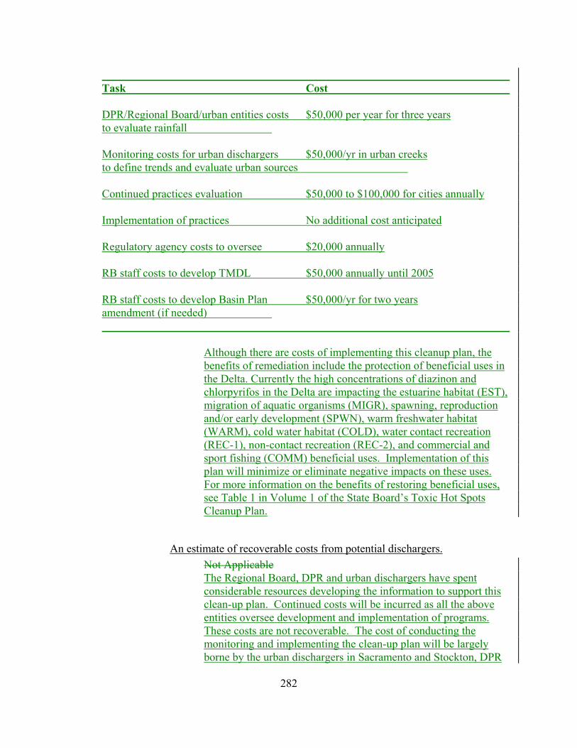
282
Task Cost DPR/Regional Board/urban entities costs $50,000 per year for three years to evaluate rainfall Monitoring costs for urban dischargers $50,000/yr in urban creeks to define trends and evaluate urban sources Continued practices evaluation $50,000 to $100,000 for cities annually Implementation of practices No additional cost anticipated Regulatory agency costs to oversee $20,000 annually RB staff costs to develop TMDL $50,000 annually until 2005 RB staff costs to develop Basin Plan $50,000/yr for two years amendment (if needed)
Although there are costs of implementing this cleanup plan, the benefits of remediation include the protection of beneficial uses in the Delta. Currently the high concentrations of diazinon and chlorpyrifos in the Delta are impacting the estuarine habitat (EST), migration of aquatic organisms (MIGR), spawning, reproduction and/or early development (SPWN), warm freshwater habitat (WARM), cold water habitat (COLD), water contact recreation (REC-1), non-contact recreation (REC-2), and commercial and sport fishing (COMM) beneficial uses. Implementation of this plan will minimize or eliminate negative impacts on these uses. For more information on the benefits of restoring beneficial uses, see Table 1 in Volume 1 of the State Board’s Toxic Hot Spots Cleanup Plan.
An estimate of recoverable costs from potential dischargers. Not Applicable The Regional Board, DPR and urban dischargers have spent considerable resources developing the information to support this clean-up plan. Continued costs will be incurred as all the above entities oversee development and implementation of programs. These costs are not recoverable. The cost of conducting the monitoring and implementing the clean-up plan will be largely borne by the urban dischargers in Sacramento and Stockton, DPR
283
and entities that implement alternative pesticide management strategies. Fees are collected from the Sacramento and Stockton urban permittees (approximately $12,500 for the Stockton urban area and $25,000 for the Sacramento urban area) and these resources are used to oversee implementation of the permits. The urban stormwater permits for the Sacramento and Stockton urban areas have already been adopted. The Regional Board has resources budgeted to implement cooperative monitoring programs with the urban stormwater entities. Resources are also available to develop TMDLs for the urban creeks.
Two-year expenditure schedule identifying funds to implement the plan that are not recoverable from potential dischargers.
Not Applicable.
The urban stormwater permits for the Sacramento and Stockton urban areas have already been adopted. The Regional Board has resources budgeted to implement cooperative monitoring programs with the urban stormwater entities. Resources are also available to develop TMDLs for the urban creeks, however costs incurred from TMDLs and Basin Plan amendments will be beyond the two year expenditure schedule.
Recommendation: Approve the recommended variance from the cleanup plan provisions. Require that the RWQCB comply with CEQA and APA when the TMDL for pesticides in urban stormwater is approved by the RWQCB. Adopt the alternative actions and cost estimates as presented.

284
Site 5.5: Irrigation Return Flow Pesticide Cleanup Plan Site Description: The Central Valley RWQCB identified several high priority toxic
hot spots in their Regional Toxic Hot Spots Cleanup Plan. The RWQCB has identified several actions that are underway in the vicinity of toxic hot spots associated with pesticides in irrigation return flows. The RWQCB has requested that the cleanup planning portion of the document be deferred to the TMDL process under way at the RWQCB. Should the SWRCB approve a variance for addressing pesticides in irrigated return flows?
Should the RWQCB approaches for remediating the toxic hot spot be adopted?
Summary of Actions Initiated at the Site As described previously, DPR and SWRCB both have statutory responsibilities for protecting water quality from adverse effects of pesticides. In 1997, DPR and the SWRCB signed a MAA, clarifying these responsibilities. In a companion document, the Pesticide Management Plan for Water Quality (Pesticide Management Plan), a process was outlined for protecting beneficial uses of surface water from the potential adverse effects of pesticides. The process relies on a four-stage approach: Stage 1 relies on education and outreach efforts to communicative pollution prevention strategies. Stage 2 efforts involve self-regulating or cooperative efforts to identify and implement the most appropriate site-specific reduced-risk practices. In stage 3, mandatory compliance is achieved through restricted use pesticide permit requirements, implementation of regulations, or other DPR regulatory authority. In stage 4, compliance is achieved through the SWRCB and RWQCB water quality control plans or other appropriate regulatory measures consistent with applicable authorities. Stages 1 through 4 are listed in a sequence that should generally apply. However, these stages need not be implemented in sequential order, but rather as necessary to assure protection of beneficial uses. The U.S. EPA requires RWQCBs under the Clean Water Act to maintain 303(d) lists of impaired water bodies. In January 1998 the Central Valley RWQCB approved a revised 303(d) list of impaired water bodies and provided a schedule for the development of Total Maximum Daily Loads. The San Joaquin River and Delta-Estuary were listed, in part, because of chlorpyrifos impairments to water quality. The RWQCB ranked the impairment in both locations as a high priority and committed to the development of a TMDL by
285
the year 2005. Components of a TMDL include problem description, numeric targets, monitoring and source analysis, implementation plan, load allocations, performance measures and feedback, margin of safety and seasonal variation and public participation. The TMDL waste load allocation, including an implementation schedule, must be adopted as a Basin Plan amendment by the Regional Board should compliance monitoring demonstrate that the problem has not been corrected. Two activities are underway in the Central Valley to develop BMPs to reduce pesticide movement into surface water in irrigated agriculture. Each are summarized below. U.C. Statewide Integrated Pest Management Project. In December 1997 the U.C. Statewide Integrated Pest Management Project was awarded a three year one million dollar grant by the CALFED Bay Delta Program. Objectives of the grant are to (1) Identify alternate urban and rural BMPs to prevent and reduce off site movement of diazinon and chlorpyrifos into surface water. Study is to consider both summer and winter uses of the two insecticides. (2) Provide outreach and education on these new practices to the urban and agricultural community, and (3) design and initiate a monitoring program to assess the success of the new practices. Stanislaus County will be the focus of the study effort. DowElanco The Registrant of chlorpyrifos has undertaken a multi year study in the San Joaquin Basin at Orestimba Creek to identify the specific agricultural use patterns and practices which contribute the majority of the off-site movement of their product into surface water. The study involves an evaluation of pesticide movement in both winter storms and in summer irrigation return flows. Objectives in subsequent years are to use the data to develop and field test BMPs to reduce off site chemical movement. The initial study is now complete. A report is expected soon. Much similarity exits between agricultural practices in the San Joaquin Basin and the Delta. The results of the DowElanco work may be important in helping to identify the agricultural practices responsible for causing instream toxicity in the Estuary and also for developing successful BMPs to solve the problem. All promising solutions need to be field tested in Delta farmland. The Regional Board has been involved in activities to address water quality problems associated with chlorpyrifos in the Delta and tributaries to the Delta for more than 15 years, including, implementing comprehensive monitoring programs, revising CWA 303(d) listings of impaired water bodies, revising NPDES permit

286
specifications, and working with DPR and watershed groups and stakeholders.
Regional Board Monitoring • Comprehensive monitoring identified chlorpyrifos as a basin
wide water quality problem, 1986-1994. • Since 1994, the Regional Board has participated in
cooperative monitoring efforts with DPR and others.
303(d) Listings of Impaired Water Bodies
• The Delta, San Joaquin River, and several tributaries have been placed on the 303(d) list of impaired waterbodies for elevated concentrations of chlorpyrifos.
• Total Maximum Daily Loads (TMDLs) are required for all listed waterbodies.
• The Regional Board has established time schedules to develop TMDLs for the rivers and Delta and has initiated meeting with stakeholders and interested parties.
NPDES Permit Revisions • A letter was sent in 2002 to all significant NPDES Permittees
requiring monitoring of effluent discharges and receiving waters for diazinon and chlorpyrifos.
• Waste discharge requirements for municipal wastewater discharges have been re-evaluated as the permits reach the five-year expiration date. Where monitoring data indicate that there is reasonable potential for diazinon or chlorpyrifos to cause receiving water toxicity, effluent limitation are included in the NPDES Permit. (For example, the April 2002 NPDES Permit renewal for the City of Stockton wastewater treatment plant included an effluent limitation for diazinon.)
• Stormwater permits for Sacramento and Stockton urban areas have been re-evaluated and strengthened to require monitoring and chlorpyrifos control programs to insure that urban sources do not contribute to the hot spot.

287
Watershed Management Initiative • The Watershed Management Initiative (WMI) directs state and
federal funds to the highest priority activities and to assure coordination with other agencies and parties.
• The Regional Board has identified chlorpyrifos as a high priority water quality problem in the WMI.
CALFED and other Grant Programs • The Regional Board has successfully obtained state and federal
grant funding for management practice development projects. • The Regional Board has also worked with CALFED to ensure
that the Record of Decision included chlorpyrifos as a high priority problem that needs to be addressed.
Department of Pesticide Regulation Coordination In 1997, the Department of Pesticide Regulation (DPR) and the State Board signed a management agency agreement (MAA) and a companion document, the Pesticide Management Plan for Water Quality (Pesticide Management Plan), These documents were developed, in part, to provide the framework for using each agencies authorities to effectively address water quality problems associated with pesticides. The Regional Board has worked with DPR to implement monitoring programs and to support programs that evaluate management practice effectiveness. DPR will consider regulatory options to improve water quality impaired by pesticides in irrigation return flows. These options may include reevaluation as a means to obtain information from pesticide registrants on practices for reducing pesticides from return flows. They may also include requiring growers to obtain pesticide use permits from county agricultural commissioners. If permits were to be issued, they may be conditioned to reduce the likelihood that pesticides leave the application site via irrigation return flows.
Watershed and Stakeholder Groups The Regional Board has been working with DPR, interest groups and stakeholders to collect the information needed for development of the components of the TMDLs. The State’s Nonpoint Source Program also funds active participation in many

288
watershed groups working on pesticide issues, and state and federal grant projects that staff manage also allows staff to keep abreast with watershed/stakeholder activities. Staff has also partnered with other agencies and programs to maximize available resources for monitoring programs, computer models, workshops, and education and outreach efforts. Two activities by other entities are underway in the Central Valley to develop BMPs to reduce pesticide movement into surface water. Each is summarized below. • The U.C. Statewide Integrated Pest Management Project was awarded a CALFED grant in order to identify alternate urban and rural BMP practices, provide outreach and education on these new practices, and design and initiate a monitoring program to assess the success of the new practices. • DowElanco (now DowAgro Sciences), the registrant of chlorpyrifos, has undertaken a multi year study in Orestimba Creek to identify the specific agricultural use patterns and practices which contribute the majority of the off-site movement of their product into surface water.
Approach/Alternatives: In January 1998 the Central Valley RWQCB adopted a revised 303(d) list, ranked chlorpyrifos impairments in the San Joaquin River and in the Delta as high priority and committed to the development of a load reduction program by the year 2005. In October 1998 staff briefed the RWQCB on pesticide detection patterns in the Central Valley and requested guidance on whether these should be considered “frequent” as required by the BPTCP in order to be considered as a candidate high priority hot spot. In addition, guidance was sought on whether to prepare cleanup plans under Bay Protection or seek a variance and prepare a control program under section 303(d) of the Clean Water Act. The RWQCB unanimously decided that the pattern of pesticide detections observed in various Delta backsloughs were frequent and merited consideration as a high priority candidate Bay Protection Hot Spot. The Board also directed staff to seek a variance and begin pesticide regulation under section 303(d) of the Clean Water Act. Therefore, no further assessment of the actions required under the Cleanup Plan are listed here. Controlling the loads of chlorpyrifos entering the Delta from the San Joaquin River is expected to prevent impairments in the main water masses in the Delta that in the past have been associated with in-season applications. Additional work will be needed to evaluate other in-Delta sources and other tributaries (such as the

289
Mokelumne River and the Yolo Bypass) and develop control programs for these sources, if warranted. The Basin Plan amendment for the Delta will describe how monitoring results will be evaluated and how impairments in the back sloughs will be addressed. In evaluating implementation program options, Regional Board staff will consider all alternatives that are appropriate under state and federal laws and regulations, including use of waste discharge requirements. This cleanup plan is designed to address the seasonal water column toxicity problem that occurs as a result of applications of chlorpyrifos. This cleanup plan is different than cleanup plans developed in other parts of the state to remediate toxic sediment, a problem that can be addressed by traditional cleanup activities such as burying, dredging and hauling to remedy the problems. This seasonal water column hot spot cannot be addressed by hauling away the water or the underlying sediment. . Instead, like the preceding cleanup plans, this cleanup plan must rely on controlling the amounts of the chemicals that reach surface waters entering the Delta. Therefore, the cleanup plans focuses on source control, either by reduction of the use of the chemicals or by implementation of use and management practices that reduce or eliminate the discharge of chlorpyrifos into surface waters. This cleanup plan identifies actions the Regional Board may take to establish a regulatory framework that will require implementation of a suite of management practices or measures to assure that irrigation return flow discharges do not continue to cause or contribute significantly to the hot spot. The regulatory frameworks and associated costs outlined in this cleanup plan are included here for informational purposes. These are examples of potential actions the Board may take when implementing TMDLs and Basin Plan Amendments and should not be construed as initiating or dictating action at this time. This cleanup plan does set a time schedule for the Regional Board to make important regulatory revisions to the Basin Plan. This cleanup plan establishes a time schedule for the Regional Board to adopt TMDLs, and to adopt Basin Plan amendments to implement the TMDLs. This cleanup plan requires that the Regional Board approve the TMDLs and consider amendments to the Basin Plan by September 2003 for the San Joaquin River and by September 2004 for the Delta and adopt amendments to the

290
Basin Plan no later than December 2003 and December 2004 respectively20.
Basin Plan Amendment Schedule Waterway Schedule Date San Joaquin Rivers Technical reports circulated for peer review;
includes preliminary staff analysis on water quality objectives and implementation alternatives
March 2003
San Joaquin Rivers Proposed basin plan amendments given to the Regional Board for consideration. Amendments will include:
− water quality objectives for chlorpyrifos;
− an implementation program and framework;
− a compliance time schedule;
− a monitoring program; and − other required TMDL
elements.
September 2003
San Joaquin Rivers Adopt Basin Plan Amendments December 2003 Delta Technical reports prepared that includes
preliminary staff analysis on water quality objectives and implementation alternatives
September 2003
Delta Proposed Basin Plan amendments given to the Regional Board for consideration. Amendments will include:
− water quality objectives for chlorpyrifos;
− an implementation program and framework;
− a compliance time schedule; − a monitoring program; and − other required TMDL
elements.
September 2004
Delta Adopt Basin Plan Amendments December 2004 Delta and Upstream Monitor chlorpyrifos concentrations in surface
waters in the Delta and upstream inputs. Annually
TMDLs will be developed for chlorpyrifos in the San Joaquin River and Delta. The TMDLs will include a TMDL staff report
20 The time schedules set forth herein express the Board’s intent and may need to be revised depending on future funding levels and developments that occur in the separate public proceedings for considering adoption of TMDLs and Basin Plan amendments.

291
that describes the impairment, identifies an appropriate water quality target, determines the loading capacity and allocates loads (including a margin of safety). The TMDL load allocations are implemented by amending the Basin Plan to include the regulatory provisions of the TMDL (water quality objective, load allocations and margin of safety) together with an implementation program and time schedule. The TMDLs are adopted when the Regional Board adopts the Basin Plan amendments that implement the load allocations. The cleanup plan requires that these amendments contain: • numeric water quality objectives for chlorpyrifos for the San Joaquin River and the Delta • load allocations including a margin of safety • a time schedule for compliance with the objectives and allocations • a program of implementation that is based on the regulatory options contained in Porter-Cologne (i.e., individual WDRs, areawide or group WDRs, conditional prohibitions, conditional waivers) • monitoring requirements to evaluate program effectiveness This cleanup plan also reaffirms the Board’s commitment and time schedule for adopting TMDLs for the San Joaquin River and the Delta. It also reaffirms the Board’s commitment to continue to work with watershed groups, DPR, the agricultural commissioners, and other stakeholders. Basin Plan amendments and TMDLs typically take two to three years to develop. The reason that the proposed time schedule set forth above can be met is that development of the TMDL and Basin Plan amendments are already underway (they started two years ago). However, this time schedule cannot be shortened further because of requirements for public review and response to comments and CEQA. The Basin Plan amendments that are required by the cleanup plans will implement actions previously missing (BMPs and other source control options) in order to correct the hot spots. The Regional Board cannot specify what specific practices should be implemented. The Regional Board can specify through a Basin Plan amendment what water quality conditions need to be met, by when they must be met, and what type of information must be submitted to determine compliance.

292
The implementation framework that will be included in the Basin Plan will be based on Regional Board regulatory authorities that are included in Porter-Cologne. Porter-Cologne describes three primary mechanisms to regulate the discharge of waste: 1. prohibiting discharge of waste (a “prohibition” under § 13243
of Porter-Cologne) 2. issuance of requirements for the discharge of waste (waste
discharge requirements (WDRs) under § 13263 of Porter-Cologne)
3. waiver of waste discharge requirements (a “waiver” under § 13269 of Porter-Cologne)
Prohibitions and waivers of waste discharge requirements can be developed that specify conditions under which discharges may be allowed. The conditions can include a wide array of provisions geared toward assuring that waste discharges do not cause water quality problems.
An estimate of the total costs to develop the plan. Not Applicable. The primary costs of implementing this program are 1) costs to the Regional Board to develop and process the Basin Plan amendments, including monitoring and preparation of staff reports, 2) costs to the Regional Board to implement the regulatory program that is developed through the Basin Planning process, 3) costs to other entities (DPR, agricultural commissioners, watershed groups, irrigation districts, etc.) that would be part of the regulatory framework, 4) cost to growers to implement practices to reduce pesticide runoff and to submit information required as part of the regulatory program, 5) costs associated with the continuing need to develop and evaluate management practices, and 6) monitoring costs to evaluate program effectiveness. In the following table, costs are estimated for these 6 elements. More detailed information on the costs is presented following the table for each of the elements.

293
Task Cost Regional Board staff costs to develop
Basin Plan proposal $100,000 FY 2002-2003* $100,000 FY 2003-2004* Regional Board costs to oversee (Depends on regulatory framework) $540,000 -$1.8 million annually Costs to other entities to oversee $0-$300,000 annually Costs to Growers
Implementation of practices See Below (Depends on alternatives selected) Regulatory Compliance $555 to $8,200 per grower annually Continued practices development $100,000 to $1,000,000 per year Monitoring for program effectiveness $100,000/yr in Delta only
Regional Board Staff Costs to Develop Basin Plan Amendment Although the Regional Board has worked on this pesticide problem for many years, it was not until 1998 that resources were specifically designated for this program. The cost estimates presented here are for FY 2002-2003 and FY 2003-2004. Basin Plan amendments are scheduled for consideration in September 2003 for the San Joaquin River and September 2004 for the Delta. It is estimated that the costs for FY 2002-2003 would be about $100,000 and the costs for FY 2003-2004 would be about $100,000. The information is excerpted from program workplans. The cost estimates include staff time to develop the amendment package, including evaluating alternative water quality objectives and implementation frameworks and costs associated with monitoring and analysis of monitoring information. The Regional Board has resources budgeted to conduct the monitoring and the planning needed to support development of the Basin Plan amendments.
Regional Board Costs of Regulatory Oversight As has been previously indicated, the Regional Board has three primary mechanisms that could be used to regulate the discharge of waste from agricultural sources. The mechanisms are 1)

294
prohibiting the discharge of waste (a “prohibition” under § 13243 of Porter-Cologne); 2) issuing requirements for the discharge of waste (waste discharge requirements or WDRs under § 13263 of Porter-Cologne); and 3) waiving waste discharge requirements (a “waiver” under § 13269 of Porter-Cologne). Therefore, we have presented a range of cost estimates that account for the relative level of Regional Board oversight that would be required under the different options. The estimates are based on costs associated with previous Regional Board regulatory efforts for rice pesticide in the Sacramento River watershed and selenium in the San Joaquin River watershed and information presented in the Regional Board staff report on agricultural waivers that was presented to the Regional Board in December 2002. However, these costs are based on the development of regulatory oversight for one parameter (chlorpyrifos) in smaller backsloughs. The oversight will be less time consuming and costly than a more comprehensive regulatory program for multiple parameters such as those outlined in the agricultural waivers. The estimated annual cost to the Regional Board to implement this program would range from about $540,000 to $1.8 million depending on which regulatory framework is used. Following is more detailed information about each alternative. For purposes of these cost estimates, we assume that there are about 1800 growers that apply chlorpyrifos in the Delta and watersheds tributary to the Delta. If individual waste discharge requirements were used, we assume that it would take one staff to handle 100 permits. Typical annual staff costs average about $100,000. This would include activities associated with adopting waste discharge requirements over a 5 year period for the 1800 growers that apply chlorpyrifos during the irrigation season, review of information and monitoring reports submitted by dischargers and doing a baseline amount of inspections, monitoring and enforcement. The annual cost would be about $1.8 million (9staff x $100,000 to adopt WDRs and 9 staff x $100,000 to review information, monitor, inspect and enforce). The costs for the Regional Board to use general WDRs (assumes one set of WDRs covers entire Bay-Delta watershed) would be less expensive than using individual WDRs because we assume that it would take less staff effort to develop and adopt one general WDR rather than 1800 separate WDRs. We assume that a similar level of activity would be needed to review information and monitoring reports submitted by dischargers and performing a baseline number of inspections, monitoring and enforcement (compared to individual WDRs), because there still are the same 1800

295
dischargers to work with. Therefore, the annual costs are estimated to be about $900,000 annually (9 staff x $100,000). The costs to the Regional Board to use areawide WDRs (separate WDRs that covers smaller subwatersheds within the larger Bay-Delta watershed) would be slightly less than using general WDRs because we assume that some watershed groups, irrigation districts or other entities would be formed to take responsibility for managing and digesting information developed by individual growers. The Regional Board would therefore need to work with a relatively small number of entities, instead of 1800 individual growers. This would reduce Regional Board oversight costs, but there would be additional costs to entities accepting responsibility for the areawide waste discharge requirements. The annual costs are estimated to be about $540,000. There would be additional costs to entities participating in the program. Costs to the Regional Board to use a conditional waiver or prohibition would be similar to a general WDRs if the Regional Board works with all 1800growers or would be similar to the areawide WDRs if the growers formed watershed groups.
Cost to Other Entities for Regulatory Oversight
We estimate that the costs to other entities (DPR, agricultural commissioners, watershed groups, irrigation districts, etc.) would range from almost nothing to about $300,000 annually depending on the alternative selected.
Cost to Growers There are three types of costs to the grower: 1) the cost to implement practices to reduce pesticide runoff, 2) the cost associated with gathering and submitting information to fulfill waste discharge requirement or other conditions and 3) any WDR permit fee that might be required.
Cost of Practice Implementation The choice of alternative practices to be implemented will be up to individual growers. Valley-wide implementation costs will be dependent on the mix of practices selected. Alternative management practices for irrigation return flow includes

296
vegetating irrigation canal banks with native plants which reduces erosion and off site movement of pesticides and nutrients, while enhancing biological diversity and aesthetics (Yolo County RCD, 1999). The cost of vegetating one mile of irrigation canal on both sides is estimated to be about $2,695-$7,747. Another effective management practice is to install tailwater ponds. Tailwater ponds catch and store runoff water while preventing non-point source pollution from reaching surface waters and allows for pesticides to degrade naturally. Approximately, 1 acre per 100 acre field is needed for the pond(s) and the estimated costs for installing a tailwater pond is $3,3730 -$11,525 plus the cost of taking land out of production to construct the ponds. The most effective tailwater ponds for irrigation water management include return flow systems which captures the tailwater and re-circulates it for further irrigation while preventing offsite runoff. Minimum costs for tailwater ponds with return flow systems are estimated to be between $13,580 and $27,555 (Yolo County RCD, 1999). Depending on the individual grower’s choice of practices to be implemented, valley-wide implementation costs will vary.
Cost of Regulatory Compliance If use of individual WDRs is the regulatory framework selected, each grower could be required to submit a filing fee. Considering the existing filing fee schedule and category descriptions, staff estimates that annual filing fees would be approximately $2,025. We assume that monitoring, reports and other information would need to be submitted by all growers. We estimate that the cost for each grower to submit information required to satisfy the WDRs would be about $6,175 annually, for a total of $8,200 a year. We assume that other options that would rely on formation of subwatershed groups to coordinate activities would cost less because the level of detail submitted from each grower would not be as great and there would be savings on implementing areawide monitoring programs rather than having monitoring at each orchard. In the event that waste discharge requirements are waived, all or part of the fees collected will be returned to the discharger, in accordance with Water Code section 13260(e) and 23 California Code of Regulations (CCR) 2200.4. However, the filing fees may not be required and could be subtracted as a cost. We estimate that using a watershed approach could cost as little as about $555 per grower annually. Although there are costs of implementing this cleanup plan, the benefits of remediation include the protection of beneficial uses in
297
the Delta. Currently the high concentrations of diazinon and chlorpyrifos in the Delta are impacting the estuarine habitat (EST), migration of aquatic organisms (MIGR), spawning, reproduction and/or early development (SPWN), warm freshwater habitat (WARM), cold water habitat (COLD), water contact recreation (REC-1), non-contact recreation (Rec-2), and commercial and sport fishing (COMM) beneficial uses. Implementation of this plan will minimize or eliminate negative impacts on these uses. For more information on the benefits of restoring beneficial uses, see Table 1 in Volume 1 of the State Board’s Toxic Hot Spots Cleanup Plan.
An estimate of recoverable costs from potential dischargers. Not Applicable. The Regional Board, DPR and other agencies and parties have spent considerable resources developing the information to support this cleanup plan. These costs are not recoverable. As has been mentioned in the previous section, the cost of implementing the cleanup plan will be largely borne by the farmers using alternative practices and the regulatory agencies that must oversee control program implementation. Regulatory oversight costs could be recovered if waste discharge requirements are part of the regulatory framework that is developed. If individual requirements are issued, based on the cost estimates provided in the previous section, approximately $3.6 million could be recovered annually. Costs recovered by areawide or general waste discharge requirements would dependent on the population covered by the requirements. In the event that waste discharge requirements are waived, the Regional Board could elect to withhold sufficient funds collected with a filing of waste discharge to cover the actual staff time spent reviewing the report of waste discharge (as set forth in the California Code of Regulations). These costs were estimated by assuming that there are about 1800 growers in the Sacramento and San Joaquin River watersheds that apply chlorpyrifos during the irrigation season, assuming that the Regional Board would have to deal with all of them, and using the existing fee schedule to estimate the appropriate fee that would be applicable (in this case $2,025).
Two year expenditure schedule identifying funds to implement the plan that are not recoverable from potential dischargers.
Not Applicable.

298
The Regional Board has a TMDL budget and a workplan that includes resources to monitor and develop the Basin Plan amendment proposals for the San Joaquin River in FY 2002 and 2003. Resources are also earmarked for FY 2003-2004 for completion of the Basin Plan amendments for the Delta. Resources to support the Regional Board regulatory framework have not been identified and are dependent on what regulatory framework is chosen. If WDRs are used, then the program can be supported by WDR fees. If other options are used, funding sources will need to be identified. One option may be to request budget augmentations. Most of the costs to the Regional Board and other regulatory entities would occur beyond the two year budget outlooks included under this section, since the Basin Plan amendments will not be completed until 2004. Costs of implementation practices will primarily be borne by growers. However, there are many cost sharing (NRCS Environmental Quality Incentives Program (EQIP)) funds available to defray the costs associated with implementing new management practices. Additionally several of the possible alternatives would result in cost savings. There are also several state and federal grant programs available to conduct research and monitoring to analyze management practice implementation, water quality improvement and management practice development, as well as education and outreach projects. These funding sources include the Clean Water Act Sections 319(h) and 205(j), Proposition 13 (including the Pesticide Research and Investigation of Source, and Mitigation (PRISM)), Program, 40 and 50 funds, and the CALFED Bay-Delta Program.
Recommendation: Approve the recommended variance from the cleanup plan provisions. Require that the RWQCB comply with CEQA and APA when the TMDL for pesticides in irrigation return flows is approved by the RWQCB.
Adopt the alternative actions and cost estimates as presented.

299
Site 8.1: Santa Ana Region, Lower Newport Bay, Rhine Channel Site Description: The Santa Ana RWQCB identified one high priority toxic hot spot
in their Regional Toxic Hot Spots Cleanup Plan. The RWQCB has identified several actions that are underway to cleanup and remediate the toxic hot spot in Lower Newport Bay at Rhine Channel.
Description of the Site An assessment of the areal extent of the Rhine Channel Toxic Hot Spot is between 1.5 and 2.5 acres. Six boat yards currently operate along the channel. Historic practices at the boat yards are the most likely source of pollutants, although a thorough characterization of the depth of pollution has never been undertaken.
Summary of Actions Initiated at the Site The RWQCB currently regulates the discharge of process wastewater and stormwater from all boat yard facilities in Lower Newport Bay and Huntington Harbour through General Waste Discharge Requirements (Order No. 94-26, as amended by Order No. 95-60 and 96-52). The boat yards were initially issued individual NPDES permits beginning in 1975. The main feature of Order No. 94-26, as amended, is the elimination of the discharge of process wastewater in accordance with the requirement of the Water Quality Control Policy for the Enclosed Bays and Estuaries of California. Process wastewater is defined by the Order to include the first one tenth of an inch of rain that is proceeded by seven days of dry weather. This permit requirement was to be implemented by April, 1996. Presently, five of the six boat yards in Rhine Channel have complied with this requirement. The Newport Bay watershed is one of two watersheds within the Santa Ana Region that are the focus of intensive watershed management activities. The expected outcome of this planning and management effort includes a further refinement of water quality problems, both in the Bay and watershed, the development and implementation of a watershed management plan that addresses these problems, and mechanisms for measuring the success of the plan and improvements in water quality. Additionally, Lower Newport Bay is currently listed as water quality limited for metals and pesticides pursuant to Section 303(d) of the Clean Water Act. A TMDL for metals and pesticides will be developed by the RWQCB to address this impairment. The

300
control of pollutant sources occurring in Rhine Channel will be a component of the TMDLs.
Approach/Alternatives: There are four options for cleanup of the Rhine Channel toxic hot
spot. These include ex-situ treatment, chemical separation, immobilization, and dredging.
1. Ex-situ Treatment. The ex-situ treatment of pollution at Rhine Channel could include either chemical separation or immobilization. Chemical separation would separate the weakly bound metals from the sediment, and the clean sediment would then be disposed. The problem with this treatment is the limited application of the method, the need for further treatment systems integration for a complete separation, and the need for a treatment site. This last factor is significant due to the urban setting of the site. Significant transportation costs would be incurred by hauling the sediment to a non-local treatment area.
2. Immobilization by chemical fixation.
Immobilization of trace metals by chemical fixation is another possible treatment. This treatment has been used extensively for solid wastes. A limitation with this treatment is the high moisture content of the sediment in Rhine Channel and the need for a treatment site.
3. Capping or containment. The capping or containment of the site is not an option due to the shallow depth of Rhine Channel. Capping would effectively eliminate any navigation in the channel and adversely affect the economic activities of businesses that use the channel (i.e., the boatyards). 4. Dredging. The only other viable treatment is dredging and off-site disposal. Dredging of the site would allow for a confined remediation area with a low potential for the off-site migration of toxic substances through the use of siltation curtains. It would also allow for the continued use of the channel without a significant disruption of access or business activity.

301
An estimate of the total cost and benefits of implementing the cleanup plan.
The dredging of Rhine Channel would involve the removal of approximately 23,000 cubic yards of sediment (2 acres x 7 feet deep--Table 13). This is a rough estimate because there has not been a thorough characterization of the areal extent of pollution. These amounts should be considered conservative and preliminary. Additional costs could be incurred if alternative disposal transportation is required. Cost estimates are listed in Table 13.
TABLE 13: COST ESTIMATE TO DREDGE RHINE CHANNEL Sediment Removal Hydraulic dredge (23,000 cy @ $10 cy) $230,000 Silt screen (material, labor)
(600 ft @ $3 ft) $1,800
Sediment Transport Truck (23,000 cy @ $200 cy) $4,600,000 Sediment Disposal Class I disposal facility (23,000 cy @ $250 cy) $5,750,000 (Hazardous waste) Total $10,581,800
Estimate of recoverable costs from potential dischargers The recoverable costs from dischargers would be insufficient to perform cleanup activities. The boatyard operations are small businesses, with a few having financial difficulty implementing control measures currently required by the RWQCB. If the RWQCB were to issue Cleanup and Abatement Orders to the boatyards in an attempt to recover costs for the proposed cleanup activities, it is envisioned that several of the boatyards would claim bankruptcy rather than participate. It is estimated that recoverable cleanup costs from dischargers would be from 1 to 10 percent.
302
Two-year expenditure schedule identifying funds to implement the plans that are not recoverable from potential dischargers.
Year 1. The activities conducted during the first year would be further site pollution characterization. These activities would include extensive sampling to determine the areal extent, depth, and severity of pollution in Rhine Channel. The cost would be approximately $900,000.
Year 2. The activities conducted during the second year would be the development of an engineering report and operating plan for the cleanup site, obtaining the appropriate permits (e.g., 401/404), and producing appropriate environmental documentation (e.g., NEPA/CEQA). These services would be provided by a consulting firm. This would cost approximately $500,000.
Recommendation: Adopt the alternatives, cost estimates and expenditure plan as
presented.
303
Site 9.1: San Diego Region, Seventh Street Channel, National City Site Description: The San Diego RWQCB identified one high priority toxic hot spot
in their Regional Toxic Hot Spots Cleanup Plan. The RWQCB has identified several actions that are underway at the Seventh Street Channel in San Diego Bay. Should the RWQCB approaches for remediating the toxic hot spot be adopted?
Description of the Site The remediation alternatives are applicable to Approximately three acres, encompassing the area of Stations 90009, 93227, 93228. However, the area affected could be substantially larger or smaller. Dredging activities could have occurred in this area since San Diego Bay was sampled during the period 1992 to 1994. If so, this area or parts of this area may no longer be considered for remediation.
Summary of Actions Initiated at the Site The following is a summary of actions that have been initiated by the San Diego RWQCB to reduce the accumulation of pollutants at the THS. The following programs address water quality near the Seventh Street Channel. It is unknown whether any of the organizations or facilities named below have discharged chemical wastes at levels which could have caused the accumulation of pollutants at existing toxic hot spots.
NPDES Permits for the Naval Station The Naval Station Graving Dock, which lies midway between Chollas Creek and the Seventh Street Channel and a half mile north of the Seventh Street Channel, currently is covered by its own National Pollutant Discharge Elimination System (NPDES) permit. Discharges from Navy industrial facilities are currently covered under the State Water Resources Control Board General Industrial Storm Water Permit. The Regional Board may issue NPDES permits for discharges from other Navy activities adjacent to San Diego Bay.
NPDES Municipal Storm Water Permit In 1990, the RWQCB issued NPDES stormwater permits to municipalities responsible for civilian areas, including those tributary to San Diego Bay. Activities underway in the Paleta Creek watershed by the City of National City include public education, public service announcements on television, and street sweeping. The stormwater permit is now being revised.
304
Pacific Steel site During the 1980s, the Regional Board took enforcement action against Pacific Steel, an automobile recycler. The company, which was located inland of the Seventh Street Channel, maintained a large “fluff” pile of non-ferrous waste. Runoff from the fluff pile was prohibited by the RWQCB from draining to San Diego Bay. The fluff pile was subsequently removed and the site cleaned up.
Military cleanups The Regional Board has participated in Department of Defense Environmental Response Program (DERP) and Navy Installation Restoration (IR) activities to close former military hazardous waste sites on land adjacent to the Bay. Several disposal sites are located around the Seventh Street Channel.
Approach/Alternatives: Section 13360 of the Porter-Cologne Water Quality Control Act
prohibits RWQCBs, the SWRCB, and the courts from designating the means of compliance with the California Water Code. For this reason, the options presented below are not meant to influence the ultimate solution, but are presented to comply with BPTCP legislative requirements and to provide a starting point for discussion. The RWQCB could require potential responsible parties to submit California Water Code Section 13267 technical reports documenting the amounts and types of wastes discharged.
1. RWQCB procedures.
A first step could be to convene a meeting between potential responsible parties to discuss the data and to receive comments and information about the site. After review by staff of available information, the RWQCB Executive Officer could ask potential dischargers to submit technical reports. Subsequently, the RWQCB could require potential responsible parties to sample the site and surrounding area to document in detail the areal extent of the site and to identify specific pollutants at the site. Only after extensive review of all available information would the RWQCB require remediation actions. 2. Persistence of wastes at this site. The chemical wastes found in the Seventh Street Channel and at the mouth of Paleta Creek, the pesticides Chlordane and DDT, and the class of polynuclear aromatic hydrocarbon (PAH) “ring” compounds derived from fossil fuels, are known to persist in nature. These organic chemicals may be resistant to treatment or

305
natural remediation processes such as oxidation, microbial degradation, and photolysis. For this reason, natural recovery or in situ treatment may not be feasible. In-place capping is presumed to be infeasible because of frequent vessel traffic in this area of the Bay. Two options which may be feasible are dredging followed by placement in an upland confined disposal facility, and dredging followed by contained aquatic disposal. There is precedent for both options in San Diego Bay. Dredging of contaminated bottom material has occurred at boat yards in north San Diego Bay and at the 24th Marine Terminal in the south Bay. A submerged aquatic disposal site has been completed in the north Bay off several storm drains known to have contributed PCBs to the Bay. 3. Dredging and upland disposal. Stations 90009, 93227, and 93228 are located in a heavily-used dredged channel frequented by barges, boats, and tugs. Navigation charts show depths of between 18 to 21 feet at mean lower low water, although the depths may be shallower or deeper due to sedimentation or recent dredging. There may be suitable sites on land nearby to build settling ponds to receive hydraulic dredge spoils. Sediment removal activities could include clamshell dredging or hydraulic dredging, and transportation to a suitable disposal site by barge, rail, or truck, or to settling ponds next to the Channel. 4. Dredging and contained aquatic disposal. Another method could involve dredging a disposal site at another location in San Diego Bay, depositing the contaminated dredge spoil from the candidate toxic hot spot site, and capping the site with suitable material. The following conditions would have to be met if this option were to be implemented:
• Clean Water Act Section 404 dredging permits would be
obtained from the U.S. Army Corps of Engineers for the contaminated site and for the aquatic disposal site
• State waste discharge requirements would be obtained from the Regional Board for the disposal site
• The cap would provide adequate coverage to prevent the spread of contaminated material
• Burrowing organisms would be prevented from mixing polluted sediments (i.e., bioturbation must not occur)
• The contaminated material covered would be able to support the cap

306
• The bottom slope would be able to support the cap during seismic events
• The cap would be well marked and protected against erosion or destruction from anchors, propellers, and strikes by vessels
• The site would be located away from major navigation lanes • The exact location of the site would be noted on maps, charts,
and deeds
Estimate of the Total Cost to Implement the Cleanup Plan This preliminary cost list is based on the schedule found in the 1997 guidance document (see Table 14). High and low costs are provided. It is assumed that if ocean disposal at the 100 fathom site is chosen, the U.S. Army Corps of Engineers would require extensive testing of the material removed from the Seventh Street Channel to be transported to the LA-5 site 6 miles from Pt. Loma. Costs were not able to be estimated for California Environmental Quality Act (CEQA) compliance, Section 404 dredging permit and state waste discharge requirements acquisition, or sampling to determine the areal extent of the candidate toxic hot spot.
Costs for dredging and upland disposal. High costs: Assume that 14,520 square yards (three acres) need remediation and that sediment to a depth of one yard would be removed. The 14,520 cubic yards of dredge spoil would then be placed on a barge, offloaded onto trucks, and transported to a suitable upland landfill. Low costs: Assume that the wastes are transported to a Class III site. Cost estimates are presented in Table 14.

307
TABLE 14: COMPARISON OF HIGH AND LOW COSTS FOR DREDGING AND UPLAND DISPOSAL High Cost per Cubic Yard Low Cost per Cubic Yard Clamshell dredging $10 Clamshell dredging $10 Unloading from barge TBD Unloading from barge TBD Transport by truck 200 Transport by truck 200 Disposal at Class I site 300 Disposal at Class III site 30 Sub total per cubic yard $510 Sub total per cubic yard $240 14,520 cubic yards X $510 = $7,405,200 (not including permits)
14,520 cubic yards X $240 = $3,384,800 (not including permits)
Costs for dredging and contained aquatic disposal. Cost estimates are presented in Table 15. High costs: Assume that 14,520 square yards (three acres) need remediation and that sediment to a depth of one yard would be removed. An aquatic disposal site would be dredged and suitable material obtained for use as a cap. Another suitable cap to prevent burrowing animals from penetrating into the underlying contaminated sediment would be provided as well. The 14,520 cubic yards of dredge spoil would be placed on a barge and transported to the aquatic disposal site. The caps would then be constructed. Low costs: Assume that confinement at the disposal site is not necessary.
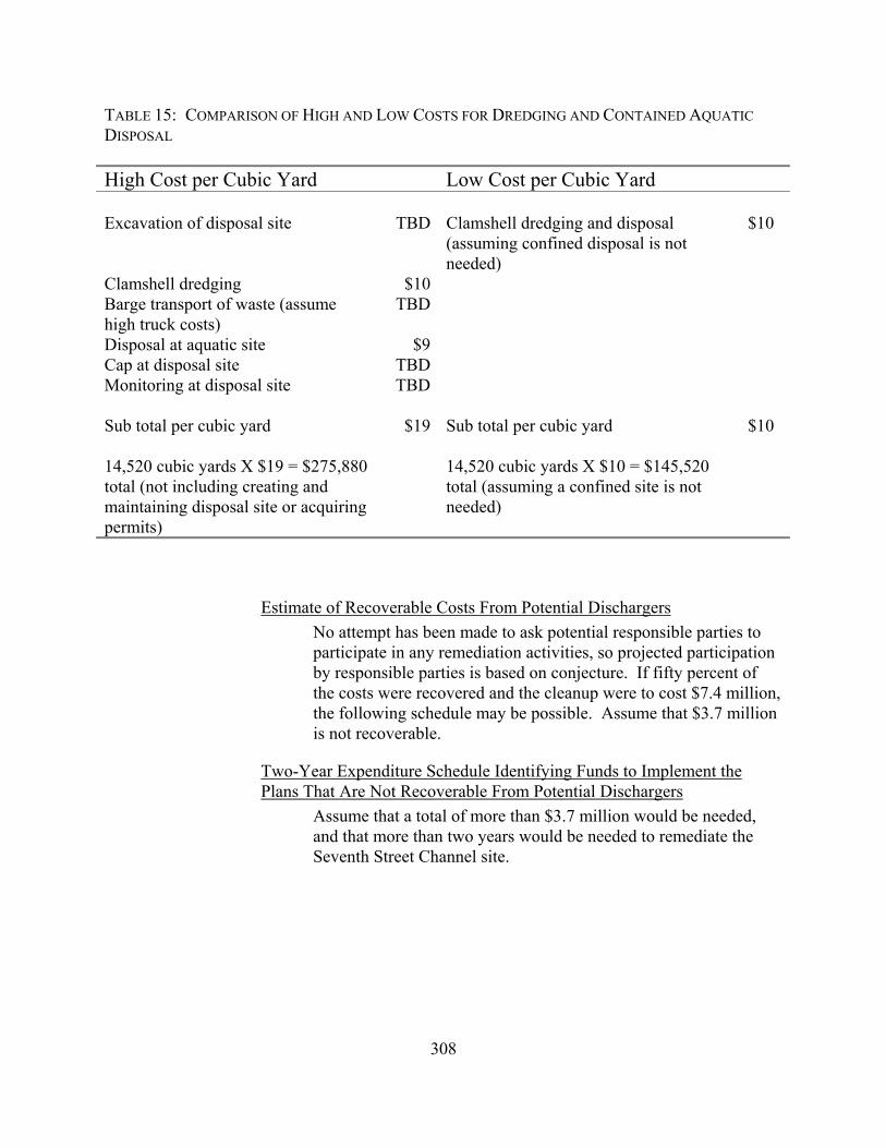
308
TABLE 15: COMPARISON OF HIGH AND LOW COSTS FOR DREDGING AND CONTAINED AQUATIC DISPOSAL High Cost per Cubic Yard Low Cost per Cubic Yard Excavation of disposal site TBD Clamshell dredging and disposal
(assuming confined disposal is not needed)
$10
Clamshell dredging $10 Barge transport of waste (assume high truck costs)
TBD
Disposal at aquatic site $9 Cap at disposal site TBD Monitoring at disposal site TBD Sub total per cubic yard $19 Sub total per cubic yard $10 14,520 cubic yards X $19 = $275,880 total (not including creating and maintaining disposal site or acquiring permits)
14,520 cubic yards X $10 = $145,520 total (assuming a confined site is not needed)
Estimate of Recoverable Costs From Potential Dischargers No attempt has been made to ask potential responsible parties to participate in any remediation activities, so projected participation by responsible parties is based on conjecture. If fifty percent of the costs were recovered and the cleanup were to cost $7.4 million, the following schedule may be possible. Assume that $3.7 million is not recoverable.
Two-Year Expenditure Schedule Identifying Funds to Implement the Plans That Are Not Recoverable From Potential Dischargers
Assume that a total of more than $3.7 million would be needed, and that more than two years would be needed to remediate the Seventh Street Channel site.

309
Activity Deficit Year 1: - Meeting with responsible parties - Request for technical information - Discharger response - Staff review of response - Cleanup and abatement order - Sampling plan to characterize areal extent - Request for bids for chemistry sampling and analysis - Lab contract estimate $800,000 Year 2: - Site characterization - Engineering report - Section 404 dredging permit application - State waste discharge requirements application - NEPA and CEQA environmental documentation estimate $900,000 Recommendation: Adopt the alternatives, cost estimates and expenditure plan as
presented.