proposed development at land east of … · proposed development at land east of clitheroe road...
TRANSCRIPT
PROPOSED DEVELOPMENT AT
LAND EAST OF CLITHEROE ROAD (LAWSONSTEADS)
WHALLEY, LANCASHIRE
FRAMEWORK TRAVEL PLAN
Bryan G Hall Ltd Consulting Civil & Transportation Planning Engineers Suite E8 Joseph’s Well Hanover Walk Leeds LS3 1AB March 2012 Ref: 10-228-004.01


CONTENTS
1.0 INTRODUCTION ............................................................................................... 1
1.1 Background ................................................................................................... 1 1.2 Structure and Process of the Framework Travel Plan .............................. 2 1.3 Overall Objectives ........................................................................................ 3
2.0 PLANNING AND TRANSPORT POLICY OBJECTIVES ................................. 4
2.1 National Policy .............................................................................................. 4 2.2 Regional Policy ............................................................................................. 4 2.3 Local Policy ................................................................................................... 5
3.0 AN UNDERSTANDING OF THE SITE ............................................................. 7
3.1 The Existing Situation .................................................................................. 7 3.2 The Proposed Development ...................................................................... 10 3.3 Pedestrian Accessibility ............................................................................ 10 3.4 Public Transport Accessibility .................................................................. 12 3.5 Cycle Accessibility ..................................................................................... 13
4.0 TRAVEL PLAN ADMINISTRATION ............................................................... 15
4.1 Site Travel Plan Co-ordinator (STPC) ....................................................... 15 4.3 Funding ....................................................................................................... 17
5.0 TRAVEL PLAN MEASURES .......................................................................... 18
5.1 General ........................................................................................................ 18 5.2 Promotion and Awareness ........................................................................ 18 5.3 Proposed Measures ................................................................................... 19
6.0 TARGETS, MONITORING AND ACTIONS .................................................... 22
6.1 Interim Targets ............................................................................................ 22 6.2 Specific Targets .......................................................................................... 22 6.3 Monitoring ................................................................................................... 23 6.4 Action Timetable ......................................................................................... 25

APPENDICES
TP1 SITE LOCATION PLAN
TP2 800 METRE WALKING DISTANCE AND FACILITIES WITHIN WHALLEY
TP3 1600 & 2000 METRE WALKING ISOCHRONE
TP4 400 METRE WALKING DISTANCE TO BUS STOPS
TP5 PUBLIC TRANSPORT INFORMATION
TP6 5.0KM & 8.0KM CYCLING ISOCHRONES

Proposed Development – Lawsonsteads, Whalley Framework Travel Plan
Bryan G Hall Ltd consulting civil & transportation planning engineers 10-228-002.05
1
1.0 INTRODUCTION
1.1 Background 1.1.1 Bryan G Hall Ltd has been commissioned by CEG Ltd to prepare a Framework
Travel Plan for eventual implementation at a proposed development on an
area of land known as Lawsonsteads situated to the east of Clitheroe Road,
north of Whalley in Lancashire. The application is in outline with all matters
reserved except the means of access for some 55 houses.
1.1.2 The Department for Transport in its recent report ‘Good Practice Guidelines:
Delivering Travel Plans through the Planning Process’, 29 April 2009, defines
a Travel Plan as “a long-term management strategy for an occupier or site that seeks
to deliver sustainable transport objectives through positive action and is articulated in
a document that is regularly reviewed.”
1.1.3 The report also identifies that a Framework Travel Plan is the appropriate tool
for large mixed-use developments with multiple occupants or mixed land use
classes. Within a Framework Travel Plan, overall outcomes, targets and
indicators are joint and administered centrally. The Framework Travel Plan
sets the parameters for the individual uses/elements that should then prepare
their own subsidiary travel plans which are in line with the Framework Travel
Plan.
1.1.4 This report details a proposed approach to developing and implementing a
Framework Travel Plan for the Lawsonsteads development. The process and
measures are illustrative of how CEG Ltd sees the Framework Travel Plan
developing for the development but should not be read as the final set of
proposals. The Framework Travel Plan will be very much a living document
that will change as the Lawsonsteads development progresses. For the
Framework Travel Plan to have a sustained effect the actions should be
implemented across the whole development and owned by the eventual
residents and other occupiers.
1.1.5 The Developer wishes to encourage everyone who visits the development
whether as a resident or visitor to make sustainable travel choices and

Proposed Development – Lawsonsteads, Whalley Framework Travel Plan
Bryan G Hall Ltd consulting civil & transportation planning engineers 10-228-002.05
2
therefore they are committed to working with the Local Planning Authority,
Ribble Valley Borough Council, and the Highway Authority, Lancashire County
Council, in order to realise this goal. Other bodies such as the transport
operators will also be included within this process in order to deliver a
transport network which will provide a sustainable travel choice.
1.1.6 Engagement with the Planning Authority and Highway Authority officers is
crucial at this early stage to guide the process and provide detailed local
knowledge on measures that will be the most successful as part of a wider
package. Initial contact has been made with officers at the Planning and
Highway Authorities in relation to the development of the Framework Travel
Plan and this will gain momentum as the Lawsonsteads development moves
forward.
1.2 Structure and Process of the Framework Travel Plan
1.2.1 The Framework Travel Plan is set out in the following sections:
Planning and policy objectives;
An understanding of the site and the proposed development;
Travel Plan administration;
Potential measures and their impacts; and
Targets and monitoring.
1.2.2 The development will have one overarching Travel Plan policy and within this,
individual Travel Plans for the different uses/occupiers will be developed to
take account of the individual needs of each type of occupier. The Framework
Travel Plan addresses all of the travel elements associated with the
development as a whole including resident and visitor travel along with matters
such as deliveries made to the site.
1.2.3 For the Framework Travel Plan to be effective it will be necessary to appoint a
Site Travel Plan Co-ordinator (STPC) who will be responsible for the day to
day development of the Framework Travel Plan. The STPC will set up a
Travel Plan Steering Group prior to occupation of the site. The Steering Group
will meet approximately four times a year and initially its membership will
include the STPC and representatives from Ribble Valley Borough Council and
Proposed Development – Lawsonsteads, Whalley Framework Travel Plan
Bryan G Hall Ltd consulting civil & transportation planning engineers 10-228-002.05
3
Lancashire County Council.
1.3 Overall Objectives 1.3.1 The overriding objective of the Framework Travel Plan for the Lawsonsteads
development is to reduce the impact of traffic, which will be generated by
residents travelling to and from the site, on the local highway network. The
specific objectives set for the Framework Travel Plan are:
To maximise opportunities for residents to travel to and from the
development using transport modes other than the private car
particularly when the journeys are single occupancy; and
To be complementary to the efficient operation of the Lawsonsteads
development.
1.3.2 It can be seen with reference to the following section that the stated objectives
of the Framework Travel Plan are also complimentary to national, regional and
local sustainable transport objectives.

Proposed Development – Lawsonsteads, Whalley Framework Travel Plan
Bryan G Hall Ltd consulting civil & transportation planning engineers 10-228-002.05
4
2.0 PLANNING AND TRANSPORT POLICY OBJECTIVES
2.1 National Policy 2.1.1 In its White Paper “A New Deal for Transport”, the Government identified that
the responsibility for transport problems and solutions should be shared
between the private and public sectors. It identified the importance that the
planning system could play in reducing the need to travel by car (particularly
single occupancy journeys) by the careful planning of new developments in a
sustainable manner.
2.1.2 The Transport Act 2000 requires all local transport authorities in England,
outside London, to prepare Local Transport Plans. Whalley is covered by the
Third Lancashire Local Transport Plan 2011-2021 (LTP3) and within the plan it
is identified that travel plans are a key demand management tool to assist in
tackling congestion.
2.1.3 The National Planning Policy Framework (NPPF) which was published in
March 2012 states that Travel Plans are “A long-term management strategy for an
organisation or site that seeks to deliver sustainable transport objectives through
action and is articulated in a document that is regularly reviewed.”
2.1.4 The Good Practice Guidelines: Delivering Travel Plans through the Planning
Process, published April 2009, aims to help all those involved in creating and
implementing travel plans, local authorities, transport and travel plan officers,
developers and consultants, understand the process involved and good
practise steps for achieving successful and sustainable travel plans. It states
“Travel plans can be a key tool in achieving national, regional and local objectives to
manage the demand for movement and improve accessibility for everyone.”
2.2 Regional Policy 2.2.1 Following a recent High Court ruling, the Regional Spatial Strategies (RSS),
which were previously revoked following the establishment of the Coalition
Government, have now been reinstated and remain in effect until wholly
revoked by Secretary of State. The North West of England Plan was
published in September 2008 and sets out the Secretary of State for

Proposed Development – Lawsonsteads, Whalley Framework Travel Plan
Bryan G Hall Ltd consulting civil & transportation planning engineers 10-228-002.05
5
Communities and Local Government’s policies in relation to the development
of land within this region. It aims to guide development of land within the
region over the next 15 to 20 years. The plan also embodies the Regional
Transport Strategy and must be taken into account by local authorities in
preparing their Local Development Frameworks and Local Transport Plans.
2.2.2 The Plan initially sets out its spatial principles and Policy DP5 relates to
managing travel demand and states:
Manage Travel Demand; Reduce the Need to Travel, and Increase Accessibility
“Development should be located so as to reduce the need to travel, especially by car,
and to enable people as far as possible to meet their needs locally. A shift to more
sustainable modes of transport for both people and freight should be secured, an
integrated approach to managing travel demand should be encouraged, and road
safety improved.
Safe and sustainable access for all, particularly by public transport, between homes
and employment and a range of services and facilities (such as retail, health,
education, and leisure) should be promoted, and should influence locational choices
and investment decisions.
Major growth should, as far as possible, be located in urban areas where strategic
networks connect and public transport is well provided.
All new development should be genuinely accessible by public transport, walking and
cycling, and priority will be given to locations where such access is already available.
In rural areas accessibility by public transport should also be a key consideration in
providing services and locating new development, emphasising the role of Key Service
Centres (Policy RDF2).”
2.3 Local Policy 2.3.1 The Transport Act 2000 requires all local transport authorities in England,
outside London, to prepare Local Transport Plans. The relevant local policy
documentation in the context of this Transport Assessment is the Third
Lancashire Local Transport Plan (LTP3) 2011-2021.
2.3.2 LTP3 has identified a number of transport goals and early priorities. The
priorities that have been identified complimenting the wider policy framework

Proposed Development – Lawsonsteads, Whalley Framework Travel Plan
Bryan G Hall Ltd consulting civil & transportation planning engineers 10-228-002.05
6
which seeks to increase prosperity and well-being for all communities in
Lancashire. These goals are;
To help to secure a strong economic future by making transport and
travel into and between our major economic centres more effective and
efficient and by improving links to neighbouring major economic areas
and beyond.
To provide all sections of the community with safe and convenient
access to the services, jobs, health, leisure and educational
opportunities that they need.
To improve the accessibility, availability and affordability of transport as
a contribution to the development of strong and cohesive communities.
To create more attractive neighbourhoods by reducing the impact of
transport on our quality of life and by improving our public realm.
To reduce the carbon impact of Lancashire's transport requirements,
whilst delivering sustainable value for money transport options to those
who need them.
To make walking and cycling more safe, convenient and attractive,
particularly in the more disadvantaged areas of Lancashire, bringing
improvements in the health of Lancashire's residents.
In all that we do, to provide value for money by prioritising the
maintenance and improvement of Lancashire's existing transport
infrastructure where it can help to deliver our transport goals.
2.3.3 LTP3 has drawn up seven transport policies from these goals;
Improving access into areas of economic growth and regeneration
Providing better access to employment and education
Improving people’s quality of life and well-being
Improve safety of our streets for our most vulnerable residents
Providing safe, reliable, convenient and affordable transport
alternatives to the car
Maintaining our assets
Reducing carbon emissions and its effects.

Proposed Development – Lawsonsteads, Whalley Framework Travel Plan
Bryan G Hall Ltd consulting civil & transportation planning engineers 10-228-002.05
7
3.0 AN UNDERSTANDING OF THE SITE
3.1 The Existing Situation 3.1.1 Whalley is a small village settlement with existing development to both sides of
the A671 Accrington Road, B6246 King Street, B6246 Station Road and
Clitheroe Road. The development site, which is predominantly open grassland
punctuated with existing hedgerows and trees, lies immediately to the north
east of existing residential properties on the east side of the village. The
overall site is some 3.8 hectares in area and includes a frontage,
approximately 95.0 metres in length, with Clitheroe Road. The site is bounded
to the north by open fields and a small group of residential properties, to the
east by open fields and to the south and west by existing residential
properties. On the opposite side of Clitheroe Road to the site frontage there
are large detached residential properties with individual drives onto Clitheroe
Road. The site location is shown on the plan attached at Appendix TP1.
3.1.2 Clitheroe Road links the mini roundabout junction of Brookes Lane/King
Street/Station Road, some 400.0 metres south west of the development site to
Whiteacre Lane situated some 1.5 kilometres north of the development site.
Thereafter, to the north of Whiteacre Lane, Clitheroe Road becomes Whalley
Road, which passes through the settlement of Barrow and connects with the
A671 Whalley Road, some 2.8 kilometres north of the development site, by
way of a major/minor priority junction with a right turn ghost island.
3.1.3 Along the site frontage of the development, Clitheroe Road, is single
carriageway, is lit and subject to a 30mph speed limit. Clitheroe Road serves
existing residential, farm and industrial development along its length and varies
in width between 6.6 metres and 7.4 metres in the vicinity of the site frontage.
The footway on the site side varies between 1.5 metres and 3.2 metres at its
widest. Footway provision on the opposite side of the Whalley Road varies in
width between 1.0 metre at its narrowest to 3.2 metres at its widest.
3.1.4 Clitheroe Road is a bus route with the nearest bus stop located directly on the
site frontage. This bus stop is a pole only and serves buses travelling
southbound on Clitheroe Road. The stop is located approximately 270.0

Proposed Development – Lawsonsteads, Whalley Framework Travel Plan
Bryan G Hall Ltd consulting civil & transportation planning engineers 10-228-002.05
8
metres from the centre of the proposed site. A bus stop serving buses
travelling northbound on Clitheroe Road is situated on the opposite side of the
carriageway a further 50.0 metres south of the above stop. Public transport
provision is discussed further in section 3.4 of this Framework Travel Plan.
3.1.5 Some 80.0 metres north of the site frontage, Clitheroe Road forms a simple
priority junction with Wiswell Lane which provides vehicular and pedestrian
access to Oakhill College, Oakhill Academy and scattered residential
development along its length. Wiswell Lane is single carriageway, lit and
subject to a 30mph speed limit. Pedestrian provision is poor with one footway,
approximately 1.5 to 1.8 metres wide, provided on the south side of the
carriageway which extends for approximately half the length of Wiswell Lane
i.e. 275.0 metres. Some 250.0 metres north of the Clitheroe Road/Wiswell
Lane priority junction, the speed limit of Clitheroe road increases to 40mph.
3.1.6 As previously mentioned, to the south west of the development site, Clitheroe
Road becomes the B6246 King Street at its mini roundabout junction with
Brookes Lane/King Street/B6246 Station Road. To the west of this mini
roundabout Station Road provides vehicular and pedestrian access to Whalley
Railway Station some 800.0 metres walking distance west of the centre of the
development site. Public Transport is discussed further in Section 3.4 of this
Framework Travel Plan.
3.1.7 Thereafter, Station Road passes under the Blackburn to Clitheroe Railway
Line and becomes Mitton Road before continuing westward and passing under
the A59. There is a zebra crossing facility on Station Road situated at the
junction with Riddings Lane and Station Road, midway between the mini
roundabout junction with Clitheroe Road and Whalley Railway Station. There
are also bus stops on Station Road situated some 460.0 metres walking
distance from the centre of the development site.
3.1.8 To the south of the Clitheroe Road/Brookes Lane/Station Road mini
roundabout junction, King Street provides access to the village centre of
Whalley some 800.0 metres south of the centre of the development site. The
centre of Whalley includes facilities such as Whalley Bus Station, Whalley

Proposed Development – Lawsonsteads, Whalley Framework Travel Plan
Bryan G Hall Ltd consulting civil & transportation planning engineers 10-228-002.05
9
Methodist Church, Whalley C of E Primary School and numerous shops, banks
and public houses. Some 280.0 metres south of the above mini roundabout
junction, King Street meets the mini roundabout junction of the B6246
Accrington Road/King Street which effectively forms the centre of Whalley.
King Street continues southwards, passes over the River Calder and reverts
back to Whalley Road at the priority junction with Moor Lane.
3.1.9 The entire length of King Street is subject to a high level of on street parking
which is allowed, intermittently, between double yellow line Traffic Regulation
Orders. The side streets of Woodlands Drive, George Street and Church Lane
are also subject to high levels of on street parking, which is restricted in places
by way of Traffic Regulation Orders.
3.1.10 To the south of Whalley village centre, Whalley Road provides a vehicular link
towards the settlements of Billington, Langho, Wilpshire and Ramsgreave.
Whalley Road also provides a vehicular link to Junction 31 of the M6 Motorway
and the City of Blackburn via the A59.
3.1.11 The B6246 Accrington Road extends in an east-west direction between the
mini roundabout junction with B6246 King Street, in the centre of Whalley, and
the signal controlled crossroad junction of the A671 Accrington Road/Spring
Wood Picnic Site. This junction provides a vehicular link south towards
Junction 7 of the M65 Motorway. An alternative route for local traffic wishing to
access the M65 is to utilise Wiswell Lane and its junction with the A671
Accrington Road which avoids the need to negotiate the centre of Whalley.
This signal controlled junction is subject to the national speed limit (60mph for
single carriageways) and the north and southbound approaches to the junction
on the A671 widen to form four and three lanes respectively.
3.1.12 Some 850.0 metres to the north of this signal controlled junction, the A671
meets the A59 at a large three arm roundabout. This roundabout junction
provides vehicular access to Clitheroe in the north and to the M6
Motorway/Blackburn in the south west. The A59 is also accessible to south-
westbound local traffic via the junction of the A671 Accrington Road/Wiswell
Lane which again avoids the need to negotiate the centre of Whalley.

Proposed Development – Lawsonsteads, Whalley Framework Travel Plan
Bryan G Hall Ltd consulting civil & transportation planning engineers 10-228-002.05
10
3.2 The Proposed Development 3.2.1 The proposals are for a residential development comprising some 55 dwellings
and a 50 bed nursing home on the 3.8 hectare site. The residential
development is proposed to meet an identified need for additional future
housing within the Ribble Valley.
3.2.2 Vehicular and cycle access into the majority of the site is proposed from
Clitheroe Road by way of a simple priority controlled junction. The design
speed of the junction has been assessed assuming that a 20mph zone is
introduced within Whalley, as agreed within the earlier planning application.
3.2.3 The road network within the development will be designed to provide a
permeable site layout to encourage good accessibility for all modes of travel.
3.2.4 To assist with pedestrian/cycle accessibility, the site layout will incorporate
footways including a shared cycleway/footway.
3.2.5 Within the site, the network of streets will be designed to achieve a design
speed of 20mph. Parking for cars, motorcycles and bicycles will be provided
in line with Lancashire County Council’s maximum parking standards.
3.3 Pedestrian Accessibility 3.3.1 The Institution of Highways and Transportation publication [2000] ‘Guidelines
for providing for Journeys on Foot’ notes that walking accounts for over a
quarter of all journeys and four-fifths of journeys less than one mile (1.6
kilometres). The Department of the Environment publication [1996] ‘PPG13: A
Guide to Better Practice’ states that distances under 1.6 kilometres are suited
to journeys on foot. Walking is also an essential part of public transport travel,
bus stops usually being accessed on foot. Promoting sustainable, integrated
transport involves providing good pedestrian links to public transport facilities.
3.3.2 The guidelines also provide ‘ideal’ walk distances for various trip types and
advise that the ‘desirable’ walking distance for commuting or walking to and
from school is 500.0 metres, the ‘acceptable’ walking distance for commuting

Proposed Development – Lawsonsteads, Whalley Framework Travel Plan
Bryan G Hall Ltd consulting civil & transportation planning engineers 10-228-002.05
11
or walking to and from schools is 1.0 kilometre and the ‘preferred maximum’
walking distance is 2.0 kilometres. In terms of walking to town centres, the
guidelines suggest a ‘desirable’ walking distance of 200.0 metres, an
‘acceptable’ distance of 400.0 metres and a ‘preferred maximum’ of 800.0
metres.
3.3.3 As regards walk distances to retail outlets, the IHT Guidelines suggest a
‘preferred maximum’ walking distance to town centres of 800.0 metres. This
advice is reflected in the Department for Transport, Local Government and the
Regions in conjunction with CABE published ‘Better places to live: By design –
A companion guide to PPG3’, September 2001. This suggests that:
“Having established the site’s broad setting in terms of its relationship to a city,
town or village centre, a good starting point is to examine the area within 10
minutes’ (about 800m) walking distance of the site. This can help to identify
the range of facilities which residents may comfortably access on foot, as well
as opportunities to reach more distant facilities by public transport.”
3.3.4 The plan at Appendix TP2 shows the 800.0 metre walk distances measured
from the centre of the site. It can be seen that the entire village of Whalley
falls within the 800.0 metre walk distance (up to the junction of King
Street/Abbey Passage) that the Institution of Highways and Transportation
publication ‘Guidelines for Providing for Journeys on Foot’ considers to be the
‘desirable’ walking distance to access facilities comfortably on foot. The plan
attached at Appendix TP2 also shows the range of facilities in the centre of
Whalley within the 800.0 metre walking distance.
3.3.5 The existing footway provision between the site and the centre of Whalley is
continuous, well lit and overlooked.
3.3.6 A further plan at Appendix TP3 shows the 1600 and 2000 metre walking
isochrones based on straight line distances from the centre of the site.
3.3.7 The location of the development site is such that it will encourage the
opportunity to walk whatever the journey purpose and therefore the site can be
considered as being very accessible by foot.

Proposed Development – Lawsonsteads, Whalley Framework Travel Plan
Bryan G Hall Ltd consulting civil & transportation planning engineers 10-228-002.05
12
3.4 Public Transport Accessibility 3.4.1 The Department of the Environment publication [1996] ‘PPG13: A Guide to
Better Practice’ states that for trips over 3 miles (5.0 kilometres), public
transport is the main alternative mode of transport to the private car. It is
recognised however that for public transport to be an attractive alternative
mode of transport to the private car it needs to be easily accessible on foot.
The Institution of Highways and Transportation publication [1999] ‘Planning for
Public Transport recommends that residents of major new housing
developments should not have to walk more than 400.0 metres (¼ mile) to
their nearest bus stop but that this criterion has been hard to satisfy
comprehensively and therefore it recognises that direct, frequent and easily
understood services are more important than a few metres of walking
distance. This principle is also applied to other land uses.
3.4.2 There are bus stops on Clitheroe Road within the recommended 400.0 metres
walking distance from the centre of the site as shown on the plan attached at
Appendix TP4. The bus stops located on Station Road are some 540.0
metres from the centre of the site. However, this distance will not form a
barrier to those residents who wish to utilise the bus services on Station Road.
3.4.3 Clitheroe Road is the main public transport corridor in the vicinity of the site
with Whalley Bus Station located off King Street via Station Road some 610.0
metres walking distance from the centre of the site. Whalley Bus Station offers
a wide range of services. Again, it is considered that this will also be attractive
to residents.
3.4.4 The bus stops on Clitheroe Road are currently the most frequently served with
eight services stopping with a combined frequency of seven journeys per hour
from these stops during peak times. The bus stops situated on Station Road
provide two services with a combined frequency of one journey per hour. The
buses which utilise these stops provide services to destinations such as
Clitheroe and Blackburn with journey times of some 15 and 30 minutes
respectively. The bus routes that operate on Clitheroe Road and Station Road
are shown on the summary attached at Appendix TP5 along with full details of
the service provision throughout the week.

Proposed Development – Lawsonsteads, Whalley Framework Travel Plan
Bryan G Hall Ltd consulting civil & transportation planning engineers 10-228-002.05
13
3.4.5 The Institution of Highways and Transportation publication ‘Guidelines for
Planning for Public Transport in Developments’ March 1999 sets out that new
developments should be located so that walking distances to the nearest
railway station should be less than 800.0 metres.
3.4.6 Whalley Railway Station is located some 870.0 metres walking distance west
of the site off Station Road which is above the 800.0 metre recommended
walking distance. However, this distance will not form a barrier to those
residents who wish to utilise the rail services.
3.4.7 Whalley Railway Station is managed by Northern Rail and lies on the
Manchester to Blackburn and Clitheroe line. The station provides 16 car
parking spaces and there are approximately two services per hour throughout
the day to the above destinations. A summary of the trains serving Whalley
Railway Station is also attached at Appendix TP5.
3.5 Cycle Accessibility 3.5.1 The Department of the Environment publication [1996] ‘PPG13: A Guide to
Better Practice’ states that the bicycle is an ideal mode of transport for
journeys under 8.0 kilometres. PPG13 [March 2001] states that cycling “has
clear potential to substitute for short car trips, particularly those under 5km, and to
form part of a longer journey by public transport.”
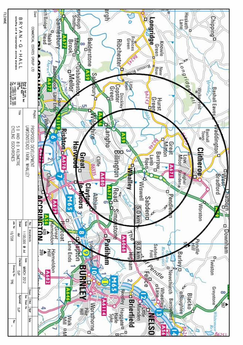
3.5.2 A plan showing the 5.0 kilometre and 8.0 kilometre catchments is attached at
Appendix TP6. The whole of Clitheroe and Whalley are within the 5.0
kilometre catchment area and the 8.0 kilometre catchment takes in part of
Padiham along with the villages of Great Harwood, Waddington, Grindleton
and Chatburn. Regional Routes 90 and 91 of the Lancashire Cycleway pass
close to the site on Clitheroe Road and Station Road, and in this vicinity, there
are on-road cycle routes.
3.5.3 It is concluded that the development site is well served by local and regional
cycle routes and overall is very accessible by cycle.

Proposed Development – Lawsonsteads, Whalley Framework Travel Plan
Bryan G Hall Ltd consulting civil & transportation planning engineers 10-228-002.05
14

Proposed Development – Lawsonsteads, Whalley Framework Travel Plan
Bryan G Hall Ltd consulting civil & transportation planning engineers 10-228-002.05
15
4.0 TRAVEL PLAN ADMINISTRATION
4.1 Site Travel Plan Co-ordinator (STPC) 4.1.1 The developer will appoint a Management Company for the site and the role of
STPC will be undertaken by a member of its staff based on site. The
appointment of a STPC will commence six months prior to occupation and the
appointment will remain in place for at least five years after full occupation but
will continue after this period of time for as long as a Management Company
remains in place. If the appointed Management Company changes, the
requirement to fulfil this role will be part of any subsequent appointment. This
way the STPC can implement some measures for first occupation and can
monitor the Framework Travel Plan for five years after full occupation. The
developer will fund this position. The STPC will be in post when the residential
units are first marketed.
4.1.2 The STPC will be responsible for overseeing the implementation of the
Framework Travel Plan based on this initial document including the promotion
of its contents to prospective occupiers. The overarching Framework Travel
Plan is the responsibility of the STPC. The STPC will contact Lancashire
County Council to advise that work has commenced on delivering the
Framework Travel Plan.
4.1.3 Prior to first occupation of the site, the STPC will establish a working party for
the Lawsonsteads Framework Travel Plan on to which will be invited the
appropriate officer from Lancashire County Council. Other bodies may be
invited on to the working party in response to particular issues raised. This
working party will meet approximately every three months to discuss and
agree strategic travel planning matters for the site.
4.1.4 The STPC will take ultimate responsibility for travel planning for the whole
development including carrying out the role of Residential Travel Plan Co-
ordinator, will be the main point of contact with Lancashire County Council and
will review all Travel Plans associated with the site. The STPC will take
responsibility for all site-wide transport matters including establishing and
maintaining a site car-share scheme, ensuring physical aspects of the site

Proposed Development – Lawsonsteads, Whalley Framework Travel Plan
Bryan G Hall Ltd consulting civil & transportation planning engineers 10-228-002.05
16
support the sustainability aims of the Framework Travel Plan, and maintaining
liaison with public transport operators and other statutory bodies.
4.1.5 The STPC will remain in post for at least five years after full occupation of the
site but this role will continue to be part of any Management Company’s
responsibilities and will assume the following responsibilities:
Carrying out the role of Residential Travel Plan Co-ordinator and
producing a Residential Travel Plan for implementation, monitoring and
maintaining at the residential development on site;
Ensuring that they comply with the travel planning standards and
conditions and also meets specific targets;
Implementing, monitoring and maintaining the Framework Travel Plan
which is consistent with the Lancashire County Council’s guidance on
Travel Plans and addresses at a minimum the issues set out in Section
5.0;
Ensuring that annual travel surveys are produced.
Ensuring that all residents are offered personalised travel planning and
asked to take part in the annual travel surveys;
Organising Personal Travel Planning programmes and the preparation
of personalised Travel Welcome Packs and a generic Travel Welcome
Pack;
Analysing the results of the travel surveys and liaising with Lancashire
County Council to discuss the results against the targets set; and
Ensuring that targets are being met and if they are not being met, they
will be addressed through agreed mitigation with Lancashire County
Council.
4.1.6 After five years of full occupation the STPC will liaise with Lancashire County
Council to reach agreement that the day to day responsibility for travel
planning for the development will pass to the individual Travel Plan Co-
ordinators working in conjunction with the appropriate officers at Lancashire
County Council. The STPC will ensure that on-call support is provided for a
maximum of 25 working days per annum for the development as a whole, for a
further 12 months.

Proposed Development – Lawsonsteads, Whalley Framework Travel Plan
Bryan G Hall Ltd consulting civil & transportation planning engineers 10-228-002.05
17
4.1.8 The role of the STPC will also include managing content for the Framework
Travel Plan website and also any contractual agreements with organisations
such as Liftshare, any car club, or any additional third party service providers
associated with the site. The STPC will also manage the allocated budget for
Framework Travel Plan initiatives.
4.1.9 The STPC will also act as a point of information and guidance in raising
awareness of workplace travel issues through e-mails, newsletters, memos,
leaflets, special activities, promotions, and reinforcing annual activities such as
Leave Your Car at Home Day, National Bike Week and Green Transport
Week. It would also be necessary for the STPC to act as a role model, to
demonstrate it is possible to effectively travel to/from work by using
sustainable modes of transport.
4.3 Funding 4.3.1 Funding is necessary to achieve the initiatives that are the basis of this
Framework Travel Plan, however a specific budget has yet to be allocated at
this time.
4.3.2 It is expected that approximately 50% of the available budget will be allocated
for direct management of the Framework Travel Plan, including monitoring of
the residential and the remaining 50% will be for materials including notice
boards, high visibility clothing, umbrellas, travel welcome packs, etc. This
initial budget is not expected to cover the costs of appointing the STPC.
4.3.3 Funding for any mitigation measures will be secured in the S106 by means of
penalty payments should the key targets set out in Section 6.0 not be met.
The penalty payments will be used to fund travel planning measures directly
related to this development. The details of the additional Framework Travel
Plan measures, such as car club trials, public transport ticketing, and cycle
hire, will be agreed by Lancashire County Council and the Site Travel Plan Co-
ordinator in order to best address the reasons for targets not being met.
Proposed Development – Lawsonsteads, Whalley Framework Travel Plan
Bryan G Hall Ltd consulting civil & transportation planning engineers 10-228-002.05
18
5.0 TRAVEL PLAN MEASURES
5.1 General 5.1.1 The following sections outline the specific physical and administrative
measures that will be introduced within the Framework Travel Plan. The
package of measures will include both incentives, to encourage travel by
alternative means to the private car, and disincentives, to discourage wherever
possible travel by private car.
5.1.2 The detailed package of measures will be implemented and will be revised as
necessary following the results of the initial travel surveys. These will
incorporate measures that will have an effect in the short, medium and longer
terms. Measures which can be taken forward to first occupation or shortly
afterwards are identified in the next sections.
5.2 Promotion and Awareness 5.2.1 For the Framework Travel Plan to be effective, awareness and ongoing
promotion is essential. CEG Limited intends to promote the Framework Travel
Plan to everyone accessing the site to encourage ownership of it and also to
promote it to the local community to raise its awareness that the
Lawsonsteads development is committed to minimising its negative impacts on
the community. The Framework Travel Plan will be promoted in a variety of
ways including:
Written media such as travel welcome packs, newsletters, leaflets
and posters;
Electronic media such as a dedicated development website and also
by email;
Spoken media through the working party meetings; and
Other media such as special events i.e. Breakfast Clubs.
5.2.2 It is essential that early awareness is achieved, as soon as possible before
any residents move on to the development. Prior to any occupation of the site,
during the construction phase, the STPC will organise the creation of a Travel

Proposed Development – Lawsonsteads, Whalley Framework Travel Plan
Bryan G Hall Ltd consulting civil & transportation planning engineers 10-228-002.05
19
Plan website. The website will include up-to-date information on public
transport, links to Lancashire County Council’s website and Transport Direct’s
journey planner. Information on car sharing and a link to the site car share
database will be accessed from this website and walking and cycling maps will
be available to download.
5.2.3 At the same time as the website goes live, a Travel Welcome Pack or
Lawsonsteads development community guide will be produced that will contain
information about the Framework Travel Plan and any other services provided
to support sustainable travel. It will provide copies of the walking and cycling
maps showing the location and routes to local amenities, public transport
information specific to the development, details of the car share scheme and
all useful contact numbers and website addresses.
5.2.4 Information on the role of STPC will be included with the invitation for a
meeting to discuss personal travel needs. A copy of the guide will be placed in
every new property as well as a download on the website. It is essential that
the guide is available prior to any occupation of each land use so that it is
provided to prospective occupiers of the residential development.
5.2.5 In addition to the induction process for prospective residents and along with
provision of information, the ongoing development of the Framework Travel
Plan and measures will need to be continually promoted on an ongoing basis.
Means of achieving this will include:
Regular updates to the website;
An up-to-date public information board and the formation of community
travel forums where users can meet and give feedback to the STPC;
Community travel events such as cycle promotion days and launches
of new services;
Establishment of a Bicycle User Group; and
Newsletter and leaflet drops.
5.3 Proposed Measures 5.3.1 The measures that will be considered for implementation when and where

Proposed Development – Lawsonsteads, Whalley Framework Travel Plan
Bryan G Hall Ltd consulting civil & transportation planning engineers 10-228-002.05
20
appropriate prior to the occupation of the site, or in the immediate period of
occupation are given in the table below along with the timescales for their
implementation.
Table 5.1
Proposed Travel Plan Measures
Action Timescale Measures to Reduce the Impact of the Car Implementation of a car sharing scheme. An online database will be set up via the Lawsonsteads development website. For members who do not have access to the internet, the STPC will be available to organise appropriate shared journeys.
Before first occupation
STPC to establish whether the site can support setting up a Car Club which could also be available to the wider community.
During marketing and on occupation
Measures to Promote Walking, Cycling and Powered Two-Wheelers Provide safe, well lit routes within the site and adequate connection to the existing facilities.
Before first occupation
Carry out an audit of existing pedestrian routes to local facilities and provide improvements where necessary.
Before first occupation
Work in partnership with local cycle and motorcycle shops to negotiate a discount scheme on cycle, motorcycle, accessories and insurance purchases.
Before first occupation
STPC to establish whether there is a demand from residents for a Bicycle Users Group and, if so, facilitate its formation.
Within six months of occupation
STPC to organise the preparation of specific walking and cycling maps showing the location and routes to local amenities.
Before first occupation and available for marketing purposes
STPC to promote the walk sharing scheme at www.walkbudi.com.
Before first occupation
Measures to Promote Public Transport STPC to organise the preparation of information about routes, timetables and fares etc
Before first occupation and available for marketing purposes.
Promote online journey planning facilities such as www.transportdirect.info
Before first occupation
Carry out an audit of existing bus stop facilities and carry out improvements where necessary
Before first occupation
Consider the provision of real time bus information (if existing fleet supports this facility) in any public areas.
Before first occupation
Investigate whether improvements can be made to the linkages between the development and Whalley Railway Station.
Before first occupation
Information Provision STPC to arrange the production of the travel welcome packs and/or Lawsonsteads development community guide
Before first occupation and available for marketing purposes
STPC to arrange creation of the Lawsonsteads development website and provide information regarding suitable links to other websites
Before first occupation and available for marketing purposes
STPC to offer personal travel planning to all residents with suitable incentives offered as part of service
Upon occupation

Proposed Development – Lawsonsteads, Whalley Framework Travel Plan
Bryan G Hall Ltd consulting civil & transportation planning engineers 10-228-002.05
21
5.3.2 The initial measures listed in Table 5.1 show the significant efforts that will be
made by CEG Limited to ensure travel to and from the Lawsonsteads
development will be as sustainable as possible. Introducing wide reaching
measures as well as possible changes to local bus services before first
occupation will have a significant impact on the level of traffic generated by the
development.

Proposed Development – Lawsonsteads, Whalley Framework Travel Plan
Bryan G Hall Ltd consulting civil & transportation planning engineers 10-228-002.05
22
6.0 TARGETS, MONITORING AND ACTIONS 6.1 Interim Targets
6.1.1 In order to determine the impacts of the Framework Travel Plan, challenging
but realistic targets must be developed. Prior to any occupation of the
development, the actual travel patterns of residents can be estimated from
available census data. Table 6.1 below uses a target of 15% reduction in car
commuter trips to show interim mode split targets for the development.
Table 6.1
Census 2001 Journey to Work Mode Share Data
Mode Without Travel Plan
With Travel Plan Percentage Change
To From To From To From Train 1% 1% 2% 2% 1% 1% Bus 3% 3% 6% 6% 3% 3% Car Driver 86% 86% 71% 71% -15% -15% Motorcycle 1% 1% 3% 3% 2% 2% Bicycle 1% 1% 6% 6% 5% 5% Foot 8% 8% 12% 12% 4% 4%
6.2 Specific Targets 6.2.1 As well as an overarching target relating to reducing single occupancy car use
for trips to and from the site, a range of supporting targets have been
developed for other modes of travel. Targets should be time-bound and
reviewed during the monitoring stages of the Framework and Company Travel
Plans.
6.2.2 Table 6.2 below shows example targets based on trip rates from the Transport
Assessment (submitted as part of the planning application). The table shows
targets based on the 55 dwellings being fully occupied, for the implemented
Framework Travel Plan to aim towards. These example targets are based on
overall mode share targets for the site and adjusted year on year.
.
Table 6.2
Example Mode Share Targets

Proposed Development – Lawsonsteads, Whalley Framework Travel Plan
Bryan G Hall Ltd consulting civil & transportation planning engineers 10-228-002.05
23
Mode Predicted opening trips Target trips within 6 months
55 dwellings 55 dwellings Two Way Two Way
AM PM AM PM Train 0 0 1 1 Bus 1 1 3 3 Car Driver 34 38 28 31 Motorcycle 1 1 1 1 Bicycle 1 1 2 3 On Foot 3 4 5 6 Total 40 45 40 45
6.3 Monitoring 6.3.1 Monitoring the success of the Framework Travel Plan against its own targets
will be a key role of the STPC. The overall role and duties of the STPC are
outlined in Section 4.1 of this initial Framework Travel Plan and it is anticipated
that over the first five years of the life of the Framework Travel Plan, the STPC
will commit to providing 240 man days in relation to carrying out the allotted
duties and any other duties found to be necessary. A review of the time
allotted to the STPC will be carried out every six months to ensure that a
consistent service is provided to all occupants of the development.
6.3.2 In order to ensure that the STPC can undertake his/her duties satisfactorily,
basic office accommodation will be made available within the development for
this purpose. This accommodation will be available prior to any on-site
marketing of development.
6.3.3 Six months after initial occupation or when occupancy has reached a level
which is deemed appropriate, as agreed by the Steering Group, the STPC will
undertake a travel survey of current residents. This will enable the STPC and
the Steering Group to develop targets and indicators which can be measured
and met by the next travel survey. The targets will be set together with the
appropriate measures to support those targets. The travel survey will collect,
as a minimum, the following information:
How residents travel to and from the site and why they choose that
mode/method of travel;
How residents travel during the working day, whether it is for business
or leisure and where they need to get to;

Proposed Development – Lawsonsteads, Whalley Framework Travel Plan
Bryan G Hall Ltd consulting civil & transportation planning engineers 10-228-002.05
24
Where, for journey to work purposes, residents are travelling to
(postcodes);
What measures would be most effective in persuading drivers to switch
to other modes; and
What measures would be the most popular amongst different types of
respondents.
6.3.4 A response rate of at least 50% should be set to ensure as many people take
part in the survey as possible. Incentives will be offered to encourage people
to take part and, in order to obtain as large a sample as possible, completion
of the travel survey will form part of the personal travel planning process. In
addition to the travel surveys, multi-modal surveys will be undertaken at all
points of access and egress into the site along and other data obtained, such
as:
Take up of bicycle storage provided on site;
Number of hits of the Travel Plan website;
Number of people taking up the car sharing scheme; and
Bus occupancy surveys at appropriate bus stops.
6.3.5 The results of the surveys in the form of a monitoring report will be provided to
Lancashire County Council within one month of the survey results being
available. Travel surveys will be undertaken annually for the first five years
after the first survey is conducted. After this period an interval for future
surveys will be agreed with the Highways Agency and Lancashire County
Council.

Proposed Development – Lawsonsteads, Whalley Framework Travel Plan
Bryan G Hall Ltd consulting civil & transportation planning engineers 10-228-002.05
25
6.4 Action Timetable 6.4.1 This sub-section of the Framework Travel Plan sets out the timescales for
delivering the initiatives outlined so far, as shown in the table below. The table
also provides details of who is responsible for the initial stages of the
Framework Travel Plan prior to individual Travel Plan Co-ordinators being in
place and setting up their respective Travel Plans under the umbrella of the
Framework Travel Plan to be developed from this initial Framework Travel
Plan. Where responsibility lies with the STPC, failure to carry out any of these
activities is a failure by the Owner to discharge against its obligations.
Table 6.3
Timetable and Responsibilities
for implementing the Framework Travel Plan
Initiative Timescale Responsibility Appoint STPC Three months prior to
any marketing and/or six months prior to any occupation
Developer
Agree and implement initial Framework Travel Plan
Within two months of appointment
STPC
Establish Travel Plan Steering Group
Prior to any marketing and occupation
STPC
Prepare initial Residential Travel Plan
Prior to any marketing and occupation
STPC
Establish Travel Plan website
Prior to any occupation STPC
Create Community Guide
Prior to any occupation STPC
Set up car share database
Prior to any occupation STPC
Set up walking buses to local primary school
Upon occupation of residential element
STPC
Set up personal travel planning meetings with residents
Upon occupation STPC
Ensure all properties are supplied with Community Guide
Upon occupation STPC
Conduct first travel survey
50% occupancy or within six months of first occupancy
STPC/Individual Travel Plan Co-ordinators

APPENDIX TP 1


APPENDIX TP 2


APPENDIX TP 3


APPENDIX TP 4


APPENDIX TP 5

Bus Services - Clitheroe Road and Station Road
Daytime Evening
26/27 Colne - Nelson - Burnley - Padiham 30 60 30 60
225 Clitheroe - Whalley - Blackburn - Bolton 30 60 30 60
231 Clitheroe - Whalley - Accrington 60 No Service 60 No Service
241 Clitheroe - Accrington - Royal - Blackburn 60 No Service 60 No Service
280/X80 Skipton - Barnoldswick - Clitheroe - Preston 60 No Service 60 No Service
Daytime Evening
5 Clitheroe - Whalley - Ribchester - Longridge 120 No Service 120 No Service
C25 Clitheroe - Whalley - Brockhall - Blackburn 120 No Service 120 No Service
Rail Services - Whalley Railway Station
60 60
60 60
Frequency (Mins)
Saturday Sunday
Route
Approx Frequency (Mins)
Monday to FridaySaturday
Monday to Friday
Whalley - Manchester Victoria
Monday to Friday
60
60
Sunday
Approx Frequency (Mins)
Service Route
Route
Whalley - Clitheroe
CLITHEROE ROAD
Saturday Sunday
STATION ROAD
Service

APPENDIX TP 6