property values - western sydney...
TRANSCRIPT

COMMONWEALTH DEPARTMENT OF T R A N S P O R T A N D R E G IO N A L
D E V E L O P M E N T
Property ValuesProposal for a Second Sydney Airport
at Badgerys Creek or Holsworthy Military Area
In f ra s t ru c tu re Library'
III I I I I I I !■C 6 1 0 1 7 2 8 3 3 5
387.736099441PPK
PPKhnvimnmcnt & Infrastructure

Prepared for:
COMMONWEALTH DEPARTMENT OF T R A N S P O R T A N D R E G IO N A L
D E V E L O P M E N T
GPO Box 594 Canberra ACT 2601
Property ValuesProposal for a Second Sydney Airport
at Badgerys Creek or Holsworthy Military Area
Technical Paper
Prepared by:
JLW AdvisoryLevel 23 Grosvenor Place
225 George Street Sydney NSW 2000
PPKLnvironment & Infrastructure
ACN 078 004 798 A NATA Certified Quality Company
PPK House PO Box 248
Concord West NSW 2138 December 1997
Report No: 58H233B PR1053 ISBN No: 0642280339

Explanatory Statement
This technical paper is not part of the Draft Environmental Impact Statement (EIS) referred to in paragraph 6 of the Administrative Procedures made under the Environment Protection (Impact of Proposals) Act 1974.
The Commonwealth Government is proposing to construct and operate a second major airport for Sydney at Badgerys Creek. This technical paper contains information relating to the Badgerys Creek airport options which was used to assist the preparation of the Draft EIS.
The technical paper also assesses the impacts of developing a major airport at the Holsworthy Military Area. On 3 September 1997, the Government eliminated the Holsworthy Military Area as a potential site for Sydney's second major airport. As a consequence, information in this technical paper relating to the Holsworthy Military Area is presented for information purposes only.
Limitations Statement
This technical paper has been prepared in accordance with the scope of work set out in the contract between Rust PPK Pty Ltd and the Commonwealth Department of Transport and Regional Development (DoTRD) and completed by PPK Environment and Infrastructure Pty Ltd (PPK). In preparing this technical paper, PPK has relied upon data, surveys, analyses, designs, plans and other information provided by DoTRD and other individuals and organisations, most of which are referenced in this technical paper. Except as otherwise stated in this technical paper, PPK has not verified the accuracy or completeness of such data, surveys, analyses, designs, plans and other information.
This technical paper has been prepared for the exclusive use of DoTRD. PPK will not be liable to any party other than DoTRD and assumes no responsibility for any loss or damage suffered by any other party arising from matters dealt with in this technical paper, including, without limitation, matters arising from any negligent act or omission of PPK or for any loss or damage suffered by any other party in reliance upon the matters dealt with and opinions and conclusions expressed in this technical paper.
Acknowledgments
Data used to develop the figures contained in this document have been obtained and reproduced by permission of the Australian Bureau of Statistics, NSW Department of Land and Water Conservation, NSW National Parks and Wildlife Service (issued 14 January 1997), NSW Department of Urban Affairs and Planning and Sydney Water. The document is predominantly based on 1996 and 1997 data.
To ensure clarity on some of the figures, names of some suburbs have been deleted from inner western, eastern, south-eastern and north-eastern areas of Sydney. On other figures, only 'Primary' and 'Secondary' centres identified by the Department of Urban Affairs and Planning's Metropolitan Strategy, in addition to Camden, Fairfield and Sutherland, have been shown.

Copyright
° Commonwealth of Australia 1997This work is copyright. Apart from any use as permitted under the Copyright Act 1968, no part may be reproduced by any process without written permission from the Australian Government Publishing Service. Requests and inquiries concerning reproduction and rights should be directed to the Manager, Commonwealth Information Service, GPO Box 84, Canberra, ACT 2601.

Contents
Page Number
Part A: Introduction
C hapter 1 Introduction 1-1
i . i Intro duct io n 1 -11.2 a Brief H istory 1 -11.3 The Proposal 1 -31.4 A ir T raffic Forecasts 1 -51.5 O peration of the A irport O ptions 1 - 6
C hapter 2 Consultation 2-1
2.1 C o m m u n it y C onsultation 2 -12.2 O ther C onsultation 2 -1
C hapter 3 M ethodology 3-1
3.1 A ims a n d Scope of W ork 3 -13.2 M easuring A ircraft N oise 3 -13.3 Q uantitative Studies 3 - 3
3.3.1 Approaches 3-33.3.2 Review of Results 3-53.3.3 Past Results for Sydney A irport 3-73.3.4 issues 3-9
3.4 Q ualitative Studies 3 - 1 1
3.4.1 Approaches 3-113.4.2 Review of Results 3-12
3.5 A pproach A dopted for this Study 3 - 1 3
Part B: Existing Environment
C hapter 4 Existing Property Values 4-1
4.1 D ata Sources 4-1
4.1.1 Noise Exposure M easurements 4-1
Department of Transport and Recional Development Pace i

4.1.2 Housing Price Data and Benchmarks 4-1
4.2 N oise Z ones 4 -1
4.2.1 Base Housing and La n d Values 4-1
C hapter 5 Price Effects on Housing 5 -1
5.1 H o u s in g Prices a n d C hanges u n d e r Syd n ey A irport
Flig h t Paths 5 -1
5.1.1 Sydney metropolitan and Regional Housing PriceTrends 5-1
5.1.2 Aggregate Price Impacts of the Opening of the ThirdRunway (Sydney Airport) 5-3
5.1.3 Median Price Trends Under the Northern Flight Pathfor Sydney Airport 5 - 5
5.1.4 Price Trends Under the Eastern and W estern FlightPaths for Sydney A irport 5-13
5.1.5 O ther Influences on Housing Values Under FlightPaths 5-15
5.1.6 Conclusions and D irections for this Study 5-18
5.2 Survey of Real Estate A gents 5 - 2 0
5.2.1 O bjective of Survey 5-205.2.2 Survey Approach 5 - 205.2.3 Q uestionnaire 5 - 205.2.4 Bias and Survey Issues 5-215.2.5 Results 5-21
5.3 D evaluation Estimates 5 - 2 4
Part C: Assessment of Impacts
C hapter 6 Impacts of A irport O ptions 6 -1
6.1 A pproach to Impact Assessment 6 -16.2 Impacts of A irport O ptions 6 - 3
Part D: Environmental M anagement
C hapter 7 Environmental M anagement 7 -1
Pace ii PPK Environment & Infrastructure Pty Ltd

Part E: Summary of Property Value Impacts
C hapter 8 Summary of Property Value Impacts 8 -1
References R -1
List o f Figures
Following Page No.
Figure 1.1 Potential Airport Sites Currently Being Considered in the Draft EIS 1-3Figure 1.2 Summary of Passenger Movement Forecasts Used for Environmental
Assessment 1-3Figure 1.3 Predominant Directions of Movement of Aircraft for Airport
Operation 1 1-7Figure 1.4 Predominant Directions of Movement of Aircraft for Airport
Operation 2 1-7Figure 5.1 ANEF Cross Sections North of Parramatta River (I) for Sydney Airport 5-5Figure 5.2 ANEF Cross Sections North of Parramatta River (II) for Sydney Airport 5-5Figure 5.3 Western Flight Path Zones (Sydney Airport) 5-13Figure 5.4 Eastern Flight Path Zones (Sydney Airport) 5-13Figure 5.5 Real Estate Agent Survey - Subject and control Areas Ryde/Hunters
Hill/Lane Cove 5-20Figure 5.6 Real Estate Agent Survey - Subject and Control Areas Pymble/
Lindfield 5-20
A ppendices
Appendix A Appendix B Appendix C Appendix D
Summaries of Previous StudiesHouse Price DataSurvey of Real Estate AgentsOutputs of Property Devaluation Assessment
JLW Advisory Disclaimer
This report is confidential to the party to whom it is addressed for the specific purpose to which it refers. No responsibility is accepted to any third party and neither the whole of the report nor any part or reference thereto may be published in any document, statement or circular or in any communication with third parties without our prior written approval of the form and context in which it w ill appear.
W e stress that the estimation of current and real estate prices and values is a problematical exercise which at best should be regarded as an indicative assessment of possibilities rather than absolute certainties. The process of making forward projections of such key elements involves assumptions respecting a considerable number of variables which are acutely sensitive to changing conditions, variations in any one of which may significantly affect the outcome and we draw your attention to this factor.
Department of Transport and Recional Development Pace iii

Part AIn tro d u ctio n

In t r o d u c t io n - C hapter 1
Chapter 1 Introduction
1.1 Introduction
This technical paper addresses the potential property value impacts identified as part o f the previously proposed development o f the Second Sydney A irport at either Badgerys Creek or the Holsworthy M ilita ry Area. It contains information used to prepare the Draft Environmental Impact Statement (EIS) w hich addresses the overall environmental impacts o f the Badgerys Creek airport options.
1.2 A Brief H istory
The question of where, when and how a second major airport may be developed for Sydney has been the subject of investigation for more than 50 years. The investigations and the associated decisions are closely related to the history of the development of Sydney's existing major airport, located at Mascot.
The site of Sydney Airport was first used for aviation in 1919. It was acquired by the Commonwealth Government in 1921, and was declared an International Aerodrome in 1935. In 1940 the first terminal building and control tower were opened.
In 1945 the airport had three relatively short runways. A major expansion began in 1947, and by 1954 the current east-west runway was opened. The north-south runway was first opened in 1954 and was extended to its current length in 1972. The present international terminal was opened in 1970.
Planning and investigations for a site for a second Sydney airport first started in 1946. A large number of possible sites both within and outside the Sydney Basin have been investigated.
The Second Sydney A irport Site Selection Program Draft Environmental Impact Statement (Kinhill Stearns, 1985) re-examined all possible locations for the second airport and chose 10 for preliminary evaluation. Two sites, Badgerys Creek and Wilton, were examined in detail and an EIS was prepared. In February 1986 the then Commonwealth Government announced that Badgerys Creek had been selected as the site for Sydney's second major airport.
The Badgerys Creek site, which is about 46 kilometres west of Sydney's Central Business District and is 1,700 hectares in area, was acquired by the
Department of Transport and Recional Development Pace 1-1

Se c o n d Syd n ey A irport
Commonwealth between 1986 and 1991. A total of $155 million has been spent on property acquisition and preparatory works.
Since 1986, planning for Sydney's second airport has been closely linked to the development of the third runway at Sydney Airport. In 1989 the Government announced its intention to construct a third runway. An EIS was undertaken and the decision to construct the runway was made in December 1991.
At the same time as investigations were being carried out on the third runway, detailed planning proceeded for the staged development of the second airport at Badgerys Creek. In 1991 it was announced that initial development at Badgerys Creek would be as a general aviation airport with an 1,800 metre runway.
The third runway at Sydney Airport was opened in November 1994. In March 1995, in response to public concern over the high levels of aircraft noise, the Commonwealth Senate established a committee in March 1995 to examine the problems of noise generated by aircraft using Sydney Airport and explore possible solutions. The committee's report, Falling on Deaf Ears?, containing several recommendations, was tabled in parliament in November 1995 (Senate Select Committee on Aircraft Noise, 1995).
During 1994 and 1995 the Government announced details of its proposed development of Badgerys Creek, and of funding commitments designed to ensure the new airport would be operational in time for the 2000 Olympics. This development included a 2,900 metre runway for use by major aircraft.
The decision to accelerate the development of the new airport triggered the environmental assessment procedures in the Environment Protection (Impact of Proposals) Act 1974. In January 1996 it was announced that an EIS would be prepared for the construction and operation of the new airport.
In May 1996, the present Commonwealth Government decided to broaden the environmental assessment process. It put forward a new proposal involving the consideration of 'the construction and operation of a second major international/ domestic airport for Sydney at either Badgerys Creek or Holsworthy on a site large enough for future expansion of the airport if required' (Department of Transport and Regional Development, 1996). A major airport was defined as one 'capable of handling up to about 360,000 aircraft movements and 30 million passengers per year' (Department of Transport and Regional Development, 1996).
The Government also indicated that 'Badgerys Creek at this time remains the preferred site for Sydney's second major airport, subject to the favourable outcome of the EIS, while Holsworthy is an option to be considered as an
Page 1-2 PPK Environment & Infrastructure Pty Ltd

In tro du c t io n - C hapter 1
alternative' (Minister for Transport and Regional Development, 1996). The two sites considered in this technical paper are shown in Figure 1.1.
Following the substantial completion of a Draft EIS on the Badgerys Creek and Holsworthy airport options, the Government eliminated the Holsworthy Military Area as a potential site for Sydney's second major airport. The environmental assessment showed that the Badgerys Creek site was significantly superior to the Holsworthy Military Area. As a result a Draft EIS was prepared which examines only the Badgerys Creek site. While this technical paper examines both the Badgerys Creek and Holsworthy airport options, only the parts of the assessment relating to the Badgerys Creek airport options were used to assist the preparation of the Draft EIS.
1.3 The Proposal
The Commonwealth Government proposes the development of a second major airport for Sydney capable of handling up to 30 million domestic and international passengers a year. By comparison, Sydney Airport will handle about 20 million passengers in 1997. The Second Sydney A irport Site Selection Program Draft Environmental Impact Statement anticipated the airport would accommodate about 13 million passengers each year (Kinhill Stearns, 1985).
A stated objective of the Government is the building of a second major airport in the Sydney region to a full international standard, subject to the results of an EIS. In the Government's view, Sydney needs a second major airport to handle the growing demand for air travel and to control the level of noise experienced by Sydney residents (Coalition of Liberal and National Parties, 1996).
Government policy (Coalition of Liberal and National Parties, 1996) indicates:
■ that Sydney's second airport will be more than just an overflow airport and will, in time, play a major role in serving Sydney's air transport needs; and
■ a goal of reducing the noise and pollution generated by Sydney Airport as much as possible and that the Government would take steps to ensure that the noise burden around Sydney Airport is shared in a safe and equitable way.
The assumptions made on how the Second Sydney Airport would operate and the master plans which set out the broad framework for future physical development of the airport are based on an operational limit of 30 million passengers a year. The main features include parallel runways, a cross wind
Department of Transport and Recionai Development Pace 1-3

Se c o n d Sy d n ey a irpo rt
runway and the provision of the majority of facilities between the parallel runways.
Consideration has also been given to how the airport may be expanded in the future and the subsequent environmental implications. Such an expansion could not proceed, however, unless a further detailed environmental assessment and decision making process were undertaken by the Government.
Five airport options are considered, as well as the implications of not proceeding with the proposal. Three of the airport options are located at Badgerys Creek and two are located within the Holsworthy Military Area. Generally, the airport options are:
■ Badgerys Creek Option A which has been developed to be generally consistent with the planning for this site undertaken since 1986. The airport would be developed within land presently owned by the Commonwealth with two parallel runways constructed on an approximate north-east to south-west alignment;
■ Badgerys Creek Option B would adopt an identical runway alignment to Option A, but provides an expanded land area and also a cross wind runway;
■ Badgerys Creek Option C would provide two main parallel runways on an approximate north to south alignment in addition to a cross wind runway. Again the land area required would be significantly expanded from that which is presently owned by the Commonwealth;
■ Holsworthy Option A would be located centrally within the Holsworthy Military Area and would have two main parallel runways on an approximate north to south alignment and a cross wind runway; and
■ Holsworthy Option B would be located in the south of the Holsworthy Military Area and would have two main parallel runways on an approximate south-east to north-west alignment and a cross wind runway.
To ensure that the likely range of possible impacts of the airport options are identified a number of different assumptions about how the airport options would be developed and operate have been adopted. These different assumptions relate to the number and types of aircraft that may operate from the airport, the flight paths used and the direction of take offs and landings.
The number of flights into and out of the proposed Second Sydney Airport would depend on a number of factors including the types of aircraft that would use the airport and the associated numbers of passengers in each aircraft. The
Pace 1-4 PPK Environment & Infrastructure Pty Ltd

TN
Total: 20.3 million Total: 34.0 million Sydney Airport. 30 million
Second Sydney Airport4.fi million
Domestic f*itsengen
Total: 49.0 million
» Airport: 30 millionmillion 1184.500 aircraft movements)
Assumptions about Passenger Movements for Air Traffic Forecast 1
1995/6
Total: 20.3 m illion Total: 34.8 million Sydney Airport: 24.8 million
Second Sydney Airport 10 million
Tota: 49 0 million Sydney Airport 24.8 million
Second Sydney Airport: 24.2 million (233.600 a
__Sydney Airpcniniem iM nil Passengers
Sydney Airport Domestic Passengers
Ircraft movements)
Assumptions about Passenger Movements for Air Traffic Forecast 2
Second Sydney A roan Demesne Passengers
Sydney Airport International Passengers
Total: 20.3 million Total: 34.fi million Sydney Airport: 19.7 million
Second Sydney Airport 15.1 million
Second Sydney Airport International PassengersTotal 49.0 million
Sydney Airport: 19.7 millionSecond Sydney Airport: 29.3 million (244.600 aircraft mavemants)
Assumptions about Passenger Movements for Air Traffic Forecast 3
Figure 1 .2Summary of Passenger Movement Forecasts Used for Environmental Assessment
In tro d u c t io n - C hapter 1
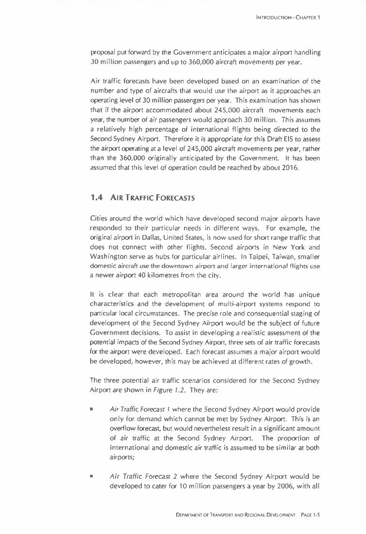
proposal put forward by the Government anticipates a major airport handling 30 million passengers and up to 360,000 aircraft movements per year.
Air traffic forecasts have been developed based on an examination of the number and type of aircrafts that would use the airport as it approaches an operating level of 30 million passengers per year. This examination has shown that if the airport accommodated about 245,000 aircraft movements each year, the number of air passengers would approach 30 million. This assumes a relatively high percentage of international flights being directed to the Second Sydney Airport. Therefore it is appropriate for this Draft EIS to assess the airport operating at a level of 245,000 aircraft movements per year, rather than the 360,000 originally anticipated by the Government. It has been assumed that this level of operation could be reached by about 2016.
1.4 A ir Traffic Forecasts
Cities around the world which have developed second major airports have responded to their particular needs in different ways. For example, the original airport in Dallas, United States, is now used for short range traffic that does not connect with other flights. Second airports in New York and Washington serve as hubs for particular airlines. In Taipei, Taiwan, smaller domestic aircraft use the downtown airport and larger international flights use a newer airport 40 kilometres from the city.
It is clear that each metropolitan area around the world has unique characteristics and the development of multi-airport systems respond to particular local circumstances. The precise role and consequential staging of development of the Second Sydney Airport would be the subject of future Government decisions. To assist in developing a realistic assessment of the potential impacts of the Second Sydney Airport, three sets of air traffic forecasts for the airport were developed. Each forecast assumes a major airport would be developed, however, this may be achieved at different rates of growth.
The three potential air traffic scenarios considered for the Second Sydney Airport are shown in Figure 1.2. They are:
■ A ir Traffic Forecast 1 where the Second Sydney Airport would provide only for demand which cannot be met by Sydney Airport. This is an overflow forecast, but would nevertheless result in a significant amount of air traffic at the Second Sydney Airport. The proportion of international and domestic air traffic is assumed to be similar at both airports;
■ A ir Traffic Forecast 2 where the Second Sydney Airport would be developed to cater for 10 million passengers a year by 2006, with all
Department of Transport and Regional D evelopment Pace 1-5

Se c o n d Syd n ey A irport
further growth after this being directed to the second airport rather than Sydney Airport. The proportion of international and domestic traffic is also assumed to be similar at both airports; and
A ir Traffic Forecast 3 which is similar to Forecast 2 but with more international flights being directed to the Second Sydney Airport. This would result in the larger and comparatively noisier aircraft being directed to the second airport. It would accommodate about 29.3 million passengers by 2016.
1.5 O peration of the A irport O ptions
At any airport, aircraft operations are allocated to runways (which implies both the physical runway and the direction in which it is used) according to a combination of wind conditions and airport operating policy. The allocation is normally performed by Air Traffic Control personnel.
Standard airport operating procedures indicate that a runway may not be selected for either approach or departure if the wind has a downwind component greater than five knots, or a cross wind component greater than 25 knots. If the runway is wet, it would not normally be selected if there is any downwind component. This applies to all aircraft types, although larger aircraft would be capable of tolerating relatively higher wind speeds. Wind conditions at the airport site therefore limit the times when particular runways may be selected. However, there would be a substantial proportion of the time, under low wind conditions, when the choice of runways would be determined by airport operating policy.
For the environmental assessment, the maximum and minimum likely usage for each runway and runway direction was estimated and the noise impact of each case calculated. The actual impact would then lie between these values and would depend on the operating policy which is applicable at the time.
The three airport operation scenarios were adopted for the environmental assessment, namely:
■ Airport Operation 1 shown in Figure 1.3. Aircraft movements would occur on the parallel runways in one specified direction (arbitrarily chosen to be the direction closest to north), unless this is not possible due to meteorological conditions. That is, take offs would occur to the north from the parallel runways and aircraft landing would approach from the south, travelling in a northerly direction. Second priority is given to operations in the other direction on the parallel runways, with operations on the cross wind runway occurring only when required because of meteorological conditions;
Pace 1-6 PPK Environment & Infrastructure Pty Ltd

In t r o d u c t io n - C hapter 1
■ Airport Operation 2 shown in Figure 1.4. As for Operation 1, but with the preferred direction of movements on the parallel runways reversed, that is to the south; and
■ A irport Operation 3. Deliberate implementation of a noise sharing policy under which seven percent of movements are directed to occur on the cross wind runway (equal numbers in each direction) with the remainder distributed equally between the two parallel runway directions.
Since a cross wind runway is not proposed at Badgerys Creek Option A, onlyOperations 1 and 2 were considered for that option.
Department of Transport and Recional Development Page 1-7

Predominant Directions of Movement of Aircraftfor Airport Operation 1
Note: Cross wind runway used only when required because of meteorological conditions
F ig u re 1 .4
Predominant Directions of Movement of Aircraftfor Airport Operation 2
Note: Cross wind runway used only when required because of meteorological conditions