prologis land-to-suitproperty.prologis.com/flyers/3440_doc_2_-_lts_2015.pdf · poland 7 poland...
TRANSCRIPT

PROLOGIS LAND-TO-SUIT2015 OFFER
®

UJA
ZD
We are delighted to present to you this catalogue of Prologis' proposedinvestment sites . The land we offer is unique in terms of businessfor saledevelopment. It includes sites to use for investments such as industrialparks, logistic centres, and related service centres. What is important isthat this current edition includes proposals for locations for the whole ofCentral and Eastern Europe.
The undeniable advantages of the sites offered by Prologis are their size,attractive location, position on or near to major traffic routes, and the factthat they are covered by current plans for spatial development. Moreover,Prologis guarantees the regulated legal status and clear procedures foracquisition of the lands offered.
These attributes, together with the platform and our company'sexperience of the investment process, allow us to individually address theunique requirements of our industry clients. We can offer a range of sitesfor various customer uses and needs. No matter if, they need just land,land with an infrastructure, land with building permits in place, or land withan industrial facility on site.
Put simply LTS: Land-to-Suit all your industrial requirements.
Michał PtaszyńskiLand & Development Director
INTRODUCTION
3

CZECHREPUBLIC
SLOVAKIA
HUNGARY
ROMANIA
1
1
13 24
1
4
POLAND12
3
5
4
10
6
9
8 7
PROPOSED LOCATIONS
CZECH REPUBLIC
1 Prague-Úžice
SLOVAKIA
1 Nové Mesto
HUNGARY
1 Budapest-Batta
2 Budapest-Fót
3 Budapest-Harbor
4 Hegyeshalom
ROMANIA
1 Bucharest A1
5
POLAND
1 Błonie II
2 Sochaczew
3 Urzut - Under Offer
4 Piotrków II
5 Ruda Śląska
6 Ujazd
7 Wrocław V - Sold
8 Wrocław IV
9 Szczecin
10 Gdańsk II - Sold

PIO
TR
KÓ
WT
RY
BU
NA
LS
KI
LublinRadom
Gdynia
Gdańsk
Piotrków
Poznań
Wrocław
Łódź
Białystok
Bydgoszcz Toruń
Bielsko-Biała
Szczecin
Katowice
Kraków
Częstochowa
Warsaw
A1
A6
A4
A2
A1
A4
S6
A1
A2
E28E28
E77
E67
E30
E77
E77
E77
E75
E40E40
E40
E372E371
E371
E261
E373
E373
E462
E65
E65
E67
E67
E67
A2
A4
A1A4
E75
E75
drogi krajowenational roads
autostradymotorways
autostrady w budowiemotorways under construction
LegendaKey
autostrady planowaneplanned motorways
drogi ekspresoweexpress roads
drogi ekspresowe w budowieexpress roads
drogi ekspresowe planowaneexpress roads
POLAND
7
PO
LA
ND
Proponowane lokalizacjeProposed locations
1
2
5
4
3
10
6
9
8
7
1 BŁONIE II
2 SOCHACZEW
3 URZUT
4 PIOTRKÓW II
5 RUDA ŚLĄSKA
6 UJAZD
7 WROCŁAW V
8 WROCŁAW IV
9 SZCZECIN
10 GDAŃSK II
12
5
4
3
10
6
9
8 7
Błonie
GrodziskJunction
WiskitkiJunction
Vistula
Vistu
la
KatowiceWrocław
Łódź
Kiev / Moscow
Nowy Dwór Mazowiecki
E30
Warsaw
E77
E67
Białystok
S17
A2
50
50
62
575
705
50
S7
S8
S8
S8
92
E30
S2
S2
GdańskGdynia
E77
Sochaczew
PoznańBerlin
10 km
Ołtarzew
A2
PruszkówJunction Konotopa
Junction
WypędyJunction
OżarówE30
Kraków
Pruszków
S79
S7/S8
S7
S8
E77E67
Błonie II
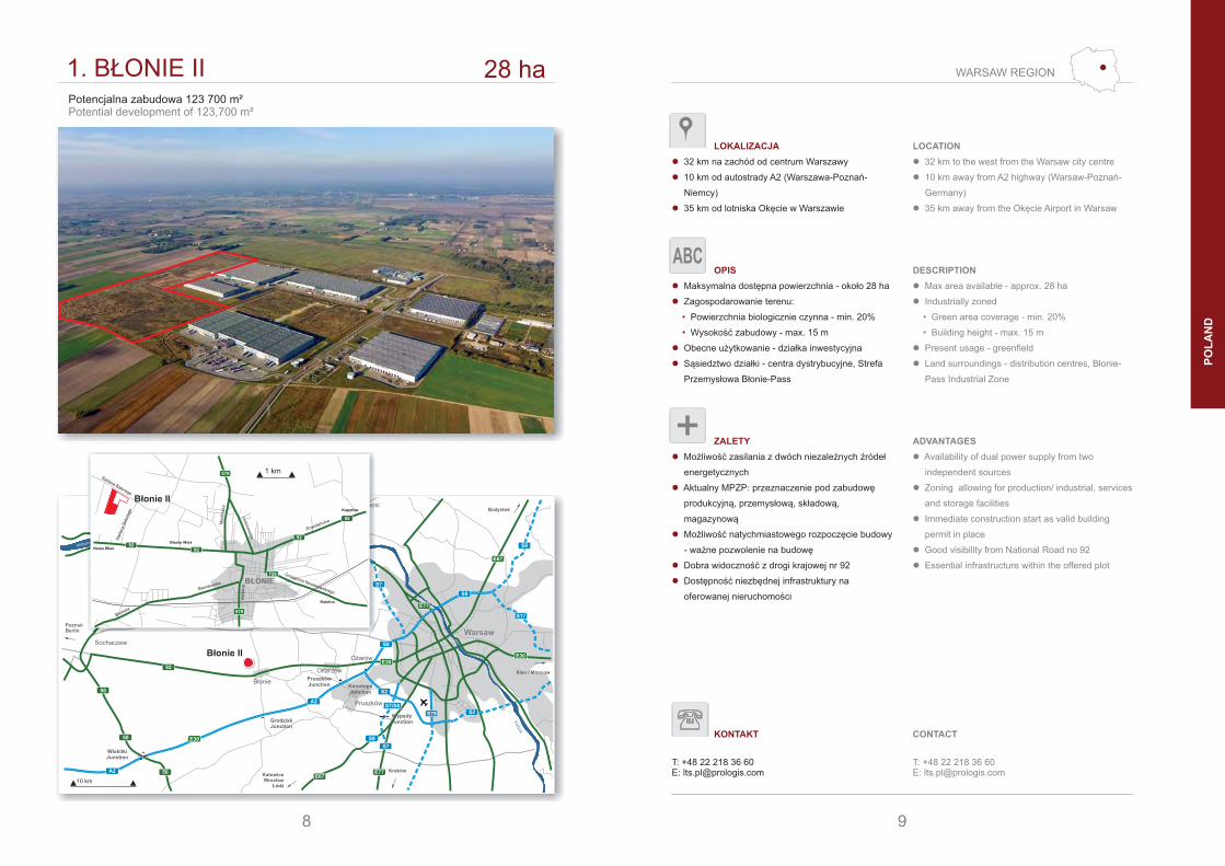
1. BŁONIE II 28 haPotencjalna zabudowa 123 700 m²Potential development of 123,700 m²
8
579
579
720
92
92
92
92
BŁONIEGrzegorza Nowakowskiego
Gro
dzka
Błońska
Powstańców
Lesznowska
Mod
lińsk
a
Ste
fana
Bat
oreg
o
Stefana Batorego
Bieniewicka
Błonie Wieś
Nowa Wieś
Kopytów
Rokitno
Błonie II
1 km
9
WARSAW REGION
LOKALIZACJA
� 32 km na zachód od centrum Warszawy
� 10 km od autostrady A2 (Warszawa-Poznań-
Niemcy)
� 35 km od lotniska Okęcie w Warszawie
OPIS
� Maksymalna dostępna powierzchnia - około 28 ha
� Zagospodarowanie terenu:
Powierzchnia biologicznie czynna - min. 20%•
Wysokość zabudowy - max. 15 m•
� Obecne użytkowanie - działka inwestycyjna
� Sąsiedztwo działki - centra dystrybucyjne, Strefa
Przemysłowa Błonie-Pass
ZALETY
� Możliwość zasilania z dwóch niezależnych źródeł
energetycznych
� Aktualny MPZP: przeznaczenie pod zabudowę
produkcyjną, , składową,przemysłową
magazynową
� Możliwość natychmiastowego rozpoczęcie budowy
- ważne pozwolenie na budowę
� Dobra widoczność z drogi krajowej nr 92
� Dostępność niezbędnej infrastruktury na
oferowanej nieruchomości
KONTAKT
T: +48 22 218 36 60E: [email protected]
CONTACT
T: +48 22 218 36 60E: [email protected]
LOCATION
� 32 km to the west from the Warsaw city centre
� 10 km away from A2 highway (Warsaw-Poznań-
Germany)
� 35 km away from the Okęcie Airport in Warsaw
DESCRIPTION
� Max area available - approx. 28 ha
� Industrially zoned
• Green area coverage - min. 20%
• Building height - max. 15 m
� Present usage - greenfield
� Land surroundings - distribution centres, Błonie-
Pass Industrial Zone
ADVANTAGES
� Availability of dual power supply from two
independent sources
� Zoning allowing for production/ industrial, services
and storage facilities
� Immediate construction start as valid building
permit in place
� Good visibility from National Road no 92
� Essential infrastructure within the offered plot
ABC
PO
LA
ND

Błonie
GrodziskJunction
WiskitkiJunction
Vistula
Vistu
la
KatowiceWrocław
Łódź
Kiev / Moscow
Nowy Dwór Mazowiecki
E30
Warsaw
E77
E67
Białystok
S17
A2
50
50
62
575
705
50
S7
S8
S8
S8
92
E30
S2
S2
GdańskGdynia
E77
Sochaczew
PoznańBerlin
10 km
Ołtarzew
A2
PruszkówJunction Konotopa
Junction
WypędyJunction
OżarówE30
Kraków
Pruszków
S79
S7/S8
S7
S8
E77E67
2. SOCHACZEW 2 ha / 14 ha
Sochaczew
14 ha
2 ha
Potencjalna zabudowa 62 000 m²Potential development of 62,000 m²
92
10
Bzur
a
E30
2
92
92
92
50
50
705
705
705
SOCHACZEWPłocka
Licealna
Ale
ja 6
00-le
cia
Warszawska
15 S
ierp
nia
Czerwonka-Parcel
Wójtówka
Kożuszki-ParcelSochaczew
1 km
11
WARSAW REGION
PO
LA
ND
LOKALIZACJA
� Położona w bezpośrednim sąsiedztwie drogi
krajowej Nr 92 (Warszawa-Poznań)
� 50 km od centrum Warszawy
� 56 km od lotniska Okęcie w Warszawie
� 20 km od autostrady A2 - Węzeł Wiskitki
OPIS
� Zagospodarowanie terenu:
Powierzchnia zabudowy - max. 50%•
Powierzchnia biologicznie czynna - min. 30%•
Wysokość zabudowy - max. 20 m•
� Obecne użytkowanie - działka inwestycyjna
� Sąsiedztwo działki - centrum dystrybucyjne oraz
zabudowa mieszkaniowa
ZALETY
� Strategiczna lokalizacja w bezpośrednim
sąsiedztwie międzynarodowych szlaków
transportowych, A2 (Warszawa-Poznań-Niemcy)
� ,Różnica poziomów terenu: 1 5 m
� Dostęp do niezbędnej infrastruktury technicznej
� Przeznaczona pod Miejsce Obsługi Podróżnych
przy drodze krajowej nr 92
� Aktualny MPZP: przeznaczenie pod zabudowę
usługową/mieszkaniową
LOCATION
� Located adjacent to the National Road No 92
(Warsaw-Poznań)
� 50 km away from the Warsaw city
� 56 km away from the Okęcie Airport in Warsaw
� 20 km away from the A2 motorway - Wiskitki
Junction
DESCRIPTION
� Industrial zone and services
• Building coverage - max. 50%
• Green area coverage - min. 30%
• Building height - max. 20 m
� Present usage - greenfield
� Land surroundings - distribution centre & residential
area
ADVANTAGES
� Strategic location close to intersection of the major
international transportation corridors, A2 motorway
(Warsaw-Poznań-Germany)
� Differences in land level: 1.5 m
� Dedicated infrastructure and utilities in place
� Great district for RSA - catchment area & along the
National Road No 92
� Zoning allowing for services and residential
purposes
2 HA
14 HA
ABC
KONTAKT
T: +48 22 218 36 60E: [email protected]
CONTACT
T: +48 22 218 36 60E: [email protected]

Błonie
GrodziskJunction
WiskitkiJunction
Vistula
Vistu
la
KatowiceWrocław
Łódź
Kiev / Moscow
Nowy Dwór Mazowiecki
E30
Warsaw
E77
E67
Białystok
S17
A2
50
50
62
575
705
50
S7
S8
S8
S8
92
E30
S2
S2
GdańskGdynia
E77
Sochaczew
PoznańBerlin
10 km
Ołtarzew
A2
PruszkówJunction Konotopa
Junction
WypędyJunction
OżarówE30
Kraków
Pruszków
S79
S7/S8
S7
S8
E77E67
3. URZUT 3,5 ha
Urzut
Potencjalna zabudowa 14 000 m²Potential development of 14,000 m²
E67
12
E67
E67
720
8
8
Nadarzyn
Środkow
a
Szkoln
a
Głow
na
Brzozowa
Msz
czon
owsk
a
Grodziska
Błońska
Pruszkow
ska
Górna
Aleja K
asztanowa
Aleja Katowicka
Aleja Katowicka
Kajetany
Stara Wieś
CentrumModyNadarzyn
Urzut
1 km
13
WARSAW REGION
PO
LA
ND
LOKALIZACJA
� 25 km od centrum Warszawy
� 21 km od lotniska Okęcie w Warszawie
� 15 km od autostrady A2 - Węzeł Grodzisk
OPIS
� Maksymalna dostępna powierzchnia - 3,5 ha
� Zagospodarowanie terenu:
• Powierzchnia biologicznie czynna - min. 20%
• Wysokość zabudowy - max. 12 m
� Istniejąca infrastruktura techniczna w pobliżu
nieruchomości
� Obecne użytkowanie - działka inwestycyjna
� Sąsiedztwo działki - tereny przemysłowe oraz
zabudowa mieszkaniowa
ZALETY
� Bezpośrednie sąsiedztwo drogi krajowej nr 8,
przyszłej drogi ekspresowej S8 (planowane
zakończenie prac: 2014-2016)
� MPZP - przeznaczenie:
• obiekty usługowo-produkcyjne
• handel hurtowy i detaliczny
• hotele, restauracje and etc.
� Doskonała widoczność z drogi ekspresowej S8
LOCATION
� 25 km away from the Warsaw city center
� 21 km away from the Okęcie Airport in Warsaw
� 15 km away from the A2 Motorway - Grodzisk
Junction
DESCRIPTION
� Max area available - 3.5 ha
� Industrially zoned
• Green area coverage - min. 20%
• Building height - max. 12 m
� Essential infrastructure nearby the offered plot
� Present usage - greenfield
� Land surroundings - industrial and residential area
ADVANTAGES
� Located in the immediate vicinity of the National
Road No 8, in the future express road S8
(reconstruction planned for 2014 - 2016)
� Zoning allowing for production:
• industrial and warehouses area
• retail and wholesale trade
• hotels, restaurant and etc.
� Excellent visibility from the express road S8
ABC
KONTAKT
T: +48 22 218 36 60E: [email protected]
CONTACT
T: +48 22 218 36 60E: [email protected]

ŁódźBrzeziny
Stryków
Bełchatów
Katowice
Wrocław
Zielona Góra
Poznań
E75
71
7172
12
1
72
14
72
2
A1
713
91
1
E67
12
8
A2A2
A1
RawaMazowiecka
WarsawWarsaw
8
E67
8
PiotrkówTrybunalski
Lublin
E67
74
8
12
TomaszówMazowiecki
48
10 km
Pabianice
71
14
14
S8
S14
ZalewSulejowski
4. PIOTRKÓW II 20 ha
Piotrków II
Potencjalna zabudowa 100 700 m²Potential development of 100,700 m²
E67
14
E75
E75
E67
191
8
Sulejowska
Żel
azna
Wojska Polskiego
Łódzka
Trybunalska
Wolb
orsk
a
Rak
owsk
a
Kra
kow
skie
Prz
ed
mie
ście
A1
A1
PIOTRKÓWTRYBUNALSKI
12
91
91
E67
12
12
Graniczna
Twardosławicka
Słowackiego
Balzacka
Św
ierk
owa
Gromadzka
Rokszyce
Twardosławice
RokszyceSzkolne
Frank
lina
Roose
velta
2 km
Piotrków II
15
CENTRAL POLAND
PO
LA
ND
LOKALIZACJA
� 47 km od centrum Łodzi
� 50 km od portu lotniczego w Łodzi
� 3,5 km od autostrady A1 - Węzeł Bełchatów
� 65 km od autostrady A2 - Węzeł Stryków
OPIS
� Maksymalna dostępna powierzchnia - około 20 ha
� Istniejąca infrastruktura techniczna na oferowanej
nieruchomości
� Obecne użytkowanie - działka inwestycyjna
� Sąsiedztwo działki - park logistyczny oraz pola
uprawne
ZALETY
� Strategiczna lokalizacja ze względu na sąsiedztwo
dwóch głównych szlaków komunikacyjnych
w Polsce ( A1, drogi krajowej nr 8)autostrady
� Aktualny MPZP: przeznaczenie pod zabudowę
produkcyjną, przemysłową, składową,
magazynową
� Możliwość prowadzenia na terenie działalności
handlowej
� Możliwość natychmiastowego rozpoczęcia budowy
- ważne pozwolenie na budowę
LOCATION
� 47 km from the Łódz city center
� 50 km away from the Łódz Airport
� 3.5 km away from the A1 motorway - Bełchatów
Junction
� 65 km away from the A2 motorway - Stryków
Junction
DESCRIPTION
� Max area available - approx. 20 ha
� Dedicated infrastructure and utilities in place
� Present usage - greenfield
� Land surroundings - logistic park & agricultural area
ADVANTAGES
� Strategic location in Central Poland at the
intersection of the major international transportation
route (A1 highway and National Road No 8)
� Zoning allowing for production/ industrial, services
and warehouses purposes
� Commercial developments including retail
� Immediate construction start as valid building
permit in place
ABC
KONTAKT
T: +48 22 218 36 60E: [email protected]
CONTACT
T: +48 22 218 36 60E: [email protected]

TarnowskieGóry
Poznań / Szczecin
WarsawGdańsk
KielceWrocław / Berlin
Kraków
StrzelceOpolskie
Ujazd
OlkuszKatowice
Jaworzno
Tychy
Gliwice
Bytom
Ruda Śląska
Chorzów
DabrowaGórnicza
Będzin
Prague
Chrzanów
A4
A4
A4
Sosnowiec
S1
A1
A1
E75
E40
E4079
79
44
44
44
1
E75
86
81
9411
E75
1 78
E75
4
86
81 E75
94
9488
4
78
78
78
78
78
94
40
A1
A1
10 km
Rybnik
5. RUDA ŚLĄSKA 30 ha
Ruda Śląska
Potencjalna zabudowa 101 200 m²Potential development of 101,200 m²
A4
16
1 km
E40
E40
Ruda Śląska
Mar
szał
ka J
ózef
a P
iłsud
skie
go
A4A4
A4
Oświęcimska
Cegielniana
Kalinow
a
Wars
ztato
wa
Mło
dzie
żow
a
Brz
ozo
wa
Oświęcimska
DzierżoniaGajowa
Wyzwolenia
Kochł
owick
a
Radoszowska
Radoszowska
Ste
fana
Bat
oreg
o
Ludw
ika
Ksi
ędza
Tunk
la
Leśna II
Niedźwiedziniec
Kasztanowa
RondoGębały
17
UPPER SILESIA
PO
LA
ND
LOKALIZACJA
� Położona w sąsiedztwie autostrady A4 (Niemcy-
Wrocław-Katowice-Kraków)
� 10 km od autostrady A1 (Gdańsk-Katowice)
� 9 km od centrum Katowic
� 40 km od lotniska w Katowicach
OPIS
� Maksymalna dostępna powierzchnia - około 30 ha
� Zagospodarowanie terenu:
• Powierzchnia zabudowy - max. 50%
• Powierzchnia biologicznie czynna - min. 30%
• Wysokość zabudowy - max. 5 kondygnacji
� Dostęp do niezbędnej infrastruktury technicznej
� Obecne użytkowanie - działka inwestycyjna
� Sąsiedztwo działki - kopalnia węgla, ogródki
działkowe oraz zabudowa mieszkaniowa
ZALETY
� Doskonałe połączenie komunikacyjne w związku
z sąsiedztwem dwóch głównych autostrad
transeuropejskich
� Aktualny MPZP: przeznaczenie pod zabudowę
usługowo-produkcyjną, gastronomiczną,
rekreacyjną
� Możliwość natychmiastowego rozpoczęcie budowy
- ważne pozwolenie na budowę
� Możliwość prowadzenia na terenie działalności
handlowej - max. 2 000 m²
LOCATION
� Located adjacent to the A-4 highway (Germany-
Wrocław-Katowice-Kraków)
� 10 km away from the A1 highway (Gdańsk-
Katowice)
� 9 km away from the Katowice city centre
� 40 km away from the Katowice Airport
DESCRIPTION
� Max area available - approx. 30 ha
� Industrially zoned
• Building coverage - max. 50%
• Green area coverage - min. 30%
• Building height - max. 5 floors
� Dedicated infrastructure and utilities in place
� Present usage - greenfield
� Land surroundings - coal mine, allotment garden &
residential area
ADVANTAGES
� Excellent connections with the two main Trans-
European highways
� Zoning aallowing for industrial-warehouses are ,
recreation purposesal
� Immediate construction start as valid building
permit in place
� Commercial developments including retail - max.
2,000 m²
ABC
KONTAKT
T: +48 22 218 36 60E: [email protected]
CONTACT
T: +48 22 218 36 60E: [email protected]

TarnowskieGóry
Poznań / Szczecin
WarsawGdańsk
KielceWrocław / Berlin
Kraków
StrzelceOpolskie
Ujazd
OlkuszKatowice
Jaworzno
Tychy
Gliwice
Bytom
Ruda Śląska
Chorzów
DabrowaGórnicza
Będzin
Prague
Chrzanów
A4
A4
A4
Sosnowiec
S1
A1
A1
E75
E40
E4079
79
44
44
44
1
E75
86
81
9411
E75
1 78
E75
4
86
81 E75
94
9488
4
78
78
78
78
78
94
40
A1
A1
10 km
Rybnik
6. UJAZD 33 ha
Ujazd
Potencjalna zabudowa 125 100 m²Potential development of 125,100 m²
A4
18
E40
E40
E40 Ujazd
Opolska
Toszecka
Brzezina
Zimna Wódka
Brze
zińska
Celna
Gogolińska
Mar
ka P
raw
ego
Koz
iels
ka
A4
A4
426
426
426
426
94
94
88
88
409
STRZELCEOPOLSKIE
Ujazdowska
Ujazdow
ska
1 km
19
UPPER SILESIA
PO
LA
ND
LOKALIZACJA
� 50 km od centrum Opola
� 30 km od centrum Gliwic
� 70 km od lotniska w Katowicach
OPIS
� Maksymalna dostępna powierzchnia - około 33 ha
� Zagospodarowanie terenu:
• Powierzchnia zabudowy - max. 60%
• Powierzchnia biologicznie czynna - min. 10%
• Wysokość zabudowy - max. 15 m
� Obecne użytkowanie - działka inwestycyjna
� Sąsiedztwo działki - tereny rolnicze
ZALETY
� Położona w bezpośrednim sąsiedztwie autostrady
A4 (Niemcy-Wrocław-Katowice-Kraków) i drogi
krajowej nr 88 (Gliwice-Opole)
� Aktualny MPZP: przeznaczenie pod obiekty
produkcyjne, przemysłowe, składy, magazyny
� Doskonała widoczność z autostrady A4
� Możliwość asysty ze strony Prologis przy:
• Przygotowywaniu planów projektowych
• Doprowadzeniu potrzebnych mediów
• Procesie budowy
LOCATION
� 50 km away from the Opole city centre
� 30 km away from the Gliwice city centre
� 70 km west from the Katowice Airport
DESCRIPTION
� Max area available - approx. 33 ha
� Industrially zoned
• Building coverage - max. 60%
• Green area coverage - min. 10%
• Building height - max. 15 m
� Present usage - greenfield
� Land surroundings - agricultural fields
ADVANTAGES
� Located adjacent to A4 highway (Germany-
Wrocław-Katowice-Kraków) and the National Road
No 88 (Gliwice-Opole)
� Zoning allowing for production/ industrial, services,
warehouses area
� Excellent visibility from the A4 highway
� Prologis expertise - possibility of assisting in:
• Project design
• Media requirements
• Construction process
ABC
KONTAKT
T: +48 22 218 36 60E: [email protected]
CONTACT
T: +48 22 218 36 60E: [email protected]

JezioroMietkowskie
7. WROCŁAW V 18 ha
Wrocław V
Potencjalna zabudowa m²78 000Potential development of m²78,000
A4
S8
20
Wrocławski TorWyścigów Konnych
A4
A4S8
A8 98
98
35
347
E40
E40
WROCŁAW
Tyniecka
Kło
dzka
Aleja Karko
noska
E. Kwiatkow
skiego
Wro
cław
ska
Czeko
ladowa
Cze
kola
dow
a
Auchan
BielanyWrocławskie
E67
E67
Au
tostrad
ow
a
Ob
wo
dn
ica Wro
cławia
Wrocław V
1 km
21
LOWER SILESIA
PO
LA
ND
LOKALIZACJA
� 10 km od lotniska we Wrocławiu
� 12 km od centrum Wrocławia
� 3 km od Bielan Wrocławskich
� Bezkolizyjny wjazd i zjazd na nieruchomość
z autostrady A8/A4
OPIS
� Maksymalna dostępna powierzchnia - około 18 ha
� Zagospodarowanie terenu:
• Powierzchnia zabudowy - max. 60%
• Powierzchnia biologicznie czynna - min. 10%
• Wysokość zabudowy - max. 30 m
� Dostęp do niezbędnej infrastruktury technicznej
� Obecne użytkowanie - działka inwestycyjna
� Sąsiedztwo działki - park logistyczno-przemysłowy
oraz pola uprawne
ZALETY
� Strategiczna lokalizacja w bezpośrednim
sąsiedztwie międzynarodowych szlaków
transportowych - autostrada A8/A4
� Aktualny MPZP: przeznaczenie pod zabudowę
produkcyjną, przemysłową, składową,
magazynową, usługową
� Możliwość natychmiastowego rozpoczęcie budowy
- ważne pozwolenie na budowę
LOCATION
� 10 km away from the Wrocław Airport
� 12 km away from the Wrocław city centre
� 3 km away from Bielany Wrocławskie
� Non-collision entrance and exit from the park to the
A8/A4 highways
DESCRIPTION
� Max area available - approx. 18 ha
� Industrially zoned
• Building coverage - max. 60%
• Green area coverage - min. 10%
• Building height - max. 30 m
� Dedicated infrastructure and utilities in place
� Present usage - greenfield
� Land surroundings - production plant & agricultural
fields
ADVANTAGES
� Strategic location at the intersection of the major
international transportation corridors highway A4
and A8
� Zoning allowing for production/ industrial, services,
warehouses area
� Immediate construction start as valid building
permit in place
ABC
KONTAKT
T: +48 22 218 36 60E: [email protected]
CONTACT
T: +48 22 218 36 60E: [email protected]

JezioroMietkowskie
7. WROCŁAW IV 10 haPotencjalna zabudowa 40 200 m²Potential development of 40,200 m²
A4
22
A4
A4
5
5
E40
E40
362346
347
347
346
346
KĄTYWROCŁAWSKIE
1 Maja
Józe
fa M
ireck
iego
Ks.
Jer
zego
Pop
iełu
szki
Wrocławska
Krobielowice
Sośnica
Nowa WieśKącka
Wrocław IV
1 km
Wrocław IV
23
LOWER SILESIA
PO
LA
ND
LOKALIZACJA
� Położona wzdłuż autostrady A4 (Niemcy-Wrocław-
Katowice-Kraków)
� 25 km od centrum Wrocławia
� 20 km od lotniska we Wrocławiu
� Bezkolizyjny wjazd i zjazd z autostrady A4
OPIS
� Maksymalna dostępna powierzchnia - około 10 ha
� Zagospodarowanie terenu:
• Powierzchnia biologicznie czynna - min. 10%
• Wysokość zabudowy - max. 25 m
• Powierzchnia działki budowlanej - min. 5 000 m²
� Dostęp do niezbędnej infrastruktury technicznej
� Obecne użytkowanie - działka inwestycyjna
� Sąsiedztwo działki - park logistyczny, las oraz pola
uprawne
ZALETY
� Aktualny MPZP: przeznaczenie pod zabudowę
produkcyjną, przemysłową, składową, usługową,
magazynową
� Możliwość natychmiastowego rozpoczęcia budowy
- ważne pozwolenie na budowę
� Możliwość asysty ze strony Prologis przy:
• Przygotowywaniu planów projektowych
• Doprowadzeniu potrzebnych mediów
• Procesie budowy
LOCATION
� Located along the highway A4 (Germany-Wrocław-
Katowice-Krakow)
� 25 km away from the regional capital - Wrocław
� 20 km away from the Wrocław Airport
� Non-collision entrance and exit from the part to the
A4 highway
DESCRIPTION
� Max area available - approx. 10 ha
� Industrially zoned
• Green area coverage - min. 10%
• Building height - max. 25 m
• New plots area - min. 5,000 m²
� Dedicated infrastructure and utilities in place
� Present usage - greenfield
� Land surroundings - logistics park, forest &
agricultural fields
ADVANTAGES
� Zoning allowing for production/ industrial, services
and storage facilities
� Immediate construction start as valid building
permit in place
� -Prologis expertise possibility of assisting in:
• Project design
• Media requirements
• Construction process
ABC
KONTAKT
T: +48 22 218 36 60E: [email protected]
CONTACT
T: +48 22 218 36 60E: [email protected]

8. SZCZECIN 10 ha
A6
11
6
6
6
6
3
3
3
13
10
20
20
10
E65
E65
E65
E28
E28
E65
Szczecin
Zalew
Szczeciński
Jezioro
Dąbie
Jezioro
Miedwie
Gdańsk
Gdynia
Berlin
PoznańBydgoszczToruńWarsaw
Goleniów
StargardSzczeciński
DrawskoPomorskie
GERMANY
Świnoujście
10 kmS331
93
S3
S10
Szczecin
Potencjalna zabudowa 40 000 m²Potential development of 40,000 m²
S3
24
Szczecin
500 m
GOLENIÓW
Nowog
rodz
ka
Nowa
Granito
wa
Prosta
Łozienica
Marszewo
Krzewno
Żółwia Błoć
S3
S3
113
E28
E28
6
6
E65
E65
113
25
SZCZECIN REGION
PO
LA
ND
LOKALIZACJA
� 35 km od centrum Szczecina
� 24 km od Portu Morskiego w Szczecinie
� 7 km od Portu Lotniczego Szczecin - Goleniów
OPIS
� Maksymalna dostępna powierzchnia - 10 ha
� Zagospodarowanie terenu:
• Powierzchnia biologicznie czynna - min. 10%
• Wysokość zabudowy - max. 3 kondygnacji
� Dostęp do niezbędnej infrastruktury technicznej
� Obecne użytkowanie - działka inwestycyjna
� Sąsiedztwo działki - zabudowa przemysłowa
� Istnieje możliwość zakupu działki zabudowanej
magazynem o powierzchni użytkowej - 41 400 m²
ZALETY
� WZiZT zezwalająca na budowę centrum
produkcyjno-magazynowego składającego się
z 4 hal
� Możliwość natychmiastowego rozpoczęcia budowy
- ważne pozwolenie na budowę
� Działka znajduje się na terenie rozwijającego się
Goleniowskiego Parku Przemysłowego
� Dobra widoczność z drogi ekspresowej S3
� Możliwość asysty ze strony Prologis przy:
• Przygotowywaniu planów projektowych
• Doprowadzeniu potrzebnych mediów
• Procesie budowy
LOCATION
� 35 km away from the Szczecin city centre
� 24 km away from the Szczecin seaport
� 7 km away from the Szczecin - Goleniów Airport
DESCRIPTION
� Max area available - 10 ha
� In the accordance with the zoning decision
• Green area coverage - min. 10%
• Building height - max. 3 floors
� Dedicated infrastructure and utilities in place
� Present usage - greenfield
� Land surrounding - industrial area
� Possibility of purchasing land with existing
warehouse - 41,400 m²
ADVANTAGES
� WZiZT allowing for production/ warehouse and
industrial park consisting of 4 buildings
� Immediate construction start as valid building
permit in place
� The plot is situated in a growing area of the
Industrial Park Goleniów
� Benefits from good visibility
� -Prologis expertise possibility of assisting in:
• Project design
• Media requirements
• Construction process
ABC
KONTAKT
T: +48 22 218 36 60E: [email protected]
CONTACT
T: +48 22 218 36 60E: [email protected]
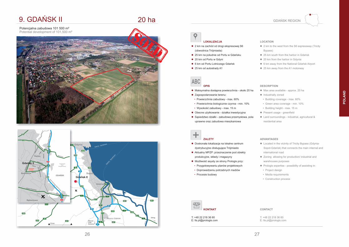
9. GDAŃSK II 20 ha
Gda
ńsk-Nyn
asha
mn
Gdynia - Karlskrona
Gdańsk
Pruszcz GdańskiWarsawŁódźKatowice
Elbląg
Kartuzy E77
7
20224
20
20
224
91
E75
221
501 501
7
E77
E287226
227
211
211
224
228
Vistula
Vis
tula
Vis
tula
10 km6
S7
Gdynia
Sopot
Szczecin
Żukowo
Ob
wo
dn
icaTró
jmiasta
S6
S6
E28
7
E28
218
468
6
468
A1
1 km
Gdańsk II
Potencjalna zabudowa 101 500 m²Potential development of 101,500 m²
S6
26
S6
S6
E28
E28
218
218
20
Gdańsk II
Kielnieńska
Wodnik
a
Nowy Świat
Sołd
kaBar
niew
icka
Meteorytowa
Dębowa
Keplera
Wenus
Teleskopowa
Pla
neta
rna Wenus
Spacerowa
Juliusza Słowackiego
Juliusza Słowackiego
Aleja Kazimierza Jagiellończyka
Ob
wo
dn
ica
Tró
jmia
sta
BarniewiceGDAŃSK
Rębiechowo
Osowa
TrójmiejskiPark
Krajobrazowy
27
GDAŃSK REGION
PO
LA
ND
LOKALIZACJA
� 2 km na zachód od drogi ekspresowej S6
(obwodnica Trójmiasta)
� 25 km na południe od Portu w Gdańsku
� 20 km od Portu w Gdyni
� 6 km od Portu Lotniczego Gdańsk
� 25 km od autostrady A1
OPIS
� Maksymalna dostępna powierzchnia - około 20 ha
� Zagospodarowanie terenu:
• Powierzchnia zabudowy - max. 60%
• Powierzchnia biologicznie czynna - min. 10%
• Wysokość zabudowy - max. 15 m
� Obecne użytkowanie - działka inwestycyjna
� Sąsiedztwo działki - zabudowa przemysłowa, pola
uprawne oraz zabudowa mieszkaniowa
ZALETY
� Doskonała lokalizacja na lokalne centrum
dystrybucyjne obsługujące Trójmiasto
� Aktualny MPZP: przeznaczenie pod obiekty
produkcyjne, składy i magazyny
� Możliwość asysty ze strony Prologis przy:
• Przygotowywaniu planów projektowych
• Doprowadzeniu potrzebnych mediów
• Procesie budowy
LOCATION
� 2 km to the west from the S6 expressway (Tricity
Bypass)
� 25 km south from the harbor in Gdańsk
� 20 km from the harbor in Gdynia
� 6 km away from the National Gdańsk Airport
� 25 km away from the A1 motorway
DESCRIPTION
� Max area available - approx. 20 ha
� Industrially zoned
• Building coverage - max. 60%
• Green area coverage - min. 10%
• Building height - max. 15 m
� Present usage - greenfield
� Land surroundings - industrial, agricultural &
residential area
ADVANTAGES
� Located in the vicinity of Tricity Bypass (Gdynia-
Sopot-Gdańsk) that connects the main internal and
international road
� Zoning allowing for production/ industrial and
warehouses purposes
� Prologis expertise - possibility of assisting in:
• Project design
• Media requirements
• Construction process
ABC
KONTAKT
T: +48 22 218 36 60E: [email protected]
CONTACT
T: +48 22 218 36 60E: [email protected]

PR
AG
UE
-ÚŽ
ICE
dezinárodní silnicenational roads
dálnicemotorways
LegendaKey
CZECH REPUBLIC
1 PRAGUE-ÚŽICE
Nabízená lokalitaProposed locations
1
29
Prague
OstravaPlzeň
Brno
České Budějovice
D11
D1
D5
D8
D1
D2
1
rychlostní silniceexpress roads
CZ
EC
H R
EP
UB
LIC
Prague
D1
D3
R4
R6
R10
R35
D8
D8
Plzeň
HradecKrálové
Liberec
Turnov
Ústi nadLabem
Chemnitz
E50
E55E65
3
4
E50
E55
E50
E442
35
16
35
38
33
37
37
14
14E442
E65
10
Vlta
va
Vltava
D5
E48
7
7
E48
27
E49
26
E442
E49
20
20
27
27
E49
GERMANY
GERMANY
POLAND
D11E67
BerlinWarsaw
Nürnberg
BratislavaVienna
10 km
16
212
17
36
34
34
38
38
19
19
18
19
16
16
1513
8
30
62
15
9
2
32
13
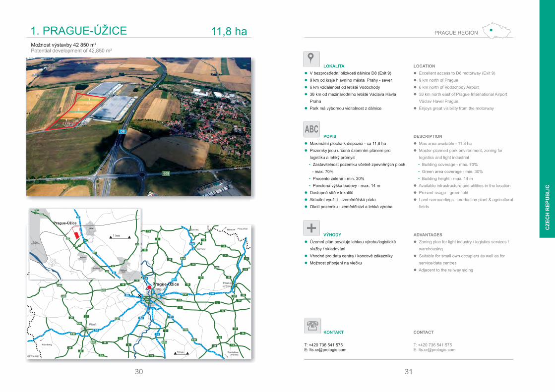
1. PRAGUE-ÚŽICE 11,8 ha
Prague-Úžice
Možnost výstavby m²42 850Potential development of , m²42 850
D8
608
30
OdolenaVoda
Úžice
Kozomin
Kralupynad Vltavou
D8
D8608
608
608
101
522
522
E55
Prague-Úžice
Poztřižin
Teplická
1 km
12,1 ha
23,4 ha
34 ha
31
PRAGUE REGION
CZ
EC
H R
EP
UB
LIC
LOKALITA
� V bezprostřední blízkosti dálnice D8 (Exit 9)
� 9 km od kraje hlavního města Prahy - sever
� 6 km vzdálenost od letiště Vodochody
� 38 km od mezinárodního letiště Václava Havla
Praha
� Park má výbornou viditelnost z dálnice
POPIS
� Maximální plocha k dispozici - ca 11,8 ha
� Pozemky jsou určené územním plánem pro
logistiku a lehký průmysl
• Zastavitelnost pozemku včetně zpevněných ploch
- max. 70%
• Procento zeleně - min. 30%
• Povolená výška budovy - max. 14 m
� Dostupné sítě v lokalitě
� Aktuální využití - zemědělská půda
� Okolí pozemku - zemědělství a lehká výroba
VÝHODY
� Územní plán povoluje lehkou výrobu/logistické
služby / skladování
� Vhodné pro data centra / koncové zákazníky
� Možnost připojení na vlečku
LOCATION
� Excellent access to D8 motorway (Exit 9)
� 9 km north of Prague
� 6 km north of Vodochody Airport
� 38 km north east of Prague International Airport
Václav Havel Prague
� Enjoys great visibility from the motorway
DESCRIPTION
� Max area available - 11.8 ha
� Master-planned park environment, zoning for
logistics and light industrial
Building coverage - max. 70%•
Green area coverage - min. 30%•
Building height - max. 14 m•
� Available infrastructure and utilities in the location
� Present usage - greenfield
� Land surroundings - production plant & agricultural
fields
ADVANTAGES
� Zoning plan for light industry / logistics services /
warehousing
� Suitable for small own occupiers as well as for
service/data centres
� Adjacent to the railway siding
ABC
KONTAKT
T: +420 736 541 575E: [email protected]
CONTACT
T: +420 736 541 575E: [email protected]
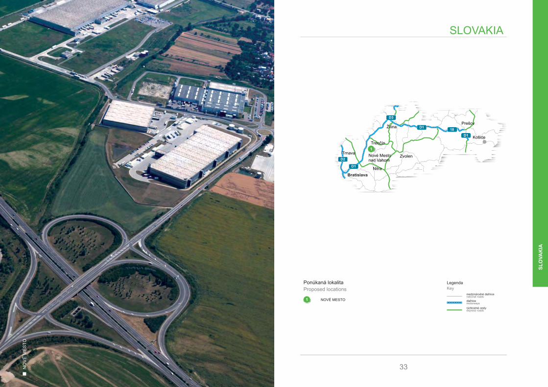
NO
VÉ
ME
ST
O
1 NOVÉ MESTO
Ponúkaná lokalitaProposed locations
1medzinárodné diaľnicenational roads
diaľnicemotorways
LegendaKey
SLOVAKIA
33
rýchlostné cestyexpress roads
Bratislava
D3
D1
D1
D2
18
D1
Prešov
Košice
Zvolen
Nitra
Trnava
Žilina
Trenčín
Nové Mestonad Vahom
1
SL
OV
AK
IA
Bratislava
AUSTRIA
HUNGARY
CZECHREPUBLIC
Poland
Brno
BrnoPrague
Viena
Budapest
Žilina
E575
63
502
51
51
5812
2
E572
504
E571
64
Galanta
Senec
Trnava
Nové Mestonad Váhom
503
503
Danub
507 561
61
61
62
7564
64
76
50
50
75
SeredNitra
10 km
R1
R1
D1
D1
M15
D2
D4
D4
A6
A4
D2
E575
15
2
E60
E58
E75
E65
E65
E75
E58
E58
507
54
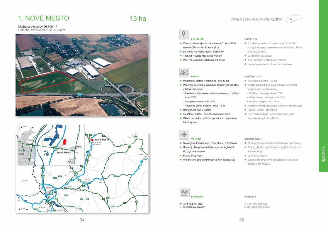
1. NOVÉ MESTO 13 ha
Nové Mesto
Možnosť výstavby 56 700 m²Potential development of 56,700 m²
D1
34
515
D1
D1
Nové Mestonad Váhom
Rakoluby
E75
E75
54
515
515
61
61
507
507
Zel
ená
Vod
a
Tre
nčin
ska
Beckovská
Zelená voda
Nové Mesto
1 km
BeckovskáVieska
35
NOVÉ MESTO NAD VAHOM REGION
SL
OV
AK
IA
LOKALITA
� V bezprostrednej blízkosti diaľnice D1 (exit 106)
smer na Žilina (SK)/Kraków (PL)
� 90 km od hlavného mesta Bratislavy
� 1 km od Nového Mesta nad Váhom
� Park má výbornú viditeľnosť z diaľnice
POPIS
� Maximálna plocha k dispozícii - cca 13 ha
� Pozemky sú určené územným plánom pre logistiku
a ľahký priemysel
• Zastavanosť pozemku včetne spevnených plôch -
max. 70%
• Percento zelene - min. 30%
• Povolená výška budovy - max. 16 m
� Dostupnosť sietí v lokalite
� Aktuálne využitie - poľnohospodárska pôda
� Okolie pozemku - poľnohospodárstvo, logistika a
ľahká výroba
VÝHODY
� Strategická lokalita medzi Bratislavou a Poľskom
� Územný plán povoľuje ľahkú výrobu/ logistické
služby/ skladovanie
� Platný EIA proces
� Vhodné pre data centra/ koncových zákazníkov
LOCATION
� Excellent access to D1 motorway (Exit 106),
a major transport route between Bratislava, Žilina
and Kraków (PL)
� 90 km from Bratislava
� 1 km from Nové Mesto nad Váhom
� Enjoys great visibility from the motorway
DESCRIPTION
� Max area available - 13 ha
� Master-planned park environment, zoning for
logistics and light industrial
Building coverage - max. 70%•
Green area coverage - min. 30%•
Building height - max. 16 m•
� Available infrastructure and utilities in the location
� Present usage - greenfield
� Land surroundings - production plant, light
industrial & agricultural fields
ADVANTAGES
� Strategic location between Bratislava and Poland
� Zoning plan for light industry / logistics services /
warehousing
� Valid EIA process
� Suitable for small own occupiers as well as for
service/data centres
ABC
KONTAKT
T: +421 904 661 044E: [email protected]
CONTACT
T: +421 904 661 044E: [email protected]
BU
DA
PE
ST-B
AT
TA
M70 M7
M3
M35
M5
M3
M8
M6
M7
M1
M15 M30Hegyeshalom
Gyál
Szeged
Nyíregyháza
Miskolc
Debrecen
Kecskemét
Gyor
Pécs
Budapest
főutaknational roads
autópályákmotorways
JelölésekKey
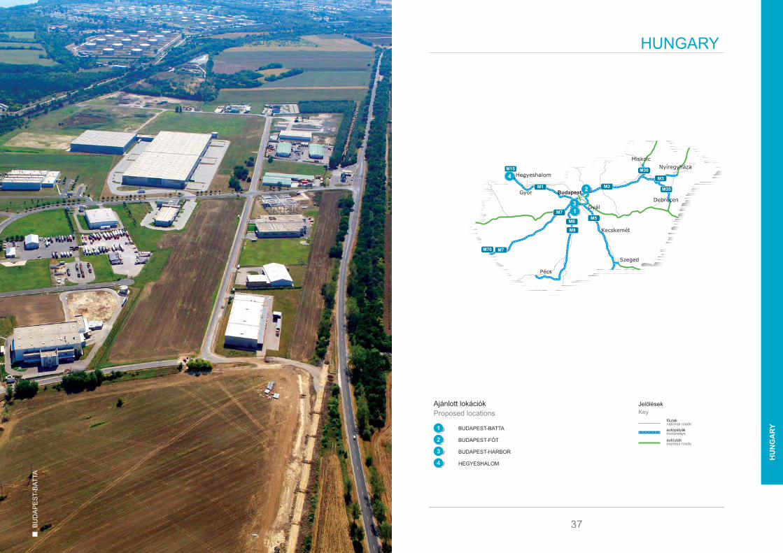
HUNGARY
37
autóutakexpress roads
1 BATTABUDAPEST-
2 BUDAPEST-FÓT
3 HARBORBUDAPEST-
4 HEGYESHALOM
Ajánlott lokációkProposed locations
1
2
3
4
4
2
31
HU
NG
AR
Y
38
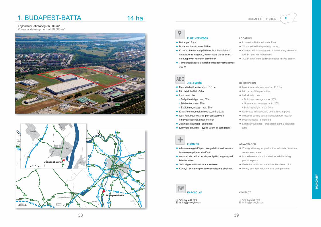
1. BUDAPEST-BATTA 14 ha
Croatia Serbia
CroatiaZagreb
Romania
ViennaBratislava
10 km
Budapest
Székesfehérvár
6
75E71
6362
E73
E66 E66
72
8
83
83
8
7
E60
E75
E60
E71
E71
3
2
2
11
E77
11711
82
82
E751
10
M7
M7
M6
M5
M4
M51
M5
M0
M0
M10
M3
M1
M1
M1M1
4
31
3
81
81 13
14
E575
E575
E75E60
E60
M0
M31
M2
Györ
SLOVAKIA
12
M19
M8
M11
M11
1
1
M11
51
Budapest-Batta
Fejlesztési lehetőség 56 000 m²Potential development of 56,000 m²
6
Danube
M6
M6
E73
E73
6
6
Ercsi
Ráckeresztúr
Szigetujfalu
Ipari park
Dózsa György utca
Budapest-Batta
1 km
39
BUDAPEST REGION
HU
NG
AR
Y
ELHELYEZKEDÉS
� Batta Ipari Park
� Budapest belvárosától 25 km
� Közel az M6-os autópályához és a 6-os főúthoz,
így az M0-ás körgyűrű, valamint az M1-es és M7-
es autópályák könnyen elérhetőek
� Tömegközlekedés: a százhalombattai vasútállomás
300 m
JELLEMZŐK
� Max. elérhető terület - kb. 13,8 ha
� Min. telek terület - 5 ha
� Ipari besorolás
• Beépíthetőség - max. 50%
• Zöldterület - min. 25%
• Épület magasság - max. 30 m
� Kialakított infrastruktúra és közműhálózat
� Ipari Park besorolás az ipari parkban való
elhelyezkedésnek köszönhetően
� Jelenlegi használat - zöldterület
� Környező területek - gyártó üzem és ipari telkek
ELŐNYÖK
� A besorolás gyártó/ipari, szolgáltató és raktározási
tevékenységet tesz lehetővé
� Azonnal elérhető az érvényes építési engedélynek
köszönhetően
� Szükséges infrastruktúra a területen
� Könnyű- és nehézipari tevékenységre is alkalmas
LOCATION
� Located in Batta Industrial Park
� 25 km to the Budapest city centre
� Close to M6 motorway and Road 6, easy access to
M0, M1 and M7 motorways
� 300 m away from Százhalombatta railway station
DESCRIPTION
� Max area available - approx. 13.8 ha
� Min. size of the plot - 5 ha
� Industrially zoned
• Building coverage - max. 50%
• Green area coverage - min. 25%
• Building height - max. 30 m
� Dedicated infrastructure and utilities in place
� Industrial zoning due to industrial park location
� Present usage - greenfield
� Land surroundings - production plant & industrial
sites
ADVANTAGES
� Zoning allowing for production/ industrial, services,
warehouses area
� Immediate construction start as valid building
permit in place
� Essential infrastructure within the offered plot
� Heavy and light industrial use both permitted
ABC
KAPCSOLAT
T: +36 302 225 405E: [email protected]
CONTACT
T: +36 302 225 405E: [email protected]

40
2. BUDAPEST-FÓT 76 ha
Croatia Serbia
CroatiaZagreb
Romania
ViennaBratislava
10 km
Budapest
Székesfehérvár
6
75E71
6362
E73
E66 E66
72
8
83
83
8
7
E60
E75
E60
E71
E71
3
2
2
11
E77
11711
82
82
E751
10
M7
M7
M6
M5
M4
M51
M5
M0
M0
M10
M3
M1
M1
M1M1
4
31
3
81
81 13
14
E575
E575
E75E60
E60
M0
M31
M2
Györ
SLOVAKIA
12
M19
M8
M11
M11
1
1
M11
51
Budapest-Fót
Fejlesztési lehetőség 257 500 m²Potential development of 257,500 m²
M3
1 km
Fót
Fótliget
Budapest-Fót
BUDAPEST
E77
M0
M0
M0
M3
M3
M3
M2
41
BUDAPEST REGION
HU
NG
AR
Y
ELHELYEZKEDÉS
� Budapest központjától 20 km észak-keletre
� 40 km a Liszt Ferenc Nemzetközi Repülőtértől
� Kiváló elérhetőség kivételes rálátással az M3-as
autópályáról
� M3-as autópálya északi oldala
JELLEMZŐK
� Max. elérhető terület - 75,95 ha
� Min. telek terület - 5 ha
� Ipari besorolás
• Beépíthetőség - max. 50%
• Zöldterület - min. 25%
• Épület magasság - max. 9-12 m
� Kialakított infrastruktúra és közműhálózat
� Ipari és kiskereskedelmi besorolás
� Jelenlegi használat - zöld terület
� Környező területek - ipari és kiskereskedelmi
területek, valamint lakóépületek
ELŐNYÖK
� Stratégiai elhelyezkedés a fő nemzetközi
szállítmányozási folyosók találkozásánál
� Kereskedelmi fejlesztés megengedett
� Gyártásra és könnyűipari tevékenységre alkalmas
� Szükséges infrastruktúra a területen
� Kiskereskedelmi egységek közelsége
LOCATION
� 20 km north-east of the Budapest city centre
� 40 km from Liszt Ferenc International Airport ,
Budapest
� Excellent access to the M3 Motorway with
exceptional visibility
� Located along the northern side of the M3
Motorway
DESCRIPTION
� Max area available - 75.95 ha
� Min. size of the plot - 5 ha
� Industrially zoned
• Building coverage - max. 50%
• Green area coverage - min. 25%
• Building height - max. 9-12 m
� Dedicated infrastructure and utilities in place
� Industrial and retail zoning
� Present usage - greenfield
� Land surroundings - industrial, retail and residential
sites
ADVANTAGES
� Strategic location at the intersection of the major
international transportation corridors
� Commercial developments including retail
� Site used for production - light manufacturing
� Essential infrastructure within the offered plot
� Vicinity to retail units
ABC
KAPCSOLAT
T: +36 302 225 405E: [email protected]
CONTACT
T: +36 302 225 405E: [email protected]

42
3. BUDAPEST-HARBOR 4,8 ha
Croatia Serbia
CroatiaZagreb
Romania
ViennaBratislava
10 km
Budapest
Székesfehérvár
6
75E71
6362
E73
E66 E66
72
8
83
83
8
7
E60
E75
E60
E71
E71
3
2
2
11
E77
11711
82
82
E751
10
M7
M7
M6
M5
M4
M51
M5
M0
M0
M10
M3
M1
M1
M1M1
4
31
3
81
81 13
14
E575
E575
E75E60
E60
M0
M31
M2
Györ
SLOVAKIA
12
M19
M8
M11
M11
1
1
M11
51
Budapest-Harbor
Fejlesztési lehetőség 39 600 m²Potential development of 39,600 m²
M6
N6
1 km
DanubeBudapest-Harbor
M0
M0
M0
M6
6
7
7
6
6
E71
E60
E75E73
E73
Nagytétényí út
BUDAPESTBalatoni út
HU
NG
AR
Y
43
BUDAPEST REGION
ELHELYEZKEDÉS
� Budapest XXII. kerületének déli határán
helyezkedik el
� A Duna nyugati partján, a belvárostól 12 km
� Az M6-os autópálya és a 6-os út a park mellett
halad el, így az M0-ás körgyűrű, valamint az M1-es,
M7-es autópályák könnyen elérhetőek
� Az M0-ás körgyűrű csomópontja 2,5 km
(20 perc) a parktól
JELLEMZŐK
� Elérhető terület - 4,77 ha
� Ipari besorolás
• Beépíthetőség - max. 50%
• Zöldterület - min. 30%
• Épület magasság - max. 12 m
� Kialakított infrastruktúra és közműhálózat
� Jelenlegi használat - zöldterület
� Környező területek: ipari telkek, zöldterület és
vasútállomás
ELŐNYÖK
� Alkalmas gyártó és könnyűipari tevékenységre
� Ideális távol-keleti termékekhelyszín
disztribúciójához, régiósvagy
elosztóközpontszámára
� Kiváló infrastrukturális lehetőségek
� Bevásárlóközpont és éttermek 10 percre
� Jó tömegközlekedés, a vasútállomás a parktól
200 m
LOCATION
� Located on the southern border of Budapest in
District 22
� 12 km south of the central business district on the
western side of the Danube
� Close to M6 motorway and Road 6, easy access to
M0, M1 and M7 motorways
� M0 Ring Road 2.5 km from the park
DESCRIPTION
� Available area - 4.77 ha
� Industrially zoned
• Building coverage - max. 50%
• Green area coverage - min. 30%
• Building height - max. 12 m
� Dedicated infrastructure and utilities in place
� Present usage - greenfield
� Land surroundings - industrial sites , greenfields &
railway station
ADVANTAGES
� Site used for production - light manufacturing
� Product tailoring and distribution centre for Far-East
products
� Excellent infrastructural opportunities
� Shopping centre and restaurants within 10 minutes’
driving time
� Good public transportation, commuter train services
200 m close to the park
ABC
KAPCSOLAT
T: +36 302 225 405E: [email protected]
CONTACT
T: +36 302 225 405E: [email protected]

Croatia
Serbia
CroatiaZagreb
ViennaBratislava
Budapest
Székesfehérvár
6
5
E71E73
E66
8
8
E60
E51
E71
E71
3
2
11
E77117
82
82
E751
M7
M7
M6M51
M5
M0
M3
M1
M1
M1
M1
M1
81
81
E575
E75E60
E50
M0
Györ
SLOVAKIA
Romania
4
E75
E60
Au
stri
a
E66
E65
E575
E75
85
M19
10 km
44
4. HEGYESHALOM 26 ha
Hegyeshalom
Fejlesztési lehetőség 120 600 m²Potential development of 120,600 m²
M15
1
1 km
Hegyeshalom
Levél
Fö utca
HegyeshalomM1
M1
M15
M15
E60
E75
1
E75
E65
45
NORTHERN REGION
HU
NG
AR
Y
ELHELYEZKEDÉS
� A „mágikus háromszögben” helyezkedik el Bécs,
Pozsony és Győr között
� 5 km az osztrák határtól és 10 km a szlovák
határtól
� Stratégiai elhelyezkedés a fő nemzetközi
szállítmányozási folyosók mentén (M1/M15)
� Kiváló kapcsolat a Szlovákiába vezető M15-ös és
az Ausztriába vezető M1-es autópályákkal
JELLEMZŐK
� Max. elérhető terület - 25,82 ha
� Min. telek terület - 5 ha
� Ipari besorolás
• Beépíthetőség - max. 50%
• Zöldterület - min. 30%
• Épület magasság - max. 9-12 m
� Kialakított infrastruktúra és közműhálózat
� Ipari besorolás
� Jelenlegi használat - zöldterület
� Környező területek - ipari és mezőgazdasági
területek, valamint lakóépületek
ELŐNYÖK
� Azonnal elérhető az érvényes építési engedélynek
köszönhetően
� Gyártáshoz kapcsolódó raktározási szolgáltatások -
konszolidációs raktár és gyártó központ
� Vasúti csatlakozási lehetőség speciális termékek /
ipar részére
� Kiváló infrastrukturális lehetőségek
� Elérhető munkaerő, kedvező feltételekkel
LOCATION
� Positioned in “the magic triangle” (between Vienna,
Bratislava and Győr)
� 5 km to the Austrian border and 10 km to the
Slovakian border
� Located on the east-west Pan-European corridor
(E75/M1)
� Excellent access to M15 (leading to Slovakia) and
M1 motorways (leading to Austria)
DESCRIPTION
� Max area available - approx. 25.82 ha
� Min. size of the plot - 5 ha
� Industrially zoned
• Building coverage - max. 50%
• Green area coverage - min. 30%
• Building height - max. 9-12 m
� Dedicated infrastructure and utilities in place
� Industrial zoning
� Present usage - greenfield
� Land surroundings - industrial, residential sites &
agricultural fields
ADVANTAGES
� Immediate construction start as valid building
permit in place
� Production related warehousing services - inbound
logistics warehouse and factory DC
� Railway potential connection - for specific types of
goods / industries
� Excellent infrastructural opportunities
� Advantageous labour cost & availability
ABC
KAPCSOLAT
T: +36 302 225 405E: [email protected]
CONTACT
T: +36 302 225 405E: [email protected]
BU
CH
AR
ES
TA
1
Locatia propusaProposed locations
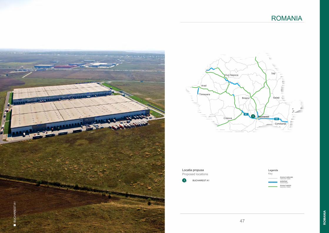
1 BUCHAREST A11
Timisoara
Arad
Bra ovş Galaţi
Cluj-Napoca
Constanţa
Craiova
I şia
BucharestA2
A11
drumuri nationalenational roads
autostrazimotorways
LegendaKey
ROMANIA
47
drumuri expresexpress roads
RO
MA
NIA

Budapest
Bulgaria
Ukraine
Constanta
DNCB
DNCB
DN
CB
A1
A1
A1
E70
E81
E607
71
7
601A
7
6
61
61
E85
E70
E81
5
4
2
E60
E85
3
E81
1
10 km
Bucarest
A3
1A
65A
72
61
48
1. BUCHAREST A1 28 haDezvoltare posibila 123 000 m²Potential development of 123,000 m²
Bucharest A1
A1
Exit 2
StradaStrada
Str. MarasestiStr.
23 Aug
ust
Strada
Strada Strada
Stra
da
A1A1E81
500 m
Bucharest A1
49
BUCHAREST REGION
RO
MA
NIA
LOCATIE
� Acces direct la Autostrada A1
� Localizat de-a lungul Coridorului European 4, care
tranziteaza Romania de la Est la Vest
� 23 km vest de Centrul Bucurestiului
� 7 km distanta de viitorul inel de centura care va
furniza acces la Aeroportul international in 25 de
minute
DESCRIERE
� Suprafata maxima disponibila - aproximativ 28 ha
� Dimensiunea minima a parcelei - 5 ha
� Plan Urbanistic de Detaliu
• suprafata construita la sol - max 50%
• spatii verzi - min 26 %
• inaltime cladiri - max 18 m
� Infrastructura si Utilitati construite
� Catalogata ca Zona Industriala datorita locatiei
parcului industrial / titlului de Parc Industrial
� Utilizarea prezenta - teren construibil
� Terenuri inconjuratoare - fabrici, depozite si terenuri
agricole
AVANTAJE
� Teren utilizat pentru fabricatie - productie usoara
� Servicii de depozitare dedicate productiei - depozit
logistic inbound
� Servicii de depozitare dedicate productiei - Centru
de Distributie al fabricii
� Activitati frigorifice pentru logstica alimentare)
� Dedicat unui anumit produs sau centru de
distributie pentru produsele din Orientul Indepartat
� Puntul principal de acces in oras pentru logistica
� Disponibiliatea si costul avantajos al fortei de
munca
� Posibile avantaje fiscal datorita titlului de parc
industrial
LOCATION
� Direct access to A1 motorway that leads to the west
(Hungary) and links the large localities in central,
north and western parts of Romania
� Located along the IV European corridor, which
transits through Romania from West to East
� 23 km west of Bucharest City Centre
� 7 km away from the future Ring Road with access
to the International Airport within 25 minutes
DESCRIPTION
� Max area available - approx. 28 ha
� Min. size of the plot - 5 ha
� Industrially zoned
• Building coverage - max. 50%
• Green area coverage - min. 26%
• Building height - max. 18 m
� Dedicated infrastructure and utilities in place
� Industrial zoning due to industrial park location /
Industrial Park title
� Present usage - greenfield
� Land surroundings - production plant, warehouses
& agricultural fields
ADVANTAGES
� Site used for production - light manufacturing
� Production related warehousing services - inbound
logistics warehouse
� Production related warehousing services - factory
DC
� Chilled activities for food logistics Product tailoring
and distribution centre for Far-East products
� Main entrance point to the city for logistics
� Advantageous labour cost & availability
� Potential tax incentives due to industrial park title
ABC
KAPCSOLAT
T: +36 302 225 405E: [email protected]
CONTACT
T: +36 302 225 405E: [email protected]

®www.prologislts.com
Laszlo Kemenes
+36 302 225 405
HUNGARY & ROMANIA
Martin Polak
+421 904 661 044
SLOVAKIA
Pavlina Plaskova
+420 776 373 738
CZECH REPUBLIC
POLAND
Michał Ptaszyński
+48 696 045 300