projet gcp/int/903/fra ‘‘appui au programme de renforcement des systèmes d’information et de...
TRANSCRIPT

Projet GCP/INT/903/FRA‘‘Appui au Programme de Renforcement
des Systèmes d’Information et de Statistiques Rurales en Afrique’’
DRAFT SYNTHESIS OF MAIN CONCLUSIONS AND
RECOMMANDATIONS AND OUTLINES OF THE HANDBOOK
TECHNICAL MEETING ON THE USE OF GPS FOR CROP AREA MEASUREMENT IN THE AGRICULTURAL SURVEYS
IN AFRICA
Addis-Ababa, Ethiopia: 27-28 November 2008

Synthesis of the main conclusions and recomandations
Group 1

Do we have enough evidence from the various studies to validate the response?
No We need additional tests which can give
information concerning the slop, canopy cover and so on according to the characteristics of the different African countries
Relationships between differential GPS and compass and tape (see nest slide)
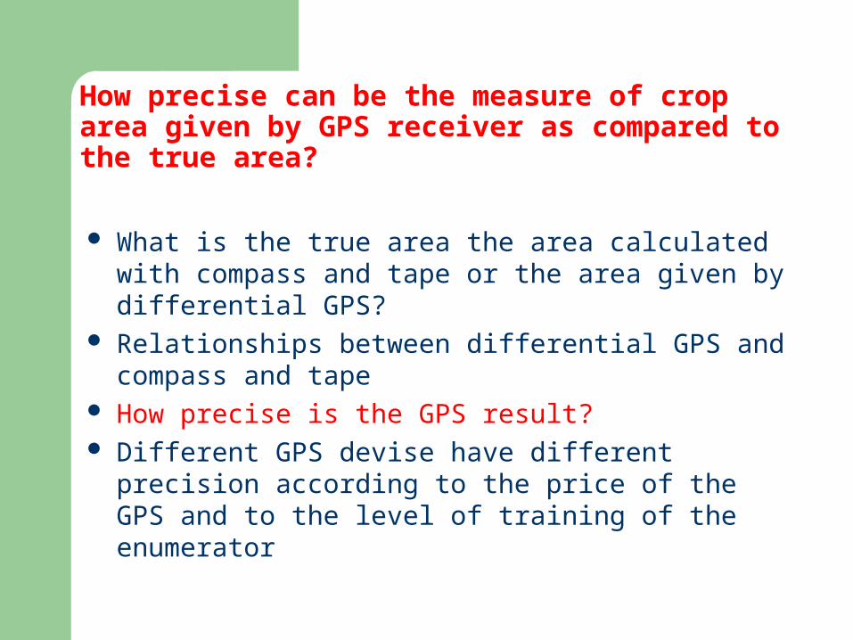
How precise can be the measure of crop area given by GPS receiver as compared to the true area?
What is the true area the area calculated with compass and tape or the area given by differential GPS?
Relationships between differential GPS and compass and tape
How precise is the GPS result? Different GPS devise have different precision
according to the price of the GPS and to the level of training of the enumerator

Does the type of GPS have an impact on the accuracy of measurement?
Yes According to study conducted on the
available data set, it seems that the Garmin 60 is the best.
Garmin 72 and Garmin 12 are a bit worse than G60
Magellan 400 give unstable results, very good for the second measurement and bad for the first and the third

How stable is the measurement of area with GPS?Does repetition of measurement improve the accuracy?
Theoretically for sure We would suggest repetition for pilot studies For operational project, at least two measurements
can give the possibility to detect very bad measurements
We have to make further cost- benefit analysis on available data set for operational projects
The Ethiopian and other data sets that will include plots in different conditions will allow a better assessment of the stability

Is there a link between accuracy of measurement of GPS and plot size?Is there a cut-off point?
According to the data base, there is not a clear link between the size of the plot and the accuracy of the measurement
If we segment the plots according to the size, we have some problems particularly with extra small plots
It is difficult to give a cut-off point valid for various countries

Extra small plots - equality of medians rejected Wilcoxon signed-rank test Variable | Obs Mean Std. Dev. Min Max Median-------------+-------------------------------------------------------- difference | 160 61.7875 196.7237 -370 1214 9 reldiff | 160 .1135625 .3330015 -.63 .95 3.8%
Very small - equality of medians not rejected
Variable | Obs Mean Std. Dev. Min Max median-------------+-------------------------------------------------------- difference | 53 70.36283 435.8523 -895 1461 -52 reldiff | 53 .0455283 .2103337 -.316 .731 -2.1%
Small - equality of medians not rejected Variable | Obs Mean Std. Dev. Min Max Median-------------+-------------------------------------------------------- difference | 33 -16.21818 260.4032 -430 1097.7 -35.5 reldiff | 33 -.0030606 .069689 -.125 .3 -0.9%
Larger plot - equality of medians not rejected Variable | Obs Mean Std. Dev. Min Max Median-------------+-------------------------------------------------------- difference | 77 -49.97234 1289.079 -3178 8265 -100.4 reldiff | 77 .004026 .1397709 -.204 .972 -1.3%

How faster is to measure crop area with GPS?
Traditional method long measuring an area with a GPS takes the time of
walking around the plot possible additional manipulations Magellan 400 GPS measures more than 4 times shorter than the
traditional measures For large plots, this ratio can go up to 17 times No significant differences amongst the receivers
tested Magellan 400 more complex to use according to the
field enumerators.

Do we need additional analysis of available data?
Yes

What other uses can be made of the GPS to improve agricultural surveys?
We have to make further cost- benefit analysis on available data set for operational projects
The Ethiopian and other data sets that will include plots in different conditions will allow a better assessment of the stability
Cut-off point according to the situation of different countries, particularly Ethiopian one

Do we need additional field tests?What changes should be made to the protocol used?
Yes Analysis of the agricultural environment Stratification Representativeness Involvement of African universities Involvement of the producers

What area operational issues?
Batteries, maybe rechargeable Memory Download to laptop Training of trainers

OUTLINES OF THE HANDBOOK
Group 2

Group tasks
Finalize contents (Preliminary remarks)
Select title
Preliminary outlines
Roadmap

Who is the audience?:– Policymakers (improve crop area statistics)– Professionals undertaking agricultural surveys in the field
(statisticians, natural resources specialists, socio-economists, etc.)
– Data users and analysts (GIS users) We have to take into account
- The need to be readily operational in the shortest time possible in all context (simplicity, operationality, etc.)
– The rapidly changing technology (modern devices), we have to be open for the future technological development (Some countries (Brazil, Jordan) already use PDA in census)
What is our purpose?– To improve data collection in the field and presentation of results– To assist in selection of best methods and choices of devices
Preliminary Remarks
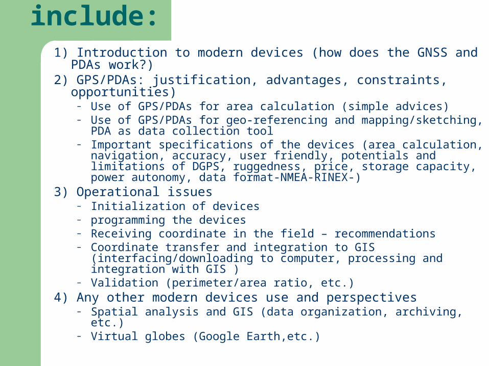
The handbook should include:1) Introduction to modern devices (how does the GNSS and PDAs
work?) 2) GPS/PDAs: justification, advantages, constraints, opportunities)
– Use of GPS/PDAs for area calculation (simple advices)– Use of GPS/PDAs for geo-referencing and mapping/sketching, PDA as
data collection tool– Important specifications of the devices (area calculation, navigation,
accuracy, user friendly, potentials and limitations of DGPS, ruggedness, price, storage capacity, power autonomy, data format-NMEA-RINEX-)
3) Operational issues– Initialization of devices– programming the devices– Receiving coordinate in the field – recommendations– Coordinate transfer and integration to GIS (interfacing/downloading to
computer, processing and integration with GIS ) – Validation (perimeter/area ratio, etc.)
4) Any other modern devices use and perspectives– Spatial analysis and GIS (data organization, archiving, etc.)– Virtual globes (Google Earth,etc.)

Studies to launch for handbook v2 PDA Virtual globes (google earth) GIS DGPS High spatial resolution satellite imagery

TITLE OF THE HANDBOOK
ADVANCED METHODS IN AGRICULTURAL STATISTICS :
Use of modern geo-positioning devices in agricultural censuses and surveys
(GPS/PDA)
Outlines
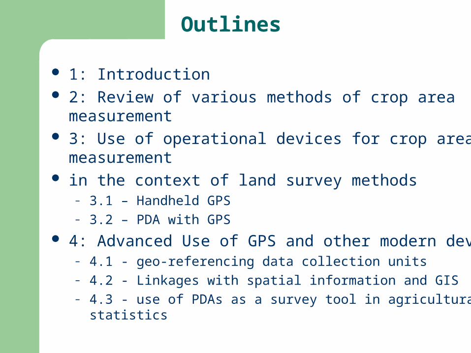
1: Introduction 2: Review of various methods of crop area measurement 3: Use of operational devices for crop area measurement in the context of land survey methods
– 3.1 – Handheld GPS– 3.2 – PDA with GPS
4: Advanced Use of GPS and other modern devices– 4.1 - geo-referencing data collection units – 4.2 - Linkages with spatial information and GIS– 4.3 - use of PDAs as a survey tool in agricultural statistics

Instructions– Instructions for use of various types of GPS for crop
area measurement– Instructions for use of PDAs for data collection
Case studies/comparative studies – in the use of GPS for crop area measurement– in the use of GPS for geo-referencing data collection
units– for linkages with spatial information and GIS– for use of PDAs
APPENDIXES

ROADMAP What – see contents and outlines How
– Technical committee small group from concerned agencies (FAOcoordination+CIRAD+WFP+JRC+consultant)
1 – prepare the TOR including the process (outlines to finalize, defined the contributions of various agencies, assign focal persons, etc.)
2 – put the technical committee group to work (mainly through tele/videoconference, email, etc.)
– advisory group (including countries and other concerned institutions)
Validation When
– Draft by October 2009– Requirements: field tests of PDAs, additional GPS tests (slope,
canopy, etc.)