project-team ariana inverse problems in earth observation...
TRANSCRIPT
a ppor t d ' c t i v i t é
2 0 0 5
THEME COG
INSTITUT NATIONAL DE RECHERCHE EN INFORMATIQUE ET EN AUTOMATIQUE
Project-Team Ariana
Inverse Problems in Earth Observation andCartography
Sophia Antipolis


Table of contents
1. Team 12. Overall Objectives 2
2.1. Overall Objectives 23. Scientific Foundations 3
3.1. Probabilistic approaches 33.1.1. Markov random fields 33.1.2. Wavelets 33.1.3. Stochastic geometry 3
3.2. Variational approaches 43.2.1. Regularization and functional analysis 43.2.2. Contours and regions 43.2.3. Wavelets 4
3.3. Parameter estimation 44. Application Domains 4
4.1. Denoising and deconvolution 44.2. Segmentation and classification 44.3. Extraction of structures 44.4. 3D modelling 64.5. Information mining and database retrieval 6
5. Software 65.1. Quality-Candy 65.2. CAROLINE 75.3. HIMNE 75.4. ExtraLine 75.5. ExtraLinePlus 75.6. PhaseLine 7
6. New Results 76.1. Probabilistic models 7
6.1.1. Image deconvolution using Langevin dynamics 76.1.2. Shape from shading using stochastic dynamics 86.1.3. Road extraction using a three-stage approach 96.1.4. Tree crown extraction using a Markov random field 106.1.5. Target detection via the analysis of texture perturbations 106.1.6. Evaluation of the damage caused by forest fires 106.1.7. Multiscale road extraction 116.1.8. Automatic building 3D reconstruction from high resolution satellite images 11
6.2. Variational models 126.2.1. An approximation of the Mumford-Shah energy by a family of discrete edge preserving
functionals 126.2.2. Detecting codimension-two objects in an image with Ginzburg-Landau models 136.2.3. Image restoration for bounded noise 136.2.4. Variational models for road network updating in dense urban areas from very high resolution
optical images 136.3. EU project MUSCLE 14
6.3.1. New higher-order active contour energies for network extraction 146.3.2. Phase field models and higher-order active contours 146.3.3. Quartic models of the nonlinear statistics of adaptive wavelet packet coefficients 15
2 Activity Report INRIA 2005
6.3.4. High-level understanding for remote sensing image retrieval 166.4. EU project IMAVIS 17
6.4.1. Higher-order active contours for tree detection 176.5. ARC MODE de VIE 18
6.5.1. Tree crown extraction using marked point processes 186.5.2. Tree classification and characterization 18
6.6. ACI QuerySat 196.6.1. Study of the change with resolution of the parameters of adaptive wavelet packet texture
models 196.6.2. Indexing of remote sensing images using road networks 19
6.7. ACI Multim 206.7.1. Multi-spectral image restoration and decomposition 20
6.8. Application to astrophysics 216.8.1. Detection of cosmic filaments using the ‘Quality Candy’ model 21
6.9. Applications to biology 226.9.1. Blind deconvolution of biological images using 3D complex wavelets 226.9.2. Segmentation and deconvolution of 3D images 23
7. Contracts and Grants with Industry 237.1. Industrial 23
7.1.1. Alcatel Alenia Space Cannes 237.1.2. Silogic Toulouse 237.1.3. CNES Toulouse 237.1.4. IGN Saint Mande 247.1.5. BRGM Orleans 247.1.6. IFN Nogent sur Vernisson 247.1.7. DGA/CTA Arcueil 24
8. Other Grants and Activities 248.1. Regional 24
8.1.1. INRIA COLORS project ‘FIGARO’ 248.1.2. CNRS MATH/STIC grant ‘Détection de structures fines en imagerie 3D’ 24
8.2. National 248.2.1. INRIA ARC project ‘MODE de VIE: MODEling and DEtecting Vegetation in Interaction
with their Environment’ 248.2.2. ACI Masse de Données ‘QuerySat: Heterogeneous and multi-scale descriptors for retrieval
from remote sensing image databases’ 248.2.3. ACI NIM ‘Multim: Nouvelles methodes mathematiques pour la restauration d’images multi-
canaux’ 258.2.4. Action PNTS ‘Extraction/mise à jour cartographique des réseaux linéiques à partir des
données radar et optique hautes résolutions’ 258.2.5. Action PNTS ‘Extraction de bâti à partir de MNE’ 25
8.3. European 258.3.1. Egide PAI Galilée ‘PLATONOV: photocopies de livres anciens par techniques
d’optimisation numériques et solutions de viscosité’ 258.3.2. Egide PAI Balaton ‘Efficient shape priors for colour textured image segmentation’258.3.3. EU project IMAVIS 258.3.4. EU project MUSCLE 25
8.4. International 258.4.1. ECO-NET ‘Méthodes de la Physique statistique pour l’analyse d’image: application à la
gestion forestière’ 25
Project-Team Ariana 3
8.4.2. NATO/Russia Collaborative Linkage Grant 980107 ‘Prior shape information for imagesegmentation in environmental and disaster detection and monitoring’ 26
8.4.3. INRIA/USA Initiative 268.4.4. INRIA/LIAMA Initiative 268.4.5. INRIA STIC-Tunisia 268.4.6. P2R Franco-Israeli collaborative programme ‘Blind deconvolution in 3D biological mi-
croscopy’ 269. Dissemination 26
9.1. Conferences, Seminars, Meetings 269.2. Refereeing 289.3. Organization 299.4. Teaching 309.5. PhDs 30
9.5.1. In progress 309.5.2. Defended in 2005 31
9.6. Prizes 3110. Bibliography 31


1. TeamTeam Leader
Josiane Zerubia [Research Director (DR1) INRIA]
Administrative AssistantCorinne Zuzia [Administrative Assistant (TRN) INRIA (half-time in the project-team)]
Research Scientists (INRIA)Xavier Descombes [Research Scientist (CR1)]Ian Jermyn [Research Scientist (CR1)]
Research Scientists (CNRS)Laure Blanc-Féraud [Research Director (DR2)]
Postdoctoral FellowsMats Erikson [Mr. Erikson is funded by the French Ministry of Research (MESR). He arrived in October]Dan Yu [Ms Yu is funded by the French Ministry of Research (MESR). She arrived in December]
Ph.D. StudentsAlexis Baudour [Mr. Baudour is funded by an ENS/AMN grant. He started his Ph.D. in October]Avik Bhattacharya [Mr. Bhattacharya is funded by a grant from French Space Agency (CNES) and INRIA]Alexandre Fournier [Mr. Fournier is funded by a grant from the French Defence Agency (DGA) and CNRS.He started his Ph.D. in November]Peter Horvath [Mr. Horvath is funded by a grant from MAE/EGIDE, INRIA, and the University of Szeged,Hungary. He started his Ph.D. in September]Florent Lafarge [Mr. Lafarge is funded by a grant from the French Space Agency (CNES) and the FrenchNational Geographic Institute (IGN)]Ting Peng [Ms Peng is funded by a grant from MAE/EGIDE, CASIA/LIAMA, and Alcatel Alenia Space. Shestarted her Ph.D. in September]Guillaume Perrin [Mr. Perrin is funded by an MESR grant from École Centrale Paris]Marie Rochery [Mrs Rochery was funded by an MESR grant from the University of Nice-Sophia Antipolis.She defended her Ph.D. in September]Emmanuel Villeger [Mr. Villeger is an ENS student, funded first by an ENS/AMN grant, and then by teachingas a college Professor during the last year of his Ph.D. . He defended his Ph.D. in December]Pierre Weiss [Mr. Weiss is funded by an MESR grant from the University of Nice-Sophia Antipolis. He startedhis Ph.D. in October]Olivier Zammit [Mr. Zammit is funded by a SILOGIC/INRIA grant. He started his Ph.D. in October]
Student InternsVikram Agrawal [Mr. Agrawal (IIT New Delhi, India) was funded by the INRIA Internship programme/ACIQuerySat from May to August]Johan Aubray [Mr. Aubray was funded by the French Civil Aviation Authority (DGAC) from April toSeptember]Alexis Baudour [Mr. Baudour was funded by ENS Cachan from April to August]Aymen El Ghoul [Mr. El Ghoul (Sup’Com Tunis) was funded by an INRIA STIC-Tunisia and ACI QuerySatgrant from April to June]Alexandre Fournier [Mr. Fournier was funded by INRIA and the French Geographical Survey (BRGM) fromApril to September]Pierre Gernez [Mr. Gernez was funded by INRIA (COLORS FIGARO) from April to September]Marion Lebellego [Ms Lebellego was partially funded by ECO-NET from April to September]Alain Lehman [Mr. Lehman (ETHZ) was funded by Studex (Switzerland) from May to August]Praveen Pankajakshan [Mr. Pankajakshan (IIT Roorkee, India and Texas A&M University, USA) was fundedby the INRIA Internship programme/P2R Franco-Israeli programme from November to December]

2 Activity Report INRIA 2005
Pierre Weiss [Mr. Weiss was funded by I3S (CNRS/UNSA) from April to August]
Visiting ScientistsAlin Achim [Lecturer, University of Bristol, UK. One week in June funded by the University of Bristol]Fernand Cohen [Professor, Drexel University, USA. Mid-June to mid-September, funded by CNRS]Joseph Francos [Professor, Ben-Gurion University, Israel. One week in August, funded by Ben-GurionUniversity]Peter Horvath [Ph.D. student, University of Szeged, Hungary. January to June, funded by EU project IMAVIS]Zoltan Kato [Assistant Professor, University of Szeged, Hungary. Two weeks in April, and one week inDecember, funded by PAI Balaton]Robert Minlos [Professor, IITP, Russia. Two weeks in October funded by Egide (ECO-NET)]Boris Nahapetian [Professor, University of Yerevan, Armenia. Two weeks in November/December funded byEgide (ECO-NET)]Eugene Pechersky [Professor, IITP, Russia. Four weeks in May/June funded by Egide (ECO-NET) and fourweeks in November/December funded by CNRS]Ting Peng [Ph.D. student, LIAMA, Beijing, China. Two weeks in May, funded by CASIA/LIAMA]Veronique Prinet [Associate Professor, CASIA/LIAMA, Beijing, China. One week in December, funded byARC Mode de Vie]Ryad Tebourbi [Assistant Professor, Sup’Com Tunis, Tunisia. One week in January, funded by INRIA STIC-Tunisia]Rebecca Willett [Assistant Professor, Duke University, USA. One week in June, funded by the INRIA USAInitiative]Roland Wilson [Professor, University of Warwick, UK. January to March, funded by the Royal Society, UK]Elena Zhizhina [Professor, IITP, Russia. Four weeks in October funded by Egide (ECO-NET)]
External CollaboratorsGilles Aubert [Professor at the Jean-Alexandre Dieudonné Laboratory, CNRS/UNSA]Gérard Giraudon [Research Director (DR1) INRIA, Director of Development and Industrial Relations]Marc Sigelle [Ingénieur en chef du Corps des Télécom, and Associate Professor in the Signal and ImageProcessing Department, ENST, Paris]
2. Overall Objectives2.1. Overall Objectives
Ariana is a joint project-team of INRIA, CNRS, and the University of Nice-Sophia Antipolis, via theComputer Science, Signals and Systems Laboratory (I3S) in Sophia Antipolis (UMR 6070). The project-teamweb site can be found athttp://www.inria.fr/ariana.
The Ariana project-team is engaged in two distinct but strongly synergistic endeavours, one applicativeand one methodological. The project-team aims to provide image processing tools to aid in the solution ofproblems arising in a wide range of concrete applications in Earth observation and cartography, for examplecartographic updating, land management, and agriculture, while at the same time advancing the state of the artin the image processing methods used to construct those tools.
The problems treated by the project-team run the gamut of image processing, applied to satellite and aerialimages. Examples include image restoration and denoising, multicamera reconstruction and superresolution,the extraction of various complex structures in the scene, and retrieval from remote sensing image databases.One thing all the problems have in common is that they are ill-posed inverse problems. Even in those rare casesfor which the existence and uniqueness of the solution is guaranteed, the solution is unstable to the perturbingeffects of observation noise. It is therefore necessary to introduce prior knowledge concerning the solution,both in order to limit the set of possible solutions and to stabilize the solution against perturbations. Similar
Project-Team Ariana 3
problems occur in the processing of other imagery types, with the consequence that the techniques developedin the project-team have also found application to astrophysical and biological images.
Methodologically speaking, the project-team uses two broad classes of techniques to attack these problems:probabilistic models combined with stochastic algorithms, and variational models combined with deterministicalgorithms. In addition to applying these techniques to specific cases, the project-team advances thesetechniques more generally, through innovative modelling and theoretical analysis, and a comparative studyof the two classes. An important recent theme, for example, is the incorporation of geometric information intoboth classes of techniques, in the probabilistic case via the use of stochastic geometry, and in the variationalcase via the use of higher-order active contours.
The project-team also concerns itself with a number of important, related problems, in particular thedevelopment of the parameter estimation procedures necessary to render the above methods automatic or semi-automatic, and the study of the optimization algorithms used to solve the problems (for example, reversiblejump Markov chain Monte Carlo (RJMCMC)).
3. Scientific Foundations3.1. Probabilistic approaches
Following a Bayesian methodology as far as possible, probabilistic models are used within the Arianaproject-team, as elsewhere, for two purposes: to describe the class of images to be expected from any givenscene, and to describe prior knowledge about the scene in the absence of the current data. The models usedfall into the following three classes.
3.1.1. Markov random fieldsMarkov random fields were introduced to image processing in the Eighties, and were quickly applied to
the full range of inverse problems in computer vision. They owe their popularity to their flexible and intuitivenature, which makes them an ideal modelling tool, and to the existence of standard and easy-to-implementalgorithms for their solution. In the Ariana project-team, attention is focused on their use in image modelling,in particular of textures; on the development of improved prior models for segmentation; and on the lighteningof the heavy computational load traditionally associated with these techniques, in particular via the study ofvarieties of hierarchical random field.
3.1.2. WaveletsThe development of wavelets as an alternative to the pixel and Fourier bases has had a big impact on image
processing due to their spatial and frequency localization, and the sparse nature of many types of image datawhen expressed in these bases. In particular, wavelet bases have opened up many possibilities for probabilisticmodelling due to the existence of not one but two natural correlation structures, intra- and inter-scale, leadingto adaptive wavelet packet models and tree models respectively. In Ariana, attention is focused on the use oftree models for denoising and deconvolution; adaptive wavelet packet models for texture description; and onthe use of complex wavelets for their improved translation invariance and directional selectivity.
3.1.3. Stochastic geometryOne of the grand challenges of computer vision and image processing is the expression and use of prior
geometric information. For satellite and aerial imagery, this problem has become increasingly important asthe increasing resolution of the data results in the necessity to model geometric structures hitherto invisible.One of the most promising approaches to the inclusion of this type of information is stochastic geometry,which is a new and important line of research in the Ariana project-team. Instead of defining probabilities fordifferent types of image, probabilities are defined for configurations of an indeterminate number of interacting,parameterized objects located in the image. Such probability distribution are called ‘marked point processes’.For instance, two examples that have been developed in Ariana use interacting cuboids of varying length,
4 Activity Report INRIA 2005
width, height and orientation for modelling buildings; and interacting line segments of varying length andorientation for modelling road and other networks.
3.2. Variational approaches3.2.1. Regularization and functional analysis
The use of variational models for the regularization of inverse problems in image processing is long-established. Attention in Ariana is focused on the theoretical study of these models and their associatedalgorithms, and in particular on theΓ-convergence of sequences of functionals and on projection algorithms.Recent research concerns the definition of and computation in a function space containing oscillatory patterns,a sort of dual space to BV space, which captures the geometry of the image. These variational methods areapplied to a variety of problems, for example image decomposition.
3.2.2. Contours and regionsIn addition to the regularization of inverse problems, variational methods are much used in the modelling
of boundaries in images using contours. In Ariana, attention is focused on the use of such models for imagesegmentation, in particular texture segmentation; on the theoretical study of the models and their associatedalgorithms, in particular level set methods; and on the incorporation of prior geometric information concerningthe regions sought using higher-order active contour energies.
3.2.3. WaveletsWavelets are important to variational approaches in two ways. They enter theoretically, through the study
of Besov spaces, and they enter practically, in models of texture for segmentation, and in the denoising of theoscillatory parts of images.
3.3. Parameter estimationOne of the most important problems studied in the Ariana project-team is how to estimate the parameters
that appear in the models. For probabilistic models, the problem is easily framed, but is not necessarily easy tosolve, particularly in the case when it is necessary to extract simultaneously from the data both the informationof interest and the parameters. For variational models, there are few methods available, and the problem isconsequently more difficult.
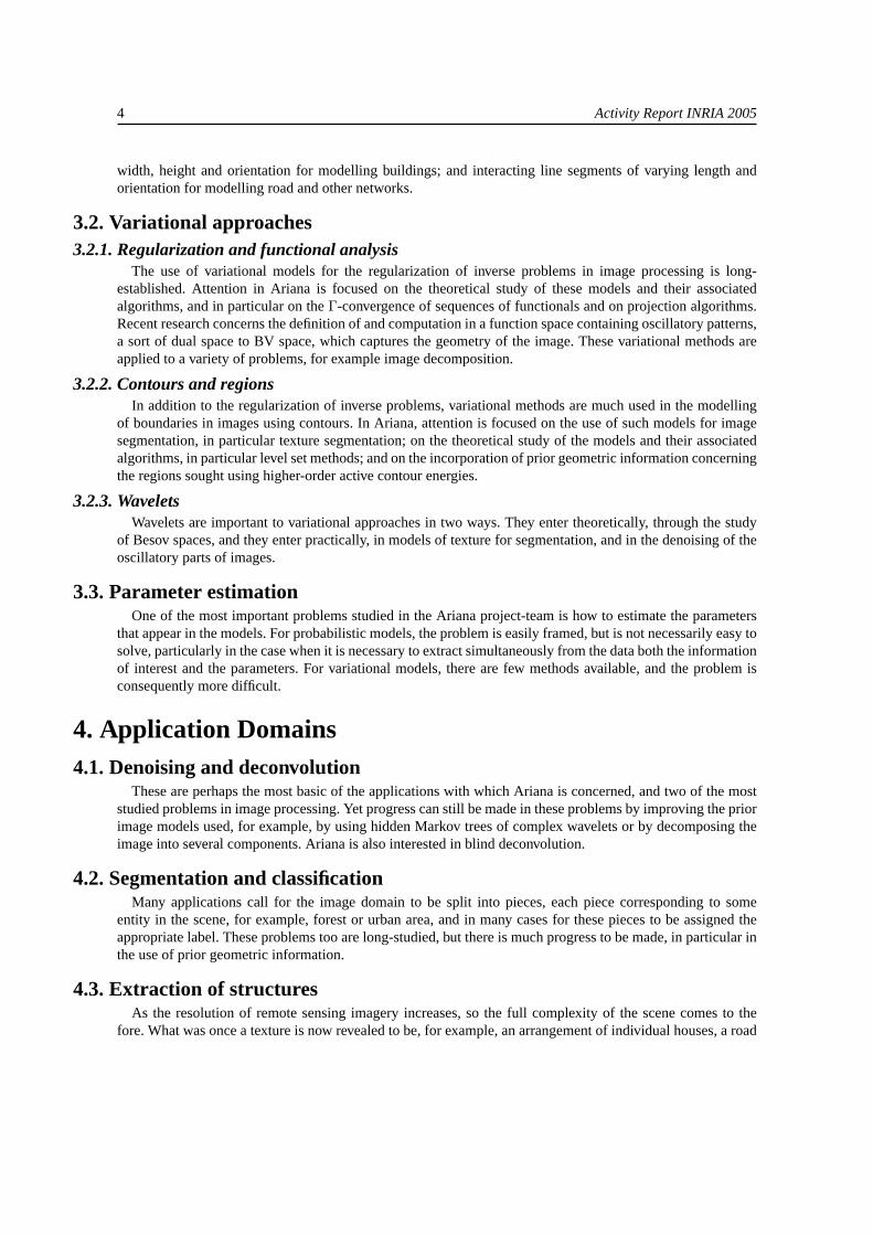
4. Application Domains4.1. Denoising and deconvolution
These are perhaps the most basic of the applications with which Ariana is concerned, and two of the moststudied problems in image processing. Yet progress can still be made in these problems by improving the priorimage models used, for example, by using hidden Markov trees of complex wavelets or by decomposing theimage into several components. Ariana is also interested in blind deconvolution.
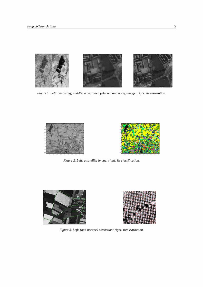
4.2. Segmentation and classificationMany applications call for the image domain to be split into pieces, each piece corresponding to some
entity in the scene, for example, forest or urban area, and in many cases for these pieces to be assigned theappropriate label. These problems too are long-studied, but there is much progress to be made, in particular inthe use of prior geometric information.
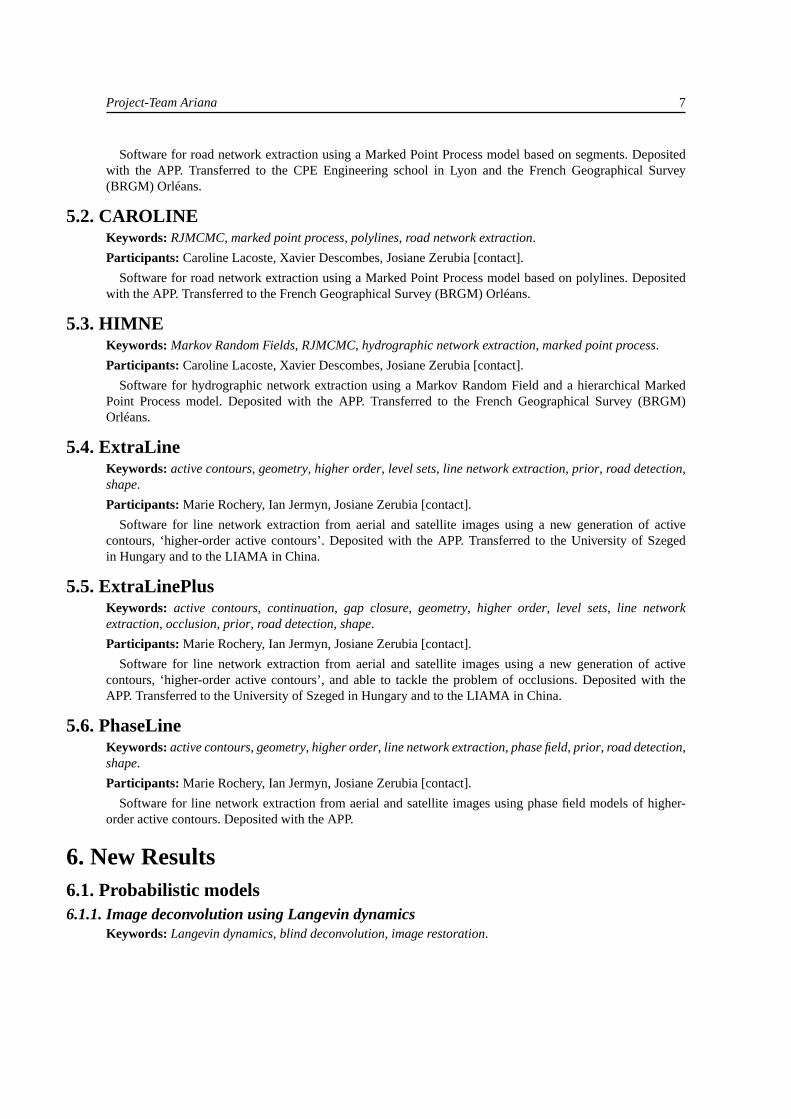
4.3. Extraction of structuresAs the resolution of remote sensing imagery increases, so the full complexity of the scene comes to the
fore. What was once a texture is now revealed to be, for example, an arrangement of individual houses, a road
Project-Team Ariana 5
Figure 1. Left: denoising; middle: a degraded (blurred and noisy) image; right: its restoration.
50 100 150 200 250 300 350 400 450 500
50
100
150
200
250
300
350
400
450
500
50 100 150 200 250 300 350 400 450 500
50
100
150
200
250
300
350
400
450
500
Figure 2. Left: a satellite image; right: its classification.
50 100 150 200 250 300 350 400 450 500
50
100
150
200
250
300
350
400
Figure 3. Left: road network extraction; right: tree extraction.

6 Activity Report INRIA 2005
network, or a number of separate trees. Many new applications are created by the availability of this data, butefficient harvesting of the information requires new techniques.
4.4. 3D modellingEarth observation and cartography is not solely concerned with 2D images. One important problem is the
construction of 3D digital elevation models (DEMs) from high-resolution stereo images produced by satellitesor aerial surveys. Synthetic aperture radar (SAR) imagery also carries elevation information, and allows theproduction of more accurate DEMs thanks to interferometry techniques, for example.
Figure 4. Left: DEM; right: interferometry.
4.5. Information mining and database retrievalEvery day, vast quantities of data are accumulated in remote sensing data repositories, and intelligent access
to this data is becoming increasingly problematic. Recently, the problem of retrieval from large unstructuredremote sensing image databases has begun to be studied within the project-team.
Figure 5. Image registration for the evaluation of retrieval systems. Left: mosaicked aerial image data; right:registered ground truth classification.
5. Software5.1. Quality-Candy
Keywords: RJMCMC, marked point process, road network extraction, segments.
Participants: Caroline Lacoste, Xavier Descombes, Josiane Zerubia [contact].
Project-Team Ariana 7
Software for road network extraction using a Marked Point Process model based on segments. Depositedwith the APP. Transferred to the CPE Engineering school in Lyon and the French Geographical Survey(BRGM) Orléans.
5.2. CAROLINEKeywords: RJMCMC, marked point process, polylines, road network extraction.
Participants: Caroline Lacoste, Xavier Descombes, Josiane Zerubia [contact].
Software for road network extraction using a Marked Point Process model based on polylines. Depositedwith the APP. Transferred to the French Geographical Survey (BRGM) Orléans.
5.3. HIMNEKeywords: Markov Random Fields, RJMCMC, hydrographic network extraction, marked point process.
Participants: Caroline Lacoste, Xavier Descombes, Josiane Zerubia [contact].
Software for hydrographic network extraction using a Markov Random Field and a hierarchical MarkedPoint Process model. Deposited with the APP. Transferred to the French Geographical Survey (BRGM)Orléans.
5.4. ExtraLineKeywords: active contours, geometry, higher order, level sets, line network extraction, prior, road detection,shape.
Participants: Marie Rochery, Ian Jermyn, Josiane Zerubia [contact].
Software for line network extraction from aerial and satellite images using a new generation of activecontours, ‘higher-order active contours’. Deposited with the APP. Transferred to the University of Szegedin Hungary and to the LIAMA in China.
5.5. ExtraLinePlusKeywords: active contours, continuation, gap closure, geometry, higher order, level sets, line networkextraction, occlusion, prior, road detection, shape.
Participants: Marie Rochery, Ian Jermyn, Josiane Zerubia [contact].
Software for line network extraction from aerial and satellite images using a new generation of activecontours, ‘higher-order active contours’, and able to tackle the problem of occlusions. Deposited with theAPP. Transferred to the University of Szeged in Hungary and to the LIAMA in China.
5.6. PhaseLineKeywords: active contours, geometry, higher order, line network extraction, phase field, prior, road detection,shape.
Participants: Marie Rochery, Ian Jermyn, Josiane Zerubia [contact].
Software for line network extraction from aerial and satellite images using phase field models of higher-order active contours. Deposited with the APP.
6. New Results6.1. Probabilistic models6.1.1. Image deconvolution using Langevin dynamics
Keywords: Langevin dynamics, blind deconvolution, image restoration.
8 Activity Report INRIA 2005
Participants: Marion Lebellego, Xavier Descombes.
This internship was co-supervised by Elena Zhizhina from the ITTP of RAS, Moscow. It was partly funded byan Egide ECO-NET project [http://www-sop.inria.fr/ariana/personnel/Xavier.Descombes/Xaveconet.html],and partly by NATO/Russia Collaborative Linkage Grant 980107.
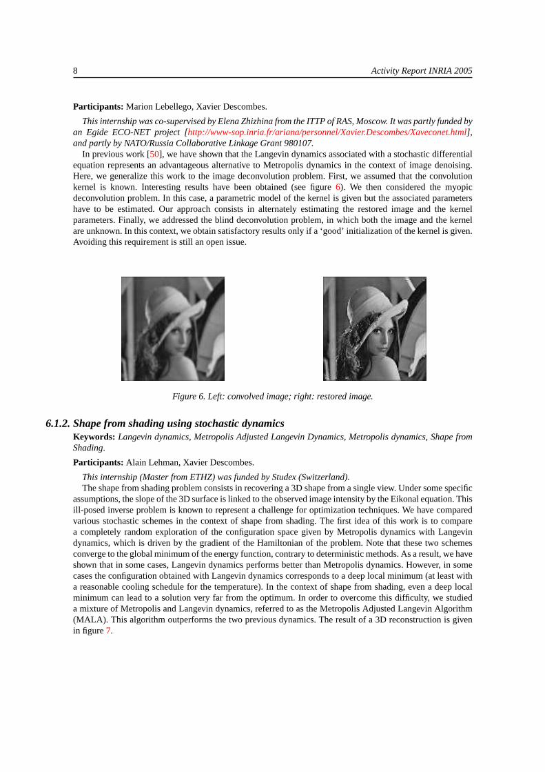
In previous work [50], we have shown that the Langevin dynamics associated with a stochastic differentialequation represents an advantageous alternative to Metropolis dynamics in the context of image denoising.Here, we generalize this work to the image deconvolution problem. First, we assumed that the convolutionkernel is known. Interesting results have been obtained (see figure6). We then considered the myopicdeconvolution problem. In this case, a parametric model of the kernel is given but the associated parametershave to be estimated. Our approach consists in alternately estimating the restored image and the kernelparameters. Finally, we addressed the blind deconvolution problem, in which both the image and the kernelare unknown. In this context, we obtain satisfactory results only if a ‘good’ initialization of the kernel is given.Avoiding this requirement is still an open issue.
Figure 6. Left: convolved image; right: restored image.
6.1.2. Shape from shading using stochastic dynamicsKeywords: Langevin dynamics, Metropolis Adjusted Langevin Dynamics, Metropolis dynamics, Shape fromShading.
Participants: Alain Lehman, Xavier Descombes.
This internship (Master from ETHZ) was funded by Studex (Switzerland).The shape from shading problem consists in recovering a 3D shape from a single view. Under some specific
assumptions, the slope of the 3D surface is linked to the observed image intensity by the Eikonal equation. Thisill-posed inverse problem is known to represent a challenge for optimization techniques. We have comparedvarious stochastic schemes in the context of shape from shading. The first idea of this work is to comparea completely random exploration of the configuration space given by Metropolis dynamics with Langevindynamics, which is driven by the gradient of the Hamiltonian of the problem. Note that these two schemesconverge to the global minimum of the energy function, contrary to deterministic methods. As a result, we haveshown that in some cases, Langevin dynamics performs better than Metropolis dynamics. However, in somecases the configuration obtained with Langevin dynamics corresponds to a deep local minimum (at least witha reasonable cooling schedule for the temperature). In the context of shape from shading, even a deep localminimum can lead to a solution very far from the optimum. In order to overcome this difficulty, we studieda mixture of Metropolis and Langevin dynamics, referred to as the Metropolis Adjusted Langevin Algorithm(MALA). This algorithm outperforms the two previous dynamics. The result of a 3D reconstruction is givenin figure7.
Project-Team Ariana 9
010
2030
4050
60
0
20
40
60
−0.5
0
0.5
1
xy
z
Figure 7. Left: image of a synthetic landscape; right: 3D reconstruction result.
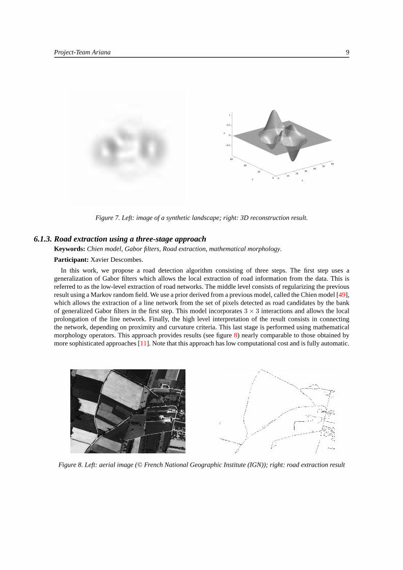
6.1.3. Road extraction using a three-stage approachKeywords: Chien model, Gabor filters, Road extraction, mathematical morphology.
Participant: Xavier Descombes.
In this work, we propose a road detection algorithm consisting of three steps. The first step uses ageneralization of Gabor filters which allows the local extraction of road information from the data. This isreferred to as the low-level extraction of road networks. The middle level consists of regularizing the previousresult using a Markov random field. We use a prior derived from a previous model, called the Chien model [49],which allows the extraction of a line network from the set of pixels detected as road candidates by the bankof generalized Gabor filters in the first step. This model incorporates3× 3 interactions and allows the localprolongation of the line network. Finally, the high level interpretation of the result consists in connectingthe network, depending on proximity and curvature criteria. This last stage is performed using mathematicalmorphology operators. This approach provides results (see figure8) nearly comparable to those obtained bymore sophisticated approaches [11]. Note that this approach has low computational cost and is fully automatic.
Figure 8. Left: aerial image (© French National Geographic Institute (IGN)); right: road extraction result

10 Activity Report INRIA 2005
6.1.4. Tree crown extraction using a Markov random fieldKeywords: Markov random field, long-range interactions, tree crown detection.
Participants: Guillaume Perrin, Xavier Descombes.
This work is the result of a collaboration with Eugene Pechersky from the ITTP of RAS, Moscow. It waspartly funded by an Egide ECO-NET project [http://www-sop.inria.fr/ariana/personnel/Xavier.Descombes/Xaveconet.html].
In this work, we address the problem of tree crown extraction from infra-red remote sensing images. Wedefine a template-based Markov random field that includes short-range interactions to promote regularizationinside the tree crowns, medium-range interactions defining the tree borders, and long-range attractive interac-tions to favour the regular structure of poplar stands. Besides the ‘tree’ and ‘outside tree’ labels, a third labeldefining the centre of the trees is included in the model. The neighbourhood defining the long-range interac-tions is estimated by analysing the Fourier transform of the data. Finally, from the segmentation results, eachindividual tree is delineated using the tree centre label. We thus obtain a description of the population whichallows the estimation of the number of trees and various statistical descriptors such as the average size (seefigure9).
Figure 9. Left: infrared image (© French National Forest Inventory (IFN)); right: tree crown detection result.
6.1.5. Target detection via the analysis of texture perturbationsKeywords: Markov random field, parameter estimation, target detection, texture.
Participants: Alexandre Fournier, Xavier Descombes, Josiane Zerubia.
This Ph.D. is funded by the French Defence Agency (DGA) in collaboration with CNRS. The data will beprovided by the French Defence Agency (DGA) and EADS.
The goal of this work is to detect specific targets that are hidden in the background. We consider the targetdetection problem as the perturbation analysis of a texture model. We thus consider the texture analysisframework in a non-stationary context. The models used will be Markov random field models. The targetenvironment will be characterized by model parameters locally estimated from the image, and local variationsof these parameters will enable us to detect the target automatically. From the data, different statisticalparameter maps will be estimated. Target detection will be based on the analysis of these maps via thedetection of local variations. The performance of the detection is linked to the accuracy of the statisticalparameter estimation, so we will develop robust estimators for small sample sizes. Following target detection,segmentation based on a region-growing technique will delineate the different targets. Finally, a classificationprocedure will characterize each target. This classification will be based on a training set for each potentialtarget.
6.1.6. Evaluation of the damage caused by forest firesKeywords: Gaussian field, Support Vector Machines, classification, forest fire, texture.

Project-Team Ariana 11
Participants: Olivier Zammit, Xavier Descombes, Josiane Zerubia.
This work is done in collaboration with Silogic, Toulouse [http://www.silogic.fr].The aim of this work is to evaluate and quantify the damage caused by forests fires. We will extract radio-
metric information from the different channels of SPOT 5 satellite images (super-mode and multispectral). Weplan to use Gaussian random fields and Support Vector Machines for the classification. A map of the burntareas will be produced and validated, allowing them to be referenced, placed in their geographic context, andtheir surface area estimated.
6.1.7. Multiscale road extractionKeywords: Bayesian image analysis, Quality Candy model, marked point process, road extraction.
Participants: Alexandre Fournier, Xavier Descombes, Josiane Zerubia.
This work is funded by the French Geographical Survey (BRGM) and INRIA. It is part of a PNTS initiative.The data are provided by the French Geographical Survey (BRGM).
A road extraction algorithm, called the ‘Quality Candy’ model, was previously developed in the Arianaproject-team [11]. This algorithm takes the road width as a parameter. The goal of this work is to include theroad width in the state space, and thereby classify roads according to their scale. Introducing such changesled us to define new transition kernels in the Markov chain that take into account realistic changes in theroad model width. Moreover, the resolution of the image is taken into account because each proposal nowdepends on the object width. This led us to normalize the energy at each scale so that jumps between differentresolutions are possible and realistic.
The results are encouraging (see figure10): we are now able to detect roads with multiple widths in a singleimage. However, the result has lower precision than the original version of the model [11]. The side effects ofenergy normalization are now being studied in order to improve the spatial precision. The detection of verythin roads is still troublesome.
Figure 10. Left: synthetic image; middle: detection of lines of width 1–4 pixels; right: detection of lines of width5–8 pixels.
6.1.8. Automatic building 3D reconstruction from high resolution satellite imagesKeywords: 3D building reconstruction, Bayesian approach, Markov chain Monte Carlo, parametric model.
Participants: Florent Lafarge, Xavier Descombes, Josiane Zerubia.
This Ph.D. is co-supervised by Marc-Pierrot Deseilligny, chief scientist of the technical direction of theFrench National Geographic Institute (IGN)[http://www.ign.fr]. The data are provided by the French SpaceAgency (CNES) [http://www.cnes.fr] and the French National Geographic Institute (IGN), who also partiallyfund this work. The work is part of a PNTS initiative.
The automatic 3D reconstruction of urban areas has become a topic of growing interest in the last fewyears. Models built from connected planar facets have recently been used in various applications such as
12 Activity Report INRIA 2005
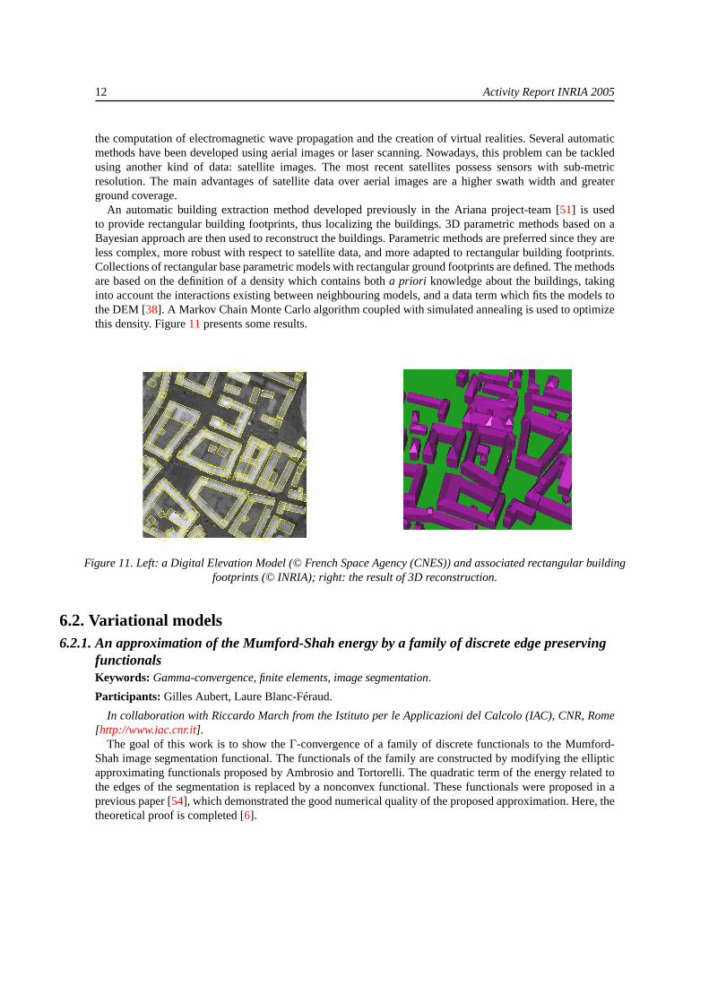
the computation of electromagnetic wave propagation and the creation of virtual realities. Several automaticmethods have been developed using aerial images or laser scanning. Nowadays, this problem can be tackledusing another kind of data: satellite images. The most recent satellites possess sensors with sub-metricresolution. The main advantages of satellite data over aerial images are a higher swath width and greaterground coverage.
An automatic building extraction method developed previously in the Ariana project-team [51] is usedto provide rectangular building footprints, thus localizing the buildings. 3D parametric methods based on aBayesian approach are then used to reconstruct the buildings. Parametric methods are preferred since they areless complex, more robust with respect to satellite data, and more adapted to rectangular building footprints.Collections of rectangular base parametric models with rectangular ground footprints are defined. The methodsare based on the definition of a density which contains botha priori knowledge about the buildings, takinginto account the interactions existing between neighbouring models, and a data term which fits the models tothe DEM [38]. A Markov Chain Monte Carlo algorithm coupled with simulated annealing is used to optimizethis density. Figure11presents some results.
Figure 11. Left: a Digital Elevation Model (© French Space Agency (CNES)) and associated rectangular buildingfootprints (© INRIA); right: the result of 3D reconstruction.
6.2. Variational models6.2.1. An approximation of the Mumford-Shah energy by a family of discrete edge preserving
functionalsKeywords: Gamma-convergence, finite elements, image segmentation.
Participants: Gilles Aubert, Laure Blanc-Féraud.
In collaboration with Riccardo March from the Istituto per le Applicazioni del Calcolo (IAC), CNR, Rome[http://www.iac.cnr.it].
The goal of this work is to show theΓ-convergence of a family of discrete functionals to the Mumford-Shah image segmentation functional. The functionals of the family are constructed by modifying the ellipticapproximating functionals proposed by Ambrosio and Tortorelli. The quadratic term of the energy related tothe edges of the segmentation is replaced by a nonconvex functional. These functionals were proposed in aprevious paper [54], which demonstrated the good numerical quality of the proposed approximation. Here, thetheoretical proof is completed [6].

Project-Team Ariana 13
6.2.2. Detecting codimension-two objects in an image with Ginzburg-Landau modelsKeywords: Ginzburg-Landau model, PDE, point detection, segmentation.
Participants: Laure Blanc-Féraud, Gilles Aubert.
This is joint work with Jean-François Aujol, ex-Ph.D. student in the Ariana project-team, now a CNRSpermanent researcher at ENS Cachan [http://www.cmla.ens-cachan.fr/~aujol].
In this work, we propose a new mathematical model for detecting singularities of codimension greater thanor equal to two in an image. This means we want to detect points in a 2D image or points and curves in a3D image. Inspiration was drawn from the Ginzburg-Landau models used for modelling many phenomena inphysics. We have proposed a model adapted to image processing, we have stated its mathematical propertiesand have given some experimental results demonstrating its capabilities in image processing [5]. This workwas dedicated to 2D images; we are currently working on a 3D model.
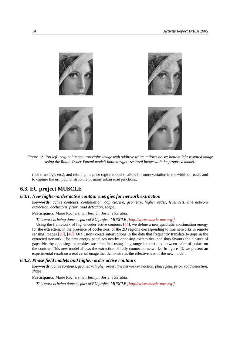
6.2.3. Image restoration for bounded noiseKeywords: L-infinity norm, bounded noise, decomposition, geometry, texture, total variation.
Participants: Pierre Weiss, Laure Blanc-Féraud, Gilles Aubert.
In this work we focus on the minimization of energies involving anL∞ norm. Such a norm is difficult tohandle, because it is non-differentiable, and approximations lead to unstable algorithms. This norm occurs inmany recent applications notably in the denoising of uniform noise or in the decomposition of an image intogeometric and textured components.
We have found an original method to minimize such energies. The idea is to replace the non-differentiableenergy by a differentiable one that we minimize under some constraints. This result allows us to designnew algorithms to solve the above mentioned problems. In particular, we propose a new model using TotalVariation to denoise bounded noise, and a simple algorithm without extra parameters to solve the problem ofdecomposition into textured and geometric components introduced by Y. Meyer.
In figure12, we show the result of the denoising of an image perturbed by white uniform noise. We see thatcompared to the Rudin-Osher-Fatemi model, details are better preserved (hair) and the solution is smoother(cheeks).
6.2.4. Variational models for road network updating in dense urban areas from very highresolution optical imagesKeywords: Road network extraction, VHR, data fusion, digital cartography, updating, variational models.
Participants: Ting Peng, Ian Jermyn, Josiane Zerubia.
This Ph.D. is co-supervised by Professor Baogang Hu, Chinese Director of the Sino-French Laboratory inInformatics, Automation and Applied Mathematics [http://liama.ia.ac.cn], Institute of Automation, ChineseAcademy of Sciences, Beijing, China, and by Véronique Prinet, Associate Professor in the same laboratory.The data (Quickbird images and GIS of Beijing urban areas) were respectively provided by DigitalGlobe[http://www.digitalglobe.com] and the Beijing Institute of Survey and Mapping [http://www.bism.cn].
The aim of this work is the automatic extraction of road networks from dense urban areas using very highresolution (VHR) optical satellite images. The final goal is the retrieval and updating of road network databasesin urban areas, a task crucial to many Geographic Information System (GIS) applications like intelligentvehicle navigation, urban planning, environment guidance, emergency handling, etc. Because of its significantapplicability, the present research work could be part of larger and wider research project, aiming at developingtools for decision support, with one of the applications cited above.
The research will use the higher-order active contour models developed within the Ariana project-team forroad network extraction from medium to high resolution images [44], [45], and adapt both the prior and thelikelihood terms to the demands of VHR imagery. This will involve developing a multiscale model of theimage that can take into account the complex surface features associated with roads in VHR images (cars,
14 Activity Report INRIA 2005
Figure 12. Top-left: original image; top-right: image with additive white uniform noise; bottom-left: restored imageusing the Rudin-Osher-Fatemi model; bottom-right: restored image with the proposed model.
road markings, etc.), and refining the prior region model to allow for more variation in the width of roads, andto capture the orthogonal structure of many urban road junctions.
6.3. EU project MUSCLE6.3.1. New higher-order active contour energies for network extraction
Keywords: active contours, continuation, gap closure, geometry, higher order, level sets, line networkextraction, occlusions, prior, road detection, shape.
Participants: Marie Rochery, Ian Jermyn, Josiane Zerubia.
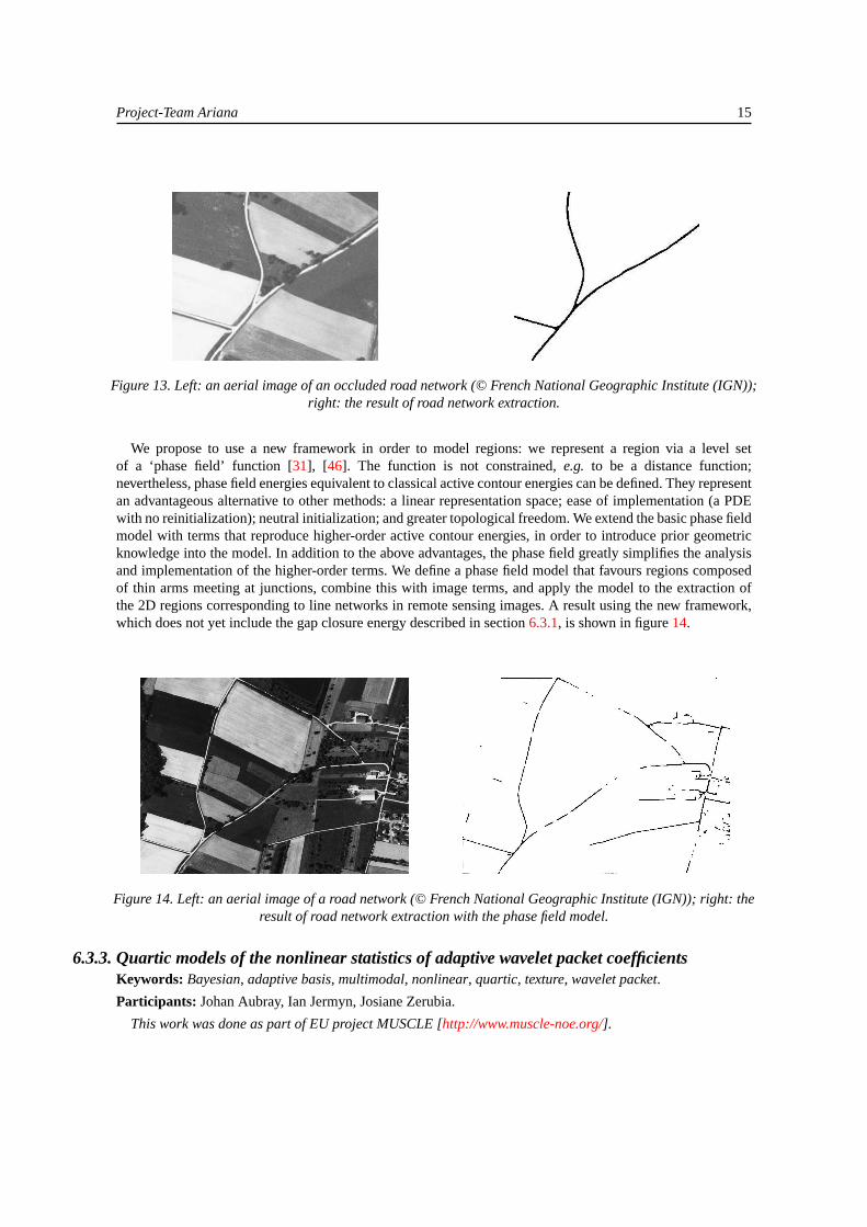
This work is being done as part of EU project MUSCLE [http://www.muscle-noe.org/].Using the framework of higher-order active contours [44], we define a new quadratic continuation energy
for the extraction, in the presence of occlusions, of the 2D regions corresponding to line networks in remotesensing images [30], [45]. Occlusions create interruptions in the data that frequently translate to gaps in theextracted network. The new energy penalizes nearby opposing extremities, and thus favours the closure ofgaps. Nearby opposing extremities are identified using long-range interactions between pairs of points onthe contour. This new model allows the extraction of fully connected networks. In figure13, we present anexperimental result on a real aerial image that demonstrates the effectiveness of the new model.
6.3.2. Phase field models and higher-order active contoursKeywords: active contours, geometry, higher order, line network extraction, phase field, prior, road detection,shape.
Participants: Marie Rochery, Ian Jermyn, Josiane Zerubia.
This work is being done as part of EU project MUSCLE [http://www.muscle-noe.org/].
Project-Team Ariana 15
Figure 13. Left: an aerial image of an occluded road network (© French National Geographic Institute (IGN));right: the result of road network extraction.
We propose to use a new framework in order to model regions: we represent a region via a level setof a ‘phase field’ function [31], [46]. The function is not constrained,e.g. to be a distance function;nevertheless, phase field energies equivalent to classical active contour energies can be defined. They representan advantageous alternative to other methods: a linear representation space; ease of implementation (a PDEwith no reinitialization); neutral initialization; and greater topological freedom. We extend the basic phase fieldmodel with terms that reproduce higher-order active contour energies, in order to introduce prior geometricknowledge into the model. In addition to the above advantages, the phase field greatly simplifies the analysisand implementation of the higher-order terms. We define a phase field model that favours regions composedof thin arms meeting at junctions, combine this with image terms, and apply the model to the extraction ofthe 2D regions corresponding to line networks in remote sensing images. A result using the new framework,which does not yet include the gap closure energy described in section6.3.1, is shown in figure14.
Figure 14. Left: an aerial image of a road network (© French National Geographic Institute (IGN)); right: theresult of road network extraction with the phase field model.
6.3.3. Quartic models of the nonlinear statistics of adaptive wavelet packet coefficientsKeywords: Bayesian, adaptive basis, multimodal, nonlinear, quartic, texture, wavelet packet.
Participants: Johan Aubray, Ian Jermyn, Josiane Zerubia.
This work was done as part of EU project MUSCLE [http://www.muscle-noe.org/].
16 Activity Report INRIA 2005
This work addresses the accurate modelling of textures using probabilistic models. In [47], models weredeveloped based on wavelet packet bases adapted to the structure of the texture being described. The useof adaptive bases allows the model to focus on the important structures in a texture and to capture long-range correlations with little extra computational effort. The initial models were Gaussian, but it was observedthat the empirical subband statistics of the resulting adaptive bases in fact assume three forms: Gaussian,generalized Gaussian, and, typically in subbands with narrow frequency support, bimodal. The latter areclosely linked to the structure of the texture, since they predict that the most probable image under thedistribution is in fact textured, unlike most previous texture models.
An initial attempt to model this variety of behaviour used a choice of models for each subband [21] [48]. Toreduce the complexity of the description, to remove the necessity for model selection, and to provide greaterflexibility for future models of the joint subband statistics, in this work [34] the subband models are unifiedusing a two-parameter quartic probability distribution. We use a Bayesian methodology throughout, computingMAP estimates for the adaptive wavelet packet basis and for the subband model parameters using depth-firstsearch and a quasi-Newton optimization algorithm.
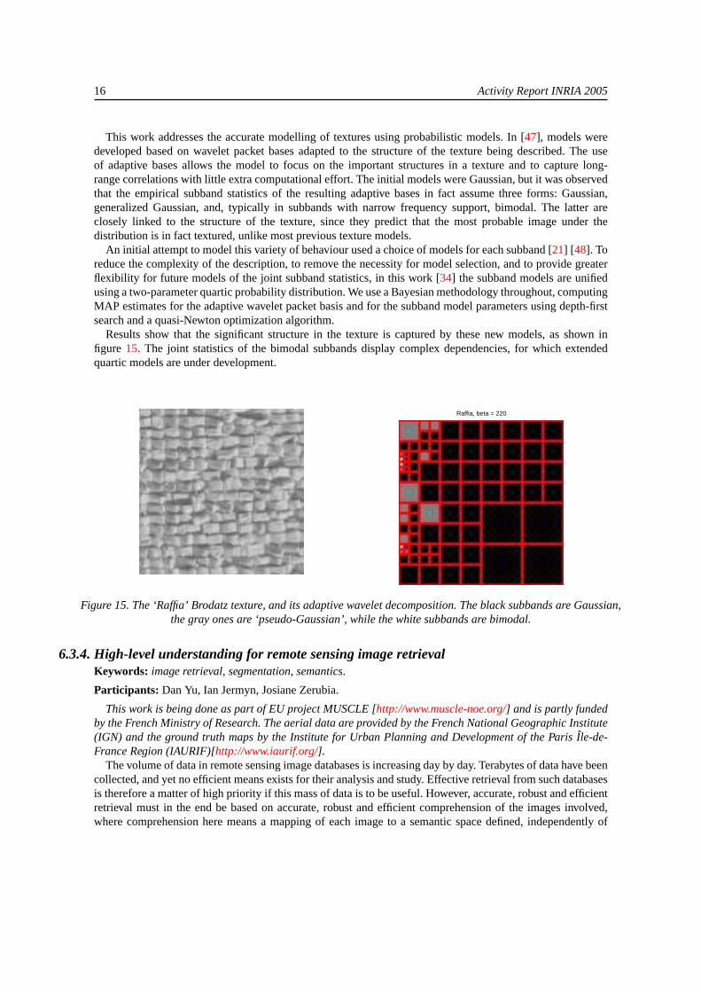
Results show that the significant structure in the texture is captured by these new models, as shown infigure 15. The joint statistics of the bimodal subbands display complex dependencies, for which extendedquartic models are under development.
Raffia, beta = 220
Figure 15. The ‘Raffia’ Brodatz texture, and its adaptive wavelet decomposition. The black subbands are Gaussian,the gray ones are ‘pseudo-Gaussian’, while the white subbands are bimodal.
6.3.4. High-level understanding for remote sensing image retrievalKeywords: image retrieval, segmentation, semantics.
Participants: Dan Yu, Ian Jermyn, Josiane Zerubia.
This work is being done as part of EU project MUSCLE [http://www.muscle-noe.org/] and is partly fundedby the French Ministry of Research. The aerial data are provided by the French National Geographic Institute(IGN) and the ground truth maps by the Institute for Urban Planning and Development of the Paris Île-de-France Region (IAURIF)[http://www.iaurif.org/].
The volume of data in remote sensing image databases is increasing day by day. Terabytes of data have beencollected, and yet no efficient means exists for their analysis and study. Effective retrieval from such databasesis therefore a matter of high priority if this mass of data is to be useful. However, accurate, robust and efficientretrieval must in the end be based on accurate, robust and efficient comprehension of the images involved,where comprehension here means a mapping of each image to a semantic space defined, independently of
Project-Team Ariana 17
the retrieval process, by the specific application. Thus, this work focuses primarily on the extraction of theimage semantics in a specific application and secondarily on its retrieval. The dataset involved is a collectionof aerial images of the Île-de-France Region. A useful semantics to associate with this database is built onthe predicate: ‘The land area corresponding to region R in the image is occupied by land cover type C’.Ground truth for this semantics exists in the form of land use classification maps for the Île-de-France Region.These maps classify the land area into eleven ‘regional’ classes (such as ‘forest’), and several ‘linear’ classes(such as ‘waterways’). The aim of the work is twofold. First, to be able to generate, using techniques (textureand colour-based image classification; extraction of linear networks,...) both extant and under developmentin project-team Ariana, automatic classifications of the images in the dataset into these classes. Second, toincorporate this image comprehension facility into an image retrieval system, for example, the IKONA system[http://www-rocq.inria.fr/imedia/ikona/], developed by the Imedia project-team at INRIA Rocquencourt.
6.4. EU project IMAVIS6.4.1. Higher-order active contours for tree detection
Keywords: active contours, geometry, higher order, level sets, prior, shape, tree detection.
Participants: Peter Horvath, Ian Jermyn, Josiane Zerubia.
This Ph.D. is co-supervised by Zoltan Kato, Assistant Professor at the University of Szeged,Hungary [http://www.inf.u-szeged.hu/~kato]. The data are provided by the French National For-est Inventory (IFN) [http://www.ifn.fr]. It is partly supported by EU project IMAVIS [http://www-sop.inria.fr/robotvis/projects/Imavis/imavis.html], by the Egide PAI Balaton programme, and by theFrench Ministry of Foreign Affairs (MAE).
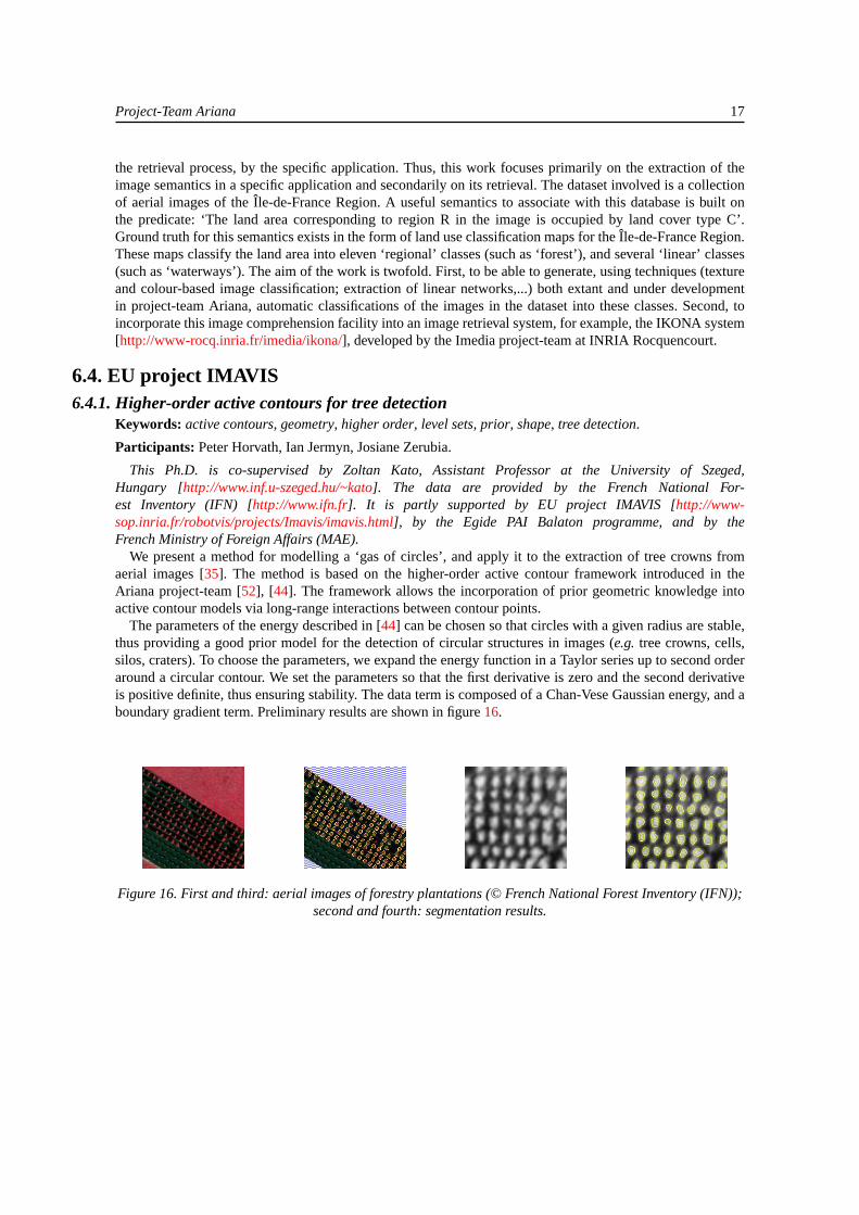
We present a method for modelling a ‘gas of circles’, and apply it to the extraction of tree crowns fromaerial images [35]. The method is based on the higher-order active contour framework introduced in theAriana project-team [52], [44]. The framework allows the incorporation of prior geometric knowledge intoactive contour models via long-range interactions between contour points.
The parameters of the energy described in [44] can be chosen so that circles with a given radius are stable,thus providing a good prior model for the detection of circular structures in images (e.g. tree crowns, cells,silos, craters). To choose the parameters, we expand the energy function in a Taylor series up to second orderaround a circular contour. We set the parameters so that the first derivative is zero and the second derivativeis positive definite, thus ensuring stability. The data term is composed of a Chan-Vese Gaussian energy, and aboundary gradient term. Preliminary results are shown in figure16.
Figure 16. First and third: aerial images of forestry plantations (© French National Forest Inventory (IFN));second and fourth: segmentation results.
18 Activity Report INRIA 2005
6.5. ARC MODE de VIE6.5.1. Tree crown extraction using marked point processes
Keywords: Reversible Jump Markov Chain Monte Carlo, forestry, marked point process, object-based model,simulated annealing, tree crown extraction.
Participants: Guillaume Perrin, Xavier Descombes, Josiane Zerubia.
This Ph.D. is co-supervised by Christian Saguez, director of the Applied Mathematics Laboratory ofÉcole Centrale Paris [http://www.mas.ecp.fr], and by Paul-Henry Cournède from the same laboratory andthe Digiplante INRIA project-team [http://www-rocq.inria.fr/Digiplante/]. The data (aerial images of Frenchforests) are provided by the French National Forest Inventory (IFN) [http://www.ifn.fr]. The work forms partof ARC MODE de VIE [http://www-sop.inria.fr/ariana/Projets/ModedeVie/MODEdeVIE.html].
In forestry management, high-level parameters such as the number of stems or the distribution of tree crowndiameters are assessed by Forest Inventories using field studies. Nevertheless, these statistics are not preciseenough to appear on forestry maps, whose resolution is less than 1 ha. High spatial resolution images couldhelp forestry managers to obtain, using appropriate algorithms, more knowledge at the scale of individualtrees.
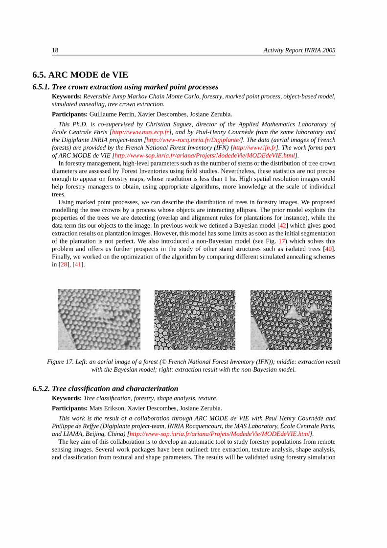
Using marked point processes, we can describe the distribution of trees in forestry images. We proposedmodelling the tree crowns by a process whose objects are interacting ellipses. The prior model exploits theproperties of the trees we are detecting (overlap and alignment rules for plantations for instance), while thedata term fits our objects to the image. In previous work we defined a Bayesian model [42] which gives goodextraction results on plantation images. However, this model has some limits as soon as the initial segmentationof the plantation is not perfect. We also introduced a non-Bayesian model (see Fig.17) which solves thisproblem and offers us further prospects in the study of other stand structures such as isolated trees [40].Finally, we worked on the optimization of the algorithm by comparing different simulated annealing schemesin [28], [41].
Figure 17. Left: an aerial image of a forest (© French National Forest Inventory (IFN)); middle: extraction resultwith the Bayesian model; right: extraction result with the non-Bayesian model.
6.5.2. Tree classification and characterizationKeywords: Tree classification, forestry, shape analysis, texture.
Participants: Mats Erikson, Xavier Descombes, Josiane Zerubia.
This work is the result of a collaboration through ARC MODE de VIE with Paul Henry Cournède andPhilippe de Reffye (Digiplante project-team, INRIA Rocquencourt, the MAS Laboratory, École Centrale Paris,and LIAMA, Beijing, China) [http://www-sop.inria.fr/ariana/Projets/ModedeVie/MODEdeVIE.html].
The key aim of this collaboration is to develop an automatic tool to study forestry populations from remotesensing images. Several work packages have been outlined: tree extraction, texture analysis, shape analysis,and classification from textural and shape parameters. The results will be validated using forestry simulation
Project-Team Ariana 19
software based on the growth model GreenLab [http://www-rocq.inria.fr/Digiplante/]. From the applicationpoint of view, these tools will enable us to simulate a 3D rendering of a forestry area, to study the evolution ofa population between two dates, and to forecast the evolution of forestry, both from an architectural and froma functional point of view.
We will combine the different results obtained by the tree detection procedure and the textural and shapeanalysis. In particular, we will propose and develop a classification procedure. To achieve this, we will rely onthe extraction tools developed within the Ariana project-team. We will develop statistical tools to validate theresulting classification, based on the different tree species, the age of trees, and various biomass parameters.
6.6. ACI QuerySat6.6.1. Study of the change with resolution of the parameters of adaptive wavelet packet texture
modelsKeywords: adaptive basis, change, parameter, resolution, texture, wavelet packet.
Participants: Vikram Agrawal, Aymen El Ghoul, Ian Jermyn, Josiane Zerubia.
This work was performed as part of ACI QuerySat [http://www.tsi.enst.fr/QuerySat/] and partly fundedby the INRIA Internship programme (IIT New Delhi) and by the INRIA STIC-Tunisia programme (Sup’ComTunis).
As the resolution of detectors increases, remote sensing image databases contain images at an ever widerrange of resolutions. Current retrieval systems rely heavily on the use of parameters extracted from the databy texture models of various types in order to represent semantics and retrieve images. In this context, theexistence of images at different resolutions creates problems because the same semantics will have differentparameters at different resolutions. There are two solutions to this problem: one is to find parameters thatare resolution-independent. However, this necessarily means that some information is lost, not just aboutthe resolution, but about the texture being described. The alternative, which is the subject of this work, isto understand how the parameters change when the resolution changes, and to adjust the retrieval processaccordingly.
Texture models based on wavelets have the advantage that they are naturally multiscale, and hence moreeasily adaptable to different resolutions. It is advantageous to go beyond standard wavelet bases, and to usewavelet packet bases adapted to the texture being modelled [47], [48], [34], thereby capturing accurately thedependencies that characterize texture structure while maintaining subband independence and the multiscalenature of the model. In this case, in addition to individual subband parameters, the basis itself may change withresolution. The first part of this work consisted of an empirical study of the change in subband parametersand basis when the resolution is reduced using various operators. Some results of this study are shown infigure 18 for the scaling operator (which produces no change in the basis) and the Gaussian operator. Thestudy concluded that the basis was quite stable for several operators of interest, in particular Gaussian, andthat an analytical treatment would be feasible in the Gaussian case. The second part of the work consisted ofa calculation of the change in the subband parameters and basis for the Gaussian operator. Under reasonableapproximations, one result is that the wavelet packet basis becomes more decomposed under a reduction ofresolution, thus facilitating the analysis of the change of basis.
6.6.2. Indexing of remote sensing images using road networksKeywords: database retrieval, graph matching, remote sensing, road network, skeleton.
Participants: Avik Bhattacharya, Ian Jermyn, Xavier Descombes, Josiane Zerubia.
This Ph.D. is co-supervised by Henri Maître, deputy director of École Nationale Supérieure desTélécommunications, Paris [http://www.tsi.enst.fr]. This work has been done as part of ACI QuerySat[http://www.tsi.enst.fr/QuerySat/], and is partly funded by the French Space Agency (CNES).
The growing need for semantically accurate retrieval from large remote sensing image archives demands aprecise and robust characterization of the semantics of the images in the archive. Road networks can be used

20 Activity Report INRIA 2005
Figure 18. Change of adaptive wavelet packet basis and subband type (Gaussian, grey; generalized Gaussian,black; bimodal, white) with resolution change. Left-hand three images: scaling operator; right-hand three images:Gaussian operator. Resolution decreases by factor of two from one image to its right-hand neighbour, which should
be compared to the top-left quadrant of its predecessor.
to characterize certain types of semantics, and consequently can be used to retrieve images. They can be usedto position an image geographically in a way that is invariant to detector type and other confounding factors,and to characterize certain types of environment, for example urban areas, via statistics computed from thenetwork. To use road networks in this way has several pre-requisites: the road network must be extracted withadequate precision from the original images [18], [11]; it must be converted into a representation suitablefor matching to other road networks or for clustering; and suitable matching and clustering algorithms mustbe developed. This work studies the latter two elements. The results will be tested using two image retrievalsystems available to ACI QuerySat: the IKONA system [http://www-rocq.inria.fr/imedia/ikona/] developed bythe INRIA Imedia project-team, and the retrieval system at ENST, which operates in a similar manner to theGerman Space Agency (DLR) KIM system [http://isis.dlr.de/mining/].
To allow the maximum flexibility, the outputs of the extraction algorithms are converted to a commonrepresentation: an undirected graph, with special nodes representing road extremities and junctions, andstrings of standard nodes representing roads. The nodes and arcs can be decorated with geometric and imageinformation. The output of [18] is the distance function of the region corresponding to the road network, fromwhich a skeleton graph is computed using [53], but adapted to allow for non-connected and multiply connectedregions. The output of [11] is a collection of line segments. After dilation with a small structuring elementand computation of the distance function, [53] can again be applied. Some results are shown in figure19.The computation of appropriate statistics and probabilistic graph matching and graph clustering algorithmsbased on retrieval scenarios provided by the French National Geographic Institute (IGN) and others is work inprogress.
Figure 19. From the left: extracted road network; its graph representation; extracted road network; image dilatedwith a 3×3 mask; its graph representation.
6.7. ACI Multim6.7.1. Multi-spectral image restoration and decomposition
Keywords: correlation, geometry, multi-spectral image, texture, total variation.
Project-Team Ariana 21
Participants: Pierre Weiss, Laure Blanc-Féraud, Gilles Aubert.
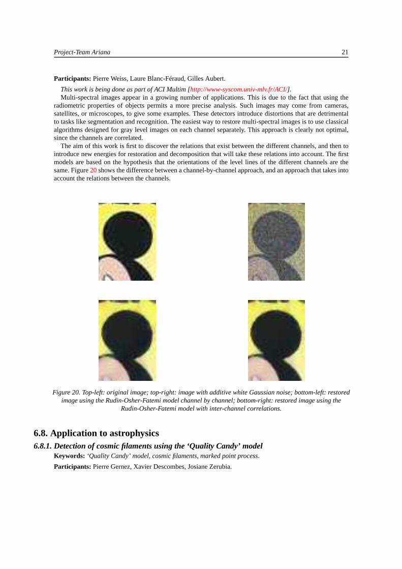
This work is being done as part of ACI Multim [http://www-syscom.univ-mlv.fr/ACI/].Multi-spectral images appear in a growing number of applications. This is due to the fact that using the
radiometric properties of objects permits a more precise analysis. Such images may come from cameras,satellites, or microscopes, to give some examples. These detectors introduce distortions that are detrimentalto tasks like segmentation and recognition. The easiest way to restore multi-spectral images is to use classicalalgorithms designed for gray level images on each channel separately. This approach is clearly not optimal,since the channels are correlated.
The aim of this work is first to discover the relations that exist between the different channels, and then tointroduce new energies for restoration and decomposition that will take these relations into account. The firstmodels are based on the hypothesis that the orientations of the level lines of the different channels are thesame. Figure20shows the difference between a channel-by-channel approach, and an approach that takes intoaccount the relations between the channels.
Figure 20. Top-left: original image; top-right: image with additive white Gaussian noise; bottom-left: restoredimage using the Rudin-Osher-Fatemi model channel by channel; bottom-right: restored image using the
Rudin-Osher-Fatemi model with inter-channel correlations.
6.8. Application to astrophysics6.8.1. Detection of cosmic filaments using the ‘Quality Candy’ model
Keywords: ‘Quality Candy’ model, cosmic filaments, marked point process.
Participants: Pierre Gernez, Xavier Descombes, Josiane Zerubia.

22 Activity Report INRIA 2005
This internship was co-supervised by Eric Slezak and Albert Bijaoui from the Nice Cote d’AzurObservatory [http://www.obs-nice.fr/]. It was funded by INRIA COLORS project FIGARO [http://www-sop.inria.fr/ariana/personnel/Xavier.Descombes/FIGARO.html].
Beyond three hundred billion light-years, the cosmos can be seen as a gas of galaxies, uniformly distributedand isotropically moving. At smaller distances, astronomical observations have shown that the distributionof matter in the Universe is not so homogeneous. Galaxies cluster in long structures, called filaments, withhuge voids between them. The filaments, which only represent about 10% of the volume of the Universe,are organized in a complex three-dimensional web-like network. This work concerns the extraction of suchnetworks from astronomical images. To do this, we have adapted a stochastic model initially developed forroad extraction from satellite images [11]: the ‘Quality Candy’ Model. The approach models the filaments bya configuration of connected line segments. This approximation is optimized through a simulated annealingalgorithm which minimizes the geometrical and physical constraints corresponding to the filament networkwe want to detect. A result of filament extraction from a galaxy map is shown in figure21. The networkextracted matches astronomical expectations. This is the first time that filaments have been extracted directlyfrom galaxy maps obtained from astronomical surveys.
Figure 21. Galactic filaments extracted from a galaxy map provided by the Center for Astrophysics, Harvard.
6.9. Applications to biology6.9.1. Blind deconvolution of biological images using 3D complex wavelets
Keywords: 3D complex wavelets, biological image, blind deconvolution, confocal microscopy, parameterestimation, wide-field microscopy.
Participants: Praveen Pankajakshan, Laure Blanc-Feraud, Josiane Zerubia.
This is joint work with the Pasteur Institute, Paris (J.C. Olivo-Marin, B. Zhang) [http://www.pasteur.fr],the Weizmann Institute (Z. Kam) [http://www.weizmann.ac.il/] and Technion (A. Feuer)[http://www.technion.ac.il/], Israel. It is partly funded by the P2R Franco-Israeli collaborative programmeand by the INRIA internship programme (IIT Roorkee).

Project-Team Ariana 23
The confocal laser scanning microscope (CLSM) is an optical fluorescence microscope associated to alaser that scans the specimen in 3D and uses a pinhole to reject most out-of-focus light. The ability ofCLSM to image optical sections of thick specimens explains its rapidly increasing use in biological research.Nevertheless, the quality of confocal microscopy images suffers from two basic physical limitations. First, out-of-focus blur due to the diffraction-limited nature of optical microscopy remains substantial, even though it isreduced compared to wide-field microscopy. Second, the confocal pinhole drastically reduces the amount oflight detected by the photomultiplier, leading to Poisson noise. The images produced by CLSM can thereforebenefit from postprocessing by deconvolution methods designed to reduce blur and noise. The Ariana project-team has worked on these methods [9] in collaboration with the Pasteur Institute in Paris and the WeizmannInstitute in Israel for three years.
We recently proposed a restoration method based on a 3D complex wavelet decomposition that gives goodresults in denoising real biological images [29], [43].
The goals of this work are first to extend this denoising method to deconvolution in the 3D complexwavelet domain, and second to estimate the parameters of the Point Spread Function via impulse responsemodelling of the blur due to physical phenomenona during the acquisition. Tests will be conducted on confocalmicroscopy images provided by the Pasteur Institute and wide-field microscopy images provided by theWeizmann Institute.
6.9.2. Segmentation and deconvolution of 3D imagesKeywords: 3D image processing, Ginzburg-Landau, filament, segmentation, variational method.
Participants: Alexis Baudour, Laure Blanc-Feraud, Gilles Aubert.
This work is being done in collaboration with Christophe Zimmer from the Pasteur Institute, Paris[http://www.pasteur.fr]. It is partly funded by a CNRS Math/STIC grant.
Our work currently deals with filament detection in skeletons of cells. These filaments are detected bylocally approximating the 2D or 3D image function by its second order Taylor polynomial. The direction ofthe filament is determined from the Hessian matrix of the Taylor polynomial. This first method is not robustenough in the presence of noise. Thus we have to complete the missing parts of the filaments.
We start from the complex Ginzburg-Landau model, which comes from physics, and which has been usedfor inpainting singularities whose codimension is higher than one in an image. The filaments are the zerolevel set of a complex-valued function defined on the 3D space which minimizes the energy derived from theGinzburg-Landau model. We use variational methods to find this minimum.
7. Contracts and Grants with Industry7.1. Industrial7.1.1. Alcatel Alenia Space Cannes
Participants: Ting Peng, Ian Jermyn, Josiane Zerubia [PI].
Road network updating in dense urban areas from very high resolution optical images. Contract in theprocess of being signed.
7.1.2. Silogic ToulouseParticipants: Olivier Zammit, Xavier Descombes, Josiane Zerubia [PI].
Evaluation of the damage after a forest fire from high resolution satellite images. Contract signed but numbernot yet assigned.
7.1.3. CNES ToulouseParticipants: Avik Bhattacharya, Ian Jermyn, Xavier Descombes, Josiane Zerubia [PI].
24 Activity Report INRIA 2005
Extraction and characterization of line networks in satellite images for retrieval from image databases.Contract #293
7.1.4. IGN Saint MandeParticipants: Florent Lafarge, Xavier Descombes, Josiane Zerubia [PI].
Automatic building extraction from digital elevation models. Grant from the French National GeographicInstitute (IGN) and the French Space Agency (CNES).
7.1.5. BRGM OrleansParticipants: Alexandre Fournier, Xavier Descombes, Josiane Zerubia [PI].
Updating of line networks in cartography using data fusion and Markov object processes. Contract #102E03800041624.01.2.
7.1.6. IFN Nogent sur VernissonParticipants: Guillaume Perrin, Xavier Descombes, Josiane Zerubia [PI].
Semi-automatic methods for forestry cartography using aerial and high resolution satellite images. Contractin the process of being signed.
7.1.7. DGA/CTA ArcueilParticipants: Alexandre Fournier, Xavier Descombes, Josiane Zerubia [PI].
Target detection through texture perturbation analysis. Grant from the French Defence Agency (DGA) andCNRS.
8. Other Grants and Activities8.1. Regional8.1.1. INRIA COLORS project ‘FIGARO’
Participants: Pierre Gernez, Xavier Descombes [PI], Josiane Zerubia.
In collaboration with the Nice Côte d’Azur Observatory (A. Bijaoui, E. Slezak), and INRA, Avignon (R.Stoica).
8.1.2. CNRS MATH/STIC grant ‘Détection de structures fines en imagerie 3D’Participants: Alexis Baudour, Laure Blanc-Féraud [PI].
In collaboration with the J.-A. Dieudonné Laboratory, CNRS/UNSA (G. Aubert).
8.2. National8.2.1. INRIA ARC project ‘MODE de VIE: MODEling and DEtecting Vegetation in
Interaction with their Environment’Participants: Mats Erikson, Guillaume Perrin, Xavier Descombes [PI], Josiane Zerubia.
In collaboration with the Digiplante project-team (INRIA Rocquencourt, MAS, AMAP ofCIRAD (O. Chassagneux, P.H. Cournède, P. de Reffye)), the MAS laboratory (C. Saguez),and LIAMA, Beijing, China (C. Cassissa, T. Fourcaud, M. Jaeger, V. Prinet). [http://www-sop.inria.fr/ariana/Projets/ModedeVie/MODEdeVIE.html].
8.2.2. ACI Masse de Données ‘QuerySat: Heterogeneous and multi-scale descriptors forretrieval from remote sensing image databases’Participants: Vikram Agrawal, Avik Bhattacharya, Aymen El Ghoul, Ian Jermyn, Xavier Descombes [ArianaPI], Josiane Zerubia.

Project-Team Ariana 25
In collaboration with the Signal and Image Processing laboratory of ENST (M. Campedel, Y. Kyrgyzov,B. Luo, H. Maître, M. Roux), INRIA project-team IMEDIA (O. Besbes, S. Boughorbel, N. Boujemaa, M.Crucianu, M. Ferecatu, V. Gouet) and URISA of Sup’Com Tunis (Z. Belhadj, A. Ben Azza, R. Tebourbi).
8.2.3. ACI NIM ‘Multim: Nouvelles methodes mathematiques pour la restauration d’imagesmulti-canaux’Participants: Pierre Weiss, Xavier Descombes, Laure Blanc-Féraud [Ariana PI], Josiane Zerubia.
In collaboration with the J-L Lions Laboratory (P. L. Combettes, A. Cohen); J.-A. Dieudonné Laboratory,CNRS/UNSA (G. Aubert); CMAP, École Polytechnique (A. Chambolle); Applied Maths Laboratory, Univer-sity Paris V (L. Moisan); INFO-IGM Laboratory, University Marne La Vallée (J.-C. Pesquet); ObservatoireMidi Pyrennées/University Paul Sabatier, Toulouse (S. Rocques).
8.2.4. Action PNTS ‘Extraction/mise à jour cartographique des réseaux linéiques à partir desdonnées radar et optique hautes résolutions’Participants: Alexandre Fournier, Xavier Descombes, Josiane Zerubia [PI].
In collaboration with the French Geographical Survey (BRGM) (N. Bagdhadi).
8.2.5. Action PNTS ‘Extraction de bâti à partir de MNE’Participants: Florent Lafarge, Xavier Descombes [Ariana PI], Josiane Zerubia.
In collaboration with ENST (H. Maître, M. Roux).
8.3. European8.3.1. Egide PAI Galilée ‘PLATONOV: photocopies de livres anciens par techniques
d’optimisation numériques et solutions de viscosité’Participant: Xavier Descombes [Ariana PI].
In collaboration with IRIT Toulouse (F. Courteille, A. Crouzil, JD Durou, P. Gurdjos) and University LaSapienza, Rome (E. Cristiani, M. Falcone, A. Seghini).
8.3.2. Egide PAI Balaton ‘Efficient shape priors for colour textured image segmentation’Participants: Florent Lafarge, Marie Rochery, Ian Jermyn [Ariana PI], Josiane Zerubia.
In collaboration with the University of Szeged, Hungary (P. Horvath, Z. Kato).
8.3.3. EU project IMAVISParticipants: Peter Horvath, Ian Jermyn, Josiane Zerubia [Ariana PI].
The Ariana project-team is a participant in the European Union Fifth Framework project IMAVIS (Theoryand Practice of Image Processing and Computer Vision), contract IHP-MCHT-99-1, in collaboration with theINRIA Odyssée and Epidaure project-teams [http://www-sop.inria.fr/robotvis/projects/Imavis/imavis.html].
8.3.4. EU project MUSCLEParticipants: Johan Aubray, Marie Rochery, Ian Jermyn [Ariana PI], Josiane Zerubia.
The Ariana project-team is a participant in the European Union Sixth Framework Network of ExcellenceMUSCLE (Multimedia Understanding through Semantics, Computation and Learning), contract FP6-507752,in collaboration with 41 other participants around Europe, including four other INRIA project-teams. Website:http://www.muscle-noe.org
8.4. International8.4.1. ECO-NET ‘Méthodes de la Physique statistique pour l’analyse d’image: application à la
gestion forestière’Participants: Marion Lebellego, Guillaume Perrin, Xavier Descombes [PI], Josiane Zerubia.

26 Activity Report INRIA 2005
In collaboration with the IITP of the Russian Academy of Science (R. Minlos, E. Pechersky, E. Zhizhina)and the Department of Applied Mathematics and Informatics of the Russian-Armenian-Slavonian Universityof Yerevan (B. Nahapetyan, P. Solakhyan).
8.4.2. NATO/Russia Collaborative Linkage Grant 980107 ‘Prior shape information for imagesegmentation in environmental and disaster detection and monitoring’Participants: Marie Rochery, Ian Jermyn, Xavier Descombes, Josiane Zerubia [PI].
In collaboration with North Carolina State University (H. Krim) and the IITP of the Russian Academy ofScience (R. Minlos, E. Pechersky, E. Zhizhina).
8.4.3. INRIA/USA InitiativeParticipants: Ian Jermyn [PI], Josiane Zerubia.
In collaboration with the University of Wisconsin-Madison (R. Nowak) and Duke University (R. Willett).
8.4.4. INRIA/LIAMA InitiativeParticipants: Guillaume Perrin, Ian Jermyn, Xavier Descombes, Josiane Zerubia [PI].
In collaboration with LIAMA, Institute of Automation, Chinese Academy of Sciences (T. Bailloeul, H.BaoGang, G. Cassissa, T. Fourcaud, M. Jaeger, T. Peng and V. Prinet).
8.4.5. INRIA STIC-TunisiaParticipants: Avik Bhattacharya, Ian Jermyn [Ariana PI], Josiane Zerubia.
In collaboration with INRIA project-team Imedia (N. Boujemaa, V. Gouet, N, Grira), and URISA ofSup’Com Tunis (Z. Belhadj, A. Ben Azza, S. Bougharel, A. El Ghoul, R. Tebourbi).
8.4.6. P2R Franco-Israeli collaborative programme ‘Blind deconvolution in 3D biologicalmicroscopy’Participants: Praveen Pankajackshan, Laure Blanc-Féraud, Josiane Zerubia [PI].
In collaboration with the Pasteur Institute, Paris (J-C. Olivo-Marin, B. Zhang), the Weizmann Institute (Z.Kam) and Technion (A. Feuer), Israel.
9. Dissemination9.1. Conferences, Seminars, Meetings
• The members of the Ariana project-team participated actively in GdR ISIS and GdR MSPCV.
• The members of the Ariana project-team participated in the INRIA/UNSA Fête de la Science at ParcValrose in Nice in October. In particular, G. Perrin and J. Zerubia made presentations.
• The Ariana project-team organized numerous seminars in image processing during 2005. Twentyresearchers were invited from the following countries: Australia, Canada, France, Hungary, Italy,Russia, the United Kingdom, and the United States. For more information, see theAriana project-teamweb site.
• As in previous years, members of the Ariana project-team participated actively in the visits to INRIASophia Antipolis of students from the Grandes Écoles (École Polytechnique, ENS Cachan, ENPC,Sup’Aéro), and helped students of the Classes Préparatoires with TIPE in France and in Tunisia(IPEST).

Project-Team Ariana 27
• Avik Bhattacharya gave a talk at the ACI QuerySat meeting in February at INRIA Sophia Antipolis.He gave seminars at ENST (TSI Department), Paris, and at INRIA Rocquencourt (project-teamIMEDIA), in April. He visited Sup’Com, Tunisia, in May, and gave a seminar. He gave a seminarat ENST (TSI Department), Paris, and visited the French National Geographic Institute (IGN)MATIS Research lab, Saint Mandé, in July. He attended an International Summer School on PatternRecognition in Plymouth, U.K., in July, and presented his work at IIT Kharagpur in India in August.
• Peter Horvath presented a paper at the Hungarian-Austrian Conference on Image Processing andPattern Recognition in May in Veszprem, Hungary.
• Florent Lafarge gave talks at the conference GRETSI in Louvain-la-Neuve, Belgium, and at theconference ICIP in Genoa, Italy in September. He visited the German Space Agency (DLR) inOberpfaffenhofen for the DLR/CNES workshop in November at which he presented his work. InDecember, he gave seminars at Sztaki (Hungarian Academy of Sciences) and the Catholic Universityof Budapest. He also visited the University of Szeged where he gave a seminar.
• Guillaume Perrin attended an advancement meeting of the ARC Mode de Vie at INRIA SophiaAntipolis, in March. In June, he participated in a Ph.D. and ARC Mode de Vie advancement meetingat École Centrale Paris (Applied Mathematics Laboratory), Chatenay-Malabry. In September, heparticipated in a meeting with the French National Forest Inventory (IFN), Nogent sur Vernisson.He gave a talk at the conference ICIP, Genoa, in September, and presented a poster at the conferenceEMMCVPR, St-Augustine, Florida, in November. He visited École Centrale Paris, Chatenay-Malabry, in December for a Ph.D. and ARC Mode de Vie advancement meeting.
• Marie Rochery gave a talk at the conference ICIP in September in Genoa, Italy.
• Ian Jermyn participated in January in a presentation of the Ariana project-team to the ProjectsCommittee of the I3S laboratory. He presented a paper at the PSIP workshop in Toulouse in January.In March, he presented the Ariana project-team to an industrial and governmental delegation fromBavaria. In April, he attended a meeting of FP6 Network of Excellence MUSCLE in Paris, andmade a presentation. In June, he gave an invited talk at GdR ISIS Workshop on Shape, Modelsand Deformations, at ENST in Paris, and attended the PNTS Long-Wavelength Radar workshop,also at ENST, Paris. In August, he attended a meeting of ACI QuerySat in Rocquencourt, and gavea presentation. In October, he visited the LIAMA institute in Beijing, China, and gave an invitedtalk at a workshop. While in China, he also attended the conference ICCV, and presented a paper.In November, he visited École Centrale, Paris, and gave a seminar. In December, he attended ameeting of FP6 Network of Excellence MUSCLE at INRIA Rocquencourt, and made a presentation.In December, he visited the University of Szeged, Hungary, and gave a seminar.
• Xavier Descombes gave a seminar at the Strasburg Observatory in March. He was invited by theAmerican Institute of Mathematics to present his work at a workshop in Palo Alto in May. He gavetwo seminars in June in the context of the Orfeo group and of the 3D optical R&D group at CNES inParis. He was an invited speaker in a workshop on 3D image processing organized by the SEE andGdR ISIS in Paris in June. He took part in the EUSIPCO conference in September and presented apaper. He attended a Galilee project meeting at the University La Sapienza in Rome in September.He also took part in several meetings of ACI QuerySat and ARC MODE de VIE.
• Laure Blanc-Féraud presented a poster and chaired a session at the conference ICASSP, Philadelphia,in April, and also participated in the General Assembly of GdR ISIS in Batz-sur-Mer. In June, sheco-organized the GdR ISIS Workshop on Shape, Models and Deformations, GdR MSPC, a two-day meeting ’From images to 3D models: automatic and assisted extraction’ with GdR ISIS and theSEE/Club 29, and SFPT, all in Paris. In September, she participated in the conference ICIP in Genoa.Also in September, she presented the work of the Ariana project-team to a delegation from the townof Cannes, at INRIA, in connection with the Technopole Image. She visited the Pasteur Institute inParis twice as part of a collaboration on biological images.

28 Activity Report INRIA 2005
• Josiane Zerubia visited Silogic in Toulouse, and attended a meeting on orbital systems organizedby the French Space Agency (CNES) in Labége, both in February. Also in February, she presentedthe work of the Ariana project-team on biological images to an American-Israeli delegation of theHadassah Foundation. In March, she attended the first meeting of the ARC MODE de VIE in SophiaAntipolis. Also in March, she went twice to Toulouse to evaluate the R&T of the French SpaceAgency (CNES), and to participate, as one of 30 experts of CERT, in the writing of a report onthe subject sent to the President of CNES. Still in March, she visited the Pasteur Institute in Paris aspart of the P2R Franco-Israeli collaboration. She also attended, in March, the two-day ‘Journées de laRecherche de l’IGN’ in Saint Mandé. In April, she attended a meeting of FP6 Network of ExcellenceMUSCLE in Paris. In June, she attended an ORFEO meeting at the French Space Agency (CNES)in Paris, and a P2R Franco-Israeli collaborative programme meeting at the Pasteur Institute, Paris.In August, she attended a meeting of ACI QuerySat in Rocquencourt. In September, she attendedthe conference ICIP in Genoa, Italy, where she had four papers and was chair of a session. Also inGenoa, she co-chaired a meeting of the Editorial Board of the IEEE TIP, and had a meeting withthe General Chair of ICASSP06 as part of the ICASSP06 Organizing Committee. In September, sheattended a meeting on 3D DEM from high resolution images co-organized by CNES, IGN, ONERA,and INRIA in Toulouse. In October, she attended a meeting on ‘security’ at the College de Francein Paris. In November, she attended the ARC MODE de VIE meeting in Sophia Antipolis. Alsoin November, she attended a meeting with Silogic in Sophia Antipolis. In December, she attendedanother meeting with Silogic, this time in Toulouse, where she also visited the C-S Remote SensingLaboratory to do some bench-marking of their research as an expert.
9.2. Refereeing
• G. Perrin was a referee for SFPT (Revue Française de Photogrammétrie et de Télédétection).
• Marie Rochery was a referee for IEEE TIP.
• Ian Jermyn was a referee for CVIU, JMLR, IEEE TIP, and IEEE TPAMI, and for the conferencesCVPR05, ICIP05, and SITIS06.
• Xavier Descombes was a referee for IEEE TIP, IEEE PAMI, IEEE TMI, IEEE TGRS, IJCV,Traitement du Signal, and SFPT (Revue Française de Photogrammétrie et de Télédétection), andfor the conferences ICIP05 and GRETSI05.
• Laure Blanc-Féraud was a referee for IEEE TIP and Machine Vision and Applications, and for theconferences ICIP05, ACIVS05, and GRETSI05.
• Josiane Zerubia was a referee for IJCV, IEEE TIP, and SFPT (Revue Française de Photogrammétrieet de Télédétection), and for the conferences ICASSP05, ICIP05, EMMCVPR05, SPIE-ISPRS‘Image and Signal Processing for Remote Sensing’05, GRETSI05, TAIMA05, and for the SpecialSessions of ICASSP06.
Project-Team Ariana 29
9.3. Organization
• Ian Jermyn is a member of the Comité de Suivi Doctoral at INRIA Sophia Antipolis. He is thecoordinator of an Egide PAI Balaton collaboration with the University of Szeged, Hungary, andcoordinator of the Ariana project-team’s efforts within the FP6 Network of Excellence MUSCLE.He is the Ariana coordinator for an INRIA STIC-Tunisia project. He is a member of the TechnicalCommittee for EUSIPCO06. He was a member of the programme committee for SITIS06, and is amember of the programme committees for IFMIP06, IEEE POCV06, and the ECCV06 workshop‘Computation Intensive Methods for Analysis of Vision Data’. He was a reviewer for the Chineseside of a joint French-Chinese Ph.D. at the LIAMA Institute, Beijing, China, and committee memberfor the French side.
• Xavier Descombes is the Ariana project-team coordinator for the INRIA ACI QuerySat. He isprincipal investigator for the COLORS action FIGARO, for ARC MODE de VIE and for an ECO-NET project. He is member of the ORFEO group (CNES) and of the R&T 3D Optique workinggroup of CNES. He was an expert evaluator for ACI Masses de Données, for the Israel ScienceFoundation and for an industrial proposal for ANVAR, France. He is member of the scientificcommittee of PopSud and head of the Learning and Statistics group of GdR ISIS. He is a member ofthe technical committees for SITIS06 and RFIA06. He was nominated as expert ‘comité multi’of CNRS. He is member of the thesis guidance committee for a Ph.D. at the Agricultural andEnvironmental Engineering Research Centre (CEMAGREF) ENGREF in Montpellier. He was areviewer for three Ph.D.’s , at the University Paul Sabatier, Toulouse, at the University Paris XI, andat LSS (Sup’Elec).
• Laure Blanc-Féraud is the Ariana project-team coordinator for the INRIA ACI MultiNIM and forthe CNRS Math/STIC project. She is a member of the managing committee of GdR ISIS, and vice-director of I3S laboratory (CNRS/UNSA). She is a member of the scientific committee of the EDSTIC in Sophia Antipolis and a member of the COLORS committee at INRIA Sophia Antipolis.She was an expert evaluator for a research proposal for ECOS-Sud, Uruguay. She was a committeemember for three Ph.D.’s , one at the University Paris V, and two at the University of Nice-SophiaAntipolis. She was a reviewer for a Ph.D. at the University Orsay (L2S), and a reviewer for twoHdR’s, at the University Orsay (L2S), and at the INPG (LIS), Grenoble.
• Josiane Zerubia is an IEEE Fellow. She is a member of the Biological Image and Signal ProcessingTechnical Committee of the IEEE Signal Processing Society. She is an Area Editor for IEEE TIP,and she is a member of the Editorial Boards of IJCV and the Revue Française de Photogrammétrieet de Télédétection of SFPT. She was president of a session at ICIP05 in Genoa. She was aprogramme committee member for ICASSP05, ICIP05, EMMCVPR05, SPIE-ISPRS ‘Image andSignal Processing for Remote Sensing’05, and TAIMA05. Together with Patrick Flandrin fromENS Lyon, she is co-organizing the Special Sessions of ICASSP06. She represented INRIA at theDirection Technique du Ministère de la Recherche for high resolution imagery and remote sensing.She was a member of the CERT Committee, as one of 30 experts nominated by the Director of theFrench Space Agency (CNES) to evaluate the future research and development of CNES. She was amember of the evaluation boards for the Israel Science Foundation and for the Indo-Swiss ResearchProgramme. She is principal investigator for the PNTS initiative with the French GeographicalSurvey (BRGM). She is the Ariana project-team coordinator for Fifth Framework European Unionproject IMAVIS. She is principal investigator for the NATO/Russia Collaborative Linkage Grant,for the INRIA/LIAMA initiative, and for the P2R Franco-Israeli collaborative programme. She isalso principal investigator for the seven current industrial contracts and grants of the Ariana project-team. She is a member of the ORFEO group (CNES) and of the R&T 3D Optique working group ofCNES. She organized the ACI QuerySat meeting at INRIA Sophia Antipolis in February involvingENST, Sup’Com Tunis, and INRIA project-teams Imedia and Ariana. She was a reviewer for a Ph.D.

30 Activity Report INRIA 2005
at ENST in Paris, a member of a Ph.D. committee at the University of Nice-Sophia Antipolis, andpresident of an HdR committee at the University Paul Sabatier/INPT (CesBio) in Toulouse.
9.4. Teaching
• Alexis Baudour was lab instructor for ‘Mathematics for digital images’ (45h), at the IUT of NiceSophia Antipolis.
• Peter Horvath was lab instructor for ‘Introduction to programming (tutorial)’ (70 h) at the Universityof Szeged, Hungary.
• Florent Lafarge was lab instructor for ‘Computer science’ (90 h) at the University Paris V, and for‘Image processing’ (8h) at ENSG, University Marne-La Vallée.
• Marie Rochery was lab instructor for ‘Digital signal processing’ (66 h) at ESINSA.
• Pierre Weiss was a lab instructor for ‘Combinatory logic’ (60h) at ESINSA.
• Ian Jermyn taught ‘Image analysis’ (6h) at ESINSA, and ‘Filtering and segmentation of spaceimagery’ (2.5h) at Sup’Aéro.
• Xavier Descombes taught a module in ‘Image Processing’ (15h) at ESINSA and ‘Filtering andsegmentation of space imagery’ (17.5h) at Sup’Aéro.
• Laure Blanc-Féraud taught ‘Image restoration’ (15h) for the Masters 2 course IGMMV and ‘Math-ematics for digital images’ (30h) at the IUT of Nice Sophia Antipolis.
• Josiane Zerubia taught the module ‘Stochastic models in image processing’ for the Masters 2 courseIGMMV at the University of Nice-Sophia Antipolis (15h). She was director of the course ‘Filteringand segmentation of space imagery’ at Sup’Aéro (40h, of which 20h taught), where she also taughtas part of the course ‘Variational methods for image processing’ (2.5h).
9.5. PhDs9.5.1. In progress
1. Alexis Baudour: ‘Segmentation et déconvolution d’ images 3D’, University of Nice-Sophia Antipo-lis. Defence expected in 2008.
2. Avik Bhattacharya: ‘Indexation d’images satellitaires par des informations structurelles’, ÉcoleNationale Supérieure de Télécommunications, Paris. Defence expected in 2007.
3. Alexandre Fournier: ‘Détection de cibles par une analyse des perturbations de la texure’, ÉcoleNationale Supérieure d’Aeronautique et de l’Espace, Toulouse. Defence expected in 2008.
4. Peter Horvath: ‘Image segmentation with shape priors’, University of Nice-Sophia Antipolis andUniversity of Szeged, Hungary. Defence expected in 2007.
5. Florent Lafarge: ‘Reconstruction 3D de zones urbaines denses à partir d’images satellitaires hauterésolution’, École Nationale Supérieure des Mines, Paris. Defence expected in 2007.
6. Ting Peng: ‘Variational models for road network updating in dense urban areas from very highresolution optical images’, University of Nice-Sophia Antipolis and the Sino-French Laboratory inInformatics, Automation and Applied Mathematics, Institute of Automation, Chinese Academy ofSciences, Beijing, China. Defence expected in 2008.
7. Guillaume Perrin: ‘Extraction de houppiers par processus ponctuels marqués’, École Centrale Paris.Defence expected in 2006.
8. Pierre Weiss: ‘Décomposition d’images multispectrales’, University of Nice-Sophia Antipolis. De-fence expected in 2008.
9. Olivier Zammit: ‘Evaluation des dégats après un feu de forêt à partir d’images satellitaires’,University of Nice-Sophia Antipolis. Defence expected in 2008.
Project-Team Ariana 31
9.5.2. Defended in 2005
1. Marie Rochery: ‘Contours actifs d’ordre supérieur et leur application à la détection de linéiques dansdes images de télédétection’, University of Nice-Sophia Antipolis. Defended September 28.
2. Emmanuel Villeger: ‘Constance de largeur et déocclusion dans les images digitales’, University ofNice-Sophia Antipolis. Defended December 8.
9.6. Prizes
• Jean-François Aujol (Ariana Ph.D. student, defended June 2004) was awarded the 2005 Thesis Prizeof the club EAA, Signal and Image section, for his thesis entitled ‘Contribution à l’analyse detextures en traitement d’images par méthodes variationnelles et équations aux dérivées partielles’.
• For some years, the Ariana project-team has been a member of the Image and Video UnderstandingERCIM Working Group. This Working Group gave rise to the European Union Network of Excel-lence MUSCLE, a projet of 42 partners working on ‘Multimedia Understanding through Semantics,Computation, and LEarning’. As a consequence of this and other achievements, the Working Groupwas awarded the ERCIM Working Group Award in May 2005.
10. BibliographyDoctoral dissertations and Habilitation theses
[1] M. ROCHERY. Contours actifs d’ordre supérieur et leur application à la détection de linéiques dans des imagesde télédétection, Ph. D. Thesis, Université de Nice Sophia Antipolis, Sophia Antipolis, September 2005.
[2] E. V ILLÉGER. Constance de largeur et désocclusion dans les images digitales, Ph. D. Thesis, Université deNice Sophia Antipolis, December 2005.
Articles in referred journals and book chapters
[3] G. AUBERT, J.F. AUJOL. Modeling very Oscillating Signals. Application to Image Processing, in "AppliedMathematics and Optimization", vol. 51, no 2, March 2005, p. 163–182.
[4] G. AUBERT, J.F. AUJOL. Optimal Partitions, Regularized Solutions, and Application to Image Classification,in "Applicable Analysis", vol. 84, no 1, January 2005, p. 15–35.
[5] G. AUBERT, J.F. AUJOL, L. BLANC-FÉRAUD. Detecting codimension-two objects in an image with Ginzburg-Landau models, in "International Journal of Computer Vision", To appear, 2005.
[6] G. AUBERT, L. BLANC-FÉRAUD, R. MARCH. An approximation of the Mumford-Shah energy by a family ofdiscrete edge-preserving functionals, in "Nonlinear Analysis", To appear, 2005.
[7] J.F. AUJOL, G. AUBERT, L. BLANC-FÉRAUD, A. CHAMBOLLE . Image Decomposition into a BoundedVariation Component and an Oscillating Component, in "Journal of Mathematical Imaging and Vision", vol.22, no 1, January 2005, p. 71–88.
32 Activity Report INRIA 2005
[8] J.F. AUJOL, A. CHAMBOLLE . Dual Norms and Image Decomposition Models, in "International Journal ofComputer Vision", vol. 63, no 1, June 2005, p. 85–104.
[9] N. DEY, L. BLANC-FÉRAUD, C. ZIMMER , Z. KAM , P. ROUX, J.C. OLIVO -MARIN , J. ZERUBIA. Richardson-Lucy Algorithm with Total Variation Regularization for 3D Confocal Microscope Deconvolution, in "Mi-croscopy Research Technique", to appear, 2005.
[10] I.H. JERMYN. Invariant Bayesian estimation on manifolds, in "Annals of Statistics", vol. 33, no 2, April 2005,p. 583–605,http://dx.doi.org/10.1214/009053604000001273.
[11] C. LACOSTE, X. DESCOMBES, J. ZERUBIA. Point Processes for Unsupervised Line Network Extraction inRemote Sensing, in "IEEE Trans. Pattern Analysis and Machine Intelligence", vol. 27, no 10, October 2005, p.1568–1579.
[12] G. MOSER, J. ZERUBIA, S.B. SERPICO. Dictionary-Based Stochastic Expectation-Maximization for SARAmplitude Probability Density Function Estimation, in "IEEE Trans. Geoscience and Remote Sensing", toappear, 2005.
[13] G. MOSER, J. ZERUBIA, S.B. SERPICO. SAR Amplitude Probability Density Function Estimation Based ona Generalized Gaussian Model, in "IEEE Trans. on Image Processing", to appear, 2005.
[14] M. ORTNER, X. DESCOMBES, J. ZERUBIA. A Reversible Jump MCMC Sampler for Object Detection inImage Processing, in "Monte Carlo Methods and Quasi-Monte Carlo Methods", LNS, to appear, SpringerVerlag, 2005.
[15] M. ORTNER, X. DESCOMBES, J. ZERUBIA. Building Outline Extraction from Digital Elevation Models usingMarked Point Processes, in "International Journal of Computer Vision", to appear, 2005.
[16] H. PERMUTER, J.M. FRANCOS, I.H. JERMYN. A study of Gaussian mixture models of colour and texturefeatures for image classification and segmentation, in "Pattern Recognition", to appear, 2005.
[17] G. POGGI, G. SCARPA, J. ZERUBIA. Supervised Segmentation of Remote Sensing Images Based on a Tree-Structure MRF Model, in "IEEE Trans. Geoscience and Remote Sensing", vol. 43, no 8, August 2005, p.1901–1911.
[18] M. ROCHERY, I.H. JERMYN, J. ZERUBIA. Higher-order active contours, in "International Journal ofComputer Vision", to appear, 2005.
Publications in Conferences and Workshops
[19] G.C.K. ABHAYARATNE , I.H. JERMYN, J. ZERUBIA. Texture-adaptive mother wavelet selection for textureanalysis, in "Proc. IEEE International Conference on Image Processing (ICIP), Genoa, Italy", September 2005.
[20] A. ACHIM , E.E. KURUOGLU, J. ZERUBIA. Maximum A Posteriori Estimation of Radar Cross Sectionin SAR Images using the Heavy-Tailed Rayleigh Model, in "Proc. European Signal Processing Conference(EUSIPCO), Antalya, Turkey", September 2005.
Project-Team Ariana 33
[21] R. COSSU, I.H. JERMYN, J. ZERUBIA. Multimodal statistics of adaptive wavelet packet coefficients:experimental evidence and theory, in "Proc. Physics in Signal and Image Processing, Toulouse, France",January 2005.
[22] P. HORVATH, A. BHATTACHARYA , I.H. JERMYN, J. ZERUBIA, Z. KATO. Shape Moments for Region-BasedActive Contours, in "Proc. Hungarian-Austrian Conference on Image Processing and Pattern Recognition,Szeged, Hungary", May 2005.
[23] C. LACOSTE, X. DESCOMBES, J. ZERUBIA, N. BAGHDADI . Extraction of hydrographic networks fromsatellite images using a hierarchical model within a stochastic geometry framework, in "Proc. European SignalProcessing Conference (EUSIPCO), Antalya, Turkey", September 2005.
[24] F. LAFARGE, X. DESCOMBES, J. ZERUBIA. Textural Kernel for SVM Classification in Remote Sensing :Application to Forest Fire Detection and Urban Area Extraction, in "Proc. IEEE International Conference onImage Processing (ICIP), Genoa, Italy", September 2005.
[25] F. LAFARGE, X. DESCOMBES, J. ZERUBIA, S. MATHIEU-MARNI . Détection de feux de forêt à partird’images satellitaires IRT par analyse statistique d’évènements rares, in "Proc. GRETSI Symposium on Signaland Image Processing, Louvain-la-Neuve, Belgique", September 2005.
[26] S. LE HEGARAT-MASCLE, A. KALLEL , X. DESCOMBES. Application of ant colony optimization to imageclassification using a Markov model with nonstationary neighborhoods, in "Proc. SPIE/ISPRS Symposium onRemote Sensing, Bruges, Belgium", vol. 5982, September 2005.
[27] G. PERRIN, X. DESCOMBES, J. ZERUBIA. A Marked Point Process Model for Tree Crown Extraction inPlantations, in "Proc. IEEE International Conference on Image Processing (ICIP), Genoa, Italy", September2005.
[28] G. PERRIN, X. DESCOMBES, J. ZERUBIA. Adaptive Simulated Annealing for Energy Minimization Problemin a Marked Point Process Application, in "Proc. Energy Minimization Methods in Computer Vision andPattern Recognition (EMMCVPR), St Augustine, Florida, USA", November 2005.
[29] G. PONS BERNAD, L. BLANC-FÉRAUD, J. ZERUBIA. A Restoration Method for Confocal MicroscopyUsing Complex Wavelet Transform, in "Proc. IEEE International Conference on Acoustics, Speech and SignalProcessing (ICASSP), Philadelphia, Pennsylvania, USA", March 2005.
[30] M. ROCHERY, I.H. JERMYN, J. ZERUBIA. New Higher-order Active Contour Energies for Network Extrac-tion, in "Proc. IEEE International Conference on Image Processing (ICIP), Genoa, Italy", September 2005.
[31] M. ROCHERY, I.H. JERMYN, J. ZERUBIA. Phase field models and higher-order active contours, in "Proc.IEEE International Conference on Computer Vision (ICCV), Beijing, China", October 2005.
Internal Reports
[32] G.C.K. ABHAYARATNE , I.H. JERMYN, J. ZERUBIA. Probabilistic Models of Adaptive Mother Wavelets forTexture Description, To appear, Research Report, INRIA, France, December 2005.
34 Activity Report INRIA 2005
[33] A. ACHIM , E.E. KURUOGLU, J. ZERUBIA. SAR Image Filtering Based on the Heavy-Tailed Rayleigh Model,Research Report, no 5493, INRIA, France, February 2005,http://www.inria.fr/rrrt/rr-5493.html.
[34] J. AUBRAY, I.H. JERMYN, J. ZERUBIA. Quartic Models of the Bimodal Statistics of the Adaptive WaveletPacket Coefficients of Textures, To appear, Research Report, INRIA, France, December 2005.
[35] P. HORVATH, I.H. JERMYN, J. ZERUBIA. Higher-Order Active Contour Model of a ‘Gas of Circles’ and itsApplication to Tree Detection, To appear, Research Report, INRIA, France, December 2005.
[36] C. LACOSTE, X. DESCOMBES, J. ZERUBIA, N. BAGHDADI . Hydrographic Network Extraction from RadarSatellite Images using a Hierarchical Model within a Stochastic Geometry Framework, Research Report, no
5697, INRIA, France, September 2005,http://www.inria.fr/rrrt/rr-5697.html.
[37] C. LACOSTE, X. DESCOMBES, J. ZERUBIA. A Polyline Process for Unsupervised Line Network Extractionin Remote Sensing, Research Report, no 5698, INRIA, France, September 2005,http://www.inria.fr/rrrt/rr-5698.html.
[38] F. LAFARGE, X. DESCOMBES, J. ZERUBIA, M.P. DESEILLIGNY. A Parametric Model for Automatic 3DBuilding Reconstruction from High Resolution Satellite Images, Research Report, no 5687, INRIA, France,September 2005,http://www.inria.fr/rrrt/rr-5687.html.
[39] M. ORTNER, X. DESCOMBES, J. ZERUBIA. A Marked Point Process of Rectangles and Segments forAutomatic Analysis of Digital Elevation Models., Research Report, no 5712, INRIA, France, October 2005,http://www-sop.inria.fr/rapports/sophia/RR-5712.html.
[40] G. PERRIN, X. DESCOMBES, J. ZERUBIA. A Non-Bayesian Model for Tree Crown Extraction using MarkedPoint Processes, to appear, Research Report, INRIA, France, December 2005.
[41] G. PERRIN, X. DESCOMBES, J. ZERUBIA. Optimization Techniques for Energy Minimization Problem in aMarked Point Process Application to Forestry, Research Report, no 5704, INRIA, France, September 2005,http://www.inria.fr/rrrt/rr-5704.html.
[42] G. PERRIN, X. DESCOMBES, J. ZERUBIA. Point Processes in Forestry : an Application to Tree CrownDetection, Research Report, no 5544, INRIA, France, April 2005,http://www.inria.fr/rrrt/rr-5544.html.
[43] G. PONSBERNAD, L. BLANC-FÉRAUD, J. ZERUBIA. Restauration d’Images Biologiques 3D en MicroscopieConfocale par Transformée en Ondelettes Complexes, Research Report, no 5507, INRIA, France, February2005,http://www.inria.fr/rrrt/rr-5507.html.
[44] M. ROCHERY, I.H. JERMYN, J. ZERUBIA. Higher Order Active Contours, Research Report, no 5656, INRIA,France, August 2005,http://www.inria.fr/rrrt/rr-5656.html.
[45] M. ROCHERY, I.H. JERMYN, J. ZERUBIA. Higher-Order Active Contour Energies for Gap Closure, ResearchReport, no 5717, INRIA, France, October 2005,http://www.inria.fr/rrrt/rr-5717.html.

Project-Team Ariana 35
[46] M. ROCHERY, I.H. JERMYN, J. ZERUBIA. Phase Field Models and Higher-Order Active Contours, To appear,Research Report, INRIA, France, December 2005.
Bibliography in notes
[47] K. BRADY, I.H. JERMYN, J. ZERUBIA. A Probabilistic Framework for Adaptive Texture Description,Research Report, no 4920, INRIA, September 2003,http://www.inria.fr/rrrt/rr-4920.html.
[48] R. COSSU, I.H. JERMYN, K. BRADY, J. ZERUBIA. Models of the Unimodal and Multimodal Statis-tics of Adaptive Wavelet Packet Coefficients, Research Report, no 5122, INRIA, February 2004,http://www.inria.fr/rrrt/rr-5122.html.
[49] X. DESCOMBES, R. MORRIS, J. ZERUBIA, M. BERTHOD. Estimation of Markov Random Field priorparameters using Markov chain Monte Carlo Maximum Likelihood, in "IEEE Trans. Image Processing", vol.8, no 7, July 1999, p. 954–963.
[50] X. DESCOMBES, E. ZHIZHINA . Applications of Gibbs fields methods to image processing problems, in"Problems of Information Transmission", in English, vol. 40, no 3, September 2004, p. 279–295.
[51] M. ORTNER. Processus Ponctuels Marqués pour l’Extraction Automatique de Caricatures de Bâtiments àpartir de Modèles Numériques d’Elévation, Ph. D. Thesis, Universite de Nice Sophia Antipolis, October 2004,http://www.inria.fr/rrrt/tu-1138.html.
[52] M. ROCHERY, I. H. JERMYN, J. ZERUBIA. Higher Order Active Contours and their Application to theDetection of Line Networks in Satellite Imagery, in "Proc. IEEE Workshop Variational, Geometric and LevelSet Methods in Computer Vision, at ICCV, Nice, France", October 2003.
[53] K. SIDDIQI , S. BOUIX , A. TANNANBAUM , S. W. ZUCKER. The Hamilton-Jacobi Skeleton, in "Proc. IEEEInternational Conference on Computer Vision (ICCV), Kerkyra, Greece", 1999, p. 828–834.
[54] S. TEBOUL, L. BLANC-FÉRAUD, G. AUBERT, M . BARLAUD . Variational approach for edge-preservingregularization using coupled PDE’s, in "IEEE Trans. Image Processing", vol. 7, 1998, p. 387–397.