project report toproject report to request approval on route imp-007 at pm 0.0 _____ i have reviewed...
TRANSCRIPT

11 - IMP - 007 – PM 0.0 11-430500 – EFIS ID 1118000265 –PPNO 1335
May 2020
Project Report
To
Request Approval
On Route IMP-007
At PM 0.0 _______________
I have reviewed the right-of-way information contained in this report and the right-of-way data sheet attached hereto, and find the data to be complete, current and accurate:
CHRIS SCHMIDT, Deputy District Director, Right of Way
APPROVAL RECOMMENDED:
NICOLA BERNARD, Project Manager
PROJECT APPROVED:
MARIO ORSO, Date Corridor Project Director
BRUCE APRIL, DateDeputy District Director
Environmental
CLINT PEACE, Date Acting Deputy District Director Program/Project Management
5/26/2020
5-26-2020

11 - IMP - 007 – PM 0.0 11-430500 – EFIS ID 1118000265 –PPNO 1335
May 2020
2
Vicinity Map
IN IMPERIAL COUNTY NEAR CALEXICO AT CALEXICO EAST PORT OF ENTRY BRIDGE
(ALL AMERICAN CANAL)

11 - IMP - 007 – PM 0.0 11-430500 – EFIS ID 1118000265 –PPNO 1335
May 2020
3
This project report has been prepared under the direction of the following registered civil engineer. The registered civil engineer attests to the technical information contained herein and the engineering data upon which recommendations, conclusions, and decisions are based. REGISTERED CIVIL ENGINEER DATE
09/30/2020
C66859
JORGE A. PEREZ-VALDES
5/11/2020

11 - IMP - 007 – PM 0.0 11-430500 – EFIS ID 1118000265 –PPNO 1335
May 2020
4
Table of Contents
1. INTRODUCTION ...............................................................................................5
2. RECOMMENDATION ......................................................................................5
3. BACKGROUND ..................................................................................................6
4. PURPOSE AND NEED .......................................................................................9
5. ALTERNATIVES ..............................................................................................13
6. CONSIDERATIONS REQUIRING DISCUSSION .......................................22
7. OTHER CONSIDERATIONS AS APPROPRIATE .....................................28
8. FUNDING, PROGRAMMING AND ESTIMATE ........................................33
9. DELIVERY SCHEDULE .................................................................................35
10. RISKS.................................................................................................................36
11. EXTERNAL AGENCY COORDINATION ..................................................36
12. PROJECT REVIEWS ......................................................................................37
13. PROJECT PERSONNEL ................................................................................37
14. ATTACHMENTS (81) .....................................................................................38

11 - IMP - 007 – PM 0.0 11-430500 – EFIS ID 1118000265 –PPNO 1335
May 2020
5
1. INTRODUCTION
Project Description:
The Imperial County Transportation Commission (ICTC), Federal Highway Administration (FHWA), and Caltrans along with the U.S. General Services Administration (GSA) propose to widen the existing Calexico East Port of Entry Bridge over the All-American Canal near the US/ Mexico border to improve access to the existing inspection booths. The project proposes to widen the existing structure over the All-American Canal near the U.S./Mexico border approximately 0.7 miles south of State Route 7 (SR 7). There are no new lanes proposed north of the inspection booths leading to SR 7.
Table 1.1 – Project Information
Project Limits
11-IMP-7 0.0/0.0 (Calexico East POE)
Number of Alternatives 1
Current Cost
Estimate: Escalated Cost
Estimate: Capital Outlay Support $9,247,000 Capital Outlay Construction $14,909,000 $15,806,000 Capital Outlay Right-of-Way $4,000 $4,000 Current Funding Source SB 1 Trade Corridor Enhancement Program
(TCEP) (PA&ED); ICTC Local Funds; BUILD Grant (Design and Construction Phase)
Funding Year 19/20 Federal Year; State Fiscal Year 20/21 Type of Facility Bridge Number of Structures 3 (Bridge and North and South Tunnels) Environmental Determination or Document
Categorical Exemption (CEQA) / Categorical Exclusion (NEPA)
Legal Description IN IMPERIAL COUNTY NEAR CALEXICO AT CALEXICO EAST PORT OF ENTRY BRIDGE (ALL AMERICAN CANAL)
2. RECOMMENDATION
This Project Report recommends the approval of the Preferred (Build) Alternative, and the project to proceed to the Design phase. This phase will utilize the Design/Build delivery method under the authority of the Imperial County Transportation Commission (ICTC).

11 - IMP - 007 – PM 0.0 11-430500 – EFIS ID 1118000265 –PPNO 1335
May 2020
6
3. BACKGROUND State, regional, and local transportation agencies consistently identify the need for improvements to enhance capacity throughout the Border Region. An important component of these enhancements is this project that proposes widening of the existing bridge. The infrastructure improvements associated with this project are necessary to reduce existing congestion. This project was identified in the Southern California Association of Governments (SCAG) Regional Transportation Plan/Sustainable Communities Strategy (RTP/SCS), and the 2014 Border Master Plan Update. The Calexico East Port of Entry (POE) Bridge Widening Project will address immediate freight efficiency needs at the California-Mexico region and advance the goals of the California Freight Mobility Plan (CFMP) and California Sustainable Freight Action Plan (CSFAP). The Project will also support the Advanced Technology Corridors at Border Ports of Entry Pilot Project, one of three State pilot projects identified in the CSFAP by providing the necessary infrastructure to implement this pilot.
Project History A Project Initiation Report (PIR) was prepared and approved on June 28, 2018. The Recommended Alternative (Alternative 1 “Programmable Project Alternative”) included widening of the Calexico East Bridge on both east and west sides to accommodate two twelve-foot lanes and one eight-foot shoulder in each direction of travel with new barriers and security features including fencing and security cameras. The U.S. Department of Transportation (DOT) awarded $20 million to ICTC from the 2018 Better Utilizing Investments to Leverage Development (BUILD) Transportation Development Grants. These are funds intended for design and construction and need to be obligated before September 30, 2020. ICTC is the Administering Agency for Design and Construction. ICTC proposes to deliver the project via a Design-Build procurement.
Agency Coordination / Interaction
Close coordination has been maintained with the ICTC, GSA, U.S. Customs and Border Protection (CBP), U.S. Bureau of Reclamation (USBR), and the Imperial Irrigation District (IID) throughout the PA&ED phase of the project.

11 - IMP - 007 – PM 0.0 11-430500 – EFIS ID 1118000265 –PPNO 1335
May 2020
7
Existing Facility
The existing Bridge across the All-American Canal is located approximately 0.7 miles south of SR 7 in Imperial County and just south of the Calexico East POE (see Attachment A). The Calexico East POE and the Bridge were constructed in the mid 1990’s and are the property of the U.S. GSA.
The existing Bridge consists of three structures separated by a 1-inch joint. From west to east, the structures that make up the Bridge are referred to as “bridge 1,” “bridge 2,” and “bridge 3” (see Figure 3.1). Each of the structures is a single span structural steel plate girder bridge supporting a concrete deck slab approximately 9” thick. Cross-bracing diaphragm stiffeners of the steel girders consist primarily of angle shape (L-shape) members bolted and jointed to the main steel girders by steel plates. There are currently no shoulders on the Bridge.
Figure 3.1 Cross Section of Existing Calexico East POE Bridge (Source: As-Built Plans, Calexico East POE, U.S. General Services Administration).
The existing Bridge is 159’-0” wide (see Figure 3.1) and 175’-0” long [from Begin Bridge (BB) to End Bridge (EB)] (see Figure 3.2). The Bridge has a span length of 172’-0” (see Figures 3.2 and 3.3).
There are two culvert/tunnel structures, one each on the north and south ends of the bridge (see Figures 3.2 and 3.3). These culvert/tunnel structures provide access to IID and U.S. Border Patrol personnel. The north tunnel is 16’-0” wide with a minimum vertical clearance of 14’-0”. The south tunnel is 12’-0” wide with a minimum vertical clearance of 10’-0”. There is a tunnel ramp roadway at both east and west ends of each of the tunnels above mentioned. Approach slabs, 12’-0” long each, exist adjacent to each of the tunnels (see Figure 3.3).

11 - IMP - 007 – PM 0.0 11-430500 – EFIS ID 1118000265 –PPNO 1335
May 2020
8
Figure 3.2 Typical Calexico East POE Bridge Longitudinal Section Bridge (Source: Advance Planning Study, Calexico Bridge Widening, Caltrans Division of Engineering Services, September 2019).
Figure 3.3 Typical Calexico East POE Bridge Longitudinal Section Bridge (Source: As-Built Plans, Calexico East POE, U.S. General Services Administration).
The existing Calexico East POE Bridge carries two southbound (SB) passenger vehicle lanes, three NB passenger vehicle lanes, two SB and two NB commercial vehicle lanes, one SB and one NB pedestrian walkway (see Attachment B).
The existing SB passenger vehicle lanes are 14’-0” wide each. The existing NB passenger-vehicle lanes are 14’-0”, 12’-0”, and 14’-0” (west to east), respectively. The existing SB and NB commercial vehicle lanes are 14’-2 ½”. The existing SB pedestrian walkway is 8’-0” wide. The existing NB pedestrian walkway is 12’-5”

11 - IMP - 007 – PM 0.0 11-430500 – EFIS ID 1118000265 –PPNO 1335
May 2020
9
wide (see Figure 3.1). There are approach roadways south and north of the Bridge. The approach roadway south of the Bridge ties into Mexico. The roadways north of the Bridge tie into the existing passenger commercial vehicles inspection lanes (see Attachment B). The approach roadways used by passenger vehicles consist of flexible pavement (asphalt concrete structural section). This pavement is exhibiting signs of distress. The approach roadways used by commercial vehicles consist of rigid pavement (Portland Cement Concrete (PCC) structural section). This approach roadway pavement is exhibiting heaving, settlement, and cracking in some locations.
The existing approach roadway embankment consists of 2:1 side slopes (horizontal to vertical). The existing drainage systems consist of catch basins, storm drains of various diameters, and a 36” diameter culvert . A lift station and underground tank facilitate the drainage of the north tunnel ramp roadway.
4. PURPOSE AND NEED
4A. PROBLEM, DEFICIENCIES, JUSTIFICATION
Purpose: The purpose of this project is to enhance traffic efficiency needs at the Calexico East POE. The Project will improve efficiency of California’s freight making it more competitive and environmentally sustainable and reduce current traffic congestion to improve economic competitiveness. Need: There is congestion due to the physical constraints of the existing bridge. The current traffic demands are not being met as the Calexico East POE serves roughly 23,500 vehicles daily, NB and SB, with over ten percent being trucks. There is an economic loss caused by inadequate border infrastructure that is failing to keep pace with the growing levels of trade and addition security requirements. Expansion of the existing bridge is needed to ensure a timely binational movement of goods and people.

11 - IMP - 007 – PM 0.0 11-430500 – EFIS ID 1118000265 –PPNO 1335
May 2020
10
4B. REGIONAL AND SYSTEM PLANNING
State Planning The Calexico East Port of Entry (POE) Bridge Widening Project will address immediate freight efficiency needs at the California-Mexico region and advance the goals of the California Freight Mobility Plan (CFMP) and California Sustainable Freight Action Plan (CSFAP). The Project will also support the Advanced Technology Corridors at Border Ports of Entry Pilot Project, one of three State pilot projects identified in the CSFAP by providing the necessary infrastructure to implement this pilot.
Regional Planning In 1997, Imperial County adopted the Gateway of the Americas Specific Plan (Plan) for the area surrounding the Calexico East POE. The purpose of the Plan is to support and maximize the economic benefits associated with the POE and the international commerce that is promoted by the POE. The “Gateway” area and SR-7 are also part of the 597-acre Foreign Trade Zone (FTZ) Number 257. An FTZ is an area where foreign and domestic merchandise is considered by the U.S. government not to be within U.S. customs jurisdiction.
Local Planning Future expansion of the commercial facility is identified as the fourth priority in the California-Baja California Border Master Plan Update.
Transit Operator Planning There are currently no transit stops near the POE or along SR-7 for pedestrian access. The closest transit stops are located in Calexico. The Caltrans D11 SR-7 Transportation Concept Report (TCR) recommends multimodal (transit included) capital project strategies in order to achieve the corridor concept outlined in the TCR.
4C. TRAFFIC Current and Forecasted Traffic
The following table from the Traffic Study prepared for the project summarizes the existing and future traffic volumes on the Calexico POE Bridge:

11 - IMP - 007 – PM 0.0 11-430500 – EFIS ID 1118000265 –PPNO 1335
May 2020
11
Table 4.1 – Summary of ADT
Year Scenario Southbound Northbound 2020 Existing 3,688 12,407 2022 No Build 3,879 12,869 2022 Build 3,995 13,256
2045 No Build 12,155 29,660 2045 Build 12,519 30,550
Source: Traffic Study, Calexico Bridge Widening, 11-43050.
Commercial vehicles comprise about 10% of existing traffic volume. The future volumes were developed using the most recent (2018) version of the Imperial County Transportation Model. The Open to Traffic Year is 2022. The Design Year or Future Traffic Conditions Year is 2045.
A 2.5% increase in ADT was estimated between the No Build and Build alternatives. The commercial vehicle percentage is estimated to be about 10% in year 2022, and 10.6% in year 2045.
The Traffic Study evaluated operations at three intersections north of the POE for existing conditions and comparing build and no-build conditons both for opening day in 2022 qnd horizon year in 2045. The existing peak hour analysis used the highest volumes from three-day counts to compute the most conservative estimation of delay. The delay and level of service (LOS) results were determined using Synchro software and Highway Capacity Manual 6th Edition methodology.
Table 4.2 – Existing Year 2020 – Intersection Delay and LOS
Existing 2020
No Build Delay
(seconds)
No Build LOS
Build Delay
(seconds) Build LOS
SR 7 and Menvielle Road 31.9 C 32.5 C SR 7 and Maggio Road 14.3 B 14.9 B SR 7 and SR 98 22.4 C 22.6 C Source: Traffic Study, Calexico Bridge Widening, 11-43050.

11 - IMP - 007 – PM 0.0 11-430500 – EFIS ID 1118000265 –PPNO 1335
May 2020
12
Table 4.3 – Opening Year 2022 – Intersection Delay and LOS
Opening Year 2022
No Build Delay
(seconds)
No Build LOS
Build Delay
(seconds) Build LOS
SR 7 and Menvielle Road 33.7 C 35.2 D SR 7 and Maggio Road 16.0 B 16.8 B SR 7 and SR 98 22.8 C 23.0 C Source: Traffic Study, Calexico Bridge Widening, 11-43050.
Table 4.4 – Horizon Year 2045 – Intersection Delay and LOS
Horizon Year 2045
No Build Delay
(seconds)
No Build LOS
Build Delay
(seconds) Build LOS
SR 7 and Menvielle Road 189.0 F 203.4 F SR 7 and Maggio Road 53.1 D 57.2 E SR 7 and SR 98 28.0 C 28.5 C Source: Traffic Study, Calexico Bridge Widening, 11-43050.
The following is the Design Designation for the proposed structural section of the proposed pavement widening south and north of the bridge:
20-year TI (Traveled Way) = 14.00 20-year ESAL (Traveled Way) = 35,943,828 20-year TI (Shoulders) = 8.50 20-year ESAL (Shoulders) = 718,877 40-year TI (Traveled Way) = 15.50 40-year ESAL (Traveled Way) = 106,821,274 40-year TI (Shoulders) = 10.00 40-year ESAL (Shoulders) = 2,136,425
Design hourly volume (DHV) = 115 (2600). 115 is the DHV for commercial
vehicles in the NB direction for existing conditions. 2,600 is the DHV derived from the peak-hour volume (PHV) representing NB passenger car and commercial vehicle volumes in Year 2045.
Percentage of the DHV in the direction of heavier flow (D) = 100%. Since
traffic counts are only available for the NB commercial vehicles entering the U.S. at the POE, the D factor (percentage of the DHV in the heavier flow) is 100%.

11 - IMP - 007 – PM 0.0 11-430500 – EFIS ID 1118000265 –PPNO 1335
May 2020
13
5. ALTERNATIVES
5A. VIABLE ALTERNATIVE Build Alternative (Option A) This alternative proposes to widen the existing structure over the All-American Canal near the U.S./Mexico border approximately 0.7 miles south of SR 7. The proposed widening would add four northbound (NB) lanes on the structure, two commercial and two passenger vehicle lanes, and new concrete barriers, increasing the number of lanes on the bridge from nine to thirteen. All widening will occur to the east of the existing structure. In addition, this project would include minor modification to existing landscaping, drainage, signage, and lighting. The existing NB pedestrian walkway would be shifted to the east to facilitate the addition of the two new NB passenger vehicle lanes (see Attachments C1 and C2). Build Aternative (Option B) The Build Alternative (Options A and B) in this Project Report proposes to widen the Bridge on its east side as traffic impacts during construction are reduced along with capital construction cost. The alternative outlined in the Project Initiation Document and the U.S. DOT BUILD Grant application also included the construction of four NB lanes but proposed widening on both sides of the existing bridge and an additional eight-foot shoulder on both the east side and west side of the new bridge. The project team determined constructing all the widening east of the existing bridge and shifting commercial traffic and the pedestrian walkway to the east would facilitate construction and reduce costs. ICTC’s grant application requested $25 million to fund the above scope but was awarded $20 million. In order to address the need and purpose of the project and complete the project with the reduced funding the eight-foot shoulder, along with non-critical rehabilitation work on the existing structures (including tunnels), and construction of a proposed bridge canopy along the NB pedestrian walkway was eliminated. Should additional funding become available Option B will become the preferred alternative.
Proposed Engineering Features
Bridge Widening The project proposes the construction of a new structure to the east tying it to existing bridge 3. Similar to the existing Bridge, the proposed structure would consist of composite structural steel girders supporting a 9” thick concrete deck. Structural steel cross-bracing stiffeners would be erected and placed between the new steel girders. The existing easternmost bridge railing would be

11 - IMP - 007 – PM 0.0 11-430500 – EFIS ID 1118000265 –PPNO 1335
May 2020
14
removed and a closure pour would be constructed in its place to tie in the bridge addition to the existing Bridge. Polyester concrete overlay would be required to adjust deck slope as needed. New concrete barriers would be constructed as well (see Attachments D1 and D2).
The current design will accommodate and 8-foot high fence. Type and placement will be determined by U.S. CBP. Roadway Widening Widening and realigning approach and departure roadways would be required to align with the additional lanes. (see Attachment G). The new roadway pavement would consist of continuously reinforced concrete pavement (CRCP) and match existing Portland cement concrete (PCC) pavement (see Attachment G).
Tunnels Extension In order to accommodate the additional lanes the project proposes the extension of the existing north and south tunnels to the east (see Attachments E1 and E2). The extensions would require removal and relocation of existing tunnel ramps to the east (see Attachments C1 and C2). Relocation of the northern tunnel ramp roadway would require demolition and reconstruction of an existing retaining wall along the southern edge of the ramp and parallel to the All-American Canal.
Electrical Systems The existing lighting systems on the Bridge and northern tunnel will be replaced. An existing 4”-diameter conduit embedded in the existing NB pedestrian walkway on the bridge deck would have to be relocated.
Figure 5.1 Lateral view (looking west) of the Calexico East POE Bridge, northern tunnel, tunnel ramp, and retaining wall to be reconstructed.

11 - IMP - 007 – PM 0.0 11-430500 – EFIS ID 1118000265 –PPNO 1335
May 2020
15
Drainage Systems The existing drainage systems would be modified, and new drainage systems would be installed as necessary to maintain the existing drainage pattern.
The proposed roadway widening would require the extension of an existing 36” diameter culvert, north of the Bridge, to maintain the existing drainage pattern (see Figure 5.2, Attachments C1, C2, and G).
An existing storm water lift station, located northeast of the existing Bridge, would be impacted by project. This lift station drains surface runoff that accumulates at the lowest point along the existing tunnel ramp east of the northern tunnel. This lift station will be relocated east of its current location (see preliminary Drainage Plan in Attachment G). See Figures 5.3 and 5.4 for a view of the lift station and the tunnel ramp the lift station drains.
Figure 5.2 Existing 36" diameter culvert (east end) (looking west).

11 - IMP - 007 – PM 0.0 11-430500 – EFIS ID 1118000265 –PPNO 1335
May 2020
16
Figure 5.3. Side view of lift station located northeast of Bridge (looking west).
An existing drainage basin located northeast of the project will be enlarged to accommodate the additional runoff due to the proposed project (see preliminary Drainage Plan in Attachment G).
A new drainage basin would be constructed southeast of the Bridge to collect storm water runoff from new pavement before reaching Mexico (see preliminary Drainage Plan in Attachment G).
Deferred Maintenance Due to limited budget constraints, this project proposes rehabilitation of existing bridge 3 only. This rehabilitation includes replacing anchor bolts and bearing pads at the south abutment, clean and maintain bearing pads at both abutments, clean joint seals, and joint seal replacement, prepare concrete bridge deck surface, and furnish and place concrete polyester overlay on deck surface. Should
Figure 5.4. Tunnel ramp east of northern tunnel (looking west).

11 - IMP - 007 – PM 0.0 11-430500 – EFIS ID 1118000265 –PPNO 1335
May 2020
17
additional funds become available, rehabilitation of existing bridges 1 and 2 will be completed (see subsection “Needed Structure Rehabilitation and Upgrading” below, Table 5.1, and Attachment F). Replacement of Impacted Items In addition to the above described engineering features, the project would replace in kind any items modified by construction activities. Nonstandard Design Features
The following nonstandard features were identified based on the AASHTO - A Policy on Geometric Design of Highways and Streets, Sixth Edition (Green Book) Year 2011 (see Attachment I): 1) Shoulder Width 2) Horizontal Clearance to Obstructions 3) Side Slopes 4) Tunnel Vertical Clearance
The Design/Build team should coordinate with federal agencies to determine approval of the required nonstandard design features documentation for the project.
Park-and-Ride Facilities Since this is a federal facility and the POE already has an ample parking area, a park-and-ride facility is not proposed as part of this project.
Utility and Other Owner Involvement
There are no public utility facilities being impacted by this project (see Attachment J).
Highway Planting Highway planting is not included as part of this project.
Erosion Control No planting/seeding is recommended for permanent erosion control due to the arid climate of the project area. However, bonded fiber matrix is recommended for

11 - IMP - 007 – PM 0.0 11-430500 – EFIS ID 1118000265 –PPNO 1335
May 2020
18
erosion control of the new 2:1 embankment slopes, staging area, and construction access. Please see Attachment O for additional information regarding Erosion Control.
Nonmotorized and Pedestrian Features The existing NB pedestrian walkway will be relocated approximately twenty-four feet to the east of its current location. The new width of the relocated NB pedestrian walkway will be 12’-11”. The existing width of this pedestrian walkway is 12’-5”. Both the proposed and existing widths exceed the minimum width required for sidewalks per the AASHTO Green Book Section 4.17.1 “Sidewalks” (4 to 8 feet), HDM Index 105.2 “Sidewalks and Walkways” (5, 6, and 8 feet) and per HDM Index 208.4 “Bridge Sidewalks” (6 feet).
U.S. CBP is working on the development of a Secure Corridor Pedestrian Walkway project initiative that would install 8-foot high security fencing along pedestrian approach walkways to increase security.
Needed Roadway Rehabilitation and Upgrading The bridge and site assessment conducted June, 2019 observed the approach roadways exhibited heaving, settlement, and cracking up to 1” wide in some locations. It is recommended that approach pavement settlement and subgrade conditions be further investigated.. In addition, visual inspection revealed that the surface course of the passenger vehicle lanes (NB and SB) is exhibiting wear and tear such as longitudinal, transverse and/or block cracking (flexible pavement). Cracks are also noted on the southbound commercial vehicle lanes just south of the inspection booths. The bus drop off paved area located south of the POE main building is exhibiting longitudinal cracking as well. A detailed evaluation of the existing roadway conditions should be conducted to determine appropriate recommendations.
Needed Structure Rehabilitation and Upgrading The bridge and tunnels were inspected in June 2019. The findings of the inspection were documented in the Calexico East POE – Assessment of Existing Conditions, Bridge Assessment Report prepared by Jacobs Engineering Group in December 2019. Below please find a table with a summary of the Bridge and tunnel elements, considered in poor condition:

11 - IMP - 007 – PM 0.0 11-430500 – EFIS ID 1118000265 –PPNO 1335
May 2020
19
Table 5.1 – Structural Elements in Poor Condition
ELEMENT Bridge No. CONDITION RATING
Bearing Devices Fractured Anchor Bolts 1, 3 Poor Bent Anchor Bolts 1, 2, 3 Poor Shifted Pads 1, 2, 3 Poor
Source: Calexico East POE Assessment of Existing Conditions, Bridge Assessment Report, Jacobs Engineering Group Inc., December 2, 2019.
Keeping with best practices it is highly recommended replacing and/or repairing all elements in “Poor” condition. If funding becomes available all bridges will be rehabilitated. Should additional funding become available all structures will be rehabilitated.
After the deferred maintenance and proposed widening are complete, the Bridge and tunnels should be inspected biannually and maintained based on current FHWA guidelines.

11 - IMP - 007 – PM 0.0 11-430500 – EFIS ID 1118000265 –PPNO 1335
May 2020
20
Table 5.2 – Summary of Bridge and Tunnel Elements, Condition Ratings, and Repair Recommendations
Cost Estimates Total project costs for project design and construction are included in Table 5.3 below. For detailed estimates for Options A and B see Attachments M1 and M2 respectively.
Option A represents the Build alternative with no 8-foot shoulder and deferred maintenance of existing bridge 3 only. Option B represents the Build alternative with 8-foot shoulder, deferred maintenance of existing bridges 1, 2, and 3, deferred maintenance of the existing tunnels, and a proposed bridge pedestrian canopy.
Source: Calexico East POE Assessment of Existing Conditions, Bridge Asessment Report, Jacobs Engineering Group Inc., December 2, 2019

11 - IMP - 007 – PM 0.0 11-430500 – EFIS ID 1118000265 –PPNO 1335
May 2020
21
Table 5.3 – Summary of Cost Estimates
Option A Option B (Current Costs) (Escalated Costs) (Current Costs) (Escalated Costs) PA&ED Cost $3,000,000.00 $3,000,000.00 $3,000,000.00 $3,000,000.00 Capital Cost $14,913,000.00 $15,810,000.00 $19,901,000.00 $21,098,000.00 Support Cost (D/B) $5,893,000.00 $6,247,000.00 $7,961,000.00 $8,439,300.00 Total Project Cost $23,806,000.00 $25,057,000.00 $30,862,000.00 $32,550,000.00
As previously stated ICTC has been awarded BUILD funds for the design and construction phases of this project and will lead these efforts using the design build delivery method. See Table 5.4 below for anticipated costs should ICTC request Caltrans to provide quality assurance during these phases. A Project Implementation Order (PIO) will be executed to document Caltrans involvement in future phases.
Table 5.4 – Summary of Support Cost Estimates
ICTC Caltrans Totals PAED $3,000,000 $3,000,000 PS&E $2,386,700 $382,300 $2,769,000 Construction $3,160,400 $317,600 $3,478,000 Total $5,547,100 $3,699,900 $9,247,000
Right-of-Way Data A full evaluation of the right-of-way was conducted. No impacts are anticipated as a result of the project. Currently, the entire project construction is intended to be done in GSA’s right-of-way. If the contractor deems necessary to carry construction equipment in adjacent private properties, permits to enter those properties would be required. In addition, use of U.S. Bureau of Reclamation’s right-of-way requires a permit. Please see subsection “Permits” under Section 7 “Other Considerations as Appropriate” in this PR for more details regarding this permitting process.
Right-of-way cost estimates are reported on the Right of Way Datasheet (see Attachment J).
5B. REJECTED ALTERNATIVE No Build Alternative This alternative retains the existing conditions and will not address the purpose and need of the project. The consequences will be continued bottleneck for both

11 - IMP - 007 – PM 0.0 11-430500 – EFIS ID 1118000265 –PPNO 1335
May 2020
22
passenger and commercial vehicles, resulting in continued economic loss and continued degradation of air quality due to idling vehicles.
6. CONSIDERATIONS REQUIRING DISCUSSION 6A. HAZARDOUS WASTE Review of the project by Caltrans District 11 Environmental Engineering branch revealed that there are currently no permits or corrective actions or hazardous waste facilities or site cleanup projects within the project limits. The review also revealed that no sites within the project limits would impact groundwater or have the potential to impact groundwater. Other hazardous waste matters concerning the project are:
Aerially Deposited Lead (ADL) ADL field survey was conducted on April 10 and 11, 2019. The results determined the soil within project limits is “clean soil” (unrestricted use). Import Soil The import of soil to a project must be strictly controlled as import soil exceeding the minimum soluble or total lead concentration (80 mg/kg) requires special handling and management and imparts a permanent liability to the owner. Soil imported for the project is subject to Department of Toxic Substances Control (DTSC) regulatory thresholds upon reaching the project area.
Asbestos-Containing Construction Materials (ACCM) in Bridges Based upon the limited ACCM survey and subsequent laboratory analysis, ACCMs were not identified at the Site bridge structure. Lead-Based Paint (LBP) Based upon the limited LBP survey and subsequent laboratory analysis, the following LBPs have been identified at the Site bridge structure:
Yellow paint on the eastern curb of the northbound approach slab. Yellow paint striping on the roadway of the northbound approach slab.
Waste streams generated during removal or stabilization of LBP materials (e.g., paint chips) should be sampled prior to disposal for the purposes of waste characterization. Depending on contractor’s means and methods, the LBP material would be characterized as a California hazardous waste (if removed separately from the substrate) or non-hazardous waste containing lead (if removed intact with the substrate).

11 - IMP - 007 – PM 0.0 11-430500 – EFIS ID 1118000265 –PPNO 1335
May 2020
23
Thermoplastic, traffic stripe, and pavement marking When traffic stripes and/or pavement markings are removed while grinding, Standard Special Provision (SSP) 36-4 Residue Containing Lead from Paint and Thermoplastic shall be followed. A Lead Compliance Plan, prepared by a Certified Industrial Hygienist (CIH), must be provided by the Contractor and implemented for all workers handling hazardous or non-hazardous soil as well as removal/application of any hazardous or non-hazardous lead-based point.
Groundwater sampling Sampling and Analysis for groundwater characterization has been performed to address various construction activities that may require dewatering. Several options have been evaluated and disclosed in the Groundwater Sampling for Construction Discharge report for the discharge of construction related groundwater during the construction of the project. The ultimate disposition of groundwater is at the discretion of the Contractor based on their means and methods and compliance options associated with all Permits, Licenses, Agreements, and Certifications. Coordination with the Imperial Irrigation District (IID) and U.S. Bureau of Reclamation (USBR) may be required to determine if returning dewatering water into the All-American canal or drainage canals is acceptable.
6B. VALUE ANALYSIS A Value Analysis study was not conducted since the project is not on the National Highway System and the total project cost is less than $40 million. 6C. RESOURCE CONSERVATION During construction, an irretrievable commitment of fossil fuel resources will be required for equipment operation; however, the amount of fuel to be used for construction is not considered substantial when compared with the benefits of the improved operations at the Calexico East Port of Entry. Widening the bridge shall reduce idling time as open kiosks become accessible to commercial and passenger vehicles and due to elimination of the bottleneck. Removed materials should be re-purposed when possible. Import of roadway embankment will be needed. All lighting modifications will incorporate the latest LED technologies. Project should minimize demolition of existing bridge. Every effort shall be made to work closely with Mexico to maximize design efficiency and coordination of both design and construction efforts. This will eliminate the need for post-construction demolition and abandonment of work created

11 - IMP - 007 – PM 0.0 11-430500 – EFIS ID 1118000265 –PPNO 1335
May 2020
24
by improper joins of traffic and border fence penetration.
6D. RIGHT-OF-WAY ISSUES The administering agency (ICTC) is to secure required right of way, if any, prior to advertising the project for construction.
6E. ENVIRONMENTAL COMPLIANCE The project was determined to have a Categorical Exemption (CE) under California Environmental Quality Act (CEQA) and a Categorical Exclusion (CE) under National Environmental Policy Act (NEPA) (See Attachment P).
Technical evaluations included the following Studies/Report/Memos created in support of above document:
• Biological Resources with the Natural Environmental Study, as revised • Community Impact Assessment (CIA) with a Memorandum • Cumulative Impacts with a Memorandum • Cultural and Historic Resources with the Historic Property Survey Report
(HPSR), and First Supplemental • Hazardous Waste with a Memorandum and Aerial Deposited Lead (ADL) Report • Hydrology and Floodplain with the Summary Floodplain Encroachment Report • Paleontological Resources with a Memorandum • Visual and Landscape Impact Assessment with a Memorandum • Air Quality Report that includes GHG and Climate Change • National Pollutant Discharge Elimination System (NPDES) Memorandum • Noise Study Report (NSR) • Section 4(f) with a Memorandum • Section 6(f) with a Memorandum • Utilities / Emergency Services with a Memorandum • Traffic Study • Water Quality with a Memorandum
Biological Resources – This Natural Environment Study (Minimal Impacts) (NES [MI]) was prepared by the California Department of Transportation (Caltrans) for the Calexico Bridge Widening Project. The Imperial County Transportation Commission (ICTC), Federal Highway Administration (FHWA), and Caltrans along with the United States General Services Administration (GSA) has reviewed the project’s Biological Study Area (BSA), which totals approximately 65 acres of bare ground, disturbed habitat, and riverine habitat of the All American Canal, and surrounding agricultural fields.

11 - IMP - 007 – PM 0.0 11-430500 – EFIS ID 1118000265 –PPNO 1335
May 2020
25
Eleven sensitive species were evaluated for presence within the Calexico SE United States Geological Survey (USGS) 7.5 minute topographic quadrangle, where the project is located. All project activities are in GSA property. No permanent or temporary impacts will occur to the All American Canal as construction of the abutments and extension of the sheet pile occurs outside of the active channel. It was concluded Impacts will occur only to disturbed areas with no habitat supporting any sensitive species. Six Measures were identified and will be implemented by way of the Environmental Commitment Record. These measures are added to avoid impacts to sensitive species either directly or indirectly. Other measures provide for Aquatic, Avian, and Invasive Species mitigation and minimization Measures.
Stewardship (Permits) – There are no proposed permanent or temporary impacts to the All-American Canal as a result of the project. The proposed work will occur outside of the active channel and, thus, will not require permits from the California Department of Fish and Wildlife. The All-American Canal, which is a man-made structure built wholly in uplands, is not within the jurisdiction of the U.S. Army Corps of Engineers and the California Regional Water Quality Control Board.
Cultural and Paleontological Resource – There are cultural resources that may be in the area. Unless the scope changes to include major ground disturbance, impacts to paleontological resource are not anticipated.
Stormwater/NPDES – On September 19, 2012 the State Water Resources Control Board (SWRCB) adopted Order 2012-0011-DWQ, National Pollutant Discharge Elimination System (NPDES) Permit for storm water discharges from the State of California Department of Transportation (Caltrans) properties, facilities, and activities. The Order further got amended by Order WQ 2014-0006-EXEC, Order WQ 2014-0077-DWQ, and Order WQ 2015-0036EXEC. This project will be designed in conformance with the NPDES Permit requirements and Appendix E of the Caltrans Project Planning and Design Guide (PPDG). Appendix E consists of documentation for storm water quality design issues through the development of a Storm Water Data Report (SWDR) and an Evaluation Documentation Form for incorporation of Treatment BMPs. The SWDR shall be prepared for the project and the SWDR signature cover sheet shall be included in Attachment O of the project report. The SWDR identifies site data, storm water quality design issues, and Best Management Practices (BMPs) designed to minimize pollution potential.
The Disturbed Soil Area (DSA) under or over one acre would determine whether a Water Pollution Control Program (WPCP) or a Stormwater Pollution Prevention Plan (SWPPP) is required prior to the start of construction. The project is located within the jurisdiction of Caltrans District 11 and the Colorado River Basin Regional Water Quality Control Board – Region 7 (RWQCB).

11 - IMP - 007 – PM 0.0 11-430500 – EFIS ID 1118000265 –PPNO 1335
May 2020
26
6F. AIR QUALITY CONFORMITY The project will not cause or contribute to adverse regional or localized air quality impacts. The project will not cause any new localized CO, PM2.5, PM10, or MSAT violations and will not increase the frequency and/or severity of existing exceedances.
6G. TITLE VI CONSIDERATIONS Title VI of the Civil Rights Act of 1964 states:
No person in the Unites States shall, on the ground of race, color, or national origin, be excluded from participation in, be denied the benefits of, or be subjected to discrimination under any program or activity receiving Federal assistance.
More information about Caltrans’ adherence to Title VI, including the Non-discrimination Policy Statement, is located at the Title VI Program website.
https://dot.ca.gov/programs/business-and-economic-opportunity/title-vi
6H. NOISE ABATEMENT DECISION REPORT The Noise Study Report (NSR) for this project was prepared on July 17, 2019.
The NSR discusses potential noise impacts from the construction and operation of the project. As noted in the NSR, existing traffic noise near the project area is predominantly from the Calexico POE truck traffic crossing over the existing bridge. A field investigation was conducted to identify frequent human outdoor use areas that could be subject to traffic noise impacts. The project is in a rural area surrounded by mostly agricultural farm land and port related facilities that are not noise-sensitive. There are no frequent human use outdoor areas identified within 500 feet of the project limit. One short-term measurement and one long-term measurement were conducted simultaneously for existing traffic noise levels. The results reveal that the existing traffic noise level is well below the Noise Abatement Criteria (NAC), as evaluated in the NSR, and therefore, preparation of a noise abatement decision report (NADR) is not required.
No adverse noise impacts from construction are anticipated if construction noise control conforms to the provisions in Section 14-8.02, "Noise Control," of the Caltrans Standard Specifications and 14-8.02 “Noise Control” of the Caltrans Standard Special Provisions. The requirements state that all equipment shall be fitted with adequate mufflers and operated according to the manufacturers’ specifications. Additionally, contractors are expected to comply with applicable local noise guidelines.
11 - IMP - 007 – PM 0.0 11-430500 – EFIS ID 1118000265 –PPNO 1335
May 2020
27
Construction noise would be short-term and intermittent.
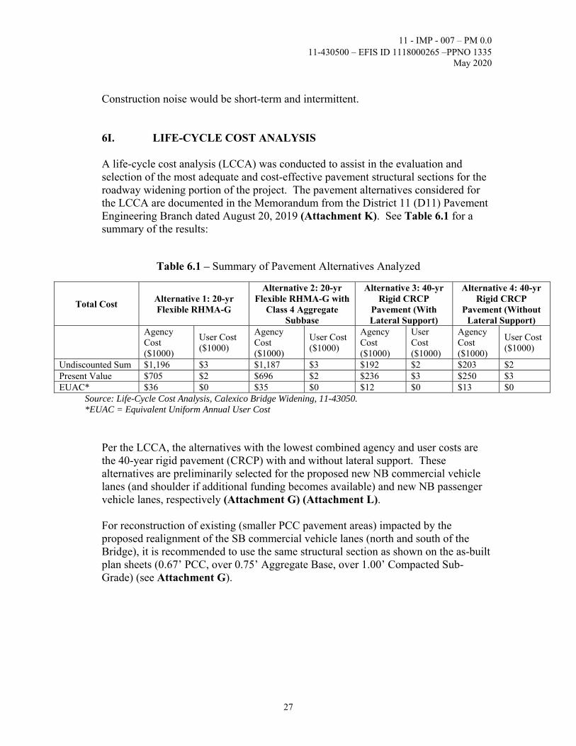
6I. LIFE-CYCLE COST ANALYSIS A life-cycle cost analysis (LCCA) was conducted to assist in the evaluation and selection of the most adequate and cost-effective pavement structural sections for the roadway widening portion of the project. The pavement alternatives considered for the LCCA are documented in the Memorandum from the District 11 (D11) Pavement Engineering Branch dated August 20, 2019 (Attachment K). See Table 6.1 for a summary of the results:
Table 6.1 – Summary of Pavement Alternatives Analyzed
Total Cost Alternative 1: 20-yr Flexible RHMA-G
Alternative 2: 20-yr Flexible RHMA-G with
Class 4 Aggregate Subbase
Alternative 3: 40-yr Rigid CRCP
Pavement (With Lateral Support)
Alternative 4: 40-yr Rigid CRCP
Pavement (Without Lateral Support)
Agency Cost ($1000)
User Cost ($1000)
Agency Cost ($1000)
User Cost ($1000)
Agency Cost ($1000)
User Cost ($1000)
Agency Cost ($1000)
User Cost ($1000)
Undiscounted Sum $1,196 $3 $1,187 $3 $192 $2 $203 $2 Present Value $705 $2 $696 $2 $236 $3 $250 $3 EUAC* $36 $0 $35 $0 $12 $0 $13 $0
Source: Life-Cycle Cost Analysis, Calexico Bridge Widening, 11-43050. *EUAC = Equivalent Uniform Annual User Cost
Per the LCCA, the alternatives with the lowest combined agency and user costs are the 40-year rigid pavement (CRCP) with and without lateral support. These alternatives are preliminarily selected for the proposed new NB commercial vehicle lanes (and shoulder if additional funding becomes available) and new NB passenger vehicle lanes, respectively (Attachment G) (Attachment L).
For reconstruction of existing (smaller PCC pavement areas) impacted by the proposed realignment of the SB commercial vehicle lanes (north and south of the Bridge), it is recommended to use the same structural section as shown on the as-built plan sheets (0.67’ PCC, over 0.75’ Aggregate Base, over 1.00’ Compacted Sub-Grade) (see Attachment G).

11 - IMP - 007 – PM 0.0 11-430500 – EFIS ID 1118000265 –PPNO 1335
May 2020
28
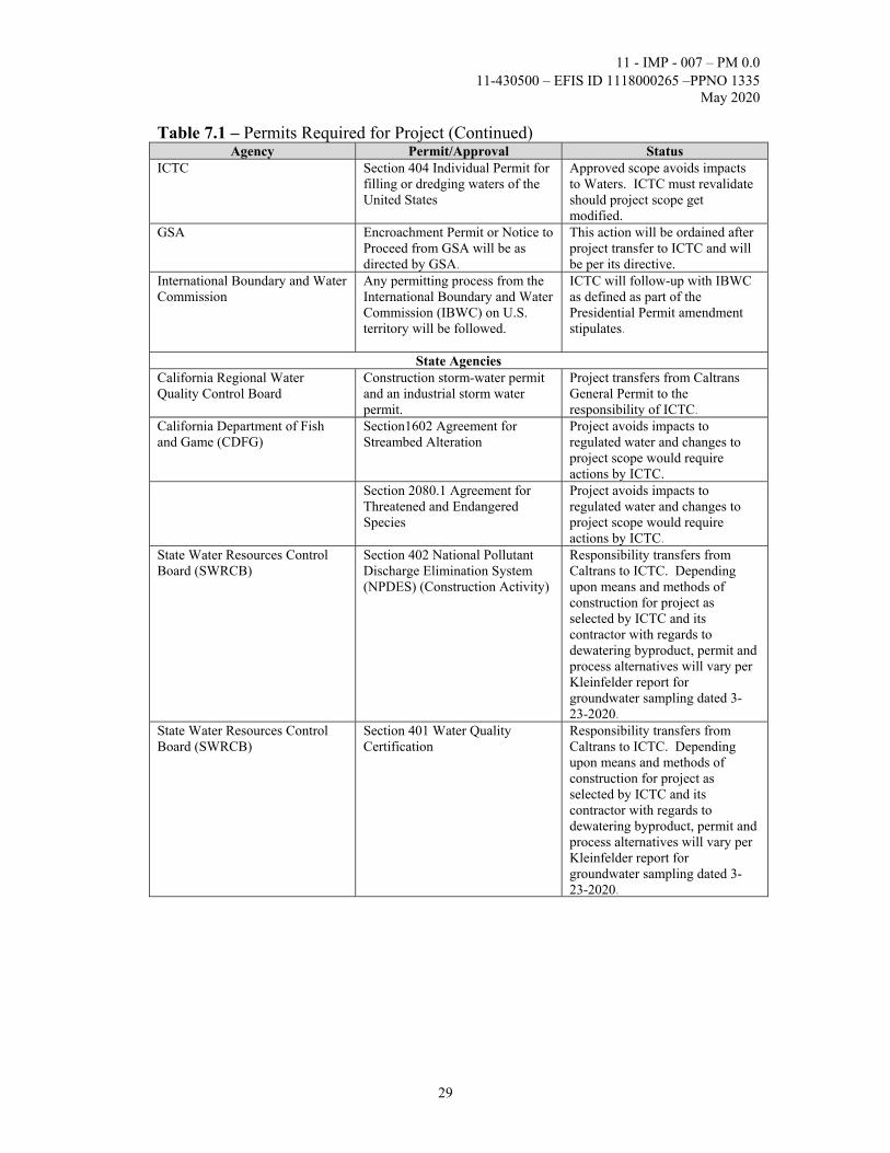
7. OTHER CONSIDERATIONS AS APPROPRIATE Permits Table 7.1 – Permits Required for Project
Agency Permit/Approval Status Federal Agencies
Presidential Permit An amendment to the existing Presidential Permit or an Application to a New Presidential Permit will be required to remove approximately 60 feet of existing border fence to accommodate the proposed widening of the approach roadway from Mexico necessary to merge with the roadway in the U.S.
Prior to project completion General Services Administration (GSA) must amend current permit with Secretary of State.
United States Bureau of Reclamation (USBR)
Project construction and bridge plans will need to be reviewed by USBR. In order to request right -of-way use from USBR, an Application for Transportation and Utility Systems and Facilities on Federal Lands (Standard Form 299) should be submitted to USBR. The application should include design plans, which must outline USBR’s rights-of-way and/or lands, and include the legal description. USBR will require environmental studies/reports for the project along with a plan of development. USBR can review 30, 60, 90, and 100% plans, but can only provide approval on 90 or 100%. Typical application review and processing takes from 120 to 180 days depending on project complexity and other variables (see Attachment H1 for USBR’s application process). Approval may be part of GSA’s requirement.
Prior to Construction General Services Administration Imperial County Transportation Commission (ICTC) must have received approval for project activity.
General Services Administration (GSA)
Project construction and bridge plans approval.
Project hand-off after completion of Project Report and Environmental Document phase transitions project from Caltrans to ICTC and all decision-making transfers with this milestone.
United States Fish and Wildlife Service (USFWS)
No regulatory requirement determined at time of technical report.
ICTC will monitor regulatory environment for changes in law.
11 - IMP - 007 – PM 0.0 11-430500 – EFIS ID 1118000265 –PPNO 1335
May 2020
29
Table 7.1 – Permits Required for Project (Continued) Agency Permit/Approval Status
ICTC Section 404 Individual Permit for filling or dredging waters of the United States
Approved scope avoids impacts to Waters. ICTC must revalidate should project scope get modified.
GSA Encroachment Permit or Notice to Proceed from GSA will be as directed by GSA.
This action will be ordained after project transfer to ICTC and will be per its directive.
International Boundary and Water Commission
Any permitting process from the International Boundary and Water Commission (IBWC) on U.S. territory will be followed.
ICTC will follow-up with IBWC as defined as part of the Presidential Permit amendment stipulates.
State Agencies California Regional Water Quality Control Board
Construction storm-water permit and an industrial storm water permit.
Project transfers from Caltrans General Permit to the responsibility of ICTC.
California Department of Fish and Game (CDFG)
Section1602 Agreement for Streambed Alteration
Project avoids impacts to regulated water and changes to project scope would require actions by ICTC.
Section 2080.1 Agreement for Threatened and Endangered Species
Project avoids impacts to regulated water and changes to project scope would require actions by ICTC.
State Water Resources Control Board (SWRCB)
Section 402 National Pollutant Discharge Elimination System (NPDES) (Construction Activity)
Responsibility transfers from Caltrans to ICTC. Depending upon means and methods of construction for project as selected by ICTC and its contractor with regards to dewatering byproduct, permit and process alternatives will vary per Kleinfelder report for groundwater sampling dated 3-23-2020.
State Water Resources Control Board (SWRCB)
Section 401 Water Quality Certification
Responsibility transfers from Caltrans to ICTC. Depending upon means and methods of construction for project as selected by ICTC and its contractor with regards to dewatering byproduct, permit and process alternatives will vary per Kleinfelder report for groundwater sampling dated 3-23-2020.

11 - IMP - 007 – PM 0.0 11-430500 – EFIS ID 1118000265 –PPNO 1335
May 2020
30
Table 7.1 – Permits Required for Project (Continued) Agency Permit/Approval Status
California Regional Water Quality Control Board
Per IID, a construction storm-water permit and an industrial storm water permit from the California Regional Water Quality Control Board are required for the construction and operation of the proposed facility. Copies of those permits and the project’s Storm Water Pollution Prevention Plan are to be submitted to IID.
Responsibility transfers from Caltrans to ICTC. Depending upon means and methods of construction for project as selected by ICTC and its contractor with regards to dewatering byproduct, permit and process alternatives will vary per Kleinfelder report for groundwater sampling dated 3-23-2020.
Regional and Local Agencies Imperial Irrigation District (IID) Project construction and bridge
plans will need to be reviewed by IID. The IID requires an IID encroachment permit process to be followed. Any construction or operation on IID property or within its existing and proposed right of way or easements will require an encroachment permit or encroachment agreement. An IID encroachment permit will be required to utilize existing surface-water drainpipe connections to drains and receive drainage service from IID. Surface-water drainpipe connections are to be modified in accordance with IID standards. IID should be consulted prior to the installation of any facilities adjacent to IID’s facilities (see Attachment H2 for additional requirements from IID).
These permits will be obtained after approval of the environmental document by ICTC or its agents.
California Air Quality Management District
Rule 1403
ICTC must comply with requirements by submitting test results which were negative for Asbestos containing materials planned for demolition. Must be revalidated should scope change.
Regional and Local Agencies Private Property Owners
Property access and temporary construction easements (TCEs)
None identified but it will be responsibility of ICTC to deny or approve solicitation should a request evolve.
Coordination with U.S. CBP should occur during all construction activity.

11 - IMP - 007 – PM 0.0 11-430500 – EFIS ID 1118000265 –PPNO 1335
May 2020
31
Cooperative Agreements In order to secure BUILD America grant funds and to expedite project delivery, a Design/Build (D/B) project delivery method will be pursued. It is anticipated that a contractor will construct the project and the construction management performed by the same private entity preparing the PS&E (with possible Caltrans oversight). Roles and responsibilities will have to be outlined in a Cooperative Agreement. An agreement between the U.S. Bureau of Reclamation (USBR) and GSA to outline ownership, operation and maintenance responsibilities for the Bridge will be required.
Use of U.S. Bureau of Reclamation Structures Use of any structure owned by USBR for pre-construction/construction access will need to be coordinated with and approved by USBR and the Imperial Irrigation District (IID). Should there be requests to use these structures, a right-of-use application should be submitted to USBR and IID.
Transportation Management Plan Coordination with U.S. CBP will be required to develop a Transportation Management Plan (TMP) that meets their needs for a Border Crossing.
Stage Construction
It is anticipated that the construction of the Build alternative will occur in three stages as shown on Attachment G.
A detailed stage construction and traffic handling plan will be developed during the Design/Build phase to minimize impact to traffic. It is proposed that the assembly of the composite welded steel girders be done in the open southeast area within the Calexico East POE complex. A traffic handling plan for the mobility of construction equipment in and out the POE complex will be required as well. Existing solar panels would have to be protected. Per GSA, these solar panels are cleaned quarterly. Accommodation of Oversize Loads The bridge and roadway widening will accommodate vehicles of unrestricted height.

11 - IMP - 007 – PM 0.0 11-430500 – EFIS ID 1118000265 –PPNO 1335
May 2020
32
Asset Management Since this project is in a federal facility, the asset management requirements do not apply.
Complete Streets
The Calexico East POE and the project accommodate pedestrians, truckers, and motorists.
Climate Change Considerations
The Build alternative would result in a net decrease in average emissions, when compared to the future No Build, due to operational and processing improvements which will enhance traffic circulation through this area and would help reduce GHG levels from commercial vehicles. The project will not cause or contribute to adverse regional or localized air quality impacts. Geotechnical Considerations A Preliminary Foundation Report (PFR) dated August 19, 2019 was prepared for the project. Development of the PFR included field investigation, research of archived information, and engineering analyses. The PFR is included as Attachment P of this Project Report. Detailed descriptions of the field investigation, site geology, subsurface conditions, groundwater, scour evaluation, corrosion evaluation, seismic design information and recommendations are included in the PFR.
Preliminary Foundation Recommendations The PFR recommends Class 200 Alternative “W” driven steel pipe pile with close end as the foundation type. According to the PFR, the closed end can be achieved by welding either a flat plate or a conical point to the base of the pile. Preliminary foundation design data, pile loads, and preliminary design recommendations are included in the PFR. For foundation analyses, the groundwater table is assumed to be 5 feet below ground surface.
Per the PFR, the channel banks are susceptible to seismically induced lateral spreading and settlement, which will greatly increase lateral soil pressure, and reduce the lateral and vertical resistances of the piles. These effects need to be considered in final foundation design. Furthermore, liquefaction will likely cause the box culverts (tunnels) and approach embankments at both ends of the bridge to settle significantly more than the bridge itself during strong seismic events.

11 - IMP - 007 – PM 0.0 11-430500 – EFIS ID 1118000265 –PPNO 1335
May 2020
33
The PFR also includes notes for structure design and construction considerations, which include:
Design pile tip for lateral load will be provided by the Structure Design Team. Permanent sheet piles may be needed for protection of pile caps from erosion
of channel banks. The pile embedment length is recommended to be twice the exposed height.
Hard pile driving is anticipated at both abutments due to the presence of hard clay and very dense sand.
Foundation construction will likely encounter groundwater. Dewatering may be required.
Broadband and Advance Technologies Another Caltrans District 11 project (EA 11-427501) will be installing wireless technology devices (Wi-Fi) or radio frequency identification (RFID) readers to monitor incoming passenger vehicles or commercial vehicles from Mexico. This is part of a Border Wait Time study is aimed at measuring border delays and providing this information to potential POE users by means of the Caltrans QuickMap mobile application (app).
8. FUNDING, PROGRAMMING AND ESTIMATE Funding: The California Transportation Commission (CTC) approved this project as part of the 2018 Trade Corridor Enhancement Program (TCEP) of the Road Repair and Accountability Act of 2017 (Senate Bill 1 (SB-1)). A total of $3 million was approved for the PA&ED phase of this project. ICTC received approval for a total of $20 million from the 2018 U.S. Department of Transportation (DOT) Better Utilizing Investments to Leverage Development (BUILD) Transportation Development Grants. These are funds intended for design and construction and should be obligated before the September 30, 2020 deadline (thus the D/B project delivery method proposed for this project). These BUILD funds must be expended before September 30, 2025. ICTC will provide $1.844 million in local funds. Remaining funds have not been programmed at this time.
Programming The PIR (referred to in Section 3 “Background” of this PR) programmed the project to proceed to the PA&ED phase. The approval of this PR and the Categorical Exemption/Categorical Exclusion Determination Form would secure approval of this project to proceed to the D/B phase. This approval would enable ICTC to formally obligate the 2018 BUILD Grant for this project.

11 - IMP - 007 – PM 0.0 11-430500 – EFIS ID 1118000265 –PPNO 1335
May 2020
34
Below please find proposed funding allocation tables for the Build Alternative Options A and B (as defined in subsection “Cost Estimates” above).
Table 8.1 – Funding Allocation Table (Build Alternative – Option A)
Fund Source Fiscal Year Estimate
TCEP/BUILD/ Local
Prior 18/19 19/20 20/21 21/22 22/23 23/24 Future Total
Component In thousands of dollars ($1,000)
PA&ED Support 3,000 3,000
PS&E Support 2,769 2,769 Right-of-Way Support
Construction Support
3,478 3,478
Right-of-Way 4 4
Construction 15,806 15,806
Total 3,000 2,769 19,288 25,057
The support cost ratio is 58% (40% for D/B effort). The TCEP is the fund source for the PA&ED phase. The U.S. DOT BUILD Transportation Development Grant and Local Funds are the fund sources for the PS&E and Construction phases.
Table 8.2 – Funding Allocation Table (Build Alternative – Option B)
Fund Source Fiscal Year Estimate
TCEP/BUILD/ Local
Prior 18/19 19/20 20/21 21/22 22/23 23/24 Future Total
Component In thousands of dollars ($1,000)
PA&ED Support 3,000 3,000
PS&E Support 3,798 3,798 Right-of-Way Support
Construction Support
4,642 4,642
Right-of-Way 4 4
Construction 21,094 21,094
Total 3,000 3,798 25,740 32,550
The support cost ratio is 54% (40% for D/B effort). The TCEP is the fund source for the PA&ED phase. The U.S. DOT BUILD Transportation Development Grant and Local Funds are the fund sources for the PS&E and Construction phases (up to $21.844 million).

11 - IMP - 007 – PM 0.0 11-430500 – EFIS ID 1118000265 –PPNO 1335
May 2020
35
Estimate: The total current project estimate cost for the project (no shoulder and maintenance of existing bridge 3) (excluding PA&ED support costs) is $20,806,000. The total project cost (including PA&ED support costs) is $25,057,000 escalated to the year of construction, 2021 (See Table 8.1 and Attachment M1).
The total current project estimate cost for the project (with shoulder, maintenance of existing bridges 1, 2 and 3, maintenance of existing tunnels, and construction of bridge canopy) is $27,862,000. The total project cost (including PA&ED support costs) is $32,550,000 escalated to the year of construction, 2021. (See Table 8.2 and Attachment M2).
9. DELIVERY SCHEDULE
Table 9.1 – Project Milestones
Project Milestones Milestone Date
(Month/Day/Year)
Milestone Designation
(Target/Actual) PROGRAM PROJECT M015 08/15/2018 A
BEGIN PROJECT M040 10/01/2018 A
BEGIN ENVIRONMENTAL M020 10/20/2018 A
NOTICE OF PREPARATION (NOP) M030 08/15/2019 A
APPROVE FED M160 04/13/2020
PA&ED M200 05/20/2020
AWARD D/B M495 02/03/2021
BEGIN DESIGN M210 03/01/2021
RIGHT OF WAY CERTIFICATION M410 01/29/2021
CONTRACT ACCEPTANCE M600 10/01/2022
PROJECT CLOSEOUT INITIATED M650 02/09/2023
END PROJECT EXPENDITURES M800 01/09/2025
The total cost of the PA&ED phase is $3,000,000 of which $2,247,165 has been expended to date. As this project is utilizing the D/B delivery method the 0-phase will remain open until the D/B contract is awarded. The remaining funding will be expended during this period in support of the D/B procurement.
A

11 - IMP - 007 – PM 0.0 11-430500 – EFIS ID 1118000265 –PPNO 1335
May 2020
36
10. RISKS
The Risk Register was updated to remove identified risks that were already addressed. Geotechnical issues that may increase costs and require subsurface exploration were resolved. The risk associated with hazardous soil and materials was deleted as a study was done and resulted in no ADL findings in the project area.
Other identified risks associated with utilities relocation, environmental process, construction costs and funding were removed from the Register. Active risks are dewatering, coordination with other agencies, partial inspection (of existing bridge and tunnel structures), reduced contingency for bridge and tunnels items, and the Presidential Permit. See Attachment N for a detailed discussion of these risks and associated costs. Additional risks could be identified during the D/B phase of the project.
11. EXTERNAL AGENCY COORDINATION
Federal Highway Administration (FHWA) The project will be a “Project of Division Interest” since it meets two California Division criteria for selection: Innovative Contracting Method – Design-Build, and Discretionary Grants Recipient – BUILD. There has been an ongoing coordination with FHWA on the development of the project. National Environmental Policy Act (NEPA) review and approval for this project has been delegated to Caltrans.
The project requires the following coordination: - General Services Administration - U.S. Customs and Border Protection - U.S. Bureau of Reclamation - International Boundary and Water Commission - Imperial Irrigation District - Sistema de Administración Tributaria (Mexican Federal Government) - Secretaría de Comunicaciones y Transportes (Mexican Federal Government) - Secretaría de Infraestructura, Desarrollo Urbano, y Reorganización Territorial del
Estado de Baja California (Mexican State of Baja California Government) - Comisión Internacional de Límites y Aguas
11 - IMP - 007 – PM 0.0 11-430500 – EFIS ID 1118000265 –PPNO 1335
May 2020
37
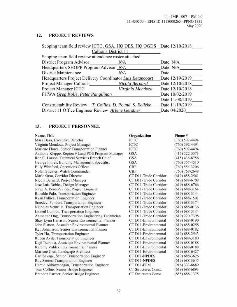
12. PROJECT REVIEWS Scoping team field review ICTC, GSA, HQ DES, HQ OGDS Date 12/10/2018 Caltrans District 11 Scoping team field review attendance roster attached. District Program Advisor N/A Date N/A Headquarters SHOPP Program Advisor N/A Date N/A District Maintenance N/A Date Headquarters Project Delivery Coordinator Luis Betancourt Date 12/19/2019 Project Manager Caltrans Nicola Bernard Date 12/10/2018 Project Manager ICTC Virginia Mendoza Date 12/10/2018 FHWA Greg Kolle, Peter Pangilinan Date 10/02/2019 Date 11/08/2019 Constructability Review T. Collins, D. Pound, S. Felleke Date 11/19/2019 District 11 Office Engineer Review Arlene Gerstner Date 04/2020
13. PROJECT PERSONNEL Name, Title Organization Phone # Mark Baza, Executive Director ICTC (760) 592-4494 Virginia Mendoza, Project Manager ICTC (760) 592-4494 Marlene Flores, Senior Transportation Planner ICTC (760) 592-4494 Anthony Kleppe, Region 9 Land POE Program Manager GSA (415) 522-3373 Ron C. Larson, Technical Services Branch Chief GSA (415) 436-8756 George Flores, Building Management Specialist GSA (760) 357-4510 Billy Whitford, Operations Officer CBP (760) 554-3206 Nolan Stickles, Watch Commander CBP (760) 768-2648 Mario Orso, Corridor Director CT D11-Trade Corridor (619) 688-2561 Nicola Bernard, Project Manager CT D11-Trade Corridor (619) 688-6708 Jose Luis Robles, Design Manager CT D11-Trade Corridor (619) 688-6766 Jorge A. Perez-Valdes, Project Engineer CT D11-Trade Corridor (619) 688-3164 Ronaldo Palo, Transportation Engineer CT D11-Trade Corridor (619) 688-3144 Ryan Fallica, Transportation Engineer CT D11-Trade Corridor (858) 688-1501 Sreedevi Ponduri, Transportation Engineer CT D11-Trade Corridor (619) 688-3174 Nicholas Ventrilla, Transportation Engineer CT D11-Trade Corridor (619) 688-0136 Lioneil Lumido, Transportation Engineer CT D11-Trade Corridor (619) 688-3144 Antonette Ong, Transportation Engineering Technician CT D11-Trade Corridor (619) 220-7398 Shay Lynn Harrison, Senior Environmental Planner CT D11-Environmental (619) 688-0190 John Slatton, Associate Environmental Planner CT D11-Environmental (619) 688-0258 Ken Johansson, Senior Environmental Planner CT D11-Environmental (619) 688-0182 Tyler Ho, Transportation Engineer CT D11-Environemntal (619) 688-2543 Ruben Avila, Transportation Engineer CT D11-Environmental (619) 688-3180 Koji Tsunoda, Associate Environmental Planner CT D11-Environmental (619) 688-0188 Karemy Valdez, Environmental Planner CT D11-Environmental (619) 688-0188 Marlene Gros, Landscape Architect CT D11-Environmental (619) 688-6427 Carl Savage, Senior Transportation Engineer CT D11-NPDES (619) 688-3626 Roy Santos, Transportation Engineer CT D11-NPDES (619) 688-3645 Hamid Akbarzadegan, Transportation Engineer CT D11-PPM (916) 333-8689 Tom Collins, Senior Bridge Engineer CT Structures Const. (619) 688-6893 Brandon Farmer, Senior Bridge Engineer CT Structures Const. (858) 688-1375

11 - IMP - 007 – PM 0.0 11-430500 – EFIS ID 1118000265 –PPNO 1335
May 2020
38
Mina Pezeshpour, Office of Bridge Design South Chief CT Structure Design (909) 598-8103 Dawit Worku, Senior Bridge Engineer CT Structure Design (909) 595-4506 Prem Rimal, Senior Bridge Engineer CT Structure Design (909) 595-7614 Krishnakant Andurlekar, Technical Liaison Engineer CT Structure Design (916) 227-8381 Tamara Marchenko, Project Engineer CT ODTS (916) 227-0402 Annie Chen, Transportation Engineer CT Struct. Office Engineer (916) 227-1154 Richard Rusnak, OGDS Chief – Branch B CT OGDS (916) 799-5351 Sunny Yang, Transportation Engineer CT OGDS (858) 467-6922 Jeff Tesar, Engineering Geologist CT OGDS (858) 467-2716 Julio Reyes, Acting Senior Transportation Engineer CT D11-Materials Lab. (619) 571-2091 Fariba Ramos, Senior Transportation Electrical Engineer CT D11-Electrical Design (619) 688-4248 Enrique Bernal, Transportation Electrical Engineer CT D11-Electrical Design (619) 688-6875 Joel Sims, Transportation Engineer CT D11-Signing/Striping (619) 688-6880 Iram Syed, Transportation Engineer CT D11-Signing/Striping (619) 718-7850 Karina Cantero-Angel, Senior Transportation Engineer CT D11-Traffic Ops. (619) 688-3233 Jose Ornelas, Transportation Engineer CT D11-Traffic Ops. (619) 688-3140 Enrique Ramirez, Transportation Engineer CT D11-Traffic Ops. (619) 688-3257 Arlene Gerstner, Transportation Engineer CT D11-Office Engineer (619) 688-3184
14. ATTACHMENTS (81)
A. Vicinity Map (1) B. Existing Conditions (1) C1. Lane Configuration for Build Scenario – Option A (1) C2. Lane Configuration for Build Scenario – Option B (2) D1. APS Calexico Bridge Widening – No Shoulder (2) D2. APS Calexico Bridge Widening – 8-foot Shoulder (2) E1. APS Calexico Tunnels Extension – No Shoulder (3) E2. APS Calexico Tunnels Extension – 8-foot Shoulder (3) F. APS Calexico Bridge Rehabilitation (1) G. Preliminary Roadway Plans (10) H1. USBR Right-of-Way Use Application Process (1) H2. IID Requirements (3) I. Summary of Nonstandard Design Features (2) J. Right of Way Data Sheet (4) K. Structural Section Pavement Recommendations (2) L. Life Cycle Cost Analysis (10) M1. Cost Estimate – Build Alternative (Option A) (11) M2. Cost Estimate – Build Alternative (Option B) (11) N. Risk Register (1) O. Storm Water Data Report (1) P. Preliminary Foundation Report (8) Q. Categorical Exemption/Exclusion Determination (2)