project proposal for pds under hydrology …hydrologyproject.cg.gov.in/images/pds kharun-sub...
TRANSCRIPT

PROJECT PROPOSAL FOR PDS UNDER HYDROLOGY PROJECT PHASE-II
WATER AVAILABILITY STUDY AND SUPPLY- DEMAND ANALYSIS INWATER AVAILABILITY STUDY AND SUPPLY- DEMAND ANALYSIS IN SEONATH SUB-BASIN OF CHHATTISGARH STATE
TITLE CHANGED AS
WATER AVAILABILITY STUDY AND SUPPLY-DEMAND ANALYSIS IN KHARUN SUB BASIN OF SEONATH BASIN ININ KHARUN SUB-BASIN OF SEONATH BASIN IN
CHHATTISGARH STATE
WATER RESOURCES DEPARTMENT, GOVT. OF CHHATTISGARH, RAIPUR
NATIONAL INSTITUTE OF HYDROLOGYNATIONAL INSTITUTE OF HYDROLOGY GANGA PLAINS SOUTH REGIONAL CENTRE,
SAGAR (M.P.)
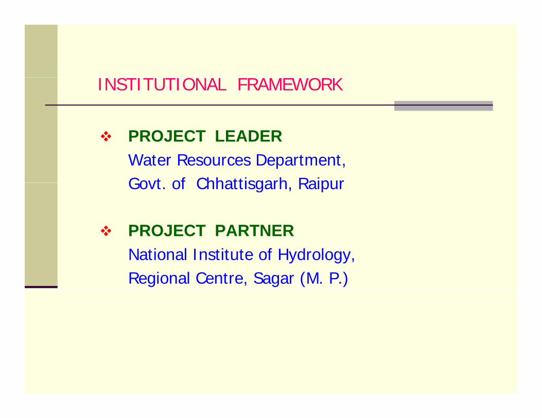
S O OINSTITUTIONAL FRAMEWORK
PROJECT LEADERPROJECT LEADERWater Resources Department, Govt of Chhattisgarh RaipurGovt. of Chhattisgarh, Raipur
PROJECT PARTNERPROJECT PARTNER National Institute of Hydrology, Regional Centre, Sagar (M. P.)
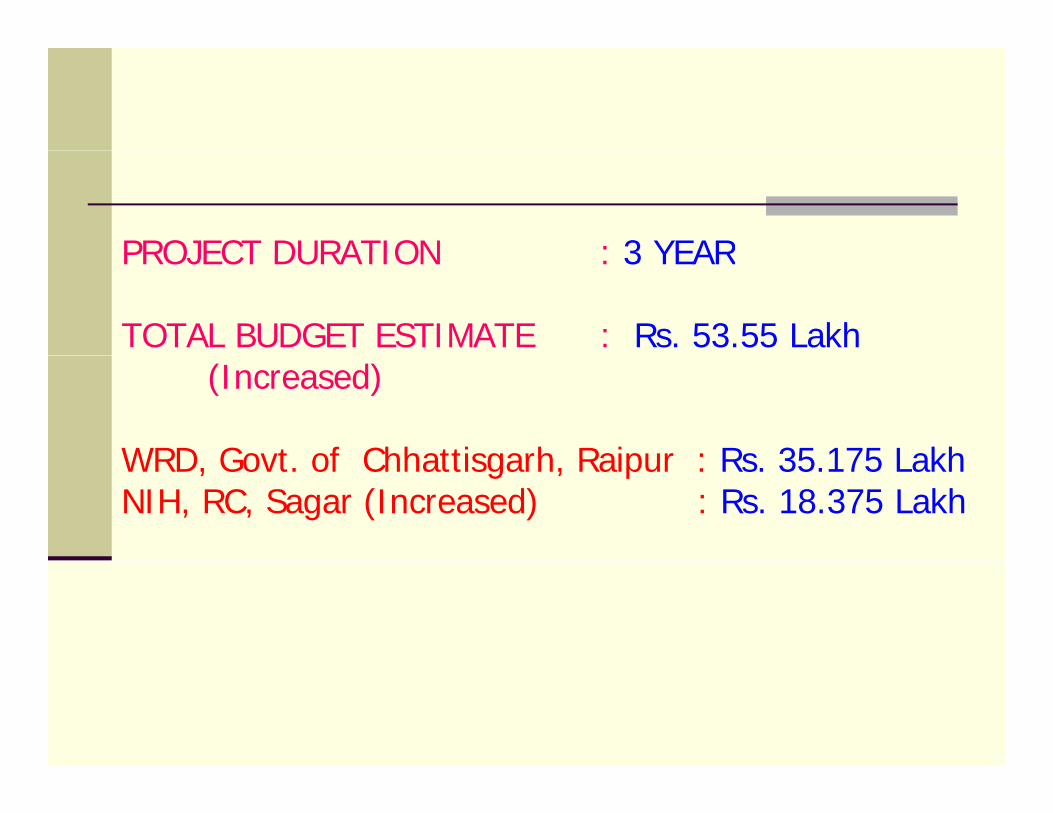
PROJECT DURATION : 3 YEARPROJECT DURATION : 3 YEAR
TOTAL BUDGET ESTIMATE : Rs. 53.55 Lakh (Increased)
WRD Govt of Chhattisgarh Raipur : Rs 35 175 LakhWRD, Govt. of Chhattisgarh, Raipur : Rs. 35.175 Lakh NIH, RC, Sagar (Increased) : Rs. 18.375 Lakh
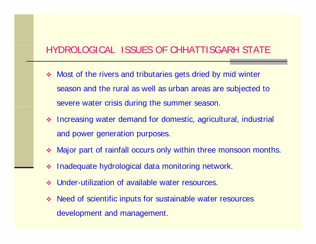
HYDROLOGICAL ISSUES OF CHHATTISGARH STATE
Most of the rivers and tributaries gets dried by mid winterMost of the rivers and tributaries gets dried by mid winter
season and the rural as well as urban areas are subjected to
severe water crisis during the summer season.g
Increasing water demand for domestic, agricultural, industrial
and power generation purposes.p g p p
Major part of rainfall occurs only within three monsoon months.
Inadequate hydrological data monitoring network.Inadequate hydrological data monitoring network.
Under-utilization of available water resources.
Need of scientific inputs for sustainable water resourcesNeed of scientific inputs for sustainable water resources
development and management.
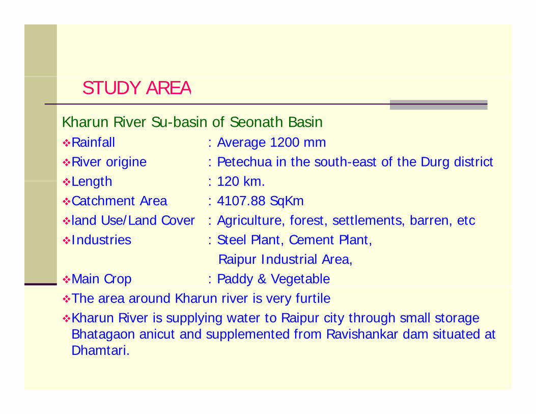
STUDY AREA
Kharun River Su-basin of Seonath BasinRainfall : Average 1200 mm River origine : Petechua in the south-east of the Durg district Length : 120 kmLength : 120 km. Catchment Area : 4107.88 SqKmland Use/Land Cover : Agriculture, forest, settlements, barren, etcIndustries : Steel Plant, Cement Plant,
Raipur Industrial Area, Main Crop : Paddy & Vegetablep y gThe area around Kharun river is very furtileKharun River is supplying water to Raipur city through small storage Bhatagaon anicut and supplemented from Ravishankar dam situated atBhatagaon anicut and supplemented from Ravishankar dam situated at Dhamtari.
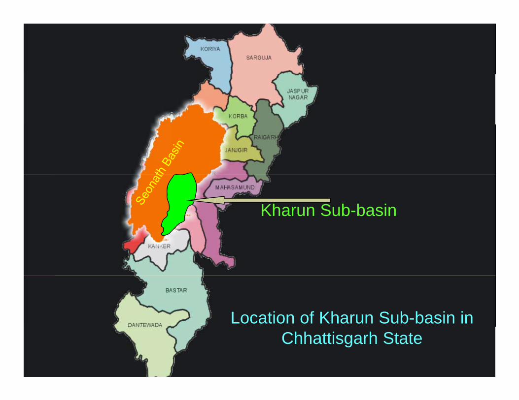
Kharun Sub-basin
Location of Kharun Sub-basin in Chhattisgarh State
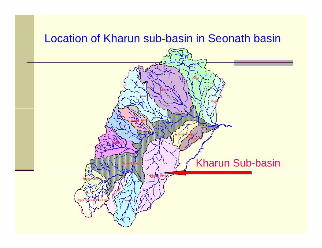
Location of Kharun sub-basin in Seonath basin
A
Lilagar
Arpa
Sakari
Maniyari
Dotua Karua
Jamunia-BanjariKhorsi
Surki
Amner
Seonath Main Kharun Sub-basinSukha-Gamriya
Tandula
Kharun River
Kharkh
oraUpper Seonath(Dalekasa)
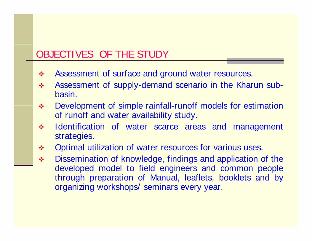
OBJECTIVES OF THE STUDY
Assessment of surface and ground water resourcesAssessment of surface and ground water resources.Assessment of supply-demand scenario in the Kharun sub-basin.Development of simple rainfall runoff models for estimationDevelopment of simple rainfall-runoff models for estimationof runoff and water availability study.Identification of water scarce areas and managementstrategiesstrategies.Optimal utilization of water resources for various uses.Dissemination of knowledge, findings and application of thed l d d l t fi ld i d ldeveloped model to field engineers and common peoplethrough preparation of Manual, leaflets, booklets and byorganizing workshops/ seminars every year.
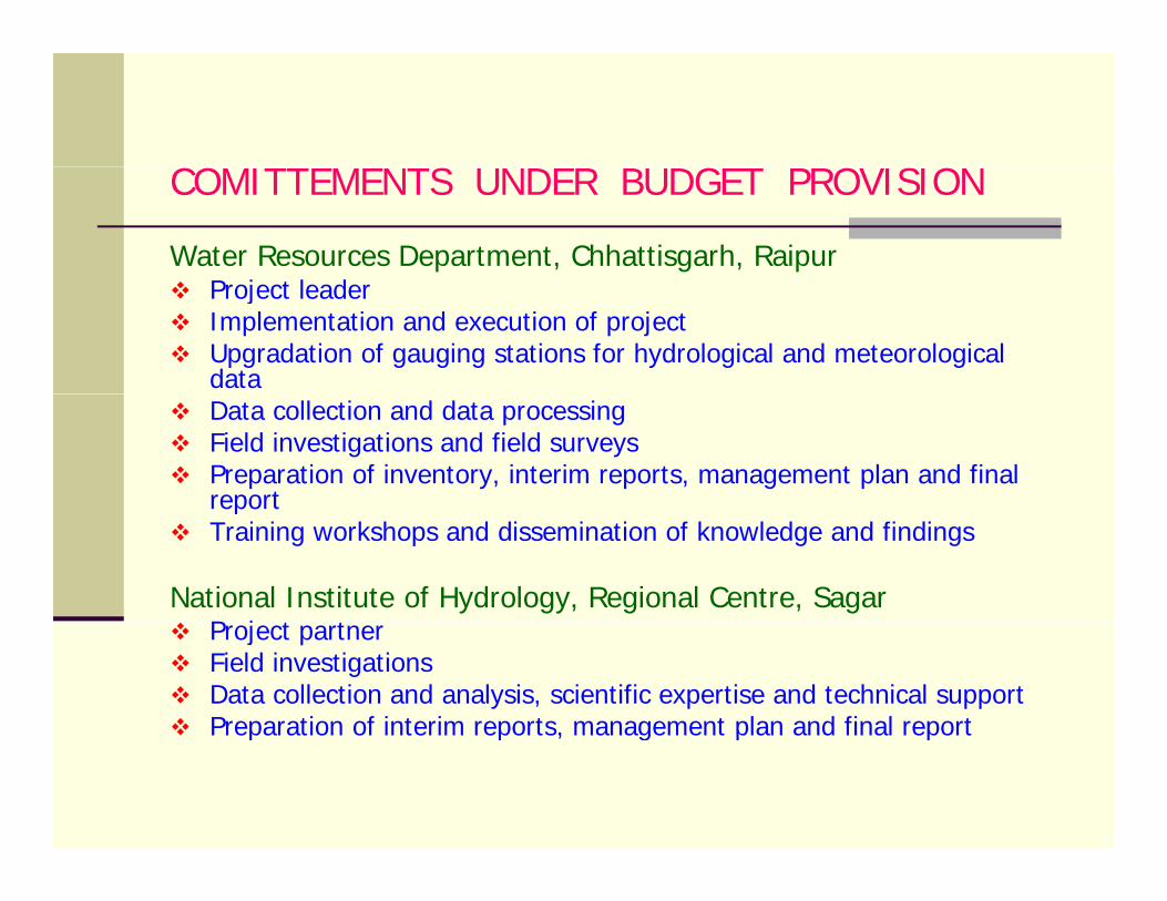
CO S G O S OCOMITTEMENTS UNDER BUDGET PROVISION
Water Resources Department, Chhattisgarh, RaipurP j t l dProject leaderImplementation and execution of project Upgradation of gauging stations for hydrological and meteorological data Data collection and data processing Field investigations and field surveysPreparation of inventory, interim reports, management plan and final reportreportTraining workshops and dissemination of knowledge and findings
National Institute of Hydrology, Regional Centre, SagarP j t tProject partnerField investigationsData collection and analysis, scientific expertise and technical supportPreparation of interim reports, management plan and final reportPreparation of interim reports, management plan and final report
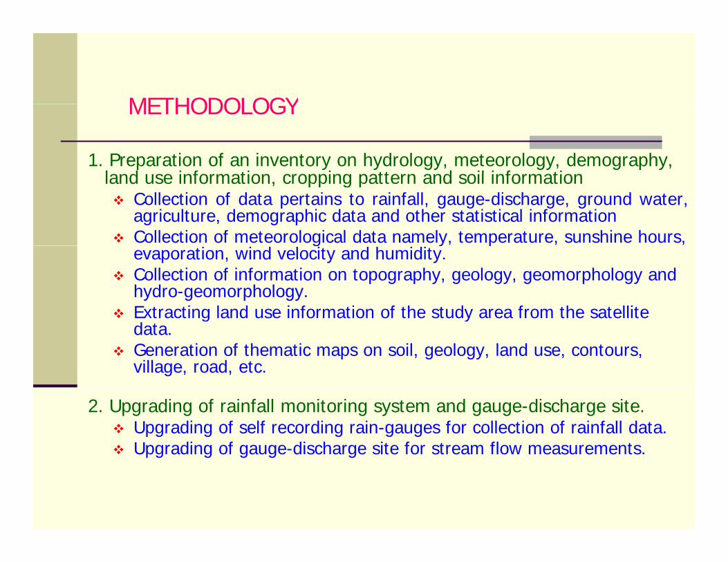
METHODOLOGYMETHODOLOGY
1. Preparation of an inventory on hydrology, meteorology, demography, land use information cropping pattern and soil informationland use information, cropping pattern and soil information
Collection of data pertains to rainfall, gauge-discharge, ground water,agriculture, demographic data and other statistical informationCollection of meteorological data namely, temperature, sunshine hours, g y, p , ,evaporation, wind velocity and humidity.Collection of information on topography, geology, geomorphology and hydro-geomorphology.Extracting land use information of the study area from the satelliteExtracting land use information of the study area from the satellite data.Generation of thematic maps on soil, geology, land use, contours, village, road, etc.
2. Upgrading of rainfall monitoring system and gauge-discharge site.Upgrading of self recording rain-gauges for collection of rainfall data.Upgrading of gauge-discharge site for stream flow measurements.
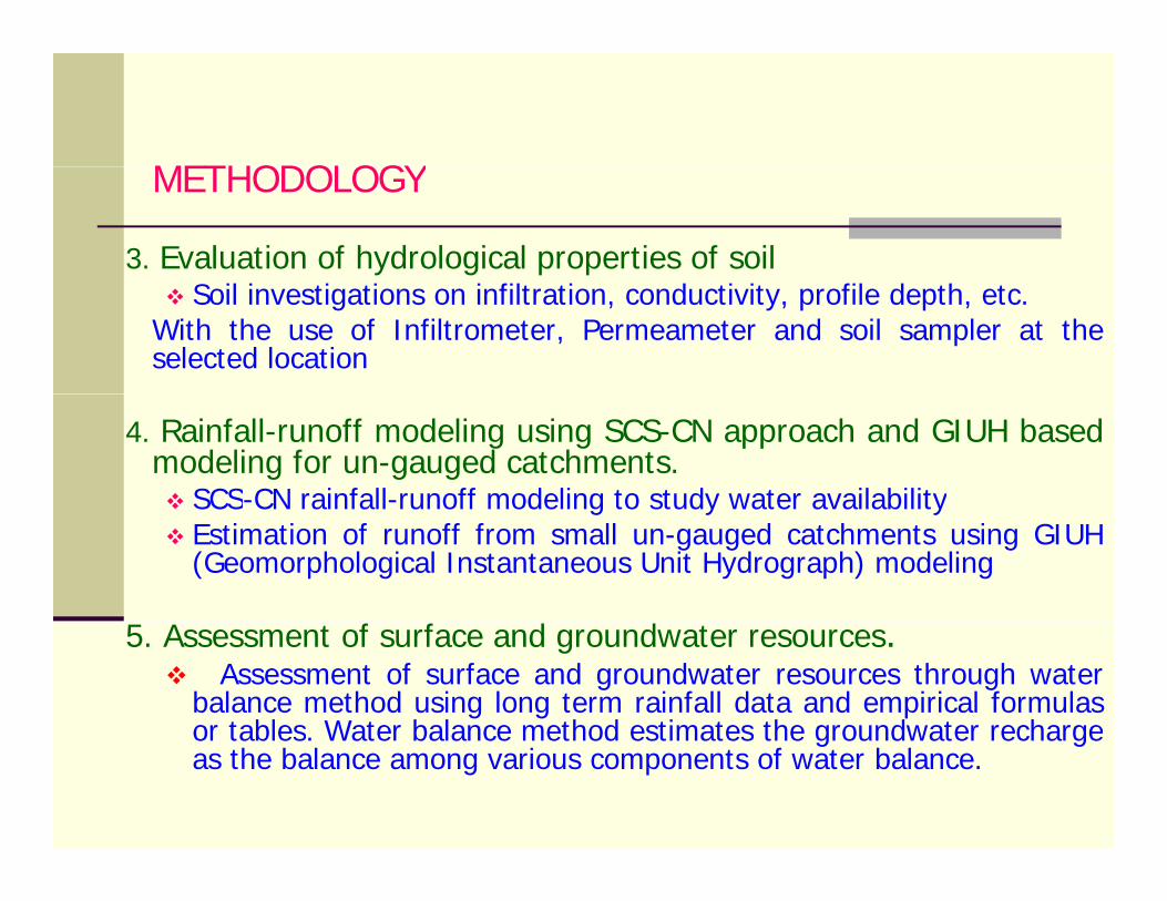
METHODOLOGYMETHODOLOGY
3. Evaluation of hydrological properties of soilSoil investigations on infiltration, conductivity, profile depth, etc.
With the use of Infiltrometer, Permeameter and soil sampler at theselected location
4. Rainfall-runoff modeling using SCS-CN approach and GIUH basedmodeling for un-gauged catchments.
SCS-CN rainfall-runoff modeling to study water availabilitySCS CN rainfall runoff modeling to study water availabilityEstimation of runoff from small un-gauged catchments using GIUH(Geomorphological Instantaneous Unit Hydrograph) modeling
5. Assessment of surface and groundwater resources.Assessment of surface and groundwater resources through water
balance method using long term rainfall data and empirical formulasor tables Water balance method estimates the groundwater rechargeor tables. Water balance method estimates the groundwater rechargeas the balance among various components of water balance.
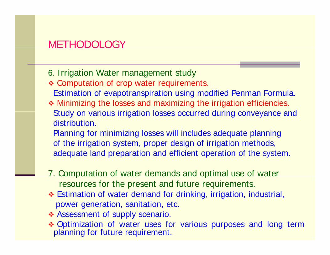
METHODOLOGYMETHODOLOGY
6. Irrigation Water management studyComputation of crop water requirements.
Estimation of evapotranspiration using modified Penman Formula.Minimizing the losses and maximizing the irrigation efficiencies.
Study on various irrigation losses occurred during conveyance andStudy on various irrigation losses occurred during conveyance anddistribution.Planning for minimizing losses will includes adequate planningof the irrigation system proper design of irrigation methodsof the irrigation system, proper design of irrigation methods,adequate land preparation and efficient operation of the system.
7. Computation of water demands and optimal use of water7. Computation of water demands and optimal use of waterresources for the present and future requirements.Estimation of water demand for drinking, irrigation, industrial,power generation, sanitation, etc.p g , ,Assessment of supply scenario.Optimization of water uses for various purposes and long term
planning for future requirement.
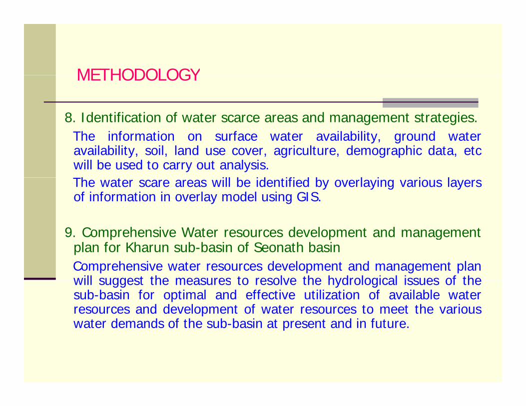
METHODOLOGYMETHODOLOGY
8. Identification of water scarce areas and management strategies.The information on surface water availability, ground wateravailability, soil, land use cover, agriculture, demographic data, etcwill be used to carry out analysis.Th ill b id ifi d b l i i lThe water scare areas will be identified by overlaying various layersof information in overlay model using GIS.
9 C h i W t d l t d t9. Comprehensive Water resources development and managementplan for Kharun sub-basin of Seonath basinComprehensive water resources development and management planwill suggest the measures to resolve the hydrological issues of thewill suggest the measures to resolve the hydrological issues of thesub-basin for optimal and effective utilization of available waterresources and development of water resources to meet the variouswater demands of the sub-basin at present and in future.
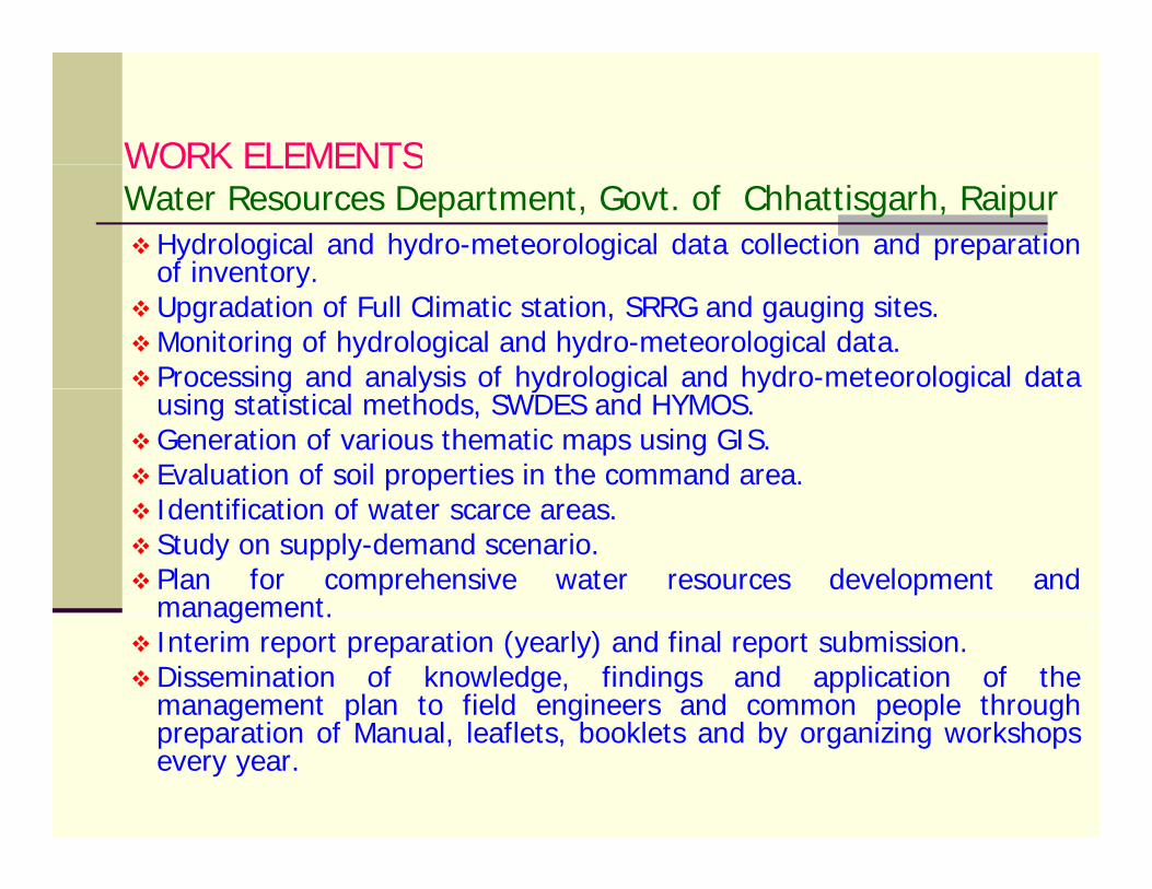
WORK ELEMENTSWORK ELEMENTSWater Resources Department, Govt. of Chhattisgarh, Raipur
Hydrological and hydro-meteorological data collection and preparationof inventoryof inventory.Upgradation of Full Climatic station, SRRG and gauging sites.Monitoring of hydrological and hydro-meteorological data.Processing and analysis of hydrological and hydro-meteorological datag y y g y gusing statistical methods, SWDES and HYMOS.Generation of various thematic maps using GIS.Evaluation of soil properties in the command area.Id tifi ti f tIdentification of water scarce areas.Study on supply-demand scenario.Plan for comprehensive water resources development andmanagementmanagement.Interim report preparation (yearly) and final report submission.Dissemination of knowledge, findings and application of themanagement plan to field engineers and common people through
ti f M l l fl t b kl t d b i i k hpreparation of Manual, leaflets, booklets and by organizing workshopsevery year.

WORK ELEMENTS
Technical support for monitoring of data and data procurement.
WORK ELEMENTS National Institute of Hydrology, Regional Centre, Sagar
pp g pAssessment of present land use using remote sensing data and GIS. Development of rainfall-runoff models and water availability study. Assessment of surface and ground water resources.Assessment of surface and ground water resources.Irrigation water management.Study on supply-demand scenario. Identification of water scarce areasIdentification of water scarce areas.Study on optimal utilization of water under various uses.Development of comprehensive water resources development and management plan for both catchment and the command area.management plan for both catchment and the command area.Interim report preparation (yearly) and Final report submission. Technical support for dissemination of knowledge, findings and application of the management plan to field engineers through pp g p g gpreparation of Manual, leaflets, booklets.
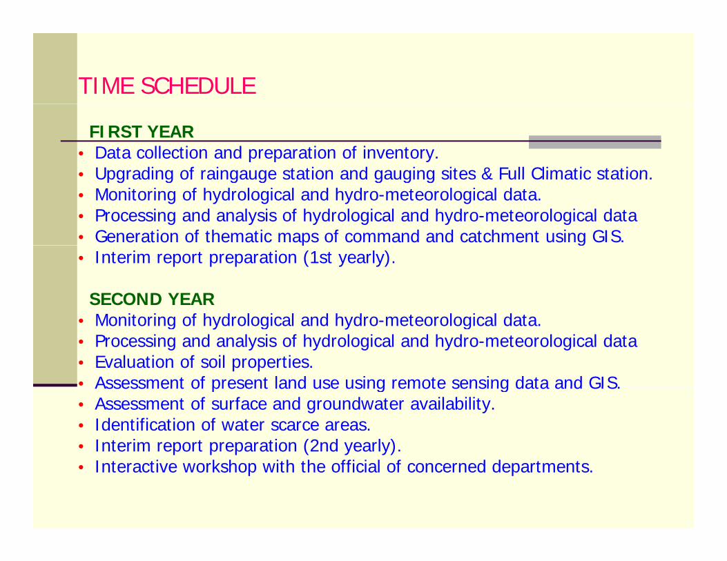
TIME SCHEDULE
FIRST YEAR• Data collection and preparation of inventory.• Upgrading of raingauge station and gauging sites & Full Climatic station• Upgrading of raingauge station and gauging sites & Full Climatic station.• Monitoring of hydrological and hydro-meteorological data.• Processing and analysis of hydrological and hydro-meteorological data • Generation of thematic maps of command and catchment using GIS.p g• Interim report preparation (1st yearly).
SECOND YEARM it i f h d l i l d h d t l i l d t• Monitoring of hydrological and hydro-meteorological data.
• Processing and analysis of hydrological and hydro-meteorological data • Evaluation of soil properties.• Assessment of present land use using remote sensing data and GIS.Assessment of present land use using remote sensing data and GIS. • Assessment of surface and groundwater availability. • Identification of water scarce areas.• Interim report preparation (2nd yearly). • Interactive workshop with the official of concerned departments.
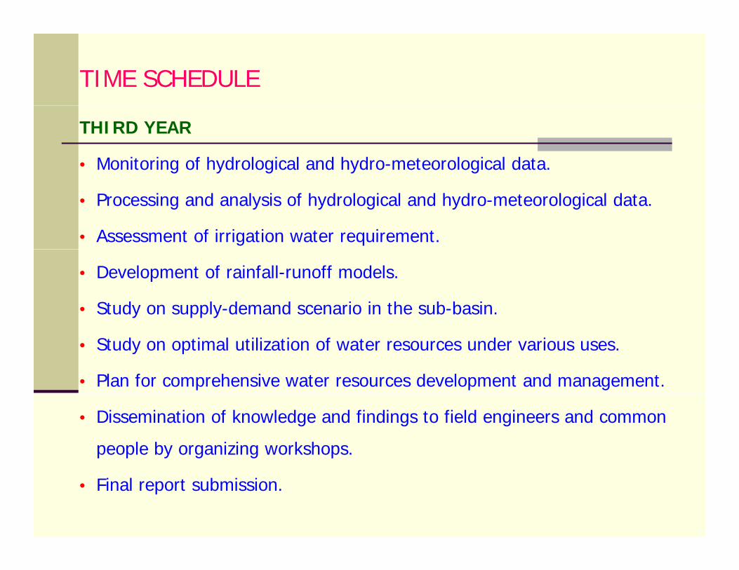
TIME SCHEDULE
THIRD YEAR
• Monitoring of hydrological and hydro-meteorological data.
• Processing and analysis of hydrological and hydro-meteorological data.
• Assessment of irrigation water requirement.
• Development of rainfall-runoff models.
• Study on supply-demand scenario in the sub-basin.
• Study on optimal utilization of water resources under various uses.
• Plan for comprehensive water resources development and management.
• Dissemination of knowledge and findings to field engineers and common
people by organizing workshops.
• Final report submission.
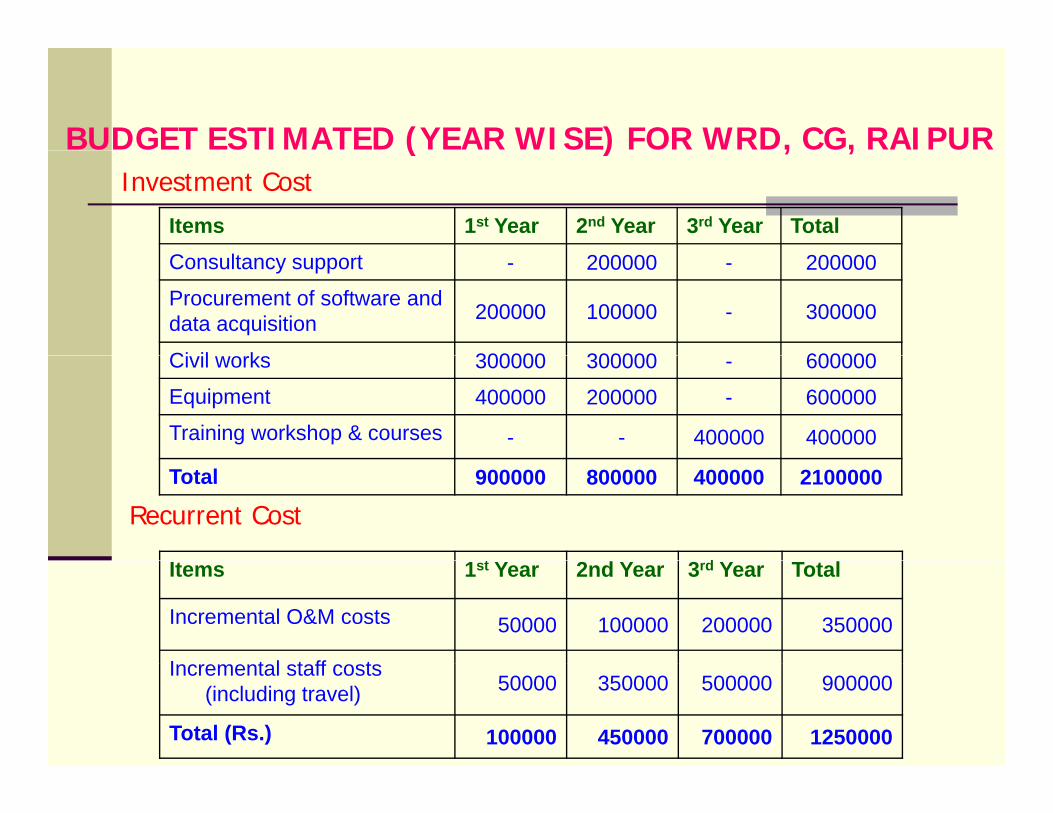
BUDGET ESTIMATED (YEAR WISE) FOR WRD, CG, RAIPUR( ) , ,
Items 1st Year 2nd Year 3rd Year Total
Investment Cost
Consultancy support - 200000 - 200000
Procurement of software and data acquisition 200000 100000 - 300000
Ci il k 300000 300000 600000Civil works 300000 300000 - 600000
Equipment 400000 200000 - 600000
Training workshop & courses - - 400000 400000
Total 900000 800000 400000 2100000
Recurrent Cost
t dItems 1st Year 2nd Year 3rd Year Total
Incremental O&M costs 50000 100000 200000 350000
I t l t ff tIncremental staff costs (including travel) 50000 350000 500000 900000
Total (Rs.) 100000 450000 700000 1250000
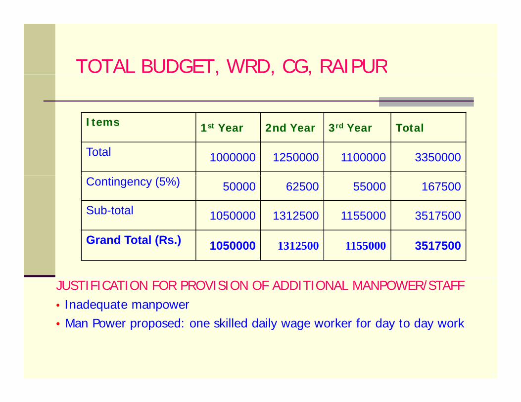
TOTAL BUDGET, WRD, CG, RAIPUR, , ,
Items 1st Y 2 d Y 3rd Y T t lItems 1st Year 2nd Year 3rd Year Total
Total 1000000 1250000 1100000 3350000
Contingency (5%) 50000 62500 55000 167500
Sub-total 1050000 1312500 1155000 3517500
Grand Total (Rs.) 1050000 1312500 1155000 3517500
JUSTIFICATION FOR PROVISION OF ADDITIONAL MANPOWER/STAFF• Inadequate manpower • Man Power proposed: one skilled daily wage worker for day to day workp p y g y y
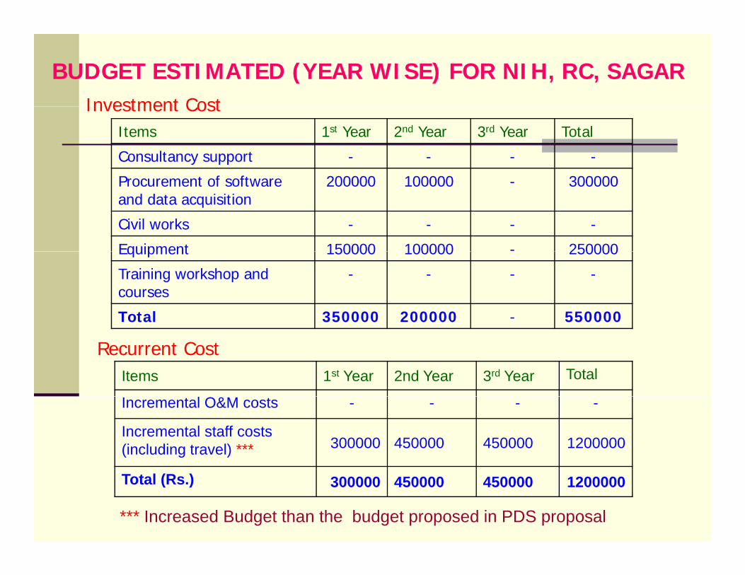
BUDGET ESTIMATED (YEAR WISE) FOR NIH, RC, SAGARInvestment Cost
Items 1st Year 2nd Year 3rd Year Total
Consultancy support - - - -
Procurement of software 200000 100000 300000
Investment Cost
Procurement of software and data acquisition
200000 100000 - 300000
Civil works - - - -
Equipment 150000 100000 - 250000Equipment 150000 100000 250000
Training workshop and courses
- - - -
Total 350000 200000 - 550000
Recurrent CostItems 1st Year 2nd Year 3rd Year Total
Incremental O&M costs - - - -
Incremental staff costs (including travel) *** 300000 450000 450000 1200000
Total (Rs.) 300000 450000 450000 1200000
*** Increased Budget than the budget proposed in PDS proposal
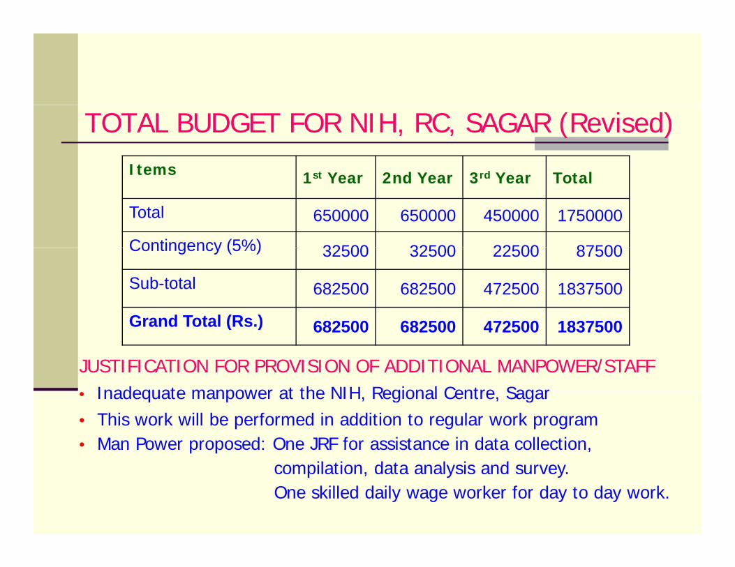
TOTAL BUDGET FOR NIH, RC, SAGAR (Revised)Items 1st Year 2nd Year 3rd Year Total1st Year 2nd Year 3rd Year Total
Total 650000 650000 450000 1750000
Contingency (5%) 32500 32500 22500 87500Contingency (5%) 32500 32500 22500 87500
Sub-total 682500 682500 472500 1837500
Grand Total (Rs )
JUSTIFICATION FOR PROVISION OF ADDITIONAL MANPOWER/STAFFInadequate manpower at the NIH Regional Centre Sagar
Grand Total (Rs.) 682500 682500 472500 1837500
• Inadequate manpower at the NIH, Regional Centre, Sagar• This work will be performed in addition to regular work program• Man Power proposed: One JRF for assistance in data collection,
il ti d t l i dcompilation, data analysis and survey. One skilled daily wage worker for day to day work.
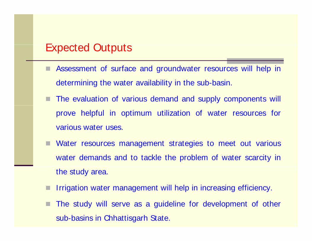
E t d O t tExpected Outputs
Assessment of surface and groundwater resources will help in
determining the water availability in the sub-basin.
The evaluation of various demand and supply components will
prove helpful in optimum utilization of water resources for
various water uses.
Water resources management strategies to meet out various
water demands and to tackle the problem of water scarcity in
the study area.
Irrigation water management will help in increasing efficiency.
The study will serve as a guideline for development of other
sub-basins in Chhattisgarh State.
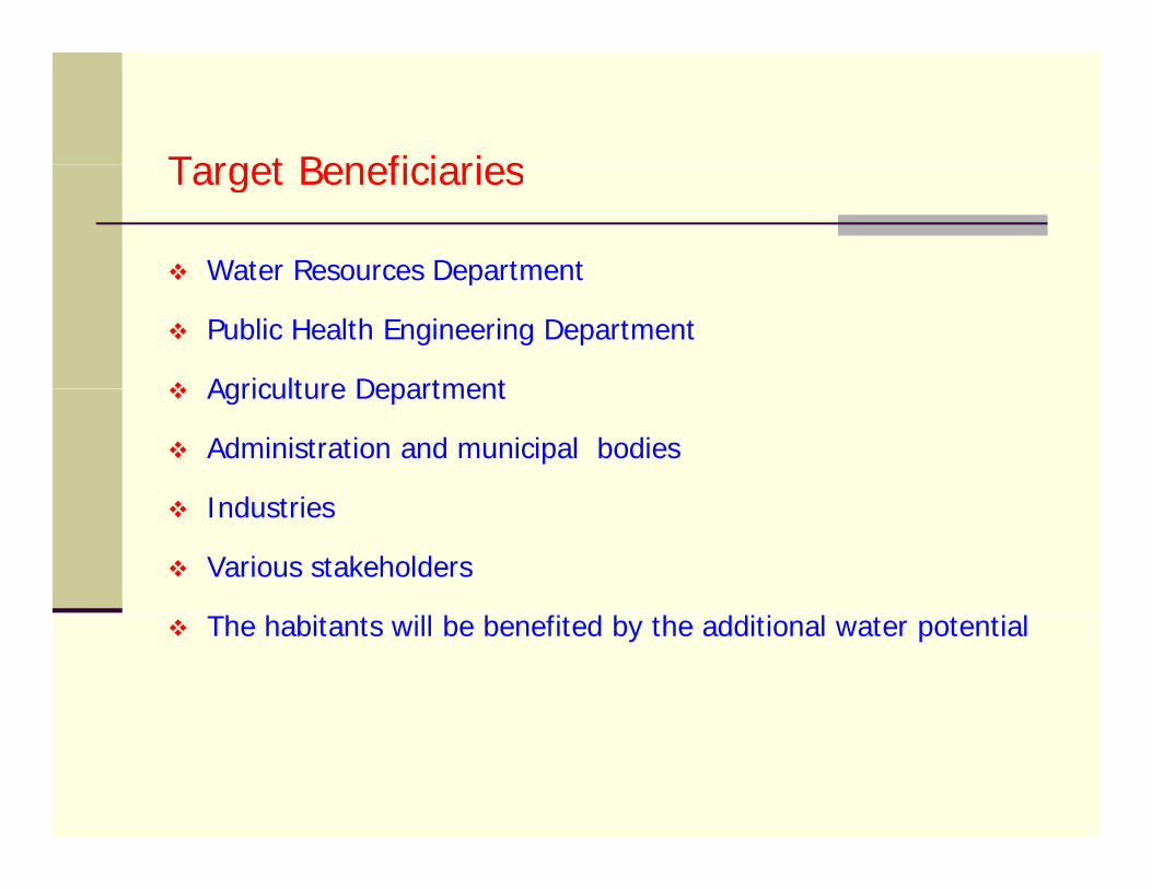
Target BeneficiariesTarget Beneficiaries
Water Resources DepartmentWater Resources Department
Public Health Engineering Department
Agriculture DepartmentAgriculture Department
Administration and municipal bodies
I d t iIndustries
Various stakeholders
The habitants will be benefited by the additional water potential