project management - eastern michigan university
TRANSCRIPT

Managing GIS Projects
This work was supported in part by the National Science Foundation Grant Number9752086.
Managing GIS Projects
Work Site Alliance – Community Based GIS Education ii 2000
This section on Project Management was developed by Work/Site Alliance withcontributions by the following:
• Laura Pinto, Author
• Beverly Hunter, Editor
• Dr. Yiyi Sun, Technical Support
• CEITA Staff

Managing GIS Projects
Work Site Alliance – Community Based GIS Education iii 2000
Table of Contents
TABLE OF CONTENTS...................................................................................................................................III
1. EDUCATORS AS PROJECT MANAGERS ............................................................................................. 1
UNDERSTANDING PROJECT MANAGEMENT CONCEPTS...................................................................................... 1HISTORY AND ORIGINS OF THE DISCIPLINE OF PROJECT MANAGEMENT .......................................................... 3THE ROLE OF PROJECT MANAGEMENT IN WSA/GIS ....................................................................................... 4
Teachers as Project Managers...................................................................................................................... 4Student Acquisition of Project Management Skills ........................................................................................ 4
THE PROJECT MANAGEMENT SKILL SETS ........................................................................................................ 5Project Management Interpersonal Skills...................................................................................................... 5Project Management Organization and Planning Skills ................................................................................ 6
OVERVIEW OF THE PROJECT LIFE CYCLE......................................................................................................... 7Start-Up Stage .............................................................................................................................................. 7Planning Stage ........................................................................................................................................... 10Execution and Control Stage ...................................................................................................................... 14Close-Out Stage.......................................................................................................................................... 14Factors Affecting Project Success ............................................................................................................... 15Factors Affecting Project Failure ............................................................................................................... 15
2. PROJECT MANAGEMENT SOFTWARE APPLICATIONS ............................................................... 17
ADVANTAGES AND DISADVANTAGES OF PROJECT MANAGEMENT SOFTWARE.................................................. 17EXERCISES IN USING MICROSOFT PROJECT .................................................................................................... 18
2.1 GETTING STARTED WITH MICROSOFT PROJECT ....................................................................... 20
STEP 1. LIST ALL THE TASKS IN THE SAMPLE PROJECT .................................................................................... 20STEP 2. OPEN MS PROJECT ON YOUR COMPUTER .......................................................................................... 20STEP 3. UNDERSTANDING THE DEFAULT SCREEN ............................................................................................ 20STEP 4. INPUT THE START AND END DATES FOR THE PROJECT IN THE PROJECT INFORMATION WINDOW ......... 21STEP 5. ENTER THE TASKS INTO THE ENTRY TABLE ....................................................................................... 21STEP 6. DEFINE ATTRIBUTES OF THE TASKS..................................................................................................... 22STEP 7. CREATE A RECURRING TASK. .............................................................................................................. 22
2.2 OUTLINING AND LINKING TASKS .................................................................................................... 23
STEP 1. OUTLINE YOUR TASK LIST .................................................................................................................. 23STEP 2. CREATE LINKS ................................................................................................................................... 24STEP 3. VIEW AND ADJUST THE GANTT CHART ............................................................................................... 25
2.3 MANAGING RESOURCES ................................................................................................................ 25
STEP 1: VIEW THE RESOURCE SHEET.............................................................................................................. 25STEP 2: UPDATE THE RESOURCE SHEET.......................................................................................................... 25STEP 3. CREATE MILESTONES......................................................................................................................... 26STEP 4. VIEW THE WBS .................................................................................................................................. 27STEP 5. OBSERVE AND PRINT VIEWS................................................................................................................ 27STEP 6. GENERATE REPORTS........................................................................................................................... 28
2.4 ANALYZING AND TRACKING THE CRITICAL PATH................................................................ 29
Managing GIS Projects
Work Site Alliance – Community Based GIS Education iv 2000
STEP 1. VIEW AND MODIFY THE CRITICAL PATH.............................................................................................. 29Step 2. View the baseline for the project. .................................................................................................... 30
STEP 3. UPDATE STATUS OF TASKS................................................................................................................... 31STEP 4. UPDATE RESOURCES ........................................................................................................................... 31STEP 5. VIEW THE TRACKING GANTT CHART ................................................................................................. 32
SUMMARY........................................................................................................................................................ 32
3. REFERENCES AND RESOURCES ........................................................................................................ 33
REFERENCES ON PROJECT MANAGEMENT ...................................................................................................... 33Internet Resources................................................................................................................................................... 34
APPENDIX A..................................................................................................................................................... 35
EXAMPLE PROJECT PROPOSAL PRESENTATION .............................................................................................. 35
APPENDIX B..................................................................................................................................................... 38
EXAMPLE PROJECT CONTRACT ...................................................................................................................... 38
APPENDIX C..................................................................................................................................................... 53
EXAMPLE PROJECT PLAN ............................................................................................................................... 53Summary..................................................................................................................................................... 53Hardware Overview.................................................................................................................................... 54Software Overview...................................................................................................................................... 54Performance Standard ................................................................................................................................ 54Milestone Summary .................................................................................................................................... 55Development Milestone Breakdown ............................................................................................................ 55
MILESTONE 1 BREAKDOWN................................................................................................................... 55COMPETITIVE INTELLIGENCE REPORT ........................................................................................................... 55DATA ANALYSIS (6 DAYS) ................................................................................................................................ 56REPORTING (4 DAYS)....................................................................................................................................... 56MILESTONE 2/3/4/5 BREAKDOWN.......................................................................................................... 56RESEARCH (3 DAYS) ........................................................................................................................................ 56DATA ANALYSIS (10 DAYS) .............................................................................................................................. 56REPORTING (4 DAYS)....................................................................................................................................... 56
APPENDIX D..................................................................................................................................................... 57
PROJECT CONCEPT WORKSHEET.................................................................................................................... 57
APPENDIX E ..................................................................................................................................................... 58
PROJECT TASK SHEET .................................................................................................................................... 58Responsibility ......................................................................................................................................................... 58

Managing GIS Projects
Work Site Alliance – Community Based GIS Education 1 2000
1. Educators as Project Managers
A project is a process undertaken to achieve a specific goal that has definedscope and outcomes, can be accomplished within a specific time frame, utilizeshuman effort and a limited set of resources, and is characterized by a sequenceof activities. This project management unit provides the following.
• An introduction to the basic elements of project management, includingconsiderations for teachers and classrooms.
• Exercises in using project management software.
• Project management tools and resources you can tailor for your use in theW/SA Case Studies and in your own projects.
Understanding Project Management Concepts
A project is intended to come to an end and have a finite life, while the productor service of the project is generally intended to have a long or indefinite life. Aproject is a unique undertaking and follows a specific methodology to achieve abeneficial change with a specified outcome.
Examples of projects include:
• Design and creation of a new piece of software, such as a video game orword processing program.
• Creation of a public information system for a city.
• Design and creation of a new product, such as a new soft drink.
• The development of a curriculum or course of study.
• Modification of a computer system to perform a new function, such as addinga new service charge to a bank's central computer system.
Project Management is the approach used to manage non-repetitive work withinthe constraints of time, cost, and performance targets. It is characterized by botha set of skills and by a specific methodology, with a focus on deliverables(specific outcomes that can be measured, such as: schedules, personnel, andcost). The goal of project management is to assure successful completion of aproject with respect to quality (performance), timing (schedule), and budget(cost).

Managing GIS Projects
Work Site Alliance – Community Based GIS Education 2 2000
PERFORMANCE
SCHEDULE COST
Figure 1.1: The Three Project Constraints1
Within those constraints, project managers are responsible for:
• Designing the project – analyzing client requirements, articulating the idea,identifying the goals, breaking goals down into smaller tasks and interimproducts, and scheduling those tasks and products.
• Strategic planning - creating time lines that include all tasks, assigning tasksand roles to individuals and teams, and planning for potential problems andrisk.
• Team management - leading the project teams through the processefficiently.
• Client interface - working with the persons, departments, or organizationsthat the end product affects, and ensuring that all of their needs are met.
• Resource allocation - taking available resources (monetary, materials, time,and human capital) and budgeting all of this into a reasonable, cost-effectiveplan for the project.
In order to perform their roles effectively, project managers must possess avariety of skills. These skills can be divided into two categories: InterpersonalSkills and Organization and Planning Skills. Each of the categories is equallyessential to a project manager's success and will be discussed in more detail insection 5. Without the ability to communicate with and motivate others, a projectmanager will get little accomplished. Similarly, without careful planning andorganization, a project will not succeed.
1 Michael C. Thomsett, The Little Black Book of Project Management (New York: American ManagementAssociation, 1990), 7.

Managing GIS Projects
Work Site Alliance – Community Based GIS Education 3 2000
The project life cycle is a framework for accomplishment followed by projectmanagers throughout North America. Every basic project management modelrequires the manager to first plan the work, then work the plan. Though modelsproposed by different theorists and organizations vary with respect to the namesof the stages, but are extremely similar conceptually.
History and Origins of the Discipline of Project Management
Project management began as a process approximately forty years ago. It hasgrown in popularity among engineering firms and software developers. To date,no single methodology has been offered as the correct way to conduct a project.Many different methodologies have been brought forward throughout the historyof the discipline, and these have been based on the needs of those managerscreating them and the "fashionable" business principles of the day. 2 Similarly,different methodologies have been developed for different industries. Onecriticism of the disciplines to date is that they do not address all of the issuesfaced by project managers.
As the field of project management evolves, methodologies are being evaluatedfor effectiveness. Various organizations, such as the Project ManagementInstitute, have established frameworks for their membership. Many of theseorganizations offer formal "Project Manager" certification based on course workand professional experience.
Project management is widely recognized as the new frontier in modernorganizations. With increased global competition and fast-paced technologicalchanges, the role of the project manager is becoming essential for organizationsto grow and change in twenty first century. Organizations, such as the ProjectManagement Institute, offer certification programs for their membership, givingthem official Project Manager status.
As mentioned earlier, engineers and software developers have embraced projectmanagement. Though project management was originally developed for theseindustries, its popularity has gone beyond the scope of these industries. Theproject management skill set and methodology are applicable to virtually anysituation and to any workplace. Following the methodology can simplify any task,from planning a party to building a piece of real estate.
2 Project Management - Forty Years Young and Still Looking for a Philosophy, Project Manager Today,1996.

Managing GIS Projects
Work Site Alliance – Community Based GIS Education 4 2000
The Role of Project Management in WSA/GIS
Project management focuses on the completion of a specific goal within a certainperiod of time using a specific, logical methodology to break down the goal intotasks, then schedule and allocate resources for those tasks. The discipline ofproject management is important in WSA/GIS projects for three main reasons.
• Many different people are involved in the projects and these people havedifferent backgrounds, expectations, skills, and agendas. The discipline ofproject management helps to provide a common basis for understanding andcommunication among all participants.
• The teacher needs to be a project manager with his or her students.
• Students benefit from learning the skills and discipline of projectmanagement.
Teachers as Project Managers
On a daily basis, teachers act as project managers in the sense that they areleading a group of students toward a specific goal: mastery of specific learningobjectives in a course. WSA/GIS is structured around the project-based learningmodel, and the role of a teacher managing such a project becomes increasinglysimilar to that of a project manager. In fact, by applying the methodology, ateacher can easily plan and track these sorts of events in an organized fashion.
Student Acquisition of Project Management Skills
Students can benefit from learning and practicing project management skills androles in the classroom as a part of WSA/GIS project. By breaking an overallproject team into student sub-teams, students can have opportunities to serveras project managers for their teams. The skills and knowledge will equipstudents with the tools necessary to survive in the current, dynamic workingenvironment, thereby assisting in school-to-work transition. Students can applythese skills immediately to excel in time management and completion of schoolassignments, projects, and extra-curricular activities.

Managing GIS Projects
Work Site Alliance – Community Based GIS Education 5 2000
The Project Management Skill Sets
Project management requires two quite different sets of skills – interpersonalskills and organizational or analytic skills.
Figure 5.1: The Project Management Skill Set
Project Management Interpersonal Skills
Much of a project manager's day-to-day job consists of working with the projectteam and liaising with the client, so good interpersonal skills are a necessity.There are three major groups that a project manager must interact with:
• The project team.
• The client (an individual or organization who will use the product).
• Colleagues, co-workers and other departments within the organization whoare involved, directly or indirectly, with the project.
A project manager must first act as a leader in initiating and managing theproject. In addition to having the qualities that make a good leader, a project
• Leading
• Communicating
• Motivating Groups
• Facilitating TeamWork
• Writing
• Presenting
• Budgeting
• Managing Time
• Controlling Risk
THE PROJECT MANAGER
Interpersonal Skills Organization and Planning

Managing GIS Projects
Work Site Alliance – Community Based GIS Education 6 2000
manager must be able to communicate effectively with the project team and theclient in order to complete a project.
As the project team's leader, the project manager must be able to motivate thegroup to complete tasks effectively and on time. Much of this may be dependenton the team working together as a group. A project manager must be a goodlistener, so he or she can understand the ideas and motivations of how eachteam member. The project manager must be able to facilitate group work inorder to obtain high productivity among the members. Finally, the projectmanager must be able to utilize positive influence skills to meet personal andgroup objectives.
Project Management Organization and Planning Skills
Though essential, interpersonal skills alone do not make an effective projectmanager. Virtually all projects begin with proposals. A project manager must beable to articulate his or her vision for a project in writing, and be able toeffectively present it. Without these skills, a project will not get off the ground.
Any successful project must be carefully planned, with clear objectives andoutcomes that are understood by all parties involved. Crucial areas of planningfor project managers include:
• Budgeting money, time, equipment access, and other resources.
• Establishing and meeting deadlines.
• Identifying data sources.
• Scheduling team members for various tasks within the project.
• Ensuring quality at each step in the project.
• Identifying and controlling risk.
In order to perform these functions, a project manager will be more successfuland efficient if he or she uses a well-considered methodology. Projectmanagement professionals prescribe a methodology based on the four-stageproject life cycle. To be most efficient, project managers use technological toolsto help them budget, plan and organize. A great deal of technology is availableto assist project managers. They must be able to identify the appropriatetechnology, adapt it to their projects, and use it to its fullest potential.

Managing GIS Projects
Work Site Alliance – Community Based GIS Education 7 2000
Overview of the Project Life Cycle
The project life cycle is a framework followed by project managers throughoutNorth America. Every basic project management model requires the manager tofirst plan the work, then work the plan. Though models proposed by differenttheorists and organizations vary with respect to the names of the stages, themodel we will examine is proposed by the Project Management Institute. Adescription of how these stages relate to WSA/GIS projects appears in AppendixD, Project Overview Sheet.
Figure 6.1: Stages of the Project Life CycleTable 6.1: Components of Stages in the Project Life Cycle
Start-up Planning Execution and Control Close-out
Pre-Conceptual
Conceptual Execution and Acceptance Documentation
Definition Definition &Development
Delivery Support
Proposal Start-up Implementation Evaluation
Defining Planning Leading and Monitoring Completing
Concept Development Documentation Finishing or Termination
Start-Up Stage
Sometimes called the proposal stage, this start-up stage is when the project ideagets formulated. Objectives are determined, and the staffing is established. Thestart-up stage can take a surprisingly long time, involving many meetings amongthe various stakeholders. In the Work/Site Alliance, some projects have spent aslong as a year in the Start-Up Stage. Often, the project manager must obtaininformation from the client and negotiate a contract. The manager must design
PLANNING START UP CLOSE OUT
EXECUTIO
N &

Managing GIS Projects
Work Site Alliance – Community Based GIS Education 8 2000
and proposal and present it to all appropriate parties during this stage to obtainpermission to proceed.
A teacher or school initiating and organizing a WSA/GIS project during the start-up stage should complete the following tasks.
• Identify Key Individuals within the Alliance. The project manager mustidentify key individuals within the school, school board, client organization,and WSA/GIS team who should be involved in the planning of a project.Commitment from those individuals should be obtained.
• Identify Potential Client/Partner Organizations. If a client has not alreadybeen established, the teacher/project manager must locate organizations thatmight be willing to act as clients/partners in a WSA/GIS project.
• Make an Initial Presentation to Potential Client/Partner Organizations. Asample of a presentation appears in Appendix A, Sample Presentation –Central Bank. The presentation should suggest ways in which theorganization could benefit from participation in a WSA/GIS project.
• Describe Purpose of the Project. The outcomes of the project should bedefined in as much detail as possible.
• Evaluate Feasibility of the Project. This will allow the teacher who willmanage the project an opportunity to ensure that the project is feasible andrealistic with respect to complexity, difficulty, flexible and reasonable timelines, resources, and technology. Some types of resources that may beneeded include workstations with appropriate software; data; procedures;equipment such as scanners, digital cameras, GPS units and printers;physical space for doing the work; transportation to field sites; and trainingmaterials. Other considerations that may arise may include intellectualproperty rights and ownership of data; privacy of data; child labor laws;parental permission requirements; union concerns. If the project as originallyconceived is not feasible, alternatives should be discussed between theparties involved. The following are some guidelines the W/SA teams havefound to be desireable when defining projects involving schools andstudents.
• Keep the specifications stable. It is common for client organizations toneed changes in the project as it goes along, due to new understandingsof what is possible or due to changing circumstances in the client

Managing GIS Projects
Work Site Alliance – Community Based GIS Education 9 2000
organization. For a school project to be successful, however, it isimportant to keep the specifications stable.
• Start with a prototype or “demo” for a deliverable rather than a fulloperational system.
• Break large projects into smaller deliverables. It is often possible toidentify within a large project the client has in mind, a smaller subset thatis appropriate for students to work on.
• Assess Client/Partner Organization Needs and Expectations. Ensure thatthe client/partner organization has realistic expectations about the project,and is willing to participate in a learning process along with the school,students, and teacher.
• Negotiate a contract or memorandum of understanding with theClient/Partner Organization. Some schools and school districts prefer that afairly informal agreement or memorandum of understanding be used, whileothers engage in formal contracts. A sample contract appears in Appendix B,Sample Contract – Central Bank. Whether the agreement is formal orinformal, all involved parties should be involved in negotiation, includingexecutives/managers from the client organization, teachers to be involved,technical support personnel, the school principal, and in some casesrepresentatives from the school board. Refer to school board policy todetermine who is authorized to sign the contract. A formal contract shouldinclude (but is not limited to) the following information
• Purpose of contract.
• Description of purpose of project, services to be provided, deliverables,and end product.
• Acceptance criteria for services and end product.
• Communication schedule (individual contacts and frequency ofcommunication).
• Compensation levels and schedule and method of payment.
• Level of technical or training support offered by client/partnerorganization.
• Data or resources to be furnished by both parties.

Managing GIS Projects
Work Site Alliance – Community Based GIS Education 10 2000
• Provisions for lateness of deliverables.
• Confidentiality agreements (for data and information provided by theclient).
• Indemnification clauses.
• Notice of material changes clause.
• Provisions for termination of the contract.
• Compliance with laws clause.
• Authorization clause.
• Document Initial Project Objectives and Scope. To complete thiscomponent, a general description of objectives for the project must bedefined. This includes a deadline, potential problems that may beencountered, quality expectations, and, if possible, a budget. This provides ageneral idea of the size and scope of the project, which is crucial to theformation of a team and the planning phase. This information should beincluded in the contract.
• Assign a Project Manager. If a project manager (likely the teacher who willbe executing the project in his/her class) has not already been assigned, heor she must be at this time. As well, the authority and responsibilities of theproject manager must be defined.
• Form Project Team. The project manager must determine the types ofindividuals that are required for the team, and how many of each. In thecase of WSA/GIS, the teacher will likely act as project manager, andstudents will make up the bulk of the project team. In addition, individualswho will provide technological support and/or training for the project mustbe identified. In many cases a subject-matter expert is also needed on theteam.
Planning Stage
During the Planning stage, the project manager performs detailed planning of allaspects of the project. This stage mainly focuses on the creation of a projectplan. Project management software, if available, should be used to facilitate thedevelopment of timelines and documentation. Components of this stage are:
Managing GIS Projects
Work Site Alliance – Community Based GIS Education 11 2000
• Develop a Team Charter. A charter is a document prepared by the entireproject team defining their mission, goals, objectives, scope, assumptionsand constraints. It is a tool to promote team building and ownership of theproject. Charters are considered essential to the success of a team's effortsin working cooperatively. As a project manager, a teacher involved inWSA/GIS should consider creating a team charter with the class, anddisplaying it in a visible place in the classroom.
• Develop the Project Plan. The project plan should be completed prior to theexecution phase the project. It should be shared with the client and teammembers. A sample of a project plan appears in Appendix C, Sample ProjectPlan (Abbreviated) – Central Bank. Supporting documentation, such astimelines, baseline, and work breakdown structure, should be produced tosupplement the plan. This information should be distributed to all relevantparties, and posted in the classroom for student reference.
• Define the Scope. Scope definition involves sizing a project through beforebreaking it down into very detailed tasks. To some degree, scope definitionshould have been established in the start-up stage. It should be reiterated indetail in the project plan. Four types of scope are usually assessed in detail.
• Technical - Defining the level of technology needed to complete theproject, and identifying any gaps.
• Work - What sorts of work the team will produce.
• Deliverables - Outcomes that take place during the course of the project.
• Milestones - Deliverables that are measured and/or tested to give theteam feedback.
• Define the Tasks. Using the scope definition as a guide, establish a detailedlist of tasks to guide the process. To assist in task definition, use Appendix E,Project Task Sheet to brainstorm a list. The outcome of task definition is awork breakdown structure (WBS), or a chart that organizes, defines, andgraphically displays the total work for the project. The WBS justifies eachstep, and ensures that it is necessary and cost-effective to the final outcome.Some important tasks common to most WSA/GIS project include:
• Collecting and assessing the quality and relevance of available data.
• Creating a data model.
Managing GIS Projects
Work Site Alliance – Community Based GIS Education 12 2000
• Converting and pre-processing data.
• Synthesizing data into ArcView or other GIS software.
• Performing analyses of the data.
• Interpretation of results of data analysis.
• Making recommendations to client.
• Creating a presentation.
• Delivering the presentation to client.
• Define the classroom team structure in relation to the tasks. This is acritical step for the classroom teacher who is managing a project. The overallproject and its tasks need to be structured in some logical manner thatcorresponds to the way the student teams will be organized. The project maybe subdivided by geographic areas, by subject-matter, or by function.
• Geographic breakdown. For instance, a study of historic buildings in acity may be broken down into neighborhoods, with each student teamresponsible for one neighborhood.
• Subject-matter breakdown. For instance, the Parks and RecreationFacilities project was broken down into different types of parks, with eachstudent team responsible for a particular type of park or recreation facility.(See W/SA Case Study: Parks and Recreation).
• Functional breakdown. The project tasks may be grouped into functionalgroupings, such as data collection; digitizing source data; spatialanalysis; and designing a presentation or end product. Each team isresponsible for specializing in a particular function and developingexpertise in that area.
• Task Sequencing. Task sequencing involves arranging all the tasks from theWBS in a logical order, and linking them to establish dependencies andconstraints. This is most efficiently performed using project managementsoftware. Arranging and linking tasks correctly will ease the tracking processduring phase three. It is useful to design the tasks in such a way as tominimize dependence of one task on another.

Managing GIS Projects
Work Site Alliance – Community Based GIS Education 13 2000
• Duration Estimating. Duration estimation builds on task sequencing. Thelength it will take to complete each task is determined, generally by thosewho will be completing the work. Accuracy is very important. Take intoaccount the school calendar, possible snow days, etc. in planning theduration of a task.
• Project Scheduling. This is the process of converting the WBS to anoperating timetable based on the constraints determined in the previousthree steps. Generally, project managers use software to perform this task.Results are depicted using a visual-scheduling tool such as a Gantt chart orsimple flowchart, which can be generated using project managementsoftware.
• Resource and Cost Estimating. Resources, including human,technological, and physical resources, are allocated to each task in the WBS.From this, costs are estimated. Again, project management software assistsin this process.
• Resource and Cost Budgeting. Five main budgets are created during thisstage: responsibility budget, labor budget, technology budget, equipmentbudget, and space budget. The sum of these budgets creates the projectbudget. If the project budget is not consistent with what a customer is willingto pay, adjustments must be made by either the customer or the projectmanager.
• Risk Management Plan. Project managers generally assess levels of threetypes of risk for each project: technical; schedule; and cost. Risks areidentified, analyzed, and assigned to the team members who can bestminimize them. The project manager must take steps to reduce or avoid risks.For example, a teacher should consider how to deal with the possible ofschool closures during winter months as a result of inclement weather. Thisinformation is documented for all parties.
• Project Quality Plan. The project manager must identify both the level ofquality required in the final outcome, and how the quality will be tested andassured. This information should be available through the contract with thepartner/client organization.
• Project Communication Plan. This plan first identifies what items will becommunicated, and how often. Information should be distributed to thepartner/client organization, to students, and possible to school or schoolboard administrators. Additional documentation, such as schedules, might

Managing GIS Projects
Work Site Alliance – Community Based GIS Education 14 2000
need to be distributed. Second, this plan identifies who will receive thisinformation. Mailing and e-mail address lists are prepared in this plan.
• Student Evaluation Plan. Students as individuals and teams need to knowhow they will be evaluated for their learning and work on the project, andwhat evidence they need to assemble concerning their activities andprogress. One way to do this is to establish a list of items that each studentand team should keep in their project portfolio, and a rubric for evaluating thequality of each item.
• Establishing a Project Baseline. A baseline is simply a snapshot of theproject against which a project manager can compare changes as progress ismade toward completion. This is automatically generated by projectmanagement software.
Execution and Control Stage
Project execution consists of overseeing the project as the project team iscompleting it. Project control involves monitoring all aspects of the projectthroughout its execution. It includes documenting task completions, and makingnecessary changes. Components of this stage are:
• Managing the process until the project is complete. This can be trackedusing project management software or manually against a Gantt chart.
• Making necessary changes to the project, tasks or schedule as they arise.
• Tracking completion of tasks and milestones on charts.
• Reporting on the status of completion to all appropriate parties. For someprojects this involves submitting milestones to the client as deliverables andobtaining feedback before proceeding further.
Close-Out Stage
The final stage of the project management process, project close-out involves"wrapping up" all aspects of the project. Outcomes and processes are assessedand documented. Student work, both individual and teams, is evaluated.Recommendations are made for future projects. Appendix F, Project EvaluationSheet, can be used to assist WSA/GIS project managers in leading discussionswith parties and obtaining feedback. Information gathered can be synthesizedinto one document and presented as closing reporting. Components of theproject close-out are:

Managing GIS Projects
Work Site Alliance – Community Based GIS Education 15 2000
• Obtaining feedback from all parties.
• Assessing the quality of the outcome against the required level establishedduring planning.
• Preparing post-implementation documentation.
• Making and critiquing student presentations
• Evaluating student portfolios
• Formal closing activities/ceremonies.
• Making written recommendations for future projects.
Factors Affecting Project Success
The following are some of the project management factors that have been foundto contribute to success of projects.
• thorough definition ofobjectives and outcomes
• use of appropriate data
• appropriate scheduling
• resource allocation
• early identification ofchanges
• strong sense of teamwork
• participation of all membersin decisions
• clear understanding of rolesand responsibilities
Factors Affecting Project Failure
The following are some of the project management factors that contribute to lackof success of projects:
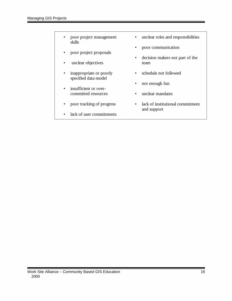
Managing GIS Projects
Work Site Alliance – Community Based GIS Education 16 2000
• poor project managementskills
• poor project proposals
• unclear objectives
• inappropriate or poorlyspecified data model
• insufficient or over-committed resources
• poor tracking of progress
• lack of user commitments
• unclear roles and responsibilities
• poor communication
• decision makers not part of theteam
• schedule not followed
• not enough fun
• unclear mandates
• lack of institutional commitmentand support

Managing GIS Projects
Work Site Alliance – Community Based GIS Education 17 2000
2. Project Management Software Applications
Many major software manufacturers have developed software programsspecifically designed to assist project managers. These programs combinefeatures of word processor, spreadsheet, and database to ease the organizationand tracking process for project managers. All the elements of the projectmanagement programs are linked, so that information entered is transferred intoa variety of documents, including calendars, financial reports and schedules.
Advantages and Disadvantages of Project Management Software
The main advantage to using project management software is that it eases thecomplex organization process of a project. Projects are made up of numeroustasks, many of which are inter-related. The software allows a project manager toinput these tasks, and the computer is then able to organize them intoschedules, budgets, and reports. Tied to that, project management softwareprovides the benefit of a system that records, stores, and recalls all details of aproject in one place. This is useful throughout the duration of the project, andalso serves as a historical record once the project is complete. Once projectinformation is inputted into the program, the software acts as a tool to analyzeinformation in various ways. Finally, project manager software assists a projectmanager by easing the communication of progress to other parties throughreporting features, data sharing and e-mail.
There are two main disadvantages of project management software. First, inorder to benefit from project management software, the user must have anunderstanding of the project management methodology and vocabulary. Mostproject management software packages rely on this as a prerequisite. Unless theuser follows basic planning and task definition steps, the software will not be ofany benefit, and may, in fact, complicate the project.
Second, the information that a project manager inputs into the software is likelyto change throughout the course of the project. Reports and analyses producedby the software are based on the data entered in the planning phase. Asproblems occur and things do not go as planned, the information stored in thesoftware is no longer valid. Consequently, a project manager using softwaremust enter any changes into the computer as they occur, and re-generateanalyses and reports. Some project managers feel that this adds to theirworkload, and outweighs the benefits of the software.

Managing GIS Projects
Work Site Alliance – Community Based GIS Education 18 2000
Exercises in Using Microsoft Project
The following hands-on exercises will take you through the project planning foran example project. Microsoft Project was selected for this W/SA projectmanagement unit because it is among the most widely used project managementsoftware programs. It is accessible to most people, and is considered to be theeasiest program to use. Because it is a Windows based application, the basicfeatures of the program are intuitive for most Windows users.

Managing GIS Projects
Work Site Alliance – Community Based GIS Education 19 2000
Scenario for Example ProjectCentral Bank and Newtonbrook Secondary School
Background
Newtonbrook Secondary School approached Central Bank’s Personal and Commercial Financial Services (PCFS)Division to establish a WSA/GIS partnership.
Newtonbrook is a high school with a population of approximately 2,000 students. As a semestered school, classes meetdaily for 70-minute periods for five months. Semester one begins in September, and ends in January. Semester twobegins in February and ends in June. The school has an established technology program in which ArcView GIS hasbeen delivered as a part of the geography curriculum for several years. Newtonbrook hopes to expand the use of GIS asa part of the WSA/GIS program. Partnering with Central Bank would allow them to deliver authentic, project-basedlearning in senior level marketing courses.
Located in the same community as Newtonbrook is Central Bank’s head office. Central Bank is a major financialinstitution in the region, with over two million customers. Prior to commencing discussions between the twoorganizations, it was established that both use ArcView GIS, ensuring that files exchanged between the twoorganizations would be compatible.
Central Bank had recently established a Consumer Knowledge Data Base (CKDB), which tracks customer information.This database was constructed to describe customer behaviors at the “household” level, while integrating this informationwith demographic and psychographic information already available. By plugging CKDB information into ArcView GIS,Central Bank is able to assess complex customer information, and make informed strategic business decisions.
A presentation was made to Central Bank (see Appendix A, Sample Presentation – Central Bank), resulting in a verbalagreement to proceed with a partnership. A contract was subsequently negotiated and accepted by both parties (seeAppendix B, Sample Contract – Central Bank) which lead to the preparation of an initial project plan (see Appendix C,Sample Project Plan (Abbreviated) – Central Bank). Though Central Bank has not yet provided specific Business Casesfor Newtonbrook to work on, they anticipate a scenario such as:
Central Bank wishes to increase the level of “100% banking relationships” with customers in the Willowdale community.Based on the data available, who are the customers that should be targeted? Generate a mailing list based on the criteriaof partial banking relationships. Analyze the banking behaviors of those targeted. What do they have in common? Howcould a direct mail campaign be crafted to address those behaviors?
Central Bank would provide background information about banking behavior, as well as the appropriate data sets, codes, etc. tosupport Newtonbrook’s work on this initiative.
Challenge
1. Using the information provided in the appendices, create a detailed task sheet (use Appendix E as a guide) to support thisproject. Each milestone should be broken down into detailed tasks. For tasks assigned to student, simply call them “Student1,” “Student 2,” etc. Remember to include tasks for the close-out stage of the project as well as during execution.
2. Following the steps below, create an electronic project plan using Microsoft Project. You will be required to use many of thesoftware’s features, and create several reports.

Managing GIS Projects
Work Site Alliance – Community Based GIS Education 20 2000
Exercises
2.1 Getting Started with Microsoft Project
In this exercise you will use the information from the sample project scenarioshown above, and related supporting materials in Chapter 3 of this ProjectManagement unit. You will create a new Project and enter a set of tasks for theproject.
Step 1. List all the tasks in the sample project
On paper or whiteboard, work with a small group to make a list of all tasks forthis project and assign them to individuals (use Appendix D, Project OverviewSheet, and Appendix E, Project Task Sheet as guides).
Step 2. Open MS Project on your Computer
• As soon Microsoft Project is opened, the "Welcome to Microsoft Project"dialogue box appears.
• Close the “Welcome to Microsoft Project” dialogue box since you will becreating a new project. The MS Project default screen appears.
Step 3. Understanding the Default Screen
• Make the following observations about the MS Project screen. When startinga new project, the MS Project default screen that first appears is known as"Gantt Chart" in the View menu.
• Drag with the mouse to move the line that separates the Gantt Chart fromthe Entry Table.
• The left side of the screen is the Entry Table. It functions like a spreadsheet.Data is entered into the cells, and is linked to the Gantt Chart, which isautomatically updated.
• The Entry Table will provide a detailed list of every task associated with aproject. Dependencies and links are also entered into this table. The GanttChart provides a visual representation of the overall project schedule that isbased on the information entered into the Entry Table.

Managing GIS Projects
Work Site Alliance – Community Based GIS Education 21 2000
Step 4. Input the start and end dates for the project in the ProjectInformation window
• From the Project menu, select Project Information. The project informationscreen appears.
• Take a few moments to familiarize yourself with the buttons on the toolbar forMS Project.
Step 5. Enter the Tasks into the Entry Table
• Type each of your task names into Task Name column, sequentially ifpossible.
• If a task is missed, you can add a line by going to Insert/Insert Task. Thecomputer will automatically default to a duration of 1 day, starting on theproject start date that was entered in the Project Information window.
Gantt Chart
Entry Table - move theseparating bar with your
mouse to reveal allcolumns.
Tools for prioritizing tasks.

Managing GIS Projects
Work Site Alliance – Community Based GIS Education 22 2000
Step 6. Define attributes of the tasks.
• Select the cell by clicking or tabbing.
• Type in the correct information.
• Press <enter>.
For instance, to change task duration from 1d to 5h, select that cell, type "5h"and press enter. Adding special columns through Insert/Insert Column cancustomize the table.
As changes are made, the Gantt Chart is automatically updated.
Step 7. Create a recurring task.
Recurring tasks (such as weekly meetings) can be set, so that the user only hasto define the attributes of the task once. This is accomplished by performing thefollowing steps when setting that task the first time it is listed.
• Click Insert/Recurring Task. A dialogue box will appear,
• Set the attributes of your task.
• Click OK. The task will be placed into the entry table in the frequencyidentified. The task name will only be shown once, while each individual taskis "hidden" (this will be discussed in subsequent sections).
Input tasks here.
Managing GIS Projects
Work Site Alliance – Community Based GIS Education 23 2000
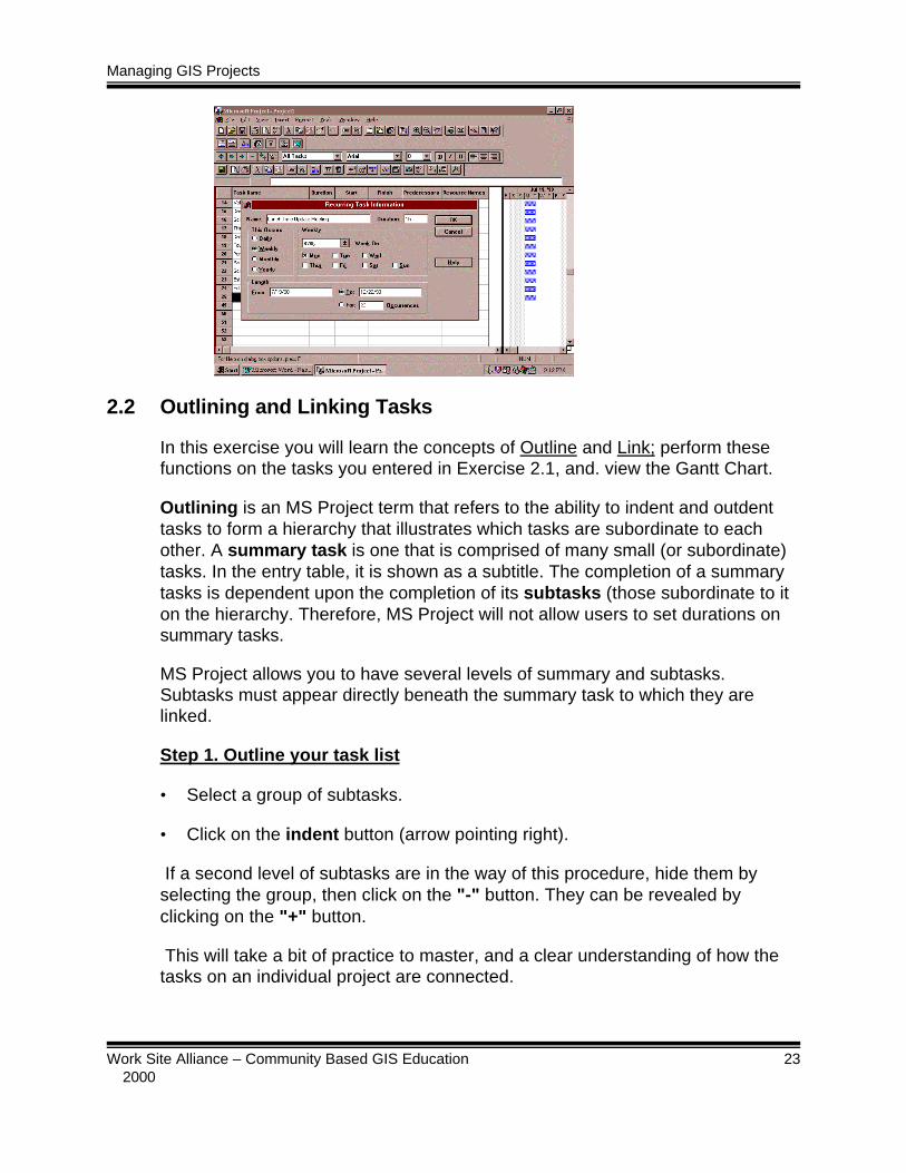
2.2 Outlining and Linking Tasks
In this exercise you will learn the concepts of Outline and Link; perform thesefunctions on the tasks you entered in Exercise 2.1, and. view the Gantt Chart.
Outlining is an MS Project term that refers to the ability to indent and outdenttasks to form a hierarchy that illustrates which tasks are subordinate to eachother. A summary task is one that is comprised of many small (or subordinate)tasks. In the entry table, it is shown as a subtitle. The completion of a summarytasks is dependent upon the completion of its subtasks (those subordinate to iton the hierarchy. Therefore, MS Project will not allow users to set durations onsummary tasks.
MS Project allows you to have several levels of summary and subtasks.Subtasks must appear directly beneath the summary task to which they arelinked.
Step 1. Outline your task list
• Select a group of subtasks.
• Click on the indent button (arrow pointing right).
If a second level of subtasks are in the way of this procedure, hide them byselecting the group, then click on the "-" button. They can be revealed byclicking on the "+" button.
This will take a bit of practice to master, and a clear understanding of how thetasks on an individual project are connected.

Managing GIS Projects
Work Site Alliance – Community Based GIS Education 24 2000
Step 2. Create Links
Once tasks are outlined, the next logical step is to create links whereappropriate. A link is a type of dependency or relationship between two tasks,where the start of one task is dependent upon the completion of another. Linkingthe task list will result in significant changes to the Gantt Chart. In particular, theschedule will visibly spread out based on the durations identified. As well,arrows appear to show which are linked.
• Select an entire group of tasks to be linked.
• Click the link button.
Start by linking the lowest level of subtasks. Next, hide those groups of subtasksusing the "-" button. Link the next level of tasks. Continue linking and hidinguntil the project is finished. Hidden tasks can be reveals by selecting allremaining tasks, and clicking on the "++" button.
The default link is known as a "finish-to-start" (FS) link, meaning that once thefirst task is finished, the next linked task starts. MS Project is able to create morecomplex links by double clicking on the link line in the Gantt Chart. Other typesof dependencies available are finish-to-finish (FF), start-to-start (SS), and start-to-finish (SF).
Additionally, MS Project allows users to create constraints, lags, and leads totasks. These will not be discussed in this chapter.
Managing GIS Projects
Work Site Alliance – Community Based GIS Education 25 2000
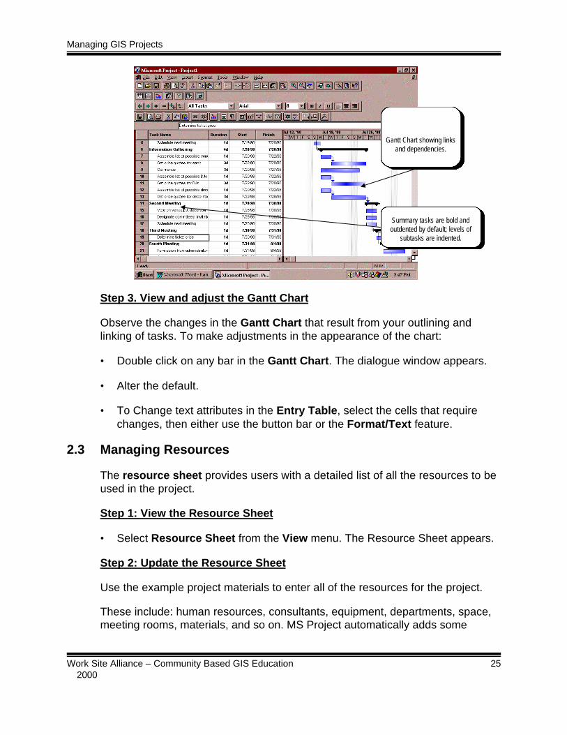
Step 3. View and adjust the Gantt Chart
Observe the changes in the Gantt Chart that result from your outlining andlinking of tasks. To make adjustments in the appearance of the chart:
• Double click on any bar in the Gantt Chart. The dialogue window appears.
• Alter the default.
• To Change text attributes in the Entry Table, select the cells that requirechanges, then either use the button bar or the Format/Text feature.
2.3 Managing Resources
The resource sheet provides users with a detailed list of all the resources to beused in the project.
Step 1: View the Resource Sheet
• Select Resource Sheet from the View menu. The Resource Sheet appears.
Step 2: Update the Resource Sheet
Use the example project materials to enter all of the resources for the project.
These include: human resources, consultants, equipment, departments, space,meeting rooms, materials, and so on. MS Project automatically adds some
Gantt Chart showing linksand dependencies.
Summary tasks are bold andoutdented by default; levels of
subtasks are indented.

Managing GIS Projects
Work Site Alliance – Community Based GIS Education 26 2000
resources to the resource sheet as they are added to the Entry Table. Byclicking on Window/Split, you can view and update the details of a selectedindividual resource.
Step 3. Create Milestones
As defined earlier, milestones are deliverables that are measured and/or testedto give the project team feedback. In MS Project, a milestone is a task with zeroduration that acts as a marker for the beginning or end of something. Forinstance, "banquet hall reserved" may be a milestone for a school prom project.More commonly, milestones have titles like "Phase 1 Complete". Because it is amarker, MS Project will not allow the user to input a duration for a milestone.Similarly, milestones do not have resources, costs or any other characteristicscommon to tasks. A milestone appears on the Gantt Chart in the form of a soliddiamond-shape with a date next to it.
• Type the title of a milestone into the Entry Table in the task column
• Enter the duration as "0d". MS Project will automatically update theremainder of your file.
The Resource Sheet canbe edited here.

Managing GIS Projects
Work Site Alliance – Community Based GIS Education 27 2000
Step 4. View the WBS
WBS (Work Breakdown Structure) is defined in MS Project as "a hierarchicalstructure used to organize tasks for reporting schedules and tracking costs." MSProject automatically codes each task, giving the user the option of re-codingwith a unique system. To view the WBS or to change codes, click on theinformation button on the toolbar .
Step 5. Observe and print Views
MS Project provides project managers with a multitude of ways to view variousaspects of a project. The left-hand side of the screen should provide a series ofbuttons that can be clicked to provide a specific view. Alternately, using the Viewmenu, the user selects different page and information layouts. By choosing theMore Views option, additional views can be selected. The default view (whichcontains the Entry Table) is called the Gantt Chart in the View menu. View andprint each of the following for your example project:
• Calendar - shows the tasks in date boxes similar to a standard calendar. Thescale of the calendar can be changed by using the zoom-in and zoom-outicons. Double click on any day, and view or change information details.
• PERT (Project Evaluation and Review Technique) Chart - a network diagramwith boxes that represent tasks, and lines between to indicate relationships.It can be used for task entry (instead of the Entry Table) or to edit taskinformation.
• Task Form - reviews tasks with associated resources. It is used to showcurrent status in hours and comparisons with baseline.
• Task Detail Form - very useful for editing single tasks.
• Resource Form - a table that shows each resource with details that may beedited. It is useful if adjustments need to be made for one specific resource.
• Resource Graph - a graph that shows resource information and usage overtime. It is very useful in allocating human resources, and notifies the userwhat resources are over-allocated.
• Resource Usage - a table listing the usage of each resource. It is helpful inanalyzing the volume of use assigned to one resource over time.

Managing GIS Projects
Work Site Alliance – Community Based GIS Education 28 2000
Step 6. Generate reports
In addition to tables and graphic views of project attributes, MS Project willgenerate reports for the user based on the data contained in the file.
• Select Reports from the View menu. This will bring up the Reports dialoguebox.
The six categories of reports are: Overview, Current Activities, Costs,Assignments, Workloads, and Custom. Each category allows you a multitude oftemplate options. The custom option allows you to change any of the otherreports or create your own. Table 2.1 Illustrates the reports available in eachcategory.

Managing GIS Projects
Work Site Alliance – Community Based GIS Education 29 2000
Table 2.1: Reports by Category
Overview CurrentActivities
Costs Assignments Workloads
ProjectSummary
Top-levelTasks
Critical Tasks
Milestones
Working Days
UnstartedTasks
Tasks StartingSoon
Tasks inProgress
CompletedTasks
Should HaveStarted Tasks
Slipping Tasks
Weekly CashFlow
Budget
OverbudgetTasks
OverbudgetResources
Earned Value
Who DoesWhat
Who DoesWhat When
Weekly To-Do List
OverallocatedResources
Task Usage
ResourceUsage
• Generate any two reports of your choice.
2.4 Analyzing and Tracking the Critical Path
CPM (Critical Path Management) is a management technique that requires amanager to identify which tasks are critical a project's successful completion.Through a complex mathematical formula, MS Project analyzes the differencebetween the time frame you have set for a project, and the project duration ascalculated from the sum of all tasks. If a significant difference exists, the programisolates all tasks that cannot be delayed because of their relationship to othertasks. This string of tasks directly affect prompt completion of project. They areconsidered to be the critical path.
MS Project sets the critical path automatically as the user enters projectinformation.
Step 1. View and modify the critical path
• Click the Gantt Chart Wizard button to view the critical path.
• Menu select Tools/Options/Schedule.

Managing GIS Projects
Work Site Alliance – Community Based GIS Education 30 2000
• Set a day limit under "Tasks are critical if slack <=".
• Click OK. The critical path will be updated.
Step 2. View the baseline for the project.
Tracking refers to monitoring the project as in progresses. Before tracking canbegin, a baseline must be established. A baseline is the project plan againstwhich project progress is measured. Therefore, all relevant information withrespect to tasks, schedules, and resources must be inputted correctly andverified prior to baseline creation. Once a baseline is created, it cannot be easilychanged.
• Activate the Gantt Chart view (or any task view).
• Select menus for Tools/Tracking/Save Baseline to activate the baselinedialogue box.
Managing GIS Projects
Work Site Alliance – Community Based GIS Education 31 2000
• Activate The Save Baseline and Entire Project radial buttons.
• Click OK; the baseline is set and saved.
• Select View/Tables/More Tables/Baseline to view the Baseline.
Step 3. Update status of tasks
The project is tracked against baseline information. Consequently, informationmust be collected regularly to update the status of all tasks currently active inthe schedule. Generally, the types of tracking information entered are: actualstart, actual finish, percent completed, revised duration, actual work, and actualcosts.
• In the Task Sheet View, select a task to be updated.
• Click the Update Tasks button.
• Type the update information for the task.
Step 4. Update resources
• In the Resource Sheet View, select a resource to be updated.
• Click the Update Resources button.

Managing GIS Projects
Work Site Alliance – Community Based GIS Education 32 2000
• Type the update information for the resource.
Step 5. View the Tracking Gantt Chart
Task progress is summarized in the Tracking Gantt Chart view. It adds acompletion bar (which is a thick black bar) and the percentage of each taskcompleted, making it easy to see the relative completion rate at a glance.
Summary
Through the exercises in this chapter you have had an opportunity to try out some ofthe functions of Microsoft Project, a commonly used project management softwarepackage. You have created a list of project tasks for an example project scenario andassigned resources to the tasks. You have viewed the Gantt chart, observed andmodified the critical path, and generated reports. You have updated the project file toreflect example progress on some tasks. Through these activities you have becomefamiliar with some of the basic concepts used in project management and are now in aposition to evaluate whether such software tools would be useful to you in managingyour next project.
Completion Bar

Managing GIS Projects
Work Site Alliance – Community Based GIS Education 33 2000
3. References and Resources
This chapter contains general references on project management, a set ofresource materials related to the example Project, and worksheets you can usein your own project planning.
References on Project Management
Cattaneo, Julian, and others. Management for Productivity. Toronto: John Wiley& Sons, 1988.
Fast Company Magazine. Fast Company Online Archives. Available:www.fastcompany.com., 1998.
Fosberg, Kevin, Hal Mooz and Howard Cotterman. Visualizing ProjectManagement. New York: John Wiley & Sons, 1996.
Heck, Mike. "Project Management." PC World Magazine. October 1997.Available: www.pcworld.com/software/
Kayser, Thomas A. Mining Group Gold. El Segundo, CA: Serif Publishing, 1990.
King, Nelson. Teach Yourself Microsoft Project for Windows 95. New York: MISPress, 1996.
McKay, Matthew, Martha Davis and Patrick Flanning. Messages: TheCommunication Skills Book. Oakland, CA: New Harbinger Publications,1983.
Norton, Robert. Communicator Style. Beverly Hills, CA: Sage Publications, 1983.
"Project Management - Forty Years Young and Still Looking for a Philosophy."Project Manager Today. Available: www.projectnet.co.uk/pm/pmt., 1996.
Sandia National Laboratories. Project Management Guidelines Handbook.Available: www.ca.sandia.gov/pubs/PMGHhome, 1996.
Situation Management Systems Inc. Positive Power and Influence Program, 4thed. Hanover, MA: Situation Management Systems Inc., 1996.
Thomsett, Michael C. The Little Black Book of Project Management. New York:American Management Association, 1990.

Managing GIS Projects
Work Site Alliance – Community Based GIS Education 34 2000
Van Fleet, David. Contemporary Management. Boston: Houghton MifflinCompany, 1988.
Willcocks, Graham and Steve Morris. Successful Team Building. New York:Barron's, 1997.
Internet Resources
Directory of Project ManagementResources
www.synapse.net/~today/PMForum/specint.htm#FRAME
International Journal of ProjectManagement
www.elsevier.nl/estoc/publications/store/3/02637863
International Research Network onOrganizing by Projects
www.fek.umu.se.irnop
Project Management Centre www.infogoal.com/pmc/pmchome
Project Management Forum www.pmforum.org
Project Management Institute www.pmi.org
Project Management Journal www.pmi.org/publictn/project_management_journal.htm
Project Manager Today www.projectnet.co.uk/pm/pmt
Scandinavian Journal ofManagement
www.elsevier.hl/estoc/publications/store/l/09565221/SZ955825.shtml

Managing GIS Projects
Work Site Alliance – Community Based GIS Education 35 2000
Appendix A
Example Project Proposal Presentation
Slides1 & 2
GISGIS Partnership Proposal Partnership Proposal
A presentation byNewtonbrook Secondary SchoolforCentral Bank, PCFS Division
NewtonbrookNewtonbrook Secondary School Secondary School
z Student body of nearly 2,000
z Relies on inquiry, investigation andproblem-solving fostered throughproject-based learning
z Technological emphasis in all courses
Slides 3& 4
Success StoriesSuccess Stories
z GIS partnerships between schools and
businesses have resulted in mutual
benefit
z Students have been highly successful insolving complex research problems
GISGIS Overview Overview
z GIS software maps behavioral,demographic and sociographicdata sets
z Facilitates problem-solving andresearch
z ESRI ArcView GIS package used byboth PCFS and Newtonbrook

Managing GIS Projects
Work Site Alliance – Community Based GIS Education 36 2000
Slides 5& 6
Partnership PossibilitiesPartnership Possibilities
z By combining our resources,Newtonbrook School and CentralBank can both benefit:
y Central Bank’s PCFS division willreceive assistance in researchand reporting
y Newtonbrook will receive datasets and authentic learningproblems
Central Bank InvolvementCentral Bank Involvement
Central Bank can help Newtonbrookmeet its objectives by:
n Providing authentic research problemsfaced by PCFS
n Providing data sets that representcustomer behavior and demographicinformation from the Bank’s CustomerKnowledge Data Base
Slides 7& 8
Objectives ofObjectives of GIS GIS Learning Learning
Students will be able to:
n apply critical thinking skills to solveproblems
n participate in “authentic learning” projects,enabling use of multi-disciplinaryknowledge to meet research objectives
n acquire client-service and presentationskills
Value PropositionValue Proposition
In exchange, Central Bank willreceive:
n Solutions to research and marketingproblems
n Positive public relations
n Potential employees trained to use thelatest GIS technology and familiar withCentral Bank’s operations
Slides 9& 10
In addition,In addition, Newtonbrook Newtonbrook will:will:
z Customize the Marketing course to CentralBank’s PCFS, generating useful studentprojects such as:
y detailed competitive intelligence reportingy research on trends in financial servicesy compilations of financial services industry
advertising tacticsy small-scale primary research projects
Critical PathCritical Path
z Joint project planning to take place in June
z Classes begin September 8
z Data sets required by mid-July
z Research questions required in earlySeptember
z Results of research compiled and presented toCentral Bank between October and January
Managing GIS Projects
Work Site Alliance – Community Based GIS Education 37 2000
Slides 11& 12
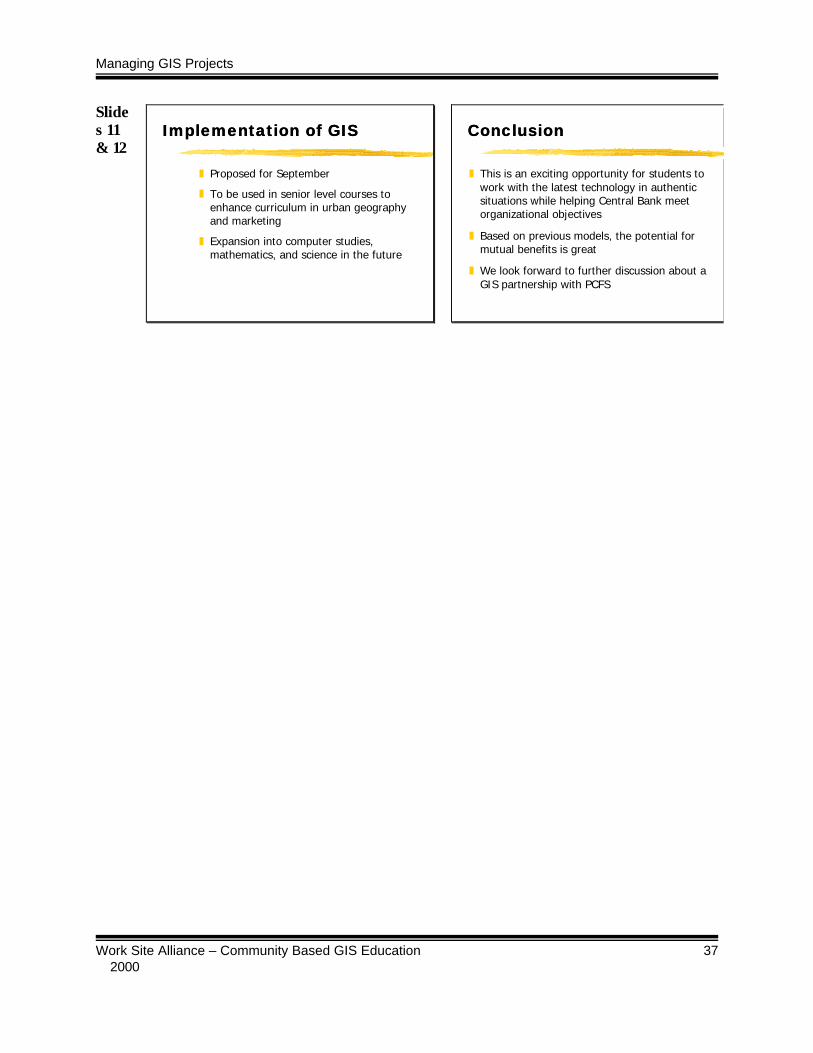
Implementation ofImplementation of GIS GIS
z Proposed for September
z To be used in senior level courses toenhance curriculum in urban geographyand marketing
z Expansion into computer studies,mathematics, and science in the future
ConclusionConclusion
z This is an exciting opportunity for students towork with the latest technology in authenticsituations while helping Central Bank meetorganizational objectives
z Based on previous models, the potential formutual benefits is great
z We look forward to further discussion about aGIS partnership with PCFS

Managing GIS Projects
Work Site Alliance – Community Based GIS Education 38 2000
Appendix B
Example Project Contract
THIS CONTRACT IS ENTERED INTO ON ___________________ BETWEEN CENTRAL BANK’SPERSONAL AND COMMERCIAL FINANCIAL SERVICES DIVISION (“THE BANK”) ANDNEWTONBROOK SECONDARY SCHOOL, (“THE CONTRACTOR”).
1. Purpose
1.01 Central Bank independently develops and operates several departmental computerapplications. Appendix I identifies and describes the activities of this Contract that are associated with ageographic mapping application.
In addition to performing internal, department level functions, some of these applications receivedata from and/or provide data to other Bank computer applications including: a) Bank-wide, enterpriseapplications which are mainframe-based and are operated and supported by the Bank’s department ofInformation Processing; b) client/server applications residing on various Bank local area or wide areanetworks.
2. Engagement of Contractor
2.01 The Bank engages the Contractor and the Contractor agrees to faithfully and diligentlyperform the services in accordance with the terms and conditions contained in this contact and consistentwith the standard of practice in the community.
3. Scope of Service
3.01 The Contractor must perform the services in a satisfactory manner, as determined withinthe discretion of the Bank.
3.02 In the event there is any dispute between the parties regarding the extent and characterof the services to be performed, the interpretation and determination of the Bank governs.
3.03 The services include all conferences and consultations deemed necessary by the Bankto properly and fully perform the services.
4. Services to be Provided
Please refer to Appendix I for a detailed description of the specific services to be provided.
5. Term of Contract
5.01 This Contract begins _________, and ends ___________. The Contractor mustexpediently perform the services to achieve the objectives of this Contract.
6. Data To Be Furnished Contractor
6.01 Upon the request of the Contractor, without charge, the Bank must furnish copies of allinformation, data, reports, records, etc., That the Bank thinks is necessary to do the services. The

Managing GIS Projects
Work Site Alliance – Community Based GIS Education 39 2000
Contractor is entitled to visit Bank offices and key facilities as approved by the Bank, during regularbusiness hours to obtain the necessary data. The Contractor will schedule conferences at convenienttimes with key administrative personnel of the Bank to gather the information.
7. Personnel
7.01 The Contractor warrants that all employees of the Contractor assigned to theperformance of the services are qualified and authorized to perform the services under the state andlocal laws and governing professional association rules where the employee is employed.
7.02 Each employee must devote the time and professional ability as is necessary to mosteffectively and efficiently perform the services according to professional standards.
7.03 Whenever an employee assigned to this Contract must be replaced for any reason, theContractor must supply an acceptable replacement as soon as possible and agrees not to substitute alower classified employee to perform the services without obtaining prior Bank approval in writing.
7.04 The Contractor may determine employees’ daily working hours. When the employeesare working in or about a Bank facility, Contractor agrees to adjust its employees’ daily working hours tobe the same as those worked by Bank employees working at the facility.
8. Administration
8.01 The Contractor must inform the Bank as soon as the following types of conditionsbecome known:
A. Probable delays or adverse conditions, which do or may materially, prevent the meetingof the objectives of the Contract. The Contractor must accompany this disclosure with astatement or any remedial action taken or contemplated by it; and
B. Favorable developments or events, which enable meeting, time schedules or goalssooner than anticipated.
9. Compensation
9.01 The Bank agrees to pay the Contractor for the performance of services under hisContract as stated in Appendix I.
This compensation includes all remuneration to which the Contractor may be entitled forperforming the services described in Appendix II of this Contract. The Bank will not pay theContractor for overtime, holiday or other premium charges or benefits. Total dollars paidunder the terms of this agreement shall not exceed $3,000.00.
9.02 The Contractor must, upon reasonable notice, be available to participate in anyproceeding, whether legal, administrative or otherwise, or in any internal Bank preparatory meetings forthe proceeding, in order to assist the Bank in any matter relating to the purpose or outcome of thisContract. The Bank will compensate the Contractor under a separately negotiated agreement for anyservices rendered pursuant to this section.
10. Method of Payment

Managing GIS Projects
Work Site Alliance – Community Based GIS Education 40 2000
10.01 The Bank will pay for the proper performance of the services, commensurate with theprogress of the work as evidenced by the timely performance of the services, and after it receivesinvoices at the end of each month and after Bank has accepted the defined deliverables for that month.The invoices must certify the total cost of the services rendered to the project to date and the cost of allservices for that billing period; and must describe the services rendered. If the invoice also requestsreimbursement or payment for reimbursable expenses, the appropriate receipts must be attached. TheContractor must sign the invoice and send it to the Bank. This section is limited by the provisions ofSection 9 with regard to the amounts payable for performance.
10.02 The Contractor must direct invoices to the attention of the individual specified in theNotice provisions, Section 24.
10.03 The Contractor must submit as part of the invoices, written monthly progress reportsindicating the Contractor’s activities during the reported month and signed by an authorized officer of theContractor.
11. Records – Access
11.01 The Contractor must maintain complete books, ledgers, journals, accounts, or records inwhich it keeps all entries reflecting its operation pursuant to this Contract. The Contractor must keep therecords according to federally accepted accounting practices.
11.02 The Contractor must maintain all records for a minimum of 3 years after the Contract’stermination and completion.
11.03 The Bank has the right to examine and audit all books, records, documents and othersupporting data as the Bank deems necessary of the Contractor, or any subcontractors, or agentsrendering services under this Contract, whether direct or indirect, which will permit adequate evaluationof the services or the cost or pricing data submitted by the Contractor. The Contractor must include asimilar covenant allowing for Bank audit in any Contract it has with a consultant or agent whose serviceswill be charged directly or indirectly to the Bank. The Bank may delay payment to the Contractor pendingthe results of any such audit without penalty or interest.
11.04 The Contractor agrees that representatives of the Bank are entitled to make periodicinspections to ascertain that the Contractor is properly performing the services. The inspections may bemade at any time during normal business hours of the Contractor. If, in the course of the inspections, therepresentatives of the Bank should note any deficiencies in the performance of the services of theContractor, or any other mutually agreed upon performance deficiencies, the alleged deficiencies mustbe reported promptly to the Contractor, in writing. The Contractor agrees to promptly remedy and correctany reported deficiencies within 10 days of notification by the Bank.
11.05 If, as a result of any audit conducted by or for a Bank, State of Michigan or Federal,agency relating to the Contractor’s performance under this Contract, a discrepancy should arise as to theamount of compensation due the Contractor, the Bank may retain the amount of compensation due theContractor, the Bank may retain the amount of compensation in question from any funds allocated to theContractor but not yet disbursed under the Contract. Should a deficiency still exist, the Bank may offsetsuch a deficiency against the compensation to be paid the Contractor in any successive or futureContracts between the parties.
12. Relationship of Parties

Managing GIS Projects
Work Site Alliance – Community Based GIS Education 41 2000
12.01 The relationship of the Contractor to the Bank is and will continue to be that of anindependent Contractor. No liability or benefits, such as workers’ compensation or insurance rights,arising out of, or related to a Contract for hire or employer/employee as a result of this Contract. Norelationship, other than that of independent Contractor will be implied between the parties, or eitherparty’s agent, employee or subcontractor. The Contractor agrees to hold the Bank harmless from anyclaims, and any related costs or expenses.
13. Insurance
13.01 The Contractor, at its expense, must maintain during the term of this Contract thefollowing insurance:
A. Professional liability insurance with minimum limits of $1 million dollars per occurrenceand $1 million dollars aggregate.
B. Workers’ Compensation insurance which meets Michigan statutory requirements.
C. Comprehensive General Liability Insurance with minimum limits or bodily injury of$500,000 each person and $1 million dollars aggregate and with minimum limits forproperty damage of $500,000 each occurrence and $1 million dollars aggregate.
D. Comprehensive Automobile Liability (including hired and non-owned vehicles) withminimum limits for bodily injury of $500,000 each person and $1 million dollars eachaccident and with minimum limits for property damage of $500,000 each accident.
13.02 If, during the term of this Contract, changed conditions or other pertinent factors, shouldin the reasonable judgement of the Bank, render inadequate the insurance limits, the Contractor willfurnish on demand such additional coverage as may reasonable be required and available under thecircumstances. The insurance must be effected under valid and enforceable policies, issued byrecognized, responsible Michigan insurers, which are well rated by national rating organizations.
13.03 Insurance policies must name the Contractor as the insured, and must not be cancelledor materially changed without at least 30 days prior notice from the Contractor to the Bank. TheContractor must submit certificates evidencing the insurance to the risk management division at the timethe Contractor executes the Contract, and at least 15 days prior to the expiration dates of expiringpolicies.
14. Indemnification
14.01 The Contractor agrees to save harmless the Bank against, and from any and allliabilities, obligations, damages, penalties, claims, costs, charges and expenses (including, withoutlimitation, fees and expenses of attorneys, expert witnesses and other consultants) which may beimposed upon, incurred by or asserted against the Bank because of any of the following occurring duringthe term of this Contract:
A. Any negligent or tortuous act, error, or omission held in a court of competent jurisdictionto be attributable, in whole or in part to the Contractor, or any of its personnel,employees, consultants, agents, or any entities associated, affiliated, (directly orindirectly) or subsidiary to the Contractor now existing, or to be created, their agents andemployees for whose acts any of them might be liable.

Managing GIS Projects
Work Site Alliance – Community Based GIS Education 42 2000
B. Any failure by the Contractor to perform its obligations either implied or expressed underthis Contract.
14.02 The Contractor agrees that it is its responsibility and not the responsibility of the Bank tosafeguard the property and materials that the employees of the Contractor use in performing thisContract. The Contractor must hold the Bank harmless for costs and expenses resulting from any loss ofthe property and materials used by its employees pursuant to the performance of the Contractor underthis Contract. Contractor is specifically responsible for reimbursing Bank for the loss, theft, or repairs ofBank computer equipment and software loaned by the Bank to Contractor for the performance of workunder this Contract.
14.03 The Contractor cannot hold the Bank liable for any personal injury incurred by theemployee(s), agents, or consultants of the Contractor while working on this Contract which is not held ina court of competent jurisdiction to be directly attributable to the gross negligence of the Bank or anyemployee of the Bank acting within the scope of their employment. The Contractor agrees to hold theBank harmless from any such claim by the Contractor’s employees.
14.04 For purposes of the hold-harmless provisions, the term “Bank” includes the Bank ofWayne and all other associated, affiliated, or subsidiary departments or divisions now existing or to becreated, their agents and employees.
14.05 This indemnity applies without regards to whether the claim, damage, liability or expenseis based on breach of Contract, breach of warranty, negligence, strict inability, or other tort. Thisindemnity survives delivery and acceptance of services.
15. Bankruptcy or Insolvency
15.01 If the Contractor is adjudicated bankrupt or insolvent, or if a trustee is appointed over theContractor or any of its property, whether it is a third party or Contractor as debtor-in-possession(referred to as “Contractor” in this Section unless the context clearly requires otherwise) the followingrights, obligations and limitations control:
A. Contractor or any trustee must not assign any or all of its rights, title or interest, in or tothis Contract, as this Contract is for the delivery or professional services and relatedservices, as to which the Bank is entitled to insist upon performance solely by theContractor.
B. Contractor or any trustee may only assume this Contract if it provides adequateassurance of future performance. Adequate assurance of future performance meansproof reasonably satisfactory to the Bank of:
(i) Adequate financial capacity to employ or Contract with sufficient personnel toperform the services assigned to the Contractor as provided in this Contract, andto pay for all services Contracted for by the Contractor;
(ii) Adequate financial capacity to won, operate, lease or obtain sufficient facilitiesand supplies to perform the services assigned to the Contractor as provided forin this Contract; and
Managing GIS Projects
Work Site Alliance – Community Based GIS Education 43 2000
(iii) Adequate financial and professional capacity to maintain the professionalstandard provided in this Contract. The reasonable determination of the Bank asto the adequate professional capacity of the Contractor is determinative.
C. Because of the unique nature of the services this Contract requires the Contractor toprovide, the Contractor agrees that any requests by the Bank that the trustee or it asdebtor-in-prosession assume or reject this Contract in a shorter time than provided for in11 USC §365 is reasonable so long as the trustee or Contractor receives no less than 5business days’ notice.
D. If this Contract is terminated during bankruptcy proceedings or if the trustee or debtor-in-possession or its trustee must cooperate with the Bank in arranging for the orderlytransfer of responsibilities to persons or entities as the Bank may designate. Therejection is not effective until the orderly transfer of responsibilities, consistent withsound professional practice, has been completed.
15.02 Although neither party has the right to terminate the Contract merely because the otheris adjudicated bankrupt or insolvent or a trustee or a debtor-in-possession is appointed over any parties’property, each party retains all of the other termination rights set forth elsewhere in this Contract duringthe period of any proceedings under the bankruptcy code.
16. Notice of Material Changes
16.01 The Contractor must immediately inform the Bank of material changes in its operation,ownership or financial condition. Material changes include, but are not limited to:
A. Reduction or change in staffing assigned to the Contractor.
B. Decrease in, or cancellation of, insurance coverage.
C. Delinquent payment, or nonpayment, of tax obligations.
D. Delinquent payment, or nonpayment, of payroll obligations.
E. Delinquent funding, or non-funding, or pension or profit sharing plans.
F. Delinquent payment, or nonpayment, of subcontractors.
G. Termination of, or changes in, subcontracts.
17. Termination
17.01 The Bank may terminate this Contract without cause at any time, without incurring anyfurther liability, other than as stated in this Section by giving written notice to the Contractor of thetermination. The notice must specify the effective date, at least 10 days prior to the effective date of thetermination, and this Contract will terminate as if the date were the date originally given for the expirationof this Contract. If the Contract is terminated, the Bank will pay the Contractor for the services renderedprior to termination, as soon as can be authorized. The final payment constitutes full payment. If theContractor accepts the payment, the Contract is satisfied. The parties agree that no payments under thissection will exceed the amount payable under Section 9.

Managing GIS Projects
Work Site Alliance – Community Based GIS Education 44 2000
17.02 After receipt of a notice of termination and except as otherwise directed by the Bank, theContractor must:
A. Stop work under the Contract on the date and to the extent specified in the notice oftermination.
B. Obligate no additional Contract funds for payroll costs and other costs beyond the dateas the Bank specifies.
C. As of the date the termination is effective, present all Contract records and submit to theBank the records, data notes, reports, discs, and documents (“Records”) as the Bankspecifies, all pertinent keys to files, and carry out such directives as the Bank may issueconcerning the safeguarding or disposition of files and property.
D. Submit within 30 days a final report of receipts and expenditures of funds relating to thisContract.
E. Place no further orders on subcontracts for materials, services, or facilities, except asmay be necessary for completion of such portion of the work under this Contract as isnot terminated;
F. Terminate all orders and subcontracts to the extent that they relate to the portion of workso terminated;
G. Submit with five days a listing of all creditors, subcontractors, lessors and other partieswith which the Contractor has incurred financial obligations pursuant to the Contract.
17.03 Upon termination of this Contract, all Records prepared by the Contractor under thisContract or in anticipation of this Contract must, at the option of the Bank, become its exclusive property,whether or not in the possession of the Contractor. The Records are free from any claim or retention ofrights on the part of the Contractor except as specifically provided. The Bank must return all theproperties of the Contractor to it.
17.04 Any intentional failure or delay by the Contractor to deliver the Records to the Bank willcause irreparable injury to the Bank not adequately compensable in damages and for which the Bank hasno adequate remedy at law. The Contractor will pay the Bank $1.00 per day as damages, and not as apenalty, until it delivers the Records to the Bank. The Bank may seek and obtain injunctive relief in acourt of competent jurisdiction and compel delivery of the Records which the Contractor consents to aswell as all applicable damages and costs. The Bank has unrestricted use of the Records for the purposeof completing the services.
17.05 Access to the records prior to delivery must be restricted to authorized representatives ofthe Bank and the Contractor. The Contractor has no right to disclose or use any information gathered inthe course of its work without obtaining the written concurrence of the Bank. All the information must beconfidential and handled in such a manner at all times as to preserve confidentiality. The Records as wellas any related products and materials are proprietary to the Bank, having been developed for the Bankfor its own and sole use.
17.06 In addition, each party will assist the other party in the orderly termination of thisContract and the transfer of all aspects, tangible or intangible, as may be necessary for the orderly, non-disrupted business continuance of each party.

Managing GIS Projects
Work Site Alliance – Community Based GIS Education 45 2000
18. Assignment
18.01 The Contractor must not assign this Contract, nor any part, or subcontract any of thework or services to be performed without the Bank’s prior written approval.
19. Ethics in Contracting
19.01 If the Contractor knowingly collaborates in or induces a violations of any of the ethicalstandards that are set forth in subsections C,D,E,F,H, I, J, K, or M of Section 15, the Bank has the rightto impose any one or more of the following sanctions:
A. Immediately terminate the Contract and require the Contractor to pay the Bankliquidated damages, and not a penalty, of 15% of the total Contract compensation.
B. Debar or suspend the Contractor from consideration from competing for further BankContracts.
C. Recover the value transferred or received in breach of the ethical standards by a Bankemployee or other person.
20. Confidential Information
20.01 If the Bank discloses confidential information to the Contractor’s employees pertaining tothe Bank’s past, present and future activities, the Contractor must instruct its employees to regard allinformation gained by each person as a result of the services to be performed as information which isconfidential and not to be disclosed to any organization or individual without the prior written consent ofthe Bank.
20.02 The Contractor agrees to take appropriate action with respect to its employees to insurethat the obligations of nonuse and non-disclosure of confidential information concerning this Contract canbe fully satisfied.
21. Compliance with Laws
21.01 The Contractor must comply with and must require its employees to comply with allapplicable laws and regulations.
21.02 The Contractor must hold the Bank harmless with respect to any damages arising fromany violations of this Section by it or its employees.
22. Amendments
22.01 No amendment to this Contract is effective unless it references this Contract, is written,is signed and acknowledged by duly authorized representatives of both parties.
23. Nondiscrimination Practices
23.01 Each party must comply with:

Managing GIS Projects
Work Site Alliance – Community Based GIS Education 46 2000
A. Titles VI and VII of the Civil Rights Act (42 U.S.C. §§2000d et. seq.)and the UnitedStates Department of Justice Regulations (28 C.F. R. Part 42) issued pursuant to thosetitles; and
B. Age Discrimination Act of 1985 (42 U.S.C. §61 01 -07
C. Section 504 of the Rehabilitation Act of 1973 (29 U.S.C. §794);
D. The Americans with disabilities Act of 1990 (42 U.S.C. §1 21 01 et. seq.) and itsassociated regulations;
E. The Michigan Civil Rights Act (P.A. 1976 No. 453) and the Michigan Handicappers CivilRights Act (P.A. 1976 No. 220);
23.02 The Contractor Must Not:
A. Refuse to recruit, hire, employ, promote or to bar or discharge from employment anindividual, or discriminate against an individual in compensation, terms, conditions orprivileges of employment because of religion, race, color, creed, national origin, age,height, weight, martial status, handicap, sex or sexual orientation, or any individual.
B. Limit, segregate, or classify an employee or applicant for employment in a way whichdeprives or tends to deprive any individual of employment opportunities or otherwiseadversely affects the employment status of an employee because of religion, race, color,creed, national origin, age, height, weight, marital status, handicap, sex or sexualorientation.
C. Print or publish or cause to be printed or published a notice, application, oradvertisement relating to employment by the Contractor indicating a preference,limitation, specification, or discrimination based upon religion, race, color, creed,national origin, age, height, weight, marital status, handicap, sex, or sexual orientation.
D. Make or use a written or oral inquiry or form of application that elicits or attempts tosolicit information concerning the religion, race, color, creed, national origin, age, height,weight, marital status, handicap, sex, or sexual orientation of perspective employees.Make or keep a record of that information, or to disclose that information.
E. Make or use a written or oral inquiry or form of application that expresses a preference,limitation or specification based on religion, race, color, creed, national origin, age,height, weight, marital status, handicap, sex or sexual orientation.
23.03 The Contractor must notify any subcontractor, if any, of the obligations relative tonondiscrimination under this Contract when soliciting the subcontractor. The Contractor will include theprovisions of this Section in any subcontract, as well as provide the Bank a copy of any subcontractoragreement.
23.04 The Contractor and its subcontractors must not discriminate against minority businessenterprises or women business enterprises (as defined in Equal Contracting Opportunity Ordinance No.93-738) in selecting and retaining subcontractors to perform work on this Contract.
23.05 The Contractor and its subcontractors must not discriminate against any employee orapplicant for employment, training, education, or apprenticeship connected directly or indirectly with the

Managing GIS Projects
Work Site Alliance – Community Based GIS Education 47 2000
performance of this Contract, with respect to hire, promotion, job assignment, tenure, terms, conditionsor privileges of employment because of religion, race, color, creed, national origin, age, height, weight,marital status, handicap, sex or sexual orientation. This Section does not apply if it is determined by theDivision of Human Relations that the requirements are bona fide occupational qualifications reasonablenecessary to perform the duties required for employment. The burden or proof that the occupationalqualifications are bona fide is upon the Contractor.
23.06 Breach of these covenants may be regarded as a material breach of this Contract.
23.07 If the Contractor does not comply with the non-discrimination provisions of this Contract,the Bank may impose sanctions as it determines to be appropriate, including, but not limited to:
A. Withholding of payments to the Contractor under this Contract until the Contractorcomplies, and/or
B. Cancellation, termination or suspension of this Contract, in whole or in part.
24. Notices
24.01 All notices, consents, approvals, requests and other communications (“Notices”) requiredor permitted under this Contract must be given in writing and mailed by first-class mail and addressed asfollows:
If to the Contractor:
Newtonbrook Secondary School
ATTN: M. Brumwell
655 Hilda Ave.
Detroit, Michigan 48000
If to the Bank:
Central Bank
Personal and Commercial Financial Services
ATTN: W. Potomski
55 Bloor Street West, 15th Floor
Detroit, MI 48111
24.02 All notices are deemed given on the day of mailing. Either party to this Contract maychange its address for the receipt of notices at any time by giving notice to the other as provided. Anynotice given by a party must be signed by an authorized representative of such party.
24.03 Termination notices, change of address notices, and other notices of a legal nature, arean exception and must be sent by registered or certified mail, postage prepaid, return receipt requested.
Managing GIS Projects
Work Site Alliance – Community Based GIS Education 48 2000
25. Waiver of Any Breach
25.01 No failure by a party to insist upon the strict performance of any term of its Contract or toexercise any term after a breach, constitutes a waiver of any breach of term. No waiver of any breachaffects or alters this Contract, but every term of this Contract remains effective with respect to any otherwhen existing or subsequent breach.
26. Severability of Provisions
26.01 If any provision of this Contract or the application to any person or circumstance is, toany extent, judicially determined to be invalid or unenforceable, the remainder of the Contract, or theapplication of the provision to persons or circumstances other than those as to which it is invalid orunenforceable, is not affected and is enforceable.
27. Merger Clause
27.01 This document, including the appendices, contains the entire agreement between theparties and all prior negotiations and agreements are merged in this document. Neither party has madeany representations except those expressly set forth. No rights or remedies are, or will be acquired byeither party by implication or otherwise unless set forth.
28. Jurisdiction and Law
28.01 This Contract, and all actions arising from it, must be governed by, subject to, andconstrued according to the law of the State of Michigan.
29. Nonexclusive Contract
29.01 The Bank or the Contractor may Contract with other firms providing the same or similarservices so long as the Contractor’s obligations to the Bank contained in this Contract will not be affectedin any manner.
30. Miscellaneous
30.01 The Contractor covenants that is not, and will not become, in arrears to the Bank uponany Contract, debt, or any other obligation to the Bank, including real property and personal propertytaxes.
30.02 Sections 13, 14, and 24 survive termination of the Contract.
30.03 All the provisions of this Contract are “covenants” and “conditions” as though the wordsspecifically expressing or imparting covenants and conditions are used in each provision.
30.04 If any affiliate of the Contractor takes any action, which, if done by the Contractor, wouldconstitute a breach of this Contract, the action is deemed a breach by the Contractor. “Affiliate” is a“parent”, subsidiary or other company controlling, controlled by or in common control with the Contractor.
30.05 Neither party is responsible for force majeure events. In the event of a dispute betweenthe parties with regard to what constitutes a force majeure event, the Bank’s reasonable determination iscontrolling.

Managing GIS Projects
Work Site Alliance – Community Based GIS Education 49 2000
30.06 The Contractor will not use any of the funds, materials, property or services contributedunder this Contract, for any partisan political activity, or to further the election or defeat of any candidatefor public office.
30.07 There shall be no religious worship, instructor or proselytization as part of or inconnection with the performance of this Contract.
30.08 Unless the context otherwise requires, the words, “herein”, “hereof” and “hereunder”, andother words of similar import, refer to this Contract as a whole and not to any particular article, section, orother subdivision.
30.09 The headings of the Sections in this Contract are for convenience only and must not beused to construe or interpret the scope or intent of this Contract or in any way affect the Contract.
30.10 This Contract may be executed in any number of counterparts, and all of thecounterparts taken together are one and the same document.
30.11 As used, the singular includes the plural, the plural includes the singular, and the use ofany gender is applicable to all genders.
30.12 The Contractor warrants that any products sold or processes used in the performance ofthis Contract do not infringe upon or violate any patent, copyright, trademark, trade secret or any otherproprietary rights of any third party. If a third party makes a claim against the Bank, the Bank mustpromptly notify the Contractor. Each party to this Contract must seek its own legal representative andbear its own costs, including judgements, in any litigation which may arise from performance of thisContract. Both the Bank and the Contractor understand and agree that neither party will indemnify theother party in such litigation.
31. Authorization and Capability
31.01 The Contractor warrants to the Bank that it has taken all corporate actions necessary forthe authorization, execution, delivery and performance of this Contract. It is ready to perform itsobligations. The Contractor further warrants that the person signing this Contract is authorized to do soon behalf of the Contractor and is empowered to bind the Contractor to this Contract.
32. Signature
32.01 The Bank and the Contractor, by their authorized officers and representatives haveexecuted this Contract as of the date first above written.
Newtonbrook Secondary School
By: ___________________________________
M. Brumwell
Its: Principal, Newtonbrook Secondary School
Central Bank

Managing GIS Projects
Work Site Alliance – Community Based GIS Education 50 2000
By: ___________________________________
W. PotomskiIts:Vice President, Personal and Commercial Financial Services
Managing GIS Projects
Work Site Alliance – Community Based GIS Education 51 2000
Appendix I: Description of Services and Deliverables
Newtonbrook Secondary School will deliver milestones to Central Bank as mutually agreed upon.The Bank will log descriptive and control information concerning the quality assurance sample, thenprovide the sample to the Contractor for quality assurance processing.
1. Deliverable Milestone I: Competitive Intelligence Report
• Contractor will prepare a detailed competitive intelligence report detailing the services of allcompetitors within the geographical boundaries supplied by the Bank. The data will beentered into Microsoft Excel.
• Contractor will prepare a geocoded map and a presentation for PCFS executives describingthe results of the research.
Acceptance Criteria:
• All competitors accounted for;
• Accurate and useful data presented and surrendered to the Bank;
• All supporting information and materials gathered through competitive research surrenderedto the Bank.
2. Deliverable Milestones II, III, IV, V: Data Analysis and Recommendations
• Using database files provided by the Bank from CKDB, the Contractor will analyze,recommend, and display results in ArcView in response to three Business Case scenariosprovided by the Bank. One analysis will be completed each month in October, November,and December. The final deliverable will be a summary/comparison of all three analyses.
Acceptance Criteria for Data Analysis and Recommendations:
• Presentation made to Bank executives;
• Thorough analysis of data;
• Recommendations made with supporting data analysis results;
• Maps presented depicting data analysis results prepared;
• All supporting information and materials gathered during analysis surrendered to the Bank.

Managing GIS Projects
Work Site Alliance – Community Based GIS Education 52 2000
Appendix II: Compensation Schedule
Contractor will be compensated under the following schedule:
• Contractor may invoice for $500.00 upon signing of the contract for mobilization fees.
• Contractor may invoice for 3 payments of $500.00 monthly.
• Contractor will be paid $1,000.00 at completion of project.
• Total compensation for the project will be $3,000.00.
The payment schedule may be accelerated by mutual consent if progress on the projectwarrants. The consent will be in the form of a letter initialed by both parties.
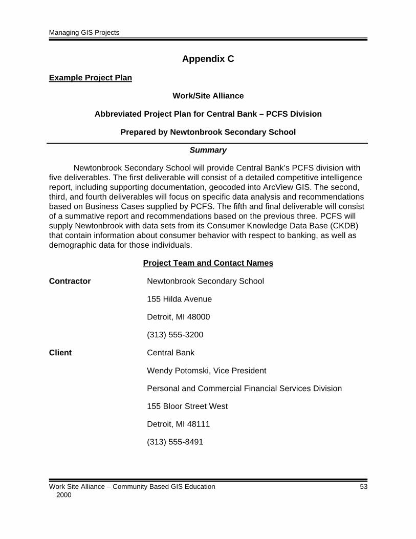
Managing GIS Projects
Work Site Alliance – Community Based GIS Education 53 2000
Appendix C
Example Project Plan
Work/Site Alliance
Abbreviated Project Plan for Central Bank – PCFS Division
Prepared by Newtonbrook Secondary School
Summary
Newtonbrook Secondary School will provide Central Bank’s PCFS division withfive deliverables. The first deliverable will consist of a detailed competitive intelligencereport, including supporting documentation, geocoded into ArcView GIS. The second,third, and fourth deliverables will focus on specific data analysis and recommendationsbased on Business Cases supplied by PCFS. The fifth and final deliverable will consistof a summative report and recommendations based on the previous three. PCFS willsupply Newtonbrook with data sets from its Consumer Knowledge Data Base (CKDB)that contain information about consumer behavior with respect to banking, as well asdemographic data for those individuals.
Project Team and Contact Names
Contractor Newtonbrook Secondary School
155 Hilda Avenue
Detroit, MI 48000
(313) 555-3200
Client Central Bank
Wendy Potomski, Vice President
Personal and Commercial Financial Services Division
155 Bloor Street West
Detroit, MI 48111
(313) 555-8491

Managing GIS Projects
Work Site Alliance – Community Based GIS Education 54 2000
Principal – Newtonbrook S. S. Marion Brumwell
Supervising Teacher Adam Mock
Project Team 11th Grade Marketing Class
Hardware Overview
The hardware to be used will consist of a lab of IBM Pentium III machines,networked on the School Board WAN.
Software Overview
APPLICATION MANUFACTURER/BRAND VERSION
Geographic InformationSystems
ESRI ArcView v. 3.x
Word Processor Microsoft Word Windows 2000
Spreadsheet Microsoft Excel Windows 2000
Database Microsoft Access Windows 2000
Presentation Microsoft PowerPoint Windows 2000
Performance Standard
Our goal is a product, which will meet and exceed Central Bank’s expectationswith respect to quality and thoroughness of information. Students will perform additionalresearch where necessary to ensure thorough and insightful recommendations toPCFS.
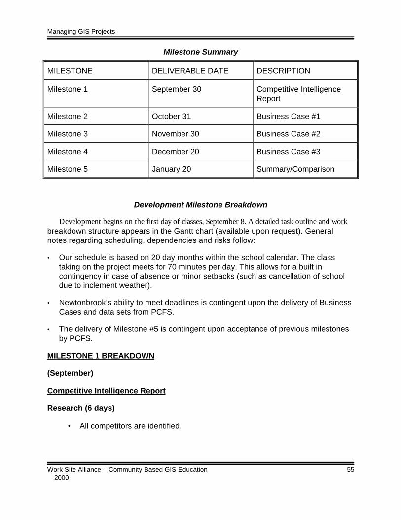
Managing GIS Projects
Work Site Alliance – Community Based GIS Education 55 2000
Milestone Summary
MILESTONE DELIVERABLE DATE DESCRIPTION
Milestone 1 September 30 Competitive IntelligenceReport
Milestone 2 October 31 Business Case #1
Milestone 3 November 30 Business Case #2
Milestone 4 December 20 Business Case #3
Milestone 5 January 20 Summary/Comparison
Development Milestone Breakdown
Development begins on the first day of classes, September 8. A detailed task outline and workbreakdown structure appears in the Gantt chart (available upon request). Generalnotes regarding scheduling, dependencies and risks follow:
• Our schedule is based on 20 day months within the school calendar. The classtaking on the project meets for 70 minutes per day. This allows for a built incontingency in case of absence or minor setbacks (such as cancellation of schooldue to inclement weather).
• Newtonbrook’s ability to meet deadlines is contingent upon the delivery of BusinessCases and data sets from PCFS.
• The delivery of Milestone #5 is contingent upon acceptance of previous milestonesby PCFS.
MILESTONE 1 BREAKDOWN
(September)
Competitive Intelligence Report
Research (6 days)
• All competitors are identified.
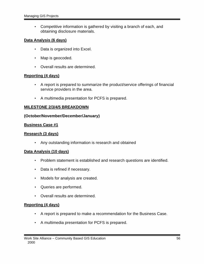
Managing GIS Projects
Work Site Alliance – Community Based GIS Education 56 2000
• Competitive information is gathered by visiting a branch of each, andobtaining disclosure materials.
Data Analysis (6 days)
• Data is organized into Excel.
• Map is geocoded.
• Overall results are determined.
Reporting (4 days)
• A report is prepared to summarize the product/service offerings of financialservice providers in the area.
• A multimedia presentation for PCFS is prepared.
MILESTONE 2/3/4/5 BREAKDOWN
(October/November/December/January)
Business Case #1
Research (3 days)
• Any outstanding information is research and obtained
Data Analysis (10 days)
• Problem statement is established and research questions are identified.
• Data is refined if necessary.
• Models for analysis are created.
• Queries are performed.
• Overall results are determined.
Reporting (4 days)
• A report is prepared to make a recommendation for the Business Case.
• A multimedia presentation for PCFS is prepared.

Managing GIS Projects
Work Site Alliance – Community Based GIS Education 57 2000
Appendix D
Project Concept Worksheet
Name of Project: ____________________________________________________
Brief description of the project:
Expected completion date:______________________________________________________
Project Stages Checklist:
Start-Up
q Locatepotentialclient/partneragency
q Makepresentationto potentialclient/partner agency
q Definepurpose ofproject inconjunctionwith clientagency
q Define thescope of theproject
q Ensure the
Planning
q Train teachersas applicable tothe project
q Obtaincommitmentfor technicalsupport
Project Plan:
q Identify andassign all tasks
q Createmilestones
q Schedule alltasks
q Createcommunication plan andschedule
Execution
q Monitorprojectprogress
q Liaise withclient on anongoingbasis
q Collect data
q Convert andpre-processdata
q Synthesizedata in toArcViewProject
q Createmodels
q Perform
Close-Out
q Settle allbudgetissues
q Have ameeting todiscuss whatwas donewell, howthings couldbeimproved,and anylessonslearned thatcan beapplied tofutureprojects
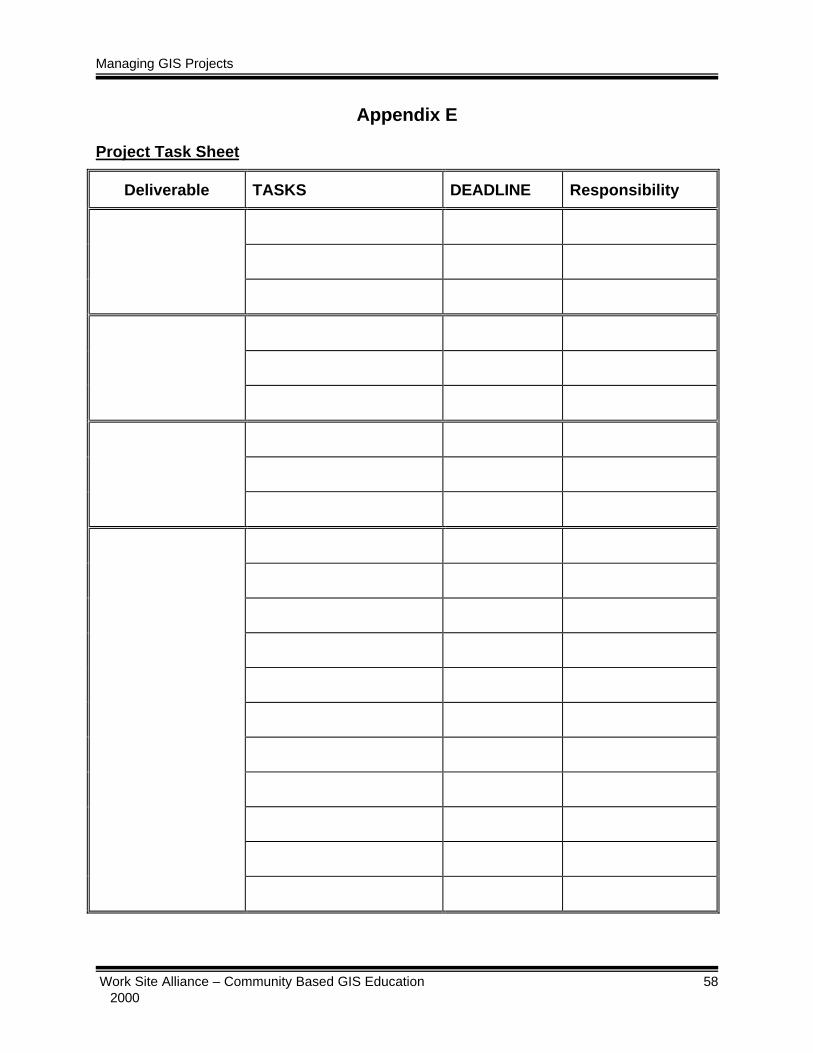
Managing GIS Projects
Work Site Alliance – Community Based GIS Education 58 2000
Appendix E
Project Task Sheet
Deliverable TASKS DEADLINE Responsibility

Managing GIS Projects
Work Site Alliance – Community Based GIS Education 59 2000
Appendix F
DID WELL DO BETTER
Summary of lessons learned for future projects:

Managing GIS Projects
Work Site Alliance – Community Based GIS Education 60 2000