project aist-camvis meeting agenda start at 2:00 pm est on march 27, 2009 items:...
TRANSCRIPT

Project AIST-CAMVis Meeting Agenda
Start at 2:00 PM EST on March 27, 2009Items:• introductions/warm-up activities (~5 minutes) • project overview (3~5 minutes)• open discussion (~5 minutes)
End at 2:30 PM ESTMeeting information:
Dial in numbers: 888-282-1678 Participant passcode: 18503
*AIST: Advanced Information System Technology**CAMVis: “Coupling NASA Advanced Multi-scale Modeling and Concurrent
Visualization Systems for Improving Predictions of Tropical High-Impact Weather”

Coupling NASA Advanced Multi-Scale Modeling and Concurrent Visualization Systems for Improving Predictions of Tropical High-Impact Weather (CAMVis)
Key Milestones
TRLout = 7
• Implement model components and CV on the
Pleiades supercomputer;
Conduct initial benchmarks 09/2009• Improve parallel scalability of model components;
Integrate the NASA fvGCM and CV 03/2010• Couple the NASA mg-GCEs and CV
Implement and test an I/O module 09/2010• Integrate the fvMMF (fvGCM+GCEs) and CV
Streamline data flow for production runs 09/2011• Test the coupled system 03/2012
ObjectiveSeamlessly integrate NASA advanced technologies of supercomputing, concurrent visualization (CV), and multi-scale (global-, meso-, and cloud-scale) modeling systems for improving the understanding of the roles of atmospheric moist thermodynamic processes (i.e., the changes of precipitation, temperature, and humidity) and the cloud-radiation-aerosol interactions, aimed at improving predictions of tropical high-impact weather systems.
Support Earth Science missions: Climate Absolute Radiance and Refractivity Observatory (CLARREO), Aerosol-Cloud-Ecosystems (ACE), PATH (Precipitation and All-Weather Temperature and Humidity), Three-dimensional Tropospheric winds from Space-based Lidar (3D-winds). All are described in the NRC Decadal Survey (2007). ApproachImprove parallel scalability of the multi-scale
modeling system to take full advantage of the next-generation peta- scale supercomputers (e.g., NASA Pleiades)
Integrate NASA multi- scale (global, regional, cloud-scale) model system, including Goddard Cloud Ensemble model (GCE) and the finite-volume General Circulation Model (fvGCM), and the concurrent visualization (CV) system
Significantly streamline data flow for fast post-processing and visualizations
Conduct high-resolution numerical simulations and visualizations for high-impact tropical weather events
Test coupled systems• Co-I’s: Wei-Kuo Tao (GSFC, CO-PI), Bryan Green (CO-PI), Chris Henze, Piyush Mehrotra, (ARC), Jui-Lin Li (JPL)
• Partners: Antonio Busalacchi (UMD), Peggy Li (JPL)
PI: Bo-Wen Shen (UMD/ESSIC)
Co-I’s/Partners
TRLin = 3
fvGCM, showing a 7-day forecast of tropical cyclone Nargis (2008) and westerly wind belt in the Indian Ocean
Pleiades supercomputer with 51,200 cores
Concurrent visualization (CV) system on the 128-panel hyperwall-2
GCE, simulating high-fidelity clouds motions
Multiscale modeling system, simulating planetary-scale Madden-Julia Oscillation. The system consists of the fvGCM and tens of thousands copies of GCEs.
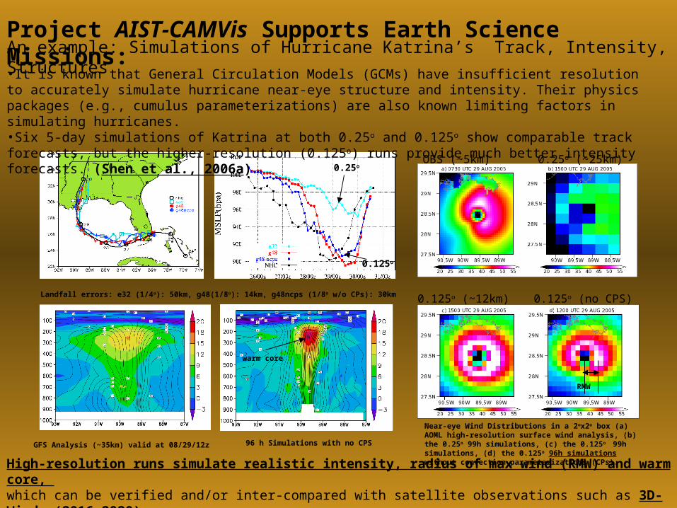
An example: Simulations of Hurricane Katrina’s Track, Intensity, Structures
GFS Analysis (~35km) valid at 08/29/12z 96 h Simulations with no CPS
High-resolution runs simulate realistic intensity, radius of max wind (RMW) and warm core, which can be verified and/or inter-compared with satellite observations such as 3D-Winds (2016-2020)
Landfall errors: e32 (1/4o): 50km, g48(1/8o): 14km, g48ncps (1/8o w/o CPs): 30km
Near-eye Wind Distributions in a 2ox2o box (a) AOML high-resolution surface wind analysis, (b) the 0.25o 99h simulations, (c) the 0.125o 99h simulations, (d) the 0.125o 96h simulations without convection parameterizations (CPs).
•It is known that General Circulation Models (GCMs) have insufficient resolution to accurately simulate hurricane near-eye structure and intensity. Their physics packages (e.g., cumulus parameterizations) are also known limiting factors in simulating hurricanes. •Six 5-day simulations of Katrina at both 0.25o and 0.125o show comparable track forecasts, but the higher-resolution (0.125o) runs provide much better intensity forecasts. (Shen et al., 2006a)
0.25o
0.125o
warm core
RMW
OBS (~5km) 0.25o (~25km)
0.125o (~12km) 0.125o (no CPS)
Project AIST-CAMVis Supports Earth Science Missions:

4
Large-scaleNumerical
Modeling & Visualization
Supercomputing
ScientificDiscoveries
Goals:
to improve presentations of multiple atmospheric processes and multiscale interactions by coupling a deterministic global model and stochastic cloud model
to meet real-time requirements by improving scalability and computing performance of the modeling system and by taking full advantage of NASA supercomputers
to understand and examine the transient dynamics of model simulations by integrating the numerical model and concurrent visualization systems.
to improve real-time predictions of high-impact tropical weather (e.g., hurricanes, MJO, AEWs etc) with the NASA advanced technologies
to explore the predictability limit of a mesoscale tropical weather and its interaction with large-scale weather with the advanced coupled system
“A Cycle”
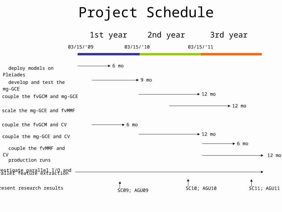
deploy models on Pleiades
1st year 2nd year 3rd year
03/15/’09 03/15/’10 03/15/’11
develop and test the mg-GCE
couple the fvGCM and mg-GCE
scale the mg-GCE and fvMMF
couple the fvGCM and CV
couple the mg-GCE and CV
couple the fvMMF and CV
production runs
6 mo
9 mo
12 mo
12 mo
6 mo
12 mo
6 mo
12 mo
Investigate parallel I/O and parallel feature extraction
Present research results SC09; AGU09 SC10; AGU10 SC11; AGU11
Project Schedule

Technology Readiness Level (TRL) Assessment
•TRL 3: analytical and experimental critical function and/or characteristic proof-of-concept
• A proof-of-concept implementation of scalable fvMMF has been done on Columbia.
• A proof-of-concept implementation of the CV system with the fvGCM has been done.
•TRL 4: components/subsystem validation in laboratory environment
•TRL 5: system/subsystem/component validation in relevant environment
• fvGCM will be coupled and tested with the CV system on the Pleiades supercomputer. (year 1)
• mgGCE will be developed (modularized) and coupled with the CV; (year 2)
• coupled fvMMF will be integrated with the CV. (early year 3)
•TRL 6: system/subsystem model or prototyping demonstration in a relevant end-to-end environment
• Simulations and visualizations in a hind-cast mode with fvGCM-CV and fvMMF-CV will be conducted for verification. Selected case studies include Hurricane Katrina (2005), Tropical Cyclones Nargis (2008), and Madden-Julia Oscillations. (early year 3)
•TRL 7: system prototyping demonstration in an operational environment
• Short-term and extended-range (15~30 days) weather/hurricane predictions with the final system in an experimental real-time mode (year 3)

Panel Comments on Project CAMVis
• Factor 1: Relevance to NASA's objectives: Relevance is clear, impact is substantial. This proposal will optimize compute-bound applications, create a modern framework for model innovations advancing research and minimizing research "mud". Research "mud" is the work that is required to optimize models without any advances in science. A here-to-for necessary evil. This proposal will substantially obviate the mud. Commercial benefits may surface for this proposal. A highly skilled near-term weather forecast can save lives. With the infrastructure that the authors propose, a highly skilled forecast could be the result!
• Factor 2: Intrinsic merit: This team is powerful, with extreme talent. The proposal is tight, bounded, and can be highly successful! The coupling and optimization of models is one of the most difficult tasks. The payoffs are very large; this reviewer feels that this team will succeed in all aspects!
• Factor 3: Cost realism and reasonableness: Excellent team drives the risk for the proposal to low. Management plan is reasonable. Past performance is excellent. This team will succeed!
The final comments have been made based on a peer review, including (1) individual evaluations by three reviewers, (2) integrated evaluation by the panel, consisting of over 60 specialists from NASA Centers, academia and industry.