progressing practices on pembina - university of...
TRANSCRIPT

Case-in-Point 2014 1
Case-in-Point 2014
Integrated transportation and land use are critical to the provision of Complete Streets and complete communities. Winnipeg’s transportation and development policies set out to enable lifestyles that include walking, cycling, and transit as everyday modes of transport. Such policies include the Complete Communities Direction Strategy and the Transportation Master Plan. The provision of housing, services, and amenities that are accessible to pedestrians, cyclists, and transit users are central to Winnipeg’s vision. As the City of Winnipeg sets out to facilitate multimodal transportation options, formulated design processes will assist in accounting for the spectrum of considerations and opportunities for Complete Streets and communities. The City of Winnipeg’s Pembina Highway rehabilitation project between Crescent and Plaza Drives was one of the City’s cutting edge projects to provide multimodal transportation options to link key city regions. This transportation project is significant because it balanced the needs of various street users, and the design process demonstrated collaboration between municipal departments, politicians, stakeholders, and the public. This case study was conducted to document the given street design process, and consider how the design process could be expanded to improve multimodal transportation and land use integration in future endeavors.
Abstract
Progressing Practices on PembinaCompleting Streets and Communities through Coordinated Geometric Design and Land Use Planning
Jeana Klassenin collaboration with the
City of Winnipeg’s:
Susanne Dewey Povoledo, Planner
Kevin Nixon, Active Transportation Coordinator
Judy Redmond, Universal Design Coordinator
Scott Suderman, Streets Planning Engineer

Case-in-Point 2014 2
Major arterial streets enable the efficient flow of traffic, by allowing high speeds, limited land access, high traffic volumes, and limited parking (City of Winnipeg, 2011b). This case-in-point will explore the Pembina Highway project, seeking to understand the design process that was undertaken to integrate geometric design and land use planning. Geometric design includes a roadway’s dimensions and features (TAC, 1999) and land use planning sets out land uses, physical facilities, and services through plans and policies (Government of Canada, 2013). Particular attention will be given to aspects that could further acknowledge the inter-relationships and integration of geometric design and land use planning. The case study will evaluate what was successful, what could be done differently, and what was missed.
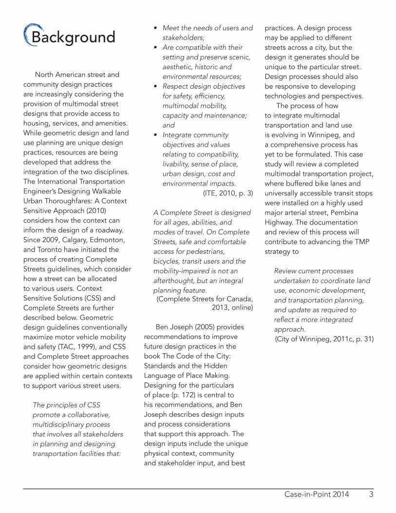
Highway. An adjacent street does not exist as an alternative route between Crescent and Plaza Drives. Winnipeg’s development plan, OurWinnipeg (2011b), designates Pembina Highway as a Regional Mixed Use Corridor. The Complete Communities Direction Strategy (2011a) suggests that additional development and redevelopment is promoted along Regional Mixed Use Corridors, as shown in Figure 1.
By expanding the number and range of amenities and housing options within existing neighbourhood intensifying mixed use development along Corridors will help to complete communities. (City of Winnipeg, 2011a, p. 39)
From a transportation network perspective, Pembina Highway is a major arterial street (City of Winnipeg, 2011c).
The City of Winnipeg’s Complete Communities Direction Strategy (2011a) and the Transportation Master Plan (2011c) frame Winnipeg’s growth and development for the next 25 years. Complete Communities aspires to create “places that both offer and support a variety of lifestyle choices, providing opportunities for people of all ages and abilities to live, work, shop, learn and play in close proximity to one another” (City of Winnipeg, 2011a, p. 4). The Transportation Master Plan (City of Winnipeg, 2011c) articulates strategies for integrating transportation and land use, and also providing transportation choice. Accessibility and universal design, transportation demand management, and Complete Streets are design considerations that enable transportation choice. In 2013, buffered bike lanes and universally accessible bus stops were installed on the east and west sides of Pembina Highway between Crescent and Plaza Drives. This project was initiated based on the roadway’s need for rehabilitation, and city policies expanded the scope to incorporate cycling and universally accessible designs. Pembina Highway is a key transportation corridor, running from Downtown and the Central Business District, through the Inner Ring Strategic Road Network and Perimeter
Introduction
Figure 1: Regional mixed use corridor’s progression of development (City of Winnipeg, 2011a)
Case-in-Point 2014 3
• Meet the needs of users and stakeholders;
• Are compatible with their setting and preserve scenic, aesthetic, historic and environmental resources;
• Respect design objectives forsafety,efficiency,multimodal mobility, capacity and maintenance; and
• Integrate community objectives and values relating to compatibility, livability, sense of place, urban design, cost and environmental impacts.
(ITE, 2010, p. 3)
A Complete Street is designed for all ages, abilities, and modes of travel. On Complete Streets, safe and comfortable access for pedestrians, bicycles, transit users and the mobility-impaired is not an afterthought, but an integral planning feature. (Complete Streets for Canada,
2013, online)
Ben Joseph (2005) provides recommendations to improve future design practices in the book The Code of the City: Standards and the Hidden Language of Place Making. Designing for the particulars of place (p. 172) is central to his recommendations, and Ben Joseph describes design inputs and process considerations that support this approach. The design inputs include the unique physical context, community and stakeholder input, and best
practices. A design process may be applied to different streets across a city, but the design it generates should be unique to the particular street. Design processes should also be responsive to developing technologies and perspectives. The process of how to integrate multimodal transportation and land use is evolving in Winnipeg, and a comprehensive process has yet to be formulated. This case study will review a completed multimodal transportation project, where buffered bike lanes and universally accessible transit stops were installed on a highly used major arterial street, Pembina Highway. The documentation and review of this process will contribute to advancing the TMP strategy to
Review current processes undertaken to coordinate land use, economic development, and transportation planning, and update as required to reflectamoreintegratedapproach.(City of Winnipeg, 2011c, p. 31)
Background
North American street and community design practices are increasingly considering the provision of multimodal street designs that provide access to housing, services, and amenities. While geometric design and land use planning are unique design practices, resources are being developed that address the integration of the two disciplines. The International Transportation Engineer’s Designing Walkable Urban Thoroughfares: A Context Sensitive Approach (2010) considers how the context can inform the design of a roadway. Since 2009, Calgary, Edmonton, and Toronto have initiated the process of creating Complete Streets guidelines, which consider how a street can be allocated to various users. Context Sensitive Solutions (CSS) and Complete Streets are further described below. Geometric design guidelines conventionally maximize motor vehicle mobility and safety (TAC, 1999), and CSS and Complete Street approaches consider how geometric designs are applied within certain contexts to support various street users.
The principles of CSS promote a collaborative, multidisciplinary process that involves all stakeholders in planning and designing transportation facilities that:

Case-in-Point 2014 4
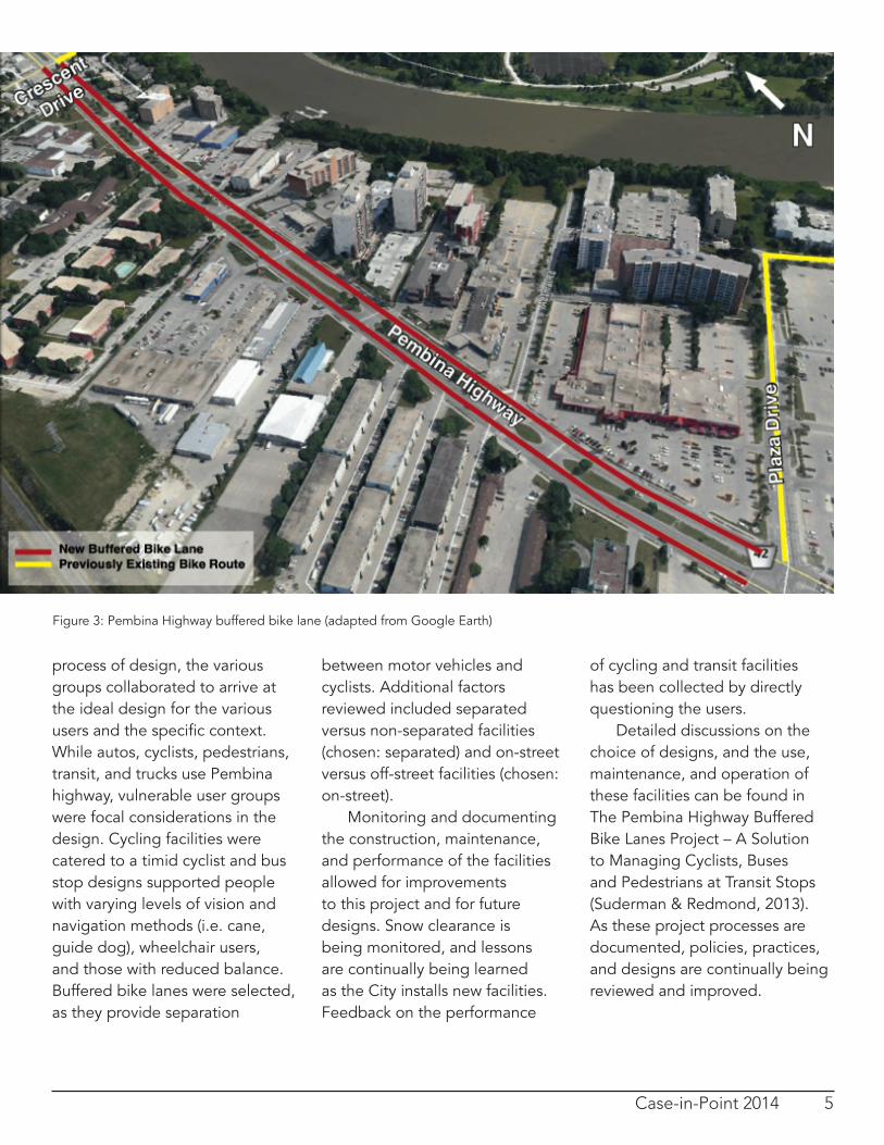
Pembina Highway is a three lane divided major arterial street. The previous design of Pembina Highway between Crescent and Plaza Drive is shown in Figure 1, and design considerations are shown in Table 1. When Pembina Highway was scheduled to undergo a mill and fill project, active transportation facilities were included in the project scope due to the 2008 Active Transportation Action Plan Policy. This policy recommended that any major rehabilitation done on a facility included in the City’s planned active transportation network implement the infrastructure as a part of the rehabilitation (City of Winnipeg, 2008). This section of Pembina Highway was both a gap in the cycling network and the only corridor option (Figure 2). The Universal Design Policy (City of Winnipeg, 2001) provides
accessibility standards that are intended for application to City of Winnipeg projects. The need for universally accessible designs was not only supported by policy, but by the high demand for transit services for those with poor mobility. Bus drivers count the number of wheelchairs using their service, and a need to account for wheelchair friendly designs was noted for this route. Older adult housing, services, and amenities were also particularly noted along this corridor. Transportation engineers and planners were involved in the process of design, and input was collected from stakeholders within municipal departments, the public, businesses and politicians. In the decision making process, two design concepts were developed and shared with the involved parties. Design scenarios were based on best practices (Suderman & Redmond, 2013). It was recognized that in any design there are tradeoffs between modes and conflict areas are inevitable (for example,
in the chosen design show in Figure 3, pedestrians have to cross the cycle track to access the bus stop). Designers sought to mitigate risks and manage conflict areas. Various designs were considered and their impacts on various street users were reviewed. Maintaining motor vehicle and transit level of service, and ensuring a continuous cycling trip was a priority. Way finding was intended to support people with a variety of mobility challenges and using different modes of transport. Documenting and sharing the analysis of the two designs and the decision making process was critical to gaining external and internal support. The buffered bike lanes and the transit stop design were selected by the Active Transportation Coordinator, geometric design details were determined by the Streets Planning Engineer, and accessibility details were guided by the Universal Design Coordinator. Throughout this
Process Facts
Figure 2: Previous design of Pembina Highway (Suderman and Redmond, 2013)
Design Consideration
Pembina Highway Context
Land use context Commercial and residential
Functional classification
Major arterial
Relationship of buildings to street
Street and non-street oriented
Motor vehicles 48 000/weekday
Transit buses 600/weekday
Cyclist use High
Pedestrian use Moderately high
Speed limit 60 km/h
Table 1: Pembina Highway design considerations (data collected from a site visit and Suderman & Redmond, 2013)
Case-in-Point 2014 5
process of design, the various groups collaborated to arrive at the ideal design for the various users and the specific context. While autos, cyclists, pedestrians, transit, and trucks use Pembina highway, vulnerable user groups were focal considerations in the design. Cycling facilities were catered to a timid cyclist and bus stop designs supported people with varying levels of vision and navigation methods (i.e. cane, guide dog), wheelchair users, and those with reduced balance. Buffered bike lanes were selected, as they provide separation
between motor vehicles and cyclists. Additional factors reviewed included separated versus non-separated facilities (chosen: separated) and on-street versus off-street facilities (chosen: on-street). Monitoring and documenting the construction, maintenance, and performance of the facilities allowed for improvements to this project and for future designs. Snow clearance is being monitored, and lessons are continually being learned as the City installs new facilities. Feedback on the performance
of cycling and transit facilities has been collected by directly questioning the users. Detailed discussions on the choice of designs, and the use, maintenance, and operation of these facilities can be found in The Pembina Highway Buffered Bike Lanes Project – A Solution to Managing Cyclists, Buses and Pedestrians at Transit Stops (Suderman & Redmond, 2013). As these project processes are documented, policies, practices, and designs are continually being reviewed and improved.
Figure 3: Pembina Highway buffered bike lane (adapted from Google Earth)

Case-in-Point 2014 6
While this project focused on roadway and transit stop designs, future project scopes may have the potential to integrate additional land use considerations (City of Winnipeg, 2011c). Transportation engineers and planners determined the process for designing Pembina Highway’s bike lanes and transit facilities in a piecemeal fashion without a formal process. After reflecting on this process, the planners and engineers have acknowledged the potential value of a formal process to support future projects. A formalized process is thought to improve communication and thereby understanding among municipal departments, the public, politicians, and stakeholders, help ensure an optimal multimodal design, and improve transportation and land use integration. To expand the Pembina Highway design process beyond multimodal roadway considerations and into land use considerations, the below process is suggested (Figure 4). From this formalized process “Understanding the current and future role of the street” (see second step of Figure 4) is an area that could more explicitly consider opportunities for better land use and transportation integration by the City of Winnipeg. A key element of this is to analyze how
Lessons Learned
Figure 4: Chosen design for buffered bike lanes (City of Winnipeg, 2012)
the street could be designed to support future roadway networks and land developments. For example, if a street is scheduled to become a trucking route, the multimodal geometric design should be cognizant of this shift in a way deemed appropriate. In the case of future pedestrian
oriented land development, the geometric design should support pedestrians accordingly. A review of transit stop’s placement, modal trip generators, pedestrian desire lines, and bicycle and motor vehicle parking further contribute to the current and future role of a street.

Case-in-Point 2014 7
*E.g. convert a bike sharrow to a bike lane; convert a mixed traffic lane to a designated bus lane **E.g. transit oriented development around nodes; pedestrian oriented mixed-‐use development along corridors; auto-‐oriented low-‐density box store development; ***E.g. cyclists qualities: daring, timid, recreational, utilitarian, cargo bikes, passing cyclists; pedestrian qualities: older adults, children, mobility impaired, recreational, retail, utilitarian
The need or opportunity for redesign of the roadway is
established by:
• Repair, rehab, or reconstruc3on • Policies and modal plans • Public or poli3cal concern • Network gaps • Increased service/facility quality demand* • Safety concerns
Understand the current and future role of the street for:
• Interac3ng with land use and design** • Specific land use context (nearby trip generators and associated pedestrian desire lines)
• Enabling social interac3ons, economic exchanges, and environmental considera3ons
• Alloca3ng mul3modal mobility, access, and aesthe3c space and features
• Facilita3ng vehicle and bicycle parking, and transit stop placement • Providing u3lity space • Supplemen3ng a future alterna3ve modal priority route
Consider poten9al transporta9on facili9es.
• Determine the range of user needs*** and priori3es • Ensure consistency and con3nuity with similar city facili3es • Search for precedents • Research seasonal poten3als and challenges for design • Assess tradeoffs • Analyze safety • Inves3gate opera3onal and drainage implica3ons of poten3al facili3es • Explore innova3ons in land drainage
Determine and implement the geometric design
• Consider a pilot project if there is public or poli3cal uncertainty
Monitor and report
• User interviews • Collect modal counts • Track maintanence performance • Assess modal performance measures • Present :indings • Reasses policy
Education, Discussion, and Documentation:
Iterative process with public and stakeholders
Figure 5: Suggested process for integrating geometric design and land use planning

Case-in-Point 2014 8
In addition to the International Transportation Engineers’ Designing Walkable Urban Thoroughfares: A Context Sensitive Approach (2010) and Canadian municipalities’ Complete Streets guidelines, the National Association of City Transportation Officials’ Urban Street Design Guide (2013) is also being applied in Canada. Common features of these guidelines include
• Street classification systems/typologies that describe the relationship of the street to the surrounding land use (Winnipeg’s current street classification system describes the roadway’s level of mobility – expressway, major arterial, minor arterial, collector, and local road)
• A discussion of multimodal performance measures (Winnipeg currently focuses on motor vehicle level of service)
• A street design process that inclusively considers multimodal transportation
Lessons from these guidelines were considered when suggesting a design process for Winnipeg. Common trends in guidelines could be considered by Winnipeg as it practically integrates transportation and land use.
The process for design influences what is included in a project’s scope, the factors that are considered, and how the factors are considered. As the City of Winnipeg seeks to integrate transportation and land use through Complete Streets and communities, projects’ processes will need to be reframed to comprehensively consider how geometric design can support land use. The Pembina Highway project between Crescent and Plaza Drives demonstrates a collaborative process between municipal departments,
Progressing Practices
Conclusionstakeholders, politicians, and the public where the needs of various street users were considered. This case-in-point debriefed this design process, formulating the steps that were taken and future steps that could improve geometric design and land use integration. Understanding the current and future role of the street was identified as a key area future design processes could integrate more comprehensively. Further networking and practice sharing between municipalities and design organizations could further enhance Winnipeg’s design practices.
Figure 6: Westminster Avenue and Sherbrook Street, Winnipeg (source: Jeana Klassen)
Case-in-Point 2014 9
ResourcesBen Joseph, E. (2005). The Code
of the City: Standards and the Hidden Language of Place Making. Cambridge, MA: MIT Press.
City of Winnipeg. (2012). Active Transportation Network: Pembina Highway Buffered Bike Lanes Project. Retrieved 2 April 2014 from http://www.winnipeg.ca/publicworks/MajorProjects/ActiveTransportation/PembinaBufferedBikeLanes/default.stm
City of Winnipeg. (2011a). The Complete Communities Direction Strategy. Retrieved 4 March 2014 from http://winnipeg.ca/interhom/ CityHall/OurWinnipeg/pdf/CompleteCommunities.Jul_.12.2011.WEB_.RGB_.pdf
City of Winnipeg. (2011b). OurWinnipeg. Retrieved 9 April 2014 from http://winnipeg.ca/interhom/CityHall/OurWinnipeg/pdf/OurWinnipeg.Jul15.2010.pdf
City of Winnipeg. (2011c). Transportation Master Plan. Retrieved 4 March 2014 from http://transportation.speakupwinnipeg.com/files/2011/11/2011-11-01-TTRWinnipegTMP-Final-Report.pdf
Special thanks to Susanne Dewey Povoledo, Kevin Nixon, Judy Redmond, and Scott Suderman for their collaborative contributions and insights into this project.
City of Winnipeg. (2008). Council Meeting – May 14, 2008: Meeting Proceedings. Retrieved 20 March 2014 from http://www.winnipeg.ca/CLKDMIS/ViewDoc.asp?DocId=8323&SectionId=&InitUrl
City of Winnipeg. (2001). Report of the Executive Policy Committee: Universal Design Policy. Retrieved 28 March 2014 from http://www.winnipeg.ca/ppd/planning/pdf_folder/EPC_UnivDesign.pdf
Complete Streets for Canada. (2012). Retrieved 14 March 2014 from http://completestreetsforcanada.ca
Government of Canada. (2013). Urban and Land Use Planners. Service Canada. Retrieved 28 February 2014 from http://www.servicecanada.gc.ca/eng/qc/job_futures/statistics/2153.shtml
Institute of Transportation Engineers (ITE). (2010). Designing Walkable Urban Thoroughfares: A Context Sensitive Approach. Retrieved 22 March 2013 from http://www.ite.org/css/
Suderman, S. & Redmond, J. (2013). The Pembina Highway Buffered Bike Lanes Project – A Solution to Managing Cylcists, Buses and Pedestrians at Transit Stops. 2013 Conference of the Transportation Association of Canada: Geometric Design – Lessons Learned Session.
Transportation Association of Canada (TAC). (1999).Geometric Design Guide for Canadian Roads. Ottawa: Transportation Association of Canada.