progress - alaska
TRANSCRIPT
PROGRESS REPORT
1966 - 1967
WATER STUDY - GREATER ANCHORAGE AREA, ALASKA
BY
William W . Barnwell and Raymond S . George
Open-f i le Report
U.S. Geological Survey - Water Resources Divis ion
Prepared i n Cooperation with t h e C i t y o f Anchorage
and t h e Grea te r Anchorage Area Borough
This r epor t is pre l iminary and has no t been e d i t e d
o r reviewed f o r conformity with U.S. Geological
Survey e d i t o r i a l s tandards
CONTENTS
. . . . . . . . . . . . . . . . . . . . . . . . . . . . Summary
In t roduct ion . . . . . . . . . . . . . . . . . . . . . . . . . . . . . . . . . . . . . . . . . . . . . S t a t u s of cu r r en t work
. . . . . . . . . . . . . . . . . . . . . Geologic s t u d i e s
. . . . . . . . . . . . . . . . . . . Geophysical s t u d i e s
Se i smicsu rvey . . . . . . . . . . . . . . . . . . . . . . . . . . . . . . . . . . . . R e s i s t i v i t y survey
Borehole geophysics . . . . . . . . . . . . . . . . . Hydrologic s t u d i e s . . . . . . . . . . . . . . . . . . . .
. . . . . . . . . . . . . . . . . . . . . Streamflow
Groundwater . . . . . . . . . . . . . . . . . . . . . . . . . . . . . . . . . . . . . . Q u a l i t y o f w a t e r
Waterbudget . . . . . . . . . . . . . . . . . . . . Special s t u d i e s . . . . . . . . . . . . . . . . . . . . .
Remote sensing . . . . . . . . . . . . . . . . . . . Ef fec t s of s a l t -wa te r encroachment . . . . . . . . .
Basic records . . . . . . . . . . . . . . . . . . . . . . . . . . . . . . . . . . . . . . . . . . . Plans f o r f u t u r e work
Development of new sources . . . . . . . . . . . . . . . . S u r f a c e w a t e r . . . . . . . . . . . . . . . . . . . .
. . . . . . . . . . . . . . . . . . . . Ground water
Maintenance of e x i s t i n g supp l i e s . . . . . . . . . . . . . Water management . . . . . . . . . . . . . . . . . . . . .
Page
1
3
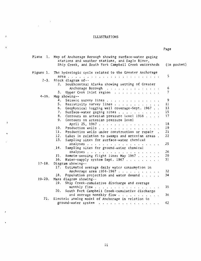
ILLUSTRATIONS
Page
Plate 1. Map af Anchorage Borough showing sur face-water gaging s t a t i o n s and weather s t a t i o n s , and Eagle River, Ship Creek, and South Fork Campbell Creek watersheds
Figure 1. The hydrologic cyc l e r e l a t e d t o t h e Grea te r Anchorage a r e a . . . . . . . . . . . . . . . . . . . . . . . .
2 - 3 . Block diagram of-- 2 . Southcent ra l Alaska showing s e t t i n g of Grea te r
Anchorage Borough . . . . . . . . . . . . . . 3 . Upper Cook I n l e t reg ion . . . . . . . . . . . .
4-16. Map showing-- 4 . Seismic survey l i n e s . . . . . . . . . . . . . . 5. R e s i s t i v i t y survey l i n e s . . . , . . . . . . . . 6. Geophysical logging wel l coverage-Sept. 1967 . . 7. Surface-water gaging s i t e s . . . . . . . . . . . 8. Contours on a r t e s i a n pressure l e v e l 1956 . . . . 9. Contours on a r t e s i a n p r e s s u r e l e v e l
Apr i l 25, 1967 . . . . . . . . . . . . . . . . 10. P r o d u c t i o n w e l l s . . . . . . . . . . . . . . . . 11. Product ion we l l s under cons t ruc t ion or r e p a i r . 1 2 . Lakes i n r e l a t i o n t o swamps and a r t e s i a n axeas . 13 . Sampling s i t e s f o r sur face-water chemical
ana lyses . . . . . . . . . . . . . . . . . . . 14. Sampling s i t e s fox ground-water chemical
analyses . . . . . . . . . . . . . . . . . . . 15. Remote-sensing f l i g h t l i n e s May 1967 . . . . . . 16. Water-supply system Sept . 1967 . . . . . . . . .
17-18. Diagram showing-- 1 7 . Estimated average d a i l y water consumption i n
Anchorage a r e a 1954-1967 . . . . . . . . . . . 18. Populat ion p r o j e c t i o n and water demand . . . . .
19-20. Mass diagram showing-- 19. Ship Creek-cumulative d i scharge and average
monthly flow . . . . . . . . . . . . . . . . . 20. South Fork Campbell Creek-cumulative d i scharge
and average monthly flow . . . . . . . . . . . 21. E l e c t r i c analog model o f Anchorage i n r e l a t i o n t o
ground-water system . . . . . . . . . . . . . . . .
( i n pocket)
The Grea te r Anchorage Area Water Resources Study
Progress Report 1966-67
SUMMARY
The purpose of t h e 5-year coopera t ive water resources s tudy o f t h e
Grea te r Anchorage a r ea by t h e Geological Survey is t o app ra i s e t h e water
resources of t h e a r e a and ob ta in d a t a needed t o so lve water problems and
t o a s s i s t i n t h e o r d e r l y development and management of t h e r e sou rce .
Work accomplished during t h e f i r s t yea r of t h e s tudy has been
concerned l a r g e l y wi th t he o rgan iza t ion and compilat ion of e x i s t i n g d a t a
p repa ra to ry t o i n t e r p r e t a t i o n and a n a l y s i s . In add i t i on new d a t a were
acquired regard ing t h e geohydrology o f t h e a r e a . This involved coopera t ive
s t u d i e s wi th t h e Engineering and Geophysics Branches of t h e Geological
Survey t o understand b e t t e r t h e na tu re of rocks underlying t h e a r e a and
t h e i r s t r u c t u r a l and s t r a t i g r a p h i c r e l a t i o n s . The s t u d i e s used se i smic ,
e l e c t r i c a l - r e s i s t i v i t y , and borehole geophysical methods t o d e f i n e t h e
geology. Only pre l iminary i n t e r p r e t a t i o n s o f t h e geologic d a t a have been
made t o d a t e . The s tudy o f hydrology has r equ i r ed an inventory o f new
water wells i n t h e a r ea and an expansion of t h e stream-gaging and water-
q u a l i t y programs t o inc lude Eagle River, Ship Creek, Chester Creek, South
Fork Campbell Creek, Campbell Creek, and Glac i e r Creek. Miscellaneous
measurements were a l s o made t o determine flow l o s s e s o r ga ins i n s t reams.
The amount and p a r t i c l e s i z e d i s t r i b u t i o n of sediment c a r r i e d by s e l e c t e d
s t reams and t h e chemical q u a l i t y o f both s u r f a c e and ground water was a l s o
determined. Prel iminary work was s t a r t e d t o determine t h e water budget of
t h e a r e a . The budget involves determining t h e t o t a l inf low and outf low of
water i n t he a r e a inc luding evapo t r ansp i r a t i on . Maps were cons t ruc ted
showing t h e a r t e s i a n p re s su re l e v e l s i n t h e g l a c i a l water-bear ing rocks
under ly ing t h e a r ea . The maps show t h e a r t e s i a n water p r e s su re l e v e l s i n
1956 soon a f t e r pumping from those aqu i f e r s was begun, t h e l e v e l s i n 1967,
and t h e change i n t h e l e v e l s dur ing t h e i n t e r v a l .
During 1967, t h e Geological Survey worked c l o s e l y with Ci ty , Borough,
and Federal o f f i c i a l s and with l o c a l consul t ing engineers on s p e c i f i c
problems r e l a t i n g t o ground water and t o p o l l u t i o n .
Spec ia l hydrologic s t u d i e s involving t h e use of remote sensing
techniques were i n i t i a t e d and monitoring programs t o de t ec t s a l t - w a t e r
encroachment were e s t ab l i shed .
Work p lans f o r t he 1968 f i s c a l year c a l l f o r a g r e a t e r use of
automatic data-processing techniques t o more e f f e c t i v e l y i n t e r p r e t t h e
accumulated da t a . An e l ec t r i c - ana log model of t h e Anchorage hydrologic
system i s under cons t ruc t ion . The model and processing techniques w i l l
provide management with t o o l s t o b e t t e r u t i l i z e t h e water resources of
t h e a r ea . Addit ional gaging s t a t i o n s w i l l be e s t ab l i shed on Rabbit Creek,
L i t t l e Rabbit Creek, Pe t e r s Creek, and on F i r e Lake. Emphasis w i l l be
placed on t h e explora t ion by t e s t d r i l l i n g o f new sources of ground water
i n t h e a l l u v i a l fan a reas on Ship and Campbell Creeks. Test d r i l l i n g is
planned t o e s t a b l i s h more adequate monitoring po in t s f o r s a l t -wa te r
encroachment and t o v e r i f y geologic concepts der ived from p a s t geophysical
s t u d i e s . During t h e year , f i e l d t e s t s w i l l be conducted t o determine r a t e s
o f flow of ground water, t h e permeabi l i ty of ma te r i a l s , and t h e r e l a t i o n -
sh ip o f s u r f a c e and ground water . Other p lans inc lude ana lys i s of
e x i s t i n g production-well pumping schedules and t h e extension of t he well
inventory t o ou t ly ing communities wi th in t h e Borough.
INTRODUCTION
The o b j e c t i v e of t h e s tudy is t o app ra i se t h e water resources of t h e
Anchorage a rea and t o obta in some of t h e b a s i c da t a needed t o so lve water
problems i n t h e Anchorage a rea . The problems include development of new
water sources, maintenance of e x i s t i n g supp l i e s , water management, poss ib l e
e f f e c t s of s a l t -wa te r encroachment, water temperature i n d i s t r i b u t i o n l i n e s ,
drainage of waterlogged a reas , and e f f e c t s of f loods and p o l l u t i o n on t h e
water system. During the s tudy, f a c t s about t h e hydrologic system i n t h e
Greater Anchorage a rea w i l l be assembled and i n t e g r a t e d t o a i d c i t y and
borough o f f i c i a l s i n t h e o rde r ly development of t h e water resource .
The information needed f o r development inc ludes d e f i n i t i o n of hydro-
l o g i c boundaries, inventory of e x i s t i n g developments, i n v e s t i g a t i o n of
undeveloped sources, and an e s t ima te of t o t a l q u a n t i t i e s of water
p o t e n t i a l l y a v a i l a b l e .
I n J u l y 1966 t h e Geological Survey undertook a 5-year cooperat ive
program with t h e c i t y o f Anchorage and t h e Grea ter Anchorage Area Borough
t o a s s e s s t h e water resources of t h e Borough. Many r e l a t e d s t u d i e s by
o t h e r Federal and S t a t e agencies a r e con t r ibu t ing valuable information.
These r e l a t e d s t u d i e s a r e descr ibed elsewhere i n t h i s r e p o r t .
This r e p o r t summarizes progress by t h e Water Resources Division of
t h e U.S. Geological Survey's program t o da t e and o u t l i n e s fu tu re work
p l ans . Work during the f i r s t year has been concentrated mainly i n t h e
metropol i tan a rea of Anchorage.
STATUS OF CURRENT WORK
I t i s necessary t o explore i n many d i r e c t i o n s t o obta in d a t a needed
t o so lve t h e complex problems being encountered i n t h e Greater Anchorage
a r e a . The work of t he p r o j e c t i s aimed a t providing da t a f o r t h e s o l u t i o n
not only o f cu r r en t problems but a l s o long-range problems.
S p e c i f i c kinds of work designed t o accomplish t h e foregoing objec-
t i v e s a r e d iscussed below under geologic s t u d i e s , geophysical s t u d i e s ,
hydrologic s t u d i e s , s p e c i a l s t u d i e s , and c o l l e c t i o n of b a s i c da t a .
Geologic S tudies
Geologic s t u d i e s i n cooperation with the Engineering Geology Branch,
U.S. Geological Survey, a r e cont inuing. The Engineering Geology Branch
is p r e s e n t l y conducting an independent, f e d e r a l l y f inanced, engineering
geology s tudy of t he Borough. These s t u d i e s a r e aimed a t de f in ing t h e
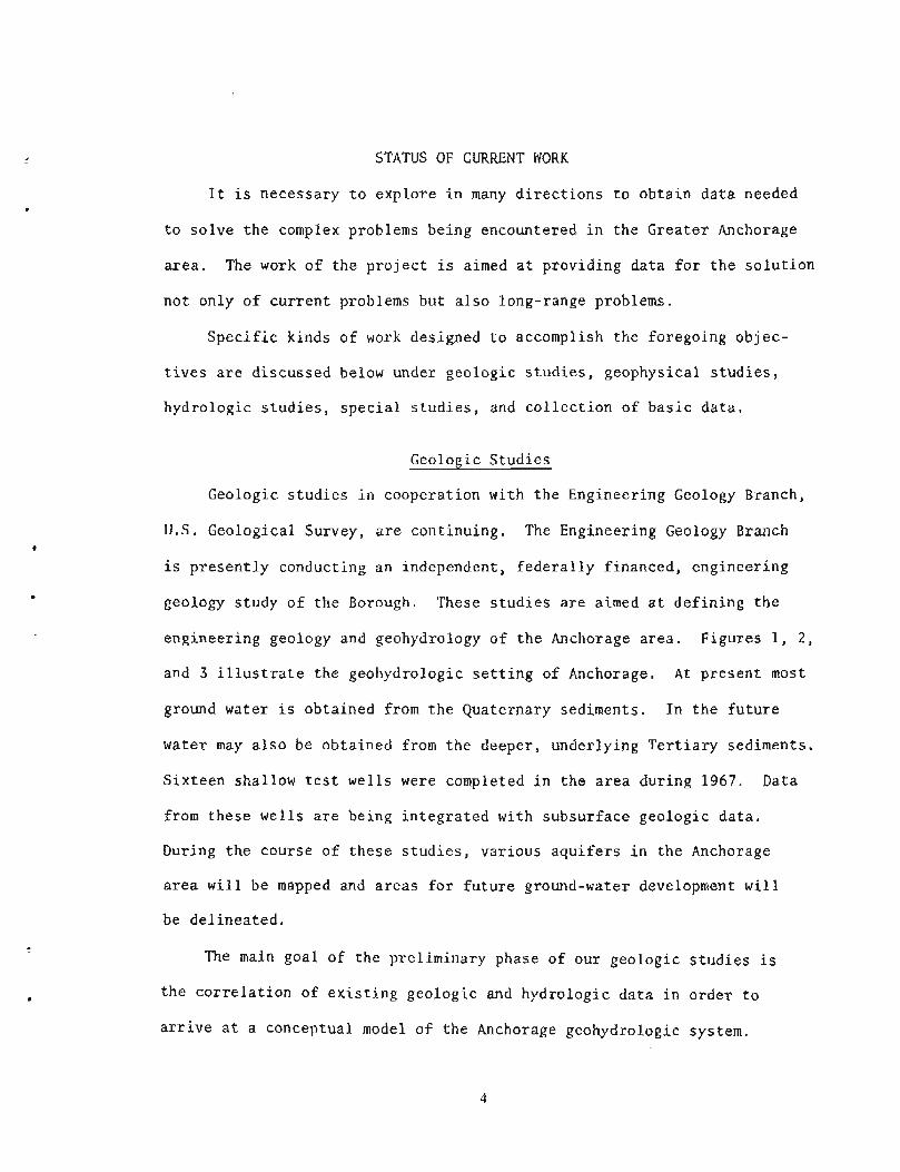
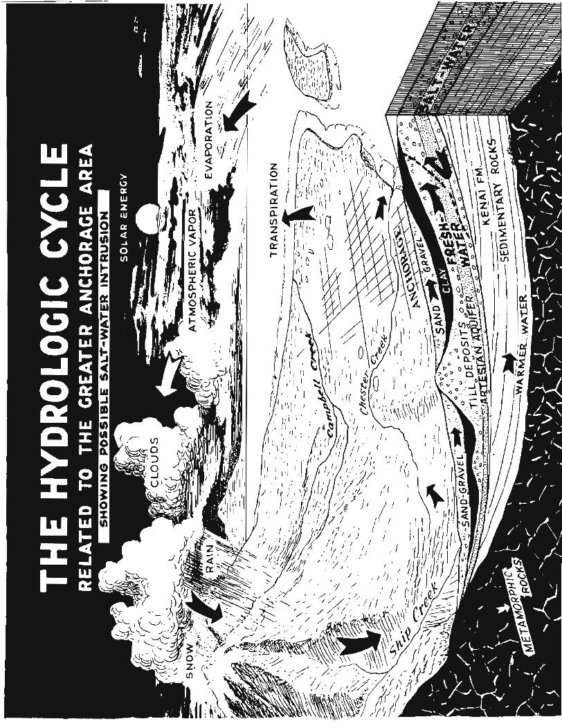
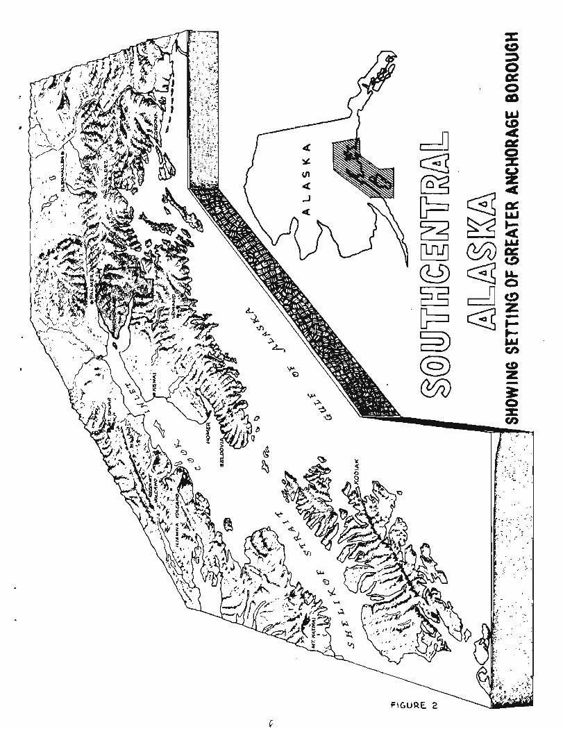
engineering geology and geohydrology of t he Anchorage a rea . Figures 1, 2 ,
and 3 i l l u s t r a t e t he geohydrologic s e t t i n g of Anchorage. A t p resent most
ground water i s obtained from t h e Quaternary sediments. In t h e f u t u r e
water may a l s o be obtained from t h e deeper, underlying T e r t i a r y sediments.
S ix teen shallow t e s t wel ls were completed i n t h e a r ea during 1967. Data
from these wel l s a r e being i n t e g r a t e d with subsurface geologic da t a .
During the course o f t hese s t u d i e s , var ious a q u i f e r s i n t h e Anchorage
area w i l l be mapped and a reas f o r fu tu re ground-water development w i l l
be de l inea t ed .
The main goal of t he prel iminary phase of our geologic s t u d i e s i s
t he c o r r e l a t i o n of e x i s t i n g geologic and hydrologic d a t a i n order t o
a r r i v e a t a conceptual model of t h e Anchorage geohydrologic system.
Geophysical Studies
In the Anchorage area, surveys were conducted during 1967 to
determine the depth to bedrock and thickness and lithology of overlying
water-bearing glacial sediments. This work was concentrated in the area
of Ship Creek and Campbell Creek to establish control. Information from
these control areas will then be correlated with other subsurface data
from surrounding areas to establish a model of the geohydrologic system.
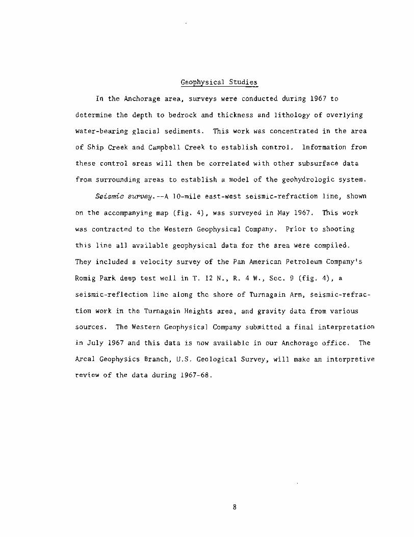
Seismic survey.--A 10-mile east-west seismic-refraction line, shown
on the accompanying map (fig. 4), was surveyed in May 1967. This work
was contracted to the Western Geophysical Company. Prior to shooting
this line all available geophysical data for the area were compiled.
They included a velocity survey of the Pan American Petroleum Company's
Romig Park deep test well in T. 12 N., R . 4 W., Sec. 9 (fig. 43, a
seismic-reflection line along the shore of Turnagain Arm, seismic-refrac-
tion work in the Turnagain Heights area, and gravity data from various
sources. The Western Geophysical Company submitted a final interpretation
in July 1967 and this data is now available in our Anchorage office. The
Areal Geophysics Branch, U.S. Geological Survey, will make an interpretive
review of the data during 1967-68.
L
EXPLANATION I
0-1 REFRACTION L ~ N E MAY 1967
+--I EXISTING REFLECTION LlNE
@ DEEP WELL CONTROL
U. S GEOLOGlCAL SURVEY -WATER RESOURCES DIVISION IN COOPERATION WITH THE CITY OF ANCHORAGE AND THE GREATER ANCHORAGE AREA BOROUGH
GREATER AffCM%!AG& AREA , ALASKA SCALE IN MILES 1-
0 I 2 3 4
SEISMIC SURVEY LINES
FIGURE 4
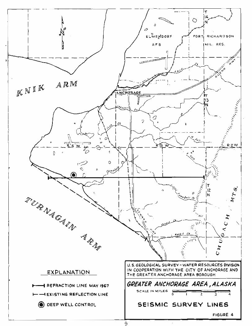
Res i s t i v i t y surmey.--Twenty-six miles of e l e c t r i c a l r e s i s t i v i t y l i n e s
were e s t a b l i s h e d during August and September 1967 by a Geological Survey
crew from t h e Regional Geophysics Branch, Denver, Colo. The l o c a t i o n s of
t h e s e l i n e s a r c shown on f i g u r e 5. An i n t e r p r e t a t i o n of t h i s d a t a i s now
being made i n Denver. A t t h i s t ime r e s i s t i v i t y d a t a w i l l be f u r t h e r i n t e -
g r a t e d with e x i s t i n g wel l logs and o t h e r subsur face da t a . Addit ional
soundings, a s shown on t h e accompanying map, w i l l be made i f t h e i n t e r -
p r e t a t i o n o f t h e 1967 work shows t h a t they a r e needed.
Prel iminary r e s u l t s i n d i c a t e r e l i a b l e depths t o t h e top of t h e Kenai
Formation, bu t l e s s p r e c i s e information on t h e l i t h o l o g i c d i f f e r ences
between t h e g l a c i a l sediments. There i s a s i g n i f i c a n t r e s i s t i v i t y con-
t r a s t (1:4) between t h e Kenai Formation, composed o f consol ida ted
sandstone, s i l t s t o n e , and coa l , and t h e g l a c i a l sediments from which most
o f Anchorage's ground water i s produced. A l e s s d i s t i n c t c o n t r a s t w i th in
t h e g l a c i a l sediments i s mappable between s u r f i c i a l sand and g rave l and
c l ay and impermeable sediments. Data from a l l soundings sugges ts t h a t
s a l t water i s no t p resen t a t d e p t h i n t h e sediments o f t h e a r ea . The
th i cknes s of g l a c i a l sediments i n t h e Sand Lake a r e a i s es t imated t o be
between 1200 and 1500 f e e t . In t h e v i c i n i t y of t h e i n t e r s e c t i o n of
Lake Otis Road and t h e Seward Highway these sediments a r e 500 t o 600 f e e t
t h i c k . A f a u l t o r an abrupt t h inn ing o f g l a c i a l sediments i s l o c a t e d
nea r t h e i n t e r s e c t i o n of Lake O t i s and Abbot Roads. West o f t h i s l o c a l i t y
sediments a r e 500 f e e t t h i c k and t o t h e e a s t they a r e 300 f e e t t h i c k .
I
4
GREATER ANCHORAGE AREA , A L ASKA SCALE IN MILES - - I
0 I 2 3 4
RESIST lVlTY SURVEY LINES FIGURE 5
L
I I
EXPLANATION - 1967 COVERAGE
eeoaaaa PROPOSED COVERAGE
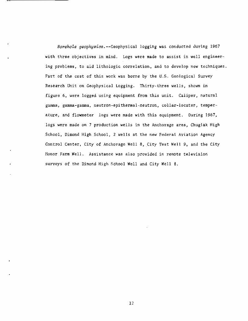
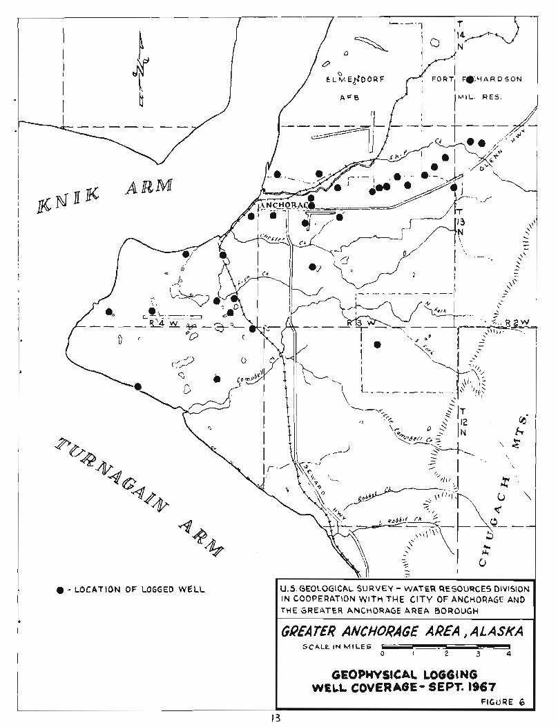
BorehoZe geophysics.--Geophysical logging was conducted during 1967
with t h r e e ob jec t ives i n mind. Logs were made t o a s s i s t i n wel l engineer-
ing problems, t o a i d l i t h o l o g i c c o r r e l a t i o n , and t o develop new techniques.
P a r t o f t h e cos t of t h i s work was borne by t h e U.S. Geological Survey
Research Unit on Geophysical Logging. Th i r ty - th ree wells , shown i n
f i g u r e 6 , were logged us ing equipment from t h i s u n i t . Cal iper , n a t u r a l
gamma, gamma-gamma, neutron-epithermal-neutron, c o l l a r - l o c a t e r , temper-
a t u r e , and flowmeter logs were made with t h i s equipment. During 1967,
logs were made on 7 product ion wel l s i n t h e Anchorage a rea , Chugiak High
School, Dimond High School, 2 wel l s a t t h e new Federal Aviation Agency
Control Center, Ci ty of Anchorage Well 8, Ci ty Tes t Well 9, and t h e City
Honor Farm Well, Assis tance was a l s o provided i n remote t e l e v i s i o n
surveys of t h e Dimond High School Well and Ci ty Well 8.
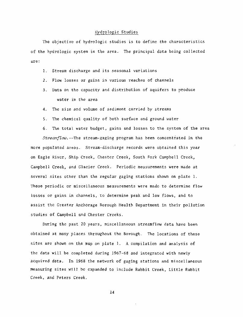
Hydrologic S tudies
The o b j e c t i v e o f hydrologic s t u d i e s i s t o de f ine t h e c h a r a c t e r i s t i c s
o f t h e hydrologic system i n the a r ea . The p r i n c i p a l d a t a being c o l l e c t e d
a r e :
1. Stream discharge and i t s seasonal v a r i a t i o n s
2 . Flow los ses o r gains i n var ious reaches of channels
3 . Data on t h e capac i ty and d i s t r i b u t i o n of a q u i f e r s t o produce
water i n t h e area
4 . The s i z e and volume of sediment c a r r i e d by streams
5. The chemical q u a l i t y o f both su r f ace and ground water
6 . The t o t a l water budget, ga ins and l o s s e s t o t h e system of t h e a r ea
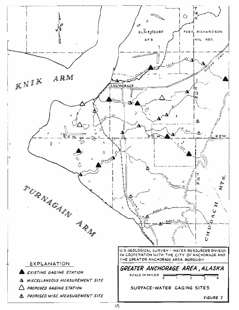
Stremf2ow.--The stream-gaging program has been concentrated i n t h e
more populated a reas . Stream-discharge records were obta ined t h i s year
on Eagle River, Ship Creek, Chester Creek, South Fork Campbell Cxeek,
Campbell Creek, and Glac ier Creek. Pe r iod ic measurements were made a t
s eve ra l s i t e s o t h e r than t h e r egu la r gaging s t a t i o n s shown on p l a t e 1.
These pe r iod ic o r miscellaneous measurements were made t o determine flow
l o s s e s o r gains i n channels, t o determine peak and low flows, and t o
a s s i s t t h e Greater Anchorage Borough Heal th Department i n t h e i r p o l l u t i o n
s t u d i e s of Campbell and Chester Creeks.
During t h e p a s t 20 years , miscellaneous streamflow d a t a have been
obta ined a t many p l aces throughout t h e Borough. The loca t ions of t hese
s i t e s a r e shown on t h e map on p l a t e 1. A compilation and a n a l y s i s of
t h e da t a w i l l be completed during 1967-68 and i n t e g r a t e d with newly
acqui red da ta . In 1968 t h e network of gaging s t a t i o n s and miscellaneous
measuring s i t e s w i l l be expanded t o inc lude Rabbit Cxeek, L i t t l e Rabbit
Creek, and Pe te r s Creek.
The U.S. Army Corps of Engineers i s making a f lood-frequency s t u d y
o f Ches te r Creek and Campbell Creek, t h e r e s u l t s o f which w i l l a l s o be
inc luded i n o u r r e p o r t s . This s t u d y is f inanced e n t i r e l y by Federa l funds .
G~owzd water.--During t h e y e a r , maps of a r t e s i a n p r e s s u r e l e v e l s
have been made f o r s e l e c t e d p e r i o d s o f r e c o r d . The maps show w a t e r l e v e l s
a t v a r i o u s t imes s i n c e t h e beginning of a p p r e c i a b l e ground-water pumping
i n t h e a r e a i n 1956. Maps showing p r e s s u r e l e v e l s i n 1956 ( f i g . 8) and
i n 1967 ( f i g . 9) accompany t h i s r e p o r t . F igure 10 shows t h e approximate
decrease i n a r t e s i a n p r e s s u r e l e v e l s between 1956 and 1966. The n e t
lowering i s presumed t o be t h e r e s u l t o f i n c r e a s e d pumpage dur ing t h i s
p e r i o d . Analysis o f t h e s e and o t h e r maps a long wi th pumpage r a t e s and
pas t withdrawal t o t a l s p rov ides knowledge o f t h e e f f e c t s o f withdrawal
o f water from v a r i o u s a q u i f e r s i n t h e a r e a and a l lows t h e p r e d i c t i o n o f
f u t u r e p r e s s u r e l e v e l s and t h e s e l e c t i o n o f optimum pumping r a t e s . An
observa t ion-wel l network i n t h e a r e a i s being mainta ined. A r t e s i a n
p r e s s u r e l e v e l s a r e recorded by cont inuous r e c o r d e r s i n f i v e wells.
T h i r t y - f i v e o t h e r w e l l s a r e measured monthly. This network i s c u r r e n t l y
be ing expanded t o o b t a i n added c o n t r o l i n t h e Rabbit Creek and m i l i t a r y
r e s e r v a t i o n a r e a s .
EXPLANATION
OBSERVATION WELLS I GREATER ANCHORAGE AREA , ALASKA SCALE IN M I L E S
0 -.- I 2 3 I I CONTOURS ON ARTESIAN PRESSURE LEVEL
APRIL 25,1967 I I DATUM MEAN SEA LEVEL FIGURE 9 1

During 1966 and 1967, t h e Geological Survey has worked c l o s e l y wi th
Ci ty , Borough, and Federa l o f f i c i a l s and with l o c a l consu l t i ng engineers
on s p e c i f i c problems r e l a t i n g t o ground water such a s t h e cons t ruc t ion
o f a new product ion wel l f o r t he C i ty nea r t h e c i t y water t rea tment p l a n t ,
t h e design of two we l l s f o r t h e Federal Aviat ion Agency A i r T r a f f i c Control
Center i n Anchorage, and t h e l oca t ion of we l l s a t Dimond High School,
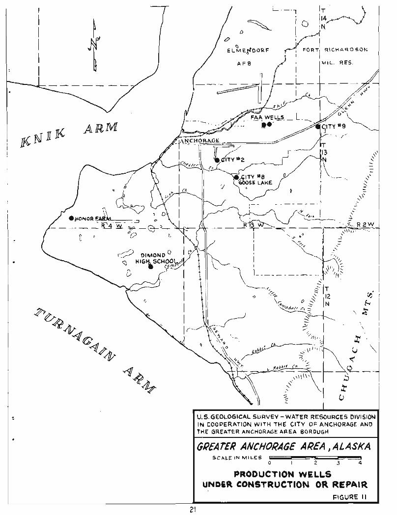
Chugiak High School, t h e C i t y Honor Farm, and elsewhere. Figure 11 shows
t h e l o c a t i o n o f some of t he se we l l s .
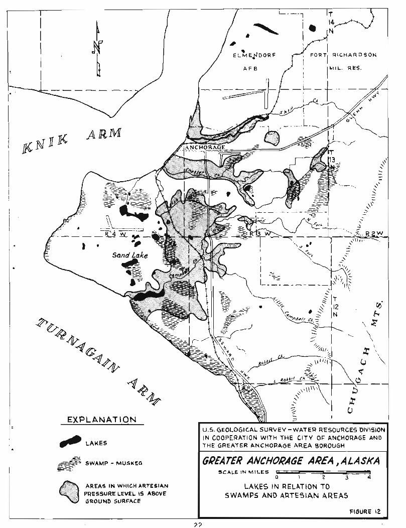
The e f f e c t s of p o s s i b l e a r t i f i c i a l drainage of low-lying a r e a s i n
r e l a t i o n t o l ake and ground-water l e v e l s and t h e i n t e r connec t ion between
t h e shallow water t a b l e and deeper a q u i f e r s are being i n v e s t i g a t e d ( f i g . 12 ) .
A water - leve l gage has been i n s t a l l e d on Sand Lake and is r ead d a i l y
dur ing t h e open-water season.
I
F O R T R \ C H A R D S O N
7 - -
PRODUCTION WELLS UNDeR CONSTRUCTION OR REPAIR
2 I
- -
EXPLANATION
. -. = --
-srTi ---- ==- SWAMP - MUSKEG -- -. s-=::
AREAS IN WHICH ARTESIAN LAKES IN RELATION TO PRESSURE LEVEL IS ABOVE SWAMPS AND ARTESIAN AREAS
FIGURE I2
? 7
Qual i t y of water. --During 1967, information was obtained a t s e l e c t e d
s i t e s throughout t h e Borough on the s u i t a b i l i t y o f water f o r domestic,
municipal, and i n d u s t r i a l use. Data were compiled on t h e na tu re and
amounts o f d isso lved s o l i d s i n Ship, Campbell, and Chester Creeks and
Eagle River, and on t h e quan t i ty and p a r t i c l e s i z e d i s t r i b u t i o n of
suspended sediment t r anspor t ed by Chester Creek. Chemical q u a l i t y and
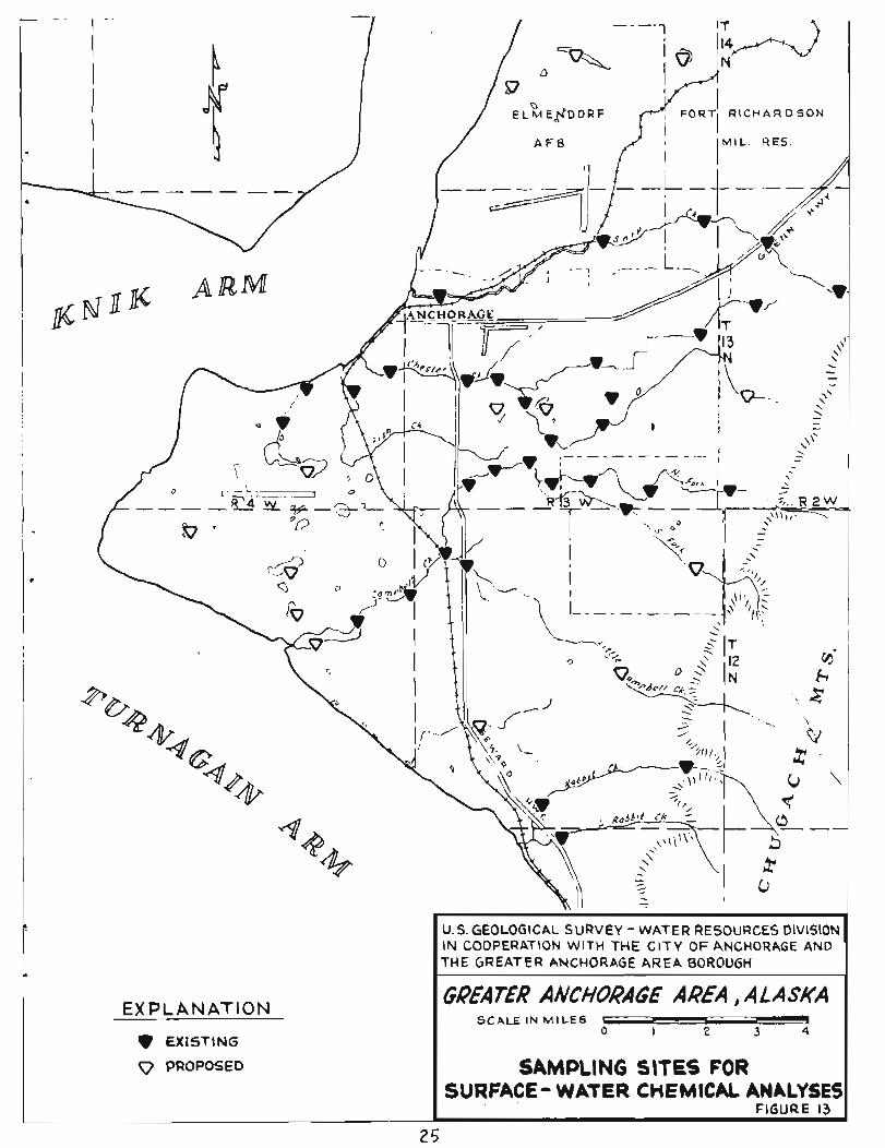
sediment t r anspor t da t a f o r many o the r streams shown i n f i g u r e 13 have
been o r a r e being obtained i n t e r m i t t e n t l y . Data a l s o were obtained
p e r i o d i c a l l y on chemical q u a l i t y of water from t h e c i t y production wel l s
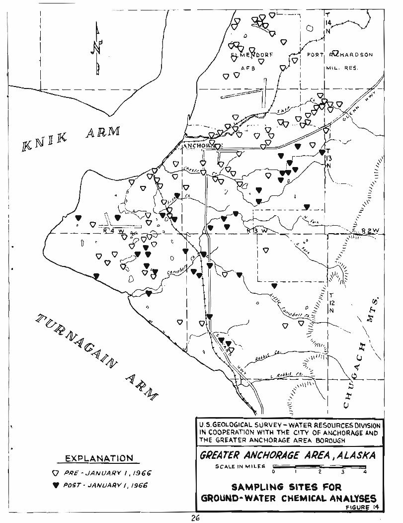
and o the r wel l s i n t h e Borough a r e a shown on f i g u r e 14.
In add i t ion , during 1967, a l l e x i s t i n g chemical analyses of ground
water have been coded on maps and well schedules , and a r e being punched
on cards . A p i l o t computer program was completed f o r ana lys i s of s e l ec t ed
chemical-qual i ty samples from 46 Anchorage wel l s t o determine t h e presence
o r absence of s i g n i f i c a n t t r ends i n t h e chemical cons t i t uen t s o f ground
water i n t h e a rea .
Close cooperation has been maintained with t h e S t a t e of Alaska,
Department of Health and Welfare, t h e Greater Anchorage Borough Health
Department, and the Federal Water Po l lu t ion Control Administration t o
he lp them determine t h e e f f e c t s and extent of p re sen t po l lu t ion i n both
sur face and ground water and t o f i n d means t o prevent f u t u r e po l lu t ion
of Anchorage water resources . This cooperation cons is ted of furn ish ing
r e s u l t s of chemical analyses of water, seepage l o s s measurements along
streams, i d e n t i f i c a t i o n of ground-water recharge a reas , and determination
of hydraul ic in te rconnect ion between deep and shallow wel l s .
Samples of stream water f o r ana lys i s of t r a c e elements, such a s
i ron , lead, and copper, were co l l ec t ed f o r t he Federal Water Po l lu t ion
Control Administration. These analyses a r e p a r t o f a s tudy aimed a t
de f in ing the d i s t r i b u t i o n of these elements i n both sur face and ground
water. The d i s t r i b u t i o n may i n d i c a t e t h e source and d i r e c t i o n of
movement of ground water i n t h e a rea .
Water budget.--To formulate a model of t he hydrologic system it i s
necessary t o determine t h e water budget of t h e a rea . This means t h a t
t h e total inf low and outflow of water i n t h e s tudy a r e a must be de t e r -
mined. The amount of evapot ranspi ra t ion i s an important element i n
outflow. The amount of p r e c i p i t a t i o n i n t he a r e a w i l l be determined
from U.S. Weather Bureau records . Then it w i l l be determined how much
of t h i s water evaporates , how much i s t r ansp i r ed by p l a n t s , how much and
where water e n t e r s t h e ground-water system, how much runs o f f a s s u r f a c e
water, and f i n a l l y how much ground water e n t e r s t h e Cook I n l e t . A l l o f
t hese elements must be est imated. P l a t e 1 shows t h e Weather Bureau's
cu r r en t network o f p r e c i p i t a t i o n s t a t i o n s i n t h e a r ea . Several new
s t a t i o n s have been i n s t a l l e d i n t h e Anchorage a rea s i n c e J u l y 1966 a t
no c o s t t o t h e p r o j e c t . Depth of snowpack i n the Borough a r e a i s being
measured by t h e S o i l Conservation Serv ice a t no c o s t t o t he p r o j e c t .
Snow-thickness and water content da t a and runoff r e l a t i o n s a r e being
analyzed by t h e Geological Survey t o determine t h e amount of water
a v a i l a b l e t o t h e Borough a r e a from t h i s source.
Spec ia l S tudies
Remote sensing.--In e a r l y May 1967 t h e National Aeronautics and
Space Administration made co lo r and co lo r i n f r a r e d areal photographs
and recorded i n f r a r e d imagery along f l i g h t l i n e s i n t h e Anchorage a rea .
The loca t ion of t hese l i n e s i s shown on f i g u r e 15. This work was done
t o see i f a r eas of outflow of ground water i n t o Cook I n l e t could be
determined by remote sensing techniques. These d a t a a r e now being
processed and i n t e r p r e t a t i o n w i l l be made during 1967-68.
Effects of sazt-water encroachment.--As ground-water development
proceeds i n t h e Anchorage a r e a , t h e r e i s a p o s s i b i l i t y o f f u t u r e s a l t -
water i n t r u s i o n i n t o a r t e s i a n a q u i f e r s . Figure 1 shows these r e l a t i o n s
schemat ica l ly . Steps have a l ready been taken t o monitor t h e chemical
q u a l i t y of water i n F i r e I s l and wel l s and i n s eve ra l c o a s t a l wel ls f o r
s i g n s of encroachment. During August and ~ e ~ t e h b e r 1967, e l e c t r i c a l -
r e s i s t i v i t y soundings were a l s o made near Turnagain Heights and Campbell
Lake t o determine if s a l t water i s p re sen t i n deep coas t a l a q u i f e r s .
Prel iminary r e s u l t s of t h i s work suggest t h a t s a l t water is not present
i n t h e s e a q u i f e r s . A l l t h e s e s t u d i e s w i l l u l t ima te ly produce conclusions
concerning sa l t -wa te r i n t r u s i o n i n t h e a r e a and w i l l suggest methods t o
r e t a r d , o r avoid, i n t r u s i o n a t Anchorage.
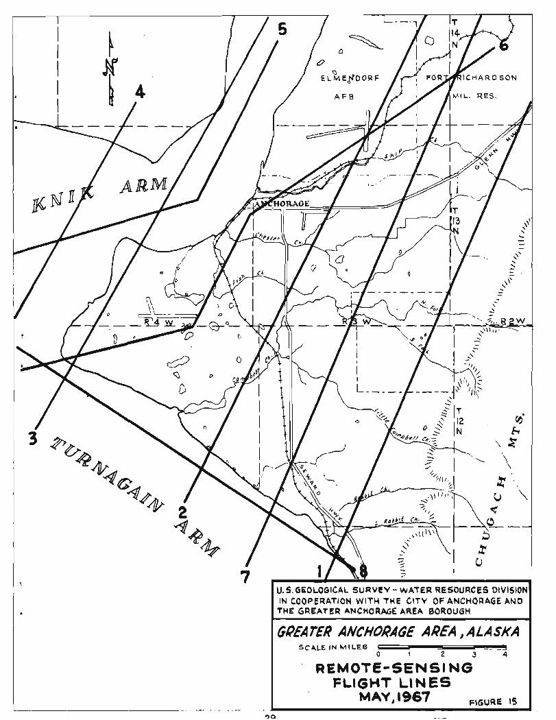
I FLIGHT LINES MAY, 1967 FIGURE 15
Basic Records
The l a r g e q u a n t i t y of d a t a becoming a v a i l a b l e from s t u d i e s of t h e
Anchorage a r e a makes it advantageous t o convert t o automatic d a t a proc-
e s s ing . Use o f computers w i l l provide an economical and r a p i d means of
analyzing and p re sen t ing the d e t a i l e d d a t a . Data from more than 900
water we l l s i n t h e Anchorage a r e a were coded f o r computer a n a l y s i s during
1967. By June 1968 most of t h e qua l i ty -of -water and ground-water d a t a
w i l l be on punchcards. This w i l l f a c i l i t a t e r a p i d process ing o f d a t a
f o r r e l e a s e a s wel l a s f o r complex i n t e r p r e t i v e ana lys i s . Eventual ly
a l l app l i cab l e d a t a w i l l be p laced on punchcards f o r computer a n a l y s i s
and p r i n t o u t .
PLANS FOR FUTURE WORK
The primary o b j e c t i v e of t h e s tudy i s t o determine where and i n
what q u a n t i t i e s water i s a v a i l a b l e f o r use . Future work p l ans a r e
designed t o accomplish t h i s ob j ec t i ve .
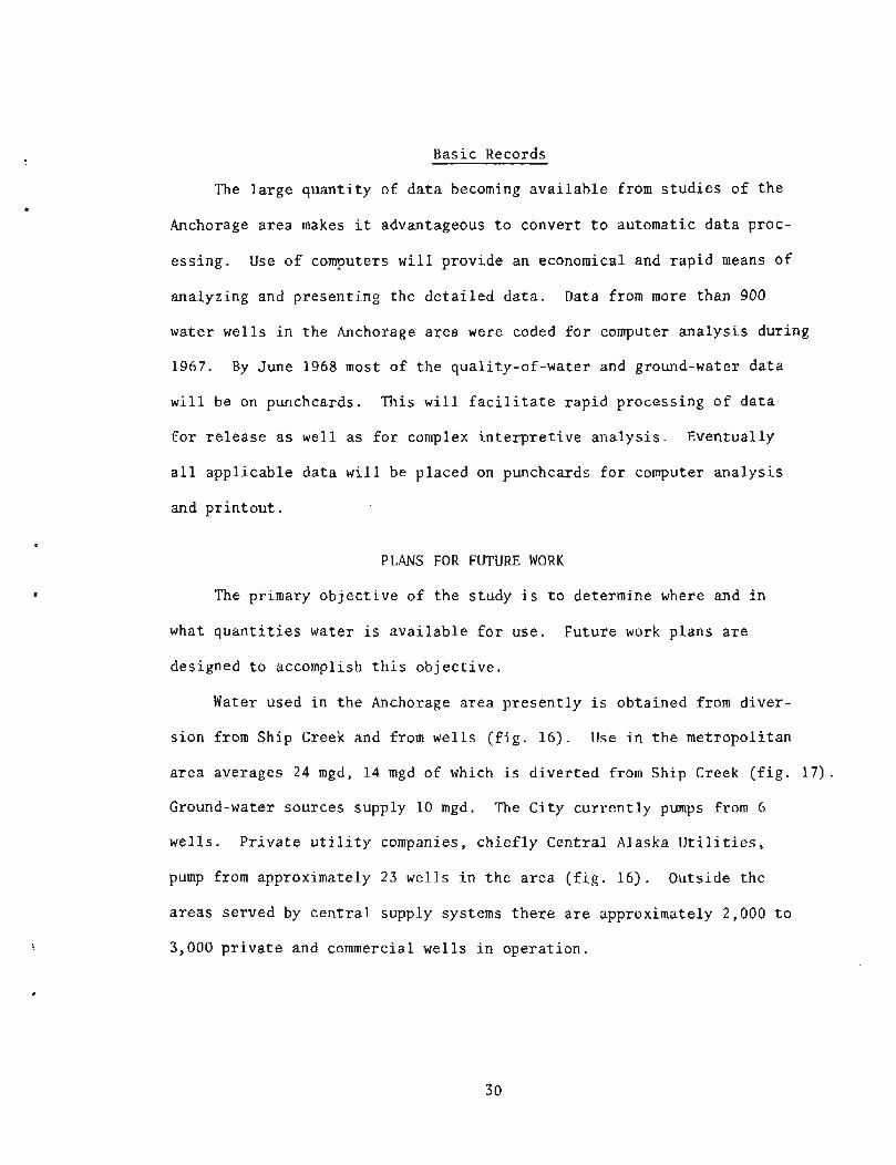
Water used i n t h e Anchorage a r ea p r e s e n t l y is obta ined from d ive r -
s i on from Ship Creek and from wel l s ( f i g . 16 ) . Use i n t h e met ropol i tan
a r e a averages 24 mgd, 1 4 mgd of which i s d i v e r t e d from Ship Creek ( f i g . 17) .
Ground-water sources supply 10 mgd. The C i ty c u r r e n t l y pumps from 6
wel l s . P r i v a t e u t i l i t y companies, c h i e f l y Cent ra l Alaska U t i l i t i e s ,
pump from approximately 23 wel ls i n t h e a r e a ( f i g . 16 ) . Outside t h e
a r e a s se rved by c e n t r a l supply systems t h e r e a r e approximately 2,000 t o
3,000 p r i v a t e and commercial we l l s i n ope ra t i on .
u
I I
I
EXPLANATION
C\TY PRODUCTION WELL
0 UTILITY PRODUCTION WELL
SURFACE WATER DIVERSION FROM SHIP CREEK
I
m-m DIVERSION UNDER CONSTRUCTION
em C I T Y WATER SYSTEM
n PRIVATE UTIUTY WATER SYSTEM
POTENTIAL FUTURE DIVERSION AREA
wk POTENTIAL FUTURE GROUND-WATER DEVELOPMENT AREA
1N COOPERATION WlTH THE CITY OF ANCHORAGE AND T H E GREATER ANCHORAGE AREA BOROUGH
GREA T€U ANCHORAGE AREA , A L ASKA SCALE IN ~ I ~ L E s L
0 I 2 3 4
WATER SUPPLY SYSTEM SEPTEMBER 1967
FIGURE 16
FIGURE 17 5 -
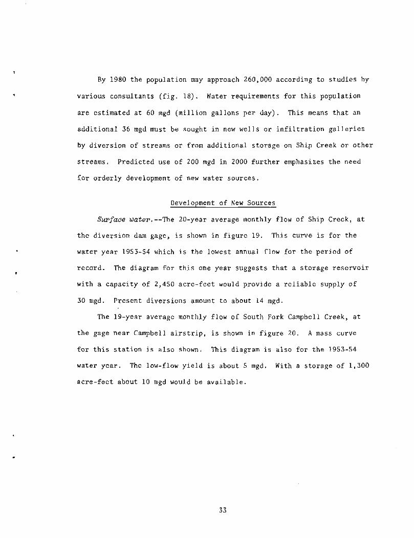
By 1980 t h e popula t ion may approach 260,000 according t o s t u d i e s by
va r ious consu l t an t s ( f i g . 18) . Water requirements f o r t h i s popula t ion
a r e es t imated a t 60 rngd (mi l l i on ga l lons pe r day) . This means t h a t an
a d d i t i o n a l 36 rngd must be sought i n new wel l s o r i n f i l t r a t i o n g a l l e r i e s
by d ive r s ion of s t reams o r from a d d i t i o n a l s t o r age on Sh ip Creek o r o t h e r
s t reams. P red i c t ed use of 200 rngd i n 2000 f u r t h e r emphasizes t h e need
f o r o rde r ly development of new water sources .
Development of New Sources
Surface -dater.--The 20-year average monthly flow of Ship Creek, a t
t h e d ive r s ion dam gage, i s shown i n f i g u r e 19. This curve i s f o r t h e
water yea r 1953-54 which i s t h e lowest annual flow f o r t h e pe r iod of
record . The diagram f o r t h i s one yea r sugges ts t h a t a s to rage r e s e r v o i r
with a capac i ty of 2,450 a c r e - f e e t would provide a r e l i a b l e supply o f
30 mgd. Presen t d ive r s ions amount t o about 14 mgd.
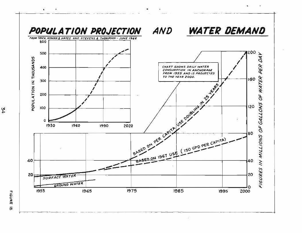
The 19-year average monthly flow o f South Fork Campbell Creek, a t
t h e gage nea r Campbell a i r s t r i p , i s shown i n f i g u r e 20. A mass curve
f o r t h i s s t a t i o n i s a l s o shown. This diagram i s a l s o f o r t h e 1953-54
water yea r . The low-flow y i e l d i s about 5 mgd. With a s t o r a g e of 1,300
ac re - f ee t about 10 rngd would be a v a i l a b l e .
AND WATER DEMAND

30,000 - The mass curve at left 3 shows the accumulated 2 0 flow in Ship Creek for water
3 year 1953-54, the lowest 3 25,000 annual average flow for * L 20 years of record. W i t h 2450
0 acre-feet of shrage, the @ sfream would yield 30 $, zqoao \ m i l l i o n g a ~ ~ o n s p e r d ~ y . V s L
15,000 b 9C 3
,Oo0
Chart below shows average monthly and average annual flow in Ship Creek (1941-66). 9 Shaded area with figures is average monthly diver- sion for 1965 - 66.
m
300
AVERAGE ANNUAL FLOW -------------- ----
FIGURE 19
SOUTH FORK CAMPELL CREEK- Curnulo five Discharge and Average
The mass curve a t l e f t shows the accurnu\a)ed
t f low in South Fork Camp- bell Creek for water year 1953- 5 4 , +he lowest annual average f l o w for 19 years o f record. With 1300 acre- fee+ o f storage, the stream would yield 10 million
Chart below shows aver- age monthly and average annual f low in South b r k Campbell Creek covering 19 years o f record.
36 FIGURE 20
These curves f o r Ship Creek and South Fork Campbell Creek a r e based
on only one y e a r ' s record and do no t t ake i n t o cons ide ra t i on needs f o r
s t o r a g e r e l e a s e s necessary t o maintain a base flow i n t h e channel down-
stream, evaporat ion l o s s e s , o r l o s s e s due t o i c e s t o r a g e o r any o t h e r
such cons ide ra t i ons . Data from the gaging s t a t i o n on South Fork Campbell
Creek, which i s loca t ed i n t h e bedrock canyon be fo re t h e creek flows o u t
onto i t s a l l u v i a l fan , may r e s u l t i n a s l i g h t l y d i f f e r e n t mass curve f o r
t h e s t ream.
A t p r e sen t t h e d ive r s ion from Ship Creek nea r ly equa ls t h e y i e l d
without s t o r a g e dur ing low-flow per iods . A simple d ive r s ion on South
Fork Campbell Creek would no t p rovide more than 5 mgd during those
same pe r iods .
Addit ional s u r f a c e water can be ob ta ined from Eagle River which
has a low flow of about 30 mgd. That water would r e q u i r e t rea tment t o
remove g l a c i e r f l o u r and s i l t and c lay-s ized p a r t i c l e s .
Ground water . - -Potent ial sources of ground water a r e being i n v e s t i -
gated throughout t h e Borough. Ground water has s eve ra l advantages over
su r f ace water . The temperature of t he ground water averages 3 O C (3g°F)
t h e year around and i s warmer than su r f ace water i n t h e win ter months.
Consequently, when it is mixed with surface water, f r eez ing i n water
mains i s r e t a rded . Figure 17 shows the e f f e c t of t h e add i t i on of ground
water t o t h e water d i s t r i b u t i o n system. Between 1957 and 1960,even when
t h e populat ion s t e a d i l y increased, a dec l ine i n water use occurred. The
dec l ine was caused by t h e add i t i on of warmer ground water t o t he c i t y
water system. This reduced the hazard of f r eez ing i n mains and connec-
t i o n p ipes and e l imina ted the neces s i ty f o r water u se r s i n t h e a r ea t o
leave t h e i r water t aps cons t an t ly open during the winter months. Another
advantage of ground water i s t h a t i t can be obtained from wel l s loca ted
near t h e a r e a i n which i t i s needed and r equ i r e s l i t t l e o r no t reatment
p r i o r t o use.
The development of f u t u r e ground-water sources i s p re sen t ly concen-
t r a t e d i n t h e Ship Creek and Campbell Creek fans ( f i g . 16) because those
a reas a r e c lo se t o a r eas of g r e a t e s t populat ion. During 1968 f i e l d t e s t s
w i l l be conducted i n those a reas t o measure the permeabi l i ty and po ros i ty
of a q u i f e r s by s tandard methods inc luding pump t e s s and t e s t d r i l l i n g .
These t e s t s w i l l provide d a t a on the r a t e of movement of ground water ,
t h e s to rage capac i ty of t h e water-bearing ma te r i a l s , and t h e r a t e of
n a t u r a l recharge. Tes ts and observa t ions w i l l a l s o be made t o determine
t h e seasonal r e l a t i o n s h i p of surface-water and ground-water temperatures
and t o a s se s s t h e p o s s i b i l i t y of using i n f i l t r a t i o n g a l l e r i e s and shallow
wel l s t o develop ground-water supp l i e s . Water-spreading experiments w i l l
a l s o be conducted t o provide d a t a on t h e amount of excess su r f ace water
t h a t could be added a r t i f i c i a l l y t o aqu i f e r s t o increase t h e i r y i e l d
during low-flow per iods . Estimates of t he perennia l y i e l d and t o t a l
water a v a i l a b l e from wel l s i n t h e fan a reas w i l l be made.
Plans f o r t h e 1968 f i s c a l year inc lude a s e r i e s of shallow t e s t wells
t o be d r i l l e d by t h e Geological Survey auger r i g and by cont rac t d r i l l i n g
i n the f an a reas and elsewhere i n t h e Borough. Those t e s t wel ls w i l l
provide geologica l information, w i l l se rve a s water - leve l observat ion
wel l s , and w i l l be used f o r logging and var ious o the r t e s t s .
A s e r i e s of deep t e s t ho les w i l l a l s o be d r i l l e d i n t h e Anchorage
a rea t o i n v e s t i g a t e t h e deeper a q u i f e r s . Those holes w i l l be used t o
t e s t t h e water p o t e n t i a l and chemical q u a l i t y of water i n t h e Kenai
Formation which i s known t o conta in warmer water than t h e shallow
a q u i f e r s . 'fie deep t e s t s , when combined with a r e a l geophysical d a t a
already ava i l ab l e , w i l l i n d i c a t e t he t o t a l th ickness of p o t e n t i a l a q u i f e r s
i n t h e a r e a and may a l s o provide data on sa l t -wa te r encroachment.
Ground-water s t u d i e s w i th in t h e Borough w i l l be extended dur ing
t h e coming yea r t o ou t ly ing communities such as Birchwood, Chugiak,
Eagle River , Portage, and Girdwood.
Maintenance o f Ex i s t i ng Suppl ies
Data on e x i s t i n g product ion we l l s i n t h e Anchorage v i c i n i t y , shown
i n f i g u r e 16, a r e being compiled and s t u d i e d t o a s su re t h a t t hose sources
w i l l con t inue t o y i e l d q u a n t i t i e s of water comparable t o t h e p a s t . This
d a t a w i l l be cons t an t ly updated t o provide information from which pumping
r a t e s and schedules can be drawn.
Water Management
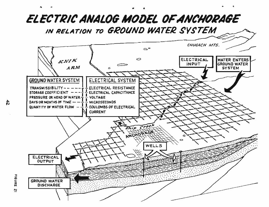
A pre l iminary e l e c t r i c - a n a l o g model o f t h e p r i n c i p a l a q u i f e r s i n t h e
Anchorage area, diagrammatical ly i l l u s t r a t e d on f i g u r e 21, has been con-
s t r u c t e d a t a s c a l e o f 1:24,000 by t h e Geological Survey Analog Model
Unit i n Phoenix, Ar iz . This model i s now ope ra t i ona l i n Phoenix and w i l l
provide d a t a on t h e e f f e c t o f f u t u r e water withdrawals from t h e a r e a and
w i l l a l low planning f o r optimum use o f water a v a i l a b l e i n t h e Anchorage
a r e a . Problems o f wel l spacing and t h e i n t e r r e l a t i o n s o f va r ious sources
of water under a n t i c i p a t e d load condi t ions w i l l be analyzed by use of
t h e model. Data from t h e model can be combined with d i g i t a l o r mathe-
ma t i ca l models t o make more advanced economical ana lyses of f u t u r e
water-supply and d i s t r i b u t i o n systems. An a u x i l i a r y t e s t model o f t h e
c i t y of Anchorage well f i e l d i s a l s o under cons t ruc t ion t o o b t a i n d a t a
needed i n t h e l a r g e r model o f t h e Anchorage a r e a .
Prel iminary problems w i l l be solved by t h e model by l a t e i n 1968
f i s c a l year . The so lu t ions w i l l become more r e l i a b l e and accura te during
1969 and 1970 as more b a s i c d a t a on t h e system are c o l l e c t e d . They w i l l
provide gu ide l ines f o r f u t u r e explora tory work.