programme 6 north norfolk - channel 4 · programme 6 north norfolk ... britain was set on limiting...
TRANSCRIPT

PROGRAMME 6 North Norfolk Introduction This 4 day hike takes us into the heart of sleepy North Norfolk to explore a famously sedate coastline. Just 100 miles from London, yet it’s one of the quietest corners of England and fantastic walking territory. But in the Victorian era this area seemed set to change. With royal patronage, celebrity visitors, a host of railway lines and some very fine sea-bathing, North Norfolk was the place to be. Today although this area is celebrated in its way, why is it a backwater? Over the next 50 miles or so, we’re set to find out. Our route begins beside the Wash at the Queen’s private residence, Sandringham, before taking in the experimental seaside resort of Hunstanton. Crossing ancient agricultural land, much of which is still dominated by the county’s largest estate, Holkham, our path leads us along spectacular coastline to the Victorian-inspired nature reserve of Blakeney Point. We steam our way to Sheringham on the train, before hotfooting our way to Cromer, the Victorian resort that became a battleground for the heart and soul of North Norfolk.
.Walking Through History
Day 1.
Begins at Sandringham House, the private home of four generations of British monarchs. We head to Wolferton to discover how the royals journeyed back and forth from London to North Norfolk, and check out a bog, that is one of the largest remaining areas of lowland heathland left in the UK, before reaching the experimental seaside resort, Hunstanton.
Sandringham to Hunstanton via Wolferton and Dersingham Distance: 13 miles
Day 2.
We’re off to Holkham through ancient agricultural land to uncover how the landowners of the great estates kept the holidaymakers and the expansion of North Norfolk in check. We see the scale of the area’s vast malting industry and pay a visit to the local pub of Britain’s greatest naval hero.
Hunstanton to Holkham, via Thornham, Brancaster and Burnham Thorpe Distance: 18 miles
Day 3.
Takes us along spectacular coastline, through saltmarshes, out to sea on a boat trip to the nature reserve at Blakeney Point, before reaching our destination, Cley-next-the-Sea, once one of the busiest ports in England, and now not next to the sea at all!
Holkham to Cley-next-the-Sea, via Wells-next-the-Sea, Morston and Blakeney Point Distance: 11 miles (plus a boat trip to Blakeney Point)
Day 4.
The final day takes us to Weybourne where we jump on a steam train to Sheringham before heading to the Victorian seaside resort at the heart of the struggle for the soul of North Norfolk, Cromer.
Cley-next-the-Sea to Cromer, via Weybourne, Sheringham Distance: 14 miles (including a 3 mile train journey)
Please use OS Explorer Maps 250, 251, 252 (1:25k) or OS Landranger 132,133 (1:50k). All distances approx.
.Walking Through History
Day 1 – Places of Interest
Sandringham to Hunstanton via Wolferton and Dersingham Distance: 13 miles
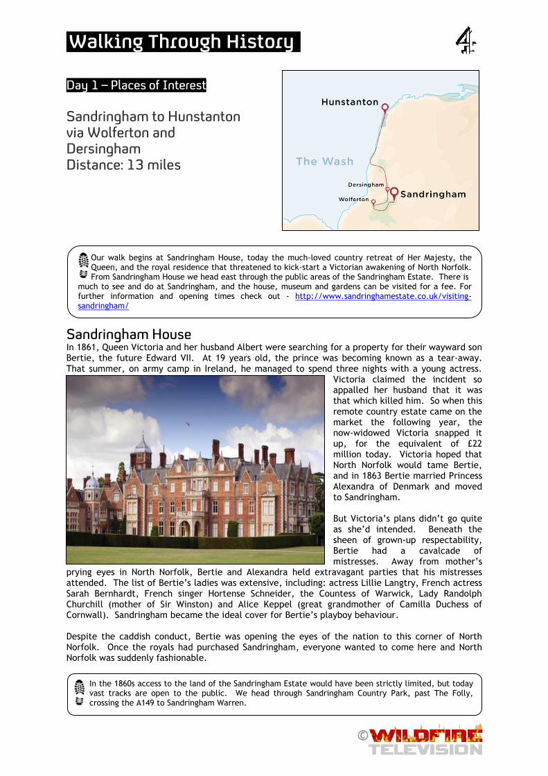
Sandringham House In 1861, Queen Victoria and her husband Albert were searching for a property for their wayward son Bertie, the future Edward VII. At 19 years old, the prince was becoming known as a tear-away. That summer, on army camp in Ireland, he managed to spend three nights with a young actress.
Victoria claimed the incident so appalled her husband that it was that which killed him. So when this remote country estate came on the market the following year, the now-widowed Victoria snapped it up, for the equivalent of £22 million today. Victoria hoped that North Norfolk would tame Bertie, and in 1863 Bertie married Princess Alexandra of Denmark and moved to Sandringham. But Victoria’s plans didn’t go quite as she’d intended. Beneath the sheen of grown-up respectability, Bertie had a cavalcade of mistresses. Away from mother’s
prying eyes in North Norfolk, Bertie and Alexandra held extravagant parties that his mistresses attended. The list of Bertie’s ladies was extensive, including: actress Lillie Langtry, French actress Sarah Bernhardt, French singer Hortense Schneider, the Countess of Warwick, Lady Randolph Churchill (mother of Sir Winston) and Alice Keppel (great grandmother of Camilla Duchess of Cornwall). Sandringham became the ideal cover for Bertie’s playboy behaviour. Despite the caddish conduct, Bertie was opening the eyes of the nation to this corner of North Norfolk. Once the royals had purchased Sandringham, everyone wanted to come here and North Norfolk was suddenly fashionable.
Our walk begins at Sandringham House, today the much-loved country retreat of Her Majesty, the Queen, and the royal residence that threatened to kick-start a Victorian awakening of North Norfolk. From Sandringham House we head east through the public areas of the Sandringham Estate. There is
much to see and do at Sandringham, and the house, museum and gardens can be visited for a fee. For further information and opening times check out - http://www.sandringhamestate.co.uk/visiting-sandringham/
In the 1860s access to the land of the Sandringham Estate would have been strictly limited, but today vast tracks are open to the public. We head through Sandringham Country Park, past The Folly, crossing the A149 to Sandringham Warren.
.Walking Through History
Bertie’s Other Passion In the 1860’s space and privacy were the great selling points of Sandringham to the Royals. And Bertie was determined to keep things that way. In addition to women, Bertie’s other passion was for shooting. Over his fifty years at Sandringham, more and more land was purchased. 7000 acres of woodland were planted. Sandringham became the country’s premier sporting terrain. Shooting would start each year on November 9th, the future king’s birthday, from when Bertie would use all available time to entertain the great and the good. A single day’s shoot it’s said, once accounted for 1300 partridges. Edward even decreed that time itself should be altered to maximize enjoyment of the estate. This involved moving all the clocks forward by half an hour in order to make the most of daylight hours in the winter months. Bertie was bringing his own way of doing things to North Norfolk. And the most fashionable man in Britain was set on limiting development here. The people of the late Victorian era were urban dwellers. The countryside was no longer considered just as a place of work, it was now being seen as a place for recreation. This was a time when tourism and holidays became more popular throughout the leisured classes, so to keep his privacy in peaceful North Norfolk, Bertie would be in for a struggle.
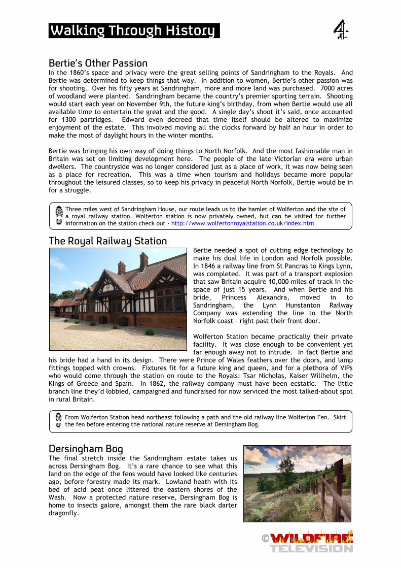
The Royal Railway Station Bertie needed a spot of cutting edge technology to make his dual life in London and Norfolk possible. In 1846 a railway line from St Pancras to Kings Lynn, was completed. It was part of a transport explosion that saw Britain acquire 10,000 miles of track in the space of just 15 years. And when Bertie and his bride, Princess Alexandra, moved in to Sandringham, the Lynn Hunstanton Railway Company was extending the line to the North Norfolk coast – right past their front door. Wolferton Station became practically their private facility. It was close enough to be convenient yet far enough away not to intrude. In fact Bertie and
his bride had a hand in its design. There were Prince of Wales feathers over the doors, and lamp fittings topped with crowns. Fixtures fit for a future king and queen, and for a plethora of VIPs who would come through the station on route to the Royals: Tsar Nicholas, Kaiser Willhelm, the Kings of Greece and Spain. In 1862, the railway company must have been ecstatic. The little branch line they’d lobbied, campaigned and fundraised for now serviced the most talked-about spot in rural Britain.
Dersingham Bog
The final stretch inside the Sandringham estate takes us across Dersingham Bog. It’s a rare chance to see what this land on the edge of the fens would have looked like centuries ago, before forestry made its mark. Lowland heath with its bed of acid peat once littered the eastern shores of the Wash. Now a protected nature reserve, Dersingham Bog is home to insects galore, amongst them the rare black darter dragonfly.
Three miles west of Sandringham House, our route leads us to the hamlet of Wolferton and the site of a royal railway station. Wolferton station is now privately owned, but can be visited for further information on the station check out - http://www.wolfertonroyalstation.co.uk/index.htm
From Wolferton Station head northeast following a path and the old railway line Wolferton Fen. Skirt the fen before entering the national nature reserve at Dersingham Bog.

.Walking Through History
Sunny Hunny At the northwest tip of East Anglia, the railway line stretched beyond the royal estate, into another massive Norfolk landholding, that of the Le Strange family. In the 1840s, two decades before Bertie arrived at Sandringham, the man in charge was Henry Styleman Le Strange - artist, aristocrat
and innovator. He took note of two things – the coming of the railways and the growing craze of seaside holidays. Since the beginning of that century, sea-water had been heralded as a wonder drug. Swimming in it could cure everything from corns to cancer, it was claimed. South coast settlements like Brighton, Weymouth and Eastbourne had been transformed into grand and profitable resorts. Le Strange conceived of a new-style coastal resort, on the grassy cliff-tops, a sea bathing village near the Old Village of Hunstanton. Le Strange’s design was classy, there was to be no brash metropolis here. The plan was 60
and 80 little houses and a hotel, and somewhere for people to bathe. It was a radical vision. But even then, Le Strange believed it would take a railway to make his resort a reality. The problem was there was no guarantee of the railway coming here. Without a railway the location was just too remote. Development ground to a halt, all that was built was the New Inn. This lonely hotel became known as ‘le Strange’s folly’. But ten years later – there was a breakthrough. A concrete plan was laid out to extend the line from King’s Lynn, past Sandringham to this northwest tip of East Anglia. It was what Le Strange had been waiting for. The first train rolled into the new Hunstanton in October 1862. Sadly, Le Strange wasn’t there. He had died from a heart attack, five weeks before the line opened, at just 47. ‘Sunny Hunny’, as it’s affectionately known, grew and grew in a way Le Strange could never have imagined, or wanted. The railway brought lots of people. And whilst Hunstanton has never rivalled Brighton or Eastbourne, it was an early lesson for the great and good of Norfolk that the railways had the power to usher in major and unwelcome change.
Continue through Dersingham Fen until you reach the A149. Here we follow the B4100 into Dersingham. From here we head north, back on the trail of the railway on a footpath following the old track-bed through Ingoldisthorpe Common, and Southgate to Snettisham. At the main cross roads
in north Snettisham head east taking the footpath past Home Farm and Lodge Hill Farm, before crossing the old railway line once more and joining a path charting the coast north to the end of the line and our ultimate destinations: Hunstanton and Old Hunstanton.

.Walking Through History
Day 2 – Places of Interest Hunstanton to Holkham via Brancaster and Burnham Thorpe Distance: 18 miles
Thornham Church In 1666 the tower of Thornham church was under construction, when the Great Fire of London happened. The team working on it downed tools and headed to London to help with its re-build. They didn’t come back to complete the job until 1935 - that’s got to be the longest builder’s tea break in history! In those three centuries, the church tower might have changed but the look of this land probably hasn’t, a field of barley is still a field of barley. Unlike the tourist outpost of Hunstanton much of the land here has been cultivated in the same way for centuries.
Changes in Land Ownership Land-ownership has certainly changed over the past three centuries. By the time Victoria reached the throne, nearly all North Norfolk’s vast acres of fertile soil were in private hands, conferring real power on those fortunate landowners. In the 18th century agriculture was being modernized, much of the common land was enclosed and reallocated as private land. Farms became bigger and for the rich, it was an opportunity to get richer. It’s difficult to conceive in this day and age, but until
Having reached the northwest tip of Norfolk, we’re off to explore how this area remained one of the least populated stretches of modern England. Leaving the Wash and Hunstanton behind, Day 2’s walk heads east, following the Peddars Way/ Norfolk Coast Path, past Holme Dunes Nature Reserve to the
picturesque village of Thornham.
From Thornham, still following the Peddars Way/ Norfolk Coast Path, we head south and cutting across swathes of agricultural land.

.Walking Through History
quite recently, millions of acres of our country weren’t owned by anyone. It was common land and everyone had a right to grow crops and graze cattle on it. All this changed when George III brought in the Enclosure Act. It transformed rural areas, allowing new landowners to take a modern, industrial approach to farming. The act gave smart farmers the chance to become the oligarchs of the age.
The Brancaster Malthouse In Brancaster Staithe, at the heart of prime barley growing country was one of the greatest examples of the industrialization of Norfolk’s agriculture. The Brancaster Malthouse, completed in 1797 was reputedly the largest malthouse in Britain. Today nothing remains of the vast 100 metre long building that processed 120 tons of barley grain each week. Norfolk’s barley has been used in Scotland to make whisky, Holland to make beer and even ended up all the way around the coast in Dublin making Guinness. Following the land enclosures, barley was grown, malted and shipped on a massive scale here. This coastline was becoming highly profitable, without any tourism. The site of the Brancaster Malthouse is just yards from the Jolly Sailors pub a convenient spot for refreshment. For further information on the pub check out – http://www.jollysailorsbrancaster.co.uk/
Burnham Thorpe and Lord Nelson The village of Burnham Thorpe is famous for its connection with one of Britain’s greatest naval heroes. In 1758, the local rector’s son was born here, his name was Horatio Nelson. Nelson didn’t live long enough to be called a Victorian; he died valiantly at the Battle of Trafalgar in 1805, the scene of his greatest triumph. But this son of Norfolk was revered by Victorian society, and around 250 pubs in Britain bear his name. The pub in Burnham Thorpe was actually Nelson’s local. In 1787 after his first 17 years at sea, Nelson returned to his home village and waited 5 whole years for his
next commission. Plenty of time for a drink, and we know that Nelson came to the pub because in 1793, it’s recorded that he threw a huge dinner party for the men of the village in celebration that he’d just taken command of the 64 gun Agamemnon. So if you’d stopped for a bite to eat here over 200 years ago, you’d have been in good company. For further information on The Lord Nelson check out - http://www.nelsonslocal.co.uk/
We head east across farmland before turning north again to reach the coastal village of Brancaster. From here we briefly detour from the Peddars Way/ Norfolk Coast Path, taking a footpath south along Green Common Lane to Barrow Common, one of few remaining patches of common land left in the
area, and the country. The route takes us east across the common before heading north up Common Lane to rejoin the Peddars Way/ Norfolk Coast Path to Brancaster Staithe.
Continue along the Peddars Way/ Norfolk Coast Path, past Burnham Deepdale, along large stretches of salt marsh, until you reach the village of Burnham Overy Staithe. Here we once again detour from the Peddars Way/ Norfolk Coast Path, heading south down Gong Lane, and along a path that takes us
past Burnham Overy town, across a dismantled railway and to Manor House, where we join the road taking us into Burnham Thorpe.

.Walking Through History
The Holkham Estate Nelson would go on to become the national hero, but in North Norfolk, the biggest name by far, was his neighbour, the ultimate Norfolk farmer, Thomas William Coke. Coke (who just happened to be godfather to Henry Le Strange, back in Hunstanton) was busy building an estate that to this day,
makes even Sandringham look pokey. Of all the great Norfolk estates that came together in time for the Victorian age, Holkham was the biggest and finest of the lot. Holkham Park stands at around 3000 acres, but the Holkham Estate surrounding the park is eight times that size. Coke’s utter dominance over this area was recognized in the form of a royal visit. A young Victoria came to stay, with the man hailed as the Greatest Commoner in England. Coke was almost 80 by this point with a wife who was 49 years his
junior. With his international agricultural fairs, crop rotation techniques, 30,000 acres and dozens of tenant farmers paying him rent, Thomas William was the greatest beneficiary of land enclosures. He is still known simply as Coke of Norfolk.
The Victoria Inn Coke was a key figure who shaped large parts of the landscape on the walk we’ve seen today, and indeed will see tomorrow, such was the extent of his estate. And as if his influence wasn’t great enough, Queen Victoria made the ageing Coke, Earl of Leicester. In return, the new Earl of Leicester built a pub on the edge of his park, in honour of his queen – The Victoria. For further information on the pub check out - http://www.holkham.co.uk/victoria/
Just over two miles southeast out of Burnham Thorpe along the road past East End Farm and Whitehall Farm, we reach the south entrance of Holkham Park. From here head north up the grand avenue, that leads to Holkham Hall. For further information about visiting Holkham Park and Hall check out.
http://www.holkham.co.uk/
From Holkham Hall, head northeast crossing the Deer Park to reach Holkham village, and the end of Day 2’s walk.

.Walking Through History
Day 3 – Places of Interest Holkham to Cley-next-the-Sea via Well-next-the-Sea, Morston and Blakeney Point Distance: 11 miles
Maltings at Wells-next-the-Sea Unlike his father, the Second Earl of Leicester wasn’t anti the railway age. In fact, he invested heavily in the local network, not for tourists, but for his barley. Wells-next-the-Sea was the key gateway for shipping out the estate’s barley. Back in the day, there were hundreds of maltings here. Half the countries malt exports came from this now sleepy seaside town. With the Earl of Leicester’s backing there was not one, but two railway lines set to push the port and the maltings to a whole new level. But there’s barely a glimmer of industry in Wells today. Ironically the two railways actually made Wells quieter. The town was built on import and export and this was easier to do by rail than by boat. So the introduction of the railways actually sent the port spinning into decline. The railways were more effective than anyone could have imagined. They killed off the fortnightly packet boat service to London almost immediately. And as ships grew bigger and the North Norfolk silt grew deeper, Wells struggled to live up to its billing of ‘major port’. So the town was left in a kind of time warp, and ironically just the sort of place which appeals enormously to 21st century visitors!
Day 3 and we’re finding out how North Norfolk remained so famously undeveloped. A handful of powerful landowners were key. By the early Victorian age, life and business in this extremity of rural
Norfolk was dominated by the Earls of Leicester and their powerbase at Holkham. From Holkham we head north up Lady Ann’s Drive to re-join the Peddars Way/ Norfolk Coast Path, following it east to the quaint town of Wells-next-the-Sea.
.Walking Through History
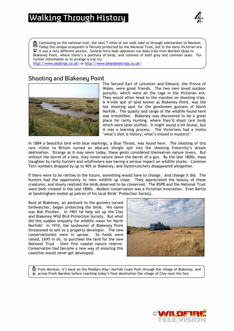
Shooting and Blakeney Point The Second Earl of Leicester and Edward, the Prince of Wales, were great friends. The two men loved outdoor pursuits, which were all the rage in the Victorian era. They would often head to the marshes on shooting trips. A 4-mile spit of land known as Blakeney Point, was the hot shooting spot for the gentlemen gunners of North Norfolk. The quality and range of the wildlife found here was irresistible. Blakeney was discovered to be a great place for rarity hunting, where they’d shoot rare birds which were later stuffed. It might sound a bit brutal, but it was a learning process. The Victorians had a motto ‘what’s shot is history, what’s missed is mystery!’
In 1884 a beautiful bird with blue markings, a Blue Throat, was found here. The shooting of this rare visitor to Britain turned an obscure shingle spit into the shooting fraternity’s dream destination. Strange as it may seem today, these gents considered themselves nature lovers. But without the barrel of a lens, they loved nature down the barrel of a gun. By the late 1800s, mass slaughter by rarity hunters and wildfowlers was having a serious impact on wildlife stocks. Common Tern numbers dropped by up to 90% at Blakeney, and Oystercatchers disappeared altogether. If there were to be rarities in the future, something would have to change. And change it did. The hunters had the opportunity to view wildlife up close. They appreciated the beauty of these creatures, and slowly realized the birds deserved to be conserved. The RSPB and the National Trust were both created in the late 1800s. Modern conservation was a Victorian innovation. Even Bertie at Sandringham ended up patron of his local Birds’ Protection Society. Back at Blakeney, an assistant to the gunners turned birdwatcher, began protecting the birds. His name was Bob Pinchen. In 1901 he help set up the Cley and Blakeney Wild Bird Protection Society. But what did this sudden empathy for wildlife mean for North Norfolk? In 1910, the landowner of Blakeney Point threatened to sell to a property developer. The new conservationists were in uproar. So funds were raised, £695 in all, to purchase the land for the new National Trust – their first coastal nature reserve. Conservation had become a new way of ensuring this coastline would never get developed.
Continuing on the national trail, the next 7 miles of our walk take us through saltmarshes to Morston. Today this unique ecosystem is fiercely protected by the National Trust, but in the early Victorian era it was a very different picture. Several ferry boat operators run daily trips from Morston Quay to
Blakeney Point, where there’s a plethora of birds, and colonies of both grey and common seals. For further information or to arrange a trip try: http://www.sealtrips.co.uk/ or http://www.beansboattrips.co.uk/
From Morston, it’s back on the Peddars Way/ Norfolk Coast Path through the village of Blakeney, and across Fresh Marshes before reaching today’s final destination the village of Cley-next-the-Sea.
.Walking Through History
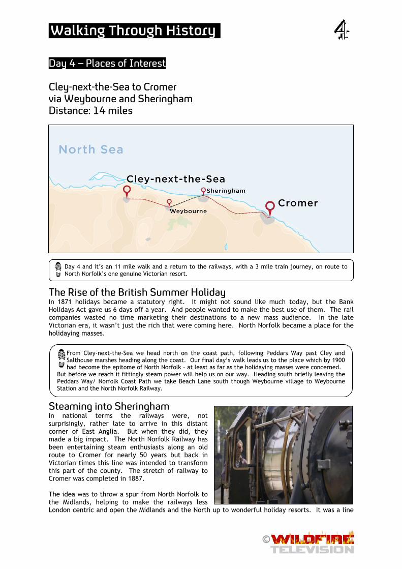
Day 4 – Places of Interest Cley-next-the-Sea to Cromer via Weybourne and Sheringham Distance: 14 miles
The Rise of the British Summer Holiday In 1871 holidays became a statutory right. It might not sound like much today, but the Bank Holidays Act gave us 6 days off a year. And people wanted to make the best use of them. The rail companies wasted no time marketing their destinations to a new mass audience. In the late Victorian era, it wasn’t just the rich that were coming here. North Norfolk became a place for the holidaying masses.
Steaming into Sheringham In national terms the railways were, not surprisingly, rather late to arrive in this distant corner of East Anglia. But when they did, they made a big impact. The North Norfolk Railway has been entertaining steam enthusiasts along an old route to Cromer for nearly 50 years but back in Victorian times this line was intended to transform this part of the county. The stretch of railway to Cromer was completed in 1887. The idea was to throw a spur from North Norfolk to the Midlands, helping to make the railways less London centric and open the Midlands and the North up to wonderful holiday resorts. It was a line
Day 4 and it’s an 11 mile walk and a return to the railways, with a 3 mile train journey, on route to North Norfolk’s one genuine Victorian resort.
From Cley-next-the-Sea we head north on the coast path, following Peddars Way past Cley and Salthouse marshes heading along the coast. Our final day’s walk leads us to the place which by 1900 had become the epitome of North Norfolk – at least as far as the holidaying masses were concerned.
But before we reach it fittingly steam power will help us on our way. Heading south briefly leaving the Peddars Way/ Norfolk Coast Path we take Beach Lane south though Weybourne village to Weybourne Station and the North Norfolk Railway.

.Walking Through History
very much aimed at tourists. The tourism industry was just beginning in late Victorian times and all the stations along this stretch were aimed at the holidaymaker. It was a success and the profits made during the summer months kept the railway running during the winter. For the railway companies, getting Londoners and Brummies to the Norfolk coast wasn’t the end of the story. Once they were here, they aggressively marketed day-trips; on a Wednesday you could take a Charabanc tour of Sandringham. For further information on the North Norfolk Railway and for timetables and fares check out - http://www.nnrailway.co.uk/
Poppyland and Mixed Sea Bathing Anyone who was anyone in the 1890s had been to Cromer. In the latter years of Victoria’s reign,
the Empress of Austria and the German nobility came to stay. Bertie, the Prince of Wales, was made patron of the Royal Cromer Golf Club and Clement Scott, theatre critic of the Daily Telegraph, came at the invitation of the railway company. Scott penned a series of gushing travel reports and coined a new name for the area - ‘Poppyland’, which quickly proved a marketing triumph. The businessmen of Cromer, who were also local councillors, realized they could make money from the Poppyland brand. For instance, a local chemist made Poppyland perfume and there was Poppyland china.
But not everything about Poppyland pleased its councillors. Sea bathing was popular, but the elderly gentlemen of the council, were apoplectic at meetings, at the prospect of having men and women bathing together in the same area of beach, when normally men and women bathed on separate beaches in different parts of town. From 1897 onwards men and women could bathe with their partner, as long as they were dressed in a costume from neck to knee.
The Rise and Fall of Norfolk’s Seaside Resorts As one of the first resorts to allow mixed sea-bathing, visitor numbers to Cromer grew and grew, and the decision was made to create an eye-catching centerpiece for Cromer’s re-invention - a pleasure pier. Cromer pier opened in 1901 at the very end of the Victorian Age. After almost 60 years of waiting, Bertie, Prince of Wales, was now Edward VII and with its pier, memorabilia and mixed bathing, Cromer seemed to finally be leading Norfolk into the world of mass tourism. But in truth, Bertie’s ten year reign was as good as it got for tourism in Cromer. Poppyland with its mix of ‘resort’ and ‘rural’ was the perfect brand for genteel Edwardian leisure. The Great War though, changed British society forever. The resorts that went on to thrive now had to cope with millions of working families each year, whereas Cromer was really quite happy with just a few thousand. Poppyland simply slipped from the public’s attention. And now, North Norfolk's railways have mostly gone. The nature reserves have grown, and the vast country estates continue to farm, shoot and shape the future of this sedate coastline.
Cutting down today’s walking, we hop on a train from Weybourne to Sheringham. Where the old line built to carry tourists is now a major attraction in its own right. Today the railway no longer stretches as far as Cromer, so at Sheringham we take on the final 5 ½ miles on foot.
Leaving Sheringham station we head back to the coast and again take to the Peddars Way/ Norfolk Coast Path. The route turns south just before West Runton, and then heads east through woodland and a variety of plantations, before reaching our final destination, the seaside resort of Cromer.