proforma of application of research grantnihroorkee.gov.in/inccc/tapi_basin_project.pdf · plain of...
TRANSCRIPT

133
A
RESEARCH PROPOSAL
ON “IMPACT OF CLIMATE CHANGE ON
WATER RESOURCES OF TAPI BASIN”
SUBMITTED TO
INDIAN NATIONAL COMMITTEE ON CLIMATE CHANGE (INCCC),
MINISTRY OF WATER RESOURCES,
RIVER DEVELOPMENT & GANGA REJUVENATION
GOVERNMENT OF INDIA
PRINCIPAL INVESTIGATOR
Dr. P.L.PATEL DEPARTMENT OF CIVIL ENGINEERING
SVNIT-SURAT
CO-INVESTIGATORS
Dr. Rohit Goyal (MNIT-Jaipur) Dr. Vishnu Prasad (MANIT-Bhopal) Dr. P V Timbadiya (SVNIT-Surat)
DEPARTMENT OF CIVIL ENGINEERING
(WATER RESOURCES ENGINEERING SECTION)
SARDAR VALLABHBHAI NATIONAL INSTITUTE OF TECHNOLOGY, SURAT-395007
1
Application of Research Grant
1 Project Title:
“Impact of Climate Change on Water Resources of Tapi Basin”
2 Principal Investigator:
Name Dr. PREM LAL PATEL
Designation Professor
Address Department of Civil Engineering, Water Resources Engg. Section,
SVNIT, Ichchhanath Road, Piplod, Surat-395007, Gujarat, India
Telephone 0261-2201682(O), 09904003857(M)
Fax 0261-2227334
Email [email protected]; [email protected]
3 Research Station/Institution
Name Sardar Vallabhbhai National Institute of Technology, Surat
Address Civil Engineering Department, Water Resources Engg. Section,
SVNIT, Ichchhanath Road, Piplod, Surat-365007, Gujarat, India
Telephone 0261-2201505
Fax 0261-2227334
Email [email protected]
Nearest Railhead/airport
Surat
4 Co-Principal Investigators:
Name Dr. Rohit Goyal
Designation Professor
Address Department of Civil Engineering, MNIT, Jaipur - 302017,
Rajasthan, India
Telephone 0141-2713263(O), 09314506900(M)
Fax 0141-2529029
Email [email protected]

2
Name Dr. Vishnu Prasad
Designation Professor
Address Department of Civil Engineering, MANIT, Bhopal - 462003,
Madhya Pradesh, India
Telephone 0755-4051200(O), 07869301938(M)
Fax 0755-2670562
Email [email protected]
Name Dr. P V Timbadiya
Designation Assistant Professor
Address Department of Civil Engineering, Water Resources Engg. Section,
SVNIT , Ichchhanath Road, Piplod, Surat-395007, Gujarat, India
Telephone 0261-2201835(O), 09426137917(M)
Fax 0261-2227334
Email [email protected]; [email protected]
5 Brief Bio-Data of Investigators:
Brief Biodata of Investigators is enclosed at ANNEXURE – I
6 Track Record and Workload Assessment of the PI
Enclosed at ANNEXURE – I
7 If the scheme is sanctioned, the authority in whose name the payment is to be authorized:
Lead Institute:
i) Name of authorized person holding account with complete address:
Director, SVNIT Surat
ii) Organization Name as per Bank records:
SVNIT Surat
iii) Bank Account No: 10023050019 (current a/c)
iv) IFSC Code : SBIN0003320
v) MICR Code : 395002012
vi) Bank Name : State Bank of India
3
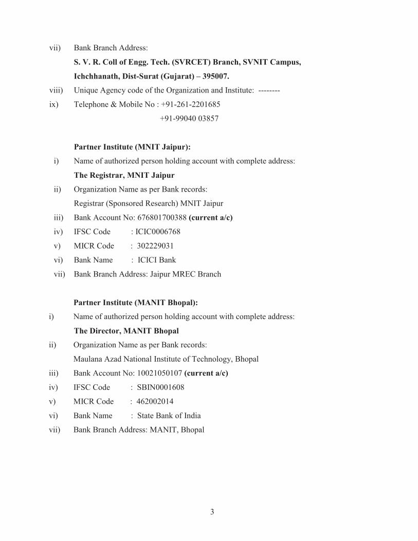
vii) Bank Branch Address:
S. V. R. Coll of Engg. Tech. (SVRCET) Branch, SVNIT Campus,
Ichchhanath, Dist-Surat (Gujarat) – 395007.
viii) Unique Agency code of the Organization and Institute: --------
ix) Telephone & Mobile No : +91-261-2201685
+91-99040 03857
Partner Institute (MNIT Jaipur):
i) Name of authorized person holding account with complete address:
The Registrar, MNIT Jaipur
ii) Organization Name as per Bank records:
Registrar (Sponsored Research) MNIT Jaipur
iii) Bank Account No: 676801700388 (current a/c)
iv) IFSC Code : ICIC0006768
v) MICR Code : 302229031
vi) Bank Name : ICICI Bank
vii) Bank Branch Address: Jaipur MREC Branch
Partner Institute (MANIT Bhopal):
i) Name of authorized person holding account with complete address:
The Director, MANIT Bhopal
ii) Organization Name as per Bank records:
Maulana Azad National Institute of Technology, Bhopal
iii) Bank Account No: 10021050107 (current a/c)
iv) IFSC Code : SBIN0001608
v) MICR Code : 462002014
vi) Bank Name : State Bank of India
vii) Bank Branch Address: MANIT, Bhopal
4
8 Category of R&D Activity (Tick those which are applicable)
a) Basic research
b) Applied research √
c) Action research
d) Education & Training
e) Mass awareness Programme
f) Infrastructure Development
g) Creation of Centres of Excellence
9 Description of the Proposal
According to the International Panel on Climate Change (IPCC) Scientific assessment report,
global average temperature would rise between 1.4� and 5.8� by 2100 with the doubling of
CO2 concentration in the atmosphere. The sea level rise, change in the precipitation pattern
and change in other local conditions are expected due to rise in the earth temperature. At
present, the Impact of climate change on Water Resources is the most crucial research agenda
worldwide (IPCC, 2007).
The Prime Minister of India unveiled the National Action Plan for climate change on 30-06-
2008 wherein eight missions including the National Water Mission (NWM) were launched.
One of the top agenda of the NWM has been to predict the climate change and its possible
impacts on water resources of Indian basins. The Prime Minister had also shown his concern
over the depleting water resources in the country and its vulnerability under the changing
climatic conditions during India Water week on April 10, 2012. Under NWM, 20 river basins
in the country has been identified for detailed study on effect of climate change and its
possible impact on water resources of the respective basins. The information on future climate
scenarios may help in adapting to the climate change and mitigation of its adverse impacts,
like flood and drought etc.
Few studies have been reported in the past in our country on effect of climate change at basin
levels (Gosain and Rao, 2003; Rupa Kumar et al., 2006; Hassel and Jones, 1999; IPCC, 1990;
and Lal et al. 1992) particularly at very coarser grid level. Prediction of climatic variables,
5
under changing climatic conditions, at the basin level (fine resolutions) and their use in
hydrological/hydraulic modeling is required for prediction of water availability for irrigation,
domestic, industrial, power production; and flood and drought conditions at the basin levels.
The Tapi basin spreads in an area of 65145 km2 which is nearly 2% of the total geographic
area of the country. It originates in Multai district of Madhya Pradesh and culminates in the
Arabian Sea at the Surat city. The Tapi River is a major source of irrigation and plays major
role in agricultural economy of Maharashtra and Gujarat states apart from feeding several
domestic water supply schemes, industries and hydropower in its catchment. Apart from
aforesaid benefits, major historical floods had occurred in the past in the coastal urban flood
plain of the Tapi River in the Surat city. The flood of year 2006 alone had caused a loss of
Rs.21000/- Crores and the economy of the country was severely affected for several months
after the flood. The rise in temperature, sea level rise and severity of the extremes (flood) in
Tapi basin (Gosain and Rao, 2006; Timbadiya et al. 2012), the flood conditions in the coastal
flood plain may adversely affect the Surat city in near future. Keeping in view the aggravating
situation of the climate change across the globe, in general, and, for the Tapi basin, in
particular, hydrological and hydraulic analyses are required to predict the water yield in the
basin and status of flood and drought for different future RCP scenarios using downscaled
climatic variables like precipitation, temperature (Min., Max., Average), solar radiation, wind
velocity, relative humidity and sun shine hours at basin levels.
10 Objectives
The objectives of proposed project, computation of reservoir sedimentation and sediment
erosion modeling of catchment, can be described as below:
1. Collection of base line data of Tapi basin which would include stream gauge data,
topography, soil, land use/land cover, ground water levels, reservoir and its utilities,
cropping pattern of Ukai command area, past floods and tidal levels, vegetation, land
management practices, sediment etc.
2. Selection of Hydrological (SWAT/MIKE SHE) and hydraulic models (MIKE FLOOD) and
their calibration from past observed data.
3. Parametric and non-parametric tests for trend detection for hydro-meteorological and
hydrological variables in the basin.
6
4. Performance evaluation of Ukai reservoir under changing climatic conditions in fulfilling
its requirements of irrigation, hydropower and flood control.
5. Using the output from dynamic/statistical downscaling, prediction of flood situation
downstream of Ukai dam in lower Tapi River under changing climatic conditions and
preparation of flood risk maps of the Surat city under changing climatic conditions.
6. Organize Workshops during the project duration as capacity building measures and
awareness for the stakeholders in the river basin and academic institutions involved in such
activities.
11 Contribution to Water Resources Development
The change in the climatic condition is being faced by the whole world. The average global
temperature has risen by about 0.75� in the last century. Similarly, the significant seal level has
taken place (12-22 cm) in the same period. The water resource has become the most fragile
resource of river basin and susceptible to the ongoing climate change. The extremes
(flood/drought) have become more frequent in the basin and entire humanity is likely to face
the menace of the climate change in the near future. The present study would be helpful in
prediction of water resources of the basin under changing climatic conditions as follows:
a) Prediction of water yield into the reservoirs under changing climatic conditions which
would help the stakeholders in the command area to be resilient in planning their
cropping pattern, industrial/domestic water requirements, particularly under the drought
conditions.
b) Prediction of flood into the Ukai reservoir, routing the flood in the reservoir and
hydraulic routing of the flood in the downstream channel, giving due consideration to
the tidal levels, would help in flood predictions in the Surat city under different climatic
scenarios. The developed flood risk maps for changing climatic conditions would help
the city dwellers in managing and adopting themselves with the severe extremes in
future.
12 Putting the Research to Use
The proposed research project is being submitted under National Water Mission (NWM),
MoWR, Govt. of India as one of the top priorities of the country. The Stakeholders, like water
resources, water supply departments, Govt. of Gujarat and Maharashtra; Surat Municipal
7
Corporation (SMC) would be the real beneficiary of foregoing project. The findings of the
research project can be put into use as under:
a) The findings of the research project will be discussed in the research forum time to time
under National Water Mission, and will be made available in the form of research project
reports and publications through peer reviewed International /National Journals.
b) The end-users will be invited in the awareness/ capacity building workshops, to be
organized during the project duration, to show case the outcome of studies and motivate
them to devise the adoptive measures for facing the consequences of climate change, like
food/drought conditions, in near future.
The recommendations from the project would help the policy makers, both at central and state
level, to initiate appropriate actions which would help the people to adopt themselves from the
menace of climate change.
13 Present State of Art
Observed Recent Trends on Climate Change
The earth is experiencing a rapid climate warming which may affect both the natural and
human systems in near future. IPCC (2001) has indicated that the average global temperature
has increased by 0.6±0.2° per decade since the late 19th century. The rate and duration of
warming of the 20th century has been found to be larger than any other time during the last
1000 years (Sharma and Singh, 2007). The IPCC 4th assessment report (IPCC, 2007) depicts a
situation characterized by snow cover reduction in northern Hemisphere and glacial retreat
almost worldwide. Ranzi and Barontini (2010) presented the variation of temperature,
precipitation in Adige river basin in Italy along with variation of runoff at the catchment
outlet. The data analyzed by them confirmed an increase of temperature @ 1.5° per century
over the last century with acceleration in the last decade of 20th century. Recently, Timbadiya
et al. (2012 a, 2012 b) carried out the trend analysis of observed annual extremes flows at
different gauging stations in the Tapi basin in India for duration 1972-2010 and reported
that Annual extremes are aggravating in the basin in the recent past.

8
Impact of Climate change on Water Resources of River Basin
Gosain et al. (2011) presented a study on assessment of water resources in seventeen Indian
basins under changing climatic conditions across the globe. They had used the weather data
from PRECIS RCM for Base line (1961-1990), near term (2021-2050) and long term (2071-98)
periods for A1B IPCC SRES scenario in aforesaid study. The weather output from RCM data
was utilized for possible impacts on the run-off, sediment yield and actual evapo-transpiration
of all the basins. The said study indicated an increase in precipitation by 17.50% and
5.70% with reference to the base line period in the Tapi Basin during the near term and
long term respectively. The analysis related with water yield, evapo-transpiration, sediment
yield, floods and drought were under taken in SWAT, a physically based hydrological model,
by using the weather data from aforesaid RCM. The majority of northern river systems show an
increase in evapo-transpiration during the near term scenarios while majority of southern river
systems show the marginal reduction in the evapotranspiration. The Impact analysis on flood
had indicated an increase in flooding from 10% to 50% over the existing magnitudes. The
foregoing study was dependent on the analysis of outputs from the PRECIS RCM for present
(base period) and future (near term and long term) time periods for A1B scenario. The RCM
outputs related with climatic variables like precipitation, temperature, solar radiation, wind
velocity and relative humidity were not validated with the actual observed data in the river
basins.
Raje and Mujumdar (2011) used conditional random field (CRF) method to downscale the
outputs from three GCMs under A2, A1B and B1 IPCC scenarios for computations of inflow into
Hirakud reservoir for time slices of year 2045-65 and 2075-95 by using actual observed data for
years 1959-2005. By simulating the future stream inflow scenarios into Hirakud reservoir, they
assessed the performance of the reservoir in fulfilling its requirements, viz. Hydropower,
irrigation and flood control, under changing climatic scenarios.
Gebre (2011) studied the effect of climate change on water resources availability of Didessa
catchment in Blue Nile river basin in Ethopia. He used the downscaled results of ECHAMSM
(GCM) through a regional circulation model (RegCM3) for A1B scenario of the said catchment.
The downscaled results (precipitation, temperature, and potential evapotranspiration) were used
as input to a distributed hydrological model (HBV-96) for simulating the flow in the study area
9
during 2031-2040 and 2091-2100. Precipitation and temperature were only downscaled
parameters and the assumption of invariant climatic conditions like wind speed, solar radiation
and relative humidity, in the future was made in the said analysis. A significant increase in
runoff was reported in the projected time period in above study. He also recommended for using
multiple GCM, in study of effect of climate change for water resources of river basin to depict
the model uncertainty.
Paiva et al. (2011) studied the impact of climate change of Quarai river basin (as part of larger
Uruguay and Parana La Plata basin) in South America. They used nine GCMs and six emission
scenarios of greenhouse gas emissions to predict the impact of climate change on rainfall and
temperature of the said basin. The uncertainty in climate change predictions was assessed by
them by comparing the results obtained using different GCMs and different greenhouse gas
emission scenarios. The uncertainty due to differences between GCMs greatly surpassed the
differences between the greenhouse gas scenarios.
Ngugen and Nguyen (2011) proposed a methodology, called ‘Scale invariance concept’ to
obtain cumulative probability distribution (CDF) of extreme rainfall of smaller duration (e.g., 1
hr rainfall) from statistically downscaled CDF of large duration (e.g., daily rainfall). Such study
could be very useful in studying effect of climate change in the analysis of extremes (floods) at
basin scales.
Ghosh et al. (2011) employed three GCMs, viz. CCSR/NIES (Centre for Climate System
Research/National Institute of Environmental studies), HadCM3 (Hadely Climate Model 3) and
coupled global climate model 2 with two scenarios A2 and B2 to downscale the stream inflow,
with due bias corrections, into Hirakud reservoir. The computed CDF for the downscaled
stream flow had shown significant uncertainty, among the GCMs, particularly for medium
flows. They had also obtained the possibilistic mean CDF for stream flow into the reservoir by
giving suitable weights to each GCMs and scenario depending upon their performance in
analyzing the climate condition for base line period. They assess the impact of climate change
on existing policy of reservoir operation and found that hydropower production and its
reliability will decrease; and vulnerability will increase as result of climate change in the future.
10
CONCLUDING REMARKS
Recent studies on Tapi basin has indicated an increase in precipitation in future, both in near
and long terms, with reference to base line period. The trend analysis of stream flow in the Tapi
River, and inflow into Ukai reservoir has also indicated an increasing trend in near future. The
downscaled climatic variables of the Tapi basin can be used as inputs to available hydrological
and hydraulic models to predict availability of water resource in the Tapi basin at critical
locations. Also, the predicted rainfall at the basin level can be downscaled at sub-time period (e
g. hourly) to compute event based flood hydrograph in the basin for future time projections. The
predicted climatic/hydrologic variables can be useful in the assessment of reservoir
performance and would help the stake holders and the policy makers to formulate appropriate
adoptive measures in the river basin under the changing climatic conditions.
References:
Ghosh S., Raje D. and Mujumdar P .P. (2011), Mahanadi Streamflow: Climate Change
Impact Assessment and Adaptive Strategies, Proceeding of International symposium on
water Resources Management for developing countries due to climate change, March 29,
2011, Water Resources research Centre, Kyoto University, Japan, pp.119-131.
Gosain A. K., Rao Sandhya and Arora A. (2011), Climate change Impact Assessment of
Water Resources of India, Current Science, Vol.101, No.3, pp.356-371.
Intergovernmental Panel on Climate Change (2001), Climate change 2001: The scientific
Basis, Intergovernmental Panel on Climate Change.
IPCC (2007), Climate Change 2007: Synthesis report, contribution of working group I, II
and III to the fourth Assessment report of IPCC, IPCC, Geneva, Switzerland.
Ngugen V-T-V, Nguyen T-D (2011), On statistical modeling of extreme rainfall processes
in the context of climate change, Proceeding of International symposium on water
11
Resources Management for developing countries due to climate change, March 29, 2011,
Water Resources research Centre, Kyoto University, Japan, pp.65-74.
Paiva Radrigo C. D., Collischonn W. and ScheHini E. B. (2011), Climate change Impacts
on Watr Resources in the Quarai River Basin; contributed in text book on ‘Modelling the
Impact of Climate Change on Water Resources, edited by Fung F., Lopez A., and New
Mark, Wiley- Blackwell, pp.137-148.
Raje D. and Mujumdar P.P. (2011), Reservoir performance under uncertainty in
hydrological Impacts of Climate Change, Advances in Water Resources, Science
Direct,30(2010), pp.312-326.
Ranzi Roberto and Barontini S. (2010), Are ther evidences of the Impact of global warming
on runoff regimes in the Southern Alps? Proceeding of International workshop on ‘Impact
of global warming from hydrological and Hydraulic issues’, March 12, 2010, DDRI, Kyoto
University, Japan.
Sharma K.D. and Singh Pratap (2007), Impacts of climate change on hydrological
extremes: Floods and droughts, Hydrology Journal, 30(3-4), pp.129-145.
Timbadiya P. V., Patel P. L. and Porey P. D. (2012 a), Application of innovative trend
analysis methodology and distribution fitting: Study on Annual peak inflow into Ukai dam,
Gujarat, India, Water and Energy International, CBIP, Vol.69, No.9, Sep.2012, pp.40-44.
Timbadiya P. V., Mirajkar A. B. and Patel P.L. (2012 b), Recent trend analysis for annual
peak flow in Tapi basin, Presented in India Water Week organized by MoWR, GOI,
April 10-14, 2012 (Accepted for publication in Journal of Water and Energy
International, CBIP in forthcoming issues)

12
14 Methodology
The present section describes about the study area (Tapi basin), ongoing studies related to
the Tapi basin, scope of work, methodologies and the proposed Team involved in the
project with the defined responsibilities:
Study area
The Tapi River, with its origin at Multai in Madhya Pradesh, traverses around 720 km
distance before meeting with the Arabian Sea just 12 km from the heart of the Surat city.
The catchment of the Tapi river is elongated in shape, falling in Madhya Pradesh (9804
km2), Maharashtra (51504 km2) and Gujarat (3838 km2) states. Out of several hydraulic
structures came into existence on the Tapi river, Ukai dam is one of the important
multipurpose dam which was constructed for the providing irrigation in the Southern
Gujarat, Controlling the flood in the Surat city and hydropower generation through releases
from the dam into Kakrapar weir system. The Index map of Tapi basin, its tributaries and
locations of major hydraulic structures on them including the Ukai dam is shown in Fig.1.
Fig. 1. Geographical view of Tapi Basin
13
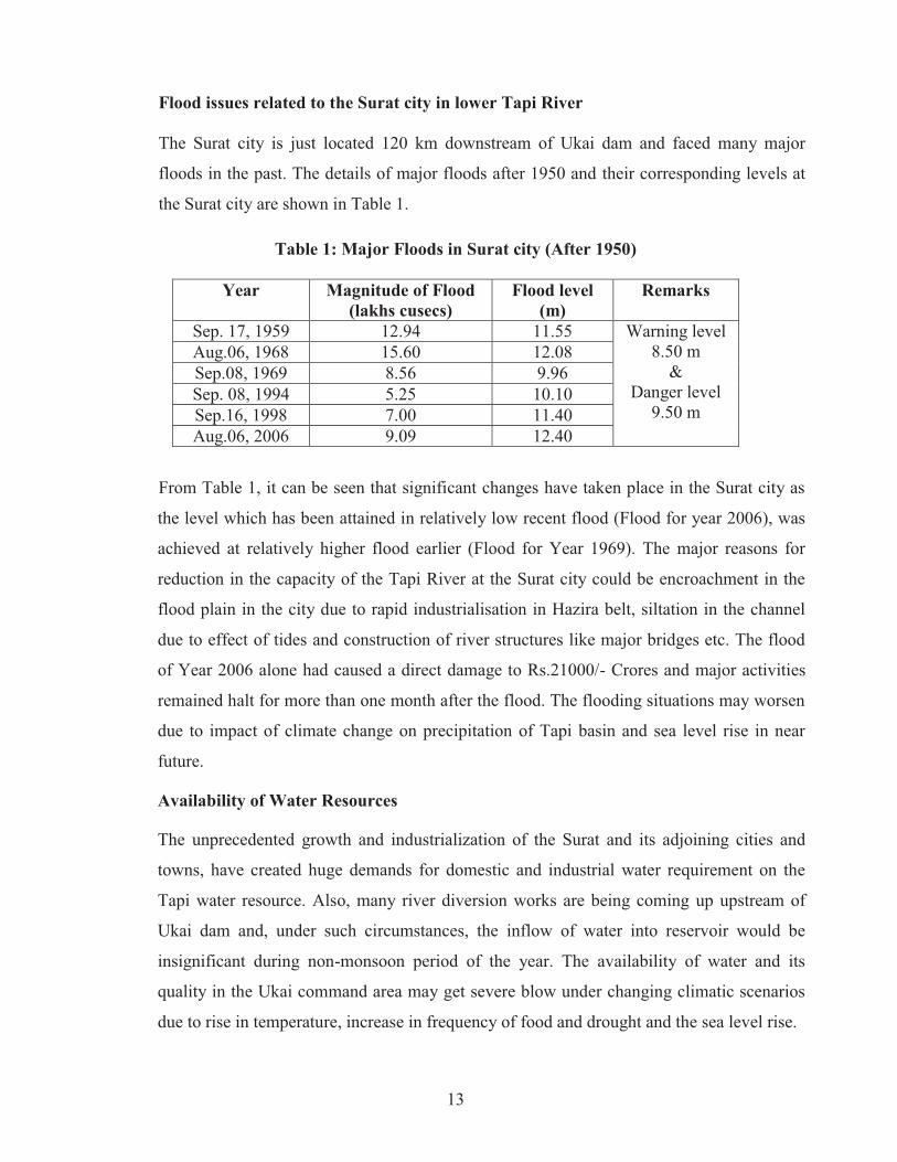
Flood issues related to the Surat city in lower Tapi River
The Surat city is just located 120 km downstream of Ukai dam and faced many major
floods in the past. The details of major floods after 1950 and their corresponding levels at
the Surat city are shown in Table 1.
Table 1: Major Floods in Surat city (After 1950)
Year Magnitude of Flood (lakhs cusecs)
Flood level (m)
Remarks
Sep. 17, 1959 12.94 11.55 Warning level 8.50 m
& Danger level
9.50 m
Aug.06, 1968 15.60 12.08 Sep.08, 1969 8.56 9.96 Sep. 08, 1994 5.25 10.10 Sep.16, 1998 7.00 11.40 Aug.06, 2006 9.09 12.40
From Table 1, it can be seen that significant changes have taken place in the Surat city as
the level which has been attained in relatively low recent flood (Flood for year 2006), was
achieved at relatively higher flood earlier (Flood for Year 1969). The major reasons for
reduction in the capacity of the Tapi River at the Surat city could be encroachment in the
flood plain in the city due to rapid industrialisation in Hazira belt, siltation in the channel
due to effect of tides and construction of river structures like major bridges etc. The flood
of Year 2006 alone had caused a direct damage to Rs.21000/- Crores and major activities
remained halt for more than one month after the flood. The flooding situations may worsen
due to impact of climate change on precipitation of Tapi basin and sea level rise in near
future.
Availability of Water Resources
The unprecedented growth and industrialization of the Surat and its adjoining cities and
towns, have created huge demands for domestic and industrial water requirement on the
Tapi water resource. Also, many river diversion works are being coming up upstream of
Ukai dam and, under such circumstances, the inflow of water into reservoir would be
insignificant during non-monsoon period of the year. The availability of water and its
quality in the Ukai command area may get severe blow under changing climatic scenarios
due to rise in temperature, increase in frequency of food and drought and the sea level rise.
14
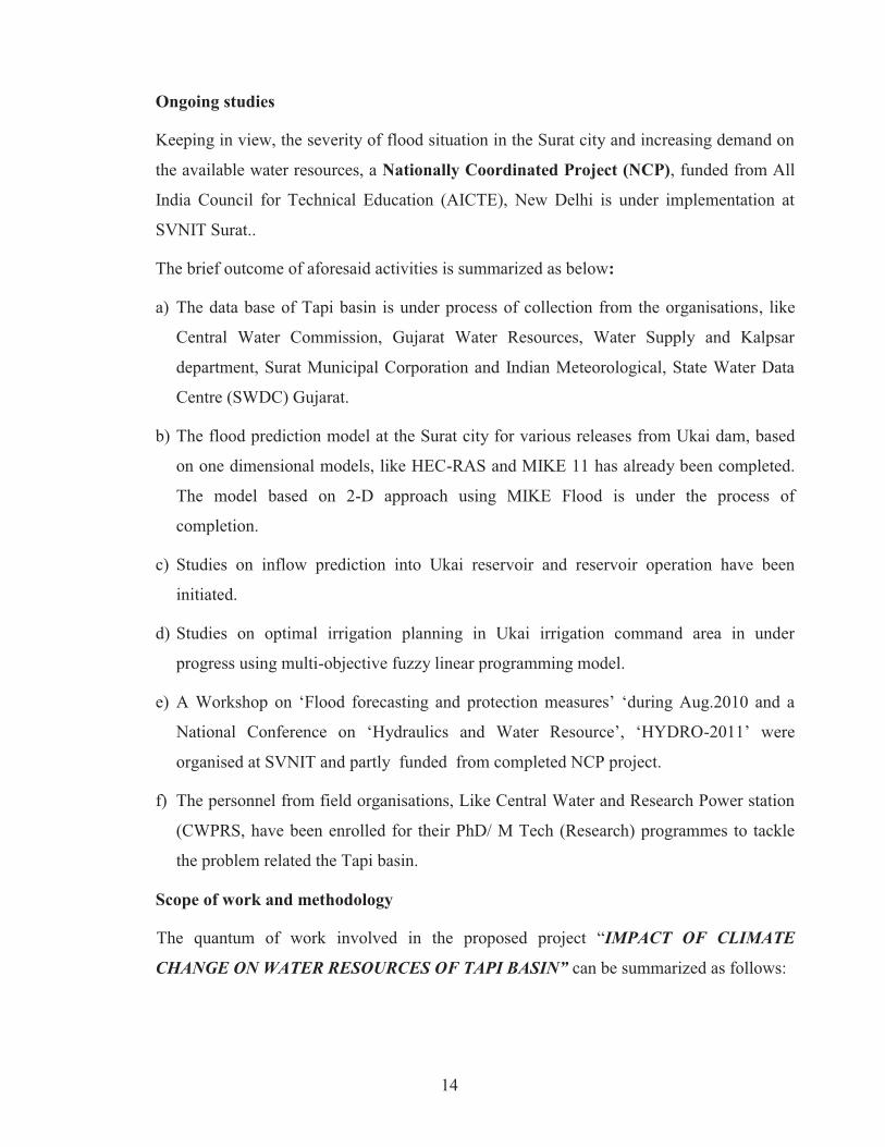
Ongoing studies
Keeping in view, the severity of flood situation in the Surat city and increasing demand on
the available water resources, a Nationally Coordinated Project (NCP), funded from All
India Council for Technical Education (AICTE), New Delhi is under implementation at
SVNIT Surat..
The brief outcome of aforesaid activities is summarized as below:
a) The data base of Tapi basin is under process of collection from the organisations, like
Central Water Commission, Gujarat Water Resources, Water Supply and Kalpsar
department, Surat Municipal Corporation and Indian Meteorological, State Water Data
Centre (SWDC) Gujarat.
b) The flood prediction model at the Surat city for various releases from Ukai dam, based
on one dimensional models, like HEC-RAS and MIKE 11 has already been completed.
The model based on 2-D approach using MIKE Flood is under the process of
completion.
c) Studies on inflow prediction into Ukai reservoir and reservoir operation have been
initiated.
d) Studies on optimal irrigation planning in Ukai irrigation command area in under
progress using multi-objective fuzzy linear programming model.
e) A Workshop on ‘Flood forecasting and protection measures’ ‘during Aug.2010 and a
National Conference on ‘Hydraulics and Water Resource’, ‘HYDRO-2011’ were
organised at SVNIT and partly funded from completed NCP project.
f) The personnel from field organisations, Like Central Water and Research Power station
(CWPRS, have been enrolled for their PhD/ M Tech (Research) programmes to tackle
the problem related the Tapi basin.
Scope of work and methodology
The quantum of work involved in the proposed project “IMPACT OF CLIMATE
CHANGE ON WATER RESOURCES OF TAPI BASIN” can be summarized as follows:

15
a) Development of data base of Tapi basin related with stream gauging data, land use and
land cover, topographical maps, soil map; reservoir inflow-outflow, levels, and releases
pattern; cropping pattern of Ukai command area including crop calendar; bathymetry of
lower Tapi river and Surat city, past flood levels in Surat city; and Tidal levels.
b) Analysis of past data for detection of trend in hydro-meteorological and hydrological
variables in Tapi basin.
c) Calibration and validation of selected hydrological and hydraulic models from the base
line data
d) Estimation of spatial and temporal water availability in the Tapi basin by using the
downscaled Predictands as inputs to the hydrological model.
e) Using downscaled Predictands at the basin level, assess the performance of
multipurpose storage reservoir (UKAI reservoir) to fulfill its intended objectives, viz.
irrigation, domestic and industrial water supply; hydropower generation and flood
control.
The detailed methodologies to achieve aforesaid objectives are depicted in the form of flow
chart, see Fig 2.
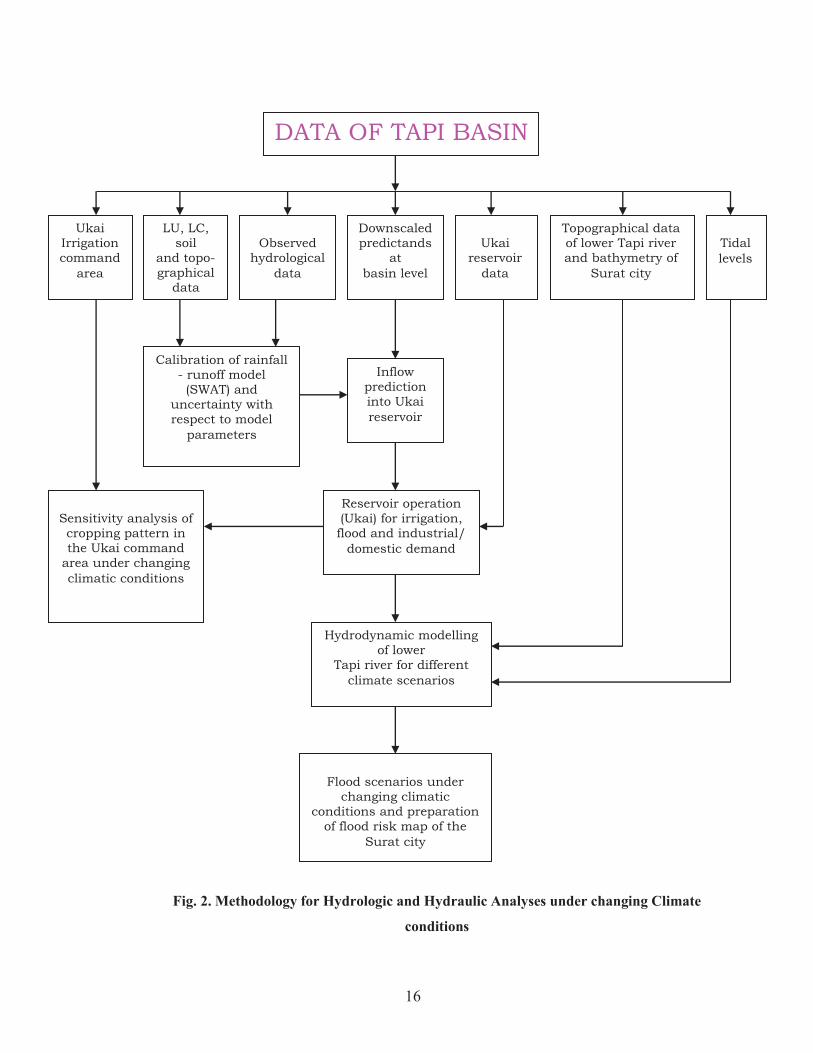
16
Fig. 2. Methodology for Hydrologic and Hydraulic Analyses under changing Climate
conditions
DATA OF TAPI BASIN
Ukai Irrigation command
area
LU, LC, soil
and topo-graphical
data
Observed
hydrological data
Downscaled predictands
at basin level
Ukai
reservoir data
Topographical data of lower Tapi river and bathymetry of
Surat city
Tidal levels
Flood scenarios under
changing climatic conditions and preparation
of flood risk map of the Surat city
Inflow prediction into Ukai reservoir
Calibration of rainfall - runoff model (SWAT) and
uncertainty with respect to model
parameters
Reservoir operation (Ukai) for irrigation, flood and industrial/
domestic demand
Sensitivity analysis of cropping pattern in the Ukai command
area under changing climatic conditions
Hydrodynamic modelling of lower
Tapi river for different climate scenarios

17
The following team would be involved in execution of aforesaid project:
a) Sardar Vallabhbhai National Institute of Technology Surat (SV NIT) : Lead Institute
b) Malaviya National Institute of Technology Jaipur: Co-coordinating Institute
c) Maulana Azad National Institute of Technology Bhopal: Co-coordinating Institute
The responsibility of the Institutes, involved in the project, is described in succeeding
paragraphs:
SVNIT Surat
a) Collection/extraction of data, with the help of associate institutes, related to stream
gauging, land use and land cover, topographical maps, soil map; reservoir inflow-
outflow, levels, and releases pattern; cropping pattern of Ukai command area
including crop calendar; bathymetry of lower Tapi river and Surat city, past flood
levels in Surat city; and Tidal levels.
b) Development of rainfall-runoff and sediment yield model for Purna catchment
(subcatchment-2, see Fig.3) for present as well future scenarios.
c) Detection of trend in hydro-meteorological variables (as per TOR-2) in the sub-
catchment of Tapi basin identified for the study.
d) Assessment of reservoir (Ukai) behavior under changing climatic conditions vis-à-
vis present condition, and propose revised rule curve for its operation, if required.
e) Sensitivity analysis of cropping pattern in Ukai command area under revised water
yield in Ukai reservoir under changing climatic conditions.
f) Calibration of hydraulic model (MIKE Flood) and prediction of flood situations in
the downstream of Ukai reservoir under present and changing climatic situations.
MNIT Jaipur
a) Development of rainfall-runoff and sediment yield model for upper Tapi basin (sub-
catchments 1, 3, 4, see Fig.3) after taking input from SVNIT for Purna catchment at
the junction of Tapi River.
18
b) Detection of trend in hydro-meteorological variables (as per TOR-2) in the sub-
catchment of Tapi basin identified for the study.
c) Performance evaluation of Hathnur reservoir under changing climatic conditions for
both observed as well as future RCP scenario.
d) To assist lead Institute in collection/extraction of field data.
MANIT Bhopal
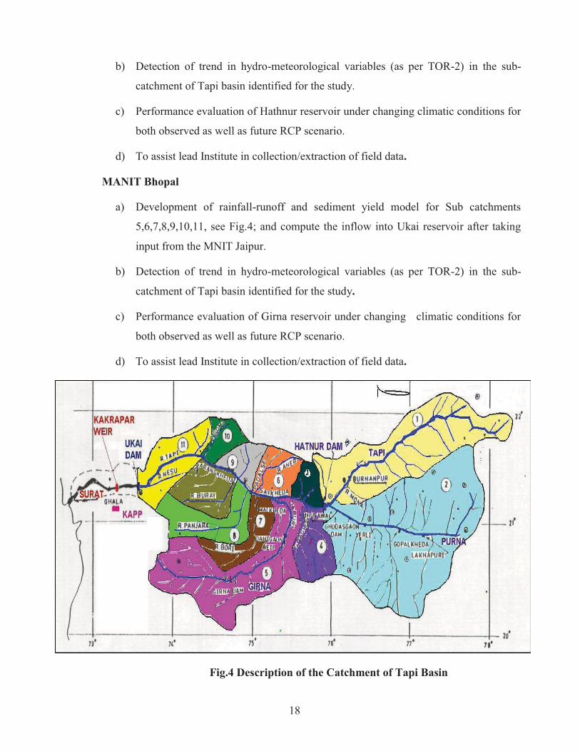
a) Development of rainfall-runoff and sediment yield model for Sub catchments
5,6,7,8,9,10,11, see Fig.4; and compute the inflow into Ukai reservoir after taking
input from the MNIT Jaipur.
b) Detection of trend in hydro-meteorological variables (as per TOR-2) in the sub-
catchment of Tapi basin identified for the study.
c) Performance evaluation of Girna reservoir under changing climatic conditions for
both observed as well as future RCP scenario.
d) To assist lead Institute in collection/extraction of field data.
Fig.4 Description of the Catchment of Tapi Basin