profile: the sekong basin - iucn water · 2017-02-15 · profile: the sekong basin . the sekong...
TRANSCRIPT
INTERNATIONAL UNION FOR CONSERVATION OF NATURE
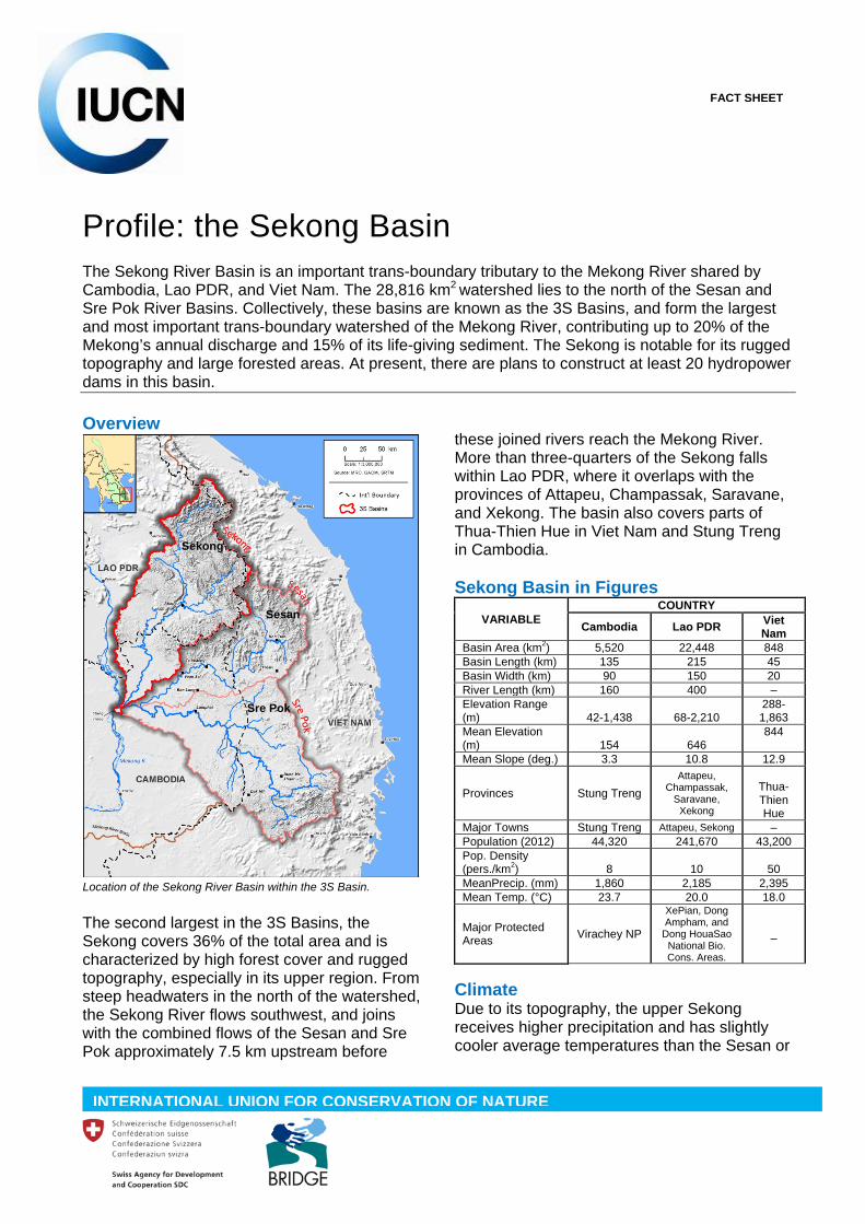
Profile: the Sekong Basin The Sekong River Basin is an important trans-boundary tributary to the Mekong River shared by Cambodia, Lao PDR, and Viet Nam. The 28,816 km2 watershed lies to the north of the Sesan and Sre Pok River Basins. Collectively, these basins are known as the 3S Basins, and form the largest and most important trans-boundary watershed of the Mekong River, contributing up to 20% of the Mekong’s annual discharge and 15% of its life-giving sediment. The Sekong is notable for its rugged topography and large forested areas. At present, there are plans to construct at least 20 hydropower dams in this basin. Overview The second largest in the 3S Basins, the Sekong covers 36% of the total area and is characterized by high forest cover and rugged topography, especially in its upper region. From steep headwaters in the north of the watershed, the Sekong River flows southwest, and joins with the combined flows of the Sesan and Sre Pok approximately 7.5 km upstream before
these joined rivers reach the Mekong River. More than three-quarters of the Sekong falls within Lao PDR, where it overlaps with the provinces of Attapeu, Champassak, Saravane, and Xekong. The basin also covers parts of Thua-Thien Hue in Viet Nam and Stung Treng in Cambodia. Sekong Basin in Figures
VARIABLE COUNTRY
Cambodia Lao PDR Viet Nam
Basin Area (km2) 5,520 22,448 848 Basin Length (km) 135 215 45 Basin Width (km) 90 150 20 River Length (km) 160 400 – Elevation Range (m) 42-1,438 68-2,210
288-1,863
Mean Elevation (m) 154 646
844
Mean Slope (deg.) 3.3 10.8 12.9
Provinces Stung Treng Attapeu,
Champassak, Saravane,
Xekong
Thua-Thien Hue
Major Towns Stung Treng Attapeu, Sekong – Population (2012) 44,320 241,670 43,200 Pop. Density (pers./km2) 8 10
50
MeanPrecip. (mm) 1,860 2,185 2,395 Mean Temp. (°C) 23.7 20.0 18.0
Major Protected Areas Virachey NP
XePian, Dong Ampham, and
Dong HouaSao National Bio. Cons. Areas.
–
Climate Due to its topography, the upper Sekong receives higher precipitation and has slightly cooler average temperatures than the Sesan or
FACT SHEET
Location of the Sekong River Basin within the 3S Basin.
Sekong
Sesan
Sre Pok

Sre Pok. Along the border between Lao PDR and Viet Nam average annual precipitation can exceed 2,800 mm per year. This precipitation in turn produces significant runoff, which peaks in the upper basin in September and October, during the wet season.1 Temperature is correlated with elevation, with relatively warmer temperatures in low-lying areas, including in the plains in the upper basin, around Attapeu. High elevation plateau areas have cooler temperatures and allow for cultivation of specialty crops such as tea and coffee. Annual temperature at some of the highest mountains in the basin averages below 15°C.
Land cover in 2009. The area around Attapeu is extensively cultivated and rubber tree plantations have been expanded here. Data: GlobCover 2009. Topography and Land Cover The topography of the Sekong is divided between low-lying areas in Cambodia, a large plain in its central area, and high elevation and steep slopes in the upper basin which straddles the border between Lao PDR and Viet Nam. A unique feature, the Bolaven Plateau, rises above 1,300 m and has been used for generations to cultivate crops such as coffee. The Sekong has the highest proportion of forest cover in the 3S Basin. In 2003 (the most recent year for which official Mekong River Commission data are available) natural deciduous and evergreen forests covered 83% of the area. Data from 2009 shows agricultural areas have expanded. (However, the different methodologies defining forest areas mean that 1MRC. Lower Mekong Basin Historical Hydro Meteorology database (data from before year 2000); temperature from WorldClim.
the two datasets are not directly comparable.) In recent decades, significant areas of the Sekong have been deforested.2 This is especially noticeable in Lao PDR, where large flatter areas have been converted for agriculture, plantations, and other uses. Between 2000 and 2012 as much as 1,400 km2
of forest (5.2% of the entire basin) was converted to other land uses. Much of this loss occurred in Lao PDR, where roughly one third of the total area deforested (423 km2) fell within protected or proposed protected areas.3 The largest contiguous clearings involved plantations (including a rubber plantation larger than 8,000 hectares to the east of Attapeu). Cambodia has not seen as high levels of deforestation, although large areas have been recently cleared along the basin border north of Stung Treng.4
Protected areas and forest loss (purple) from 2001-2012. A large area cleared for a rubber plantation is clearly visible east of Attapeu. Data: MRC 2009, Hansen et al. 2013, WDPA 2013. Protected Areas The Sekong overlaps with three National Biodiversity Conservation Areas: Xe Pian, Dong Ampham, and Dong Houa Sao in Lao PDR. However, some of these areas have experienced significant forest loss. In addition, 15 Key Biodiversity Areas5 and 13 Important
2Hansen et al. 2013. 3 Ibid. 4Hansen et al. 2013. 5 These are places of international importance for conserving biodiversity through protected areas and other methods, and are identified nationally using standard criteria.
Sekong
Sekong
Sesan
Sre Pok
Sesan
Sre Pok

Bird Areas fall within, or are immediately adjacent to, the Sekong. Population The Sekong has the smallest population among the three basins. Total human population is just under 330,000 (around 40,000 people in Viet Nam, 240,000 in Lao PDR, and 44,000 in Cambodia). This represents 7% of the total population in the 3S Basins. Majority of the population lives in the towns of Attapeu and Sekong and in the large surrounding plains. Accordingly, population density is also much lower compared to the other basins, at only 8 and 10 people/km2 in Cambodia and Lao PDR, respectively, and 50 people/km2 in Viet Nam.
The Sekong has the lowest population in the 3S Basins, at around 7% of the total. Data: LandScan 2012. Fisheries Fish and other aquatic resources from the Sekong River are central to families’ livelihoods and food security. After agriculture, fishing and related activities provide the second largest source of income. Not only does fish catch contribute 35-40% of annual household income through trade or sale of fish, it also provides 80% of the protein consumed in the basin.6,7 In the portion of the basin in Lao PDR, mean annual consumption of fish is nearly 50 kg/person.8 6LNMC, p. 37. 7FAO. 8MRC 2009.
Hydropower To date, the Sekong has not seen extensive hydropower dam construction as in the Sesan or Sre Pok. Currently, the basin has only three large hydropower dams. However, five more are under construction and another 16 under consideration.9
Existing (red) and planned or under construction (orange) hydropower dams. Size represents relative production capacity. Legal framework and key institutions Key institutions governing water resources include the Ministry of Natural Resources and the Environment (MONRE) in each country, the Ministry of Agriculture and Rural Development (MARD) in Viet Nam, and the Agriculture and Forestry Ministries in Cambodia and Lao PDR. A variety of laws on environment, water resources, fisheries, and strategic development plans influence water resources but have only domestic jurisdiction. The main official mechanism for intergovernmental cooperation within the Mekong Basin is the Mekong River Commission. However, there is no substantive, basin-specific agreement governing water resources management or development in the Sekong. As such diplomatic channels are critical for managing trans-boundary water resources. In August 2014, the UN Water Courses Convention (UNWC),10 came into force after Viet Nam became the 35th signatory. The
9Ibid. 10UNWC 1997;formally titled the “U.N. Convention on the Law of Non-Navigational Uses of International Watercourses.”
Sekong
Sesan
Sre Pok
Sekong
Sesan
Sre Pok
convention does not take direct effect in the 3S Basins until a neighbouring country also ratifies it. However, the UNWC could play an important role in future developments in the region by providing guiding principles that supplement the 1995 Mekong Agreement. Threats and Emerging Issues The expansion of rubber plantations has resulted in land cover change across extensive areas of the Sekong. Expansion of other agricultural crops has added to this conversion, and is thought to be depleting groundwater resources as well as affecting surface water quality by increasing erosion.11 Mining is also a concern for potential impacts to water quality and land cover. Although available data have not found consistently high levels of mercury in water, more sampling and tissue analysis of aquatic species may identify this as a more serious concern. In the future, the basin may face increased changes in flow patterns, with implications on fisheries, flooding, and power production.12 References and Further Reading Asian Development Bank (ADB). (2010). Sesan, Sre Pok, and Sekong River Basins Development Study in Kingdom of Cambodia, Lao People’s Democratic Republic, and Socialist Republic of Viet Nam. Baran, E., SaraySamadee, Teoh ShwuJiau, Tran Thanh Cong. (2011). Fish and fisheries in the Sesan River Basin ‐ Catchment baseline, fisheries section. Project report. Mekong Challenge Program project MK3 “Optimizing the management of a cascade of reservoirs at the catchment level”. WorldFish Center, Phnom Penh, Cambodia. 61 pp. Cambodia National Mekong Committee (CNMC). (2011). Profile: Sub-area Sekong-Se San-Sre Pok Cambodia (SA-7C) (Unpublished draft: April 2011). FAO. “Farming System-Agriculture: Lao PDR,” Regional Data Exchange System on Food and Agricultural Statistics in Asia and the Pacific. UN Food and Agriculture Organization. http://www.faorap-apcas.org/lao.html GlobCover. (2009).http://due.esrin.esa.int/globcover/. Global Land Cover Map for 2009 (GlobCover 2009). European Space Agency (ESA) & Universitécatholique de Louvain (UCL). Grimsditch, M. (2012). 3S Rivers Under Threat: Understanding New Threats and Challenges from Hydropower Development to Biodiversity and Community Rights in the 3S River Basin. 3S Rivers Protection Network and International Rivers. Hijmans et al. (2005). WorldClim Database. www.worldclim.org. Accessed 18 February 2014. LandScan. (2012).http://web.ornl.gov/sci/landscan/. Lao National Mekong Committee (LNMC). (2011). Final Report of Profile of Sub-area Sekong 7L in Lao PDR. (Updated January 2011). Meynell, P. (2014). The Sekong River in Viet Nam, Lao PDR: and Cambodia: An Information Sourcebook for Dialogue on River Flow Management. Bangkok, Thailand: IUCN. 139pp.
11ADB 2010. 12Räsänen 2012.
MRC. (2009). MRC Master Catalogue. http://portal.mrcmekong.org/master-catalogue. Timo A. Räsänen. 2012. Baseline hydrology of the 3S basin: Sesan-Sekong-SrepokVMod hydrological modelling report: Challenge Program on Water & Food Mekong project MK3 “Optimizing the management of a cascade of reservoirs at the catchment level”. ICEM – International Centre for Environmental Management, Hanoi Vietnam, 2012 UNWC. (1997). http://legal.un.org/avl/ha/clnuiw/clnuiw.html Ziv, G., Baran, E., Nam, S., Rodríguez-Iturbe, I., & Levin, S. A. (2012). Trading-off fish biodiversity, food security, and hydropower in the Mekong River Basin. Proceedings of the National Academy of Sciences, 109(15), 5609-5614. BRIDGE: Building river dialogue and governance This publication is produced as part of the IUCN BRIDGE project in the Mekong 3S. IUCN (International Union for Conservation of Nature), under the umbrella of the Building River Dialogue and Governance (BRIDGE) project supported by the Swiss Agency for Development and Cooperation (SDC), seeks to facilitate cooperative processes in the 3S region by developing and strengthening water governance capacities through governance reforms, stakeholder dialogues and knowledge exchange programmes. For more information Raphaël Glémet Senior Programme Officer, Water and Wetlands E-mail: [email protected] IUCN Asia Regional Office (ARO) Websites BRIDGE 3S Basins website: www.3sbasin.org IUCN BRIDGE websites: www.iucn.org/bridge www.iucn.org/about/union/secretariat/offices/asia/regional_activities/bridge_3s/ About IUCN IUCN helps the world find pragmatic solutions to our most pressing environment and development challenges. IUCN’s work focuses on valuing and conserving nature, ensuring effective and equitable governance of its use, and deploying nature-based solutions to global challenges in climate, food and development. IUCN supports scientific research, manages field projects all over the world, and brings governments, NGOs, the UN and companies together to develop policy, laws and best practice. IUCN’s Asia Regional Office is located in Bangkok, Thailand, with country, programme and liaison offices in Bangladesh, Cambodia, China, India, Lao PDR, Nepal, Pakistan, Sri Lanka, Thailand and Viet Nam.
www.iucn.org www.iucn.org/asia
Facebook: iucn.asia Twitter: iucnasia